Form-I - Environmental Clearance
52
CMPDI/FORM-I/MCL/2017-18/NOV-17/58/00 Form-I Application for Prior Environmental Clearance for Coal Mining Project of LAKHANPUR OCP EXPN. (PHASE II) (21.0 Mty) Lease Area (Ha) Capacity (MTY) Existing Proposed Existing Proposed 2485 2485 18.75 21.00 As per guidelines for granting Environmental Clearance for expansion of Coal Mining Projects up to 40% in 2-3 phases vide Office Memorandum No.J-11015/224/2015.IA.II, Govt. of India MoEF&CC, New Delhi, dated 15 th Sept’2017 Prepared by REGIONAL INSTITUTE – VII CENTRAL MINE PLANNING & DESIGN INSTITUTE LIMITED (A Subsidiary of Coal India Limited) BHUBANESWAR-751001, ODISHA. NABET/QCI Accreditation Number: NABET/EIA/01/12/002 Dt. Jan 31, 2012.
-
Upload
khangminh22 -
Category
Documents
-
view
2 -
download
0
Transcript of Form-I - Environmental Clearance
CMPDI/FORM-I/MCL/2017-18/NOV-17/58/00
Form-I Application
for Prior Environmental Clearance
for Coal Mining Project
of LAKHANPUR OCP EXPN. (PHASE II)
(21.0 Mty)
Lease Area (Ha) Capacity (MTY)
Existing Proposed Existing Proposed
2485 2485 18.75 21.00
As per guidelines for granting Environmental Clearance for
expansion of Coal Mining Projects up to 40% in 2-3 phases vide Office Memorandum No.J-11015/224/2015.IA.II, Govt. of India
MoEF&CC, New Delhi, dated 15th Sept’2017
Prepared by REGIONAL INSTITUTE – VII
CENTRAL MINE PLANNING & DESIGN INSTITUTE LIMITED (A Subsidiary of Coal India Limited)
BHUBANESWAR-751001, ODISHA. NABET/QCI Accreditation Number: NABET/EIA/01/12/002 Dt. Jan 31, 2012.

CMPDI
Job No.706137 Form-I, Page - 1
Application for Prior Environmental Clearance (EC) (Increase in Production Capacity)
FORM 1
[See Paragraph – 7(ii), Notification dtd.14th September 2006 with subsequent amendment vide OM F. No. J-11015/224/2015-IA.II dt. 15th Sep, 2017]
(I) Basic Information
Sl. No. Item Details
1 Name of the Project/s Lakhanpur OCP Expn. Phase-II 2 S. No. in the schedule 1(a)-A 3 Proposed capacity/ area/ length/ tonnage to
be handled/ command area/ lease area/ number of wells to be drilled
Proposed capacity 21.0 Mty Mining lease area : No additional land
4 New/ Expansion/ Modernization Expansion in capacity 5 Existing Capacity/ Area etc. 18.75 Mty / Mining lease area is
2485.0 Ha (However EC has only been granted for ML area of 2389.60 Ha due to unavailability of FC of 95.40 Ha)
6 Category of Project i.e. ‘A’ or ‘B’ A 7 Does it attract the general condition? If yes,
please specify. NA
8 Does it attract the specific condition? If yes, please specify.
NA
9 Location Project Officer, Lakhanpur OCP, Mahanadi Coalfield Limited, P.O : Ubuda, VIA- Belpahar Dist.:Jharsuguda–768217 (Odisha).
Village Khairakuni, Tingismal, Khunta-mahul, Banjhipali, Ubuda, Kalarajori, Khaliapali, Kudaloi, Kusuraloi, Soladia and Lakhanpur.
P.O : Ubuda, VIA- Belpahar District Jharsuguda State Odisha
10 Nearest railway station/ airport along with distance in Kms.
Belpahar Rly Stn : 8 km Bhubaneswar Airport : 387 km
11 Nearest Town, city, District Headquarters along with distance in Kms.
Nearest town/Dist HQ - Jharsuguda -30 Km
12 Village Panchayats, Zilla Parishad, Municipal Corporation, Local Body (complete postal addresses with telephone Nos. to be given)
A. Village- Lakhanpur, Soldia, Khalipali & Kalarajori, Lakhanpur Gram Panchayat, At/PO-Lakhanpur
B. Village- Kudaloi, Banjhipali, Khuntamahul, Tingismal & Ubuda, Kudaloi Gram Panchayat, At/PO-Kudaloi
C. Village- Kusuraloi,Kusuraloi Gram Panchayat, At/PO- Kusuraloi

CMPDI
Job No.706137 Form-I, Page - 2
13 Name of the applicant A.K. Pandey, Project Officer
14 Registered Address Project Officer, Lakhanpur OCP, Mahanadi Coalfield Limited, P.O : Ubuda, VIA- Belpahar Dist.:Jharsuguda–768217 (Odisha). Phone : 06645-605914
15 Address for correspondence: G.M (Env. & Forest), Mahanadi Coalfields Limited, P:O- Jagruti Vihar, Burla, Dist-Sambalpur, Odisha
Name Dr. Abani Kanta Samantray. Designation (Owner/ Partner/ CEO) G.M (Environment & Forest), MCL Pin Code 768020 E-Mail [email protected] Telephone No. 0663-2542084 Fax No. 0663-2542257
16 Details of alternative sites examined, if any, location of these sites should be shown on a topo sheet.
This is a site specific project.
17 Interlinked Projects Not Applicable 18 Whether separate application of interlinked
project has been submitted? Not Applicable
19 If yes, date of submission Not Applicable 20 If no, reason Independent Project 21 Whether the proposal involves approval/
clearance under: if yes, details of the same and their status to be given. (a) The Forest (Conservation) Act, 1980? (b) The Wildlife (Protection) Act, 1972? (c) The C.R.Z. Notification, 1991?
No additional land is involved.
22 Whether there is any Government Order/ Policy relevant/ relating to the site?
EC obtained vide letter no. J-11015/391/2012-IA.II(M) dated 21st May 2014 for 18.75 Mty in ML area of 2389.60 Ha. (Annexure-I).
23 Forest land involved (hectares) No additional forest land involved in the expansion project.
24 Whether there is any litigation pending against the project and/ or land in which the project is proposed to be set up? (a) Name of the Court (b) Case No. (c) Orders/ directions of the Court, if any and
its relevance with the proposed project.
No

CMPDI
Job No.706137 Form-I, Page - 3
I hereby given undertaking that the data and information given in the application and enclosures are true to the best of my knowledge and belief and I am aware that if any part of the data and information submitted is found to be false or misleading at nay stage, the project will be rejected and clearance give, if any to the project will be revoked at our risk and cost.

CMPDI
Job No.706137 Form-I, Page - 4
(II) Activity
1. Construction, operation or decommissioning of the Project involving actions, which will cause physical changes in the locality (topography, land use, changes in water bodies, etc.)
Sl. No.
Information / Checklist
confirmation
Yes/No Details thereof (with approximate quantities/rates, wherever possible) with source of information data
1.1 Permanent or temporary change in land use, land cover or topography including increase in intensity of land use (with respect to local land use plan)
Yes Details of land : (in ha)
Sl.No.
Particulars Existing 18.75 Mty
Addl. land
Total for 21.0 Mty
1. Forest 328.83 -- 328.83* 2. Non-forest 2156.17 -- 2156.17 Mining lease area 2485.00 -- 2485.00 Rehabilitation and residential colony 212.00 -- 212.00 Total land 2697.00 -- 2697.00
Out of the total forest land 233.43 Ha has already been diverted. For rest 95.40 Ha FC application is under process.
1.2 Clearance of existing land, vegetation and buildings ?
Yes No additional land is required for this project.
1.3 Creation of new land uses?
Yes New land uses will be created due to opening of mines. Better land use will be achieved by proper refilling and reclamation after mine closure.
1.4 Pre-construction investigations e.g. bore holes, soil testing ?
No Not applicable.
1.5 Construction works ?
No No new construction work in the expansion project.
1.6 Demolition works? No This is an operating mine. Demolition work will be carried out before 1 year of mine closure.
1.7 Temporary sites used for construction works or housing of construction workers?
No It is a capacity / production increase proposal.
1.8 Above ground buildings, structures or earthworks including linear structures, cut and fill or excavations
No Not applicable.
1.9 Underground works including mining or tunneling?
No This is an opencast mining.
1.10 Reclamation works?
Yes Backfilling has already been started and an area of 283.43 Ha has been physically reclaimed out of which 118.70 Ha is biologically reclaimed. Same will continue for expansion project.
1.11 Dredging?
No Not applicable.

CMPDI
Job No.706137 Form-I, Page - 5
Sl. No.
Information / Checklist
confirmation
Yes/No Details thereof (with approximate quantities/rates, wherever possible) with source of information data
1.12 Offshore structures?
No Not applicable.
1.13 Production and manufacturing processes ?
Yes OB removal is being done by Shovel and dumper combination. Whereas the coal is being extracted by Surface miner. Same system of mining will be followed in expansion project.
1.14 Facilities for store of goods or materials?
Yes The storage of goods and materials are done as follows :
OB = Mine void Coal = Stockyard Store = For storing materials like lubricant, batteries, etc. Explosive = Magazine house
1.15 Facilities for treatment or disposal of solid waste or liquid effluents ?
Yes
Solid waste 1. No external dumping for this project. 2. Backfilled area is being technically &
biologically reclaimed. Workshop HEMM
1. Oily sludge disposed in impervious lined pit. 2. Oil & grease collected in drums and will be
auctioned. 3. Effluent treatment plants have been provided.
Domestic effluent
Sewage treatment plant exists. Sludge generated will be used and is being used as form yard manure.
Mine discharge treatment plant
Mine discharge treatment plant exists.
1.16 Facilities for long-term housing of operational workers ?
Yes Housing facilities exist for manpower of existing project. No additional manpower for expansion project.
1.17 New road, rail or sea traffic during construction or operation ?
No No additional road or rail is required for this project.
1.18 New road, rail, air waterborne or other transport infrastructure including new or altered routes and stations, ports, airports etc.?
No Not applicable.
1.19 Closure or diversion of existing transport routes or infrastructure leading to changes in traffic movements?
No Not applicable.
1.20 New or diverted transmission lines or pipelines?
No Not applicable.
1.21 Impoundment, damming, culverting, realignment or other changes to the hydrology of
Yes The Phullijhore Nallah will be diverted in the existing project.

CMPDI
Job No.706137 Form-I, Page - 6
Sl. No.
Information / Checklist
confirmation
Yes/No Details thereof (with approximate quantities/rates, wherever possible) with source of information data
water-courses or aquifers?
1.22 Stream crossings? Yes The Phulijhore Nallah will be diverted in the existing project. 1.23 Abstraction or
transfers of water from ground or surface waters?
Yes (Fig. In Mld) Existing
(18.75 Mty) Additional (2.25 Mty)
Total (21.0 Mty)
Potable 1.95 -- 1.95
Industrial 3.50 0.5$ 4.00
Total 5.40 0.50 5.95 $ Dust suppression and road watering. Potable water is being met through Integrated Water Supply Scheme (IWSS) of Belpahar and that arrangement will be continued for this expansion project. The industrial water requirement is being met from the recycling of treated mine water and that arrangement will suffice for this expansion project.
1.24 Changes in water bodies or the land surface affec-ting drainage or run-off?
Yes One seasonal tributary of Lilari nallah namely Phullijhore draining this opencast will be diverted to Lilari nallah in the existing project.
1.25 Transport of personnel or materials for construction, operation or decommissioning?
Yes No additional manpower for this project, however transport arrangement has been provided for manpower of existing project.
1.26 Long-term dismantling or decommissioning or restoration works?
Yes Dismantling of infrastructure like workshop, office building transmission line etc. will be done before 1 year of mine closure.
1.27 Ongoing activity during decommissioning which could have an impact on the environment?
No This is a running mine. Decommissioning will start before one year of the mine closure.
1.28 Influx of people to an area in either temporarily or permanently?
Yes No additional manpower for expansion project. Other people for mining or allied activities will be attracted to provide services / education, etc.
1.29 Introduction of alien species?
No Total 118.70 Ha backfilled area has already been biologically reclaimed with indigenous species. The same arrangement will continue.
1.30 Loss of native species or genetic diversity?
No Total 118.70 Ha backfilled area has already been biologically reclaimed with indigenous species. The same arrangement will continue.
1.31 Any other actions? No NilN.B.: Source of information – Mahanadi Coalfields Limited, unless otherwise specified.

CMPDI
Job No.706137 Form-I, Page - 7
2. Use of Natural resources for construction or operation of the
Project (such as land, water, materials or energy, especially any resources which are non-renewable or in short supply) :
Sl. No.
Information/Checklist confirmation
Yes/No Details thereof (with approximate quantities/rates, wherever possible) with source of information data
2.1 Land especially undeveloped or agricultural land (ha)
Yes
Details of land : (in Ha)
Existing (18.75 Mty)
Additional (2.25 Mty)
Total (21.0 Mty)
(a) Agricultural : 1182.97 -- 1182.97 (b) Forest : 328.83 -- 328.83 (c) Waste land (Govt. land) : 930.58 -- 930.58 (d) Grazing : (e) Surface water bodies : 0.00 -- 0.00 (f) Others (specify) (Homestead
other tenancy land) : 42.62 -- 42.62
Total : 2485.00 -- 2485.00
2.2 Water (expected source & competing users) unit : Mld
Yes (Fig. In Mld) Existing
(18.75 Mty) Additional (2.25 Mty)
Total (21.0 Mty)
Potable 1.95 -- 1.95
Industrial 3.5 0.5$ 4.00
Total 5.45 0.5 5.95 $ Dust suppression and road watering. Potable water is being met through Integrated Water Supply Scheme (IWSS) of Belpahar and that arrangement will be continued for this expansion project. The industrial water requirement is being met from the recycling of treated mine water and that arrangement will suffice for this expansion project.
2.3 Mineral (MT) Yes Balance mineable reserve (Mt) = 263.90 (as on 01/04/2017) 2.4 Construction material
– stone, aggregates, and/soil (expected source – MT)
No No construction work for expansion work.
2.5 Forests and timber (source – MT)
No Compensatory afforestation of diverted forest land and its enrichment. No timber is required for the project. No timber is required for the project.
2.6 Energy including electricity and fuels (source, competing users) Unit: fuel (MT), energy (MW)
Yes
Existing (18.75 Mty)
Additional (2.25 Mty)
Total (21.0 Mty)
Electrical energy (MKwh/annum)
12.52 1.5 14.02
Fuel energy (Kl/day)
85.00 9.76 94.76
2.7 Any other natural resources (use appro-priate standard units)
No Nil
N.B.: Source of information – Mahanadi Coalfields Limited, unless otherwise specified.

CMPDI
Job No.706137 Form-I, Page - 8
3. Use, storage, transport, handling or production of substances or
materials, which could be harmful to human health or the environment or raise concerns about actual or perceived risks to human health.
Sl. No.
Information/Checklist confirmation
Yes/No Details thereof (with approximate quantities/rates, wherever possible) with source
of information data
3.1 Use of substances or materials, which are hazardous (as per MSIHC rules) to human health or the environment (flora, fauna, and water supplies)
Yes Sl
No. Waste
description Existing (18.75 Mty)
Additional (2.25 Mty)
Total (21.0 Mty)
1. Used oil KL/annum
76.65 9.19 85.84
2. Used batteries nos. /annum
140 17 157
3. Oily sludge m3 /annum
2378 285.36 2663.36
4 Oil & grease generated ltr/annum
150 18 168
5. Filters & filter materials in nos
1700 204 1904
- Effluent treatment plant exists. - Used oil & grease is collected in drums and to Be auctioned. - Oily sludge and used filters & filter materials will
be disposed in impervious lined pit.
- Used batteries are stored in shed and will be
auctioned to authorized re-processors.
3.2 Changes in occurrence of disease or affect disease vectors (e.g. insect or water borne diseases)
No No worker is found to be suffering from any occupational health hazard. Health of workers is checked regularly under periodical medical examination (PME) in which each worker is covered in a span of 5 years.
3.3 Affect the welfare of people e.g. by changing living conditions?
No ---
3.4 Vulnerable groups of people who could be affected by the project e.g. hospital patients, children, the elderly etc.,
Yes Hospitals, Schools and places of worship exist.
3.5 Any other causes No Nil
N.B.: Source of information – Mahanadi Coalfields Limited, unless otherwise specified.

CMPDI
Job No.706137 Form-I, Page - 9
4. Production of solid wastes during construction or operation or decommissioning (MT/month)
Sl. No.
Information/Checklist confirmation
Yes/No Details thereof (with approximate quantities/rates, wherever possible) with source of information data
4.1 Spoil, overburden or mine wastes
Yes
Total OB estimated in the mine life is 682.39 Mm3. (Balance as on 1.4.2017)
4.2 Municipal waste (domestic and or commercial wastes)
Yes The following municipal wastes are generated:
Existing (18.75 Mty)
Additional (2.25 Mty)
Total (21.0 Mty)
Domestic waste(tonne/year)
439.64 Nil 439.64
2. Commercial waste- Nil
4.3 Hazardous wastes (as per Hazardous Waste Management Rules)
Yes
- Effluent treatment plant exists. - Used oil & grease is collected in drums and to Be auctioned. - Oily sludge and used filters & filter materials will
be disposed in impervious lined pit.
- Used batteries are stored in shed and will be
auctioned to authorized re-processors.
Sl No.
Waste description
Existing (18.75 Mty)
Additional (2.25 Mty)
Total (21.0 Mty)
1. Used oil KL/annum
76.65 9.19 85.84
2. Used batteries nos. /annum
140 17 157
3. Oily sludge m3 /annum
2378 285.36 2663.36
4 Oil & grease generated ltr/annum
150 18 168
5. Filters & filter materials in nos
1700 204 1904
4.4 Other industrial process wastes
No Nil
4.5 Surplus product No Nil 4.6 Sewage sludge or
other sludge from effluent treatment
No
Existing (18.75 Mty)
Additional (2.25 Mty)
Total (21.0 Mty)
Sludge (m3/month) 19.569 Nil 19.569 Sludge is being and will be used as farm yard manure after drying.
4.7 Construction or demolition wastes
Yes Solid waste (682.39 Mm3) will be generated during production. These are non-hazardous and non-toxic in nature. These are disposed off by backfilling and re-

CMPDI
Job No.706137 Form-I, Page - 10
vegetating. 4.8 Redundant machinery
or equipment Yes To be surveyed off for disposal subsequently.
4.9 Contaminated soils or other materials
No Nil
4.10 Agricultural wastes No Not applicable. 4.11 Other solid wastes No Sediments containing silica and clay from sedimentation
ponds is being used as land fill.
N.B.: Source of information – Mahanadi Coalfields Limited, unless otherwise specified.
5. Release of pollutants or any hazardous, toxic or noxious substances to air (kg/hr)
Sl. No.
Information/Checklist confirmation
Yes/No Details thereof (with approximate quantities/rates, wherever possible) with
source of information data 5.1 Emissions from combustion of
fossil fuels from stationary or mobile sources
Yes Operation of HEMMs leads to generation SO2, NOX, etc.
5.2 Emissions from production processes
Yes Particulate matters are generated during mining, operation. Suitable mitigatory measures have already been adopted to minimize the release of pollutants by deploying mobile water sprinklers within the mine and installing fixed water sprinklers at the strategic locations like CHP, railway siding, etc. The concentration of SPM, RPM, SO2 and NOX are being monitored fortnightly.
5.3 Emissions from materials handling including storage or transport
Yes Transportation road, haul road, OB unloading points, CHP, dozing operation on OB and silo loading of coal wagons. Suitable mitigatory measures will be adopted for minimizing the pollutant.
5.4 Emissions from construction activities including plant and equipment
Yes There will be emission from the vehicles during transportation of construction materials and also due to construction activities. Suitable mitigatory measures will be adopted for minimizing the pollutant.
5.5 Dust or odours from handling of materials including construction materials, sewage and waste
Yes During construction vehicles will ply. Dust will be generated. Dust will be controlled by water spraying on roads. Septic tank & soak pit combination will be provided for temporary hutment for the construction workers.
5.6 Emissions from incineration of waste
No Not applicable
5.7 Emissions from burning of waste in open air (e.g. slash materials, construction debris)
No Not applicable
5.8 Emissions from any other sources
No Nil
N.B.: Source of information – Mahanadi Coalfields Limited, unless otherwise specified.
CMPDI
Job No.706137 Form-I, Page - 11
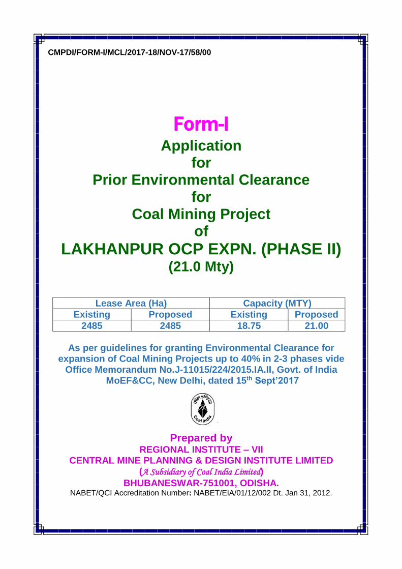
6. Generation of Noise and Vibration, and Emissions of Light and Heat :
Sl. No.
Information/Checklist confirmation
Yes/No Details thereof (with approximate quantities/rates, wherever possible) with
source of information data 6.1 From operation of equipment
e.g. engines, ventilation plant, crushers
Yes Noise is being generated due to operation of HEMM & other machineries. Regular monitoring is being carried out for noise level measurement every fortnightly and the results are found to be within the permissible limits.
6.2 From industrial or similar processes
Yes The workmen associated with the operation of HEMM are provided with personal protective devices like ear plugs, sound proof HEMM cabins. Greenbelts in and around the mine periphery.
6.3 From construction or demolition Yes During construction period movement of vehicles will be there noise level measurement will be monitored and the values will be within permissible limits.
6.4 From blasting or piling Yes DGMS circular by adopting controlled blasting techniques.
6.5 From construction or operational traffic
Yes Suitable measures will be provided. Silencers, vibration absorbing foundation have already been provided. Regular monitoring is done and will be carried out.
6.6 From lighting or cooling systems
No Not applicable.
6.7 From any other sources No Nil N.B.: Source of information – Mahanadi Coalfields Limited, unless otherwise specified.
7. Risks of contamination of land or water from releases of pollutants
into the ground or into sewers, surface waters, groundwater, coastal waters or the sea:
Sl. No.
Information/Checklist confirmation
Yes/No Details thereof (with approximate quantities/rates, wherever possible) with source of information data
7.1 From handling, storage, use or spillage or hazardous materials
Yes - Effluent treatment plant exists. - Used oil & grease is collected in drums and to be auctioned. - Oily sludge and used filters & filter materials will
be disposed in impervious lined pit.
- Used batteries are stored in shed and will be
auctioned to authorized re-processors.
7.2 From discharge of sewage or other effluents to water or the land (expected mode and place of discharge)
Yes No additional sewage sludge will be generated. Oily sludge generated is disposed in impervious lined pit.
7.3 By deposition of pollutants emitted to air into the land or into water
Yes Fugitive emission into air which is insignificant.
7.4 From any other No Nil

CMPDI
Job No.706137 Form-I, Page - 12
sources
7.5 Is there a risk of long-term build up of pollutants in the environment from these sources?
No Nil
N.B.: Source of information – Mahanadi Coalfields Limited, unless otherwise specified. 8. Risk of accidents during construction or operation of the Project,
which could affect human health or the environment Sl. No.
Information/Checklist confirmation
Yes/No Details thereof (with approximate quantities/rates, wherever possible) with
source of information data 8.1 From explosions, spillages, fires
etc. from storage, handling, use or production of hazardous substances
No This is an opencast mine and there is hardly any risk from explosion, spillage and fires. Minimum quantity of explosive will be kept in magazine duly approved by Chief Controller of Explosive. Blasting will be carried out by blasting personnel. In case of fire necessary firefighting has been provided.
8.2 From any other causes Yes Risk of accidents during operation of the project may arise due to the following reasons : 1. Land sliding in OB dump & mine pit 2. Mine inundation. 3. Blasting 4. Fire 5. Loading/Unloading & Transportation
8.3 Could the project be affected by natural disasters causing environmental damage (e.g. floods, earthquakes, landslides, cloudburst etc.)?
Yes The project is not falling under seismically active zone or land slide prone area. Chances of flood can not be ruled out. Besides safety measures, the mine is well equipped to deal with eventuality as enumerated in CMR 1957 and related DGMS circulars.
N.B.: Source of information – Mahanadi Coalfields Limited, unless otherwise specified.
9. Factors which should be considered (such as consequential development) which could lead to environmental effects or the potential for cumulative impacts with other existing or planned activities in the locality
Sl. No.
Information/Checklist confirmation
Yes/No Details thereof (with approximate quantities/rates, wherever possible) with
source of information data 9.1 Lead to development of
supporting facilities, ancillary development or development stimulated by the project which could have impact on the environment e.g.:
Yes Economic growth associated with coal mining activity leads to semi urban like development of ancillary and supporting industries and other related activities.
Supporting infrastructure (roads, power supply, waste or waste water treatment, etc.)
No additional quarter is required as there is no manpower increase existing infrastructure caters the demand.

CMPDI
Job No.706137 Form-I, Page - 13
Housing development
Extractive industries
Supply industries
Other
9.2 Lead to after-use of the site, which could have an impact on the environment
Yes The physically and / or biologically reclaimed land would undergo transformation over time which would have positive impact on environment.
9.3 Set a precedent for later developments
Yes Activities at 9.1 and 9.2 above do culminate in conjunction with local set up and in a number of cases has set precedence of economic development leading to over all socio-economic growth of the area.
9.4 Have cumulative effects due to proximity to other existing or planned projects with similar effects
Yes Coal occurs in layers which may continue up to large distances. Associated mining activity with numerous such closely located activities with other activities like power generation, etc. could be cumulative impact.
N.B.: Source of information – Mahanadi Coalfields Limited, unless otherwise specified. (III) Environmental Sensitivity Sl. No.
Areas Name/ Identity
Aerial distance (within 15km.) Proposed project location boundary
1 Areas protected under international conventions, national or local legislation for their ecological, landscape, cultural or other related value
No Nil
2 Areas which are important or sensitive for ecological reasons – Wetlands, watercourses or other water bodies, coastal zone, biospheres, mountains, forests
Yes 1. Ib River is about 25 km. 2. Lilari nallah is about 0.5 km. 3. Phulijori nallah will be diverted. 4. Hirakud reservoir is about 4.0 km. 5. Visible degraded and intensively biotically
interfered forest like Bikramkhol RF, Rajpur RF, Rameda RF, Arhaparah RF fall in buffer zone area.
3 Areas used by protected, important or sensitive species of flora or fauna for breeding, nesting, foraging, resting, over wintering, migration
No As per Department of Environmental Science and the School of Life Sciences, Sambalpur University Study Report no endangered and endemic plant species as well as animal species were recorded.
4 Inland, coastal, marine or underground waters
No Nil
5 State, National boundaries No Nil
6 Routes or facilities used by the public for access to recreation or other tourist, pilgrim areas
No Nil
7 Defense installations No Nil
8 Densely populated or built-up area
Yes Belpahar, Brajrajnagar town is located in the buffer zone.

CMPDI
Job No.706137 Form-I, Page - 14
9 Areas occupied by sensitive man-made land uses (hospitals, schools, places of worship, community facilities)
Yes Hospital, Schools and places of worship exist.
10 Areas containing important, high quality or scarce resources (ground water resources, surface resources, forestry, agriculture, fisheries, tourism, minerals)
No Hirakud reservoir is located 4.0 km south of the project.
11 Areas already subjected to pollution or environmental damage (those where existing legal environmental standards are exceeded)
No CMPDI Environmental monitoring data is given in Pre-feasibility Report.
12 Areas susceptible to natural hazard which could cause the project to present environ-mental problems (earthquakes, subsidence, landslides, erosion, flooding or extreme or adverse climatic conditions)
No Nil
(IV) Proposed Terms of Reference for EIA studies
No TOR is being proposed as the application is being submitted under Clause 7(ii) of EIA Notification 2006. It is requested for consideration of
due diligence in view of the following aspects:
• Detailed EIA Study of the core and buffer zones (10 km radius) had already been made during the preparation of EIA - EMP of Lakhanpur OC Expn. Project (15.0 Mty) and the project has already been recommended by EAC(T&C) for environmental clearance vide letter No.J-11015/638/2007-IA.II (M) dtd.16th Nov., 07.
• Public hearing was conducted on 27/7/2007 for 15.0 Mty project as per Sept., 2006 notification.
• In phase I expansion under 7 (ii) clause the project got EC from 15.0 Mty to 18.75 Mty.
• The present application is being made under clause 7(ii) of EIA notification 2006 as per the new Office Memorandum F.No.J-11015/224/2015-IA.II Govt. of India, MoEF&CC dated. 15th Sept’2017 for expansion upto 40%.
• Coal Mining will be done through the Eco-friendly Surface Miners.
• The AQIP analysis using AERMOD revealed that the incremental PM10 levels
of Lakhanpur OC Expansion Project for incremental production of 2.25 MTPA
will be 10.00 µg/cu.m at West Side of Quarry No 4 with control measures.

CMPDI
Job No.706137 Form-I, Page - 15
• It has been observed that due to increment in production the increase in
pollutant levels is not very high and absolute value is well within the
permissible limits of GSR 742(E) 2000.
• However the same can be further reduced by upcoming conveyor belt & SILO.

CMPDI/PFR/MCL/2017-18/NOV-17/58/00
PRE-FEASIBILITY REPORT
FOR LAKHANPUR OCP EXPN. (PHASE II)
(EXISTING CAPACITY 18.75MTY) (PROPOSED CAPACITY 21.00 MTY)
LAKHANPUR AREA IB VALLEY COALFIELD
MAHANADI COALFIELDS LIMITED
NOVEMBER 2017
Central Mine Planning & Design Institute Limited
(A Subsidiary of Coal India Ltd.) Regional Institute-VII, Samantpuri, P.O: RRL, Bhubaneswar-751013 (Odisha)
Accreditation Number: NABET/EIA/01/12/002 Dt. Jan 31, 2012.

CMPDI
Job No.706137 Pre-feasibility Report, Page - 1
PRE-FEASIBILITY REPORT FOR
LAKHANPUR OCP EXPANSION (PHASE II) (CAPACITY 21.0 MTY)
1. INTRODUCTION
Ib-valley coalfield (also known as Ib-river coalfield) is located in Jharsuguda,
Sambalpur and Sundergarh districts of Orissa between latitudes 21o 42' 15” to 21o
47' 10” N and longitudes 83o 48' 11” to 83
o 52' 38” E in toposheet No.64 (O/13) with
Scale 1:50,000. The coalfield is named after the river Ib, a tributary of the river
Mahanadi. The Howrah-Mumbai railway line passes through the coalfield. The
nearest rail head is Belpahar.
Mining in this coalfield in south-eastern part started with the support of
available infrastructures around Brajrajnagar township in the first half of this century.
The first UG mine to start was Himgir Rampur colliery (1909) and subsequently
Orient UG mine No.1 (1940).
The Project Report for Lakhanpur Opencast, 5.0 Mty capacity of Ib-valley
coalfield was prepared in April, 87 and approved in January, 92 vide letter No.43011/
43/87-CPA, dt.22.1.92. The mine started coal production from 1992-93 and has been
completed in March, 2000. Further, PR for Lakhanpur OC Expansion, 10.0 Mty (5.0
Mty Incremental) was sanctioned in February, 2004 at an additional capital of
Rs.98.74 crores. The same was declared completed in March, 2010.
Further Lakhanpur OCP expansion (Phase-II) Capacity 15 Mty (5 Mty
incremental) was sanctioned in September 2008. The same has been prepared to
cater to the projected demand on MCL and is part of ‘Emergency Coal Production
Plan’ of Coal India Limited.
Environmental Clearance (EC) was accorded by MoEF, Govt. of India for
Lakhanpur OC Expansion, 15.0 Mty (5.0 Mty incremental) vide Letter No.J-
11015/638/2007-IA.II(M), dated 12.5.2008. (Annexure I)
Again Environmental Clearance (EC) was granted by MoEF, Govt. of India
for Lakhanpur OC Expansion, 15.0 Mty to 18.75 Mty (under 7(ii) of EIA notifications
2006) vide Letter No.J-11015/398/2012-IA.II(M), dated 21.5.2014 (Annexure IA) for
existing mining lease area of 2389.6 Ha.

CMPDI
Job No.706137 Pre-feasibility Report, Page - 2
2. NEED / JUSTIFICATION FOR THE PROJECT The consumers of MCL are linked to the company and not to any specific
coalfield ( i.e Talcher & Ib valley). The actual supply from any coalfield of MCL will
depend upon the production and transport logistics. Under the above circumstances
coalfield wise demand has been assessed based on the production share of these
two coalfield which is as below:
Projected coal demand on MCL from Ib-valley coalfield
(Fig. in Mt) Sl. No
Particulars 2021-22 2026-27
1 Total Demand on MCL 244.83 274.134 2 Projected coal demand on Ib-valley
coalfield 97.93 120.56
3 Coal Availability 73.82 85.32 Gap (-)24.11 (-)35.24
It is proposed that the coal produced from the proposed project will be linked
to Thermal Power Stations for power generation, both within the state and outside the
state.
The proposed PR of Lakhanpur OCP (21 Mty) will be linked to the existing
consumers. In addition a basket of new consumers may be linked to the project who
have been issued LOA (Letter of Assurances) by MCL under NCDP-2007
As per above table, the projected gap between demand and availability is
projected to be 35.24 Mt from Ib-valley coalfield. Further new coal linkages have
been given to MCL for which MCL has already issued LOA. The proposed Lakhanpur
(21 Mty) project will meet the coal demand from the coalfield, especially to the new
consumers and reduce the gap between demand and availability.
3. LOCATION AND COMMUNICATION (PLATE IA & IB) Lakhanpur opencast expansion (Phase-II) project (21.0 Mty) Revision -1 is
proposed in Belpahar-III geological block of Rampur tract of Ib-valley coalfield, falling
in the south of Lilari nallah.
The block area falls between latitudes 21o42'15" N to 21o47'10"N and
longitudes 83o48'11"E to 83o52'38"E and is included in Survey of India topo sheet

CMPDI
Job No.706137 Pre-feasibility Report, Page - 3
no.64/O/13 of 1:50,000 RF. It is situated to the south of Howrah-Mumbai Railway
line, between Belpahar and Brajrajnagar railway stations. The nearest railway station
is Belpahar at a distance of about 8 kms.
The project is connected by road to Brajrajnagar & Jharsuguda in Orissa and
Raigarh in Chhatisgarh. Jharsuguda is connected to Sambalpur by SH-10 and NH-6
& NH-42.
4. TOPOGRAPHY, DRAINAGE AND CLIMATE • The topography of the block is plain to moderately undulating.
• The area is gently sloping towards east.
• The highest and lowest elevations of the area are 250 m and 198 m above
mean sea level respectively.
• The drainage is controlled by Lilari nullah which discharges into Hirakud
reservoir. One tributary (seasonal) of Lilari nullah namely, Pulijhore flows
from west to east within the mine area with its catchment area to the west
of the block.
5. MINE BOUNDARY
Quarry-1 This is the northern quarry. Lilari nala separates it from the workings of Lilari Opencast project. Southern boundary is fixed such that the immediate diversion of Pulijhar nala does not become necessary. North : Floor boundary is fixed after considering the present surface boundary and leaving a surface barrier of approximately 60m against Lilari nullah. East : 1 m thick coal line in the incrop of Lajkura seam. South : Floor boundary is fixed considering existing embankment against the Pulijhore nullah. West : Floor boundary is almost fixed along block boundary.
Quarry-2
Quarry-2 forms the central part of the selected quarry area and is adjacent to
quarry-1. Pulijore nala which flows on the northern side of the quarry will have
to be diverted before starting of this quarry.
CMPDI
Job No.706137 Pre-feasibility Report, Page - 4
North : Shares the southern boundary of Quarry-1. East : 1m thick coal line in the incrop of Lajkura seam South : An arbitrary line midway between final southern boundary & northern boundary of Quarry-2. West : 70m / 80m floor contour.
Quarry-3
This is the last quarry in sequence and coal production starts from the 17th
year and continues upto the 25th year i.e. the terminal year of the project.
North : Shares the southern boundary of Quarry-2 East : 1m thick coal line in the incrop of Lajkura seam. South : Approximate 6-7 m Iso-thickness line of dirt bands. West : 90m floor contour. However due to land constraints, non-availability of forest land and difficulty in
diversion of Phulijhor nala existing sequence of working has been modified.
Quarry-1 has been extended towards south upto temporary diversion route of
Phuljhor nala, part of quarry-2 as per 15 Mty PR, has also been opened
towards south of Phulijhor nala and it’s southern limit is restricted upto a road
connecting village Khaliapali. In future quarry-2 &3 will be advanced as a
single quarry and quarry-1 will be connected to quarry-2 after diversion of
Phulijhor nala.
Mining has been proposed in two phases in present mining plan of 21 Mty, in
Phase-I mining has been restricted to the approved lease area as per
approved EMP of 18.75 Mty ( excluding area of non diverted forest)(shown in
Min-I), in phase-II mining will be taken up in remaining area after getting forest
clearance ).
CMPDI
Job No.706137 Pre-feasibility Report, Page - 5
6. GEOLOGY
STATUS OF EXPLORATION
Detailed exploration of the block projected for mine planning has been carried
out by CMPDI (CMIB series boreholes) & GSI (IBR series boreholes) through 111
boreholes involving 13963.97m of drilling out of which 4 boreholes have been drilled
by Geological Survey of India. The area for geological exploration is 14.44 sq. Km.
and bore hole density is 7.69 boreholes /sq. Km.
GEOLOGICAL STRUCTURE The beds strike in a NE-SW direction in the northern part, assume a N-S
trend in the central part and SSE-NNW in the southern part. The overall configuration
is thus of a broad antiform. The dip of the strata varies from NW in northern part, due
west in the central part and WSW in southern part. The dip ranges from 4o to 6o. The
block has been traversed by 8 normal faults ranging in throw from 2m to 70m.
However, within the mining block 2 nos. of faults (F3F3 & F11F11) have been
deciphered and ranging in throw from 2m to 5m.
COAL SEAMS
All the three main coal seams of the Ib-River coalfield viz. Ib, Rampur and
Lajkura seams have been encountered within the block besides Parkhani and
Belpahar seams which occur in the downdipside. Only Lajkura seam has been
described in details as only Lajkura seam has been considered for mine planning.

CMPDI
Job No.706137 Pre-feasibility Report, Page - 6
SEQUENCE OF COAL SEAMS OF BELPAHAR SECTOR-III BLOCK
Seam/Section Thickness (m) Parting (m) with the lower seam
Min. Max. Min. Max. Belpahar 1.49 4.20 68.16 72.67 Parkhani 0.20 5.18 75.28 110.52 Lajkura 20.88 33.53 41.65 96.22 Section A (Rampur Top-I
0.35 3.75 0.45 10.10
Section-B(Top) (Rampur Top-II part)
0.18 3.83 0.31 3.12
Section-B (Bot) (Rampur Top-II part)
0.12 2.59 1.28 24.93
Section-C 0.12 3.83 3.98 12.56 Section-D (Rampur Bot-I part)
0.11 2.44 2.61 18.43
Section-E (Rampur Bot-II part)
0.62 5.45 5.85 35.55
Ib Top 0.09 6.20 0.80 9.58 Ib-Bottom Ib-Comb.
0.15 4.42
8.00 10.95
- -
QUALITY The details of quality are given in the following table.
Seam overall proximate analysis (on equilibrated basis), CV, UHV and grade of Lajkura seam on I100 basis.
Thickness range mm.
Moisture %
Ash %
VM %
FC %
CV (K.Cal/Kg)
UHV (K.Cal/Kg)
Grade
20.88-31.25
6.3-7.8 32.0-44.8
23.0-26.9
25.9-33.5
3280-4285 1848-3435 E-G
CMPDI
Job No.706137 Pre-feasibility Report, Page - 7
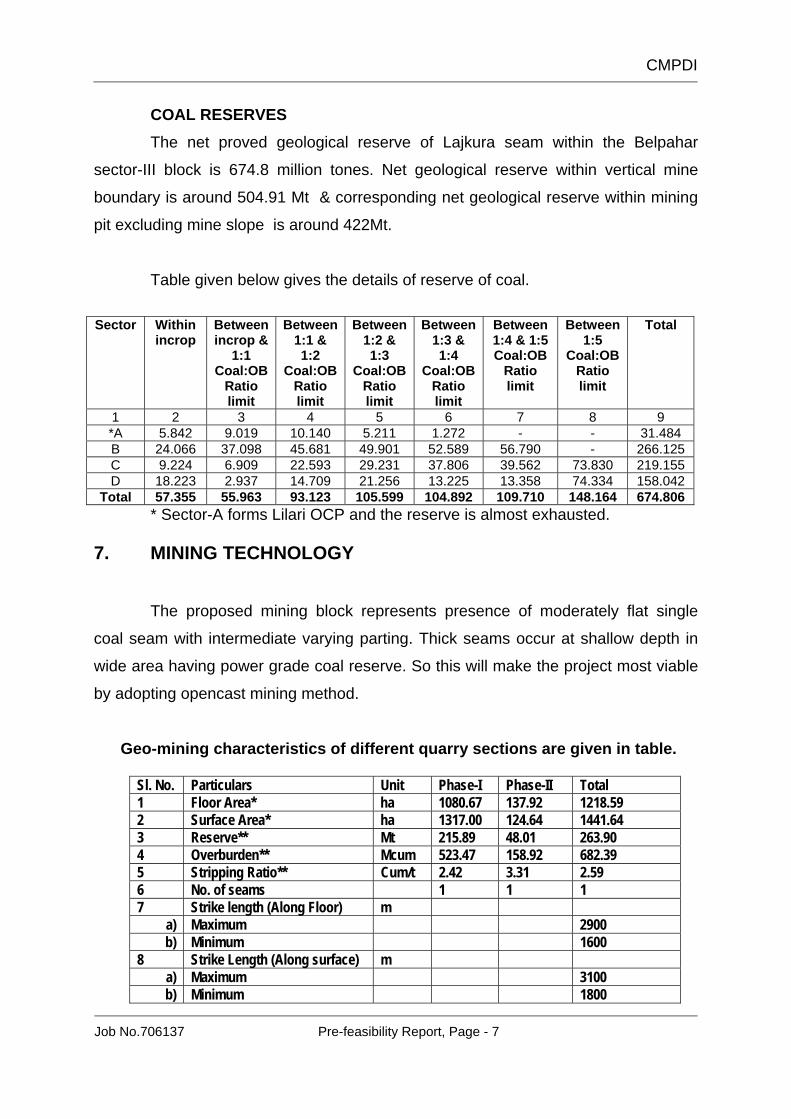
COAL RESERVES The net proved geological reserve of Lajkura seam within the Belpahar
sector-III block is 674.8 million tones. Net geological reserve within vertical mine
boundary is around 504.91 Mt & corresponding net geological reserve within mining
pit excluding mine slope is around 422Mt.
Table given below gives the details of reserve of coal.
Sector Within
incrop Between incrop &
1:1 Coal:OB
Ratio limit
Between 1:1 & 1:2
Coal:OB Ratio limit
Between 1:2 & 1:3
Coal:OB Ratio limit
Between 1:3 & 1:4
Coal:OB Ratio limit
Between 1:4 & 1:5 Coal:OB
Ratio limit
Between 1:5
Coal:OB Ratio limit
Total
1 2 3 4 5 6 7 8 9 *A 5.842 9.019 10.140 5.211 1.272 - - 31.484 B 24.066 37.098 45.681 49.901 52.589 56.790 - 266.125 C 9.224 6.909 22.593 29.231 37.806 39.562 73.830 219.155 D 18.223 2.937 14.709 21.256 13.225 13.358 74.334 158.042
Total 57.355 55.963 93.123 105.599 104.892 109.710 148.164 674.806 * Sector-A forms Lilari OCP and the reserve is almost exhausted. 7. MINING TECHNOLOGY
The proposed mining block represents presence of moderately flat single
coal seam with intermediate varying parting. Thick seams occur at shallow depth in
wide area having power grade coal reserve. So this will make the project most viable
by adopting opencast mining method.
Geo-mining characteristics of different quarry sections are given in table.
Sl. No. Particulars Unit Phase-I Phase-II Total 1 Floor Area* ha 1080.67 137.92 1218.59 2 Surface Area* ha 1317.00 124.64 1441.64 3 Reserve** Mt 215.89 48.01 263.90 4 Overburden** Mcum 523.47 158.92 682.39 5 Stripping Ratio** Cum/t 2.42 3.31 2.59 6 No. of seams 1 1 1 7 Strike length (Along Floor) m
a) Maximum 2900 b) Minimum 1600
8 Strike Length (Along surface) m a) Maximum 3100 b) Minimum 1800
CMPDI
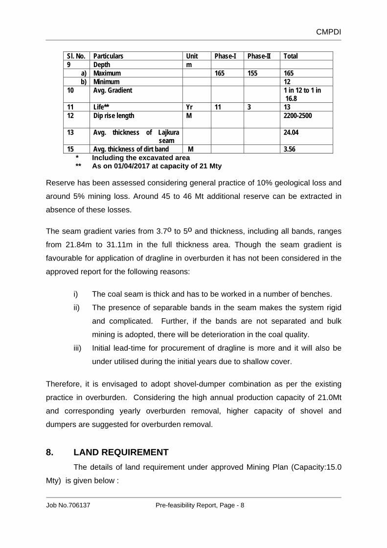
Job No.706137 Pre-feasibility Report, Page - 8
Sl. No. Particulars Unit Phase-I Phase-II Total 9 Depth m
a) Maximum 165 155 165 b) Minimum 12
10 Avg. Gradient 1 in 12 to 1 in 16.8
11 Life** Yr 11 3 13 12 Dip rise length M
2200-2500
13 Avg. thickness of Lajkura seam
24.04
15 Avg. thickness of dirt band M 3.56 * Including the excavated area
** As on 01/04/2017 at capacity of 21 Mty
Reserve has been assessed considering general practice of 10% geological loss and
around 5% mining loss. Around 45 to 46 Mt additional reserve can be extracted in
absence of these losses.
The seam gradient varies from 3.7o to 5o and thickness, including all bands, ranges
from 21.84m to 31.11m in the full thickness area. Though the seam gradient is
favourable for application of dragline in overburden it has not been considered in the
approved report for the following reasons:
i) The coal seam is thick and has to be worked in a number of benches.
ii) The presence of separable bands in the seam makes the system rigid
and complicated. Further, if the bands are not separated and bulk
mining is adopted, there will be deterioration in the coal quality.
iii) Initial lead-time for procurement of dragline is more and it will also be
under utilised during the initial years due to shallow cover.
Therefore, it is envisaged to adopt shovel-dumper combination as per the existing
practice in overburden. Considering the high annual production capacity of 21.0Mt
and corresponding yearly overburden removal, higher capacity of shovel and
dumpers are suggested for overburden removal.
8. LAND REQUIREMENT The details of land requirement under approved Mining Plan (Capacity:15.0
Mty) is given below :

CMPDI
Job No.706137 Pre-feasibility Report, Page - 9
(Area in Ha) Purpose Existing Additional Total
Forest Non-forest
Total Forest Non-forest
Total Forest Non-forest
Total
Quarry Excavation 243.1 1198.54 1441.64 -- -- -- 243.1 1198.54 1441.64 Safety zone for blasting 52.8 653.66 706.4 -- -- -- 52.8 653.66 706.4 OB dump OB area of 38.40 ha falls in safety zone. Infrastructure 6.33 181.67 188 -- -- -- 6.33 181.67 188 Rationalisation of project boundary
26.6 122.36 148.96 -- -- -- 26.6 122.36 148.96
Mining lease area [Sub-total of (1 to 5)]
328.83 2156.17 2485 -- -- -- 328.83 2156.17 2485
Residential Colony -- 60 60 -- -- -- -- 60 60 Resettlement Site -- 152 152 -- -- -- -- 152 152 Grand Total : 328.83 2368.17 2697 -- -- -- 328.83 2368.17 2697
No additional land will be required for implementation of the proposed peak
21.0 Mty project, as it is proposed within the same mine boundary of earlier approved
15 Mty PR. So, no additional provision for land has been made in the present
proposal. 9. TARGETED OUTPUT, LIFE, RESERVE & PRODUCTION
SCHEDULE Production Programme (Phase-I & II)
YEAR COAL ( in Mt) OB ( in Mcum) SR ( in cum/t) 2017‐18(YR1)
21.00 47.00 2.24
2018‐19 ( Yr2) 21.00 57.08 2.72
2019‐20( Yr3) 21.00 57.08 2.72
2020‐21( Yr4) 21.00 57.08 2.72
2021‐22( Yr5) 21.00 57.08 2.72
2022‐23( Yr6) 21.00 57.08 2.72
2023‐24( Yr7) 21.00 57.08 2.72
2024‐25( Yr8) 21.00 57.08 2.72
2025‐26( Yr9) 21.00 57.08 2.72
2026‐27( Yr10) 21.00 57.08 2.72
2027‐28( Yr11) 21.00 57.08 2.72
2028‐29( Yr12) 21.00 51.40 2.45
2029‐30( Yr13) 11.90 13.19 1.11
TOTAL 263.90 682.39 2.59

CMPDI
Job No.706137 Pre-feasibility Report, Page - 10
Production plan for phase-I (excl non diverted forest area) is summarized in Table
below.
Production Programme (Phase-I)
YEAR COAL ( in Mt) OB ( in Mcum) SR ( in cum/t) 2017‐18(YR1)
21.00 47.00 2.24
2018‐19 ( Yr2) 21.00 57.08 2.72
2019‐20( Yr3) 21.00 57.08 2.72
2020‐21( Yr4) 21.00 57.08 2.72
2021‐22( Yr5) 21.00 57.08 2.72
2022‐23( Yr6) 21.00 57.08 2.72
2023‐24( Yr7) 21.00 57.08 2.72
2024‐25( Yr8) 21.00 57.08 2.72
2025‐26( Yr9) 21.00 57.08 2.72
2026‐27( Yr10) 21.00 19.83 3.37
2027‐28(YR11) 5.89 -
TOTAL 215.89 523.47 2.42
10. WATER DEMAND AND SUPPLY ARRANGEMENT (in MLD)
18.75 Mty
Addl. (2.25Mty)
Total (21.0 Mty)
Potable water demand 1.95 0.00 1.95 Industrial and fire fighting 3.50 0.50 4.00 Total : 5.45 0.50 5.95
* Dust suppression and road watering.
SEWAGE SYSTEM Sewage treatment plant exist in Lakhanpur Colony.
11. COAL WINNING, OB REMOVAL AND TRANSPORTATION Shovel-dumper system of mining for overburden removal has been already
adopted for running mine. This system is very flexible and also offers convenient
mining operations to deal with sudden occurrences of unworkable or poor quality
patches and change of floor position due to repeated faulting and varying seam
gradient and thickness. It also offers flexibility for easy transition to any other

CMPDI
Job No.706137 Pre-feasibility Report, Page - 11
technology or equipment configuration. The technology is well known and
advantageous to get skilled manpower. So shovel-dumper mining method has been
adopted for overburden removal and the same has been suggested for remaining life
of the mine. Considering the annual target of 21.0Mt and corresponding yearly
overburden removal, higher capacity of shovel and dumpers are suggested for
overburden removal.
The top soil of 30cm will be excavated and stacked separately or utilized directly for
covering the backfill. At present 5.0 cum electric rope shovels, 5.1cum hydraulic
shovels and 3.7/2.7 hydraulic shovels or backhoes are deployed for overburden
removal. As per earlier approved mining plan, considering large quantity of
overburden to be removed (about 40-50Mcum/year) it was proposed to deploy 8.5-10
cum hydraulic shovels/ backhoe for top overburden removal. 3.7cum/2.7cum
hydraulic shovels and backhoes would be generally deployed for removal of bands.
However in recent years, 2 working patches in quarry-1 and one patch in quarry-2
overburden is being excavated & transported through outsourcing means. Increase in
production will be done through deployment of more departmental HEMM or
increasing load of outsourcing agencies.
In the present mine coal is being extracted either by using surface miner through
outsourcing agencies or by departmental surface miner. Any additional coal
production will be done by using surface miner through outsourcing agencies or by
departmental means.
Surface miners will be working in windrowing method, In windrowing mode the cut
material is directly discharged behind the machine without using a conveyor.
Therefore the cutting operation is independent from the truck loading operation, but
the coal has to be rehandled by the front end loader which in turn loads the coal into
the dump truck. For many reasons, the higher productivity in windrowing method
compensates the rehandling cost. In addition, no belt wear and operating cost for
conveyor will arise when working with windrowing mode of operation.

CMPDI
Job No.706137 Pre-feasibility Report, Page - 12
While working the barrier between quarry-1 & quarry-2, it will be necessary to
rehandle some overburden already backfilled along common boundaries. HEMM
deployed for overburden removal will also rehandle this overburden.
12. MANPOWER No additional manpower is required for this project.
13. POWER SUPPLY The power supply to the project will come from Jurabaga Sub-station of MCL
through 33 kV double circuit overhead line.
14. COAL HANDLING & DESPATCH ARRANGEMENT At present, the coal produced from the mine is dispatched to OPGC and to Y-
curved siding for basket linkage for further dispatch though Howrah-Mumbai main
line.
A Coal handling plant for Lakhanpur open cast project was constructed and
commissioned. The CHP consisted of crushing complex (Feeder breakers), conveyor
and truck loading hopper for dispatch to Y-curve siding. Subsequent to introduction of
Blast Free coal production, the Feeder Breakers and other accessories have been
shifted to other mines for their better utilisation. Out of total production approximately
3.50 Mty of coal is dispatched through MGR for OPGC. Part of remaining coal
(around 7.0 Mty for year 2016-17) is being transported through Y-curve siding which
is located at a distance of 14-15 km, remaining part of coal production is also being
transported through Lakhanpur siding no-7 and Belpahar siding no 3 & 6 near
eastern side of Belpahar OCP. Coal transportation from pit top/stock to the siding is
being done through outsourcing transport arrangement.
Around 10 Mty coal from pit bottom will be transported up to pit top by
departmental/ out sourcing dumpers. From pit top through reclaim feeder the coal will
be transported by conveyor to washery, then washed coal will be transported by
conveyor to SILO for further rail transport. For the above proposal tendering is in
advance stage.
.

CMPDI
Job No.706137 Pre-feasibility Report, Page - 13
15. WORKSHOP AND STORE Two-tier system of maintenance had been envisaged in the existing project
(21.0 Mty) for the plant and machinery one as the unit workshop located at the quarry
mouth to cater to the needs of day-to-day maintenance work and the other at Central
Workshop for major overhauls and capital repairs. The unit workshop for HEMM and
E&M equipment (like CHP, pumps, electrical, etc.) were envisaged to be separate.
The workshop facilities created already as per the approved PR are meeting the
present maintenance requirements of the mine.
No additional provision for E&M workshop has been given in this report since
no such remarkable additional E&M input like CHP, pumps, etc. has been provided.
The existing E&M workshop will serve the purpose.
16. CIVIL CONSTRUCTION Existing arrangement for 18.75.0 Mty project will take care for expansion
project. Workshop (H.E.M.M. and E&M) has been made for 18.75 Mty projects will
suffice for expansion project.
17. ROUTINE ENVIRONMENTAL MONITORING Routine environmental monitoring is being carried out every fortnight in each
month in and around of Lakhanpur OCP.

CMPDI
Job No.706137 Pre-feasibility Report, Page - 14
WATER QUALITY Routine water quality monitoring generated during the period (April 2017 to
June 2017) is given in the table below:
Project / OCP Lakhanpur OCP
Monitoring Station Ubuda village well warter
Khairkuni village
tubewell water
LKP canteen tap
water
Indian Drinking Standards (IS-10500):2012
Dt. of sampling 26.04.17 14.04.17 14.04.17 Acceptable Permissible Colour(Hazen) 2 6 8 5 15
Odour Agreeable Agreeable Agreeable Agreeable Agreeable Taste Agreeable Agreeable Agreeable Agreeable Agreeable
Turbidity(NTU) 1 3 4 1 5 pH 6.70 7.32 6.99 6.5-8.5 No
relaxation Total
Alkalinity(mg/L) 32 28 20 200 600
Total Hardness(mg/L)
320 64 76 200 600
Iron(mg/L) <0.06 <0.06 <0.06 0.3 No relaxation
Chloride(mg/L) 102 30 18 250 1000 Residual Free
chlorine(mg/L) <1.0 <1.0 <1.0 0.2 1
Total Dissolve Solid(mg/L)
608 154 146 500 2000
Calcium(mg/L) 73.6 16.0 19.2 75 200 Copper(mg/L) 0.04 0.04 <0.03 0.05 1.5
Manganese(mg/L) 0.02 0.21 <0.08 0.1 0.3 Sulphate(mg/L) 104 6 8 200 400 Nitrate(mg/L) 5.87 4.76 3.99 45 No
relaxation Fluoride(mg/L) 0.36 0.40 0.32 1 1.5 Selenium(mg/L) <0.002 <0.002 <0.002 0.01 No
relaxation Arsenic(mg/L) <0.002 <0.002 <0.002 0.01 0.05
Lead(mg/L) <0.005 <0.005 <0.005 0.01 No relaxation
Zinc(mg/L) <0.02 <0.02 <0.02 5 15 Boron(mg/L) <0.2 <0.02 <0.02 0.5 1.0
Cadmium(mg/L) <0.0005 <0.0005 <0.0005 0.003 No relaxation

CMPDI
Job No.706137 Pre-feasibility Report, Page - 15
Project / OCP Lakhanpur OCP
Monitoring Station Khairkuni village tubewell water
LKP canteen tap water
Indian Drinking Standards (IS-10500):2012
Dt. of sampling 12-05-2017 12-05-2017 Acceptable Permissible Colour(Hazen) 8 4 5 15
Odour Agreeable Agreeable Agreeable Agreeable Taste Agreeable Agreeable Agreeable Agreeable
Turbidity(NTU) 3 2 1 5 pH 6.72 6.72 6.5-8.5 No relaxation
Total Alkalinity(mg/L) 12 12 200 600
Total Hardness(mg/L) 72 64 200 600
Iron(mg/L) <0.06 <0.06 0.3 No relaxation Chloride(mg/L) 24 14 250 1000
Residual Free chlorine(mg/L) <1.0 <1.0 0.2 1
Total Dissolve Solid(mg/L) 124 120 500 2000
Calcium(mg/L) 16.0 19.2 75 200 Copper(mg/L) <0.03 0.04 0.05 1.5
Manganese(mg/L) 0.33 <0.02 0.1 0.3 Sulphate(mg/L) 4 9 200 400 Nitrate(mg/L) 2.37 1.87 45 No relaxation
Fluoride(mg/L) 0.32 0.29 1 1.5 Selenium(mg/L) <0.002 <0.002 0.01 No relaxation
Arsenic(mg/L) <0.002 <0.002 0.01 0.05
Lead(mg/L) <0.005 <0.005 0.01 No relaxation Zinc(mg/L) 0.19 0.02 5 15
Boron(mg/L) <0.02 <0.2 0.5 1.0 Cadmium(mg/L) <0.0005 <0.0005 0.003 No relaxation

CMPDI
Job No.706137 Pre-feasibility Report, Page - 16
Project / OCP Lakhanpur OCP
Lakhanpur OCP
Monitoring Station
Khairkuni village
tubewell water
LKP canteen tap water
Indian Drinking Standards (IS-10500):2012
Dt. of sampling 12-06-2017 12-06-2017 Acceptable Permissible
Colour(Hazen) 2 8 5 15 Odour Agreeable Agreeable Agreeable Agreeable Taste Agreeable Agreeable Agreeable Agreeable
Turbidity(NTU) 1 2 1 5
pH 6.52 7.16 6.5-8.5 No relaxationTotal
Alkalinity(mg/L) 16 16 200 600
Total Hardness(mg/L) 72 80 200 600
Iron(mg/L) <0.06 <0.06 0.3 No relaxation
Chloride(mg/L) 6 34 250 1000
Residual Free chlorine(mg/L) <1.0 <1.0 0.2 1
Total Dissolve Solid(mg/L) 152 184 500 2000
Calcium(mg/L) 17.6 19.2 75 200
Copper(mg/L) 0.04 <0.03 0.05 1.5
Manganese(mg/L) <0.02 <0.02 0.1 0.3
Sulphate(mg/L) 4 12 200 400
Nitrate(mg/L) 6.23 4.43 45 No relaxation
Fluoride(mg/L) 0.48 0.63 1 1.5
Selenium(mg/L) <0.002 <0.002 0.01 No relaxation
Arsenic(mg/L) <0.002 0.0035 0.01 0.05
Lead(mg/L) <0.005 <0.005 0.01 No relaxationZinc(mg/L) <0.02 <0.02 5 15
Boron(mg/L) <0.02 <0.2 0.5 1.0 Cadmium(mg/L) <0.0005 <0.0005 0.003 No relaxation

CMPDI
Job No.706137 Pre-feasibility Report, Page - 17
Effluent Data:
Date of Sampling
Sampling Station pH Oil & Grease (mg/l)
TSS (mg/l)
COD (mg/l)
14-Apr-17 Oil & Grease trap no 2 outlet
6.45 <4.0 20 8
14-Apr-17 Oil & Grease trap no 1 Outlet
6.21 <4.0 18 12
14-Apr-17 Outlet of sedimentation Pond
6.1 <4.0 42 28
Standards 5.5-9.0 10 100 250
AIR QUALITY Routine Environmental Monitoring
April 2017 to June 2017
Date of Sampling
Monitoring Station PM2.5 PM10 SO2 NOx SPM
15-Apr-17 East of coal stock no 10 92 216 8.19 <6 687 26-Apr-17 East of coal stock no 10 22 123 3.48 <6 356 11-May-17 East of Coal Stock no. 10 29 469 1.25 <6 572 25-May-17 East of Coal Stock no. 10 41 56 2.74 <6 112 12-Jun-17 East of Coal Stock no. 10 48 56 8.84 <6 115 27-Jun-17 East of Coal Stock no. 10 15 16 6.44 12 58
Average 41.17 156.00 5.16 <6 316.67 Standards --- 300 120 120 600
Date of
Sampling Monitoring Station PM2.5 PM10 SO2 NOx SPM
26-Apr-17 Near MGR Siding 28 272 4.21 <6 633 11-May-17 Near MGR Siding 15 102 1.39 <6 285 25-May-17 Near MGR Siding 29 125 4.43 <6 278 12-Jun-17 Near MGR Siding 76 91 8.22 <6 265 27-Jun-17 Near MGR Siding 15 23 6.93 <6 31
Average 32.6 122.6 5.036 <6 298.4 Standards --- 300 120 120 600
Date of
Sampling Monitoring Station PM2.5 PM10 SO2 NOx SPM
14-Apr-17 Near OB dump no – 1 61 253 3.62 <6 528 26-Apr-17 Near OB dump no – 1 66 209 13.36 <6 469 11-May-17 Near OB Dump no.1 34 355 1.14 <6 733 25-May-17 Near OB Dump no.1 35 160 4.03 7 222 12-Jun-17 Near OB Dump no.1 28 104 9.67 <6 198 27-Jun-17 Near OB Dump no.1 27 81 8.13 <6 108
Average 41.83 193.67 6.66 <6 376.33 Standards --- 300 120 120 600

CMPDI
Job No.706137 Pre-feasibility Report, Page - 18
Date of Sampling
Monitoring Station PM2.5 PM10 SO2 NOx SPM
14-Apr-17 North west of quarry 1 69 237 23.92 <6 479 26-Apr-17 North west of quarry 1 32 12-May-17 North west of quarry 1 45 306 4.36 <6 751 26-May-17 North west of quarry 1 27 520 2.81 <6 1065 13-Jun-17 North west of quarry 1 16 86 9.18 <6 141 28-Jun-17 North west of quarry 1 19 40 5.77 24 56
Average 34.67 237.80 9.21 <6 498.40 Standards --- 300 120 120 600
Date of
Sampling Monitoring Station PM2.5 PM10 SO2 NOx SPM
17-Apr-17 North West of Quarry No 3 21 253 8.89 <6 363 11-May-17 North West of Quarry no. 3 39 105 0.51 <6 197 25-May-17 North West of Quarry no. 3 40 140 2.15 <6 323 12-Jun-17 North West of Quarry no. 3 28 159 10 <6 265 27-Jun-17 North West of Quarry no. 3 25 70 8.15 <6 167
Average 30.60 145.40 5.94 <6 263.00 Standards --- 300 120 120 600
Date of
Sampling Monitoring Station PM2.5 PM10 SO2 NOx SPM
14-Apr-17 West side of Quarry no.4 44 453 15.72 <6 818 26-Apr-17 West side of Quarry no.4 38 344 7.32 <6 520 11-May-17 West Side of quarry no. 4 28 90 1.14 <6 267 25-May-17 West Side of quarry no. 4 29 38 2.33 <6 91 12-Jun-17 West Side of quarry no. 4 21 104 9.51 <6 337 27-Jun-17 West Side of quarry no. 4 25 40 7.44 <6 68
Average 30.83 178.17 7.24 <6 350.17 Standards --- 300 120 120 600
NOISE QUALITY Routine noise quality monitoring generated during the period (April 2017 to
June 2017) is given in the table below:
Station Day Night Date of sampling Near OB dump No.1 64.7 66.2 14-Apr-17 West side of quarry no 4 67.7 61.8 14-Apr-17 North west of Quarry No.1 68.4 70.7 14-Apr-17 East of coal stock no 10 67.7 70 15-Apr-17 North west of quarry no.3 62.3 66.7 26-Apr-17 Near OB dump No.1 69.9 66.7 26-Apr-17 West side of quarry no.4 67.9 67.5 26-Apr-17 Near MGR Siding 76.8 66.4 26-Apr-17 East of coal stock no 10 66.1 64.9 26-Apr-17 North west of Quarry No.1 67.3 64.4 26-Apr-17 Near MGR Siding 63.3 64 11-May-17

CMPDI
Job No.706137 Pre-feasibility Report, Page - 19
West side of quarry no.4 76.3 67.8 11-May-17 Near OB dump No.1 67.7 63.8 11-May-17 East of coal stock no 10 65.3 65 11-May-17 North west of quarry no.3 67.6 65.3 11-May-17 North west of Quarry No.1 70.3 69 12-May-17 Near MGR Siding 69.1 64.6 25-May-17 West side of quarry no.4 68 69 25-May-17 Near OB dump No.1 64.1 65.2 25-May-17 East of coal stock no 10 71.6 63.7 25-May-17 North west of quarry no.3 67 64.5 25-May-17 North west of Quarry No.1 60 69.9 26-May-17 Bandabahal Township/BIT 62.3 59.6 13-06-2017 North east of quarry 2 63.8 57.9 13-06-2017 Near MDTP 65.4 60.8 13-06-2017 Quarry no.2 old view point 67.9 62.4 13-06-2017 Quarry no.2 old view point 71.6 63.7 28-06-2017 North east of quarry 2 68.4 64.8 28-06-2017 Near MDTP 67.1 65 28-06-2017 Bandabahal Township/BIT 64.3 65.2 28-06-2017
Standards 75 70
18. FLORA & FAUNA The proposed expansion project does not involve any additional land and the
detailed flora fauna study was done for Lakhanpur OCP Expn. 15.0 Mty. It has been
observed that this area does not have any rare or endangered floristic elements and
it is also not a migratory route for any wild animal.
19. SAFETY MANAGEMENT AND CONSERVATION
Adequate provisions have been made for safe working of mine in form of
planning, design of operational system, provision of safety management for safe use
of explosive, electricity and HEMM.
20. REHABILITATION AND RESETTLEMENT This is a running project and the R&R is already in advance stage. The
details of R& R is given in Annexure III.

CMPDI
Job No.706137 Pre-feasibility Report, Page - 20
21. RAIN WATER HARVESTING
Rain water is naturally pure water except where it becomes acidic due to
industrial pollution. The rapid exploitation of ground water as well as surface water
due to the industrial developmental projects, increase in population resulted in acute
scarcity of fresh water availability. It has become necessary to conserve this valuable
natural resource for sustainable development.
Conservation of this valuable natural resource can be done by collecting this
rain water scientifically and utilizing it either for drinking purposes or ground water
recharging purposes.
Scientifically & technically designed system which helps us to collect and
utilize the rain water effectively through various steps and collectedly termed as “Rain
Water Harvesting”.
The various steps/methods are roof top catchments, check dams, percolation
pond, storage tanks, etc.
CMPDI/ADDENDUM/MCL/2017-18/NOV-17/58/00
Addendum Environmental Impact Assessment
And Environment Management Plan
for LAKHANPUR OCP EXPN. (PHASE II)
(21.0 Mty) (i.e. 2.25 MTY INCREMENTAL)
LAKHANPUR AREA IB VALLEY COALFIELD
MAHANADI COALFIELDS LIMITED
NOVEMBER 2017
NABET/QCI Accreditation Number: NABET/EIA/01/12/002 Dt. Jan 31, 2012.
Central Mine Planning & Design Institute Limited (A Subsidiary of Coal India Ltd.)
Regional Institute-VII, Samantpuri, P.O: RRL, Bhubaneswar-751013 (Odisha)

CMPDI
Job No.706137
LIST OF CONTENTS
Sl.No. Particulars Page No.
Introduction 1-1
1.1 Air Environment 1-4
1.2 Water Environment 4-5
1.3 Noise Environment 6-6
1.4 Land Resource Management 6-7
1.5 Societal Management 7-11
1.6 Compliance of the Condition of Office Memorandum F.No.J-11015/224/2015-IA.II Govt. of India, MoEF&CC dated. 15th Sept’2017 for expansion upto 40%.
12-12
LIST OF ANNEXURES
Sl. No. Particulars Annexure
1. Copy of Environmental Clearance of earlier EC of 15.0 Mty I
2. Copy of Environmental Clearance of earlier EC of 18.75 Mty IA
3. Board Approval Letter of MP & MCP II
4. EC compliance Report III
5. Copy of Office Memorandum F.No.J-11015/224/2015-IA.II Govt. of India, MoEF&CC dated. 15th Sept’2017 for expansion upto 40%.
IV
6. Public Hearing proceeding and compliance status V
7. A Copy of letter Consent to Establish VI
8. A Copy of letter consent to Operate VII
9. A copy of Authorization letter for Hazardous Waste VIII

CMPDI
Job No.706137
LIST OF PLATES Sl. No. Particulars Plate
1. Location Plans showing Odisha Coalfields IA & IB
2. Surface Master Plan II
3. Geological and Surface Contour Plan III
4. Lithologs IV
5. Study Area Map V
6. Infrastructure Map VI
7. Final Stage Dump Plan VII
8. Final Stage Dump Plan For Phase I VIIA
9. Air Monitoring Station VIII
CMPDI
Job No.706137 Addendum Report, Page - 1
Addendum report on the likely increase in pollution,
existing and proposed protection measures etc. while increasing production from 18.75 Mty to 21.00 Mty
for Lakhanpur OCP Expn. Ib Valley Coalfield.
1.0 INTRODUCTION The pollution impacts of coal mining and its allied activities of the projects
have been assessed for incremental effects from 18.75 Mty to production of 21.00
Mty. The environmental attributes like air, water, land resource and rehabilitation &
resettlement have been taken for impact assessment.
AIR ENVIRONMENT
1.1 AIR POLLUTION IMPACT ASSESSMENT
The main pollutant on ambient air quality is PM10. Dust (PM10) is the major
emission from mining activities in coalfield area. Impact has been predicted for air
quality taking PM10 into consideration in and around the project area. The impact
assessment has been carried out considering the following points:
(i) Calculation of rate of generation of PM10 using empirical formulae and
emission factors for different mining operations developed by USEPA &
Environment Australia:2001
(ii) Air quality impact prediction (AQIP) using AERMOD of Lakes View
Environment.
(iii) The AQIP modeling has been carried out for incremental capacity of
2.25 MTPA (i.e from present capacity of 18.75 MTPA to peak capacity
of 21.00 MTPA).

CMPDI
Job No.706137 Addendum Report, Page - 2
CALCULATION OF RATE OF GENERATION OF AIR POLLUTION FROM LAKHANPUR EXPANSION OCP (CAPACITY 21.0 MTY i.e. 2.25 MTY INCREMENTAL) USING EMPIRICAL EQUATION
Activity-wise emission rates have been estimated using the above mentioned
empirical formulae and emission factors. The formulae have been used to evaluate
the emission rate for the mining activities and locations e.g. drilling, haul road,
transportation road, loading, unloading, and dozing on dumps, etc. Based on the
above study, rate of generation of PM10 from Lakhanpur Expansion OCP considering
the incremental project of 2.25 MTPA has been calculated.
Consideration of production and population of equipment
(i) The production schedule of peak 21 MTPA with corresponding mine life of 13 years has been considered.
(ii) Total OB removal is 682.39 M.Cum. (III) The total equipment, their capacity and population for
incremental 2.25 MTPA production schedule have been considered.
AIR QUALITY IMPACT PREDICTION (AQIP) OF PM10 USING AERMOD MODEL
Air quality impact prediction (for PM10) for this mine was carried out using
“AERMOD Model” considering area sources. The model was applied to Incremental production of 2.25 Mty (i.e. from 18.75 MTPA to peak production 21.0 MTPA) for
with control measures.
The average PM10 at Monitoring stations, predicted incremental PM10
concentration and absolute PM10 at various receptors are given in the following table: (Values in µg/cu. m)
Monitoring Stations
Distance from boundary and
direction from center of Core Zone
Measured PM10
(Average)
Predicted incremental PM10 using
AQIP
Predicted absolute PM10
With control measures
With control measures
(i) (ii) (i)+(ii) East of Coal Stock No.10 Core Zone 156.00 4.00 160.00 Near OB dump 1 Core Zone 193.67 5.00 198.67 North West of Quarry 1 Core Zone 237.80 9.00 246.80 West Side of Quarry No. 4 Core Zone 178.17 10.00 188.17

CMPDI
Job No.706137 Addendum Report, Page - 3
Near MGR Siding Core Zone 122.60 4.00 126.60 NW of Quarry No. 3 Core Zone 145.40 2.00 147.40
Note : Predominant wind direction is from South -West to North-East RESULTS AND DISCUSSIONS
The AQIP analysis using AERMOD revealed that the incremental PM10 levels
of Lakhanpur OC Expansion Project for incremental production of 2.25.0 MTPA will
be 10.00 µg/cu.m at West Side Of Quarry No 4 with control measures.
It has been observed that due to increment in production the increase in pollutant
levels is not very high and absolute value is well within the permissible limits of GSR
742(E) 2000.
CONTROL MEASURES Description of pollution
control measures Existing 18.75 Mty capacity 21.0 Mty
Dust extractor in drill machines
Drill – 9 nos. with wet drilling and dust extractor.
Same as 18.75 Mty.
Fixed sprinkler at CHP, railway siding etc. Mobile water tanker for quarry, haul road, transport road, CHP, etc.
At mine, haul road, transport road 2 no. 28 kl = 7-10 trips per day 2 no. 20 kl (Converted) = 7-10 trips per day 1 no. 9 kl = 7-10 trips per day 3 Contractual water tankers of 8KL- 5 trips per day No CHP Fixed sprinklers – Total 84 Nos.Main haul road- 45 Nos. MGR siding – 12 Nos. From Lilari nallah bridge to Project office- 26 Nos.
Conveyor and SILO is proposed.
Water requirement for dust suppression and fire fighting
3503 kl / day water is being used for this purpose.
Additional water requirement of 500 kl / day is provided for this purpose.
Green cover development for control of dust.
118 ha of backfilled area has already been biologically reclaimed
Internal dumping (777.96 Ha) Vacant area block plantation (34.985 Ha)
Cleaning / sweeping of dust from coal transportation roads
Manual and mechanical sweeper is proposed.
Same as 18.75 Mty.
Coal transportation roads Sweeping of dust, water Same as 18.75 Mty.

CMPDI
Job No.706137 Addendum Report, Page - 4
spraying done through contract basis.
Black topping of roads 5.2 km black topping of road done, rest of the road are proposed to be made concrete.
Maintenance will be carried out for black topped road.
Fully covered belt conveyor
Exists and water spraying at all discharge points
Will be maintained.
Provision of eco-friendly surface mines for production
7 nos. of surface miners are now being used for 18.75 Mty project.
Same will be maintained.
Ambient air quality monitoring
Ambient air quality within limit as per GSR742(E). Notification of MoEF has been followed
Same will be maintained.
1.2 WATER ENVIRONMENT
Control Measures Existing 18.75 Mty capacity 21.0 Mty
Manpower 3110 ---
Water requirement Potable (Kld) 1950 No additional potable water
demand Industrial (Kld) 3503 500(Addl.) Source of water Potable Potable water demand is
being met through IWSS Hirakud Reservoir.
Existing arrangement will be continued for this expansion project.
Industrial Industrial water demand is being met from mine water.
Existing arrangement will be continued for this expansion project.
Effluent Domestic effluent 1560 m3/day domestic
effluent is being treated in STP. The dried sludge is being used as farmyard manure by the villagers.
There is no additional potable water demand.
Industrial effluent 486 m3/day industrial effluent is generated from workshop which is being treated in industrial effluent treatment plant (IETP) for suspended solids and oil & grease. The treated water is being reused for washing of the equipment.
The existing IETP will cater the demand for the expansion project.
Mine effluent (Kld) Mine effluent of about 48484 This expansion project will

CMPDI
Job No.706137 Addendum Report, Page - 5
Control Measures Existing 18.75 Mty capacity 21.0 Mty kld is generated during monsoon and about 6769 kld is generated during non-monsoon period.
generate an additional negligible mine effluent.
Surface run-off & Storm Water
Network of catch drains are made around the backfilled OB / Top soil sites. The runoff through these catch drains are directed to 4 nos. of mine sump of capacity (i) 6,22,929 m3, (ii) 7,80,000 m3, (iii) 1,35,000 m3, (iv) 1,35,000 m3. Water so collected is being used for dust suppression in the mine area, roads, green belt development, etc. All such drains are regularly cleaned before monsoon, as a part of monsoon preparation plan of the mine. Garland drain (Size- 3m x 3m) (gradient- 1 in 20) and length of about 1.6 km is made all along the periphery of the mine. Sudden peak rainfall qty. is 12,83,700 m3 & sump capacity is 21,52,791 m3 i.e. The safety margin is more than 200%.
The existing arrangement for surface run-off from internal dump, external dump and coal dumps is sufficient for this proposed project.
Water quality monitoring Conforming to the limits of the Environment (protect-tion), Amendment Rules, 2000 (“Schedule-VI”, General standards for discharge of Environmental pollutants, part-A: Effluents) for the quality of treated effluents.
The existing practice will be followed.

CMPDI
Job No.706137 Addendum Report, Page - 6
1.3 NOISE ENVIRONMENT The following noise abatement measures already exist and the same will be
continued in the expansion project.
1. No. of ear plug/mufflers issued in last 3 years.
Sl.No. Year No. of ear plug/mufflers (a) 2015-16 600 (b) 2016-17 400 (c) 2017-18 400
2. Silencer : All HEMM machineries are fitted with silencer. 3. Muffler : All HEMM machineries are fitted with silencer. 4. Shock
absorbing pad : All HEMM machineries are fitted with silencer.
5. Green belt /
block plantation: Green belt / block plantation of 34.985 ha and avenue plantation of 6.93Rkm has already been planted and 367.95 ha (total) has to be planted for expansion project.
6. Avenue
plantation : 6.93 ha of land has already been planted along road side. 2.00 ha of land has to be planted along road side for expansion project.
1.4 LAND RESOURCE MANAGEMENT Environmental
parameters Control Measures
Existing 18.75 Mty capacity
21.0 Mty
Land requirement (ha) Total land involved 2697.00 Same as 15.0 Mty
Mining lease area 2485.00 Same as 15.0 Mty
Forest land 328.83 Same as 15.0 Mty
Non-forest land 2368.17 Same as 15.0 Mty
Land usage of mining lease area (Ha) Area broken-up 593.78 (as on 01-04-17) -
Area to be broken-up -- 847.86
Area not to be broken-up -- 1034.36
Solid waste management External dumping An area of 17.50 Ha had
already been reclaimed There is no additional external dumping.

CMPDI
Job No.706137 Addendum Report, Page - 7
with OB of 1.94 Mm3.
Internal dumping An OB quantity of 226.34 Mm3 has already been backfilled in an area of 373.37 Ha.
An area of 777.96 Ha of land (total) has to be backfilled and reclaimed.
Biological reclamation External OB dump About 43750 number of
saplings have been planted.
There is no additional external dumping.
Backfilled area (Internal dump)
About 110.77 Ha of backfilled area has been biologically reclaimed with plantation of 477119.
About 777.96 ha of land will be biologically reclaimed. The remaining land of 464.84 Ha will be converted into agricultural land.
Block plantation and avenue plantation Block plantation Greenbelt / block
plantation = 34.985 ha. Total Greenbelt / block planta-tion = 409.86 Ha.
Avenue plantation Avenue plantation = 6.93 ha
Avenue plantation = 2.0 ha.
1.5 SOCIETAL MANAGEMENT (a) Rehabilitation & Resettlement
This is a running project R&R is already in advance stage the details of R& R is given
in Annexure III. (i) Drinking Water Supply to nearby villages of Lakhanpur OCP for the
year 2017-18 (Amount In Rs.)
S.No. Village Quantity (kl) Trips Days Expenditure 1 Old Khairkuni 8 2 90 129600 2 New Khairkuni 8 3 90 194400 3 Chruchpada 8 2 90
129600 4 Jabudicya 8 2 90 5 Changapada 8 2 90 6 Ubuda 8 2 365 626048 7 Luhurpada 8 2 365
518592 8 Sahajbahal 8 2 365 9 Karlajori 8 2 365
687952 10 Khaliapali 8 2 365 11 Kudaloi 8 2 90 133920
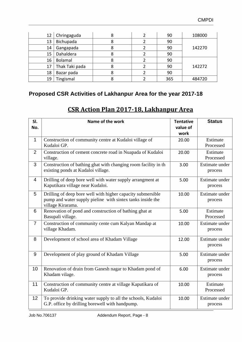
CMPDI
Job No.706137 Addendum Report, Page - 8
12 Chringaguda 8 2 90 108000 13 Bichupada 8 2 90
142270 14 Gangapada 8 2 90 15 Dahaldera 8 2 90 16 Bolamal 8 2 90
142272 17 Thak Taki pada 8 2 90 18 Bazar pada 8 2 90 19 Tingismal 8 2 365 484720
Proposed CSR Activities of Lakhanpur Area for the year 2017-18
CSR Action Plan 201718, Lakhanpur Area
Sl. No.
Name of the work Tentative value of work
Status
1 Construction of community centre at Kudaloi village of Kudaloi GP.
20.00 Estimate Processed
2 Construction of cement concrete road in Nuapada of Kudaloi village.
20.00 Estimate Processed
3 Construction of bathing ghat with changing room facility in th existing ponds at Kudaloi village.
3.00 Estimate under process
4 Drilling of deep bore well with water supply arrangment at Kaputikara village near Kudaloi.
5.00 Estimate under process
5 Drilling of deep bore well with higher capacity submersible pump and water supply pieline with sintex tanks inside the village Kirarama.
10.00 Estimate under process
6 Renovation of pond and construction of bathing ghat at Basupali village.
5.00 Estimate Processed
7 Construction of community cente cum Kalyan Mandap at village Khadam.
10.00 Estimate under process
8 Development of school area of Khadam Village 12.00 Estimate under process
9 Development of play ground of Khadam Village 5.00 Estimate under process
10 Renovation of drain from Ganesh nagar to Khadam pond of Khadam vilage.
6.00 Estimate under process
11 Construction of community centre at village Kaputikara of Kudaloi GP.
10.00 Estimate Processed
12 To provide drinking water supply to all the schools, Kudaloi G.P. office by drilling borewell with handpump.
10.00 Estimate under process

CMPDI
Job No.706137 Addendum Report, Page - 9
13 Development of road from Kushraloi to Kantajharia chawk in Kushraloi Village.
10.00 Estimate under process
14 Construction of Community Centre cum kalyan mandap at Lakhanpur village.
30.00 Estimate Processed
15 Construction of community centre at Bhejibandh of village Pipilikani GP.
10.00 Work Completed
16 Excavation of new pond at Karpabahal village. 10.00 Estimate under process
17 Deep borewell in Gangapada, Chamarpada, Dhaldira, Kudaloi pond area and Bichuapada of Kudaloi village.
10.00 Estimate under process
18 Construction of separate Hostel building for Orphans at Thakkar Bapa Sevasadan Orphanage (Belpahar Municipality).
25.00 Estimate under process
19 Construction of additional school building and construction of boundary wall for Manoj Padhee High School, Sarandamal village.
25.00 Estimate Processed
20 Deepening of pond and stone patching with bathing ghat at Talibahal, Sarandamal
10.00 Estimate Sanctioned & to be tendered
21 Excavation of new pond at Talipada (Purana Basti) with 4 nos. of ghat
4.00 Estimate under process
22 Construction of concrete road from Talipada to Goudapada connecting main road with drain system on both side of road.
10.00 Estimate under process
23 Construction of urinal, toilet and bath rooms for Gourpara community centre in Bandhabahal GP.
3.00 Estimate under process
24 Construction of urinal, bath room for para Anganwadi. 3.00 Estimate under process
25 Construction of urinal, bath room with toilet at Majhipada School and Anganwadi.
3.00 Estimate under process
26 Renovation and development of Hagarimunda pond of Puranibasti.
5.00 Estimate under process
27 Construction of Community centre cum kalyan mandap at Basupali village under Dalgaon GP.
10.00 Estimate Processed
28 Renovation of Pond at Negipali village under Dalgaon G.P. 10.00 Estimate under process
29 Construction of Kalyan mandap cum community centre with attached latrine & bathroom at village Adhapara under Kushraloi G.P.
25.00 Estimate Processed &
sent to Hqtr for approval
30 Excavation of new pond at Banjimunda under Lakhanpur G.P. 15.00 Estimate Processed

CMPDI
Job No.706137 Addendum Report, Page - 10
31 Black topping road from Block Office to Maa Samlei Girls' High School at village Lakhanpur under Lakhanpur G.P.
25.00 Estimate Processed
32 Construction of drain in Lakhanpur village under Lakahanpur G.P.
20.00 Estimate Processed
33 Construction of RCC bridge at Mauliberna over Bagdianalla including road near Hanuman Mandir under Lakhanpur G.P. RDC
50.00 Estimate under process
34 Construction of boundary wall around Pipilikani high school under Pipilikani G.P.
25.00 Estimate Processed &
sent to Hqtr for approval
35 Construction of Village Club at Sartang (Majhipada) under Piplikani G.P.
6.00 Estimate under process
36 Construction of Village club of Orampada/Talibahal under Sarandamal GP.
6.00 Estimate under process
37 Construction of balance boundary wall of Sarandamal Primary School, Talibahal under Sarandamal G.P.
10.00 Estimate under process
38 Construction of 2 nos. of bathing ghat at the pond located the beginning of village Talibahal under Sarandamal G.P.
4.00 Estimate under process
39 Construction of cement concrete road from beginning of village upto UP School at village Talibahal under Sarandamal G.P.
20.00 Estimate under process
40 Construction of Cement concrete road from Khamanpada to Orampada at Village Talibahal under Sarandamal G.P.
16.00 Estimate under process
41 Construction of Community Centre near Sarandamal GP Office under Sarandamal G.P.
10.00 Estimate Processed
42 Construction of bathing ghat and cement concrete approach road to ghat at village Phata under Sarandamal G.P.
10.00 Estimate under process
43 Construction of two additional rooms and urinals & latrines, Playground, Library & Laboratory etc for students of Arjun Gupta High School, Phatapali, Tilia GP.
15.00 Estimate under process
44 Construction of Examination hall at Belpahar college in ward no- 2 under Belpahar Municipality
50.00 Estimate yet to be prepared
45 Construction of class room (s) at Belpahar college, Belpahar under Belpahar Municipality
91.58 Estimate Processed
46 Installation of MS grill at verandah of Belpahar college under Belpahar Municipality
4.00 Estimate Sanctioned & Tender invited
47 Construction of 2 nos. of class room and science laboratory in Anchalik High School, Dalgaon under Dalgaon GP
12.00 Estimate under process
48 Renovation of nuabandh (pond) at Bargarh Sarandamal GP 5.00 Estimate under process
49 Renovation of bandh (pond) at Dhubentipi Sarandamal GP 6.00 Estimate under process

CMPDI
Job No.706137 Addendum Report, Page - 11
50 Construction of dining hall and providing kitchen utensils to Manoj Padhee high school Sarandamal GP
10.00 Estimate Processed
51 Construction of one examination hall at Anchalik High School, Dalgaon under Dalgaon G.P.
5.00 Estimate Processed
52 Construction of boundary wall around the school of Anchalik High School, Dalgaon under Dalgaon G.P.
8.00 TCR processed
53 Construction of CC road from Naikpada, Pipilikani to Ainlapada R.D. Road under pipilikani G.P.
20.00 Estimate under updation
54 Construction of CC road from Padapali to Sundhimunda R.D. road under Pipilikani G.P.
20.00 Estimate under updation
55 Improvement of Khuntband Kanta (Pond) and construction of 04 nos of Bathing Ghat under Pipilikani G.P.
25.00 Estimate under updation
56 Renovation of Pipilikani Bandha (Pond) and construction of 04 nos of Bathing Ghat at upper pada under Pipilikani G.P.
12.00 Estimate under updation
57 Improvement of Bejibandh kanta (Pond) and construction of guard wall, Tal and Canal under Pipilikani G.P.
10.00 Estimate under updation
58 Construction of Library cum study room at Tulsi Sahu High School, Tilia under Tilia G.P.
10.00 Estimate processed
59 Improvement of Basupali upper munda / kanta (pond) and construction of 02 nos of bathing steps under Dalgaon G.P.
8.00 Estimate under process
60 Improvement of Dalgaon Kanta (pond) and construction of 04 nos of bathing step under Dalgaon G.P.
10.00 Estimate under process
61 Improvement of Snehmal Kanta (pond) and construction of bathing steps under Dalgaon G.P.
10.00 Estimate under process
62 Providing water supply arrangement , Electric Wiring of Govt. (SSD) High School of Banjari Dist. Jharsuguda.
4.00 Work Completed
63 Renovation of Majhikata pond of village Baghmunda under Baghmunda G.P. at LKP OCP of Lakhanpur Area
9.60 Estimate Processed
64 Providing preparatory training to 18 nos SC/ST male candidates selected by MCL as Trainees to fill up the post of Mining Sirdar T&S Gr.C i.e. statutory mining supervisory personnel reserved for SC/ST categories, on qualifying the statutory examination on completion of the training conducted at BTI, Lakhanpur with an amount of Rs. 73, 28,435.00 for 4 years duration of training under CSR of MCL.
- Works related to Personnel
Dept.

CMPDI
Job No.706137 Addendum Report, Page - 12
1.6 AS PER GUIDELINES FOR GRANTING ENVIRONMENTAL CLEARANCE FOR EXPANSION OF COAL MINING PROJECTS INVOLVING CAPACITY EXPANSION OF UP TO 40% IN THE EXISTING OPERATION-REG VIDE OFFICE MEMORANDUM NO. J-11015/224/2015-IA.II DATED 15TH SEP, 2017(ANNEXURE- IV).
Point No. Guidelines for one time capacity expansion
Compliance
3.0 (i) Predicted air quality parameters are within the prescribed norms
The AQIP modeling has been carried out for incremental capacity of 2.25 MTPA (i.e. from present capacity of 18.75 MTPA to capacity of 21.0 MTPA) using AERMOD software. The Ambient air quality is well within permissible limit as per GSR742 (E).
3(ii) Coal Transportation is through conveyor system up to the silo and then loading to railway wagon, involving no transportation through roads.
Conveyor and SILO is proposed.
3(ii) Coal mining is done through deployment of surface miner, replacing three dust generating operations of conventional mining system namely drilling, blasting and crushing in one go.
Coal is to be completely excavated/mined by Surface miner only.
3(iii) Public hearing already conducted for the total mine lease area involved and no more area is required for the proposed expansion.
Public hearing was conducted on 27/7/2007 for 15.0 Mty project as per Sept., 2006 notification. Annexure V
3(iv) Compliance Status of EC conditions monitored by the concerned Regional Office of this ministry is found to be satisfactory.
Annexure III
3(v) Other statutory requirements like Consent to Establish/Operate, Clearance from CGWA, approval of Mining Plan and the Mine Closure Plan, Mine Closure Status Report as applicable, Forest Clearance, etc are satisfactorily fulfilled.
Annexure I to VIII