appendix i - Environmental Clearance
56
-
Upload
khangminh22 -
Category
Documents
-
view
1 -
download
0
Transcript of appendix i - Environmental Clearance


1
APPENDIX I
(See Paragraph- 6) FORM 1
Note : If space provided against any parameter is inadequate,Kindly upload supporting document under 'Additional Attachments if any' at the last part of the Form1. Please note that all such Annexures must be part of single pdf document.
(I) Basic Informations
S.No. Item Details
1. Name of the Project Moharwa Limestone Deposit of M/s Adhunik Corporation
Limited
2. Project Sector Non-Coal Mining
3. Location of the project
Villages - Moharwa, Gothari, Godhin, Patehara, Goraiya,
Barkula and Jhanjwari,
Tehsil Maihar,
District - Satna, MP
4. Shape of the project land Polygon
Uploaded GPS file Annexure-GPS file
Uploaded copy of survey of India
Toposheet Annexure-Survey of India Toposheet
5. Brief summary of project Annexure-Brief Summary of Project
6. State of the project Madhya Pradesh
Details of State of the Project
S.No. State Name District Name Tehsil Name
(i) Madhya Pradesh Satna Maihar
7. Town/ Village Villages: Moharwa, Ghotari, Godhin, Patahara,
Goraiya, Barkula, Jhanjwari
8. Plot/Survey/Khasra No. Total khasra numbers : 1956
9. S. No. in the schedule 1 (a) Mining of minerals
10.
Proposed capacity/area/length/tonnage to
beHandles/command area/lease
area/number or wells to be drilled
ProposedCapacity- ROM – 4.0 MTPA
Production - 3.75 MTPA Limestone,
ML Area - 869.032 hectares.
11. New/Expansion/Modernization New
12. Category of project i.e. ‘A’ or ‘B’ A
13. Does it attract the general condition?
If yes, please specify. No.
15. Does it attract specific condition? No.
16. Is there any litigation pending against the
project? No
17. Nearest railway station along with distance
in kms. Maihar-14 km aerially in NW

2
18. Nearest airport along with distance in kms. Jabalpur -136 km SW
19. Nearest Town/City/District Headquarters
along with distance in kms Maihar- 14 km aerially in NW
20. Details of alternative sites examined shown
on a toposheet No
21.
Whether a part of interlinked projects?
Whether separate application of interlinked
project has been submitted?
Reason
Yes
No
PFR of cement plant under preparation
Identification of some land still to be completed
22.
Whether the proposal involves
approval/clearance under the Forest
(Conservation) Act, 1980?
No
23.
Whether the proposal involves
approval/clearance under the wildlife
(Protection) Act, 1972?
No
24.
Whether the proposal involves
approval/clearance under the C.R.Z
notification, 2011?
No
25.
Whether there is any Government
Order/Policy relevant/relating to the site?
Uploaded Order/Policy
ACL has signed a MOU with Govt of MP for
establishment of Cement plant in Satna district.
This mine will be a captive mine for supply of
limestone to the proposed cement plant. The State
Govt of MP has issued grant order of Mining
Lease vide letter dated 01-04-2015. Time for
execution of ML Deed is extended vide letter
dt.31.05.2016.
26.
Whether there is any litigation pending
against the project and/or land in which the
project is proposed to be set up?
No
27. Project Cost (in lacs) 22000
Activity
1. Construction, operation or decommissioning of the Project involving actions,
which will cause physical changes in the locality (topography, land use,
changes in waterbodies, etc.)
S.No Information/Checklist Confirmation Yes/No Details there of (with approximate
quantities/rates, wherever possible) with source of information
data 1.1 Permanent or temporary change in land use, land
cover or topography including increase in intensity
of land use (with respect to local land use plan)
Yes The present land use of the area will be changed by creation of void and dumps. This will be temporary as at conceptual stage, the void will reclaimed and rehabilitated by dumps

3
and OB/waste generated. The rest voids will be converted to water reservoir.
1.2 Clearance of existing land, vegetation and
buildings?
Yes Shrubs and bushes will be cleared. Few trees will be felled. 229 houses (208 kutcha and 21 pucca house) will be cleared
1.3 Creation of new land uses? Yes The mining activity will result in pits; therefore land use of ML area change.
1.4 Pre-construction investigations e.g. bore holes, soil testing?
Yes Prospecting by giving bore holes was carried out during PL period
1.5 Construction works? Yes Administrative office, Site services and haul road
1.6 Demolition works? Yes Hutments present inside ML area will be demolished
1.7 Temporary sites used for construction works or housing of construction workers?
No -
1.8 Above ground buildings, structures or earth works including linear structures, cut and fill or excavations and fill or excavations
Yes Mine office and site services shall be over ground. Opencast Mine will create pits
1.9 Underground works including mining or tunneling? No No underground mining is proposed
1.10 Reclamation works? Yes Fully mined out area will be partially reclaimed by backfilling.
1.11 Dredging? No -
1.12 Offshore structures? No -
1.13 Production and manufacturing processes? Yes Open cast Mining by mechanised method
1.14 Facilities for storage of goods or materials? Yes Temporary OB dump and soil stacking inside ML area
1.15 Facilities for treatment or disposal of solid waste or liquid effluents?
Yes septic tanks and soak pits for sewage disposal OB dump for storage of waste materials
1.16 Facilitiesfor long term housing of operationalworkers?
No Workers will be employed locally from the nearby villages, for the mining activity. Thus no housing facility will be developed in the ML area.
1.17 New road, rail or sea traffic during construction or operation?
No -
1.18 New road, rail, air water borne or other transport infrastructure including new or altered routes and
No -

4
stations, ports, airports etc?
1.19 Closure or diversion of existing transport routes or infrastructure leading to changes in traffic movements?
No No Closure or diversion of existing transport routes are proposed.
1.20 New or diverted transmission lines or pipelines No
1.21 Impoundment, damming, culverting, realignment or other changes to the hydrology of watercourses or aquifers?
Yes
1.22 Stream crossings? No There is no stream crossing in the mine lease area
1.23 Abstraction or transfers of water from ground or surface waters?
Yes Water stored in existing mined out pits will be used for dust suppression and gardening. Dugwells/Bore wellsare present inside the ML area, which will be used for drinking purpose
1.24 Changes in water bodies or the land surface affecting drainage or run-off?
No No change in water bodies or drainage or run-off is proposed.
1.25 Transport of personnel or materials for construction, operation or decommissioning?
Yes Employees will come from surrounding villages
1.26 Long-term dismantling or decommissioning or restoration works?
Yes Mined out pit will be reclaimed using OB and Soil. Plantation will be done over reclaimed area
1.27 Ongoing activity during decommissioning which couldhave an impact on the environment?
No The houseowners will be allowed to collect their building materials after demolishing
1.28 Influx of people to an area in either temporarily or permanently?
Yes Few technical employees may be brought from outside
1.29 Introduction of alien species? No
1.30 Loss of native species or genetic diversity? No
1.31 Any other actions? No
2. Use of Natural resources for construction or operation of the Project (such as
land, water, materials or energy, especially any resources which are non-
renewable or in short supply):
S.No. Information/Checklist confirmation Yes/No Details thereof (with approximate
quantities/rates, wherever possible) with source of information
data
2.1 Land especially undeveloped or agricultural land (ha)
Yes ML area is partially waste land and mostly single crop rain fed agriculture land.
2.2 Water (expected source & competing users) unit: KLD
Yes 100 KL/day. Source: Rainwater accumulated in mine sump. Water from existing dug / bore wells will be used for

5
drinking
2.3 Minerals (MT) Yes Geological Reserve: 105.262 Million tons Mineable reserve 84.956 Million tons
2.4 Construction material – stone, aggregates, sand / soil (expected source – MT)
Yes Purchased from Local retailers
2.5 Forests and timber (source – MT No
2.6 Energy including electricity and fuels (source, competing users) Unit: fuel (MT),energy (MW)
Yes 2 MW from SEB. 500 KVA DG Sets for emergency use
2.7 Any other natural resources (use appropriate standard units)
No
Use, storage, transport, handling or production of substances or materials, which 3 could be harmful to human health or the environment or raise concerns about
actual or perceived risks to human health
S.No Information/Checklist Confirmation Yes/No Details thereof (with approximate
quantities/rates, wherever possible) with source of information
data
3.1 Use of substances or materials, which are hazardous (as per MSIHC rules) to human health or theenvironment (flora, fauna, and water supplies
Yes Explosives in magazine Diesel and lube oil in drums
3.2 Changes in occurrence of disease or affect disease vectors (e.g. insect or water borne diseases)
No -
3.3 Affect the welfare of people e.g. by changing living conditions?
Yes Create employment and more trade opportunity to local people
3.4 Vulnerable groups of people who could be affected by the project e.g. hospital patients, children, the elderly etc.
No -
3.5 Any other causes No -
4. Production of solid wastes during construction or operation or decommissioning
(MT/month)
S.No Information/Checklist Confirmation Yes/No Details thereof (with approximate
quantities/rates, wherever possible) with source of information
data
4.1 Spoil, overburden or mine wastes Yes OB and mine wastes / soils will be stored as dump inside MLarea
4.2 Municipal waste (domestic and or commercial wastes)
Yes Garbage shall be disposed As per norms
4.3 Hazardous wastes (as per Hazardous Waste Management Rules)
Yes Spent oil and grease will be given to authorised recyclers

6
4.4 Other industrial process wastes No -
4.5 Surplus product No -
4.6 Sewage sludge or other sludge from effluent treatment
No -
4.7 Construction or demolition wastes No -
4.8 Redundant machinery or equipment No -
4.9 Contaminated soils or other materials No -
4.10 Agricultural wastes No -
4.11 Other solid wastes No -
5. Release of pollutants or any hazardous, toxic or noxious substances to air(Kg/hr)
S.No Information/Checklist Confirmation Yes/No Details thereof (with approximate
quantities/rates, wherever possible) with source of information
data
5.1 Emissions from combustion of fossil fuels fromstationary or mobile sources
Yes From diesel exhaust of HEMM
5.2 Emissions from production processes Yes Dust emission from crusher will be controlled using bag filter and water sprinkling
5.3 Emissionsfrom materials handling including storage or transport
Yes Dust emission from vehicles movement on haul road
5.4 Emissions from construction activities including plant and equipment
Yes From HEMM, Crusher and Vehicles
5.5 Dust or odours from handling of materials including construction materials, sewage and waste
Dust from haul roads Dust during mining operations
5.6 Emissions from incineration of waste No -
5.7 Emissions from burning of waste in open air (e.g. slash materials, construction debris)
No -
5.8 Emissions from any other sources No -
6 Generation of Noise and Vibration, and Emissions of Light and Heat:
S.No Information/Checklist Confirmation Yes/No Details thereof (with approximate
quantities/rates, wherever possible) with source of information
data
6.1 From operation of equipment e.g. engines, ventilation plant, crushers
Yes From HEMM and Crusher, Blasting
6.2 From industrial or similar processes No -
6.3 From construction or demolition No -
6.4 From blasting or piling Yes Controlled Blasting will be done with all precautions stipulated by DGMS
6.5 From construction or operational traffic Yes From vehicle movement on haul roads
6.6 From lighting or cooling systems No -
6.7 From any other sources No -

7
7. Risks of contamination of land or water from releases of pollutants into the ground
or into sewers, surface waters, groundwater, coastal waters or the sea:
S.No Information/Checklist Confirmation Yes/No Details thereof (with approximate
quantities/rates, wherever possible) with source of information
data
7.1 From handling, storage, use or spillage of hazardousmaterials
Yes Diesel in drums Lube oil indrums Explosives in Magazine Risk management plan shall be Prepared
7.2 From discharge of sewage or other effluents to water or the land (expected mode and place of discharge)
Yes Sewage will be treated in septic tanks and disposed in soak pits
7.3 By deposition of pollutants emitted to air into the land or into water
Yes Air emissions will be within norms
7.4 From any other sources No -
7.5 Is there a risk of long term build up of pollutants in the environment from these sources?
No -
8 Risk of accidents during construction or operation of the Project, which could
affect human health or the environment S.No Information/Checklist Confirmation Yes/No Details thereof (with
approximate quantities/rates,
wherever possible) with source of information
data
8.1 From explosions, spillages, fires etc from storage, handling, use or production of hazardous substances
Yes Fire in diesel drums Explosion in Magazine
8.2 From any other causes
No -
8.3 Could the project be affected by natural disasters causing environmental damage (e.g. floods, earthquakes, landslides, cloudburst etc)?
No
9.Factors which should be considered (such as consequential development) which
could lead to environmental effects or the potential for cumulative impacts with other existing or planned activities in the locality
S.No Information/Checklist Confirmation Yes/No Details thereof (with approximate
quantities/rates, wherever possible) with source of information
data
9.1 Lead to development of supporting Yes Development of roads,

8
utilities, ancillary development or development stimulated by the project which could have impact on the environment e.g.:
Supporting infrastructure (roads, power supply, waste or waste water treatment, etc.)
housing development
extractive industries
supply industries
other
infrastructure and cement plant
9.2 Lead to after-use of the site, which could have an impact on the environment
Yes Site will be partially reclaimed by afforestation
9.3 Set a precedent for later developments No -
9.4 Have cumulative effects due to proximity to other existing or planned projects with similar effects
Yes The site is located adjacent to limestone mines of Maihar Cements.
(II) Environmental Sensitivity
S.No Areas Name/Identity
Aerial distance (within 15 km.) Proposedproject locationboundary
1. Areas protected under international conventions,national or local legislation for their ecological,landscape, cultural or other related value
No
2. Areas which are important or sensitive for ecological reasons - Wetlands, watercourses or other waterbodies, coastal zone, biospheres, mountains, forests
Yes Reserve forests are present Hardua RF(10 km), Kerreha RF-6.5 km, Bara RF-14 km, JunwaniRF-3.5 km, Gorala RF- 1km Hills are located on the north and south side of Mine
3. Areas used by protected, important or sensitivespecies of flora or fauna for breeding, nesting,foraging, resting, over wintering, migration
No -
4. Inland, coastal, marine or underground waters
Yes Bansagar Water Reservoir
5. State, National boundaries No -
6. Routes or facilities used by the public for access torecreation or other tourist, pilgrim areas
No -
7. Defence installations No -
8. Densely populated or built-up area No -
9. Areas occupied by sensitive man-made land uses(hospitals, schools, places of worship, communityfacilities)
Yes Hospital – Sarla Nagar and Maihar Schools - Sarla Nagar, Bhadanpur, Latagaon, Moharwa, Gothari, Godhin, Goraiya, Barkula, Jhanjwari and Maihar etc

9
Places of worship, community facilities in nearby villages
10. Areas containing important, high quality or scarceresources.(ground water resources,surface resources,forestry,agriculture,fisheries,tourism,minerals)
Yes The area is rich in limestone, hence many cement plants and mines are existing like KJS Cement, Maihar Cement,Reliance Cement
11. Areas already subjected to pollution or environmentaldamage.(those where existing legal environmental standards are exceeded)
No -
12. Areas susceptible to natural hazard which couldcause the project to present environmental problems(earthquakes, subsidence, landslides, erosion, flooding or extreme or adverse climatic conditions)similar effects
No -
(IV) PROPOSED TERMS OF REFERENCE FOR EIA STUDIES : Attached 1. Uploaded Terms of Reference(TOR) File Annexure-TOR file
2. Uploaded scanned copy of covering letter Annexure-scanned copy of covering letter
3. Uploaded Pre-Feasibility report(PFR) Annexure-PFR
4. Uploaded additional attachments(only single pdf file)
Annexure-Additional attachments
5 Uploaded Approval of mining Plan Annexure-Uploaded Approval of mining plan
(V) Undertaking
The aforesaid application and documents furnished here with are true to my knowledge
v. (i)
Name of Applicant Mr.Bikash Roy Choudhury
Designation Chief Executive Officer
Name of Company(Applicant Name should not be given here)
Adhunik Corporation Ltd
Address 14 N. S. Road, 2nd floor Kolkata-700 001

10
PROPOSED TERMS AND REFERENCE FOR EIA STUDY
Introduction
Adhunik Corporation Limited (ACL) proposes to start the Captive Limestone Mines, named
Moharwa Limestone Deposit located near villages Moharwa, Ghotari, Gondin, Patahara, Goraiya,
Barkula, Jhanjhwari, Tehsil Maihar, District Satna, Madhya Pradesh. The Mining Lease area is
869.032 hectares. Almost 99% land is single crop agriculture land. Production of ROM limestone
will be 4.0 Million Tons Per Annum (MTPA) and usable limestone will be 3.75 MTPA. The
limestone will be crushed in 1200 TPH Crusher and then transported to the proposed cement plant
by Over Land Belt Conveyor. The cement plant site has been identified at village Sagmania, on
the north side across hillock. The cement plant will produce 2.5 MTPA Clinker. Government of MP
has granted Mining Lease to Adhunik Corp Ltd. vide letter dated 1-4-2015.
The probable reserves estimated were 105.262 million tons in which the mineable reserve
calculated was estimated to be about 84.956 million tons. The life of the mine will be 27 years.
The limestone grade varies from CaO –34% to 50 %, SiO2 – 1.5% to 12.0% &MgO – 1.5% to
5.0%. The project cost is Rs.220 Crores. CSR cost is 2% and EMP cost is 5% of the cost, The
cost of production will be about Rs. 150/- per ton limestone.
No wildlife sanctuary, national park and biosphere reserve exists in the 10 km area (study area)
around the proposed mine boundary. Hills are located on the north and south side of the ML. Many
Reserve Forests are present in the study area. The 869.032 ha land is non-forest land. The ML
area is divided into 19 blocks to retain the several small nallasand road passing through the ML
area. Road passing through the ML area will be diverted along the boundary (if required at a later
stage when work on this block will start). ML boundary of Maihar cement is present on the west
side of this lease.
About 100 KL/day water will be required for the project. There are few abandoned limestone
pitsinside the mine. Water accumulated in these pits will be used for mining. 31 dug wells are also
present from where drinking water will be taken.
The ML area is located about 16 km southeast of Maihar town. The latitude and Longitude of the
four extreme corners of ML is given below.
Toposheet No. - 63 D/16
Latitude - 24°08'25.3" to 24°10'56.6" North
Longitude - 80°51'14.9" to 80°55'14.1" East
Altitude - 312m - 322 m A.M.S.L.

11
The method of mining will be fully mechanised opencast method with the use of HEMM. Blast
holes of 150 mm dia. are proposed to be drilled by using DTH wagon drill machine and controlled
blasting with ANFO with Booster charge will be done. Loading of blasted material will be done
using large size bucket excavators in dumpers of 35-40 tons capacity and transported to crusher
site for sizing. No external dump outside the ML area will be created. All pollution control
measures, as per standard norms, will be implemented.
The water table varies from 35m in post-monsoon to 40m in pre-monsoon below ground level of
360m RL. The main drainage of the area is through seasonal water courses situated in between
the different blocks of the applied area. The drainage of applied area is towards south-east in
Andhiari nalla, Geruha nalla & Parari nalla situated near the applied area. This ultimately merges
in to Mahanadi River in south east (Not the famous Mahanadi river of Chhattisgarh and Orissa).
There are several small ponds in the ML area.
The lease area is located in 7 villages. There are public building & place of worship falling in
villages in between the 19 blocks granted during the ML. During the course of grant of mining
lease, the village area including public building & place of worship was declared as restricted zone
and deleted from the applied area by the lessee. Hence there is no public building & place of
worship within the consented area for grant under ML. The Bhadanpur – Bara Khurd approach
road and Bhadanpur-Latagoan is passing through the applied area. In the buffer zone within 19
blocks of the ML area many public building such as Panchayatbhawan, Primary School,
Anganbadi Centre and PHC etc., temples are located. The Maihar- Barhi PWD road is passing at
a distance of 4.5 Km from the applied area in west. Maihar Cement, KJS Cement and Reliance
Cement plant and mines are located inside the 10 km study area.
Human habitation (208 kutcha houses + 21 pucca houses) exists inside the Mining Lease area.
There are 1956 khata holders for the entire ML area. R&R Policy of MP Government and LARR Act
2013 shall be followed while acquiring the land. All guidelines of MP Government and Central
Government shall be followed. Detailed socio-economic analysis of the project affected people will
be carried out and assessed before R&R plan is prepared and submitted to MP Govt for
implementation. Need based analysis of the project affected people as well as surrounding people
will be carried out to formulate the CSR Plan.

12
Proposed TORs
1) Year-wise production details since 1994 shall be given, clearly stating the highest
production achieved in any one year prior to 1994. It may also be categorically informed
whether there had been any increase in production after the EIA Notification 1994 came
into force, w.r.t. the highest production achieved prior to 1994.
2) A copy of the document in support of the fact that the Proponent is the rightful
lessee of the mine shall be given.
3) All documents including approved mine plan, EIA and Public Hearing shall be
compatible with one another in terms of the mine lease area, production levels, waste
generation and its management, mining technology etc. and shall be in the name of the
lessee.
4) All corner coordinates of the mine lease area, superimposed on a High Resolution
Imagery/ toposheet, topographic sheet, geomorphology and geology of the areashall be
provided. Such an Imagery of the proposed area shall clearly show the land use and other
ecological features of the study area (core and buffer zone).
5) Information shall be provided in Survey of India Toposheet in 1:50,000
scale indicating geological map of the area, geomorphology of land forms of the area,
existing minerals and mining history of the area, important water bodies, streams and
rivers and soil characteristics.
6) Details about the land proposed for mining activities shall be givenwith
information as to whether mining conforms to the land use policy of the State; land diversion
for mining shall have approval from State land use board or the concerned authority.
7) It shall be clearly stated whether the proponent Company has a well
laid down Environment Policy approved by its Board of Directors? If so, it may be spelt out in
the EIA Report with description of the prescribed operating process/procedures to bring
into focus any infringement/deviation/ violation of the environmental or forest norms/
conditions? The hierarchical system or administrative order of the Company to deal with the
environmental issues and for ensuring compliance with the EC conditions may also be
given. The system of reporting of non-compliances / violations of environmental norms to
the Board of Directors of the Company and/or shareholders or stakeholders at large,may
also be detailed in the EIA Report.
8) Issues relating to Mine Safety, including subsidence study in case of underground
mining and slope study in case of open cast mining, blasting study etc. shall be detailed.
The proposed safeguard measures in each case shall also be provided.
9) The study area will comprise of 10 km zone around the mine lease from lease
periphery and the data contained in the EIA such as waste generation etc. shall be for the
life of the mine / lease period.
10) Land use of the study area delineating forest area, agricultural land, grazing land,
wildlife sanctuary, national park, migratory routes of fauna, water bodies, human

13
settlements and other ecological features shall be indicated. Land use plan of the mine
lease area shall be prepared to encompass preoperational, operational and post
operational phases and submitted. Impact, if any, of change of land use shall be given.
11) Details of the land for any Over Burden Dumps outside the mine lease, such as
extent of land area, distance from mine lease, its land use, R&R issues, if any, shall be
given.
12) A Certificate from the Competent Authority in the State Forest Department shall be
provided, confirming the involvement of forest land, if any, in the project area. In the event
of any contrary claim by the Project Proponent regarding the status of forests, the site may
be inspected by the State Forest Department along with the Regional Office of the Ministry
to ascertain the status of forests, based on which, the Certificate in this regard as
mentioned above be issued. In all such cases, it would be desirable for representative of
the State Forest Department to assist the Expert Appraisal Committees.
13) Status of forestry clearance for the broken up area and virgin forestland involved
in the Project including deposition of net present value (NPV) and compensatory
afforestation (CA) shall be indicated. A copy of the forestry clearance shall also be
furnished.
14) Implementation status of recognition of forest rights under the Scheduled Tribes and
other Traditional Forest Dwellers (Recognition of Forest Rights) Act, 2006 shall be
indicated.
15) The vegetation in the RF / PF areas in the study area, with necessary details, shall
be given.
16) A study shall be got done to ascertain the impact of the Mining Project on wildlife of
the study area and details furnished. Impact of the project on the wildlife in the surrounding
and any other protected area and accordingly, detailed mitigative measures required,
shall be worked out with cost implications and submitted.
17) Location of National Parks, Sanctuaries, Biosphere Reserves, Wildlife Corridors,
Ramsar site Tiger/ Elephant Reserves/(existing as well as proposed), if any, within 10 km of
the mine lease shall be clearly indicated, supported by a location map duly
authenticated by Chief Wildlife Warden. Necessary clearance, as may be applicable to
such projects due to proximity of the ecologically sensitive areas as mentioned above,
shall be obtained from the Standing Committee of National Board of Wildlife and copy
furnished.
18) A detailed biological study of the study area [core zone and buffer zone (10 km radius of
the periphery of the mine lease)] shall be carried out. Details of flora and fauna,
endangered, endemic and RET Species duly authenticated, separately for core and buffer
zone shall be furnished based on such primary field survey, clearly indicating the Schedule
of the fauna present. In case of any scheduled- I fauna found in the study area, the
necessary plan alongwith budgetary provisions for their conservation shall be prepared

14
in consultation with State Forest and Wildlife Department and details furnished.
Necessary allocation of funds for implementing the same shall be made as part of the
project cost.
19) Proximity to Areas declared as 'Critically Polluted' or the Project areas likely to
come under the 'Aravali Range', (attracting court restrictions for mining operations), shall
also be indicated and where so required, clearance certifications from the prescribed
Authorities, such as the SPCB or State Mining Department shall be secured and
furnished to the effect that the proposed mining activities could be considered.
20) Similarly, for coastal Projects, A CRZ map duly authenticated by one of the
authorized agencies demarcating LTL. HTL, CRZ area, location of the mine lease w.r.t
CRZ, coastal features such as mangroves, if any, shall be furnished. (Note: The Mining
Projects falling under CRZ would also need to obtain approval of the concerned Coastal
Zone Management Authority).
21) R&R Plan/compensation details for the Project Affected People (PAP) shall be
furnished. While preparing the R&R Plan, the relevant State/National Rehabilitation &
Resettlement Policy shall be kept in view. In respect of SCs /STs and other weaker
sections of the society in the study area, a need based sample survey, family-wise, shall
be undertaken to assess their requirements, and action programmes prepared and
submitted accordingly, integrating the sectoral programmes of line departments of the
State Government. It may be clearly brought out whether the village(s) located in the
mine lease area will be shifted or not. The issues relating to shifting of village(s)
including their R&R and socio-economic aspects shall be discussed in the Report.
22) One season (non-monsoon) [i.e. March-May (Summer Season); October-December
(post monsoon season) ; December-February (winter season)]primary baseline data on
ambient air quality as per CPCB Notification of 2009, water quality, noise level, soil and flora
and fauna shall be collected and the AAQ and other data so compiled presented date-wise
in the EIA and EMP Report. Site-specific meteorological data shall also be collected. The
location of the monitoring stations shall be such as to represent whole of the study area
and justified keeping in view the pre-dominant downwind direction and location of sensitive
receptors. There shall be at least one monitoring station within 500 m of the mine lease in
the pre-dominant downwind direction. The mineralogical composition of PM10, particularly
for free silica, shall be given.
23) Air quality modeling shall be carried out for prediction of impact of the
project on the air quality of the area. It shall also take into account the impact of movement
of vehicles for transportation of mineral. The details of the model used and input parameters
used for modeling shall be provided. The air quality contours may be shown on a location
map clearly indicating the location of the site, location of sensitive receptors, if any, and
the habitation. The wind roses showing pre-dominant wind direction may also be
indicated on the map.
15
24) The water requirement for the Project, its availability and source shall
be furnished. A detailed water balance shall also be provided. Fresh water requirement for
the Project shall be indicated.
25) Necessary clearance from the Competent Authority for drawl of requisite
quantity of water for the Project shall be provided.
26) Description of water conservation measures proposed to be adopted in
the Project shall be given. Details of rainwater harvesting proposed in the Project, if any,
shall be provided.
27) Impact of the Project on the water quality, both surface and
groundwater, shall be assessed and necessary safeguard measures, if any required, shall
be provided.
28) Based on actual monitored data, it may clearly be shown whether working
will intersect groundwater. Necessary data and documentation in this regard may be
provided. In case the working will intersect groundwater table, a detailed Hydro Geological
Study shall be undertaken and Report furnished. The Report inter-alia, shall include details
of the aquifers present and impact of mining activities on these aquifers. Necessary
permission from Central Ground Water Authority for working below ground water and for
pumping of ground water shall also be obtained and copy furnished.
29) Details of any stream, seasonal or otherwise, passing through the
lease area and modification / diversion proposed, if any, and the impact of the same on
the hydrology shall be brought out.
30) Information on site elevation, working depth, groundwater table etc.
Shall be provided both in AMSL and bgl. A schematic diagram may also be provided for
the same.
31) A time bound Progressive Greenbelt Development Plan shall be prepared
in a tabular form (indicating the linear and quantitative coverage, plant species and time
frame) and submitted, keeping in mind, the same will have to be executed up front on
commencement of the Project. Phase-wise plan of plantation and compensatory
afforestation shall be charted clearly indicating the area to be covered under plantation and
the species to be planted. The details of plantation already done shall be given. The
plant species selected for green belt shall have greater ecological value and shall be of
good utility value to the local population with emphasis on local and native species and
the species which are tolerant to pollution.
32) Impact on local transport infrastructure due to the Project shall be indicated.
Projected increase in truck traffic as a result of the Project in the present road network
(including those outside the Project area) shall be worked out, indicating whether it is
capable of handling the incremental load. Arrangement for improving the infrastructure, if
contemplated (including action to be taken by other agencies such as State Government)
shall be covered. Project Proponent shall conduct Impact of Transportation study as per
Indian Road Congress Guidelines.

16
33) Details of the onsite shelter and facilities to be provided to the mine workers shall be
included in the EIA Report.
34) Conceptual post mining land use and Reclamation and Restoration of mined out
areas (with plans and with adequate number of sections) shall be given in the EIA report.
35) Occupational Health impacts of the Project shall be anticipated and the proposed
preventive measures spelt out in detail. Details of pre-placement medical examination and
periodical medical examination schedules shall be incorporated in the EMP. The project
specific occupational health mitigation measures with required facilities proposed in the
mining area may be detailed.
36) Public health implications of the Project and related activities for the population in the
impact zone shall be systematically evaluated and the proposed remedial measures shall
be detailed along with budgetary allocations.
37) Measures of socio economic significance and influence to the local community
proposed to be provided by the Project Proponent shall be indicated. As far as possible,
quantitative dimensions may be given with time frames for implementation.
38) Detailed environmental management plan (EMP) to mitigate the environmental
impacts which, shall inter-alia include the impacts of change of land use, loss of agricultural
and grazing land, if any, occupational health impacts besides other impacts specific to the
proposed Project.
39) Public Hearing points raised and commitment of the Project Proponent on the same
along with time bound Action Plan with budgetary provisions to implement the same shall
be provided and also incorporated in the final EIA/EMP Report of the Project.
40) Details of litigation pending against the project, if any, with direction /order passed by
any Court of Law against the Project shall be given.
41) The cost of the Project (capital cost and recurring cost) as well as the cost towards
implementation of EMP shall be clearly spelt out.
42) A Disaster management Plan shall be prepared and included in the EIA/EMP
Report.
43) Benefits of the Project if the Project is implemented shall be spelt out. The benefits of
the Project shall clearly indicate environmental, social, economic, employment potential,
etc.
44) Besides the above, the below mentioned general points are also to be followed:-
a) Executive Summary of the EIA/EMP Report
b) All documents to be properly referenced with index and continuous page numbering.
c) Where data are presented in the Report especially in Tables, the period in which the

17
data were collected and the sources shall be indicated.
d) Project Proponent shall enclose all the analysis/testing reports of water, air, soil, noise
etc. using the MoEF&CC/NABL accredited laboratories. All the original analysis/testing reports
shall be available during appraisal of the Project.
e) Where the documents provided are in a language other than English, an English
translation shall be provided.
f) The Questionnaire for environmental appraisal of mining projects as devised earlier by
the Ministry shall also be filled and submitted.
g) While preparing the EIA report, the instructions for the Proponents and instructions for the
Consultants issued by MoEF&CC vide O.M. No. J-11013/41/2006-IA.II(I) dated 4th August, 2009,
which are available on the website of this Ministry, shall be followed.
h) Changes, if any made in the basic scope and project parameters (as submitted in Form-I
and the PFR for securing the TOR) shall be brought to the attention of MoEF&CC with reasons for
such changes and permission shall be sought, as the TOR may also have to be altered. Post
Public Hearing changes in structure and content of the draft EIA/EMP (other than
modifications arising out of the P.H. process) will entail conducting the PH again with the
revised documentation.
i) As per the circular no. J-11011/618/2010-IA.II(I) dated 30.5.2012, certified report of the
status of compliance of the conditions stipulated in the environment clearance for the existing
operations of the project, shall be obtained from the Regional Office of Ministry of
Environment, Forest and Climate Change, as may be applicable.
i) The EIA report shall also include (i) surface plan of the area indicating contours of main
topographic features, drainage and mining area, (ii) geological maps and sections and (iii)
sections of the mine pit and external dumps, if any, clearly showing the land features of the
adjoining area.
18
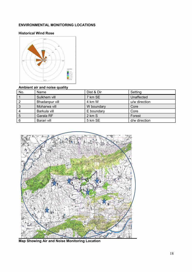
ENVIRONMENTAL MONITORING LOCATIONS Historical Wind Rose
Ambient air and noise quality
No. Name Dist & Dir Setting
1 Sulkhem vill 7 km SE Unaffected
2 Bhadanpur vill 4 km W u/w direction
3 Moharwa vill W boundary Core
4 Barkula vill E boundary Core
5 Garala RF 2 km S Forest
6 Barari vill 5 km SE d/w direction
Map Showing Air and Noise Monitoring Location

19
Soil and Ground Water Quality
No. Name Dist & Dir Setting
1 Sulkhem vill 7 km SE Unaffected
2 Bhadanpur vill 4 km W u/w direction
3 Moharwa vill W boundary Core
4 Barkula vill E boundary Core
5 Garala RF 2 km S Forest
6 Barari vill 5 km SE d/w direction
7 Sulkhem vill 7 km SE d/w direction
8 Moudaha vill 9 km S Unaffected
Map Showing Soil and Groundwater Quality Monitoring Location

20
Surface Water Quality
No. Name Dist & Dir
1 Ghasni nalla 8 km NW
2 Garula nalla 2 km S
3 Andhari nalla 3 km SE
4 Mahanadi R 9 km S
Map Showing Surface Water Quality Monitoring Location

21
PRE-FEASIBILITY REPORT OF
MOHARWA LIMESTONE DEPOSIT
M. L. Area – 869.032 Ha.
Village –Moharwa, Ghotari, Gondin, Patahara, Goraiya, Barkula, Jhajhwari
Tehsil–Maihar, District- Satna
State - Madhya Pradesh
Proposed Capacity – Proposed Capacity- ROM – 4.0 MTPA
Production - 3.75 MTPA Limestone
Lessee -
M/s. Adhunik Corporation Limited
Regd Office: 14 N.S. Road, Kolkata-1 Corporate Office:
Lansdowne Towers
2/1A, Sarat Bose Road Kolkata - 700020
Mob. – 09831159444 e-mail – [email protected]
This PFR is based on Mining Plan Prepared by
Balram Singh Associates Pvt. Ltd.
Regd. No.- RQP/JBP/105/2003/B
Valid upto - 14.09.2023
Chopra Colony, P.O.- Maihar
Distt.- Satna (M.P.) Pin : 485771
Phone No. : (07674) 232473, Mob - 919425185701
e-mail : [email protected]

22
1) Executive Summary
Background:
The PL was sanctioned over an area of 987.530 Ha and the sanctioned area under ML is
869.032 Ha which is part of PL area. The State Government of Madhya Pradesh took
decision to grant precise area under mining lease & communicated such decision vide letter
No.-F-3-20/2010/12/1 Bhopal Dated - 13.12.2011 & extended the time period by 6 months
effective from 13.12.2012 for submission of mining plan vide letter dated 14.03.2013 under
Rule-22 of MCR 1960. The State Government again extended the time period for submission
of approved Mining Plan by further 6 months period w.e.f. 13.06.2013 to 12.12.2013 vide
letter No.–F3-20/2010/12/2 dated 04.10.2013. Mining Plan as such was prepared under Rule-
22 (4) of M.C.R. 1960. The mining plan was approved by IBM on 5.12.2014. Grant order
of ML was issued vide letter dt.01.04.2015 and time for execution of ML was
extended vide letter dt.31.05.2016.
This will be a fully mechanised mine with average daily employment less than 150. All
operations of mining will be done by deployment of HEMM including deep hole drilling &
blasting of large dia.
The cement plant is proposed tentatively in Village – Sagmania, Tehsil – Maihar, District-
Satna (M.P.) towards north - west at 8 kms distance. of capacity being 2.50 million TPA of
Clinker. The requirement of Limestone i.e. 3.75 million TPA will be met from the applied area
when it will be fully developed. This will be a captive mine for the proposed Cement Plant.
Profile of the company -
Adhunik Corporation Ltd.(ACL) is a part of the Adhunik Group which is in the business of
manufacture of Steel, Cement, and Power and Mining business with excellent market network
all over the country. The group is having manufacturing facilities in the States of West Bengal,
Orissa & Jharkhand. The group is one of the largest in the Steel market and is set to become
market leader through its experienced managerial skills and its forward and backward
integration, and diversification plans. The Adhunik Group is one of the leading Industrial
houses in the Country with very sound business and financial fundamentals.

23
DETAILS OF ADHUNIK CORPORATION LTD. AND GROUP COMPANIES
Company Facilities of Manufacture
Location
Adhunik Corporation Ltd Integrated Steel Plant
Manufacturing Sponge
Iron and Billets
Durgapur,
West Bengal
Adhunik Industries Ltd. Rolling Mill Durgapur,WestBengal
Adhunik Metaliks Ltd. Integrated Steel Plant Rourkela, Orissa
with CPP
Adhunik Alloys and Power Ltd. Integrated Steel Plant Kandra, Jharkhand
with CPP
Adhunik Power and Natural 2X 270MW Independent Kandra, Jharkhand
Resources Ltd. Power Producer Plant
Orissa Manganese and Minerals Ltd. Non-Captive Mining
Orissa and Jharkhand
The Company‘s strength is indicated hereunder on the various key parameters:-
I. Financial Soundness: Adhunik Corporation Ltd. is a part of Adhunik Group of
Industries, having annual turnover of over Rs.4000 Crores. The company has
excellent Banking relationship.
II. Presence in Mining Activities: The Adhunik Group has presence in mining
activities as under:-
Orissa Limestone, Manganese Ore
Chhatisgarh Limestone Mines
Jharkhand Manganese Ore
Maharashtra Iron Ore
III. Experienced Professionals: Adhunik Group has a strong team of professionals
in various disciplines including Mining. As the group is having operational mines in

24
the States of Jharkhand, Orissa and hence it is having a team of experienced
Mining and allied technical professionals expert in the field.
IV. Excellent Background of Promoters: The promoters of the group as well as the
company have excellent acumen and savvy to tackle the business situations and
are aggressive in putting the growth graph northwards.
V. Adhunik Corporation Ltd. was incorporated on 2nd of February 1996 and has
manufacturing facilities in Durgapur having integrated steel plant manufacturing
Billets and has a rolling mill. The company has an MOU with the Madhya Pradesh
Government to set up a cement plant in the State.
The Project:-
Project : Moharwa Limestone Deposit
Name of Company / Mine Owner : M/s. Adhunik Corporation Limited
Location
Village : Moharwa, Ghotari, Gondin, Patehara,
Goraiya, Barkula, Jhajhwari
Taluka : Maihar
District : Satna
State : Madhya pradesh
1 Mining Lease Area & Type of land 869.032 ha, Revenue land
2 Geographical co-ordinates Latitude– 24°08'25.3" to 24°10'56.6"N
Longitude-80°51'14.9" to 80°55'14.1"E
3 Name of Rivers/ Nallahs/ Tanks/
Spring/ Lakes etc
Mahanadi River
Tons River
Bansagar Lake
4 Name of Reserve Forest(s), Wild life
Sanctuary/ National parks etc.
Hardua RF(10 km),
Kerreha RF-6.5 km,
Bara RF-14 km,
JunwaniRF-3.5 km,
Gorala RF- 1km
5 Topography of ML area Almost Plain,
Highest elevation -380m assumed R.L. in
North of the applied area
Lowest elevation- 360m. assumed R.L.
towards South east.
The general slope of the lease area is
towards south direction.
6 Name of Mineral mined Limestone
25
7 Rate of Production (in MTPA) Proposed Capacity- ROM – 4.0 MTPA
Production - 3.75 MTPA Limestone
8 Life of mine 27 Years based on present level of
exploration.
9 Mineral Reserve in Million Tonnes Mineral resource: 105.262 Million tons
Mineral Reserve: 83.906 Million tons
10 Drilling/ Blasting Dia. of holes = upto 150 mm
Charge per hole = 45t
11 Ultimate depth of Mining 320m RL
12 Ground water level 45-50 m bgl (310-315m RL)
13 GWT intersection No
14 Drainage pattern/ water courses The drainage of applied area is towards
south-east in Andhiari nalla, Geruha Nalla
& Parari Nalla situated near the applied
area. This ultimately merges in to
Mahanadi River in south east.
15 Break-up of Land Utilization Pattern Mineable area - (291.042 ha.)
Proposed rehabilitation by –
Water Reservoir – 195.09 ha.
Plantation on backfilled area – 95.952 ha
Green Belt – 15.0 ha.
16 Water requirement & Source Total water requirement for dust
suppression, plantation and drinking is
100 m3/day.
Water will be sourced from existing bore
wells/dug wells present inside ML area.
17 Solid waste The 254460 cum of soil and 1005955 cum
of OB/waste generated will be utilised for
preparing protective bund by the side of
the road and in boundary. Rest will be
stacked in south of the applied area and
utilised for backfilling of mined out area
and for sloping the sides of the water
reservoir created post mining.
18 Mining Approval : Date 5.12.2014
19 Public hearing : Date After Submission of Draft EIA Report
20 Cost of project Rs.22000 Lacs.
21 Any Other (specify) --

26
2) INTRODUCTION OF THE PROJECT / BACKGROUND INFORMATION
S. No. Particulars Details
1. 1stMining lease period 50 years period.
(i) IDENTIFICATION OF PROJECT AND PROJECT PROPONENT
Name of the Project : Moharwa Limestone Deposit
Location : Moharwa, Gothari, Godhin, Patehara, Goraiya,
Barkula and Jhanjwari
Tehsil : Maihar
District : Satna, Madhya Pradesh state.
Production : Proposed Capacity- ROM – 4.0 MTPA
Production - 3.75 MTPA Limestone
ML Area : 869.032 ha. Non- Forest Barren Land
Name and Address of the Project Proponent:
Lessee : M/s. Adhunik Corporation Limited
Address : Registered Office: 14 N.S. Road, Kolkata-1
: Corporate Office: Lansdowne Towers, 2/1A Sarat Bose
Road, Kolkata-700020
Phone No. : 9831159444
e-mail : [email protected]
Copy of Grant order of mining lease is attached as Annexure.
ii) BRIEF DESCRIPTION OF THE NATURE OF THE PROJECT.
Opencast mechanised method of mining will be adopted in this mine. The development
and production will be done side by side. The OB and ore will be loaded mechanically on
dumpers or trucks. 3.75 MTPA Limestone will be produced. The OB and mine wastes will
be stored inside ML area.
(iii) NEED FOR THE PROJECT AND ITS IMPORTANCE TO THE COUNTRY AND OR
REGION
The mine will be a captive mine for proposed cement plant in Satna district. The
production of mineral will benefit to the State in the form of Royalty & value addition
taxes. Apart from this, the project will generate direct and indirect employment
opportunities to the tune of about 100 persons from the nearby villages. Also, the mine
management will conduct medical camps at regular interval in the nearby villages and will
help the nearby villages in providing infrastructure like school furniture, water tankers,
etc. The lessee will also assist in mission Swacch Bharat Abhiyaan and other CSR
activities.

27
(iv) DEMAND SUPPLY GAP
The mineral is intended for captive consumption in its Cement plant proposed near the ML
area in village Sagmania, tehsil Maihar, District Satna, MP. No supply will be made to
other industry.
(v) IMPORTS VS. INDIGENOUS PRODUCTION
Indigenous production of mineral will be used in proposed cement plant. No import is
envisaged as the mineral produced is for captive purpose.
(vi) EXPORT POSSIBILITY - The Limestone mined out is proposed to be used in
cement plant. No export is proposed.
(vii) DOMESTIC/ EXPORT MARKETS
The promoters of the group as well as the company have excellent acumen and savvy to
tackle the business situations and are aggressive in putting the growth graph
northwards. Adhunik Corporation Ltd. was incorporated on 2nd of February 1996 and
has manufacturing facilities in Durgapur having integrated steel plant manufacturing
Billets and has a rolling mill.The company has MOU with Government of M.P. for
setting up a cement plant in the State. The limestone will be used for captive purpose.
(viii) EMPLOYMENT GENERATION (DIRECT AND INDIRECT) DUE TO PROJECT.
The total manpower requirement in this project is as under.
Mining Engg./First class Mines manager - 2
Second class Mines manager - 4
Mechanical Engg - 2
Geologist - 1
Electrical Foreman - 1
Mines Foreman - 4
Mechanical Foreman - 4
Skilled - 25
Semi Skilled - 30
Unskilled - 25

28
3) PROJECT DESCRIPTION
(i) TYPE OF PROJECT (INCLUDING INTERLINKED AND INTERDEPENDENT
PROJECT, IF ANY)
The mine will be captive. The interlinked project is the proposed cement plant near the
mine site.
(ii) LOCATION (MAP SHOWING GENERAL LOCATION, SPECIFIC LOCATION AND
PROJECT BOUNDARY & PROJECT SITE SPECIFIC LAYOUT) WITH COORDINATES.

29
The details of the land are as follows:
Khasra No. / Plot No. / Block Range /Survey No/ Khasra No.-1956 khasra numbers
Lease Area:869.032 Ha.
Type of Land: Non forest revenue Land
The applied area is located 20 km Southeast of Maihar town and forms a part of the Survey
of India Toposheet No 63D/16. The said area is bounded by Latitudes and Longitudes as
follows:
Toposheet No. 63 D/16
Latitude 24°08'25.3" to 24°10'56.6" North
Longitude 80°51'14.9" to 80°55'14.1" East
District /
State Tehsil Village
Block No.
in Lease
Map Block No. in
Surface Plan Area ( ha.)
Ownership
/
Occupancy
Area acquired
or surface
right of lessee
Satna
(M.P.)
Maihar Ghotari I Block - 14 36.049 Government
Land =
35.307 ha.
Private Land
= 833.725
ha.
Surface
right to be
acquired
II Block - 15
Patahara I Block – 8 113.104
II Block – 19
III Block – 10
IV Block – 7
V Block – 9
Moharwa I Block – 1 99.143
II Block – 2
III Block – 3
IV Block – 4
Jhajhwari I Block – 6 129.965
II Block – 11
III Block – 13
IV Block – 12
Goraiya I Block – 16 105.975
Gondin I Block – 5 21.474
Barkula I Block – 17 363.322
II Block – 18
Total 869.032

30
Existing Land Use Pattern :-
Sl.
No.
Item Type of Land (in
hects.)
Forest
Land
(Hects.)
Agri.
Land
(Hects.)
Grazing
Land
Barren
Land
Any
other
type
Total
1. (A) Lease area - 861.532 - 7.50 - 869.032
2. (B) Mining & allied
Activities -
i. Pit - - - 1.0 - 1.0
ii. Dumps - - - 0.50 - 0.50
iii. Roads - - - 1.0 - 1.0
iv. Site services - 2.0 - - - 2.0
v. Plantation etc. - - - - - -
vi. Water body - - - - - -
(c) Hutments/Infrastructure - - - - -
Undisturbed area - 859.532 - 5.0 - 866.532
Co-ordinates of Pillar (WGS 84) –
Pillar No. Latitude Longitude Pillar No. Latitude Longitude
1 24°10'00.0" 80°51'21.9" 2 24°09'53.7" 80°51'46.3"
3 24°10'06.1" 80°51'45.8" 4 24°10'11.5" 80°52'13.6"
5 24°09'57.4" 80°52'15.8" 6 24°10'05.8" 80°52.32.9"
7 24°10'06.2" 80°52'53.0" 8 24°10'17.1" 80°53'04.6"
9 24°10'12.1" 80°54'21.1" 10 24°10'43.7" 80°54'46.4"
11 24°10'56.6" 80°53'03.1" 12 24°10'34.2" 80°55'11.1"
13 24°09'58.5" 80°55'07.8" 14 24°09'34.5" 80°55'03.7"
15 24°09'17.8" 80°55'09.4" 16 24°09'04.3" 80°55'14.1"
17 24°08'37.7" 80°54'48.3" 18 24°09'31.8" 80°54'09.0"
19 24°09'19.6" 80°53'04.4" 20 24°08'47.7" 80°52'57.3"
21 24°08'25.3" 80°52'40.9" 22 24°08'45.2" 80°52'12.3"
23 24°09'11.9" 80°51'46.4" 24 24°09'32.7" 80°51'14.9"
25 24°08'47.7" 80°52'57.3"
(iii) DETAILS OF ALTERNATE SITES CONSIDERED AND THE BASIS OF
SELECTING THE PROPOSED SITE, PARTICULARLY THE ENVIRONMENTAL
CONSIDERATIONS GONE INTO SHOULD BE HIGHLIGHTED.
Mining is a site specific project hence no alternate site is considered. The area was
previously held under PL and sufficient reserves were established to erect a cement plant
as per MOU with the state Govt. of M.P.
(iv) SIZE OR MAGNITUDE OF OPERATION.
The maximum rated capacity of the project will be ROM – 4.0 million TPA and Production
- 3.75 MTPA of Limestone. The lease area is spread over 869.032 ha.

31
(v) PROJECT DESCRIPTION WITH PROCESS DETAILS (A SCHEMATIC DIAGRAM/
FLOW CHART SHOWING THE PROJECT LAYOUT, COMPONENTS OF THE PROJECT
ETC. SHOULD BE GIVEN.
MINING PROCESS
Opencast fully mechanised method of mining will be done. All operations of mining will be
done by deployment of heavy earth moving machineries for deep hole drilling,
excavation, loading & transport. Various mining activities such as drilling, blasting,
loading and transportation will be so conducted as to ensure maximum mineral
conservation and minimum environmental degradation. While planning, quality parameter
of the deposit has been taken care of so as to have maximum blending ratio.
Systematic working will be done by formation of benches as per M.M.R. 1961. All
applicable rules of MMR 1961, Mines Act-1952, MCR-2016, MCDR-1988 will be followed
for safe, scientific & systematic working to follow the principles of safety & conservation
of human health & mineral.
The bench height in OB has been proposed upto 6.5m based on the thickness
encountered in bore hole -2 and in mineral has been proposed as 7.5m. This has been
done for better and smooth working facility and quality control in respect of mining. This
will ensure vertical blending. The cut off grade of limestone has been taken as 34% CaO
and 5% MgO. To the possible extent, suitable blending of ROM limestone will be done
using the stacker reclaimer in the plant in the best interest of mineral conservation.
Removal of over burden will be done by loader cum excavator. Drilling in hard strata will
be done by DTH drills of hole dia 115 to 150 mm. It is proposed to use ripper or surface
miner also along with rock breaker. Drilling and blasting within 300 m from habitation will
only be done after taking permission from DGMS as per rules. Provision for safe guard of
hutments with blasting danger zone with controlled or muffle blasting will be done along
with delay detonator. The benches will be sloped at 45 degrees. The haul road will be
extended from north-west side of the applied area to the working pit at gradient of 1 in
16. The gradient in ramp will be 1 in 10. For blasting, three types of explosives will be
used i.e. Emulsion explosives (cap sensitive), Slurry explosive (cap sensitive) and ANFO
(Non cap sensitive). Cap sensitive explosives are used as base charge (@ 12 to 15% of
total explosive) whereas non-cap sensitive explosives are used as column charge.
Blasting will be done for heaving effect and fragmentation of the deposit. Blasted
Limestone will be loaded in to the dumpers by loaders and will be transported to the
destination crushing plant. The over burden will be loaded by loaders and transported to
the dumping yard by dumpers. Winning of limestone and handling of waste rock will be
done by excavators of bucket capacity 3.5 to 5 cum. capacity and dumpers of 35 to 60 t.
capacity.

32
(i) Extent of mechanization :-
1. Drilling machines :
Type Nos. Dia of hole
(mm.)
Size /
capacity
Make Motive Power H.P.
IBH – 10 3 150 10m/hr. IBH Diesel 400
2. Loading equipment :-
All loading of OB/waste will be done mechanically by following machine.
Type Nos. Size /
capacity
Make Motive
Power
H.P.
L&T -300 CKII
Demag H-55
Hyd. Shovel
4
4.0 cum
3.5 cum
L & T/
Demag
Diesel
Diesel
320
295
3. Haulage and transport equipment :-
(a) Haulage Within the lease hold area :
Haulage of O.B.to the surface stacking site and limestone to the crusher will be done
mechanically. The distance is within 2 km. total distance.
Type Nos. Size /
capacity
Make Motive
Power
H.P.
Dumpers (BH-
60/Cat - B775)
11
60 t.
Caterpillar Diesel
700
4. Miscellaneous: - The following additional equipments/machineries will be required for
allied operations related to the mining of the deposit not covered earlier.
Sl.
No.
Type Nos. Size /
capacity
Make Motive
Power
H.P.
1. Bull Dozer
BEML (D-155 A-1)
L&T (D-155 A- 5)
1
1
63cum
10.44 cum
BEML
Komatsu
Diesel
Diesel
360
350
2. Dewatering
Pumps
6 290-2000
GPM
Kirloskar Diesel &
Electric
30-125
3. Explosive Van, Tata
1210
1 10 t. Telco Diesel 95
4. Water Tankar
with water
Sprinkler
1 18000 ltr. Terex
R35
Diesel 375
5. Maintenance
Van
1 - Tata Diesel 95
6. Crane 2 3-10 t. Hydraulic
& Manual
Diesel 60
7. Rock Breaker
L&T-90CK II
3 0.90 cum L&T Diesel 114
8. Air Compressors
KG Khosla TDS-400 1 400 cfm Khosla Diesel 106

33
KG Khosla TDS H2 – 620
1 620 cfm Khosla 200
9. Tractors 2 HMT Diesel 58
10. Maintenance Van 1 10 t. Tata
1210S
Diesel 110
11. Portable diesel engine
driven welding set
5 10 t. OTM Diesel
12. Surface Miner
13. Rammer
(vi)RAW - MATERIAL REQUIRED ALONG WITH ESTIMATED QUANTITY, LIKELY
SOURCE, MARKETING AREA OF FINAL PRODUCT/S, MODE OF TRANSPORT OF
RAW - MATERIAL AND FINISHED PRODUCT
No raw material will be required in the proposed project. The operation involves the
mining of Mineral.
(vii) RESOURCE OPTIMIZATION/ RECYCLING AND REUSE ENVISAGED IN THE
PROJECT, IF ANY, SHOULD BE BRIEFLY OUTLINED
Not envisaged.
(viii) AVAILABILITY OF WATER, ITS SOURCE, ENERGY/ POWER REQUIREMENT
AND SOURCE SHOULD BE GIVEN -
The ground water is available from old bore wells for domestic purpose near the ML area.
The water from mine sump will be sourced for dust suppression and afforestation
purpose. Around 100 KLD water will be required under following heads:
Power –Power requirement is 2 MW, to be taken from SEB. Solar power will be also used
for site office.
(ix) Quantity of wastes to be generated (liquid and solid) and scheme for their
management/disposal.
Waste generation and Disposal of waste
A total of 744250 t. per annum of OB/Waste will be generated. The OB and waste will be
stacked initially within the ML area and then simultaneously backfilled.
Generation of waste water
No waste water will be generated except domestic waste which will be treated in septic
tank or soak pit.
The pumped out water will be utilized for sprinkling of water on haul roads, Crusher site,
watering of plants, drilling and other dust suppression measures. The mine water may
also be supplied to Cement plant. The water will not be discharged into any surface water
source directly. Regular monitoring of discharge water will be done.
(x) Schematic representations of EIA
This is Category A Project
Submission of Application to MOEF&CC. MOEF&CC will issue TOR for conducting EIA Study
Public Hearing will be done by submitting Draft EIA
In Final EIA, comments obtained from PH will be included
Final EIA will be appraised by EAC-Non-Coal Mining at MOEF&CC for Environmental Clearance

34
4) SITE ANALYSIS
(i) Connectivity
The applied area is located 20 km South east of Maihar town. Maihar Railway Station is
approx. 14 Km and Jabalpur Airport is 136 km from the proposed Site.
(ii) LAND FORM, LAND - USE AND LAND OWNERSHIP
Landform - The area is almost plain. It is non forest revenue land.
Land–use –The land use of the area is partially agriculture and partially waste land.
Mostly single crop rain fed agriculture land.
Ownership – The applied area is private land as well as Govt. land.
Existing Land Use Pattern :-
Sl.
No.
Item Type of Land (in
hects.)
Forest
Land
(Hects.)
Agri.
Land
(Hects.)
Grazing
Land
Barren
Land
Any
other
type
Total
1. (A) Lease area - 861.532 - 7.50 - 869.032
2. (B) Mining & allied
activities -
i. Pit - - - 1.0 - 1.0
ii. Dumps - - - 0.50 - 0.50
iii. Roads - - - 1.0 - 1.0
iv. Site services - 2.0 - - - 2.0
v. Plantation etc. - - - - - -
vi. Water body - - - - - -
(c) Hutments/Infrastructure - - - - -
Undisturbed area - 859.532 - 5.0 - 866.532
(iii) Topography along with maps
The lease area is almost plain having gentle slope towards south. The highest level is
380m RL towards north while the lowest elevation is 360 m in south-east.
(iv) EXISTING LAND USE PATTERN (AGRICULTURE, NON-AGRICULTURE,
FOREST, WATER BODIES (INCLUDING AREA UNDER CRZ), SHORTEST
DISTANCES FROMTHE PERIPHERY OF THE PROJECT TO PERIPHERY OF THE
FORESTS, NATIONAL PARK, WILD LIFE SANCTUARY, ECO-SENSITIVE AREAS,
WATER DIES (DISTANCE FROM THE HFL OF THE RIVER), CRZ. IN CASE OF
NOTIFIED INDUSTRIAL AREA, A COPYOF THE GAZETTE NOTIFICATION SHOULD
BE GIVEN.
The ML area is agriculture/waste land. There is no forest land or any water body in the
lease area. No national park, wild life sanctuary, eco-sensitive areas exists within 10 kms
radius. Other forest areas are as under –Hardua Reserve forest –10 Km , Kerreha RF –
6.5 Km, Bara RF – 14 Km , Junwani RF – 3.5 Km, Gorala RF – 1 Km .

35
(v) Existing infrastructure
The nearest rail head is at Maihar. Road and railways are near to the working site.
Manpower is easily available. There is no infrastructure existing within the ML area. Post
office is at village Moharwa, Gothari, Godhin. Police station is at Maihar. Rest House is at
Maihar and Satna. Hospital and education facility is available at Sarla Nagar and Maihar
(vi) Soil classification
The top soil is sandy in nature at the proposed site.
(vii) Climatic data from Secondary Sources
The region has a tropical monsoon climate with long humid summer and short winters.
The rain fall is heavy during S-W monsoon and light during pre-monsoon season. The
monsoon normally begins during June and retracts during September.
Metrological data is given below :-The climate of the region is tropical and the
average rainfall is 1100mm. The maximum precipitation is received during the rainy
season with little to moderate rain during winter. The meteorological data is given below -
Monthly mean maximum & minimum temperature and total rainfall based upon
1901-2000 data at Jabalpur IMD:
Month Mean Temperature Mean Rainfall,mm
Maximum Minimum
January 25.5 9.8 22.2
February 28.2 11.9 23.4
March 33.6 16.1 15.5
April 38.4 21.4 7.7
May 41.3 26.0 12.9
June 37.5 26.4 167.3
July 30.7 24.1 421.9
August 29.5 23.6 422.9
September 30.9 23.1 200.1
October 31.6 18.8 39.9
November 28.7 12.7 15.0
December 25.9 9.3 9.9

36
(viii) Social infrastructure Available
Existing:
All social infrastructure facility is available near the area at Maihar & Satna.
Water Supply:There is no major ground water body in the core zone. Hand pump, bore
well & dug well is situated for drinking purpose. The ground water table is 40m to 45m
below general ground level. The mining will be done above ground water table. There is
surface water body in form of rainwater catchment ponds present in the core zone. There
is no perennial source of surface water in the core zone, Mahanadi river is present in
south at about 10.0 Km distance. The main source of water supply is through tube well
situated in the area and nearby villages.

37
5. PLANNING BRIEF
(i) Planning Concept
The mining operation will be done in systematic and scientific manner by formation of
benches as per MMR 1961.
(ii) Population Projection
The project will employ most of the workers from nearby villages. Only supervisory staff
will be hired from outside. There will not be any increase in population due to the project.
However, few people from other area may migrate in this area for business opportunities.
(iii) Land use planning (Break up along with green belt, etc.)
The proposed land use at the end of lease period is given below:
Conceptual reclamation and rehabilitation of the worked out area –
(i) Present -The area was previously held under PL.
(ii) During the proposal period –
The open cast FM method of mining will be confined within the ultimate pit limit. The
proposal for development has been given at 1 place from one end of the lease area.
About 17.964 ha.area will be developed. No of benches in OB and mineral will be 4. The
overall pit slope will be 45 degree. The bench will be of height 7.50m on average and
width not less than the height of the bench. The stripping ratio will be 1:0.67.
(iii) Conceptual Mine Development –
Block Ultimate area of the pit upto
mine life –
Block Ultimate area of the pit
upto mine life –
1 80000 5 130000
6 50000 8 297700
14 339720 15 31700
16 339700 17 1641600
Ultimate slope of pit = 450, Ultimate area of the pit upto mine life = 291.042 ha.
The development and the ultimate pit limit has been designed keeping in view 7.5m
barrier as per Rule 111 of MMR 1961, mineralised area and public works. The stripping
ratio will be 1:0.67.

38
Following Pit will be available at the end of Conceptual Period –
BROKEN
AREA
Pit
bottom
area
SURFACE
RL
(range)
Conceptual
PIT
BOTTOM
RL(lowest)
Max. no of benches on any side of pit
TYPE BENCH
NO
HT(AV) WIDTH
(AV)
291.042
ha.
275.0
ha.
365-380 320 Soil/OB B1 6.0 6.0
Limestone B2 to
B5
7.5 7.5
C) Conceptual Waste Dump Management :
(i) Details of existing dumps –There is no dump in ML area.
(ii)Built up of dump at the end of 5 year plan period – Dumping has been proposed
during the ensuing Mining Plan period. Utilisation of soil and of reject stone/ waste will be
carried out during 4 years.
(iii)Quantum of waste dumping at the end of 5 year plan period – During the
ensuing Mining Plan period, 254460 cum of soil and 1005955 cum of OB/waste will be
generated. This will be utilised for preparing protective bund by the side of the road and
in boundary. Rest will be stacked in south of the applied area. Besides this OB/waste will
be used for preparing ramp and stack yard of crusher also.
(iv)Built up of dump at the conceptual stage – Dumping has been proposed at the
conceptual stage. About 25.0 ha area will be used for dumping purpose.
(v)Quantum of waste dumping at the conceptual stage – About 4.35 million cum of
soil and 25.65 million cum of OB & waste is proposed to be generated.
(vi)Area to be covered under dump/Conceptual dump design –External dumping
will be carried out in 25.0 ha. up to 30.0m height in three terraces of 10.0m each sloping
at 300 till complete exploration is done during the 1st 5 year of Mining Plan period. The
dump mentioned above in 25 ha. is temporary and will be backfilled from 8th year
onwards. No dump will remain at end.
(vii)Protective measures proposed – Garland bund will be prepared in sloping side of
the applied area.
39
(D)Conceptual reclamation and rehabilitation of the worked out area –
(i) Present land use –
1.Pits and quarrie-1.0 ha.
2.Road-1.0 ha.
3.Dump/Ore Stack-0.50 ha.
4.Hutment/Infrastructure-3.0 ha.
5.Plantation-2.0 ha.
(ii)Area under use during the plan period –
1.Pits - 17.964 ha. area will be degraded is mostly agriculture land.
2.Dumps- Dumping will be carried out in 9.75 ha area towards south.
3.Plantation – Plantation will be done in 3.0 ha. area in boundary on bund.
4.Infrastructural facilities will be developed in 4.50 ha area.
(iii)Area under use at conceptual stage –
1.Pits -291.042 Hects. area will be degraded. The original land use of this area is mostly
agriculture land.
2.Plantation – Plantation will be done in 15.0 ha. area in boundary and 95.952 ha in
reclaimed area.
3.Water reservoir - Water reservoir will be prepared in 195.09 ha. area which is presently
barren land as well as partly excavated.
(iv)Proposed reclamation & rehabilitation –
1.During Proposal Period – No reclamation has been proposed in view of area not being
fully explored.
2.At Conceptual Stage – Reclamation has been proposed in 95.952 ha. area by
afforestation. Rest 195.09 ha will be converted in water reservoir.
(E) Conceptual land use –
1. Area to be covered under Afforestation – Afforestation will be done in non mineable
area as green belt and over reclaimed & rehabilitated area after mining.
(a)Green belt- In the barrier zone of 15.0 ha area green belt will be developed by
planting tall trees which will act as air and noise pollution barrier. Conceptual Land use of
the area thus by Landscaping and beautification will be changed to picnic spot.
(b)Reclaimed and rehabilitated by Plantation - Conceptual land use of the 95.952 ha
backfilled and reclaimed area will be done by way of growing fruit bearing trees and fuel
wood which will be of commercial utility to the local community. This will add to the bio
diversity of the area.

40
(iv) Assessment of Infrastructure Demand
The following facilities will be extended to the nearby villages by the mine management.
Proposed facilities:
Provision of green belt along the mine lease boundary
Direct Employment to required number of persons from nearby villages.
Indirect employment opportunities to about 100 persons from the nearby villages.
Arrangements for safe and healthy working conditions
Provision of Drinking water to nearby villages through tankers in dry period.
Medical facilities and Health check-up camps for the workers
Conducting medical camps in nearby villages at regular interval.
(v) AMENITIES/ FACILITIES - Therequisite site facilities are proposed as follows:Site
- Office- A site - office exists for technical & clerical staff and keeping the records.
First - Aid - First aid - facility in the office for giving first -aid to the injured persons.
Water Hut - Water hut is proposed for drinking water for employees. The water is
proposed to be stored in water pitchers and tanks.
Rest - Shelter - A rest - shelter exists for workers for lunch and taking rest during
interval.
Lavatory– Portable toilets will be used.

41
6) Proposed Infrastructure
(i) Industrial Area (Processing area)
No processing is proposed within the ML area.
(ii) Residential area (Non Processing area)
Site office and rest shelter will be provided. No residential area for workers is proposed.
(iii) Green Belt
It is proposed to plant trees along the mine lease boundaryof 15.0 ha area by planting
tall trees which will act as air and noise pollution barrier. The width will be 7.5 m along
the ML boundary. Fencing will be done to protect the plants.
(iv) Social Infrastructure
Road facility (existing roads will be maintained regularly)
Employment opportunity
Medical camps
Social awareness camps,
Donations to schools
Secondary employment opportunities
Formation of self help groups for the women in nearby villages
(v) Connectivity
The nearest rail head is at Maihar. Road and railwaysare near to the working site.
Manpower is easily available. There is no infrastructure existing within the ML area. Post
office is at village Moharwa, Gothari, Godhin. Police station is at Maihar. Rest House is at
Maihar and Satna. Hospital and education facility is available at Sarla Nagar and Maihar
(vi) Drinking Water Management (Source and supply of Water)
Ground water will be used for drinking. Water for mining and allied activities will be out
sourced from sump.
(vii) Sewerage System
The domestic effluent from the site office and rest shelter will be discharged in septic tank
and soak pit system.
(viii) Industrial Waste Management
There will not be any industrial waste generation. The only waste generated from the
mine will be overburden.

42
(ix) Solid Waste Management
The 254460 cum of soil and 1005955 cum of OB/waste will be generated. This will be
utilised for preparing protective bund by the side of the road and in boundary. Rest will
be stacked in south of the applied area. Besides this OB/waste will be used for preparing
ramp and stack yard of crusher also. Rest 195.09 ha will be converted in water reservoir.
(x) Power requirement & Supply / Source.
Electrical power will be required only for site office and will be obtained from SEB and also
by solar energy. DG set shall be used to supply power during emergency.

43
7.0 REHABILITATION AND RESETTLEMENT (R&R) PLAN
(i) POLICY TO BE ADOPTED (CENTRAL/STATE) IN RESPECT OF THE PROJECT
AFFECTED PERSONS INCLUDING HOME OUSTEES, LAND OUSTEES AND
LANDLESS LABORERS (A BRIEF OUTLINE TO BE GIVEN)
Human settlement present inside the ML area will be disturbed due to the mining
activity. Rehabilitation and Resettlement plan shall be prepared as per LAAR 2013 and
State Govt Policy.
There are 208 kutcha houses and 21 pucca houses inside the ML area. The
number of identified khasra for the ML area is 1956. Social Impact Assessment study
shall be conducted where door to door survey of the home oustees and land oustees shall
be conducted. Information related to land less labourers dependent on the identified land
shall be also surveyed during the SIA study.

44
8.0 PROJECT SCHEDULE & COST ESTIMATES
(i)LIKELY DATE OF START OF CONSTRUCTION AND LIKELY DATE OF
COMPLETION (TIME SCHEDULE FOR THE PROJECT TO BE GIVEN)
The project will commence after grant of environmental clearance from Ministry of
Environment Forests and Climate Change and Consent to establish / Operate from MP
Pollution Control Board.
(ii) ESTIMATED PROJECT COST ALONG WITH ANALYSIS IN TERMS OF
ECONOMIC VIABILITY OF THE PROJECT
The estimated project cost is Rs 22000 Lacs.
Operating/ Recurring Cost
Area of investment Cost per ton (in Rs.)
i Mining 197 /-
a Expenditure for infrastructure and
equipment maintenance
22 /-
b Salaries & Wages of 100 staffs 10 /-
c Diesel and Accessories for transport
including mining cost
40 /-
d Royalty on Mineral, Taxes &
Miscellaneous Exp
125 /-
ii Socio economic Development 2 /-
iii Occupational Health and Safety 3 /-
iv Environment Management 5 /-
Total Recurring Expenditure 207 /-

45
9. ANALYSIS OF PROPOSED (FINAL RECOMMENDATIONS)
(i)FINANCIAL AND SOCIAL BENEFITS WITH SPECIAL EMPHASIS ON THE
BENEFIT TO THE LOCAL PEOPLE INCLUDING TRIBAL POPULATION, IF ANY, IN
THE AREA.
The Project will bring economic benefits to the state by the way of Royalty for mineral
and to the local people by way of direct and indirect employment opportunities.
The mine management will also help the nearby villages by providing aid to school,
conducting medical and social awareness camps, helping in formation of self help groups,
etc. especially keeping in view the tribal and economically backward population in the
area.
Thus the project will bring about socio-economic improvement of the area and will prove
beneficial to the area.
*******************

46
Letter from GOMP Regarding Mining Grant

47

48

49

50

51
Letter from GOMP Regarding Mining Grant Extension

52
Mining Plan Approval Letter

53

54
Key Plan

55
Toposheet Showing ML Area & Surrounding 10 km Area