annexure i - Environmental Clearance
143
-
Upload
khangminh22 -
Category
Documents
-
view
0 -
download
0
Transcript of annexure i - Environmental Clearance

Debika
Typewritten Text
Debika
Typewritten Text
Debika
Typewritten Text
ANNEXURE I
Debika
Typewritten Text
Debika
Typewritten Text
Debika
Typewritten Text
Debika
Typewritten Text
Debika
Typewritten Text
Debika
Typewritten Text

EOVERIiITiEIIT Of UIEST BENqALDEPARTMf,}TT Of IIIDUSTRY, COMIIERCE G. f,.NTESPRISES
MINES BS-IICfl4, ABANINDRANATI{ TAGORE SARANT (CAITIAC STREET), KOLKATA - r 6
No.104-C|/O/M|N/GEN-M|S/34I2016 Dated Kolkatathe18thFebruary,2020
From : The Assistant Secretary to theGovernment of West Bengal
To : The District Magistrate, Birbhum,P.O.Suri, Dist.Birbhum
Sub : Final acceptance of DSR on Birbhum District.
Madam/Sir,
I am directed to send herewith a copy (soft/hard) of final accepted DistrictSurvey Report on Birbhum District for uploading in your website.
5Dff.5t zt't0Assistaht Secretary
No.104/1 (4)-CllO/MIN/GEN-MI5/34/2016 Dated Kolkata the I8b February, 2020
Copy forwarded for information to :
1. The Director, Directorate of Mines & Minerals, WB;
2. The Director, WBMDTC Ltd;3. Director, Directorate of Land, Record & Survey, 35, Alipore Road, Gopalnagar,
Chetla, Kol kata-7 0CF27 ;
4. The Chief Mining fficer, WB;
5. The Mining Officer, Suri Zone,Santineer, Tilpara, P.O. & P.S. Suri, DisLBirbhum,PtN-731101.
5 off ,o2.2ozoAssistahf Secretary
No.1 04/1 (2)-CllO/MlN/GEN-Ml5/34/2016 Dated Kolkata the 1 8h February, 2O2O
1.
2.
Copy forwarded for information to:Sr. P.S. to the Secretary, ICE DepartmentP.A. to Additional Secretary, ICE Department
Sql. oa,eozoAssistant Secretary
@
ANNEXURE I
Sarita Mahato
打字机文本
a
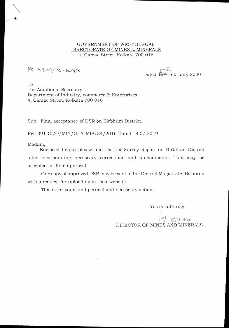
GOVBRNMENT OF WEST BBNGALDIRECTORATE OF MINES & MINERALS
4, Camac Strcct, Kolkata 700 016
ToThe Additional SccrctaryDepartment of Industry, commcrcc & Enterprises4, Camac Strcet, Kolkata 700 0 1 6
Sub: Final acceptancc of DSR on Birbhum District.
I?ef: 39 1 -CIl O/ MIN/GBN-MIS I 34 / 2O1 6 Datcd I 8.07.20 1 9
Madam,Encloscd herein plcasc find District Survey Rcport on Birbhum District
after incorporating ncccssary corrections and amcndments. This may be
acceptcd for final approval.
One copy of approved DSR may bc scnt to thc District Magistratc, Birbhum
with a rcquest for uploading in thcir wcbsite.
This is for your kind pcrusal and neccssary action.
Yours faithfully,
No. Gtt">fzc-at\lLe f+rh-Datcd 1-3! Fcbruary,202O
Ll 47a,vr-DTRECTOR OF MrryE6 ANp/MTNERALS
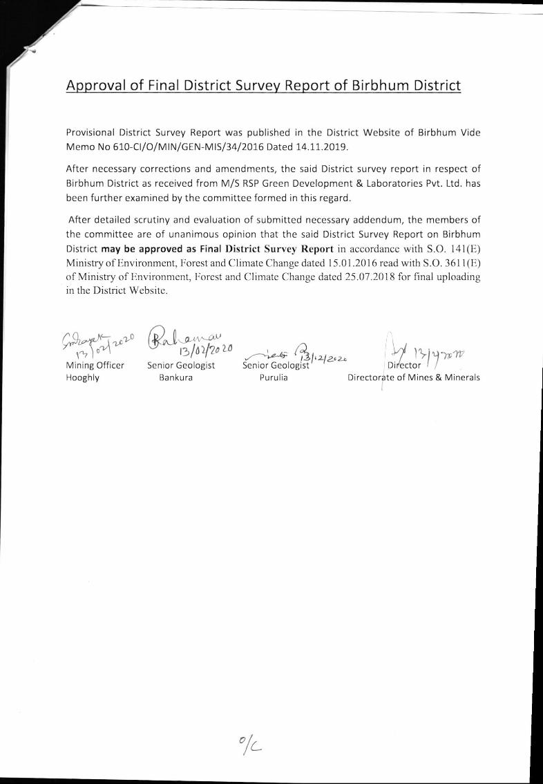
Approval of Final District Survev Report of Birbhum District
Provisional District Survey Report was published in the District Website of Birbhum Vide
Memo No 610-Cl/O/MlN/GEN-MlS/34l2016 Dated 14.11.2019.
After necessary corrections and amendments, the said District survey report in respect ofBirbhum District as received from M/S RSP Green Development & Laboratories Pvt. Ltd. has
been further examined by the committee formed in this regard.
After detailed scrutiny and evaluation of submitted necessary addendum, the members ofthe committee are of unanimous opinion that the said District Survey Report on Birbhum
District may be approved as Final District Survey Rcport in accordancc with S.O. l4l(Il)Ministry of linvironmcnt, I.'orest and Climate Change datcd I 5.01 .201 6 rcad with S.O. 361 1 (U)
of Ministry of llnvironmcnt, Irorcst and Climatc Change dated 25.07.201 8 for final uploadingin thc Dislrict Wcbsilc.
@rtiffi,Mining OfficerHooghly
-01,
.A*''n. 4Senior Geolo8ist
Purulia
,Y,,:Irj-*c
l,zlz,z-Sen io r Geologist
Banku ra Directorate of Mines & Minerals
'/.
RSP Anybody
Typewriter
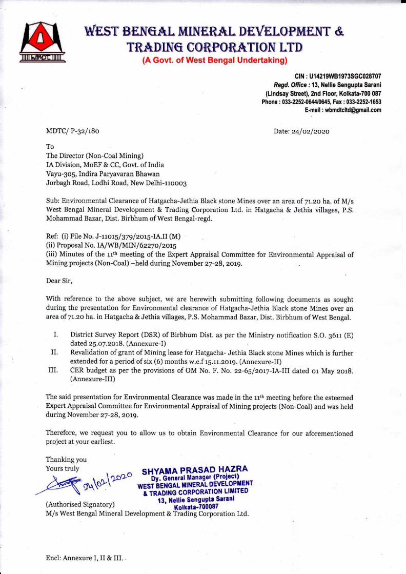
AsperNotificationNo.S.O.3611(E)NewDelhi Dated25thJuly2018of MinistryofEnvironment,Forest&Climate Change(MoEFCC)
DISTRICT SURVEY REPORT, BIRBHUM DISTRICT, WEST BENGAL
PREPARED BY: RSP GREEN DEVELOPMENT & LABORATORIES PVT. LTD (I)
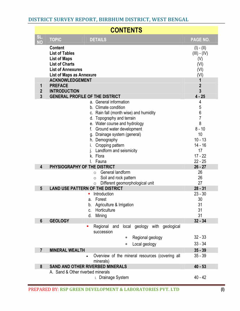
CONTENTS
SL. NO
TOPIC DETAILS PAGE NO.
Content (I) - (II) List of Tables (III) - (IV) List of Maps (V) List of Charts (VI) List of Annexures (VI) List of Maps as Annexure (VI) ACKNOWLEDGEMENT 1
1 PREFACE 2 2 INTRODUCTION 3 3 GENERAL PROFILE OF THE DISTRICT 4 - 25 a. General information 4
b. Climate condition 5 c. Rain fall (month wise) and humidity 6 d. Topography and terrain 7 e. Water course and hydrology 8 f. Ground water development 8 - 10 g. Drainage system (general) 10 h. Demography 10 - 13 i. Cropping pattern 14 - 16 j. Landform and seismicity 17 k. Flora 17 - 22 l. Fauna 22 - 25
4 PHYSIOGRAPHY OF THE DISTRICT 26 - 27 o General landform 26 o Soil and rock pattern 26 o Different geomorphological unit 27
5 LAND USE PATTERN OF THE DISTRICT 28 - 31 Introduction 23 - 30
a. Forest 30 b. Agriculture & Irrigation 31 c. Horticulture 31 d. Mining 31
6 GEOLOGY 32 - 34 Regional and local geology with geological
succession
Regional geology 32 - 33
Local geology 33 - 34
7 MINERAL WEALTH 35 - 39 Overview of the mineral resources (covering all
minerals) 35 - 39
8 SAND AND OTHER RIVERBED MINERALS 40 - 53 A. Sand & Other riverbed minerals i. Drainage System 40 - 42
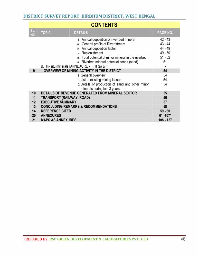
DISTRICT SURVEY REPORT, BIRBHUM DISTRICT, WEST BENGAL
PREPARED BY: RSP GREEN DEVELOPMENT & LABORATORIES PVT. LTD (II)
CONTENTS
SL. NO
TOPIC DETAILS PAGE NO.
ii. Annual deposition of river bed mineral 42 - 43 iii. General profile of River/stream 43 - 44 iv. Annual deposition factor 44 - 49 v. Replenishment 49 - 50 vi. Total potential of minor mineral in the riverbed 51 - 52 vii. Riverbed mineral potential zones (sand) 51
B. In- situ minerals [ANNEXURE - II, II (a) & III] - 9 OVERVIEW OF MINING ACTIVITY IN THE DISTRICT 54 a. General overview 54
b. List of existing mining leases 54 c. Details of production of sand and other minor
minerals during last 3 years 54
10 DETAILS OF REVENUE GENERATED FROM MINERAL SECTOR 55 11 TRANSPORT (RAILWAY, ROAD) 56 12 EXECUTIVE SUMMARY 57 13 CONCLUDING REMARKS & RECOMMENDATIONS 58 14 REFERENCE CITED 59 - 60 20 ANNEXURES 61 -107* 21 MAPS AS ANNEXURES 108 - 127
DISTRICT SURVEY REPORT, BIRBHUM DISTRICT, WEST BENGAL
PREPARED BY: RSP GREEN DEVELOPMENT & LABORATORIES PVT. LTD (III)
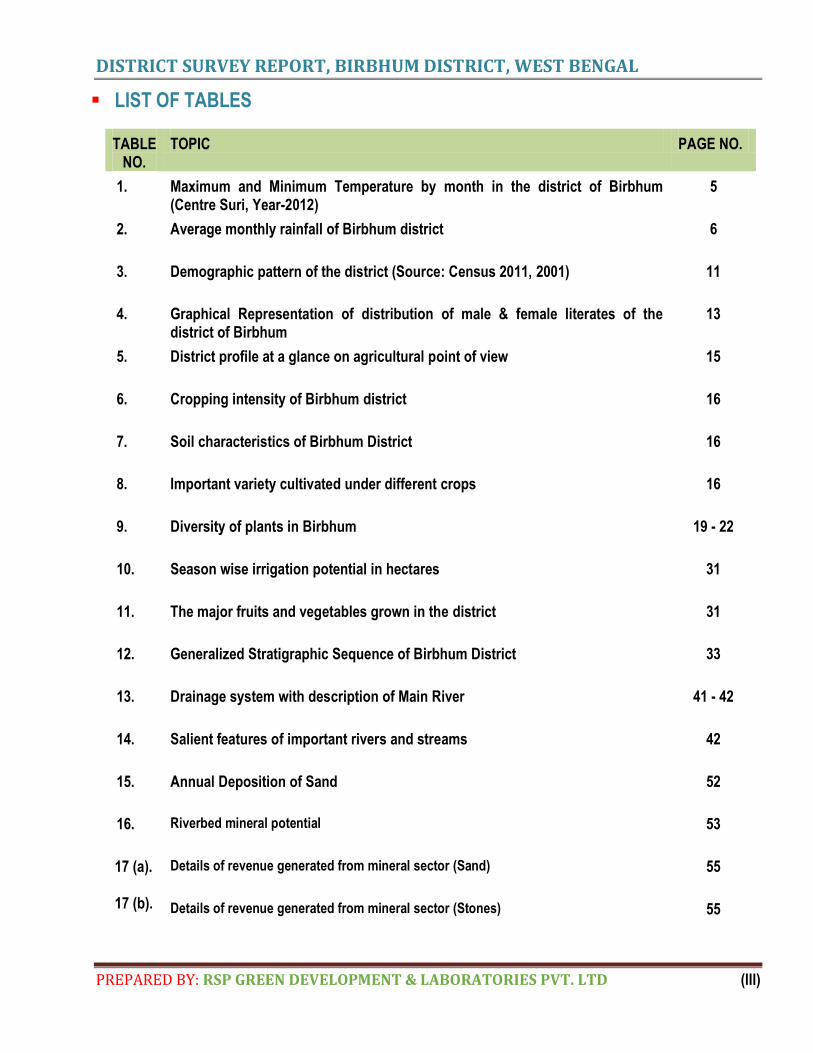
LIST OF TABLES
TABLE NO.
TOPIC PAGE NO.
1. Maximum and Minimum Temperature by month in the district of Birbhum (Centre Suri, Year-2012)
5
2. Average monthly rainfall of Birbhum district 6
3. Demographic pattern of the district (Source: Census 2011, 2001) 11
4. Graphical Representation of distribution of male & female literates of the district of Birbhum
13
5. District profile at a glance on agricultural point of view 15
6. Cropping intensity of Birbhum district 16
7. Soil characteristics of Birbhum District 16
8. Important variety cultivated under different crops 16
9. Diversity of plants in Birbhum 19 - 22
10. Season wise irrigation potential in hectares 31
11. The major fruits and vegetables grown in the district 31
12. Generalized Stratigraphic Sequence of Birbhum District 33
13. Drainage system with description of Main River 41 - 42
14. Salient features of important rivers and streams 42
15. Annual Deposition of Sand 52
16. Riverbed mineral potential 53
17 (a). Details of revenue generated from mineral sector (Sand) 55
17 (b). Details of revenue generated from mineral sector (Stones) 55
DISTRICT SURVEY REPORT, BIRBHUM DISTRICT, WEST BENGAL
PREPARED BY: RSP GREEN DEVELOPMENT & LABORATORIES PVT. LTD (IV)
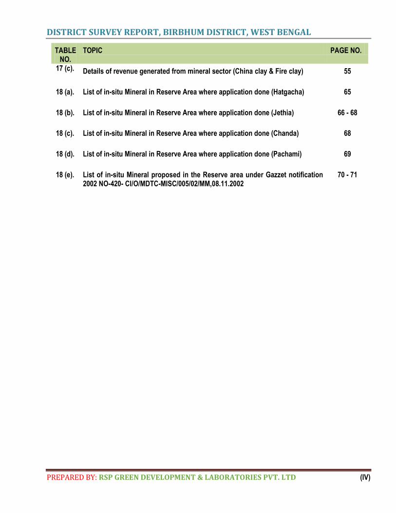
TABLE NO.
TOPIC PAGE NO.
17 (c). Details of revenue generated from mineral sector (China clay & Fire clay) 55
18 (a). List of in-situ Mineral in Reserve Area where application done (Hatgacha) 65
18 (b). List of in-situ Mineral in Reserve Area where application done (Jethia) 66 - 68
18 (c). List of in-situ Mineral in Reserve Area where application done (Chanda) 68
18 (d). List of in-situ Mineral in Reserve Area where application done (Pachami) 69
18 (e). List of in-situ Mineral proposed in the Reserve area under Gazzet notification 2002 NO-420- CI/O/MDTC-MISC/005/02/MM,08.11.2002
70 - 71
DISTRICT SURVEY REPORT, BIRBHUM DISTRICT, WEST BENGAL
PREPARED BY: RSP GREEN DEVELOPMENT & LABORATORIES PVT. LTD (V)
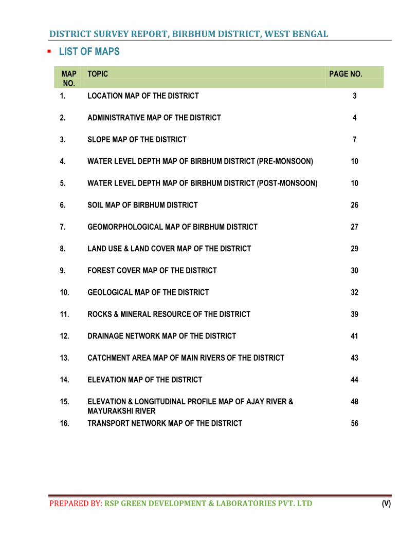
LIST OF MAPS
MAP NO.
TOPIC PAGE NO.
1. LOCATION MAP OF THE DISTRICT 3
2. ADMINISTRATIVE MAP OF THE DISTRICT 4
3. SLOPE MAP OF THE DISTRICT 7
4. WATER LEVEL DEPTH MAP OF BIRBHUM DISTRICT (PRE-MONSOON) 10
5. WATER LEVEL DEPTH MAP OF BIRBHUM DISTRICT (POST-MONSOON) 10
6. SOIL MAP OF BIRBHUM DISTRICT 26
7. GEOMORPHOLOGICAL MAP OF BIRBHUM DISTRICT 27
8. LAND USE & LAND COVER MAP OF THE DISTRICT 29
9. FOREST COVER MAP OF THE DISTRICT 30
10. GEOLOGICAL MAP OF THE DISTRICT 32
11. ROCKS & MINERAL RESOURCE OF THE DISTRICT 39
12. DRAINAGE NETWORK MAP OF THE DISTRICT 41
13. CATCHMENT AREA MAP OF MAIN RIVERS OF THE DISTRICT 43
14. ELEVATION MAP OF THE DISTRICT 44
15. ELEVATION & LONGITUDINAL PROFILE MAP OF AJAY RIVER & MAYURAKSHI RIVER
48
16. TRANSPORT NETWORK MAP OF THE DISTRICT 56
DISTRICT SURVEY REPORT, BIRBHUM DISTRICT, WEST BENGAL
PREPARED BY: RSP GREEN DEVELOPMENT & LABORATORIES PVT. LTD (VI)
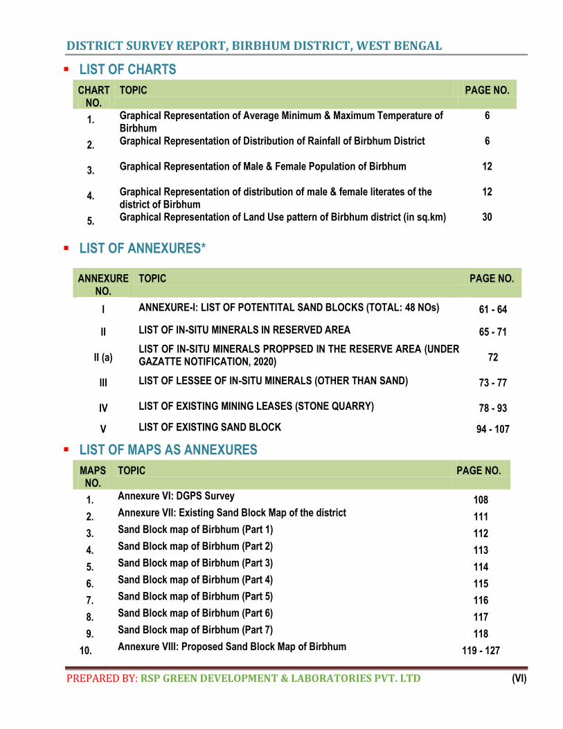
LIST OF CHARTS
CHART NO.
TOPIC PAGE NO.
1. Graphical Representation of Average Minimum & Maximum Temperature of Birbhum
6
2. Graphical Representation of Distribution of Rainfall of Birbhum District 6
3. Graphical Representation of Male & Female Population of Birbhum 12
4. Graphical Representation of distribution of male & female literates of the district of Birbhum
12
5. Graphical Representation of Land Use pattern of Birbhum district (in sq.km) 30
LIST OF ANNEXURES*
ANNEXURE NO.
TOPIC PAGE NO.
I ANNEXURE-I: LIST OF POTENTITAL SAND BLOCKS (TOTAL: 48 NOs) 61 - 64
II LIST OF IN-SITU MINERALS IN RESERVED AREA 65 - 71
II (a) LIST OF IN-SITU MINERALS PROPPSED IN THE RESERVE AREA (UNDER GAZATTE NOTIFICATION, 2020) 72
III LIST OF LESSEE OF IN-SITU MINERALS (OTHER THAN SAND) 73 - 77
IV LIST OF EXISTING MINING LEASES (STONE QUARRY) 78 - 93
V LIST OF EXISTING SAND BLOCK 94 - 107
LIST OF MAPS AS ANNEXURES
MAPS NO.
TOPIC PAGE NO.
1. Annexure VI: DGPS Survey 108
2. Annexure VII: Existing Sand Block Map of the district 111
3. Sand Block map of Birbhum (Part 1) 112
4. Sand Block map of Birbhum (Part 2) 113
5. Sand Block map of Birbhum (Part 3) 114
6. Sand Block map of Birbhum (Part 4) 115
7. Sand Block map of Birbhum (Part 5) 116
8. Sand Block map of Birbhum (Part 6) 117
9. Sand Block map of Birbhum (Part 7) 118
10. Annexure VIII: Proposed Sand Block Map of Birbhum 119 - 127
DISTRICT SURVEY REPORT, BIRBHUM DISTRICT, WEST BENGAL
PREPARED BY: RSP GREEN DEVELOPMENT & LABORATORIES PVT. LTD Page 1
ACKNOWLEDGEMENT
RSP Green Development & Laboratories Pvt. Ltd. record their sincere thanks and
gratefulness to the Government functionaries of West Bengal and prominent citizens of
Birbhum district and also the villagers in and around the district Birbhum who have offered
their fullest cooperation unhesitatingly but for which the execution of the work would have not
become as smooth as it has been.
DISTRICT SURVEY REPORT, BIRBHUM DISTRICT, WEST BENGAL
PREPARED BY: RSP GREEN DEVELOPMENT & LABORATORIES PVT. LTD Page 2
1. PREFACE
he purpose and structure of District Survey Report has been discretely discussed under Para 7 (iii) (a) and
Annexure (x) of the notification issued by Ministry of Environment, Forest and Climate Change,
Government of India on 15th January 2016. The District Survey Report (DSR) is to be prepared in every
district for each minor mineral. It will guide systematic and scientific utilization of natural resources, so that present
and future generation may be benefitted at large. The purpose of District Survey Report (DSR) is identification of
areas of aggradations or deposition where mining can be allowed; and identification of areas of erosion and
proximity to infrastructural structures and installations where mining should be prohibited. The District Survey report
(DSR) is comprised of secondary data published and endorsed by various departments and websites about geology
of the area, mineral wealth details, details of lease and mining activity in the district and revenue of minerals along
with the primary data collected from ground survey. This report also contains details of climatic conditions,
topography and terrain, land form, forest, rivers, soil, agriculture, road, transportation, irrigation etc. The DSR would
also help to calculate the annual rate of replenishment wherever applicable and allow time for replenishment.
The state of West Bengal has an important position in mineral production of the country. In terms of value, the state
accounts for 3.8% of mineral production in India and occupies the seventh position. Various metallic and non-
metallic mineral deposits have been located both in the Peninsular and Extra-peninsular parts of the State and
some of them viz.coal,chinaclay,fireclay, apatite, dolomite, limestone, silica sand, base metals, wolframite have
wide economic importance. Availability of apatite in Birbhum district; coal in Bardhaman, Bankura, Birbhum,
Darjeeling, Jalpaiguri and Birbhum districts; china clay in 24-Parganas, Bankura, Birbhum, Bardhaman, Hoogly,
Midnapur and Birbhum districts; and fireclay in Bankura, Bardhaman and Birbhum districts is distinct. Other
minerals that occur in the State are barytes, copper, gold, kyanite, pyrite and titanium minerals in Birbhum district;
dolomite in Jalpaiguri district; felspar in Bankura and Birbhum districts; granite in Bankura and Birbhum districts;
lead-zinc in Darjeeling district; limestone in Bankura and Birbhum districts; manganese ore and sillimanite in
Midnapur district; quartz/silica sand in Bankura, Hooghly and Birbhum districts; and tungsten & vermiculite in
Bankura district (Indian Minerals Year Book 2012 2012,GoI).
Disclaimer: - The data may vary due to flood, heavy rains and other natural calamities. Therefore it is recommended that
DEIAA/SEIAA may take into consideration all its relevant aspects / data while scrutinizing and recommending the
application for EC to the concerned authority.
T
DISTRICT SURVEY REPORT, BIRBHUM DISTRICT, WEST BENGAL
PREPARED BY: RSP GREEN DEVELOPMENT & LABORATORIES PVT. LTD Page 3
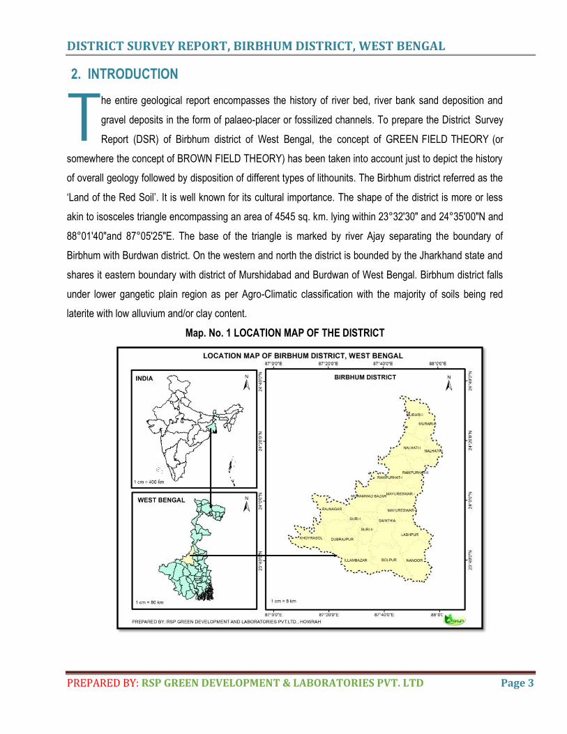
2. INTRODUCTION
he entire geological report encompasses the history of river bed, river bank sand deposition and
gravel deposits in the form of palaeo-placer or fossilized channels. To prepare the District Survey
Report (DSR) of Birbhum district of West Bengal, the concept of GREEN FIELD THEORY (or
somewhere the concept of BROWN FIELD THEORY) has been taken into account just to depict the history
of overall geology followed by disposition of different types of lithounits. The Birbhum district referred as the
‘Land of the Red Soil’. It is well known for its cultural importance. The shape of the district is more or less
akin to isosceles triangle encompassing an area of 4545 sq. km. lying within 23°32'30" and 24°35'00"N and
88°01'40"and 87°05'25"E. The base of the triangle is marked by river Ajay separating the boundary of
Birbhum with Burdwan district. On the western and north the district is bounded by the Jharkhand state and
shares it eastern boundary with district of Murshidabad and Burdwan of West Bengal. Birbhum district falls
under lower gangetic plain region as per Agro-Climatic classification with the majority of soils being red
laterite with low alluvium and/or clay content.
Map. No. 1 LOCATION MAP OF THE DISTRICT
T
DISTRICT SURVEY REPORT, BIRBHUM DISTRICT, WEST BENGAL
PREPARED BY: RSP GREEN DEVELOPMENT & LABORATORIES PVT. LTD Page 4
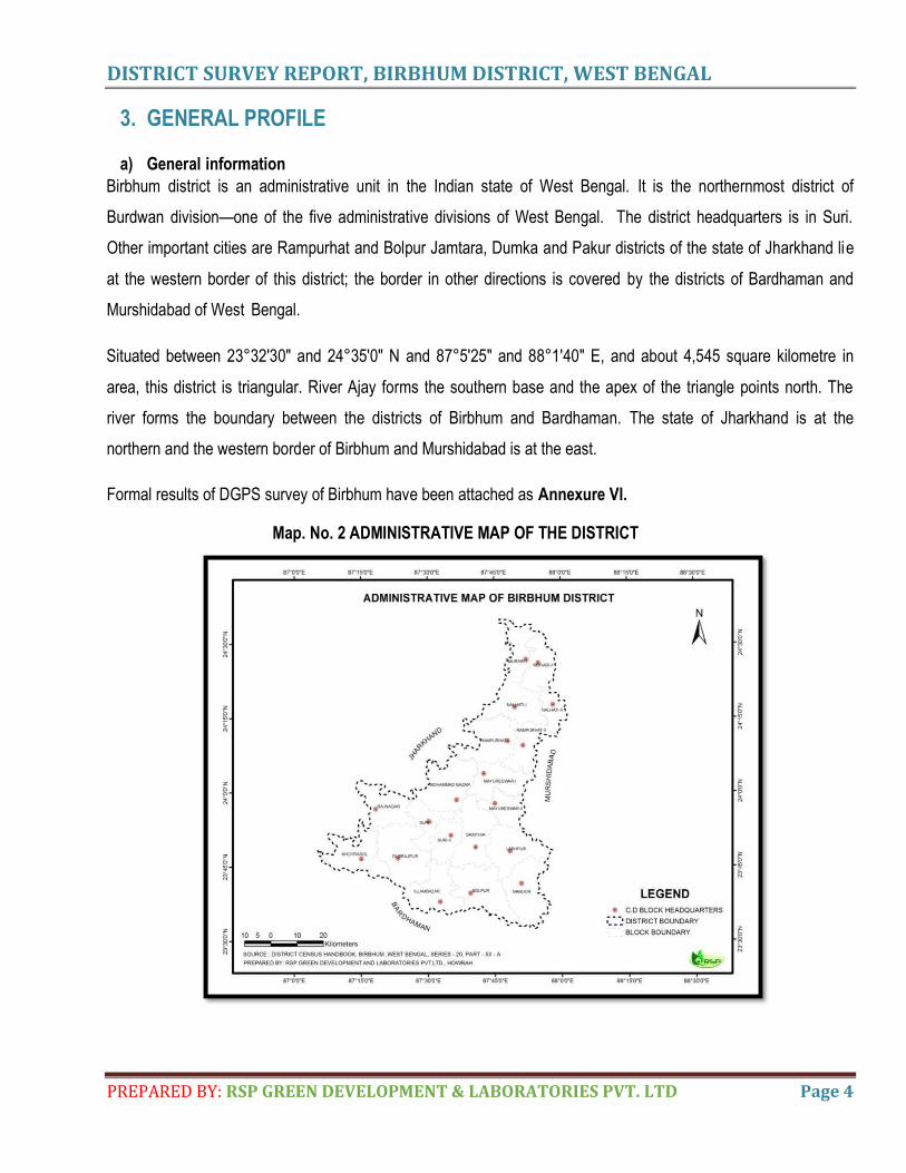
3. GENERAL PROFILE
a) General information
Birbhum district is an administrative unit in the Indian state of West Bengal. It is the northernmost district of
Burdwan division—one of the five administrative divisions of West Bengal. The district headquarters is in Suri.
Other important cities are Rampurhat and Bolpur Jamtara, Dumka and Pakur districts of the state of Jharkhand lie
at the western border of this district; the border in other directions is covered by the districts of Bardhaman and
Murshidabad of West Bengal.
Situated between 23°32'30" and 24°35'0" N and 87°5'25" and 88°1'40" E, and about 4,545 square kilometre in
area, this district is triangular. River Ajay forms the southern base and the apex of the triangle points north. The
river forms the boundary between the districts of Birbhum and Bardhaman. The state of Jharkhand is at the
northern and the western border of Birbhum and Murshidabad is at the east.
Formal results of DGPS survey of Birbhum have been attached as Annexure VI.
Map. No. 2 ADMINISTRATIVE MAP OF THE DISTRICT
DISTRICT SURVEY REPORT, BIRBHUM DISTRICT, WEST BENGAL
PREPARED BY: RSP GREEN DEVELOPMENT & LABORATORIES PVT. LTD Page 5
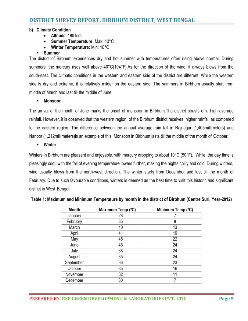
b) Climate Condition Altitude: 180 feet
Summer Temperature: Max: 40°C
Winter Temperature: Min: 10°C Summer
The district of Birbhum experiences dry and hot summer with temperatures often rising above normal. During
summers, the mercury rises well above 40°C(104°F).As for the direction of the wind, it always blows from the
south-east. The climatic conditions in the western and eastern side of the district are different. While the western
side is dry and extreme, it is relatively milder on the eastern side. The summers in Birbhum usually start from
middle of March and last till the middle of June.
Monsoon
The arrival of the month of June marks the onset of monsoon in Birbhum.The district boasts of a high average
rainfall. However, it is observed that the western region of the Birbhum district receives higher rainfall as compared
to the eastern region. The difference between the annual average rain fall in Rajnagar (1,405millimeters) and
Nanoor (1,212millimeters)is an example of this. Monsoon in Birbhum lasts till the middle of the month of October.
Winter
Winters in Birbhum are pleasant and enjoyable, with mercury dropping to about 10°C (50°F). While the day time is
pleasingly cool, with the fall of evening temperature lowers further, making the nights chilly and cold. During winters,
wind usually blows from the north-west direction. The winter starts from December and last till the month of
February. Due to such favourable conditions, winters is deemed as the best time to visit this historic and significant
district in West Bengal.
Table 1: Maximum and Minimum Temperature by month in the district of Birbhum (Centre Suri, Year-2012)
Month Maximum Temp (ºC) Minimum Temp (ºC)
January 28 7
February 35 8
March 40 13
April 41 19
May 45 22
June 46 24
July 38 24
August 35 24
September 36 23
October 35 16
November 32 11
December 30 7
DISTRICT SURVEY REPORT, BIRBHUM DISTRICT, WEST BENGAL
PREPARED BY: RSP GREEN DEVELOPMENT & LABORATORIES PVT. LTD Page 6
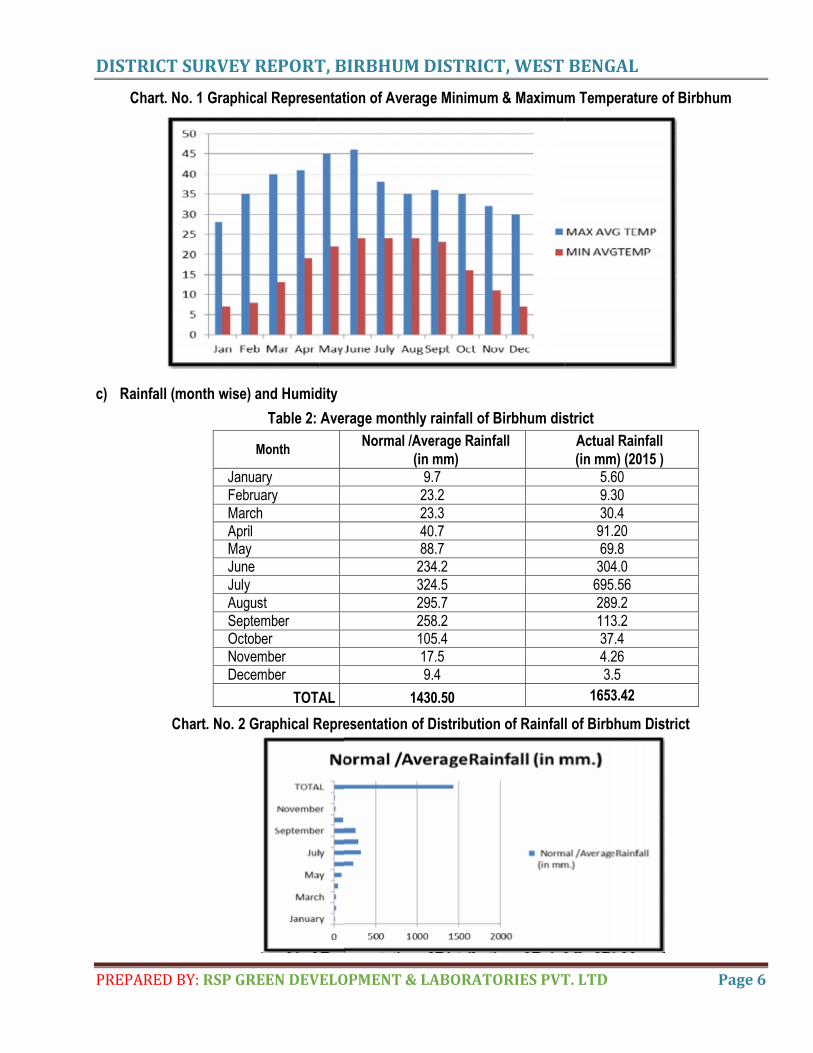
Chart. No. 1 Graphical Representation of Average Minimum & Maximum Temperature of Birbhum
c) Rainfall (month wise) and Humidity
Table 2: Average monthly rainfall of Birbhum district
Month Normal /Average Rainfall
(in mm)
Actual Rainfall
(in mm) (2015 ) January 9.7 5.60 February 23.2 9.30 March 23.3 30.4 April 40.7 91.20 May 88.7 69.8 June 234.2 304.0 July 324.5 695.56
August 295.7 289.2 September 258.2 113.2 October 105.4 37.4 November 17.5 4.26 December 9.4 3.5
TOTAL 1430.50 1653.42
Chart. No. 2 Graphical Representation of Distribution of Rainfall of Birbhum District
DISTRICT SURVEY REPORT, BIRBHUM DISTRICT, WEST BENGAL
PREPARED BY: RSP GREEN DEVELOPMENT & LABORATORIES PVT. LTD Page 7
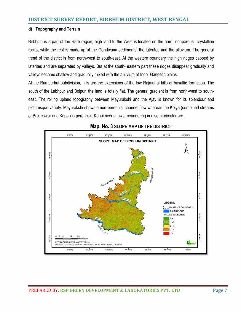
d) Topography and Terrain
Birbhum is a part of the Rarh region; high land to the West is located on the hard nonporous crystalline
rocks, while the rest is made up of the Gondwana sediments, the laterites and the alluvium. The general
trend of the district is from north-west to south-east. At the western boundary the high ridges capped by
laterites and are separated by valleys. But at the south- eastern part these ridges disappear gradually and
valleys become shallow and gradually mixed with the alluvium of Indo- Gangetic plains.
At the Rampurhat subdivision, hills are the extensions of the low Rajmahal hills of basaltic formation. The
south of the Labhpur and Bolpur, the land is totally flat. The general gradient is from north-west to south-
east. The rolling upland topography between Mayurakshi and the Ajay is known for its splendour and
picturesque variety. Mayurakshi shows a non-perennial channel flow whereas the Koiya (combined streams
of Bakreswar and Kopai) is perennial. Kopai river shows meandering in a semi-circular arc.
Map. No. 3 SLOPE MAP OF THE DISTRICT
DISTRICT SURVEY REPORT, BIRBHUM DISTRICT, WEST BENGAL
PREPARED BY: RSP GREEN DEVELOPMENT & LABORATORIES PVT. LTD Page 8
e) Water Course and Hydrology
Birbhum district mainly comprises of i) alternating layers of sand, silt and clay ii) Rajmahal trap basalt, hard clays
with caliche nodules iii) enclaves of granite gneiss. These lithological units directly control the hydrological part of
this undulating area. Presence of hard clays and Rajmahal trap basalt hinders the flow of ground water system due
to lack of vesicular structures. So in this region low to heavy duty tube wells are feasible. The yield prospect is 7.2-
250 cum/hr. Permeable layers of shale, sandstone increase the downward percolation and flow of groundwater. So
that dug wells and bore wells are feasible in this area. Archaean granite gneiss occurs at the western region; water
bearing fractures are encountered within 60m below ground level that paves the way of advent of water easily
during pumping.
The Archaeo-Proterozoic rocks are the main source of fluorine causing the fluoride contamination of groundwater
mainly in Nalhati Block-I and Block-II. So the human habitation of these localities suffers fluorosis disease due to
intake of fluoridated ground water. The permissible limit of F content in GW is 1.5 ppm as per WHO. But water of
Nalhati blocks exceeds the limit.Sporadic occurrence of high fluoride (>1.5mg / L) in ground water has been
reported from the blocks of Khoyrasol, Sainthia, Suri-II,Mayureswar-I, Nalhati-I, Rampurhat-I of Birbhum District.
Fluoride content more than 1.5mg/ L has been noted in the following depth ranges in different types of
hydrogeological formations consisting of different types of litho units:
In highly fractured, jointed and fissured granite, basalt & alluvium with in a depth range of 50- 80m.
In Gondwana formation with in 30m depth range.
f) Ground water development
Ground water potentialities and its position largely depends on the geological structures, composition of strata,
infiltration circumstances, water retention capacity, presence and alignment of aquifer and aquiclude (impermeable
hard layer) layer. The average potentiality of layers of this district are located at the depth of i) 12.19-24.38 m ii)
30.48-42.67 m iii) 54.86-67.06 m.
The lithological conditions are not same in all parts. Hatia and Dwarka have only two potential layers, first layer is
composed of coarse sand and the second layer is used for drinking water purpose. Only Chauhatta-II is composed
of six potential layers and grade of sand becomes going to be decreased with the changing of layers from the
surface. Here fifth and sixth layers are used for drinking water purpose. Rests of the Panchayets are composed of 3
layers and the 2nd and 3rd layers are used for drinking water purpose. In all Panchayets the first layers remain
unused for drinking water because coarse sand helps to filter the surface water which reaches to the second layer.
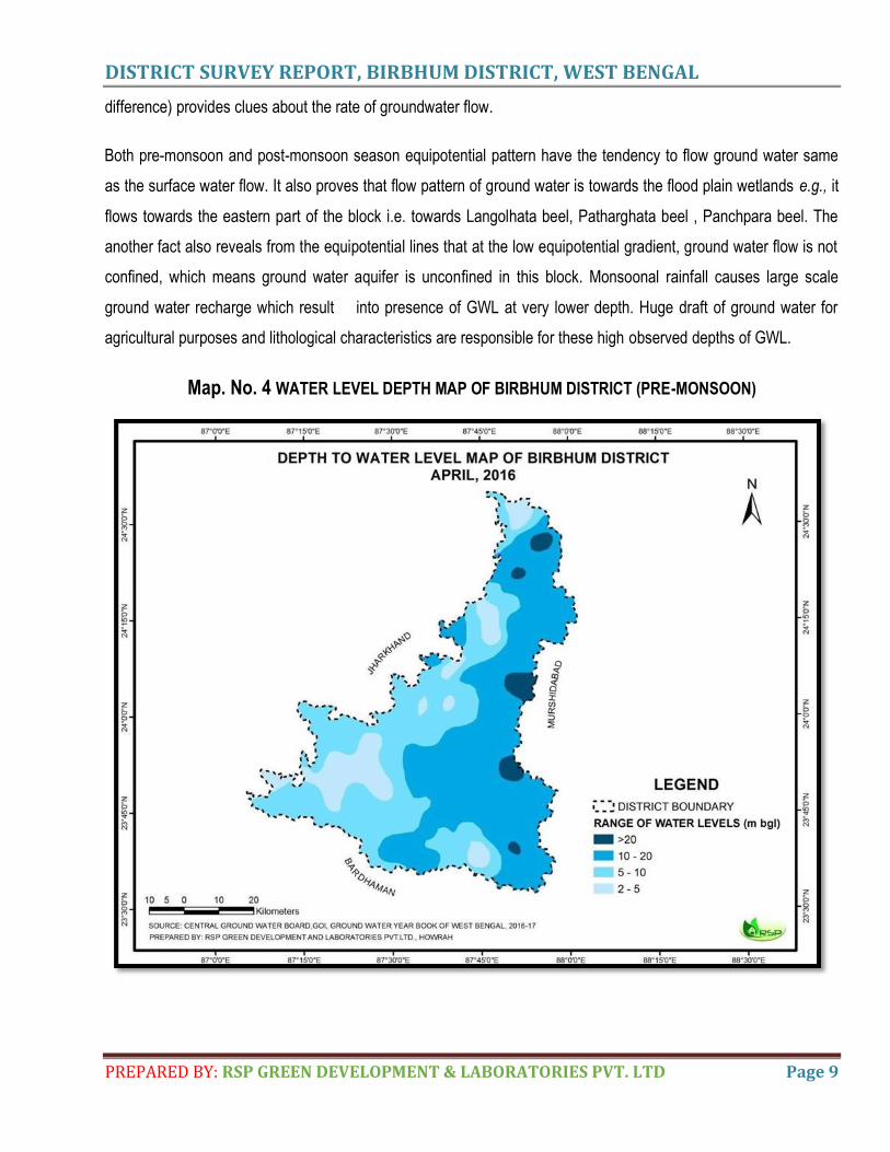
In Labpur block the potentiometric map (i.e., the map shows the equal potential lines of same hydraulic head
DISTRICT SURVEY REPORT, BIRBHUM DISTRICT, WEST BENGAL
PREPARED BY: RSP GREEN DEVELOPMENT & LABORATORIES PVT. LTD Page 9
difference) provides clues about the rate of groundwater flow.
Both pre-monsoon and post-monsoon season equipotential pattern have the tendency to flow ground water same
as the surface water flow. It also proves that flow pattern of ground water is towards the flood plain wetlands e.g., it
flows towards the eastern part of the block i.e. towards Langolhata beel, Patharghata beel , Panchpara beel. The
another fact also reveals from the equipotential lines that at the low equipotential gradient, ground water flow is not
confined, which means ground water aquifer is unconfined in this block. Monsoonal rainfall causes large scale
ground water recharge which result into presence of GWL at very lower depth. Huge draft of ground water for
agricultural purposes and lithological characteristics are responsible for these high observed depths of GWL.
Map. No. 4 WATER LEVEL DEPTH MAP OF BIRBHUM DISTRICT (PRE-MONSOON)
DISTRICT SURVEY REPORT, BIRBHUM DISTRICT, WEST BENGAL
PREPARED BY: RSP GREEN DEVELOPMENT & LABORATORIES PVT. LTD Page 10
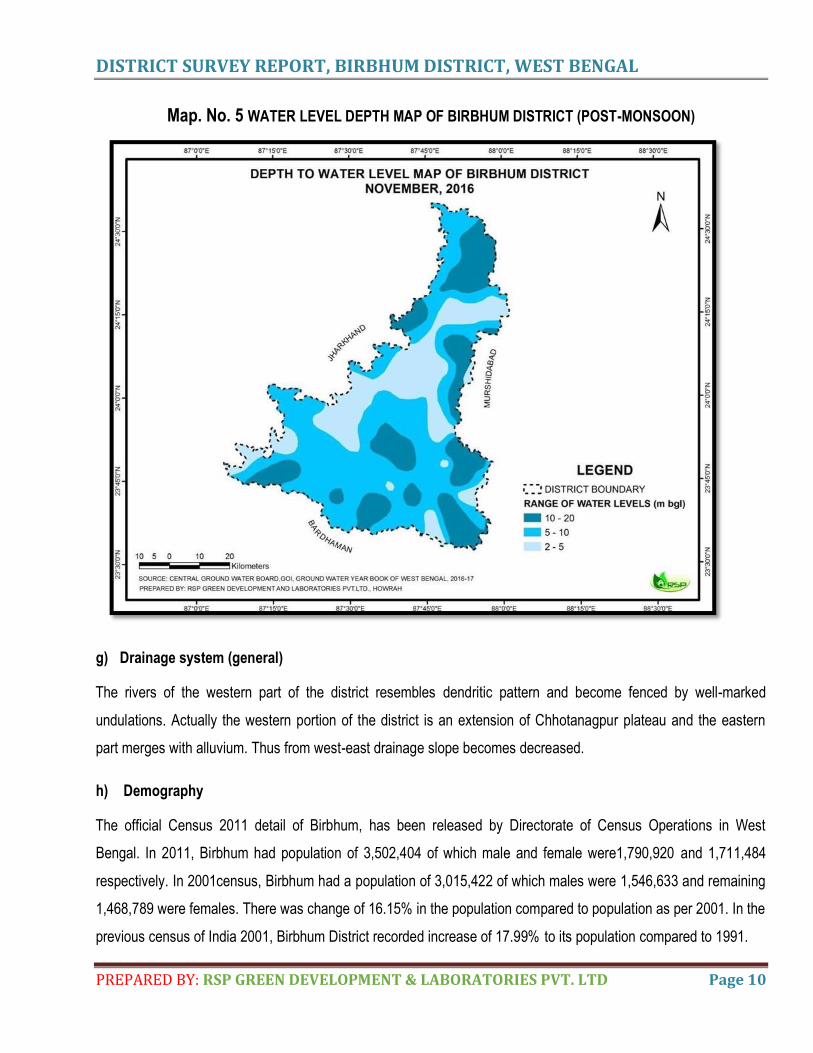
Map. No. 5 WATER LEVEL DEPTH MAP OF BIRBHUM DISTRICT (POST-MONSOON)
g) Drainage system (general)
The rivers of the western part of the district resembles dendritic pattern and become fenced by well-marked
undulations. Actually the western portion of the district is an extension of Chhotanagpur plateau and the eastern
part merges with alluvium. Thus from west-east drainage slope becomes decreased.
h) Demography
The official Census 2011 detail of Birbhum, has been released by Directorate of Census Operations in West
Bengal. In 2011, Birbhum had population of 3,502,404 of which male and female were1,790,920 and 1,711,484
respectively. In 2001census, Birbhum had a population of 3,015,422 of which males were 1,546,633 and remaining
1,468,789 were females. There was change of 16.15% in the population compared to population as per 2001. In the
previous census of India 2001, Birbhum District recorded increase of 17.99% to its population compared to 1991.
DISTRICT SURVEY REPORT, BIRBHUM DISTRICT, WEST BENGAL
PREPARED BY: RSP GREEN DEVELOPMENT & LABORATORIES PVT. LTD Page 11
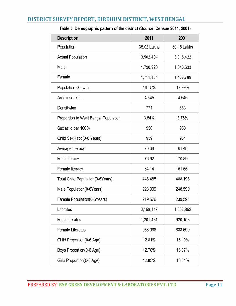
Table 3: Demographic pattern of the district (Source: Census 2011, 2001)
Description 2011 2001
Population 35.02 Lakhs 30.15 Lakhs
Actual Population 3,502,404 3,015,422
Male 1,790,920 1,546,633
Female 1,711,484 1,468,789
Population Growth 16.15% 17.99%
Area insq. km. 4,545 4,545
Density/km 771 663
Proportion to West Bengal Population 3.84% 3.76%
Sex ratio(per 1000) 956 950
Child SexRatio(0-6 Years) 959 964
AverageLiteracy 70.68 61.48
MaleLiteracy 76.92 70.89
Female literacy 64.14 51.55
Total Child Population(0-6Years) 448,485 488,193
Male Population(0-6Years) 228,909 248,599
Female Population(0-6Years) 219,576 239,594
Literates 2,158,447 1,553,852
Male Literates 1,201,481 920,153
Female Literates 956,966 633,699
Child Proportion(0-6 Age) 12.81% 16.19%
Boys Proportion(0-6 Age) 12.78% 16.07%
Girls Proportion(0-6 Age) 12.83% 16.31%
DISTRICT SURVEY REPORT, BIRBHUM DISTRICT, WEST BENGAL
PREPARED BY: RSP GREEN DEVELOPMENT & LABORATORIES PVT. LTD Page 12
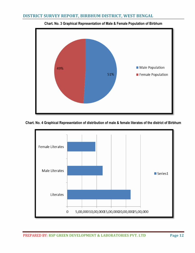
Chart. No. 3 Graphical Representation of Male & Female Population of Birbhum
Chart. No. 4 Graphical Representation of distribution of male & female literates of the district of Birbhum
DISTRICT SURVEY REPORT, BIRBHUM DISTRICT, WEST BENGAL
PREPARED BY: RSP GREEN DEVELOPMENT & LABORATORIES PVT. LTD Page 13
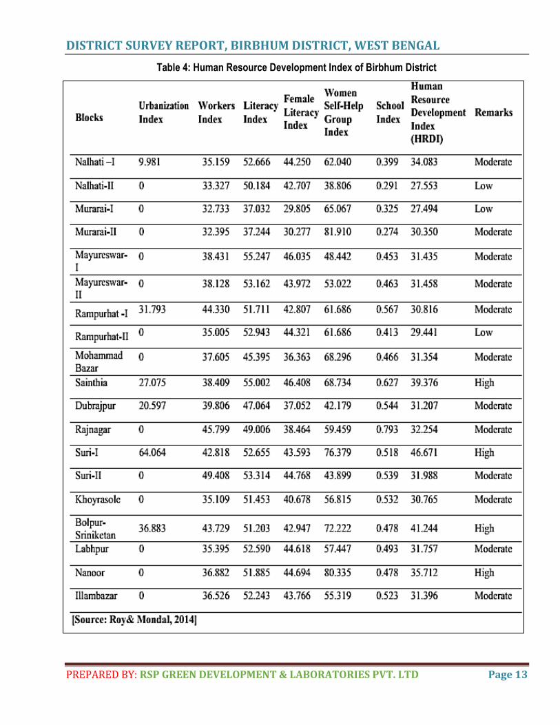
Table 4: Human Resource Development Index of Birbhum District
DISTRICT SURVEY REPORT, BIRBHUM DISTRICT, WEST BENGAL
PREPARED BY: RSP GREEN DEVELOPMENT & LABORATORIES PVT. LTD Page 14
i) Cropping Pattern
The soil of the Nalhati Plain has lateritic soils mixed with Recent alluvium. Brahmani- Mayurakshi Basin has red
sandy and red loamy soils of the older alluvium. The soils are loose and friable. In Suri-Bolpur Plain the soil varies
from red sandy, red loamy and older alluvium in the south-western to brown and recent alluvium in the central and
south-eastern part of the region. The soil of Bakreswar Upland is generally lateritic mixed with alluvium. The various
types of soil as observed in the district and their suitability for growing different crops are described below.
In Bengali language, the brownish clay is called Entel. It is wholly unsuitable for rabi cultivation and needs manuring
to produce rice. Entel is the clay soil, can retain moisture and is capable of producing ‘Aman’ rice and winter crops
like gram, wheat, etc. The alluvial deposition is known as ‘Palimati’. Such soils are very rich and generally are used
for growing wheat, potato, vegetables, etc. With adequate irrigation such soils can produce ‘Rabi’ crops in
abundance.
‘Bindi’ is friable, loose sandy soil with very little water holding capacity. It can grow rice and is quite capable of
growing rabi crops with irrigation. ‘Doansh’ is friable loose blackish soil. It is very rich in fertility and can grow almost
all crops. ‘Bele’ is friable loose whitish soil, poor in fertility, ordinarily unsuitable for rabi cultivation, but can grow rice
and to some extent some vegetables. ‘Kankar’ is friable loose reddish soil and considered as a very poor type of
soil. However, it can grow crop like mahua, bajra, maize, etc. and with irrigation facilities can grow some rabi crops.
‘Bastu’ is rich blackish soil with low water holding capacity which with proper manuring and irrigation can grows fine
rice, wheat, tobacco, sugarcane, etc. In the Brahmani- Mayurakshi Basin aman paddy is the principal crop. With the
help of irrigation rabi crops are also grown. In Suri-Bolpur Plain, along with paddy, wheat, peas, sugarcane and
tobacco are grown. The soil of the Bakreswar Upland is not fertile but the crops are grown in irrigation schemes of
the Mayurakshi canal project and Hingla project.
The economic condition of Birbhum district is dominated by agriculture. The land of Birbhum is divided into 13
classes, viz. (1) Do, (2) Suna, (3) Sali, (4) Ola orolan, (5) Jedanga or Danga, (6) Pat- jamior Mulberryland, (7)
Jangalbhumi, (8) Panerbaraj, (9) Ghas,(10) Sarbera,(11) Bastu,12) Salghor and (13) Patit. Out of these 13 classes
of land, mainly the first three classes of land are most fit for rice cultivation. Do land has a rich soil, on which aus or
aman rice is generally grown, besides gram, masuri, peas, wheat, linseed, khesari, til, sugarcane and occasionally
cotton. Suna lands differ from do lands in having a smaller amount of moisture and in being unsuitable for the
cultivation of sugarcane. Other crops that grow on do lands also grow onsuna lands, but the quantity of produce is
smaller and the cost of cultivation greater. Sali land consists of moist muddy land which will bear three crops in the
DISTRICT SURVEY REPORT, BIRBHUM DISTRICT, WEST BENGAL
PREPARED BY: RSP GREEN DEVELOPMENT & LABORATORIES PVT. LTD Page 15
year, viz., a crop of aman rice, a crop of khesari, and a crop of kashta til.There is double to triple cropping system of
Paddy cultivation in the district. The area under Paddy in 2010-11 is 249.0 thousand hectares of land.
[Source: District Census Handbook, Birbhum, 2011].
Rice, pulses, wheat, sugarcane, oilseeds, potato, sugarcane are the major crops cultivated in the district. Among
Khar if crops,4.8 hectares of land is under rainfed rice cultivation only. Among Rabi crops, which are cultivated by
means of irrigation only, rice cultivation covers 315 hectares, pulses cultivation covers 17.8 hectares, wheat
cultivation covers 32.1 hectares, oilseeds cultivation covers 36.3 hectares and potato cultivation covers
17.8hectares.
[Source:http://www.crida.in/CP-2012/ statewiseplans / West%20Bengal%20(Pdf)/BCK VV , %20 Kalyani / WestBengal%203-Birbhum- 31.12.2011.pdf]
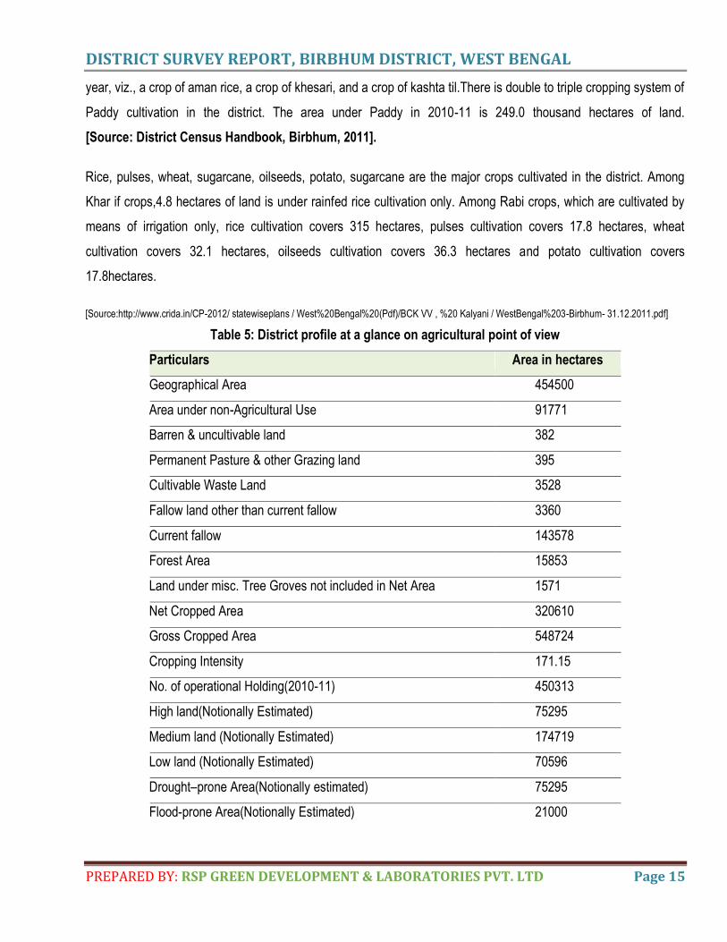
Table 5: District profile at a glance on agricultural point of view
Particulars Area in hectares
Geographical Area 454500
Area under non-Agricultural Use 91771
Barren & uncultivable land 382
Permanent Pasture & other Grazing land 395
Cultivable Waste Land 3528
Fallow land other than current fallow 3360
Current fallow 143578
Forest Area 15853
Land under misc. Tree Groves not included in Net Area 1571
Net Cropped Area 320610
Gross Cropped Area 548724
Cropping Intensity 171.15
No. of operational Holding(2010-11) 450313
High land(Notionally Estimated) 75295
Medium land (Notionally Estimated) 174719
Low land (Notionally Estimated) 70596
Drought–prone Area(Notionally estimated) 75295
Flood-prone Area(Notionally Estimated) 21000
DISTRICT SURVEY REPORT, BIRBHUM DISTRICT, WEST BENGAL
PREPARED BY: RSP GREEN DEVELOPMENT & LABORATORIES PVT. LTD Page 16
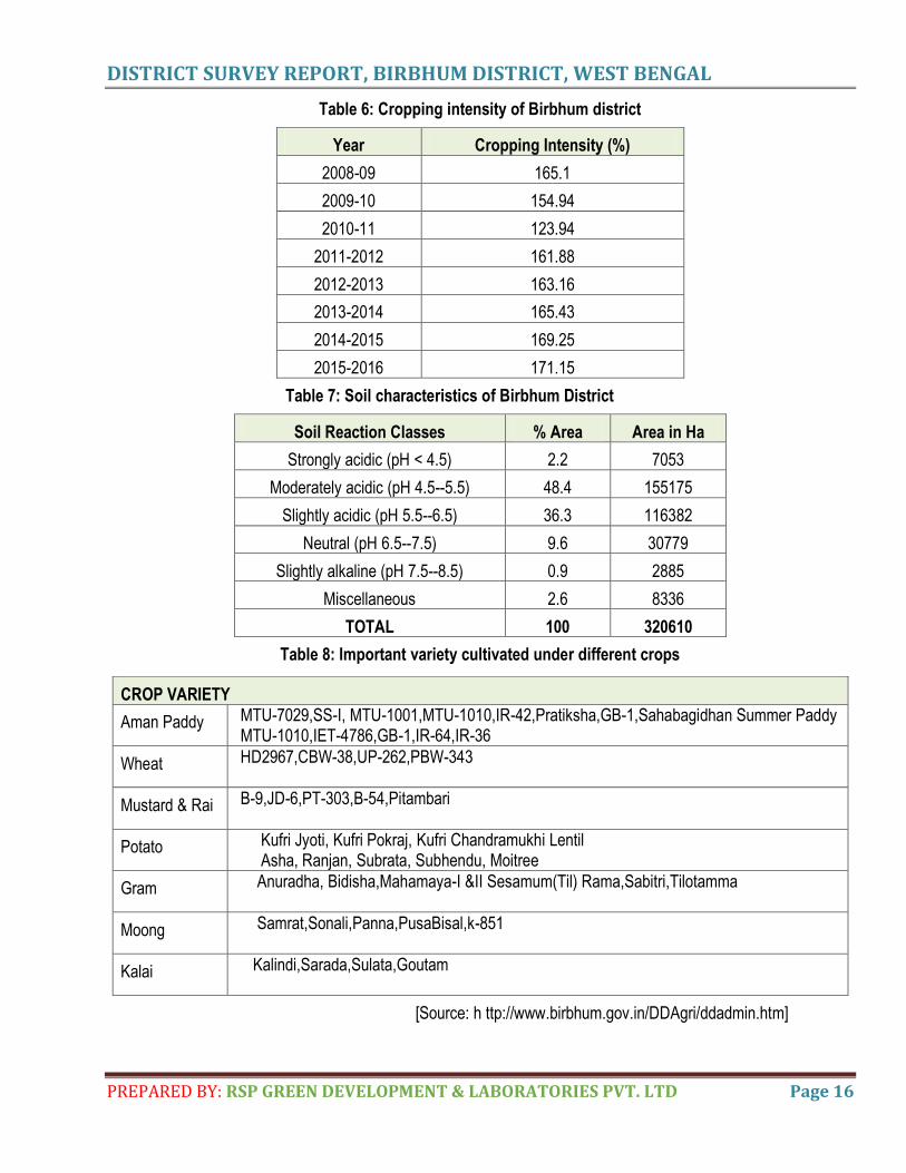
Table 6: Cropping intensity of Birbhum district
Year Cropping Intensity (%)
2008-09 165.1
2009-10 154.94
2010-11 123.94
2011-2012 161.88
2012-2013 163.16
2013-2014 165.43
2014-2015 169.25
2015-2016 171.15
Table 7: Soil characteristics of Birbhum District
Soil Reaction Classes % Area Area in Ha
Strongly acidic (pH < 4.5) 2.2 7053
Moderately acidic (pH 4.5--5.5) 48.4 155175
Slightly acidic (pH 5.5--6.5) 36.3 116382
Neutral (pH 6.5--7.5) 9.6 30779
Slightly alkaline (pH 7.5--8.5) 0.9 2885
Miscellaneous 2.6 8336
TOTAL 100 320610
Table 8: Important variety cultivated under different crops
CROP VARIETY
Aman Paddy MTU-7029,SS-I, MTU-1001,MTU-1010,IR-42,Pratiksha,GB-1,Sahabagidhan Summer Paddy MTU-1010,IET-4786,GB-1,IR-64,IR-36
Wheat HD2967,CBW-38,UP-262,PBW-343
Mustard & Rai B-9,JD-6,PT-303,B-54,Pitambari
Potato Kufri Jyoti, Kufri Pokraj, Kufri Chandramukhi Lentil Asha, Ranjan, Subrata, Subhendu, Moitree
Gram Anuradha, Bidisha,Mahamaya-I &II Sesamum(Til) Rama,Sabitri,Tilotamma
Moong Samrat,Sonali,Panna,PusaBisal,k-851
Kalai Kalindi,Sarada,Sulata,Goutam
[Source: h ttp://www.birbhum.gov.in/DDAgri/ddadmin.htm]
DISTRICT SURVEY REPORT, BIRBHUM DISTRICT, WEST BENGAL
PREPARED BY: RSP GREEN DEVELOPMENT & LABORATORIES PVT. LTD Page 17
j) Landform and Seismicity
At the western part of the Birbhum dist. hillocks are present. That part is elevated region, basically the foothill of
Chhotanagpur Plateau that gradually merges with the fertile laterite sand alluvium flat farmland in the east. Birbhum
is categorized under seismically active zone- III. (Least Active)
k) Flora
Total forest area in Birbhum district has been estimated nearly 15926.58 hectares which covers only 3.5 per cent of
the total district area. There are mainly three types of forest areas in the district namely (i)Reserved Forest
(ii)Protected Forest and (iii)Unclassified Forest area. Most of the Reserved Forests and Protected Forests are
located along the undulated high lands of the western part of the district while rest of the area is characterized by
Unclassified Forests of open mixed jungles and scrubs. The important forests of the district are Masra Reserved
Forest in Rampurhat-IC.D. Block, the Kalai Pahari Protected Forest, Maubelia Reserved Forest , Chandpur
Protected Forest in Mohammad Bazar C.D. Block, Bansbuni Protected Forest in Rajnagar C.D. Block and
Chaupahari Protected Forest in Illambazar C.D. Block. All these forest areas are dominated by Sal (Shorea
robusta) trees while the Unclassified Forests belong to Northern Tropical Dry deciduous type. The major trees
found in these forests are Teak (Tectona grandis), Pipal (Ficus Religiosa), Siris (Albizzia lebbeck), Mahua (Bassia
latifolia), Neem (Azadirachta indica), Babul (Acacia arabica), Bamboo (Bambusha tulda) etc. These are the main
source of non-timber forest products to the people of the district.Besides these tree types, certain medicinal plants
including Neem (Azadirachta indica), Kumbhi (Careya arborea Roxb), Najani (Croton bonplandianum), Bat (Ficus
benghalensis Linn), Gurmar (Gymnea sylvestre), Arjun(Terminalia cuneala Roth) and Akanda (Calotropis gigantea)
etc. are also found in plenty in the district (Source: District Census Handbook, Birbhum, 2011).
The vegetation of Birbhum District as a whole belongs to the tropical dry deciduous type with a few representatives
of the evergreens occurring here and there. Trees, like Sal (Shorearobusta), Mahua (Bassia lati/olia) and Palas
grow to the western part. Thorny shrubs, palm and mango trees are present throughout. Botanically, the district can
broadly be divided into two zones. The first zone comprises the undulated highlands along the western part of the
district. Although the soil erosion is acute in this lateritic area, several relict patches of Chhotanagpur plateau forest
are still to be found around Rajnagar, Mahammad Bazar, Hetempur and Suri. The vegetation of this region shows
semi-arid nature and is similar to eastern Bihar including species of scrubby thickets like Acacia bridelia,
Buchanania, Calotropis, Capparis cassia, feronia, jatropha, phyllanthus, streeblus, Tephrosia, wendlandia, Zizy plus
etc. Grooves of trees are rather scarce in the south western parts ofthe district. The second zone consists of the flat
alluvial plain in the south and east of the district. The vegetation of this tract is characteristic of the alluvial rice plain
of Gangetic West Bengal. Species of Ageratum alysicarpus, Apongeton, Cayratia commelina etc. flourish well in
DISTRICT SURVEY REPORT, BIRBHUM DISTRICT, WEST BENGAL
PREPARED BY: RSP GREEN DEVELOPMENT & LABORATORIES PVT. LTD Page 18
this part of the district The common plants seen around die dwellings in village and towns are clumps of babla
(Acacia nilotica), bel (Aegle marmelos), ata (Annona squamosa), kanthal (Artocarpur heterophyllus), neem
(Azadirachta indica), bansh (Bambusae arundinacea), bot (Ficus benghalensis), pakur or aswatha (Ficus religiosa),
am (Mangifera indica), sajina (Moringa oleifera), amra (Spondias pinnata), jam (Syzygiumcumini), tentul
(Tamarindusindica), aijun(Terminaliaarjuna)and other arborescentspecies.Marginsoftanks, bunds of paddy fields
and marshes are inhabited by a mixed community of aquatic and amphibious species: kachuri pana (Eichhomia
crassipes), jhanjhi (Hydrilla verticillata), kalmi (Ipomoeaaquatica), susni(Marsileaminuta), paniphal(Trapanatens)etc.
Wetland plantspecies include floating hydrophytes, namely, water hyacinth,water lettuce and duck weeds;
suspended hydrophytes, Tikejhanji (Ceratophyllum) and anchoredhydrophytes such as Patashaola (Vallisneria sp.),
Padma (Nelumbo nucifera), Paniphal (Trapa sp.),Panchuli (Nymphoides sp.), Shapla (Nymphaea sp.), Hydrilla,
Ottellia, Najas etc. Most of these hydrophytes were abundant in Datindighi, about 4 km. west of Dubrajpur, which is
said to have beenexcavated by Kbagaditya Raja (O'Malley, 1910). Similar aquatic or palustrine genera are
available in wetlands of Ballavpur and Rampurhat along with sedge (Cyperus sp.) and emergent amphibious
hydrophytes (Marsilea, Aponogeton, En hydra, Potamegeton, Paspalsum, Aeschynomene, etc. especially in the
Nagalhata beel. However, man-made ponds of domestic use were turned intogreen colour during summer due to
algal blooms caused by Microcystis sp. and Tilpara barrage was dominated by filamentous algae (Spirogyra) (Nandi
et. al., 2001).
Apart from the principal types of food and cash crops - rice, wheat, maize, potato, sugarcane, jute,pulses, oilseeds
and vegetables – the Birbhum district also produces several other important economicplants.The district is
particularly rich in medicinal plants.Some common ones, which are used as natural drugs and form articles of trade
are Vasaka (Adhatoda vasica), Kalmegh (Andrographis paniculata), Satamul (Asparagus racemosus), Anantamul
(Hemideomus indicus), Siuls (Nyotanthes arbor-iristis), Tentul (Tamarindus indica), Arjun (Terminalia arjuna),
Behera (Terminalia belerica), Haritaki (Terminalia chebula) etc. The majority of these drugs come from the forests.
The trees of Babla (Acacia nilotica), Palas (Butea monosperma), Bot (Ficus benghalensis), Aswatha (Ficus
religiosa), Kusum (Schleichera oleosa) and Kul (Zizyphus mauritiana) are raised for tiny lac insects to leave
resinous incrustation on their soft branches. The Tunt (Moru alba) is commonly cultivated in Bhadrapur, Boswa
Bishnupur, Ganutia and their neighbouring areas to feed silk-worms. Several species of sisal (Agave sp.) are
grown' on large scale near Rajnagar. The forest are usually distributed in scattered patches, in between the
stretches of barren waste lands or fallow fields along the western fringe of the district They are located in Nalhati,
Rampurhat, Mahammad bazar, Suri, Rajnagar, Khayrasole, Dubrajpur, Illambazar and Bolpur Police stations. The
forest may be classified as lateritic forests, which include, sal forest. With the introduction of permanent settlement,
forest was gradually cut to bring land under cultivation. The practice of keeping land fallow and
DISTRICT SURVEY REPORT, BIRBHUM DISTRICT, WEST BENGAL
PREPARED BY: RSP GREEN DEVELOPMENT & LABORATORIES PVT. LTD Page 19
unscientificlandmanagementledtosevereerosion.Thebiggestareaofforestthathasbeenleftis Chaupahari jungle having
an area of about 14 sq.km, under the Illambazar police station. Other notable spots are Baidyanathpur, Kachujore,
Asansol, Rajnagarjungles and their adjoining formations. The district is divided into five forest Ranges, as follows:
Bolpur, Suri, Rajnagar, Mahammad Bazar and Rampurhat. Some minor forest products like bidi leaves, sal leaves,
mahua flowers, pial fruits, grasses and fodder provide means of livelihood to the people in die forest areas.
[Source:https://shodhganga.inflibnet.ac.in/bitstream/10603/164886/11/11_chapter%203.pdf]
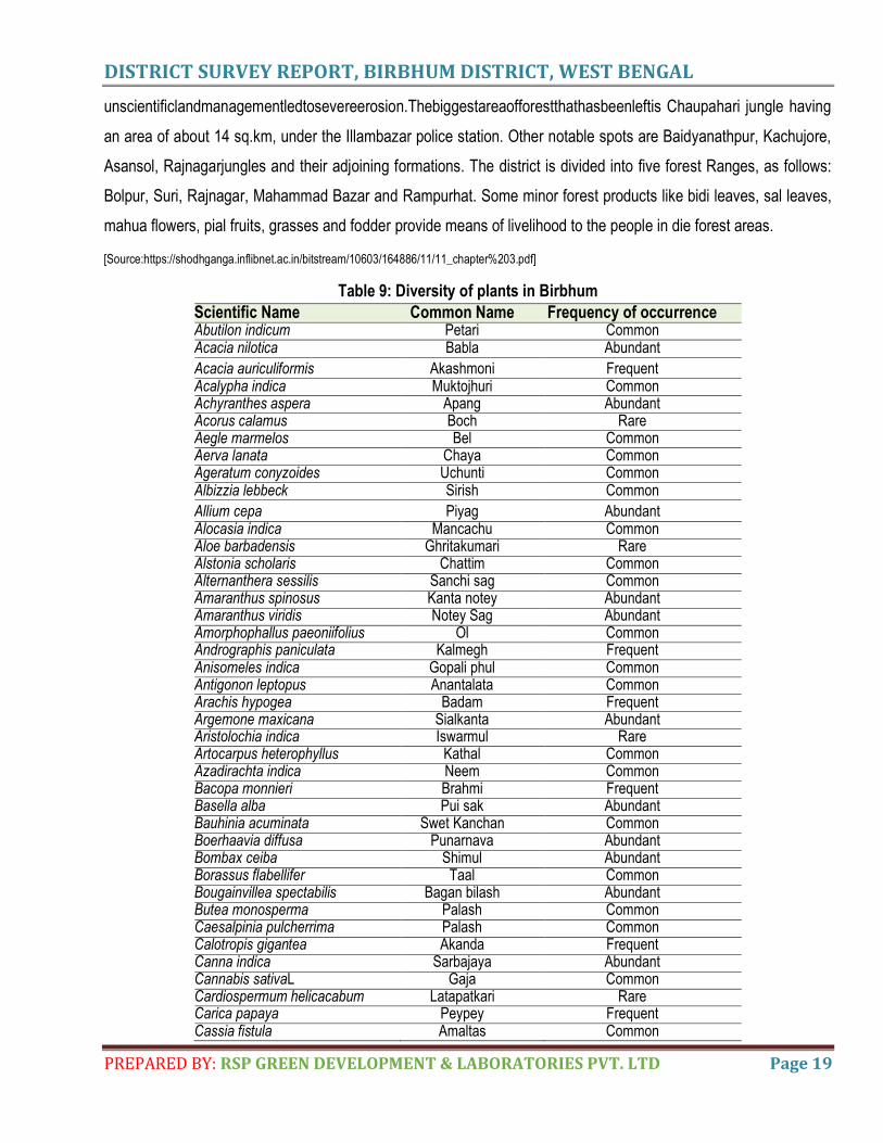
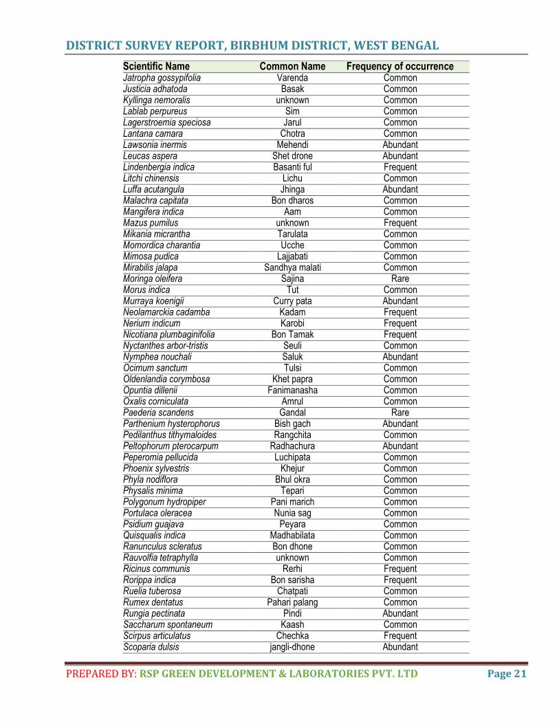
Table 9: Diversity of plants in Birbhum
Scientific Name Common Name Frequency of occurrence Abutilon indicum Petari Common Acacia nilotica Babla Abundant
Acacia auriculiformis Akashmoni Frequent Acalypha indica Muktojhuri Common Achyranthes aspera Apang Abundant Acorus calamus Boch Rare Aegle marmelos Bel Common Aerva lanata Chaya Common Ageratum conyzoides Uchunti Common Albizzia lebbeck Sirish Common
Allium cepa Piyag Abundant Alocasia indica Mancachu Common Aloe barbadensis Ghritakumari Rare Alstonia scholaris Chattim Common Alternanthera sessilis Sanchi sag Common Amaranthus spinosus Kanta notey Abundant Amaranthus viridis Notey Sag Abundant Amorphophallus paeoniifolius Ol Common Andrographis paniculata Kalmegh Frequent Anisomeles indica Gopali phul Common Antigonon leptopus Anantalata Common Arachis hypogea Badam Frequent Argemone maxicana Sialkanta Abundant Aristolochia indica Iswarmul Rare Artocarpus heterophyllus Kathal Common Azadirachta indica Neem Common Bacopa monnieri Brahmi Frequent Basella alba Pui sak Abundant Bauhinia acuminata Swet Kanchan Common Boerhaavia diffusa Punarnava Abundant Bombax ceiba Shimul Abundant Borassus flabellifer Taal Common Bougainvillea spectabilis Bagan bilash Abundant Butea monosperma Palash Common Caesalpinia pulcherrima Palash Common Calotropis gigantea Akanda Frequent Canna indica Sarbajaya Abundant Cannabis sativaL Gaja Common Cardiospermum helicacabum Latapatkari Rare Carica papaya Peypey Frequent Cassia fistula Amaltas Common
DISTRICT SURVEY REPORT, BIRBHUM DISTRICT, WEST BENGAL
PREPARED BY: RSP GREEN DEVELOPMENT & LABORATORIES PVT. LTD Page 20
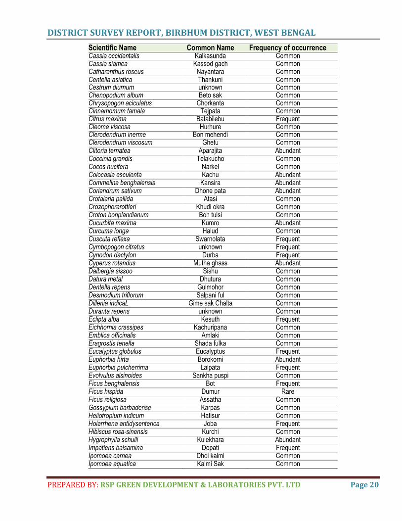
Scientific Name Common Name Frequency of occurrence Cassia occidentalis Kalkasunda Common Cassia siamea Kassod gach Common Catharanthus roseus Nayantara Common Centella asiatica Thankuni Common Cestrum diurnum unknown Common Chenopodium album Beto sak Common Chrysopogon aciculatus Chorkanta Common Cinnamomum tamala Tejpata Common Citrus maxima Batabilebu Frequent Cleome viscosa Hurhure Common Clerodendrum inerme Bon mehendi Common Clerodendrum viscosum Ghetu Common Clitoria ternatea Aparajita Abundant Coccinia grandis Telakucho Common Cocos nucifera Narkel Common Colocasia esculenta Kachu Abundant Commelina benghalensis Kansira Abundant Coriandrum sativum Dhone pata Abundant Crotalaria pallida Atasi Common Crozophorarottleri Khudi okra Common Croton bonplandianum Bon tulsi Common Cucurbita maxima Kumro Abundant Curcuma longa Halud Common Cuscuta reflexa Swarnolata Frequent Cymbopogon citratus unknown Frequent Cynodon dactylon Durba Frequent Cyperus rotandus Mutha ghass Abundant Dalbergia sissoo Sishu Common Datura metal Dhutura Common Dentella repens Gulmohor Common Desmodium triflorum Salpani ful Common Dillenia indicaL Gime sak Chalta Common Duranta repens unknown Common Eclipta alba Kesuth Frequent Eichhornia crassipes Kachuripana Common Emblica officinalis Amlaki Common Eragrostis tenella Shada fulka Common Eucalyptus globulus Eucalyptus Frequent Euphorbia hirta Borokorni Abundant Euphorbia pulcherrima Lalpata Frequent Evolvulus alsinoides Sankha puspi Common Ficus benghalensis Bot Frequent Ficus hispida Dumur Rare Ficus religiosa Assatha Common Gossypium barbadense Karpas Common Heliotropium indicum Hatisur Common Holarrhena antidysenterica Joba Frequent Hibiscus rosa-sinensis Kurchi Common Hygrophylla schulli Kulekhara Abundant Impatiens balsamina Dopati Frequent Ipomoea carnea Dhol kalmi Common Ipomoea aquatica Kalmi Sak Common
DISTRICT SURVEY REPORT, BIRBHUM DISTRICT, WEST BENGAL
PREPARED BY: RSP GREEN DEVELOPMENT & LABORATORIES PVT. LTD Page 21
Scientific Name Common Name Frequency of occurrence Jatropha gossypifolia Varenda Common Justicia adhatoda Basak Common Kyllinga nemoralis unknown Common Lablab perpureus Sim Common Lagerstroemia speciosa Jarul Common Lantana camara Chotra Common Lawsonia inermis Mehendi Abundant Leucas aspera Shet drone Abundant Lindenbergia indica Basanti ful Frequent Litchi chinensis Lichu Common Luffa acutangula Jhinga Abundant Malachra capitata Bon dharos Common Mangifera indica Aam Common Mazus pumilus unknown Frequent Mikania micrantha Tarulata Common Momordica charantia Ucche Common Mimosa pudica Lajjabati Common Mirabilis jalapa Sandhya malati Common Moringa oleifera Sajina Rare Morus indica Tut Common Murraya koenigii Curry pata Abundant Neolamarckia cadamba Kadam Frequent Nerium indicum Karobi Frequent Nicotiana plumbaginifolia Bon Tamak Frequent Nyctanthes arbor-tristis Seuli Common Nymphea nouchali Saluk Abundant Ocimum sanctum Tulsi Common Oldenlandia corymbosa Khet papra Common Opuntia dillenii Fanimanasha Common Oxalis corniculata Amrul Common Paederia scandens Gandal Rare Parthenium hysterophorus Bish gach Abundant Pedilanthus tithymaloides Rangchita Common Peltophorum pterocarpum Radhachura Abundant Peperomia pellucida Luchipata Common Phoenix sylvestris Khejur Common Phyla nodiflora Bhul okra Common Physalis minima Tepari Common Polygonum hydropiper Pani marich Common Portulaca oleracea Nunia sag Common Psidium guajava Peyara Common Quisqualis indica Madhabilata Common Ranunculus scleratus Bon dhone Common Rauvolfia tetraphylla unknown Common Ricinus communis Rerhi Frequent Rorippa indica Bon sarisha Frequent Ruelia tuberosa Chatpati Common Rumex dentatus Pahari palang Common Rungia pectinata Pindi Abundant Saccharum spontaneum Kaash Common Scirpus articulatus Chechka Frequent Scoparia dulsis jangli-dhone Abundant
DISTRICT SURVEY REPORT, BIRBHUM DISTRICT, WEST BENGAL
PREPARED BY: RSP GREEN DEVELOPMENT & LABORATORIES PVT. LTD Page 22
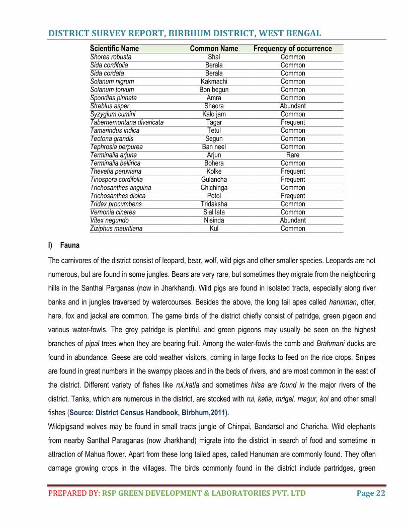
Scientific Name Common Name Frequency of occurrence Shorea robusta Shal Common Sida cordifolia Berala Common Sida cordata Berala Common Solanum nigrum Kakmachi Common Solanum torvum Bon begun Common Spondias pinnata Amra Common Streblus asper Sheora Abundant Syzygium cumini Kalo jam Common Tabernemontana divaricata Tagar Frequent Tamarindus indica Tetul Common Tectona grandis Segun Common Tephrosia perpurea Ban neel Common Terminalia arjuna Arjun Rare Terminalia bellirica Bohera Common Thevetia peruviana Kolke Frequent Tinospora cordifolia Gulancha Frequent Trichosanthes anguina Chichinga Common Trichosanthes dioica Potol Frequent Tridex procumbens Tridaksha Common Vernonia cinerea Sial lata Common Vitex negundo Nisinda Abundant Ziziphus mauritiana Kul Common
l) Fauna
The carnivores of the district consist of leopard, bear, wolf, wild pigs and other smaller species. Leopards are not
numerous, but are found in some jungles. Bears are very rare, but sometimes they migrate from the neighboring
hills in the Santhal Parganas (now in Jharkhand). Wild pigs are found in isolated tracts, especially along river
banks and in jungles traversed by watercourses. Besides the above, the long tail apes called hanuman, otter,
hare, fox and jackal are common. The game birds of the district chiefly consist of patridge, green pigeon and
various water-fowls. The grey patridge is plentiful, and green pigeons may usually be seen on the highest
branches of pipal trees when they are bearing fruit. Among the water-fowls the comb and Brahmani ducks are
found in abundance. Geese are cold weather visitors, coming in large flocks to feed on the rice crops. Snipes
are found in great numbers in the swampy places and in the beds of rivers, and are most common in the east of
the district. Different variety of fishes like rui,katla and sometimes hilsa are found in the major rivers of the
district. Tanks, which are numerous in the district, are stocked with rui, katla, mrigel, magur, koi and other small
fishes (Source: District Census Handbook, Birbhum,2011).
Wildpigsand wolves may be found in small tracts jungle of Chinpai, Bandarsol and Charicha. Wild elephants
from nearby Santhal Paraganas (now Jharkhand) migrate into the district in search of food and sometime in
attraction of Mahua flower. Apart from these long tailed apes, called Hanuman are commonly found. They often
damage growing crops in the villages. The birds commonly found in the district include partridges, green
DISTRICT SURVEY REPORT, BIRBHUM DISTRICT, WEST BENGAL
PREPARED BY: RSP GREEN DEVELOPMENT & LABORATORIES PVT. LTD Page 23
pigeons, and various waterfouls. But their number has dwindled considerably due to reckless hunting. Few
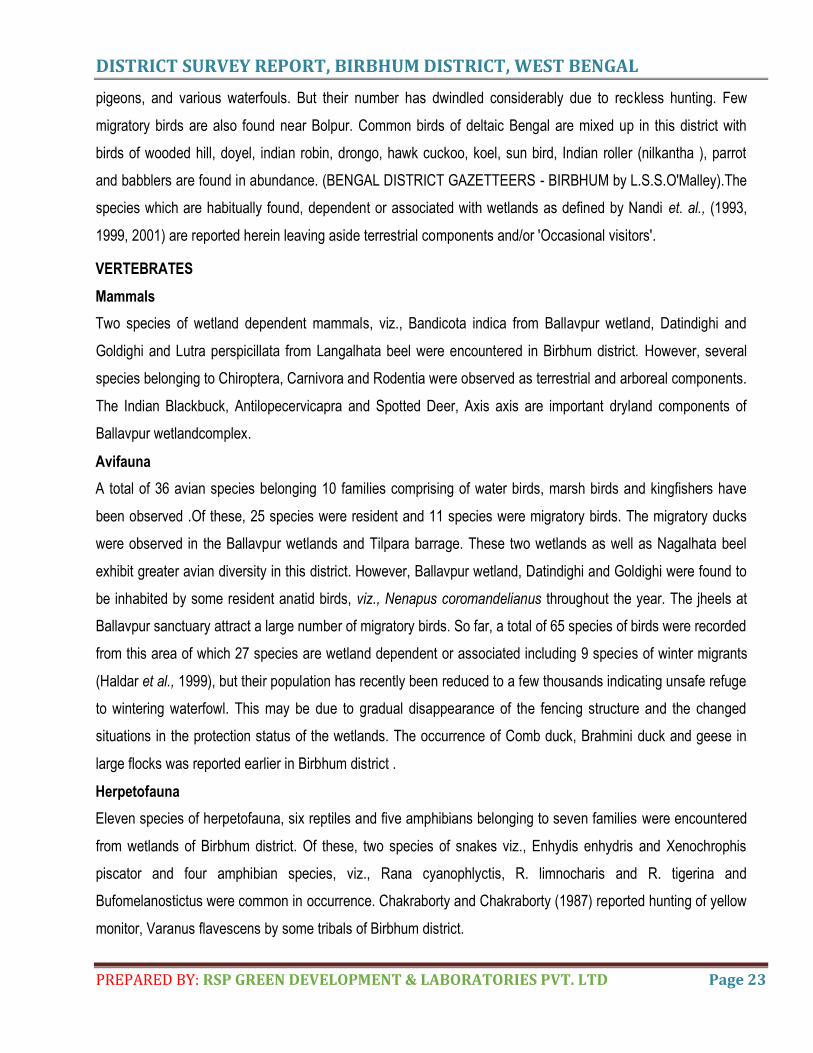
migratory birds are also found near Bolpur. Common birds of deltaic Bengal are mixed up in this district with
birds of wooded hill, doyel, indian robin, drongo, hawk cuckoo, koel, sun bird, Indian roller (nilkantha ), parrot
and babblers are found in abundance. (BENGAL DISTRICT GAZETTEERS - BIRBHUM by L.S.S.O'Malley).The
species which are habitually found, dependent or associated with wetlands as defined by Nandi et. al., (1993,
1999, 2001) are reported herein leaving aside terrestrial components and/or 'Occasional visitors'.
VERTEBRATES
Mammals
Two species of wetland dependent mammals, viz., Bandicota indica from Ballavpur wetland, Datindighi and
Goldighi and Lutra perspicillata from Langalhata beel were encountered in Birbhum district. However, several
species belonging to Chiroptera, Carnivora and Rodentia were observed as terrestrial and arboreal components.
The Indian Blackbuck, Antilopecervicapra and Spotted Deer, Axis axis are important dryland components of
Ballavpur wetlandcomplex.
Avifauna
A total of 36 avian species belonging 10 families comprising of water birds, marsh birds and kingfishers have
been observed .Of these, 25 species were resident and 11 species were migratory birds. The migratory ducks
were observed in the Ballavpur wetlands and Tilpara barrage. These two wetlands as well as Nagalhata beel
exhibit greater avian diversity in this district. However, Ballavpur wetland, Datindighi and Goldighi were found to
be inhabited by some resident anatid birds, viz., Nenapus coromandelianus throughout the year. The jheels at
Ballavpur sanctuary attract a large number of migratory birds. So far, a total of 65 species of birds were recorded
from this area of which 27 species are wetland dependent or associated including 9 species of winter migrants
(Haldar et al., 1999), but their population has recently been reduced to a few thousands indicating unsafe refuge
to wintering waterfowl. This may be due to gradual disappearance of the fencing structure and the changed
situations in the protection status of the wetlands. The occurrence of Comb duck, Brahmini duck and geese in
large flocks was reported earlier in Birbhum district .
Herpetofauna
Eleven species of herpetofauna, six reptiles and five amphibians belonging to seven families were encountered
from wetlands of Birbhum district. Of these, two species of snakes viz., Enhydis enhydris and Xenochrophis
piscator and four amphibian species, viz., Rana cyanophlyctis, R. limnocharis and R. tigerina and
Bufomelanostictus were common in occurrence. Chakraborty and Chakraborty (1987) reported hunting of yellow
monitor, Varanus flavescens by some tribals of Birbhum district.
DISTRICT SURVEY REPORT, BIRBHUM DISTRICT, WEST BENGAL
PREPARED BY: RSP GREEN DEVELOPMENT & LABORATORIES PVT. LTD Page 24
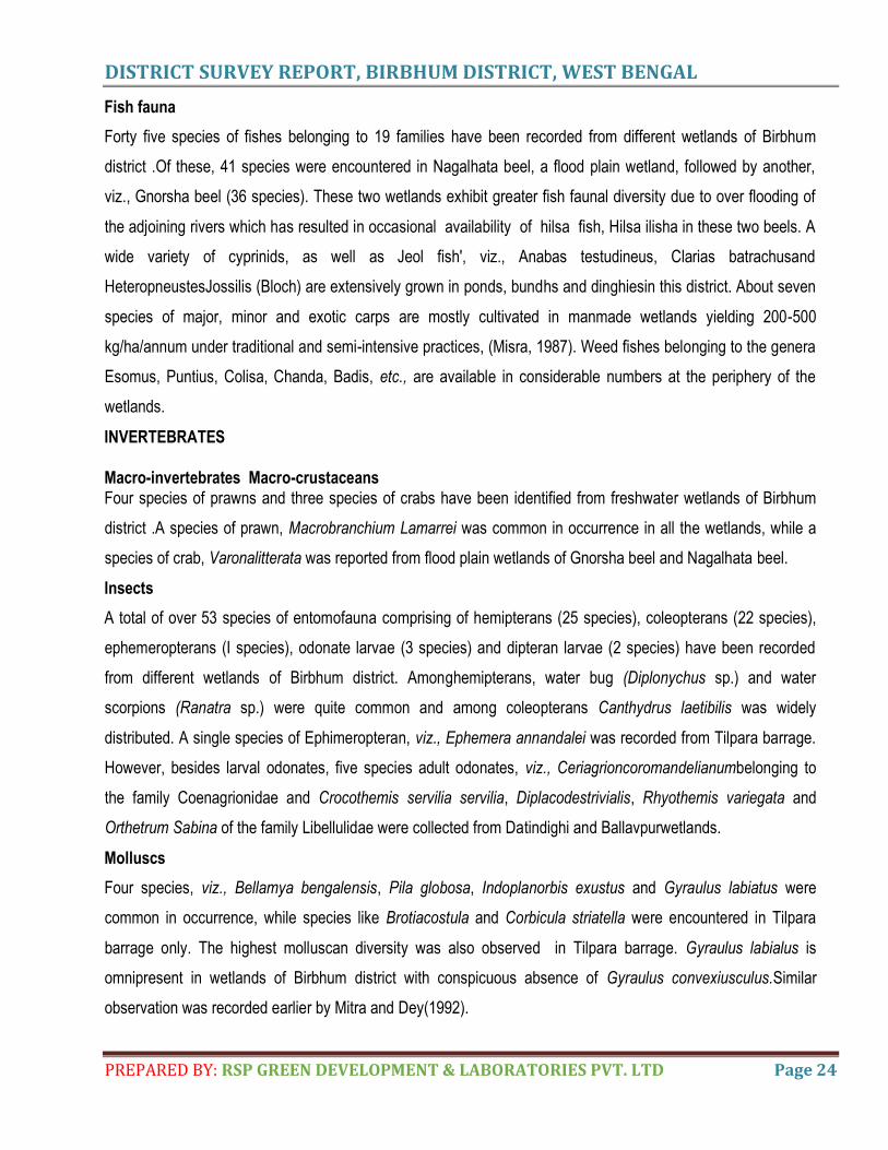
Fish fauna
Forty five species of fishes belonging to 19 families have been recorded from different wetlands of Birbhum
district .Of these, 41 species were encountered in Nagalhata beel, a flood plain wetland, followed by another,
viz., Gnorsha beel (36 species). These two wetlands exhibit greater fish faunal diversity due to over flooding of
the adjoining rivers which has resulted in occasional availability of hilsa fish, Hilsa ilisha in these two beels. A
wide variety of cyprinids, as well as Jeol fish', viz., Anabas testudineus, Clarias batrachusand
HeteropneustesJossilis (Bloch) are extensively grown in ponds, bundhs and dinghiesin this district. About seven
species of major, minor and exotic carps are mostly cultivated in manmade wetlands yielding 200-500
kg/ha/annum under traditional and semi-intensive practices, (Misra, 1987). Weed fishes belonging to the genera
Esomus, Puntius, Colisa, Chanda, Badis, etc., are available in considerable numbers at the periphery of the
wetlands.
INVERTEBRATES Macro-invertebrates Macro-crustaceans Four species of prawns and three species of crabs have been identified from freshwater wetlands of Birbhum
district .A species of prawn, Macrobranchium Lamarrei was common in occurrence in all the wetlands, while a
species of crab, Varonalitterata was reported from flood plain wetlands of Gnorsha beel and Nagalhata beel.
Insects
A total of over 53 species of entomofauna comprising of hemipterans (25 species), coleopterans (22 species),
ephemeropterans (I species), odonate larvae (3 species) and dipteran larvae (2 species) have been recorded
from different wetlands of Birbhum district. Amonghemipterans, water bug (Diplonychus sp.) and water
scorpions (Ranatra sp.) were quite common and among coleopterans Canthydrus laetibilis was widely
distributed. A single species of Ephimeropteran, viz., Ephemera annandalei was recorded from Tilpara barrage.
However, besides larval odonates, five species adult odonates, viz., Ceriagrioncoromandelianumbelonging to
the family Coenagrionidae and Crocothemis servilia servilia, Diplacodestrivialis, Rhyothemis variegata and
Orthetrum Sabina of the family Libellulidae were collected from Datindighi and Ballavpurwetlands.
Molluscs
Four species, viz., Bellamya bengalensis, Pila globosa, Indoplanorbis exustus and Gyraulus labiatus were
common in occurrence, while species like Brotiacostula and Corbicula striatella were encountered in Tilpara
barrage only. The highest molluscan diversity was also observed in Tilpara barrage. Gyraulus labialus is
omnipresent in wetlands of Birbhum district with conspicuous absence of Gyraulus convexiusculus.Similar
observation was recorded earlier by Mitra and Dey(1992).
DISTRICT SURVEY REPORT, BIRBHUM DISTRICT, WEST BENGAL
PREPARED BY: RSP GREEN DEVELOPMENT & LABORATORIES PVT. LTD Page 25
Zooplankton
Fifty three species of zooplankton belonging to Copepoda (6 species), Ostracoda (5 species), Cladocera (35
species), Conchostraca (1 species) and Rotifera (6 species) have been recorded from various wetlands of
Birbhum district. Of these, Cladocerans exhibited greatest diversity representing 35 species belonging to five
families. Among Cladocerans, Ceriodaphnia comuata occurs in all the wetlands sampled for zooplankton, while
Daphnia similis occurredonly in the flood plain wetland of Gnorsha beel. However, in general, littoral species
such as Chydorids were dominantover limnetic species since most of these wetlands are used for pisciculture.
The scarcity in representation of limnetic Cladocerans belonging to the families Daphnidae, Moinidae and
Bosminidae is suspected due to the predation pressure by insects and fishes as suggested by
Venkataramanand Das (1993) and Venkataraman et al., (2000).Copepods appear to be the next dominant
group in which predaceous cyclops predominate amongst zooplankton population in a number of wetlands
surveyed. The wetlands of Birbhum district are utilized in various ways, viz., reservoir of water, recreation,
waterfowl habitat, religious purposes, etc. Ballavpur wetland and para barrage have high value as waterfowl
habitat and Goldighihas high recreational as well as reservoir of water value for domestic purposes. On the other
hand, Datindighi is an important religious site for the local people. Ghosh et. al., (1992) reported archaeological
domestic mammalian remains from a pond of chalcolithic Kotasur village of this district (Nandi et. al., 2001).
DISTRICT SURVEY REPORT, BIRBHUM DISTRICT, WEST BENGAL
PREPARED BY: RSP GREEN DEVELOPMENT & LABORATORIES PVT. LTD Page 26
4. PHYSIOGRAPHY OF THE DISTRICT General Landform
The western hilly upland of the district, a part of eastern part of Chhotanagpur plateau is approximately bounded by
100 metre contour in the east with a slope of >2°.Parts of Murarai-I, Nalhati-I, Rampurhat-I, Khoyrasol, Rajnagar
and Suri – I are characterized by the existence of cap rocks and hilly upland. This is also known as plateaurim. The
land gradually descends eastward with slope of 1-2 º from the plateau rim. This rolling topography is the transitional
zone in between hilly upland in the west and the depositional plain in the east. The depositional plain consists of
alluvial tract formed by sand, sandy loam and silty loam. Slope of this area is below1º for most of the places.
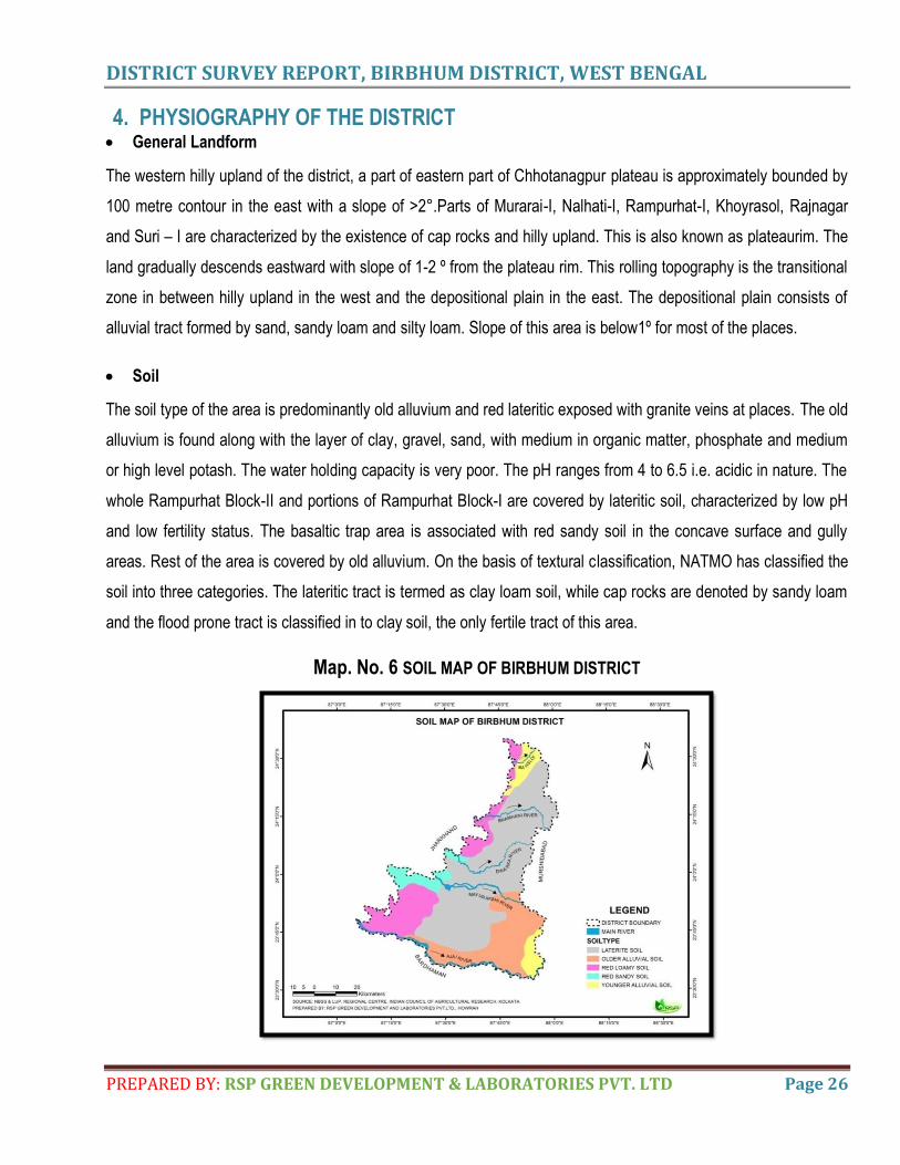
Soil
The soil type of the area is predominantly old alluvium and red lateritic exposed with granite veins at places. The old
alluvium is found along with the layer of clay, gravel, sand, with medium in organic matter, phosphate and medium
or high level potash. The water holding capacity is very poor. The pH ranges from 4 to 6.5 i.e. acidic in nature. The
whole Rampurhat Block-II and portions of Rampurhat Block-I are covered by lateritic soil, characterized by low pH
and low fertility status. The basaltic trap area is associated with red sandy soil in the concave surface and gully
areas. Rest of the area is covered by old alluvium. On the basis of textural classification, NATMO has classified the
soil into three categories. The lateritic tract is termed as clay loam soil, while cap rocks are denoted by sandy loam
and the flood prone tract is classified in to clay soil, the only fertile tract of this area.
Map. No. 6 SOIL MAP OF BIRBHUM DISTRICT
DISTRICT SURVEY REPORT, BIRBHUM DISTRICT, WEST BENGAL
PREPARED BY: RSP GREEN DEVELOPMENT & LABORATORIES PVT. LTD Page 27
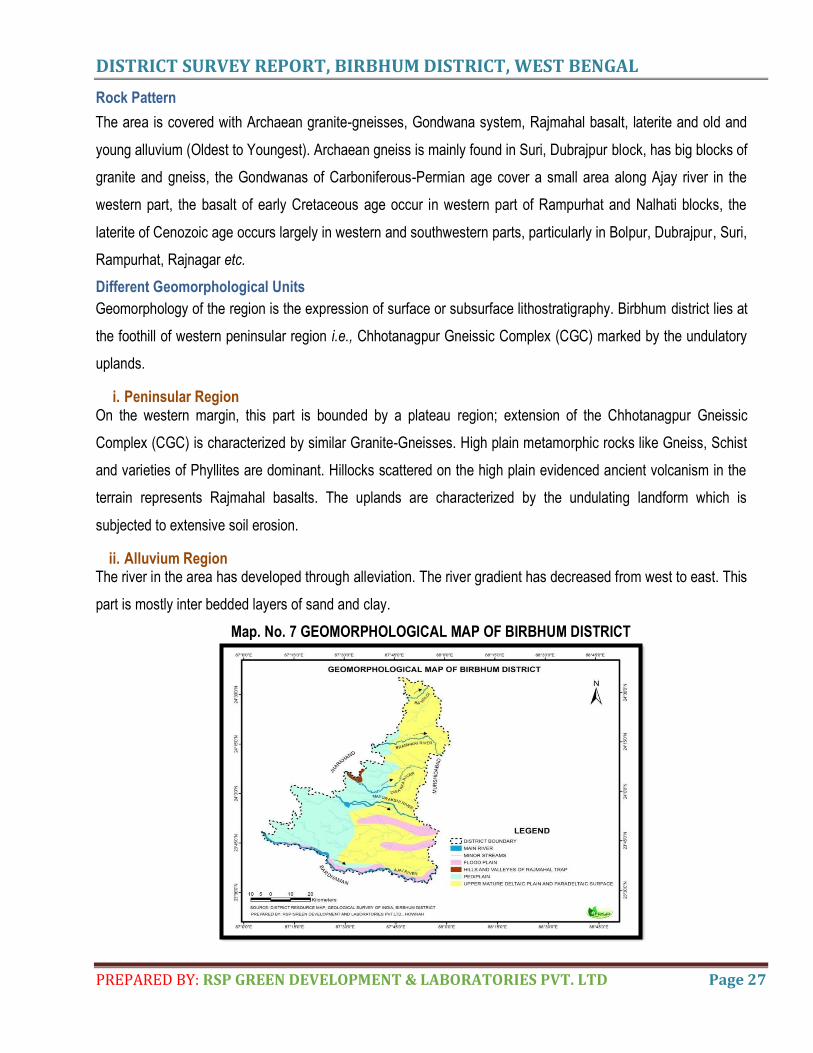
Rock Pattern
The area is covered with Archaean granite-gneisses, Gondwana system, Rajmahal basalt, laterite and old and
young alluvium (Oldest to Youngest). Archaean gneiss is mainly found in Suri, Dubrajpur block, has big blocks of
granite and gneiss, the Gondwanas of Carboniferous-Permian age cover a small area along Ajay river in the
western part, the basalt of early Cretaceous age occur in western part of Rampurhat and Nalhati blocks, the
laterite of Cenozoic age occurs largely in western and southwestern parts, particularly in Bolpur, Dubrajpur, Suri,
Rampurhat, Rajnagar etc.
Different Geomorphological Units
Geomorphology of the region is the expression of surface or subsurface lithostratigraphy. Birbhum district lies at
the foothill of western peninsular region i.e., Chhotanagpur Gneissic Complex (CGC) marked by the undulatory
uplands.
i. Peninsular Region On the western margin, this part is bounded by a plateau region; extension of the Chhotanagpur Gneissic
Complex (CGC) is characterized by similar Granite-Gneisses. High plain metamorphic rocks like Gneiss, Schist
and varieties of Phyllites are dominant. Hillocks scattered on the high plain evidenced ancient volcanism in the
terrain represents Rajmahal basalts. The uplands are characterized by the undulating landform which is
subjected to extensive soil erosion.
ii. Alluvium Region The river in the area has developed through alleviation. The river gradient has decreased from west to east. This
part is mostly inter bedded layers of sand and clay.
Map. No. 7 GEOMORPHOLOGICAL MAP OF BIRBHUM DISTRICT
DISTRICT SURVEY REPORT, BIRBHUM DISTRICT, WEST BENGAL
PREPARED BY: RSP GREEN DEVELOPMENT & LABORATORIES PVT. LTD Page 28
5. LAND USE PATTERN OF THE DISTRICT
INTRODUCTION
Land cover is the physical material at the surface of the earth. Land covers include grass, asphalt,
trees, bare ground, water, etc. Land cover data documents how much of a region is covered by forests,
wetlands, impervious surfaces, agriculture, and other land and water types. Water types include wetlands or
open water.
Land use shows how people use the landscape – whether for development, conservation, or mixed uses. Land
use refers to the purpose the land serves, for example, recreation, wildlife habitat, or agriculture. Land use
applications involve both baseline mapping and subsequent monitoring, since timely information is required to
know what current quantity of land is in what type of use and to identify the land use changes from year to year.
Deciduous forest: Woody vegetation with a percent cover >60% and height exceeding 2 m. consists of
broadleaf tree communities with an annual cycle of leaf-on and leaf-off periods, dominated by trees that lose
their leaves each year.
Cropland: Temporarily cropped area followed by harvest and a bare soil period (e.g., single and multiple
cropping systems). Different types of cropland based on seasons (e.g., kharif, rabi, zaid). Cropland includes
areas used for the production of adapted crops for harvest.
Built up land: a developed area, i.e., any land on which buildings and/or non-building structures are present,
normally as part of a larger developed environment such as: developed landlot, rural area, urban area. Land
covered by buildings and other man-made structures
Mixed forest: Vegetation formation composed principally of trees, including shrub and bush under storey,
where neither broad-leaved nor coniferous species predominate.
Shrub land: Land with woody vegetation less than 2 m in height and with greater than 10% shrub canopy
cover. The shrub foliage can be either evergreen or deciduous. Shrubland, scrubland, scrub, brush, or bush is a
plant community characterised by vegetation dominated by shrubs, often also including grasses, herbs, and
geophytes. Shrubland may either occur naturally or be the result of human activity.
Fallow land: Fallow Land is farmland that has no crops on it, usually for a year, to recover its fertility to grow
crops. Land taken up for cultivation temporarily allowed to remain uncultivated for one or more seasons.
Waste land: Sparsely vegetated land with signs of erosion and land deformation that could be attributed to lack
of appropriate water and soil management, or natural causes. These are land identified as currently
underutilized and could be reclaimed to productive uses with reasonable effort. Degraded forest (<10% tree
cover) with signs of erosion is classified under wasteland.
DISTRICT SURVEY REPORT, BIRBHUM DISTRICT, WEST BENGAL
PREPARED BY: RSP GREEN DEVELOPMENT & LABORATORIES PVT. LTD Page 29
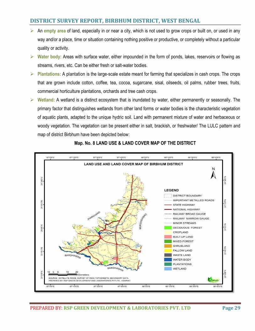
An empty area of land, especially in or near a city, which is not used to grow crops or built on, or used in any
way and/or a place, time or situation containing nothing positive or productive, or completely without a particular
quality or activity.
Water body: Areas with surface water, either impounded in the form of ponds, lakes, reservoirs or flowing as
streams, rivers, etc. Can be either fresh or salt-water bodies.
Plantations: A plantation is the large-scale estate meant for farming that specializes in cash crops. The crops
that are grown include cotton, coffee, tea, cocoa, sugarcane, sisal, oilseeds, oil palms, rubber trees, fruits,
commercial horticulture plantations, orchards and tree cash crops.
Wetland: A wetland is a distinct ecosystem that is inundated by water, either permanently or seasonally. The
primary factor that distinguishes wetlands from other land forms or water bodies is the characteristic vegetation
of aquatic plants, adapted to the unique hydric soil. Land with permanent mixture of water and herbaceous or
woody vegetation. The vegetation can be present either in salt, brackish, or freshwater/ The LULC pattern and
map of district Birbhum have been depicted below:
Map. No. 8 LAND USE & LAND COVER MAP OF THE DISTRICT
DISTRICT SURVEY REPORT, BIRBHUM DISTRICT, WEST BENGAL
PREPARED BY: RSP GREEN DEVELOPMENT & LABORATORIES PVT. LTD Page 30
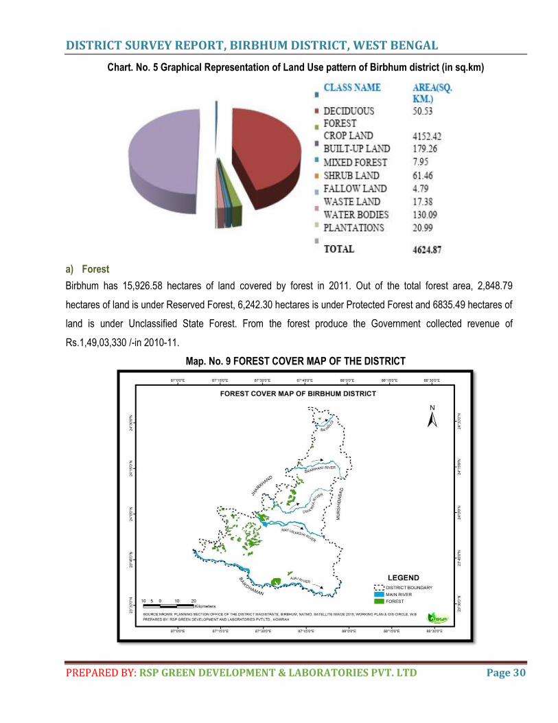
Chart. No. 5 Graphical Representation of Land Use pattern of Birbhum district (in sq.km)
a) Forest
Birbhum has 15,926.58 hectares of land covered by forest in 2011. Out of the total forest area, 2,848.79
hectares of land is under Reserved Forest, 6,242.30 hectares is under Protected Forest and 6835.49 hectares of
land is under Unclassified State Forest. From the forest produce the Government collected revenue of
Rs.1,49,03,330 /-in 2010-11.
Map. No. 9 FOREST COVER MAP OF THE DISTRICT
DISTRICT SURVEY REPORT, BIRBHUM DISTRICT, WEST BENGAL
PREPARED BY: RSP GREEN DEVELOPMENT & LABORATORIES PVT. LTD Page 31
b) Agriculture and Irrigation Paddy is the principal agricultural crops produced in the district. Apart from it many other different crops are
grown in the district such as wheat, potato, sugarcane ,pulses, oilseeds, tomato, cabbage, cauliflower, brinjal,
cucurbits, onions etc. Fruits such as Mango, banana, guava etc are also found to grown in the district.
Table 10: Season wise irrigation potential in hectares
Source Area in hectare
Canal 182.362
Tank 31.416
D.T.W & MD.T.W 46.959
S.T.W 16.592
RLI 5.630
Open Dug Well 0.62
Other sources 2.605
Total 286.184
c) Horticulture
Table 11: The major fruits and vegetables grown in the district
Horticulture fruit
crops
Area
(Hectare)
Horticulture vegetable
crops
Area
(Hectare)
Mango 0.9 Brinjal 9.9
Banana 0.7 Cucurbits 9.3
Guava 0.9 Ladies Finger 3.9 Citrus 0.5 Cabbage 2.6
Paoaya 0.5 Cauliflower 2.2
Tomato 1.9
d) Mining For performing mining operations there mainly basalt quarries present at Nalhati, Rampurhat and Barapahari
blocks. The Basalt deposit is well exposed on the surface. In view of this, the deposit will be worked by opencast
mining method to achieve the required amount of production.Clay mining plays also a crucial role accelerating
the development of mining activity (Dubrajpur & Md. Bazar) which may meet the market demand augmenting
clay production. Riverbed sands are also mined in these districts as minor minerals which are responsible for
huge economic growth of this region. Successful management of sand, clay and stone mining involving
exploration, exploitation, conservation and protection of the resource in the district will be of immense help to its
economic growth and sustenance of the quality of environment. Deocha - Pachami- Dewanganj- Harinsingha,
Birbhum coalfield, District Birbhum, West Bengal of an area of 12.3 sq.km having Lat: 240 01′ 45”- 240 05′ 30”
(approx) Long : 870 34′ 15”- 870 37′ 39” (approx), Toposheet No- 72P/12.
DISTRICT SURVEY REPORT, BIRBHUM DISTRICT, WEST BENGAL
PREPARED BY: RSP GREEN DEVELOPMENT & LABORATORIES PVT. LTD Page 32
6. GEOLOGY OF THE DISTRICT
o REGIONAL GEOLOGY
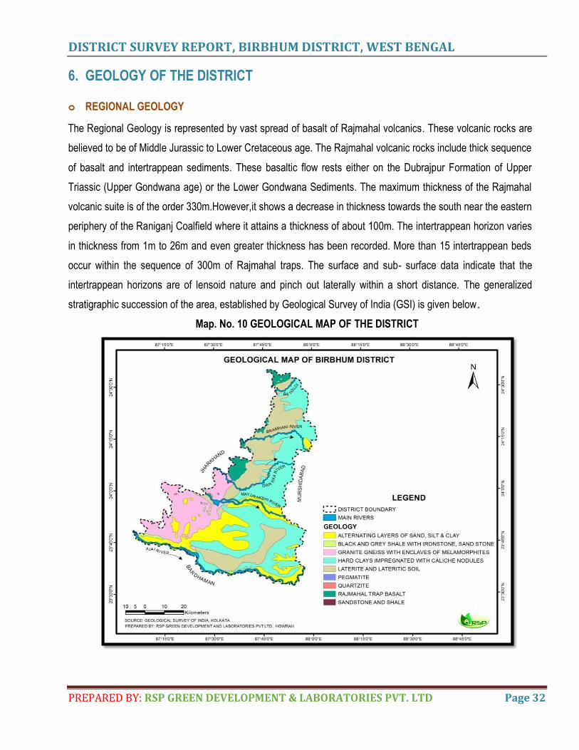
The Regional Geology is represented by vast spread of basalt of Rajmahal volcanics. These volcanic rocks are
believed to be of Middle Jurassic to Lower Cretaceous age. The Rajmahal volcanic rocks include thick sequence
of basalt and intertrappean sediments. These basaltic flow rests either on the Dubrajpur Formation of Upper
Triassic (Upper Gondwana age) or the Lower Gondwana Sediments. The maximum thickness of the Rajmahal
volcanic suite is of the order 330m.However,it shows a decrease in thickness towards the south near the eastern
periphery of the Raniganj Coalfield where it attains a thickness of about 100m. The intertrappean horizon varies
in thickness from 1m to 26m and even greater thickness has been recorded. More than 15 intertrappean beds
occur within the sequence of 300m of Rajmahal traps. The surface and sub- surface data indicate that the
intertrappean horizons are of lensoid nature and pinch out laterally within a short distance. The generalized
stratigraphic succession of the area, established by Geological Survey of India (GSI) is given below.
Map. No. 10 GEOLOGICAL MAP OF THE DISTRICT
DISTRICT SURVEY REPORT, BIRBHUM DISTRICT, WEST BENGAL
PREPARED BY: RSP GREEN DEVELOPMENT & LABORATORIES PVT. LTD Page 33
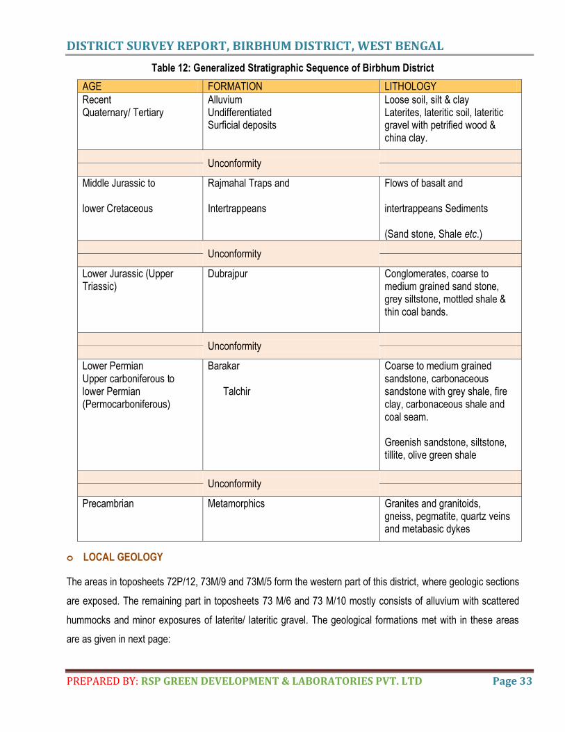
Table 12: Generalized Stratigraphic Sequence of Birbhum District
AGE FORMATION LITHOLOGY
Recent Quaternary/ Tertiary
Alluvium Undifferentiated Surficial deposits
Loose soil, silt & clay Laterites, lateritic soil, lateritic gravel with petrified wood & china clay.
Unconformity
Middle Jurassic to lower Cretaceous
Rajmahal Traps and Intertrappeans
Flows of basalt and intertrappeans Sediments (Sand stone, Shale etc.)
Unconformity
Lower Jurassic (Upper Triassic)
Dubrajpur Conglomerates, coarse to medium grained sand stone, grey siltstone, mottled shale & thin coal bands.
Unconformity
Lower Permian Upper carboniferous to lower Permian (Permocarboniferous)
Barakar Talchir
Coarse to medium grained sandstone, carbonaceous sandstone with grey shale, fire clay, carbonaceous shale and coal seam. Greenish sandstone, siltstone, tillite, olive green shale
Unconformity
Precambrian
Metamorphics Granites and granitoids, gneiss, pegmatite, quartz veins and metabasic dykes
o LOCAL GEOLOGY
The areas in toposheets 72P/12, 73M/9 and 73M/5 form the western part of this district, where geologic sections
are exposed. The remaining part in toposheets 73 M/6 and 73 M/10 mostly consists of alluvium with scattered
hummocks and minor exposures of laterite/ lateritic gravel. The geological formations met with in these areas
are as given in next page:
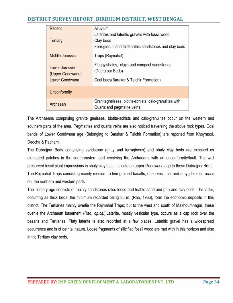
DISTRICT SURVEY REPORT, BIRBHUM DISTRICT, WEST BENGAL
PREPARED BY: RSP GREEN DEVELOPMENT & LABORATORIES PVT. LTD Page 34
Recent Alluvium
Laterites and lateritic gravels with fossil wood.
Tertiary Clay beds
Ferruginous and feldspathic sandstones and clay beds
Middle Jurassic Traps (Rajmahal)
Lower Jurassic
(Upper Gondwana)
Lower Gondwana
Flaggy shales, clays and compact sandstones
(Dubrajpur Beds)
Coal beds(Barakar & Talchir Formation)
Unconformity
Archaean Granitegneisses, biotite-schists, calc-granulites with
Quartz and pegmatite veins.
The Archaeans comprising granite gneisses, biotite-schists and calc-granulites occur on the western and
southern parts of the area. Pegmatites and quartz veins are also noticed traversing the above rock types. Coal
bands of Lower Gondwana age (Belonging to Barakar & Talchir Formation) are reported from Khoyrasol,
Deocha & Pachami.
The Dubrajpur Beds comprising sandstone (gritty and ferruginous) and shaly clay beds are exposed as
elongated patches in the south-eastern part overlying the Archaeans with an unconformity/fault. The well
preserved fossil plant impressions in shaly clay beds indicate an upper Gondwana age to these Dubrajpur Beds.
The Rajmahal Traps consisting mainly medium to fine grained basalts, often vesicular and amygdaloidal, occur
on, the northern and western parts.
The Tertiary age consists of mainly sandstones (also loose and friable sand and grit) and clay beds. The latter,
occurring as thick beds, the minimum recorded being 30 m. (Rao, 1966), form the economic deposits in this
district. The Tertiaries mainly overlie the Rajmahal Traps; but to the west and south of Makhdumnagar, these
overlie the Archaean basement (Rao, op.cit.).Laterite, mostly vesicular type, occurs as a cap rock over the
basalts and Tertiaries. Platy laterite is also recorded at a few places. Lateritic gravel has a widespread
occurrence and is of detrital nature. Loose fragments of silicified fossil wood are met with in this horizon and also
in the Tertiary clay beds.
DISTRICT SURVEY REPORT, BIRBHUM DISTRICT, WEST BENGAL
PREPARED BY: RSP GREEN DEVELOPMENT & LABORATORIES PVT. LTD Page 35
7. MINERAL WEALTH
OVERVIEW OF MINERAL RESOURCES
It is really an enigma, why the plateau regions are the store house or repository of mineral resources. Being a part
of Chhotanagpur, mineral resource quarrying in Birbhum district has a historical past. Mining gained sky-scrapper
popularity after the recovery of famine of 1176 (of Bengali calendar). Processing of sponge iron from good quality
laterite in Narayanpur was the popular practice before company rule. During company rule ‘Summer Healthy and
Co.’, the pioneer of coal mining in Raniganj Coal Field (RCF) started iron ore processing in Narayanpur in 1978 and
coal mining in Panchokot (Panchokot was then located in Birbhum) in the same year.
China Clay mining in Mohammad Bazar and also in Rampurhat Block-I and basalt quarryingin Baramosia is mining
phenomena after independence. Basalt quarrying of Rampurhat Block-I, has started around the beginning of 1960s.
Nalhati Block-I contains basalt quarry. The trap basaltic rock of Rajmahal hill has an extension towards Bhagirathi
basin, and is found at the surface level in Pakur. Rajmahal Traps consisting mainly medium to fine grained
basaltshaving vesicular and amygdaloidal structure in the northern and western part basically with intertrappean
sediments. In the eastern part of the district, recent alluvium mainly composed of sand and clay occur as patches.
DETAILS OF RESOURCES
Clay
Clays have widespread occurrences in Birbhum district so far investigated. Different types of clay have been observed
according to the modes of their occurrence. The following types are recognised:
i) Kaolinitic clay associated with weathered granite gneisses, pegmatites and blackstone.
ii) Semi-plastic light grey clay within the upper Gondwana sedimentaries.
iii) Plastic white clays within the Tertiary sequence
iv) Lithomergic clay associated with laterite. The clays are bedded in nature and interbanded with sand and
sandy clay. There are a number of clay horizons within the sequence, their thicknesses varying from 2 m. to 20 m.
(as seen in the quarries).
1. Chaknurai sector: This sector is delineated to the east (Dhatelpara, Baghajor) and south of Chaknurai
(bounded by Baragachia and Baramasia), 8 km. west of Rampurhat. Clay is exposed in nallah beds, mound
scarps, road cuttings, and well section and in the abandoned/ existing quarries. In the exposure the clay is
bedded and jointed.
2. Makhdumnagar Sector: Clay beds are reported from Salak, Makhdumnagar and Shaikherdeh areas in this
DISTRICT SURVEY REPORT, BIRBHUM DISTRICT, WEST BENGAL
PREPARED BY: RSP GREEN DEVELOPMENT & LABORATORIES PVT. LTD Page 36
sector. The clay in this sector is plastic and varies in colour from yellow to cream at the top, followed by creamy
white and white with brown, yellow and violet stains, forming bands at places. The clay is bedded and hard
when dry and fine grained.
3. Dewanganj-Katpaheri Sector: Yellow and white clay is known to occur near Chanda and grey fireclay at
Harin-singha near Katpahari.
4. Mohammad Bazar Sector: Occurrences of white clay have been reported since long from the area comprising
Mohammad Bazar, Khariaand Kumarpur. Several workers of G.S.I. earlier prospected, aided by drilling, for
white clay (deposits in this sector and also in the adjoining areas. (Rao, et. al.,) estimated a reserve of 20.44
million tonnes of clay. This sector, however, has the largest deposit of white china-clay in Birbhum district.
Morrum
Morrum of Birbhum district has been formed from N-S trending lateritic hard crust on the Rajmahal Trap Basalts,
Archean granite-gneiss, Lower Gondwana sediments, Palaeogene gravels and older deltaic alluvium under different
tectono-climatic condition of north-western marginal part of Bengal Basin. Low level secondary laterites of Bengal
comprising of heterogeneous Fe-Al rich gravelly materials are basically the products from high level primary
laterites of plateau region. Morrum is the manifestation of the phenomenon of weathering of laterites or lateritic
beds which are formed from the leaching of sedimentary rocks (sandstones, clays, limestones); metamorphic rocks
(schists, gneiss and migmatites); igneous rocks (granite, basalt, gabbro and peridodite) and mineralised proto-ores
(i.e., protore).
Basically, Laterite is a soil & rock type rich in Fe and Al and commonly considered to have formed in hot and wet
tropical climate condition. Nearly all laterites are of red in colour because of high Fe content.
Morrums are generally impervious, friable ferruguinous concretions. In Birbhum, morrums are generally of Kankar &
lateritic loamy nature.
The main rivers of Birbhum district-Ajay and Mayurakshi are the chief carriers of ferruginous coarse sediments that
form a upland lateritic terrain.
In a morrum quarry of Baramasia near Rampurhat-I (24ᵒ12’12″ N, 87ᵒ40’29″ E) three distinct domains of laterites
are found to seen.
A well-developed & well preserved laterite profile of about 10-11 m thick (primary laterites) is exposed at Naihati-I
(24ᵒ17’47″ N, 82ᵒ49’28″ E) of Naihati hillock. This acts as an avenue for supply of morrum.
Morrum is also recorded at Pansiuri (23ᵒ46’39″ N & 87ᵒ16’47″ E).
DISTRICT SURVEY REPORT, BIRBHUM DISTRICT, WEST BENGAL
PREPARED BY: RSP GREEN DEVELOPMENT & LABORATORIES PVT. LTD Page 37
Based on field observations in Boro Pahari (24ᵒ12’03″ N,87ᵒ41’33″ E) of Rampurhat zones of morrum have been
identified.
In a quarry of China Clay (Kaolin) at Bhatina of Birbhum district (24ᵒ10’02″ N, 87ᵒ42’18″ E) presence of morrum has
been recorded.
The badland topography (i.e., Khoai Landscape) of Kopai-Ajay interfluves region of Bolpur has developed over
morrum.
Morrums are used for making roads & civil construction purposes. It is used in plinth filling, back filling in trenches;
footing pits etc.
In view of the increasing demand of morrum in the state, exploitation of it should be of national interest & it should
be prioritized at national level.
Coal
Birbhum has the resource of coking coal with total reserves of 6586.01 million tonnes.
Khoyrasole , Deocha & Pachami are the potential coal bearing horizons in Birbhum Province.
i) At Djara area, Birbhum is covered with Tertiary sediments. The maximum thickness of Tertiary sedimentaries is
323.40m; Rajmahal Formation is 317.40m, Barakar Formationis233.41 m and Talchir Formation is 61.37 m
ii) Gazipur west sector also covered by Tertiary sediments. The maximum thickness of Tertiary
sedimentariesis275.60m;RajmahalFormationis383.30mandBarakarFormationis183.19m, respectively.(Source:
Indian Minerals Yearbook 2015 (Part- I)/ ibm.nic.in)
Deocha - Pachami- Dewanganj- Harinsingha, Birbhum coalfield, District Birbhum, West Bengal of an area of
12.3 sq.km having Lat: 240 01′ 45”- 240 05′ 30” (approx) Long : 870 34′ 15”- 870 37′ 39” (approx), Toposheet No-
72P/12.
SEAM /ZONE THICKNESS OF COAL SEAM ZONES [i.e., CUMULATIVE THICKNESS OF COAL SEAMS &
PARTINGS (M)]
DEPTH RANGE REMARKS
IV 8.98-30.77 (4.1-20.9)
135-355 Seams occur in a number of sections. Coal seams are concealed by a thick cover of Trap, Laterite and Dubrajpur formation
Parting 100-122
III 17.32- 42.66 (6.7- 40.4)
280-500
Parting 30-122
II 40.69-58.88 (15.2-53.6)
350-580
Parting 87-200
I 41.61-79.89 (5.2-63.4)
510-850
Note: Figures in bracket indicate cumulative thickness of coal sections.
DISTRICT SURVEY REPORT, BIRBHUM DISTRICT, WEST BENGAL
PREPARED BY: RSP GREEN DEVELOPMENT & LABORATORIES PVT. LTD Page 38
Dewanganj –Harinsinha
Seam Zone Zone Thickness (m) Depth Range (m) Remarks
III 101 – 138 12 – 96 There are 5 – 22 sections in seam zone. The total thickness of coal sections varies from 5.30 – 38.63 m
Parting 47 – 63
II 25 – 74 204 – 284 There are 6 to 16 sections in seam zone. The total thickness of coal sections varies from 8.62 to 31.04 m.
Parting 122 – 144
I 10 – 17 45 – 386 There are 2 to 4 sections in seam zone. The total thickness of coal sections varies from 6.69 – 9.65 m.
RESERVES
Deocha – Pachami: An indicated reserve of 2025.62 m.t. has been reported here and adjoining eastern sector of Birbhum coalfields.
Seam Gr A Gr B Gr C Gr D Gr E Gr F Gr G Total
IV 23.62 123.51 49.78 196.91
III 135.63 157.06 240.62 265.53 91.08 889.92
II 310.80 147.29 458.09
I 161.44 212.97 94.20 12.09 480.70
Total 607.87 370.03 505.73 389.04 152.95 2025.62
The depth wise breakup of the reserves is cited below:
Depth Range (m) Reserves (Mt)
0 - 300 152.20
300 – 600 1078.39
600 – 1200 795.03
Total 2025.62
Dewanganj Harinsinha : out of 38.693 mt. of net reserves, proved reserve of 28.093 and indicated reserve of
10.600 mt. has been reported. Horizon wise reserved of coal seams is as follows:
Horizon (Seam Zone) Proved Reserve Indicated Net Total (in Million tonnes)
III 12.014 1.797 13.811
Local 1.513 0.825 2.338
II 11.128 6.333 17.461
I 3.438 1.645 5.083
Total 28.093 10.600 38.693
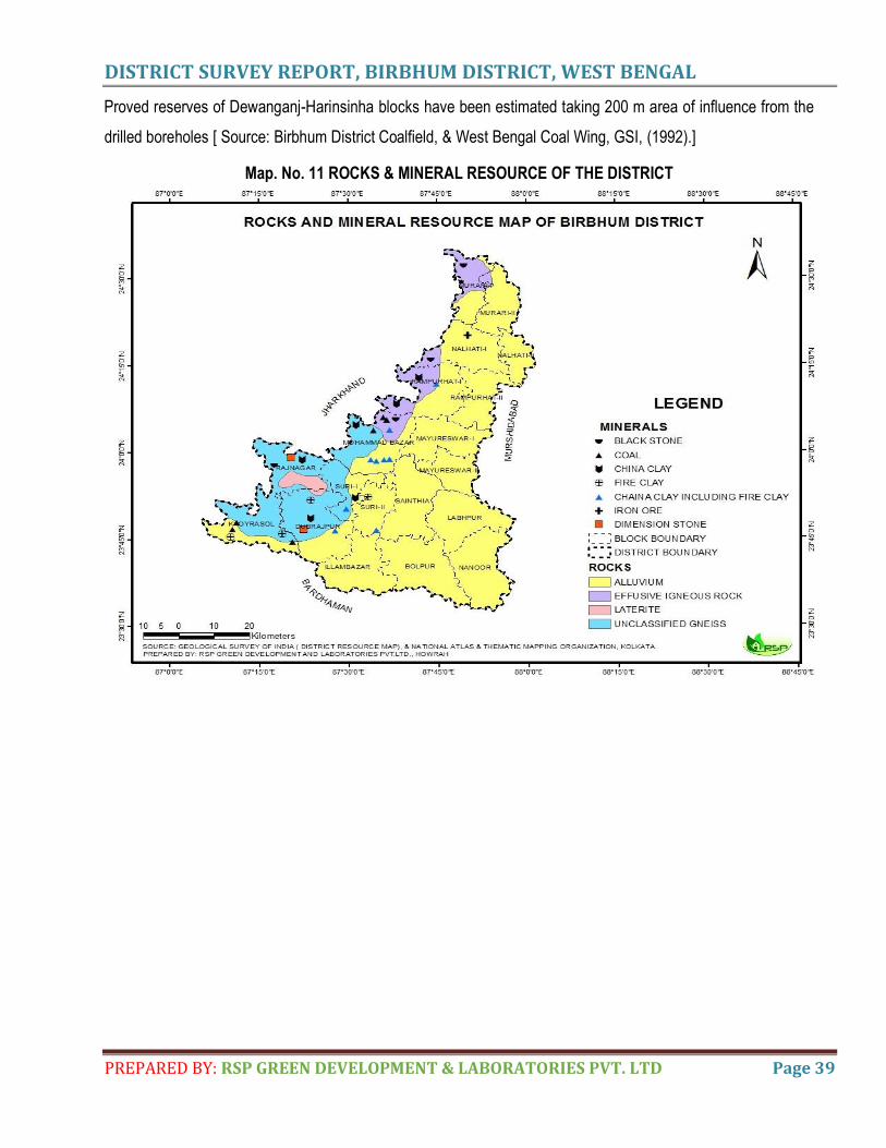
DISTRICT SURVEY REPORT, BIRBHUM DISTRICT, WEST BENGAL
PREPARED BY: RSP GREEN DEVELOPMENT & LABORATORIES PVT. LTD Page 39
Proved reserves of Dewanganj-Harinsinha blocks have been estimated taking 200 m area of influence from the
drilled boreholes [ Source: Birbhum District Coalfield, & West Bengal Coal Wing, GSI, (1992).]
Map. No. 11 ROCKS & MINERAL RESOURCE OF THE DISTRICT

DISTRICT SURVEY REPORT, BIRBHUM DISTRICT, WEST BENGAL
PREPARED BY: RSP GREEN DEVELOPMENT & LABORATORIES PVT. LTD Page 40
8. SAND AND OTHER RIVERBED MINERALS
(i) Drainage system
Most of the rivers and rivulets arise out from Chhotanagpur hills, entering into the western portion then passing through
the eastern portion of the district with slightly southerly inclination. There are two major rivers Ajay and Mayurakshi by
which the district is drained mainly and other rivers are Hingla, Bansloi, Kopai, Bakraswar, Siddheswari, Brahmani,
Dwarka passing through the different blocks of the district. The river Ajay divides the district Burdwan and Birbhum.
Overall drainage pattern of district is dendritic and parallel but west part is controlled by structurally. So, it may be of
Trellis type to some extent. The upland ridges, hillocks, high erosion rate, badland topography have resulted the
formation of numerous lower order streams which run through deep cutting of lateritic tract. Hence, stream frequency,
drainage density is remarkably high of this geo-province.
Brief descriptions of rivers in this district are:
AJAY RIVER
The Ajay River originates on a small hill, southwest of Deoghar in Jharkhand. After entering Katwa Sub-division of East
Bardhaman District joins Bhagirathi River. Total length of Ajay is 288 km and catchment area is 6000 sq.km. The
important tributaries are Partho and Jayanti in Jharkhand.
MAYURAKSHI RIVER
Also called Mor River, is a major river in Jharkhand and West Bengal. Its source from Trikut hill, from Deoghar in
Jharkahnd state. Then it flows through Birbhum and Murshidabad of West Bengal before flowing into Hoogly River. The
river is about 250 km.
BANSLOI RIVER
The Bansloi River originates on Bans Hill in Sahebganj District of Jharkhand through pakur district of Jharkhand. The
combined catchment area of the Pagla-Bansloi river system is 2200 sq.km.
KOPAI RIVER
Kopai river is the tributary of the Mayurakshi River. It flows past such towns as Santiniketon, Bolpur, Kankalitala,
Kirnahar and Labhpur in Birbhum district.The area around the river quite often has purple soil, which forms ravines on
the river bank with weathering and popular as khoai.
BAKRESHWAR RIVER
The Bakreshwar River is a tributary of the Mayurakshi River. It originates in Santhal Parganas division of Jharkhand. It
meets kopai at Birbhum district.
DISTRICT SURVEY REPORT, BIRBHUM DISTRICT, WEST BENGAL
PREPARED BY: RSP GREEN DEVELOPMENT & LABORATORIES PVT. LTD Page 41
BRAHMANI RIVER
The Brahmani originates in the Santhal Parganas in Jharkhand and then flows through Birbhum district, bisecting
Rampurhat subdivision. It is a hill stream with beds full of pebbles and yellow clay.
DWARAKA RIVER
The Dwaraka originates in Santhal Parganas in Jharkhand, flows through Deucha, and then through Mayureswar and
Rampurhat police station areas of Birbhum district. Total length of Dwarka river is 156.5 km
Map. No. 12 DRAINAGE NETWORK MAP OF THE DISTRICT
Table 13: Drainage system with description of Main River
Sl.
No.
Name of
the River Area drained
(sq.km.)
% area drainedin the district
Name of the Blocks
1 Mayurakshi 246.27 5.45% Kalyanpur, Illambazar, Bhedia,
Sonarkunda, Haridaspur
2 Ajay 587.35 12.92% Jayrampur, Dubrajpur, Deucha,
Palan, Bajitpur, Dumra
3
Bansloi 444.24 9.77% Suri, Kunuri, Narasinghpur, Ranpur,
Malian, Barulia,Dhanyagram
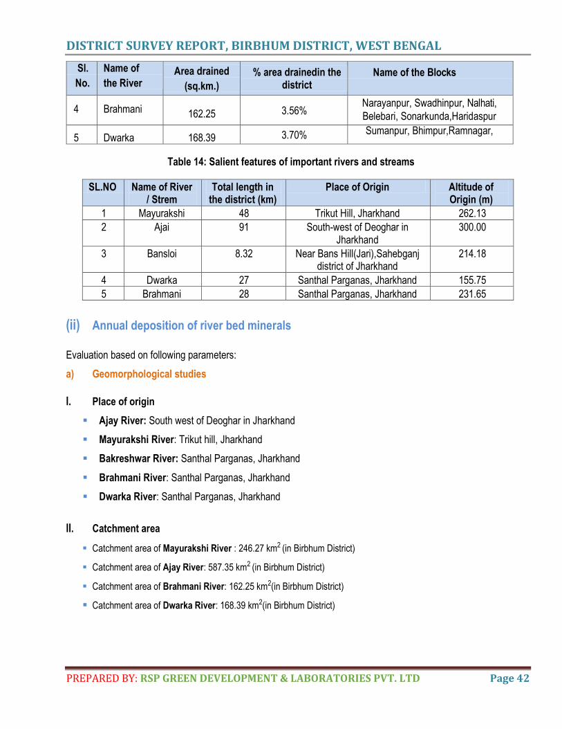
DISTRICT SURVEY REPORT, BIRBHUM DISTRICT, WEST BENGAL
PREPARED BY: RSP GREEN DEVELOPMENT & LABORATORIES PVT. LTD Page 42
Sl.
No.
Name of
the River Area drained
(sq.km.)
% area drainedin the district
Name of the Blocks
4 Brahmani 162.25 3.56% Narayanpur, Swadhinpur, Nalhati,
Belebari, Sonarkunda,Haridaspur
5 Dwarka 168.39 3.70% Sumanpur, Bhimpur,Ramnagar,
Table 14: Salient features of important rivers and streams
SL.NO Name of River / Strem
Total length in the district (km)
Place of Origin Altitude of Origin (m)
1 Mayurakshi 48 Trikut Hill, Jharkhand 262.13
2 Ajai 91 South-west of Deoghar in Jharkhand
300.00
3 Bansloi 8.32 Near Bans Hill(Jari),Sahebganj district of Jharkhand
214.18
4 Dwarka 27 Santhal Parganas, Jharkhand 155.75
5 Brahmani 28 Santhal Parganas, Jharkhand 231.65
(ii) Annual deposition of river bed minerals
Evaluation based on following parameters:
a) Geomorphological studies
I. Place of origin
Ajay River: South west of Deoghar in Jharkhand
Mayurakshi River: Trikut hill, Jharkhand
Bakreshwar River: Santhal Parganas, Jharkhand
Brahmani River: Santhal Parganas, Jharkhand
Dwarka River: Santhal Parganas, Jharkhand
II. Catchment area
Catchment area of Mayurakshi River : 246.27 km2 (in Birbhum District)
Catchment area of Ajay River: 587.35 km2 (in Birbhum District)
Catchment area of Brahmani River: 162.25 km2(in Birbhum District)
Catchment area of Dwarka River: 168.39 km2(in Birbhum District)

DISTRICT SURVEY REPORT, BIRBHUM DISTRICT, WEST BENGAL
PREPARED BY: RSP GREEN DEVELOPMENT & LABORATORIES PVT. LTD Page 43
Map. No. 13 CATCHMENT AREA MAP OF MAIN RIVERS OF THE DISTRICT
(iii) General profile of river/stream
If rivers are always straight i.e. if rivers follow straight course, the meaning of slope becomes valueless, but if the river is
curvy and follows a sinusoidal pattern(as is usually the case, at least to some extent) then we have to measure the
horizontal distance along the sinuous projection of the course of the river on a horizontal plane. The slope can be
measured in feet per mile or some metric units like meters per kilometre. Recalling some trigonometry, we might
recognise as the tangent of a slope angle although measuring the slope of a river is not an easy matter. The slope of the
rivers of Ajay & Mayurakshi of Birbhum district, in this case, has been measured following the method of Digital Elevation
Model (DEM).
To reach the targeted approach, here contour lines are digitized from topographic map using a scale of 1:8000; from this
map few contours are also digitized in flat areas. Spot heights are also digitized. From this height data, contour
interpolation is completed in Arc-GIS approach. This slope map is exported to ERDAS for further processing. The slope
map is classified to 0-15 degree or more than 15 degree.
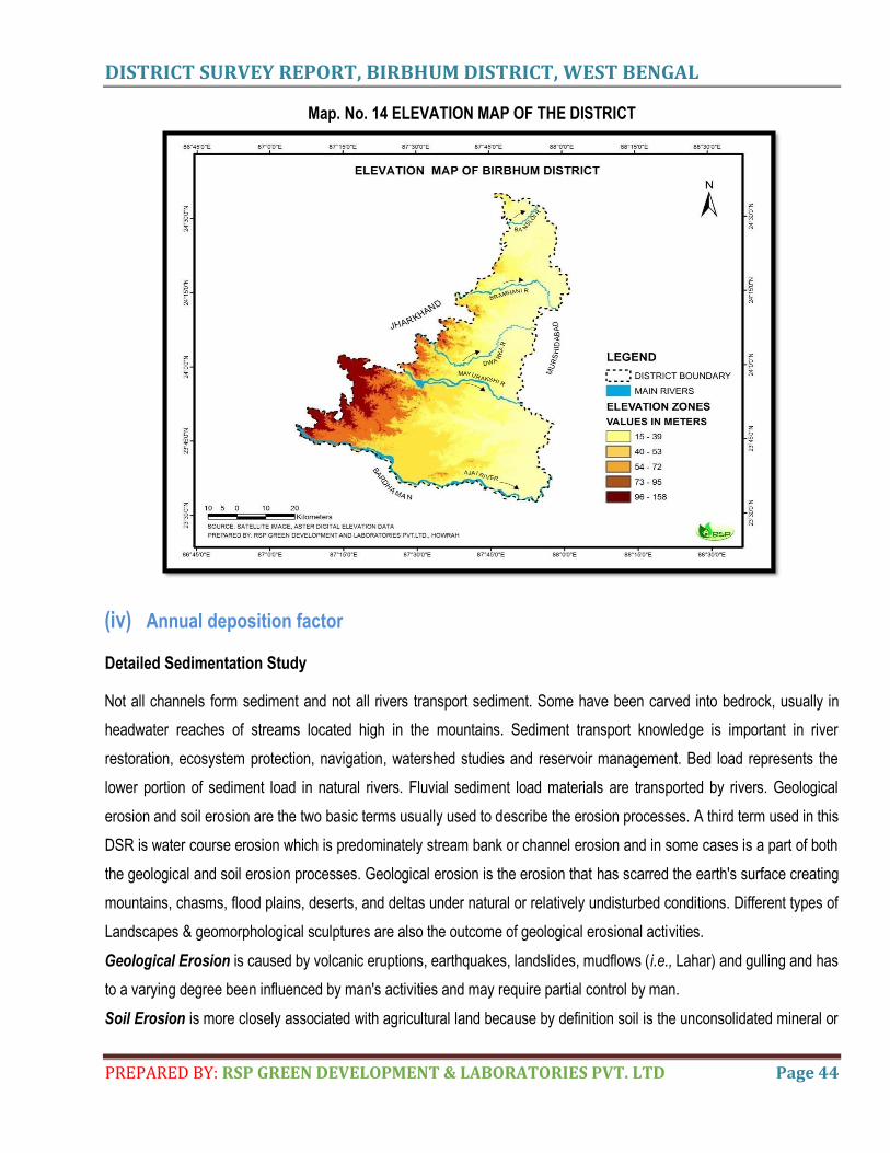
DISTRICT SURVEY REPORT, BIRBHUM DISTRICT, WEST BENGAL
PREPARED BY: RSP GREEN DEVELOPMENT & LABORATORIES PVT. LTD Page 44
Map. No. 14 ELEVATION MAP OF THE DISTRICT
(iv) Annual deposition factor
Detailed Sedimentation Study
Not all channels form sediment and not all rivers transport sediment. Some have been carved into bedrock, usually in
headwater reaches of streams located high in the mountains. Sediment transport knowledge is important in river
restoration, ecosystem protection, navigation, watershed studies and reservoir management. Bed load represents the
lower portion of sediment load in natural rivers. Fluvial sediment load materials are transported by rivers. Geological
erosion and soil erosion are the two basic terms usually used to describe the erosion processes. A third term used in this
DSR is water course erosion which is predominately stream bank or channel erosion and in some cases is a part of both
the geological and soil erosion processes. Geological erosion is the erosion that has scarred the earth's surface creating
mountains, chasms, flood plains, deserts, and deltas under natural or relatively undisturbed conditions. Different types of
Landscapes & geomorphological sculptures are also the outcome of geological erosional activities.
Geological Erosion is caused by volcanic eruptions, earthquakes, landslides, mudflows (i.e., Lahar) and gulling and has
to a varying degree been influenced by man's activities and may require partial control by man.
Soil Erosion is more closely associated with agricultural land because by definition soil is the unconsolidated mineral or
DISTRICT SURVEY REPORT, BIRBHUM DISTRICT, WEST BENGAL
PREPARED BY: RSP GREEN DEVELOPMENT & LABORATORIES PVT. LTD Page 45
organic material that will support plant growth. Soil particles located on the surface of agricultural lands, forest lands, or
grazing lands are detached by rainfall or eroded away by surface runoff. This may take place in the form of sheet erosion
with at in sheet of water flowing down a gentle upland slope. Rill erosion is another form with runoff occurring in well-
defined yet small incisions in the land surface. Gully erosion is the dissection of the soil surface with a deep cut in the
land channel formed below an uncut reach thus creating a sudden break in surface slope.
Water Course Erosion is the erosion of a stream channel's bank and bed caused by flowing water. A river channel or
water course transports or carries sediment that originates from surface runoff in the upland reaches by the erosion
processes previously described of geological or soil Erosion. The water course's ability to transport its sediment load is
dependent on channel velocity or energy. If the upland sediment inflow to the river channel or water course is low then
there is unspent energy which will pick up or erode the bank and bed of the channel. A meander pattern may develop
with erosive forces active on the bank and bed of the channel on the outside or concave bends in the water course
meander. These streams have channel forms that often are dominated by the nature of the rock (of varying hardness
and resistance to mechanical weathering and of varying frequencies of joints, spacing and pattern) in which the channel
has been cut. Such channels often include pools that trap sediment so that long reaches of channel may carry
essentially no sediment at all. Such channels, known as non-alluvial channels, have been taken into account for
convenience of study of sedimentation. But here we will focus on alluvial channels, the class of river channel forming the
vast majority of rivers on the earth‘s surface. Alluvial channels are self-formed channels in sediments that the river
typically has at one time or another transported downstream in the flow.
The movement of detrital particles by air, water, ice or gravity is defined as sediment transport. Grains (may be sand
particles transported by air & water (fluid transport) move as bed load (by rolling and sliding and by saltation) or in
suspension, when grains are kept up by turbulence. The different sizes/density population of moving grains promote
sorting of the materials and mechanical abrasion during transport removes corners and edges, so the grains become
more rounded. The lower density and viscosity of air means that air transports a smaller range of grains sizes than does
water, and generally only the fineness dust move in suspension. As a result, Aeolian deposits are usually much better
sorted than water-laid sediments. The process of deposition of sand on riverbed is vital part of sedimentation. For proper
documentation of the processes, we should cater light on the following aspects.
The amount and size of sediment moving through a river channel are determined by three fundamental controls:
competence, capacity and sediment supply.
The sediment load of a river is transported in various ways although these distinctions are to some extent arbitrary and
not always very practical in the sense that not all of the components can be separated in practice:
1. Dissolved load
2. Suspended load
DISTRICT SURVEY REPORT, BIRBHUM DISTRICT, WEST BENGAL
PREPARED BY: RSP GREEN DEVELOPMENT & LABORATORIES PVT. LTD Page 46
3. Intermittent suspension (saltation)load
4. Wash load
5. Bed load
Dissolved Load: Dissolved load is the material that has gone into solution and is part of the fluid moving through the
channel. Since it is dissolved, it does not depend on forces in the flow to keep it in the water column. The amount of
material in solution depends on supply of a solute and the saturation point for the fluid. For example, in limestone areas,
calcium carbonate may be at saturation level in river water and the dissolved load may be close to the total sediment
load of the river. In contrast, rivers draining insoluble rocks, such as in granitic terrains, may be well below saturation
levels for most elements and dissolved load may be relatively small.
Suspended load: Sediments carried as solids as the stream flows are suspended load. The size of particles that can be
carried is determined by the stream‘s velocity. Faster streams can carry larger particles. Streams that carry larger
particles have greater competence. Streams with a steep gradient (slope) have a faster velocity and greater
competence.
Saltation Load: A type of sediment transport in air or water in which particles are moved forward in short, abrupt leaps.
This process is intermediate between suspension and traction.
Wash load: Although wash load is part of the suspended-sediment load it is useful here to make a distinction. Unlike
most suspended-sediment load, wash load does not rely on the force of mechanical turbulence generated by flowing
water to keep it in suspension. It is so fine (in the clay range) that it is kept in suspension by thermal molecular agitation
(sometimes known as Brownian motion). Because these clays are always in suspension, wash load is that component of
the particulate or clastic load that is-washed through the river system. Unlike coarser suspended-sediment, wash load
tends to be uniformly distributed throughout the water column. That is, unlike the coarser load, it does not vary with
height above the bed.
The term sand is use to denote an aggregate of mineral or rock grains greater than 1/16mm and less than 2mm in
diameter.
Sands follow traction and inertiasuspensi on approximately in accordance with the so-called Sixth-Power Law, which
corroborates a complete transfer of kinetic energy transmitted from water to a particle and prohibits allowance for the
subsidiary effect of viscous drag. But the size-velocity relationship in this range is defined by the popular Stokes Law.
Here smaller particles remain in suspension chiefly by the kinetic effects of disperse system i.e. colloid.
Bed load: Particles that are too large to be carried as suspended load are bumped and pushed along the stream bed as
bed load. Bed load sediments do not move continuously. Streams with high velocities and steep gradients do a great
deal of down cutting into the streambed, which is primarily accomplished by movement of particles that make up the bed
load.
DISTRICT SURVEY REPORT, BIRBHUM DISTRICT, WEST BENGAL
PREPARED BY: RSP GREEN DEVELOPMENT & LABORATORIES PVT. LTD Page 47
Drainage system is the pattern formed by streams, rivers and lakes in a drainage basin. In a drainage system,
streams or rivers always connect together to form networks. Many factors such as topography, soil type, bedrock
type, climate and vegetation cover influence input, output and transport of sediment and water in a
drainage basin (Charlton, 2008). So the river bed sand depositions are the manifestation of rate of current of water
flow. Another two factors–lower flow regime and upper flow regime are also the vital factors which play a pivotal role
for deposition of sands in particular pockets. These factors also influence the nature of the pattern of water bodies
(Twidale, 2004).
Methodology: The catchment area of river has been analyzed with the help of Arc-GIS approach. The mined affected
area of the river will be measured through Arc-GIS approach and ground based survey by GPS approach gives fruitful
results. The stretch of the mined area of river is divided in various segments depending on stretch of the rivers. The
width (meters) and GPS information at each segment is collected to quantify the total mined area of river. The geo-
morphological patters in terms of stream orders were also observed using ArcGIS methodology. Besides, the mined
affected area of the river is divided in to various segments to analyze grain size distribution in river bed. The role of
hydraulic gradient of most of the rivers has been scrutinized in detail to explain the causes of riverbed sand deposits.
Although, the role of drainage density is of paramount importance in riverbed sand deposition.
Bed material: The mixture of sediment that composes stream bed is called bed materials .Bed material is stationary,
but particle size is important to sediment transport because as energy level of a stream increases, some bed-material
particles are mobilized and become part of the bed load or suspended load. In this report, composition of bed material is
defined by particle-size distribution.
Suspended Sediment Material: Usually small particles, suspended by turbulence of the flow or existing as colloids, and
transported at about the same downstream velocity as the flowing water. Suspended sediment is distributed at all depths
in flowing water. In this report, suspended sediment is expressed as concentration in milligrams per litre.
Suspended-sediment load: In this report, annual suspended-sediment load is expressed in tones .Suspended-
sediment discharge: A computed value of the quantity (weight)of suspended sediment per unit time also referred to as
suspended-sediment transport rate.
Total sediment load: The sum of bed load and suspended sediment load, together called total sediment load. In this
report, total sediment load is expressed in tones. Total sediment discharge: The sum of bed load discharge and
suspended-sediment discharge.
When a graph is plotted with the river bed elevation on the vertical axis and the upstream distance on the horizontal axis,
a smooth curve may pass through the points. The result is called the Longitudinal Profile or Long profile of the river. The
longitudinal profiles of most rivers are concave upward. The reason is not difficult to understand. In the downstream
direction, one tributary after another joins the river, each adding discharge. As the river grows larger, the ratio of cross-
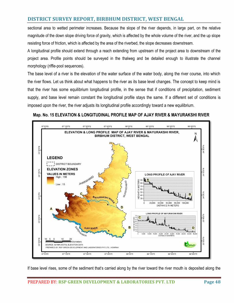
DISTRICT SURVEY REPORT, BIRBHUM DISTRICT, WEST BENGAL
PREPARED BY: RSP GREEN DEVELOPMENT & LABORATORIES PVT. LTD Page 48
sectional area to wetted perimeter increases. Because the slope of the river depends, in large part, on the relative
magnitude of the down slope driving force of gravity, which is affected by the whole volume of the river, and the up slope
resisting force of friction, which is affected by the area of the riverbed, the slope decreases downstream.
A longitudinal profile should extend through a reach extending from upstream of the project area to downstream of the
project area. Profile points should be surveyed in the thalweg and be detailed enough to illustrate the channel
morphology (riffle-pool sequences).
The base level of a river is the elevation of the water surface of the water body, along the river course, into which
the river flows. Let us think about what happens to the river as its base level changes. The concept to keep mind is
that the river has some equilibrium longitudinal profile, in the sense that if conditions of precipitation, sediment
supply, and base level remain constant the longitudinal profile stays the same. If a different set of conditions is
imposed upon the river, the river adjusts its longitudinal profile accordingly toward a new equilibrium.
Map. No. 15 ELEVATION & LONGITUDINAL PROFILE MAP OF AJAY RIVER & MAYURAKSHI RIVER
If base level rises, some of the sediment that‘s carried along by the river toward the river mouth is deposited along the
DISTRICT SURVEY REPORT, BIRBHUM DISTRICT, WEST BENGAL
PREPARED BY: RSP GREEN DEVELOPMENT & LABORATORIES PVT. LTD Page 49
way to raise the river bed, thereby establishing a new equilibrium longitudinal profile. If base level falls, the river erodes
its bed to adjust toward a new, lower equilibrium profile. There‘s more to be said, however, about what happens as the
river erodes its bed as a consequence of a fall in base level. The erosion does not happen uniformly everywhere. All at
the same time, but by upstream propagation of a point where the channel slope changes, from steeper downstream of
the point to less steep point survives, for a long time, as a pair of terraces above the new, lower river channel Because
the differ upstream of the point. The point of change in slope is called a knickpoint. The position of a knick point is
marked by a waterfall or rapids. Knick points migrate slowly up stream, thereby extending the new, lower longitudinal
profile as the river eats its way upstream. If a floodplain has developed in the river valley, the old floodplain downstream
of the knickpoint between old and new equilibrium profiles decreases upstream, other things being equal (the elevations
of the highlands in the headwaters of the river are very conservative), the height of this knickpoint decreases as it
migrates upstream. Often, if base level drops abruptly a number of times during some long period of time, more than one
knickpoint is present along the river course, each slowly making its way upstream.
Sediment Transport Rate: The rate at which sediment is moved past a cross section of the flow is called either the
sediment transport rate or the sediment discharge. It‘s related to the sediment load, but it‘s different, just because
different fractions of the sediment load are transported at different rates. It can be measured in mass per unit time, or in
weight per unit time, or in volume per unit time.
Sediment Discharge formulae: To derive a sediment discharge formula, you try to think about the physics of
sediment transport in a way that allows you to develop the form of some rational equation for transport rates,
which contains within it one or more adjustable parameters‖ whose values are assigned by analysis of selected
data sets already at hand. Our common sense tells us that the stronger the flow the greater the sediment transport
rate. And an important first-order fact of observation is that the sediment transport rate is a very steeply increasing
function of the flow strength. Think about the simplest way to embody these important facts in a formula for the
sediment transport rate per unit width of flow, usually written qs. Perhaps the simplest approach to quantifying qs is
to write an expression like qs = Aτon where A is a coefficient and n is an exponent much larger than one.
The Sediment Yield: To introduce just one more thing about sediment in rivers, we should make a distinction
between the sediment discharge and what‘s called the sediment yield of a river. The sediment yield is the sediment
discharge divided by the total drainage area of the river upstream of the cross section at which the sediment
discharge is measured or estimated. The sediment yield measures the rate, per unit area, at which sediment is
removed from the watershed. It is important in studies of the long-term evolution of landscapes drained by rivers.
(v) Replenishment
Replenishment defines rejuvenation of riverbed sand deposition phenomena. The word replenishment is the fulcrum of
riverbed sedimentation under different depositional environmental conditions especially in syn-monsoon i.e., during rainy
DISTRICT SURVEY REPORT, BIRBHUM DISTRICT, WEST BENGAL
PREPARED BY: RSP GREEN DEVELOPMENT & LABORATORIES PVT. LTD Page 50
seasons.
Local monitoring for replenishment at specific mining sites, monitoring of the entire reach through the estuary will provide
information on the cumulative response of the system to sand and gravel extraction. For example, it is important for
downstream bars and the estuary to receive sufficient sand and gravel to maintain estuarine structure and function.
Because the elevation of the bed of the channel is variable from year to year, a reach-based approach to monitoring will
provide a larger context for site-specific changes.
The rate of gross or absolute silt production (erosion) in the watershed and the ability of the, stream system to transport
the eroded material in a river have the direct relation with the quantity of sediment delivered into a river. The rate of
gross erosion is dependent upon many physical factors like climatic conditions, nature of soil, slope of the area,
topography and the land use. Hydro-physical conditions of the watershed govern the capability of transporting the
eroded material. It has been observed that the average rate of sediment production decreases as the size of drainage
area increase and the larger watershed the lesser is the variation between the rates. The larger water shed presents
more opportunity for deposition of silt during its traverse from the point of production. The water shed with maximum land
use class of forest generate very low rate of production unless the forest are degraded or open forest. The cultivated
watersheds with unscientific farming produce very high rate of silt production. The total amount of eroded material, which
reaches a particular hydraulic control point, is termed as sediment yield.
For sustainability of river sand mining, it is necessary that the mine pits formed as a result of sand excavation are refilled
with sand by natural process of replenishment in a reasonable period of time so that the area is again available for
mining. The rate of excavation should be decided in accordance with the rate of replenishment which is the rate at which
sand/gravel is deposited on the river flood plain by the river during monsoon season. However, determination of site-
specific rate of replenishment is quite difficult as it is dependent on several factors such as geology and topography of
the catchment area of the river, breadth of the flood plain, rainfall in that particular year(which is quite variable and not
very much predictable much in advance),etc. Dandy-Bolton formula is generally used to calculate the sediment yield.
However, this formula can give only a quick rough approximation of mean sediment yield at regional basis (for the whole
catchment area of the river) and it can, at best, be used only for preliminary watershed planning and its use to predict
sediment yield for a specific location would be unwise because of the wide variability caused by local factors, not
considered in the formula. But it is to be kept in mind that to prepare the mining plans of the mines, the factor of annual
replenishment is to be taken into consideration while calculating the mineral reserves. It has also been observed that
during flooding, all the pits replenish with sand. Hence, mined out areas in the pre monsoon season will be completely
replenished with sand during monsoon. Therefore, it has been assumed that the pits will be replenished after each
monsoon. The replenishment data collections are going on and will be furnished within six (6) months.
DISTRICT SURVEY REPORT, BIRBHUM DISTRICT, WEST BENGAL
PREPARED BY: RSP GREEN DEVELOPMENT & LABORATORIES PVT. LTD Page 51
(vi) Total potential of minor mineral in the riverbed
The total potential of minor mineral (sand) in the riverbed is 1231276.66 cum.
b) Geological Studies
I. Lithology of Catchment Area
Ajay River: lithological units are alternating layers of sand, silt and clay with hard clays impregnated with
caliche nodules.
Mayurakshi River: Granite gneiss, with enclaves of metamorphites, laterite and lateritic soils, alternating
layers of sand, silt and clay.
Brahmani River: Laterite and lateritic soils, hard clays impregnated with caliche nodules.
II. Tectonics and structural behaviour of rocks
Chhotanagpur Gneissic Complex marks the metamorphic basement rocks which comprise of pink granite, granite
gneiss and epidote granite impregnated with veins of quartz and pegmatite which are exposed in the south-west
and north-west part of the districts. Foliation of this areas dip towards north-east moderately; trend of the foliation is
generally NW-SE. Early Cretaceous Rajmahal Trap Formation consisting of grey, hard and compact intertrappean
basalt having a network of siliceous veins with pockets of zeolites in the northern parts are found to seen.
Here geology provides crucial information about the underlying hidden set up. Weathered and fractured hard rock
terrains with higher elevations and steeper topography are the special features of this province. As Birbhum is the
part of Chhotanagpur plateau, it tectonically lies within the cradle of orogeny i.e. more or less within the tectonically
active zone. Structural features like faults (neotectonic fault and subsurface fault), geomorphic lineament, breaks in
slope, geomorphic lineament-ridges parallel and columnar joints within basaltic rocks are also prominent in the
western part of the district.
c) Climatic factors
I. Intensity of rainfall
The intensity of rainfall due to depressions sometimes becomes very great and may cause enhanced soil erosion in
the district. During winter, western disturbances generally cause light rainfall .This does not cause any major soil
erosion problem. During hot weather season of March to May, rainfall is caused by the Norwesters or Kalbaisakhis.
Kalbaishakhis generally bring sudden rainfall with great intensities. Besides, the season in which it occurs is
characterized by the presence of bare soil mostly devoid of vegetation. Therefore, it causes considerable amount of
soil erosion.
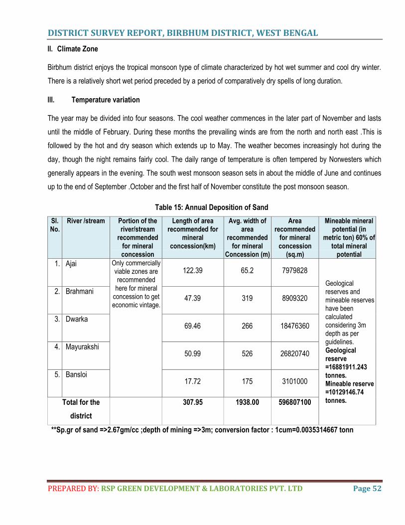
DISTRICT SURVEY REPORT, BIRBHUM DISTRICT, WEST BENGAL
PREPARED BY: RSP GREEN DEVELOPMENT & LABORATORIES PVT. LTD Page 52
II. Climate Zone
Birbhum district enjoys the tropical monsoon type of climate characterized by hot wet summer and cool dry winter.
There is a relatively short wet period preceded by a period of comparatively dry spells of long duration.
III. Temperature variation
The year may be divided into four seasons. The cool weather commences in the later part of November and lasts
until the middle of February. During these months the prevailing winds are from the north and north east .This is
followed by the hot and dry season which extends up to May. The weather becomes increasingly hot during the
day, though the night remains fairly cool. The daily range of temperature is often tempered by Norwesters which
generally appears in the evening. The south west monsoon season sets in about the middle of June and continues
up to the end of September .October and the first half of November constitute the post monsoon season.
Table 15: Annual Deposition of Sand
Sl. No.
River /stream Portion of the river/stream
recommended for mineral concession
Length of area recommended for
mineral concession(km)
Avg. width of area
recommended for mineral
Concession (m)
Area recommended
for mineral concession
(sq.m)
Mineable mineral potential (in
metric ton) 60% of total mineral
potential
1. Ajai Only commercially viable zones are recommended
here for mineral concession to get economic vintage.
122.39 65.2 7979828
Geological reserves and mineable reserves have been calculated considering 3m depth as per guidelines. Geological reserve =16881911.243 tonnes. Mineable reserve =10129146.74 tonnes.
2. Brahmani 47.39 319 8909320
3. Dwarka 69.46 266 18476360
4. Mayurakshi 50.99 526 26820740
5. Bansloi 17.72 175 3101000
Total for the
district
307.95 1938.00 596807100
**Sp.gr of sand =>2.67gm/cc ;depth of mining =>3m; conversion factor : 1cum=0.0035314667 tonn
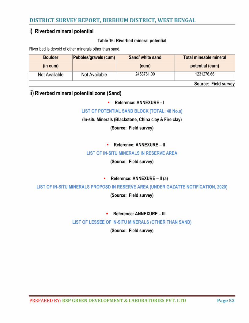
DISTRICT SURVEY REPORT, BIRBHUM DISTRICT, WEST BENGAL
PREPARED BY: RSP GREEN DEVELOPMENT & LABORATORIES PVT. LTD Page 53
i) Riverbed mineral potential
Table 16: Riverbed mineral potential
River bed is devoid of other minerals other than sand.
Boulder
(in cum)
Pebbles/gravels (cum) Sand/ white sand
(cum)
Total mineable mineral
potential (cum)
Not Available Not Available 2458761.00 1231276.66
Source: Field survey
ii) Riverbed mineral potential zone (Sand)
Reference: ANNEXURE - I
LIST OF POTENTIAL SAND BLOCK (TOTAL: 48 No.s)
(In-situ Minerals (Blackstone, China clay & Fire clay)
(Source: Field survey)
Reference: ANNEXURE – II
LIST OF IN-SITU MINERALS IN RESERVE AREA
(Source: Field survey)
Reference: ANNEXURE – II (a)
LIST OF IN-SITU MINERALS PROPOSD IN RESERVE AREA (UNDER GAZATTE NOTIFICATION, 2020)
(Source: Field survey)
Reference: ANNEXURE – III
LIST OF LESSEE OF IN-SITU MINERALS (OTHER THAN SAND)
(Source: Field survey)
DISTRICT SURVEY REPORT, BIRBHUM DISTRICT, WEST BENGAL
PREPARED BY: RSP GREEN DEVELOPMENT & LABORATORIES PVT. LTD Page 54
9. OVERVIEW OF MINING ACTIVITIES IN THE DISTRICT
a. GENERAL OVERVIEW
To prepare the DSR of Birbhum district of West Bengal, geological studies along with structural studies in the quest
from knowing more and more pertaining to tectonic set up of this regime, suitability for riverbed sand mining and
time of deposition of different types of minor minerals are also important. The common hydrological regime plays a
pivotal role for deposition of sand and other minor minerals and it is defined by the tropical monsoon climate with
alternating dry and wet seasons. Birbhum, in this regard, gives a best fit result. The spatiality of rain is controlled by
the orientation of the axis of monsoon trough. River bed sand mining or sand mining adjacent to a river or stream
has a direct impact on the physical characteristics of the stream such as channel geometry, bed elevation,
substratum composition and stability, in-stream roughness of the bed, pro velocity, discharge capacity, sediment
transport capacity, turbidity, temperature etc. Alteration or modification of the said attributes may cause hazardous
impact on ecological equilibrium of riverine regime.
b. EXISTING MINING LEASES OF THE DISTRICT WITH LOCATION, AREA, PERIOD FOR EACH MINOR
MINERAL
Reference: ANNEXURE – IV
LIST OF EXISTING MINING LEASES (STONE QUARRY)
(Source: DLLRO SURI, BIRBHUM)
c. DETAILS OF PRODUCTION OF SAND AND OTHER MINOR MINERALS DURING LAST 3 YEARS
The data regarding production against revenue will be furnished within six (6) months.
Reference: ANNEXURE – V
LIST OF EXISTING SAND BLOCK
(Source: DLLRO SURI, BIRBHUM)
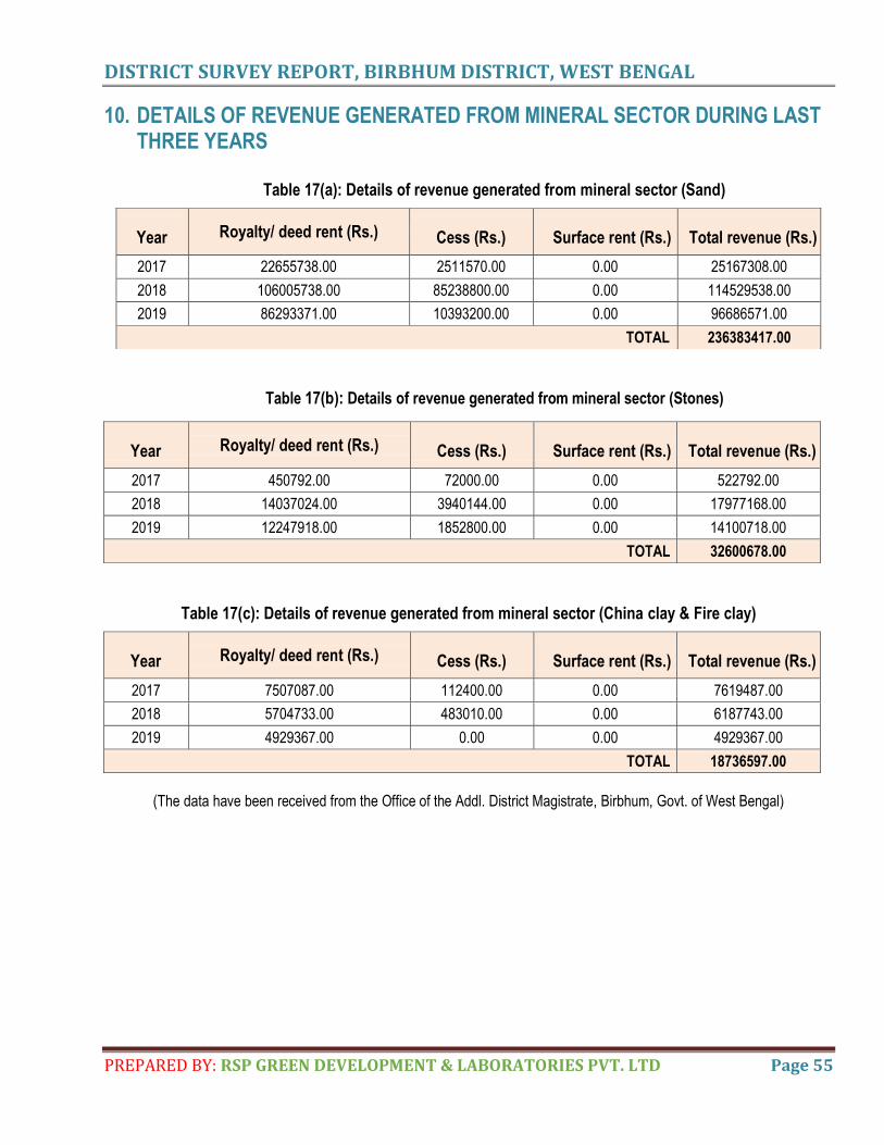
DISTRICT SURVEY REPORT, BIRBHUM DISTRICT, WEST BENGAL
PREPARED BY: RSP GREEN DEVELOPMENT & LABORATORIES PVT. LTD Page 55
10. DETAILS OF REVENUE GENERATED FROM MINERAL SECTOR DURING LAST THREE YEARS
Table 17(a): Details of revenue generated from mineral sector (Sand)
Table 17(b): Details of revenue generated from mineral sector (Stones)
Table 17(c): Details of revenue generated from mineral sector (China clay & Fire clay)
(The data have been received from the Office of the Addl. District Magistrate, Birbhum, Govt. of West Bengal)
Year Royalty/ deed rent (Rs.) Cess (Rs.) Surface rent (Rs.) Total revenue (Rs.)
2017 22655738.00 2511570.00 0.00 25167308.00
2018 106005738.00 85238800.00 0.00 114529538.00
2019 86293371.00 10393200.00 0.00 96686571.00
TOTAL 236383417.00
Year Royalty/ deed rent (Rs.) Cess (Rs.) Surface rent (Rs.) Total revenue (Rs.)
2017 450792.00 72000.00 0.00 522792.00
2018 14037024.00 3940144.00 0.00 17977168.00
2019 12247918.00 1852800.00 0.00 14100718.00
TOTAL 32600678.00
Year Royalty/ deed rent (Rs.) Cess (Rs.) Surface rent (Rs.) Total revenue (Rs.)
2017 7507087.00 112400.00 0.00 7619487.00
2018 5704733.00 483010.00 0.00 6187743.00
2019 4929367.00 0.00 0.00 4929367.00
TOTAL 18736597.00
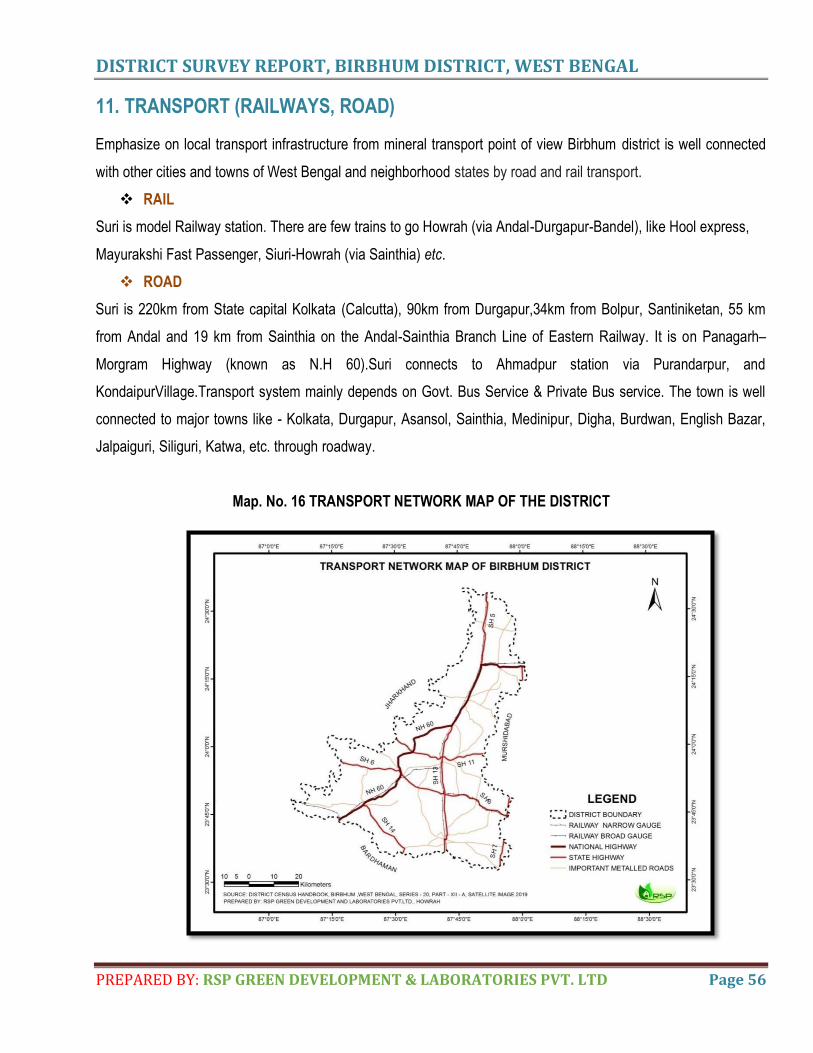
DISTRICT SURVEY REPORT, BIRBHUM DISTRICT, WEST BENGAL
PREPARED BY: RSP GREEN DEVELOPMENT & LABORATORIES PVT. LTD Page 56
11. TRANSPORT (RAILWAYS, ROAD)
Emphasize on local transport infrastructure from mineral transport point of view Birbhum district is well connected
with other cities and towns of West Bengal and neighborhood states by road and rail transport.
RAIL
Suri is model Railway station. There are few trains to go Howrah (via Andal-Durgapur-Bandel), like Hool express,
Mayurakshi Fast Passenger, Siuri-Howrah (via Sainthia) etc.
ROAD
Suri is 220km from State capital Kolkata (Calcutta), 90km from Durgapur,34km from Bolpur, Santiniketan, 55 km
from Andal and 19 km from Sainthia on the Andal-Sainthia Branch Line of Eastern Railway. It is on Panagarh–
Morgram Highway (known as N.H 60).Suri connects to Ahmadpur station via Purandarpur, and
KondaipurVillage.Transport system mainly depends on Govt. Bus Service & Private Bus service. The town is well
connected to major towns like - Kolkata, Durgapur, Asansol, Sainthia, Medinipur, Digha, Burdwan, English Bazar,
Jalpaiguri, Siliguri, Katwa, etc. through roadway.
Map. No. 16 TRANSPORT NETWORK MAP OF THE DISTRICT
DISTRICT SURVEY REPORT, BIRBHUM DISTRICT, WEST BENGAL
PREPARED BY: RSP GREEN DEVELOPMENT & LABORATORIES PVT. LTD Page 58
13. CONCLUDING REMARKS & SUGGESTED RECOMMENDATIONS
It is pertinent to say in the context of preparation of DSR of Birbhum district that it is a laudable attempt and it will
give the “facilities galore” to West Bengal Government, from point of view of mineral deposits (both minor &
major minerals). This district survey report indicates prima facie availability of requisite area from within the ML
blocks to prove adequate reserves of black stones, fireclay, china clay, and riverbed sand deposits. For
complete feasibility of the said projects if following points are taken into grip, a crystal clear picture about the
reserve and grade of the deposits can be obtained.
Application of the concept of mineral (Minor & Major) paragenesis in regional and local context.
Increasing utilization of remotely sensed data such as multi sensor airborne survey, LAND SAT imageries etc.
Review, intensification and projectisation of exploration in already intense field blocks.
Necessity of extensive exploration and thoroughness of search for stones, minor minerals, and new vistas of
riverbed sand deposits in view of geological diversity.
Testing of unconventional targets based on minor and major mineral paragenesis and its localization applying
BROWN FIELD / GREEN FIELD concepts. More aggressive surface sampling, geochemical survey, soil
analysis and assays of other minerals followed by grid pattern and chemical assay of bore hole samples at
short depth of interval by technical experts to the field of minor and major minerals.(although these come
under G:2 & G:3 stages; but these are beyond your scope.)
It is the prime time for the technocrats associated with mineral development to take up the challenge and
present propagation of misconceptions in the ALIBI of environmental degradation.
But successful management of stones and riverbed sand deposits involving exploitation, conservation and
protection of the resources from the company will be pivotal to its economic growth and sustenance of the quality of
the environment.
NB:
Data concerning production against revenue and replenishment details of post-monsoon (2019) and pre-
monsoon (2020) will be provided within six (6) months.
DISTRICT SURVEY REPORT, BIRBHUM DISTRICT, WEST BENGAL
PREPARED BY: RSP GREEN DEVELOPMENT & LABORATORIES PVT. LTD Page 59
14. REFERENCE CITED
1) Begum, N., & Mandal, S. (2015). Survey of Plants in the rural belt of Birbhum District, West Bengal with
reference to Pollination Calendar. International Journal of Current Microbiology & Applied Sciences, 4(5),
1118-1131.
2) Central Ground water Board. (2013). Ground Water Information Booklet, Pakur District, Jharkhand State.
3) Das, N., Mukhopadhay, S. (2015). Status of Ground Water Hydrology of Labpur block, Birbhum District.
International Journal of Geology, Earth & Environmental Sciences, 5(3), 19-32.
4) District Census Handbook of Birbhum, 2011
5) District Statistical Handbook , Birbhum,2008
6) District Survey Report for Sand Mining / Sand Ghats District Dumka as Per Sustainable Mining Guidelines.
7) Environmental Impact Assesment & Environmental Management Plan of Hatgacha- Jethia block
Blackstone Mines of West Bengal Mineral Development & Trading Corporation Limited (2017).
8) Geological Survey of India. Interim Report on Investigation of Clays in The Birbhum, Burdwan and Bankura
Districts, West Bengal.
9) Geology, Geomorphology and Seismotectonics of Bengal Basin with special emphasis on Kolkata and its
adjoining region‖. (http://wbdmd.gov.in/writereaddata/chapter-2A.pdf)
10) Government of India Ministry of Mines Indian Bureau of Mines. Indian Minerals Year book 2015 (Part- I)
,STATE REVIEWS (West Bengal).
11) Government of India Ministry of Mines. (July, 2017). ―Indian Minerals Year book 2015. ‖. Jaiswal, S. K. S.
(2013). Mining Plan for Basalt Stone Mine.
12) Indian Mineral Year Book – 2015
13) Indian Minerals Year book 2015 (Part I); 54th Edition State Reviews (West Bengal); (Final release)
Government of India, Ministry of Mines, Indian Bureau of Mines, www.ibm.nic.in
14) Nandi, N. C., Venkataraman, K., Das, S. R., Bhuinya, S., & Das, S. K. (2001). Wetland faunal resources of
West Bengal-3 Birbhum district. Records of the Zoological Survey of India, 99(1-4),135-156.
15) Report on exploration for coal in the pachami section, Birbhum coalfield, Birbhum District, West Bengal,
Coal Wing, GSI. 1992
16) Roy, D., Mondal, A. (2014). Human Resource Development of Birbhum District – A Critical Study, IOSR
Journal of Humanities and Social Science, 19 (2), 62-67.
17) Sandipan Ghosh & Sanat Kumar Guchhait 2014Characterization and evolution of primary and seceondary
laterites in northwestern Bengal Basin, West Bengal, India. In Journal of Palaeogeography , 2015,4(2):203-
DISTRICT SURVEY REPORT, BIRBHUM DISTRICT, WEST BENGAL
PREPARED BY: RSP GREEN DEVELOPMENT & LABORATORIES PVT. LTD Page 60
230, DOI : 103724/SP.J.1261.2015.00074
18) West Bengal District Fact book, Birbhum
19) West Bengal Mineral Development and Trading Corporation Ltd. (2017). Environmental Impact
Assessment And Environmental Management Plan of Hatgacha – Jethia Black stone Mines.
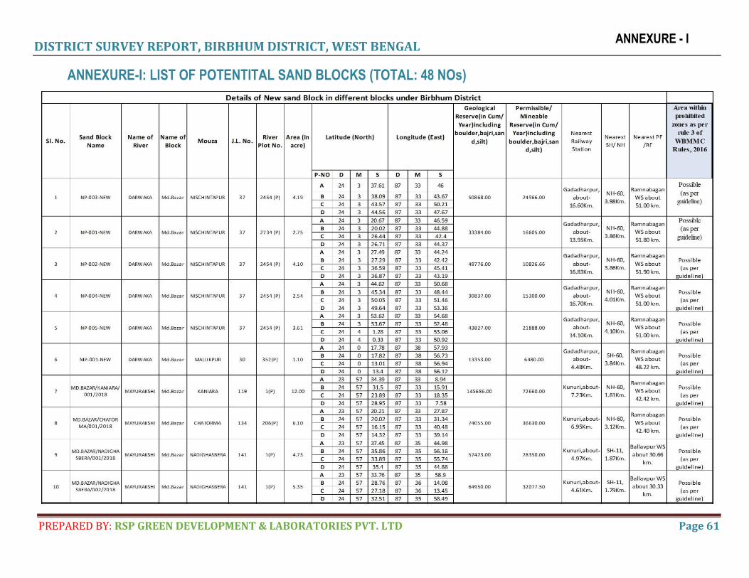
DISTRICT SURVEY REPORT, BIRBHUM DISTRICT, WEST BENGAL
PREPARED BY: RSP GREEN DEVELOPMENT & LABORATORIES PVT. LTD Page 61
ANNEXURE - I
ANNEXURE-I: LIST OF POTENTITAL SAND BLOCKS (TOTAL: 48 NOs)
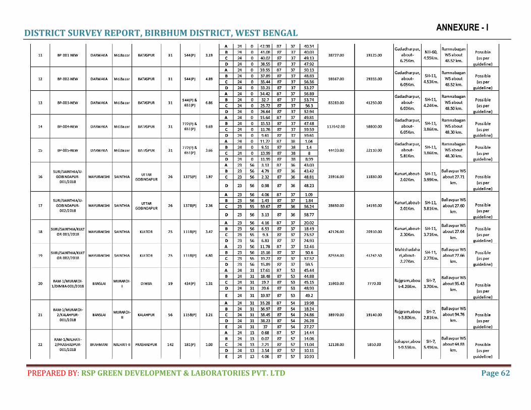
DISTRICT SURVEY REPORT, BIRBHUM DISTRICT, WEST BENGAL
PREPARED BY: RSP GREEN DEVELOPMENT & LABORATORIES PVT. LTD Page 62
ANNEXURE - I
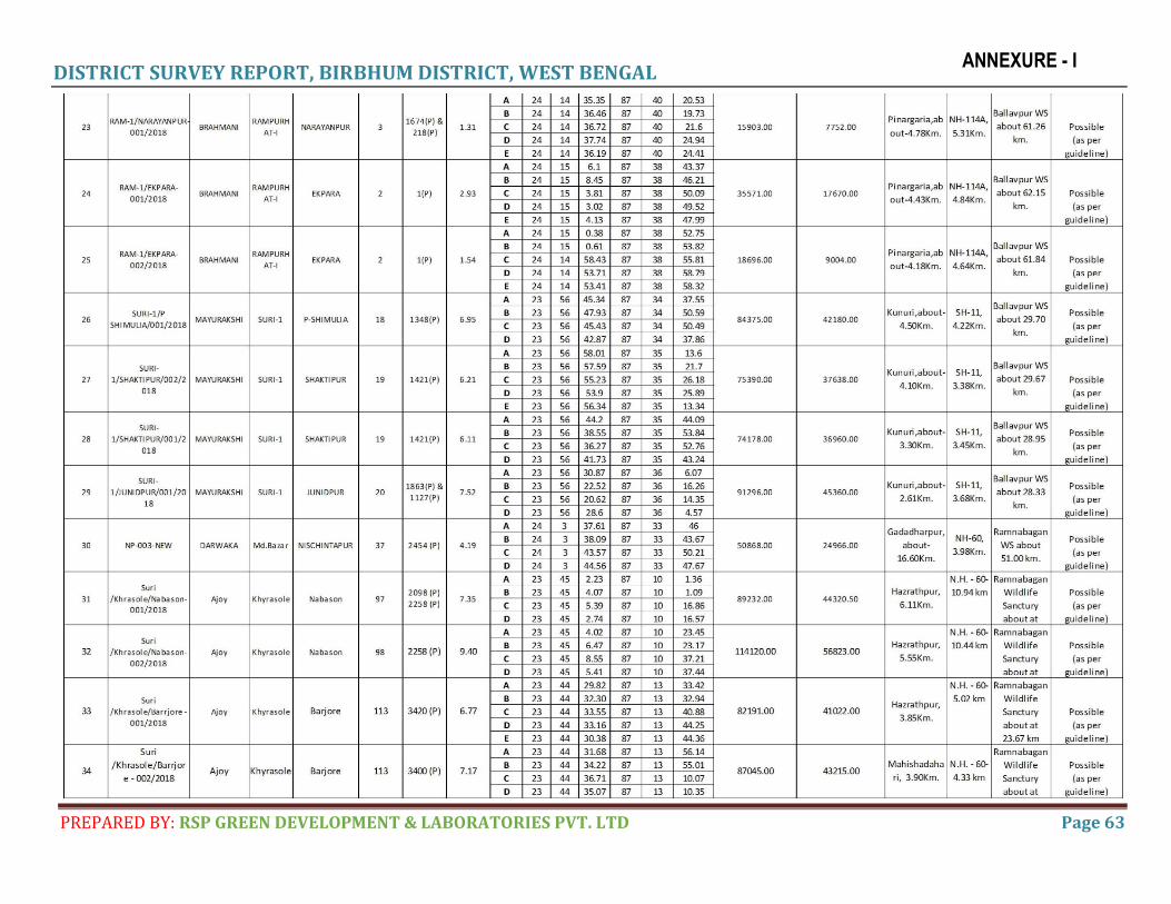
DISTRICT SURVEY REPORT, BIRBHUM DISTRICT, WEST BENGAL
PREPARED BY: RSP GREEN DEVELOPMENT & LABORATORIES PVT. LTD Page 63
ANNEXURE - I
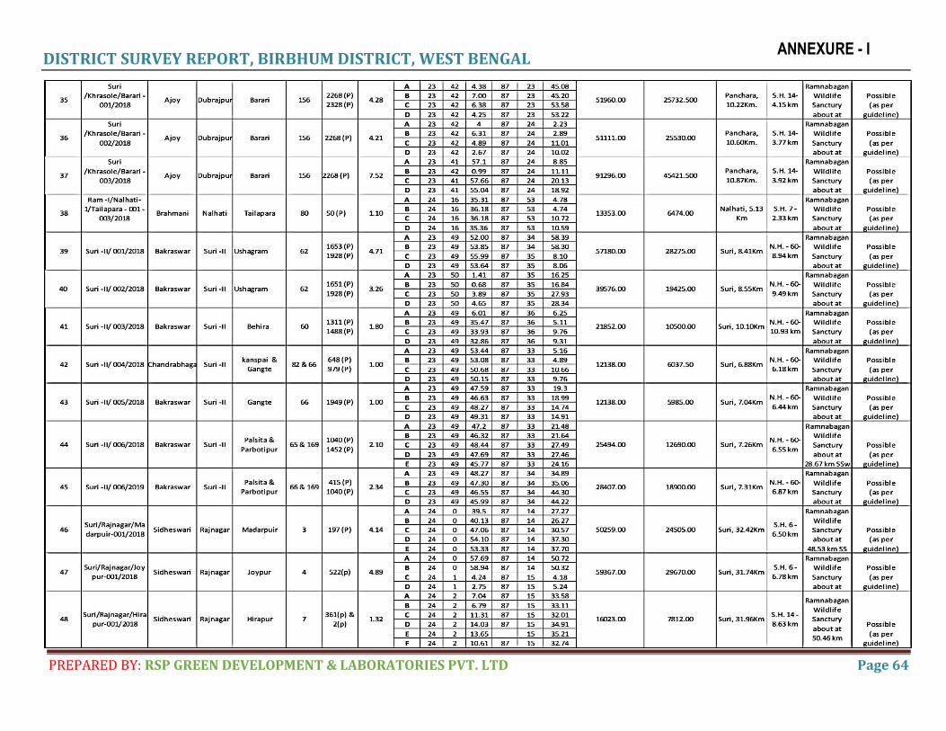
DISTRICT SURVEY REPORT, BIRBHUM DISTRICT, WEST BENGAL
PREPARED BY: RSP GREEN DEVELOPMENT & LABORATORIES PVT. LTD Page 64
ANNEXURE - I
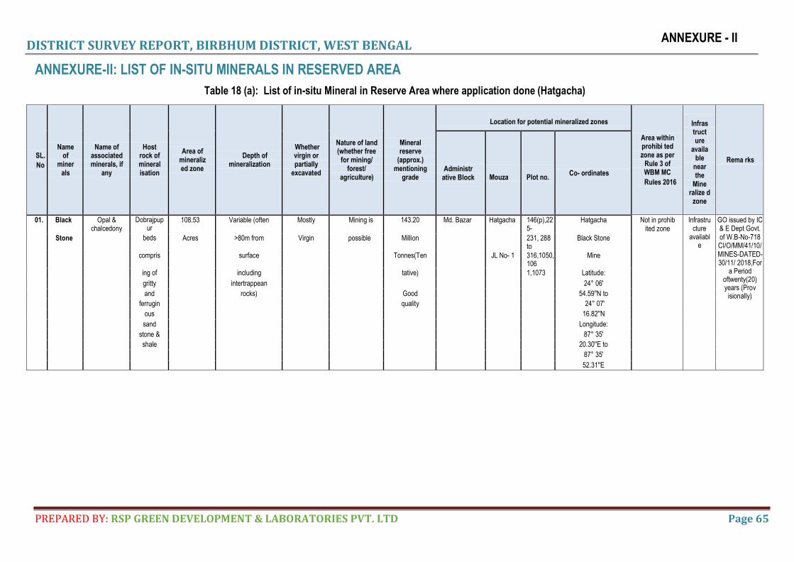
DISTRICT SURVEY REPORT, BIRBHUM DISTRICT, WEST BENGAL
PREPARED BY: RSP GREEN DEVELOPMENT & LABORATORIES PVT. LTD Page 65
ANNEXURE - II
ANNEXURE-II: LIST OF IN-SITU MINERALS IN RESERVED AREA
Table 18 (a): List of in-situ Mineral in Reserve Area where application done (Hatgacha)
SL.
No
Name of
miner als
Name of associated minerals, if
any
Host rock of mineral isation
Area of mineraliz ed zone
Depth of mineralization
Whether virgin or partially
excavated
Nature of land (whether free
for mining/ forest/
agriculture)
Mineral reserve
(approx.) mentioning
grade
Location for potential mineralized zones
Area within prohibi ted zone as per
Rule 3 of WBM MC
Rules 2016
Infras truct ure
availa ble
near the
Mine ralize d
zone
Rema rks
Administr ative Block Mouza Plot no.
Co- ordinates
01. Black Opal & chalcedony
Dobrajpupur
108.53 Variable (often Mostly Mining is 143.20 Md. Bazar Hatgacha 146(p),225-
Hatgacha Not in prohib ited zone
Infrastructure
available
GO issued by IC & E Dept Govt. of W.B-No-718 CI/O/MM/41/10/MINES-DATED- 30/11/ 2018,For
a Period oftwenty(20) years (Prov
isionally)
Stone beds Acres >80m from Virgin possible Million 231, 288 to
Black Stone
compris surface Tonnes(Ten JL No- 1 316,1050,106
Mine
ing of including tative) 1,1073 Latitude:
gritty intertrappean 24° 06'
and rocks) Good 54.59''N to
ferrugin quality 24° 07'
ous 16.82''N
sand Longitude:
stone & 87° 35'
shale 20.30''E to
87° 35'
52.31''E
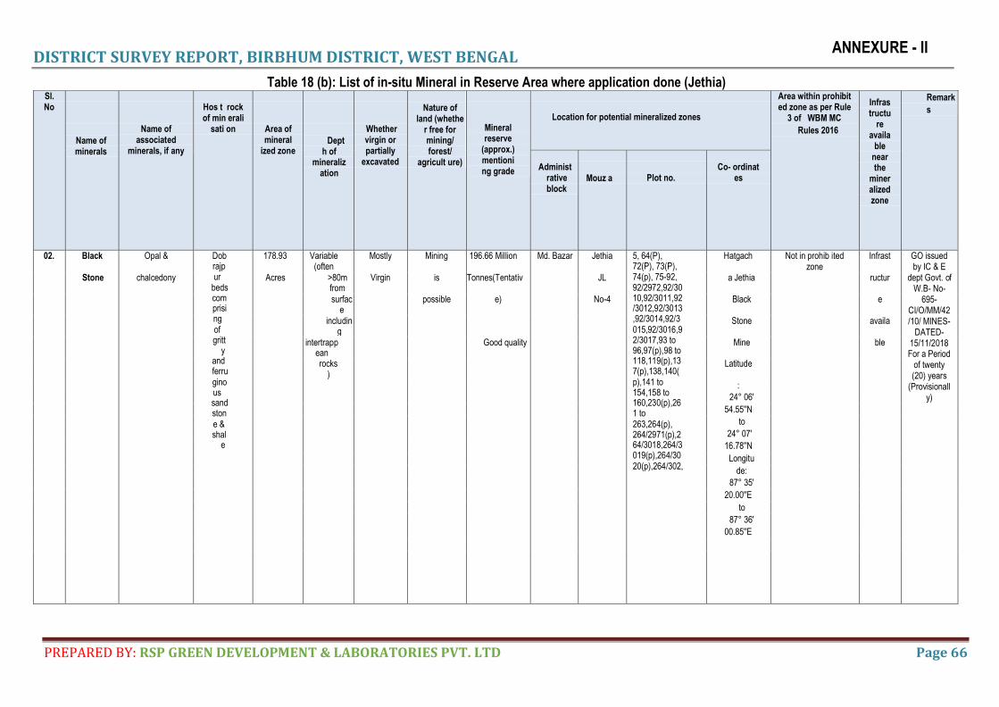
DISTRICT SURVEY REPORT, BIRBHUM DISTRICT, WEST BENGAL
PREPARED BY: RSP GREEN DEVELOPMENT & LABORATORIES PVT. LTD Page 66
ANNEXURE - II
Table 18 (b): List of in-situ Mineral in Reserve Area where application done (Jethia) Sl. No
Name of minerals
Name of associated
minerals, if any
Hos t rock of min erali
sati on
Area of mineral
ized zone
Dept
h of mineraliz
ation
Whether virgin or partially
excavated
Nature of
land (whethe r free for mining/ forest/
agricult ure)
Mineral reserve
(approx.) mentioning grade
Location for potential mineralized zones
Area within prohibit ed zone as per Rule
3 of WBM MC
Rules 2016
Infras tructu
re availa
ble near the
miner alized zone
Remark
s
Administ
rative block
Mouz a
Plot no.
Co- ordinat
es
02. Black Opal & Dob rajp ur
beds com prisi ng of gritt
y and ferru gino us sand ston e & shal
e
178.93 Variable (often
Mostly Mining 196.66 Million Md. Bazar Jethia 5, 64(P), 72(P), 73(P), 74(p), 75-92, 92/2972,92/30 10,92/3011,92 /3012,92/3013 ,92/3014,92/3 015,92/3016,9 2/3017,93 to 96,97(p),98 to 118,119(p),13 7(p),138,140( p),141 to 154,158 to 160,230(p),26 1 to 263,264(p), 264/2971(p),2 64/3018,264/3 019(p),264/30 20(p),264/302,
Hatgach Not in prohib ited zone
Infrast GO issued by IC & E
dept Govt. of W.B- No-
695- CI/O/MM/42/10/ MINES-
DATED- 15/11/2018 For a Period
of twenty (20) years
(Provisionally)
Stone chalcedony Acres >80m from
Virgin is Tonnes(Tentativ JL a Jethia ructur
surface
possible e) No-4 Black e
including
Stone availa
intertrappean
Good quality Mine ble
rocks)
Latitude
:
24° 06'
54.55''N
to
24° 07'
16.78''N
Longitu
de:
87° 35'
20.00''E
to
87° 36'
00.85''E
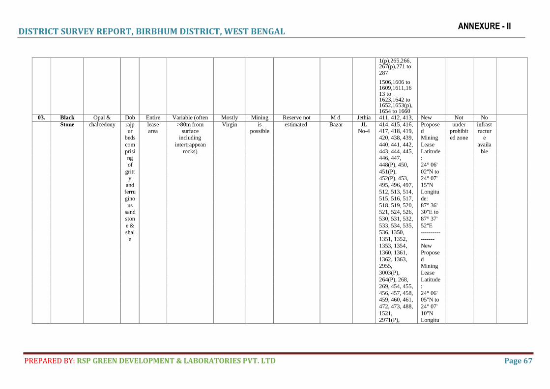
DISTRICT SURVEY REPORT, BIRBHUM DISTRICT, WEST BENGAL
PREPARED BY: RSP GREEN DEVELOPMENT & LABORATORIES PVT. LTD Page 67
ANNEXURE - II
1(p),265,266, 267(p),271 to 287
1506,1606 to 1609,1611,16 13 to 1623,1642 to 1652,1653(p), 1654 to 1660
03. Black Opal & Dob Entire Variable (often Mostly Mining Reserve not M d. Jethia 411, 412, 413, New Not No Stone chalcedony rajp lease >80m from Virgin is estimated Bazar JL 414, 415, 416, Propose under infrast ur area surface possible No-4 417, 418, 419, d prohibit ructur beds including 420, 438, 439, Mining ed zone e com intertrappean 440, 441, 442, Lease availa prisi rocks) 443, 444, 445, Latitude ble ng 446, 447, :
of 448(P), 450, 24° 06'
gritt 451(P), 02''N to
y 452(P), 453, 24° 07'
and 495, 496, 497, 15''N
ferru 512, 513, 514, Longitu
gino 515, 516, 517, de:
us 518, 519, 520, 87° 36'
sand 521, 524, 526, 30''E to
ston 530, 531, 532, 87° 37'
e & 533, 534, 535, 52''E
shal 536, 1350, ----------
e 1351, 1352, -------
1353, 1354, New
1360, 1361, Propose
1362, 1363, d
2955, Mining
3003(P), Lease
264(P), 268, Latitude
269, 454, 455, :
456, 457, 458, 24° 06'
459, 460, 461, 05''N to
472, 473, 488, 24° 07'
1521, 10''N
2971(P), Longitu
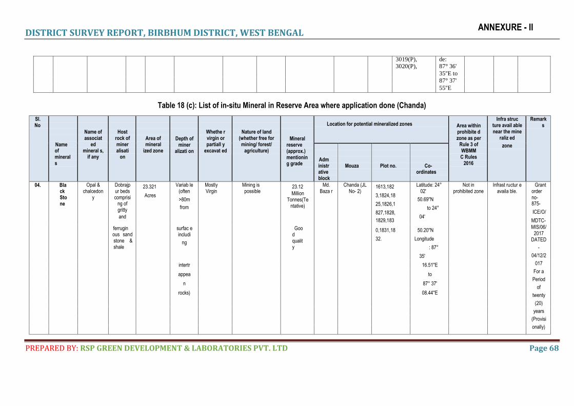
DISTRICT SURVEY REPORT, BIRBHUM DISTRICT, WEST BENGAL
PREPARED BY: RSP GREEN DEVELOPMENT & LABORATORIES PVT. LTD Page 68
ANNEXURE - II
3019(P), de: 3020(P), 87° 36'
35''E to 87° 37'
55''E
Table 18 (c): List of in-situ Mineral in Reserve Area where application done (Chanda)
Sl. No
Name of minerals
Name of associat
ed mineral s,
if any
Host
rock of miner alisati
on
Area of mineral
ized zone
Depth of miner
alizati on
Whethe r virgin or partiall y
excavat ed
Nature of land
(whether free for mining/ forest/
agriculture)
Mineral reserve (approx.) mentionin g grade
Location for potential mineralized zones
Area within prohibite d zone as per
Rule 3 of WBMM C Rules
2016
Infra struc ture avail able near the mine
raliz ed
zone
Remark s
Adm inistr ative block
Mouza
Plot no.
Co-
ordinates
04. Black Stone
Opal & chalcedon
y
Dobrajp ur beds comprisi
ng of gritty
and
23.321
Acres
Variab le (often
>80m
from
Mostly Virgin
Mining is possible
23.12
Million Tonnes(Te
ntative)
Md. Baza r
Chanda (JL No- 2)
1613,182
3,1824,18
25,1826,1
827,1828,
1829,183
Latitude: 24° 02'
50.69''N
to 24°
04'
Not in prohibited zone
Infrast ructur e availa ble.
Grant order no-875-
ICE/O/
MDTC-
MIS/06/ 2017
DATED
-
04/12/2
017
For a
Period
of
twenty
(20)
years
(Provisi
onally)
ferrugin ous sand stone & shale
surfac e includi
ng
Good quality
0,1831,18
32.
50.20''N
Longitude
: 87°
35'
intertr 16.51''E
appea to
n 87° 37'
rocks) 08.44''E
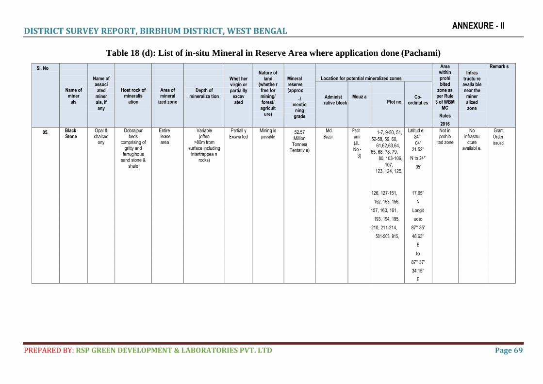
DISTRICT SURVEY REPORT, BIRBHUM DISTRICT, WEST BENGAL
PREPARED BY: RSP GREEN DEVELOPMENT & LABORATORIES PVT. LTD Page 69
ANNEXURE - II
Table 18 (d): List of in-situ Mineral in Reserve Area where application done (Pachami)
Sl. No
Name of miner
als
Name of associ ated
miner als, if any
Host rock of mineralis
ation
Area of mineral
ized zone
Depth of
mineraliza tion
Whet her virgin or partia lly
excav ated
Nature of
land (whethe r free for mining/ forest/ agricult
ure)
Mineral reserve (approx
.)
mentio ning
grade
Location for potential mineralized zones
Area within prohi bited
zone as per Rule 3 of WBM
MC
Rules
2016
Infras tructu re availa ble near the
miner alized zone
Remark s
Administ rative block
Mouz a
Plot no.
Co- ordinat es
05. Black Stone
Opal & chalced
ony
Dobrajpur beds
comprising of gritty and
ferruginous sand stone &
shale
Entire lease area
Variable (often
>80m from surface including
intertrappea n rocks)
Partiall y
Excava ted
Mining is
possible 52.57
Million Tonnes(
Tentativ e)
Md.
Bazar
Pach
ami
(JL
No -
3)
1-7, 9-50, 51,
52-58, 59, 60,
61, 62, 63, 64,
65, 68, 78, 79,
80, 103-106,
107,
123, 124, 125,
Latitud e:
24°
04'
21.52''
N to 24°
05'
Not in prohib
ited zone
No infrastru
cture availabl e.
Grant
Order
issued
126, 127-151, 17.65''
152, 153, 156, N
157, 160, 161, Longit
193, 194, 195, ude:
210, 211-214, 87° 35'
501-503, 915, 48.63''
E
to
87° 37'
34.15''
E
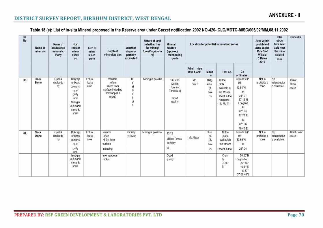
DISTRICT SURVEY REPORT, BIRBHUM DISTRICT, WEST BENGAL
PREPARED BY: RSP GREEN DEVELOPMENT & LABORATORIES PVT. LTD Page 70
ANNEXURE - II
Table 18 (e): List of in-situ Mineral proposed in the Reserve area under Gazzet notification 2002 NO-420- CI/O/MDTC-MISC/005/02/MM,08.11.2002
Sl. No
Name of miner als
Name of
associa ted minera ls,
if any
Host
rock of miner alisati
on
Area of miner alized zone
Depth of mineraliza tion
Whether virgin or partially
excavated
Nature of land (whether free
for mining/ forest/ agricultu
re)
Mineral reserve (approx.) mention ing
grade
Location for potential mineralized zones
Area within prohibite d zone as per
Rule 3 of WBMM C Rules
2016
Infra struc
ture avail able near the mine ralize d
zone
Rema rks
Admi nistr ative block
Mouz a
Plot no.
Co- ordinates
06. Black Stone
Opal & chalcedo
ny
Dobrajp ur beds
comprisi
ng of
gritty
and
ferrugin
ous sand
stone & shale
Entire lease area
Variable (often
>80m from surface including
intertrappea n rocks)
M
o
st
ly
V
ir
gi
n
Mining is possible 143.208
Million Tonnes(
Tentativ e)
Good quality
Md.
Baza r
Hatg
acha
(JL
No-
1)
All the
plots
available in
the Mouza
sheet in the
Hatgacha
(JL No-1)
Latitude: 24°
04'
40.64''N
to
24° 07'
37.12''N Longitud
e:
87° 34'
17.78''E
to
87° 36'
49.40''E
Not in prohibite d
zone
No infrastructure available.
Grant
Order
issued
07. Black Stone
Opal & chalcedo
ny
Dobrajp ur beds
comprisi
ng of
Entire lease area
Variable
(often
>80m from
surface
including
Partially
Excavted
Mining is possible 13.12
Million Tonnes(
Tentativ
e)
Md. Bazar
Chan
da
(JL
No-
2)
All the
plots
available in
the Mouza
sheet in the
Latitude: 24°
02'
50.69''N
to
24° 04'
Not in prohibite d
zone
No infrastructur
e available.
Grant Order
issued
gritty
and
ferrugin ous sand stone & shale
intertrappe an
rocks)
Good
quality
Chan
da
(JLNo-
2)
50.20''N
Longitud e:
87° 35'
16.51''E
to 87°
37' 08.44''E
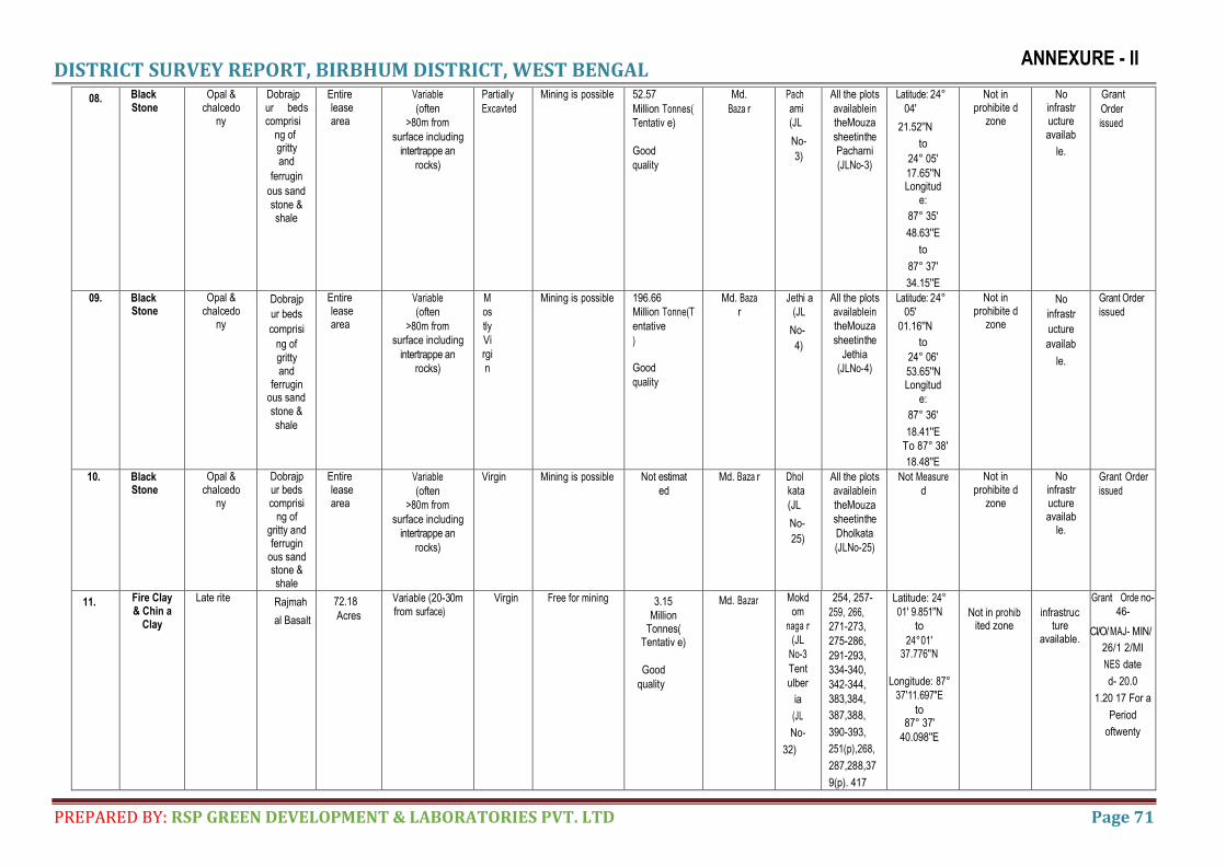
DISTRICT SURVEY REPORT, BIRBHUM DISTRICT, WEST BENGAL
PREPARED BY: RSP GREEN DEVELOPMENT & LABORATORIES PVT. LTD Page 71
ANNEXURE - II
08. Black Stone
Opal & chalcedo
ny
Dobrajp ur beds comprisi
ng of gritty and
ferrugin
ous sand
stone & shale
Entire lease area
Variable
(often
>80m from
surface including
intertrappe an
rocks)
Partially
Excavted
Mining is possible 52.57
Million Tonnes(
Tentativ e)
Good
quality
Md.
Baza r
Pach
ami
(JL
No-
3)
All the plots
available in
the Mouza
sheet in the
Pachami
(JLNo-3)
Latitude: 24°
04'
21.52''N
to
24° 05'
17.65''N Longitud
e:
87° 35'
48.63''E
to
87° 37'
34.15''E
Not in prohibite d
zone
No infrastr ucture
availab
le.
Grant
Order
issued
09. Black Stone
Opal & chalcedo
ny
Dobrajp
ur beds
comprisi
ng of
gritty and
ferrugin ous sand
stone &
shale
Entire lease area
Variable
(often
>80m from
surface including
intertrappe an
rocks)
M
os
tly
Vi
rgi
n
Mining is possible 196.66
Million Tonne(T
entative
)
Good
quality
Md. Baza
r
Jethi a
(JL
No-
4)
All the plots
available in
the Mouza
sheet in the
Jethia
(JLNo-4)
Latitude: 24°
05'
01.16''N
to
24° 06'
53.65''N Longitud
e:
87° 36'
18.41''E
To 87° 38'
18.48''E
Not in prohibite d
zone
No
infrastr
ucture
availab
le.
Grant Order
issued
10. Black Stone
Opal & chalcedo
ny
Dobrajp ur beds comprisi
ng of gritty and ferrugin
ous sand stone & shale
Entire lease area
Variable
(often
>80m from
surface including
intertrappe an
rocks)
Virgin Mining is possible Not estimat
ed
Md. Baza r Dhol
kata
(JL
No-
25)
All the plots
available in
the Mouza
sheet in the
Dholkata
(JL No-25)
Not Measure
d
Not in prohibite d
zone
No infrastr ucture availab
le.
Grant Order
issued
11. Fire Clay & Chin a
Clay
Late rite Rajmah
al Basalt
72.18
Acres
Variable (20 - 30m
from surface)
Virgin Free for mining 3.15
Million Tonnes(
Tentativ e)
Good
quality
Md. Bazar Mokd
om
naga r
(JL
No-3
Tent
ulber
ia
(JL
No-
32)
254, 257-
259, 266,
271-273,
275-286,
291-293,
334-340,
342-344,
383,384,
387,388,
390-393,
251(p),268,
287,288,37
9(p). 417
Latitude: 24°
01' 9.851''N
to
24° 01' 37.776''N
Longitude: 87°
37' 11.697''E
to 87° 37'
40.098''E
Not in prohib ited zone
infrastructure
available.
Grant Orde no-
46-
CI/O/ MAJ- MIN/
26/1 2/MI
NES date
d- 20.0
1.20 17 For a
Period
oftwenty
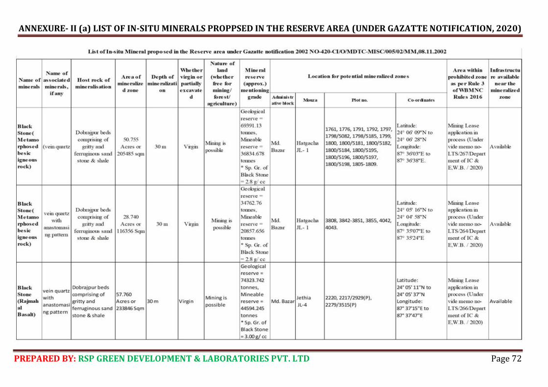
ANNEXURE- II (a) LIST OF IN-SITU MINERALS PROPPSED IN THE RESERVE AREA (UNDER GAZATTE NOTIFICATION, 2020)
PREPARED BY: RSP GREEN DEVELOPMENT & LABORATORIES PVT. LTD Page 72
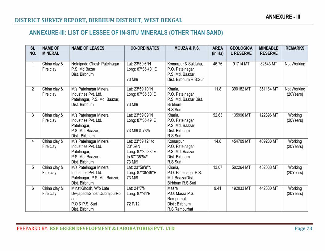
DISTRICT SURVEY REPORT, BIRBHUM DISTRICT, WEST BENGAL
PREPARED BY: RSP GREEN DEVELOPMENT & LABORATORIES PVT. LTD Page 73
ANNEXURE - III
ANNEXURE-III: LIST OF LESSEE OF IN-SITU MINERALS (OTHER THAN SAND)
SL NO.
NAME OF MINERAL
NAME OF LEASES CO-ORDINATES MOUZA & P.S. AREA (in Ha)
GEOLOGICAL RESERVE
MINEABLE RESERVE
REMARKS
1 China clay & Fire clay
Netaipada Ghosh Patelnagar P.S. Md Bazar Dist. Birbhum
Lat: 23º59ꞌ6ꞌꞌN Long: 87º35ꞌ40ꞌꞌ E 73 M/9
Komarpur & Saldaha, P.O. Patelnagar P.S. Md. Baazar, Dist. Birbhum R.S:Suri
46.76 91714 MT 82543 MT Not Working
2 China clay & Fire clay
M/s Patelnagar Mineral Industries Pvt. Ltd. Patelnagar, P.S. Md. Baazar, Dist. Birbhum
Lat: 23º59ꞌ10ꞌꞌN Long: 87º35ꞌ50ꞌꞌE 73 M/9
Kharia, P.O. Patelnagar P.S. Md. Baazar Dist. Birbhum R.S.Suri
11.8 390182 MT 351164 MT Not Working (20Years)
3 China clay & Fire clay
M/s Patelnagar Mineral Industries Pvt. Ltd. Patelnagar, P.S. Md. Baazar, Dist. Birbhum
Lat: 23º59ꞌ09ꞌꞌN Long: 87º35ꞌ49ꞌꞌE 73 M/9 & 73/5
Kharia, P.O. Patelnagar P.S. Md. Baazar Dist. Birbhum R.S.Suri
52.63 135996 MT 122396 MT Working (20Years)
4 China clay & Fire clay
M/s Patelnagar Mineral Industries Pvt. Ltd. Patelnagar, P.S. Md. Baazar, Dist. Birbhum
Lat: 23º59ꞌ12ꞌꞌ to 23°59ꞌN Long: 87º35ꞌ38ꞌꞌE to 87°35ꞌ54ꞌꞌ 73 M/9
Komarpur P.O. Patelnagar P.S. Md. Baazar Dist. Birbhum R.S.Suri
14.8 454709 MT 409238 MT Working (20Years)
5 China clay & Fire clay
M/s Patelnagar Mineral Industries Pvt. Ltd. Patelnagar, P.S. Md. Baazar, Dist. Birbhum
Lat: 23°59ꞌ9ꞌꞌN Long: 87°35ꞌ49ꞌꞌE 73 M/9
Kharia, P.O. Patelnagar P.S. Md. BaazarDist. Birbhum R.S.Suri
13.07 502264 MT 452038 MT Working (20Years)
6 China clay & Fire clay
MinatiGhosh, W/o Late DwijapadaGhoshDubrajpurRoad, P.O & P.S. Suri Dist. Birbhum
Lat: 24°7ꞌN Long: 87°41ꞌE 72 P/12
Masra P.O. Masra P.S. Rampurhat Dist : Birbhum R.S.Rampurhat
9.41 492033 MT 442830 MT Working (20Years)
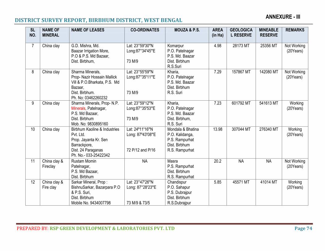
DISTRICT SURVEY REPORT, BIRBHUM DISTRICT, WEST BENGAL
PREPARED BY: RSP GREEN DEVELOPMENT & LABORATORIES PVT. LTD Page 74
ANNEXURE - III
SL NO.
NAME OF MINERAL
NAME OF LEASES CO-ORDINATES MOUZA & P.S. AREA (in Ha)
GEOLOGICAL RESERVE
MINEABLE RESERVE
REMARKS
7 China clay G.D. Mishra, Md. Baazar Irrigation More, P.O & P.S. Md Bazaar, Dist. Birbhum,
Lat: 23°59ꞌ30ꞌꞌN Long:87°34ꞌ45ꞌꞌE 73 M/9
Komarpur P.O. Patelnagar P.S. Md. Baazar Dist. Birbhum R.S.Suri
4.98 28173 MT 25356 MT Not Working (20Years)
8 China clay Sharma Minerals, Prop- Nazir Hossain Mallick Vill & P.O.Bharkata, P.S. Md Bazaar, Dist. Birbhum. Ph. No: 03462260232
Lat: 23°55ꞌ59ꞌꞌN Long:87°35ꞌ11ꞌꞌE 73 M/9
Kharia, P.O. Patelnagar P.S. Md. Baazar Dist. Birbhum R.S. Suri
7.29 157867 MT 142080 MT Not Working (20Years)
9 China clay Sharma Minerals, Prop- N.P. Minerals, Patelnagar, P.S. Md Bazaar, Dist. Birbhum Mob. No: 9830895160
Lat: 23°59ꞌ12ꞌꞌN Long:87°35ꞌ53ꞌꞌE 73 M/9
Kharia, P.O. Patelnagar P.S. Md. Baazar Dist. Birbhum, R.S. Suri
7.23 601792 MT 541613 MT Working (20Years)
10 China clay Birbhum Kaoline & Industries Pvt. Ltd. Prop. Jayanta Kr. Sen Barrackpore, Dist. 24 Paraganas Ph. No.- 033-25422342
Lat: 24º11ꞌ16ꞌꞌN Long: 87º43ꞌ08ꞌꞌE 72 P/12 and P/16
Mondala & Bhatina P.O. Kalidanga, P.S. Rampurhat Dist. Birbhum R.S. Rampurhat
13.98 307044 MT 276340 MT Working (20Years)
11 China clay & Fireclay
Rustam Momin Patelnagar, P.S. Md Bazaar, Dist. Birbhum
NA Masra P.S. Rampurhat Dist. Birbhum R.S. Rampurhat
20.2 NA NA Not Working (20Years)
12 China clay & Fire clay
Sarkar Mineral, Prop : BishnuSarkar, Bazarpara P.O & P.S. Suri, Dist. Birbhum Mobile No. 9434007798
Lat: 23°47ꞌ26ꞌꞌN Long: 87°28ꞌ23ꞌꞌE 73 M/9 & 73/5
Chandispur P.O. Sahapur P.S. Dubrajpur Dist. Birbhum R.S.Dubrajpur
5.85 45571 MT 41014 MT Working (20Years)
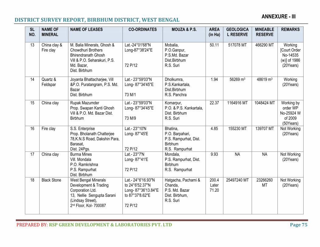
DISTRICT SURVEY REPORT, BIRBHUM DISTRICT, WEST BENGAL
PREPARED BY: RSP GREEN DEVELOPMENT & LABORATORIES PVT. LTD Page 75
ANNEXURE - III
SL NO.
NAME OF MINERAL
NAME OF LEASES CO-ORDINATES MOUZA & P.S. AREA (in Ha)
GEOLOGICAL RESERVE
MINEABLE RESERVE
REMARKS
13 China clay & Fire clay
M. Balia Minerals, Ghosh & Chowdhuri Brothers Bhirendranath Ghosh Vill & P.O. Seharakuri, P.S. Md. Bazar, Dist. Birbhum
Lat.-24°01'68''N Long-87°38'24''E 72 P/12
Mobalia, P.O.Ganpur, P.S.Md. Bazar Dist.Birbhum R.S. Suri
50.11 517078 MT 466290 MT Working [Court Order
No-14535 (w)] of 1986 (20Years)
14 Quartz & Feldspar
Joyanta Bhattacharjee, Vill &P.O. Puratangram, P.S. Md. Bazar Dist. Birbhum
Lat.- 23°59'03''N Long- 87°34'45''E 73 M/1
Dholkumra, P.S.Kankartala, Dist.Birbhum R.S. Panchra
1.94 56269 m3 48619 m3 Working (20Years)
15 China clay Rupak Mazumder Prop. Swapan Kanti Ghosh Vill & P.O. Md. Bazar Dist. Birbhum
Lat.- 23°59'03''N Long- 87°34'45''E 73 M/9
Komarpur, P.O. & P.S. Kankartala, Dist. Birbhum R.S. Suri
22.37 1164916 MT 1048424 MT Working by order WP
No-25924 W of 2009
(50Years)
16
Fire clay
S.S. Enterprise Prop. Bholanath Chatterjee 78,K.N.S Road, Dakshin Para, Barasat, Dist. 24Pgs.
Lat.- 23°10'N Long- 87°45'E 72 P/12
Bhatina, P.O. Barpahari, P.S. Rampurhat, Dist. Birbhum R.S. Rampurhat
4.85 155230 MT 139707 MT Not Working (20Years)
17
China clay
Burma Mines Vill. Mondala P.O. Ramkrishna P.S. Rampurhat Dist. Birbhum
Lat.- 23°7'N Long- 87°41'E 72 P/12
Mondala, P.S. Rampurhat, Dist. Birbhum R.S. Rampurhat
9.93 NA NA Not Working (20Years)
18
Black Stone
West Bengal Minerals Development & Trading Corporation Ltd. 13, Nellie Sengupta Sarani (Lindsay Street), 2nd Floor, Kol- 700087
Lat.- 24°6'16.93''N to 24°6'52.37''N Long- 87°36'13.84''E to 87°37'8.62''E 72 P/12
Hatgacha, Pachami & Chanda, P.S. Md. Bazar Dist. Birbhum, R.S. Suri
200.4 Later 71.20
25497240 MT 23266260 MT
Not Working (20Years)

DISTRICT SURVEY REPORT, BIRBHUM DISTRICT, WEST BENGAL
PREPARED BY: RSP GREEN DEVELOPMENT & LABORATORIES PVT. LTD Page 76
ANNEXURE - III
SL NO.
NAME OF MINERAL
NAME OF LEASES CO-ORDINATES MOUZA & P.S. AREA (in Ha)
GEOLOGICAL RESERVE
MINEABLE RESERVE
REMARKS
19
Black Stone
M/s Bharati Stone Product Prop. Smt. Sabina Begum, Lalkuthipara, P.O. & P.S. Suri, Dist. Birbhum
Lat.- 23°07'N Long- 87°45'E 72 P/12
Tarachua, P.S. Rampurhat, Dist. Birbhum, R.S. Rampurhat
3.925 295348 m3 265813 m3 Not Working (20Years)
20 Black Stone M/s. Jayanti stone Querry, Partner. Kamal Khan, Vill. Talbandh P.O. N-Jagatpur, P.S. Md. Bazar, Dist. Birbhum
Lat.- 23°08'50''N Long- 87°35'40''E 72 P/12
Nischintapur & Dewangunj, P.S. Md. Bazar, Dist. Birbhum, R.S. Suri
2.316 656000 m3 610000 m3 Working (5 Years)
21 Black Stone
M/s. Md. Bazar Stone Crusher, Partner. Abdul Hannan, Vill. Patelnagar, P.O. Md. Bazar (T.S.), P.S. Md. Bazar, Dist. Birbhum
Lat.-23°3'/4'50''N Long- 87°35'/37'40''E 72 P/12
Komarpur, P.O. & P.S. Md. Bazar, Dist. Birbhum, R.S. Suri
3.64 483975 MT 456779.25 MT
Working (05 Years)
22 Black Stone
M/s Aryan stone Quarry, Partner. Sk. Tajommel, Vill. & P.O. & P.S. Suri, Dist. Birbhum
Lat.-23°44'N Long-86°48'E 73 P/13
Tarachua, P.S. Rampurhat, Dist. Birbhum, R.S. Rampurhat
1.46 489375 m3 455119 m3 Working (05 Years)
23 Black Stone
M/s. Sree Durga Black Stone Industries, Partner. Atanu Roy, P.O. & P.S. Suri, Dist. Birbhum
Lat.-24°04'50''N Long-87°37'40''E 72 P/12
Nischintapur, P.S. Md. Bazar, Dist. Birbhum, R.S. Mollarpur
2.81 364694 MT 344228.85 MT
Working (05 Years)
24 Black Stone M/s. Khan Stone Quarry, Prop. Musarof Hossain Khan, P.O. Md.Bazar (T.S.), P.S. Md.Bazar
Lat.-24°3'/4'50''N,Long-87°35'/37'40''E,72 P/12
Nischintapur, P.O. Harinsingha P.S. Md. Bazar, Dist. Birbhum,
3.95 516000 m3 479880 m3 Working (05 Years)
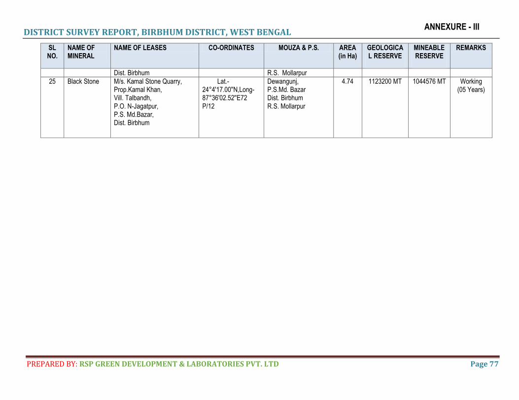
DISTRICT SURVEY REPORT, BIRBHUM DISTRICT, WEST BENGAL
PREPARED BY: RSP GREEN DEVELOPMENT & LABORATORIES PVT. LTD Page 77
ANNEXURE - III
SL NO.
NAME OF MINERAL
NAME OF LEASES CO-ORDINATES MOUZA & P.S. AREA (in Ha)
GEOLOGICAL RESERVE
MINEABLE RESERVE
REMARKS
Dist. Birbhum R.S. Mollarpur
25 Black Stone
M/s. Kamal Stone Quarry, Prop.Kamal Khan, Vill. Talbandh, P.O. N-Jagatpur, P.S. Md.Bazar, Dist. Birbhum
Lat.-24°4'17.00''N,Long-87°36'02.52''E72 P/12
Dewangunj, P.S.Md. Bazar Dist. Birbhum R.S. Mollarpur
4.74 1123200 MT 1044576 MT Working (05 Years)
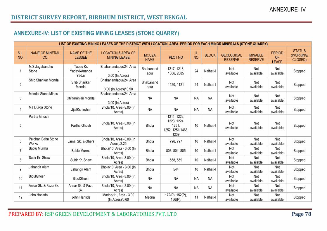
DISTRICT SURVEY REPORT, BIRBHUM DISTRICT, WEST BENGAL
PREPARED BY: RSP GREEN DEVELOPMENT & LABORATORIES PVT. LTD Page 78
ANNEXURE- IV
ANNEXURE-IV: LIST OF EXISTING MINING LEASES (STONE QUARRY)
LIST OF EXISTING MINING LEASES OF THE DISTRICT WITH LOCATION, AREA. PERIOD FOR EACH MINOR MINERALS (STONE QUARRY)
S.L. NO.
NAME OF MINERAL CO.
NAME OF THE LESSEE
LOCATION & AREA OF MINING LEASE
MOUZA NAME
PLOT NO
JL NO.
BLOCK
GEOLOGICAL RESERVE
MINABLE RESERVE
PERIOD
OF LEASE
STATUS (WORKING/ CLOSED)
1 M/S Jagabandhu Stone
Tapas Kr. Yadav&Ananda
Yadav
Bhabanandapur/24, Area -
3.00 (In Acres)
Bhabanandapur
1217, 1218, 1306, 2085
24 Nalhati-I Not
available Not
available Not
available Stopped
2 Shib Shankar Mondal
Shib Shankar Mondal
Bhabanandapur/24, Area -
3.00 (In Acres)/ 0.50
Bhabanandapur
1120, 1121 24 Nalhati-I Not
available Not
available Not
available Stopped
3 Mondal Stone Mines
Chittaranjan Mondal Bhabanandapur/24, Area
- 3.00 (In Acres)
NA NA NA NA Not
available Not
available Not
available Stopped
4 Ma Durga Stone
UjjalKshirohan Bhola/10, Area -3.00 (In
Acres) NA NA NA NA
Not available
Not available
Not available
Stopped
5
Partha Ghosh
Partha Ghosh Bhola/10, Area -3.00 (In
Acres) Bhola
1211, 1222, 1223, 1224,
1251, 1252, 1251/1468,
1239
10 Nalhati-I Not
available Not
available Not
available Stopped
6 Palohan Baba Stone Works
Jamal Sk. & others Bhola/10, Area -3.00 (In
Acres)/2.25 Bhola 796, 797 10 Nalhati-I
Not available
Not available
Not available
Stopped
7 Bablu Murmu
Bablu Murmu Bhola/10, Area - 3.00 (In
Acres) Bhola 803, 804, 805 10 Nalhati-I
Not available
Not available
Not available
Stopped
8 Subir Kr. Shaw
Subir Kr. Shaw Bhola/10, Area -3.00 (In
Acres) Bhola 558, 559 10 Nalhati-I
Not available
Not available
Not available
Stopped
9 Jahangir Alam
Jahangir Alam Bhola/10, Area - 3.00 (In
Acres) Bhola 544 10 Nalhati-I
Not available
Not available
Not available
Stopped
10 BipulGhosh
BipulGhosh Bhola/10, Area -3.00 (In
Acres) NA NA NA NA
Not available
Not available
Not available
Stopped
11 Ansar Sk. & Fazu Sk. Ansar Sk. & Fazu
Sk. Bhola/10, Area -3.00 (In
Acres) NA NA NA NA
Not available
Not available
Not available
Stopped
12 John Hansda
John Hansda Madna/11, Area - 3.00
(In Acres)/0.60 Madna
172(P), 152(P), 156(P),
11 Nalhati-I Not
available Not
available Not
available Stopped
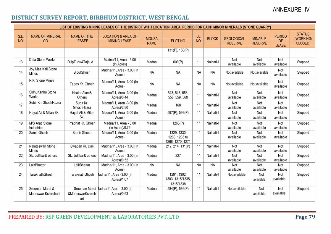
DISTRICT SURVEY REPORT, BIRBHUM DISTRICT, WEST BENGAL
PREPARED BY: RSP GREEN DEVELOPMENT & LABORATORIES PVT. LTD Page 79
ANNEXURE- IV
LIST OF EXISTING MINING LEASES OF THE DISTRICT WITH LOCATION, AREA. PERIOD FOR EACH MINOR MINERALS (STONE QUARRY)
S.L. NO.
NAME OF MINERAL CO.
NAME OF THE LESSEE
LOCATION & AREA OF MINING LEASE
MOUZA NAME
PLOT NO
JL NO.
BLOCK
GEOLOGICAL RESERVE
MINABLE RESERVE
PERIOD
OF LEASE
STATUS (WORKING/ CLOSED)
131(P), 150(P)
13 Data Stone Works
DilipTudu&Tajel A… Madna/11, Area - 3.00
(In Acres) Madna 600(P) 11 Nalhati-I
Not available
Not available
Not available
Stopped
14 Joy Maa Kali Stone Mines BipulGhosh
Madna/11, Area - 3.00 (In Acres)
NA NA NA NA Not available Not available Not
available Stopped
15 R.K. Stone Mines
Tapas Kr. Ghosh Madna/11, Area -3.00 (In
Acres) NA NA NA NA Not available Not available
Not available
Stopped
16 SidhuKanhu Stone Works
KhairulAlam& Others
Madna/11, Area -3.00 (In Acres)/0.44
Madna 543, 546, 556, 558, 559, 560
11 Nalhati-I Not
available Not
available Not
available Stopped
17 Subir Kr. GhoshHazra Subir Kr.
GhoshHazra Madna/11, Area -3.00 (In
Acres)/2.80 Madna 168 11 Nalhati-I
Not available
Not available
Not available
Stopped
18 Hayat Ali & Milan Sk. Hayat Ali & Milan Sk.
Madna/11, Area -3.00 (In
Acres)
Madna 597(P), 599(P) 11 Nalhati-I Not
available
Not
available
Not
available
Stopped
19 M/S Arati Stone Industries
Prabhat Kr. Ghosh Madna/11, Area - 3.00 (In Acres)/0.75
Madna 1263(P) 11 Nalhati-I Not available
Not available
Not available
Stopped
20 Samir Ghosh Samir Ghosh Madna/11, Area -3.00 (In Acres)
Madna 1329, 1330, 1263, 1265 to
1268, 1270, 1271
11 Nalhati-I Not available
Not available
Not available
Stopped
21 Nalateswan Stone Mines
Swapan Kr. Das Madna/11, Area - 3.00 (In Acres)
Madna 212, 214, 131(P) 11 Nalhati-I Not available
Not available
Not available
Stopped
22 Sk. Julfikar& others Sk. Julfikar& others Madna/11, Area - 3.00 (In Acres)/0.52
Madna 227 11 Nalhati-I Not available
Not available
Not available
Stopped
23 LalitBhattar LalitBhattar Madna/11, Area - 3.00 (In Acres)
NA NA NA NA Not available
Not available
Not available
Stopped
24 TaraknathGhosh TaraknathGhosh Madna/11, Area -3.00 (In
Acres)/1.07
Madna 1291, 1302, 1303, 1315/1335,
1315/1338
11 Nalhati-I Not available Not
available
Not available
Stopped
25 Sreeman Mardi &
Maheswar Kshirohari
Sreeman Mardi
&MaheswarKshiroh
ari
Madna/11,Area - 3.00 (In
Acres)/0.93
Madna 584(P), 586(P) 11 Nalhati-I Not available Not
available
Not available
Stopped
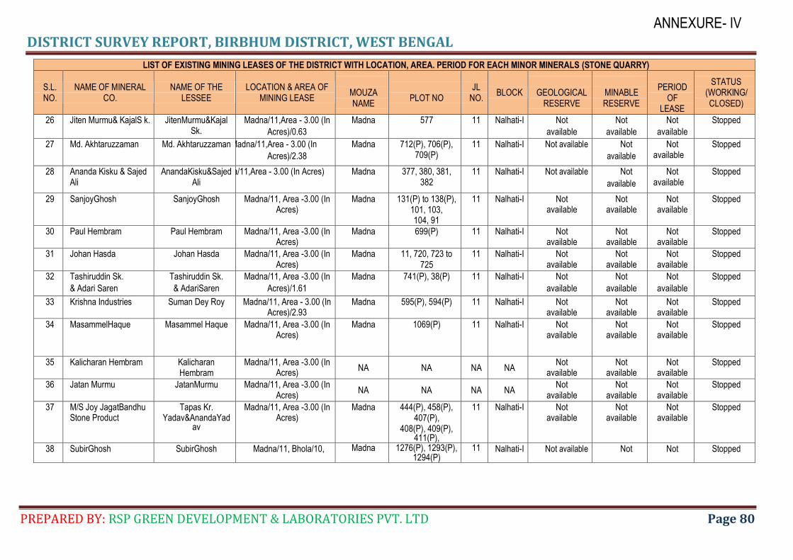
DISTRICT SURVEY REPORT, BIRBHUM DISTRICT, WEST BENGAL
PREPARED BY: RSP GREEN DEVELOPMENT & LABORATORIES PVT. LTD Page 80
ANNEXURE- IV
LIST OF EXISTING MINING LEASES OF THE DISTRICT WITH LOCATION, AREA. PERIOD FOR EACH MINOR MINERALS (STONE QUARRY)
S.L. NO.
NAME OF MINERAL CO.
NAME OF THE LESSEE
LOCATION & AREA OF MINING LEASE
MOUZA NAME
PLOT NO
JL NO.
BLOCK
GEOLOGICAL RESERVE
MINABLE RESERVE
PERIOD
OF LEASE
STATUS (WORKING/ CLOSED)
26 Jiten Murmu& KajalS k. JitenMurmu&Kajal Sk.
Madna/11,Area - 3.00 (In
Acres)/0.63
Madna 577 11 Nalhati-I Not
available
Not
available
Not
available
Stopped
27 Md. Akhtaruzzaman Md. Akhtaruzzaman Madna/11,Area - 3.00 (In
Acres)/2.38
Madna 712(P), 706(P), 709(P)
11 Nalhati-I Not available Not
available
Not available
Stopped
28 Ananda Kisku & Sajed Ali
AnandaKisku&Sajed Ali
Madna/11,Area - 3.00 (In Acres) Madna 377, 380, 381, 382
11 Nalhati-I Not available Not
available
Not available
Stopped
29 SanjoyGhosh SanjoyGhosh Madna/11, Area -3.00 (In Acres)
Madna 131(P) to 138(P), 101, 103, 104, 91
11 Nalhati-I Not available
Not available
Not available
Stopped
30 Paul Hembram Paul Hembram Madna/11, Area -3.00 (In Acres)
Madna 699(P) 11 Nalhati-I Not available
Not available
Not available
Stopped
31 Johan Hasda Johan Hasda Madna/11, Area -3.00 (In Acres)
Madna 11, 720, 723 to 725
11 Nalhati-I Not available
Not available
Not available
Stopped
32 Tashiruddin Sk.
& Adari Saren
Tashiruddin Sk.
& AdariSaren
Madna/11, Area -3.00 (In
Acres)/1.61
Madna 741(P), 38(P) 11 Nalhati-I Not
available
Not
available
Not
available
Stopped
33 Krishna Industries Suman Dey Roy Madna/11, Area - 3.00 (In Acres)/2.93
Madna 595(P), 594(P) 11 Nalhati-I Not available
Not available
Not available
Stopped
34 MasammelHaque Masammel Haque Madna/11, Area -3.00 (In Acres)
Madna 1069(P) 11 Nalhati-I Not available
Not available
Not available
Stopped
35 Kalicharan Hembram Kalicharan Hembram
Madna/11, Area -3.00 (In Acres)
NA NA NA NA Not
available Not
available Not
available Stopped
36 Jatan Murmu JatanMurmu Madna/11, Area -3.00 (In Acres)
NA NA NA NA Not
available Not
available Not
available Stopped
37 M/S Joy JagatBandhu Stone Product
Tapas Kr. Yadav&AnandaYad
av
Madna/11, Area -3.00 (In Acres)
Madna 444(P), 458(P), 407(P),
408(P), 409(P), 411(P),
11 Nalhati-I Not available
Not available
Not available
Stopped
38 SubirGhosh SubirGhosh Madna/11, Bhola/10, Madna 1276(P), 1293(P), 1294(P)
11 Nalhati-I Not available Not Not Stopped
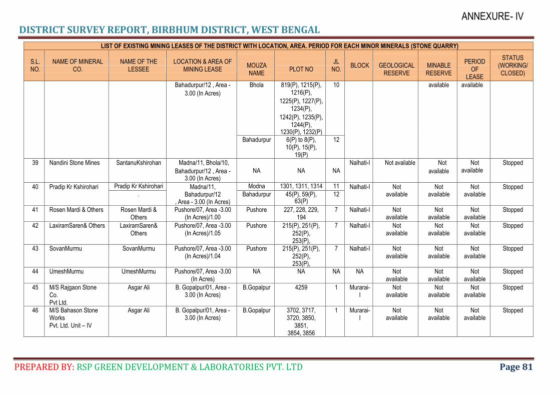
DISTRICT SURVEY REPORT, BIRBHUM DISTRICT, WEST BENGAL
PREPARED BY: RSP GREEN DEVELOPMENT & LABORATORIES PVT. LTD Page 81
ANNEXURE- IV
LIST OF EXISTING MINING LEASES OF THE DISTRICT WITH LOCATION, AREA. PERIOD FOR EACH MINOR MINERALS (STONE QUARRY)
S.L. NO.
NAME OF MINERAL CO.
NAME OF THE LESSEE
LOCATION & AREA OF MINING LEASE
MOUZA NAME
PLOT NO
JL NO.
BLOCK
GEOLOGICAL RESERVE
MINABLE RESERVE
PERIOD
OF LEASE
STATUS (WORKING/ CLOSED)
Bahadurpur/12 , Area -
3.00 (In Acres)
Bhola 819(P), 1215(P), 1216(P),
1225(P), 1227(P), 1234(P),
1242(P), 1235(P), 1244(P),
1230(P), 1232(P)
10 available available
Bahadurpur 6(P) to 8(P), 10(P), 15(P),
19(P)
12
39 Nandini Stone Mines SantanuKshirohan Madna/11, Bhola/10,
Bahadurpur/12 , Area - 3.00 (In Acres)
NA NA NA
Nalhati-I Not available Not
available
Not available
Stopped
40 Pradip Kr Kshirohari Pradip Kr Kshirohari Madna/11, Bahadurpur/12
, Area - 3.00 (In Acres)
Modna 1301, 1311, 1314 11 Nalhati-I Not available
Not available
Not available
Stopped . Bahadurpur 45(P), 59(P),
63(P) 12
41 Rosen Mardi & Others Rosen Mardi & Others
Pushore/07, Area -3.00 (In Acres)/1.00
Pushore 227, 228, 229, 194
7 Nalhati-I Not available
Not available
Not available
Stopped
42 LaxiramSaren& Others LaxiramSaren& Others
Pushore/07, Area -3.00 (In Acres)/1.05
Pushore 215(P), 251(P), 252(P), 253(P),
7 Nalhati-I Not available
Not available
Not available
Stopped
43 SovanMurmu SovanMurmu Pushore/07, Area -3.00 (In Acres)/1.04
Pushore 215(P), 251(P), 252(P), 253(P),
7 Nalhati-I Not available
Not available
Not available
Stopped
44 UmeshMurmu UmeshMurmu Pushore/07, Area -3.00 (In Acres)
NA NA NA NA Not available
Not available
Not available
Stopped
45 M/S Rajgaon Stone Co. Pvt Ltd.
Asgar Ali B. Gopalpur/01, Area - 3.00 (In Acres)
B.Gopalpur 4259 1 Murarai-I
Not available
Not available
Not available
Stopped
46 M/S Bahason Stone Works Pvt. Ltd. Unit – IV
Asgar Ali B. Gopalpur/01, Area - 3.00 (In Acres)
B.Gopalpur 3702, 3717, 3720, 3850,
3851, 3854, 3856
1 Murarai-I
Not available
Not available
Not available
Stopped
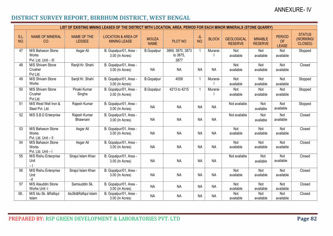
DISTRICT SURVEY REPORT, BIRBHUM DISTRICT, WEST BENGAL
PREPARED BY: RSP GREEN DEVELOPMENT & LABORATORIES PVT. LTD Page 82
ANNEXURE- IV
LIST OF EXISTING MINING LEASES OF THE DISTRICT WITH LOCATION, AREA. PERIOD FOR EACH MINOR MINERALS (STONE QUARRY)
S.L. NO.
NAME OF MINERAL CO.
NAME OF THE LESSEE
LOCATION & AREA OF MINING LEASE
MOUZA NAME
PLOT NO
JL NO.
BLOCK
GEOLOGICAL RESERVE
MINABLE RESERVE
PERIOD
OF LEASE
STATUS (WORKING/ CLOSED)
47 M/S Bahason Stone Works
Pvt. Ltd. Unit – III
Asgar Ali B. Gopalpur/01, Area -
3.00 (In Acres)
B.Gopalpur 3869, 3870, 3873 to 3875,
3877
1 Murarai-I
Not
available
Not
available
Not
available
Stopped
48 M/S Shivam Stone Crusher
Pvt Ltd.
Ranjit Kr. Shahi B. Gopalpur/01, Area -
3.00 (In Acres) NA NA NA NA Not
available
Not
available
Not
available
Closed
49 M/S Shivam Stone Works
Sanjit Kr. Shahi B. Gopalpur/01, Area -
3.00 (In Acres)
B.Gopalpur 4058 1 Murarai-I
Not
available
Not
available
Not
available
Stopped
50 M/S Shivam Stone Crusher
Pvt Ltd.
Pinaki Kumar Singha
B. Gopalpur/01, Area -
3.00 (In Acres)
B.Gopalpur 4213 to 4215 1 Murarai-I
Not
available
Not
available
Not
available
Stopped
51 M/S West Well Iron &
Steel Pvt. Ltd.
Rajesh Kumar B. Gopalpur/01, Area -
3.00 (In Acres) NA NA NA NA Not available Not
available
Not available
Stopped
52 M/S S.B.D Enterprise Rajesh Kumar Bhawnani
B. Gopalpur/01, Area -
3.00 (In Acres) NA NA NA NA Not available Not
available
Not available
Closed
53 M/S Bahason Stone Works Pvt. Ltd. Unit – II
Asgar Ali B. Gopalpur/01, Area - 3.00 (In Acres) NA NA NA NA
Not available
Not available
Not available
Closed
54 M/S Bahason Stone Works Pvt. Ltd. Unit – I
Asgar Ali B. Gopalpur/01, Area - 3.00 (In Acres) NA NA NA NA
Not available
Not available
Not available
Closed
55 M/S Rishu Enterprise Unit
– I
Sirajul Islam Khan B. Gopalpur/01, Area -
3.00 (In Acres) NA NA NA NA
Not available Not
available
Not available
Closed
56 M/S Rishu Enterprise Unit –II
Sirajul Islam Khan B. Gopalpur/01, Area - 3.00 (In Acres) NA NA NA NA
Not available
Not available
Not available
Closed
57 M/S Alauddin Stone Works Unit -I
Samsuddin Sk. B. Gopalpur/01, Area - 3.00 (In Acres)
NA NA NA NA Not
available Not
available Not
available Closed
58.. M/S Idu Sk. &Rafiqul Islam
IduSk&Rafiqul Islam B. Gopalpur/01, Area - 3.00 (In Acres)
NA NA NA NA Not
available Not
available Not
available Closed
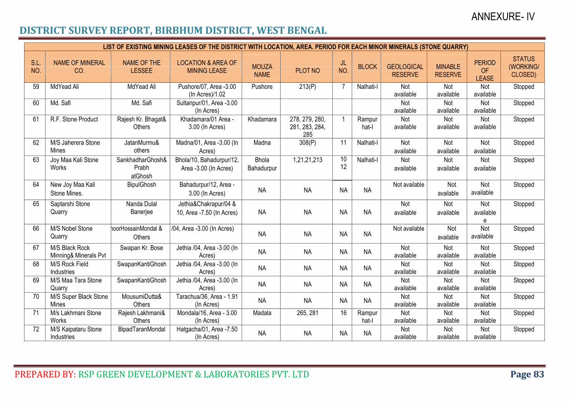
DISTRICT SURVEY REPORT, BIRBHUM DISTRICT, WEST BENGAL
PREPARED BY: RSP GREEN DEVELOPMENT & LABORATORIES PVT. LTD Page 83
ANNEXURE- IV
LIST OF EXISTING MINING LEASES OF THE DISTRICT WITH LOCATION, AREA. PERIOD FOR EACH MINOR MINERALS (STONE QUARRY)
S.L. NO.
NAME OF MINERAL CO.
NAME OF THE LESSEE
LOCATION & AREA OF MINING LEASE
MOUZA NAME
PLOT NO
JL NO.
BLOCK
GEOLOGICAL RESERVE
MINABLE RESERVE
PERIOD
OF LEASE
STATUS (WORKING/ CLOSED)
59 MdYead Ali MdYead Ali Pushore/07, Area -3.00 (In Acres)/1.02
Pushore 213(P) 7 Nalhati-I Not available
Not available
Not available
Stopped
60 Md. Safi Md. Safi Sultanpur/01, Area -3.00 (In Acres)
Not available
Not available
Not available
Stopped
61 R.F. Stone Product Rajesh Kr. Bhagat& Others
Khadamara/01 Area - 3.00 (In Acres)
Khadamara 278, 279, 280, 281, 283, 284,
285
1 Rampurhat-I
Not available
Not available
Not available
Stopped
62 M/S Jaherera Stone Mines
JatanMurmu& others
Madna/01, Area -3.00 (In
Acres)
Madna 308(P) 11 Nalhati-I Not
available
Not
available
Not
available
Stopped
63 Joy Maa Kali Stone Works
SankhadharGhosh&Prabh
atGhosh
Bhola/10, Bahadurpur/12,
Area -3.00 (In Acres)
Bhola
Bahadurpur
1,21,21,213 10 12
Nalhati-I Not
available
Not
available
Not
available
Stopped
64 New Joy Maa Kali
Stone Mines.
BipulGhosh Bahadurpur/12, Area -
3.00 (In Acres) NA NA NA NA Not available Not
available
Not available
Stopped
65 Saptarshi Stone Quarry
Nanda Dulal Banerjee
Jethia&Chakrapur/04 &
10, Area -7.50 (In Acres) NA NA NA NA
Not
available
Not
available
Not
available e
Stopped
66 M/S Nobel Stone Quarry
WagnoorHossainMondal &
Others
Jethia /04, Area -3.00 (In Acres) NA NA NA NA
Not available Not
available
Not available
Stopped
67 M/S Black Rock Minning& Minerals Pvt
Swapan Kr. Bose Jethia /04, Area -3.00 (In Acres)
NA NA NA NA Not
available Not
available Not
available Stopped
68 M/S Rock Field Industries
SwapanKantiGhosh Jethia /04, Area -3.00 (In Acres)
NA NA NA NA Not
available Not
available Not
available Stopped
69 M/S Maa Tara Stone Quarry
SwapanKantiGhosh Jethia /04, Area -3.00 (In Acres)
NA NA NA NA Not
available Not
available Not
available Stopped
70 M/S Super Black Stone Mines
MousumiDutta& Others
Tarachua/36, Area - 1.91 (In Acres)
NA NA NA NA Not
available Not
available Not
available Stopped
71 M/s Lakhmani Stone Works
Rajesh Lakhmani& Others
Mondala/16, Area - 3.00 (In Acres)
Madala 265, 281 16 Rampurhat-I
Not available
Not available
Not available
Stopped
72 M/S Kaipataru Stone Industries
BipadTaranMondal Hatgacha/01, Area -7.50 (In Acres)
NA NA NA NA Not
available Not
available Not
available Stopped
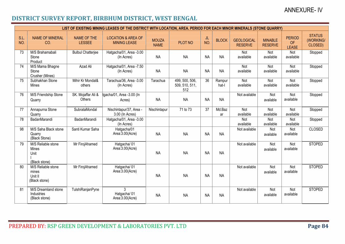
DISTRICT SURVEY REPORT, BIRBHUM DISTRICT, WEST BENGAL
PREPARED BY: RSP GREEN DEVELOPMENT & LABORATORIES PVT. LTD Page 84
ANNEXURE- IV
LIST OF EXISTING MINING LEASES OF THE DISTRICT WITH LOCATION, AREA. PERIOD FOR EACH MINOR MINERALS (STONE QUARRY)
S.L. NO.
NAME OF MINERAL CO.
NAME OF THE LESSEE
LOCATION & AREA OF MINING LEASE
MOUZA NAME
PLOT NO
JL NO.
BLOCK
GEOLOGICAL RESERVE
MINABLE RESERVE
PERIOD
OF LEASE
STATUS (WORKING/ CLOSED)
73 M/S Brahamabali Stone Product
Bulbul Chatterjee Hatgacha/01, Area -3.00 (In Acres) NA NA NA NA
Not available
Not available
Not available
Stopped
74 M/S Mama Bhagne Stone Crusher (Mines)
Azad Ali Hatgacha/01, Area -7.50 (In Acres) NA NA NA NA
Not available
Not available
Not available
Stopped
75 Subhakhan Stone Mines
Mihir Kr Mondal& others
Tarachua/36, Area -3.00 (In Acres)
Tarachua 499, 500, 506, 509, 510, 511,
512
36 Rampurhat-I
Not available
Not available
Not available
Stopped
76 M/S Friendship Stone
Quarry
SK. Mojaffar Ali & Others
.
Hatgacha/01, Area -3.00 (In
Acres) NA NA NA NA
Not available Not
available
Not available
Stopped
77 Annapurna Stone Quarry
SubrataMondal Nischintapur/37, Area - 3.00 (In Acres)
Nischintapur 71 to 73 37 Md.Bazar
Not available
Not available
Not available
Stopped
78 BadanMarandi BadanMarandi Hatgacha/01, Area -3.00 (In Acres)
Not available
Not available
Not available
Stopped
98 M/S Saha Black stone Quarry (Black Stone)
Santi Kumar Saha Hatgacha/01 Area:3.00(Acre) NA NA NA NA
Not available Not
available
Not available
CLOSED
79 M/S Reliable stone Mines Unit I (Black stone)
Mr FirojAhamed Hatgacha/ 01 Area:3.00(Acre)
NA NA NA NA
Not available Not
available
Not available
STOPED
80 M/S Reliable stone mines Unit II
(Black stone)
Mr FirojAhamed Hatgacha/ 01 Area:3.00(Acre)
NA NA NA NA
Not available Not
available
Not available
STOPED
81 M/S Dreamland stone Industries (Black stone)
TulshiRanjanPyne 3 Hatgacha/ 01
Area:3.00(Acre) NA NA NA NA
Not available Not
available
Not available
STOPED
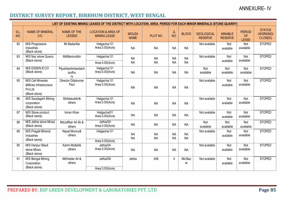
DISTRICT SURVEY REPORT, BIRBHUM DISTRICT, WEST BENGAL
PREPARED BY: RSP GREEN DEVELOPMENT & LABORATORIES PVT. LTD Page 85
ANNEXURE- IV
LIST OF EXISTING MINING LEASES OF THE DISTRICT WITH LOCATION, AREA. PERIOD FOR EACH MINOR MINERALS (STONE QUARRY)
S.L. NO.
NAME OF MINERAL CO.
NAME OF THE LESSEE
LOCATION & AREA OF MINING LEASE
MOUZA NAME
PLOT NO
JL NO.
BLOCK
GEOLOGICAL RESERVE
MINABLE RESERVE
PERIOD
OF LEASE
STATUS (WORKING/ CLOSED)
82 M/S Progressive Industries (Black stone)
Mr BadarAla Hatgacha/ 01 Area:3.00(Acre) NA NA NA NA
Not available Not
available
Not available
STOPED
83 M/S Naz stone Quarry (Black stone)
MdManiruddin Hatgacha/ 01 NA NA
NA NA
NA NA
NA NA
Not available Not
available
Not available
STOPED
Area:3.00(Acre)
84 M/S ESSEN.R.CO (Black stone)
Pijushkantichandachaudhu
ry
Hatgacha/ 01 Area:3.00(Acre) NA NA NA NA
Not available
Not available
Not available
STOPED
85 M/S Cell Minerals
&Mines Infrastructure
Pvt,Ltd
(Black stone)
Director Dilipkumar Paul
Hatgacha/ 01 Area:3.00(Acre)
NA NA NA NA
Not available Not
available
Not available
STOPED
86 M/S Saudagarh Mining
corporation
(Black stone)
SkSalauddin& others
Hatgacha/ 01 Area:3.00(Acre) NA NA NA NA
Not available Not
available
Not available
STOPED
87 M/S Stone product (Black stone)
Imran Khan Hatgacha/01 Area:3.00(Acre) NA NA NA NA
Not available Not
available
Not available
STOPED
88 M/S Jethia stone Mines (Black stone)
MdJulfikar Ali Sk.&
others
Jethia/04 Area:3.00(Acre) NA NA NA NA
Not
available
Not
available
Not
available
STOPED
89 M/S Pragati Mineral
Industries
(Black stone)
Nepal Murmu& others
Hatgacha/ 01 NA NA
NA NA
NA NA
NA NA
Not available Not
available
Not available
STOPED
Area:3.00(Acre)
90 M/S Haripur Black
stone Mines (Black stone)
Karim Mollah& others
Jethia/04 Area:3.00(Acre) NA NA NA NA
Not available Not
available
Not available
STOPED
91 M/S Bengal Mining
Corporation
(Black stone)
MdHaider Ali & others
Jethia/04 Jethia 458 4 Md.Bazar
Not available Not
available
Not available
STOPED
Area:3.00(Acre)
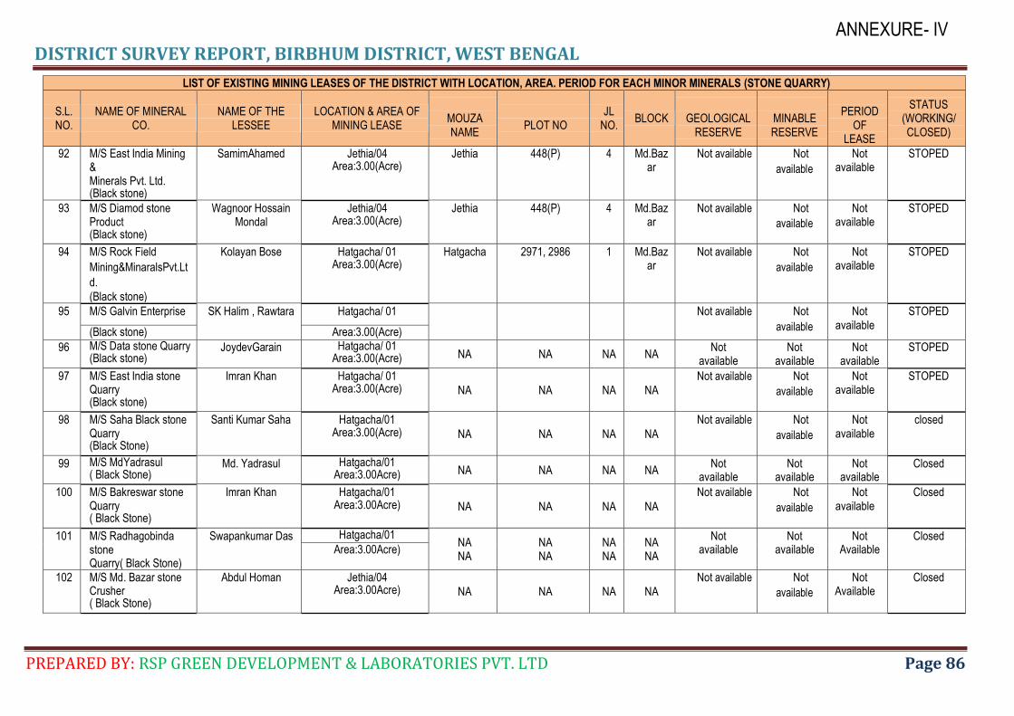
DISTRICT SURVEY REPORT, BIRBHUM DISTRICT, WEST BENGAL
PREPARED BY: RSP GREEN DEVELOPMENT & LABORATORIES PVT. LTD Page 86
ANNEXURE- IV
LIST OF EXISTING MINING LEASES OF THE DISTRICT WITH LOCATION, AREA. PERIOD FOR EACH MINOR MINERALS (STONE QUARRY)
S.L. NO.
NAME OF MINERAL CO.
NAME OF THE LESSEE
LOCATION & AREA OF MINING LEASE
MOUZA NAME
PLOT NO
JL NO.
BLOCK
GEOLOGICAL RESERVE
MINABLE RESERVE
PERIOD
OF LEASE
STATUS (WORKING/ CLOSED)
92 M/S East India Mining & Minerals Pvt. Ltd. (Black stone)
SamimAhamed Jethia/04 Area:3.00(Acre)
Jethia 448(P) 4 Md.Bazar
Not available Not
available
Not available
STOPED
93 M/S Diamod stone Product (Black stone)
Wagnoor Hossain Mondal
Jethia/04 Area:3.00(Acre)
Jethia 448(P) 4 Md.Bazar
Not available Not
available
Not available
STOPED
94 M/S Rock Field
Mining&MinaralsPvt.Lt
d.
(Black stone)
Kolayan Bose Hatgacha/ 01 Area:3.00(Acre)
Hatgacha 2971, 2986 1 Md.Bazar
Not available Not
available
Not available
STOPED
95 M/S Galvin Enterprise SK Halim , Rawtara Hatgacha/ 01 Not available Not
available
Not available
STOPED
(Black stone) Area:3.00(Acre)
96 M/S Data stone Quarry (Black stone)
JoydevGarain Hatgacha/ 01 Area:3.00(Acre) NA NA NA NA
Not available
Not available
Not available
STOPED
97 M/S East India stone Quarry (Black stone)
Imran Khan Hatgacha/ 01 Area:3.00(Acre) NA NA NA NA
Not available Not
available
Not available
STOPED
98 M/S Saha Black stone Quarry (Black Stone)
Santi Kumar Saha Hatgacha/01 Area:3.00(Acre) NA NA NA NA
Not available Not
available
Not available
closed
99 M/S MdYadrasul ( Black Stone)
Md. Yadrasul Hatgacha/01 Area:3.00Acre) NA NA NA NA
Not available
Not available
Not available
Closed
100 M/S Bakreswar stone Quarry ( Black Stone)
Imran Khan Hatgacha/01 Area:3.00Acre) NA NA NA NA
Not available Not
available
Not available
Closed
101 M/S Radhagobinda stone Quarry( Black Stone)
Swapankumar Das Hatgacha/01 NA NA
NA NA
NA NA
NA NA
Not available
Not available
Not Available
Closed Area:3.00Acre)
102 M/S Md. Bazar stone Crusher ( Black Stone)
Abdul Homan Jethia/04 Area:3.00Acre) NA NA NA NA
Not available Not
available
Not Available
Closed
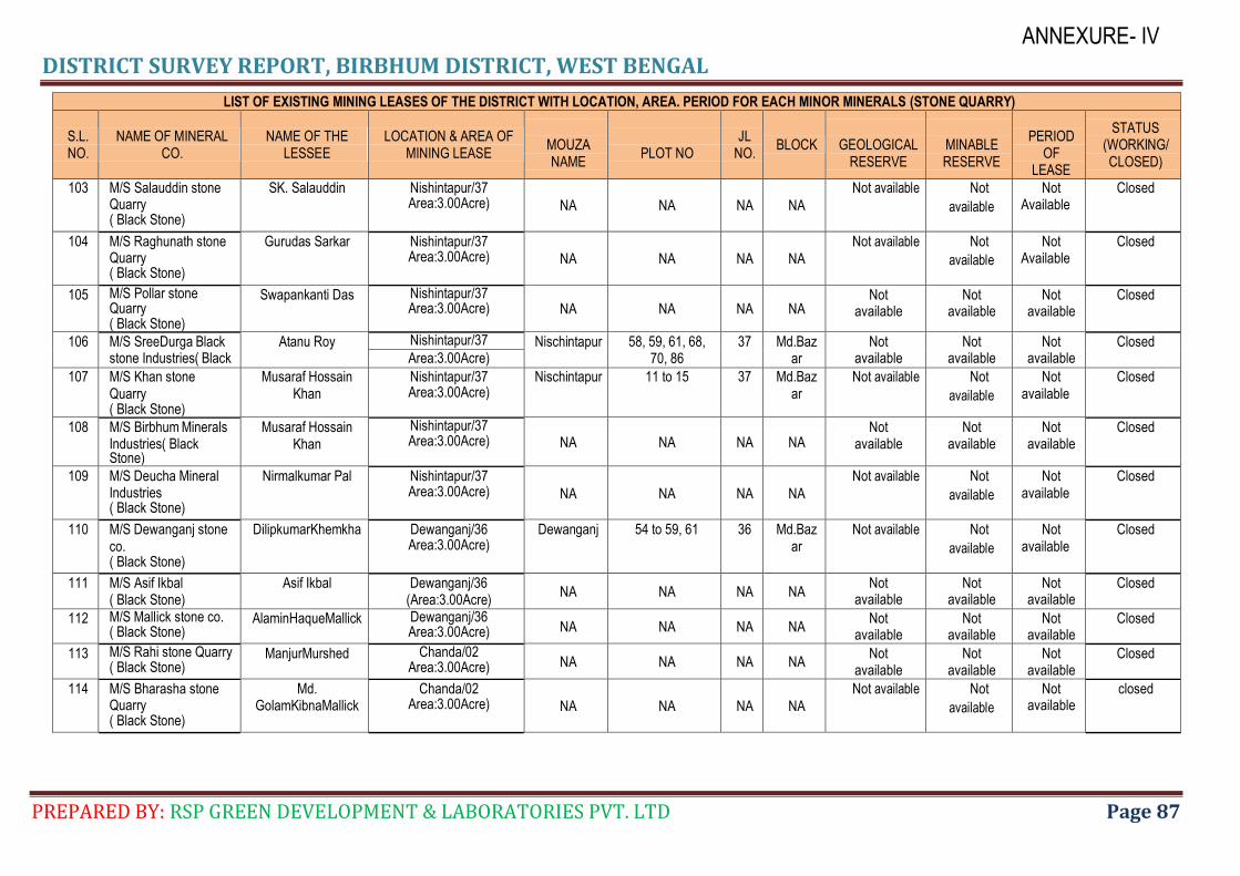
DISTRICT SURVEY REPORT, BIRBHUM DISTRICT, WEST BENGAL
PREPARED BY: RSP GREEN DEVELOPMENT & LABORATORIES PVT. LTD Page 87
ANNEXURE- IV
LIST OF EXISTING MINING LEASES OF THE DISTRICT WITH LOCATION, AREA. PERIOD FOR EACH MINOR MINERALS (STONE QUARRY)
S.L. NO.
NAME OF MINERAL CO.
NAME OF THE LESSEE
LOCATION & AREA OF MINING LEASE
MOUZA NAME
PLOT NO
JL NO.
BLOCK
GEOLOGICAL RESERVE
MINABLE RESERVE
PERIOD
OF LEASE
STATUS (WORKING/ CLOSED)
103 M/S Salauddin stone Quarry ( Black Stone)
SK. Salauddin Nishintapur/37 Area:3.00Acre) NA NA NA NA
Not available Not
available
Not Available
Closed
104 M/S Raghunath stone Quarry ( Black Stone)
Gurudas Sarkar Nishintapur/37 Area:3.00Acre) NA NA NA NA
Not available Not
available
Not Available
Closed
105 M/S Pollar stone Quarry ( Black Stone)
Swapankanti Das Nishintapur/37 Area:3.00Acre) NA NA NA NA
Not available
Not available
Not available
Closed
106 M/S SreeDurga Black stone Industries( Black
Atanu Roy Nishintapur/37 Nischintapur 58, 59, 61, 68, 70, 86
37 Md.Bazar
Not available
Not available
Not available
Closed Area:3.00Acre)
107 M/S Khan stone Quarry ( Black Stone)
Musaraf Hossain Khan
Nishintapur/37 Area:3.00Acre)
Nischintapur 11 to 15 37 Md.Bazar
Not available Not
available
Not available
Closed
108 M/S Birbhum Minerals Industries( Black Stone)
Musaraf Hossain Khan
Nishintapur/37 Area:3.00Acre) NA NA NA NA
Not available
Not available
Not available
Closed
109 M/S Deucha Mineral Industries ( Black Stone)
Nirmalkumar Pal Nishintapur/37 Area:3.00Acre) NA NA NA NA
Not available Not
available
Not available
Closed
110 M/S Dewanganj stone co. ( Black Stone)
DilipkumarKhemkha Dewanganj/36 Area:3.00Acre)
Dewanganj 54 to 59, 61 36 Md.Bazar
Not available Not
available
Not available
Closed
111 M/S Asif Ikbal ( Black Stone)
Asif Ikbal Dewanganj/36 (Area:3.00Acre)
NA NA NA NA Not
available Not
available Not
available Closed
112 M/S Mallick stone co. ( Black Stone)
AlaminHaqueMallick Dewanganj/36 Area:3.00Acre) NA NA NA NA
Not available
Not available
Not available
Closed
113 M/S Rahi stone Quarry ( Black Stone)
ManjurMurshed Chanda/02 Area:3.00Acre) NA NA NA NA
Not available
Not available
Not available
Closed
114 M/S Bharasha stone Quarry ( Black Stone)
Md. GolamKibnaMallick
Chanda/02 Area:3.00Acre) NA NA NA NA
Not available Not
available
Not available
closed
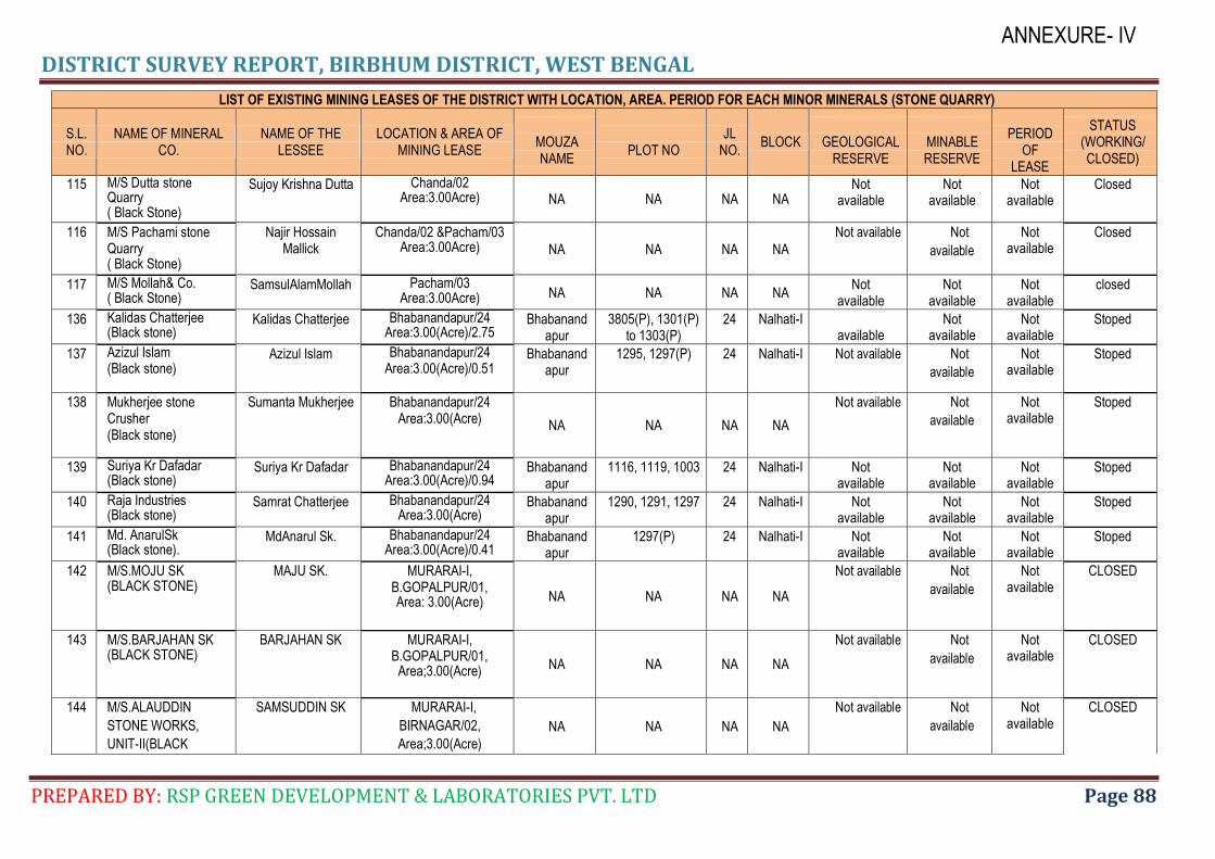
DISTRICT SURVEY REPORT, BIRBHUM DISTRICT, WEST BENGAL
PREPARED BY: RSP GREEN DEVELOPMENT & LABORATORIES PVT. LTD Page 88
ANNEXURE- IV
LIST OF EXISTING MINING LEASES OF THE DISTRICT WITH LOCATION, AREA. PERIOD FOR EACH MINOR MINERALS (STONE QUARRY)
S.L. NO.
NAME OF MINERAL CO.
NAME OF THE LESSEE
LOCATION & AREA OF MINING LEASE
MOUZA NAME
PLOT NO
JL NO.
BLOCK
GEOLOGICAL RESERVE
MINABLE RESERVE
PERIOD
OF LEASE
STATUS (WORKING/ CLOSED)
115 M/S Dutta stone Quarry ( Black Stone)
Sujoy Krishna Dutta Chanda/02 Area:3.00Acre) NA NA NA NA
Not available
Not available
Not available
Closed
116 M/S Pachami stone Quarry ( Black Stone)
Najir Hossain Mallick
Chanda/02 &Pacham/03 Area:3.00Acre) NA NA NA NA
Not available Not
available
Not available
Closed
117 M/S Mollah& Co. ( Black Stone)
SamsulAlamMollah Pacham/03 Area:3.00Acre) NA NA NA NA
Not available
Not available
Not available
closed
136 Kalidas Chatterjee (Black stone)
Kalidas Chatterjee Bhabanandapur/24 Area:3.00(Acre)/2.75
Bhabanandapur
3805(P), 1301(P) to 1303(P)
24 Nalhati-I available
Not available
Not available
Stoped
137 Azizul Islam (Black stone)
Azizul Islam Bhabanandapur/24 Area:3.00(Acre)/0.51
Bhabanandapur
1295, 1297(P) 24 Nalhati-I Not available Not
available
Not available
Stoped
138 Mukherjee stone Crusher (Black stone)
Sumanta Mukherjee Bhabanandapur/24 Area:3.00(Acre)
NA NA NA NA
Not available Not
available
Not available
Stoped
139 Suriya Kr Dafadar (Black stone)
Suriya Kr Dafadar Bhabanandapur/24 Area:3.00(Acre)/0.94
Bhabanandapur
1116, 1119, 1003 24 Nalhati-I Not available
Not available
Not available
Stoped
140 Raja Industries (Black stone)
Samrat Chatterjee Bhabanandapur/24 Area:3.00(Acre)
Bhabanandapur
1290, 1291, 1297 24 Nalhati-I Not available
Not available
Not available
Stoped
141 Md. AnarulSk (Black stone).
MdAnarul Sk. Bhabanandapur/24 Area:3.00(Acre)/0.41
Bhabanandapur
1297(P) 24 Nalhati-I Not available
Not available
Not available
Stoped
142 M/S.MOJU SK (BLACK STONE)
MAJU SK. MURARAI-I, B.GOPALPUR/01, Area: 3.00(Acre) NA NA NA NA
Not available Not
available
Not available
CLOSED
143 M/S.BARJAHAN SK (BLACK STONE)
BARJAHAN SK MURARAI-I, B.GOPALPUR/01,
Area;3.00(Acre) NA NA NA NA
Not available Not
available
Not available
CLOSED
144 M/S.ALAUDDIN
STONE WORKS,
UNIT-II(BLACK
SAMSUDDIN SK MURARAI-I,
BIRNAGAR/02,
Area;3.00(Acre)
NA NA NA NA
Not available Not
available
Not available
CLOSED
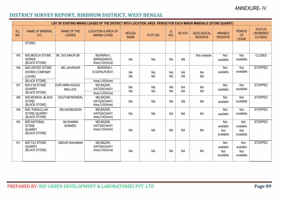
DISTRICT SURVEY REPORT, BIRBHUM DISTRICT, WEST BENGAL
PREPARED BY: RSP GREEN DEVELOPMENT & LABORATORIES PVT. LTD Page 89
ANNEXURE- IV
LIST OF EXISTING MINING LEASES OF THE DISTRICT WITH LOCATION, AREA. PERIOD FOR EACH MINOR MINERALS (STONE QUARRY)
S.L. NO.
NAME OF MINERAL CO.
NAME OF THE LESSEE
LOCATION & AREA OF MINING LEASE
MOUZA NAME
PLOT NO
JL NO.
BLOCK
GEOLOGICAL RESERVE
MINABLE RESERVE
PERIOD
OF LEASE
STATUS (WORKING/ CLOSED)
STONE)
145 M/S.MEIEJA STONE WORKS (BLACK STONE)
MENTU SK. S/O.AINUR SK MURARAI-I, BIRNAGAR/02, Area;3.00(Acre)
NA NA NA NA
Not available Not
available
Not available
CLOSED
146 M/S.UNITED STONE
WORKS COMPAMY
(LEASE)
MD.JAHANGIR MURARAI-I,
B.GOPALPUR/01, NA NA
NA NA
NA NA
NA NA
NA NA
Not
available
Not available
STOPPED
(BLACK STONE) Area;3.00(Acre)
147 M/S.P.M.STONE QUARRY (BLACK STONE)
NOOR AMIN HAQUE
MALLICK,
MD.BAZAR, HATGACHA/01
NA NA
NA NA
NA NA
NA NA
NA NA
Not
available
Not available
STOPPED
Area;3.00(Acre)
148 M/S.MONDAL BLACK STONE (BLACK STONE)
GOUTAM MONDAL MD.BAZAR, HATGACHA/01 Area;3.00(Acre)
NA NA NA NA NA
Not
available
Not available
STOPPED
149 M/S. PANAULLAH STONE QUARRY (BLACK STONE)
MD.NAZIBUDDIN MD.BAZAR, HATGACHA/01 Area;3.00(Acre)
NA NA NA NA NA
Not
available
Not available
STOPPED
150 M/S.NATIONAL STONE QUARRY (BLACK STONE)
SK.SHAMIN AHAMED,
MD.BAZAR, HATGACHA/01 Area;3.00(Acre) NA NA NA NA NA
Not
available
Not available
Not
available
Not available
STOPPED
151 M/S.TAJ STONE QUARRY (BLACK STONE)
ABDUR RAHAMAN MD.BAZAR, HATGACHA/01 Area;3.00(Acre) NA NA NA NA NA
Not
available
Not available
Not
available
Not available
STOPPED
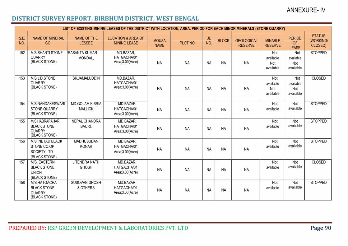
DISTRICT SURVEY REPORT, BIRBHUM DISTRICT, WEST BENGAL
PREPARED BY: RSP GREEN DEVELOPMENT & LABORATORIES PVT. LTD Page 90
ANNEXURE- IV
LIST OF EXISTING MINING LEASES OF THE DISTRICT WITH LOCATION, AREA. PERIOD FOR EACH MINOR MINERALS (STONE QUARRY)
S.L. NO.
NAME OF MINERAL CO.
NAME OF THE LESSEE
LOCATION & AREA OF MINING LEASE
MOUZA NAME
PLOT NO
JL NO.
BLOCK
GEOLOGICAL RESERVE
MINABLE RESERVE
PERIOD
OF LEASE
STATUS (WORKING/ CLOSED)
152 M/S.SHANTI STONE QUARRY (BLACK STONE)
PRASANTA KUMAR
MONDAL,
MD.BAZAR, HATGACHA/01 Area;3.00(Acre) NA NA NA NA NA
Not
available
Not available
Not
available
Not available
STOPPED
153 M/S.J.D.STONE QUARRY (BLACK STONE)
SK.JAMALUDDIN MD.BAZAR, HATGACHA/01 Area;3.00(Acre) NA NA NA NA NA
Not
available
Not available
Not
available
Not available
CLOSED
154 M/S.NANDAKESWARI
STONE QUARRY
(BLACK STONE)
MD.GOLAM KIBRIA
MALLICK
MD.BAZAR,
HATGACHA/01
Area;3.00(Acre) NA NA NA NA NA
Not
available
Not available
STOPPED
155 M/S.HABRAPAHARI
BLACK STONE QUARRY (BLACK STONE)
NEPAL CHANDRA
BAURI,
MD.BAZAR,
HATGACHA/01
Area;3.00(Acre) NA NA NA NA NA
Not
available
Not available
STOPPED
156 M/S. NETAJI BLACK
STONE CO.OP
SOCIETY LTD
(BLACK STONE)
MADHUSUDAN
KONAR
MD.BAZAR,
HATGACHA/01
Area;3.00(Acre) NA NA NA NA NA
Not
available
Not available
STOPPED
157 M/S. EASTERN
BLACK STONE
UNION
(BLACK STONE)
JITENDRA NATH
GHOSH
MD.BAZAR,
HATGACHA/01
Area;3.00(Acre) NA NA NA NA NA
Not
available
Not available
CLOSED
158 M/S.HATGACHA
BLACK STONE
QUARRY (BLACK STONE)
SUSOVAN GHOSH
& OTHERS
MD.BAZAR,
HATGACHA/01 Area;3.00(Acre)
NA NA NA NA NA
Not
available
Not available
STOPPED
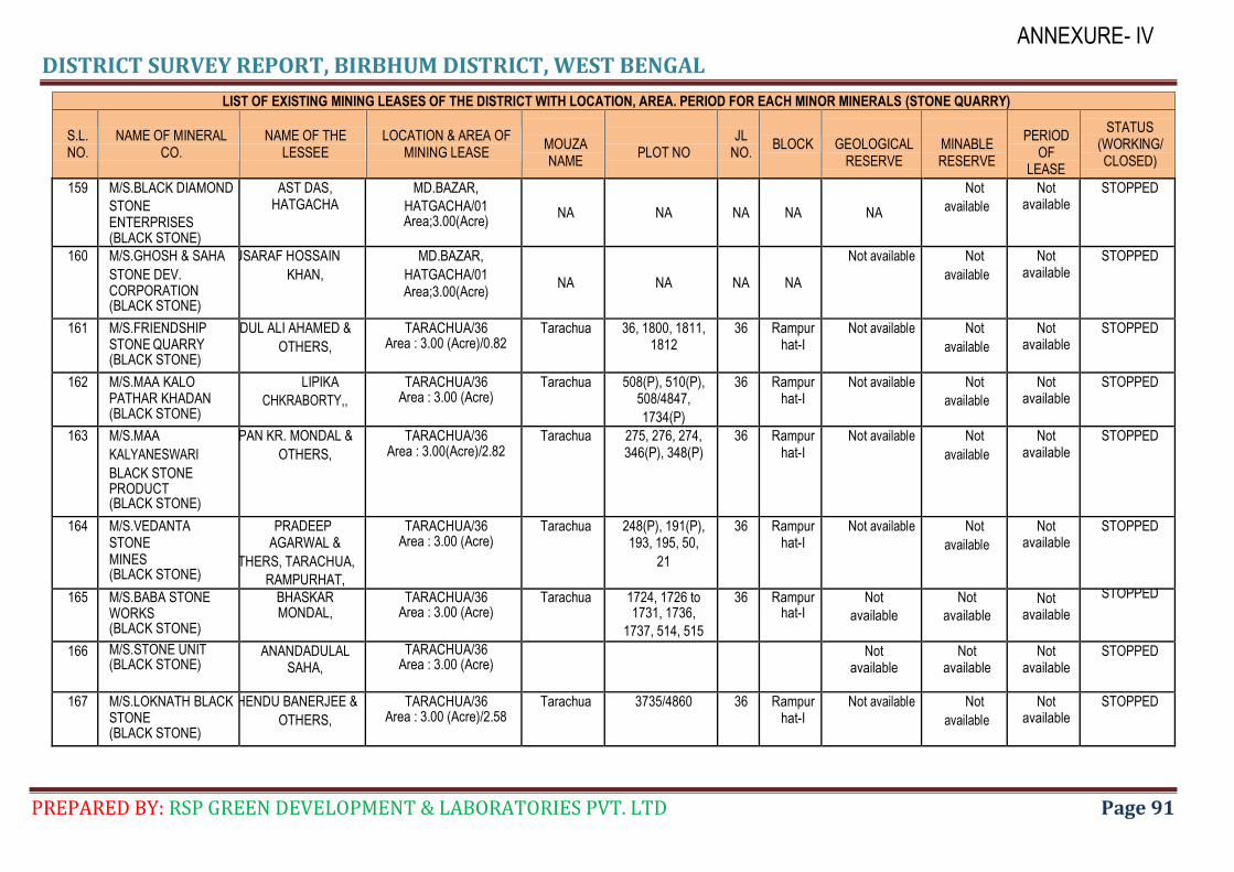
DISTRICT SURVEY REPORT, BIRBHUM DISTRICT, WEST BENGAL
PREPARED BY: RSP GREEN DEVELOPMENT & LABORATORIES PVT. LTD Page 91
ANNEXURE- IV
LIST OF EXISTING MINING LEASES OF THE DISTRICT WITH LOCATION, AREA. PERIOD FOR EACH MINOR MINERALS (STONE QUARRY)
S.L. NO.
NAME OF MINERAL CO.
NAME OF THE LESSEE
LOCATION & AREA OF MINING LEASE
MOUZA NAME
PLOT NO
JL NO.
BLOCK
GEOLOGICAL RESERVE
MINABLE RESERVE
PERIOD
OF LEASE
STATUS (WORKING/ CLOSED)
159 M/S.BLACK DIAMOND
STONE ENTERPRISES (BLACK STONE)
AST DAS, HATGACHA
MD.BAZAR,
HATGACHA/01 Area;3.00(Acre)
NA NA NA NA NA
Not
available
Not available
STOPPED
160 M/S.GHOSH & SAHA
STONE DEV. CORPORATION (BLACK STONE)
MUSARAF HOSSAIN
KHAN,
MD.BAZAR,
HATGACHA/01 Area;3.00(Acre)
NA NA NA NA
Not available Not
available
Not available
STOPPED
161 M/S.FRIENDSHIP STONE QUARRY (BLACK STONE)
ABDUL ALI AHAMED &
OTHERS,
TARACHUA/36 Area : 3.00 (Acre)/0.82
Tarachua 36, 1800, 1811, 1812
36 Rampurhat-I
Not available Not
available
Not available
STOPPED
162 M/S.MAA KALO PATHAR KHADAN (BLACK STONE)
LIPIKA
CHKRABORTY,,
TARACHUA/36 Area : 3.00 (Acre)
Tarachua 508(P), 510(P), 508/4847,
1734(P)
36 Rampurhat-I
Not available Not
available
Not available
STOPPED
163 M/S.MAA
KALYANESWARI
BLACK STONE PRODUCT (BLACK STONE)
TAPAN KR. MONDAL &
OTHERS,
TARACHUA/36 Area : 3.00(Acre)/2.82
Tarachua 275, 276, 274, 346(P), 348(P)
36 Rampurhat-I
Not available Not
available
Not available
STOPPED
164 M/S.VEDANTA STONE MINES (BLACK STONE)
PRADEEP AGARWAL &
OTHERS, TARACHUA,
RAMPURHAT,
TARACHUA/36 Area : 3.00 (Acre)
Tarachua 248(P), 191(P), 193, 195, 50,
21
36 Rampurhat-I
Not available Not
available
Not available
STOPPED
165 M/S.BABA STONE WORKS (BLACK STONE)
BHASKAR MONDAL,
TARACHUA/36 Area : 3.00 (Acre)
Tarachua 1724, 1726 to 1731, 1736,
1737, 514, 515
36 Rampurhat-I
Not
available
Not
available
Not available
STOPPED
166 M/S.STONE UNIT (BLACK STONE)
ANANDADULAL SAHA,
TARACHUA/36 Area : 3.00 (Acre)
Not available
Not available
Not available
STOPPED
167 M/S.LOKNATH BLACK STONE (BLACK STONE)
SUBHENDU BANERJEE &
OTHERS,
TARACHUA/36 Area : 3.00 (Acre)/2.58
Tarachua 3735/4860 36 Rampurhat-I
Not available Not
available
Not available
STOPPED

DISTRICT SURVEY REPORT, BIRBHUM DISTRICT, WEST BENGAL
PREPARED BY: RSP GREEN DEVELOPMENT & LABORATORIES PVT. LTD Page 92
ANNEXURE- IV
LIST OF EXISTING MINING LEASES OF THE DISTRICT WITH LOCATION, AREA. PERIOD FOR EACH MINOR MINERALS (STONE QUARRY)
S.L. NO.
NAME OF MINERAL CO.
NAME OF THE LESSEE
LOCATION & AREA OF MINING LEASE
MOUZA NAME
PLOT NO
JL NO.
BLOCK
GEOLOGICAL RESERVE
MINABLE RESERVE
PERIOD
OF LEASE
STATUS (WORKING/ CLOSED)
168 M/S.MONDAL STONE PRODUCT (BLACK STONE)
DHIMONTA MONDAL,
TARACHUA/36 Area : 3.00 (Acre)
Tarachua 488, 489, 452, 453, 454
36 Rampurhat-I
Not available
Not available
Not available
STOPPED
169 M/S.BHOLA BABA STONE MINES (BLACK STONE)
SANJIT KR. MONDAL &
OTHERS,
TARACHUA/36 Area : 3.00 (Acre)/0.75
Tarachua 1745 36 Rampurhat-I
Not available Not
available
Not available
STOPPED
170 M/S.SALMA BLACK STONE (BLACK STONE)
SK.SHAHNEWAJ &
OTHERS,
TARACHUA/36 Area : 3.00 (Acre)/2.00
Tarachua 3963(P) 36 Rampurhat-I
Not available Not
available
Not available
STOPPED
171 M/S.NEW MAA
KALYANESWARI STONE UNIT (BLACK STONE)
MILAN
CHAKRABORTY &
OTHERS,
TARACHUA/36 Area : 3.00(Acre)
Tarachua 1767, 1779, 1780, 1781
36 Rampurhat-I
Not available Not
available
Not available
STOPPED
172 M/S.DADA BHAI STONE PRODUCT (BLACK STONE)
KRISHENDU
BHATTACHARJEE,
TARACHUA/36 Area : 3.00 (Acre)
Tarachua 874 to 876, 878, 892, 868,
880, 893, 899(P)
36 Rampurhat-I
Not available Not
available
Not available
STOPPED
173 M/S.SHIB SHAKTI STONE PRODUCT (BLACK STONE)
NARATTOM SAHA &
OTHERS,
TARACHUA/36 Area : 3.00 (Acre)/2.96
Tarachua 3895 to 3897, 3900, 3901,
3904
36 Rampurhat-I
Not available Not
available
Not available
STOPPED
174 M/S.JOY MATADI STONE MINES (BLACK STONE)
SHIB PUJAN BHAKAT,
TARACHUA/36 Area : 3.00(Acre)/1.78
Tarachua 3759 36 Rampurhat-I
Not available Not
available
Not available
STOPPED
175 M/S Chawdhury stone co. (BLACK STONE)
NityanandaSaha& others
Tarachua/36 Area : 3.00(Acre)/2.75
Mandala 163, 178(P), 182(P), 184, 192,
193(P), 194, 196(P), 197, 198
16 Rampurhat-I
Not available Not
available
Not available
STOPPED
176 Chakraborty black stone Mines (BLACK STONE)
ShaktipadaChakraborty
TARACHUA/36 Tarachua 532/5032 36 Rampurhat-I
Not available Not
available
Not available
STOPPED
Area : 3.00 (Acre)
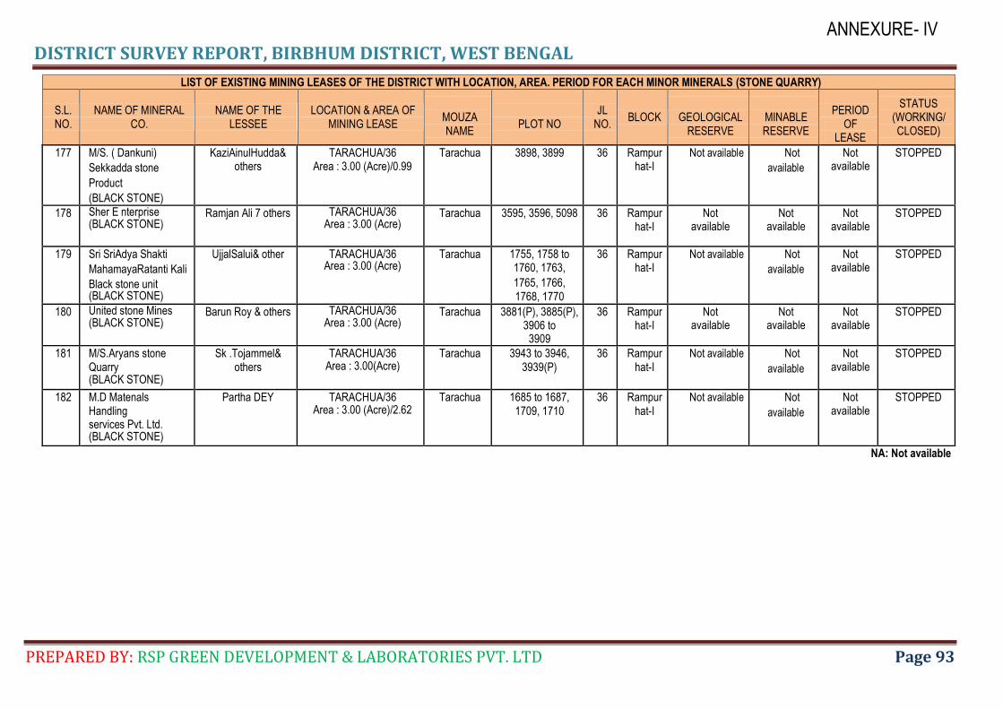
DISTRICT SURVEY REPORT, BIRBHUM DISTRICT, WEST BENGAL
PREPARED BY: RSP GREEN DEVELOPMENT & LABORATORIES PVT. LTD Page 93
ANNEXURE- IV
LIST OF EXISTING MINING LEASES OF THE DISTRICT WITH LOCATION, AREA. PERIOD FOR EACH MINOR MINERALS (STONE QUARRY)
S.L. NO.
NAME OF MINERAL CO.
NAME OF THE LESSEE
LOCATION & AREA OF MINING LEASE
MOUZA NAME
PLOT NO
JL NO.
BLOCK
GEOLOGICAL RESERVE
MINABLE RESERVE
PERIOD
OF LEASE
STATUS (WORKING/ CLOSED)
177 M/S. ( Dankuni)
Sekkadda stone
Product
(BLACK STONE)
KaziAinulHudda& others
TARACHUA/36 Area : 3.00 (Acre)/0.99
Tarachua 3898, 3899 36 Rampurhat-I
Not available Not
available
Not available
STOPPED
178 Sher E nterprise (BLACK STONE)
Ramjan Ali 7 others TARACHUA/36 Area : 3.00 (Acre)
Tarachua 3595, 3596, 5098 36 Rampurhat-I
Not available
Not available
Not available
STOPPED
179 Sri SriAdya Shakti
MahamayaRatanti Kali
Black stone unit (BLACK STONE)
UjjalSalui& other TARACHUA/36 Area : 3.00 (Acre)
Tarachua 1755, 1758 to 1760, 1763,
1765, 1766, 1768, 1770
36 Rampurhat-I
Not available Not
available
Not available
STOPPED
180 United stone Mines (BLACK STONE)
Barun Roy & others TARACHUA/36 Area : 3.00 (Acre)
Tarachua 3881(P), 3885(P), 3906 to
3909
36 Rampurhat-I
Not available
Not available
Not available
STOPPED
181 M/S.Aryans stone Quarry (BLACK STONE)
Sk .Tojammel& others
TARACHUA/36 Area : 3.00(Acre)
Tarachua 3943 to 3946, 3939(P)
36 Rampurhat-I
Not available Not
available
Not available
STOPPED
182 M.D Matenals Handling services Pvt. Ltd. (BLACK STONE)
Partha DEY TARACHUA/36 Area : 3.00 (Acre)/2.62
Tarachua 1685 to 1687, 1709, 1710
36 Rampurhat-I
Not available Not
available
Not available
STOPPED
NA: Not available
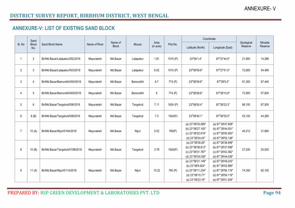
DISTRICT SURVEY REPORT, BIRBHUM DISTRICT, WEST BENGAL
PREPARED BY: RSP GREEN DEVELOPMENT & LABORATORIES PVT. LTD Page 94
ANNEXURE- V
ANNEXURE-V: LIST OF EXISTING SAND BLOCK
Sl. No Sand Block No.
Sand Block Name Name of River Name of
Block Mouza
Area (in acre)
Plot No.
Coordinate
Geological Reserve
Minable Reserve Latitude (North) Longitude (East)
1 2 Bir/Md.Bazar/Latapakur/002/2016 Mayurakshi Md.Bazar Latapakur 1.81 1010 (P) 23⁰59′1.4″ 87⁰27′44.5″ 21,900 14,286
2 3 Bir/Md.Bazar/Latapakur/003/2016 Mayurakshi Md.Bazar Latapakur 6.02 1010 (P) 23⁰58′59.6″ 87⁰27′51.0″ 72,900 54,495
3 4 Bir/Md.Bazar/Bamundihi/004/2016 Mayurakshi Md.Bazar Bamundihi 6.7 774 (P) 23⁰58′59.6″ 87⁰28′5.0″ 81,300 67,440
4 5 Bir/Md.Bazar/Bamundihi/005/2016 Mayurakshi Md.Bazar Bamundihi 6 774 (P) 23⁰58′58.6″ 87⁰28′10.9″ 72,900 57,600
5 6 Bir/Md.Bazar/Tangshuli/006/2016 Mayurakshi Md.Bazar Tangshuli 7.11 1924 (P) 23⁰58′50.4″ 87⁰28′23.3″ 86,100 67,500
6 8 (B) Bir/Md.Bazar/Tangshuli/008/2016 Mayurakshi Md.Bazar Tangshuli 7.3 1924(P) 23⁰58′40.1″ 87⁰28′35.5″ 53,100 44,280
7 10 (A) Bir/Md.Bazar/Nijuri/010A/2018 Mayurakshi Md.Bazar Nijuri 5.52 780(P)
(a) 23°58'30.569" (a) 87°28'47.608"
40,212 31,860 (b) 23°58'27.193" (b) 87°28'44.501"
(c) 23°58'22.819" (c) 87°28'50.563"
(d) 23°58'24.43" (d) 87°28'52.136"
8 10 (B) Bir/Md.Bazar/Tangshuli/010B/2018 Mayurakshi Md.Bazar Tangshuli 3.78 1924(P)
(a) 23°58'38.26" (a) 87°28'38.499"
27,535 20,520 (b) 23°58'36.613" (b) 87°28'37.099"
(c) 23°58'31.787" (c) 87°28'42.382"
(d) 23°58'34.036" (d) 87°28'44.038"
9 11 (A) Bir/Md.Bazar/Nijuri/011A/2018 Mayurakshi Md.Bazar Nijuri 10.22 780 (P)
(a) 23°58'21.149" (a) 87°28'49.243"
74,340 62,100
(b) 23°58'9.924" (b) 87°28'52.985"
(c) 23°58'11.234" (c) 87°28'56.119"
(d) 23°58'15.77" (d) 87°28'56.119"
(e) 23°58'23.16" (e) 87°28'51.254"
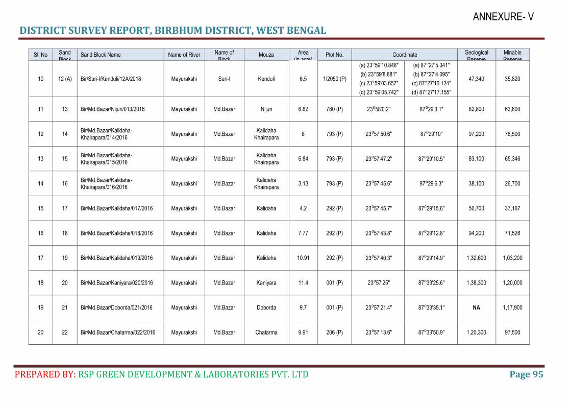
DISTRICT SURVEY REPORT, BIRBHUM DISTRICT, WEST BENGAL
PREPARED BY: RSP GREEN DEVELOPMENT & LABORATORIES PVT. LTD Page 95
ANNEXURE- V
Sl. No Sand Block No.
Sand Block Name Name of River Name of Block
Mouza Area (in acre)
Plot No. Coordinate Geological Reserve
Minable Reserve
10 12 (A) Bir/Suri-I/Kenduli/12A/2018 Mayurakshi Suri-I Kenduli 6.5 1/2050 (P)
(a) 23°59'10.846" (a) 87°27'5.341"
47,340 35,820 (b) 23°59'8.881" (b) 87°27'4.095"
(c) 23°59'03.657" (c) 87°27'16.124"
(d) 23°59'05.742" (d) 87°27'17.155"
11 13 Bir/Md.Bazar/Nijuri/013/2016 Mayurakshi Md.Bazar Nijuri 6.82 780 (P) 23⁰58′0.2″ 87⁰29′3.1″ 82,800 63,600
12 14 Bir/Md.Bazar/Kalidaha-Khairapara/014/2016
Mayurakshi Md.Bazar Kalidaha
Khairapara 8 793 (P) 23⁰57′50.6″ 87⁰29′10″ 97,200 76,500
13 15 Bir/Md.Bazar/Kalidaha-Khairapara/015/2016
Mayurakshi Md.Bazar Kalidaha
Khairapara 6.84 793 (P) 23⁰57′47.2″ 87⁰29′10.5″ 83,100 65,346
14 16 Bir/Md.Bazar/Kalidaha-Khairapara/016/2016
Mayurakshi Md.Bazar Kalidaha
Khairapara 3.13 793 (P) 23⁰57′45.6″ 87⁰29′6.3″ 38,100 26,700
15 17 Bir/Md.Bazar/Kalidaha/017/2016 Mayurakshi Md.Bazar Kalidaha 4.2 292 (P) 23⁰57′45.7″ 87⁰29′15.6″ 50,700 37,167
16 18 Bir/Md.Bazar/Kalidaha/018/2016 Mayurakshi Md.Bazar Kalidaha 7.77 292 (P) 23⁰57′43.8″ 87⁰29′12.8″ 94,200 71,526
17 19 Bir/Md.Bazar/Kalidaha/019/2016 Mayurakshi Md.Bazar Kalidaha 10.91 292 (P) 23⁰57′40.3″ 87⁰29′14.9″ 1,32,600 1,03,200
18 20 Bir/Md.Bazar/Kaniyara/020/2016 Mayurakshi Md.Bazar Kaniyara 11.4 001 (P) 23⁰57′25″ 87⁰33′25.6″ 1,38,300 1,20,000
19 21 Bir/Md.Bazar/Doborda/021/2016 Mayurakshi Md.Bazar Doborda 9.7 001 (P) 23⁰57′21.4″ 87⁰33′35.1″ NA 1,17,900
20 22 Bir/Md.Bazar/Chatarma/022/2016 Mayurakshi Md.Bazar Chatarma 9.91 206 (P) 23⁰57′13.6″ 87⁰33′50.9″ 1,20,300 97,500
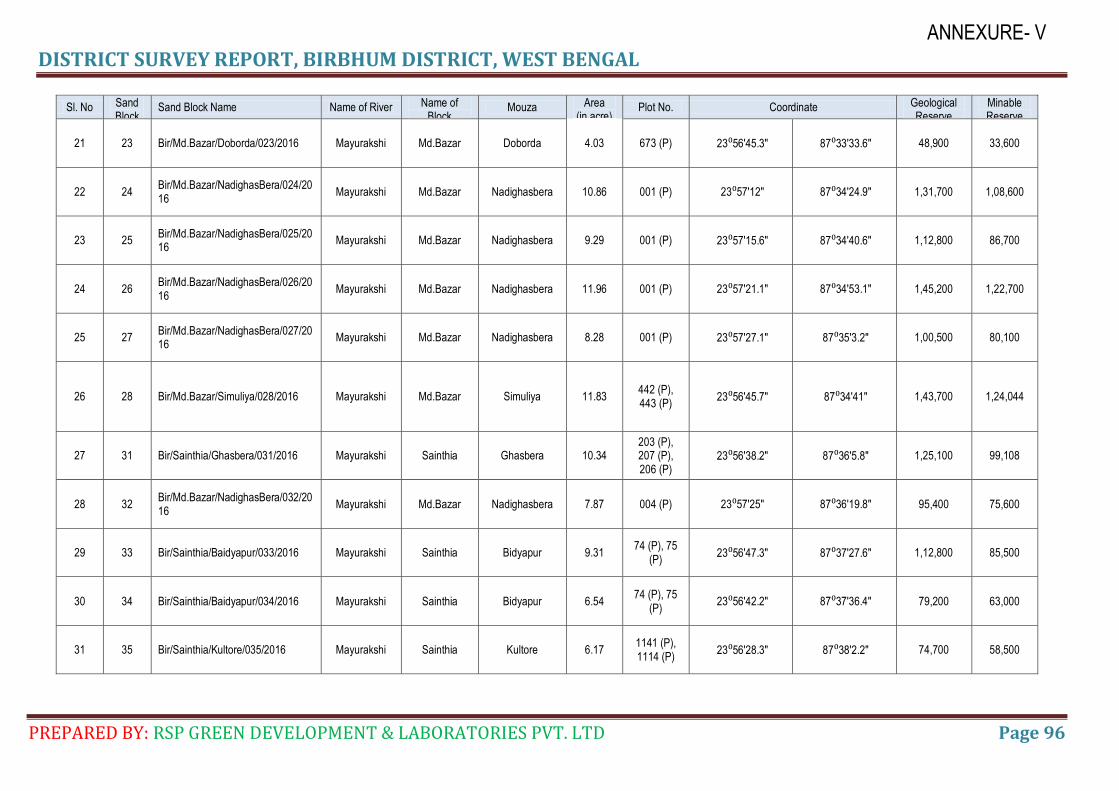
DISTRICT SURVEY REPORT, BIRBHUM DISTRICT, WEST BENGAL
PREPARED BY: RSP GREEN DEVELOPMENT & LABORATORIES PVT. LTD Page 96
ANNEXURE- V
Sl. No Sand Block No.
Sand Block Name Name of River Name of Block
Mouza Area (in acre)
Plot No. Coordinate Geological Reserve
Minable Reserve
21 23 Bir/Md.Bazar/Doborda/023/2016 Mayurakshi Md.Bazar Doborda 4.03 673 (P) 23⁰56′45.3″ 87⁰33′33.6″ 48,900 33,600
22 24 Bir/Md.Bazar/NadighasBera/024/2016
Mayurakshi Md.Bazar Nadighasbera 10.86 001 (P) 23⁰57′12″ 87⁰34′24.9″ 1,31,700 1,08,600
23 25 Bir/Md.Bazar/NadighasBera/025/2016
Mayurakshi Md.Bazar Nadighasbera 9.29 001 (P) 23⁰57′15.6″ 87⁰34′40.6″ 1,12,800 86,700
24 26 Bir/Md.Bazar/NadighasBera/026/2016
Mayurakshi Md.Bazar Nadighasbera 11.96 001 (P) 23⁰57′21.1″ 87⁰34′53.1″ 1,45,200 1,22,700
25 27 Bir/Md.Bazar/NadighasBera/027/2016
Mayurakshi Md.Bazar Nadighasbera 8.28 001 (P) 23⁰57′27.1″ 87⁰35′3.2″ 1,00,500 80,100
26 28 Bir/Md.Bazar/Simuliya/028/2016 Mayurakshi Md.Bazar Simuliya 11.83 442 (P), 443 (P)
23⁰56′45.7″ 87⁰34′41″ 1,43,700 1,24,044
27 31 Bir/Sainthia/Ghasbera/031/2016 Mayurakshi Sainthia Ghasbera 10.34 203 (P), 207 (P), 206 (P)
23⁰56′38.2″ 87⁰36′5.8″ 1,25,100 99,108
28 32 Bir/Md.Bazar/NadighasBera/032/2016
Mayurakshi Md.Bazar Nadighasbera 7.87 004 (P) 23⁰57′25″ 87⁰36′19.8″ 95,400 75,600
29 33 Bir/Sainthia/Baidyapur/033/2016 Mayurakshi Sainthia Bidyapur 9.31 74 (P), 75
(P) 23⁰56′47.3″ 87⁰37′27.6″ 1,12,800 85,500
30 34 Bir/Sainthia/Baidyapur/034/2016 Mayurakshi Sainthia Bidyapur 6.54 74 (P), 75
(P) 23⁰56′42.2″ 87⁰37′36.4″ 79,200 63,000
31 35 Bir/Sainthia/Kultore/035/2016 Mayurakshi Sainthia Kultore 6.17 1141 (P), 1114 (P)
23⁰56′28.3″ 87⁰38′2.2″ 74,700 58,500
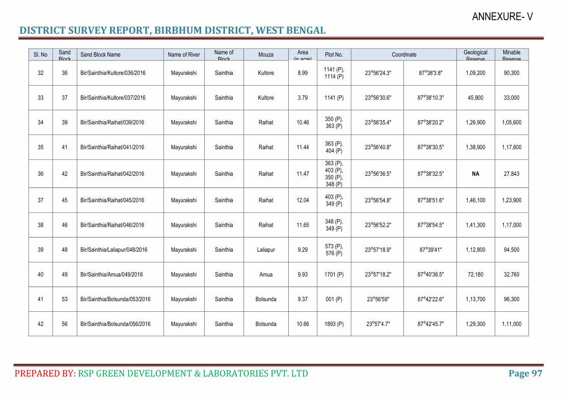
DISTRICT SURVEY REPORT, BIRBHUM DISTRICT, WEST BENGAL
PREPARED BY: RSP GREEN DEVELOPMENT & LABORATORIES PVT. LTD Page 97
ANNEXURE- V
Sl. No Sand Block No.
Sand Block Name Name of River Name of Block
Mouza Area (in acre)
Plot No. Coordinate Geological Reserve
Minable Reserve
32 36 Bir/Sainthia/Kultore/036/2016 Mayurakshi Sainthia Kultore 8.99 1141 (P), 1114 (P)
23⁰56′24.3″ 87⁰38′3.8″ 1,09,200 90,300
33 37 Bir/Sainthia/Kultore/037/2016 Mayurakshi Sainthia Kultore 3.79 1141 (P) 23⁰56′30.6″ 87⁰38′10.3″ 45,900 33,000
34 39 Bir/Sainthia/Raihat/039/2016 Mayurakshi Sainthia Raihat 10.46 350 (P), 363 (P)
23⁰56′35.4″ 87⁰38′20.2″ 1,26,900 1,05,600
35 41 Bir/Sainthia/Raihat/041/2016 Mayurakshi Sainthia Raihat 11.44 363 (P), 404 (P)
23⁰56′40.8″ 87⁰38′30.5″ 1,38,900 1,17,600
36 42 Bir/Sainthia/Raihat/042/2016 Mayurakshi Sainthia Raihat 11.47
363 (P), 403 (P), 350 (P), 348 (P)
23⁰56′36.5″ 87⁰38′32.5″ NA 27,843
37 45 Bir/Sainthia/Raihat/045/2016 Mayurakshi Sainthia Raihat 12.04 403 (P), 349 (P)
23⁰56′54.8″ 87⁰38′51.6″ 1,46,100 1,23,900
38 46 Bir/Sainthia/Raihat/046/2016 Mayurakshi Sainthia Raihat 11.65 348 (P), 349 (P)
23⁰56′52.2″ 87⁰38′54.5″ 1,41,300 1,17,000
39 48 Bir/Sainthia/Laliapur/048/2016 Mayurakshi Sainthia Laliapur 9.29 573 (P), 576 (P)
23⁰57′18.9″ 87⁰39′41″ 1,12,800 94,500
40 49 Bir/Sainthia/Amua/049/2016 Mayurakshi Sainthia Amua 9.93 1701 (P) 23⁰57′18.2″ 87⁰40′36.5″ 72,180 32,760
41 53 Bir/Sainthia/Bolsunda/053/2016 Mayurakshi Sainthia Bolsunda 9.37 001 (P) 23⁰56′59″ 87⁰42′22.6″ 1,13,700 96,300
42 56 Bir/Sainthia/Bolsunda/056/2016 Mayurakshi Sainthia Bolsunda 10.66 1893 (P) 23⁰57′4.7″ 87⁰42′45.7″ 1,29,300 1,11,000
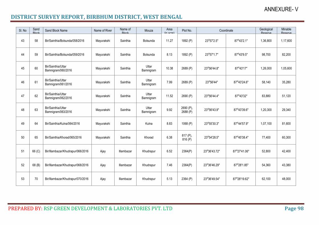
DISTRICT SURVEY REPORT, BIRBHUM DISTRICT, WEST BENGAL
PREPARED BY: RSP GREEN DEVELOPMENT & LABORATORIES PVT. LTD Page 98
ANNEXURE- V
Sl. No Sand Block No.
Sand Block Name Name of River Name of Block
Mouza Area (in acre)
Plot No. Coordinate Geological Reserve
Minable Reserve
43 58 Bir/Sainthia/Bolsunda/058/2016 Mayurakshi Sainthia Bolsunda 11.27 1892 (P) 23⁰57′2.5″ 87⁰43′2.1″ 1,36,800 1,17,600
44 59 Bir/Sainthia/Bolsunda/059/2016 Mayurakshi Sainthia Bolsunda 8.13 1892 (P) 23⁰57′1.7″ 87⁰43′9.5″ 98,700 82,200
45 60 Bir/Sainthia/Uttar Bamnigram/060/2016
Mayurakshi Sainthia Uttar
Bamnigram 10.38 2689 (P) 23⁰56′44.8″ 87⁰43′17″ 1,26,000 1,05,600
46 61 Bir/Sainthia/Uttar Bamnigram/061/2016
Mayurakshi Sainthia Uttar
Bamnigram 7.99 2689 (P) 23⁰56′44″ 87⁰43′24.6″ 58,140 35,280
47 62 Bir/Sainthia/Uttar Bamnigram/062/2016
Mayurakshi Sainthia Uttar
Bamnigram 11.52 2690 (P) 23⁰56′44.4″ 87⁰43′32″ 83,880 51,120
48 63 Bir/Sainthia/Uttar Bamnigram/063/2016
Mayurakshi Sainthia Uttar
Bamnigram 9.92
2690 (P), 2688 (P)
23⁰56′43.9″ 87⁰43′39.6″ 1,20,300 29,340
49 64 Bir/Sainthia/Kulna/064/2016 Mayurakshi Sainthia Kulna 8.83 1068 (P) 23⁰55′30.3″ 87⁰44′57.9″ 1,07,100 81,600
50 65 Bir/Sainthia/Khorad/065/2016 Mayurakshi Sainthia Khorad 6.38 817 (P), 816 (P)
23⁰54′28.5″ 87⁰45′38.4″ 77,400 60,300
51 66 (C) Bir/Illambazar/Khudrapur/066/2016 Ajay Illambazar Khudrapur 6.52 2364(P) 23⁰36′43.72″ 87⁰27′41.06″ 52,800 42,400
52 68 (B) Bir/Illambazar/Khudrapur/068/2016 Ajay Illambazar Khudrapur 7.46 2364(P) 23⁰36′46.29″ 87⁰28′1.85″ 54,360 43,380
53 70 Bir/Illambazar/Khudrapur/070/2016 Ajay Illambazar Khudrapur 5.13 2364 (P) 23⁰36′49.54″ 87⁰28′19.62″ 62,100 48,000
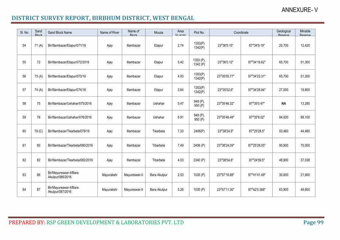
DISTRICT SURVEY REPORT, BIRBHUM DISTRICT, WEST BENGAL
PREPARED BY: RSP GREEN DEVELOPMENT & LABORATORIES PVT. LTD Page 99
ANNEXURE- V
Sl. No Sand Block No.
Sand Block Name Name of River Name of Block
Mouza Area (in acre)
Plot No. Coordinate Geological Reserve
Minable Reserve
54 71 (A) Bir/Illambazar/Etapur/071/16 Ajay Illambazar Etapur 2.74 1353(P) 1342(P)
23⁰36′5.15″ 87⁰34′9.19″ 20,700 12,420
55 72 Bir/Illambazar/Etapur/072/2016 Ajay Illambazar Etapur 5.42 1353 (P), 1342 (P)
23⁰36′0.12″ 87⁰34′16.62″ 65,700 51,300
56 73 (A) Bir/Illambazar/Etapur/073/16 Ajay Illambazar Etapur 4.93 1353(P) 1342(P)
23⁰35′55.77″ 87⁰34′23.31″ 65,700 51,300
57 74 (A) Bir/Illambazar/Etapur/074/16 Ajay Illambazar Etapur 3.64 1353(P) 1342(P)
23⁰35′52.6″ 87⁰34′28.94″ 27,000 19,800
58 75 Bir/Illambazar/Ushahar/075/2016 Ajay Illambazar Ushahar 5.47 949 (P), 950 (P)
23⁰35′46.32″ 87⁰35′0.47″ NA 13,280
59 76 Bir/Illambazar/Ushahar/076/2016 Ajay Illambazar Ushahar 6.91 949 (P), 950 (P)
23⁰35′46.49″ 87⁰35′9.02″ 84,000 68,100
60 79 (C) Bir/Illambazar/Tikarbeta/079/16 Ajay Illambazar Tikarbeta 7.33 2406(P) 23⁰38′24.9″ 87⁰25′28.5″ 53,460 44,460
61 80 Bir/Illambazar/Tikarbeta/080/2016 Ajay Illambazar Tibarbeta 7.49 2406 (P) 23⁰38′24.09″ 87⁰25′28.05″ 90,900 75,000
62 82 Bir/Illambazar/Tikarbeta/082/2016 Ajay Illambazar Tibarbeta 4.03 2340 (P) 23⁰38′54.6″ 87⁰24′59.5″ 48,900 37,038
63 86 Bir/Mayureswar-II/Bara Akulpur/086/2016
Mayurakshi Mayureswar-II Bara Akulpur 2.53 1035 (P) 23⁰57′16.88″ 87⁰41′41.49″ 30,600 21,900
64 87 Bir/Mayureswar-II/Bara Akulpur/087/2016
Mayurakshi Mayureswar-II Bara Akulpur 5.26 1035 (P) 23⁰57′11.30″ 87⁰42′5.368″ 63,900 49,800
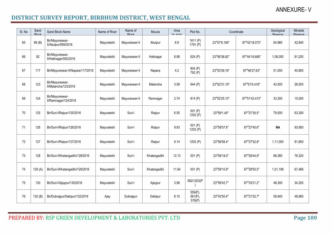
DISTRICT SURVEY REPORT, BIRBHUM DISTRICT, WEST BENGAL
PREPARED BY: RSP GREEN DEVELOPMENT & LABORATORIES PVT. LTD Page 100
ANNEXURE- V
Sl. No Sand Block No.
Sand Block Name Name of River Name of Block
Mouza Area (in acre)
Plot No. Coordinate Geological Reserve
Minable Reserve
65 89 (B) Bir/Mayureswar-II/Akulpur/089/2016
Mayurakshi Mayureswar-II Akulpur 8.9 1811 (P) 1791 (P)
23⁰57′8.106″ 87⁰42′18.073″ 64,980 42,840
66 92 Bir/Mayureswar-II/Hatinagar/092/2016
Mayurakshi Mayureswar-II Hatinagar 8.98 624 (P) 23⁰56′38.82″ 87⁰44′16.685″ 1,08,000 91,200
67 117 Bir/Mayureswar-II/Napara/117/2016 Mayurakshi Mayureswar-II Napara 4.2 804 (P) 792 (P)
23⁰53′39.16″ 87⁰46′27.63″ 51,000 40,800
68 123 Bir/Mayureswar-II/Malancha/123/2016
Mayurakshi Mayureswar-II Malancha 3.58 644 (P) 23⁰52′31.19″ 87⁰51′6.418″ 43,500 28,500
69 124 Bir/Mayureswar-II/Ramnagar/124/2016
Mayurakshi Mayureswar-II Ramnagar 2.74 814 (P) 23⁰52′25.10″ 87⁰51′42.413″ 33,300 15,000
70 125 Bir/Suri-I/Raipur/125/2016 Mayurakshi Suri-I Raipur 6.55 001 (P) 1202 (P)
23⁰59′1.40″ 87⁰27′35.5″ 79,500 63,300
71 126 Bir/Suri-I/Raipur/126/2016 Mayurakshi Suri-I Raipur 9.93 001 (P) 1202 (P)
23⁰58′57.6″ 87⁰27′45.6″ NA 93,900
72 127 Bir/Suri-I/Raipur/127/2016 Mayurakshi Suri-I Raipur 9.14 1202 (P) 23⁰58′56.4″ 87⁰27′52.8″ 1,11,000 91,800
73 128 Bir/Suri-I/Khatangadihi/128/2016 Mayurakshi Suri-I Khatangadihi 12.13 001 (P) 23⁰58′18.0″ 87⁰28′44.9″ 88,380 76,320
74 129 (A) Bir/Suri-I/Khatangadihi/129/2016 Mayurakshi Suri-I Khatangadihi 11.64 001 (P) 23⁰58′10.9″ 87⁰28′50.5″ 1,01,199 67,466
75 130 Bir/Suri-I/Ajaypur/130/2016 Mayurakshi Suri-I Ajaypur 3.98 992/1203(P
) 23⁰56′42.7″ 87⁰33′21.2″ 48,300 34,200
76 132 (B) Bir/Dubrajpur/Debipur/132/2016 Ajay Dubrajpur Debipur 8.15 559(P), 561(P), 576(P)
23⁰42′50.4″ 87⁰21′52.7″ 59,940 48,960
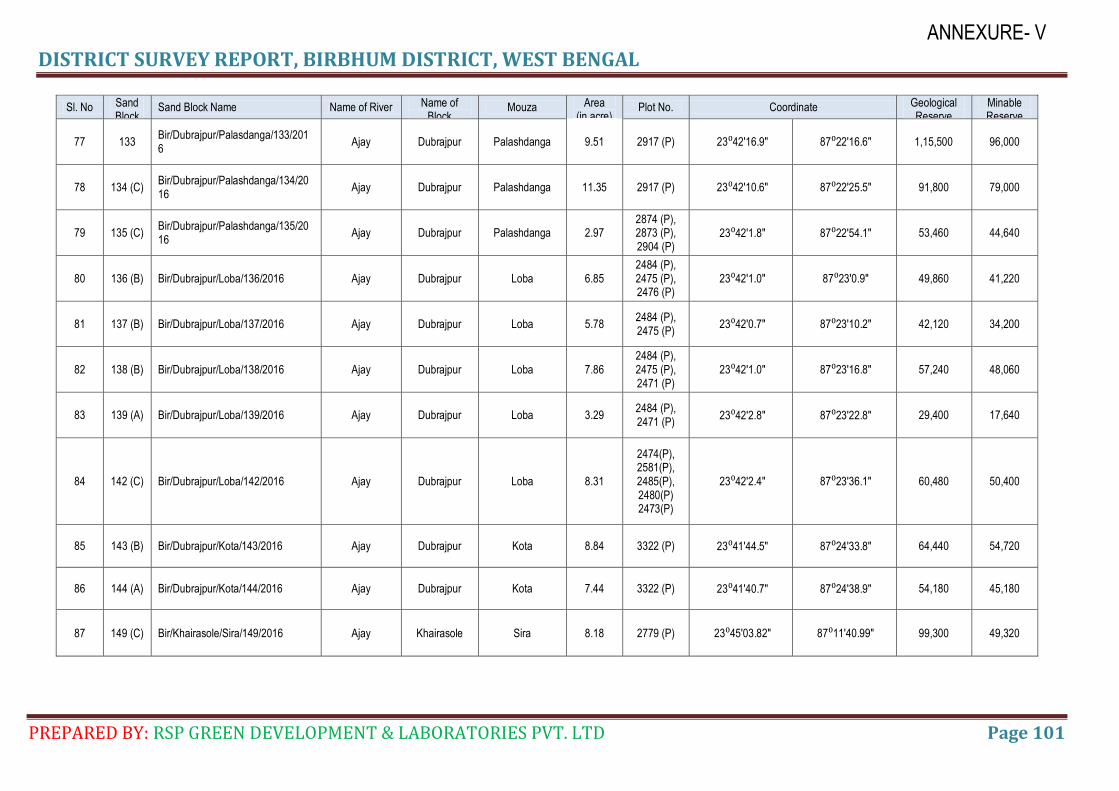
DISTRICT SURVEY REPORT, BIRBHUM DISTRICT, WEST BENGAL
PREPARED BY: RSP GREEN DEVELOPMENT & LABORATORIES PVT. LTD Page 101
ANNEXURE- V
Sl. No Sand Block No.
Sand Block Name Name of River Name of Block
Mouza Area (in acre)
Plot No. Coordinate Geological Reserve
Minable Reserve
77 133 Bir/Dubrajpur/Palasdanga/133/2016
Ajay Dubrajpur Palashdanga 9.51 2917 (P) 23⁰42′16.9″ 87⁰22′16.6″ 1,15,500 96,000
78 134 (C) Bir/Dubrajpur/Palashdanga/134/2016
Ajay Dubrajpur Palashdanga 11.35 2917 (P) 23⁰42′10.6″ 87⁰22′25.5″ 91,800 79,000
79 135 (C) Bir/Dubrajpur/Palashdanga/135/2016
Ajay Dubrajpur Palashdanga 2.97 2874 (P), 2873 (P), 2904 (P)
23⁰42′1.8″ 87⁰22′54.1″ 53,460 44,640
80 136 (B) Bir/Dubrajpur/Loba/136/2016 Ajay Dubrajpur Loba 6.85 2484 (P), 2475 (P), 2476 (P)
23⁰42′1.0″ 87⁰23′0.9″ 49,860 41,220
81 137 (B) Bir/Dubrajpur/Loba/137/2016 Ajay Dubrajpur Loba 5.78 2484 (P), 2475 (P)
23⁰42′0.7″ 87⁰23′10.2″ 42,120 34,200
82 138 (B) Bir/Dubrajpur/Loba/138/2016 Ajay Dubrajpur Loba 7.86 2484 (P), 2475 (P), 2471 (P)
23⁰42′1.0″ 87⁰23′16.8″ 57,240 48,060
83 139 (A) Bir/Dubrajpur/Loba/139/2016 Ajay Dubrajpur Loba 3.29 2484 (P), 2471 (P)
23⁰42′2.8″ 87⁰23′22.8″ 29,400 17,640
84 142 (C) Bir/Dubrajpur/Loba/142/2016 Ajay Dubrajpur Loba 8.31
2474(P), 2581(P), 2485(P), 2480(P) 2473(P)
23⁰42′2.4″ 87⁰23′36.1″ 60,480 50,400
85 143 (B) Bir/Dubrajpur/Kota/143/2016 Ajay Dubrajpur Kota 8.84 3322 (P) 23⁰41′44.5″ 87⁰24′33.8″ 64,440 54,720
86 144 (A) Bir/Dubrajpur/Kota/144/2016 Ajay Dubrajpur Kota 7.44 3322 (P) 23⁰41′40.7″ 87⁰24′38.9″ 54,180 45,180
87 149 (C) Bir/Khairasole/Sira/149/2016 Ajay Khairasole Sira 8.18 2779 (P) 23⁰45′03.82" 87⁰11′40.99″ 99,300 49,320
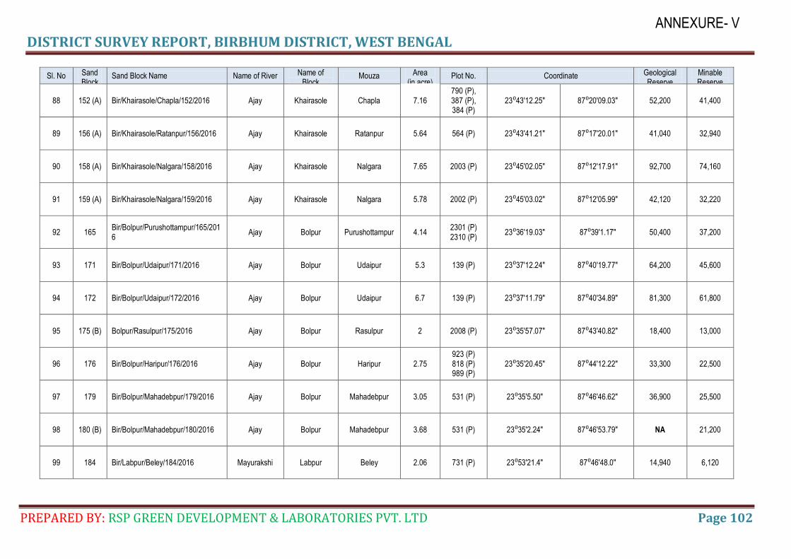
DISTRICT SURVEY REPORT, BIRBHUM DISTRICT, WEST BENGAL
PREPARED BY: RSP GREEN DEVELOPMENT & LABORATORIES PVT. LTD Page 102
ANNEXURE- V
Sl. No Sand Block No.
Sand Block Name Name of River Name of Block
Mouza Area (in acre)
Plot No. Coordinate Geological Reserve
Minable Reserve
88 152 (A) Bir/Khairasole/Chapla/152/2016 Ajay Khairasole Chapla 7.16 790 (P), 387 (P), 384 (P)
23⁰43′12.25″ 87⁰20′09.03″ 52,200 41,400
89 156 (A) Bir/Khairasole/Ratanpur/156/2016 Ajay Khairasole Ratanpur 5.64 564 (P) 23⁰43′41.21″ 87⁰17′20.01″ 41,040 32,940
90 158 (A) Bir/Khairasole/Nalgara/158/2016 Ajay Khairasole Nalgara 7.65 2003 (P) 23⁰45′02.05″ 87⁰12′17.91″ 92,700 74,160
91 159 (A) Bir/Khairasole/Nalgara/159/2016 Ajay Khairasole Nalgara 5.78 2002 (P) 23⁰45′03.02″ 87⁰12′05.99″ 42,120 32,220
92 165 Bir/Bolpur/Purushottampur/165/2016
Ajay Bolpur Purushottampur 4.14 2301 (P) 2310 (P)
23⁰36′19.03″ 87⁰39′1.17″ 50,400 37,200
93 171 Bir/Bolpur/Udaipur/171/2016 Ajay Bolpur Udaipur 5.3 139 (P) 23⁰37′12.24″ 87⁰40′19.77″ 64,200 45,600
94 172 Bir/Bolpur/Udaipur/172/2016 Ajay Bolpur Udaipur 6.7 139 (P) 23⁰37′11.79″ 87⁰40′34.89″ 81,300 61,800
95 175 (B) Bolpur/Rasulpur/175/2016 Ajay Bolpur Rasulpur 2 2008 (P) 23⁰35′57.07″ 87⁰43′40.82″ 18,400 13,000
96 176 Bir/Bolpur/Haripur/176/2016 Ajay Bolpur Haripur 2.75 923 (P) 818 (P) 989 (P)
23⁰35′20.45″ 87⁰44′12.22″ 33,300 22,500
97 179 Bir/Bolpur/Mahadebpur/179/2016 Ajay Bolpur Mahadebpur 3.05 531 (P) 23⁰35′5.50″ 87⁰46′46.62″ 36,900 25,500
98 180 (B) Bir/Bolpur/Mahadebpur/180/2016 Ajay Bolpur Mahadebpur 3.68 531 (P) 23⁰35′2.24″ 87⁰46′53.79″ NA 21,200
99 184 Bir/Labpur/Beley/184/2016 Mayurakshi Labpur Beley 2.06 731 (P) 23⁰53′21.4″ 87⁰46′48.0″ 14,940 6,120
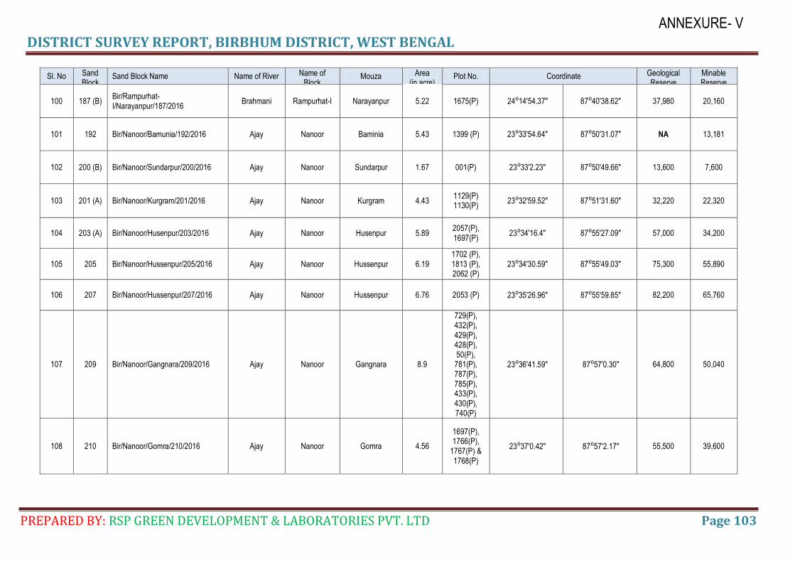
DISTRICT SURVEY REPORT, BIRBHUM DISTRICT, WEST BENGAL
PREPARED BY: RSP GREEN DEVELOPMENT & LABORATORIES PVT. LTD Page 103
ANNEXURE- V
Sl. No Sand Block No.
Sand Block Name Name of River Name of Block
Mouza Area (in acre)
Plot No. Coordinate Geological Reserve
Minable Reserve
100 187 (B) Bir/Rampurhat-I/Narayanpur/187/2016
Brahmani Rampurhat-I Narayanpur 5.22 1675(P) 24⁰14′54.37″ 87⁰40′38.62″ 37,980 20,160
101 192 Bir/Nanoor/Bamunia/192/2016 Ajay Nanoor Baminia 5.43 1399 (P) 23⁰33′54.64″ 87⁰50′31.07″ NA 13,181
102 200 (B) Bir/Nanoor/Sundarpur/200/2016 Ajay Nanoor Sundarpur 1.67 001(P) 23⁰33′2.23″ 87⁰50′49.66″ 13,600 7,600
103 201 (A) Bir/Nanoor/Kurgram/201/2016 Ajay Nanoor Kurgram 4.43 1129(P) 1130(P)
23⁰32′59.52″ 87⁰51′31.60″ 32,220 22,320
104 203 (A) Bir/Nanoor/Husenpur/203/2016 Ajay Nanoor Husenpur 5.89 2057(P), 1697(P)
23⁰34′16.4″ 87⁰55′27.09″ 57,000 34,200
105 205 Bir/Nanoor/Hussenpur/205/2016 Ajay Nanoor Hussenpur 6.19 1702 (P), 1813 (P), 2062 (P)
23⁰34′30.59″ 87⁰55′49.03″ 75,300 55,890
106 207 Bir/Nanoor/Hussenpur/207/2016 Ajay Nanoor Hussenpur 6.76 2053 (P) 23⁰35′26.96″ 87⁰55′59.85″ 82,200 65,760
107 209 Bir/Nanoor/Gangnara/209/2016 Ajay Nanoor Gangnara 8.9
729(P), 432(P), 429(P), 428(P), 50(P), 781(P), 787(P), 785(P), 433(P), 430(P), 740(P)
23⁰36′41.59″ 87⁰57′0.30″ 64,800 50,040
108 210 Bir/Nanoor/Gomra/210/2016 Ajay Nanoor Gomra 4.56
1697(P), 1766(P),
1767(P) & 1768(P)
23⁰37′0.42″ 87⁰57′2.17″ 55,500 39,600
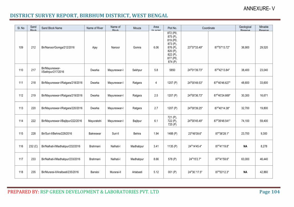
DISTRICT SURVEY REPORT, BIRBHUM DISTRICT, WEST BENGAL
PREPARED BY: RSP GREEN DEVELOPMENT & LABORATORIES PVT. LTD Page 104
ANNEXURE- V
Sl. No Sand Block No.
Sand Block Name Name of River Name of Block
Mouza Area (in acre)
Plot No. Coordinate Geological Reserve
Minable Reserve
109 212 Bir/Nanoor/Gomga/212/2016 Ajay Nanoor Gomra 6.06
872 (P0, 875 (P), 819 (P0, 873 (P), 876 (P), 820 (P), 822 (P), 877 (P0, 874 (P)
23⁰37′33.49″ 87⁰57′13.72″ 36,900 29,520
110 217 Bir/Mayureswar-I/Sekhpur/217/2016
Dwarka Mayureswar-I Sekhpur 5.8 5850 24⁰01′39.73″ 87⁰42′13.84″ 38,400 23,040
111 218 Bir/Mayureswar-I/Ratgara/218/2016 Dwarka Mayureswar-I Ratgara 4 1207 (P) 24⁰00′49.53″ 87⁰40′46.627″ 48,600 33,600
112 219 Bir/Mayureswar-I/Ratgara/219/2016 Dwarka Mayureswar-I Ratgara 2.5 1207 (P) 24⁰00′36.73″ 87⁰40′24.669″ 30,300 16,671
113 220 Bir/Mayureswar-I/Ratgara/220/2016 Dwarka Mayureswar-I Ratgara 2.7 1207 (P) 24⁰00′39.25″ 87⁰40′14.38″ 32,700 19,800
114 222 Bir/Mayureswar-I/Bajitpur/222/2016 Mayurakshi Mayureswar-I Bajitpur 6.1 721 (P), 722 (P), 725 (P)
24⁰00′45.49″ 87⁰39′48.541″ 74,100 59,400
115 228 Bir/Suri-II/Behira/228/2016 Bakreswar Suri-II Behira 1.94 1488 (P) 23⁰49′39.6″ 87⁰36′28.1″ 23,700 9,300
116 232 (C) Bir/Nalhati-I/Madhabpur/232/2016 Brahmani Nalhati-I Madhabpur 3.41 1135 (P) 24⁰14′45.4″ 87⁰41′19.8″ NA 8,278
117 233 Bir/Nalhati-I/Madhabpur/233/2016 Brahmani Nalhati-I Madhabpur 8.66 578 (P) 24⁰15′2.7″ 87⁰41′59.6″ 63,000 46,440
118 235 Bir/Murarai-II/Aralbasti/235/2016 Bansloi Murarai-II Arlabasti 5.12 001 (P) 24⁰30.′17.5″ 87⁰53′12.3″ NA 42,860
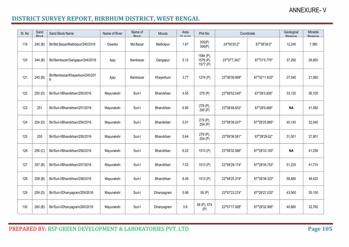
DISTRICT SURVEY REPORT, BIRBHUM DISTRICT, WEST BENGAL
PREPARED BY: RSP GREEN DEVELOPMENT & LABORATORIES PVT. LTD Page 105
ANNEXURE- V
Sl. No Sand Block No.
Sand Block Name Name of River Name of Block
Mouza Area (in acre)
Plot No. Coordinate Geological Reserve
Minable Reserve
119 240 (B) Bir/Md.Bazar/Mallickpur/240/2016 Dwarka Md.Bazar Mallickpur 1.67 305(P) 306(P)
24⁰00′20.2″ 87⁰38′39.5″ 12,240 7,380
120 244 (B) Bir/Illambazar/Gangapur/244/2016 Ajay Illambazar Gangapur 5.12 1584 (P), 1578 (P), 1577 (P)
23⁰37′7.342″ 87⁰31′5.776″ 37,260 28,800
121 245 (B) Bir/Illambazar/Khayerbuni/245/2016
Ajay Illambazar Khayerbuni 3.77 1274 (P) 23⁰36′39.969″ 87⁰32′11.633″ 27,540 21,060
122 250 (D) Bir/Suri-I/Bhandirban/250/2016 Mayurakshi Suri-I Bhandirban 4.55 279 (P) 23⁰58′52.045″ 87⁰28′3.938″ 33,120 26,100
123 251 Bir/Suri-I/Bhandirban/251/2016 Mayurakshi Suri-I Bhandirban 6.95 279 (P), 290 (P)
23⁰58′48.653″ 87⁰28′9.489″ NA 41,580
124 254 (D) Bir/Suri-I/Bhandirban/254/2016 Mayurakshi Suri-I Bhandirban 5.51 279 (P), 254 (P)
23⁰58′39.247″ 87⁰28′25.885″ 40,140 32,040
125 255 Bir/Suri-I/Bhandirban/255/2016 Mayurakshi Suri-I Bhandirban 5.64 279 (P), 254 (P)
23⁰58′36.061″ 87⁰28′29.02″ 31,001 27,901
126 256 (C) Bir/Suri-I/Bhandirban/256/2016 Mayurakshi Suri-I Bhandirban 6.52 1513 (P) 23⁰58′32.566″ 87⁰28′33.183″ NA 41,256
127 257 (B) Bir/Suri-I/Bhandirban/257/2016 Mayurakshi Suri-I Bhandirban 7.02 1513 (P) 23⁰58′29.174″ 87⁰28′35.753″ 51,220 41,774
128 258 (B) Bir/Suri-I/Bhandirban/258/2016 Mayurakshi Suri-I Bhandirban 8.06 1513 (P) 23⁰58′25.319″ 87⁰28′38.323″ 58,680 48,420
129 259 (D) Bir/Suri-I/Dhanyagram/259/2016 Mayurakshi Suri-I Dhanyagram 5.98 58 (P) 23⁰57′23.274″ 87⁰29′27.033″ 43,560 35,100
130 260 (B) Bir/Suri-I/Dhanyagram/260/2016 Mayurakshi Suri-I Dhanyagram 5.6 58 (P), 574
(P) 23⁰57′17.928″ 87⁰29′32.995″ 40,860 32,760
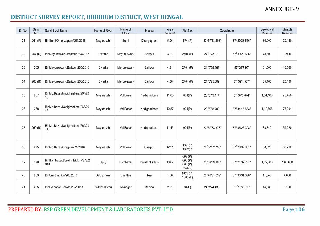
DISTRICT SURVEY REPORT, BIRBHUM DISTRICT, WEST BENGAL
PREPARED BY: RSP GREEN DEVELOPMENT & LABORATORIES PVT. LTD Page 106
ANNEXURE- V
Sl. No Sand Block No.
Sand Block Name Name of River Name of Block
Mouza Area (in acre)
Plot No. Coordinate Geological Reserve
Minable Reserve
131 261 (F) Bir/Suri-I/Dhanyagram/261/2016 Mayurakshi Suri-I Dhanyagram 5.06 574 (P) 23⁰57′13.303″ 87⁰29′38.546″ 36,900 29,160
132 264 (C) Bir/Mayureswar-I/Bajitpur/264/2016 Dwarka Mayureswar-I Bajitpur 3.97 2704 (P) 24⁰0′23.979″ 87⁰39′20.626″ 48,300 9,900
133 265 Bir/Mayureswar-I/Bajitpur/265/2016 Dwarka Mayureswar-I Bajitpur 4.31 2704 (P) 24⁰0′28.369″ 87⁰39′7.95″ 31,500 16,560
134 266 (B) Bir/Mayureswar-I/Bajitpur/266/2016 Dwarka Mayureswar-I Bajitpur 4.88 2704 (P) 24⁰0′25.609″ 87⁰39′1.587″ 35,460 20,160
135 267 Bir/Md.Bazar/Nadighasbera/267/2018
Mayurakshi Md.Bazar Nadighasbera 11.05 001(P) 23⁰57′9.114″ 87⁰34′3.844″ 1,34,100 75,456
136 268 Bir/Md.Bazar/Nadighasbera/268/2018
Mayurakshi Md.Bazar Nadighasbera 10.87 001(P) 23⁰57′8.703″ 87⁰34′15.563″ 1,12,806 75,204
137 269 (B) Bir/Md.Bazar/Nadighasbera/269/2018
Mayurakshi Md.Bazar Nadighasbera 11.45 004(P) 23⁰57′33.373″ 87⁰35′25.308″ 83,340 59,220
138 275 Bir/Md.Bazar/Girajpur/275/2018 Mayurakshi Md.Bazar Girajpur 12.21 1321(P) 1322(P)
23⁰57′22.758″ 87⁰29′32.981″ 88,920 68,760
139 278 Bir/Illambazar/DakshinEkdala/278/2018
Ajay Illambazar DakshinEkdala 10.67
693 (P), 696 (P), 698 (P), 699 (P)
23°39'39.398" 87°24'39.287" 1,29,600 1,03,680
140 283 Bir/Sainthia/Ikra/283/2018 Bakreshwar Sainthia Ikra 1.56 1059 (P), 1085 (P)
23°49'21.292" 87°38'31.628" 11,340 4,860
141 285 Bir/Rajnagar/Rahida/285/2018 Siddheshwari Rajnagar Rahida 2.01 84(P) 24⁰1′24.433″ 87⁰15′29.55″ 14,580 9,180
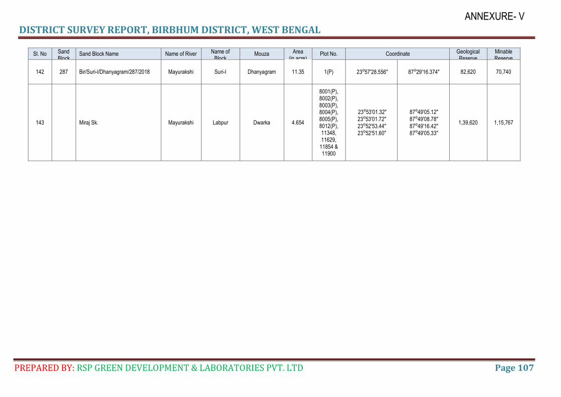
DISTRICT SURVEY REPORT, BIRBHUM DISTRICT, WEST BENGAL
PREPARED BY: RSP GREEN DEVELOPMENT & LABORATORIES PVT. LTD Page 107
ANNEXURE- V
Sl. No Sand Block No.
Sand Block Name Name of River Name of Block
Mouza Area (in acre)
Plot No. Coordinate Geological Reserve
Minable Reserve
142 287 Bir/Suri-I/Dhanyagram/287/2018 Mayurakshi Suri-I Dhanyagram 11.35 1(P) 23⁰57′28.556″ 87⁰29′16.374″ 82,620 70,740
143
Miraj Sk. Mayurakshi Labpur Dwarka 4.654
8001(P), 8002(P), 8003(P), 8004(P), 8005(P), 8012(P), 11348, 11629,
11854 & 11900
23⁰53′01.32″ 23⁰53′01.72″ 23⁰52′53.44″ 23⁰52′51.60″
87⁰49′05.12″ 87⁰49′08.78″ 87⁰49′16.42″ 87⁰49′05.33″
1,39,620 1,15,767
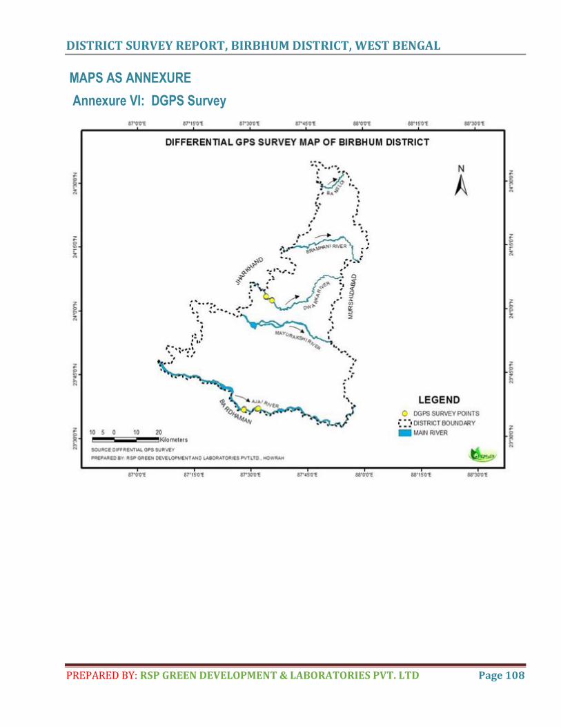
DISTRICT SURVEY REPORT, BIRBHUM DISTRICT, WEST BENGAL
PREPARED BY: RSP GREEN DEVELOPMENT & LABORATORIES PVT. LTD Page 108
MAPS AS ANNEXURE
Annexure VI: DGPS Survey
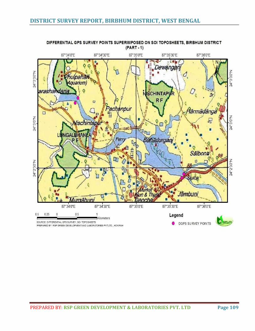
DISTRICT SURVEY REPORT, BIRBHUM DISTRICT, WEST BENGAL
PREPARED BY: RSP GREEN DEVELOPMENT & LABORATORIES PVT. LTD Page 109
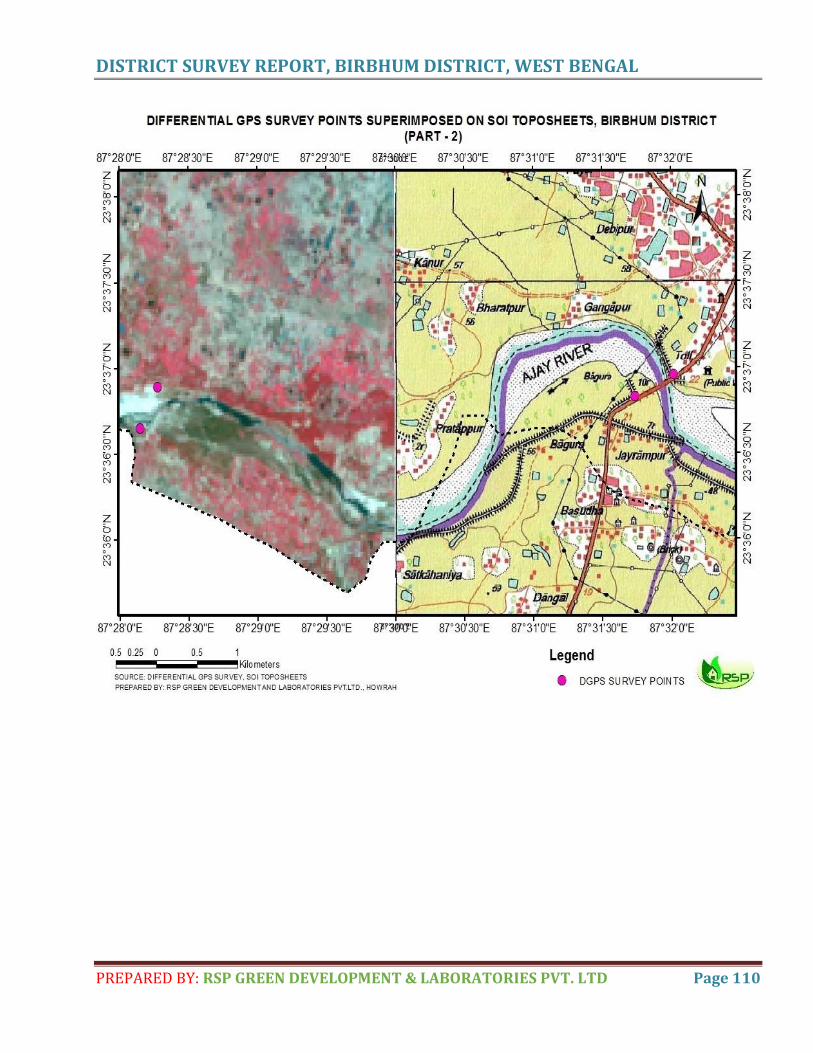
DISTRICT SURVEY REPORT, BIRBHUM DISTRICT, WEST BENGAL
PREPARED BY: RSP GREEN DEVELOPMENT & LABORATORIES PVT. LTD Page 110
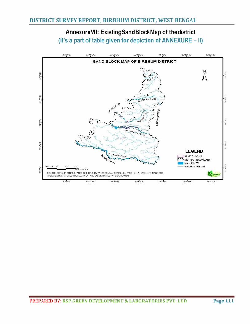
DISTRICT SURVEY REPORT, BIRBHUM DISTRICT, WEST BENGAL
PREPARED BY: RSP GREEN DEVELOPMENT & LABORATORIES PVT. LTD Page 111
Annexure V II : Existing Sand Block Map of the district
(It’s a part of table given for depiction of ANNEXURE – II)
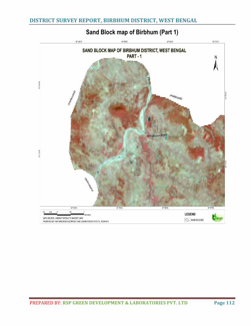
DISTRICT SURVEY REPORT, BIRBHUM DISTRICT, WEST BENGAL
PREPARED BY: RSP GREEN DEVELOPMENT & LABORATORIES PVT. LTD Page 112
Sand Block map of Birbhum (Part 1)
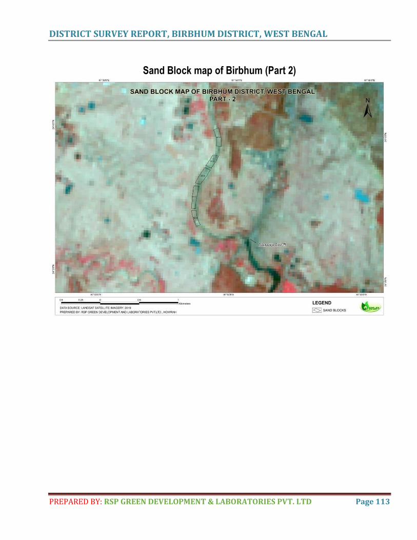
DISTRICT SURVEY REPORT, BIRBHUM DISTRICT, WEST BENGAL
PREPARED BY: RSP GREEN DEVELOPMENT & LABORATORIES PVT. LTD Page 113
Sand Block map of Birbhum (Part 2)
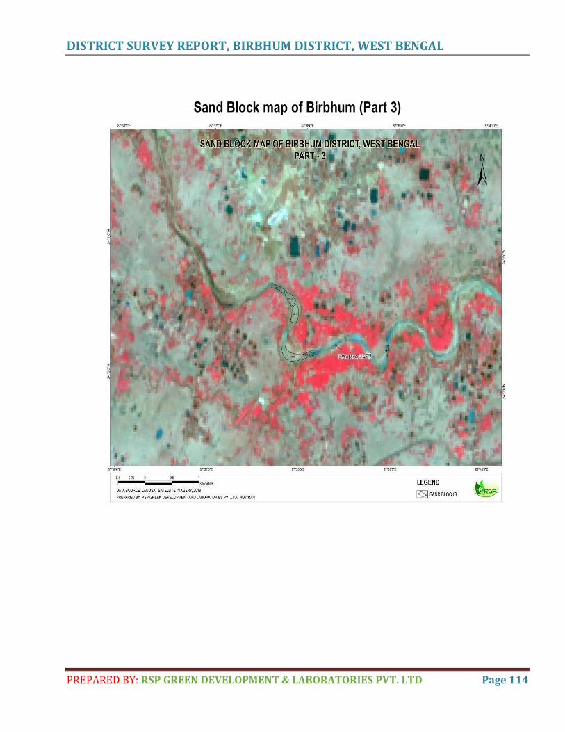
DISTRICT SURVEY REPORT, BIRBHUM DISTRICT, WEST BENGAL
PREPARED BY: RSP GREEN DEVELOPMENT & LABORATORIES PVT. LTD Page 114
Sand Block map of Birbhum (Part 3)
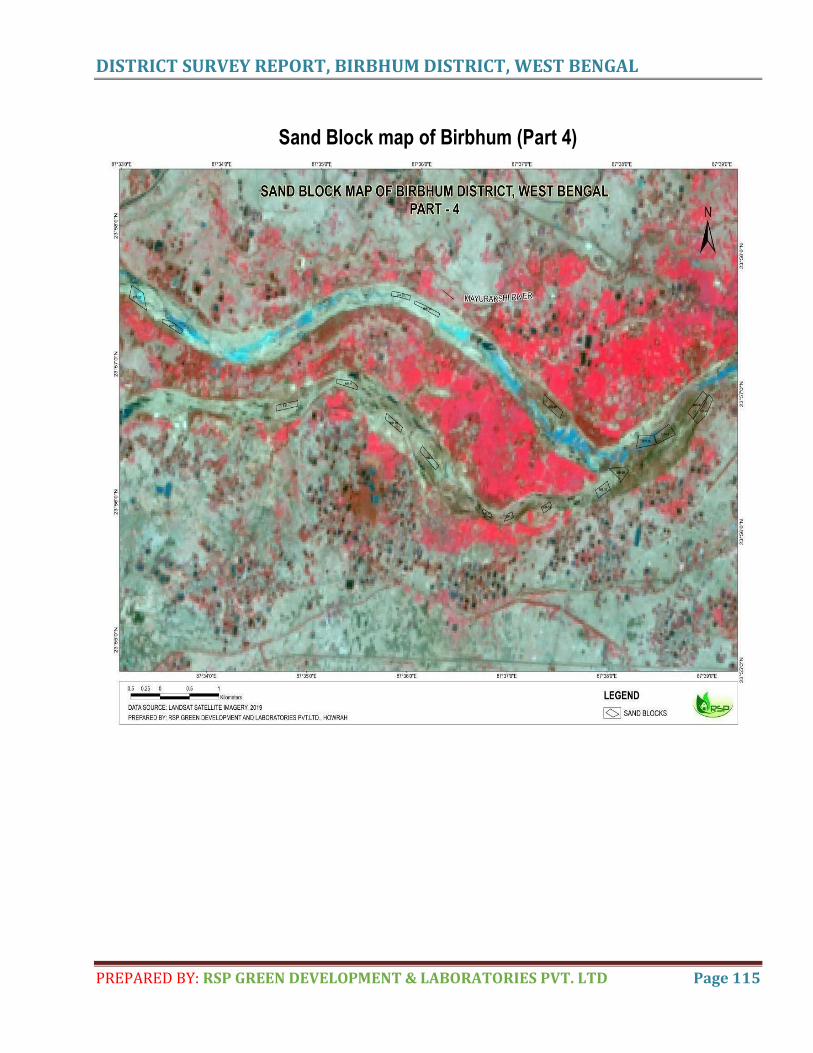
DISTRICT SURVEY REPORT, BIRBHUM DISTRICT, WEST BENGAL
PREPARED BY: RSP GREEN DEVELOPMENT & LABORATORIES PVT. LTD Page 115
Sand Block map of Birbhum (Part 4)
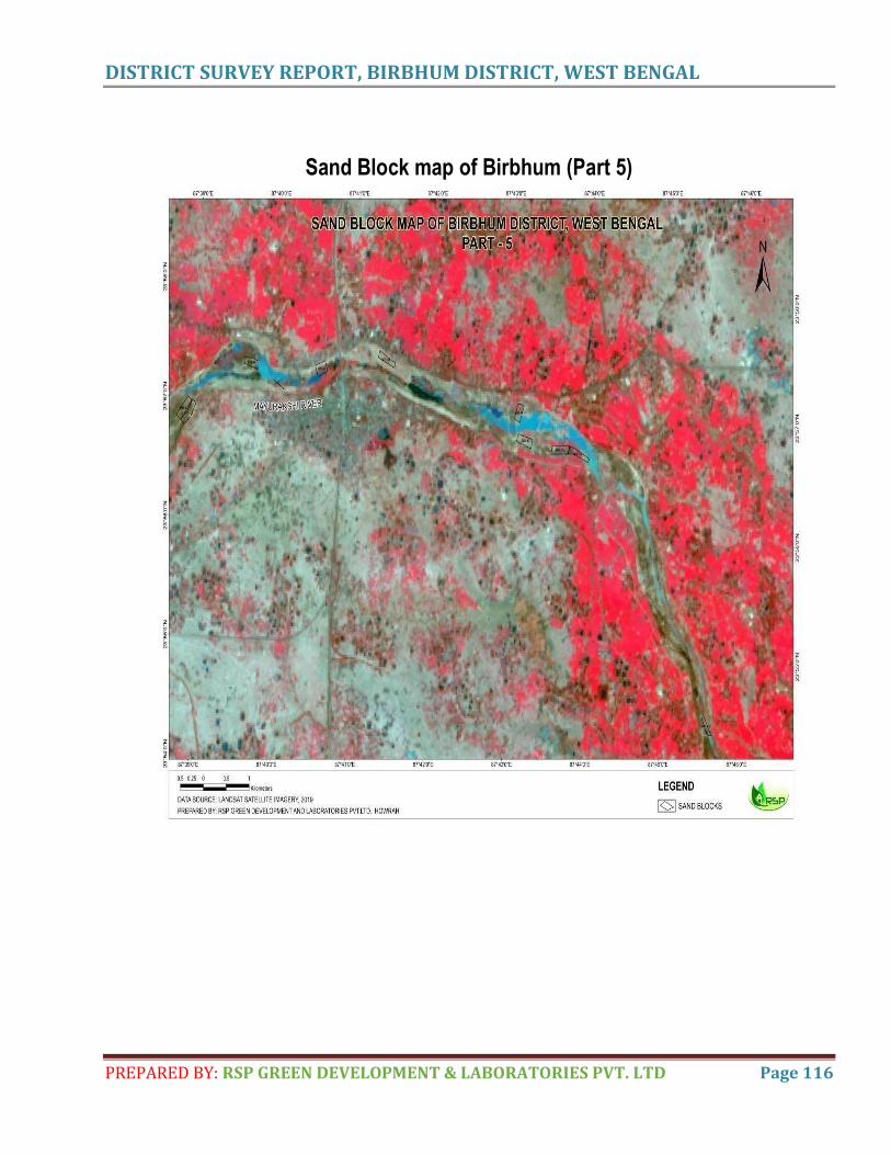
DISTRICT SURVEY REPORT, BIRBHUM DISTRICT, WEST BENGAL
PREPARED BY: RSP GREEN DEVELOPMENT & LABORATORIES PVT. LTD Page 116
Sand Block map of Birbhum (Part 5)
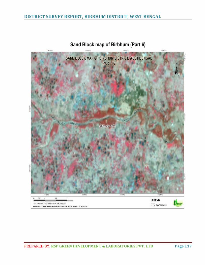
DISTRICT SURVEY REPORT, BIRBHUM DISTRICT, WEST BENGAL
PREPARED BY: RSP GREEN DEVELOPMENT & LABORATORIES PVT. LTD Page 117
Sand Block map of Birbhum (Part 6)
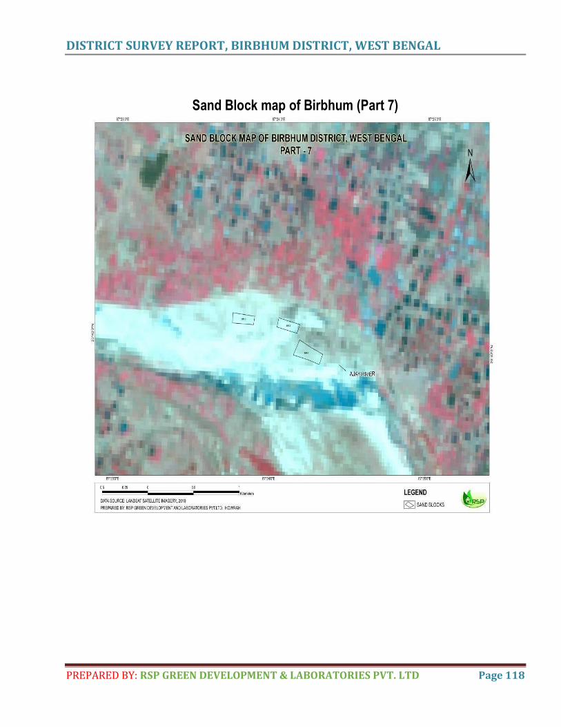
DISTRICT SURVEY REPORT, BIRBHUM DISTRICT, WEST BENGAL
PREPARED BY: RSP GREEN DEVELOPMENT & LABORATORIES PVT. LTD Page 118
Sand Block map of Birbhum (Part 7)
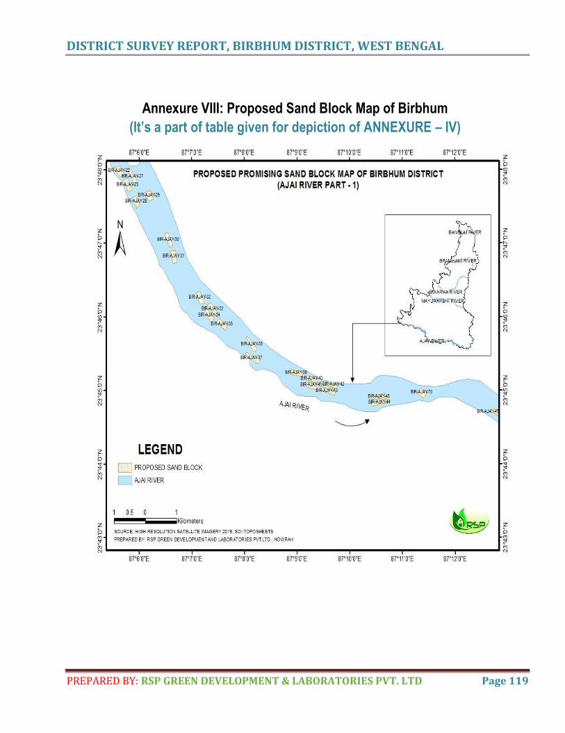
DISTRICT SURVEY REPORT, BIRBHUM DISTRICT, WEST BENGAL
PREPARED BY: RSP GREEN DEVELOPMENT & LABORATORIES PVT. LTD Page 119
Annexure VIII: Proposed Sand Block Map of Birbhum
(It’s a part of table given for depiction of ANNEXURE – IV)
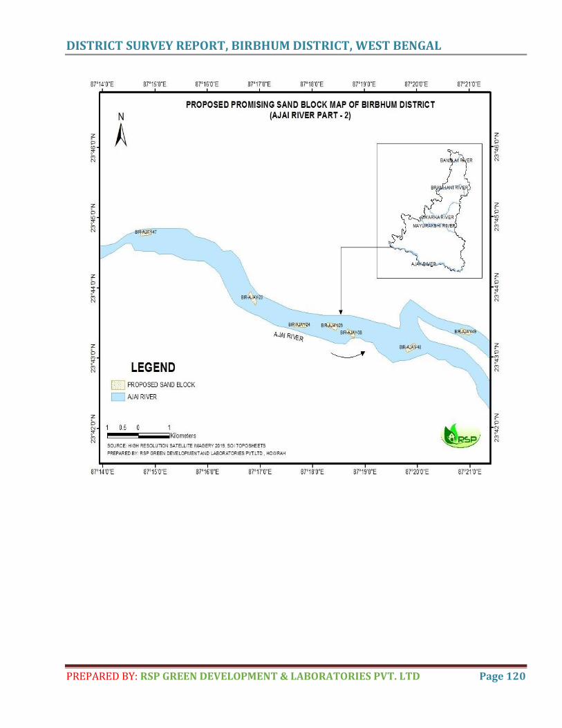
DISTRICT SURVEY REPORT, BIRBHUM DISTRICT, WEST BENGAL
PREPARED BY: RSP GREEN DEVELOPMENT & LABORATORIES PVT. LTD Page 120
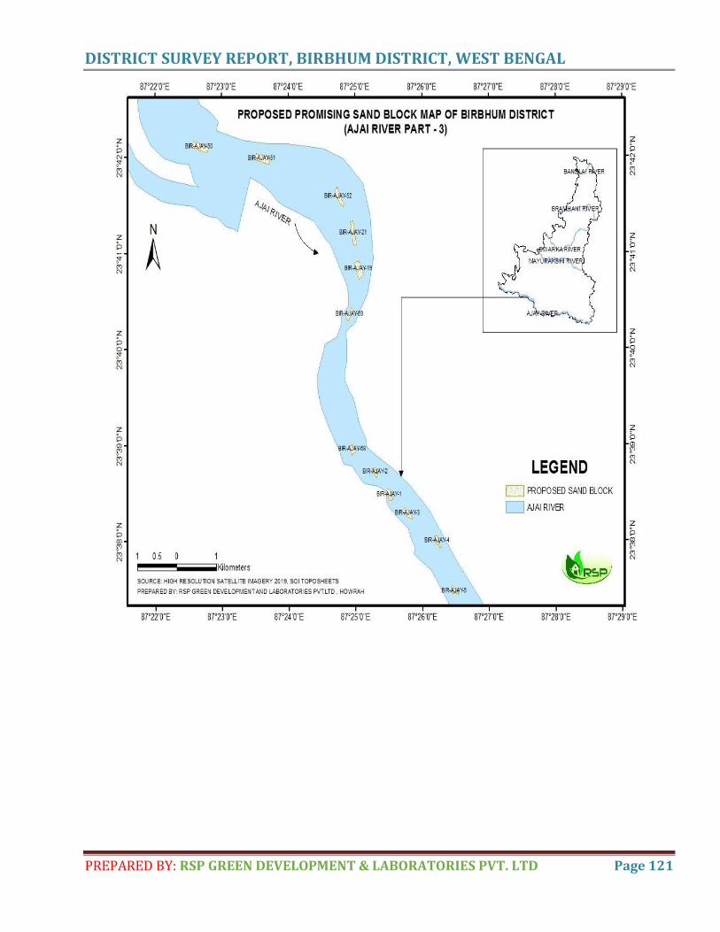
DISTRICT SURVEY REPORT, BIRBHUM DISTRICT, WEST BENGAL
PREPARED BY: RSP GREEN DEVELOPMENT & LABORATORIES PVT. LTD Page 121
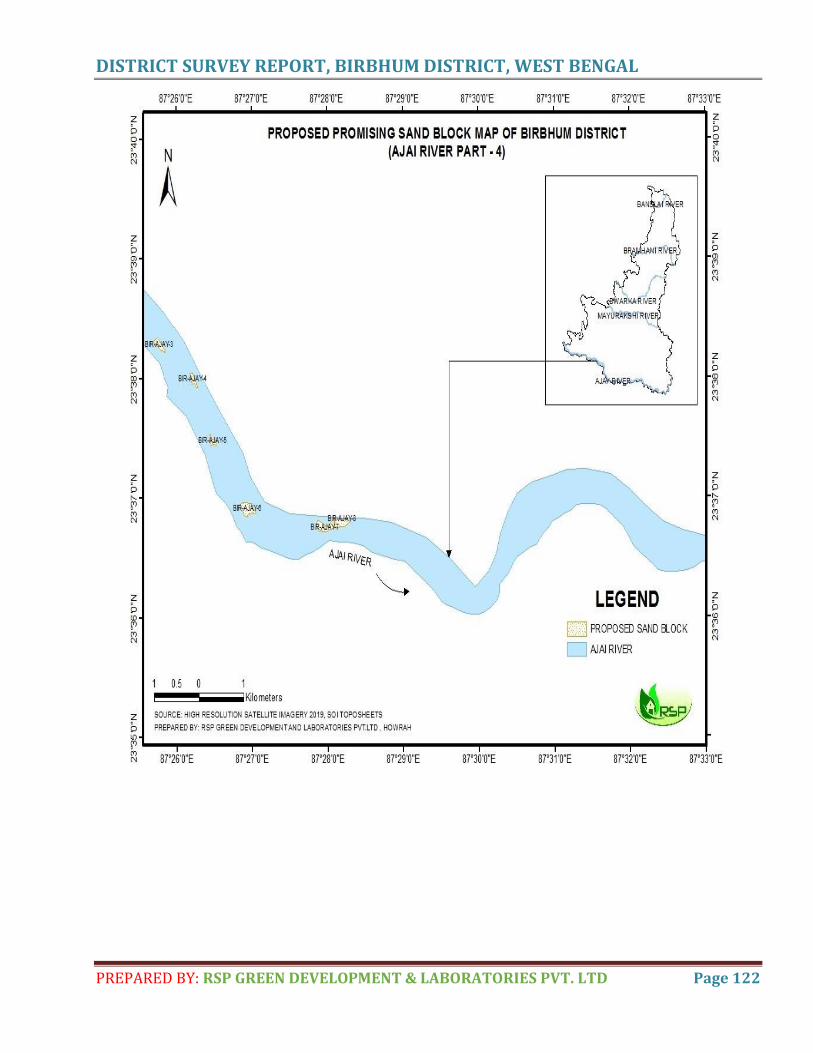
DISTRICT SURVEY REPORT, BIRBHUM DISTRICT, WEST BENGAL
PREPARED BY: RSP GREEN DEVELOPMENT & LABORATORIES PVT. LTD Page 122
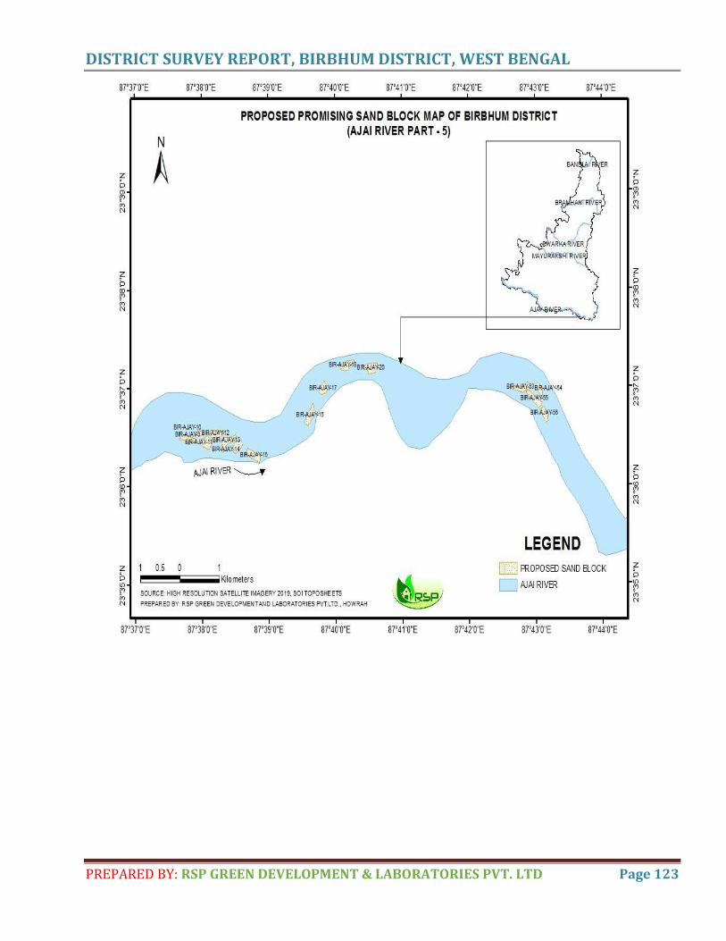
DISTRICT SURVEY REPORT, BIRBHUM DISTRICT, WEST BENGAL
PREPARED BY: RSP GREEN DEVELOPMENT & LABORATORIES PVT. LTD Page 123
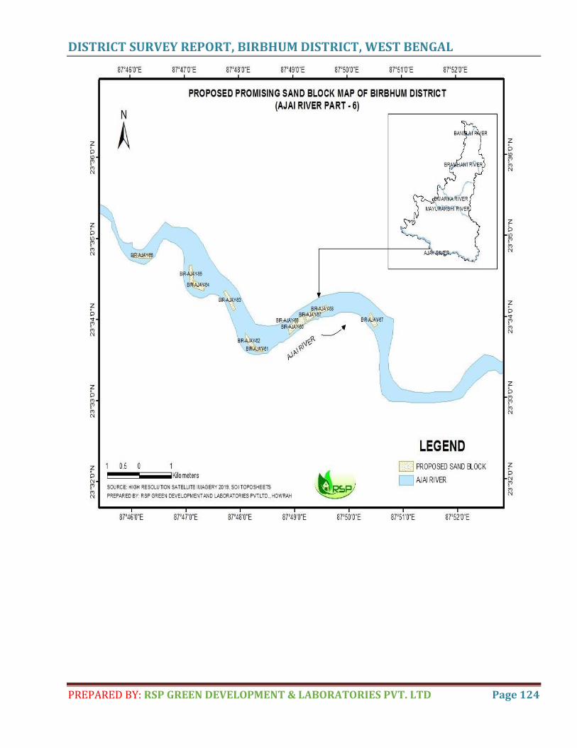
DISTRICT SURVEY REPORT, BIRBHUM DISTRICT, WEST BENGAL
PREPARED BY: RSP GREEN DEVELOPMENT & LABORATORIES PVT. LTD Page 124
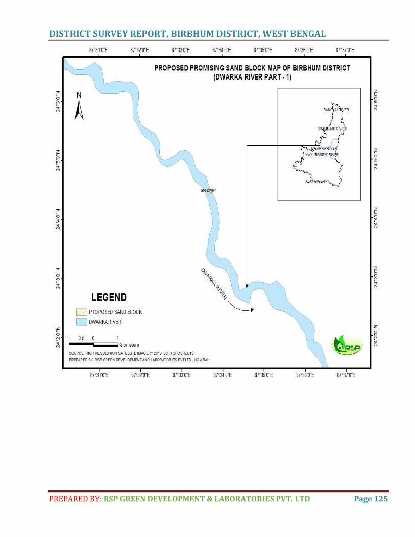
DISTRICT SURVEY REPORT, BIRBHUM DISTRICT, WEST BENGAL
PREPARED BY: RSP GREEN DEVELOPMENT & LABORATORIES PVT. LTD Page 125
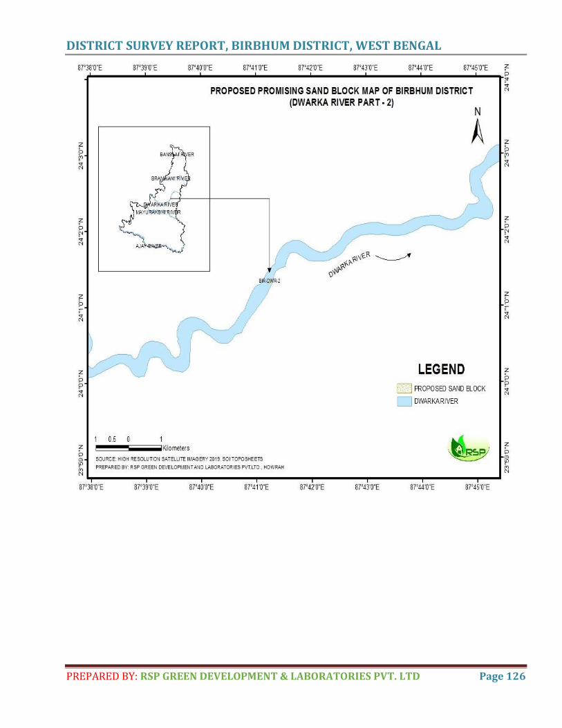
DISTRICT SURVEY REPORT, BIRBHUM DISTRICT, WEST BENGAL
PREPARED BY: RSP GREEN DEVELOPMENT & LABORATORIES PVT. LTD Page 126
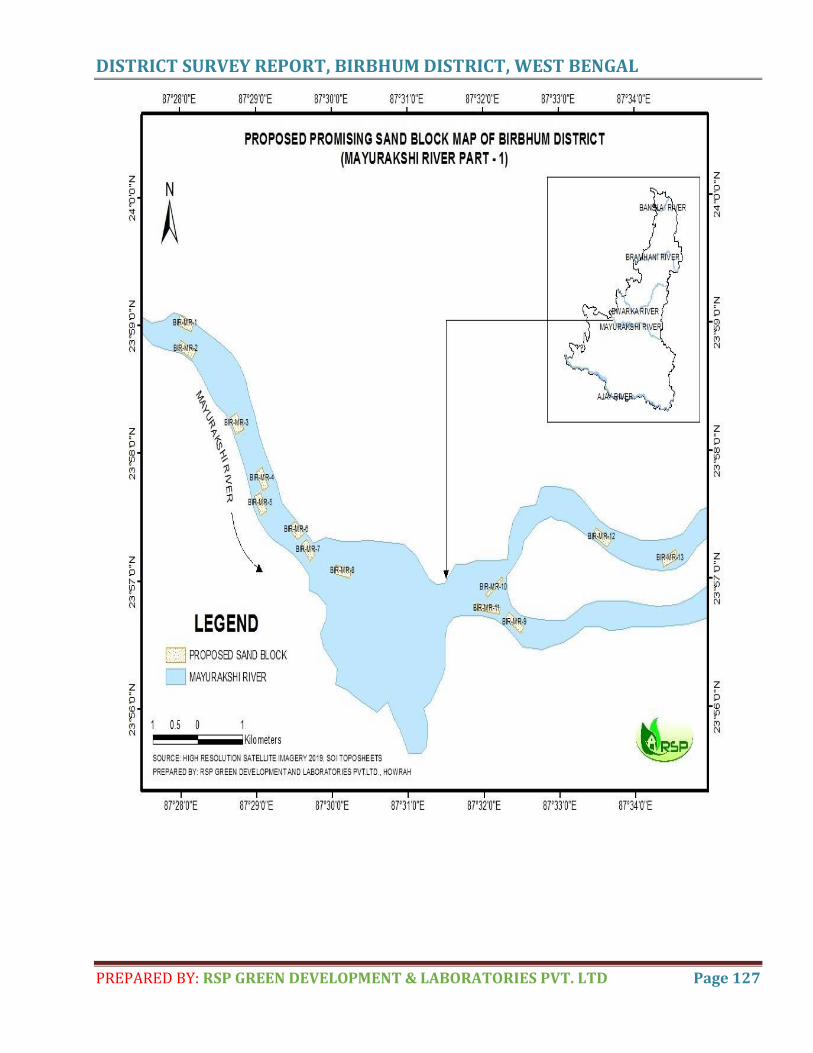
DISTRICT SURVEY REPORT, BIRBHUM DISTRICT, WEST BENGAL
PREPARED BY: RSP GREEN DEVELOPMENT & LABORATORIES PVT. LTD Page 127

Debika
Typewritten Text
ANNEXURE II

Debika
Typewritten Text
Debika
Typewritten Text
Debika
Typewritten Text
ANNEXURE III
Debika
Typewritten Text