Debris flow hazard of glacial lake in Chitral, Pakistan Селевая ...
10
Селевые потоки: катастрофы, риск, прогноз, защита Труды 6-й конференции (Таджикистан) Debris Flows: Disasters, Risk, Forecast, Protection Proceedings of the 6 th conference (Tajikistan) 272 Debris flow hazard of glacial lake in Chitral, Pakistan N. Uddin, M. Anjum, S. Uddin, Z. Uddin Branch of the Aga Khan Agency for Habitat in Pakistan, Islamabad, Pakistan, [email protected] Abstract. Glacial lake outburst floods (GLOF) evolve into debris flows by erosion and sediment entrainment while propagating down a valley, which highly increases peak discharge and volume and causes destructive damage downstream. In Chitral, the most northern district of Pakistan, we have combined field and remote sensing research to study glacial lakes and debris flow initiation zones in periglacial areas. The study of lake dynamics and description of Lake Outburst on downstream settlement is presented. Dir Gol Lake in the north of Arkari valley has been subject to detailed monitoring since 2015. In 2015 the total area of the lake was 127,535m² which has expanded up to 146,539m² area in 2019. Although lake is stable due to the firm support of moraine boulders but due to the adjacent retreating glacier and physical condition of the surrounding area the downstream settlements are endangered by potential debris flow. Based on the analysis of physical and social-economic parameters of the glacier lakes and surrounding area respectively we determined risk index and vulnerability for the downstream settlement. Study shows that most of the glaciers in Hindu Kush region are receding, so the probability of lake development is also increasing in the region. In the future we hope to develop detailed recommendations for risk management, mitigation and adaptation measures of glacier and debris flow hazards in Chitral area. Key words: debris flow, lake, GLOF, anticipated debris flow, hazard, outburst Cite this article: Uddin N., Anjum M., Uddin S., Uddin Z. Debris flow hazard of glacial lake in Chitral, Pakistan. In: Chernomorets S.S., Viskhadzhieva K.S. (eds.) Debris Flows: Disasters, Risk, Forecast, Protection. Proceedings of the 6th International Conference (Dushanbe–Khorog, Tajikistan). Volume 1. Dushanbe: “Promotion” LLC, 2020, p. 272–281. Селевая опасность ледникового озера в Читрале, Пакистан Н. Уддин, M. Анджум, С. Уддин, З. Уддин Филиал Агентства Ага Хана по Хабитат в Пакистане, Исламабад, Пакистан, [email protected] Аннотация. Паводки, формирующиеся в результате прорыва ледниковых озер, ниже по долине трансформируются в селевые потоки в результате эрозии и вовлечения твердой составляющей, что значительно увеличивает их пиковые расходы и объем и наносит разрушительный ущерб в низовьях реки. В Читрале, самом северном округе Пакистана, мы объединили полевые и дистанционные исследования для изучения ледниковых озер и зон зарождения селевых потоков в перигляциальных районах. В статье представлено изучение динамики озер и описание последствий прорыва озера для населенного пункта ниже по течению. Озеро Дир Гол, расположенное на севере долины Аркари, стало объектом детального мониторинга с 2015 г. В 2015 г. общая площадь озера составила 127 535 м 2 , а в 2019 г. она увеличилась до 146 539 м 2 . Несмотря на то, что озеро стабильно благодаря тому, что подпружено крупнообломочными моренными отложениями, наличие выше отступающего ледника и физическое состояние окружающей территории объясняют высокий уровень потенциальной селевой опасности для населенных пунктов, расположенных ниже по течению. На основании анализа физических и социально-экономических параметров ледниковых озер и прилегающей территории мы определили индекс риска и уязвимости населенных пунктов ниже по течению. Исследования показывают, что большая часть ледников
-
Upload
khangminh22 -
Category
Documents
-
view
6 -
download
0
Transcript of Debris flow hazard of glacial lake in Chitral, Pakistan Селевая ...

Селевые потоки: катастрофы, риск, прогноз, защита Труды 6-й конференции (Таджикистан)
Debris Flows: Disasters, Risk, Forecast, Protection Proceedings of the 6th conference (Tajikistan)
272
Debris flow hazard of glacial lake in Chitral, Pakistan
N. Uddin, M. Anjum, S. Uddin, Z. Uddin
Branch of the Aga Khan Agency for Habitat in Pakistan, Islamabad, Pakistan,
Abstract. Glacial lake outburst floods (GLOF) evolve into debris flows by erosion and
sediment entrainment while propagating down a valley, which highly increases peak
discharge and volume and causes destructive damage downstream. In Chitral, the most
northern district of Pakistan, we have combined field and remote sensing research to study
glacial lakes and debris flow initiation zones in periglacial areas. The study of lake
dynamics and description of Lake Outburst on downstream settlement is presented. Dir
Gol Lake in the north of Arkari valley has been subject to detailed monitoring since 2015.
In 2015 the total area of the lake was 127,535m² which has expanded up to 146,539m² area
in 2019. Although lake is stable due to the firm support of moraine boulders but due to the
adjacent retreating glacier and physical condition of the surrounding area the downstream
settlements are endangered by potential debris flow. Based on the analysis of physical and
social-economic parameters of the glacier lakes and surrounding area respectively we
determined risk index and vulnerability for the downstream settlement. Study shows that
most of the glaciers in Hindu Kush region are receding, so the probability of lake
development is also increasing in the region. In the future we hope to develop detailed
recommendations for risk management, mitigation and adaptation measures of glacier and
debris flow hazards in Chitral area.
Key words: debris flow, lake, GLOF, anticipated debris flow, hazard, outburst
Cite this article: Uddin N., Anjum M., Uddin S., Uddin Z. Debris flow hazard of glacial lake in Chitral, Pakistan.
In: Chernomorets S.S., Viskhadzhieva K.S. (eds.) Debris Flows: Disasters, Risk, Forecast, Protection. Proceedings
of the 6th International Conference (Dushanbe–Khorog, Tajikistan). Volume 1. Dushanbe: “Promotion” LLC, 2020,
p. 272–281.
Селевая опасность ледникового озера в Читрале, Пакистан
Н. Уддин, M. Анджум, С. Уддин, З. Уддин
Филиал Агентства Ага Хана по Хабитат в Пакистане, Исламабад, Пакистан,
Аннотация. Паводки, формирующиеся в результате прорыва ледниковых озер,
ниже по долине трансформируются в селевые потоки в результате эрозии и
вовлечения твердой составляющей, что значительно увеличивает их пиковые
расходы и объем и наносит разрушительный ущерб в низовьях реки. В Читрале,
самом северном округе Пакистана, мы объединили полевые и дистанционные
исследования для изучения ледниковых озер и зон зарождения селевых потоков в
перигляциальных районах. В статье представлено изучение динамики озер и
описание последствий прорыва озера для населенного пункта ниже по течению.
Озеро Дир Гол, расположенное на севере долины Аркари, стало объектом
детального мониторинга с 2015 г. В 2015 г. общая площадь озера составила 127 535
м2, а в 2019 г. она увеличилась до 146 539 м2. Несмотря на то, что озеро стабильно
благодаря тому, что подпружено крупнообломочными моренными отложениями,
наличие выше отступающего ледника и физическое состояние окружающей
территории объясняют высокий уровень потенциальной селевой опасности для
населенных пунктов, расположенных ниже по течению. На основании анализа
физических и социально-экономических параметров ледниковых озер и
прилегающей территории мы определили индекс риска и уязвимости населенных
пунктов ниже по течению. Исследования показывают, что большая часть ледников

Debris Flows: Disasters, Risk, Forecast, Protection. Proceedings of the 6th conference (Tajikistan)
Селевые потоки: катастрофы, риск, прогноз, защита. Труды 6-й конференции (Таджикистан)
273
в горах Гиндукуша отступает, поэтому вероятность формирования озер в этом
районе также возрастает. В будущем мы надеемся разработать подробные
рекомендации по управлению рисками, смягчению последствий и мерам адаптации
к опасностям, связанным с ледниками и селевыми потоками в округе Читрал.
Ключевые слова: селевой поток, озеро, прорыв ледникового озера, прогнозируемый
селевой поток, опасность, прорыв
Ссылка для цитирования: Уддин Н., Анджум M., Уддин С., Уддин З. Селевая опасность ледникового озера
в Читрале, Пакистан. В сб.: Селевые потоки: катастрофы, риск, прогноз, защита. Труды 6-й Международной
конференции (Душанбе–Хорог, Таджикистан). Том 1. – Отв. ред. С.С. Черноморец, К.С. Висхаджиева. –
Душанбе: ООО «Промоушн», 2020, с. 272–281.
Introduction
Glaciers in high mountain regions benefit human civilization by serving as sources of
drinking water, irrigation, and energy generation, but they also pose occasional hazards such as
glacial lake outburst floods (GLOFs) and ice avalanches, causing human casualties and
economic losses in downstream areas. Debris flows associated with glacier are common
mountain hazard, and are driven by climate and weather conditions as well as by glacier
dynamics and geological features. In recent decades Hindu Kush-Himalaya (HKH) glaciers
have been shrinking and thinning [Kaser et al., 2006; Zemp et al., 2009; Fujita et al., 2011;
Kargel et al., 2011; Scherler et al., 2011] resulting glacier to retreat. After the termini retreat
the vacant area in between the moraine and retreating glacier snout is taken over by proglacial
lakes. Such glacier phenomenon and lake formation is currently observed in the majority of
glaciated mountain regions of the world including the Himalayas and Karakoram. These glacial
lakes often dammed by ice-cored moraines are main sources of devastating outburst floods.
These outburst events often transform into more destructive debris flows when the flow path is
steep, flow velocity is high and erodible material is available [Clague et al., 1985; Clague et
al., 1992; Huggel et al. 2004; Kaab et al. 2005; Chiarle et al. 2007], threatening downstream
settlements and infrastructure. In comparison with other glacier hazards, GLOFs are
widespread and impact several kilometers downstream from the source. Such sudden outburst
may lead to widespread damage and result in fatalities. Pakistan has witnessed several GLOF
events in the past. A series of studies carried out between 2002 and 2005 in Pakistan identified
a total of 5,218 glaciers with an area of 15,041 sq.km, and 2,420 glacial lakes out of which 52
were considered potentially dangerous [Roohi et al., 2005]. Gilgit‐Baltistan region is said to
have witnessed more than 35 GLOF events in the past 200 years [Watkins, 2007]. In recent past
too, we have witnessed GLOF events. Two GLOF events, one in Brep village in Upper Chitral
in 2005 and other in the village of Sonoghur in 2007 displaced 100 families and damaged
valuable cultivable land and infrastructures [Haq, 2007].
Surrounded by some of the tallest and highly glaciated mountains, the Chitral District of
northern Pakistan lies in the eastern Hindu Kush Range (Fig. 1). The district has an area of
15,000 km2 and spans within an elevation range from 1000 m to 7700 m above sea level. A
common geomorphic feature of the Chitral region is valley facing slopes associated with high-
relief Mountains, which merge into broad, relatively flat floodplains. The region is prone to
occasional heavy precipitation, snow avalanches and glacial-lake outbursts that cause flooding
of the fans, damaging life, property and crops. At least a dozen human casualties are associated
with snow avalanches, floods and debris flows in the eastern Hindu Kush every year [Haq,
2007]. Roohi et al. [2005] reported 187 glacial lakes in the Chitral basin covering an area of
9 km2 [cf. Ives et al., 2010].
The paper presents the debris flow hazard case study from a Dir Gole lake in the Arkari
valley. The lake located at latitude 36°10'54.38"N °and longitude 71°47'57.46"E is at an
elevation of 4613 m with north-south orientation. It is a moraine dammed lake. The nearest
settlement is Safaid Arkari and is situated at a distance of 13 km downstream at 2575 m asl

Debris Flows: Disasters, Risk, Forecast, Protection. Proceedings of the 6th conference (Tajikistan)
Селевые потоки: катастрофы, риск, прогноз, защита. Труды 6-й конференции (Таджикистан)
274
altitude. The geology of the area is composed of Meta sediments which are intruded by
granodiorites such as the Tirich Mir Pluton [Calkins et al., 1981]. The climate there is temperate
type with warm summer and very cold winter. Mean summer temperature ranges from 22°C to
24 °C while winter temperature ranges from -4°C to -6°C.
Fig. 8. Location map of the study area
Specific aims of our study are as follows: i) to prepare a comprehensive assessment of
GLOF hazard, risk and vulnerability ii) to determine the fluctuation in glacial lake area, volume
and iii) to describe the impact of lake burst on the downstream settlement.
Brief Review of the Problem
Geo hazards in the Karakoram have been subject of a few studies in the past [e.g.,
Derbyshire and Owen, 1990; Derbyshire et al., 2001], but the adjacent eastern Hindu Kush
remained unexplored due to inaccessibility [Khan et al., 2012].
In spite of presence of several glacial lakes in Chitral, assessment of glacial lakes from
the point of debris flow risk has not yet been sufficiently researched. The lakes have not been
systematically surveyed. It is extremely important to improve our knowledge of glacial-lake
formation features, estimate lake volumes and areas, and assess the hazard of outburst floods
and debris flows. Up to now, in the region conclusions are drawn mainly on small amounts of
direct field data. The outburst trigger mechanism is poorly understood as well as the relations
between the lake volume and the debris flow discharge.
Data
Multi-temporal Sentinel 2A images with 10m resolution of the study area were
downloaded freely from Sentinels Scientific Data Hub (https://scihub.copernicus.eu/), for 2015
& 2019. Settlement area, road network, drainage network were manually digitized. The digital
elevation model (DEM) with 30m spatial resolution was downloaded from Earth Explorer

Debris Flows: Disasters, Risk, Forecast, Protection. Proceedings of the 6th conference (Tajikistan)
Селевые потоки: катастрофы, риск, прогноз, защита. Труды 6-й конференции (Таджикистан)
275
website for generating slope and contour maps. Land cover data of 2015 and 2019 were sourced
from Sentinels Scientific Data Hub website and were of 10m spatial resolution. These images
have cloud cover less than 20%.
Vector data like road network, settlement area, and drainage network and debris flow
path were digitized manually in ArcGIS 10.7. Debris flow path was further verified on field by
the Geologists of Aga Khan Agency for Habitat, Pakistan. These data were overlaid on the
satellite imageries as base map.
Temperature data were taken from Weather Monitoring Post (WMP) installed by Aga
Khan Agency for Habitat at Rabat Mukhi Arkari valley. Physical parameters of the lake and
surrounding area, pictures, household data, demographic data and infrastructure data were
collected during field survey conducted from 08 to 14 of August of the 2019.
Methods
Lake area change
This study is based on primary data collected from field and secondary data obtained
through remote sensing. Mainly, linear stretching and histogram equalization were used to
improve image contrast. The enhanced images were taken to ArcGIS 10.7 software for visual
interpretation and image classification. The lake area was mapped using supervised
classification which was later converted to vector for further calculation. Fig. 2 provides
workflow used for this study. Both manual digitization and supervised classification technique
were adopted to generate input data. The downloaded images which were in raw format were
first imported in ArcGIS and four bands such as B2, B3, B4 and B8 of 10m spatial resolution
were layer stacked followed by image enhancement done in ILWIS 3.4 software to enhanced
improve visualization.
Lake volume estimation
Although there is no better alternative to field based bathymetric survey in case of lake
volume estimation, an empirical equation established by Huggel et al, 2002 is used in this study.
This approach has been used by many researchers mainly to overcome lack of field data which
is hard to come. The empirical equation expressed volume, V (in m3) of a glacial lake as a
function of the area A (in m2) as in Eq. 1:
V = 0.104A1.42, (1)
Fig. 9. Work flow diagram
Debris Flows: Disasters, Risk, Forecast, Protection. Proceedings of the 6th conference (Tajikistan)
Селевые потоки: катастрофы, риск, прогноз, защита. Труды 6-й конференции (Таджикистан)
276
Cause of the GLOF
A team of geologists were fielded for field assessment to understand potential causes that
resulted in the GLOF. The team made visual observation of associated glacier features like
hanging glaciers, glacial retreat and assessed possibility of ice avalanche, ice calving, rock fall
or rock slope failure.
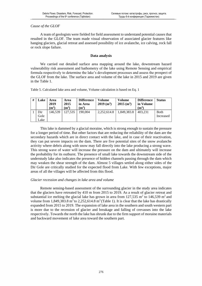
Data analysis
We carried out detailed surface area mapping around the lake, downstream hazard
vulnerability risk assessment and bathometry of the lake using Remote Sensing and empirical
formula respectively to determine the lake’s development processes and assess the prospect of
the GLOF from the lake. The surface area and volume of the lake in 2015 and 2019 are given
in the Table 1.
Table 5. Calculated lake area and volume, Volume calculation is based on Eq. 1
# Lake Area
2019
(m2)
Area
2015
(m2)
Difference
in Area
(m2)
Volume
2019 (m3)
Volume
2015 (m3)
Difference
in Volume
(m3)
Status
1 Dir
Gole
Lake
146,539 127,535 190,004 2,252,614.8 1,849,383.8 403,231 Both
Increased
This lake is dammed by a glacial moraine, which is strong enough to sustain the pressure
for a longer period of time. But other factors that are reducing the reliability of the dam are the
secondary hazards which are in direct contact with the lake, and in case of their reactivation,
they can put severe impacts on the dam. There are five potential sites of the snow avalanche
activity where debris along with snow may fall directly into the lake producing a strong wave.
This strong wave of water will increase the pressure on the dam and ultimately will increase
the probability for its outburst. The presence of small lake towards the downstream side of the
understudy lake also indicates the presence of hidden channels passing through the dam which
may weaken the shear strength of the dam. Almost 5 villages settled along either sides of the
Dir Gole are critically studied for the expected flood from Lake. With few exceptions, major
areas of all the villages will be affected from this flood.
Glacier recession and changes in lake area and volume
Remote sensing-based assessment of the surrounding glacier in the study area indicates
that the glaciers have retreated by 410 m from 2015 to 2019. As a result of glacier retreat and
substantial ice melting the glacial lake has grown in area from 127,535 m2 to 146,539 m2 and
volume from 1,849,383.8 m3 to 2,252,614.8 m3 (Table 1). It is clear that the lake has drastically
expanded from 2015 to 2019. The expansion of lake area in the southern and south western part
is more due to the recession of glacier and breakage and falling of crevasses into the lake
respectively. Towards the north the lake has shrunk due to the firm support of moraine materials
and backward movement of lake area toward the southern part.

Debris Flows: Disasters, Risk, Forecast, Protection. Proceedings of the 6th conference (Tajikistan)
Селевые потоки: катастрофы, риск, прогноз, защита. Труды 6-й конференции (Таджикистан)
277
Fig. 3. Difference in lake area and volume (2015 and 2019)
Fig. 4. Snow and glacier distribution (2015-2019)
Fig. 5. Picture of receding glacier snout

Debris Flows: Disasters, Risk, Forecast, Protection. Proceedings of the 6th conference (Tajikistan)
Селевые потоки: катастрофы, риск, прогноз, защита. Труды 6-й конференции (Таджикистан)
278
Elements Exposed to a Potential GLOF
Using slope map, debris flow path for potential debris flow is generated and used to map
out elements exposed to the event. This was cross checked using contour map with 10 m contour
interval. It was further verified by demarcating anticipated debris flow path during field visit.
The initial 6 km stretch of the downstream areas for about Dir Gol Lake is almost
uninhabited. However, many people from downstream communities commute and install
temporary huts in the pasture land from June to August for grazing their sheep and goats. The
temporary movement of community towards the pastureland makes them more vulnerable to
potential GLOF as the site is very near to debris flow tract. In addition, high temperature in July
and August accelerate the melting of glacier, which further add more water to the lake and
increase the probability of Lake Outburst.
Fig. 6. Mean monthly temperature, Rabat Mukhi WMP
A potential GLOF can have downstream impacts at three different levels: households,
vegetation area, and infrastructures.
Table 6. Impact of GLOF
Houses 131 households with 858 populations
Infrastructure four schools, office building, two Jamat Khanas, trails, roads, embankment
structures, bridges, irrigation channels, water mills, shops, welfare center, Aga
Khan Health Center, heliport, dispensary, food store and transmission lines.
Vegetation Forest, grazing land and crop land.
Fig. 7. Slope elevation map and contour map of study area
It was observed that the debris flow may block Arkari River and create artificial lake
which will create secondary hazards in the form of bank erosion for some of the houses and
infrastructures at Safaid Arkari village along the river bank. If this debris dam remains for some
0
5
10
15
20
25
30
May June July Aug Sept
Te
mp
era
ture
in
C°
2017
2019

Debris Flows: Disasters, Risk, Forecast, Protection. Proceedings of the 6th conference (Tajikistan)
Селевые потоки: катастрофы, риск, прогноз, защита. Труды 6-й конференции (Таджикистан)
279
days, the stored water will damage the settlements lying in the lower reaches of the valley up
to Ruji more severely than the anticipated GLOF.
Assessment of vegetation and stream width
The changes in vegetation cover can be identified clearly. The green part shows
vegetation, including forest covered area, crop land and shrub land while the other shows barren
land and buildup area. As both the images were of same month, so by visual interpretation it is
obvious that vegetation has decreased and the debris path has increased width wise from 2015
to 2019 in the perennial stream. Therefore, it can be interpreted that in case of out bursting it
will erode and affect more area than the perennial stream covered. This was substantiated
through field observation where sediment deposition has raised the water level and transformed
the gorge into shallow stream due to which bank erosion has occurred at both sides, and
widened the stream width and decreased vegetation cover along the sides.
Fig. 8. Elements exposed to potential GLOF
Fig. 9. Decrease in vegetation and increase in debris flow path in the study area between 2015 and 2019

Debris Flows: Disasters, Risk, Forecast, Protection. Proceedings of the 6th conference (Tajikistan)
Селевые потоки: катастрофы, риск, прогноз, защита. Труды 6-й конференции (Таджикистан)
280
Conclusion
In this study assessment of GLOF hazard and impact of Lake Outburst on the
downstream settlement is presented. Although outburst debris flows have been rare in the
region, but recession of glacier, expansion of lake and prominent seepage water in the terminal
moraine dam means that surge waves can overtop the dam triggering an outburst. Study
indicates that the lake can become unstable as surge waves as a result of ice and rock avalanches
striking their surface could cause overtopping of end moraine. The study clearly shows that
people living downstream of the glacial lakes are at risk from GLOFs. Their lives and property,
including infrastructure and crop land are vulnerable. To reduce the impact of GLOFs, we can
also increase the preparedness of the community which is settled on the areas laying low along
the valley through which water from out bursting lake will flow. Proper planning of land use
should be placed in which should focus on using the areas or zones of higher vulnerability for
the purposes other than human settlements, i.e., for agriculture or for farming. Enhancement of
the coping and adaptive capacity of local governments and communities, reducing of water
volume in the lake and establishment of appropriate early warning systems are recommended.
Acknowledgments
Authors highly acknowledge the efforts of Aga Khan Agency for Habitat Pakistan, for
providing the platform to conduct this research. Also, the efforts of Deo Raj Gurung,
Programme Coordinator, Aga Khan Agency for Habitat, Head Office for giving the preliminary
technical input in initiating the research are highly acknowledged.
References
Clague, J.J., & Evans, S.G. (1992). A self-arresting moraine dam failure, St. Elias Mountains, British
Columbia. Current Research, Part A, Geological Survey of Canada, Paper 92-1A: 85-188.
Clague, J.J., Evans, S.G. & Blown, I.G. (1985). A debris flow triggered by the breaching of a moraine-
dammed lake, Kattlasine Creek, British Columbia. Canadian Journal of Earth Sciences 22:1492-
1502.
Calkins, A., Jamiluddin., Bhuyank., & Hussaina. (1981). Geology and mineral resources of the Chitral-
Partsan area, Hindu Kush Range, Northern Pakistan. United States Geological Survey Professional
Paper, 716-G.
Chiarle, M., Iannotti, S., Mortara, G. & Deline, P. (2007). Recent debris flow occurrences associated
with glaciers in the Alps. Global and Planetary Change. 56:123-136.
Derbyshire, E., Owen, L.A. (1990). Quaternary alluvial fans in the Karakoram mountains. In: Rachocki,
A.H., Church, M. (Eds.), Alluvial Fans: A field Approach. John Wiley and Sons, Chichester, pp. 27–
53.
Derbyshire, E., Fort, M., Owen, L.A. (2001). Geomorphological hazards along the Karakoram Highway;
Khunjerab Pass to the Gilgit River, Northwest Pakistan. Erdkunde, Arcive Fur Wissenschftliche
Geographie, Boss Verlag Kleve, pp. 49–71.
Fujita, K., & Nuimura, T. (2011). Spatially heterogeneous wastage of Himalayan glaciers. Proceedings
of the National Academy of Sciences, 108, 14011–14014. doi:10.1073/pnas. 1106242108.
Haq, I. (2007). Community response to climatic hazards in northern Pakistan. Mountain Research and
Development 27 (4). http://dx.doi.org/10.1659/mrd.0947.
Ives, J.D., Shrestha, R.B., Mool, P.K., (2010). Formation of glacial lakes in the Hindu Kush-Himalayas
and GLOF risk assessment. ICIMOD, Kathmandu, 1–56.
Huggel, C., Kääb, A., Haeberli, W., Teysseire, P., & Paul, F. (2002). Remote sensing based assessment
of hazards from glacier lake outbursts: a case study in the Swiss Alps. Canadian Geotechnical
Journal, 39: 316–330.
Huggel, C., Haeberli, W., Ka¨a¨b, A., Bieri, D., & Richardson, S. (2004). Assessment procedures for
glacial hazards in the Swiss Alps. Canadian Geotechnical Journal, 41(6):1068-1083.
Kääb, A., Huggel, C., Fischer, L., Guex, S., Paul, F., Roer, I., Salzmann, N., Schlaefli, S., Schmutz, K.,
Schneider, D., Strozzi, T. & Weidmann, Y. (2005). Remote sensing of glacier- and permafrost-related
hazards in high Mountains: an overview. Natural Hazards and Earth System Sciences, 5:527-554.

Debris Flows: Disasters, Risk, Forecast, Protection. Proceedings of the 6th conference (Tajikistan)
Селевые потоки: катастрофы, риск, прогноз, защита. Труды 6-й конференции (Таджикистан)
281
Khan, M.A., Haneef, M., Khan, A.S. & Tahirkheli, T. (2012). Debris-flow hazards on tributary-junction
fans, Chitral, Hindu Kush Ranges, northern Pakistan. Journal of Asian Earth Sciences, 62, 720–733.
Kargel, J. S., Cogley, J. G., Leonard, G. J., Haritashya, U., & Byers, A. (2011). Himalayan glaciers: The
big picture is a montage. Proceedings of the National Academy of Sciences, 108, 14709–14710.
doi:10.1073/pnas.1111663108.
Kaser, G., Cogley, J. G., Dyurgerov, M. B., Meier, M. F., & Ohmura, A. (2006). Mass balance of glaciers
and ice caps: Consensus estimates for 1961–2004. Geophysical Research Letters, 33(19), 1–5.
doi:10.1029/2006GL027511.
Roohi, R., Ashraf, R., Naz, R., Hussain, S.A., Chaudhry, M.H., 2005. Inventory of glaciers and glacial
lakes outburst floods (GLOFs) affected by global warming in the mountains of Himalayan region,
Indus Basin, Pakistan Himalaya. ICIMOD Report, Kathmandu, Nepal.
Scherler, D., Bookhagen, B., & Strecker, M. R. (2011). Spatially variable response of Himalayan glaciers
to climate change affected by debris cover. Nature Geoscience, 4(1), 1–1. 10.1038/ngeo1059.
Watkins, K. (Ed.). (2007) Human Development Report 2007: Climate Change and Human
Development–Rising to the Challenge. Palgrave Macmillan.
Zemp, M., Hoelzle, M., & Haeberli, W. (2009). Six decades of glacier mass-balance observations: A
review of the worldwide monitoring network. Annals of Glaciology, 50, 101–111.
doi:10.3189/1727564097877.