Storm-initiated debris flows and plantation forestry - Gisborne ...
30
Storm-initiated debris flows and plantation forestry: protocols for monitoring & post-storm data capture
-
Upload
khangminh22 -
Category
Documents
-
view
6 -
download
0
Transcript of Storm-initiated debris flows and plantation forestry - Gisborne ...

Storm-initiated debris flows and plantation forestry: protocols for monitoring & post-storm data capture

Storm-initiated debris flows and plantation forestry: protocols for monitoring & post-storm data capture
Chris Phillips, Michael Marden, Les Basher, Nick Spencer
Landcare Research
Prepared for:
Gisborne District Council
15 Fitzherbert Street PO Box 747 Gisborne 4040 New Zealand
July 2016
Landcare Research, Gerald Street, PO Box 69040, Lincoln 7640, New Zealand, Ph +64 3 321 9999, Fax +64 3 321 9998, www.landcareresearch.co.nz

Reviewed by: Approved for release by:
Ian Lynn
Landcare Research
Chris Phillips Portfolio Leader – Managing Land & Water Landcare Research
Landcare Research Contract Report: LC 2607
Disclaimer
This report has been prepared by Landcare Research for Gisborne District Council. If used by other parties, no warranty or representation is given as to its accuracy and no liability is accepted for loss or damage arising directly or indirectly from reliance on the information in it.
© Landcare Research New Zealand Ltd and Gisborne District Council
No part of this work covered by copyright may be reproduced or copied in any form or by any means (graphic, electronic, digital or mechanical, including photocopying, recording, taping, information retrieval systems, or otherwise), in whole or in part, without the written permission of Landcare Research or Gisborne District Council.

Landcare Research Page iii
Contents
Summary ..................................................................................................................................... v
1 Introduction ....................................................................................................................... 1
2 Objectives .......................................................................................................................... 2
3 Methods ............................................................................................................................ 2
4 Findings .............................................................................................................................. 3
4.1 Background and purpose .................................................................................................... 3
4.2 Post-storm information to collect ....................................................................................... 5
4.3 Suggested approaches and parameters to focus on ........................................................... 7
4.4 Parameters .......................................................................................................................... 9
4.5 Tier 1 assessment – ‘incident report’ ................................................................................ 15
4.6 Tier 2 assessment .............................................................................................................. 15
4.7 Tier 3 assessment .............................................................................................................. 16
4.8 Data collection, management, and use ............................................................................. 16
5 Conclusions ...................................................................................................................... 18
6 Recommendations ........................................................................................................... 19
7 Acknowledgements ......................................................................................................... 20
8 References ....................................................................................................................... 20
Appendix 1 – Tier 1 assessment – field example form ............................................................. 24

Landcare Research Page v
Summary
Project and Client
Following a workshop on the impacts of storms on forestry in 2016, Gisborne District Council (GDC) approached Landcare Research to follow up on recommendations in the report that documented the workshop. One of those recommendations was to determine what information should be collected following a storm event.
Objectives
Develop a discussion document or protocol to capture an appropriate set of fit-for-purpose data to evaluate the impacts of future storm-induced debris flow/landslide occurrences (hereafter referred to as events) related to forestry. This may include a tiered approach (e.g. essential, desirable, maybe useful to collect), acknowledging that individual forestry companies and/or GDC may wish to collect specific information for their own purposes beyond the ‘core’ set.
Assist GDC to socialise this with East Coast forestry companies via the Environmental Forestry Group (EFG).
Prepare a draft report.
Methods
A discussion document in the form of a report was prepared assessing the minimum level of information required to characterise and record the impacts of storms and debris flow events pertaining to plantation forestry land uses. The document includes:
an outline of the parameters to be collected, why they are important, how they should be measured, and how the data could be stored and accessed.
an assessment of relevant literature for any indicator/metric/parameter and its usefulness. This includes consideration of any scale effects.
a ranking of parameters.
Findings
The discussion document (this report) indicated several key findings:
There is no ‘standard’ for collecting post-event information/data both internationally and in New Zealand, though there are broad areas of commonality.
The collection of good quality storm damage data along with characterisation of environmental/management drivers are required to underpin analysis of landslide/debris flow susceptibility, hazard assessment, and subsequently risk assessment.

Storm-initiated debris flows and plantation forestry: protocols for monitoring & post-storm data capture
Page vi Landcare Research
Conclusions
The Gisborne–East Coast region is one of New Zealand’s most erosion-prone regions and it has a large plantation forest estate. It will never be possible to reduce the risk of post-harvest, storm-induced landsliding and debris flows to zero as the processes causing potential issues are natural and part of the way the landscape adjusts.
Collecting information in a consistent, methodical way on a storm event that causes undesirable impacts is necessary both to improve the understanding of natural hazards and to provide the necessary information to support land use planning and risk assessment. Obtaining relevant, credible and defensible information to inform the public, GDC, and the forest industry is thus a high priority.
The derivation of threshold conditions for initiation of shallow landslides and debris flows within a forest would be a useful future goal. Development of causal relationships between the conditions known to cause issues either within or external to the forest would enable better future planning and avoidance strategies to minimise future impacts.
Recommendations
Adopt the recommendations in this report and implement a routine post-storm event data/information protocol.
In conjunction with the Environmental Forestry Group, set up systems to enable data sharing and ‘capture’ of relevant information collected by forest companies as part of their internal Environmental Management Systems (EMS) incident reports.
Key tasks recommended are to: get agreement from the forestry sector that adopting a routine and consistent approach to post-storm assessment has value to all parties; adopt at least a Tier 1 but preferably Tier 2 approach; set up the system(s), forms and templates to capture the information; prepare a standard post-storm assessment reporting template designed to meet both GDC and forest company requirements; consider widening the scope of this project to include other councils and forest companies.

Landcare Research Page 1
1 Introduction
In many countries, floods, debris flows, landslides and rockfalls (Hunger et al. 2014) cause damage every year affecting property values, infrastructure, forestry and agriculture. Collecting information on such events in a systematic way is needed for hazard mapping and analysis to underpin decision-making that recognises these hazards. This information can provide answers to questions related to the spatial and temporal distribution of damage, natural hazard processes, and the corresponding weather conditions that triggered the events (Glade 1996, 1997, 2003; USDA Forest Service 2001; Hilker et al. 2009).
Plantation forestry is a significant land use in the Gisborne–East Coast region, providing a number of benefits including soil conservation, improved water quality, employment, and economic value. However, there are a number of issues associated with forestry, particularly during and post-harvest, that impact on both the environment and the communities of the region. Amongst these is the issue of storm-induced, post-harvest landsliding and debris flows, which mobilise slash (harvesting residue) on slopes and in channels and deliver it to neighbouring properties, river flood plains, and to the coast, where it ends up on beaches. It also poses a risk to infrastructure such as culverts, bridges, roads, and rail. A number of incidents within the last 5 years have raised the ire of coastal communities, iwi, and the farming community and have resulted in many letters to the local paper and pressure on Gisborne District Council (GDC) to ‘tackle the issue’. Of particular importance to GDC will be averting any potential damage to the Gisborne water supply pipeline following harvesting of forests near the water supply catchments.
This is not an issue unique to this region, but is one that occurs in many other parts of New Zealand, where it also receives attention from councils, communities and forestry companies (e.g. Horner 2012). Recent and legacy articles, reports, and Environment Court evidence suggest that this phenomenon is not new and will continue in the future wherever forests are harvested from steep, erosion-prone land subject to large rain storms (e.g. Phillips et al. 2012; Basher et al. 2015; Marden & Rowan 2015; Payn et al. 2015; Phillips et al. 2015). The North Island and the top of the South Island appear more vulnerable to rainstorm events that trigger landslides, slash mobilisation and debris flows.
The nature of the issue and what science has been done to address it and more general observations are described in the papers cited above and outlined in a 2016 report (Phillips et al. 2016).
One of the recommendations from the joint GDC-forestry company workshop in 2015 upon which the Phillips et al. (2016) report was based, was to develop a discussion document or protocol to capture information relevant to specific storm events in a systematic way that both GDC and forestry companies could use. This report addresses that need. It is part 1 of a 2-part study with the second part focused on co-developing a risk matrix for use by forestry companies in the East Coast to assist them to better manage the risk of storm-induced landsliding and debris flows.
Storm-initiated debris flows and plantation forestry: protocols for monitoring & post-storm data capture
Page 2 Landcare Research
2 Objectives
Develop a discussion document or protocol to capture an appropriate set of fit-for-purpose data to evaluate the impacts of future storm-induced landslide/debris flow occurrence related to forestry. This may include a tiered approach (e.g. essential, desirable, maybe useful to collect), acknowledging that individual forestry companies and/or GDC may wish to collect specific information for their own purposes beyond the ‘core’ set.
Assist GDC to socialise this with East Coast forestry companies via the Environmental Forestry Group (EFG).
Prepare a draft report
Areas out of scope:
Recommendations on routine monitoring of forestry activities on the environment (e.g. stream monitoring)
Recommendations on specific actions to mitigate effects of forestry on debris flows
Ensuring consistency with nationally developed approaches that may be in use or being developed for other regions (though endeavours will be made to make a preliminary assessment of these if known)
Identifying potential sites of value (high consequence) that are likely to be impacted in the future, especially those where there is some historic information of past impacts.
Other recommendations in Phillips et al. (2016) not specifically relevant to the primary objective of capturing post-storm information.
3 Methods
To prepare this discussion document we have used a combination of literature search and review, unpublished information sources, and local knowledge and experience. A starting point was to:
look at past events in New Zealand (via Geonet; Glade et al. 2001) to determine if there were consistent approaches to post-storm information gathering
assess the international literature for data collection and database approaches that might be relevant
assess New Zealand forestry companies for ‘common practice’ within companies’ Environmental Management Systems (EMS) incident reporting.
seek feedback from the EFG on the utility of recommended parameters and approaches.
briefly explore informatics options for capture, storage, retrieval and use of data and information.
Storm-initiated debris flows and plantation forestry: protocols for monitoring & post-storm data capture
Landcare Research Page 3
4 Findings
4.1 Background and purpose
One of the key purposes of collecting data on storms and their impacts is to get an understanding of natural hazards – what and where they are – to inform planning to help manage the effects of future events and to reduce the costs of those events (e.g. Smith & Katz 2013). Hazard mapping then becomes a basis for better policy development and growth management planning that can greatly reduce impacts to infrastructure and loss of life and property. Without a regular and systematic way of collecting post-storm information, detailed analyses are limited to anecdotal observations. As a consequence causative links and predictive tools become more difficult to develop. A second purpose of consistent data collection is to provide accurate disaster or storm loss data to understand the economic costs of such events and to help apportion costs in remediation or to support insurance claims. There are, for example, many studies that have looked at the economic impacts of floods (e.g. Downton & Pielke 2005; Merz et al. 2010; Meyer et al. 2013).
In the context of this report, collection of post-storm, event-based data is firstly to obtain information in a systematic and consistent way to improve knowledge of storm impacts and the conditions that result in impacts associated with plantation forestry, including assessing links with forestry management practices. This information will help GDC (develop and refine policy), the public (improve education and raise awareness), and the forestry companies (improve management) to understand the nature of hazards in the region and the likely landscape responses to storms of different magnitudes. Secondly, recording information in a consistent manner avoids subjective, anecdotal information entering public records, and provides a degree of both objectivity and continuity if personnel with memories of past events leave GDC or forest company staff leave the region. Such information may also be useful for reporting to GDC elected representatives in a consistent manner as part of normal council operations and to shareholders of forest companies.
Storm damage assessment was recognised as an integral component of hazard analysis by NWASCA (1984), with the stated aim of:
1. supplying information to interested parties about the extent and causes of erosion, flooding and other damage, and to assess repair options, and
2. establishing a record of the effects of storms in various areas of New Zealand. This will help in understanding the susceptibilities of various landscapes to erosion and will be an aid in planning to prevent damage from similar storm events.
In the longer term, post-storm surveys provide information for hazard mapping for preventative erosion control works and planning. This information has multiple uses and could, for example, lead to re-assessment of Land Use Capability (LUC) mapping and subsequent farm-scale mapping or contribute to forest estate planning.
In addition, one of the aims of a council-driven data collection process that this report is addressing is for GDC to obtain many of the details that are often assessed by forestry

Storm-initiated debris flows and plantation forestry: protocols for monitoring & post-storm data capture
Page 4 Landcare Research
agencies in their ‘environmental incident’ reports, all of whom currently have no obligation to share that information. The sharing of information between the land user/manager and the regulator is often the first step towards collaboratively finding solutions to contentious issues raised by either party or the public. Forestry companies have several reasons for collecting information on storms and their impacts including their internal shareholder requirements, requirements under Environmental Standards (ISO) or to meet industry good practice/market standards such as those of the Forest Stewardship Council (FSC).
An environmental incident in its broadest sense is one that has caused, or has the potential for causing, one or more of the following:
Adverse impact on the quality of air, land or water, wildlife, aquatic species or species at risk.
Exceedance of resource consent conditions or external reporting requirement.
Notification of external agencies due to emergency/beyond normal circumstances.
Adverse publicity with respect to environment.
In some countries where there is a well-recognised risk of storm-induced landsliding occurring within forested lands, guidelines have been developed to fore-warn the forest industry of either impending events or the conditions under which forest operation shut downs are recommended (e.g. BGC Engineering 2005; Baum & Godt 2010). An interesting finding from the BGC Engineering study (2005) was that landslides occur during storms with return periods of half a year or less, in contrast to earlier work suggesting a 2-year storm return period for landsliding. Such approaches are still in development and while promising, are unlikely to be available in New Zealand for some time due to lack of fundamental data. However, the approach of combining forecasted rainfall, a meteorologically derived storm classification, the four-week antecedent rainfall and the on-site 24-hour rainfall, shows promise in being able to provide different levels of landslide hazard advisory (Jakob et al. 2006).
A probabilistic modelling system for forecasting shallow, rainfall-initiated landslides has been developed at NIWA (Schmidt et al. 2008). The modelling system has three components: weather forecasting, catchment hydrology and slope stability. Weather forecasts are derived from the New Zealand Limited Area Model (NZLAM). This model is based on the UK Met Office’s Unified Model and assimilates data for all local observations, both satellite- and ground-based, to produce accurate weather forecasts (NIWA). Catchment hydrology is simulated by the spatially-distributed, physically based TopNet model using weather forecast data. Slope stability is determined from factor-of-safety analysis (Schmidt et al. 2008), with soil moisture inputs from TopNet. The slope stability model determines the effects of changes in soil moisture on shear stress and soil strength (Schmidt et al. 2008). Comparison of shear stress and soil strength is used to determine the probability of slope failure (Schmidt et al. 2008). An initial test of the model (without any calibration) had a 70–90% success rate (observed landslide densities versus predicted probabilities) for an extreme rainfall event within the 6000-km2 Manawatu catchment. Schmidt et al. (2008) did, however, warn that due to the ‘inherent uncertainties in weather simulation, hydrological modelling, and geotechnical models … landslide forecast results

Storm-initiated debris flows and plantation forestry: protocols for monitoring & post-storm data capture
Landcare Research Page 5
contain high degrees of uncertainties, in particular if verified on a local scale, hence, the forecast results need to be up-scaled to regional levels to be useful for applied purposes’.
4.2 Post-storm information to collect
There are many reports and approaches that detail individual events and document their impacts both internationally and in New Zealand (Glade & Crozier 1996). These include reports on floods, landslides and other natural disasters. There does not appear to be any one ‘consistent’ approach to gathering information that is directly relevant to storm influence and landscape response for steepland plantation forests. However, there is a consistent pattern in terms of the type of information contained in global reports. Essentially information falls into five broad categories:
1. Aspects of the storm or event that caused the impacts – rainfall, wind, flooding, etc.
2. The extent or area affected by the event – local, regional, national
3. The nature of the impacts – landslides, life, property, etc.
4. The comparative size of the event relative to historical events or recurrence interval
5. Responses to impacts – human or management response; what worked and what didn’t to prevent or modify the impacts.
Broadly, methodological approaches can be considered in a hierarchy with increasing levels of detail and quantitative information gathered at lower levels or tiers (Figure 1). For example, a Tier 1 approach provides a qualitative assessment and is usually derived from a reconnaissance survey/flight/visual inspection. Observations tend to be illustrative of the event and its impact and are generally supported by oblique aerial photos, ground-based photos and notes, and reflect the views and understanding of the assessor. As there is no systematic approach to collecting information, between-event comparisons may be difficult. Resource costs for such assessments tend to be relatively low and assessment is made immediately, or soon after the event occurs, and often as part of another work task such as road inspection. Forest company incident reports carried out as part of EMS could also be classed as Tier 1 assessments as they provide some level of what happened and where, but generally their usefulness for subsequent analysis is limited (Black 2010). Tier 2 approaches are still largely reconnaissance-based but tend to follow a more systematic approach and include more detail and some quantitative information (e.g. Phillips & Marden 1999; Beetham & Grant 2006; Basher 2010; Phillips & Marden 2011; Page & Rosser 2015).

Storm-initiated debris flows and plantation forestry: protocols for monitoring & post-storm data capture
Page 6 Landcare Research
Figure 1 Tier 1–3 approaches
A Tier 3 approach involves gathering more quantitative information and thus resourcing required is significantly greater. These assessments may take several weeks or months to compile and are usually carried out by ‘experts’ or trained assessors (e.g. Marden & Rowan 1993; McSaveney et al. 2005; Hancox & Wright 2005; Page et al. 2012; Marden & Rowan 2015). However, the value of these data is that they can then be used as specific evidence to inform land use policy development, that is, hazard zoning, detailed farm planning, catchment plans, or future mitigation options (e.g. Black 2011). They can also be used in cases where there are compliance issues and to resolve liability issues. Some information can also be gathered by satellite imagery where it exists or by automated landslide recognition software to provide the necessary level of detail and relationships between the various factors and impacts. There are further reasons to collect more detailed information including to:
determine the catchment processes that contributed to the initiation of landslides\debris flows
determine if there is any evidence of past events and the frequency of their occurrence
assess the likely response to future rainfall events
identify the rainfall, geological, and topographical conditions that could result in landsliding in the wider vicinity and hence identify areas where there is significant future risk
1
2
3
Quantitative data; higher cost; expert assessors; enables hazard & risk assessment; links to model development & calibration
Some quantitative data; moderate cost; some training needed for assessment; data needed for hazard & risk analysis
Observations; no quantitative data; low cost; non-expert

Storm-initiated debris flows and plantation forestry: protocols for monitoring & post-storm data capture
Landcare Research Page 7
recommend possible mitigation options to minimise the risks.
In New Zealand and particularly in recent years, the focus of post-storm damage assessments has tended to be on reconnaissance-level assessment (Tiers 1–2) rather than systematic mapping or undertaking detailed landslide inventories. However, the level of confidence in the use of information derived from such assessments is limited, particularly if the data are to be used to inform future policy or inform risk management.
For example, previous large regional storm damage assessments have been carried out under the umbrella of GeoNet (the official source of geological hazard information for New Zealand) (e.g. Beetham & Grant 2006; Page & Rosser 2015). In a similar manner, several agencies including research institutes and local government have also conducted detailed post-storm assessments (e.g. Marden & Rowan 1993, 2015; Phillips & Marden 1999; Basher 2010; Phillips & Marden 2011). These studies have increased the general understanding of natural hazards and landscape response in areas prone to these events and that knowledge has contributed to improved land use or hazard planning.
4.3 Suggested approaches and parameters to focus on
This section and the subsequent tables are structured around:
what parameters are to be collected
why they are important
how they should be measured
how the data could be stored and accessed.
The key parameters that need to be assessed essentially relate to the broad drivers of erosion that result in the observable impacts. These are rainfall/meteorological conditions of the storm and the geology, vegetation/land cover/land use, and topography and characteristics of the areas affected. The ‘receiving environment’ or proximity to a water body or to infrastructure (house, road, etc.) is also included in order to gain information on the severity of impacts and possible economic consequences. Forest information such as infrastructure damage (roads, culverts, crossings, etc.) or loss of soil or young plantings on clear-cuts due to landslides is also key information to collect.
There are three levels of information or parameter explained in the tables below. Those marked with an asterisk are Tier 2 and/or Tier 3 and, where resources are sufficient, would add additional value to Tier 1 information to be collected following a storm. These data are necessary to enable landslide hazard analysis and subsequent risk assessment.

Storm initiated debris flows and plantation forestry: protocols for monitoring and post-storm data capture
Landcare Research Page 9
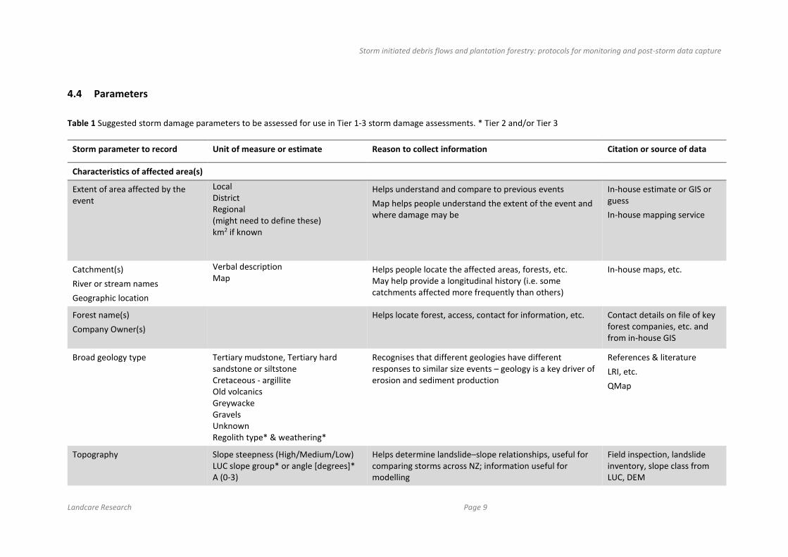
4.4 Parameters
Table 1 Suggested storm damage parameters to be assessed for use in Tier 1-3 storm damage assessments. * Tier 2 and/or Tier 3
Storm parameter to record Unit of measure or estimate Reason to collect information Citation or source of data
Characteristics of affected area(s)
Extent of area affected by the event
Local District Regional (might need to define these) km2 if known
Helps understand and compare to previous events
Map helps people understand the extent of the event and where damage may be
In-house estimate or GIS or guess
In-house mapping service
Catchment(s)
River or stream names
Geographic location
Verbal description Map
Helps people locate the affected areas, forests, etc. May help provide a longitudinal history (i.e. some catchments affected more frequently than others)
In-house maps, etc.
Forest name(s)
Company Owner(s)
Helps locate forest, access, contact for information, etc. Contact details on file of key forest companies, etc. and from in-house GIS
Broad geology type Tertiary mudstone, Tertiary hard sandstone or siltstone Cretaceous - argillite Old volcanics Greywacke Gravels Unknown Regolith type* & weathering*
Recognises that different geologies have different responses to similar size events – geology is a key driver of erosion and sediment production
References & literature
LRI, etc.
QMap
Topography Slope steepness (High/Medium/Low) LUC slope group* or angle [degrees]* A (0-3)
Helps determine landslide–slope relationships, useful for comparing storms across NZ; information useful for modelling
Field inspection, landslide inventory, slope class from LUC, DEM

Storm initiated debris flows and plantation forestry: protocols for monitoring and post-storm data capture
Page 10 Landcare Research
Storm parameter to record Unit of measure or estimate Reason to collect information Citation or source of data
B (4-7) C (8-15) D (16-20) E (21-25) F (26-35) G (>35) Slope aspect* Local relief*
LUC classes most affected* Class 6 Class 7 Other All Land overlay 3A affected?
Steep slopes tend to have more storm damage – visual assessment to determine if the spread of landslide activity is related to slope
In-house
LRI
Severity of erosion and landslides*
Slight Moderate Severe Extreme
Helps determine degree of on-site erosion and potential soil loss which relates to long-term sustainability (i.e. cumulative effects)
Allows comparison to previous events
Visual assessment OK though quantitative better via inventory
Dominant type of erosion* Shallow landslides Y/N Deep landslides Slumps Earthflow Debris flows Y/N Numbers of debris flows, magnitude (small, medium, large), and their impact Bank erosion Y/N Gullies Other
Helps determine what processes occurred and what caused impacts
Landslide Numbers* <10 10–100 100–>1000

Storm initiated debris flows and plantation forestry: protocols for monitoring and post-storm data capture
Landcare Research Page 11
Storm parameter to record Unit of measure or estimate Reason to collect information Citation or source of data
Landslide details* Slope position [Upper, Middle, Lower] Slope form [convex, concave, planar] Failure mechanism Material Landslide density [no/ha] Average landslide dimensions (L,W,D) [m] Landslide volume estimates combined [m3] Landslide connectivity to streams Y/N
Detailed information for full geomorphic landslide inventory.
Glade & Crozier (1996)
Land cover vegetation & % estimate*
Pasture Young or recently harvested (less than 5 years) Mid age Mature pines All age classes Native (scrub/forest) Mixed Presence of riparian or vegetated buffers Y/N Riparian buffers impacted by landslides/debris flows Y/N
Existing knowledge (e.g. Marden & Rowan 1993) and others); Cyclone Bola– young trees recently harvested have more landslides in a storm
Rainfall & meteorological conditions*
Storm name? Y/N*
Date(s) of event
[DD, MM, YYYY] Helps with historical and large cross-regional comparisons in NZ
Met Service, NIWA, local source
Storm rainfall total Rainfall depth [mm] Allows comparison between different events In-house records, farmers records, NIWA, etc.
Duration* Hours [h] Days [d]
Length of storm, long period means wetter soils, etc. In-house records, farmers records, NIWA, etc.

Storm initiated debris flows and plantation forestry: protocols for monitoring and post-storm data capture
Page 12 Landcare Research
Storm parameter to record Unit of measure or estimate Reason to collect information Citation or source of data
Intensity*
1 to 48 hours
[mm h-1] Allows comparison between events In-house records, farmers records, NIWA, etc.
ARI (Annual recurrence interval)* 1 in X years Measure of storm size and magnitude. Relevant for hazard analysis.
In-house
HiRDS
Forestry company
(e.g. Environment Canterbury; NIWA)
Antecedent ground/soil conditions*
Dry Moist Wet Actual rainfall if known
An assessment of pre-storm soil or ground conditions. Wet antecedent conditions are likely to increase landslide incidence or numbers vs dry (other things considered)
Storm cell type* Ex-tropical Frontal Local thunderstorm
May help understand major storm tracks and thus differentiate potentially susceptible areas.
NIWA, Met Service, etc.
In-house
Wind direction & intensity* Peak gusts [kmh-1] [knots] Forest damage, salvage issues, access issues, etc. Met Service,
In-house, NIWA
Flooding details* Overbanks Y/N etc. Return frequency plots Time of flood peak ARI
Additional information used to assess impacts of storms In-house, NIWA
Impacts*
Forest-specific information related to the area(s) affected*
On recently harvested and less than 2 years 2–5 years since harvesting 5–10 years >10 years One company or multiple forest owners within affected area/catchment
Confirms existing knowledge, (e.g. Marden & Rowan (1993) and others); Cyclone Bola– young trees recently harvested have more landslides in a storm
Forestry Co or aerial fly-over
Specific on-site impacts (in Soil loss (landslides, sheet erosion, Loss of soil leads to long-term declines in productivity – Forestry Co

Storm initiated debris flows and plantation forestry: protocols for monitoring and post-storm data capture
Landcare Research Page 13
Storm parameter to record Unit of measure or estimate Reason to collect information Citation or source of data
forest)*
rilling, gullying, earthflow, debris flow)
Sediment deposition in stream Y/N
Woody debris in streams on roads, in forest, etc. Y/N
Debris Flows Y/N
Forest infrastructure damaged (roads or culverts/bridges) by what process (fill or cut slope, gully, rill, etc.)
Landing failures Y/N
Wind damage of forest Y/N*
Heaphy et al. (2014).
Public complaints and calls
In-house assessment
Off-site impacts*
Debris flows Y/N
Sediment deposition beyond forest boundary Y/N
Woody debris on river beds/banks, on beach Y/N
Woody debris largely harvesting slash/pine or other (willows, poplars, natives)*
Public infrastructure damaged Y/N (roads or culverts/bridges)
Forest neighbours affected Y/N
River protection works (assets) affected or damaged* Y/N
River bank slumping* Y/N
Deaths or injury Y/N*
Helps determine nature of impact and economic costs
Potential liabilities for clean-up cost apportionment
Alerts GDC asset management team to potential repairs
Alerts GDC to any potential compliance breaches
Forest company response within forest*
Immediate (clean-up is evident) No response
Forest company response external (i.e. help neighbours)*
Immediate (clean-up is evident) No response

Storm initiated debris flows and plantation forestry: protocols for monitoring and post-storm data capture
Page 14 Landcare Research
Storm parameter to record Unit of measure or estimate Reason to collect information Citation or source of data
Other information of relevance
Other data that would be useful to record/file*
Forest company incident reports
Aerial & oblique photographs
Flood records
Newspaper or media reports
Additional information provides further context and background
Public complaints*
Any records of formal and informal complaints to GDC hotline
Issues tabled at council relevant to the particular event
Builds a data base and useful information to know if public concern is increasing or waning
Identifies ‘squeaky wheels’ that may over-represent concerns
Assessment of event compared to historical events *
Comparative assessment of magnitude and level of impact In-house
Storm initiated debris flows and plantation forestry: protocols for monitoring and post-storm data capture
Landcare Research Page 15
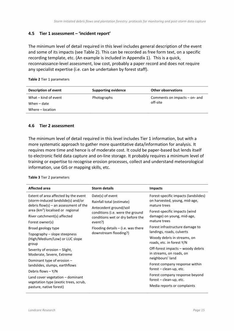
4.5 Tier 1 assessment – ‘incident report’
The minimum level of detail required in this level includes general description of the event and some of its impacts (see Table 2). This can be recorded as free form text, on a specific recording template, etc. (An example is included in Appendix 1). This is a quick, reconnaissance-level assessment, low cost, probably a paper record and does not require any specialist expertise (i.e. can be undertaken by forest staff).
Table 2 Tier 1 parameters
Description of event Supporting evidence Other observations
What – kind of event
When – date
Where – location
Photographs Comments on impacts – on- and off-site
4.6 Tier 2 assessment
The minimum level of detail required in this level includes Tier 1 information, but with a more systematic approach to gather more quantitative data/information for analysis. It requires more time and hence is of moderate cost. It could be paper-based but lends itself to electronic field data capture and on-line storage. It probably requires a minimum level of training or expertise to recognise erosion processes, collect and understand meteorological information, use GIS or mapping skills, etc.
Table 3 Tier 2 parameters
Affected area Storm details Impacts
Extent of area affected by the event (storm-induced landslide(s) and/or debris flow(s) – an assessment of the area (km2) localised or regional
River catchment(s) affected
Forest owner(s)
Broad geology type
Topography – slope steepness (High/Medium/Low) or LUC slope group
Severity of erosion – Slight, Moderate, Severe, Extreme
Dominant type of erosion – landslides, slumps, earthflows
Debris flows – Y/N
Land cover vegetation – dominant vegetation type (exotic trees, scrub, pasture, native forest)
Date(s) of event
Rainfall total (estimate)
Antecedent ground/soil conditions (i.e. were the ground conditions wet or dry before the event?)
Flooding details – (i.e. was there downstream flooding?)
Forest-specific impacts (landslides) on harvested, young, mid-age, mature trees
Forest-specific impacts (wind damage) on young, mid-age, mature trees
Forest infrastructure damage to landings, roads, culverts
Woody debris in streams, on roads, etc. in forest Y/N
Off-forest impacts – woody debris in streams, on roads, on neighbours’ land
Forest company response within forest – clean-up, etc.
Forest company response beyond forest – clean-up, etc.
Media reports or complaints

Storm initiated debris flows and plantation forestry: protocols for monitoring and post-storm data capture
Page 16 Landcare Research
4.7 Tier 3 assessment
Detail required in this level includes aspects of both Tier 1 and 2, but with further additional quantitative data/information including subsequent analysis. The parameters in Table 1 marked with an asterisk are effectively Tier 3 parameters. There may be other useful parameters or information that could be collected at this level, though we have not provided an exhaustive list. This approach requires considerable effort and time and hence is of moderate-high cost. It may require specialist expertise not available in house. It is more likely to use a combination of electronic field data capture and then on-line database storage, retrieval and analysis including spatial modelling. Results from such assessments are not usually available for some months following the event. This information has wider utility, informs national-level understanding of natural hazards and their management, and enables the development or refinement of risk management approaches (risk matrix).
4.8 Data collection, management, and use
4.8.1 Data collection template and storage
There are several possible approaches to collecting, recording, storing, and retrieving information on storms and their effects (Table 4). These range from paper-based templates filled in as part of post-storm reconnaissance to more in-depth recording on hand-held devices linked to electronic databases (e.g. Barnolas & Llasat 2007; Hilker et al. 2009). The latter approach enables historical analysis and even public access to enable increased awareness of natural hazards.
Table 4 Summary of approaches
Approach Development cost and ‘running’ cost
Ease of field data capture
Ease of storage and retrieval of information
Quantitative assessment
Paper template Low High Low Low
Electronic database Medium Low (2-stage process)
High High
Application on phone or similar device
High Moderate to Low
Moderate-High Moderate-High
Other (e.g. as part of forestry EMS)
Low High High Low
In many countries, storm-related information is collected in regional or national disaster databases, particularly if the events caused significant damage or loss of life (e.g. Canadian Disaster Database). The quality and detail of information varies significantly from event to event and country to country. With the increase in social media in recent years, there are also bloggers and social media threads, in which incidents are reported across the globe related to natural hazards such as storm-induced landslides (e.g. The Landslide Blog -
Storm initiated debris flows and plantation forestry: protocols for monitoring and post-storm data capture
Landcare Research Page 17
http://blogs.agu.org/landslideblog/). Like disaster reporting, these are often focused on fatalities and the economic costs of events and the details on specific events are variable. However, some of these include further analyses that look at trends in losses and aim to make links to changes in climate or weather patterns, which are then used to inform policy development in some countries.
To provide for future options and support future data aggregation, analysis, and reporting a purely paper-based solution without digitisation will not suffice. It is recommended that any paper template system be combined with a digital data storage solution supported by a data entry and reporting capability. Replacing or complementing a paper-based system with electronic field capture solutions using mobile devices such as tablets or smartphones will add further benefits to data quality, ease of capture, and reduced time of data upload.
There are a number of data storage options to consider that could potentially build on existing GDC capabilities. These range from structured Excel spreadsheet approaches to those making use of existing database tools and GDC GIS capability for data storage, retrieval, and analysis. The spreadsheet option offers lower cost, but greatly reduces the rigour of storage and also reduces the ability to link data across different storm events. It would also limit the ability to undertake flexible ad hoc query analysis of the information. However, a spreadsheet option may be a useful initial step toward development of a more sophisticated, longer-term solution.
The use of a structured database is preferable, designed and built to securely store the already identified parameters listed in section 4.4 of this report. The database would include units of measure, controlled vocabularies, and ‘pick list’ terms for data accuracy and quality. These options would add significant long-term value to the stored information and allow for robust analysis over time and improved data linking capabilities with other systems such as GIS-based ones. A structured database also allows for data inputs from a range of sources to be collected in one central location. Examples include paper-based templates, an online geospatial web site, mobile devices, social media inputs, and data feeds from other agencies (e.g. weather and hydrology related information). Where database data entry is the option, data capture would be supported using electronic forms built directly within the database or by using external software tools such as web or desktop options to provide user interfaces for interacting with the system. Structured database solutions also allow multiple users to interact with the database, at the same time making the system more accessible. Combined with an online geospatial web-based option, a database solution would provide access to a wider audience than internal systems, such as spreadsheets, would allow. Direct database access and analysis would rely on summary reports built into the database software or on ad hoc queries using the underlying database capability. This would include the ability to export data into GIS systems for visualisation and further analysis.
Extending data capture to mobile devices in the field offers additional capabilities and benefits over a two-stage approach using paper followed by database entry. Devices provide on-board inputs such as location, time, date, collector details and provide real-time data validation and visualisation options so that observers can verify the information they collect at the time of recording. Minimising data collection errors and maximising speed of data transfer to another system are also major benefits. Data collected on mobile devices can be downloaded to structured databases either wirelessly or stored locally until back at base

Storm initiated debris flows and plantation forestry: protocols for monitoring and post-storm data capture
Page 18 Landcare Research
and in network range. Some options, for example ESRI’s Survey123 for ArcGIS, provide straightforward data collection entry form designs, support multiple devices and platforms, and offer integration with existing GIS systems to provide quick and powerful location visualisation information together with the recorded parameters.
4.8.2 Reporting template for council records
We suggest that a MS Word document or spreadsheet database template be created to enable consistent reporting to council on the effects of storm impacts. This would provide a standard report of events to enable a consistent public record, recorded and tabled as part of Environment Committee agenda items. This template could also be modified for use by the forestry sector as part of their incident reporting to be included in their EMS. Having the same parameters and information ‘template’ for land user and regulator may help with education and awareness of storms and their impacts within the plantation forestry sector and with the public.
4.8.3 Report a landslide
In the US as part of the US Geological Survey’s landslide hazard programme, there is a public tool much like a pollution hotline that enables the public to register a landslide and record aspects of its impacts (http://landslides.usgs.gov/dysi/form.php). Such an approach has merit and NZ’s GeoNet has a similar on-line tool for recording the public’s responses to earthquakes, but not for recording landslides (http://info.geonet.org.nz/display/slide/Landslide).
The capacity within GDC to develop or maintain electronic information submitted by their own staff, accredited users, or the public is not known. Unfortunately, the information services staff within GDC were in the process of shifting offices when we visited and to date we have not followed up to determine potential pathways for data collection, storage and retrieval, other than the suggestions made by Landcare Research’s informatics staff.
5 Conclusions
The Gisborne–East Coast region is one of New Zealand’s most erosion-prone regions. It has a large plantation forest estate with significant areas nearing maturity and due to be harvested over the next decade. Storms have the potential to cause landslides and debris flows at any stage in the forest cycle but generally these are more likely in the 5-year period following tree harvest.
It will never be possible to reduce the risk of post-harvest, storm-induced landsliding and debris flows to zero as the processes causing potential issues are natural and part of the way the landscape adjusts.
Collecting information in a consistent, methodical way on a storm event that causes undesirable impacts is necessary both to improve the understanding of natural hazards and to provide the necessary information to support land use planning. Obtaining relevant,

Storm initiated debris flows and plantation forestry: protocols for monitoring and post-storm data capture
Landcare Research Page 19
credible and defensible information to inform the public and to be used by GDC and the forest industry is thus a high priority.
The derivation of threshold conditions (e.g. Berti et al. 2012; Iadanza 2016) for initiation of shallow landslides and debris flows within a forest would be a useful future goal. This would rely on a retrospective assessment of landslide damage caused by past storm events and the continuation of data collection in the event of future storms. Development of causal relationships between the conditions known to cause issues either within or external to the forest would enable better future planning and avoidance strategies to minimise future impacts. Recognition of a hazard and what contributes to it is the first step in trying to avoid, remedy or mitigate that hazard. Lessons could be learnt from the implementation of Health & Safety legislation and the information that is collected to meet those requirements as it is applied to storm-induced landsliding within plantation forests.
6 Recommendations
An information system (database) needs to be developed within GDC or in partnership with the regional forestry companies (via the EFG) to capture and store information relevant to future storm events that cause landslides, debris flows, and their impacts related to plantation forestry on the East Coast. Landcare Research could provide more advice on tailored data management solutions particularly if these capabilities are not available in-house.
Gisborne District Council should also develop appropriate forms or templates with the forestry sector. A standardised reporting template that could be used by both GDC and forest companies would, in our view, aid in consistency of message and information delivery.
We have suggested three tiers of assessment, with Tier 1 being the minimum required to document the impacts of a storm. However, the Tier 2 approach is preferred because it will provide the minimum dataset that will enable hazard identification and analysis and allow for future risk assessment. The risk assessment matrix to be developed as Part 2 of this project would not be possible without information collected from Tier 2 or Tier 3 assessments. Thus any future refinements to such a risk matrix will require ongoing collection of information.
We suggest that a collaborative approach be taken with the forestry sector to implement our recommendations to ensure both consistency and uptake within the wider sector.
Gisborne District Council and the EFG members should consider lobbying their companies and other regional councils to widen implementation of this project beyond the Gisborne region to a national-level approach. Envirolink or NZFOA Forest Growers Levy Trust could provide logistical funding to accomplish this.

Storm initiated debris flows and plantation forestry: protocols for monitoring and post-storm data capture
Page 20 Landcare Research
7 Acknowledgements
We would like to thank Lois Easton GDC for commissioning this work. Ian Lynn reviewed this report and Leah Kearns edited it. Members of the East Coast Forestry Forum are thanked for providing open discussion and sharing their company experiences. This report is part 1 of a 2 part study.
8 References
Basher LR 2010. Storm damage in the Tapawera area during the storm of 16 May 2010.
Unpublished Landcare Research report. 17 p.
Basher LR, Harrison D, Phillips CJ, Marden M 2015. What do we need for a risk
management approach to steepland plantation forests in erodible terrain? New Zealand
Journal of Forestry 60(2): 7–10.
Barnolas M, Llasat MC 2007. A flood geodatabase and its climatological applications: the
case of Catalonia for the last century. Natural Hazards and Earth Systems Science 7:
271–281.
Baum RL, Godt JW 2010. Early warning of rainfall-induced shallow landslides and debris
flows in the USA. Landslides 7: 259–272. doi: 10.1007/s10346-009-0177-0
Beetham RD, Grant H 2006. Reconnaissance of landslide and flood damage in the Gisborne
areas caused by the 2005 Labour Weekend Storm. GNS Science Consultancy Report
2006/022.
Berti M, Martina MLV, Franceschini S, Pignone S, Simoni A, Pizzolo M 2012. Probabilistic
rainfall thresholds for landslide occurrence using a Bayesian approach. Journal of
Geophysical Research 117: F04006. doi:10.1029/2012JF002367.
BGC Engineering 2005. Forest science program. Hydro-meterological thresholds for
landslide initiation. Report Project No: 0275-003-03.
Black RD 2010. File Note 2668-HOU-R. Post-storm inspection report of event 14-15 May
2010. Hancock Forest Management Ltd. Unpublished.
Black RD 2011. Houpoto Forest storm damage rehabilitation plan. Report to Environment
Bay of Plenty. 31 May 2011. Unpublished report from Hancock Forest Management
Ltd.
Canadian Disaster Database. http://www.publicsafety.gc.ca/cnt/rsrcs/cndn-dsstr-dtbs/index-
eng.aspx (accessed 29 June 2016).
Downton MW, Pielke RA 2005. How accurate are disaster loss data? The case of US flood
damage. Natural Hazards 35: 211–228.
Environment Canterbury. http://ecan.govt.nz/quick-answers/Pages/what-does-annual-
exceedance-probability-or-aep-mean.aspx (accessed June 29 2016)

Storm initiated debris flows and plantation forestry: protocols for monitoring and post-storm data capture
Landcare Research Page 21
Glade T 1996. The temporal and spatial occurrence of landslide-triggering rainstorms in New
Zealand. In: Mäusbacher R, Schulte A eds. Beiträge zur Physiogeographie - Festschrift
für Dietrich Barsch - Heidelberger Geographische Arbeiten, Heidelberg,
Geographisches Institut, University Heidelberg 104: 237–250.
Glade T 1997. The temporal and spatial occurrence of rainstorm-triggered landslide events in
New Zealand. PhD Thesis, Victoria University, Wellington. 380 p.
Glade T 2003. Landslide occurrence as a response to land use change: a review of evidence
from New Zealand. Catena 51: 297–314.
Glade T, Crozier M 1996. Towards a national landslide information base for New Zealand.
New Zealand Geographer 52(1): 29–40.
Glade T, Albini P, Frances F eds. 2001. Landslide hazard assessment and historical landslide
data — an inseparable couple? The use of historical data in natural hazard assessments.
doi: 10.1007/978-94-017-3490-5_12
Hancox GT, Wright K 2005. Analysis of landsliding caused by the February 2004 rainstorms
in the Wanganui-Manawatu hill country, southern North Island, New Zealand. GNS
Science Report 2005/1.
Heaphy MJ, Lowe DJ, Palmer DJ, Jones HS, Gielen GJHP, Oliver GR, Pearce SH 2014.
Assessing drivers of plantation forest productivity on eroded and non-eroded soils in
hilly land, eastern North Island, New Zealand. New Zealand Journal of Forestry
Science 44: 24.
Hilker N, Badoux A, Hegg C 2009. The Swiss flood and landslide damage database 1972-
2007. Natural hazards and Earth System Sciences 9: 913–925.
Horner M 2012. After the storms: a case study in risk reduction. New Zealand Journal of
Forestry 56(4): 13–15.
Hungr O, Lerouli S, Picarelli L 2014. The Varnes classification of landslide types, an update.
Landslides 11(2): 167–194.
Iadanza C, Triglia A, Napolitano F 2016. Identification and characterization of rainfall
events responsible for triggering of debris flows and shallow landslides. Journal of
Hydrology. doi: 10.1016/j.jhydrol.2016.01.018
Jakob M, Holm K, Lange O, Schwab JW 2006. Hydrometeorological thresholds for landslide
initiation and forest operation shutdowns on the north coast of British Columbia.
Landslides 3(30): 228–238. doi: 10.1007/s10346-006-0044-1
Marden M, Rowan D 1993. Protective value of vegetation on Tertiary terrain before and
during Cyclone Bola, East Coast, North Island, New Zealand. New Zealand Journal of
Forestry Science 23: 255–263.
Marden M, Rowan D 2015. The effect of land use on slope failure and sediment generation in
the Coromandel region of New Zealand following a major storm in 1995. New Zealand
Journal of Forest Science 45:10.

Storm initiated debris flows and plantation forestry: protocols for monitoring and post-storm data capture
Page 22 Landcare Research
McSaveney MJ, Beetham RD, Leonard 2005. The 18 May 2005 debris flow disaster at
Matata: causes and mitigation suggestions. GNS client report 2005/71.
Merz B, Krebach H, Schwarz R, Thieken A 2010. Assessment of economic flood damage.
Natural Hazards and Earth Systems Science 10: 1697–1724.
Meyer V, Becker N, Markantonis V et al. 2013. Review article: Assessing the costs of natural
hazards – state of the art and knowledge gaps. Natural Hazards and Earth Systems
Science 13: 1351–1373.
NIWA. https://www.niwa.co.nz/natural-hazards/hazards/floods (accessed 29 June 2016)
NWASCA (National Water and Soil Conservation Authority ) 1984. Storm damage
assessment. Streamland 21. Wellington, National Water and Soil Conservation
Authority, Water and Soil Division of the Ministry of Works and Development.
Page MJ, Rosser BJ 2015. The landslide response to the 14 May 2015 high intensity
rainstorm in the Kapiti Coast-Hutt Valley area. GNS Science Report 2015/20,
December 2015.
Page MJ, Langridge RM, Stevens G, Jones KE 2012. The December 2011 debris flows in the
Pohara-Ligar bay area, Golden Bay: causes, distribution, future risks, and mitigation
options. GNS Science Consultancy Report 2012/305. 91 p.
Payn TW, Phillips CJ, Basher LR, Baillie BR, Garrett LG, Harrison DR, Heaphy MJ, Marden
M 2015. Improving management of post-harvest risks in steepland plantations. New
Zealand Journal of Forestry 60(2): 3–6.
Phillips CJ, Marden M 1999. Review of vegetation-slope stability in plantation forests and
risk assessment of Ohui Forest to landsliding. Landcare Research Contract Report
LC9899/66 prepared for Carter Holt Harvey Forests Ltd.
Phillips CJ, Marden M 2011. Houpoto Forest storm damage assessment and review. Landcare
Research Contract Report LC 277 prepared for Hancock Forest Management.
Phillips CJ, Marden M, Basher LR 2012. Plantation forest harvesting and landscape response
– what we know and what we need to know. New Zealand Journal of Forestry 56: 4–
12.
Phillips CJ, Marden M, Basher LR 2015. Forests and erosion protection – getting to the root
of the matter. New Zealand Journal of Forestry 60(2): 11–15.
Phillips CJ, Basher LR, Marden M 2016. Research and monitoring advice on environmental
impacts of forestry in the Gisborne-East Coast region. Landcare Research Contract
Report LC2466 prepared for Gisborne District Council.
Schmidt J, Turek G, Clark MP, Uddstrom M, Dymond JR 2008. Probabilistic forecasting of
shallow, rainfall-triggered landslides using real-time numerical weather predictions.
Natural Hazards and Earth System Sciences 8: 349–357.

Storm initiated debris flows and plantation forestry: protocols for monitoring and post-storm data capture
Landcare Research Page 23
Smith AB, Katz RW 2013. US billion-dollar weather and climate disasters: data sources,
trends, accuracy and biases. Natural Hazards 67(2): 387–410.
Varnes DJ 1978. Slope movement types and processes. In: Schuster RL, Krizek RJ eds.
Landslides, analysis and control, special report 176. Washington, DC, Transportation
research board, National Academy of Sciences. Pp. 11–33.
USDA Forest Service 2001. An initial storm damage assessment protocol for urban and
community forests January 2001. Developed by USDA Forest Service Northeast Center
for Urban and Community Forestry, University of Massachusetts, USA. NY, Davey
Resource Group

Storm initiated debris flows and plantation forestry: protocols for monitoring and post-storm data capture
Page 24 Landcare Research
Appendix 1 – Tier 1 assessment – field example form
Storm damage assessment form
Observer: Date: Forest:
Catchment:
Observations within forest:
Observations external to forest:
Supporting photographs:
Other Comments:
File reference: