GLACIAL PROCESSES AND LANDFORMS
70
454 lecture 10 GLACIAL PROCESSES AND LANDFORMS Glaciers affected landscapes directly, through the movement of ice & associated erosion and deposition, and indirectly through • changes in sealevel (marine terraces, river gradients, climate) • climatic changes associated with changes in atmospheric & oceanic circulation patterns • resultant changes in vegetation, weathering, & erosion • changes in river discharge and sediment load Many high-latitude regions are dominated by glacially-produced landforms
-
Upload
khangminh22 -
Category
Documents
-
view
0 -
download
0
Transcript of GLACIAL PROCESSES AND LANDFORMS

454 lecture 10
GLACIAL PROCESSES AND LANDFORMS
Glaciers affected landscapes directly, through the movement of
ice & associated erosion and deposition, and indirectly through
• changes in sealevel (marine terraces, river gradients, climate)
• climatic changes associated with changes in atmospheric &
oceanic circulation patterns
• resultant changes in vegetation, weathering, & erosion
• changes in river discharge and sediment load
Many high-latitude regions are dominated by glacially-produced
landforms

454 lecture 10
Glacial origin
Glacier: body of flowing ice formed on land by compaction &
recrystallization of snow
Accreting snow changes to glacier ice as
snowflake points preferentially melt &
spherical grains pack together, decreasing
porosity & increasing density
(0.05 g/cm3 0.55 g/cm3): becomes firn
after a year, but is still permeable to
percolating water
Over the next 50 to several hundred years,
firn recrystallizes to larger grains, eliminating
pore space (to 0.8 g/cm3), to become
glacial ice
454 lecture 10
Mont Blanc, France

454 lecture 10

454 lecture 10
Glacial mechanics
Creep: internal deformation of ice
creep is facilitated by continuous deformation; ice begins to
deform as soon as it is subjected to stress, & this allows the
ice to flow under its own weight
Cavell Glacier,
Jasper National Park,
Canada
Sliding along base & sides is particularly important in temperate
glaciers
two components of slide are
regelation slip – melting & refreezing of ice due to fluctuating
pressure conditions
enhanced creep

454 lecture 10
supraglacial
stream, Alaska
subglacial stream,
Alaska

454 lecture 10
Velocity along glacier
increases to the equilibrium line as discharge increases
(Q = w d v), & decreases after this line as ablation becomes
active
decreases from the surface to the bedrock & from the center to
the edges as a result of boundary resistance and internal
mechanics
As ice flows, it thickens through compressive flow when the bed
is concave upward or addition of ice is low, or thins through
extending flow

454 lecture 10Fairweather Range, Alaska
Glacier Bay, Alaska
Mendenhall Glacier, Alaska
Glacier Bay, Alaska

454 lecture 10

454 lecture 10
Glacier Bay, Alaska

454 lecture 10
Surging glacier: movement may have characteristics similar to
kinematic wave, but does not require external stimuli such as
mass addition
• sudden, brief, large-scale ice displacements periodically occur
• move 10-100 times faster than normal
• periodicity at 15-100 years
• probably due to unique conditions creating cyclic instability
within the glacier
• fairly common phenomenon
• surge chaotically breaks surface
• key may lie in mechanics of basal sliding (eg. meltwater lowers
basal shear stress)

454 lecture 10
Types of glaciers
Morphological: based on glacier size & environment of growth
cirque glaciers
valley glaciers
piedmont glaciers
ice sheetsDynamic: based on observed activities of glaciers
active – continuous movement of ice from accumulation
zones to edges
passive – not enough new snow, or low slopes; very low
velocity
dead – no internal transfer of ice from accumulation zoneThermal: based on temperature of ice
temperate – ice throughout mass is at pressure-melting
point, abundant meltwater; high velocity & erosive action
polar or cold – absence of meltwater means ice at base is
frozen to underlying rock – slippage can’t occur
(movement is internal) – erosive action much less

454 lecture 10
Generally, valley glaciers are active, & temperate ice sheets are
polar and passive
firn line (above here snow remains on ground perennially)
equilibrium line (annual volumes of accumulation &
ablation are equal)
ablation (-)
accumulation (+)
Glacial budget: mass balance of glacier; budgeting of gains &
losses of mass on glacier during specific time interval
accumulation ablation
snow melting sublimation
rain & other water evaporation calving
avalanches wind erosion
Usually consider one budget year (time between two successive
stages) when ablation attains maximum yearly value – usually
end of summer

454 lecture 10
+ mass balance: advance; steep or vertical front
-- mass balance: recede; gently sloping, partially buried snout
rates of accumulation & ablation matter, as well as overall balance
temperate glaciers – high accumulation & ablation rates,
move rapidly
polar glaciers – low accumulation & ablation rates,
passive
both
may
have
0 net
balance

454 lecture 10
Ice structures
Primary
stratification: layers or bands within ice due to annual cycle of
snow accumulation & ablation – debris & textural
differences separate bands
Secondary
foliation: layering produced by shear during ice motion,
produces alternating clear blue & white bubble-rich ice
crevasses: cracks in ice surface; reflect tensional stress,
usually perpendicular to direction of maximum
elongation, although also• splay or radial crevasses near centerline where spreading exerts component
of lateral extension
• chevron/en echelon crevasses near ice margins where shear stress parallels
valley walls and crevasses form diagonal to valley sides
• transverse crevasses where ice extends in longitudinal direction (eg ice falls)

454 lecture 10
marginal or chevron transverse
splaying radial splaying

454 lecture 10
Taku Glacier, Alaska

454 lecture 10
ogives: at base of ice fall crevasses are closed by compression
& band of dirt-stained ice forms in summer – in winter the ice
descending the fall reconstitutes into clear, bubbly ice; the
annual down-valley flow produces a series of alternating white
& dark bands called ogives
Taku Valley,
Alaska

454 lecture 10
Erosional Processes and Features
Glacial erosion occurs via
abrasion: scraping from debris carried in ice, depends on
relative hardness of debris & bedrock; amount of debris; and
velocity of flow; about 0.06-5 mm/yr
quarrying/plucking: ice exerts shear force on rock loosened by
fractures & meltwater freezes to rock as glacier thickness/
velocity/meltwater fluctuate
Abrasion features
striations: mm deep, continuous only for short distances
grooves: 1-2 m deep, 50-100 m long, boulders carried along
crescentic marks: chipping of underlying rock

454 lecture 10striations, Athabaska Glacier, Canada
glacial polish, Yosemite, CA

454 lecture 10
crescentic gouges,
northern Norway

454 lecture 10
Plucking features
roche moutonnee: abrasion upstream & plucking downstream,
promoted by irregular spacing of bedrock fractures
Patagonia,
Argentina

454 lecture 10
Other features
cirque: deep, erosional recess with steep & shattered walls
at the head of a mountain valley, semicircular in plan view
like ampitheater; bowl may contain lake called tarn dammed
by rock lip with moraines
Cirque Lake, Pingree Park,
CO
cirque & tarn, Glacier National Park, MT

454 lecture 10Rocky Mountain NP

454 lecture 10
Size & shape of cirque are a function of
rock type (larger & more well-developed in igneous or highly
metamorphosed rocks)
rock structure
preglacial relief
time span of glaciation
Elevation is controlled by snowline elevation at time of formation,
orientation with respect to solar radiation & prevailing winds
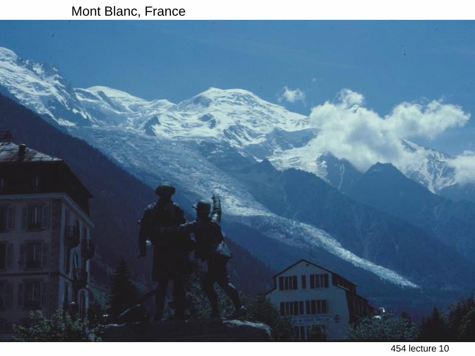
Cirques grow headward & laterally to form horns and arretes

454 lecture 10Machapuchre, Nepal (horn)
horn, Glacier National Park, MT
Matterhorn, Switzerland

454 lecture 10

454 lecture 10

454 lecture 10
Cirques develop through
mechanical weathering & mass wasting: accumulating snow &
firn percolate into rock fractures – pressure fluctuates
during freeze & thaw, and particles move downslope by
creep – nivation
erosion by cirque glaciers: move by rotational sliding as ice
slides and rotates

454 lecture 10
rounded, glaciated topography,
Acadia National Park, Maine

454 lecture 10
glaciated landscape, Kings Canyon National Park, CA

454 lecture 10
Nunataks: residual peaks of rock above ice when cirque glaciers
merge to form ice cap
hanging valley glacier,
Jasper National Park,
Canada
Glacial trough: steep, near-vertical sides & wide, flat bottoms;
u-shaped valley created from v-shaped river valley through
lateral and vertical erosion; tend to have irregular longitudinal
profiles of basins with paternoster lakes & steps; also
hanging valleys where tributary glaciers with less ice join the
main valleyFjords: glacial trough partially submerged by ocean; development
occurred when ice was physically beneath ocean (too deep
for sealevel drop)

454 lecture 10
glacial trim line,
Glacier Bay, Alaska
nunatak, Fairweather Range,
Alaska

454 lecture 10
u-shaped valley, Glacier N.P., MT
stepped valley, Cabinet Mts., MT
glacial tarn, Bighorn Mts., WY

454 lecture 10
lower Taku Valley,
Alaska
upper Taku Valley, Alaska
Yosemite Valley, CA

454 lecture 10
fjord, Norway
Thunersee, Switzerland
u-shaped valley, Norway
454 lecture 10
arretes, Mont Blanc, France
arretes, Southern Patagonia Icefield
Prince William Sound, Alaska

454 lecture 10
Glacial depositional features
glacial drift: all deposits associated with glaciation; covers 8% of
Earth’s surface above sealevel, and 25% of North America
i) nonstratified drift
till: transported & deposited by ice itself; unsorted; many
lithologies; angular
basal or lodgement till: deposited in subglacial environment
under pressure of overlying ice
ablation till: debris concentrated at or near the surface &
dropped as ice melts
Type of till & mode of emplacement are determined from texture of deposit &
arrangement of particles, or fabric (eg. orientation of clasts through motion =
lodgement till)

454 lecture 10
Pinedale till over Bull Lake till, MT

454 lecture 10
ii) stratified drift
sediment transported by moving water before final deposition &
thus stratified, sorted, & rounded; also called fluvioglacial
sediments deposited beyond the terminal margin of the ice
in the proglacial environment form outwash – well sorted,
rounded sands & gravels from bedload of stream channels
Also classify drift & depositional landforms by location relative
to ice:
ice-contact environment: stratified, non-stratified, or combination
marginal: stagnant ice in front of active glacial zone & end
moraines
interior
moraines: depositional features with form independent of
subjacent topography, constructed by accumulation
of drift which is mostly ice-deposited
proglacial: stratified

454 lecture 10
glacier-outburst flood & mass
movements from cirque,
Ama Dablam, Nepal
outwash fans, Glacier Bay,
Alaska

454 lecture 10

454 lecture 10
Stratified Marginal Features
kames: moundlike hills of layered sand & gravel from minor
swells to 50 m high
kame terraces: drift deposited in narrow lake or stream channels
between the valley side & lateral edge of stagnating ice
kettle holes: circular depressions from burial of isolated ice
blocks by stratified drift; ice melts & drift collapses
esker: ridges of fluvioglacial drift formed in tunnels beneath
the ice, in crevasses, or in supraglacial channels

454 lecture 10
kettles, Wind River Range,
Wyoming
mountain front
kame terrace,
nw MT
kame terrace, Scotland

454 lecture 10
Moraines (marginal)
end: at or near edges of active glaciers
terminal: end moraine at farthest point of advance
lateral: sides of valley
interlobate: at junction of two lobes
medial: at junction of two valley glaciers
ground: beneath glacier
Interior features
ground moraine: smoothly undulating plains < 10 m total relief
fluted surfaces: narrow, regularly spaced, parallel ridges &
grooves < 5m high & several hundred m long
drumlins: elongated parallel to ice flow, 1-2 km long, 400-600 m
wide, 5-50 m high, tend to cluster together;
may be erosional (streamline pre-existing drift),
or depositional (ice deposits & molds material
as it moves)

454 lecture 10
Glacier Bay, Alaska

454 lecture 10
Talkeetna, Alaska

454 lecture 10
lateral moraine, Jasper
National Park, Canada
Nepal
lateral moraine,
Rocky Mountain National Park

454 lecture 10
moraine-dammed lake & lateral
moraines, Wind River Range,
Wyoming
recent moraine, Great Basin N.P., Nevada
Holocene moraines,
Longs Peak, CO

454 lecture 10
Moraine Park, Rocky Mountain NP
454 lecture 10
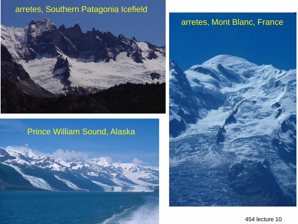
medial & recessional moraines,
Storjuvbreein Glacier, Norway

454 lecture 10
Greenland

454 lecture 10
Sawtooth Mountains, Idaho

454 lecture 10

454 lecture 10
recessional moraines, Athabaska Glacier,
Canada
recessional moraines,
Mt. Rainier, WA
1965
1953
19491945
19191922
1908
1873
1731
1954
1958
1974
19751968
1993
1983 1951
1905
1870
1840

454 lecture 10
Proglacial
sandur (plural sandar): large plain of outwash; similar to alluvial
fans
valley sandur: created by one main river & anabranches
(called valley trains in US)
plain sandur: coalescence of many braided rivers (called
outwash plain in US)
sandar are composed of sand & gravel (fines deflated)
Three zones of sandar are
proximal: close to ice, rivers entrenched, pitted surface
(kettled sandar) due to kettleholes
intermediate: channels wide, shallow, braided & rapidly
laterally shifting
distal: channels so shallow that rivers merge to a single sheet
of water at high flowSandar form via a large sediment supply & high floods such as jokulhlaups –
sudden release of lake water dammed within ice

454 lecture 10
Vatnajokul
Iceland

454 lecture 10

454 lecture 10
sandur, s. Iceland

454 lecture 10
Matanuska Glacier &
braided river, Alaska
outwash fan, Glacier Bay, Alaska
glacial outwash fan,
Yoho National Park,
Canada

454 lecture 10
Fairweather Range, Alaska
glacial lacustrine sediments, Nepal
river with glacial flour,
Yoho National Park, Canada

454 lecture 10
Glacial Depositional Environments
Setting Features Type of drift
Ice contact
marginal end moraines till, fluvioglacial
kames fluvioglacial
kame terraces “
kettle holes “
eskers “
interior medial moraines till
interlobate moraines till
ground moraines lodgement till
fluted surfaces “
drumlins “
proglacial sandar fluvioglacial (outwash)
kettled sandar “

454 lecture 10terminus, Cavell Glacier, Canada
terminus of
cirque glacier,
Nepal

454 lecture 10
terminus of glacier,
Denali National Park,
Alaska
ice & rock glacier, Great Basin N.P.,
Nevada

454 lecture 10
Map of Glacier Bay,
Alaska showing
historical changes in
terminus of glaciers
0 15 miles
1760-80
1860
1963
1966
1966
1966
1966
1966
1966
1966

454 lecture 10
Broecker’s Great Ocean Conveyor Belt
Great Ocean Conveyor Belt: warm water moves northward at
the surface in the North Atlantic; transfer of heat from sea to
air where current meets air cooled during passage over frigid
Canada
heat transferred is 30% of that received by the surface of the
North Atlantic from the sun
this transfer keeps northern Europe warmer, & the waters cool
and sink because they are now more dense
so the ocean current acts as a pump, extracting heat from
low-latitude air & transferring it to high-latitude air

454 lecture 10
the pattern of this circulation is governed by the sea’s salt: the
Atlantic loses more water through evaporation than it gains
through precipitation & continental runoff – the situation is
reversed in the Pacific
net flow of seawater from the Pacific to the Atlantic, but the
Atlantic is still enriched in salt content – flow of more salty
water from Atlantic to Pacific (hence, great conveyor belt)
conveyor did not function during glacial time; when the belt
operates, its warmth prevents ice accumulation on lands
surrounding the northern Atlantic (conveyor shut off for about
700 years during the Younger Dryas)
so there must be some link between the conveyor & seasonality

454 lecture 10

454 lecture 10
stronger
weaker
cold
warmlarge
small
30,000
yr BP20,000 10,000 now
summer
radiation
N. Atlantic
basin T
volume of
icecaps
1) Fluctuations in Earth’s orbit
affect how much summer
sunlight Earth receives
2) This expands & contracts
polar icecap, driving Northern
Hemisphere in & out of glacial
episodes
3) Volume of ice changes
sluggishly & gradually (bottom)
4) Abrupt global warming has
marked end of each glacial
period, indicating that ocean-
atmosphere operation can
change suddenly (middle)
5) Younger Dryas, 700-year
return to glacial conditions,
thought to have been caused
by sudden diversion of melting
Canadian ice sheet waters
from the Mississippi to the St.
Lawrence River

454 lecture 10