Mass wasting processes in the Western Wilkes Land margin: Possible implications for East Antarctic...
15
Mass wasting processes in the Western Wilkes Land margin: Possible implications for East Antarctic glacial history F. Donda a, ⁎ , P.E. O'Brien b , L. De Santis a , M. Rebesco a , G. Brancolini a a Istituto Nazionale di Oceanografia e di Geofisica Sperimentale (OGS), Borgo Grotta Gigante, 42/c, 34010 Sgonico (Trieste), Italy b Geoscience Australia, GPO Box 378 Canberra, ACT 2601, Australia Received 18 May 2007; accepted 22 August 2007 Abstract Multichannel seismic data collected off Western Wilkes Land (East Antarctica) reveal widespread sediment mass movement events, mainly in the form of mega debris flows deposited on the continental rise. In places, they have a seaward extent of more than 200 km and a thickness of up to 400 m. Debris flow units are commonly separated by thin deposits of well-stratified facies, interpreted as glaciomarine mixed contouritic and distal turbidite deposits, possibly with some hemipelagic sediments. These units, due to a dominant contouritic component, represent weakened layers and could then play a major role in the slope instability. Based on stratigraphic correlation with DSDP Site 268, it is suggested that slope failures in the Western Wilkes Land occurred mostly during the Miocene. Inferred high sedimentation rates, due to large amounts of sediment delivered from a temperate, wet-based ice sheet, would have constituted a key factor in the sediment failures. The distribution of mass wasting-related features appears also strongly related to the amount of meltwater discharge. The main trigger mechanism would probably have been earthquakes, enhanced by isostatic rebounds following major ice sheet retreats. © 2007 Elsevier B.V. All rights reserved. Keywords: East Antarctica; Multichannel seismic; Debris flows; Contourites 1. Introduction Mass wasting is a common mechanism both in low latitudes and in high latitude glaciated margins, whereby shelf-edge and upper slope sediment is redistributed downslope by various gravity-driven processes includ- ing suspension flows. Sediment slides, debris flows and turbidity currents are the major gravity-driven processes at continental margins which transport significant volumes of sediment over large distances, into the deep ocean. Slides occur due to the factors that induce in- creases in slope loading, which lead to an increase in shear stress, or a reduction in shear strength. A number of different trigger mechanisms have been suggested for submarine landslides, including sea level change, high sedimentation rates, oversteepening of the slope gradi- ent, wave activity (especially during storm events), gas hydrate dissociation, tsunamis and earthquakes, and, for the polar regions, loading and unloading of sediment deposited from grounded ice sheets (Bugge et al., 1987; Mosher et al., 1994; Mulder and Moran, 1995; Dimakis et al., 2000; Laberg and Vorren, 2000; Imbo et al., 2003; Evans et al., 2005; Rise et al., 2005, 2006). Available online at www.sciencedirect.com Palaeogeography, Palaeoclimatology, Palaeoecology 260 (2008) 77 – 91 www.elsevier.com/locate/palaeo ⁎ Corresponding author. E-mail address: [email protected] (F. Donda). 0031-0182/$ - see front matter © 2007 Elsevier B.V. All rights reserved. doi:10.1016/j.palaeo.2007.08.008
Transcript of Mass wasting processes in the Western Wilkes Land margin: Possible implications for East Antarctic...
Available online at www.sciencedirect.com
alaeoecology 260 (2008) 77–91www.elsevier.com/locate/palaeo
Palaeogeography, Palaeoclimatology, P
Mass wasting processes in the Western Wilkes Land margin: Possibleimplications for East Antarctic glacial history
F. Donda a,⁎, P.E. O'Brien b, L. De Santis a, M. Rebesco a, G. Brancolini a
a Istituto Nazionale di Oceanografia e di Geofisica Sperimentale (OGS), Borgo Grotta Gigante, 42/c, 34010 Sgonico (Trieste), Italyb Geoscience Australia, GPO Box 378 Canberra, ACT 2601, Australia
Received 18 May 2007; accepted 22 August 2007
Abstract
Multichannel seismic data collected off Western Wilkes Land (East Antarctica) reveal widespread sediment mass movementevents, mainly in the form of mega debris flows deposited on the continental rise. In places, they have a seaward extent of morethan 200 km and a thickness of up to 400 m. Debris flow units are commonly separated by thin deposits of well-stratified facies,interpreted as glaciomarine mixed contouritic and distal turbidite deposits, possibly with some hemipelagic sediments. These units,due to a dominant contouritic component, represent weakened layers and could then play a major role in the slope instability. Basedon stratigraphic correlation with DSDP Site 268, it is suggested that slope failures in the Western Wilkes Land occurred mostlyduring the Miocene. Inferred high sedimentation rates, due to large amounts of sediment delivered from a temperate, wet-based icesheet, would have constituted a key factor in the sediment failures. The distribution of mass wasting-related features appears alsostrongly related to the amount of meltwater discharge. The main trigger mechanism would probably have been earthquakes,enhanced by isostatic rebounds following major ice sheet retreats.© 2007 Elsevier B.V. All rights reserved.
Keywords: East Antarctica; Multichannel seismic; Debris flows; Contourites
1. Introduction
Mass wasting is a common mechanism both in lowlatitudes and in high latitude glaciated margins, wherebyshelf-edge and upper slope sediment is redistributeddownslope by various gravity-driven processes includ-ing suspension flows. Sediment slides, debris flows andturbidity currents are the major gravity-driven processesat continental margins which transport significantvolumes of sediment over large distances, into the deep
⁎ Corresponding author.E-mail address: [email protected] (F. Donda).
0031-0182/$ - see front matter © 2007 Elsevier B.V. All rights reserved.doi:10.1016/j.palaeo.2007.08.008
ocean. Slides occur due to the factors that induce in-creases in slope loading, which lead to an increase inshear stress, or a reduction in shear strength. A number ofdifferent trigger mechanisms have been suggested forsubmarine landslides, including sea level change, highsedimentation rates, oversteepening of the slope gradi-ent, wave activity (especially during storm events), gashydrate dissociation, tsunamis and earthquakes, and, forthe polar regions, loading and unloading of sedimentdeposited from grounded ice sheets (Bugge et al., 1987;Mosher et al., 1994; Mulder and Moran, 1995; Dimakiset al., 2000; Laberg and Vorren, 2000; Imbo et al., 2003;Evans et al., 2005; Rise et al., 2005, 2006).
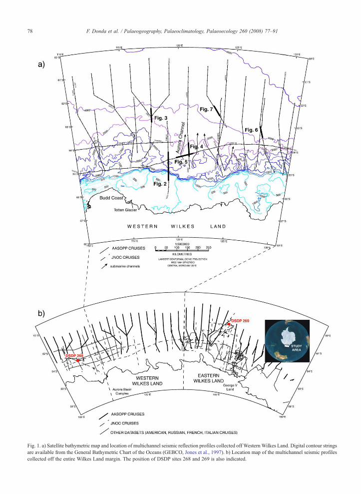
Fig. 1. a) Satellite bathymetric map and location of multichannel seismic reflection profiles collected off WesternWilkes Land. Digital contour stringsare available from the General Bathymetric Chart of the Oceans (GEBCO, Jones et al., 1997). b) Location map of the multichannel seismic profilescollected off the entire Wilkes Land margin. The position of DSDP sites 268 and 269 is also indicated.
78 F. Donda et al. / Palaeogeography, Palaeoclimatology, Palaeoecology 260 (2008) 77–91
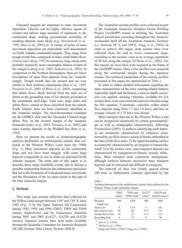
Table 1Technical parameters of the multichannel seismic lines collected in theWestern Wilkes Land continental margin
TH83cruise a
TH93 andTH94 cruise b
GA227cruise c
GA228 andGA229 cruises c
Streamerlength (m)
600 1200 300 3600
Source (l) 9 13.8 6 60Shot interval (m) 50 50 37.5 50Group interval (m) 25 25 12.5 12.5Recording fold 6 12 4 36a Sato et al. (1984).b Ishihara et al. (1996).c Stagg and Schiwy (2002); Stagg et al. (2004).
79F. Donda et al. / Palaeogeography, Palaeoclimatology, Palaeoecology 260 (2008) 77–91
Glaciated margins are important to mass movementdeposition. Glaciers can be highly effective agents oferosion and deliver large amounts of sediments to thecontinental slope, making gravitational instability ofresulting deposits more likely (e.g. Dowdeswell et al.,1998; Bryn et al., 2005a,b). A variety of styles of massmovement deposition are particularly well documentedon North Atlantic continental margins. They range fromtrough mouth fans, composed of many small debris flows(Vorren and Laberg, 1997) to numerous, large slump unitsprobably formed by more catastrophic failures of parts ofthe margin (Laberg et al., 2002; Solheim et al., 2005). Incomparison to the Northern Hemisphere, there are fewerdescriptions of mass flow deposits from the Antarcticmargin. Trough mouth fans are present and are verysimilar to their northern counterparts (Bart et al., 1999;Passchier et al., 2003; O'Brien et al., 2004), comprisingthin debris flows, likely derived from the melt out ofdebris at the grounding zone of ice streams grounded atthe continental shelf-edge. Until now, large slides anddebris flows, similar to those described from the easternNorth Atlantic, have not been commonly identified inthe Antarctic margin. The best-documented examplesare the GEBRA slide and the Alexander Channel megadebris flow on the western margin of the AntarcticPeninsula (Imbo et al., 2003; Diviacco et al., 2003) andmass wasting deposits in the Weddell Sea (Bart et al.,1999).
Here we present the results of seismostratigraphicanalyses performed on multichannel seismic data col-lected in the Western Wilkes Land since the 1980s(Fig. 1). Mass movement deposits on the continentalslope and rise have been imaged, with some largedeposits comparable in size to slides on glaciated NorthAtlantic margins. The main aim of this paper is todescribe these slope instability events and to discuss apossible relationship between the sedimentary processesthat led to the formation of widespread mass movementsand the fluctuation of the ice sheet extent in this part ofthe East Antarctic margin.
2. Methods
This study uses seismic reflection data collected onthe Wilkes Land margin between 110° and 130° E since1983 (Fig. 1) by the Japan National Oil Corporationduring 1983, 1993 and 1994 (TH83, TH93 and TH94cruises respectively) and by Geoscience Australiaduring 2001 and 2002 (GA227, GA228 and GA229cruises). Japanese seismic lines were made availablethrough the Scientific Committee for Antarctic Research(SCAR) Seismic Data Library System (SDLS).
The Australian seismic profiles were collected as partof the Australian Antarctica Southern Ocean ProfilingProject (AASOPP) aimed at defining the Australiansubsoil jurisdiction extending throughout the Antarcticcontinental shelf off the Australian Antarctic Territory(i.e. between 38° E and 160°E, Stagg et al., 2004). Inorder to achieve this target, deep seismic lines werecollected from the mid to lower continental slope,extending to the oceanic crust at an average separationof 90 km along the margin (O'Brien et al., 2006). Forthis reason, no cross lines were acquired in the frame ofthe AASOPP cruises. Only a few profiles were acquiredalong the continental margin during the Japanesecruises. The technical parameters of the seismic profilespresented in this paper are summarized in Table 1.
In order to obtain detailed information regarding themain characteristics of the mass wasting-related features(especially depth and thickness), a time-to-depth conver-sion was applied: stacking velocities, available for GAseismic lines, were converted into interval velocities usingthe Dix equation. Commonly, velocities within debrisflow deposits range from 1.7 and 1.8 km/s, and thus anaverage velocity of 1.75 km/s was chosen.
Mass transport deposits in the Western Wilkes Landcan be recognized seismically by certain geomorpholo-gic as well as stratigraphic characteristics, followingPosamentier (2005): 1) surfaces underlying such depos-its are commonly characterized by extensive scour,formed by sea floor erosive action of blocks embedded atthe base of the flow mass; 2) the upper bounding surfaceis commonly characterized by an irregular to hummockyrelief; 3) in the section view, mass transport deposits arecharacterized by transparent-to-chaotic seismic reflec-tions. Mass transport units commonly amalgamate,although surfaces between successive mass transportdeposits can be obscured and difficult to recognize.
The network of lines was widely spaced (about100 km), so bathymetric contours (provided by the
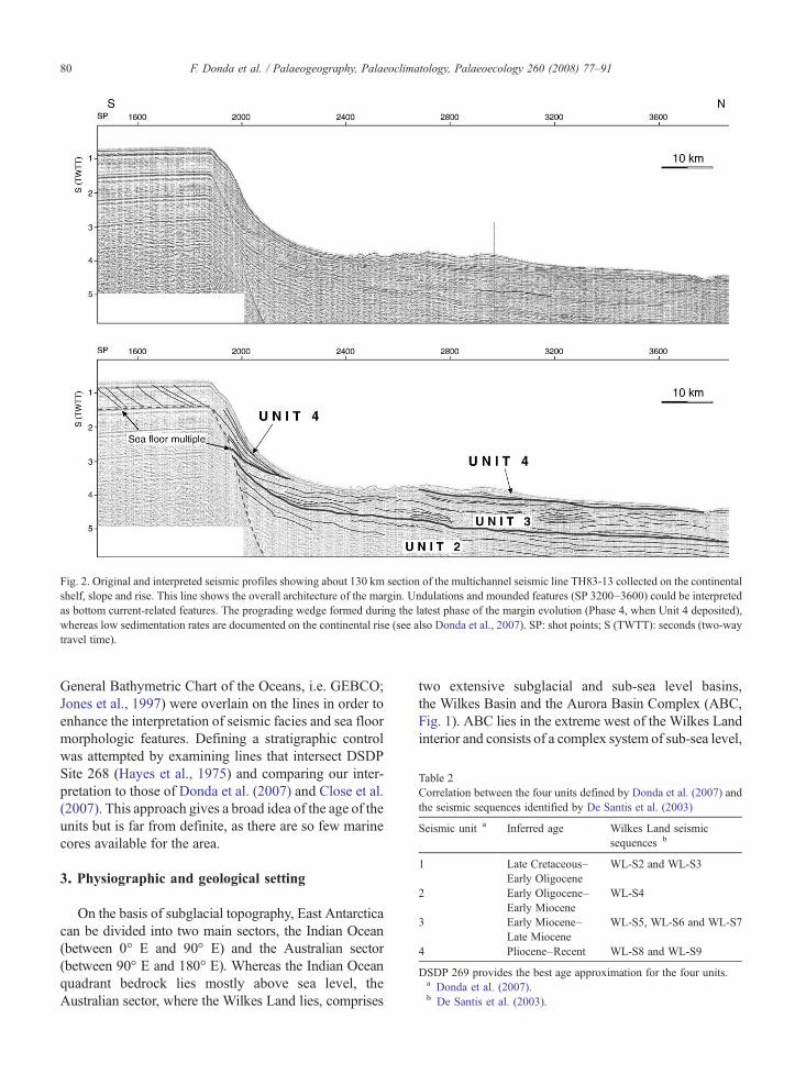
Fig. 2. Original and interpreted seismic profiles showing about 130 km section of the multichannel seismic line TH83-13 collected on the continentalshelf, slope and rise. This line shows the overall architecture of the margin. Undulations and mounded features (SP 3200–3600) could be interpretedas bottom current-related features. The prograding wedge formed during the latest phase of the margin evolution (Phase 4, when Unit 4 deposited),whereas low sedimentation rates are documented on the continental rise (see also Donda et al., 2007). SP: shot points; S (TWTT): seconds (two-waytravel time).
Table 2Correlation between the four units defined by Donda et al. (2007) andthe seismic sequences identified by De Santis et al. (2003)
Seismic unit a Inferred age Wilkes Land seismicsequences b
1 Late Cretaceous–Early Oligocene
WL-S2 and WL-S3
2 Early Oligocene–Early Miocene
WL-S4
3 Early Miocene–Late Miocene
WL-S5, WL-S6 and WL-S7
4 Pliocene–Recent WL-S8 and WL-S9
DSDP 269 provides the best age approximation for the four units.a Donda et al. (2007).b De Santis et al. (2003).
80 F. Donda et al. / Palaeogeography, Palaeoclimatology, Palaeoecology 260 (2008) 77–91
General Bathymetric Chart of the Oceans, i.e. GEBCO;Jones et al., 1997) were overlain on the lines in order toenhance the interpretation of seismic facies and sea floormorphologic features. Defining a stratigraphic controlwas attempted by examining lines that intersect DSDPSite 268 (Hayes et al., 1975) and comparing our inter-pretation to those of Donda et al. (2007) and Close et al.(2007). This approach gives a broad idea of the age of theunits but is far from definite, as there are so few marinecores available for the area.
3. Physiographic and geological setting
On the basis of subglacial topography, East Antarcticacan be divided into two main sectors, the Indian Ocean(between 0° E and 90° E) and the Australian sector(between 90° E and 180° E). Whereas the Indian Oceanquadrant bedrock lies mostly above sea level, theAustralian sector, where the Wilkes Land lies, comprises
two extensive subglacial and sub-sea level basins,the Wilkes Basin and the Aurora Basin Complex (ABC,Fig. 1). ABC lies in the extreme west of the Wilkes Landinterior and consists of a complex system of sub-sea level,
81F. Donda et al. / Palaeogeography, Palaeoclimatology, Palaeoecology 260 (2008) 77–91
generally, northwest-trending basins (Close, 2004). Abroadly north–south oriented region of rugged highlands,called Resolution and Porpoise Subglacial Highlands,separates the ABC from the Wilkes Basin. Althoughgeophysical data over the ABC is extremely limited, ithas been estimated that the thickness of the ice cover ismore that 4 km (Close, 2004). The Budd Coast alsocomprises an elevated bedrock and ice surface, as doesthe Law Dome, which rises to about 1400 m. The ABCrepresents the catchment area of one of the fastest-flowing outlet glaciers in East Antarctica, i.e. the TottenGlacier (Bamber et al., 2000, 2006). Close et al. (2007)noted that the greatest thickness of sediment depositedin Wilkes Land in the last 34 Ma was located offshorethe Totten Glacier terminus, that lies at and around atopographic high on the Budd Coast. They calculatedthat the average sedimentation rates for this area be-
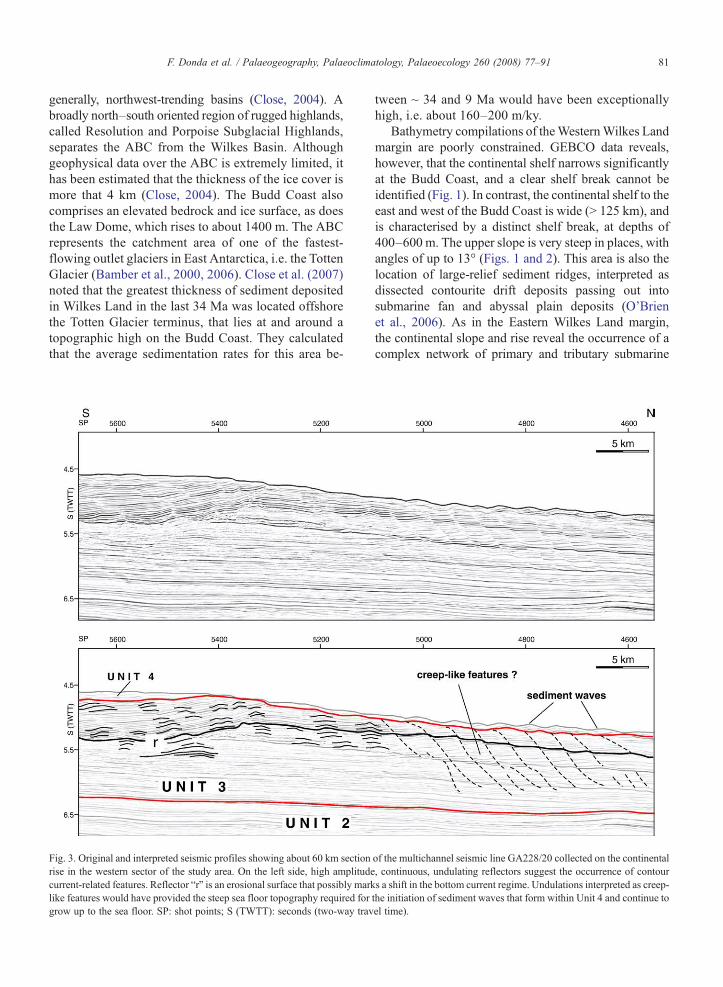
Fig. 3. Original and interpreted seismic profiles showing about 60 km sectionrise in the western sector of the study area. On the left side, high amplitudecurrent-related features. Reflector “r” is an erosional surface that possibly marklike features would have provided the steep sea floor topography required forgrow up to the sea floor. SP: shot points; S (TWTT): seconds (two-way trav
tween ~ 34 and 9 Ma would have been exceptionallyhigh, i.e. about 160–200 m/ky.
Bathymetry compilations of theWesternWilkes Landmargin are poorly constrained. GEBCO data reveals,however, that the continental shelf narrows significantlyat the Budd Coast, and a clear shelf break cannot beidentified (Fig. 1). In contrast, the continental shelf to theeast and west of the Budd Coast is wide (N 125 km), andis characterised by a distinct shelf break, at depths of400–600 m. The upper slope is very steep in places, withangles of up to 13° (Figs. 1 and 2). This area is also thelocation of large-relief sediment ridges, interpreted asdissected contourite drift deposits passing out intosubmarine fan and abyssal plain deposits (O'Brienet al., 2006). As in the Eastern Wilkes Land margin,the continental slope and rise reveal the occurrence of acomplex network of primary and tributary submarine
of the multichannel seismic line GA228/20 collected on the continental, continuous, undulating reflectors suggest the occurrence of contours a shift in the bottom current regime. Undulations interpreted as creep-the initiation of sediment waves that form within Unit 4 and continue toel time).
82 F. Donda et al. / Palaeogeography, Palaeoclimatology, Palaeoecology 260 (2008) 77–91
channels (see also Escutia et al., 2000 and Donda et al.,2007). One of these channels, most of which are un-named thus far, has been crossed by the Japanese seismicline TH83-17 (see below). Since this channel lies off-shore the Aurora Basin (at around 120°E), it has beennamed the “Aurora Channel” for the purposes of thisstudy (Fig. 1).
The Wilkes Land continental margin formed as aconsequence of the separation of East Antarctica andAustralia. Since the initial Early Eocene interpretation ofWeissel and Hayes (1972), the timing of the breakup hasundergone several revisions. Recent reinterpretations ofthe magnetic anomalies off Southern Australia (e.g.Sayers et al., 2001) proposed that sea floor spreadingbetween Australia and Antarctica started at about 83Ma.Sea floor spreading was very slow until the Eocene (1–4.5 mm/yr, Cande and Mutter, 1982), when spreadingrates accelerated to 10 mm/yr (Tikku and Cande, 1999).Close (2004), suggested an average spreading rate ofabout 6 mm/yr from about 83 Ma to 38 Ma, then anaverage spreading rate of 31 mm/yr from about 37 Ma tothe present day. By the Early Oligocene, the final sepa-ration of Antarctica and Australia took place resulting inopen marine conditions between the continents (Exonet al., 2001, 2002). The northward movement ofAustralia led to its aridity, whereas in the conjugateEast Antarctic margin, the first emplacement of an ice
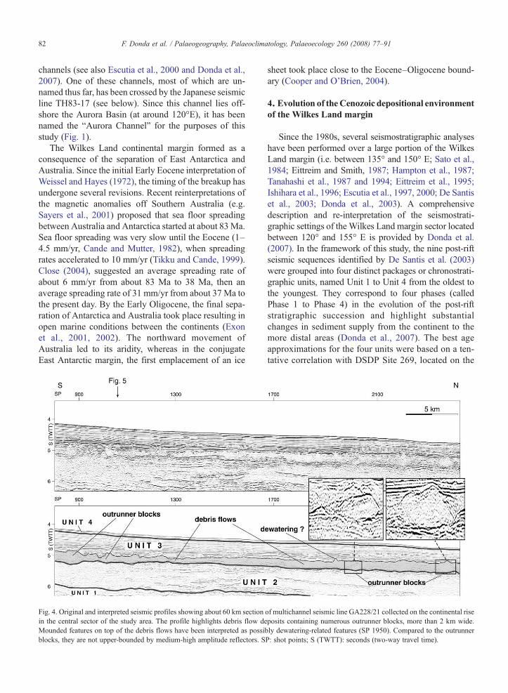
Fig. 4. Original and interpreted seismic profiles showing about 60 km sectionin the central sector of the study area. The profile highlights debris flow deMounded features on top of the debris flows have been interpreted as possiblocks, they are not upper-bounded by medium-high amplitude reflectors. S
sheet took place close to the Eocene–Oligocene bound-ary (Cooper and O'Brien, 2004).
4. Evolution of theCenozoic depositional environmentof the Wilkes Land margin
Since the 1980s, several seismostratigraphic analyseshave been performed over a large portion of the WilkesLand margin (i.e. between 135° and 150° E; Sato et al.,1984; Eittreim and Smith, 1987; Hampton et al., 1987;Tanahashi et al., 1987 and 1994; Eittreim et al., 1995;Ishihara et al., 1996; Escutia et al., 1997, 2000; De Santiset al., 2003; Donda et al., 2003). A comprehensivedescription and re-interpretation of the seismostrati-graphic settings of the Wilkes Land margin sector locatedbetween 120° and 155° E is provided by Donda et al.(2007). In the framework of this study, the nine post-riftseismic sequences identified by De Santis et al. (2003)were grouped into four distinct packages or chronostrati-graphic units, named Unit 1 to Unit 4 from the oldest tothe youngest. They correspond to four phases (calledPhase 1 to Phase 4) in the evolution of the post-riftstratigraphic succession and highlight substantialchanges in sediment supply from the continent to themore distal areas (Donda et al., 2007). The best ageapproximations for the four units were based on a ten-tative correlation with DSDP Site 269, located on the
of multichannel seismic line GA228/21 collected on the continental riseposits containing numerous outrunner blocks, more than 2 km wide.bly dewatering-related features (SP 1950). Compared to the outrunnerP: shot points; S (TWTT): seconds (two-way travel time).
83F. Donda et al. / Palaeogeography, Palaeoclimatology, Palaeoecology 260 (2008) 77–91
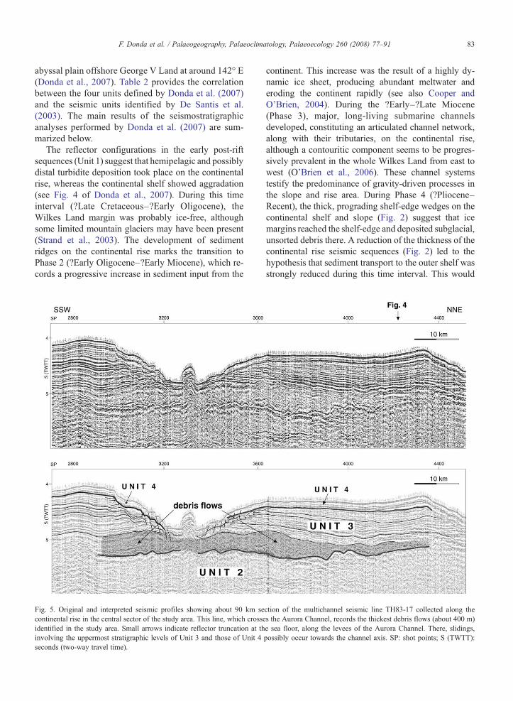
abyssal plain offshore George V Land at around 142° E(Donda et al., 2007). Table 2 provides the correlationbetween the four units defined by Donda et al. (2007)and the seismic units identified by De Santis et al.(2003). The main results of the seismostratigraphicanalyses performed by Donda et al. (2007) are sum-marized below.
The reflector configurations in the early post-riftsequences (Unit 1) suggest that hemipelagic and possiblydistal turbidite deposition took place on the continentalrise, whereas the continental shelf showed aggradation(see Fig. 4 of Donda et al., 2007). During this timeinterval (?Late Cretaceous–?Early Oligocene), theWilkes Land margin was probably ice-free, althoughsome limited mountain glaciers may have been present(Strand et al., 2003). The development of sedimentridges on the continental rise marks the transition toPhase 2 (?Early Oligocene–?Early Miocene), which re-cords a progressive increase in sediment input from the
Fig. 5. Original and interpreted seismic profiles showing about 90 km secontinental rise in the central sector of the study area. This line, which crosseidentified in the study area. Small arrows indicate reflector truncation at thinvolving the uppermost stratigraphic levels of Unit 3 and those of Unit 4seconds (two-way travel time).
continent. This increase was the result of a highly dy-namic ice sheet, producing abundant meltwater anderoding the continent rapidly (see also Cooper andO'Brien, 2004). During the ?Early–?Late Miocene(Phase 3), major, long-living submarine channelsdeveloped, constituting an articulated channel network,along with their tributaries, on the continental rise,although a contouritic component seems to be progres-sively prevalent in the whole Wilkes Land from east towest (O'Brien et al., 2006). These channel systemstestify the predominance of gravity-driven processes inthe slope and rise area. During Phase 4 (?Pliocene–Recent), the thick, prograding shelf-edge wedges on thecontinental shelf and slope (Fig. 2) suggest that icemargins reached the shelf-edge and deposited subglacial,unsorted debris there. A reduction of the thickness of thecontinental rise seismic sequences (Fig. 2) led to thehypothesis that sediment transport to the outer shelf wasstrongly reduced during this time interval. This would
ction of the multichannel seismic line TH83-17 collected along thes the Aurora Channel, records the thickest debris flows (about 400 m)e sea floor, along the levees of the Aurora Channel. There, slidings,possibly occur towards the channel axis. SP: shot points; S (TWTT):
84 F. Donda et al. / Palaeogeography, Palaeoclimatology, Palaeoecology 260 (2008) 77–91
reflect that the ice sheet was progressively less dynamicthan during Phase 3, and a transition to colder, morepolar regimes occurred (Donda et al., 2007).
5. Results
5.1. Seismic characteristics of the Western Wilkes Landmass wasting-related features
5.1.1. Creep-like featuresVariable thickness packages of medium amplitude,
widely folded reflectors, with each fold being sepa-rated from the other by listric faults, have been in-terpreted as creep-like features (Fig. 3; see also Fig. 2aof Canals et al., 2004). They are characterized byasymmetric undulations that resemble up-slope mi-grating sediment waves. Depositional bedforms arepresent in the region; however, these slide structuresdiffer in having irregular undulation spacing andhaving steep sides that can be traced into faults atdepth (Fig. 3). Later, we tentatively provide a dis-cussion about the main parameters we adopted todistinguish between creeping and current-related, de-positional features (see Discussion). Usually this facies
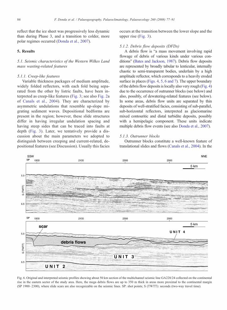
Fig. 6. Original and interpreted seismic profiles showing about 50 km sectionrise in the eastern sector of the study area. Here, the mega debris flows are(SP 1900–2300), where slide scars are also recognizable on the seismic line
occurs at the transition between the lower slope and theupper rise (Fig. 3).
5.1.2. Debris flow deposits (DFDs)A debris flow is “a mass movement involving rapid
flowage of debris of various kinds under various con-ditions” (Bates and Jackson, 1987). Debris flow depositsare represented by broadly tabular to lenticular, internallychaotic to semi-transparent bodies, underlain by a highamplitude reflector, which corresponds to a heavily erodedsurface in places (Figs. 4, 5, 6 and 7). The upper boundaryof the debris flowdeposits is locally also very rough (Fig. 4)due to the occurrence of outrunner blocks (see below) andalso, possibly, of dewatering-related features (see below).In some areas, debris flow units are separated by thindeposits of well-stratified facies, consisting of sub-parallel,sub-horizontal reflectors, interpreted as glaciomarinemixed contouritic and distal turbidite deposits, possiblywith a hemipelagic component. These units indicatemultiple debris flow events (see also Donda et al., 2007).
5.1.3. Outrunner blocksOutrunner blocks constitute a well-known feature of
translational slides and flows (Canals et al., 2004). In the
of the multichannel seismic line GA228/24 collected on the continentalup to 350 m thick in areas more proximal to the continental margins. SP: shot points; S (TWTT): seconds (two-way travel time).
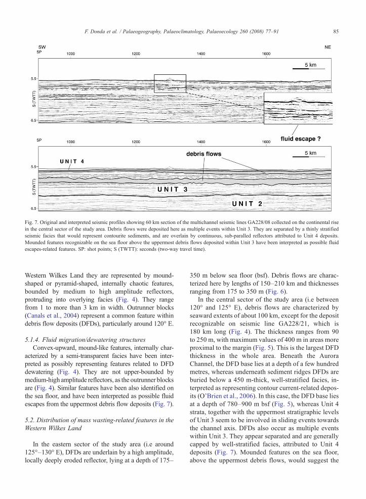
Fig. 7. Original and interpreted seismic profiles showing 60 km section of the multichannel seismic lines GA228/08 collected on the continental risein the central sector of the study area. Debris flows were deposited here as multiple events within Unit 3. They are separated by a thinly stratifiedseismic facies that would represent contourite sediments, and are overlain by continuous, sub-paralled reflectors attributed to Unit 4 deposits.Mounded features recognizable on the sea floor above the uppermost debris flows deposited within Unit 3 have been interpreted as possible fluidescapes-related features. SP: shot points; S (TWTT): seconds (two-way travel time).
85F. Donda et al. / Palaeogeography, Palaeoclimatology, Palaeoecology 260 (2008) 77–91
Western Wilkes Land they are represented by mound-shaped or pyramid-shaped, internally chaotic features,bounded by medium to high amplitude reflectors,protruding into overlying facies (Fig. 4). They rangefrom 1 to more than 3 km in width. Outrunner blocks(Canals et al., 2004) represent a common feature withindebris flow deposits (DFDs), particularly around 120° E.
5.1.4. Fluid migration/dewatering structuresConvex-upward, mound-like features, internally char-
acterized by a semi-transparent facies have been inter-preted as possibly representing features related to DFDdewatering (Fig. 4). They are not upper-bounded bymedium-high amplitude reflectors, as the outrunner blocksare (Fig. 4). Similar features have been also identified onthe sea floor, and have been interpreted as possible fluidescapes from the uppermost debris flow deposits (Fig. 7).
5.2. Distribution of mass wasting-related features in theWestern Wilkes Land
In the eastern sector of the study area (i.e around125°–130° E), DFDs are underlain by a high amplitude,locally deeply eroded reflector, lying at a depth of 175–
350 m below sea floor (bsf). Debris flows are charac-terized here by lengths of 150–210 km and thicknessesranging from 175 to 350 m (Fig. 6).
In the central sector of the study area (i.e between120° and 125° E), debris flows are characterized byseaward extents of about 100 km, except for the depositrecognizable on seismic line GA228/21, which is180 km long (Fig. 4). The thickness ranges from 90to 250 m, with maximum values of 400 m in areas moreproximal to the margin (Fig. 5). This is the largest DFDthickness in the whole area. Beneath the AuroraChannel, the DFD base lies at a depth of a few hundredmetres, whereas underneath sediment ridges DFDs areburied below a 450 m-thick, well-stratified facies, in-terpreted as representing contour current-related depos-its (O'Brien et al., 2006). In this case, the DFD base liesat a depth of 780–900 m bsf (Fig. 5), whereas Unit 4strata, together with the uppermost stratigraphic levelsof Unit 3 seem to be involved in sliding events towardsthe channel axis. DFDs also occur as multiple eventswithin Unit 3. They appear separated and are generallycapped by well-stratified facies, attributed to Unit 4deposits (Fig. 7). Mounded features on the sea floor,above the uppermost debris flows, would suggest the
86 F. Donda et al. / Palaeogeography, Palaeoclimatology, Palaeoecology 260 (2008) 77–91
occurrence of fluid escapes (Fig. 7). Numerous out-runner blocks are also recognizable within the DFDs(Fig. 4).
In the western sector of the study area (i.e between110° and 120° E), there is no evidence of DFD, except forthe ~ 200 m-thick and 40 km-long, lens-shaped deposit,recognizable on seismic line GA228/18 (see Fig. 3 ofClose et al., 2007, Shot Points 2750–3450). Slides occuron the continental rise, possibly as creep-like features(Fig. 3). Unit 4 deposits, above such facies, displayasymmetric undulations, composed of highly continuousreflectors, which have been interpreted as up-slope mi-grating sediment waves (Fig. 4).
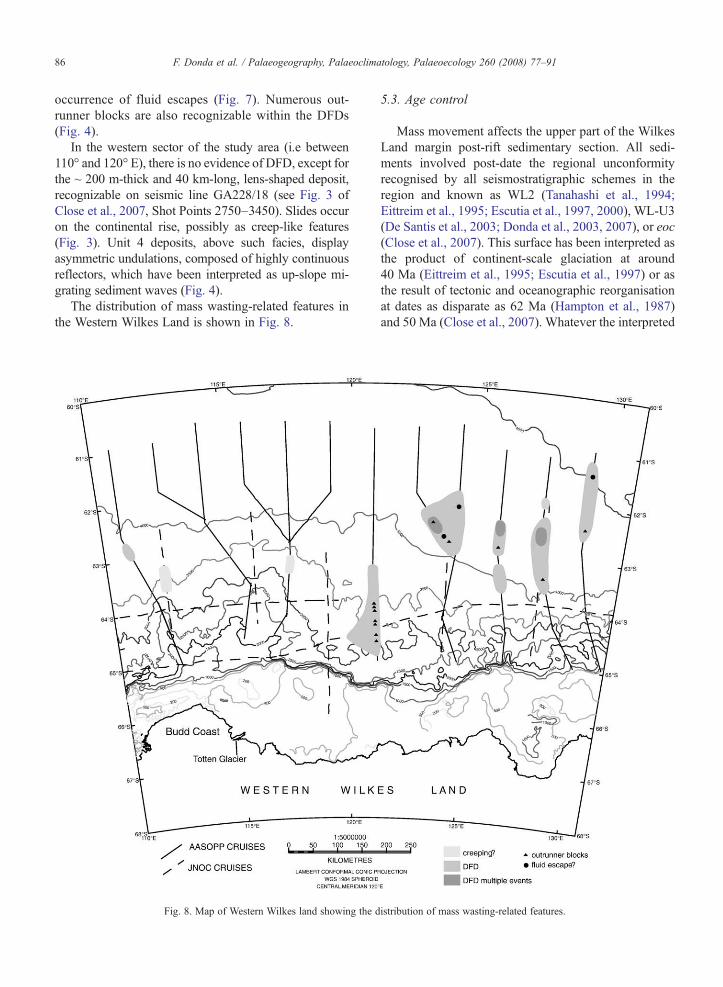
The distribution of mass wasting-related features inthe Western Wilkes Land is shown in Fig. 8.
Fig. 8. Map of Western Wilkes land showing the d
5.3. Age control
Mass movement affects the upper part of the WilkesLand margin post-rift sedimentary section. All sedi-ments involved post-date the regional unconformityrecognised by all seismostratigraphic schemes in theregion and known as WL2 (Tanahashi et al., 1994;Eittreim et al., 1995; Escutia et al., 1997, 2000), WL-U3(De Santis et al., 2003; Donda et al., 2003, 2007), or eoc(Close et al., 2007). This surface has been interpreted asthe product of continent-scale glaciation at around40 Ma (Eittreim et al., 1995; Escutia et al., 1997) or asthe result of tectonic and oceanographic reorganisationat dates as disparate as 62 Ma (Hampton et al., 1987)and 50 Ma (Close et al., 2007). Whatever the interpreted
istribution of mass wasting-related features.
87F. Donda et al. / Palaeogeography, Palaeoclimatology, Palaeoecology 260 (2008) 77–91
age of this surface, the mass movement features de-scribed here are likely post-Eocene.
Deep Sea Drilling Project (DSDP) Site 268 is locatedon the upper continental rise at a water depth of 3500 m,at around 105° E, approximatively 300 km east of ourstudy area. This site is tied by GA228/16 and TH83-10and TH94-19 seismic lines. The sedimentary section isabout 3.5 km thick, but the maximum core recoverydepth was only 474.5 m (Hayes et al., 1975). Site 268penetrated a series of seismic sequences that, althoughdifficult to correlate across the area, provide seismos-tratigraphic guidance as to the age of sediment massmovement events. Hayes et al. (1975) subdivided Site268 into 3 units. The uppermost unit is 160 m thick andcomprises Pliocene to Pleistocene diatom oozes, clays,silts and graded sand beds interpreted by Piper andBrisco (1975) as interbedded turbidites and hemipelagicsediments. The second is 68 m thick and is composed ofEarly Miocene clays, silts, and nannofossil-bearing oozewith silt laminae and scattered granules and coarse sandgrains. It overlies a 256 m thick layer, consisting oflaminated clays and cherts with silty laminae. Granulesand fine pebbles are present but rare. Biostratigraphicevidence suggests Late Oligocene to Early Miocene agefor such deposits, interpreted by Piper and Brisco (1975)as contourites.
Site 268 intersects several seismic lines that exhibit thesame seismic stratigraphic styles described by Dondaet al. (2007). The stratigraphy of Site 268 would suggestthat Phase 4 was of Pliocene to Pleistocene age and thatPhase 3 represents sedimentation throughout the Mio-cene, although unconformities intersecting the hole andthroughout the region make precise correlation difficult.The positions of the mass movement deposits thereforesuggest they formed at various times during the Miocene.
6. Discussion
In the Wilkes Land margin, mass wasting-related fea-tures, especially the mega debris flow deposits, occur inan area of the margin where a significant increase in thewhole post-rift sediment thickness occurs (O'Brien et al.,2006). Amainly contouritic origin for such deposits, morethan 4 km thick (see Fig. 12 of Close et al., 2007), hasbeen suggested (O'Brien et al., 2006). Bottom current-related deposits are recognizable on the continental rise inthe whole study area, as continuous, undulating reflectorsand as mound-like features, affecting sediments depositedwithin units 3 and 4 (Figs. 2 and 3). The thickest sedi-mentary sequence lies approximatively 500 km offshorethe Totten Glacier terminus (see Fig. 7 of O'Brien et al.,2006). A spatial correlation between these sediments and
the significant sediment discharge from the Totten Glacieris made. It provides evidence that some fast-flow featuresmaintain relatively static discharge point sources on longtime scales (N10 My, Close, 2004).
Debris flow deposits have been identified in the easternand central part of the study area (Figs. 4, 5, 6, 7 and 8).They are represented by an almost acoustically transpar-ent internal seismic signature, probably caused bydeformational homogenization during their downslopemovement (Nardin et al., 1979; Laberg andVorren, 1995).DFD bases often correspond to a deeply eroded surface(Figs. 4, 5 and 6), indicating that the debris flows de-formed and thus were able to incorporate some of theunderlying sediments during their emplacement. Similarprocesses have also been reported by Laberg and Vorren(1995) in the Bear Island trough mouth fan. It has beenwidely demonstrated that the matrix of debris flows, inwhich strength is the main sediment support mechanism,can easily support clasts of various sizes as well as con-solidated blocks that have been transported as partiallybuoyant rafted blocks (Canals et al., 2004). The DFDcapacity of incorporating and transporting bedload ma-terial is demonstrated also by the occurrence of outrunnerblocks, which have been found in several locations and atdifferent distances within the DFDs (Fig. 4). With aseaward extent of up to 200 km and a thickness thatreaches 400 m, DFDs can be classified as “mega debrisflows deposits,” according to Diviacco et al. (2003). Dueto their exceptional size, it is likely that such depositsresulted from the incorporation of several, smaller debrisflows, which were part of a single, multiphase failureevent, as also suggested for the Alexander Channel debrisflow in the Antarctic Peninsula by Diviacco et al. (2003).They reveal an extraordinary mobility, as demonstratedby their long run-out distances, comparable with theStoregga and Traenadjupet slides (Laberg and Vorren,2000; Laberg et al., 2002; Bryn et al., 2005a,b; De Blasio,2005; Kvalstad et al., 2005). The absence of sea floorfeatures acting as obstacles to the flow (Canals et al.,2004), and a progressive change of the physical propertiesof the material involved in the downslope movementsuggests a relatively low sediment yield strength. In fact,De Blasio et al. (2005) suggested that long run-outs, as inthe Storegga Slide (400–450 km), are due to progressiveloss of strength during the downslope movement of thedebris flows, possibly related to water entrainment un-derneath the flowing sediments. Such a process, known as“hydroplanning” (Harbitz et al., 2003), is commonly as-sociated with long run-out distances and outrunner blockswithin the debris flow deposits (De Blasio et al., 2005).When hydroplaning starts, water underneath the debrisflows rapidly mixes with the solid material, favouring
88 F. Donda et al. / Palaeogeography, Palaeoclimatology, Palaeoecology 260 (2008) 77–91
water seepage into the debris flows (De Blasio et al.,2005). Frequent outrunner blocks and features that couldbe interpreted as dewatering structures have been iden-tified within and above the Western Wilkes Land megadebris flow deposits (Figs. 4, 7). It is then suggested thattheir long run-out distances could be related to hydro-planning processes, as a consequence of a progressive lossof yield strength during the debris flow downslope move-ment. Major slides occurred several times during Phase 3.In the Norwegianmargin, recent results from the StoreggaSlide reveal that, although a single, main slide occurred ataround 8200 yr BP, repeated failures also occurred afterthis major event (Haflidason et al., 2005).
The uppermost DFDs are capped by the stratifiedfacies attributed to Unit 4 deposits (Figs. 4, 6, 7), sug-gesting that mass wasting processes were largely subduedor even absent during Phase 4 (?Pliocene–Recent).
Surprisingly, in the westernmost part of the studyarea, no debris flows have been identified. Only creep-like features have been tentatively identified. Thisseismic facies appears to be very similar to sedimentwave deposition facies. Interpretation problems oftenarise when distinguishing between failure-related andcurrent-related depositional features. In this study, thetwo criterion adopted to distinguish between them are:1) the continuity of the seismic reflections and 2) theoccurrence/absence of listric faulting. Sediment wavesdisplay more continuous seismic reflectors and noevidence of faulting has been detected to separate eachwave from the adjacent one. Well-developed sedimentwaves have been identified within Unit 4 up to the seafloor. They appear to develop above the inferred creep-like features (Fig. 3), according to Wynn and Stow(2002), who infer that pre-existing stepped sea floortopography is normally required for wave initiation.
A possible explanation for the “absence” of DFDs inthewestern sector of the study area is the differences in theamount of meltwater discharge along the margin. Melt-water-related processes are important to the sedimentaryarchitecture and morphology of continental slopes both inthe Southern (Anderson, 1999; Shipp et al., 1999) and inthe Northern Hemisphere (Hesse et al., 1997, 1999). Ingeneral, large meltwater discharges favour rapid, prox-imal initiation of turbidity currents and relative sedimentstarvation on the upper slope rather than deposition ofunstable sediments on the slope, which later fail and formdebris flows (O'Cofaigh et al., 2003). In the Wilkes Landmargin, large amounts of glacial meltwater eroded anddelivered sediments from the continental shelf to the slopeand rise area during Phase 3 (Donda et al., 2007). Pos-sibly, meltwater discharge did not occurr in a similar wayall along the margin, with some areas delivering larger
amounts of water. Large debris flows in the eastern andcentral sector of the study area suggest a lesser role formeltwater in transporting sediment to the rise than furtherwest. Here, the abundant fine component in the sedimentload, discharged from a highly dynamic, wet-based gla-cier such as the Totten Glacier, became available foradvection by contour currents, contributing to the depo-sition of the thick contouritic deposits.
In the Western Wilkes Land, the occurrence of mul-tiple events would indicate that this part of the conti-nental margin has been unstable for a long time, i.e. atleast during the deposition of Unit 3, which is Miocenein age. Moreover, multiple debris flow events areintercalated with mixed glaciomarine contouritic anddistal turbiditic-related deposits together with, possibly,hemipelagic sediments (see also Donda et al., 2007).The contouritic component seems also to be progres-sively prevalent in the whole Wilkes Land from Eastto West, according to O'Brien et al. (2006). Contourcurrent-related deposits, mainly soft clays, have alsobeen identified in the failed sediments of the Storegga,Traenadjupet and Afen slides in the North Atlanticglaciated margins. The main influence of countourites ofslope instability relates to their physical properties,being in general characterized by high water and claycontent and plasticity (Kvalstad et al., 2005; Bryn et al.,2005b). Contouritic deposits in the Western WilkesLand could then also have played a major role in theslope instability, representing weak layers above whichsediments were prone to slide.
7. Trigger mechanisms
A trigger mechanism, or a combination of triggermechanisms, is required to destabilize sediments alreadyprone to failure. As it has been suggested for severalNorthern Hemisphere slide events (Rise et al., 2006),excess pore pressure could be invoked as the main triggermechanism for the Wilkes Land mass wastings. Analo-gues from the Northern Hemisphere mass wastingprocesses can be taken into account since the modernNorth Atlantic glacial regime can be regarded as ananalogue to the glacial conditions in Antarctica during theNeogene (Hambrey et al., 2002). In the Western WilkesLand margin, approximatively off the Totten Glacierterminus, themaximum sediment thickness (about 850m;Fig. 6) of deposits attributed to Unit 3 has been recorded.As also suggested by Donda et al. (2007) high sedi-mentation rates could be possibly related to the pro-gressive growth and evolution of the East Antarctic IceSheet. During the Miocene, high sedimentation rates areexpected to occur in the Wilkes Land as a consequence of
89F. Donda et al. / Palaeogeography, Palaeoclimatology, Palaeoecology 260 (2008) 77–91
high discharge of meltwater at the base of a highly dy-namic, wet-based temperate ice sheet (see also Dondaet al., 2007). Under such conditions, there was excessporewater pressure. Overpressure was generated withinthe intercalated sediments made of mixed contouritic,turbiditic and hemipelagic deposits, possibly depositedduring glacial retreats. These intercalated sedimentswould have behaved as weak layers and glide planes.
As a final trigger mechanism, earthquake activityassociated with a post-glacial isostatic rebound could beinvoked. In the Northern Hemisphere, glacio-eustaticseismicity would be at its highest during deglaciations(Solheim et al., 2005), when strong (magnitudes 7) earth-quakes were suggested to have occurred (Bryn et al.,2005a). During the Miocene, and especially during theMiddle–Late Miocene, variations in the eustatic curveand the isotope ratios would be related to major ice sheetfluctuation (see Fig. 11 of Donda et al., 2007). Theisostatic rebound, following the ice sheet retreat, couldthen be responsible for seismic activity in Antarctica, andthen also in the Wilkes Land margin. In fact, the previousnotion that Antarctica is essentially aseismic (Tingey,1991) has been recently disproved, and loading and partialunloading of ice cover has been proposed as one of themain seismic controlling factors (Reading, in press). Thisseems to be particularly well constrained in the WilkesLand, where earthquakes presently occur in the con-tinental shelf and rise area, with some events reaching amagnitude of 5.0 (Reading, 2002, in press). It is thenreasonable to suggest that strong earthquakes occurred inthe study area also throughout the Miocene, when iso-static rebounds were caused by multiple advances andretreats of a highly dynamic ice sheet.
8. Conclusions
Seismostratigraphic analyses performed on multi-channel seismic data collected off Western Wilkes Land(East Antarctica) reveal the occurrence of widespreadsliding events. They are mainly represented by megadebris flows, deposited as multiple events on the conti-nental rise, locally containing large outrunner blocks.DFDs were probably characterized by low yield strength,indicated by their long run-out distances.
Stratigraphic correlation with DSDP Site 268 suggeststhat slope failures in the Western Wilkes Land occurredduring the Miocene. The uppermost part of the WesternWilkes Land post-rift sequence, corresponding to sedi-ments attributed toUnit 4, Pliocene toRecent in age, is notaffected by major slope failure. Here, sediment wavesform locally, possibly as a consequence of both turbiditicand contouritic processes.
Debris flow units are commonly separated by thindeposits of well-stratified facies, interpreted as glaciomar-ine mixed contourites and distal turbidites, and hemi-pelagic deposits. These units, due to a dominant contouriticcomponent, areweakened layers and could then represent akey factor in the further slope instability. Inferred highsedimentation rates, due to large amounts of sedimentdelivered from a temperate, wet-based ice sheet (Dondaet al., 2007), and consequent excess pore pressures pos-sibly played amajor role inWesternWilkes Land sedimentfailures. The distribution of mass wasting-related featuresappears to have been strongly related to the amount ofmeltwater discharge, with debris flow deposition occurringin areas were meltwater possibly played only a minorrole. The final trigger mechanism would be related to thehigh dynamism of the ice sheet, characterized by largefluctuations during the Miocene. Isostatic rebound, fol-lowing major ice sheet retreat, could be possibly at theorigin of large earthquakes, leading to the failure of sedi-ments already prone to slide.
Acknowledgments
The first author is grateful to the Petroleum andMarineDivision of Geoscience Australia for the hospitality andtechnical support. Howard Stagg is acknowledged inparticular for the valuable discussions and suggestions. L.Rise and P. Bryn are acknowledged for the stimulatingcomments and constructive suggestions that greatlyimproved the manuscript. This study is funded by theItalian Programma Nazionale di Ricerche in Antartide(PNRA) and by the Consiglio Nazionale delle Ricerche(CNR) in the frame of the international “Short-TermMobility” project.
References
Anderson, J.B., 1999. Antarctic Marine Geology. Cambridge Uni-versity Press, Cambridge.
Bamber, J.L., Vaughan, D.G., Joughin, I., 2000. Widespread complexflow in the interior of theAntarctic ice sheet. Science 287, 1248–1250.
Bamber, J.L., Ferraccioli, F., Shepherd, T., Rippin, D.M., Siegert, M.J.,Vaughan, D.G., 2006. East Antarctic ice stream tributary underlainby major sedimentary basins. Geology 34 (1), 33–36.
Bart, P.J., De Batist, M., Jokat, W., 1999. Interglacial collapse of Crarytrough-mouth fan,Weddel Sea,Antarctica: implications for Antarcticglacial history. Journal of Sedimentary Research 69, 1276–1289.
Bates, R.L., Jackson, J.A., 1987. Glossary of Geology. AmericanGeological Institution, Alexandria, USA. 788 pp.
Bryn, P., Berg, K., Forsberg, C.F., Solheim, A., Kvalstad, T.J., 2005a.Explaining the Storegga Slide. Marine and Petroleum Geology 22,11–19.
Bryn, P., Berg, K., Stoker, M.S., Haflidason, H., Solheim, A., 2005b.Contourites and their relevance for mass wasting along the Mid-Norwegian Margin. Marine and Petroleum Geology 22, 85–96.

90 F. Donda et al. / Palaeogeography, Palaeoclimatology, Palaeoecology 260 (2008) 77–91
Bugge, T., Befring, S., Belderson, R.H., Eidvin, T., Jansen, E., Kenyons,N.H., Holtedahl, H., Sejrup, H.P., 1987. A giant three-stagesubmarine slide off Norway. Geo Marine Letters 7, 191–198.
Canals, M., Lastras, G., Urgeles, R., Casamor, J.L., Mienert, J.,Cattaneo, A., De Batist, M., Haflidason, H., Imbo, Y., Laberg, J.S.,Locat, J., Long, D., Longva, O., Masson, D.G., Sultan, N.,Trincardi, F., Bryn, P., 2004. Slope failure dynamics and impactsfrom sea floor and shallow sub-seafloor geophysical data: casestudies from the COSTA project. Marine Geology 213, 9–72.
Cande, S.C., Mutter, J.C., 1982. A revised identification of the oldestsea-floor spreading anomalies between Australia and Antarctica.Earth and Planetary Science Letters 58, 151–160.
Close, D.I., 2004. Amarine geophysical study of theWilkes Land riftedcontinental margin, Antarctica. PhD Thesis, University of Oxford.
Close, D.I., Stagg, H.M.J., O'Brien, P.E., 2007. Seismic stratigraphyand sediment distribution of the Wilkes Land and Terre Adeliemargins, East Antarctica. Marine Geology 239, 33–57.
Cooper, A.K., O'Brien, P.E., 2004. Leg 188 Synthesis: Transitions inthe glacial hystory of the Prydz Bay region, East Antarctica, fromODP drilling. In: Cooper, A.K., O'Brien, P.E., Richter, C. (Eds.),Proc. ODP, Sci. Results, vol. 188. College Station, Texas, pp. 1–42.
De Blasio, F.V., Elverhoi, A., Issler, D., Harbitz, C.B., Bryn, P., Lien,R., 2005. On the dynamics of subaqueous clay rich gravity massflows — the giant Storegga Slide, Norway. Marine and PetroleumGeology 22, 179–186.
De Santis, L., Brancolini, G., Donda, F., 2003. Seismo-stratigraphicanalysis of the Wilkes Land continental margin (East Antarctica):influence of glacially-driven processes on the Cenozoic deposition.Deep-Sea Research II 50, 1563–1594.
Dimakis, P., Elverhoi, A., Hoeg, K., Solheim, A., Harbitz, C., Laberg,J.S., Vorren, T.O., Marr, J., 2000. Submarine slope stability onhigh-latitude glaciated Svalbard-Barents Sea Margin. MarineGeology 162, 303–316.
Diviacco, P., Rebesco, M., Camerlenghi, A., 2003. Late Pliocene megadebris flow deposits and related fluid escapes identified on theAntarctic Peninsula continental margin by seismic reflection dataanalysis. Marine Geophysical Researches 27 (2), 109–128.
Donda, F., Brancolini, G., De Santis, L., Trincardi, F., 2003. Seismicfacies and sedimentary processes on the continental rise off WilkesLand (East Antarctica): evidence of bottom current activity. Deep-Sea Research II 50, 1509–1527.
Donda, F., Brancolini, G., O'Brien, P.E., De Santis, L., Escutia, C.,2007. Sedimentary processes in the Wilkes Land margin: a recordof the Cenozoic East Antarctic Ice Sheet evolution. Journal of theGeological Society of London 164, 243–256.
Dowdeswell, J.A., Elverhoi, A., Spielhagen, R., 1998. Glacimarinesedimentary processes and facies on the polar North AtlanticMargins. Quaternary Science Reviews 17, 243–272.
Eittreim, S.L., Smith, G.L., 1987. Seismic sequences and theirdistribution on theWilkes LandMargin. In: Eittreim, S.L., Hampton,M.A. (Eds.), The Antarctic Continental Margin: Geology andGeophysics of Offshore Wilkes Land. Circum-Pacific Council forEnergy and Mineral Resources, Houston, TX, pp. 15–43.
Eittreim, S.L., Cooper, A.K., Wannesson, J., 1995. Seismic strati-graphy evidence of ice-sheet advances on the Wilkes Land margin.Sedimentary Geology 96, 131–156.
Escutia, C., Eittreim, S.L., Cooper, A.K., 1997. Cenozoic glaciomarinesequences on the Wilkes Land continental rise, Antarctica. In:Ricci, C.A. (Ed.), Proceedings Volume, VIIth InternationalSymposium on Antarctic Earth Sciences, pp. 791–795.
Escutia, C., Eittreim, S.L., Cooper, A.K., Nelson, C.H., 2000.Morphology and acoustic character of the Antarctic Wilkes Land
turbidite system: ice-sheet-sourced versus river-sourced fans.Journal of Sedimentary Research 70 (1), 84–93.
Evans, D., Stoker, M.S., Shannon, P.M., STRATAGEM partners,2005. The Stratagem Project: stratigraphic development of theglaciated European margin. Marine and Petroleum Geology 22,969–976.
Exon, N.F., Kennett, J.P., Malone, M.J., et al., 2001. Proceedings of theOcean Drilling Program, Initial Reports, 189. Ocean DrillingProgram, College Station, TX.
Exon, N.F., Kennett, J.P., Malone, M.J., the Leg 189 Shipboard Party,2002. Drilling reveals climatic consequences of Tasmanian Gate-way opening. EOS Transactions, American Geophysical Union 83(2), 253–261.
Haflidason, H., Lien, R., Sejrup, H.P., Forsberg, C.F., Bryn, P., 2005.The dating and morphometry of the Storegga Slide. Marine andPetroleum Geology 22, 123–136.
Hambrey, M.J., Barrett, P.J., Powell, R.D., 2002. Late Oligocene andearly Miocene glaciomarine sedimentation in the southwesternRoss Sea, Antarctica: the record from offshore drilling. In:Dowdeswell, J.A., O'Cofaigh, C. (Eds.), Glacier-influencedSedimentation on High Latitude Continental Margins: Ancientand Modern. Geological Society of London Special Publications,vol. 203, pp. 105–128.
Hampton, M.A., Eittreim, S.L., Richmond, B.M., 1987. Post-breakupsedimentation on the Wilkes Land margin. In: Eittreim, S.L.,Hampton,M.A. (Eds.), TheAntarctic ContinentalMargin: Geologyand Geophysics of Offshore Wilkes Land. Circum-Pacific Councilfor Energy and Mineral Resources, Houston, TX, pp. 75–88.
Harbitz, C., Parker, G., Elverhoi, A., Marr, J., Mohrig, D., Harff, P.,2003. Hydroplaning of muddy debris flows and glide blocks:Analytical solutions and discussions. Journal of GeophysicalResearch 108 (B7), 2349. doi:10.1029/2001JB001454.
Hayes, D.E., Frakes, L.A., the Shipboard Scientific Party, 1975. InitialReports of the Deep Sea Drilling Project, vol. 28. US GovernmentPrinting Office, Washington, DC.
Hesse, R., Khodabakhsh, S., Klaucke, I., Ryan, W.B.F., 1997.Asymmetrical turbid surface-plume deposition near ice-outlets ofthe Pleistocene Laurentide ice sheet in the Labrador Sea. Geo-Marine Letters 17, 179–187.
Hesse, R., Klaucke, I., Khodabakhsh, S., Piper, D., 1999. Continentalslope sedimentation adjacent to an ice margin. III. The upperLabrador Slope. Marine Geology 155, 249–276.
Imbo, Y., De Batist, M., Canals, M., Prieto, M.J., Baraza, J., 2003. TheGebra Slide: a submarine slide on the Trinity Peninsula Margin,Antarctica. Marine Geology 193, 235–252.
Ishihara, T., Tanahashi, M., Sato, M., Okuda, Y., 1996. Preliminaryreport of geophysical and geological surveys of the WesternWilkes Land margin. Proceedings of the NIPR Symposium onAntarctic Science, vol. 9, pp. 91–108.
Jones, M.T., Tabor, A.R., Weatherall, P., 1997. Supporting Volume tothe GEBCO digital atlas.
Kvalstad, T.J., Andresen, L., Forsberg, C.F., Berg, K., Bryn, P., Wangen,M., 2005. The Storegga slide: evaluation of triggering sources andslide mechanics. Marine and Petroleum Geology 22, 245–256.
Laberg, J.S., Vorren, T.O., 1995. Late Weichselian submarine debrisflows deposits on the Bear Island Trough Mouth Fan. MarineGeology 127, 45–72.
Laberg, J.S., Vorren, T.O., 2000. The Traenadjupet Slide, offshoreNorway: morphology, evacuation and triggering mechanisms.Marine Geology 171, 95–114.
Laberg, J.S., Vorren, T.O., Mienert, J., Bryn, P., Lien, R., 2002. TheTraenadjupet Slide: a large slope failure affecting the continental
91F. Donda et al. / Palaeogeography, Palaeoclimatology, Palaeoecology 260 (2008) 77–91
margin of Norway 4000 years ago. Geo-Marine Letters 22 (1),19–24.
Mosher, D.C., Moran, K., Hiscott, R.N., 1994. Late Quaternarysediments, sediment mass flow processes and slope stability on theScotian Slope, Canada. Sedimentology 41, 1039–1061.
Mulder, T., Moran, K., 1995. Relationship among submarineinstabilities, sea level variations, and the presence of an ice sheeton the continental shelf: an example from the Verril Canyon Area,Scotian Shelf. Paleoceanography 10, 137–154.
Nardin, T.R., Hein, F.J., Gorsline, D.S., Edwards, B.D., 1979. In: Doyle,L.J., Pilkey, O.H. (Eds.), A review of mass movement processes,sediment and acoustic characteristics, and contrasts in slope andbase-of-slope systems versus canyon-fan-basin floor systems.Geology of Continental Slopes, SEPM Special Publication, vol. 27,pp. 61–73.
O'Brien, P.E., Cooper, A.K., Florindo, F., Handwerger, D.A., Lavelle,M., Passchier, S., Pospichal, J.J., Quilty, P.G., Richter, G.,Theissen, K.M., Whitehead, J.M., 2004. Prydz Channel Fan andthe history of extreme ice advances in Prydz Bay. In: Cooper, A.K.,O'Brien, P.E., Richter, C. (Eds.), Proc. ODP Sci. Results, 188.Ocean Drilling Program, College Station, TX, pp. 1–32.
O'Brien, P.E., Stanley, S., Parums, R., 2006. Post-rift continental slopeand rise sediments from38°E to 164° E, EastAntarctica. In: Fuetterer,D.K., Damaske, D., Kleinschmidt, G., Miller, H., Tessensohn, F.(Eds.), Antarctica: Contributions to Global Earth Sciences. Springer-Verlag, Berlin Heidelberg New York, pp. 341–348.
O'Cofaigh, C., Taylor, J., Dowdeswell, J.A., Pudsey, C.J., 2003.Palaeo-ice streams, trough mouth fans and high-latitude con-tinental slope sedimentation. Boreas 32, 37–55.
Passchier, S., O'Brien, P.E., Damuth, J.E., Janusczak, N., Handwerger,D.A., Whitehead, J.M., 2003. Pliocene–Pleistocene glaciomarinesedimentation in eastern Prydz Bay and development of the Prydztrough-mouth fan, ODP Sites 1166 and 1167, East Antarctica.Marine Geology 199, 279–305.
Piper, D.J.W., Brisco, C.B., 1975. Deep-water continental-marginsedimentation, DSDP Leg 28, Antarctica. In: Hayes, D.E., Frakes,L.A. (Eds.), Initial Reports of the Deep Sea Drilling Project, 28.US Government Printing Office, Washington, DC., pp. 727–755.
Posamentier, H.W., 2005. Analysis of deep-water mass transportcomplexes based on 3D seismic data. NGF Abstracts andProceedings, 2nd International Conference “Submarine MassMovements and their Consequences,” Oslo, Norway, p. 71.
Reading, A.M., 2002. Antarctic seismicity and neotectonics. In:Gamble, J.A., Skinner, D.N.B., Henrys, S. (Eds.), Antarctica at theClose of a Millenium. Royal Society of New Zealand Bulletin, 35,pp. 479–484.
Reading, A.M., in press. The seismicity of the Antarctic Plate. In:Stein, S., Mazzotti, S. (Eds.), Continental Intraplate Earthquakes:Science, Hazard, and Policy Issues. Geological Society of AmericaMonograph.
Rise, L., Ottesen, D., Berg,K., Lundin, E., 2005. Large-scale developmentof the mid-Nowegian shelf and margin during the last 3 million years.Marine and Petroleum Geology 22, 257–273.
Rise, L., Ottesen, D., Longva, O., Solheim, A., Andersen, E.S., Ayers,S., 2006. The Sklinnadjupet slide and its relation to the Elsterianglaciation on the mid-Norwegian margin. Marine and PetroleumGeology 23, 569–583.
Sato, S., Asakura, N., Saky, T., Oikawa,N., Kaneda, Y., 1984. Preliminaryresults of geological and geophysical surveys in the Ross Sea and inthe Dumond d'Urville Sea, off Antarctica. Memoirs of the NationalInstitute for Polar Research 33, 66–92.
Sayers, J., Symonds, P.A., Direen, N.G., Bernardel, G., 2001. Natureof the continent–ocean transition on the non-volcanic rifted marginof the central Great Australian Bight. In: Wilson, R.C.L.,Whitmarsh, R.B., Froitzheim, N. (Eds.), Non-volcanic Rifting ofContinental Margins: a Comparison of Evidence from Land andSea. Geological Society of London Special Publications, vol. 187,pp. 51–76.
Shipp, S.S., Anderson, J.B., Domack, E.W., 1999. Late Pleistocene–Holocene retreat of the West Antarctic Ice-Sheet system in theRoss Sea: Part 1 — Geophysical results. Geological Society ofAmerica Bulletin 111, 1486–1516.
Solheim, A., Berg, K., Forsberg, C.F., Bryn, P., 2005. The StoreggaSlide complex: repetitive large scale sliding with similar cause anddevelopment. Marine and Petroleum Geology 22, 97–107.
Stagg, H.M.J., Schiwy, R.A., 2002. Marine geophysical surveyscompleted off Antarctica. AusGeo News 66, 18–19.
Stagg, H.M.J., Colwell, J.B., Direen, N.G., et al., 2004. GeologicalFramework of theContinentalMargin in theRegion of the AustralianAntarctic Territory. Geoscience Australia Record, 2004/25.
Strand, K., Passchier, S., Näsi, J. 2003. Implications of quartz grainmicrotextures for onset of Eocene/Oligocene glaciation in PrydzBay, ODP Site 1166, Antarctica. Palaeogeography, Palaeoclima-tology, Palaeoecology 198, 101–111.
Tanahashi, M., Saki, T., Oikawa, N., Sato, S., 1987. An interpretationof the multichannel seismic reflection profiles across thecontinental margin of the Dumond d'Urville Sea, off WilkesLand, East Antarctica. In: Eittreim, S.L., Hampton, M.A. (Eds.),The Antarctic Continental Margin: Geology and Geophysics ofOffshore Wilkes Land. Circum-Pacific Council for Energy andMineral Resources, Houston, TX, pp. 1–13.
Tanahashi, M., Eittreim, S.L., Wanneson, J., 1994. Seismic stratigraphicsequences of theWilkes Landmargin. Terra Antartica 1 (2), 391–393.
Tikku, A.A., Cande, S.C., 1999. The oldest magnetic anomalies in theAustralian–Antarctic Basin: Are they isochrones? Journal ofGeophysical Research 104 (B1), 661–677.
Tingey, R.J., 1991. The geology of Antarctica. Oxford Monographs onGeology and Geophysics. Oxford University Press, UK.
Vorren, T.O., Laberg, J.S., 1997. Trough mouth fans-palaeoclimateand ice-sheet monitors. Quaternary Science Reviews 16, 856–881.
Weissel, J.K., Hayes, D.E., 1972. In: Hayes, D.E. (Ed.), Magneticanomalies in the Southeast Indian Ocean, in Antarctic OceanologyII, The Antarctic-New Zealand Sector. Am. Geophys. Union., Ant.Res. Ser., vol. 19, pp. 165–196.
Wynn, R.B., Stow, D.A.V., 2002. Classification and characterisation ofdeep-water sediment waves. Marine Geology 192, 7–22.