The Antarctic Treaty - GOV.UK
255
The Antarctic Treaty Measures adopted at the Thirty-first Consultative Meeting held at Kyiv 2 June - 13 June 2008 Presented to Parliament by the Secretary of State for Foreign and Commonwealth Affairs by Command of Her Majesty 9 Cm 7527 £28.00 March 200
-
Upload
khangminh22 -
Category
Documents
-
view
0 -
download
0
Transcript of The Antarctic Treaty - GOV.UK

The Antarctic Treaty
Measures adopted at
the Thirty-first Consultative Meeting
held at Kyiv 2 June - 13 June 2008
Presented to Parliament
by the Secretary of State for Foreign and Commonwealth Affairs
by Command of Her Majesty
9
Cm 7527 £28.00
March 200

The Antarctic Treaty
Measures adopted at
the Thirty-first Consultative Meeting
held at Kyiv 2 June - 13 June 2008
Presented to Parliament
by the Secretary of State for Foreign and Commonwealth Affairs
by Command of Her Majesty
9
March 200
Cm 7527 £28.00

© Crown Copyright 2009
The text in this document (excluding the Royal Arms and other departmental or agency logos) may be
reproduced free of charge in any format or medium providing it is reproduced accurately and not used
in a misleading context. The material must be acknowledged as Crown copyright and the title of
the document specified.
Where we have identified any third party copyright material you will need to obtain permission from
the copyright holders concerned.
For any other use of this material please write to Office of Public Sector Information, Information
Policy Team, Kew, Richmond, Surrey TW9 4DU or e-mail: [email protected]
ISBN: 9780101752725

i
MEASURES ADOPTED AT THE THIRTY-FIRST CONSULTATIVE
MEETING HELD AT KYIV 2 JUNE - 13 JUNE 2008
The Measures1 adopted at the Thirty-first Antarctic Treaty Consultative Meeting are
reproduced below from the Final Report of the Meeting.
In accordance with Article IX, paragraph 4, of the Antarctic Treaty, the Measures
adopted at Consultative Meetings become effective upon approval by all Contracting
Parties whose representatives were entitled to participate in the meeting at which they
were adopted (i.e. all the Consultative Parties). The full text of the Final Report of the
Meeting, including the Decisions and Resolutions adopted at that Meeting, is
available on the website of the Antarctic Treaty Secretariat at www.ats.aq.
The approval procedures set out in Article 6 (1) of Annex V to the Protocol on
Environmental Protection to the Antarctic Treaty2 apply to Measures 1 to 14 (2008).
1 As defined in Decision 1 (1995), published in Miscellaneous No. 28 (1996) Cm 3483
2 Treaty Series No. 15 (2006) Cm 6855
The texts of the Antarctic Treaty together with the texts of the Recommendations of the first three
Consultative Meetings (Canberra 1961, Buenos Aires 1962 and Brussels 1964) have been published in
Treaty Series No. 97 (1961) Cmnd. 1535 and Miscellaneous No. 23 (1965) Cmnd. 2822. The text of
the Environmental Protocol to the Antarctic Treaty has been published in Treaty Series No. 6 (1999)
Cm 4256. The text of Annex V to the Protocol on Environmental Protection to the Antarctic Treaty has
been published in Treaty Series No. 15 (2006) Cm 6855.
The Recommendations of the Fourth to Eighteenth Consultative Meetings, the Reports of the First to
Sixth Special Consultative Meetings and the Measures adopted at the Nineteenth and the Measures
adopted at the Twenty-sixth, Twenty-seventh, Twenty-eighth, Twenty-ninth and Thirtieth Consultative
Meetings were also published as Command Papers. No Command Papers were published for the
Twentieth to Twenty-fifth Consultative Meetings.

ii
MEASURES ADOPTED AT THE XXXIst
Consultative Meeting held at
2 June - 13 June 2008
Measure 1 (2008) Antarctic Specially Managed Area No 7: South-west Anvers Island
and Palmer Basin 71
Annex: Management Plan for Antarctic Specially Managed Area No 7:
South-west Anvers Island and Palmer Basin 73
Measure 2 (2008) Antarctic Specially Protected Area No 168: Mount Harding, Grove
Mountains, East Antarctica 109
Annex: Management Plan for Antarctic Specially Protected Area No. 168:
Mount Harding, Grove Mountains, East Antarctica 111
Measure 3 (2008) Antarctic Specially Protected Area No 169: Amanda Bay, Ingrid
Christensen Coast, Princess Elizabeth Land, East Antarctica 129
Annex: Management Plan for Antarctic Specially Protected Area No. 169:
Amanda Bay, Ingrid Christensen Coast, Princess Elizabeth Land, East
Antarctica 131
Measure 4 (2008) Antarctic Specially Protected Area No 170: Marion Nunataks,
Charcot Island, Antarctic Peninsula 145
Annex: Management Plan for Antarctic Specially Protected Area No 170:
Marion Nunataks, Charcot Island, Antarctic Peninsula 147
Measure 5 (2008) Antarctic Specially Protected Area No 118: (Summit of Mount
Melbourne, Victoria Land): Revised Management Plan 163
Annex: Management Plan for Antarctic Specially Protected Area No. 118:
Summit of Mount Melbourne, Victoria Land 165
Measure 6 (2008) Antarctic Specially Protected Area No 123: (Barwick and Balham
Valleys, Southern Victoria Land): Revised Management Plan 175
Annex: Management Plan for Antarctic Specially Protected Area No 123:
Barwick and Balham Valleys, Southern Victoria Land 177
Measure 7 (2008) Antarctic Specially Protected Area No 124: (Cape Crozier, Ross
Island): Revised Management Plan 185
Annex: Management Plan for Antarctic Specially Protected Area No. 124:
Cape Crozier, Ross Island 187
Kyiv

iii
Measure 8 (2008) Antarctic Specially Protected Area No 135: (North-East Bailey
Peninsula, Budd Coast, Wilkes Land): Revised Management Plan 199
Annex: Management Plan for Antarctic Specially Protected Area No. 135:
North-East Bailey Peninsula, Budd Coast, Wilkes Land 201
Measure 9 (2008) Antarctic Specially Protected Area No 137: (North-west White
Island, McMurdo Sound): Revised Management Plan 229
Annex: Management Plan for Antarctic Specially Protected Area No 137:
North-west White Island, McMurdo Sound 231
Measure 10 (2008) Antarctic Specially Protected Area No 138: (Linnaeus Terrace,
Asgard Range, Victoria Land): Revised Management Plan 239
Annex: Management Plan for Antarctic Specially Protected Area No. 138:
Linnaeus Terrace, Asgard Range, Victoria Land 241
Measure 11 (2008) Antarctic Specially Protected Area No 154: (Botany Bay, Cape
Geology, Victoria Land): Revised Management Plan 251
Annex: Management Plan for Antarctic Specially Protected Area No 154:
Botany Bay, Cape Geology, Victoria Land 253
Measure 12 (2008) Antarctic Specially Protected Area No 155: (Cape Evans, Ross
Island): Revised Management Plan 265
Annex: Management Plan for Antarctic Specially Protected Area No. 155:
Cape Evans, Ross Island 267
Measure 13 (2008) Antarctic Specially Protected Area No 160: (Frazier Islands,
Windmill Islands, Wilkes Land, East Antarctica): Revised Management Plan 277
Annex: Management Plan for Antarctic Specially Protected Area No. 160:
Frazier Islands, Windmill Islands, Wilkes Land, East Antarctica 279
Measure 14 (2008) Antarctic Specially Protected Area No 161: (Terra Nova Bay,
Ross Sea): Revised Management Plan 297
Annex: Management Plan for Antarctic Specially Protected Area No 161:
Terra Nova Bay, Ross Sea 299
Note: The above page numbers have been reproduced from the original Final Report of the meeting

71
Measure 1 (2008)
Antarctic Specially Managed Area No 7:
South-west Anvers Island and Palmer Basin
The Representatives,
Recalling Articles 4, 5 and 6 of Annex V to the Protocol on Environmental Protection to the
Antarctic Treaty, providing for the designation of Antarctic Specially Managed Areas
(“ASMA”) and the approval of Management Plans for those Areas;
Recalling the agreement of ATCM XVI (1991) that Parties should require, voluntarily, that
their national programme operators and, to the maximum extent possible, persons subject
to their jurisdiction comply with the provisions of the proposed Multiple-Use Planning
Area at South-west Anvers Island and vicinity;
Recalling
- Recommendation VIII-1 (1975), which designated Litchfield Island as Specially
Protected Area (SPA) No 17,
- Decision 1 (2002), which renamed and renumbered SPA 17 as Antarctic Specially
Protected Area (“ASPA”) No 113, and
- Measure 2 (2004), which annexed a Management Plan for ASPA 113;
Recalling
- Recommendation XIV-5 (1987), which designated South Bay, Doumer Island, Palmer
Archipelago as Site of Special Scientific Interest (“SSSI”) No 28 and annexed a Management
Plan for SSSI 28,
- Resolution 3 (1996), which extended the expiry date of SSSI 28 from 31 December
1997 to 31 December 2000,
- Measure 2 (2000), which extended the expiry date of SSSI 28 from 31 December 2000
to 31 December 2005,
- Decision 1 (2002), which renamed and renumbered SSSI 28 as Antarctic Specially
Protected Area No 146;

72
II. MEASURES
Noting that the Committee for Environmental Protection has advised that South-west Anvers
Island and Palmer Basin be designated as an Antarctic Specially Managed Area and has
endorsed the Management Plan annexed to this Measure;
Recognising that South-west Anvers Island and Palmer Basin is an area where activities are
being conducted, in which it is desirable to plan and co-ordinate activities, avoid possible
conflicts, improve cooperation between Parties and avoid possible environmental impacts;
Desiring to designate Anvers Island and Palmer Basin as an Antarctic Specially Managed
Area, within which ASPA 113 and ASPA 146 are located, and to approve a Management
Plan for the Area, without any modification to the Management Plan for ASPA 113 which is
annexed to Measure 2 (2004) or to the Management Plan for ASPA 146 which is annexed to
Recommendation XIV-5 (1987);
Noting that South-west Anvers Island and Palmer Basin contains marine areas and that the
Commission on the Conservation of Antarctic Marine Living Resources approved its
designation as an Antarctic Specially Managed Area at its 26th meeting;
Recommend to their Governments the following Measure for approval in accordance with
Paragraph 1 of Article 6 of Annex V to the Protocol on Environmental Protection to the
Antarctic Treaty:
That:
1) South-west Anvers Island and Palmer Basin be designated as Antarctic Specially
Managed Area No 7; and
2) the Management Plan which is annexed to this Measure be approved.

73
MEASURE 1 - ANNEX
Management Plan for Antarctic Specially Managed Area No 7
SOUTH-WEST ANVERS ISLAND AND PALMER BASIN
Introduction
The region that includes south-west Anvers Island and the Palmer Basin and its fringing island
groups has a wide range of important natural, scientific and educational values and is an area of
considerable and increasing scientific, tourist and logistic activities. The importance of these values and
the need to provide an effective means to manage the range of activities was recognised with adoption of
the area as a Multiple-Use Planning Area for voluntary observance at the XVIth Antarctic Treaty
Consultative Meeting (1991). With the acquisition of new data and information and changes to logistics
and the pressures arising from human activities in the region, the original plan has been comprehensively
revised and updated to meet current needs as an Antarctic Specially Managed Area (ASMA).
In particular, scientific research being undertaken within the Area is important for considering
ecosystem interactions and long-term environmental changes in the region, and how these relate to
Antarctica and the global environment more generally. This research is important to the work of the
Committee for Environmental Protection, the Commission for the Conservation of Antarctic Marine
Living Resources (CCAMLR) and the Antarctic Treaty System as a whole. There is a risk that these
globally important research programs and long-term datasets could be compromised if activities
were to occur in the marine area that were not appropriately managed to avoid potential conflicts
and possible interference. While marine harvesting activities are not currently being conducted
within the Area, and the marine component of the Area represents only 0.5% of CCAMLR Subarea
48.1, it is important that should harvesting be undertaken within the Area then it should be carried
out in such a way that it would not impact on the important scientific and other values present
within the Area.
Important values present in the proposed ASMA in the vicinity of Palmer Station and key activities
to be managed are summarised as follows:
1. Values to be protected and activities to be managed
1(i) Scientific values
The diverse and easily accessible assemblages of marine and terrestrial flora and fauna in the south-
west Anvers Island and Palmer Basin area are particularly valuable for science, with some datasets
spanning the past 100 years and intensive scientific interest beginning in the 1950s. Studies have
been carried out on a wide variety of topics, including long-term monitoring of seal and bird
populations, surveys of plants and animals in both the terrestrial and sub-tidal environments,
investigations of the physiology and biochemistry of birds, seals, terrestrial invertebrates and
zooplankton, the behaviour and ecology of planktonic marine species, physical oceanography, and
marine sedimentology and geomophology. While the United States (US) maintains the only
permanent research station within the Area, research in these fields has been undertaken by scientists
from a broad range of Antarctic Treaty Parties, often as collaborative projects with US scientists.
Some important recent examples from the Palmer Long Term Ecological Research (LTER) program
are described below.

II. MEASURES
74
The south-west Anvers Island and Palmer Basin area has exceptional importance for long-term
studies of the natural variability in Antarctic ecosystems, the impact of world-wide human activities
on Antarctica and on the physiology, populations and behaviour of its plants and animals. Research
in this region is essential for understanding the linkages among avifauna, krill dynamics and the
changing marine habitat.
In particular, the United States Antarctic Program (USAP) has a major and ongoing commitment to
ecosystem research in the Antarctic Peninsula region, which was formalized through the designation
in 1990 of the area around Palmer Station (US) as a Long Term Ecological Research (LTER) site.
The Palmer LTER (PAL-LTER) site is part of a wider network of LTER sites, and one of only two
in the Antarctic, designed specifically to address important research questions related to environmental
change over a sustained period spanning more than several decades. Since 1991, the PAL-LTER
program has included spatial sampling during annual and seasonal cruises within a large-scale
(200,000km2) regional grid along the west coast of the Antarctic Peninsula, as well as temporal
sampling from October to March in the local area adjacent to Palmer Station. The Palmer LTER and
the British Antarctic Survey are collaborating on research comparing the marine ecosystem in the
Palmer Basin region with that in Marguerite Bay approximately 400km further to the south. In the
Palmer region, the ecosystem is changing in response to the rapid regional warming first documented
by BAS scientists. In addition, recent collaboration has been established as part of the International
Polar Year with scientists from France and Australia using metagenomic tools to understand microbial
community adaptations to the polar winter.
A major theme in the PAL-LTER is the study of sea-ice dynamics and related impacts on all aspects
of the ecosystem (Smith et al. 1995). The annual advance and retreat of sea-ice is a major physical
determinant of spatial and temporal changes in the structure and function of the Antarctic marine
ecosystem, from total and annual primary production to breeding success in seabirds. The Western
Antarctic Peninsula (WAP) is a premier example of a region experiencing major changes in species
abundance, range and distribution, in response to regional climate change. This change is manifested
primarily as a southern migration of regional climate characteristics (Smith et al. 1999, 2001).
Paleoecological records on sea-ice, diatom stratigraphy and penguin colonization have also placed
the current LTER data into a longer-term context (Smith et al. 1999, 2001). In particular, the Palmer
Basin has been the site of extensive paleoecological and climate change studies. The Palmer Basin
also exhibits a variety of geomorphological features of value.
Extensive seabird research has focused on the ecology of Adélie penguins and their avian predators
and scavengers within the inshore 50km2 PAL-LTER grid close to Palmer Station. Colonies on 18
islands in this area are visited every 2-7 days in the summer season, and three more distant control
sites within the ASMA are also visited infrequently to assess the extent of possible disturbance from
activities around Palmer Station. Sea ice forms a critical winter habitat for Adélie penguins, and
interdisciplinary research has focused on the impacts of changes in the frequency, timing and duration
of sea-ice on the life histories of this and other bird species, as well as on prey populations.
Torgersen Island is the site of a study on the impacts of tourism, and has been divided into two
areas, one open to visitors and the other closed as a site for scientific reference. This site together
with other nearby islands not visited by tourists provide a unique experimental setting to examine
the relative effects of natural versus human-induced variability on Adélie penguin populations. The
long-term data sets obtained from this site are of particular value in understanding the impacts of
tourism on birds.
The south-west Anvers Island and Palmer Basin region also hold particular scientific interest in terms of
newly-exposed terrestrial areas that have been subject to vegetation colonization after glacial retreat.
With continuing trends of glacial retreat, these areas are likely to be of increasing scientific value.

ASMA 7: ANVERS ISLAND
75
Seismic monitoring at Palmer Station contributes to a global seismic monitoring network, and the
remote location of the station also makes it a valuable site for long-term monitoring of global levels
of radionuclides.
It is important that the region is carefully managed so that these scientific values can be maintained
and the results of the long-term research programs are not compromised.
1(ii) Flora and fauna values
The south-west Anvers Island and Palmer Basin region is one of the most biologically diverse in
Antarctica, with numerous species of bryophytes, lichens, birds, marine mammals and invertebrates
(Appendix C). These organisms are dependent on both the marine and terrestrial ecosystems for
food and habitat requirements, with the Palmer Basin exerting a substantial influence on regional
ecological processes.
Breeding colonies of birds and seals are present on ice-free areas along the coast of Anvers Island,
as well as on many of the offshore islands within the region. Eleven species of birds breed in the
Area, with Adélie penguins (Pygoscelis adeliae) the most abundant, and several other species are
frequent non-breeding visitors. Five species of seals are commonly found in the Area, but are not
known to breed there. Palmer Basin is an important foraging area for birds, seals and cetaceans.
The two native Antarctic vascular plants, Deschampsia antarctica and Colobanthus quitensis, are
commonly found on surfaces with fine soil in the area around Arthur Harbor, although they are
relatively rare along the Antarctic Peninsula (Komárková et al. 1985). The vascular plant communities
found at Biscoe Point (ASPA No 139) and on the Stepping Stones are some of the largest and most
extensive in the Anvers Island region, and are particularly abundant for such a southerly location.
Dense communities of mosses and lichens are also found on Litchfield Island (ASPA No 113) – a
site specially protected for exceptional vegetation values – and at several other locations around
Arthur Harbor.
The soils and plant communities provide an important habitat for invertebrates, and the ice-free
islands and promontories close to Palmer Station are particularly valuable for their abundant
populations of the endemic wingless midge Belgica antarctica, the southernmost, free-living true
insect. This is also of significant value for scientific studies, since this species has not been found to
the same extent close to other research stations on the Antarctic Peninsula.
1(iii) Educational and visitor values
The south-west Anvers Island area holds a special attraction to tourists because of its biological
diversity, accessibility and the presence of Palmer Station. These features offer tourists the opportunity
to observe wildlife, and gain an appreciation of Antarctic environments and scientific operations.
Outreach to tourists via local tours and shipboard lectures given by scientists is a valuable educational
tool, and information is also made available to high school students in the US by initiatives through
the LTER program.
2. Aims and objectives
The aim of this Management Plan is to conserve and protect the unique and outstanding environment
of the south-west Anvers Island and Palmer Basin region by managing the variety of activities and
interests in the Area. The Area requires special management to ensure that these important values
are protected and sustained in the long-term, especially the extensive scientific data sets collected

II. MEASURES
76
over the last 100 years. Increasing human activity and potentially conflicting interests have made it
necessary to manage and coordinate activities more effectively within the Area.
The specific objectives of management in the Palmer Basin region are to:
• Facilitate scientific research while maintaining stewardship of the environment;
• Assist with the planning and coordination of human activities in the region, managing
potential or actual conflicts of interest among different values, activities and operators,
including between different areas of scientific research;
• Ensure that any marine harvesting activities are coordinated with scientific research and
other activities taking place within the Area. This coordination could include the development
of a plan for harvesting within the Area in advance of any such activities taking place.
• Ensure the long-term protection of scientific, ecological, and other values of the Area through
the minimization of disturbance to or degradation of these values, including disturbance to
fauna and flora, and to minimize the cumulative environmental impacts of human activities;
• Minimize the footprint of all facilities and scientific experiments established in the Area,
including the proliferation of field camps and boat landing sites;
• Promote the use of energy systems and modes of transport that have the least environmental
impact, and minimize the use of fossil fuels for the conduct of activities in the Area;
• Encourage communication and cooperation between users of the Area, in particular through
dissemination of information on the Area and the provisions that apply.
3. Management activities
To achieve the aims and objectives of this Management Plan, the following management activities
are to be undertaken:
• National Programs operating within the Area should establish a South-west Anvers Island
and Palmer Basin Management Group to oversee coordination of activities in the ASMA.
The Management Group is established to:
- facilitate and ensure effective communication among those working in or visiting the
Area;
- provide a forum to resolve any potential conflicts in uses;
- maintain a record of activities and, where practical, impacts in the Area;
- develop strategies to detect and address cumulative impacts;
- evaluate the effectiveness of management activities; and
- disseminate information on the values and objectives of the ASMA to those working
in or visiting the Area.
The Management Group should convene on an annual basis to review past, existing, and future
activities and to make recommendations on the implementation of this Management Plan, including
its revision when necessary.
• To guide activities in the Area, a general Code of Conduct for activities is included in this
Management Plan (see Section 7) and further Guidelines relating to specific activities and
zones are included in the Appendices.
• National Programs operating within the Area and tour operators visiting should ensure that
their personnel (including staff, crew, visiting scientists and passengers) are briefed on,
and are aware of, the requirements of this Management Plan;

ASMA 7: ANVERS ISLAND
77
• The USAP determines annually the number of tourist vessel visits to Palmer Station
(approximately 12 per season) through a pre-season scheduling and approval process;
• Signs and markers shall be erected where necessary and appropriate to show the boundaries
of Antarctic Specially Protected Areas (ASPAs) and other zones within the Area. Signs
shall be secured and maintained in good condition, and removed when no longer necessary;
• Copies of this Management Plan and supporting documentation will be made available at
Palmer Station (US). In addition, the Management Group shall make this information freely
available in electronic form to enable visitors to consult plan requirements in advance and
to enable them to carry a copy when visiting;
• Visits should be made to the Area as necessary (no less than once every 5 years) to evaluate
the effectiveness of the Management Plan, and to ensure that management and maintenance
measures are adequate. The Management Plan, Code of Conduct and Guidelines will be
revised and updated as necessary.
Note: any activity planned inside an ASPA within the Area requires a permit and must refer to the
appropriate management plan for guidance.
4. Period of designation
Designated for an indefinite period.
5. Maps
• Map 1. Regional map and ASMA boundary.
• Map 2. SW Anvers Island Restricted Zones: Rosenthal, Joubin and Dream islands.
• Map 3. Arthur Harbor & Palmer Station access.
• Map 4. Palmer Station Operations Zone.
• Map 5. Torgersen Island Zones.
• Map 6. Dream Island Restricted Zone.
• Map 7. Litchfield Island, ASPA No 113.
• Map 8. Biscoe Point, ASPA No 139.
6. Description of the Area
6(i) Geographical co-ordinates, boundary markers and natural features
General description
Anvers Island is the largest and most southerly island in the Palmer Archipelago, located
approximately 25km west of the Antarctic Peninsula. It is bounded by Neumayer Channel and
Gerlache Strait in the south-east and Bismarck Strait to the south (Map 1). Anvers Island is heavily
glaciated, the south-western half being dominated by the Marr Ice Piedmont, a broad expanse of
permanent ice rising gently from the coast to around 1000m elevation. The southern and western
coastlines of Anvers Island within the Area comprise mainly ice cliffs on the edge of the Marr Ice
Piedmont, punctuated by small rocky outcrops, ice-free promontories and numerous small near-
shore islands. Other prominent land features within the Area include ice-free Cape Monaco at the

II. MEASURES
78
south-western extremity of Anvers Island, and Cape Lancaster in the south-east. These ice-free
areas form important sites for animal and plant colonisation.
Six main island groups exist within the Area: in the north are the Rosenthal Islands (~22km NW of
Palmer Station). Fringing the Palmer Basin are the Joubin Islands, the Arthur Harbor island group
(location of Palmer Station), the Wauwermans Islands, the Dannebrog Islands and the Vedel Islands.
These island groups are of low relief, generally of less than 100m in elevation, although local
topography can be rocky and rugged together with small relict ice-caps.
Palmer Station (US) (64°46’27"S, 64°03’15"W) is located within Arthur Harbor on Gamage Point,
an ice-free promontory on the south-western coast of Anvers Island at the edge of the Marr Ice
Piedmont (Maps 3 & 4). Immediately to the south of the station are Hero Inlet and Bonaparte Point.
Norsel Point lies 2.7km from Palmer Station at the NW extremity of the largest island in Arthur
Harbor, which until recently was joined to Anvers Island by an ice-bridge. Other islands within a
few km west of the station include Torgersen (Map 5), Humble, Breaker and Litchfield (Map 7)
islands, the latter designated as ASPA No 113. Those nearby to the south-east include Shortcut,
Christine, Hermit, Limitrophe, Laggard and Cormorant islands (Map 3). More distant, Biscoe Point,
ASPA No 136, lies on a small island ~14km to the south-east that was until recently also joined by
an ice-bridge to Anvers Island (Map 8). To the west, Fraser, Halfway (Map 2) and Dream (Map 6)
islands lie 5.9, 6.4 and 9.4km respectively NW of Palmer Station in Wylie Bay.
There are three dominant marine features in the Palmer Basin region:
Shallow shelves: extend from Anvers Island and the adjacent island groups to depths of 90-140m.
Bismarck Strait: located south of Palmer Station and north of the Wauwermans Islands on an east–
west axis, with depths generally between 360 to 600 m, connecting the southern entrances to Gerlache
Strait and Neumayer Channel to Palmer Basin.
Palmer Basin: the only deep basin in the area, located 22km south-west of Palmer Station and with
a maximum depth of ~1400m. It is bordered by the Joubin Islands to the north, the Wauwermans
Islands to the east, and the Dannebrog and Vedel island groups in the south-east, and is surrounded
by shelves shallower than 165m. A channel of ~460m depth connects Palmer Basin to the continental
shelf edge west of the Area.
Boundaries of the Area
The South-west Anvers Island and Palmer Basin ASMA encompasses an area of approximately
3275km2, including both terrestrial and marine components. For ease of navigation, the boundaries
of the Area follow geographic features where practical and latitude/longitude lines in open ocean
areas remote from prominent land features. The north-eastern boundary of the Area is defined as a
line extending parallel to and approximately one kilometer inland from the south-west Anvers Island
coastline. This terrestrial boundary extends from a northerly location at 64°33’S, 64°06’03"W,
~3.1km north of Gerlache Island, to 64°51’21"S, 63°42’36"W at Cape Lancaster in the south. From
Cape Lancaster, the eastern boundary is defined as the 63°42’36"W line of longitude extending
7.9km across Bismarck Strait to 64°55’36"S on Wednesday Island, the most easterly of the
Wauwermans Islands. The boundary then follows a general south-westerly direction to 65°08’33"S,
64°14’22"W at the southern extremity of the Vedel Islands, following the eastern coastlines of the
Wauwermans, Dannebrog and Vedel island groups. The southern boundary of the area is defined as
the 65°08’33"S line of latitude extending due west from 64°14’22"W in the Vedel Islands to 65°00’W.
The northern boundary is defined as the line of latitude extending from 64°33’S, 64°06’03"W to
the coast (~3.1km north of Gerlache Island) and thence due west to the 65°00’W line of longitude.

ASMA 7: ANVERS ISLAND
79
The western boundary of the Area is defined as the 65°00’W line of longitude, extending between
64°33’S in the north and 65°08’33"S in the south.
The boundaries of the Area have been designed to include areas of high ecological value while also
maintaining a practical configuration for ease of use and navigation. The original Multiple-use
Planning Area boundary has been extended northwards to include the Rosenthal Islands, which
contain several large colonies of chinstrap and gentoo penguins that may function as source
populations for other colonies in the south-west Anvers Island region (W. Fraser pers. comm. 2006).
The original boundary has also been extended westwards and southwards to include the full extent
of the Palmer Basin, because of the biological, palaeoecological and oceanographic importance of
this feature.
The extent of the terrestrial component has been revised from the original Multiple-use Planning
Area boundary to exclude extensive ice fields on the Marr Ice Piedmont, which do not possess
values related to the core objectives of the management plan. The boundary encompasses all ice-
free coastal areas, the Palmer Basin which plays a key role in regional ecosystem processes, and the
nearby associated island groups, which are biologically important and also the focus of most human
activity in the region.
Climate
The western Antarctic Peninsula is experiencing the most rapid warming of any marine ecosystem
on the planet (Ducklow et al. 2007). The mean annual temperature at Palmer Station between 1974-
96 was –2.29° C, with an average minimum monthly air temperature over this period of –7.76° C in
August, and a maximum of 2.51° C in January (Baker 1996). Data from Faraday / Vernadsky Station
53km to the south demonstrate a statistically significant trend of annual average temperature rise,
from –4.4º in 1951 to –2.0º in 2001, an average rate of 0.057º C per annum (Smith et al. 2003). The
minimum recorded temperature at Palmer Station as of 2006 is –31° C, and the maximum is 9° C.
Storms and precipitation are frequent, with approximately 35-50 cm water equivalent of precipitation
received annually in the form of snow and rain (Smith et al. 1996). Winds are persistent but generally
light to moderate in strength, prevailing from the north-east.
Glaciology, geology and geomorphology
The dominant glacial feature within the Area is the Marr Ice Piedmont. Smaller glaciers and ice-
caps are found on many of the islands and promontories, the largest of which is located on Gerlache
Island in the Rosenthal Islands (Map 2). Recent observations show the local glaciers to be retreating
by approximately 10m annually, with a number of ice-bridges between the Marr Ice Piedmont and
offshore islands having collapsed.
Anvers Island and the numerous small islands and rocky peninsulas along its south-western coast
are composed of late-Cretaceous to early-Tertiary age granitic and volcanic rocks belonging to the
Andean Intrusive Suite. These rocks dominate the Anvers Island area (Hooper 1962) and similar
rock types extend into the island groups further south.
The main marine geomorphological feature within the Area is Palmer Basin, an erosional, inner-
shelf trough located at the convergence of former ice-flows that once drained across the continental
shelf from three distinct accumulation centers on the Antarctic Peninsula and Anvers Island (Domack
et al. 2006). Seafloor features include relict terraces, sub-glacial lake deltas, channels, debris slopes
and morainal banks. These remain as evidence of the development of a sub-glacial lake within the
Palmer Basin during, or prior, to the last glacial maximum, its subsequent drainage, and the recession
of the Palmer Basin ice stream system (Domack et al. 2006).

II. MEASURES
80
Freshwater habitat
Throughout the Area there are no significant lakes or streams, although there are numerous small
ponds and temporary summer melt streams (Lewis Smith 1996). These are mainly on Norsel Point
and some of the offshore islands in Arthur Harbor: notably on Humble Island, and also found on
Breaker, Shortcut, Laggard, Litchfield and Hermit islands, and at Biscoe Point (W. Fraser, pers.
comm. 2006), although many are heavily contaminated by neighboring penguin colonies and groups
of non-breeding skuas. The streams possess few biota other than marginal mosses (e.g. Brachythecium
austrosalebrosum, Sanionia uncinata), which are a favored habitat for the larvae of the Antarctic
wingless midge, Belgica antarctica. However, the ponds support a diverse micro-algal and
cyanobacterial flora, with over 100 taxa being recorded, although numbers vary considerably between
ponds (Parker 1972, Parker & Samsel 1972). Of the freshwater fauna there are numerous species of
protozoans, tardigrades, rotifers, and nematodes, and a few free-swimming crustaceans of which
the anostracan Branchinecta gaini (Antarctic fairy shrimp) and copepods Parabroteus sarsi and
Pseudoboeckella poppii are the largest and most conspicuous (Heywood 1984).
Flora
The Area lies within the cold maritime Antarctic environment of the western Antarctic Peninsula,
where conditions of temperature and moisture availability are suitable to support a high diversity of
plant species, including the two native flowering plants Antarctic hairgrass (Deschampsia antarctica)
and Antarctic pearlwort (Colobanthus quitensis) (Longton 1967; Lewis Smith 1996, 2003). In
Antarctica these flowering plants occur only in the western Peninsula region, South Shetland and
South Orkney Islands, occurring most frequently on sheltered, north-facing slopes, especially in
gullies and on ledges near sea level. In a few favourable sites the grass has developed locally
extensive closed swards (Lewis Smith 1996), notably at Biscoe Point (ASPA No 139), where closed
swards cover up to 6500 m2. Throughout the maritime Antarctic, and especially in the Arthur Harbor
area, the warming trend since the early 1980s has resulted in populations of both species rapidly
increasing in number and extent, and numerous new colonies becoming established (Fowbert &
Lewis Smith 1994; Day et al. 1999).
Vegetation within the Area is otherwise almost entirely cryptogamic (Lewis Smith 1979), with
bryophytes dominating moist to wet habitats and lichens and some cushion-forming mosses
occupying the drier soils, gravels and rock surfaces (Komárková et al. 1985). Dense communities
of mosses and lichens are found at several locations around Arthur Harbor, including Norsel Point,
Bonaparte Point and Litchfield Island, as well as some of the outer islands and Cape Monaco. In
particular, sheltered north-facing slopes support locally extensive communities of the moss turf
sub-formations up to 30 cm in depth, with stands of the Polytrichum strictum–Chorisodontium
aciphyllum association predominating (Lewis Smith 1982). In Arthur Harbor large banks of these
mosses can be found overlying an accumulation of peat exceeding a meter in depth and radio-
carbon dated at almost 1000 years old. These are particularly apparent on Litchfield Island (ASPA
No 113), which is protected principally because of its outstanding vegetation values. Smaller examples
are found on Laggard Island, Hermit Island and on Norsel Point, with small banks occurring on
coastal promontories and islands throughout the Area. The largest of the Joubin Islands has a peat
bank composed solely of Chorisodontium (Fenton & Lewis Smith 1982). From the late 1970s relictual
patches of centuries-old peat formed by these mosses became exposed below the receding ice cliffs
of Marr Ice Piedmont, notably on Bonaparte Point (Lewis Smith 1982). Wet level areas and seepage
slopes usually support communities of the moss carpet and mat sub-formation in which Sanionia
uncinata, Brachythecium austrosalebrosum and Warnstorfia spp. are usually dominant. One
exceptionally extensive stand on Litchfield Island was destroyed by the increasing summer influx
of fur seals during the 1980s.

ASMA 7: ANVERS ISLAND
81
Lichen-dominated (e.g. species of Usnea, Pseudephebe, Umbilicaria and many crustose forms)
communities of the fruticose and foliose lichen sub-formation (often referred to as fellfield) are
widespread on most stable, dry stony ground and exposed rock surfaces, often with associated
cushion-forming mosses (e.g. species of Andreaea, Hymenoloma, Orthogrimmia and Schistidium)
(Lewis Smith & Corner 1973). Rocks and boulders close to the shore, especially where influenced
by nutrient (nitrogen) input from nearby penguin and petrel colonies, usually support various
communities of the crustose and foliose lichen sub-formation. Many of the species (e.g. Acarospora,
Amandinea, Buellia, Caloplaca, Haematomma, Lecanora, Lecidea, Xanthoria) are brightly coloured
(orange, yellow, gray-green, brown, white).
The green foliose alga Prasiola crispa develops a conspicuous zone on the highly nutrient enriched
soil and gravel around penguin colonies. In late summer melting ice fields and permanent snow
patches develop a reddish hue as huge aggregations of unicellular snow algae accumulate in the
melting firn. Elsewhere, green snow algae give the surface a distinctive coloration.
A checklist of flora observed in the Area is included in Appendix C.
Invertebrates
The vegetation communities found within the Area serve as important habitat for invertebrate fauna.
As is common elsewhere on the Antarctic Peninsula, springtails and mites are especially prominent.
Colonies of the mite Alaskozetes antarcticus are frequently observed on the sides of dry rocks,
while other species are associated with mosses, fruticose lichens and Antarctic hairgrass. The most
common springtail, Cryptopygus antarcticus, is found in moss beds and under rocks. Springtails
and mites are also found in other habitats, including bird nests and limpet accumulations (Lewis
Smith 1966).
The islands near Palmer Station are notable for their abundant populations of the wingless midge
Belgica antarctica, a feature not found to the same extent close to other research stations on the
Antarctic Peninsula. This endemic species is significant because it is the southernmost, free-living
true insect. It inhabits a wide range of habitats including moss, the terrestrial alga Prasiola crispa
and nutrient-enriched microhabitats adjacent to elephant seal wallows and penguin colonies. Larvae
are exceptionally tolerant of freezing, anoxia, osmotic stress and desiccation.
Colonies of the seabird tick Ixodes uriae are frequently found beneath well-drained rocks adjacent
to seabird nests and especially Adélie penguin colonies. This tick has a circumpolar distribution in
both hemispheres and exhibits the greatest range of thermal tolerance (-30 to 40°C) of any Antarctic
terrestrial arthropod. The abundance of this tick has decreased during the past three decades
concomitantly with observed decreases in Adélie penguin populations (R. Lee pers. comm. 2007).
Birds
Three species of penguins, Adélie (Pygoscelis adeliae), chinstrap (P. antarctica) and gentoo (P.
papua), breed in the south-west Anvers Island area (Parmelee & Parmelee 1987, Poncet & Poncet
1987, Woehler 1993). The most abundant species is the Adélie penguin, which breeds on Biscoe
Point, Christine, Cormorant, Dream, Humble, Litchfield and Torgersen islands, as well as the Joubin
and Rosenthal islands (Maps 2-8). Numbers of Adélie penguins have declined significantly over
the last 30 years, thought to be linked to the effects of the changing climate on sea-ice conditions,
snow accumulation and prey availability (Fraser & Trivelpiece 1996, Fraser & Hofmann 2003,
Fraser & Patterson 1997, Trivelpiece & Fraser 1996). Numbers of Adélie penguins breeding on
Litchfield Island declined from 884 pairs to 143 pairs between 1974/75 and 2002/03, with no pairs
breeding in 2006/07 (W. Fraser pers. comm. 2007). Chinstrap penguins are present on Dream Island,
on small islands near Gerlache Island, and on the Joubin Islands. The Rosenthal Islands contain

II. MEASURES
82
source populations of chinstrap and gentoo penguins that are likely to be closely linked to other
colonies in the south-west Anvers Island region. Gentoo penguins are thought to be increasing in
the region in response to the regional warming, and may be colonising new sites in recently deglaciated
areas or sites vacated by Adélie penguins. In particular, small glaciers on the Wauwermans Islands are
retreating and may provide important habitat for new gentoo colonies (W. Fraser pers. comm. 2006).
Southern giant petrels (Macronectes giganteus) breed at numerous locations within the Area. Blue-
eyed shags (Phalacrocorax [atriceps] bransfieldensis) breed on Cormorant Island, Elephant Rocks
and in the Joubin Islands. Other breeding bird species occurring in the Area include kelp gulls
(Larus dominicanus), Wilson’s storm petrels (Oceanites oceanicus), sheathbills (Chionis alba),
south polar skuas (Catharacta maccormicki), brown skuas (C. loennbergi) and Antarctic terns (Sterna
vittata). Common non-breeding visitors include southern fulmars (Fulmarus glacialoides), Antarctic
petrels (Thalassoica antarctica), cape petrels (Daption capense) and snow petrels (Pagadroma
nivea). A full list of breeding, frequent and less common or transient visitors recorded in the Area is
provided in Appendix C.
Marine mammals
There are few published data on the marine mammals within the area. Cruises conducted in Gerlache
Strait have observed fin (Balaenoptera physalus), humpback (Megaptera novaeangliae) and southern
bottlenose (Hyperoodon planifrons) whales (Thiele 2004). Anecdotal observations by Palmer Station
personnel and visitors have noted fin, humpback, sei (Balaenoptera borealis), southern right
(Eubalaena australis), minke (Balaenoptera bonaerensis) and killer (Orcinus orca) whales within
the Area, as well as hourglass dolphins (Lagenorhynchus cruciger) (W. Fraser pers. comm. 2007).
Non-breeding Weddell (Leptonychotes weddellii) and southern elephant seals (Mirounga leonina)
haul out on accessible beaches, and crabeater (Lobodon carcinophagus) and leopard seals (Leptonyx
hydrurga) are also commonly seen at sea and on ice floes within the Area. Numbers of non-breeding
Antarctic fur seals (Arctocephalus gazella), mainly juvenile males, have increased in recent years,
and depending on the time of year hundreds to thousands of individuals may be found on local
beaches throughout the Area. Their increasing abundance is damaging vegetation at lower elevations
(Lewis Smith 1996, Harris 2001). Despite the lack of published data concerning marine mammals
within the Area, their presence is likely to be related to foraging for Antarctic krill, which forms an
important component in their diets (Ducklow et al. 2007). A list of marine mammals observed
within the Area is provided in Appendix C.
Oceanography
The Western Antarctic Peninsula is unique as the only region where the Antarctic Circumpolar
Current (ACC) is adjacent to the continental shelf. The ACC flows in a north-easterly direction off
the shelf, and there is also some southward flow on the inner part of the shelf (Smith et al. 1995).
Circumpolar Deep Water (CDW) transports macronutrients and warmer, more saline water onto the
shelf, which has significant implications for heat and salt budgets in the south-west Anvers Island
and Palmer Basin region. Circulation patterns and the presence of the CDW water mass may also
affect the timing and extent of sea ice (Smith et al. 1995). The extent of sea ice cover and the timing
of the appearance of the marginal ice zone (MIZ) in relation to specific geographic areas have high
interannual variability (Smith et al. 1995), although Smith and Stammerjohn (2001) have shown a
statistically significant reduction in overall sea-ice extent in the Western Antarctic Peninsula region
over the period for which satellite observations are available. The ice edge and the MIZ form major
ecological boundaries, and are of particular interest in the region because of their interaction with
many aspects of the marine ecosystem, including phytoplankton blooms and seabird habitat. Within
the Area, the Palmer Basin is a focal point of biological and biogeochemical activity and an important
area of upwelling.

ASMA 7: ANVERS ISLAND
83
Marine ecology
The marine ecosystem west of the Antarctic Peninsula is highly productive, with dynamics that are
strongly coupled to the seasonal and interannual variations in sea ice. The rapid climate changes
occurring on the western Antarctic Peninsula, with resultant changes in sea ice, is affecting all
levels of the food web (Ducklow et al. 2007). Marine flora and fauna within the Area are strongly
influenced by factors including low temperatures, a short growing season, high winds influencing
the depth of the mixed layer, proximity to land with the potential for input of micronutrients, and
the varying sea-ice coverage. It is a high-nutrient, low-biomass environment.
High levels of primary production are observed within the region, maintained by topography-induced
upwellings and stratification by fresh water input from glaciers (Prézelin et al. 2000, 2004; Dierssen
et al. 2002). In terms of biomass, the phytoplankton communities are dominated by diatoms and
cryptomonads (Moline & Prezelin 1996). Species distribution and composition varies with water
masses, fronts and the changing position of the ice edge.
Salps and Antarctic krill (Euphausia sp.) often dominate the total zooplankton biomass (Moline &
Prezelin 1996). Dominant organisms in the neritic province on the shelf south-west of Anvers Island
are E. superba, E. crystallorophias, and fish larvae (Ross et al. 1996). The distribution and abundance
of zooplankton is variable over time, and Spiridonov (1995) found krill in the Palmer Archipelago
to exhibit a highly variable life cycle as compared with other areas of the western Antarctic Peninsula.
There is a high level of endemism among fish species sampled on the Antarctic continental shelf as
compared with other isolated marine communities, with new species still being regularly discovered
(Eastman 2005). Examples of fish collected within the Area are six species of Nototheniidae
(Notothenia coriiceps neglecta, N. gibberifrons, N. nudifrons, Trematomus bernachii, T. hansoni
and T. newnesi), one of Bathydraconidae (Parachaenichthys charcoti) and one of Channichthydae
(Chaenocephalus aceratus) (De Witt & Hureau 1979, Detrich 1987, McDonald et al. 1992).
The soft-bottomed macrobenthic community of Arthur Harbor is characterised by high species
diversity and abundance, being dominated by polychaetes, peracarid crustaceans and molluscs (Lowry
1975, Richardson & Hedgpeth 1977, Hyland et al. 1994). Samples collected during a study of UV
effects on marine organisms carried out close to Palmer Station during the austral spring (Karentz et al.
1991) yielded 57 species (1 fish, 48 invertebrates, and 8 algae). Sampling was from a combination of
rocky intertidal areas (yielding 72% of organisms), subtidal and planktonic habitats. Of the marine
invertebrates collected, the greatest number of species was found in the phylum Arthropoda (12 species).
The Antarctic limpet (Nacella concinna) is common in Arthur Harbor (Kennicutt et al. 1992b).
Human activities and impact
‘Base N’ (UK) was built on Norsel Point (Map 3) in 1955 and operated continuously until 1958.
The United States established ‘Old Palmer’ Station nearby on Norsel Point in 1965, although in
1968 transferred the main US operations to the present site of Palmer Station on Gamage Point.
‘Base N’ was used as a biological laboratory by US scientists from 1965-71, although this burnt to
the ground in 1971. ‘Old Palmer’ station was removed by the US in 1991, and all that remains of
both ‘Old Palmer’ and ‘Base N’ are the original concrete footings.
On 28 January 1989, the Argentine vessel Bahia Paraiso ran aground 750m south of Litchfield
Island, releasing more than 600,000 liters (150,000 gallons) of petroleum into the surrounding
environment (Kennicutt 1990, Penhale et al. 1997). Contamination was lethal to some of the local
biota including krill, intertidal invertebrates and seabirds, particularly Adélie penguins and blue-
eyed shags (Hyland et al. 1994, Kennicutt et al. 1992a&b, Kennicutt & Sweet 1992). A summary of
the spill, research on the environmental impact, and the joint 1992/1993 clean-up by Argentina –
and The Netherlands can be found in Penhale et al. (1997).
II. MEASURES
84
All fin-fishing is currently prohibited in the western Antarctic Peninsula region (CCAMLR Statistical
Subarea 48.1) under CCAMLR Conservation Measure 32-02 (1998) (CCAMLR 2006a). Krill fishing
occurs in the offshore region to the north-west of the Palmer Archipelago, and is currently
concentrated mainly around the South Shetland Islands further to the north. The total krill catch for
Subarea 48.1 was reported at 7095 tonnes in the 2004/05 season (CCAMLR 2006b), and there has
been some limited historical activity in the vicinity of the ASMA. However, fine-scale data show
krill catches in the south-west Anvers Island region during only one 3-month period between 2000
and 2005, with a total catch of less than 4 tonnes (Q2, 2002/03)(CCAMLR 2006b: 187). CCAMLR-
related activities are therefore occurring within or close to the Area, but are currently minimal.
Current human activities in the Area are mainly related to science and associated logistic activities,
and tourism. Palmer Station (US) serves as the base for scientific research and associated logistic
operations conducted in the western Antarctic Peninsula and Palmer Archipelago by the United
States Antarctic Program (USAP) and collaborators from a number of other Antarctic Treaty Parties.
Scientific and logistic support is received from ships operated or chartered by the USAP, which
visit the station approximately 15 times per year. Aircraft are not operated routinely from Palmer
Station, although helicopters may visit occasionally in summer. Local scientific transport and support
is provided using small inflatable boats, which are operated throughout the 3-mile (~5km) ‘safe
boating limit’ area during the summer season (Map 3). Frequent visits are made to islands within
the safe boating limit for scientific research, and also for recreation by base personnel.
Published information on the impacts of science (for example from sampling, disturbance or
installations) within the Area is limited. However, numerous welding rods inserted into soil to mark
vegetation study sites (Komárková 1983) were abandoned at Biscoe Point (ASPA No 139) and Litchfield
Island (ASPA No 113) in 1982. Where these remained, surrounding vegetation had been killed as an
apparent result of highly localised contamination by chemicals from the rods (Harris 2001).
Between 1984/85 and 1990/91, the number of tour ship visits each season at Palmer Station increased
from 4 visits (340 visitors) to 12 (1300 visitors). Since 1991 the number of tour ship visits to Palmer
Station has been maintained at approximately 12 vessels annually, with visits arranged prior to the
start of the season. Tourists typically land at the station itself for a tour of the facilities, visit the
Visitor Zone on Torgersen Island (Map 5), and make short cruises around the nearshore islands
using inflatable boats. Yachts also visit Palmer Station and the surrounding area, with 17 vessels
visiting during the 2007/08 season. Studies of changes in penguin populations on Torgersen Island
and nearby islands suggest that the impacts of visits by tourists, base personnel, and scientists on
breeding performance have been small compared to longer-term climate-related forcing factors
(Fraser & Patterson 1997, Emslie et al. 1998, Patterson 2001).
6(ii) Structures within the Area
Modern Palmer Station (Map 4) consists of two main buildings, a laboratory facility and several
ancillary structures including an aquarium, small boathouse, workshops, storage and communications
facilities. The station is powered by one diesel-electric generator, the fuel for which is stored in two
double-walled tanks. A pier has been constructed adjacent to the station at the entrance to Hero
Inlet, which may accommodate medium-sized scientific and logistic support ships. The station is
operated year-round and can accommodate approximately 44 people, with a summer occupancy of
at least 40, and a winter complement of around 10.
6(iii) Restricted and managed zones within the Area
Three types of management zones (Restricted, Visitor and Operations) are designated within the
Area. Two ASPAs are also located within the Area.

ASMA 7: ANVERS ISLAND
85
(a) Restricted Zones
Sixteen sites of special ecological and scientific value are designated as Restricted Zones (Maps 2-6).
These sites are particularly sensitive to disturbance during the summer months, and are listed as
follows:
Table 1: Restricted Zones within the South-west Anvers Island and Palmer Basin ASMA
The Restricted Zones include a buffer extending 50m from the shore into any adjacent marine area
(Map 2). A 50m Restricted Zone buffer also extends around Litchfield Island (ASPA No 113). In
order to protect sensitive bird colonies throughout the breeding season to the maximum extent
possible, and also plant communities, access to Restricted Zones between 1 October to 15 April
inclusive is restricted to those conducting essential scientific research, monitoring or maintenance.
All non-essential small boat traffic should avoid transit of or cruising within the 50m marine buffers
of Restricted Zones.
Specific guidelines for scientific research activities within Restricted Zones are included in the
Scientific Guidelines for the ASMA (Appendix A).
(b) Visitor Zone
The north-eastern half of Torgersen Island is designated as a Visitor Zone (Map 5). Visitors are
currently directed to this part of the island, while access to the Restricted Zone in the south-west
part of the island, which is set aside as a scientific reference area, is restricted to those conducting
essential scientific research, monitoring or maintenance. Specific guidelines for activities within
the Visitor Zone are included in the Visitor Guidelines for the ASMA (Appendix B).
(c) Operations Zone
Palmer Station facilities are largely concentrated within a small area on Gamage Point. The Operations
Zone is designated as the area of Gamage Point encompassing the station buildings, together with
adjacent masts, aerials fuel storage facilities and other structures and extending to the permanent
ice edge of the Marr Ice Piedmont (Map 4).
(d) Antarctic Specially Protected Areas (ASPAs)
Two Antarctic Specially Protected Areas, ASPA No 113 Litchfield Island and ASPA No 139 Biscoe
Point, are located within the ASMA (Maps 7 and 8). Revised management plans for both sites were
adopted by the Antarctic Treaty Parties in 2004. All entry is prohibited unless in accordance with a
Permit issued by an appropriate national authority.
Bonaparte Point (incl. ‘Diana’s Island’
and ‘Kristie Cove’)
Christine Island
Cormorant Island
Dream Island
Elephant Rocks
Hermit Island
Humble Island
Joubin Islands
Laggard Island
Limitrophe Island
Norsel Point
Rosenthal Islands
Shortcut Island
Shortcut Point
Stepping Stones
Torgersen Island (SW half of island)

II. MEASURES
86
6(iv) Location of other protected areas within close proximity of the Area
In addition to ASPA No 113 and ASPA No 139 within the Area, the only other protected area within
close proximity is ASPA No 146, South Bay, Doumer Island, 25km south-east of Palmer Station
(Map 1). There are no Historic Sites and Monuments within the Area, with the nearest being HSM
No 61, Base A, Port Lockroy, Goudier Island, 30km east of Palmer Station (Map 1).
7. General code of conduct
The Code of Conduct in this section is the main instrument for the management of activities in the
Area. It outlines the overall management and operational principles for the Area. More specific
environmental, scientific and visitor guidelines are provided in the appendices.
7(i) Access to and movement within the Area
Access to the Area is generally by ship (Map 4), with occasional access by helicopter. There are no
special restrictions on the transit of vessels through the Area, with the exception of seasonal buffer
zones extending 50m from the shore at a small number of islands designated as Restricted Zones
(see Section 6(iii)(a)). Prior to visiting Palmer Station, radio contact should always be made to
obtain guidance on local activities being conducted in the region (Map 3).
Tour ships, yachts and National Program vessels may stand offshore and access Palmer Station and
the surrounding coast and islands by small boat, taking into account the access restrictions applying
within designated zones. The region of safe small boat operations and preferred small boat landing
sites within the area local to Palmer Station are shown on Map 3 (see also Appendix A).
Access to Restricted Zones between 1 October – 15 April inclusive is restricted to those conducting
essential scientific research, monitoring or maintenance, including the nearshore marine area within
50m of the coast of these zones (see Section 6(iii)(a) for details). Access to ASPAs is prohibited
except in accordance with a Permit issued by an appropriate national authority.
Aircraft operating within the Area should follow the ‘Guidelines for the operation of aircraft near
concentrations of birds in Antarctica’ (Resolution 4, XXVII Antarctic Treaty Consultative Meeting).
The primary helicopter landing site at Palmer Station is a flat, rocky area approximately 400m east
of Palmer Station. Helicopter approach should be high over the peninsula east of Palmer Station or
up the channel from SE (refer to Palmer Station page in the Anvers Island section of the Wildlife
Awareness Manual (Harris 2006)). Overflight of wildlife colonies should be avoided throughout
the Area, and specific overflight restrictions apply at Litchfield Island (ASPA No 113) and Biscoe
Point (ASPA No 139) (Maps 7 & 8 and specific provisions in the ASPA management plans).
Movement on land within the Area is generally on foot, although vehicles are used in the Operations
Zone. A route leading from Palmer Station up onto the Marr Ice Piedmont is marked by flags to
avoid crevassed areas. The precise route varies according to conditions and visitors should obtain
the latest information on the route from Palmer Station. In the winter, snowmobiles are sometimes
used on this route. All movement should be undertaken carefully to minimise disturbance to animals,
soil and vegetated areas.
7(ii) Activities that are or may be conducted within the Area
Activities that may be conducted in the Area include:
• scientific research, or the logistical support of scientific research, that will not jeopardise
the values of the Area;

ASMA 7: ANVERS ISLAND
87
• management activities, including the maintenance or removal of facilities, clean-up of
abandoned work-sites, and monitoring the implementation of this Management Plan; and
• tourist or private expedition visits consistent with the provisions of this Management Plan
and the Visitor Guidelines (Appendix B);
• media, arts, education or other official national program visitors;
• harvesting of marine living resources, which should be conducted in accordance with the
provisions of this Management Plan and with due recognition of the important scientific
and environmental values of the Area. Any such activities should be conducted in
coordination with research and other activities taking place, and could include development
of a plan and guidelines that would help to ensure that harvesting activities did not pose a
significant risk to the other important values of the Area.
All activities in the Area should be conducted in such a manner so as to minimize environmental
impacts. Specific guidelines on the conduct of activities within the Area, including within specific
zones, can be found in the Appendices.
7(iii) Installation, modification or removal of structures
Site selection, installation, modification or removal of temporary refuges or tents should be undertaken
in a manner that does not compromise the values of the Area. Installation sites should be re-used to
the greatest extent possible and the location recorded. The footprint of installations should be kept
to the minimum practical.
Scientific equipment installed in the Area should be clearly identified by country, name of principal
investigator, contact details, and date of installation. All such items should be made of materials that
pose minimal risk of contamination to the area. All equipment and associated materials should be
removed when no longer in use.
7(iv) Location of field camps
Temporary field camps may be made where required for research, and in accordance with the
Restricted Zone and ASPA provisions. Field camps should be located on non-vegetated sites, or on
thick snow or ice cover when practical, and should avoid concentrations of mammals or breeding
birds. The location of field camps should be recorded, and previously occupied campsites should be
re-used where appropriate. The footprint of campsites should be kept to the minimum practical.
Emergency caches are located on several islands within the Area for safety purposes, and are identified
on Map 3. Please respect the caches and only use them in a genuine emergency, reporting any such
use to Palmer Station so the cache can be restocked.
7(v) Taking or harmful interference with native flora and fauna
Taking (including killing or capturing) or harmful interference with native flora or fauna is prohibited,
except by Permit issued in accordance with Annex II to the Protocol on Environmental Protection
to the Antarctic Treaty (1998).
7(vi) Collection or removal of anything not brought into the Area
Material not covered by 7(v) above should only be removed from the area for scientific and associated
educational purposes or essential management or conservation purposes, and should be limited to
the minimum necessary to fulfill those needs. Material of human origin likely to compromise the
values of the Area may be removed unless the impact of removal is likely to be greater than leaving

II. MEASURES
88
the material in place. If this is the case the appropriate authority should be notified. Do not disturb
experimental sites or scientific equipment.
7(vii) Restrictions on materials and organisms which can be brought into the Area
Visitors should seek to minimize the risk of introduction of non-native species to the maximum
extent practical.
7(viii) Waste disposal / management
All wastes other than human wastes and domestic liquid waste shall be removed from the Area.
Human and domestic liquid wastes from stations or field camps may be disposed of into the sea
below the high water mark. In accordance with Article 4, Annex III of the Protocol on Environmental
Protection, wastes shall not be disposed of into freshwater streams or lakes, onto ice-free areas, or
onto areas of snow or ice which terminate in such areas or have high ablation.
7(ix) Requirements for Reports
Reports of activities in the Area should be maintained by the Management Group to the greatest
extent possible, and made available to all Parties. In accordance with Article 10 of Annex V of the
Protocol on Environmental Protection, arrangements should be made for collection and exchange
of reports of inspection visits and on any significant changes or damage within the Area.
Tour operators should record their visits to the Area, including the number of visitors, dates, and
any incidents in the Area.
8. Exchange of information
In addition to the normal exchange of information by means of the annual national reports to the
Parties of the Antarctic Treaty, and to SCAR and COMNAP, Parties operating in the Area should
exchange information through the Management Group. All National Antarctic Programs planning
to conduct scientific activities within the Area should, as far as practical, notify the Management
Group in advance of their nature, location and expected duration, and any special considerations
related to the deployment of field parties or scientific instrumentation within the Area.
All tour ships and yachts should, as far as practical, provide the Management Group with details of
scheduled visits in advance.
All those planning to conduct marine harvesting activities within the Area should, as far as practical,
notify the Management Group in advance of their nature, location and expected duration, and of
any special considerations related to how these activities could impact on scientific investigations
being carried out within the Area.
Information on the location of scientific activities within the Area should be disseminated as far as
practical.
9. Supporting documentation
This Management Plan includes the following supporting documents as appendices:
• Appendix A: Scientific and Environmental Guidelines (including guidelines for Restricted
Zones);

ASMA 7: ANVERS ISLAND
89
• Appendix B: Visitor Guidelines (including guidelines for the Visitor Zone);
• Appendix C: Plant, bird and mammal species recorded within the South-west Anvers Island
and Palmer Basin ASMA;
• Appendix D: References.

II. MEASURES
90

ASMA 7: ANVERS ISLAND
91
APPENDIX A
Supporting Guidelines and Data
Scientific and Environmental Guidelines (including guidelines for Restricted Zones)
The coastal marine environmental of the West Antarctic Peninsula has become an important site for
scientific research, with a history of study going back some fifty years. This code suggests how you
can help to protect the values of the area for future generations and ensure that your presence in the
region will have as little impact as possible.
• Everything taken into the field must be removed. Do not dump any unwanted material on
the ground or in the water.
• Do not collect specimens or any natural material of any kind, including fossils, except for
approved scientific and educational purposes.
• For those based at Palmer Station, stay within the safe boating limits: these are approximately
5km (3 miles) from the station and no closer than 300m from the glacier front along the
Anvers Island coastline (Map 3).
• Visit only approved islands at approved times. Do not harass wildlife. Do not disturb
mummified seals or penguins.
• When traveling on foot, stay on established trails whenever possible. Do not walk on
vegetated areas or rock formations. Some of the biological communities in them have taken
several thousand years to develop.
• Ensure that equipment and supplies are properly secured at all times to avoid dispersion by
high winds. High velocity winds can arrive suddenly and with little warning.
• Avoid any activities that would result in the dispersal of foreign substances (e.g., food,
fuel, reagents, litter). Do not leave any travel equipment behind.
Fuel and chemicals
• Take steps to prevent the accidental release of chemicals such as laboratory reagents and
isotopes (stable or radioactive). When permitted to use radioisotopes, precisely follow all
instructions provided.
• Ensure you have spill kits appropriate to the volume of fuel or chemicals you have and are
familiar with their use.
Sampling and experimental sites
• All sampling equipment should be clean before being brought into the field.
• Once you have drilled a sampling hole in sea ice or dug a soil pit, keep it clean and make
sure all your sampling equipment is securely tethered.
• Avoid leaving markers (e.g. flags) and other equipment for more than one season without
marking them clearly with your event number and duration of your project.
Glaciers
• Minimize the use of liquid water (e.g., with hot water drills) which could contaminate the
isotopic and chemical record within the glacier ice.
• Avoid the use of chemical-based fluids on the ice.

II. MEASURES
92
• If stakes or other markers are placed on a glacier, use the minimum number of stakes
required to meet the needs of the research; where possible, label these with event number
and project duration.
Restricted Zones
• Research in Restricted Zones should be carried out with particular care to avoid or minimize
trampling of vegetation and disturbance of wildlife;
• Minimize any disturbance to birds during the breeding season (1 October to 15 April)
except for compelling scientific reasons;
All visits to and activities within Restricted Zones should be recorded, in particular records should
be kept of the type and quantity of all sampling.

ASMA 7: ANVERS ISLAND
93
APPENDIX B
Visitor Guidelines (including guidelines for the Visitor Zone)
These guidelines are for commercial tour operators and private expeditions, as well as for National
Antarctic Program staff when undertaking recreational activities within the Area.
• Visitor activities should be undertaken in a manner so as to minimize adverse impacts on
the south-west Anvers Island and Palmer Basin ecosystem and/or on the scientific activities
in the Area;
• Tour operators should provide visit schedules to National Programs operating in the Area
in advance of their visits, which should be circulated to the Management Group as soon as
they become available;
• In addition to the above, tour vessels and yachts planning to visit Palmer Station should
make contact with the station at least 24 hours before arrival to confirm details of the visit;
• At Palmer Station, no more than 40 passengers should be ashore at any time;
• Small boat cruising should avoid any disturbance of birds and seals, and take account of
the 50m operation limit around Restricted Zones;
• Visitors should maintain a distance of 5 meters from birds or seals, to avoid causing them
disturbance. Where practical, keep at least 15 meters away from fur seals;
• Visitors should avoid walking on any vegetation including mosses and lichens;
• Visitors should not touch or disturb scientific equipment, research areas, or any other facilities
or equipment;
• Visitors should not take any biological, geological or other souvenirs, or leave behind any
litter;
• Within the group of islands in Arthur Harbor, tourist landings should be confined to the
designated Visitor Zone.
Visitor Zone (Torgersen Island)
Visits to Torgersen Island should be undertaken in accordance with the general visitor guidelines
outlined above. Further site-specific guidelines are as follows:
• Landings on Torgersen Island should be made at the designated small boat landing site at
64°46’17.8"S, 64°04’31"W on the northern shore of the island;
• No more than 40 passengers should be ashore at any time;
Visitors should limit their visit to the Visitor Zone portion of the island, as the Restricted Zone is a
control site for scientific research (Map 5).

II. MEASURES
94
APPENDIX C
Plant, bird and mammal species recorded
within the South-west Anvers Island and Palmer Basin ASMA
Table C.1: Plant species recorded within the Area (extracted from British Antarctic Survey Plant
Database (2007)).
Flowering plants Lichens
Colobanthus quitensis
Deschampsia antarctica
Liverworts
Barbilophozia hatcheri
Cephaloziella varians
Lophozia excisa
Mosses
Andreaea depressinervis, A. gainii var. gainii, A.
regularis M
Bartramia patens
Brachythecium austrosalebrosum
Bryum archangelicum, B. argenteum, B. boreale, B.
pseudotriquetrum
Ceratodon purpureus
Chorisodontium aciphyllum
Dicranoweisia crispula, D. dryptodontoides
Grimmia reflexidens
Hymenoloma grimmiaceum
Kiaeria pumila
Platydictya jungermannioides
Pohlia cruda, P. nutans
Polytrichastrum alpinum
Polytrichum juniperinum, P.piliferum, P. strictum
Sanionia uncinata
Sarconeurum glaciale
Schistidium antarctici, S. urnulaceum
Syntrichia magellanica
Syntrichia princeps, S. sarconeurum
Warnstorfia laculosa
Acarospora macrocyclos
Amandinea petermannii
Buellia anisomera, B. melanostola, B. perlata, B.
russa
Catillaria corymbosa
Cetraria aculeata
Cladonia carneola, C. deformis, C. fimbriata, C.
galindezii, C. merochlorophaea var. novochloro,
C. pleurota, C. pocillum, C. sarmentosa, C.
squamosa
Coelopogon epiphorellus
Haematomma erythromma
Himantormia lugubris
Lecania brialmontii
Lecanora polytropa, L. skottsbergii
Leptogium puberulum
Massalongia carnosa
Mastodia tessellata
Melanelia ushuaiensis
Ochrolechia frigida
Parmelia cunninghamii, P. saxatilis
Physcia caesia, P. dubia
Physconia muscigena
Pseudephebe minuscula, P. pubescens
Psoroma cinnamomeum, P. hypnorum
Rhizoplaca aspidophora
Rinodina turfacea
Sphaerophorus globosus
Stereocaulon alpinum
Umbilicaria antarctica, U. decussata
Usnea antarctica, U. aurantiaco-atra
Xanthoria candelaria
Xanthoria elegans
Notes: The number of species recorded within the Area = 83.

ASMA 7: ANVERS ISLAND
95
Table C.2: Bird and mammal species recorded within the Area (Parmelee et al. 1977; W. Fraser
pers. comm. 2007).
Common name Scientific name Status within Area
Birds
chinstrap penguin Pygoscelis antarctica Confirmed breeder
Adélie penguin Pygoscelis adeliae Confirmed breeder
gentoo penguin Pygoscelis papua Confirmed breeder
southern giant petrel Macronectes giganteus Confirmed breeder
blue-eyed shag Phalacrocorax [atriceps] bransfieldensis Confirmed breeder
kelp gull Larus dominicanus Confirmed breeder
Wilson’s storm petrel Oceanites oceanites Confirmed breeder
sheathbill Chionis alba Confirmed breeder
south polar skua Catharacta maccormicki Confirmed breeder
brown skua Catharacta loennbergi Confirmed breeder
Antarctic tern Sterna vittata Confirmed breeder
southern fulmar Fulmarus glacialoides Frequent visitor
Antarctic petrel Thalassoica antarctica Frequent visitor
cape petrel Daption capense Frequent visitor
snow petrel Pagadroma nivea Frequent visitor
emperor penguin Aptenodytes forsteri Occasional visitor
king penguin A. patagonicus Occasional visitor
macaroni penguin Eudyptes chrysolophus Occasional visitor
rockhopper penguin Eudyptes chrysocome Occasional visitor
Magellanic penguin Spheniscus magellanicus Occasional visitor
black-browed albatross Diomedea melanophris Occasional visitor
gray-headed albatross D. chrystosoma Occasional visitor
northern giant petrel Macronectes halli Occasional visitor
black-bellied storm petrel Fregetta tropica Occasional visitor
red phalarope Phalaropus fulicarius Occasional visitor
South Georgia pintails Anas georgica Occasional visitor
black-necked swan Cygnus melancoryphus Occasional visitor
sandpiper (sp. unknown) Occasional visitor
cattle egret Bubulcus ibis Occasional visitor
Arctic tern Sterna paradisaea Occasional visitor
Seals (no data on breeding or numbers available)
Weddell seal Leptonychotes weddellii Frequent visitor
southern elephant seal Mirounga leonina Frequent visitor
crabeater seal Lobodon carcinophagus Frequent visitor
leopard seal Hydrurga leptonyx Frequent visitor
Antarctic fur seals Arctocephalus gazella Frequent visitor
Whales and dolphins (no data on breeding or numbers available)
fin whale Balaenoptera physalus Observed
humpback whale Megaptera novaeangliae Observed
sei whale Balaenoptera borealis Observed
southern right whale Eubalaena australis Observed
minke whale Balaenoptera bonaerensis Observed
killer whale Orcinus orca Observed
hourglass dolphins Lagenorhynchus cruciger Observed

II. MEASURES
96
APPENDIX D
References
Baker, K.S. 1996. Palmer LTER: Palmer Station air temperature 1974 to 1996. Antarctic Journal of
the United States 31(2): 162-64.
CCAMLR 2006a. Schedule of Conservation Measures in force 2006/07 season. CCAMLR, Hobart,
Australia.
CCAMLR 2006b. Statistical Bulletin, Vol. 18 (1996*2005). CCAMLR, Hobart, Australia.
Day, T.A., C.T. Ruhland, C.W. Grobe & F. Xiong 1999. Growth and reproduction of Antarctic vascular
plants in response to warming and UV radiation reductions in the field. Oecologia 119: 24-35.
Detrich III, H.W. 1987. Formation of cold-stable microtubules by tubulins and microtubule associated
proteins from Antarctic fishes. Antarctic Journal of the United States 22(5): 217-19.
Domack E., D. Amblàs, R. Gilbert, S. Brachfeld, A. Camerlenghi, M. Rebesco, M. Canals & R.
Urgeles 2006. Subglacial morphology and glacial evolution of the Palmer deep outlet system,
Antarctic Peninsula. Geomorphology 75(1-2): 125-42.
Ducklow, H.W., K.S. Baker, D.G. Martinson, L.B. Quetin, R.M. Ross, R.C. Smith, S.E. Stammerjohn,
M. Vernet & W. Fraser 2007. Marine pelagic ecosystems: The West Antarctic Peninsula.
Special Theme Issue, Antarctic Ecology: From Genes to Ecosystems. Philosophical
Transactions of the Royal Society of London 362: 67-94.
Eastman, J.T. 2005. The nature and diversity of Antarctic fishes. Polar Biology 28(2): 93-107.
Emslie, S.D., W.R. Fraser, R.C. Smith & W. Walker 1998. Abandoned penguin colonies and
environmental change in the Palmer Station area, Anvers Island, Antarctic Peninsula.
Antarctic Science 10(3): 257-68.
Fraser, W.R. & Trivelpiece, W.Z. 1996. Factors controlling the distribution of seabirds: winter-
summer heterogeneity in the distribution of Adélie penguin populations. In: R. Ross, E.
Hofmann, & L. Quetin (eds) Foundations for ecological research west of the Antarctic
Peninsula. Antarctic Research Series 70. American Geophysical Union, Washington, DC:
257-52.
Fraser, W.R. & Hofmann, E.E. 2003. A predator’s perspective on causal links between climate change,
physical forcing and ecosystem response. Marine Ecology Progress Series 265: 1-15.
Fraser, W.R. & Patterson, D.L. 1997. Human disturbance and long-term changes in Adélie penguin
populations: a natural experiment at Palmer Station, Antarctic Peninsula. In: B. Battaglia,
J. Valencia & D. Walton (eds) Antarctic communities: species, structure and survival.
Cambridge University Press, Cambridge: 445-52.
Fraser, W.R., W.Z. Trivelpiece, D.G. Ainley & S.G. Trivelpiece 1992. Increases in Antarctic penguin
populations: reduced competition with whales or a loss of sea ice due to global warming?
Polar Biology 11: 525-31.
Fenton, J.H.C. & Lewis Smith, R.I. 1982. Distribution, composition and general characteristics of
the moss banks of the maritime Antarctic. British Antarctic Survey Bulletin 51: 215-36.
Fowbert, J.A. & Lewis Smith, R.I. 1994. Rapid population increases in native vascular plants in the
Argentine Islands, Antarctic Peninsula. Arctic and Alpine Research 26: 290-96.

ASMA 7: ANVERS ISLAND
97
Harris, C.M. 2001. Revision of management plans for Antarctic Protected Areas originally proposed
by the United Kingdom and the United States of America: 2001 field visit report.
Unpublished report, Environmental Research & Assessment, Cambridge.
Harris, C.M. (ed) 2006. Wildlife Awareness Manual: Antarctic Peninsula, South Shetland Islands,
South Orkney Islands. First Edition. Wildlife Information Publication No 1. Prepared for
the UK Foreign & Commonwealth Office and HMS Endurance. Environmental Research
& Assessment, Cambridge.
Heywood, R.B. 1984. Antarctic inland waters. In: R. Laws (ed) Antarctic ecology (Volume 1).
Academic Press, London: 279-344.
Hooper, P.R. 1962. The petrology of Anvers Island and adjacent islands. FIDS Scientific Reports 34.
Huiskes, A.H.L., D. Lud, T.C.W. Moerdijk-Poortviet, & J. Rozema 1999. Impact of UV-B radiation
on Antarctic terrestrial vegetation. In: J. Rozema (ed) Stratospheric ozone depletion; the
effects of enhancing UV-B radiation on terrestrial ecosystems. Blackhuys Publishers, Leiden:
313-37.
Kennicutt II, M.C. 1990. Oil spillage in Antarctica: initial report of the National Science Foundation-
sponsored quick response team on the grounding of the Bahia Paraiso. Environmental
Science and Technology 24: 620-24.
Kennicutt II, M.C., T.J. McDonald, G.J. Denoux & S.J. McDonald 1992a. Hydrocarbon contamination
on the Antarctic Peninsula I. Arthur Harbor – subtidal sediments. Marine Pollution Bulletin
24(10): 499-506.
Kennicutt II, M.C., T.J. McDonald, G.J. Denoux & S.J. McDonald 1992b. Hydrocarbon contamination
on the Antarctic Peninsula I. Arthur Harbor – inter- and subtidal limpets (Nacella concinna).
Marine Pollution Bulletin 24(10): 506-11.
Kennicutt II, M.C & Sweet, S.T. 1992. Hydrocarbon contamination on the Antarctic Peninsula III.
The Bahia Paraiso – two years after the spill. Marine Pollution Bulletin 24(9-12): 303-06.
Komárková, V. 1983. Plant communities of the Antarctic Peninsula near Palmer Station. Antarctic
Journal of the United States 18: 216-18.
Komárková, V. 1984. Studies of plant communities of the Antarctic Peninsula near Palmer Station.
Antarctic Journal of the United States 19: 180-82.
Komárková, V., S. Poncet & J. Poncet 1985. Two native Antarctic vascular plants, Deschampsia
antarctica and Colobanthus quitensis: a new southernmost locality and other localities in
the Antarctic Peninsula area. Arctic and Alpine Research 17(4): 401-16.
Lascara, C.M., E.E. Hofmann, R.M. Ross & L.B. Quetin 1999. Seasonal variability in the distribution
of Antarctic krill, Euphausia superba, west of the Antarctic Peninsula. Deep Sea Research
Part I: Oceanographic Research Papers 46(6): 951-84.
Lewis Smith, R.I. & Corner, R.W.M. 1973. Vegetation of the Arthur Harbour-Argentine Islands
region of the Antarctic Peninsula. British Antarctic Survey Bulletin 33-34: 89-122.
Lewis Smith, R.I. 1979. Peat forming vegetation in the Antarctic. In: E. Kivinen, L. Heikurainen & P.
Pakarinen (eds), Classification of peat and peatlands. University of Helsinki, Helsinki: 58-67.
Lewis Smith, R.I. 1982. Plant succession and re-exposed moss banks on a deglaciated headland in
Arthur Harbour, Anvers Island. British Antarctic Survey Bulletin 51: 193-99.

II. MEASURES
98
Lewis Smith, R.I. 1996. Terrestrial and freshwater biotic components of the western Antarctic
Peninsula. In: R. Ross, E. Hofmann, & L. Quetin (eds) Foundations for ecological research
west of the Antarctic Peninsula. Antarctic Research Series 70. American Geophysical Union,
Washington, DC: 15-59.
Lewis Smith, R.I. 2003. The enigma of Colobanthus quitensis and Deschampsia antarctica in
Antarctica. In A. Huiskes, W. Gieskes, J. Rozema, R. Schorno, S. van der Vies & W. Wolff
(eds) Antarctic biology in a global context. Backhuys Publishers, Leiden: 234-39.
Longton, R.E. 1967. Vegetation in the maritime Antarctic. In: J. Smith (ed) A discussion on the
terrestrial Antarctic ecosystem. Philosophical Transactions of the Royal Society of London
252B(777): 213-35.
McDonald, S., M. Kennicutt II, K. Foster-Springer & M. Krahn 1992. Polynuclear aromatic hydrocarbon
exposure in Antarctic fish. Antarctic Journal of the United States 27(5): 333-35.
Moline, M.A. & Prezelin, B.B. 1996. Palmer LTER 1991-1994: long term monitoring and analysis
of physical factors regulating variability in coastal Antarctic phytoplankton biomass, in
situ productivity and taxanomic composition over subseasonal, seasonal and interannual
time scales phytoplankton dynamics. Marine Ecology Progress Series 145: 143-60.
Parker, B.C. 1972. Conservation of freshwater habitats on the Antarctic Peninsula. In: B. Parker
(ed) Conservation problems in Antarctica. Allen Press Inc., Lawrence, Kansas: 143-162.
Parker, B.C. & Samsel, G.L. 1972. Fresh-water algae of the Antarctic Peninsula. 1. Systematics and
ecology in the U.S. Palmer Station area. In: G. Llano (ed) Antarctic terrestrial biology.
Antarctic Research Series 20. American Geophysical Union, Washington, DC: 69-81.
Parmelee, D.F., W.R. Fraser & D.R. Neilson 1977. Birds of the Palmer Station area. Antarctic Journal
of the United States 12(1-2): 15-21.
Parmelee, D.F. & Parmelee, J.M. 1987. Revised penguin numbers and distribution for Anvers Island,
Antarctica. British Antarctic Survey Bulletin 76: 65-73.
Patterson, D.L. 2001. The effects of human activity and environmental variability on long-term
changes in Adélie penguin populations at Palmer Station, Antarctica. Unpublished MSc
thesis in Fish & Wildlife Management, Montana State University, Bozeman.
Patterson, D.L., E.H. Woehler, J.P. Croxall, J. Cooper, S. Poncet & W.R. Fraser (in press). Breeding
distribution and population status of the northern giant petrel Macronectes halli and the
southern giant petrel M. giganteus. Marine Ornithology (submitted).
Penhale, P.A., J. Coosen & E.R. Marshcoff 1997. The Bahai Paraiso: a case study in environmental
impact, remediation and monitoring. In: B. Battaglia, J. Valencia & D. Walton (eds) Antarctic
Communities: species, structure and survival. Cambridge University Press, Cambridge:
437-44.
Poncet, S. & Poncet, J. 1987. Censuses of penguin populations of the Antarctic Peninsula 1983-87.
British Antarctic Survey Bulletin 77: 109-29.
Smith, R.C. & Stammerjohn, S.E. 2001. Variations of surface air temperature and sea-ice extent in
the western Antarctic Peninsula (WAP) region. Annals of Glaciology 33(1): 493-500.
Smith, R.C., K.S. Baker, W.R. Fraser, E.E. Hofmann, D.M. Karl, J.M. Klinck, L.B. Quetin, B.B.
Prézelin, R.M. Ross, W.Z. Trivelpiece & M. Vernet 1995. The Palmer LTER: A long-term
ecological research program at Palmer Station, Antarctica. Oceanography 8(3): 77-86.
ASMA 7: ANVERS ISLAND
99
Smith, R.C., S.E. Stammerjohn & K.S. Baker. 1996. Surface air temperature variations in the western
Antarctic Peninsula region. In: R. Ross, E. Hofmann, & L. Quetin (eds) Foundations for
ecological research west of the Antarctic Peninsula. Antarctic Research Series 70. American
Geophysical Union, Washington, DC: 105-12.
Smith, R.C., K.S. Baker & S.E. Stammerjohn. 1998. Exploring sea ice indexes for polar ecosystem
studies. BioScience 48: 83-93.
Smith, R.C., D. Ainley, K.S. Baker, E. Domack, S. Emslie, W.R. Fraser, J. Kennett, A. Leventer, E.
Mosley-Thompson, S.E. Stammerjohn & M. Vernet. 1999. Marine Ecosystem Sensitivity
to Climate Change. BioScience 49(5): 393-404.
Smith, R.C., K.S. Baker, H.M. Dierssen, S.E. Stammerjohn, & M. Vernet 2001. Variability of primary
production in an Antarctic marine ecosystem as estimated using a multi-scale sampling
strategy. American Zoologist 41(1): 40-56.
Smith, R.C., W.R. Fraser, S.E. Stammerjohn & M. Vernet 2003. Palmer Long-Term Ecological
Research on the Antarctic marine ecosystem. In: E. Domack, A. Leventer, A. Burnett, R.
Bindschadler, P. Convey & M. Kirby (eds) Antarctic Peninsula climate variability: historical
and paleoenvironmental perspectives. Antarctic Research Series 79. American Geophysical
Union, Washington, DC: 131-44.
Stammerjohn, S.E. & Smith, R.C. 1996. Spatial and temporal variability of western Antarctic
Peninsula sea ice coverage. In: R. Ross, E. Hofmann, & L. Quetin (eds) Foundations for
ecological research west of the Antarctic Peninsula. Antarctic Research Series 70. American
Geophysical Union, Washington, DC: 81-104.
Stammerjohn, S.E. & Smith, R.C. 1997. Opposing Southern Ocean climate patterns as revealed by
trends in regional sea ice coverage. Climatic Change 37: 617-39.
Stammerjohn, S.E., M.R. Drinkwater, R.C. Smith & X. Liu 2003. Ice-atmosphere interactions during
sea-ice advance and retreat in the western Antarctic Peninsula region. Journal of Geophysical
Research 108 (C10) 10: 1029/2002JC001543.
Thiele D., K. Asmus, S. Dolman, C.D. Falkenberg, D. Glasgow, P. Hodda, M. McDonald, E. Oleson,
A. Širovic, A. Souter, S. Moore & J. Hildebrand 2004. International Whaling Commission
– Southern Ocean GLOBEC/CCAMLR collaboration: Cruise Report 2003-2004. Journal
of Cetacean Research & Management SC/56/E24.
Trivelpiece W.Z. & Fraser, W.R. 1996. The breeding biology and distribution of Adélie penguins:
adaptations to environmental variability. In: R. Ross, E. Hofmann, & L. Quetin (eds)
Foundations for ecological research west of the Antarctic Peninsula. Antarctic Research
Series 70. American Geophysical Union, Washington, DC: 273-85.
Woehler, E.J. (ed) 1993. The distribution and abundance of Antarctic and Subantarctic penguins.
SCAR, Cambridge.
Personal communications
Fraser, W. various personal communications 2003-08;
Patterson, D. 2006;
Lee, R. 2007;
Lewis Smith, R. 2007.

II. MEASURES
100

ASMA 7: ANVERS ISLAND
101

102
II. MEASURES

ASMA 7: ANVERS ISLAND
103

104
II. MEASURES

ASMA 7: ANVERS ISLAND
105

II. MEASURES
106

107
ASMA 7: ANVERS ISLAND

II. MEASURES

109
Measure 2 (2008)
Antarctic Specially Protected Area No 168:
Mount Harding, Grove Mountains, East Antarctica
The Representatives,
Recalling Articles 3, 5 and 6 of Annex V to the Protocol on Environmental Protection to the
Antarctic Treaty providing for the designation of Antarctic Specially Protected Areas and
approval of Management Plans for those Areas;
Noting that the Committee for Environmental Protection has recommended that Mount
Harding, Grove Mountains, East Antarctica, be designated as a new Antarctic Specially
Protected Area, and has endorsed the Management Plan for this area annexed to this Measure;
Recognising that this area supports outstanding environmental, scientific, historic, aesthetic
or wilderness values, or ongoing or planned scientific research, and would benefit from
special protection;
Desiring to designate Mount Harding, Grove Mountains, East Antarctica as an Antarctic
Specially Protected Area and to approve the Management Plan for this Area;
Recommend to their Governments the following Measure for approval in accordance with
Paragraph 1 of Article 6 of Annex V to the Protocol on Environmental Protection to the
Antarctic Treaty:
That:
1) Mount Harding, Grove Mountains, East Antarctica be designated as Antarctic
Specially Protected Area No 168; and
2) the Management Plan which is annexed to this Measure be approved.

II. MEASURES
110

111
MEASURE 2 - ANNEX
Management Plan for Antarctic Specially Protected Area No 168
MOUNT HARDING, GROVE MOUNTAINS, EAST ANTARCTICA
1. Introduction
The Grove Mountains (72o20’-73o10’S, 73o50’-75o40’E) are located approximately 400km inland
(south) of the Larsemann Hills in Princess Elizabeth Land, East Antarctica, on the eastern bank of
the Lambert Rift(Map A). Mount Harding (72°512 -72°572 S, 74°532 -75°122 E) is the largest
mount around Grove Mountains region, and located in the core area of the Grove Mountains that
presents a ridge-valley physiognomies consisting of nunataks, trending NNE-SSW and is 200m
above the surface of blue ice (Map B).
The primary reason for designation of the Area as an Antarctic Specially Protected Area is to protect
the unique geomorphological features of the area for scientific research on the evolutionary history
of East Antarctic Ice Sheet (EAIS), while widening the category in the Antarctic protected areas
system.
Research on the evolutionary history of EAIS plays an important role in reconstructing the past
climatic evolution in global scale. Up to now, a key constraint on the understanding of the EAIS
behaviour remains the lack of direct evidence of ice sheet surface levels for constraining ice sheet
models during known glacial maxima and minima in the post-14 Ma period.
The remains of the fluctuation of ice sheet surface preserved around Mount Harding, will most
probably provide the precious direct evidences for reconstructing the EAIS behaviour. There are
glacial erosion and wind-erosion physiognomies which are rare in nature and extremely vulnerable,
such as the ice-core pyramid, the ventifact, etc. These glacial-geological features have not only
important scientific values, but also rare wildness and aesthetic values and the disorderly human
activities would cause perpetual, unrepairable damage to it.
The Chinese Antarctic Research Expedition (CHINARE) has visited the Grove Mountains for several
times from1998 to 2006, focusing on research on geological tectonics, glacial geology and landscape,
meteorology, ice-cap movement and mass balance, surveying and mapping, especially on fluctuation
of Antarctic icecap surface since the Pliocene, and these research results in some new discoveries.
The Australian Antarctic Programme has for many years visited the Grove Mountains to conduct a
range of geoscience and glaciology research and support activities. It currently maintains a continuous
GPS station on Tianhe Range and expects to continue to access the region for research and operational
purposes. Besides, Russian Antarctic Research Expedition has ever tripped there in 1958 and 1973
for a short stay, but whether they have arrived at this area is unclear.
2. Description of values
The Mount Harding area designated as the site for the specially protected area (Map A) has the
precious physiognomies of glacier erosion preserved in the ice sheet of inland Antarctic, which is of
great scientific, aesthetic and wilderness values. The aim of this protected area is to preserve its
scientific, aesthetic and wilderness values.

II. MEASURES
112
2(i) Scientific values
A lot of remains of ice sheet advance and retreat are preserved in Mount Harding, which are the
direct evidence of the changes of cold and warm in the global environment since Pliocene. In this
area, the scientists have found the rare extreme cold desert soil, the sedimentary rocks formed in the
Neogene Period that are not consolidated completely, as well as the valuable spore pollen assemblages
in those paleo-soils and sedimentary rocks. All of this implies there existed a warm climate event in
this area; probably resulting in a large-scale retreat of the EAIS, and its margin might be even
beyond the Grove Mountains, 400km south from its present coast of the EAIS.
The unique geomorphological features in this area includes the integral geologic-geomorphic remains
and a series of special physiognomy, such as ice-core pyramid, ventifacts, ice-cored moraine (end
moraine and lateral moraine), cold-desert soil, sedimentary erratics, pool of melted water, roche
moutonee, etc.
2(ii) Aesthetic and wilderness values
A legacy of the various magnificent landscapes remains in this area, from pool of melted water, ice-
core moraine, ice-core pyramid to ventifacts (photos 1-6).
Human beings have visited for many years this area, other area within Grove Mountains region to
conduct for a range of scientific activities. It mainly includes scientists and support staff from
China, Australia and Russia. In the future, especially during the 2007-2008 IPY, human activities
perhaps will increase in this area.
3. Management objectives
The purpose of establishing a specially protected area for the remains of ice sheet advance and
retreat around Mount Harding, Grove Mountains, East Antarctica, is to:
• Facilitate long-term scientific research while avoiding direct or cumulative damage to
vulnerable geomorphological features;
• Allow compelling scientific research that cannot be carried out elsewhere;
• Authorize other scientific activities consistent with the management objectives;
• Allow visits for managerial purposes in support of the objectives of the Management Plan.
4. Management activities
Copies of the Management Plan (attached with maps) shall be made available at the Zhongshan
Station (China), Davis Station (Australia), Progress Station (Russia), and the map of the protected
area should be put up at conspicuous positions in the stations mentioned above (special restrictions
of access to the protected area, and the equilibrium line separating the zone of net ablation from the
inland zone of net accumulation, as well as a series of the special physiognomies unique to the
inland ice sheet of East Antarctica within the protected area should be indicated in the map).
National Antarctic Programs operating in the region shall consult with each other and exchange
information to ensure that activities in the Area are undertaken in a manner consistent with the aims
and objectives of this Management Plan.
Visits should be paid to this area regularly (once every five years) so as to assess whether the objective of
protection in this area is achieved and to ensure that various managerial measures are in place.

ASPA 168: MOUNT HARDING
113
The Management Plan should be reviewed at least once every five years and, if necessary, updated
or revised.
In case the Antarctic ice sheet continuously retreats so that the new remains of advance and retreat
of EAIS are exposed in the vicinity of the protected area and the extent of remains of ice sheet
advance and retreat expands, the boundary of the protected area should be updated periodically so
as to include the newly exposed remains of ice cap advance and retreat in the area. This should be
taken into consideration in examining the Management Plan.
5. Period of designation
Designated for an indefinite period.
6. Description of the Area
6(i) Geographical co-ordinates, boundary marks, general climate condition in summer and
physiognomy
The Area is irregular, and approximately rectangular in shape, with a width of about 10km from east
to west, a length of about 12km from south to north and an total area of about 120km2 (Map A).
The proposed ASPA boundary was defined to in order to ensure that the unique geomorphological
features, formed in ice sheet advance and retreat in Mount Harding, can be specially protected as a
whole.
Geographical Co-ordinates
The Specially protected Area of Mount Harding, Grove Mountains, includes the open blue-ice zone
from the moraine on the west side of Mount Harding to the east side of the Zakharoff Ridge as well
as a number of nunataks, detritus zone, and moraine etc. within it (Map B). Its geographical co-
ordinates are: 72°512 -72°572 S, 74°532 -75°122 E.
Boundary marks
The western boundary of the Area is the moraine on the west side of Mount Harding, with its
northern end turning eastward to the open blue-ice detritus zone on the east side of the Zakharoff
Ridge via the north flank of the northern ridge of Mount Harding and the northern end of the
Zakharoff Ridge, turning southwards to the northern end of Davey Nunataks, and then heading
westwards to the southern end of the Xi Lake moraine to close the whole area. The geographical
coordinates of the nine control points located at its boundary are counter clockwise: 1. 74o57’E,
72o51’ S, 2. 74o54’E, 72o53’ S, 3. 74o53’E, 72o55’ S, 4. 74o54’E, 72o57’ S, 5. 75o00’E, 72o57’ S, 6.
75o10’E, 72o57’ S, 7. 75o12’E, 72o55’ S, 8. 75o11’E, 72o52’ S, 9. 75o08’E, 72o51’ S.
No markers or signs are currently in place to mark the boundary.
General climate condition in summer
With an average altitude of more than 2000 meters in the Grove Mountains, the daily temperature
range and strong wind frequency are greater than those at Zhongshan Station. When affected by the
warm-moist current from the north, snowfall would appear constantly in this area, while under the
control of the east current, the weather would mainly be sunny. The trend of daily wind speed
change is greater than that at Zhongshan Station, where the maximum wind speed appears at around

II. MEASURES
114
05:00 am; the lowest records are seen from 16:00 and 17:00 in the afternoon, and minimum wind
speed might appears at about 17:00 pm. Same as Zhongshan Station, the Grove Mountains area is
influenced by the katabatic wind, but with a greater force than Zhongshan Station.
From December 1998 to January 1999, the average highest and lowest air temperature in the Grove
Mountains area were -13.1°C and -22.6°C respectively, and the estimated average daily temperature
range could be -9.5°C. In this area, in January in particular, the air temperature and snow temperature
saw an obvious change during a day, where the average air temperature was -18.5°C, and the snow
surface temperature was about -17.9°C, that is, the average snow temperature was higher than the
average air temperature.
Physiognomy
Mount Harding in the central GMs is shaped as a crescent open to the north-west. Both the northern
and southern ends are steep crests, protruding ~200m above the recent ice surface. The central
segment of the ridge-line between two summits descends progressively until it reaches the ice surface
in a central col, with a relic ice tongue hanging on the lee side. A stagnant field of blue ice, tens of
km2 wide, lies inside the crescent. All of this, shining each other with the vast blue ice, forms the
magnificent, beautiful scene of ice-eroded ice field geomorphology.
The nunataks within the area may be divided into two groups. The one in the west is the tall nunataks
represented by Mount Harding, and the other is a small part of the area including the low linear
nunatak chain on the Zakharoff Ridge. The stoss slopes of rocky nunataks show smoothly abraded
bedrock, with surfaces sparsely erratic till patches. The lee and lateral sides of the nunataks show
generally sharp bluffs, resulting from both ice flow scraping and collapse along sub-vertical crevasses
of rocks. The nunataks leave pair of “wake zone” of superglacial debris tens km in length on the ice
surface, marking the path of present local ice flow.
The upper parts of the higher nunataks are usually jagged ridge populating with well-developed
ventifacts on the summits, facing the dominant wind from the SE. The scarcity of glacial erosive
imprints, also meters of depth inside the hard rock delved by wind- force blowing out indicate that
these higher slopes are ice free since rather long time. But the lower parts of slopes beneath ~100m
above ice surface have the features of recent glacial erosion such as fresh trimlines and erratics.
Some of small nunataks are typical “roches moutonnée” resulted from the past ice flow overriding.
This regional borderline between wind and glacial erosions are considered to represent a former
height of ice surface since certain phase, probably early Quaternary glaciations, and the later rises
of ice surface did not exceed this limit.
Mount Harding is the largest nunatak in the Grove Mountains. On the west side of the crescent
ridge there is a large stretch of lake shaped stagnant blue ice plain (Kunming Lake, Xi Lake) and a
dozen ice-cored pyramids (ice-cored cone) are visible at the juncture of the ice lake and the foot of
the rocky nunataks.
The geological and glacial phenomena or landscapes that deserve special protection include (Map C).
Ventifact (photo 1, 2): As a result of long-term blow and erosion by fierce winds, there have developed
a large number of ventifacts with peculiar shape around the southern summit of Mount Harding.
These ventifacts are the typical wind-erosion physiognomy rarely seen on the earth and are subject
to the perpetual damage by disorderly human activities.
Ice-core pyramids (ice-cored cones, photo 3): Along the northern and southern banks of “Kunming
Lake” are scattered a dozen ice-core pyramids. These ice-core pyramids are cone shaped with a
height of 20-40m and a base diameter of 50-80m. These pyramids are the best marks for directly
measuring the pneumatolysis of blue ice and of great importance to the research on the material

ASPA 168: MOUNT HARDING
115
balance and evolutionary history of the EAIS. They are extremely vulnerable and any human climbing
behaviour will lead to their perpetual alteration and destruction.
Floating ice-cored moraine (photo 4): On the north-west side of the stagnant blue ice pool lie some
of linear floating moraine. These moraines are about 100m wide, 25-35m high and kilometres long.
On the surface of the moraine there is a gravel bed with a thickness of 50-100 cm, below which is
the blue ice. These exotic rock masses provide precious source material for studying the tectonics
of the underlying base rocks of EAIS. The spore pollen assemblages contained in the sedimentary
erratics are the key evidence of the large-scale retreat event of the EAIS during the Pliocene. Any
walking or climbing activities will very probably cause the irreparable damage to these moraine
dykes.
Cold-desert soil: Several cold-desert soil patches were found on the southern slope of Mount Harding
above the regional erosion limit of 100m. The existence of such soils indicates also that the ice
fluctuation has never been higher than this limit after the formation of soils because any higher rise
of the ice would have scraped all of them away.
Microfossil assemblages in the sedimentary erratics: More than 25 species of Neogene microfossil
of plant have been identified from such outwash sedimentary boulders. These spore and pollen
assemblages provide useful information on the evolution of the EAIS since they are derived from a
suite of glaciogenic strata hidden beneath the EAIS. Most of the pollen and spores are originated
from local sources as in situ assemblages, representing a continental flora.
Pool of ice melted water (photo5): At the foot of the lee side of huge nunataks are often developed
pools of ice melted water, large or small, each with an area from several dozen square meters up to
a thousand square meters. The surface ice of these pools is extremely smooth and transparent, and
the air bubbles are rich inside the ice from the bottom. The occurrence of the pool of ice melted
water suggests the existence of a megathermal event.
Blue ice cliff: On the east side of the protected area are distributed blue ice cliffs or blue ice precipices,
with the length of several thousand meters, usually 30-50m high, with a slope of 40-70°.
Roche moutonnees (photo 6): Typical roche moutonnees are distributed on the east and south sides
of the protected area. They are peculiar in shape, have a large number of footprints of ice flow on
their surfaces, and possess very high wilderness, aesthetic and scientific values.
Paleo-sedimentary basin (ice sheet leading edge): A paleo-ice erosion basin with the marginal
sedimentary layer, at the front edge of ice sheet in the Pliocene is inferred to lie below the blue ice
basin on the west side of Mount Harding. It is probably a brand-new type of subglacial lakes.
Exploration of these paleo-sedimentary lake basins may yield the precious sedimentary records on
the paleo-climatic and environmental changes during the Pliocene in this area.
6(ii) Geological condition
These nunataks consist mainly of upper amphibolite to granulite facies metamorphic rocks, syn-
orogenic to late orogenic granite, and post tectonic granodioritic aplite and pegmatite. The absence
of active structures and earthquakes, and the lack of Cenozoic volcanism suggest that this region,
along with Prydz Bay, have been geologically stable at least since the Late Mesozoic Epoch. New
geological evidence obtained from this area shows that in the inland East Antarctica there exists a
huge "Pan-African" stage orogenic zone from the Prydz Bay, Grove Mountains to the Prince Charles
Mountains, which should be the last segmented suture zone of the Gondwana land.

II. MEASURES
116
6(iii) Access to, and movement within or over, the Area
Access to the area may be gained overland by vehicle or by aircraft landing on snow- and ice-
covered sites within or adjacent to the Area.
6(iv) Location of structures within and adjacent to the site
Australia maintains a continuous GPS station on Tianhe Ridge at 72o54’29.17479"S,
74o54’36.43606"E. The station consists of a GPS antenna mounted on a geodynamic survey pillar,
three rugged cases containing batteries and GPS receivers, a solar panel frame holding four solar
panels and a wind turbine. In addition there are three survey reference marks surrounding the GPS
pillar, approximately 20m distant.
6(v) Location of other protected areas in the vicinity
There are no other protected areas nearby.
6(vi) Special Zones within the Area
There are no special zones proposed in this area.
7. Permit
Entry into the Area is prohibited unless a Permit issue by an appropriate national authority.
Conditions for issuing a Permit to enter the Area are that:
• Scientific research activities that cannot be carried out in any place other than this area; and
the applicant for a Permit who needs to collect rock specimens or samples shall make an
application. Before the permit is issued, the applicant shall demonstrate to the appropriate
competent authorities that the specimens or samples already collected from other parts of
the world so far cannot fully meet the needs of the researches (tasks) proposed;
• Managerial activities for the purpose of realizing the objectives of the Management Plan,
such as inspection, maintenance and review;
• The actions permitted are in accordance with the Management Plan;
• The actions permitted will not jeopardize the values of the Area;
• Those who are within the specially protected area must carry with them the Permit or its
valid copy;
• The period of validity must be stated in the Permit;
• Report on the activities must be submitted to the national authorities issuing the Permit and
in charge of polar issues.
7(i) Access to and movement within the Area
Entry by land vehicles such as snowmobile and aircraft should avoid destroying the local equilibrium
line separating the zone of net ablation from the inland zone of net accumulation, paleo-soil
distribution zone, ventifacts, blue-ice cliff, ice-core pyramid, and other geological and natural
physiognomy of important scientific research and environmental values.
As there have many ice crevice in this area, it is recommend that entry by snowmobile would drive
down the route along the two sides of which Chinese expedition has set colourful poles for the sake
of safety.

ASPA 168: MOUNT HARDING
117
Aircraft operations within the Area should be mindful of the mountainous terrain.
Climbing up the ice-core pyramids, walking on the floating moraine dyke and roches montannees is
strictly prohibited.
7(ii) Activities allowed to be conducted in the Area, including restrictions on time and place
Scientific researches which have to be carried out in the Area (cannot be conducted in any other
parts of the world or in other areas of Antarctica) and which must not damage the value of the Area.
Major management activities, including monitoring, inspection, maintenance or review.
Other activities in support of scientific research or management within the Area, or essential for
operational support of activities within or beyond the wider Grove Mountains area.
7(iii) Installation, modification and removal of structures
No structures or facilities shall be erected in the Area except those for conducting essential scientific
and managerial activities or for the purpose of scientific research, as specified in the Permit.
All the facilities to be set up and installed within the Area shall be specified in the Permit issued by
the competent authority of the particular country. Where possible, such installations should avoid
sensitive geomorphological features.
Their permitting country, year of installation, principal investigators or responsible persons shall be
clearly indicated. When no longer needed, these facilities shall be removed in time and so shall
other abandoned equipment or materials as far as possible.
7(iv) Location of field camps
For safety reasons, the camping sites must be selected in such a way as not to destroy or affect the
special geological and natural physiognomy.
If not destroying the local and adjacent geological and natural physiognomy, Camping is allowed
within the Area when necessary for purposes consistent with this Management Plan and where
authorised in a Permit. In this area, the encampment near Mount Harding (No 9) and the encampment
near Zakharoff Ridge (No 8) are the preferred camping site, shown in Map B. Camping should
choose snow or ice surface or rock surface to avoid the remnants of ice sheet.
7(v) Restrictions on materials and organisms which may be brought into the site
No depots of food or other supplies are to be left within the Area beyond the time period or activity
for which they are required.
No live animals, plant material or micro-organisms shall be deliberately introduced into the Area.
All necessary precautions shall be taken to prevent accidental introduction.
All material introduced shall be for a stated period, shall be removed at or before the conclusion of
that stated period, and shall be stored and handled so as to minimise the risk of environment impacts.
7(vi) Taking of, or harmful interference with, native flora and fauna
No native flora and fauna are present.

II. MEASURES
118
7(vii) The collection or removal of materials not imported by the permit holder
Material may be Collected or removed from the Area only in accordance with a Permit and should
be limited to the minimum necessary to meet scientific or management needs.
Material of human origin likely to compromise the values of the Area, and which was not brought
into the Area by the Permit holder or otherwise authorised, may be removed unless the impact of the
removal is likely to be greater than leaving the material in situ. If this is the case, the appropriate
national authority must be notified and approval obtained.
7(viii) Disposal of waste
At a minimum, all the wastes (non-human or human) should be managed in accordance with Annex
III and not disposed of into freshwater streams or lakes, onto ice-free areas, or onto areas of snow or
ice which terminate in such areas of high ablation.
7(ix) Measures that may be necessary to continue to meet the aims of the Management Plan
None.
7(x) Reporting requirements
After each Permit is issued, the responsible Permit holder shall prepare and submit a report on the
activities conducted in the Area in the Visit Report form suggested by SCAR. The report shall be
submitted to the competent authorities specified in the Permit as soon as possible, but no later than
6 months after the visit ends. Such reports shall be kept indefinitely and easily made available to the
interested Parties, CCAMLR and COMNAP. If necessary, documentation of human activities within
the area shall be provided to the above-mentioned parties.
The investigators should finish their investigation report within six months after the research activities
are concluded. A copy of such report should be submitted to national authority so as to make revision
and re-examination of the Management Plan in accordance with the requirements of the Antarctic
Treaty. The report should include all the contents of the accepted Visit Report Form suggested by
SCAR as well as other information as required according to the country’s laws and regulations. The
permit issuing authority should provide the information on these reports so that organizations such
as SCAR, COMNAP and the interested countries may consult them.
8. Supporting documentation
Australian Antarctic Division (AAD, 2007): Australian Antarctic Programme Approved Science
Projects for season 2006/07, http://its-db.aad.gov.au/proms/public/projects/
projects_by_program.cfm?season=0607&PG_ID=5.
Report on the 22nd CHINARE Scientific Activity [2005/2006](2006), Chinese Arctic and Antarctic
Administration.
Liu Xiaochun; Jahn Bor-ming, Zhao Yue, Li Miao, Li, Huimin; Liu Xiaohan (2006). Late Pan-
African granitoids from the Grove Mountains, East Antarctica: Age, origin and tectonic
implications. Precambrian Research, 145: 131-154.
Zhang Shengkai, E Dongchen, LiFei, et al (2006). The establishment of GPS network in Grove
Mountains, East Antarctica. Chinese Journal of Polar Science 17(2):111-116.

ASPA 168: MOUNT HARDING
119
CHENG Xiao, ZHANG Yan-mei(2006). Detecting Ice Motion with Repeat-pass ENVISAT ASAR
Interferometry over Nunataks Region in Grove Mountain, East Antarctic—The Preliminary
Result, Journal of Remote Sensing 10( 1):118-122.
IPY-ACE core program, 2006
Dongchen E, Chunzia Zhou, Mingsheng Liao(2005). Application of SAR interferometry in Grove
Mountains, East Antarctica. SCAR Report, 2005, 23: 42-46.
Dongchen E., Shengkai Zhang, Li Yan, Fei Li (2005). The establishment of GPS control network
and data analysis in the Grove Mountains, East Antarctica. SCAR Report, 2005, 23: 46-49.
Aimin Fang, Xiaohan Liu, Xiaoli Li, Feixin Huang, Liangjun Yu (2005). Cenozoic glaciogenic
sedimentary record in the Grove Mountains of East Antarctica. Antarctic Science 17(2):
237-240.
J. Taylor, M. J. Siegert, A.J. Payne, M.J. Hambrey, P.E. O’Brien, A.K. Cooper, & G. Leitchenkov
(2004). Topographic controls on post-Oligocene changes in ice-sheet dynamics, Prydz Bay,
East Antarctica, Geology 32 (3) :197-200.
Fang Aimin, Liu Xiaohan, Lee Jong Ik, Li Xiaoli, Huang Feixin (2004). Sedimentary environments
of the Cenozoic sedimentary debris found in the moraines of the Grove Mountains, East
Antarctica and its climatic implications. Progress in Natural Science 14(3): 223-234.
Huang Feixin, Liu Xiaohan, Kong Ping; Ju Yitai, Fang Aimin, Li Xiaoli, Na Chunguang (2004).
Bedrock exposure ages in the Grove Mountains, interior East Antarctica. Chinese Journal
of Polar Research 16(1):22-28.
Fang Aimin, Liu Xiaohan, Wang Weiming, Yu Liangjun, Li Xiaoli, Huang Feixin (2004). Preliminary
study on the spore-pollen assemblages found in the cenozoic sedimentary rocks in Grove
Mountains, East Antarctica. Quaternary Sciences 24(6):645-653.
Report on the 19th CHINARE Scientific Activity [2002/2003](2003), Chinese Arctic and Antarctic
Administration.
X.H. Liu, Y, Zhao, X.C. Liu, & L.J. Yu, (2003) Geology of the Grove Mountains in East Antarctica-New
Evidence for the Final Suture of Gondwana Land, Science in China (D), 46 (4): 305-319.
Zhao Y, Liu X H, Liu X C, Song B(2003). Pan-African events in Prydz Bay, East Antarctica, and
their implications for East Gondwana tectonics. In: Yoshida M, Windley B F, Dasgupta S.
(eds) Proterozoic East Gondwana: Supercontinent Assembly and Breakup. Geological
Society, London, Special Publications, 206: 231-245.
Liu X, Zhao Z, Zhao Y, Chen J and Liu X Hÿ2003 ÿ. Pyroxene exsolution in mafic granulites
from the Grove Mountains, East Antarctica: constraints on the Pan-African metamorphic
conditions. European Journal of Mineralogy 15:55-65.
X.L. Li, X.H. Liu, Y.T. Ju & F.X. Huang(2003). Properties of soils in Grove Mountains, East
Antarctica, Science in China (D) ÿ46 (7):683-693.
Qin Xiang (2003). A brief introduction to research on the snow and ice of the Grove Mountains, Antarctica,
during the Third Chinese research expedition. Bingchuan Dongtu, 25 (4): 477-478.
Cheng Xiao, Li Zhen, Massonnet, Didier [chairperson], Yu Shao, Zhang Yanmei(2003). Blue-ice domain
discrimination using interferometric coherence in Antarctic Grove Mountains. 2003 EEE
international geoscience and remote sensing symposium: July 21-25, 2003: Toulouse, France;
International Geoscience and Remote Sensing Symposium, 2003, Volume 4: 2599-2601.

II. MEASURES
120
Fang Aimin, Liu Xiaohan, Lee Jong Ik, Li Xiaoli, Huang Feixin (2003). The significance of Cenozoic
sedimentary rocks found in Grove Mountains, East Antarctica. Chinese Journal of Polar
Research 15 (2): 138-150.
LI Xiaoli, LIU Xiaohan, FANG Aimin, JU Yitai, YAN Fuhua (2003). Pliocene sporopollen in the
Grove Mountains, East Antarctica, Marine geology & Quaternary geology 23(1):35-39.
Johnston, Gary, Digney, Paul, Manning, John [editor](2002).Extension of the Australian Antarctic
geodetic network in Grove Mountains. Third Antarctic geodesy symposium: July 18-20,
2001: Saint Petersburg, Russian Federation; SCAR Report 21: 34-37.
Whitehead J M & McKelvey B C(2002). Cenozoic glacigene sedimentation and erosion at the
Menzies Range, southern Prince Charles Mountains, Antarctica. Journal of Glaciology 48
(2): 207-247.
Liu Xiaochun, Zhao Yue (2002). Geological aspects of the Grove Mountains, East Antarctica——
New evidence for the final suture of Gondwana Land. Royal Society of New Zealand
Bulletin 35:161-166.
Liu X H, Zhao Y, Liu X C, Yu L Z (2002). Geological aspects of the Grove Mountains, East Antarctica.
Science in China (Series D) 32(6): 457-468.
Yu Liangjun, Liu Xiaohan, Zhao Yue, Ju Yitai (2002). Preliminary study on metamorphic mafic
rocks in the Grove Mountains, East Antarctica. Chinese Journal of Polar Research 14 (2):
93-104.
Mikhalsky, E. V., Sheraton, J. W., Beliatsky, B. V.( 2001). Preliminary U-Pb dating of Grove
Mountains rocks: implications for the Proterozoic to Early Palaeozoic tectonic evolution
of the Lambert Glacier-Prydz Bay area (East Antarctica). Terra Antarctica 8 (1): 3-10.
B.C. McKelvey, M.J. Hambrey, D.M. Harwood (2001). The Pagodroma Group - a Cenozoic record
of the East Antarctic ice sheet in the northern Prince Charles Mountains, Antarctic Science,
13 (4) :455-468.
Liu X, Zhao Y and Liu X H(2001). The Pan-African granulite facies metamorphism and syn-tectonic
magmatism in the Grove Mountains, East Antarctica. Journal of Conference Abstracts,
Cambridge Publications, Cambridge, United Kingdom, 6:379.
Sun Jiabing, HuoDongmin, ZhouJunqi and SunZhaohui (2001). The digital mapping of satellite
images by free of ground control and the analysis of land form blue ice and meteorites
distribution in the Grove Mountains. Chinese Journal of Polar Science 13(1).
Report on the 16th CHINARE Scientific Activity [1999/2000](2000), Chinese Arctic and Antarctic
Administration.
Cheng Yanjie, Lu Longhua, Bian Lingen, Liu Xiaohan (2000). Summer weather characteristics on
the Grove Mountain of Antarctica. Chinese Journal of Polar Science11 (2): 123-130.
Report on the 15th CHINARE Scientific Activity [1998/1999](1999), Chinese Arctic and Antarctic
Administration.
Cheng Yanjie, Lu Longhua, Bian Lingen, Liu Xiaohan (1999). Summer weather characteristics of
Grove Mountain area in East Antarctica. Chinese Journal of Polar Research 11(4): 291-
300.
Cheng Yanjie, Lu Longhua and Bian Lingen (1999).Summer weather characteristics of Grove
Mountain area in East Antarctica Chinese Journal of Polar Science 14(1):291-300.
ASPA 168: MOUNT HARDING
121
Guide to the Preparation of Management Plans for Antarctic Specially Protected Areas - Appendix
to Resolution 2(1998).
Domack E, et al (1998). Late Quaternary sediment facies in Prydz Bay, East Antarctica and their
relationship to glacial advance onto the continental shelf. Antarctic Science 10(3):236^ÿ246.
Barker P F, et al. (1998). Ice sheet history from Antarctic continental margin sediments: the
ANTOSTRAT approach. Terra Antarctica, 5:737-760.
D.E. Sugden, D.R. Marchant, Jr. N. Potter, R.A. Souchez, G.H. Denton, C.C. Swisher III, J.L. Tison
(1995). Preservation of Miocene glacier ice in East Antarctica, Nature 376(3):412-414.
D.E. Sugden, D.R. Marchani, & G.H. Destos, The case for a stable East Antarctic Ice Sheet the
background, Geografiska Annaler, 75A, (1993) 151-153.
9. Maps
• Map A: A1: Position of Grove Mountain. A2: Grove Mountains Area, Antarctica
• Map B: Protected Area around Mount Harding, Grove Mountains, Antarctica
• Map C: Location of Nunataks and Direction of Ice Flow around Mount Harding, Grove
Mountains, Antarctica.

II. MEASURES
122
Map A1. Position of Grove Mountains
Mapping Standard: Projection: Normal Stereographic Horizontal datum:WGS-84
Manufacturer: Chinese Antarctic Centre of Surveying and Mapping, Wuhan University

ASPA 168: MOUNT HARDING
123
Map A2. Grove Mountains Area, Antarctica
Mapping standards: Projection: TM, Horizontal datum: WGS-84
Manufacturer: Chinese Antarctic Centre of Surveying and Mapping, Wuhan University

II. MEASURES
124
Map B. Protected Area around Mount Harding, Grove Mountains, Antarctica
Mapping standards: Projection: TM Horizontal datum: WGS-84
Manufacturer: Chinese Antarctic Centre of Surveying and Mapping, Wuhan University

ASPA 168: MOUNT HARDING
125
Map C. Location of Nunataks and Direction of Ice Flow around Mount Harding, Grove
Mountains, Antarctica
Mapping standards: Projection: TM Horizontal datum: WGS-84
Manufacturer: Institute of Geology and Geophysics, Chinese Academy of Sciences

II. MEASURES
126
Photo 1: Ventifact, taken on January 13th, 2003
Photo 2: Ventifact, taken on January 13th, 2003

ASPA 168: MOUNT HARDING
127
Photo3: Ice-core pyramid, taken on January 12th, 2003
Photo 4: Hanging moraine dyke, taken on January 14th, 2003

II. MEASURES
128
Photo 5: Pool of ice melted water, taken on January 14th, 2003
Photo 6: Roches montannees, taken on January 12th, 2003

129
Measure 3 (2008)
Antarctic Specially Protected Area No 169:
Amanda Bay, Ingrid Christensen Coast,
Princess Elizabeth Land, East Antarctica
The Representatives,
Recalling Articles 3, 5 and 6 of Annex V to the Protocol on Environmental Protection to the
Antarctic Treaty providing for the designation of Antarctic Specially Protected Areas and
approval of Management Plans for those Areas;
Noting that the Committee for Environmental Protection has recommended that Amanda
Bay, Ingrid Christensen Coast, Princess Elizabeth Land, East Antarctica be designated as a
new Antarctic Specially Protected Area, and has endorsed the Management Plan for this
Area annexed to this Measure;
Recognising that this area supports outstanding environmental, scientific, historic, aesthetic
or wilderness values, or ongoing or planned scientific research, and would benefit from
special protection;
Desiring to designate Amanda Bay, Ingrid Christensen Coast, Princess Elizabeth Land,
East Antarctica as an Antarctic Specially Protected Area and to approve the Management
Plan for this Area;
Recommend to their Governments the following Measure for approval in accordance with
Paragraph 1 of Article 6 of Annex V to the Protocol on Environmental Protection to the
Antarctic Treaty:
That:
1) Amanda Bay, Ingrid Christensen Coast, Princess Elizabeth Land, East Antarctica
be designated as Antarctic Specially Protected Area No 169; and
2) the Management Plan which is annexed to this Measure be approved.

130
II. MEASURES

131
MEASURE 3 - ANNEX
Management Plan for Antarctic Specially Protected Area No 169
AMANDA BAY, INGRID CHRISTENSEN COAST,
PRINCESS ELIZABETH LAND, EAST ANTARCTICA
Introduction
Amanda Bay is located on the Ingrid Christensen Coast of Princess Elizabeth Land, East Antarctica
at 69°15' S, 76°49’59.9" E. (Map A). The Antarctic Specially Protected Area (ASPA) is designated
to protect the breeding colony of several thousand pairs of emperor penguins annually resident in
the south-west corner of Amanda Bay, while providing for continued collection of valuable long-
term research and monitoring data and comparative studies with colonies elsewhere in East Antarctica.
Only two other emperor penguin colonies along the extensive East Antarctic coastline are protected
within ASPAs (ASPA 120, Point Géologie Archipelago and ASPA 167 Haswell Island). Amanda
Bay is more easily accessed, from vessels or by vehicle from research stations in the Larsemann
Hills and Vestfold Hills, than many other emperor penguin colonies in East Antarctica. This
accessibility is advantageous for research purposes, but also creates the potential for human
disturbance of the birds.
The Antarctic coastline in the vicinity of Amanda Bay was first sighted and named the Ingrid
Christensen Coast by Captain Mikkelsen in command of the Norwegian ship Thorshavn on 20
February 1935. Oblique aerial photographs of the coastline were taken by the Lars Christensen
expedition in 1937 and by the US Operation Highjump in 1947 for reconnaissance purposes. In the
1954/55 summer, the Australian National Antarctic Research Expedition (ANARE) on the Kista
Dan explored the waters of Prydz Bay, and the first recorded landing in the area was made by a
sledging party led by Dr. Phillip Law on 5 February 1955 on Lichen Island (69°19’59.9"S,
75°31’59.9 E). Extensive aerial photography was flown by ANARE from 1957 to 1960.
The first recorded visit to Amanda Bay itself took place in August 1957, when a surveying party
observed an astro fix at the Larsemann Hills. During the return flight to Davis, the area was
photographed and named Amanda Bay after the newly-born daughter of the pilot, RAAF Squadron
Leader Peter Clemence. Between 1957 and 1997 the colony is known to have been visited
approximately once every for years (see Appendix 1), however in recent years there has been
increased visitation from research scientists, station personnel on overland traverses, and commercial
tourism operators.
1. Description of Values to be Protected
The Area is primarily designated to protect the breeding colony of emperor penguins located at
Amanda Bay for their intrinsic and scientific values. The colony lies adjacent to the highly productive
area of Prydz Bay and provides an ideal opportunity for comparative studies with emperor penguin
colonies of the Mawson Coast further to the west.
The emperor penguin colony consists of several thousand pairs located on the fast ice in the south-
west corner of the bay. The current range of the number of breeding pairs at the colony is unknown
as no systematic census has been carried out since 1983 when Cracknell (1986) counted 2339
chicks and 2448 adults in the colony on 29/30 September (see Appendix 1). Since that count was
conducted half way through the breeding season, it is not possible to accurately estimate the size of

II. MEASURES
132
the breeding population, however it gives an indication of a minimal number of breeders present in
that year.
Emperor penguins Aptenodytes forsteri live all year in Antarctic waters and have a circumpolar
breeding distribution. Colonies occur chiefly in three main areas: (1) the Weddell Sea and Dronning
Maud Land; (2) Enderby and Princess Elizabeth Lands; and (3) the Ross Sea. There may be as
many as 40 known breeding colonies; the majority of these have not been visited or systematically
counted for decades, so the total breeding population is not accurately known. Most colonies are
located between 20°W and 110°E along the coast of East Antarctica, and there is a concentration of
breeding pairs at six colonies in the Ross Sea East (160°E to 170°E). The latitudes of colonies range
from 66°S to 78°S. Emperor penguin colonies are typically located on the winter fast ice in areas
where the ice forms early in the year and remains stable until early summer. Only three colonies are
known to be located on land: one on Dion Island in Marguerite Bay, on the western Antarctic
Peninsula (ASPA 107, 67°52‘S, 68°43’W); one near Taylor Glacier, Mac. Robertson Land (ASPA
101, 67°28’S, 60°53’E); and one in the area of Richardson Lakes near Amundsen Bay in Enderby
Land (66° 45’S, 50° 38’E).
2. Aims and objectives
Management at Amanda Bay aims to:
• avoid degradation of, or substantial risk to, the emperor penguin colony by preventing /
minimising unnecessary human disturbance;
• provide for ongoing research and monitoring of the emperor penguin colony, and other
compelling scientific activity which cannot be undertaken elsewhere; and
• gather survey data on the population status of the emperor penguin colony on a regular
basis.
3. Management activities
The following management activities will be undertaken to protect the values of the Area:
• signs illustrating the location and boundaries, with clear statements of entry restrictions,
shall be placed at appropriate locations on the boundary of the Area to help avoid inadvertent
entry;
• information about the Area (describing the boundary and all special restrictions that apply)
and copies of this Management Plan shall be made available at research/field stations in the
Vestfold Hills and Larsemann Hills, and shall be provided to all ships visiting the vicinity;
• visits shall be made to the Area as necessary (where practicable, not less than once every
five years) to assess whether the Area continues to serve the purposes for which it was
designated and to ensure that management activities are adequate; and
• the Management Plan shall be reviewed at least every five years and updated as required.
4. Period of designation
Designated for an indefinite period.

ASPA 169: AMANDA BAY
133
5. Maps
The following maps are provided:
• Map A: Amanda Bay Antarctic Specially Protected Area, Ingrid Christensen Coast, Princess
Elizabeth Land, East Antarctica. Location Amanda Bay on Ingrid Christensen Coast.
Map Specifications: Projection: Lambert Conical Conformal; Horizontal Datum: WGS84;
Vertical Datum: Mean Sea Level.
• Map B: Amanda Bay Antarctic Specially Protected Area, Ingrid Christensen Coast, Princess
Elizabeth Land, East Antarctica. Location of Emperor Penguin Colony and Physical Features.
Map Specifications: Horizontal Datum: WGS84; Vertical Datum: Mean Sea Level.
6. Description of the Area
6(i) Geographical co-ordinates, boundary markers and natural features
Amanda Bay (69°15’S, 76°49’59.9"E) lies south-west of the Brattstrand Cliffs, between the Vestfold
Hills to the north-east and the Larsemann Hills to the south-west on the Ingrid Christensen Coast,
Princess Elizabeth Land, East Antarctica (Map A). Amanda Bay is approximately 3km wide and
6km long, and opens north-west into Prydz Bay. The south-west side of the bay is flanked by the
Flatnes Ice Tongue secured by Cowell Island at its western corner. The southern and eastern sides
are bounded by continental ice cliffs. There are small islets towards the centre of the bay and several
un-named islands a few kilometres offshore.
The Amanda Bay Antarctic Specially Protected Area comprises the rocks, islands and water, including
fast ice, lying within an irregular area, covering the general area of Amanda Bay, commencing at a
point to the north-east of Hovde Island at the terminus of the Hovde Glacier, 76°53’54.48"E,
69°13’25.77"S; then south along the coastline at the base of the Hovde Glacier ice cliffs, to a point
at 76°53’44.17"E, 69°16’22.72"S; then west along the coastline at the base of a series of ice-free
bluffs to a point 76°49’37.47"E, 69°16’58’48"S; then north along the base of the Flatnes Ice Tongue
ice cliffs, to a point at the terminus of the Flatnes Ice Tongue, 76°46’41.07’E, 69°14’44.37"S; then
a straight line in a north-easterly direction connecting with the originating point at 76°53’54.48"E,
69°13’25.77"S (Map B).
Emperor Penguins
The Amanda Bay emperor penguin colony occupies fast ice in the south-west corner of Amanda
Bay, between two small islands to the east and the glacier tongue to the west. The colony has
occupied a number of sites within Amanda Bay location since its discovery in 1957.
In September – October 1986, the colony occupied an area of some 100m by 500m during winter.
This was in an area about 3.3km south of that reported in 1961, but probably similar to the position
reported in May 1960. In September – October 1986, the colony was divided into two major groups,
the first occupying a dark–stained slope of consolidated snow, ice and excreta based on a strip of
moraine landward of the tide cracks at the foot of the ice-cliffs. The second group was on the flat sea
ice just seaward of the main tide crack zone. In October that year, open water was approximately
38km from the colony and there was a continuous movement of adults and chicks between the two
groups. In winter 1997, the colony consisted of six groups of ranging in size and covering a site
some 2.5km by 5km on the fast ice, approximately 10km from open water. The strong circular
currents in Prydz Bay render the sea ice unstable for most of the year, and in so doing provide the
penguins with good access northwards to open water for feeding.

II. MEASURES
134
The Amanda Bay colony was viewed from the air on three occasions in 1956/57, once in 1960 and
again in December 1981. The only recorded ground count before 1970 was made on a one day visit
on 21 May 1960. The Frozen Sea Expedition spent seven days at the colony, 27 September - 3
October and on 18 October 1983, and expeditioners made additional observations on sea ice offshore
from the colony. This was the most recent thorough census, although observations during subsequent
periodic visits from research stations in the Larsemann Hills and Vestfold Hills confirm the continued
presence of the colony.
Other Biota
There are limited accounts of other fauna and no published accounts of flora in the immediate
vicinity, although lichens have been collected from Hovde Island and the emergent headland moraine
at the head of the bay at the edge of the polar plateau and the nunataks beyond. Adélie penguins
(Pygoscelis adeliae), south polar skuas (Catharacta maccormicki), Wilson’s storm petrels (Oceanites
oceanicus) and Weddell seals (Leptonychotes weddelli) have been observed.
Climate
Limited data exists for the meteorology of Amanda Bay. The nearest areas with a substantial record
of meteorological data are the Vestfold Hills (Davis), 75km to the north-east, and the Larsemann
Hills (Zhongshan and Progress II station), 22km to the south-west. The prevailing wind within
Amanda Bay appears to be highly variable east-south-east. The prevailing winds at Davis are north-
east to east and of moderate strength, but in the Larsemann Hills violent southerly winds are often
encountered. For most quarters of the wind, Amanda Bay would present ice cliffs to windward and
leeward of the colony. Aerial photography has shown Amanda Bay to be almost completely filled
by fast ice even during summer months.
Approximately 22km to the south-west of Amanda Bay are the Larsemann Hills, where there are
permanent Russian and Chinese research stations. A major feature of the climate of the Larsemann
Hills is the existence of persistent, strong katabatic winds that blow off the plateau from the north-
east on most summer days. Daytime air temperatures from December to February frequently exceed
4°C and can exceed 10°C, with the mean monthly temperature a little above 0°C. Mean monthly
winter temperatures are between -15°C and -18°C. Pack ice is extensive inshore throughout summer
months, and the fjords and embayments are rarely ice-free. Precipitation occurs as snow and is
unlikely to exceed 250 mm water equivalent annually.
Davis station, 75km to the south-west, experiences a mean monthly temperature range from +1°C
in January to -18°C in July. Winds are predominantly from between north to east. The mean annual
wind speed is 18km/hr. The windiest month is November, while the lightest winds are on average
recorded in April. Snowfall is very light at Davis, and most snow accumulation is a result of drift
snow blown from the plateau between March and October. The Vestfold Hills area is subject to
frequently cloudy skies, very low absolute humidity, and a small amount of snowfall. The climate
of Davis is less severe than most other locations in Antarctica because of the sheltering from katabatic
winds by the Vestfold Hills. The extent of pack ice in September and October can reach as far north
as 55°S. The fast ice edge in winter is usually between 5km to 15km south-west of Davis; the fast
ice breaks up and is carried out to sea, usually in January.
Geology
Rock outcrops in southern Prydz Bay, comprising the Svenner Islands, the Brattstrand Cliffs, Amanda
Bay, the Larsemann Hills, Bolingen Island, Søstrene Island, the Munro Kerr Mountains and Landing
Bluff consist of interleaved paragneiss with high temperature mineral assemblages and structures
about 500 Ma in age (Pan African). The paragneiss preserves no conclusive evidence of earlier

ASPA 169: AMANDA BAY
135
metamorphism, but the orthogneiss has local relics of high-grade metamorphism at 1000 Ma The
Pan-African event involved crustal thickening and burial of the paragneiss, followed by exhumation.
There are also a number of intrusions that post-date peak metamorphism, including granitoid plutons
and widespread pegmatic dykes which cross-cut both paragneiss and the plutons. One such granitoid
pluton is found at Amanda Bay. This is K-feldspar rich and post-dates early foliations in the country
gneiss. It has biotite foliation and contains garnet, spinel, apatite, and is thought to be syn-tectonic.
6(ii) Special Zones within the Area
There are no special zones within the Area.
6(iii) Location of structures within and adjacent to the Area
There are no structures within the Area.
6(iv) Location of other Protected Areas in the vicinity
There are no other protected areas in the near vicinity of Amanda Bay. Marine Plain, Antarctic
Specially Protected Area No 143 (68°36’S, 78°07’E) and Hawker Island, Antarctic Specially
Protected Area No 167 (68°35’S, 77°50’E) are located approximately 75km north-east in the Vestfold
Hills. The Larsemann Hills, Antarctic Specially Managed Area No 6, is located approximately 22km
to the south-west (69o30’S 76o19’58"E).
7. Permit conditions
Entry into the Area is prohibited except in accordance with a Permit issued by an appropriate national
authority. Conditions for issuing a Permit to enter the Area are that:
• the actions permitted will not jeopardise the values of the Area;
• the actions permitted are in accordance with this Management Plan;
• the Permit, or an authorised copy, shall be carried within the Area;
• a visit report shall be supplied to the authority named in the Permit;
• permits shall be issued for a finite period;
• Permit Holders shall notify the appropriate authority of any activities or measures undertaken
that were not authorised permit; and
• all census and GPS data shall be made available to the permitting authority and to the
Parties responsible for the development of the Management Plan.
7(i) Access to and movement within or over the Area
The coastline of Amanda Bay is partially comprised of a very large ice wall. Whenever possible,
vehicle access should be from sea ice to the north of the colony, or overland from the south of the
Area. Visitors to the Area are to take precautions to reduce vehicular and other disturbance to the
penguins, and should avoid crossing between the colony and the sea.
It should be noted that conditions at Amanda Bay are seasonably variable, and when traversing the
Area caution should be exercised. As a consequence it is not possible to be prescriptive about
helicopter landing sites and access routes. Conditions should be assessed on each visit and caution
exercised in accordance with the provisions of this Management Plan.
Vehicles should be kept at least 500m from any bird or concentrations of birds.
The following conditions apply to the use of helicopters:
II. MEASURES
136
• overflight of the colony is prohibited;
• helicopters may not land, take off or fly within 1000m of the colony;
• helicopters are to approach the Area from the north over the sea ice and, where sea ice
conditions permit, land outside the Area, with access being by foot;
• helicopters approaching to land in the Area must fly low over the sea ice to avoid disturbing
breeding penguins in the colony; and
• helicopters are not to be refuelled within the Area.
There are no marked pedestrian routes within the Area. Unless disturbance is authorised by permit,
pedestrians should keep at least 50m from the penguins.
7(ii) Activities which are or may be conducted within the Area, including restrictions on time and
place
• Compelling scientific research, which cannot be undertaken elsewhere and which will not
jeopardise the avifauna or the ecosystem of the Area.
• Essential management activities, including monitoring.
• Sampling, which should be the minimum required for the approved research programs.
As the penguins are particularly sensitive to disturbance during the following periods:
• from mid-May to late July, when they are incubating eggs;
• from late July to late September, when adults are brooding chicks; and
• from late November to late December when the chicks moult and fledge, and also during
moult in late summer,
• authorised visitors should exercise particular care not to unduly disturb or interfere with
the birds during these periods.
7(iii) Installation, modification, or removal of structures
Field huts should be placed well away from the penguin colony at a point outside the Area. As
conditions at Amanda Bay are seasonally variable, specific locations are not designated. Other
structures may be installed within the Area subject to a Permit.
Markers, signs, equipment and structures erected in the Area for scientific or management purposes
must be secured and maintained in good condition, and removed when no longer required. All such
items should be made of materials that pose a minimum risk of environmental harm and must be
marked to clearly identify the permitting country, name of principal investigator, year of installation
and date of expected removal.
7(iv) Field camps
Temporary camping is allowed within the Area when necessary for purposes consistent with this
Management Plan and where authorised in a Permit. As conditions at Amanda Bay are seasonally
variable, specific campsite locations are not designated, but camping within 500m of the emperor
penguin colony should be avoided.
7(v) Restrictions on materials and organisms which may be brought into the Area
No poultry products are to be taken into the Area, other than foods containing pasteurized egg
powder, stock cubes, powdered soups and canned soups that contain poultry.

ASPA 169: AMANDA BAY
137
No depots of food or other supplies are to be left within the Area beyond the time period or activity
for which they are required.
No live animals, plant material or micro-organisms shall be deliberately introduced into the Area.
The precautions listed in section 8(ix) shall be taken to minimise the risk of accidental introductions.
No herbicides or pesticides shall be brought into the Area. Any other chemicals, including radio-
nuclides or stable isotopes, which may be introduced for scientific or management purposes specified
in a Permit, shall be removed from the Area at or before the conclusion of the activity for which the
Permit was granted.
Fuel is not to be stored in the Area unless required for essential purposes connected with the activity
for which the Permit has been granted. All such fuel shall be removed at or before the conclusion of
the permitted activity. Permanent or multi-year fuel depots are not permitted.
All material introduced shall be for a stated period, shall be removed at or before the conclusion of
that stated period, and shall be stored and handled so as to minimise the risk of environment impacts.
7(vi) Taking of, or harmful interference with, native flora and fauna
Taking of or harmful interference with native flora and fauna is prohibited except in accordance
with a Permit. Where taking or harmful interference with animals is involved this should, as a
minimum standard, be in accordance with the SCAR Code of Conduct for the Use of Animals for
Scientific Purposes in Antarctica.
7(vii) Collection and removal of anything not brought into the Area by the Permit Holder
Material may be collected or removed from the Area only in accordance with a Permit and should
be limited to the minimum necessary to meet scientific or management needs.
Material of human origin likely to compromise the values of the Area, and which was not brought
into the Area by the Permit holder or otherwise authorised, may be removed unless the impact of the
removal is likely to be greater than leaving the material in situ. If this is the case, the appropriate
national authority must be notified and approval obtained.
7(viii) Disposal of waste
All wastes, including all solid human wastes, shall be removed from the Area.
7(ix) Measures that may be necessary to ensure that the aims and objectives of the Management
Plan can continue to be met
Permits may be granted to enter the Area to carry out biological monitoring and Area inspection
activities, which may involve the collection of samples for analysis or review; the erection or
maintenance of scientific equipment and structures, and signposts; or for other protective measures.
Any specific sites of long-term monitoring shall be appropriately marked and a GPS position obtained
for lodgement with the Antarctic Data Directory System through the appropriate national authority.
Ornithological research shall be limited to activities that, where practicable, are non-invasive and
non-disruptive to the breeding birds present within the Area. Invasive and/or disruptive research
shall only be authorised if it will have only a temporary and transient effect on the population.
Visitors shall take special precautions against the introduction of alien organisms to the Area. Of
particular concern are pathogenic, microbial or vegetation introductions sourced from soils, flora or
fauna at other Antarctic sites, including research stations, or from regions outside Antarctica. To

II. MEASURES
138
minimise the risk of introductions, before entering the Area, visitors shall thoroughly clean footwear
and any equipment to be used in the Area, particularly sampling equipment and markers.
7(x) Requirements for reports
Visit reports shall provide detailed information on all census data; maps and a description of locations
of any new colonies or nests not previously recorded; a brief summary of research findings; comments
indicating measures taken to ensure compliance with Permit conditions; and, where appropriate,
copies of photographs take to illustrate reported matters.
Visitors are requested to make recommendations relevant to the management of the Area, in particular
as to whether the values for which the ASPA was designated are being adequately protected and
whether management measures are effective.
The report should be submitted as soon as practicable after the visit to the ASPA has been completed,
but no later than six months after the visit has occurred. A copy of the report should be made
available to the Permit issuing authority and to the parties responsible for development of the
Management Plan (if different) for the purposes of reviewing the Management Plan in accordance
with the Antarctic Treaty system requirements. Reports should include a completed SCAR Visit
Report, or such information as required by national laws. The permitting authority should maintain
a record of the report for an indefinite period and shall make this available to SCAR, CCAMLR,
COMNAP, and to interested parties upon request.
7(xi) Emergency provision
Exceptions to restrictions outlined in the Management Plan are in an emergency as specified in
Article 11 of Annex V of the Protocol on Environmental Protection to the Antarctic Treaty (the
Protocol).
8. Supporting documentation
Some or all of the data used within this paper were obtained from the Australian Antarctic Data
Centre (IDN Node AMD/AU), a part of the Australian Antarctic Division (Commonwealth of
Australia).
Budd, G.M. (1961). The biotopes of emperor penguin rookeries. Emu, 61, 171-89.
Budd, G.M. (1962). Population studies in rookeries of the emperor penguin Aptenodytes forsteri.
Proceedings of the Zoological Society, London 139, 365-388.
Cracknell, G.S. (1986). Population counts and observations at the emperor penguin Aptenodytes
forsteri colony at Amanda Bay, Antarctica. Emu, 86(2): 113-117
Crohn, P.W. (1959). A contribution to the geology and glaciology of the western part of the Australian
Antarctic Territory. Bull. Bur. Miner. Resour. Geol. Geophys., Aust., No 32.
Easther, R. (1986). Winter journey to the Amanda Bay emperor penguin rookery. ANARE News
September 1986: 14.
Fitzsimons, I. (1988). Amanda Bay region geology studies fill important information gap. ANARE
News, March 1988: 5.
Fitzsimons, I. (1997). The Brattstrand Paragneiss and the Søstrene Orthogneiss: A Review of Pan-
African Metamorphism and Grevillian Relics in Southern Prydz Bay. In The Antarctic
Region: Geological Processes. 121-130.

ASPA 169: AMANDA BAY
139
Gales, N.J., Klages, N.T.W., Williams, R. and Woehler, E.J. (1990). The diet of the emperor penguin,
Aptenodytes forsteri, in Amanda Bay, Princess Elizabeth Land, Antarctica. Antarctic Science,
2(1): 23-28
Giese, M. and Riddle, M. (1999). Disturbance of emperor penguin Aptenodytes forsteri chicks by
helicopters. Polar Biology, 22 (6): 366-371
Horne, R.S.C. (1983). The distribution of penguin breeding colonies on the Australian Antarctic
Territory, Heard Island, the McDonald Islands and Macquarie Island. ANARE Res. Notes
No 9.
Johnstone, G.W., Lugg, D.J. and Brown, D.A. (1973). The biology of the Vestfold Hills, Antarctica.
Melbourne. Department of Science, Antarctic Division, ANARE Scientific Reports, Series
B (1) Zoology. Publication No 123.
Kirkwood, R. and Robertson, G. (1997). Seasonal change in the foraging ecology of emperor penguins
on the Mawson Coast, Antarctica. Marine Ecology Progress Series 156: 205-223.
Kirkwood, R. and Robertson, G. (1997). The energy assimilation efficiency of emperor penguins,
Aptenodytes forsteri, fed a diet of Antarctic krill, Euphausia superba. Physiological Zoology
70: 27-32.
Kirkwood, R. and Robertson, G. (1997). The foraging ecology of female emperor penguins in winter.
Ecological Monographs 67: 155-176.
Kirkwood, R. and Robertson, G. (1999). The occurrence and purpose of huddling by Emperor
penguins during foraging trips. Emu 99: 40-45.
Korotkevich, E.S. (1964). Observations on birds during the first wintering of the Soviet Antarctic
Expedition in 1956-1957. Soviet Antarctic Expedition Information Bulletin, Elsevier
Publishing Company, Amsterdam. 149-152.
Lewis, D. (1984). Icebound in Antarctica. National Geographic, 166, 5: 634-663.
Lewis, D. (1987). Icebound in Antarctica. William Heinemann Australia, Richmond, Victoria
Lewis, D. and George, M., eds. (1984). The Initial Reports of the Mawson Anniversary and Frozen
Sea Expeditions, nos. 4 and 11. Oceanic Research Foundation Occasional Publication 1:
Robertson, G. (1990). Huddles. Australian Geographic, 20: 76-94.
Robertson, G. (1992). Population Size and Breeding Success of Emperor Penguins Aptenodytes
forsteri at the Auster and Amanda Glacier Colonies, Mawson Coast, Antarctica. Emu. 92:
62-71.
Robertson, G. and Newgrain, K. (1992). Efficacy of the tritiated water and 22Na turnover methods
in estimating food and energy intake by Emperor penguins Aptenodytes forsteri.
Physiological Zoology, 65: 933-951.
Robertson, Graham G. (1994). The Foraging Ecology of Emperor Penguins (Aptenodytes forsteri)
at two Mawson Coast Colonies, Antarctica. PhD Thesis, University of Tasmania.
Robertson, G., Williams, R. Green, K. and Robertson, L. (1994). Diet composition of Emperor
penguin chicks Aptenodytes forsteri at two Mawson Coast colonies, Antarctica. Ibis, 136:
19-31
Robertson, G. (1995). The foraging ecology of Emperor penguins Aptenodytes forsteri at two Mawson
Coast colonies, Antarctica. ANARE Reports 138, 139.

II. MEASURES
140
Schwerdtfeger, W. (1970). The climate of the Antarctic. In: Climates of the Polar Regions (ed. S.
Orvig), pp. 253-355.
Schwerdtfeger, W. (1984). Weather and climate of the Antarctic. In: Climates of the Polar Regions
(ed. S. Orvig), p. 261.
Todd, F.S., et. al., (1999). Observations in some emperor penguin Aptenodytes forsteri Colonies in
East Antarctica. Emu 99:142-145.
Wienecke, B., Kirkwood, R., Robertson, G. (2004). Pre-moult foraging trips and moult locations of
Emperor penguins at the Mawson Coast. Polar Biology 27: 83-91.
Wienecke, B.C., and Robertson, G. (1997). Foraging space of emperor penguins Aptenodytes forsteri
in Antarctic shelf waters in winter. Marine Ecology Progress Series 159: 249-263.
Willing, R.L. (1958). Feeding habits of emperor penguins. Nature, 182: 194-95.
Willing, R.L. (1958). Australian discoveries of emperor penguin rookeries
in Antarctica during 1954-57. Nature, London, 182, 1393-1394.
Woehler, E.J. [comp.]; Poncet S. International Council of Scientific Unions. Scientific Committee
on Antarctic Research. Bird Biology Subcommittee.; Scott Polar Research Institute. (1993).
The distribution and abundance of Antarctic and subantarctic penguins. Cambridge:
Scientific Committee on Antarctic Research (SCAR).
Woehler, E.J. et. al., and International Council of Scientific Unions. Scientific Committee on Antarctic
Research, Bird Biology Subcommittee, Commission for the Conservation of Antarctic
Marine Living Resources, National Science Foundation [U.S.]. (2001). A statistical
assessment of the status and trends of Antarctic and sub-Antarctic seabirds. Scientific
Committee on Antarctic Research (SCAR)
Woehler, E.J.; and Johnstone, G.W. (1991). Status and conservation of the seabirds of the Australian
Antarctic Territory Islands. In Seabird - status and conservation: a supplement, Cambridge:
International Council for Bird Preservation, 279-297

ASPA 169: AMANDA BAY
141
Appendix 1. History of emperor penguin population observations
at Amanda Bay, 1956-1997
Date Estimated number
of penguins present
in colony
Comments Reference
1956/57 5000 birds along
Ingrid Christensen
Coast
General reference, no
systematic census
Korotkevich 1964
September,
1957
1000 – 2000 birds No systematic count, no
distinction between adults
and chicks
Willing 1958
1961 1500 adults Unspecified reference, no
date given, no systematic
count conducted
ANARE in Horne
1983
29/30 Sep 1983 2339 ± 69 chicks,
2448 ± 23 adults
Adults: en masse count
after Budd (1961), chicks:
Combined en masse count
group I and indirect count
of group II (see Budd 1961)
Cracknell 1986
1987 9000 ? Unspecified reference, no
date, no specification of
unit, no systematic census
ANARE in Woehler
& Johnstone 1991
13 Dec 1992 5500 – 6000 chicks Chicks in five groups,
estimate based on grid
counts
Todd 1999
21 Dec 1996 1000 – 5000 total
birds
Rough estimate from
overflight
Todd 1999
Nov 1997 8000 chicks No systematic count, rough
estimate
J. Gallagher, pers.
comm, in Giese and
Riddle 1999

II. MEASURES
142

ASPA 169: AMANDA BAY
143

II. MEASURES
144

145
Measure 4 (2008)
Antarctic Specially Protected Area No 170:
Marion Nunataks, Charcot Island, Antarctic Peninsula
The Representatives,
Recalling Articles 3, 5 and 6 of Annex V to the Protocol on Environmental Protection to the
Antarctic Treaty providing for the designation of Antarctic Specially Protected Areas and
approval of Management Plans for those Areas;
Noting that the Committee for Environmental Protection has recommended that Marion
Nunataks, Charcot Island, Antarctic Peninsula, be designated as a new Antarctic Specially
Protected Area, and has endorsed the Management Plan for this area annexed to this Measure;
Recognising that this area supports outstanding environmental, scientific, historic, aesthetic
or wilderness values, or ongoing or planned scientific research, and would benefit from
special protection;
Desiring to designate Marion Nunataks, Charcot Island, Antarctic Peninsula as an Antarctic
Specially Protected Area and to approve the Management Plan for this Area;
Recommend to their Governments the following Measure for approval in accordance with
paragraph 1 of Article 6 of Annex V to the Protocol on Environmental Protection to the
Antarctic Treaty:
That:
1) Marion Nunataks, Charcot Island, Antarctic Peninsula be designated as Antarctic
Specially Protected Area No 170; and
2) the Management Plan which is annexed to this Measure be approved.

II. MEASURES

147
MEASURE 4 - ANNEX
Management Plan for Antarctic Specially Protected Area No 170
MARION NUNATAKS, CHARCOT ISLAND, ANTARCTIC PENINSULA
Introduction
Marion Nunataks (75°15’ W, 69° 45’ S) lie on the northern edge of Charcot Island, a remote ice-
covered island to the west of Alexander Island, Antarctic Peninsula, in the eastern Bellingshausen
Sea. Marion Nunataks form a 12km chain of rock outcrops on the mid-north coast of the island and
stretch from Mount Monique on the western end to Mount Martine on the eastern end. The Area is
176km2 (maximum dimensions are 9.2km north-south and 19.2km east-west) and includes all of
the known ice-free land on Charcot Island.
Past visits to the Area have been few, rarely more than a few days in duration and focussed initially
on geological research. However, during visits between 1997 and 2000, British Antarctic Survey
scientists discovered a rich biological site, located on the nunatak at 69°44’55" S, 75°15’00" W.
The nunatak has several unique characteristics including two lichens species that have not been
recorded elsewhere in Antarctica, mosses that are rarely found at such southerly latitudes and,
perhaps most significantly off all, a complete lack of predatory arthropods and Collembola which
are common at all other equivalent sites within the biogeographical zone. The nunataks are extremely
vulnerable to introduction of locally and globally non-indigenous species that could be carried
unintentionally to the site by visitors.
The Area fits into the wider context of the Antarctic Protected Area system by protecting the unique
species assemblage found on Marion Nunataks and being the first to protect a substantial area of
ground that is representative of the permanent ice-cap and nunataks that exist commonly in the
southern Antarctic Peninsula. The Area is therefore designated as an Antarctic Specially Protected
Area to protect its outstanding environmental values and to facilitate ongoing and planned scientific
research.
1. Description of values to be protected
The outstanding environmental values of the Area are based on the following unique species
assemblages found in the terrestrial environment:
The terrestrial fauna is unique for the maritime Antarctic in that it appears to contain neither predatory
arthropods nor Collembola (springtails), which are otherwise ubiquitous and important members of
the terrestrial fauna of the zone. As such, the site provides unique opportunities for the scientific
study of terrestrial biological communities from the maritime Antarctic where key ecological
components are absent.
The Marion Nunataks flora includes an exceptional development of three mosses that are encountered
only rarely at latitudes south of 65 oS (Brachythecium austrosalebrosum, Dicranoweisia crispula
and Polytrichium piliferum).
The Area includes two lichen species that are previously unrecorded from Antarctica (Psilolechia
lucida and Umbilicaria aff. thamnodes) and represents the furthest south known occurrence for
several lichen species (including Frutidella caesioatra, Massalongia spp., Ochrolechia frigida,
Usnea aurantiaco-atra and Usnea trachycarpa).

II. MEASURES
148
2. Aims and objectives
The aims and objectives of this Management Plan are to:
• Permit only research of a compelling scientific nature, which cannot be served elsewhere,
particularly relating to the simple ecosystems and isolated terrestrial communities of the
maritime Antarctic.
• Minimise the risk of introduction of locally non-native soils, plants, animals and
microorganisms into the Area and avoid changes to the structure and composition of the
terrestrial biota.
• Avoid degradation of the values of the Area by preventing unnecessary human disturbance
and sampling in the Area.
3. Management activities
Management activities that involve visits to the Area and erection of permanent structures may
themselves significantly increase the risk of irreversible human impact, through introductions of
locally non-native species. The emphasis for management of the site should be to avoid (1)
unnecessary visits to the Area and (2) erection of permanent structures such as location notice
boards and signs. The following management activities are to be undertaken to protect the values of
the Area:
• Due to the sensitive nature of the Area and the severity of the consequences should non-
native species be introduced, management visits shall be kept to an absolute minimum.
• Field parties shall be fully briefed by the national authority on the values that are to be
protected and the precautions and mitigation measures detailed in this Management Plan.
• National Antarctic Programmes operating in the region are encouraged to consult together
with a view to minimising human impact.
4. Period of designation
Designation is for an indefinite period of time.
5. Maps
• Map 1. Charcot Island in relation to Alexander Island and the Antarctic Peninsula. Map
specifications: Projection: WGS84 Antarctic Polar Stereographic. Standard parallel: 71 oS.
Central meridian 55 oW.
• Map 2. Charcot Island including the Marion Nunataks Antarctic Specially Protected Area
boundary. Map specifications: Projection: Universal Transverse Mercator UTM Zone 18
S. Central meridian 75 oW. The map was produced from a Landsat image (reference number:
223109_26012002) from 26 January 2002.
• Map 3. Marion Nunataks with Antarctic Specially Protected Area boundary. The Area
comprises the icesheet, nunataks, rocks, sea ice and islands lying within the rectangle. The
Area does not include the marine environment below the low water mark. The circle shows
the location of the known biological site. The penguin symbol shows the approximate
location of the Adelie penguin colony. Map specifications: Projection: Universal Transverse

ASPA 170: MARION NUNATAKS
149
Mercator UTM Zone 18 S. Central meridian 75 oW. The map was produced from a Landsat
image (reference number: 223109_26012002) from 26 January 2002.
• Map 4. Environmental domains analysis for Charcot Island (Morgan et al., 2005; Landcare
Research NZ) [see section 6(i) Biogeography and environmental domains analysis]. Map
specifications: Projection: Universal Transverse Mercator UTM Zone 18 S. Central meridian
75 oW.
6. Description of the Area
6(i) Geographical coordinates, boundary markers and natural features
Charcot Island is roughly circular in shape, approximately 50km across and is separated from north-
west Alexander Island (~100km away) by Wilkins Sound and Wilkins Ice shelf (Maps 1 and 2).
Charcot Island is ice-covered with the exception of Marion Nunataks (69o45’ S, 75o15’ W), which
form a 12km chain of rock outcrops that overlook the mid-north coast of Charcot Island, and consist
predominantly of steep north–facing cliffs (Map 3). Mount Monique lies towards the western end
of the Marion Nunataks chain and Mount Martine to the eastern end. The summits of both peaks are
between 750 and 1000 metres above sea level.
The Area comprises the icesheet, nunataks, rocks, sea ice and islands [including Cheeseman Island
(69o43’24" S, 75o11’00" W)] lying within a rectangle enclosed by the following coordinates (Map 3):
Latitude Longitude
1 69o43’00” 75o30’00”
2 69o43’00” 75o00’00”
3 69o48’00” 75o30’00”
4 69o48’00” 75o00’00”
There are no boundary markers delimiting the Area. The maximum dimensions of the Area are
9.2km north-south and 19.2km east-west. The Area does not include the marine environment below
the low water mark. The protected land area is 176km2 and includes all of the ice-free land on
Charcot Island (known as of 2008). The Area also includes ice cap that extends at least 4km to the
south and east of the nunataks, which is intended to act as a buffer zone to prevent accidental
importation of species not native to the Area (see Map 3).
Reports suggest that no landing on Charcot Island has ever been made by sea. The steep ice cliffs on
the north coast of Charcot Island, make access from the sea difficult.
Climatic conditions
No climatic data are available, but Charcot Island lies in the track of depressions approaching the
Antarctic Peninsula from the west. Satellite imagery indicates that the island is predominantly covered
by cloud, and may not become free of winter pack ice until late summer, if at all.
Biogeography and environmental domains analysis
Research by Smith (1984) and Peat et al. (2007) describes the recognised biogeographical regions
present within the Antarctic Peninsula. Antarctica can be divided into three major biological

II. MEASURES
150
provinces: northern maritime, southern maritime and continental. Charcot Island lies within the
southern maritime zone (Smith, 1984), approximately 600km north of the major biogeographic
discontinuity that separates the Antarctic Peninsula and continental Antarctica known at the Gressitt
Line (Chown and Convey, 2007).
According to Morgan et al. (2005), almost all of Charcot Island falls within environmental domain
C of the environmental domains analysis for the Antarctic continent. Domain C is generally found
at the base of the Antarctic Peninsula, and also includes most of Alexander Island and adjacent
coastal, islands and low-lying areas connected to the main continent by ice shelf. The high latitude
results in lower estimated solar radiation and a shorter period with normal diurnal patterns than
more northerly environments. Seasonal temperature ranges are also more pronounced.
A small area of environmental domain B exists over Marion Nunataks. The different classification
is due to the increased average slope at the nunataks compared to the surrounding ice sheet.
The only other protected area in domain C is ASPA No 147, Ablation Valley, Ganymede Heights, which
is situated on the eastern coast of Alexander Island. ASPA No 147 is atypical of domain C as it encompasses
a large biologically rich area of ice-free ground. Marion Nunataks are more representative of domain C
with a substantial proportion of the Area consisting of permanent ice cap.
Geology
The rocks of Marion Nunataks are turbiditic sandstones and mudstones, similar in appearance to
those found on nearby Alexander Island. However, geochronology and isotopic analyses from detrital
minerals (grains that survive erosion, transport and deposition and so preserve information on the
source rock) suggest that Charcot Island rocks are different to those on Alexander Island, and possibly
the whole of the Antarctic Peninsula (Michael Flowerdew, pers. comm.).
Alexander Island rocks are thought to have formed from sediments eroded off rocks from the Antarctic
Peninsula. However, Charcot Island sediments were originally deposited within a deep marine trench
that formed as a result of the destruction of the Pacific plate beneath the edge of the ancient continent
of Gondwana. The sedimentary rocks were scraped off the Pacific plate as it was destroyed and
accreted to the Gondwana continent, causing them to be folded and methamorphosed under high
pressure. Charcot Island sedimentary rocks are thought to be Cretaceous (deposited around 120
million years ago), and may have been transported over long distances in a relatively short time
interval before becoming juxtaposed to Alexander Island around 107 million years ago.
All geological samples taken from Charcot Island have been sampled from within the Area.
Biology
The known terrestrial biological site (located on the nunatak at 69o44’55" S, 75o15’00" W) extends
approximately 200m east-west, by a maximum of 50m north-south and harbours an extensive biota
(Convey et al., 2000). This vegetated bluff consists of rock gently sloping to the north-west, which
rapidly steepens to broken cliffs which drop to the sea. Water has been observed to be freely available
at the site during all summer visits between December 1997 and January 2000.
Biota in the known terrestrial biological site include:
• Bryophytes: 16 mosses (including Andreaea spp., Bartramia patens, Bryum pseudotriquetrum,
Brachythecium austrosalebrosum, Ceratodon purpureus, Dicranoweisia crispula, Grimmia
reflexidens, Hennediella heimii, Hypnum revolutum, Pohlia spp., Polytrichum piliferum,
Schistidium antarctici, Syntrichia princeps) and one liverwort (Cephaloziella varians). The
dominant species are Andreaea spp., Dicranoweisia crispula and Polytrichum piliferum,
which are usually only common in the sub-Antarctic. The abundance of B. austrosalebrosum

ASPA 170: MARION NUNATAKS
151
is remarkable as it is a hydric species requiring a continuous supply of water. The mosses
generally occur on wet rock slabs irrigated by trickling melt water from late snow patches
which has allowed the formation of cushions c. 15 cm deep. (Smith, 1998; Convey et al., 2000).
• Foliose alga: Prasiola crispa (Smith, 1998; Convey et al., 2000).
• Lichens: 34 species, plus two identified to genus level. The dominant lichen species are
Pseudophebe minuscule, Umbilicaria decussata, Usnea sphacelata and various crustose
taxa (Smith, 1998; Convey et al., 2000). Lichen communities occupy much of the dry,
windswept stony ground and ridges. Melt channels on sloping rock slabs are lined with
large thalli (up to ~15 cm across) of Umbilicaria antarctica. The Area includes two lichen
species that are previously unrecorded from Antarctica (Psilolechia lucida and Umbilicaria
aff. thamnodes) and represents the furthest south known occurrence for several lichen species
(including Frutidella caesioatra, Massalongia spp., Ochrolechia frigida, Usnea aurantiaco-
atra and Usnea trachycarpa). Unusually, the widespread Usnea antarctica was not recorded
from the site.
• Invertebrates: Seven species of Acari, seven Nematoda and four Tardigrada were present in
collections from Marion Nunataks. Uniquely, neither acarine predators nor Collembola
were recorded (Convey, 1999; Convey et al., 2000).
• Vertebrates: A small colony of 60 Adelie penguins (Pygoscelis adeliae) containing many
chicks was reported from the small islands just to the north-west of Mount Monique
(Henderson, 1976; Croxall and Kirkwood, 1979). If still present, this is the most southerly
colony of Adelie penguins on the Antarctic Peninsula. Other than the penguin colony, the
Area has little vertebrate influence. South polar skuas (Catharacta maccormicki) are observed
in the Area and a single nest was found on moss turf. Other birds observed and considered likely
to breed in the area were small numbers of Antarctic terns (Sterna vittata), snow petrels
(Pagodroma nivea), Antarctic petrels (Thalassoica antarctica) and Wilson’s storm petrels
(Oceanites oceanicus Kühl) (Henderson, 1976; Smith, 1998; Convey et al., 2000).
Although all elements of the biota recorded are typical of the maritime Antarctic biogeographical
zone (Smith, 1984), community composition differs strikingly in detail from that found at other
sites in the biome. The apparent absence of Collembola, recorded at all other known maritime
Antarctic sites, contrasts directly with their importance elsewhere. Numbers of other animal species
recovered from Marion Nunataks, suggest population densities comparable with those found in
many other coastal maritime Antarctic sites and at least an order of magnitude greater than those
usually found in Continental Antarctic sites, or on south-east Alexander Island at the southern limit
of the maritime Antarctic. The numerical contribution made by springtails to faunas elsewhere in
the maritime Antarctic appears to be replaced by several smaller prostigmatid mites (Nanorchestes
nivalis and Eupodes minutes) on Charcot Island. The absence of predatory taxa is also an exceptional
element of the Charcot Island arthropod community, particularly given the arthropod population
densities.
The terrestrial biological communities on Charcot Island are extremely vulnerable to accidental
human-mediated introduction of both native Antarctic and alien biota. Convey et al. (2000) write:
‘As visitors to this island will inevitably arrive from other locations within the [Antarctic]
Maritime zone, the potential for accidental transfer in soil or vegetation adhering to boots
or clothing, rucksacks, etc. is great. Extreme caution is therefore required to avoid the
transfer of native species between isolated populations within the Maritime Antarctic,
highlighting an urgent need for strict control measures to be applied to all visitors to the
site and others like it to conserve them for the future.’

II. MEASURES
152
Past human activity
The Area is extremely isolated and difficult to access, other than by air, and as a result has been
visited by only a small number of people, and these visits have been generally brief. Charcot Island
was discovered on 11 January 1910 by Dr Jean Baptiste Charcot of the French Antarctic Expedition.
The first landing on the island was made on 21 November 1947 by the Ronne Antarctic Research
Expedition (RARE) when parts of the island were photographed from the air (Searle, 1963).
A temporary hut (30 m2) and airstrip were established by the Chilean Antarctic Expedition and
Chilean Air Force (FACH) in November 1982. The camp was situated on ice a few kilometres east
of Mount Martine (69o43’S 75o00’W), on what is now the eastern boundary of the Area. The hut
was buried by snow during the winter of 1983 and no evidence of the station remains on the surface
(Comité Nacional de Investigaciones Antárticas, 1983; Verónica Vallejos, pers. comm.).
British Antarctic Survey (BAS) geologists and cartographers made brief visits to Marion Nunataks
in January 1975, 9-13 February 1976 and 17 January 1995. BAS biologists made day trips to the
nunatak at 69o44’55" S, 75o15’00" W on 22 December 1997, 20-21 January 1999, 5 February 1999
and 16 January 2000. Reports suggest that there have been less than 10 field party visits to Marion
Nunataks since their first visit in 1975. Visits have generally been limited to a few days or hours.
Importantly, no further visits have been made to Marion Nunataks Area since the discovery of its
unique ecosystems (Convey et al., 2000). As a result, it is probable that the ecosystem still exists in
it original pristine state and no introduction of macrobiota has occurred.
6(ii) Restricted zones within the Area
None.
6(iii) Location of structures within the Area
No installations or caches are known to exist in the Area. One cairn was constructed on the highest
point (~126m above sea level) of the small nunatak at 69o44’55" S, 75o15’00" W during the 1975-
76 United States Geological Survey-British Antarctic Survey Doppler Satellite Programme
(Schoonmaker and Gatson, 1976). The 0.6m high cairn marks the site of Station Jon and contains a
standard USGS brass Antarctica tablet stamped ‘Jon 1975-1976’ set loosely in faulted rock. A metal
tent pole (2.4 m) was erected in the cairn; however, there was no record of it in visit reports from
1995 onwards (Anonymous, 1977; Morgan, 1995).
6(iv) Location of other ASPAs and ASMAs within close proximity
There are no other protected or managed areas nearby, with the nearest being ASPA No 147, Ablation
Valley - Ganymede Heights, which is situated 270km away on the eastern coast of Alexander Island.
7. Permit conditions
Entry into the Area is prohibited except in accordance with a permit issued by an appropriate national
authority under Article 3, paragraph 4, and Article 7 of Annex V to the Enviromental Protocol to the
Antarctic Treaty.
Conditions for issuing a permit to enter the Area are that:
• it is issued only for a compelling scientific reason, which cannot be served elsewhere
• the activities permitted will not jeopardize the natural ecological system in the Area
• any management activities are in support of the objectives of the Management Plan
ASPA 170: MARION NUNATAKS
153
• the Permit, or an authorised copy, must be carried within the Antarctic Specially Protected Area
• a report is supplied to the authority or authorities named in the permit, which shall include
a section on the environmental state of the Area
• any permit shall be issued for a stated period
7(i) Access to and movement within the Area
No access points are specified, but landings are usually most safely made by aircraft as access from
the sea is made difficult due to step ice cliffs around much of the coastline.
Where possible, day visits to the Area are strongly recommended in order to reduce the requirement
for camping equipment, and the associated risk of transferring locally non-native species. If scientific
or management requirements cannot be met within the time scale of a single day visit, then longer
visits requiring camping within the Area are permitted, but only after all other options have been
full explored and rejected.
Entry of personnel or equipment arriving directly from other biological field sites to the Area is
prohibited. It is a condition of entry into the Area that all visitors and equipment must travel via an
Antarctic station or ship where thorough cleaning of clothing and equipment has been performed,
as detailed in this Management Plan [section 7(ix)].
To protect the values of the Area and minimise the risk of introduction of locally non-native species,
the following restrictions apply within the Area:
(a) Aircraft
Aircraft are only permitted to land in the Area if they have performed the measures as detailed in
this Management Plan [section 7(ix)]. Otherwise aircraft must land outside the Area. Fixed and
rotory wing aircraft are prohibited from landing within 100m of rock outcrops and associated flora
and fauna within the Area.
Aircraft flying near the Adelie penguin colony on the small islands just to the north-west of Mount
Monique (69o45’30" S, 75o25’00" W) must comply with the guidelines detailed in ‘Guidelines for
the operation of aircraft near concentrations of birds in Antarctica’ (Antarctic Treaty Consultative
Meeting, 2004).
(b) Land vehicles and sledges
Land vehicles shall not be taken into the Area unless essential for scientific, management or safety
reasons.
Land vehicles and sledges are only permitted within the Area if they are compliant with the measures
as detailed in this Management Plan [section 7(ix)].
Once inside the Area, skidoos, sledges and other land vehicles are prohibited within 100m of rock
outcrops and associated flora and fauna. The remaining 100m of the approach to rock outcrops
must be made on foot.
(c) Human movement
Pedestrian traffic shall be keep to an absolute minimum necessary to be consistent with the objectives
of any permitted activities.
No pedestrian routes are designated but persons on foot should at all times avoid disturbance or
damage to vegetation and periglacial features.

II. MEASURES
154
Visitors shall avoid walking on areas of visible vegetation or moist soil.
Strict personal quarantine precautions shall be taken as described in section 7(ix) of this Management
Plan.
7(ii) Activities that are, or may be, conducted within the Area, including restrictions on time and
place
Compelling scientific research that cannot be undertaken elsewhere and which will not jeopardize
the ecosystem of the Area.
Essential management activities, including monitoring.
7(iii) Installation, modification or removal of structures
No structures may be erected in the Area, nor equipment installed, except for essential scientific or
management activities, as specified in the permit. If equipment is installed every effort must be
taken to ensure the equipment is sterile and free of imported seeds, spores, propagules, soil,
microorganisms and invertebrates [see section 7(ix)]. Existing structures must not be removed.
7(iv) Location of field camps
Camping within the Area is only permitted if scientific and management objectives cannot be achieved
during a day trip to the Area. Camping may also occur within the Area during an emergency.
Unless unavoidable for safety reason, tents should be erected on snow or ice, at least 500m from the
nearest rock outcrops.
Field camp equipment must be cleaned and transported as described in section 7(ix) of this
Management Plan.
7(v) Restrictions on materials and organisms that may be brought into the Area
It is essential that activities conducted by visiting scientists or managers do not introduce new
species into the Area. No living animals, plant material or microorganisms shall be deliberately
introduced into the Area. All necessary precautions shall be taken to prevent accidental introductions.
All sampling equipment brought into the Area shall have been thoroughly cleaned [see section
7(ix)].
No poultry products, including food products containing uncooked dried eggs, shall be taken into
the Area.
No herbicides or pesticides shall be brought into the Area. Any other chemicals, which may be
introduced for a compelling scientific purpose specified in the Permit, shall be removed from the
Area at or before the conclusion of the activity for which the Permit was granted.
Fuel, food and other materials are not to be deposited in the Area, unless required for essential
purposes connected with the activity for which the Permit has been granted. All such materials
introduced are to be removed when no longer required. Fuel, food and other materials must only be
deposited on snow or ice that is at least 500m from the nearest rock outcrop. Permanent depots are
not permitted.
7(vi) Taking or harmful interference with native flora and fauna
Any removal or disturbance of soil, vegetation or invertebrates is prohibited, except in accordance
with a permit issued under Article 3 of Annex II to the Environmental Protocol by the appropriate

ASPA 170: MARION NUNATAKS
155
national authority. Any sampling is to be kept to an absolute minimum required for scientific or
management purposes, and carried out using techniques which minimise disturbance to surrounding
soil, ice structures and biota. Any sampling of experimental sites should be photographed and the
location recorded in detail and reported to the permitting authority. When animal taking or harmful
interference is involved this should, as a minimum standard, be in accordance with the ‘SCAR code
of conduct for the use of animals for scientific purposes in Antarctica’.
7(vii) Collection and removal of anything not brought into the Area by the permit holder
Material may be collected or removed from the Area only in accordance with a permit issued under
Article 3 of Annex II by the appropriate national authority. Debris of man-made origin likely to
compromise the values of the Area, which was not brought into the Area by the permit holder or
otherwise authorised, may be removed from any part of the Area, unless the impact of removal is
likely to be greater than leaving the material in situ. If this is the case, the appropriate authority
should be notified.
7(viii) Disposal of waste
All wastes shall be removed from the Area, including all human waste.
7(ix) Measures that may be necessary to ensure that the aims and objectives of the Management
Plan continue to be met
To help protect the ecological and scientific values derived from the isolation and low level of
human impact at the Areas, visitors shall take special precautions against the introduction of non-
native species. Of particular concern are animal or vegetation introductions sourced from:
• soils from any other Antarctic sites, including those near the stations
• soils from regions outside Antarctica
It is a condition of entry to the Area that visitors shall minimize the risk of introductions in accordance
with the following measures:
(a) Aircraft
The interior and exterior of aircraft shall have been carefully inspected and cleaned as near as
possible to the time of departure of the aircraft from the originating Antarctic station or ship. It is
recommended that this include thorough sweeping and vacuuming of the inside of the aircraft and
steam-cleaning or brushing of the exterior of the aircraft.
Any aircraft that has landed at other rock airstrips or near biologically rich sites since being cleaned
at the Antarctic station or ship is not permitted to enter the Area.
Fixed-wing aircraft that departed from a gravel runway must have landed, or trailed their skis, on
clean snow outside the Area in an attempt to dislodge any soil from the skis, before landing within
the Area.
(b) Land vehicles and sledges
Before land vehicles and sledges enter the Area, all mud, soil, vegetation and excessive dirt and
grease must have been removed. Ideally, this should have been completed on the originating Antarctic
station or ship before transfer of the vehicles into the field.
Land vehicles shall not enter the Area if after cleaning they have been driven over areas of rock or
soil outside the Area.

II. MEASURES
156
(c) Field camp equipment
All camping equipment, including emergency camping equipment, shall have been thoroughly
cleaned (i.e. free of soil and propagules and, if practicable, sealed in plastic bags or sheeting) before
being taken into the Area. This includes emergency camping equipment carried aboard any aircraft
landing in the Area.
(d) Sampling equipment, scientific apparatus and field-site markers
To the greatest extent possible, all sampling equipment, scientific apparatus and markers brought
into the Area shall have been sterilized, and maintained in a sterile condition, before being used
within the Area. Sterilization should be by an accepted method, including UV radiation, autoclaving
or by surface sterilisation using 70% ethanol or a commercially available biocide (e.g. Virkon®).
(e) General field equipment
General equipment includes harnesses, crampons, climbing equipment, ice axes, walking poles, ski
equipment, temporary route markers, pulks, sledges, camera and video equipment, rucksacks, sledge
boxes and all other personal equipment.
All equipment used inside the Area should be free of biological propagules such as seeds, eggs,
insects, fragments of vegetation and soil. To the maximum extent practicable, all equipment used,
or brought into the Area, shall have been thoroughly cleaned and sterilized at the originating Antarctic
station or ship. Equipment shall have been maintained in this condition before entering the Area,
preferably by sealing in plastic bags or other clean containers.
(f) Outer clothing
Outer clothing includes hats, gloves, fleeces or jumpers, jackets, fabric or fleece trousers, waterproof
trousers or salopettes, socks, boots and any other clothing likely to be worn as a surface layer. Outer
clothing worn inside the Area should be free of biological propagules such as seeds, eggs, insects,
fragments of vegetation and soil. To the maximum extent practicable, footwear and outer clothing
used, or brought into the Area, shall have been thoroughly laundered and cleaned since previous
use. Particular attention should be given to removing seeds and propagules from Velcro®. New
clothing, taken straight out of the manufacturer’s packaging just before entering the Area, need not
undergo cleaning.
Further procedures for ensuring non-native species are not transferred into the Area on boots and
clothing depend upon whether the visit is via (i) a direct aircraft landing in the Area, or (ii) overland
movement into the Area from outside its boundaries.
i. Direct aircraft landing in the Area
Sterile protective over-clothing shall be worn. The protective clothing shall be put on immediately
prior to leaving the aircraft. Spare boots, previously cleaned using a biocide then sealed in plastic
bags, should be unwrapped and put on just before entering the Area.
ii. Overland movement into the Area from outside its boundaries
Sterile protective over-clothing is not recommended as, once within the Area, significant amounts
of travel over crevassed ground may be required and use of sterile protective over-clothing may
interfere with safety equipment such as ropes and harnesses.
For overland movement into the Area, alternative measures must be used. Each visitor is required to
bring at least two sets of outer clothing. The first set should be worn for the journey to the Area

ASPA 170: MARION NUNATAKS
157
boundary. The second set of outer clothing, which has previously be cleaned and sealed in plastic,
should only be worn inside the Area. Immediately before entering the Area, visitors should change
into their clean set of outer clothing. Spare boots, previously cleaned using a biocide then sealed in
plastic bags, should be unwrapped and put on just before entering the Area. The removed unclean
outer clothing should be stored in sealed, labelled plastic bags, preferably outside the Area.
On leaving the Area by overland travel, the clothing worn in the Area should be (1) removed and
stored in a clean, labelled plastic bag until needed for any further trips into the Area, or (2) returned
to the originating Antarctic station or ship for cleaning.
7(x) Requirements for reports
Parties shall require the principal holder of each permit issued by it to submit to the appropriate
authority a report describing the activities undertaken within six months of the visit. Such reports
should include, as appropriate, the information identified in the Visit Report Form suggested by
SCAR. Under item 10 of this form (mode of transport to/from the area) particular note should be
made of locations where aircraft took off and landed. Parties should maintain a record of such
activities and, in the Annual Exchange of Information, should provide summary description of
activities conducted by persons subject to their jurisdiction, in sufficient detail to allow evaluation
of the effectiveness of the Management Plan. Parties should, wherever possible, deposit originals
or copies of such original reports in a publicly accessible archive to maintain a record of usage, to
be used both in any review of the Management Plan and in organising the scientific use of the Area.
8. Bibliography
Anonymous. (1977). British Antarctic Survey Archives Service, Arc. Ref. ES2/EW360.1/SR17-18/7,8.
Antarctic Treaty Consultative Meeting. (2004). Guidelines for the operation of aircraft near
concentrations of birds in Antarctica. ATCM Resolution 2 (2004).
Comité Nacional de Investigaciones Antárticas. (1983). Informe de las actividades Antárticas de
Chile al SCAR. Santiago, Instituto Antártico Chileno.
Chown, S. L., and Convey, P. (2007). Spatial and temporal variability across life’s hierarchies in the
terrestrial Antarctic. Philosophical Transactions of the Royal Society B - Biological Sciences
362 (1488): 2307-2331.
Convey, P. (1999). Terrestrial invertebrate ecology. Unpublished British Antarctic Survey internal
report ref. R/1998/NT5.
Convey, P., Smith, R. I. L., Peat, H. J. and Pugh, P. J. A. (2000). The terrestrial biota of Charcot
Island, eastern Bellingshausen Sea, Antarctica: an example of extreme isolation. Antarctic
Science 12: 406-413.
Croxall, J. P., and Kirkwood, E. D. (1979). The distribution of penguins on the Antarctic Peninsula
and islands of the Scotia Sea. British Antarctic Survey, Cambridge.
Henderson, I. (1976). Summer log of travel and work of sledge kilo in northern Alexander Island
and Charcot Island, 1975/1976. Unpublished British Antarctic Survey internal report ref.
T/1975/K11.
Morgan, F., Leathwick, J., Price, R., and Keys, H. (2005). Environmental domains analysis for the
Antarctic continent. Landcare Research Contract Report LC0405/106. Landcare Research
New Zealand Ltd.

II. MEASURES
158
Morgan, T. (1995). Sledge echo travel report, 1994/5 season – geology in central Alexander Island.
Unpublished British Antarctic Survey internal report ref. R/1994/K7.
Peat, H. J., Clarke, A., and Convey, P. (2007). Diversity and biogeography of the Antarctic flora.
Journal of Biogeography 34: 132-146.
Schoonmaker, J. W., Gatson, K. W. (1976). U. S. Geological Survey/British Antarctic Survey Landsat
Georeceiver Project. British Antarctic Survey Archives Service, Arc. Ref. ES2/EW360/56.
Searle, D. J. H. (1963). The evolution of the map of Alexander and Charcot Islands, Antarctica. The
Geographical Journal 129: 156-166.
Smith, R. I. L. (1984). Terrestrial plant biology of the sub-Antarctic and Antarctic. In: Antarctic
Ecolgy, Vol. 1. Editor: R. M. Laws. London, Academic Press.
Smith, R. I. L. (1998). Field report: sledge delta, November 1997 - January 1998. Unpublished
British Antarctic Survey internal report ref. R/1997/NT3.

ASPA 170: MARION NUNATAKS
159
Map 1. Charcot Island in relation to Alexander Island and the Antarctic Peninsula. Map specifications:
Projection: WGS84 Antarctic Polar Stereographic. Standard parallel: 71 oS. Central meridian 55 oW.

II. MEASURES
160
Map 2. Charcot Island including the Marion Nunataks Antarctic Specially Protected Area boundary.
Map specifications: Projection: Universal Transverse Mercator UTM Zone 18 S. Central meridian 75 oW. The
map was produced from a Landsat image (reference number: 223109_26012002) from 26 January 2002.

ASPA 170: MARION NUNATAKS
161
Map 3. Marion Nunataks with Antarctic Specially Protected Area boundary. The Area comprises the icesheet,
nunataks, rocks, sea ice and islands lying within the rectangle. The Area does not include the marine environment
below the low water mark.
The circle shows the location of the known biological site. The penguin symbol shows the approximate
location of the Adelie penguin colony.
Map specifications: Projection: Universal Transverse Mercator UTM Zone 18 S. Central meridian 75 oW. The
map was produced from a Landsat image (reference number: 223109_26012002) from 26 January 2002.

II. MEASURES
162
Map 4. Environmental domains analysis for Charcot Island (Morgan et al., 2005; Landcare Research NZ)
[see section 6(i) Biogeography and environmental domains analysis].
Map specifications: Projection: Universal Transverse Mercator UTM Zone 18 S. Central meridian 75 oW.

163
Measure 5 (2008)
Antarctic Specially Protected Area No 118
(Summit of Mount Melbourne, Victoria Land):
Revised Management Plan
The Representatives,
Recalling Articles 3, 5 and 6 of Annex V to the Protocol on Environmental Protection to the
Antarctic Treaty providing for the designation of Antarctic Specially Protected Areas
(“ASPA”) and approval of Management Plans for those Areas;
Recalling
• Recommendation XIV-5 (1987), which designated Summit of Mount Melbourne,
North Victoria Land as Site of Special Scientific Interest (“SSSI”) No 24 and annexed
a Management Plan for the Site;
• Resolution 3 (1996), which extended the expiry date of SSSI 24 from 31 December
1997 to 31 December 2000;
• Measure 2 (2000), which extended the expiry date of SSSI 24 from 31 December
2000 to 31 December 2005;
• Decision 1 (2002), which renamed and renumbered SSSI 24 as Antarctic Specially
Protected Area No 118;
Noting that the Committee for Environmental Protection has endorsed a revised Management
Plan for ASPA 118;
Desiring to replace the existing Management Plan for ASPA 118 with the revised
Management Plan;
Recommend to their Governments the following Measure for approval in accordance with
Paragraph 1 of Article 6 of Annex V to the Protocol on Environmental Protection to the
Antarctic Treaty:
That:

164
II. MEASURES
1) the revised Management Plan for Antarctic Specially Protected Area No 118:
Summit of Mount Melbourne, Victoria Land which is annexed to this Measure,
be approved; and
2) the Management Plan for ASPA 118 annexed to Recommendation XIV-5 (1987)
shall cease to be effective.

165
MEASURE 5 - ANNEX
Management Plan for Antarctic Specially Protected Area No 118
SUMMIT OF MOUNT MELBOURNE, VICTORIA LAND
1. Description of values to be protected
An area of 6km2 on the summit of Mount Melbourne was originally designated in Recommendations
XVI-5 (1987, SSSI No 24, Summit of Mount Melbourne) and XVI-8 (1991 SPA No 22, Cryptogam
Ridge, Mount Melbourne) after proposals by New Zealand and Italy on the grounds that these areas
contain geothermal soils that support a unique and diverse biological community. The warmest
areas of ground created by fumaroles support patches of moss, liverwort and algae along with one
species of invertebrate protozoan. ASPA No 118a (SPA No 22) was originally enclosed within
ASPA No 118b (SSSI No 24) in order to provide more stringent access conditions to this part of the
Mt Melbourne summit area. ASPA 118a and 118b have now been merged in the current plan, and
Prohibited and Restricted zones provide for more stringent access conditions within the former
SPA. The outer boundaries of the Area follow the original SSSI No 24 designation.
The biotic communities of the closest documented fumarolic ground, 400km to the south on Tramway
Ridge, Mt Erebus and on Mt Rittman, in the Mountaineer Range over 180km to the north, are
considered significantly different to that on Mt Melbourne. Mount Melbourne has the only known
leafy example of the moss Campylopus pyriformis on the Antarctic continent (the moss is present
on Mt Erebus only in the protonema stage). A new species of moss Pohlia nutans (very genetically
similar to another species found on Mt Rittman) was discovered in 2002 in small mosses in the
fumeroles on the NW slope of Mt Melbourne. The algae Stigonema ocellatum and Chlorella cf.
reniformis are the only Antarctic records. Several other algal species are not recorded elsewhere in
Antarctica, apart from Mt Erebus. An entirely new species of thermophilic bacteria, Bacillus
thermoantarcticus, has also been discovered on the summit (Manca et al 1996; Lama et al 1996,
2001; Nicolaus et al 2000, 2001, 2002), and some enzymes have been isolated from these
microorganisms (Lama et al 2001, 2004, 2005; Nicolaus et al 2002, 2004). Biochemical and
microbiological studies have also been carried out on hot substrata in the area (Bargagli et al 2004;
Pepi et al 2005).
The total cover of vegetation within the Area is hard to assess due to largely permanent snow cover,
but is estimated at 100-200 m2. Despite this relatively small area of cover, the uniqueness and
fragility of the biological communities and their physical environment are such that the Area is of
high scientific and conservation value and vulnerable to human disturbance. The dangers of
introducing new organisms and disturbance by trampling and sampling are great and justify this site
being given long-term special protection. Extensive ice-free geothermal areas at high altitude,
supporting a unique community of flora and microbiota and accumulations of organic matter, make
this Area of exceptional scientific interest.
2. Aims and objectives
Management at Mount Melbourne aims to:
• avoid degradation of, or substantial risk to, the values of the Area by preventing unnecessary
human disturbance;

II. MEASURES
166
• allow scientific research on the ecosystem in the Area, in particular on the plants, liverworts,
algae and invertebrates, while ensuring protection from oversampling;
• allow other scientific research provided it is for compelling scientific reasons which cannot
be served elsewhere;
• minimise the possibility of introduction of alien soils, plants, animals and microbes into
the Area;
• preserve a part of the natural ecosystem of the Area, which is declared a Prohibited Zone,
as a reference site for the purpose of future comparative studies;
• allow visits for the purposes of installation and maintenance of essential communications
equipment that does not compromise the values of the Area;
• allow visits for management purposes in support of the aims of the Management Plan.
3. Management activities
The following management activities are to be undertaken to protect the values of the Area:
• Information showing the location of the Area (stating the special restrictions that apply)
shall be displayed prominently, and a copy of this Management Plan shall be kept available,
in all of the research hut facilities located within 25km of the Area, and in the radio repeater
equipment box on the summit of Mt Melbourne.
• Markers, signs or structures erected within the area for scientific or management purposes
shall be secured and maintained in a good condition.
• Visits shall be made as necessary to assess whether the Area continues to serve the purposes
for which it was designated and to ensure management and maintenance measures are
adequate.
• National Antarctic Programmes operating in the region are encouraged to consult together
with a view to ensuring these steps are carried out.
4. Period of designation
Designated for an indefinite period.
5. Maps and photographs
• Map A: Mount Melbourne, location map. Map specifications: Projection: Lambert
conformal conic; Standard parallels: 1st 72°40’0.000"S; 2nd 75°20’0.000"S; Central Meridain:
165°0’0.000"E; Latitude of Origin 74°0’49.2"S; Scale approx. 1:350,000. Spheroid:
WGS84.
• Map B: Mount Melbourne, site map. Map specifications: Projection: Lambert conformal
conic; Standard parallels: 1st 72°40’0.000"S; 2nd 75°20’0.000"S; Central Meridain:
165°0’0.000"E; Latitude of Origin 74°0’49.2"S; Scale approx. 1:16,000. Spheroid: WGS84.
Photography USGS/DoSLI (SN7851) 22 November 1993.

ASPA 118: MOUNT MELBOURNE
167
6. Description of the Area
6(i) Geographical coordinates, boundary markers and natural features
Mount Melbourne (2733m, 74º21’S 164º42’E) in northern Victoria Land, is situated between Wood
Bay and Terra Nova Bay, on the western side of the Ross Sea, and Campbell Glacier, about 10km to
the west (see Map A). The Area encompasses all terrain above the 2200m contour surrounding the
main crater of Mt Melbourne. Boundary markers are not installed at points on the 2200m contour,
due to access being predominantly via helicopter to the summit of the mountain, making assessment
of altitude straightforward.
Mount Melbourne is part of the McMurdo volcanics, which are a line of dormant and extinct volcanoes
running along the coast of Victoria Land. The Mt Melbourne area is thought to be late Quaternary
in age and the most recent eruption may have been as little as 150 years ago. The volcanic rocks
have been detailed as trachyte to trachyandesite on the mountain itself, with basalt at its base.
Mount Melbourne is an almost perfect low-angle volcanic cone with extensive areas of hot ground,
fumaroles, and ice towers prominent around the summit crater and on some upper parts of the
mountain. The summit caldera is about 1km in diameter and forms the névé for a westward flowing
glacier. Several smaller basaltic cones and mounds occur near the base and on the flanks of the
mountain. The summit also contains the most extensive areas of warm ground, marked by snow-
free warm or steaming ground, fumaroles and ice towers or pinnacles. Surface soil (0-2cm depth)
temperatures of up to 42oC, areas of cooler ground where activity is discontinuous, and zones of
geothermal activity are marked by ice and snow hummocks up to a metre in height.
There are three main areas exhibiting thermal activity (see Map B); two situated on the edge of the
caldera, and a third about 250m lower on the northern slopes. However, areas of surface activity
extend at least as low as 2400m on the north-west side of the mountain. These geothermal areas
support a unique biological assemblage of species otherwise restricted to low altitudes. The species
are not of a local provenance and must have been dispersed over long distances to reach the Area.
The total cover of vegetation at the site is small, perhaps only 100-200 m2 with plant life only
possible through the occurrence of small water droplets formed by the condensation of steam keeping
the soils moist. Known sites of vegetation are marked as A-E on Map B. Site D is known to have
been disturbed and possibly contaminated by human activity.
Mount Melbourne exhibits high biodiversity relative to other geothermal sites in the Antarctic, both
maritime and high altitude. Biota includes algal crusts and felts (11 species) that coat small stones,
gravel and finer substrata, bryophytes (one species of moss and one of liverwort), a protozoan, and
a range of microflora. A lichen association has been observed as a component of black crusts over
small areas of warm soil. The warmest areas of ground support yellowish-green patches of the moss
Campylopus pyriformis, along with the liverwort Cephaloziella varians and brownish crusts of
algae. The unusual occurrence of shallow peat is evidence of bryophyte growth over at least several
decades. The amoeboid protozoan Corythion dubium was observed as empty shells in both mineral
substrates and amongst bryophytes. The species is not common in continental Antarctica, and only
found at one other site in Victoria Land.
6(ii) Prohibited, restricted and managed zones within the Area
Prohibited and Restricted Zones - Cryptogam Ridge
An area on the southern rim of the main summit crater (known as Cryptogam Ridge) is designated
as a Prohibited Zone and a Restricted Zone (see Map B) in order to protect the most extensive stand
of vegetation and preserve part of the Area as a reference site for future comparative study. The
II. MEASURES
168
remainder of the Area, similar in biology, features, and character, is available for research programmes
and controlled sample collection.
The zones consist of areas of snow-covered cool ground, warm snow-free ground, and ice-hummocks
covering steam emissions and extend 40m in all directions from the ridge line. Most of Cryptogam
Ridge is incorporated within the Restricted Zone, which may be accessed by permit for essential
scientific reasons which cannot be met elsewhere in the Area. The western most 100m of the
Cryptogam Ridge is a Prohibited Zone, to which access is strictly prohibited until such time it is
agreed by management plan review that access should be allowed.
Managed Zones
Two Managed zones (see Map B) have been established within the Area where survey marks used
in deformation studies need to be regularly accessed, and a radio repeater is installed and maintained
each season. The zones extend 15m around the survey marks and are located as follows:
Summit of Mt Melbourne, containing survey mark No. 600 and radio repeater site; and
south-east of Cryptogam Ridge, containing survey mark No. 601.
6(iii) Structures within and near the Area
A total of six survey marks, consisting of a metal tube set into a concrete base, are located around
the summit area (see Map B) and are used in an ongoing Italian scientific programme examining the
deformation study on the mountain. A radio repeater to support communications for the Italian
Antarctic programme, consisting of an equipment box and aerial, is also installed annually on cool,
ice-free ground near the summit.
6(iv) Location of other protected areas within close proximity of the Area
The nearest protected areas are: Edmonson Point ASPA No 165, approximately 13km east of Mt
Melbourne; Cape Hallett, Victoria Land ASPA No 106 (SPA No 7), approximately 300km to the
north; and, Botany Bay, Cape Geology, Victoria Land ASPA No 164 (SSSI No 37) approximately
300km to the south.
7. Permit conditions
Entry into the Area is prohibited except in accordance with a specific Permit issued by the appropriate
national authoritie under Article 3 of Annex II. Permits may be issued for the following purposes:
• For activities outside the Restricted and Managed zones, permits may be issued only for
scientific study of the ecosystem, for a compelling scientific or management purpose that
cannot be served elsewhere, or for essential management purposes consistent with the plan
objectives such as inspection, monitoring or review.
• Permits to access to the Restricted Zone may only be issued for essential scientific or
management purposes that cannot be met elsewhere in the Area.
• Permits to enter only the Managed Zones may be issued for essential operational or scientific
purposes consistent with the objectives of the Management Plan, such as to access survey
marks and radio repeater sites.
Conditions for issuing a Permit to enter the Area are that:

ASPA 118: MOUNT MELBOURNE
169
• the actions permitted are not likely to jeopardise the natural ecological system or scientific
values of the Area;
• any management activities are in support of the objectives of the Management Plan;
• the actions permitted are in accordance with all requirements of the Management Plan;
• a Permit, or a copy, shall be carried within the Area, including a copy of all relevant maps
from the Management Plan;
• a visit report shall be supplied to the authority named on the permit; and
• any Permit shall be issued for a stated period.
7(i) Access to and movement within the Area
The following restrictions apply within the Area:
• land vehicles are prohibited within the Area;
• helicopters may only land at the established survey marks within the two Managed Zones
(see Map B), unless specifically allowed by Permit for purposes consistent with the aims of
this plan;
• use of helicopter smoke grenades within the Area is prohibited;
• any overflight of the Prohibited or Restricted Zone must be more than 50m above the
ground level; and
• hovering over any part of the Area is not permitted lower than 50m, and ice-free areas
should be avoided unless absolutely necessary for access to the Area.
Visitors must avoid walking on areas of visible vegetation or moist soil, both on ice-free ground and
among ice hummocks, and should not interfere with any ice structures unless specified in the permit.
Pedestrian traffic should be kept to the absolute minimum necessary consistent with the objectives
of any permitted activities and every reasonable effort should be made to minimise effects.
7(ii) Activities that are or may be conducted in the Area, including restrictions on time or place
As outlined above, permitted activities within the Area may include:
• scientific research that will not jeopardise the ecosystem of the Area and cannot be conducted
elsewhere;
• essential management activities, including monitoring and inspection; and
• essential operational activities, such as access to survey marks and radio repeater sites.
7(iii) Installation, modification or removal of structures
No structures are to be erected within the Area except as specified in a Permit. All scientific equipment
installed in the Area must be approved by Permit and clearly identified by country, name of the
principal investigator, and year of installation. All such items should be made of materials that pose
minimal risk of contamination of the Area. Removal of specific equipment for which the Permit has
expired shall be a condition of the Permit.
7(iv) Location of field camps
Camping is permitted only in the ice-filled summit of the caldera or outside the Area (i.e. below the
2200m contour).

II. MEASURES
170
7(v) Restrictions on materials and organisms which can be brought into the Area
To avoid compromising the values of the ecosystem for which the Area is protected, the following
restrictions apply to all activities in the Area:
• no living animals, plant material or microorganisms shall be deliberately introduced into
the Area and precautions shall be taken against accidental introductions;
• chemicals, including radio-nuclides or stable isotopes, which may be introduced for scientific
or management purposes specified in the Permit, shall be removed from the Area at or
before the conclusion of the activity for which the Permit was granted;
• fuel is not to be stored in the Area, unless required for essential purposes connected with
the activity for which the Permit has been granted and shall not be stored on ice free areas;
and
• all materials introduced shall be for a stated period only, shall be removed at or before the
conclusion of that stated period, and shall be stored and handled so that risk of their
introduction into the environment is minimised.
7(vi) Taking or harmful interference with native flora or fauna
Any removal or disturbance of the vegetation or invertebrates is prohibited, except in accordance
with a Permit issued under Article 3 of Annex II by the appropriate national authority specifically
for that purpose. Any sampling is to be kept to the absolute minimum required for scientific or
management purposes, and carried out using techniques which minimise disturbance to the
surrounding soil, ice structures and biota. Any sampling or experimental sites should be photographed
and the location recorded in detail and reported to the Permitting authority.
7(vii) Collection or removal of anything not brought into the Area by the Permit holder
Material may be collected or removed from the Area only in accordance with a Permit issued under
Article 3 of Annex II by the appropriate national authority specifically for that purpose and should
be limited to the minimum necessary to meet scientific or management needs. Sampling is to be
carried out using techniques which minimise disturbance to the surrounding soil and biota. Material
of human origin likely to compromise the values of the Area, which was not brought into the Area
by the Permit holder or otherwise authorised, may be removed from any part of the Area, including
the Restricted Zone, unless the impact of removal is likely to be greater than leaving the material in
situ: if this is the case the appropriate authority should be notified.
7(viii) Disposal of waste
All wastes, including all human wastes, shall be removed from the Area.
7(ix) Measures that are necessary to ensure that the aims and objectives of the Management Plan
can continue to be met
Permits may be granted to enter the Area to carry out biological monitoring and site inspection
activities, which may involve the collection of small samples for analysis, or for protective measures
and other essential management activities.
Any specific sites of long-term monitoring shall be appropriately marked (as in 7iii above).
To help maintain the ecological and scientific values derived from the isolation and relatively low
level of human impact at the Area, visitors shall take special precautions against introductions,
especially when visiting several thermal regions in a season. Of particular concern are microbial or
vegetation introductions sourced from:

ASPA 118: MOUNT MELBOURNE
171
• thermal areas, both Antarctic and non-Antarctic;
• soils at any other Antarctic sites, including those near stations;
• soils from regions outside Antarctica.
To this end, visitors shall take the following measures to minimise the risk of introductions:
• Any sampling equipment or markers brought into the Area shall be sterilised and maintained
in a sterile condition before being used within the Area. To the maximum extent practicable,
footwear and other equipment used or brought into the Area (including backpacks or carry-
bags) shall be thoroughly cleaned or sterilised and maintained in this condition before
entering the Area;
• Sterilisation should be by an acceptable method, such as by UV light, autoclave, or by
washing surfaces in 70 percent ethanol solution in water.
• Sterile protective overclothing shall be worn. The overclothing shall be suitable for working
at temperatures of -20oC or below and comprise at a minimum sterile overalls to cover
arms, legs and body and sterile gloves suitable for placing over the top of cold-weather
gloves. Disposable sterile/protective foot coverings are not suitable for the scoria surface
and should not be used. Instead, all footwear should be thoroughly brushed to remove soil
particles and wipes with 70 percent ethanol.
• Both the interior and exterior of helicopters should be cleaned as far as practicable before
landing within Area.
7(x) Requirements for reports
Parties shall ensure that the principal holder for each Permit issued submits to the appropriate
authority a report describing the activities undertaken. Such reports should include, as appropriate,
the information identified in the Visit Report Form suggested by SCAR. Under item 10 of this form
(mode of transport to/from the area), particular note should be made of where any helicopter used
took off from and which landing site was used.
Parties shall maintain a record of such activities and, in the Annual Exchange of Information, shall
provide summary descriptions of activities conducted by persons subject to their jurisdiction, in
sufficient detail to allow evaluation of the effectiveness of the Management Plan. Parties should,
wherever possible, deposit originals or copies of such reports in a publicly accessible archive to
maintain a record of usage, to be used both for review of the Management Plan and in organising
the scientific use of the site.
8. Bibliography
Bargagli R., Skotnicki M.L., Marri L., Pepi M., Mackenzie A., Agnorelli C., 2004. New record of moss
and thermophilic bacteria species and physico-chemical properties of geothermal soils on the
north-west slope of Mt. Melbourne (Antarctica). Polar Biol. 27: (2004) 423-431.
Broady, Paul A, Given, David R.; Greenfield, Laurence G.; Thompson, Keith., 1987. The biota and
environment of fumaroles on Mt Melbourne, Northern Victoria Land.Polar Biology, 1987,
7(2): 97-113.
Lama L., Nicolaus B., Calandrella V., Esposito E., Gambacorta A., 1996. Xylanase Produced by
Bacillus thermoantarcticus, a new thermophilic bacillus. Enzyme Engineering XIII, 799,
285-289.

II. MEASURES
172
Lama L., Nicolaus B., Calandrella V., Basile R. and Gambacorta A., 2001. Purification and
characterization of thermostable xylose (glucose) isomerase from Bacillus thermoantarcticus.
J. Ind. Microbiol. Biotechnol 27, 234-240
Lama L., Calandrella V., Gambacorta A., Nicolaus B., 2004. Purification and characterization of
thermostable xylanase and beta-xylosidase by the thermophilic bacterium Bacillus
thermantarcticus. Res Microbiol. 155, 283-289
Lama L., Nicolaus B., Gambacorta A., 2005. Thermozymes from Antarctica bacteria Biocatalysis:
Chemistry and Biology, 111-125. Antonio trincone ed. Research Signpost, trivandrum 695
023 Kerala, India
Manca M.C., Lama L., Esposito E. Improta R. Gambacorta A. and Nicolaus B., 1996. Chemical
Composition of Two Exopolysaccharides from Bacillus thermoantarcticus Appl. Env.
Microbiol. 62 (9), 3265-3269
Nicolaus, B. Lama, L. Esposito, E. Manca, M.C. Di Prisco, G. Gambacorta, A., 1996. Bacillus
thermoantarcticus sp. nov., from Mount Melbourne, Antarctica: a novel thermophilic species.
Polar Biology. 16(2). pp.101-104.
Nicolaus B., Lama L., Esposito E, Bellitti M.R., Improta R., Panico A., and Gambacorta A., 2000.
Extremophiles in Antarctica. Ital. J. Zool. 1, 169-174
Nicolaus B., Manca M.C., Lama L., Esposito E., and Gambacorta A., 2001. Lipid modulation by
environmental stresses in two models of extremophiles isolated from Antarctica. Polar Biol.
24, (2001) 1-8
Nicolaus B., Lama L., and Gambacorta A., 2002. Thermophilic Bacillus isolates from Antarctic
environments. In: Applications and Systematics of Bacillus and Relatives (Berkeley R,
Heyndrickx M, Logan N, De Vos P, eds) Blackwell Publishing Vol 5, 47-63
Seppelt R.D., Green T.G.A., 1998. A bryophyte flora from southern Victoria Land. New Zealand
Journal of Botany. Vol 36. pp 53-59.
Seppelt, R.D., 1983. Cephaloziella exiliflora (Tayl.) Steph. from the Windmill Islands, continental
Antarctica. In: (Ed.). Lindbergia. Vol 9. pp 27-28.
Skotnicki, M.L, Selkirk, P.M., Broady, P. Adam, K.D. and Ninham, J.A., 2001. Dispersal of the
moss Campylopus pyriformis on geothermal ground near the summit of Mount Erebus and
Mount Melbourne, Victoria Land, Antarctica. Antarctic Science 13 (3). pp 280-285.
Smith, G.H., 1992. Distribution and ecology of the testate rhizopod fauna of the continental Antarctic
zone. Polar Biology. Vol 12. pp 629-634.

ASPA 118: MOUNT MELBOURNE
173

II. MEASURES
174

175
Measure 6 (2008)
Antarctic Specially Protected Area No 123
(Barwick and Balham Valleys, Southern Victoria Land):
Revised Management Plan
The Representatives,
Recalling Articles 3, 5 and 6 of Annex V to the Protocol on Environmental Protection to the
Antarctic Treaty providing for the designation of Antarctic Specially Protected Areas
(“ASPA”) and approval of Management Plans for those Areas;
Recalling
• Recommendation VIII-4 (1975), which designated the Barwick Valley, Victoria Land
as Site of Special Scientific Interest (“SSSI”) No 3 and annexed a Management Plan
for the Site;
• Recommendation X-6 (1979), which extended the expiry date of SSSI 3 from 30
June 1981 to 30 June 1985;
• Recommendation XII-5 (1983), which extended the expiry date of SSSI 3 from 30
June 1985 to 31 December 1985;
• Recommendation XIII-7 (1985), which extended the expiry date of SSSI 3 from 31
December 1985 to 31 December 1995;
• Resolution 7 (1995), which extended the expiry date of SSSI 3 from 31 December
1995 to 31 December 2000;
• Measure 2 (2000), which extended the expiry date of SSSI 3 from 31 December 2000
to 31 December 2005;
• Decision 1 (2002), which renamed and renumbered SSSI 3 as Antarctic Specially
Protected Area No 123;
• Measure 1 (2002), which annexed a revised Management Plan for ASPA 123;
Noting that the Committee for Environmental Protection has endorsed a revised Management
Plan for ASPA 123;
Desiring to replace the existing Management Plan for ASPA 123 with the revised
Management Plan;

176
II. MEASURES
Recommend to their Governments the following Measure for approval in accordance with
Paragraph 1 of Article 6 of Annex V to the Protocol on Environmental Protection to the
Antarctic Treaty:
That:
1) the revised Management Plan for Antarctic Specially Protected Area No 123:
Barwick and Balham Valleys, Southern Victoria Land, which is annexed to this
Measure, be approved; and
2) all prior management plans for ASPA 123, namely those annexed to:
a) Recommendation VIII-4 (1975); and
b) Measure 1 (2002);
shall cease to be effective.

177
MEASURE 6 - ANNEX
Management Plan for Antarctic Specially Protected Area No 123
BARWICK AND BALHAM VALLEYS, SOUTHERN VICTORIA LAND
1. Description of values to be protected
An area of 325km2 at Barwick Valley, including part of adjacent Balham Valley, was originally
designated in Recommendation VIII-4 (1975, SSSI No 3) after a proposal by the United States of
America on the grounds that it was "one of the least disturbed and contaminated of the Dry Valleys
of Victoria Land" and was important as a reference base against which to measure changes in
comparable ecosystems of the other Dry Valleys where scientific investigations were being regularly
conducted. The site remains distant from field stations and has not been subjected to intensive
visitation or research. The Barwick Valley was first visited in 1958 and several subsequent expeditions
were conducted in the 1960s through to 1975, after which time visits have been few because of the
designation of the SSSI. Although some human impacts from these early expeditions were visible
within the region in 1993-94, Barwick and Balham Valleys are believed to remain one of the least
impacted areas in the Victoria Land Dry Valleys region of Antarctica.
The boundaries of the original Area were enlarged in 2002 (Measure 1) to include more of the
Balham Valley catchment, and rationalized to exclude the Victoria Upper Glacier catchment which
was previously within the Area, resulting in a total area of 480km2. The current Management Plan
has been updated to include additional provisions to reduce the risk of microbial and vegetation
introductions from soils at other Antarctic sites, or from regions outside Antarctica.
The Victoria Land Dry Valleys have a unique and extreme polar desert ecosystem. The Area contains
examples of a wide variety of the environments found in this ecosystem, including desert pavements,
sand dunes, patterned ground, glacial and moraine features, streams, freshwater and saline lakes,
valleys and high-altitude ice-free ground. Some of the best examples of ventifact pavements and
weathering-pitted dolerites are found on the valley floors, along with examples of chasmolithic
lichens, layered communities of endolithic lichens, fungi, algae and associated bacteria, and
populations of soil and lake microflora. Special protection of the Area provides the opportunity to
conserve a relatively pristine example of this ecosystem as a baseline for future reference. Protection
on a catchment basis serves to provide greater representation of the ecosystem features, and also
facilitates management of the Area as a geographically distinct and integrated ecological system.
The high ecological values, as well as the scientific, aesthetic and wilderness values derived from
the isolation and relatively low level of human impact are important reasons for special protection
at Barwick and Balham Valleys.
2. Aims and objectives
Management at Barwick and Balham Valleys aims to:
• avoid degradation of, or substantial risk to, the values of the Area by preventing unnecessary
human disturbance to the Area;
• conserve the natural ecosystem as a reference area largely undisturbed by direct human
activities;
• allow scientific research on the natural ecosystem and physical environment in the Area
provided it is for compelling reasons which cannot be served elsewhere;

II. MEASURES
178
• minimize human disturbance to the Area by preventing unnecessary sampling;
• minimize the possibility of introduction of alien plants, animals and microbes to the Area;
• allow visits for management purposes in support of the protection of the values and features
of the Area.
3. Management activities
• Copies of this management plan, including maps, shall be kept available in the principal
research hut facilities in the vicinity of the Area and at McMurdo Station and Scott Base;
• Visits shall be made as necessary to assess whether the Area continues to serve the purposes
for which it was designated and to ensure management and maintenance measures are
adequate;
• National Antarctic Programs operating in the region shall consult together for the purpose
of ensuring that the above provisions are implemented.
4. Period of designation
Designated for an indefinite period.
5. Maps
Map 1: ASPA No 123 Barwick and Balham Valleys, Topography and boundary. Map specifications:
Projection: Lambert conformal conic; Standard parallels: 1st 77° 15' S; 2nd 77° 25' S; Central Meridian:
161° 10' E; Latitude of Origin: 78° 00' S; Spheroid: WGS84 approximation; Datum: ‘Camp Area’
Local.
• Inset 1: Ross Sea region, showing the location of the McMurdo Dry Valleys and Inset 2.
• Inset 2: McMurdo Dry Valleys and Ross Island, showing location of McMurdo Station
(US) and Scott Base (NZ), Antarctic Specially Managed Area No 2 McMurdo Dry Valleys
(ASMA No 2), and the location of other Antarctic Specially Protected Areas in the McMurdo
Dry Valleys (ASPA No 131, Canada Glacier, and ASPA No 138, Linnaeus Terrace).
6. Description of the Area
6(i) Geographical coordinates, boundary markers and natural features
Barwick Valley (161° E, 77° 20' S) is situated about 65km inland from the Ross Sea coast of southern
Victoria Land (Map and Insets). The Area includes Barwick and Balham Valleys and their respective
catchments and is bordered on the south, west and north by the McKelvey Valley, the Willet Range
and the divide between the Victoria and Barwick Valleys, respectively.
The boundary of the Area extends from its eastern extremity in the lower Barwick Valley (around
the confluence of the Barwick, Victoria and McKelvey Valleys) several kilometers south towards
the ridge leading SW to the summit of Mount Insel (1345m), from where the boundary follows the
high points of the ridge of the Insel Range for 5km before descending to a low pass between the
McKelvey and Balham Valleys at the location of Bullseye Lake. The boundary crosses the lake
before ascending the ridge to a further high point on the Insel Range (approximately 1250m), and
continues towards the upper reaches of the Balham Valley. As the terrain becomes gentler in the

ASPA 123: BARWICK AND BALHAM VALLEYS
179
upper Balham and approximately 7km east of the summit of Shapeless Mountain (2736m), the
boundary extends northward at an elevation of approximately 1800m towards Apocalypse Peaks.
The boundary extends NW from the Apocalypse Peaks for approximately 9km towards a prominent
ridge leading to the summit of Mount Bastion (2477m, 160°29’E, 77°19’S). This ridge is followed
in a northerly direction to Skew Peak (2535m, 160°41’E, 77°13’30’S), located at the head of the
Barwick Valley. The boundary then descends along the east ridge of Skew Peak above Webb Glacier,
before following the catchment boundary in a more southerly direction toward Parker Mesa. From
Parker Mesa the boundary descends further to follow the dividing ridge between the catchments of
the Victoria Upper Glacier and the Barwick Valley. The boundary extends east along this ridge for
13km to Sponsors Peak (1454m, 161°24’E, 77°18’S). The boundary descends the SW ridge of
Sponsors Peak and Nickell Peak (approximately 1400m) to the lower Barwick to the eastern extremity
of the Area, which is about 4km north-west of Lake Vida, Victoria Valley.
An extensive névé south of Skew Peak feeds the Webb Glacier in the upper Barwick Valley. Very
little ice from the Polar Plateau flows over the scarp into the Barwick Valley, as flow vectors and
debris cover patterns on the Webb Glacier in this location indicate that this part of the glacier is
almost stationary. The Barwick and Balham Valleys merge in the south-east of the Area, 9km from
where the Barwick joins the Victoria Valley. A series of lakes occupy the Barwick Valley, the largest
being Webb Lake (approximate elevation 650m) at the snout of Webb Glacier. Lake Vashka
(approximate elevation 507m), partially filling an unusually deep circular depression, is the second
largest and 5.7km down-valley from Webb Lake. Hourglass Lake (approximate elevation 625m),
the next largest, is approximately half way between Webb Lake and Lake Vashka. An intermittent
stream connecting this series of lakes terminates at Lake Vashka, which has a level well below its
overflow threshold. Early observations of the smooth surfaces of Lakes Webb and Vashka suggested
that they are ‘ice-block’ lakes that contain no significant liquid water. However, liquid water up to
several meters in depth was observed at the perimeter of Lake Vashka in December 1993. Recent
studies on the physical features of any of the Barwick Valley lakes have not been made. Lake
Balham, a small lake in a depression (<700m elevation) below Apocalypse Peaks, is the only lake in
Balham Valley (generally around 800m in elevation).
Multiple glaciations, mainly between 13 Ma and 3.5 Ma ago, have resulted in a thick ground moraine
on both valley floors. These deposits are mantled by solifluction sheets at the head of Balham
Valley. In addition the valleys bear a small number of fresh and saline lakes on the drift surfaces. In
many cases the lakes have evaporated to leave extensive salt deposits. The walls of Barwick and
Balham Valleys display remnants of glacial benches at about 800m and 1,200-1,500m altitude. The
soils near Lake Vashka consist of moraine debris derived largely from dolerite and sandstone, but
granites, gneiss and schist make up as much as 35% of boulders locally. Weathering is often indicated
by deep red staining due to oxidation of iron compounds, usually eroded by wind-driven sand on
the boulders’ windward side. The valley floors are extensively covered with patterned ground of
sand-wedge polygons, typical of permafrost areas in the Dry Valleys. The majority is old (high
centered), with young (hollow centered) polygons found in recent stream channels, and both typically
measure 20m across.
No invertebrates have been found in the dry soils of the Barwick Valley and there is little obvious
vegetation. Algal crusts and mats fringe the lakes and streams but the flora reported is essentially
microbial: chasmolithic lichens are present in jagged screes of the Apocalypse Range and dense layered
communities of endolithic lichens, fungi, algae and associated bacteria are occasionally found in boulders
of Beacon Sandstone. Black lichen growth is reported to be well developed in areas of sandstone on the
valley floor of Balham Valley. Significant heterotrophic bacterial populations have been reported in
sandy samples from Barwick Valley. The population contained lactose-fermenters, nitrate-reducers,
nitrogen-fixers, yeasts and algae but no detectable filamentous fungi or Protozoa.

II. MEASURES
180
While the Barwick and Balham Valleys are one of the most remote areas of the Dry Valleys, south
polar skuas (Catharacta maccormicki) are known to visit the Area, with about 40 carcasses found at
Lake Vashka in 1959-60. The mummified carcasses of two seals have been found near the snout of
Webb Glacier, and seven more, mainly crabeaters (Lobodon carcinophagus) were found near the
Balham/Barwick Valley junction.
Inspection of the Barwick and Balham Valleys in December 1993 from Bullseye Lake to Lake
Vashka revealed evidence of prior human activity, particularly around Lake Vashka where field
camps had been in use for scientific research in the 1960s. Impacts observed in the Lake Vashka
vicinity included stone circles for tents at old camp sites, soil pits and a trench, remains of a wooden
crate, a wooden box containing rocks and a paper poster, and a broken food cache partially submerged
in the lake. Bamboo poles are situated near the snout of Webb Glacier and at Vashka Crag. Dynamite
charges have been used in the vicinity of Lake Vashka and at least one other unknown location in
the Barwick Valley. Remediation of the site was carried out in 1995/96 by a New Zealand team.
Recent visits have recorded no evidence of human activities or disturbance.
6(ii) Restricted and managed zones within the Area
None.
6(iii) Structures within and near the Area
None.
6(iv) Location of other protected areas within close proximity of the Area
Barwick and Balham Valleys lie within Antarctic Specially Managed Area (ASMA) No 2, McMurdo
Dry Valleys. Within the ASMA, the nearest Special Features include the Sand Dune Field in the
Lower Victoria Valley, Argo Gully, Boulder Pavement and Prospect Mesa in the Wright Valley, and
Don Juan Pond in the Upper Wright Valley. The nearest protected areas to Barwick and Balham
Valleys are Linnaeus Terrace (ASPA No 138) 35km south in the Wright Valley, and Canada Glacier
(ASPA No 131) 50km SE in the Taylor Valley (Inset 2, Map 1).
7. Permit conditions
Entry into the Area is prohibited except in accordance with a permit issued by an appropriate national
authority. Conditions for issuing a permit to enter the Area are that:
• it is issued for compelling scientific reasons that cannot be served elsewhere, or for essential
management purposes consistent with plan objectives such as inspection or review;
• the actions permitted will not jeopardize the physical, ecological, scientific or aesthetic and
wilderness values of the Area, nor the pristine value of the Area and its potential as a
largely undisturbed reference site;
• any management activities are in support of the objectives of the Management Plan;
• the actions permitted are in accordance with the Management Plan;
• the permit, or a copy, shall be carried within the Area;
• a visit report shall be supplied to the authority named in the permit;
• permits shall be issued for a stated period.

ASPA 123: BARWICK AND BALHAM VALLEYS
181
7(i) Access to and movement within the Area
• Access to and movement within the Area shall be on foot. Vehicles are prohibited within
the Area;
• Landing of aircraft and overflight below 750m (~2500 ft) is prohibited within the Area,
except for scientific or management purposes specifically authorized by permit;
• Use of smoke grenades is prohibited within the Area and discouraged within 1km of the Area;
• No special restrictions apply to the air or land routes used to move to and from the Area.
Scientists are encouraged to access the Area at a practicable point closest to their site of
study to minimize the amount of the Area that is traversed;
• Pedestrian routes should avoid lakes, ponds, stream beds, areas of damp ground and areas
of soft sediments or dunes;
• Pedestrian traffic should be kept to the minimum necessary consistent with the objectives
of any permitted activities and every reasonable effort should be made to minimize effects.
7(ii) Activities that may be conducted in the Area
Activities that may be conducted within the Area include:
• scientific research that will not jeopardize the scientific or ecosystem values of the Area, or
its pristine value and potential as a reference site, and which cannot be served elsewhere;
• essential management activities, including monitoring.
7(iii) Installation, modification or removal of structures
• No structures are to be erected within the Area except as specified in a permit;
• Permanent structures are prohibited;
• All scientific equipment installed in the Area must be approved by permit and clearly
identified by country, name of the principal investigator and year of installation. All such
items should be made of materials that pose minimal risk of contamination of the Area;
• Removal of specific equipment for which the permit has expired shall be the responsibility
of the authority which granted the original Permit, and shall be a condition of the Permit.
7(iv) Location of field camps
Camping should generally be avoided within the Area, and two campsites outside of, but close to,
the east and south boundaries are identified for access into the Area. One of these is at the confluence
of the lower Barwick and Victoria Valleys (161° 41' 15" E, 77° 21' 45" S), while the other is close to
Bullseye Lake in the McKelvey Valley (161° 13' 08" E, 77° 25' 40" S) (see Map 1). If deemed to be
essential, camping should be at previously impacted sites, preferably on snow or ice-covered ground
if available. Researchers should consult with the appropriate national authority to obtain up-to-date
information on any sites where camping may be preferred.
7(v) Restrictions on materials and organisms that can be brought into the Area
• No living animals, plant material or microorganisms shall be deliberately introduced into
the Area, and the precautions listed below shall be taken against accidental introductions;
• To help maintain the ecological and scientific values of the isolation and relatively low
level of human impact at the Area visitors shall take special precautions against the
introduction of animals, plant material and microorganisms. Of particular concern are
microbial and vegetation introductions from soils at other Antarctic sites, including stations,

II. MEASURES
182
or from regions outside Antarctica. To minimize the risk of introductions, visitors shall
thoroughly clean footwear and any equipment to be used in the area – particularly sampling
equipment and markers – before entering the Area;
• To reduce the risk of microbial contamination, the exposed surfaces of footwear, sampling
equipment and markers should, to the greatest extent practical, be sterilized before use
within the Area. Sterilization should be by an acceptable method, such as by washing in
70% ethanol solution in water or in a commercially available solution such as ‘Virkon’;
• No herbicides or pesticides shall be brought into the Area;
• Any other chemicals, including radio-nuclides or stable isotopes, which may be introduced
for scientific or management purposes specified in the permit, shall be removed from the
Area at or before the conclusion of the activity for which the permit was granted;
• Fuel is not to be brought into the Area, unless specifically authorized by permit for specific
scientific or management purposes;
• All materials introduced shall be for a stated period only, shall be removed at or before the
conclusion of that stated period, and shall be stored and handled so that risk of their
introduction into the environment is minimized;
• If release occurs which is likely to compromise the values of the Area, removal is encouraged
only where the impact of removal is not likely to be greater than that of leaving the material
in situ.
7(vi) Taking or harmful interference with native flora or fauna
Taking or harmful interference of native flora and fauna is prohibited, except in accordance with a
separate permit issued under Article 3 of Annex II by the appropriate national authority specifically
for that purpose.
7(vii) Collection or removal of anything not introduced by a visitor
• Material may be collected or removed from the Area only in accordance with a permit and
should be limited to the minimum necessary to meet scientific or management needs. Permits
shall not be granted if there is a reasonable concern that the sampling proposed would take,
remove or damage such quantities of soil, native flora or fauna that their distribution or
abundance within the Area would be significantly affected;
• Material of human origin likely to compromise the values of the Area, which was not
brought into the Area by the permit holder or otherwise authorized, may be removed unless
the impact of removal is likely to be greater than leaving the material in situ. If this is the
case the appropriate authority should be notified.
7(viii) Disposal of waste
All wastes, including water used for any human purpose and including all human wastes, shall be
removed from the Area. Individuals or groups shall carry appropriate containers for human waste
and gray water so they may be safely transported and removed from the Area.
7(ix) Measures that are necessary to ensure that the aims and objectives of the Management Plan
can continue to be met
• Visitors should consult and apply where appropriate the comprehensive Code of Conduct
and Guidelines for Conduct of Scientific Research developed for use within the McMurdo
Dry Valleys (ASMA No 2).
• Any specific sites of long-term monitoring should be appropriately marked;

ASPA 123: BARWICK AND BALHAM VALLEYS
183
7(x) Requirements for reports
• Parties should ensure that the principal holder for each permit issued submits to the
appropriate authority a report describing the activities undertaken. Such reports should
include, as appropriate, the information identified in the Visit Report form contained in
Appendix 4 of Resolution 2 (1998)(CEP I).
• Parties should maintain a record of such activities and, in the Annual Exchange of
Information, should provide summary descriptions of activities conducted by persons subject
to their jurisdiction, which should be in sufficient detail to allow evaluation of the
effectiveness of the Management Plan. Parties should, wherever possible, deposit originals
or copies of such original reports in a publicly accessible archive to maintain a record of
usage, to be used both in any review of the Management Plan and in organizing the scientific
use of the Area.
• The appropriate authority should be notified of any activities/measures undertaken, and /
or of any materials released and not removed, that were not included in the authorized
Permit.

II. MEASURES
184

185
Measure 7 (2008)
Antarctic Specially Protected Area No 124
(Cape Crozier, Ross Island): Revised Management Plan
The Representatives,
Recalling Articles 3, 5 and 6 of Annex V to the Protocol on Environmental Protection to the
Antarctic Treaty providing for the designation of Antarctic Specially Protected Areas
(“ASPA”) and approval of Management Plans for those Areas;
Recalling
• Recommendation IV-6 (1966), which designated Cape Crozier, Ross Island, as
Specially Protected Area (“SPA”) No 6;
• Recommendation VIII-2 (1975), which terminated Recommendation IV-6;
• Recommendation VIII-4 (1975), which renamed and renumbered SPA 6 as Site of
Special Scientific Interest (“SSSI”) No 4 and annexed a Management Plan for the Site;
• Recommendation X-6 (1979), which extended the expiry date of SSSI 4 from 30
June 1981 to 30 June 1985;
• Recommendation XII-5 (1983), which extended the expiry date of SSSI 4 from 30
June 1985 to 31 December 1985;
• Recommendation XIII-7 (1985), which extended the expiry date of SSSI 4 from 31
December 1985 to 31 December 1991;
• Recommendation XVI-7 (1991), which extended the expiry date of SSSI 4 from 31
December 1991 to 31 December 2001;
• Measure 3 (2001), which extended the expiry date of SSSI 4 from 31 December 2001
until 31 December 2005;
• Decision 1 (2002), which renamed and renumbered SSSI 4 as Antarctic Specially
Protected Area No 124;
• Measure 1 (2002), which annexed a revised Management Plan for ASPA 124;
Noting that the Committee for Environmental Protection has endorsed a revised Management
Plan for ASPA 124;

186
II. MEASURES
Desiring to replace the existing Management Plan for ASPA 124 with the revised
Management Plan;
Recommend to their Governments the following Measure for approval in accordance with
Paragraph 1 of Article 6 of Annex V to the Protocol on Environmental Protection to the
Antarctic Treaty:
That:
1) the revised Management Plan for Antarctic Specially Protected Area No 124,
Cape Crozier, Ross Island, which is annexed to this Measure, be approved;
2) all prior Management Plans for ASPA 124, namely those annexed to:
a) Recommendation VIII-4 (1975); and
b) Measure 1 (2002);
shall cease to be effective.

187
MEASURE 7 - ANNEX
Management Plan for Antarctic Specially Protected Area No 124
CAPE CROZIER, ROSS ISLAND
1. Description of values to be protected
An area at Cape Crozier was originally designated as Specially Protected Area No 6 by
Recommendation IV-6 (1966) after a proposal by the United States of America on the grounds that
the region supports a rich bird and mammal fauna as well as microfauna and microflora, and that
the ecosystem depends on a substantial mixing of marine and terrestrial elements of outstanding
scientific interest. With adoption by Antarctic Treaty Parties of the Site of Special Scientific Interest
(SSSI) category of protection in 1972, Cape Crozier’s designation as an SPA was terminated by
Recommendation VIII-2 (1975) and the site was re-designated as SSSI No 4 by Recommendation
VIII-4 (1975). The reason for designation of SSSI No 4 was to protect long-term studies of the
population dynamics and social behaviour of emperor (Aptenodytes forsteri) and Adélie (Pygoscelis
adeliae) penguin colonies in the region. Information gathered since the designation of SSSI No 4
supported the inclusion of skua populations and vegetation assemblages as important values to be
protected at Cape Crozier. In 2002 (Measure 1) the boundaries were extended south to Igloo Spur to
protect the range of vegetation assemblages representative of the Cape Crozier region. The western
boundary of the Area has been modified in the current plan to follow a simple line of longitude
because visitors found the previous boundary hard to follow.
The emperor penguin colony at Cape Crozier was first recorded by members of the British National
Antarctic Expedition in 1902. The colony is the most southerly known and has the longest record of
study on an emperor penguin population. The colony breeds on fast ice that forms between large
cracks, which develop where the Ross Ice Shelf abuts Cape Crozier. The positions of these cracks
shift with movement of the ice shelf, and the colony itself is known to move around different parts
of the cracks during the breeding season. The boundaries of the Area have been designed to include
fast-ice areas consistently occupied by breeding birds.
Cape Crozier has a large Adélie penguin (Pygoscelis adeliae) population numbering around 150,000
breeding pairs, making it one of the largest Adélie colonies in Antarctica. The colony is divided into
two main groups 1km apart known as East and West Colonies (Maps 1 and 2). In addition, well-
preserved ancient Adélie penguin remains found within the Area have particular scientific value for
genetic studies. Associated with the penguin colonies is a large south polar skua (Catharacta
maccormicki) colony, estimated at 1000 breeding pairs.
Weddell seals (Leptonychotes weddellii) breed within the Area, while leopard seals (Leptonyx
hydrurga) are frequent visitors and crabeater seals (Lobodon carcinophagus) are commonly seen at
sea and on ice floes. Orca are also frequently seen close off shore within the Area. While the mammal
species recorded at Cape Crozier are not unique to the Area nor known to be outstanding in this
context, they form an integral and representative part of the local ecosystem.
There are moss, algae and lichen assemblages in the Area. Expanses of snow algae at Cape Crozier
cover an area of more than 4 ha adjacent to the skua and penguin colonies. Growths as extensive as
those at Cape Crozier have been remarked on only once before in the Continental Antarctic Zone,
on the Wilkes Land Coast, and Cape Crozier has one of the most southerly records of snow algae.
Lichens are also abundant, with large areas of bright orange encrusting (crustose) lichens on rocks

II. MEASURES
188
and stones on the slopes above the Adélie colony, and rich growths of foliose and fruticose lichens
in the vicinity of Wilson’s Stone Igloo.
A message post from Scott’s National Antarctic Expedition (1901-04) is situated in West Colony
(169°16’14"E, 77°27’15"S) and was designated as Historic Site and Monument (HSM) No 69 in
Measure 4 (1995). Wilson’s Stone Igloo (169°18’E, 77°51’S), designated as HSM No 21 in
Recommendation VII-9 (1972), is situated in the south of the Area. The rock shelter was constructed
in July 1911 by members of the 1910-1913 British Antarctic Expedition during their winter journey
to Cape Crozier to collect emperor penguin eggs.
The high scientific, ecological and historic values of this area along with its vulnerability to
disturbance through trampling, sampling, pollution or alien introduction, are such that this Area
requires long-term special protection.
2. Aims and objectives
Management at Cape Crozier aims to:
• avoid degradation of, or substantial risk to, the values of the Area, and in particular the
avifauna and vegetation assemblages within the Area;
• allow scientific research, especially of the avifauna and vegetation assemblages, in the
Area while ensuring it is protected from oversampling or other possible scientific impacts;
• allow other scientific research provided it will not jeopardize the values of the Area;
• minimize the possibility of introduction of alien plants, animals and microbes into the Area;
• allow visits to the historic sites, but under strict control by permit;
• allow visits for management purposes in support of the aims of the Management Plan.
3. Management activities
• Durable wind direction indicators should be erected close to the primary designated
helicopter landing site whenever it is anticipated there will be a number of landings at the
site in a given season. These should be replaced as needed and removed when no longer
required.
• Brightly colored markers, which should be clearly visible from the air and pose no significant
threat to the environment, should be placed to mark the primary and secondary designated
helicopter landing sites adjacent to the field hut.
• Signs showing the location of the Area (stating the special restrictions that apply) shall be
displayed prominently, and a copy of this management plan shall be kept available, in the
research hut facility at Cape Crozier.
• Markers, signs or structures erected within the Area for scientific or management purposes
shall be secured and maintained in good condition, and removed when no longer necessary.
• Visits shall be made as necessary (no less than once every five years) to assess whether the
Area continues to serve the purposes for which it was designated and to ensure management
and maintenance measures are adequate.
• National Antarctic Programs operating in the region shall consult together for the purpose
of ensuring that the above provisions are carried out.

ASPA 124: CAPE CROZIER
189
4. Period of designation
Designated for an indefinite period.
5. Maps and photographs
• Map 1: ASPA No 124 Cape Crozier: Topography and boundary. Map specifications:
Projection: Lambert conformal conic; Standard parallels: 1st 77° 27' S; 2nd 77° 32' S; Central
meridian: 169° 15' E; Latitude of Origin: 77° S; Spheroid: WGS84; Datum: McMurdo
Sound Geodetic Control Network 1992.
Inset 1: Ross Sea region, showing location of Inset 2.
Inset 2: Ross Island region, showing the location of Map 1 and McMurdo Station (US)
and Scott Base (NZ).
• Map 2: ASPA No 124 Cape Crozier: Access, facilities and wildlife. Map specifications are
the same as those for Map 1.
6. Description of the Area
6(i) Geographical co-ordinates, boundary markers and natural features
Cape Crozier (169° 21' 30" E, 77° 30' 30" S) is at the eastern extremity of Ross Island, where an ice-free
area comprises the lower eastern slopes of Mount Terror. The designated area is situated in the vicinity of
Post Office Hill (407 m), extending to encompass the adjacent Ross Ice Shelf where large cracks in the
shelf are covered by fast-ice which is occupied annually by breeding emperor penguins.
The Area includes a terrestrial region and ice shelf above the mean high water mark as well as the
adjacent fast-ice within the boundaries occupied by breeding emperor penguins. The north boundary
of the Area extends 6.5km along the 77° 26' 00" S line of latitude from 169° 11' 30" E to 169° 28' 00" E.
The west boundary extends 1.5km south from the northern boundary to the coast, thence in a SW
direction following a low ice-free ridge that passes 30m west of the hut and helicopter pad. The
boundary then follows this ridge in a southerly direction to the saddle SW of the summit of Post
Office Hill at 169° 11' 30" E 77° 28' 00" S, before following the 169° 11' 30" E line of longitude
south to a point at 169° 11' 30" E 77° 31' 00" S, which is close to the summit of Bomb Peak (740m).
The boundary extends down the SE ridge of Bomb Peak to Igloo Spur at 169° 20' 00" E 77° 32' 00" S,
from where it extends due east along latitude 77° 32' 00" S to the east boundary at 169° 28' 00" E.
The ice-free ground at Cape Crozier is of recent volcanic origin, with numerous small cones and
craters evident among gentle slopes of scoria and fine-grained basalt lava. Several of these hills,
including Post Office Hill, shelter the penguin colonies from south-westerly winds. On the surface
are many volcanic bombs and other evidence of small-scale volcanic explosions. To the south of the
Area coastal cliffs adjacent to the ice shelf are up to 150m high. The cliff faces show bedded lava
and brown palagomite tuffs with several lenticular patches of columnar basalt towards the base.
Large rocks of continental origin transported by glacial action can be found on the northern side of
Cape Crozier. Prevailing winds tend to be from between the south-west and west, with temperatures
generally about 8° colder than those at McMurdo Sound.
The emperor penguin (Aptenodytes forsteri) colony at Cape Crozier was discovered in October
1902 by R.S. Skelton, a member of Scott’s Discovery Expedition. The presence of the colony depends
on fast-ice locked between cracks in the Ross Ice Shelf where it abuts Cape Crozier. The size of the
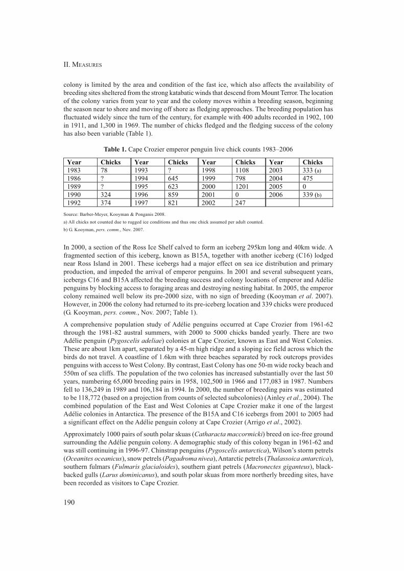
II. MEASURES
190
colony is limited by the area and condition of the fast ice, which also affects the availability of
breeding sites sheltered from the strong katabatic winds that descend from Mount Terror. The location
of the colony varies from year to year and the colony moves within a breeding season, beginning
the season near to shore and moving off shore as fledging approaches. The breeding population has
fluctuated widely since the turn of the century, for example with 400 adults recorded in 1902, 100
in 1911, and 1,300 in 1969. The number of chicks fledged and the fledging success of the colony
has also been variable (Table 1).
Table 1. Cape Crozier emperor penguin live chick counts 1983–2006
Source: Barber-Meyer, Kooyman & Ponganis 2008.
a) All chicks not counted due to rugged ice conditions and thus one chick assumed per adult counted.
b) G. Kooyman, pers. comm., Nov. 2007.
In 2000, a section of the Ross Ice Shelf calved to form an iceberg 295km long and 40km wide. A
fragmented section of this iceberg, known as B15A, together with another iceberg (C16) lodged
near Ross Island in 2001. These icebergs had a major effect on sea ice distribution and primary
production, and impeded the arrival of emperor penguins. In 2001 and several subsequent years,
icebergs C16 and B15A affected the breeding success and colony locations of emperor and Adélie
penguins by blocking access to foraging areas and destroying nesting habitat. In 2005, the emperor
colony remained well below its pre-2000 size, with no sign of breeding (Kooyman et al. 2007).
However, in 2006 the colony had returned to its pre-iceberg location and 339 chicks were produced
(G. Kooyman, pers. comm., Nov. 2007; Table 1).
A comprehensive population study of Adélie penguins occurred at Cape Crozier from 1961-62
through the 1981-82 austral summers, with 2000 to 5000 chicks banded yearly. There are two
Adélie penguin (Pygoscelis adeliae) colonies at Cape Crozier, known as East and West Colonies.
These are about 1km apart, separated by a 45-m high ridge and a sloping ice field across which the
birds do not travel. A coastline of 1.6km with three beaches separated by rock outcrops provides
penguins with access to West Colony. By contrast, East Colony has one 50-m wide rocky beach and
550m of sea cliffs. The population of the two colonies has increased substantially over the last 50
years, numbering 65,000 breeding pairs in 1958, 102,500 in 1966 and 177,083 in 1987. Numbers
fell to 136,249 in 1989 and 106,184 in 1994. In 2000, the number of breeding pairs was estimated
to be 118,772 (based on a projection from counts of selected subcolonies) (Ainley et al., 2004). The
combined population of the East and West Colonies at Cape Crozier make it one of the largest
Adélie colonies in Antarctica. The presence of the B15A and C16 icebergs from 2001 to 2005 had
a significant effect on the Adélie penguin colony at Cape Crozier (Arrigo et al., 2002).
Approximately 1000 pairs of south polar skuas (Catharacta maccormicki) breed on ice-free ground
surrounding the Adélie penguin colony. A demographic study of this colony began in 1961-62 and
was still continuing in 1996-97. Chinstrap penguins (Pygoscelis antarctica), Wilson’s storm petrels
(Oceanites oceanicus), snow petrels (Pagadroma nivea), Antarctic petrels (Thalassoica antarctica),
southern fulmars (Fulmaris glacialoides), southern giant petrels (Macronectes giganteus), black-
backed gulls (Larus dominicanus), and south polar skuas from more northerly breeding sites, have
been recorded as visitors to Cape Crozier.
Year Chicks Year Chicks Year Chicks Year Chicks
1983 78 1993 ? 1998 1108 2003 333 (a)
1986 ? 1994 645 1999 798 2004 475
1989 ? 1995 623 2000 1201 2005 0
1990 324 1996 859 2001 0 2006 339 (b)
1992 374 1997 821 2002 247

ASPA 124: CAPE CROZIER
191
Weddell seals (Leptonychotes weddellii) breed within the Area, with approximately 20 pups being
recorded in recent years. Leopard seals (Leptonyx hydrurga) frequent the Area, with approximately
12 individuals recognized as regular visitors, while crabeater seals (Lobodon carcinophagus) are
commonly seen at sea and on ice floes in the vicinity. Other mammals frequently observed within
the Area include killer whales (Orcinus orca), of which several distinct types have been recognized.
Algae can be found throughout the Area on large patches of snow and on soils and stones, often
below the soil surface layer. Large areas of green snow algae, covering more than 4 ha, can be
found in the north of the Area in snowfields around the periphery of the Adélie penguin colony and
skua nesting areas (Broady 1989). Particularly large patches have been reported in the snow-filled
valley between the two coastal hills at the northern end of the Adélie colony, with snow-tinted green
over at least one hectare. However, the extent of snow algae is not always obvious, with the green
color often not revealed until a surface crust of white ice is broken away. Snow algae samples are
dominated by a species of Chlamydomonas, and associated with occasional Ulothrix-like filaments
and diatoms. Growth requires percolating meltwater during summer and nutrients derived from the
bird colonies.
Prasiola crispa grows in slow water flows in the vicinity of the penguin colonies and ribbon-like
growths of P. calophylla are found where water percolates over stones on the tallus slopes. Numerous
small ponds are found throughout the Area, from small pools 1-m in diameter to a lake 150-m in
diameter situated immediately south of The Knoll. The four ponds in the penguin colonies contain
abundant phytoplankton populations of Chlamydomonas cf. snowiae, while ponds elsewhere support
growths of red-brown to dark blue-green benthic felts dominated by Oscillatoriaceae. Occasional
epilithic algae (dominated by Gloeocapsa, Nostoc and Scytonema) are found as blackish crusts
coating rock surfaces where meltwater percolates.
Mosses are sparse and scattered in their distribution with most occurrences being of one or a small
number of isolated cushions no larger than 10cm in diameter. Richer growths than this occur up to
0.5km NE of the hut on north and NW facing slopes and on slopes immediately above the coastal
cliffs about 1km south of the penguin colonies. The moss species occurring at Cape Crozier have
yet to be identified.
Encrusting orange lichens are present in shallow hollows, on rock outcrops, boulders and encrusting
bryophytes on the slopes above the penguin colonies. Also present adjacent to Wilson’s Stone Igloo
is the fruticose lichen Usnea and the foliose lichen Umbilicaria, both duller in color but structurally
more complex. Green algal crusts are found throughout the Area.
6(ii) Restricted and managed zones within the Area
None.
6(iii) Structures within and near the Area
The Cape Crozier hut (US) (169° 11' 14" E, 77° 27' 39" S) is situated on the NW side of a low peak
(locally known as ‘Pat’s Peak’) (Maps 1 and 2). A radio communications repeater is installed above
the hut on a seasonal basis (Map 2). An observation hide dating from research programs in the
1960–80 period is located at the base of the north side of Post Office Hill. An old ‘Jamesway’ hut
was built on a small terrace approximately 1km NE of the present hut (Map 2), although this was
destroyed by fire and all hut debris has since been removed. Some materials such as nails, screws
and hinges remain at the site.
A historic message post, designated as HSM No 69 under Measure 4 (1995), is situated in the West
Colony on the NE coast of the Area (169° 16' 14" E, 77° 27' 15" S). The post was used by the 1901–
04 British National Antarctic Expedition to provide information to the expedition’s relief ships. An

II. MEASURES
192
historic rock hut known as Wilson’s Stone Igloo (HSM No 21) (169° 17' 48" E, 77° 31' 48" S) is
located on Igloo Spur (Map 1).
6(iv) Location of other protected areas within close proximity of the Area
The nearest protected areas to Cape Crozier are on Ross Island: Lewis Bay (ASPA No 156), the site
of the 1979 DC-10 passenger aircraft crash is the closest and 45km west; Tramway Ridge (ASPA
No 130) near the summit of Mt. Erebus is 55km west; Discovery Hut on the Hut Point Peninsula
(ASPA No 158 and HSM No 18); Arrival Heights (ASPA No 122) is 70km to the SW adjacent to
McMurdo Station; Cape Royds (ASPA No 121), Backdoor Bay (ASPA No 157 and HSM No 15)
and Cape Evans (ASPA No 155) are 75km west; and New College Valley (ASPA No 116) are 75km
NW at Cape Bird.
7. Permit conditions
Entry into the Area is prohibited except in accordance with a permit issued by an appropriate national
authority. Conditions for issuing a permit to enter the Area are that:
• it is issued for scientific research, and in particular for research on the bird fauna as well as
on the vegetation assemblages in the Area, or for essential management or educational
purposes;
• access to the historic sites may be permitted for scientific, management, educational or
historical purposes on the condition that movement within the Area be restricted to accessing
the historic sites;
• the actions permitted will not jeopardize the ecological, scientific or historic values of the
Area;
• any management activities are in support of the objectives of the Management Plan;
• the actions permitted are in accordance with the Management Plan;
• the permit, or a copy, shall be carried within the Area;
• a visit report shall be supplied to the authority named in the permit;
• permits shall be issued for a stated period.
7(i) Access to and movement within the Area
Access into the Area is permitted by foot or by helicopter. Use of land vehicles within the Area is
prohibited.
Aircraft may operate and land within the Area according to strict observance of the following
conditions:
• All overflight of the Area for purposes other than access shall be at a height greater than
2500 ft (~750m) Above Ground Level, except when specifically permitted for scientific
purposes.
• The primary designated helicopter landing site preferred for most access to the Area is
located at 169° 11' 25" E, 77° 27' 42" S (elevation 240m) (Map 2). This landing site is
below and 150m north-west of the Cape Crozier field hut (US) and is marked by a circle of
bright orange painted rocks. An alternative, secondary, landing site is located 150m above
the hut, which may also be used when necessary.
• A third designated helicopter landing site is located above and 350m north-west of Wilson’s
Stone Igloo (Map 1) in an area of relatively flat terrain.
ASPA 124: CAPE CROZIER
193
• When required for scientific, educational or management purposes, landings may be made
elsewhere within the Area provided this is specifically authorized by permit.
• To minimize the risks of inadvertent overflight of bird colonies, helicopter pilots accessing
the Area for the first time should be accompanied by another pilot with previous experience
of flying into the Area.
• Use of helicopter smoke grenades is prohibited unless absolutely necessary for safety, and
all grenades should be retrieved.
• When transporting permitted visitors, pilots, air crew, or passengers en route elsewhere on
helicopters are prohibited from moving on foot beyond the immediate vicinity of the
designated landing site and field hut unless specifically authorized by a Permit.
• Pedestrian traffic should be kept to the minimum necessary consistent with the objectives
of any permitted activities and every reasonable effort should be made to minimize effects.
• Permitted visitors should keep to natural penguin tracks when walking through bird colonies
and should not approach occupied nests except as required for scientific or management
purposes. Care should be taken to avoid trampling nests when moving through skua
territories.
• Visitors should avoid walking on visible vegetation and care should be exercised walking
in areas of moist ground, where foot traffic can easily damage sensitive soils, plant and
algal communities and degrade water quality.
7(ii) Activities that are or may be conducted in the Area, including restrictions on time or place
Activities that may be conducted within the Area include:
• scientific research or educational visits that will not jeopardize the ecosystem of the Area;
• essential management activities, including monitoring;
• visits to historic sites for scientific, management, educational or historical reasons subject
to the conditions described within this plan;
• activities with the aim of preserving or protecting the historic resources within the Area.
7(iii) Installation, modification or removal of structures
• No structures are to be erected within the Area except as specified in a permit;
• All scientific equipment installed in the Area must be authorized by permit and clearly
identified by country, name of the principal investigator and year of installation. All such
items should be made of materials that pose minimal risk of contamination of the Area;
• Removal of specific equipment for which the permit has expired shall be the responsibility
of the authority which granted the original Permit, and shall be a condition of the permit.
7(iv) Location of field camps
Camping within the Area should be within a 100-m radius of the hut (169° 11' 14" E, 77° 27' 39" S).
Camping is permitted outside of the hut vicinity where access is required to distant parts of the
Area. Such camping should preferably be at sites that have been previously used, are not vegetated
or occupied by breeding birds, and should be on snow or ice-covered ground if available. Researchers
should consult with the appropriate national authority to obtain up-to-date information on any sites
where camping may be preferred.

II. MEASURES
194
7(v) Restrictions on materials and organisms that can be brought into the Area
• No living animals, plant material, microorganisms or soils shall be deliberately introduced
into the Area, and the precautions listed below shall be taken against accidental introductions;
• To help maintain the ecological and scientific values of the Area visitors shall take special
precautions against introductions. Of particular concern are microbial, invertebrate and
vegetation introductions from soils at other Antarctic sites, including stations, or from regions
outside Antarctica. To minimize the risk of introductions, visitors should thoroughly clean
footwear and any equipment to be used in the area – particularly sampling equipment and
markers – before entering the Area.
• In view of the presence of breeding bird colonies at Cape Crozier, no poultry products,
including products containing uncooked dried eggs, including wastes from such products,
shall be released into the Area;
• No herbicides or pesticides shall be brought into the Area;
• Any other chemicals, including radio-nuclides or stable isotopes, which may be introduced
for scientific or management purposes specified in the permit, shall be removed from the
Area at or before the conclusion of the activity for which the permit was granted;
• Fuel, food, and other materials are not to be stored in the Area, unless required for essential
purposes connected with the activity for which the permit has been granted or are contained
within an emergency cache authorized by an appropriate authority;
• All materials introduced shall be for a stated period only, shall be removed at or before the
conclusion of that stated period, and shall be stored and handled so that risk of their
introduction into the environment is minimized;
• If release occurs which is likely to compromise the values of the Area, removal is encouraged
only where the impact of removal is not likely to be greater than that of leaving the material
in situ.
7(vi) Taking or harmful interference with native flora or fauna
Taking or harmful interference of native flora and fauna is prohibited, except in accordance with a
permit issued under Article 3 of Annex II by the appropriate national authority specifically for that
purpose.
7(vii) Collection or removal of anything not brought into the Area by the permit holder
• Material may be collected or removed from the Area only in accordance with a permit and
should be limited to the minimum necessary to meet scientific or management needs.
• Material of human origin likely to compromise the values of the Area, which was not
brought into the Area by the permit holder or otherwise authorized, may be removed from
any part of the Area, unless the impact of removal is likely to be greater than leaving the
material in situ. If this is the case the appropriate authority should be notified.
• Unless specifically authorized by permit, visitors are prohibited from interfering with or
attempting restoration of Wilson’s Stone Igloo in any way, or from handling, taking or
damaging any artifacts. Evidence of recent changes, damage or new artifacts observed
should be notified to the appropriate national authority. Relocation or removal of artifacts
for the purposes of preservation, protection, or to re-establish historical accuracy is allowable
by permit.

ASPA 124: CAPE CROZIER
195
7(viii) Disposal of waste
All wastes, including all human wastes, shall be removed from the Area.
7(ix) Measures that are necessary to ensure that the aims and objectives of the Management Plan
can continue to be met
• Any specific sites of long-term monitoring shall be appropriately marked.
7(x) Requirements for reports
• Parties should ensure that the principal holder of each permit issued submit to the appropriate
authority a report describing the activities undertaken. Such report should include, as
appropriate, the information identified in the Visit Report form contained in Appendix 4 of
Resolution 2 (1998)(CEP I).
• Parties should maintain a record of such activities, and, in the annual Exchange of
Information, should provide summary descriptions of activities conducted by persons subject
to their jurisdiction, in sufficient detail to allow evaluation of the effectiveness of the
Management Plan. Parties should, wherever possible, deposit originals or copies of such
original reports in a publicly accessible archive to maintain a record of usage, to be used
both in any review of the Management Plan and in organizing the scientific use of the Area.
• The appropriate authority should be notified of any activities/measures undertaken, and /
or of any materials released and not removed, that were not included in the authorized
permit.
8. Selected references
Ainley, D.G., C.A. Ribic, G. Ballard, S. Heath, I. Gaffney, B.J. Karl, K.J. Barton, P.R. Wilson, & S.
Webb. 2004. Geographic structure of Adélie penguin populations: overlap in colony-specific
foraging areas Ecological Monographs 74(1):159–78.
Arrigo, K. R., G.L. van Dijken, D.G. Ainley, M.A. Fahnestock, & T. Markus. 2002. Ecological
impact of a large Antarctic iceberg. Geophysical Research Letters 29(7): 1104.
Barber-Meyer, S.M., G.L. Kooyman, & P.J. Ponganis. 2008. Trends in western Ross Sea emperor
penguin chick abundances and their relationships to climate. Antarctic Science 20 (1), 3–
11.
Broady, P.A. 1989. Broadscale patterns in the distribution of aquatic and terrestrial vegetation at
three ice-free regions on Ross Island, Antarctica. Hydrobiologia 172: 77-95.
Kooyman, G.L. 1993. Breeding habitats of emperor penguins in the western Ross Sea. Antarctic
Science 5(2): 143-48.
Kooyman, G.L., D.G. Ainley, G. Ballard, & P.J. Ponganis. 2007. Effects of giant icebergs on two
emperor penguin colonies in the Ross Sea, Antarctica. Antarctic Science 19(1): 31-38.

II. MEASURES
196

ASPA 124: CAPE CROZIER
197

II. MEASURES
198

199
Measure 8 (2008)
Antarctic Specially Protected Area No 135
(North-East Bailey Peninsula, Budd Coast, Wilkes Land):
Revised Management Plan
The Representatives,
Recalling Articles 3, 5 and 6 of Annex V to the Protocol on Environmental Protection to the
Antarctic Treaty providing for the designation of Antarctic Specially Protected Areas
(“ASPA”) and approval of Management Plans for those Areas;
Recalling
• Recommendation XIII-8 (1985), which designated Bailey Peninsula, Budd Coast,
Wilkes Land as Site of Special Scientific Interest (“SSSI”) No 16 and annexed a
Management Plan for the Site;
• Resolution 7 (1995), which extended the expiry date of SSSI 16 from 31 December
1995 to 31 December 2000;
• Measure 2 (2000), which extended the expiry date of SSSI 16 from 31 December
2000 until 31 December 2005;
• Decision 1 (2002), which renamed and renumbered SSSI 16 as Antarctic Specially
Protected Area No 135;
• Measure 2 (2003), which annexed a revised Management Plan for ASPA 135;
Noting that the Committee for Environmental Protection has endorsed a revised Management
Plan for ASPA 135;
Desiring to replace the existing Management Plan for ASPA 135 with the revised
Management Plan;
Recommend to their Governments the following Measure for approval in accordance with
Paragraph 1 of Article 6 of Annex V to the Protocol on Environmental Protection to the
Antarctic Treaty:
That:

200
II. MEASURES
1) the revised Management Plan for Antarctic Specially Protected Area No 135:
North-East Bailey Peninsula, Budd Coast, Wilkes Land, which is annexed to
this Measure, be approved; and
2) all prior Management Plans for ASPA 135, namely those annexed to:
- Recommendation XIII-8 (1985), and
- Measure 2 (2003);
shall cease to be effective.

201
MEASURE 8 - ANNEX
Management Plan for Antarctic Specially Protected Area No 135
NORTH-EAST BAILEY PENINSULA, BUDD COAST, WILKES LAND
Introduction
North-east Bailey Peninsula was designated in 1985 as Site of Special Scientific Interest (SSSI) No
16 through Recommendation XIII-8, after a proposal by Australia. In accordance with Resolution 5
(1996) the site was redesignated and renumbered as Antarctic Specially Protected Area (ASPA) No
135. The ASPA is designated primarily as a scientific reference site which, since the early 1980s,
has supported a range of studies into the diverse assemblage of vegetation found in the area. The
site is located in close proximity to Australia’s Casey station, which allows ease of access for field
research but also creates the potential for disturbance of study areas.
1. Description of values to be protected
Windmill Islands Region
Outside the Antarctic Peninsula, the Windmill Islands region supports some of the most extensive
and best-developed plant communities on continental Antarctica. The region is floristically diverse
with rich associations of macrolichens and bryophytes that occupy very specific ecological niches.
The flora of the Windmill Islands region comprises at least 36 species of lichen, 6 bryophytes (5
mosses and 1 liverwort), 150 non-marine algae and at least 120 fungal taxa. An ascomycete
mycorrhizal fungus has been shown in the liverwort Cephaloziella varians.
Lichens constitute the largest part of the Windmill Islands region flora, with bryophytes being
dominant in moister areas. At least 11 cryptogamic community types have been identified. These
vegetation groupings exist within a continuum of ecological variation along environmental gradients
influenced by soil moisture, soil chemistry, and microclimate. On the peninsulas in the region, the
major community types are distinguished by the dominance of three bipolar lichens, Usnea
sphacelata, Pseudephebe minuscula and Umbilicaria decussata. Vegetation communities on the
islands are dominated by algal species such as Prasiola crispa, with moss and lichen being
considerably poorer developed than on the peninsulas. Mosses and lichens are all but absent in
eutrophic sites near bird colonies with a prevalence of Prasiola crispa, Prasiococcus calcareus and
Desmococcus olivaceus chlorophyte algae occurring.
North-east Bailey Peninsula Protected Area
The North-east Bailey Peninsula Antarctic Specially Protected Area (the Area) is representative of
a diverse assemblage of the Windmill Islands region flora. As such, the Area has intrinsic ecological
value and scientific importance, particularly to botanists, microbiologists, soil scientists and glacial
geomorphologists.
The Area contains three extensive and contrasting moss fields that have been the subject of taxonomic,
ecological and physiological studies since the summer of 1982/83. Additional studies have included
population ecology of invertebrates associated with the vegetation, and soil/water chemistry.
Permanent lichen growth monitoring sites are established, as are sites monitoring annual growth
increments in mosses. Other floral studies have concentrated on the determination of biodiversity,

II. MEASURES
202
physiological and biochemical attributes, component interactions, impact of anthropogenic pollutants,
and potential effects of global climate change.
Global change studies have included a multi-season investigation into the impact of water and
nutrients on various components of the vegetation, associated studies into the tolerance of mosses
to both submergence and desiccation, and examination of the tolerance of three moss species to
increased UV-B as a result of ozone depletion. Fine-scale analysis of genetic diversity of one
cosmopolitan moss species Ceratodon purpureus has been compared for this location and others in
the region. Dating of long cores of mosses has been achieved using 14C released during atmospheric
atomic bomb testing in the 1950s and 1960s.
The Area is included within the geographic coverage of an Australian Antarctic programme state of
the environment indicator "Windmill Islands terrestrial vegetation dynamics", which involves
quantitative analysis of a series of permanent transects across selected vegetation, with the aim of
monitoring the effects of climate change on Antarctic cryptogamic communities.
Moss and lichen communities are used to monitor environmental impacts of Casey station. The
Area provides baseline data with which to compare changes in similar plant communities in the
immediate surroundings of Casey station. The Area also serves as a valuable comparative site for
similar plant communities in ASPA 136 Clark Peninsula, which are subject to less environmental
stress and disturbance.
2. Aims and objectives
Management of the Area aims to:
• avoid degradation of, or substantial risk to, the values of the Area by preventing unnecessary
human disturbance and sampling in the Area;
• preserve a part of the natural ecosystem as a reference Area for the purpose of future
comparative studies and to assess direct and indirect effects of Casey station;
• provide for compelling scientific research which cannot be served elsewhere;
• minimise the possibility of introduction of alien plants, animals and microbes to the Area;
and
• allow for the continued maintenance of the Tandem Delta antenna communications
installation and associated facilities without degradation of the Area’s values.
3. Management activities
The following management activities shall be undertaken to protect the values of the Area:
• place signs illustrating the location and boundaries, with clear statements of entry restrictions
at appropriate locations at the boundaries of the Area to help avoid inadvertent entry;
• display prominently information on the location of the Area (stating special restrictions
that apply) and a copy of this Management Plan at Casey station and provide copies of this
information to ships visiting the vicinity;
• secure and maintain in good condition markers, signs and structures erected within the
Area for scientific or management purposes and remove them when no longer required;
• remove abandoned equipment or materials to the maximum extent possible provided this
does not adversely impact on the values of the Area;
ASPA 135: BAILEY PENINSULA
203
• detailed mapping of ongoing scientific experimental sites to ensure they are not disturbed;
• visit the Area as necessary (no less than once every five years) to assess whether the Area
continues to serve the purposes for which it was designated and to ensure that management
activities are adequate; and
• review the Management Plan at least every five years and update as required.
4. Period of designation
Designated for an indefinite period.
5. Maps
• Map A: Windmill Island, showing location of the North-east Bailey Peninsula ASPA No
135 and other protected areas within the region.
Map specifications:
Projection: Lambert Conformal Conic
Horizontal Datum: WGS84
• Map B: North-east Bailey Peninsula, Antarctic Specially Protected Areas No 135:
Topography, vegetation, birds, roads and structures.
Map specifications:
Projection: UTM Zone 49
Horizontal Datum: WGS84.
Contour Interval: 10m.
• Map C: North-east Bailey Peninsula, Antarctic Specially Protected Areas No 135: Vegetation
Map specifications:
Projection: UTM Zone 49
Horizontal Datum: WGS84.
• Map D: North-east Bailey Peninsula, Antarctic Specially Protected Areas No 135. Geology.
Map specifications:
Projection: UTM Zone 49
Horizontal Datum: WGS84.
• Map E: North-east Bailey Peninsula, Antarctic Specially Protected Areas No 135: Showing
buildings, structures and vegetation.
Map specifications:
Projection: UTM Zone 49
Horizontal Datum: WGS84.

II. MEASURES
204
6. Description of the Area
6(i) Geographical co-ordinates, boundary markers and natural features
General description
The Area is located on Bailey Peninsula in the Windmill Islands region of Budd Coast, Wilkes
Land, East Antarctica (Map A). Bailey Peninsula is an area of rock exposures and permanent snow
and ice fields lying between Newcomb Bay and O’Brien Bay, two kilometres south of Clark Peninsula.
The Area is located in the north-east of Bailey Peninsula, approximately 200m east of Casey station
(66°16’59.9"S, 110°31’59.9"E), and covers an area of approximately 0.28km2. The boundary is
irregular, extending in the north to within approximately 70m south of Brown Bay. Boundary
coordinates for the Area are shown in Appendix 1.
Topographically, Bailey Peninsula comprises low lying, rounded ice-free rocky outcrops (maximum
altitude approximately 40 m), and, rising from the coast to the Løken Moraines (altitude approximately
130 m) approximately three kilometres to the east. Intervening valleys are filled with permanent
snow or ice, or glacial moraine and exfoliated debris, and contain water catchment areas. The
topography of Bailey Peninsula is shown at Map B.
Climate
The climate of the Windmill Islands region is frigid-Antarctic. Climate records from nearby Casey
station (altitude 32 m) show mean temperatures for the warmest and coldest months of 2.2 and
-11.4°C respectively, extreme temperatures ranging from 9.2 to -34°C, and mean annual maximum
and minimum temperatures of –5.9°C and –12.5°C respectively. The climate is dry with a mean
annual snowfall of 219 mm year (rainfall equivalent), precipitation as rain has been recorded in the
summer.
There is an annual average wind speed of 25km per hour. Gale winds are predominantly from the
east, off the polar ice cap. Blizzards may occur very suddenly and are a frequent occurrence especially
during winter. Snowfall is common during the winter, but the extremely strong winds scour the
snow off exposed areas of the Peninsula. On most hill crests on Bailey Peninsula snow gathers in
the lee of rock outcrops and in depressions in the substratum. Further down the slopes snow forms
deeper drifts.
Geology and soils
WINDMILL ISLANDS REGION
The Windmill Islands region represents one of the eastern-most outcrops of a Mesoproterozoic
low-pressure granulite facies terrain that extends west to the Bunger Hills and further to the Archaean
complexes in Princess Elizabeth Land, to minor exposures in the east in the Dumont d’Urville area
and in Commonwealth Bay. The total outcrop areas do not exceed more than a few square kilometres.
The Mesoproterozoic outcrop of the Windmill Islands and the Archaean complexes of Princess
Elizabeth Land are two of the few major areas in East Antarctica that can be directly correlated with
an Australian equivalent in a Gondwana reconstruction. The Mesoproterozoic facies terrain comprises
a series of migmatitic metapelites and metapsammites interlayered with mafic to ultramafic and
felsic sequences with rare calc-silicates, large partial melt bodies (Windmill Island supacrustals),
undeformed granite, charnockite, gabbro, pegmatite, aplites and cut by easterly-trending late dolerite
dykes.

ASPA 135: BAILEY PENINSULA
205
BAILEY PENINSULA
Bailey Peninsula is part of the northern gradation of a metamorphic grade transition which separates
the northern part of the Windmill Islands region from the southern part. The metamorpohic grade
ranges from amphibolite facies, sillimanite-biotite-orthoclase in the north at Clark Peninsula, through
biotite-cordierite-almandine granulite, to hornblende-orthopyroxene granulite at Browning Peninsula
in the south. The Ardery Charnockite of the south is prone to deep weathering and crumbles readily
because of its mineral assemblage, whereas the metamorphic sequences of the northerly parts of the
region have a much more stable mineral assemblage and crystalline structure. This difference has a
significant influence on the distribution of vegetation in the Windmill Islands region with the northern
rock types providing a more suitable substrate for slow growing lichens.
The leucocratic granite gneiss, which constitutes the main outcrop on Bailey Peninsula, may be
subdivided into leucogneiss and two different types of garnet-bearing gneiss. The outcrop on Bailey
Peninsula is characterised as a garnet-bearing gneiss type 1 which is white, medium grained and
foliated. The foliation is defined by the alignment of an early biotite generation that is tight to
openly folded, with a garnet and a later biotite generation that overgrows the fabric.
Unmetamorphosed and undeformed dolerite dykes occur over Bailey Peninsula such as at "Penguin
Pass" (66°17’18"S, 110°33’16"E), to the south of the Area. Small outcrops of metapelite,
metapsammite and leuco- gneisses occur on the Peninsula. Recent geochronology of the rocks of
the Windmill Islands region suggest two major phases of metamorphism, the first at c. 1400-1310
Ma, an upper amphibolite facies event, followed by a granulite facies overprint c. 1210-1180 Ma.
The geology of Bailey Peninsula is shown at Map D.
GLACIATION
The Windmill Islands region was glaciated during the Late Pleistocene. The southern region of the
Windmill Islands was deglaciated by 8000 corr. yr B.P., and the northern region, including Bailey
Peninsula deglaciated by 5500 corr. yr B.P. Isostatic uplift has occurred at a rate of between 0.5 and
0.6 m/100 yr, with the upper mean marine limit, featured as ice-pushed ridges, being observed on
Bailey Peninsula at approximately 30m where they extend in continuous rows from the present sea-
level.
SOILS
Soils on Bailey Peninsula are derived from weathered gneiss, moraine deposits and outwash gravels
stemming from glacial episodes. Seabirds have a large impact on soil formation in the entire landscape.
Soils are frozen much of the year during summer, the upper 30-60 cm thaws with the few top
centimetres, refreezing at night. Soils are mainly formed by cryoturbation and cryoclastic weathering.
In the vicinity of Casey station most soils are classified by Blume, Kuhn and Bölter (2002) as
cryosols with lithic, leptic, skeletal, turbic and stagnic subunits. Other soils in the Area are gelic
subunits of histosols, podzols, and regosols, boulder and rock outcrops with ecto- and endolithic
flora are classified as Lithosols.
Lakes
Cold monomictic lakes and ponds occur throughout the Windmill Islands region in bedrock
depressions and are usually ice-free during January and February. Nutrient rich lakes are found
near the coast, in close proximity to penguin colonies or abandoned colonies, sterile lakes are located
further inland and are fed by meltwater and local precipitation. A number of these lakes and ponds
occur across Bailey Peninsula with two large lakes located 500m to the west of the Area. Two ponds
occur within the protected Area, the largest being approximately 75m by 50m and the smaller
approximately 25m diameter. The distribution of lakes and ponds on Bailey Peninsula is shown at
Map B.

II. MEASURES
206
Vegetation
The vegetation of Bailey Peninsula is exceptionally well developed and diverse and the Area
represents one of the most important botanical sites on continental Antarctica. Within the relatively
complex plant communities and contrasting habitats found on Bailey Peninsula, are found at least
23 lichens, three mosses, and a liverwort. There are expansive dense stands of macrolichens and in
the more moist and sheltered areas bryophytes form closed stands of 25-50 m2 with turf up to 30 cm
in depth. Together with the lichens Umbilicaria decussata, Pseudephebe minuscula and Usnea
sphacelata, mixed bryophytes dominate the vegetation cover of most of the ice-free areas. This is
particularly so on the north-east and centre of the Peninsula where there are dense communities
similar to those found on Clark Peninsula. The most complex bryophyte communities are restricted
to small locally moist hollows adjacent to melt pools and streams in the central north-east and
central parts of the Peninsula. Vegetation is absent or poorly developed on the ice-free areas of the
Peninsula’s southern coast. Appendix 2 provides a list of bryophytes and lichens identified in the
Area. In many areas mosses appear to becoming increasingly moribund and are being out-competed
or overgrown by lichens.
Two principal cryptogamic subformations are recognised; a lichen-dominated association occupying
a variety of windswept substrata ranging from bedrock to gravel, and, a short cushion and turf moss
subformation comprising four moss dominated sociations. The vegetation of Bailey Peninsula is
shown at Maps C and E.
At least 150 taxa of non-marine algae and cyanobacteria have been isolated; these include 50
cyanobacteria, 70 chlorophytes and 23 chromophytes. The taxa have been found in snow and ice,
soil, rocks, ephemeral ponds, tarns and lakes; 24 cyanobacterial and algal species occur in the snow.
Snow algae are abundant and widespread in the icy corridors between the rocky outcrops and in
semi-permanent snow drifts. A list of cyanobacterial and algal species from the Area, Bailey Peninsula,
and the Windmill Islands region is shown in Appendix 3.
The vegetated soils of Bailey Peninsula contain fungal hyphae, yeasts, fungal propagules, an
assortment of algae, cyanobacteria, protozoa, and provide a significant habitat for soil microfauna
such as nematodes, mites, rotifers and tardigrades. There is relatively low fungal diversity in the
Windmill Islands region, with 35 taxa representing 22 genera of fungi being isolated from soils,
mosses, algae and lichens. Thirty fungal taxa have been detected in soils in the vicinity of Casey
station with 12 of these taxa restricted to anthropogenically influenced soils around the station,
Penicillium species dominate in these sites. Within the Windmill Islands region, 21 fungal taxa
have been isolated the mosses, with 12 taxa isolated from algae and 6 from lichens. A number of
fungi have also been found associated with animals of the region. Appendix 4 provides detail of the
taxa and their source.
Birds
Four species of birds are known to nest in the vicinity of Bailey Peninsula. These include Adélie
penguin Pygoscelis adeliae, the most abundant bird species in the Area. The nearest breeding colony
is on Shirley Island about 1.5km west of Casey station. Snow petrels Pagodroma nivea are seen all
year round and breed throughout the Windmill Islands region including Reeve Hill about 750m
west of the Area and Budnick Hill, 600m to the north-west. Wilson’s storm petrels Oceanites
oceanicus breed throughout the Windmill Islands region and nest in the Area. The Antarctic skua
Catharacta maccormicki breeds throughout the Windmill Islands region at widely dispersed nests,
mostly near Adélie penguin colonies.
Other birds that breed in the Windmill Islands region but not in the immediate vicinity of Bailey
Peninsula include southern giant petrel Macronectes giganteus, cape petrel Daption capense, southern
ASPA 135: BAILEY PENINSULA
207
fulmar Fulmarus glacialoides and Antarctic petrel Thalassoica antarctica. The emperor penguin
Aptenodytes forsteri is a common visitor to the Windmill Islands region and a breeding colony of
approximately 2000 pairs is established in the area of Peterson Bank.
Terrestrial invertebrates and microbial communities
The Antarctic flea Glaciopsyllus antarcticus has been found in the nests of southern fulmars. The
anopluran louse Antarctophthirus ogmorhini is found on the Weddell seal Leptonychotes weddellii
A number of species of mallophagan lice have also been found on birds.
The mite Nanorchestes antarcticus has been found on Bailey Peninsula at sites characterised as
having sandy or gravelly soils, free of extensive moss or lichen cover, and moist but not water-
logged.
Five species of tardigrades have been collected on Bailey Peninsula: Pseudechiniscus suillus,
Macrobiotus sp., Hypsibius antarcticus, Ramajendas frigidus and Diphascon chilenense. Significant
positive associations between bryophytes and the most common species of tardigrades P. suillus, H.
antarcticus and D. chilenense, have been found, and strong negative associations between those
species and algae and lichens have been established. No systematic or ecological accounts of
nematodes have yet been published for the Windmill Islands region.
Protozoa have been studied at a number of sites on Bailey Peninsula and in the Area ciliates and
testate amoebae are active. Twenty seven ciliate species and six testacean species have been found
(see Appendix 5).
6(ii) Special zones within the Area
There are no special zones within the Area.
6(iii) Location of structures within and adjacent to the Area
Casey station (Australia) is located approximately 200m west of the Area. Prior to the designation
of the Area in 1986 an array of radio transmitters had been progressively established at the site since
1964. During the 2001/2002 and 2007/2008 summers redundant aerials and some other infrastructure
were removed. A number of structures remain within the Area, including a small storage rack in the
north-west, the transmitter building (which can also be used as an emergency refuge), a 45m high
tandem delta antenna mast and a non-directional beacon antenna located in the south-east (Map E).
Another 35m high mast is located approximately 100m south of the Area.
6(iv) Location of other Protected Areas in the vicinity
ASPA No 136, Clark Peninsula, is located 2.5km to the north-east, across Newcomb Bay.
ASPA No 103, Ardery and Odbert Islands, is located approximately 11km to the south, west of
Robinson Ridge.
ASPA No 160, Frazier Islands, is located in the eastern part of Vincennes Bay approximately 16km
to the west-north-west.
7. Permit conditions
Entry into the Area is prohibited except in accordance with a Permit issued by an appropriate national
authority. A Permit to enter the Area may only be issued for compelling scientific research,
maintenance of the Tandem Delta antenna communications installation and associated facilities, or

II. MEASURES
208
for essential management purposes consistent with the Management Plan’s objectives and provisions,
and providing that the actions permitted will not jeopardise the ecological or scientific values of the
Area or interfere with existing scientific studies. Conditions that must be included in the Permit are
that the Permit or an authorised copy shall be carried within the Area, and that the Permit specify the
period for specific activities. Additional conditions, consistent with the Management Plan’s objectives
and provisions, may be included by the issuing Authority.
7(i) Access to and movement within or over the Area
Helicopters are prohibited from landing within the Area.
Vehicles are prohibited from entering the Area, except for the purpose of conducting ongoing
maintenance of the transmitter building, associated buildings and antennas. Access to the transmitter
building near the south-east end of the Area should be via the over-snow access route to Law Dome,
several kilometres to the south. Within the Area, vehicles should follow the most direct practicable
route between the Area boundary and the communications facilities, avoiding vegetation and cables.
Vehicle use in the Area shall be kept to a minimum.
The Area is accessible on foot. Casey station is located approximately 200m west of the north west
boundary of the Area. Visitors should avoid walking on visible vegetation. Care should be exercised
when walking in areas of moist ground, where foot traffic can easily damage sensitive soils, plant or
algae communities, and degrade water quality. Pedestrian traffic should be kept to the minimum
necessary to undertake permitted activities and every reasonable effort should be made to walk around
such areas, keeping to ice-covered areas or bare rock where it is practicable and safe to do so.
7(ii) Activities which are or may be conducted within the Area, including restrictions on time and
place
Compelling scientific research which cannot be undertaken elsewhere and which will not jeopardise
the ecosystem of the Area.
Essential management activities, including monitoring.
Sampling, but this should be the minimum required for the approved research programs.
Maintenance and activities associated with the antennas and transmitter facility.
7(iii) Installation, modification or removal of structures
Any structures erected or installed within the Area are to be specified in a Permit. Scientific markers
and equipment must be secured and maintained in good condition, clearly identifying the permitting
country, name of principal investigator and year of installation. All such items should be made of
materials that pose minimum risk of contamination of the Area. Removal of equipment associated
with scientific research, before the Permit for that research expires, shall be a condition of the
Permit. Details of markers and equipment left in situ should be reported to the permitting Authority.
Such details should include a description, expected "use by date", and accurate GPS location with
longitude and latitude in decimal degrees to 6 decimal places (where practicable, details should also
be given regarding the horizontal datum used, model of GPS, base station details, and horizontal
and vertical accuracies).
7(iv) Location of field camps
Camping is prohibited within the Area.

ASPA 135: BAILEY PENINSULA
209
7(v) Restrictions on materials and organisms which may be brought into the Area
• No living animals, plant material or microorganisms shall be deliberately introduced into the
Area. To help maintain the ecological and scientific values of the plant communities found in
the Area, persons entering the Area shall take special precautions against unintentional
introductions. Of particular concern are microbial or vegetation introductions sourced from
soils at other Antarctic sites, including stations, or from regions outside Antarctica. To minimise
the risk of introductions footwear and any equipment – including carry cases, sampling equipment
and markers – to be used in the Area shall be thoroughly cleaned before entering the Area.
• No herbicides or pesticides shall be brought into the Area. Other chemicals may be introduced
for scientific or management purposes specified in a Permit and shall be removed from the
Area at or before the conclusion of the permitted activity.
• Permanent fuel depots are prohibited. Fuel may be temporarily stored in the Area for essential
purposes connected with an activity for which a Permit has been granted. Such fuel shall be
stored in sealed and bunded containers.
• Any materials introduced for a stated period shall be removed at or before the conclusion
of the stated period, and shall be stored and handled so that the risk of dispersal into the
environment is minimised.
7(vi) Taking of or harmful interference with native flora and fauna
Taking of or harmful interference with native flora and fauna is prohibited, except in accordance
with a Permit. Where taking of or harmful interference with animals is involved this should, as a
minimum standard, be in accordance with the SCAR Code of Conduct for the Use of Animals for
Scientific Purposes in Antarctica.
7(vii) Collection and removal of anything not brought into the Area by the permit holder
Material may only be collected or removed from the Area in accordance with a Permit and should
be limited to the minimum necessary to meet scientific or management needs.
Material of human origin likely to compromise the values of the Area, and which was not brought
into the Area by the Permit Holder or otherwise authorised, may be removed unless the impact of
the removal is likely to be greater than leaving the material in situ. In such cases the appropriate
national authority must be notified and approval obtained.
7(viii) Disposal of waste
All wastes, including all human wastes, shall be removed from the Area.
7(ix) Measures that may be necessary to ensure that the aims and objectives of the Management
Plan can continue to be met
Permits may be granted to enter the Area to carry out the following measures, provided they do not
adversely impact on the values of the Area:
• biological monitoring and Area inspection and management activities, which may involve
the collection of small samples for analysis or review;
• erect or maintain signposts;
• remove the storage rack, buildings, antenna masts and associated supplies located in the
north-west of the Area; and
• other protective measures as required.

II. MEASURES
210
7(x) Requirements for reports
The principal Permit Holder for each Permit issued shall submit to the appropriate national authority
a report describing the activities undertaken. Such reports should include, as appropriate, the
information identified in the Visit Report form contained in Appendix 4 of the Guide to the
Preparation of Management Plans for Antarctic Specially Protected Areas appended to Resolution
2 (1998). Parties should maintain a record of such activities and, in the Annual Exchange of
Information, should provide summary descriptions of activities conducted by persons subject to
their jurisdiction, which should be in sufficient detail to allow evaluation of the effectiveness of the
Management Plan. Parties should, wherever possible, deposit originals or copies of such original
reports in a publicly accessible archive to maintain a record of usage; to be used both in any review
of the Management Plan and in organising the scientific use of the Area.
8. Supporting documentation
Adamson, E., and Seppelt, R. D. (1990) A comparison of airborne alkaline pollution damage in
selected lichens and mosses at Casey Station, Wilkes Land, Antarctica. In: Kerry, K. R. and
Hempel, G. (eds.) Antarctic Ecosystems: Ecological Change and Conservation Springer-
Verlag, Berlin, pp. 347-353.
Azmi, O. R., and Seppelt, R. D. (1997) Fungi in the Windmill Islands, continental Antarctica. Effect
of temperature, pH and culture media on the growth of selected microfungi. Polar Biology
18: 128-134.
Azmi, O. R., and Seppelt, R. D. (1998) The broad scale distribution of microfungi in the Windmill
Islands region, continental Antarctica. Polar Biology 19: 92-100.
Bednarek-Ochyra, H., Váòa, J., Ochyra, R., Lewis Smith, R. I. (2000) The Liverwort Flora of
Antarctica. Polish Academy of Sciences, Institute of Botany, Cracow.
Beyer, L., (2002) Properties, Formation and Geography of Soils in a Coastal Terrestrial Ecosystem of East
Antarctica (Casey Station, Wilkes Land) [www site] [cited 1 May 2002]. Available from internet:
http://aadc-db.aad.gov.au/metadata/cgi-bin/getdif.pl?format=sgml&morph_dic=dif_to_dif-display-
html.dic&entry_ids=ASAC_1083&form=gcmdwww&interface=parameters
Beyer, L., Pingpank, K., Bölter, M. and Seppelt, R. D. (1998) Small-distance variation of carbon
and nitrogen storage in mineral Antarctic cryosols near Casey Station (Wilkes Land).
Zeitschrift fur Pflanzenahrung Bodendunde 161: 211-220.
Beyer, Lothar, Kristina Pingpank, Manfred Bölter and Rod D. Seppelt (2002): Soil organic matter
storage on soil profile and on landscape level in permafrost affected soils in the coastal
region of East Antarctica (Casey Station, Wilkes Land). In: Tarnocai et al. (Eds.). Cryosols
- Permafrost-Affected Soils. Lewis Publishers, Boca Raton (in press).
Blight, D. F. (1975) The Metamorphic Geology of the Windmill Islands Antarctica, Volume 1 and 2,
PhD thesis, University of Adelaide.
Blight, D. F. and Oliver, R. L. (1982) Aspects of the Geological history of the Windmill Islands,
Antarctica. In: Craddock, C. (Ed.) Antarctic Geoscience, University of Wisconsin Press,
Madison, WI, pp. 445-454.
Blight, D. F. and Oliver, R. L. (1997) The metamorphic geology of the Windmill Islands Antarctica:
a preliminary account. Journal of the Geological Society of Australia. 24 (5): 239-262.

ASPA 135: BAILEY PENINSULA
211
Block, W. (1992) An Annotated Bibliography of Antarctic Invertebrates (Terrestrial and Freshwater).
British Antarctic Survey, Natural Environmental Research Council, Cambridge.
Block, W. (2002) A dataset of Antarctic and sub-Antarctic invertebrates. [www site], [cited 1 May
2002]. Available from internet: http://aadc-db.aad.gov.au/metadata/cgi-bin/
g e t d i f . p l ? f o r m a t = s g m l & m o r p h _ d i c = d i f _ t o _ d i f - d i s p l a y -
html.dic&entry_ids=block_invertebrates&form=gcmdwww&interface=parameters
Blume, H-P., Kuhn, D. and Bölter, M. (2002) Soils and landscapes. In: Beyer, L. and Bölter, M.
(eds.) Geoecology of Antarctic Ice-Free Coastal Landscapes. Springer-Verlag, Berlin, pp.
94-98, 105-108.
Bureau of Meteorology (2004) Climate and History, Climate of Casey [www site], [cited 22 June
2004] Available from internet: http://www.bom.gov.au/weather/ant/casey/climate.shtml
Clarke, L.J., Robinson, S.A., Ayre, D.J. (2008) Somatic mutation and the Antarctic ozone hole
Journal of Ecology 96 378-385. Editor’s choice article for March 2008.
Clarke, L.J., Robinson, S.A. Cell wall-bound UV-screening pigments explain the high UV tolerance
of the Antarctic moss, Ceratodon purpureus (revised submission to New Phytologist Feb
2008)
Clarke, L.J., Robinson, S.A., Ayre, D.J. Genetic structure of Antarctic populations of the moss
Ceratodon purpureus. (revised submission to Antarctic Science Feb 2008)
Cowan, A. N. (1979) Giant petrels at Casey, Antarctica. Australian Bird Watcher. 8 (2): 66-67.
Cowan, A. N. (1981). Size variation in the Snow petrel (Pagodroma nivea). Notornis 28: 169-188.
Dunn, J. (2000) Seasonal variation in the pigment content of three species of Antarctic bryophytes
Honours thesis University of Wollongong .; [Ref:10167]; AAS Projects 941, 1310
Dunn, J.L., Robinson, S.A. (2006) Ultraviolet B screening potential is higher in two cosmopolitan
moss species than in a co-occurring Antarctic endemic moss: implications of continuing
ozone depletion. Global Change Biology 12. 2282-2296; [Ref:12830]; AAS Projects 1310,
2542
Dunn, J.L., Robinson, S.A. (2006) UV-B screening potential is higher in two cosmopolitan moss
species than in a co-occurring Antarctic endemic moss - implications of continuing ozone
depletion Global Change Biology 12 (12). 42pp; [Ref:12867]; AAS Projects 1310, 2542
Giese, M. (1998) Guidelines for people approaching breeding groups of Adélie penguins (Pygoscelis
adeliae). Polar Record. 34 (191): 287-292.
Goodwin, I. D. (1993) Holocene deglaciation, sea-level change, and the emergence of the Windmill
Islands, Budd Coast, Antarctica. Quaternary Research. 40: 70-80.
Hallingbäck, Tomas and Hodgetts, Nick. (Compilers) (2000) Mosses, Liverworts, and Hornworts:
Status Survey and Conservation Action Plan for Bryophytes. IUCN/SSC Bryophyte
Specialist Group.
Heatwole, H., Saenger, P., Spain, A., Kerry, E. and Donelan, J. (1989) Biotic and chemical
characteristics of some soils from Wilkes Land Antarctica. Antarctic Science. 1(3): 225-
234.
Hovenden, M. J. and Seppelt, R. D. (1995) Exposure and nutrients as delimiters of lichen communities
in continental Antarctica. Lichenologist 27(6): 505-516.

II. MEASURES
212
Leslie, S. (2003) The Combined Effects of Desiccation and UV-B Radiation on the Accumulation
of DNA Damage, Pigment Composition and Photosynthetic Efficiency in three species of
Antarctic moss. Thesis. Bachelor of of Biotechnology (Honours) Degree, University of
Wollongong. 1-87; [Ref:11456]; AAS Project 1310
Ling, H. U. (1996) Snow algae of the Windmill Islands region, Antarctica. Hydrobiologia 336: 99-106.
Ling, H. U. (2001) Snow Algae of the Windmill Islands, Continental Antarctica: Desmotetra
aureospora, sp. nov. and D. antarctica, comb. nov. (Chlorophyta). Journal of Phycology
37: 160-174.
Ling, H. U. and Seppelt, R.D. (1990) Snow algae of the Windmill Islands, continental Antarctica.
Mesotaenium berggrenii (Zygnematales, Chlorophyta) the alga of grey snow. Antarctic
Science 2(2): 143-148
Ling, H. U. and Seppelt, R.D. (1993) Snow algae of the Windmill Islands, continental Antarctica. 2.
Chloromonas rubroleosa sp. nov. (Volvocales, Chlorophyta), an alga of red snow. European
Journal of Phycology : 77-84.
Ling, H. U. and Seppelt, R.D. (1998) Non-marine algae and cyanobacteria of the Windmill Islands
region, Antarctica, with descriptions of two new species. Archiv für Hydrobiologie
Supplement 124, Algological Studies 89: 49-62.
Ling, H. U. and Seppelt, R.D. (1998) Snow Algae of the Windmill Islands, continental Antarctica 3.
Chloromonas polyptera (Volvocales, Chlorophyta) Polar Biology 20: 320-324.
Ling, H. U. and Seppelt, R.D. (2000) Snow Algae of the Windmill Islands Region, Adaptations to
the Antarctic Environment. Davison, W., Howard-Williams, C., Broady, P. (eds.) Antarctic
Ecosystems: Models for Wider Ecological Understanding. pp. 171-174.
Longton, R. E. (1988) Biology of polar bryophytes and lichens. Cambridge University Press,
Cambridge. 307-309.
Lovelock, C.E., Robinson, S.A. (2002) Surface reflectance properties of Antarctic moss and their
relationship to plant species, pigment composition and photosynthetic function. Plant, Cell
and Environment. 25. 1239-1250; [Ref:10869]; AAS Projects 941, 1310
Melick, D. R., Hovenden, M. J., and Seppelt, R. D. (1994) Phytogeography of bryophyte and lichen
vegetation in the Windmill Islands, Wilkes land, Continental Antarctica. Vegetatio 111: 71-
87.
Melick, D. R., and Seppelt, R. D. (1990) Vegetation patterns in Relation to climatic and endogenous
changes in Wilkes Land, continental Antarctica. Journal of Ecology 85: 43-56.
Miller, W. R., Miller, J. D. and Heatwole, H. (1996) Tardigrades of the Australian Antarctic Territories:
the Windmill Islands, East Antarctica. Zoological Journal of the Linnean Society 116: 175-
184.
Murray, M. D., and Luders, D. J. (1990) Faunistic studies at the Windmill Islands, Wilkes Land,
East Antarctica, 1959-80. ANARE Research Notes 73, Antarctic Division, Kingston.
Orton, M. N. (1963) A Brief Survey of the fauna of the Windmill Islands, Wilkes Land, Antarctica.
The Emu 63 (1): 14-22.
Øvstedal, D. O. and Lewis Smith, R. I. (2001) Lichens of Antarctica and South Georgia: A Guide to
their Identification and Ecology. Cambridge University Press, Cambridge.

ASPA 135: BAILEY PENINSULA
213
Paul, E., Stüwe, K., Teasdale, J. and Worley, B. (1995) Structural and metamorpohic geology of the
Windmill Islands, East Antarctica: field evidence for repeated tectonothermal activity.
Australian Journal of Earth Sciences 42: 453-469.
Petz, P. (1997) Ecology of the active microfauna (Protozoa, Metazoa) of Wilkes Land, East Antarctica.
Polar Biology 18: 33-44.
Petz, P. and Foissner, W. (1997) Morphology and infraciliature of some ciliates (Protozoa, Ciliophora)
from continental Antarctica, with notes on the morphogenesis of Sterkiella histriomuscorum.
Polar Record 33(187): 307-326.
Robinson, S.A., Wasley, J., Popp, M., Lovelock, C.E. (2000) Desiccation tolerance of three moss
species from continental Antarctica. Australian Journal of Plant Physiology 27. 379-388;
[Ref:9083]; AAS Projects 941, 1087, 1313
Robinson, S.A., Dunn, J., Turnbull, D., Clarke, L. (2006) UV-B screening potential is higher in two
cosmopolitan moss species than in a co-occurring Antarctic endemic ? implications of
continuing ozone depletion. Abstracts of the Combio 2006 Conference, Brisbane Sept 24-
28th 2006. p. 101; [Ref:12837]; AAS Projects 1310, 2542
Roser, D. J., Melick, D. R., Ling, H. U. and Seppelt, R. D. (1992) Polyol and sugar content of
terrestrial plants from continental Antarctica. Antarctic Science 4 (4): 413-420.
Roser, D. J., Melick, D. R. and Seppelt, R. D. (1992) Reductions in the polyhydric alcohol content
of lichens as an indicator of environmental pollution. Antarctic Science 4 (4): 185-189.
Roser, D. J., Seppelt, R. D. and Nordstrom (1994) Soluble carbohydrate and organic content of
soils and associated microbiota from the Windmill Islands, Budd Coast, Antarctica. Antarctic
Science 6(1): 53-59.
Selkirk, P. M.and Skotnicki, M. L (2007) Measurement of moss growth in continental Antarctica,
Polar Biology 30(4): pp. 407-413; Springer-Verlag, Berlin, illus. incl. 2 tables; 21 refs.
Seppelt, R. D. (2002) Plant Communities at Wilkes Land. In: Beyer, L. and Bölter, M. (eds.)
Geoecology of Antarctic Ice-Free Coastal Landscapes Springer-Verlag, Berlin, 233-242.
Seppelt, R. D. (2002) Wilkes Land (Casey Station). In: Beyer, L. and Bölter, M. (eds.) Geoecology
of Antarctic Ice-Free Coastal Landscapes. Springer-Verlag, Berlin, pp. 41-46.
Seppelt, R. D. (2008) Dr R. Seppelt, Senior Research Scientist, Australian Antarctic Division. Personal
communication.
Smith, R. I. L. (1980) Plant community dynamics in Wilkes Land, Antarctica, Proceedings NIPR
Symposium of polar biology 3: 229-224.
Smith, R. I. L. (1986) Plant ecological studies in the fellfield ecosystem near Casey Station, Australian
Antarctic Territory, 1985-86. British Antarctic Survey Bulletin. 72: 81-91.
Turnbull, J.D., Robinson, S.A. Susceptibility To Ultraviolet Radiation Induced DNA Damage In
Three Antarctic Mosses (submitted to Global Change Biology)
Turnbull, J.D., Robinson, S.A., Leslie, S.J., Nikaido, O. Desiccation confers protection from UV –
B radiation but an endemic Antarctic moss is more susceptible to DNA damage than co-
occurring cosmopolitan species. (in prep)
Wasley, J., Robinson, S.A., Lovelock, C.E., Popp, M. (2006) Climate change manipulations show
Antarctic flora is more strongly affected by elevated nutrients than water. Global Change
Biology 12. 1800-1812; [Ref:12682]; AAS Project 1087

II. MEASURES
214
Wasley, J., Robinson, S.A., Lovelock, C.E., Popp, M. (2006) Some like it wet — biological
characteristics underpinning tolerance of extreme water stress events in Antarctic bryophytes.
Functional Plant Biology 33. 443-455; [Ref:12318]; AAS Project 1087
Woehler, E. J., Penney, S. M., Creet, S. M. and Burton, H. R. (1994) Impacts of human visitors on
breeding success and long-term population trends in Adélie penguins at Casey, Antarctica.
Polar Biology 14: 269-274.
Woehler, E. J., Slip, D. J., Robertson, L. M., Fullagar, P. J. and Burton, H. R. (1991) The distribution,
abundance and status of Adélie penguins Pygoscelis adeliae at the Windmill Islands, Wilkes
Land, Antarctica. Marine Ornithology 19(1): 1-18.

ASPA 135: BAILEY PENINSULA
215
Appendix 1: North-east Bailey Peninsula, Antarctic Specially Protected Area
No 135, boundary coordinates
Boundary
Point Longitude Latitude
Boundary
Point Longitude Latitude
1 110°32’56” 66°17’11” 15 110°32’16” 66°16’52”
2 110°32’50” 66°17’11” 16 110°32’19” 66°16’53”
3 110°32’41” 66°17’10” 17 110°32’19” 66°16’55”
4 110°32’22” 66°17’7” 18 110°32’24” 66°16’55”
5 110°32’20” 66°17’6” 19 110°32’25” 66°16’53”
6 110°32’18” 66°17’2” 20 110°32’29” 66°16’53”
7 110°32’18” 66°17’0” 21 110°32’44” 66°16’54”
8 110°32’14” 66°17’0” 22 110°33’9” 66°17’5”
9 110°32’9” 66°16’56” 23 110°33’11” 66°17’6”
10 110°32’8” 66°16’54” 24 110°33’10” 66°17’9”
11 110°32’5” 66°16’54” 25 110°33’2” 66°17’11”
12 110°32’7” 66°16’52”
13 110°32’7” 66°16’52”
14 110°32’12” 66°16’51”

II. MEASURES
216
Appendix 2: Mosses, liverworts and lichens identified from North-east Bailey
Peninsula Antarctic Specially Protected Area No 135, (from Mellick 1994,
Seppelt pers. comm.)
Mosses
Bryum pseudotriquetrun (Hedw.) Gaertn., Meyer et Scherb.
Ceratodon purpureus (Hedw.) Brid.
Schistidium antarctici Card.
Liverworts
Cephaloziella varians Steph.
Lichens
Acarospora gwynii Dodge & Rudolph
Amandinea petermannii (Hue) Matzer, H. Mayrhofer & Scheid.
Buellia cf. cladocarpiza Lamb?
Buellia frigida Darb.
Buellia grimmiae Filson
Buellia cf. lignoides Filson
Buellia papillata Tuck.
Buellia pycnogonoides Darb.
Buellia soredians Filson
Caloplaca athallina Darb.
Caloplaca citrina (Hoffm.) Th. Fr.
Candelariella flava (C.W. Dodge & Baker) Castello & Nimis
Lecanora expectans Darb.
Lecidea spp.
Lecidea cancriformis Dodge & Baker (=Lecidea phillipsiana Filson)
Lecidea andersonii Filson
Lepraria sp.
Pleopsidium chlorophanum (Wahlenb.) Zopf
Rhizocarpon geographicum
Rhizoplaca melanophthalma (Ram.) Leuck. & Poelt
Rinodina olivaceobrunnea Dodge & Baker
Physcia caesia (Hoffm.) Hampe
Umbilicaria aprina Nyl.
Umbilicaria decussata (Vill.) Zahlbr.
Umbilicaria cf. propagulifera (Vainio) Llano
Xanthoria elegans (Link) Th. Fr.
Xanthoria mawsonii Dodge.
Pseudephebe minuscula (Nyl ex Arnold) Brodo & Hawksw.
Usnea antarctica Du Rietz
Usnea sphacelata R. Br.

ASPA 135: BAILEY PENINSULA
217
Appendix 3: Fungi isolated from soils, mosses, lichens and algae from ASPA
No 135 and from species of wider distribution in the Windmill Islands region
(from Azmi 1998 and Seppelt pers. comm. 2008)
Note: This is only a partial list of the taxa isolated from the Windmill Islands
ASPA No 135
Bailey Peninsula
Bryum pseudotri-quetrum
Ceratodon purpureus
Grimmia antarctici
Algae Lichens*
Acremonium sp. � Acremonium crotociningenum (Schol-Schwarz)
W. Gams
� �
Alternaria alternata (Fr.)
Keissl. �
Arthrobotrys � � Aspergillus nidulans (Eidam) G.
Winter
�
Aspergillus sp. � Botrytis cinerea Pers.
�
Chrysosporium sp � � � �
Chrysosporium pannorum (Link.) S.
Hughes
� � � � � � �
Cladosporium sp. �
Diplodia sp. � Fusarium oxysporum E.F.
Sm., & Swingle �
Geomyces sp. � � � � � Geotrichum sp. Mortierella sp. � � � � � Mortierella gamsii Milko � �
Mucor pyriformis Scop. � � �
Mycelia sterilia 1** � � � � � �
Mycelia sterilia 2** � � � � �
Mycelia sterilia 3** � � � �
Mycelia sterilia 4** �
Nectria peziza Berk.
� � �
Penicillium chrysogenum Thom
� � � �
P. commune Thom
�
P. corylophilum Dierckx
�
P. expansum Link
� � � �

II. MEASURES
218
*Lichens are Xanthoria mawsonni, Umbilicaria decussata and Usnea sphacelata.
** Mycelia sterilia is a general term for sterile mycelia. Approximately 45% of all the isolates obtained from
the Windmill Islands have not been identified because they remained sterile in culture.
ASPA No 135
Bailey Peninsula
Bryum pseudotri-quetrum
Ceratodon purpureus
Grimmia antarctici
Algae Lichens*
P. hirsutum Dierckx
�
P. palitans Westling
� � � �
P. roqueforti Thom
�
Penicillium sp. � � � � Penicillium sp. 1
Penicillium sp. 2
Phialophora malorum (Kidd
& Beaumont)
McColloch
� � � � �
Phoma herbarum Westend
� � � �
Phoma sp. � Phoma sp. 1 � � � Phoma sp. 2 � � Rhizopus stolonifer (Ehrenb.) Vuill.
� �
Sclerotinia sclerotiorum (Lib.) de Bary
�
Thelebolus microsporus (Berk. &
Broome) Kimbr.
� � � � � � �
Trichoderma harzianum Rifai �
T. pseudokoningi Rifai
�

ASPA 135: BAILEY PENINSULA
219
Appendix 4: Cyanobacterial and algal species identified from the Windmill
Islands region
The taxa are listed in alphabetical order under each phylum together with their habitats
and whether they are maintained in culture. A = Aquatic, T = Terrestrial (from soil),
S = Snow or ice and C = Culture. (from Ling 1998 and Seppelt pers. comm. 2008).
Cyanobacteria
Aphanothece castagnei (Breb.) Rabenh. A
Aphanocapsa elachista var. irregularis Boye-Pet. A
Aphanocapsa muscicola (Menegh.) Wille A
Aphanothece saxicola Nageli A
Aphanothece sp. A
Calothrix parietina Thur. A
Chamaesiphon subglobosus ((Ros-Taf) Lemmerm. A
Chroococcus dispersus (Keissl.) Lemmerm. A
Chroococcus minutus (Kutz.) Nageli A
Chroococcus turgidus (Kutz.) Nageli A
Dactylococcopsis antarctica F E. Fritsch A
Dactylococcopsis smithii R. et E.Chodat (= Rhabdogloea smithii (R. et E.Chodat) A
Eucapsis sp. T
Gloeocapsa dermochroa Nageli A
G. kuetzingiana Nageli A
Hammatoidea sp. A
Homoeothrix sp. A
Isocystis pallida Woron. AT
Katagnymene accurata Geitler AT
Lyngbya attenuata Fritsch A
Lyngbya martensiana Menegh. A
Merismopedia tenuissima Lemmerm. AT
Myxosarcina concinna Printz A
Nodularia harveyana var. sphaerocarpa (Born. et Flah.) Elenkin A
Nostoc commune Vaucher ATC
Nostoc sp. T
Oscillatoria annae Van Gook A
Oscillatoria fracta Carlson A
Oscillatoria irrigua Kutz A
Oscillatoria lemmermannii Wolosz. A
Oscillatoria proteus Skuja A
Oscillatoria sp. (Broady 1979a, Oscillatoria cf. limosa Agardh) A
Oscillatoria sp. (BROADY 1979a, Oscillatoria sp. C) T
Phormidium autumnale(Agardh) Gomont T
Phormidium foveolarum Gomont A
Phormidium frigidum F.E. Fritsch A
Phormidium subproboscideum (W et G. S. West) Anagnost et Komarek A
Phormidium sp. A
Plectonema battersii Gomont A
Plectonema nostocorum Bornet A
Pseudanabaena mucicola (Hub.-Pest. et Naum.) Bour. A
Schizothrix antarctica F E. Fritsch A
Stigonema mesentericum Geitler f. T
Stigonema minutum (AGARDH) Hassall T
Stigonema sp. T
Synechococcus aeruginosus Nageli T
Synechococcus maior Schroeter AT
Tolypothrix byssoidea (Berk.) Kirchner f A
Tolypothrix distorta var. penicillata (Agardh)Lemmerm.(= Tolypothrix penicillata
Thuret)
A

II. MEASURES
220
Chlorophyta
Actinotaenium cucurbita (Breb.) Teiling AC
Apodochloris irregularis Ling et Seppelt AC
Asterococcus superbus (Cienk.) Scherff. AC
Binuclearia tatrana Wittr. AC
Binuclearia tectorum (KÜTZ.) Beger AC
Chlamydomonas pseudopulsatilla Gerloff S
Chlamydomonas sphagnicola (F.E. Fritsch) F.E. Fritsch et Takeda TC
Chlamydomonas subcaudata Wille A
Chlamydomonas sp. l A
Chlamydomonas sp. 2 A
Chlorella vulgaris Beij. AT
Chloromonas brevispina Hoham, Roemer et Mullet S
Chloromonas polyptera (F.E. Fritsch) Hoham, Mullet et Roemer SC
Chloromonas rubroleosa Ling et Seppelt SC
Chloromonas sp. l SC
Chloromonas sp. 2 A
Coenochloris sp. T
Desmococcus olivaceus (Pers. ex Ach.) Laundon ATC
Desmotetra sp. 1 SC
Desmotetra sp. 2 SC
Dictyosphaerium dichotomum Ling et Seppelt T
Fernandinella alpina Chodat AC
Geminella terricola Boye-Pet. T
Gloeocystis polydermatica (Kutz.) Hindak T
Gloeocystis vesiculosa Nageli T
Gongrosira terricola Bristol AC
Gonium sociale (Dujard.) Warm. AC
Hormotila sp. SC
Kentrosphaera bristolae G.M.Smith A
Klebsormidium dissectum var. 1(Broady 1979a, Chlorhormidium dissectum var. A) T
Klebsormidium subtilissimum (Rabenh.) Silva, Mattox et Blackwell A
Klebsormidium sp. (BROADY 1981, Klebsormidium sp. A) SC
Lobococcus sp.? T
Lobosphaera tirolensis Reisigl TC
Macrochloris multinucleate (Reisigl) Ettl et Gartner ATC
Mesotaenium berggrenii (Wittr.) Lagerh. f. S
Monoraphidium contortum (Thur.) Komark.-Legn. A
Monoraphidium sp. S
Myrmecia bisecta Reisigl T
Palmella sp. 1 TC
Palmella sp. 2 A
Palmellopsis sp. SC
Prasiococcus calcarius (Boye-Pet.) Vischer ATSC
Prasiola calophylla (Carmich.) Menegh. TC
Prasiola crispa (Lightf.) Menegh. ATSC
Prasiola sp.? A
Pseudochlorella subsphaerica Reisigl T
Pseudococcomyxa simplex (Mainx) Fott T
Pyramimonas gelidfcola McFadden, Moestrup et Wetherbee A
Pyramimonas sp. A
Raphidonema helvetica Kol S
Raphidonema nivale Lagerh. S
Raphidonema sempervirens Chodat TC
Raphidonema tatrae Kol S
Schizogonium murale Kutz. ATC
Schizogonium sp. AT
Staurastrum sp. A
Stichococcus bacillaris Nageli TSC
Stichococcus fragilis (A. Braun) Gay A
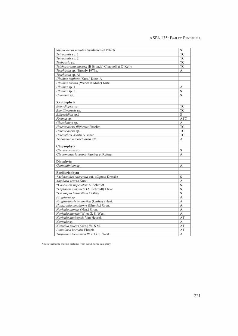
ASPA 135: BAILEY PENINSULA
221
Stichococcus minutus Grintzesco et Peterfi S
Tetracystis sp. 1 TC
Tetracystis sp. 2 TC
Trebouxia sp. TC
Trichosarcina mucosa (B Broady) Chappell et O’Kelly TC
Trochiscia sp. (Broady 1979x, A
Trochiscia sp. A)
Ulothrix implexa (Kutz.) Kutz. A
Ulothrix zonata (Weber et Mohr) Kutz
Ulothrix sp. 1 A
Ulothrix sp. 2 S
Uronema sp. S
Xanthophyta
Botrydiopsis sp. TC
Bumilleriopsis sp. TC
Ellipsoidion sp.? S
Fremya sp. ATC
Gloeobotrys sp. A
Heterococcus filiformis Pitschm. TC
Heterococcus sp. TC
Heterothrix debilis Vischer TC
Tribonema microchloron Ettl A
Chrysophyta
Chrysococcus sp. S
Chroomonas lacustris Pascher et Ruttner A
Dinophyta
Gymnodinium sp. A
Bacillariophyta
*Achnanthes coarctata var. elliptica Krasske S
Amphora veneta Kutz. A
*Cocconeis imperatrix A. Schmidt S
*Diploneis subcincta (A. Schmidt) Cleve S
*Eucampia balaustium Castray S
Fragilaria sp. A
Fragilariopsis antarctica (Castray) Hust. A
Hantzschia amphioxys (Ehrenb.) Grun. A
Navicula atomus (Nag.) Grun. A
Navicula murrayi W. et G. S. West A
Navicula muticopsis Van Heurck AT
Navicula sp. A
Nitzschia palea (Kutz.) W. S M. AT
Pinnularia borealis Ehrenb. AT
Torpedoes laevissima W et G. S. West A
*Believed to be marine diatoms from wind-borne sea spray.
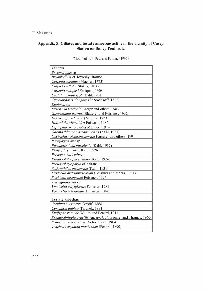
II. MEASURES
222
Appendix 5: Ciliates and testate amoebae active in the vicinity of Casey
Station on Bailey Peninsula
(Modified from Petz and Foissner 1997)
Ciliates
Bryometopus sp
Bryophyllum cf. loxophylliforme
Colpoda cucullus (Mueller, 1773)
Colpoda inflata (Stokes, 1884)
Colpoda maupasi Enriques, 1908
Cyclidium muscicola Kahl, 1931
Cyrtolophosis elongata (Schewiakoff, 1892)
Euplotes sp.
Fuscheria terricola Berger and others, 1983
Gastronauta derouxi Blatterer and Foissner, 1992
Halteria grandinella (Mueller, 1773)
Holosticha sigmoidea Foissner, 1982
Leptopharynx costatus Mermod, 1914
Odontochlamys wisconsinensis (Kahl, 1931)
Oxytricha opisthomuscorum Foissner and others, 1991
Parafurgasonia sp.
Paraholosticha muscicola (Kahl, 1932)
Platyophrya vorax Kahl, 1926
Pseudocohnilembus sp.
Pseudoplatyophrya nana (Kahl, 1926)
Pseudoplatyophrya cf. saltans
Sathrophilus muscorum (Kahl, 1931)
Sterkiella histriomuscorum (Foissner and others, 1991)
Sterkiella thompsoni Foissner, 1996
Trithigmostoma sp.
Vorticella astyliformis Foissner, 1981
Vorticella infusionum Dujardin, 1 841
Testate amoebae
Assulina muscorum Greeff, 1888
Corythion dubium Taranek, 1881
Euglypha rotunda Wailes and Penard, 1911
Pseudodifflugia gracilis var. terricola Bonnet and Thomas, 1960
Schoenbornia viscicula Schoenborn, 1964
Trachelocorythion pulchellum (Penard, 1890)

ASPA 135: BAILEY PENINSULA
223

II. MEASURES
224

ASPA 135: BAILEY PENINSULA
225

II. MEASURES
226

ASPA 135: BAILEY PENINSULA
227

II. MEASURES

229
Measure 9 (2008)
Antarctic Specially Protected Area No 137
(North-west White Island, McMurdo Sound):
Revised Management Plan
The Representatives,
Recalling Articles 3, 5 and 6 of Annex V to the Protocol on Environmental Protection to the
Antarctic Treaty providing for the designation of Antarctic Specially Protected Areas
(“ASPA”) and approval of Management Plans for those Areas;
Recalling
• Recommendation XIII-8 (1985), which designated White Island, McMurdo Sound,
as Site of Special Scientific Interest (“SSSI”) No 18 and annexed a management plan
for the site;
• Recommendation XVI-7 (1991), which extended the expiry date of SSSI 18 from 31
December 1991 to December 2001;
• Measure 3 (2001), which extended the expiry date of SSSI 18 December 2001 until
31 December 2005;
• Decision 1 (2002), which renamed and renumbered SSSI 18 as Antarctic Specially
Protected Area No 137;
• Measure 1 (2002), which adopted a revised Management Plan for ASPA 137;
Noting that the Committee for Environmental Protection has endorsed a revised Management
Plan for ASPA 137;
Desiring to replace the existing Management Plan for ASPA 137 with the revised
Management Plan;
Recommend to their Governments the following Measure for approval in accordance with
Paragraph 1 of Article 6 of Annex V to the Protocol on Environmental Protection to the
Antarctic Treaty:
That:

230
II. MEASURES
1) the revised Management Plan for Antarctic Specially Protected Area No 137:
North-west White Island, McMurdo Sound, which is annexed to this Measure,
be approved; and
2) all prior management plans for ASPA 137, namely those annexed to:
- Recommendation XIII-8 (1985), and
- Measure 1 (2002);
shall cease to be effective.

231
MEASURE 9 - ANNEX
Management Plan for Antarctic Specially Protected Area No 137
NORTH-WEST WHITE ISLAND, McMURDO SOUND
1. Description of values to be protected
An area of 150km2 of coastal shelf ice on the north-west side of White Island was originally designated
by Recommendation XIII-8 (1985, SSSI No 18) after a proposal by the United States of America on
the grounds that this locality contains an unusual breeding population of Weddell seals (Leptonychotes
weddellii) which is the most southerly known, and which has been physically isolated from other
populations by advance of the McMurdo Ice Shelf and Ross Ice Shelf (Map 1). The original
boundaries were adjusted in 2002 (Measure 1) in light of new data recording the spatial distribution
of the seals on the ice shelves. In the south, the boundary of the Area was shifted north and east to
exclude the region north of White Strait where no observations of the seals have been recorded. In
the north, the Area was extended to encompass an additional part of the Ross Ice Shelf in order to
ensure inclusion of more of the region within which the seals may be found. In 2008, the Management
Plan was updated to include recent census data on the seal colony, which led to revision of the
boundary to include part of the Ross Ice Shelf in the north-east where seals have been observed.
The Area is now approximately 142km2. Additional guidance on aircraft overflight and access has
also been included.
The Weddell seal colony appears unable to relocate to another area because of its distance from the
open ocean of McMurdo Sound, and as such it is highly vulnerable to any human impacts that
might occur in the vicinity. The colony is not thought to have been present in the early 1900s, as
there is no mention of seals by naturalists who visited White Island many times during Scott’s 1902,
1903 and 1910 expeditions. An ice breakout occurred in the region between 1947 and 1956, and the
first two seals were observed near the north-eastern end of the island in 1958 (R. Garrott, pers.
comm. 2007). Year-round studies have detected no evidence of immigration or emigration of seals
from the population, which appears to have grown to around 25 to 30 animals from a population of
around 11 in the 1960s. The seals do not have the breathing capacity needed to dive the 20km
required to reach the open ocean, and there is only one record of a seal from the colony making the
journey over the ice shelf surface.
The seals gain access to the sea below the ice shelf through pressure cracks, which are formed by
tidal motion and movement of the McMurdo and Ross ice shelves. Only one crack remains open
year-round. The Weddell seals at White Island are on average greater in size and weight than their
McMurdo Sound counterparts and have been shown to make more shallow dives. NW White Island
is one of very few sites where Weddell seals are known to feed under shelf ice. The population is
considered to have exceptional scientific value because of its period of physical isolation from
interaction with other seals, thought to be around 60 years, and investigations are being undertaken
of the extent to which the group may be considered a genetically distinct population. Genetic
techniques have been used to construct a complete pedigree for the NW White Island population,
which supports the conclusion that the year in which the colony was founded is likely to have been
around 60 years ago, which agrees with historical sightings. NW White Island is relatively accessible
by shelf ice from the nearby United States and New Zealand research stations at Hut Point, Ross
Island. In addition, a flagged access route between these stations and Black Island traverses within
approximately 2km of the Area (Map 1).

II. MEASURES
232
The Area requires long-term special protection because of the exceptional importance of the Weddell
seal colony, outstanding scientific values and opportunities for research, and the potential
vulnerability of the Area to disturbance from scientific and logistic activities in the region.
2. Aims and objectives
Management at NW White Island aims to:
• avoid degradation of, or substantial risk to, the values of the Area by preventing unnecessary
human disturbance to the Area;
• allow scientific research on the ecosystem, in particular on the Weddell seals, while ensuring
protection from excessive disturbance or other possible scientific impacts;
• allow other scientific research provided it will not jeopardize the values of the Area;
• minimize the possibility of introduction of alien animals and microbes into the Area;
• allow visits for management purposes in support of the aims of the Management Plan.
3. Management activities
• Signs showing the location of the Area (stating the special restrictions that apply) shall be
displayed prominently, and a copy of this management plan shall be kept available in
appropriate places, in particular at McMurdo Station, Scott Base and at the Black Island
facilities.
• Markers, signs or structures erected within the Area for scientific or management purposes
shall be secured and maintained in good condition, and removed when no longer necessary.
• Visits shall be made as necessary (no less than once every five years) to assess whether the
Area continues to serve the purposes for which it was designated and to ensure management
and maintenance measures are adequate.
• National Antarctic Programs operating in the region shall consult together for the purpose
of ensuring these steps are carried out.
4. Period of designation
Designated for an indefinite period.
5. Maps and photographs
• Map 1: NW White Island, ASPA No 137, topographic map.
Map specifications:
Projection: Lambert Conformal Conic; Standard parallels: 1st 78° 00' 00" S; 2nd 78° 12'
00"S; Central Meridian: 167° 05' 00" E; Latitude of Origin: 77° 30' 00" S; Spheroid: WGS84.
Inset 1: Ross Sea region.
Inset 2: Ross Island region, key features and nearby stations.
Note: Map 1 is derived from the Antarctic Digital Database (Version 5.0, SCAR, 2007). This
framework has been identified as positionally inaccurate in the Ross Island / White Island

ASPA 137: WHITE ISLAND
233
region. Accurate ground control available for Hut Point Peninsula was used to adjust the
geographical position of the framework by approximately +240m (x direction) and +100m
(y direction). This shift is considered to improve the accuracy of Map 1, but the result is
only an approximation. Global Positioning Systems (GPS, in WGS-84) observations of
seals shown on Map 1 are considered accurate to approximately 200m of their true positions.
6. Description of the Area
6(i) Geographical coordinates, boundary markers and natural features
White Island, part of the McMurdo volcanic complex, is situated approximately 20km SE of the
edge of the McMurdo Ice Shelf and 25km SE of Hut Point, the location of McMurdo Station (United
States) and Scott Base (New Zealand) on Ross Island (Inset 2, Map 1). The roughly triangular
island is approximately 30km long and 15km wide at its maximum, and rises to a maximum elevation
of 762m in several locations (Map 1). The northern and western shores of White Island descend
steeply, with water depths of 600m occurring within 5km of the island. The island is predominantly
ice-covered with most of the rock outcrops being in the north, and is completely surrounded by
permanent shelf ice, between 10m and 100m in thickness, of the McMurdo Ice Shelf and Ross Ice
Shelf. Black Island is situated 2.5km west of White Island, separated by the shelf ice of White
Strait. The GPS entry and exit points for the access route to Black Island from McMurdo through
White Strait are 78° 12' 00"S, 166° 50' 00"E and 78° 14' 17"S, 166° 45' 30" E, respectively.
The westward movement of the McMurdo Ice Shelf is greatest at the northern end of White Island
and movement of ice away from the NW coast ensures open water in cracks in the shelf at this
locality is present year-round. The Weddell seal population uses the cracks for access to seawater
and feeding grounds under the shelf ice, and inhabits and breeds in the region within approximately
5km of their positions. The cracks occur parallel to and within a few hundred meters of the coast of
White Island, and intermittently extend along the coast from the northern extremity of the island up
to 15km to the south.
The Area includes 142km2 of the shelf ice and open-water cracks of both the Ross Ice Shelf and
McMurdo Ice Shelf up to 5km offshore north-east, north and west from the White Island coast. The
north-eastern boundary extends from the north-eastern coast of Cape Spencer-Smith (167° 32' 42"
E, 78° 00' 43" S) 5km due east to 167° 46' 37" E, 78° 00' 43" S. The boundary then extends north-
west, and follows a line parallel to and 5km from the coast, around Cape Spencer Smith and then
heading south-west to 167° 00' 00" E, 78° 05' 00" S. The boundary then extends due south for
7.8km to 167° 00' 00" E, 78° 09' 12" S, and thence 1.5km east to the southern-most significant
outcrop of rock on the western coast of White Island (167° 05' 00" E, 78° 09' 12" S). The boundary
then extends northwards, following the coastline around Cape Spencer Smith to the north-eastern
limit of the Area. The White Island coast is distinguished by a change in surface slope where the
transition between the floating ice-shelf and land occurs: the transition is in some places gradual
and indistinct, and the exact position of the coast is not precisely known. For this reason the coastal
(generally east) boundary of the Area is considered to follow the line of the coast as evidenced by a
surface elevation rise towards the land of two meters above the average elevation of the adjacent
McMurdo Ice Shelf.
The Weddell seal population was estimated at around 25 to 30 animals in 1991. A 1981 study
estimated "about 30" seals, while 1991 studies estimated 26 seals greater than one year of age.
Since 1991, 17 different females have produced pups at White Island. Between 2003 and 2007, 11
females have been sighted at White Island, but only six of these individuals have produced pups.
Between two and four live pups were recorded in 1963-1968, 1981, and 1991. Annual censuses

II. MEASURES
234
since 1991 recorded between four and ten pups from 1991 to 2000, but lower numbers (between
two and four pups each year) from 2000 to 2007. Pup mortality is high, possibly due to inbreeding,
and pup production is low in comparison to the population in Erebus Bay.
The seals are physically isolated by the barrier of the shelf ice, and are unable to swim the 20km
distance under the ice to reach the seasonally open waters of McMurdo Sound: Weddell seals have
been estimated to be capable of swimming a distance of around 4.6km (2.5 nautical miles) on a
single breath. The apparent isolation of the colony is substantiated by tag observation data on Weddell
seals in McMurdo Sound, where in more than 100,000 tag observations over a 20-year period no
tagged seals from White Island have been observed in McMurdo Sound. These data suggest that the
White Island seals do not generally traverse the 20km distance to the open ocean over the surface of
the shelf ice. However, there is at least one record of a yearling from the White Island colony found
to have made the journey across to the Williams airfield close to McMurdo station (G. Kooyman,
pers. comm. 2007).
Adult female seals begin to appear on the shelf ice in early November, one month later than other
pupping areas in the southern Ross Sea. They pup at the NW extremity of the island during which
time sub-adults and non-breeding adults can be found up to 15km to the SW near open cracks on the
west side of the island. Adult male seals are not observed on the sea-ice during this time, remaining
in the water to establish and defend territories. The females remain on the ice until pups are weaned
at about 6-8 weeks of age. After December, adults and sub-adults mix in the pupping area and along
the cracks formed at the NW corner of the island.
It is thought that the harsh surface conditions confine the seals to the water during the winter months.
Winter surface temperatures reach as low as -60°C and it is thought that the seals expend considerable
time maintaining an open air hole in the cracks. This is thought to be a key factor limiting the
population size, with pups and sub-adults possibly excluded from use of the limited breathing holes
by more dominant and aggressive adults. Some pups may be unable to maintain their own breathing
holes and may become trapped on the ice surface if dominant seals do not allow them entry into the
water.
Studies have suggested that the Weddell seals at White Island have a similar diet to their counterparts
at McMurdo Sound. Studies of fish otoliths recovered from Weddell seal fecal samples have revealed
a diet comprised primarily of the nototheniid fish Pleuragramma antarcticum, also with fish from
the genus Trematomus. Invertebrates are thought to comprise the remainder of the diet along with a
cephalopod belonging to the family Mastogoteuthidae. Consumption of the latter was found to be
considerably greater amongst White Island seals than those at McMurdo Sound.
Other aspects of the physiology and behaviour of seals at White Island appear to differ from nearby
populations at McMurdo Sound and at Terra Nova Bay: the seals at White Island appear to be
significantly fatter, with recorded weights of up to 686 kg (1500 lb.) at White Island compared to no
more than 500 kg at McMurdo Sound or Terra Nova Bay. A 1991 study revealed that on average
adult female seals are considerably longer than those in McMurdo Sound, and young seals at White
Island have been observed to exhibit faster growth rates than their McMurdo counterparts. Average
diving depths at White Island are shallower than at McMurdo Sound.
6(ii) Restricted and managed zones within the Area
None.
6(iii) Structures within and near the Area
There are no structures within or near the Area.

ASPA 137: WHITE ISLAND
235
6(iv) Location of other protected areas within close proximity of the Area
The nearest protected areas to NW White Island are on Ross Island: Arrival Heights (ASPA No 122)
adjacent to McMurdo Station and Discovery Hut (ASPA No 158) on the Hut Point Peninsula are the
closest at 20km to the north; Cape Evans (ASPA No 155) and Cape Royds (ASPA No 121) are
47km and 55km north respectively; and Tramway Ridge (ASPA No 130) near the summit of Mt.
Erebus is 60km to the north.
7. Permit conditions
Entry into the Area is prohibited except in accordance with a permit issued by appropriate national
authorities. Conditions for issuing a permit to enter the Area are that:
• it is issued only for scientific study of the Weddell seal ecosystem, or for scientific reasons
or management purposes consistent with plan objectives such as inspection or review;
• the actions permitted will not jeopardize the ecological or scientific values of the Area;
• any management activities are in support of the objectives of the Management Plan;
• the actions permitted are in accordance with the Management Plan;
• the Permit, or a copy, shall be carried within the Area;
• a visit report shall be supplied to the authority named in the Permit;
• Permits shall be issued for a stated period.
7(i) Access to and movement within the Area
• Access into the Area is permitted on foot, by vehicle, or by aircraft.
• Aircraft landings and overflight below 750m (~2500 ft) within the Area are prohibited
without a permit. Aircraft approach and departure shall avoid overflight of the White Island
coastline and tide-cracks within the Area, where the seals are most commonly found. Aircraft
shall not land closer than 300m from seals where they can be seen from the air, and shall
land at least 300m (~980 ft) away from the coastline of White Island and the tide-crack
when seals are not visible.
• Use of helicopter smoke grenades is prohibited unless absolutely necessary for safety, and
all grenades should be retrieved.
• Vehicles are strongly discouraged from approaching closer than 50m from seals, and closer
approaches should be on foot. Vehicle and pedestrian traffic should be kept to the minimum
necessary consistent with the objectives of any permitted activities.
7(ii) Activities that are or may be conducted in the Area, including restrictions on time or place
Activities that may be conducted within the Area include:
• scientific research that will not jeopardize the ecosystem of the Area;
• essential management activities, including monitoring.
7(iii) Installation, modification or removal of structures
• No structures are to be erected within the Area except as specified in a permit;
• All scientific equipment installed in the Area must be authorized by permit and clearly
identified by country, name of the principal investigator and year of installation. All such
items should be made of materials that pose minimal risk of contamination of the Area;

II. MEASURES
236
• Removal of specific equipment for which the permit has expired shall be the responsibility
of the authority which granted the original Permit, and shall be a condition of the permit.
7(iv) Location of field camps
Permanent field camps are prohibited within the Area. Temporary campsites are permitted within
the Area. There are no specific restrictions to a precise locality for temporary camp sites within the
Area, although sites selected shall be more than 200m from the ice-shelf cracks inhabited by the
seals, unless authorized by permit when deemed necessary to the accomplishment of specific research
goals.
7(v) Restrictions on materials and organisms that can be brought into the Area
• No living animals, plant material or microorganisms shall be deliberately introduced into
the Area and precautions shall be taken against accidental introductions. Of particular concern
are microbial and viral introductions from other seal populations. To minimize the risk of
introductions, visitors shall ensure that any measuring devices, sampling equipment, markers
or personal equipment to be used in the area are clean before entering the Area;
• No herbicides or pesticides shall be brought into the Area;
• Any other chemicals, including radio-nuclides or stable isotopes, which may be introduced
for scientific or management purposes specified in the permit, shall be removed from the
Area to the maximum extent practicable at or before the conclusion of the activity for
which the permit was granted;
• Fuel is not to be stored in the Area, unless required for essential purposes connected with
the activity for which the permit has been granted;
• All materials introduced shall be for a stated period only, shall be removed at or before the
conclusion of that stated period, and shall be stored and handled so that risk of their
introduction into the environment is minimized.
7(vi) Taking or harmful interference with native flora or fauna
Taking or harmful interference with native flora and fauna is prohibited, except in accordance with
a separate permit issued under Article 3 of Annex II by the appropriate national authority specifically
for this purpose.
7(vii) Collection or removal of anything not brought into the Area by the permit holder
Material may be collected or removed from the Area only in accordance with a permit and should
be limited to the minimum necessary to meet scientific or management needs. Material of human
origin likely to compromise the values of the Area, which was not brought into the Area by the
permit holder or otherwise authorized, may be removed unless the impact of removal is likely to be
greater than leaving the material in situ: if this is the case the appropriate authority should be notified.
7(viii) Disposal of waste
All wastes shall be removed from the Area.
7(ix) Measures that are necessary to ensure that the aims and objectives of the Management Plan
can continue to be met
• Any specific sites of long-term monitoring shall be appropriately marked;
• The use of explosives is prohibited within the Area.

ASPA 137: WHITE ISLAND
237
7(x) Requirements for reports
• Parties should ensure that the principal holder for each permit issued submits to the
appropriate authority a report describing the activities undertaken. Such reports should
include, as appropriate, the information identified in the Visit Report form suggested by
SCAR.
• Parties should maintain a record of such activities and, in the Annual Exchange of
Information, should provide summary descriptions of activities conducted by persons subject
to their jurisdiction, which should be in sufficient detail to allow evaluation of the
effectiveness of the Management Plan. Parties should, wherever possible, deposit originals
or copies of such original reports in a publicly accessible archive to maintain a record of
usage, to be used both in any review of the Management Plan and in organizing the scientific
use of the Area.

II. MEASURES
238

239
Measure 10 (2008)
Antarctic Specially Protected Area No 138
(Linnaeus Terrace, Asgard Range, Victoria Land):
Revised Management Plan
The Representatives,
Recalling Articles 3, 5 and 6 of Annex V to the Protocol on Environmental Protection to the
Antarctic Treaty providing for the designation of Antarctic Specially Protected Areas
(“ASPA”) and approval of Management Plans for those Areas;
Recalling
• Recommendation XIII-8 (1985), which designated Linnaeus Terrace, Asgard Range,
Victoria Land, as Site of Special Scientific Interest (“SSSI”) No 19 and annexed a
management plan for the site;
• Resolution 7 (1995), which extended the expiry date of SSSI 19 from 31 December
1995 to 31 December 2000;
• Measure 1 (1996), which adopted a revised Management Plan for SSSI 19;
• Decision 1 (2002), which renamed and renumbered SSSI 19 as Antarctic Specially
Protected Area No 138;
Noting that the Committee for Environmental Protection has endorsed a revised Management
Plan for ASPA 138;
Desiring to replace the existing Management Plan for ASPA 138 with the revised
Management Plan;
Recommend to their Governments the following Measure for approval in accordance with
Paragraph 1 of Article 6 of Annex V to the Protocol on Environmental Protection to the
Antarctic Treaty:
That:
1) the revised Management Plan for Antarctic Specially Protected Area No 138:
Linneaus Terrace, Asgard Range, Victoria Land, which is annexed to this
Measure, be approved;

240
II. MEASURES
2) the Management Plan for ASPA 138 annexed to Recommendation XIII-8 (1985)
shall cease to be effective; and
3) Measure 1 (1996), which is not yet effective, be withdrawn.

241
MEASURE 10 - ANNEX
Management Plan for Antarctic Specially Protected Area No 138
LINNAEUS TERRACE, ASGARD RANGE, VICTORIA LAND
1. Description of values to be protected
Linnaeus Terrace was originally designated in Recommendation XIII-8 (1985, SSSI No 19) after a
proposal by the United States of America on the grounds that the Area is one of the richest known
localities for the cryptoendolithic communities that colonize the Beacon Sandstone. Exposed surfaces
of the Beacon Sandstone are the habitat of cryptoendolithic microorganisms, which may colonize a
zone of up to 10 millimeters deep below the surface of the rocks. The sandstones exhibit a range of
biological and physical weathering forms, as well as trace fossils, and many of the formations are
fragile and vulnerable to disturbance and destruction by trampling and sampling. Cryptoendolithic
communities are known to develop over time periods in the order of tens of thousands of years, and
damaged rock surfaces would be slow to recolonize. The excellent examples of these communities
found at the site are the subject of the original detailed Antarctic cryptoendolithic descriptions. As
such, Linnaeus Terrace is considered a type locality with outstanding scientific values related to this
ecosystem. These values, as well as the vulnerability of the site to disturbance and destruction,
require that it receives long-term special protection. The Management Plan has been updated to
include additional provisions to reduce the risk of alien plants, animals or microbes from other
Antarctic sites, or from regions outside Antarctica.
2. Aims and objectives
Management at Linnaeus Terrace aims to:
• avoid degradation of, or substantial risk to, the values of the Area by preventing unnecessary
human disturbance to the Area;
• allow scientific research on the ecosystem, in particular on the cryptoendolithic communities,
while ensuring protection from excessive sampling, damage to fragile rock formations, or
other possible scientific impacts;
• allow other scientific research provided it will not jeopardize the values of the Area;
• minimize the possibility of introduction of alien plants, animals and microbes into the Area;
• allow visits for management purposes in support of the aims of the Management Plan.
3. Management activities
• A copy of this Management Plan shall be kept available in appropriate places, in particular
at McMurdo Station and Scott Base;
• Durable wind direction indicators should be erected close to the designated helicopter landing
site whenever it is anticipated there will be a number of landings at the Area in a given
season. These should be replaced as needed and removed when no longer required;
• Brightly colored markers, which should be clearly visible from the air and pose no significant
threat to the environment, should be placed to mark the designated helicopter landing site;

II. MEASURES
242
• Markers or structures erected within the Area for scientific or management purposes shall
be secured and maintained in good condition, and removed when no longer necessary;
• Visits shall be made as necessary (preferably no less than once every five years) to assess
whether the Area continues to serve the purposes for which it was designated and to ensure
management and maintenance measures are adequate;
• National Antarctic Programmes operating in the region shall consult together for the purpose
of ensuring these steps are carried out.
4. Period of designation
Designated for an indefinite period.
5. Maps and photographs
• Map 1: ASPA No 138 Linnaeus Terrace, Wright and Taylor Valleys.
Projection: Lambert conformal conic; Standard parallels: 1st 77° 30' S; 2nd 77° 40' S; Central
Meridian: 161° 53' E; Latitude of Origin: 78° 00' S; Spheroid: WGS84; Datum: ‘Camp
Area’ Local; Contour interval 250m.
• Map 2: ASPA No 138 Linnaeus Terrace, topography and boundary. Projection: Lambert
conformal conic; Standard parallels: 1st 77° 35' S; 2nd 77° 36' S; Central Meridian: 161° 05'
E; Latitude of Origin: 78° 00' S; Spheroid and horizontal datum: WGS84; Contour interval
5m. Map derived from an orthophotograph with an estimated positional accuracy of 0.5m.
• Figure 1: Photograph illustrating some of the fragile rock formations and trace fossils found
on Linnaeus Terrace.
6. Description of the Area
6(i) Geographical coordinates, boundary markers and natural features
Linnaeus Terrace (161° 05' 00" E, 77° 35' 50" S) is a bench of weathered Beacon Sandstone
approximately 1.5km in length and 1km in width at an elevation of about 1600m (Map 1). It is
located at the western end of the Asgard Range, 1.5km north of Oliver Peak (161° 02' 30"E, 77° 36'
40" S, 2410 m). The Area overlooks the South Fork of the Wright Valley, is about 4km from Don
Juan Pond and 10km from the terminus of the Wright Upper Glacier (Map 1).
The lower (northern) boundary of the Area is characterized by the presence of a predominantly
sandstone outcrop of approximately 3m in height which extends for much of the length of the
terrace (Map 2). The lower boundary of the Area is defined as the upper edge of this outcrop, and as
straight lines adjoining the visible edges where the outcrop is covered by surface talus. The upper
(south-western) boundary of the Area is characterized by a line of sandstone outcrop of about 2-5m
in height, occurring between the elevations of 1660 - 1700m about 70m above the general elevation
of the terrace. The upper boundary of the Area is defined as the uppermost edge of this outcrop, and
shall be considered a straight line between the visible edges where the outcrop is covered by surface
talus. The western end of the Area is defined as where the terrace narrows and merges with a
dolerite talus slope on the flank of the NW ridge of Oliver Peak. The boundary at the west dips
steeply from where the upper outcrop disappears, following the border of the dolerite talus with the
terrace sandstone down to the westernmost corner. The east boundary is defined as the 1615m

ASPA 138: LINNAEUS TERRACE
243
contour, which follows closely the edge of an outcrop which extends much of the width of the
terrace (Map 2). At the southernmost corner of the Area the terrace merges with the slopes into the
valley to the east: from this point the boundary extends upward to the 1700m contour, from where
it follows the line of outcrop defining the south-western boundary.
Winter air temperature at Linnaeus Terrace ranges between -20°C and -45°C, while in January the
daily mean is approximately -5°C. Cryptoendolithic microorganisms typically colonize porous
Beacon sandstones with a 0.2 - 0.5 mm grain size, with an apparent preference for rocks stained tan
or brown by Fe3+ -containing oxyhydroxides. A silicified crust of about 1 mm thickness on many
of the rocks probably facilitates colonization by stabilizing the surface and reducing wind erosion.
Three of the five described cryptoendolithic microbial communities have been found on Linnaeus
Terrace: the Lichen Dominated, Red-Gloeocapsa and Chroococcidiopsis Communities. Linnaeus
Terrace is the type locality of the endemic green algal genus Hemichloris and of the endemic
Xanthophycean algal species Heterococcus endolithicus. The Area is unusual in that so many different
living and fossil endolithic communities are present within a small area. The main physical and
biological features of these communities and their habitat are described in Friedmann, E.I. (ed)
1993 Antarctic Microbiology, Wiley-Liss, New York.
Fragile weathered rock formations, such as trace fossils in eroded sandstone and brittle overhanging
low rock ledges (ranging from approximately 10 cm up to 1m in height), are present throughout the
Area.
A small area (Map 2) has been contaminated by release of the C(14) radioactive isotope. While the
contamination poses no significant human or environmental threat, any samples gathered within
this area are considered unsuitable for scientific work using C(14) techniques.
6(ii) Restricted zones within the Area
None.
6(iii) Structures within the Area
A number of rocks within the Area have small instruments installed into them for scientific purposes
and should not be disturbed.
6 (iv) Location of other protected areas within close proximity of the Area
Linnaeus Terrace lies within Antarctic Specially Managed Area (ASMA) No 2, McMurdo Dry
Valleys. Within the ASMA, the nearest Special Feature is Don Juan Pond in the Upper Wright
Valley. The nearest protected areas to Linnaeus Terrace are Barwick and Balham Valleys (ASPA No
123), 35km to the north, and Canada Glacier (ASPA No 131), 50km to the east (Map 1).
7. Permit conditions
Entry into the Area is prohibited except in accordance with a permit issued by an appropriate national
authority. Conditions for issuing a Permit to enter the Area are that:
• it is issued only for scientific study of the cryptoendolithic ecosystem, or for a compelling
scientific or management purpose that cannot be served elsewhere;
• the actions permitted will not jeopardize the natural ecological or scientific values of the
Area;
• any management activities are in support of the objectives of the Management Plan;

II. MEASURES
244
• the actions permitted are in accordance with the Management Plan;
• the permit, or a copy, shall be carried within the Area;
• a visit report is supplied to the authority named in the Permit;
• permits shall be issued for a stated period.
7(i) Access to and movement within the Area
• Access to the Area is permitted by foot or by helicopter. No special restrictions apply to the
routes used to move to and from the Area;
• Helicopters shall land only at the designated site at the west end of the terrace (161° 04' 29"
E, 77° 35' 50" S, elevation 1610m: Map 2), except when specifically authorized by Permit
otherwise for a compelling scientific or management purpose. Use of helicopter smoke
grenades is prohibited unless absolutely necessary for safety, and all grenades should be
retrieved;
• When transporting permitted visitors, pilots, air crew, or passengers en route elsewhere on
helicopters are prohibited from moving on foot beyond the immediate vicinity of the
designated landing and camping sites unless specifically authorized by a Permit;
• Land vehicles are prohibited within the Area;
• Movement within the Area should avoid damage to fragile rock formations: care should be
exercised to avoid walking on trace fossils (Figure 1) and brittle overhanging low rock
ledges which are easily broken;
• Pedestrian traffic should be kept to the minimum necessary consistent with the objectives
of any permitted activities.
7(ii) Activities that are or may be conducted in the Area, including restrictions on time or place
• Scientific research which will not jeopardize the ecosystem of the Area;
• Essential management activities, including monitoring.
7(iii) Installation, modification or removal of structures
• No structures are to be erected within the Area except as specified in a permit;
• Permanent structures are prohibited;
• All scientific equipment installed in the Area must be authorized by permit and clearly
identified by country, name of the principal investigator and year of installation. All such
items should be made of materials that pose minimal risk of contamination of the Area;
• Removal of specific equipment for which the permit has expired shall be the responsibility
of the authority which granted the original permit, and shall be a condition of the permit.
7(iv) Location of field camps
Camping is permitted within the Area only at the designated site in the immediate vicinity of the
helicopter landing site (Map 2).
7(v) Restrictions on materials and organisms which can be brought into the Area
• To avoid compromising the microbial ecosystem for which this site is protected, no living
animals, plant material or microorganisms shall be deliberately introduced into the Area
and the precautions listed below shall be taken against accidental introductions.

ASPA 138: LINNAEUS TERRACE
245
• To help maintain the ecological and scientific values of the Area, visitors shall take special
precautions against the introduction of animals, plant material or microorganisms. Of
particular concern are microbial and vegetation introductions from soils at other Antarctic
sites, including stations, or from regions outside Antarctica. To minimize the risk of
introductions, visitors should thoroughly clean footwear and any equipment to be used in
the Area – particularly sampling equipment and markers – before entering the Area.
• No herbicides or pesticides shall be brought into the Area.
• Any other chemicals, including radio-nuclides or stable isotopes, which may be introduced
for scientific or management purposes specified in the permit, shall be removed from the
Area at or before the conclusion of the activity for which the Permit was granted.
• Food, fuel, and other materials are not to be stored in the Area, unless required for essential
purposes connected with the activity for which the permit has been granted.
• All materials introduced shall be for a stated period only, shall be removed at or before the
conclusion of that stated period, and shall be stored and handled so that risk of their
introduction into the environment is minimized.
• If release occurs which is likely to compromise the values of the Area, removal is encouraged
only where the impact of removal is not likely to be greater than that of leaving the material
in situ.
7(vi) Taking or harmful interference with native flora or fauna
Taking or harmful interference with native flora or fauna is prohibited, except in accordance with a
separate permit issued under Article 3 of Annex II by an appropriate national authority.
7(vii) Collection or removal of anything not brought into the Area by the Permit holder
• Material may be collected or removed from the Area only in accordance with a permit and
should be limited to the minimum necessary to meet management needs;
• Material of human origin, not brought into the Area by the permit holder, but which is
likely to compromise the values of the Area may be removed from the Area unless the
impact of removal is likely to be greater than leaving the material in situ. If this is the case
the appropriate authority should be notified.
7(viii) Disposal of waste
All wastes, including all human wastes, shall be removed from the Area.
7(ix) Measures that are necessary to ensure that the aims and objectives of the Management Plan
can continue to be met
• Visitors should consult and apply where appropriate the comprehensive Code of Conduct
and Guidelines for Conduct of Scientific Research developed for use within the McMurdo
Dry Valleys (ASMA No 2).
• Any specific sites of long-term monitoring should be appropriately marked.
7(x) Requirements for reports
• Parties should ensure that the principal holder of each permit issued submit to the appropriate
authority a report describing the activities undertaken. Such report should include, as
appropriate, the information identified in the Visit Report form contained in Appendix 4 of
Resolution 2 (1998)(CEP I).

II. MEASURES
246
• Parties should maintain a record of such activities, and, in the annual Exchange of
Information, should provide summary descriptions of activities conducted by persons subject
to their jurisdiction, in sufficient detail to allow evaluation of the effectiveness of the
Management Plan. Parties should, wherever possible, deposit originals or copies of such
original reports in a publicly accessible archive to maintain a record of usage, to be used
both in any review of the Management Plan and in organizing the scientific use of the Area.
• The appropriate authority should be notified of any activities/measures undertaken, and /
or of any materials released and not removed, that were not included in the authorized
permit.

ASPA 138: LINNAEUS TERRACE
247

II. MEASURES
248

ASPA 138: LINNAEUS TERRACE
249
Figure 1. Fragile rock formations and trace fossils found on Linnaeus Terrace

II. MEASURES

251
Measure 11 (2008)
Antarctic Specially Protected Area No 154
(Botany Bay, Cape Geology, Victoria Land):
Revised Management Plan
The Representatives,
Recalling Articles 3, 5 and 6 of Annex V to the Protocol on Environmental Protection to the
Antarctic Treaty providing for the designation of Antarctic Specially Protected Areas
(“ASPA”) and approval of Management Plans for those Areas;
Recalling
• Measure 3 (1997), which designated Botany Bay, Cape Geology, Victoria Land, as
Site of Special Scientific Interest (“SSSI”) No 37 and annexed a management plan
for the site;
• Decision 1 (2002), which renamed and renumbered SSSI 37 as Antarctic Specially
Protected Area No 154;
• Measure 2 (2003), which annexed a revised management plan for ASPA 154;
Noting that the Committee for Environmental Protection has endorsed a revised Management
Plan for ASPA 154;
Desiring to replace the existing Management Plan for ASPA 154 with the revised
Management Plan;
Recommend to their Governments the following Measure for approval in accordance with
paragraph 1 of Article 6 of Annex V to the Protocol on Environmental Protection to the
Antarctic Treaty:
That:
1) the revised Management Plan for Antarctic Specially Protected Area No 154:
Botany Bay, Cape Geology, Victoria Land, which is annexed to this Measure,
be approved; and

252
II. MEASURES
2) all prior management plans for ASPA 154, namely those annexed to:
- Measure 3 (1997), and
- Measure 1 (2002);
shall cease to be effective.

253
MEASURE 11 - ANNEX
Management Plan for Antarctic Specially Protected Area No 154
BOTANY BAY, CAPE GEOLOGY, VICTORIA LAND
1. Description of values to be protected
The Area at Botany Bay and Cape Geology (Granite Harbour, Victoria Land) has been proposed by
New Zealand on the grounds that it is an extremely rich botanical refuge for such a high latitude
location (162° 34' 00"E, 77° 00' 30"S), with a lichen and moss species diversity and abundance that
is unique for southern Victoria Land. In addition to a high diversity and abundance of lichens and
mosses there are abundant growths of algae, large populations of invertebrates (collembola, mites,
nematodes, rotifers) and a colony (in excess of 40 pairs) of south polar skua (Catharacta
maccormicki). The area is the type locality for the collembolan Gomphiocephalus hodgsoni Carpenter
and the lichen Caloplaca coeruleofrigida Sochting.
The structure and development of the moss and lichen communities is similar to that found more
than 10° of latitude further north, with several species at their known southern limit. The Area
contains the most southerly record of the hepatic (Cephaloziella varians). Of great significance is
the size (up to 15 cm diameter) of some lichen thalli (e.g. Umbilicaria aprina). The boulder beach
has rich populations of both epilithic and endolithic lichens.
In addition to the biological values described, the Area contains within it the remains of a rock
shelter and associated artifacts of historical importance, known as ‘Granite House’, designated as
Historic Site No 67 in Measure 4 (1995). Constructed by members of the 1910-1913 British Antarctic
Expedition, the shelter and associated artifacts are vulnerable to disturbance and are therefore
managed as a Managed Zone within the Area, which is subject to access restrictions. A tent site used
by the Western Geological Party under Griffith Taylor, is identifiable as a flat gravel area with a
number of stones that were used to weigh down the tent valance. This area is outside the Managed
Zone and is subject to access restrictions.
The limited geographical extent of the ecosystem, its unusual ecological features and importance,
its exceptional scientific and historic values and the vulnerability of the Area to disturbance through
trampling, sampling, pollution or alien introductions, are such that the Area requires long-term
special protection.
2. Aims and objectives
Management at Cape Geology aims to:
• avoid degradation of, or substantial risk to, the values of the Area by preventing unnecessary
human disturbance to the Area;
• allow scientific research on the ecosystem and elements of the ecosystem in particular on
lichen and moss species, algae, invertebrates and skuas while ensuring protection from
over-sampling;
• allow other scientific research provided it is for compelling reasons which cannot be served
elsewhere;
• preserve a part of the natural ecosystem as a reference area for the purpose of future
comparative studies;

II. MEASURES
254
• minimise the possibility of introduction of alien plants, animals and microbes to the Area;
• allow visits to ‘Granite House’, but under strict control by Permit;
• allow conservation visits to historic sites outside the Managed Zone, but under strict control
by Permit;
• allow visits for management purposes in support of the aims of the Management Plan.
3. Management activities
The following management activities are to be undertaken to protect the values of the Area:
• Maps showing the location of the Area (stating the special restrictions that apply) shall be
displayed prominently, and copies of this Management Plan shall be kept in all of the
research hut facilities located within 25km of the Area. Copies of the Management Plan
will also be available at Scott Base (NZ).
• Signs illustrating the location, boundaries and clearly stating entry restrictions shall be
placed at appropriate locations at the boundaries of the Area and Zones within to help
avoid inadvertent entry.
• Markers, signs or structures erected within the Area for scientific or management purposes
shall be secured and maintained in good condition.
• Visits shall be made as necessary (no less than once every five years) to assess whether the
Area continues to serve the purposes for which it was designated and to ensure management
and maintenance measures are adequate.
• National Antarctic Programmes operating in the region shall consult together with a view
to ensuring these steps are carried out.
4. Period of designation
Designated for an indefinite period.
5. Maps and photographs
• Map A: Botany Bay and Cape Geology, protected area topographic map. Map specifications:
Projection: Lambert conformal conic; Standard parallels: 1st 79° 20' 00" S; 2nd 76° 40' 00"S
Central Meridian: 162° 30' 00" E Latitude of Origin: 78° 01' 16.211" S; Spheroid: WGS84.
Inset 1: Southern Victoria Land, Ross Sea and Ross Island, showing location of Granite
Harbour.
Inset 2: Cape Geology location map, and Granite Harbour region.
• Map B: Managed Zone with ‘Granite House’ and viewing area, site topographic, derived
from Map A.
• Map C: Vegetation density layers, site topographic, showing the distribution density of moss,
lichen and algae within ASPA 154. Map specifications are the same as those in Map A.

ASPA 154: BOTANY BAY
255
6. Description of the Area
6(i) Geographical coordinates, boundary markers and natural features
Cape Geology is situated in the south-western corner of Granite Harbour, southern Victoria Land,
at 162°32’52"E, 77°00’14"S, approximately 100km north-west of Ross Island (Map A, Insets). The
Area encompasses much of the catchment above Botany Bay and consists of raised boulder beach
terraces, weathered rocky steppes and irregular rock platforms around Cape Geology, extending
south to include a well-defined elevated cirque containing a small ice field. The bedrock geology at
Cape Geology has been described as a porphyritic grey biotite-granite, with phenocrysts of orthoclase
of reddish colour, casting the weathered rock with a reddish tinge.
The north-west corner of the Area is marked by a brass plaque in a boulder (M1, 2 m: Map A,
162°31’53"E, 77°00’19’S) 400m SW of Cape Geology. The west boundary is defined by a line
extending first 260m SSE from M1 to a large boulder (marked by a cairn) with terrier bolt (M2) at
an elevation of 118m on the ridge above the campsite; thence the boundary extends 250m up this
ridge to a point at 162m elevation marked by an iron tube with bamboo pole. The west boundary
extends a further 300m up this ridge to a large pointed rock at 255m elevation (162°31’46"E,
77°00’40"S) near the edge of the permanent ice field. The boundary then extends 150m south
across the ice field to the west edge of a prominent line of exposed rock and moraine in the SW
corner of the Area at 325m elevation. The south boundary follows this line of rock east until the
exposure is buried by the ice-field, thence SE across the ice field for 500m to the edge of a second
and more prominent exposure at an elevation of just over 400m (M3, 162°33’22"E, 77°00’59"S).
The boundary follows the upper edge of this exposure and then crosses the ice field SE to an
elevation of approximately 325m where the ice-free eastern boundary ridge and the ice field converge,
(162°34’15"E, 77°01’16"S). The east boundary follows the ridge crest for 1550m in a NE direction
to a low point on the ridge (M4, 392 m, 162°36’10"E, 77°00’13"S) where the east boundary turns
to descend due north to the coast at the eastern extremity of the boulder beach of Botany Bay (M5,
5 m). The mean high water mark of the coastline of Botany Bay and Cape Geology forms the
northern boundary of the Area.
The Area is extremely rich botanically for such a high-latitude location — it is also one of the
richest sites in the whole of continental Antarctica. There is a high diversity and abundance of
lichens (more than 30 species) and mosses (seven species), and the structure and development of
these communities are similar to those found 10° of latitude further north (Table 1). Some lichen
thalli (e.g. Umbilicaria aprina) measure up to 15 cm diameter. The boulder beach has rich populations
of both epilithic and endolithic lichens. The Area is the type locality for the lichen Caloplaca
coeruleofrigida Sochting. The Area contains by far the most southerly record of an hepatic
(Cephaloziella varians) and the mosses Bryoerythrophyllum recurvirostre and possibly Ceratodon
purpureus. There are abundant growths of algae (at least 85 taxa), although the algal flora is not
considered particularly unusual for the locality.
Table 1. Estimated species list for lichen and mosses found at Botany Bay (species in bold are common)
Lichen Mosses Acarospora gwynnii Breyoerythrophyllum recurvirostre Amandinea petermannii Bryum argenteum Buellia frigida Bryum pseudotriquetrum Buellia papillata Ceratodon purpureus Buellia subfrigida Hennediella heimii Caloplaca athallina Hennediella heimii Caloplaca citrina Syntrichia sarconeurum Caloplaca coeruleofrigida Caloplaca saxicola Candelariella flava

II. MEASURES
256
There are large populations of invertebrates (collembola, mites, nematodes, rotifers) and the area is
the type locality for the collembolan Gomphiocephalus hodgsoni Carpenter. There is a colony of
between 40 – 50 breeding pairs (and numerous non-breeders) of the south polar skua (Catharacta
maccormicki), which is approximately the same number present in 1911–12. No other bird species
are known to breed in the Cape Geology area.
6(ii) Restricted and managed zones within the Area
Restricted Zone
An area directly above Botany Bay is designated as a Restricted Zone in order to preserve part of
the Area as a reference site for future comparative studies, while the remainder of the Area (which
is similar in biology, features and character) is more generally available for research programmes
and sample collection. The west boundary of the Restricted Zone is defined by a line from a marker
(iron tube in rock, 20 metres from mean high water mark, elevation 8 m) at the west side of Botany
Bay (Map A), extending SW for 170m up to a second iron tube marker on the crest of the adjacent
ridge (87 m). This boundary extends 100m to a third iron tube and a cairn (98 m), thence 50m to a
large flat rock in the centre of the main flush (marked ‘1’ on Map A). The south boundary of the
Restricted Zone extends from the flat rock in the flush in a straight line 820m to the first of two
prominent boulders closely adjacent to each other, approximately in the middle of the ice-free
slopes above Botany Bay (marked ‘2’ on Map A at 165 m). The east boundary extends 300m from
there to a large rock at 135m elevation (marked ‘3’ on Map A), thence NE downslope to the NE
boundary point (M5, 5 m). The north boundary of the Restricted Zone is the mean high water mark
of Botany Bay and is coincident with the north boundary of the Area.
Access to the Restricted Zone is allowed only for compelling scientific or management (such as
inspection or review) purposes, which cannot be served elsewhere in the Area.
Managed Zone
Situated along the coast from the north-west corner of ASPA 154 to just west of the northernmost
tip of Cape Geology, a Managed Zone is designated to protect historic artifacts and plant communities
within this vicinity, yet also to allow access to the rock shelter known as ‘Granite House’, which
Lichen Mosses Carbonea vorticosa? Lecanora expectans Lecanora fuscobrunnea Lecanora mons-nivis Lecidea andersonii Lecidea cancriformis Lecidella siplei Lepraria cacuminum Physcia caesia Physcia dubia Rhizocarpon geminatum Rhizocarpon geographicum Rhizoplaca sp. Rhizoplaca melanophthalma Rinodina olivaceobrunnea Umbilicaria aprina Xanthoria elegans Xanthoria mawsonii indeterminate grey crust

ASPA 154: BOTANY BAY
257
was designated as Historic Site No 67 in Measure 4 (1995). The Managed Zone is an area of 470m
by 20m along the coast and by 80m at the point that surrounds a rock ridge leading from the coast
at Cape Geology to the old shelter. The boundaries are marked on Map B. The shelter was constructed
by members of the 1910-1913 British Antarctic Expedition, and used between December 1911 and
January 1912 while the party carried out geological and biological exploration in the vicinity. The
structure was built using a natural hollow in the rocks, with walls built up from granite boulders and
a roof of seal skins: in January 2007 parts of the walls remained, but while several of the skins were
present the roof had collapsed. Access to the Managed Zone may be allowed by Permit, subject to
the conditions of this Management Plan.
6(iii) Structures within and near the Area
The only structures known to exist in the Area are ‘Granite House’, the boundary survey markers
and signposts in appropriate locations.
6(iv) Location of other protected areas within close proximity of the Area
Botany Bay lies within Antarctic Specially Managed Area (ASMA No 2), McMurdo Dry Valleys.
Within the ASMA, the nearest Special Feature is the Sand Dune Feature in Lower Victoria Valley.
The nearest protected area to Cape Geology is ASPA 123 at Barwick Valley, 50km distant in a SW
direction in the Victoria Land Dry Valleys.
7. Permit conditions
Entry into the Area is prohibited except in accordance with a Permit issued by appropriate national
authorities. Conditions for issuing a Permit to enter the Area are that:
• outside of the Restricted and Managed Zones, it is issued only for scientific study of the
ecosystem, or for compelling scientific reasons that cannot be served elsewhere, or for
conservation at historic sites, or for essential management purposes consistent with plan
objectives such as inspection or review;
• access to the Restricted Zone is allowed only for compelling scientific or management
reasons that cannot be served elsewhere in the Area;
• access to the Managed Zone may be permitted for scientific, management, historical,
educational or recreational purposes;
• the actions permitted will not jeopardise the ecological, scientific or historic values of the
Area;
• any management activities are in support of the objectives of the Management Plan;
• the actions permitted are in accordance with the Management Plan;
• the Permit, or an authorized copy, shall be carried within the Area;
• a visit report shall be supplied to the authority named in the Permit;
• permits shall be issued for a stated period.
7(i) Access to and movement within the Area
Vehicles are prohibited within the Area and access should be by foot. Helicopters are normally
prohibited from landing within the Area: there is a designated site 60m outside of the Area (162° 31'
47.7"E, 77° 00' 20.8"S: Map A, Map B and Map C). Access to the landing site should be from the
open water / sea ice to the north of the Area. Overflight of the Area lower than 300m (~1000 ft)

II. MEASURES
258
above ground level is normally prohibited. When required for essential scientific or management
purposes, transient overflight or landing may be allowed: conduct of such anticipated overflights or
landings must be specifically authorised by Permit. Use of helicopter smoke grenades within the
Area is prohibited unless necessary for safety, and all grenades should be retrieved. All helicopter
landing or overflight lower than 300m AGL is prohibited within the Restricted Zone.
Access into the Area should preferably be from the recommended camping area along a preferred
walking route 10–20m from the coast, which is relatively devoid of vegetation. Visitors should
avoid walking on visible vegetation, or unnecessary disturbance to bird populations. Care should
be exercised walking in areas of moist ground, where foot traffic can easily damage sensitive soils,
plant and algal communities, and degrade water quality: walk around such areas, on ice or rocky
ground. Pedestrian traffic should be kept to the minimum necessary consistent with the objectives
of any permitted activities and every reasonable effort should be made to minimise effects.
Access to the Managed Zone should preferably be from the coast, following the ridge leading up to
‘Granite House’ (Map B). An alternative route may be used from the recommended camping area
and helicopter landing site, along a preferred walking route 10-20m from the coast, if sea-ice travel
is unsafe (Map B). Unless specifically authorised by Permit, visitors are prohibited from entering
the historic shelter, and are limited to access and viewing from the rock ridge designated for access
from the coast in order to prevent damage to the rich vegetation within the Managed Zone. Visitors
shall not venture south of ‘Granite House’, unless specifically authorised by Permit. A maximum of
10 people is permitted to enter the Managed Zone at any one time, and a maximum of 5 people is
allowed in the viewing area overlooking ‘Granite House’ at any one time (Map B).
7(ii) Activities that are or may be conducted in the Area, including restrictions on time or place
• Scientific research that will not jeopardise the ecosystem of the Area;
• essential management activities, including monitoring;
• limited visits to the Managed Zone for reasons other than science or management subject to
the conditions described in this plan;
• activities with the aim of preserving or protecting the historic resources within the Area.
7(iii) Installation, modification or removal of structures
No structures are to be erected within the Area except as specified in a Permit. All scientific equipment
installed in the Area must be authorised by Permit and clearly identified by country, name of the
principal investigator and year of installation. All such items should be made of materials that pose
minimal risk of contamination of the Area. Removal of specific equipment for which the Permit has
expired shall be a condition of the Permit.
7(iv) Location of field camps
Camping within the Area is prohibited and should be at a site outside of the Area, 100m from the
NW corner (Map A), adjacent to the designated helicopter landing site. This camping site has been
disturbed by previous activities and visitors should reoccupy these disturbed positions for tents and
other facilities.
7(v) Restrictions on materials and organisms which can be brought into the Area
No living animals, plant material or microorganisms shall be deliberately introduced into the Area
and precautions shall be taken against accidental introductions. No herbicides or pesticides shall be
brought into the Area. Any other chemicals, including radio-nuclides or stable isotopes, which may
be introduced for scientific or management purposes specified in the Permit, shall be removed from

ASPA 154: BOTANY BAY
259
the Area at or before the conclusion of the activity for which the Permit was granted. Fuel is not to
be stored in the Area, unless required for essential purposes connected with the activity for which
the Permit has been granted. All materials introduced shall be for a stated period only, shall be
removed at or before the conclusion of that stated period, and shall be stored and handled so that
risk of their introduction into the environment is minimised.
7(vi) Taking or harmful interference with native flora or fauna
This is prohibited, except in accordance with a Permit. Where animal taking or harmful interference
is involved this should, as a minimum standard, be in accordance with the SCAR Code of Conduct
for the Use of Animals for Scientific Purposes in Antarctica.
7(vii) Collection or removal of anything not brought into the Area by the Permit holder
Material may be collected or removed from the Area only in accordance with a Permit and should
be limited to the minimum necessary to meet scientific or management needs. Material of human
origin likely to compromise the values of the Area, which was not brought into the Area by the
Permit Holder or otherwise authorised, may be removed unless the impact of removal is likely to be
greater than leaving the material in situ : if this is the case the appropriate authority should be
notified.
Unless specifically authorised by Permit, visitors are prohibited from interfering with or attempting
restoration of ‘Granite House’ in any way, or from handling, taking or damaging any artifacts found
within the Managed Zone. Evidence of recent changes, damage or new artifacts observed should be
notified to the appropriate national authority. Relocation or removal of artifacts for the purposes of
preservation, protection or to re-establish historical accuracy is allowable by Permit.
7(viii) Disposal of waste
All wastes, including all human wastes, shall be removed from the Area.
7(ix) Measures that are necessary to ensure that the aims and objectives of the Management Plan
can continue to be met
Permits may be granted to enter the Area to carry out biological monitoring and site inspection
activities, which may involve the collection of small samples for analysis or review, to erect or
maintain signposts, or for management activities, especially those associated with the Historic Sites.
Any specific sites of long-term monitoring shall be appropriately marked.
To help maintain the ecological and scientific values of the isolation and relatively low level of
human impact at the Area visitors shall take special precautions against introductions. Of particular
concern are microbial or vegetation introductions sourced from soils at other Antarctic sites, including
stations, or from regions outside Antarctica. To minimize the risk of introductions, visitors shall
thoroughly clean footwear and any equipment to be used in the area - particularly sampling equipment
and markers – before entering the Area.
Visitors shall consult and apply where appropriate the comprehensive Code of Conduct and
Guidelines for Conduct of Scientific Research developed for use within the McMurdo Dry Valleys
(ASMA No 2).
7(x) Requirements for reports
Parties should ensure that the principal holder for each permit issued submit to the appropriate
authority a report describing the activities undertaken. Such reports should include, as appropriate,

II. MEASURES
260
the information identified in the Visit Report form suggested by SCAR. Parties should maintain a
record of such activities and, in the Annual Exchange of Information, should provide summary
descriptions of activities conducted by persons subject to their jurisdiction, which should be in
sufficient detail to allow evaluation of the effectiveness of the Management Plan. Parties should,
wherever possible, deposit originals or copies of such original reports in a publicly accessible archive
to maintain a record of usage, to be used both in any review of the management plan and in organising
the scientific use of the Area.
8. Bibliography
Broady, P.A., 2005. The distribution of terrestrial and hydro-terrestrial algal associations at three
contrasting locations in southern Victoria Land, Antarctica. Algological Studies, 118, 95-
112.
Davidson, M.M., Broady, P.A. (1996). Analysis of gut contents of Gomphiocephalus hodgsoni
Carpenter (Collembola: Hypogastruridae) at Cape Geology, Antarctica. Polar Biology, 16
(7), 463-467.
Green, T.G.A. 2001. The state of the Ross Sea region terrestrial environment: Terrestrial biota. in:
Ross Sea Region 2001: A state of the environment report for the Ross Sea region of
Antarctica.Waterhouse E.(ed), Christchurch: New Zealand Antarctic Institute. pp.4.36-4.54
Green, T.G.A. Kulle, D. Pannewitz, S. Sancho, L.G. Schroeter, B. 2005. UV-A protection in mosses
growing in continental Antarctica. Polar biology 28(11): 822-827.
Green, T.G.A. Schroeter, B. Sancho, L.D. 1999. Plant life in Antarctica. in: Handbook of functional
plant ecology.Pugnaire F.I. Valladares F. (eds) New York, Basel: Marcel Dekker. pp.495-
543 ISBN 0824719506
Green, T.G.A. Schroeter, B. Seppelt, D. 2000. Effect of temperature, light and ambient UV on the
hotosynthesis of the moss Bryum argenteum Hedw. in continental Antarctica. in: Antarctic
Ecosystems: models for wider ecological understanding.Davison W. Howard-Williams C.
Broady P.(eds) Christchurch, New Zealand: New Zealand Natural Sciences. pp.165-170
ISBN 047306877X
Kappen, L. Schroeter, B. 1997. Activity of lichens under the influence of snow and ice. Proceedings
of the NIPR Symposium on Antarctic Geosciences 10: 163-168.
Kappen, L. Schroeter, B. Green, T.G.A. Seppelt, R.D. 1998. Chlorophyll a fluorescence and CO2
exchange of Umbilicaria aprina under extreme light stress in the cold. Oecologia 113(3):
325-331.
Kappen, L., Schroeter, B., Green, T.G. A., Seppelt, R.D. 1998. Microclimate conditions, meltwater
moistening, and the distributional pattern of Buellia frigida on rock in a southern continental
Antarctic habitat. Polar biology, 19 (2), 101-106.
Montes, M.J., Andrés, C., Ferrer, S., Guinea, J. 1997. Cryptococcus a new Antarctic yeast isolated
from Botany Bay, Tierra Victoria. Real Sociedad Española de Historia Natural. Boletín.
Sección Biológica. 93 (1-4), 45-50.
Pannewitz, S. Schlensog, M. Green, T.G.A. Sancho, L.G. Schroeter, B. 2003. Are lichens active
under snow in continental Antarctica? Oecologia 135: 30-38, 2003.

ASPA 154: BOTANY BAY
261
Pannewitz, S. Green, T.G.A. Maysek, K. Schlensog, M. Seppelt, R. Sancho, L.G. Türk, R. Schroeter,
B. 2005. Photosynthetic responses of three common mosses from continental Antarctica.
Antarctic science 17(3): 341-352.
Rees, P.M., Cleal, C.J. 2004. Lower Jurassic floras from Hope Bay and Botany Bay, Antarctica.
Special Papers in Palaeontology, Vol. 72, 90p. Palaeontology Association, London, United
Kingdom.
Sancho, L.G. Pintado, A. Green, T.G.A. Pannewitz, S. Schroeter, B. 2003. Photosynthetic and
morphological variation within and among populations of the Antarctic lichen Umbilicaria
aprina: implications of the thallus size. Bibliotheca lichenologica 86: 299-311.
Schlensog, M. Pannewitz, S. Green, T.G.A. Schroeter, B. 2004. Metabolic recovery of continental
Antarctic cryptogams after winter. Polar biology 27(7): 399-408.
Schroeter, B., Green, T.G.A., Seppelt, R.D. 1993. History of Granite House and the western geological
party of Scott’s Terra Nova expedition. Polar record, 29 (170), 219-224.
Schroeter, B. Green, T.G.A. Kappen, L. Seppelt, R.D. 1994. Carbon dioxide exchange at subzero
temperatures. Field measurements on Umbilicaria aprina in Antarctica. Cryptogamic botany
4(2): 233-241.
Schroeter, B. Green, T.G.A. Seppelt, R.D. Kappen, L. 1992. Monitoring photosynthetic activity of
crustose lichens using a PAM-2000 fluorescence system. Oecologia 92: 457-462.
Schroeter, B. Kappen, L. Green, T.G.A. Seppelt, R.D. 1997. Lichens and the Antarctic environment:
effects of temperature and water availability on photosynthesis. in: Ecosystem processes in
Antarctic ice-free landscapes: proceedings of an International Workshop on Polar Desert
Ecosystems, Christchurch, NZ, 1-4 July 1996.Lyons W.B. Howard-Williams C. Hawes I.
(eds) The Netherlands: Balkema Press. pp.103-117 ISBN 9054109254
Schroeter, B. Scheiddegger, C. 1995. Water relations in lichens at subzero temperatures: structural
changes and carbon dioxide exchange in the lichen Umbilicaria aprina from continental
Antarctica. New phytologist 131(2): 273-285.
Seppelt, R.D., Green, T.G.A., 1998. A bryophyte flora for southern Victoria Land, Antarctica. New Zealand
Journal of Botany, 36 (4), p. 617-635.

II. MEASURES
262
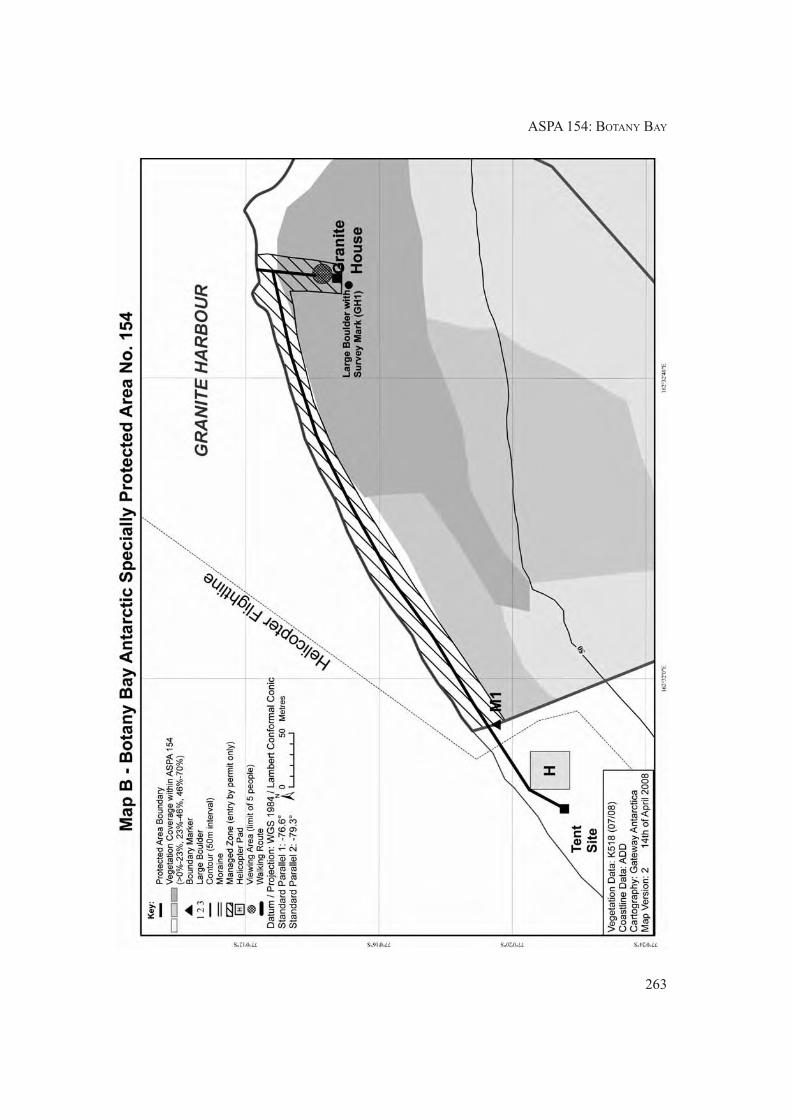
ASPA 154: BOTANY BAY
263

II. MEASURES
264

265
Measure 12 (2008)
Antarctic Specially Protected Area No 155
(Cape Evans, Ross Island): Revised Management Plan
The Representatives,
Recalling Articles 3, 5 and 6 of Annex V to the Protocol on Environmental Protection to the
Antarctic Treaty providing for the designation of Antarctic Specially Protected Areas
(“ASPA”) and approval of Management Plans for those Areas;
Recalling
• Measure 2 (1997), which designated the Cape Evans Historic Site and its environs as
Specially Protected Area (“SPA”) No 25 and annexed a management plan for the site;
• Decision 1 (2002), which renamed and renumbered SPA 25 as Antarctic Specially
Protected Area No 155;
• Measure 2 (2005), which adopted a revised management plan for ASPA 155;
Noting that the Committee for Environmental Protection has endorsed a revised Management
Plan for ASPA 155;
Desiring to replace the existing Management Plan for ASPA 155 with the revised
Management Plan;
Recommend to their Governments the following Measure for approval in accordance with
paragraph 1 of Article 6 of Annex V to the Protocol on Environmental Protection to the
Antarctic Treaty:
That:
1) the revised Management Plan for Antarctic Specially Protected Area No 155:
Cape Evans, Ross Island, which is annexed to this Measure, be approved; and
2) all prior Management Plans for ASPA No 155, namely those annexed to:
- Measure 2 (1997), and
- Measure 2 (2005);
shall cease to be effective.

266
II. MEASURES

267
MEASURE 12 - ANNEX
Management Plan for Antarctic Specially Protected Area No 155
CAPE EVANS, ROSS ISLAND
(including Historic Sites and Monuments Nos. 16 and 17,
the historic Terra Nova hut of Captain R.F. Scott and its precincts)
1. Description of values to be protected
The significant historic value of this Area was formally recognised when it was listed as Historic
Site and Monument Nos 16 and 17 in Recommendation 9 (1972). An area containing both sites was
designated as Specially Protected Area No 25 in Measure 2 (1997) and redesignated as Antarctic
Specially Protected Area 155 in Decision 1 (2002).
The Terra Nova hut (Historic Site and Monument No 16) is the largest of the historic huts in the
Ross Sea region. It was built in January 1911 by the British Antarctic Terra Nova Expedition of
1910-1913, led by Captain Robert Falcon Scott, RN. It was subsequently used as a base by the Ross
Sea party of Sir Ernest Shackleton’s Imperial Trans-Antarctic Expedition of 1914-1917.
Historic Site and Monument No 17 contains the Cross on Wind Vane Hill, (erected in the memory
of three members of Shackleton’s Ross Sea party who died in 1916). In addition to this, the anchors
of the ship Aurora from the Imperial Trans-Antarctic Expedition, an instrument shelter, several
supply dumps and dog kennels, and numerous artefacts are distributed around the site.
Some of the earliest advances in the study of earth sciences, meteorology, flora and fauna are
associated with the Terra Nova Expedition based at this site. The data collected can provide a bench
mark against which to compare current measurements. The history of these activities and the
contribution they have made to the understanding and awareness of Antarctica therefore contribute
to both the historic and scientific value of the site.
The Cape Evans site is one of the principal sites of early human activity in Antarctica. It is an
important symbol of the Heroic Age of Antarctic exploration, and as such, has considerable historical
significance.
2. Aims and objectives
The aim of this Management Plan is to provide protection for the Area and its features so that its
values can be preserved. The objectives of the Plan are to:
• avoid degradation of, or substantial risk to, the values of the Area;
• maintain the historic values of the area through planned conservation work which may
include:
a) an annual ‘on-site’ maintenance programme,
b) a programme of monitoring the condition of artefacts and structures, and the factors
which affect them, and conservation of artefacts to be conducted on and off site;

II. MEASURES
268
• allow management activities which support the protection of the values and features of the
Area including:
a) mapping and otherwise recording the disposition of historic items in the hut environs,
and
b) recording other relevant historic data; and
• prevent unnecessary human disturbance to the Area, its features and artefacts through
managed access to the Terra Nova hut.
3. Management activities
The following management activities will be undertaken to protect the values of the Area:
• A regular programme of conservation work shall be undertaken on the Terra Nova hut and
associated artefacts in the Area.
• Systematic monitoring shall be put in place to assess the impacts of present visitor limits,
and the results and any related management recommendations included in reviews of this
Management Plan.
• Visits shall be made as necessary for management purposes.
• National Antarctic Programmes operating in, or those with an interest in, the Area shall
consult together with a view to ensuring the above management activities are implemented.
4. Period of designation
Designated for an indefinite period.
5. Maps
• Map A: Cape Evans regional map. This map shows the boundaries of the proposed Antarctic
Specially Protected Areas with significant topographical features, approaches, field camp
sites and helicopter landing sites. It also shows the approximate location of significant
historical items within the area. Inset: Ross Island showing sites of nearby protected areas
and stations.
• Map B: Cape Evans site map. This map shows the approximate location of specific historic
artefacts and sites within the Area.
6. Description of the Area
6(i) Geographical co-ordinates boundary markers and natural features
Cape Evans is a small, triangular shaped, ice-free area in the south west of Ross Island, 10 kilometres
to the south of Cape Royds and 22 kilometres to the north of Hut Point Peninsula on Ross Island.
The ice-free area is composed of till-covered basalt bedrock. The designated Area is located on the
north western coast of Cape Evans adjacent to Home Beach and centred on Scott’s Terra Nova hut.
The boundaries of the ASPA are:

ASPA 155: CAPE EVANS
269
• South: a line extending east from a point at 77º 38' 15.47" S, 166º 25' 9.48" E – 20 metres
south of the cross on Wind Vane Hill;
• South-west: a line from the reference point above extended to follow the crest of the small
ridge descending in a north westerly direction to the shoreline at 77º 38' 11.50" S, 166º 24'
49.47" E;
• North-west: by the shoreline of Home Beach;
• North-east: by the line of the outlet stream from Skua Lake to Home Beach at 77º 38' 4.89"
S, 166º 25' 13.46" E;
• East: by the line extending south from the western edge of Skua Lake at 77º 38' 5.96" S,
166º 25' 35.74" E – to intersect with the southern boundary at 77º 38' 15.48" S, 166º 25'
35.68" E.
Skuas (Catharacta maccormicki) nest on Cape Evans and Adelie penguins (Pygoscelis adeliae)
from the rookery at Cape Royds may occasionally transit the Area. Weddell seals have also been
seen hauled up on Home Beach.
6(ii) Access to the Area
When safe conditions exist, vehicle approach to the Area can be made across the sea ice. Vehicles
are prohibited from entering the Area, unless approved to do so for management activities in
accordance with 7(i) below. During open water, landings by boat may be made directly in front of
the hut at Home Beach. Helicopter landings may be made at either of the existing designated landing
sites marked on Maps 1 and 2. One site is approximately 100 metres to the north of the hut, just
outside the Area. The other is located adjacent to the New Zealand refuge hut approximately 250
metres beyond the south western boundary of the Area.
6(iii) Location of structures within and adjacent to the Area
All structures located within the Area are of historic origin, although a temporary, modern protective
enclosure around the magnetic hut remains in place. A major feature of the Area is Scott’s Terra
Nova hut located on the north western coast of Cape Evans at Home Beach. The hut is surrounded
by many historic relics including the anchors from the Aurora, dog skeletons, instrument shelters,
dog line, meteorological screen, fuel dump, magnetic hut, coal, stores, rubbish dumps and flag pole.
A memorial cross to three members of Shackleton’s Ross Sea party of 1914-1917 stands on West
Vane Hill. All these features are included within the boundaries of the Area.
A New Zealand refuge hut, camp site and helicopter landing site are situated approximately 250m
to the south west of the Area.
The Greenpeace year-round World Park Base was sited to the north east of Scott’s hut from 1987 to
1992. No visible sign of the base remains.
6(iv) Location of other Protected Areas in the vicinity
• ASPA 121 (previously SSSI No 1) and
• ASPA 157 (SPA No 27), Cape Royds are 10 kilometres north of Cape Evans.
• ASPA 122 (SSSI No 2), Arrival Heights and
• ASPA 158 (SPA No 28), Hut Point are approximately 20 kilometres south of Cape Evans at
Hut Point Peninsula.
• ASPA 130 (SSSI No 11), Tramway Ridge is approximately 20 kilometres east of Cape
Evans.

II. MEASURES
270
All sites are located on Ross Island.
6(v) Special Zones within the Area
There are no special zones within the Area.
7. Terms and conditions for entry permits
Entry to the Area is prohibited except in accordance with a Permit. Permits shall be issued only by
appropriate national authorities and may contain both general and specific conditions. A Permit
may be issued by a national authority to cover a number of visits in a season. Parties operating in the
Area shall consult together and with groups and organisations interested in visiting the Area to
ensure that visitor numbers are not exceeded.
Permits to enter the site may be issued for a stated period for:
• activities related to conservation, research and/or monitoring purposes;
• management activities in support of the objectives of the Plan;
• activities related to educational or recreational activities including tourism, providing they
do not conflict with the objectives of this Plan.
7(i) Access to and movement within or over the Area
• Control of movement within the Area is necessary to prevent damage caused by crowding
around the many vulnerable features within the Area. The maximum number in the Area at
any time (including guides and those within the hut) shall be: 40 people.
• Control of numbers within the hut is necessary to prevent damage caused by crowding
around the many vulnerable features within the hut. The maximum number within the hut
at any time (including guides) shall be: 12 people.
• Avoidance of cumulative impacts on the interior of the hut requires an annual limit on
visitor numbers. The effects of the current visitor levels (average 1489 per year between
1998 and 2004) suggest that a significant increase could cause significant adverse impacts.
The maximum annual number of visitors shall be: 2,000 people.
• These limits have been set based on current visitor levels and on the best advice available
from conservation advisory agencies (which include conservators, archaeologists, historians,
museologists and other heritage protection professionals). The limits are based on the
proposition that any significant increase in the current level of visitor numbers would be
detrimental to the values to be protected. An ongoing monitoring programme to assess the
effects of visitors is required to provide the basis for future reviews of the Management
Plan, in particular whether the current limits on numbers of visitors are appropriate.
• Adequate supervision of visits to the Area is necessary to prevent damage caused by crowding
and by actions inconsistent with the Code of Conduct set out in section 7(ii). All tourism,
educational and recreational visits must be supervised by an experienced guide nominated
by the operator (refer section 7(ix)).
• Helicopter landings are prohibited within the Area as they have the potential to damage the
site by blowing scoria and ice particles and to accelerate the abrasion of the hut and
surrounding artefacts. Refer to 6(ii) for recommended approaches and landing sites.
• Vehicles are prohibited from entering the Area except where it is necessary to use vehicles
for management activities. This may include, but is not limited to activities such as clearing
ASPA 155: CAPE EVANS
271
snow and ice that is judged to be a threat to the historic hut or other artefacts. In all such
cases consideration shall be given to:
i. using the minimum sized vehicle required for the job;
ii. ensuring the vehicle operator is fully trained and aware of the provisions of this
management plan, and of the sensitivities at the site of operation of the vehicle;
iii. careful planning and monitoring of all vehicle movements within the site so as to
avoid damage to either the hut or artefacts buried beneath accumulated snow and ice.
7(ii) Activities which may be conducted within the Area
Activities which may be conducted within the Area include:
• visits for conservation purposes;
• educational and/or recreational visits including tourism; and
• scientific activity which does not detract from the values of the Area.
Visitors should adhere to the following Code of Conduct, except where conservation, research,
monitoring or management activities specified in the Permit require otherwise:
• To reduce floor abrasion, thoroughly clean grit and scoria, ice and snow from boots using
the brushes provided before entering the hut;
• Remove any clothing made wet by sea water, and any sea ice crystals from boots, as salt
particles accelerate corrosion of metal objects;
• Do not touch, move or sit on any items or furniture in the huts - handling artefacts causes
damage;
• As many areas are cramped and artefacts can be accidentally bumped, do not wear packs
inside;
• When moving around the sites, take great care not to tread on any items which may be
obscured by snow;
• Use of combustion style lanterns, naked flames or smoking in or around the huts is strictly
forbidden as fire is a major risk; and
• Visits should be recorded in the book provided. This allows times and levels of visitation to
be correlated with temperature and humidity data automatically logged inside the hut.
7(iii) Installation, modification or removal of structures
• No new structures are to be erected in the Area, or scientific equipment installed, except for
conservation activities as specified in section 3.
• No historic structure shall be removed from the Area, unless specified in a Permit issued in
accordance with the provisions of section 7(vii).
7(iv) Location of field camps
• Use of the historic hut for living purposes is not permitted. Camping is prohibited in the
Area under any circumstances.
• An existing field camp site is associated with the two New Zealand field shelters located
250m south west of the Area and should be used by all parties intending to camp in this
area.

II. MEASURES
272
7(v) Restrictions on materials and organisms which may be brought to the Area
• No living animals, plant material, micro-organisms or soil shall be introduced to the Area.
No food products shall be taken into the Area.
• Chemicals may only be introduced for permitted scientific or conservation purposes.
Chemicals (including fuel) or other materials are not to be left in the Area, unless required
for essential purposes connected with the conservation of the historic structures or associated
relics.
• All materials are to be removed when no longer required and before a date to be specified
in the relevant Permit.
7(vi) Taking or harmful interference with native flora and fauna
• This activity is prohibited except in accordance with a Permit issued by the appropriate
national authority specifically for that purpose under Article 3, Annex II to the Protocol on
Environmental Protection.
• Where animal taking or harmful interference is involved, this should, as a minimum standard,
be in accordance with the SCAR Code of Conduct for the Use of Animals for Scientific
Purposes in Antarctica.
7(vii) Collection or removal of anything not imported by the permit holder
• Material may be collected and removed from the Area for conservation reasons consistent
with the objectives of this Plan only when specified in a Permit issued by the appropriate
national authority.
• Materials which pose a threat to the environment or human health may be removed from
the Area for disposal, in accordance with a Permit, where they meet one or more of the
following criteria:
i. the artefact presents a threat to the environment, wildlife or human health and safety;
ii. it is in such poor condition that it is not reasonably possible to conserve it;
iii. it does not contribute in any significant way to our understanding of the hut, its
occupants or the history of Antarctica;
iv. it does not contribute to, or it detracts from, the visual qualities of the site or the hut,
and/or;
v. it is not a unique or rare item;
and where such action is:
vi. undertaken by parties with appropriate heritage conservation expertise; and
vii.part of an overall plan for conservation work at the site.
• National authorities should ensure that any removal of artefacts and assessment against the
above criteria is carried out by personnel with appropriate heritage conservation expertise.
• Artefacts judged to be of high historic value, which cannot be conserved on site with currently
available techniques, may be removed in accordance with a Permit for storage in a controlled
environment until such time as they can safely be returned to the Area.
• Samples of soil and other natural materials may be removed for scientific purposes only in
accordance with an appropriate Permit.

ASPA 155: CAPE EVANS
273
7(viii) Disposal of waste
• All human waste, grey water and other waste generated by work parties or visitors shall be
removed from the Area.
7(ix) Measures that may be necessary to ensure that the aims and objectives of the Management
Plan continue to be met
• The Permit, or an authorised copy, shall be carried within the Area.
• Information on the requirements of this Plan shall be provided to all visitors.
• The Code of Conduct set out in section 7(ii) shall be followed by all visitors, except where
conservation, research, monitoring or management purposes require otherwise.
• Operators facilitating educational and recreational visits (including tourism) to the Area
shall, prior to commencement of the summer season, nominate people with a working
knowledge of both the site and this Management Plan to act as guides during visits.
• All educational and recreational visits (including tourism) shall be supervised by a nominated
guide, who is responsible for briefing visitors on the code of conduct and ensuring it is
complied with.
• Parties shall consult and coordinate to develop skills and resources, particularly those related
to conservation techniques, to assist with the protection of the Area’s values.
7(x) Requirements for reports
Parties shall ensure that the principal holder for each Permit issued submits to the appropriate
authority a report describing the activities undertaken. Such reports shall include, as appropriate,
the information identified in the Visit Report provided in Appendix 4 of Resolution 2 (1998). In
addition, any removal of materials in accordance with section 7(vii) shall be detailed, including the
reason for removal and the current location of the items or the date of disposal. Any return of such
items to the site shall also be reported.
Parties shall maintain a record of activities within the Area and, in the Annual Exchange of
Information, shall provide summary descriptions of activities conducted by persons subject to their
jurisdiction, in sufficient detail to allow an evaluation of the effectiveness of the Management Plan.
Parties should wherever possible deposit originals or copies of such reports in a publicly accessible
archive to maintain a record of visitation, to be used both for review of the Management Plan and in
managing further visitation to the site.

II. MEASURES
274

ASPA 155: CAPE EVANS
275

II. MEASURES

277
Measure 13 (2008)
Antarctic Specially Protected Area No 160
(Frazier Islands, Windmill Islands, Wilkes Land,
East Antarctica): Revised Management Plan
The Representatives,
Recalling Articles 3, 5 and 6 of Annex V to the Protocol on Environmental Protection to the
Antarctic Treaty providing for the designation of Antarctic Specially Protected Areas
(“ASPA”) and approval of Management Plans for the Areas;
Recalling Measure 2 (2003), which designated Frazier Islands, Wilkes Land, as Antarctic
Specially Protected Area No 160, and annexed a management plan for the site;
Noting that the Committee for Environmental Protection has endorsed a revised Management
Plan for ASPA 160;
Desiring to replace the existing Management Plan for ASPA 160 with the revised
Management Plan;
Recommend to their Governments the following Measure for approval in accordance with
Paragraph 1 of Article 6 of Annex V to the Protocol on Environmental Protection to the
Antarctic Treaty:
That:
1) the revised Management Plan for Antarctic Specially Protected Area No 160:
Frazier Islands, Windmill Islands, Wilkes Land, East Antarctica which is annexed
to this Measure, be approved;
2) the Management Plan for ASPA 160 annexed to Measure 2 (2003) shall cease to
be effective.

278
II. MEASURES

279
MEASURE 13 - ANNEX
Management Plan for Antarctic Specially Protected Area No 160
FRAZIER ISLANDS, WINDMILL ISLANDS,
WILKES LAND, EAST ANTARCTICA
Introduction
The Frazier Islands consists of a group of three islands located approximately 16km offshore from
the Australian Casey station, in East Antarctica (see Map A). The islands support the largest of only
four known breeding colonies of southern giant petrels Macronectes giganteus on continental
Antarctica, and were designated as an Antarctic Specially Protected Area under Measure 2 (2003)
for the sanctuary of the birds.
Following their discovery in 1955, the southern giant petrel colonies at the Frazier Islands were
visited intermittently during the period mid-January to late March. The aim of these visits was
usually the banding of southern giant petrel chicks. Weather permitting, counts of the chicks present
were made but were often restricted to Nelly Island. Thus, the early data available do not offer the
information needed for an analysis of possible changes in the status of the population. In more
recent years, occupied nests were counted in December, usually covering all three islands. The
indication is that the breeding population, especially at Dewart Island, may be increasing.
Apart from visits for seabird observations, the Frazier Islands have been visited very infrequently.
Twenty three visits, or on average one visit every two years, have occurred since the late 1950s (see
Appendix 1). In the mid-1980s, a formal management strategy was implemented to minimise human
disturbance to breeding colonies of southern giant petrels in the vicinity of Australia’s Antarctic
stations. The Australian Antarctic Division restricted access by Australian Antarctic programme
participants so that census visits occurred once in every three- to five-year period and implemented
tight administrative controls over visits for other purposes. The census interval was considered an
appropriate compromise between the risk of disturbance to breeding birds from monitoring activities
and the need to obtain population data. Current thinking suggests it is desirable to provide for more
frequent censuses, if conducted in an appropriate manner, to allow more detailed understanding of
population status and trends.
A recent ostensible increase in the breeding population of southern giant petrels at the Frazier
Islands, combined with the apparent positive effects of the existing protective measures, suggests
that continued and formalised protection of southern giant petrel breeding colonies is warranted.
Long-term protection and monitoring of southern giant petrels at the Frazier Islands will contribute
to the development of appropriate regional and global conservation strategies for the species and
will provide information for comparisons with populations elsewhere.
This revised Management Plan reaffirms the values of the original designation and accords with
Annex V of the Protocol on Environmental Protection.
1. Description of values to be protected
The Area is primarily designated to protect the breeding colony of southern giant petrels, which is
the largest known in the continental Antarctic.

II. MEASURES
280
In the late 1980s the world breeding population of southern giant petrels was estimated at 38,000
pairs. Declines in the 1990s appear to have stabilised and, while some populations appear to be
decreasing and others are stable, the major colonies appear to be increasing. Recognising this global
trend, but mindful of the potential continuing threat posed by demersal longline fisheries, the IUCN
in 2007 down-listed the species from Vulnerable to Near Threatened.
The southern giant petrel is also listed in Annex 1 of the Agreement on the Conservation of Albatrosses
and Petrels (ACAP), a multilateral agreement which seeks to conserve albatrosses and petrels by
coordinating international activity to mitigate known threats to their populations, and in Appendix
II of the Convention on the Conservation of Migratory Species of Wild Animals.
In East Antarctica, southern giant petrels are uncommon as they are at the southern limit of their
distribution range. The most recent estimate of the population at the Frazier Islands was 274 breeding
pairs in 2005/06. Colonies are found on all three of the islands in the group (Nelly, Dewart and
Charlton Islands – Map B), the largest being located on Dewart Island.
The Frazier Islands are one of only four known breeding localities of southern giant petrels around
the coastline of continental Antarctica and are the only known site in nearly 3000km of coastline
between Davis station and Dumont d’Urville. The other three continental breeding colonies are
located near the Australian stations of Mawson (Giganteus Island, Rookery Islands, ASPA 102) and
Davis (Hawker Island, ASPA 167), and near the French station Dumont d’Urville (Pointe-Géologie
Archipelago, ASPA 120). The southern giant petrels on the Antarctic continent comprise less than
1% of the global breeding population. The current population for continental Antarctica is estimated
at approximately 320 pairs, comprised of 3 pairs on Giganteus Island, 25 pairs on Hawker Island,
16 pairs at Pointe Géologie archipelago (Terre Adélie) and approximately 270 pairs on the Frazier
Islands. However, incidental observations at the coast near Mawson station indicate there may be
additional colonies that have not been discovered yet.
The breeding season for southern giant petrels at the Frazier Islands usually commences between
late October and mid November, and extends through to April with the birds’ departure northward
for the winter. Banded chicks from the Frazier Islands dispersed throughout the Southern Hemisphere
and have previously been recovered in New Zealand, South America, Easter Island, and South
Africa within nine months of departure.
2. Aims and objectives
Management of the Frazier Islands aims to:
• minimise human disturbance to the breeding colonies of southern giant petrels to assist
further the protection of the population in the wild;
• conserve the Frazier Islands as a reference area for future comparative studies with other
breeding populations of southern giant petrels; and
• minimise the possibility of the introduction of alien plants, animals and microbes to the
Frazier Islands.
3. Management activities
The following management activities shall be undertaken to protect the values of the Area:
• where practicable, at least one research visit should be conducted to census the southern
giant petrels and other seabird populations in each 5 year period, to enable assessment of

ASPA 160: FRAZIER ISLANDS
281
breeding populations. These visits should be conducted by a team including at least one
bird biologist associated with a national Antarctic programme or someone with relevant
scientific skills and experience;
• information about the location of the Area and the restrictions that apply shall be produced
and prominently displayed at Casey station. Copies of this Management Plan shall be
available at the station. Informative material and the Management Plan shall be provided to
ships visiting the vicinity;
• the Management Plan shall be reviewed at least every five years and updated/modified as
required.
4. Period of designation
Designation is for an indefinite period.
5. Maps
• Map A: Windmill Islands, showing location of the Frazier Islands and protected areas within
the region.
Map specifications:
Projection: UTM Zone 49
Horizontal Datum: WGS84
• Map B: Frazier Islands, Antarctic Specially Protected Area showing distribution of seabird
nesting sites.
Map Specifications:
Projection: UTM Zone 49
Horizontal Datum: WGS84
6. Description of the Area
6(i) Geographical co-ordinates, boundary markers and natural features
The Frazier Islands are located at latitude 66°14’S, longitude 110°10’E (Map A). The three islands
(Nelly, Dewart and Charlton) lie in the eastern part of Vincennes Bay approximately 16km to the
west north west of Casey station. Nelly Island is the largest of the three islands (approximately
0.35km² in area), and was named for the presence of several colonies of southern giant petrels or
"Nellies". The Area comprises the entire terrestrial area of the three islands, with the seaward boundary
at the low water mark (Map B). The total area of the Antarctic Specially Protected Area is
approximately 0.6km². There are no boundary markers.
Nelly Island supports the largest and most varied avian community of the three islands, with records
indicating that snow petrels (Pagodroma nivea), cape petrels (Daption capense), Antarctic petrels
(Thalassoica antarctica), Wilson’s storm-petrels (Oceanites oceanicus), southern fulmars (Fulmarus
glacialoides), and South Polar skuas (Catharacta maccormicki) all nest on the island. South Polar
skua nests have also been observed on Dewart Island (Appendix 2, Map B).
II. MEASURES
282
In 1961/62, 100 Adélie penguin (Pygoscelis adeliae) nests were reported in one colony on Nelly
Island. During the 1989/90 season, three colonies were recorded on the north-west ridge of Nelly
Island with a total of 554 nests. The increase corresponds with those recorded for most other Adélie
penguin populations in the Windmill Islands region during the period from 1959/60 to 1989/90. In
the 2001/02 season, approximately 1,000 pairs were estimated to be nesting on Nelly Island. A brief
inspection of the Adélie penguin colonies in 2005/06 suggested that the breeding population continues
to increase.
Recorded sightings of marine mammals at the Frazier Islands are scarce. In 1968 three Weddell
seals (Leptonychotes weddellii) were observed on an ice floe located between Nelly and Dewart
Islands. An Orca (killer whale: Orcinus orca) was also sighted offshore from the islands during the
same year, and a small pod was sighted during 2005/06. A few leopard seals (Hydrurga leptonyx)
were sighted on sea ice near Nelly Island and a small number of Weddell seals were recorded on the
sea ice near the Frazier Islands in the 2001/02 season (Appendix 2).
Vegetation recorded at Nelly Island comprises at least 11 species, including lichens Buellia frigida,
Usnea antarctica, Rhizoplaca melanophthalma, Candelariella flava, a terrestrial alga Prasiola crispa,
an indeterminate green crust which is thought to be ‘a mixture of fungal hyphae and green alga
Desmococcus olivaceus’, and several species of snow algae including Chlorococcum sp.,
Chloromonas polyptera, Chlorosarcina antarctica, Prasiococcus calcarius (Appendix 2). There
are no published records of terrestrial invertebrates on the Frazier Islands; however, no surveys
have been undertaken.
The topography of the Frazier Islands is characterised by steep cliffs rising from the sea. The highest
peak on Nelly Island is approximately 65 metres. There is a broad ‘U’ shaped ice-filled valley on
both Nelly and Dewart Islands.
The geology of the Frazier Islands is typical of the Windmill Islands group and is characterised by
the layered schists and finely crenulated gneisses of the Windmill metamorphics. The geological
character of the Frazier Islands developed as a result of two phases of metamorphosis at 1400-1310
Ma and about 1200 Ma of pre-existing volcanics, greywacke and shale. On Nelly Island there are
steep cliffs of biotite and gneiss. A red sandstone erratic is located in the ‘U’ shaped valley on Nelly
Island below the 30m contour. Highly polished glacial striae in the gneisses provide evidence of
recent glaciation and indicate the former direction of ice flow of 265º and 280º T. Surface sediments
consist of fine gravelly sand located in bedrock depressions.
The climate at the Frazier Islands is characteristic of that experienced at the Windmill Islands and
other Antarctic coastal locations in the region. At Casey station, located 16 kilometres to the east
south eastESE of the Frazier Islands group, mean temperatures are 0.3°C for the warmest month
and –14.9°C for the coldest month. Precipitation is low and the high albedo of the exposed rock
surfaces results in persistent ice-free areas that provide attractive nesting sites for the avifauna.
6(ii) Special zones within the Area
There are no special zones within the Area.
6(iii) Location of structures within the Area
There are no structures within or adjacent to the Area and none are to be erected.
6(iv) Location of other Protected Areas within close proximity
The following Protected Areas are located on the Budd Coast near the Frazier Islands (see Map A):
• ASPA No 135, North-east Bailey Peninsula (66°17’S, 110°32’E);

ASPA 160: FRAZIER ISLANDS
283
• ASPA No 136, Clark Peninsula (66º15’S, 110º36’E); and
• ASPA No 103, Ardery Island and Odbert Island (66º22’S, 110º30’E).
7. Permit conditions
Entry to the Area is prohibited except in accordance with a Permit issued by an appropriate national
authority.
Permits shall include a condition requiring that the Permit or a copy shall be carried at all times
when within the Area. Additional conditions, consistent with the objectives and provisions of the
Management Plan, may be included by the issuing authority. The principal Permit Holder for each
Permit issued should be required to submit to the Permit issuing authority a visit report detailing all
activities undertaken within the Area, and include all census data obtained during the visit.
7(i) Access to and movement within or over the Area
• Vehicles are prohibited within the Area.
• The only permitted access to the Frazier Islands is by watercraft. Landings must be made at
the designated sites as marked on Map B. Boats used to visit the islands must be left at the
shoreline and movement within the Area is by foot only. Only personnel who are required
to carry out scientific/management work in the Area should leave the landing site;
• Any movement within the Area is to be consistent with the minimum approach distances to
nesting birds specified in Appendix 3. Persons shall not approach closer than is necessary
to obtain census data or biological data from any nesting southern giant petrels, and in no
case closer than 20m;
• To reduce disturbance to wildlife, noise levels including verbal communication are to be
kept to a minimum. The use of motor-driven tools and any other activity likely to generate
noise and thereby cause disturbance to nesting birds is prohibited within the Area during
the breeding period for southern giant petrels (1 October to 30 April);
• Landing of aircraft in the Area is prohibited at any time; and
• Clothing (particularly all footwear) and field equipment shall be thoroughly cleaned before
entering the Area.
7(ii) Activities which are, or may be conducted within the Area, including restrictions on time and
place
Permits to enter the Area during the non-breeding period for southern giant petrels (1 May to 30
September), may be issued for compelling scientific research that cannot be undertaken elsewhere,
or for essential management purposes consistent with the objectives and provisions of this
Management Plan. Permits are only to be issued for activities that will not jeopardise the ecological
or scientific values of the Area, or interfere with existing scientific studies.
Permits to enter the Area during the breeding period for southern giant petrels (1 October to 30
April) may be issued for the purpose of conducting censuses. The Permit issuing authority is to
refer to the provision under the first dot point of section 3 of this Management Plan when issuing
Permits. Wherever practicable, censuses are to be conducted from outside the giant petrel colonies.
In most cases there are vantage points from where the nesting giant petrels may be counted. Access
to the Area should be limited to the minimum amount of time reasonably required to undertake the
census. Boat operators and other support personnel should remain at the landing site for safety
reasons.

II. MEASURES
284
7(iii) Installation, modification, or removal of structures
No permanent structures are to be erected in the Area.
7(iv) Location of field camps
Camping is prohibited in the Area except in an emergency.
7(v) Restrictions on materials and organisms that may be brought into the Area
• Fuel is not to be depoted on the islands. Boat refuelling is permitted at shoreline landing
sites. A small amount of fuel is permitted for an emergency stove.
• The only poultry products that may be brought into the Area are pasteurized egg powder,
stock cubes, powdered soups and canned soups .
• No herbicides or pesticides are to be brought into the Area.
• Any chemical which may be introduced for compelling scientific purposes as authorised in
a Permit shall be removed from the Area, at or before the conclusion of the activity for
which the Permit was granted. The use of radio-nuclides or stable isotopes is prohibited.
• No animals, plant material or microorganisms shall be deliberately introduced into the
Area and precautions shall be taken against accidental introductions. All equipment and
clothing should be thoroughly cleaned before entering the Area.
7(vi) Taking of, or harmful interference with, native flora and fauna
Taking of, or harmful interference with, native flora and fauna, is prohibited unless specifically
authorised by permit issued in accordance with Article 3 of Annex II to the Protocol on Environmental
Protection to the Antarctic Treaty.
Disturbance of southern giant petrels should be avoided at all times. Visitors should be alert to
changes in wildlife behaviour, especially changes in posture or vocalisaton. If birds are showing
signs of wanting to leave the nest, all persons should retreat immediately.
7(vii) Collection or removal of anything not brought into the Area by the permit holder
Material may only be collected or removed from the Area as authorised in a Permit and should be
limited to the minimum necessary to meet scientific or management needs.
Material of human origin likely to compromise the values of the Area, which was not brought into
the Area by the Permit Holder or otherwise authorised, may be removed unless the impact of the
removal is likely to be greater than leaving the material in situ. If such material is found, the
appropriate national authority must be notified. Where possible, photographic documentation should
be obtained and included with site visit report.
7(viii) Disposal of waste
No wastes, including human wastes, are to be deposited or left in the Area.
7(ix) Measures that may be necessary to ensure that the aims and objectives of the Management
Plan continue to be met
A census of southern giant petrels should be conducted at least once in each 5 year period. Censuses
of other species may be undertaken during these visits provided no additional disturbance is caused
to the southern giant petrels.
ASPA 160: FRAZIER ISLANDS
285
All GPS data obtained for specific sites of long-term monitoring shall be registered in the Antarctic
Master Directory, through the appropriate national authority.
7(x) Requirements for reports
Parties should ensure that the principal Permit Holder for each permit issued submits to the appropriate
national authority a report on activities undertaken. Such reports should include, as appropriate, the
information identified in the Visit Report form contained in Appendix 4 of the Guide to the
Preparation of Management Plans for Antarctic Specially Protected Areas appended to Resolution
2 (1998). Parties should maintain a record of such activities and, in the Annual Exchange of
Information, should provide summary descriptions of activities conducted by persons subject to
their jurisdiction in sufficient detail to allow evaluation of the effectiveness of the Plan of
Management. Parties should, wherever possible, deposit originals or copies of such original reports
in a publicly accessible archive to maintain a record of usage, for the purpose of any review of the
Management Plan and in organising the scientific use of the Area. A copy of the report should be
forwarded to the Party responsible for development of the Management Plan to assist in management
of the Area, and monitoring of bird populations. Additionally, visit reports should provide detailed
information on census data, locations of any new colonies or nests not previously recorded, a brief
summary of research findings and copies of photographs taken of the Area.
8. Supporting documentation
ANARE (1968) Unpublished data.
Birdlife International (2000) Threatened birds of the world. Barcelona and Cambridge U. K: Lynx
Edicions and Birdlife International.
BirdLife International 2007. Macronectes giganteus. In: IUCN 2007. 2007 IUCN Red List of
Threatened Species. www.iucnredlist.org. Downloaded on 12 March 2008.
Blight, D.F., Oliver, R. L. Aspects of the Geologic History of the Windmill Islands, Antarctica in
Craddock C. (ed.) (1982) Antarctic Geoscience. University of Wisconsin Press, Madison:
445-454.
Cooper, J., Woehler, E.J., Belbin, L. (2000) Guest editorial. Selecting Antarctic Specially Protected
Areas: Important Bird Areas can help. Antarctic Science 12: 129.
Cowan, A.N. (1981) Size variation in the snow petrel. Notornis 28: 169-188.
Cowan, A.N. (1979) giant petrels at Casey. Australian Bird Watcher 8: 66-67.
Creuwels, J.C.S., Stark, J.S., Woehler, E.J., Van Franeker, J.A., Ribic, C.A. (2005) Monitoring of a
Southern giant petrel Macronectes giganteus population on the Frazier Islands, Wilkes
Land, Antarctica. Polar Biology 28:483–493
Croxall, J.P., Steele, W.K., McInnes, S.J., Prince, P.A. (1995) Breeding Distribution of the snow
petrel Pagodroma nivea. Marine Ornithology 23: 69-99.
Environment Australia (2001) Recovery Plan for Albatrosses and Giant Petrels. prepared by Wildlife
Scientific Advice, Natural Heritage Division in consultation with the Albatross and Giant
Petrel Recovery Team, Canberra.
Environmental Code of Conduct for Australian Field Activities, Australian Antarctic Division.

II. MEASURES
286
Garnett, S.T., Crowley, G.M. (2000) The Action Plan for Australian Birds 2000. Commonwealth of
Australia, Environment Australia, Canberra
Goodwin, I.D. (1993) Holocene Deglaciation, Sea-Level Change, and the Emergence of the Windmill
Islands, Budd Coast, Antarctica. Quaternary Research 40: 70-80.
Ingham, S.E. (1959) Banding of Giant Petrels by the Australian National Antarctic Research
Expeditions, 1955-58. Emu 59: 189-200.
IUCN (2001) IUCN Red List Categories: Version 3.1. Prepared by the IUCN Species Survival
Commission. IUCN, Gland, Switzerland and Cambridge, UK.
Jouventin, P., Weimerskirch, H. (1991) Changes in the population size and demography of southern
seabirds: management implications. In: Perrins, C.M., Lebreton, J.-D. and Hirons, G.J.M.
Bird population studies: Relevance to conservation and management. Oxford University
Press: 297-314.
Law, P. (1958) Australian Coastal Exploration in Antarctica The Geographical Journal CXXIV:
151-162.
Mackinlay, S.J. (1997) A Management Zoning System for Casey Station and the Windmill Islands,
East Antarctica. Project report for the MAppSc degree in Environmental Management,
School of Geography, University of New South Wales.
Melick, D.R., Hovenden. M.J., Seppelt, R.D. (1994) Phytogeography of bryophyte and lichen
vegetation in the Windmill Islands, Wilkes Land, Continental Antarctica. Vegetatio 111:
71-87.
Micol, T., Jouventin, P. (2001) Long-term population trends in seven Antarctic seabirds at Point
Géologie (Terre Adélie): Human impact compared with environmental change. Polar Biology
24: 175-185.
Murray, M.D. (1972) Banding Giant Petrels on Frazier Islands, Antarctica. The Australian Bird
Bander 10(3): 57-58.
Murray M.D., Luders D.J. (1990) Faunistic studies at the Windmill Islands, Wilkes Land, East
Antarctica, 1959-80. ANARE Research Notes 73: 1-45.
Orton, M.N. (1963) A Brief Survey of the Fauna of the Windmill Islands, Wilkes Land, Antarctica.
Emu 63: 14-22.
Orton, M.N. (1963) Movements of young giant petrels bred in Antarctica. Emu 63: 260.
Patterson D.L., Woehler, E.J., Croxall, J.P., Cooper, J., Poncet, S., Fraser, W.R. (in press) Breeding
distribution and population status of the northern giant petrel Macronectes halli and the
southern giant petrel M. giganteus. Marine Ornithology.
Paul, E., Stüwe, K., Teasdale, J., Worley, B. (1995) Structural and metamorphic geology of the
Windmill Islands, east Antarctica: field evidence for repeated tectonothermal activity.
Australian Journal of Earth Sciences 42: 453-469.
Robertson, R. (1961) Geology of the Windmill Islands, Antarctica. IGY Bulletin 43: 5-8.
van Franeker, J.A., Gavrilo, M., Mehlum, F., Veit, R.R., Woehler E.J. Distribution and Abundance
of the Antarctic Petrel. Waterbirds: The International Journal of Waterbird Biology, Vol.
22, No 1 (1999), pp. 14-28
Woehler, E.J. (1990) Status of southern giant petrels at Casey. ANARE News 61: 18.

ASPA 160: FRAZIER ISLANDS
287
Woehler, E.J. (1991) Status and Conservation of the Seabirds of Heard and the McDonald Islands.
In: Croxall, J.P. (ed.) Seabird Status and Conservation: A Supplement. ICBP Technical
Publication No 11: 263-277.
Woehler E.J., Croxall J.P. (1997) The status and trends of Antarctic and subantarctic seabirds. Marine
Ornithology 25: 43-66.
Woehler, E.J., Johnstone, G.W. (1991) Status and Conservation of the Seabirds of the Australian
Antarctic Territory. In Croxall, J.P. (ed.) Seabird Status and Conservation: A Supplement.
ICBP Technical Publication No 11: 279-308.
Woehler, E.J., Martin, M.R., Johnstone, G.W. (1990) The Status of Southern Giant Petrels
Macronectes giganteus at the Frazier Islands, Wilkes Land, East Antarctica. Corella 14:
101-106.
Woehler, E.J. (2005) Southern giant petrels critically endangered in the Antarctic. World Birdwatch
27(3), 9.
Woehler, E.J. (2006) Status and conservation of the seabirds of Heard Island and the McDonald
Islands. In: Green K & Woehler EJ (eds) Heard Island, Southern Ocean Sentinel. Surrey
Beatty & Sons, Chipping Norton, pp 128-165.
Woehler, E.J., Riddle MJ & Ribic CA (2003) Long-term population trends in southern giant petrels
in East Antarctica. In: Huiskes AHL, Gieskes WWC, Rozema J, Schorno RML, van der
Vies SM & Wolff W (eds) Antarctic Biology in a global context. Backhuys Publishers,
Leiden, pp 290-295.
Woehler, E.J., Cooper, J., Croxall, J.P., Fraser, W.R., Kooyman, G.L., Miller, G.D., Nel, D.C.,
Patterson, D.L., Peter, H-U, Ribic, C.A., Salwicka, K., Trivelpiece, W.Z., Weimerskirch,
H. (2001) A Statistical Assessment of the Status and Trends of Antarctic and Subantarctic
Seabirds. SCAR/CCAMLR/NSF, 43 pp.; Patterson et al. Breeding distribution and
population status of the giant petrel; Woehler et al. "Long-term population trends in southern
giant petrels".
Woehler, E.J., Riddle, M.J. (2003) Long-term population trends in southern giant petrels in the
Southern Indian Ocean. Poster presented at 8th SCAR Biology Symposium 2001,
Amsterdam.
Woehler, E.J., Slip, D.J., Robertson, L.M., Fullagar, P.J., Burton, H.R. (1991) The distribution,
abundance and status of Adélie penguins Pygoscelis adeliae at the Windmill Islands, Wilkes
Land, Antarctica. Marine Ornithology 19(1): 1-17.
Woehler, E.J., Cooper, J., Croxall, J.P., Fraser, W.R., Kooyman, G.L., Miller, G.D., Nel, D.C.,
Patterson, D.L., Peter, H-U, Ribic, C.A., Salwicka, K., Trivelpiece, W.Z., Wiemerskirch,
H. (2001) A Statistical Assessment of the Status and Trends of Antarctic and Subantarctic
Seabirds. SCAR/CCAMLR/NSF, 43 pp.

II. MEASURES
288

ASPA 160: FRAZIER ISLANDS
289
Appendix 1: Southern giant petrel populations
at the Frazier Islands, Antarctica
Note: To the extent possible, each observation below has been validated by a review of the primary
data records. The comments indicate where variations from published literature were identified.
Further consideration of each observation would be required before using and of these data in
analyses.
Date Nelly
Island
Dewart
Island
Charlton
Island
Source Comment
21, 22
Jan.
1956
250 N not visited not visited Unpublished data: J
Bunt 2008 pers.
comm.; Law (1958)
Counted at four separate
rookeries on higher parts of
Nelly Island. Notes say that
most nests contained chicks.
Many of these nests could be
old nests.
24-5
Jan.
1959
25 N not visited not visited Unpublished data:
Bird log Magga
Dan-Wilkes &
Oates Land Voyage
(Jan-Mar 1959);
Unpublished data:
Biology report for
Wilkes, (1959/60-
1960-61), R Penny.
It is not clear whether these
observations are all chicks, but
Penny comments that some of
them were chicks.
15
Dec.
1959
60 A not visited not visited Unpublished data:
Biology report for
Wilkes, Appendix F
(1961) M. Orton;
Creuwels et al.
(2005)
20 other birds were associated
with nests.
12
Feb.
1960
46 C not visited not visited Unpublished data:
Biology report for
Wilkes, (1959/60-
1960-61), R Penny;
Unpublished data:
Biology report for
Wilkes, Appendix F
(1961) M. Orton.
Orton reports that there were
47 chicks on Nelly Island when
in fact it was 46 (Penny 1960).
15
Dec.
1960
not visited 60 N not visited Unpublished data:
Biology report for
Wilkes, Appendix F
(1961) M. Orton;
Woehler et al.
(1990); Creuwels et
al. (2005)
20 other birds were associated
with nests. Woehler et al.
(1990) and Creuwels et al.
(2005) have both quoted
directly from R. Penny's
unpublished report.
22
Mar.
1961
34 C 10 C no data Unpublished data:
Biology report for
Wilkes, Appendix F
(1961) M. Orton;
Unpublished data:
Biology: Giant
petrel Wilkes report
(1961); Creuwels et
al. (2005)
All chicks observed on Nelly
Island were banded. Only a
subset of the chicks observed at
Dewart Island were banded.
23
Nov.
1962
11 eggs not visited not visited Unpublished data:
Davis and Mawson
station biology log
records (1962)
This count appears to have
been a subset of the population
only.

II. MEASURES
290
Date Nelly
Island
Dewart
Island
Charlton
Island
Source Comment
21
Jan.
1964
10 C not visited not visited Unpublished data:
Wilkes station
report, biology log
records (1964), L.G.
Murray
Birds were observed on the
north-east ridge, with about 20
occupied nests in this area, and
more on the lower area on the
southern side of the ridge.
There were many old and
uninhabited nests.
7 Mar.
1968
72 no data not visited Unpublished data:
Bird Log Nella Dan
(1967-8) Vol. 1;
Shaughessey
(1971); Murray &
Luders (1990)
This count is the total for all
four rookeries found on Nelly
Island. There is a map of their
location in the field notes.
20, 21
Jan.
1972
52 C 53 C 10-20 N
(aerial
survey
only)
Murray (1972) Land survey primarily for
banding. 49 of 52 chicks seen
were banded on Nelly Island.
51 of 53 chicks seen were
banded on Dewart Island.
Please note counts quoted in
Murray & Luders (1990) are
incorrect.
31
Jan.
1974
27 BC no data no data Unpublished data:
Biology report for
Casey (1974) A.
Jones; Murray &
Luders (1990);
Woehler et al.
(1990); Creuwels et
al. (2005)
All peer-reviewed papers
appear to have reported an
incorrect count of a total of 76,
however only 27 chicks were
banded in this season.
13-17
Feb.
1977
27 C 43 C no data Cowan (1979);
Murray & Luders
(1990); Woehler et
al. (1990); Creuwels
et al. (2005)
All peer-reviewed papers
appear to have reported the
wrong count. Cowan is the
original reference, where data
has gone straight to peer-
reviewed publication.
25
Jan.
1978
48 C 48 C 6 C Cowan (1979);
Murray & Luders
(1990); Woehler et
al. (1990); Creuwels
et al. (2005)
30
Jan., 2
Feb.
1979
35
(method
unknown)
46
(method
unknown)
5
(method
unknown)
Murray & Luders
(1990); Woehler et
al. (1990); Creuwels
et al. (2005)
The earliest reference to this
work is Murray & Luders
(1990), but they did not do the
original counts. For Nelly,
Woehler et al. (1990) and
Creuwels et al. (2005) further
report the chick count as 37
and not 35 as reported in
Murray & Luders (1990).
Further work is required to
know which figure reflects the
correct count. K. de Jong's
original data is unable to be
located.

ASPA 160: FRAZIER ISLANDS
291
‘A’ = count of adults, ‘AON’ = apparently occupied nests, ‘BC’ = banded chicks, ‘C’ = count of chicks, ‘N’ = count of nests,
‘ON’ = occupied nests
Date Nelly
Island
Dewart
Island
Charlton
Island
Source Comment
18
Jan.
1980
43 C 10
(method
unknown)
no data Murray & Luders
(1990); Woehler et
al. (1990); Creuwels et al. (2005)
Original data not located.
Creuwels et al. (2005) note that
the census data from Dewart Island and Charlton Island are
confused with banding data.
28 &
29
Nov.
1983
63 AON 68 AON 9 AON Unpublished data:
Casey station report
(1983); Woehler et
al. (1990); Creuwels et al. (2005)
Woehler et al. (1990)
conducted the survey.
25 &
26 Jan
1984
52
(method
unknown)
not visited not visited Woehler et al.
(1990); Creuwels et
al. (2005)
Original data not located.
3, 6
Mar.
1985
64 C 69 C no data Woehler et al.
(1990); Crewels et
al. (2005)
Original data not located.
14
Feb.
1986
59 50 9 Woehler et al.
(1990); Creuwels et
al. (2005)
Census type cannot be
attributed to any island.
Original data not located.
23
Dec.
1989
73 AON 106 AON 14 AON Woehler et al.
(1990); Creuwels et
al. (2005)
Apparently occupied nests
(AON) may contain a
proportion of failed or non-
breeding nest sites (Creuwels et
al. 2005).
18
Feb. 1996
11 C not visited not visited Creuwels et al.
(2005)
23 Dec.
1997
96 AON 104 AON 21 AON Creuwels et al. (2005)
Apparently occupied nests (AON) may contain a
proportion of failed or non-
breeding nest sites (Creuwels et
al. 2005).
26
Dec.
1998
95 AON 103 AON 17 AON Creuwels et al.
(2005)
14 Mar.
1999
66 C 82 C 11 C Creuwels et al. (2005)
26
Dec. 2001
93 AON 135 AON 20 AON Creuwels et al.
(2005)
14
Dec.
2005
110 ON 149 ON 25 ON Unpublished data:
E.J. Woehler

II. MEASURES
292
Appendix 2: Biota recorded at the Frazier Islands
Census data for breeding seabirds provided where available, ‘P’ indicates recorded breeding seabirds
but no census data available, 2001 indicates observations in December 2001 visit, 2005 indicates
observations from December 2005 visit, ‘X’ indicates recorded on or near the island, ‘N’ a count of
nests, ‘R’ rare, and ‘F’ frequent. Data compiled from records held by the Australian Antarctic Data
Centre, ANARE records 1968, Appendix 1, Melick et al. 1994, Seppelt, R. pers. comm., Ling, H.
pers. comm., Woehler, E.J. pers. comm., and Woehler, E.J. and Olivier, F. unpublished data (December
2001), Woehler, E.J. unpublished data (December 2005).
Nelly Island Dewart Island Charlton
Island
Seabirds
Adélie penguins (Pygoscelis adeliae) c.>1400
(2005)
Antarctic petrel (Thalassoica
antarctica)
P
Cape petrel (Daption capense) P P (2001) P (2001)
Snow petrel (Pagodroma nivea) P P
Southern giant petrel
(Macronectes giganteus)
100N (2005) 149N (2005) 25N (2005)
Wilson’s storm petrels
(Oceanites oceanicus)
P
South Polar skua
(Catharacta maccormicki)
1N (2005) 1N (2005)
Southern fulmar (Fulmarus
glacialoides)
P P
Mammals
Leopard seal (Hydrurga leptonyx) X (2001)
Weddell seal (Leptonychotes
weddellii)
X (2001)
Orca (killer whale: Orcinus orca) Small pod
observed close
to island (2005)
Lichens
Buellia frigida R
Usnea antarctica R
Rhizoplaca melanophthalma R
Candelariella flava R R
Moss
Bryum pseudotriquetrum R
Algae
Indeterminate green crust F
Prasiola crispa F
Chlorococcum sp. F
Chloromonas polyptera F
Chlorosarcina antarctica R
Prasiococcus calcarius F

ASPA 160: FRAZIER ISLANDS
293
Appendix 3: Minimum wildlife approach distances
The minimum (closest) approach distances as set out below are to be maintained when approaching
any wildlife on, or in the vicinity of the Frazier Islands unless a closer approach distance is authorised
in a Permit. These distances are a guide and should an activity disturb wildlife, a greater distance is
to be maintained.
Notes:
1. Includes cape petrels, Antarctic petrels, Wilson’s storm petrels, snow petrels and southern fulmars.
Species Approach distance
(on foot)
Giant petrels 100m
Other penguins in colonies
Moulting penguins
Seals with pups
Seal pups on their own
Prions and petrels on nest
South polar skua on nest
30m
Penguins on sea ice
Non breeding adult seals 5m
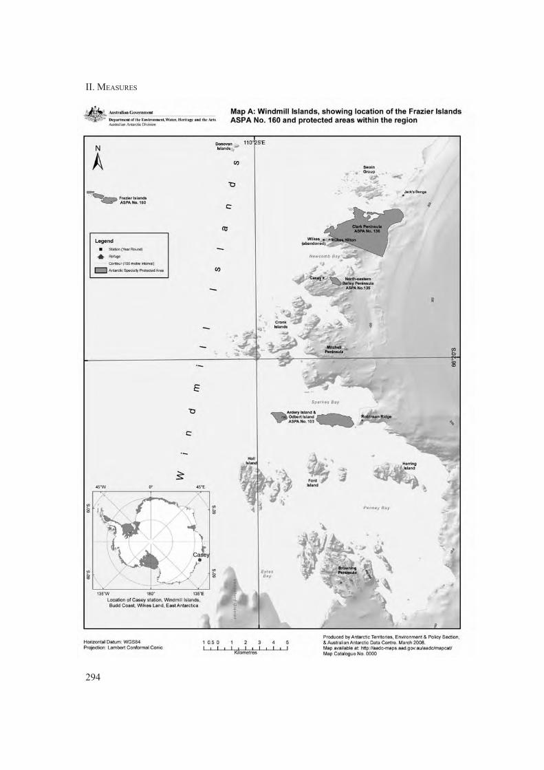
II. MEASURES
294

ASPA 160: FRAZIER ISLANDS
295

II. MEASURES

297
Measure 14 (2008)
Antarctic Specially Protected Area No 161
(Terra Nova Bay, Ross Sea): Revised Management Plan
The Representatives,
Recalling Articles 3, 5 and 6 of Annex V to the Protocol on Environmental Protection to the
Antarctic Treaty providing for the designation of Antarctic Specially Protected Areas
(“ASPA”) and approval of Management Plans for those Areas;
Recalling Measure 2 (2003), which designated Terra Nova Bay, Ross Sea, as Antarctic
Specially Protected Area No 161, and annexed a management plan for the site;
Noting that the Committee for Environmental Protection has endorsed a revised Management
Plan for ASPA 161;
Desiring to replace the existing Management Plan for ASPA 161 with the revised
Management Plan;
Recommend to their Governments the following Measure for approval in accordance with
paragraph 1 of Article 6 of Annex V to the Protocol on Environmental Protection to the
Antarctic Treaty:
That:
1) the revised Management Plan for Antarctic Specially Protected Area No 161:
Terra Nova Bay, Ross Sea, which is annexed to this Measure, be approved;
2) the Management Plan for ASPA 161 annexed to Measure 2 (2003) shall cease to
be effective.

298
II. MEASURES

299
MEASURE 14 - ANNEX
Management Plan for Antarctic Specially Protected Area No 161
TERRA NOVA BAY, ROSS SEA
1. Description values to be protected
A coastal marine area encompassing 29.4km2 between Adélie Cove and Tethys Bay, Terra Nova
Bay, is proposed as an Antarctic Specially Protected Area (ASPA) by Italy on the grounds that it is
an important littoral area for well-established and long-term scientific investigations. The Area is
confined to a narrow strip of waters extending approximately 9.4km in length immediately to the
south of the Mario Zucchelli Station (MZS) and up to a maximum of 7km from the shore. No
marine resource harvesting has been, is currently, or is planned to be, conducted within the Area,
nor in the immediate surrounding vicinity. The site typically remains ice-free in summer, which is
rare for coastal areas in the Ross Sea region, making it an ideal and accessible site for research into
the near-shore benthic communities of the region. Extensive marine ecological research has been
carried out at Terra Nova Bay since 1986/87, contributing substantially to our understanding of
these communities which had not previously been well-described.
High diversity at both species and community levels make this Area of high ecological and scientific
value. Studies have revealed a complex array of species assemblages, often co-existing in mosaics
(Cattaneo-Vietti, 1991; Sarà et al., 1992; Cattaneo-Vietti et al., 1997; 2000b; 2000c; Gambi et al.,
1997; Cantone et al., 2000). There exist assemblages with high species richness and complex
functioning, such as the sponge and anthozoan communities, alongside loosely structured, low
diversity assemblages. Moreover, the sponge and anthozoan communities at Terra Nova Bay show
an unique structure and long-term transects have been established to monitor changes in coastal
benthic communities, both natural and human-induced. The presence of a population of Adélie
penguins (Pygoscelis adeliae) at Adélie Cove allows assessment of the effects of this colony on the
adjacent marine environment (Povero et al., 2001).
It is important to protect the Area as far as possible from direct human impacts in order that it can be
used to monitor potential impacts arising from activities at the nearby permanent scientific station
of MZS at Terra Nova Bay (Mauri et al., 1990; Berkman & Nigro, 1992; Focardi et al., 1993;
Minganti et al., 1995; Bruni et al., 1997; Nonnis Marzano et al., 2000). The high ecological and
scientific values derived from the diverse range of species and assemblages, in particular through
the collection of extensive data on these features, together with the vulnerability of the Area to
disturbance by pollution, over-sampling and alien introductions, are such that the Area requires
long-term special protection.
2. Aims and objectives
Management at Terra Nova Bay aims to:
• avoid degradation of, or substantial risk to, the values of the Area by preventing unnecessary
human disturbance to the Area;
• allow scientific research on the ecosystem, in particular on the marine species assemblages,
while ensuring it is protected from oversampling or other possible scientific impacts;
• allow other scientific research and support activities provided they are for compelling
reasons which cannot be served elsewhere;

II. MEASURES
300
• maintain long-term monitoring sites to evaluate natural changes in marine communities;
• monitor the effects of the research station and its associated activities on the marine
ecosystem;
• minimise the possibility of introduction of alien plants, animals and microbes to the Area;
• allow visits for management purposes in support of the aims of the Management Plan.
3. Management activities
The following management activities are to be undertaken to protect the values of the Area:
• A map showing the location of the Area (stating the special restrictions that apply) shall be
displayed prominently, and a copy of this Management Plan shall be kept available, at
MZS (Italy);
• A sign illustrating the location and boundaries with clear statements of entry restrictions
shall be installed at MZS at a prominent location;
• Buoys, or other markers or structures erected for scientific or management purposes shall
be secured and maintained in good condition, and removed when no longer necessary;
• Visits shall be made as necessary to assess whether the Area continues to serve the purposes
for which it was designated and whether management and maintenance measures are
adequate.
4. Period of designation
Designated for an indefinite period.
5. Maps and photographs
• Map 1: Terra Nova Bay, Antarctic Specially Protected Area No 161, bathymetric map.
Map specifications: Projection: UTM Zone 58S; Spheroid: WGS84. Bathymetric contour
interval 50m. Land contours and coast derived from 1:50,000 Northern Foothills Satellite
Image Map (Frezzotti et. al. 2001). Bathymetry within ASPA derived from high resolution
sidescan sonar data surveyed by Kvitek, 2002. Bathymetry outside of ASPA supplied by
Italian Hydrographic Office 2000. Marine data collected under Terra Nova Bay marine
protected area Project (PNRA 1999-2001).
Inset 1: The location of Terra Nova Bay in Antarctica.
Inset 2: Terra Nova Bay location map, showing the region covered by Map 1, stations,
and sites of nearby protected areas.
6. Description of the Area
6(i) Geographical co-ordinates, boundary markers and natural features
The designated Area is situated in Terra Nova Bay, between the Campbell Glacier Tongue and
Drygalski Ice Tongue, Victoria Land. The Area is confined to a narrow strip of coastal waters to the
south of MZS (Italy), extending approximately 9.4km in length and generally within 1.5 – 7km of

ASPA 161: TERRA NOVA BAY
301
the shore, comprising an area of 29.4km2 (Map 1). No marine resource harvesting has been, is
currently, or is planned to be, conducted within the Area, nor in the immediate surrounding vicinity.
The western boundary of the Area is defined as the mean high water mark along the coastline
extending between 74°42’57"S in the north (2.3km south of MZS) and 74°48’00"S in the south (the
southern shore of Adélie Cove), and includes the intertidal zone (Map 1). The northern boundary of
the Area is defined as the 74°42’57"S line of latitude, extending from the coast 1.55km eastward to
the 164°10’00"E line of longitude. The boundary position may be recognised near the shore by the
presence of a large and distinctive offshore rock in the northernmost cove on the coast south of
MZS, which is an unique feature on this stretch of coast. The southern boundary is defined as the
74°48’00"S line of latitude, extending from the coast 3.63km eastward to the 164°10’00"E line of
longitude. The boundary position may be recognised visually as being at the southern shore of the
mouth of Adélie Cove, immediately south of a distinctive rocky outcrop at the base of the coastal
cliffs. The eastern boundary of the Area is defined as the 164°10’00"E line of longitude extending
between 74°42’57"S in the north and 74°48’00"S in the south.
The coastline of Terra Nova Bay is characterised predominantly by rocky cliffs, with large boulders
forming occasional ‘beaches’ (Simeoni et al., 1989). In the sheltered areas, the soft bottom begins
at a depth of 20–30m. The tidal range is 1.5–2m and pack ice approximately 2–2.5m thick covers
the sea surface for 9–10 months of the year (Stocchino & Lusetti, 1988; 1990). Data available for
the summer period suggest that ocean currents in the Area are likely to be slow and to flow generally
in a north-south direction. Along the coastline of the Area there are two main coves; the larger
Adélie Cove in the south and a smaller cove around 3km to its north. The sea floor substrate of the
smaller consists of pebbles of various sizes, while Adélie Cove is characterised by fine-grained,
muddy sediments. An Adélie penguin (Pygoscelis adeliae) colony is situated at Adélie Cove, with
a 1991 population of 7899 breeding pairs. Outside of the coves, the sea floor characteristics and
benthic species assemblages are relatively homogenous along the coastal length of the Area, and
are observed to vary more particularly with the vertical gradient.
An aerial survey on cetacean species, conducted in the coastal area surrounding the Italian Station
Mario Zucchelli in summer 2004, showed the presence of killer whale (Orcinus orca (L.)), types B
and C and minke whale (Balaenoptera bonaerensis Burmeister) (Lauriano et al., 2007a; 2007b;
Lauriano pers.com.).
The seafloor within the Area is primarily granitic rock, with softer substrates composed of coarse
sands or gravels. In the supralittoral zone, only cyanobacteria and diatoms colonise the hard substrates,
while the intertidal zone (1.5–2.0m wide) has, in the most sheltered areas, a high coverage of the
green alga Urospora penicilliformis and Prasiola crispa (Cormaci et al., 1992b). Below the tidal
zone, down to 2–3m depth, the community is very poor, due to the persistent presence and scouring
action of pack ice, and is mainly composed of epilithic diatoms and the crustacean amphipod
Paramoera walkeri. Immediately deeper, rocks can be fully colonised by the red alga Iridaea cordata
(Cormaci et al., 1996), frequently found with Plocamium cartilagineum, to a depth of 12m (Gambi
et al., 1994; 2000a). At this level large sessile animals such as Alcyonium antarcticum and Urticinopsis
antarctica can be occasionally observed, while frequent are the asteroid Odontaster validus and the
echinoid Sterechinus neumayeri. Phyllophora antarctica is another red alga forming expanded mats
from 12 to 25m depth, often fully colonised by sessile organisms, mainly hydroids (Cerrano et al.,
2000c, Puce et al., 2002), serpulids and bryozoans (Celleporella antarctica and Harpecia
spinosissima). The upper algal belts represent shelter and a food source for diversified and abundant
communities of mobile fauna. Numerous invertebrates, such as the polychaete Harmothoe brevipalpa,
the mollusc Laevilittorina antarctica, the crustacean amphipod Paramoera walkeri and the isopod
Nototanais dimorphus feed on these algal species and can be very abundant. On rocky bottoms in

II. MEASURES
302
deeper layers, the algal colonisation is replaced by a calcareous crustose coralline alga
(Clathromorphum lemoineanum) on which sea-urchins feed.
The soft bottoms from 20–40m depth are coarse sands and gravels, where the community is
characterised by the mollusc bivalve Laternula elliptica and the polychaete Aglaophamus ornatus
(Nephtiidae). The bivalve Yoldia eightsi is abundant in fine-sand sediments.
Between 30–70m, the substrate becomes finer and is completely colonised by the bivalve Adamussium
colbecki, the shells of which are colonised by a micro-community comprising mainly forams,
bryozoans (Aimulosia antarctica, Arachnopusia decipiens, Ellisina antarctica, Micropora brevissima)
and the spirorbid Paralaeospira levinsenii (Albertelli et al., 1998; Ansell et al., 1998; Chiantore et
al., 1998; 2000; 2001; 2002; Vacchi et al., 2000a; Cerrano et al., 2001a; 2001b). In this region,
large predators such as the gastropod Neobuccinum eatoni and the nemertean Parborlasia corrugatus
are frequent. The echinoid Sterechinus neumayeri and the starfish Odontaster validus are still very
frequent at all depths on both hard and mobile substrates (Chiantore et al., 2002; Cerrano et al.,
2000b).
Below 70–75m down to 120–130m depth, heterogeneous substrates allow hard- and soft-bottom
communities to coexist. On the sparse rocky outcrops the encrusting algae disappear and the benthic
communities are dominated by the sessile zoobenthos. This diversified filter feeding assemblage is
mainly characterised by sponges and anthozoans, while in soft sediments detritus-feeder polychaetes
and bivalves dominate. Among sponges, which can reach very high biomass values, Axociella
nidificata, Calyx arcuarius, Gellius rudis, Phorbas glaberrima, Tedania charcoti, are very abundant
(Sarà et al., 1992; 2002; Gaino et al., 1992; Cattaneo-Vietti et al., 1996; 2000c; Bavestrello et al.,
2000; Cerrano et al., 2000a). Numerous invertebrates constitute an important component of this
assemblage which develops down to 120-140m depth. These include the epibiont polychaete Barrukia
cristata on Thouarellid gorgonians, crustacean peracarids, pycnogonids, mollusc opisthobranchs
(Austrodoris kerguelenensis, Tritoniella belli) (Cattaneo-Vietti, 1991; Gavagnin et al., 1995) and
bivalves, ophiuroids and holothuroids, bryozoans, and the endobionts. The conspicuous sponge
spicule mats found at these depths underline the important role of sponges in this area, besides the
one played by diatoms, in determining the sediment texture and silica content. A peculiar community,
dominated by polychaetes and by the bivalve Limatula hodgsoni, can be associated with these mats.
Below 130m the hard substrates become very sparse and are mainly colonised by the polychaete
Serpula narconensis (Schiaparelli et al., 2000) and several bryozoans (Arachnopusia decipiens,
Ellisina antarctica, Flustra angusta, F. vulgaris and Isoschizoporella similis). The dominant muddy
bottoms are instead characterised by tubicolous polychaetes (Gambi et al., 2000b), mainly
Spiophanes. Much deeper, at about 150-200m depth, brachiopods and various species of bivalves
characterise the environment on small gravels as well as on the soft bottom (Cattaneo-Vietti et al.,
2000b). The great heterogeneity of these substrates contributes to the creation of communities with
considerable species richness, diversity and biomass.
Finally, the faunal assemblage of the Area includes notothenioid fishes, represented especially by
species of the Trematomus group, including T. bernacchi, T. pennelli, T. hansoni and T. loennbergii.
These exert an important role in benthic food webs as consumers of many invertebrate species,
mainly crustaceans and polychaetes (Vacchi et al., 1991; 1992; 1994a; 1994b; 1995; 1997; 2000b;
La Mesa et al., 1996; 1997; 2000; Guglielmo et al., 1998).
The platelet ice occurring at Terra Nova Bay in early spring has been shown to house an important
nursery for the Antarctic silverfish, Pleuragramma antarcticum, a key organism in the ecology of
Antarctic food webs (La Mesa et al., 2004; Vacchi et al., 2004). The platelet ice environment has
strong prooxidant characteristics at the beginning of austral spring, and the marked responsiveness
of antioxidant defences represents a fundamental strategy for P. antarcticum (Regoli et al., 2005b).

ASPA 161: TERRA NOVA BAY
303
The elevated prooxidant challenge, to which these organisms are naturally adapted, also influences
the susceptibility of P. antarcticum toward prooxidant chemicals of anthropogenic origin (Regoli et
al., 2005b).
Oxyradical metabolism and antioxidant defenses have a fundamental role in several marine
invertebrates, fish and penguins from Terra Nova Bay, representing important counteractive strategies
toward, i.e. extreme environmental conditions, marked seasonal fluctuations of biotic and abiotic
factors, symbiotic relationships, specific physiological features, long-term protection of biological
macromolecules and aging (Regoli et al., 1997a,b; 2000a,b, 2002, 2004; Corsolini et al., 2001;
Cerrano et al., 2004).
Susceptibility to oxidative stress is of particular value also for monitoring the impact of human
activities and cellular responses to pollutants were characterized in key Antarctic organisms
developing a wide array of biomarkers sensitive to biological disturbance (Focardi et al., 1995;
Regoli et al., 1998; Jimenez et al., 1999; Regoli et al., 2005a; Benedetti et al., 2005, 2007; Canapa
et al., 2007; Di Bello et al., 2007). At the moment, there is no evidence of polluted areas in Terra
Nova Bay, but organisms are exposed to a naturally elevated bioavailability of cadmium causing
tissue concentrations generally 10-50 folds higher than those typical of temperate species (Mauri et
al., 1990; Nigro et al., 1992, 1997; Canapa et al., 2007). Despite elevated levels of this element do
not cause direct adverse effects to the organisms, nonetheless the environmental characteristics of
Terra Nova Bay influence the responsiveness of organisms to other chemicals with important
implications for monitoring the impact of anthropogenic pressure or accidental spills (Regoli et al.,
2005a); in particular, elevated level ofcadmium at Terra Nova Bay modulates bioaccumulation and
metabolism of polycyclic aromatic hydrocarbons and of organochlorine xenobiotics in local marine
organisms suggesting also endocrine effects from the chronic exposure to this element (Regoli et
al., 2005a; Benedetti et al., 2007; Canapa et al., 2007).
Human impacts within the Area are believed to be minimal and confined to those arising from the
nearby Terra Nova Bay Station and scientific work conducted within the Area. The station can
accommodate approximately 80 people, has facilities for helicopter operations and a jetty for the
docking of small boats. Fuel used at the station is a light petroleum diesel, stored in three double-
walled steel tanks with a total capacity of 1.8 million litres. Fuel is transferred to the station annually
from resupply ship either via hoses routed across sea ice or via barge when sea ice is not present.
Station waste water, purified by a biological plant, is discharged into the sea adjacent to the station
on the eastern side of the peninsula on which the station is located, 2.3km from the northern boundary
of the Area. Combustible rubbish generated at the Station is incinerated and the smoke washed and
filtered with water. This water is discharged into the waste water treatment plant at time intervals
which intovary with incinerator usage. An atmospheric monitoring facility (locally referred to as
‘Campo Icaro’) is situated approximately 650m north of the northern boundary of the Area and
150m from the shore: no wastes are discharged from this facility. A support ship regularly visits
Mario Zucchelli Station during the summer, and there are occasional visits by tourist ships. These
usually stop offshore several kilometres to the north of the Area.
6(ii) Restricted zones within the Area
None.
6(iii) Structures within and near the Area
There are no structures within the Area. The nearest structure is the atmospheric monitoring facility
(locally referred to as ‘Campo Icaro’) 650m north of the northern boundary of the Area, while
Mario Zucchelli Station (74°41’42"S, 164°07’23"E) is situated on a small peninsula on the coast
adjacent to Tethys Bay, a further 1.65km to the north.

II. MEASURES
304
6(iv) Location of other protected areas within close proximity of the Area
ASPA No 118, summit of Mount Melbourne, is a terrestrial site situated 45km to the NE, which is
the only other protected area within close proximity.
7. Permit conditions
Entry into the Area is prohibited except in accordance with a Permit issued by the appropriate
national authority. Conditions for issuing a Permit are that:
• it is issued for scientific study of the marine environment in the Area, or for other scientific
purposes which cannot be served elsewhere; and/or
• it is issued for essential management purposes consistent with plan objectives such as
inspection, maintenance or review;
• the actions permitted will not jeopardise the values of the Area;
• any management activities are in support of the objectives of the Management Plan;
• the actions permitted are in accordance with the Management Plan;
• the Permit, or an authorised copy, shall be carried by the holderwithin the Area;
• a visit report shall be supplied to the authority named in the Permit;
• permits shall be issued for a stated period.
7(i) Access to and movement within the Area
Access into the Area shall be by sea, land, over sea ice or by air. There are no specific restrictions on
routes of access to and movement within the Area, although movements should be kept to the
minimum necessary consistent with the objectives of any permitted activities and every reasonable
effort should be made to minimise disturbance. Anchoring is prohibited within the Area. There are
no overflight restrictions within the Area and aircraft may land by Permit when sea ice conditions
allow. Ship or small boat crew, or other people on small boats or ships, are prohibited from moving
beyond the immediate vicinity of their vessel unless specifically authorized by Permit.
7(ii) Activities that are or may be conducted within the Area, including restrictions on time or place
• Scientific research or essential operational activities that will not jeopardise the values of
the Area;
• Essential management activities, including monitoring;
• Activities that involve trawling, dragging, grabbing, dredging, or deployment of nets within
the Area should be undertaken with great care because of the sensitivity of the rich bottom
communities to disturbance: before Permits are granted for such activities careful
consideration should be given to the impact of such activities on the ecosystem under special
protection versus the expected scientific or management benefits, with consideration given
to alternative, more selective and less-invasive, sampling methods;
• The appropriate authority should be notified of any activities/measures undertaken that
were not included in the authorized Permit.
7(iii) Installation, modification or removal of structures
Structures or scientific equipment shall not be installed within the Area except as specified in a
Permit. All markers, structures or scientific equipment installed in the Area shall be clearly identified

ASPA 161: TERRA NOVA BAY
305
by country, name of the principal investigator and year of installation. All such items should be
made of materials that pose minimal risk of contamination of the Area. Removal of specific equipment
for which the Permit has expired shall be a condition of the Permit. Permanent installations are
prohibited.
7(iv) Location of field camps
None within the Area. An occasional field camp has been positioned on the beach at Adélie Cove.
7(v) Restrictions on materials and organisms which can be brought into the Area
No living animals, plant material, pathogens or microorganisms shall be deliberately introduced
into the Area. Poultry products, including food products containing uncooked dried eggs, shall not
be released into the Area. No herbicides or pesticides shall be introduced into the Area. Any other
chemicals, including radio-nuclides or stable isotopes, which may be introduced for scientific or
management purposes specified in the Permit, shall be used in the minimum quantities necessary to
achieve the purpose of the activity for which the Permit was granted. Such chemicals shall be used
with due regard for the values of the Area. All materials shall be stored and handled so that risk of
their accidental introduction into the environment is minimized. Where practical, materials introduced
shall remain for a stated period only and shall be removed at or before the conclusion of that stated
period. If release occurs which is likely to compromise the values of the Area, removal is encouraged
only where the impact of removal is not likely to be greater than that of leaving the material in situ.
The appropriate authority should be notified of any materials released that were not included in the
authorized Permit.
7(vi) Taking or harmful interference with native flora or fauna
Taking or harmful interference with native flora or fauna is prohibited, except by Permit issued in
accordance with Annex II to the Protocol on Environmental Protection to the Antarctic Treaty.
Where taking or harmful interference with animals is involved, the SCAR Code of Conduct for the
Use of Animals for Scientific Purposes in Antarctica should be used as a minimum standard.
7(vii) Collection and removal of anything not brought into the Area by the Permit holder
Material may be collected or removed from the Area only in accordance with a Permit and should
be limited to the minimum necessary to meet scientific or management needs. Permits shall not be
granted if there is a reasonable concern that the sampling proposed would take, remove or damage
such quantities of substrate, native flora or fauna that their distribution or abundance within the
Area would be significantly affected. All samples collected shall be described in terms of their type,
quantity and the location from which they were taken. This information shall held in an archive
accessible at MZS in order to maintain a record of usage that will assist assessment of the impacts
of sampling activities and in the planning of future sampling. Material of human origin likely to
compromise the values of the Area, which was not brought into the Area by the Permit Holder or
otherwise authorized, may be removed unless the impact of removal is likely to be greater than
leaving the material in situ: if this is the case the appropriate authority should be notified.
7(viii) Disposal of waste
All wastes, including all human wastes, shall be removed from the Area.
II. MEASURES
306
7(ix) Measures that are necessary to ensure that the aims and objectives of the Management Plan
can continue to be met
Permits may be granted to enter the Area to carry out biological monitoring and site inspection
activities, which may involve the collection of limited samples for analysis or review, or for protective
measures.
Any specific sites of long-term monitoring that are vulnerable to inadvertent disturbance should be
appropriately marked on site where practical and, as appropriate, on maps of the Area.
To help maintain the ecological and scientific values of the marine communities found within the
Area, visitors shall take special precautions against marine pollution. Of concern are the release or
spillage of hydrocarbons from ships, and biological introductions. To minimize the risk of such
pollution, visitors shall ensure that sampling equipment or markers brought into the Area are clean.
Vessels that are found to show fuel leakage, or a significant risk of such leakage, are prohibited
from entering the Area. If a fuel leak from a vessel is discovered while within the Area, the vessel
shall leave the Area unless the leak can be promptly stopped. Handling of fuels and oil within the
Area shall be the minimum necessary consistent with meeting the objectives of the permitted activities.
7(x) Requirements for reports
Antarctic Treaty Parties should ensure that the principal holder for each Permit issued submits to
the appropriate authority a report describing the activities undertaken. Such reports should include,
as appropriate, the information identified in the Visit Report form suggested by SCAR. Parties
should maintain a record of such activities and, in the Annual Exchange of Information, should
provide summary descriptions of activities conducted by persons subject to their jurisdiction, which
should be in sufficient detail to allow evaluation of the effectiveness of the Management Plan.
Parties should, wherever possible, deposit originals or copies of such original reports in a publicly
accessible archive to maintain a record of usage, to be used both in any review of the management
plan and in organizing the scientific use of the Area.
8. References
Albertelli G., Cattaneo-Vietti R., Chiantore M., Pusceddu A., Fabiano M., 1998. Food availability
to an Adamussium bed during the austral Summer 1993/94 (Terra Nova Bay, Ross Sea).
Journal of Marine Systems 17: 425-34.
Ansell A.D., Cattaneo-Vietti R., Chiantore M., 1998. Swimming in the Antarctic scallop Adamussium
colbecki: analysis of in situ video recordings. Antarctic Science 10 (4): 369-75.
Bavestrello G., Arillo A., Calcinai B., Cattaneo-Vietti R., Cerrano C., Gaino E., Penna A., Sara’ M.,
2000. Parasitic diatoms inside Antarctic sponges. Biol. Bull. 198: 29-33.
Benedetti M., Gorbi S., Bocchetti R., Fattorini D., Notti A., Martuccio G., Nigro M., Regoli F.
(2005). Characterization of cytochrome P450 in the Antarctic key sentinel species
Trematomus bernacchii. Pharmacologyonline 3: 1-8 ISSN-1827-8620
Benedetti M., Martuccio G., Fattorini D., Canapa A., Barucca M., Nigro M., Regoli F. (2007).
Oxidative and modulatory effects of trace metals on metabolism of polycyclic aromatic
hydrocarbons in the Antarctic fish Trematomus bernacchii. Aquat. Toxicol. 85: 167-175
Berkman P.A., Nigro M., 1992. Trace metal concentrations in scallops around Antarctica: Extending
the Mussel Watch Programme to the Southern Ocean. Marine Pollution Bulletin 24 (124):
322-23.

ASPA 161: TERRA NOVA BAY
307
Bruni V., Maugeri M.L., Monticelli L.S., 1997. Faecal pollution indicators in the Terra Nova Bay
(Ross Sea, Antarctica). Marine Pollution Bulletin 34 (11): 908-12.
Canapa A, Barucca M, Gorbi S, Benedetti M, Zucchi S, Biscotti MA, Olmo E, Nigro M, Regoli F
2007 Vitellogenin gene expression in males of the Antarctic fish Trematomus bernacchii
from Terra Nova Bay (Ross Sea): A role for environmental cadmium? Chemosphere,
66:1270-1277.
Cantone G., Castelli A., Gambi M.C., 2000. The Polychaete fauna off Terra Nova Bay and Ross
Sea: biogeography, structural aspects and ecological role. In: Ross Sea Ecology, F. Faranda,
L. Guglielmo and A. Ianora Eds., Springer Verlag, Berlin Heidelberg: 551-61.
Cattaneo-Vietti R., 1991. Nudibranch Molluscs from the Ross Sea, Antarctica. J. Moll. Stud. 57:
223-28.
Cattaneo-Vietti R., Bavestrello G., Cerrano C., Sara’ M., Benatti U., Giovine M., Gaino E., 1996.
Optical fibres in an Antarctic sponge. Nature 383: 397-98.
Cattaneo-Vietti R., Chiantore M., Albertelli G., 1997. The population structure and ecology of the
Antarctic Scallop, Adamussium colbecki in Terra Nova Bay (Ross Sea, Antarctica). Scientia
Marina 61 (Suppl. 2): 15-24.
Cattaneo-Vietti R., Chiantore M., Misic C., Povero P., Fabiano M., 1999. The role of pelagic-benthic
coupling in structuring littoral benthic communities at Terra Nova Bay (Ross Sea) and
inside the Strait of Magellan. Scientia Marina 63 (Supl. 1): 113-21.
Cattaneo-Vietti R., Chiantore M., Gambi M.C., Albertelli G., Cormaci M., Di Geronimo I., 2000a.
Spatial and vertical distribution of benthic littoral communities in Terra Nova Bay. In: Ross
Sea Ecology, F. Faranda, L. Guglielmo and A. Ianora Eds., Springer Verlag, Berlin
Heidelberg: 503-14.
Cattaneo-Vietti R., Chiantore M., Schiaparelli S., Albertelli G., 2000b. Shallow and deep-water
mollusc distribution at Terra Nova Bay (Ross Sea, Antarctica). Polar Biology 23: 173-82.
Cattaneo-Vietti R., Bavestrello G., Cerrano C., Gaino E., Mazzella L., Pansini M., Sarà M., 2000c.
The role of sponges of Terra Nova Bay ecosystem. In: Ross Sea Ecology, F. Faranda, L.
Guglielmo and A. Ianora Eds., Springer Verlag, Berlin Heidelberg: 539-49.
Cerrano C., Arillo A., Bavestrello G., Calcinai B., Cattaneo-Vietti R., Penna A., Sarà M., Totti C.,
2000a. Diatom invasion in the Antarctic hexactinellid sponge Scolymastra joubini. Polar
Biology 23: 441-44.
Cerrano C., Bavestrello G., Calcinai B., Cattaneo-Vietti R., Sarà A., 2000b. Asteroids eating sponges
from Tethys Bay, East Antarctica. Antarctic Science 12(4): 431-32.
Cerrano C., Puce S., Chiantore M., Bavestrello G., 2000c. Unusual trophic strategies of Hydractinia
angusta (Cnidaria, Hydrozoa) from Terra Nova Bay, Antarctica. Polar Biology 23(7): 488-
94.
Cerrano C., G. Bavestrello, B. Calcinai, R. Cattaneo-Vietti, M. Chiantore, M. Guidetti, A. Sarà,
2001a. Bioerosive processes in Antarctic seas. Polar Biology 24: 790-92.
Cerrano C., S. Puce, M. Chiantore, G. Bavestrello, R. Cattaneo-Vietti, 2001b. The influence of the
epizooic hydroid Hydractinia angusta on the recruitment of the Antarctic scallop
Adamussium colbecki. Polar Biology 24: 577-81.

II. MEASURES
308
Cerrano C, Calcinai B, Cucchiari E, Di Camillo C, Nigro M, Regoli F, Sarà A, Schiapparelli S, Totti
C, Bavestrello G 2004 Are diatoms a food source for Antarctic sponges? Chemistry and
Ecology, vol. 20: 57-64.
Chiantore M., Cattaneo-Vietti R., Albertelli G., Misic M., Fabiano M., 1998. Role of filtering and
biodeposition by Adamussium colbecki in circulation of organic matter in Terra Nova Bay
(Ross Sea, Antarctica). Journal of Marine Systems 17: 411-24.
Chiantore M., Cattaneo-Vietti R., Povero P., Albertelli G., 2000. The population structure and ecology
of the antarctic scallop Adamussium colbecki in Terra Nova Bay. In: Ross Sea Ecology, F.
Faranda, L. Guglielmo and A. Ianora Eds., Springer Verlag, Berlin Heidelberg: 563-73.
Chiantore M., Cattaneo-Vietti R., Berkman P.A., Nigro M., Vacchi M., Schiaparelli S., Albertelli G.,
2001. Antarctic scallop (Adamussium colbecki) spatial population variability along the
Victoria Land Coast, Antarctica. Polar Biology 24: 139-43.
Chiantore M., R. Cattaneo-Vietti, L. Elia, M. Guidetti, M. Antonini, 2002. Reproduction and condition
of the scallop Adamussium colbecki (Smith 1902), the sea-urchin Sterechinus neumayeri
(Meissner, 1900) and the sea-star Odontaster validus Koehler, 1911 at Terra Nova Bay
(Ross Sea): different strategies related to inter-annual variations in food availability. Polar
Biology 22: 251-55.
Cormaci M., Furnari G., Scammacca B., Casazza G., 1992a. Il fitobenthos di Baia Terra Nova (Mare
di Ross, Antartide): osservazioni sulla flora e sulla zonazione dei popolamenti. In: Gallardo
VA, Ferretti O, Moyano HI (eds) Actas del Semin. Int. Oceanografia in Antartide. Centro
EULA, Universitad de Concepción, Chile. ENEA: 395-408.
Cormaci M., Furnari G., Scammacca B., 1992b. The benthic algal flora of Terra Nova Bay (Ross
Sea, Antarctica). Botanica Marina 35(6): 541-52
Cormaci M., Furnari G., Scammacca B., 1992c. Carta della vegetazione marina di Baia Terra Nova
(Mare di Ross, Antartide). Biologia Marina 1: 313-14.
Cormaci M., Furnari G., Scammacca B., Alongi G., 1996. Summer biomass of a population of
Iridaea cordata (Gigartinaceae, Rhodophyta) from Antarctica. In: Lindstrom SC, Chapman
DJ (Eds) Proceedings of the XV Seeweeds Symposium. Hydrobiologia 326/327: 267-72.
Corsolini S, Nigro M, Olmastroni S, Focardi S, Regoli F 2001 Susceptibility to oxidative stress in
Adelie and Emperor penguin, Polar Biology, vol. 24: 365-368.
Di Bello D., Vaccaio E., Longo V., Regoli F., Nigro M., Benedetti M., Gervasi PG, Pretti C. (2007).
Presence and inducibility by â-Naphtoflavone of CYP 1A1, CYP 1B1, UDP-GT, GST and
DT-Diaphorase enzymes in Trematomus bernacchii, an Antarctic fish. Aquatic Toxicol. 84:
19-26
Fabiano M., Danovaro R., Crisafi E., La Ferla R., Povero P., Acosta Pomar L., 1995. Particulate
matter composition and bacterial distribution in Terra Nova Bay (Antarctica) during summer
1989-90. Polar Biology 15: 393-400.
Fabiano M., Povero P., Danovaro R., 1996. Particulate organic matter composition in Terra Nova
Bay (Ross Sea, Antarctica) during summer 1990. Antarctic Science 8(1): 7-13.
Fabiano M., Chiantore M., Povero P., Cattaneo-Vietti R., Pusceddu A., Misic C., Albertelli G.,
1997. Short-term variations in particulate matter flux in Terra Nova Bay, Ross Sea. Antarctic
Science 9(2): 143-149.

ASPA 161: TERRA NOVA BAY
309
Focardi S., Bargagli R., Corsolini S., 1993. Organochlorines in marine Antarctic food chain at Terra
Nova Bay (Ross Sea). Korean Journal of Polar Research 4: 73-77.
Focardi S, Fossi MC, Lari L, Casini S, Leonzio C, Meidel SK, Nigro M. 1995 Induction of MFO
Activity in the Antarctic fish Pagothenia bernacchii: Preliminary results. Marine
Environmental Research., 39: 97-100.
Gaino E., Bavestrello G., Cattaneo-Vietti R., Sara’ M., 1994. Scanning electron microscope evidence
for diatom uptake by two Antarctic sponges. Polar Biology 14: 55-58.
Gambi M.C., Lorenti M., Russo G.F., Scipione M.B., 1994. Benthic associations of the shallow
hard bottoms off Terra Nova Bay (Ross Sea, Antarctica): zonation, biomass and population
structure. Antarctic Science 6(4): 449-62.
Gambi M.C., Castelli A., Guizzardi M., 1997. Polychaete populations of the shallow soft bottoms
off Terra Nova Bay (Ross Sea, Antarctica): distribution, diversity and biomass. Polar Biology
17: 199-210.
Gambi M.C., Buia M.C., Mazzella L., Lorenti M., Scipione M.B., 2000a. Spatio-temporal variability
in the structure of benthic populations in a physically controlled system off Terra Nova
Bay: the shallow hard bottoms. In: Ross Sea Ecology, F. Faranda, L. Guglielmo and A.
Ianora Eds., Springer Verlag, Berlin Heidelberg: 527-538.
Gambi M.C., Giangrande A., Patti F.P., 2000b. Comparative observations on reproductive biology
of four species of Perkinsiana (Polychaeta, Sabellidae). Bulletin of Marine Science 67(1):
299-309.
Gavagnin M., Trivellone E., Castelluccio F., Cimino G., Cattaneo-Vietti R., 1995. Glyceryl ester of
a new halimane diterpenoic acid from the skin of the antarctic nudibranch Austrodoris
kerguelenensis. Tetrahedron Letters 36: 7319-22.
Guglielmo L., Granata A., Greco S., 1998. Distribution and abundance of postlarval and juvenile
Pleuragramma antarticum (Pisces, Nototheniidae )of Terra Nova Bay (Ross Sea, Antarctica).
Polar Biology 19: 37-51.
Guglielmo L., Carrada G.C., Catalano G., Dell’Anno A., Fabiano M., Lazzara L., Mangoni O.,
Pusceddu A., Saggiomo V., 2000. Structural and functional properties of sympagic
communities in the annual sea ice at Terra Nova Bay (Ross Sea, Antarctica). Polar Biology
23(2): 137-46.
Jimenez B, Fossi MC, Nigro M, Focardi S. 1999 Biomarker approach to evaluating the impact of
scientific stations on the Antarctic environment using trematomus bernacchii as a
bioindicator organism. Chemosphere, 39: 2073-2078.
La Mesa M., Arneri E., Giannetti G., Greco S., Vacchi M., 1996. Age and growth of the nototheniid
fish Trematomus bernacchii Boulenger from Terra Nova Bay, Antarctica. Polar Biology16:
139-45.
La Mesa M., Vacchi M., Castelli A., Diviacco G., 1997. Feeding ecology of two nototheniid fishes
Trematomus hansoni and Trematomus loennbergi from Terra Nova Bay, Ross Sea. Polar
Biology 17: 62-68.
La Mesa M., Vacchi M., T. Zunini Sertorio, 2000. Feeding plasticity of Trematomus newnesi (Pisces,
Nototheniidae) in Terra Nova Bay, Ross Sea, in relation to environmental conditions. Polar
Biology 23(1): 38-45.

II. MEASURES
310
La Mesa M., J.T. Eastman, M. Vacchi, 2004. The role of notothenioid fish in the food web of the
Ross Sea shelf waters: a review. Polar Biol., 27: 321-338.
Lauriano G., Fortuna C.M., Vacchi M., 2007a. Observation of killer whale (Orcinus orca) possibly
eating penguins in Terra Nova Bay, Antarctica. Antarctic Science, 19(1): 95-96.
Lauriano G., Vacchi M., Ainley D., Ballard G., 2007b. Observations of top predators foraging on
fish in the pack ice of the southern Ross Sea. Antarctic Science, 19(4): 439-440.
Mauri M., Orlando E., Nigro M., Regoli F., 1990. Heavy metals in the Antarctic scallop Adamussium
colbecki (Smith). Mar. Ecol. Progr. Ser. 67: 27-33.
Mauri M, Orlando E, Nigro M, Regoli F. 1990 Heavy metals in the Antarctic scallop Adamussium
colbecki (Smith). Marine Ecology Progress Series, 67: 27-33. I.f. 2.286
Minganti V., Capelli R., Fiorentino F., De Pellegrini R., Vacchi M., 1995. Variations of mercury and
selenium concentrations in Adamussium colbecki and Pagothenia bernacchii from Terra
Nova Bay (Antarctica) during a five year period. Int. J. Environ. Anal. Chem. 61: 239-48.
Nonnis Marzano F., Fiori F., Jia G., Chiantore M., 2000. Anthropogenic radionuclides
bioaccumulation in Antarctic marine fauna and its ecological relevance. Polar Biology 23:
753-58.
Nigro M, Orlando E, Regoli F. 1992 Ultrastructural localisation of metal binding sites in the kidney
of the Antarctic scallop Adamussium colbecki. Marine Biology, 113: 637-643.
Nigro M., Regoli F., Rocchi R., Orlando E. (1997). Heavy metals in Antarctic Molluscs. In "Antarctic
Communities" (B. Battaglia, J. Valencia and D.W.H Walton Eds.), Cambridge
University Press, 409-412
Povero P., Chiantore M., Misic C., Budillon G., Cattaneo-Vietti R., 2001. Pelagic-benthic coupling
in Adélie Cove (Terra Nova Bay, Antarctica): a strongly land forcing controlled system?
Polar Biology 24: 875-882.
Puce S., Cerrano C., Bavestrello G., 2002. Eudendrium (Cnidaria, Anthomedusae) from the Antarctic
Ocean with a description of new species. Polar Biology 25: 366-73.
Pusceddu A., Cattaneo-Vietti R., Albertelli G., Fabiano M., 1999. Origin, biochemical composition
and vertical flux of particulate organic matter under the pack ice in Terra Nova Bay (Ross
Sea, Antarctica) during late summer 1995. Polar Biology 22: 124-32.
Regoli F, Principato GB, Bertoli E, Nigro M, Orlando E. 1997a Biochemical characterisation of
the antioxidant system in the scallop Adamussium colbecki, a sentinel organism for
monitoring the Antarctic environment. Polar Biology, 17: 251-25.
Regoli F, Nigro M, Bertoli E, Principato GB, Orlando E. 1997b Defences against oxidative stress in
the Antarctic scallop Adamussium colbecki and effects of acute exposure to metals.
Hydrobiologia, 355: 139-144.
Regoli F, Nigro M, Orlando E. 1998 Lysosomal and antioxidant defences to metals in the Antarctic
scallop Adamussium colbecki. Aquatic Toxicology, 40: 375-392.
Regoli F, Nigro M, Bompadre S, Wiston G. 2000a Total oxidant scavenging capacity (TOSC) of
microsomal and cytosolic fractions from Antarctic Arctic and Mediterranean Scallops:
differentiation between three different potent oxidants. Aquatic Toxicology, 49: 13-25.
Regoli F, Nigro M, Chiantore MC, Gorbi S, Wiston G 2000b Total oxidant scavenging capacity of
Antarctic, Arctic and Mediterranean scallops. Italian Journal of Zoology, vol. 67: 5-94.

ASPA 161: TERRA NOVA BAY
311
Regoli F., M. Nigro, M. Chiantore, G.W. Winston, 2002. Seasonal variations of susceptibility to
oxidative stress in Adamussium colbecki, a key bioindicator species for the Antarctic marine
environment. The Science of the Total Environment, 289: 205-211.
Regoli F, Nigro M, Chierici E, Cerrano C, Schiapparelli S, Totti C, Bavestrello G 2004 Variations of
antioxidant efficiency and presence of endosymbiontic diatoms in the Antarctic porifera
Haliclona dancoi, Marine Environmental Research, vol. 58: 637-640.
Regoli F, Nigro M, Benedetti M, Gorbi S, Pretti C, Gervasi PG, Fattorini D 2005a Interactions
between metabolism of trace metals and xenobiotics agonist of the aryl hydrocarbon receptor
in the Antarctic fish Trematomus bernacchii: environmental perspectives. Environmental
Toxicology and Chemistry, vol. 24(6): 201-208
Regoli F, Nigro M, Benedetti M, Fattorini D, Gorbi S 2005b Antioxidant efficiency in early life
stages of the Antarctic silverfish Pleuragramma antarcticum: Responsiveness to pro-
oxidant conditions of platelet ice and chemical exposure. Aquatic Toxicology, vol. 75: 43-52.
Sarà A., Cerrano C., Sarà M., 2002. Viviparous development in the Antarctic sponge Stylocordyla
borealis Loven, 1868. Polar Biology 25: 425-31.
Sarà M., Balduzzi A., Barbieri M., Bavestrello G., Burlando B., 1992. Biogeographic traits and
checklist of Antarctic demosponges. Polar Biology 12: 559-85.
Schiaparelli S., Cattaneo-Vietti R., Chiantore M., 2000. Adaptive morphology of Capulus
subcompressus Pelseneer, 1903 (Gastropoda: Capulidae) from Terra Nova Bay, Ross Sea
(Antarctica). Polar Biology 23: 11-16.
Simeoni U., Baroni C., Meccheri M., Taviani M., Zanon G., 1989. Coastal studies in Northern
Victoria Land (Antarctica): Holocene beaches of Inexpressible island, Tethys Bay and
Edmonson Point. Boll. Ocean. Teor. Appl. 7(1-2): 5-16.
Stocchino C., Lusetti C., 1988. Le costanti armoniche di marea di Baia Terra Nova (Mare di Ross,
Antartide). F.C. 1128 Istituto Idrografico della Marina, Genova.
Stocchino C., Lusetti C., 1990. Prime osservazioni sulle caratteristiche idrologiche e dinamiche di
Baia Terra Nova (Mare di Ross, Antartide). F.C. 1132 Istituto Idrografico della Marina,
Genova.
Vacchi M., Greco S., La Mesa M., 1991. Ichthyological survey by fixed gears in Terra Nova Bay
(Antarctica). Fish list and first results. Memorie di Biologia Marina e di Oceanografia 19:
197-202.
Vacchi M., Romanelli M., La Mesa M., 1992. Age structure of Chionodraco hamatus (Teleostei,
Channichthyidae) samples caught in Terra Nova Bay, East Antarctica. Polar Biology 12:
735-38.
Vacchi M., Greco S., 1994a. Capture of the giant Nototheniid fish Dissostichus mawsoni in Terra
Nova Bay (Antarctica): Notes on the fishing equipment and the specimens caught. Cybium
18(2): 199-203.
Vacchi M., La Mesa M., Castelli A., 1994b. Diet of two coastal nototheniid fish from Terra Nova
Bay, Ross Sea. Antarctic Science 6(1): 61-65.
Vacchi M., La Mesa M., 1995. The diet of Antarctic fish Trematomus newnesi Boulenger, 1902
(Notothenidae) from Terra Nova Bay, Ross Sea. Antarctic Science 7(1): 37-38.
Vacchi M., La Mesa M., 1997. Morphometry of Cryodraco specimens of Terra Nova Bay. Cybium
21(4): 363-68.

II. MEASURES
312
Vacchi M., Cattaneo-Vietti R., Chiantore M., Dalù M., 2000a. Predator-prey relationship between
nototheniid fish Trematomus bernacchii and Antarctic scallop Adamussium colbecki at Terra
Nova Bay (Ross Sea). Antarctic Science 12(1): 64-68.
Vacchi M., La Mesa M., Greco S., 2000b. The coastal fish fauna of Terra Nova Bay, Ross Sea
(Antarctica). In: Ross Sea Ecology, F. Faranda, L. Guglielmo and A. Ianora Eds., Springer
Verlag, Berlin Heidelberg: 457-68.
Vacchi M., M. La Mesa, M. Dalù, J. MacDonald, 2004. Early life stages in the life cycle of Antarctic
silverfish,Pleuragramma antarcticum in Terra Nova Bay, Ross Sea. Antarctic Science

ASPA 161: TERRA NOVA BAY
313

II. MEASURES
314

ASPA 161: TERRA NOVA BAY
315
Appendix 1: Recent bibliography and other publications of interest
for the research activities in the Terra Nova Bay
Berkman P.A., R. Cattaneo-Vietti, M. Chiantore, C. Howard-Williams, 2004. Polar emergence and
the influence of increased sea ice extent on the Cenozoic biogeography of pectinid molluscs in
Antarctic coastal seas. Deep Sea Research II, 1839-1855.
Berkman, P.A., R. Cattaneo-Vietti, Chiantore, M., Howard-Williams, C., Cummings, V., Kvitek, R.,
2005. Marine research in the Latitudinal Gradient Project along Victoria Land, Antarctica. In: W.E.
Arntz, G.A. Lovrich & S. Thatje (Eds), The Magellan-Antarctic Connection: links and frontiers at
hifh southern Latitudes. Scientia Marina, 69 (suppl. 2): 57-63.
Cerrano C. B., Bavestrello, R, Calcinai, R Cattaneo Vietti., M. Chiantore, G. G. Guidetti, A. Sarà
2001. Bioerosive processes in Antarctic seas. Polar Biology, 24: 790-792
Cerrano C , S. Puce, M. Chiantore, G. Bavestrello, R. Cattaneo Vietti 2001. The influence of the
epizooic hydroid Hydractinia angusta on the recruitment of the Antarctic scallop Adamussium
colbecki. Polar Biology, 24: 577-581.
Chiantore M., R. Cattaneo-Vietti, P. Berkman, M. Nigro, M. Vacchi, S. Schiaparelli, M. Guidetti &
G. Albertelli, 2001. Antarctic scallop (Adamussium colbecki) spatial and temporal population
variability along the Victoria Land Coast, Antarctica. Polar Biology: 24: 139-143.
Chiantore M., Cattaneo-Vietti R., Heilmayer, O., 2003. Antarctic scallop (Adamussium colbecki)
annual growth rate at Terra Nova Bay. Polar Biology 26, 416-419.
Chiantore M., M. Guidetti, M. Cavallero, F. De Domenico, G. Albertelli, R. Cattaneo-Vietti, 2005.
Sea urchins, sea stars and brittle stars from Terra Nova Bay (Ross Sea, Antarctica). Polar Biology,
29: 467–475
Corsi I., S. Bonacci, G. Santovito, M. Chiantore, L. Castagnolo, S. Focardi, 2004. Preliminary
investigation on cholinesterase activity in Adamussium colbecki from Terra Nova Bay: field and
laboratory study. Chemistry and Ecology, 20 Suppl 1: 79-87.
Corsi, I., S. Bonacci, G. Santovito, M. Chiantore, L. Castagnolo, S. Focardi, 2004. Cholinesterase
activities in the Antarctic scallop Adamussium colbecki: tissue expression and effect of ZnCl2
exposure. Marine Environmental Research, 58: 401-406.
Dalla Riva S., Abelmoschi M. L., Grotti M., Soggia F., Bottaro M., Vacchi M., 2006. The occurrence
of lead in the bone tissues of Trematomus bernacchii (Terra Nova Bay, Ross Sea, Antarctica). Antarctic
Science, 18(1): 75-80.
Dalla Riva S., M.L. Abelmoschi, M. Chiantore, M. Grotti, E. Magi, F. Soggia, 2003. Biogeochemical
cycling of Pb in the coastal marine environment at Terra Nova Bay, Ross Sea. Antarctic Science, 15
(4): 425-432.
De Domenico F., M. Chiantore, S. Buongiovanni, M.P. Ferranti, S. Ghione, S. Thrush, V. Cummings,
J. Hewin, K. Kroeger & R. Cattaneo-Vietti, 2006. Latitude versus local effects on echinoderm
assemblages along the Victoria Land, Ross Sea, Antarctica. Antarctic Science, 18: 655-662.
Granata A., Cubeta A., Guglielmo L., Sidoti O., Greco S., Vacchi M. and M. La Mesa, 2002.
Ichthyoplankton abundance and distribution in the Ross Sea during 1987-1996. Polar Biol., 25(3):
187-202.
Guidetti M., S. Marcato, M. Chiantore, T. Patarnello, G. Albertelli & R. Cattaneo-Vietti, 2006.
Adamussium colbecki population structure in the Ross Sea. Antarctic Science, 18: 645-653.

II. MEASURES
316
Heilmayer O., C. Honnen, U. Jacob, M. Chiantore, R. Cattaneo-Vietti & T. Brey, 2005. Temperature
effects on summer growth rates in the Antarctic scallop, Adamussium colbecki. Polar Biology, 28:
523–527.
Heilmayer O., T. Brey, M. Chiantore, R. Cattaneo-Vietti & W. Arntz, 2003. Age and productivity of
the Antarctic scallop, Adamussium colbecki, in Terra Nova Bay (Ross Sea, Antarctica). J. Exp. Mar.
Biol. Ecol., 288: 239-256.
Howard-Williams C., D. Peterson, W.B. Lyons, R. Cattaneo-Vietti & S. Gordon, 2006. Measuring
Ecosystem Response in a Rapidly Changing Environment: The Latitudinal Gradient Project. Antarctic
Science, 18: 465-471.
Koubbi P., Ozouf-Costaz C., Hureau J-C., Lecointre G., Pisano E., Vacchi M., Razouls S., White
M., E. Le Guilloux, 2001. Le sous-Ordre des Notothenioidei (Ostéichthyens, Perciformes). Modèle
unique de radiation adaptative en milieu marin isolé. IFRTP (Institut Français pour la Recherche et
la technologie Polaires): 64-70
La Mesa M. and M. Vacchi, 2001. Age and growth of high-Antarctic fish: a review. Antarctic Science:
13(3): 227-235
La Mesa M., Vacchi M., Iwami T. J.T. Eastman, 2002. Taxonomic studies of the icefish genus
Cryodraco Dollo, 1900 (Notothenioidei: Channichthyidae). Polar Biol., 25(4): 384-390.
La Mesa M., Caputo V., Rampa R. and Vacchi M., 2003. Macroscopic and histological analyses of
gonads during the spawning season of Chionodraco hamatus (Pisces, Channichthyidae) off Terra
Nova Bay, Ross Sea, Southern Ocean. Polar Biol., 26: 621-628.
La Mesa M., M. Dalù, M. Vacchi, 2004. Trophic ecology of the emerald notothen Trematomus
bernacchii (Pisces, Nototheniidae) from Terra Nova Bay, Ross Sea, Antarctica. Polar Biol.
online 24 July 2004.
La Mesa M., Vacchi M., 2005. On the second record of the Antarctic plunderfish Artedidraco
glareobarbatus (Artedidraconidae) from the Ross Sea. Polar Biol. 29(1): 40-43.
La Mesa M., Cattaneo-Vietti R., Vacchi M., 2006. Species composition and distribution of the
Antarctic plunderfishes (Pisces, Artedidraconidae) from the Ross Sea off Victoria Land. Deep-Sea
Research II, 53: 1061-1070.
Povero P., M. Castellano, N. Ruggieri, L. Monticelli, V. Saggiomo, M. Chiantore, M. Guidetti & R.
Cattaneo-Vietti, 2006. Water column features and their relationship with sediments and ben th i c
communities along Victoria Land Coast, Ross Sea, summer 2004. Antarctic Science, 18: 603-613.
Povero P., M. Chiantore, C. Misic, G. Budillon, R. Cattaneo-Vietti, 2001. Land forcing controls
pelagic-benthic coupling in Adelie Cove (Terra Nova Bay, Ross Sea). Polar Biology, 24: 875-882.
Regoli F., M. Nigro, M. Chiantore, G.W. Winston, 2002. Seasonal variations of susceptibility to
oxidative stress in Adamussium colbecki, a key bioindicator species for the Antarctic marine
environment. The Science of the Total Environment, 289: 205-211
Regoli F., Nigro, M., Chiantore M., Winston G.W. (2002). Seasonal variations of susceptibility to
oxidative stress in Adamussium colbecki, a key bioindicator species for the Antarctic marine
environment. Sci. Total Envir. 289: 205-211
Schiaparelli S., Albertelli G., Cattaneo-Vietti R., 2003. The epibiotic assembly on the sponge
Haliclona dancoi (Topsent, 1901) at Terra Nova Bay (Antarctica, Ross Sea). Polar Biology, 26:
342-347.

ASPA 161: TERRA NOVA BAY
317
Schiaparelli S., A-N. Loerz, A. Rowden & R. Cattaneo-Vietti, 2006. Spatial variability of mollusc
assemblages on the Victoria Land coast and Balleny Islands (Ross Sea, Antarctica. Antarctic Science,
18 (4): 615-631.
Schiaparelli S., Ghirardo C., Bohn J., Chiantore M., Albertelli G., Cattaneo-Vietti R., 2007. Antarctic
associations: the parasitic relationship between the gastropod Bathycrinicola tumidula (Thiele, 1912)
(Ptenoglossa: Eulimidae) and the comatulid Notocrinus virilis (Mortensen, 1917, Crinoidea:
Notocrinidae) in the Ross Sea. Polar Biology, 30: 1545-1555.
Schiaparelli S., R. Cattaneo-Vietti & P. Mierzejewski, 2004. A "protective shell" around the larval
cocoon of Cephalodiscus densus Andersson, 1907 (Graptolithoidea, Hemicordata). Polar
Biology, 27: 813-817.
Smith W.O., Ainley D.J. & Cattaneo-Vietti R., 2007. Trophic interactions within the Ross Sea
continental shelf ecosystem. Philosophical Transactions of the Royal Society, series B: 362: 95-111.
Thrush, S., Dayton, P., Cattaneo-Vietti, R., Chiantore, M., Cummings, V., Andrew, N., Hawes, I.,
Kim, S., Kvitek, R., Schwarz, A.M., 2006. Broad-scale factors influencing the biodiversity of coastal
benthic communities of the Ross Sea. Deep-Sea Research II, 53: 959-971.
Vacchi M., La Mesa M. and C. Ozouf-Costaz, 2001. First occurrence of Acanthodraco dewitti
Skora, 1995 (Notothenioidei, Bathydraconidae) in the Ross Sea. Polar Biol. 24(6): 471-472
Appendix 2
During 2003-2005 Italian Antarctic Campaign have been issued the permits for the sampling of
following marine species into the Terra Nova Bay marine ASPA No 161:
Organism denomination Amount Kg Sampling System
Adamussium colbecki 150 Dedge Grab, Sediment cores
Odontaster validus 50 " " "
Laternula elliptica 20 " " "
Sterechinus neumayeri 150 " " "
Ophionotus victorie 10 " " "
Neobuccinum eatoni 20 " " "
Pycnogonidis-picnogonoidi 20 " " "
Gymnodraco acuticeps Phyllophora 20 " " "
Iridea cordata 10 " " "
Various species fishes 70 Hook and line fishing and nets
Sampling and studies activities into the ASPA area have been carried out in 40 different times for a
total of 145 hours of work.
Printed in the UK by The Stationery Office Limited on behalf of the Controller of Her Majesty’s Stationery Office
ID5986967 03/09 Printed on Paper containing 75% recycled fibre content minimum.