Plectolyngbya hodgsonii: a novel filamentous cyanobacterium from Antarctic lakes
Upload
independentCategory
view
0download
0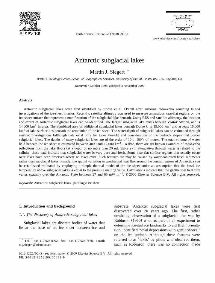
Ž .Earth-Science Reviews 50 2000 29–50www.elsevier.comrlocaterearscirev
Antarctic subglacial lakes
Martin J. Siegert )
Bristol Glaciology Centre, School of Geographical Sciences, UniÕersity of Bristol, Bristol BS8 1SS, England, UK
Received 7 October 1998; accepted 4 November 1999
Abstract
Ž . Ž .Antarctic subglacial lakes were first identified by Robin et al. 1970 after airborne radio-echo sounding RESinvestigations of the ice-sheet interior. Recently, satellite altimetry was used to measure anomalous near-flat regions on theice-sheet surface that represent a manifestation of the subglacial lake beneath. Using RES and satellite altimetry, the locationand extent of Antarctic subglacial lakes can be identified. The largest subglacial lake exists beneath Vostok Station, and is14,000 km2 in area. The combined area of additional subglacial lakes beneath Dome C is 15,000 km2 and at least 15,000km2 of lake surface lies beneath the remainder of the ice sheet. The water depth of subglacial lakes can be estimated through
Ž .seismic investigations although data exist only for Lake Vostok and consideration of the bedrock slopes that bordersubglacial lakes. The depths of many subglacial lakes are of the order of 10’s–100’s of metres. The total volume of waterheld beneath the ice sheet is estimated between 4000 and 12,000 km3. To date, there are six known examples of radio-echo
Ž .reflections from the lake floors at a depth of no more than 20 m . Since erm attenuation through water is related to thesalinity, these data indicate that subglacial water is very pure and fresh. Some near-flat surface regions that usually occurover lakes have been observed where no lakes exist. Such features are may be caused by water-saturated basal sedimentsrather than subglacial lakes. Finally, the spatial variation in geothermal heat flux around the central regions of Antarctica canbe established estimated by employing a simple thermal model of the ice sheet under an assumption that the basal icetemperature above subglacial lakes is equal to the pressure melting value. Calculations indicate that the geothermal heat fluxvaries spatially over the Antarctic Plate between 37 and 65 mW my2. q 2000 Elsevier Science B.V. All rights reserved.
Keywords: Antarctica; subglacial; lakes; glaciology; ice sheet
1. Introduction and background
1.1. The discoÕery of Antarctic subglacial lakes
Subglacial lakes are discrete bodies of water thatlie at the base of an ice sheet between ice and
) Tel.: q44-117-928-8902; fax: q44-117-928-7878; e-mail:[email protected]
substrate. Antarctic subglacial lakes were firstdiscovered over 20 years ago. The first, ratherunwitting, observation of a subglacial lake was by
Ž .Robinson 1960 who, as part of an experiment todetermine ice-surface landmarks to aid flight orienta-tion, identified ‘‘oval depressions with gentle shores’’on the ice surface. Although these features werereferred to as ‘lakes’ by pilots who observed them,such as Robinson, there was no connection made
0012-8252r00r$ - see front matter q 2000 Elsevier Science B.V. All rights reserved.Ž .PII: S0012-8252 99 00068-9
( )M.J. SiegertrEarth-Science ReÕiews 50 2000 29–5030
between ice-surface morphology and basal ice-sheetconditions. However, during the 1990s, as will bediscussed later, a relationship between surface ice-sheet morphology and subglacial lakes was estab-lished.
The first direct identification of a subglacial lakecame as a consequence of the Antarctic airborne
Ž .radio-echo sounding RES program between 1968Ž .and 1979 referred to later . Radio-echo sounding is
capable of acquiring information about the ice-sheetbase and so is instrumental in the identification ofbasal water bodies. During one of the first RESflights across the Antarctic continent a 10-km-longRES signal, representing an unusually flat subglacialsurface, was received beneath the Russian base at
ŽSovetskaya Station in central East Antarctica Robin.et al., 1970 . This signal was attributed to a ‘‘thick
Ž .layer of water beneath the ice’’ Robin et al., 1970 .Subsequent to this discovery, RES was used to iden-tify a number of other Antarctic subglacial lakesŽ .Oswald and Robin, 1973; McIntyre, 1983 . Therehave been few subsequent investigations until rela-tively recently. In the last few years a re-examinationof a large RES database has revealed new informa-tion about their size, occurrence and glacial andgeological significance of Antarctic subglacial lakes.
The aim of this paper is to summarisze what iscurrently understood about the physical character-istics of Antarctic subglacial lakes. The influencethat subglacial lakes exert on ice-sheet dynamics isdiscussed with reference to satellite altimetry of theice surface. The geological significance of subglaciallakes in terms of stores for continuous sedimentbuild-up, and sources for water outburst events arethen discussed.
1.2. A brief introduction to the Antarctic Ice Sheet
Antarctica is comprised of two main grounded icesheets; the West Antarctic and the East Antarctic icesheets. The present volume of ice in Antarctica is
3 Žaround 30,000 km equivalent to 60 m of global.sea-level of which 83% is housed within the East
Antarctic Ice Sheet. The maximum surface elevationis just over 4000 m in East Antarctica. Ice thicknessvaries between 2800 and 4500 m in the centralregions of Antarctica. The ice thickness and bedrock
Ž .elevation at the base of the ice sheet can vary
spatially by 100s of metres over a few km. The basaltopography is arranged as a series of troughs, basinsand highlands. Subglacial topography is fundamentalto the location of subglacial lakes since lakes aregenerally located within topographic hollows. TheEast and West Antarctic ice sheets are separated bythe Trans-Antarctic mountains. If the ice were to beremoved from East Antarctica, the bedrock surfacewould be above sea-level. However, if the samewere to happen over West Antarctica, even account-ing for isostatic rebound, the bedrock would remainbelow the modern sea level. Thus, the West Antarc-tic Ice Sheet is often referred to as a marine-basedice sheet. In addition to the two main ice sheets, theother significant region of grounded ice exists overthe Antarctic Peninsular where a series of ice capsand glaciers are located.
Ž .Grounded ice flows by 1 the deformation of ice,Ž . Ž .and 2 basal sliding over bedrock andror 3 defor-
mation of water saturated basal substrate. Ice isdrained from the ice domes of the ice-sheet interiorby fast flowing rivers of ice known as ‘ice streams’,where the dominant method of flow is by slidingandror basal sediment deformation. These feedgrounded ice into numerous floating ‘ice shelves’that surround the continent. The largest two iceshelves are the Ross and the Filchner-Ronne iceshelves which have an area of 526,000 and 473,000
2 Ž .km , respectively Drewry, 1983 . Icebergs, usuallyof tabular form, are calved out from the marinemargins of ice shelves, where ice thickness is usuallyaround 250–300 m. This process represents the mostimportant mechanism by which ice is lost from theice-sheet system; accounting for 85–75% of ice lossŽ .Jacobs et al., 1992; Paterson, 1994 . A full reviewof the Antarctic Ice Sheet, and methods by which icesheets flow can be found in Quaternary Science
Ž . Ž .ReÕiews Vol. 9 1990 and Paterson 1994 , respec-tively.
2. Identification, occurrence and dimensions ofsubglacial lakes
2.1. The identification of subglacial lakes
An extensive RES database is held in archive atŽ .the Scott Polar Research Institute SPRI , University

( )M.J. SiegertrEarth-Science ReÕiews 50 2000 29–50 31
of Cambridge. These data were collected between1968 and 1979 as part of the collaborative airborneRES survey of the ice sheet between the SPRI and
Ž .the Technical University of Denmark TUD and theŽ .National Science Foundation NSF of the USA. The
SPRI-TUD-NSF survey covers, through 400,000 kmof flight track, around 50% of East Antarctica, aswell as the Ross Ice Shelf and the southern most30% of West Antarctica covering a total area of ;7million km2. Since the acquisition of SPRI-TUD-NSFRES data, there have been numerous smaller RESsurveys over the some of the remaining regions ofAntarctica. However, a large part of Antarctica hasyet to be surveyed by this method. Unless statedotherwise, in this paper information from subglaciallakes has been gained from the SPRI RES database.Airborne RES works by the emission of a radiowave which is reflected off boundaries of dielectriccontrast and received again very close to the locationof transmission. The one-way travel time of theradio-wave can be multiplied by the velocity of ermradiation through the propagating material to yieldthe total distance travelled. The radio-wave velocity
y1 Žthrough ice is 168 m ms e.g., Glen and Paren,.1975 . This calculation yields information about ice
thickness with an accuracy of about 1.5%. Byrecording depth sequentially every few seconds asthe aircraft traverses across the ice sheet, a pseudo
Žcross-section of the ice sheet can be obtained Fig..1 . For the surveys performed prior to availability of
digital technology, the received radio-wave wasrecorded onto 35 mm film from which hardcopies ofthe RES data were produced. Through photographic
Ž .processing, the horizontal axis i.e., flight distancecould be compressed so that vertically exaggeratedcross-sections that comprise several 10’s to 100’s offlight track can be viewed. It should be noted thatmodern RES equipment record digital information tocomputer disks, on which processing can be per-formed using image analysis software.
Airborne RES at 60 MHz has been used success-fully to penetrate to the base of ice over 4 km thick
Ž .in Antarctica e.g., Robin et al., 1977; Drewry, 1983 .This is possible because ice is relatively transparent
Žto erm radiation at this frequency Johari and.Charette, 1975 , especially when ice is several tens
of degrees below freezing, as is the case for most ofthe Antarctic Ice Sheet.
The strength of reflection from the bed dependspredominantly upon the difference between the di-
Želectric properties of the ice real part of the dielec-.tric constant ´s3.2 , and the dielectric properties ofŽthe sub-ice material i.e., a boundary of dielectric
. Ž .contrast . As the dielectric constant of water ´s81Ž .is very different from typical bedrock ´s4 to 9 , a
much stronger reflection is obtained from an ice-water interface compared with an ice-rock interface.This difference is further increased by the relativelyrough character of an ice-bedrock interface, whichscatters energy and further reduces echo strength.
Sub-glacial lakes are identified on 60 MHz RESrecords by the presence of the three distinct charac-
Ž .teristics Fig. 1 . The first is especially strong reflec-tions from the ice-sheet base, which appear bright on35 mm film records and are typically 10–20 dBstronger than adjacent ice-bedrock reflections. Thesecond characteristic is that echoes of constantstrength occur along the track, indicative of an inter-face which is very smooth on the scale of the RESwavelength. The third is a very flat and virtually
Ž .horizontal character i.e., mirror-like , with maxi-mum slopes typically less than 1%.
Such subglacial lake radio-wave reflections arehighly distinctive and pose relatively few problemsconcerning identification from the surrounding ice-
Ž .bedrock interface Fig. 1 . However, it should benoted that accumulations of water-saturated basalsediments may also yield relatively strong radio-wavereturns, in some cases similar to those observed froman ice-water interface. Conceivably, such returnsmay be observed on the RES record as flat horizon-tal reflections. This possibility is referred to later in asection on the geological significance of subglaciallakes.
2.2. The spatial distribution of Antarctic subglaciallakes
RES records of the Antarctic ice sheet are linkedto aircraft navigational information. Because of this,the location of subglacial lake RES data can bedetermined. In addition, the length of the water bodyand the thickness of overlying ice has also beenmeasured from the RES data. Lengths of the sub-icelake records were calculated by assuming a constantaircraft speed of 300 km hy1, and should be consid-
( )M.J. SiegertrEarth-Science ReÕiews 50 2000 29–5032
Fig. 1. Typical 60 MHz radio-echo sounding records of four small Antarctic sub-glacial lakes. Note the strong, flat reflections which areŽused to identify lakes, as compared with the weaker, undulating signals reflected off the surrounding subglacial bedrock adapted from
.Dowdeswell and Siegert, 1999 .
ered as representing minimum values for water-bodyŽ .dimensions Siegert et al., 1996 .
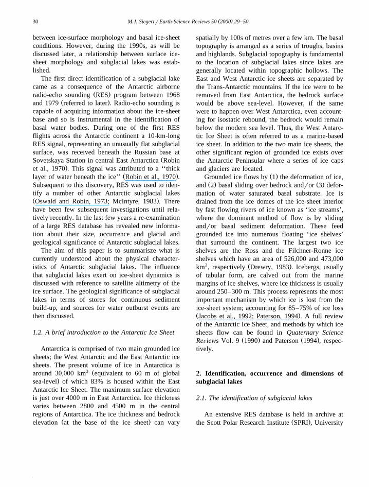
Ž .Siegert et al. 1996 identified 77 sub-glaciallake-type RES reflectors. The majority of the ob-served lakes are situated in relatively close proximity
to ice divides, where both the surface slope and iceŽ .velocity are small Fig. 2 . Two clusters of lakes,
accounting for 70% of the total lake inventory, are inregions of Dome C and Ridge B in East Antarctica.In addition, the ice divide stretching from West to
( )M.J. SiegertrEarth-Science ReÕiews 50 2000 29–50 33
Ž .Fig. 2. The locations of lakes beneath the Antarctic Ice Sheet marked by triangles , identified from 60 MHz airborne radio-echo soundingŽ .records. Ice-sheet surface elevation is contoured at 500 m intervals adapted from Siegert et al., 1996 .
Ž .East Antarctica which runs close to the South Pole ,has several sub-ice lakes along its length in the areas
Ž .of Hercules Dome and Titan Dome Fig. 2 . At least16 subglacial lakes are located away from the icedivide, close to the onset of enhanced ice-sheet flow.
It is likely that the total number of lakes identifiedŽ .by Siegert et al. 1996 is an underestimate. First,
flight-line spacing of 50-100 km over much of theSPRI-TUD-NSF survey area means that some addi-tional lakes may be present between existing flight-lines. For example, in a recent RES survey of the
Ž .central region of Dome C Fig. 2 , performed inorder to determine a location for the new EPICA icecore site, two small subglacial lakes were discoveredbetween one block of flight tracks from the SPRI-
Ž .TUD-NSF survey Tabacco et al., 1998 . Second,
where ice above a subglacial lake has been subject tobasal sliding, the ice-sheet base may include animprint of the rough upstream bedrock morphology.In this situation, RES may not record the ice-waterinterface as a ‘mirror like’ reflector and, thus, not
Ž .detect the lake Reynolds and Whillans, 1979 . Third,several regions of Antarctica have yet to be surveyedby the RES method. Therefore, it is highly likely thata number of subglacial lakes exist undetected be-neath the Antarctic Ice Sheet.
Using ice-surface topography and flow lines re-constructed for the modern Antarctic Ice Sheet from
Ž .surface altimetric data Drewry, 1983 , the distanceof each lake from the ice divide can be calculated.Several sub-glacial lakes occur on ice divides, andalmost 40% are located within 100 km of the ice

( )M.J. SiegertrEarth-Science ReÕiews 50 2000 29–5034
crest in drainage basins which are often about 1000Ž .km from divide to seaward margin Fig. 3 . The
mean thickness of ice above the lakes is about 3000m, with a standard deviation of 460 m. Less than 5%of sub-glacial lakes occur beneath ice of less than2000 m in thickness. This is consistent with theirtendency to be located close to the thick ice associ-ated with ice divides.
2.3. The dimensions of subglacial lakes from RESdata
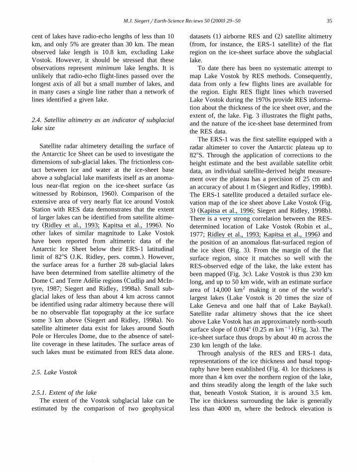
At each lake site identified from RES records, thehorizontal length of the strong, smooth basal reflec-tor has also been measured. The longest lake is 230km and is located close to Vostok Station in East
Ž .Antarctica Kapitsa et al., 1996 . Seventy-five per-
Ž .Fig. 3. a ERS-1 satellite radar altimeter map of the Lake Vostok area. Contours are every 10 m. The positions of all RES flight lines overthe lake are provided, and regions of ‘bedrock reflection’ and ‘lake reflection’ noted. The diagram indicates that the lake lies beneath
Ž . Ž .Vostok Station, and extends northwards for 230 km. b Location of Vostok Station. c Location and margin of Lake Vostok, inferred fromŽ . Ž . Ž .RES data and ERS-1 altimetry adapted from Kapitsa et al., 1996 . d RES flightlines around the Vostok Station magnified from a .Ž .Adapted from Siegert and Ridley 1998b .
( )M.J. SiegertrEarth-Science ReÕiews 50 2000 29–50 35
cent of lakes have radio-echo lengths of less than 10km, and only 5% are greater than 30 km. The meanobserved lake length is 10.8 km, excluding LakeVostok. However, it should be stressed that theseobservations represent minimum lake lengths. It isunlikely that radio-echo flight-lines passed over thelongest axis of all but a small number of lakes, andin many cases a single line rather than a network oflines identified a given lake.
2.4. Satellite altimetry as an indicator of subglaciallake size
Satellite radar altimetery detailing the surface ofthe Antarctic Ice Sheet can be used to investigate thedimensions of sub-glacial lakes. The frictionless con-tact between ice and water at the ice-sheet baseabove a subglacial lake manifests itself as an anoma-
Žlous near-flat region on the ice-sheet surface as.witnessed by Robinson, 1960 . Comparison of the
extensive area of very nearly flat ice around VostokStation with RES data demonstrates that the extentof larger lakes can be identified from satellite altime-
Ž .try Ridley et al., 1993; Kapitsa et al., 1996 . Noother lakes of similar magnitude to Lake Vostokhave been reported from altimetric data of theAntarctic Ice Sheet below their ERS-1 latitudinal
Ž .limit of 828S J.K. Ridley, pers. comm. . However,the surface areas for a further 28 sub-glacial lakeshave been determined from satellite altimetry of the
ŽDome C and Terre Adelie regions Cudlip and McIn-´.tyre, 1987; Siegert and Ridley, 1998a . Small sub-
glacial lakes of less than about 4 km across cannotbe identified using radar altimetry because there willbe no observable flat topography at the ice surface
Ž .some 3 km above Siegert and Ridley, 1998a . Nosatellite altimeter data exist for lakes around SouthPole or Hercules Dome, due to the absence of satel-lite coverage in these latitudes. The surface areas ofsuch lakes must be estimated from RES data alone.
2.5. Lake Vostok
2.5.1. Extent of the lakeThe extent of the Vostok subglacial lake can be
estimated by the comparison of two geophysical
Ž . Ž .datasets 1 airborne RES and 2 satellite altimetryŽ .from, for instance, the ERS-1 satellite of the flatregion on the ice-sheet surface above the subglaciallake.
To date there has been no systematic attempt tomap Lake Vostok by RES methods. Consequently,data from only a few flights lines are available forthe region. Eight RES flight lines which traversedLake Vostok during the 1970s provide RES informa-tion about the thickness of the ice sheet over, and theextent of, the lake. Fig. 3 illustrates the flight paths,and the nature of the ice-sheet base determined fromthe RES data.
The ERS-1 was the first satellite equipped with aradar altimeter to cover the Antarctic plateau up to828S. Through the application of corrections to theheight estimate and the best available satellite orbitdata, an individual satellite-derived height measure-ment over the plateau has a precision of 25 cm and
Ž .an accuracy of about 1 m Siegert and Ridley, 1998b .The ERS-1 satellite produced a detailed surface ele-
Žvation map of the ice sheet above Lake Vostok Fig.. Ž .3 Kapitsa et al., 1996; Siegert and Ridley, 1998b .
There is a very strong correlation between the RES-Ždetermined location of Lake Vostok Robin et al.,
.1977; Ridley et al., 1993; Kapitsa et al., 1996 andthe position of an anomalous flat-surfaced region of
Ž .the ice sheet Fig. 3 . From the margin of the flatsurface region, since it matches so well with theRES-observed edge of the lake, the lake extent has
Ž .been mapped Fig. 3c . Lake Vostok is thus 230 kmlong, and up to 50 km wide, with an estimate surfacearea of 14,000 km2 making it one of the world’s
Žlargest lakes Lake Vostok is 20 times the size of.Lake Geneva and one half that of Lake Baykal .
Satellite radar altimetry shows that the ice sheetabove Lake Vostok has an approximately north-south
Ž y1 . Ž .surface slope of 0.0048 0.25 m km Fig. 3a . Theice-sheet surface thus drops by about 40 m across the230 km length of the lake.
Through analysis of the RES and ERS-1 data,representations of the ice thickness and basal topog-
Ž .raphy have been established Fig. 4 . Ice thickness ismore than 4 km over the northern region of the lake,and thins steadily along the length of the lake suchthat, beneath Vostok Station, it is around 3.5 km.The ice thickness surrounding the lake is generallyless than 4000 m, where the bedrock elevation is

( )M.J. SiegertrEarth-Science ReÕiews 50 2000 29–5036
Ž . Ž . Ž .Fig. 4. a Ice thickness map of the Lake Vostok region. b Map of the elevation of the ice-sheet base, around the Lake Vostok region. cThe likely flow of ice over Lake Vostok. The direction of ice flow is controlled by both the surrounding easterly, and local southerly, ice
Ž .surface slopes. Adapted from Siegert and Ridley 1998b .
( )M.J. SiegertrEarth-Science ReÕiews 50 2000 29–50 37
high relative to the lake basin. The height of the lakesurface at its northern end is around y700 m above
Ž .sea level Fig. 4 . This elevation increases toward thesouth of the lake where, beneath Vostok Station, thesurface elevation of the lake is at about y300 m.
2.5.2. Water depth of Lake VostokInformation about the depth of Lake Vostok comes
Ž . Ž .from three sources: 1 seismic investigations; 2RES-derived information about the slopes of bedrock
Ž .which border the lake; and 3 reflection of 60 MHzRES waves off the lake floor.
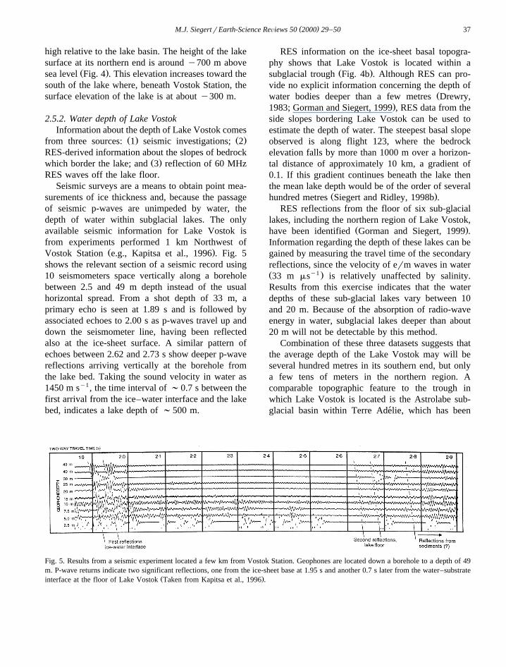
Seismic surveys are a means to obtain point mea-surements of ice thickness and, because the passageof seismic p-waves are unimpeded by water, thedepth of water within subglacial lakes. The onlyavailable seismic information for Lake Vostok isfrom experiments performed 1 km Northwest of
Ž .Vostok Station e.g., Kapitsa et al., 1996 . Fig. 5shows the relevant section of a seismic record using10 seismometers space vertically along a boreholebetween 2.5 and 49 m depth instead of the usualhorizontal spread. From a shot depth of 33 m, aprimary echo is seen at 1.89 s and is followed byassociated echoes to 2.00 s as p-waves travel up anddown the seismometer line, having been reflectedalso at the ice-sheet surface. A similar pattern ofechoes between 2.62 and 2.73 s show deeper p-wavereflections arriving vertically at the borehole fromthe lake bed. Taking the sound velocity in water as1450 m sy1, the time interval of ;0.7 s between thefirst arrival from the ice–water interface and the lakebed, indicates a lake depth of ;500 m.
RES information on the ice-sheet basal topogra-phy shows that Lake Vostok is located within a
Ž .subglacial trough Fig. 4b . Although RES can pro-vide no explicit information concerning the depth of
Žwater bodies deeper than a few metres Drewry,.1983; Gorman and Siegert, 1999 , RES data from the
side slopes bordering Lake Vostok can be used toestimate the depth of water. The steepest basal slopeobserved is along flight 123, where the bedrockelevation falls by more than 1000 m over a horizon-tal distance of approximately 10 km, a gradient of0.1. If this gradient continues beneath the lake thenthe mean lake depth would be of the order of several
Ž .hundred metres Siegert and Ridley, 1998b .RES reflections from the floor of six sub-glacial
lakes, including the northern region of Lake Vostok,Ž .have been identified Gorman and Siegert, 1999 .
Information regarding the depth of these lakes can begained by measuring the travel time of the secondaryreflections, since the velocity of erm waves in waterŽ y1 .33 m ms is relatively unaffected by salinity.Results from this exercise indicates that the waterdepths of these sub-glacial lakes vary between 10and 20 m. Because of the absorption of radio-waveenergy in water, subglacial lakes deeper than about20 m will not be detectable by this method.
Combination of these three datasets suggests thatthe average depth of the Lake Vostok may will beseveral hundred metres in its southern end, but onlya few tens of meters in the northern region. Acomparable topographic feature to the trough inwhich Lake Vostok is located is the Astrolabe sub-glacial basin within Terre Adelie, which has been´
Fig. 5. Results from a seismic experiment located a few km from Vostok Station. Geophones are located down a borehole to a depth of 49m. P-wave returns indicate two significant reflections, one from the ice-sheet base at 1.95 s and another 0.7 s later from the water–substrate
Ž .interface at the floor of Lake Vostok Taken from Kapitsa et al., 1996 .
( )M.J. SiegertrEarth-Science ReÕiews 50 2000 29–5038
likened to the Great Rift Valley in East AfricaŽCudlip and McIntyre, 1987; Siegert and Glasser,
.1997 .
2.5.3. Volume of water in Lake VostokWith an area around 14,000 km2, an envelope for
the water volume held within Lake Vostok, based oninformation relating to water depth, can be esti-mated. For example, if the 510 m depth representedan average depth, then the volume of Lake Vostokwould be 7140 km3. However, this is probably amaximum estimate. A more realistic estimate, basedon consideration of bedrock slopes at the lake mar-gins, is an average water depth of 200 m, giving awater volume of 2800 km3. A minimum estimatewould be an average water depth of 100 m, yieldinga water volume of 1400 km3. Thus, the volume ofwater within lake Vostok lies within a likely enve-lope between 7000 and 1500 km3. Kapitsa et al.Ž .1996 estimated that the water volume of LakeVostok is most likely to be 1800 km3.
3. Glaciological significance of Antarctic sub-glacial lakes
3.1. Ice sheet topography aboÕe subglacial lakes
As is the case for Lake Vostok, many othersubglacial lakes manifest themselves as relatively
Žflat regions on the ice-sheet surface compared with.the general slope of surrounding ice . This is because
shear stress at the ice-sheet basal interface is reducedto zero when over the subglacial lake, and glacialdynamics changed from the base-parallel shearing ofgrounded ice to longitudinal extension when ice is
Ž .floating as in ice shelves .As a consequence, the association between ice
surface morphology and subglacial lakes is an indi-rect one since it is basal shear stress and ice dynam-ics that controls the ice-sheet surface profile and notsolely the existence of subglacial water. For instance,an area of the ice-sheet base where no subglaciallake exists, but where very low shear stresses occurŽe.g., a region of water-saturated unlithified sedi-
.ments may also have a nearly-flat surface regionŽ .above it Siegert and Ridley, 1998a .
Not all subglacial lakes have nearly-flat ice-sheetsurface features associated with them. For examplesmall lakes do not show this feature, and neither dolakes that are located very close to or at the ice
Ž .divide Siegert and Ridley, 1998a .To date, the most extensive investigation into the
flat regions above subglacial lakes analysed ERS-1altimeter information across the Dome C region,
Žwhere a large cluster of lakes are located Siegert.and Ridley, 1998a . Analysing ERS-1 satellite radar
altimetric data from East Antarctica provided infor-Ž .mation on 1 the surface area of known subglacial
lakes, identified from the calculated area of theŽ Ž .nearly-flat surface feature as in Kapitsa et al. 1996
. Ž .for the Vostok lake , and 2 the minimum size ofknown subglacial lakes which cause the formation ofa flat region within the ice-sheet surface. If flatice-surface features are identified where RES datashow the absence of a subglacial lake, these RESdata may can be used to determine the appropriate,alternative ice-sheet basal conditions. This point isreferred to later in a section on the geological signifi-cance of subglacial lakes.
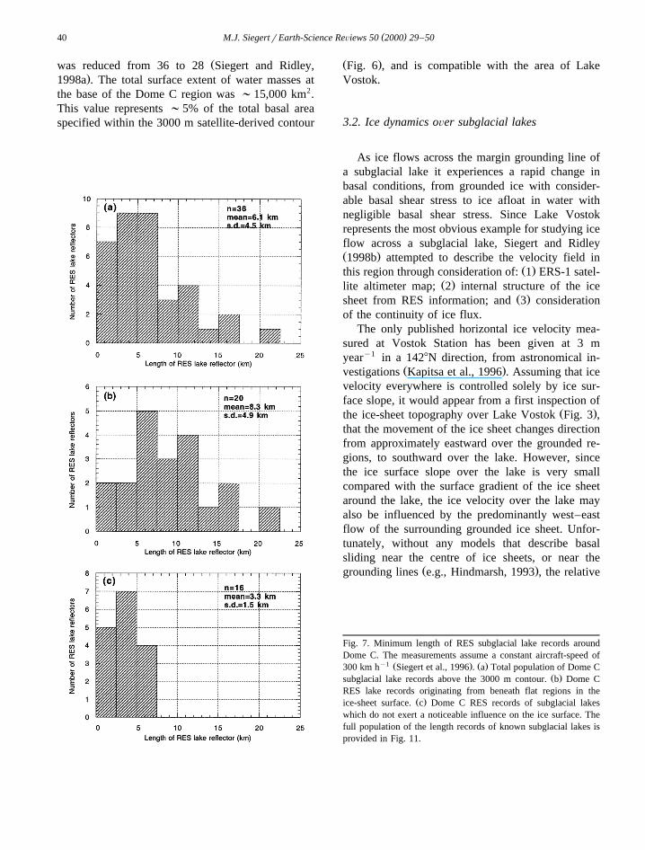
Analysis of the satellite radar altimeter map, inconjunction with the locations of subglacial lakesbeneath Dome C, shows that 20 of 36 RES lakereflectors lie beneath an ice-sheet surface slope ofless than 0.018. In general, relatively larger lakes
Žoccur beneath nearly-flat regions Dowdeswell and.Siegert, 1999 . The mean minimum length of RES
lake-type reflectors beneath ‘flat’ regions is ;8.3km, whilst it is ;3.3 km if no surface expression isobserved. Consequently, the occurrence or non-oc-currence of flat ice-sheet surface regions is con-
Ž .trolled by the size of the lake Fig. 7 . This hasimplications for the minimum size of subglacial lakesthat can be detected from satellite information, andleads to a suggestion that there may be more sub-
Ž .glacial lakes F4 km in length which lie undetectedbetween the 50–100 km separations of the RES
Ž .flight tracks Dowdeswell and Siegert, 1999 .Measurements of lake extent from satellite data
have implications for the calculated minimum lengthof lakes, determined previously from RES data. Itcan be assumed that the shape of the ERS-1-derivednear-flat surface regions, if associated with lake-typeRES reflectors, represents the shape of subglacial
Ž .lakes e.g., Kapitsa et al., 1996 . In support of this
( )M.J. SiegertrEarth-Science ReÕiews 50 2000 29–50 39
assumption, where RES data are available, the edgeof the subglacial lakes corresponds well with themargin of the flat surface region. Consequently,where the ERS-1-derived lake dimensions are largerthan those detailed in RES data, the minimum lengthsand approximate areas can be recorded directly from
Ž .the ice-surface features Figs. 6 and 7 . However, it
must be stressed that without confirmation of sub-glacial lake existence from RES data, a flat region onthe ice-sheet surface does not necessarily correspondwith a subglacial lake beneath.
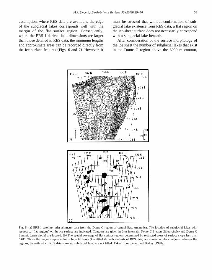
After consideration of the surface morphology ofthe ice sheet the number of subglacial lakes that existin the Dome C region above the 3000 m contour,
Ž .Fig. 6. a ERS-1 satellite radar altimeter data from the Dome C region of central East Antarctica. The location of subglacial lakes withŽ .respect to ‘flat regions’ on the ice surface are indicated. Contours are given in 2-m intervals. Dome C Station filled circle and Dome C
Ž . Ž .Summit open circle are located. b The spatial coverage of flat surface regions determined by restricted areas of surface slope less thanŽ .0.018. Those flat regions representing subglacial lakes identified through analysis of RES data are shown as black regions, whereas flat
Ž .regions, beneath which RES data show no subglacial lake, are not filled. Taken from Siegert and Ridley 1998a .
( )M.J. SiegertrEarth-Science ReÕiews 50 2000 29–5040
Žwas reduced from 36 to 28 Siegert and Ridley,.1998a . The total surface extent of water masses at
the base of the Dome C region was ;15,000 km2.This value represents ;5% of the total basal areaspecified within the 3000 m satellite-derived contour
Ž .Fig. 6 , and is compatible with the area of LakeVostok.
3.2. Ice dynamics oÕer subglacial lakes
As ice flows across the margin grounding line ofa subglacial lake it experiences a rapid change inbasal conditions, from grounded ice with consider-able basal shear stress to ice afloat in water withnegligible basal shear stress. Since Lake Vostokrepresents the most obvious example for studying iceflow across a subglacial lake, Siegert and RidleyŽ .1998b attempted to describe the velocity field in
Ž .this region through consideration of: 1 ERS-1 satel-Ž .lite altimeter map; 2 internal structure of the ice
Ž .sheet from RES information; and 3 considerationof the continuity of ice flux.
The only published horizontal ice velocity mea-sured at Vostok Station has been given at 3 myeary1 in a 1428N direction, from astronomical in-
Ž .vestigations Kapitsa et al., 1996 . Assuming that icevelocity everywhere is controlled solely by ice sur-face slope, it would appear from a first inspection of
Ž .the ice-sheet topography over Lake Vostok Fig. 3 ,that the movement of the ice sheet changes directionfrom approximately eastward over the grounded re-gions, to southward over the lake. However, sincethe ice surface slope over the lake is very smallcompared with the surface gradient of the ice sheetaround the lake, the ice velocity over the lake mayalso be influenced by the predominantly west–eastflow of the surrounding grounded ice sheet. Unfor-tunately, without any models that describe basalsliding near the centre of ice sheets, or near the
Ž .grounding lines e.g., Hindmarsh, 1993 , the relative
Fig. 7. Minimum length of RES subglacial lake records aroundDome C. The measurements assume a constant aircraft-speed of
y1 Ž . Ž .300 km h Siegert et al., 1996 . a Total population of Dome CŽ .subglacial lake records above the 3000 m contour. b Dome C
RES lake records originating from beneath flat regions in theŽ .ice-sheet surface. c Dome C RES records of subglacial lakes
which do not exert a noticeable influence on the ice surface. Thefull population of the length records of known subglacial lakes isprovided in Fig. 11.

( )M.J. SiegertrEarth-Science ReÕiews 50 2000 29–50 41
importance of the surface slope compared with thesurrounding grounded ice velocity, on the directionof ice flow over the lake cannot be calculated.
The surface of the ice sheet over Lake Vostokslopes predominantly from northwest to southeastover the northern region and from north to south
Žover the southern area of the lake with an angle of.0.0048 , compared with the approximately west to
Ž .east surface slope 0.088 of the surrounding iceŽ .sheet resting over bedrock Fig. 3 . If it is assumed
that the direction of ice flow over the sub-glacialŽ .lake is controlled solely by the surface slope Fig. 3 ,
then ice flow across the lake is generally west to easteither side of the lake, and from NW to SE over thenorthern region, to N–S over the southern area, ofthe lake. However, since the conservation of ice fluxmust apply if the ice sheet is in relative steady-state,it must be concluded that the ice-sheet flow is morelikely in an approximately W–E direction across thelake. The rationale behind this conclusion is as fol-
Ž .lows: a the ice-sheet surface slope over groundedice to the west and east of the lake has a relatively
Ž .constant value 0.088 , indicating a steady flux of icefrom the western, and out of the eastern side, of the
Ž .lake, b from this reasoning, a steady flux of iceŽoccurs over the lake from west to east i.e., approxi-
mately perpendicular to the direction of the low.ice-sheet surface slope over the lake . However,
under this rationale, the N–S slope of the ice sheetover the lake is not accounted for.
If ice flow were from north to south whilst overthe lake then, from consideration of the continuity ofice mass, the velocity field in the central EastAntarctic Ice Sheet would provide an unusually highflux of ice flowing southeastward beneath VostokStation.
If one assumes N–S ice flow over the lake, thenthe direction of ice flow must change markedly
Žacross the western margin of the lake i.e., from.eastward to southward . In this situation, assuming
that the ice-sheet is in steady-state, the flux of iceentering the 240 km long western margin of the lakemust be similar to that across the downstream edgeof the lake, at the 30 km-wide southern lake margin.Since the ice thickness only varies from 4200 m overthe North, to 3700 m over the South of the lake, thevelocity of ice across the southern margin of the lakewould have to increase dramatically in order to
provide ice flux continuity. Thus, the ice velocitybeneath Vostok Station would have to be aroundeight times more than that over the western marginŽassuming no ice is lost across the eastern side of the
.lake . The general velocity of ice in the central Easty1 wAntarctic is up to ;3 m year a maximum value,
estimated from numerical modelling studies of theŽ .xregion Huybrechts, 1992 . Thus, if ice flow is
controlled solely by surface slope, the surface veloc-ity of ice at Vostok Station would be up to ;24 myeary1. Such an ice velocity is very high for thecentre of a large ice sheet, and is inconsistent with
Žthe velocity measurement for this region 3 my1 .year in a 1428N . Moreover, there is no topo-
graphic expression in the surface elevation at Vos-tok, measured by the ERS-1 radar altimeter, for anunusually high velocity feature.
In order to account for both the N–S slope of ice,and the conservation of ice mass, it was proposedthat the ice velocity field is dominated by the west–east movement of grounded ice, but that a N–Svelocity component is established when the ice is
Ž .located over the lake Siegert and Ridley, 1998b .Under this scenario, the ice flowline turns clockwiseand then anti-clockwise as ice moves from west to
Ž .east across the lake Fig. 4c . New interferometricSAR data used to calculate the ice velocity acrossLake Vostok, is in agreement with this conceptual
Ž .model of ice flow R. Kwok, pers. comm. .Thus, Lake Vostok exerts a significant influence
on the dynamics of the ice sheet which lies over it.In addition, the nearly constant surface slopes to thewest and east of the lake, suggest that Lake Vostokdoes not influence ice-sheet behaviour away from itsmargins.
To recap, the systematic analysis of the AntarcticRES database identified 68 sub-glacial lake-type re-flectors, within several regions of Antarctica. Manyof these subglacial lakes have a noticeable topo-graphic expression on the ice-sheet surface. There-fore, several subglacial lakes in addition to LakeVostok, possess a dynamic control on the ice sheet.For example, around the Dome C region of EastAntarctica, the surface area occupied by subglaciallakes is estimated to represent ;5% of the ice-sheet
Ž .base Siegert and Ridley, 1998a . Therefore, it canbe inferred from analysis of the data from LakeVostok that other subglacial lakes may exert a dy-

( )M.J. SiegertrEarth-Science ReÕiews 50 2000 29–5042
namic influence on at least 5% of the interior EastAntarctic Ice Sheet.
3.3. Salinity of lake water and the formation ofAntarctic subglacial lakes
There have been two proposals for the formationof Antarctic subglacial lakes. The first is that thelakes have been formed as part of the relatively
Žstable ice-sheet configuration e.g., Shoemaker,.1991 . The second is that they represent pre-glacial
Žwater bodies i.e., terrestrial lakes or regions of.sea-floor that were subsequently overridden by
glacial ice. The former theory dictates that subglacialmelting, as occurs within the central regions ofAntarctica today from geothermal heating, is thesource of subglacial lake water. The water is routed
Žsomehow into bedrock troughs such as in Lake.Vostok where it collects to form a lake. Under this
rationale, the salinity of the lake water is likely to besimilar to that of the basal layers of ice. From whatis understood about the salinity of deep ice withinAntarctic ice cores, this salinity value is likely to beextremely low. However, under the latter proposal, ifsubglacial lakes are relics from past terrestrial lakesor sea-floor regions, then the salinity could be muchhigher. Thus, identification of the salinity of sub-glacial lakes is fundamental to understanding theirformation.
There are two means by which the salinity ofsubglacial lake water can be established. First isthrough consideration of how the ice sheet effec-
Žtively ‘floats’ in the subglacial lake Oswald and.Robin, 1973; Kapitsa et al., 1996 . The second is by
analysing faint erm reflections that have been ob-served from the floors of a few subglacial lakesŽ .Gorman and Siegert, 1999 .
RES data collected along the 230 km length ofLake Vostok shows information regarding the ice
Ž .thickness accurate to 1.5% . When this is plottedagainst the ERS-1-derived surface elevation, the datashould lie along a straight line, the gradient of whichis proportional to the ratio of the density of ice and
Ž .water Fig. 8 . From the Vostok ice core, the densityof ice at the base is likely to be around 0.913 g cmy3
Ž .Kapitsa et al., 1996 . The gradient of the best fitŽ .line Fig. 8 corresponds with a salinity value of
between 0.00 and 0.05‰. Also provided on Fig. 8 isa line that corresponds with seawater, at a salinityvalue of 35‰, that does not fit well with the data.
The manner in which erm radiation is attenuatedthrough water is related to the conductivity. In turn,conductivity of water is dependent on salinity of thewater. By measuring the decay of radio-waves inwater, from analysis of the power reflected fromsubglacial lake floors, the electrical conductivity can
Ž .be determined Gorman and Siegert, 1999 . Thisprocedure has shown the electrical conductivity of
Fig. 8. The salinity of Antarctic subglacial lakes. Ice thickness vs. surface elevation for ice over Lake Vostok. Note how the gradient of theŽ .best fit line corresdponds with that for fresh water, whereas a seawater line does not link the data points. Taken from Kapitsa et al. 1996 .
( )M.J. SiegertrEarth-Science ReÕiews 50 2000 29–50 43
Antarctic subglacial lake water is between 3.08=y4 y1 Ž10 mhos m for water-saturated sand at the lake. y4 y1 Ž .floor and 5.36=10 mhos m for bedrock .
The electrical conductivity of fresh water is 10y4
mhos my1. Thus estimates of electrical conductivitywithin subglacial lakes show that the water is very
Ž .pure and fresh Gorman and Siegert, 1999 .
4. Geological significance of Antarctic subglaciallakes
Antarctic subglacial lakes represent an importantcomponent of the central regions of glacierisedAntarctica. Although the ice sheet may be relatively
Žstable i.e., it is neither in, nor about to enter, a.period of rapid oscillations in volume and extent the
ice sheet exists as a dynamic configuration in whichice is constantly flowing towards the ice margin, andwhere the associated glacial erosion and sedimenttransport are active processes. Subglacial lakes havean influence on ice dynamics, act as sedimentarytraps and house a vast amount of water. Undercertain glaciological conditions subglacial lake watercould be transported to the glacier margins. This isespecially true for lakes located at the onset ofenhanced ice flow. Subglacial lakes also allow us todetermine thermal conditions within the ice sheetthat are related to the geothermal heat flux throughthe Earth’s crust. Thus, there are several areas ofpotential glacial–geological interest that can be ex-plored through examination of Antarctic subglaciallakes.
4.1. Sedimentation within subglacial lakes
The basal layers of ice within the Greenland IceSheet are characterised by the entrainment of sedi-
Ž .ment as observed in the GRIP ice core . Althoughno ice core has reached the bed in East Antarctica, itseems relatively safe to assume that the base of EastAntarctica will consist of sediment laden ice. Justifi-cation for this assumption is from observations ofbasal melting and sliding that will encourage the
Žentrainment of sediment into ice Hubbard and Sharp,.1993 .
Ž .Zotikov 1987 identified a number of aspectsinvolved in the process of sedimentation within sub-glacial lakes. The first is that ice flow across sub-
glacial lakes occurs as a result of the decoupledice-water interface. Thus, ice flow across the lake atthe ice-sheet base will occur, resulting in a relativelyconstant supply of ‘dirty’ basal ice to the surface ofthe lake. Secondly, thermodynamic modelling of theice sheet indicates that the rate of basal melting willbe of the order of 1 mm yeary1. Because of this, thesedimentation rate is likely to be very low. However,subglacial lakes may be several million years old.Consequently, even under relatively minute sedimen-tation rates, a significant thickness of sediment would
Ž .build up. Zotikov 1987 suggested that sedimentbuild-up within subglacial lakes may be 10’s to100’s of metres in thickness. In addition, the sedi-mentary record within subglacial lakes woulddemonstrate a complete history of Antarctic ice-sheetvariability, dating back to the time at which the lake
Ž .was formed possibly several millions of years . Nodirect measurements of sedimentation within sub-glacial lakes have been made.
In addition to the flat ice-sheet surface regionsŽ .identified at Dome C Fig. 9 , an inspection of the
Antarctic ERS-1 satellite altimeter data has revealeda relatively large flat region which appears analo-
Ž .gous to that in the Vostok area Fig. 3a . Thissurface feature is located at 808S, 1278E, and has asurface slope of 0.028 within a regional surface dip
Ž .of 0.098 Fig. 9 . The surface slope is twice the valueused in the criterion for flat region identification, butthe sudden change in slope from that of the sur-
Žrounding ice sheet which is similar to that observed.over the Vostok lake , means that it should be inves-
tigated as a potential surface feature resulting fromthe presence of a subglacial lake. The RES data forthis region indicate a relatively undulating basal
Ž .return Fig. 9b which suggests that a subglacial lakeŽis not present in this area reflections from subglacial
.lakes are unusually flat or mirror-like . However, theRES signal does show relatively bright subglacialreturns which may be indicative of radio-wave re-flections in the presence of water at the ice-sheet
Ž .base. Siegert and Ridley 1998a suggest that the flatregion on the ice surface may be caused by a reduc-
Žtion in the basal shear stress similar to that which.occurs over subglacial lakes due to the existence of
geotechnically weak water-saturated basal sediment.If water-saturated sediments are capable of induc-
Žing flat regions on the ice surface appearing similar
( )M.J. SiegertrEarth-Science ReÕiews 50 2000 29–5044
.to those formed by subglacial lakes , then it can beconcluded that the identification of subglacial lakescannot be made through the interpretation of satellite
radar altimeter data alone. However, satellite radaraltimeter data can help to determine areas wheresubglacial lakes may exist, and where additional

( )M.J. SiegertrEarth-Science ReÕiews 50 2000 29–50 45
RES data are required to confirm the presence ofsignificant subglacial water bodies. Such featuresmay represent subglacial lakes that have been filledwith glacier-derived sediment.
4.2. Thermal regime aboÕe subglacial lakes
The existence of large volumes of water beneaththe East Antarctic Ice Sheet has significant conse-quences for analysing the thermal regime of the icesheet. The presence of sub-glacial lakes indicatesthat, in the region of the ice sheet over and adjacentto the lake, the temperature of the ice-sheet base is at
Žthe pressure melting point Siegert and Dowdeswell,.1996 .
Basal ice-sheet temperatures are controlled by anumber of parameters including ice thickness, ice-sheet surface temperature and accumulation rate, heattransported through horizontal advection of ice, the
Žbasal heat gradient the sum of geothermal heat flux,.and heat produced from basal sliding and heat de-
rived from internal ice deformation. The basal heatgradient is dependent on the flow at the ice-sheetbase, and its magnitude will therefore increase withdistance from the ice divide as ice-sheet velocityincreases. However, at the ice divide, the sole supplyof basal heat will be from the geothermal processes.A simple numerical model of the ice-sheet thermalregime in such regions will indicate the geothermalenergy required to allow basal melting to take place.
A model that can be used for such a purpose wasŽ .developed by Robin 1955 . The equation used is:
'p dTT sT y l erf hrl 1Ž . Ž .B S ž /2 d z B
where
2khls 2Ž .(
b
and
dT Lgeosy 3Ž .ž /d z KB
Symbols used in the above equations are defined asfollows: T is the basal temperature of the ice sheetBŽ .8C ; T is the mean annual surface temperature ofS
Ž .the ice sheet 8C ; z is the coordinate in the verticaldirection, positive upwards and zero at the ice-sheetbase; h is the ice thickness above the sub-glacial
Ž .lake m ; b is the mean annual surface accumulationŽ y1 .of the ice sheet above the lake m year ; k is the
Ž 2 y1.thermal diffusivity of ice 36.3 m year ; K is theŽ y1 y1.thermal conductivity of ice 2.10 W m 8C ; and
ŽL is the Earth’s geothermal heat flux 54 mWgeoy2 .m , unless stated otherwise . The Error Function
Ž Ž ..erf hrl is a tabulated function just as a Sine orŽLogarithmic function Abramowitz and Stegun,
.1970 .As mentioned previously, the ice thickness, h,
above a sub-glacial lake can be measured directlyfrom the time-dependent raw radio echo soundingdata. Assuming that the surface air temperature ap-proximates the surface temperature of the ice sheetŽ .Loewe, 1970 , the surface temperature of the icesheet, T , can be obtained from the map of meanS
annual air temperature, determined from field mea-Ž .surements Robin, 1955 . Surface accumulation on
the ice-sheet surface above each lake, b, was ob-tained from a map of accumulation, interpolated
Žfrom direct field measurements Giovinetto and.Bentley, 1985 . Thus, assuming that the temperature
above a subglacial lake is at the pressure meltingŽ .value, Eq. 1 can be solved for L .geo
Consideration of the spatial distribution of sub-Ž .glacial lakes shows that many ;40% are locatedŽ .directly over, or relatively close -100 km to, ice
Ž .divides Fig. 2 . The ice sheet at and around icedivides will experience little basal heat derived from
Ž .Fig. 9. a ERS-1 satellite altimeter data from an unusually flat region to the south of Dome C. RES flightlines around this region are shown.Ž .Contours are given in 2 m intervals where the ice surface is relatively flat, and in 10 m intervals elsewhere. b Airborne RES information
Ž .from flight no. 135, 1978–1979. The location markers AB refer to those indicated in a . The basal reflection is identified as the non-flatline above the note ‘ice-sheet base reflection’. The location of this flat surface region is provided in Fig. 1a. Note that the sub-parallel wavy
Ž .lines in the lower half of b represent scratches on the original RES negative used to obtain the photograph. Taken from Siegert and RidleyŽ .1998a .

( )M.J. SiegertrEarth-Science ReÕiews 50 2000 29–5046
horizontal ice motion terms. Consequently, the basalŽ .heat gradient required by Eq. 1 to calculate the
pressure melting temperature above sub-glacial lakeslocated in such regions, will be associated mainlywith the supply of geothermal heat. This geothermalheat gradient is calculated for sub-glacial lakes thatlie along, or close to, the ice divide. In this experi-
Ž .ment, the minimum geothermal heat flux L thatmin
allows the pressure melting temperature to be reachedis determined. Variation of the calculated minimumbasal heat gradient within the ice sheet close to icedivides will, therefore, be due mainly to changes inthe geothermal heat flux within the Antarctic conti-nent.
Comparing the geographical location of thosesub-glacial lakes which exist near to ice divides withL , illustrates that the geothermal heat flux variesmin
Ž .spatially around the Antarctic Plate Fig. 10 . Forexample, at Dome C, Talos Dome and Titan Dome,the datapoints illustrated in Fig. 10 are tightly clus-tered with little variation in the minimum geothermal
Ž y2 .heat flux between 41 and 58 mW m . However,the L around the large lake near to Vostok Sta-min
tion appears to remain at or below 43 mW my2 ,while at Ridge B it is between 37 and 42 mW my2
Ž .Fig. 10 . For lakes located around the HerculesDome region the minimum geothermal heat flux
required for basal pressure melting is consistentlyy2 Ž .above 60 mW m Fig. 10 . Consequently, the
geothermal heat flux in the Hercules Dome region ofAntarctica may be around 20–25 mW my2 higherthan that in Ridge B, and 10-15 mW my2 higherthan in Dome C.
From the analysis of the geothermal heat proper-ties beneath sub-glacial lakes, it can be suggestedthat, beneath ice divides of the East Antarctic IceSheet, the Antarctic Plate’s geothermal heat fluxvaries between about 37 and 64 mW my2 .
It should be noted that several datapoints in Fig.Ž .10 relate to sub-glacial lakes that lie far )400 km
from an ice divide. In such cases, the minimum basalŽ Ž ..heat gradient Eq. 3 required to calculate the
pressure melting value at the ice-sheet base shouldbe regarded as a combination of the heat derived
Žfrom the Earth plus horizontal ice-motion terms i.e.,.internal ice deformation and basal sliding .
4.3. Subglacial water Õolume
Quantification of the exact volume of subglacialwater held beneath the Antarctic Ice Sheet cannot bedetermined unequivocally. However, by evaluatingŽ .1 the area of subglacial lakes and maximum and
Ž .minimum end-member values for 2 the water depth
Fig. 10. Imposed basal heat flux required to induce pressure melting against the distance of the lake, along the direction of ice flow, fromthe nearest ice divide. Data points are identified with respect to geographical location. The graph illustrates the amount of basal heatrequired to ensure basal melting above sub-glacial lakes, and how this relates to the location of the lake within the ice sheet. See Fig. 2 for
Ž .locations of named regions of Antarctica. Taken from Siegert and Dowdeswell 1996 .
( )M.J. SiegertrEarth-Science ReÕiews 50 2000 29–50 47
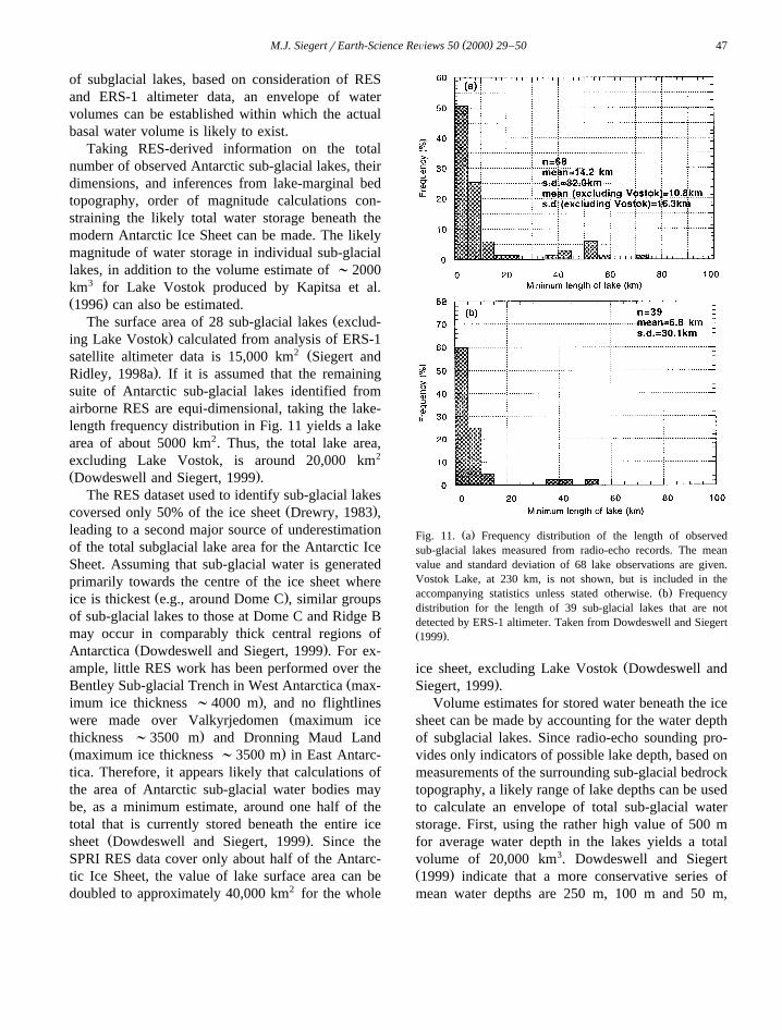
of subglacial lakes, based on consideration of RESand ERS-1 altimeter data, an envelope of watervolumes can be established within which the actualbasal water volume is likely to exist.
Taking RES-derived information on the totalnumber of observed Antarctic sub-glacial lakes, theirdimensions, and inferences from lake-marginal bedtopography, order of magnitude calculations con-straining the likely total water storage beneath themodern Antarctic Ice Sheet can be made. The likelymagnitude of water storage in individual sub-glaciallakes, in addition to the volume estimate of ;2000km3 for Lake Vostok produced by Kapitsa et al.Ž .1996 can also be estimated.
ŽThe surface area of 28 sub-glacial lakes exclud-.ing Lake Vostok calculated from analysis of ERS-1
2 Žsatellite altimeter data is 15,000 km Siegert and.Ridley, 1998a . If it is assumed that the remaining
suite of Antarctic sub-glacial lakes identified fromairborne RES are equi-dimensional, taking the lake-length frequency distribution in Fig. 11 yields a lakearea of about 5000 km2. Thus, the total lake area,excluding Lake Vostok, is around 20,000 km2
Ž .Dowdeswell and Siegert, 1999 .The RES dataset used to identify sub-glacial lakes
Ž .coversed only 50% of the ice sheet Drewry, 1983 ,leading to a second major source of underestimationof the total subglacial lake area for the Antarctic IceSheet. Assuming that sub-glacial water is generatedprimarily towards the centre of the ice sheet where
Ž .ice is thickest e.g., around Dome C , similar groupsof sub-glacial lakes to those at Dome C and Ridge Bmay occur in comparably thick central regions of
Ž .Antarctica Dowdeswell and Siegert, 1999 . For ex-ample, little RES work has been performed over the
ŽBentley Sub-glacial Trench in West Antarctica max-.imum ice thickness ;4000 m , and no flightlines
Žwere made over Valkyrjedomen maximum ice.thickness ;3500 m and Dronning Maud Land
Ž .maximum ice thickness ;3500 m in East Antarc-tica. Therefore, it appears likely that calculations ofthe area of Antarctic sub-glacial water bodies maybe, as a minimum estimate, around one half of thetotal that is currently stored beneath the entire ice
Ž .sheet Dowdeswell and Siegert, 1999 . Since theSPRI RES data cover only about half of the Antarc-tic Ice Sheet, the value of lake surface area can bedoubled to approximately 40,000 km2 for the whole
Ž .Fig. 11. a Frequency distribution of the length of observedsub-glacial lakes measured from radio-echo records. The meanvalue and standard deviation of 68 lake observations are given.Vostok Lake, at 230 km, is not shown, but is included in the
Ž .accompanying statistics unless stated otherwise. b Frequencydistribution for the length of 39 sub-glacial lakes that are notdetected by ERS-1 altimeter. Taken from Dowdeswell and SiegertŽ .1999 .
Žice sheet, excluding Lake Vostok Dowdeswell and.Siegert, 1999 .
Volume estimates for stored water beneath the icesheet can be made by accounting for the water depthof subglacial lakes. Since radio-echo sounding pro-vides only indicators of possible lake depth, based onmeasurements of the surrounding sub-glacial bedrocktopography, a likely range of lake depths can be usedto calculate an envelope of total sub-glacial waterstorage. First, using the rather high value of 500 mfor average water depth in the lakes yields a totalvolume of 20,000 km3. Dowdeswell and SiegertŽ .1999 indicate that a more conservative series ofmean water depths are 250 m, 100 m and 50 m,
( )M.J. SiegertrEarth-Science ReÕiews 50 2000 29–5048
producing total stored water volumes of approxi-mately 10,000 km3, 4000 km3 and 2000 km3, respec-tively. To each of these values should be added the
3 Ž .2000 km estimated by Kapitsa et al. 1996 forLake Vostok. This then yields an envelope of be-tween about 4000 and 12,000 km3 for the likelyvolume of water stored in modern Antarctic sub-gla-
Ž .cial lakes Dowdeswell and Siegert, 1999 .
4.4. EÕacuation of subglacial water
The RES-derived measurements of both the totalvolume of water stored as lakes beneath the Antarc-tic Ice Sheet, and the size of individual water bodies,provides an analogue for conditions at the base ofthe large ice sheets which developed over mid andhigh northern latitudes during Quaternary full glacialconditions. The identification of subglacial lakes atthe onset of enhanced ice flow is an importantfinding since these former ice sheets may have pos-sessed a similar relationship between ice streams andbasal water.
Several of Dowdeswell and Siegert’s findings areŽ .of particular significance to: a the likely magnitude
of outburst flood events from full glacial ice sheetsŽ .and the release of waters to the global ocean, and b
the consequences of such meltwater release for sub-glacial and proglacial landscapes, and for the marinegeological record of, for example, Heinrich Events.Even if the water from all the observed Antarcticsubglacial lakes was released at the same time, thevolume involved would probably be less than 12,000km3. Given the very wide geographical distributionof lakes over the Antarctic Ice Sheet, it is highlyunlikely that such synchronous drainage would takeplace. A water volume of 12,000 km3 in Antarcticsubglacial lakes is equivalent to about 35 mm ofglobal sea level rise. If the largest subglacial lake,
3 Žthe 2000 km lake at Vostok Station Kapitsa et al.,.1996 , were to drain alone, a sea level equivalent of
about 6 mm would be transferred to the globalocean. Other large lakes identified during RES inves-tigations would, if drained to the ocean, probablyproduce less than 1000 km3 of water or -3 mm of
Ž .sea level equivalent Dowdeswell and Siegert, 1999 .It should be noted that the observations of
Ž .Dowdeswell and Siegert 1999 are probably lessrepresentative of ice surface and basal conditionsduring Quaternary deglaciations, where large quanti-
ties of meltwater are likely to have been produced atthe ablating surface and may have penetrated to thebed. However, the association between subglaciallakes and warm-based enhanced flow of ice mayremain valid for these periods, since a hydrologicalconnection between the lakes and ice margin isrequired for an outburst event.
5. Summary and conclusions
Airborne RES is capable of identifying subglaciallakes beneath up to 4 km of ice in Antarctica. Manysubglacial lakes have a flat surface region on the icesheet directly above them which can be surveyed bysatellite altimetry. Using RES and ERS-1 altimeterinformation, the location and size of subglacial lakescan be established. A number of inventories of sub-glacial lakes have been compiled in the last 25 years.
Ž .Oswald and Robin 1973 identified 17 subglaciallakes around Dome C and Ridge B. The large sub-glacial lake at Vostok Station was identified by
Ž .Robin et al. 1977 . An examination of post 1973Ž .RES data by McIntyre 1983 increased this number
to 64. However a re-examination of these data identi-Žfied 77 subglacial lake-type reflectors Siegert et al.,
.1996 . The ERS-1 satellite altimeter can be used todetermine the surface topography above subglaciallakes and, in so doing, provides information onwhich subglacial RES lake-type reflectors corre-spond with the same lakes. Siegert and RidleyŽ .1998a analysed these two datasets and concludedthat 68 individual lakes are known to exist. Thisnumber can actually be increased to 71 after theidentification of 3 further lakes in proximity with the
Ž .Dome C station Tabacco et al., 1998 .It is clear from Fig. 2 that the majority of the
observed lakes are situated in relatively close prox-imity to ice divides, where both the surface slope andice velocity are small. Two clusters of lakes, ac-counting for 70% of the total lake inventory, are inregions of Dome C and Ridge B in East AntarcticaŽ .Fig. 2 . In addition, the ice divide stretching from
ŽWest to East Antarctica which runs close to the.South Pole , has several sub-ice lakes along its length
Žin the areas of Hercules Dome and Titan Dome Fig..2 .
The largest subglacial lake exists beneath and upto 230 km to the north of Vostok Station, central
( )M.J. SiegertrEarth-Science ReÕiews 50 2000 29–50 49
Ž .East Antarctica Kapitsa et al., 1996 . The extent ofŽ 2 .Lake Vostok 14,000 km was able to be deter-
mined with accuracy due to the flat surface regionthat exists above the lake which is measurable from
Ž .the ERS-1 altimeter Fig. 3 .The sudden change in the surface slope of the ice
sheet above Lake Vostok is due to a rapid alterationin the ice dynamics from grounded to floating ice, asice flows over the margin of the lake. Assuming thatthe ice sheet is in relative steady-state, considerationsof continuity of mass show that the ice flows overthe lake in a direction controlled more by the pre-dominantly eastward slope of the surroundinggrounded ice sheet, than by the low southward slope
Ž .of the ice sheet over the lake Fig. 4c . The influenceof Lake Vostok on ice dynamics is limited to itsshorelines. Assuming this to be true for the 68 othersub-glacial lakes have been detected within Antarc-tica, Antarctic sub-glacial lakes may have a controlon the dynamics of the central regions of the icesheet, where they currently occupy ;5% of theice-sheet base.
The water depths of Antarctic lakes can be estab-lished from three methods. First is by seismic inves-tigations, where the p-wave two-way travel-time dif-ference between reflectors from the ice-water and thewater-lake-floor interfaces yield allow the calcula-tion of lake depth. The one depth-calculation hasbeen made using the seismic technique at LakeVostok recorded a water depth of 510 m a few kmfrom Vostok Station. Second is by consideration ofbedrock slopes at the margins of subglacial lakes.Calculations of these slopes from RES informationshow that, by extrapolating these slopes beneath lakesurfaces, a water depth of several 10’s–100’s ofmetres is likely. The third method of determininglake-depth comes from analysis of erm reflectorsfrom the water-lake floor interface. In total, six ofthese reflectors have been identified, and indicatewater depths of around 10-20 m in all cases. Thus, itcan be concluded that subglacial lakes are not thinŽ .cm scale layers of water, but are 10’s of metresdeep in most cases.
Assuming the set of Antarctic sub-glacial lakesidentified from airborne RES are equi-dimensional,the lake length–frequency distribution in Fig. 11ayields a total lake area of about 20,000 km2, plus14,000 km2 for Lake Vostok. Given that SPRI RES
data cover only about 50% of the ice sheet, thisvalue is doubled to about 40,000 km2.
An envelope of mean water depths of 250 m, 100m and 50 m, produces total stored water volumes ofapproximately 10,000 km3, 4000 km3 and 2000 km3,respectively. Adding the ;2000 km3 estimated by
Ž .Kapitsa et al. 1996 for Lake Vostok, this gives anenvelope of between about 4000 and 12,000 km3 forthe likely volume of water stored in contemporaryAntarctic sub-glacial lakes. This represents a globalsea-level equivalent of 10–35 mm.
From analysis of radio-wave attenuation in sub-glacial water, the conductivity of Antarctic sub-gla-cial water bodies varies between about 1-2=10y2
y1 Ž .mhos m ; reflecting very fresh water 1–3 PSUbeneath the Antarctic Ice Sheet. This finding hasimplications for theories about the formation of sub-glacial lakes. There are two main ideas, the first ofwhich is that subglacial lakes form from basal melt-water that collects within subglacial topographic hol-lows, the second is that lakes represent ancient lakesor sea bed which was overridden by ice during theonset of Antarctic glaciation.
RES data from the ice base beneath two flatŽsurface regions within the Dome C district identi-
.fied as a and b in Fig. 6 , and a further large flatŽ .region located at 808S, 1278E Fig. 9 , do not indi-
cate the existence of subglacial lakes. However, therelatively high strength of these RES signals suggestthe existence of basal water and, conceivably,water-saturated basal sediments. The low yield stressof such material would influence the ice-sheet dy-namics in a manner similar to the negligible basalstress above subglacial lakes. Consequently, the icesurface morphology above regions of deforming sed-iment may be comparable with surface features abovesubglacial lakes. In addition, the absence of sub-glacial lakes within deep troughs where basal melt-ing is likely to be occurring, such as the AdventureSubglacial Trough, suggests that the transport ofwater must be occurring at the base of the centralAntarctic Ice Sheet.
By assuming that the ice temperature about abovesubglacial lakes is equal to the pressure meltingvalue, for the case of lakes that lie at or very close tothe ice divide a simple thermal model allows aprediction of the geothermal heat flux at the base ofthe Antarctic Ice Sheet. The geothermal heat flux
( )M.J. SiegertrEarth-Science ReÕiews 50 2000 29–5050
calculated to ensure basal melting of the ice sheety2 Ž .was between 37 and 64 mW m Fig. 10 .
Acknowledgements
Funding for this review was provided by NERCgrant GR9r2532.
References
Abramowitz, M., Stegun, I.A., 1970. Handbook of mathematicalfunctions, Dove Publications, New York.
Cudlip, W., McIntyre, N.F., 1987. Seasat altimeter observations ofan Antarctic ‘‘lake’’. Ann. Glaciol. 9, 55–59.
Dowdeswell, J.A., Siegert, M.J., 1999. The dimensions and topo-graphic setting of Antarctic subglacial lakes and implicationsfor large-scale water storage beneath continental ice sheets.Geol. Soc. Am. Bull. 111, 254–263.
Drewry, D.J., 1983. Antarctica: Glaciological and GeophysicalFolio, Scott Polar Research Institute, Univ. of Cambridge.
Giovinetto, M.B., C.R. Bentley, 1985. Surface balance in icedrainage systems of Antarctica, Antarctic Journal, XX-4.
Glen, J.W., Paren, J.G., 1975. The electrical properties of snowand ice. J. Glaciol. 15, 15–38.
Gorman, M.R., Siegert, M.J., 1999. Penetration of Antarctic sub-glacial water masses by VHF electromagnetic pulses: esti-mates of minimum water depth and conductivity of basalwater bodies, J. Geophys. Res.
Hindmarsh, R.C.A., 1993. Modelling the dynamics of ice sheets.Progress in Physical Geography 17, 391–412.
Hubbard, B., Sharp, M., 1993. Weertman regelation, multiplerefreezing events and the isotopic evolution of the basal icelayer. J. Glaciol. 39, 275–291.
Huybrechts, P., 1992. The Antarctic ice sheet and environmentalchange: a three dimensional modelling study. Reports on Polar
ŽResearch Alfred-Wegener-Institut fur Polar und Meeres-¨.forschung 99.
Jacobs, S.S., Hekmer, H.H., Doake, C.S.M., Jenkins, A., Frolich,R.M., 1992. Melting of ice shelves and the mass balance ofAntarctica. J. Glaciol. 38, 375–387.
Johari, G.P., Charette, P.A., 1975. The permittivity and attenua-tion in polycrystalline and single-crystal ice Ih at 35 and 60MHhz. J. Glaciol. 14, 293–303.
Kapitsa, A., Ridley, J.K., Robin, G. de Q., Siegert, M.J., Zotikov,I., 1996. A large deep freshwater lake beneath the ice ofcentral East Antarctica. Nature 381, 684–686.
Loewe, F., 1970. Screen temperatures and 10 m temperatures. J.Glaciol. 9, 263–268.
McIntyre, N.F., 1983. The topography and flow of the Antarcticice sheet. Unpublished PhD thesis, Univ. of Cambridge, Eng-land.
Oswald, G.K.A., Robin, G. de Q., 1973. Lakes beneath theAntarctic ice sheet. Nature 245, 251–254.
Paterson, W.S.B., 1994. The Physics of Glaciers, 3rd edn., Perga-mon, 480 pp.
Reynolds, R., Whillans, I.M., 1979. Glacial-bed types and theirradar-reflection characteristics. J. Glaciol. 23, 439.
Ridley, J.K., Cudlip, W., Laxon, S.W., 1993. Identification ofsubglacial lakes using ERS-1 radar altimeter. J. Glaciol. 39,625–634.
Robin, G. de Q., 1955. Ice movement and temperature distributionin glaciers and ice sheets. J. Glaciol. 3, 589–606.
Robin, G. de Q., Drewry, D.J., Meldrum, D.T., 1977. Interna-tional studies of ice sheet and bedrock. Philos. Trans. R. Soc.London 279, 185–196.
Robin, G. de Q., Swithinbank, C.W.M., Smith, B.M.E., 1970.Radio echo exploration of the Antarctic ice sheet. Int. Assoc.Sci. Hydrol. Publ. 86, 97–115.
Robinson, R.V., 1960. Experiment in visual orientation duringflights in the Antarctic. International Bulletin of the SovietAntarctic Expeditions 18, 28–29.
Shoemaker, E.M., 1991. On the formation of large subglaciallakes. Can. J. Earth Sci. 28, 1975–1991.
Siegert, M.J., Dowdeswell, J.A., 1996. Spatial variations in heat atthe base of the Antarctic ice sheet from analysis of the thermalregime above sub-glacial lakes. J. Glaciol. 42, 501–509.
Siegert, M.J., Glasser, N.F., 1997. Convergent flow of ice throughthe Astrolabe sub-glacial trough, Terre Adelie, East Antarc-tica. Polar Research 16, 63–72.
Siegert, M.J., Ridley, J.K., 1998a. Determining basal ice-sheetconditions at Dome C, central East Antarctica, using satelliteradar altimetry and airborne radio-echo sounding information.J. Glaciol. 44, 1–8.
Siegert, M.J., Ridley, J.K., 1998b. An analysis of the surface andsub-surface topography of the Vostok Station subglacial lake,
Ž .central East Antarctica. J. Geophys. Res. 103 B5 , 10195–10208.
Siegert, M.J., Dowdeswell, J.A., Gorman, M.R., McIntyre, N.F.,1996. An inventory of Antarctic subglacial lakes. AntarcticSci. 8, 281–286.
Tabacco, I.E., Passerini, A., Corbelli, F., Gorman, M., 1998.Determination of the surface and bed topography at Dome C,East Antarctica. J. Glaciol. 44, 185–190.
Zotikov, I.A., 1987. The thermophysics of glaciers, Reidel, Dor-drecht.
Martin J. Siegert is a University Lecturer at the Bristol GlaciologyCentre, School of Geographical Sciences, University of Bristol.He graduated from the University of Reading in 1989 afterreading Geological Geophysics, and gained his Ph.D. in numericalice sheet modelling from the University of Cambridge in 1994.Dr. Siegert then spent 4 years as a lecturer at the Centre forGlaciology, University of Wales, Aberystwyth. His research inter-ests include the measurement and modelling of large ice masses,understanding ice sheet identification and understanding of sub-glacial lakes.
Copyright © 2022 FDOKUMEN