Mantle anisotropy beneath northwest Pacific subduction zones
Upload
independentCategory
view
1download
0
Part 1
Glacier dynamics and sedimentation
GSP_4_C01.qxd 11/5/07 13:17 Page 1
Debris apron comprising reworked fluvial and wind-blown sands with internal deformation including thrusting, atWright Lower Glacier, Victoria Land, Antactica. (Photograph by M.J. Hambrey)
GSP_4_C01.qxd 11/5/07 13:17 Page 2

Hydrological connections between Antarctic subglacial lakes, the flow of water beneath the East Antarctic Ice Sheet
and implications for sedimentary processes
MARTIN J. SIEGERT*, ANNE LE BROCQ† and ANTONY J. PAYNE†
*School of GeoSciences, Grant Institute, University of Edinburgh, West Mains Road, Edinburgh, EH9 3JW, UK (e-mail: [email protected])
†Centre for Polar Observation and Modelling, Bristol Glaciology Centre, School of Geographical Sciences, University of Bristol, Bristol BS8 1SS, UK
ABSTRACT
Subglacial lakes are commonly referred to as unique environments isolated for millions of years.The recent detection of a rapid transmission of water between subglacial lakes indicates, however,that these environments may be connected hydrologically and that sporadic discharge of lake watermay be an expected process. Knowledge of this flow at a continental scale is important to under-standing habitats provided by subglacial lakes, the potential routes by which stored basal water canbe exported to the ice margin and the development of glacial-fluvial landforms. Here, an assess-ment of Antarctic subglacial water flow-paths is presented, based on hydro-potential gradients derivedfrom basal and ice surface topographies. The assessment reveals that most subglacial lakes aroundDome C are likely to be linked. One flow-path in particular connects >10 lakes located within adjacenttopographic valleys, including Lake Concordia and Lake Vincennes. Subglacial water at Dome C hasthe potential to flow to the ocean, as the ice base is warm continuously between the ice divideand the margin. Such flow is likely to be organised into distinct drainage basins, in which water isrouted to the proglacial zone through only a small number of outlets, which potentially has a stronginfluence on the development of sedimentary landforms.
Keywords basal hydrology, ice-sheet dynamics, glacial history
INTRODUCTION
Rapid release of water from subglacial lakes, andwell-organised (probably channellised) flow ofthis water to other lakes, have been demonstratedrecently from analysis of satellite altimetric surfacechanges (Wingham et al., 2006). Such flow may bea common means by which stored water is re-distributed beneath the East Antarctic Ice Sheet. The paths of such flow have also been shown to be predictable through consideration of thesubglacial water pressure potential (Shreve, 1972).The number of measured Antarctic subglaciallakes currently stands at 145, the majority ofwhich are located around the Dome C and RidgeB regions of East Antarctica (Siegert et al., 2005a).Thermomechanical ice-sheet models predict basal
temperatures at or near the pressure-melting pointin these regions (e.g. Huybrechts, 1990; Siegertet al., 2005b). It is possible, therefore, that manyAntarctic subglacial lakes are hydrologically con-nected. The aim of this paper is to provide a firstassessment of the expected hydrological paths inthe vicinity of known Antarctic subglacial lakes,focussing on the Dome C and Ridge B regionswhere there is sufficient surface and subglacialtopography data to constrain the water pressure calculation to at least a gross level (i.e. ±25 km) and to investigate the potential geomorphologicalimplications of these paths. Such assessment isimportant to determining the likelihood of waterescaping to the ice sheet margin, explaining theonshore and offshore sedimentary record, evaluat-ing the habitats of subglacial lakes and planning
GSP_4_C01.qxd 11/5/07 13:17 Page 3

4 M.J. Siegert et al.
future exploration of these extreme environments(e.g. Priscu et al., 2005).
CALCULATING SUBGLACIAL WATER FLOW-PATHS
Assuming that subglacial water pressure (p) isequal to the pressure of the overlying ice, the flow-paths of subglacial water can be calculated from thepressure potential (φ), i.e. the sum of gravitationalpotential energy and water pressure, followingShreve (1972): p = ρigh, φ = p + (ρwgzb) and, therefore,φ = ρigzs + (ρw − ρi)gzb, where ρw is the density ofwater (1000 kg m−3), g is the gravitational accelera-tion (9.81 m s−2), zb (m) is the elevation of the bed,zs (m) is the elevation of the ice surface, ρi is thedensity of ice (910 kg m−3) and h (m) is the over-lying ice thickness (i.e. zs − zb). Using values of zb
derived from the BEDMAP topographic dataset of Antarctica (Lythe et al., 2000), and zs from theRAMP altimetric dataset of Antarctica (Liu et al.,1999), the water pressure potential for the entire ice sheet base can be calculated. Flowpaths can thenbe constructed assuming that water flow is per-pendicular to pressure potential contours.
Although it must be noted that the BEDMAPdataset does not represent a comprehensive evalu-ation of subglacial topography, at some locationsit is an appropriate dataset for the calculation ofbasal water flowpaths. At Dome C, topographic coverage is good enough to denote the large-scaletopography (features with lateral extent ≥10 km)well. Importantly, roughness at a smaller scale atDome C has been shown to be low (Siegert et al.,2005b), which suggests the likelihood of substan-tial topographic barriers to water flow is low in this region. The accuracy of the dataset has beenshown to be sufficient to predict the flowpath ofwater between subglacial lakes >250 km apart(Wingham et al., 2006).
FLOW OF WATER BENEATH THE ICE SHEET
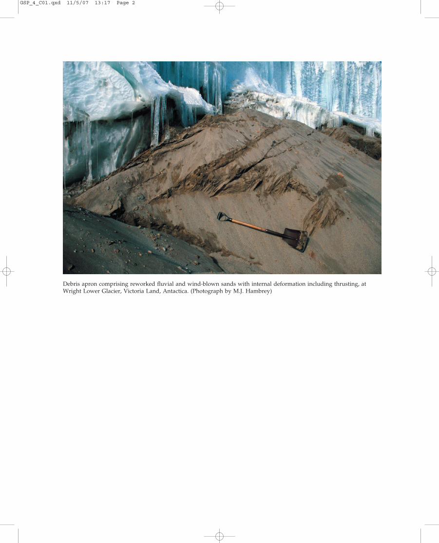
Antarctic subglacial water drainage is organized into a series of distinct catchments and pathways(Fig. 1). While the ice surface slope dictates to a firstorder the direction of subglacial water flow, basaltopography has a noticeable effect on flow-paths.It is important to note that there are very few, if
any, significant regions where water may pond(i.e. where there is a local minimum in the piezosurface). Hence the potential for the build up of verylarge subglacial lakes, such as Lake Vostok, is low(nb. Lake Vostok is not identified by this method,as BEDMAP does not account for the bathymetryof this large lake). At Dome C there are no largemeasurable water-pressure ‘basins’. Consequently,the vast majority of the subglacial landscape willbe involved in a large-scale hydrological networkbeginning at the ice sheet centre and terminatingat the margin.
Results from thermomechanical ice sheet model-ing show many regions of the Antarctic Ice Sheet ator near the pressure melting temperature (Fig. 2A),including the location of lakes around Dome C (Fig. 2B). If the regional ice sheet base is warm, itis highly likely that water will flow at the baseaccording to Shreve (1972). If the ice base is belowthe pressure melting point, hydrological connec-tions may still be possible, but additional energywill be required from the flow locally to both raisethe temperature and melt ice. Such energy may beavailable from rapid releases (e.g. Wingham et al.,2006).
There are at least three continuous warm-basedpathways from the Dome C interior to the ice mar-gin: to the Byrd Glacier within the TransantarcticMountains; to Totten Glacier in Wilkes Land; andto the Mertz and Ninnis glaciers in George V Land.At Ridge B, there is also a continuously warm-based hydrological pathway to Byrd Glacier (Figs 2 and 3).
The association between known subglacial lakes,modelled warm basal conditions, and a predicteddendritic basal drainage network, in which smallertributaries feed larger trunk pathways, makes it possible that subglacial lakes are connected into a hierarchical drainage system, within which lake-water mixing (and consequently biodiversity)may increase toward the ice margin. Furthermore,under this ordered system, the total water flux fromlake discharges is likely to increase towards the margin. We anticipate that much of the melt watergenerated at the centre of the ice sheet could wellpass through several connected lakes during its passage to the ice sheet margin. In fact, flow to themargin must happen unless it can be refrozen tothe underside of the ice sheet in sufficient quant-ities to balance melt water generated. Winghamet al. (2006) expected the flow of lake water to be
GSP_4_C01.qxd 11/5/07 13:17 Page 4
Hydrological connections between Antarctic subglacial lakes, the flow of water beneath the East Antarctic Ice Sheet and implications 5
sporadic and inherently unstable. They reasonedthat if a hydrological connection existed betweena subglacial lake and the ocean, there would be little to stop the lake draining (as the ice marginhas a far lower potential than the centre of the ice sheet base) provided there is sufficient energyavailable to melt the channel through which waterflows, and to deform the ice (i.e. for draining andponding of water).
SUBGLACIAL LAKE CONNECTIONS
Examination of how hydrological flow-paths linksubglacial lake locations allows an indication of the
Fig. 1 The location of 145 known Antarctic subglacial lakes, the ice-sheet surface elevation (both adapted from Siegert etal., 2005a), and large-scale flow-paths of subglacial water. Ice surface contours are provided in 500 m intervals. The largestdrainage basins are coloured distinctly, although no significance is attached to these colours.
potential connectivity of subglacial lakes (Fig. 3).In particular, where numerical modelling predictswarm basal conditions such connectivity is likely(Fig. 2).
Most subglacial lakes around Dome C arelocated within or close to smooth topographiclowlands, which are thought to be the product ofancient glacial erosion by a former smaller ice cap(Drewry, 1975; Siegert et al., 2005b). The predictedflow-paths of subglacial water allow us to developan understanding of possible hydrological link-ages between lakes at Dome C (Fig. 3).
The majority of subglacial lakes at Dome C connect to at least one lake downstream. A largeproportion of these feed into more than one
90°W 90°E
180°
0°
70°
75°
80°
Subglacial lake
Byrd Glacier
1000 km7505002500
NinnisGlacier
MertzGlacier
TottenGlacier
BellingshausenSea
WeddellSea
Amery IceShelf
Filchner-Ronne
IceShelf
AmundsenSea
RossSea
GSP_4_C01.qxd 11/5/07 13:17 Page 5

A0 500 1000km
200
200 250
0
–2
–4
–6
–8
Bas
al te
mpe
ratu
re °
C
–10
–12
–14
–16
–18
–20
B0.2
0.18
0.16
0.14
0.12
Pre
dict
ed b
asal
wat
er d
epth
(m)
0.1
0.08
0.06
0.04
0.02
0
150
150
100
100
50
50
East AntarcticaEast AntarcticaEast Antarctica
Fig. 2 (A) Basal temperature of the Antarctic Ice Sheet (in °C), derived from a thermomechanical ice sheet model(adapted from Siegert et al., 2005b), and the locations of Antarctic subglacial lakes (shown as solid triangles apart from Lake Vostok, which is outlined). (B) The location of basal water (the average depth in m), predicted by the icesheet model, around the Dome C and Dome A regions. Names of subglacial lakes are as follows: LV, Lake Vostok; AL, Aurora Lake, LC, Lake Concordia; VL; Vincennes Lake. The positions of potential water flow-paths, as provided in Fig. 1, are also included.
GSP_4_C01.qxd 11/5/07 13:17 Page 6

Hydrological connections between Antarctic subglacial lakes, the flow of water beneath the East Antarctic Ice Sheet and implications 7
downstream lake. One hydrological flow-pathconnects lakes within the Vincennes Subglacial Basin and the Adventure Subglacial Trench, where subglacial lake connectivity has been observed(Wingham et al., 2006). This path involves the
connection of over 20 individual lakes, includingLake Concordia and the Vincennes Lake (Tabaccoet al., 2003; Tikku et al., 2005) (Fig. 2B). Althoughsubglacial water flow into Lake Concordia haspreviously been postulated by Tikku et al. (2005),
Lakes that are downstream of <2 lakesLakes that are downstream of 2–5 lakesLakes that are downstream of >5 lakes
Lakes that are upstream of >5 known lakesLakes that are upstream of 2–5 lakesLakes that are upstream of <2 lakes
Fig. 3 Complete drainage pathways of subglacial water around the Dome C and Ridge B regions of East Antarctica.The key reveals how subglacial lakes are coded to illustrate whether they are fed by, or feed into, other subglacial lakes.The largest drainage basins are coloured distinctly as in Fig. 1. Blue regions denote floating ice, while black shaderepresents the ocean.
GSP_4_C01.qxd 11/5/07 13:17 Page 7
8 M.J. Siegert et al.
the flowpaths out of the lake along warm basal conditions makes it highly likely that water alsoescapes from Lake Concordia to, possibly, severallakes downstream.
As even small changes to the ice sheet surfacehave large consequences for subglacial hydrology,the present distribution of basal flowpaths isunlikely to be fixed through time. That said, thelarge-scale subglacial topography has a strongeffect on water flow, which runs along the axes of many subglacial valleys around Dome C. Con-sequently, while small changes to the position of the ice divide may result in reconfiguration of the boundaries of drainage basins, it probably will not affect the flow routes of water along sub-glacial valleys. Hence, many of the subglacial lakeconnections found today may have existed in a similar stable form over the past few glacial cycles(during which time topography would probablyhave been largely unchanged).
IMPLICATIONS FOR SUBGLACIAL LAKEEXPLORATION AND OUTBURST FLOODING
The notion of subglacial lakes (including LakeVostok) as isolated water bodies (e.g. Siegert, 1999;Priscu et al., 2003) is clearly in need of revision. As a consequence, plans to explore subglacial lakeenvironments must take note of the probability of a hydrological system that connects lakes both upstream and downstream. Such a system willinfluence a number of environment parameters of the lake system, including hydrochemistry(including solute acquisition), water residencetimes, biodiversity (between lakes) and water circulation. In terms of risk during exploration, itis now clear that should a lake be contaminated during in situ examination, other lakes locateddownstream may well be affected over time.Clearly this is an issue that must be considered by proposals to explore many of the subglacial lakes across Dome C, but probably not all. Acrossthe lowlands, which have well defined flow-paths,where quite large lakes are located, these con-cerns will be greatest. Over the higher ground somelakes could be hydrologically isolated. Further geo-physical survey on such lakes to define the basalhydrology further is a prerequisite to exploratoryexamination.
As ice-sheet modelling indicates continuouswarm based conditions from Dome C to the coast(Fig. 2) it is likely that subglacial lake water couldescape the ice sheet. The subglacial drainage sys-tem indicates only a few outlets of such water, however (Fig. 3). The majority of lakes drain intothe Byrd Glacier drainage basin, which cuts acrossthe Transantarctic Mountains and into the RossIce Shelf. Most other lakes at Dome C feed into theAurora basin and the Totten Glacier, from wherelake water could flow into the ocean.
The probability of substantial volumes of melt-water being issued to the ice margin by rapidlydraining Antarctic subglacial lakes has importantimplications for active subglacial geomorpholo-gical processes. Now that subglacial lake out-bursts have been identified as probably beingcommonplace, a logical next step is to identifyand comprehend evidence of such activity in thepast. For example, the Antarctic Dry Valleys con-tain channels of 103 m2 in cross-section that attestto intense subglacial floods of considerable size(Denton & Sugden, 2005) that reached the ice sheetmargin. Today, the potential path of subglacial waterinto the Dry Valleys comes from the Wilkes Basin,where several subglacial lakes are known to exist.As noted by Denton & Sugden (2005), expansionof the ice sheet in this area would reduce the ice-surface slope over the Wilkes Basin, so allowingwater to pond and be issued in potentially largequantities to the ice margin and the ocean. Similargeomorphological observations have been meas-ured on the Soya Coast (Sawagaki & Hirakawa,1997). Investigation of surface geomorphological andsedimentary records for further evidence of pastflooding events is clearly warranted to establish, ifpossible, the rates, magnitudes and frequencies ofsubglacial lake floods.
Direct observations of subglacial water ‘outbursts’are clearly critical to evaluating the dynamics of the process, but are currently restricted to a singleevent in 1985 at Casey Station in East Antarctica,which lasted six months (Goodwin, 1988). Thissingle observation is testament to the possibility of flooding from beneath polar ice masses, where little or no melting occurs on the surface. Accord-ing to Goodwin (1988) the origin of the flood wasstored subglacial water, which collected slowlyover time until a threshold was reached, uponwhich rapid unstable outflow occurred. The process
GSP_4_C01.qxd 11/5/07 13:17 Page 8

Hydrological connections between Antarctic subglacial lakes, the flow of water beneath the East Antarctic Ice Sheet and implications 9
witnessed at Casey Station may, therefore, be applic-able to other regions of stored subglacial water suchas at Dome C.
IMPLICATIONS FOR ICE DYNAMICS ANDGLACIAL SEDIMENTARY PROCESSES IN EAST ANTARCTICA
The collection and transfer of water from largeupstream subglacial catchments to discrete regionsof the ice sheet margin has potential implicationsfor ice stream dynamics. It is highly likely that thebases of at least some East Antarctic ice streams areunderlain by sedimentary material (e.g. Bamber et al., 2006). Such sediments, to become weak to the point of deforming to facilitate ice flow, needto be saturated with water. The results presentedhere indicate that the bulk of water emanatingfrom the Dome C region can be routed into only afew ice-marginal outlets. The consequence is thatany sedimentary material beneath the Byrd, Totten,Mertz and Ninnis outlet glaciers is likely to be fedwith water. Unless this water escapes to the marginvia well defined channels, it will act to increase pore-water pressures and so reduce the strength ofsediments, which will increase ice velocity. Thedeformation of sediments beneath ice streams willdrive material in the direction of ice flow to the ice margin and, given that the supply of water tothese outlets is likely to have occurred over a con-siderable period (the LGM ice sheet configurationof East Antarctica is quite similar to that of today;Huybrechts, 2002), the build up of very large pro-glacial sedimentary sequences, possibly developedover millions of years, should be expected. If nosubglacial sediment is present beneath East Antarcticice streams (i.e. the glaciers rest on bedrock), waterfrom upstream catchments may still influence iceflow provided distributed subglacial hydrologicalsystems operate (Kamb, 1987).
The rapid transfer of subglacial water may alsolead to glaciofluvial sedimentary processes, sim-ilar to that proposed in huge magnitude by Shawet al. (1989) and Shaw (1996), and on a lesser scaleby Shoemaker (1992), for the formation of drumlinfields across southern Canada during the lastglacial phase. The distribution of subglacial waterbeneath the Antarctic ice sheet, involving episodicdischarges from subglacial lakes, is likely to be a
common process (Wingham et al., 2006). It is there-fore likely that subglacial sedimentary landforms,moulded by the occasional rapid supplies ofsignificant quantities of water, are actively beingdeveloped in Antarctica. The implication of this, forinterpretation of the sedimentary geological record,is that many landforms may originate from short-term fluvial processes operating beneath large icesheets as well as longer-term processes such as iceflow. The subsequent task is to identify the degreeto which glacial landforms exhibit signs of subglacialfluvial activity in order to ascertain the influenceof subglacial discharges on past and present ice-sheet dynamics.
ACKNOWLEDGEMENTS
Funding for this work was provided by the UKNatural Environment Research Council’s Centre for Polar Observation and Modelling (CPOM).ALB acknowledges funding of a UK NERC PhDstudentship (no. NER/S/D/2003/11902).
REFERENCES
Bamber, J.L., Ferraccioli, F., Shepherd, T., Rippin, D.M.,Siegert, M.J. and Vaughan, D.G. (2006) East Antarcticice stream tributary underlain by major sedimentarybasin. Geology, 34, 33–36.
Denton, G.E. and Sugden, D.E. (2005) Meltwater featuresthat suggest Miocene ice-sheet overriding of theTransantarctic Mountains in Victoria Land, Antarctica.Geogr. Ann., 87 A, 67–85.
Drewry, D.J. (1975) Initiation and growth of the EastAntarctic ice sheet. J. Geol. Soc. London, 131, 255–273.
Goodwin I.D. (1988) The nature and origin of a jökulhlaup near Casey Station, Antarctica. J. Glaciol.,34, 95–101.
Huybrechts, P. (1990) A 3-D model for the Antarctic IceSheet: a sensitivity study on the glacial-interglacial contrast. Climate Dynamics, 5, 79–92.
Huybrechts, P. (2002) Sea-level changes at the LGMfrom ice-dynamic reconstructions of the Greenland and Antarctic ice sheets during the glacial cycles.Quatern. Sci. Rev., 21, 203–231.
Kamb, B. (1987) Glacier surge mechanism based onlinked cavity configuration of the basal water conduitsystem. J. Geophys. Res., 92, 9083– 9100.
Liu, H., Jezek, K.C. and Li, B. (1999) Development of an Antarctic digital elevation model by integrating
GSP_4_C01.qxd 11/5/07 13:17 Page 9

10 M.J. Siegert et al.
cartographic and remotely sensed data: A geographicinformation system based approach. J. Geophys. Res.,104, 23199–23213.
Lythe, M.B., Vaughan, D.G. and the BEDMAP consortium(2000) BEDMAP – bed topography of the Antarctic.1:10,000,000 map, BAS (Misc.), 9. Cambridge: BritishAntarctic Survey.
Priscu, J.C., Bell, R.E., Bulat, S.A., Ellis-Evans, J.C.,Kennicutt, M.C. II., Lukin, V.V., Petit, J.R., Powell, R.D.,Siegert, M.J. and Tabacco, I.E. (2003) An internationalplan for Antarctic subglacial lake exploration. PolarGeogr., 27, 69–83.
Sawagaki, T. and Hirakawa, K. (1997) Erosion ofbedrock by subglacial meltwater, Soya Coast, EastAntarctica. Geogr. Ann., 79, 223–238.
Shaw, J. (1996) A meltwater model for Laurentide sub-glacial landscapes. In: Geomorphology Sans Frontiers.(Eds McCann, S.B. and Ford, D.C.). London, Wiley,181–236.
Shaw, J., Kvill, D. and Rains, R.B. (1989) Drumlins andcatastrophic subglacial floods. Sed. Geol., 62, 177–202.
Shreve, R.L. (1972) Movement of water in glaciers. J. Glaciol., 11, 205–214.
Shoemaker, E.M. (1992) Water sheet outburst floodsfrom the Laurentide Ice Sheet. Can. J. Earth Sci., 29,1250–1264.
Siegert, M.J. (1999) Antarctica’s Lake Vostok. AmericanScientist, 87, 510–517.
Siegert, M.J., Carter, S., Tabacco, I.E., Popov, S. andBlankenship, D.D. (2005a) A revised inventory ofAntarctic subglacial lakes. Antarct. Sci., 17, 453–460.
Siegert, M.J., Taylor, J. and Payne, A.J. (2005b) Spectralroughness of subglacial topography and implicationsfor former ice-sheet dynamics in East Antarctica.Global Planet. Change, 45, 249–263.
Tabacco, I.E., Forieri, A., Vedova, A.D., Zirizzotti, A.,Bianchi, C., De Michelis, P. and Passerini, A. (2003)Evidence of 14 new subglacial lakes in the Dome C-Vostok area. Terra Antarct., 8, 175–179.
Tikku, A.A., Bell, R.E., Studinger, M., Clarke, G.K.C.,Tabacco, I. and Ferraccioli, F. (2005) Influx of melt-water to subglacial Lake Concordia, East Antarctica.J. Glaciol., 51, 96–104.
Wingham, D.J., Siegert, M.J., Shepherd, A.P. and Muir, A.S. (2006) Rapid discharge connects Antarcticsubglacial lakes. Nature, 440, 1033–1036.
GSP_4_C01.qxd 11/5/07 13:17 Page 10
Copyright © 2022 FDOKUMEN