2019 Final Report - Antarctic Treaty
353
Final Report of the Forty-second Antarctic Treaty Consultative Meeting
-
Upload
khangminh22 -
Category
Documents
-
view
4 -
download
0
Transcript of 2019 Final Report - Antarctic Treaty

Final Report of the Forty-secondAntarctic Treaty Consultative
Meeting


Secretariat of the Antarctic TreatyBuenos Aires
2019
ANTARCTIC TREATY CONSULTATIVE MEETING
Final Report of the Forty-second
Antarctic Treaty Consultative Meeting
Prague, Czech Republic1 - 11 July 2019
Volume

www.ats.aq
87 9

Contents
VOLUME I

Endurance

VOLUME II

63840
434550515252

Acronyms and Abbreviations


PART II
Measures, Decisions and Resolutions (Cont.)


4. Management Plans


Measure 1 (2019)
Management Plan for Antarctic Specially Protected Area (ASPA) No. 123
BARWICK and BALHAM VALLEYS, SOUTHERN VICTORIA LAND
Introduction The Barwick and Balham Valleys are located within Antarctic Specially Managed Area (ASMA) No. 2 McMurdo Dry Valleys, Victoria Land, Ross Sea. The Area is centered at 160° 57' E, 77° 21' S and is approximately 423 km2 in area. The Barwick and Balham Valleys are rarely visited and are an important reference area for comparing changes in other Dry Valley ecosystems which are regularly visited for scientific purposes. The Area contains examples of a wide variety of the environments found in the polar desert ecosystem. Some of the best examples of the physical surface features associated with this unique and extreme environment are found on the valley floors, where there are also fine examples of microbial life, lichens, as well as soil and lake microflora.
Barwick and Balham Valleys were originally designated as Site of Special Scientific Interest (SSSI) No. 3 through Recommendation VIII-4 (1975) after a proposal by the United States of America. A number of Recommendations extended the Management Plan expiry dates (Recommendation X-6 (1979), Recommendation XII-5 (1983), Recommendation XIII-7 (1985), and Resolution 7 (1995)). Measure 2 (2000) advanced the expiry date of the management plan from 31 December 2000 until 31 December 2005. Decision 1 (2002) renamed and renumbered SSSI No. 3 as Antarctic Specially Protected Area No. 123. Measure 1 (2002) designated the Area for an indefinite period, enlarged the original Area to include more of the Balham Valley catchment and rationalized it to exclude the Victoria Upper Glacier catchment. Measure 6 (2008) amended the Management Plan to include additional provisions to reduce the risk of microbial and vegetation introductions from soils at other Antarctic sites or from regions outside Antarctica. Measure 3 (2013) updated literature, improved the map of the Area, and made minor adjustments to provisions on aircraft access. The boundary was adjusted to follow the Barwick / Balham catchments more precisely. Soil geochemistry analyses on samples collected in 2015 revealed low-level contamination present at a former soil pit near Lake Vashka. However, the low absolute levels overall and the very limited spatial extent of contamination observed suggest that the pristine nature of the Area is being maintained and its value as a reference site remains valid.
The Area is classified as Environment S – McMurdo - South Victoria Land geologic based on the Environmental Domains Analysis for Antarctica (Resolution 3 (2008)) and is classified as Region 9 – South Victoria Land under the Antarctic Conservation Biogeographic Regions (ACBR) classification (Resolution 3 (2017)).
1. Description of values to be protectedAn area of 325 km2 at Barwick Valley, including part of adjacent Balham Valley, was originally designated in Recommendation VIII-4 (1975, SSSI No. 3) after a proposal by the United States of America on the grounds that it was “one of the least disturbed and contaminated of the Dry Valleys of Victoria Land” and was important as a reference base against which to measure changes in comparable ecosystems of the other Dry Valleys where scientific investigations were being regularly conducted. The site remains distant from field stations and has not been subjected to intensive visitation or research. The Barwick Valley was first visited in 1958 and several subsequent expeditions were conducted in the 1960s through to 1975, after which time visits have been few because of the designation of the SSSI. Although some human impacts from these early expeditions were visible within the region in 1993-94, Barwick and Balham Valleys are believed to remain one of the least impacted areas in the McMurdo Dry Valleys region of Antarctica. Soil samples collected in 2015 showed evidence of low levels of metals and hydrocarbon contamination at one previously disturbed site near Lake Vashka. However, given the low magnitude and very limited spatial extent of
15

ATCM XLII Final Report contamination observed, as well as very low absolute levels of contaminants observed in samples taken nearby, the largely pristine nature of the Area is being maintained and its value as a reference site is considered to remain valid.
The boundaries of the original Area were re-designed in Measure 1 (2002) so they followed the Barwick and Balham catchments more truthfully, resulting in a total area of 418 km2 (correction from 480 km2, an error in Measure 1 (2002)), which were again adopted without change in Measure 6 (2008). The catchment boundaries were refined further in 2013 based on improved mapping, resulting in an increase in total area from 418 km2 to 423 km2. The boundary remains unchanged in the current Management Plan.
The McMurdo Dry Valleys have a unique and extreme polar desert ecosystem. The Area contains examples of a wide variety of the environments found in this ecosystem, including desert pavements, sand dunes, patterned ground, glacial and moraine features, streams, freshwater and saline lakes, valleys and high-altitude ice-free ground. Some of the best examples of ventifact pavements and weathering-pitted dolerites are found on the valley floors, along with examples of chasmolithic lichens, layered communities of endolithic lichens, fungi, algae and associated bacteria, and populations of soil and lake microflora. Special protection of the Area provides the opportunity to conserve a relatively pristine example of this ecosystem as a baseline for future reference. Protection on a catchment basis serves to provide greater representation of the ecosystem features, and also facilitates management of the Area as a geographically distinct and integrated ecological system. The high ecological values, as well as the scientific, aesthetic and wilderness values derived from the isolation and relatively low level of human impact are important reasons for special protection at Barwick and Balham Valleys.
2. Aims and objectives Management at Barwick and Balham Valleys aims to:
• avoid degradation of, or substantial risk to, the values of the Area by preventing unnecessary human disturbance to the Area;
• conserve the natural ecosystem as a reference area largely undisturbed by direct human activities; • allow scientific research on the natural ecosystem and physical environment in the Area provided it is for
compelling reasons which cannot be served elsewhere; • minimize human disturbance to the Area by preventing unnecessary sampling; • prevent or minimize the introduction to the Area of alien plants, animals and microbes; • allow visits for management purposes in support of the aims of the management plan.
3. Management activities The following management activities shall be undertaken to protect the values of the Area:
• Notices showing the location of the Area (stating the special restrictions that apply) shall be displayed prominently, and a copy of this Management Plan shall be kept available, at permanent scientific stations located within the Ross Sea region;
• All pilots operating in the region shall be informed of the location, boundaries and restrictions applying to entry, overflight and landings within the Area;
• National programs shall take steps to ensure the boundaries of the Area and the restrictions that apply within are marked on relevant maps and nautical / aeronautical charts;
• Markers, signs or structures erected within the Area for scientific or management purposes shall be secured and maintained in good condition, and removed when no longer required;
• Any abandoned equipment or materials shall be removed to the maximum extent possible provided doing so does not adversely impact on the environment and the values of the Area;
• Visits shall be made as necessary to assess whether the Area continues to serve the purposes for which it was designated and to ensure management and maintenance measures are adequate;
• National Antarctic Programs operating in the region shall consult together with a view to ensuring the above management activities are implemented.
16

ASPA No. 123 – Barwick and Balham Valleys, Southern Victoria Land
4. Period of designation Designated for an indefinite period.
5. Maps Map 1: ASPA No. 123 Barwick and Balham Valleys – topography and boundary.
Map specifications: Projection: Lambert conformal conic; Standard parallels: 1st 77° 15' S; 2nd 77° 25' S; Central Meridian: 161° 10' E; Latitude of Origin: 78° 00' S; Spheroid and datum: WGS84.
Inset 1: Ross Sea region, showing the location of the McMurdo Dry Valleys and Inset 2.
Inset 2: McMurdo Dry Valleys and Ross Island, showing location of McMurdo Station (US) and Scott Base (NZ), Antarctic Specially Managed Area No. 2 McMurdo Dry Valleys (ASMA No.2).
6. Description of the Area
6(i) Geographical coordinates, boundary markers and natural features
General description
Barwick Valley (161° 57' E, 77° 21' S) is situated about 65 km inland from the Ross Sea coast of southern Victoria Land (Map 1 and Insets). The Area includes Barwick and Balham Valleys and their respective catchments and is bordered on the south, west and north by the McKelvey Valley, the Willet Range and the divide between the Victoria and Barwick Valleys, respectively.
Boundaries and coordinates
The boundary of the Area extends from its eastern extremity in the lower Barwick Valley (around the confluence of the Barwick, Victoria and McKelvey Valleys) several kilometers south towards the ridge leading SW to the summit of Mount Insel (1345 m, 161 30.74' E, 77 23.50' S), from where the boundary follows the high points of the ridge of the Insel Range over Halzen Mesa for 5.5 km before descending to a low pass between the McKelvey and Balham Valleys at the location of Bullseye Lake (722 m, 161° 14.41' E, 77° 24.78' S). The boundary crosses the lake before ascending the ridge to a further high point on Canfield Mesa on the Insel Range (approximately 1250 m), and continues over Green Mesa to follow Rude Spur to Mount Cassidy (1917 m) and onwards to the upper reaches of the Balham Valley. As the terrain becomes gentler in the upper Balham and approximately 6.5 km southeast of the summit of Shapeless Mountain (2736 m), the boundary extends northward at an elevation of between 1800 – 1900 m towards the Huka Kapo Glacier and Apocalypse Peaks. The boundary extends NW from the Huka Kapo Glacier for approximately 9 km towards a prominent ridge leading to the summit of Mount Bastion (2477 m, 160°29.39' E, 77°19.18' S). This ridge is followed in a northerly direction to the top of McSaveney Spur, thence follows the upper ridgeline of the cirque containing Webb Icefall to the summit of Vishniac Peak (2280 m, 160° 31.82'E, 77° 14.71' S). The boundary thence follows the main ridge northeast for 5 km to the summit of Skew Peak (2537 m, 160° 42.07'E, 77° 13.16' S), located at the head of the Barwick Valley. The boundary then descends along the east ridge of Skew Peak above Webb Cirque, before following the catchment boundary in a more southerly direction to Parker Mesa. From Parker Mesa the boundary descends further to follow the upper ridge of The Fortress and the Cruzon Range, which is the dividing ridge between the catchments of the Victoria Upper Glacier and the Barwick Valley. The boundary extends east along this ridge for ~12 km via Loewenstein Peak (1539 m) and Shulman Peak (1400 m) to Sponsors Peak (1454 m, 161°24.4' E, 77°18.2' S). The boundary descends the SE ridge of Sponsors Peak and Nickell Peak (approximately 1400 m, 161° 28.25' E 77° 19.21' E) to the lower Barwick to the eastern extremity of the Area, which is about 4 km northwest of Lake Vida, Victoria Valley.
Physiography, glaciology, streams and lakes
An extensive névé south of Skew Peak feeds the Webb Glacier in the upper Barwick Valley. Very little ice from the Polar Plateau flows over the scarp into the Barwick Valley, as flow vectors and debris cover patterns on the Webb Glacier indicate that this part of the glacier is almost stationary. The Barwick and
17

ATCM XLII Final Report Balham Valleys merge in the southeast of the Area, 9 km from where the Barwick joins the Victoria Valley. A series of lakes occupy the Barwick Valley, the largest being Webb Lake (approximate elevation 658 m) at the snout of Webb Glacier. Lake Vashka (approximate elevation 476 m), partially filling an unusually deep circular depression (Chinn 1993), is the second largest and 5.7 km down-valley from Webb Lake. Hourglass Lake (approximate elevation 617 m), the next largest, is approximately half way between Webb Lake and Lake Vashka. An intermittent stream connecting this series of lakes terminates at Lake Vashka, which has a level well below its overflow threshold. Early observations of the smooth surfaces of Lakes Webb and Vashka suggested that they are ‘ice-block’ lakes that contain no significant liquid water (Chinn 1993). However, liquid water up to several meters in depth was observed at the perimeter of Lake Vashka in December 1993. Recent studies on the physical features of any of the Barwick Valley lakes have not been made. Lake Balham, a small lake in a depression (671 m elevation) below Apocalypse Peaks, is the only lake in Balham Valley (generally around 800 m in elevation).
Multiple glaciations, mainly between 13 Ma and 3.5 Ma ago, have resulted in a thick ground moraine on both valley floors (Péwé 1960). These deposits are mantled by solifluction sheets at the head of Balham Valley. In addition, the valleys bear a small number of fresh and saline lakes on the drift surfaces. In many cases the lakes have evaporated to leave extensive salt deposits. The walls of Barwick and Balham Valleys display remnants of glacial benches at about 800 m and 1,200-1,500 m altitude (Bull et al. 1962). The soils near Lake Vashka consist of moraine debris derived largely from dolerite and sandstone, but granites, gneiss and schist make up as much as 35% of boulders locally (Claridge 1965). Weathering is often indicated by deep red staining due to oxidation of iron compounds, usually eroded by wind-driven sand on the boulders’ windward side (Claridge & Campbell 1984). The valley floors are extensively covered with patterned ground of sand-wedge polygons, typical of permafrost areas in the Dry Valleys (Campbell & Claridge 1987). The majority is old (high centered), with young (hollow centered) polygons found in recent stream channels, and both typically measure 20 m across.
Terrestrial and animal ecology
No invertebrates have been found in the dry soils of the Barwick Valley and there is little obvious vegetation (Freckman & Virginia 1998). Algal crusts and mats fringe the lakes and streams but the flora reported is essentially microbial: chasmolithic lichens are present in jagged screes of the Apocalypse Range and dense layered communities of endolithic lichens, fungi, algae and associated bacteria are occasionally found in boulders of Beacon Sandstone (Edwards et al. 1998, 2005). Black lichen growth is reported to be well developed in areas of sandstone on the valley floor of Balham Valley (Russell et al. 1998). Significant heterotrophic bacterial populations have been reported in sandy samples from Barwick Valley. The population contained lactose-fermenters, nitrate-reducers, nitrogen-fixers, yeasts and algae but no detectable filamentous fungi or Protozoa (Cowan et al. 2002).
While the Barwick and Balham Valleys are one of the most remote areas of the Dry Valleys, south polar skuas (Stercorarius maccormicki) are known to visit the Area, with about 40 carcasses found at Lake Vashka in 1959-60. The mummified carcasses of two seals have been found near the snout of Webb Glacier, and seven more, mainly crabeaters (Lobodon carcinophagus) were found near the Balham / Barwick Valley junction (Dort 1981).
Human activities / impacts
Inspection of the Barwick and Balham Valleys in December 1993 from Bullseye Lake to Lake Vashka revealed evidence of prior human activity, particularly around Lake Vashka where field camps had been in use for scientific research in the 1960s. Impacts observed in the Lake Vashka vicinity included stone circles for tents at old camp sites, soil pits and a trench, remains of a wooden crate, a wooden box containing rocks and a paper poster, and a broken food cache partially submerged in the lake (Harris 1994). A poster recording names of visitors enclosed in a map roll at Lake Vashka was removed from the Area in 1993 because it was deteriorating (Harris 1994). Bamboo poles are situated near the snout of Webb Glacier and at Vashka Crag. Dynamite charges have been used in the vicinity of Lake Vashka and at least one other unknown location in the Barwick Valley. Remediation of the site was carried out in 1995/96 by a New Zealand team.
The spatial distribution of soils in the Barwick and Balham valleys was investigated in field work undertaken 6-13 January 2012 (McLeod & Bockheim 2012). Small, shallow excavations were made to determine soil properties, which were carefully remediated and their positions recorded by GPS (Antarctica NZ 2012). The
18

ASPA No. 123 – Barwick and Balham Valleys, Southern Victoria Land
team camped at a previously established site near Lake Vashka (161° 09.284' E, 77° 20.931' S) (Map 1). Walking routes and sampling sites were kept to the minimum to accomplish objectives and sensitive areas were avoided. Precautions were taken to minimize the risk of introduction of non-native species by cleaning equipment, and all wastes were removed. The team made observations of former soil excavations at three locations (161° 08.822' E, 77° 20.951' S; 161° 09.078' E, 77° 20.989' S; and 161° 09.085' E, 77° 20.989' S). No structures were observed within the Area and the team noted that the sites visited appeared to remain pristine.
To gain a quantitative understanding of baseline environmental conditions as well as possible impacts, Klein et al. (2019) collected soil samples along the western margin of Lake Vashka in November 2015 from four sites of past human activities reported previously (Harris 1994, McLeod & Bockheim 2012, Antarctica New Zealand 2012). The site on the shore of Lake Vashka where a broken and partially submerged food cache was found in 1993 was fully submerged several meters below the lake surface in 2015, and samples were not collected from this site directly but from the adjacent area above the present lake shoreline. All samples were analysed for polycyclic aromatic hydrocarbons (PAHs) and a suite of 17 metals/metalloids to determine whether there were geochemical indications of human activities. An additional site was identified with evidence of ~12 shallow soil excavations scattered over an area approximately 20 m in diameter at 161° 10.422' E 77° 21.18' S, although this was not sampled.
Overall, the geochemical analyses revealed little evidence of contamination that could reasonably be associated with human activities in the Area. The majority of samples (18 of 24) showed no indication of contamination, with total PAHs lower than 6.5 ng/g and trace metals also showing levels consistent with expected baseline conditions. While no control site was sampled in 2015 to provide true baseline measurements, the overall consistent low level of contamination evident across all elements and the spatially distributed samples suggests that these 18 samples are likely to be a reasonable proxy for background baseline levels in the vicinity of Lake Vashka.
The results from four samples taken at one of the former soil excavation sites exhibited relatively elevated concentrations of both PAHs and a number of metals that are associated with human activities (Klein et al. 2019). The elements Ba, Cd, Fe, Hg, Mg, Pb, and Zn showed more than double the average concentrations observed at nearby sample sites, with mercury in particular being almost nine times the average. Total PAH at this former soil pit was also up to ~14 times the average levels across other sites. The results support the hypothesis that the spatial extent of any contamination present is very limited. While levels from this more contaminated soil pit site were much higher compared to the adjacent sampling sites, in the wider context of Antarctica the detected absolute concentrations overall are considered low and indicate limited human impact (Klein et al. 2019). Given the low measured concentrations and very limited spatial extent of contamination observed, as well as the very low baseline levels of contaminants observed in samples more generally, the largely pristine nature of this part of the Barwick Valley is confirmed and the value of the site as a reference area is considered to remain valid.
6 (ii) Access to the area
The Area may be accessed by traversing over land or ice, or by air. Particular access routes have not been designated for entering the Area. Access restrictions apply within the Area, the specific conditions for which are set out in Section 7(ii) below.
6(iii) Location of structures within and adjacent to the Area
There are no structures within or near the Area.
6(iv) Location of other protected areas in the vicinity
Barwick Valley and Balham Valley lie within Antarctic Specially Managed Area (ASMA) No.2 McMurdo Dry Valleys. The nearest protected areas to Barwick and Balham Valleys are Linnaeus Terrace (ASPA No.138) 35 km south in the Wright Valley, and Canada Glacier (ASPA No.131) and Lower Taylor Glacier and Blood Falls (ASPA No. 172), both of which are approximately 45 km southeast in the Taylor Valley (Inset 2, Map 1).
6 (v) Special zones within the Area
There are no special zones within the Area.
19

ATCM XLII Final Report 7. Terms and conditions for entry permits
7 (i) General permit conditions
Entry into the Area is prohibited except in accordance with a permit issued by an appropriate national authority. Conditions for issuing a permit to enter the Area are that:
• it is issued for compelling scientific reasons that cannot be served elsewhere, or for reasons essential to the management of the Area;
• the actions permitted are in accordance with this Management Plan; • the activities permitted will give due consideration via the environmental impact assessment process to
the continued protection of the environmental, ecological, scientific, aesthetic and wilderness values of the Area, including the pristine value of the Area and its potential as a largely undisturbed reference site;
• the permit shall be issued for a finite period; • the permit, or a copy, shall be carried when in the Area.
7(ii) Access to, and movement within or over, the Area
Access to and movement within the Area shall be on foot or by aircraft. Vehicles are prohibited within the Area.
Access on foot 1) Pedestrians are encouraged to access the Area at a practicable point closest to the site(s) they are
visiting to minimize the amount of the Area that is traversed; 2) Pedestrian routes should avoid lakes, ponds, stream beds, areas of damp ground and areas of soft
sediments or dunes; 3) Pedestrian traffic should be kept to the minimum necessary consistent with the objectives of any
permitted activities and every reasonable effort should be made to minimize effects.
Access and overflight by piloted aircraft and Remotely Piloted Aircraft Systems (RPAS) 1) Overflight below 2000 ft (610 m) and landings within the Area by piloted aircraft, including by
helicopters, are prohibited except in accordance with a permit issued by an appropriate national authority;
2) Overflight below 2000 ft (610 m) and landings within the Area by Remotely Piloted Aircraft Systems (RPAS) are prohibited except in accordance with a permit issued by an appropriate national authority. RPAS use within the Area should follow the Environmental Guidelines for Operation of Remotely Piloted Aircraft Systems (RPAS) in Antarctica (Resolution 4 (2018)).
7(iii) Activities that may be conducted within the Area • Compelling scientific research that cannot be undertaken elsewhere and will not jeopardize the values of
the Area, or its pristine value and potential as a reference site; • Essential management activities, including monitoring and inspection.
7(iv) Installation, modification or removal of structures / equipment • No structures are to be erected within the Area except as specified in a permit; • Permanent structures are prohibited; • All structures, scientific equipment or markers installed in the Area shall be authorized by permit and
clearly identified by country, name of the principal investigator, year of installation and date of expected removal. All such items should be free of organisms, propagules (e.g. seeds, eggs) and non-sterile soil, and be made of materials that can withstand the environmental conditions and pose minimal risk of contamination of the Area;
• Installation (including site selection), maintenance, modification or removal of structures or equipment shall be undertaken in a manner that minimizes disturbance to the values of the Area;
20

ASPA No. 123 – Barwick and Balham Valleys, Southern Victoria Land
• Removal of specific structures / equipment for which the permit has expired shall be the responsibility of the authority which granted the original permit, and shall be a condition of the permit.
7(v) Location of field camps
Camping should generally be avoided within the Area, and two campsites outside of, but close to, the east and south boundaries are identified for access into the Area. One of these is at the confluence of the lower Barwick and Victoria Valleys (161° 41.25' E, 77° 21.75' S), while the other is close to Bullseye Lake in the McKelvey Valley (161° 13.13' E, 77° 25.67' S) (see Map 1). If deemed to be essential, camping should be at previously impacted sites, preferably on snow or ice-covered ground if available. One such previously established camp site is located on slopes ~150 m above the SW shore of Lake Vashka (161° 09.284' E, 77° 20.931' S) (Map 1), which is marked by a circle of stones, and this site should be used to meet research needs as appropriate. Researchers should consult with the appropriate national authority to obtain up-to-date information on any other sites where camping may be preferred.
7(vi) Restrictions on materials and organisms that may be brought into the Area
In addition to the requirements of the Protocol on Environmental Protection to the Antarctic Treaty, restrictions on materials and organisms which may be brought into the area are:
• Deliberate introduction of animals, plant material, micro-organisms and non-sterile soil into the Area is prohibited. Precautions shall be taken to prevent the accidental introduction of animals, plant material, micro-organisms and non-sterile soil from other biologically distinct regions (within or beyond the Antarctic Treaty area);
• Visitors shall ensure that scientific equipment, particularly for sampling, and markers brought into the Area are clean. To the maximum extent practicable, footwear and other equipment used or brought into the area (including backpacks, carry-bags and tents) shall be thoroughly cleaned before entering the Area. Visitors should also consult and follow as appropriate recommendations contained in the Committee for Environmental Protection Non-native Species Manual (Resolution 4 (2016); CEP 2017), and in the Environmental Code of Conduct for Terrestrial Scientific Field Research in Antarctica (Resolution 5 (2018)).;
• To reduce the risk of microbial contamination, the exposed surfaces of footwear, sampling equipment and markers should, to the greatest extent practical, be sterilized before use within the Area. Sterilization should be by an acceptable method, such as by washing in 70% ethanol solution in water or in a commercially available solution such as ‘Virkon’;
• No herbicides or pesticides shall be brought into the Area; • The use of explosives is prohibited within the Area; • Fuel, food, chemicals, and other materials shall not be stored in the Area, unless specifically authorized
by permit and shall be stored and handled in a way that minimises the risk of their accidental introduction into the environment;
• All materials introduced shall be for a stated period only and shall be removed by the end of that stated period; and
• If release occurs which is likely to compromise the values of the Area, removal is encouraged only where the impact of removal is not likely to be greater than that of leaving the material in situ.
7(vii) Taking of, or harmful interference with, native flora or fauna
Taking of, or harmful interference with, native flora and fauna is prohibited, except in accordance with Annex II of the Protocol on Environmental Protection to the Antarctic Treaty.
Where animal taking or harmful interference with animals is involved, this should, as a minimum standard, be in accordance with the SCAR Code of Conduct for the Use of Animals for Scientific Purposes in Antarctica.
7(viii) Collection or removal of anything not brought into the Area by the permit holder
Material may be collected or removed from the Area only in accordance with a permit and should be limited to the minimum necessary to meet scientific or management needs. Material of human origin likely to
21

ATCM XLII Final Report compromise the values of the Area, which was not brought into the Area by the permit holder or otherwise authorized, may be removed unless the impact of removal is likely to be greater than leaving the material in situ. If this is the case the appropriate authority must be notified and approval obtained.
7(ix) Disposal of waste
All wastes, including water used for any human purpose and including all human wastes, shall be removed from the Area.
7(x) Measures that may be necessary to continue to meet the aims of the Management Plan
Permits may be granted to enter the Area to:
• carry out monitoring and Area inspection activities, which may involve the collection of a small number of samples or data for analysis or review;
• install or maintain signposts, markers, structures or scientific equipment; • carry out protective measures.
7(xi) Requirements for reports • The principal permit holder for each visit to the Area shall submit a report to the appropriate national
authority as soon as practicable after the visit has been completed in accordance with national procedures.
• Such reports should include, as appropriate, the information identified in the visit report form contained in the Guide to the Preparation of Management Plans for Antarctic Specially Protected Areas (Resolution 2 (2011)). If appropriate, the national authority should also forward a copy of the visit report to the Party that proposed the Management Plan, to assist in managing the Area and reviewing the Management Plan.
• Parties should, wherever possible, deposit originals or copies of such original visit reports in a publicly accessible archive to maintain a record of usage, for the purpose of any review of the Management Plan and in organising the scientific use of the Area.
• The appropriate authority should be notified of any activities/measures undertaken, and / or of any materials released and not removed, that were not included in the authorized Permit.
8. Supporting documentation Antarctica New Zealand 2012. Antarctic Specially Protected Area Visit Report. Unpublished report by M.
McLeod on visit made to Barwick and Balham Valleys in January 2012. Antarctica NZ, Christchurch.
Bull, C., McKelvey, B.C. & Webb, P.N. 1962. Quaternary Glaciations in Southern Victoria Land, Antarctica. Journal of Glaciology 4 (31): 63-78.
Campbell, I.B. & Claridge, G.G.C. 1987. Antarctica: Soils, weathering processes and environment. Developments in Soil Science 16. Elsevier Science Publishers, Amsterdam.
Chinn, T.J. 1993. Physical Hydrology of the Dry Valley Lakes. In Green, W.J. & Friedmann, E.I. (eds) Physical and biogeochemical processes in Antarctic Lakes. Antarctic Research Series 59:1-51. American Geophysical Union, Washington, D.C.
Claridge, G.G.C. 1965. The clay mineralogy and chemistry of some soils from the Ross Dependency, Antarctica. New Zealand Journal of Geology and Geophysics 8 (2):186-220.
Claridge, G.G.C. & Campbell, I.B. 1984. Mineral transformations during the weathering of dolerite under cold arid conditions. New Zealand Journal of Geology and Geophysics 27: 533-45.
CEP (Committee for Environmental Protection). 2017. Non-Native Species Manual: Revision 2017. Secretariat of the Antarctic Treaty, Buenos Aires.
Cowan, D.A., Russell, N.J., Mamais, A. & Sheppard, D.M. 2002. Antarctic Dry Valley mineral soils contain unexpectedly high levels of microbial biomass. Extremophiles 6 (5): 431-36.
22

ASPA No. 123 – Barwick and Balham Valleys, Southern Victoria Land
Dort, W., Jr. 1981. The mummified seals of southern Victoria Land, Antarctica. In Parker, B., Ed. Terrestrial Biology III, Antarctic Research Series 30: 123–54. American Geophysical Union, Washington, D.C.
Edwards, H.G.M., Moody, C.D., Jorge Villar, S.E. & Wynn-Williams, D.D. 2005. Raman spectroscopic detection of key biomarkers of cyanobacteria and lichen symbiosis in extreme Antarctic habitats: Evaluation for Mars lander missions. Icarus 174: 560-71.
Edwards, H.G.M., Russell, N.C. & Wynn-Williams, D.D. 1997. Fourier Transform Raman spectroscopic and scanning electron microscopic study of cryptoendolithic lichens from Antarctica. Journal of Raman Spectroscopy 28 (9): 685–90.
Freckman, D.W. & Virginia, R.A. 1998. Soil Biodiversity and Community Structure in the McMurdo Dry Valleys, Antarctica. In Priscu, J., (ed). Ecosystem Dynamics in a Polar Desert, The McMurdo Dry Valleys, Antarctica. Antarctic Research Series 72: 323–35. American Geophysical Union, Washington, D.C.
Harris, C.M. 1994. Ross Sea Protected Areas 1993/94 Visit Report. Unpublished report on inspection visits to protected areas in the Ross Sea. International Centre for Antarctic Information and Research, Christchurch.
Klein, A.G., Sweet, S.T., Wade, T.L., Sericano, J.L., Palmer, T. & Montagna, P. 2019. Report: B-518-M Barwick Valley Soil Analysis. Unpublished report prepared for the DOD‐Army‐COE‐Engineer Research & Development Center, Cold Regions R&E Laboratory. Award No. W913E5-16-C-0006. Department of Geography, Texas A&M University, College Station.
McLeod, M. & Bockheim, J.G. 2012. A summary of K123A Antarctic field activities, 2011-2012. 25 January 2012. Unpublished field report prepared for Antarctica New Zealand.
Péwé, T.L. 1960. Multiple glaciation in the McMurdo Sound region, Antarctica – A progress report. Journal of Geology 68 (5): 498-514.
Russell, N.C., Edwards, H.G.M. and Wynn-Williams, D.D. 1998. FT-Raman spectroscopic analysis of endolithic microbial communities from Beacon sandstone in Victoria Land, Antarctica. Antarctic Science 10 (1): 63-74.
23

ATCM XLII Final Report
24

Measure 2 (2019)
Management Plan for Antarctic Specially Protected Area No 128
Western Shore of Admiralty Bay, King George Island, South Shetland Islands
Introduction
The Western Shore of Admiralty Bay is located on King George Island, South Shetland Islands, ~125 kilometers from the northern Antarctic Peninsula. Approximate area and coordinates: 16.8 km2 (centered at 58° 27' 40" W, 62° 11' 50" S). The Area is wholly terrestrial, and the primary reasons for designation are its diverse avian and mammalian fauna and locally rich vegetation, providing a representative sample of the maritime Antarctic ecosystem. Long term scientific research has been conducted on the animals within the Area. The Area is relatively accessible to nearby research stations and tourist ships regularly visit Admiralty Bay, and the ecological and scientific values of the area need protection from potential disturbance.
The Area was originally designated as Site of Special Scientific Interest (SSSI) No. 8 in Recommendation X-5 (1979, SSSI No. 8) after a proposal by Poland. The SSSI designation was extended through Recommendation XII-5 (1983), Recommendation XIII-7 (1985) and Resolution 7 (1995). Revised Management Plans were adopted through Measure 1 (2000) and Measure 4 (2014). The site was renamed and renumbered as Antarctic Specially Protected Area (ASPA) No. 128 by Decision 1 (2002). The Area lies within Antarctic Specially Managed Area (ASMA) No. 1 Admiralty Bay, King George Island, South Shetland Islands, originally designated through Measure 2 (2006) and revised through Measure 14 (2014).
The biological and scientific values of the Area are vulnerable to human disturbance (e.g. oversampling, disturbance to wildlife, introduction of non-native species). Therefore, it is important that human activities in the Area are managed to minimize the risk of impacts. A small area of the introduced grass species Poa annua was noted within the Area, and this was given priority management attention in 2015 when the known plants were removed by hand, and this site continues to be monitored for potential recolonization. The Area is considered of sufficient size to protect the values for which special protection is required because it includes within the boundaries numerous examples of the features represented (e.g. plant and animal communities), which should ensure that the Area is able to withstand changes that could arise from local or regional pressures, particularly when considered in combination with other instruments that apply in the region such as Antarctic Specially Managed Area No.1 Admiralty Bay, the Convention on the Conservation of Antarctic Marine Living Resources (CCAMLR), and the Agreement on the Conservation of Albatrosses and Petrels (ACAP).
Antarctic Important Bird Area No. 046 West Admiralty Bay is identified within the Area. The Area comprises environments within three of the domains defined in the Environmental Domains Analysis for Antarctica (Resolution 3 (2008)): Environment A – Antarctic Peninsula northern geologic; Environment E – Antarctic Peninsula, Alexander and other islands; and Environment G – Antarctic Peninsula offshore islands. Areas of ice-free ground classified as Region 3 – Northwest Antarctic Peninsula under the Antarctic Conservation Biogeographic Regions classification (Resolution 3 (2017)) lie within the Area.
1. Description of values to be protected
The western shore of Admiralty Bay possesses a diverse avian and mammalian fauna and locally rich vegetation which is representative of the maritime Antarctic terrestrial ecosystem. The breeding colonies of Adélie (Pygoscelis adeliae) and gentoo penguin (Pygoscelis papua) within the Area are among the largest on King George Island, and the site is one of only a few protected areas where all three Pygoscelid penguins are found breeding together at the same location. Ten other birds breed within the Area, including chinstrap penguins (Pygoscelis antarcticus), southern giant petrel (Macronectes giganteus), cape petrel (Daption capense), Wilson's storm petrel (Oceanites oceanicus), black-bellied storm petrel (Fregetta tropica), sheathbill (Chionis alba), south polar skua (Stercorarius maccormicki), brown skua (Stercorarius lonnbergi), Dominican gull (Larus dominicanus), and Antarctic tern (Sterna vittata).
25

ATCM XLII Final Report
Elephant seals (Mirounga leonina), Antarctic fur seals (Arctocephalus gazella), Weddell seals (Leptonychotes weddellii) rest and/or breed on a number of beaches within the Area. Leopard seals (Hydrurga leptonyx) and crabeater seals (Lobodon carcinophagus) frequent Admiralty Bay, and are occasionally present on beaches within the Area.
Rich terrestrial plant communities exist within the Area, including one of the most extensive areas colonized by the Antarctic hairgrass Deschampsia antarctica and the pearlwort Colobanthus quitensis in Antarctica. Extensive stands of moss from the families Andreaeaceae, Bryaceae, Polytrichaceae, Pottiaceae and Grimmiaceae are present, particularly near the coast up to 60 m above sea level. Lichen assemblages are more dominant at higher elevations. Rich microbial communities are also represented, including algae (e.g Prasiola, Phormidium), mites (from the Orders / Suborders Prostigmata, Mesostigmata and Oribatida) and nematodes (e.g. Plectus and Panagrolaimus).
The values to be protected are those associated with the exceptionally diverse assemblage of plants and animals, which is a representative example of the Maritime Antarctic ecosystem, and the long-term scientific studies that have been undertaken within the Area, especially since 1976. In particular, scientific studies undertaken within the Area have been important in relation to documenting and interpreting large-scale regional shifts in pygoscelid penguin populations that have been observed on the Antarctic Peninsula and its offshore islands over recent decades.
Recent exposure of new areas of ice-free ground as a result of glacial recession offers opportunities for studies of colonisation processes, which represents an additional scientific value of the Area. Implementation of a program to eradicate the known population of the non-native species Poa annua on the deglaciated moraines near Ecology Glacier was successful in 2015, and the site continues to be systematically monitored for potential recolonization. The whole Area is also monitored for the presence of other unintentionally introduced species.
2. Aims and objectives
Management at the western shore of Admiralty Bay aims to:
• Avoid degradation of, or substantial risk to, the values of the Area by preventing unnecessary human disturbance;
• Allow scientific research on the ecosystem of the Area, in particular on the avifauna, pinnipeds and terrestrial ecology, while ensuring protection from oversampling or other possible scientific impacts;
• Allow other scientific research, scientific support activities and visits for educational and outreach purposes (such as documentary reporting (visual, audio or written) or the production of educational resources or services) provided that such activities are for compelling reasons that cannot be served elsewhere and will not jeopardise the natural ecological system in the Area;
• Minimize the possibility of introduction of additional alien plants, animals and microbes to the Area; • Minimize the possibility of the introduction of pathogens that may cause disease in faunal populations
within the Area; • To continue the on-going eradication program of the non-native grass Poa annua in the Area,
systematically monitor its results, and to coordinate these strategies with those developed for the management of non-native species within ASMA No. 1 Admiralty Bay more generally; and
• Allow visits for management purposes in support of the aims of the management plan.
3. Management activities
The following management activities shall be undertaken to protect the values of the Area:
• Notices showing the location of the Area (stating the special restrictions that apply) shall be displayed prominently, and a copy of this management plan shall be kept available, at all permanent scientific stations located within Admiralty Bay;
• Copies of this management plan shall be made available to all vessels and aircraft visiting the Area and/or operating in the vicinity of the adjacent stations, and all pilots and ship captains operating in the region shall be informed of the location, boundaries and restrictions applying to entry and overflight within the Area;
26

ASPA No 128 - Western shore of Admiralty Bay, King George Island, South Shetland Islands
• National programs shall take steps to ensure the boundaries of the Area and the restrictions that apply within are marked on relevant maps and nautical / aeronautical charts;
• Signs illustrating the location and boundaries with clear statements of entry restrictions should be installed, as appropriate, at or near the northern boundary of the Area to help avoid inadvertent entry from the vicinity of nearby Arctowski Station (Poland). As appropriate, signs may be installed at hut facilities within the Area to help avoid inadvertent entry to the Area;
• Markers, signs or structures erected within the Area for scientific or management purposes shall be secured and maintained in good condition, and removed when no longer required;
• National Antarctic programs operating in the Area should maintain a record of all new markers, signs and structures erected within the Area;
• The presence of, and / or recolonization by, the non-native species Poa annua within the Area near Ecology Glacier should monitored and the eradication program (mechanical removal by hand tools) continued as necessary, with reports on the effectiveness of any control and eradication measures, including on measures taken to mitigate against further introductions of non-native species, made by National Antarctic programs operating in the Area at least once every five years in support of management plan reviews;
• Instruction on the provisions and contents of the Management Plan is the responsibility of national programs, tour operators, independent visitors or appropriate national authorities that have personnel (national program staff, field expeditions, tourist expedition leaders, independent visitors and pilots) who will be in the vicinity of, accessing (only under the terms of “General permit conditions”) or flying over the Area.
• Visits shall be made as necessary (no less than once every five years) to assess whether the Area continues to serve the purposes for which it was designated and to ensure management and maintenance measures are adequate;
• National Antarctic Programs operating in the region shall consult together with a view to ensuring that the above provisions are implemented.
4. Period of designation
Designated for an indefinite period.
5. Maps and photographs
Map 1. ASPA No. 128 Western Shore of Admiralty Bay, King George Island – Regional overview.
Inset: Location of King George Island, South Shetland Islands, Antarctic Peninsula. Topography and coastlines provided by Proantar, Brasil. Bathymetry: International Bathymetric Chart of the Southern Ocean (IBCSO) v1 (2013). Other data supplied by Environmental Research & Assessment.
Projection: Lambert Conformal Conic; Standard parallels: 1st 62°00’ S; 2nd 62°15’ S; Central Meridian: 58°15’ W; Latitude of Origin 64°00 S; Spheroid and horizontal datum: WGS84.
Map 2. ASPA No. 128 Western Shore of Admiralty Bay: access, facilities & wildlife.
Map specifications: Projection: UTM Zone 21S; Spheroid and horizontal datum: WGS84. Topography and bathymetry provided by Proantar, Brasil. Coastline updated from WorldView-1 imagery (Mar 2008; imagery © Digital Globe). Streams digitized from orthophoto map by Pudelko (1979). Location of Poa annua, small boat landing sites, marker and HSM No.51 supplied by Polish Antarctic Program. Other data supplied by Environmental Research & Assessment.
6. Description of the Area
6(i) Geographical co-ordinates, boundary markers and natural features
General description
The Area is situated on the western shore of Admiralty Bay on the south side of King George Island, which is the largest of the South Shetland Islands archipelago. Arctowski Station (Poland) is situated 0.5 km to the north. The Area comprises ice-free terrain including steep crags of up to 400 m in elevation with more gentle
27

ATCM XLII Final Report
morainic slopes interspersed by several glaciers extending down to the coast. The shoreline consists of broad pebbly beaches interrupted by rocky headlands. The Area is ~17 km².
Boundaries and coordinates
The eastern boundary of the Area follows the coastline on the western shore of Admiralty Bay from the SE extremity of Halfmoon Cove (58°27'49"W, 62°09'44"S) for ~ 6 km SSE to Demay Point (Map 2). The boundary thence follows the coastline SW around Paradise Cove and Uchatka Point approximately 3.5 km to Telefon (Patelnia) Point (58°28'28"W, 62°14'03"S). From Telefon Point the boundary extends northward in a straight line for ~2.3 km to The Tower (367 m; 58°28'48"W, 62°12'55"S), a distinctive peak above Tower Glacier. The boundary continues in this direction a further 5.3 km to Jardine Peak (285 m; 58°29'54"W, 62°10'03"S). The boundary descends eastward in a straight line from Jardine Peak for ~1.7 km to the highest point on Penguin Ridge, ~ 550 m from Arctowski Station. The boundary thence extends NE for ~0.3 km to the SE coast of Halfmoon Cove. A marker is placed in Halfmoon Cove on the northern boundary of the Area at 58°27'48.7" W 62°09'43.7" S, ~500 m southeast of Arctowski station (Map 2).
Climate
The climate of the Area is typical of maritime Antarctica. Based on complementary data obtained at Arctowski Station (Poland) between 1977-2000 and from 2006 and at the Comandante Ferraz Station (Brazil) since 1984, the microclimate of Admiralty Bay is characterized by an average annual temperature of around -l.8 °C and an average annual wind speed of approximately 6.5 m s-¹. Annual average precipitation equals 508.5 mm, humidity is 82% and pressure 991 hPa. The waters of Admiralty Bay have an annual temperature range of -1.8° to +4°C, being well mixed by tides and strongly influenced by currents and coastal upwelling (from ASMA No.1 Admiralty Bay Management Plan).
The climate has recently been changing under the influence of unstable pressure systems such as the Southern Annular Mode (SAM) and the El Nino Southern Oscillation (ENSO) (Bers et al. 2012). Rapid regional warming of air temperature on the Western Antarctic Peninsula (WAP) observed over the last 50 years is exceptional and unprecedented in comparison with the record from ice core data over the past 500 years (Vaughan and Doake 1996). The most recent reconstructions show a warming trend between 1957 - 2006 of 0.12 °C per decade for the whole Antarctic continent, and of 0.17 °C per decade for West Antarctica (Steig et al. 2009). Schloss et al. (2012) show the 50-year warming trend has yielded an average increase of air temperature of about 2.0° C in summer and 2.4° C in winter at nearby Carlini Station (Map 1). Kejna et al. (2013), analysing data from all available meteorological sources on King George Island and on Deception Island, showed a 1.2 °C increase in annual average air temperature and a 2.3 hPa decrease in atmospheric pressure over a comparable time period.
Geology, geomorphology and soils
Geological investigations on King George Island prior to 1980 were performed by British, Argentinian, Russian and Chilean scientists, although the area within ASPA No. 128 was not described because it does not have any paternal lithostratigraphic rock sequences (for details see Birkenmajer 2003). The first geological map covering this area was presented by Birkenmajer (1980), republished with minor modifications in Birkenmajer (2003). The area of ASPA No.128 is included by Birkenmajer (2003) in the Warszawa tectonic block (terrane), that consists of Cretaceous, Paleocene, Eocene volcanic and pyroclastic rock with trace participation of sedimentary rocks. Volcanic rocks belong mainly to basalt, basaltic andesite, andesite intercalated with tuffs, scoria and volcanic breccia. Sediments bearing plant remains occur only in the thin horizon (<1 m) of the upper part of Zamek sections. Moreover, dispersed petrified wood is present in agglomerates of the Tower, and abundant fossil flora was present in reworked clastics of the Błaszczyk moraine. A rich collection of dicotyledonous leaf, represented mainly by the genus Nothofagus and by laurophyllos plant frond impressions as well as conifer shoot imprints, was gathered and described from this site (Birkenmajer & Zastawniak 1989; Zastawniak 1994; Dutra & Batten 2000). Several hypabyssal intrusions (plug, dykes, sills) of diversified patrographic and geochemical composition cut stratiform volcanic complexes of Warszawa Terrane (Barbieri et al. 1987). Isotopic analyses (40Ar-39Ar of rock and U-Pb of zircons) gave Eocene ages for most of the rocks from the Area considered previously as Cretaceous, including the fossil flora bearing formations (Nawrocki et al. 2011).
Poor tundra soils occurring in the maritime Antarctic climate are difficult to describe according to criteria used in traditional soil classification systems. The first ecological and intuitive soil classification covering
28

ASPA No 128 - Western shore of Admiralty Bay, King George Island, South Shetland Islands
the maritime Antarctic, including ASPA No.128, was proposed by Everett (1976). Schaefer et al. (2007) identified 20 soil-scape units in the Arctowski Station vicinity and classified them according to their vulnerability in a geo-environmental map, partly comparable to that of more formal soil units proposed by Blume et al. (2002). Particular attention has been focused in this region on coastal soils around penguin colonies, since their fertile ecosystems are highly productive and biologically diverse. Ornithogenic soils were fully described and mapped (or indicated on air photographs) in papers by Tatur & Myrcha (1984); Tatur (1989) and Tatur (2002). Ornithogenic soils of the maritime Antarctic were subdivided into: organic soils of the rookery (with hydroxyapatite); soils of the phosphatized zone (with Al-Fe phosphates bearing K and NH4 ions) and soils accumulated from inactive reworked phosphates. Moreover, relic soils at the locations of abandoned penguin colonies were distinguished and are an important feature in the Area. The phosphatization was described as a soil forming process, investigated also in other papers (e.g. Simas et al. 2007).
Glaciology, streams and lakes
The Area is shaped by valley glaciers draining the Warszawa icefield, which are constrained at the sides by exposed bedrock. Isolated rocky hills are covered by rock rubble, with glaciers and glacial deposits filling depressions among them. Prominent early Holocene cliffs may be observed in the coastal zone. Holocene raised beaches (up to 16 m a.s.l.) and more recent beaches are comprised of sand with pebbles and boulders.
Several glaciers descend into the Area, flowing eastward from the Warszawa Icefield (Map 2). These have been in continuous retreat for at least the last 30 years, with former tidal glacier fronts retreating up to 900 m inland between 1997–2007 (Battke et al. 2001; Pudełko 2007), which is consistent with a global warming trend and a local reduction in the size of floating glaciers in Admiralty Bay (Braun & Gossmann 2002) . The ice-free area of ASPA No128 has increased from 20% in 1979 to more than 50% in 1999 (Battke et al. 2001) and continues to increase. Retreating glaciers deposited bands of ridges formed by fresh lateral moraines and ground moraines on the flat areas at the front of glaciers, often with brackish water lagoons collecting glacial meltwaters mixed with seawater (Ecology, Baranowski, and Windy glaciers). Newly exposed land and new water bodies are colonized by biota that create a unique opportunity to study succession processes in the Antarctic environment (Olech & Massalski 2001).
A number of small meltwater streams are present within the Area, mainly originating from the outlet glaciers flowing down from the Warszawa Icefield (Map 2).
Terrestrial ecology
Vegetation typical of the maritime Antarctic has partially colonised the ice-free terrain within the Area. Dry areas and rocks are colonised by lichens, with flowering plants such as Deschampsia antarctica and Colobanthus quitensis locally numerous and occupying fairly large areas particularly in the vicinity of Arctowski Station. This constitutes one of the largest areas covered by these species in the Antarctic. Bryophyta and flowering plants dominate the vegetation from 0 to 60 m a.s.l., while lichens are more dominant above this elevation. Mosses can be found from the families Andreaeaceae, Bryaceae, Polytrichaceae, Pottiaceae and Grimmiaceae. Around penguin colonies the species richness and diversity is lower due to the high nitrate and ammonia content of the soil (Olech 2002; Victoria, Pereira, and Pinheiro 2009).
One alien species of grass, Poa annua, was observed in 2008-09 within the Area on the deglaciated moraines of the Ecology Glacier (Olech & Chwedorzewska 2011) (approximate location 58° 27' 54"W 62° 10' 7"S, Map 2). This species was first recorded outside of the Area, at Arctowski Station, in summer 1985-86 (Olech 1996), first in places where the soil structure had been disturbed by human activities and later within native vegetation communities (Olech unpublished, after Chwedorzewska 2008)). High genetic variability suggests several separate immigration events from different sources, including Europe and South America (Chwedorzewska 2008).
Recently, propagules and pollen of the rush Juncus bufonius were found in one location within the Area (Cuba-Diaz et al. 2012).
Three different types of mite are present in the Area: Prostigmata, Mesostigmata and Oribatida. Prostigmata is the dominant community and Oribatida is only found in ice free areas that have been ice-free for more than 30 years (Gryziak 2009).
29

ATCM XLII Final Report
Glacial recession has exposed new ice-free areas that are being successively colonized by microbial and invertebrate communities including algae, mites and nematodes, as well as lichens, mosses and vascular plants. The pioneer species that appeared first were the moss Bryum pseudotriquetrum, and then the grass Deschampsia antarctica. In the second stage of succession the dominance of Colobanthus quitensis was marked. The first rock-inhabiting lichens (Caloplaca johnstoni, C. sublobulata, Lecanora spp.) appeared in the third stage of succession. The substantial influence of penguin colonies, which occur in the Telefon (Patelnia) Point region, was revealed in the fourth stage. On rocks the ornithocoprophilous communities of epilithic lichens dominated, while on soil the grass Deschampsia antarctica with the nitrophilous algae (Prasiola crispa, Phormidium spp.) and mosses (e.g. Syntrichia magellanica) were prominent (Olech & Massalski 2001). The abundance of nematodes increases with the age of the ice free area and common species present are Plectus and Panagrolaimus (Ilieva-Makulec & Gryziak 2009).
Breeding birds
Twelve bird species regularly breed within the Area, the most numerous of which are penguins. In 2017/18 there were 6136 breeding pairs of Adélie penguin (Pygoscelis adeliae), 666 breeding pairs of chinstrap penguin (Pygoscelis antarcticus) and 7087 breeding pairs of gentoo penguin (Pygoscelis papua) (unpublished data Polish Ecological Monitoring program, Korczak-Abshire pers. comm. 2019). Interannual variation in breeding pairs is large for all these species, with changes in some years in excess of 40% (Ciaputa & Sierakowski 1999). Significant decreases in average penguin breeding numbers were observed between the four-year periods of 1978-81 and 2014-18, when an average decrease of ~66% was observed for Adélie penguins and over 87% for chinstrap penguins, while gentoo penguins have increased by 216%. These trends are consistent with those observed for these species at other nearby colonies on King George Island, in particular those at Lions Rump (Korczak-Abshire et al. 2013), Turret Point (Korczak-Abshire et al. 2018) and Stranger Point (Carlini et al. 2009). Hinke et al. (2017) modelled future trends in the Copacabana Adélie penguin colony based on almost 30 years of historical data (1982-2011), finding a one in three probability of >90% declines in the local population over the next 30 years, and a near 100% probability for a decline of 50%, given status-quo conditions. New methods to monitor seabird breeding performance within the Area are being applied using autonomous time-lapse photography, which is an important component of the CCAMLR Ecosystem Monitoring Program to inform fisheries management (Hinke et al. 2018).
The regional trends and breeding data suggest differential over-winter survival between the species (Hinke et al. 2007, Carlini et al. 2009), which relates to influences remote from nesting sites within the Area. Therefore, the changes being observed in populations at breeding sites within the Area are not considered related to human pressures or impacts occurring within the Area.
Table 1: Four-year averages of numbers of penguin breeding pairs within ASPA 128 (based on data from Ciaputa & Sierakowski 1999, US AMLR program unpublished data, Polish Ecological Monitoring program - unpublished data, Korczak-Abshire - pers. comm. 2019).
Species Location
Census Period Average change (1978-81 to 2009-12)
Percent change (1978-81 to 2009-12)
Average change (1978-81 to 2009-12)
Percent change (1978-81 to 2014-17)
1978-81
1992-96
2009-2012
2014-2017
Pygoscelis
adeliae
Llano Point 10859 6073 2454 2853 -8405 -8006
Point Thomas 11899 9886 4578 4740 -7321 -7159
Total 22758 15959 7032 7593 -15726 -69.1% -15165 -66.60%
Pygoscelis
antarcticus
Telefon Point 2029 1511 604 461 -1425 -1568
Uchatka Point 1944 909 292 236 -1652 -1708
30

ASPA No 128 - Western shore of Admiralty Bay, King George Island, South Shetland Islands
Demay Point 819 263 52 15 -767 -804
Llano Point 347 8 2 10 -345 -337
Point Thomas 541 1 0 1 -541 -540
Total 5681 2692 950 723 -4731 -83.3% -4958 -87.21%
Pygoscelis
papua
Llano Point 2174 1765 4646 6162 2472 3988
Point Thomas 715 267 90 76 -625 -639
Total 2889 2032 4736 6238 1847 +63.9% 3349 215.90%
Nine other bird species breed within the Area: Southern giant petrel (Macronectes giganteus); cape petrel (Daption capense); Wilson's storm petrel (Oceanites oceanicus); black-bellied storm petrel (Fregetta tropica); American sheathbill (Chionis alba); Dominican gull (Larus dominicanus); Antarctic tern (Sterna vittata); south polar skua (Stercorarius maccormicki) and brown skua (S. lonnbergi) . Data for the latter two species show successful breeding was rare in the 2012-13 season (Table 2), when no south polar skua or mixed pairs bred. Despite the poor skua breeding performance in that season, numerous birds were present on territories (Hinke pers. comm. 2013, U.S. AMLR program). Recent data (Hinke pers. comm. 2018) show the number of breeding pairs has recovered since the low in 2012/13, and while still considerably fewer than in 2004/05 the total population is at a level similar to that in 1978/79.
Table 2: Skua breeding pair census (Carneiro et al. 2009, US AMLR program unpublished data Hinke pers. comm. 2018)
Location
Brown Skua South Polar Skua Mixed Skua Total
2004-2005
2012-2013
2016-2017
2004-2005
2012-2013
2016-2017
2004-2005
2012-2013
2016-2017
2004-2005
2012-2013
2016-2017
Llano Point to Telefon Point
21 11 16 27 0 21 6 0 1 54 11 38
Point Thomas 21 7 12 45 0 14 10 0 2 76 7 28
Four other penguin species (king (Aptenodytes patagonicus), emperor (Aptenodytes forsteri), rockhopper (Eudyptes chrysocome) and Magellanic (Spheniscus magellanicus)) are occasionally observed within the Area. Other Antarctic bird species (e.g. snow petrel (Pagodroma nivea)) are also occasionally observed within the Area (Gryz et al. 2018, Sierakowski et al. 2017)).
Seven South American bird species have been observed within the Area as stray visitors that remained only temporarily: cattle egret (Bubulcus ibis), black-necked swan (Cygnus melanocoryphus), Chiloe wigeon (Anas sibilatrix), Yellow-billed pintail (Anas georgica), white-rumped sandpiper (Calidris fuscicollis), Wilson's phalarope (Pharalopus tricolor) and barn swallow (Hirundo rustica) (Poland 2002; Korczak-Abshire, Lees & Jojczyk 2011; Korczak-Abshire, Angiel & Wierzbicki 2011).
Antarctic Important Bird Area (IBA) No. 046 West Admiralty Bay lies within the Area, which was identified for its large colony of Gentoo penguins and the concentration of seabirds present (Harris et al. 2015). Dias et
31

ATCM XLII Final Report
al. (2018) identified the adjacent marine area, including all of Admiralty Bay and extending ~20 km into Bransfield Strait, as an important foraging ground for penguins breeding on the western shore of Admiralty Bay.
Breeding mammals
Elephant seals (Mirounga leonina), Antarctic fur seals (Arctocephalus gazella) and Weddell seals (Leptonychotes weddellii) are present on beaches at numerous sites, although only elephant seals and occasionally Weddell seals breed within the Area. In 2009-10 six elephant seal harems with 238 pups were observed within the Area (Map 2), while in the same year the maximum number of fur seals exceeded 1290 individuals (Korczak-Abshire, pers. comm.). Four Weddell seal pups were observed in the Point Thomas area in 2011 (Korczak-Abshire, pers. comm. 2019). Annual seal censuses have been conducted by Poland year-round once every ten days since 1988 (Ciaputa 1996; Salwicka & Sierakowski 1998; Salwicka & Rakusa-Suszczewski 2002). A strong annual cycle in numbers is evident, with the number of elephant seals reaching a maximum from December to February and Antarctic fur seals showing a high peak around February and another lower peak around June. Leopard seals (Hydrurga leptonyx) and crabeater seals (Lobodon carcinophagus) are frequently seen on ice floes during the winter, although rarely come ashore (Salwicka & Rakusa-Suszczewski 2002).
Human activities / impacts
The permanent year-round station Henryk Arctowski (Poland) (58°28'15"W, 62°09'34"S) situated 0.5 km north of the Area (Map 1) has been occupied continuously since 1977 and can host up to 70 people during the summer, and 20 during winter. Several other permanent national program stations are located nearby within Admiralty Bay, including Ferraz (Brazil) (~9.5 km from the Area), Machu Picchu (Peru) (~7.6 km from the Area) and Vincente (Ecuador) (~5.2 km from the Area). Activities of national programs operating with the region are coordinated under the management plan for ASMA No. 1 Admiralty Bay.
A semi-permanent summer-only field camp (US) (58°26'49"W, 62°10'46"S) is situated within the Area south of Llano Point (Map 2). Known as ‘Copacabana’, the field camp, which has capacity for up to six people, has been occupied by ornithologists every summer season since it was established in 1985.
A small (16 m2, 4 berth) wooden refuge (Poland) (58°26'32"W, 62°13'03"S) is situated ~300 m NW of Uchatka Point near the shore of Paradise Cove. The hut is used mostly by researchers who study the pinniped and penguin colonies located in the southern part of the Area. The refuge also serves as a base camp for glaciologists, geologists and botanists working on Baranowski and Windy Glaciers.
Admiralty Bay has been a perennial destination for tourism due to its location, historic and ecological values, and the interest provided by permanent scientific stations. Arctowski Station has been particularly popular (Chwedorzewska & Korczak 2010), with a peak of over 5000 visitors in 2007/08, although in recent years the number of tourists visiting per season has been around one to two thousand (Table 3). The principal activities conducted are station visits, with extended walks, kayaking and small boat cruises also being undertaken near to, but outside of, the Area.
Table 3: Number of tourist visits to Arctowski Station 2016-18 (Source: IAATO) Season Number of Tourists
(landed and non-landed) Number of Tourists Landed only
Number of Vessels
2016-17 871 871 5
2017-18 2106 2106 6
The level of visitation at Arctowski Station makes the Area relatively vulnerable to the introduction of non-native species. One such species, the grass Poa annua, has established a stable population at Arctowski Station (Olech 1996), and was present on a deglaciated moraine inside the Area (approximate location 58° 27' 54"W 62° 10' 7"S, Map 2). At the latter site approximately 70 individuals were reported spread over an area of 100 m2 in 2011 (Olech and Chwedorzewska 2011). Poland is supporting further research on survival and dispersion of Poa annua in the region (Chwedorzewska et al. 2015, Wódkiewicz et al. 2017, Galera et al. 2018, Rudak et al. 2018), and since 2014/15 it has embarked on a systematic eradication/monitoring
32

ASPA No 128 - Western shore of Admiralty Bay, King George Island, South Shetland Islands
program (Galera et al. 2017). A survey grid was established in the vicinity of Arctowski Station over an area of 4.59 ha. Within this area, approximately 25% of the identified population of Poa annua was eradicated by experienced scientists in early 2015, accomplished by excavation up to 10 cm depth using hand tools (Galera et al. 2017). Within the Area and at the same time, all of the known population located in the glacial forefield near Ecology Glacier was removed.
Galera et al. (2017) estimated that the cumulative total excavated area was 0.1 m2 at the Arctowski Station site and 0.0025 m2 and Ecology Glacier site respectively, and therefore concluded that the magnitude and extent of disturbance to local ecosystems by the eradication process was thus far negligible. Plant removal sites were accurately mapped and marked in the field for subsequent monitoring. Work continues to remove the remaining invasive plants and to monitor for recolonization, although it is acknowledged that, owing to biological characteristics of the species, total eradication may be difficult to achieve (Galera et al. 2017).
A survey of moraines within the Area in the Ecology Glacier forefield was repeated in 2015/16. Three seedlings of P. annua were found, which were documented and removed by hand tools, with the sites marked for on-going monitoring (Poland 2016). This area was re-surveyed in March 2017 and no new P. annua seedlings were found (Poland 2017). Also in March 2017, additional P. annua plants were removed from the Arctowski Station vicinity (Poland 2017). Most recently, between January – April 2018 ~1500 more P. annua plants were removed by hand, together with roots and topsoil, from the vicinity of Arctowski Station. In this season several plants were also discovered and removed from within the Area (again in the glacial forefield of Ecology Glacier), indicating on-going monitoring for re-colonisation remains necessary and is planned to continue (Potocka pers. comm. 2018).
Historical, morphometric and genetic analyses revealed that the population in the vicinity of Arctowski Station had most likely originated from multiple introductions from Poland and perhaps also South America (Chwedorzewska et al. 2015; Galera et al. 2017), while the Ecology Glacier population within the Area had most likely been transferred directly from the station area by human activity rather than aerial dispersal (Wódkiewicz et al. 2017). Thus, eradication of the invasive species from the vicinity of Arctowski Station is important to preventing further and repeated introductions to the Area.
6(ii) Access to the Area
The Area may be accessed by traversing over land or sea ice, by sea or by air. Particular routes have not been designated for access to the Area. Small boat access, overflight and aircraft landing restrictions apply within the Area, the specific conditions for which are set out in Section 7(ii) below.
6(iii) Location of structures within and adjacent to the Area
Two structures are located within the Area (Map 2): Copacabana Field Camp (US)(58° 26' 49.27" W 62° 10' 45.89" S), located ~500 m south of Llano Point and consisting of three wooden huts to accommodate up to six people. A four-berth wooden refuge (Poland) (58° 26' 32.27" W 62° 13' 2.9" S) is located in Paradise Cove ~1.2 km SW of Demay Point.
6(iv) Location of other protected areas in the vicinity
ASPA No.125, Fildes Peninsula, King George Island (25 de Mayo), and ASPA No 150, Ardley Island, Maxwell Bay, King George Island (25 de Mayo), lie ~27 km west of the Area (Map 1). ASPA No.132, Potter Peninsula, , and ASPA No.171 Narebski Point, Barton Peninsula, lie ~15 km and ~19 km to the west respectively on King George Island (25 de Mayo). ASPA No.151, Lion’s Rump, King George Island, lies ~20 km to the east of the Area (Map 1). Historic Monument No.51, consisting of the grave of Wlodzimierz Puchalski surmounted by an iron cross, is situated ~80 m outside of the northern boundary of the Area (Map 2).
The Area lies within Antarctic Specially Managed Area (ASMA) No. 1 Admiralty Bay, King George Island, South Shetland Islands (Map 1).
6(v) Special zones within the Area
There are no zones designated within the Area.
33

ATCM XLII Final Report
7. Terms and conditions for entry permits
7(i) General permit conditions
Entry into the Area is prohibited except in accordance with a Permit issued by an appropriate national authority. Conditions for issuing a permit for the Area are that:
• It is issued for scientific research, and in particular for research on the avifauna in the Area, or for compelling scientific, educational or outreach reasons that cannot be served elsewhere, or for reasons essential to the management of the Area;
• The actions permitted are in accordance with this Management Plan; • The activities permitted will give due consideration via the environmental impact assessment process to
the continued protection of the environmental and scientific values of the Area; • Approach distances to fauna must be respected, except when the scientific projects may require
otherwise and this is specified in the relevant permits; • The Permit shall be issued for a finite period; • The Permit, or a copy, shall be carried when in the Area.
7(ii) Access to, and movement within or over, the Area
Access into the Area is permitted on foot, by small boat or by aircraft. Vehicles are prohibited within the Area. Access to bird breeding areas during the breeding season (01 October to 31 March) is restricted to visitors conducting or supporting scientific research, carrying out educational or outreach activities consistent with the aims and objectives of the management plan, or undertaking essential management activities.
Foot access and movement within the Area
Persons on foot should at all times avoid disturbance to birds and seals, and damage to vegetation. Pedestrians entering the Area from the vicinity of nearby Arctowski Station should be particularly mindful of the potential to transfer plant material or seeds of the invasive non-native grass Poa annua and observe the precautions set out below in Section 7(v) to minimize the risk of further spread.
Pedestrians should maintain the following minimum approach distances from wildlife, unless it is necessary to exceed these for purposes allowed for by the permit:
• Southern giant petrels (Macronectes giganteus) – 50 m
• breeding/moulting other birds and seals, and Antarctic fur seals (for personal safety) – 15 m
• non-breeding birds and seals – 5 m.
Pilots, air, or boat crew, or other people in boats or aircraft are prohibited from moving on foot beyond the immediate vicinity of their landing site or the hut facilities unless specifically authorised by Permit. Visitors should move carefully so as to minimize disturbance to flora, fauna, and soils, and should walk on snow or rocky terrain where practical and avoid vegetated areas. Where possible avoid moist ground where foot traffic can easily damage sensitive soils, plant and algal communities, and degrade water quality. Pedestrian traffic should be kept to the minimum consistent with the objectives of any permitted activities and every reasonable effort should be made to minimize effects.
Small boat access
Access from the sea is permitted only by small boat. Access to the beach area between Llano Point and Sphinx Hill (Map 2) from the sea is prohibited in order to avoid interference with animal communities that are the subject of long-term and ongoing research, except for the purpose of visiting ‘Copacabana’ Field Camp for purposes allowed for by Permit, or in an emergency. The recommended landing sites for small boats are at the following locations (Map 2):
1) on the beaches at Halfmoon Cove or Arctowski Cove, both of which are outside of the Area where no permit for entry is required;
2) on the beach immediately in front of ‘Copacabana’ Field Camp (US); or
34

ASPA No 128 - Western shore of Admiralty Bay, King George Island, South Shetland Islands
3) on the beach immediately in front of the refuge (PL) in Paradise Cove.
Access from the sea to any sites suitable for landing south of Sphinx Hill is allowed, provided this is consistent with the purposes for which a Permit has been granted. Visitors to the Area by small boat should inform Arctowski Station.
Access and overflight by piloted aircraft and Remotely Piloted Aircraft Systems (RPAS)
Due to the widespread presence of seabirds and pinnipeds within the Area during the breeding season (01 October – 31 March), access to the Area by piloted aircraft in this period is strongly discouraged. All restrictions on aircraft access and overflight apply between 01 October – 31 March inclusive, when aircraft shall operate and land within the Area according to strict observance of the following conditions:
1) Piloted aircraft should maintain a horizontal and vertical separation distance 2000 ft (~610 m) from the coast generally, and from the breeding wildlife colonies in particular, as identified on Map 2, unless otherwise authorized by permit;
2) Weather with a low cloud ceiling often prevails over King George Island, particularly in the vicinity of the permanent ice caps such as the Warszawa Icefield. Piloted aircraft should avoid the Area unless it is possible to maintain safely the minimum horizontal and vertical separation distance of 2000 ft (~610 m) given above;
3) Landing of helicopters within the Area is generally prohibited, except on permanent glaciers or in an emergency;
4) Helicopters operating in the region may land at the designated landing site located at Arctowski Station (58°58.849"W, 62°11.577"S), which should be approached from the NE over Admiralty Bay. Helicopter overflight of the northern boundary of Area where many birds and seals are present should be avoided;
5) Use of smoke grenades to indicate wind direction is prohibited within the Area unless absolutely necessary for safety, and any grenades used should be retrieved;
6) In circumstances not covered above piloted aircraft should, as a minimum standard, comply with the Guidelines for the Operation of Aircraft near Concentrations of Birds contained in Resolution 2 (2004);
7) Overflight below 2000 ft (610 m) and landings within the Area by Remotely Piloted Aircraft Systems (RPAS) are prohibited except in accordance with a permit issued by an appropriate national authority. RPAS use within the Area should follow the Environmental Guidelines for Operation of Remotely Piloted Aircraft Systems (RPAS) in Antarctica (Resolution 4 (2018)).
7(iii) Activities that may be conducted within the Area • Scientific research that will not jeopardize the ecosystem or values of the Area; • Activities with educational and / or outreach purposes that cannot be served elsewhere; • Activities with the aim of preserving or protecting historic resources within the Area; • Essential management activities, including management of non-native species within the Area,
monitoring and inspection; • Activities at the site within the Area known to be colonised by the invasive grass Poa annua (Map 2) are
specifically restricted to research or management related to the non-native species, and other access to this site is prohibited unless access is necessary for other compelling scientific or management reason(s) that cannot be served elsewhere. Those accessing the site shall take precautions not to spread the grass further by thoroughly inspecting and cleaning footwear, equipment and clothing before moving to another location both within or outside of the Area.
7(iv) Installation, modification or removal of structures / equipment • No structures are to be erected within the Area except as specified in a permit and, with the exception of
permanent survey markers and signs, additional permanent structures or installations are prohibited; • All structures, scientific equipment or markers installed in the Area must be authorized by permit and
clearly identified by country, name of the principal investigator, year of installation and date of expected removal. All such items should be free of organisms, propagules (e.g. seeds, eggs) and non-sterile soil,
35

ATCM XLII Final Report
and be made of materials that can withstand the environmental conditions and pose minimal risk of contamination or damage to the values of the Area;
• Installation (including site selection), maintenance, modification or removal of structures or equipment shall be undertaken in a manner that minimizes disturbance to values of the Area, preferably avoiding the main breeding season (01 Oct – 31 Mar);
• Removal of specific structures / equipment for which the permit has expired shall be the responsibility of the authority which granted the original permit, and shall be a condition of the permit.
7(v) Location of field camps
The facilities ‘Copacabana’ Field Camp (United States) and refuge (Poland) at Paradise Cove (Map 2) provide limited accommodation for scientific use subject to the permission of the appropriate authority. Camping is prohibited elsewhere within the Area.
7(vi) Restrictions on materials and organisms that may be brought into the Area
In addition to the requirements of the Protocol on Environmental Protection to the Antarctic Treaty, restrictions on materials and organisms that may be brought into the area are:
• Deliberate introduction of animals, plant material, micro-organisms and non-sterile soil into the Area is prohibited. Precautions shall be taken to prevent the accidental introduction of animals, plant material, micro-organisms and non-sterile soil from other biologically distinct regions (within or beyond the Antarctic Treaty area).
• Visitors shall ensure that sampling equipment and markers brought into the Area are clean. To the maximum extent practicable, footwear and other equipment used or brought into the area (including backpacks, carry-bags and other equipment) shall be thoroughly cleaned before entering the Area. This is particularly important when travelling to the Area from nearby Arctowski Station where the invasive grass Poa annua has become established, and footwear and equipment that has potential to be contaminated should be cleaned before departing the station and not worn or used around the station before entering the Area. Visitors should also consult and follow as appropriate recommendations contained in the Committee for Environmental Protection Non-native Species Manual (CEP 2017), and in the Environmental Code of Conduct for Terrestrial Scientific Field Research in Antarctica (Resolution 5 (2018)).
• All poultry brought into and not consumed or used within the Area, including all parts, products and / or wastes of poultry, shall be removed from the Area or disposed of by incineration or equivalent means that eliminates risks to native flora and fauna;
• No herbicides or pesticides shall be brought into the Area; • Fuel, food, chemicals, and other materials shall not be stored in the Area, unless specifically authorized
by permit and shall be stored and handled in a way that minimises the risk of their accidental introduction into the environment;
• All materials introduced shall be for a stated period only and shall be removed by the end of that stated period; and
• If release occurs which is likely to compromise the values of the Area, removal is encouraged only where the impact of removal is not likely to be greater than that of leaving the material in situ.
7(vii) Taking of, or harmful interference with, native flora or fauna
Taking or harmful interference with native flora and fauna is prohibited, except in accordance with a permit issued under Article 3 of Annex II of the Protocol on Environmental Protection to the Antarctic Treaty. Where animal taking or harmful interference is involved, this should, as a minimum standard, be in accordance with the SCAR Code of Conduct for the Use of Animals for Scientific Purposes in Antarctica.
7(viii) Collection or removal of materials not brought into the Area by the permit holder • Material may be collected or removed from the Area only in accordance with a Permit and should be
limited to the minimum necessary to meet scientific or management needs. This includes biological samples, rock specimens, whale bones, artefacts of the whaling industry, and any other historical item.
36

ASPA No 128 - Western shore of Admiralty Bay, King George Island, South Shetland Islands
• Material of human origin likely to compromise the values of the Area, and which was not brought into the Area by the permit holder or otherwise authorized, may be removed from the Area, unless the impact of removal is likely to be greater than leaving the material in situ: if this is the case the appropriate authority must be notified and approval obtained.
7(ix) Disposal of waste
All wastes shall be removed from the Area, except human wastes and domestic liquid wastes, which may be removed from the Area or disposed of into the sea.
7(x) Measures that may be necessary to continue to meet the aims of the Management Plan
Permits may be granted to enter the Area to:
1) Carry out monitoring and Area inspection activities, which may involve the collection of a small number of samples or data for analysis or review;
2) Install or maintain signposts, markers, structures or scientific or essential logistic equipment; 3) Carry out protective measures, which may include mechanical removal of non-native species by hand
tools; 4) Carry out research or management in a manner that avoids interference with long-term research and
monitoring activities or possible duplication of effort. Persons planning new projects within the Area should consult with established programs working within the Area, such as those of Poland and the US, before initiating the work.
7(xi) Requirements for reports • The principal permit holder for each visit to the Area shall submit a report to the appropriate national
authority as soon as practicable after the visit has been completed in accordance with national procedures.
• Such reports should include, as appropriate, the information identified in the visit report form contained in the Guide to the Preparation of Management Plans for Antarctic Specially Protected Areas (Resolution 2 (2011)). If appropriate, the national authority should also forward a copy of the visit report to the Parties that proposed the Management Plan, to assist in managing the Area and reviewing the Management Plan.
• Parties should, wherever possible, deposit originals or copies of such original visit reports in a publicly accessible archive to maintain a record of usage, for the purpose of any review of the Management Plan and in organising the scientific use of the Area.
• The appropriate authority should be notified of any activities / measures undertaken, and / or of any materials released and not removed, that were not included in the authorized permit.
8. Supporting documentation Barbieri, M, K Birkenmajer, MC Delitala, L Francalanci, W Narbski, M Nicoletti, A Peccerillo, A Petrucciniani, L
Tolomeo, and C Trudu. 1987. Preliminary geological, geochemical and Sr isotopic investigations on Mesozoic to Cenozoic magmatism of King George Island, South Shetland Islands (West Antarctica). Mineralogical and Petrological Acta (Bologna) 37: 37–49.
Battke, Z, A Marsz, and R Pudełko. 2001. Procesy deglacjacji na obszarze SSSI No. 8 i ich uwarunkowania klimatyczne oraz hydrologiczne (zatoka Admiralicji, Wyspa Króla Jerzego, Szetlandy Południowe). Problemy Klimatologii Polarnej 11: 121–135.
Bers, AV, F Momo, IR Schloss, and D Abele. 2012. Analysis of trends and sudden changes in long-term environmental data from King George Island (Antarctica): relationships between global climatic oscillations and local system response. Climatic Change. doi:10.1007/s10584-012-0523-4.
Birkenmajer, K. 1980. Geology of Admiralty Bay, King George Island (South Shetland Islands). An outline. Polish Polar Research 1: 29–54.
———. 2003. Geological Results of Polish Antarctic Expeditions: Admiralty Bay, King George Island, South Shetland Islands West Antarctica. Geological map. Studia Geologica Polonica 120: 1–73.
Birkenmajer, K, and E Zastawniak. 1989. Late Crataceous-Early Tertiary floras of King George Island, West Antarctica: their stratigraphic distribution and paleoclimatic significance. In Origin and Evolution of Antarctic Biota. Geological Society of London, Special Publication,47, edited by A J Crame, 227–240.
37

ATCM XLII Final Report
Blume, H-P, D Kuhn, and M Bölter. 2002. Soils and Soilscapes. In Geoecology of Antarctic Ice−free Coastal Landscapes, Ecological Studies 154, edited by L. Beyer and M Bölter, 91–113. Springer, Berlin.
Braun, M, and H Gossmann. 2002. Glacial changes in the areas of Admiralty Bay and Potter Cove, King George Island, maritime Antarctica. In Geoecology and Antarctic Ice-Free Coastal Landscapes, edited by L. Beyer and M Bölter, 75–89. Springer, Berlin.
Carlini, AR, NR Coria, MM Santos, J Negrete, M a. Juares, and G a. Daneri. 2009. Responses of Pygoscelis adeliae and P. papua populations to environmental changes at Isla 25 de Mayo (King George Island). Polar Biology 32 (10) (May 16): 1427–1433. doi:10.1007/s00300-009-0637-y. http://link.springer.com/10.1007/s00300-009-0637-y.
Carneiro, APB, MJ Polito, M Sander, and WZ Trivelpiece. 2009. Abundance and spatial distribution of sympatrically breeding Catharacta spp. (skuas) in Admiralty Bay, King George Island, Antarctica. Polar Biology 33 (5) (November 8): 673–682. doi:10.1007/s00300-009-0743-x. http://link.springer.com/10.1007/s00300-009-0743-x.
Chwedorzewska, KJ. 2008. Poa annua L. in Antarctic: searching for the source of introduction. Polar Biology 31: 263–268. doi:10.1007/s00300-007-0353-4.
Chwedorzewska, KJ, and M Korczak. 2010. Human impact upon the environment in the vicinity of Arctowski Station, King George Island, Antarctica. Polish Polar Research 31 (1) (January 1): 45–60. doi:10.4202/ppres.2010.04. http://versita.metapress.com/openurl.asp?genre=article&id=doi:10.4202/ppres.2010.04.
Chwedorzewska K.J., Giełwanowska I., Olech M., Molina-Montenegro M.A., Wódkiewicz M. and Galera H. 2015. Poa annua L. in the maritime Antarctic: an overview. Polar Record 51: 637-43.
Ciaputa, P. 1996. Numbers of pinnipeds during 1994 in Admiralty Bay, King George Island, South Shetland Islands. Polish Polar Research 17: 239–244.
Ciaputa, P. and K Sierakowski. 1999. Long-term population changes of Adelie, chinstrap, and gentoo penguins in the regions of SSSI No. 8 and SSSI No. 34, King George Island, Antarctica. Polish Polar Research 20 (4): 355–365.
CEP (Committee for Environmental Protection). 2017. Non-Native Species Manual: Revision 2017. Secretariat of the Antarctic Treaty, Buenos Aires.
Cuba-Diaz, M, JM Troncoso, C Cordero, VL Finot, and M Rondanelli-Reyes. 2012. Juncus bufonius, a new non-native vascular plant in King George Island, South Shetland Islands. Antarctic Science 1 (1): 1–2.
Dias M., Carniero, A., Warwick-Evans, V., Harris, C., Lorenz, K., Lascelles, B., Clewlow, H., Dunn, M., Hinke, J., Kim, J-H., Kokobun, N., Manco, F., Ratcliffe, N., Santos, M., Takahashi, A., Trivelpiece, W. & Trathan, P. 2018. Identification of marine Important Bird and Biodiversity Areas for penguins around the South Shetland Islands and South Orkney Islands. Ecology and Evolution 8: 10520-29.
Dutra, TL, and DJ Batten. 2000. Upper Cretaceous floras of King George Island, West Antarctica, and their palaeoenvironmental and phytogeographic implications. Cretaceous Research 21: 181–209. doi:10.1006/cres.2000.0221. http://linkinghub.elsevier.com/retrieve/pii/S0195667100902210.
Everett, KR. 1976. A survey of soils in the region of the South Shetland Islands and adjacent parts of the Antarctica Peninsula. Ohio State University Institute for Polar Studies Reports 58: 1–44.
Galera H., Chwedorzewska K.J., Korczak-Abshire M. and Wódkiewicz M. 2018. What affects the probability of biological invasions in Antarctica? Using an expanded conceptual framework to anticipate the risk of alien species expansion. Biodiversity and Conservation . ISSN 0960-3115
Galera H., Wódkiewicz M., Czyż E., Łapiński S., Kowalska E., Pasik M., Rajner M., Bylina P. and Chwedorzewska K.J. 2017. First step to eradication of Poa annua L. from Point Thomas Oasis (King George Island, South Shetlands, Antarctica). Polar Biology 40: 939-45.
Gryz P., Gerlée A., Korczak-Abshire M. 2018. New breeding site and records of King Penguin (Aptenodytes patagonicus) on the King George Island (South Shetlands, Western Antarctic). Polar Record https://doi.org/10.1017/S0032247418000554
Gryziak, G. 2009. Colonization by mites of glacier-free areas. Pesquisa Agropecuária Brasileira 44 (8): 891–895. Harris, C.M., Lorenz, K., Fishpool, L.D.C., Lascelles, B., Cooper, J., Coria, N.R., Croxall, J.P., Emmerson, L.M., Fijn,
R.C., Fraser, W.L., Jouventin, P., LaRue, M.A., Le Maho, Y., Lynch, H.J., Naveen, R., Patterson-Fraser, D.L., Peter, H.-U., Poncet, S., Phillips, R.A., Southwell, C.J., van Franeker, J.A., Weimerskirch, H., Wienecke, B., & Woehler, E.J. 2015. Important Bird Areas in Antarctica 2015. BirdLife International and Environmental Research & Assessment Ltd., Cambridge.
Hinke, JT, K Salwicka, SG Trivelpiece, GM Watters, and WZ Trivelpiece. 2007. Divergent responses of Pygoscelis penguins reveal a common environmental driver. Oecologia 153 (4) (October): 845–55. doi:10.1007/s00442-007-0781-4. http://www.ncbi.nlm.nih.gov/pubmed/17566778.
Hinke, J.T., Trivelpiece, S.G. & Trivelpiece, W. 2017. Variable vital rates and the risk of population declines in Adélie penguins from the Antarctic Peninsula region. Ecosphere 8. e01666. doi: 10.1002/ecs2.1666.
Hinke, J., Barbosa, A.M., Emmerson, L., Hart, T., Alejandra, J., Korczak-Abshire, M., Milinevsky, G., Santos, M., Trathan, P.M., Watters, G. & Southwell, C. 2018. Estimating nest-level phenology and reproductive success of colonial seabirds using time-lapse cameras. Methods in Ecology and Evolution 9. doi 10.1111/2041-210X.13015.
Ilieva-Makulec, K, and G Gryziak. 2009. Response of soil nematodes to climate-induced melting of Antarctic Glaciers. Polish Journal of Ecology 57 (4): 811–816.
Kejna, M, A Araźny, and I Sobota. 2013. Climatic change on King George Island in the years 1948 – 2011. Polish Polar Research 34 (2): 213–235. doi:10.2478/popore.
38

ASPA No 128 - Western shore of Admiralty Bay, King George Island, South Shetland Islands
Korczak-Abshire, M, PJ Angiel, and G Wierzbicki. 2011. Records of white-rumped sandpiper (Calidris fuscicollis) on the South Shetland Islands. Polar Record 47 (3): 262–267.
Korczak-Abshire, M, AC Lees, and A Jojczyk. 2011. First documented record of barn swallow (Hirundo rustica) in the Antarctic. Polish Journal of Ecology 32 (4): 355–360. doi:10.2478/v10183.
Korczak-Abshire, M, M Węgrzyn, PJ Angiel, and M Lisowska. 2013. Pygoscelid penguins breeding distribution and population trends at Lions Rump rookery, King George Island. Polish Polar Research 34 (1): 87–99. doi:10.2478/popore.
Korczak-Abshire M., Zmarz A., Rodzewicz M., Kycko M., Karsznia I., Chwedorzewska K. J. 2018. Study of fauna population changes on Penguin Island and Turret Point Oasis (King George Island, Antarctica) using Unmanned Aerial Vehicle. Polar Biology. https://doi.org/10.1007/s00300-018-2379-1
Nawrocki, J, M Pańczyk, and IS Williams. 2011. Isotopic ages of selected magmatic rocks from King George Island (West Antarctica) controlled by magnetostratigraphy. Geological Quarterly 55 (4): 301–322.
Olech, M. 1996. Human impact on terrestrial ecosystems in West Antarctica. In Proceedings of the NIPR Symposium on Polar Biology, 9, 299–306.
———. 2002. Plant communities on King George Island. In Geoecology of Antarctic Ice-Free Coastal Landscapes. Ecological Studies, edited by L. Beyer and M Bölter, 215–231. Springer, Berlin.
Olech, M, and KJ Chwedorzewska. 2011. The first appearance and establishment of an alien vascular plant in natural habitats on the forefield of a retreating glacier in Antarctica. Antarctic Science 23 (2): 153–154.
Olech, M, and A Massalski. 2001. Plant colonization and community development on the Sphinx Glacier forefield. Geographia 25: 111–119.
Poland, Government of. 2002. The long-term monitoring of avifauna in Admiralty Bay in light of the changes in the sea-ice zone ecosystem (South Shetland Islands, Antarctica). In 25th ATCM Information Paper IP−001 Agenda Item CEP 5. 2002.
Poland, Government of. 2016. Next step in eradication of non-native grass Poa annua L. from ASPA No 128 Western Shore of Admiralty Bay, King George Island, South Shetland Islands. Information Paper 060, XXXVIII ATCM held in Santiago, Chile, 23 May – 01 Jun 2016.
Poland, Government of. 2017. Eradication of a non-native grass Poa annua L. from ASPA No 128 Western Shore of Admiralty Bay, King George Island, South Shetland Islands. Information Paper 047, XL ATCM held in Beijing, China, 22 May – 01 Jun 2017.
Pudełko, R. 2007. Orthophotomap Western Shore of Admiralty Bay, King George Island, South Shetland Islands. Warsaw, Poland: Dept. Antarctic Biology PAS.
Rudak A., Wódkiewicz M., Znój A., Chwedorzewska K.J. and Galera H. 2018. Plastic biomass allocation as a trait increasing the invasiveness of annual bluegrass (Poa annua L.) in Antarctica. Polar Biology https://doi.org/10.1007/s00300-018-2409-z
Salwicka, K, and S Rakusa-Suszczewski. 2002. Long-term monitoring of Antarctic pinnipeds in Admiralty Bay. Acta Theriologica 47: 443–457.
Salwicka, K, and K Sierakowski. 1998. Seasonal numbers of five species of seals in Admiralty Bay (South Shetland Islands, Antarctica). Polish Polar Research 3-4: 235–247.
Schaefer, CEGR, RM Santana, FNB Simas, MR Francelino, EI Fernandes Filho, MA Albuquerque, and MI Calijuri. 2007. Geoenvironments from the vicinity of Arctowski Station, Admiralty Bay, King George Island, Antarctica: vulnerability and valuation assessment in Antarctica: A keystone in a changing wold. In Online Proceedings of the ISAES, USGS Open−File Report 2007−1047, Short Research Paper 015, edited by A K Cooper and C.R. Raymand, 1–4.
Schloss, IR, CA Michaud-Tremblay, and D Dumont. 2012. Modelling phytoplankton growth in polar coastal areas. International Polar Year (IPY) Conference “From knowledge to action”. Montréal, Canada.
Sierakowski K., Korczak-Abshire M., Jadwiszczak P. 2017. Changes in bird communities of Admiralty Bay, King George Island (West Antarctica): insights from monitoring data (1977-1996). Polish Polar Research 38(2): 231–262.
Simas, FNB, CEGR Schaefer, VF Melo, MR Albuquerque-Filho, RFM Michel, V V. Pereira, MRM Gomes, and LM da Costa. 2007. Ornithogenic cryosols from Maritime Antarctica: Phosphatization as a soil forming process. Geoderma 138 (3-4): 191–203. doi:10.1016/j.geoderma.2006.11.011.
Steig, EJ, DP Schneider, SD Rutherford, ME Mann, JC Comiso, and DT Shindell. 2009. Warming of the Antarctic ice-sheet surface since the 1957 International Geophysical Year. Nature 457: 459–462. doi:10.1038/nature08286.
Tatur, A. 1989. Ornithogenic soils of the maritime Antarctic. Polish Polar Research 10 (4): 481–532. ———. 2002. Ornithogenic ecosystems in the Maritime Antarctic – Formation, development and disintegration. In
Geoecology of Antarctic Ice−free Coastal Landscapes. Ecological Studies 154, edited by L. Beyer and M Bölter, 161–184. Springer, Berlin.
Tatur, A, and A Myrcha. 1984. Ornithogenic soils on King George Island, South Shetland Islands (Maritime Antarctic Zone). Polish Journal of Ecology 5 (1-2): 31–60.
Vaughan, DG, and CSM Doake. 1996. Recent atmospheric warming and retreat of ice shelves on the Antarctic Peninsula. Nature 379: 328–331. doi:10.1038/379328a0.
39

ATCM XLII Final Report
Victoria, FDC, AB Pereira, and D Pinheiro. 2009. Composition and distribution of moss formations in the ice-free areas adjoining the Arctowski region, Admiralty Bay, King George Island, Antarctica. Inheringia Botanical Series 64 (1): 81–91.
Wódkiewicz M., Chwedorzewska K.J., Bednarek P.T. Znój A., Androsiuk P., and Galera H. 2018. How much of the invader’s genetic variability can slip between our fingers? A case study of secondary dispersal of Poa annua on King George Island (Antarctica). Ecology and Evolution 8 (1): 592-600.
Zastawniak, E. 1994. Upper Cretaceous leaf flora from Błaszczyk Moraine (Zamek Formation), King George Island, West Antarctica. Acta Palaeobotanica 34 (2): 119–163.
40

ASPA No 128 - Western shore of Admiralty Bay, King George Island, South Shetland Islands
41

ATCM XLII Final Report
42

Measure 3 (2019) Annex
Management Plan for
Antarctic Specially Protected Area No. 141
YUKIDORI VALLEY, LANGHOVDE, LÜTZOW-HOLM BAY
Introduction The Yukidori Valley (69º14'30''S, 39º46'00''E) is located in the middle part of Langhovde on the east coast of Lützow-Holm Bay, continental Antarctica, which is about 20 km south of the Japanese Syowa Station (69º00'22''S, 39º35'24''E) on the Ongul Islands (Map 1). The Valley is 2.0-2.5 km long from east to west, 1.8 km wide and contains a prominent melt stream and two lakes (Map 2).
The Area was originally designated in Recommendation XIV-5 (1987, SSSI No.22) after the proposal by Japan. A management plan for the Area was adopted under Recommendation XVI-7 (1991) and revised under Measure 1 (2000).
Based on the Environmental Domains Analysis for Antarctica (Resolution 3 (2008)) the Area lies within Environment D – East Antarctic coastal geologic. In accordance with the Antarctic Conservation Biogeographic Regions (ACBR) (Resolution6 (2012)), the Area lies within ACBR 5
Enderby Land. The Yukidori valley is designated as ASPA to protect a fragile, typical continental Antarctic fellfield ecosystem and its component species, some of which are endemic to Antarctica, from the human activity in Antarctica. Additionally, long-term monitoring programs have been conducted in this valuable site.
1. Description of values to be protected A fragile, typical continental fellfield ecosystem has developed in the Yukidori Valley. Field surveys of geological and biological sciences have been carried out in Langhovde since 1957 of the IGY period and a long-term monitoring program started in the Yukidori Valley area in 1984. More intensive studies have been carried out after the Area was designated as SSSI No.22 in 1987. Since 1984, the long-term monitoring program has continued in this Area, in particular to monitor temporal and spatial changes in vegetation of mosses and lichens (Map 2).
The values to be protected are those associated with this fragile, typical continental Antarctic fellfield ecosystem under quite harsh Antarctic environment, and the long-term scientific studies that have been carried out since 1984. Permanent quadrats for monitoring lichen and moss vegetation have been established in this typical continental ecosystem in relation to long-term environmental change. The Area requires protection in order to ensure that this long-term scientific monitoring program is not compromised. Based on these reason, the Area was designated in Recommendation XIV-5 (1987, SSSI No.22) after the proposal by Japan, and the management plan for the Area was adopted under Recommendation XVI-7 (1991). The human activity in this area will easily destroy the fragile ecosystem under the harsh environment in continental Antarctica, and it will take so long period or absolutely impossible to recover. By designed as ASPA, this valuable fellfield ecosystem should be protected and the value for research on the ecosystem and environmental monitoring.
The Yukidori Valley is inhabited by several thousand snow petrels. Excrement of snow petrels is important as a major supply of nutrients for mosses and lichens.
By the continuous environmental monitoring study in the ASPA area, the effect of global environmental change in Antarctica will be detected and it will contribute as a sentinel system for the whole world.
2. Aims and objectives Management at Yukidori Valley aims to:
43

ATCM XLII Final Report avoid degradation of, or substantial risk to, the values of the Area by preventing unnecessary human
disturbance to the Area; allow a continuation of long-term monitoring programs; avoid major changes to the structure and composition of the terrestrial vegetation, in particular the moss
and lichen banks; prevent unnecessary human disturbance to the snow petrels, as well as to the surrounding environment,
and minimise the possibility of introduction of alien plants, animals and microbes into the Area, and Allow visits for management purposes in support of the aims of the Management Plan.
3. Management activities The following management activities are to be undertaken to protect the values of the Area:
Maps showing the location of the Area (stating the special restrictions that apply) shall be displayed prominently at "Biological research hut" located outside of the western boundary of the Area, where copies of this management plan shall also be made available.
Signs showing the location and boundaries of the Area and listing entry restrictions should be placed at the entry point at the western boundary of the Area to help avoid inadvertent entry.
Markers, signs or structures erected within the Area for scientific or management purposes shall be secured and maintained in good condition and removed when no longer necessary.
Information about the ASPA, including copies of the Management Plan, should be made available at all facilities operating in the region
Personnel (national programme staff, field expeditions, tourists and pilots) in the vicinity of, accessing or flying over the Area shall be specifically instructed, by their national program (or appropriate national authority) as to the provisions and contents of the Management Plan.
All pilots operating in the region shall be informed of the location, boundaries and restrictions applying to entry and over-flight in the Area.
4. Period of designation Designated for an indefinite period.
5. Maps Map 1: Sôya Coast, Lützow-Holm Bay, East Antarctica.
Map 2: Yukidori Valley, Langhovde and the boundary of ASPA No. 141.
Map 3: The biological research hut and surroundings.
6. Description of the Area 6(i) Geographical co-ordinates, boundary markers and natural features
The Yukidori Valley (69º00'30''S, 39º46'00''E) is situated in the middle part of Langhovde, on the east coast of Lützow-Holm Bay, Continental Antarctica. The Area encompasses 2.0-2.5 km by 1.8 km, located between a tongue of the ice cap and sea at the western end of the Valley. The fellfield ecosystem and long-term monitoring sites are contained entirely within Yukidori Valley, and the Area boundary is designed to afford protection to the entire valley/ catchment system. The Area does not include any marine area.
The location of the Area and its boundaries are shown on the attached maps (Map 2). It is described as all the land within the Area bounded by the following lines:
44

ASPA No. 141 – Yukidori Valley, Langhovde, Lützow-Holm Bay
The eastern boundary of the Area follows a straight line from 69º14'00''S, 39º48'00''E due south to 69º15'00''S, 39º48'00''E.
The northern boundary of the Area follows a straight line from 69º14'00''S, 39º48'00''E due west to the coastline at 69º14'00''S, 39º44'20''E (Map 2-A).
The southern boundary of the Area follows a straight line from 69º15'00''S, 39º48'00''E due west to the stream of Yatude Valley at 69º15'00''S, 39º45'20''E (Map 2-E).
The western boundary of the Area between 69º14'00''S, 39º44'20''E (Map 2-A) and 69º15'00''S, 39º45'20''E (Map 2-E), is delineated by the high-water line of the coast, rope boundaries and stream of Yatude Valley.
Map 2-A (69º14'00"S, 39°44'.20"E) to Map 2-B (69°14'31"S, 39°42'57"E): High-water line of the coast
Map 2-B (69°14'31"S, 39°42'57"E) to Map 2-C (69°14'38"S, 39°43'22"E): Rope boundaries
Map 2-C (69°14'38"S, 39°43'22"E) to Map 2-D (69°14'32"S, 39°43.01"E): Rope boundaries
Map 2-D (69°14'32"S, 39°43.01"E) to Map 2-E (69º15'00''S, 39º45'20''E): Stream of Yatude Valley
Geology
The Yukidori Valley contains a prominent melt stream and two lakes. The stream flows from the ice cap towards the sea through V-shaped and U-shaped sectors of the Valley and enters Lake Yukidori, in the middle of the Valley, 125 m above sea level; it then flows from the south-west corner of the lake and runs through the lower valley formed by steep cliffs. Sorted stone circles with mean diameter of 1 m are situated on moraines near the northwestern part of Langhovde Glacier to the east of Lake Higasi-Yukidori, which is located at the head of the Valley, about 200 m above sea level abutting the edge of the ice cap. Poorly-developed stone circles are found on fluvioglacial deposits in the Yukidori Valley. Small talus aprons and talus cones are located around Lake Yukidori. In the lower reaches of the Yukidori Valley, at on altitude of about 20 m, fluvioglacial terraces 20 to 30 m wide stand 2 to 3 m high above the present channel bed. These flat terraces consist of rather fine sand and gravel. There is a dissected deltaic fan formed at the mouth of the stream. The Valley is underlain by well-layered sequences of late Proterozoic metamorphic rocks, consisting of garnet-biotite gneiss, biotite gneiss, pyroxene gneiss and hornblende gneiss with metabasite. The foliation of the gneisses strike N10°E and dips monoclinally to the east (Map 3).
Flora and fauna
Almost all of the plant species recorded from the Langhovde area occur within the Area. They include the mosses Bryum pseudotriquetrum (= Bryum algens), Bryum argenteum, Bryum amblyodon, Ceratodon purpureus, Hennediella heimii, Pottia austrogeorgica, Grimmia lawiana and lichens Usnea sphacelata, Umbilicaria antarctica, Umbilicaria decussata, Pseudephebe minuscula, and Xanthoria elegans. Four species of free living mites (Nanorchestes antarcticus, Protereunetes minutus, Antarcticola meyeri, Tydeus erebus), have been reported. There are over sixty species of microalgae, including species endemic to the Yukidori Valley, Cosmarium yukidoriense and a variety of Cosmarium clepsydra. Such vegetation is distributed all along the stream. Several pairs of the south polar skua (Catharacta maccormicki) and several thousand snow petrels (Pagodroma nivea; note "Yukidori" is Japanese for the snow petrel) breed at the cliff along the valley.
6(ii) Access to the area
Access to the Area is covered under section 7(ii) of this plan
6(iii) Location of structures within and adjacent to the Area
The biological research hut is located just outside the western boundary of the Area at (69º14'36"S, 39º42'59"E).The boundary of the Area near the hut is enclosed by ropes. It was constructed in 1986 near the beach at the mouth of the Valley so that there would be minimal impact on the flora, fauna, and terrain of the Area. There are three sites for microclimatic observations in the lower, middle and upper reaches of the stream within the Area. Microclimatic factors such as relative humidity and air temperatures at ground level,
45

ATCM XLII Final Report soil temperatures and temperatures at moss level are measured. Hexagon chambers made of acrylic fiber are installed at the vegetated area in the lower and middle reaches in order to assess vegetational and environmental changes. These sites are indicated in the attached maps.
6(iv) Location of other protected areas in the vicinity
None.
6(v) Special zones within the Area
There are no special zones within the Area.
7. Terms and conditions for entry permits 7(i) General permit conditions
Entry into the Area is prohibited except in accordance with a Permit issued by an appropriate national authority. Conditions for issuing a Permit to enter the Area are that:
it is issued for compelling scientific or educational reasons that cannot be served elsewhere, or for essential management purposes consistent with plan objectives such as inspection, maintenance or review;
the actions permitted will not jeopardize the ecological or scientific values of the Area; any management activities are in support of the aims and objectives of the management plan; the actions permitted are in accordance with this management plan; the Permit, or an authorized copy, shall be carried within the Area; a visit report shall be supplied to the authority named in the Permit; Permit shall be issued for a stated period. The appropriate authority should be notified of any activities/measures undertaken that weren't included
in the authorized Permit.
7(ii) Access to, and movement within or over, the Area The area is situated about 20 km south from Syowa station. In winter, snow vehicle access route is
settled on the frozen sea ice. In summer, helicopter is used to access from Syowa station and ice-breaker.
Access route of snow vehicle and helicopter are shown in Map3. Heliport is located outside of the boundary at 69º14'37''S, 39º42'53''E .
Vehicles are prohibited within the Area and helicopter should not land within the Area. Only those pedestrians with compelling research activities are allowed to enter at the entry point (Map
2-C). No pedestrian routes are designated within the Area, but persons on foot should at all times avoid
walking on vegetated areas or disturbance to birds and natural features.
The operation of aircraft over the Area should be carried out, as a minimum requirement, in compliance with the ‘Guidelines for the Operation of Aircraft near Concentrations of Birds’ contained in Resolution 2 (2004).
Overflight of bird colonies within the Area by RPAS shall not be permitted unless for scientific or operational purposes, and in accordance with a permit issued by an appropriate national authority.
7(iii) Activities which may be conducted in the Area, including restrictions on time or place Compelling scientific research which cannot be undertaken elsewhere and which will not jeopardize the
ecosystem of the Area
Essential management activities, including monitoring;
7(iv) Installation, modification or removal of structures
46

ASPA No. 141 – Yukidori Valley, Langhovde, Lützow-Holm Bay
No structures are to be erected in the Area, or scientific equipment installed, except for essential
scientific or management activities, as specified in the Permit.
All markers, structures or scientific equipment installed in the Area must be clearly identified by country, name of the principal investigator or agency, year of installation and date of expected removal.
All such items should be free of organisms, propagules (e.g. seeds, eggs) and non-sterile soil, and be made of materials that can withstand the environmental conditions and pose minimal risk of contamination of the Area.
Installation (including site selection), maintenance, modification or removal of structures and equipment shall be undertaken in a manner that minimises disturbance to the values of the Area
Structures and installations must be removed when they are no longer required, or on the expiry of the permit, whichever is the earlier.
7(v) Location of field camps
Camping is prohibited within the Area. All the visitors stay in the biology research hut (69º14'36"S, 39º42'59"E) just outside the western boundary of the Area, or tent settled around the hut.
7(vi) Restrictions on materials and organisms which may be brought into the Area
No living animals, plant material, microorganisms or soils shall be deliberately introduced into the Area and the precautions listed in 7(x) below shall be taken to prevent accidental introductions. Further guidance can be found in the CEP Non-native species manual (CEP,2017) and the Environmental code of conduct for terrestrial scientific field research in Antarctica(SCAR, 2009)In view of the presence of breeding bird colonies in the Area, no poultry products, including products containing uncooked dried eggs, shall be taken into the Area.
No herbicides or pesticides shall be brought into the Area. Any other chemicals, including radionuclides or stable isotopes, which may be introduced for scientific or management purposes specified in the Permit, shall be removed from the Area at or before the conclusion of the activity for which the Permit was granted. Fuel is not to be stored in the Area, unless specifically authorized by Permit for specific scientific or management purposes. Anything introduced shall be for a stated period only, shall be removed at or before the conclusion of that stated period, and shall be stored and handled so that risk of any introduction into the environment is minimized. If release occurs which is likely to compromise the values of the Area, removal is encouraged only where the impact of removal is not likely to be greater than that of leaving the material in situ. The appropriate authority should be notified of anything released and not removed that was not included in the authorized Permit.
7(vii) Taking of, or harmful interference with, native flora and fauna
Taking or harmful interference with native flora and fauna is prohibited, except by Permit issued in accordance with Annex II to the Protocol on Environmental Protection to the Antarctic Treaty. Where taking or harmful interference with animals is involved, the SCAR Code of Conduct for the Use of Animals for Scientific Purposes in Antarctica should be used as a minimum standard.
7(viii) The collection or removal of materials not brought into the Area by the permit holder
Collection or removal of anything not brought into the Area by the Permit holder shall only be in accordance with a Permit and should be limited to the minimum necessary to meet scientific or management needs. Permits shall not be granted in instances where it is proposed to take, remove or damage such quantities of soil, native flora or fauna that their distribution or abundance in the Area would be significantly affected. Anything of human origin likely to compromise the values of the Area, which was not brought into the Area by the Permit Holder or otherwise authorized, may be removed unless the impact of removal is likely to be greater than leaving the material in situ: if this is the case the appropriate authority should be notified.
7(ix) Disposal of waste
47

ATCM XLII Final Report Liquid human wastes may be disposed of into the sea adjacent to the area. All other wastes should be removed from the Area. Solid human waste should not be disposed of to the sea, but shall be removed from the Area. No solid or liquid human waste shall be disposed of inland.
7(x) Measures that may be necessary to continue to meet the aims of the Management Plan Permits may be granted to enter the Area to carry out biological monitoring and area inspection
activities, which may involve the collection of a small number of samples or data for analysis or review.
Any specific sites of long-term monitoring shall be appropriately marked on site and on maps of the Area. To help maintain the ecological and scientific values of the Area, visitors shall take special precautions against introductions. Of particular concern are microbial, animal or vegetation introductions sourced from soils, from other Antarctic sites, including stations, or from regions outside Antarctica. To the maximum extent practicable, visitors should ensure that footwear, clothing and any equipment particularly camping and sampling equipment- is thoroughly cleaned before entering the Area.
To avoid interference with long-term research and monitoring activities or duplication of effort, persons planning new projects within the Area should consult with established programs and/or appropriate national authorities.
7 (xi) Requirements for reports
The principal permit holder for each visit to the Area shall submit a report to the appropriate national authority as soon as practicable, and no later than six months after the visit has been completed.
Such reports should include, as appropriate, the information identified in the visit report form contained in the Guide to the Preparation of Management Plans for Antarctic Specially Protected Areas.
Parties should maintain a record of such activities and, in the Annual Exchange of Information, should provide summary descriptions of activities conducted by persons subject to their jurisdiction, which should be in sufficient detail to allow evaluation of the effectiveness of the management plan.
Parties should, wherever possible, deposit originals or copies of such original reports in a publicly accessible archive to maintain a record of usage, to be used both in any review of the management plan and in organizing the scientific use of the Area.
8. Supporting documentation Akiyama, M. 1985. Biogeographic distribution of freshwater algae in Antarctica, and special reference to the
occurrence of an endemic species of Oegonium. Mem. Fac. Edu., Shimane Univ., 19, 1-15. Committee for Environmental Protection (CEP). 2017. Non-native species manual - 2nd Edition. Manual
prepared by Intersessional Contact Group of the CEP and adopted by the Antarctic Treaty Consultative Meeting through Resolution 4 (2016). Buenos Aires, Secretariat of the Antarctic Treaty.
Hirano, M. 1979. Freshwater algae from Yukidori Zawa, near Syowa Station, Antarctica. Mem. Natl Inst. Polar Res., Spec. Issue 11: 1-25.
Inoue, M. 1989. Factors influencing the existence of lichens in the ice-free areas near Syowa Station, East Antarctica. Proc. NIPR Symp. Polar Biol., 2, 167-180.
Ino, Y. and Nakatsubo, T. 1986. Distribution of carbon, nitrogen and phosphorus in a moss community-soil system developed on a cold desert in Antarctica. Ecol. Res., 1:59-69.
Ino, Y. 1994. Field measurement of the photosynthesis of mosses with a portable CO2 porometer at Langhovde, East Antarctica. Antarct. Rec., 38, 178-184.
Ishikawa, T., Tatsumi, T., Kizaki, K., Yanai, K., Yoshida, M., Ando, H., Kikuchi, T., Yoshida, Y. and Matsumoto, Y. 1976. Langhovde. Antarct. Geol. Map Ser., 5 (with explanatory text, 10 p.), Tokyo, Natl Inst. Polar Res.
Kanda, H. 1987. Moss vegetation in the Yukidori Valley, Langhovde, East Antarctica. Papers on Plant Ecology and Taxonomy to the Memory of Dr. Satoshi Nakanishi. Kobe Botanical Society, Kobe, 17-204.
48

ASPA No. 141 – Yukidori Valley, Langhovde, Lützow-Holm Bay
Kanda, H. and Inoue, M. 1994. Ecological monitoring of moss and lichen vegetation in the Syowa Station
area, Antarctica. Mem. NIPR Symp. Polar Biol., 7: 221-231. Kanda, H. and Ohtani, S. 1991. Morphology of the aquatic mosses collected in lake Yukidori, Langhovde,
Antarctica. Proc., NIPR Symp., Polar Biol., 4, 114-122. Kanda, H., Inoue, M., Mochida, Y., Sugawara, H., Ino, Y., Ohtani, S. and Ohyama, Y. 1990. Biological
studies on ecosystems in the Yukidori Valley., Langhovde, East Antarctica. Antarct. Rec., 34, 76-93. Matsuda, T. 1968. Ecological study of the moss community and microorganisms in the vicinity of Syowa
Station, Antarctica. JARE Sci. Rep., Ser. E. (Biol.), 29, 58p. Nakanishi, S. 1977. Ecological studies of the moss and lichen communities in the ice-free areas near Syowa
Station, Antarctica. Antarct. Rec. 59, 68-96. Nakatsubo, T. and Ino, Y. 1986. Nitrogen cycling in an Antarctic ecosystem. I. Biological nitrogen fixation
in the vicinity of Syowa Station. Mem. Natl Inst. Polar Res., Ser. E. 37:1-10. Ohtani, S. 1986. Epiphytic algae on mosses in the vicinity of Syowa Station, Antarctica. Mem. Natl. Inst.
Polar Res., Spec. Issue 44:209-219. Ohtani, S., Akiyama, M. and Kanda, H. 1991. Analysis of Antarctic soil algae by the direct observation
using the contact slide method. Antarctic. Rec. 35, 285-295. Ohtani, S., Kanda, H. and Ino, Y. 1990. Microclimate data measured at the Yukidori Valley, Langhovde,
Antarctica in 1988-1989. JARE Data Rep., 152 (Terrestrial Biol. 1), 216p. Ohtani, S., Kanda, H., Ohyama, Y., Mochida, Y., Sugawara, H. and Ino, Y. 1992. Meteorological data
measured at biological hut, the Yukidori Valley, Langhovde, Antarctica in the austral summer of 1987-1988 and 1988-1989. JARE Data Rep., 178 (Terrestrial Biol., 3), 64p.
Ohyama, Y. and Matsuda, T. 1977. Free-living prostigmatic mites found around Syowa Station, East Antarctica. Antarct. Rec., 21:172-176.
Ohyama, Y. and Sugawara, H. 1989. An occurrence of cryptostigmatic mite around Syowa Station area. Proc. Int. Symp. Antarct. Rec., pp.324-328. China, Ocean Press. Tianjin.
SCAR (Scientific Committee on Antarctic Research) 2009. Environmental code of conduct for terrestrial scientific field research in Antarctica. ATCM XXXII IP4.
Sugawara, H., Ohyama, Y. and Higashi, S. 1995. Distribution and temperature tolerance of the Antarctic free-living mire Antarcticola meyeri (Acari, Cryptostigmata). Polar Biol., 15: 1-8.
49

ATCM XLII Final Report
50

Measure 3 (2019) Annex
51

ATCM XLII Final Report
52

Measure 4 (2019)
Management Plan for Antarctic Specially Protected Area No. 142
SVARTHAMAREN
Introduction The Svarthamaren nunatak (71°53'16"S - 5°9'24"E to 71°56'10"S - 5°15'37"), part of the Mühlig-Hoffmanfjella in Dronning Maud Land, Antarctica, is protected as an Antarctic Special Protected Area (ASPA). The Area is approximately 7.5 km2.
The nunatak holds one of the largest known seabird colony in the Antarctica. Between approx. 100,000 and 250,000 pairs of Antarctic petrels (Thalassoica antarctica) breed here annually and many non-breeders are present during breeding season. Svarthamaren is the largest petrel colony in Dronning Maud Land, where more than 60% of the entire Antarctic petrel population breed. In addition, between 1000 and 2000 pairs of snow petrel (Pagodroma nivea) and between 100 and 150 pairs of south polar skua (Catharacta maccormicki) are found here. This is one of the largest concentrations of South polar skuas in Antarctica.
Primary purpose: To avoid human induced changes to the population structure, composition and size of the seabird colonies present at the site, to allow for undisturbed research on the adaptations of the Antarctic petrel, snow petrel and south polar skua to the inland conditions in Antarctica.
1. Description of values to be protected The Area was originally designated in Recommendation XIV-5 (1987, SSSI No. 23) after a proposal by Norway based on the following factors, which still give relevant grounds for designation:
• the fact that the colony of Antarctic petrel (Thalassoica antarctica) is one of the largest known inland seabird colony on the Antarctic continent
• the fact that the colony constitutes a large proportion of the known world population of Antarctic petrel • the fact that the colony is an exceptional “natural research laboratory” providing for research on the
Antarctic petrel, snow petrel (Pagodroma nivea) and south polar skua (Catharacta maccormicki), and their adaptation to breeding in the inland/interior of Antarctica
2. Aim and objectives The aim of managing Svarthamaren is to:
• avoid human induced changes to the population structure, composition and size of the seabird colonies present at the site
• prevent unnecessary disturbance to the seabird colonies, as well as to the surrounding environment • allow for undisturbed research on the adaptations of the Antarctic petrel, snow petrel and south polar
skua to the inland conditions in Antarctica (Primary Research) • allow access for other scientific reasons where the investigations will not damage the objectives of the
bird research
The focus of the Primary Research in Svarthamaren ASPA is as follows:
• Improve the understanding of how natural as well as anthropogenic changes in the environment affect the spatial and temporal distribution of animal populations, and, furthermore, how such changes affect the interaction between key species in the Antarctic ecosystem.
53

ATCM XLII Final Report 3. Management activities Management activities at Svarthamaren shall:
• ensure that the seabird colonies are adequately monitored, to the maximum extent possible by non-invasive methods
• allow erection of signs/posters, border markers, etc. in connection to the site, and ensure that these are serviced and maintained in good condition
• include visits as necessary to assess whether the Area continues to serve the purposes for which it was designated and to ensure management and maintenance measures are adequate
• allow posting of warning signs informing about danger of rock avalanches to ensure safety of visitors in some areas within the Area
Any direct intervention management activity in the area must be subject to an environmental impact assessment before any decision to proceed is taken.
4. Period of Designation Designated for an indefinite period.
5. Maps and Illustrations
Map A: Map of ASPA 142 Svarthamaren in Dronning Maud Land (showing location of Map B 71°53'16"S - 5°9'24"E to 71°56'10"S - 5°15'37"E). Map specifications:
• Projection: Transverse Mercator, UTM zone 31S • Spheroid: WGS 1984 • (EPSG code: 32731) • Additionally, the map is rotated 2,5 degrees to the left
Map B: Svarthamaren – ASPA 142. Boundaries and Main Seabird Concentrations (2014). Map specifications:
• Projection: Transverse Mercator, UTM zone 31S • Spheroid: WGS 1984 • (EPSG code: 32731) • Additionally, the map is rotated 2,1 degrees to the left
Map C: Aerial photo of Svarthamaren (1996, Norwegian Polar Institute)
6. Description of Area
6 (i) Geographic co-ordinates, boundary markers and natural features
The Svarthamaren ASPA is situated in Mühlig-Hoffmannfjella, Dronning Maud Land, stretching from approx. 71°53'16"S - 5°9'24"E to the north-east to approx. 71°56'10"S - 5°15'37"E in the south-east. The distance from the ice front is about 200 km. The Area covers approximately 7.5 km2, and consists of the ice-free areas of the Svarthamaren nunatak, including the areas in the immediate vicinity of the ice-free areas naturally belonging to the nunatak (i.e. rocks). The Area is shown in Map B and C.
The Norwegian field station Tor is located in the Svarthamaren nunatak at lat. 71°53'22"S, 5°9'34"E, immediately outside the Area.
The main rock types in the Area are coarse and medium grained charnockites with small amounts of xenoliths. Included in the charnockitoids are banded gneisses, amphibolites and granites of the amphibolite
54

ASPA No. 142 – Svarthamaren
facies mineralogy. The slopes are covered by decomposed feldspathic sand. The north-eastern side of the Svarthamaren nunatak is dominated by scree slopes (slope 31º-34º), extending 240 metres upwards from the base of the mountain at about 1600 metres above sea level. The major features of this area are two rock amphitheatres inhabited by breeding Antarctic petrels. It is this area which makes up the core of the protected site.
No continuous weather observations have been carried through in the Area, but prevalent air temperature has been observed to range between -5º and -15ºC in January, with somewhat lower minimum temperatures in February.
The flora and vegetation at Svarthamaren are sparse compared with other areas in Mühlig-Hofmannfjella and Gjelsvikfjella to the west of the site. The only plant species occurring in abundance, but peripherally to the most manured areas, is the foliose green alga, Prasiola crispa. There are a few lichen species on glacier-borne erratics 1-2 km away from the bird colonies: Candelariella hallettensis (= C. antarctica), Rhizoplaca (= Lecanora) melanophthalma, Umbilicaria spp. and Xanthoria spp. Areas covered with Prasiola are inhabited by collembola ASPA No. 142: Svarthamaren Cryptopygus sverdrupi) and a rich fauna of mites (Eupodes anghardi, Tydeus erebus) protozoan, nematodes and rotifers. A shallow pond measuring about 20 x 30 m, lying below the middle and largest bird sub-colony at Svarthamaren, is heavily polluted by petrel carcasses, and supports a strong growth of a yellowish-green unicellular algae, Chlamydomonas, sp. No aquatic invertebrates have yet been recorded.
The colonies of breeding seabirds are the most conspicuous biological element in the Area. The north-eastern slopes of Svarthamaren are occupied by a densely populated colony of Antarctic petrels (Thalassoica antarctica) divided into three separate sub-colonies.
The total number of breeding pairs is estimated to be between 100,000 and 250,000 pairs, with large inter-annual fluctuations. In addition, approximately 1000-2000 pairs of snow petrels (Pagodroma nivea) and 100-150 pairs of south polar skuas (Catharacta maccormicki) breed in the area. The two main colonies of Antarctic petrels are situated in the two rocky amphitheatres. The main colonies of snow petrels are located in separate parts of the scree-slope that are characterised by larger rocks. The south polar skuas nest on the narrow strip of flat, snow-free ground below the scree-slopes.
The main concentrations of seabirds are indicated on Map B. Readers should, however, be aware that birds are also found in other areas than these densely populated areas.
Based on the Environmental Domains Analysis for Antarctica (2007, Morgan et al.) both Environments T- Inland continental geologic - and U- North Victoria Land geologic - are found to be represented at Svarthamaren (2009, Harry Keys, pers. comm.). Svarthamaren belongs to Antarctic Conservation Biogeographic Region 6 – Dronning Maud Land (ACBR 6) (2012, Aleks Terauds et al.). Antarctic Important Bird Area No. 112 Svarthamaren is identified within the Area.
6 (ii) Restricted zones within the Area
None
6 (iii) Location of structures within the Area
A weather station is located at the edge of the main petrel colony. During the austral winter only the mast (2 meters high) remains, while the station proper is installed during the summer season. The mast has not been permanently fixed into the ground and can easily be removed. With this exception there are no structures within the Area.
6 (iv) Location of other Protected Areas within close proximity
None
7. Permit Conditions Permits may be issued only by appropriate national authorities as designated under Annex V, Article 7 of the Protocol on Environmental Protection to the Antarctic Treaty. Conditions for issuing a permit to enter the Area are that:
55

ATCM XLII Final Report • the actions permitted are in accordance with this Management Plan • the permit, or a copy, shall be carried within the area • any permit issued shall be valid for a stated period • a visit report is supplied to the authority named in the permit
7 (i) Access to and movement within the Area
Access to the area is restricted by the following conditions:
• no pedestrian routes are designated, but persons on foot shall at all times avoid disturbances to birds, and as far as possible also to the sparse vegetation cover in the Area
• vehicles are prohibited in the Area • no flying of helicopters or other aircraft over the Area is allowed • helicopter landings are not allowed within the boundaries of the ASPA. Landings associated with
activities at the field station Tor should preferably take place at the north-eastern tip of the Svarthamaren nunatak
• the use of Remotely Piloted Aircraft Systems (RPAS) within the Area is not allowed. Exemptions can be granted for research and management activities provided these are not in conflict with the aim and objectives of this management plan. Such use of RPAS should be in accordance with the Environmental Guidelines for operation of Remotely Piloted Aircraft Systems (RPAS) in Antarctica (ATCM Resolution 4 (2018)).
7 (ii) Activities that are or may be conducted within the Area, including restrictions on time and place The following activities may be conducted within the Area in accordance with permit: • primary biological research programs for which the area was designated • essential management activities, including monitoring and inspection • other research programs of a compelling scientific nature that will not interfere with the bird research in
the Area
7 (iii) Installation, modification or removal of structures
No structures are to be erected in the Area, or scientific equipment installed, except for equipment essential for scientific or management activities, including Automatic Weather Stations (AWS) for scientific purposes. Such structures can only be installed as specified in a permit.
7 (iv) Location of field camps
No field camps should be established within the Area.
7 (v) Restrictions on materials and organisms which may be brought into the Area • no living animals or plant material shall be deliberately introduced into the Area • no poultry products, including food products containing uncooked dried eggs, shall be taken into the
Area • no herbicides or pesticides shall be brought into the Area. Any other chemicals (including fuel), which
may be introduced for a compelling scientific purpose specified in the permit, shall be removed from the Area before or at the conclusion of the activity for which the permit was granted
• all materials introduced shall be for a stated period, shall be removed at or before the conclusion of that stated period, and shall be stored and handled so that risk of their introduction into the environment is minimized
7 (vi) Taking or harmful interference with native flora and fauna
56

ASPA No. 142 – Svarthamaren
Taking or harmful interference with native flora and fauna is prohibited, except in accordance with a permit issued in accordance with Annex II to the Protocol of Environmental Protection to the Antarctic Treaty. Where taking or harmful interference with animals is involved, SCAR Code of Conduct for Use of Animals for Scientific Purposes in Antarctica should be used as a minimum standard.
It is recommended that those responsible for the primary research in the Area should be consulted before a permit is granted for taking of birds for purposes not associated with the primary research. Studies requiring taking of birds for other purposes should be planned and carried through in such a manner that it will not interfere with the objectives of the bird research in the Area.
7 (vii) Collection and removal of anything not brought into the Area by the Permit holder
Material may be collected or removed from the Area only in accordance with a permit, except that debris of man-made origin should be removed and that dead specimens of fauna may be removed for laboratory examination.
7 (viii) Disposal of waste
All wastes, including human wastes, are to be removed from the Area.
7 (ix) Measures that may be necessary to ensure that the aims and objectives of the Management Plan continue to be met
Permits may be granted to enter the Area to carry out biological monitoring and site inspection activities which may involve the collection of small amounts of plant material or small numbers of animals for analysis or audit, to erect or maintain notice boards or to undertake protective measures.
7 (x) Requirements for reports
Parties should ensure that the principal holder of each permit issued submit to the appropriate authority a report describing the activities undertaken. Such reports should include, as appropriate, the information identified in the Visit Report form suggested by SCAR. Parties should maintain a record of such activities and, in the Annual Exchange of Information, should provide summary descriptions of activities conducted by persons subject to their jurisdiction, which should be in sufficient detail to allow evaluation of the effectiveness of the Management Plan. Parties should, wherever possible, deposit originals or copies of such original reports in a publicly accessible archive to maintain a record of usage, to be used both in any review of the management plan and in organizing the scientific use of the Area.
Bibliography Amundsen, T. 1995. Egg size and early nestling growth in the snow petrel. Condor 97: 345-351. Amundsen, T., Lorentsen, S.H. & Tveraa, T. 1996. Effects of egg size and parental quality on early nestling
growth: An experiment with the Antarctic petrel. Journal of Animal Ecology 65: 545-555. Andersen, R., Sæther, B.E. & Pedersen, H.C. 1995. Regulation of parental investment in the Antarctic petrel
Thalassoica antarctica: An experiment. Polar Biology 15:65-68 Andersen, R., Sæther, B.-E. & Pedersen, H.C. 1993. Resource limitation in a long-lived seabird, the
Antarctic petrel Thalassoica antarctica: a twinning experiment. Fauna Norwegica, Serie C 16:15-18 Bech, C., Mehlum, F. & Haftorn, S. 1988. Development of chicks during extreme cold conditions: the
Antarctic petrel Thalassioca antarctica. Proceedings of the 19'th International Ornithological Congress:1447-1456
Brooke, M.D., Keith, D. & Røv, N. 1999. Exploitation of inland-breeding Antarctic petrels by south polar skuas. OECOLOGIA 121: 25-31
Carravieri A et al. (2018) Mercury exposure and short-term consequences on physiology and reproduction in Antarctic petrels Environmental Pollution 237:824-831
Descamps S, Tarroux A, Lorentsen SH, Love OP, Varpe O, Yoccoz NG (2016) Large-scale oceanographic fluctuations drive Antarctic petrel survival and reproduction Ecography 39:496-505 doi:10.1111/ecog.01659
57

ATCM XLII Final Report Descamps S et al. (2016) At-Sea Distribution and Prey Selection of Antarctic Petrels and Commercial Krill
Fisheries PLoS One 11:e0156968 Descamps S, Tarroux A, Varpe Ø, Yoccoz NG, Tveraa T, Lorentsen SH (2015) Demographic effects of
extreme weather events: snow storms, breeding success, and population growth rate in a long-lived Antarctic seabird Ecol and Evol 5:314-325
Fauchald P et al. (2017) Spring phenology shapes the spatial foraging behavior of Antarctic petrels Mar Ecol Prog Ser 568:203-215
Fauchald, P. & Tveraa, T. 2003. Using first-passage time in the analysis of area restricted search and habitat selection. Ecology 84:282-288
Fauchald P. & Tveraa T. 2006. Hierarchical patch dynamics and animal movement pattern. Oecologia, 149, 383-395
Haftorn, S., Beck, C. & Mehlum, F. 1991. Aspects of the breeding biology of the Antartctic petrel (Thalassoica antarctica) and krill requirements of the chicks, at Svarthamaren in Mühlig-Hofmannfjella, Dronning Maud Land. Fauna Norwegica, Serie C. Sinclus 14:7-22
Haftorn, S,, Mehlum, F. & Bech, C. 1988. Navigation to nest site in the snow petrel (Pagodrom nivea). Condor 90:484-486
Lorentsen, S.H. & Røv, N. 1994. Sex determination of Antarctic petrels Thalassoica antarctica by discriminant analysis of morphometric characters. Polar Biology 14:143-145
Lorentsen, S.H. & Røv, N. 1995. Incubation and brooding performance of the Antarctic petrel (Thalassoica antarctica) at Svarthamaren, Dronning Maud Land. Ibis 137: 345-351.
Lorentsen, S.H., Klages, N. & Røv, N. 1998. Diet and prey consumption of Antarctic petrels Thalassoica antarctica at Svarthamaren, Dronning Maud Land, and at sea outside the colony. Polar Biology 19: 414-420.
Lorentsen, S.H. 2000. Molecular evidence for extra-pair paternity and female-female pairs in Antarctic petrels. Auk 117:1042-1047
Morgan, F., Barker, G., Briggs, C. Price, R., Keys, H. 2007. Environmental Domains of Antarctica, Landcare Research New Zealand Ltd Nygård,T., Lie, E., Røv, N., et al. 2001. Metal dynamics in an Antarctic food chain. Mar. Pollut. Bull. 42:
598-602 Ohta, Y., Torudbakken, B.O. & Shiraishi, K. 1990. Geology of Gjelsvikfjella and Western Muhlig-
Hofmannfjella, Dronning Maud Land, East Antarctica. Polar Research 8: 99-126. Steele, W.K., Pilgrim, R.L.C. & Palma, R.L. 1997. Occurrence of the flea Glaciopsyllus antarcticus and
avian lice in central Dronning Maud Land. Polar Biology 18: 292-294. Schwaller MR, Lynch HJ, Tarroux A, Prehn B (2018) A continent-wide search for Antarctic petrel breeding
sites with satellite remote sensing Remote Sensing of Environment 210:444-451 Sæther, B.E., Lorentsen, S.H., Tveraa, T. et al. 1997.Size-dependent variation in reproductive success of a
long-lived seabird, the Antarctic petrel (Thalassoica antarctica). AUK 114 (3): 333-340. Sæther, B.-E., Andersen, R. & Pedersen, H.C. 1993. Regulation of parental effort in a long-lived seabird: An
experimental study of the costs of reproduction in the Antarctic petrel (Thalassoica Antarctica). Behavioral Ecology and Sociobiology 33:147-150
Tarroux A et al. (2016) Flexible flight response to challenging wind conditions in a commuting Antarctic seabird: do you catch the drift? Animal Behaviour 113:99-112
Terauds, A., Chown, S. L., Morgan, F, Peat, H.J., Watts, D. J., Keys, H, Convey, P. , Bergstrom, D.M. 2012. Conservation biogeography of the Antarctic. Diversity and Distributions: 1–16.
Tveraa, T., Lorentsen, S.H. & Saether, B.E. 1997. Regulation of foraging trips and costs of incubation shifts in the Antarctic petrel (Thalassoica antarctica). Behavioral Ecology 8: 465-469.
Tveraa, T. & Christensen, G.N. 2002. Body condition and parental decisions in the Snow Petrel (Pagodroma nivea). AUK 119: 266-270.
Tveraa, T., Sæther, B.E., Aanes, R. & Erikstad, K.E. 1998. Regulation of food provisioning in the Antarctic petrel; the importance of parental body condition and chick body mass. Journal of Animal Ecology 67: 699-704.
Tveraa, T., Sæther, B.-E., Aanes, R. & Erikstad, K.E. 1998. Body mass and parental decisions in the Antarctic petrel Thalassoica antarctica: how long should the parents guard the chick? Behavioral Ecology and Sociobiology 43:73-79
van Franeker JA, Gavrilo M, Mehlum F, Veit RR, Woehler EJ (1999) Distribution and abundance of the Antarctic Petrel Waterbirds 22:14-28 doi:10.2307/1521989
58
ASPA No. 142 – Svarthamaren
Varpe, Ø., Tveraa, T. & Folstad, I. 2004. State-dependent parental care in the Antarctic petrel: responses to
manipulated chick age during early chick rearing. Oikos, in press ASPA No. 142: Svarthamaren Weimerskirch H, Tarroux A, Chastel O, Delord K, Cherel Y, Descamps S (2015) Population-specific
wintering distributions of adult south polar skuas over three oceans Mar Ecol Prog Ser 538:229-237
59

ATCM XLII Final Report MAP A: Map of ASPA 142 Svarthamaren in Dronning Maud Land
60

ASPA No. 142 – Svarthamaren
Map B: Svarthamaren – ASPA No. 142. Boundaries and Main Seabird Concentrations (2014).
61

ATCM XLII Final Report Map C: Aerial Photograph of Svarthamaren ASPA 142 (1996, Norwegian Polar Institute)
62

Measure 5 (2019)
Management Plan for Antarctic Specially Protected Area No 151
Lions Rump, King George Island, South Shetland Islands
Introduction
Lions Rump (62º08’S; 58º07’W) is located on the southwestern coast of King George Island, South Shetland Islands, covering approximately 1.32 km2 in area.
The Area takes its name from the distinctive rocky hill lying between the southern extremity of King George Bay and Lions Cove.
The Area was originally designated as Site of Special Scientific Interest No 34 through Recommendation XVI-2 (1991, SSSI No 34) after a proposal by Poland on the grounds that it contains diverse biota and geological features and is a representative example of the terrestrial, limnological, and littoral habitats of the maritime Antarctic. The Area was designated primarily to protect its ecological values. It is also valuable as a reference site with diverse avian and mammalian Antarctic fauna, against which disturbance at sites situated near locations of human activity can be measured.
A revised Management Plan was adopted in Measure 1 (2000). The site was re-designated ASPA No 151 in Decision 1 (2002). A second revised Management Plan was adopted in Measure 11 (2013).
Based on the Environmental Domains Analysis for Antarctica (Resolution 3 (2008)) ASPA No 151 lies within Environment A (Antarctic Peninsula northern geologic), which is a small, terrestrial environment around the northern Antarctic Peninsula consisting entirely of ice-free land cover and sedimentary geology (Morgan et al. 2007). Other protected areas containing Domain A include ASPA No 111, ASPA No 128 and ASMA No 1 (Morgan et al. 2007)
Under the Antarctic Conservation Biogeographic Regions classification (Resolution 6 (2012), updated in Resolution 3 (2017)) the Area lies within Antarctic Conservation Biogeographic Region ACBR1 North-east Antarctic Peninsula.
There are five other ASPAs on King George Island and seven more on other islands of the South Shetland Archipelago, but only one of them (ASPA No 128 Western Shore of Admiralty Bay) represents both the same Environmental Domain A, and the same primary reason of designation (area with important or unusual assemblages of species, including major colonies of breeding native birds or mammals) (Morgan et al. 2007). Lions Rump, in contrast to ASPA No 128, is located ca 30 km from the nearest station and has been subjected to minimal disturbance by human activity. Therefore, ASPA No 151 complements ASPA No 128 by protecting a site against which human impact can be measured.
The Area is considered to be sufficiently large to provide adequate protection to the values described below. The biological, geological and scientific values of Lions Rump are vulnerable to human disturbance (e.g trampling, oversampling, disturbance of wildlife). Therefore, it is important that human activities in the Area are managed to minimize the risk of impacts.
The earliest information about penguin populations at Lions Rump was given by Stephens in 1958 (Croxall and Kirkwood 1979). Later studies come from works by Jabłoński (1984), Trivelpiece et al. (1987), Ciaputa and Sierakowski (1999) and Korczak-Abshire et al. (2013). Since 2007 a monitoring programme of birds and pinnipeds is carried out in the Area according to CCAMLR standard methods, and since 2014 Lions Rump is one of CEMP (CCAMLR Ecosystem Monitoring Program) sites. In 2014/2015 and 2016/2017 aerial surveys by UAV were conducted in the Area (Zmarz et al 2015).
In 1989/90, 2004, 2007 and 2008 botanical studies were conducted in the Area, and vegetation maps of the Area were done, showing changes in lichen spatial distribution caused by climatic changes (Olech 1993,
63

ATCM XLII Final Report 1994, pers. comm., Olech and Slaby 2016). An attempt to estimate ages of lichen colonization on the oldest maraines of the White Eagle Glacier was done (Angiel and Dąbski 2012).
Ornithogenic soils in the area of penguin rookery at Lions Rump were described by Tatur (1989), and then included into regional pedological synthesis (Tatur 2002). Surface loamy weathering cover of the Area was not described in soils categories yet. In 1988, when investigations preceding establishment of ASPA No 151 were conducted, southern part of the Area was covered by glacier. Due to White Eagle Glacier retreat in the result of regional climate change, a new ice-free, postglacial landscape has appeared (Angiel and Dąbski 2012).
Paleogene and Neogene rocks from the Area and its close surroundings provide data important for world glacial history. The sequence consists of sedimentary and volcanic rocks from preglacial Eocene terrestrial and fresh water sediments to onlapping sequence of Early Oligocene diamictict and Miocene pillow lavas. Eocene sedimentary, pyroclastic and andesite rocks covering a main part of Area belong to “Lions Cove Formation” (Birkenmajer 1980, 1981, 1994; 2001; Birkenmajer et al. 1991a, b). “Lions Cove Formation” was excluded from “Lions Rump Group” of Barton (1961, 1965). Eocene age for “Lions Cove Formation” was proposed by Smellie et al. (1984) and confirmed by K-Ar determinations ( Pańczyk and Nawrocki 2011,Tatur et al. 2009, Krajewski et al. 2009, Krajewski et al. 2010, Tatur et al. 2010., Krajewski et al. 2011). Oligocene tillites and glaciomarine sediments of “Polonez Cove Formation” (see Birkenmajer 2001) border the Area forming steep rocky walls from the west, south and east sides. Central part of the area is covered by the youngest Miocene andesite lavas an pillow-lavas forming hummocks along cliff (K-Ar datings from Ace Group, pers. comm.).
1. Description of values to be protected
Lions Rump was first designated a protected area as a representative of the terrestrial, limnological and littoral ecosystems of King George Island, possessing diverse biota and rock formations (volcanic and sedimentary rocks important for world geological history). In the Antarctic Protected Areas Database it is characterized as an area with important or unusual assemblages of species, including major colonies of breeding native birds or mammals.
The original goals for designating the Area are still relevant.
The breeding avifauna of the Area is diverse and numerous, including three pygoscelide penguin species (Adélie penguin Pygoscelis adeliae, Gentoo penguin Pygoscelis papua and Chinstrap penguin Pygoscelis antarcticus), as well as eight other bird species such as Cape pigeon Daption capense, Wilson's storm petrel Oceanites oceanicus, black-bellied storm petrel Fregetta tropica, snowy sheathbill Chionis alba, South polar skua Catharacta maccormicki, Brown skua Stercorarius antarcticus, Dominican gull Larus dominicanus, and Antarctic tern Sterna vittata. Since 2013/2014 unsuccessful breeding attempts by king penguins (Aptenodytes patagonicus) were observed in the Area (Gryz et al, 2019).
Furthermore, Elephant seals (Mirounga leonina), Weddell seals (Leptonychotes weddellii), Leopard seals (Hydrurga leptonyx), Crabeater seals (Lobodon carcinophagus), and Fur seals (Arctocephalus gazella) rest and/or breed on the beaches.
ASPA No 151 includes unique pre-glacial Eocene and partially glacial Oligocene sequences. Continental glacial sequence of “Polonez Formation” (tillites and glacial diamicts bearing erratic clasts) provides the oldest known hard evidence of the coming Cenozoic glaciation (28-32 SIS dating). Outcrops providing hard data of this event should be protected; collecting petrified wood, rare leaves, layers of coal representing lustros (vitrinite) brown-coal methaphase and volcanic bombs from tuff deposits in the Area should be limited to the necessary minimum. Eocene flora (Mozer, 2013) is identical to flora cropping from the other side of White Eagle Glacier (Zastawniak 1981, 1990), and consistent with regional floristic pattern (Pool et al. 2001).
Lions Rump contains rich lichen flora, and numerous stands of two native vascular plants, Colobanthus quitensis and Deschampsia antarctica. The lichen biota of the Area consists of 140 taxa, making it one of the most diverse sites in the Antarctic (Olecha 2001; Olech and Słaby 2016).
The original values of the Area associated with the marine bottom fauna cannot be confirmed as one of the primary reasons for special protection of the Area because there is a lack of new data available describing the
64

ASPA No 151 - Lions Rump, King George Island, South Shetland Islands communities. However, future research may reaffirm them. Therefore, marine boundary of the Area has not been redefined.
The Area has not been subjected to frequent visits, scientific research and sampling. Human presence in the Area is currently limited to two persons carrying out monitoring research between 1st November and 30th March, and infrequent short visits by other scientists. Therefore, the Area may be regarded as a reference site for future comparative studies.
Since 2007 a monitoring programme of birds and pinnipeds is carried out in the Area, in accordance with standard CCAMLR methods (pinniped census every 10 days, penguins’ and other birds’ nests census once during breeding season, fledglings weighting once during the season, recording of vagrant birds). Data serve as a basis for the conservation of Antarctic marine living resources, to detect and record significant changes in critical components of the ecological system, and to compare population trends with other areas (such as ASPA No 128 Western Shore of Admiralty Bay) that experience the greater level of human activities.
2. Aims and objectives
Management of the Area aims to:
• avoid degradation of, or substantial risk to, the values of the Area by preventing unnecessary human disturbance to the Area;
• allow scientific research in the Area provided it is for compelling reason which cannot be served elsewhere, and which will not jeopardize the natural ecological system in the Area. Invasive practices used during biological research are excluded in this area;
• allow visits for management purposes in support of the aims of the management plan;
• prevent or minimize the introduction and dispersal of non-native species (plants, animals and microbes);
• preserve the Area as a reference site for future comparative studies.
3. Management activities
The following management activities shall be undertaken to protect the values of the Area:
• Visits shall be made as necessary to assess whether the ASPA continues to serve the purposes for which it was designated and to ensure management and maintenance measures are adequate.
• The Management Plan shall be reviewed at least every five years and updated as required.
• A copy of this Management Plan shall be made available at Arctowski Station (Poland: 62º09'34"S, 058º28'15"W), Comandante Ferraz Station (Brazil: 62º05'07"S, 58º23'32"W), Machu Picchu Station (Perú: 62º05'30"S, 58º28'30"W), Copacabana Field Station (USA: 62º10'45” S, 58º26'49” W), Hennequin Point Refuge (Equador: 62º07'16"S, 58º23'42"W) and in the refuge proximate to the Area (62º07'54"S, 58º09'20"W).
• The staff authorized to access the Area shall be specifically instructed on the conditions of this Management Plan.
• Markers, signs and other structures erected within the Area for scientific or management purposes shall be secured and maintained in good condition and removed when no longer required.
• Approach distances to fauna must be respected, except when the scientific projects may require otherwise and this is specified in the relevant permits.
• All scientific and management activities within the Area should be subject to an Environmental Impact Assessement (Annex I of the Protocol on Environmental Protection to the Antarctic Treaty).
• Where appropriate, National Antarctic Programmes are encouraged to coordinate activities to prevent excessive sampling of biological and geological material within the Area, to prevent or minimize the danger of introduction and dispersal of non-native species, and to keep environmental impacts, including cumulative impacts, to an absolute minimum.
65

ATCM XLII Final Report
4. Period of designation
The Area is designated for an indefinite period.
5. Maps
Map 1. The location of Lions Rump in relation to King George Island.
Map 2. Lions Rump in greater detail.
Map 3. Vegetation map of Lions Rump.
Map 4. Geological map of Lions Rump.
6. Description of the area
6(i) Geographical co-ordinates, boundary markers and natural features
The Area is located on the southern coast of King George Bay, King George Island, in the South Shetlands Islands (Map 1, 2). It is described as all land and sea falling within the area bounded by the following co-ordinates:
62°07'48''S, 58°09'17''W;
62°07'49''S, 58°07'14''W;
62°08'19''S, 58°07'19''W;
62°08'16''S, 58°09'15''W;
62º08'16''S, 58º09'15''W.
The Area includes the littoral and sublittoral zones extending from the eastern end of Lajkonik Rock to the most northerly point of Twin Pinnacles. From this point the boundary extends to the easternmost end of the columnar plug of Lions Head to the east of White Eagle Glacier. On land, the Area includes the coast with raised beaches, freshwater pools and streams on the south side of King George Bay, around Lions Cove, and the moraines and slopes which lead to the lower ice tongue of White Eagle Glacier, then westward to a small moraine which protrudes through the ice cap south-east of Sukiennice Hills.
The ice-free area of ASPA No 151 exhibits a range of geomorphological features, including beaches of various width and length, moraines, hills and inland rocks (Map 4). The highest point rises to the altitude of c. 190m. Geologically, Lions Rump area is made up mainly of tuff, fuffite, lahar bearing wood and andesite basalt lava layer interbedding, deposited inside tectonic paleovalley. In the upper part of this sequence andesite lava flow (42-45 Ma K/Ar dating) preceded by lahars occurs. These terrestrial pyroclastics were exposed to alluvial erosion and valleys were ultimately filled with massive conglomerate (Conglomorate Bluff). All that complex of rocks belonging to Eocene “Lions Cove Formation” was cut by younger andesite dykes (Lions Rump). “Lions Cove Formation” is topped by glaciomarine clastic sediments of “Oligocene Polonez Cove Formation” (Krakowiak and Low Head Members). Oligocene rocks form steep walls surrounding the Area. Area is largely covered by glacial moraines and slope loamy deposits. The front of White Eagle Glacier is marked by large, dome-shaped moraine ridges belonging to several Holocene stages of glacier advance and retreat. Eocene sediments were affected by complex alteration related to post magmatic changes, weathering processes and low-grade metamorphism. Chloritization, palagonization and zeolitization is observed along all the sediments. Terrestial Eocene and glaciomarine Oligocene are covered by Miocene andesite lavas and pillow lavas flows (c. 20 Ma, ACE group pers. com.). That volcanic rock occupies central part of ASPA No 151 territory, and most of it forms Sukiennice Hills.
Large numbers of penguins breed throughout the Area. In 2018/19 there were 3,473 occupied nests of Adèlie penguins (Pygoscelis adeliae), 3,789 occupied nests of Gentoo penguins (Pygoscelis papua), and 42 occupied nests of Chinstrap penguins (Pygoscelis antarcticus) (Polish Antarctic Station Report 2018/19). Since 1995/96 a decrease in Adèlie penguin breeding population and an increase in Gentoo penguin breeding
66

ASPA No 151 - Lions Rump, King George Island, South Shetland Islands population were observed. Chinstrap population is not numerous enough to detect any statistically significant changes (Angiel and Korczak 2008; Angiel and Korczak-Abshire 2011; Zmarz et al. 2015).
There are 8 other bird species breeding in the Area (Cape pigeon (Daption capense) , Wilson's storm petrel (Oceanites oceanicus), Black-bellied storm petrel (Fregetta tropica), Snowy sheathbill (Chionis albus) , South polar skua (Catharacta maccormicki), Brown skua (Stercorarius antarcticus), Dominican gull (Larus dominicanus), and Antarctic tern (Sterna vittata). In 2018/19 the most numerous were: Dominican gull (17 nests), Cape pigeon (8 nests) and Antarctic tern (12 nests) (Polish Antarctic Station Report 2018/19). Since 2013/2014 unsuccessful breeding attempts by King penguins (Aptenodytes patagonicus) were observed in the Area (King penguin couple laying eggs, chick hatched and found dead).
Elephant seals (Mirounga leonina), Weddell seals (Leptonychotes weddellii), Leopard seals (Hydrurga leptonyx), Crabeater seals (Lobodon carcinophagus), and Fur seals (Arctocephalus gazella) rest and/or breed on the beaches. In 2018/19 four harems and 130 pups of Elephant seals were observed in the Area. The maximum numbers of Fur seals exceeded 3008 individuals, in the first half of February (Polish Antarctic Station Report 2018/19).
Approximately 13 taxa of macroalgae were found in the littoral zone of the Area. The most common among them were: green algae (Monostroma hariotti), red algae (Georgiella confluens, Iridaea cordata and Leptosarca simplex), and brown algae (Adenocystis utricularis and Ascoseira mirabilis). There is rich and abundant bottom fauna in the marine part of the Area, with Bivalve as the dominant group. Both Amphipoda and Polychaeta also contribute significantly to benthic fauna abundance. Species composition and proportion of endemics indicate that King George Bay is transitional between Antarctic and Subantarctic (unpublished data). Marine part of the Area is shallow, with a lot of skerries and rocks, and is not accessible to ships.
The lichen (lichenized fungi) biota of the Area consist of 140 taxa (Map 3). Moreover 11 lichenicolous fungi species were recorded. The most diverse genera are Caloplaca (19 species), Buellia (9 species) and Lecanora (8 species). The highest species richness was found in places with diversified habitat, eg, with rocks, near penguin colonies or in places of bird perching. The lowest species richness was found in recently deglaciated terraine (young moraines) or in snowbeds. Since 1988/90 changes in lichen spatial distribution caused by glacial retreat and resulting water deficit were observed. Liverworts have little importance in local plant communities. They occur mostly in moss banks. Fungi are rare or uncommon. Knowledge of the Area freshwater algae is poor.
6 (ii) Access to the Area
Access shall be by small boats landing outside the Area. Accessible beach is situated outside the western boundary of the Area, in front of the refuge (62º07'54"S, 58º09'20"W).
Access to the Area from the recommended landing site shall be on foot.
Helicopters may land in the Area only in case of emergency. Suggested landing site is situated on flat area 50-100 m eastward from the refuge, on both sides of the Area boundary. Changeable distribution of marine mammals, snow patches and stream tributories should be taken into account during landing. Landing on vegetation or near the wildlife should be avoided to the maximum extent possible. To avoid overflying breeding sites, approach should preferably be from the north, or west.
Overflight operations by fixed-wing aircraft and helicopters shall be carried out, as a minimum requirement, in accordance with the “Guidelines for the Operation of Aircraft near Concentrations of Birds” contained in Resolution 2 (2004).
6 (iii) Location of structures within the Area
A sign-board is located on the wall of the refuge outside the western border of the Area.
A four-berth wooden refuge (62º07'54"S, 58º09'20"W) constructed by Poland is located on a flat marine gravel terrace about 50m outside the western boundary of the Area.
The nearest scientific research stations are located ca 30 km west (Arctowski Station – Poland, 62º09'34"S, 058º28'15"W) and north-west (Comandante Ferraz – Brazil, 62º05'07"S, 58º23'32"W) from the Area.
67

ATCM XLII Final Report
6 (iv) Location of other Protected Areas within close proximity
ASPA No 125, Fildes Peninsula, King George Island (25 de Mayo), and ASPA No 150, Ardley Island, Maxwell Bay, King George Island (25 de Mayo), lie about 50 km west of Lions Rump. ASPA No 171 Narebski Point, Barton Peninsula, King George Island lies about 40 km west of Lions Rump. ASPA No 132, Potter Peninsula, King George Island (25 de Mayo), South Shetland Islands, lies about 35 km to the west. ASMA No 1, Admiralty Bay, King George Island and ASPA No 128, Western shore of Admiralty Bay, King George Island, South Shetland Islands, lie about 20 km to the west.
6(v) Special zones within the Area
None
7. Permit conditions
7 (i) General permit conditions
Permits may be issued only by appropriate national authorities as designated under Annex V Article 7 of the Protocol on Environmental Protection to the Antarctic Treaty.
Conditions for issuing a permit for the Area are that:
• it is issued only for a compelling scientific purpose which cannot be served elsewhere, or
• it is issued for essential management purposes such as inspection, maintenance or review,
• the actions permitted will not jeopardize the natural ecological system or scientific values of the Area,
• any management activities are in support of the objectives of the Management Plan,
• the actions permitted are in accordance with this Management Plan,
• the permit, or an authorized copy, must be carried within the Area,
• a permit is issued for a stated period only,
• a report is supplied to the authority named in the Permit,
• the appropriate authority should be notified of any activities/measures undertaken that were not included in the Permit.
7 (ii) Access to and movement within or over the Area
Access to, and movement within the Area shall be on foot from the direction of the recommended landing site on the beach near the refuge.
Access shall be limited in order to avoid disturbance to birds, and damage to vegetation and geological features.
Land vehicles are prohibited in the Area. Helicopters may land only in case of emergency (see 6(ii)).
Overflight of bird colonies within the Area by Remotely Piloted Aircraft Systems (RPAS) shall not be permitted unless for scientific or operational purposes, and in accordance with a permit issued by an appropriate national authority. Guidance can be found in Environmental Guidelines for operation of Remotely Piloted Aircraft Systems (RPAS) in Antarctica (Resolution 4 (2018).
No pedestrian routes are designated within the Area, but persons on foot should at all times avoid disturbance to birds and mammals, and damage to vegetation and paleontological (marine fauna in Polonez Cove Formation, wood and rare leaves in lahars) and geological (erratics) evidences.
7 (iii) Activities which are or may be conducted within the Area, including restrictions on time and place
68

ASPA No 151 - Lions Rump, King George Island, South Shetland Islands • Compelling scientific research which cannot be conducted outside the Area, and which will not damage
or interfere with any aspect of the Area's biological, geological, or aesthetic values.
• Essential management activities, including monitoring.
7 ( iv) Installation, modification or removal of structures
No new structures are to be erected in the Area, or scientific equipment installed, except for compelling scientific or management reasons and for a pre-established period, as specified in a Permit. Installation (including site selection), maintenance, modification or removal of structures and equipment shall be undertaken in a manner that minimises disturbance to the Area. All structures or scientific equipment installed in the Area shall be clearly identified by country, name of the principal investigator and year of installation.
All such items should be free of organisms, propagules (e.g. seeds, eggs) and non-sterile soil, and be made of materials that can withstand the environmental conditions and pose minimal risk of contamination of the Area. Removal of specific structures or equipment for which the Permit has expired shall be a condition of the Permit. Permanent structures or installations are prohibited.
7 (v) Location of the field camps
Camping is prohibited in the Area.
A four-berth wooden refuge constructed by Poland is located on a flat marine gravel terrace ca 50 m outside the western boundary of the Area (62º07'54"S, 58º09'20"W). The refuge is used mostly by Polish researchers monitoring birds and pinnipeds in the Area. Additional camping outside the Area is possible on non-vegetated sites near the refuge. Care should be taken to minimize disturbance to wildlife.
7 (vi) Restrictions on materials and organisms which may be brought into the Area
No living animals, plant material or microorganisms shall be deliberately introduced into the Area. To ensure that the floristic and ecological values of the Area are maintained, special precautions shall be taken against accidentally introducing microbes, invertebrates or plants from other Antarctic sites, including stations, or from regions outside Antarctica. Special care must be extended to ensure that non-native grass Poa annua that is present in the vicinity of Arctowski Station will not be inadvertently introduced to the Area. All sampling equipment or markers brought into the Area shall be cleaned or sterilized. Introduction of non-sterile soil is prohibited.
To the maximum extent practicable, footwear, outer clothing, backpacks and other equipment used or brought into the Area shall be thoroughly cleaned before entering the Area. CEP Non-native Species Manual and COMNAP/SCAR Checklists for supply chain managers of National Antarctic Programmes for the reduction in risk of transfer of non-native species shall be used for further guidance. Potential non-native species spotted in the Area should be reported to the appropriate authorities.
In view of the presence of breeding bird colonies within the Area no poultry products, including food products containing uncooked dried eggs, shall be released into the Area or into adjacent sea.
No herbicides or pesticides shall be brought into the Area. Any other chemicals, including radio-nuclides or stable isotopes, which may be introduced for scientific or management purposes specified in the Permit, shall be removed from the Area at or before the conclusion of the activity for which the Permit was granted. Release of radio-nuclides or stable isotopes directly into the environment in a way that renders them unrecoverable should be avoided.
Fuel or other chemicals shall not be stored in the Area unless specifically authorised by Permit condition. They shall be stored and handled in a way that minimises the risk of their accidental spill into the environment, and their quantity shall be kept to the minimum needed for scientific or management purposes specified in the Permit.
Materials introduced into the Area shall be for a stated period only and shall be removed by the end of that stated period.
69

ATCM XLII Final Report If release occurs which is likely to compromise the values of the Area, removal is encouraged only where the impact of removal is not likely to be greater than that of leaving the material in situ. The appropriate authority should be notified of anything released and not removed that was not included in the authorised Permit.
7 (vii) Taking or harmful interference with native flora and fauna
Taking or harmful interference with native flora and fauna is prohibited, except by Permit issued in accordance with Annex II to the Protocol on Environmental Protection to the Antarctic Treaty. Where taking of or harmful interference with animals is involved, the SCAR Code of Conduct for Use of Animals for Scientific Purposes in Antarctica should be used as a minimum standard.
Information on taking and harmful interference will be duly exchanged through the Antarctic Treaty Information Exchange system.
To prevent human disturbance of the breeding penguin colony, visitors shall not approach within 10 m of the colony during breeding season, unless authorised by Permit for specific scientific or management purposes.
7 (viii) Collection and removal of anything not brought into the Area by the Permit holder
Collection or removal of anything not brought into the Area by the permit holder shall only be in accordance with a Permit and should be limited to the minimum necessary to meet scientific or management needs.
Permits shall not be granted if there is reasonable concern that the sampling proposed would take, remove or damage such quantities of soil, sediment, flora or fauna that their distribution or abundance within the Area would be significantly affected.
Other material of human origin likely to compromise the values of the Area (e.g. plastic debris) which was not brought into the Area by the permit holder or otherwise authorised, may be removed from the Area unless the environmental impact of the removal is likely to be greater than leaving the material in situ; if this is the case the appropriate Authority must be notified and approval obtained.
7 ( ix) Disposal of waste
All wastes, including human waste, shall be removed from the Area.
7 (x) Measures that may be necessary to ensure that the aims and objectives of the Management Plan continue to be met
Permits may be granted to enter the Area to carry out scientific research, monitoring and site inspection activities, which may involve the collection of small number of samples for analysis, to erect and maintain signpost, or to carry out protective measures.
Scientific activities shall be performed in accordance with SCAR’s environmental code of conduct for terrestrial scientific field research in Antarctica.
Any specific sites of long-term monitoring shall be appropriately marked, and the markers or signs maintained..
To avoid interference with long-term research and monitoring activities, consultations and exchange of information with established programs working at Lions Rump are recommended.
7 (xi) Requirements for reports
The principal permit holder for each visit to the Area shall submit a report to the appropriate national authority as soon as practicable, and no later than six months after the visit has been completed.
70

ASPA No 151 - Lions Rump, King George Island, South Shetland Islands Such reports should include, as appropriate, the information identified in the Visit Report form contained in Appendix 2 to the Guide to the Preparation of Management Plans for Antarctic Specially Protected Areas (Resolution 2/2011).
If appropriate, the national authority should also forward a copy of the visit report to the Party that proposed the Management Plan, to assist in managing the Area and reviewing the Management Plan.
Parties should, wherever possible, deposit originals or copies of such original visit reports in a publicly accessible archive to maintain a record of usage, for the purpose of any review of the Management Plan and in organising the scientific use of the Area.
The relevant authority should be notified of any activity undertaken, any measure taken or material released and not removed which are not covered by a permit.
8. Supporting documentation
COMNAP/SCAR Checklists for supply chain managers of National Antarctic Programmes for the reduction in risk of transfer of non-native species – ATCM XXXIV - CEP XIV, Buenos Aires (avaible at: https://www.comnap.aq/Shared%20Documents/checklistsbrochure.pdf)
Environmental Guidelines for operation of Remotely Piloted Aircraft Systems (RPAS) in Antarctica. Resolution 4 (2018) - ATCM XLI - CEP XXI, Buenos Aires (available at: https://www.ats.aq/devAS/info_measures_listitem.aspx?lang=e&id=679)
Guidelines for the Operation of Aircrafts near Concentrations of Birds in Antarctica. Resolution 2 (2004) – ATCM XXVII - CEP VII, Cape Town (available at: http://www.ats.aq/documents/recatt/Att224_e.pdf)
Non-Native Species Manual. Resolution 4 (2016) – ATCM XXXIX – CEP XIX, Santiago (available at: https://www.ats.aq/devAS/info_measures_listitem.aspx?lang=e&id=640)
SCAR Code of Conduct for the Use of Animals for Scientific Purposes (available at: http://www.scar.org/treaty/atcmxxxiv/ATCM34_ip053_e.pdf)
SCAR’s Environmental Code Of Conduct For Terrestrial Scientific Field Research In Antarctica. Resolution 5 (2018) - ATCM XLI - CEP XXI, Buenos Aires (avaible at: https://www.ats.aq/devAS/info_measures_listitem.aspx?lang=e&id=680)
Angiel P.J., Dąbski M. 2012. Lichenometric ages of the Little Ice Age moraines of King George Island and of the last volcanic activity on Penguin Island (West Antarctica). Geografiska Annaler: Series A, Physical Geography, 94, 395–412.
Angiel P.J., Korczak M. 2008. Comparison of population size of penguins concerning present and archive data from ASPA 128 and ASPA 151 (King George Island). Arctic and Antarctic Perspectives in the International Polar Year. SCAR/IASC IPY. Open Science Conference. St. Petersburg, Russia. July 8th - 11th 2008. Abstract volume: 241.
Angiel P.J., Korczak-Abshire M. 2011. Recent Climate Change Effect on Penguins and Pinnipeds, King George Island, Antarctica. Newsletter for the Canadian Antarctic Research Network, 30, 10-14.
Barton C.M. 1961. The geology of King George Island. Preliminary Report, Falkland Islands Dependencies Survey 12: 1-18.
Barton C.M. 1965. The geology of South Shetland Islands. III. The stratigraphy of King George Island. Sci. Rep. of BAS 44, 1-33.
Birkenmajer K 1994. Geology of Tertiary glacigenic deposits and volcanics (Polonia Glacier Group and Chopin Ridge Group) at Lions Rump (SSSI No. 34), King George Island, West Antarctica. Bulletin of the Polish Academy of Sciences, Earth Sciences, 42, 165-180.
Birkenmajer K. 1980. Report on geological investigations of King George Island, South Shetlands (West Antarctica), in 1978/79. Studia Geologica Polonica, 64, 89-105.
71

ATCM XLII Final Report Birkenmajer K. 1981. Geological relations at Lions Rump, King George Island. Studia Geologica Polonica, 72, 75-87.
Birkenmajer K. 2001., Mesozoic and Cenozoic stratigraphic units in parts of the South Shetland Islands and Northern Antarctic Peninsula (as used by the Polish Antarctic Programmes). Studia Geologica Polonica, 118, 5-188.
Birkenmajer K., Frankiewicz J.K., Wagner M. 1991a. Tertiary coal from the Lions Cove Formation, King George Island, West Antarctica. Polish Polar Research, 12, 221-249.
Birkenmajer K., Gaździcki A., Gradziński R., Kreuzer H., Porębski S.J., Tokarski A.K. 1991b. Origin and age of pectinid-bearing conglomerate (Tertiary) on King George Island, West Antarctica. Geological Evolution of Antarctica, edited by M.R.A. Thomson, J.A. Crame, and J.W. Thomson, pp. 663-665, Cambridge University Press.
Ciaputa P., Sierakowski K. 1999. Long-term population changes of Adelie, chinstrap, and gentoo penguins in the regions of SSSI No. 8 and SSSI No. 34, King George Island, Antarctica. Polish Polar Research, 20, 355-365.
Croxall J.P., Kirkwood E.D. 1979. The distribution of penguins on the Antarctic Peninsula and islands of the Scotia Sea. Life Science Division, British Antarctic Survey, Cambridge: 186.
Gryz P., Gerlée A., Korczak-Abshire M. 2019. New breeding site and records of king penguin (Aptenodytes patagonicus) on King George Island (South Shetlands, Western Antarctic). Polar Record, 54, 275-283.
Jabłoński B. 1984. Distribution and numbers of penguins in the region of King George Island (South Shetland Islands) in the breeding season 1980/1981). Polish Polar Research, 5, 17-30.
Korczak-Abshire M., Angiel P.J., Wierzbicki G. 2011. Records of white-rumped sandpiper (Calidris fuscicollis) on the South Shetland Islands. Polar Record, 47 (242), 262–267.
Korczak-Abshire M., Węgrzyn M., Angiel P.J., Lisowska M. 2013. Pygoscelid penguin breeding distribution and population trends at Lions Rump rookery (South Shetland Islands). Polish Polar Research, 30, 87-99.
Krajewski K., Sidorczyk M., Tatur A., Zieliński G. 2009. Lithostratigraphy and depositional history of the earliest Miocene glaco-marine sequences at Cape Melville Formation, King George Island, West Antarctica (poster). The First ACE IPY Conference in Granada, Spain, September 2009.
Krajewski K.P., Tatur A., Molnar F., Mozer A., Pecskay Z., Sidorczuk M., Zieliński G., Kusiak M., Keewook Y.I., Namhoon Kim. 2011. Paleoclimatic Stages in the Eocene-Miocene succession on King George Islans: new chronology data and relevance for glaciation of Antarctica. ACE Symposium Edinburgh.
Krajewski K.P., Tatur A., Mozer A., Pecskay Z., Zieliski G. 2010. Cenozoic climate evolution in the northern Antarctic Peninsula region: geochronological paleoenvironments on King George Island. Presentation No PS2-C.40. International Polar Year Conference – Oslo Science Conference. 8-12 June 2010.
Morgan, F., Barker, G., Briggs, C., Price, R. and Keys, H. 2007. Environmental Domains of Antarctica Version 2.0 Final Report, Manaaki Whenua Landcare Research New Zealand Ltd. 89.
Mozer A. 2013. Eocene sedimentary facies in volcanogenic succession on King George Island, South Shetland Islands: a record of pre-ice sheet terrestrial environments in West Antarctica. Geological Quaterly 57: 385-394.
Olech M. 1993. Flora porostów i szata roślinna Południowych Szetlandów (Antarktyka). Wiadomości Geobotaniczne 37, 209-211.
Olech M. 1994. Lichenological assessment of the Cape Lions Rump, King George Island, South Shetland Islands; a baseline for monitoring biological changes. Polish Polar Research, 15, 111-130.
Olech M., Słaby A. 2016. Changes in the lichen biota of the Lions Rump area, King George Island, Antarctica, over the last 20 years. Polar Biology, 20, 39:1499–1503.
Olech, M. 2001. Annotated checklist of Antarctic lichens and lichenicolous fungi. Institute of Botany of the Jagiellonian University, Kraków.
Pańczyk M., Nawrocki J. 2011. Geochronology of selected andesitic lavas from the King George Bay area (SE King George Island). Geological Quarterly, 55, 323–334.
72

ASPA No 151 - Lions Rump, King George Island, South Shetland Islands Poole D., Hunt R.J., Cantrill D.J. 2001. A Fossil Wood Flora from King George Island: Ecological Implications for a AntarcticEocene Vegetation. Annals of Botany, 88, 33-54.
Smellie J.L., Pankhurest R.J., Thompson M.R.A., Davies R.E.S. 1984. The geology of South Shetland Islands. VI. Stratigraphy, geochemistry and evolution. Scientific Reports, British Antarctic Survey, 87: 1-85.
Tatur A. 1989. Ornithogenic Soils of the maritime Antarctic. Pol. Polar Res. 10, 4; 481 - 532.
Tatur A. 2002. Ornithogenic Ecosystems in the maritime Antarctic - formation, development and disintegration. In: Beyer L. and Bölter M. (eds). Geoecology of Terrestrial Antarctic Ice-Free Coastal Landscapes, Ecological Studies 154, Springer Verlag 161-184.
Tatur A. Krajewski K.P., Pecskay Z., Zieliński G., del Valle R.A., Mozer A. 2010. Suplementary evidence of Paleogene environment changes in West Antarctica. SCAR Conference. Buenos Aires, July 2010.
Tatur A., Krajewski K.P., Angiel P., Bylina P., Delura K., Nawrocki J., Pańczyk M., Peckay Z., Zieliński G., Mozer A. 2009. Lithostratigraphy, dating, and correlation of cenozoic glacial and interglacial sequences on King George Island, West Antarctica (poster). The First ACE IPY Conference in Granada, Spain, September 2009.
Trivelpiece W.Z., Trivelpiece S.G., Volkman N. 1987. Ecological segregation of Adélie, gentoo, and chinstrap penguins at King George Island, Antarctica. Ecology 68: 351-361.
Zastawniak E. 1981. Tertiary leaf flora from the Point Hennequin Group of King George Island (South Shetland Islands, Antarctica). Preliminary report. Studia Geologica Polonica 72, 97–108.
Zastawniak E. 1990. Late Cretaceous leaf flora of King George Island, West Antarctica. In Proceedings of the symposium: Paleofloristic and paleoclimatic changes in the Cretaceous and Tertiary (eds Knobloch, E. & Kvacek, Z.), pp. 81–85 (Geological Survey, Prague).
Zmarz A., Korczak-Abshire M., Storvold R., Rodzewicz M., Kędzierska I. 2015. Indicator species population monitoring in Antarctica with UAV. The International Archives of the Photogrammetry, Remote Sensing and Spatial Information Sciences, Volume XL-1/W4.
Maps of Lions Rump:
Battke Z., Cisak J. 1988. Cape Lions Rump, King George Bay, 1:5000. Printed by E. Romer State Cartographic Publishing House, Warsaw.
Angiel P.J., Gasek A. Lions Rump and Polonia Glacier, King George Island. Map prepared during the 33rd Polish Antarctic Expedition to Arctowski Station. Glacier front mapped in January 2009. Detailed hydrography only for ASPA 151, generalized in the Polonia Glacier forefront.
73

Measure 5 (2019)
74

Measure 5 (2019)
75

ATCM XLII Final Report
76

ASPA No 151 - Lions Rump, King George Island, South Shetland Islands
77

ATCM XLII Final Report
78

Measure 6 (2019)
Management Plan For
Antarctic Specially Protected Area No. 154 BOTANY BAY, CAPE GEOLOGY, VICTORIA LAND
Introduction Botany Bay, Cape Geology is situated in the south western corner of Granite Harbour, southern Victoria Land (77° 0.230' S, 162° 32.870' E; Map 1, Inset 1 and 2). The Area is extremely rich botanically for such a high-latitude location and is one of the richest sites in the whole of continental Antarctica. There is a high diversity and abundance of lichens (at least 30 species) and mosses (9 species) with abundant growths of algae (at least 85 taxa). The Area also has a diverse community of invertebrates (collembola, mites, nematodes, rotifers and protozoa) and a colony (in excess of 40 pairs) of South polar skua (Catharacta maccormicki). The Area is the type locality for the collembola Gomphiocephalus hodgsoni Carpenter, the lichen Caloplaca coeruleofrigida Sochting and Seppelt and the lichen Buellia frigida. In addition to the biological values described, the Area contains within it the remains of a rock shelter and associated artefacts of historical importance (from the British Antarctic Expedition 1910-1913), known as Granite House, designated as Historic Site and Monument (HSM) No. 67 in Measure 4 (1995). Botany Bay, Cape Geology was originally designated in Measure 3 (1997) as Site of Special Scientific Interest (SSSI) No. 37. New Zealand proposed the designation on the grounds that the Area is an extremely rich botanical refuge for such a high latitude location, with a lichen and moss species diversity and abundance that is unique for southern Victoria Land. The site was re-designated Antarctic Specially Protected Area (ASPA) No. 154 in Decision 1 (2002). The Management Plan was revised and adopted in Measure 2 (2003), Measure 11 (2008), and Measure 12 (2013). The primary reason for the designation of Botany Bay, Cape Geology as an Antarctic Specially Protected Area is to protect the Area's unusual ecological features and its exceptional scientific and historic values. 1. Description of values to be protected In the Ross Sea region, areas of abundant mosses and lichens have been identified at Cape Bird, Ross Island (ASPA 116), Beaufort Island (ASPA 105), Canada Glacier in the Taylor Valley (ASPA 131), Kar Plateau in Granite Harbour, Edmonson Point (ASPA 165) and Cape Hallett (ASPA 106). While these sites have a high vegetation ground cover and biomass, the diversity of species present is considerably lower than that found at Botany Bay. Botany Bay is extremely rich botanically and is also one of the most diverse sites in the whole of continental Antarctica. The terrestrial lichen and moss flora of Botany Bay comprises one liverwort, nine mosses and at least 30 lichens (Annex 1). There are abundant growths of algae (at least 85 taxa), although the algal flora is not considered particularly unusual for the locality. The Area also has large populations of invertebrates (collembola, mites, nematodes, rotifers and protozoa). The genetic diversity of springtails on the continent vary between refugia which is in contrast with Ross Island and Beaufort Island where separate populations share the genetic
79

ATCM XLII Final Report structure. Analysis has found the population at Granite Harbour shares some haplotypes with the population at Cape Bird, suggesting the Granite Harbour population may have been a colonization source for Ross Island (Stevens and Hogg, 2003). There is a colony (in excess of 40 pairs) of South polar skua (Catharacta maccormicki). No other birds are known to breed in the Area but Adelie penguin (Pygoscelis adeliae) have been reported as seen moulting in the Area and have been suggested as possible vectors for transferring populations of springtails between Granite Harbour and Ross Island (Stevens and Hogg, 2003). The Area is the type locality for the collembolan Gomphiocephalus hodgsoni Carpenter, the lichen Caloplaca coeruleofrigida Sochting and Seppelt and the lichen Buellia frigida. The structure and development of the moss and lichen communities at Botany Bay is similar to that found more than 10° of latitude further north. The Area contains by far the most southerly record of the liverwort Cephaloziella varians, the lichen Turgidosculum complicatulum and the mosses Bryoerythrophyllum recurvirostrum and possible Ceratodon purpureus. Most are about three degrees of latitude further south than the nearest record to the north in the Terra Nova Bay region. The boulder beach has rich populations of both epilithic and endolithic lichens. Of great significance is the size (up to 15 cm diameter) of some lichen thalli. At high latitudes, macrolichens are rare and scattered. Botany Bay is exceptional as there is an abundance of several macrolichens including Umbilicaria aprina, Xanthoria elegans, Physcia caesia and several forms of microlichens. With regards to chasmoendolithic algae, both green and blue-green growths of the species Gloeocapsa cf. punctata and Chroococcidiopsis sp. are co-dominant in the area with Prasiococcus calcarius and Desmococcus olivaceus found close to the shore-line. Additionally, small ribbons of Prasiola sp. are present where water was likely to have flushed the rock surface for a sufficient duration. The formation of thin algal crusts has previously been reported (Broady, 2005) and recent visits (K080-1819-A Antarctica New Zealand Science Report) have found a surprisingly high abundance of biological soil crusts dominated by Cyanobacteria and possibly green algae. The species composition of crusts requires investigation and work is underway to characterize their extent, distribution and persistence. The rich flora is the result of a comparatively warm microclimate produced by the unusual sheltered nature of the Area being protected from the southerly and easterly polar winds but fully open to the brightest sun to the north. Different species assemblages or associations within the Area are determined by nutrient input from the skua colony, the occurrence of the source of water, whether solely from snowmelt from the ice field or snowfall, or from some form of melt stream, and by the regularity and speed of water flow and the type of substrate, especially whether it is loose gravel or solid rock. Under the influence of a changing climate (both global and local), increases in volume and shifts in location of water flow through or over the vegetation would inevitably lead to changes in the vegetation distribution, diversity and abundance. The Area would be ideal for assessing the impacts of climate change on continental Antarctic terrestrial ecosystems dominated by moss and lichen vegetation. In addition to the biological values described, the Area contains within it the remains of a rock shelter and associated artefacts of historical importance, known as Granite House. The shelter was
80

ASPA No. 154 – Botany Bay, Cape Geology, Victoria Land
constructed using a natural hollow in the rocks, with walls built up from granite boulders and a roof of seal skins in 1911 for use as a field kitchen by Griffith Taylor’s western geological party during the British Antarctic Expedition of 1910-1913. It was enclosed on three sides with granite boulder walls and used a sledge to support a seal-skin roof. The stone walls of the shelter have since partially collapsed and numerous artefacts have disappeared. In January 2012 parts of the walls remained, but the roof had collapsed and the seal skins had blown some way down the beach. The shelter still contains corroded remnants of tins, a seal skin and some fabrics. The shelter and associated artefacts are vulnerable to disturbance and therefore access is managed with an Access Zone within the Area, which is subject to access restrictions. A tent site used by the Western Geological Party under Griffith Taylor, is identifiable as a flat gravel area with a number of stones that were used to weigh down the tent valance. This area is outside the Access Zone and is subject to access restrictions. The primary reason for the designation of Botany Bay, Cape Geology as an Antarctic Specially Protected Area is to protect the limited geographical extent of the ecosystem, the unusual ecological features, and the exceptional scientific and historic values of the Area. The vulnerability of the Area to disturbance through trampling, sampling, pollution or alien introductions, are such that the Area requires long-term special protection. 2. Aims and objectives Management at Botany Bay aims to:
• avoid degradation of, or substantial risk to, the values of the Area by preventing unnecessary human disturbance to the Area;
• allow scientific research on the ecosystem and elements of the ecosystem in particular on lichen and moss species, algae, invertebrates and skuas while ensuring protection from over-sampling;
• allow other scientific research in the Area provided it is for compelling reasons which cannot be served elsewhere and which will not jeopardize the natural ecological system in the Area;
• preserve a part of the natural ecosystem of the Area as a reference area for future comparative studies;
• prevent or minimise the introduction to the Area of alien plants, animals and microbes; • allow visits to the historic site Granite House, but under strict control by Permit; • allow conservation visits to other historic sites, but under strict control by Permit; • allow visits for management purposes in support of the aims of the Management Plan.
3. Management activities The following management activities shall be undertaken to protect the values of the Area:
• Information on the location of the Area, stating special restrictions that apply, shall be displayed prominently, and a copy of this Management Plan shall be made available, at National Antarctic Programme stations that operate in the vicinity of the Area.
• Signs illustrating the location and boundaries, with clear statements of entry restrictions, shall be placed at appropriate locations on the boundary of the Area to help avoid inadvertent entry.
81

ATCM XLII Final Report
• Markers, signs or other structures (e.g. cairns) erected within the Area for scientific or management purposes shall be secured and maintained in good condition and removed when no longer required.
• The Area shall be visited as necessary, and no less than once every five years, to assess whether it continues to serve the purposes for which it was designated and to ensure that management and maintenance activities are adequate.
• National Antarctic Programmes operating in the Area shall consult together with a view to ensuring the above management activities are implemented.
4. Period of designation Designated for an indefinite period. 5. Maps Map 1: ASPA No. 154 Botany Bay: Regional overview Map specifications: Projection - Lambert conformal conic. Standard parallels – 1st 77° 35' S; 2nd 77° 38' S. Central Meridian – 163° 00' E. Latitude of Origin – 78° 00' S. Spheroid and horizontal datum: WGS84. Map 2: ASPA No. 154 Botany Bay: Topography Map specifications are the same as those in Map 1. Map 3: ASPA No. 154 Botany Bay: Air access guidance Map specifications are the same as those in Map 1. Map 4: ASPA No. 154 Botany Bay: Access Zone Map specifications are the same as those in Map 1, except: Standard parallels – 1st 77° 00' S, 2nd 77° 02' S; Central Meridian – 162° 34' E. Map 5A: ASPA No. 154 Botany Bay: Moss Density Map specifications are the same as those in Map 4. Map 5B: ASPA No. 154 Botany Bay: Lichen Density Map specifications are the same as those in Map 4. 6. Description of the Area 6(i) Geographical coordinates, boundary markers and natural features Cape Geology is situated in the south-western corner of Granite Harbour, southern Victoria Land, at 77° 0.230' S, 162° 32.870' E approximately 100 km north-west of Ross Island (Map 1, Insets). The Area consists of raised boulder beach terraces, weathered rocky steppes and irregular rock platforms around Cape Geology, rising rapidly to the south to include a well-defined elevated cirque containing a small ice field. The ice field provides a regular supply of meltwater over the Area. The Area faces north and is well protected from strong winds. The intensity of the solar radiation is increased by reflection from the sea ice that normally remains in Granite Harbour until the end of January. Consequently, the site has warmer than expected air temperatures sometimes reaching almost 10°C in January. The most extensive vegetation occurs on the sheltered raised beach terrace known as Botany Bay.
82
ASPA No. 154 – Botany Bay, Cape Geology, Victoria Land
The bedrock geology at Cape Geology has been described as a porphyritic grey biotite-granite, with phenocrysts of orthoclase of reddish colour, casting the weathered rock with a reddish tinge. The boundaries of the Area include the water catchment and encompass the elevated cirque from the small ice field down to the coastline (Map 1). The northwest boundary of the Area is marked by a brass plaque in a boulder along the shoreline (M1, 77° 0.316' S, 162° 31.883' E) 400 m southwest of Cape Geology. The west boundary is defined by a line extending first 260 m south southeast from M1 to a large boulder (marked by a cairn) with terrier bolt (M2, 77° 0.450' S 162° 33.133' E) at an elevation of 118 m on the ridge above the campsite; thence the boundary extends 250 m up this ridge to a point at 162 m elevation marked by an iron tube with bamboo pole. The west boundary extends a further 300 m up this ridge to a large pointed rock at 255 m elevation (77° 0.667' S, 162° 31.767' E) near the edge of the permanent ice field. The boundary then extends 150 m south across the ice field to the west edge of a prominent line of exposed rock and moraine in the southwest corner of the Area at 325 m elevation. The south boundary follows this line of rock east until the exposure is buried by the ice-field, thence southeast across the ice field for 500 m to the edge of a second and more prominent exposure at an elevation of just over 400 m (M3, 77° 0.983' S, 162° 33.367' E). The boundary follows the upper edge of this exposure and then crosses the ice field southeast to an elevation of approximately 325 m where the ice-free eastern boundary ridge and the ice field converge, (77° 01.267' S, 162° 34.250' E). The east boundary follows the ridge crest for 1,550 m in a northeast direction to a low point on the ridge approximately 392 m (M4, 77° 0.217' S, 162°36.167' E) where the east boundary turns to descend due north to the coast at the eastern extremity of the boulder beach of Botany Bay (M5, 77° 0.200' S, 162° 36.200' E). The mean high-water mark of the coastline forms the northern boundary of the Area between M1 and M5. The Area also supports an Access Zone and Restricted Zone (Maps 2 and 4). The Access Zone has been designated to allow access to Granite House while the Restricted Zone has been designated to protect the most extensive area of vegetation in the Area at Botany Bay. The density of moss and lichen is highest in the Access and Restricted Zone of Botany Bay (Map 5A and B) and the Restricted Zone has been designated to preserve part of the Area as a reference site for future comparative studies. A vegetation distribution map for the Restricted Zone can be found in Seppelt et al., 2010. Under the Environmental Domains Analysis (Resolution 3 (2008)) the Area is Environment S – McMurdo – South Victoria Land geologic. Environment Domain S includes known areas of abundant mosses and lichens at Cape Bird, Ross Island (ASPA 116), Beaufort Island (ASPA 105) and Canada Glacier in the Taylor Valley (ASPA 131). Under the Antarctic Conservation Biogeographic Region (Resolution 3 (2017)) the Area is in Region 9: South Victoria Land. 6(ii) Access to the Area Access to the Area is generally via helicopter with a designated helicopter landing site 60 m outside of the Area (77° 00.347' S, 162° 31.795' E; Map 2-5) adjacent to the designated camp site. Specific helicopter access requirements are outlined in Section 7(ii). Vehicles are prohibited within the Area and access shall be by foot. Access should preferably be from the designated camp site following the preferred corridor of the Access Zone, 10 to 20 m from the coast, which is relatively devoid of vegetation. Visitors shall not venture south of Granite House to the Restricted Zone, unless specifically authorised by Permit.
83

ATCM XLII Final Report 6(iii) Location of structures within and adjacent to the Area The only structures known to exist in the Area are Granite House and the associated artefacts, the boundary survey mark at M1 and other boundary markers (i.e. cairns, iron tube markers). At the designated camp site, there is a large wooden platform with materials stored beneath and an automatic weather station is installed further down the beach. The designated camp site is marked by several circle of rocks and the designated helicopter landing site is marked with rocks and is a cleared section of the beach. 6(iv) Location of other protected areas in the vicinity Botany Bay lies within Antarctic Specially Managed Area (ASMA No. 2), McMurdo Dry Valleys. The nearest protected area to Botany Bay is ASPA 123 Barwick and Balham Valleys, 50km away in a southwest direction.
6(v) Special zones within the Area
Restricted Zone The most extensive area of vegetation occurs on the sheltered raised beach terrace known as Botany Bay. This embayment and a portion of the Area directly above Botany Bay is designated as a Restricted Zone in order to preserve part of the Area as a reference site for future comparative studies. The remainder of the Area, which is similar in biology, features and character, is generally more available for research programmes and sample collection. The western boundary of the Restricted Zone is defined by a line from a marker (iron tube in rock, 20 metres from mean high water mark, elevation 8 m) at the west side of Botany Bay (Map 2), extending southwest for 170 m up to a second iron tube marker on the crest of the adjacent ridge (87 m). This boundary extends 100 m to a third iron tube and a cairn (98 m), thence 50 m to a large flat rock in the centre of the main flush (marked ‘1’ on Map 2). The southern boundary of the Restricted Zone extends from the flat rock in the flush in a straight line 820 m to the first of two prominent boulders closely adjacent to each other, approximately in the middle of the ice-free slopes above Botany Bay (marked ‘2’ on Map 2 at 165 m). The eastern boundary extends 300 m from there to a large rock at 135 m elevation (marked ‘3’ on Map 2), thence northeast down slope to the northeast boundary point (M5, 5 m). The northern boundary of the Restricted Zone is the mean high water mark of Botany Bay and is coincident with the northern boundary of the Area. Access to the Restricted Zone is allowed only for compelling scientific or management (such as inspection or review) purposes, which cannot be served elsewhere in the Area. Access Zone In order to allow access to the rock shelter known as Granite House (HSM No. 67), an Access Zone has been designated to protect historic artefacts and plant communities within the vicinity, while also allowing access to the rock shelter. The Access Zone is a corridor of 10 to 20 m wide extending from the north western boundary near the campsite to Cape Geology, following parallel to the coast for ~480 m (Map 4). At Cape Geology, the Access Zone extends southwards for 80 m in a corridor ranging from 20 to 30 m wide, following a low rocky ridge from the coast to the rock shelter. The boundaries are marked on Map 4. The shelter was constructed by members of the 1910-1913 British Antarctic Expedition, and used between December 1911 and January 1912 while the party carried out geological and biological exploration in the vicinity.
84

ASPA No. 154 – Botany Bay, Cape Geology, Victoria Land
Access to the Access Zone may be allowed by Permit, subject to the conditions of this Management Plan. 7. Permit conditions 7(i) General permit conditions Entry into the Area is prohibited except in accordance with a Permit issued by an appropriate national authority. Conditions for issuing a Permit to enter the Area are that:
• outside of the Restricted and Access Zones, access may be permitted only for scientific study of the ecosystem, or for compelling scientific reasons that cannot be served elsewhere, or for conservation at historic sites, or for essential management purposes consistent with plan objectives such as inspection or review;
• access to the Restricted Zone may be permitted only for compelling scientific or management reasons that cannot be served elsewhere in the Area;
• access to the Access Zone may be permitted for scientific, management, historical, educational or recreational purposes;
• the actions permitted will not jeopardise the ecological, scientific or historic values of the Area;
• any management activities are in support of the objectives of the Management Plan; • the actions permitted are in accordance with the Management Plan; • the Permit, or an authorised copy, shall be carried within the Area; • a visit report shall be supplied to the authority named in the Permit; • permits shall be issued for a stated period.
7(ii) Access to, and movement within or over, the Area Vehicles are prohibited within the Area and all movement within the Area should be on foot. Helicopter Access
• There is a designated helicopter landing site 60 m outside of the Area (77° 0.347' S, 162° 31.795' E Maps 2-5).
• The preferred helicopter approach is over sea ice when present (Maps 1 and 3). • When approaching over sea ice, where practicable fly at least a ¼ nautical mile (460 m)
from the coastline to minimise potential disturbance to breeding birds. • When necessary to make an overland approach to the designated landing site, the preferred
approach is from the west in the New Glacier region when practicable. Should an overland approach from the West in the New Glacier region not be practicable (e.g. owing to fog or other unfavourable conditions), the preferred approach to the designated landing site is over the ASPA although aircraft should maintain an operating elevation of at least 150 ft (50 m) Above Ground Level and avoid hovering within the ASPA (Maps 1 and 3).
• Landings within the ASPA are prohibited unless specifically authorised by permit. • Helicopter landings are prohibited within the Restricted Zone. • Use of helicopter smoke grenades within the Area is prohibited unless necessary for safety,
and all grenades should be retrieved. Access to the Area
• Access into the Area should preferably be from the designated camp site following the preferred corridor of the Access Zone, 10 to 20 m from the coast, which is relatively devoid of vegetation (Map 4).
85

ATCM XLII Final Report
• Visitors should avoid walking on visible vegetation, or cause unnecessary disturbance to bird populations.
• Care should be exercised walking in areas of moist ground, where foot traffic can easily damage sensitive soils, plant and algal communities, and degrade water quality.
• Visitors should walk around such areas, on ice or rocky ground. • Pedestrian traffic should be kept to the minimum necessary consistent with the objectives of
any permitted activities and every reasonable effort should be made to minimise impacts. Access to the Access Zone
• Access to the Access Zone should preferably be from the northern coast at Cape Geology, following the ridge leading up to Granite House (Map 4), avoiding areas of dense lichen growth to either side and as far as possible, the foliose lichen species which are characterised by flat leafy forms, compared with the crustose forms which adhere very closely to the substrate.
• An alternative route may be used from the designated camp site and helicopter landing site, along a preferred walking route 10 to 20 m from the coast, if sea-ice travel is unsafe (Map 4). Note that several areas of dense lichen growth lie close to and inland from the Access Zone (e.g. approximately halfway between the designated camp site and Cape Geology), and these should be avoided unless access is required for science or management.
• Unless specifically authorised by Permit, visitors are prohibited from entering the historic shelter, and are limited to access and viewing from the rock ridge designated for access from the coast in order to prevent damage to the rich vegetation within the Access Zone.
• Visitors shall not venture south of Granite House, unless specifically authorised by Permit. • A maximum of 10 people is permitted to enter the Access Zone at any one time, and a
maximum of 5 people is allowed in the viewing area overlooking Granite House at any one time (Map 4).
7(iii) Activities which may be conducted within the Area Activities which may be conducted within the Area include:
• compelling scientific research which cannot be undertaken elsewhere and which will not jeopardise the ecosystem of the Area;
• essential management activities, including monitoring; • limited visits to the Restricted Zone for reasons other than science or management subject to
the conditions described in this plan; • activities with the aim of preserving or protecting the historic artefacts within the Area.
7(iv) Installation, modification, or removal of structures No new structures are to be erected within the Area, or scientific equipment installed, except for compelling scientific or management reasons, and for a pre-established period, as specified in a Permit. All markers, structures or scientific equipment installed in the Area must be clearly identified by country, name of the principal investigator or agency, year of installation and date of expected removal. All such items should be free of organisms, propagules (e.g. seeds, eggs of invertebrates) and non-sterile soil, and be made of materials that can withstand the environmental conditions and pose minimal risk of contamination of the Area. Removal of specific structures or equipment for which the Permit has expired shall be a condition of the Permit. 7(v) Location of field camps Camping within the Area is prohibited and should be at a site outside of the Area, 100 m from the northwest corner (Maps 2, 4 and 5) and adjacent to the designated helicopter landing site. This camp site has been disturbed by previous activities and visitors should reoccupy these disturbed positions for tents and other facilities.
86

ASPA No. 154 – Botany Bay, Cape Geology, Victoria Land
7(vi) Restrictions on materials and organisms which may be brought into the Area In addition to the requirements of the Protocol on Environmental Protection to the Antarctic Treaty, restrictions on materials and organisms which may be brought into the Area are:
• No animals, plant material, microorganisms or non-sterile soil shall be deliberately introduced into the Area and precautions shall be taken to prevent against accidental introductions.
• No herbicides or pesticides shall be brought into the Area. • Any other chemicals, including radio-nuclides or stable isotopes, which may be introduced
for scientific or management purposes specified in the Permit, shall be removed from the Area at or before the conclusion of the activity for which the Permit was granted.
• Fuel is not to be stored in the Area, unless required for essential purposes connected with the activity for which the Permit has been granted.
• All materials introduced into the Area shall be for a stated period only and shall be removed by the end of that stated period, and shall be stored and handled so that risk of their introduction into the environment is minimised.
7(vii) Taking of, or harmful interference, with native flora or fauna Taking of, or harmful interference with, native flora and fauna is prohibited, except in accordance with a Permit issued in accordance with Annex II of the Protocol on Environmental Protection to the Antarctic Treaty. Where taking or harmful interference with animals is involved this should, as a minimum standard, be in accordance with the SCAR Code of Conduct for the Use of Animals for Scientific Purposes in Antarctica. 7(viii) The collection or removal of materials not brought into the Area by the permit holder Material may be collected or removed from the Area only in accordance with a Permit and should be limited to the minimum necessary to meet scientific or management needs. Material of human origin likely to compromise the values of the Area, and which was not brought into the Area by the Permit Holder or otherwise authorised, may be removed from the Area unless the environmental impact of the removal is likely to be greater than leaving the material in situ: if this is the case the appropriate authority must be notified and approval obtained. Unless specifically authorised by Permit, visitors to the Area are prohibited from interfering with or from handling, taking, damaging or attempting restoration of Granite House or any artefacts found within the Access Zone. Evidence of recent changes, damage or new artefacts observed should be notified to the appropriate national authority. Relocation or removal of artefacts for the purposes of preservation, protection or to re-establish historical accuracy is allowable by Permit. 7(ix) Disposal of waste All wastes, including all human wastes, shall be removed from the Area. 7(x) Measures that may be necessary to continue to meet the aims of the Management Plan Permits may be granted to enter the Area to:
• carry out monitoring and Area inspection activities, which may involve the collection of small samples or data for analysis or review;
• erect or maintain signposts, structures or scientific equipment; • carry out management and conservation activities, especially those associated with the
Historic Sites.
87

ATCM XLII Final Report Any specific sites of long-term monitoring shall be appropriately marked on site and on maps of the Area. A GPS position should be obtained for lodgement with the Antarctic Data Directory System through the appropriate national authority. To help maintain the ecological and scientific values of the isolation and relatively low level of human impact at the Area visitors shall take special precautions against introductions. Of particular concern are microbial, animal or vegetation introductions sourced from soils from other Antarctic sites, including stations, or from regions outside Antarctica. To the maximum extent possible, visitors shall ensure that footwear, clothing and any equipment – particularly camping and sampling equipment – is thoroughly clean before entering the Area. 7(xi) Requirements for reports The principal permit holder for each visit to the Area shall submit a report to the appropriate national authority as soon as practicable, and no later than six months after the visit has been completed. Such visit reports should include, as applicable, the information identified in the recommended visit report form contained in the Revised Guide to the Preparation of Management Plans for Antarctic Specially Protected Areas appended to Resolution 2 (2011). If appropriate, the national authority should also forward a copy of the visit report to the Party that proposed the Management Plan, to assist in managing the Area and reviewing the Management Plan. Parties should, wherever possible, deposit originals or copies of such original visit reports in a publicly accessible archive to maintain a record of usage, for the purpose of any review of the Management Plan and in organising the scientific use of the Area.
88

ASPA No. 154 – Botany Bay, Cape Geology, Victoria Land
8. Supporting documentation Broady, P.A. 2005. The distribution of terrestrial and hydro-terrestrial algal associations at three contrasting locations in southern Victoria Land, Antarctica. Algological Studies 118: 95-112. Davidson, M.M. and Broady, P.A. 1996. Analysis of gut contents of Gomphiocephalus hodgsoni Carpenter (Collembola: Hypogastruridae) at Cape Geology, Antarctica. Polar Biology 16 (7): 463-467. De los Rios, A., Sancho, L.G., Grube, M., Wierzchos, J. And Ascaso, C. 2005. Endolithic growth of two Lecidea lichens in granite from continental Antarctica detected by molecular and microscopy techniques. New Phytologist 165: 181-190. Green, T.G.A. and Broady, P.A. 2001. Biological soil crusts of Antarctica. In: Belnap, J. and Lange, O.L. (Eds.) Biological soil crusts: structure, function, and management. Springer-Verlag, Heidelberg, pp133-139. Green, T.G.A., Kulle, D., Pannewitz, S., Sancho, L.G. and Schroeter, B. 2005. UV-A protection in mosses growing in continental Antarctica. Polar biology 28(11): 822-827. Green, T.G.A., Schroeter, B. and Sancho, L.G. 2007. Plant life in Antarctica. In: Pugnaire, F.I. and Valladares, F. (Eds.). Handbook of functional plant ecology. Marcel Dekker Inc., New York, pp 389-433. Green, T.G.A., Schroeter, B. and Seppelt, R.D. 2000. Effect of temperature, light and ambient UV on the photosynthesis of the moss Bryum argenteum Hedw. Pages165-170 in Davison, W., Howard-Williams, C. and Broady, P. (Eds). Antarctic Ecosystems: models for wider ecological understanding. Christchurch, New Zealand: New Zealand Natural Sciences. ISBN 047306877X. Kappen, L. and Schroeter, B. 1997. Activity of lichens under the influence of snow and ice. Proceedings of the NIPR Symposium on Antarctic Geosciences 10: 163-168. Kappen, L., Schroeter, B., Green, T.G.A. and Seppelt, R.D. 1998. Chlorophyll a fluorescence and CO2 exchange of Umbilicaria aprina under extreme light stress in the cold. Oecologia 113(3): 325-331. Kappen, L., Schroeter, B., Green, T.G. A. and Seppelt, R.D. 1998. Microclimate conditions, meltwater moistening, and the distributional pattern of Buellia frigida on rock in a southern continental Antarctic habitat. Polar biology 19 (2): 101-106. Montes, M.J., Andrés, C., Ferrer, S. and Guinea, J. 1997. Cryptococcus: A new Antarctic yeast isolated from Botany Bay, Tierra Victoria. Real Sociedad Española de Historia Natural. Boletín. Sección Biológica. 93 (1-4): 45-50. Montes, M.J., Belloch, C., Galiana, M., Garcia, M.D., Andres, C., Ferrer, S., Torres-Rodriguez, J.M. and Guinea, J. 1999. Polyphasic taxonomy of a novel yeast isolated from Antarctic environment; description of Cryptococcus victoriae sp. Nov. Systmatics and Applied Microbiology 22(1): 97-105. Pannewitz, S., Schlensog, M., Green, T.G.A., Sancho, L.G., and Schroeter, B. 2003. Are lichens active under snow in continental Antarctica? Oecologia 135: 30-38.
89

ATCM XLII Final Report Pannewitz, S., Green, T.G.A., Maysek, K., Schlensog, M., Seppelt, R.D., Sancho, L.G., Türk, R. and Schroeter, B. 2005. Photosynthetic responses of three common mosses from continental Antarctica. Antarctic science 17(3): 341-352. Rees, P.M. and Cleal, C.J. 2004. Lower Jurassic floras from Hope Bay and Botany Bay, Antarctica. Special Papers in Palaeontology, Vol. 72, 90p. Palaeontology Association, London, United Kingdom. Ruprecht, U., Lumbsch, H.T., Brunauer, G., Green, T.G.A. and Turk, R. 2010. Diversity of Lecidea (Lecideaceae, Ascomycota) species revealed by molecular data and morphological characters. Antarctic Science 22: 727-741. Sancho, L.G., Pintado, A., Green, T.G.A., Pannewitz, S. and Schroeter, B. 2003. Photosynthetic and morphological variation within and among populations of the Antarctic lichen Umbilicaria aprina: implications of the thallus size. Bibliotheca lichenologica 86: 299-311. Schlensog, M., Pannewitz, S., Green, T.G.A. and Schroeter, B. 2004. Metabolic recovery of continental Antarctic cryptogams after winter. Polar biology 27(7): 399-408. Schroeter, B., Green, T.G.A. and Seppelt, R.D. 1993. History of Granite House and the western geological party of Scott’s Terra Nova expedition. Polar Record 29 (170): 219-224. Schroeter, B., Green, T.G.A., Kappen, L. and Seppelt, R.D. 1994. Carbon dioxide exchange at subzero temperatures. Field measurements on Umbilicaria aprina in Antarctica. Cryptogamic Botany 4(2): 233-241. Schroeter, B., Green, T.G.A., Pannewitz, S., Schlensog, M. And Sancho, L.G. 2010. Fourteen degrees of latitude and a continent apart: comparison of lichen activitiy over two years at continental and maritime Antarctic sites. Antarctic Science 22: 681-690. Schroeter, B., Green, T.G.A., Seppelt, R.D. and Kappen, L. 1992. Monitoring photosynthetic activity of crustose lichens using a PAM-2000 fluorescence system. Oecologia 92: 457-462. Schroeter, B., Kappen, L., Green, T.G.A. and Seppelt, R.D. 1997. Lichens and the Antarctic environment: effects of temperature and water availability on photosynthesis. Pages 103-117 in Lyons W.B., Howard-Williams, C. and Hawes, I. (Eds.). Ecosystem processes in Antarctic ice-free landscapes: proceedings of an International Workshop on Polar Desert Ecosystems, Christchurch, New Zealand, 1-4 July 1996. The Netherlands: Balkema Press. ISBN 9054109254. Schroeter, B. and Scheiddegger, C. 1995. Water relations in lichens at subzero temperatures: structural changes and carbon dioxide exchange in the lichen Umbilicaria aprina from continental Antarctica. New Phytologist 131(2): 273-285. Seppelt, R.D. and Green, T.G.A. 1998. A bryophyte flora for southern Victoria Land, Antarctica. New Zealand Journal of Botany 36 (4): 617-635. Seppelt, R., Turk, R., Green, T.G.A., Moser, G., Pannewitz, S., Sancho, L.G. and Schroeter, B. 2010. Lichen and moss communities of Botany Bay, Granite Harbour, Ross Sea, Antarctica. Antarctic Science 22: 691-702.
90

ASPA No. 154 – Botany Bay, Cape Geology, Victoria Land
Stevens, M.I. and Hogg, I.D. 2003. Long-term isolation and recent range expansion from glacial refugia revealed for the endemic springtail Gomphiocephalus hodgsoni from Victoria Land, Antarctica. Molecular Ecology 12: 2357-2369.
91

ATCM XLII Final Report Annex 1: Bryophytes and lichens of the Botany Bay-Cape Geology region, Granite Harbour, Victoria Land, Antarctica (from Seppelt et al., 2010).
HEPATICAE (Liverwort) 1Cephaloziella varians* MUSCI (Moss) Bryoerythrophyllum recurvirostrum* 2Bryum argenteum var. muticum Bryum pseudo triquetrum Ceratodon purpureus* 3Didymodon brachyphyllus Grimmia plagiopodia Hennediella heimii Schistidium antarctici 4Syntrichia sarconeurum
LICHEN Acarospora gwynnii Amandinea petermannii Buellia frigida 5Buellia cf. papillata 6Buellia subfrigida Caloplaca athallina Caloplaca citrina Caloplaca coeruleofrigida Caloplaca cf. schofieldii Caloplaca saxicola Candelariella flava 7Carbonea vorticosa Lecanora expectans Lecanor mons-nivis Lecidea andersonii Lecidea cancriformis Lecidella siplei 8Leproloma cacuminum Physcia caesia Physcia dubia Rhizocarpon geminatum Rhizocarpon geographicum Rhizoplaca melanophthalma Rhizoplaca cf. priestleyi Sarcogyne privigna Turgidosculum complicatulum* Umbilicaria aprina 9Xanthomendoza borealis Xanthoria elegans
1 Cephaloziella varians has previously been referred to as C. exiliflora (Bednarek-Ochyra et al., 2000). 2 Bryum argenteum var. muticum has previously been referred to as Bryum subrotundifolium (Ochyra et al., 2008). 3 Didymodon brachyphyllus has previously been referred to as Didymodon gelidus (Ochyra et al., 2008). 4 Syntrichia sarconeurum has previously been referred to as Sarconeurum glaciale (Ochyra et al., 2008). 5 Buellia cf. papillata has previously been referred to as Buellia grimmiae. 6 Buellia subfrigida has previously been referred to as Aspicilia glacialis (Seppelt et al., 1995) and Hymenelia glacialis (Ovstedal and Lewis Smith, 2001). 7 Carbonea vorticosa has previously been referred to as Lecidea blackburnii (Seppelt et al., 1995). 8 Leproloma cacuminum has previously been referred to as Lepraria sp. 9 Xanthomendoza borealis has previously been referred to as Xanthoria mawsonii (Lindblom and Sochting, 2008). * The most southerly record of these species.
92

ASPA No. 154 – Botany Bay, Cape Geology, Victoria Land
93

ATCM XLII Final Report
94

ASPA No. 154 – Botany Bay, Cape Geology, Victoria Land
95

ATCM XLII Final Report
96

ASPA No. 154 – Botany Bay, Cape Geology, Victoria Land
97

ATCM XLII Final Report
98

Measure 7 (2019)
Management Plan for Antarctic Specially Protected Area No. 161
TERRA NOVA BAY, ROSS SEA
Introduction The ASPA of Terra Nova Bay is a coastal marine area encompassing 29.4 km2 between Adélie Cove and Tethys Bay, Terra Nova Bay, immediately to the south of the Italian Mario Zucchelli Station (MZS). Terra Nova Bay was originally designated as Antarctic Specially Protected Area through Measure 2 (2003) after a proposal of Italy. CCAMLR considered and approved its designation during CCAMLR XXVI, Hobart 2007. The Management Plan has been revised in 2008, through measure 14 (2008) and in 2013 through measure 15 (2013). The primary reason for the designation of Terra Nova Bay as an Antarctic Specially Protected Area (ASPA) is its particular interest for ongoing and future research. Long term studies conducted in the last 30 years by Italian scientists have revealed a complex array of species assemblages, characterized by unique symbiotic interactions. In this Area, several VME species are also present, above all the Antarctic scallop Adamussium colbecki and pterobranchs, and new species continue to be described. The high ecological and scientific values derived from the diverse range of species and assemblages, together with the vulnerability of the Area to disturbance by scientific oversampling, alien introductions, and direct human impacts arising from increasing activities at the nearby permanent scientific stations (also considering the construction of the new gravel runway at Boulder Clay - Final CEE, 2017) are such that the Area requires long-term special protection. No Domain nor ACBR number is proposed as the Environmental Domain Analysis for Antarctica (Resolution 3, 2008) and Antarctic Conservation Biogeographic Regions (Resolution 6, 2012) classifications are based on terrestrial criteria. 1. Description values to be protected
This coastal marine area is an important area for well-established and long-term scientific investigations that allowed, up to now, to collect an extensive amount of scientific data. The site typically remains ice-free in summer, which is rare for coastal areas in the Ross Sea region, making it an ideal and accessible site for research into the near-shore benthic communities of the region. Extensive marine ecological research has been carried out at Terra Nova Bay since 1986/87, contributing substantially to our understanding of the marine communities in this area, and of the effect of katabatic winds on the physical, chemical and biological processes occurring in the water column (Povero et al., 2001).
High diversity at both species and community levels make this Area of high ecological and scientific value. Studies have revealed a complex array of species assemblages, often co-existing in mosaics (Sarà et al., 1992; 2002; Gambi et al., 1997; Cantone et al., 2000; Ghiglione et al., 2013) and characterized by unique symbiotic interactions (Schiaparelli et al., 2011; 2015; Regoli et al., 2004). There exist assemblages with high species richness and complex functioning, such as the sponge and anthozoan communities, alongside loosely structured, low diversity assemblages. In this area several VME species also occur, above all the Antarctic scallop Adamussium colbecki (Schiaparelli and Linse, 2006) and pterobranchs (Schiaparelli et al., 2004), and new species continue to be described (Schiaparelli and Jirkov, 2016). A population of Adélie penguins (Pygoscelis adeliae) is present nearby the Area. The collected scientific data over the years, allowed the site to serve as reference for the determination of impacts arising from human activities (Berkman and Nigro, 1992; Focardi et al., 1993; Minganti et al., 1995; Bruni et al., 1997; Nonnis Marzano et al., 2000, Lo Giudice et al., 2013).
2. Aims and objectives • avoid degradation of, or substantial risk to, the values of the Area by preventing unnecessary human
disturbance to the Area; • allow scientific research on the ecosystem, in particular on the marine species assemblages and long-term
monitoring, while ensuring protection from oversampling or other possible human impacts;
99

ATCM XLII Final Report • allow other scientific research and support activities provided they are for compelling reasons which
cannot be served elsewhere; • minimise the possibility of introduction of alien plants, animals and microbes to the Area; • allow visits for management purposes in support of the aims of the Management Plan. 3. Management activities The following management activities are to be undertaken to protect the values of the Area: • A map showing the location of the Area (stating the special restrictions that apply) shall be displayed, and
a copy of this Management Plan shall be kept available, at all the scientific stations located within 50 km of the Area. Information illustrating the location and boundaries with clear statements of entry restrictions is displayed on Posters at MZS;
• Buoys, or other markers or structures established for scientific or management purposes shall be secured and maintained in good condition, and removed when no longer necessary;
• Any abandoned equipment or material shall be removed to the maximum extent possible, provided that doing so does not adversely impact on the environment and the values of the Area;
• Visits shall be made as necessary to assess whether the Area continues to serve the purposes for which it was designated and whether management and maintenance measures are adequate.
• National Antarctic Programs are encouraged to consult together to prevent oversampling within the Area. 4. Period of designation Designated for an indefinite period. 5. Maps and photographs Map 1: Terra Nova Bay, Antarctic Specially Protected Area No. 161, bathymetric map.
Map specifications: Projection: UTM Zone 58S; Spheroid: WGS84. Bathymetric contour interval 50 m. Land contours and coast derived from 1:50,000 Northern Foothills Satellite Image Map (Frezzotti et. al. 2001). Bathymetry within ASPA derived from high resolution sidescan sonar data surveyed by Kvitek, 2002. Bathymetry outside of ASPA supplied by Italian Hydrographic Office 2000. Marine data collected under Terra Nova Bay marine protected area Project (PNRA 1999-2001). Inset 1: The location of Terra Nova Bay in Antarctica. Inset 2: Terra Nova Bay location map, showing the region covered by Map 1, stations, and sites of nearby protected areas.
6. Description of the Area 6(i) Geographical co-ordinates, boundary markers and natural features General description, borders and coordinates The Area is situated in Terra Nova Bay, between the Campbell Glacier Tongue and Drygalski Ice Tongue, Victoria Land (Map 1). It is confined to a narrow strip of coastal waters to the south of MZS (Italy), extending approximately 9.4 km in length and generally within 1.5 – 7 km of the shore, comprising an area of 29.4 km2 (Map 1). No marine resource harvesting has been, is currently, or is planned to be conducted within the Area, nor in the immediate surrounding vicinity.
The western boundary of the Area is defined as the mean high water mark along the coastline extending between 74°42'57"S in the north (2.3 km south of MZS) and 74°48'00"S in the south (the southern shore of Adélie Cove), and includes the intertidal zone (Map 1). The northern boundary of the Area is defined as the 74°42'57"S line of latitude, extending from the coast 1.55 km eastward to the 164°10'00"E line of longitude. The boundary position may be recognised near the shore by the presence of a large and distinctive offshore rock in the northernmost cove on the coast south of MZS, which is an unique feature on this stretch of coast. The southern boundary is defined as the 74°48'00"S line of latitude, extending from the coast 3.63 km eastward to the 164°10'00"E line of longitude. The boundary position may be recognized visually as being at the southern shore of the mouth of Adélie Cove, immediately south of a distinctive rocky
100

ASPA No. 161 – Terra Nova Bay, Ross Sea outcrop at the base of the coastal cliffs. The eastern boundary of the Area is defined as the 164°10'00"E line of longitude extending between 74°42'57"S in the north and 74°48'00"S in the south.
Geology
The coastline of Terra Nova Bay is characterised predominantly by rocky cliffs, with large boulders forming occasional ‘beaches’ (Simeoni et al., 1989). In the sheltered areas, the soft bottom begins at a depth of 20–30 m. The tidal range is 1.5–2 m and pack ice approximately 2–2.5 m thick covers the sea surface for 9–10 months of the year (Stocchino and Lusetti, 1988; 1990). Data available for the summer period suggest that ocean currents in the Area are likely to be slow and to flow generally in a north-south direction. Along the coastline of the Area there are two main coves; the larger Adélie Cove in the south and a smaller cove around 3 km to its north. The sea floor substrate of the smaller consists of pebbles of various sizes, while Adélie Cove is characterised by fine-grained, muddy sediments. The seafloor within the Area is primarily granitic rock, with softer substrates composed of coarse sands or gravels. Invertebrates (0-40 m)
In the supralittoral zone, only cyanobacteria and diatoms colonise the hard substrates, while the intertidal zone (1.5–2.0 m wide) has, in the most sheltered areas, a high coverage of the green alga Urospora penicilliformis and Prasiola crispa (Cormaci et al., 1992b). Below the tidal zone, down to 2–3 m depth, the community is very poor, due to the persistent presence and scouring action of pack ice, and is mainly composed of epilithic diatoms and the crustacean amphipod Paramoera walkeri. Immediately deeper, rocks can be fully colonised by the red alga Iridaea cordata (Cormaci et al., 1996), frequently found with Plocamium cartilagineum, to a depth of 12 m (Gambi et al., 1994; 2000a). At this level, large sessile animals such as Alcyonium antarcticum and Urticinopsis antarctica can be occasionally observed, while frequent are the asteroid Odontaster validus and the echinoid Sterechinus neumayeri. Phyllophora antarctica is another red alga forming expanded mats from 12 to 25 m depth, often fully colonised by sessile organisms, mainly hydroids (Cerrano et al., 2000c, Puce et al., 2002), serpulids and bryozoans (Celleporella antarctica and Harpecia spinosissima). The upper algal belts represent shelter and a food source for diversified and abundant communities of mobile fauna. Numerous invertebrates, such as the polychaete Harmothoe brevipalpa, the mollusc Laevilittorina antarctica, the crustacean amphipod Paramoera walkeri and the isopod Nototanais dimorphus feed on these algal species and can be very abundant. On rocky bottoms in deeper layers, the algal colonisation is replaced by a calcareous crustose coralline alga (Clathromorphum lemoineanum) on which sea-urchins feed.
The soft bottoms from 20–40 m depth are coarse sands and gravels, where the community is characterised by the mollusc bivalve Laternula elliptica and the polychaete Aglaophamus ornatus (Nephtiidae). The bivalve Yoldia eightsi is abundant in fine-sand sediments especially in the Adelie Cove. Invertebrates (30-70 m)
Between 30–70 m, the substrate becomes finer and is completely colonised by the bivalve Adamussium colbecki, the shells of which are colonised by a micro-community comprising mainly forams, bryozoans (Aimulosia antarctica, Arachnopusia decipiens, Ellisina antarctica, Micropora brevissima) and the spirorbid Paralaeospira levinsenii (Albertelli et al., 1998; Ansell et al., 1998; Chiantore et al., 1998; 2000; 2001; 2002; Vacchi et al., 2000a; Cerrano et al., 2001a; 2001b). In this region, large predators such as the gastropod Neobuccinum eatoni and the nemertean Parborlasia corrugatus are frequent. The echinoid Sterechinus neumayeri and the starfish Odontaster validus are still very frequent at all depths on both hard and mobile substrates (Chiantore et al., 2002; Cerrano et al., 2000b). Several unique biotic associations have been described at these depths, e.g. between sponges and other invertebrates (Schiaparelli et al., 2000; 2003; 2007; 2010; 2011; 2015). Sponge also represent a key taxon, which has been widely investigated in terms of symbionts (Regoli et al., 2004) and associated microbes (Lo Giudice et al., 2019). In recent years also new species for science have been described as the parasitic amphipod Lepidepecreella debroyeri (Schiaparelli et al., 2015) and the ampharetid polychaete Amphicteis teresae (Schiaparelli and Jirkov, 2016). Other data have been produced about VME species, such as Cephalodiscus densus (Schiaparelli et al., 2004) and Adamussium colbecki (Schiaparelli and Linse, 2006). About the latter species, new analyses of data collected in 2006-2007, thank to the presence of a mooring within the ASPA boundaries (Mooring “L” under the Italian mooring code system), showed that this species recruits during summer months in coincidence with
101

ATCM XLII Final Report an increase of the seawater temperature and a seasonal shift in the water currents and intensity (Schiaparelli and Aliani, 2019). Invertebrates (70-130 m) Below 70–75 m down to 120–130 m depth, heterogeneous substrates allow hard- and soft-bottom communities to coexist. On the sparse rocky outcrops the encrusting algae disappear and the benthic communities are dominated by the sessile zoobenthos. This diversified filter feeding assemblage is mainly characterised by sponges and anthozoans, while in soft sediments detritus-feeder polychaetes and bivalves dominate. Among sponges, which can reach very high biomass values, Axociella nidificata, Calyx arcuarius, Gellius rudis, Phorbas glaberrima, Tedania charcoti, are very abundant (Sarà et al., 1992; 2002; Gaino et al., 1994; Cattaneo-Vietti et al., 1996; 2000c; Bavestrello et al., 2000; Cerrano et al., 2000a). Numerous invertebrates constitute an important component of this assemblage which develops down to 120-140 m depth. These include crustacean peracarids, pycnogonids, mollusc opisthobranchs (Austrodoris kerguelenensis, Tritoniella belli) (Cattaneo-Vietti, 1991; Gavagnin et al., 1995) and bivalves, ophiuroids and holothuroids, bryozoans, and a variety of endobionts. The conspicuous sponge spicule mats found at these depths underline the important role of sponges in this area, besides the one played by diatoms, in determining the sediment texture and silica content. A peculiar community, dominated by polychaetes and by the bivalve Limatula hodgsoni, can be associated with these mats. Invertebrates (below 130 m)
Below 130 m the hard substrates become very sparse and are mainly colonised by the polychaete
Serpula narconensis (Schiaparelli et al., 2000) and several bryozoans (Arachnopusia decipiens, Ellisina antarctica, Flustra angusta, F. vulgaris and Isoschizoporella similis). The dominant muddy bottoms are instead characterised by tubicolous polychaetes (Gambi et al., 2000b), mainly Spiophanes. Much deeper, at about 150-200 m depth, brachiopods and various species of bivalves characterise the environment on small gravels as well as on the soft bottom (Cattaneo-Vietti et al., 2000b). The great heterogeneity of these substrates contributes to the creation of communities with considerable species richness, diversity and biomass. Bird, fish and mammals
An Adélie penguin (Pygoscelis adeliae) colony is situated nearby the Area at Adélie Cove, with a
2013 population of 13,408 breeding pairs (Humphries et al., 2017) (Map 1). About 30 Skua (Stercorarius maccormicki) pairs breed close to the penguins (Final CEE – 2017).
The faunal assemblage of the Area includes notothenioid fishes, represented especially by species of the Trematomus group, including T. bernacchi, T. pennelli, T. hansoni and T. loennbergii. These exert an important role in benthic food webs as consumers of many invertebrate species, mainly crustaceans and polychaetes (Vacchi et al., 1991; 1992; 1994a; 1994b; 1995; 1997; 2000b; La Mesa et al., 1996; 1997; 2000; Guglielmo et al., 1998).The platelet ice occurring at Terra Nova Bay in early spring has been shown to house an important nursery for the Antarctic silverfish, Pleuragramma antarcticum, a key organism in the ecology of Antarctic food webs (La Mesa et al., 2004; Vacchi et al., 2004). The platelet ice environment has strong prooxidant characteristics at the beginning of austral spring, and the marked responsiveness of antioxidant defences represents a fundamental strategy for P. antarcticum (Regoli et al., 2005b).
An aerial survey on cetacean species, conducted in the coastal area surrounding the Italian Station Mario Zucchelli, showed the presence of Killer Whale Orcinus orca (L.), types B and C and Minke Whale (Balaenoptera bonaerensis Burmeister). (Lauriano et al., 2007a; 2007b; Lauriano pers.com.). Leopard seals (Hydrurga leptonix) were sighted several times at the end of the slope that penguins climb to reach the colony in the area represented in Map 1.
Environmental characterization
Studies on industrial pollutants in biomarkers allowed to monitor the impact of human activities on the Antarctic biota in Terra Nova Bay area (Focardi et al., 1995; Regoli et al., 1998; Jimenez et al., 1999; Regoli et al., 2005a; Benedetti et al., 2005, 2007; Canapa et al., 2007; Di Bello et al., 2007, Corsolini, 2009).
102

ASPA No. 161 – Terra Nova Bay, Ross Sea
In Terra Nova Bay, organisms are exposed to a naturally elevated bioavailability of cadmium causing tissue concentrations generally 10-50 folds higher than those typical of temperate species (Mauri et al., 1990; Nigro et al., 1992, 1997; Canapa et al., 2007, Mangano et al., 2014, Caruso et al., 2018). Elevated level of cadmium at Terra Nova Bay modulates bioaccumulation and metabolism of polycyclic aromatic hydrocarbons and of organochlorine xenobiotics in local marine organisms (Regoli et al., 2005a; Benedetti et al., 2007; Canapa et al., 2007). Recent analyses (Signa et al. 2019) reported increased concentrations of Pb and Hg (Pb: Grotti et al., 2008; Ianni et al., 2010; Hg: Bargagli et al., 1998; Negri et al., 2006), and phytoplankton reached trace elements levels from 2-fold (Hg) to 4-fold (Cd) and even 10-fold (Pb) higher than those previously recorded (Bargagli et al., 1996, 1998; Dalla Riva et al., 2003). In contrast, Hg concentration measured in feathers of Adelie penguins (Pygoscelies adelie) and Skua (Catharacta maccormlcki) in 2013 (Signa et al. 2019) did not differ from those measured in 1989-1991 (Bargagli et al. 1998).
A systematic publication of faunal check-lists for the Terra Nova Bay area has been stated by the Italian National Antarctic Museum (MNA, https://steu.shinyapps.io/MNA-generale/) in 2013, with the final target to provide to GBIF distributional information for all taxa occurring in the area. Data are available for: Mollusca (Ghiglione et al., 2013), Tanaidacea (Piazza et al., 2014), Ophiuroidea (Cecchetto et al., 2017), Porifera (Ghiglione et al., 2018), Bryozoa (Cecchetto et al., 2019).
In recent years, remotely operated vehicle surveys and transects were performed. Georeferenced images were taken at specific points identifying the appearing species (Canese et al., 2015). These activities allow to monitor changes in coastal benthic communities (Piazza et al., 2018; Piazza et al., in press). Ongoing studies on food web structure will enable to quantify trophic interactions between species and potential community vulnerability to biodiversity loss and changes in sea-ice dynamics (Calizza et al., 2018, Signa et al., 2019). Human Activities
The Area is close to the Italian Station Mario Zucchelli (74°41’39”S ,164°06’55”E) that can accommodate approximately 90 people, has facilities for helicopter operations and a jetty for the docking of small boats. Fuel used at the station is Jet-A1. The station is equipped with a waste water treatment plant. Treated water is discharged into the sea adjacent to the station 2.3 km from the northern boundary of the Area. A support ship regularly visits Mario Zucchelli Station during the summer, and there are occasional visits by tourist ships. These usually stop offshore several kilometers to the north of the Area. Other nearby stations are Gondwana (74°38’0.7”S, 164°13’19” E; Germany), a summer station with capacity for approximately 25 personnel, Jang Bogo station (74°37’15”S ,164°11’57”E; Republic of Korea) year round station with a complement of 60 personnel during summer and 17 during winter. China is currently establishing a new station on nearby Inexpressible Island which will operate year-round with a complement of up to 30 in winter and 80 summer personnel (CAA 2018). A gravel runway is under construction at Boulder Clay site, Terra Nova Bay (74°44’45”S, 164°01’17”E, 205 m a.s.l.). The end of the runway is about 1.8 km from the penguin colony of Adelie Cove. An Environmental Impact Monitoring Plan has been developed to evaluate changes in the ecosystem during construction and operation of the runway (Draft CEE – MZS gravel runway ATCM39).
6(ii) Access to the Area Access into the Area is generally by ship. Access into the Area may be made by air or over sea ice when conditions allow. Access routes within the Area have not been defined. 6(iii) Location of structures within and adiacent to the Area There are no structures within the Area. The nearest structure is the atmospheric monitoring facility (locally referred to as ‘Campo Icaro’) 650 m north of the northern boundary of the Area, while Mario Zucchelli Station (74°41'42"S, 164°07'23"E) is situated on a small peninsula on the coast adjacent to Tethys Bay, a further 1.65 km to the north. A gravel runway is under construction at Boulder Clay site, Terra Nova Bay (74°44’45”S, 164°01’17”E, 205 m a.s.l.). The end of the runway is about 1.8 km from the penguin colony of Adelie Cove.
103

ATCM XLII Final Report 6(iv) Location of other protected areas in the vicinity ASPA No. 175 the high altitude geothermal sites on Mount Melbourne, is a terrestrial site situated 45 km to the NE, which is the only other protected area within close proximity. 6(v) Special zones within the Area There are no special zones within the Area. 7. Terms and conditions for entry permits 7(i) General permit conditions Entry into the Area is prohibited except in accordance with a permit issued by the appropriate national authority. Conditions for issuing a permit are that: • it is issued for scientific purposes, or for educational purposes which cannot be served elsewhere; and/or • it is issued for essential management purposes consistent with plan objectives such as inspection,
maintenance or review; • the actions permitted will not jeopardise the values of the Area; • any management activities are in support of the objectives of the Management Plan; • the actions permitted are in accordance with the Management Plan; • The permit , or a copy, shall be carried by the holder within the Area; • permits shall be issued for a stated period. 7(ii) Access to and movement within the Area Access into the Area shall be by sea, land, over sea ice or by air. There are no specific restrictions on routes of access to and movement within the Area, although movements should be kept to the minimum necessary consistent with the objectives of any permitted activities and every reasonable effort should be made to minimise disturbance. Anchoring is prohibited within the Area. There are no overflight restrictions within the Area and aircraft may land by permit when sea ice conditions allow, taking into consideration the Penguin colony situated at Adelie Cove and following the Guidelines for Operations of Aircraft near Concentration of Birds in Antarctica (Resolution 2, 2004), to limit disturbance. 7(iii) Activities that may be conducted within the Area Activities that may be conducted in the Area should not jeopardise the values of the Area and include: • Scientific research that cannot be served elsewhere; • Sampling, which should be the minimum required to reach the scientific goals. Selective and less-
invasive sampling methods should always be considered to reduce disturbance of the rich bottom communities;
• Essential management activities, including monitoring and inspection; • Operational activities in support of scientific research or management of the Area; • Activities for educational and outreach purposes. 7(iv) Installation, modification or removal of structures Structures or scientific equipment shall not be installed within the Area except as specified in a permit. All markers, structures or scientific equipment installed in the Area shall be clearly identified by country, name of the principal investigator and year of installation. All such items should be made of materials that pose minimal risk of contamination of the Area. Removal of specific equipment for which the permit has expired is mandatory. 7(v) Location of field camps None within the Area. 7(vi) Restrictions on materials and organisms which can be brought into the Area
• No living animals, plant material, pathogens or microorganisms shall be deliberately introduced into the Area.
• Poultry products, including food products containing uncooked dried eggs, shall not be introduced into the Area.
104

ASPA No. 161 – Terra Nova Bay, Ross Sea
• No herbicides or pesticides shall be introduced into the Area. • Chemicals, including radio-nuclides or stable isotopes, which may be introduced for the
scientific or management purposes specified in the permit, shall be used in the minimum quantities necessary to achieve the purpose of the activity for which the permit was granted.
• All materials introduced in the Area shall be stored and handled so that risk of their accidental release into the environment is minimized and removed at the end of the period allowed in the permit.
• Visitors shall take special precautions against marine pollution and ensure that sampling equipment or markers brought into the Area are clean. Vessels that are found to show fuel leakage, or a significant risk of such leakage, are prohibited from entering the Area.
7(vii) Taking or harmful interference with native flora or fauna
Taking or harmful interference with native flora or fauna is prohibited, except by permit issued in accordance with Annex II to the Protocol on Environmental Protection to the Antarctic Treaty. Careful environmental evaluation is needed concerning trawling, dragging, grabbing, dredging, or deployment of nets because of the sensitivity of the rich bottom communities to disturbance. More selective and less-invasive sampling methods should always be considered;
Where taking of or harmful interference with animals is involved, the SCAR Code of Conduct for the Use of Animals for Scientific Purposes in Antarctica (ATCM XXXIV-CEP XIV, 2011) should be used as a minimum standard. 7(viii) Collection or removal of materials not brought into the Area by the permit holder
Any antrophogenic material found should be notified to the appropriate national authority. Material may be collected or removed from the Area only in accordance with a permit. In this case removal of material should not create an impact greater than leaving the material in situ. 7(ix) Disposal of waste All wastes, including all human wastes, shall be removed from the Area. 7(x) Measures that may be necessary to continue to meet the aims of the Management Plan Permits may be granted to enter the Area to
• carry out monitoring and site inspection activities, which may involve the collection of limited samples for analysis or review, or for protective measures;
• Install markers on specific sites of long-term monitoring. 7(xi) Requirements for reports The holder of each permit issued should report to the appropriate national competent authority about the activity undertaken in the Area. Such reports should include, as appropriate, the information identified in Appendix 2- ASPA visit report form of the Guide to the Preparation of Management plans for ASPAs (Resolution 2 , 2011). Parties should, wherever possible, exchange with the Party that proposed the Management Plan, information on reports received to assist managing the Area. 8. References and relevant supporting bibliography Accornero A., Manno C., Arrigo K.R., Martini Atucci S., 2003. “The vertical flux of particulate matter in
the polynya of Terra Nova Bay. Part I. Chemical constituents” Antarctic Science 15 (1), 119-132.
105

ATCM XLII Final Report Albertelli G., Cattaneo-Vietti R., Chiantore M., Pusceddu A., Fabiano M., 1998. Food availability to an
Adamussium bed during the austral Summer 1993/94 (Terra Nova Bay, Ross Sea). Journal of Marine Systems 17: 425-34.
Alvaro M.C, Blazewicz-Paszkowycz M., Davey N., Schiaparelli S., 2011. Skin-digging tanaidaceans: the unusual parasitic behaviour of Exspina typica (Lang, 1968) in Antarctic waters and worldwide deep basins. Antarct Sci, vol. 23 (4); p. 343-348, ISSN: 0954-1020, doi: 10.1017/S0954102011000186
Ansell A.D., Cattaneo-Vietti R., Chiantore M., 1998. Swimming in the Antarctic scallop Adamussium colbecki: analysis of in situ video recordings. Antarctic Science 10 (4): 369-75.
Ballerini T., Tavecchia G., Olmastroni S., Pezzo F., Focardi S., 2009. Nonlinear effects of winter sea ice on the survival probabilities of Adélie penguins. Oecologia 161:253–265.
Bargagli R., Nelli L., Ancora S., Focardi S., 1996. Elevated cadmium accumulation in marine organisms from Terra Nova bay (Antartica). Polar Biology 16: 513-520.
Bargagli R., Monaci F., Sanchez-Hernandez J.C., Cateni D., 1998. Biomagnification of mercury in an Antarctic marine coastal food web. Marine Ecology Progress Series 169: 65-76.
Bargagli R.,2005. Antarctic Ecosystems. Environmental Contamination, Climate Change, and Human Impact. Ecological Studies ,vol. 175; Springer-Verlag, Heidelberg, 395 pp.
Bargagli R.,2008. Environmental contamination in Antarctic ecosystems. Sci. Total Environ. 400: 212-226. Bavestrello G., Arillo A., Calcinai B., Cattaneo-Vietti R., Cerrano C., Gaino E., Penna A., Sara’ M., 2000.
Parasitic diatoms inside Antarctic sponges. Biol. Bull. 198: 29-33. Benedetti M., Gorbi S., Bocchetti R., Fattorini D., Notti A., Martuccio G., Nigro M., Regoli F. (2005).
Characterization of cytochrome P450 in the Antarctic key sentinel species Trematomus bernacchii. Pharmacologyonline 3: 1-8 ISSN-1827-8620.
Benedetti M., Martuccio G., Fattorini D., Canapa A., Barucca M., Nigro M., Regoli F. (2007). Oxidative and modulatory effects of trace metals on metabolism of polycyclic aromatic hydrocarbons in the Antarctic fish Trematomus bernacchii. Aquat. Toxicol. 85: 167-175
Berkman P.A., Nigro M., 1992. Trace metal concentrations in scallops around Antarctica: Extending the Mussel Watch Programme to the Southern Ocean. Marine Pollution Bulletin 24 (124): 322-23.
Borghesi N., Corsolini S., Focardi S., 2008. Levels of polybrominated diphenyl ethers (PBDEs) and organochlorine pollutants in two species of Antarctic fish (Chionodraco hamatus and Trematomus bernacchii). Chemosphere, 73, 155–160.
Bruni V., Maugeri M.L., Monticelli L.S., 1997. Faecal pollution indicators in the Terra Nova Bay (Ross Sea, Antarctica). Marine Pollution Bulletin 34 (11): 908-12.
Budillon G., Spezie G., 2000. “Thermoaline structure and variability in the Terra Nova Bay polynya (Ross Sea) between 1995-98”. Antarctic science 12, 243-254.
Calizza E., Careddu G., Sporta Caputi S., Rossi L., Costantini M.L., 2018. Time-and depth-wise trophic niche shifts in Antarctic benthos. PloS one 13: e0194796.
Canapa A., Barucca M., Gorbi S., Benedetti M., Zucchi S., Biscotti MA., Olmo E., Nigro M., Regoli F., 2007. Vitellogenin gene expression in males of the Antarctic fish Trematomus bernacchii from Terra Nova Bay (Ross Sea): A role for environmental cadmium? Chemosphere, 66:1270-1277.
Canese S., Mazzoli C., Montagna P., Schiaparelli S., Taviani M., 2015. The Terra Nova Bay ‘Canyon’: ROV survey of nearshore shallow to deep carbonate factories. XII International Symposium on Antarctic Earth Sciences ISAES, 13-17 July 2015, Goa, India.
Cantone G., Castelli A., Gambi M.C., 2000. The Polychaete fauna off Terra Nova Bay and Ross Sea: biogeography, structural aspects and ecological role. In: Ross Sea Ecology, F. Faranda, L. Guglielmo and A. Ianora Eds., Springer Verlag, Berlin Heidelberg: 551-61.
Caruso C., Rizzo C., Mangano S., Poli A., Di Donato P., Nicolaus B., Di Marco G., Michaud L., Lo Giudice A. (2018). Extracellular polymeric substances with metal adsorption capacity produced by Pseudoalteromonas sp. MER144 from Antarctic seawater. Environmental Science and Pollution Research, 25: 4667-4677.
Castellano M. 2006. “Aspetti trofo-funzionali dell'ecosistema marino costiero antartico: sostanza organica particellata e disciolta”, Univeristà degli Studi di Genova, PhD Thesys.
Cattaneo-Vietti R., 1991. Nudibranch Molluscs from the Ross Sea, Antarctica. J. Moll. Stud. 57: 223-28. Cattaneo-Vietti R., Bavestrello G., Cerrano C., Gaino E., Mazzella L., Pansini M., Sarà M., 2000c. The role
of sponges of Terra Nova Bay ecosystem. In: Ross Sea Ecology, F. Faranda, L. Guglielmo and A. Ianora Eds., Springer Verlag, Berlin Heidelberg: 539-49.
Cattaneo-Vietti R., Bavestrello G., Cerrano C., Sara’ M., Benatti U., Giovine M., Gaino E., 1996. Optical fibres in an Antarctic sponge. Nature 383: 397-98.
106

ASPA No. 161 – Terra Nova Bay, Ross Sea Cattaneo-Vietti R., Chiantore M., Albertelli G., 1997. The population structure and ecology of the Antarctic
Scallop, Adamussium colbecki in Terra Nova Bay (Ross Sea, Antarctica). Scientia Marina 61 (Suppl. 2): 15-24.
Cattaneo-Vietti R., Chiantore M., Gambi M.C., Albertelli G., Cormaci M., Di Geronimo I., 2000a. Spatial and vertical distribution of benthic littoral communities in Terra Nova Bay. In: Ross Sea Ecology, F. Faranda, L. Guglielmo and A. Ianora Eds., Springer Verlag, Berlin Heidelberg: 503-14.
Cattaneo-Vietti R., Chiantore M., Misic C., Povero P., Fabiano M., 1999. The role of pelagic-benthic coupling in structuring littoral benthic communities at Terra Nova Bay (Ross Sea) and inside the Strait of Magellan. Scientia Marina 63 (Supl. 1): 113-21.
Cattaneo-Vietti R., Chiantore M., Schiaparelli S., Albertelli G., 2000b. Shallow and deep-water mollusc distribution at Terra Nova Bay (Ross Sea, Antarctica). Polar Biology 23: 173-82.
Cecchetto M., Alvaro M.C., Ghiglione C., Guzzi A., Mazzoli C., Piazza P., Schiaparelli S., 2017. Distributional records of Antarctic and sub-Antarctic Ophiuroidea from samples curated at the Italian National Antarctic Museum (MNA): check-list update of the group in the Terra Nova Bay area (Ross Sea) and launch of the MNA 3D model ‘virtual gallery’. ZooKeys, 705: 61-79. https://doi.org/10.3897/zookeys.705.13712.
Cecchetto M., Lombardi C., Canese S., Cocito S., Kuklinski P., Mazzoli C., Schiaparelli S., 2019. Bryozoa collection of the Italian National Antarctic Museum (MNA), with an updated checklist from Terra Nova Bay (Ross Sea). Zookeys 812: 1-22.
Cerrano C., Calcinai B., Cucchiari E., Di Camillo C., Nigro M., Regoli F., Sarà A., Schiapparelli S., Totti C., Bavestrello G., 2004. Are diatoms a food source for Antarctic sponges?. Chemistry and Ecology, vol. 20: 57-64.
Cerrano C., Arillo A., Bavestrello G., Calcinai B., Cattaneo-Vietti R., Penna A., Sarà M., Totti C., 2000a. Diatom invasion in the Antarctic hexactinellid sponge Scolymastra joubini. Polar Biology 23: 441-44.
Cerrano C., Bavestrello G., Calcinai B., Cattaneo-Vietti R., Sarà A., 2000b. Asteroids eating sponges from Tethys Bay, East Antarctica. Antarctic Science 12(4): 431-32.
Cerrano C., G. Bavestrello, B. Calcinai, R. Cattaneo-Vietti, M. Chiantore, M. Guidetti, A. Sarà, 2001a. Bioerosive processes in Antarctic seas. Polar Biology 24: 790-92.
Cerrano C., Puce S., Chiantore M., Bavestrello G., 2000c. Unusual trophic strategies of Hydractinia angusta (Cnidaria, Hydrozoa) from Terra Nova Bay, Antarctica. Polar Biology 23(7): 488-94.
Cerrano C., S. Puce, M. Chiantore, G. Bavestrello, R. Cattaneo-Vietti, 2001b. The influence of the epizooic hydroid Hydractinia angusta on the recruitment of the Antarctic scallop Adamussium colbecki. Polar Biology 24: 577-81.
Chiantore M., Cattaneo-Vietti R., Albertelli G., Misic M., Fabiano M., 1998. Role of filtering and biodeposition by Adamussium colbecki in circulation of organic matter in Terra Nova Bay (Ross Sea, Antarctica). Journal of Marine Systems 17: 411-24.
Chiantore M., Cattaneo-Vietti R., Berkman P.A., Nigro M., Vacchi M., Schiaparelli S., Albertelli G., 2001. Antarctic scallop (Adamussium colbecki) spatial population variability along the Victoria Land Coast, Antarctica. Polar Biology 24: 139-43.
Chiantore M., Cattaneo-Vietti R., Povero P., Albertelli G., 2000. The population structure and ecology of the antarctic scallop Adamussium colbecki in Terra Nova Bay. In: Ross Sea Ecology, F. Faranda, L. Guglielmo and A. Ianora Eds., Springer Verlag, Berlin Heidelberg: 563-73.
Chiantore M., R. Cattaneo-Vietti, L. Elia, M. Guidetti, M. Antonini, 2002. Reproduction and condition of the scallop Adamussium colbecki (Smith 1902), the sea-urchin Sterechinus neumayeri (Meissner, 1900) and the sea-star Odontaster validus Koehler, 1911 at Terra Nova Bay (Ross Sea): different strategies related to inter-annual variations in food availability. Polar Biology 22: 251-55.
Chiantore M., Vacchi M., 2012. Dense populations of the Antarctic scallop Adamussium colbecki in Terra Nova Bay (Subarea 88.1J): potential VMEs adiacent to the Terra Nova Bay ASPA (No. 161). CCAMLR WG-MME-12/23, 12 pp.
Cormaci M., Furnari G., Scammacca B., 1992b. The benthic algal flora of Terra Nova Bay (Ross Sea, Antarctica). Botanica Marina 35(6): 541-52
Cormaci M., Furnari G., Scammacca B., 1992c. Carta della vegetazione marina di Baia Terra Nova (Mare di Ross, Antartide). Biologia Marina 1: 313-14.
Cormaci M., Furnari G., Scammacca B., Alongi G., 1996. Summer biomass of a population of Iridaea cordata (Gigartinaceae, Rhodophyta) from Antarctica. In: Lindstrom SC, Chapman DJ (Eds) Proceedings of the XV Seeweeds Symposium. Hydrobiologia 326/327: 267-72.
107

ATCM XLII Final Report Cormaci M., Furnari G., Scammacca B., Casazza G., 1992a. Il fitobenthos di Baia Terra Nova (Mare di
Ross, Antartide): osservazioni sulla flora e sulla zonazione dei popolamenti. In: Gallardo VA, Ferretti O, Moyano HI (eds) Actas del Semin. Int. Oceanografia in Antartide. Centro EULA, Universitad de Concepción, Chile. ENEA: 395-408.
Corsolini S, Nigro M, Olmastroni S, Focardi S, Regoli F 2001 Susceptibility to oxidative stress in Adelie and Emperor penguin, Polar Biology, vol. 24: 365-368.
Corsolini S. Borghesi N., Ademolo N., Focardi S., 2011. Chlorinated biphenyls and pesticides in migrating and resident seabirds from East and West Antarctica. Environment International 37(8): 1329-1335.
Corsolini S., 2009. Industrial contaminants in Antarctic biota. Journal of Chromatography A, 1216, 598–612.
Corsolini S., 2011. Antarctic: Persistent Organic Pollutants and Environmental Health in the Region. In: Nriagu JO (ed.) Encyclopedia of Environmental Health, volume 1, pp. 83–96 Burlington: Elsevier,NVRN/978-0-444-52273-3.
Corsolini S., Kannan K., Imagawa T., Focardi S., Giesy J.P., 2002. Polychloronaphthalenes and other dioxin-like compounds in Arctic and Antarctic marine food webs. Environmental Science and Technology, 36: 3490-3496.
Dalla Riva S., Abelmoschi M.L., Magi E., Soggia F., 2004. The utilization of the antarctic environmental specimen bank (BCAA) in monitoring Cd and Hg in an antarctic coastal area in Terra Nova bay (Ross Sea - Northern Victoria land). Chemosphere 56: 59-69.
Di Bello D., Vaccaio E., Longo V., Regoli F., Nigro M., Benedetti M., Gervasi PG, Pretti C. (2007). Presence and inducibility by β-Naphtoflavone of CYP 1A1, CYP 1B1, UDP-GT, GST and DT-Diaphorase enzymes in Trematomus bernacchii, an Antarctic fish. Aquatic Toxicol. 84: 19-26
Fabiano M., Chiantore M., Povero P., Cattaneo-Vietti R., Pusceddu A., Misic C., Albertelli G., 1997. Short-term variations in particulate matter flux in Terra Nova Bay, Ross Sea. Antarctic Science 9(2): 143-149.
Fabiano M., Danovaro R., Crisafi E., La Ferla R., Povero P., Acosta Pomar L., 1995. Particulate matter composition and bacterial distribution in Terra Nova Bay (Antarctica) during summer 1989-90. Polar Biology 15: 393-400.
Fabiano M., Povero P., Danovaro R., 1996. Particulate organic matter composition in Terra Nova Bay (Ross Sea, Antarctica) during summer 1990. Antarctic Science 8(1): 7-13.
Focardi S., Fossi M.C., Lari L., Casini S., Leonzio C., Meidel S.K., Nigro M., 1995. Induction of MFO Activity in the Antarctic fish Pagothenia bernacchii: Preliminary results. Marine Environmental Research., 39: 97-100.
Focardi S., Bargagli R., Corsolini S., 1993. Organochlorines in marine Antarctic food chain at Terra Nova Bay (Ross Sea). Korean Journal of Polar Research 4: 73-77.
Frezzotti, M., Salvatore, M.C., Vittuari, L., Grigioni, P., De Silvestri L., 2001. Satellite Image Map: Northern Foothills and Inexpressible Island Area (Victoria Land, Antarctica). Terra Antarctica Reports n° 6, 8 p. + map - ISBN 88-900221-9-1.
Gaino E., Bavestrello G., Cattaneo-Vietti R., Sara' M., 1994. Scanning electron microscope evidence for diatom uptake by two Antarctic sponges. Polar Biology 14: 55-58.
Gambi M.C., Buia M.C., Mazzella L., Lorenti M., Scipione M.B., 2000a. Spatio-temporal variability in the structure of benthic populations in a physically controlled system off Terra Nova Bay: the shallow hard bottoms. In: Ross Sea Ecology, F. Faranda, L. Guglielmo and A. Ianora Eds., Springer Verlag, Berlin Heidelberg: 527-538.
Gambi M.C., Castelli A., Guizzardi M., 1997. Polychaete populations of the shallow soft bottoms off Terra Nova Bay (Ross Sea, Antarctica): distribution, diversity and biomass. Polar Biology 17: 199-210.
Gambi M.C., Giangrande A., Patti F.P., 2000b. Comparative observations on reproductive biology of four species of Perkinsiana (Polychaeta, Sabellidae). Bulletin of Marine Science 67(1): 299-309.
Gambi M.C., Lorenti M., Russo G.F., Scipione M.B., 1994. Benthic associations of the shallow hard bottoms off Terra Nova Bay (Ross Sea, Antarctica): zonation, biomass and population structure. Antarctic Science 6(4): 449-62.
Gavagnin M., Trivellone E., Castelluccio F., Cimino G., Cattaneo-Vietti R., 1995. Glyceryl ester of a new halimane diterpenoic acid from the skin of the antarctic nudibranch Austrodoris kerguelenensis. Tetrahedron Letters 36: 7319-22.
Ghiglione C, Alvaro M.C., Griffiths H.J., Linse K., Schiaparelli S., 2013. Ross Sea Mollusca from the Latitudinal Gradient Program: R/V Italica 2004 Rauschert dredge samples. ZooKeys, 341: 37-48.
108

ASPA No. 161 – Terra Nova Bay, Ross Sea Grotti M., Soggia F., Lagomarsino C., Dalla Riva S., Goessler W., Francesconi, K.A., 2008. Natural
variability and distribution of trace elements in marine organisms from Antarctic coastal environments. Antarctic Science 20: 39-51.
Guglielmo G., Zagami G., Saggiorno V., Catalano G., Granata A., 2007. "Copepods in spring annual sea ice at Terra Nova Bay (Ross Sea, Antarctica)" Polar Biology 30, 747-758.
Guglielmo L., Carrada G.C., Catalano G., Dell'Anno A., Fabiano M., Lazzara L., Mangoni O., Pusceddu A., Saggiomo V., 2000. Structural and functional properties of sympagic communities in the annual sea ice at Terra Nova Bay (Ross Sea, Antarctica). Polar Biology 23(2): 137-46.
Guglielmo L., Granata A., Greco S., 1998. Distribution and abundance of postlarval and juvenile Pleuragramma antarticum (Pisces, Nototheniidae )of Terra Nova Bay (Ross Sea, Antartica). Polar Biology 19: 37-51.
Humphries G.R.W., Che-Castaldo C., Naveen R., Schwaller M., McDowall P., Schrimpf M., and Lynch H.J. 2017. Mapping Application for Penguin Populations and Projected Dynamics (MAPPPD): Data and tools for dynamic management and decision support. Polar Records .
Ianni C., Magi E., Soggia F., Rivaro P., Frache R., 2010. Trace metal speciation in coastal and off-shore sediments from Ross Sea (Antarctica). Microchemical Journal 96: 203-212
Jimenez B., Fossi M.C., Nigro M., Focardi S., 1999. Biomarker approach to evaluating the impact of scientific stations on the Antarctic environment using trematomus bernacchii as a bioindicator organism. Chemosphere, 39: 2073-2078.
La Mesa M., Arneri E., Giannetti G., Greco S., Vacchi M., 1996. Age and growth of the nototheniid fish Trematomus bernacchii Boulenger from Terra Nova Bay, Antartica. Polar Biology16: 139-45.
La Mesa M., J.T. Eastman, M. Vacchi, 2004. The role of notothenioid fish in the food web of the Ross Sea shelf waters: a review. Polar Biol., 27: 321-338.
La Mesa M., Vacchi M., Castelli A., Diviacco G., 1997. Feeding ecology of two nototheniid fishes Trematomus hansoni and Trematomus loennbergi from Terra Nova Bay, Ross Sea. Polar Biology 17: 62-68.
La Mesa M., Vacchi M., T. Zunini Sertorio, 2000. Feeding plasticity of Trematomus newnesi (Pisces, Nototheniidae) in Terra Nova Bay, Ross Sea, in relation to environmental conditions. Polar Biology 23(1): 38-45.
Lauriano G., Fortuna C.M., Vacchi M., 2007a. Observation of killer whale (Orcinus orca) Lauriano G., Vacchi M., Ainley D., Ballard G., 2007b. Observations of top predators foraging on fish
in the pack ice of the southern Ross Sea. Antarctic Science, 19(4): 439-440. Lo Giudice A., Casella P., Bruni V., Michaud L. (2013). Response of bacterial isolates from Antarctic
shallow sediments towards heavy metals, antibiotics and polychlorinated biphenyls. Ecotoxicology, 22: 240-250
Lo Giudice A., Azzaro M., Schiaparelli S. (2019). Microbial Symbionts of Antarctic Marine Benthic Invertebrates. In The Ecological Role of Micro-organisms in the Antarctic Environment, Castro-Sowinski S. (Ed.), Chapter 13, Springer Polar Sciences. Pp. 277-296. https://doi.org/10.1007/978-3-030-02786-5_13.
Mangoni O., Modigh M., Conversano F., Carrada G.C., Saggiorno V., 2004. “Effects of summer ice coverege on phytoplankton assemblages in the Ross Sea, Antarctica” Deep-Sea Research I, 51, 1601-1617.
Massolo S., Messa R., Rivaro P., Leardi R., 2009. "Annual and spatial variations of chemical and physical properties in the Ross Sea surface waters (Antarctica)" Continental Shel Research 29, 2333-2344.
Mauri M., Orlando E., Nigro M., Regoli F., 1990. Heavy metals in the Antarctic scallop Adamussium colbecki (Smith). Mar. Ecol. Progr. Ser. 67: 27-33.
Minganti V., Capelli R., Fiorentino F., De Pellegrini R., Vacchi M., 1995. Variations of mercury and selenium concentrations in Adamussium colbecki and Pagothenia bernacchii from Terra Nova Bay (Antarctica) during a five year period. Int. J. Environ. Anal. Chem. 61: 239-48.
Negri A., Burns K., Boyle S., Brinkman D., Webster N., 2006. Contamination in sediments, bivalves and sponges of McMurdo Sound, Antarctica. Environmental Pollution 143: 456-467.
Nigro M., Orlando E., Regoli F., 1992. Ultrastructural localisation of metal binding sites in the kidney of the Antarctic scallop Adamussium colbecki. Marine Biology, 113: 637-643.
Nigro M., Regoli F., Rocchi R., Orlando E., 1997. Heavy metals in Antarctic Molluscs. In "Antarctic Communities" (B. Battaglia, J. Valencia and D.W.H Walton Eds.), Cambridge University Press, 409-412
109

ATCM XLII Final Report Nonnis Marzano F., Fiori F., Jia G., Chiantore M., 2000. Anthropogenic radionuclides bioaccumulation in
Antarctic marine fauna and its ecological relevance. Polar Biology 23: 753-58. Pane L., Feletti M., Francomacaro B., Mariottini G.L., 2004. “Summer coastal zooplankton biomass and
copepod community structure near the Italian Terra Nova Base ( Terra Nova Bay, Ross Sea, Antarctica)” Journal of Plankton Research, vol 26, issue 12, 1479-1488.
Piazza et al (IN PRESS) Antarctic benthos monitoring using underwater photogrammetry: lessons learned, legacy data rescue and future developments for long-term monitoring programmes. Poalr Biology (POBI-D-18-00100).
Piazza P., Cummings V., Lohrer D., Marini S., Marriott P., Menna F., Nocerino E., Peirano A., Schiaparelli S., 2018. Divers-operated underwater photogrammetry: applications in the study of Antarctic benthos. The International Archives of the Photogrammetry, Remote Sensing and Spatial Information Sciences, Volume XLII-2, 885-892. https://doi.org/10.5194/isprs-archives-XLII-2-885-2018.
Piazza P., Błażewicz-Paszkowycz M., Ghiglione C., Alvaro M.C., Schnabel K., Schiaparelli S., 2014. Distributional records of Ross Sea (Antarctica) Tanaidacea from museum samples stored in the collections of the Italian National Antarctic Museum (MNA) and the New Zealand National Institute of Water and Atmospheric Research (NIWA). ZooKeys, 451: 49–60.
Povero P., Castellano M., Ruggieri N., Monticelli L.S., Saggiomo V., Chiantore M.C., Guidetti M., Cattaneo-Vietti R., 2006. “Water column features and their relationship with sediments and benthic communities along the Victoria Land coast, Ross Sea, Antarctica, summer 2004” Antarctic Science 18 (4), 603-613.
Povero P., Chiantore M., Misic C., Budillon G., Cattaneo-Vietti R., 2001. Pelagic-benthic coupling in Adélie Cove (Terra Nova Bay, Antarctica): a strongly land forcing controlled system? Polar Biology 24: 875-882.
Puce S., Cerrano C., Bavestrello G., 2002. Eudendrium (Cnidaria, Anthomedusae) from the Antarctic Ocean with a description of new species. Polar Biology 25: 366-73.
Pusceddu A., Cattaneo-Vietti R., Albertelli G., Fabiano M., 1999. Origin, biochemical composition and vertical flux of particulate organic matter under the pack ice in Terra Nova Bay (Ross Sea, Antarctica) during late summer 1995. Polar Biology 22: 124-32.
Regoli F., Nigro M., Benedetti M., Fattorini D., Gorbi S., 2005b. Antioxidant efficiency in early life stages of the Antarctic silverfish Pleuragramma antarcticum: Responsiveness to pro-oxidant conditions of platelet ice and chemical exposure. Aquatic Toxicology, vol. 75: 43- 52.
Regoli F., Nigro M., Benedetti M., Gorbi S., Pretti C., Gervasi P.G., Fattorini D., 2005a. Interactions between metabolism of trace metals and xenobiotics agonist of the aryl hydrocarbon receptor in the Antarctic fish Trematomus bernacchii: environmental perspectives. Environmental Toxicology and Chemistry, vol. 24(6): 201-208
Regoli F., Nigro M., Bertoli E., Principato G.B., Orlando E., 1997b. Defences against oxidative stress in the Antarctic scallop Adamussium colbecki and effects of acute exposure to metals. Hydrobiologia, 355: 139-144.
Regoli F., Nigro M., Bompadre S., Wiston G., 2000a. Total oxidant scavenging capacity (TOSC) of microsomal and cytosolic fractions from Antarctic Arctic and Mediterranean Scallops: differentiation between three different potent oxidants. Aquatic Toxicology, 49: 13-25.
Regoli F., Nigro M., Chiantore M.C., Gorbi S., Wiston G., 2000b. Total oxidant scavenging capacity of Antarctic, Arctic and Mediterranean scallops. Italian Journal of Zoology, vol. 67: 5-94.
Regoli F., Nigro M., Chierici E., Cerrano C., Schiapparelli S., Totti C., Bavestrello G., 2004. Variations of antioxidant efficiency and presence of endosymbiontic diatoms in the Antarctic porifera Haliclona dancoi, Marine Environmental Research, vol. 58: 637-640.
Regoli F., Nigro M., Orlando E., 1998. Lysosomal and antioxidant defences to metals in the Antarctic scallop Adamussium colbecki. Aquatic Toxicology, 40: 375-392.
Regoli F., Principato G.B., Bertoli E., Nigro M., Orlando E., 1997a. Biochemical characterisation of the antioxidant system in the scallop Adamussium colbecki, a sentinel organism for monitoring the Antarctic environment. Polar Biology, 17: 251-25.
Regoli F., M. Nigro, M. Chiantore, G.W. Winston, 2002. Seasonal variations of susceptibility to oxidative stress in Adamussium colbecki, a key bioindicator species for the Antarctic marine environment. The Science of the Total Environment, 289: 205-211.
Regoli F., Nigro M., Chierici E., Cerrano C., Schiaparelli S., Totti C., Bavestrello G., 2004. Variations of antioxidant efficiency and presence of endosymbiotic diatoms in the Antarctic porifera Haliclona dancoi. Marine Environmental Research, 58: 637–640.
110

ASPA No. 161 – Terra Nova Bay, Ross Sea Sarà A., Cerrano C., Sarà M., 2002. Viviparous development in the Antarctic sponge Stylocordyla borealis
Loven, 1868. Polar Biology 25: 425-31. Sarà M., Balduzzi A., Barbieri M., Bavestrello G., Burlando B., 1992. Biogeographic traits and checklist of
Antarctic demosponges. Polar Biology 12: 559-85. Schiaparelli S., Aliani, 2019. Oceanographic moorings as year-round laboratories for investigating growth
performance and settlement dynamics in the Antarctic scallop Adamussium colbecki (E.A. Smith, 1902). PeerJ 7:e6373, DOI 10.7717/peerj.6373
Schiaparelli S., Linse K., 2006. A reassessment of the distribution of the common Antarctic scallop Adamussium colbecki (Smith, 1902). Deep-Sea Research II, 53: 912–920.
Schiaparelli S., Albertelli G., Cattaneo-Vietti R., 2003. The epibiotic assembly on the sponge Haliclona dancoi (Topsent, 1901) at Terra Nova Bay (Antarctica, Ross Sea). Polar Biology, 26: 342-347.
Schiaparelli S., Alvaro M.C., Kilgallen N., Scinto A., Lorz A.N., 2015. Host-shift speciation in Antarctic symbiotic invertebrates: further evidence from the new amphipod species Lepidepecreella debroyeri from the Ross Sea? Hydrobiologia 761: 143-159.
Schiaparelli S., Alvaro M.C; Barnich R., 2011. Polynoid polychaetes living in the gut of irregular sea urchins: a first case of inquilinism in the Southern Ocean and an overview of polychaete-echinoderm associations. Antarctic Science, 144- 151 23 (2).
Schiaparelli S., Cattaneo-Vietti R., Chiantore M., 2000. Adaptive morphology of Capulus subcompressus Pelseneer, 1903 (Gastropoda: Capulidae) from Terra Nova Bay, Ross Sea (Antarctica). Polar Biology 23: 11-16.
Schiaparelli S., Ghirardo C., Bohn J., Chiantore M., Albertelli G., Cattaneo-Vietti R. 2007. Antarctic associations: the parasitic relationship between the gastropod Bathycrinicola tumidula (Thiele, 1912) (Ptenoglossa: Eulimidae) and the comatulid Notocrinus virilis Mortensen, 1917 (Crinoidea: Notocrinidae) in the Ross Sea. Polar Biology, 30: 1545-1555.
Schiaparelli S., Lörz A.N., Cattaneo-Vietti R., 2006. Diversity and distribution of mollusc assemblages on the Victoria Land coast and the Balleny Islands, Ross Sea, Antartica. Antarctic Science, 18 (4): 615–631.
Schiaparelli S., Cattaneo-Vietti R., Mierzejewski P., 2004. A “protective shell” around the larval cocoon of Cephalodiscus densus Andersson, 1907 Graptolithoidea (Hemichordata). Polar Biology, 27: 813-817.
Schiaparelli S., Alvaro M.C., Bohn J., Albertelli G., 2010. "Hitchhiker" polynoid polychaetes in cold deep waters and their potential influence on benthic soft bottom food webs. Antarctic Science, 399- 407 22 (4).
Schiaparelli S., Jirkov I.A., 2016A reassessment of the genus Amphicteis Grube, 1850 (Polychaeta: Amphaetidae) with the description of Amphicteis teresae sp nov from Terra Nova Bay (Ross Sea, Antarctica). Italian Journal of Zoology 83: 531-542.
Signa G., Calizza E., Costantini, M.L., Tramati C., Sporta Caputi S., Mazzola A., Rossi L., Vizzini, S., 2019. Horizontal and vertical food web structure drives trace element trophic transfer in Terra Nova Bay, Antarctica. Environmental Pollution 246: 772-781.
Simeoni U., Baroni C., Meccheri M., Taviani M., Zanon G., 1989. Coastal studies in Northern Victoria Land (Antarctica): Holocene beaches of Inexpressible island, Tethys Bay and Edmonson Point. Boll. Ocean. Teor. Appl. 7(1-2): 5-16.
Stocchino C., Lusetti C., 1988. Le costanti armoniche di marea di Baia Terra Nova (Mare di Ross, Antartide). F.C. 1128 Istituto Idrografico della Marina, Genova.
Stocchino C., Lusetti C., 1990. Prime osservazioni sulle caratteristiche idrologiche e dinamiche di Baia Terra Nova (Mare di Ross, Antartide). F.C. 1132 Istituto Idrografico della Marina, Genova.
Swadling K.M., Penot F., Vallet C., Rouyer A., Gasparini S., Mousseau L., Smith M., Goffart A., Koubbi P., 2003. "Interannual variability of zooplancton in the Dumont d'Urville sea (39°E-146°E), east Antarctica, 2004-2008" Polar Science 5, 118-133, (2011)
Tagliabue A. & Arrigo K.R., “Anomalously low zooplankton abundane in the Ross Sea: An alternative explanation” Limnol. Oceanogr. 48, 686-699.
Vacchi M., Cattaneo-Vietti R., Chiantore M., Dalù M., 2000a. Predator-prey relationship between nototheniid fish Trematomus bernacchii and Antarctic scallop Adamussium colbecki at Terra Nova Bay (Ross Sea). Antarctic Science 12(1): 64-68.
Vacchi M., Greco S., 1994a. Capture of the giant Nototheniid fish Dissostichus mawsoni in Terra Nova Bay (Antarctica): Notes on the fishing equipment and the specimens caught. Cybium 18(2): 199-203.
Vacchi M., Greco S., La Mesa M., 1991. Ichthyological survey by fixed gears in Terra Nova Bay (Antarctica). Fish list and first results. Memorie di Biologia Marina e di Oceanografia 19: 197-202.
111

ATCM XLII Final Report Vacchi M., La Mesa M., 1995. The diet of Antarctic fish Trematomus newnesi Boulenger, 1902
(Notothenidae) from Terra Nova Bay, Ross Sea. Antarctic Science 7(1): 37-38. Vacchi M., La Mesa M., 1997. Morphometry of Cryodraco specimens of Terra Nova Bay. Cybium 21(4):
363-68. Vacchi M., La Mesa M., Castelli A., 1994b. Diet of two coastal nototheniid fish from Terra Nova Bay, Ross
Sea. Antarctic Science 6(1): 61-65. Vacchi M., La Mesa M., Greco S., 2000b. The coastal fish fauna of Terra Nova Bay, Ross Sea (Antarctica).
In: Ross Sea Ecology, F. Faranda, L. Guglielmo and A. Ianora Eds., Springer Verlag, Berlin Heidelberg: 457-68.
Vacchi M., La Mesa M., Eastman J.T., 2004a."The role of notothenioid fish in the food web of the Ross Sea shelf waters: a review" Polar Biology 27(6), 321-338, (2004)
Vacchi M., La Mesa M., Dalù M., MacDonald J., 2004b. Early life stages in the life cycle of Antarctic silverfish,Pleuragramma antarcticum in Terra Nova Bay, Ross Sea. Antarctic Science
Vacchi M., Romanelli M., La Mesa M., 1992. Age structure of Chionodraco hamatus (Teleostei, Channichthyidae) samples caught in Terra Nova Bay, East Antarctica. Polar Biology 12: 735-38.
Van dijken G.L., Arrigo K.R., 2005. " Annual cycles of sea ice and phytoplankton in three Ross Sea polynyas" Poster at 3rd International Conference on the Oceanography of the Ross Sea Antarctica. Venezia, Italy, 10-14 Oct.
112

ASPA No. 161 – Terra Nova Bay, Ross Sea
Map 1 Terra Nova Bay ASPA N° 161, Victoria Land, Ross Sea.
113

ATCM XLII Final Report
114

Measure 8 (2019)
Management Plan for Antarctic Specially Protected Area No. 171
NARĘBSKI POINT, BARTON PENINSULA, KING GEORGE ISLAND
Introduction
Narębski Point is located on the southeast coast of Barton Peninsula, King George Island. The Area is delimited as latitude 62° 13’ 40”S - 62° 14’ 23”S and longitude 58° 45’ 25”W - 58° 47’ 00”W, and easily distinguished by mountain peaks on the north and the east boundaries and coastline on the southwest boundary.
The unique topography of the Area gives the outstanding aesthetic beauty with panoramic views, and the Area provides exceptional opportunities for scientific studies of terrestrial biological communities with high diversity and complexity of ecosystem. In particular, the coverage of mosses and lichens is very extensive.
The Area also includes water-shed systems, such as lakes and creeks, where dense microbial and algal mats with complex species assemblages are frequently found. These fresh water resources are essential to the diverse life forms in this Area. The high biodiversity of terrestrial vegetation with complexity of habitats enhance the potential values of the Area to be protected.
Through the Korea Antarctic Research Program, scientists have visited the Area regularly since 1980s in order to study its fauna, flora and geology. In recent years, however, Narębski Point has been frequented by visitors from the nearby stations with purposes other than scientific research, particularly during the reproductive season, and vulnerability to human interference has been increasing. Some studies note that King George Island has the potential for tourism development (ASOC, 2007 & 2008; Peter et al., 2005) and visitors to the King Sejong Station have increased from less than 20 people a year in the late 1980s to over 110 in recent years.
The primary reason for designation of the Area as an Antarctic Specially Protected Area is to protect its ecological, scientific, and aesthetic values from human interference. Long-term protection and monitoring of diverse range of species and assemblages at Narębski Point will contribute to the development of appropriate regional and global conservation strategies for the species and will provide information for comparisons with elsewhere.
The ASPA was designated in 2009 (Measure 13: ASPA No 171 – Narębski Point, Barton Peninsula, King George Island) and the management plan was revised in 2014 (Measure 11).
The APSA is described as Domain A (Antarctic Peninsula northern geologic) based on the Environmental Domains Analysis for the Antarctic continent (Resolution 3, 2008), with ASPA No 111, 128, and 151. Moreover, the ASPA sits within Antarctic Conservation Biogeographic Region (ACBR) 3 – North-west Antarctic Peninsula Regions (Resolution 3, 2017).
1. Description of Values to be Protected
The Narębski Point area is designated as an Antarctic Specially Protected Area to protect its outstanding environmental values and to facilitate ongoing and planned scientific research.
The Area provides exceptional opportunities for scientific studies of terrestrial biological communities. Scientific research, including the monitoring of penguin colonies, has been carried out by several countries since the early 1980s. Outcomes of the research revealed the potential value of the Area as a reference site, particularly in relation to global warming and the impacts from human activities.
115

ATCM XLII Final Report
The most conspicuous vegetal communities are the associations of lichens and the moss turf dominated by Usnea spp, Himantormia lugbris and Chorisodontium aciphyllum. The present flora includes one Antarctic flowering plant species (only two flowering plant species were found as yet in the Antarctica), 51 lichen species, 29 moss species, six liverwort species, and at least one algae species.
Another noticeable feature in the Area is that over 2,800 pairs of Chinstrap Penguins (Pygoscelis antarcticus) – the largest number in King George Island – and over 2,300 pairs of Gentoo Penguins (Pygoscelis papua) inhabit in the Area (MOE 2018). There are also 16 other bird species. Among them, eight breeding birds include the Brown Skua (Stercorarius antarcticus lonnbergi), South Polar Skua (Stercorarius maccormicki), Kelp Gull (Larus dominicanus), Antarctic Tern (Sterna vittata), Wilson’s Storm Petrel (Oceanites oceanicus), Black-bellied Storm Petrel (Fregetta tropica), Snowy Sheathbill (Chionis albus), and the Southern Giant Petrel (Macronectes giganteus).
The unique topography of the Area, together with the abundance and diversity of fauna and flora, gives the Area an exceptional aesthetic value. Among others, the mountain peaks and the southernmost peaks provide breathtaking panoramic views.
For above reasons, the Area should be protected and subject to minimal disturbance by human activities with the exception of occasional monitoring studies including vegetation, bird populations, geological and geomorphologic studies.
The total area of the Area is 984,951 m2.
2. Aims and Objectives
Management of Narębski Point aims to:
• Avoid degradation of or substantial risk to the values of the Area by preventing unnecessary human disturbance to the Area;
• Allow scientific research that cannot be carried out elsewhere, as well as the continuity of ongoing long term biological studies established in the Area;
• Allow other scientific research, scientific support activities and visits for educational and outreach purposes (such as documentary reporting (visual, audio or written) of educational resources or services) provided that such activities are for compelling reasons that cannot be served elsewhere and that will not jeopardize the natural ecological system in that Area;
• Allow visits for management purposes in support of the aims of the management plan; • Prevent, to the maximum extent practicable, the introduction of non-native species and pathogen that may
endanger or alter the ecosystem of the Area • Protect the Area’s aesthetic and scientific values.
3. Management Activities
The following management activities are to be undertaken to protect the values of the Area:
• Personnel accessing the site shall be specifically instructed, by their national program (or competent authority) as to the content of the Management Plan;
• Signboard illustrating the location and boundaries, with clear statements of entry restrictions, shall be placed at appropriate locations at the boundaries of the Area (see Map 2);
• Copies of this Management Plan shall be made available to all vessels and aircraft visiting the Area and/or operating in the vicinity of the adjacent stations, and all pilots and ship captains operating in the region shall be informed of the location, boundaries and restrictions applying to entry and overflight within the Area;
116

ASPA No 171 - Narębski Point, Barton Peninsula, King George Island
• All signs as well as scientific equipments and markers erected in the Area will be secured and maintained in proper conditions;
• The biological condition of the Area will be adequately monitored, including census on penguins and other birds populations;
• Any abandoned equipment or materials shall be removed to the maximum extent possible provided doing so does not adversely impact on the environment and the values of the Area;
• Visits shall be made as necessary (no less than once every five years) to assess whether the Area continues to serve the purposes for which it was designated and to ensure that maintenance and management measures are adequate;
• National Antarctic Programs operating in the region are encouraged to consult with each other and exchange information to ensure that activities in the Area are undertaken in a manner consistent with the aims and objectives of this Management Plan.
4. Period of Designation
Designated for an indefinite period.
5. Maps Maps 1 to 6 are attached at the end of this management plan as Annex II. • Map 1: Location of Narębski Point in relation to the King George Island
and the existing protected areas (ASMA, ASPAs, and HSMs) • Map 2: Boundary of the ASPA No. 171 • Map 3: Distribution of bird colonies and seal haul-out sites within the ASPA No. 171 • Map 4: Distribution of the plant communities in the ASPA No. 171 • Map 5: Geomorphologic details of the ASPA No. 171 • Map 6: Access routes to the ASPA No. 171
6. Description of the Area
6(i) Geographical co-ordinates, boundary markers, and natural features
Narębski Point is located on the southeast coast of Barton Peninsula, King George Island, and the Area is delimited as latitude 62° 13’ 40”S - 62° 14’ 23”S and longitude 58° 45’ 25” W - 58° 47’ 00” W. Boundaries are delimited by mountain peaks on the north and the east and coastline on the southwest. The southwest boundary can be easily recognized due to its distinguished geomorphology. The Area includes only the terrestrial area, excluding the intertidal zone.
The Area is rich in flora and fauna, of which the abundance of some species is exceptional. The cover of mosses and lichens is very extensive. There are large numbers of Chinstrap and Gentoo Penguins and the breeding areas of eight other birds including the nests of the Southern Giant Petrel. The high diversity in relief and coastal forms, due to the presence of different geologies and a prominent system of fractures, in addition to an extensive and varied vegetation cover, provides unusual scenic diversity in the Antarctic environment.
Climate Meteorological data for the Area are confined entirely to observations at the King Sejong Station (1988-2017), about 2 km northwest of Narębski Point. The climate is humid and relatively mild because of a strong maritime effect. The Area has an annual average temperature of -1.8 °C (maximum 10.5°C, minimum -25.6°C), relative humidity of 88.2%, average total precipitation of 526.5 mm, and cloud cover of 6.8 Octas. The mean wind velocity is 8.0 m/s (51.9 m/s at the greatest), predominantly from the northwest and east throughout the year. The occurrence of blizzards from 1988 to 2017 was 22.9 (average total duration time 271.6 hours).
117

ATCM XLII Final Report
Geology The lowermost lithostratigraphic unit in Barton peninsula is the Sejong formation (Yoo et al., 2001), formally regarded as a lower volcanic member. The Sejong formation is distributed in the southern and southeastern cliffs of Barton Peninsula (Lee et al., 2002). It is largely composed of volcaniclastic constituents gently dipping to the south and southwest. Mafic to intermediated volcanic lavas overlying the Sejong formation are widespread in Barton Peninsula, including the Area. They are mostly plagioclase-phyric or plagioclase- and clinopyroxene-phyric basaltic andesite to andesite with rare massive andesite. Some thick-bedded lapilli tuffs are intercalated with the lava flows. Mafic dikes, Narębski Point being one of them, cut the Sejong formation along the southern coast of the peninsula. Soils of the peninsula are subdivided into four suites based on bedrock type, namely those on granodiorite, basaltic andesite, lapilli tuff, and the Sejong formation (Lee et al., 2004). Soils are generally poor in organic materials and nutrients, except for those near seabird colonies.
Penguins
Breeding colonies of Chinstrap Penguins (Pygoscelis antarcticus) and Gentoo Penguins (Pygoscelis papua) are distributed on rocky inclines and hill crests of Narębski Point.
The Chinstrap Penguin is the most abundant breeding species at the site, with a total of 2,388 nests observed in 2018/19 (Figure 1A). Chinstrap Penguins begin to lay eggs in early November and incubate for 32-43 days, and the peak seasons of laying and hatching are estimated to be mid-November and mid-December, respectively (Kim, 2002). The maximum number of breeding Chinstrap Penguins was estimated at 3,332 nests in 2012/13 (MOE, 2013. Breeding nests of Chinstrap Penguins have maintained its population between 2,300 and 3,300 nests from 1994/95 to 2018/19 (see Figure 1A).
Breeding nests of Gentoo Penguins have increased steadily from 500 nests, since1984/85. A total of 2,224 nests of Gentoo Penguins were counted in 2018/19 (see Figure 1B). Gentoo Penguins start to lay eggs during mid-October, with the peak season occurring in late October. They incubate for 33-40 days and hatch in early December (Kim, 2002).
(A)
118

ASPA No 171 - Narębski Point, Barton Peninsula, King George Island
(B)
Figure 1. Breeding populations of (A) Chinstrap Penguins and (B) Gentoo Penguins at the Narębski Point
(Peter et al., 1986; Rauschert et al., 1987; Mönke & Bick, 1988; Yoon, 1990; MOST, 1993; MAF, 1997; Kim, 2002; MOE, 2007; MOE, 2011, 2012, 2013, 2014, 2015, 2016, 2017, 2018)
Other birds
There are eight more nesting bird species in the Area along with two penguin species: the Brown Skua (Stercorarius antarcticus lonnbergi), South Polar Skua (Stercorarius maccormicki), Kelp Gull (Larus dominicanus), Antarctic Tern (Sterna vittata), Southern Giant Petrel (Macronectes giganteus), Wilson’s Storm Petrel (Oceanites oceanicus), Black-bellied Storm Petrel (Fregetta tropica), and Snowy Sheathbill (Chionis albus). In addition, eight non-breeding bird species have been recorded in the Area, including the Adélie Penguin (Pygoscelis adelie), Macaroni Penguin (Eudyptes chrysolophus), Antarctic Shag (Leucocarbo bransfieldensis), Arctic Tern (Sterna paradisaea), Cape Petrel (Daption capense), Antarctic Petrel (Thalassoica antarctica), Snow Petrel (Pagodroma nivea), and Southern Fulmar (Fulmarus glacialoides). A summary of the estimated number of nests by species is presented in Table 1.
Brown Skuas and South Polar Skuas prey on penguin eggs and chicks, and some pairs of skuas occupy penguin sub-colonies as feeding territory during breeding season (Trivelpiece et al., 1980; Hagelin and Miller, 1997; Pezzo et al., 2001; Hahn and Peter, 2003). South Polar Skuas nesting in the Area do not depend on penguin eggs and chicks for their chick-rearing. On the contrary, during the 2018/19 season, all Brown Skua pairs (5 pairs) breeding in this Area were observed to occupy their own feeding territory in penguin sub-colonies and defend them.
Number of breeding pairs of Snowy Sheathbill near penguin rookery increased to five in Narębski Point in 2018/2019. Snowy Sheathbills are omnivores and forage for food around the breeding colonies of seabirds. They feed on penguin faeces, eggs, and dead chicks, and also steal krill from penguins at the site. Table 1. Estimated number of nests, by species (2006/07, 2013/14, 2018/2019)
Species Number of nests
2006/2007 2013/2014 2018/2019 Gentoo Penguin Pygoscelis papua 1,719 2,378 2,224 Chinstrap Penguin Pygoscelis antarcticus 2,961 3,157 2,388
119

ATCM XLII Final Report
Brown Skua Stercorarius antarcticus lonnbergi
4 7 5
South Polar Skua Stercorarius maccormicki 27 - 7 Kelp Gull Larus dominicanus 6 - - Antarctic Tern Sterna vittata 41 - 4 Southern Giant Petrel
Macronectes giganteus 9 5 15
Wilson’s Storm Petrel
Oceanites oceanicus 19 >10 >7
Snowy Sheathbill Chionis albus 2 2 5 Vegetation Most of the ice-free areas of Barton Peninsula are covered by relatively rich vegetation, dominated by cryptogamic species. The cover of mosses and lichens is very extensive within the Area. The most conspicuous vegetal communities are the associations of dominant lichens Usnea-Himantormia and the moss turf dominated by Sanionia-Chorisodontium. The algal community is dominated by the green fresh water alga Prasiola crispa, which is established around penguin colonies. The present flora includes one Antarctic flowering plant species, 51 lichen species, 29 moss species, six liverwort species, and one algae species. In the case of algae, only the species forming macroscopically detectable stands were recorded. No information on cyanobacteria and mycobiota occurring in this Area is available, as studies have not been undertaken. The detailed vegetation list is shown in Annex I. Human activities / impacts Two permanent scientific stations are located at nearby Narębski Point. The King Sejong Station (62°13'S, 58°47'W; Republic of Korea), established in 1988, and the Carlini Station (62°14'S, 58°40'W; Argentina), established in 1953, operate year-round activities. 6(ii) Access to the area
Access to the Area is possible on foot along the coast or by small boat without anchoring. The access routes and the landing site are shown in Map 6. Vehicle traffic of any type is not permitted inside the Area. Access restrictions apply within the Area, the specific conditions for which are set out in Section 7(ii) below.
6(iii) Location of structures within and adjacent to the Area
Only one refuge facility is located at the southeastern coast in the Area. The King Sejong Station (Republic of Korea, 62°13'S, 58°47'W; Map 2), which is located 2 km to the northwest of Narębski Point, is the closest major facility and the Carlini Station (Argentina) is located 5 km to the southeast of Narębski Point.
6(iv) Location of other protected areas in the vicinity
• ASMA No. 1, Admiralty Bay, King George Island, South Shetland islands lies about 8 km northeast.
• ASPA No. 125, Fildes Peninsula, King George Island, South Shetland islands lies about 11 km west.
• ASPA No. 128, Western Shore of Admiralty Bay, King George Island, South Shetland islands lies about 17 km east.
• ASPA No. 132, Potter Peninsula, King George Island, South Shetland islands lies about 5 km east.
• ASPA No. 133, Harmony Point, Nelson Island, South Shetland islands lies about 25 km southwest.
• ASPA No. 150, Ardley Island, King George Island, South Shetland islands lies about 9 km to the west.
• ASPA No. 151, Lions Rump, King George Island, South Shetland islands lies about 35km northeast.
120

ASPA No 171 - Narębski Point, Barton Peninsula, King George Island
• HSM No. 36, Replica of a metal plaque erected by Eduard Dallmann at Potter Cove, King George Island, lies about 5 km east.
• HSM No. 50, Plaque to commemorate the research vessel Professor Siedlecki which landed in February 1976, Fildes Peninsula, King George Island lies about 10 km west.
• HSM No. 51, Grave of W. Puchalski, an artist and a producer of documentary films, who died on 19 January 1979, lies about 18 km northeast.
• HSM No. 52, Monolith erected to commemorate the establishment on 20 February 1985 of Great Wall Station (China), Fildes Peninsula, King George Island lies about 10 km west.
• HSM No. 82, Plaque at the foot of the monument commemorating the Signatories to the Antarctic Treaty and successive IPYs, lies about 12 km west.
• HSM No. 86, No.1 Building at Great Wall Station, lies about 10 km west.
6(v) Special zones within the Area
There are no special zones within the Area.
7. Terms and conditions for entry permits
7(i) General permit conditions Entry into the Area is prohibited except in accordance with a permit issued by appropriate national authorities as designated under Article 7 of Annex V of the Protocol on Environmental Protection to the Antarctic Treaty.
Conditions for issuing a permit to enter the Area are that:
• It is issued only for scientific study of the ecosystem, or for compelling scientific or educational (such as documentary reporting or the production of educational resources or services) reasons that cannot be served elsewhere, or for reasons essential to the management of the Area;
• The actions permitted will not jeopardize the natural ecological system of the Area;
• The actions permitted are in accordance with this Management Plan;
• Any management activities are in support of the objectives of the Management Plan;
• The permit, or an authorized copy, must be carried within the Area;
• Permits shall be valid for a stated period and identify the competent authority.
7(ii) Access to, and movements within or over, the Area • Access to the Area is possible on foot along the coast or by small boat without anchoring. The access
routes and the landing site are shown in Map 6. • Pedestrian movements should be kept with caution so as to minimize disturbance to flora and fauna, and
should walk on snow or rocky terrain if practical, but taking care not to damage lichens.
• Vehicle traffic of any type is not permitted inside the Area.
• The operation of aircraft over the Area will be carried out, as a minimum requirement, in compliance with Resolution 2 (2004), “Guidelines for the Operation of Aircraft near Concentrations of Birds”. As a general rule, no aircraft should fly over the ASPA at less than 610 meters (2000 ft), except in cases of emergency or aircraft security. Over flights, however, should be avoided.
121

ATCM XLII Final Report
• Overflight of bird colonies within the Area by Remotely Piloted Aircraft Systems (RPAS) shall not be permitted unless for scientific or operational purposes in compliance with Resolution 4 (2018), and in accordance with a permit issued by an appropriate national authority.
7(iii) Activities which may be conducted within the Area;
Activities which may be conducted within the Area shall not jeopardize ecological, scientific and aesthetic values of the Area. Activities which may be conducted within the Area include:
• Compelling scientific research which cannot be undertaken elsewhere;
• Essential management activities, including monitoring;
• Constraints may be placed on the use of motor-driven tools and any activity likely to generate noise and thereby cause disturbances to nesting birds during the breeding period (from October 1 to March 31);
• Activities for educational or outreach purposes (such as documentary reporting (e.g. visual, audio or written) or the production of educational resources or services) that cannot be served elsewhere;
• Sampling, which should be the minimum required for approved research programmes.
7(iv) Installation, modification, or removal of structures
• No structures will be built and no equipment installed within the Area, with the exception of scientific or management activities, as specified in the permit.
• Any scientific equipment installed in the Area should be approved by a permit and clearly identify the permitting country, name of the principal investigator, and the year of installation and date of expected removal. All the equipment should pose a minimum risk of pollution to the Area or a minimum risk of causing disturbances to the flora or to the fauna.
• Signs of investigation should not remain after the permit expires. If a specific project cannot be finished within the allowed time period, an extension should be sought that authorizes the continued presence of any object in the Area.
7(v) Location of field camps
• The use of the refuge facility located on the shore near the eastern boundary of the Area is strongly encouraged in emergency (see Map 2).
• For scientific purposes, temporary camping is permitted within the Area in accordance with a permit. There are no specific restrictions on the precise locality for temporary camp sites within the Area, although it is recommended that initial sites selected should be away from breeding bird nests.
7(vi) Restriction on material and organisms which may be brought into the Area
In addition to the requirements of the Protocol on Environmental Protection to the Antarctic Treaty, restrictions on materials and organisms which may be brought into the Area are:
• No living animals or plant material shall be deliberately introduced into the Area.
• No uncooked poultry products or fresh fruit and vegetables are to be taken into the Area.
• To minimize the risk of microbial or vegetation introductions from soils at other Antarctic sites, including the station, or from regions outside Antarctica, footwear and any equipment (particularly sampling equipment and markers) to be used in the Area shall be thoroughly cleaned before entering the Area.
• No herbicides or pesticides shall be introduced into the Area. Any other chemical product, which shall be introduced with the corresponding permit, shall be removed from the Area upon conclusion of the activity for which the permit was granted. The use and type of chemical products should be documented, as clearly as possible, for the knowledge of other researchers.
122

ASPA No 171 - Narębski Point, Barton Peninsula, King George Island
• Fuel, food, and other material are not to be stored in the Area, unless required for essential purposes connected with the activity for which the permit has been granted, provided it is securely stored so that wildlife cannot have access to it.
• To ensure that ecological values of the Area are maintained, special precautions shall be taken against accidentally introducing microbes, invertebrates or plants from other Antarctic sites, including stations, or from regions outside Antarctica.
• Further guidance can be found in the CEP Non-native species manual (CEP, 2017) and SCAR’s Environmental Code of Conduct for Terrestrial Scientific Field Research in Antarctica (Resolution 5, 2018).
7(vii) Taking of, or harmful interference with, native flora and fauna
• Any taking or harmful interference, except in accordance with a permit, is prohibited and should be consistent with the SCAR Code of Conduct for the use of Animals for Scientific Purposes in Antarctica (ATCM XXXIV and CEP XIV, 2011) as a minimum requirement.
• Information on taking or harmful interference will be exchanged through the System of Information Exchange of the Antarctic Treaty.
7(viii) The collection or removal of materials not brought into the Area by the permit holder
• Collection or removal of materials from the Area may be only in accordance with a permit and should be limited to the minimum necessary to meet scientific or management needs.
• Anything of human origin likely to compromise the values of the Area, which were not brought into the Area by the permit holder or otherwise authorized, may be removed unless the impact of removal is likely to be greater than leaving the material in situ: if this is the case, the appropriate authority should be notified.
7(ix) Disposal of waste
• All wastes, including all human wastes, shall be removed from the Area.
7(x) Measures that may be necessary to continue to meet the aims of the Management Plan • Permits may be granted to enter the Area to: • carry out biological monitoring and Area inspection activities, which may involve the collection of a small
number of samples for scientific analysis or review; • install or maintain signboards, markers, structures or scientific equipment; • carry out protective measures. • Any long-term monitoring sites shall be appropriately marked and the markers or signs maintained.
7(xi) Requirements for reports • The principal permit holder for each issued permit shall submit a report of activities undertaken in the
Area. • Such reports should include, as appropriate, the information identified in the visit report form contained in
the Revised Guide to the Preparation of Management Plans for Antarctic Specially Protected Areas (Resolution 2, 2011).
• This report shall be submitted to the authority named in the permit as soon as practicable, but not later than 6 months after the visit has taken place.
• Records of such reports should be stored indefinitely and made accessible to any interested Party, SCAR, CCAMLR, and COMNAP if requested, so as to provide necessary information of human activities in the Area to ensure adequate management of the Area.
123

ATCM XLII Final Report
• The appropriate authority should be notified of any activities / measures undertaken, and / or of any materials released and not removed, that were not included in the authorized permit.
8. Supporting documentation Aguirre, C.A. & Acero, J.M. (1995) Distribution and abundance of birds in the Errera Channel, Antarctic
Peninsula during the 1992/93 breeding season. Mar. Ornithol. 23, 129-134. ASOC (2007) Implementing the Madrid Protpcol: A case study of Fildes Peninsula, King George Island,
XXX ATCM/IP136. ASOC (2008) Some land-based facilities used to support/manage Antarctic tourism in King George Island,
XXXI ATCM/IP41. Bednarek-Ochyra, H., Vana, R. & Lewis-Smith, R.I. (2000) The liverwort flora of Antarctica. Polish
Academy of Sciences, Institute of Botany, Cracow. Chang, S.K. (2004) Preliminary report on the ecology of the penguins observed in the cold years and a less
cold year in the vicinity of King Sejong Station, King George Island off the Antarctic Peninsula. In: Annual report of environmental monitoring on human impacts at the King Sejong Station, Antarctica. KORDI, ECPP 03 102.
Esponda, C.M.G. Coria, N.R. & Montalti, D. (2000) Breeding birds at Halfmoon Island, South Shetland Islands, Antarctica, 1995/96. Mar. Ornithol. 28, 59-62.
Hagelin, J.C., and Miller, G.D. (1997) Nest-site selection in South polar skuas: Balancing nest safty and access to recources. Auk 114, 638-546.
Hahn, S., Peter, H-U., Quillfeldt, P. & Reinhardt, K. (1998) The birds of the Potter Peninsula, King George Island, South Shetland, Antarctica, 1965–1998, Mar. Ornithol. 26, 1-6.
Jablonski, B. (1984) Distribution and number of penguins in the region of King George Island, South Shetland Islands in the breeding season 1980/81. Polish Polar Research 5, 17-30.
Kim, D. (2002) Effect of variation in food supply on reproduction in Gentoo (Pygoscelis papua) and Chinstrap penguins (P. antarctica). p.195-222. In: Annual report of environmental monitoring on human impacts at the King Sejong Station, Antarctica. KORDI EC PP 01 001-B2.
Kim, J.H. Ahn, I.Y., Lee , K.S., Chung, H. & Choi, H.-G. (2007) Vegetation of Barton Peninsula in the neighbourhood of King Sejong Station (King George Island, Maritime Antarctic). Polar Biol. 30, 903-916.
Kim J.-H., Chung, H., Kim, J.H., Yoo, J.C. & Ahn, I.Y. (2005) Nest distribution of skuas on Barton and Weaver peninsulas of the King George Island, the Antarctic. Ocean and Polar Research 27(4), 443-450.
Lee, J.I., Hur, S.D., Yoo, C.M., Ueo, J.P., Kim, H., Hwang J., Choe, M.Y., Nam, S.H., Kim. Y., Park, B-K., Zheng X. & López- Martínez, J. (2002) Explanatory text of the geological map of Barton and Weaver Peninsulas, King George Island, Antarctica. Korea Ocean Research and Development Institute.
Lee YI, Lim HS & Yoon HI (2004) Geochemistry of soils of King George Island, South Shetland Islands, West Antarctica: implication for pedogenesis in cold polar regions. Geochim Cosmochim Acta 68, 4319–4333.
Lewis-Smith, R.I. and Poncet, S. (1985) New southernmost record for Antarctic flowering plants. Polar Record 22, 425-427.
López- Martínez, J., Serrano, E. & Lee, J.I. (2002) Geomorphological map of Barton and Weaver Peninsulas, King George Island, Antarctica. Korea Ocean Research and Development Institute. Lumper, P., and Weidinger, K. (2000) Distribution, numbers and breeding of birds at the Northern Ice-free
areas of Nelson Island, South Shetland Islands, 1990–1992. Mar. Ornithol. 28, 41-56. Ministry of Environment (MOE) (2007) The fundamental study for designation of Antarctic Specially
Protected Area. BSPN07030-71-3. Ministry of Environment (MOE) (2011) Management of and monitoring on Antarctic Specially Protected
Area. Ministry of Environment. Ministry of Environment (MOE) (2012) Management of and monitoring on Antarctic Specially Protected
Area (II). Ministry of Environment. Ministry of Environment (MOE) (2013) Management of and monitoring on Antarctic Specially Protected
Area (III). Ministry of Environment.
124

ASPA No 171 - Narębski Point, Barton Peninsula, King George Island
Ministry of Environment (MOE) (2014) Development of Environmental Monitoring Techniques of Antarctic Specially Protected Area. Ministry of Environment.
Ministry of Environment (MOE) (2015) Development of Environmental Monitoring Techniques of Antarctic Specially Protected Area (II). Ministry of Environment.
Ministry of Environment (MOE) (2016) Development of Environmental Monitoring Techniques of Antarctic Specially Protected Area (III). Ministry of Environment.
Ministry of Environment (MOE) (2017) Development of Environmental Monitoring Techniques of Antarctic Specially Protected Area (Ⅳ). Ministry of Environment.
Ministry of Environment (MOE) (2018) Development of Environmental Monitoring Techniques of Antarctic Specially Protected Area (Ⅴ). Ministry of Environment.
Ministry of Maritime Affairs and Fisheries (MAF) (1997) Overwintering Report of the 8th Korea Antarctic Research Program at King Sejong Station (November 1994-December 1995). BSE 520001-982-7.
Ministry of Science and Technology (MOST) (1989) A study on Natural Environment in the area around the Korea Antarctic Station, King George Island (II). BSPG00081-246-7.
Ministry of Science and Technology (MOST) (1992) The Research on Natural Environments and Resources of Antarctica. BSPG 00169-5-485-7.
Ministry of Science and Technology (MOST) (1993) Overwintering Report of the 4th Korea Antarctic Research Program at King Sejong Station (December 1991-December 1992). BSPN 00221-1-678-7.
Mönke, R. & Bick, A. (1988) Fachlicher Bericht über die Teilnahme der DDRBiologengruppe an der 31. Sowjetischen Antarktisexpedition (SAE), Station "Bellingshausen", King-George-Island (Südshetland Inseln/Antarktis), Berlin, Potsdam.
Ochyra, R. (1998) The moss flora of King George Island Antarctica. Polish Academy of Sciences, W. Szafer Institute of Botany, Cracow. Øvstedal, D.O. & Lewis-Smith. R.I. (2001) Lichens of Antarctica and South Georgia: a guide to their
identification and ecology. Cambridge University Press, Cambridge, P. 411. Peter, H.-U., Kaiser, M. & Gebauer, A. (1986) Reisebericht - Teil 2, Wissenschaftliche Ergebnisse der
Teilnahme an der 29. Sowjetischen Antarktisexpedition Überwinterungsgruppe, Station Bellingshausen 21.11.1983-18.05.1985, Berlin, Potsdam.
Peter, H.-U., Busser, C., Mustafa, O & Pfeiffer, S. (2005) Preliminary Results of the Research Project “Risk assessment for the Fildes Peninsula and Ardley Island and the development management plans for designation as ASMA (unpublished survey results presented at the Fildes meeting at INACH).
Pezzo, F.,Olmastroni, S., Corsolini, S., & Focardi, S. (2001) Factors affecting the breeding success of the south polar skua Catharacta maccormicki at Edmonson Point, Victoria Land, Antarctica. Polar Biol 24, 389-393.
Rauschert, M., Zippel, D. & Gruner, M. (1987) Reisebericht Teil 2. Fachlicher Bericht über die Teilnahme der Biologengruppe der DDR an der 30. Sowjetischen Antarktisexpedition (SAE), Station "Bellingshausen", King George Island (Südshetlandinseln/Antarktis), unveröffentl. Ber. Berlin, Potsdam.
Schroeter, B., Kappen, L. Green, T.G.A. & Seppelt, R.D. (1997) Lichens and the Antarctic environment: effect of temperature and water availability on phytosynthetisis. In Ecosystem processes in Antarctic ice-free landscapes, ed. W.B. Lyons, C. Howard-Williams & I. Hawes, pp. 103-117. Rotterdam, Balkema.
Shuford, W.D. & Spear, L.B. (1988) Survey of Breeding Penguins and other seabirds in the South Shetland Islands, Antarctica, January-February 1987. NOAA Technical Memorandum NMFS-F/NEC-59.
Takahashi, A., Kokubun N., Mori, Y. & Shin, H-C. (2008) Krill-feeding behaviour of gentoo penguins as shown by animal-borne camera loggers. Polar Biol. 31, 1291-1294.
Trivelpiece, W, Butler, R.G. & Volkman, N.J. (1980) Feeding territoties of brown skuas (Catharacta lonnbergi). Auk 97, 669-676.
Trivelpiece, W.Z., Trivelpiece, S.G. & Volkman, N.J. (1987) Ecological segregation of adélie, gentoo, Chinstrap penguins at King George Island, Antarctica. Ecology 68, 351-361.
Yoon, M.B. (1990) Observation of birds around King Sejong Station during 1989/90 austral summer. In A study on Natural Environment in the Area Around the Korean Antarctic Station, King George Island (III). pp.433-459. MOST BSPG-00111-317-7.
Yoo, C.M., Choe, M.Y., Jo, H.R., Kim, Y. & Kim, K.H. (2001) Vocaniclastic sedimentation of the Sejong Formation (Late Paleocene-Eocene), Barton Peninsula, King George Island, Antarctica. Ocean and Polar Research, 23, 97-107.
Vaughan, D.G., Marshall, G.J., Connolley, W.M., King, J.C. & Mulvaney, R. (2001) Devil in the detail.
125

ATCM XLII Final Report
Science 293, 1777-1779.
126

ASPA No 171 - Narębski Point, Barton Peninsula, King George Island
ANNEX I. List of flora in the Site
Taxa Lichens Acrospora austroshetlandica (C.W. Dodge) Øvstedal Bryoria sp. Buellia anisomera Vain. Buellia russa (Hue)Darb. Caloplaca lucens (Nyl.) Zahlbr. Caloplaca sublobulata (Nyl.) Zahlbr. Cetraria aculeata (Schreb.) Fr. Cladonia borealis S. Stenroos Cladonia chlorophaea (Flörke ex Sommerf.) Spreng. Cladonia furcata (Huds.) Schaer. Cladonia gracilis (L.) Willd. Cladonia merochlorophaea var novochlorophaea Sipman Cladonia pleurota (Flörke) Schaer. Cladonia pyxidata (L.) Hoffm. Cladonia scabriuscula (Delise) Nyl. Haematomma erythromma (Nyl.) Zahlbr Himantormia lugubris (Hue.) I. M. Lamb Huea coralligera (Hue) C. W. Dodge & G. E. Baker Lecania brialmontii (Vain.) Zahlbr. Lecania gerlachei (Vain.) Darb. Lecanora polytropa (Hoffm.) Rabenh. Lecidea cancriformis C.W. Dodge and G.E. Baker Lecidella carpathica Körb. Massalongia carnosa (Dicks.) Körb. Ochlorechia frigida (Sw.) Lynge Pannaria austro-orcadensis Øvstedal Pertusaria excudens Nyl. Physcia caesia (Hoffm.) Fürnr. Physcia dubia (Hoffm.) Lettau Physconia muscigena (Ach.) Poelt Placopsis contourtuplicata I. M. Lamb Porpidia austrosheltandica Hertel Pseudophebe pubescens (L.) M. Choisy Psoroma cinnamomeum Malme Psoroma hypnorum (Vahl) Gray Ramalina terebrata Hook f, & Taylor Rhizocarpon geographicum (L.) DC. Rhizoplaca aspidophora (Vain.) Redón Rhizoplaca melanophthalma (Ram.) Leuckert & Poelt Rinodina olivaceobrunnea C.W. Dodge & G. B. Baker Sphaerophorus globosus (Huds.) Vain. Stereocaulon alpinum Laurer Tephromela atra (Huds.) Hafellmer ex Kalb Tremolecia atrata (Ach.) Hertel Turgidosculum complicatulum (Nyl.) J. Kohlm. & E. Kohlm Umbilicaria antarctica Frey & I. M. Lamb Umbilicaria decussata (Vill.) Zahlbr. Usnea antarctica Du Rietz Usnea aurantiaco-atra (Jacq.) Bory
127

ATCM XLII Final Report
Xanthoria candelaria (L.) Th. Fr. Xanthoria elegans (Link) Th. Fr. Mosses Andreaea depressinervis Cardot Andreaea gainii Cardot Andreaea regularis Müll. Hal. Bartramia patens Brid. Bryum argenteum Hedw. Bryum orbiculatifolium Cardot & Broth. Bryum pseudotriquetrum (Hedw.) C.F. Gaertn. et al. Ceratodon purpureus (Hedw.) Brid. Chorisodontium aciphyllum (Hook. f. & Wils.) Dicranoweisia brevipes (Müll. Hal.) Cardot Dicranoweisia crispula (Hedw.) Lindb. Ex Milde Ditrichum hyalinum (Mitt.) Kuntze Ditrichum lewis-smithii Ochyra Encalypta rhaptocarpa Schwägr. Hennediella antarctica (Ångstr.) Ochyra & Matteri Notoligotrichum trichodon (Hook. f. Wils.) G. L. Sm. Pohlia drummondii (Müll. Hal.) A. K. Andrews Pohlia nutans (Hedw.) Lindb. Pohlia wahlenbergii (Web. & Mohr) A. L. Andrews Polytrichastrum alpinum (Hedw.) G. L. Sm. Polytrichum strictum Brid. Racomitrium sudeticum (Funck) Bruch & Schimp. Sanionia georgico-uncinata (Müll. Hal.) Ochyra & Hedenäs Sanionia uncinata (Hedw.) Loeske Schistidium antarctici (Card.) L. I. Savicz & Smirnova Syntrichia filaris (Müll. Hal.) Zand. Syntrichia princeps (De Not.) Mitt. Syntrichia saxicola (Card.) Zand. Warnstorfia sarmentosa (Wahlenb.) Hedenäs Liverworts Barbilophozia hatcheri (A. Evans) Loeske Cephalozia badia (Gottsche) Steph. Cephaloziella varians (Gottsche) Steph. Herzogobryum teres (Carrington & Pearson) Grolle Lophozia excisa (Dicks.) Dumort. Pachyglossa disstifidolia Herzog & Grolle Algae Prasiola crispa (Ligtf.) Menegh. Flowering plant Deschampsia antarctica Desv.
128

ASPA No 171 - Narębski Point, Barton Peninsula, King George Island
ANNEX II. Maps
Map 1. Location of Narębski Point (ASPA No. 171) in relation to King George Island and
the existing protected areas (ASMA, ASPAs, and HSMs)
129

ATCM XLII Final Report
Map 2. Boundary of the ASPA No. 171
130

ASPA No 171 - Narębski Point, Barton Peninsula, King George Island
Map 3. Distribution of bird colonies and seal haul-out sites within the ASPA No. 171
131

ATCM XLII Final Report
Map 4. Distribution of plant communities in the ASPA No. 171
132

Map 5. Geomorphologic details of the ASPA No. 171
133

ATCM XLII Final Report
Map 6. Access routes to the ASPA No. 171
134

Measure 9 (2019)
Management Plan for Antarctic Specially Protected Area (ASPA) No. 173
CAPE WASHINGTON AND SILVERFISH BAY, TERRA NOVA BAY, ROSS SEA
Introduction Cape Washington and Silverfish Bay are located in northern Terra Nova Bay, Victoria Land, Ross Sea. Approximate area and coordinates: 286 km2 (centered at 164° 57.6' E, 74° 37.1' S), of which 279.5 km2 is marine (98 %) and 6.5 km2 is terrestrial (2 %). The primary reasons for designation of the Area are the outstanding ecological and scientific values. One of the largest emperor penguin (Aptenodytes forsteri) colonies in Antarctica breeds on sea ice adjacent to Cape Washington, with around 20,000 breeding pairs comprising approximately eight percent of the global emperor population and ~21% of the population in the Ross Sea. Several factors, such as location, ice conditions, weather and accessibility provide relatively consistent and stable opportunities to observe emperor chick fledging reliably and the presence of a variety of other species make it an ideal place to study ecosystem interactions. The extended record of observations of the emperor colony at Cape Washington is of important scientific value. Approximately 20 km west of Cape Washington, the first documented ‘nursery’ and hatching area for Antarctic silverfish (Pleuragramma antarctica) is located at Silverfish Bay. Recent research has shown that the concentration of spawning on occasions extends all the way across the embayment to Cape Washington. The first ground-breaking studies on the life-history of this species have been made at the site, and its relative accessibility to nearby research stations make the Area important for biological research. The Area also has important geoscientific values, as it features extensive volcanic rock exposures originating from the nearby active volcano Mount Melbourne.
The Area was originally designated though Measure 17 (2013) after approval under the Convention on the Conservation of Antarctic Marine Living Resources (CCAMLR). The Area requires long-term special protection because of the outstanding ecological and scientific values and the potential vulnerability of the Area to disturbance from scientific, logistic and tourist activities in the region.
Antarctic Important Bird Area No. 176 Cape Washington is identified within the Area. The Area is situated in Environment U – North Victoria Land Geologic based on the Environmental Domains Analysis for Antarctica (Resolution 3 (2008)) and in Region 8 – Northern Victoria Land based on the Antarctic Conservation Biogeographic Regions classification (Resolution 3 (2017)).
1. Description of values to be protected The Area at northern Terra Nova Bay comprising Cape Washington and Silverfish Bay (Map 1) was proposed by Italy and the United States on the grounds that it contains one of the largest emperor penguin (Aptenodytes forsteri) colonies known, and the colony and its associated ecosystem is the subject of on-going scientific studies that began in 1986. Recently, large quantities of eggs of the Antarctic silverfish (Pleuragramma antarctica) were discovered under sea ice in northern Terra Nova Bay, making it the first documented ‘nursery’ and hatching area for this species. This discovery has greatly expanded understanding of the life-history of this species, and the proximity of the site to nearby scientific stations makes it of outstanding scientific value for continuing study. The site of the original Antarctic silverfish egg discovery was named Silverfish Bay (Map 2), and more recent research has revealed the rich concentration of P. antarctica eggs found there extends in some years across the embayment towards Cape Washington. The total area is 286 km2, of which the marine component is ~279.5 km2 (98 %) and the terrestrial component is 6.5 km2 (2 %).
The Cape Washington emperor colony, usually centered around one kilometer northwest of the cape (at 165°22’ E, 74°38.8’ S), was the largest known in Antarctica in the 1993 and 1994 seasons, with counts of around 24,000 chicks being slightly greater than that of nearby Coulman Island at the time. In other years for which
135

ATCM XLII Final Report counts are available the Coulman Island colony was the slightly larger of the two. The colony appears to maintain a reasonably stable population, with ~17,000 chicks being counted in 2010. This relative stability makes the colony particularly suited to scientific study and monitoring, since long-term trends may be more readily studied and detected. Moreover, a relatively long time-series of scientific data exists for the Cape Washington emperor colony. Because of the location, ice conditions, weather and accessibility, Cape Washington is one of only two Ross Sea colonies where October through December studies can be conducted and emperor chick fledging can be observed reliably. All of these qualities make the Cape Washington emperor colony of outstanding ecological and scientific value.
The Area at Cape Washington and Silverfish Bay is also of considerable scientific interest because of the variety of other species that frequent the Area, making it an ideal location to study ecosystem interactions. Cape Washington itself is a nesting area for south polar skuas (Stercorarius maccormicki) and snow petrels (Pagodroma nivea). Adélie penguins (Pygoscelis adeliae) are present in the emperor colony and on the sea-ice edge daily from November to mid-January. Large groups of killer whales (Orcinus orca), both B1 and C type, and Antarctic minke whales (Balaenoptera bonaerensis) are regularly present and/or forage in the area, as well as Weddell (Leptonychotes weddellii) and leopard (Hydrurga leptonyx) seals. The embayment is an important haul-out and breeding area for Weddell seals, with several hundred typically congregating along sea ice leads and near Markham Island throughout the season. Crabeater seals (Lobodon carcinophagus) and Arnoux’s beaked whales (Berardius arnuxii) are occasionally seen at the sea ice edge in the region. Cape Washington is the only place known where the interaction between leopard seals and emperor penguins can be so reliably observed.
The Area has exceptional value for observations of the interactions and predator / prey relationships between many different members of the marine ecosystem within a relatively compact area that is accessible to scientists supported by nearby research stations.
The boundaries of the Area are defined taking an integrated approach to inclusion of all components of the local ecosystem.
The Area has considerable geoscientific value because it features extensive volcanic rock exposures related to the nearby active volcano Mount Melbourne. The Area serves as a key marker region for evaluating the young, neotectonic evolution of the western Ross Sea. It borders the deepest waters of the Ross Sea and includes Markham Island, a volcanic outcrop that is located over a negative magnetic anomaly, the origin of which is not yet known.
Cape Washington is relatively accessible by sea-ice, sea and air from nearby research stations in Terra Nova Bay. Aircraft activity in the region is frequent throughout the summer season, with fixed-wing aircraft operating from the sea ice runway in Gerlache Inlet (Map 2), and helicopter movements within the region around Mount Melbourne on a regular basis.
The Area requires long-term special protection because of the outstanding ecological and scientific values and the potential vulnerability of the Area to disturbance from scientific, logistic and tourist activities in the region.
2. Aims and objectives Management at Cape Washington and Silverfish Bay aims to:
• avoid degradation of, or substantial risk to, the values of the Area by preventing unnecessary human disturbance to the Area;
• allow scientific research on the ecosystem, in particular on the emperor penguins and ecosystem interactions, while ensuring protection from oversampling or other possible scientific impacts;
• allow other scientific research, scientific support activities and visits for educational and outreach purposes (such as documentary reporting (visual, audio or written) or the production of educational resources or services) provided that such activities are for compelling reasons that cannot be served elsewhere and that will not jeopardise the natural ecological system in that Area;
• prevent or minimize the introduction of alien plants, animals and microbes into the Area; • minimise the possibility of the introduction of pathogens that may cause disease in faunal populations
within the Area;
136

ASPA No. 173 – Cape Washington and Silverfish Bay, Terra Nova Bay, Ross Sea
• allow visits for management purposes in support of the aims of the management plan.
3. Management activities The following management activities shall be undertaken to protect the values of the Area:
• Signs showing the location of the Area (stating the special restrictions that apply) shall be displayed prominently, and a copy of this Management Plan shall be kept available, at all scientific stations located within 75 km of the Area;
• Copies of this Management Plan shall be made available to all vessels and aircraft visiting the Area and/or operating in the vicinity of the adjacent stations, and all pilots and ship captains operating in the region shall be informed of the location, boundaries and restrictions applying to entry and overflight within the Area;
• National programs shall take steps to ensure the boundaries of the Area and the restrictions that apply within are marked on relevant maps and nautical / aeronautical charts;
• Markers, signs or structures erected within the Area for scientific or management purposes shall be secured and maintained in good condition, and removed when no longer required;
• Any abandoned equipment or materials shall be removed to the maximum extent possible provided doing so does not adversely impact on the environment and the values of the Area;
• Visits shall be made as necessary (no less than once every five years) to assess whether the Area continues to serve the purposes for which it was designated and to ensure management and maintenance measures are adequate;
• National Antarctic Programs operating in the region shall consult together with a view to ensuring that the above provisions are implemented.
4. Period of designation Designated for an indefinite period.
5. Maps and photographs Map 1: ASPA No. 173: Cape Washington and Silverfish Bay – Regional map. Projection: Lambert Conformal Conic; Standard parallels: 1st 74° 20' S; 2nd 75° 20' S; Central Meridian: 164° 00' E; Latitude of Origin: 74° 00' S; Spheroid and horizontal datum: WGS84; Contour interval 200 m; Bathymetry 200 m at coast, then 500 m interval.
Inset: Location of Terra Nova Bay in the Ross Sea region.
Map 2: ASPA No. 173: Cape Washington and Silverfish Bay – topographic map. Projection: Lambert Conformal Conic; Standard parallels: 1st 74° 35' S; 2nd 74° 45' S; Central Meridian: 164° 42' E; Latitude of Origin: 74° 00' S; Spheroid and horizontal datum: WGS84; Contour interval 200 m; Bathymetry 100 m interval.
Map 3: ASPA No. 173: Cape Washington and Silverfish Bay – Access Guidance. Map details as per Map 2.
Map 4: ASPA No. 173: Cape Washington and Silverfish Bay – Restricted Zone. Map details as per Map 2 except Central Meridian: 165° 20' E. Satellite image Ikonos acquired 30 Dec 2011, © GeoEye (2011).
6. Description of the Area
6(i) Geographical coordinates, boundary markers and natural features
General description
137

ATCM XLII Final Report Cape Washington is situated in northern Terra Nova Bay, 40 km east of Mario Zucchelli Station (Italy) (Map 1). The Area is 286 km2, of which the marine component is 279.5 km2 (98 %) and the terrestrial component is 6.5 km2 (2 %).
Sea ice persists in Silverfish Bay and across Closs Bay to Cape Washington from March until January, providing a stable and reliable platform on which the emperors can breed and suitable conditions for the silverfish ‘nursery’. The Cape Washington peninsula provides shelter to the emperor colony, which is relatively protected from the strong katabatic winds that descend into other parts of Terra Nova Bay. The eastern coast of the Cape Washington peninsula comprises precipitous cliffs of several hundred meters in height, while the west side comprises more gentle mixed snow and ice-free slopes with some rocky outcrops extending down to sea level. Closs Bay extends uninterrupted across to the Campbell Glacier Tongue, punctuated by the solitary and small Markham Island close to Oscar Point (Map 2).
Boundaries and coordinates
The eastern boundary of the Area at the NE corner extends from the coordinates 165° 27' E, 74° 37' S on the eastern coast of the Cape Washington peninsula due south for ~5.6 km to 165° 27' E, 74° 40' S (Map 2). The boundary thence extends due west across Closs Bay on latitude 74° 40' S for ~26.8 km to the Campbell Glacier Tongue. It then follows the eastern margin of the Campbell Glacier Tongue for ~11.2 km northwards to the coast at Shield Nunatak. The boundary thence follows the coastline eastwards, around the Vacchi Piedmont Glacier, to the western coast of the Cape Washington peninsula, ~23 km in a straight-line from Shield Nunatak. The boundary thence follows the coastline southward ~7.5 km towards the first prominent rock outcrop at latitude 74° 37.03' S on the western coast of the Cape Washington peninsula. The boundary extends eastwards from this coast along the line of latitude 74° 37' S ~ 2.8 km to the NE corner boundary point located on the eastern coast of the Cape Washington peninsula.
Climate
Four meteorological stations are located in Terra Nova Bay, of which ‘Eneide’, located at Mario Zucchelli Station (164° 05.533' E, 74° 41.750' S) and ~ 25 km from the center of the Area, has the longest time series of data. The mean annual air temperature at Mario Zucchelli Station was -13.8º C during the period 1987 – 2018, with the coldest month being July with an average minimum temperature of -22.6º C and the warmest months are January and December with an average maximum temperature between -0.7 and -0.9º C. The mean annual wind speed at Mario Zucchelli Station was 6.20 m/s (22.3 km/h; 1987 –2018) with an average maximum of 13 m/s (47.0 km/h) in June and an average minimum of 4.4 m/s (15.8 km/h) in December and January.
The strongest mean annual wind speed in the Terra Nova Bay area has been recorded near Inexpressible Island, measured at 12.3 m/s (44.3 km/h) between Feb 1988 – 1989 (Bromwich et al. 1993). This is significantly stronger than ordinary katabatic winds (< 10 m/s), as local topographic features channel the air into the ‘confluence zones’ of the Reeves and the Priestley glaciers (Bromwich et al. 1993). These offshore katabatic winds play a significant role in the formation of the Terra Nova Bay polynya.
Oceanography
Terra Nova Bay is a deep basin that reaches a maximum depth of ~1100 m, which is the deepest water in the Ross Sea (Buffoni et al. 2002) (Map 1). Ocean circulation in the bay is characterized in summer by a prevailing northward movement in the upper layer, parallel to the coast, and a clockwise rotation with depth (Vacchi et al. 2012b). Warmer and more saline waters are observed near the coast, while cooler waters are found in the central part of the bay, and local eddies and upwelling processes are strongly influenced by katabatic winds (Budillon & Spezie 2000; Buffoni et al. 2002).
A perennial winter polynya forms in the bay through a combination of persistent katabatic winds driving newly formed ice offshore and the Drygalski Ice Tongue acting as a barrier to the northward drift of pack ice (Bromwich & Kurtz 1984; Van Woert 1999) (Map 1). The polynya generally forms with a maximum east-west extent that appears to be closely related to the length of the Drygalski Ice Tongue (Kurtz & Bromwich 1983). The polynya has been observed to cover a mean area of roughly 1300 km2 (65 km N/S by 20 km E/W), although in some years it may not exist at all, while in others it can reach a maximum of ~ 5000 km² (65 km N/S by 75 km E/W) (Kurtz & Bromwich 1983).
138

ASPA No. 173 – Cape Washington and Silverfish Bay, Terra Nova Bay, Ross Sea
This polynya plays an important role in the formation of High Salinity Shelf Waters (HSSW) in Terra Nova Bay (Buffoni et al 2002). The brine rejected during the ice formation process increases the salt content and density of the water, which consequently causes a thermohaline circulation and convective movements. The HSSW found in this area have the highest salinity content in Antarctica reaching up to 34.87 and a potential temperature near the sea surface freezing point of -1.9 ºC.
Marine biology
The silverfish (Pleuragramma antarctica) is the dominant pelagic fish (of both the abundance and biomass of Ross Sea midwater fish fauna) in waters of the continental shelf in the Ross Sea and is considered a keystone species providing one of the major links between lower and higher trophic levels (Bottaro et al. 2009; La Mesa et al. 2004; La Mesa et al. 2010; O’Driscoll et al. 2011; Vacchi et al. 2012). Silverfish represent the primary food item for most marine vertebrates, such as baleen whale, birds, and other fishes (La Mesa et al. 2004), and are the primary fish prey for both emperor penguins and Weddell seals (Burns & Kooyman 2001).
Until a few decades ago little was known of the early life history of silverfish (Guglielmo et al. 1998; Vacchi et al. 2004). Marine surveys in Terra Nova Bay in the late 1980s yielded samples that suggested the northern part of the bay may represent a nursery ground for early stages of P. antarctica (Guglielmo et al. 1998). From late October to early December 2002 large quantities of embryonated eggs of P. antarctica were found floating among platelet ice under sea ice in northern Terra Nova Bay (Vacchi et al. 2004). This was the first documented nursery and hatching area of the Antarctic silverfish. In 2014, Italy and Korea conducted collaborative research on the ecology of Antarctic silverfish, which extended towards winter. Eggs were collected in the nursery as early as September, allowing observation and description of early embryonic development (Ghigliotti et al. 2015).
Research conducted over subsequent years showed higher egg concentrations were consistently found within the embayment east of the Campbell Glacier Tongue (which led to naming this area Silverfish Bay), with greatest abundances in areas where the sea was at least 300 m in depth. Since 2005, regular late spring – early summer monitoring of the Antarctic silverfish nursery has been undertaken, revealing annual fluctuations (significant at the site scale) in the distribution patterns of eggs, possibly related to differences in the processes of sea ice formation and local hydrodynamic conditions and winds (Guidetti et al. 2015). This and other research has indicated that habitats with particular combinations of geographic and oceanographic features and conditions (e.g. close ice shelf or glacier tongues, canyons, water mass stratification, polynyas, katabatic winds, and sea ice cover) are favorable for the early life history of the silverfish (Vacchi et al. 2012b, Ghigliotti et al., 2017). The spatial segregation of Antarctic silverfish eggs in the platelet ice makes this under-ice environment an essential habitat for this specific ecophase, and more research is needed on its biotic and abiotic characteristics (Koubbi et al. 2017). Specific molecular and functional adaptation mechanisms, possibly evolved in response to specific environmental conditions typical of the platelet ice, have been detected in the early life stages of Antarctic silverfish. For instance, a marked responsiveness of antioxidant defences has been described as a means to survive the extreme pro-oxidant conditions of platelet ice at the beginning of austral spring (Regoli et al. 2005). This feature also influences the susceptibility of this species toward pro-oxidant chemicals of anthropogenic origin (Regoli et al. 2005, Giuliani et al. 2017).
The Antarctic toothfish (Dissostichus mawsoni) is a unique piscine high trophic level predator. In a recent CCAMLR longline sub-adult survey in the Ross Sea, sampling stations were included in vicinity of the Area. The high catch rate at those stations, dominated by 8-10 year old fish, suggested the relevance of this area for slightly older sub-adult toothfish that would deserve regular monitoring (Hanchet et al., 2015). Opportunistic observations in Silverfish Bay, carried out through marine acoustics and visual methods, also supported the presence of Antarctic toothfish in the area, specifically large adult specimens under the sea-ice cover (O’Driscoll et al. 2018; Ghigliotti et al. 2018; Di Blasi et al. 2018).
Birds
The emperor penguin colony at Cape Washington is one of the two largest known; the other is the Coulman Island colony 200 km to the north. While in some years the Cape Washington population has exceeded that at Coulman Island, available data suggests that usually the latter is the slightly larger of the two (Barber-Meyer et al. 2008). The population generally ranges between approximately 13,000 and 25,000 breeding pairs (Table 1; Barber-Meyer et al. 2008). The most recent count available, made on 31 October 2018 from
139

ATCM XLII Final Report an aerial survey, indicated approximately 14,000 breeding pairs were present (M. La Rue pers. comm. 2019). Data from earlier years indicate that live chick numbers have consistently remained around these levels since studies were initiated in 1986 (Kooyman et al. 1990).
Table 1. Cape Washington emperor penguin population from 2000 and 2018. Year Live chick
count 1 Estimated breeding pairs (approx.)
2000 17397 20000 2001 18734 20000 2002 11093 13000 2003 13163 15000 2004 16700 20000 2005 23021 25000 2010 17000 2 20000 2018 12178 14000 1. Barber-Meyer et al. 2008. 2. Kooyman pers. comm. 2012, Kooyman & Ponganis 2017. 3. M. La Rue pers. comm. 2019.
The emperor penguin colony breeds on sea ice that extends from Cape Washington to the Campbell Glacier Tongue in the northern part of Terra Nova Bay. Sea ice formation begins in March and the bay is generally covered by sea ice until ice break-up around mid-January. The Terra Nova Bay polynya generally offers the colony access to open sea throughout the breeding cycle.
The sea ice in the vicinity of the emperor breeding site may be covered with up to 25 cm of snow near the ice edge, with up to about 1 m of snow accumulating on the SW shoreline of the Cape Washington peninsula (Kooyman et al. 1990). This area is relatively sheltered from both SW and NW winds. The locality has been observed to enjoy relatively cloud-free conditions from October to January, resulting in elevated levels of direct solar irradiance. This causes the dirty guano-covered snow and ice to soften and melt, forming pools that are difficult or impossible for penguins, and humans, to walk through. As a result, the birds need to shift their breeding sites regularly throughout the summer period. The incubating birds generally cluster adjacent to the SW coast of Cape Washington until September, before spreading away from the Cape in an expanding semi-circle.
The center of the incubation area in 1996 was approximately 165°22.0' E, 74°38.8' S. Observations in 1986-87 found the colony dispersed into several groups by the end of October, each containing 1000 to 2000 chicks with attendant adults (Kooyman et al. 1990). From the Cape northward along the western coast of the peninsula, there was found to be a gradient in chick development, with the largest chicks in groups closest to the ice-edge near the Cape. By the time of fledging some groups of chicks had moved 5 to 6 km away from the original breeding locality. In 1986-87 fledging occurred abruptly over a ten-day period at the end of December and the beginning of January.
There is evidence that the Cape Washington colony is comparatively stable in population and that it appears to enjoy relatively high levels of breeding success, averaging almost 95% of chicks successfully fledged over a six-year study period (Barber-Mayer et al. 2008). This compares with breeding successes of only around 60-70 % at the Point Géologie, Taylor Glacier and Auster colonies in the East Antarctic. The Cape Washington colony is particularly valuable for scientific study because of its comparative low variability in breeding success, which may be in part a function of its large size, with smaller colonies exhibiting greater population fluctuations (Barber-Mayer et al. 2008). Moreover, the colony is relatively accessible to nearby scientific stations, making research more practical.
A south polar skua (Stercorarius maccormicki) colony comprising approximately 50 pairs is located on the ice-free slopes of Cape Washington, overlooking the emperor colony. Snow petrels (Pagodroma nivea) have been recorded as breeding in niches in the Cape Washington cliffs (Greenfield & Smellie 1992), feeding along the ice edge, and have been noted as the most abundant flying bird in the vicinity over the summer months (Kooyman et al. 1990). Adélie penguins (Pygoscelis adeliae) are observed along the ice edge and within the emperor colony during summer months, while Wilson’s storm petrels (Oceanites oceanicus) are frequently observed along the ice edge from mid- to late-November. Southern giant petrels (Macronectes giganteus) have been observed overflying and landing within the Area (Kooyman et al. 1990).
140

ASPA No. 173 – Cape Washington and Silverfish Bay, Terra Nova Bay, Ross Sea
Mammals (whales, seals)
Minke whales (Balaenoptera bonaerensis), Arnoux’s beaked whale (Beradius arnuxii) and both B1 and C Killer whale forms are common in Terra Nova Bay (Kooyman et al. 1990; Lauriano et al. 2010). Arnoux’s beaked whales and minke whales are seasonally present, taking advantage of the highly productive waters and associated prey that becomes available as the ice breaks up. Higher cetacean encounter rates were observed in the region between Edmonson Point and the Campbell Glacier Tongue than in the region south from Mario Zucchelli Station onwards (Lauriano et al. 2010). The B1 type killer whale feeds on mammals and commonly occurs along the ice shelf in the austral summer to take advantage of both the seals and Adélie penguin colonies in the area (Andrews et al., 2008; Lauriano et al., 2007). The C type killer whale (or Ross Sea Killer Whale - RSKW) feeds on fish, and is observed in the area between Campbell Ice Tongue and Cape Washington. A satellite telemetry study revealed deep dives (up to 300 m) and Area of Restricted Search (ARS) behaviours in Closs Bay compared to the transit behaviour outside of this area (Lauriano & Panigada, 2015a,b; Lauriano et al. submitted). These data emphasise the role of the Area as a feeding ground for this dwarf killer whale form. Moreover, resightings between 2004 and 2015 highlight a site fidelity and confirm the value of the Area. Stable isotope analysis indicates Antarctic toothfish (Dissostichus mawsoni) as the main component of the diet of the biopsied animals (Lauriano et al. submitted).
Three species of seal – Weddell (Leptonychotes weddellii), leopard (Hydrurga leptonyx) and crabeater (Lobodon carcinophagus) – are common in the Area. The embayment is an important haul-out and breeding area for Weddell seals, which typically congregate along sea ice leads and openings that dynamically form throughout the season. At least 200 Weddell seals were recorded in the bay west of Cape Washington in 1986-87, with 31 pups counted near Markham Island (Kooyman et al. 1990), and a similar number of adults was counted in the same region from satellite imagery acquired in November 2011 (La Rue pers. comm. 2012).
Leopard seals (Hydrurga leptonyx) were recorded within the Area from mid-November through December in 1986-87, and were observed to prey on emperor penguins around the ice edge. Kooyman et al. (1990) estimated that the three individuals they monitored over this period would have taken approximately 150 – 200 adult birds, or about 0.5 % of breeding emperor adults at the colony. Crabeater seals were recorded on occasion at the ice edge or on nearby ice flows in the same season (Kooyman et al. 1990).
Human activities / impacts
Three permanent scientific stations are located at nearby Gerlache Inlet and one is under construction on Inexpressible Island. Mario Zucchelli (164° 06.917' E, 74° 41.650' S; Italy), established in 1987, operates summer only with a complement of about 90 personnel. Gondwana (164° 13.317' E, 74° 38.133' S; Germany), established in 1983, operates on occasional summers with capacity for approximately 25 personnel. Jang Bogo station (164° 11.950' E, 74° 37.250' S; Republic of Korea) has been operational since February 2014 and carries a complement of ~20 winter personnel and up to 60 in summer. China is currently establishing a new station on nearby Inexpressible Island at 163° 42.5' E, 74° 56.15' S, which will operate year-round with a complement of up to ~30 winter and ~80 summer personnel (CAA 2018).
A gravel airstrip is under construction in the Northern Foothills, approximately six km south of Mario Zucchelli Station and around 40 km from the Area. The airstrip will be capable of receiving large 4-engined wheeled aircraft, although all aircraft operating in the vicinity will be subject to the minimum flying heights specified in this Management Plan when overflying the Area.
The Cape Washington emperor colony has been of interest for tourism for around 20 years, with an average of ~200 tourists visiting Cape Washington per annum over the last decade. The colony has also been of interest for recreational visits by station personnel from nearby Mario Zucchelli Station prior to the designation of the Area. An area frequented by emperor penguins lies immediately south of the southern boundary of the Area at 74° 40' S (Maps 3 & 4). This region lies within the approximate 6 km buffer from the nominal centroid of the breeding colony within which the birds have been consistently observed when sea ice is present. This region outside of the protected area allows continued opportunities for tourism or recreational visits to view emperor penguins in the Cape Washington vicinity, and other opportunities exist at colonies elsewhere in the Ross Sea and Antarctica more generally.
6(ii) Access to the Area
141

ATCM XLII Final Report The Area may be accessed by traversing over land or sea ice, by sea or by air. Particular access routes have not been designated over land or sea ice or for vessels entering the Area by sea. Access to Cape Washington by helicopter should follow the designated access route over the northern part of the Cape Washington peninsula. Overflight, aircraft landing and ship access restrictions apply within the Area, the specific conditions for which are set out in Section 7(ii) below.
6(iii) Location of structures within and adjacent to the Area
There are no structures within the Area. Several geodetic reference markers have been established by the Italian Antarctic program at Markham Island and at Cape Washington on ice-free ground, and these are the only known permanent markers in the Area. Mario Zucchelli Station (164° 06.917' E, 74° 41.650' S; Italy) is situated ~13 km southwest of the western boundary of the Area on the southern shore of Gerlache Inlet (Map 2). Gondwana Station (164° 13.317' E, 74° 38.133' S; Germany) is located 8.7 km west of the western boundary of the Area, also in Gerlache Inlet and 7.2 km north of Mario Zucchelli Station. Jang Bogo Station (164° 11.95' E, 74° 37.25' S; South Korea) is located ~9 km west of the western boundary of the Area, ~1.8 km NW of Gondwana Station. A new station is being constructed by China on Inexpressible Island at 163° 42.5' E, 74° 56.15' S, ~40 km southwest of the southern boundary of the Area, which is expected to be operational around 2021/22 (CAA 2018). A number of structures associated with national program operations are located nearby, such as a communications facility near the summit of Mount Melbourne, several radar and non-directional beacons to assist summer air operations, and Italy is constructing a new gravel airstrip in the Northern Foothills, although these are all outside of the Area.
6(iv) Location of other protected areas in the vicinity
The nearest protected areas to Cape Washington are the high altitude geothermal sites on Mount Melbourne (ASPA No.175) 23 km north of the northern boundary of the Area, Edmonson Point (ASPA No.165) 24 km north of the northern boundary of the Area, and Terra Nova Bay (ASPA No.161) 13 km from the western boundary of the Area.
6(v) Special zones within the Area
This Management Plan establishes a Restricted Zone within the Area which applies during the period from 01 April through to 01 January inclusive.
Restricted Zone
The Restricted Zone is designated east of the line of longitude 165° 10’ E and south of the line of latitude 74° 35.5’ S (Map 3), which encompasses the primary emperor breeding area and is considered the most ecologically sensitive part of the Area. The Restricted Zone has an area of 62.5 km2. Access to the Restricted Zone should be for compelling reasons that cannot be served elsewhere within the Area and detailed conditions for access are described in Section 7(ii) below.
7. Terms and conditions for entry permits
7(i) General permit conditions
Entry into the Area is prohibited except in accordance with a permit issued by an appropriate national authority. Conditions for issuing a permit to enter the Area are that:
• it is issued only for scientific study of the ecosystem, or for compelling scientific or educational (such as documentary reporting or the production of educational resources or services) reasons that cannot be served elsewhere, or for reasons essential to the management of the Area;
• the actions permitted are in accordance with this Management Plan; • the activities permitted will give due consideration via the environmental impact assessment process to
the continued protection of the environmental, ecological and scientific values of the Area; • access to the Restricted Zone is allowed only for compelling reasons that cannot be served elsewhere
within the Area; • the permit shall be issued for a finite period;
142

ASPA No. 173 – Cape Washington and Silverfish Bay, Terra Nova Bay, Ross Sea
• the permit, or a copy, shall be carried when in the Area.
7(ii) Access to, and movement within or over, the Area
Access into the Area is permitted on foot or by vehicle, by ship or small boat, or by fixed-wing or rotor-wing aircraft.
Access on foot or by vehicle
No special access routes are designated for access to the Area on foot or by vehicle over sea ice or by land. Vehicles may be used over sea ice and glaciers although are prohibited from ice-free ground within the Area. Pedestrian and vehicular traffic should be kept to the minimum necessary consistent with the objectives of any permitted activities and every reasonable effort should be made to minimize disturbance. Vehicle use should be avoided within 100 m of concentrations of emperor penguins or Weddell seals, and permitted visitors should avoid entering penguin sub-groups or approaching seals except as required for essential scientific, educational or management purposes.
Access and overflight by piloted aircraft and Remotely Piloted Aircraft Systems (RPAS)
Resolution 2 (2004), the Guidelines for the Operation of Aircraft near Concentrations of Birds in Antarctica, should be followed at all times. Restrictions on aircraft operations apply during the period from 01 April through to 01 January inclusive, when aircraft shall operate and land within the Area according to strict observance of the following conditions:
1) Overflight below 2000 ft (610 m) and landings within the Area by piloted aircraft, including by helicopters, are prohibited except in accordance with a permit issued by an appropriate national authority;
2) Piloted aircraft landings on sea ice within ½ nautical mile (~930 m) of the emperor colony are prohibited. Pilots should note that the emperor colony may move throughout the breeding season up to six kilometers from the nominal center coordinate of the colony at 165°22’ E, 74°38.8’ S (Map 3), and the colony may break up into a number of smaller units within the Area;
3) Piloted aircraft landings on sea ice within ½ nautical mile (~930 m) of concentrations of Weddell seals are prohibited. Pilots should note that Weddell seals may be present throughout the Area, although tend to congregate along sea ice leads and around Markham Island (Map 3). In the context of management of the Area, a concentration is defined as five or more animals within 300 m of each other;
4) Pilots shall ensure piloted aircraft maintain the minimum separation distance from any part of the emperor colony and / or any concentration of seals when operating over sea ice at all times, excepting when this is impractical because the animals have voluntarily moved closer to the aircraft after it has landed;
5) Pilots making authorized landings beyond ½ nautical mile (~930 m) of the emperor colony and / or concentrations of seals may select landing sites according to visit needs, local conditions and safety considerations. Pilots of piloted aircraft should make a reconnaissance of suitable landing sites from above 2000 feet (~610 m) before descending to land;
6) Landings by helicopter may be made on land within the Restricted Zone at Cape Washington. The preferred helicopter approach route to the Cape is from the north over the Cape Washington peninsula, avoiding overflight of the emperor colony, breeding skua territories situated immediately west of the access route, and seabird breeding sites along the cliffs of the Cape Washington peninsula (Map 3). Pilots flying to the Cape should follow the designated approach route to the maximum extent practicable and abort the journey should it be likely that conditions would force a route that might lead to overflight of the emperor colony;
7) Approaches by fixed wing aircraft to sea ice landing sites in Terra Nova Bay adjacent to Mario Zucchelli Station (Italy) (Map 2) should maintain designated approach paths and elevations as defined in the most recent edition of the Antarctic Flight Information Manual (COMNAP 2019). Should visibility or other conditions be prohibitive of maintaining these paths and / or elevations, pilots should ensure that alternative approaches adopted avoid exceeding the minimum overflight heights that apply within the Restricted Zone.
143

ATCM XLII Final Report 8) Overflight below 2000 ft (610 m) and landings within the Area by Remotely Piloted Aircraft Systems
(RPAS) are prohibited except in accordance with a permit issued by an appropriate national authority. RPAS use within the Area should follow the Environmental Guidelines for Operation of Remotely Piloted Aircraft Systems (RPAS) in Antarctica (Resolution 4 (2018)).
Access by ship or small boat
Restrictions on ship and / or small boat operations apply during the period from 01 April through to 01 January inclusive, when ships and / or small boats shall operate within the Area according to strict observance of the following conditions:
• Ships and / or small boats are prohibited from the Area, including entering sea ice within the Area, unless authorized by permit for purposes allowed for by this Management Plan;
• Ships are prohibited within the Restricted Zone; • There are no special restrictions on where access can be gained to the Area by small boat, although
small boat landings should avoid areas where penguins are accessing the sea unless this is necessary for purposes for which the permit was granted.
7(iii) Activities that may be conducted within the Area • Scientific research that will not jeopardize the values of the Area; • Essential management activities, including monitoring and inspection; • Activities for educational or outreach purposes (such as documentary reporting (e.g. visual, audio or
written) or the production of educational resources or services) that cannot be served elsewhere.
7(iv) Installation, modification or removal of structures / equipment • No structures are to be erected within the Area except as specified in a permit and, with the exception of
permanent survey markers and signs, permanent structures or installations are prohibited; • All structures, scientific equipment or markers installed in the Area shall be authorized by permit and
clearly identified by country, name of the principal investigator, year of installation and date of expected removal. All such items should be free of organisms, propagules (e.g. seeds, eggs) and non-sterile soil, and be made of materials that can withstand the environmental conditions and pose minimal risk of contamination of the Area;
• Installation (including site selection), maintenance, modification or removal of structures or equipment shall be undertaken in a manner that minimizes disturbance to the values of the Area;
• Removal of specific structures / equipment for which the permit has expired shall be the responsibility of the authority which granted the original permit, and shall be a condition of the permit.
7(v) Location of field camps
Permanent field camps are prohibited within the Area. Temporary camp sites are permitted within the Area. There are no specific restrictions on the precise locality for temporary camp sites within the Area, although it is recommended that initial sites selected should be more than 1000 m from concentrations of breeding emperor penguins. It is recognized that the birds move from their original breeding locations throughout the season. As the birds will subsequently set their own distance limits from any camp established, it is not considered necessary to keep moving the camp in response to the shifting positions of the emperor colony. It is recommended that camp sites be located approximately 500 m offshore from the western coast of the Cape Washington peninsula because the near-shore area is subject to snow overburden and subsequent meltwater flooding. Camping within the terrestrial part of the Area is not restricted to a particular location, but where possible camp sites should be located on snow covered ground.
7(vi) Restrictions on materials and organisms that may be brought into the Area
In addition to the requirements of the Protocol on Environmental Protection to the Antarctic Treaty, restrictions on materials and organisms that may be brought into the area are:
• deliberate introduction of animals, plant material, micro-organisms and non-sterile soil into the Area is prohibited. Precautions shall be taken to prevent the accidental introduction of animals, plant material,
144

ASPA No. 173 – Cape Washington and Silverfish Bay, Terra Nova Bay, Ross Sea
micro-organisms and non-sterile soil from other biologically distinct regions (within or beyond the Antarctic Treaty area).
• Visitors shall ensure that sampling equipment and markers brought into the Area are clean. To the maximum extent practicable, footwear and other equipment used or brought into the area (including backpacks, carry-bags and tents) shall be thoroughly cleaned before entering the Area. Visitors should also consult and follow as appropriate recommendations contained in the Committee for Environmental Protection Non-native Species Manual (CEP 2017), and in the Environmental Code of Conduct for terrestrial scientific field research in Antarctica (Resolution 5 (2018));
• All poultry brought into the Area shall be managed appropriately to minimize any risk of transmission of diseases and all poultry not consumed or used within the Area, including all parts, products and / or wastes of poultry, shall be removed from the Area or disposed of by incineration or equivalent means that eliminates risks to native flora and fauna;
• No herbicides or pesticides shall be brought into the Area; • Fuel, food, chemicals, and other materials shall not be stored in the Area, unless specifically authorized
by permit and shall be stored and handled in a way that minimises the risk of their accidental introduction into the environment;
• All materials introduced shall be for a stated period only and shall be removed by the end of that stated period; and
• If release occurs which is likely to compromise the values of the Area, removal is encouraged only where the impact of removal is not likely to be greater than that of leaving the material in situ.
7(vii) Taking of, or harmful interference with, native flora or fauna
Taking of, or harmful interference with, native flora and fauna is prohibited, except in accordance with a permit issued in accordance with Annex II of the Protocol on Environmental Protection to the Antarctic Treaty.
Where animal taking or harmful interference is involved, this should, as a minimum standard, be in accordance with the SCAR Code of Conduct for the Use of Animals for Scientific Purposes in Antarctica.
7(viii) Collection or removal of anything not brought into the Area by the permit holder • Material may be collected or removed from the Area only in accordance with a permit and should be
limited to the minimum necessary to meet scientific or management needs. • Material of human origin likely to compromise the values of the Area, and which was not brought into
the Area by the permit holder or otherwise authorized, may be removed from the Area, unless the impact of removal is likely to be greater than leaving the material in situ: if this is the case the appropriate authority must be notified and approval obtained.
7(ix) Disposal of waste
All wastes, except human wastes, shall be removed from the Area. Small quantities of human wastes, such as arising from groups of no more than 10 people within a given season, may be disposed of onto annual sea ice or directly into the sea within the Area, or otherwise shall be removed from the Area.
7(x) Measures that may be necessary to continue to meet the aims of the Management Plan Permits may be granted to enter the Area to:
• carry out monitoring and Area inspection activities, which may involve the collection of a small number of samples or data for analysis or review;
• install or maintain signposts, markers, structures or scientific equipment; • carry out protective measures.
7(xi) Requirements for reports
145

ATCM XLII Final Report • The principal permit holder for each visit to the Area shall submit a report to the appropriate national
authority as soon as practicable after the visit has been completed in accordance with national procedures.
• Such reports should include, as appropriate, the information identified in the visit report form contained in the Guide to the Preparation of Management Plans for Antarctic Specially Protected Areas (Resolution 2 (2011)). If appropriate, the national authority should also forward a copy of the visit report to the Party that proposed the Management Plan, to assist in managing the Area and reviewing the Management Plan.
• Parties should, wherever possible, deposit originals or copies of such original visit reports in a publicly accessible archive to maintain a record of usage, for the purpose of any review of the Management Plan and in organising the scientific use of the Area.
• The appropriate authority should be notified of any activities / measures undertaken, and / or of any materials released and not removed, that were not included in the authorized permit.
8. Supporting documentation Andrews R.D., Pitman R.L. & Balance L.T. 2008. Satellite tracking reveals distinct movement patterns for
Type B and Type C killer whales in the southern Ross Sea, Antarctica. Polar Biology 31: 1461-68
Barber-Meyer, S.M., Kooyman, G.L. & Ponganis P.J. 2008. Trends in western Ross Sea emperor penguin chick abundances and their relationships to climate. Antarctic Science 20 (1): 3-11.
Bottaro, M., Oliveri, D., Ghigliotti, L., Pisano, E., Ferrando, S. & Vacchi, M. 2009. Born among the ice: first morphological observations on two developmental stages of the Antarctic silverfish Pleuragramma antarcticum, a key species of the Southern Ocean. Reviews in Fish Biology & Fisheries 19: 249-59.
Bromwich, D.H. & Kurtz, D.D. 1984. Katabatic wind forcing of the Terra Nova Bay polynya. Journal of Geophysical Research 89 (C3): 3561–72. DOI:10.1029/JC089iC03p03561.
Bromwich, D.H., Parish, T.R., Pellegrini, A., Stearns, C.R & Weidner, G.A. 1993. Spatial and temporal characteristics of the intense katabatic winds at Terra Nova Bay, Antarctica. In D.H. Bromwich & C.R. Stearns (eds) Antarctic Meteorology and Climatology: Studies Based on Automatic Weather Stations. Antarctic Research Series 61: 47-68. American Geophysical Union, Washington DC.
Budillon, G.& Spezie, G. 2000. Thermohaline structure and variability in Terra Nova Bay polynya, Ross Sea. Antarctic Science 12: 493-508.
Buffoni, G., Cappelletti, A. & Picco, P. 2002. An investigation of thermohaline circulation in Terra Nova Bay polynya. Antarctic Science 14 (1): 83-92.
Burns, J.M. & Kooyman, G.L. 2001. Habitat use by Weddell seals and emperor penguins foraging in the Ross Sea, Antarctica. American Zoologist 41: 90-98.
CAA (Chinese Arctic & Antarctic Administration 2018. Draft Comprehensive Environmental Evaluation for the proposed construction and operation of a new Chinese Research Station, Victoria Land, Antarctica. Prepared by the Polar Research Institute of China and TonJi University. CAA, Beijing: http://www.chinare.gov.cn/en/CEE2018.
CEP (Committee for Environmental Protection) 2017. Non-Native Species Manual: Revision 2017. Secretariat of the Antarctic Treaty, Buenos Aires.
COMNAP (Council of Managers of National Antarctic Programs) 2019. Antarctic Flight Information Manual (AFIM). https://www.comnap.aq/miscpages/SitePages/AFIM.aspx
Di Blasi D, Canese S, Carlig E, Ghigliotti L, Parker S, Vacchi M (2018) Baited Remote Underwater Video (BRUV) system to monitor Antarctic toothfish distribution and abundance: pilot study results and future design. WG-FSA-18/62, September 2018, 13 pp.
Ghigliotti L, Canese S, Carlig E, Di Blasi D, Parker S, O’Driscoll R, Vacchi M (2018) Non-invasive technology to support data collection on Antarctic toothfish under sea-ice. CCAMLR WS-DmPH-18/09, 19-21 February 2018, 8 pp.
Ghigliotti, L., Pisano, E., Carlig, E., Kim, J.H., Choi, T., Vacchi, M. 2015. Towards an all year round monitoring the Antarctic silverfish nursery area in the Ross sea. CCAMLR WG-FSA-15/58, 6 pp.
146

ASPA No. 173 – Cape Washington and Silverfish Bay, Terra Nova Bay, Ross Sea
Giuliani, M.E., Benedetti, M., Nigro, M., Regoli, F. 2017. Nrf2 and regulation of the antioxidant system in
the Antarctic silverfish, Pleuragramma antarctica: Adaptation to environmental changes of pro-oxidant pressure. Marine Environmental Research 129: 1-13.Greenfield, L.G. & Smellie, J.M. 1992. Known, new and probable Snow Petrel breeding locations in the Ross Dependency and Marie Byrd Land. Notornis 39: 119–24.
Guglielmo, L., Granata, A. & Greco, S. 1998. Distribution and abundance of postlarval and juvenile Pleuragramma antarcticum (Pisces, Nototheniidae) off Terra Nova Bay (Ross Sea, Antarctica). Polar Biology 19:37-51.
Guidetti, P., Ghigliotti, L., Vacchi, M. 2015. Insights on spatial distribution patterns of early stages of the Antarctic silverfish, Pleuragramma antarctica, in the platelet ice of Terra Nova Bay, Antarctica. Polar Biology 38 (3): 333-42. doi: 10.1007/s00300-014-1589-4Kooyman, G.L., Croll, D., Stone, S. & Smith S. 1990. Emperor penguin colony at Cape Washington, Antarctica. Polar Record 26 : 103-08.
Kurtz D.D. & Bromwich, D.H. 1983. Satellite observed behaviour of the Terra Nova Bay polynya. Journal of Geophysical Research 88: 9717-22.
Kurtz, D.D. & Bromwich, D.H. 1985. A recurring, atmospherically forced polynya in Terra Nova Bay. In: Jacobs, S.S. (ed) Oceanology of the Antarctic continental shelf. Antarctic Research Series 43: 177-201. American Geophysical Union, Washington DC.
La Mesa, M., Eastman, J.T., & Vacchi, M. 2004. The role of notothenioid fish in the food web of the Ross Sea shelf waters: a review. Polar Biology 27: 321-38.
La Mesa, M., Catalano, B., Russo, A., Greco, S., Vacchi, M. & Azzali M. 2010. Influence of environmental conditions on spatial distribution and abundance of early life stages of Antarctic silverfish, Pleuragramma antarcticum (Nototheniidae), in the Ross Sea. Antarctic Science 22: 243-54.
Lauriano G., Fortuna C.M. & Vacchi, M. 2007. Observation of killer whale (Orcinus orca) possibly eating penguins in Terra Nova Bay, Antarctica. Antarctic Science 19 (1) 95–96.
Lauriano, G., Fortuna, C.M. & Vacchi, M. 2010. Occurrence of killer whales (Orcinus orca) and other cetaceans in Terra Nova Bay, Ross Sea, Antarctica. Antarctic Science 23: 139-43. DOI:10.1017/S0954102010000908
Lauriano, G. & Panigada, S. 2015a Ross Sea Killer whales activities from Terra Nova Bay (Ross Sea, Antarctica) to New Zealand. Journal of Cetacean Research & Management SC/66a/SM/11 San Diego, Ca.
Lauriano, G. & Panigada, S. 2015b. Satellite telemetry on Ross Sea killer whales off northern Terra Nova Bay to describe habitat use and support conservation measures in ASPA 173. 21st Biennial Conference on Marine Mammals. San Francisco December 2015.
Lauriano, G., Pirotta, E., Joyce, T., Pitman, B., Borrell, A. & Panigada, S. (submitted). Movements, diving behaviour and diet of type-C killer whales (Orcinus orca) in the Ross Sea, Antarctica. Aquatic Conservation: Marine and Freshwater Ecosystems.
O’Driscoll, R., Canese, S., Landroit, Y., Parker, S.J., Ghigliotti, L., Mormede, S., Vacchi, M. 2018. First in situ estimates of acoustic target strength of Antarctic toothfish (Dissostichus mawsoni). Fisheries Research 206: 79-84, DOI 10.1016/j.fishres.2018.05.008
Regoli, F., Nigro, M., Benedetti, M., Fattorini, D., Gorbi, S. 2005. Antioxidant efficiency in early life stages of the Antarctic silverfish, Pleuragramma antarcticum: Responsiveness to pro-oxidant conditions of platelet ice and chemical exposure. Aquatic Toxicology 75(1): 43-52.
Vacchi, M., La Mesa, M. & Greco, S. 1999. Summer distribution and abundance of larval and juvenile fishes in the western Ross Sea. Antarctic Science 11: 54-60.
Vacchi, M., La Mesa, M., Dalu, M. & MacDonald J. 2004. Early life stage in the life cycle of Antarctica silverfish, Pleuragramma antarticum in Terra Nova Bay, Ross Sea. Antarctic Science 16: 299-305.
Vacchi, M., Koubbi, P., Ghigliotti, L. & Pisano, E. 2012a. Sea-ice interactions with polar fish – focus on the Antarctic Silverfish life history. In: Verde, C. & di Prisco, G. (eds.) Adaptation and Evolution in Marine Environments, From Pole to Pole Series Volume 1. Springer-Verlag, Berlin. DOI: 10.1007/978-3.
Vacchi, M., DeVries, A.L., Evans, C.W., Bottaro, M., Ghigliotti, L., Cutroneo, L. & Pisano, E. 2012b. A nursery area for the Antarctic silverfish Pleuragramma antarcticum at Terra Nova Bay (Ross Sea): first estimate of distribution and abundance of eggs and larvae under the seasonal sea ice. Polar Biology 35 (10): 1573-85.
147

ATCM XLII Final Report Van Woert, M.L. 1999. Wintertime dynamics of the Terra Nova Bay polynya. Journal of Geophysical
Research 104: 1153-69.
148

ASPA No. 173 – Cape Washington and Silverfish Bay, Terra Nova Bay, Ross Sea
149

Measure 9 (2019)
150

ASPA No. 173 – Cape Washington and Silverfish Bay, Terra Nova Bay, Ross Sea
151

ATCM XLII Final Report
152

Measure 10 (2019)
Deception Island Management Package
Introduction
Deception Island is a unique Antarctic island with important natural, scientific, historic, educational and aesthetic values. Over the years, different parts of the island have been given legal protection under the Antarctic Treaty following piecemeal proposals, but no coherent strategy had been formulated for protecting the whole island. In 2000, an integrated strategy for the management of activities there was agreed by Argentina, Chile, Norway, Spain and the UK. This strategy recommended an island-wide approach. Deception Island would be proposed as an Antarctic Specially Managed Area (ASMA) comprising a matrix of Antarctic Specially Protected Areas (ASPAs), Historic Sites and Monuments (HSMs), and further zones in which activities would be subject to a code of conduct. In March 2001, the Instituto Antártico Chileno hosted a workshop in Santiago to progress the Management Plan for Deception Island. The Deception Island working group was widened to include the USA, as well as the Antarctic and Southern Ocean Coalition (ASOC) and the International Association of Antarctica Tour Operators (IAATO) as advisors to the group. During February 2002, the Dirección Nacional del Antártico (Argentina) hosted an expedition to the island at Decepción Station. Representatives from the six National Antarctic Programmes, as well as ASOC and IAATO, participated. The overall goal of the expedition was to undertake baseline survey fieldwork to assist with the joint preparation by the six Antarctic Treaty Consultative Parties of a Management Package for Deception Island. Following further extensive consultation, the first version of the Management Package for Deception Island was produced. Its aim was to conserve and protect the unique environment of Deception Island, whilst managing the variety of competing demands placed upon it, including science, tourism, and the conservation of its natural and historic values. It also aims to safeguard those working on, or visiting, the island. Information Papers submitted to the CEP (XII SATCM/IP8, XXIV ATCM/IP63, XXV ATCM/IP28 and XXVI ATCM/IP48) give further detail of the extensive consultation and site investigations, which have resulted in the production of the Management Package for Deception Island. The Management Plan was updated in 2012 as a result of Measure 10 (2012). In accordance with Article 6 (3) of Annex V to the Environmental Protocol, a review process for the management plan was initiated in 2017, and on basis of discussions and new information a revised management plan was produced in 2019 and submitted to the CEP/ATCM for consideration and approval.
153

ATCM XLII Final Report
154

ATCM XLII Final Report
Management Plan for Antarctic Specially Managed Area No 4
DECEPTION ISLAND, SOUTH SHETLAND ISLANDS, ANTARCTICA
1. Values to be protected and activities to be managed Deception Island (latitude 62°57’S, longitude 60°38’W), South Shetland Islands, is a unique Antarctic island with important natural, scientific, historic, educational and aesthetic values. i. Natural value
• Deception Island is one of the most active volcanoes in Antarctica with eruptive activities in historical time. It was responsible for numerous ash layers dispersed across the South Shetland Islands, Bransfield Strait and the Scotia Sea. Ash from the island has even been identified in an ice core sample from the South Pole. The record of the eruptions form the 18th to the 20th centuries reveals periods of great activity with several temporally closely spaced eruptions, followed by decades of dormancy. The most recent eruptions (1967, 1969 and 1970) and episodes of unrest (1992, 1999 and 2014-2015) demonstrate that the volcanic system is still active. The occurrence of a future eruption in Deception Island is likely.
• The Area has an exceptionally important floral assemblage, including at least 18 species
which have not been recorded elsewhere in the Antarctic. No other Antarctic area is comparable. Of particular importance are the very small, unique biological communities associated with the island’s geothermal areas, and the most extensive known community of the flowering plant Antarctic pearlwort (Colobanthus quitensis).
• Nine species of seabird breed on the island, including one of the world’s largest colonies of
chinstrap penguins (Pygoscelis antarctica). The Antarctic Specially Managed Area (ASMA) contains Antarctic Important Bird Areas (IBA) Nos. 055 Baily Head and 056 Vapour Col, following the identification of IBAs across wider Antarctica (see Resolution 5 (2015)). Baily Head qualifies on the basis of the chinstrap penguin colony present, while Vapour Col qualifies on the basis of the concentration of seabirds present and in particular chinstrap penguin (see: http://www.era.gs/resources/iba/).
• The benthic habitat of Port Foster is of ecological interest due to the natural perturbations
caused by volcanic activity. The warmer conditions of the seafloor, together with the sediment characteristics, make the benthic communities unique within the South Shetland Islands.
ii. Scientific value and activities
• The Area is of outstanding scientific interest, in particular for studies in geoscience and biological science. It offers the rare opportunity to study the effects of environmental change on an ecosystem, and the dynamics of the ecosystem as it recovers from natural disturbance.
155

ASMA No. 4 – Deception Island
• Long term, geothermal, geochemical, geophysical and geodetic data and biological data-sets
are being collected at Decepciόn Station (Argentina) and Gabriel de Castilla Station (Spain)1.
iii. Historic value
• The Area has had a long history of human activity since c.1820, including exploration, sealing, whaling, aviation, scientific research and tourism, and as such has played a significant role in Antarctic affairs.
• At Whalers Bay, the Norwegian Hektor whaling station, the cemetery and other artefacts,
some of which pre-date the whaling station, are the most significant whaling remains in the Antarctic. The British ‘Base B’, which was established in the abandoned whaling station, was the first base of the secret World War II expedition ‘Operation Tabarin’, the forerunner to the British Antarctic Survey. As such, it was one of the earliest permanent research stations in Antarctica. The whalers’ remains and ‘Base B’ are listed as Historic Site and Monument (HSM) No. 71. Appendix 3 contains the Conservation Strategy for HSM No. 71.
• The remains of the Chilean Presidente Pedro Aguirre Cerda Station at Pendulum Cove are
listed as HSM No. 76. Meteorological and volcanological studies were undertaken at the base from 1955 until its destruction by volcanic eruptions in 1967 and 1969.
v. Aesthetic value
• Deception Island’s flooded caldera, its ‘horse-shoe’ shape and linear glaciated eastern coastline, its barren volcanic slopes, steaming beaches and ash-layered glaciers provide a unique Antarctic landscape.
iv. Educational values
• Deception Island is one of the few places in the world where vessels can sail directly into the centre of a restless volcanic caldera, providing the opportunity for visitors to learn about volcanoes and other aspects of the natural world, as well as early Antarctic exploration, whaling and science. Deception Island is also one of the most visited touristic sites in Antarctica.
2. Aims and objectives The main aim of this Management Package is to conserve and protect the unique and outstanding environment of Deception Island, whilst managing the variety of competing demands placed upon it, including science, tourism, and the conservation of its natural and historic values. It also aims to protect the safety of those working on, or visiting the island taking into account that it is an active volcano.
1 Spain has been collecting seismological data since the opening of Gabriel de Castilla station in 1989; the data-sets are available in the National Polar Data Center (NPDC) of Spain. Biological data sets have been collected at irregular intervals from 2001 and are also available in the NPDC.
156

ATCM XLII Final Report
The objectives of management at Deception Island are to:
• assist in the planning and co-ordination of activities in the Area, encourage co-operation between Antarctic Treaty Parties and other stakeholders, and manage potential or actual conflicts of interest between different activities, including science, logistics and tourism;
• avoid unnecessary degradation, by human disturbance, to the unique natural values of the
Area;
• safeguard in particular the scientific and wilderness values of those areas in the Area which thus far have not been significantly modified by human activity (especially the recently created volcanic surfaces);
• minimise the possibility of non-native species being introduced through human activities;
• prevent unnecessary disturbance, destruction or removal of historic buildings, structures and
artefacts;
• safeguard and inform those working in or near to, or visiting, the Area from the significant volcanic risk;
• manage visitation to this unique Island, and promote an awareness, through education, of its
significance and potential volcanic hazards. 3. Management activities To achieve the aims and objectives of this Management Plan, the following management activities will be undertaken:
• There will be a Deception Island Management Group involving all interested Parties to:
- oversee the co-ordination of activities in the Area; - facilitate communication between those working in, or visiting, the Area; - maintain a record of activities in the Area; - disseminate information and educational material on the significance of Deception Island
to those visiting, or working there; - monitor the site to investigate cumulative impacts derived from science, permanent
facilities, tourism/visitor and management activities; - oversee the implementation of this Management Plan, and revise it when necessary.
• a general island-wide Code of Conduct for activities in the Area is included in this ASMA
Management Plan (see Section 9). Further site-specific Codes of Conduct are included in the Conservation Strategy for Whalers Bay HSM No.71 (Appendix 3), as well as the Code of Conduct for the Facilities Zone (Appendix 4), the Code of Conduct for Visitors (Appendix 5) and Site Visitor Guidelines for Telefon Bay, Whalers Bay, Pendulum Cove and Baily Head. These Codes of Conduct and Site Visitor Guidelines should be used to guide activities in the Area;
157

ASMA No. 4 – Deception Island
• National Antarctic Programmes operating within the Area should ensure that their personnel are briefed on, and are aware of, the requirements of this Management Plan and supporting documentation;
• tour operators visiting the Area should ensure that their staff, crew and passengers are briefed
on, and are aware of, the requirements of this Management Plan and supporting documentation;
• signs and markers will be erected where necessary and appropriate to show the boundaries of
ASPAs and other zones, such as the location of scientific activities. Signs and markers will be well designed to be informative and obvious, yet unobtrusive. They will also be secured and maintained in good condition, and removed when no longer necessary. Signs and marks will be analysed on a case-by-case basis and re-evaluated periodically;
• the volcanic alert scheme (as at Appendix 6) will be implemented. This alert scheme, together
with the emergency evacuation plan, will be kept updated and under continuous review;
• Parties authorizing activities in the South Shetland Island area should ensure that those responsible for the activity are aware of the desirability of avoiding use of Deception Island as an emergency harbour in cases of maritime accidents/incidents due to both the ecological sensitivities and safety issues of the island. Parties should ensure that those responsible for the activity make themselves familiar with alternative emergency harbours in the area and encourage these to be used if the situation at hand deems this possible and appropriate.
• copies of this Management Plan and supporting documentation, in English and Spanish, will be made available at Decepciόn Station (Argentina), and Gabriel de Castilla Station (Spain). In addition, the Deception Island Management Group should encourage National Antarctic Operators, tour companies and, as far as practicable, private yacht operators visiting the Area, to have available copies of this Management Plan when they visit the Area; and
• visits should be made to the Area as necessary (no less than once every 5 years) by members
of the Deception Island Management Group to ensure that the requirements of the Management Plan are being met.
4. Period of designation Designated for an indefinite period of time. 5. Description of the Area i. Geographical co-ordinates, boundary markers and natural features
General description Deception Island (latitude 62°57’S, longitude 60°38’W) is situated in the Bransfield Strait at the southern end of the South Shetland Islands, off the north-west coast of the Antarctic Peninsula (Figures 1 and 2). The boundary of the ASMA is defined as the outer coastline of the island above the low tide water level. It includes the waters and seabed of Port Foster to the north of a line drawn
158

ATCM XLII Final Report
across Neptunes Bellows between Entrance Point and Cathedral Crags (Figure 3). No boundary markers are required for the ASMA, as the coast is clearly defined and visually obvious.
Geology, geomorphology and volcanic activity Deception Island is an active volcano with a submerged basal diameter of approximately 30 km, rising up to 1.5 km above the sea floor. The volcano has a large flooded caldera giving the island a distinctive horseshoe shape broken only on the south-eastern side by Neptunes Bellows, a narrow shallow passage about 500 m wide. The caldera-forming eruption occurred possibly less than 10,000 years ago. It consisted of a large scale, violently explosive eruption that rapidly evacuated around 30-60 km3 of magma, leading to the collapse of the volcano summit region and the formation of Port Foster caldera. Associated ashfalls and tsunamis affected the environment of the northern Antarctic Peninsula region. Volcanic activity in Deception Island after the formation of Port Foster caldera mostly consists of several tens of scattered eruptive vents distributed inside the caldera structure. In general, recent eruptions have been small in volume (e.g. < 0.1 km3 of erupted magma), mostly classified as VEI (Volcanic Explosivity Index) 2 or 3. In Deception Island, even small-volume eruptions can be highly explosive, in the case of shallow submarine vents or those located on waterlogged shorelines or beneath the ice caps. The volcano was particularly active during the late 18th and 19th centuries, when numerous eruptions occurred. In contrast, 20th century eruptions were restricted to two short periods, around 1906–1910 and 1967–1970. Three processes of significant activity occurred in 1992, 2015 and especially 1999. Together with the record of historical eruptions and the presence of long-lived areas of geothermal activity, allow Deception Island to be classified as a restless caldera with a significant volcanic risk. Approximately 57% of the island is covered by permanent glaciers, many of which are overlain with volcanic ash. Mounds and low ridges of glacially transported debris (moraines) are present around the margins of the glaciers. An almost complete ring of hills, rising to 539 m at Mount Pond, encircles the sunken interior of Port Foster, and is the principal drainage divide on the island. Ephemeral springs flow toward the outer and inner coasts. Several lakes are located on the inner divide of the watershed.
Climate The climate of Deception Island is polar maritime. Mean annual air temperature at sea level is –2.9°C. Extreme temperatures range from 11°C at the warmest to – 28 °C at the coldest. Precipitation, which falls on more than 50% of summer days, is high for the region, with a mean annual equivalent of rainfall of approximately 500 mm. Prevailing winds are from the north-east and west.
Marine ecology The marine ecology of Port Foster has been significantly influenced by volcanic activity and sediment deposition. ASPA No. 145, comprising two sub-sites believed to be reservoirs for soft-bottom species, is located in the Area. The Management Plan for ASPA 145, contained in Appendix 2, gives further detail of the marine ecology of Port Foster.
159

ASMA No. 4 – Deception Island
Flora Deception Island is a unique and exceptionally important botanical site. The flora includes at least 18 species of moss, liverwort and lichen which have not been recorded elsewhere in the Antarctic. Small communities, which include rare species and unique associations of taxa, grow at a number of geothermal areas on the island, some of which have fumaroles. Furthermore, the most extensive known concentration of Antarctic pearlwort (Colobanthus quitensis) is located between Baily Head and South East Point. In many areas, ground surfaces created by the 1967-70 eruptions are being colonized rapidly, probably enhanced by the increasing summer temperatures now occurring in the Antarctic Peninsula as a result of regional climate change. ASPA No. 140, comprising 11 sub-sites, is located in the Area. The Management Plan for ASPA No. 140 is contained in Appendix 1. This gives further details of the flora of Deception Island.
Invertebrates Recorded terrestrial and freshwater invertebrates on Deception Island include at least 18 species of Acarina (mite) of which three are non-native, one species of Diptera (fly), three species of Tardigrada (tardigrade), 14 species of Collembola (springtail) of which six are non-native, three freshwater Crustacea (crustacean), 14 Nematoda (nematode), one Gastrotricha (gastrotrich) and five Rotifera (rotifer). Colonies of seabird ticks (Ixodes uriae) are frequently found beneath rocks adjacent to penguin rookeries (e.g. at the Vapour Col rookery). In the heterogeneous intertidal zone of Port Foster, the mean and upper tidal levels of the sedimentary shores are depleted in biodiversity, harboring a low number of invertebrate species, and with only the group of Collembola linking terrestrial and marine habitats along the bay. Ice scouring during the winter period, warm soil temperatures along extensive stretches of shore line (e.g. up to 60 ºC at the surface) and CO2 emissions associated with geothermal activity (up to 1000 ppm m2 s-1), prevent the settlement of groups that conspicuously occupy similar sedimentary shores that are free of ice along the South Shetland Islands and in the Antarctic Peninsula. Biodiversity increases in the low intertidal and saturated zones, where eight species of amphipods, three species of prosobranchs and a yet unidentified assemblage of Enchytraeidae Oligochaeta have been reported to date. The surf zone and shallow water along the beaches behave as an interface between the intertidal zone that has low levels of productivity and the more highly productive sea bed; here, large supplies or organic matter from detached macroalgae decompose, underpinning a diverse and abundant community of herbivore and scavenger Amphipods. Macroalgae are frequently observed in these zones and in the intertidal, either stranded or attached to stones, with more than 90% of the deposits belonging to the Florideophyceae, including Palmaria decipiens and Phaeophyceae and Desmarestia spp. The infauna, macrofauna and megafauna at subtidal levels is very rich. The infauna has proven to be much higher than expected, both in species richness and in biomass, with a large contribution of annelid polychaetes. Macroalgae and fauna are quite diverse at the caldera, with highest abundances and levels of species richness associated with boulders and hard substrates. Important communities of suspension and filter-feeders are particularly rich in Whalers Bay and Fildes Point. The presence of vertical walls in these areas allow the growth of large invertebrates, which in turn provide a three-dimensional habitat for smaller invertebrates, generating high diversity and biomass values. These communities are composed of many different species of macroalgae, porifera, bryozoa, and soft corals, which are not found in other parts of the of the caldera further from Neptunes Bellows. As an
160

ATCM XLII Final Report
example, more than 25 species of sponges (some of them still to be identified) have been found there. Some other new species in other phyla have been found and are currently being described.
Birds Nine species of bird breed within the Area. The most numerous is the chinstrap penguin (Pygoscelis antarctica), with an estimated total population of around 70,000 breeding pairs on the island. The largest rookery is at Baily Head, with the latest estimates indicating 50,000 breeding pairs2. In the last 20 years the chinstrap penguin population has declined in the Area, probably due to the effects of climate change on krill abundance, upon which the penguins feed. The most recent studies indicate a 50% decline in breeding pairs at Baily Head since the 1986/87 season census3. Although Macaroni penguins (Eudyptes chrysolophus) have been observed occasionally nesting in small numbers on the island, no breeding birds have been observed over the last two decades. Brown skuas (Catharacta antarctica lonnbergi), south polar skuas (Catharacta maccormicki), kelp gulls (Larus dominicanus), cape petrels (Daption capensis), Wilson’s storm-petrels (Oceanites oceanicus), Antarctic terns (Sterna vittata), Antarctic cormorant (Phalacrocorax bransfieldensis) and snowy sheathbills (Chionis alba) also breed within the Area.
Mammals Deception Island has no breeding mammals. Antarctic fur seals (Arctocephalus gazella), Weddell seals (Leptonychotes weddelli), crabeater seals (Lobodon carcinophagus), southern elephant seals (Mirounga leonina) and leopard seals (Hydrurga leptonyx) haul out on the beaches of the inner and outer coast. At rare intervals whales – mostly humpback whales (Megaptera novaeangliae) - can be observed in Port Foster. Humpback whales are also routinely seen feeding in the island’s coastal waters from late December onwards. A high number of Antarctic fur seals (around 500) normally can be observed on the beach located between Entrance Point and Collins Point. ii. Structures within the Area Decepción Station (Argentina) (latitude 62°58’20” S; longitude 060°41’40” W ) is situated on the southern shore of Fumarole Bay. Gabriel de Castilla Station (Spain) (latitude 62°58 ’ 40”S, longitude 060°40 ’ 30”W) is located approximately 1 km to the south-east. Further details on both stations are contained in the Facilities Zone Code of Conduct (Appendix 4). The remains of Hektor Whaling Station (Norway) and other remains that pre-date the whaling station, the Whalers Cemetery and the former British ‘Base B’, which together form Historic Site and Monument (HSM) No. 71, are located at Whalers Bay (see Appendix 3). A number of steam boilers from the whaling station can be found washed up on the southwest coast of Port Foster. The remains of the Chilean Presidente Pedro Aguirre Cerda Station (HSM No. 76) is located at Pendulum Cove. A derelict wooden refuge hut is located approximately 1 km to the south-west of HSM No.76.
2 Estimates are based on surveys conducted by US in the 20111/12 season. 3 Naveen, R., H. J. Lynch, S. Forrest, T. Mueller, and M. Polito. 2012. First direct, site-wide penguin survey at Deception Island, Antarctica suggests significant declines in breeding chinstrap penguins. In review at Polar Biology. Barbosa, A., Benzal, J., De Leon, A., Moreno, J. (2012) Population decline of chinstrap penguins (Pygoscelis antarctica) on Deception Island, South Shetlands, Antarctica. Polar Biology 35; 1453-1457.
161

ASMA No. 4 – Deception Island
A light beacon, maintained by the Chilean Navy, is located on Collins Point. A collapsed light tower, dating from the whaling era, is below it. The remains of a further light tower dating from the whaling era is located at South East Point. The stern of the Southern Hunter, a whale-catcher belonging to the Christian Salvesen Company, which foundered on Ravn Rock, Neptunes Bellow’s in 1956, remains on the unnamed beach to the west of Entrance Point. A number of beacons and cairns marking sites used for topographical survey are present within the Area. A volcanic surveillance network (seismic, geodetic, geothermal and oceanographic equipment) is deployed along Deception Island every Austral summer to record the volcanic activity of the Island. The network has permanent and seasonal instruments which is updated every season (for more information, please contact Spain4). 6. Protected areas and managed zones within the Area Figure 3 shows the location of the following ASPAs, HSMs, Facility Zone and other sites with special management provisions within the Area.
• ASPA No. 140, comprising 11 terrestrial sites, including a Prohibited Zone at Site J Perchuć
Cone; • ASPA No. 145, comprising two marine sites within Port Foster; • HSM No. 71, the remains of Hektor Whaling Station and other remains which pre-date the
whaling station, the Whalers Cemetery and ‘Base B’, Whalers Bay; • HSM No. 76 , the remains of Pedro Aguirre Cerda Station, Pendulum Cove; • A Facilities Zone, located on the west side of Port Foster, which includes Decepción Station
and Gabriel de Castilla Station; • Four sites for which Site Visitor Guidelines have been adopted: Pendulum Cove, Baily Head,
Whalers Bay and Telefon Bay.
7. Maps Map 1: The location of Deception Island ASMA No. 4 in relation to the Antarctic Peninsula. Map 2: Deception Island - topography Map 3: Deception Island Antarctic Specially Managed Area No 4 8. Supporting Documents This Management Plan includes the following supporting documents as appendices:
• Management Plan for Antarctic Specially Protected Area No. 140 (Appendix 1) • Management Plan for Antarctic Specially Protected Area No. 145 (Appendix 2) • Conservation Strategy for HSM No. 71, Whalers Bay (Appendix 3)
4 Please e-mail [email protected]
162

ATCM XLII Final Report
• Code of Conduct for Facilities Zone (Appendix 4) • Code of Conduct for visitors at Deception Island (Appendix 5) • Alert Scheme and Escape Strategy for volcanic eruptions on Deception Island (Appendix 6) • Site Visitor Guidelines: Telefon Bay (Appendix 7) • Site Visitor Guidelines: Whalers Bay (Appendix 8) • Site Visitor Guidelines: Baily Head (Appendix 9) • Site Visitor Guidelines: Pendulum Cove (Appendix 10)
Those appendices containing management plans for ASPAs or Site Visitor Guidelines will be maintained and updated with the latest versions of these documents as they have been adopted by the ATCM. 9. General Code of Conduct i. Volcanic risk All activities undertaken within the Area should be planned and conducted taking into account the significant risk to human life and infrastructures posed by the threat of potential volcanic eruption (see Appendix 6). ii. Access to and movement within the Area Access to the Area is generally by ship or yacht, with landings usually taking place by small boat, or less frequently by helicopter. Vessels arriving in or departing from Port Foster must announce over VHF Marine Channel 16 the intended time and direction of passage through Neptunes Bellows. Ships may transit ASPA 145, but anchoring within either of the two sub-sites should be avoided except in extreme emergencies. There are no restrictions on landings on any beaches outside the protected areas covered in Section 6, although recommended landing sites (including for the landing of tourists) are shown in Figure 3. Boat landings should avoid disturbing birds and seals. Extreme caution should be exercised when attempting landings on the outer coast owing to the significant swell and submerged rocks. Recommended landing sites for helicopters are shown in Figure 3. Helicopters should avoid overflying areas with high concentrations of birds (i.e. penguin rookeries or other seabird breeding colonies). Aircraft operations over the Area should be carried out, as a minimum requirement, in compliance with ATCM Resolution 4 (2004), “Guidelines for the Operation of Aircraft near Concentrations of birds in Antarctica”. Movement within the area should generally be on foot. All-Terrain Vehicles may also be used with care exclusively for scientific support or logistical purposes along the beaches outside of ASPA 140. All movement should be undertaken carefully to minimise disturbance to animals, soil and vegetated areas, and not damage or dislodge flora. iii. Activities that are or may be conducted within the Area, including restrictions on time or place
163

ASMA No. 4 – Deception Island
• Scientific research, or the logistical support of scientific research, which will not jeopardise the values of the Area;
• Management activities, including the restoration of historic buildings, clean-up of abandoned
work-sites, and monitoring the implementation of this Management Plan;
• Tourist or private expedition visits consistent with the Codes of Conduct for Visitors (Appendix 5) and the provisions of this Management Plan;
Due to the presence of the most extensive known concentration of Antarctic pearlwort Colobanthus quitensis the walk between Baily Head and Whalers Bay should not be undertaken, unless absolutely necessary for the conduct of scientific activity. Overwintering at Deception Island (unless for scientific purposes) is discouraged due to the unique circumstances regarding safety (including during rescue operations) with respect to any potential volcanic activity on the island and lack of year-round volcanic surveillance. Further restrictions apply to activities within ASPA 140 and ASPA 145 (see Appendices 1 and 2). iv. Installation, modification or removal of structures Site selection, installation, modification or removal of temporary refuges, hides, or tents should be undertaken in a manner that does not compromise the values of the Area and follows the general safety recommendations. Scientific equipment installed in the Area should be clearly identified by country, name of principal investigator, contact details, and date of installation. All such items should be made of materials that pose minimal risk of contamination to the area. All equipment and associated materials should be removed when no longer in use. v. Location of field camps for scientific activities Field camps should be located on non-vegetated sites, such as on barren ash plains, slopes or beaches, or on thick snow or ice cover when practicable, and should also avoid concentrations of mammals or breeding birds. Field camps should also avoid areas of geothermally heated ground or fumaroles. Similarly, campsites should avoid dry lake or stream beds. Previously occupied campsites should be re-used where appropriate. Due to the biological diversity of the island camping for purposes other than for scientific activity is not permitted. The SCAR’s Environmental Code of Conduct for Terrestrial Scientific Field Research in Antarctica should be used as guidance when establishing field camps (see Resolution 5 (2018); available at: https://www.scar.org/policy/scar-codes-of-conduct/). Figure 3 shows the recommended sites for field camps within the Area. vi. Taking or harmful interference with native flora or fauna Taking or harmful interference with native flora or fauna is prohibited, except by Permit issued in accordance with Annex II to the Protocol on Environmental Protection to the Antarctic Treaty (1998). Where taking or harmful interference with animals for scientific purposes is involved, the
164

ATCM XLII Final Report
SCAR Code of Conduct for the Use of Animals for Scientific Purposes in Antarctica should be used as a minimum standard (available at: https://www.scar.org/policy/scar-codes-of-conduct/). vii. Collection or removal of anything not brought into the Area Material should only be removed from the area for scientific, management, conservation or archaeological purposes, and should be limited to the minimum necessary to fulfil those needs. If objects likely to stem from one of the Historic Sites and Monuments in the Area are found in other areas of the island they should be secured by the best means possible. A report describing the nature of the material and the location within the Historic Site and Monument where it has been secured and stored, should be submitted to the Chair of the Deception Island Management Group, to establish the most appropriate way to deal with the debris (i.e. conservation to preserve any historic value or appropriate disposal). viii. Restrictions on materials and organisms which may be brought into the Area A combination of high visitation, relatively mild climatic conditions and the presence of geothermally heated soils makes Deception Island one of the most vulnerable locations within Antarctic to non-native species introductions and establishment. Monitoring studies suggest that the island is the most highly invaded location in Antarctica, with at least nine non-native terrestrial invertebrates present. The has been success in the eradication of non-native plants, but the large number and wide distribution of non-native invertebrates present a significant problem that has yet to be resolved. Port Foster has been subject to ship visits for almost two centuries; however, the number of marine non-native species present within Port Foster is not known. The introduction of non-native species is prohibited, except by Permit issued in accordance with Annex II to the Protocol on Environmental Protection to the Antarctic Treaty. To minimise the risk of accidental or unintentional introduction of non-native species the revised CEP Non-native species manual attached to ATCM Resolution 4 (2016) should be consulted (also available at: https://www.ats.aq/documents/ATCM40/att/atcm40_att056_e.pdf). For more information on the non-native species found within Deception Island please see Hughes et al, (2015). viii. The disposal of waste All wastes other than human wastes and domestic liquid waste shall be removed from the Area. Human and domestic liquid wastes from stations or field camps may be disposed of into Port Foster or other coastal sites below the low water mark, and not within the boundaries of ASPA No. 145. Freshwater streams or lakes, or vegetated areas, shall not be used to dispose of human wastes. ix. Requirement for reports
165

ASMA No. 4 – Deception Island
Reports of activities within the Area, which are not already covered under existing reporting requirements, or activities clearly in breach of the requirements of this plan should be made available to the Chair of the Deception Island Management Group5. 10. Advance exchange of information
All National Antarctic Programmes should, as far as practicable, notify the Chair of the Deception Island Management Group of the location, expected duration, and any special considerations related to the deployment of field parties, scientific instrumentation or botanical quadrats at the four sites commonly visited by tourists (Whalers Bay, Pendulum Cove, Baily Head or the eastern end of Telefon Bay). This information will be relayed to IAATO (and as far as practicable to non-IAATO members).
11. References Angulo-Preckler C; Tuya F; Avila C., 2016. Abundance and size patterns of echinoderms in coastal soft-bottoms at Deception Island (South Shetland Islands, Antarctica). Continental Shelf Research 137 : 131-141 Angulo-Preckler C.; Leiva C.; Avila C.; Taboada S., 2017. Macroinvertebrate communities from the shallow soft-bottoms of Deception Island (Southern Ocean): a paradise for opportunists. Marine Environmental Research 127 :62- 74 Baker, P.E., 1969. Investigations of the 1967 and 1969 volcanic eruptions on Deception Island, South Shetland Islands. Polar Record 14: 823-827. doi:10.1017/S003224740006544X Baker, P.E., Davies, T.G., Roobol, M.J., 1969. Volcanic activity at Deception Island in 1967 and 1969. Nature 224: 553-560.doi:10.1038/224553a0 Baker, P.E., McReath, I., Harvey, M.R., Roobol, M.J., Davies, T.G., 1975. The geology of the south Shetland islands: Volcanic evolution of Deception island. British Antarctic Survey Scientific Reports 78: 81 pp. Bartolini, S., Geyer, A., Martí, J., Pedrazzi, D., Aguirre-Díaz, G., 2014. Volcanic hazard on Deception Island (South Shetland Islands, Antarctica). Journal of Volcanology and Geothermal Research 285: 150-168. doi: 10.1016/j.jvolgeores.2014.08.009. Birkenmajer, K., 1992. Volcanic succession at Deception Island, West Antarctica: a revised lithostratigraphic standard. Studia Geologica Polonica 101: 27-82.
Figuerola, B.; Monleón-Getino, T.; Ballesteros, M.; Avila, C. 2012. Spatial patterns and diversity of bryozoan communities from the Southern Ocean: South Shetland Islands, Bouvet Island and Eastern Weddell Sea. Systematics and Biodiversity 10 (1): 109-123.
Glover, A.G.; Wiklund, H.; Taboada, S.; Avila, C.; Cristobo, J.; Smith, C.R.; Kemp, K.M.; Jamieson, A.; Dahlgren, T.G., 2013. Bone-eating worms from the Antarctic: the contrasting fate of
5 Contact details for the Chair of the Deception Island Management Group can be found on the http://www.deceptionisland.aq/
166

ATCM XLII Final Report
whale and wood remains on the Southern Ocean seafloor. Proceedings of the Royal Society B: Biological Sciences 280 (1768): 1-10
Hawkes, D.D., 1961. The geology of the South Shetland Islands: II. The geology and petrology of Deception Island. Falkland Islands Dependencies Survey Scientific Reports 27: 43. Hughes, K.A.; Pertierra, L.R.; Molina-Montenegro, M.; Convey, P., 2015. Biological invasions in Antarctica: what it the current status and can we respond? Biodiversity and Conservation 24: 1031-1055. Available at: https://link.springer.com/article/10.1007/s10531-015-0896-6 Ibáñez, J.M., Almendros, J., Carmona, E., Martı, amp, x, nez-Arévalo, C., Abril, M., 2003. The recent seismo-volcanic activity at Deception Island volcano. Deep Sea Research Part II: Topical Studies in Oceanography 50: 1611-1629. doi: 10.1016/S0967-0645(03)00082-1 Marti, J., Baraldo, A., 1990. Pre-caldera pyroclastic deposits of Deception Island (South Shetland Islands). Antarctic Science 2: 345-352. doi: 10.1017/S0954102090000475 Martí, J., Vila, J., Rey, J., 1996. Deception island (Bransfield Strait, Antarctica): An example of a volcanic caldera developed by extensional tectonics. In: McGuire, W.J., Jones, A.P., Neuberg, J. (Eds.), Volcano instability on the Earth and other planets. The geological society, Oxford: pp. 253-266. Martí, J., Geyer, A., Aguirre-Diaz, G., 2013. Origin and evolution of the Deception Island caldera (South Shetland Islands, Antarctica). Bulletin of Volcanology 75: 1-18. doi: 10.1007/s00445-013-0732-3 Moles, J.; Avila, C.; Kim, I.H., 2015. Anthessius antarcticus n. sp. (Copepoda: Poecilostomatoida: Anthessiidae) from Antarctic waters living in association with Charcotia granulosa (Mollusca: Nudibranchia: Charcotiidae). Journal of Crustacean Biology 35(1): 97 -104 Moles, J.; Figuerola, B.; Campanyà-Llovet, N.; Monleón-Getino, T.; Taboada, S.; Avila, C. 2015. Distribution patterns in Antarctic and Subantarctic echinoderms. Polar Biology 38(6): 799- 813. Orheim, O., 1972. A 200-year record of glacier mass balance at Deception Island, southwest Atlantic Ocean, and its bearing on models of global climate change. Institute of Polar Studies, Ohio State University, p. 118. Pedrazzi, D., Aguirre-Díaz, G., Bartolini, S., Martí, J., Geyer, A., 2014. The 1970 eruption on Deception Island (Antarctica): eruptive dynamics and implications for volcanic hazards. Journal of the Geological Society 171: 765-778. doi: 765-778. 10.1144/jgs2014-015. Roobol, M.J., 1980. A model for the eruptive mechanism of Deception Island from 1820 to 1970. British Antarctic Survey Bulletin 49: 137-156. Roobol, M.J., 1982. The volcanic hazard at Deception Island, South Shetland Islands. British Antarctic Survey Bulletin 51: 237-245.
167

ASMA No. 4 – Deception Island
Taboada, S.; Riesgo, A.; Bas, M.; Arnedo, M. A.; Cristobo, J.; Rouse, G. W.; Avila, C., 2015. Bone-eating worms spread: insights into shallow-water Osedax (Annelida, Siboglinidae) from Antarctic, Subantarctic, and Mediterranean waters. PLoS One 10(11): e0140341 Smellie, J.L., 1988. Recent observations on the volcanic history of Deception Island, South Shetland Islands. British Antarctic Survey Bulletin 81: 83-85. Smellie, J.L., 1989. Deception Island. In: Dalziel I, W.D. (Ed.), Tectonics of the Scotia arc, Antarctica. 28th International Geological Congress, Field Trip Guidebook T180. American Geophysical Union, Washington DC: pp. 146-153. Smellie, J.L., 2001. Lithostratigraphy and volcanic evolution of Deception Island, South Shetland Islands. Antarctic Science 13: 188-209. doi: 10.1017/S0954102001000281 Smellie, J.L., 2002. The 1969 subglacial eruption on Deception Island (Antarctica): events and processes during an eruption beneath a thin glacier and implications for volcanic hazards. In: Smellie, J.L., Chapman, M.G. (Eds.), Volcano-Ice Interactions on Earth and Mars. Geological Society of London, London: pp. 59-79. Smellie, J.L.; López-Martínez, J.; Headland, R.K.; Hernández-Cifuentes, F.; Maestro, A.;; Rey, J.; Serrano, E.; Somoza, L.; Thomson, J.W., 2002. Geology and geomorphology of Deception Island. Br. Antarct. Surv., Natural Environmental Research Council, Cambridge. Taboada, S.; Doner, S.; Blake, J.A.; Avila, C., 2012. A new species of Cirratulus (Annelida: Polychaeta) described from a shallow-water whale bone in Antarctica. Zootaxa 3340: 59-68. Taboada, S.; Junoy, J.; Andrade, S.; Giribet, G.; Cristobo, J.; Avila, C., 2013. On the identity of two Antarctic brooding nemerteans: redescription of Antarctonemertes valida (Bürger, 1893) and description of a new species in the genus Antarctonemertes Friedrich, 1955 (Nemertea, Hoplonemertea). Polar Biology 36: 1415-1430. Taboada, S.; Wiklund, H.; Glover, A.G.; Dahlgren, T.G.; Cristobo, J.; Avila, C., 2013. Two new Antarctic Ophryotrocha (Annelida: Dorvilleidae) described from shallow-water whale bones. Polar Biology 36: 1031-1045 Taboada, S.; Bas, M.; Avila, C. 2014. A new Parougia (Annelida, Dorvilleidae) associated to eutrophic marine habitats in Antarctica. Polar Biology 38: 517-527 Vila, M.; Costa, G.; Angulo-Preckler, C.; Sarda, R.; Avila, C. 2016. Contrasting views on Antarctic tourism, 'last chance tourism' or 'ambassadorship' in the last of the wild. Journal of Cleaner Production 111 (B): 451-460.
168

ATCM XLII Final Report
169

ASMA No. 4 – Deception Island
170

ATCM XLII Final Report
171

ASMA No. 4 – Deception Island
Appendix 1: ASPA 140 Currently valid plan is available at https://documents.ats.aq/recatt/Att615_e.pdf. Appendix 2: ASPA 145 Currently valid plan is available at http://www.ats.aq/documents/recatt/Att284_e.pdf.
172

ATCM XLII Final Report
Appendix 3: Whalers Bay Conservation Strategy
Conservation Strategy for Historic Site and Monument No. 71, Whalers Bay, Deception Island
1. Introduction 1.1 General background
Historic Site and Monument No 71, Whalers Bay (latitude 62° 59’S, longitude 60° 34’W), is located on Deception Island, South Shetland Islands, Antarctica.
The buildings, structures and other artefacts on the shore of Whalers Bay, which date from the period 1906-1931, represent the most significant whaling remains in the Antarctic. Other buildings, structures and artefacts of the British ‘Base B’ represent an important aspect of the scientific history of the area (1944-1969).
The remains of the Norwegian Hector whaling station at Whalers Bay were originally listed as Historic Site and Monument No. 71 in ATCM Measure 4 (1995) based on a proposal by Chile and Norway. The extent of the historic site was expanded in 2003 by means of ATCM Measure 3 (2003) (see Section 3).
1.2 Brief historical background (1906-1969)
During the 1906-07 austral summer, the Norwegian Captain Adolfus Andresen, founder of the Sociedad Ballenera de Magallanes, Chile, began whaling at Deception Island. Whalers Bay served as a sheltered anchorage for factory ships that processed whale blubber. In 1908 a cemetery was established here. The cemetery was partly buried and partly swept away during a volcanic eruption in 1969, at which time it comprised 35 graves and a memorial to ten men who were lost at sea (only one body was recovered). In 1912, a Norwegian company, Aktieselskabet Hektor, established the shore-based whaling station in Whalers Bay. Hektor whaling station operated until 1931.
During the 1943-44 austral summer, the UK established a permanent base (Base B) in part of the abandoned whaling station. Base B was operated as a British scientific station, latterly by the British Antarctic Survey, until 1969, when it was severely damaged by a mud and ash flow caused by a volcanic eruption, and was abandoned.
Attachment A contains further detail on the history of Whalers Bay, including a bibliography.
1.3 Aim and objectives of the conservation strategy
The overall aim of the conservation strategy is to protect the values of Whalers Bay Historic Site. The objectives are to:
173

ASMA No. 4 – Deception Island
• Maintain and preserve the cultural heritage and the historic values of the site within the
constraints of natural processes. Minor restoration and conservation work will be considered, whilst it is recognised that natural processes will continue to cause the deterioration of buildings, structures and other artefacts over time.
• Prevent unnecessary human disturbance to the site, its features and artifacts. Every effort
shall be made to ensure that human activity at the site does not diminish its historic values. Any damage, removal or destruction of buildings or structures is prohibited in accordance with Article 8 (4) of Annex V to the Protocol on Environmental Protection to the Antarctic Treaty.
• Permit ongoing clean up of debris. Large quantities of waste are present in and around the
buildings at Whalers Bay. Wind-scattered debris is present throughout the site. There is also hazardous waste present, including diesel fuel and asbestos. A major clean up of loose debris and waste, identified by conservation and environmental experts as not forming an important part of the historic remains, was undertaken in April 2004. Furthermore, a program of ongoing clean–up of debris resulting from the gradual deterioration of the structures, will be instigated. Any removal of debris must only be undertaken under the advice of a professional heritage expert, and proper documentation must be secured before such debris is removed.
• Educate visitors to understand, respect and care for the historic values of the site. Whalers
Bay Historic Site is one of the most visited sites in Antarctica. Information on the historic significance of the site, and the need to conserve its values, will be made available to visitors.
• Protect the natural and cultural environment of the site. Whalers Bay is an integral part of
the unique environment of Deception Island. Activities at the site should be undertaken in such a way that minimizes any impact on the natural and cultural environment.
2. Parties undertaking management
Chile, Norway and the UK shall consult within the wider Deception Island Management Group to ensure that the provisions of this conservation strategy are implemented and its aim is met.
3. Description of the site
The site comprises all pre-1970 remains on the shore of Whalers Bay, including those from the early whaling period (1906-12) initiated by Captain Adolfus Andresen of the Sociedad Ballenera de Magallanes, Chile; the remains of the Norwegian Hektor Whaling Station established in 1912 and all artefacts associated with its operation until 1931; the site of a cemetery with 35 burials and a memorial to ten men lost at sea; and the remains from the period of British scientific and mapping activity (1944-1969). The site also acknowledges and commemorates the historic value of other events that occurred there, from which nothing remains.
174

ATCM XLII Final Report
3.1 Site boundary Figure 1 shows the boundary of the Whalers Bay Historic Site. It comprises most of the beach at Whalers Bay from Neptunes Window to the former BAS aircraft hangar. Boundary markers, which would detract from the aesthetic value of the site, have not been erected. Figure 1 also shows the major historic buildings and structures at the site.
3.2 Historic remains Table 1 summarises the main buildings, facilities and other structures at the site. More detailed information about these historic structures is provided in Attachment B and their location is shown on Figure 1.
Table 1: Historic remains at the Whalers Bay Historic Site
#6 Structure Map 17 Whaling period
WB1 Various remains from the whaling period at Deception Island (1906-1931), including:
- Water boats and rowing boats - Wells and well head houses - Storage building - Wooden and metal barrels - Rampart dams
14
WB2 Cemetery (1 cross and 1 empty coffin currently visible). NB The pile of stones in front of the original cross does NOT indicate a grave, but is a new addition by visitors. One memorial cross has been moved to the site.
Cross
WB3 Magistrate’s residence 3 WB4 Hospital/storage building 2 WB5 Boilers 7 WB6 Cookers and associated equipment, including:
- cooking grills - driving wheel - steam winch
7
WB7 Foundation of kitchen/mess building (subsequently reused as the foundations for Priestley House) and piggery
4
WB8 Fuel storage tanks 10, 11 WB9 Half floating dock 12 WB10 Whalers Barracks (subsequently renamed Biscoe House) 5 Scientific period
WB11 ‘Hunting Lodge’ (UK company Hunting Aerosurveys) 9 WB12 Aircraft hangar 8 1 WB13 Massey Ferguson tractor 6
3.3 Natural environment
6 Reference number is cross-referenced with the information in Attachment B. 7 Reference to map location (Figure 1) 8 A de Havilland DHC-3 Single Otter was removed from the site in April 2004 by BAS for restoration.
175

ASMA No. 4 – Deception Island
The 1967 volcanic eruption on Deception Island resulted in the deposition of a 1-5 cm layer of ash over Whalers Bay, whilst the 1969 eruption caused a lahar (mud slide) which partly buried the site. Fragile fluvial terraces are located to the north of the whaling station which were of geological importance, although have now been naturally eroded by meltwater streams.
The immediate area to the west of the Historic Site, including Kroner Lake, the Ronald Hill crater plain and the valley connecting them, is designated as part of ASPA 140 due to its exceptional botanical and limnological importance.
Further areas of botanical importance are located within the Historic Site. These include a geothermally active scoria outcrop to the east of the whaling station, around the ‘Hunting Lodge’, inside the two accessible whale oil tanks, around the site of the cemetery, and on the cliffs and massive boulders at Cathedral Crags and Neptunes Window. Elsewhere, timber and iron structures, bricks and mortar, are colonised by various crustose lichens, all of which are common on natural substrata on the island.
Kelp gulls (Larus dominicanus), Wilson’s storm-petrel (Oceanites oceanicus) and Antarctic Terns (Sterna vittata) breed at Whalers Bay, and Cape petrels (Daption capensis) nest in Cathedral Crags, overlooking the site.
4. Management of the site 4.1 Access to, and movement within, the site All visits at the site should adhere to the adopted visitor site guidelines for Whalers Bay9. In addition the following should be used as guidance with respect to access to, and movement within the site:
• Motorized vehicles are only to be used within the HSM for scientific, conservation or clean-up
activities (e.g. removal of waste).
• Helicopter landings, where necessary for conservation or management purposes, should only take place in the designated landing site (shown in Figure 1) to avoid dangers associated with loose debris and to prevent damaging structures or causing disturbance to wildlife.
• Field camps for scientific or management purposes should be established in the area to the east
of the half floating dock as indicated in the map provided in Attachment B. The use of buildings for camping purposes is prohibited except in an emergency.
4.2 Installation, modification and removal of structures
• In accordance with Article 8 of Annex V to the Protocol on Environmental Protection to the
Antarctic Treaty (1998), the historic structures, facilities and artefacts at the site are not to be
9 The site guidelines are available at the ATS website at: https://guidelines.ats.aq/GuideLinePDF/30c44ada-60be-404c-9665-331b79c81ecf/17_Whalers_2018_e.pdf
176

ATCM XLII Final Report
damaged, removed or destroyed. Graffiti considered to be of historic importance should not be removed. New graffiti should not be added.
• Conservation and/or restoration work agreed by the Parties undertaking management may be carried out. Work on the buildings and structures may be necessary to render them safe or to prevent damage to the environment.
• No new buildings or other structures (apart from interpretative material agreed by Chile,
Norway and the UK, in consultation with the wider Deception Island Management Group) are to be erected at the site.
• Historic remains and artefacts found at other locations on Deception Island, or elsewhere, which
originate from Whalers Bay may be returned to the site after due consideration by those Parties undertaking management.
4.3 Visitor guidelines
The Visitor Site Guidelines for Whalers Bay (adopted by ATCM) applies to all visitors, including visits by commercial tour operators (IAATO and non-IAATO affiliated), private expeditions and National Antarctic Programme staff when undertaking recreational visits10.
4.4 Information
• Information should be provided to visitors prior to landing at the site. A heritage video is available.
• Signs around the site will be assessed for removal. • Memorial plaques (e.g. listing the names of those buried in the cemetery, or commemorating
Captain Adolfus Andresen) may also be located within the site.
• Boundary markers are not considered necessary, as they would detract from the aesthetic value of the site. The boundary generally follows clearly visible natural features.
• The Parties undertaking management will disseminate further information about the significance
of the historic site and the need to conserve its values. 4.5 Reporting and Recording
The following records are to be maintained by the Parties undertaking management:
• number of tourists landing at the site; • number of scientists and associated logistics personnel visiting the site for scientific and non-
scientific purposes; • conservation and clean-up work carried out; and
10 The guidelines are available at the ATS website at https://guidelines.ats.aq/GuideLinePDF/30c44ada-60be-404c-9665-331b79c81ecf/17_Whalers_2018_e.pdf
177

ASMA No. 4 – Deception Island
• site inspection reports, including reports and photographs on the condition of the historic remains.
Map 1
Appendix 4: Facilities Zone Code of Conduct
Code of Conduct for the Deception Island ASMA 4 Facilities Zone, including Decepción Station (Argentina) and Gabriel de Castilla Station (Spain)
1. Introduction The Deception Island ASMA includes a Facilities Zone (Figure 1) within which is located “Decepción” Station (Argentina, Figure 2) and “Gabriel de Castilla” Station (Spain, Figure 3). Figure 1 shows the extent of the Facilities Zone, which includes the two stations, the surrounding beach area, and a small unnamed lake, to the west of Crater Lake from which freshwater is extracted. Activities within this zone are to be undertaken in line with this Code of Conduct, the aims of which are to:
● encourage the pursuit of scientific investigation on Deception Island, including the establishment and maintenance of appropriate supporting infrastructure;
178

ATCM XLII Final Report
● preserve the natural, scientific and cultural values of the Facilities Zone; ● safeguard the health and safety of station personnel. ● Develop all activities following the Madrid Protocol
This Code of Conduct summarises existing station procedures, a copy of which is available at Decepción and Gabriel de Castilla stations. Staff and visitors will be made aware of the contents of this Code of Conduct during pre-deployment training programmes and briefing sessions on board ship prior to arrival at the station. A copy of the complete Deception Island ASMA Management Package will be kept at Decepción Station and Gabriel de Castilla Station, where relevant maps and information posters about the ASMA will also be displayed. 2. Buildings and services 2.1 Buildings
● In addition to the general EIA requirements, in relation to the facilities, an EIA must be undertaken for the quarrying of rock to maintain existing buildings, in line with Annex I to the Environmental Protocol, as well as with the prior approval of the national authorities of Argentina (Decepción Station) or Spain (Gabriel de Castilla Station).
● Consideration will be given to reusing existing sites when practicable, in order to minimise disturbance.
● Buildings are to be maintained in good condition. Buildings not currently in use are to be routinely checked, and assessed for likely removal.
● Work-sites are to be kept as neat as possible.
2.2 Power Generation
● Maintain generators in good condition, and undertake routine inspections, so as to minimise emissions and possible fuel leaks.
● Ensure economy in power consumption and hence fuel usage and emissions. ● The use of renewable energy sources will be encouraged, where appropriate.
2.3 Water Supply
● Handling or disposing of wastes, fuel or other chemicals within the stations’ water catchment area is prohibited.
● Use of vehicles within the water catchment area will only be for essential purposes. ● Ensure that regular tests of water quality, as well as routine cleaning of water holding tanks, are
conducted. ● Regulate water consumption, so as to avoid unnecessary extraction.
3. Fuel handling
● The integrity of bulk fuel storage facilities, supply lines, pumps, reels and other fuel handling equipment will be regularly inspected.
● At both stations, fuel storage includes secondary containment. Drummed fuel should be stored inside. Storage areas should, as far as practicable, be properly ventilated, and sited away from
179

ASMA No. 4 – Deception Island
electrical services. Storage facilities should also be sited away from accommodation facilities for safety reasons.
● All practicable measures will be undertaken to avoid fuel spills, in particular during fuel transfer (e.g. ship to shore transfer by pipeline or zodiac, refuelling day tanks).
● Any fuel, oil or lubricant spills will be reported immediately to the Station Leader, and subsequently to the National Authority.
● Ensure that adequate and sufficient spill response equipment (e.g. absorbents) is kept in a known location and available to deal with any spills.
● Station personnel will be trained in how to use spill response equipment. Training exercises will be undertaken at the beginning of each season.
● In case of fuel spills, response actions will be undertaken in line with the Oil Spill Contingency Plan held at each station.
● Oily wastes will be packaged in appropriate containers and disposed of according to station procedures.
4. Fire prevention and fire-fighting
● Signs indicating no-smoking areas, and flammable substances, will be displayed as appropriate. ● Firefighting equipment will be available at fuel storage sites and elsewhere. Such equipment will be
clearly marked. 5. Waste Management
● Waste management, including waste reduction and the provision of equipment and appropriate packaging material, will be considered in the planning and conducting of all activities at Decepción and Gabriel de Castilla stations.
● All station personnel will be instructed on the provisions of Annex III to the Environmental Protocol. ● A waste management co-ordinator will be appointed at each station. ● Wastes will be segregated at source and stored safely on site prior to removal. After each summer
season, wastes generated at Decepción and Gabriel de Castilla stations will be removed from the Antarctic Treaty Area.
● Rests of uncooked poultry products should be incinerated as soon as possible or stored in tight recipients in a closed room until safe evacuation to avoid their dispersion
● Regular tests of water effluents discharged into Port Foster will be undertaken. ● Any substances that may adversely affect the working of effluent treatment plants will not be
disposed of through the drainage system (including toilets and wash basins). ● Cleaning up past waste disposal sites on land and abandoned work sites will be considered a priority,
except where removal would result in more adverse environmental impacts than leaving the structure or waste material in situ.
● Personnel from both stations should periodically participate in clean-up activities within the facilities area, so as to minimise any scattered wastes around the stations.
● At the end of each summer season, activities connected to clean-up and removal of wastes will be reported to the appropriate national authority.
6. Other Operational Issues 6.1 Communications
● The installation of permanent or temporary aerials is to be carefully considered through the environmental evaluation procedures in place.
● VHF Marine Channel 16 will be monitored.
180

ATCM XLII Final Report
● All station personnel leaving the Facilities Zone must be equipped with a VHF radio. 6.2 Use of vehicles and small boats
● Vehicles should only be used around and between the stations when necessary. ● Keep to established tracks within the station area where practicable. ● Refuelling and servicing of vehicles will be carried out at the facilities provided for these purposes.
Every effort should be made to avoid spills during refuelling and servicing. ● Do not use vehicles close to sensitive scientific equipment, across flora or near concentrations of
fauna, or unnecessarily within the water-catchment area. ● Small boats operating out of Decepción or Gabriel de Castilla Station are only to be used within Port
Foster, when weather conditions allow, and principally for scientific and logistic reasons. No small boats will be used outside Port Foster. Avoid the use of small boats close to cliffs and/or glaciers, to avoid rock or ice falls.
● When operating one boat, a second boat will be on stand-by, at the Station, for immediate support in an emergency.
● Small boats will be operated by at least two people. Essential equipment will include boating immersion suits, life jackets and appropriate radio links (for example, VHF radios).
6.3 Aircraft Operations
● Helicopters will generally take off from and land at the helipad at Decepción Station. Occasionally, operational reasons may require them to take off from, or land at, other appropriate locations within the Facilities Zone.
● Helicopters should avoid overflying areas with high concentrations of birds (i.e. penguin rookeries or other seabird breeding colonies) or seals.
● Aircraft operations over the area should be carried out, as a minimum requirement, in compliance with the “Guidelines for the Operation of Aircraft near Concentrations of birds in Antarctica” contained in Resolution 2 (2004).
● The use of UAV (Unmanned Aerial Vehicles) and RPAS (Remotely Piloted Aircraft Systems) around the stations should follow Resolution 4 (2018) “Environmental Guidelines for operation of Remotely Piloted Aircraft Systems (RPAS)1 in Antarctica”, the COMNAP “Antarctic Unmanned Aerial Systems (UAS) Operator’s Handbook”and the existing domestic legislation ,
6.4 Field travel
● All wastes from field camps, that depend on the stations Decepción and Gabriel de Castilla including human wastes (faeces, urine and grey water) will be returned to the stations or ships for safe disposal. The human and domestic liquid wastes are to be disposed in Port Foster or other coastal areas below the low water mark.
● The Station Leader and/or the Station Environment Officer will brief field parties on environmental management in the field, the location of protected areas, and the provisions of the ASMA Management Plan.
● No uncooked poultry products will be used by field parties. ● All field parties will be equipped with VHF radios. ● All movements into the area shall consider, when appropriate and taking into account the
particularities and level of impact already existing on Deception Island, the SCAR Code of Conduct for Activity within Terrestrial Geothermal Environments in Antarctica.
7. Protected Areas
181

ASMA No. 4 – Deception Island
● Three terrestrial sub-sites of ASPA No. 140 (Site B - Crater Lake, Site C - Caliente Hill, southern end of Fumarole Bay, and Site D - Fumarole Bay), are located close to the Facilities Zone. Station personnel will be made aware of the location of, and restrictions on access to, all protected areas on Deception Island. Information about these protected areas, including a map showing their location, will be prominently displayed at both stations.
8. Flora and fauna
● Any activity involving the taking of, or harmful interference with, native flora or fauna (as defined in
Annex II to the Protocol) is prohibited unless authorised by a permit issued by the appropriate authority.
● To minimise the risk of accidental or unintentional introduction of non-native species, the ‘Non-native species manual’ attached to Resolution 4 (2016) should be consulted.
● An appropriate precautionary approach distance, no closer than 10 meters, is to be maintained from birds or seals present in the Facility Zone.
● Staff and visitors are to walk slowly and carefully when near wildlife, in particular avoiding birds which are nesting, moulting, crèching or returning from foraging trips. Give ‘right of way’ to wildlife at all times.
● Birds are not to be fed on waste food scraps from the stations. Food wastes will be secured to prevent scavenging by birds. Special attention should be paid to uncooked remains of poultry products which could transmit disease to native birds.
● The introduction of herbicides, pesticides or other harmful substances is prohibited. ● At the end of each summer season, a report on activities involving the taking of, or harmful
interference with, native flora and fauna will be forwarded to the appropriate national authorities.
9. Tourist visits to the Facilities Zone
● Any visits to Decepción Station (Argentina) or Gabriel de Castilla Station (Spain) may only be undertaken at the discretion of the respective Station Leader and according to the policy of reception of visitors in stations, of each of these two countries. Contact can be made via VHF Marine Channel 16. Visits will only be allowed if they do not interfere with scientific or logistical work.
● Visits are to be undertaken in line with Recommendation XVIII-1 “Guidelines for tourism”, Resolution 3 (2004) “Tourism and Non-Governmental activities”, Resolution 4 (2007) “Ship-based Tourism, Resolution 7 (2009) “General Principles of Antarctic Tourism”, Resolution 3 (2011) “General Guidelines for Visitors to Antarctica” and Measure 15 (2009) “Landing of Persons from Passenger vessels”.11
● Station Leaders will co-ordinate visits to stations with Expedition Leaders. ● Visitors will be informed about the principles of this Code of Conduct, as well as the ASMA
Management Plan. ● The station leader will appoint a guide (English speaking, when appropriate and possible), to escort
visitors around the station, in order to ensure compliance with the measures included in this Code of Conduct.
● The national authorities operating Decepción or Gabriel de Castilla Stations will inform Antarctic Treaty Secretariat, COMNAP and IAATO in case of a significant change in the volcanic situation . The stations shall notify any ships in the area of any immediate danger. See appendix 6.
10. Co-operation and sharing of resources
11 Measure 15 (2009) is not in force (as of July 2019).
182

ATCM XLII Final Report
● Both stations will co-ordinate and periodically conduct joint emergency evacuation, oil spill response
and fire-fighting exercises. Figure 1. Facilities Zone
183

ASMA No. 4 – Deception Island
Figure 2. Argentinian Antarctic Station Decepción
Figure 3. Spanish Antarctic Base Gabriel de Castilla
184

ATCM XLII Final Report
Appendix 5: Visitor Sites Code of Conduct
Code of Conduct for Visitors to Deception Island 1. Introduction
This code of conduct has been produced for commercial tour operators (IAATO and non-IAATO affiliated), private expeditions and National Antarctic Programme staff when undertaking recreational visits to Deception Island.
There are four sites on Deception Island which may generally be visited: Whalers Bay, Baily Head, Pendulum Cove, and Telefon Bay (east). Stancomb Cove, in Telefon Bay, is also used as an anchorage for yachts. Visits to Decepción Station (Argentina) and Gabriel de Castilla Station (Spain) are only permitted by prior agreement with the respective Station Leaders. Tourist or recreational visits to other sites on the island are discouraged.
2. General Guidelines
The following general guidelines apply to all the above sites visited on Deception Island:
● Visits are to be undertaken in line with the Management Plan for Deception Island ASMA 4, the general guidelines for visitors to the Antarctic Resolution 3 (2011) and with Recommendation XVIII-1 “Guidelines for tourism.”
● All visits must be planned and conducted taking into account the significant risk to human
life and infrastructures posed by the threat of volcanic potential volcanic eruptions. ● Expedition Leaders of cruise ships and Masters of national programme support vessels
are encouraged to exchange itineraries in order to avoid two ships unintentionally converging on a site simultaneously.
● Vessels and yachts approaching or departing from Port Foster must necessarily announce
over VHF Marine Channel 16 the intended time and direction of passage through Neptune’s Bellows.
● For commercial cruise operators, no more than 100 passengers may be ashore at a site at
any time, accompanied by a minimum of one member of the expedition staff for every 20 passengers except for Baily Head where additional restrictions apply. See Appendix 9
● Clearly marked walking paths should be used instead of free walking (i.e. walking path to
Vapour Col Do not walk on vegetation such as moss or lichen that sometimes can be unnoticed. The flora of Deception Island is of exceptional scientific importance. Walking on the alga Prasiola crispa (associated with penguin colonies) is permissible as it will not cause it any adverse disturbance.
● Maintain an appropriate distance from birds or seals which is safe and does not cause
them disturbance. As a general rule, maintain a distance of 10 metres. Where practicable, keep at least 15 metres away from fur seals.
185

ASMA No. 4 – Deception Island
● Avoid walking along the path used by penguins between colonies and sea even when no
penguins are present.
● In order to prevent biological introductions, carefully wash boots and clean clothes, bags, tripods and walking sticks before landing.
● Do not leave any litter.
● Do not take biological or geological souvenirs or disturb artefacts.
● It is strictly prohibited to write or draw graffiti on any man-made structure or natural
surface or any interference on the natural landscape
● Scientific equipment is routinely deployed during the austral summer by National Antarctic Programmes at a number of locations on Deception Island. The Spanish Antarctic Programme deploys equipment for important and necessary volcanic monitoring. Such, equipment, as well as other, is highly sensitive to disturbance. At least 20 metres must be maintained from the equipment, which will be marked with a red flag. .
● Do not touch or disturb other types of scientific instruments or markers (e.g. wooden stakes marking botanical plots).
● Do not touch or disturb field depots or other equipment stored by National Antarctic
Programmes.
● It is recommended not to enter in Port Foster if the state of the alert system is orange 3. Site Specific Guidelines 3.1 Whalers Bay (latitude 62°59’S, longitude 60°34’W)
Whalers Bay is the most visited site on Deception Island, and one of the most visited sites in the Antarctic. It is a small bay immediately to the east after passing into Port Foster through Neptune’s Bellows. It was named by the French explorer Jean-Baptiste Charcot because of the whaling activity that took place there. The site includes the remains of the Norwegian Hektor Whaling Station, the site of the cemetery and the abandoned British ‘Base B’, as well as the whaling remains along the length of the beach, some of which pre-date the whaling station. Appendix 3, Conservation Strategy for Whalers Bay Historic Site and Monument No. 71, contains further information about Whalers Bay. Visits to Whalers Bay must be undertaken in line with Visitor Site Guide for Whalers Bay (Appendix 8).
3.2 Pendulum Cove (latitude 62º56’S, longitude 60º36’W)
Pendulum Cove (see figure 1) is a small cove on the north east side of Port Foster. It was named by Henry Foster of the British Royal Naval vessel HMS Chanticleer who, in 1828, undertook magnetic observations there using pendulums. The gently sloping ash and cinder
186

ATCM XLII Final Report
beach leads to the remains of the abandoned Presidente Pedro Aguirre Cerda Station (Chile), Historic Site and Monument No. 76, which was destroyed by a volcanic eruption in 1967. Visits to Pendulum Cove must be undertaken in line with Visitor Site Guide for Pendulum Cove (Appendix 10).
3.3 Baily Head (latitude 62º58’S, longitude 60º30’W)
Baily Head (see figure 2) is a rocky headland exposed to the Bransfield Strait on the southeast coast of Deception Island. It was named after Francis Baily, the English astronomer who reported on Foster’s magnetic observations at Pendulum Cove. The site comprises the southern end of a long linear beach which runs along most of the eastern side of Deception Island, and a narrow valley that rises steeply inland to a semi-circular ridgeline, giving the impression of a natural ‘amphitheatre’. It is bounded to the north by a large glacier and to the south by the cliffs of Baily Head. A substantial melt-stream runs through the centre of the valley during the austral summer. Within this unnamed valley, and to the south of it, is one of the largest colonies of chinstrap penguins (Pygoscelis antarctica) in Antarctica - although recent studies indicate a significant reduction of around a 50% in the population here. Brown skuas (Catharacta antarctica lonnbergi), cape petrels (Daption capensis) and snowy sheathbills (Chionis alba) also nest at Baily Head. Antarctic fur seals (Arctocephalus gazella) haul out along the beach in large numbers during the austral summer.
Visits to Baily Head must be undertaken in line with Visitor Site Guide for Baily Head (Appendix 9).
3.4 Telefon Bay (east) (latitude 62º56’S, longitude 60º40’W)
Telefon Bay (see figure 3) was named after the whaling vessel Telefon which was moored in the bay for repairs in 1909 by Adolfus Amandus Andresen, founder of the company Sociedad Ballenera de Magallanes. At the easternmost end of Telefon Bay a gently sloping beach leads to a shallow valley which rises sharply to the rim of an unnamed volcanic crater.
Visits to Telefon Bay must be undertaken in line with Visitor Site Guide for Telefon Bay (Appendix 7).
3.5 Decepción Station (Argentina) and Gabriel de Castilla Station (Spain)
Visits to Decepción Station (Argentina) and Gabriel de Castilla Station (Spain) may only be undertaken with the prior agreement of the appropriate Station Leader. Visits to the stations must be undertaken in line with the Code of Conduct for the Deception Island Facilities Zone (Appendix 4).
187

ATCM XLII Final Report
Appendix 6: Volcanic Alert and Escape
Alert Scheme and Escape Strategy for volcanic eruptions on Deception Island Historical Context and Volcanic Activity Volcanic activity in Deception Island after the formation of Port Foster caldera mostly consists of several tens of scattered eruptive vents distributed inside the caldera structure. The composition of the extruded magma mainly ranges from basaltic andesite to andesite, with some post-caldera eruptions involving also more evolved dacitic-rhyolitic magmas. Historical eruptions have been small in volume (e.g. < 0.1 km3 of erupted magma) but the presence of Deception Island tephras in marine sediments and ice cores in the Scotia Sea and the South Pole, suggests that some recent eruptions may have been much more violent. Indeed, Deception Island’s eruptions can show important degree of explosivity due to the interaction of the rising or erupting magma with water of diverse provenance (i.e., from Port Foster Bay; from the underground aquifer; melt water from the glaciers). The record of the eruptions from the 18th to the 20th centuries reveals periods of great activity with several temporally closely spaced eruptions, followed by decades of dormancy. The most recent eruptions (1967, 1969 and 1970) and unrest episodes (1992, 1999 and 2014-2015) demonstrate that the volcanic system is still active and the occurrence of a future eruption in Deception Island should be taken into account. Between 1967 and 1970, the intense volcanic activity in Deception Island caused the destruction of the scientific stations of Chile, in Pendulum Cove, and the United Kingdom, in Whalers Bay. The intense volcanic activity changed the island’s morphology; a small island was created in Port Foster which, with time, was joined to the rest of Deception Island in the Telefon Bay area. The great amount of ejected volcanic ash, rock and debris covered some of the surroundings islands, which can still be observed at Johnson Glacier on Livingston Island. An immediate consequence of the volcanic activity in 1967-1970, was the temporary end of scientific activity on the island, with only a limited number of studies looking at the post eruptive period taking place. At present, evidences of volcanic activity on Deception Island include deformation of the volcanic edifice, thermal anomalies, and the presence of significant local seismic activity. Deception Island has horizontal NE geodynamic deformation measured in 2 cm per year and 6 mm/year of subsidence. The deformation due to the volcanic activity has alternative expansion-elevation and compression-subsidence phases. The periods of higher volcanic activity match with expansion-elevation phases. The geothermal station at Caliente Hill shows temperatures up to 80-100º Celsius during the austral summer at 10-40 cm in depth. Shallow seismicity at Deception Island can be related to the tectonic expansion of the Bransfield rift as well as to the local volcano dynamics. Background seismicity averages several hundred low-energy volcanic earthquakes per month. However, higher magnitude volcano-tectonic earthquakes were recorded during three particularly active surveys: 1991-1992; 1998-1999 and 2014-2015. During these periods, some earthquakes were felt by the personnel working on Gabriel de Castilla Station. Between 31 December 1991 and 25 January 1992, the island experienced an important increase in seismic activity with up to 900 earthquakes recorded, four of which were directly felt by personnel on the island. These activities were interpreted as a reactivation process, probably due to a small intrusion located in Fumarole Bay. These periods match with expansive and subsidence periods recorded during 1991-1992 and 1995-1996 austral summer.
188

ASMA No. 4 – Deception Island
On 3 January 1999, a further important period of seismic-volcanic activity commenced with two earthquakes of magnitude 2.9 (January 11) and 3.4 (January 20). These seismic-volcanic activities were located between Fumarole Bay and Whalers Bay. They included volcano-tectonics quakes that liberated a significant amount of energy, the like of which had never been recorded previously. Between the austral summers of 1995-1996 and 1999-2000 the major expansion-elevation process never registered was measured from Port Foster. Following this period of more intense seismic activity, the multi-disciplinary geophysical and geodetic studies were increased within the island. Activities included: resurveying of the geodetic net, establishing a new seismometer display, sampling of gases in the fumaroles and maintaining geomagnetic, gravimetric and bathymetric data records. An important geophysical study was performed that produced a tomography model of speed and attenuation in wave propagation, including a model to explain the relationship between the seismic activity recorded and the dynamics of the volcano. In 2012, by means of submarine and terrestrial thermometric, a new process of high volcanic activity was recorded that lasted till 2014-2015 austral summer. Between 2012 and 2015 an expansion-elevation process occurred. During the 2014-2015 austral summer, there was an increase in the number of earthquakes recorded at Deception Island volcano. This activity followed an intense seismic swarm that occurred at SE of Livingston Island, comprising ~10,000 earthquakes with estimated magnitudes up to 4.6 between September 2014 and April 2015. The local seismic activity at Deception Island was initially located SW of the island, but during February 2015 epicentres migrated towards the caldera, increasing both in number and magnitude. This observation led to a temporal change in the volcanic alert level that was set to yellow (i.e., enhanced monitoring to corroborate the observed anomalies) on February 17th. After February 20th, the seismicity rate temporarily decreased and the alert level was set back to green. The Gabriel de Castilla Base was closed on February 24th. However, permanent seismic stations operating in the area indicate that the seismic activity continued at Deception Island at least until May 2015, with intense swarms in March and April 2015. Alert System Every year, for approximately four months in the austral summer, Spanish and Argentinian scientists record continuously the volcanic activity on the island (typically between the end of November and the beginning of March). These periods are also coincident with the maximum human presence on the island. The instruments deployed on Deception Island include a local network of seismometers and seismic array, telemetric seismographs, thermometric stations, geodetic network, geothermal station at Caliente Hill and a tide station at Colatinas, maintained and recorded at Gabriel de Castilla Station. Since 2008, a permanent broadband seismic station is also operating at Deception Island. Captains of ships entering Port Foster, and pilots of aircraft or helicopters, overflying the island, must request information about the volcanic activity recorded in the island from Gabriel de Castilla (Spain) and Decepción (Argentina) Stations on VHF Channel 16 Marine. To communicate this information, it is considered useful to use a traffic light system that describes in a simple and accessible way, the present volcanic risk of the Deception Island volcano (Table 1).
Table 1
Alert system for volcanic eruptions in Deception Island as recommended by IAVCEI (International Association of Volcanology and Chemistry of the Earth's Interior) Colour Code Alert State Description Operative Actions
189

ATCM XLII Final Report
GREEN No eruption expected Normal volcanic parameters recorded. This is the normal island status
Control
YELLOW Some anomalies in the volcanic system. A volcanic crisis could arise at some point in the future
There are small but significant anomalies in the volcanic parameters recorded
Control. Increase volcanic parameters recordings. Verify the parameters
ORANGE Increased probability of a volcanic eruption in the near future
Significant increase in volcanic parameters anomalies recorded. New changes in volcanic parameters appears
Increase readiness to respond. Start preparing the evacuation plan. Recommend restricting access to the island. Recommend temporary evacuation of the island including ships and helicopters
RED High probability of an imminent volcanic eruption or ongoing volcanic event
High probability of volcanic eruption confirmed with a significant change in the number of volcanic parameters anomalies
Personnel on the island to move to emergency camps or evacuate the island entirely depending on the location of the eruption. Prohibit ships and helicopters from entering the island, unless for rescue purposes.
Note: The recording and evaluation of the volcanic risk should be on-going, at least during the time the bases are operating. Volcanologists must update the state of the traffic lights system, according to the variability of the recorded volcanic parameters.
Escape strategy in case of a volcanic eruption on Deception Island The present evacuation strategy is based in the assumption that future eruptions will be similar to those in 1967-1970 and that the volcanic activity will have a geographically limited impact in the island. A sudden slump of the whole caldera could result in a most serious event with lethal effects for all personnel on the island. An effective evacuation under this scenario is unlikely. However, the likelihood of such event is probably low and would likely be preceded by many warning events such as an increase of ground deformation, temperature and increase in earthquake frequency and intensity for several days or weeks before the event. Nevertheless, an event could arise suddenly, without any warning signs. If an orange state of alert is declared:
- Ships should be advised not to access Port Foster in order to reduce future evacuation problems. These measures would be temporary meanwhile orange state
190

ASMA No. 4 – Deception Island
- All ships should leave Port Foster immediately after taking on board all crew and passengers that are ashore
- It is recommended to take some other precautionary actions by every ship (i.e. breathing masks, abandon the main deck).
Captains and Masters of ships must take extreme caution when crossing Neptune Bellows taking into account the possibility of strong currents, Ravn rock in the middle of the narrow strait and any material that may have fallen from the steep cliffs on either side of the channel. Although the island is small, it may be large enough to have areas where small groups may be relatively safe during a volcanic event. When considering recent eruptions on Deception Island, locations at distances from 7 to 10 kilometres from the centre of volcanic activity could be relatively safe. However, some ash fall out may be experienced over the whole island depending on the wind’s direction and intensity. It should be noted that evacuating all personnel from existing research stations could be more problematic, and have more serious consequences, than moving personnel to selected emergency camps during a volcanic event. Timely use of previously assessed emergency camp locations could reduce the risk associated with a fast and full evacuation of personnel from the island during a volcanic event. Consequently, it is important to have selected locations a priori for emergency camps, taking into consideration the different possible locations of volcanic eruptions and other processes. As a general rule, different options should therefore be considered before initiating an evacuation. General volcanic emergency kit It is highly recommended to have in both stations volcanic emergency kits (including glasses, protective masks, helmet, and torch, etc.) for the personnel at the station and the personnel working on the island. Evacuation routes During a volcanic event, all interior coastal areas may be considered dangerous, because of the fall of pyroclasts, rocks and other materials and the possibility of high, fast and irregular waves produced by seiches in Port Foster, that could put in danger ships sailing or anchoring in the island’s lagoon. Before evacuation it should be understood, that evacuation routes may be over difficult terrain and that the descent to the beaches on the outer coastline of the island may be steep and difficult to follow. In addition, because of the substantial difficulties associated with crossing glaciers (broken and slippery surfaces, sudden lahars possible), it is advisable to avoid these areas, unless the support of specialists guides and adequate equipment is provided. However, it is recognised that such support may not always be available under emergency conditions. Although the evacuation in helicopters might be possible before the onset eruption, it should be taken into account that external beaches are steep and narrow, with large boulders and are adjacent to deep waters with large waves that are often present even under good weather conditions. Some beaches (for example near Punta de la Descubierta) have submerged rocks which may be dangerous for small boats. If the eruption has not started and the weather is good, it could be possible to try helicopter evacuation from some locations around Port Foster, although helicopters working in any evacuation must avoid flying through volcanic clouds, because the fall of pyroclasts and ash could damage their engines. These factors increase the danger of evacuation from Port Foster beaches, and it should be considered likely that
191

ATCM XLII Final Report
evacuations may only be possible from external beaches or from some specific areas that could allow safe helicopters operation To estimate the likely difficulties that could be encountered by evacuating personnel, the recommended evacuation routes should be regularly checked by station personnel to assess their availability. Previous inspections indicate that only three of the island’s external beaches are available during bad weather: north side of Kendall Terrace, Macaroni Point and Baily Head, depending on the location and type of the eruption. All of the other beaches identified were rocky and with access available only with helicopters. The route toward Punta de la Descubierta could be used, but only when the tide is very low. As a result of these studies the main available evacuation routes are:
• From the facilities zone (Gabriel de Castilla, Decepcion Stations) toward De la Descubierta Point (1) • From the facilities zone towards Entrance Point (the proposed route would entail evacuation from
the beach) (2) • From the facilities zone towards Entrance Point (helicopter extraction) (2) • From Whalers Bay towards Baily Head (3) • From the facilities zone towards Kendall Terrace (through the Pass at 168 m altitude above Telefon
Bay) (4) • From the facilities zone towards Kendall Terrace (through the Pass at 158 m altitude near Obsidians)
(5) • From the facilities zone towards Extremadura Cove beach to Kendall Terrace (6)
Table 2 includes details of the evacuation routes, including distance, height gain and estimated journey time. Table 2. Evacuation routes Evacuation route Total distances Maximum altitude12 Estimated time Facilities zone to Punta de la Descubierta (Figure 2)
3920 m 130 m in Espolon 1 hours 11 minutes
Facilities zone to Entrance Point (beach extraction area);
6800m 180 in Espolon 2 hours 9 minutes
Facilities zone to Entrance Point (helicopter extraction area)
7237 m 172 m 2 hours
Whalers Bay to Baily Head
3954 m 295 m in Collado crossing
1 hour 37 minutes
Facilities zone to Kendall Terrace (by Collado crossing 168 of Telefon Bay)
9400 m 168 m in Collado 2 hours 31 minutes
Facilities zone to Kendall Terrace (by
6400 m 169 m in Collado 1 hour 46 minutes
12 The given altitudes refer to the highest point of the route.
192

ASMA No. 4 – Deception Island
Collado crossing 158 in Obsidianas) Extremadura Cove to Kendall Terrace
5980 m 180 m Vaguada crossing 1 hour 30 minutes
193

ATCM XLII Final Report
Appendix 7: Visitor Site Guide: Telefon Bay Current guidelines at https://guidelines.ats.aq/GuideLinePDF/37dd76bd-0441-4276-aed0-39223d6caf87/20_Telefon_2019_e.pdf Appendix 8: Visitor Site Guide: Whalers Bay Current guidelines at https://guidelines.ats.aq/GuideLinePDF/30c44ada-60be-404c-9665-331b79c81ecf/17_Whalers_2018_e.pdf Appendix 9: Visitor Site Guide: Baily Head Current guidelines at https://guidelines.ats.aq/GuideLinePDF/b509e543-a156-4ac7-a824-c2503b2a3d85/19_Baily_2018_e.pdf Appendix 10: Visitor Site Guide: Pendulum Cove Current guidelines at https://guidelines.ats.aq/GuideLinePDF/1f36044a-88e6-4ac3-a10b-c764d1981949/35_Pendulum_2018_e.pdf
194

Measure 11 (2019)
Management Plan for Antarctic Specially Managed Area No. 7
SOUTHWEST ANVERS ISLAND AND PALMER BASIN
Contents
Introduction ...................................................................................................................................................................... 1 1. Values to be protected and activities to be managed ............................................................................................ 2 2. Aims and objectives ................................................................................................................................................. 3 3. Management activities ............................................................................................................................................. 4 4. Period of Designation ............................................................................................................................................... 5 5. Maps and photographs ............................................................................................................................................ 5 6. Description of the Area ............................................................................................................................................ 5
6(i) Geographical co-ordinates, boundary markers, and natural features .............................................................. 5 6(ii) Restricted and managed zones within the Area............................................................................................. 11 6(iii) Structures within and near the Area .............................................................................................................. 12 6(iv) Location of other protected areas within the Area ........................................................................................ 12
7. Code of Conduct ..................................................................................................................................................... 12 7(i) Access to and movement within the Area ..................................................................................................... 12 7(ii) Activities that may be conducted in the Area ............................................................................................... 13 7(iii) Installation, modification, or removal of structures ...................................................................................... 13 7(iv) Field camps ................................................................................................................................................... 13 7(v) Taking or harmful interference with native flora or fauna ............................................................................ 13 7(vi) Restrictions on materials and organisms which can be brought into the Area .............................................. 14 7(vii) Collection or removal of material found in the Area .................................................................................... 14 7(viii) Waste management ....................................................................................................................................... 14 7(ix) Requirements for reports ............................................................................................................................... 14
8. Provisions for the exchange of information in advance of proposed activities ................................................. 14 9. Supporting documentation .................................................................................................................................... 14 Appendix A General Environmental Guidelines ......................................................................................................... 18 Appendix B Environmental Guidelines for Scientific Research ................................................................................. 20 Appendix C General guidelines for Non-Governmental Visitors ............................................................................... 21 Appendix D Guidelines for Restricted Zones ............................................................................................................... 22 Appendix E Guidelines for Visitor Zones ..................................................................................................................... 38 Appendix F Plant, bird and mammal species recorded within the ASMA ................................................................ 40
Introduction The region that includes southwest Anvers Island, the Palmer Basin and its fringing island groups has a wide range of important natural, scientific and educational values and is an area of considerable and increasing scientific, tourist and logistic activities. The importance of these values and the need to provide an effective means to manage the range of activities was recognised with adoption of the area as a Multiple-Use Planning Area for voluntary observance at the XVIth Antarctic Treaty Consultative Meeting (1991). With the acquisition of new data and information and changes to logistics and the pressures arising from human activities in the region, the original plan was comprehensively revised and updated to meet current needs as an Antarctic Specially Managed Area (ASMA) in 2008. The present plan remains consistent with that adopted in 2008, although has been brought up to date and restructured for consistency with other ASMA plans more recently adopted by the Antarctic Treaty Parties. Minor adjustments have been made to simplify the boundary near the Rosenthal Islands and to reflect changes in the ice coastline, such that the Area now encompasses 3238 km2.
In particular, scientific research being undertaken within the Area is important for considering ecosystem interactions and long-term environmental changes in the region, and how these relate to Antarctica and the global environment more generally. This research is important to the work of the Committee for Environmental Protection, the Commission for the Conservation of Antarctic Marine Living Resources (CCAMLR) and the Antarctic Treaty System as a whole. There is a risk that these globally important research programs and long-term datasets could be compromised if activities were to occur in the marine area that were not appropriately managed to avoid potential conflicts and possible interference. While marine harvesting activities are not currently being conducted within the Area, and the marine component of the Area represents only 0.5% of CCAMLR Subarea 48.1, it is important that should harvesting be undertaken within the
195

ATCM XLII Final Report Area then it should be carried out in such a way that it would not impact on the important scientific and other values present within the Area.
Antarctic Specially Protected Area (ASPA) No. 113 Litchfield Island and ASPA No. 139 Biscoe Point lie within the Area. Antarctic Important Bird Areas (IBAs) Nos. 085 Cormorant Island, 086 Litchfield Island, 087 Joubin Islands and 088 Rosenthal Islands have been identified within the Area. The Area is situated within Environment B – Antarctic Peninsula mid-northern latitudes geologic and Environment E – Antarctic Peninsula, Alexander and other islands, based on the Environmental Domains Analysis for Antarctica (Resolution 3 (2008)). Areas of ice-free ground classified as Region 3 – Northwest Antarctic Peninsula under the Antarctic Conservation Biogeographic Regions classification (Resolution 3 (2017)) lie within the Area.
1. Values to be protected and activities to be managed
Scientific values
The diverse and easily accessible assemblages of marine and terrestrial flora and fauna in the southwest Anvers Island and Palmer Basin area are particularly valuable for science, with some datasets spanning more than 100 years and intensive scientific interest beginning in the 1950s. Studies have been carried out on a wide variety of topics, including long-term monitoring of seal and bird populations, surveys of plants and animals in both the terrestrial and sub-tidal environments, investigations of the physiology and biochemistry of birds, seals, terrestrial invertebrates and zooplankton, the behavior and ecology of planktonic marine species, physical oceanography, and marine sedimentology and geomorphology. While the United States maintains the only permanent research station within the Area, research in these fields has been undertaken by scientists from a broad range of Antarctic Treaty Parties, often as collaborative projects with scientists from the United States. Some important examples from the Palmer Long Term Ecological Research (PAL-LTER) program (https://pal.lternet.edu) are described below.
The southwest Anvers Island and Palmer Basin area has exceptional importance for long-term studies of the natural variability in Antarctic ecosystems, the impact of world-wide human activities on Antarctica and on the physiology, populations and behaviour of its plants and animals. Research in this region is essential for understanding the linkages among avifauna, krill dynamics and the changing marine habitat.
In particular, the United States Antarctic Program has a major and ongoing commitment to ecosystem research in the Antarctic Peninsula region, which was formalized through the designation in 1990 of the area around Palmer Station (United States) as a Long Term Ecological Research (LTER) site. The PAL-LTER site is part of a wider network of LTER sites, and one of only two in the Antarctic, designed specifically to address important research questions related to environmental change over a sustained period spanning more than several decades. Since 1991, the PAL-LTER program has included spatial sampling during annual and seasonal cruises within a large-scale (200,000 km2) regional grid west of the Antarctic Peninsula, as well as temporal sampling from October to April in the local area adjacent to Palmer Station. The PAL-LTER and the British Antarctic Survey (BAS) are collaborating on research comparing the marine ecosystem in the Palmer Basin region with that in Marguerite Bay approximately 400 km further to the south. In the Palmer region, the ecosystem is changing in response to the rapid regional warming first documented by BAS scientists. In addition, collaboration has been established as part of the International Polar Year with scientists from France and Australia using metagenomic tools to understand microbial community adaptations to the polar winter.
A major theme in the PAL-LTER is the study of sea-ice dynamics and related impacts on all aspects of the ecosystem (Smith et al. 1995). The annual advance and retreat of sea-ice is a major physical determinant of spatial and temporal changes in the structure and function of the Antarctic marine ecosystem, from total and annual primary production to breeding success in seabirds. The Western Antarctic Peninsula is a premier example of a region experiencing major changes in species abundance, range and distribution, in response to regional climate change. This change is manifested primarily as a southern migration of regional climate characteristics (Smith et al. 1999, 2001). Paleoecological records on sea-ice, diatom stratigraphy and penguin colonization have also placed the current LTER data into a longer-term context (Smith et al. 1999, 2001). In particular, the Palmer Basin has been the site of extensive paleoecological and climate change studies. The Palmer Basin also exhibits a variety of geomorphological features of value.
Extensive seabird research has focused on the ecology of Adélie penguins and their avian predators and scavengers within the inshore 50 km2 PAL-LTER grid close to Palmer Station. Colonies on 18 islands in this area are visited every 2-7 days in the summer season, and three more distant control sites within the ASMA are also visited infrequently to assess the extent of possible disturbance from activities around Palmer Station. Sea ice forms a critical winter habitat for Adélie penguins, and interdisciplinary research has focused on the impacts of changes in the frequency, timing and duration of sea-ice on the life histories of this and other bird species, as well as on prey populations.
Torgersen Island has been the subject of study on the impacts of tourism, and has been divided into two areas, one open to visitors and the other closed as a site for scientific reference. This site together with other nearby islands not visited by tourists provide a unique experimental setting to examine the relative effects of natural versus human-induced
196

ASMA No 7 - Southwest Anvers Island and Palmer Basin
variability on Adélie penguin populations. The long-term data sets obtained from this site are of particular value in understanding the impacts of tourism on birds.
The southwest Anvers Island and Palmer Basin region also hold particular scientific interest in terms of newly-exposed terrestrial areas that have been subject to vegetation colonization after glacial retreat. With continuing trends of glacial retreat, these areas are likely to be of increasing scientific value.
Seismic monitoring at Palmer Station contributes to a global network, and the remote location of the station also makes it a valuable site for long-term monitoring of global levels of radionuclides.
It is important that the region is carefully managed so that these scientific values can be maintained, and the results of the long-term research programs are not compromised.
Flora and fauna values
The southwest Anvers Island and Palmer Basin region is one of the most biologically diverse in Antarctica, with numerous species of bryophytes, lichens, birds, marine mammals and invertebrates (Appendix F). These organisms are dependent on both the marine and terrestrial ecosystems for food and habitat requirements, with the Palmer Basin exerting a substantial influence on regional ecological processes.
Breeding colonies of birds and seals are present on ice-free areas along the coast of Anvers Island, as well as on many of the offshore islands within the region. Eleven species of birds breed in the Area, with Adélie penguins (Pygoscelis adeliae) the most abundant, and several other species are frequent non-breeding visitors. Five species of seals are commonly found in the Area, but are not known to breed there. Palmer Basin is an important foraging area for birds, seals and cetaceans.
The two native Antarctic vascular plants, Deschampsia antarctica and Colobanthus quitensis, are commonly found on surfaces with fine soil in the area around Arthur Harbor, although they are relatively rare along the Antarctic Peninsula (Komárková et al. 1985). The vascular plant communities found at Biscoe Point (ASPA No. 139) are some of the largest and most extensive in the Anvers Island region, and are particularly abundant for such a southerly location. Dense communities of mosses and lichens are also found on Litchfield Island (ASPA No. 113) – a site specially protected for exceptional vegetation values – and at several other locations around Arthur Harbor such as Norsel Point and Cormorant, Hermit and Limitrophe islands. Some of these sites have been heavily damaged by Antarctic fur seal (Arctocephalus gazella) and Elephant seal (Mirounga leonina) activity, which has increased over the past 20 years.
The soils and plant communities provide an important habitat for invertebrates, and the ice-free islands and promontories close to Palmer Station are particularly valuable for their abundant populations of the endemic wingless midge Belgica antarctica, the southernmost, free-living true insect. This is also of significant value for scientific studies, since this species has not been found to the same extent close to other research stations on the Antarctic Peninsula.
Educational and visitor values
The southwest Anvers Island area holds a special attraction to tourists because of its biological diversity, accessibility and the presence of Palmer Station. These features offer tourists the opportunity to observe wildlife, and gain an appreciation of Antarctic environments and scientific operations. Outreach to tourists via local tours and shipboard lectures is a valuable educational tool, and information is also made available to school students in the United States by initiatives through the Palmer science community.
2. Aims and objectives The aim of this Management Plan is to conserve and protect the unique and outstanding environment of the southwest Anvers Island and Palmer Basin region by managing the variety of activities and interests in the Area. The Area requires special management to ensure that these important values are protected and sustained in the long-term, especially the extensive scientific data sets collected. Increasing human activity and potentially conflicting interests have made it necessary to manage and coordinate activities more effectively within the Area.
The specific objectives of management in the Palmer Basin region are to:
• Facilitate scientific research while maintaining stewardship of the environment; • Assist with the planning and coordination of human activities in the region to manage actual or potential conflicts
among different values (including those of different scientific disciplines), activities and operators; • Ensure that any marine harvesting activities are coordinated with scientific research and other activities taking
place within the Area. This coordination could include the development of a plan for harvesting within the Area in advance of any such activities taking place.
197

ATCM XLII Final Report • Ensure the long-term protection of scientific, ecological, and other values of the Area by minimizing disturbance to
or degradation of these values, including disturbance to natural features and fauna and flora, and by minimizing the cumulative environmental impacts of human activities;
• Prevent the unintended introduction of species not native to the Area, and minimize as far as practicable the unintended transfer of native species within the Area;
• Minimize the footprint of all facilities and scientific experiments established in the Area, including the proliferation of field camps and boat landing sites;
• Minimize any physical disturbance, contamination and wastes produced within the Area, and take all practical steps to contain, treat, remove or remediate these whether produced in the course of normal activities or by accident;
• Promote use of energy systems and modes of transport within the Area that have the least environmental impact, and minimize as far as practicable the use of fossil fuels for the conduct of activities within the Area;
• Improve the understanding of natural processes and human impacts in the Area, including through the conduct of monitoring programs; and
• Encourage communication and co-operation between users of the Area, in particular through dissemination of information on the Area and the provisions that apply.
3. Management activities To achieve the aims and objectives of this Management Plan, the following management activities are to be undertaken:
• National Programs operating within the Area should establish a Southwest Anvers Island and Palmer Basin Management Group to oversee coordination of activities in the ASMA. The Management Group is established to:
- facilitate and ensure effective communication among those working in or visiting the Area; - provide a forum to resolve any actual or potential conflicts in use; - help minimize the duplication of activities; - maintain a record of activities and, where practical, impacts in the Area; - develop strategies to detect and address cumulative impacts; - disseminate information on the Area, in particular on the activities occurring and the management
measures that apply within the Area; including through maintaining this information electronically; - review past, existing, and future activities and evaluate the effectiveness of management activities; and - make recommendations on the implementation of this Management Plan.
• National Programs operating within the Area shall maintain copies of the current version of the management plan and supporting documentation in appropriate stations and research hut facilities and make these available to all persons in the Area, as well as electronically;
• National Programs operating within the Area and tour operators visiting should ensure that their personnel (including staff, crew, passengers, scientists and any other visitors) are briefed on, and are aware of, the requirements of this Management Plan, and in particular the Environmental (Appendix A), Scientific (Appendix B), and Non-Governmental Visitor (Appendix C) Guidelines, and guidelines for specific zones (Appendices D and E) that apply within the Area;
• Tour operators and any other group or person responsible for planning and / or conducting non-governmental activities within the Area should coordinate their activities with National Programs operating in the Area in advance to ensure they do not pose risks to the values of the Area and that they comply with the requirements of the Management Plan;
• The United States Antarctic Program determines annually the number of tourist vessel visits to Palmer Station (approximately 12 per season) through a pre-season scheduling and approval process;
• National Programs operating within the Area should seek to develop best practices with a view to achieving the objectives of the Management Plan, and to exchange freely such knowledge and information;
• Signs and / or markers should be installed where necessary and appropriate to show the location or boundaries of ASPAs, zones, research sites, landing sites and / or campsites within the Area. Signs and markers should be installed on a case-by-case basis and re-evaluated periodically. They should be informative and obvious, yet unobtrusive. Signs and markers shall be secured and maintained in good condition, and removed when no longer necessary;
• Visits shall be made as necessary (no less than once every five years) to evaluate whether the Management Plan is effective and to ensure management measures are adequate. The Management Plan, Code of Conduct and Guidelines shall be revised and updated as necessary; and
198

ASMA No 7 - Southwest Anvers Island and Palmer Basin
• National Programs operating within the Area shall take such steps as are necessary and practical to ensure the requirements of the Management Plan are observed.
4. Period of Designation Designated for an indefinite period.
5. Maps and photographs Table 1: List of Management Plan maps.
Map Title Source Scale Estimated Error (+/- m)
Overviews Map 1 Regional map and ASMA boundary 1:400,000 100 Map 2 Rosenthal, Joubin and Dream Islands Restricted Zones 1:130,000 100 Map 3 Arthur Harbor & Palmer Station access 1:45,000 2 Operations Zone Map 4 Palmer Station Operations Zone 1:4000 1 Restricted Zones Map 5 Norsel Point 1:5000 1 Map 6 Humble Island 1:2500 1 Map 7 Elephant Rocks 1:2500 1 Map 8 Torgersen Island (Restricted Zone & Visitor Zone) 1:2500 1 Map 9 Bonaparte Point / Kristie Cove 1:2500 1 Map 10 Shortcut Island / Shortcut Point 1:5000 1 Map 11 Christine Island 1:5000 1 Map 12 Hermit Island 1:7000 1 Map 13 Laggard Island 1:5000 1 Map 14 Limitrophe Island 1:5000 1 Map 15 Stepping Stones 1:2500 1 Map 16 Cormorant Island 1:5000 1 Map 17 Dream Island 1:5000 2 Map 18 Joubin Islands 1:50,000 10 Map 19 Rosenthal Islands 1:50,000 10 Visitor Zone Map 8 Torgersen Island (Visitor Zone & Restricted Zone) 1:2500 1
6. Description of the Area
6(i) Geographical coordinates, boundary markers, and natural features
General description
Anvers Island is the largest and most southerly island in the Palmer Archipelago, located approximately 25 km west of the Antarctic Peninsula. It is bounded by Neumayer Channel and Gerlache Strait in the southeast and Bismarck Strait to the south (Map 1). Anvers Island is heavily glaciated, the southwestern half being dominated by the Marr Ice Piedmont, a broad expanse of permanent ice rising gently from the coast to around 1000 m elevation. The southern and western coastlines of Anvers Island within the Area comprise mainly ice cliffs on the edge of the Marr Ice Piedmont, punctuated by small rocky outcrops, ice-free promontories and numerous small near-shore islands. Other prominent land features within the Area include ice-free Cape Monaco at the southwestern extremity of Anvers Island, and Cape Lancaster in the southeast. These ice-free areas form important sites for animal and plant colonisation.
Six main island groups exist within the Area: in the north are the Rosenthal Islands (~22 km NW of Palmer Station). Fringing the Palmer Basin are the Joubin Islands, the Arthur Harbor island group (location of Palmer Station), the
199

ATCM XLII Final Report Wauwermans Islands, the Dannebrog Islands and the Vedel Islands. These island groups are of low relief, generally of less than 100 m in elevation, although local topography can be rocky and rugged together with small relict ice-caps.
Palmer Station (United States) (64°03.25'W, 64°46.45'S) is located within Arthur Harbor on Gamage Point, an ice-free promontory on the southwestern coast of Anvers Island at the edge of the Marr Ice Piedmont (Maps 3 & 4).
There are three dominant marine features in the Palmer Basin region:
1. Shallow shelves: extend from Anvers Island and the adjacent island groups to depths of 90-140 m.
2. Bismarck Strait: located south of Palmer Station and north of the Wauwermans Islands on an east–west axis, with depths generally between 360 to 600 m, connecting the southern entrances to Gerlache Strait and Neumayer Channel to Palmer Basin.
3. Palmer Basin: the only deep basin in the area, located 22 km southwest of Palmer Station and with a maximum depth of ~1400 m. It is bordered by the Joubin Islands to the north, the Wauwermans Islands to the east, and the Dannebrog and Vedel island groups in the southeast, and is surrounded by shelves shallower than 165 m. A channel of ~460 m depth connects Palmer Basin to the continental shelf edge west of the Area.
Boundaries of the Area
The Southwest Anvers Island and Palmer Basin ASMA encompasses an area of approximately 3238 km2, including both terrestrial and marine components. For ease of navigation, the boundaries of the Area follow geographic features where practical and latitude/longitude lines in open ocean areas remote from prominent land features. The northeastern boundary of the Area is defined as a line extending parallel to and approximately one kilometer inland from the southwest Anvers Island coastline. This terrestrial boundary extends from a northerly location at 64° 06'W, 64° 33'S, ~3.1 km north of Gerlache Island, to 63° 42.2'W, 64° 51.35'S at Cape Lancaster in the south. From Cape Lancaster, the eastern boundary is defined as the 63° 42.2'W line of longitude extending 7.9 km across Bismarck Strait to 64° 55.6'S on Wednesday Island, the most easterly of the Wauwermans Islands. The boundary then follows a general southwesterly direction to 64° 14.37'W, 65° 08.55'S, at the southern extremity of the Vedel Islands, following the eastern coastlines of the Wauwermans, Dannebrog and Vedel island groups. The southern boundary of the area is defined as the 65° 08.55'S line of latitude extending due west from 64° 14.37'W in the Vedel Islands to 65° 00'W.
The northern boundary is defined as the line of latitude extending from 64° 06'W, 64° 33'S to the coast (~3.1 km north of Gerlache Island) and thence due west to the 65° 00'W line of longitude. The western boundary of the Area is defined as the 65° 00'W line of longitude, extending between 64° 33'S in the north and 65° 08.55'S in the south.
The boundaries of the Area have been designed to include areas of high ecological value while also maintaining a practical configuration for ease of use and navigation. The original Multiple-use Planning Area boundary has been extended northwards to include the Rosenthal Islands, which contain several large colonies of chinstrap and gentoo penguins that may function as source populations for other colonies in the southwest Anvers Island region (W. Fraser pers. comm. 2006). The original boundary has also been extended westwards and southwards to include the full extent of the Palmer Basin, because of the biological, paleoecological and oceanographic importance of this feature.
The extensive ice fields on the Marr Ice Piedmont are excluded because they do not possess values related to the core objectives of the management plan. The boundary encompasses all ice-free coastal areas, the Palmer Basin which plays a key role in regional ecosystem processes, and the nearby associated island groups, which are biologically important and also the focus of most human activity in the region.
Climate
The western Antarctic Peninsula is experiencing the most rapid warming of any marine ecosystem on the planet (Ducklow et al. 2007). Between 1974-96 the mean annual temperature at Palmer Station was –2.29° C, with an average monthly air temperature in August of –7.76° C and in January 2.51° C (Baker 1996). Between 2010-17 the mean annual temperature at Palmer Station was –1.8° C, with an average monthly air temperature in August of –5.94° C, and in January 1.72° C. The maximum temperature recorded April 1989 through October 2018 was +11.6° C on 08 March 2010, while the minimum was -26.0° C on 24 August 1995. Data from Faraday / Vernadsky Station 53 km to the south demonstrate a statistically significant trend of annual average temperature rise, from –5.4º in 1951 to –2.5º in 2001, an average rate of 0.058º C per annum (Smith et al. 2003). Storms and precipitation are frequent, with an annual average of approximately 636 mm water equivalent of precipitation received in the form of snow and rain, with an average annual snowfall depth of 344 cm. Winds are persistent but generally light to moderate in strength (~10-11 knots on average), prevailing from the northeast.
Glaciology, geology and geomorphology
The dominant glacial feature within the Area is the Marr Ice Piedmont. Smaller glaciers and ice-caps are found on many of the islands and promontories, the largest of which is located on Gerlache Island in the Rosenthal Islands (Map 2).
200

ASMA No 7 - Southwest Anvers Island and Palmer Basin
Recent observations show the local glaciers to be retreating by approximately 10 m annually, with a number of ice-bridges between the Marr Ice Piedmont and offshore islands having collapsed.
Anvers Island and the numerous small islands and rocky peninsulas along its southwestern coast are composed of late-Cretaceous to early-Tertiary age granitic and volcanic rocks belonging to the Andean Intrusive Suite. These rocks dominate the Anvers Island area (Hooper 1962) and similar rock types extend into the island groups further south.
The main marine geomorphological feature within the Area is Palmer Basin, an erosional, inner-shelf trough located at the convergence of former ice-flows that once drained across the continental shelf from three distinct accumulation centers on the Antarctic Peninsula and Anvers Island (Domack et al. 2006). Seafloor features include relict terraces, sub-glacial lake deltas, channels, debris slopes and morainal banks. These remain as evidence of the development of a sub-glacial lake within the Palmer Basin during, or prior, to the last glacial maximum, its subsequent drainage, and the recession of the Palmer Basin ice stream system (Domack et al. 2006).
Freshwater habitat
Throughout the Area there are no significant lakes or streams, although there are numerous small ponds and temporary summer melt streams (Lewis Smith 1996). These are mainly on Norsel Point and some of the offshore islands in Arthur Harbor: notably on Humble Island, and also found on Breaker, Shortcut, Laggard, Litchfield and Hermit islands, and at Biscoe Point (W. Fraser, pers. comm. 2006), although many are heavily contaminated by neighboring penguin colonies and groups of non-breeding skuas. The streams possess few biota other than marginal mosses (e.g. Brachythecium austrosalebrosum, Sanionia uncinata), which are a favored habitat for the larvae of the Antarctic wingless midge, Belgica antarctica. However, the ponds support a diverse micro-algal and cyanobacterial flora, with over 100 taxa being recorded, although numbers vary considerably between ponds (Parker & Samsel 1972). Of the freshwater fauna there are numerous species of protozoans, tardigrades, rotifers, and nematodes, and a few free-swimming crustaceans of which the anostracan Branchinecta gaini (Antarctic fairy shrimp) and copepods Parabroteus sarsi and Pseudoboeckella poppii are the largest and most conspicuous (Heywood 1984).
Flora
The Area lies within the cold maritime Antarctic environment of the western Antarctic Peninsula, where conditions of temperature and moisture availability are suitable to support a high diversity of plant species, including the two native flowering plants Antarctic hairgrass (Deschampsia antarctica) and Antarctic pearlwort (Colobanthus quitensis) (Lewis Smith 1996, 2003). In Antarctica these flowering plants occur only in the western Peninsula region, South Shetland and South Orkney Islands, occurring most frequently on sheltered, north-facing slopes, especially in gullies and on ledges near sea level. In a few favourable sites the grass has developed locally extensive closed swards (Lewis Smith 1996), notably at Biscoe Point (ASPA No. 139), where closed swards cover up to 6500 m2. Throughout the maritime Antarctic, and especially in the Arthur Harbor area, the warming trend since the early 1980s has resulted in populations of both species rapidly increasing in number and extent, and numerous new colonies becoming established (Fowbert & Lewis Smith 1994; Day et al. 1999).
Vegetation within the Area is otherwise almost entirely cryptogamic, with bryophytes dominating moist to wet habitats and lichens and some cushion-forming mosses occupying the drier soils, gravels and rock surfaces (Komárková et al. 1985). Dense communities of mosses and lichens are found at several locations around Arthur Harbor, including Norsel Point, Bonaparte Point and Litchfield Island, as well as some of the outer islands and Cape Monaco. In particular, sheltered north-facing slopes support locally extensive communities of the moss turf sub-formations up to 30 cm in depth, with stands of the Polytrichum strictum–Chorisodontium aciphyllum association predominating (Lewis Smith 1982). In Arthur Harbor large banks of these mosses can be found overlying an accumulation of peat exceeding a meter in depth and radio-carbon dated at almost 1000 years old. These are particularly apparent on Litchfield Island (ASPA No. 113), which is protected principally because of its outstanding vegetation values. Smaller examples are found on Laggard Island, Hermit Island and on Norsel Point, with small banks occurring on coastal promontories and islands throughout the Area. The largest of the Joubin Islands has a peat bank composed solely of Chorisodontium (Fenton & Lewis Smith 1982). From the late 1970s relictual patches of centuries-old peat formed by these mosses became exposed below the receding ice cliffs of Marr Ice Piedmont, notably on Bonaparte Point (Lewis Smith 1982). Wet level areas and seepage slopes usually support communities of the moss carpet and mat sub-formation in which Sanionia uncinata, Brachythecium austrosalebrosum and Warnstorfia spp. are usually dominant. One exceptionally extensive stand on Litchfield Island was destroyed by the increasing summer influx of Antarctic fur seals during the 1980s.
Lichen-dominated (e.g. species of Usnea, Pseudephebe, Umbilicaria and many crustose forms) communities of the fruticose and foliose lichen sub-formation (often referred to as fellfield) are widespread on most stable, dry stony ground and exposed rock surfaces, often with associated cushion-forming mosses (e.g. species of Andreaea, Hymenoloma, Orthogrimmia and Schistidium) (Lewis Smith & Corner 1973). Rocks and boulders close to the shore, especially where influenced by nutrient (nitrogen) input from nearby penguin and petrel colonies, usually support various communities of the crustose and foliose lichen sub-formation. Many of the species (e.g. Acarospora, Amandinea, Buellia, Caloplaca, Haematomma, Lecanora, Lecidea, Xanthoria) are brightly coloured (orange, yellow, gray-green, brown, white).
201

ATCM XLII Final Report The green foliose alga Prasiola crispa develops a conspicuous zone on the highly nutrient enriched soil and gravel around penguin colonies. In late summer melting ice fields and permanent snow patches develop a reddish hue as huge aggregations of unicellular snow algae accumulate in the melting firn. Elsewhere, green snow algae give the surface a distinctive coloration.
A checklist of flora observed in the Area is included in Appendix F.
Invertebrates
The vegetation communities found within the Area serve as important habitat for invertebrate fauna. As is common elsewhere on the Antarctic Peninsula, springtails and mites are especially prominent. Colonies of the mite Alaskozetes antarcticus are frequently observed on the sides of dry rocks, while other species are associated with mosses, fruticose lichens and Antarctic hairgrass. The most common springtail, Cryptopygus antarcticus, is found in moss beds and under rocks. Springtails and mites are also found in other habitats, including bird nests and limpet accumulations (Lewis Smith 1966).
The islands near Palmer Station are notable for their abundant populations of the wingless midge Belgica antarctica, a feature not found to the same extent close to other research stations on the Antarctic Peninsula. This endemic species is significant because it is the southernmost, free-living true insect. It inhabits a wide range of habitats including moss, the terrestrial alga Prasiola crispa and nutrient-enriched microhabitats adjacent to elephant seal wallows and penguin colonies. Larvae are exceptionally tolerant of freezing, anoxia, osmotic stress and desiccation.
Colonies of the seabird tick Ixodes uriae are frequently found beneath well-drained rocks adjacent to seabird nests and especially Adélie penguin colonies. This tick has a circumpolar distribution in both hemispheres and exhibits the greatest range of thermal tolerance (-30 to 40°C) of any Antarctic terrestrial arthropod. The abundance of this tick has decreased during the past three decades concomitantly with observed decreases in Adélie penguin populations (R. Lee pers. comm. 2007).
Birds
Three species of penguin, Adélie (Pygoscelis adeliae), Chinstrap (P. antarctica) and Gentoo (P. papua), breed in the southwest Anvers Island area (Parmelee & Parmelee 1987, Poncet & Poncet 1987). In the past the most abundant species was the Adélie penguin, which breeds on Biscoe Point, Christine, Cormorant, Dream, Humble, and Torgersen islands, as well as the Joubin and Rosenthal islands (Maps 2-19). Numbers of Adélie penguins have declined significantly over the last 30 years, thought to be linked to the effects of the changing climate on sea-ice conditions, snow accumulation and prey availability (Fraser & Trivelpiece 1996, Fraser & Hofmann 2003, Fraser & Patterson 1997, Trivelpiece & Fraser 1996). Numbers of Adélie penguins breeding on Litchfield Island declined from 884 pairs to 143 pairs between 1974/75 and 2002/03, with no pairs breeding in 2017/18 (W. Fraser pers. comm. 2018). Today, the Gentoo penguin is locally the most abundant penguin species (Fraser pers. comm. 2019). Chinstrap penguins are present on Dream Island, on small islands near Gerlache Island, and on the Joubin Islands. The Rosenthal Islands contain source populations of Chinstrap and Gentoo penguins that are likely to be closely linked to other colonies in the southwest Anvers Island region. In the last decade there has been an expansion of ice‐intolerant Gentoo penguins and a coincident decrease in ice‐obligate Adélie penguins near Palmer Station (Fraser et al. 2013; Ducklow et al. 2013). Gentoo penguins are thought to be increasing in the region in response to the regional warming, and are colonising new sites in recently deglaciated areas or sites vacated by Adélie penguins. In particular, small glaciers on the Wauwermans Islands are retreating and may provide important habitat for new Gentoo colonies and a new colony was discovered near Dream Island in 2019 (W. Fraser pers. comm. 2019).
Southern Giant petrels (Macronectes giganteus) breed at numerous locations within the Area. Imperial shags (Leucocarbo atriceps bransfieldensis) breed on Cormorant Island and in the Joubin and Rosenthal islands. Imperial shags continue to roost on Elephant Rocks, although no longer breed there (Patterson-Fraser pers. comm. 2019). Other breeding bird species occurring in the Area include Kelp gulls (Larus dominicanus), Wilson’s Storm petrels (Oceanites oceanicus), Snowy sheathbills (Chionis alba), South Polar skuas (Stercorarius maccormicki), Brown skuas (S. loennbergi) and Antarctic terns (Sterna vittata). Common non-breeding visitors include Southern fulmars (Fulmarus glacialoides), Antarctic petrels (Thalassoica antarctica), Cape petrels (Daption capense) and Snow petrels (Pagadroma nivea). A full list of breeding, frequent and less common or transient visitors recorded in the Area is provided in Appendix F.
Antarctic Important Bird Area (IBA) No. 085 Cormorant Island (Map 16) qualified for the large number of Imperial shags (729 pairs) present on the island based on data recorded in 1985 (Harris et al. 2015). The breeding colony has declined substantially in recent years ~30 breeding pairs have been present (Fraser pers. comm. 2019). IBA No. 086 Litchfield Island (Map 3), qualified on the basis of the South Polar skua colony, with up to 50 breeding pairs present on the island. IBA No. 087 Joubin Islands (Map 18), qualified for the large number of Imperial shags (>250 pairs) present in the northern part of the island group, also based on data collected by S. and J. Poncet in 1985 (Harris 2015), although a census undertaken in 2019 indicated only ~50 pairs present (Fraser pers. comm. 2019). IBA No. 088 Islet South of Gerlache Island, Rosenthal Islands (Map 19), qualified on the grounds of the large Gentoo penguin colony present.
202

ASMA No 7 - Southwest Anvers Island and Palmer Basin
Improved mapping data show this site was incorrectly located in the IBA assessment (Harris et al. 2015), and this colony lies not on Island 303 but on Peninsula 306. More recent data show that 2442 pairs were present in February 2016 (Fraser pers. comm. 2018), which is less than the threshold for IBA qualification. Nevertheless, for penguins in aggregate and taking other species into consideration, the number of breeding individuals present within the boundary of the Restricted Zone is more than sufficient to qualify as an IBA (IBA Criteria A4iii – at least 10,000 seabirds present).
Marine mammals
There are few published data on the marine mammals within the area. Cruises conducted in Gerlache Strait have observed Fin (Balaenoptera physalus), Humpback (Megaptera novaeangliae) and Southern Bottlenose (Hyperoodon planifrons) whales (Thiele 2004). Recent data indicates a rapidly growing Humpback whale population in the region (Pallin et al. 2018). Anecdotal observations by Palmer Station personnel and visitors have noted Fin, Humpback, Sei (Balaenoptera borealis), Southern Right (Eubalaena australis), Minke (Balaenoptera bonaerensis) and Killer (Orcinus orca) whales within the Area, as well as Hourglass dolphins (Lagenorhynchus cruciger) (W. Fraser pers. comm. 2007). Weddell (Leptonychotes weddellii) and Southern Elephant (Mirounga leonina) seals breed within the Area and haul out on accessible beaches, and Crabeater (Lobodon carcinophagus) and Leopard (Leptonyx hydrurga) seals are also commonly seen at sea and on ice floes within the Area. Numbers of non-breeding Antarctic fur seals (Arctocephalus gazella), mainly juvenile males, have increased in recent years, and depending on the time of year hundreds to thousands of individuals may be found on local beaches throughout the Area. Their increasing abundance is damaging vegetation at lower elevations (Lewis Smith 1996, Harris 2001). Despite the lack of published data concerning marine mammals within the Area, their presence is likely to be related to foraging for Antarctic krill, which forms an important component in their diets (Ducklow et al. 2007). A list of marine mammals observed within the Area is provided in Appendix F.
Oceanography
The Western Antarctic Peninsula is unique as the only region where the Antarctic Circumpolar Current (ACC) is adjacent to the continental shelf. The ACC flows in a northeasterly direction off the shelf, and there is also some southward flow on the inner part of the shelf (Smith et al. 1995). Circumpolar Deep Water (CDW) transports macronutrients and warmer, more saline water onto the shelf, which has significant implications for heat and salt budgets in the southwest Anvers Island and Palmer Basin region. Circulation patterns and the presence of the CDW water mass may also affect the timing and extent of sea ice (Smith et al. 1995). The extent of sea ice cover and the timing of the appearance of the marginal ice zone (MIZ) in relation to specific geographic areas have high interannual variability (Smith et al. 1995; Stammerjohn & Smith 1996), although Smith and Stammerjohn (2001) have shown a statistically significant reduction in overall sea-ice extent in the Western Antarctic Peninsula region over the period for which satellite observations are available. The ice edge and the MIZ form major ecological boundaries, and are of particular interest in the region because of their interaction with many aspects of the marine ecosystem, including phytoplankton blooms and seabird habitat. Within the Area, the Palmer Basin is a focal point of biological and biogeochemical activity and an important area of upwelling.
Marine ecology
The marine ecosystem west of the Antarctic Peninsula is highly productive, with dynamics that are strongly coupled to the seasonal and interannual variations in sea ice. The rapid climate changes occurring on the western Antarctic Peninsula, with resultant changes in sea ice, is affecting all levels of the food web (Ducklow et al. 2007). Marine flora and fauna within the Area are strongly influenced by factors including low temperatures, a short growing season, high winds influencing the depth of the mixed layer, proximity to land with the potential for input of micronutrients, and the varying sea-ice coverage. It is a high-nutrient, low-biomass environment.
High levels of primary production are observed within the region, maintained by topography-induced upwellings and stratification by fresh water input from glaciers (Prézelin et al. 2000, 2004; Dierssen et al. 2002). In terms of biomass, the phytoplankton communities are dominated by diatoms and cryptomonads (Moline & Prézelin 1996). Species distribution and composition varies with water masses, fronts and the changing position of the ice edge.
Salps and Antarctic krill (Euphausia sp.) often dominate the total zooplankton biomass (Moline & Prézelin 1996). Dominant organisms in the neritic province on the shelf southwest of Anvers Island are E. superba, E. crystallorophias, and fish larvae (Ross et al. 1996). The distribution and abundance of zooplankton is variable over time, and Spiridonov (1995) found krill in the Palmer Archipelago to exhibit a highly variable life cycle as compared with other areas of the western Antarctic Peninsula.
There is a high level of endemism among fish species sampled on the Antarctic continental shelf as compared with other isolated marine communities, with new species still being regularly discovered (Eastman 2005). Examples of fish collected within the Area are six species of Nototheniidae (Notothenia coriiceps neglecta, N. gibberifrons, N. nudifrons, Trematomus bernachii, T. hansoni and T. newnesi), one of Bathydraconidae (Parachaenichthys charcoti) and one of Channichthydae (Chaenocephalus aceratus) (De Witt & Hureau 1979, Detrich 1987, McDonald et al. 1992).
203

ATCM XLII Final Report The soft-bottomed macrobenthic community of Arthur Harbor is characterised by high species diversity and abundance, being dominated by polychaetes, peracarid crustaceans and molluscs (Lowry 1975, Richardson & Hedgpeth 1977, Hyland et al. 1994). Samples collected during a study of UV effects on marine organisms carried out close to Palmer Station during the austral spring (Karentz et al. 1991) yielded 57 species (1 fish, 48 invertebrates, and 8 algae). Sampling was from a combination of rocky intertidal areas (yielding 72% of organisms), subtidal and planktonic habitats. Of the marine invertebrates collected, the greatest number of species was found in the phylum Arthropoda (12 species). The Antarctic limpet (Nacella concinna) is common in Arthur Harbor (Kennicutt et al. 1992b).
Human activities and impact
‘Base N’ (UK) was built on Norsel Point (Map 3) in 1955 and operated continuously until 1958. The United States established ‘Old Palmer’ Station nearby on Norsel Point in 1965, although in 1968 transferred the main operations to the present site of Palmer Station on Gamage Point. ‘Base N’ was used as a biological laboratory by United States scientists from 1965-71, although this burnt to the ground in 1971. ‘Old Palmer’ station was removed by the United States in 1991, and all that remains of both ‘Old Palmer’ and ‘Base N’ are the original concrete footings and some metal objects such as stakes, nails and wire, as well as pieces of wood.
On 28 January 1989, the Argentine vessel Bahia Paraiso ran aground 750 m south of Litchfield Island, releasing more than 600,000 liters (150,000 gallons) of petroleum into the surrounding environment (Penhale et al. 1997). Contamination was lethal to some of the local biota including krill, intertidal invertebrates and seabirds, particularly Adélie penguins and Imperial shags (Hyland et al. 1994, Kennicutt et al. 1992a&b, Kennicutt & Sweet 1992). A summary of the spill, research on the environmental impact, and the joint 1992/1993 clean-up by Argentina and The Netherlands can be found in Penhale et al. (1997).
All fin-fishing is currently prohibited in the western Antarctic Peninsula region (CCAMLR Statistical Subarea 48.1) under CCAMLR Conservation Measure 32-02 (2017) (CCAMLR 2018). Krill fishing occurs in the offshore region to the northwest of the Palmer Archipelago, and is currently concentrated mainly around the South Shetland Islands further to the north. The total krill catch for Subarea 48.1 was reported at 154,442 tonnes in the 2015/16 season (CCAMLR 2017). Small-scale management units (SSMU) have been established for Subarea 48.1, with ASMA No. 7 being situated in SSMU Antarctic Peninsula West. The total krill catch for the SSMU was reported at 37,832 tonnes in the 2015/16 season (CCAMLR 2017). CCAMLR-related activities are therefore occurring within or close to the Area.
The krill fishery in SSMU Antarctic Peninsula West is not known to have operated within the Area in recent years. Current human activities in the Area are mainly related to science and associated logistic activities, and tourism. Palmer Station serves as the base for scientific research and associated logistic operations conducted in the western Antarctic Peninsula and Palmer Archipelago by the United States Antarctic Program and collaborators from a number of other Antarctic Treaty Parties. Scientific and logistic support is received from ships operated or chartered by the United States Antarctic Program, which visit the station approximately 15 times per year. Aircraft are not operated routinely from Palmer Station, although helicopters may visit occasionally in summer.
Local scientific transport and support is provided using small open inflatable boats, which are operated throughout the ~5 km (~3 miles) Standard Boating Area during the summer season (Map 3), with more limited trips (weather/season dependent) into the Extended Boating Area (Map 1). Frequent visits are made to islands within the Standard Boating Area for scientific research, and also for recreation by station personnel. The more capable Rigid-Hulled-Inflatable-Bottom (RHIB) boats operate from Palmer Station within the Extended Boating Area (Maps 1 & 2), which includes nearby island groups such as the Wauwermans and Joubins (weather/season dependent), enabling research activities regularly to encompass distances of up to ~30 km (~20 miles) from the station (Maps 1 & 2).
Published information on the impacts of science (for example from sampling, disturbance or installations) within the Area is limited. However, numerous welding rods inserted into soil to mark vegetation study sites (Komárková 1983) were abandoned at Biscoe Point (ASPA No. 139) and Litchfield Island (ASPA No. 113) in 1982. Where these remained, surrounding vegetation had been killed as an apparent result of highly localised contamination by chemicals from the rods (Harris 2001). Most of these, and other old markers such as bamboo poles, have now been removed by scientists and Palmer Station personnel.
Between 1984-91, the number of tour ship visits each season at Palmer Station increased from 4 (340 visitors) to 12 (1300 visitors), and has remained around this level since. However, the number of visitors has increased substantially, with an average of ~6500 visiting annually between 2003-16, of which an average of ~2000 tourists per year landed. Ship visits are arranged prior to the start of the season. Tourists typically visit Palmer Station, make short small-boat cruises around nearshore islands, and an annual average of ~500 tourists landed at the Visitor Zone on Torgersen Island between 2003-16 (Map 5). Since the mid-2000s kayaking has become popular in Arthur Harbor, with an average of ~50 visitors per season undertaking this activity. Yachts also visit Palmer Station and the surrounding area, with 17 vessels visiting during the 2007/08 season.
Torgersen Island was divided into a Restricted Zone (researchers only) and Visitor Zone (tourist and station personnel visitors plus researchers) to enable comparisons of Adélie penguin population trends between the two sides of the island
204

ASMA No 7 - Southwest Anvers Island and Palmer Basin
(Map 8). Studies suggested that the impacts of visits by tourists, station personnel, and scientists on breeding performance have been small compared to longer-term climate-related forcing factors (Fraser & Patterson 1997, Emslie et al. 1998, Patterson 2001). However, in recent years the number of breeding Adélie penguins within the Visitor Zone has decreased more rapidly than within the Restricted Zone. While the causes and mechanisms of this trend are complex and cannot necessarily be attributed to visitor impacts, the breeding groups are now so small that it was decided to close the Visitor Zone during the main breeding period of early-October to mid-January as a precautionary measure (Fraser pers. comm. 2019).
6(ii) Restricted and managed zones within the Area
This Management Plan establishes three types of zones within the Area: Operations, Restricted and Visitor. The management objectives of the different types of zones are set out in Table 2. The location of all zones is shown on Maps 2 and 3. Map 4 shows the Operations Zone, and Maps 05-19 show the Restricted Zones and Visitor Zone in the context of surrounding geography with the detailed features and infrastructure present.
A new zone or zone type may be considered by the Management Group as the need arises, and those no longer needed may be delisted. Zoning updates should be given particular consideration at the time of Management Plan reviews.
Table 2: Management Zones designated within the Area and their specific objectives.
Management Zones
Specific Zone Objectives Plan Appendix
Operations Zone To ensure that science support facilities and related human activities within the Area are contained and managed within designated areas.
-
Restricted Zone To restrict access into a particular part of the Area and/or activities within it for a range of reasons, e.g. owing to special scientific or ecological values, because of sensitivity, presence of hazards, or to restrict emissions or constructions at a particular site. Access into Restricted Zones should normally be for compelling reasons that cannot be served elsewhere within the Area.
D
Visitor Zone To provide a means of managing the activities of visitors, including program personnel and/or tourists, so their impacts may be contained and, as appropriate, monitored and managed.
E
The overall policies applying within the zones are outlined in the sections below, while site-specific guidelines and maps for the conduct of activities at each zone are found in Appendices D and E.
Operations Zone
Palmer Station facilities are largely concentrated within a small area on Gamage Point. The Operations Zone is designated as the area of Gamage Point encompassing the station buildings, together with adjacent masts, aerials, fuel storage facilities and other structures and extending to the permanent ice edge of the Marr Ice Piedmont (Map 4).
Restricted Zones
Fifteen sites of special ecological and scientific value are designated as Restricted Zones (Appendix D). These sites are particularly sensitive to disturbance during the summer months.
The Restricted Zones usually include a buffer extending 50 m from the shore into any adjacent marine area (Map 3 and Maps 5 – 17). A 50 m Restricted Zone buffer also extends around ASPA No. 113 Litchfield Island.
Research in Restricted Zones should be carried out with particular care to avoid or minimize trampling of vegetation and disturbance of wildlife. In order to protect sensitive bird colonies throughout the breeding season to the maximum extent possible, and also plant communities, access to Restricted Zones between 01 October to 15 April inclusive is restricted to those conducting essential scientific research, monitoring or maintenance. All non-essential small boat traffic should avoid transit of or cruising within the 50 m marine buffers of Restricted Zones with the exception of the narrow channel between Shortcut Point and Shortcut Island which may be used by small boats for transit when necessary. All visits to, and activities within, Restricted Zones should be recorded, in particular records should be kept of the type and quantity of all sampling.
Site-specific Guidelines for Restricted Zones are included in Appendix D.
Visitor Zone
205

ATCM XLII Final Report The northeastern half of Torgersen Island is designated as a Visitor Zone (Map 8). Owing to recent declines in the local breeding population of Adélie penguins, the Visitor Zone is closed to all visits except for scientific or management purposes during the main breeding period of 01 October to 15 January inclusive. The Visitor Zone is open 16 January to 30 September inclusive. Access to the Torgersen Island Restricted Zone in the southwestern part of the island is restricted year-round to those conducting essential scientific research, monitoring or maintenance. A summary of specific guidelines for activities within the Visitor Zone are included in Appendix E (see also Antarctic Treaty Visitor Site Guide: Torgersen Island, available from the Antarctic Treaty Secretariat at https://www.ats.aq).
6(iii) Structures within and near the Area
Modern Palmer Station (Map 4) consists of two main buildings, a laboratory facility and several ancillary structures including an aquarium, small boathouse, workshops, storage and communications facilities. The station is powered by two diesel-electric generators, the fuel for which is stored in two double-walled tanks. A pier has been constructed adjacent to the station at the entrance to Hero Inlet, which may accommodate medium-sized scientific and logistic support ships. The station is operated year-round and can accommodate approximately 44 people, with a summer occupancy of at least 40, and a winter complement of around 18-32.
6(iv) Location of other protected areas within the Area
Entry to an Antarctic Specially Protected Area (ASPA) is prohibited unless a permit for entry has been issued by a national authority. Two ASPAs are designated within the Area (Maps 1 and 3):
• ASPA No. 113 Litchfield Island (Map 3); • ASPA No. 139 Biscoe Point (Map 1).
The only other protected area within close proximity is ASPA No. 146, South Bay, Doumer Island, 25 km southeast of Palmer Station (Map 1). There are no Historic Sites and Monuments (HSM) within the Area, with the nearest being HSM No. 61, Base A, Port Lockroy, Goudier Island, 30 km east of Palmer Station (Map 1).
7. Code of Conduct The Code of Conduct in this section is the main instrument for the management of activities in the Area. It outlines the overall management and operational principles for the Area. More specific environmental, scientific and visitor guidelines are provided in the appendices.
7(i) Access to and movement within the Area
Access to the Area is generally by ship (Map 1), with occasional access by helicopter. There are no special restrictions on the transit of vessels through the Area, with the exception of seasonal buffer zones extending 50 m from the shore at a small number of islands designated as Restricted Zones (see Section 6(ii)). Prior to visiting Palmer Station, radio contact should always be made to obtain guidance on local activities being conducted in the region (Map 3).
Tour ships, yachts and National Program vessels may stand offshore and access Palmer Station and the surrounding coast and islands by small boat, taking into account the access restrictions applying within designated zones and ASPAs.
Small open inflatable boat operations from Palmer Station are normally undertaken during the summer within the Standard Boating Area, which extends up to ~5 km (~3 miles) from the station (Map 3), with more limited trips (weather/season dependent) into the Extended Boating Area (Map 1). Rigid-Hulled-Inflatable-Bottom (RHIB) boats may operate from Palmer Station within the Extended Boating Area, which extends up ~30 km from the station (Maps 1 & 2). Small boats should operate no closer than 300 m from the glacier front along the Anvers Island coastline as a safety precaution against glacier calving. See also Appendix A.
Access to Restricted Zones from 01 October to 15 April inclusive is restricted to those conducting essential scientific research, monitoring or maintenance, including the nearshore marine area within 50 m of the coast of these zones (see Section 6(ii) for details). Access to ASPAs is prohibited except in accordance with a Permit issued by an appropriate national authority.
Overflight of wildlife colonies below 2000 ft (~610 m) should be avoided throughout the Area, and specific overflight restrictions apply at ASPA No.113 Litchfield Island and ASPA No.139 Biscoe Point (Maps 1 & 2) as detailed in the respective management plans. Pilots operating aircraft within the Area should follow the ‘Guidelines for the Operation of Aircraft Near Concentrations of Birds in Antarctica’ (Resolution 2 (2004)) and the ‘Environmental Guidelines for Operation of Remotely Piloted Aircraft Systems (RPAS) in Antarctica (Resolution 4 (2018)).
The designated Helicopter Landing Site (HLS) at Palmer Station on Gamage Point lies ~400 m (~1/4 nm) east of Palmer Station at 64°02.7417'W, 64°46.475'S (Map 4). It is located on flat, well-drained, rocky ground in a depression
206

ASMA No 7 - Southwest Anvers Island and Palmer Basin
~100 x 200 m across at an elevation of 13 m (~45 ft) Above Mean Sea Level (AMSL). Approach to the HLS should be high over the peninsula east of Palmer Station or up the channel from the south, avoiding breeding bird colonies occupying nearby islands to the maximum extent practicable (in particular Shortcut, Christine, Hermit, Laggard, Limitrophe and Cormorant islands, and the Stepping Stones to the east, and all islands to the west of Palmer Station (Map 3)). Communications aerials and wires strung between masts are installed in the proximity of Palmer Station, which are a particular hazard for aircraft.
If aircraft access, overflight or landing is anticipated at Gamage Point or within Arthur Harbor more generally, it is essential that communications are established with Palmer Station prior to such access to get information on the latest site-specific conditions and constraints.
Movement on land within the Area is generally on foot, although vehicles are used in the Operations Zone. A route leading from Palmer Station up onto the Marr Ice Piedmont is marked by flags to avoid crevassed areas. The precise route varies according to conditions and visitors should obtain the latest information on the route from Palmer Station. In the winter, snowmobiles are sometimes used on this route. All movement should be undertaken carefully to minimise disturbance to animals, soil and vegetated areas.
7(ii) Activities that may be conducted in the Area
Activities that may be conducted in the area include scientific research; operations in support of science; media, arts, education or other official national program visitors; management activities including maintenance or removal of facilities; and tourism visits within the Visitor Zone, where these activities do not jeopardize the values of the Area.
Harvesting of marine living resources, should be conducted in accordance with the provisions of this Management Plan and with due recognition of the important scientific and environmental values of the Area. Any such activities should be conducted in coordination with research and other activities taking place, and could include development of a plan and guidelines that would help to ensure that harvesting activities did not pose a significant risk to the other important values of the Area.
All activities in the Area should be conducted in such a manner as to minimize impacts on the environment. Alternative energy sources (e.g. solar, wind, fuel cells) should be used wherever practicable in order to minimize fossil fuel usage. Specific guidelines for the conduct of activities in the Area are provided in Appendices A-E.
Tourism and non-governmental expeditions should additionally ensure their activities have minimal impact on the scientific activities being conducted within the Area, and on Torgersen Island are carried out in accordance with Appendix E (see also the Antarctic Treaty Visitor Site Guide: Torgersen Island available from the Antarctic Treaty Secretariat at https://www.ats.aq).
7(iii) Installation, modification, or removal of structures
Site selection, installation, modification or removal of temporary refuges or tents should be undertaken in a manner that does not compromise the values of the Area. Installation sites should be re-used to the greatest extent possible and the location recorded. The footprint of installations should be kept to the minimum practical.
Scientific equipment installed in the Area should be clearly identified by country, name of principal investigator, contact details, and date of installation. All such items should be made of materials that pose minimal risk of contamination to the area. All equipment and associated materials should be removed when no longer in use.
7(iv) Field camps
Temporary field camps may be established where required for research, and in accordance with the Restricted Zone and ASPA provisions. Field camps should be located on non-vegetated sites, or on thick snow or ice cover when practical, and should avoid concentrations of mammals or breeding birds. The location of field camps should be recorded, and previously occupied campsites should be re-used where practicable. The footprint of campsites should be kept to the minimum practical.
Emergency caches are located on several islands within the Area for safety purposes, and are identified on Map 3. Please respect the caches and only use them in a genuine emergency, reporting any such use to Palmer Station so the cache can be restocked.
7(v) Taking or harmful interference with native flora or fauna
Taking or harmful interference with native flora or fauna is prohibited, except in accordance with a permit issued under Article 3 of Annex II to the Protocol by the appropriate national authority specifically for that purpose. Where animal taking or harmful interference is involved, this should, as a minimum standard, be in accordance with the Scientific Committee on Antarctic Research (SCAR) Code of Conduct for the Use of Animals for Scientific Purposes in Antarctica.
207

ATCM XLII Final Report 7(vi) Restrictions on materials and organisms which can be brought into the Area
To help maintain the ecological and scientific values of the Area visitors should take special precautions against the introduction of non-native species. Of particular concern are introductions from other Antarctic sites, including stations, or from regions outside Antarctica. Visitors should ensure that sampling equipment and markers brought into the Area are clean. Visitors should thoroughly clean all equipment (including backpacks, carry-bags and tents), clothing and footwear before entering the Area.
7(vii) Collection or removal of material found in the Area
Material not covered by 7(v) above should only be collected or removed from the Area for scientific and associated educational purposes or essential management or conservation purposes and should be limited to the minimum necessary for those needs. Material of human origin likely to compromise the values of the Area should be removed unless the impact of removal is likely to be greater than leaving the material in place. If this is the case the appropriate authority should be notified. Do not disturb experimental sites or scientific equipment.
7(viii) Waste management
All wastes other than human wastes and domestic liquid waste shall be removed from the Area. Human and domestic liquid wastes from stations or field camps may be disposed of into the sea below the high water mark.
In accordance with Article 4 of Annex III to the Protocol, wastes shall not be disposed of onto ice-free areas, into freshwater systems or onto snow or in deep ice pits in ice which terminates in ice free areas or in areas of high ablation.
7(ix) Requirements for reports
Reports of activities in the Area should be maintained by the Management Group to the maximum extent practicable, and made available to all Parties.
In accordance with Article 10 of Annex V to the Protocol, arrangements shall be made for collection and exchange of reports of inspection visits and on any significant changes or damage within the Area.
Tour operators should record their visits to the Area, including the number of visitors, dates, and any incidents in the Area, and submit these data in accordance with the procedures for reporting on expeditions adopted by the Antarctic Treaty Parties and the International Association of Antarctica Tour Operators (IAATO).
8. Provisions for the exchange of information in advance of proposed activities In addition to the normal exchange of information by means of the annual national reports to the Parties of the Antarctic Treaty, and to SCAR and the Council of Managers of National Antarctic Programs (COMNAP), Parties operating in the Area should exchange information through the Management Group. All National Antarctic Programs planning to conduct scientific activities within the Area should, as far as practical, notify the Management Group in advance of their nature, location and expected duration, and any special considerations related to the deployment of field parties or scientific instrumentation within the Area.
All tour ships and yachts should, as far as practical, provide the Management Group with details of scheduled visits in advance.
All those planning to conduct marine harvesting activities within the Area should, as far as practical, notify the Management Group in advance of their nature, location and expected duration, and of any special considerations related to how these activities could impact on scientific investigations being carried out within the Area.
Information on the location of scientific activities within the Area should be disseminated as far as practical.
9. Supporting documentation
Electronic information
Management plans for ASMA No.7 and for ASPAs and sites with Visitor Site Guidelines within the Area are available from the Antarctic Treaty Secretariat website at https://www.ats.aq.
Management Plans
Management Plan for Antarctic Specially Protected Area No. 113 Litchfield Island, Arthur Harbor, Anvers Island, Palmer Archipelago
Management Plan for Antarctic Specially Protected Area No. 139 Biscoe Point, Anvers Island, Palmer Archipelago
208

ASMA No 7 - Southwest Anvers Island and Palmer Basin
References
Baker, K.S. 1996. Palmer LTER: Palmer Station air temperature 1974 to 1996. Antarctic Journal of the United States 31(2): 162-64.
CCAMLR 2017. Statistical Bulletin, Vol. 29. CCAMLR, Hobart, Australia.
CCAMLR 2018. Schedule of Conservation Measures in Force 2017/18. https://www.ccamlr.org/en/document/publications/schedule-conservation-measures-force-2017/18
Day, T.A., C.T. Ruhland, C.W. Grobe & F. Xiong 1999. Growth and reproduction of Antarctic vascular plants in response to warming and UV radiation reductions in the field. Oecologia 119: 24-35.
Detrich III, H.W. 1987. Formation of cold-stable microtubules by tubulins and microtubule associated proteins from Antarctic fishes. Antarctic Journal of the United States 22(5): 217-19.
Domack E., D. Amblàs, R. Gilbert, S. Brachfeld, A. Camerlenghi, M. Rebesco, M. Canals & R. Urgeles 2006. Subglacial morphology and glacial evolution of the Palmer deep outlet system, Antarctic Peninsula. Geomorphology 75(1-2): 125-42.
Ducklow, H.W., K.S. Baker, D.G. Martinson, L.B. Quetin, R.M. Ross, R.C. Smith, S.E. Stammerjohn, M. Vernet & W. Fraser 2007. Marine pelagic ecosystems: The West Antarctic Peninsula. Special Theme Issue, Antarctic Ecology: From Genes to Ecosystems. Philosophical Transactions of the Royal Society of London 362: 67-94.
Ducklow, H.W., Fraser, W.R., Meredith, M.P., Stammerjohn, S.E., Doney, S.C., Martinson, D.G., Sailley, S.F., Schofield, O.M., Steinberg, D.K., Venables, H.J. & Amsler, C.D. 2013. West Antarctic Peninsula: An ice-dependent coastal marine ecosystem in transition. Oceanography 26(3):190–203.
Eastman, J.T. 2005. The nature and diversity of Antarctic fishes. Polar Biology 28(2): 93-107.
Emslie, S.D., W.R. Fraser, R.C. Smith & W. Walker 1998. Abandoned penguin colonies and environmental change in the Palmer Station area, Anvers Island, Antarctic Peninsula. Antarctic Science 10(3): 257-68.
Fraser, W.R. & Trivelpiece, W.Z. 1996. Factors controlling the distribution of seabirds: winter-summer heterogeneity in the distribution of Adélie penguin populations. In: R. Ross, E. Hofmann, & L. Quetin (eds) Foundations for ecological research west of the Antarctic Peninsula. Antarctic Research Series 70. American Geophysical Union, Washington, DC: 257-52.
Fraser, W.R. & Hofmann, E.E. 2003. A predator's perspective on causal links between climate change, physical forcing and ecosystem response. Marine Ecology Progress Series 265: 1-15.
Fraser, W.R. & Patterson, D.L. 1997. Human disturbance and long-term changes in Adélie penguin populations: a natural experiment at Palmer Station, Antarctic Peninsula. In: B. Battaglia, J. Valencia & D. Walton (eds) Antarctic communities: species, structure and survival. Cambridge University Press, Cambridge: 445-52.
Fraser, W.R., W.Z. Trivelpiece, D.G. Ainley & S.G. Trivelpiece 1992. Increases in Antarctic penguin populations: reduced competition with whales or a loss of sea ice due to global warming? Polar Biology 11: 525-31.
Fraser, W.R, Patterson-Fraser, D, Ribic, C.A, Schofield, O, & Ducklow, H. 2013. A non-marine source of variability in Adélie penguin demography. Oceanography 26(3):207–09.
Fenton, J.H.C. & Lewis Smith, R.I. 1982. Distribution, composition and general characteristics of the moss banks of the maritime Antarctic. British Antarctic Survey Bulletin 51: 215-36.
Fowbert, J.A. & Lewis Smith, R.I. 1994. Rapid population increases in native vascular plants in the Argentine Islands, Antarctic Peninsula. Arctic and Alpine Research 26: 290-96.
Harris, C.M. 2001. Revision of management plans for Antarctic Protected Areas originally proposed by the United Kingdom and the United States of America: 2001 field visit report. Unpublished report, Environmental Research & Assessment, Cambridge.
Harris, C.M. (ed) 2006. Wildlife Awareness Manual: Antarctic Peninsula, South Shetland Islands, South Orkney Islands. First Edition. Wildlife Information Publication No. 1. Prepared for the UK Foreign & Commonwealth Office and HMS Endurance. Environmental Research & Assessment, Cambridge.
Harris, C.M., Lorenz, K., Fishpool, L.D.C., Lascelles, B., Cooper, J., Coria, N.R., Croxall, J.P., Emmerson, L.M., Fijn, R.C., Fraser, W.L., Jouventin, P., LaRue, M.A., Le Maho, Y., Lynch, H.J., Naveen, R., Patterson-Fraser, D.L., Peter, H.-U., Poncet, S., Phillips, R.A., Southwell, C.J., van Franeker, J.A., Weimerskirch, H., Wienecke, B., & Woehler, E.J. 2015. Important Bird Areas in Antarctica 2015. BirdLife International and Environmental Research & Assessment Ltd., Cambridge.
209

ATCM XLII Final Report Heywood, R.B. 1984. Antarctic inland waters. In: R. Laws (ed) Antarctic ecology (Volume 1). Academic Press,
London: 279-344.
Hooper, P.R. 1962. The petrology of Anvers Island and adjacent islands. FIDS Scientific Reports 34.
Huiskes, A.H.L., D. Lud, T.C.W. Moerdijk-Poortviet, & J. Rozema 1999. Impact of UV-B radiation on Antarctic terrestrial vegetation. In: J. Rozema (ed) Stratospheric ozone depletion; the effects of enhancing UV-B radiation on terrestrial ecosystems. Blackhuys Publishers, Leiden: 313-37.
Kennicutt II, M.C., T.J. McDonald, G.J. Denoux & S.J. McDonald 1992a. Hydrocarbon contamination on the Antarctic Peninsula I. Arthur Harbor – subtidal sediments. Marine Pollution Bulletin 24(10): 499-506.
Kennicutt II, M.C., T.J. McDonald, G.J. Denoux & S.J. McDonald 1992b. Hydrocarbon contamination on the Antarctic Peninsula I. Arthur Harbor – inter- and subtidal limpets (Nacella concinna). Marine Pollution Bulletin 24(10): 506-11.
Kennicutt II, M.C & Sweet, S.T. 1992. Hydrocarbon contamination on the Antarctic Peninsula III. The Bahia Paraiso – two years after the spill. Marine Pollution Bulletin 24(9-12): 303-06.
Komárková, V. 1983. Plant communities of the Antarctic Peninsula near Palmer Station. Antarctic Journal of the United States 18: 216-18.
Komárková, V., S. Poncet & J. Poncet 1985. Two native Antarctic vascular plants, Deschampsia antarctica and Colobanthus quitensis: a new southernmost locality and other localities in the Antarctic Peninsula area. Arctic and Alpine Research 17(4): 401-16.
Lascara, C.M., E.E. Hofmann, R.M. Ross & L.B. Quetin 1999. Seasonal variability in the distribution of Antarctic krill, Euphausia superba, west of the Antarctic Peninsula. Deep Sea Research Part I: Oceanographic Research Papers 46(6): 951-84.
Lewis Smith, R.I. & Corner, R.W.M. 1973. Vegetation of the Arthur Harbour-Argentine Islands region of the Antarctic Peninsula. British Antarctic Survey Bulletin 33-34: 89-122.
Lewis Smith, R.I. 1982. Plant succession and re-exposed moss banks on a deglaciated headland in Arthur Harbour, Anvers Island. British Antarctic Survey Bulletin 51: 193-99.
Lewis Smith, R.I. 1996. Terrestrial and freshwater biotic components of the western Antarctic Peninsula. In: R. Ross, E. Hofmann, & L. Quetin (eds) Foundations for ecological research west of the Antarctic Peninsula. Antarctic Research Series 70. American Geophysical Union, Washington, DC: 15-59.
Lewis Smith, R.I. 2003. The enigma of Colobanthus quitensis and Deschampsia antarctica in Antarctica. In A. Huiskes, W. Gieskes, J. Rozema, R. Schorno, S. van der Vies & W. Wolff (eds) Antarctic biology in a global context. Blackhuys Publishers, Leiden: 234-39.
McDonald, S., M. Kennicutt II, K. Foster-Springer & M. Krahn 1992. Polynuclear aromatic hydrocarbon exposure in Antarctic fish. Antarctic Journal of the United States 27(5): 333-35.
Moline, M.A. & Prézelin, B.B. 1996. Palmer LTER 1991-1994: long term monitoring and analysis of physical factors regulating variability in coastal Antarctic phytoplankton biomass, in situ productivity and taxonomic composition over subseasonal, seasonal and interannual time scales phytoplankton dynamics. Marine Ecology Progress Series 145: 143-60.
Pallin L.J., Baker C.S., Steel D., Kellar N.M., Robbins J., Johnston D.W., Nowacek D.P., Read A.J. & Friedlaender A.S. 2018. High pregnancy rates in humpback whales (Megaptera novaeangliae) around the Western Antarctic Peninsula, evidence of a rapidly growing population. Royal Society Open Science 5: 180017. http://dx.doi.org/10.1098/rsos.180017
Parker, B.C. & Samsel, G.L. 1972. Fresh-water algae of the Antarctic Peninsula. 1. Systematics and ecology in the U.S. Palmer Station area. In: G. Llano (ed) Antarctic terrestrial biology. Antarctic Research Series 20. American Geophysical Union, Washington, DC: 69-81.
Parmelee, D.F., W.R. Fraser & D.R. Neilson 1977. Birds of the Palmer Station area. Antarctic Journal of the United States 12(1-2): 15-21.
Parmelee, D.F. & Parmelee, J.M. 1987. Revised penguin numbers and distribution for Anvers Island, Antarctica. British Antarctic Survey Bulletin 76: 65-73.
Patterson, D.L. 2001. The effects of human activity and environmental variability on long-term changes in Adélie penguin populations at Palmer Station, Antarctica. Unpublished MSc thesis in Fish & Wildlife Management, Montana State University, Bozeman.
210

ASMA No 7 - Southwest Anvers Island and Palmer Basin
Patterson, D.L., E.H. Woehler, J.P. Croxall, J. Cooper, S. Poncet & W.R. Fraser (in press). Breeding distribution and population status of the northern giant petrel Macronectes halli and the southern giant petrel M. giganteus. Marine Ornithology (submitted).
Penhale, P.A., J. Coosen & E.R. Marshcoff 1997. The Bahai Paraiso: a case study in environmental impact, remediation and monitoring. In: B. Battaglia, J. Valencia & D. Walton (eds) Antarctic Communities: species, structure and survival. Cambridge University Press, Cambridge: 437-44.
Pickett, E.P, Fraser, W. R., Patterson-Fraser, D.L., Cimino, M.A. Torres, L.G. & Friedlaender, A.S. 2018. Spatial niche partitioning may promote coexistence of Pygoscelis penguins as climate-induced sympatry occurs. Ecology & Evolution 2018 : 1-15.
Poncet, S. & Poncet, J. 1987. Censuses of penguin populations of the Antarctic Peninsula 1983-87. British Antarctic Survey Bulletin 77: 109-29.
Smith, R.C. & Stammerjohn, S.E. 2001. Variations of surface air temperature and sea-ice extent in the western Antarctic Peninsula (WAP) region. Annals of Glaciology 33(1): 493-500.
Smith, R.C., K.S. Baker, W.R. Fraser, E.E. Hofmann, D.M. Karl, J.M. Klinck, L.B. Quetin, B.B. Prézelin, R.M. Ross, W.Z. Trivelpiece & M. Vernet 1995. The Palmer LTER: A long-term ecological research program at Palmer Station, Antarctica. Oceanography 8(3): 77-86.
Smith, R.C., S.E. Stammerjohn & K.S. Baker. 1996. Surface air temperature variations in the western Antarctic Peninsula region. In: R. Ross, E. Hofmann, & L. Quetin (eds) Foundations for ecological research west of the Antarctic Peninsula. Antarctic Research Series 70. American Geophysical Union, Washington, DC: 105-12.
Smith, R.C., K.S. Baker & S.E. Stammerjohn. 1998. Exploring sea ice indexes for polar ecosystem studies. BioScience 48: 83-93.
Smith, R.C., D. Ainley, K.S. Baker, E. Domack, S. Emslie, W.R. Fraser, J. Kennett, A. Leventer, E. Mosley-Thompson, S.E. Stammerjohn & M. Vernet. 1999. Marine Ecosystem Sensitivity to Climate Change. BioScience 49(5): 393-404.
Smith, R.C., K.S. Baker, H.M. Dierssen, S.E. Stammerjohn, & M. Vernet 2001. Variability of primary production in an Antarctic marine ecosystem as estimated using a multi-scale sampling strategy. American Zoologist 41(1): 40-56.
Smith, R.C., W.R. Fraser, S.E. Stammerjohn & M. Vernet 2003. Palmer Long-Term Ecological Research on the Antarctic marine ecosystem. In: E. Domack, A. Leventer, A. Burnett, R. Bindschadler, P. Convey & M. Kirby (eds) Antarctic Peninsula climate variability: historical and paleoenvironmental perspectives. Antarctic Research Series 79. American Geophysical Union, Washington, DC: 131-44.
Stammerjohn, S.E. & Smith, R.C. 1996. Spatial and temporal variability of western Antarctic Peninsula sea ice coverage. In: R. Ross, E. Hofmann, & L. Quetin (eds) Foundations for ecological research west of the Antarctic Peninsula. Antarctic Research Series 70. American Geophysical Union, Washington, DC: 81-104.
Thiele D., K. Asmus, S. Dolman, C.D. Falkenberg, D. Glasgow, P. Hodda, M. McDonald, E. Oleson, A. Širovic, A. Souter, S. Moore & J. Hildebrand 2004. International Whaling Commission – Southern Ocean GLOBEC/CCAMLR collaboration: Cruise Report 2003-2004. Journal of Cetacean Research & Management SC/56/E24.
Trivelpiece W.Z. & Fraser, W.R. 1996. The breeding biology and distribution of Adélie penguins: adaptations to environmental variability. In: R. Ross, E. Hofmann, & L. Quetin (eds) Foundations for ecological research west of the Antarctic Peninsula. Antarctic Research Series 70. American Geophysical Union, Washington, DC: 273-85.
Personal communications Fraser, W. 2003-19; Patterson-Fraser, D. 2006-19; Lee, R. 2007; Lewis Smith, R. 2007, 2018.
211

ATCM XLII Final Report
Appendices
Appendix A
General Environmental Guidelines The coastal marine environmental of the West Antarctic Peninsula is an important site for scientific research, with a history of detailed study going back more than sixty years. These guidelines suggest how you can help to protect the values of the area for future generations and ensure that your presence in the region will have as little impact as possible.
Before you travel to the Area
• Ensure that your planned activities follow the requirements of the Code of Conduct in the Management Plan, the Environmental Guidelines in Appendices A and B, the guidelines for Non-Governmental Visitors in Appendix C, and the specific guidelines that apply within management zones (Appendices D and E).
• Plan all activities such as scientific experiments, installation of equipment, travel, camps, fuel handling, and waste management, with the aim of minimizing environmental impacts.
• Ensure that all equipment, supplies and packaging are planned so as to minimize the amount of waste generated. • To help prevent the unintended introduction of non-native species, thoroughly clean all equipment (including
backpacks, carry-bags and tents), clothing and footwear before travel to the Area.
Travel and activities within the Area
• To reduce the risk of transfer of species from one part of the region to another, clean equipment, clothing and footwear before travel to another site.
• Do not collect specimens or any natural material of any kind, including fossils, except for approved scientific and educational purposes.
• Be aware of the site-specific guidelines in Appendices D and E, and avoid Restricted Zones unless access is required for a compelling reason that cannot be served elsewhere within the Area.
• Visit only approved islands at approved times. • Cairns should not be built in the Area unless authorized by a National Program. • Do not leave any travel equipment behind (e.g. ice screws, pitons).
Pedestrian travel • Avoid walking on vegetated areas or disturbing mammals or birds to the maximum extent practicable, and keep to
designated or established tracks where practicable. Some of the biological communities have taken several thousand years to develop.
Small boat travel • Small open inflatable boats may operate during the summer within the Standard Boating Area (Map 3), which
extends ~5 km (3 miles) from Palmer Station, with more limited trips (weather/season dependent) into the Extended Boating Area (Map 1).
• Rigid-Hulled-Inflatable-Bottom (RHIB) boats may operate within the Extended Boating Area, which extends up ~30 km (~20 miles) from Palmer Station (Maps 1 & 2).
• Small boats should operate no closer than 300 m from the glacier front along the Anvers Island coastline (Map 3) as a safety precaution against glacier calving.
• More extended boating on suitable vessels should be in accordance with procedures established by national programs.
Vehicle use • Vehicle use should be restricted to ice surfaces unless specifically authorized otherwise. • Vehicles should keep to established routes wherever these are present. • Vehicles should always be parked over a secondary containment unit or a drip tray.
212

ASMA No 7 - Southwest Anvers Island and Palmer Basin
Helicopter use • Helicopter use in Arthur Harbor is discouraged unless for essential purposes. If helicopters are used, follow the
guidelines set out in the Code of Conduct of this plan (Section 7(i)). • Care should be taken to ensure that helicopter sling loads are properly secured. Trained personnel should supervise
these operations.
Field camps • Use designated, former, or existing campsites to the maximum extent practicable before considering the
establishment of new campsites. • Minimize the footprint of all campsites. • Campsites should be located as far as practicable from bird breeding or seal haul-out sites. • The location of field camps should be recorded and submitted to the supporting National Program.
Use of materials and energy • Everything taken into the Area should generally be removed to the maximum extent practicable. • Ensure that equipment and supplies are properly secured at all times to avoid dispersal by wind. • Activities that could result in the dispersal of foreign materials should be avoided (e.g. use of flares, spray paint) or
should be conducted inside a building or tent (e.g. when cutting, sawing or unpacking materials). • Explosives should not be used within the Area, unless approved by a National Program for use in support of
essential scientific or management purposes. • Where possible, ensure that nothing is left frozen into snow or ice that may ablate out and cause later
contamination. • Use energy systems and modes of travel within the Area that have the least environmental impact as far as
practicable, and minimize the use of fossil fuels.
Fuel and chemicals • Steps should be taken to prevent the accidental release of fuel or chemicals. For example, regular checks should be
made to ensure all fuel valve positions are correctly set, and fuel line couplings are sealed and secure. • Ensure that spill kits and secondary containment units appropriate to the volume of the substance are available
when using chemicals or fuels. Those working with chemicals and fuels should be familiar with their use and with appropriate spill response procedures.
• Chemical and fuel containers should be securely positioned and sealed, particularly when stored outside. • All fuel drums should be stored with secondary containment. • Fuel cans with spouts should be used when refuelling generators, boat engines or vehicles. • Engine oil changes should be carried out with adequate provision for containment and preferably inside. • Generators and vehicles should be refuelled over drip trays with absorbent spill pads when outside.
Waste and spills • Clean up any spills and / or releases to the maximum extent possible and report the location(s) including
coordinates, to the appropriate National Program.
213

ATCM XLII Final Report
Appendix B
Environmental Guidelines for Scientific Research
Fuel and chemicals • Take steps to prevent the accidental release of chemicals such as laboratory reagents and isotopes (stable or
radioactive). When permitted to use radioisotopes, precisely follow all instructions provided. • Ensure you have spill kits appropriate to the volume of fuel or chemicals you have and are familiar with their use.
Sampling and experimental sites • All sampling equipment should be clean before being brought into the field. • Once you have drilled a sampling hole in sea ice or dug a soil pit, keep it clean and make sure all your sampling
equipment is securely tethered. • Avoid leaving markers (e.g. flags) and other equipment for more than one season without marking them clearly
with your event number and duration of your project.
Glaciers • Minimize the use of liquid water (e.g. with hot water drills) which could contaminate the isotopic and chemical
record within the glacier ice. • Avoid the use of chemical-based fluids on the ice. • If stakes or other markers are placed on a glacier, use the minimum number of stakes required to meet the needs of
the research; where possible, label these with event number and project duration.
214

ASMA No 7 - Southwest Anvers Island and Palmer Basin
Appendix C
General guidelines for Non-Governmental Visitors Palmer Station (United States) and the surrounding area receives a number of visitors associated with Non-Governmental expeditions each austral summer, most of whom are supported by private companies that provide transportation by ship, guides and other logistics. In addition, private yachts commonly visit. Guidelines have been established to improve coordination between the National Program(s) operating in the Area and Non-Governmental Visitors (NGVs) to Palmer Station and Arthur Harbor in particular. The purpose of this Appendix is to inform NGVs about on-site resources and constraints, visit expectations, and potential hazards. The guidelines are also provided for members of other National Antarctic Programs when undertaking recreational activities within the Area.
For the purpose of this management plan, ‘Non-Governmental Visitors’ includes all individuals or organizations that are not supported by a National Antarctic Program. All visitors to the Palmer Station shall comply with the Protocol on Environmental Protection to the Antarctic Treaty and with their respective national policies governing activities in Antarctica.
• Visitor activities should be undertaken in a manner so as to minimize adverse impacts on the southwest Anvers Island and Palmer Basin ecosystem and/or on the scientific activities in the Area;
• Tour operators should provide visit schedules to National Programs operating in the Area in advance of their visits, which should be circulated to the Management Group as soon as they become available;
• In addition to the above, tour vessels and yachts planning to visit Palmer Station should make contact with the station at least 24 hours before arrival to confirm details of the visit;
• At Palmer Station, no more than 40 passengers should be ashore at any time; • Small boat cruising should avoid any disturbance of birds and seals, and take account of the 50 m operation limit
around Restricted Zones; • Visitors should maintain a distance of 5 meters from birds or seals, to avoid causing them disturbance. Where
practical, keep at least 15 meters away from Antarctic Fur seals; • Visitors should avoid walking on any vegetation, including grasses, mosses and lichens; • Visitors should not touch or disturb scientific equipment, research areas, or any other facilities or equipment; • Visitors should not take any biological, geological or other souvenirs, or leave behind any litter; • Within the group of islands in Arthur Harbor, tourist landings should be confined to the designated Visitor Zone on
Torgersen Island (Appendix E).
215

ATCM XLII Final Report
Appendix D
Guidelines for Restricted Zones
Fifteen sites within the Area are designated Restricted Zones (Table D1).
Table D1: Restricted Zones within ASMA No.7.
Norsel Point / Amsler Island
Humble Island
Elephant Rocks
Torgersen Island (SW half of island)
Bonaparte Point / Kristie Cove
Shortcut Island / Shortcut Point
Christine Island
Hermit Island
Laggard Island
Limitrophe Island
Stepping Stones
Cormorant Island
Dream Island
Joubin Islands
Rosenthal Islands
Brief site descriptions, guidelines for activities within each Restricted Zone, and maps showing the zone boundaries (Maps 5 – 19) are attached.
The boundaries of all of the Restricted Zones within Arthur Harbor, except Bonaparte Point, are defined as a 50 m marine buffer surrounding the island(s) within each zone (see Map 3 and the maps for each Restricted Zone). The purpose of this buffer is to restrict small boats from approaching shorelines where wildlife is often present, unless access is necessary for scientific or management purposes. A marine buffer is not defined for Bonaparte Point Restricted Zone so practical access to Hero Inlet can be maintained. Marine buffers have not been defined at the Joubin or Rosenthal Islands Restricted Zones in view of their remoteness from Palmer Station and the consequent negligible amount of small boat traffic.
216

ASMA No 7 - Southwest Anvers Island and Palmer Basin
Restricted Zone
Norsel Point / Amsler Island Location Situated on Amsler Island ~2 km west of Palmer Station: 64o 05'W, 64o 45.6'S Purpose Protect sensitive breeding birds and fragile flora. Birds in the zone are the subject of long-term scientific study.
Description Zone area: 41.4 ha Three species of breeding birds and extensive moss / lichen vegetation is present on Norsel Point
Environmental Research & Assessment 11 Dec 2016. The Restricted Zone lies 2 km west of Palmer Station and ~200 m SW of Anvers Island. The zone occupies the western half of Amsler Island to Norsel Point and is 1.4 km E-W and approximately 0.4 km N-S. The zone includes adjacent islets and rocks. Birds: Confirmed breeding: Southern Giant petrel (Macronectes giganteus), occupying more elevates slopes in the western extremity and central northern parts of the island. Kelp gull (Larus dominicanus) breed on the northern coast. South Polar skua (Stercorarius maccormicki) and Wilson’s Storm petrel (Oceanites oceanicus) breed across the island. Seals: Southern Elephant seals (Mirounga leonina) haul out in the central valley and on low slopes on the promontory. Vegetation: A variety of mosses, lichens, and Antarctic hair grass (Deschampsia antarctica) colonize the island, much of which has been subjected to damage by Antarctic Fur seals. Boundaries The boundary is a 50 m marine buffer around the western half of island and in the east the zone boundary extends N-S across Amsler Island near its highest point (52 m AMSL). Impacts KNOWN IMPACTS None known. POTENTIAL IMPACTS Disturbance to wildlife and trampling of vegetation. Disturbance to scientific research. Access requirements BOAT ACCESS Access the mooring on the southern coast, SW of the central valley. SURFACE ACCESS Movement on land within the Restricted Zone shall be on foot. Special site guidance • Extensive moss and lichen vegetation within the zone is easily damaged by trampling. • Breeding Southern Giant petrels and Kelp gulls are particularly sensitive to human presence. Some nests are
inconspicuous among rocks; observe carefully to avoid disturbance. • Walk slowly and avoid sudden movements when carrying out research in this area. Key references
Site Map – Map 5
217

ATCM XLII Final Report
Restricted Zone
Humble Island Location Situated ~1.6 km west of Palmer Station: 64o 05.2'W, 64o 45.9'S Purpose Protect sensitive breeding birds and fragile flora. Birds in the zone are the subject of long-term scientific study.
Description Zone area: 16.1 ha Scientists check Adélie penguins breeding on Humble Island. Environmental Research & Assessment 09 Dec 2016
The Restricted Zone lies 1.6 km west of Palmer Station and ~1 km SW of Anvers Island. The zone is 350 m by 650 m and includes adjacent islets and rocks. Birds: Confirmed breeding: Adélie penguin (Pygoscelis adeliae) breed on the eastern part of the island, while Southern Giant petrel (Macronectes giganteus) breed on elevated slopes in the west. Kelp gulls (Larus dominicanus) breed along the NW coast. South Polar skua (Stercorarius maccormicki) breed across the island, while Brown skua (Stercorarius loenbergi) breed in the central part of the northern coast. The Adélie colony has suffered substantial decline over recent decades. Seals: Southern Elephant seals (Mirounga leonina) haul out on low slopes in the central-eastern valley. Vegetation: A variety of mosses and lichens are present, with localized well-developed moss banks. Boundaries The boundary is a 50 m marine buffer around the island and its adjacent islets and rocks. Impacts KNOWN IMPACTS USGS survey mark (HUM1) embedded in rock at the eastern summit of the island. POTENTIAL IMPACTS Disturbance to wildlife and trampling of vegetation. Disturbance to scientific research. Access requirements BOAT ACCESS Access the mooring on the eastern coast. SURFACE ACCESS Movement on land within the Restricted Zone shall be on foot. Special site guidance • Localized moss vegetation within the zone is easily damaged by trampling. • Southern Giant petrels breeding on the higher slopes in the west and Kelp gulls are particularly sensitive to human
presence. Some nests are inconspicuous among rocks; observe carefully to avoid disturbance. • Walk slowly and avoid sudden movements when carrying out research in this area. Key references
Site Map – Map 6
218

ASMA No 7 - Southwest Anvers Island and Palmer Basin
Restricted Zone
Elephant Rocks Location Situated ~1 km west of Palmer Station: 64o 04.4'W, 64o 46.1'S Purpose Protect sensitive breeding birds and Southern Elephant seals haul out. Birds in the zone are the subject of long-term scientific study.
Description Zone area: 6.9 ha Elephant Rocks in middle distance, from Torgersen Island, with Amsler Island in background. Environmental Research & Assessment 09 Dec 2016
The Restricted Zone lies 1 km west of Palmer Station and 1 km southwest of Anvers Island. The zone is 400 m E-W, and approximately 200 m N-S. The zone includes adjacent islets and rocks. Birds: Confirmed breeding: Southern Giant petrel (Macronectes giganteus), Kelp gull (Larus dominicanus). Seals: An important local haul-out site for Southern Elephant seal (Mirounga leonina). Vegetation: Mosses and lichens present, although observations not recorded. Boundaries The boundary is a 50 m marine buffer around the main island and the adjacent islets and rocks. Impacts KNOWN IMPACTS None known. POTENTIAL IMPACTS Disturbance to wildlife. Disturbance to scientific research. Access requirements BOAT ACCESS Specific access points have not been defined. SURFACE ACCESS Movement on land within the Restricted Zone shall be on foot. Special site guidance • Take care not to disturb breeding birds or Southern Elephant seals. • Breeding Southern Giant petrels and Kelp gulls are particularly sensitive to human presence. Some nests are
inconspicuous among rocks; observe carefully to avoid disturbance. • Walk slowly and avoid sudden movements when carrying out research in this area. Key references Site Map – Map 7
219

ATCM XLII Final Report
Restricted Zone
Torgersen Island (SW half) Location Situated ~1 km west of Palmer Station and ~0.3 km east of Litchfield Island: 64o 04.55'W, 64o 46.39'S Purpose A scientific reference area for research on potential impacts of tourism.
Description Zone area: 9.2 ha Adélie penguins nesting in the Restricted Zone on Torgersen Island, looking towards Litchfield Island
Polar Oceans Research Group 13 Jan 2018 Torgersen Island is roughly circular and approximately 350m across. The island slopes upwards from its rocky shoreline to a summit of 17m, and is bisected by a stony ridge lying in an east-west direction. Birds: Confirmed breeding: Adélie penguin (Pygoscelis adeliae), South Polar skua (Stercorarius maccormicki), Brown skua (Stercorarius lonnbergi), Wilson’s storm petrel (Oceanites oceanicus). Birds: Common visitors: Chinstrap penguin (Pygoscelis antarctica), Gentoo penguin (Pygoscelis papua). Seals: Leopard seal (Hydrurga leptonyx), Weddell seal (Leptonychotes weddellii), Southern Elephant seal (Mirounga leonina) and Antarctic Fur seal (Arctocephalus gazella) commonly haul out. Vegetation: A variety of mosses, including Polytrichum strictum, Chorisodontium aciphyllum and Sanionia uncinata. Antarctic hair grass (Deschampsia antarctica) is also present. Boundaries The Restricted Zone occupies the southwestern half of the island and includes a 50 m buffer extending from the shore into the adjacent marine area. Impacts KNOWN IMPACTS USGS survey mark (TOR1) embedded in rock at summit of island. POTENTIAL IMPACTS Disturbance to wildlife and trampling of vegetation. Disturbance to scientific research by
tourists or other visitors inadvertently entering the Restricted Zone. Access requirements BOAT ACCESS Access the designated landing site situated on the northern coast of the island: 64o 46.29' S,
64o 04.51'W. (Use same access as for Visitor Zone). SURFACE ACCESS Movement within the Restricted Zone shall be on foot. Recreational visits are prohibited, and
these should be directed to the Torgersen Island Visitor Zone in the NE of the island (see Appendix E)
Special site guidance • An emergency cache is situated at 64° 04.528' W, 64° 46.304' S on slopes opposite the boat landing site. • Skua and petrel nests are inconspicuous among rocks; observe carefully to avoid disturbance. • Walk slowly and avoid sudden movements when carrying out research in this area. Key references Site Map – Map 8
220

ASMA No 7 - Southwest Anvers Island and Palmer Basin
Restricted Zone
Bonaparte Point / Kristie Cove Location A promontory situated ~100 m south of Palmer Station: 64o 03'W, 64o 46.67'S Purpose Protect sensitive breeding birds and fragile flora. Used as a scientific reference area.
Description Zone area: 13.7 ha View towards Palmer Station from Bonaparte Point. Fragile lichen and moss vegetation are present, as well as sensitive breeding birds.
Environmental Research & Assessment 08 Dec 2016 The Restricted Zone lies due south and opposite Palmer Station in the central part of Bonaparte Point. The zone is 485 m E-W, and approximately 350 m N-S. Within the zone the peninsula ranges from ~50 – 150 m across. The zone includes the marine area of Kristie Cove and Diana Island. Birds: Confirmed breeding: Southern Giant petrel (Macronectes giganteus), Kelp gull (Larus dominicanus), South Polar skua (Stercorarius maccormicki), Wilson’s Storm petrel (Oceanites oceanicus). Seals: Southern Elephant seal (Mirounga leonina), Weddell seal (Leptonychotes weddellii), Leopard seal (Hydrurga leptonyx) and Antarctic Fur seal (Arctocephalus gazella) commonly haul out. Vegetation: A variety of mosses and lichens grow on Bonaparte Point. Antarctic hair grass (Deschampsia antarctica) is also present. Boundaries The northern boundary of the Restricted Zone follows the coastline of Hero Inlet. The southern boundary encloses Kristie Cove and Diana Island and follows the coastline of a rocky promontory. The western and eastern boundaries are respectively defined as 64o 02.75'W and 64o 03.37'W. Impacts KNOWN IMPACTS None known. POTENTIAL IMPACTS Disturbance to wildlife and trampling of vegetation. Disturbance to scientific research. Access requirements BOAT ACCESS Access the mooring adjacent to the Restricted Zone on Bonaparte Point, south and opposite
Palmer Station. SURFACE ACCESS Movement within the Restricted Zone shall be on foot. If it is necessary to approach the
mooring from within the Restricted Zone, walk as close to the coastline as possible to avoid South Polar skua nesting territories on the ridge crest.
Special site guidance • Fragile foliose and fruticose lichens are prolific within the zone, which are easily damaged by trampling. • Southern Giant petrels breeding the western half of the zone are particularly sensitive to human presence. • Kelp gulls breed in the northwestern part of the zone and are sensitive to human presence. • Some nests are inconspicuous among rocks; observe carefully to avoid disturbance. • Walk slowly and avoid sudden movements when carrying out research in this area. Key references Site Map – Map 9
Restricted Zone
Shortcut Island / Shortcut Point
221

ATCM XLII Final Report Location Situated ~1 km southeast of Palmer Station: 64o 05.2'W, 64o 45.9'S Purpose Protect sensitive breeding birds and fragile flora. Birds in the zone are the subject of long-term scientific study. Description Zone area: 26.8 ha South Polar skuas breed on Shortcut Island
Polar Oceans Research Group 13 Mar 2017 The Restricted Zone lies 1 km southeast of Palmer Station and ~1 km SW of Anvers Island. The zone is 350 m by 650 m and includes adjacent islets and rocks. Birds: Confirmed breeding: Southern Giant petrel (Macronectes giganteus) breed across both Shortcut Island and Shortcut Point. Kelp gulls (Larus dominicanus) breed on the northern coast of Shortcut Point. South Polar skua (Stercorarius maccormicki) breed across the area. Antarctic tern (Sterna vittata) breed on Shortcut Point. Seals: Antarctic Fur seal (Arctocephalus gazella) haul out on both Shortcut and Shortcut Point. Vegetation: A variety of mosses and lichens are present. Observations not recorded Boundaries The boundary is a 50 m marine buffer around the island and point, and the adjacent islets and rocks. The eastern boundary on Shortcut Point is the glacier margin. Impacts KNOWN IMPACTS None known. POTENTIAL IMPACTS Disturbance to wildlife and trampling of vegetation. Disturbance to scientific research. Access requirements BOAT ACCESS Access the mooring in a small cove on the northern coast of Shortcut Island. Specific small
boat access points to Shortcut Point have not been defined. The narrow channel between Shortcut Point and Shortcut Island may be used by small boats for passage as and when necessary, when boats shall move slowly and quietly with no wake to minimize potential wildlife disturbance.
SURFACE ACCESS Movement on land within the Restricted Zone shall be on foot. Access to Shortcut Point from the glacier is subject to local ice conditions and advice from Palmer Station.
Special site guidance • Breeding Southern Giant petrels, Kelp gulls and Antarctic terns are particularly sensitive to human presence. Some
nests are inconspicuous among rocks; observe carefully to avoid disturbance. • Walk slowly and avoid sudden movements when carrying out research in this area. Key references
Site Map – Map 10
222

ASMA No 7 - Southwest Anvers Island and Palmer Basin
Restricted Zone
Christine Island Location Situated ~2.4 km southeast of Palmer Station: 64o 01.5'W, 64o 47.6'S Purpose Protect sensitive breeding birds. Birds in the zone are the subject of long-term scientific study.
Description Zone area: 30.9 ha Brown skuas are being studied on Christine Island Environmental Research & Assessment 09 Dec 2016
The Restricted Zone lies 2.4 km southeast of Palmer Station and ~1.4 km south of Anvers Island. The zone is 400 m by 1100 m and includes adjacent islets and rocks. Birds: Confirmed breeding: A small Adélie penguin (Pygoscelis adeliae) colony of approx. 10-12 pairs (2016/17). South Polar skua (Stercorarius maccormicki) breed across the island, and Brown skua (Stercorarius lonnbergi) breed at the eastern end of the island. Seals: Antarctic Fur seal (Arctocephalus gazella) and Elephant seal (Mirounga leonina) haul out on beaches. Vegetation: A variety of mosses and lichens are present, including the bright red crustose lichen Xanthoria sp. Observations not recorded. Boundaries The boundary is a 50 m marine buffer around the island, and includes adjacent islets and rocks. Impacts KNOWN IMPACTS USGS survey mark (CHR1) embedded in rock at the eastern summit of the island (18 m). POTENTIAL IMPACTS Disturbance to wildlife and trampling of vegetation. Disturbance to scientific research. Access requirements BOAT ACCESS Access the mooring in a small cove on the eastern coast of the island. SURFACE ACCESS Movement on land within the Restricted Zone shall be on foot. Access to Shortcut Point from
the glacier is subject to local ice conditions and advice from Palmer Station. Special site guidance • Skua nests are inconspicuous among rocks; observe carefully to avoid disturbance. • Walk slowly and avoid sudden movements when carrying out research in this area.
Key references Site Map – Map 11
223

ATCM XLII Final Report
Restricted Zone
Hermit Island Location Situated ~3 km southeast of Palmer Station: 64o 01.3'W, 64o 48.0'S Purpose Protect sensitive breeding birds. Birds in the zone are the subject of long-term scientific study.
Description Zone area: 67.2 ha View of Anvers Island from above boat landing cove on Hermit Island Polar Oceans Research Group 24 Feb 2012
The Restricted Zone lies 3 km southeast of Palmer Station and ~2 km south of Anvers Island, and is the largest of the zones in the Arthur Harbor area. The zone is 550 m by 1700 m and includes adjacent islets and rocks. Birds: Confirmed breeding: Southern Giant petrel (Macronectes giganteus) breed on elevated east-facing slopes in the eastern part of the zone. Kelp gulls (Larus dominicanus) breed on the eastern coast of the main island, near the small boat landing site. South Polar skua (Stercorarius maccormicki) and Wilson’s Storm petrel (Oceanites oceanicus) breed across the area. Seals: Antarctic Fur seal (Arctocephalus gazella) haul out on beaches and lower vegetated slopes. Vegetation: A variety of mosses and lichens are present. Observations not recorded. Boundaries The boundary is a 50 m marine buffer around the island, and includes adjacent islets and rocks. Impacts KNOWN IMPACTS None known. POTENTIAL IMPACTS Disturbance to wildlife and trampling of vegetation. Disturbance to scientific research. Access requirements BOAT ACCESS Access the mooring in a small cove at the southeastern end of the island. SURFACE ACCESS Movement on land within the Restricted Zone shall be on foot. Special site guidance • Breeding Southern Giant petrels and Kelp gulls are particularly sensitive to human presence. Some nests are
inconspicuous among rocks; observe carefully to avoid disturbance. • Walk slowly and avoid sudden movements when carrying out research in this area.
Key references
Site Map – Map 12
224

ASMA No 7 - Southwest Anvers Island and Palmer Basin
Restricted Zone
Laggard Island Location Situated ~4 km southeast of Palmer Station: 64o 01.3'W, 64o 48.0'S
Purpose Protect sensitive breeding birds. Birds in the zone are the subject of long-term scientific study.
Antarctic fur seals are common on Laggard Island late season Polar Oceans Research Group 08 Mar 2019
Description Zone area: 37.8 ha The Restricted Zone lies 4 km southeast of Palmer Station and ~3 km south of Anvers Island. The zone is 420 m by 1200 m and includes adjacent islets and rocks. Birds: Confirmed breeding: Southern Giant petrel (Macronectes giganteus) breed on elevated slopes in the eastern part of the zone. Kelp gulls (Larus dominicanus) breed adjacent to them on the eastern coast of the main island. South Polar skua (Stercorarius maccormicki) breed across the area. Seals: Antarctic Fur seal (Arctocephalus gazella) haul out on beaches and accessible slopes. Vegetation: A variety of mosses and lichens are present. Observations not recorded. Boundaries The boundary is a 50 m marine buffer around the island, and includes adjacent islets and rocks. Impacts KNOWN IMPACTS None known. POTENTIAL IMPACTS Disturbance to wildlife and trampling of vegetation. Disturbance to scientific research. Access requirements BOAT ACCESS Access the mooring in at the northeastern end of the island, adjacent to Jacobs Island. SURFACE ACCESS Movement on land within the Restricted Zone shall be on foot. Special site guidance • Breeding Southern Giant petrels and Kelp gulls are particularly sensitive to human presence. Some nests are
inconspicuous among rocks; observe carefully to avoid disturbance. • Walk slowly and avoid sudden movements when carrying out research in this area.
Key references
Site Map – Map 13
225

ATCM XLII Final Report
Restricted Zone
Limitrophe Island Location Situated ~3 km southeast of Palmer Station: 64o 00.1'W, 64o 47.6'S Purpose Protect sensitive breeding birds. Birds in the zone are the subject of long-term scientific study.
Description Zone area: 22.2 ha Nesting birds are inconspicuous among rocks on Limitrophe Island. Environmental Research & Assessment 09 Dec 2016
The Restricted Zone lies 3 km southeast of Palmer Station and ~1.6 km south of Anvers Island. The zone is 300 m by 900 m and includes adjacent islets and rocks. Birds: Confirmed breeding: Southern Giant petrel (Macronectes giganteus) breed on elevated slopes across the island. South Polar skua (Stercorarius maccormicki) and Wilson’s Storm petrel (Oceanites oceanicus) breed across the island. Seals: Antarctic Fur seal (Arctocephalus gazella) haul out on beaches and on accessible slopes. Weddell seal (Leptonychotes weddellii) often haul out on beaches and near the landing site. Vegetation: A variety of mosses and lichens are present. Observations not recorded. Boundaries The boundary is a 50 m marine buffer around the island, and includes adjacent islets and rocks. Impacts KNOWN IMPACTS None known. POTENTIAL IMPACTS Disturbance to wildlife and trampling of vegetation. Disturbance to scientific research. Access requirements BOAT ACCESS Access the mooring at a rocky point on the northern coast of the island. SURFACE ACCESS Movement on land within the Restricted Zone shall be on foot. Special site guidance • Breeding Southern Giant petrels are particularly sensitive to human presence. Some nests are inconspicuous
among rocks; observe carefully to avoid disturbance. • Walk slowly and avoid sudden movements when carrying out research in this area.
Key references
Site Map – Map 14
226

ASMA No 7 - Southwest Anvers Island and Palmer Basin
Restricted Zone
Stepping Stones Location Situated ~2.9 km east of Palmer Station: 63o 59.6'W, 64o 47.1'S Purpose Protect sensitive breeding birds. Birds in the zone are the subject of long-term scientific study.
Description Zone area: 10.8 ha Southern Giant petrels nest among vegetation severely damaged by Antarctic fur seals on Stepping Stones. Environmental Research & Assessment 09 Dec 2016
The Restricted Zone lies 2.9 km southwest of Palmer Station and ~1.3 km south of Anvers Island. The zone is 450 m by 320 m and includes adjacent islets and rocks. Birds: Confirmed breeding: Southern Giant petrel (Macronectes giganteus) and South Polar skua (Stercorarius maccormicki) breed across the Stepping Stones. Occasionally a single Kelp gull (Larus dominicanus) nest is present. Seals: Antarctic Fur seal (Arctocephalus gazella) haul out across the islands. Vegetation: Stepping Stones were until recently extremely rich in mosses and lichens, although Antarctic Fur seal activity has largely destroyed cryptogamic vegetation cover across the islands, which has been replaced by large areas of the alga Prasiola. Boundaries The boundary is a 50 m marine buffer around the island, and includes adjacent islets and rocks. Impacts KNOWN IMPACTS The damage to vegetation by Antarctic Fur seals is substantial and extensive. POTENTIAL IMPACTS Disturbance to wildlife and to scientific research. Access requirements BOAT ACCESS Access the mooring on the northern coast of the main island. Specific points of access are
not defined for the other islands. SURFACE ACCESS Movement on land within the Restricted Zone shall be on foot. Special site guidance • Breeding Southern Giant petrels are particularly sensitive to human presence. Some nests are inconspicuous
among rocks; observe carefully to avoid disturbance. • Walk slowly and avoid sudden movements when carrying out research in this area.
Key references
Site Map – Map 15
227

ATCM XLII Final Report
Restricted Zone
Cormorant Island Location Situated ~4.5 km east of Palmer Station: 63o 58'W, 64o 47.6'S Purpose Protect sensitive breeding birds and fragile flora. Used as a scientific reference area.
Description Zone area: 20 ha Extensive moss, lichen, grass and pearlwort vegetation is present, as are rich communities of invertebrates and five species of breeding birds.
Environmental Research & Assessment 09 Dec 2016 The Restricted Zone lies 4.5 km east Palmer Station and 850 m south of Anvers Island. The zone is 430 m E-W, and approximately 500 m N-S. The zone includes adjacent islets and rocks. Birds: Confirmed breeding: Imperial shag (Leucocarbo atriceps bransfieldensis), Adélie penguin (Pygoscelis adeliae), Southern Giant petrel (Macronectes giganteus), South Polar skua (Stercorarius maccormicki), Brown skua (Stercorarius lonnbergi), Wilson’s Storm petrel (Oceanites oceanicus) and occasionally Antarctic tern (Sterna vittata). The Imperial shag and Adélie colonies have suffered substantial decline over recent decades. Seals: Antarctic Fur seal (Arctocephalus gazella) haul out on beaches and accessible slopes. Vegetation: A variety of mosses and lichens, Antarctic hair grass (Deschampsia antarctica) and the pearlwort Colobanthus quitensis are extensive on ledges and island slopes. Boundaries The boundary is a 50 m marine buffer around the island and its adjacent islets and rocks. Impacts KNOWN IMPACTS None known. POTENTIAL IMPACTS Disturbance to wildlife and trampling of vegetation. Disturbance to scientific research. Access requirements BOAT ACCESS Access to the mooring on the northern coast, near Imperial shag nests. SURFACE ACCESS Movement within the Restricted Zone shall be on foot. Special site guidance • Extensive moss and pearlwort vegetation within the zone is easily damaged by trampling. • Southern Giant petrels breeding on the higher slopes in the west are particularly sensitive to human presence.
Some nests are inconspicuous among rocks; observe carefully to avoid disturbance. • Walk slowly and avoid sudden movements when carrying out research on the islands where they are present. Key references
Site Map – Map 16
228

ASMA No 7 - Southwest Anvers Island and Palmer Basin
Restricted Zone
Dream Island Location 9.4 km NW of Palmer Station in Wylie Bay: 64° 13.6'W, 64° 43.5'S Purpose Protect sensitive breeding birds. Birds in the zone are the subject of long-term scientific study.
Description Zone area: 39.7 ha Vegetation on Dream Island with penguin colony in middle distance. Polar Oceans Research Group 08 Mar 2019
The Restricted Zone lies 9.4 km northwest of Palmer Station and ~1 km south of Anvers Island. The zone is 1000 m by 600 m and includes adjacent islets and rocks. Birds: Confirmed breeding: Adélie penguin (Pygoscelis adeliae), Chinstrap penguin (Pygoscelis antarctica) breed on the lower slopes in the central part of the island. Gentoo penguin (Pygoscelis papua) breed on a small, newly-exposed, island close west of Dream Island. Brown skua (Stercorarius lonnbergi) breed on north-facing slopes in the southern half of the island. Kelp gull (Larus dominicanus) breed on a promontory on the west side of the island. South Polar skua (Stercorarius maccormicki) breed across the island. Wilson’s Storm petrel (Oceanites oceanicus) and occasionally Antarctic tern (Sterna vittata) also breed. Seals: Antarctic Fur seal (Arctocephalus gazella) and Southern Elephant seal (Mirounga leonina) haul out on the isthmus linking the southern and northern parts of Dream Island and accessible slopes. Vegetation: Observations not recorded. Boundaries The boundary is a 50 m marine buffer around the island, and includes adjacent islets and rocks. Impacts KNOWN IMPACTS USGS survey mark (DRE1) embedded in rock at summit in the south of the island (35 m). POTENTIAL IMPACTS Disturbance to wildlife and to scientific research. Access requirements BOAT ACCESS Specific points of access are not defined on Dream Island. SURFACE ACCESS Movement on land within the Restricted Zone shall be on foot. Special site guidance • Skua and Kelp gull nests are inconspicuous among rocks. Kelp gulls are particularly sensitive to human presence;
observe carefully to avoid disturbance. • Walk slowly and avoid sudden movements when carrying out research on the island.
Key references
Site Map – Map 17
229

ATCM XLII Final Report
Restricted Zone
Joubin Islands Location 15 km west of Palmer Station: 64° 24.6'W, 64° 46.3'S Purpose Protect sensitive breeding birds. Birds in the zone are the subject of long-term scientific study.
Description Zone area: 4019 ha Moss vegetation in the Joubin Islands. Polar Oceans Research Group 21 Feb 2013
The Restricted Zone lies ~15 km west of Palmer Station and ~6 km southwest of Anvers Island. The zone is 7.5 km by 6.5 km and includes over 100 small islands within the Joubin Islands group. Birds: Confirmed breeding: Adélie penguin (Pygoscelis adeliae) and Gentoo penguin (Pygoscelis papua) breed on at least four islands (8, 18, 20, 35). Chinstrap penguin (P. antarctica) breed on one island (8). Southern Giant petrel (Macronectes giganteus) breed on at least six islands (4, 11, 12, 14, 15 and 17), and probably more. Kelp gull (Larus dominicanus) breed on at least Island 18. South Polar skua (Stercorarius maccormicki) breed across the island group. Imperial shag (Leucocarbo atriceps bransfieldensis) breed on a steep north-facing slope on Island 31. Seals: Various seal species haul out on the Joubin Islands. Specific observations not reported. Vegetation: Mosses and lichens are present across most islands. Antarctic hairgrass (Deschampsia antarctica) present on a number of islands, specifically at the southerly end of Island 17 and on NE slopes of Island 18. The largest of the Joubin Islands (assumed to be Hartshorne Island) has a peat bank composed solely of Chorisodontium (Fenton & Lewis Smith 1982). Antarctic Fur seals have since destroyed many sites of rich flora in the region, and the current status is not known. Few other observations on flora at the Joubin Islands have been reported. Boundaries The boundary encompasses the island group, and includes islets and rocks. Impacts KNOWN IMPACTS Automatic Weather Station (AWS) located on the NE point of Howard Island at 64° 21.38' W,
64° 47.13' S, installed 25 Feb 2016. Marine debris commonly observed by scientists. POTENTIAL IMPACTS Disturbance to wildlife and to scientific research. Access requirements BOAT ACCESS Specific points of access are not defined in the Joubin Islands. SURFACE ACCESS Movement on land within the Restricted Zone shall be on foot. Special site guidance • Breeding Southern Giant petrels are particularly sensitive to human presence. Nests are inconspicuous among
rocks; observe carefully to avoid disturbance. • Walk slowly and avoid sudden movements when carrying out research on the islands where they are present.
Key references W. Fraser and D. Patterson-Fraser, pers. comms. 2018, 2019. Fenton, J.H.C. & Lewis Smith, R.I. 1982. Distribution, composition and general characteristics of the moss banks of the maritime Antarctic. British Antarctic Survey Bulletin 51: 215-36. Site Map – Map 18
230

ASMA No 7 - Southwest Anvers Island and Palmer Basin
Restricted Zone
Rosenthal Islands Location 22 km northwest of Palmer Station: 64° 15'W, 64° 36'S Purpose Protect sensitive breeding birds, marine and terrestrial ecology and pristine condition. Birds in the zone are the subject of long-term scientific study.
Description Zone area: 2592 ha Adélie, Gentoo and Chinstrap penguins nest in the Rosenthal Islands. Environmental Research & Assessment 13 Dec 2016
The Restricted Zone lies ~22 km northwest of Palmer Station on the west coast of Anvers Island, and is approx. 5.5 km across. The Rosenthal Islands group comprises approximately 80 small islands, the largest of which is Gerlache Island, which rises to ~100 m in height and is approximately 2.5 km by 1.2 km in size. Birds: Confirmed breeding at least 7 species: Adélie penguin (Pygoscelis adeliae), Gentoo penguin (Pygoscelis papua) and Chinstrap penguin (Pygoscelis antarctica) breed in at least 4 locations (201, 202, 203, 205), with a resident total population of ~9000 pairs. Imperial shag (Leucocarbo atriceps bransfieldensis) breed at 201, 203 and 205, either amongst penguins or separate. Antarctic terns (Sterna vittata) breed at Island 205. Kelp gull (Larus dominicanus), and South Polar skua (Stercorarius maccormicki) breed across the island group. Wilson’s Storm petrel (Oceanites oceanicus) and Snowy sheathbill (Chionis alba) present, the latter in association with penguin and shag colonies, and both may breed in the island group. Marine mammals: Prolific wildlife breeding on islands and foraging in local embayment by marine mammals, including seals and whales. Elephant (Mirounga leonina), Weddell (Leptonychotes weddellii) and Antarctic Fur (Arctocephalus gazella) seals haul out on various islands. Specific observations not reported. Terrestrial ecology: Mosses and lichens are present across a number of islands. A preliminary survey of invertebrates identified two species of Collembola (Cryptopygus antarcticus and Friesea grisea), four species of mite (Alaskozetes antarcticus, Hydrogamasellus racovitzai, Tectopenthalodes villosus and Rhagidia sp.), and the chironomid midge Belgica antarctica. Few observations on flora at the Rosenthal Islands have been reported. Boundaries The boundary encompasses the island group, and includes islets and rocks. Impacts KNOWN IMPACTS None known. Plastic fishing float washed ashore was removed in Dec 2016. POTENTIAL IMPACTS Disturbance to wildlife and to scientific research. Access requirements BOAT ACCESS Specific points of access are not defined in the Rosenthal Islands. SURFACE ACCESS Movement on land within the Restricted Zone shall be on foot. Special site guidance • The Rosenthal Islands have been rarely visited, and are considered to be in an almost pristine condition. Ensure
impacts are kept to the absolute minimum. Key references W. Fraser and D. Patterson-Fraser, pers. comms. 2018, 2019. Gantz, J.D., Spacht, D.E. & Lee, R.E. 2018. A preliminary survey of the terrestrial arthropods of the Rosenthal Islands, Antarctica. Polar Research 37(1). DOI: 10.1080/17518369.2018.1500266. Site Map – Map 19
231

ATCM XLII Final Report
Appendix E
Guidelines for Visitor Zones
The following site within the Area is designated a Visitor Zone:
- Torgersen Island (northwestern half of island).
Visits to Torgersen Island should be undertaken in accordance with the general visitor guidelines outlined in Appendix A and the site-specific guidelines provided below. See also Antarctic Treaty Visitor Site Guide: Torgersen Island, available from the Antarctic Treaty Secretariat at https://www.ats.aq
232

ASMA No 7 - Southwest Anvers Island and Palmer Basin
Visitor Zone
Torgersen Island Location An island situated ~ 1 km west of Palmer Station and ~0.3 km east of Litchfield Island: 64o 4.55' W, 64o 46.39' S Purpose To provide a site suitable for tourism and recreational visits. Torgersen Island is divided into a Visitor Zone and a Restricted Zone. The Visitor Zone is open for general access from 16 January – 30 September, whilst the Restricted Zone is for scientific research only year-round.
Description Zone area: 5.7 ha Torgersen Island small boat landing site. Emergency cache (yellow drums) at left. ASPA 113 Litchfield Island in distance. Environmental Research & Assessment 09 Dec 2016
Torgersen Island is roughly circular and approximately 350 m across. The island slopes upwards from its rocky shoreline to a summit of 17 m, and is bisected by a stony ridge lying in an east-west direction. Birds: Confirmed breeding: Adélie penguin (Pygoscelis adeliae), South Polar skua (Stercorarius maccormicki), Brown skua (Stercorarius lonnbergi), Wilson’s storm petrels (Oceanites oceanicus). Birds: Occasional visitors: Chinstrap penguins (Pygoscelis antarctica), Gentoo penguin (Pygoscelis papua). Seals: Leopard (Hydrurga leptonyx), Weddell (Leptonychotes weddellii), Southern Elephant (Mirounga leonina) and Antarctic Fur (Arctocephalus gazella) seals commonly haul out. Vegetation: A variety of mosses grow on Torgersen Island, including Polytrichum strictum, Chorisodontium aciphyllum and Sanionia uncinata. Antarctic hair grass (Deschampsia antarctica) is also present. Boundaries The Visitor Zone covers the northeastern half of the island. Impacts KNOWN IMPACTS Survey benchmark embedded in rock at summit. POTENTIAL IMPACTS Disturbance to wildlife and trampling of vegetation. Restricted Zone boundary should be
observed to avoid accidental entry and disturbance to scientific research. Access requirements BOAT ACCESS Small boat landings shall be made at the designated landing site also used to access the
Restricted Zone, situated on the northern coast of the island: 64o 46.29' S, 64o 04.51' W. SURFACE ACCESS Movement within the Visitor Zone shall be on foot. Special site guidance • Visitor Zone Closed 01 October – 15 January. Open 16 January – 30 September. • Maximum of 40 visitors ashore at any time, exclusive of expedition guides and leaders. • Ships and small boat cruising should avoid disturbing seal and bird colonies and should take into account the 50 m
operational limit around all Restricted Zones in the vicinity. • The Restricted Zone should not be entered except in an emergency to access the emergency cache (located at 64°
4.528' W, 64° 46.304' S) on rocks above and ~50 m from small boat landing site. Key references Antarctic Treaty Visitor Site Guide: Torgersen Island. Available from the Antarctic Treaty Secretariat at https://www.ats.aq Site Map – Map 8
233

ATCM XLII Final Report
Appendix F
Plant, bird and mammal species recorded within the ASMA Table F.1: Plant species recorded within the Area (extracted from British Antarctic Survey Plant Database (2007)).
Flowering plants Lichens Colobanthus quitensis Deschampsia antarctica
Acarospora macrocyclos Amandinea petermannii Buellia anisomera, B. melanostola, B. perlata, B. russa Catillaria corymbosa Cetraria aculeata Cladonia carneola, C. deformis, C. fimbriata, C. galindezii, C. merochlorophaea var. novochloro, C. pleurota, C. pocillum, C. sarmentosa, C. squamosa Coelopogon epiphorellus Haematomma erythromma Himantormia lugubris Lecania brialmontii Lecanora polytropa, L. skottsbergii Leptogium puberulum Massalongia carnosa Mastodia tessellata Melanelia ushuaiensis Ochrolechia frigida Parmelia cunninghamii, P. saxatilis Physcia caesia, P. dubia Physconia muscigena Pseudephebe minuscula, P. pubescens Psoroma cinnamomeum, P. hypnorum Rhizoplaca aspidophora Rinodina turfacea Sphaerophorus globosus Stereocaulon alpinum Umbilicaria antarctica, U. decussata Usnea antarctica, U. aurantiaco-atra Xanthoria candelaria Xanthoria elegans
Liverworts Barbilophozia hatcheri Cephaloziella varians Lophozia excisa Mosses Andreaea depressinervis, A. gainii var. gainii, A. regularis, Bartramia patens Brachythecium austrosalebrosum Bryum archangelicum, B. argenteum, B. boreale, B. pseudotriquetrum Ceratodon purpureus Chorisodontium aciphyllum Dicranoweisia crispula, D. dryptodontoides Grimmia reflexidens Hymenoloma grimmiaceum Kiaeria pumila Platydictya jungermannioides Pohlia cruda, P. nutans Polytrichastrum alpinum Polytrichum juniperinum, P. piliferum, P. strictum Sanionia uncinata Sarconeurum glaciale Schistidium antarctici, S. urnulaceum Syntrichia magellanica Syntrichia princeps, S. sarconeurum Warnstorfia laculosa
Notes: The number of species recorded within the Area = 83
234

ASMA No 7 - Southwest Anvers Island and Palmer Basin
Table F.2: Bird and mammal species recorded within the Area (Parmelee et al. 1977; W. Fraser pers. comm. 2007).
Common name Scientific name Status within Area Birds Chinstrap penguin Pygoscelis antarctica Confirmed breeder Adélie penguin Pygoscelis adeliae Confirmed breeder Gentoo penguin Pygoscelis papua Confirmed breeder Southern Giant petrel Macronectes giganteus Confirmed breeder Imperial shag Leucocarbo atriceps bransfieldensis Confirmed breeder Kelp gull Larus dominicanus Confirmed breeder Wilson’s Storm petrel Oceanites oceanites Confirmed breeder Snowy sheathbill Chionis alba Confirmed breeder South Polar skua Stercorarius maccormicki Confirmed breeder Brown skua Stercorarius loennbergi Confirmed breeder Antarctic tern Sterna vittata Confirmed breeder Southern fulmar Fulmarus glacialoides Frequent visitor Antarctic petrel Thalassoica antarctica Frequent visitor Cape petrel Daption capense Frequent visitor Snow petrel Pagadroma nivea Frequent visitor Emperor penguin Aptenodytes forsteri Occasional visitor King penguin A. patagonicus Occasional visitor Macaroni penguin Eudyptes chrysolophus Occasional visitor Rockhopper penguin Eudyptes chrysocome Occasional visitor Magellanic penguin Spheniscus magellanicus Occasional visitor Black-browed albatross Diomedea melanophris Occasional visitor Gray-headed albatross D. chrystosoma Occasional visitor Northern giant petrel Macronectes halli Occasional visitor Black-bellied storm petrel Fregetta tropica Occasional visitor Red phalarope Phalaropus fulicarius Occasional visitor South Georgia pintail Anas georgica Occasional visitor Black-necked swan Cygnus melancoryphus Occasional visitor Sandpiper (sp. unknown) Occasional visitor Cattle egret Bubulcus ibis Occasional visitor Arctic tern Sterna paradisaea Occasional visitor Seals (no data on breeding or numbers available) Weddell seal Leptonychotes weddellii Frequent visitor Southern Elephant seal Mirounga leonina Frequent visitor Crabeater seal Lobodon carcinophagus Frequent visitor Leopard seal Leptonyx hydrurga Frequent visitor Antarctic fur seal Arctocephalus gazella Frequent visitor Whales and dolphins (no data on breeding or numbers available) Fin whale Balaenoptera physalus Observed Humpback whale Megaptera novaeangliae Observed Sei whale Balaenoptera borealis Observed Southern right whale Eubalaena australis Observed Minke whale Balaenoptera bonaerensis Observed Killer whale Orcinus orca Observed Hourglass dolphin Lagenorhynchus cruciger Observed
235

ATCM XLII Final Report
236

ASMA No 7 - Southwest Anvers Island and Palmer Basin
237

ATCM XLII Final Report
238

ASMA No 7 - Southwest Anvers Island and Palmer Basin
239

ATCM XLII Final Report
240

ASMA No 7 - Southwest Anvers Island and Palmer Basin
241

ATCM XLII Final Report
242

ASMA No 7 - Southwest Anvers Island and Palmer Basin
243

ATCM XLII Final Report
244

ASMA No 7 - Southwest Anvers Island and Palmer Basin
245

ATCM XLII Final Report
246

ASMA No 7 - Southwest Anvers Island and Palmer Basin
247

ATCM XLII Final Report
248

ASMA No 7 - Southwest Anvers Island and Palmer Basin
249

ATCM XLII Final Report
250

ASMA No 7 - Southwest Anvers Island and Palmer Basin
251

ATCM XLII Final Report
252

ASMA No 7 - Southwest Anvers Island and Palmer Basin
253

ATCM XLII Final Report
254

PART III
Opening and Closing Addresses and Reports
255

256

1. Opening and Closing Addresses
257

258

Welcoming Remarks by the Minister of Foreign Affairs of the Czech Republic Mr. Tomas Petricek
2 July, Top Hotel Praha, Prague
Your Excellencies,
Dear Delegates, Experts and Researchers,
Ladies and Gentlemen,
I am very pleased to welcome you all at the forty-second Antarctic Treaty Consultative Meeting (ATCM) and the twenty-second meeting of the Committee for Environmental Protection (CEP).
It is great honour and privilege for me to open this meeting which is hosted by the Czech Republic for the first time. At the outset, allow me to point out a few facts about the close relation between the Czech Republic and Antarctica. In January, it has been 90 years since the first Czech, Mr. Václav Vojtěch, entered the territory of Antarctica as a part of Richard Evelyn Byrd [čti Bǝrd] expedition for which he later received a Golden Medal of the U.S. Congress. Since then, the Czech Republic has noted an increased interest of Czech scientists in Antarctica. They had participated in many multinational expeditions to Antarctica before they decided to build a scientific station of their own.
After the original twelve signatories, Czechoslovakia was the first State that acceded to the Antarctic Treaty in 1962. The Czech Republic, as its successor, has been committed to the principles and purposes of the Treaty ever since. Subsequently, the deep interest of Czech scientists in scientific research in Antarctica led to the establishment of Johann Gregor Mendel Czech Antarctic station on James Ross Island. The Masaryk University has been successfully operating this station for more than a decade. The Deputy Minister of Environment will provide you with more details about their research.
I am proud that their hard work has gained international acknowledgement. By establishing a Czech scientific station in Antarctica, the Czech Republic met the requirements of Article IX, para 2 of the Antarctic Treaty. Thus, its consultative status under the Antarctic Treaty was recognized as of April 1, 2014. This achievement allows us to actively participate in the discussions and the decision-making process at the meetings. Only five years after the recognition of the consultative status, we are hosting this meeting in Prague now.
The Czech Republic remains committed to the principles and purposes of the Antarctic Treaty. The fathers of the Treaty believed that the use of Antarctica for peaceful purposes only and the continuance of international harmony in Antarctica will further the purposes and principles of the UN Charter. Without any doubt, the Treaty has achieved more than that. Not only has it contributed to the maintenance of international peace and security, it has promoted the spirit of peacefulness among States. Another example where the purposes of these two treaties perfectly match is international cooperation. International cooperation is the cornerstone of the Treaty as well as of the UN Charter. This meeting shows that it is also a centre for harmonization of activities, which help achieve the already mentioned purposes.
Antarctica is not only the fifth biggest continent but, based on the Antarctic Treaty, it is also an international space. In the history, some States made claims on the territory of Antarctica. However, the Antarctic Treaty has “frozen” those claims and “opened” Antarctica to all States. Antarctica is thus a prime example that States are able to settle their disputes peacefully and that international law truly works. It has been an inspiring source of regulation and cooperation among nations to other international spaces such as the High Seas or Outer Space.
259

ATCM XLII Final Report
The Antarctic Treaty is a great example of successful international cooperation among States. Freedom of scientific investigation in Antarctica and cooperation towards that end is one of the key principles of the Treaty. Antarctica has always been a place where all the international community has cooperated in order to obtain valuable scientific data, not only on climate change, but also on other topical issues in other scientific disciplines like biology or geophysics.
The exchange of information and scientific observation is one of the tools how to achieve this goal. Furthermore, apart from scientific cooperation, States also cooperate in logistics. As a landlocked European state, we are dependent on logistical support from other States, especially Chile and Argentina, and would like to express our gratitude for their long-lasting support.
The Treaty also foresees the exchange of scientific personnel and I would like to invite scientists from other States to come and see our modern polar station on the James Ross Island. I would like to recall that the Czech scientists participate in many foreign expeditions. Only in the last season Czech scientists have been part of German, Chilean, Argentine and Turkish expeditions. On the other hand, some States have also carried out scientific research on the James Ross Island using the Czech Antarctic station.
I have to admit that - in these warm days - it is very refreshing to think about the ice-covered continent. As I learnt, however, that even 8 years after touching the snow in Antarctica, the footprints remain, I was surprised. And then I started thinking that we should do our utmost to minimize these footprints and preserve the unique nature of Antarctica. With that in mind, I believe that the management of tourism and non-governmental activities should be strengthened and the cooperation among competent national authorities improved. As we all know, the tourism in Antarctica is steadily growing and we should not rest on our laurels. The challenges stemming from tourism activities are increasing and the proactive approach is needed. I know that tourism activities in Antarctica have already been discussed at the ATCM for a few years and that it is again on the agenda of this year. I wish you to find solutions to the challenges posed by tourism and other non-governmental activities and find consensus on the work to be done.
Last but not least, let me remind you that this year we celebrate the 60th anniversary of the Antarctic Treaty. It is already 60 years that the States united themselves with one aim only – to agree that Antarctica shall not be a place of international discord, that it shall be demilitarized and used exclusively for peaceful purposes.
As the principles and purposes of the Treaty are still valid today, the Czech Republic has initiated the process of drafting the so-called Prague Declaration. In it, the Consultative Parties may reaffirm their commitments to principles and purposes of the Treaty, including the protection and preservation of Antarctica.
Let me conclude by sharing the hope that Antarctica´s unique environment will be preserved for future generations if we all continue its protection and cooperation to that end.
I wish you successful and constructive work and a pleasant stay in the Czech Republic.
260

2. Reports by Depositaries and Observers
261

262

Report of the Depositary Government of the Antarctic
Treaty and its Protocol in accordance with Recommendation XIII-2
This report covers events with respect to the Antarctic Treaty and the Protocol on Environmental Protection to the Antarctic Treaty.
In the past year, there was one accession to the Treaty: Slovenia deposited its instrument of accession to the Treaty on April 22, 2019, and the Treaty entered into force for Slovenia on that date. There have been no accessions to the Protocol in the past year. There are fifty-four (54) Parties to the Treaty and forty (40) Parties to the Protocol.
Lists of Parties to the Treaty, to the Protocol, and of Recommendations/Measures and their approvals are attached.
263

ATCM XLII Final Report
Date of most recent action: April 22, 2019
The Antarctic Treaty
Done: Washington; December 1, 1959
Entry into force: June 23, 1961 In accordance with Article XIII, the Treaty was subject to ratification by the signatory
States and is open for accession by any State which is a Member of the United Nations, or by any other State which may be invited to accede to the Treaty with the consent of all the Contracting Parties whose representatives are entitled to participate in the meetings provided for under Article IX of the Treaty; instruments of ratification and instruments of accession shall be deposited with the Government of the United States of America. Upon the deposit of instruments of ratification by all the signatory States, the Treaty entered into force for those States and for States which had deposited instruments of accession to the Treaty. Thereafter, the Treaty enters into force for any acceding State upon deposit of its instrument of accession.
Legend: (no mark) = ratification; a = accession; d = succession; w = withdrawal or equivalent action Participant Signature Consent to be bound Other Action Notes Argentina December 1, 1959 June 23, 1961 Australia December 1, 1959 June 23, 1961 Austria August 25, 1987 a Belarus December 27, 2006 a Belgium December 1, 1959 July 26, 1960 Brazil May 16, 1975 a Bulgaria September 11, 1978 a Canada May 4, 1988 a Chile December 1, 1959 June 23, 1961 China June 8, 1983 a Colombia January 31, 1989 a Cuba August 16, 1984 a Czech Republic
January 1, 1993 d i
Denmark May 20, 1965 a Ecuador September 15, 1987 a Estonia May 17, 2001 a Finland May 15, 1984 a France December 1, 1959 September 16, 1960 Germany February 5, 1979 a ii Greece January 8, 1987 a Guatemala July 31, 1991 a Hungary January 27, 1984 a Iceland October 13, 2015 a India August 19, 1983 a Italy March 18, 1981 a Japan December 1, 1959 August 4, 1960
264

2. Reports by Depositaries and Observers
Kazakhstan January 27, 2015 a Korea (DPRK)
January 21, 1987 a
Korea (ROK)
November 28, 1986 a
Malaysia October 31, 2011 a
Monaco May 31, 2008 a
Mongolia March 23, 2015 a
Netherlands March 30, 1967 a iii New Zealand December 1, 1959 November 1, 1960 Norway December 1, 1959 August 24, 1960 Pakistan March 1, 2012 a
Papua New Guinea
March 16, 1981 d iv
Peru April 10, 1981 a Poland June 8, 1961 a Portugal January 29, 2010 a
Romania September 15, 1971 a v Russian Federation
December 1, 1959 November 2, 1960 vi
Slovak Republic
January 1, 1993 d vii
Slovenia April 22, 2019 a South Africa December 1, 1959 June 21, 1960 Spain March 31, 1982 a Sweden April 24, 1984 a Switzerland November 15, 1990 a Turkey January 24, 1996 a Ukraine October 28, 1992 a United Kingdom
December 1, 1959 May 31, 1960
United States December 1, 1959 August 18, 1960 Uruguay January 11, 1980 a viii Venezuela March 24, 1999 a
i Effective date of succession by the Czech Republic. Czechoslovakia deposited an instrument of accession to the Treaty on June 14, 1962. On December 31, 1992, at midnight, Czechoslovakia ceased to exist and was succeeded by two separate and independent states, the Czech Republic and the Slovak Republic. ii The Embassy of the Federal Republic of Germany in Washington transmitted to the Department of State a diplomatic note, dated October 2, 1990, which reads as follows: “The Embassy of the Federal Republic of Germany presents its compliments to the Department of State and has the honor to inform the Government of the United States of America as the depositary Government of the Antarctic Treaty that, t[h]rough the accession of the German Democratic Republic to the Federal Republic of Germany with effect from October 3, 1990, the two German states will unite to form one sovereign state which, as a contracting party to the Antarctic Treaty, will remain bound by the provisions of the Treaty and subject to those recommendations adopted at the 15 consultative meetings which the Federal Republic of Germany has approved. From the date of German unity, the Federal Republic of Germany will act under the designation of “Germany” within the framework of the [A]ntarctic system.
265

ATCM XLII Final Report
“The Embassy would be grateful if the Government of the United States of America could inform all contracting parties to the Antarctic Treaty of the contents of this note. “The Embassy of the Federal Republic of Germany avails itself of this opportunity to renew to the Department of State the assurances of its highest consideration.” Prior to unification, on November 19, 1974, the German Democratic Republic deposited an instrument of accession to the Treaty, accompanied by a declaration, a Department of State English translation of which reads as follows: “The German Democratic Republic takes the view that Article XIII, paragraph 1, of the Treaty is inconsistent with the principle that all States which are guided in their policies by the purposes and principles of the United Nations Charter have the right to become parties to treaties which affect the interest of all States.” Subsequently, on February 5, 1979, the Federal Republic of Germany deposited an instrument of accession to the Treaty accompanied by a statement, an English translation of which, provided by the Embassy of the Federal Republic of Germany, reads as follows: “My dear Mr. Secretary, “In connection with the deposit today of the instrument of accession to the Antarctic Treaty signed in Washington December 1, 1959, I have the honor to state on behalf of the Federal Republic of Germany that with effect from the day on which the treaty enters into force for the Federal Republic of Germany it will also apply to Berlin (West) subject to the rights and responsibilities of the French Republic, the United Kingdom of Great Britain and Northern Ireland and the United States of America including those relating to disarmament and demilitarization. “Accept, Excellency, the expression of my highest consideration.” iii The instrument of accession to the Treaty by the Netherlands states that the accession is for the Kingdom in Europe, Suriname and the Netherlands Antilles. Suriname became an independent state on November 25, 1975. The Royal Netherlands Embassy in Washington transmitted to the Department of State a diplomatic note, dated January 9, 1986, which reads as follows: “The Royal Netherlands Embassy presents its compliments to the Department of State and has the honor to request the Department’s attention for the following with respect to the Department’s capacity of depositary of [the Antarctic Treaty]. “Effective January 1, 1986 the island of Aruba – formerly part of the Netherlands Antilles – obtained internal autonomy as a country within the Kingdom of The Netherlands. Consequently the Kingdom of The Netherlands as of January 1, 1986 consists of three countries, to wit: the Netherlands proper, the Netherlands Antilles and Aruba.
266

2. Reports by Depositaries and Observers
“The Royal Netherlands Embassy avails itself of this opportunity to renew to the Department of State the assurance of its highest consideration.” The Royal Netherlands Embassy in Washington transmitted to the Department of State a diplomatic note, dated October 6, 2010, which reads in pertinent part as follows: “The Kingdom of the Netherlands currently consists of three parts: the Netherlands, the Netherlands Antilles and Aruba. The Netherlands Antilles consists of the islands of Curaçao, Sint Maarten, Bonaire, Sint Eustatius and Saba. “With effect from 10 October 2010, the Netherlands Antilles will cease to exist as a part of the Kingdom of the Netherlands. From that date onwards, the Kingdom will consist of four parts: the Netherlands, Aruba, Curaçao and Sint Maarten. Curaçao and Sint Maarten will enjoy internal self-government within the Kingdom, as Aruba and, up to 10 October 2010, the Netherlands Antilles do. “These changes constitute a modification of the internal constitutional relations within the Kingdom of the Netherlands. The Kingdom of the Netherlands will accordingly remain the subject of international law with which agreements are concluded. The modification of the structure of the Kingdom will therefore not affect the validity of the international agreements ratified by the Kingdom for the Netherlands Antilles; these agreements will continue to apply to Curaçao and Sint Maarten. “The other islands that have until now formed part of the Netherlands Antilles – Bonaire, Sint Eustatius and Saba – will become part of the Netherlands, thus constituting ‘the Caribbean part of the Netherlands’. The agreements that now apply to the Netherlands Antilles will also continue to apply to these islands; however, the Government of the Netherlands will now be responsible for implementing these agreements.” iv Date of deposit of notification of succession by Papua New Guinea; effective September 16, 1975, the date of its independence. v The instrument of accession to the Treaty by Romania was accompanied by a note of the Ambassador of the Socialist Republic of Romania to the United States of America, dated September 15, 1971, which reads as follows: “Dear Mr. Secretary: “Submitting the instrument of adhesion of the Socialist Republic of Romania to the Antarctic Treaty, signed at Washington on December 1, 1959, I have the honor to inform you of the following: ‘The Council of State of the Socialist Republic of Romania states that the provisions of the first paragraph of the article XIII of the Antarctic Treaty are not in accordance with the principle according to which the multilateral treaties whose object and purposes are concerning the international community, as a whole, should be opened for universal participation.’ “I am kindly requesting you, Mr. Secretary, to forward to all parties concerned the text of the Romanian instrument of adhesion to the Antarctic Treaty, as well as the text of this letter containing the above mentioned statement of the Romanian Government. “I avail myself of this opportunity to renew to you, Mr. Secretary, the assurances of my highest consideration.” Copies of the Ambassador’s letter and the Romanian instrument of accession to the Treaty were transmitted to the Antarctic Treaty parties by the Secretary of State’s circular note dated October 1, 1971. vi The Treaty was signed and ratified by the former Union of Soviet Socialist Republics. By a note dated January 13, 1992, the Russian Federation informed the United States Government that it “continues to perform the rights and fulfil the obligations following from the international agreements signed by the Union of Soviet Socialist Republics.” vii Effective date of succession by the Slovak Republic. Czechoslovakia deposited an instrument of accession to the Treaty on June 14, 1962. On December 31, 1992, at midnight, Czechoslovakia ceased to exist and was succeeded by two separate and independent states, the Czech Republic and the Slovak Republic. viii The instrument of accession to the Treaty by Uruguay was accompanied by a declaration, a Department of State English translation of which reads as follows: “The Government of the Oriental Republic of Uruguay considers that, through its accession to the Antarctic Treaty signed at Washington (United States of America) on December 1, 1959, it helps to affirm the principles of using Antarctica exclusively for peaceful purposes, of prohibiting any nuclear explosion or radioactive waste disposal in this area, of freedom of scientific research in Antarctica in the service of mankind, and of international cooperation to achieve these objectives, which are established in said Treaty.
267

ATCM XLII Final Report
“Within the context of these principles Uruguay proposes, through a procedure based on the principle of legal equality, the establishment of a general and definitive statute on Antarctica in which, respecting the rights of States as recognized in international law, the interests of all States involved and of the international community as a whole would be considered equitably. “The decision of the Uruguayan Government to accede to the Antarctic Treaty is based not only on the interest which, like all members of the international community, Uruguay has in Antarctica, but also on a special, direct, and substantial interest which arises from its geographic location, from the fact that its Atlantic coastline faces the continent of Antarctica, from the resultant influence upon its climate, ecology, and marine biology, from the historic bonds which date back to the first expeditions which ventured to explore that continent and its waters, and also from the obligations assumed in conformity with the Inter-American Treaty of Reciprocal Assistance which includes a portion of Antarctic territory in the zone described in Article 4, by virtue of which Uruguay shares the responsibility of defending the region. “In communicating its decision to accede to the Antarctic Treaty, the Government of the Oriental Republic of Uruguay declares that it reserves its rights in Antarctica in accordance with international law.”
268

2. Reports by Depositaries and Observers
PROTOCOL ON ENVIRONMENTAL PROTECTION TO THE ANTARCTIC TREATY
Signed at Madrid on October 4, 1991*
Date deposit of Ratification, Date Date Date of Acceptance (A) or Date deposit Date of entry Acceptance of entry State Signature Approval (AA) of Accession into force ANNEX V** into force of Annex V CONSULTATIVE PARTIES Argentina Oct. 4, 1991 Oct. 28, 1993 3 Jan. 14, 1998 Sept. 8, 2000 (A) May 24, 2002 Aug. 4, 1995 (B) Australia Oct. 4, 1991 Apr. 6, 1994 Jan. 14, 1998 Apr. 6, 1994 (A) May 24, 2002 June 7, 1995 (B) Belgium Oct. 4, 1991 Apr. 26, 1996 Jan. 14, 1998 Apr. 26, 1996 (A) May 24, 2002 Oct. 23, 2000 (B) Brazil Oct. 4, 1991 Aug. 15, 1995 Jan. 14, 1998 May 20, 1998 (B) May 24, 2002 Bulgaria April 21, 1998 May 21, 1998 May 5, 1999 (AB) May 24, 2002 Chile Oct. 4, 1991 Jan. 11, 1995 Jan. 14, 1998 Mar. 25, 1998 (B) May 24, 2002 China Oct. 4, 1991 Aug. 2, 1994 Jan. 14, 1998 Jan. 26, 1995 (AB) May 24, 2002 Czech Rep.1,2 Jan. 1, 1993 Aug. 25, 2004 4 Sept. 24, 2004 Apr. 23, 2014 (B) Ecuador Oct. 4, 1991 Jan. 4, 1993 Jan. 14, 1998 May 11, 2001 (A) May 24, 2002 Nov. 15, 2001 (B) Finland Oct. 4, 1991 Nov. 1, 1996 (A) Jan. 14, 1998 Nov. 1, 1996 (A) May 24, 2002 Apr. 2, 1997 (B) France Oct. 4, 1991 Feb. 5, 1993 (AA) Jan. 14, 1998 Apr. 26, 1995 (B) May 24, 2002 Nov. 18, 1998 (A) Germany Oct. 4, 1991 Nov. 25, 1994 Jan. 14, 1998 Nov. 25, 1994 (A) May 24, 2002 Sept. 1, 1998 (B) India July 2, 1992 Apr. 26, 1996 Jan. 14, 1998 May 24, 2002 (B) May 24, 2002 Italy Oct. 4, 1991 Mar. 31, 1995 Jan. 14, 1998 May 31, 1995 (A) May 24, 2002 Feb. 11, 1998 (B) Japan Sept. 29, 1992 Dec. 15, 1997 (A) Jan. 14, 1998 Dec. 15, 1997 (AB) May 24, 2002 Korea, Rep. of July 2, 1992 Jan. 2, 1996 Jan. 14, 1998 June 5, 1996 (B) May 24, 2002 Netherlands Oct. 4, 1991 Apr. 14, 1994 (A) 6 Jan. 14, 1998 Mar. 18, 1998 (B) May 24, 2002 New Zealand Oct. 4, 1991 Dec. 22, 1994 Jan. 14, 1998 Oct. 21, 1992 (B) May 24, 2002 Norway Oct. 4, 1991 June 16, 1993 Jan. 14, 1998 Oct. 13, 1993 (B) May 24, 2002 Peru Oct. 4, 1991 Mar. 8, 1993 Jan. 14, 1998 Mar. 8, 1993 (A) May 24, 2002 Mar. 17, 1999 (B) Poland Oct. 4, 1991 Nov. 1, 1995 Jan. 14, 1998 Sept. 20, 1995 (B) May 24, 2002
269

ATCM XLII Final Report
Russian Federation Oct. 4, 1991 Aug. 6, 1997 Jan. 14, 1998 June 19, 2001 (B) May 24, 2002 South Africa Oct. 4, 1991 Aug. 3, 1995 Jan. 14, 1998 June 14, 1995 (B) May 24, 2002 Spain Oct. 4, 1991 July 1, 1992 Jan. 14, 1998 Dec. 8, 1993 (A) May 24, 2002 Feb. 18, 2000 (B) Sweden Oct. 4, 1991 Mar. 30, 1994 Jan. 14, 1998 Mar. 30, 1994 (A) May 24, 2002 Apr. 7, 1994 (B) Ukraine May 25, 2001 June 24, 2001 May 25, 2001 (A) May 24, 2002 United Kingdom Oct. 4, 1991 Apr. 25, 1995 5 Jan. 14, 1998 May 21, 1996 (B) May 24, 2002 United States Oct. 4, 1991 Apr. 17, 1997 Jan. 14, 1998 Apr. 17, 1997 (A) May 24, 2002 May 6, 1998 (B) Uruguay Oct. 4, 1991 Jan. 11, 1995 Jan. 14, 1998 May 15, 1995 (B) May 24, 2002 _______________________________ ** The following denotes date relating either to acceptance of Annex V or approval of Recommendation XVI-10 (A) Acceptance of Annex V (B) Approval of Recommendation XVI-10
270

2. Reports by Depositaries and Observers
-2- Ratification Date Date Date of Acceptance or Date deposit Date of entry Acceptance of entry State Signature Approval of Accession into force ANNEX V** into force of Annex V
NON-CONSULTATIVE PARTIES Austria Oct. 4, 1991 Belarus July 16, 2008 Aug. 15, 2008 Canada Oct. 4, 1991 Nov. 13, 2003 Dec. 13, 2003 Colombia Oct. 4, 1991 Cuba Denmark July 2, 1992 Estonia Greece Oct. 4, 1991 May 23, 1995 Jan. 14, 1998 Guatemala Hungary Oct. 4, 1991 Korea, DPR of Oct. 4, 1991 Malaysia Aug. 15, 2016 Sept. 14, 2016 Monaco July 1, 2009 July 31, 2009 Pakistan Mar. 1, 2012 Mar. 31, 2012 Papua New Guinea Portugal Sept. 10, 2014 Oct. 10, 2014 Romania Oct. 4, 1991 Feb. 3, 2003 Mar. 5, 2003 Feb. 3, 2003 Mar. 5, 2003 Slovak Rep.1,2 Jan. 1, 1993 Switzerland Oct. 4, 1991 May 2, 2017 7 June 1, 2017 May 2, 2017 June 1, 2017 Turkey Sept. 27, 2017 Oct. 27, 2017 Venezuela Aug. 1, 2014 Aug. 31, 2014 ___________________ * Signed at Madrid on October 4, 1991; thereafter at Washington until October 3, 1992. The Protocol will enter into force initially on the thirtieth day following the date of deposit of instruments of ratification, acceptance, approval or accession by all States which were Antarctic Treaty Consultative Parties at the date on which this Protocol was adopted. (Article 23)
**Adopted at Bonn on October 17, 1991 at XVIth Antarctic Consultative Meeting.
271

ATCM XLII Final Report
1. Signed for Czech & Slovak Federal Republic on Oct. 2, 1992 - Czechoslovakia accepts the jurisdiction of the International Court of Justice and Arbitral Tribunal for the settlement of
disputes according to Article 19, paragraph 1. On December 31, 1992, at midnight, Czechoslovakia ceased to exist and was succeeded by two separate and independent states, the Czech Republic and the Slovak Republic.
2. Effective date of succession in respect of signature by Czechoslovakia which is subject to ratification by the Czech Republic and the Slovak Republic. 3. Accompanied by declaration, with informal translation provided by the Embassy of Argentina, which reads as follows: "The Argentine Republic declares that in as much as the Protocol to
the Antarctic Treaty on the Protection of the Environment is a Complementary Agreement of the Antarctic Treaty and that its Article 4 fully respects what has been stated in Article IV, Subsection 1, Paragraph A) of said Treaty, none of its stipulations should be interpreted or be applied as affecting its rights, based on legal titles, acts of possession, contiguity and geological continuity in the region South of parallel 60, in which it has proclaimed and maintained its sovereignty."
4. Accompanied by declaration, with informal translation provided by the Embassy of the Czech Republic, which reads as follows: "The Czech Republic accepts the jurisdiction of the
International Court of Justice and of the Arbitral Tribunal under Article 19, paragraph 1, of the Protocol on Environmental Protection to the Antarctic Treaty, done at Madrid on October 4, 1991."
5. Ratification on behalf of the United Kingdom of Great Britain and Northern Ireland, the Bailiwick of Jersey, the Bailiwick of Guernsey, the Isle of Man, Anguilla, Bermuda, the British
Antarctic Territory, Cayman Islands, Falkland Islands, Montserrat, St. Helena and Dependencies, South Georgia and the South Sandwich Islands, Turks and Caicos Islands and British Virgin Islands.
6. Acceptance is for the Kingdom in Europe. At the time of its acceptance, the Kingdom of the Netherlands stated that it chooses both means for the settlement of disputes mentioned in
Article 19, paragraph 1 of the Protocol, i.e. the International Court of Justice and the Arbitral Tribunal.
On October 27, 2004, the Kingdom of the Netherlands deposited an instrument, dated October 15, 2004, declaring that the Kingdom of the Netherlands accepts the Protocol for the Netherlands Antilles with a statement confirming that it chooses both means for the settlement of disputes mentioned in Article 19, paragraph 1 of the Protocol.
The Royal Netherlands Embassy in Washington transmitted to the Department of State a diplomatic note, dated October 6, 2010, which reads in pertinent part as follows: “The Kingdom of the Netherlands currently consists of three parts: the Netherlands, the Netherlands Antilles and Aruba. The Netherlands Antilles consists of the islands of Curaçao, Sint Maarten, Bonaire, Sint Eustatius and Saba. “With effect from 10 October 2010, the Netherlands Antilles will cease to exist as a part of the Kingdom of the Netherlands. From that date onwards, the Kingdom will consist of four parts: the Netherlands, Aruba, Curaçao and Sint Maarten. Curaçao and Sint Maarten will enjoy internal self-government within the Kingdom, as Aruba and, up to 10 October 2010, the Netherlands Antilles do. “These changes constitute a modification of the internal constitutional relations within the Kingdom of the Netherlands. The Kingdom of the Netherlands will accordingly remain the subject of international law with which agreements are concluded. The modification of the structure of the Kingdom will therefore not affect the validity of the international agreements ratified by the Kingdom for the Netherlands Antilles; these agreements will continue to apply to Curaçao and Sint Maarten. “The other islands that have until now formed part of the Netherlands Antilles – Bonaire, Sint Eustatius and Saba – will become part of the Netherlands, thus constituting ‘the Caribbean part of the Netherlands’. The agreements that now apply to the Netherlands Antilles will also continue to apply to these islands; however, the Government of the Netherlands will now be responsible for implementing these agreements.”
On October 16, 2014, the Kingdom of the Netherlands deposited an instrument, dated September 3, 2014, declaring that the Kingdom of the Netherlands approves Annex V to the Protocol for the Caribbean part of the Netherlands (the islands of Bonaire, Sint Eustatius and Saba).
272

2. Reports by Depositaries and Observers
7. Included in the instrument of ratification of the Protocol by Switzerland is a declaration, in accordance with Article 19, paragraph 1 of the Protocol, that Switzerland chooses the
International Court of Justice for the settlement of disputes. Department of State,
Washington, May 1, 2019.
273

ATCM XLII Final Report
Approval, as notified to the Government of the United States of America, of measures relating to the furtherance of the principles and objectives of the Antarctic Treaty
16 Recommendations 10 Recommendations 11 Recommendations 28 Recommendations 9 Recommendations 15 Recommendationsadopted at First Meeting adopted at Second Meeting adopted at Third Meeting adopted at Fourth Meeting adopted at Fifth Meeting adopted at Sixth Meeting
(Canberra 1961) (Buenos Aires 1962) (Brussels 1964) (Santiago 1966) (Paris 1968) (Tokyo 1970)
Approved Approved Approved Approved Approved Approved
Argentina ALL ALL ALL ALL ALL ALLAustralia ALL ALL ALL ALL ALL ALLBelgium ALL ALL ALL ALL ALL ALLBrazil (1983)+ ALL ALL ALL ALL ALL ALL except 10Bulgaria (1998)+Chile ALL ALL ALL ALL ALL ALLChina (1985)+ ALL ALL ALL ALL ALL ALL except 10Czech Rep. (2014)+ 1-7, 10 & 12-14 1, 4, 6-7 & 9 1-2, 7 & 11 14-15, 18, 21-24 & 27 2-3 & 6-7 1, 3, 5-7 & 10-13Ecuador (1990)+Finland (1989)+France ALL ALL ALL ALL ALL ALLGermany (1981)+ ALL ALL ALL except 8 ALL except 16-19 ALL except 6 ALL except 9India (1983)+ ALL ALL ALL except 8*** ALL except 18 ALL ALL except 9 & 10Italy (1987)+ ALL ALL ALL ALL ALL ALLJapan ALL ALL ALL ALL ALL ALLKorea, Rep. (1989)+ ALL ALL ALL ALL ALL ALLNetherlands (1990)+ ALL except 11 & 15 ALL except 3, 5, 8 & 10 ALL except 3, 4, 6 & 9 ALL except 20, 25, 26 & 28 ALL except 1, 8 & 9 ALL except 15New Zealand ALL ALL ALL ALL ALL ALLNorway ALL ALL ALL ALL ALL ALLPeru (1989)+ ALL ALL ALL ALL ALL ALLPoland (1977)+ ALL ALL ALL ALL ALL ALLRussia ALL ALL ALL ALL ALL ALLSouth Africa ALL ALL ALL ALL ALL ALLSpain (1988)+ ALL ALL ALL ALL ALL ALLSweden (1988)+U.K. ALL ALL ALL ALL ALL ALLUruguay (1985)+ ALL ALL ALL ALL ALL ALLU.S.A. ALL ALL ALL ALL ALL ALL
* IV-6, IV-10, IV-12, and V-5 terminated by VIII-2 *** Accepted as interim guideline + Year attained Consultative Status. Acceptance by that State required to bring into force Recommendations or Measures of meetings from that year forward.
274

2. Reports by Depositaries and Observers
Approval, as notified to the Government of the United States of America, of measures relating to the furtherance of the principles and objectives of the Antarctic Treaty
9 Recommendations 14 Recommendations 6 Recommendations 9 Recommendations 3 Recommendations 8 Recommendationsadopted at Seventh Meeting adopted at Eighth Meeting adopted at Ninth Meeting adopted at Tenth Meeting adopted at Eleventh Meeting adopted at Twelfth Meeting
(Wellington 1972) (Oslo 1975) (London 1977) (Washington 1979) (Buenos Aires 1981) (Canberra 1983)
Approved Approved Approved Approved Approved Approved
Argentina ALL ALL ALL ALL ALL ALLAustralia ALL ALL ALL ALL ALL ALLBelgium ALL ALL ALL ALL ALL ALLBrazil (1983)+ ALL except 5 ALL ALL ALL ALL ALLBulgaria (1998)+Chile ALL ALL ALL ALL ALL ALLChina (1985)+ ALL except 5 ALL ALL ALL ALL ALLCzech Rep. (2014)+ 4 & 6-8 1, 4, 6-10, 12 & 14 1 & 2 1-3 & 8 ALL except 2 ALL except 3-5Ecuador (1990)+Finland (1989)+France ALL ALL ALL ALL ALL ALLGermany (1981)+ ALL except 5 ALL except 2 & 5 ALL ALL ALL ALLIndia (1983)+ ALL ALL ALL ALL except 1 & 9 ALL ALLItaly (1987)+ ALL except 5 ALL ALL ALL except 1 & 9 Japan ALL ALL ALL ALL ALL ALLKorea, Rep. (1989)+ ALL ALL ALL ALL ALL ALLNetherlands (1990)+ ALL ALL ALL except 3 ALL except 9 ALL except 2 ALLNew Zealand ALL ALL ALL ALL ALL ALLNorway ALL ALL ALL ALL ALL ALLPeru (1989)+ ALL ALL ALL ALL ALL Poland (1977)+ ALL ALL ALL ALL ALL ALLRussia ALL ALL ALL ALL ALL ALLSouth Africa ALL ALL ALL ALL ALL ALLSpain (1988)+ ALL ALL ALL ALL except 1 & 9 ALL except 1 ALLSweden (1988)+U.K. ALL ALL ALL ALL ALL ALLUruguay (1985)+ ALL ALL ALL ALL ALL ALLU.S.A. ALL ALL ALL ALL ALL ALL
* IV-6, IV-10, IV-12, and V-5 terminated by VIII-2 *** Accepted as interim guideline + Year attained Consultative Status. Acceptance by that State required to bring into force Recommendations or Measures of meetings from that year forward.
275

ATCM XLII Final Report
Approval, as notified to the Government of the United States of America, of measures relating to the furtherance of the principles and objectives of the Antarctic Treaty
16 Recommendations 10 Recommendations 22 Recommendations 13 Recommendations 4 Recommendations 1 Recommendation adopted at Thirteenth Meeting adopted at Fourteenth Meeting adopted at Fifteenth Meeting adopted at Sixteenth Meeting adopted at Seventeenth Meeting adopted at Eighteenth Meeting
(Brussels 1985) (Rio de Janeiro 1987) (Paris 1989) (Bonn 1991) (Venice 1992) (Kyoto 1994)
Approved Approved Approved Approved Approved Approved
Argentina ALL ALL ALL ALL ALL ALLAustralia ALL ALL ALL ALL ALL ALLBelgium ALL ALL ALL ALL ALL ALLBrazil (1983)+ ALL ALL ALL ALL ALL ALLBulgaria (1998)+ XVI-10 Chile ALL ALL ALL ALL ALL ALLChina (1985)+ ALL ALL ALL ALL ALL ALLCzech Rep. (2014)+ 1-3, 5-6, 8, 11 & 15-16 1, 3, 5, 7-8 & 10 2, 5, 12-19 & 21 1, 2, 5-6 & 10-12 ALL except 2 ALLEcuador (1990)+ 1, 2, 5, 6, 10 & 12 ALL except 2 & 3 ALLFinland (1989)+ ALL ALL ALL ALLFrance ALL ALL ALL ALL ALL ALLGermany (1981)+ ALL ALL ALL except 3, 8, 10, 11 & 22 ALL ALL ALLIndia (1983)+ ALL ALL ALL ALL ALL ALLItaly (1987)+ ALL ALL ALL ALL ALLJapan ALL ALL ALL ALL except 1, 3-9, 12 & 13 ALL except 1-2 & 4 ALLKorea, Rep. (1989)+ ALL ALL ALL except 1-4,6-11,16,18&19 ALL ALL except 1 ALLNetherlands (1990)+ ALL ALL except 9 ALL except 22 ALL ALL ALLNew Zealand ALL ALL ALL ALL ALL ALLNorway ALL ALL ALL ALL ALL ALLPeru (1989)+ ALL except 22 ALL except 13 ALL ALLPoland (1977)+ ALL ALL ALL ALL ALL ALLRussia ALL ALL ALL ALL ALL ALLSouth Africa ALL ALL ALL ALL ALL ALLSpain (1988)+ ALL ALL ALL ALL ALL ALLSweden (1988)+ ALL ALL ALL ALLU.K. ALL ALL except 2 ALL except 3, 4, 8, 10 & 11 ALL except 4, 6, 8 & 9 ALL ALLUruguay (1985)+ ALL ALL ALL ALL ALL ALLU.S.A. ALL ALL ALL except 1-4, 10 & 11 ALL ALL ALL
* IV-6, IV-10, IV-12, and V-5 terminated by VIII-2 *** Accepted as interim guideline + Year attained Consultative Status. Acceptance by that State required to bring into force Recommendations or Measures of meetings from that year forward.
276

2. Reports by Depositaries and Observers
relating to the furtherance of the principles and objectives of the Antarctic Treaty
5 Measures 2 Measures 5 Measures 2 Measures 1 Measureadopted at Nineteenth Meeting adopted at Twentieth Meeting adopted at Twenty-First Meeting adopted at Twenty-Second Meeting adopted at Twenty-Third Meeting
(Seoul 1995) (Utrecht 1996) (Christchurch 1997) (Tromso 1998) (Lima 1999)
Approved Approved Approved Approved Approved
Argentina ALL ALL ALL ALL ALLAustralia ALL ALL ALL ALL ALLBelgium ALL ALL ALL ALL ALLBrazil (1983)+ ALL ALL ALL ALL ALLBulgaria (1998)+Chile ALL ALL ALL ALL ALLChina (1985)+ ALL ALL ALL ALL ALLCzech Rep. (2014)+ ALL except 1 & 2 ALL except 1 ALL except 1 & 2 ALL except 1Ecuador (1990)+ XIX-3 XXI-3Finland (1989)+ ALL ALL ALL ALL ALLFrance ALL ALL ALL ALL ALLGermany (1981)+ ALL ALL ALL ALL ALLIndia (1983)+ ALL ALL ALL ALL ALLItaly (1987)+ ALL ALLJapan ALL (except 2&5) ALL (except 1) All (except 1-2 & 5)Korea, Rep. (1989)+ ALL ALL ALL ALL ALLNetherlands (1990)+ ALL ALL ALL ALL ALLNew Zealand ALL ALL ALL ALL ALLNorway ALL ALL ALLPeru (1989)+ ALL ALL ALL ALL ALLPoland (1977)+ ALL ALL ALL ALL ALLRussia ALL ALL ALL ALL ALLSouth Africa ALL ALL ALL ALL ALLSpain (1988)+ ALL ALL ALL ALL ALLSweden (1988)+ ALL ALL ALL ALL ALLU.K. ALL ALL ALL ALL ALLUruguay (1985)+ ALL ALL ALL ALL ALLU.S.A. ALL ALL ALL ALL ALL__________________"+Year attained Consultative Status. Acceptance by that state required to bring into force Recommendations or Measures of meetings from that Year forward."
277

ATCM XLII Final Report
Approval, as notified to the Government of the United States of America, of measures relating to the furtherance of the principles and objectives of the Antarctic Treaty
2 Measures 3 Measures 1 Measure 3 Measures 4 Measuresadopted at Twelfth Special Meeting adopted at Twenty-Fourth Meeting adopted at Twenty-Fifth Meeting adopted at Twenty-Sixth Meeting adopted at Twenty-Seventh Meeting
(The Hague 2000) (St. Petersburg 2001) (Warsaw 2002) (Madrid 2003) (Cape Town 2004)
Approved Approved Approved Approved Approved
Argentina * XXVI-1, XXVI-2 *, XXVI-3 ** XXVII-1 *, XXVII-2 *, XXVII-3 **, XXVII-4Australia ALL ALL ALL XXVI-1, XXVI-2 *, XXVI-3 ** XXVII-1 *, XXVII-2 *, XXVII-3 **, XXVII-4Belgium ALL ALL ALL ALL ALLBrazil (1983)+ ALL ALL ALL ALL XXVII-1, XXVII-2, XXVII-3Bulgaria (1998)+ * XXVI-1, XXVI-2 *, XXVI-3 ** XXVII-1 *, XXVII-2 *, XXVII-3 **Chile ALL ALL ALL ALL ALLChina (1985)+ ALL ALL ALL ALL XXVII-1 *, XXVII-2 *, XXVII-3 **Czech Rep. (2014)+ ALL ALL ALL ALL ALLEcuador (1990)+ SATCM XII-1 XXIV-3 * XXVI-1, XXVI-2 *, XXVI-3 ** XXVII-1 *, XXVII-2 *, XXVII-3 **, XXVII-4Finland (1989)+ ALL ALL * XXVI-1, XXVI-2 *, XXVI-3 ** XXVII-1 *, XXVII-2 *, XXVII-3 **, XXVII-4France ALL (except SATCM XII-2) ALL * XXVI-1, XXVI-2 *, XXVI-3 ** XXVII-1, XXVII-2 *, XXVII-3, XXVII-4Germany (1981)+ ALL ALL ALL ALL XXVII-1 *, XXVII-2 *, XXVII-3 **India (1983)+ ALL ALL ALL ALL XXVII-1 *, XXVII-2 *, XXVII-3 **Italy (1987)+ * XXVI-1, XXVI-2 *, XXVI-3 ** XXVII-1 *, XXVII-2 *, XXVII-3 **Japan ALL * ALL XXVII-1 *, XXVII-2 *, XXVII-3 **, XXVII-4Korea, Rep. (1989)+ ALL ALL * XXVI-1, XXVI-2 *, XXVI-3 ** XXVII-1 *, XXVII-2 *, XXVII-3 **Netherlands (1990)+ ALL ALL ALL ALL ALLNew Zealand ALL ALL ALL ALL XXVII-1 *, XXVII-2 *, XXVII-3 **, XXVII-4Norway ALL * XXVI-1, XXVI-2 *, XXVI-3 ** XXVII-1 *, XXVII-2 *, XXVII-3 **, XXVII-4Peru (1989)+ ALL ALL ALL XXVI-1, XXVI-2 *, XXVI-3 ** XXVII-1 *, XXVII-2 *, XXVII-3 **Poland (1977)+ ALL ALL ALL ALLRussia ALL ALL ALL XXVI-1, XXVI-2, XXVI-3 ** XXVII-1 *, XXVII-2 *, XXVII-3 **, XXVII-4South Africa ALL ALL ALL ALL ALLSpain (1988)+ * XXVI-1, XXVI-2 *, XXVI-3 ** XXVII-1 *, XXVII-2 *, XXVII-3 **Sweden (1988)+ ALL ALL ALL ALL XXVII-1 *, XXVII-2 *, XXVII-3 **Ukraine (2004)+ XXVII-1 *, XXVII-2 *, XXVII-3 **, XXVII-4U.K. ALL (except SATCM XII-2) ALL (except XXIV-3) ALL ALL XXVII-1 *, XXVII-2 *, XXVII-3 **, XXVII-4Uruguay (1985)+ ALL ALL * XXVI-1, XXVI-2 *, XXVI-3 XXVII-1 *, XXVII-2 *, XXVII-3 **, XXVII-4U.S.A. ALL ALL * XXVI-1, XXVI-2 *, XXVI-3 ** XXVII-1 *, XXVII-2 *, XXVII-3 **__________________"+Year attained Consultative Status. Acceptance by that state required to bring into force Recommendations or Measures of meetings from that Year forward."
* Management Plans annexed to this Measure were deemed to have been approved in accordance with Article 6(1) of Annex V to the Protocol on Environmental Protection to the Antarctic Treaty and the Measure not specifying a different approval method.
** Revised and updated List of Historic Sites and Monuments annexed to this Measure was deemed to have been approved in accordance with Article 8(2) of Annex V to the Protocol on Environmental Protection to the Antarctic Treaty and the Measure not specifying a different approval method.
278

2. Reports by Depositaries and Observers
Approval, as notified to the Government of the United States of America, of measures relating to the furtherance of the principles and objectives of the Antarctic Treaty
5 Measures 4 Measures 3 Measures 14 Measuresadopted at Twenty-Eighth Meeting adopted at Twenty-Ninth Meeting adopted at Thirtieth Meeting adopted at Thirty-first Meeting
(Stockholm 2005) (Edinburgh 2006) (New Delhi 2007) (Kyiv 2008)
Approved Approved Approved Approved
Argentina XXVIII-2 *, XXVIII-3 *, XXVIII-4 *, XXVIII-5 ** XXIX-1 *, XXIX-2 *, XXIX-3 **, XXIX-4 *** XXX-1 *, XXX-2 *, XXX-3 ** XXXI-1 - XXXI-14 *Australia XXVIII-1, XXVIII-2 *, XXVIII-3 *, XXVIII-4 *, XXVIII-5 ** XXIX-1 *, XXIX-2 *, XXIX-3 **, XXIX-4 *** XXX-1 *, XXX-2 *, XXX-3 ** XXXI-1 - XXXI-14 *Belgium ALL except Measure 1 ALL ALL ALLBrazil (1983)+ ALL except Measure 1 XXIX-1 *, XXIX-2 *, XXIX-3 **, XXIX-4 *** XXX-1 *, XXX-2 *, XXX-3 ** XXXI-1 - XXXI-14 *Bulgaria (1998)+ XXVIII-2 *, XXVIII-3 *, XXVIII-4 *, XXVIII-5 ** XXIX-1 *, XXIX-2 *, XXIX-3 **, XXIX-4 *** XXX-1 *, XXX-2 *, XXX-3 ** XXXI-1 - XXXI-14 *Chile ALL except Measure 1 XXIX-1 *, XXIX-2 *, XXIX-3 **, XXIX-4 *** XXX-1 *, XXX-2 *, XXX-3 ** XXXI-1 - XXXI-14 *China (1985)+ XXVIII-2 *, XXVIII-3 *, XXVIII-4 *, XXVIII-5 ** XXIX-1 *, XXIX-2 *, XXIX-3 **, XXIX-4 *** XXX-1 *, XXX-2 *, XXX-3 ** XXXI-1 - XXXI-14 *Czech Rep. (2014)+ ALL except Measure 1 ALL ALL ALL except Measure 8Ecuador (1990)+ XXVIII-1, XXVIII-2 *, XXVIII-3 *, XXVIII-4 *, XXVIII-5 ** XXIX-1 *, XXIX-2 *, XXIX-3 **, XXIX-4 *** XXX-1 *, XXX-2 *, XXX-3 ** XXXI-1 - XXXI-14 *Finland (1989)+ XXVIII-1, XXVIII-2 *, XXVIII-3 *, XXVIII-4 *, XXVIII-5 ** XXIX-1 *, XXIX-2 *, XXIX-3 **, XXIX-4 *** XXX-1 *, XXX-2 *, XXX-3 ** XXXI-1 - XXXI-14 *France XXVIII-2 *, XXVIII-3 *, XXVIII-4 *, XXVIII-5 ** XXIX-1 *, XXIX-2 *, XXIX-3 **, XXIX-4 *** XXX-1 *, XXX-2 *, XXX-3 ** XXXI-1 - XXXI-14 *Germany (1981)+ XXVIII-2 *, XXVIII-3 *, XXVIII-4 *, XXVIII-5 ** XXIX-1 *, XXIX-2 *, XXIX-3 **, XXIX-4 *** XXX-1 *, XXX-2 *, XXX-3 ** XXXI-1 - XXXI-14 *India (1983)+ XXVIII-2 *, XXVIII-3 *, XXVIII-4 *, XXVIII-5 ** XXIX-1 *, XXIX-2 *, XXIX-3 **, XXIX-4 *** XXX-1 *, XXX-2 *, XXX-3 ** XXXI-1 - XXXI-14 *Italy (1987)+ XXVIII-1, XXVIII-2 *, XXVIII-3 *, XXVIII-4 *, XXVIII-5 ** XXIX-1 *, XXIX-2 *, XXIX-3 **, XXIX-4 *** XXX-1 *, XXX-2 *, XXX-3 ** XXXI-1 - XXXI-14 *Japan XXVIII-2 *, XXVIII-3 *, XXVIII-4 *, XXVIII-5 ** XXIX-1 *, XXIX-2 *, XXIX-3 **, XXIX-4 *** XXX-1 *, XXX-2 *, XXX-3 ** XXXI-1 - XXXI-14 *Korea, Rep. (1989)+ XXVIII-2 *, XXVIII-3 *, XXVIII-4 *, XXVIII-5 ** XXIX-1 *, XXIX-2 *, XXIX-3 **, XXIX-4 *** XXX-1 *, XXX-2 *, XXX-3 ** XXXI-1 - XXXI-14 *Netherlands (1990)+ ALL ALL ALL ALLNew Zealand XXVIII-1, XXVIII-2 *, XXVIII-3 *, XXVIII-4 *, XXVIII-5 ** XXIX-1 *, XXIX-2 *, XXIX-3 **, XXIX-4 *** XXX-1 *, XXX-2 *, XXX-3 ** XXXI-1 - XXXI-14 *Norway XXVIII-1, XXVIII-2 *, XXVIII-3 *, XXVIII-4 *, XXVIII-5 ** XXIX-1 *, XXIX-2 *, XXIX-3 **, XXIX-4 *** XXX-1 *, XXX-2 *, XXX-3 ** XXXI-1 - XXXI-14 *Peru (1989)+ XXVIII-1, XXVIII-2 *, XXVIII-3 *, XXVIII-4 *, XXVIII-5 ** XXIX-1 *, XXIX-2 *, XXIX-3 **, XXIX-4 *** XXX-1 *, XXX-2 *, XXX-3 ** XXXI-1 - XXXI-14 *Poland (1977)+ ALL ALL ALL XXXI-1 - XXXI-14 *Russia XXVIII-1, XXVIII-2 *, XXVIII-3 *, XXVIII-4 *, XXVIII-5 ** XXIX-1 *, XXIX-2 *, XXIX-3 **, XXIX-4 *** XXX-1 *, XXX-2 *, XXX-3 ** XXXI-1 - XXXI-14 *South Africa XXVIII-1, XXVIII-2 *, XXVIII-3 *, XXVIII-4 *, XXVIII-5 ** ALL XXX-1 *, XXX-2 *, XXX-3 ** XXXI-1 - XXXI-14 *Spain (1988)+ XXVIII-1, XXVIII-2 *, XXVIII-3 *, XXVIII-4 *, XXVIII-5 ** XXIX-1 *, XXIX-2 *, XXIX-3 **, XXIX-4 *** XXX-1 *, XXX-2 *, XXX-3 ** XXXI-1 - XXXI-14 *Sweden (1988)+ XXVIII-1, XXVIII-2 *, XXVIII-3 *, XXVIII-4 *, XXVIII-5 ** XXIX-1 *, XXIX-2 *, XXIX-3 **, XXIX-4 *** XXX-1 *, XXX-2 *, XXX-3 ** XXXI-1 - XXXI-14 *Ukraine (2004)+ XXVIII-1, XXVIII-2 *, XXVIII-3 *, XXVIII-4 *, XXVIII-5 ** XXIX-1 *, XXIX-2 *, XXIX-3 **, XXIX-4 *** XXX-1 *, XXX-2 *, XXX-3 ** XXXI-1 - XXXI-14 *U.K. XXVIII-1, XXVIII-2 *, XXVIII-3 *, XXVIII-4 *, XXVIII-5 ** XXIX-1 *, XXIX-2 *, XXIX-3 **, XXIX-4 *** XXX-1 *, XXX-2 *, XXX-3 ** XXXI-1 - XXXI-14 *Uruguay (1985)+ XXVIII-1, XXVIII-2 *, XXVIII-3 *, XXVIII-4 *, XXVIII-5 ** XXIX-1 *, XXIX-2 *, XXIX-3 **, XXIX-4 *** XXX-1 *, XXX-2 *, XXX-3 ** XXXI-1 - XXXI-14 *U.S.A. XXVIII-2 *, XXVIII-3 *, XXVIII-4 *, XXVIII-5 ** XXIX-1 *, XXIX-2 *, XXIX-3 **, XXIX-4 *** XXX-1 *, XXX-2 *, XXX-3 ** XXXI-1 - XXXI-14 *__________________"+Year attained Consultative Status. Acceptance by that state required to bring into force Recommendations or Measures of meetings from that Year forward."
* Management Plans annexed to this Measure deemed to have been approved in accordance with Article 6(1) of Annex V to the Protocol on Environmental Protection to the Antarctic Treaty and the Measure not specifying a different approval method.
** Revised and updated List of Historic Sites and Monuments annexed to this Measure deemed to have been approved in accordance with Article 8(2) of Annex V to the Protocol on Environmental Protection to the Antarctic Treaty and the Measure not specifying a different approval method.
*** Modification of Appendix A to Annex II to the Protocol on Environmental Protection to the Antarctic Treaty deemed to have been approved in accordance with Article 9(1) of Annex II to the Protocol on Environmental Protection to the Antarctic Treaty and the Measure not specifying a different approval method.
279

ATCM XLII Final Report
Approval, as notified to the Government of the United States of America, of measures relating to the furtherance of the principles and objectives of the Antarctic Treaty
16 Measures 15 Measures 12 Measures 11 Measures 21 Measuresadopted at Thirty-second Meeting adopted at Thirty-third Meeting adopted at Thirty-fourth Meeting adopted at Thirty-fifth Meeting adopted at Thirty-sixth Meeting
(Baltimore 2009) (Punta del Este 2010) (Buenos Aires 2011) (Hobart 2012) (Brussels 2013)
Approved Approved Approved Approved Approved
Argentina XXXII-1 - XXXII-13* and XXXII-14** XXXIII-1 - XXXIII-14* and XXXIII-15** XXXIV-1 - XXXIV-10* and XXXIV-11 - XXXIV-12** XXXV-1 - XXXV-10* and XXXV-11** XXXVI-1 - XXXVI-17* and XXXVI-18 - XXXVI-21**Australia XXXII-1 - XXXII-13* and XXXII-14**; XXXII-15 XXXIII-1 - XXXIII-14* and XXXIII-15** XXXIV-1 - XXXIV-10* and XXXIV-11 - XXXIV-12** XXXV-1 - XXXV-10* and XXXV-11** XXXVI-1 - XXXVI-17* and XXXVI-18 - XXXVI-21**Belgium ALL ALL ALL ALL ALLBrazil (1983)+ XXXII-1 - XXXII-13* and XXXII-14** XXXIII-1 - XXXIII-14* and XXXIII-15** XXXIV-1 - XXXIV-10* and XXXIV-11 - XXXIV-12** XXXV-1 - XXXV-10* and XXXV-11** XXXVI-1 - XXXVI-17* and XXXVI-18 - XXXVI-21**Bulgaria (1998)+ XXXII-1 - XXXII-13* and XXXII-14** XXXIII-1 - XXXIII-14* and XXXIII-15** XXXIV-1 - XXXIV-10* and XXXIV-11 - XXXIV-12** XXXV-1 - XXXV-10* and XXXV-11** XXXVI-1 - XXXVI-17* and XXXVI-18 - XXXVI-21**Chile XXXII-1 - XXXII-13* and XXXII-14** XXXIII-1 - XXXIII-14* and XXXIII-15** XXXIV-1 - XXXIV-10* and XXXIV-11 - XXXIV-12** XXXV-1 - XXXV-10* and XXXV-11** XXXVI-1 - XXXVI-17* and XXXVI-18 - XXXVI-21**China (1985)+ XXXII-1 - XXXII-13* and XXXII-14** XXXIII-1 - XXXIII-14* and XXXIII-15** XXXIV-1 - XXXIV-10* and XXXIV-11 - XXXIV-12** XXXV-1 - XXXV-10* and XXXV-11** XXXVI-1 - XXXVI-17* and XXXVI-18 - XXXVI-21**Czech Rep. (2014)+ ALL except 2 and 16 ALL ALL ALL ALLEcuador (1990)+ XXXII-1 - XXXII-13* and XXXII-14**; XXXII-15 XXXIII-1 - XXXIII-14* and XXXIII-15** XXXIV-1 - XXXIV-10* and XXXIV-11 - XXXIV-12** XXXV-1 - XXXV-10* and XXXV-11** XXXVI-1 - XXXVI-17* and XXXVI-18 - XXXVI-21**Finland (1989)+ XXXII-1 - XXXII-13* and XXXII-14**; XXXII-15 - XXXII-16 XXXIII-1 - XXXIII-14* and XXXIII-15** XXXIV-1 - XXXIV-10* and XXXIV-11 - XXXIV-12** XXXV-1 - XXXV-10* and XXXV-11** XXXVI-1 - XXXVI-17* and XXXVI-18 - XXXVI-21**France XXXII-1 - XXXII-13* and XXXII-14**; XXXII-15 XXXIII-1 - XXXIII-14* and XXXIII-15** XXXIV-1 - XXXIV-10* and XXXIV-11 - XXXIV-12** XXXV-1 - XXXV-10* and XXXV-11** XXXVI-1 - XXXVI-17* and XXXVI-18 - XXXVI-21**Germany (1981)+ XXXII-1 - XXXII-13* and XXXII-14** XXXIII-1 - XXXIII-14* and XXXIII-15** XXXIV-1 - XXXIV-10* and XXXIV-11 - XXXIV-12** XXXV-1 - XXXV-10* and XXXV-11** XXXVI-1 - XXXVI-17* and XXXVI-18 - XXXVI-21**India (1983)+ XXXII-1 - XXXII-13* and XXXII-14** XXXIII-1 - XXXIII-14* and XXXIII-15** XXXIV-1 - XXXIV-10* and XXXIV-11 - XXXIV-12** XXXV-1 - XXXV-10* and XXXV-11** XXXVI-1 - XXXVI-17* and XXXVI-18 - XXXVI-21**Italy (1987)+ XXXII-1 - XXXII-13* and XXXII-14** XXXIII-1 - XXXIII-14* and XXXIII-15** XXXIV-1 - XXXIV-10* and XXXIV-11 - XXXIV-12** XXXV-1 - XXXV-10* and XXXV-11** XXXVI-1 - XXXVI-17* and XXXVI-18 - XXXVI-21**Japan XXXII-1 - XXXII-13* and XXXII-14**; XXXII-15 XXXIII-1 - XXXIII-14* and XXXIII-15** XXXIV-1 - XXXIV-10* and XXXIV-11 - XXXIV-12** XXXV-1 - XXXV-10* and XXXV-11** XXXVI-1 - XXXVI-17* and XXXVI-18 - XXXVI-21**Korea, Rep. (1989)+ XXXII-1 - XXXII-13* and XXXII-14** XXXIII-1 - XXXIII-14* and XXXIII-15** XXXIV-1 - XXXIV-10* and XXXIV-11 - XXXIV-12** XXXV-1 - XXXV-10* and XXXV-11** XXXVI-1 - XXXVI-17* and XXXVI-18 - XXXVI-21**Netherlands (1990)+ XXXII-1 - XXXII-13 and XXXII-14; XXXII-15 - XXXII-16 ALL XXXIV-1 - XXXIV-10* and XXXIV-11 - XXXIV-12** ALL XXXVI-1 - XXXVI-17* and XXXVI-18 - XXXVI-21**New Zealand XXXII-1 - XXXII-13* and XXXII-14**; XXXII-15 XXXIII-1 - XXXIII-14* and XXXIII-15** XXXIV-1 - XXXIV-10* and XXXIV-11 - XXXIV-12** XXXV-1 - XXXV-10* and XXXV-11** XXXVI-1 - XXXVI-17* and XXXVI-18 - XXXVI-21**Norway XXXII-1 - XXXII-13* and XXXII-14** XXXIII-1 - XXXIII-14* and XXXIII-15** XXXIV-1 - XXXIV-10* and XXXIV-11 - XXXIV-12** XXXV-1 - XXXV-10* and XXXV-11** XXXVI-1 - XXXVI-17* and XXXVI-18 - XXXVI-21**Peru (1989)+ XXXII-1 - XXXII-13* and XXXII-14** XXXIII-1 - XXXIII-14* and XXXIII-15** XXXIV-1 - XXXIV-10* and XXXIV-11 - XXXIV-12** XXXV-1 - XXXV-10* and XXXV-11** XXXVI-1 - XXXVI-17* and XXXVI-18 - XXXVI-21**Poland (1977)+ XXXII-1 - XXXII-13* and XXXII-14** XXXIII-1 - XXXIII-14* and XXXIII-15** XXXIV-1 - XXXIV-10* and XXXIV-11 - XXXIV-12** XXXV-1 - XXXV-10* and XXXV-11** XXXVI-1 - XXXVI-17* and XXXVI-18 - XXXVI-21**Russia XXXII-1 - XXXII-13* and XXXII-14**; XXXII-15 XXXIII-1 - XXXIII-14* and XXXIII-15** XXXIV-1 - XXXIV-10* and XXXIV-11 - XXXIV-12** XXXV-1 - XXXV-10* and XXXV-11** XXXVI-1 - XXXVI-17* and XXXVI-18 - XXXVI-21**South Africa XXXII-1 - XXXII-13* and XXXII-14** XXXIII-1 - XXXIII-14* and XXXIII-15** XXXIV-1 - XXXIV-10* and XXXIV-11 - XXXIV-12** XXXV-1 - XXXV-10* and XXXV-11** XXXVI-1 - XXXVI-17* and XXXVI-18 - XXXVI-21**Spain (1988)+ XXXII-1 - XXXII-13* and XXXII-14** XXXIII-1 - XXXIII-14* and XXXIII-15** XXXIV-1 - XXXIV-10* and XXXIV-11 - XXXIV-12** XXXV-1 - XXXV-10* and XXXV-11** XXXVI-1 - XXXVI-17* and XXXVI-18 - XXXVI-21**Sweden (1988)+ XXXII-1 - XXXII-13* and XXXII-14** XXXIII-1 - XXXIII-14* and XXXIII-15** XXXIV-1 - XXXIV-10* and XXXIV-11 - XXXIV-12** XXXV-1 - XXXV-10* and XXXV-11** XXXVI-1 - XXXVI-17* and XXXVI-18 - XXXVI-21**Ukraine (2004)+ XXXII-1 - XXXII-13* and XXXII-14**; XXXII-15 XXXIII-1 - XXXIII-14* and XXXIII-15** XXXIV-1 - XXXIV-10* and XXXIV-11 - XXXIV-12** XXXV-1 - XXXV-10* and XXXV-11** XXXVI-1 - XXXVI-17* and XXXVI-18 - XXXVI-21**U.K. XXXII-1 - XXXII-13* and XXXII-14**; XXXII-15 - XXXII-16 XXXIII-1 - XXXIII-14* and XXXIII-15** XXXIV-1 - XXXIV-10* and XXXIV-11 - XXXIV-12** XXXV-1 - XXXV-10* and XXXV-11** XXXVI-1 - XXXVI-17* and XXXVI-18 - XXXVI-21**Uruguay (1985)+ XXXII-1 - XXXII-13* and XXXII-14**; XXXII-15 XXXIII-1 - XXXIII-14* and XXXIII-15** XXXIV-1 - XXXIV-10* and XXXIV-11 - XXXIV-12** XXXV-1 - XXXV-10* and XXXV-11** XXXVI-1 - XXXVI-17* and XXXVI-18 - XXXVI-21**U.S.A. XXXII-1 - XXXII-13* and XXXII-14**; XXXII-16 XXXIII-1 - XXXIII-14* and XXXIII-15** XXXIV-1 - XXXIV-10* and XXXIV-11 - XXXIV-12** XXXV-1 - XXXV-10* and XXXV-11** XXXVI-1 - XXXVI-17* and XXXVI-18 - XXXVI-21**__________________"+Year attained Consultative Status. Acceptance by that state required to bring into force Recommendations or Measures of meetings from that Year forward."
* Management Plans annexed to these Measures deemed to have been approved in accordance with Article 6(1) of Annex V to the Protocol on Environmental Protection to the Antarctic Treaty and the Measure not specifying a different approval method.
** Modifications and/or additions to List of Historic Sites and Monuments deemed to have been approved in accordance with Article 8(2) of Annex V to the Protocol on Environmental Protection to the Antarctic Treaty and the Measure not specifying a different approval method.
280

2. Reports by Depositaries and Observers
16 Measures 19 Measures 9 Measures 8 Measures 6 Measuresadopted at Thirty-seventh Meeting adopted at Thirty-eighth Meeting adopted at Thirty-ninth Meeting adopted at Fortieth Meeting adopted at Forty-first Meeting
(Brasilia 2014) (Sofia 2015) (Santiago 2016) (Beijing 2017) (Buenos Aires 2018)
Approved Approved Approved Approved Approved
Argentina XXXVII-1 - XXXVII-16* XXXVIII-1 - XXXVIII-18* and XXXVIII-19** XXXIX-1 - XXXIX-8* and XXXIX-9** XL-1 - XL-8* XLI-1 - XLI-6*Australia XXXVII-1 - XXXVII-16* XXXVIII-1 - XXXVIII-18* and XXXVIII-19** XXXIX-1 - XXXIX-8* and XXXIX-9** XL-1 - XL-8* XLI-1 - XLI-6*Belgium ALL ALL ALL ALL XLI-1 - XLI-6*Brazil (1983)+ XXXVII-1 - XXXVII-16* XXXVIII-1 - XXXVIII-18* and XXXVIII-19** XXXIX-1 - XXXIX-8* and XXXIX-9** XL-1 - XL-8* XLI-1 - XLI-6*Bulgaria (1998)+ XXXVII-1 - XXXVII-16* XXXVIII-1 - XXXVIII-18* and XXXVIII-19** XXXIX-1 - XXXIX-8* and XXXIX-9** XL-1 - XL-8* XLI-1 - XLI-6*Chile XXXVII-1 - XXXVII-16* XXXVIII-1 - XXXVIII-18* and XXXVIII-19** XXXIX-1 - XXXIX-8* and XXXIX-9** XL-1 - XL-8* XLI-1 - XLI-6*China (1985)+ XXXVII-1 - XXXVII-16* XXXVIII-1 - XXXVIII-18* and XXXVIII-19** XXXIX-1 - XXXIX-8* and XXXIX-9** XL-1 - XL-8* XLI-1 - XLI-6*Czech Rep. (2014)+ XXXVII-1 - XXXVII-16* XXXVIII-1 - XXXVIII-18* and XXXVIII-19** XXXIX-1 - XXXIX-8* and XXXIX-9** XL-1 - XL-8* XLI-1 - XLI-6*Ecuador (1990)+ XXXVII-1 - XXXVII-16* XXXVIII-1 - XXXVIII-18* and XXXVIII-19** XXXIX-1 - XXXIX-8* and XXXIX-9** XL-1 - XL-8* XLI-1 - XLI-6*Finland (1989)+ XXXVII-1 - XXXVII-16* XXXVIII-1 - XXXVIII-18* and XXXVIII-19** XXXIX-1 - XXXIX-8* and XXXIX-9** XL-1 - XL-8* XLI-1 - XLI-6*France XXXVII-1 - XXXVII-16* XXXVIII-1 - XXXVIII-18* and XXXVIII-19** XXXIX-1 - XXXIX-8* and XXXIX-9** XL-1 - XL-8* XLI-1 - XLI-6*Germany (1981)+ XXXVII-1 - XXXVII-16* XXXVIII-1 - XXXVIII-18* and XXXVIII-19** XXXIX-1 - XXXIX-8* and XXXIX-9** XL-1 - XL-8* XLI-1 - XLI-6*India (1983)+ XXXVII-1 - XXXVII-16* XXXVIII-1 - XXXVIII-18* and XXXVIII-19** XXXIX-1 - XXXIX-8* and XXXIX-9** XL-1 - XL-8* XLI-1 - XLI-6*Italy (1987)+ XXXVII-1 - XXXVII-16* XXXVIII-1 - XXXVIII-18* and XXXVIII-19** XXXIX-1 - XXXIX-8* and XXXIX-9** XL-1 - XL-8* XLI-1 - XLI-6*Japan XXXVII-1 - XXXVII-16* XXXVIII-1 - XXXVIII-18* and XXXVIII-19** XXXIX-1 - XXXIX-8* and XXXIX-9** XL-1 - XL-8* XLI-1 - XLI-6*Korea, Rep. (1989)+ XXXVII-1 - XXXVII-16* XXXVIII-1 - XXXVIII-18* and XXXVIII-19** XXXIX-1 - XXXIX-8* and XXXIX-9** XL-1 - XL-8* XLI-1 - XLI-6*Netherlands (1990)+ XXXVII-1 - XXXVII-16* XXXVIII-1 - XXXVIII-18* and XXXVIII-19** XXXIX-1 - XXXIX-8* and XXXIX-9** XL-1 - XL-8* XLI-1 - XLI-6*New Zealand XXXVII-1 - XXXVII-16* XXXVIII-1 - XXXVIII-18* and XXXVIII-19** XXXIX-1 - XXXIX-8* and XXXIX-9** XL-1 - XL-8* XLI-1 - XLI-6*Norway XXXVII-1 - XXXVII-16* XXXVIII-1 - XXXVIII-18* and XXXVIII-19** XXXIX-1 - XXXIX-8* and XXXIX-9** XL-1 - XL-8* XLI-1 - XLI-6*Peru (1989)+ XXXVII-1 - XXXVII-16* XXXVIII-1 - XXXVIII-18* and XXXVIII-19** XXXIX-1 - XXXIX-8* and XXXIX-9** XL-1 - XL-8* XLI-1 - XLI-6*Poland (1977)+ XXXVII-1 - XXXVII-16* XXXVIII-1 - XXXVIII-18* and XXXVIII-19** XXXIX-1 - XXXIX-8* and XXXIX-9** XL-1 - XL-8* XLI-1 - XLI-6*Russia XXXVII-1 - XXXVII-16* XXXVIII-1 - XXXVIII-18* and XXXVIII-19** XXXIX-1 - XXXIX-8* and XXXIX-9** XL-1 - XL-8* XLI-1 - XLI-6*South Africa XXXVII-1 - XXXVII-16* XXXVIII-1 - XXXVIII-18* and XXXVIII-19** XXXIX-1 - XXXIX-8* and XXXIX-9** XL-1 - XL-8* XLI-1 - XLI-6*Spain (1988)+ XXXVII-1 - XXXVII-16* XXXVIII-1 - XXXVIII-18* and XXXVIII-19** XXXIX-1 - XXXIX-8* and XXXIX-9** XL-1 - XL-8* XLI-1 - XLI-6*Sweden (1988)+ XXXVII-1 - XXXVII-16* XXXVIII-1 - XXXVIII-18* and XXXVIII-19** XXXIX-1 - XXXIX-8* and XXXIX-9** XL-1 - XL-8* XLI-1 - XLI-6*Ukraine (2004)+ XXXVII-1 - XXXVII-16* XXXVIII-1 - XXXVIII-18* and XXXVIII-19** XXXIX-1 - XXXIX-8* and XXXIX-9** XL-1 - XL-8* XLI-1 - XLI-6*U.K. XXXVII-1 - XXXVII-16* XXXVIII-1 - XXXVIII-18* and XXXVIII-19** XXXIX-1 - XXXIX-8* and XXXIX-9** XL-1 - XL-8* XLI-1 - XLI-6*Uruguay (1985)+ XXXVII-1 - XXXVII-16* XXXVIII-1 - XXXVIII-18* and XXXVIII-19** XXXIX-1 - XXXIX-8* and XXXIX-9** XL-1 - XL-8* XLI-1 - XLI-6*U.S.A. XXXVII-1 - XXXVII-16* XXXVIII-1 - XXXVIII-18* and XXXVIII-19** XXXIX-1 - XXXIX-8* and XXXIX-9** XL-1 - XL-8* XLI-1 - XLI-6*__________________"+Year attained Consultative Status. Acceptance by that state required to bring into force Recommendations or Measures of meetings from that Year forward."
* Management Plans annexed to these Measures deemed to have been approved in accordance with Article 6(1) of Annex V to the Protocol on Environmental Protection to the Antarctic Treaty and the Measure not specifying a different approval method.
** Modifications and/or additions to List of Historic Sites and Monuments deemed to have been approved in accordance with Article 8(2) of Annex V to the Protocol on Environmental Protection to the Antarctic Treaty and the Measure not specifying a different approval method.
281

282

Report of the Depositary Government for the Convention on the Conservation of Antarctic Marine Living Resources
(CCAMLR)
Summary A report is provided by Australia as depositary of the Convention on the Conservation of Antarctic Marine Living Resources 1980 on the status of the Convention.
Depositary report Australia, as depositary of the Convention on the Conservation of Antarctic Marine Living Resources 1980 (the Convention) is pleased to report to the Forty Second Antarctic Treaty Consultative Meeting on the status of the Convention.
Australia advises the Antarctic Treaty Parties that no new States have acceded to the Convention since Panama in 2013. The number of State Parties to the Convention is thirty-six (36).
A copy of the status list for the Convention is available via the internet on the Australian Treaties Database at the following address: http://www.austlii.edu.au/au/other/dfat/treaty_list/depository/CCAMLR.html
The status list is also available upon request to the Treaties Secretariat of the Australian Government Department of Foreign Affairs and Trade. Requests can be conveyed through Australian diplomatic missions.
283

284

Report of the Depositary Government for the Agreement on the Conservation of Albatrosses and Petrels (ACAP)
Abstract A report is provided by Australia as Depositary of the Agreement on the Conservation of Albatrosses and Petrels 2001.
Background Australia, as Depositary of the Agreement on the Conservation of Albatrosses and Petrels 2001 (‘the Agreement’) is pleased to report to the Forty-Second Antarctic Treaty Consultative Meeting (ATCM XLII) on the status of the Agreement.
Australia advises Antarctic Treaty Parties that, since the Forty-First Antarctic Treaty Consultative Meeting (ATCM XLI), no States have acceded to the Agreement.
A copy of the status list for the Agreement is available, via the internet, on the Australian Treaties Database at the following address:
http://www.austlii.edu.au/au/other/dfat/treaty_list/depository/consalbnpet.html
The status list is also available on request to the Treaties Secretariat of the Australian Government Department of Foreign Affairs and Trade. Requests can be conveyed through Australian diplomatic missions.
Australia advises that on 9 August 2018, the list of species contained in Annex 1 of the Agreement was amended by replacing ‘Ardenna creatopus, syn. Puffinus creatopus’ with ‘Ardenna creatopus’ in the current list of petrel species in Annex 1. A copy of the revised Annex 1 is attached.
285

ATCM XLII Final Report
Annex 1
Albatross and Petrel Species to which the Agreement will apply as at 1 June 2019 Albatrosses (22 species) Diomedea exulans Diomedea dabbenena Diomedea antipodensis Diomedea amsterdamensis Diomedea epomophora Diomedea sanfordi Phoebastria irrorata Phoebastria albatrus Phoebastria immutabilis Phoebastria nigripes Thalassarche cauta Thalassarche steadi Thalassarche salvini Thalassarche eremita Thalassarche bulleri Thalassarche chrysostoma Thalassarche melanophris Thalassarche impavida Thalassarche carteri Thalassarche chlororhynchos Phoebetria fusca Phoebetria palpebrata Petrels (9 species) Macronectes giganteus Macronectes halli Procellaria aequinoctialis Procellaria conspicillata Procellaria parkinsoni Procellaria westlandica Procellaria cinerea Ardenna creatopus Puffinus mauretanicus
286

Report by the United Kingdom as Depositary Government for the
Convention for the Conservation of Antarctic Seals (CCAS) in Accordance with Recommendation XIII-2, Paragraph 2(D)
Parties to the Convention and new accessions The United Kingdom, as Depositary Government for the Convention for the Conservation of Antarctic Seals (CCAS), has noted Ukraine’s intention to accede to the Convention, as set out in ATCM XLII/WP069. The full list of countries which were original signatories to the Convention, and countries which have subsequently acceded is attached to this report (Annex A). CCAS Annual Return 2017/2018 Annex B lists all capturing and killing of Antarctic seals by Contracting Parties to CCAS for the reporting year 1 March 2017 to 28 February 2018. All reported captures were for scientific research. Next CCAS Annual Return The United Kingdom would like to remind Contracting Parties to CCAS that the Exchange of Information, referred to in Paragraph 6(a) in the Annex to the Convention, for the reporting period of 1 March 2018 to 28 February 2019 is due by 30 June 2019. CCAS Parties should submit their returns, including nil returns, to both the United Kingdom and SCAR. The UK would like to encourage all Contracting Parties to CCAS to submit their returns on time. The CCAS report for the reporting period 2018/2019 will be submitted to ATCM XLII, once the June 2019 deadline for exchange of information has passed.
287

ATCM XLII Final Report
ANNEX A Parties to the Convention for the Conservation of Antarctic Seals (CCAS) London, 1 June-31 December 1972; the Convention entered into force on 11 March 1978. State Date of Signature Date of Deposit (Ratification or Acceptance)
Argentina* 9 June 1972 7 March 1978
Australia 5 October 1972 1 July 1987
Belgium 9 June 1972 9 February 1978
Chile* 28 December 1972 7 February 1980
France** 19 December 1972 19 February 1975
Japan 28 December 1972 28 August 1980
Norway 9 June 1972 10 December 1973
Russia**** 9 June 1972 8 February 1978
South Africa 9 June 1972 15 August 1972
United Kingdom** 9 June 1972 10 September 1974***
United States of America 28 June 1972 19 January 1977 Accessions State Date of deposit of Instrument of Accession
Brazil 11 February 1991
Canada 4 October 1990
Germany 30 September 1987
Italy 2 April 1992
Poland 15 August 1980
Pakistan 25 March 2013 * Declaration or Reservation ** Objection *** The instrument of ratification included the Channel Islands and the Isle of Man **** Former USSR
288

2. Reports by Depositaries and Observers
ANNEX B Annual CCAS Report 2017/2018 Synopsis of reporting in accordance with Article 5 and the Annex of the Convention: Capturing and killing of seals during the period 1 March 2017 to 28 February 2018. Contracting Party Antarctic Seals Captured Antarctic Seals Killed
Argentina 126 (a) 0
Australia 0 0
Belgium 0 0
Brazil No return received No return received
Canada 0 0
Chile No return received No return received
France 71 (b) 0
Germany 0 0
Italy 0 0
Japan No return received No return received
Norway 0 0
Pakistan No return received No return received
Poland No return received No return received
Russia 0 0
South Africa 8 (c) 0
United Kingdom 0 0
United States of America 1,709 (d) 0 All reported capturing was for scientific research.
(a) Weddell Seals: 10 adults (sex unknown). Southern Elephant Seals: 16 juveniles and 100 weaned (sex unknown).
(b) Weddell Seals: 9 male adults, 15 female adults, 21 male pups, 11 female pups and 15 pups (sex unknown)
(c) Ross Seals: 3 (age and sex unknown). Weddell Seals: 5 (age and sex unknown) (d) Antarctic Fur Seals: 32 adults/juveniles and 487 pups (sex unknown). Leopard Seals: 15
adults/juveniles (sex unknown). Southern Elephant Seals: 18 adults/juveniles and 17 pups (sex unknown). Weddell Seals: 360 adults (sex not known), 8 adult females, 4 juveniles and 768 pups (sex unknown).
289

290

Report by the CCAMLR Observer to the Forty Second Antarctic Treaty Consultative Meeting
Report of the 37th Meeting of the Commission
(Hobart, Australia, 22 October -2 November 2018)
Opening of the meeting 1. The 37th Annual Meeting of CCAMLR (CCAMLR-XXXVII), which was held in Hobart, Australia, from 22 October to 2 November 2018, was chaired by Dr Monde Mayekiso (South Africa).
2. Twenty-three Members, two Acceding States, four State Observers and 15 Observers from other organisations participated.
3. The Report of the Meeting is in the public domain (www.ccamlr.org/node/97053). Paragraph citations below refer to that Report.
4. Australia, as Depository, reported that the status of the Convention had not changed during the last intersessional period.
Implementation and compliance (paragraphs 3.1 to 3.37) 5. The Commission noted the report of the Standing Committee on Implementation and Compliance, and took the following actions:
- It amended Conservation Measure 10-05 on the Catch Document Scheme (CDS) to allow for states trading in toothfish but not engaged in harvesting or landing toothfish to be granted permanent limited access to the CDS.
- It granted such permanent access to Singapore. - It granted Ecuador the status of a Non-Contracting Party (NCP) cooperating with CCAMLR by
participating in the CDS. - It approved further engagement with NCPs, and particularly with Viet Nam which has a
significant trade in toothfish. - It approved a proposal by France to conduct further trials in 2019 of satellite monitoring to
detect illegal, unreported and unregulated (IUU) fishing activity. - The Commission added no new vessels to its IUU lists. Angola made an application to have the
Northern Warrior removed from the NCP-IUU list, but this was not approved on the evidence that there were still links between the current and previous owners of the vessel.
Administration and Finance (paragraphs 4.1 to 4.15) 6. The Commission noted the report of the Standing Committee on Administration and Finance, and took the following actions:
- It approved a new Strategic Plan for the Secretariat (2019–2022) and the accompanying Staffing and Salary Strategy (2019–2022).
- It approved the budget for 2019 and the forecast budget for 2020 and established a Working Capital Fund.
- It asked the Intersessional Correspondence Group on Sustainable Financing to undertake further work on a revision of the formula for calculating notification fees.
- It agreed a limited pilot project of funding one working group convener for two years and agreed to provide funding to enable scientists to attend meetings of the SCAR Krill Action Group.
291

ATCM XLII Final Report Report of the Scientific Committee (paragraphs 5.1 to 5.74)
7. A more detailed report that focuses on the five issues of common interest to the CEP and SC-CAMLR, as identified in 2009 at the joint CEP–SC-CAMLR Workshop in Baltimore, USA, will be presented to CEP by the CCAMLR Scientific Committee Chair, Dr Mark Belchier (United Kingdom). Additional matters on which the Scientific Committee provided advice to the Commission at its last meeting are described below.
Krill resources
8. The Commission noted that up to 30 September 2018 the total catch of krill reported for the 2017/18 season was 306 145 tonnes. Five Members notified for a total of 12 vessels for the 2018/19 season.
9. The Commission requested that the Scientific Committee make the development of a preferred option for the management of krill in Area 48 a priority in 2019.
10. The Commission noted that a multi-Member synoptic krill survey of Area 48 would take place in the austral summer of 2018/19.
Fish resources
11. In 2017/18, 13 Members fished for Patagonian toothfish (Dissostichus eleginoides) and/or Antarctic toothfish (D. mawsoni). Members also conducted research fishing for toothfish in closed areas. The reported total catch in the Convention Area of D. eleginoides to 30 September 2018 was 12 565 tonnes and that of D. mawsoni was 4 353 tonnes
12. In 2017/18, two Members fished for mackerel icefish (Champsocephalus gunnari).
13. The Commission also endorsed the advice from the Scientific Committee on proposals for fishery-related research, listing them and their catch limits in Conservation Measure 24-05.
Non-target species 14. The Commission noted that the 2017/18 season had the lowest extrapolated seabird mortality figure in CCAMLR’s history.
15. The Commission added four sites in the western Antarctic Peninsula and three sites in the South Orkney Islands to the CCAMLR vulnerable marine ecosystem (VME) registry.
Spatial management (paragraphs 6.1 to 6.69) 16. The Commission discussed the two existing marine protected areas (MPAs). It noted that the Scientific Committee had encouraged the preparation of a draft Research and Monitoring Plan for the 2019 review of the South Orkney Islands MPA, and it conducted further discussions on the Ross Sea region MPA research and monitoring plan.
17. The Commission reviewed revised proposals for MPAs in East Antarctica (submitted by Australia, the EU and France), the Weddell Sea (submitted by the European Union and its member States) and the Antarctic Peninsula region (submitted by Argentina and Chile). Whilst many Members supported these proposals, the Commission did not reach consensus on them.
18. The Commission noted that the Scientific Committee was progressing discussions on spatial management relating to sub-Antarctic areas of the Atlantic and Indian Ocean Planning Domains 4, 5 and 6.
Climate change (paragraphs 8.1 to 8.21) 19. The Commission considered a proposal submitted by Australia, Norway and the UK that climate change summary statements should be included in papers submitted to the Scientific Committee and the Commission. The Commission could not reach consensus on this proposal, although it noted that the inclusion of voluntary summaries of the implications of climate change in papers would be useful.
292

2. Reports by Depositaries and Observers
20. The Commission was unable to reach consensus on adopting a revised Climate Change Response Work Program proposed by the Climate Change Intersessional Correspondence Group.
Conservation measures (paragraphs 9.1 to 9.28) 21. The Commission’s consideration of revised and new conservation measures and resolutions, and related matters, is recorded in the Schedule of Conservation Measures in Force 2018/19, published in late 2018 (www.ccamlr.org/node/57043).
Implementation of Convention objectives (paragraphs 10.1 to 10.9) 22. The Commission reviewed actions taken by it, the Scientific Committee and their subsidiary bodies to address the recommendations of the Second Performance Review, and agreed to publish this progress on the CCAMLR website.
23. The Commission agreed to establish an ICG on Capacity Building (ICG-CB) and to hold a capacity building workshop to develop proposals for a capacity building program as well as administrative and financial mechanisms to support it.
Cooperation with the Antarctic Treaty System and international organisations 24. The Executive Secretary provided the Commission with a summary of relevant issues arising from the 41st Antarctic Treaty Consultative Meeting (ATCM XLI).
25. The Commission reaffirmed and strengthened formal arrangements with the Agreement for the Conservation of Albatrosses and Petrels (ACAP), the Commission for the Conservation of Southern Bluefin Tuna (CCSBT), the Western and Central Pacific Fisheries Commission (WCPFC), the South East Atlantic Fisheries Organisation (SEAFO), the South Pacific Regional Fisheries Management Organisation (SPRFMO) and the Southern Indian Ocean Fisheries Arrangement (SIOFA).
Next meeting 26. Spain will Chair the Commission for the 2019 meeting. Germany will serve as Vice-Chair.
27. The 38th Meeting of the Commission will be held in Hobart, Australia, from 21 October to 1 November 2019. The 38th Meeting of the Scientific Committee will be held from 21 to 25 October 2019.
293

294

The Scientific Committee on Antarctic Research Annual Report 2019 to the Antarctic Treaty Consultative Meeting XLII
Summary This paper presents the annual report of The Scientific Committee on Antarctic Research (SCAR) to the Antarctic Treaty Consultative Meeting. For ease of consideration, the main features of the report are presented as an infographic.
Background The mission of SCAR is to advance Antarctic research, including observations from Antarctica, and to promote scientific knowledge, understanding and education on any aspect of the Antarctic region. To this end, SCAR is charged with the initiation and international coordination of Antarctic and Southern Ocean research beneficial to global society. SCAR provides independent and objective scientific advice and information to the Antarctic Treaty System and other bodies, and acts as the main international exchange of Antarctic information within the scientific community. Descriptions of SCAR’s activities and scientific outputs are available at: http://www.scar.org/.
SCAR celebrated its 60th anniversary in 2018.
Recent Developments In addition to the synopsis of key outcomes and activities of SCAR presented in Figure 1, SCAR’s three science groups, six research programmes, and several specialized subsidiary groups have undertaken a wide variety of activities and produced many outputs, a suite of which are formally presented at this meeting, including in the SCAR Lecture. At the XXXV SCAR Meeting and Open Science Conference, held in Davos, Switzerland, three new executive committee members were elected by the Delegates: Dr Catherine Ritz (Vice-President), Prof Gary Wilson (Vice-President), Dr M Ravichandran (Vice-President), with Prof Jefferson Cardia Simões (Vice-President) and Prof Steven Chown (President) remaining in position. Dr Chandrika Nath is SCAR’s Executive Director. Dr Aleks Terauds is SCAR’s representative to the Committee for Environmental Protection.
Selected Forthcoming Meetings XIII SCAR Earth Science Symposium. 22-26 July 2019, Incheon, Rebublic of Korea https://www.isaes2019.org XXXVI SCAR Meetings and Open Science Conference. 31 July - 11 August 2020, Hobart, Tasmania, Australia. Its theme ‘Antarctic Science: Global Connections’ recognises the significance of the scientific connections between Antarctica and the global system. It also reflects the strongly connected Antarctic science community and, in the spirit of the Antarctic Treaty system, the importance of collaboration in Antarctic science. For the first time since 2012 the COMNAP AGM will also run concurrently with SCAR 2020. https://scarcomnap2020.antarctica.gov.au/
295

ATCM XLII Final Report
296

Annual Report for 2018/19 of the Council of Managers of National Antarctic Programs (COMNAP)
General Information
Our Membership
COMNAP was formally established on 15 September 1988, by the then 22-Member programs from the Antarctic Treaty Consultative Parties. We bring together the national officials responsible for planning, conducting and managing support to Antarctic science on behalf of their respective governments. Today, COMNAP is an international association whose Members are the 30 National Antarctic Programs from the countries of Argentina, Australia, Belgium, Brazil, Bulgaria, Chile, China, Czech Republic, Ecuador, Finland, France, Germany, India, Italy, Japan, Republic of Belarus, Republic of Korea, Netherlands, New Zealand, Norway, Peru, Poland, Russian Federation, South Africa, Spain, Sweden, Ukraine, United Kingdom, United States and Uruguay. The National Antarctic Programs of Canada (from August 2016), Malaysia (from August 2017), Portugal (from August 2015), Switzerland (from April 2018), Turkey (from April 2018) and Venezuela (from August 2015) are COMNAP Observers. The COMNAP Annual General Meeting XXXI will be held 29–31 July in Plovdiv, Bulgaria, hosted by the Bulgarian Antarctic Institute, with support from the Ministry of Education & Science of the Republic of Bulgaria.
Our Purpose
COMNAP's purpose is to develop and promote best practice in managing the support of scientific research in the Antarctic. As an organisation, COMNAP acts to add value to National Antarctic Programs’ efforts by serving as a forum to develop practices that improve effectiveness of activities in an environmentally responsible manner, by facilitating international partnerships, and through information exchange.
COMNAP strives to provide the Antarctic Treaty System with objective, practical, technical and non-political advice drawn from the National Antarctic Programs' expertise and their first-hand Antarctic knowledge. COMNAP has been an active contributor to ATCM and CEP discussions, contributing 34 Working and 114 Information Papers to date.
Our Leadership
COMNAP is a Member-driven organisation with an elected Executive Committee. Kelly Falkner (US Antarctic Program) continues in her three-year term as Chair; Vice Chairs are Javed Beg (National Centre for Polar and Ocean Research, India), John Guldahl (Norwegian Polar Institute), Agnieszka Kruszewska (Institute of Biochemistry and Biophysics Polish Academy of Sciences), and Uwe Nixdorf (Alfred Wegener Institute Helmholtz Center for Polar and Marine Research, Germany). Michelle Rogan-Finnemore is the Executive Secretary. The University of Canterbury, Christchurch, New Zealand, hosts the COMNAP Secretariat.
COMNAP Highlights and Achievements for 2018/19
Annual General Meeting (AGM) XXX (2018) 11–13 June 2018, Garmisch-Partenkirchen, Germany
The 30th AGM was hosted by the Alfred Wegener Institute Helmholtz Center for Polar and Marine Research. In addition to exchange of pre-season information, the topics of environment, safety, marine platforms and science facilitation dominated discussions. Some key outcomes:
• Environment - Understanding plastic sources and how to reduce plastic in the Antarctic terrestrial and marine
environments. Four key recommendations to National Antarctic Programs resulted, see Environment Expert Group.
- Acting to reduce the risk of introduction of non-native species, including through review and updating of the Checklists (jointly with SCAR) and through a survey of stations for the
297

ATCM XLII Final Report
monitoring and presence of non-native flies (see COMNAP ATCM XLII IP38 Report on the extent of sewage treatment plant infestations across the Antarctic Treaty area: Survey results).
- Continuing efforts to further reduce fossil fuel use in operations through the sharing of the process and findings of a comprehensive study at Australia’s Casey Station. Promotion of energy efficiency practices and technologies at stations was a key message.
• Safety - Focussed discussion on preventing harassment in the Antarctic resulted in an agreement to share
harassment prevention and response policies amongst Members. • Marine platforms
- Shared science and operations capabilities of new or under construction vessels soon to be deployed.
• Science facilitation - Focus on Southern Ocean Observing System (SOOS) and Year of Polar Prediction (YOPP), with
COMNAP agreeing to share vessel information with SOOS and to encourage all Members to support the YOPP Antarctic Special Observing Period.
“Facilitation of Internationally Collaborative Antarctic Science” 18th COMNAP Symposium –14 June 2018
COMNAP Symposiums are open, biennial events, usually held on the margins of the AGM. The overarching theme of the 18th Symposium aligned with the outcomes of the COMNAP Antarctic Roadmap Challenges (ARC) project that confirmed big science is not possible in the Antarctic without collaborative facilitation of that science. Symposium Proceedings publication: COMNAP Symposium 18 Proceedings.
“Implementation of Multi-national Polar Projects” COMNAP Mini-Symposium – 19 June 2018
The COMNAP Mini-symposium at the SCAR Open Science Conference, Davos, Switzerland, explored the critical nexus between science community and science support community, as identified in the SCAR Horizon Scan and the COMNAP ARC projects. The focus was on several coordinated, long-term observation, monitoring and research programs underway that will provide the community with access to new data, from polar areas that are currently not monitored, or are under-monitored. These included the Multidisciplinary drifting Observatory for the Study of Arctic Climate (MOSAiC), the Ross Ice Shelf Programme, the Southern Ocean Carbon and Climate Observations and Modeling project (SOCCOM), SOOS, and YOPP. Discussion explored the key roles that National Antarctic Programs play as science support organisations.
COMNAP Antarctic Search and Rescue (SAR) Workshop IV 14– 17 May 2019
COMNAP continually works on the topic of safety in partnership with Member National Antarctic Programs and with the five Rescue Coordination Centres (RCCs) that have SAR Antarctic responsibilities. This is recognised through ATCM XXXVI Resolution 4 (2013) Improved Collaboration on SAR in Antarctica, in particular, recommendation 7a, which states that the Parties: “support COMNAP to continue to foster collaborative discussions and vital sharing of information regarding SAR matters including through: holding triennial workshops on SAR…and inform future ATCMs on the results of these workshops;”. The workshop was co-hosted by JRCCNZ Maritime New Zealand and Antarctica New Zealand. See COMNAP ATCM XLII IP88 Final Report from the SAR Workshop IV.
Air Operations Expert Group & Remotely Piloted Aircraft systems Working Group (RPA-WG)
The COMNAP Air Operations Expert Group drafted the COMNAP ATCM XLII IP002 Overview of Aviation Activity to inform ATCM discussions for the Working Group 2 discussion to take place at this
298

2. Reports by Depositaries and Observers
ATCM. The RPA-WG reviewed and updated the COMNAP Antarctic RPAS Operator’s Handbook. The current version is available from https://www.comnap.aq/Publications/SitePages/Home.aspx (under “Operational Guidelines”).
Efficiency taskforce: Peninsula
Established to explore and create new collaboration mechanisms for advancement in logistics efficiency in the Peninsula region, by proposing a more efficient and balanced exchange system. All National Antarctic Programs working in the Peninsula are invited to participate. An initial meeting of five programs took place in Istanbul, Turkey. The taskforce is now reviewing seasonal personnel and cargo requirements to determine where logistics efficiencies can be introduced.
COMNAP Antarctic Research Fellowship 2019 www.comnap.aq/SitePages/fellowships.aspx
The fellowship aims to assist early career professionals to undertake a project. To date, thirteen COMNAP fellowships have been awarded. For 2019, IAATO joins the fellowship scheme by providing a new opportunity which will support an early career person to work on an environment topic. CCAMLR, COMNAP, IAATO and SCAR work together to promote this range of opportunities.
COMNAP Products and Tools
COMNAP Database
Developed via the US Polar Geospatial Center with the support and leadership of the US National Science Foundation Office of Polar Programs, and with input from all COMNAP Member National Antarctic Programs, the database includes facilities, vessels, program, and RCC information. The data is used to inform the range of COMNAP products including e-AFIM, ATOM and the Station Catalogue. Data related to all European Union countries’ Antarctic facilities was shared with the European Polar Board and EU-Polarnet for the European Polar Infrastructure Catalogue 2019.Cooperation continued with the Antarctic Treaty Secretariat to reduce duplication and increase compatibility across the database and the EIES.
Publicly available data at https://www.comnap.aq/Members/SitePages/Home.aspx and also at https://github.com/PolarGeospatialCenter/comnap-antarctic-facilities/releases and https://github.com/PolarGeospatialCenter/comnap-antarctic-vessels.
Antarctic Flight Information Manual (e-AFIM)
e-AFIM is a handbook of aeronautical information published in PDF format as a tool towards safe air operations in Antarctica as per Resolution 1 (2013). Releases are at least twice per Antarctic season and are available to all subscribers by way of a link to the most current version (2018-02).
COMNAP Asset Tracking System (CATS) – formerly the Ship Position Reporting System (SPRS) www.comnap.aq/sprs/SitePages/Home.aspx
CATS is a voluntary system for exchange of information about National Antarctic Program ship and aircraft positions developed by the Australian Antarctic Division for COMNAP. CATS was operational for the 2018/19 season and at its peak use, reported positions on 55 assets (4 rotary-wing aircraft, 22 fixed-wing aircraft and 29 vessels). We invite greater use of the CATS from all vessels and aircraft working in the Antarctic Treaty area in support of National Antarctic Programs and related operations.
Antarctic Telecommunications Operators Manual (ATOM) www.comnap.aq/membersonly/SitePages/ATOM.aspx
ATOM is the handbook of contact details to which ATCM Recommendation X-3 refers. COMNAP Members and SAR authorities have access via the COMNAP website and via the CATS.
299

ATCM XLII Final Report Search and Rescue (SAR) Webpage www.comnap.aq/membersonly/SitePages/SAR.aspx
As per Resolution 4 (2013), COMNAP established a SAR webpage in consultation with RCCs which includes SAR contacts and is regularly updated.
_______
www.comnap.aq
300

2. Reports by Depositaries and Observers
Attachment 1: COMNAP officers, projects, expert groups and meetings
Table 1: COMNAP Executive Committee (EXCOM) The COMNAP Chair and Vice Chairs are the elected officers of COMNAP. The elected officers plus the Executive Secretary, compose the COMNAP EXCOM, currently as:
Position Officer Term expires
Chair Kelly K. Falkner (USAP) [email protected] AGM 2020 Vice Chairs Javed Beg (NCPOR) [email protected] AGM 2019
John Guldahl (NPI) [email protected] AGM 2019 Agnieszka Kruszewska (PAS IBB) [email protected] AGM 2020 Uwe Nixdorf (AWI) [email protected] AGM 2020
Executive Secretary Michelle Rogan-Finnemore [email protected]
Table 2: COMNAP Projects
Project Project Manager EXCOM Officer (oversight) Antarctic Roadmap Challenges (ARC) Working Group
Michelle Rogan-Finnemore Kelly Falkner
COMNAP Asset Tracking System (CATS) Robb Clifton John Guldahl Database Steve Foga & Andrea
Colombo Michelle Rogan-Finnemore
Non-native fly: survey of Antarctic stations Anoop Tiwari & Hyoung Chul Shin
Agnieszka Kruszewska
Review of Checklists for Supply Chain Managers (jointly with SCAR)
Michelle Rogan-Finnemore Agnieszka Kruszewska
Symposium Proceedings: Facilitation of Internationally Collaborative Antarctic Science
Uwe Nixdorf (Symposium Convener)
Kelly Falkner
Antarctic Sunlines
Adele Jackson Michelle Rogan-Finnemore
Efficiency Task Force: Peninsula
Antonio Quesada Agnieszka Kruszewska
Table 3: COMNAP Expert Groups Expert Group (topic) Expert Group Leader EXCOM Officer (oversight) Air Operations (includes the RPA-WG)
Paul Sheppard John Guldahl
Advancing Critical Technologies Felix Bartsch (to 1 Dec 2018) & Pavel Kapler
Uwe Nixdorf
Environmental Protection Anoop Tiwari & Hyoung Chul Shin
Agnieszka Kruszewska
Education, Outreach & Training Dragomir Mateev Javed Beg Joint Expert Group on Human Biology & Medicine (JEGHBM)
Anne Hicks Javed Beg
Marine Platforms Miguel Ojeda Kelly Falkner Safety Simon Trotter Agnieszka Kruszewska Science Facilitation Robb Clifton Kelly Falkner
301

ATCM XLII Final Report Meetings Previous 12 months
10–13 June 2018, COMNAP Annual General Meeting (AGM) XXX (2018), hosted by the Alfred Wegener Institute Helmholtz Center for Polar and Marine Research at Garmisch-Partenkirchen, Germany.
14 June 2018, COMNAP 18th Symposium “Facilitation of Internationally Collaborative Antarctic Research”, Garmisch-Partenkirchen, Germany.
18 June 2018, Joint COMNAP/SCAR Executive Committee Meeting, Davos, Switzerland.
19 June 2018, COMNAP Mini-Symposium at POLAR2018 “Implementation of Multi-national Polar projects”, Davos, Switzerland.
27–28 August 2018, COMNAP Executive Committee Meeting, Alexandria, Virginia, USA.
12–14 September 2018, COMNAP Peninsula Task Force Group Meeting, Istanbul, Turkey.
14–17 May 2019, COMNAP Antarctic Search and Rescue (SAR) Workshop IV (2019), Wellington/Christchurch, New Zealand.
Upcoming 12 months 29–31 July 2019, COMNAP Annual General Meeting (AGM) XXXI (2019), hosted by the Bulgarian Antarctic Institute, Plovdiv, Bulgaria.
29 July 2019, Joint COMNAP/SCAR Executive Committee Meeting, Plovdiv, Bulgaria.
30 July 2019, Joint Expert Group on Human Biology and Medicine Meeting, Plovdiv, Bulgaria.
31 July 2019, COMNAP Education and Outreach Half-day Workshop “Communicating the Importance of our Antarctic Activity”, Plovdiv, Bulgaria.
November 2019, COMNAP Executive Committee Meeting.
302

3. Reports by Experts
303

304

ASOC report to the ATCM
Introduction ASOC is pleased to be in Prague for the XLII Antarctic Treaty Consultative Meeting. This report briefly describes ASOC’s work over the past year and outlines some key issues for this ATCM. ASOC’s Secretariat is in Washington, DC, USA, and its website is https://www.asoc.org. ASOC has fifteen member groups in nine countries and supporting groups in those and several other countries.
Intersessional activities Since the XLI ATCM ASOC and its member groups’ representatives participated actively in intersessional activities related to Antarctic conservation and science. In 2018 and 2019, ASOC and member group representatives attended a range of meetings relevant to Antarctic environmental protection including the XXXVII CCAMLR Meeting, International Maritime Organization meetings relating to the Polar Code, the SCAR Open Science Conference 2018, the SCAR SC-HASS Conference 2019, the Antarctic Tourism Workshop convened by The Netherlands and the United Kingdom in 2019, the IAATO annual meeting 2019, and others. ASOC participated actively in these events including through the presentation of position papers, abstracts, and research papers. In addition, ASOC representatives hosted MPA science workshops in China and Korea (ROK). ASOC also participated actively in intersessional discussions of the CEP. On 10-14 June, 2019, ASOC Members The Pew Charitable Trusts and WWF sponsored a workshop in Concarneau, France, for CCAMLR scientists to discuss further development of ecosystem—based management approaches for the krill fishery. ASOC and WWF are also founding members of the Antarctic Wildlife Research Fund (AWR), which in 2018 provided $147,000 USD to fund projects exploring the role of fish in the Scotia Sea foodweb and estimating accurate krill biomass using spatio-temporal acoustic strength modeling. WWF participated in an expedition to the Antarctic Peninsula to conduct research designed to identify critical whale habitat that can be incorporated into the design of marine protected areas (MPAs). Greenpeace undertook an Antarctic expedition as well, and released a report detailing their findings demonstrating that hat even the most remote and pristine habitats of the Antarctic are contaminated with microplastic waste and persistent hazardous chemicals1.
ASOC asks for the XLII ATCM Below, ASOC summarizes our key asks for the ATCM.
Tourism
Over the years, Antarctic tourism has been one of the most discussed topics by the ATCM but discussions have often been non-conclusive and circular. With significant increases in visitor numbers expected in coming seasons, ASOC recommends that the ATCM look to its most successful initiatives to guide proactive management efforts. These may include identifying areas of representative habitat/biodiversity in the
1 Greenpeace (2018). Microplastics and persistent fluorinated chemicals in the Antarctic. Available from <https://www.greenpeace.org/international/publication/16899/microplastics-in-the-antarctic/> accessed 29 May 2019.
305

ATCM XLII Final Report
Antarctic Peninsula where tourism is not a permitted activity; developing frameworks for the assessment of new activities (as recommended by the April 2019 tourism workshop) which are relatively likely to result in defined outcomes, as demonstrated by similar efforts on other management issues in the past; promoting harmonisation/compatibility of permitting standards; and taking a precautionary approach to the regular conduct of tourism landings at new sites. (See IP 128 for further information.)
Vessel management
Although the first phase of the Polar Code has entered into force, there are still a number of areas in which vessel management could be improved. ASOC recommends that the ATCM undertake further vessel management actions to protect the Antarctic environment, such as agreeing to collaborate meaningfully in the exchange of best practice with respect to the Polar Code, learning from experience in the Arctic, engaging fully in further negotiations on measures for non-SOLAS vessels at the IMO, applying CMS guidelines to reduce underwater noise, supporting the IMO’s actions on plastics, and exploring ways to further minimize whale strikes in the Southern Ocean. (See IP 131 for further information.)
Climate change
In 2018, the Intergovernmental Panel on Climate Change (IPCC) released an important report on the consequences of 1.5°C of global warming. In this paper, ASOC summarizes key Antarctic findings from this report. Antarctic ice sheets are expected to contribute to global sea level rise through 2100 even if warming is limited to 1.5°C. The Antarctic Peninsula region is expected to continue to experience significantly higher temperature increases and associated impacts than those projected for a global 1.5°C increase. While the ATCM cannot itself reduce global emissions, it can take steps to promote ecosystem resilience and limit the impacts of climate change, including: incorporating climate considerations into EIAs, creating a strategic plan for representative protected areas across the Antarctic Treaty Area, to promote climate resilience, implementing the Climate Change Response Work Programme, and supporting action at the IMO to reduce emissions from shipping by 2023. (See IP 132 for further information.)
Protected areas
Currently there are no legal, scientific or practical arguments to delay the expansion of the protected area in Antarctica in accordance to the requirements of the Protocol and other Antarctic Treaty System instruments. Rather, the obstacles seem to lie elsewhere. In this context ASOC urges Parties to work together towards achieving the area protection objectives of the Protocol to which all Parties have committed. Specific actions for ATCPs include committing to a timeline of key activities for expanding the protected system and increasing protection levels for all ACBRs; considering ways to streamline the process of ASPA listing and review so that there can be a focus on expansion of the network and less work spent on the minutiae of minor reviews; developing a process to earmark new areas as part of a systematic planning process rather than individually; and expand this same analysis elsewhere in Antarctica beyond solely ACBRs. (See IP 134 for further information.)
MPAs
ASOC encourages all ATCPs who are also CCAMLR Members to support efforts to enhance marine protection in the Southern Ocean using the tools available under the Protocol and the CCAMLR instruments, as well as to make progress on issues of adjacency and connectivity between the terrestrial and marine environments. (See IP 130 for further information.)
Microplastics
ASOC is pleased to see increasing attention to the issue of plastic pollution in the Southern Ocean. We have provided information to this ATCM on easily implementable methods for filtering laundry water, a common source of local microplastic pollution, in the hopes of encouraging their use on vessels and at research stations. These methods are already in use in the Antarctic, including by fishing vessels operating in the Southern Ocean. We encourage national programs to explore implementing these methods and to adopt other measures for reducing plastic pollution, such as prohibiting the use of personal care products containing
306

3. Reports by Experts
microbeads by station personnel. ASOC strongly supports the resolution on plastic pollution proposed by the United Kingdom in ATCM-XLII/WP/14. (See IP 133 for further information.)
Concluding remarks 2019 marks the 60th Anniversary of the signing of the Antarctic Treaty, and ASOC has been reflecting on the significance of this occasion. The operation of the ATCM has changed significantly since the Treaty’s entry into force, and continues to mature. ASOC is pleased to have played a role in this evolution, and looks forward to continued cooperation. We appreciate the dedication of ATCPs, Experts, and Observers to implementing the Antarctic Treaty and the Protocol, and value the constructive discussions and collaborations we are able to have with ATS colleagues, including other Observers and Experts such as IAATO, SCAR, COLTO, and ARK. At a time when many global environmental issues are contentious, it is encouraging that we are able to find common ground with a wide variety of countries and organizations.
Furthermore, ASOC was saddened to learn of the passing of Bob Hawke, former Prime Minister of Australia (1983-1991). We will remember Mr. Hawke as a visionary whose leadership was instrumental in the creation of the Environment Protocol to the Antarctic Treaty. We are forever grateful to Mr. Hawke and Michel Rocard for their political courage in realizing that the Antarctic wilderness was far too important to be put at risk. May their legacy of acting in the best interests of humankind and the environment stand as a shining example for the ATS. We hope that the next 60 years of the Treaty will continue to uphold these principles of peace, science and environmental protection.
307

308

Report of the International Association of Antarctica Tour Operators 2018-19
Under Article III (2) of the Antarctic Treaty
Introduction The International Association of Antarctica Tour Operators (IAATO) is pleased to report its activities to ATCM XLII. IAATO continues to focus activities in support of its mission statement to advocate and promote the practice of safe and environmentally responsible private sector travel to Antarctica. Further information on IAATO, its mission statement, primary activities and recent developments can be found at: www.iaato.org.
IAATO Membership and Visitor Levels during 2018-19 IAATO membership comprises 116 Operators and Associates, representing businesses based in 16 different Antarctic Treaty Party countries. IAATO Operators annually carry nationals from nearly all Treaty Parties and nationals from a further 54 non-Treaty Party countries During the 2018-19 Antarctic season, the total number of visitors traveling with IAATO Operators was 56,168, representing an increase of 8.6% compared to the previous season. This figure represents a new high, having passed the previous peak of the 2017-18 season (51,707). Further details on tourism statistics including activities and nationalities can be found in ATCM XLII IP140 and ATCM XLII IP142. The Membership Directory and additional statistics on IAATO member activities can be found at www.iaato.org.
Recent Work and Activities Several initiatives were undertaken during the year, further strengthening systems in support of managing activities for growth. Many of these initiatives are detailed in other IAATO IPs to this meeting, including:
• ATCM XLII IP24 Systematic Conservation Plan for Antarctica Peninsula Project Updates. • ATCM XLII IP138 IAATO Mandatory Observer Scheme. • ATCM XLII IP143 IAATO Deep Field Flight Activity • ATCM XLII IP98 IAATO Education and Outreach • ATCM XLII IP99 Reducing Single-Use Plastic and Waste Generated by Polar Tourism
In addition to these initiatives, the following work has been undertaken:
• In September 2018, IAATO’s Tourism Growth Working Group met in Cambridge, England to continue work done in previous workshops to develop tools for managing tourism growth. The Cambridge workshop focused on plans for a new ship scheduling program. Significant progress has been made and the tool will be beta tested in the coming year. We anticipate its full implementation in the 2020-21 Antarctic season.
• Continued investment in the assessment of field staff, recognising the importance of their role in enforcing Treaty Measures and Resolutions and IAATO standards and guidelines. Notably:
309

ATCM XLII Final Report
- 1,435 field staff passed the IAATO online Field Staff Assessment and Certification Programme for the 2018-19 season, a 36% increase on last season. Certification is mandatory for many IAATO Operators; and 2,472 field staff are now registered for the online assessment.
- New IAATO online assessments – for ship’s crew and for administrative personnel – were developed and taken by 211 vessel and operations personnel.
- IAATO’s Field Staff Conference will be held in Sturbridge, Massachusetts 22-25 September 2019. This will be the fourth such conference organized in conjunction with the Association of Arctic Expedition Cruise Operators (AECO). This two-and-a-half-day event brings together polar expedition leaders and operation managers to review issues of concern.
• Education of members, their field staff and clients about Antarctic science and conservation issues remains a priority. During the 2018-19 season IAATO has:
- Launched version 2.0 of a smart phone App (“IAATO Polar Guide: Antarctica”) designed to work offline, providing a “one-stop shop” of Treaty guidance, vessel management, and visitor guidelines on sites, biosecurity and wildlife.
- Further expanded the IAATO Antarctic Ambassador initiative on social media platforms, and begun plans for a campaign to increase awareness of the program in the coming year.
- Adopted a package of communications tools to assist members’ marketing departments and agents in designing sales and marketing materials that are consistent with IAATO’s mission and with IAATO and Antarctic Treaty System requirements.
- Expanded its support of citizen science projects, increasing collaboration with research groups and NGOs such as the Polar Citizen Science Collective (http://www.polarcollective.org).
• Establishment of an Emperor Penguin Working Group to review IAATO activities in the vicinity of emperor penguin colonies. This new working group welcomes ongoing dialogue about responsible visitor management at penguin colonies.
• IAATO sought - and was accepted for – observer status by the Commission for the Conservation of Antarctic Marine Living Resources (CCAMLR) in order to contribute to discussions on effective management of the marine environment where there is significant human activity – including establishing Marine Protected Areas in the Southern Oceans.
• Continued efforts to strengthen shipping safety in the region including: - Continued growth in the number of vessels using IAATO’s bathymetry crowd sourcing scheme,
increasing from 12 vessels to 22. Data collected is made available to hydrographic offices and research groups as needed.
- IAATO participated in three Search and Rescue exercises and workshops. Some are listed toward the end of this document.
IAATO Meeting and Participation at Other Meetings during 2018-19
IAATO’s 2019 Annual Meeting took place 30 April – 3 May 2019 in Cape Town, South Africa. The decisions made and actions taken include: • Approval to reorganize and increase Secretariat personnel from 8 to 11.5 full-time employees over the
next two years. It is anticipated that a substantial portion of the increase in staff will be in the areas of operations, environment, and science support.
• Making the previously voluntary periodic observations of member operations a mandatory requirement of membership and refining the Guidelines for Observers.
• Adoption of new whale strike mitigation measures, including speed restrictions, in a defined geo-fenced area. [See ATCM XLII IP97 New IAATO Procedures for Operating in the Vicinity of Whales.]
310

3. Reports by Experts
• Adoption of a new Code of Conduct for IAATO Vessels. This followed a detailed review of IAATO’s statement on “Wilderness Etiquette” (2007) involving more than 50 contributors. The Code has been incorporated in IAATO Bylaws as a foundational document.
• Commitment to convene another Managing for Growth workshop, time and place to be determined during the coming year.
• Review and updates to existing guidelines and the development of new draft guidelines on elephant seals and helicopter operations to be trialled during the 2019-20 season, as well as the implementation of IAATO site guidelines for Elephant Point, Livingston Island.
• IAATO agreed to contract with the non-profit science and education organization, Oceanites Inc. (www.oceanites.org) to assess long-term population changes of the Gentoo penguin (Pygoscelis papua) in relation to human disturbance, with a particular focus on colonies in the central Gerlache Strait. A report is expected by 31 January 2020.
• Continuation of the ban on recreational use of RPASs in coastal areas with further developments including :
- Authorized commercial RPAS flights are not allowed in coastal areas unless the activity is covered by the IAATO Operator’s permit/authorization or the RPAS pilot has approval from the IAATO Operator with whom they are traveling.
- Additionally, as vessels are increasingly using RPASs as navigational aids while in ice, IAATO has created Guidelines for RPAS for Navigational Use. These were trialed in draft form during the 2018-19 season prior to approval at IAATO2019.
As always, Treaty Party Representatives are cordially invited to join any of the open sessions during IAATO’s Annual Meeting and subsequent workshops.
IAATO Secretariat staff and Operator representatives participated in internal and external meetings, liaising with Treaty Party Representatives, National Antarctic Programs, governmental, scientific, environmental, and industry organisations, including but not limited to:
• COMNAP Annual Meeting, Garmisch Partenkirchen, Germany, June 2018
• IHO International Hydrographic Commission on Antarctica (HCA) 15th conference in Brazil, June 2018;
• SCAR/IASC Open Science Conference 2018, June 2018, Davos, Switzerland
• Association of Arctic Expedition Cruise Operators (AECO) Conference & Annual Meeting, Oslo, Norway, October 2018;
• Antarctic Tourism Workshop, April 2019, Rotterdam, Netherlands;
• AECO SAR 4th Annual Table Top Exercise, April 2019, Iceland;
• COMNAP Antarctic SAR Workshop IV, New Zealand, May 2019.
Environmental Monitoring IAATO provides ATCM and CEP with detailed information on Operators’ activities in Antarctica and works collaboratively with scientific institutions, particularly on long-term environmental monitoring and educational outreach. Oceanites and NOAA, for example, conduct research while traveling with IAATO Operators. IAATO members note sightings of fishing vessels for subsequent reporting to CCAMLR in support of the work against IUU fishing. Commencing in the 2019-2020 season, IAATO will participate in the CCAMLR Marine Debris Programme. IAATO welcomes opportunities for collaboration with other organisations.
311

ATCM XLII Final Report
Tourism Incidents 2018-19 IAATO follows a policy of disclosing incidents to ensure risks are understood and appropriate lessons are learned for all Antarctic operators. The 2018-19 season saw no major incidents involving IAATO Operators.
In all, a total of 14 medical evacuations have been reported by IAATO Operators. In all instances both IAATO and the Operators involved are grateful for the assistance provided.
Scientific and Conservation Support During the 2018-19 season, IAATO Operators cost-effectively or freely transported 133 scientific, support and conservation staff, and their equipment and supplies between stations, field sites and gateway ports. This included: • Transfers of scientists to/from and between stations; • Non-urgent medical evacuations; • Field support of research projects; • Collection of scientific samples and other data collection for research programs (all authorized); • Transport of scientific equipment to/from stations (all authorized); • Citizen science projects including data collection e.g. HappyWhale.com. • Air and logistic support for deep field research programs
With Thanks IAATO appreciates the opportunity to work cooperatively with Antarctic Treaty Parties, COMNAP, SCAR, CCAMLR, IHO/HCA, ASOC and others toward the long-term protection of Antarctica.
312

WMO Annual Report 2018-2019
An Information Paper submitted by WMO
The World Meteorological Organization2 (WMO) is a specialized agency of the United Nations and includes 193 Member States and Territories. It is the UN system's authoritative voice on the state and behaviour of the Earth's atmosphere, its interaction with the oceans, the climate it produces and the resulting distribution of water resources.
WMO has framed its Polar and High Mountain activities as part of the new WMO Strategic Plan 2020-2023 along the following priorities: (i) integration of surface and space observations, (ii) polar prediction and services, including climate services, (iii) the Global Cryosphere Watch pre-operational phase, (iv) high mountain activities, (v) transition from research to operation and services, and (vi) resources and partnership.
The Global Cryosphere Watch (GCW)3 is foundational to WMO’s polar initiatives and its observing component is one of the four components of the WMO Integrated Global Observing System. Currently, the surface observing network of GCW includes 22 stations in the Antarctic region, and each of them observes at least one cryosphere variable (snow, ice sheet, sea ice). Recognizing the increased availability of sea ice products and the need for guidance on their strengths and applications, GCW has initiated the coordination of a sea ice thickness and snow on ice intercomparison, which will be conducted with significant international engagement, for both poles, over the next 3-4 years.The Guide for Best Practices for cryosphere observations, under development by GCW includes references to observations in the Antarctic region. A chapter on snow observations has been published by WMO as part of the Volume on Measurement of Cryosphere Variables of the WMO Guide for Instruments and Methods of Observation. Significant engagements with the operational and scientific communities are taking place to achieve increased standardization and common practices regarding terminology and semantics on data and metadata.
Steps are being taken to integrate the WMO/SCAR Antarctic Observing Network (AntON), which has been focusing on traditional weather and climate observing stations, into the new Regional Basic Observing Network (RBON), which will be more multi-disciplinary and include new types of observing stations (e.g. aircraft-based observations, marine observing stations, surface-based remote sensing observing systems).
The Year of Polar Prediction (YOPP) is an initiative of WMO’s World Weather Research Programme, covering the period 2017 – 2019, which has aimed to improve environmental prediction capabilities by coordinating periods of intensive observing, modelling, prediction, verification, and user-engagement and education activities. A special Observing Period was held in Antarctica from 16 Nov 2018 to 15 Feb 2019. The YOPP is now entering its consolidation phase, which is crucial to synthesize research efforts and to determine measures of the long-term success of YOPP, as well as to provide recommendations (see associated IP 94).
WMO is developing the concept of an Antarctic Polar Regional Climate Centre (PRCC) Network. Focus has been on the development of the Arctic PRCC Network but the intention is still to hold a scoping workshop in order to ensure the products are co-designed with partner organisations. Both the ATCM and CEP (as well as others such as SCAR and COMNAP) will be invited to send representatives to this workshop to ensure that the needs of the CEP and Treaty are taken into account when designing such an Antarctic PRCC.
Through its co-sponsored World Climate Research Programme2, WMO carries out a number of research activities (often in partnership with SCAR and others) of relevance to Treaty Parties. For example, on Ice
2 www.wmo.int 3 http://globalcryospherewatch.org/
313

ATCM XLII Final Report
Sheet Mass Balance and Sea Level4, the Southern Ocean and Sea Ice5 (including support of the International Programme for Antarctic Buoys – see associated IP 93), Polar Climate Predictability6 and modelling on a variety of scales (e.g. WCRP coordinates the Coupled Model Intercomparison Project used by the IPCC)7. WCRP has drafted its new Strategic Plan 2019-20288 and is developing an associated Implementation Plan9, in which the climate of the polar regions are a key aspect.
Each year WMO produces a high-level “Statement on the State of the Global Climate”10. The 2018 Statement includes sections on “Warming trends in the Southern Ocean” and “Antarctic ice sheet mass balance”. These statements are presented at the Conference of Parties (COP) meetings and other fora and are available in English, Spanish, Russian, French, Chinese and Arabic. Hard copies will be made available or can be downloaded from https://library.wmo.int/index.php?lvl=notice_display&id=20799.
SCAR and WMO have also launched a WMO-SCAR Fellowship Program for early career scientists. Those supported will be expected to undertake research, on a topic that is relevant to the programme priority areas of WMO, at major international laboratories, field facilities, and/or institutes in or operated by SCAR member countries with the goal to expose them to recent advances in research and to develop long-term scientific links and partnerships (see associated IP 49).
WMO continues to look forward to a positive, mutually beneficial engagement with Treaty Parties in Antarctic weather and climate observations, services and research. For further queries please contact Mike Sparrow ([email protected]) or Etienne Charpentier ([email protected]).
4 https://www.scar.org/science/ismass/ismass/ (jointly with SCAR and IASC) 5 https://www.scar.org/science/aspect/aspect/ (jointly with SCAR) 6 http://www.climate-cryosphere.org/wcrp/pcpi (see also ATCM40, IP115) 7 https://www.wcrp-climate.org/wgcm-cmip 8 https://www.wcrp-climate.org/wcrp-sp 9 https://www.wcrp-climate.org/wcrp-ip-overview 10 https://public.wmo.int/en/our-mandate/climate/wmo-statement-state-of-global-climate
314

PART IV
Additional Documents from ATCM XLII
315

316

1. List of Documents
317

318

1. List of Documents Working Papers
Number Ag. Items Title Submitted By
E F R S Attachments
WP001 rev.1
ATCM 16 CEP 7a
The Antarctic Peninsula under a 1.5°C global warming scenario
United Kingdom
WP002 CEP 8a Draft Comprehensive Environmental Evaluation (CEE) for Continuation and Modernization of McMurdo Station Area Activities
United States
Non-Technical Summary
WP003 CEP 9a Revised Management Plan for Antarctic Specially Protected Area No. 123 - Barwick and Balham Valleys, Southern Victoria Land
United States
ASPA 123 Revised Management Plan
WP004 CEP 9a Revised Management Plan for Antarctic Specially Protected Area No. 128 - Western Shore of Admiralty Bay, King George Island, South Shetland Islands
United States Poland
ASPA 128 Revised Management Plan
WP005 rev.1
ATCM 15 Antarctica as a platform for exploring the universe: Successful international collaborations and recent achievements
United States
WP006 CEP 9a Proposal for a new Antarctic Specially Protected Area at the Rosenthal Islands, Anvers Island, Palmer Archipelago
United States
ASPA Rosenthal Islands Management Plan ASPA Rosenthal Islands Map 1 ASPA Rosenthal Islands Map 2 ASPA Rosenthal Islands Map 3
WP007 CEP 9a Revised Management Plan for Antarctic Specially Protected Area No. 173 Cape Washington and Silverfish Bay, Terra Nova Bay, Ross Sea
Italy United States
ASPA 173 Revised Management Plan
WP008 ATCM 13 Challenges that might occur in relation to increased air operations in the Antarctic Treaty area: A national Antarctic program perspective
COMNAP
WP009 CEP 9a Review of the Management Plan for ASPA No. 175: High altitude geothermal sites in the Ross Sea region (including parts of the summits of Mount Erebus, Ross Island and Mount Melbourne and Mount Rittmann, northern Victoria Land)
New Zealand United States
WP010 CEP 9a Revision of the Management Plan for Antarctic Specially Protected Area (ASPA) 154: Botany Bay, Cape Geology,
New Zealand
ASPA 154 Revised Management Plan
319

ATCM XLII Final Report
Working Papers
Number Ag. Items Title Submitted By
E F R S Attachments
Victoria Land
WP011 rev.1
ATCM 13 Aircraft Autonomous Distress Tracking
United States
WP012 ATCM 9 Information Exchange on Biological Prospecting
Netherlands
WP013 ATCM 11 Two Hundred Year Anniversaries of the discovery of the South Shetland Islands and the Antarctic Continent
United Kingdom
WP014 CEP 11 Reducing Plastic Pollution in Antarctica and the Southern Ocean
United Kingdom
WP015 CEP 8a Report of the intersessional open-ended contact group established to consider the draft CEE for the “Continuation and Modernization of McMurdo Station Area Activities”
Korea (ROK)
WP016 CEP 9a Revised Management Plan for Antarctic Specially Protected Area No. 171, Narębski Point, Barton Peninsula, King George Island
Korea (ROK)
ASPA 171 Revised Management Plan
WP017 CEP 10c SCAR’s Code of Conduct for the Use of Animals for Scientific Purposes in Antarctica
SCAR
SCAR’s Code of Conduct for the Use of Animals for Scientific Purposes in Antarctica
WP018 rev.1
CEP 9b Notification of pre-1958 historic remains: The Spanish shipwreck “San Telmo”
Spain
WP019 ATCM 17 CEP 3
Antarctic Tourism Workshop, 3-5 April in Rotterdam, The Netherlands: Chair’s Summary and Key Recommendations
Netherlands United Kingdom
WP020 CEP 9a Revision of the Management Plan for Antarctic Specially Protected Area (ASPA) No. 141, Yukidori Valley, Langhovde, Lützow-Holm Bay
Japan
ASPA 141 Map 1 ASPA 141 Map 2 ASPA 141 Map 3 ASPA 141 Revised Management Plan
WP021 rev.1
ATCM 16 Overview of outstanding ATME recommendations
Norway United Kingdom
WP022 CEP 9b Proposed addition to the list of Historic Sites and Monuments of the wreck of Sir Ernest Shackleton’s vessel Endurance
United Kingdom
WP023 ATCM 13 Improving Safety of Air Operations in Antarctica
United Kingdom
WP024 ATCM 13 Separation of Air Operations in Antarctica
United Kingdom
WP025 CEP 9b Proposal for designation of a new Historic Site and Monument
Argentina Norway
320

1. List of Documents
Working Papers
Number Ag. Items Title Submitted By
E F R S Attachments
"C.A. Larsen Multiexpedition cairn"
Sweden United Kingdom
WP026 CEP 9c Revisions to the Visitor Site Guide for Site No. 26 Torgersen Island, Arthur Harbor, southwest Anvers Island
United States
Torgersen island Map 1 Torgersen Island Map 2 Visitor Site Guide Toregersen Island
WP027 CEP 9a Revised Management Plan and maps for Antarctic Specially Managed Area No. 7 Southwest Anvers Island and Palmer Basin
United States
ASMA 7 Management Plan ASMA 7 Maps 1 - 19
WP028 ATCM 6 Notification by the Consultative Parties of the list of Observers under Art. VII of the Antarctic Treaty
Argentina Chile
WP029 CEP 9a Review of the Management Plans for Antarctic Specially Protected Areas (ASPAs) 135 North-East Bailey Peninsula, 136 Clark Peninsula, 143 Marine Plain, 160 Frazier Islands and 162 Mawson’s Huts
Australia
WP030 CEP 9a Review of the Management Plan for Antarctic Specially Protected Area (ASPA) 169, Amanda Bay, Ingrid Christensen Coast, Princess Elizabeth Land, East Antarctica
Australia China
WP031 CEP 9b Notification of the discovery of pre-1958 historic remains at Camp Lake, Vestfold Hills, East Antarctica
Australia
WP032 ATCM 15 Future Antarctic Science Challenges. Outcomes of Intersessional Discussions on future Antarctic science challenges
Australia
WP033 ATCM 11 Third report of the Intersessional Contact Group on Education and Outreach
Bulgaria Belgium Brazil Chile Portugal Spain United Kingdom
WP034 CEP 10a Non-native Species Response Protocol
Spain United Kingdom Argentina France New Zealand
NNS Response Protocol
WP035 CEP 9a Draft Antarctic Specially Protected Area Management Plan for the Léonie Islands and
United Kingdom Netherlands
Draft Management Plan ASPA 17X Léonie Islands
321

ATCM XLII Final Report
Working Papers
Number Ag. Items Title Submitted By
E F R S Attachments
south-east Adelaide Island, Antarctic Peninsula
WP036 CEP 7b Report of the Subsidiary Group on Climate Change Response (SGCCR) 2018-2019
United Kingdom
Attachment A: Reformatted CCRWP Attachment B: SGCCR operational functions discussions
WP037 ATCM 15 Sixty Years of Treaty-Supported Antarctic Science
SCAR
WP038 ATCM 7 Report of the Informal Discussions on Human Resource Policy for ATS
Argentina
Annex 1: Comparison of AT Secretariat Staff Regulations and CCAMLR Secretariat Staff Regulations Annex 2: Staff Regulations Amendment Proposal Annex 3: Seniority Salary Scale, drafted by ATS
WP039 ATCM 14 CEP 12
General recommendations of the joint inspections between Argentina and Chile, in accordance with Article VII of the Antarctic Treaty and Article 14 of the Protocol on Environmental Protection
Argentina Chile
WP040 CEP 9a Review of Antarctic Specially Protected Area (ASPA) No. 142 - Svarthamaren
Norway
ASPA 142 Revised Management Plan
WP041 ATCM 15 CEP 13
The Ice Memory Project France Italy
WP042 ATCM 6 Report of the ICG on Organisational Aspects of the ATCM
Argentina
WP043 ATCM 17 An on-board observer scheme for tourist vessels operating within the Antarctic Treaty area
France Argentina United Kingdom
WP044 CEP 9e Proposed Criteria for de-designation of Antarctic Specially Protected Areas (ASPA)
Norway Australia New Zealand United Kingdom
Criteria and process for ASPA de-designation
WP045 CEP 13 Report of the Informal Discussion for the intersessional period of 2018/19 on the revised draft Code of Conduct for Protection of Dome A area in Antarctica
China
1. Code of Conduct for Protection of Dome A area in Antarctica 2. Map of Zone Management
WP046 CEP 6 Report of the intersessional contact group established to review the Antarctic Clean-up Manual
Australia
Revised Clean-Up Manual Revised Clean-up Manual tracked
WP047 CEP 9a Proposal for a new Antarctic Specially Protected Area at Inexpressible Island and Seaview
China Italy Korea (ROK)
ASPA Inexpressible Island Management Plan
322

1. List of Documents
Working Papers
Number Ag. Items Title Submitted By
E F R S Attachments
Bay, Ross Sea
WP048 CEP 9d Harmonisation of Marine Protection Initiatives across the Antarctic Treaty System
New Zealand
WP049 CEP 9a Revision of the Management Plan for Antarctic Specially Protected Area No.161 Terra Nova Bay, Ross Sea
Italy
ASPA 161 Revised Management Plan
WP050 CEP 10a Review and Update of the “Checklists for supply chain managers of National Antarctic Programs for the reduction in risk of transfer of non-native species”
COMNAP SCAR
Inter Continental Checklists
WP051 ATCM 17 Compiling a manual on tourism and non-governmental activities in Antarctica
France Argentina United States
WP052 CEP 11 Antarctic Environments Portal Australia Netherlands New Zealand Norway SCAR Spain United States
WP053 CEP 9a Revised Management Plan for Antarctic Specially Protected Area No. 151 Lions Rump, King George Island, South Shetland Islands
Poland
ASPA 151 Revised Management Plan
WP054 CEP 9c Revision of Guidelines for Visitor Sites in the South Shetland Islands: Revised Guidelines for Yankee Harbour and Half Moon Island
United Kingdom IAATO
Revised Site Guideline Half Moon Island Map Revised Site Guideline Yankee Harbour
WP055 CEP 9c Visitor Site Guidelines Assessment and Review Checklists
United Kingdom Argentina Australia United States ASOC IAATO
Attachment A - Site Guidelines for Visitors checklist for new sites Attachment B - Site Guidelines for Visitors checklist for sites with existing guidelines Site Guidelines for visitors checklist
WP056 CEP 9a Updated Management Plan and maps for Antarctic Specially Managed Area No. 4 Deception Island
Argentina Chile Norway Spain United Kingdom United States ASOC IAATO
ASMA 4 Revised Management Plan
323

ATCM XLII Final Report
Working Papers
Number Ag. Items Title Submitted By
E F R S Attachments
WP057 ATCM 6 The Antarctic Treaty in the Changing World
Russian Federation
WP058 CEP 9b The Benefits of Conservation Management Plans for Antarctic Heritage
United Kingdom
WP059 ATCM 17 EIES – Improving availability of information on non-governmental aviation activity
Norway
WP060 ATCM 13 Air Operations in the Antarctic – challenges and possible way forward
Norway
WP061 ATCM 13 Hydrographic Surveying of Antarctic Waters
Norway Italy New Zealand United States
WP062 CEP 11 The Status and Monitoring of Antarctic Seal Species
United Kingdom
Attachment A: Antarctic seals: ecology and conservation
WP063 CEP 9c Revision of Site Guidelines to Snow Hill Hut
Argentina Sweden
Revised Site Guideline Snow Hill Hut
WP064 CEP 9a Subsidiary Group on Management Plans Report of activities during the intersessional period 2018-2019
Argentina
Annex II Flow-chart to illustrate/summarize the process of evaluating and drawing conclusions with regard to assessing an area for potential ASMA designation Annex III: Summary of suggested modifications to the “Guidelines for assessing an area for a potential Antarctic Specially Managed Area designation”
WP065 CEP 9b Proposal to redesign the format of the list of Historic Sites and Monuments
Argentina
Annex I, Information requirements for Historic Sites and Monuments of the Antarctic Treaty Annex II. Complete list template, with examples of HSMs
WP066 ATCM 17 Reviewing requirements for exchanging information on non-governmental expeditions
Argentina
WP067 ATCM 17 CEP 10c CEP 9e
Coastal Camping Coordination United States Canada
WP068 CEP 10c Anthropogenic Noise in the Southern Ocean: an Update
SCAR
WP069 ATCM 6 Intention of Ukraine to accede to the Convention for the Conservation of Antarctic Seals
Ukraine
324

1. List of Documents
Working Papers
Number Ag. Items Title Submitted By
E F R S Attachments
WP070 CEP 9e Recommendations arising from the Joint SCAR / CEP Workshop on Further Developing the Antarctic Protected Area System. Prague, Czech Republic, 27-28 June 2019
Australia Czech Republic SCAR United States
Attachment A: Draft Report on the State of the Antarctic Protected Area System Attachment B. Available Science Outputs
325

ATCM XLII Final Report
Information Papers
Number Ag. Items Title Submitted By
E F R S Attachments
IP001 rev.1
ATCM 4 Report by the Depositary Government for the Convention for the Conservation of Antarctic Seals (CCAS) in Accordance with Recommendation XIII-2, Paragraph 2(D)
United Kingdom
IP002 ATCM 13 Overview of Aviation Activity to inform ATCM discussions
COMNAP
IP003 ATCM 15 The United States National Science Foundation International Advanced Training Program in Antarctic Biology for Early Career Scientists
United States
IP004 ATCM 15 International Thwaites Glacier Collaboration: The Future of Thwaites Glacier and its Contribution to Sea-level Rise
United States United Kingdom
IP005 ATCM 15 Surprising findings from the Southern Ocean Carbon and Climate Observations and (SOCCOM) Project
United States
IP006 ATCM 15 CEP 11
The Reference Elevation Model of Antarctica: A New Tool for Supporting Research and Operations on the Continent
United States
IP007 ATCM 15 NASA Operation IceBridge: An airborne mission for Earth’s polar ice
United States
IP008 ATCM 4 CEP 5
Annual Report for 2018/19 of the Council of Managers of National Antarctic Programs (COMNAP)
COMNAP
IP009 ATCM 4 Report by the CCAMLR Observer to the Forty Second Antarctic Treaty Consultative Meeting
CCAMLR
IP010 CEP 10c An update to the state of knowledge of wildlife responses to unmanned aerial vehicles
Germany Portugal SCAR Spain
IP011 ATCM 17 CEP 3
Antarctic Tourism Workshop, 3-5 April in Rotterdam, The Netherlands: Chair’s Report
Netherlands United Kingdom
IP012 CEP 8b Numerical evaluation of mobile sources impact at environmental impact assessment in the Antarctic
Belarus
IP013 CEP 5 Report by the SC-CAMLR Observer to CEP
CCAMLR
IP014 ATCM 13 Report on the 20th and 21st edition of the Joint Antarctic Naval Patrol between Argentina and Chile
Argentina Chile
326

1. List of Documents
Information Papers
Number Ag. Items Title Submitted By
E F R S Attachments
IP015 ATCM 13 Casos de Búsqueda y Salvamento en el área de la Península Antártica año 2018. MRCC Chile
Chile
IP016 ATCM 13 Ejercicio SAR modalidad Table Top Ex entre MRCC Chile y JRCC Nueva Zelanda
Chile
IP017 ATCM 13 CEP 8b
Reemplazo de oleoducto submarino por mangueras flotantes
Chile
IP018 ATCM 13 Reconstrucción Cuartel Servicio Extinción de Incendios (SEI) Aeródromo “Teniente Marsh” de Base Aérea Antártica “Presidente Frei”
Chile
IP019 ATCM 13 CEP 8b
Plan maestro del Estado chileno: Reconstrucción de Base Aérea Antártica “Presidente Frei”,hacia una nueva matriz energética y materiales sustentables
Chile
IP020 ATCM 13 CEP 8b
Sistema de interconexión eléctrica, hacia la disminución del consumo de combustible fósil
Chile
IP021 ATCM 4 Report of the Depositary Government of the Antarctic Treaty and its Protocol in accordance with Recommendation XIII-2
United States
Antarctic Treaty status table List of Recommendations/Measures and their approvals Protocol status table
IP022 ATCM 13 CEP 8b
Estación Marítima de bahía Fildes: plan de demolición e instalación
Chile
IP023 CEP 11 Antarctic Environments Portal: Content Management Plan
Australia Netherlands New Zealand Norway SCAR Spain United States
IP024 ATCM 17 CEP 9e
Systematic Conservation Plan for the Antarctic Peninsula Project Updates
IAATO SCAR
IP025 CEP 8b Evaluación Ambiental Antártica: Modelo de Aplicación Chileno
Chile
IP026 ATCM 17 CEP 3
Proactive Management of Antarctic Tourism: Time for a Fresh Approach
Netherlands New Zealand
IP027 CEP 10a Marine non-native species in the Antarctic Treaty area
United Kingdom
Attachment A: scientific paper
IP028 ATCM 4 The Scientific Committee on Antarctic Research Annual Report 2019 to the Antarctic
SCAR
SCAR Infography
327

ATCM XLII Final Report
Information Papers
Number Ag. Items Title Submitted By
E F R S Attachments
Treaty Consultative Meeting XLII
IP029 CEP 8b Update and CEE Compliance Report: Rothera Wharf Reconstruction and Coastal Stabilisation Project
United Kingdom
IP030 CEP 5 Report by the CEP Observer to the XXXV SCAR Delegates’ Meeting
Norway
IP031 ATCM 15 CEP 10c
Results from the international workshop “The Effects of Noise on Marine Mammals in Antarctica” held in November 2018 in Germany
Germany
IP032 CEP 10a Anthropogenic transfer of terrestrial species within Antarctica: assessing the risks
United Kingdom Spain
Attachment A: academic paper
IP033 CEP 11 Quantifying and understanding the impacts of plastic pollution in the Southern Ocean
United Kingdom Peru
Attachment A: Scientific paper
IP034 CEP 9b Inspection du Site et Monument Historique N°45, Plaque de l'expédition de Gerlache, île Brabant, pointe Metchnikoff
Belgium
IP035 ATCM 15 In situ experiments and sampling of supraglacial environments in Larsemann Hills, East Antarctica
India
IP036 ATCM 15 A brief review of the activities of the Republic of Belarus in Antarctica in 2006-2018
Belarus
IP037 ATCM 13 Inauguración de la remodelación de la Base Antártica Española Juan Carlos I
Spain
IP038 CEP 10a Report on the extent of sewage treatment plant infestations across the Antarctic Treaty area: Survey results
COMNAP
IP039 ATCM 15 Australian Antarctic Science Program: highlights of the 2018/19 season
Australia
IP040 CEP 9e Report of the Antarctic Specially Managed Area No. 6 Larsemann Hills Management Group
Australia China India Russian Federation
IP041 CEP 13 Footprint in Antarctica Australia
IP042 CEP 10b Emperor penguins - vulnerable to projected rates of warming and sea ice loss; an international collaboration to inform species-related conservation decision-making and conservation planning
United Kingdom Australia Finland France Germany Norway
328

1. List of Documents
Information Papers
Number Ag. Items Title Submitted By
E F R S Attachments
Monaco SCAR ASOC
IP043 CEP 9c Site management of Elephant Point, Livingston Island, South Shetland Islands
Spain United Kingdom Portugal IAATO
IP044 ATCM 15 Malaysia’s activities and achievements in Antarctic research and diplomacy
Malaysia
IP045 ATCM 15 Japan’s Antarctic Research Highlights 2018–19
Japan
IP046 ATCM 13 Benefits of intercontinental aviation cooperation in support of Antarctic science: Australia’s experience in 2018-19
Australia
IP047 ATCM 16 Modernisation of Antarctic Stations: Survey results
COMNAP
IP048 ATCM 13 Italian Hydrographic Institute 30-yrs of exploration in Antarctica
Italy
IP049 ATCM 11 CEP 5
An update on the World Meteorological Organization-Scientific Committee on Antarctic Research Joint Fellowship Programme
SCAR WMO
IP050 CEP 8b Draft SCAR Code of Conduct on Geosciences Field Research Activities in Antarctica
SCAR
Attachment A: Draft SCAR Code of Conduct on Geosciences Field Research Activities in Antarctica
IP051 CEP 10c State of Antarctic Penguins 2019 Report
SCAR
IP052 CEP 9e A snapshot of terrestrial biodiversity protection in Antarctic Specially Protected Areas
SCAR Australia
IP053 ATCM 9 Biological Prospecting in Antarctica: An update on the review by SCAR
SCAR
IP054 ATCM 15 Summary of the 30 years of Finnish-Argentine collaboration in Antarctic climate research
Finland Argentina
IP055 ATCM 13 Finnish Antarctic Research Station Aboa celebrates its 30th Anniversary
Finland
IP056 ATCM 6 CEP 13
The Harmonization of Turkish Law to the Protocol on Environmental Protection to the Antarctic Treaty
Turkey
IP057 ATCM 15 Bulgaria-Turkey Scientific Collaboration in Antarctica
Bulgaria Turkey
IP058 ATCM 15 Colombia-Turkey Scientific Colombia
329

ATCM XLII Final Report
Information Papers
Number Ag. Items Title Submitted By
E F R S Attachments
Collaboration in Antarctica Turkey
IP059 ATCM 15 Turkey-Chile Scientific Collaboration in Antarctica
Turkey
IP060 ATCM 15 Turkey-Korea Scientific Collaboration in Antarctica
Turkey
IP061 ATCM 15 Turkish Antarctic Expedition (TAE - III) 2018 - 2019
Turkey
IP062 ATCM 15 Turkish Scientific Projects at Belgium’s Princess Elisabeth Station in Antarctica
Turkey
IP063 ATCM 15 Antarctic Publications by Turkish Scientists
Turkey
IP064 ATCM 13 Bathymetric Survey Activities of the Turkish Navy Office of Navigation, Hydrography and Oceanography in the Antarctic Region
Turkey
IP065 ATCM 15 Installation of Automatic Weather Station in Antarctica
Turkey
IP066 ATCM 15 Investigation of the Prospective Mapping Studies in Antarctic Peninsula
Turkey
IP067 ATCM 15 Signing of Memorandum of Understanding with Belarus
Belarus Turkey
IP068 CEP 13 Outcomes of the 2017 UN Conference on Oceans and a look forward to the 2020 conference in Lisbon, Portugal
Portugal Sweden WMO
IP069 ATCM 11 Evaluation of Antarctic educational activities
Portugal Germany United Kingdom
IP070 CEP 7a Projected distribution of Southern Ocean seabirds and fisheries due to climate change
Portugal South Africa Spain United Kingdom
IP071 CEP 9a Initiation of the revision process of the Management Plan for Antarctic Specially Managed Area Admiralty Bay (ASMA No. 1)
Brazil Ecuador Peru Poland United States
IP072 ATCM 15 The U.S. Antarctic Marine Living Resources (AMLR) Program leverages advanced technologies and international collaborations in a changing fiscal landscape
United States
IP073 ATCM 6 Antarctic Parliamentarians Assembly 2-3 December 2019: London
United Kingdom
Antarctic Parlamentarians Assembly Flyer
IP074 CEP 5 A Memorandum of SCAR
330

1. List of Documents
Information Papers
Number Ag. Items Title Submitted By
E F R S Attachments
Understanding between the Scientific Committee on Antarctic Research and the International Polar Heritage Committee
IP075 ATCM 15 CEP 5
Update on activities of the Southern Ocean Observing System (SOOS)
SCAR
IP076 CEP 8b The Environmental Impact Assessment Feedback Process: Review of Modernization of the Amundsen-Scott South Pole Station (1998 CEE)
United States
IP077 CEP 8b The Environmental Impact Assessment Feedback Process: Review of Project IceCube (2004 CEE)
United States
IP078 ATCM 17 A review of tourist activities authorized by France in the Antarctic Treaty area during the 2017–18 season
France
IP079 ATCM 15 Report of the activities carried out by the Argentine Antarctic Institute – 2018
Argentina
IP080 ATCM 13 Report on the tasks completed by the Naval Hydrographic Service in Antarctica 2018/19
Argentina
IP081 ATCM 13 United Kingdom Hydrographic Charting
United Kingdom
IP082 CEP 8a Initial Responses to Comments on the Draft Comprehensive Environmental Evaluation (CEE) for Continuation and Modernization of McMurdo Station Area Activities
United States
IP083 ATCM 14 CEP 12
Report of the Joint Inspections Program undertaken by Argentina and Chile under Article VII of the Antarctic Treaty and Article 14 of the Environmental Protocol
Argentina Chile
Report of the Joint Inspections Program undertaken by Argentina and Chile under Article VII of the Antarctic Treaty and Article 14 of the Environmental Protocol
IP084 ATCM 17 Report on Antarctic tourist flows and cruise ships operating in Ushuaia during the 2018/2019 Austral summer season
Argentina
IP085 ATCM 13 R/V Xuelong Collision with Iceberg during Marine Investigation in the Amundsen Sea,the Southern Ocean
China
IP086 CEP 9e Topic Summary: CEP Discussions on Further Developing the Antarctic Protected Area System
Australia
331

ATCM XLII Final Report
Information Papers
Number Ag. Items Title Submitted By
E F R S Attachments
IP087 rev.1
ATCM 15 Future Antarctic Science Challenges. Compilation of input from Parties to informal intersessional discussions
Australia Finland India Spain Turkey United Kingdom
Future Antarctic Science Challenges compilation of information
IP088 ATCM 13 Report from the COMNAP Antarctic Search and Rescue (SAR) Workshop IV
COMNAP
COMNAP Antarctic Search and Rescue (SAR) Workshop IV Final Report
IP089 ATCM 13 Modernisation of Australia’s Antarctic Program
Australia
RSV Nuyina Fact Sheet.pdf
IP090 ATCM 4 Report of the Depositary Government for the Convention on the Conservation of Antarctic Marine Living Resources (CCAMLR)
Australia
IP091 ATCM 4 Report of the Depositary Government for the Agreement on the Conservation of Albatrosses and Petrels (ACAP)
Australia
IP092 ATCM 4 CEP 5
WMO Annual Report 2018-2019 WMO
IP093 ATCM 15 CEP 5
The International Programme for Antarctic Buoys
WMO SCAR
IP094 ATCM 15 CEP 5
The Year of Polar Prediction in the Southern Hemisphere: Consolidation Phase
WMO
IP095 ATCM 11 CEP 13
Results of PEI International Workshop on Education and Outreach April 2017, Rovereto, Italy
Italy Germany India Portugal
IP096 ATCM 6 On the intention of the Republic of Belarus to request for the recognition of the Consultative Party status
Belarus
IP097 ATCM 17 CEP 10c
New IAATO Procedures for Operating in the Vicinity of Whales
IAATO
IP098 ATCM 11 Education & Outreach by IAATO – an update for 2019
IAATO
IAATO leaflet: Expedition Cruising to Antarctica. What to expect from your Antarctic Journey
IP099 CEP 11 Reducing Single-Use Plastic and Waste Generated by Polar Tourism
IAATO
Reducing Waste - Guidelines for Antarctic Visitors
IP100 CEP 11 Progress with development of a methodology to assess the relative sensitivity of sites to visits by tourists
Australia New Zealand Norway United Kingdom United States
332

1. List of Documents
Information Papers
Number Ag. Items Title Submitted By
E F R S Attachments
IAATO
IP101 ATCM 8 Annex VI to the Protocol on Environmental Protection to the Antarctic Treaty: Financial Security
IGP&I Clubs
IP102 CEP 11 Environmental Monitoring and Management Plan for Contaminated Areas at the Comandante Ferraz Antarctic Station (EACF)
Brazil
IP103 ATCM 13 Reconstruction works of the Comandante Ferraz Antarctic Station
Brazil
IP104 ATCM 13 XXXVII Brazilian Antarctic Operation
Brazil
IP105 ATCM 14 CEP 12
Follow-up the Recommendations of the Inspections at Vernadsky station since 1999
Ukraine
IP106 ATCM 15 The conception of the new State Research Program in Antarctica for 2021-2030
Ukraine
IP107 rev.1
ATCM 17 Data Collection and Reporting on Yachting Activity in Antarctica in 2018-19
United Kingdom Argentina Chile IAATO
IP108 CEP 9d Developments in the process for adoption of a Marine Protected Area in the west Antarctic Peninsula and south Scotia Arc (D1MPA)
Argentina Chile
IP109 CEP 8b Progress update in the construction of the gravel runway in the area of Mario Zucchelli Station, Terra Nova Bay, Victoria Land, Antarctica
Italy
IP110 ATCM 13 Russian Hydrographic Studies in the Antarctic in the season 2019–2020
Russian Federation
IP111 ATCM 15 Current Ice Core and Paleoclimate Research Activity in the Vicinity of Vostok Station
Russian Federation
IP112 ATCM 8 Approximate list, scope and character of response actions in the Antarctic as identified by the Antarctic Treaty System bodies
Russian Federation
IP113 ATCM 11 The Monument to Faddey Bellingshausen, Leader of the Russian South Polar Expedition
Russian Federation
IP114 ATCM 13 Construction of the New Wintering Complex at Vostok station
Russian Federation
333

ATCM XLII Final Report
Information Papers
Number Ag. Items Title Submitted By
E F R S Attachments
IP115 ATCM 15 Celebration of the 500th anniversary of the discovery of the Strait of Magellan and the 200 years of Antarctic exploration
Chile
IP116 ATCM 15 Open Call to "Media coverage of the LV Antarctic Scientific Expedition (ECA 55)"
Chile
IP117 CEP 9e Relevance of Rip Point, Nelson Island, to be proposed as ASPA
Chile
IP118 ATCM 13 CEP 6
Incident with a Brazilian container
Brazil Poland
IP119 CEP 9a Advances in the revision of the Management Plan for the Antarctic Specially Protected Area No. 112, Coppermine Peninsula, Robert Island, South Shetland Islands
Chile
IP120 CEP 10a Report of the 2018/2019 summer campaign of the joint monitoring programme of non-native flies in King George Island / Isla 25 de Mayo
Uruguay Argentina Brazil Chile China Germany Korea (ROK) Russian Federation
IP121 ATCM 13 CEP 8b
Artigas Scientific Antarctic Station renewable energy, energy efficiency and waste management plan
Uruguay
IP122 CEP 9a Estado de avance de la revisión del Plan de Manejo de la ZAEP 133 “Punta Armonía”
Argentina Chile
IP123 ATCM 13 Aportes de Colombia en la elaboración de cartas náuticas en la Península Antártica
Colombia
IP124 ATCM 13 CEP 11
Avances de Colombia en la elaboración de un Índice de Sensibilidad Ambiental a Derrames de hidrocarburos para la Isla Rey Jorge
Colombia
IP125 ATCM 7 Pasantía en la Secretaría del Tratado Antártico
Colombia
IP126 ATCM 15 Colaboraciones científicas, logísticas y operativas en el marco de la V Expedición Científica de Colombia a la Antártica. Verano austral 2018-2019
Colombia
IP127 ATCM 15 2019/2020 PROANTAR Research Projects
Brazil
334

1. List of Documents
Information Papers
Number Ag. Items Title Submitted By
E F R S Attachments
IP128 ATCM 17 Antarctic tourism: Using lessons learned to inform effective, proactive management
ASOC
IP129 ATCM 4 ASOC report to the ATCM ASOC
IP130 CEP 9d ASOC update on Marine Protected Areas in the Southern Ocean 2018-2019
ASOC
IP131 ATCM 13 Emerging issues for Southern Ocean vessel management
ASOC
IP132 ATCM 16 CEP 7a
Limiting global warming to 1.5°: the Antarctic context
ASOC
IP133 CEP 11 Mitigating microplastic pollution in Antarctica
ASOC
IP134 CEP 9e Systematic expansion of the Antarctic protected areas network
ASOC
IP135 ATCM 15 CEP 7a
SCAR Science Lecture 2019: What Does the Paris Climate Agreement mean for Antarctic and Southern Ocean Environmental Protection?
SCAR
Scar lecture slides
IP136 CEP 7a Antarctic Climate Change and the Environment – 2019 Update
SCAR
IP137 rev.1
ATCM 15 Cooperation between Romania and Republic of Korea - Antarctic Scientific Researches and Logistics Facilities 2015 – 2018
Romania
IP138 ATCM 17 IAATO Mandatory Observer Scheme
IAATO
Appendix 1: IAATO Observer Report Form for Ship-based Operations with Landings Appendix 2: IAATO Observer Scheme Guidelines
IP139 ATCM 4 Report of the International Association of Antarctica Tour Operators 2018-19
IAATO
IP140 rev.1
ATCM 17 IAATO Overview of Antarctic Tourism: 2018-19 Season and Preliminary Estimates for 2019-20 Season
IAATO
IP141 ATCM 15 CEP 5
The International Association of Antarctica Tour Operators joins Fellowship Program
IAATO
IP142 ATCM 17 CEP 9c
Report on IAATO Operator Use of Antarctic Peninsula Landing Sites and ATCM Visitor Site Guidelines, 2018-19 Season
IAATO
IP143 ATCM 13 Overview of IAATO Operators’ Flight Activity
IAATO
IP144 ATCM 17 IAATO Field Operations Manual (FOM)
IAATO
IP145 ATCM 17 A Catalogue of IAATO Operator IAATO
335

ATCM XLII Final Report
Information Papers
Number Ag. Items Title Submitted By
E F R S Attachments
CEP 3 Activities
IP146 rev.1
ATCM 9 Biological Prospecting in Antarctica by ROICE Team – ROMANIA
Romania
IP147 ATCM 15 Vigésimo Sexta Campaña Científica del Perú a la Antártida - ANTAR XXVI
Peru
IP148 CEP 9c Evaluating the efficacy of viewing distance guideline in minimizing visitor disturbance to penguins: A camera trap approach
Ecuador
IP149 ATCM 13 Initiation of renovation of the Henryk Arctowski Polish Antarctic Station on King George Island, South Shetland Islands
Poland
IP150 CEP 10a Eradication of a non-native grass Poa annua L. from Western Shore of Admiralty Bay, King George Island, South Shetland Islands – update 2018/2019
Poland
IP151 ATCM 13 Norwegian Antarctic Aviation Operations
Norway
IP152 ATCM 15 Proyecto internacional LAGO: avances en materia de astrofísica
Peru
IP153 ATCM 6 Strengthening Support for the Protocol on Environmental Protection to the Antarctic Treaty
Australia France Spain
IP154 CEP 11 Antarctic Data Analysis: A tool to support evidence-based environmental management
New Zealand
IP155 ATCM 8 The International Oil Pollution Compensation Funds
IOPC Funds
IP156 ATCM 13 Air traffic flight information arrangements for activities in the Australian Flight Information Region
Australia
IP157 CEP 4 Committee for Environmental Protection (CEP): summary of activities during the 2018/19 intersessional period
Norway
IP158 ATCM 6 The Finnish Chairmanship of the Arctic Council 2017-2019 “Exploring common solutions”
Finland
Rovaniemi Joint Ministerial Statement Rovaniemi Statement by the Chair
IP159 ATCM 11 Two Hundred Year Anniversary of the discovery of the Antarctic Continent 2020
Estonia
IP160 CEP 9b C.A. Larsen Multiexpedition cairn Norway
336

1. List of Documents
Information Papers
Number Ag. Items Title Submitted By
E F R S Attachments
IP161 ATCM 15 Cooperation between Romania and Australia in Antarctica
Romania
Flyer
IP162 ATCM 11 Recent Romanian Antarctic Education and Outreach activities
Romania
IP163 ATCM 13 Guidance for the Operation of Unmanned Aircraft Systems (UAS)
ICAO
Publication: Implementing Scientific Data Collection across the Arctic Oceanic Region Utilizing Unmanned Aircraft Systems (UAS)
IP164 ATCM 16 CEP 5
Scoping Workshop: Towards Implementing an Antarctic Regional Climate Centre Network
WMO
IP165 CEP 9e Co-conveners’ report of the Joint SCAR / CEP Workshop on Further Developing the Antarctic Protected Area System. Prague, Czech Republic, 27-28 June 2019
Australia Czech Republic SCAR United States
Attachment A: Draft Report on the State of the Antarctic Protected Area System Attachment B. Available Science Outputs
337

ATCM XLII Final Report
Secretariat Papers
Number Ag. Items Title Submitted By
E F R S Attachments
SP001 rev.2
ATCM 3 ATCM XLII - CEP XXII Agenda and Schedule
ATS
ATCM Multi-year Strategic Work Plan
SP002 CEP 2 CEP XXII Preliminary Agenda and Five-Year Work Plan (5YWP)
ATS
SP003 ATCM 6 List of measures with status “not yet effective”
ATS
SP004 rev.1
ATCM 7 Secretariat Report 2018/19 ATS
Audited Financial Report 2017/2018 Contributions Received by the Antarctic Secretariat 2018/19 Provisional Financial Report 2018/2019
SP005 rev.2
ATCM 7 Secretariat Programme 2019/20 ATS
Contribution Scale for the Financial Year 2020/21 Provisional Statement for the Financial Year 2018/19, Budget for the Financial Year 2019/20, Forecast Budget for the Financial Year 2020/21 Salary Scale FY 2019/20
SP006 ATCM 7 Five Years Forward Budget profile 2020/21 - 2024/25
ATS
Five Years Forward Budget profile 2020/21 – 2024/25
SP007 rev.1
ATCM 17 CEP 9e
Visits to Sites and Protected Areas: reporting and mapping developments
ATS
SP008 ATCM 7 CEP 13
The Secretariat Website ATS
SP009 CEP 8b Annual list of Initial Environmental Evaluations (IEE) and Comprehensive Environmental Evaluations (CEE) prepared between 1 April 2018 and 31 March 2019
ATS
SP010 rev.2
CEP 2 CEP XXII Schedule, Annotated Agenda and Summary of Papers
ATS
SP011 rev.2
ATCM 10 ATCM 11 ATCM 12 ATCM 6 ATCM 7 ATCM 8 ATCM 9
ATCM Working Group 1 Schedule, Annotated Agenda and Summary of Papers
ATS
SP012 rev.5
ATCM 13 ATCM 14 ATCM 15 ATCM 16 ATCM 17
ATCM Working Group 2 Schedule, Annotated Agenda and Summary of Papers
ATS
SP013 ATCM 1 ATCM 18 ATCM 19
ATCM Plenary Schedule, Annotated Agenda and Summary of Papers
ATS
338

1. List of Documents
Secretariat Papers
Number Ag. Items Title Submitted By
E F R S Attachments
ATCM 2 ATCM 20 ATCM 21 ATCM 3 ATCM 4 ATCM 5
339

ATCM XLII Final Report
Background Papers
Number Ag. Items Title Submitted By
E F R S Attachments
BP001 ATCM 15 Scientific and Science-related Cooperation with the Consultative Parties and the Wider Antarctic Community
Korea (ROK)
BP002 ATCM 11 Javier Lopetegui Torres. Por su capacidad visionaria y aporte al desarrollo de las actuales capacidades de Chile en la Antártica
Chile
BP003 CEP 10c Anthropogenic Noise in the Southern Ocean: an Update
SCAR
BP004 ATCM 13 Plan cartográfico y actualización de las cartas náuticas editadas y publicadas por España sobre la Antártida
Spain
BP005 ATCM 17 Experience of an Observer Scheme for Antarctic Tourism in New Zealand
New Zealand
BP006 ATCM 15 South African National Antarctic Program (SANAP): Science Highlights 2018/9
South Africa
Annex A: SANAP Symposium 2018 Program
BP007 ATCM 14 CEP 12
Follow-up to the Recommendations of the Inspection at the SANAP Summer Station
South Africa
BP008 CEP 8b Initial EIA of Turkish Camp Site on Horseshoe Island
Turkey
BP009 ATCM 6 National legislation to implement and enforce the Environmental Protocol
New Zealand
BP010 ATCM 14 CEP 12
Follow-up to the Recommendations of the Inspections at the Eco-Nelson Facility
Czech Republic
BP011 ATCM 11 Engaging students in science education through polar research
Poland
BP012 ATCM 11 Antarctica 2021. Global Youth Leaders Expedition
Canada
BP013 ATCM 15 V Expedición Científica de Colombia, verano austral 2018-2019.
Colombia
BP014 ATCM 11 Colombia sede del XIX Encuentro de Historiadores Antárticos Latinoamericanos
Colombia
BP015 ATCM 15 Despliegue de un Robot Submarino para estudios biológicos, oceanográficos y geológicos en la Antártida
Ecuador
BP016 ATCM 15 Obtención de fotografía aérea empleando UAV´s para
Ecuador
340

1. List of Documents
Background Papers
Number Ag. Items Title Submitted By
E F R S Attachments
generación cartográfica 1:10.000 de la Isla Greenwich e Islas aledañas
BP017 ATCM 15 Ukraine resumes complex marine expeditions in the Southern Ocean
Ukraine
BP018 ATCM 17 CEP 3
‘Arctic wilderness lessons’ for regulating and managing tourism in Antarctica. Background Paper on a research project on the protection of Antarctic wilderness
Netherlands
BP019 ATCM 14 CEP 12
Follow-up to the Recommendations of the Inspection at the SANAE Station
South Africa
BP020 CEP 11 DNA Metabarcoding as a tool for marine conservation, monitoring and management
Portugal Australia Germany New Zealand United Kingdom
BP021 ATCM 13 Implementación de un sistema de captación de energía solar en la Estación Científica “Pedro Vicente Maldonado”
Ecuador
BP022 ATCM 13 Desarrollo de instalaciones: Avances en la construcción del módulo de Mando y Control en la Estación Maldonado
Ecuador
BP023 ATCM 15 Actividades científicas de Cooperación Internacional durante la ECUANTAR XXIII (2018-2019)
Ecuador
BP024 ATCM 15 XXIII Expedición Antártica Ecuatoriana (2018-2019)-ECUANTAR XXIII
Ecuador
BP025 CEP 13 Implementación de nuevos equipos para el tratamiento de desechos sólidos-líquidos, en la Estación “Pedro Vicente Maldonado”
Ecuador
BP026 ATCM 11 Aplicación de redes sociales en la difusión de la ciencia y cultura antártica en el Ecuador
Ecuador
BP027 ATCM 13 Fortalecimiento de la seguridad a la navegación y la toma de decisiones, en las aguas adyacentes a la Estación Científica Ecuatoriana “Pedro Vicente Maldonado”
Ecuador
BP028 ATCM 15 Levantamiento de información sobre diversidad de comunidades bacterianas en bahías y canales de la Península
Ecuador
341

ATCM XLII Final Report
Background Papers
Number Ag. Items Title Submitted By
E F R S Attachments
Antártica con influencia antropogénica
342

2. List of Participants
343

344

3. List of Participants Consultative Parties
Party Title Name Position Argentina Lic. Casela, Paula Delegate Argentina Secr. Gimenez, Roberto Agustin Delegate Argentina Min. Gowland, Máximo Head of Delegation Argentina Cnel. Humarán, Adolfo Ernesto Delegate Argentina Lic. Ortúzar, Patricia CEP Representative Argentina Amb. Salafia, Roberto Alternate Argentina Cnel. Torres, Federico Javier Advisor Argentina Lic. Vereda, Marisol Advisor Australia Mr. Clark, Charlton Alternate Australia Mr Ellis, Kim Alternate Australia Dr Fenton, Gwen Delegate Australia Commodore Freeman, Fiona Delegate Australia Ms Garrard, Jari Delegate Australia Ms Koc-Mcdonald, Derya Delegate Australia Mr Mcivor, Ewan CEP Representative Australia Dr. Press, Tony Advisor Australia Ms Rees, Karen Advisor Australia Mr Rowe , Richard Head of Delegation Australia Dr Smith, Jodie Delegate Australia Dr Tracey, Phillip Delegate Belgium Mr Andre, Francois CEP Representative Belgium Ambassadeur de Lannoy, Christian Head of Delegation Belgium Ms Vancauwenberghe, Maaike Alternate Belgium Ms Wilmotte, Annick Advisor Brazil Prof Aguiar Saraiva Câmara, Paulo
Eduardo Delegate
Brazil Admiral Gago Guida, Sergio Alternate Brazil Ms Hemetrio Valadares, Luciana Delegate Brazil Mr Mattos, Leonardo Delegate Brazil Ms Trad Souza, Haynnee Delegate Brazil Mr. Viana, Benhur Head of Delegation Bulgaria Mr. Chakarov, Danail Head of Delegation Bulgaria Mr. Mateev, Dragomir CEP Representative Bulgaria Ambassador Parvanov, Jordan Alternate Bulgaria Prof. D.Sc. Pimpirev, Christo Alternate Bulgaria Ms. Raycheva, Sasha Delegate Bulgaria Mr. Yovchevski, Hristo Delegate Chile Mr. Cariceo, Yanko CEP Representative Chile Ms. Carvallo, María Luisa Advisor Chile Mr. Castillo, Rafael Delegate Chile Cdr Christiansen , Lars Delegate Chile Dr. Ferrada, Luis Valentín Advisor Chile Cdr Figueroa, Miguel Delegate Chile Ms. Gajardo, Gisselle Staff Chile Dr. Leppe, Marcelo Alternate Chile Mr. Pivcevic, Andrés Advisor Chile Ambassador Pradel, Patricio Advisor Chile Director Sanhueza, Camilo Head of Delegation Chile Ms. Vallejos, Verónica CEP Representative Chile Dr. Vega, Edgardo Delegate
345

ATCM XLII Final Report
Consultative Parties
Party Title Name Position Chile Second Secretary Vidal, Jorge Advisor China Deputy Director
Gene Chen, Danhong Delegate
China Attache Chen, Xinyao Delegate China Deputy Division
Dire Huang, Yingni Delegate
China Senior Engineer Li, Xiaohao Delegate China Special Adviser
For Li, Yongsheng Head of Delegation
China Deputy Head Of The I
Long, Wei Delegate
China Professor Tang, Jianye Delegate China Division Director Xu, Heyun Delegate China Associated
Professor Zhang, Fang Delegate
Czech Republic Mr. Bartak, Milos Advisor Czech Republic Mr. Beranek, Milan Delegate Czech Republic Mr. Brojac, Jan Advisor Czech Republic Mr. Caban, Pavel Delegate Czech Republic Ms. Filippiova, Martina Alternate Czech Republic Mr. Gaj, Patrik Staff Czech Republic Mrs. Gajova, Katerina Staff Czech Republic Mr. Hrbacek, Filip Advisor Czech Republic Mr. Jamny, Dusan Advisor Czech Republic Mrs. Krizova, Barbora Advisor Czech Republic Ms. Ladova, Zoja Delegate Czech Republic Dr. Nyvlt, Daniel CEP Representative Czech Republic Mrs. Pronkova, Denisa Delegate Czech Republic Mr. Rychtar, Josef Staff Czech Republic Dr. Smolek, Martin ATCM Chairman Czech Republic Dr. Štepánek, Premysl Delegate Czech Republic Dr. Válek, Petr Head of Delegation Czech Republic Mr. Venera, Zdenek CEP Representative Czech Republic Mr. Vodrážka, Radek Delegate Ecuador Embajadora Bustamante Ponce, Verónica
Augusta Advisor
Ecuador Commander Coral Carrillo, Santiago Alfonso CEP Representative Ecuador Commander Tapia Aldás, Juan Carlos Alternate Finland Ms Kivioja, Anni Advisor Finland Ms Lahti, Johanna Alternate Finland Ms Mähönen, Outi CEP Representative Finland Ms. Valjento, Liisa Head of Delegation Finland Mr. Vuorimäki, Petteri Advisor France Mme Barbier, Sandrine Head of Delegation France Dr. Chappellaz, Jérôme CEP Representative France Dr Choquet, Anne Advisor France M. Cottarel, Guillaume Advisor France Mr Le Lan, Julien Alternate France Mr Ropert-Coudert, Yan Advisor France Mrs. Semichon, Carole CEP Representative Germany Dr. Biebow, Nicole Delegate Germany Dr Dorschel, Boris Delegate
346

2. List of Participants
Consultative Parties
Party Title Name Position Germany Mr Duebner, Walter Delegate Germany Ms. Duennwald, Sonja Delegate Germany Prof. Dr. Gaedicke, Christoph Delegate Germany Dr. Hain, Stefan Delegate Germany Dr. Herata, Heike Delegate Germany Mr. Hertel, Fritz Delegate Germany Mr Hochmüller, Tilman Head of Delegation Germany Dr. Läufer, Andreas Delegate Germany Mr. Lindemann, Christian Delegate Germany Ms. Müller, Mirjam Delegate Germany Dr. Nixdorf, Uwe Delegate Germany Dr Schwarzbach, Wiebke Delegate Germany Mr Wilckens, Julian Delegate India Dr Devi, C R Asha Delegate India Mr Goenka, Himanshu Delegate India Dr Kumar, Vijay Delegate India Dr Ravichandran, Muthalagu Head of Delegation India Dr Tiwari, Anoop Kumar CEP Representative Italy Mr. Azzaro, Maurizio Delegate Italy Ing. Mecozzi, Roberta CEP Representative Italy Ms. Pratellesi, Marta Delegate Italy Mr. Sinapi, Luigi Delegate Italy Ms. Tomaselli, Maria Stefania Delegate Italy Dott. Ubaldi, Carla Delegate Italy Minister
Plenipotent Zazo, Pier Francesco Head of Delegation
Japan Mr Anjo, Kota Alternate Japan Mr. Fujihara, Junichi CEP Representative Japan Prof. Hashida, Gen Advisor Japan Prof. Imura, Satoshi Advisor Japan Mr. Iwasaki, Atsushi Head of Delegation Japan Prof. Nakamura, Takuji Advisor Japan Mr. Teramura, Satoshi Delegate Japan Prof. Watanabe, Kentaro Advisor Korea (ROK) Dr Chung, Hosung Delegate Korea (ROK) Mr Hong, Seok-Yeong Delegate Korea (ROK) Dr. Kim, Ji Hee CEP Representative Korea (ROK) Ms Kim, Yuri Delegate Korea (ROK) Ms. Minjeong, Kim Delegate Korea (ROK) Ms. Oh, Jinhee Delegate Korea (ROK) Mr Seo, Joonwoo Delegate Korea (ROK) Dr. Seo, Wonsang Delegate Korea (ROK) Mr Shin, Cheol Delegate Korea (ROK) Mr Shin, Sun-Ho Delegate Korea (ROK) Mr Yoo, Seung Kwang Delegate Korea (ROK) Mr You, Kijun Head of Delegation Netherlands Dr Badhe, Renuka Advisor Netherlands Prof. Dr. Bastmeijer, Kees Advisor Netherlands Drs. Eijs, Arthur CEP Representative Netherlands Mrs Elstgeest, Marlynda Advisor Netherlands Drs Kroef, Van Der, Dick A. Advisor Netherlands Ms Kuile, Ter, Liz Advisor
347

ATCM XLII Final Report
Consultative Parties
Party Title Name Position Netherlands Prof. Dr. Lefeber, René J.M. Head of Delegation Netherlands Ms Wijmenga, Hannah Delegate New Zealand Ms Addis, Megan Delegate New Zealand Ms Brady, Anne Marie Advisor New Zealand Dr. Gilbert, Neil Delegate New Zealand Mr Kirk, Hamish Delegate New Zealand Ms Newman, Jana Head of Delegation New Zealand Ms Poirot, Ceisha CEP Representative New Zealand Ms Risati, Ella Delegate New Zealand Mr Trotter, Simon Delegate New Zealand Ms Williamson, Sarah Delegate New Zealand Ms Yeoman, Sophie Advisor Norway Mr Flier, Evert Hendrik Advisor Norway Mr Guldahl, John Erik Delegate Norway Mr. Halvorsen, Svein Tore Delegate Norway Ms Heggelund, Kristin Delegate Norway Ms Høgestøl, Astrid Charlotte Delegate Norway Ms Johansen, Therese Simpson Delegate Norway Dr Misund, Ole Arve Delegate Norway Ms Nicolaisen, Kristine Oftedal Delegate Norway Ms. Njåstad, Birgit Delegate Norway Ms Øseth, Ellen CEP Representative Norway Ms Strengehagen, Mette Alternate Norway Mr Svendsen, Bård Ivar Head of Delegation Norway Ms Von Quillfeldt, Cecilie Delegate Peru Mr. Paredes, Oscar Delegate Peru Ambassador Seminario, Roberto Head of Delegation Peru Mr. Wiegering, Carlos Enrique Delegate Poland Dr Hab. Bialik, Robert Alternate Poland Mr. Biedrzycki, Karol Delegate Poland Mr Jalukowicz, Tomasz Delegate Poland Ms Krawczyk-Grzesiowska, Joanna Delegate Poland Prof. Lewandowski, Marek Delegate Poland Dr Marciniak, Konrad Head of Delegation Poland Dr Potocka, Marta CEP Representative Russian Federation Mrs. Bystramovich, Anna Alternate Russian Federation Mr. Dronov, Alexey Head of Delegation Russian Federation Mr. Klepikov, Alexander CEP Representative Russian Federation Mr. Lukin, Valerii Advisor Russian Federation Prof. Makarov, Alexander Delegate Russian Federation Mr. Pomelov, Victor Delegate Russian Federation Mr Tarasenko, Sergey Delegate Russian Federation Dr Timokhin, Konstantin Delegate Russian Federation Ms. Zhuzhginova, Yulia Delegate South Africa Ms Brammer, Romi Advisor South Africa Mr Dopolo, Mbulelo Tomie CEP Representative South Africa Mr. Fikizolo, Lisolomzi Head of Delegation South Africa Mr. Mngxe, Yamkela Advisor Spain Mr. Aguilera Aranda, Francisco Head of Delegation Spain Mr Moreno, Salvador Advisor Spain Mr Ojeda Cardenes, Miguel Ángel Advisor Spain Dr. Quesada Del Corral, Antonio CEP Representative
348

2. List of Participants
Consultative Parties
Party Title Name Position Spain Mrs Ramos García, Sonia Delegate Spain Mr Sepúlveda, Pedro Advisor Spain Prof. Dra. Mrs Sobrido Prieto, Marta Delegate Sweden Dr. Carman, Rolf Head of Delegation Sweden Ms Dahl, Justiina Advisor Sweden Dr Johnsson, Mats Advisor Ukraine Mr Cheberkus, Dmytro Head of Delegation Ukraine Dr Dykyi, Evgen Alternate Ukraine Mr. Fedchuk, Andrii Delegate Ukraine Ms. Kryvytska, Yuliia Delegate United Kingdom Mr Chance, Thomas Delegate United Kingdom Ms Clarke, Rachel Delegate United Kingdom Mr Doubleday, Stuart CEP Representative United Kingdom Mr. Downie, Rod Delegate United Kingdom Prof Dame Francis, Jane Delegate United Kingdom Mr Garrod, Simon Delegate United Kingdom Dr Hughes, Kevin Delegate United Kingdom Rear Admiral Lowe, Timothy Delegate United Kingdom Mrs Purdasy, Margaret Delegate United Kingdom Ms. Rumble, Jane Head of Delegation United Kingdom Mr Willett, Andy Delegate United Kingdom Mr Woodhead, Patrick Delegate United States Mr. Bloom, Evan T. Head of Delegation United States Mr. Dorr, Patrick Workshop Participant United States Mr. Edwards, David Advisor United States Dr. Falkner, Kelly Advisor United States Mr. Gilanshah, Bijan Advisor United States Prof Karentz, Deneb Advisor United States Mr. Kill, Theodore P. Advisor United States Ms. Lindsay, Heidi Taylor Advisor United States Mr. Lowell, John Workshop Participant United States Mr. Muntean, William Delegate United States Dr. O'reilly, Jessica Advisor United States Dr. Penhale, Polly A. CEP Representative United States Ms. Roemele, Julie Advisor United States Mr. Rudolph, Lawrence Advisor United States Mr Sheppard, Paul Advisor United States Ms. Short, Stephanie Advisor United States Dr. Watters, George Advisor United States Ms. Wheatley, Victoria Advisor Uruguay R.A. (Ret.) Burgos, Manuel Alternate Uruguay Ambassador Castillos, Daniel Head of Delegation Uruguay Lic. Machado , Ana Laura Advisor Uruguay Lic. Quartarolo, Angela Advisor Uruguay Dr. Soutullo, Alvaro CEP Representative
349

ATCM XLII Final Report
Non Consultative Parties
Party Title Name Position Belarus Dr Haidashou, Aliaksei Alternate Belarus Dr Kakareka, Sergey CEP Representative Belarus Prof. Loginov, Vladimir Head of Delegation Canada Ms. Arsenault, Emma Advisor Canada Mr. Taillefer, David Head of Delegation Canada Ms. Wark, Jutta Alternate Colombia Capitán De Navío Forero Hauzeur, Juan Camilo CEP Representative Colombia Mr. González Guzmán, Leonardo
Andrés Advisor
Colombia Mr. Montenegro Coral, Ricardo Head of Delegation Colombia Teniente De Fragata Olano Venegas, Lina María Advisor Colombia Teniente De Navío Quintero Ibañez, Julian Orlando Staff Colombia Capitán De Corbeta Ríos Angulo , Wilson Andrés Staff Colombia Vicealmirante Soltau Ospina, Juan Manuel Delegate Estonia Mr Palo, Timo Advisor Estonia Mr Riisalo, Tiit Head of Delegation Malaysia Mr Rahman, Nasaruddin Abd Rahman Head of Delegation Malaysia Dr Salleh, Mohd Nor Delegate Malaysia Ms. Zainol Rashid, Nor Aini Delegate Monaco Docteur Le Bohec, Céline CEP Representative Portugal Prof Caetano Xavier, José Carlos Head of Delegation Portugal Dr Fonseca, Graça Delegate Portugal Dr Moura, Gonçalo Delegate Portugal Mr. Riço, José Luis Silva Delegate Romania Ms. Burlacu, Carmen-Liliana Head of Delegation Romania Dr. Cotta, Mihaela Delegate Romania Dr. Sidoroff, Manuela Elisabeta Alternate Romania Dr. Toparceanu, Florica CEP Representative Slovak Republic Mrs Sykorova, Michaela Delegate Switzerland Mr. Cyrill, Martin Delegate Switzerland Ambassador Dominik, Furgler Head of Delegation Switzerland Mr. Hauser, Grégoire Delegate Turkey Mrs. Bayar , Eda Delegate Turkey Ms. Bosca, Aysun CEP Representative Turkey Dr. Erguven, Nasih Sard Delegate Turkey Mr. Hatipoglu, Behic Delegate Turkey Mrs. Inam, Ilknur Head of Delegation Turkey Mr. Koçak, Mesut Delegate Turkey Mr. Macit, Bilal Head of Delegation Turkey Dr. Özsoy, Burcu Delegate Turkey Miss Unal, Eda Delegate
350

2. List of Participants
Observers, Experts and Guests
Party Title Name Position ASOC Ms. Bouton, Madeleine Advisor ASOC Mr. Chen, Jiliang Advisor ASOC Ms. Christian, Claire Head of Delegation ASOC Mr. Dediu, Emil Delegate ASOC Mr Dolan, Ryan Advisor ASOC Ms. Kavanagh, Andrea Advisor ASOC Mr. Liu, Nengye Advisor ASOC Dr Roura, Ricardo CEP Representative ASOC Mr. Sonntag, Ralf Delegate ASOC Mr. Walker, Mike Advisor ASOC Mr Werner Kinkelin, Rodolfo Advisor ASOC Ms. Zharkova, Elena Advisor CCAMLR Dr Agnew, David Head of Delegation COMNAP Dr Colombo, Andrea Delegate COMNAP Ms. Rogan-Finnemore, Michelle Head of Delegation IAATO Ms Hennequin, Juliette Delegate IAATO Ms. Hohn-Bowen, Ute Delegate IAATO Ms Kelley, Lisa Head of Delegation IAATO Ms Lynnes, Amanda CEP Representative IAATO Mr. Rootes, David Delegate IAATO Ms. Schillat- San Roman, Monika Delegate IAATO Mr Shaller, Terry Delegate IGP&I Clubs Mr Baker, David Head of Delegation IGP&I Clubs Mr Buhler, Phillip Advisor IHO Commander Andina, Mario Workshop Participant IHO Rear Admiral Carrasco, Patricio Workshop Participant IHO Mrs Fontanili, Caroline Workshop Participant IHO Mr Guillam, Yves Advisor IHO Dr Jonas, Mathias Head of Delegation IMO Mr Kenney, Frederick Advisor IOPC Funds Mr Kobayashi, Kensuke Delegate IOPC Funds Mr Maura, José Delegate SCAR Prof. Chown, Steven L. Head of Delegation SCAR Dr Nath, Chandrika Delegate SCAR Dr Newman, Louise Delegate SCAR Dr Terauds, Aleksandrs CEP Representative WMO Dr. Sparrow, Mike Head of Delegation
351

ATCM XLII Final Report
Host Country Secretariat
Party Title Name Position Host Country Secretariat
Ms.
Janakova, Tereza
Staff
Host Country Secretariat
Dr
Kapler, Pavel
Head of Delegation
Host Country Secretariat
Mr.
Krois, Karel
Staff
Host Country Secretariat
Mrs.
Svobodova, Alice Marie
Staff
Host Country Secretariat
Ms.
Tacheci, Petra
Staff
Antarctic Treaty Secretariat
Party Title Name Position ATS Mr. Acero, José Maria Alternate ATS Mr. Agraz, José Luis Staff ATS Ms Aho, Kelsey Barbat Staff ATS Ms. Balok, Anna Staff ATS Ms Choudhry, Iqra Asghar Staff ATS Mrs. Dahood-Fritz, Adrian Staff ATS Ms. Erceg, Diane Staff ATS Mr. Fennell, Alan Staff ATS Mr. González Vaillant, Joaquín Staff ATS Mr Kari, Ville Petteri Staff ATS Mr. Lluberas, Albert Head of Delegation ATS Dr Nielsen, Hanne Fonss Staff ATS Mr. Papaserge, Walter Staff ATS Mr. Phillips, Andrew Staff ATS Ms. Portella Sampaio, Daniela Staff ATS Ms Seag, Morgan Claire Staff ATS Mr. Skinner, Richard Staff ATS Ms Van Der Watt, Lize-Marié Staff ATS Mr. Wainschenker, Pablo Staff ATS Mr. Wydler, Diego Staff T&I Ms Alal, Cecilia Viviana Staff T&I Mrs Alibhai, Malikah Staff T&I Mrs Bocharova, Elena Staff T&I Ms. Byrnes, Wendy Caroline Staff T&I Mrs Cook, Elena Staff T&I Mrs Coussaert, Joelle Staff T&I Mr Efimenko, Andrey Staff T&I Mr Falaleyev, Andrey Staff T&I Ms Garteiser, Claire Staff T&I Dr Gonzalez, Erika Staff T&I Dr Hale, Sandra Staff T&I Mr Magariños, Alejo Staff T&I Mr Malmontet, Benoit Staff T&I Mrs Malofeeva, Elena Staff T&I Ms Martin, Anne Staff T&I Mrs Mullova, Ludmila Staff
352

2. List of Participants
Antarctic Treaty Secretariat
Party Title Name Position T&I Dr Orlando, Marc Staff T&I Mrs Perino, María Del Valle Staff T&I Mr Revolta, Andrew Staff T&I Mrs Simonelli, Michela Staff T&I Mr Tanguy, Philippe Staff T&I Mrs Vafeas, Helen Staff
353


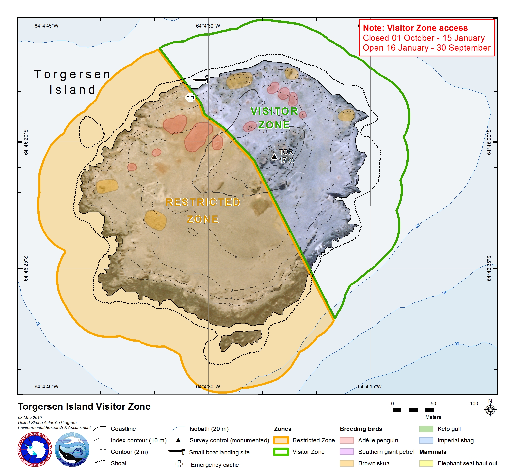
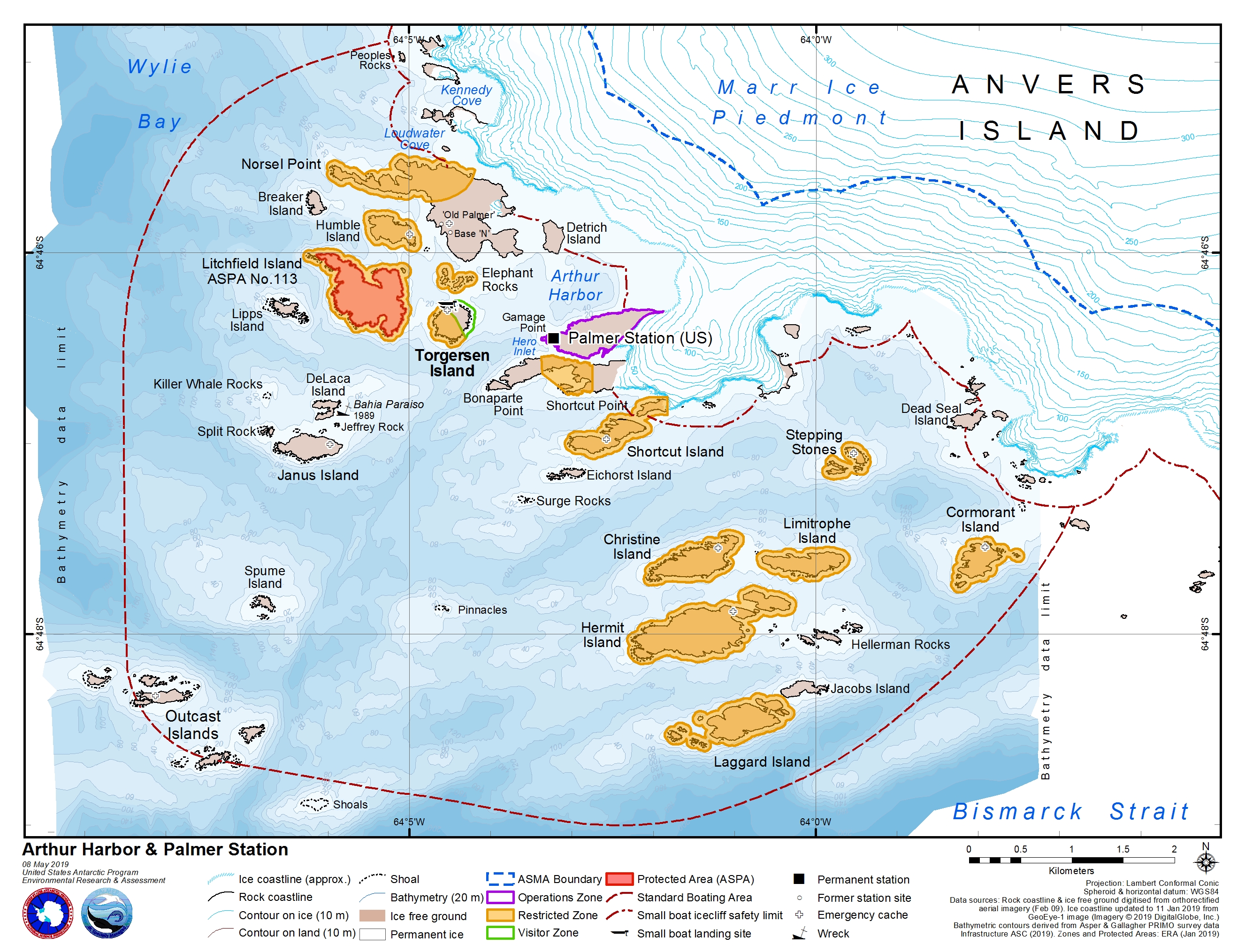