
Response of the Antarctic ice sheet to future greenhouse warming
Upload
independentCategory
view
0download
0
The physiography of modern Antarctic subglacial lakes
Julian A. Dowdeswella,*, Martin J. Siegertb
aScott Polar Research Institute, University of Cambridge, Cambridge CB2 1ER, UKbBristol Glaciology Centre, School of Geographical Sciences, University of Bristol, Bristol BS8 1SS, UK
Accepted 1 March 2002
Abstract
The size and distribution of Antarctic subglacial lakes have been investigated using airborne radio-echo sounding (RES) and
satellite radar altimetry. Over 70 lakes have been identified beneath the ice sheet from distinctive, mirror-like reflectors observed
on RES records. Almost 60% of lakes are found within 200 km of an ice divide and only about 15% are located >500 km
distant. The total volume of water stored in lakes beneath the Antarctic Ice Sheet is between 4000 and 12,000 km3. The bedrock
topography of the ice-sheet interior is characterized by large subglacial basins separated by mountain ranges. More than 60% of
lake records have marginal bed gradients of < 0.1, implying that many Antarctic subglacial lakes are found in areas of relatively
low bed relief, in and on the margins of subglacial basins. First, there are those lakes located where subglacial topography is
relatively subdued, often towards the centre of subglacial basins. Secondly, some lakes occur in significant topographic
depressions, closer to subglacial basin margins. Lakes are also found perched on the sides of subglacial mountains. Sixteen
lakes are located close to the transition from slow to enhanced ice-sheet flow. Warm-based fast-flowing ice streams provide a
possible route by which subglacial lakes may establish a hydrological connection with the ice-sheet margin. At a continental
scale, the locations of Antarctic subglacial lakes match the modeled distribution of pressure melting at the ice-sheet bed.
D 2002 Elsevier Science B.V. All rights reserved.
Keywords: physiography; radio-echo sounding; subglacial lakes
1. Introduction
Large outburst floods, resulting from the rapid
release of stored meltwater, have been observed at
the margins of a number of modern glaciers (e.g.
Bjornsson, 1974; Clarke, 1982; Goodwin, 1988).
Some large-scale geomorphic features in Quaternary
mid-latitude landscapes have also been ascribed to
huge releases of water from either ice-sheet marginal
or subglacial sources (e.g. Baker, 1978; Shaw and
Gilbert, 1990; Shaw, 1996). In the 1970s, the exis-
tence of large bodies of water beneath the modern
Antarctic Ice Sheet was discovered (e.g. Oswald and
Robin, 1973; Robin et al., 1977). It is only relatively
recently, however, that the size and distribution of
these subglacial lakes have been investigated system-
atically using geophysical instruments mounted on
aircraft and satellite platforms (e.g. Ridley et al.,
1993; Siegert et al., 1996; Dowdeswell and Siegert,
1999). In addition, the relationship between large
subglacial lakes, ice flow and ice-sheet thermal struc-
ture is now being examined (e.g. Shoemaker, 1990;
Siegert and Dowdeswell, 1996; Siegert et al., 2000;
Kwok et al., 2000).
0921-8181/02/$ - see front matter D 2002 Elsevier Science B.V. All rights reserved.
PII: S0921 -8181 (02 )00128 -5
* Corresponding author.
E-mail addresses: [email protected] (J.A. Dowdeswell),
[email protected] (M.J. Siegert).
www.elsevier.com/locate/gloplacha
Global and Planetary Change 35 (2002) 221–236

In this paper, we review themethods used to identify
and map large water bodies beneath the Antarctic Ice
Sheet, and describe the distribution and size of these
lakes. We then examine the ice-surface and bed-topo-
graphic settings in which Antarctic subglacial lakes are
located and, finally, discuss briefly the links between
subglacial lakes, ice-sheet dynamics and temperatures.
2. Identification of Antarctic subglacial lakes
2.1. Airborne radio-echo sounding
Lakes beneath the Antarctic Ice Sheet were first
observed on airborne 60-MHz radio-echo sounding
(RES) records as extensive areas of smooth and
very strong returns from the glacier bed, below
several thousand meters of ice (Oswald and Robin,
1973). These areas are specular or mirror-like
reflectors (Fig. 2), with an echo strength that is
10–20 dB above the more usual values associated
with an ice–rock interface. Such reflectors are
characteristic of a water surface. Field experiments
support this interpretation. Seismic investigations
identified a lake-bed reflector at about 510 m
beneath the subglacial surface of Lake Vostok in
East Antarctica (Kapitsa et al., 1996). More re-
cently, Gorman and Siegert (1999) have shown,
from radio-echo returns which penetrate to a shal-
low lake-bottom reflector at several subglacial lake
Fig. 1. Map of the Antarctic Ice Sheet showing the locations of Antarctic subglacial lakes (shown as triangles except Lake Vostok which is
outlined). The ice-sheet surface is contoured at 500-m intervals (after Drewry, 1983). The boxed areas are enlarged in subsequent figures.
J.A. Dowdeswell, M.J. Siegert / Global and Planetary Change 35 (2002) 221–236222

margins, that the lakes are indeed bodies of fresh
water and are not simply very flat areas of saturated
basal sediment.
Over 400,000 km of RES data, acquired in ana-
logue form at a frequency of 60 MHz, were collected
over an area of about 7 million km2, or about half of
Fig. 2. 60-MHz RES data for eight Antarctic subglacial lakes and their surrounding ice-sheet bed topography. (A) Two lakes in the Dome C area
(located in Fig. 6C). (B) Lake in the Ridge B area (located in Fig. 7C). (C) Lake at Titan Dome near the South Pole (located in Fig. 8B). (D)
Lake in the Whitmore Mountains area (located in Fig. 9B). (E) Two lakes in the Hercules Dome area located in (Fig. 9B). (F) Lake Vostok, east
of Ridge B. Note that, on this flight line over the lake, a bedrock hill protrudes through the lake waters (located in Fig. 7C).
J.A. Dowdeswell, M.J. Siegert / Global and Planetary Change 35 (2002) 221–236 223

the Antarctic Ice Sheet, between 1967 and 1979
(Robin et al., 1977). These data were used originally
to map the ice-surface and bed topography of the
Antarctic Ice Sheet (Drewry, 1983). However, they
have been re-examined systematically to provide an
inventory of subglacial lake locations, using the
following criteria (Siegert et al., 1996; Dowdeswell
and Siegert, 1999): (a) strong reflectors at the ice-
sheet base, appearing bright and specular on photo-
graphic film records, (b) echoes of constant strength
along-track, indicating a smooth interface on the scale
of the 60 MHz system wavelength, and (c) a virtually
horizontal echo character. These characteristics have
been used to locate the Antarctic subglacial lakes
mapped in Fig. 1, and are illustrated in RES data
from six areas of the Antarctic Ice Sheet where
subglacial lakes have been identified (Fig. 2).
2.2. Satellite radar altimetry
Extensive, very flat areas on the surface of the
Antarctic Ice Sheet, first noted by a Russian aircraft
navigator (Robinson, 1964), have been mapped using
satellite radar altimetry, a method which provides
surface elevations accurate to a few tens of centi-
meters (Scott et al., 1994). The spatial coincidence of
flat regions on the ice surface with strong, specular
radio-echo returns from the ice-sheet bed has been
demonstrated in several areas of Antarctica (Cudlip
and McIntyre, 1987; Ridley et al., 1993; Siegert and
Ridley, 1998a,b). This implies that satellite radar
altimetric identification of flat areas on the ice surface
can be used to infer the presence of subglacial water
bodies. The flat ice surface is produced because basal
shear stress tends to zero as the ice reaches hydrostatic
equilibrium over subglacial lake waters. Lakes smaller
than about 4 or 5 km across are unlikely to form this
characteristic flat surface, however, as the thick ice
above them (a) may not be in hydrostatic equilibrium,
and (b) may damp these relatively small-scale changes
in basal ice-sheet flow from the ice surface (Dowdes-
well and Siegert, 1999). Hence, smaller subglacial
lakes can only be observed using RES methods.
The 13-GHz radar altimeter aboard ERS-1/2 has
been used to obtain ice-surface elevation data over the
Antarctic Ice Sheet to a latitude of 82jS. The ice-
surface topography in the Vostok and Dome C areas,
in particular, has been examined for flat areas char-
acteristic of the presence of subglacial lakes (Siegert
and Ridley, 1998a,b). In addition, no lakes of the
magnitude of Lake Vostok (area 10,000 km2) have
been reported from other regions of the Antarctic Ice
Sheet for which ERS radar altimeter data are available
(J.K. Ridley, 1998, personal communication).
3. Subglacial lake distribution and size
Over 70 subglacial lakes have been identified at
the base of the 13 million km2 Antarctic Ice Sheet
Fig. 3. Observed frequency distribution of the length of Antarctic
subglacial lakes, measured from RES records (source: Dowdeswell
and Siegert, 1999). Mean lake length is 10.8 km (excluding Lake
Vostok).
Fig. 4. Sketch showing measurement method for obtaining
maximum topographic height and bedrock gradient adjacent to
subglacial lakes from RES data. The maximum elevation of the
bedrock bordering each lake is Y, whilst the bedrock gradient, taken
as the distance (X) between the lake margin and the crest of nearest
hyperbola, is Y/X (adapted from Dowdeswell and Siegert, 1999).
J.A. Dowdeswell, M.J. Siegert / Global and Planetary Change 35 (2002) 221–236224

Fig. 5. Ice-sheet bed topography around subglacial lakes in 10 areas of Antarctica. Each area is located on the central map. The slope gradient
(degrees) and the height of bedrock (m) close to each lake is given, together with lake lengths (km) in each area. Data are from the analysis of
airborne RES records.
J.A. Dowdeswell, M.J. Siegert / Global and Planetary Change 35 (2002) 221–236 225

(e.g. Oswald and Robin, 1973; Siegert et al., 1996;
Dowdeswell and Siegert, 1999), using the distinctive,
mirror-like reflectors observed on airborne RES
records (Figs. 1 and 2). The thickness of ice above
these subglacial lakes is between about 2500 and
4000 m. The bulk of the lakes are located in the
interior of the Antarctic Ice Sheet, at or close to ice
divides in the form of domes and ridges, where ice
velocity is low (Dowdeswell and Siegert, 1999).
Almost 60% of the lakes are found within 200 km
of an ice crest, remembering that ice flowlines from
divide to margin are often over 1000 km long in
Antarctica (Fig. 1). Only about 15% of the subglacial
lakes are positioned more than 500 km from an ice
divide.
The largest Antarctic subglacial lake is that located
near Vostok Station in central East Antarctica (Fig. 1).
The dimensions of this lake, known as Lake Vostok,
have beenmapped from a combination of airborne RES
and satellite radar altimetric measurements (Kapitsa et
al., 1996; Siegert and Ridley, 1998a). The lake is about
230 km long and has an area of approximately 10,000
km2, similar to that of Lake Ontario (Kapitsa et al.,
1996). A maximum water depth of 510 m was meas-
ured using seismic methods, although mean water
depth is thought to be nearer 200 m. The estimated
volume of Lake Vostok is a little less than 2000 km3.
The other 70 or so subglacial lakes identified
beneath the Antarctic Ice Sheet are one to two orders
of magnitude smaller than Lake Vostok. Although
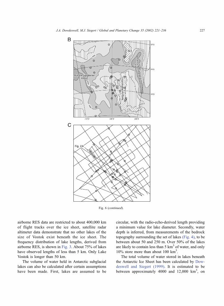
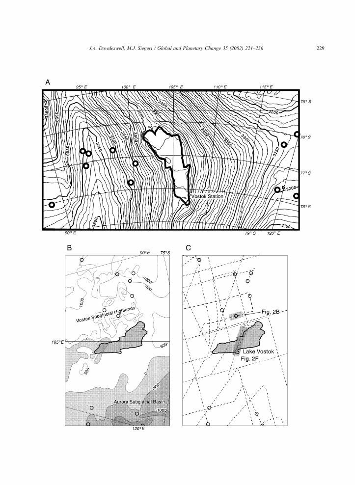
Fig. 6. Ice-surface and bedrock topography, and the locations of subglacial lakes (shown as open circles), in the Dome C region of Antarctica
(located in Fig. 1). (A) Ice-surface topography from satellite radar altimetry. Contour interval 4 m (source: Siegert and Ridley, 1998b). (B)
Subglacial bed topography, contoured at 500-m intervals (source: Drewry, 1983). (C) Grid of airborne RES flight lines used to map subglacial
topography and lake locations. The RES record shown in Fig. 2A is located.
J.A. Dowdeswell, M.J. Siegert / Global and Planetary Change 35 (2002) 221–236226
airborne RES data are restricted to about 400,000 km
of flight tracks over the ice sheet, satellite radar
altimeter data demonstrate that no other lakes of the
size of Vostok exist beneath the ice sheet. The
frequency distribution of lake lengths, derived from
airborne RES, is shown in Fig. 3. About 75% of lakes
have observed lengths of less than 5 km. Only Lake
Vostok is longer than 50 km.
The volume of water held in Antarctic subglacial
lakes can also be calculated after certain assumptions
have been made. First, lakes are assumed to be
circular, with the radio-echo-derived length providing
a minimum value for lake diameter. Secondly, water
depth is inferred, from measurements of the bedrock
topography surrounding the set of lakes (Fig. 4), to be
between about 50 and 250 m. Over 50% of the lakes
are likely to contain less than 5 km3 of water, and only
10% store more than about 100 km3.
The total volume of water stored in lakes beneath
the Antarctic Ice Sheet has been calculated by Dow-
deswell and Siegert (1999). It is estimated to be
between approximately 4000 and 12,000 km3, on
Fig. 6 (continued).
J.A. Dowdeswell, M.J. Siegert / Global and Planetary Change 35 (2002) 221–236 227

the assumptions that the size-frequency distribution of
subglacial lakes observed from airborne RES can be
extended over the whole ice sheet, and that 2000 km3
of water is held in Lake Vostok (Kapitsa et al., 1996).
The large uncertainty in this calculation is due to the
unknown mean water depth of subglacial lakes other
than Lake Vostok. This volume of water, in the very
unlikely event of being released at a single time,
would raise global sea level by 10–35 mm. Most of
the larger Antarctic lakes probably contain a few
hundred cubic kilometers of water at most.
4. Subglacial lakes and regional bed topography
The bed topography bordering Antarctic subglacial
lakes is characterised in two ways using airborne RES
data (Fig. 4). First, the maximum heights of hyper-
bolic RES reflectors, representing the bedrock close to
the lake margin, are recorded. Secondly, the gradient
between the maximum bedrock height and the edge of
the lake inferred from RES is calculated (Fig. 4). It
should be noted that rough subglacial terrain is dis-
played as a series of hyperbolae on radio-echo records
(Fig. 2). On such unmigrated records, the hyperbola
crests represent real data points, whereas the trailing
edges are artefacts of the RES technique (e.g. Harri-
son, 1970).
The bed-topographic setting of subglacial lakes in
10 areas of the Antarctic Ice Sheet is shown in Fig. 5.
More than 60% of lake records have maximum local
bedrock elevations of less than 400 m adjacent to their
margins and bed gradients of less than 0.1 (Fig. 5).
The implication of these measurements is that the
majority of Antarctic subglacial lakes are found in
areas of relatively low bed relief. In addition, compar-
isons of these two topographic parameters with esti-
mated subglacial lake length indicate that large lakes
tend to occur where bed topography is subdued. A
clear exception to this is Lake Vostok, where an
extensive alpine terrain exists, particularly to the west
of the lake, with bedrock elevations of about 1000 m
above the lake level within 10 km of its margin
(Kapitsa et al., 1996).
Ice-sheet bed topography is rather flat in many
regions, which represent large subglacial basins, and
bedrock gradients are seldom greater than 0.2 (Fig. 5).
Examples include the South Pole area, together with
many of the domes and ridges near the ice-sheet
centre, where surface topography and ice velocity
are also very low. An RES record of two subglacial
lakes located in low-gradient terrain in the Dome C
region is shown in Fig. 2A, and the bulk of lakes
around Dome C are also found in relatively flat
terrain. Examples of relatively steep bed topography
are shown in the radio-echo records for lakes in the
Whitmore Mountains and near Hercules Dome (Fig.
2D,E), where subglacial lakes can be seen perched
within steep mountain terrain.
5. Topographic setting of subglacial lakes:
examples
5.1. Dome C region
The association between subglacial lake locations
and smooth areas of the ice-sheet surface can be seen
clearly in Fig. 6. Here, lake locations are superim-
posed on a digital elevation model of the ice surface
around Dome C, contoured with an interval of 4 m
from ERS-1 satellite radar altimetry (Ridley et al.,
1993). This relationship between lakes and low ice-
surface slopes is typical for larger subglacial water
bodies, and indicates that the ice has reached hydro-
static equilibrium with the underlying fluid. The
match between lake locations and particularly flat
surface terrain does not extend to lakes smaller than
about 4–5 km, for two reasons. First, the ice above
these smaller lakes is not necessarily in hydrostatic
equilibrium due to the effects of bedrock sidewalls.
Secondly, the satellite radar altimeter, with a footprint
of 18 km, does not always resolve very small areas of
flat surface.
Fig. 7. Ice-surface and bedrock topography, and the locations of subglacial lakes (shown as open circles), in the Ridge B region of Antarctica
(located in Fig. 1), including Lake Vostok. (A) Ice-surface topography from satellite radar altimetry. Contour interval 10 m (source: Siegert and
Ridley, 1998a). (B) Subglacial bed topography, contoured at 500-m intervals (source: Drewry, 1983). (C) Grid of airborne RES flight lines used
to map subglacial topography and lake locations. Subglacial lakes are shown as circles with the exception of Lake Vostok, which is outlined in
detail. The RES records shown in Fig. 2B and F are located.
J.A. Dowdeswell, M.J. Siegert / Global and Planetary Change 35 (2002) 221–236228
J.A. Dowdeswell, M.J. Siegert / Global and Planetary Change 35 (2002) 221–236 229

Over 40 subglacial lakes are concentrated around
Dome C, and over 80% of these are located in areas of
relatively subdued bedrock topography within large
subglacial basins (Fig. 6B). Bedrock gradients around
the majority of lakes are less than 0.1, and the
surrounding highs are often significantly less than
200 m in elevation (Fig. 5). The radio-echo record
in Fig. 2a is typical of much of the Dome C region.
Two strong and very flat RES reflectors of between 5
and 10 km in length are identified as subglacial lakes
within a rather smooth bedrock terrain. The fre-
quency-distribution diagrams for Dome C in Fig. 5
also show that a few subglacial lakes are associated
with relatively steep bedrock gradients of greater than
0.3 and surrounding highs of over 1000 m, but these
are the exception and are found around the margins of
the subglacial basin (Fig. 6B).
5.2. Ridge B area
The ice-surface topography of the Ridge B area is
contoured at 10-m intervals (Fig. 7A). The ice surface
at Ridge B has a maximum elevation of more than
3800 m. To the east, an extensive area of several
thousand square kilometers of very flat ice represents
the surface manifestation of subglacial Lake Vostok
(Kapitsa et al., 1996; Siegert and Ridley, 1998a). At
the coarser resolution of this satellite altimeter-derived
surface contour map, few of the other, smaller sub-
glacial lakes show up clearly in the ice-surface top-
ography (Fig. 7A).
Bedrock topography in the Ridge B area is shown
in Fig. 7B, and is derived from analysis of the network
of RES data acquired along the flight lines shown in
Fig. 7C. Lake Vostok appears to be located in a
topographic basin, with relatively lower slopes to
the east and steeper terrain to the west. A radio-echo
transect across Lake Vostok is shown in Fig. 2F. The
remaining, smaller lakes around Ridge B fall into two
types of location. First, several are located on the
flanks of the bed-topographic ridge, to the west of
Lake Vostok, which has its surface manifestation in
Ridge B itself (Fig. 7A). It should be noted that the
radio-echo record shown in Fig. 2B runs parallel to
the contour of this bedrock high, and the bed top-
ography around the lake located here is, therefore,
minimised in this record. The second cluster of lakes
is positioned in the east of the region, within the
Aurora Subglacial Basin mapped in Fig. 7B, which is
an area of low bedrock gradients that are generally
less than 0.1 (Fig. 5).
5.3. South Pole region
Around the South Pole, the ice-sheet bed topog-
raphy is generally subdued (Fig. 8A). Bedrock ele-
Fig. 8. Ice-sheet bedrock topography and the locations of subglacial
lakes (shown as open circles) in the South Pole region of Antarctica
(located in Fig. 1). (A) Subglacial bed topography, contoured at
500-m intervals (source: Drewry, 1983). (B) Grid of airborne RES
flight lines used to map subglacial topography and lake locations.
The RES record shown in Fig. 2C is located.
J.A. Dowdeswell, M.J. Siegert / Global and Planetary Change 35 (2002) 221–236230
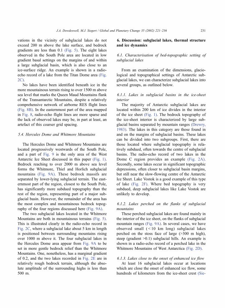
vations in the vicinity of subglacial lakes do not
exceed 200 m above the lake surface, and bedrock
gradients are less than 0.1 (Fig. 5). The eight lakes
observed in the South Pole area are located in low
gradient basal settings on the margins of and within
a large subglacial basin, which is also close to an
ice-surface ridge. An example is shown in a radio-
echo record of a lake from the Titan Dome area (Fig.
2C).
No lakes have been identified beneath ice in the
more mountainous terrain rising to over 1500 m above
sea level that marks the Queen Maud Mountains flank
of the Transantarctic Mountains, despite a relatively
comprehensive network of airborne RES flight lines
(Fig. 8B). In the easternmost part of the area mapped
in Fig. 8, radio-echo flight lines are more sparse and
the lack of observed lakes may be, in part at least, an
artefact of this coarser grid spacing.
5.4. Hercules Dome and Whitmore Mountains
The Hercules Dome and Whitmore Mountains are
located progressively westwards of the South Pole,
and a part of Fig. 9 is the only area of the West
Antarctic Ice Sheet discussed in this paper (Fig. 1).
Bedrock reaching to over 2000 m above sea level
forms the Whitmore, Thiel and Horlich subglacial
mountains (Fig. 9A). These bedrock massifs are
separated by lower-lying subglacial terrain. The east-
ernmost part of the region, closest to the South Pole,
has significantly more subdued topography than the
rest of the region, representing part of a major sub-
glacial basin. However, the remainder of the area has
the most complex and mountainous bedrock topog-
raphy of the four regions discussed here (Fig. 9A).
The two subglacial lakes located in the Whitmore
Mountains are both in mountainous terrains (Fig. 5).
This is illustrated clearly in the radio-echo record in
Fig. 2C, where a subglacial lake about 5 km in length
is positioned between surrounding mountains rising
over 1000 m above it. The four subglacial lakes in
the Hercules Dome area appear from Fig. 9A to be
set in more gentle bedrock relief than the Whitmore
Mountains. One, nonetheless, has a marginal gradient
of 0.2, and the two lakes recorded in Fig. 2E are in
relatively rough bedrock terrain, although the abso-
lute amplitude of the surrounding highs is less than
500 m.
6. Discussion: subglacial lakes, thermal structure
and ice dynamics
6.1. Characterisation of bed-topographic setting of
subglacial lakes
From an examination of the dimensions, glacio-
logical and topographical settings of Antarctic sub-
glacial lakes, we can characterize subglacial lakes into
several groups, as outlined below.
6.1.1. Lakes in subglacial basins in the ice-sheet
interior
The majority of Antarctic subglacial lakes are
located within 200 km of ice divides in the interior
of the ice sheet (Fig. 1). The bedrock topography of
the ice-sheet interior is characterized by large sub-
glacial basins separated by mountain ranges (Drewry,
1983). The lakes in this category are those found in
and on the margins of subglacial basins. These lakes
can be divided into two subgroups. First, there are
those located where subglacial topography is rela-
tively subdued, often towards the centre of subglacial
basins. The radio-echo record of two lakes in the
Dome C region provides an example (Fig. 2A).
Secondly, some lakes occur in significant topographic
depressions, often closer to subglacial basin margins,
but still near the slow-flowing centre of the Antarctic
Ice Sheet. Lake Vostok is a good example of this type
of lake (Fig. 2F). Where bed topography is very
subdued, deep subglacial lakes like Lake Vostok are
unlikely to develop.
6.1.2. Lakes perched on the flanks of subglacial
mountains
These perched subglacial lakes are found mainly in
the interior of the ice sheet, on the flanks of subglacial
mountain ranges (Fig. 9A). In several cases, we have
observed small ( < 10 km long) subglacial lakes
perched on the stoss face of large (>300 m high),
steep (gradient >0.1) subglacial hills. An example is
shown in a radio-echo record of a perched lake in the
Whitmore Mountains of West Antarctica (Fig. 2D).
6.1.3. Lakes close to the onset of enhanced ice flow
At least 16 subglacial lakes occur at locations
which are close the onset of enhanced ice flow, some
hundreds of kilometers from the ice-sheet crest (Sie-
J.A. Dowdeswell, M.J. Siegert / Global and Planetary Change 35 (2002) 221–236 231

Fig. 9. Ice-sheet bedrock topography and the locations of subglacial lakes (shown as open circles) in the Whitmore Mountains and Hercules
Dome region of Antarctica (located in Fig. 1). (A) Subglacial bed topography, contoured at 500-m intervals (source: Drewry, 1983). (B) Grid of
airborne RES flight lines used to map subglacial topography and lake locations. The RES records shown in Fig. 2D–E are located.
J.A. Dowdeswell, M.J. Siegert / Global and Planetary Change 35 (2002) 221–236232

gert and Bamber, in press). An example is provided by
three subglacial lakes near the onset of fast flow into
Byrd Glacier (Fig. 1). Byrd Glacier is fast-flowing and
drains a very large interior ice-sheet drainage basin
into the Ross Ice Shelf (Drewry, 1983). These sub-
glacial lakes are similar in size and depth to the small
and probably shallow lakes found in major subglacial
basins in the ice-sheet interior.
6.2. Lakes and ice-sheet thermal structure
Although it can be assumed that the temperature of
the ice-sheet base above subglacial lakes is at the
pressure melting point (Siegert and Dowdeswell,
1996), information about the subglacial thermal
regime across Antarctica is limited mainly to numer-
ical model calculations. Huybrechts (1992) used a
thermally coupled ice-sheet model of the Antarctic
Ice Sheet to estimate the distribution of subglacial
temperatures. The results indicate that pressure melt-
ing conditions occur across two distinct zones beneath
the ice sheet. The first is around the centre of the ice
sheet, where ice is generally thickest and acts to
insulate the ice-sheet base, kept warm by geothermal
heat, from the cold conditions at the ice surface.
Thicker ice also acts to reduce the value of the melting
temperature because of the overburden pressure of
several kilometers of ice. The second warm-based
region determined by Huybrechts (1992) is where
the friction involved in the enhanced flow of ice
provides a source of heat, in addition to the geo-
thermal flux, that causes subglacial melting. In gen-
eral, as the rate of ice flow increases, so too will this
frictional heat source. Pressure melting conditions are,
therefore, expected beneath fast-flowing outlet gla-
ciers and ice streams, despite the fact that the thick-
ness of ice within these fast-flowing regions is often
considerably less than in the ice-sheet interior
(Drewry, 1983). Between these two warm-based
regions, Huybrechts (1992) calculated that subglacial
freezing occurs.
At a continental scale, the locations of Antarctic
subglacial lakes tie in well with the distribution of a
bed at the pressure melting point close to the ice-sheet
centre and beneath fast-flowing outlets (Fig. 1). How-
ever, around a large number of subglacial lakes at the
centre of the ice sheet, relatively high topographic
relief results in regional variations in ice thickness
and, because of this, potential modification in the
subglacial temperature around the lake.
It is not yet fully understood why some lakes form
across the stoss flank of large subglacial hills. How-
ever, we can speculate that subglacial mountains may
act as a barrier to the flow of water, thus causing it to
build up at the upstream side.
6.3. Melting and freezing at Lake Vostok
A clear example of a location where the ice sheet is
likely to be at the pressure melting point is the
northern end of Lake Vostok in central East Antarctica
(Siegert et al., 2000, 2001). Several RES lines were
flown across the lake, parallel to the direction of ice-
sheet flow, as determined from interferometric syn-
thetic aperture radar (InSAR) measurements (Kwok et
al., 2000). Internal layers within RES data represent
isochronous horizons and are often traceable contin-
uously across large distances (Millar, 1981; Siegert et
al., 1998) (Fig. 2F). Such layering, deep beneath the
ice-sheet surface, reflects the flow paths of ice par-
ticles. As ice flows across the north of Lake Vostok,
the distance between the lowest internal layers and the
ice-sheet base decreases (Fig. 2F). This effect is
recording a loss of ice, which is due to subglacial
melting at a rate of several cm year� 1 (Siegert et al.,
2000). Further, in the southern part of the lake, around
Vostok Station, the distance between internal layers
and the ice-sheet bed increases, due to the accretion of
ice to the underside of the ice sheet (Bell et al., 2002).
The lowest 200 m of the Vostok ice core is known to
comprise ice refrozen from the lake waters (Jouzel et
al., 1999). This implies that there is a circulation of
water within Lake Vostok, driven by geothermal heat,
which causes subglacial melting over the northern part
of the lake (where ice thickness is around 4.1 km), and
refreezing to the south (where ice is thinnest at about
3.7 km) (Siegert et al., 2000, 2001). The sparsity of
InSAR ice velocity data across the Antarctic interior
precludes the application of the findings from Lake
Vostok to other subglacial lakes, since the direction of
ice flow cannot be established unequivocally.
6.4. Bed topography, lakes and ice-stream onset
Recent calculations of Antarctic Ice Sheet veloc-
ities suggest that transition between the slow-flowing
J.A. Dowdeswell, M.J. Siegert / Global and Planetary Change 35 (2002) 221–236 233

ice sheet interior and enhanced flow at the onset of ice
streams is likely to be associated with the occurrence
of warm-based subglacial conditions within bed-topo-
graphic channels (e.g. Joughin et al., 1999; Bamber et
al., 2000). The distribution of Antarctic subglacial
lakes shows that 16 are located close to the transition
to enhanced ice-sheet flow (Siegert and Bamber,
2000). This implies that a number of tributaries to
major outlet glaciers, several hundred kilometers from
the ice margin, are warm-based regions. Examples of
subglacial lakes located close to areas where fast
glacier flow begins include the head of David Glacier,
which drains through the Transantarctic Mountains
into the Ross Embayment, and a lake at the mouth of
the Astrolabe Subglacial Basin in East Antarctica
(Fig. 1). Warm-based fast-flowing ice streams provide
a possible route by which subglacial lakes, located at
the onset of enhanced ice flow, may establish a
hydrological connection with the ice-sheet margin.
Observations of subglacial lakes located close to
major Antarctic ice drainage features (Siegert and
Bamber, 2000) act as a potential model for the
subglacial environment of Quaternary ice sheets.
Shaw (1996) has suggested that the topography of a
number of large drumlin fields in Canada was devel-
oped during large outburst floods of subglacial water
from the Laurentide Ice Sheet during the last degla-
ciation. In East Antarctica at present, it is unlikely that
lakes beneath the centre of the ice sheet (such as those
at Dome C and Ridge B, and Lake Vostok) could
outburst to the ice margin because they would require
rapid large-scale decoupling of frozen parts of the ice-
sheet base. Evidence from recent jokulhlaups in Ice-
land indicates that outburst floodwaters follow a
relatively organised subglacial pathway, controlled
by water pressure gradients. Subglacial floods are
therefore more likely to issue through existing, albeit
rapidly enlarged, subglacial conduits and channels. In
Antarctica, such subglacial hydrology is associated
with enhanced ice drainage units.
We suggest that, if subglacial floodwater escapes to
the margin of the East Antarctic Ice Sheet at all, it is
most likely to have originated from a subglacial lake
associated with enhanced ice flow. During the decay
of an ice sheet, as the ice margin retreats, the head of
ice streams and outlet glaciers may migrate toward the
present-day ice divide into the formerly frozen ice
base. This could allow other subglacial lakes to
become involved in the release of water to the base
of enhanced ice-flow features and, thus, to the pro-
glacial region. The glacimarine sedimentary record in
the waters around Antarctica should hold evidence of
such events, if indeed they have taken place.
7. Conclusions
Large water bodies were identified beneath the
Antarctic Ice Sheet during the 1970s (e.g. Oswald
and Robin, 1973; Robin et al., 1977). The size and
distribution of these subglacial lakes have recently
been investigated systematically at a continent-wide
scale using airborne RES and satellite radar altimetry
(e.g. Ridley et al., 1993; Siegert et al., 1996; Dow-
deswell and Siegert, 1999). The following represent
the main conclusions of this work concerning the
physiography of lakes beneath the Antarctic Ice Sheet
today.
. Over 70 subglacial lakes have been identified
beneath the 13 million km2 Antarctic Ice Sheet (e.g.
Oswald and Robin, 1973; Siegert et al., 1996; Dow-
deswell and Siegert, 1999), using the distinctive,
mirror-like reflectors observed on airborne RES
records (Figs. 1 and 2). Almost 60% of lakes are
found within 200 km of an ice divide, remembering
that ice flowlines from crest to coastal margin are
often over 1000 km in length (Fig. 1). Only about
15% of subglacial lakes are located more than 500 km
from an ice divide. The total volume of water stored in
lakes beneath the Antarctic Ice Sheet is estimated to
be between about 4000 and 12,000 km3 (Dowdeswell
and Siegert, 1999).
. The bedrock topography of the ice-sheet interior
is characterized by large subglacial basins separated
by mountain ranges (Drewry, 1983). More than 60%
of lake records have maximum local bedrock eleva-
tions of < 400 m adjacent to their margins and bed
gradients of less than 0.1 (Fig. 5), implying that many
Antarctic subglacial lakes are found in areas of
relatively low bed relief. Over 40 subglacial lakes
are concentrated around Dome C, and over 80% of
these are found in relatively subdued bedrock top-
ography within large subglacial basins (Fig. 6B). Lake
Vostok, near Ridge B, appears to be located in a
topographic basin, with relatively lower slopes to the
east and steeper terrain to the west.
J.A. Dowdeswell, M.J. Siegert / Global and Planetary Change 35 (2002) 221–236234
. Many lakes are found in and on the margins of
subglacial basins. First, there are those located where
subglacial topography is relatively subdued, often
towards the centre of subglacial basins. Secondly,
some lakes occur in significant topographic depres-
sions, often closer to subglacial basin margins, but
still near the slow-flowing centre of the Antarctic Ice
Sheet. Lakes are also found perched on the flanks of
subglacial mountains, mainly in the interior of the ice
sheet (Fig. 9A).
. At a continental scale, the locations of Antarctic
subglacial lakes match the modeled distribution of
pressure melting at the bed (Huybrechts, 1992), which
is found close to the ice-sheet centre and beneath fast-
flowing outlets. It is assumed that the temperature of
the ice-sheet base above subglacial lakes is at the
pressure melting point (Siegert and Dowdeswell,
1996).
. The distribution of Antarctic subglacial lakes alsoshows that 16 are located close to the transition to
enhanced ice-sheet flow. This implies that a number of
tributaries to major outlet glaciers, several hundred
kilometers from the ice margin, are warm-based
regions. An example is provided by three subglacial
lakes near the onset of fast flow into Bryd Glacier
(Fig. 1). Warm-based fast-flowing ice streams could
provide a possible route by which subglacial lakes,
located at the onset of enhanced ice flow, might
establish a hydrological connection with the ice-sheet
margin.
Acknowledgements
Part of this work was carried out under UK NERC
Grant GR9/1418. We thank Prof. P. Holmlund and Dr.
A.P. Stroeven for constructive reviews and Dr. J.A.
Heap, former Director the Scott Polar Research,
Cambridge, for his support of our work.
References
Baker, V.R., 1978. Large-scale erosional and depositional features
of the Channeled Scabland. In: Baker, V.R., Nummedal, D.
(Eds.), The Channeled Scabland. NASA, Washington, DC, pp.
81–115.
Bamber, J.L., Vaughan, D.G., Joughin, I., 2000. Widespread com-
plex flow in the interior of the Antarctic Ice Sheet. Science 287,
1248–1250.
Bjornsson, H., 1974. Explanation of jokulhlaups from Grimsvotn,
Vatnajokull, Iceland. Jokull 24, 1–26.
Clarke, G.K.C., 1982. Glacier outburst floods from ‘‘Hazard Lake’’,
Yukon Territory, and the problem of flood magnitude prediction.
Journal of Glaciology 28, 3–21.
Cudlip, W., McIntyre, N.F., 1987. Seasat altimeter observations of
an Antarctic ‘‘lake’’. Annals of Glaciology 9, 55–59.
Dowdeswell, J.A., Siegert, M.J., 1999. The dimensions and topo-
graphic setting of Antarctic subglacial lakes and implications for
large-scale water storage beneath continental ice sheets. Geo-
logical Society of America Bulletin 111, 254–263.
Drewry, D.J., 1983. Antarctica: Glaciological and Geophysical Fo-
lio, Scott Polar Research Institute, University of Cambridge.
Goodwin, I.D., 1988. The nature and origin of a jokulhlaup near
Casey Station, Antarctica. Journal of Glaciology 34, 95–101.
Gorman, M.R., Siegert, M.J., 1999. Penetration of Antarctic sub-
glacial lakes by VHF electromagnetic pulses: information on the
depth and electrical conductivity of basal water bodies. Journal
of Geophysical Research 104, 29311–29320.
Harrison, C.H., 1970. Reconstruction of subglacial relief from radio
echo sounding record. Geophysics 35, 1099–1115.
Huybrechts, P., 1992. The Antarctic ice sheet and environmental
change: a three dimensional modelling study. Reports on Polar
Research (Alfred-Wegener-Institut fur Polar und Meeresfor-
schung) 99, 241 pp.
Joughin, I., Gray, L., Bindschadler, R., Price, S., Morse, D., Hulbe,
C., Mattar, K., Werner, C., 1999. Tributaries of West Antarctic
ice streams revealed by RADARSAT interferometry. Science
286, 283–286.
Jouzel, J., Petit, J.R., Souchez, R., Barkov, N.I., Lipenkov, V.Ya.,
Raynaud, D., Stievenard, M., Vassiliev, N.I., Verbeke, V., Vi-
meux, F., 1999. Evidence of more than 200 m of lake ice above
the subglacial lake Vostok, central East Antarctica. Science 286,
2138–2141.
Kapitsa, A., Ridley, J.K., Robin, G. de Q., Siegert, M.J., Zotikov, I.,
1996. Large deep freshwater lake beneath the ice of central East
Antarctica. Nature 381, 684–686.
Kwok, R., Siegert, M.J., Carsey, F.D., in press. Ice motion over
Lake Vostok. Journal of Glaciology.
Millar, D.H.M., 1981. Radio-echo layering in polar ice sheets and
past volcanic activity. Nature 292, 441–443.
Oswald, G.K.A, Robin, G. de Q., 1973. Lakes beneath the Antarctic
Ice Sheet. Nature 245, 251–254.
Ridley, J.K., Cudlip, W., Laxon, S.W., 1993. Identification of sub-
glacial lakes using ERS-1 radar altimeter. Journal of Glaciology
39, 625–634.
Robin, G. de Q., Drewry, D.J., Meldrum, D.T., 1997. International
studies of ice sheet and bedrock. Philosophical Transactions of
the Royal Society of London 279A, 185–196.
Robinson, R.V., 1964. Experiment in visual orientation during
flights in the Antarctic. Soviet Antarctic Expedition Information
Bulletin 2, 233–234.
Scott, R.F., Baker, S.G., Birkett, C.M., Cudlip, W., Laxon, S.W.,
Mantripp, D.R., Mansley, J.A., Morley, J.G., Rapley, C.G., Rid-
ley, J.K., Strawbridge, F., Wingham, D.J., 1994. A comparison
J.A. Dowdeswell, M.J. Siegert / Global and Planetary Change 35 (2002) 221–236 235
of the performance of the ice and ocean tracking modes of the
ERS-1 radar altimeter over non-ocean surfaces. Geophysical
Research Letters 21, 553–556.
Shaw, J., 1996. A meltwater model for Laurentide subglacial land-
scapes. In: McCann, S.B., Ford, D.C. (Eds.), Geomorphology
Sans Frontieres. Wiley, London, pp. 181–236.
Shaw, J., Gilbert, R., 1990. Evidence for large-scale subglacial melt-
water flood events in southern Ontario and northern New York
State. Geology 18, 1169–1172.
Shoemaker, E.M., 1990. The ice topography over subglacial lakes.
Cold Regions Science and Technology 18, 323–329.
Siegert, M.J., Bamber, J.L., 2000. Subglacial water at the heads of
Antarctic ice stream tributaries. Journal of Glaciology 46,
702–703.
Siegert, M.J., Dowdeswell, J.A., 1996. Spatial variations in heat at
the base of the Antarctic Ice Sheet from analysis of the thermal
regime above sub-glacial lakes. Journal of Glaciology 42,
501–509.
Siegert, M.J., Ridley, J.K., 1998a. An analysis of the ice-sheet sur-
face and subsurface topography above the Vostok Station sub-
glacial lake, central East Antarctica. Journal of Geophysical
Research 103, 10195–10207.
Siegert, M.J., Ridley, J.K., 1998b. Determining basal ice sheet con-
ditions at Dome C, central East Antarctica, using satellite radar
altimetry and airborne radio-echo sounding information. Journal
of Glaciology 44, 1–8.
Siegert, M.J., Dowdeswell, J.A., Gorman, M.R., McIntyre, N.F.,
1996. An inventory of Antarctic sub-glacial lakes. Antarctic
Science 8, 281–286.
Siegert, M.J., Hodgkins, R., Dowdeswell, J.A., 1998. A chronology
for the Dome C deep ice-core site through radio-echo layer
correlation with the Vostok ice core, Antarctica. Geophysical
Research Letters 25, 1019–1022.
Siegert, M.J., Kwok, R., Mayer, C., Hubbard, B., 2000. Water ex-
change between subglacial Lake Vostok and the overlying ice
sheet. Nature 403, 643–646.
Siegert, M.J., Ellis-Evans, J.C., Tranker, M., Mayer, C., Petit, J.R.,
Salamatin, A., Priscu, J.C., 2001. Physical, chemical and bio-
logical processes in Lake Vostok and other subglacial lakes.
Nature 414, 603–619.
J.A. Dowdeswell, M.J. Siegert / Global and Planetary Change 35 (2002) 221–236236
Copyright © 2022 FDOKUMEN