Large-scale mass wasting on the north Spitsbergen continental margin, Arctic Ocean
12
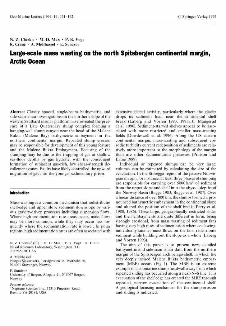
Geo-Marine Letters (1999) 19 : 131}142 ( Springer-Verlag 1999 N. Z. Cherkis ' M. D. Max ' P. R. Vogt K. Crane ' A. Midthassel ' E. Sundvor Large-scale mass wasting on the north Spitsbergen continental margin, Arctic Ocean Abstract Closely spaced, single-beam bathymetric and side-scan sonar investigations on the northern slope of the western Svalbard insular platform have revealed the pres- ence of a Late Quaternary slump complex forming a hanging-wall slump canyon near the head of the Malene Bukta (Malene Bay) bathymetric embayment in the northern continental margin. Repeated slump erosion may be responsible for development of this young feature and the Malene Bukta Embayment. Focusing of the slumping may be due to the trapping of gas at shallow sea-#oor depths by gas hydrate, with the consequent formation of subjacent gas-rich, low shear-strength de- collement zones. Faults have likely controlled the upward migration of gas into the younger sedimentary prism. Introduction Mass-wasting is a common mechanism that redistributes shelf-edge and upper slope sediment downslope by vari- ous gravity-driven processes including suspension #ows. Where high sedimentation-rate areas occur, mass #ows may be more common, while they may occur less fre- quently where the sedimentation rate is lower. In polar regions, high sedimentation rates are often associated with N. Z. Cherkis1 (|) ) M. D. Max ) P. R. Vogt ) K. Crane Naval Research Laboratory, Washington D.C. 20375-5350, USA A. Midthassel Norges Sj+kartverk, Lervigsveien 36, Postboks 60, N-4001 Stavanger, Norway E. Sundvor University of Bergen, Allegate 41, N-5007 Bergen, Norway Present address: 1 Neptune Sciences Inc., 12310 Pinecrest Road, Reston, VA 20191, USA extensive glacial activity, particularly where the glacier drops its sediment load near the continental shelf break (Laberg and Vorren 1993, 1995a, b; Mangerud et al. 1996). Sediment-starved shelves appear to be asso- ciated with more restricted and smaller mass-wasting "elds (Dowdeswell et al. 1996). Along the US eastern continental margin, mass-wasting and subsequent epi- sodic turbidity current redeposition of sediments are rela- tively more important to the morphology of the margin than are other sedimentation processes (Pratson and Laine 1989). Individual or repeated slumps can be very large; volumes can be estimated by calculating the size of the evacuation. In the Storegga region of the passive Norwe- gian margin, for instance, at least three phases of slumping are responsible for carrying over 5000 km3 of sediment from the upper slope and shelf into the abyssal depths of the Norway Basin (Bugge 1983; Bugge et al. 1987). Over a linear distance of over 800 km, the slumps formed a pro- nounced bathymetric embayment in the continental slope and altered the position of the shelf break (Perry et al. 1980, 1986). These large, geographically restricted slides and their embayments are quite di!erent in form, being strongly erosional, from mass wasting of sediment fans having very high rates of sedimentation where coalescing, individually smaller mass-#ows on the fans redistribute sediment while building out the slope as a whole (Laberg and Vorren 1993). The aim of this paper is to present new, detailed bathymetric and side-scan sonar data from the northern margin of the Spitsbergen archipelago shelf, in which the very deeply incised Malene Bukta bathymetric embay- ment (MBE) occurs (Fig. 1). The MBE is an extreme example of a submarine slump headwall away from which repeated sliding has occurred along a near-N}S line. This evacuation of the shelf edge has created the MBE through repeated, narrow evacuation of the continental shelf. A geological focusing mechanism for the slump erosion and sliding is indicated.
-
Upload
navalresearchlab -
Category
Documents
-
view
4 -
download
0
Transcript of Large-scale mass wasting on the north Spitsbergen continental margin, Arctic Ocean
Geo-Marine Letters (1999) 19 : 131}142 ( Springer-Verlag 1999
N. Z. Cherkis ' M. D. Max ' P. R. VogtK. Crane ' A. Midthassel ' E. Sundvor
Large-scale mass wasting on the north Spitsbergen continental margin,Arctic Ocean
Abstract Closely spaced, single-beam bathymetric andside-scan sonar investigations on the northern slope of thewestern Svalbard insular platform have revealed the pres-ence of a Late Quaternary slump complex forming ahanging-wall slump canyon near the head of the MaleneBukta (Malene Bay) bathymetric embayment in thenorthern continental margin. Repeated slump erosionmay be responsible for development of this young featureand the Malene Bukta Embayment. Focusing of theslumping may be due to the trapping of gas at shallowsea-#oor depths by gas hydrate, with the consequentformation of subjacent gas-rich, low shear-strength de-collement zones. Faults have likely controlled the upwardmigration of gas into the younger sedimentary prism.
Introduction
Mass-wasting is a common mechanism that redistributesshelf-edge and upper slope sediment downslope by vari-ous gravity-driven processes including suspension #ows.Where high sedimentation-rate areas occur, mass #owsmay be more common, while they may occur less fre-quently where the sedimentation rate is lower. In polarregions, high sedimentation rates are often associated with
N. Z. Cherkis1 (|) ) M. D. Max ) P. R. Vogt ) K. CraneNaval Research Laboratory, Washington D.C.20375-5350, USA
A. MidthasselNorges Sj+kartverk, Lervigsveien 36, Postboks 60,N-4001 Stavanger, Norway
E. SundvorUniversity of Bergen, Allegate 41, N-5007 Bergen,Norway
Present address:1Neptune Sciences Inc., 12310 Pinecrest Road,Reston, VA 20191, USA
extensive glacial activity, particularly where the glacierdrops its sediment load near the continental shelfbreak (Laberg and Vorren 1993, 1995a, b; Mangerudet al. 1996). Sediment-starved shelves appear to be asso-ciated with more restricted and smaller mass-wasting"elds (Dowdeswell et al. 1996). Along the US easterncontinental margin, mass-wasting and subsequent epi-sodic turbidity current redeposition of sediments are rela-tively more important to the morphology of the marginthan are other sedimentation processes (Pratson andLaine 1989).
Individual or repeated slumps can be very large;volumes can be estimated by calculating the size of theevacuation. In the Storegga region of the passive Norwe-gian margin, for instance, at least three phases of slumpingare responsible for carrying over 5000 km3 of sedimentfrom the upper slope and shelf into the abyssal depths ofthe Norway Basin (Bugge 1983; Bugge et al. 1987). Overa linear distance of over 800 km, the slumps formed a pro-nounced bathymetric embayment in the continental slopeand altered the position of the shelf break (Perry et al.1980, 1986). These large, geographically restricted slidesand their embayments are quite di!erent in form, beingstrongly erosional, from mass wasting of sediment fanshaving very high rates of sedimentation where coalescing,individually smaller mass-#ows on the fans redistributesediment while building out the slope as a whole (Labergand Vorren 1993).
The aim of this paper is to present new, detailedbathymetric and side-scan sonar data from the northernmargin of the Spitsbergen archipelago shelf, in which thevery deeply incised Malene Bukta bathymetric embay-ment (MBE) occurs (Fig. 1). The MBE is an extremeexample of a submarine slump headwall away from whichrepeated sliding has occurred along a near-N}S line. Thisevacuation of the shelf edge has created the MBE throughrepeated, narrow evacuation of the continental shelf.A geological focusing mechanism for the slump erosionand sliding is indicated.
Fig
.1
Clo
sely
spac
edN}S
and
E}W
lines
and
dark
area
ssh
ow
trac
k-lin
esu
rvey
bat
hym
etry
cove
rage
.The
N}S
trac
klin
esof
the
bath
ymet
ric
surv
eyw
ere
exte
nded
toin
clud
eth
eE}W
trac
klin
esofa
spec
ials
urve
yin
ord
erto
de"
ne
the
feat
ure
.Sea
MA
RC
IIside
-sca
nre
cord
sar
eth
em
ainly
NE}SW
tren
ding
surv
eylin
esw
ith
N}S
cross
-tra
cks.
A}A
@and
B}B
@(h
eavy
lines
)are
side-
scan
imag
es(F
ig.6
)sel
ecte
dto
show
dow
n-slopefe
ature
sin
theM
alen
eBukt
aEm
bay
men
t.T
he20
0-an
d20
00-m
conto
ursar
efrom
Cher
kis
etal
.(19
91).
Fig
ures
7an
d8
are
loca
ted
alon
gre#ec
tion
seism
iclin
es(d
ashe
d).
BA
P,Bar
ents
Aby
ssal
Pla
in;BF
Z,Bill
efjo
rden
fault
zone
;H
S,H
inlo
pen
Str
ait;
MBE
,M
alen
eB
ukta
Em
bay
men
t;Y
P,
Yer
mak
Pla
teau
132
The Malene Bukta embayment
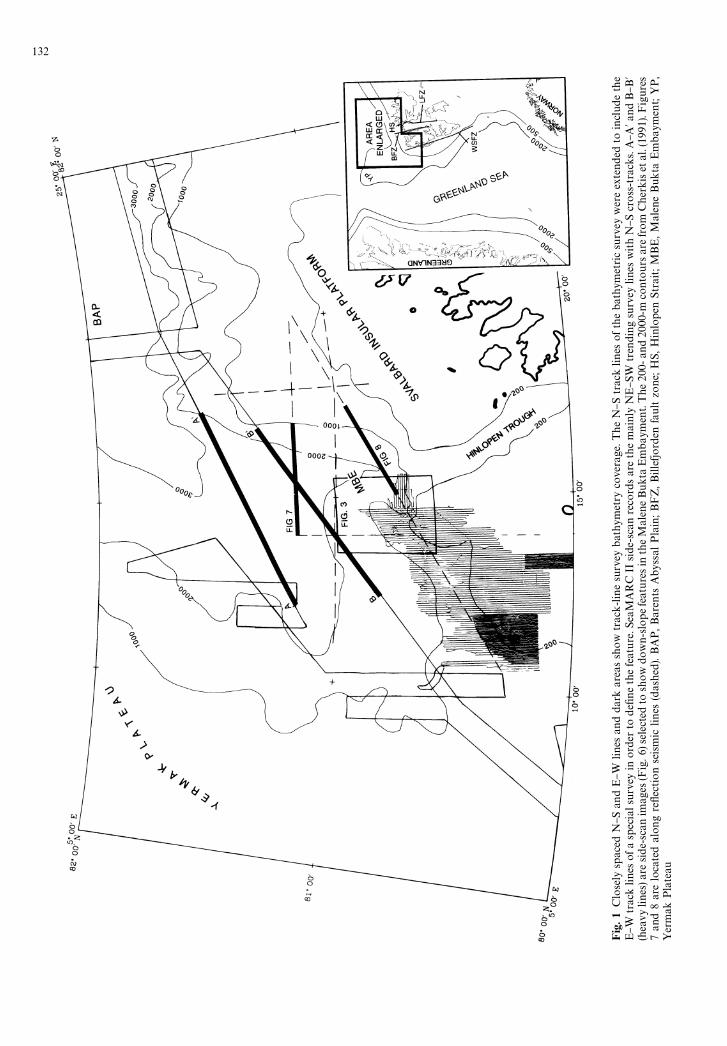
The western Svalbard and Barents Sea continental slopesare characterized by imbricated mass #ow deposits andslumps (Faleide et al. 1984; Vogt et al. 1990, 1993; Solheimet al. 1996a) (Fig. 2), as are other high-latitude continentalmargins where high sediment supply is provided by activeglacial erosion on the shelf (Matishov 1979, 1986; Dow-deswell et al. 1996). Slumping along the European conti-nental margin of the North Atlantic is common (Kenyon1987), and several slumps have been examined in detail,notably the Storegga slide (Jansen et al. 1987) on theNorwegian continental margin and mud #ows west of
Fig. 2 Interpretation of features on the shelf and slope to the northof Svalbard. Narrow, parallel channel area pattern does not showposition of individual channels. Dendritic, down-slope erosionaldrainage channels are shown where mapped on the slope east of theMalene Bukta Embayment. Continental slope to the SW of MBEshows little slumping but has relatively straight down-slope-orientedfeatures (Fig. 2) di!erent from the dendritic, down-slope drainagepattern to the east of MBE. Dotted lines show limits of slumpdeposits. Short lines about parallel to slope in the lower MBEindicate depositional mass-#ow ridges
Bear Island Trough (Vogt et al. 1993; Laberg and Vorren1995a).
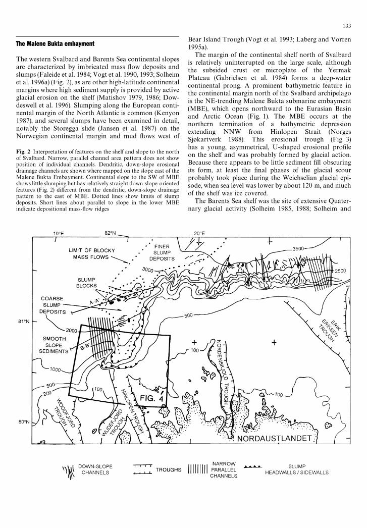
The margin of the continental shelf north of Svalbardis relatively uninterrupted on the large scale, althoughthe subsided crust or microplate of the YermakPlateau (Gabrielsen et al. 1984) forms a deep-watercontinental prong. A prominent bathymetric feature inthe continental margin north of the Svalbard archipelagois the NE-trending Malene Bukta submarine embayment(MBE), which opens northward to the Eurasian Basinand Arctic Ocean (Fig. 1). The MBE occurs at thenorthern termination of a bathymetric depressionextending NNW from Hinlopen Strait (NorgesSj+kartverk 1988). This erosional trough (Fig. 3)has a young, asymmetrical, U-shaped erosional pro"leon the shelf and was probably formed by glacial action.Because there appears to be little sediment "ll obscuringits form, at least the "nal phases of the glacial scourprobably took place during the Weichselian glacial epi-sode, when sea level was lower by about 120 m, and muchof the shelf was ice covered.
The Barents Sea shelf was the site of extensive Quater-nary glacial activity (Solheim 1985, 1988; Solheim and
133
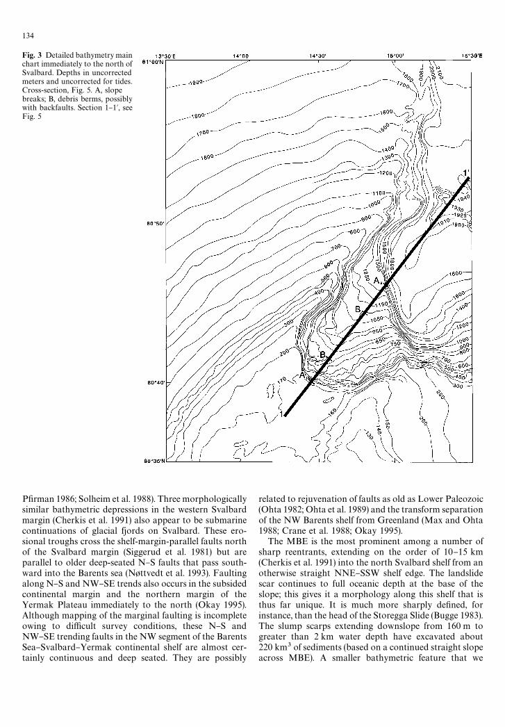
Fig. 3 Detailed bathymetry mainchart immediately to the north ofSvalbard. Depths in uncorrectedmeters and uncorrected for tides.Cross-section, Fig. 5. A, slopebreaks; B, debris berms, possiblywith backfaults. Section 1}1@, seeFig. 5
P"rman 1986; Solheim et al. 1988). Three morphologicallysimilar bathymetric depressions in the western Svalbardmargin (Cherkis et al. 1991) also appear to be submarinecontinuations of glacial fjords on Svalbard. These ero-sional troughs cross the shelf-margin-parallel faults northof the Svalbard margin (Siggerud et al. 1981) but areparallel to older deep-seated N}S faults that pass south-ward into the Barents sea (N+ttvedt et al. 1993). Faultingalong N}S and NW}SE trends also occurs in the subsidedcontinental margin and the northern margin of theYermak Plateau immediately to the north (Okay 1995).Although mapping of the marginal faulting is incompleteowing to di$cult survey conditions, these N}S andNW}SE trending faults in the NW segment of the BarentsSea}Svalbard}Yermak continental shelf are almost cer-tainly continuous and deep seated. They are possibly
related to rejuvenation of faults as old as Lower Paleozoic(Ohta 1982; Ohta et al. 1989) and the transform separationof the NW Barents shelf from Greenland (Max and Ohta1988; Crane et al. 1988; Okay 1995).
The MBE is the most prominent among a number ofsharp reentrants, extending on the order of 10}15 km(Cherkis et al. 1991) into the north Svalbard shelf from anotherwise straight NNE}SSW shelf edge. The landslidescar continues to full oceanic depth at the base of theslope; this gives it a morphology along this shelf that isthus far unique. It is much more sharply de"ned, forinstance, than the head of the Storegga Slide (Bugge 1983).The slump scarps extending downslope from 160 m togreater than 2 km water depth have excavated about220 km3 of sediments (based on a continued straight slopeacross MBE). A smaller bathymetric feature that we
134

Fig. 4 Morphologicalinterpretation. Heavy lines aretraces of major slump features.Tics on downslope of heavylines indicate scarp, tics onupslope of heavy lines showdebris berm or backfaultpositions
interpret as a slump scarp along the MBE rim formsan erosional bight in the southwest MBE headwall(Figs. 3 and 4).
Geological framework
The Svalbard archipelago at the northwestern corner ofthe Barents Sea continental shelf contains Precambrianand Lower Paleozoic metamorphic rocks similar to thoseseen in Scandinavia and Greenland, as well as youngerrocks of Upper Paleozoic, Mesozoic, and Tertiary age,exposed on the islands as well as on the sea #oor (Hjelleand Lauritzen 1982; Brekke and Riis 1987).
The continental shelf sea #oor is generally #at to undu-lating, but deepens toward the continental margin. Muchof the submerged continental shelf, especially near andalong the shelf break, is composed of Mesozoic, Tertiary,and Quaternary sedimentary strata (Sundvor andEldholm 1979). Sedimentary rocks along the northernSvalbard margin are only slightly deformed, having
escaped the important early Tertiary tectonism that isrestricted to the west Svalbard margin (Lepvrier andGeyssant 1985; Eldholm et al. 1987; Faleide et al. 1984;Dallmann et al. 1988). Upper Tertiary and Quaternarystrata in the seaward-dipping sedimentary wedge are un-deformed.
The shelf immediately north of Svalbard has not yetbeen examined geophysically in as much detail as hasthe west Svalbard margin. West Spitsbergen contains atleast "ve major north-trending fault and shear zones in-cluding the Sorgfjorden Shear Zone and the Breibogen,Billefjorden, Lomfjorden, and Raudfjorden Fault Zones(Manby and Lyberis 1996). In addition, northwest-trend-ing faults parallel to Hinlopen Trough also pass northwestacross the shelf and down the continental slope, wherethey have been imaged on seismic re#ection recordsnorthwest of 813N, 123E (Austegard 1982). A prominent,linear bathymetric trough extends northward fromHinlopen Strait (Fig. 3) northwest to the shelf break at thehead of the MBE (Cherkis et al. 1994). A number of faultsand shear zones on the northern margin of Svalbard passinto this feature. Ohta (1982), Ohta et al. (1989), and
135

Siggurud et al. (1981) regard the Hinlopen Strait FaultZone as lying along the trace of one of the dominant faultsin the region.
Slumping and morphology of the Svalbard Arctic Ocean margin
The feature we interpret as a nested slump group on theSW corner of MBE (Figs. 3 and 4) is the only feature of itstype recognized thus far along the northern Barents Seacontinental margin (Figs. 2 and 5), just as the larger MBEalso appears to be a unique morphological element. Thesubsequent SeaMARC II traverses were, in part, designedto investigate the character of the sea #oor downslopefrom the probable slump feature, and in part carried outto cover as much of the slope as could be imaged underfortuitous sea-ice conditions (Crane and Solheim 1985).Slump deposits emanating in, and downslope from theMBE have been imaged by the SeaMARC II data (Fig. 2).The steepest upper continental slope gradients in theregion occur along the southern headwalls of MBE(Fig. 2), where the most clear-cut and presumablyyoungest of the minor slumps occurred.
Side-scan images (Fig. 6) from the downslope #oor ofthe MBE show a strongly irregular pattern of debris. Inparticular, blocky slumping and rugged debris surfacemorphology persist north of MBE (Figs. 2 and 6). Ina reversal of normal mass-wasting distribution, wheremore distal material is found further from the mass-wast-ing source, small slump blocks are most common on thesouthern transect, nearer the source. Unusually large, 2-to 4-km-long blocks have been imaged on the northerntransect (Fig. 6A) nearly 70 km from the headwall of theMBE. There is an unusually high relief for the slumpedblocks, which are upstanding with steep margins risingover 40 m (measured on blow-up of seismic record usingseawater velocity of 1500 m/sec) above the surrounding
Fig. 5 Bathymetric pro"le (4.7#vertical exaggeration). Cross-sec-tion located on Fig. 3. A, slope break; B, debris berm. Heavy lines,probable faults
sediments. These blocks are characterized by high back-scatter, even from low grazing-angle insoni"cation. Thesesuggest the existence of either coarse-grained sediment,dewatered and compacted sediment, or partially lithi"edsediment. The biaxial pinch-and-swell form in the beddingplane indicates that the sediment may have had greatershear strength than would be anticipated from uncompac-ted, sur"cial marine sediments. Similar, rafted coherentblocks are also common along the US east coast continen-tal slopes (Embley and Jacobi 1986) and in the StoreggaSlide valley (Bugge 1983; Bugge et al. 1987).
Because the younger slump scarps have a very freshmorphology unobscured by draping of younger sediment,the youngest slumping in the excavated canyon is prob-ably no older than the end of the Weichselian. The sub-sequent rise of sea level and abatement of glacial erosionwould have led to a dramatically reduced sediment supply(Siegert and Dowdeswell 1996), thus keeping the scarpsrelatively steep. Soft-sediment slump rotational bed-slipsurfaces occur down to 0.5 s depth (about 500}600 m),and a number of dislocation surfaces at di!erent depthshave been imaged on re#ection seismic surveys (Fig. 7).Events A and C may merge upslope. Event D is a youngerfeature related to movement of sur"cial sediments. Thepoor signal from area B could be due either to gas e!ectsor to scattering from a geological surface related to eventC (Fig. 7B). This appears to have caused a local, highattenuation of the signal below slip surface C. It is possiblethat event C may be related to the base of the gas hydrate.However, especially where the event appears to passacross other events that would be related to older geologi-cal features, there is no clear blanking or gas zone thatwould con"rm the presence of hydrate.
Rather than occurring broadly along the continentalmargin, as is the case o! the US east coast (Embley andJacobi 1986), repeated slumping is taking place in at leastone particular location along the north Spitsbergen mar-gin. Repeated, localized slumping has been documented atthe head of the Storegga Slide region along the south-western Norwegian continental margin, where at leastthree major sediment evacuations have formed in thesame area (Bugge 1983; Bugge et al. 1987).
136

Fig. 6 SeaMARC II side-scan images across slump area collectedaboard R/< Has kon Mosby in 1990 (Crane and Solheim 1995). Referto Fig. 1 for location of survey lines and scale. Inset A shows detail ofa block train resembling extensional pinch-and-swell structures
High rates of sediment deposition and formation ofover-steep slopes, have commonly been used to explainsubmarine slumping. Aagaard (personal communication)suggests the West Spitsbergen current dissipates in thisarea and deposits sediment as the current velocity de-creases. The diminished current activity would result inincreasing slope instability owing to a high sedimentationrate, although not as high as the glacial average of be-tween 0.25 and 1.8 m/ka (Solheim et al. 1996b). Delivery ofsediment carried to the Arctic shelf edge by glaciers, whichis indicated from the trough morphology, probably onceextended north from Hinlopen Strait. This would havehad the potential to deposit larger volumes of sedimenthere in a shorter time than ocean currents could provide.No sediment fan related to either the trough mouth ora sediment drift can be recognized from the bathymetricmorphology. Small slumps at the head of the slump can-yon and for several kilometers to the east of MBE may bedue to local, high deposition rates of consolidated glacialdebris, but it is di$cult to argue that sediment overload-ing alone is the main cause for the creation of the strongly
erosional MBE wherein mass #ow of recent sedimentcould have comprised only a small part of the excavatedvolume. In addition, although glaciers have brought agreat deal of sediment to the edge of the continental shelfboth north and west of Spitsbergen, the MBE is the onlyfeature of its type and scale. Therefore, we are searchingfor a mechanism other than loading of glacial sediment toexplain the existence of the MBE.
Some diapiric movement thought to generate slumping,such as is common along the US Gulf Coast, is not anavailable mechanism to the north of Spitsbergen, whereno suitable subjacent evaporite horizons exist and whereno diapiric structures have been recognized. On the otherhand, some of the diapir-related slumping on the south-eastern US continental slope is now recognized as beinghydrate-related (Paull and Dillon 1981).
A mechanism for focused erosion
Gas hydrate occurs in sea-#oor sediments in a zone ofthermodynamic balance extending downward from thesea #oor to a depth determined by temperature, whichincreases downward (Kvenvolden 1988). Hydrate willform in interstitial water if su$cient methane is introduc-ed, usually from below. Brewer et al. (1998) have shown
137

Fig. 7 a Part of re#ection seismic line MF-I-90 Norwegian Petro-leum Directorate Mo!en#aket 1990 Survey of the Svalbard margin.Line oriented 0483, NE to right. Seconds scale shows TWT depthfrom sea surface. Possible BSR and hydrate blanking in slump massbelow steep scarp at head of Malene Bukta Embayment. Events arerelated to slip surfaces. A, Lower sediment decollement; B, area ofsignal scattering; C, intermediate sediment decollement; D, uppersediment decollement. b Interpretation showing progressive down-slope mass movement without headwall detachment. T, toe struc-tures. Irregular features and scattered signal lower on slope areblocky debris #ows, arrow shows cross-cutting of seismic events
that not only is the formation of hydrate virtually instan-taneous, but that the hydrate may seal the sediment andcause subsequent gas to pool below.
Because of their water depth and sea-#oor water tem-peratures, the slope in the area north of the MBE and thewalls of the MBE lie within the hydrate stability zone(HSZ), and thus hydrate can be anticipated in the near-sea-#oor sediments. At the shallow water depths (a fewhundred meters) of the upper continental slope, the HSZmay be only a few tens of meters thick and very responsiveto pressure changes. Kayen and Lee (1991) have discussedthe gas hydrate-trapped gas mechanism for initiating sea-#oor instability, calculated the time required to producesigni"cant gas through dissociation, and concluded thathydrate dissociation or the formation of gas pooled insediment beneath hydrate can produce mechanically veryweak gas-rich zones that will initiate slumping. Periodicgasi"cation of hydrates at the base of the HSZ can be
induced either by lowering of sea levels during glacialmaxima lowering sea-#oor pressure or by raising temper-ature (Dillon et al. 1997).
Much of the methane seepage in the northern Gulf ofMexico shelf is thought to be related to up-slope migra-tion of gas below hydrate (Bennett 1988). Coincidentally,the continental slope in the Gulf of Mexico is well knownfor its profusion of slumps. Dillon et al. (1993) also invokesa genetic relationship between the presence of gas hy-drates and major slumping, even though the gas-rich baseof the HSZ is not the decollement. McIver (1977) noteda spatial relationship between slumping and hydrate inthe upper slope on the US east coast continental marginand suggested a genetic relationship. The presence of gashydrate in a surface blanket o!ers a mechanism for form-ing a near-surface seal that can trap shallow gas (Grantzet al. 1976; Carpenter 1981; Paull and Dillon 1981; Kven-volden and Barnard 1983; Bugge 1983; Field and Kven-volden 1985; Max 1990a; Dillon et al. 1993).
Bugge (1983) and Jansen et al. (1987) have, for instance,suggested that the multiple Storegga slides (628N to658N) may have been triggered by gasi"cation of hydratesknown locally along the Norwegian margin (Kvenvoldenet al. 1989). However, Jansen et al. (1987) prefer earth-quakes as the main trigger mechanism for the StoreggaSlide. A gas hydrate and slump generating mechanism ispostulated for the massive Canary Island mass #ow,which contains slump blocks greater than 1 km acrossand which took place during the late Quaternary sea levellow stand (Weaver et al. 1992).
138
Thermodynamic conditions and the likelihood of gasgeneration make it suitable for hydrates to occur underthe slope north of Svalbard (Max and Lowrie 1993),although none has been positively identi"ed to date. Velo-city pro"les are typical of a hydrate layer in sedimentsabout 100 km away on the west Svalbard margin(Austegard 1982) and on the Barents Sea shelf (L+v+ et al.1990; Laberg and Andreassen 1996). Evidence for hy-drates is present west of Spitsbergen (Vogt et al. 1994;Egorov et al. 1997) and on the Bear Island fan southwestof Spitsbergen, and Vogt et al. (1997) show that hydrate islocally present in the region. Additionally, fault-ductingof gas is known in the Barents Sea shelf (Laberg andAndreassen 1996), along fault systems that can be tracedfrom the MBE region into the western Barents shelf(N+ttvedt et al. 1993).
Indistinct evidence for the presence of gas hydrate in theimmediate area discussed in this paper has been imagedon a re#ection seismic section from the area (Fig. 8). Theevidence is not as conclusive as it is elsewhere on theNorwegian margin (Laberg and Vorren 1995b). Here, azone of acoustic impedance blanking (Max 1990a, b; Leeet al. 1993) becomes more prominent downward andabuts a strong seismic event that locally appears to pass
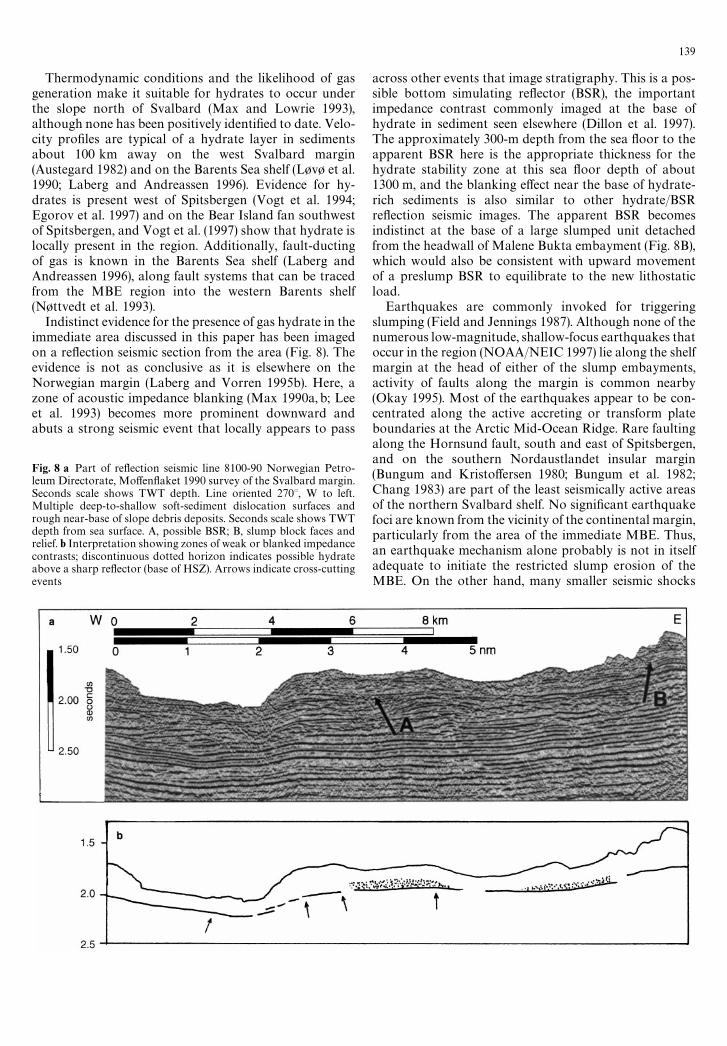
Fig. 8 a Part of re#ection seismic line 8100-90 Norwegian Petro-leum Directorate, Mo!en#aket 1990 survey of the Svalbard margin.Seconds scale shows TWT depth. Line oriented 2703, W to left.Multiple deep-to-shallow soft-sediment dislocation surfaces andrough near-base of slope debris deposits. Seconds scale shows TWTdepth from sea surface. A, possible BSR; B, slump block faces andrelief. b Interpretation showing zones of weak or blanked impedancecontrasts; discontinuous dotted horizon indicates possible hydrateabove a sharp re#ector (base of HSZ). Arrows indicate cross-cuttingevents
across other events that image stratigraphy. This is a pos-sible bottom simulating re#ector (BSR), the importantimpedance contrast commonly imaged at the base ofhydrate in sediment seen elsewhere (Dillon et al. 1997).The approximately 300-m depth from the sea #oor to theapparent BSR here is the appropriate thickness for thehydrate stability zone at this sea #oor depth of about1300 m, and the blanking e!ect near the base of hydrate-rich sediments is also similar to other hydrate/BSRre#ection seismic images. The apparent BSR becomesindistinct at the base of a large slumped unit detachedfrom the headwall of Malene Bukta embayment (Fig. 8B),which would also be consistent with upward movementof a preslump BSR to equilibrate to the new lithostaticload.
Earthquakes are commonly invoked for triggeringslumping (Field and Jennings 1987). Although none of thenumerous low-magnitude, shallow-focus earthquakes thatoccur in the region (NOAA/NEIC 1997) lie along the shelfmargin at the head of either of the slump embayments,activity of faults along the margin is common nearby(Okay 1995). Most of the earthquakes appear to be con-centrated along the active accreting or transform plateboundaries at the Arctic Mid-Ocean Ridge. Rare faultingalong the Hornsund fault, south and east of Spitsbergen,and on the southern Nordaustlandet insular margin(Bungum and Kristo!ersen 1980; Bungum et al. 1982;Chang 1983) are part of the least seismically active areasof the northern Svalbard shelf. No signi"cant earthquakefoci are known from the vicinity of the continental margin,particularly from the area of the immediate MBE. Thus,an earthquake mechanism alone probably is not in itselfadequate to initiate the restricted slump erosion of theMBE. On the other hand, many smaller seismic shocks
139

would facilitate gas movement within the sediments aswell as being possible triggers for mass #ows on gas-richdecollement.
Discussion
A special mechanism appears to be responsible for theformation of the Malene Bukta embayment. There is ageographic coincidence between the northward prolonga-tion of faults related to the Billefjorden system and theMBE. Although the faults intersecting the continentalmargin could themselves induce structural weakness lead-ing to slope failure, these faults are not seen in the youngersediments, and similar faults that intersect the marginelsewhere are not necessarily associated features like theMBE. Therefore, a further mechanism for initiating peri-odic slope failure in a restricted location is required.
The hydrate-gas decollement mechanism for initiatingslumping has the potential to operate episodically, relatedto sea level fall, sea-#oor temperature rises, or abnormallyhigh pulses of gas #ow upward along the faults. Methane(either as free gas or in solution) arriving in the HSZ willform hydrate because the pressure}temperature condi-tions are suitable. When su$cient hydrate has formed,even a thin seal that can trap gas below it may developand subjacent gas-rich zones are likely to form fromsubsequent methane arriving at the base of the HSZ. Inaddition, sea levels at glacial maxima are related to sealevel lows, and sea level falls can lead to hydrate dissocia-tion and the production of signi"cant overpressured gas atthe base of the HSZ (Max and Chandra 1998).
Su$cient gas in a shallow, slope-parallel zone stronglyreduces sediment strength. When load exceeds lateralstrength, or earth shocks initiate failure, slumps may forma decollement on the low strength gas-rich zone. Slumpingwill then remove the hydrated sediment and the gas-richzone, and slides may form that carry the slumped materialfor long distances downslope. After the gas is vented or thesediment above the gas is thinned, more hydrate will formin the new HSZ and the cycle can begin again. We con-clude that the MBE has likely formed in this manner, withthe repeated slumping caused by the hydrate-gas decolle-ment mechanism.
Areas in which there is evidence for repeated slumpingare likely to be sites of slumping in the future. Thus, theremay be environmental hazards to submerged objects suchas cables and pipelines, should such man-made objects beplaced on the sea #oor in areas where repeated slumpingcan be identi"ed.
Acknowledgments Our deepest gratitude to Norges Sj+kartverk forallowing us to use the raw bathymetric data in this study and toMorten Sand of the Norwegian Petroleum Directorate (Oljedirek-toratet) for the seismic pro"les. Thanks also to Irene Jewett forpreparation of the "gures and to B. G. Hurdle, N. T. Edgar, andW. P. Dillon (US Geological Survey) for discussions and suggestionson hydrates. This work was supported by the O$ce of NavalResearch, Program Element No. 0601153N.
References
Austegard A (1982) Velocity analysis of sonobuoy data from thenorthern Svalbard margin. Norwegian Petroleum DirectorateScienti"c Report 9, University of Bergen, 13 pp, 12 "gs
Bennett R (1988) Gas hydrate research in the Gulf of Mexico.Morgantown Energy Technology Center, Morgantown, WV,Report DOE/MC/23145-2616 (DE88010279), 41 pp
Brekke H and Riis F (1987) Tectonics and basin evolution of theNorwegian shelf between 628N and 728N. Norsk GeologiskTidsskrift 67 : 295}311
Brewer PG, Orr FM Jr, Friederich G, Kvenvolden KA, and OrangeDL (1998) Gas hydrate formation in the deep sea: in situ experi-ments with controlled release of methane, natural gas, and car-bon dioxide. American Chemical Society. Energy and Fuels12 : 183}188
Bugge T (1983) Submarine slides on the Norwegian continentalmargin, with special emphasis on the Storegga area. ContinentalShelf Institute, Norway. IKU Publication 110, Section 5.7.3,152 pp
Bugge T, Befring S, Belderson H, Eidvin T, Jansen E, Kenyon NH,Holtedahl H, and Sejrup HP (1987) A giant three-stage sub-marine slide o! Norway. Geo-Marine Letters 7 : 191}198
Bungum H and Kristo!ersen Y (1980) A microearthquake survey ofthe Svalbard region, Final Report, Phase 1. NORSAR TechnicalReport 1/80, NTNF/NORSAR, Kjeller, Norway, 42 pp
Bungum H, Mitchell BJ, and Kristo!ersen Y (1982) Concentratedearthquake zones in Svalbard. Tectonophysics 82 : 175}188
Carpenter G (1981) Coincident sediment slump/clathrate complexeson the US Atlantic continental slope. Geo-Marine Letters 1 :29}32
Chang W (1983) Structure and Tectonics of the Barents Shelf:Unpublished PhD thesis. St. Louis, Missouri: St. Louis Univer-sity, 234 pp
Cherkis NZ, Fleming HS, Max MD, Vogt PR, Czarnecki MF,Kristo!ersen Y, Midthassel A, and Rokoengen K (1991)Bathymetry of the Barents and Kara seas. Geological SocietyAmerica Map and Chart Series, MCH047
Cherkis NZ, Max MD, Midthassel A, Crane K, Sundvor E, andVogt PR (1994) Deep ice scour and mass-wasting features onthe northern svalbard insular shelf and slope. In: D. Thurstonand Fujita K (Eds.), Proceedings, First International Conferenceon Arctic Margins (ICAM). Anchorage, AK, Sept 1992. USMinerals Management Service OSC Study MMS 94-0040 : 333}338
Crane K and Solheim E (Eds.) (1985) Sea#oor Atlas of the NorthernNorwegian}Greenland Seas. Norsk Polarinstitutt Meddeleser137 : 1995
Crane K., Sundvor E, and Foucher J (1988) Thermal evolution ofthe western Svalbard margin. Marine Geophysical Researches9 : 165}194
Dallman WK, Ohta Y, and Andreasen A (Eds.) (1988) TertiaryTectonics of Svalbard: Abstracts from Symposium, Oslo, 26}27April, 1988. Norsk Polarinstitutt Rapport Series 46 : 110 pp
Dillon WP, Lee MJ, Fehlhaber K, and Coleman DF (1993) Gashydrates on the Atlantic continental margin of the United States} controls on concentration. In: DG Howell (Chief Ed.), TheFuture of Energy Gasses. US Geological Survey ProfessionalPaper 1570 : 313}330
Dillon WP, Holbrook WS, Drury R, Gettrust J, Hutchinson D,Booth J, and Taylor M (1997) Faulting of gas-hydrate-bearingmarine sediments-Contribution to permeability. Proceedings Of-fshore Technology Conference Houston, Texas 5}8 May 1997.OTC Paper 8296 : 201}209
Dowdeswell JA, Kenyon NH, Elverh+i A, Laberg JS, Hollender F-J,Mienert J and Siegert MJ (1996) Large-scale sedimentation onthe glacier-in#uenced Polar North Atlantic margins: long-rangeside-scan sonar evidence. Geophysical Research Letters 23 :35}38
140
Egorov AV, Ginsburg GD, Vogt PR, and Roshkov AN (1997) Gashydrates on the immediate sea#oor. EOS, Transactions of theAmerican Geophysical Union 78/17 (supplement) : S187
Eldholm O, Faleide JI and Myhre AM (1987) Continent-oceantransition at the western Barents Sea/Svalbard continentalmargin. Geology 15 : 1118}1122
Embley RW and Jacobi R (1986) Mass wasting in the western NorthAtlantic. In: Vogt PR and Tucholke BE (Eds.), The Geology ofNorth America, Volume M: The Western North Atlantic Region.Geological Society of America, pp 479}490
Faleide JI, Gudlaugsson ST, and Jacquart G (1984) Evolutionof the western Barents Sea. Marine Petroleum Geology1 : 123}150
Field ME and Jennings E (1987) Sea#oor gas seeps triggered bya northern California earthquake. Marine Geology 77 : 39}51
Field ME and Kvenvolden KA (1985) Gas hydrates on the northernCalifornia continental margin. Geology 13 : 517}520
Gabrielsen RH, Foerseth R, Hamar G, and R+nnevik H (1984)Nomenclature of the main structural features on the NorwegianContinental Shelf north of the 62nd parallel. In: Spencer AM,Johnsen SO, M+erk A, Nys+ther E, Songstad P, and SpinnangerA (Eds.), Petroleum Geology of the North European Margin.London: Graham and Trotman, pp 41}60
Grantz A, Boucher GW and Whitney OT (1976) Possible solidgas hydrate and natural gas deposits beneath the continentalslope of the Beaufort Sea. US Geological Survey Circular733 : 17 pp
Hjelle A and Lauritzen " (1982) Geological Map of Svalbard 1:500,000, Sheet 3G, Spitsbergen northern part. Oslo: NorskPolarinstitutt, 15 pp, map
Jansen E, Befring S, Bugge T, Eidvin T, Holtedahl H, and Sejrup HP(1987) Large submarine slides on the Norwegian continentalmargin: sediments, transport and timing. Marine Geology 78 :77}107
Kayen RE and Lee HJ (1991) Pleistocene slope instability of gashydrate-laden sediment on the Beaufort Sea margin. MarineGeochronology 10 : 125}141
Kenyon NH (1987) Mass-wasting features on the continental slopeof northwest Europe. Marine Geology 74 : 57}77
Kvenvolden KA (1988) Methane hydrates and global climate.Global Biogeochemical Cycles 2 : 221}229
Kvenvolden KA and Barnard LA (1983) Gas hydrates of the BlakeOuter Ridge, Site 533, DSDP Leg 76. Initial Reports DSDP76 : 353}360
Kvenvolden KA, Golan-Bec M, McDonald TJ, P#aum RC, andBrooks JM (1989) Hydrocarbon gases in sediment of the V+ringPlateau, Norwegian Sea. In: Eldholm O, Thiede J, Taylor E, et al.(Eds.), Proceedings, Ocean Drilling Program, Scienti"c Research104 : 319}326
Laberg JS and Andreassen K (1996) Gas hydrate and free gasindications within the Cenozoic succession of the Bj+rn+yaBasin, western Barents Sea. Marine and Petroleum Geology13 : 921}940
Laberg JS and Vorren TO (1993) A Late Pleistocene submarine slideon the Bear Island Trough Mouth Fan. Geo-Marine Letters13 : 227}234
Laberg JS and Vorren TO (1995a) Late Weischselian debris #owdeposits on the Bear Island Trough Mouth Fan. MarineGeology 27 : 45}72
Laberg JS and Vorren TO (1995b) Use of seismic data in estimatingthe amount of in-situ gas hydrates in deep marine sediment.In: Howell DG (Chief Ed.), The Future of Energy Gases. USGeological Survey Professional Paper 1570 : 563}581
Laberg JS and Vorren TO (1996) The Middle and Late Pleistoceneevolution of the Bear Island Trough Mouth Fan. Global andPlanetary Change 12 : 309}330
Lee MW, Hutchinson DR, Dillon WP, Miller JJ, Agena WF, andSwift BA (1993) Method of estimating the amount of in situgas hydrates in deep marine sediments. Marine and PetroleumGeology 10 : 493}506
Lepvrier C and Geyssant J (1985) L' eH volution structurale de lamarge occidentale du Spitsberg: coulissement et rifting tertiaries.Bulletin de la SocieH teH Geologique de France 8 : 115}125
L+v+ V, Elverh+i A, Antonsen P, Solheim A, Butenko G, GregersenO, and Liest+ O (1990) Submarine permafrost and gas hydratesin the northern Barents Sea. Norsk Polarinstitutt Rapport Series56 : 171
Manby GM and Lyberis N (1996) State of stress and tectonicevolution of the West Spitsbergen Fold Belt. Tectonophysics267 : 1}29
Mangerud J, Jansen E, and Landvik JY (1996) Late Cenozoichistory of the Scandinavian and Barents Sea ice sheets. Globaland Planetary Change 12 : 11}26
Matishov GG (1979) Geomorphological signs of the action on theScandinavian, Novaya Zemlya, and Spitsbergen ice sheets on the#oor of the Barents Sea. Oceanology 20/4 : 440}447 (AGU trans-lation)
Matishov GG (1986) Marginal glacial formations of the ocean #oor.Oceanology 26/6 : 730}735 (AGU translation)
Max MD (1990a) Gas hydrate and acoustically laminatedsediments: probable environmental cause of anomalously lowacoustic-interaction bottom loss in deep ocean sediments. NavalResearch Laboratory Report 9235 : 68 pp
Max MD (1990b) Natural gas clathrates: Geoacoustic inducementof low bottom loss. Science and technology for a newoceans decade, Vol. III. Proceedings of MTS'90. 26}28 Septem-ber 1990, Washington, DC: Marine Technological Society,pp 578}583
Max MD and Chandra K (1998) The dynamic oceanic hydratesystem: production constraints and strategies. In: Proceedings ofthe O!shore Technology Conference, 4}7 May 1998, HoustonTexas, pp 217}226
Max MD and Lowrie A (1993) Natural gas hydrates: Arctic andNordic Sea potential. In: Vorren TO, Bergsager E, Dahl-Stamnes"A, Holter E, Johansen B, Lie E, and Lund TB (Eds.), ArcticGeology and Petroleum Potential, Proceedings of the Norwe-gian Petroleum Society Conference, 15}17 August 1990, Troms+,Norway. Norwegian Petroleum Society (NPF), Special Publica-tion 2. Amsterdam: Elsevier, pp 27}53
Max MD and Ohta Y (1988) Did major fractures in continentalcrust control orientation of the Knipovich Ridge-Lena Troughsegment of the plate margin? Norsk Polarinstitutt Bulletin 6 :85}93
McIver RD (1977) Hydrates of natural gas } an important agent ingeologic processes. Geological Society of America Annual Meet-ing; Abstracts with Programs 9 : 1089}1090
NOAA/NEIC (1997) Seismicity Catalogs, Vol. 2, Global and Re-gional, 2150 BC}1996 AD, CD-ROM Set. Denver Colorado:National Earthquake Information Center
N+ttvedt A, Cecchi M, Gjelberg JG, Kristensen SE, L+n+y A, Ras-mussen A, Rasmussen E, Skott PH, and van Veen PM (1993)Svalbard-Barents Sea correlation: as short reviews. In: VorrenTO et al. (Eds.), Arctic Geology and Petroleum Potential. NPFSpecial Publication 2 : 363}375
Norges Sj+kartverk (1988) Den norske los } Arctic pilot, sailingdirections } Svalbard}Jan Mayen, vol. 7, 1st ed., Stavanger,Norway, 419 pp
Ohta Y (1982) Morpho-tectonic studies around Svalbard and thenorthernmost Atlantic. In: Embry AF and Balkwill HR (Eds.),Arctic Geology and Geophysics. Canadian Society PetroleumGeology Memoir 8 : 415}431
Ohta Y, Dallmeyer RD, and Peucat JJ (1989) Caledonian terranes inSvalbard. In: Dallmeyer RD (Ed.), Terranes in the circum-Atlan-tic Paleozoic orogens. Geological Society America Special Paper230 : 1}15
Okay N (1995) Thermal development and rejuvenation of themarginal plateaus along the transtensional volcanic marginsof the Norwegian-Greenland Sea. PhD thesis. City Universityof New York, Faculty in Earth and Environmental Sciences,348 pp
141

Paull CK and Dillon WP (1981) The appearance and distribution ofthe gas hydrate re#ector o! the southeastern United States. USGeological Survey Open File Report 80}88, 24 pp
Perry RK, Fleming HS, Cherkis NZ, Feden R, and Vogt PR (1980)Bathymetry of the Norwegian, Greenland and Western BarentsSea. Geological Society America Map and Chart Series, MC-21
Perry RK, Fleming HS, Weber JR, Kristo!ersen Y, Hall JK, GrantzA, Johnson GL, Cherkis NZ, and Larsen B (1986) Bathymetry ofthe Arctic Ocean (1:4,704,075 at Lat 7883N). Geological SocietyAmerica Map and Chart Series, MC-56
Pratson LF and Laine P (1989) The relative importance of gravity-induced versus current-controlled sedimentation during theQuaternary along the mideast US outer continental marginrevealed by 3.5 kHz echo character. Marine Geology 89 : 87}126
Siegert MJ and Dowdeswell JA (1996) Topographic control on thedynamics of the Svalbard-Barents Sea ice sheet. Global andPlanetary Change 12 : 27}39
Siggerud Th, Krassilchtchikov AA, Livchits I and Sokolov VN(1981) International Tectonic Map of Europe and AdjacentAreas (1:2,500,000) Sheet 2. International Geological Congress,Commission Geological Map of the World, Subcommission:Tectonic Map of the World
Solheim A (1985) Submarine evidence of glacier surges. PolarResearch 4 : 91}95
Solheim A (1988) Glacial Geology of the Northern Barents Sea, withEmphasis on the Surge Related, Ice Proximal Depositional Envi-ronment Norsk Polarinstitutt Rapport Series 47 (Dr. scient.Thesis), Oslo
Solheim A and P"rman SL (1986) Sea-#oor morphology outsidea grounded, surging glacier; Bras svellbreen, Svalbard. MarineGeology 65 : 127}143
Solheim A, Milliman JD, and Elverh+i A (1988) Sediment distribu-tion and sea-#oor morphology of Storbanken: implications forthe glacial history of the northern Barents Sea. Canadian JournalEarth Sciences 25 : 547}556
Solheim A, Andersen ES, Elverh+i A, and Fiedler A (1996a) LateCenozoic depositional history of the western Svalbard continen-tal shelf, controlled by subsidence and climate. Global and Plan-etary Change 12 : 135}148
Solheim A, Riis F, Faleide JI, Jensen LN, and Cloetingh S (1996b)Impact of glaciations on basin evolution: data and models fromthe Norwegian margin and adjacent areas } Introduction andsummary. Global and Planetary Change 12 : 1}9
Sundvor E and Eldholm O (1979) The western and northern margino! Svalbard. Tectonophysics 59 : 239}250
Vogt PR, Sundvor E, Crane K, P"rman S, Nishimura C and MaxMD (1990) SeaMARC II and associated geophysical investiga-tion of the Knipovich Ridge, Molloy Ridge/Fracture Zone, andBarents/Spitsbergen Continental Margin: Part III, sedimentaryprocesses. EOS, Transactions American Geophysics Union71/17(suppl): 622
Vogt PR, Crane K, and Sundvor E (1993) Glacigenic Mud#ows onthe Bear Island Submarine Fan. EOS, Transactions of the Ameri-can Geophysical Union 74 : 449, 452}453
Vogt PR, Crane K, Sundvor E, Max MD, and P"rman SL (1994)Methane-generated (?) pockmarks on young, thickly sedimentedoceanic crust in the Arctic: Vestnesa Ridge, Fram Strait. Geology22 : 255}258
Vogt PR, Cherkashev G, Ginsberg G, Ivanov G, Crane K, EgorovA, Lein A, Pimenov N, Sundvor E and MOSBY Team (1997)Haakon Mosby Mud Volcano: A warm methane seep withsea#oor hydrates and chemosyntheses-based ecosystem in LateQuaternary slide valley, Bear Island Fan, Barents Sea passivemargin. EOS, Transactions of the American Geophysical Union78/17 (supplement): S187
Weaver PPE, Rothwell RG, Ebbing J, Gunn DE, and Hunter PM(1992) Correlation, frequency of emplacement and source direc-tions of megaturbidites on the Madeira Abyssal Plain. MarineGeology 109 : 1}20
142