CITY OF HERMISTON TRANSPORTATION SYSTEM PLAN ...
177
CITY OF HERMISTON TRANSPORTATION SYSTEM PLAN FINAL REPORT May 30,1996 Prepared for The City of Hermiston 180 NE Second Street Hermiston, Oregon 97838 Prepared by David Evans and Associates, Inc. 2828 SW Corbett Avenue Portland, Oregon 97201
-
Upload
khangminh22 -
Category
Documents
-
view
1 -
download
0
Transcript of CITY OF HERMISTON TRANSPORTATION SYSTEM PLAN ...

CITY OF HERMISTON TRANSPORTATION SYSTEM PLAN
FINAL REPORT
May 30,1996
Prepared for The City of Hermiston 180 NE Second Street
Hermiston, Oregon 97838
Prepared by David Evans and Associates, Inc.
2828 SW Corbett Avenue Portland, Oregon 97201

TABLE OF CONTENTS
Page
... ................................................................................................ TRANSPORTATION ADVISORY COMMITTEE V I I I
MANAGEMENT TEAM ........................................................................................................................................... ix
............................................................................................................................ CHAPTER 1 : INTRODUCTION 1-1
..................................................................................................................................................... STUDY AREA 1-1
..................................................................................................................................... PLAN ORGANIZATION 1-2 Community Involvement .................................................................................................................................. 1-2
........................................................................................................................................ Goals and Objectives 1-3 Review and Inventory of Existing Plans, Policies, and Public Facilities ......................................................... 1-3
....................................................................................... Future Transportation System Demands ................... 1-3 Transportation System Potential Improvements ............................................................................................... 1-3
.............................................................................................................................. Transportation System Plan 1-3 Capital Improvement Program and Funding Options ....................................................................................... 1-4 Recommended Policies and Ordinances ........................................................................................................... 1-4
............................................................................................................ CHAPTER 2: GOAL AND OBJECTIVES 2-1 ...................................................................................................................................................... Project Goal 2-1
. . ............................................................................................................................................. Project Objectives 2-1
CHAPTER 3: TRANSPORTATION SYSTEM INVENTORY ............................................................................. 3-1
............................................................................................................................................. STREET SYSTEMS 3-1 State Highways ................................................................................................................................................. 3-1 Street Classification .......................................................................................................................................... 3-3 Street Layout ..................................................................................................................................................... 3-4
PEDESTRIAN SYSTEM ..................................................................................................................................... 3-5 Pedestrian Facilities Along Highways .............................................................................................................. 3-6 Pedestrian Facilities Along City Streets ........................................................................................................... 3-6 Pedestrian Crossings ......................................................................................................................................... 3-6 Off-Road Pedestrian Facilities ......................................................................................................................... 3-6 Pedestrian System Deficiencies ........................................................................................................................ 3-7
BIKEWAY SYSTEM ........................................................................................................................................... 3-7 Bikeway Facilities ............................................................................................................................................. 3-7 Bikeway Evaluation .......................................................................................................................................... 3-8
PUBLIC TRANSPORTATION ........................................................................................................................... 3-9
RAIL SERVICE ................................................................................................................................................. 3- 10 ................................................................................................................................................. Passenger Rail 3- 10
Freight Rail ..................................................................................................................................................... 3- 10
AIR SERVICE .................................................................................................................................................... 3- 10
PIPELINE SERVICE ......................................................................................................................................... 3- 1 1
WATER SERVICE/IRRIGATION .................................................................................................................. 3- 1 1
Final Repon I Hermiston Transpofiation System Plan 5130197
TABLE OF CONTENTS
Page
......................................................................... CHAPTER 4: CURRENT TRANSPORTATION CONDITIONS 4-1
...................................................................................................................... TRAFFIC VOLUMES ............ ..... 4-1 ....................................................................................................................................... Average Daily Traffic 4-1 ..................................................................................................................................... Hourly Traffic Patterns 4-2
................................................................................................................... Weekday PM Peak Hour Volumes 4-2 ................................................................................................................................................. Through Traffic 4-4
....................................................................................................................................... Average Trip Lengths 4-4 .................................................................................................................................................. Street Capacity 4-4
TRANSPORTATION DEMAND MANAGEMENT MEASURES ...................................................................... 4-8 Alternative Work Schedules ............................................................................................................................. 4-8
...................................................................................................................... TRAVEL MODE DISTRIBUTION 4.9
..................................................................................................................................... ACCIDENT ANALYSIS 4-9 ................................................................................................................................................... Highway 207 4-10
Highway 395 ................................................................................................................................................... 4-11 Within City Limits .......................................................................................................................................... 4-13
.................................................................................................................. CHAPTER 5: TRAVEL FORECASTS 5-1
STUDY AREA DEFINITION ............................................................................................................................. 5-1 Roadway System Network ................................................................................................................................ 5-1 Traffic Analysis Zones ...................................................................................................................................... 5-1
ESTIMATE AND PROJECT LAND USE .......................................................................................................... 5-2
........................................................................................................................................... TRIP GENERATION 5-2
TRIP DISTRIBUTION ......................................................................................................................................... 5-3
VEHICLE TRIP ASSIGNMENT ......................................................................................................................... 5-3
MODEL CALIBRATION .................................................................................................................................... 5-4
FUTURE TRAFFIC FORECASTS ...................................................................................................................... 5-4
CHAPTER 6: IMPROVEMENT OPTIONS ANALYSIS ...................................................................................... 6-1
................................................................................................................................. EVALUATION CRITERIA 6-2
"NO-BUILD" SCENARIO .................................................................................................................................. 6-2 ............................................................................................................................................ Traffic Projections 6-2
.............................................................................................................................. 20 16 Average Trip Lengths 6-5 Operations Analysis .......................................................................................................................................... 6-4
........................................................................................................................................................... Summary 6-4
Final Report 11 Hermiston Transportation System Plan 5130197
TABLE OF CONTENTS
Page
CHAPTER 8: FUNDING OPTIONS AND FINANCIAL PLAN .......................................................................... 8-1 General Fund ..................................................................................................................................................... 8-2
........................................................................................................................................... STREET TAX FUND 8-3 .................................................................................................................................................... Reserve Fund 8-4
........................................................................................................ WAL-MART INFRASTRUCTURE FUND 8-5
ALTERNATIVE REVENUE SOURCES ............................................................................................................ 8-5 ........................................................................................................................................................ Measure 47 8-5
Property Taxes ............................................................................................................................................. 8-6
............................................................................................................................................. DEBT FINANCING 8-7 ................................................................................................................................. General Obligation Bonds 8-7
Limited Tax General Obligation Bonds .......................................................................................................... 8-8 Local Improvement District Bonds ................................................................................................................... 8-8 Special Tax Revenue Bonds ............................................................................................................................ 8-9
SYSTEM DEVELOPMENT CHARGES ............................................................................................................ 8-9
STATE GAS TAXES ........................................................................................................................................... 8-9
VEHICLE REGISTRATION FEES ................................................................................................................... 8-10
LOCAL IMPROVEMENT DISTRICTS ............................................................................................................ 8-10
GRANTS AND LOANS .................................................................................................................................... 8-11 ODOT Immediate Opportunity Grant Program ............................................................................................. 8-11 Oregon Special Public Works Fund ................................................................................................................ 8-11
ODOT FUNDING OPTIONS ............................................................................................................................ 8-12
UMATILLA COUNTY FUNDING OPTIONS ................................................................................................. 8-13
HERMISTON TRANSPORTATION SYSTEM PLAN FUNDING REQUIREMENTS .................................. 8-14 Oregon Department of Transportation Projects .............................................................................................. 8-18 Local Projects .................................................................................................................................................. 8-18
HERMISTON TRANSPORTATION SYSTEM PLAN FUNDING STRATEGY ............................................ 8-18 H e m iston ........................................................................................................................................................ 8-19 Umatilla County .............................................................................................................................................. 8-19 Oregon Department of Transportation ............................................................................................................ 8-20
HERMISTON TRANSPORTATION FUNDING PLAN .................................................................................. 8-20 Identified Street Improvement Projects .......................................................................................................... 8-20 System Development Charges ........................................................................................................................ 8-22 General Obligation Debt Secured By Property Taxes .................................................................................... 8-25
HERMISTON TRANSPORTATION SYSTEM PLAN FUNDING RECOMMENDATlONS ........................ 8-26 City of Hermiston ........................................................................................................................................... 8-50 Umatilla County .............................................................................................................................................. 8-51
Final Report i v Hermiston Transportation System Plan 5130197
TABLE O F CONTENTS
Page
...................................................................................................................... CHAPTER 9: IMPLEMENTATION 9-1
..................................................... TRANSPORTATION SYSTEM PLAN IMPLEMENTATION PROGRAM 9-1
................................................................................................... TRANSPORTATION ELEMENT (GOAL 12) 9-1 Policy 33: Transportation Project Approval ..................................................................................................... 9-1 Policy 34: Protecting Existing and Future Operation of Facilities ................................................................ 9-2
.......................................... Policy 35: Coordinated Review of Land Use Decisions Affecting Transportation 9-3 ............................................................... Policy 36: Safe and Convenient Pedestrian and Bicycle Circulation 9-3
.................................................................................... RECOMMENDED ORDINANCES TO IMPLEMENTS 9-4 Approval Processes for Transportation Facilities ......' .................................................................................. 9-4
.................................................... PROTECTING EXISTING AND FUTURE OPERATION OF FACILITIES 9-6 Recommended Access Control Ordinances ...................................................................................................... 9-6
PROCESS FOR COORDINATED REVIEW OF LAND USE DECISIONS ................................................... 9-16 Recommended Process for Applying Conditions to Development Proposals ................................................ 9-16 Recommended Regulations to Provide Notice to Public Agencies ................................................................ 9-17 Recommended Regulations to Assure that Amendments are Consistent with the Transportation System Plan ............................................................................................................................ 9-17
SAFE AND CONVENIENT PEDESTRIAN AND BICYCLE CIRCULATION ............................................. 9-18 Ordinances for Bicycle Parking ...................................................................................................................... 9-18 Recommended Ordinances for Bicycle and Pedestrian Circulation and Access ............................................ 9-19
.............................................................................................................................................. Street Standards 9-22
APPENDICES
A . Existing Plans. Policies. B . Street System Inventory C . Demographic Analysis D . Public Involvement E . Typical Facility Unit Cost
and Guidelin
Final Repon V Hermiston Transportation System Plan j/30/97
LIST OF TABLES
Title Page
1995 AVERAGE TRIP LENGTHS ............................................................................................................ 4-4 ............................ LEVEL OF SERVICE CRITERIA FOR ARTERIAL AND COLLECTOR STREETS 4-5
LOS OF SIGNALIZED INTERSECTIONS-OCTOBER 1995 .................................................................. 4-6 ........................................... OPERATIONS OF UNSIGNALIZED INTERSECTIONS-OCTOBER 1995 4-7
................................................................... DEPARTURE TO WORK DISTRIBUTION-1990 CENSUS 4-8 JOURNEY TO WORK TRIPS 1990 CENSUS ....................................................................................... 4-9
. ACCIDENT SUMMARY HIGHWAY 207 HERMISTON HIGHWAY ............................................... 4-10
. ............................................... ACCIDENT SUMMARY HIGHWAY 395 HERMISTON HIGHWAY 4-12 ................................................ ACCIDENT SUMMARY-ACCIDENTS WITHIN THE CITY LIMITS 4-13
.................................................................................................................... TRIP GENERATION RATES 5-3 FUTURE AVERAGE TRIP LENGTHS ............. : ...................................................................................... 6-3
EFFECT OF TRANSPORTATION DEMAND MANAGEMENT MEASURES AND REVISED ZONING AND DEVELOPMENT CODES .............................................................................. 6-6
................................... RECOMMENDED STREET STANDARDS FOR THE CITY OF HERMISTON 7-2 ........................................................... RECOMMENDED SHOULDER WIDTHS ON RURAL ROADS 7-5
RECOMMENDED ACCESS MANAGEMENT STANDARDS ............................................................... 7-7 1991 OREGON HIGHWAY PLAN ACCESS MANAGEMENT CLASSIFICATION SYSTEM ........... 7-9 RECOMMENDED ACCESS MANAGEMENT GUIDELINES FOR THE HIGHWAY 395 CORRIDOR ................................................................................................................... 7-10 RECOMMENDED ACCESS MANAGEMENT GUIDELINES FOR THE HIGHWAY 395 DOWNTOWN CORRIDOR ..................................................................................................................... 7-10 PROPOSED PEDESTRIAN PROJECTS ................................................................................................. 7. 12 PROPOSED BICYCLE PROJECTS ........................................................................................................ 7-15 TRANSPORTATION IMPROVEMENT PROJECTS ............................................................................. 7. 17 HERMISTON GENERAL FUND: HISTORICAL REVENUES (BY CATEGORY) .............................. 8-3
..................... HERMISTON GENERAL FUND: HISTORICAL EXPENDITURES (BY CATEGORY) 8-3 HERMISTON STREET TAX FUND: HISTORICAL REVENUES ........................................................ 8-4 HERMISTON STREET TAX FUND: HISTORICAL EXPENDITURES ............................................. 8-4 HERMISTON RESERVE FUND: HISTORICAL REVENUES ............................................................. 8 - 4 HERMISTON RESERVE FUND: HISTORICAL EXPENDITURES ...................................................... 8-5 RECOMMENDED STREET IMPROVEMENT PROJECTS .................................................................. 8. 15 RECOMMENDED PEDESTRIAN PROJECTS ...................................................................................... 8-16 RECOMMENDED BICYCLE PROJECTS .............................................................................................. 8-17 POTENTIAL PROJECTS FOR GENERAL OBLIGATION BOND ....................................................... 8.22 FORECASTED INCREASE IN TRIP GENERATION FROM NEW DEVELOPMENT: 1996-20 16 ................................................................................................................................................. 8.23
...................... HYPOTHETICAL CITY STREET FUND CALCULATION OF LEGAL DEBT LIMIT 8-25 PRIORITIZED CAPITAL IMPROVEMENT PROGRAM (1 995) DOLLARS ...................................... 8-27 RECOMMENDED STREET STANDARDS ........................................................................................... 9.23
Final Report vi Hermiston Transportation System Plan 5/30/97
LIST OF FIGURES
Title Follows Page
. HERMISTON TSP STUDY AREA ............................................................................................................ 1 I 1992 COMPREHENSIVE PLAN MAP ................................................................................................ 1 . 1 EXISTING STREET CLASSIFICATIONS AND TRAFFIC SIGNALS .................................................. 3-1 EXISTING UNPAVED STREETS ............................................................................................................. 3.4 EXISTING PEDESTRIAN FACILITIES ................................................................................................... 3-5 EXISTING BICYCLE FACILITIES .......................................................................................................... 3-7
................................................................................................................ BICYCLE SYSTEM QUALITY 3-8 EXISTING 24-HOUR TRAFFIC VOLUMES ........................................................................................... 4-1 HOURLY TRAFFIC PATTERNS .............................................................................................................. 4-2
.............................................................................. EXISTING PM PEAK HOUR TRAFFIC VOLUMES 4-3 ..................................................... EXISTING PM PEAK HOUR TRAFFIC VOLUMES-DOWNTOWN 4-3
TRAFFIC ANALYSIS ZONES .................................................................................................................. 5-1 TRANSPORTATION ALTERNATIVES .................................................................................................. 6-1 YEAR 20 16 NO-BUILD PM PEAK HOUR TRAFFIC VOLUMES ......................................................... 6-2 YEAR 2016 NO-BUILD PM PEAK HOUR TRAFFIC VOLUMES-DOWNTOWN ............................... 6-2 20 16 "NO-BUILD" PM PEAK HOUR LEVEL OF SERVICE ................................................................. 6-4 INSTALL TRAFFIC SIGNAL ............................................................................................................. 6 I ALTERNATIVE 3E IMPROVEMENTS ................................................................................................. 6-12 MODIFY INTERSECTION ...................................................................................................................... 6-13 PROPOSED FUTURE STREET CLASSIFICATIONS AND TRAFFIC SIGNALS ................................ 7-2 URBAN STREET DESIGN STANDARDS LOCAL RESIDENTIAL STREETS .................................... 7-2 URBAN STREET DESIGN STANDARDS COLLECTOR STREETS ..................................................... 7-2 URBAN STREET DESIGN STANDARDS ARTERIAL STREETS ........................................................ 7-2 RURAL STREET DESIGN STANDARDS ............................................................................................... 7-2 PROPOSED PEDESTRIAN PROJECTS ................................................................................................. 7-16 PROPOSED BICYCLE PROJECTS ........................................................................................................ 7-16 STREET SYSTEM IMPROVEMENTS ................................................................................................... 7-16
Final Repon vii Hermiston Transportation System Plan 5130197
HERMISTON TRANSPORTTION SYSTEM PLAN
TRANSPORTATION ADVISORY COMMITTEE
Dick Ferranti, Chairman
Nathan Crowther
Gail Sargent
John Page
Chris Smalley
Harmon Springer
Tim Mabry
Ken Johnson
Margaret Saylor
DuWayne White
Claudia Stewart
. . . Final Report V l l l Hermiston Transportation System Plan 5130197

HERMISTON TRANSPORTTION SYSTEM PLAN
MANAGEMENT TEAM
Aaron Henson City Planner City of Hermiston
Ann Beier Senior Planner Umatilla County
Teny McArtor District Manager ODOT District 12
Hank McDonald Building Official City of Hermiston
Hal Phillips Public Works Director Umatilla County
John Preston Regional Planner ODOT Region 5
Final Repon ix Hermiston Transponation System Plan 5/30/97
CHAPTER 1: INTRODUCTION
The Hermiston Transportation System Plan guides the management of existing transportation facilities and the design and implementation of future facilities for the next 20 years. This Transportation System Plan constitutes the transportation element of the City of Hermiston's Comprehensive Plan and satisfies the requirements of the Oregon Transportation Planning Rule.
STUDY AREA
The Hermiston Transportation System Plan study area includes the City of Hermiston as well as the area within the City's urban growth boundary (UGB) and adjacent areas that are currently developing or that have a strong potential to develop within the 20-year planning period. The study area is shown on Figure 1 - 1 . Roadways included in the Transportation System Plan fall under several jurisdictions: the City of Hermiston, Umatilla County, and the State of Oregon.
Approximately 11,050 people live in the City of Hermiston; another 4,500 live in the study area for this Transportation System Plan. Located in northeastern Oregon about 30 miles west of Pendleton, Oregon, and approximately 34 miles south of the Tri-Cities, Washington, Hermiston is a self-contained community. Hermiston provides a variety of residential, shopping, employment, and recreational opportunities within its UGB and the surrounding countryside. The area's economy is strong, with a relatively low unemployment rate. Agriculture is important in the local economy. Non-agricultural jobs are concentrated in the industrial/manufacturing sector (37 percent), service sector (27 percent) and retail sector (21 percent). Large employers outside the planning area but near Hermiston (e.g., Umatilla Army Depot and United Parcel Service) also provide jobs for the area's residents.
Hermiston, like many other smaller communities in Oregon, developed along the state highways serving the region. With the construction of Interstate 84 (1-84) to the south and Interstate 82 (1-82) to the west of the city, much of the conflict between highway traffic and local traffic was eliminated. However, traffic problems still occur in Hermiston, particularly with increased traffic associated with growth along the Highway 395 corridor.
Two state highways traverse the City of Hermiston. Highway 395 (Umatilla-Stanfield Highway) cuts through the center of town from northwest to southeast and is a principal through street. Another principle route is Highway 207, which enters the city from the southwest along Butter Creek Road, proceeds through the core of the city along Hermiston Avenue and Main Street, and exits the city to the norhteast along Diagonal Road.
A comprehensive plan map showing the various existing and future land uses in the Hermiston Transportation System Plan study area is shown on Figure 1-2. This figure was taken from the 1992 Hermiston Comprehensive Plan. The land use development patterns have evolved since the early part of this century. Hermiston has a well- established commercial city core with residential areas radiating out from the downtown. Outside the downtown, commercial development is located along the Highway 395 corridor within the city and extending north toward Umatilla. Industrial uses are located northwest of the downtown core and in the southeast quadrant. Large industrial complexes associated with agricultural processing and the railroad are located outside the urbanized areas of Hermiston.
Final Report 1 - 1 Hermiston Transportation System Plan 5130197
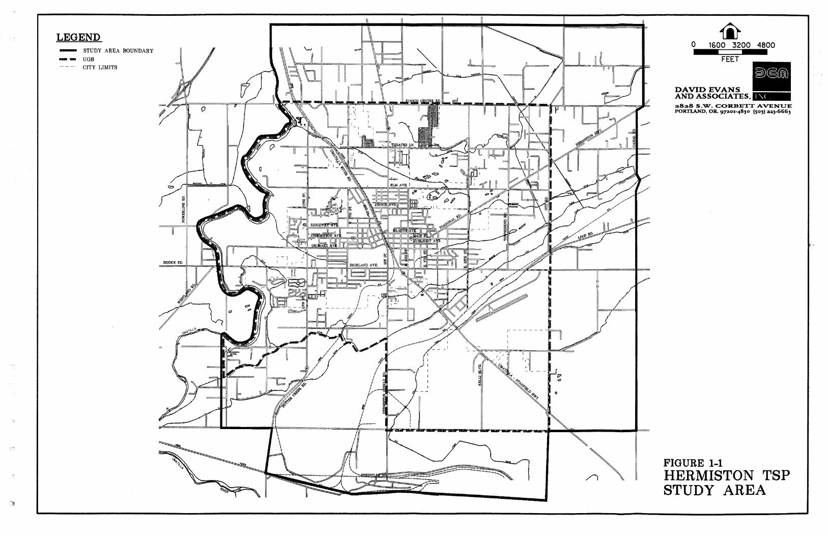
LEGEND - STUDY AREA BOUNDARY
m UGB - - - CITY LIMITS
a828 S.W. COBBEXT AVENUE PORTLAND, OR g7aox-4830 (503) aa3-6663
FIGURE 1-1 HERMISTON TSP STUDY AREA
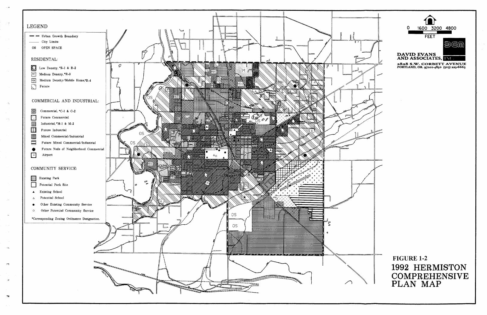
LEGEND
Urban Growth Boundary
City Limits
OS OPEN SPACE
RESIDENTAL:
LOW Denslty, *R-1 & R-2
Medium Density, *R-3
Medium Density/Mobile Home,'R-4
Fu ture
COMMERCIAL AND INDUSTRIAL:
Commercial, *C-1 & C-2
Fu ture Commercial
Industrial,*M-1 & M-2
Future Industrial
tf Mixed Commercial/Industria1
Fu ture Mixed Commercial/lndustrial
Fu ture Node of Neighborhood Commercial
Airport
COMMUNITY SERVICE:
[ Existing Park
Potential Park Site
A Existing School
n Potential School
a Other Existing Community Service
o Other Potential Community Service
'Corresponding Zoning Ordinance Designation.
a8a8 S.W. CORBETT AVXNUE PORTLAND, OR g p o r - 4 8 3 0 (503) aa3-6663
FIGURE 1-2
1992 HERMISTON COMPREHENSIVE PLAN M A P
PLAN ORGANIZATION
The Hermiston Transportation System Plan was developed through a series of technical analyses combined with systematic input and review by the City, the Transportation Advisory Committee (TAC), Management Team, and the public. Key elements of the process included:
Involving the Hermiston community (Chapter 1) (Appendix D) Defining goals and objectives (Chapter 2) Reviewing existing plans and transportation conditions (Chapters 3 and 4; Appendix A) Developing population, employment and travel forecasts (Chapter 5; Appendix C) Developing and evaluating potential transportation system improvements (Chapter 6) Developing the transportation system plan (Chapter 7) Developing a capital improvement program (Chapter 8) Developing Recommended Policies and Ordinances (Chapter 9) (separate from this document)
Community Involvement
Community involvement was an important part of developing the Hermiston Transportation System Plan. The community outreach program included work by a project management team, a transportation advisory committee, and public meetings.
The project management team consisted of staff members from the City of Hermiston, Umatilla County, and the Oregon Department of Transportation (ODOT). The team met a total of seven times to review work products produced by the consultant team. The management team provided direction on technical tasks as the plan was being prepared.
The TAC was appointed to this project by the Hermiston Mayor and City Council. The eleven-member TAC included members of the Hermiston City Council and Planning Commission, and business people from the Hermiston area. The TAC was responsible for reviewing all work products, community outreach with Hermiston residents, and providing policy direction to both the management and consultant teams. The TAC met nine times during the course of preparing this plan, and some members attended the two public meetings and the City Council presentation.
Two open community meetings were held in Hermiston on January 25, 1996, and November 12, 1996. The first meeting was held at the beginning of the planning process in a workshop format to solicit public input on transportation issues and problems to be addressed. The results of this meeting formed the basis for the transportation goal and objectives presented in Chapter 2. The second meeting was held at the end of the process for community review and comments upon completion of the draft Transportation System Plan. On November 4, 1996, the transportation improvement projects were presented to the Hermiston City Council for their review and comments.
Final Reporr 1-2 Hermiston Transportation System Plan 5130197
Goals and Objectives
Based on input from the City, the TAC, and the community, one overall goal and a set of objectives were defined for the Transportation System Plan. The goal and objectives were used to make decisions about various potential improvement projects. They are described in Chapter 2. The TSP goal and seven objectives were formulated by the TAC over a period of two separate meetings. The TAC specifically limited the number of goals and objectives to address issues and concerns important to Hemiston. The TAC periodically reviewed the goal and seven objectives as the TSP was being prepared.
Review and Inventory of Existing Plans, Policies, and Public Facilities
To begin the planning process, all applicable Hemiston and Umatilla County transportation and land use plans and policies were reviewed and an inventory of public facilities was conducted. The purpose of these efforts was to understand the history of transportation planning in the Hermiston area, including the street system improvements planned and implemented in the past, and how the city is currently managing its ongoing development. Existing plans and policies are described in Appendix A of this report.
The inventory of existing facilities catalogs the current transportation system. The results of the inventory are described in Chapter 3, while Chapter 4 describes how the system operates. Appendix B summarizes the inventory of the existing arterial and collector street system.
Future Transportation System Demands
The Transportation Planning Rule requires the Transportation System Plan to address a 20-year forecasting period. In accordance with this, 20-year travel forecasts were developed based on projections of population and employment by different land use categories within the UGB. The overall travel demand forecasting process is described in Chapter 5. The demographic forecast is described in Appendix C.
Transportation System Potential Improvements
Once the travel forecasts were developed, it was possible to evaluate a series of potential transportation system improvements. The initial evaluation was the "No-Build" option, which is the existing street system plus any currently committed street system improvements. Then, transportation demand management measures and potential transportation improvements were developed and analyzed as part of the transportation system analysis. These improvements were developed with the help of the TAC, and they attempt to address the concerns specified in the goals and objectives (Chapter 2). After evaluating the results of the potential improvements analysis, a series of transportation system improvements were selected. These recommended improvements are described in Chapter 6.
Transportation System Plan
The Transportation System Plan addresses each mode of transportation and provides an overall implementation program. The street system plan was developed from the forecasting and potential improvements evaluation described above. The bicycle and pedestrian plans were developed based on current usage, land use patterns, and
Final Repon 1-3 Hermiston Transportation System Plan 5/30/97

the requirements set forth by the Transportation Planning Rule. The public transportation, air, water, rail, and pipeline plans were developed based on discussions with the owners and operators of those facilities. Chapter 7 details the plan elements for each mode.
Capital Improvement Program and Funding Options
The capital improvement program was developed from the short-term improvements and the recommended street system plan, while the funding analysis examines options for financing these improvements. These elements are described in Chapter 8.
Recommended Policies and Ordinances
The consultant team provided the City of Hermiston wiFh a set of model comprehensive plan policies and zoning code ordinance amendments that were prepared for ODOT Region 5. City staff reviewed the models and have directed the consultant team to amend specific comprehensive plan policies and zoning code ordinances. Based on the review by city staff and the Management Team, a final set of comprehensive plan policies and zoning code ordinance amendments are detailed in Chapter.9 of this plan. It is recommended that the City of Hermiston adopt the policies and ordinance amendments concurrent with the adoption of the TSP.
% Final Report 1-4 Hermiston Transportation System Plan 5130197
CHAPTER 2: GOAL AND OBJECTIVES '
The purpose of the Transportation System Plan is to provide a guide for the City of Hermiston to make sound decisions on transportation planning issues over the next 20 years. One of the initial steps in the planning process involved city staff, the management team, and the TAC reviewing existing city goals and objectives, including a review of existing city plans and reports
Based on the input from many people, the TAC selected one goal and seven objectives to guide the preparation of the Hermiston Transportation System Plan. The TAC chose the goal they believed addressed the transportation-related needs of the community. The objectives selected ensure the plan conforms with the Hermiston Comprehensive Plan and the Oregon Transportation Planning Rule.
The goal and objectives were reviewed periodically by the consultant team and TAC as project milestones were reached and technical work products were produced. Hemiston residents were informed and reminded of the project goal and objectives throughout the planning process.
Project Goal
The City of Hermiston will promote a balanced, well-integrated transportation system which provides safe, convenient and efJicient access, and facilitates the movement ofpeople and goods.
Project Objectives
The preparation of the Hermiston Transportation System Plan was guided by the following project objectives:
Satisfies the Oregon Transportation Planning Rule.
Involves participation by interested transportation user groups and the general public.
Promotes coordination among the City of Hermiston, Umatilla County, and the Oregon Department of Transportation (ODOT).
Considers all modes of transportation.
Improves the trafJic circulation pattern.
Protects and enhances neighborhood livability.
Considers new revenue sources for transportation projects.
Final Report 2- 1 Hermiston Transportation System Plan 5130197
CHAPTER 3: TRANSPORTATION SYSTEM INVENTORY
As part of the planning process, an inventory of the existing transportation system in Hermiston was conducted. This inventory covered the street system as well as the pedestrian, bikeway, public transportation, rail, air, water, and pipeline systems.
STREET SYSTEMS
The most common understanding of transportation is of roadways carrying cars and trucks. Most transportation dollars are devoted to building, maintaining or planning roads to carry automobiles and trucks. The mobility provided by the personal automobile has resulted in a great reliance on this form of transportation. Likewise, the ability of trucks to carry freight to nearly any destination has greatly increased their use.
Encouraging the use of cars and trucks must be balanced against costs, livability factors, the ability to accommodate other modes of transportation, and negative impacts on adjacent land uses; however, the basis of transportation in all American cities is the roadway system. This trend is clearly seen in the existing Hermiston transportation system, which consists almost entirely of roadway facilities for cars and trucks. The street system will most likely continue to be the basis of the transportation system for at least the 20-year planning period; therefore, the emphasis of this plan is on improving the existing street system for all users.
The existing street system inventory was conducted for all highways, arterial roadways, and collector roadways within Hermiston as well as those in Umatilla County that are included in the Transportation System Plan planning area. Inventory elements include:
street classification and jurisdiction street width and right-of-way number of travel lanes presence of on-street parking, sidewalks, or bikeways speed limits general pavement conditions street segment lengths
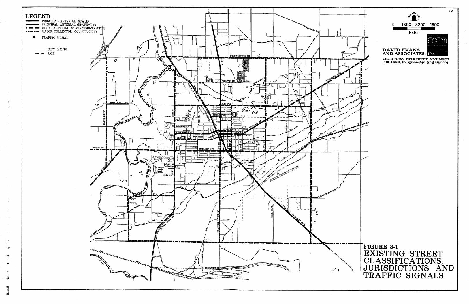
Figure 3-1 shows the roadway functional classification and jurisdiction, as well as the location of traffic signals. All streets not classified in the map are local streets. Appendix B lists an inventory of all arterial and collector streets, and some local streets.
State Highways
Discussion of the Hermiston street system must include the state highways that traverse the planning area. Hermiston is accessed by two state highways: Highway 395 and Highway 207. These highways serve as the major routes through the Hemiston urban area with residential, commercial, and industrial development focused along the corridors.
% Final Repon 3- 1 Hermiston Transportation System Plan 5130197
LEGEND
2828 S.W. COREETT AVENUE PORTLAND, OR g7aox-4830 (503) aa3-6663
FIGURE 3-1 4 \\ EXISTING STREET
CLASSIFICATIONS, \ JURISDICTIONS AND A TRAFFIC SIGNALS
The 1991 Oregon Highway Plan (OHP) classifies the state highway system into four levels of importance (LOI): Interstate, Statewide, Regional, and District. ODOT has established primary and secondary functions for each type of highway and objectives for managing the operations for each one.
Hermiston has one highway of regional significance (Highway 207) and one highway of district significance (Highway 395). According to the O W , the primary function of a regional highway is to "provide connections and links to areas within regions of the state, between small urbanized areas and larger population centers, and to higher level facilities." Within urbanized areas, a secondary function is "to serve land uses in the vicinity of these highways." The primary function of a district highway is to "serve local traffic and land access." For both types of highways, the emphasis is on preserving safe and efficient higher speed through travel in rural areas, and moderate to low-speed operations in urban or urbanizing areas. This means that design factors such as controlling access and providing passing lanes are of primary importance.
Recently, Highway 395 has been classified as a congressional high priority route in the National Highway System. This is a new classification system created by the 01;egon Department of Transportation (ODOT) to identify highways of significant importance.
Highway 207
Highway 207 is a highway of regional significance, connecting Hermiston with Interstate 84 to the southwest and US Highway 730 to the northeast. Within the city limits, one traffic signal along this route is located at the W Highland Avenue intersection.
Within the Hermiston urban area, Highway 207 traverses across the heart of the city coinciding with several overlapping local streets and, at one point, Highway 395. Beginning with the interchange at 1-84, Highway 207 runs north-south as a two-lane roadway known as the rural Butter Creek Road. The highway follows 1 lth Street up to Hermiston Avenue through an area where increasing amounts of urban residential development exists adjacent to the highway. Homes directly adjacent to the highway have direct access, whereas other residences access local roads which intersect the highway. The highway then travels east-west along Hermiston Avenue from 1 lth Street to the signalized intersection at Highway 395 and Gladys Avenue. The section of Highway 207, up to West 6th Street, is bordered by residential developments also with direct access to the highway as well as intersecting residential streets. From West 6th Street to Highway 395, adjacent land uses are predominantly commercial. The entire east-west section of Highway 207 allows on-street parking. The highway then proceeds south, coinciding with Highway 395, to the signalized intersection at Main Street, resuming its east-west alignment along East Main Street. This portion of Highway 207 is located in the downtown core of Hermiston with commercial developments along the highway's alignment and intersecting local streets. The east-west segment along Main Street is also a two-lane roadway with on-street parking present. From East 7th Street, Highway 207 becomes Diagonal Road heading in a northeasterly direction out of town. Diagonal Road is a two-lane roadway with no on-street parking, fewer intersections, and increasing speeds as it heads northeast out of the urban area.
High way 395
Highway 395 serves as a connection between lnterstate 84 to the southeast and Highway 730 to the north. This highway ties together the cities of Stanfield, Hermiston, and Umatilla providing service for local and through traffic as well as providing access to developments along the corridor.
Final Report 3 -2 Hermiston Transportation System Plan 5130197
This highway is a five-lane facility with continuous left turn lanes. A total of seven traffic signals are located along the highway within the Hermiston urban area. Signals are located at SE 4th Street, Highland Avenue, Hurlburt Avenue, Main Street, Gladys Avenue, Jennie Avenue, and Elm Avenue.
Commercial developments are adjacent to the highway beginning at SE 4th Street, continuing through the downtown area, and proceeding north to Theater Lane. Most of the land adjacent to the highway along this section of the corridor has been fully developed. Many direct access points exist along this portion of the highway serving businesses, restaurants, car dealerships, hotels, etc. Around 70 to 80 percent of land adjacent to the highway has been developed from Theater Lane up to Punkin Center Road at the northern UGB boundary and continuing north to Joy Lane and Bagget Lane. This section includes a mixture of commercial, light industrial and, in some areas, residential land use.
Street Classification
The City of Hermiston has three existing street classification levels: principal and minor arterial streets, major collector streets, and local streets. The classification system covers all city, county and state roadways in the planning area. A discrepancy exists between the street classification map in Hermiston's Comprehensive Plan 1984 and ODOT's functional classification map for the city updated in 1990. There are many roads classified on both maps that do not match. It was decided by city officials that the city's comprehensive plan map properly identifies the existing classification of the streets inside the planning area. It is recommended that ODOT modify their functional classification map of the Hermiston area to match the street classification illustrated in Figure 3-1, and only changes presented in the future street classification map proposed in Figure 7-1 (Chapter 7).
Arterial Streets
Principal and minor arterial streets form the primary roadway network within and through a region. They provide a continuous road system which distributes traffic between neighborhoods and districts. Generally, arterial streets are high capacity roadways which carry high traffic volumes with minimal localized activity.
In Hermiston, there are two principal arterials: Highways 395 and 207. These roadways, as described previously, serve as the focus for most of the commercial development in the city. Highway 395 is a five-lane roadway with continuous left-turn lanes. Highway 207 is a two-lane facility with on-street parking through the commercial areas. The minor arterials along portions of Elm Avenue, 1 I th Street, Diagonal Road, Highland Avenue, Westland Road, and Butter Creek Road integrate the principal arterials and create a grid system, providing access for adjacent collector and local streets.
Major Collector Streets
Major collector streets connect local neighborhoods or districts to the arterial network. The City of Hermiston has 19 designated major collector streets. Within the study area limits, collector streets include all or portions of the following roads: Punkin Center Road, Elm Avenue, Gladys Avenue, Orchard Avenue, Hurlburt Avenue, Highland Avenue, Loop Road, Bridge Road, Feedville Road, Power Line Road, I lth Street, Umatilla River Road, South I st Street. East 4th Street, East 10th Street, Ott Road, Canal Road, and Hermiston-Hinkle Road.
Final Report 3-3 Hermiston Transportation System Plan 5130197
Local Streets
Local streets form the majority of the street system in Hermiston. They are designed to carry the very low traffic volumes associated with the local uses which abut them. In Hermiston, the local streets help form part of the grid system; however, they are not intended to function as alternate routes to the arterial and collector street system.
Street Layout
The majority of the Hemiston streets are positioned in a north-south and east-west grid pattern. Several manmade features interrupt the grid system, creating odd shaped blocks and uncommon directions of travel. These features include the Union Pacific Railroad, Highway 207 (along Diagonal Road), Highway 395 (south of Hurlburt Avenue), and several irrigation canals and ditches.
Two rail-lines, operated by the Union Pacific Railroad, traverse the city of Hermiston. Both originate at the Hinkle Railyard south of the city. The first rail-line begins paralleling Highway 207 south of the city limits. It then proceeds to the northeast where it crosses Highland Avenue near Highway 395. The rail-line then follows North 1st PlaceNmatilla River Road in the northwest direction towards Umatilla. This rail-line crosses several major roads at grade. The crossings include: South 1st Street, Highland Avenue, Orchard Avenue, Locust Avenue, Hermiston Avenue, and Elm Avenue.
The second rail-line begins at the Hinkle Railyard and heads northeast, passing under Highway 395 just north of Airport Way. This rail-line traverses the more rural areas of the city with three at-grade crossings at Highland Avenue, Ott Road, and Canal Road. At these locations are low-volume sections of roadway.
Highway 207, along Diagonal Road, proceeds in a northeast-southwest direction creating skewed intersections with the local roads, which are positioned in a north-south or east-west direction. There are two intersections with five directions of approach; East 7th Street and Punkin Center Road. The intersection at Elm Avenue has a total of six directions of approach.
Highway 395 is positioned in a northwest-southeast direction from Hulburt Avenue south. Highly skewed intersections exist at SE 2nd Street and SE 4th Street.
Unpaved Roads
An inventory was taken of the unpaved streets that remain within the city limits. Figure 3-2 displays the locations of these streets. The unpaved streets are predominately unpaved sections of local streets throughout the city. They range from facilities that are all gravel to streets that are paved along one travel lane. The city maintains these streets on an annual basis. The City of Hermiston does not have adequate funding to upgrade unpaved streets. When possible, the city does pave some gravel streets are part of other street improvement projects.
Final Repon 3-4 Hermiston Transportation System Plan 5130197


Irrigation Canals
A series of irrigation canals are operated by the Hermiston Irrigation District within the city and throughout the urban area. The Maxwell Canal, A Line Canal, Feed Canal, and Hermiston Drain Ditch all form manmade barriers to local streets. The Maxwell Canal flows in a northeasterly direction, passing under Highway 207, S 1st Street, SE 4th Street, Highway 395, SE 9th Street, SE 10th Street, East Highland Avenue, Townsend Road, and Ott Road. With the exception of the crossings at Highway 207 and Highway 395, these crossings are narrow wooden bridges in varying states of disrepair, potentially in need of replacement.
The A Line Canal flows parallel to and south of the Maxwell Canal, in a southwesterly direction. It passes under all the same roads as the Maxwell Canal, plus Canal Road. The A Line Canal bridges are in similar condition to the Maxwell Canal Bridges. The Feed Canal approaches the urban growth boundary from the south and crosses under Feedville Road, then turns northeast and runs roughly parallel to the second rail-line described above. The Feed Canal then crosses under Highway 395, Highland Avenue Extension, and Canal Road.
PEDESTRIAN SYSTEM
The most basic transportation option is walking. Walking is the most popular form of exercise in the United States and can be performed by people of all ages and all income levels. However, it is not often considered as a means of travel, mainly because pedestrian facilities are generally an afterthought and not planned as an essential component of the transportation system.
The relatively flat terrain and small size of Hermiston indicates that walking from one place to another can be done quickly and easily. Typically, the distance commonly walked is around 1/2 mile. Encouraging pedestrian activities may not only decrease the use of the personal automobile but may also provide benefits for retail businesses. Where people find it safe, convenient, and pleasant to walk, they may linger and take notice of shops that were overlooked before. They may also feel inclined to return to renew the pleasant experience time and again.
Hermiston's transportation system was examined for how well it meets the needs of pedestrians. Figure 3-3 displays the pedestrian facilities that exist within the city limits. Walkways and complementary facilities such as crosswalks, curb ramps, paths, and user trails were identified during site visits. The general condition and adequacy of these facilities were noted. Special conditions such as obstacles and inadequate construction or design were also noted. Data pertaining to the pedestrian and bicycle system were obtained from documents supplied by the City, the 1990 Highway Census, and from observations taken during two field visits in November and December 1995.
The resulting inventory was used to develop pedestrian conditions for the arterial and collector streets and for the street network as a whole. Improvements proposed in Chapter 7 in the Pedestrian Plan section are designed to correct major problems in the pedestrian system and to encourage its use.
The City of Hermiston has an extensive and a fairly well integrated pedestrian system, with the most pedestrian- friendly area being located in the downtown core. The city has expressed the need to expand the pedestrian system to improve sidewalks and walkways to new residential areas and around new schools.
Final Report 3-5 Hermiston Transportation System Plan 5130197

Pedestrian Facilities Along Highways
Highway 207, along Hermiston Avenue and Main Street, has continuous sidewalks extending from I lth Street to Diagonal Road at 8th Street. Crosswalks and curb ramps are provided at many of the major intersections to facilitate safe pedestrian traffic flow.
There are two locations along Highway 207 within the city limits where inadequate pedestrian facilities esist. There are no sidewalks or pedestrian crossings along Highway 207Diagonal Road from 8th to 10th Street and no sidewalks along Highway 207 from Hermiston Avenue to the south city limits.
Highway 395 has continuous sidewalks along both sides of the highway from the north city limits south to the railroad overpass near the armory. These sidewalks support pedestrian activity created by the abundance of commercial developments along this section of the highway. Currently, crosswalks and curb ramps exist at most of the seven signalized intersections along the highway. With the implementation of the District 12 Signal Rehabilitation Project designed by the Oregon Department of Transportation (ODOT), all signalized intersections along the highway in Hermiston will have crosswalks and curb ramps to facilitate safe east-west travel for pedestrians and disabled citizens. Signal timings on Highway 395 at these intersections are adequate with wait times less than 60 seconds and crossing times which require pedestrians to travel no faster than four ftlsec.
Pedestrian Facilities Along City Streets
Of the 38.9 miles of arterial and collector streets in the city, only 17.4 miles (45 percent) have a sidewalk on at least one side and many of these have gaps. For example. sidewalks are present on one side only along Elm Avenue, from East 4th Street to 10th Street and along South 1 st Street, from Hermiston Avenue to Highland Avenue. Many of the semi-rural roads, such as Theater Lane. East 10th Street. and 1st Place. are narrow and without sidewalks or shoulders. These streets were originaLly constructed many years ago either as county roads or when pedestrian access was not an important consideration.
Pedestrian Crossings
Crosswalks and curb ramps are located at intersections in areas which experience heavy pedestrian usage. They are located mainly in the core of the downtown area east of Highway 395, along Gladys Avenue. Main Street, Hurlburt Avenue, and Highland Avenue. and west of Highway 395 along Hermiston Avenue and Highland Avenue. Of the 600 street comers in the Hermiston area only about 230 (38 percent) have curb ramps.
Off-Road Pedestrian Facilities
There is a multi-use path along Highway 207, from 10th Street to Townsend Road and from Ridgeway Avenue to Diagonal Road on 10th Street. This multi-use path offers a walking route, other than the highway shoulder, for pedestrians along Highway 207lDiagonal Road to access the playing fields near Townsend Road. Another multi-use path for pedestrians and bicyclists is located along the north side of Elm Avenue. from 4th Street to 10th Street. This is a narrow asphalt path approximately three feet wide and it is located at-grade and close to the roadway. It is not considered a safe pedestrian route because there is no grade separation from the street.
Final Repon 3-6 Hermiston Transponarion System Plan 5!30197
Pedestrian System Deficiencies
There are several obstacles in Hermiston that may affect a person's decision to make a trip by walking:
Highway 395 is a high volume, five lane facility dividing the east and west sections of the City of Hermiston. Although Highway 395 has sidewalks for 2.2 miles through the urban area, they are adjacent to a travel lane without any buffer, are often only 4-ft wide, and are in need of curb ramps at 43 of 70 corners. In the downtown area, there are seven signalized intersections with crosswalks, some of which are in need of medians or refuge islands to become more pedestrian friendly.
The railroad runs through the city and limits the number of crossings to 6 in 1.1 miles. Although this is a reasonable number of crossings, they are all at-grade and four pedestrian crossings need to be improved.
Perimeter city streets and roads extending outside the city lack basic pedestrian facilities such as shoulders.
There are also areas where approaches to existing schools and parks, shopping areas, and the downtown vary in quality. The following locations have been identified as places which cannot be accessed by continuous sidewalks:
Sandstone Middle School Highland Hills School Oregon State Offices on SE Columbia Drive Shopping area at Orchard Ave. and 1 1 th Street Good Shepherd Community Hospital
BIKEWAY SYSTEM
Like pedestrians, bicyclists are often overlooked when considering transportation facilities. Bicycles take up little space on the road or parked, do not contribute to air or noise pollution, and offer higher speeds than walking. Because of the small size of Hermiston, a cyclist can travel to any destination in town within a matter of minutes. Bicycling should be encouraged to reduce the use of automobiles for short trips. Noise, air pollution, and traffic congestion could be mitigated if more short trips were taken by bicycle or on foot. Typically, a short trip that would be taken by bicycle is around two miles.
Bikeway Facilities
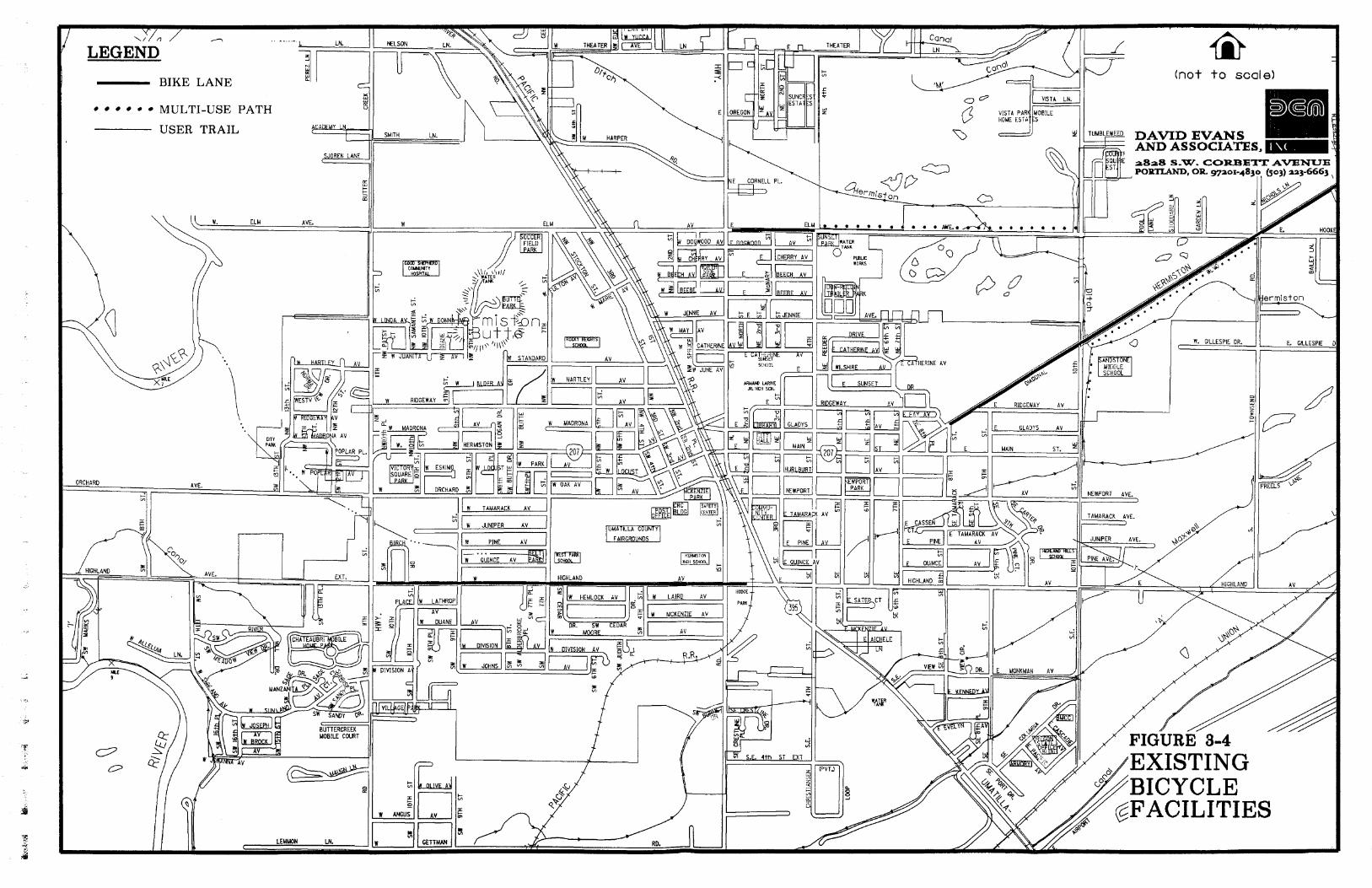
A majority of the city of Hermiston has no sanctioned bikeways; bicyclists must share the roadways with motorized vehicles. On low volume roadways, such as many of the local streets, bicyclists and autos can both safely and easily use the roadway. On higher volume roadways, particularly the principal and minor arterial streets, safety for the bicyclists is an important issue. Existing bicycle facilities are presented in Figure 3-4.
Final Report 3-7 Hermiston Transportat ion System Plan 5/30197
BIKE LANE
MULTI-USE PATH
USER TRAIL
REN LANE (7 (not to scale)
o Q
DAVID EVANS AND ASSOCIATES,
Only three roads are striped for bicycles in the city. A portion of Highland Avenue from 1 lth Street to South 1st Street has striped bike lanes in both directions. The second set of striped bike lanes is located along Elm Avenue from Highway 395 to NE 4th Street. The third set of bike lanes is located along Diagonal Road, beginning at 8th Street and heading to the northeast.
The two multi-use paths mentioned previously along Diagonal Road and Elm Avenue also allow bicycle usage as well.
Of the 38.9 miles of arterials and collectors in Hermiston's urban area, 16.9 miles (43 percent) have some type of bikeway:
Striped Bike Lane 1.3 miles Shoulder (4-fi min.) 7.2 miles Shared Roadway (14-fi outside lane min.) 7.7 miles Multi-use path (also pedestrian facility) 0.7 miles
The remaining streets either lack facilities or, in the case of some collectors, are low-traffic streets where sharing the roadway is currently acceptable.
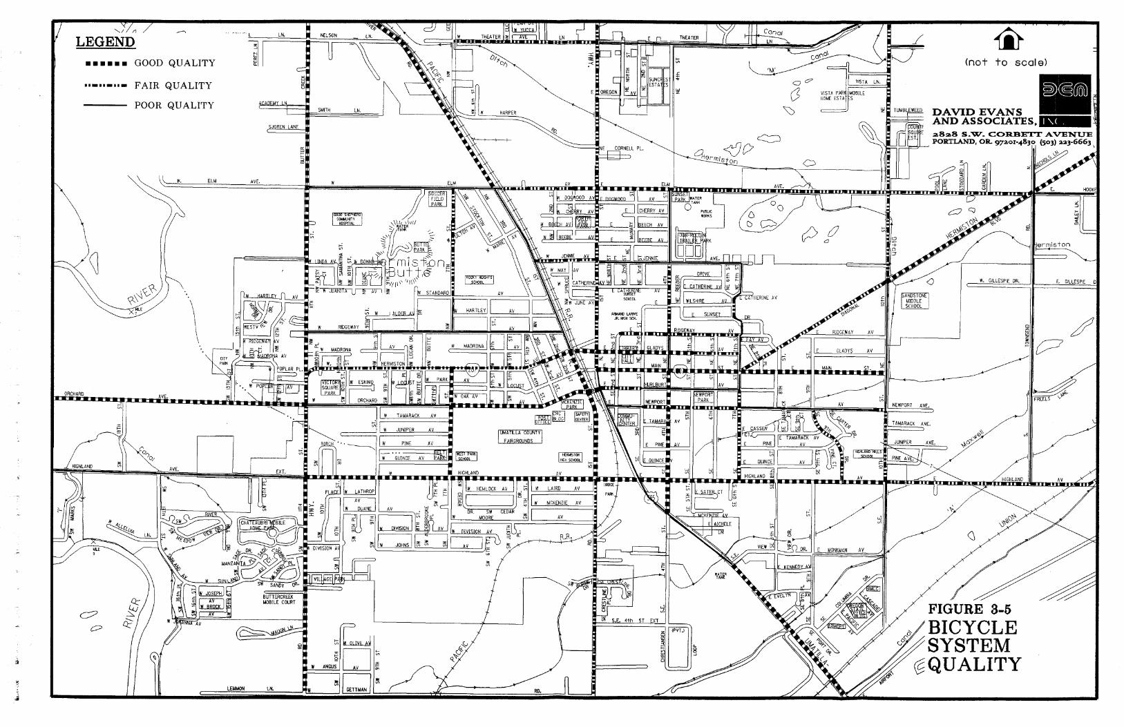
Bikeway Evaluation
The inventory of all arterial, collector, and most of the local streets was analyzed to determine the quality of the bicycle system. Results were used to divide the streets into three categories:
Good -Conducive to bicycle use. Minor improvements, if any, needed. Fair - Usable by many cyclists but poses some hazards. Improvements, such as shoulders or lanes, may be needed. Poor - Substandard conditions combined with heavy traffic create significant hazards. Should be improved.
Results were transferred to a map (See Figure 3-5, Bicycle Quality), so that gaps in the system are demonstrated graphically.
Over 60 miles of major streets in the Hermiston urban area were examined for cycling conditions. Overall. the streets rated near the break between Good and Fair. The results for 38.9 miles of arterials and collectors are:
Good 16.5 miles 42% Fair 9.0 miles 23% Poor 13.4 miles 3 5%
About 42 percent of the arterials and collectors inside the UGB are rated good for bicyclists, meaning that few improvements are necessary under present conditions. These are streets that have a good surface and ample width (wide outside lane or shoulder).
Many of the streets that rated fair to poor have deteriorated pavement, substandard space for bicyclists, and other problems. About 30 percent of these streets have outside lanes of less than 14 feet (the desirable width for a shared lane) combined with traffic over 3.000 cars per day (the volume at which bike lanes are normally
Final Rrpon 3-8 Hermiston Transportation System Plan 5130197

considered). These streets are the focus of the recommended projects, especially where they can be integrated with existing streets that rated good.
There are several obstacles in Hermiston that may affect a person's decision to make a trip by bicycling:
There are no bike lanes on Highway 395 and the outside travel lane is generally less than 14 feet, especially in the central area. It is the position of both the City of Hermiston and ODOT District 12 that bicycle travel along Highway 395 in Hermiston should not be encouraged because of the heavy truck traffic on this corridor.
The railroad divides the city and limits the number of crossings to 6 in 1.1 miles. Although this is a reasonable number of crossings, they are all at-grade and four lack good bicycle crossings.
Perimeter city streets and roads extending outside the city lack basic bicycle facilities such as shoulders.
In the downtown core, Highway 395 has traffic volumes ranging between 11,200 and 20,500 vehicles per day which is considered very heavy traffic. With traffic volumes of these magnitudes and given the existing lane geometry, the City of Hermiston, Umatilla County, and ODOT District 12 do not consider Highway 395 fit to provide safe travel lanes for bicyclists.
Another impediment to bicycle use is the lack of parking and storage facilities for bikes throughout the Hermiston area. Bicycle racks were noted at a few locations but, in general, bicycle parking appears to be sparse in all areas of the city.
PUBLIC TRANSPORTATION
Public transportation in Hermiston consists of a taxicabs, senior citizen and handicapped transport, intercity bus lines, and rail services. The city has no local fixed route transit service at this time.
Until recently, the taxicab and the senior citizens and handicapped transport services were maintained and operated by JB's Taxi Service. In 1996, this company separated into two organizations. Now Classic Cab operates the taxi service and Hermiston Senior & Disabled Transit operates the senior citizen and handicapped shuttle service. Classic Cab provides taxi rides throughout the Hermiston area as well as service to regional airports in Pendleton, Oregon and Pasco, Washington, the Amtrak station at Hinkle Railyard, and the Hermiston Greyhound terminal. Hermiston Senior & Disabled Transit uses ordinary automobiles equipped to carry handicapped citizens. A total of three vehicles are available for dispatch anywhere in the Hermiston area. Classic Cab and Hermiston Senior and Disabled Transit share dispatching facilities.
Greyhound operates the inter-city bus service in Hermiston. Currently, there are four trips per day leaving for Portland to the west. Bus departure times are at 2:00 am. , 5:50 am., 1155 am. , and 2:50 p.m. One trip per day departs for Salt Lake City, Utah, at 4 5 0 p.m. Two trips per day depart to Spokane, Washington, at 4:00 a.m. and 2:45 p.m. During the summer months, usually from April 1st until October Ist, Greyhound adds an additional trip per day to either Salt Lake City or Portland depending on ridership demand.
Final Report 3-9 Hermiston Transportation Shstcm Plan 5130197
The small size and low traffic volumes on city streets would indicate that mass transit is not currently feasible. A citywide public transportation program would not be economically feasible at this time. The Transportation Planning Rule exempts cities with a population under 25,000 from including mass transit facilities in their development regulations. However, Hermiston can plan for future transit services with growth patterns that support rather than discourage transit use in the future.
RAIL SERVICE
Passenger Rail
Amtrak did provide passenger service to and from Hermiston at the Hinkle Railyard, located about five miles south of downtown Hermiston. There were three trips per week on Tuesday, Thursday, and Sunday for passengers heading to cities in eastern Oregon such as La Grande, Pendleton, and Baker City, as well as other cities further east outside of Oregon, such as Boise, Ogden, Denver, and Chicago.
Amtrak is currently experiencing a funding crisis. As a result, passenger service between Portland and Denver, including service to Hermiston and the other cities mentioned above, was discontinued by May 1997. The city needs to recognize the importance of having possible rail services and lend support to Amtrak for its continuation. Hermiston could also lend support by promoting the service to Hermiston residents and outlying communities that have been served by the station at Hinkle for over 100 years.
Freight Rail
Freight rail lines owned and operated by Union Pacific Railroad run through Hermiston parallel to Highway 395 in the downtown core. In addition, the Hinkle Railyards, a major maintenance and repair facility, is located south of Hermiston. At the present time, the Hinkle Railyards handles 794 rail cars a day. This includes fueling, switching, and assembling activities.
The Southern Pacific Railroad has recently merged with Union Pacific Railroad. Based on an EIS published in 1996, the proposed railroad merger is expected to increase rail related activity at the Hinkle Railyard by 43 percent. The railyard was recently precertified to receive Enterprise Zone benefits to attract a maintenance facility. The facility is expected to add up to 200 new jobs to the Hinkle Railyards in the near future.
AIR SERVICE
The city of Hermiston owns and operates the municipal airport. No commercial flights are available at the present time but there is a charter service available. Commercial flights are available in Pasco, Washington, 36 miles north, and in Pendleton, Oregon, 30 miles southeast of Hermiston. Scheduled air service and daily non-stop flights are available throughout the western United States from Portland
The Henniston municipal airport is at an elevation of 637 feet above Mean Sea Level (MSL). It is located 1.5 miles from downtown Hermiston and has two runways, both of which are 4,500 feet long and positioned in a northwest- southeast direction. The municipal airport is often used by businesses such as Simplot. Gilroy Foods, Les Schwab. UPS, and other larger organizations such as PGE. Bonneville Power, and the Army Corps of Engineers. There is a
Final Rcpor t 3-10 Hermiston Transportat ion System Plan 5130197

charter air service and an agricultural spray operation based at the airport, and local residents also use the airport for recreational purposes. Because the Hermiston Airport is governed by its own master plan, recommendations for its improvement do not fall into the scope of this Transportation System Plan. However, the airport is an essential part of the economy of the area. It is necessary to include the airport when considering future development proposals for the surrounding land. In many localities, uses have been allowed around airports that are not compatible with air traffic. This issue is addressed in Chapter 9 (Recommended Policies and Ordinances).
PIPELINE SERVICE
A four-inch diesel line to the Hinkle Railyard is provided by the Kaneb Corporation. The pipeline originates in the City of Umatilla to the north and proceeds along the east side of East 10th Street in the Hermiston study area. The pipeline is running at about 75 percent capacity.
WATER SERVICE/IRRIGATION
Currently, there is a 42-inch water main providing potable water service throughout the region. The water main traverses the study area from Umatilla River Road, along 1 lth Street, to the south and extends south of the study area.
Final Report 3-1 1 tiermisron Transportation Skstem Plan 5130197
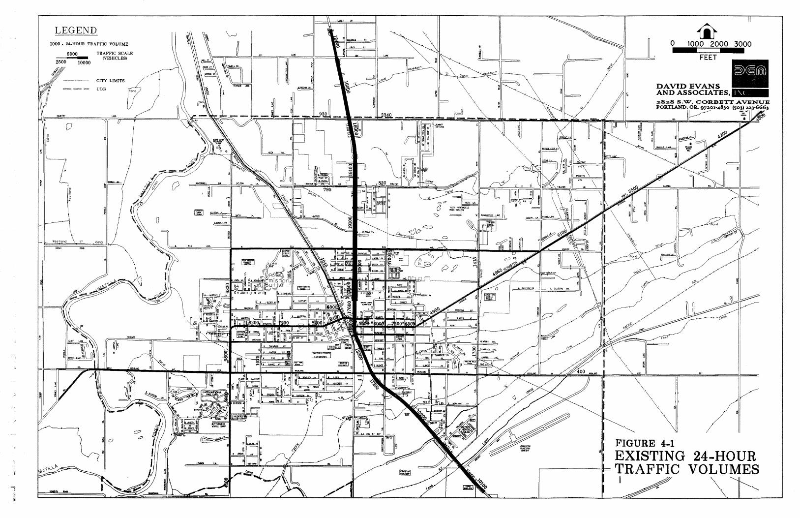
and carry volumes of 4,000 and 4,400 vpd, respectively. A section of 1st Place from Elm Avenue to Hemiston Avenue carries about 4,000 vpd. Most other collector streets in Hemiston carry less than 3,000 vpd.
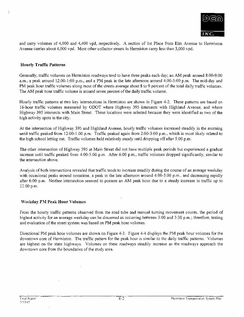
Hourly Traffic Patterns
Generally, traffic volumes on Hemiston roadways tend to have three peaks each day; an AM peak around 8:OO-9:00 a.m., a peak around 12:OO-1:00 p.m., and a PM peak in the late afternoon around 4:OO-5:00 p.m. The mid-day and PM peak hour traffic volumes along most of the streets average about 8 to 9 percent of the total daily traffic volumes. The AM peak hour traffic volume is around seven percent of the daily traffic volume.
Hourly traffic patterns at two key intersections in Hermiston are shown in Figure 4-2. These patterns are based on 16-hour traffic volumes measured by ODOT where Highway 395 intersects with Highland Avenue, and where Highway 395 intersects with Main Street. These locations were selected because they were identified as two of the high activity spots in the city.
At the intersection of Highway 395 and Highland Avenue, hourly traffic volumes increased steadily in the morning until traffic peaked from 12:OO-1:00 p.m. Traffic peaked again from 2:OO-3:00 p.m., which is most likely related to the high school letting out. Traffic volumes held relatively steady until dropping off after 5:00 p.m.
The other intersection of Highway 395 at Main Street did not have multiple peak periods but experienced a gradual increase until traffic peaked from 4:OO-5:00 p.m. After 6:00 p.m., traffic volumes dropped significantly, similar to the intersection above.
Analysis of both intersections revealed that traffic tends to increase steadily during the course of an average weekday with occasional peaks around noontime, a peak in the late afternoon around 4:OO-5:00 p.m., and decreasing rapidly after 6:00 p.m. Neither intersection seemed to possess an AM peak hour due to a steady increase in traffic up to 12:OO p.m.
Weekday PM Peak Hour Volumes
From the hourly traffic patterns observed from the road tube and manual turning movement counts, the period of highest activity for an average weekday can be discerned as occurring between 3:00 and 5 2 0 p.m.; therefore, testing and evaluation of the street system was based on PM peak hour volumes.
Directional PM peak hour volumes are shown on Figure 4-3. Figure 4-4 displays the PM peak hour volumes for the downtown core of Hermiston. The traffic pattern for the peak hour is similar to the daily traffic patterns. Volumes are highest on the state highways. Volumes on these roadways steadily increase as the roadways approach the downtown core from the boundaries of the study area.
Final Repon 5130197
4-2 Hermiston Transponation System Plan
FIGURE 4-2 HOURLY TRAFFIC PATTERNS
Final Report 4-3 Hermiston Transportation System Plan 5130197

LEGEND TAZ BOUNDARY
- CITY LIMITS - - UGB
0 1600 3200 4800 - CCCT
a8a8 S.W. COlU3ETT AVENUE PORTLAND, OR 97ao1-4830 (503) aa3-6663
FIGURE 5-1 TRAFFIC ANALYSIS ZONES
road that exists within the study area, one centroid connector may represent many local roads which are loading onto a main route.
Outside of the study area, external zones load traffic from external locations, generally traffic from other cities such as Stanfield, Pendleton, or Umatilla. These zones produce three types of trips. The first type is a through trip which begins in one external zone and ends in another external zone passing through the city along the way. The second type is a trip which begins in the city and ends at an external zone. The last type is a trip which begins at an external zone and ends in the city. In the modeling process, the trips traveling to and from these external zones are generally associated with the actual roads leading in and out of the study area. A total of nine external zones were identified where traffic enters and exits the study area.
ESTIMATE AND PROJECT LAND USE
Once the TAZ scheme was defined, both existing and future land use forecasts were developed. The existing land use inventory was used in the model calibration process while the future land use forecast is the basis for the future travel forecasts.
Land use is divided into two categories in the travel forecasting model: those uses which produce trips and those uses which attract trips. Population, represented by the number of single-family, multi-family, and manufactured home dwelling units in each TAZ, was the source of trip productions. Employment, broken down by type of land use (i.e., retaillcommercial, office, industrial, etc.), was the basis for estimating trip attractions. When developing the TAZ scheme, boundaries were chosen separating these land uses as much as possible to create boundaries with homogeneous land use.
A more detailed description of the existing and future land use projections is located in the Demographic Analysis report located in Appendix C.
TRIP GENERATION
Vehicle trip generation, the next step in the modeling process, is a method of estimating the number and type of trips a specific land use will produce or attract based on historic data and surveys of similar developments. The trip generation estimates were made for each TAZ in the planning area on the basis of the type and quantity of households and employees at businesses.
Each trip is defined by the land use from which it is produced or originated, the land use to which it is attracted or destined, and the purpose of the trip. Trip generation rates were refined for each origin and destination for specific purposes. The four categories used in the model were:
a Home-based work - Trips between home and a place of employment. a Home-based shopping - Trips between home and a retail store. a Home-based other - Trips between home and another land use for a purpose other than employment
or shopping (e.g., school trips or day care). a Non-home based - Trips between two non-residential land uses.
Table 5- 1 summarizes the trip rates for each land use category and for each trip purpose.
Final Report 5-2 Hermiston Transportation System Plan 5l30197

TABLE 5-1 TRIP GENERATION RATES
Single- Multi- Retail1 Gov. Family Family Commercial Industrial Hospital Office Services Education
(TripslDU) (TripslDU) (TripslEmp) (TripsIEmp) (TripslEmp) (TripslEmp) (TripslEmp) (TripslEmp) HBW Origin 0.08 0.06 0.08 0.28 0.08 0.54 0.37 0.52
Destination 0.34 0.23 0.02 0.07 0.02 0.14 0.09 0.13 Total 0.42 0.29 0.10 0.35 0.10 0.68 0.46 0.65
HBS Origin 0.13 0.09 0.70 0.00 0.00 0.00 0.00 0.00 Destination 0.16 0.11 0.58 0.00 0.00 0.00 0.00 0.00 Total 0.29 0.20 1.28 0.00 0.00 0.00 0.00 0.00
HBO Origin 0.07 0.04 0.13 0.00 0.06 0.00 0.00 0.18 Destination 0.07 0.04 0.13 0 .OO 0.06 0.00 0.00 0.18 Total 0.13 0.08 0.25 ' 0.00 0.12 0.00 0.00 0.35
NHB Origin 0.13 0.10 0.40 0.05 0.04 0.16 0.10 0.16 Destination 0.13 0.10 0.40 0.05 0.04 0.16 0.10 0.16 Total 0.26 0.20 0.80 0.10 0.08 0.32 0.20 0.32
TOTAL Origin 0.4 1 0.29 1.31 0.33 0.18 0.70 0.47 0.86 Destination 0.69 0.48 1.12 0.12 0.12 0.30 0.19 0.47 Total 1.10 0.77 2.43 0.45 0.30 1.00 0.66 1.32
For external TAZs, future trip volumes can be estimated based on the projected increase in population or employment, or based on historic growth on the roadways they represent.
TRIP DISTRIBUTION
Vehicle trip distribution, the fourth step in the modeling process, is a method of estimating the number of vehicle trips that go between each origin and destination pair in the study area. This was performed for all four trip purposes at all TAZs including the external stations representing the roads leading out of the study area.
The basic premise of trip distribution is that the number of trips between two areas is directly related to the size of the attractions or destinations in each zone and inversely related to the travel time between zones. For example, if two destination zones of different sizes were located equal driving times from the origin zone, more trips would be distributed to the larger destination zone. Likewise, if two destination zones of equal size were located 1 0 and 15 minutes from the origin zone, more of the trips from the origin zone would be distributed to the closer destination zone. This methodology is used by the QRS 11 program when determining the trip distribution.
VEHICLE TRIP ASSIGNMENT -
Trip assignment, the final step in the modeling process, was a method of assigning trips distributed between origin zones and destination zones to specific paths on the street system. In general, a forecasting model uses a capacity- constrained assignment methodology which assigns traffic to the street system based on travel time. Initially the
PI Final Repon 5-3 Hermiston Transportation System Plan 5130197
model assigns each trip to the route with the shortest travel time between its origin and destination. The travel time on each route is then adjusted to account for congestion and delay which may result from the first assignment. As the fastest route becomes congested, its travel time increases. If the travel time increases substantially, another parallel route may become faster. The model then adjusts the traffic assignments by reassigning traffic to the alternate route. Through an iterative process, the model balances travel times and traffic volumes between alternate routes. Using this procedure, the traffic between a single origiddestination pair could be assigned to several routes depending on the congestion of each route, thereby simulating the driving habits of "real world" motorists.
MODEL CALIBRATION
Before projecting future traffic volumes, this entire process of estimating trip generation, distribution, and assignment is completed for existing conditions and compared with actual traffic measurements on the roadway system. The theory behind calibration reasons that if the modeling process forecasts current conditions reasonably well, the same process should then provide a reasonably good estimate of future conditions. To calibrate the model, the trip generation, distribution, and assignment process is repeatedly modified until the assigned volumes approach actual counts, generally within about ten percent of those counts.
FUTURE TRAFFIC FORECASTS
Once the model was calibrated for existing traffic conditions, future traffic volumes could be estimated. Future traffic was first assigned to the existing major street system to determine which portions of the system would be deficient within the next twenty years. The model was then be used to evaluate the effects of alternative roadway configurations on traffic assignment such as the potential extension of 4th Street (Improvement 4 - Chapter 6). This was established as the "No-Build" scenario.
.q Final Repon 5-4 Hermiston Transporlation System Plan 5130197

CHAPTER 6: IMPROVEMENT OPTIONS ANALYSIS
This section identifies the potential transportation improvements for the Hermiston area. Those potential improvements were developed with the help of the TAC, and attempt to address the concerns specified in the TSP goal and objectives (Chapter 2).
Some of the potential improvements were developed to address projected future street or intersection deficiencies pertaining to traffic flow and traffic operations. Projected deficiencies were identified through a "No-Build" traffic forecast. This forecast projected traffic volumes for the year 2016 assuming no major improvements would be made to the street system. Other options were developed to address safety and livability concerns such as new bike and pedestrian facilities, improved roads, improved access, and measures to reduce the reliance on the automobile.
The following list includes all of the potential transportation system improvements considered. This list is not based on priority. Improvement options 3 through 9 are illustrated in Figure 6-1.
1 . Revise zoning codes to allow and encourage mixed-use development and redevelopment. 2. Implement transportation demand management (TDM) strategies. 3. Implement transportation system management (TSM) strategies.
a. Signalize the Intersection of Highway 395 and Theater Lane. b. Signalize the Intersection of Highway 395 and Punkin Center Road. c. Signalize the Intersection of Main Street and East 4th Street. d. Improve the 1 lth Street and Hermiston Avenue Intersection. e. Improve the 1st Place and Hermiston Avenue Intersection. f. Improve the Highland Avenue and 1 lth Street Intersection.
4. Extension of East 4th Street. a. From Elm Avenue to Theater Lane. b. From Theater Lane to Punkin Center Road.
5 . Upgrade of East 10th Street. a. From Columbia Drive to Elm Avenue. b. From Elm Avenue to Punkin Center Road.
6 . Upgrade and Realign Theater Lane Between Highway 395 and East 10th Street. a. From Highway 395 to 7th Street Alignment. b. From 7th Street Alignment to East 10th Street
7. Construct Northern Umatilla River Bridge. a. Option 1: Extension of Elm Avenue over the Umatilla River. b. Option 2: Extension of Punkin Center Road over the Umatilla River.
8. Truck Route Evaluation
a. Evaluation of Existing and Potentially New Truck Routes. b. Improved Truck Route Signing.
9. Upgrade Umatilla River Road between Hermiston Avenue and Elm Avenue. 10. Upgrade Local Unpaved Streets.
Final Report 6- 1 Hermiston Transportation System Plan 5130197

As discussed in the remaining sections of this chapter, not all of these considered improvements were recommended. These recommendations were based on costs and benefits relative to traffic operations, the transportation system, and the community livability.
EVALUATION CRITERIA
The evaluation of the potential transportation improvements was based on the analysis of several factors. The first two factors are traffic projections and traffic operations. The traffic projections section evaluates any anticipated shift in travel patterns. The traffic operation section evaluates whether or not the improvement could reduce congestion or delay on the street system. It also covers the operating conditions of any critical signalized or unsignalized intersections which may be affected by the improvement
In addition to the quantitative traffic analysis, three factors were evaluated qualitatively: 1) safety; 2) environmental factors, such as air quality, noise, and water quality; and 3) socioeconomic and land use impacts, such as right-of-way requirements and impacts on adjacent lands.
The final factor in the evaluation of the potential transportation improvements was cost. Costs were estimated in 1996 dollars based on preliminary alignments for each potential transportation system improvement.
"NO-BUILD" SCENARIO
The "No-Build" scenario establishes the baseline for all other analysis. This scenario assumes that no major changes would be made to the existing transportation system for the next 20 years. However, traffic volumes would increase in Hermiston as population and employment increase by about 27 percent by the year 2016. By comparing the future traffic demand with the unchanged transportation system, we can determine where future problems are likely to occur.
Chapter 5 describes in detail how the existing (1996) traffic model was developed and how future forecasts were performed using similar methods. The "No-Build" forecast was performed using the same methods identified for the existing 1996 forecasts. The results of the "No-Build" forecast for 201 6 are shown in Figures 6-2 and 6-3. It is important to note that the PM peak hour volumes illustrated in these figures were not taken directly from the 2016 "No-Build" model run. The volumes shown were obtained using the increased traffic between the 1996 calibrated model and the 2016 "No-Build" model added to existing traffic volumes. Applying the additional traffic between 1996 and 201 6 to actual existing traffic would reflect more realistic traffic projections.
Traffic Projections
Motor vehicle traffic volumes throughout the Hermiston area are projected to increase by about 38 percent by the year 20 16, if no changes occur to modify the current trend of increasing motor vehicle use.
y Final Report 6-2 Hermiston Transportation System Plan 5/30/97
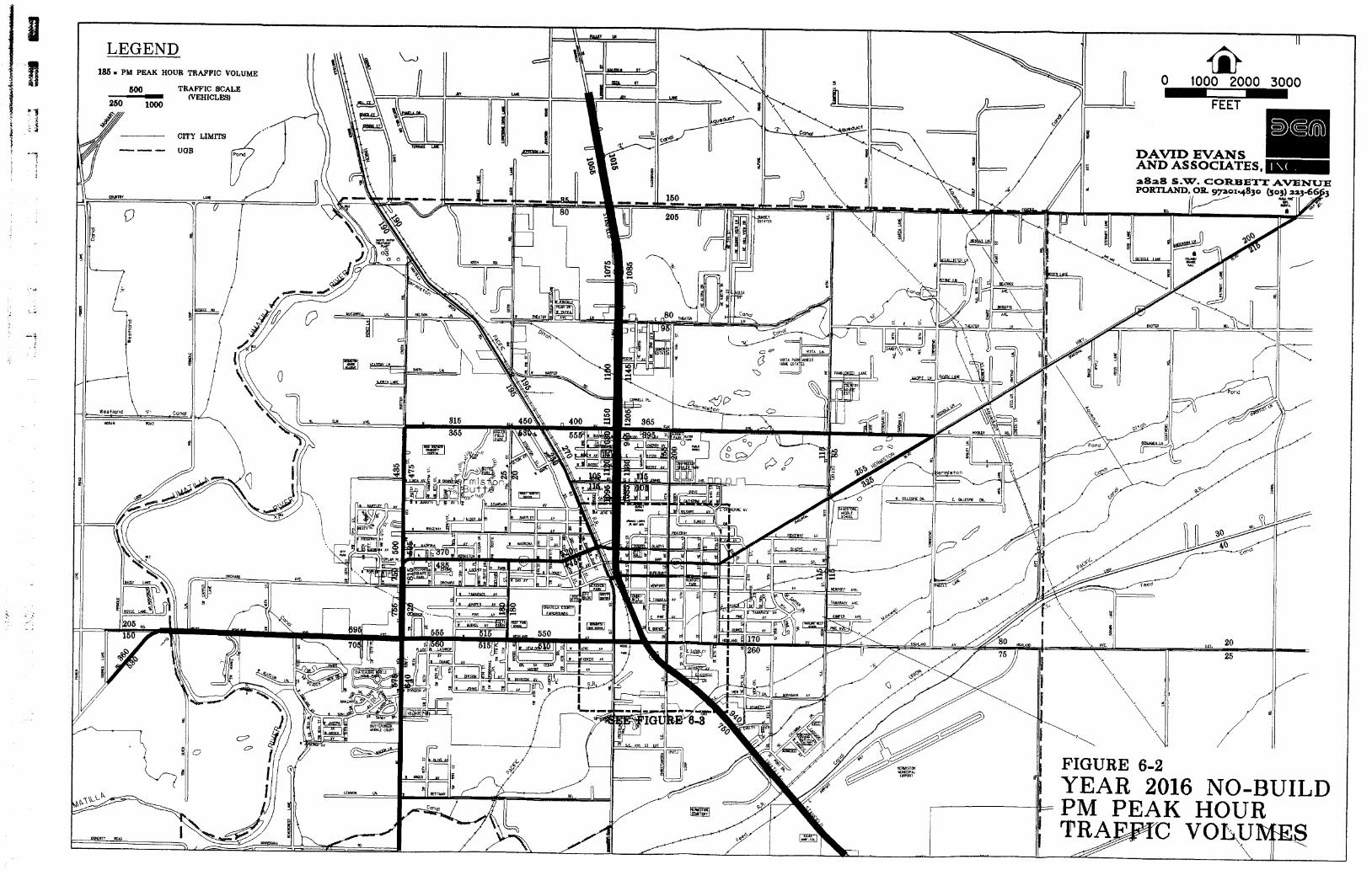
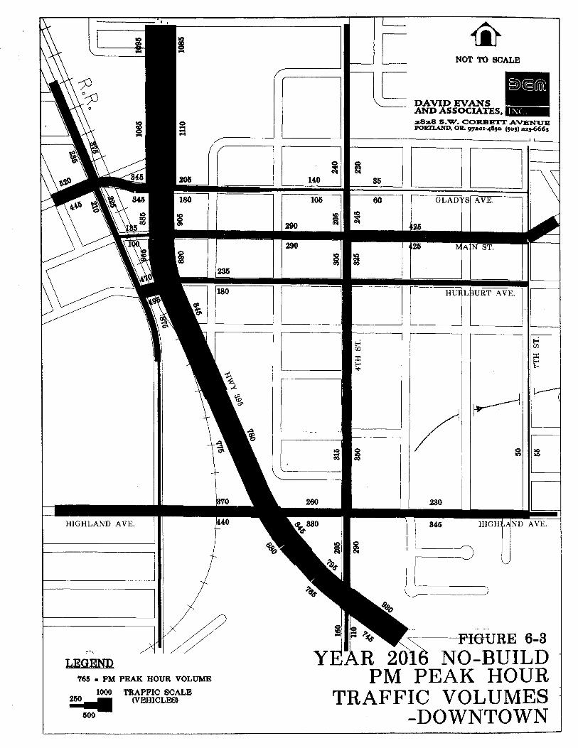
-- -
HIGHLAND AVE.
765 r PM P E M HOUR VOLUME
-..JL.-..- NOT TO SCALE
1' DAVID W A N S AND ASSOCLATEiS,
LR 2018 NO-BUILD PM PEAK HOUR
1000 TRAFFIC SCALE - (VEHICLES)
600
TRAFFIC VOLUMES -DOWNTOWN
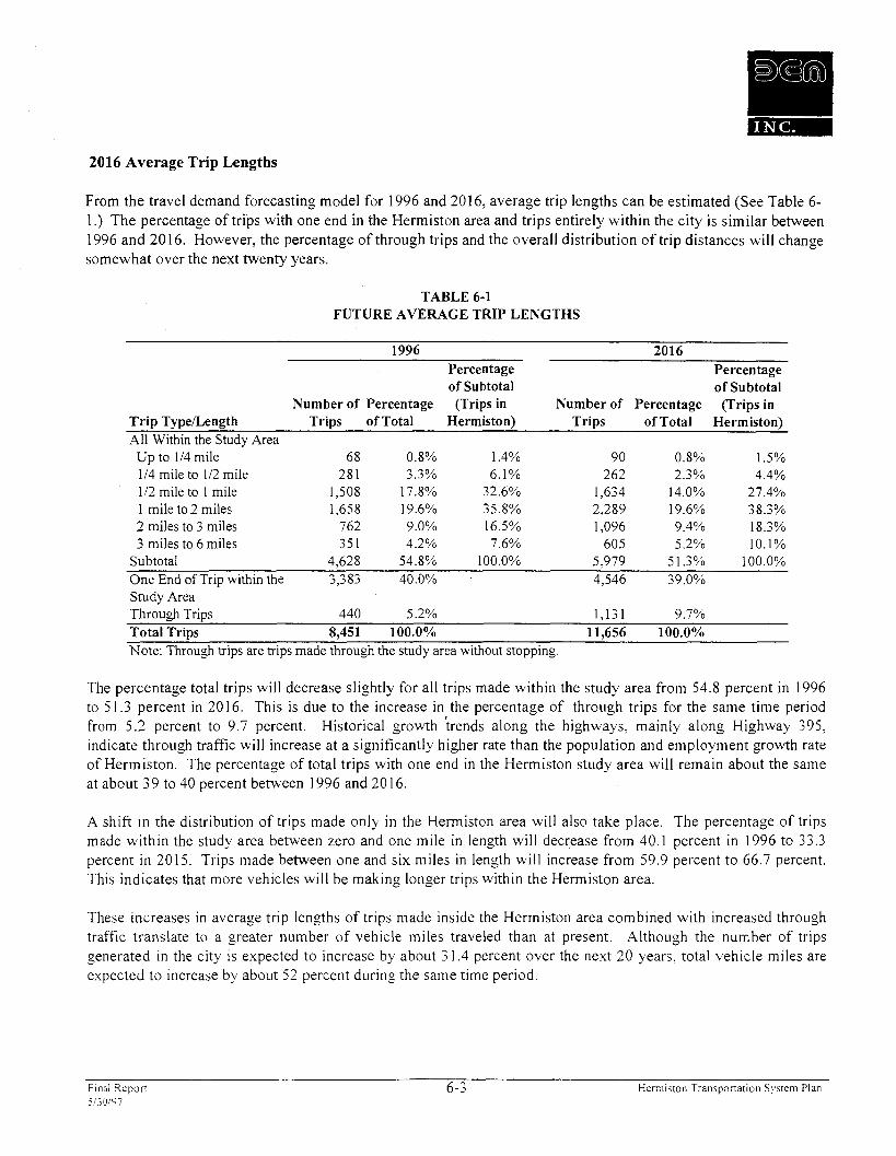
2016 Average Trip Lengths
From the travel demand forecasting model for 1996 and 2016, average trip lengths can be estimated (See Table 6- 1 .) The percentage of trips with one end in the Hermiston area and trips entirely within the city is similar between 1996 and 2016. However, the percentage of through trips and the overall distribution of trip distances will change somewhat over the next twenty years.
TABLE 6-1 FUTURE AVERAGE TRIP LENGTHS
Percentage Percentage of Subtotal of Subtotal
Number of Percentage (Trips in Number of Percentage (Trips in Trip Typenength Trips of Total Hermiston) Trips of Total Hermiston) All Within the Study Area
Up to 114 mile 68 0.8% 1.4% 90 0.8% 1.5% 114 mile to 112 mile 28 1 3.3% 6.1% 262 2.3% 4.4% 112 mile to 1 mile 1,508 17.8% 32.6% 1,634 14.0% 27.4% 1 mile to 2 miles 1,658 19.6% 35.8% 2,289 19.6% 38.3% 2 miles to 3 miles 762 9.0% 16.5% 1,096 9.4% 18.3% 3 miles to 6 miles 351 4.2% 7.6% 605 5.2% 10.1%
Subtotal 4,628 54.8% 100.0% 5,979 51.3% 100.0% One End of Trip within the 3,383 40.0% 4,546 39.0% Study Area Through Trips 440 5.2% 1,131 9.7% Total Trips 8,451 100.0% 11,656 100.0% Note: Through trips are trips made through the study area without stopping.
The percentage total trips will decrease slightly for all trips made within the study area from 54.8 percent in 1996 to 5 1.3 percent in 20 16. This is due to the increase in the percentage of through trips for the same time period from 5.2 percent to 9.7 percent. Historical growth irends along the highways, mainly along Highway 395, indicate through traffic will increase at a significantly higher rate than the population and employment growth rate of Hermiston. The percentage of total trips with one end in the Hermiston study area will remain about the same at about 3 9 to 40 percent between 1996 and 20 16.
A shift in the distribution of trips made only in the Hermiston area will also take place. The percentage of trips made within the study area between zero and one mile in length will decrease from 40.1 percent in 1996 to 33.3 percent in 2015. Trips made between one and six miles in length will increase from 59.9 percent to 66.7 percent. This indicates that more vehicles will be making longer trips within the Hermiston area.
These increases in average trip lengths of trips made inside the Hermiston area combined with increased through traffic translate to a greater number of vehicle miles traveled than at present. Although the number of trips generated in the city is expected to increase by about 3 1.4 percent over the next 20 years, total vehicle miles are expected to increase by about 52 percent during the same time period.
Final Report 6-3 Hermiston Transponation System Plan 5130/'17
Operations Analysis
The increases in motor vehicle volumes under the assumptions of the forecasting model would result in the intersection operations illustrated in Figure 6-4 for all critical signalized and unsignalized intersections. Operations illustrated in the figure also include 1996 traffic operations for comparison.
The figure illustrates that the through movements at the intersections along Highway 395 will continue to flow smoothly with a LOS of B or better. However, left-turning traffic on the highway and traffic on the minor street approaches will experience higher delays from increased traffic. Operations at many of these approaches will deteriorate from a LOS of D to LOS E or even F. Some examples are the minor street approaches of the unsignalized Punkin Avenue and Theater Lane Avenue intersections with Highway 395 which will deteriorate from a LOS of D and C to F. The operations at the T-shaped intersection of Hermiston Avenue and 1 lth Street will be at a LOS of B or better for all movements, except for the southbound left-turn movement which will deteriorate from a LOS of C to F. The signalized intersection of Highland Avenue at 1 lth Street will operate poorly in the future from significant increases in traffic. The existing left-through lanes for all four approaches to this intersection will deteriorte from a LOS of B or C to to LOS F.
Summary
The traffic projections for the "No-Build" scenario indicate a moderate increase in traffic volumes over the next 20 years. Analysis of future operating conditions indicate that several intersections will be performing at a poor level of service. Concern for the future transportation system should focus on addressing the capacity of these intersections, safety, and access issues at other intersections, and improving the street connectivity, circulation of traffic, and the livability of the community.
EVALUATION OF POTENTIAL TRANSPORTATION IMPROVEMENTS
Alternative 1. Revise Zoning and Development Codes
Overview: This improvement would amend the City of Hermiston comprehensive plan and zoning and development code to permit mixed use developments and increase density in certain areas. Specific amendments include allowing neighborhood commercial uses within residential zones and allowing residential uses within commercial zones.
Trafjc Projections: Such code amendments can encourage residents to walk and bicycle throughout the community by providing shorter travel distances between land uses. A shift in mode would reduce reliance on the automobile, a goal of the State Transportation Planning Rule.
Operations: These changes combined with the construction of new sidewalks and bicycle lanes (Alternative 2) can help reduce traffic congestion and improve the air quality and noise levels in Hermiston. A detailed analysis is presented under Alternative 2.
Inzpacts: Maintaining the livability of the community encourages new residents and businesses to locate in Hermiston. helping to keep the area economically viable.
Final Repon 6-4 Hermiston Transportalton Skstem Plan 513019 7
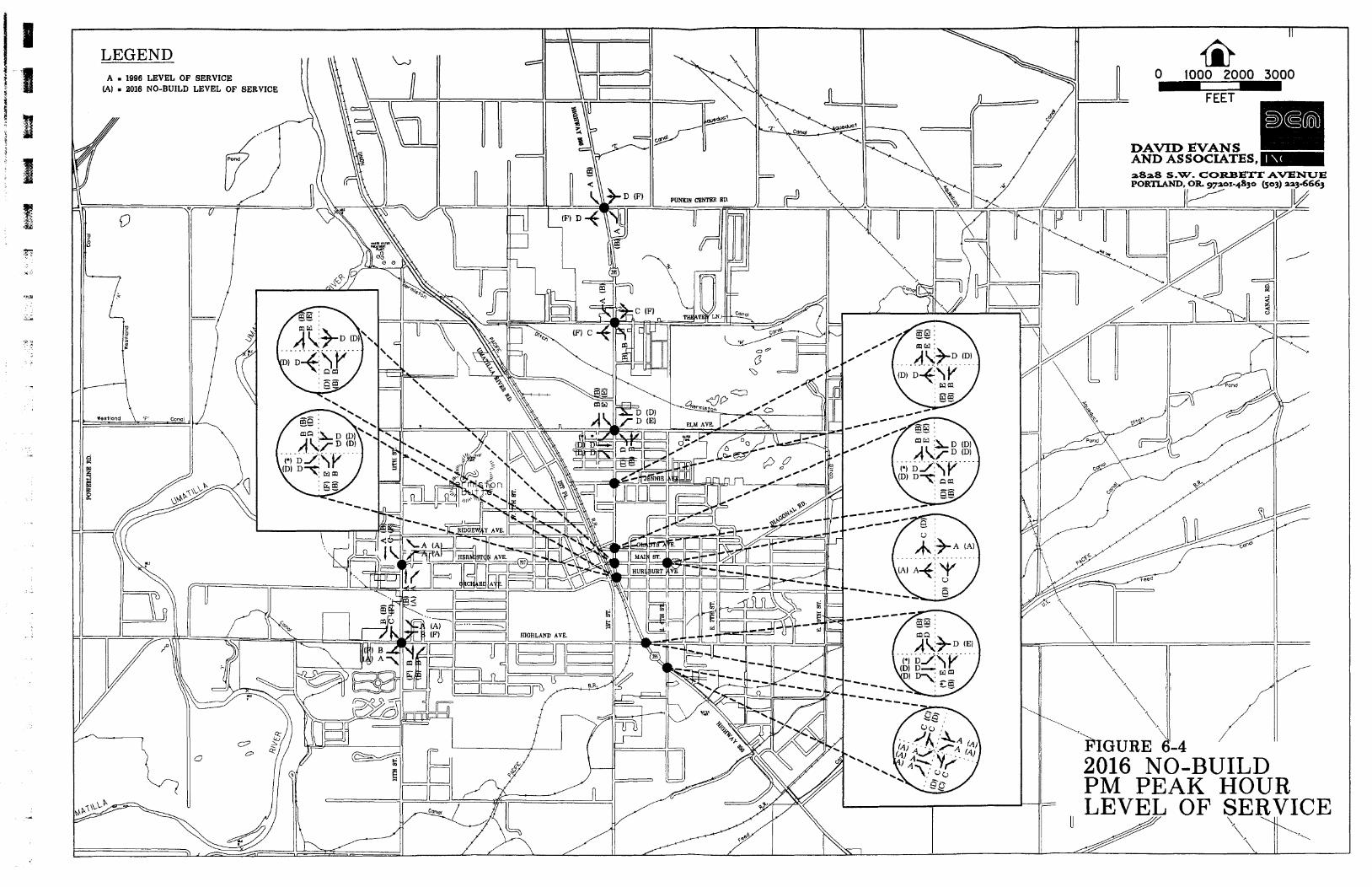
2016 NO-BUILD 1 PM PEAK HOUR
Costs: No direct costs are associated with making the comprehensive plan policy zoning code amendments.
Recommendations: Permitting mixed use developments and increased density is encouraged within the city limits of Hermiston. Implementation of these measures and changes to the comprehensive plan and zoning ordinances should be at the discretion of city officials. However, making amendments to allow a mixture of residential, industrial, and commercial uses in certain areas outside the city limits and inside the urban growth boundary may not be realistic due to the nature of the existing land use conditions in the Hermiston area. Most of the large employers of Hermiston residents are located outside the city limits; some even outside the urban growth boundary. Planning mixed use developments near these businesses may not be reasonable, based on economic feasibility and community livability. These large employers are located in rural settings as not to conflict with residential uses.
Alternative 2. Implement Transportation Demand Management Strategies
Overview: This type of improvement would attempts to change the demand on the transportation system by providing facilities for other modes of transportation, altering shift schedules, implementing carpooling programs, and applying other transportation measures within the community.
The construction and maintenance of walkways and bikeways is needed within the Hermiston area to improve safety for pedestrians and bicyclists and encourage more residents to limit their use of motorized vehicles. The addition of new sidewalks and bicycle lanes should be considered with all new street improvement projects.
Local businesses should be encouraged to stagger worker shifts so that travel to and from work is spread over a longer period. Currently, several of the largest industrial employers south and southwest of the city have been operating with staggered working shifts. Simplot, which is located along Butter Creek Road, employs a total of 850 full-time and part-time workers. There are 250 full-time workers present from 8 am to 4 pm, 250 full-time workers between 4 pm and 12 am, and 200 full-time workers between 12 am and 8 am. The Hinkle Railyards located near Feedville Road employs 300 workers which are evenly distributed over three shifts a day. The Lamb Weston site located along Westland Road employs about 500 workers evenly distributed over three shifts a day and the US Army Depot further to the southwest employs another 150 workers. Future forecasts project an increase in employment at these industrial sites, especially at the US Army Depot where the installation of an incineration plant is expected to create 1,354 jobs in the Hermiston area. A distribution center for Wal-Mart Stores is also planned near Highway 395 and Feedville Road which will employ about 600 workers. Maintaining the staggered worker shift schedule between the above five businesses into the future will help to spread traffic demand out over a longer period of time resulting in less traffic on the streets which feed into these businesses such as Highland Avenue, Westland Road, 1 Ith Street, Butter Creek Road, 1st Place, and Highway 395 south of Highland Avenue. Local businesses, especially the larger industrial employers mentioned above, should also be encouraged to institute carpooling or vanpooling programs for their employees in the future.
Traf$c Projections: A sensitivity exercise was performed to test the effects of TDM measures (Alternative 2) combined with revising the zoning and development codes (Alternative 1) on traffic projections. The average number of trips by trip length were used as the basis of this exercise. Both Alternatives 1 and 2 would result in shifts in modes away from single occupancy vehicle to carpools, vanpools, and other non-auto modes. Therefore, the sensitivity analysis assumed that vehicle trips would be reduced due to increased usage of these other travel options. The results of the sensitivity analysis are summarized in Table 6-2.
Final Repor t 6-5 Hermiston Transportation System Plan 5i30197

TABLE 6-2 EFFECT OF TRANSPORTATION DEMAND MANAGEMENT MEASURES
AND REVISED ZONING AND DEVELOPMENT CODES
Trip TypeILength "No-Build" A B C Within the Study Area
Up to 114 mile 90 85 80 80 114 mile to 112 mile 262 249 236 236 112 mile to 1 mile 1,634 1,552 1,470 1,470 1 mile to 2 miles 2,289 2,174 2,060 2,060 2 miles to 3 miles 1,096 1,096 1,096 1,096 3 miles to 6 miles 60 5 605 605 605
Subtotal 5,979 5,761 5,547 5,547
One End of Trip within the 4,546 4,546 4,546 4,319 Study Area
Through Trips 1,131 1,131 1,131 1,131 Total Trips 1 1,656 1 1,438 1 1,224 10,997 Percent Reduction N A 1.9% 3.7% 5.6%
"No-Build": No Trip Reductions A: "No-Build" with a 5% reduction in trips under 2 miles. B: "No-Build" with a 10% reduction in trips under 2 miles. C: "No-Build" with a 10% reduction in trips under 2 miles and a 5% reduction in trips with only one end within the study area.
Scenarios A through C looked at different reductions in vehicle trips by trip length due to the implementation of TDM measures and revised zoning and development codes. The reduction in trips of less than two miles was assumed to be between 5 and 10 percent. These reductions would occur predominantly because of modal shifts from motor vehicles to walking or bicycling. Trips which travel in or out of the study area were tested with reductions between 0 and 5 percent. Overall, the options resulted in total trip reductions of less than 6 percent in all cases. Percentage reductions are well below 10 percent due to the high number of through trips and trips with one trip end in the Hermiston area. The reductions at this distance will be mostly from carpooling or vanpooling measures.
Operations: Although each scenario indicates that some beneficial mode shifting would occur, the shift will only slightly improve future traffic operations at intersections and streets.
Impacts: The predicted mode shifts and demand management measures would contribute to improved traffic flow and less congestion. Providing adequate facilities for pedestrians and bicyclists increases the livability of a city, and improves traffic safety. These conditions mean air quality and noise levels would be better than the "No- Build" condition. Fewer vehicle miles traveled would also result in reduced energy consumption.
Costs: Fourteen pedestrian improvements have been identified at an estimated cost of $1.36 million. (Detailed recommendations are provided i n Chapter 7 . ) Fifteen bicycle improvements have been identified at an estimated cost of $938,000. (Detailed recommendations are provided in Chapter 7 . ) These cost estimates are for stand- alone improvements: the cost can be reduced when they are included as needed in roadway improvement projects throughout the Hermiston area.
Final Report 6-6 Hermiston Transportation System Plan 5130197
Recommendations: Because this option and Alternative 1 attempt to decrease congestion, increase the safety of the roadway system, and enhance the quality of life in the Hemiston area, these transportation improvements are encouraged. High priority should be given to the proposed bicycle and pedestrian improvements identified in Chapter 7. It is the position of the City of Hermiston that it is not the role of government to mandate TDM measures but the city is supportive of private businesses implementing such measures.
Alternative 3. Implement Transportation System Management Strategies
The potential improvements listed in this section are projects designed to improve the operations, accessibility, and safety of the local street system in Hermiston. They address specific deficiencies as well as safety hazards that currently exist or will exist in the future.
Alternative 3A. Signalize the Intersection of High way 395 and Theater Lane
Overview: This project includes the installation of a traffic signal to help maintain adequate operations and improve safety on the minor approaches of Theater Lane. It is expected that the operations of these approaches will deteriorate from LOS C to LOS F by the year 2016 if a signal is not installed.
To identify if a traffic signal may be needed at this intersection a signal warrant analysis was performed using The Manual on Uniform TrafJic Control Devices 1986 (MUTCD). The MUTCD states that "TrafJic control signals should not be installed unless one or more of the signal warrants in this manual are met. " Results from the analysis revealed that a traffic signal is not warranted under current conditions but will become warranted within the next few years without any transportation improvements.
Traffic Projections: No changes or shifts in traffic are expected from the installation of this signal.
Operations: Installation of a traffic signal will improve the operations in the year 2016 from LOS F to an estimated LOS D. However, delay will increase slightly on the major approaches of Highway 395.
Impacts: With the installation of the proposed traffic signal at Punkin Center Road andlor the interconnection between existing signals, a traffic signal installed at Theater Lane will help to maintain proper signal progression and platooning of vehicles along the highway. Installing a traffic signal will allow left-turning vehicles accessing Theater Lane and vehicles accessing Highway 395 to safely enter the intersection.
Costs: The cost of installing a traffic signal is expected to be around $200,000. This figure includes funding for right-of-way acquisition.
Recomnzendations: The installation of a traffic signal at this intersection is recommended. Installing a traffic signal within the next five years will improve the operations and safety of the intersection as traffic increases. A decision to install the signal should also be dependent upon the implementation of Alternative 3B, which includes a traffic signal installation at Punkin Center Road. For reasons of proper platooning of vehicles along the highway and maintaining signal progression, it was originally recommended that a traffic signal be installed at Theater Lane before a traffic signal is installed at Punkin Center Road. However, based on a recent traffic signal warrant analysis conducted by ODOT, a determination has been made that the signal at Highway 395 and Punkin Center should be installed first. This determination was made because a higher number of accidents have take
Final Report 6-7 Hermiston Transpor ta t ion Sys tem Plan .i!30197
place at Punkin Center Road. ODOT has already identified funding through the Hazard Elimination Program (HEP) to install the traffic signal at the Highway 395 and Punkin Center intersection in 1998. The final decision to install a traffic signal at Theater Lane is up to ODOT.
Alternative 3B. Signalize the Intersection of Highway 395 and Punkin Center Road
Overview: Traffic operations on the Punkin Center Road approaches are expected to deteriorate as well from LOS D to LOS F by the year 201 6. Installation of a traffic signal is expected to maintain sufficient operations and improve the overall safety at this intersection.
Results from a signal warrant analysis revealed that a traffic signal is warranted under current traffic conditions. Warrant 2, Interruption of Continuous Traffic, is the only warrant satisfied at this time. Without any future street improvements, warrants 1, 2 ,9 , and 1 1 are expected to be satisfied due to increases in traffic.
TrafJic Projections: No changes or shifts in traffic are expected from the installation of this signal
Operations: Installation of a traffic signal would improve the operations on the Punkin Center Road approaches from LOS F to LOS D but would increase delay slightly along the highway.
Impacts: A traffic signal installed at Punkin Center Road with the potential installation of a traffic signal at Theater Lane one-half mile to the south and the interconnection between existing signals along the highway will help maintain proper signal progression and platooning of vehicles along the highway. Without the potential traffic signal installed at Theater Lane a one mile gap would exist between the signal at Punkin Center Road and the next signalized intersection at Elm Avenue. A spacing this large would result in a poor level of signal progression.
Installing a traffic signal will allow left-turning vehicles accessing Punkin Center Road and vehicles accessing Highway 395 to enter the intersection safely.
Costs: The cost of installing a traffic signal is expected to be around $250,000. This figure includes funding for right-of-way acquisition.
Recommendation: It is recommended that a traffic signal be installed at this intersection. Timing of the installation of a signal is dependent upon several factors including: 1) Signal Warrant Analysis, 2) Deterioration of Operations, 3) Alternative 7B - Extension of Punkin Center Road over the Umatilla River, and 4) Funding. The signal warrant analysis revealed that a signal is currently warranted. If a higher priority is placed on minor street traffic accessing the highway than the continuous flow of traffic along the highway, then a traffic signal is recommended to be installed immediately. As the operations of the intersection deteriorate in the future it is recommended that a signal be installed when excessive delay is experienced by minor street traffic (LOS F). It is anticipated that this will occur within the next five years. It is also recommended that a traffic signal be installed if Punkin Center Road is extended over the Umatilla River to 1-82 to the west. Traffic volumes will be considerably higher on the approaches of Punkin Center Road as a result of this extension. Another factor affecting the timing of a traffic signal installation is funding. Currently, ODOT has proposed to provide the funding necessary to install a traffic signal within two years. As discussed under the previous alternative. ODOT District 12 has already identified funding for this new traffic signal through the Hazard Elimination Program (HEP).
Final Report 6-8 Hermiston Transponation System Plan 5130197

Alternative 3C. Signalize the Intersection of Main Street and East 4th Street
Overview: With increased use of East 4th Street as a collector street for local residences and an alternative route to Highway 395, this intersection is experiencing higher northtsouth cross-street traffic. With the potential construction of the East 4th Street extension (Alternative 5), traffic volumes are expected to increase even more.
A signal warrant analysis using turning movement counts from October 1995 revealed that a traffic signal is not warranted at this time but will be warranted by the year 20 16 without any potential street improvements. With the implementation of Alternative 5 it is expected that a signal will be warranted by the year 2013. A more detailed signal warrant analysis of this intersection was also performed by the Oregon Department of Transportation (ODOT). Results of this analysis also revealed that a traffic signal is not warranted at this time.
Traffic Projections: Traffic is expected to shift away from Highway 395 and onto East 4th Street with the installation of a traffic signal due to a reduction in delay on the northern and southern approaches of the intersection.
Operations: Installation of a traffic signal will improve future operations on the minor approaches of 4th Street in the year 2016 from LOS D to LOS B.
Impacts: Delay will increase slightly along Main Street.
Costs: The cost of installing a traffic signal is expected to be around $200,000. This figure includes funding for right-of-way acquisition.
Recommendation: A traffic signal is recommended at this intersection within the next five years. Timing of the installation should depend on the potential implementation of Alternative 5. Extending East 4th Street to either Theater Lane or Punkin Center Road will increase the amount of traffic entering this intersection. Installing a traffic signal would create favorable operations. Above all, funding for this traffic signal in conjunction with the 4th Street extension is expected to be supported by ODOT.
The installation of a traffic signal at Main Street and East 4th Street in conjunction with the extension of 4th Street from Elm Avenue to Theater Lane will improve local traffic circulation and reduce dependence on Highway 395 as a north-south corridor. At the present time, local traffic must rely on Highway 395 for local trips because there are no safe and adequate north-south travel corridors on the east side of Hermiston. The installation of a traffic signal at Main Street and 4th Street and the future extension of 4th Street will improve the local transportation grid and limit future maintenance and improvements to Highway 395 within Hermiston.
Alternative 30 . Improve the I It12 Street and Hermiston Avenue Intersection
The geometry and traffic control of this intersection is dissimilar to a normal T-shaped intersection where the minor road usually bisects the major road. At this intersection the major roads intersect at right angles; 1 l t h Street from the south and Hermiston Avenue from the east. The minor approach from the north on 1 lth Street is stop-controlled.
Final Report 6-9 Hermiston Transportation System Plan 5130197

This unusual configuration was developed because the approach from the south on 1 lth Street and the approach from the east on Hermiston Avenue are a part of Highway 207 which traverses through the city's downtown area. Traffic approaching from the south on 1 lth Street and making a left-turn to remain on 1 lth Street has a limited amount of storage length available. Trucks are restricted access to Hermiston Avenue and are forced to make a left-turn at this location, following the designated truck route north along 1 lth Street to Elm Avenue. It is estimated that in the future with increased traffic, trucks may find it more difficult to find sufficient gaps in the oncoming traffic and will deteriorate the level of service of this movement. With the limited storage length, traffic may become backed up, creating a bottleneck on this approach and negatively affecting the operations and safety of the entire intersection.
Future traffic operations analysis indicates the level of service of the left-turn movement approaching from the north on 1 lth Street will deteriorate from LOS C to LOS F by the year 2016. Results from the analysis reveal a LOS of B for traffic continuing northbound on 1 lth Street, making a left-tun. However, because of the unusual geometry for this movement, the LOS is anticipated to be worse (around D or E) in the future.
To improve the overall safety and operations of this intersection, two options were identified. The options are: 1) Geometrical improvements, and 2) Installation of a traffic signal.
Option 1: Geometrical Improvements
Overview: Geometrical improvements may include: a longer storage length for left-turning traffic approaching from the south on 1 lth Street creating a sight distance improvements for approaches on Hermiston Avenue and on 1 Ith Street and improving signs and striping.
TrafJic Projections: There are no anticipated changes in traffic volumes associated with this improvement.
Operations: Increased storage length for the left-tuning traffic approaching from the south on 1 1 th Street would prevent bottlenecking.
Impacts: The overall safety of the intersection may be improved due by better signs and striping
Costs: Costs associated with this improvement include restriping the lanes for all approaches at around $500 and construct raised medians to protect both sides of the left-turn lane on the south approach at $2000. The total cost for these improvements would be $2500.
Recommendation; Even with the increased storage length to increase the capacity of the left-turn lane on the south approach and the raised medians to protect vehicles in the queue, these geometrical improvements would not significantly improve the safety for vehicles, especially trucks, making the turn. The left-turn movement on the north approach will also deteriorate to a LOS of F by the year 2016. Therefore, this option is not recommended as a viable improvement.
Final Report 6- 10 Herniiston 'Transportation System Plan 5130197
Option 2: Installation of a Traffic Signal
Overview: Another possible improvement would be the installation of a traffic signal Figure 6-5 illustrates an example of this improvement. For existing and future year conditions, three signal warrants were met including: Warrant 1 - the Minimum Vehicular Volume, Warrant 2 - Interruption of Continuous Traffic Flow, Warrant 11 - Peak Hour Volume.
Traffic Projections: There are no anticipated changes or shifts in traffic volumes associated with this improvement.
Operations: With the installation of a traffic signal, the level-of-service of the southbound left-turn movement on 1 lth Street could be improved from LOS F to LOS C. However, the operations of the other approaches on 1 lth Street and Hermiston Avenue would be worsened slightly due to minor increases in delay from traffic signal control.
Impacts: The overall safety will be improved by creating a standard signalized T-shaped intersection. With a traffic signal, the northbound traffic would now make through movements instead of left-turns. Driveways of businesses along the west side of 1 lth Street will either be realigned or will enter the intersection at one driveway from the west. Adding a driveway to the west will require the design of a four-way intersection with phasing included. However, traffic volumes entering or exiting this driveway are expected to be low and will not affect operations significantly. Essentially, the intersection will still operate as a T-shaped intersection.
Costs: New Signal: $200,000 Other Channelin:. etc: 20.000 Total $220,000
Recommendations: Because this option would improve the safety and operational characteristics of the intersection it is recommended. Installation of a traffic signal at this location should be done within the next five years.
Alternative 3E. Improve 1st Place and Hermiston Avenue Intersection
This intersection has an unusual configuration and the orientation and traffic control may be confusing to some drivers. It has five approaches: Hermiston Avenue from the southwest and northeast, Gladys Avenue from the east, and I st Place from the northwest and southeast. STOP-signs are posted on the I st Place approaches and the Hermiston approach to the northeast.
Hermiston Avenue to the northeast accesses local businesses, such as Tum-a-Lum Lumber, and has also been known to provide a shortcut for westbound traffic along Highway 395. Vehicles occasionally turn onto this road when traffic along the highway becomes congested at the Gladys Avenue intersection. Also, trucks often turn onto Hermiston Avenue to avoid making a sharp right-turn at Gladys Avenue. These are trucks which have deliveries along Hermiston Avenue or are trucks that did not follow the designated truck route along Elm Avenue and I l th Street.
F~nal Report 6-1 1 Hermiston Transportation System Plan 5!30197
Allowing traffic to access this road can create a hazardous situation with the traffic control at this five-legged intersection. An accident analysis revealed that in the past three years, six accidents have occurred at this intersection, four of which were related to traffic on 1st Place not yielding right-of-way. One of these four accidents involved a collision with a vehicle entering the intersection from Hermiston Avenue to the northeast.
To improve the safety of this intersection, one option has been identified: vacate the section of Tum-a-Lum Road or Hermiston Avenue and extend Ridgeway Avenue east from 1 st Place to Highway 395.
Option 1: Vacate Turn-a-Lurn RoadIHerrniston Avenue and Extend Ridgeway Avenue to Highway 395
Overview: This option would vacate the Hermiston AvenueITum-a-Lum Road section between Highway 395 and the five-legged intersection. A new road extending Ridgeway Avenue from 1st Place to Highway 395 would replace the vacated road. This would require the construction of a 550-foot-long roadway and at-grade railroad crossing. This options is illustrated in Figure 6-6.
TrafJic Projections: The traffic previously entering the five-legged intersection from the Hermiston AvenueITum-a-Lum Road to the southeast would now be rerouted in two possible directions. Traffic traveling southbound in Highway 395 will either access Ridgeway Avenue or proceed onto Gladys Avenue. The extension of Ridgeway Avenue could cause unwanted traffic on the quiet residential neighborhood street along Ridgeway Avenue up to 1 lth Street. Creating a right-in, right-out access at the new intersection of Ridgeway Avenue and Highway 395 should keep traffic volumes low on this road.
Operations: Existing operations at the five-legged intersection are satisfactory and will improve as it becomes a four-way intersection. The new four-way intersection at Ridgeway Avenue and 1st Place will also operate sufficiently.
Impacts: The overall safety of this five-way intersection will improve as it becomes a common four-way intersection. A common four-way intersection will also be created at Ridgeway Avenue and I st Place.
Businesses along the southern side of the vacated road will now have to access the Ridgeway Avenue extension. The businesses on the south side of the vacated road should be provided with a driveway accessing Gladys Avenue, not at but nearly to the Gladys Avenue and 1 st Place intersection.
The new roadway access on Ridgeway Avenue will become the preferred access for local delivery trucks heading southbound on Highway 395. Large trucks and through truck traffic should be discouraged from using the new road and encouraged to use the designated truck route along Elm Avenue and 1 lth Street.
Costs: 550 ft street @ $300/ft $165,000 ROW 125 ft x 30 ft @ $]/sf $3,750 Railroad Crossing $700.000 Total $868,750
Cost estimates assumed a 40 foot wide street with curbs and sidewalks.
Final Repon 6-12 Hermiston Transponation S!stern Plan 5130197

Street at I
EXISTING INTERSECTION
rermiston Ave. not to scale
DAVID EVANS AND ASSOCIATES,
PROPOSED
HERMISTON AVE.
TRAFFIC SIGNAL
FIGURE 6-5 INSTALL TRAFFIC SIGNAL
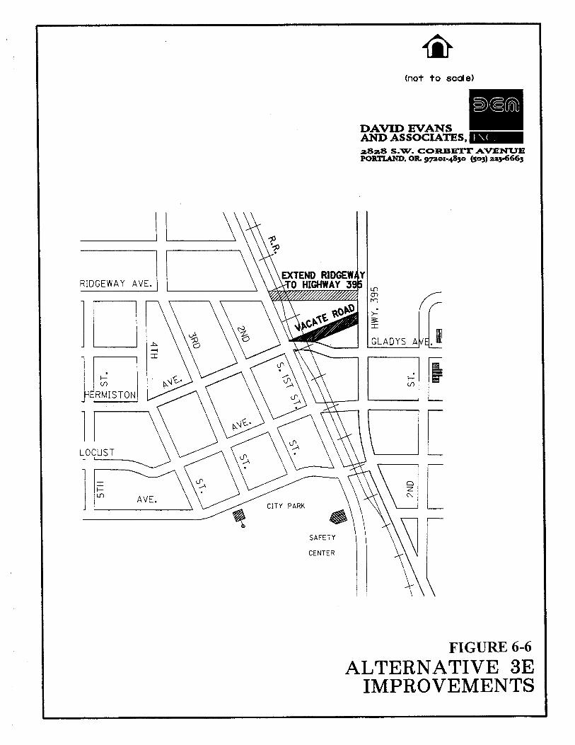
(not to scale)
2828 S.W. COREETT AVENUK PORTLAND. OR pox-4830 (503) aa3-6663
SAFETY
CENTER
FIGURE 6-6 ALTERNATIVE 3E
IMPROVEMENTS

ad HIGHLAND AVE.
Highland Ave.
I
I DAVID EVANS AND ASSOCIATES,
PROPOSED MODIFICATIONS
not to scale
~82.8 S.W. C0RBE"IT AVENUE PORTLAND, OR g p o ~ - 4 8 3 0 (503) aa3-6663
FIGURE 6-7
MODIFY INTERSECTION
Alternative 4. Extend East 4th Street
Traffic volumes are projected to increase by as much as 50 percent along Highway 395 within the study area by the year 2016. As congestion and travel delay increases along the highway, a parallel route will become more favorable to some local drivers. The utilization of the existing East 4th Street along with an extension north of Elm Avenue would provide a viable northlsouth facility parallel to Highway 395. Two options were considered for the East 4th Street extension: 1) Extending it northward to Theater Lane and 2) Extending it further northward to Punkin Center Road.
Alternative 4A. From Elm Avenue to Theater Lane
Overview: Currently, East 4th Street between Highway 395 and Elm Avenue already provides a semi-continuous north-south parallel route for local traffic. Extending East 4th Street from Elm Avenue to Theater Lane would create a safer, more continuous, and efficient parallel route for local traffic which would otherwise use Highway 395. This extension would create additional access to the residential developments bordering the existing East 4th Street south of Theater Lane such as Suncrest Estates as well as other residential developments along Theater Lane. Additional access points could be made available at businesses bordering Highway 395 along the 4th street extension to provide better access. Creating these new access points would help relieve congestion along the highway.
This new north-south parallel route could change the character of the 4th Street corridor. As traffic increases, residential livability will suffer and commercial uses will want to locate along the corridor.
The extension of East 4th Street would involve the construction of a new roadway connecting East 4th Street between Elm Avenue and Theater Lane approximately 2,600 feet in length. The City of Hermiston has partial ownership of the right-of-way along the proposed street alignment. From Theater Lane to the southeast corner of Suncrest Estates, about 1,300 feet in length, a 60-foot-wide right-of-way is owned by the city. From this point south to the Hermiston Drainage Ditch the city will have to acquire right-of-way. This section is approximately 600 feet in length and a 60 foot width is required. The city owns a 400-foot-wide section of right-of-way on the south side of the drainage ditch. However, this section is only 30 feet wide, an additional 30 feet of right-of-way will have to be acquired along the east side of the existing 30 foot section. Another section of right-of-way 60 feet wide will have to be obtained extending from Elm Avenue approximately 200 feet north. Design of the roadway will be according to the City of Hermiston's arterial or collector street standards depending on the future classification of this facility.
A crossing over the Hermiston Drainage Ditch will also be required along this new roadway. This ditch currently carries irrigation runoff storm drainage from runoff. The crossing would likely consist of a culvert crossing approximately 80 feet in length due to the width of the ditch.
TrafJc Projections: Traffic projections for this improvement alternative were performed using the QRS-I1 traffic model developed for the Hermiston area. The "No-Build'' model for the year 2016 was modified to include the 4th Street extension. A comparison was made between the "No-Build'' scenario and the 4th Street extension scenario to analyze how traffic patterns will change along the Highway 395 corridor.
The comparison showed that traffic will shift from Highway 395 to East 4th Street as a result of the extension. Traffic volumes along the highway are expected to be reduced by 60 to 100 vehicles per hour (vph) in both
Fmal Report 6- 14 Hermiston Transponation Skstem Plan jI30197

directions between Theater Lane and Elm Avenue. This is equivalent to a reduction of about 600 to 1000 vehicles over a day assuming a peak hour factor of about 10 percent which is an average percentage for a city the size of Hermiston. The peak hour factor is defined as the average number of vehicles during the PM peak hour divided by the number of vehicles over a day. From Elm Avenue to 4th Street, traffic volumes along Highway 395 are expected to decrease between 20 and 40 vph or about 200 and 400 vpd.
Operations: It is anticipated that a majority of the traffic utilizing Theater Lane will access 4th Street to the south instead of using Highway 395. This shift in traffic will improve the future operations at the unsignalized intersection of Theater Lane and Highway 395, especially for the left-turning traffic approaching Highway 395. The existing level-of -service for the approach at this intersection is at LOS C and will deteriorate to LOS F by 2016 without any improvements. Although a traffic signal may be needed at this intersection in the future, the construction of the 4th Street extension may delay its installation.
Increased traffic along 4th Street due to the extension will increase the need for a traffic signal at the intersection of 4th Street and Main Street (Alternative 3C).
Impacts: Extending East 4th Street will increase the northlsouth traffic flow along 4th Street through the bordering neighborhoods as well as the downtown area.
Extending 4th Street will also provide additional access points to local businesses which border Highway 395 providing a safer travel routes and reducing travel distance.
Adding sidewalks and bike lanes along 4th Street will provide an additional northlsouth facility other than Highway 395 capable of handling alternative transportation modes.
Noise levels along 4th Street will increase along the entire length of 4th Street due to increased traffic. Residential livability may suffer in northeast Hermiston as traffic increases.
The extension of 4th Street, from Elm Avenue to Theater Lane, in conjunction with installation a traffic signal at Main Street and 4th Street will add a vital local street corridor to the Hermiston transportation system. As detailed above under traffic projections, this street extension will reduce future traffic on Highway 395 and provide safe routes for both pedestrians and bicyclists. The 4th Street extension will enable ODOT to limit future expenditures on highway maintenance and improvements in the 395 corridor.
Cost: Cost estimates assumed a 50 foot wide street with curbs and sidewalks.
2,640 ft street @ $400/ft $1,056,000 80 ft culvert cross @ $300/ft $24,000 Acquire ROW 64 $l/sf $60.000 Total $1,140,000
Alternative 4B. From Theater Lane to Punkin Center Road
Overview: This option would build on Option A with East 4th Street extended further to Punkin Center Road. The alignment of this extension would be the same as Option A to Theater Lane but would continue in a
Final Report 6-15 Hrrrniston Transportat ion S ~ s t r r n Plan 5130197

northwesterly direction up to Punkin Center Road where it will connect opposite Sagebrush Road. This connection will create a common four-way intersection maintaining a consistent grid street network.
Construction would involve a canal crossing, right-of-way to be acquired, and the annexation of two residences which lie in the path of the proposed alignment. The canal crossing would consist of a culvert crossing over the eastern leg of the 'N' Canal, approximately 80 feet in length. The 'N' Canal is currently inactive but not abandoned and is located along an easement under the control of the Hermiston Irrigation District. Cooperation between the Irrigation District, the US Bureau of Reclamation, and the City of Hermiston could result in the abandonment of this section of the 'N' Canal, thereby avoiding the need for a new culvert crossing.
TrafJic Projections: The QRS-I1 traffic model was used again to assess the changes in traffic patterns between the "No-Build" scenario and extending 4th Street further north to Punkin Center Road. The comparison showed that with this improvement, even more traffic is expected to shift from Highway 395 to East 4th Street. Between Punkin Center Road and Theater Lane, traffic is expected to be reduced by 50 to 80 vph or about 500 to 800 vpd along the highway. From Theater Lane to Elm Avenue, traffic is expected to decrease by 100 to 140 vph or about 1,000 to 1,400 vpd. Between Elm Avenue, and where Southeast 4th Street intersects Highway 395, traffic is expected to be reduced by 10 to 40 vph or about 100 to 400 vpd.
Operations: This extension is expected to further increase traffic volumes traversing the intersection of 4th Street and Main Street which increases the need for improved traffic control such as the installation of a traffic signal (Alternative 3C).
The shifting of traffic onto 4th Street indicates that the PM peak hour traffic operations at the signalized intersections along Highway 395 will be slightly better when compared to the "No-Build" condition. However, the reduction in Highway 395 traffic will not noticeably improve the operations at intersecting minor streets.
Impacts: Construction of this facility will link together East 4th Street and Sagebrush Road providing a fully continuous north-south route parallel to Highway 395. It will also improve the continuity of the city's grid street system and increase local traffic flow. Increased traffic flow also means increased noise levels along 4th Street as well.
Cost: Cost estimates assumed a 50 foot wide street with curbs and sidewalks. It also included a culvert crossing which may be avoided.
2,640 ft street @ $400/ft $1,056,000 80 ft culvert cross @ $300/ft $24,000 ROW 2640 ft x 60 ft @ $l/sf $158,400 Annexation of two residences $121.520 Total $1,359,920
Reconvnendations: Because of the reduction in traffic along Highway 395 and the improved continuity in the grid system. both Option A and Option B are recommended for implementation. The East 4th Street extension could be constructed in two phases with Option A constructed as a high priority project in the next five years. The second phase would complete the extension in Option B as a medium priority project between five and ten years from now.
Final Repon 6- 16 Hermiston Transponation System Plan 5130197
Alternative 5. Upgrade of East 10th Street
Two options were considered for East 10th Street: a) Upgrading it between Columbia Drive and Elm Avenue, and b) Upgrading it between Elm Avenue and Punkin Center Road.
Alternative 5A. From Columbia Drive to Elm Avenue
Overview: The portion of East 10th Street between Columbia Drive and Elm Avenue is in need of an urban upgrade. East 10th Street was designed according to county standards as a rural two-lane roadway with gravel shoulders. Travel demand has increased over the past years from residential developments in the vicinity as well as the educational facilities of the Sandstone Middle School and Highland Hills Elementary School. With this increased demand the need has arisen for a facility which is designed to handle vehicular traffic as well as alternative modes of transportation along East 10th Street.
An inventory was performed on this roadway to identify areas that are insufficient in handling the current demand. In one area, substandard street widths measuring 20 feet exist along East 10th Street from Ridgeway Avenue to Newport Avenue.
Most of East 10th Street is unfit for existing pedestrian and bicycle usage. There are no continuous sidewalks or bike lanes along 10th Street. A multi-use path exists on the east side, from Diagonal Road to the Sandstone Middle School. Sidewalks are present at only two locations: between Diagonal Road and Ridgeway Avenue on the east side, and between Newport Avenue and Highland Avenue on the west side. There are no striped bike lanes and the narrow street width from Ridgeway Avenue to Newport Avenue makes conditions unsafe for shared-lane bicycle usage.
Pavement conditions are fair along most of the East 10th Street alignment except from Highland Avenue to Columbia Drive which is partly a substandard pavement and partly gravel based. In this area two narrow bridges pass over the Maxwell and 'A' Line Canals. These bridges have weight limits for heavy trucks but the limits are occasionally ignored by drivers. Recently, traffic volumes have increased along this portion of East 10th Street from new or increased employment at businesses along Columbia Drive. As traffic volumes increase in the future, a safer, more convenient access to Columbia Drive will be needed.
Option A would involve updating East 10th Street, from Elm Avenue to Highland Avenue, to an urban collector street. This includes the widening and repaving of the street and the addition of curbs, sidewalks, and bike lanes in accordance with the street design standards adopted by the city. It would also include a new culvert crossing over the Hermiston Ditch.
This option would also involve upgrading East 10th Street, from Highland Avenue to Columbia Drive, to collector or local street standards. The classification of this section of East 10th Street needs to be decided by city and county officials. Improvements should include the replacement of the two bridges over the Maxwell and 'A' Line canals with culvert type crossings.
Traffic Projections: Traffic projections on the street system are not expected to change significantly as a result of this improvement.
Final Report 6- 1 7 Hermiston Transportation System Plan 5!30/97

Operations: Traffic operations will improve slightly as a result of this improvement. Paving and widening the roadway will improve traffic flow and reduce potential conflicts with wide vehicles on narrow sections of roadway.
Impacts: This upgrade will accommodate local traffic with a more efficient northlsouth roadway responsive to all modes of transportation. Widening the existing street width will increase circulation and allow traffic to flow more freely. Adding continuous sidewalks, bicycle lanes, andlor the extension of the multi-use path will provide safer conditions for alternative modes of transportation. It will also link together the east-west pedestrian and bicycle routes such as the multi-use path along Elm Avenue, the bike path along Diagonal Road, and the continuous sidewalks along Highland Avenue.
Costs: The estimated costs for this improvement are:
7,000 ft street @ $350/ft $2,450,000 2 - 80 ft culvert cross @ $300/ft $48,000 Pipe Extension $20,000 Hermiston Ditch Crossing $24.000 Total $2,542,000
Costs for this alternative could be shared by: The City of Hermiston, which has recently accepted taking over the jurisdiction of East 10th Street from Diagonal Road to Highland Avenue from the county; Umatilla County, which will maintain jurisdiction of the remaining sections of East 10th Street including the two bridges which will be replaced with culvert crossings; ODOT, which will see traffic reduced on Highway 395, and a private developer in the process of planning the construction of 65 lot subdivision bordering the east side of East 10th Street between Ridgeway Avenue and Newport Avenue.
Recommendation: Because this project will improve the livability of the neighborhoods along East 10th Street and improve safety for pedestrians and bicyclists, this project is recommended. Implementation of this project should be considered in the next 5 to 10 years.
Alternative 5B. From Elm Avenue to Punkin Center Road
Overview: It is anticipated that the section of East 10th Street from Elm Avenue to Punkin Center Road will be in need of an urban upgrade in the future. The roadway was designed as a rural county road. It is a two-lane facility with a 24-foot street width and gravel shoulders. As the area becomes more urbanized and traffic increases in the future, a new facility will be needed to accommodate traffic demand and encourage alternative modes of transportation such as walking or biking.
Option B would involve two improvements. The 10th Street roadway, between Elm Street and Punkin Center Road, would be upgraded to an urban collector street with curbs, sidewalks, and bike lanes. To improve the overall safety and traffic flow, it is also recommended that a portion of Glemm Road approximately 1,500 feet north of Punkin Center Road be relocated and aligned with the intersection of Punkin Center Road and 10th Street as part of Option B.
Final Report 6-18 Hermiston Transportation System Plan 5130!97

This option would also include the replacement of the 'My Canal crossing with a new culvert type crossing. The 'M' Canal is currently not in use but is not abandoned. The canal follows an easement under the control of the Hermiston Irrigation District.
TrafJic Projections: Traffic projections on the street system are not expected to change significantly as a result of this improvement.
Impacts: Updating this street would create better north-south traffic circulation providing a better link between Elm Avenue and Punkin Center Road, and would provide a safe and convenient route for pedestrians and bicyclists.
Realigning the intersection of Glemm Road at Punkin Center Road and 10th Street will create a standard four-way intersection which will maintain the city's grid system. The realignment will also provide better circulation and more convenient access for northlsouth traffic along East 10th Street and Glemm Road.
Costs: The estimated costs for this improvement are:
5,500 fi street @ $350/fi $1,925,000 1,500 fi street @ $400/fi $600,000 1 - 80 ft culvert cross @ $300/ft $24,000 ROW 1500f tx70f i@,$ I l s f $105.000 Total $2,654,000
This section of East 10th Street is located outside the city limits and is under the jurisdiction of Umatilla County. Funding for this alternative should to be provided by Umatilla County.
Recommendation: Because this project will improve the livability of the neighborhoods along East loth Street and improve safety for pedestrians and bicyclists, this project is recommended. Implementation of this project should be considered in the next five to ten years.
Alternative 6. Upgrade and Realign Theater Lane
This alternative includes both the upgrade and a partial realignment of Theater Lane, from Highway 395 to East 10th Street. It involves updating Theater Lane to a more urban facility which includes widening and repaving the roadway, and the addition of curbs, sidewalks, and bicycle lanes.
Alternative 6A. From Highway 395 to 7th Street Alignment
Overview: This project would include the repaving and urban upgrade of Theater Lane to collector street standards, from Highway 395 east to the 7th Street alignment. This section of Theater Lane is a narrow two-lane roadway with a 40-foot right-of-way and no curb and gutter. There is parking available on the shoulders of the street. Pavement conditions are fair, an indication that the street will need repaving soon.
Operations: This improvement combined with Alternative 6A will increase traffic circulation along Theater Lane, shorten travel distances: and reduce delay.
F ~ n a l Report 6-19 Herrniston Transportat~on System Plan 5130197

Impacts: This improvement combined with Alternative 6A would provide a direct east-west route, enhancing the city's grid system.
Cost: The estimated costs for this improvement are:
2,600 ft street @ $350/ft $9 1 0,000 ROW 2600 f i x 30 ft 6) $l/sf $78.000 Total $988,000
Recommendation: Implementation of this project along with Alternative 6B should be considered by city officials in the next five to ten years.
Alternative 6B. From 7th Street Alignment to East 10th Street
Overview: The section of Theater Lane from the 7th Street alignment, just east of the Alora Heights subdivision, is currently unpaved and follows along the 'N' Canal to the northwest where it intersects with East 10th Street. This section of Theater Lane would be realigned to connect with the existing East 10th StreetITheater Lane intersection. This realignment would interconnect the entire length of Theater Lane east of Highway 395 and create a common four-way intersection at East 10th Street. Right-of-way would need to be acquired by the city to realign Theater Lane.
Operations: This improvement would increase traffic circulation along Theater Lane, shorten travel distances, and reduce delay.
Impacts: This improvement may require two crossings over the 'N' Canal which is currently empty but not abandoned. Or it may be possible to realign the canal to run alongside Theater Lane. This would require the cooperation of the Irrigation District.
The vertical drop-off located along the proposed realignment would require a moderate amount of cut and fill to the slopes which would increase construction costs.
Cost: The estimated costs for this improvement are:
2,640 fi street @ $400/ft $1 ~056,000 2 - 80 ft canal cross @ $3OO/ft $48,000 ROW 1 .300f ix70f t@, $l/sf $91 .OOO Total $1,195,000
Recommendation: It is recommended that the realignment of Theater Lane be considered a low priority improvement due to the nature of the N Canal alignment, the natural geographical features of the land along the proposed alignment, and the costs associated with this project. Implementation of this project and Alternative 6A should be considered by city officials in the next 10 years.
Final R e p o n 6-20 Hermiston 1- ranspona t ion System Plan j l30I9 i
Alternative 7. Construction of the Umatilla River Bridge
The travel demand forecast performed for the Hermiston area indicates that traffic volumes will increase along Highway 395 in the Hermiston area by about 48 percent in the next 20 years. Although highway capacity may not be an issue now, it may be so in the future. As traffic volumes increase along the highway, a new alternative route may be desired between Hermiston and the City of Umatilla and cities in Washington to the north. Providing a direct east-west link from the Hermiston area to Interstate 82 to the west would provide that alternative route.
There are other reasons for a future need to provide a direct east-west link between the Hermiston area and Interstate 82. With the construction of the US Army incineration plant located five miles southwest of Hermiston it is anticipated that 1,354 new jobs will be created for Hermiston residents. It was assumed in the future "No- Build" travel demand forecast that during the PM peak hour on an average weekday, two-thirds of those workers will be traveling to and/or from work. Without any street improvements it is anticipated that Westland Road, which will be one of the quickest routes to the plant, will experience an additional 200 vph each way. This will have adverse impacts on the intersections of Highland Avenue at 1 lth Street and Hermiston Avenue at 1 lth Street without any street or intersection improvements. Providing access to Interstate 82 would divert some of that traffic around the perimeter of the city and away from Westland Road and Highland Avenue.
A roadway constructed over the Umatilla River to Interstate-82 will also provide better access for through traffic heading southwest to Interstate-84. Through traffic that would benefit from this new access would consist of traffic originating from areas northeast of Hermiston and from the smaller cities of Charlestown and Power City to the north.
Two potential street improvements have been identified that would provide this access. Option 1 would extend Elm Avenue over the Umatilla River to connect with Power Line Road. From there traffic will utilize the Interstate 82 interchange to the north. Option 2 would extend Punkin Center Road over the Umatilla River and connecting it to Power Line Road where traffic can access the highway interchange more easily.
Alternative 7A: Extension of Elm Avenue Over the Umatilla River
Overview: Extending Elm Avenue over the Umatilla River would include the following: the paving and widening of Elm Avenue west of 1 lth Street (2,600 feet in length); construction of a new roadway to the Umatilla River; construction of a bridge over the river(approximate1y 400 feet long and 62 feet wide); construction of a new roadway to Hogan Road (approximately 2,200 feet in length); the potential upgrading of Powerline Road up to the Interstate 82 interchange as a collector or arterial street (6000 feet in length); the possibility of a traffic signal installation at the Elm Avenue and 11th Street intersection; the possibility of replacing the temporary traffic signal, which is currently being constructed at Elm Avenue and Umatilla River Road, with a permanent signal.
TrafJic Projections: No traffic projections were determined for this option since the extension could not be incorporated into the travel forecast (QRS-11) model.
Operations: The operations along streets and intersections affected by this extension were not determined.
Zngpacts: The extension of a roadway over the Umatilla River will raise environmental issues and concerns about the potential bridge crossing. The livability of the residences located on both sides of the river will also be affected.
Final Repon 6-2 1 Hermiston Transponat~on System Plan 5130197
Recommendations: Construction of either of these alternatives will provide an additional route other than Westland Road for much of the traffic related to the incineration plant. It will also provide an alternative route for through traffic and a potential truck route.
It should be noted that the improvement falls outside the city limits and UGB of Hermiston. It should be recognized that the city cannot authorize the project at this time, that further coordination with the county would be required, and that a goal exception and/or an extension of the UGB line would need to be approved by the Department of Land Conservation and Development (DLCD).
Alternative 8. Truck Route Evaluation
This alternative has two parts: 1) Evaluation of existing and potentially new truck routes, 2) The upgrading of the current signing for the City of Hermiston's truck routes.
Alternative 8a: Evaluation of Existing and Potentially New Truck Routes
Overview: There are two primary truck routes which traverse the City of Hermiston. One truck route exists entirely along Highway 395 through the city. The second truck route extends from Butter Creek Road which turns into 1 lth Street, proceeding east on Elm Avenue and onto Diagonal Road leading northeast.
A list of potentially new truck routes were evaluated based on public input and proposed street improvement options:
1) Ott Road, from Highway 395 to Highway 207lDiagonal Road 2) Westland Road 3) Across the potential Umatilla River Bridge to Interstate 82 (Elm Avenue or Punkin Center Road)
Ott Road
Currently, trucks traveling between Highway 207 to the northeast and Highway 395 to the south use Elm Avenue. One problem associated with this truck route is the truck traffic present along Highway 395 through the downtown area. Designating Ott Road would allow truck traffic to bypass the downtown. However, this may not be feasible. Ott Road is an unpaved, gravel based road. Designating this road as a truck route between Highway 395 and 207 would require it to be paved. Also, a connection between Loop Road and Highland Avenue would have to be constructed to provide a direct north-south route along Ott Road. Costs associated with these improvements would be high.
Westland Road
Westland Road was not evaluated as a potential truck route. Currently, Butter Creek Road (Highway 207) south of Highland Avenue serves as the truck route linking Hermiston with Interstate 84 to the southwest. Future traffic projections show that this roadway will operate smoothly with traffic volumes well below the street's capacity.
Final R r p o n 6-23 Hermiston Transponation System Plan 5130197
Therefore, it is anticipated that this roadway will remain a complimentary truck route into the future. A truck route along Westland Road will not be necessary.
Umatilla River Bridge
A truck route located along the potential roadway over the Umatilla River would change the existing truck route configuration for the Hermiston area dramatically. A roadway extension over the Umatilla River along either Elm Avenue (Alternative 7A) or along Punkin Center Road (Alternative 7B) would integrate the existing truck routes along Highway 39.5 and Elm Avenue with Interstate 82 to the west. Through truck traffic between Interstate 84 to the southwest and Highway 39.5 to the north would no longer be routed through the downtown core of the city along 1 1 th Street, reducing truck traffic dramatically.
Recommendations: It is recommended that the existing truck routes be maintained along Highway 39.5, Butter Creek Road, 1 lth Street, Elm Avenue, and Diagonal Road. Several intersection improvements have been identified and planned for construction which would improve the existing truck routes so that no other routes are needed. Some of these improvements include ODOT's plan to realign the six-way intersection at Diagonal Road and Elm Avenue. Because the existing intersection is skewed, trucks have difficulty turning from Elm Avenue on to Diagonal Road due to limited sight distance. With the intersection realignment, trucks making this movement will have improved sight distance that would allow them to enter the intersection safely. Other improvements planned by ODOT are the retiming of the traffic signals through town along Highway 39.5 and the curb cut modifications at several intersections including Highway 39.5 and Elm Avenue to allow trucks to turn corners safely. Also, a traffic signal installation is recommended (Alternative 3D) at the intersection of Hermiston Avenue and 1 lth Street intersection. This street improvement option will allow truck traffic to flow more easily. All of these improvements mentioned are planned or recommended to be constructed within the next five years. ODOT has identified funding through the Hazard Elimination Program (HEP) to reconstruct the Elm AvenuelDiagonal Road intersection. ODOT expects that this reconstruction will be done within the next five years.
Alternative 8B: Improved Truck Route Signing
Guide signs along Highway 207 which include the streets Diagonal Road, Elm Avenue, and Butter Creek Road11 lth Street do not display the truck routes clearly and need to be enlarged andlor placed in areas which are more visible to drivers. Trucks have a history of disregarding these signs and end up on streets or intersections where the existing geometry cannot handle truck turns.
Traffic Projections: Truck traffic volumes are not expected to change with the replacement of truck route signs
Operations: Street and intersection operations are not expected to change with the replacement of truck route signs.
Impacts: Improved signing will prevent trucks from deviating from the designated truck routes and improve the safety of the street system.
Cost: Costs for new truck route signs are estimated to be around $200lsign
Final Repon 6-24 Hermiston Transponation S\stem Plan 5!30197

Recommendations: Because of the low costs involved and the improved safety of the street system, it is recommended that the signing of the city's truck routes be improved along the streets mentioned above.
Alternative 9. Upgrade Umatilla River Road Between Hermiston Avenue and Elm Avenue
Overview: Umatilla River Road is in need of an urban upgrade. It was designed according to county standards as a two-lane roadway with gravel shoulders. In the past, this roadway served as the primary route for traffic heading north towards Umatilla. Since the completion of Highway 395 this road has become more of a collector street for local traffic within the urban parts of the city. This section of Umatilla River Road currently has poor pavement conditions.
The upgrade would involve updating the roadway between Elm Avenue and Hermiston Avenue to collector street standards which would include widening, repaving, and the installation of curbs, sidewalks, and bicycle lanes.
TrafJic Projections: Traffic volumes along Umatilla River Road, near Hermiston Avenue, are anticipated to increase from 230 to 375 vehicles northbound and from 160 to 285 vehicles southbound during the PM peak hour in the year 20 15. This is an increase of about 69 percent.
Operations: Upgrading the roadway to collector street standards will allow the roadway to handle future traffic demand. The upgrade will increase traffic flow for all modes by providing wider travel lanes for traffic and bike lanes and sidewalks to encourage their use.
Impacts: Widening and repaving the roadway will provide a safe environment for vehicular traffic. Safety for bicyclists and pedestrians will also be improved with the installation of bike lanes, sidewalks, and curbs
Cost: The estimated cost for this improvement is:
3.300 ft street @ $350/ft $1.155.000 Total $1,155,000
Recommendations: This project is recommended, and should be considered for development within the next five to ten years.
Alternative 10. Upgrade Local Unpaved Roads
The city of Hermiston has identified the locations of the unpaved, partly paved, and unbased substandard roads within the city's urban growth boundary. These substandard streets are shown in Chapter 3-Existing Conditions (Figure 3-2).
This alternative will require that a priority and funding program be formulated for the City of Hermiston to upgrade the substandard city streets over the next 20 years. The prioritization of improving these streets will depend on which other transportation alternatives are adopted by the City of Hermiston. Some of the substandard streets are close to or within some of the transportation grid patterns of other alternatives. Consideration to improve these substandard streets should be considered when specific transportation alternatives are being programmed.
Fmal Repor t 6-25 Herrn~ston T r a n s p o r t a t ~ o n S)slern Plan .;1;0197

Final Report 6-26 Hermiston Transponation Sysrem Plan 5/30/97

CHAPTER 7: TRANSPORTATION SYSTEM PLAN
The purpose of this chapter is to provide a detailed transportation system plan that will help to promote the goal and objectives set forth by the Hermiston community. The plan addresses all modes of transportation available in the Hermiston study area which include the street system, pedestrian and bicycle, and rail, air, and pipeline services. The plan also includes existing and recommended street classification standards, recommended access management measures, and transportation demand management measures.
EXISTING STREET CLASSIFICATION STANDARDS
Street classification standards relate the design of a roadway to its function. The function is determined by operational characteristics such as traffic volume, operating speed, safety, and capacity. Street standards are necessary to provide a community with roadways which are relatively safe, aesthetically pleasing to the eye, and easy to administer when new roadways are planned or constructed. They are based on experience, and policies and publ'ications of the profession.
The City of Hermiston has jurisdiction.for the design and construction of local streets within the city. Umatilla County is responsible for the roads located outside the city limits and within the Hermiston UGB. The Oregon Department of Transportation has jurisdiction for the design and construction of state highways within Hermiston and Umatilla County. Both the City of Hermiston and Umatilla County have street and road design standards at the current time. However, the existing standards are incomplete because they do not cover all street types: Umatilla County is in the process of revising their current road design standards.
The City of Hermiston has standards for local residential streets in the City of Hermiston Standard Plans and Specfzcations, 1993. The plans require local streets to have a minimum of 50 to 60 feet right of way with minimum street widths of 30 to 32 feet. Curb and gutter are also required on all new residential streets. The street specifications for local streets do not include sidewalks in the cross sectional figures. However, two types of sidewalk standards are included in a separate part of the plans, both of which require a minimum width of five feet. The city currently does not have design standards for either collector or arterial streets.
Umatilla County has road design standards for urban arterial, suburban arterial and rural roads. At the present time, the County Public Works Department is revising the existing road design standards. All roadways constructed in the county are required to have a 60-foot right-of-way. Urban arterial streets require a 36-foot roadway with five-foot sidewalks. Suburban arterial streets require a 32-foot street width which includes four- foot shoulders on each side. Rural streets require a 32-foot street width. Rural roads within Umatilla County are not required to have paved shoulders. The urban arterial road design standards apply to the urban areas designated areas within the Hermiston UGB. The rural road design standards apply to the urbanizable areas within the UGB.
RECOMMENDED STREET CLASSIFICATION STANDARDS
The development of the Hermiston Transportation System Plan provides the city and the county with an opportunity to review and revise their street design standards to more closely fit the functional street classification, and the goals and objectives of the Transportation System Plan. The propos'ed street classification
Final R e p o n 7- 1 Hermiston Transponation Sys tem Plan 5130197
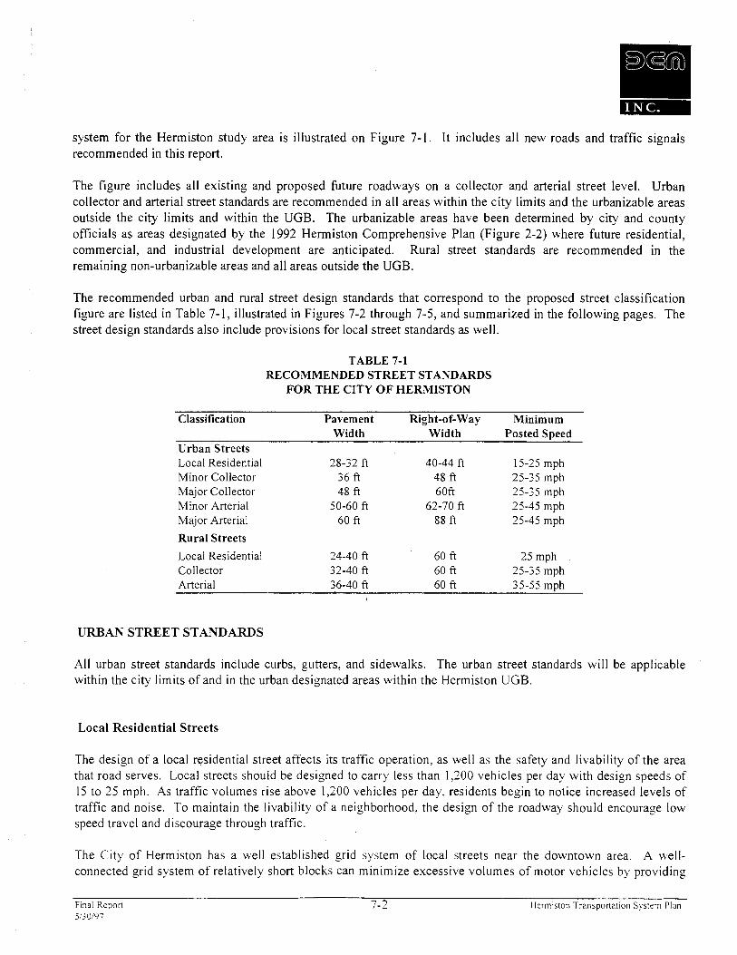
system for the Hermiston study area is illustrated on Figure 7-1. It includes all new roads and traffic signals recommended in this report.
The figure includes all existing and proposed future roadways on a collector and arterial street level. Urban collector and arterial street standards are recommended in all areas within the city limits and the urbanizable areas outside the city limits and within the UGB. The urbanizable areas have been determined by city and county officials as areas designated by the 1992 Hermiston Comprehensive Plan (Figure 2-2) where future residential, commercial, and industrial development are anticipated. Rural street standards are recommended in the remaining non-urbanizable areas and all areas outside the UGB.
The recommended urban and rural street design standards that correspond to the proposed street classification figure are listed in Table 7-1, illustrated in Figures 7-2 through 7-5, and summarized in the following pages. The street design standards also include provisions for local street standards as well.
TABLE 7-1 RECOMMENDED STREET STANDARDS
FOR THE CITY OF HERMISTON
Classification Pavement Right-of-way Minimum Width Width Posted Speed
Urban Streets Local Residential 28-32 ft 40-44 ft 15-25 mph Minor Collector 36 ft 48 ft 25-35 mph Major Collector 48 ft 60ft 25-35 mph Minor Arterial 50-60 ft 62-70 ft 25-45 mph Major Arterial 60 ft 88 ft 25-45 mph
Rural Streets
Local Residential 24-40 ft 60 ft 25 mph Collector 32-40 ft 60 ft 25-35 mph Arterial 36-40 ft 60 ft 35-55 m ~ h
URBAN STREET STANDARDS
All urban street standards include curbs, gutters, and sidewalks. The urban street standards will be applicable within the city limits of and in the urban designated areas within the Hermiston UGB.
Local Residential Streets
The design of a local residential street affects its traffic operation, as well as the safety and livability of the area that road serves. Local streets should be designed to carry less than 1,200 vehicles per day with design speeds of 15 to 25 mph. As traffic volumes rise above 1,200 vehicles per day, residents begin to notice increased levels of traffic and noise. To maintain the livability of a neighborhood, the design of the roadway should encourage low speed travel and discourage through traffic.
The City of Hermiston has a well established grid system of local streets near the downtown area. A well- connected grid system of relatively short blocks can minimize excessive volumes of motor vehicles by providing
Final Report 7-2 Hermiston Transportat ion Sys tem Plan 5130197
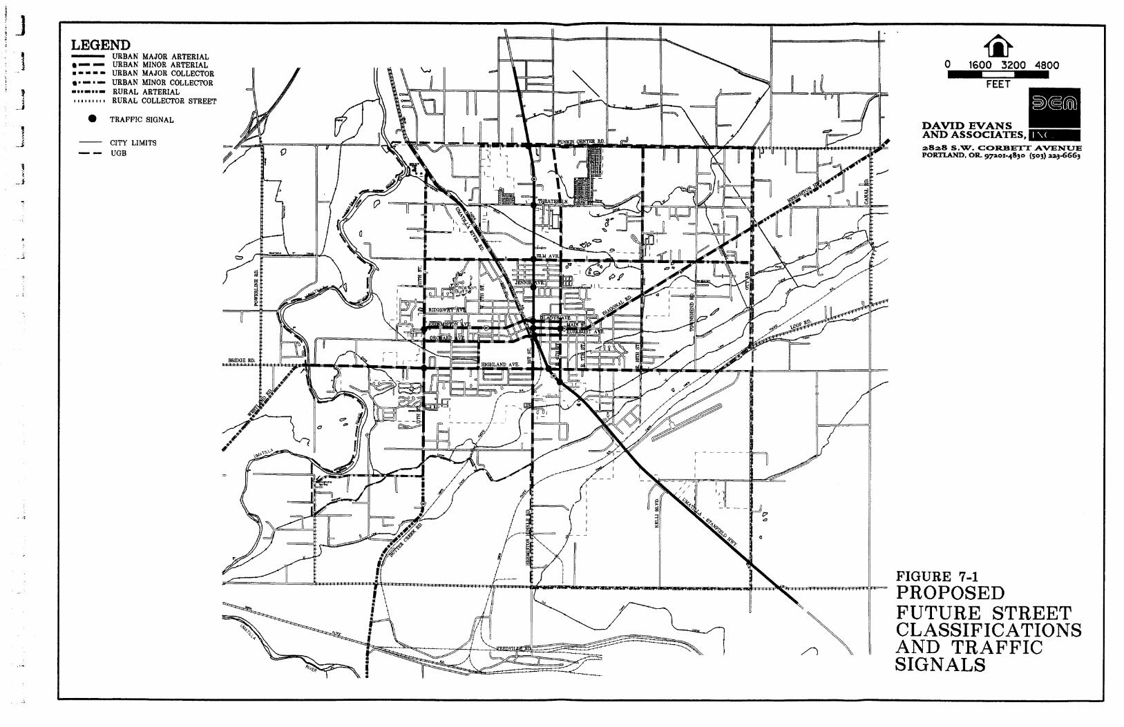
LEGEND - URBAN MAJOR ARTERIAL - - URBAN MINOR ARTERIAL - - = - URBAN MAJOR COLLECTOR - 1 - URBAN MINOR COLLECTOR =nm=mm= RURAL ARTERIAL I I a I I I I I I RURAL COLLECTOR STREET
TRAFFIC SIGNAL
CITY LIMITS - - UGB
0 1600 3200 4800 I
CCCT
a828 S.W. CORBE'IT AVENUE PORTLAND, O R g p o i - 4 8 3 0 ( 5 0 3 ) aa3-6663
FIGURE 7-1 PROPOSED FUTURE STREET CLASSIFICATIONS AND TRAFFIC SIGNALS

2828 S.W. CORBETT AVENUE PORlUND, OR. 81201-48W t508) 228-
ALTERNATIVE '1
LOCAL RESIDENTIAL CUL-DE-SAC5
Q
1 I P A F X ~ TRAVEL 1 TRAVEL WALK STRIP LANE
FIGURE 1 - 2 URBAN STREET
DESIGN STANDARDS LOCAL RESIDENTIAL STREETS

2828 S.W. CORBETT AVENUE PORTLAND. OR 87201-4850 ~ 5 0 ~ mas
5' .t. 1' L I I ' II' L 1' .L 5' T r T T
MAJOR COLLECTOR STeEELf,
1 /PAWING/ BIKE 1 TRAVEL 1 TRAVEL UIALK STRIP LANE LANE
- FIGURE f -3 0 0 0
URBAN 5TREET I x
DESIGN STANDARDS DL
COLLECTOR STREETS W I
2828 S.W. CORBETT AVENUE PORTLAM). OR WZUl4ILY) LS08) M
MINOR ARTERIAL STREETS
MAJOR ARTERIAL STREETS
Q
WALK
k L
80' R.O.W. 4
-1
PARKINGBIKE STRIP
1 BIKE TRAVEL 1 TRAVEL WALKWAY LANE 1 LANE LANE
FIGURE 1-4 URBAN STREET
LANE
TRAVEL LANE
DESIGN STANDARDS ARTERIAL STREETS
TRAVEL LANE
TRAVEL LANE
TRAVEL LANE
BIKE LANE
1 WALKWAY^
BIKE LANE
PARKING STRIP WALK

DAVID EVANS AND ASSOCIATES. 2828 S.W. CORBETT AVENUE PORTWND. OR m - 4 1 U O W8) 2aww
( 18' 18' >
SHOULDER SUOULDER
.RURAL COLJJXTOR STREETS
I I 1 TRAVEL TRAVEL LANE SHOULDER
It 32':401 d
I 1 TRAVEL TRAVEL 1 SHOULDER LANE LANE SHOULDER
k 36'-40' i k 6 0 ' R 0 . W . d
a series of equally attractive or restrictive travel options. This street pattern is also beneficial to pedestrians and bicyclists. This type of street development is encouraged as the vacant lands within Hemiston's urban growth boundary are developed.
The standard for a local residential street should be a 28- to 32-foot roadway, from curb face to curb face, within a 40- to 44-foot right-of-way. Local residential streets should include five-foot sidewalks with one-foot wide curb and gutter on both sides of the street.
The 28-foot cross section, labeled as Alternative I in Figure 7-1, will provide two 10-foot travel lanes with parking on one side. The 32-foot cross section, labeled as Alternative 2, will provide two nine-foot travel lanes with. Alternative 1 would provide a narrower street and improved neighborhood aesthetics. It also discourages speeding and through traffic. Alternative 2 provides parking on both sides of the street, and allows traffic to move freely but slowly. Both alternatives will also cut down on right-of-way needs, construction costs, stormwater run- off, and need to clear vegetation.
Cul-de-sac, or "dead-end" residential streets, are intended to serve only the adjacent land in residential neighborhoods. These streets should be short, serving a maximum of 20 single-family houses. Because the streets are short and the traffic volumes relatively low, the street width can be narrower than a standard residential street, allowing for the passage of two lanes of traffic when no vehicles are parked at the curb or one lane of traffic when vehicles are parked at the curb.
The street width of a cul-de-sac street should be 34 feet, curb face-to-curb face within a 46-foot right-of-way, as shown in Figure 7-1. A five-foot-wide sidewalk should be located on each side of the roadway as well as the circular portion of the cul-de-sac. Because cul-de-sac streets limit street and neighborhood connectivity, they should only be used where topographical or other environmental constraints prevent street connections. Where cul-de-sacs must be used, pedestrian and bicycle connections to adjacent cul-de-sacs or through streets should be included.
Collector Streets
Collector streets are intended to cany between 1,200 and 5,000 vehicles per day, including limited through traffic, at design speeds of 25 to 35 mph. A collector street can serve adjacent residential, commercial, industrial, or mixed land uses and connect arterials to local streets.
Table 7-3 shows the recommended cross sections for an urban minor and major collector street. Minor collector street standards could be implemented in neighborhood settings where traffic volumes are lower. The 11-foot travel lanes and on-street parking widths of seven feet provide a narrower road that will discourage speeding.
A major collector street standard could be used in a commercial or industrial setting where traffic volumes are higher and truck traffic is more frequent. The recommended street cross section is wider with 12-foot travel lanes, two five-foot bike lanes, and on-street parking areas which are eight feet wide.
Final Report 7-3 Hermiston Transportation System Plan 5130197
Both collector street standards provide five-foot sidewalks on each side of the roadway. Collector streets can also be striped to provide two travel lanes plus left-turn lanes at intersections or driveways by removing parking for short distances. If traffic volume forecasts exceed 5,000 vehicles per day on either type of collector, then driveways serving single- or multi-family houses should not be permitted on that section.
The City of Hermiston will decide which cross section is best for a collector street.
Minor Arterial Streets
, Minor arterial streets serve as a connector between local, major collector, and major arterial streets creating a moderate amount of through traffic. Like a collector street, it is also designed to provide access to residential, commercial, industrial, or mixed land uses that are adjacent to the roadway. These roadways tend to be higher volume roadways from the combination of local and through traffic. Traffic volumes range between 5,000 and 10,000 vehicles per day. Design speeds range between 25 and 45 mph.
Two alternative design standards are recommended for minor arterial streets. The first alternative utilizes a 50- foot cross section consisting of two travel lanes with bike lanes and parking on both sides of the road. The second alternative uses the same configuration but with a the addition of a 12-foot continuous, left-turn lane in the middle of the road. This design standard is recommended where left turn movements prevail along a street segment, where access to either local streets or driveways are abundant. The left-turn lane will provide a shelter for left- turning vehicles and will prevent the disruption of traffic flow. A five-foot sidewalk should be provided on both sides of the street in each alternative.
Major Arterial Streets
Major arterial streets, such as Highway 395 and 207, form the primary roadway network within and through a region. They provide a continuous roadway system that distributes traffic between different neighborhoods and districts. Major arterial streets are high capacity roadways that carry high traffic volumes with minimal localized activity. Design speeds should be between 25 and 45 MPH. Residential property should not face or be provided with access onto major arterial streets. Major arterial streets should consist of a 60 foot street width within an 88 foot right-of-way, as shown in Figure 7-2. The 60 foot paved width provides four 12-foot travel lanes and two six-foot bike lanes. Sidewalks along major arterial streets should be at least eight feet wide where possible.
RURAL STREET STANDARDS
The recommended rural street design standards apply to all roads outside the designated urbanizable areas in the Hermiston UGB. The rural street standards are based on the proposed functional classification of the roadway and the average amount of traffic that is expected. Three functional classes are recommended for rural roadways: local streets, collectors, and arterials. Recommended travel lane width for these types of roads ranges between 10 and 12 feet. Recommended shoulder widths are summarized in Table 7-2.
Final Report 7-4 Hermiston Transportation S ~ s t e m Plan 51;0/97
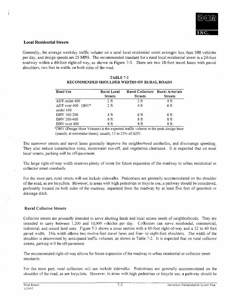
Local Residential Streets
Generally, the average weekday traffic volume on a rural local residential street averages less than 500 vehicles per day, and design speeds are 25 MPH. The recommended standard for a rural local residential street is a 24-foot roadway within a 60-foot right-of-way, as shown in Figure 7-3. There are two 10-foot travel lanes with paved shoulders, two feet in width, on both sides of the road.
TABLE 7-2 RECOMMENDED SHOULDER WIDTHS ON RURAL ROADS
Road Use Rural Local Rural Collectors Rural Arterials Streets Streets Streets
ADT under 400 2 ft 2 ft 4 ft ADT over 400 DHV* 2 ft 4 ft 6 ft under 100 DHV 100-200 4 ft 6 ft 6 ft DHV 200-400 6 ft 8 f t 8 f t DHV over 400 8 ft 8 ft 8 ft
*DHV (Design Hour Volume) is the expected traffic volume in the peak design hour (usually at commuter times), usually 13 to 25% of ADT.
The narrower streets and travel lanes generally improve the neighborhood aesthetics, and discourage speeding. They also reduce construction costs, stormwater run-off, and vegetation clearance. It is expected that on rural local streets, parking will be off-pavement.
The large right-of-way width reserves plenty of room for future expansion of the roadway to urban residential or collector street standards.
For the most part, rural streets will not include sidewalks. Pedestrians are generally accommodated on the shoulder of the road, as are bicyclists. However, in areas with high pedestrian or bicycle use, a pathway should be considered, preferably located on both sides of the roadway, separated from the roadway by at least five feet of greenbelt or drainage ditch.
Rural Collector Streets
Collector streets are primarily intended to serve abutting lands and local access needs of neighborhoods. They are intended to carry between 1,200 and 10,000 vehicles per day. Collectors can serve residential, commercial, industrial, and mixed land uses. Figure 7-3 shows a cross section with a 60-foot right-of-way and a 32 to 40 foot paved width. This width allows two twelve-foot travel lanes and four- to eight-foot shoulders. The width of the shoulder is determined by anticipated traffic volumes, as shown in Table 7-2. It is expected that on rural collector streets, parking will be off-pavement.
The recommended right-of-way allows for future expansion of the roadway to urban residential or collector street standards.
For the most part, rural collectors will not include sidewalks. Pedestrians are generally accommodated on the shoulder of the road, as are bicyclists. However, in areas with high pedestrian or bicycle use, a pathway should be
Final Repor t 7-5 Hermiston Transportat ion System Plan 5130197

considered, preferably located on both sides of the roadway, separated from the roadway by at least five feet of greenbelt or drainage ditch.
If traffic volume forecasts exceed 5,000 vehicles per day, then driveways serving single-family houses, duplexes, or triplexes should not be permitted on that section.
Rural Arterial Streets
Arterial streets form the primary roadway network within and through a region. They provide a continuous roadway system which distributes traffic between different neighborhoods and districts. Generally, arterial streets are high capacity roadways which carry high traffic volumes with minimal localized activity. Access should be provided along an intersecting rural, local, or collector street. Direct assess to residential property along a rural arterial should be discouraged.
Figure 7-3 shows a cross section with a 60-foot right-of-way and a 36 to 40 foot paved width. This width allows two 12-foot travel lanes and six to eight-foot shoulders. The width of the shoulder is determined by anticipated traffic volumes, as shown in Table 7-2. No on-street parking should be allowed on arterial streets.
For the most part, rural arterial streets will not include sidewalks. Pedestrians are generally accommodated on the shoulder of the road, as are bicyclists. However, in areas with high pedestrian or bicycle use, a pathway should be considered, preferably located on both sides of the roadway, separated from the roadway by at least five feet of greenbelt or drainage ditch.
ACCESS MANAGEMENT
Access management is an important tool for maintaining a transportation system. An access management plan takes into consideration the number, spacing, type and location of accesses, intersection and traffic signals and their effects on capacity, speed, safety, and the gmeral operational efficiency of a roadway. An effective management plan is necessary to operate a transportation system safely, at reasonable levels of service, and in a cost-efficient manner.
Access management addresses several areas of safety and efficiency concern on urban area transportation networks. A high number of driveways and other access points can limit the function of an arterial or collector by causing delay and safety hazards. Research has also shown a direct correlation between the number of access points and collision rates. Widening arterials and collectors to address traffic delays and safety hazards created by turning movements often leads to further increases in traffic and capital investments. Effective access management, therefore, is achieved by developing and implementing techniques and standards that maintain and enhance the capacity, safety, and level-of-service on an urban roadway system.
Access Management Techniques
The number of access points to a street can be restricted through the following techniques:
Final Report 7-6 Hermiston Transportation System Plan 5130197
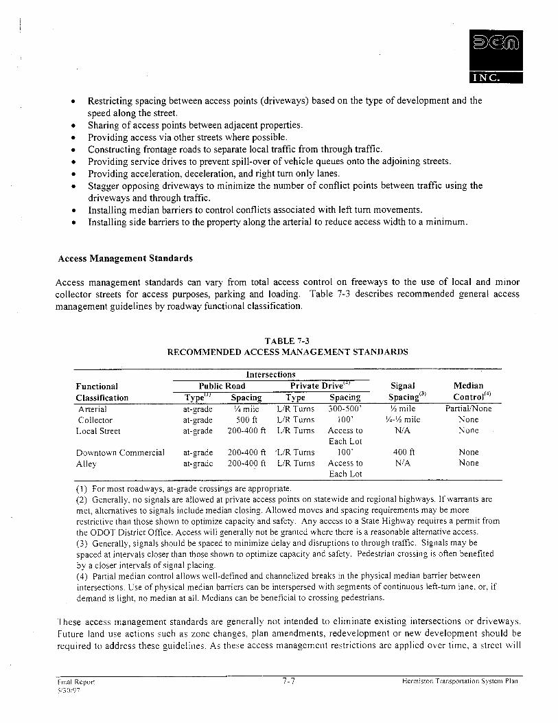
Restricting spacing between access points (driveways) based on the type of development and the speed along the street. Sharing of access points between adjacent properties. Providing access via other streets where possible. Constructing frontage roads to separate local traffic from through traffic. Providing service drives to prevent spill-over of vehicle queues onto the adjoining streets. Providing acceleration, deceleration, and right turn only lanes. Stagger opposing driveways to minimize the number of conflict points between traffic using the driveways and through traffic. Installing median barriers to control conflicts associated with left turn movements. Installing side barriers to the property along the arterial to reduce access width to a minimum.
Access Management Standards
Access management standards can vary from total access control on freeways to the use of local and minor collector streets for access purposes, parking and loading. Table 7-3 describes recommended general access management guidelines by roadway functional classification.
TABLE 7-3 RECOMMENDED ACCESS MANAGEMENT STANDARDS
Intersections Functional Public Road Private rive"' Signal Median Classification TY pe'" Spacing Type Spacing control(') Arterial at-grade '/a mile LIR Turns 300-500' % mile PartiaVNone - Collector at-grade 500 ft LIRTurns 100' X-% mile None Local Street at-grade 200-400 ft LIR Turns Access to NIA None
Each Lot Downtown Commercial at-grade 200-400 ft ,LlR Turns 100' 400 ft None Alley at-grade 200-400 ft LIR Turns Access to NIA None
Each Lot
( 1 ) For most roadways, at-grade crossings are appropriate. (2) Generally, no signals are allowed at private access points on statewide and regional highways. If warrants are met, alternatives to signals include median closing. Allowed moves and spacing requirements may be more restrictive than those shown to optimize capacity and safety. Any access to a State Highway requires a permit from the ODOT District Office. Access will generally not be granted where there is a reasonable alternative access. (3) Generally, signals should be spaced to minimize delay and disruptions to through traffic. Signals may be spaced at intervals closer than those shown to optimize capacity and safety. Pedestrian crossing is often benefited by a closer intervals of signal placing. (4) Partial median control allows well-defined and channelized breaks in the physical median barrier between intersections. Use of physical median barriers can be interspersed with segments of continuous left-turn lane, or. if demand is light, no median at all. Medians can be beneficial to crossing pedestrians.
These access management standards are generally not intended to eliminate existing intersections or driveways. Future land use actions such as zone changes. plan amendments, redevelopment or new development should be required to address these guidelines. As these access management restrictions are applied over time, a street will
F~na l Report 7-7 Hermiston Transportation System Plan 51;0/97
comply with the above mentioned standards. However, where there is a recognized safety problem, these standards can be utilized to retrofit existing roadways.
The Oregon Highway Plan specifies an access management classification system for State facilities. The 1991 Oregon Highway Plan delineates policies and strategies to guide the Oregon State Highway Division's operating and fiscal activities during the 1991-2010 period. The plan's mission is to design, build, and maintain quality highways and bridges that are safe, cost-effective, and that provide efficient access throughout the state. The plan includes a system to identify each facility's level of importance and access management classification to allow highway improvement needs and operational objectives to be prioritized throughout the state.
The Level of Importance (LOI) and Access Management Policies of the 1991 Oregon Highway Plan direct the specific operating characteristics of state highway facilities. The guidelines and classifications for access management along state highways that pertain to the Hermiston area are described as follows:
Level of Importance: Regional High way
The primary function of highways in this level is to provide connections and links to areas within the regions of the state, between small urbanized areas and larger population centers, and to higher level facilities. A secondary jimction is to serve and users in the vicinity of these highways.
The management objective of a regional highway is to provide for safe and efJicient high-speed continuous-$ow operation in rural areas, except where there are signlficant environnzental constraints, and moderate to low-speed operation in urban and urbanizing areas with moderate interruptions to$ow.
Under the 1991 Oregon Highway Plan, a Regional LO1 allows Highway 395 in Hermiston to be classified as either a Category 4 or 5 highway. Categories 4 and 5 are defined as follows:
Access Mrmagement Ccrtegory 4
These highway segnzents provide for efJicient and safe medium-to-high-speed and mediunz-to- high-volunze trafJic movements on higher function interregional and intercity highway segments. They may also carry signlficant volumes of longer distance intracity trips. They are appropriate
for routes passing through areas that have moderate dependence on the highway to serve land access and where the financial and social costs of attaining f i l l access control would substantially exceed benefits. This category includes a small part of the statewide facilities and most regional facilities.
ODOT's Category 4 policy states that the facility should maintain 500 feet between full-access private drives; 114 mile between public roads for urbanlurbanizing sections of the highway: and traffic signal spacing of 112 mile or greater. Partial control of medians using barriers or raised curbs is provided.
Final Repon 7-8 Herni~ston Transportation System Plan 5130197

Access Management Category 5
These highway segments provide for eflcient and safe slower-to-medium-speed and low-to-high volume trafJic movements on intercity and intercommunity routes. This category will be assigned only where there is little value in providing high speed travel. Providing for reasonable and safe access to abutting property is a major purpose of this access category
The Category 5 policy states that the facility should maintain 300 feet between full-access private drives; 114 mile between public roads for urbanlurbanizing sections of highway; and 114 mile or greater spacing between traffic signals. Median control is limited. Table 7-4 shows the access management classification system guidelines for Categories 4 and 5.
TABLE 7-4 1991 OREGON HIGHWAY PLAN
ACCESS MANAGEMENT CLASSIFICATION SYSTEM
Category Access LO1 Urban- Intersection Signal Median Treatment ~~~~l Public Road Private Drive Spacing Control
Type Spacing TY pe
4 Limited Statewide1 Urban At grade1 114 mile Lt.1Rt. 500 ft 112 mile PartialMo Control Regional Interchange Turns n e
5 Partial RegionalID Urban At grade 114 mile Lt./Rt. 300 ft 114 mile None -
Control istrict Turns
Special Access Management Areas in Hermiston
For the purposes of this Transportation System Plan, special access management areas have been designated in Hermiston along the Highway 395 corridor. In order to maintain and enhance the capacity, safety and level-of- service along Highway 395 in the Hermiston area, access management plans and policies have been developed in accordance with the 1991 Oregon Highway Plan. Although Umatilla County and the City of Hermiston may designate State highways as arterial roadways within their transportation systems, the access management categories for these facilities should generally follow the guidelines of the Oregon Highway Plan.
For the purposes of this Transportation Plan and in accordance with the Hermiston-Umatilla Highway 395 Corridor Land Use/Transportation Plan, Highway 395 in the Hermiston area has been divided into three management segments: (1) Joy Lane to Punkin Center Road; (2) Punkin Center Road to SE View Drive; and (3) SE View Drive to Feedville Road. The recommended access management categories for the section of Highway 395 between Joy Lane and Punkin Center Road is Category 4; between Punkin Center Road and SE View Drive Category j ; and between SE View Drive and Feedville Road Category 4.
The recommended access management guidelines for these segments of Highway 395 in Hermiston are defined in Table 7-5.
Final Report 7-9 Herm~swn Transportation System Plan 5130197
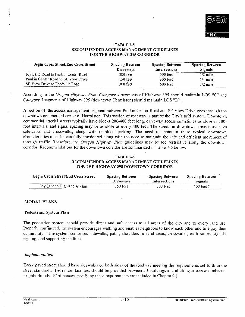
TABLE 7-5 RECOMMENDED ACCESS MANAGEMENT GUIDELINES
FOR THE HIGHWAY 395 CORRIDOR
Begin Cross StreetEnd Cross Street Spacing Between Spacing Between Spacing Between Driveways Intersections Signals
Joy Lane Road to Punkin Center Road 300 feet 500 feet 112 mile Punkin Center Road to SE View Drive 150 feet 300 feet 114 mile SE View Drive to Feedville Road 300 feet 500 feet 112 mile
According to the Oregon Highway Plan, Category 4 segments of Highway 395 should maintain LOS "C" and Category 5 segments of Highway 395 (downtown Hermiston) should maintain LOS "D".
A section of the access management segment between Punkin Center Road and SE View Drive goes through the downtown commercial center of Hermiston. This section of roadway is part of the City's grid system. Downtown commercial arterial streets typically have blocks 200-400 feet long, driveway access sometimes as close as 100- foot intervals, and signal spacing may be as close as every 400 feet. The streets in downtown areas must have sidewalks and crosswalks, along with on-street parking. The need to maintain these typical downtown characteristics must be carefully considered along with the need to maintain the safe and efficient movement of through traffic. Therefore, the Oregon Highway Plan guidelines may be too restrictive along the downtown corridor. Recommendations for the downtown corridor are summarized in Table 7-6 below.
TABLE 7-6 RECOMMENDED ACCESS MANAGEMENT GUIDELINES
FOR THE HIGHWAY 395 DOWNTOWN CORRIDOR
Begin Cross StreetJEnd Cross Street Spacing Between Spacing Between Spacing Between Drivewavs Intersections Signals
- -
Joy Lane to Highland Avenue 150 feet 300 feet 400 feet ?
MODAL PLANS
Pedestrian System Plan
The pedestrian system should provide direct and safe access to all areas of the city and to every land use. Properly configured, the system encourages walking and enables neighbors to know each other and to enjoy their community. The system comprises sidewalks, paths, shoulders in rural areas, crosswalks, curb ramps, signals, signing, and supporting facilities.
Implementation
Every paved street should have sidewalks on both sides of the roadway meeting the requirements set forth in the street standards. Pedestrian facilities should be provided between all buildings and abutting streets and adjacent neighborhoods. (Ordinances specifying these requirements are included in Chapter 9.)
Final R r p o n 7-10 Hermiston Transponat~on System Plan 5130f97
Sidewalks should be added as new streets are constructed and existing streets reconstructed. The implementation program (end of Chapter 7) identifies an approximate schedule for these improvements. Sidewalks and other pedestrian facilities may also be added as stand-alone projects as discussed in the next subsection.
Proposed Projects
Table 7-7 lists the specific improvements to be accomplished over the next 20 years and rates them to help the City determine implementation priorities. Priorities are merely a guide for pursuing projects by incorporation into the capital improvements list. The proposed pedestrian projects are shown Figure 7-4.
Note that shoulder projects, which serve cyclists and other road users as well as pedestrians, are included only under the bicycle system plan to avoid double counting.
Unit Costs
Cost estimates are based on the unit costs in Appendix E. The estimated cost represents what it would take to add the improvement to the existing road. Most projects can be accomplished at reduced cost by combining them with other work such as road widening. It has been noted in Table 7-7 if a proposed walkway project can be made part of an street improvement alternative stated in Chapter 5. Because costs vary over time, the figures provided are rough estimates intended to help set priorities and secure funding.
Other Streets
Spot projects along existing streets and intersections, where maintenance becomes a necessity, such as sidewalk infill, crosswalk striping, curb ramps, obstruction removal, and access, improvements should be completed incrementally until all identified needs are satisfied. Areas around schools and shopping areas generate the most pedestrian traffic and should be dealt with first, followed by outlying areas.
Final Report 7-1 1 Hermiston T r a n s p o r t a t ~ o n System Plan i~30107

TABLE 7-7 PROPOSED PEDESTRIAN PROJECTS
Location Proiect Descr i~t ion Length Priority Cost (ft) (9
Hwy 395 Sidewalk repair, curb ramps, driveway 890 Near-Term 23,100 (Theater Lane to SE Port Drive) management and refuge islands (4 lanes)
East 4th Street Sidewalk infill, 28 curb ramps 1,630 Near-Term 53,350 (Elm Avenue to Highland Avenue) East Main Street (East 7th Street Sidewalks 5,100 Near-Term 127,500 to East 10th Street) East 10th Street Sidewalk infill 7,455 Near-Term 186,375* (Elm Avenue to Highland Avenue)
Near-Term Total 390,325
Highland Avenue Sidewalk infill 500 (SW 1 1 th Street to SE 5th Street)
Hermiston Ave. (West 1 lth St. to 1st Pl.) 1 st Street (Hermiston Avenue to Highland Avenue) Orchard Avenue (West 1 lth Street to Highway 395) Elm Avenue (West 7th Street to Highway 395) Diagonal Road (Main Street to NE 10th Street) West 1 lth Street (Linda Avenue to Joseph Avenue)
Mid-Term Total
Sidewalk infill, 36 curb ramps 1,400
Sidewalk infill, 10 curb ramps 1,900
Sidewalk infill, 18 curb ramps 2,420
Sidewalks 4,470
Sidewalks 5,110
Sidewalk infill 6.500
Mid-Term 12,500
Mid-Term 5 1,200
Mid-Term 52,000
Mid-Term 68,600
Mid-Term 1 1 1,750
Mid-Term 127,750
Mid-Term 162,500
586,300
1 st Place Sidewalks 5,600 Long-Term 140,000* (Elm Avenue to Hermiston Avnue)
Jennie Ave. Sidewalks 4,700 Long-Term 1 17,500 (1st Place to NE 4th Street) 1 st Street Sidewalk infill with curbs, 18 curb ramps 3.900 Long-Term 125,100 (Highland Avenue to SE 4th Street Ext.)
Long-Term Total 382,600 Near-Term (2.85 mi) 390,525 Mid-Term (4.22 mi) 586,300 Long-Term (2.69 mi) 382.600
Total Pedestrian Projects 1,359,225 Notes: (1) All sidewalks assumed j-foot-wide with curb ramps at intersections (including most T-intersections),
Number ofcurb ramps is indicated. Total length ofnew sidewalk or injill on both sides ofroudwq).. (2) *Project may be incorporated into street improvement alternative (Chapter 5). (3) Near-Term: next 3 years; Mid-Term: j- 10 years; Long-Term: 10-20 years.
Fmal Report 7-12 Herrniston Transpona~ion S>stern Plan 5!;0197
Bicycle System Plan
The bicycle system plan aims to provide direct and safe access to all areas of the city. Properly configured, the system encourages bicycling and enables people of average skill to reach most destinations comfortably. The system comprises bike lanes, paths, shoulders on rural roads, shared roadways on low-traffic streets, signals, signing, pavement markings, and parking facilities.
Implementation
Every arterial and collector street should have a designated bikeway (typically bike lanes unless traffic volume is below 3,000 cars per day in which case a wide outside lane is usually adequate) meeting the requirements set forth in the street standards and in the Oregon Bicycle and Pedestrian Plan. For example, bike lanes should be one-way, marked in the same direction as the adjacent travel lane, five or six feet wide, and located against the curb except where there is curb parking or a right-turn lane in which case the bike lane is located between the travel lane and the parking or turn lane.
The Transportation Advisory Committee (TAC) made a determination that bicycle lanes along Highway 395 would not be designated because of the heavy truck traffic and narrow right-of-way. Instead the TAC recommended that bicyclists be encouraged to use the East 4th Street.
Bicycle access should be provided between adjacent neighborhoods in a direct manner, and bicycle parking should be provided at all major destinations.
Shared roadways, where bicyclists share normal travel lanes with motorists, are appropriate for local streets where speeds and volumes of motor vehicles are relatively low (less than 1,000 cars per day).
Shoulders of at least four feet are usually adequate on rural roads that lack a significant destination (school, park, residential subdivision, etc.). Wider shoulders are desirable on truck routes, where traffic volumes are over 1,000 cars per day, and near pedestrian destinations.
Functional bikeways depend on regular maintenance. Sweeping, surface repair, calibration of signal sensors, restriping, and control of vegetation are essential to useful, attractive and enduring facilities. Regular maintenance is often the easiest and most cost-effective means of enhancing the bikeway system. Construction projects should consider a long-term commitment to maintenance for bikeways.
Bikeways should be added as new streets are constructed and existing streets reconstructed. The implementation program (end of Chapter 7) identifies an approximate schedule for these improvements. Bikeways and other bicycle facilities may also be constructed as stand-alone projects where the cost is low or public support is high.
Proposed Projects
The recommended bicycle projects are illustrated in Figure 7-5. Table 7-8 lists the specific improvements that will be needed over the next 20 years and rates them to help the City determine implementation priorities. The most important attributes in rating a project are its potential use. barrier removal, connectivity, and cost effectiveness. Appropriate design to full standard is assumed unless otherwise stated: projects proposed to lesser
Final Report 7-13 Hermiston Transportat~on System Plan 51;0197
standards should be examined to determine if the compromise jeopardizes safety or functionality. Priorities are merely a guide for pursuing projects by incorporation into the capital improvements list. It is difficult to know exactly what developments will be proposed and what funding opportunities will be realized. Projects should be sequenced to take advantage of other road work being performed, and a project should not be overlooked simply because it is a low priority if conditions are favorable to proceed.
Unit Costs
Cost estimates are based on the unit costs in Appendix E. The estimated cost represents what it would take to add the improvement to the existing road. Most projects can be accomplished at reduced cost by combining them with other work such as an overlay. In many cases, the recommended work includes general roadway improvements, such as shoulders, that benefit all users and should be done as part of general roadway upgrades. It has been noted in Table 7-8 if a proposed bicycle improvement project can be part of a street improvement alternative stated in Chapter 5. Because costs vary over time, the figures provided are rough estimates intended to help set priorities and secure funding.
Other Streets
Spot projects, such as grate improvements, pavement patching, bike racks and access improvements, shall be completed incrementally until all identified needs are satisfied. Areas radiating from schools, shopping areas and major employers generate the most bicycle traffic and should be dealt with first, followed by outlying areas.
Railroad Crossings
Railroad crossings should be upgraded to concrete aprons to eliminate hazards posed to narrow wheels such as those on wheelchairs and bicycles. A joint agreement with Union Pacific Railroad should be pursued to provide concrete rail approaches.
Bicycle Parking
Bicycle racks should be installed in front of downtown businesses, large employers, and all public facilities (schools, post office, library, city hall, and parks). Typical rack designs cost about $50 per bicycle plus installation. An annual budget of about $2,000 should be established to place racks where needed.
Final Repon 7-14 Hermiston Transponation System Plan 5i30i97

TABLE 7-8 PROPOSED BICYCLE PROJECTS
Location Proiect Descri~tion Length Priority Cost (fij ($)
West 1 1 th Street Stripe bike lanes (6B- 1 1 - 1 1 -6B north of (Elm Avenue to Highland Avenue) Linda Ave., 7P-6B- 12-1 2-6B south of 57200 Near-Term 4 7 60
Linda Ave.)
Near-Term Total 4,160 Hurlburt Avenue Stripe bike lanes (5B- 1 1 - 1 1 -5B-8P) 1,400 Mid-Term 1,120 (Highway 395 to East 4th Street)
Stripe bike lanes (6P-4.5B-10- 10-4.5B) 2,600 Mid-Term 2,080 East 4th Street north of Highland Ave., (7P-4.5B-10- (Main Street to Highway 395) 10-4.5B-7P) south of Highland Ave. Orchard Avenue Stripe bike lanes (7P-5B- 10- 10-5B) 2,600 Mid-Term 2,080 (SW 1 lth Street to SW 7th Avenue) Orchard Avenue Stripe bike lanes (7P-5B- 12- 12-6B) 2,600 Mid-Term 2,080 (SW 7th Street to Highway 395) East 4th Street Stripe bike lanes (6B- 1 1 - 1 1 -6B) 3,250 Mid-Term 2,600 (Elm Avenue to Main Street)
Stripe bike lanes (Street width varies; 2,540 Mid-Term 26,032 Elm Avenue widen west of RR tracks for 800 ft from (West 7th Street to Highway 395) 24 to at least 34 ft) (6B- 1 1 - 1 1 -6B)
Widen from 24 to 34 fi with 6-ft 3,235 Mid-Term 155,280* 1 st Place shoulders: repave, and stripe for * * (Elm Avenue to Hermiston Avenue) shoulders (6Sh-11-11-6Sh) East 10th Street Widen to 34 ft (from 26,20 and 32-ft 5,2 10 Mid-Term 197.1 OO* * (Elm Avenue to Highland Avenue) segments) and stripe 6-fi bike lanes
(6B- 1 1 - 1 1 -6B)
Mid-Term Total 388,372 Diagonal Road Stripe bike lanes (7P-5B- 12- 12-6B west 3,100 Long-Term 2,480 (NE 7th Street to NE 10th Street) of 8th St.; 5.5B-11-11-5.5B) Hermiston Avenue Stripe bike lanes (7P-6B-12-12-6B west 4,750 Long-Term 3,800 (West 1 1 th Street to 1st Place) of 3rd St.; 7P-6B- 12- 12-6B-7P) Elm Avenue Widen from 24 to 34 ft with 6-ft 2,620 Long-Term 78,600* (West 1 lth Street to West 7th Avenue) shoulders and striping (6Sh-11-11-6Sh)
NE 10th Street Widen from 22 to 32 fi with 5-fi 3,3 10 Long-Term 99,3003 (Theater Lane to Elm Avenue) shoulders (wider if >2000 ADT), and * 3
stripe for shoulders (5Sh-11-11-5Sh) Theater Lane Widen from 22 to 32 ft with 5-fi 5.300 Long-Term 1 59,000* (NW Geer Road to NE 7th Street Alignment) shoulders (wider if >2000 ADT), and
stripe for shoulders (5Sh-1 1-1 1-5Sh) Highland Avenue Widen from 28 to 34 ft with 6-ft 5,500 Long-Term 202,400 (Umatilla River to SW 1 lth Avenue) shoulders, repave, and stripe for bike
lanes (5B-12-12-5B) ShoulderiBile Lanes
Long-Term Totals 545,580 Near-Term (2.7 mi) 4.160 Mid-Term (7..3 mi) 388,372 Long-Term (1 0.0 mi) 545,580
Total Bicycle Projects 938,112 .Votes. / I ) Lane conjiguralions are presented as a number series. ~nJeet, Jrom curb-to-curb lor edge-to-edge). For example, 'P- jB- I l -
12C-l l -6B f j2 ) 1s a --Joot park~ng lane, 5-Joot bike lane. two l l-Joot travel lanes w ~ t h n 12-Joot center turn lane, and a 6-Joot hike 1aneJor a total roadwaj~ wrdth of j2Jeei Lanes are nornznl1,v listedfiom west-to-east or north-to-south. /& Length given 1s one-way, but cost estimate includes both s~des ~Jroadwa~v 13) Costs associated with repaving: a layer oJasphall 2 inches thick at Sl8/linearJootJor n 34-Joot rondway (4) *Projecl includes pedestrian usage (5) **Projecl may he incorporated into street improvemenl allernatwe Khnplei- j) (6) :Year- Tern?: ne.71 5 years: .\did- Term - j- I0 years: Long-Term. 10-20 years
I inal Report 7-1 5 Herrn~ston Transportat~on Syswrn Plan 5'30197

Street System Plan
The street system plan outlines a series of improvement options that are recommended for construction within the Hermiston area during the next 20 years. Each of these options have been discussed in Chapter 6 (Improvement Options Analysis). The proposed street system options are summarized on Table 7-9 and shown on Figure 7-6 through Figure 7-8.
The Transportation Advisory Committee (TAC) evaluated and ranked the transportation alternatives detailed in Chapter 6 dealing with the street system. A total of 15 improvements were selected and prioritized. The ranking was based on their local knowledge of the Hermiston area, traffic circulation and traffic safety concerns, and cost of the improvements.
Final R e p o n 7-16 t l e r m i s ~ o n Transportarion Sysreni Plan 5130197
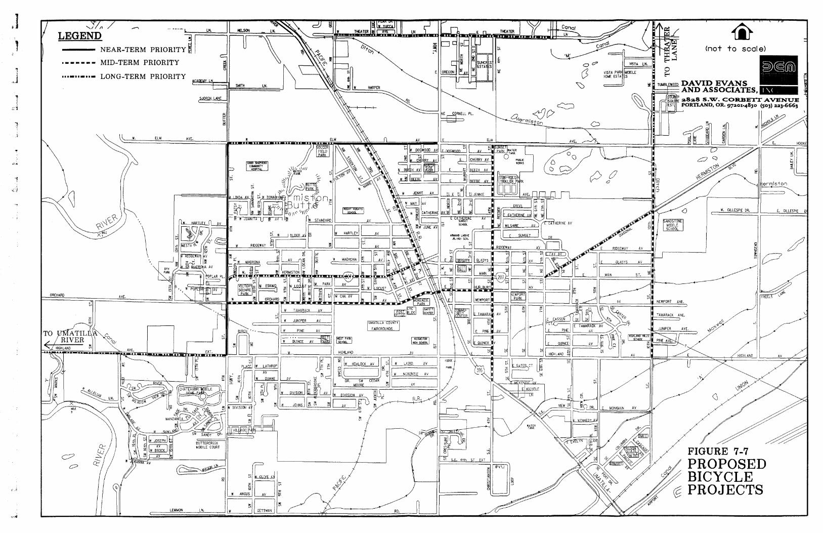
- NEAR-TERM PRIORITY 4 I C
m - - - - - - MID-TERM PRIORITY
* m m - m m - m B - LONG-TERM PRIORITY LN,
ELM AVE.
I I u LEMMOH LN. c
W TAMARACK AV ,
W JUNIPER A V
W PINE A V
V)
A V
E ELM

- NEAR-TERM PRIORIT
. - - -=== MID-TERM PRIORITY
n m m - m m - m m - LONG-TERM PRIORITY P w LN.
1 1 1
W. GlLLESPIE DR.
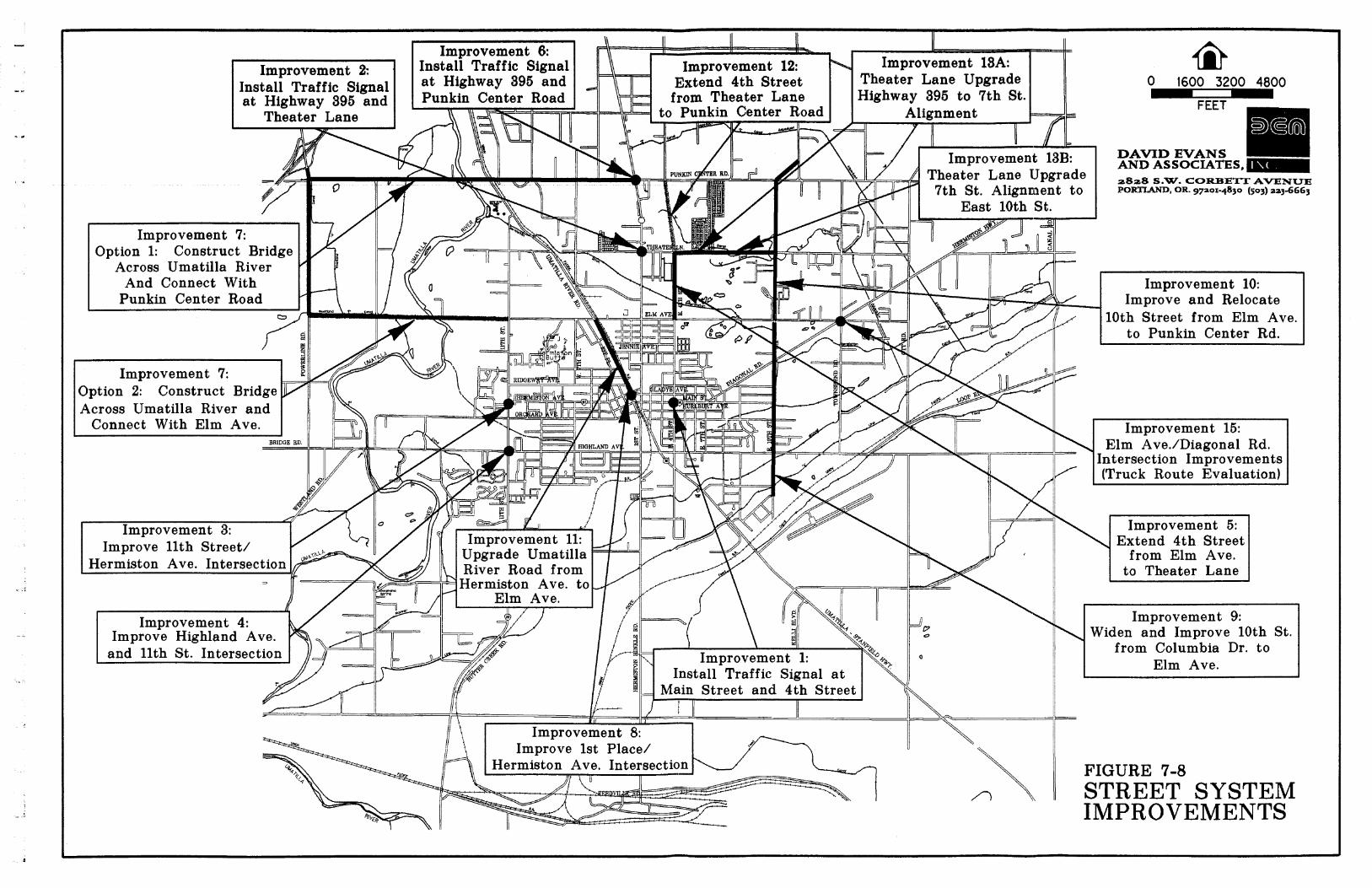
Improvement 8: Improve 1st Place/
Hermiston Ave. Intersection
Improvement 9: \ Widen and Improve 10th St.
from Columbia Dr. to Elm Ave.
17 IIU Main Street and 4th Street 1
FIGURE 7-8 \ I STREET SYSTEM
IMPROVEMENTS

TABLE 7-9 TRANSPORTATION IMPROVEMENT PROJECTS'
Project Title Improvement I : Signalize the Intersection of Main Street and East 4th Street Improvement 2: Signalize the Intersection of Highway 395 and
Cost $200,000
$200,000
Theater Lane Improvement 3: Improve the 1 Ith Street and Hermiston Avenue
Notes
($2,500) Option I - Geometrical Imp. ($220,000) Option 2- Traffic Signal
Intkrsection Improvement 4: Improvements at Highland Avenue and 1 lth Street
$208,480
Intersection Reshaping Improvement 5: East 4th Street Extension From Elm Avenue to
$1,140,000
Theater Lane Improvement 6: Signalize the Intersection of Hiehway 395 and
~ a i t 10th Street Upgrade From Columbia Drive to I '
I
$250,000 - -
punkin Center Road Improvement 7: Construction of the Umatilla River ridge'
Improvement 8: Improve 1st Place and Hermiston Avenue Intersection Imorovement 9:
Option 1 - Along Elm Ave. ($15,94 1.800) Option 2 - Along Punkin Center Rd. ($14.804.400) Vacate Hermiston AvenueITum-a-Lum Road and extend Ridgeway Avenue to Highway 396. $868,750 $2.542.000
- -
Elm Avenue Improvement 10: East 10th Street Upgrade From Elm Avenue to Punkin Center Road Improvement 1 1: Upgrade Umatilla River Road Between Elm Avenue and Hermiston Avenue Improvement 12: East 4th Street Extension From Theater Lane to
$2.654,000
$1,155,000
$1,359,920
Punkin Center Road Improvement 13a: Upgrade Theater Lane from Highway 395 east to 7th Street Alipnment
.Improvement 13b: Upgrade and Realign Theater Lane from 7th Street Alignment east to 10th Street Improvement 14: Upgrade Local Unpaved Roads Imorovement 15:
$988.000
$1,195,000
$2.0O/sq ft.
lmbrove Elm Ave.lDiagona1 Rd. Intersection (Truck Route Evaluation)
2) lmplemenrarion of [his improvemenr would require coordinaring berween cr@ and cotrnl): officials, and ~vozrld also require a goal exceprion and/or an exrension of rhe C'GB line.
3) Projecrs nor included in roral projecr cosr. - lmprovemenr 3: Oprion I - Geomerrical ln~provement - lmprovemenr -: Oprion 2 - Pzrnkin Cenrer Road Rozrre - In2provemenr 14: L'npaved Roads - Improvemenr 15: Truck Rozrre Signs
$540,000 ($200iea)- For new truck route signs
Total Cost
F ~ n a l Repon 7-17 Hermiston Transportation System Plan 5130197
( $29,462,950 .\'ores- I ) Individual Bike and Pedesirian Prolecrs are nor included in [his priorirized list.
Transportation Demand Management Plan
Transportation Demand Management is a technique applied to peak travel times to help reduce the use of the transportation network system. A variety of methods are utilized in combination to yield a more efficient transportation system that does not rely upon building new or wider roads to accommodate traffic growth. Successful techniques and methods include carpooling and vanpooling, alternative work schedules. bicycle and pedestrian facilities, and programs focused on high density employment areas.
Alternative Work Schedules
Alternative work schedules include such techniques as flex-time and staggered work hours. These flexible work schedules are principally effective with large employers. Peak period traffic volumes can be diffused over longer time intervals to provide more efficient service from a fixed capacity roadway. Several major employers in the Hermiston area already offer flexible arrival and departure times for their employees. Alternative work schedules should be an encouraged policy for any new or expanding business or industry in the area.
Carpooling and Vanpooling
Carpooling and vanpooling programs help to reduce travel and parking requirements as well as to alleviate traffic congestion and the associated air pollution on fixed roadway systems. Employers can encourage ridesharing through a variety of promotional incentives that include providing matching services subsidizing vanpools, establishing preferential car and vanpool parking, and by providing convenient drop-off sites. The City of Hermiston can encourage carpooling and vanpooling by establishing a ridesharing program that allows interested drivers to call a toll-free number to receive information about coordinating ridesharing with other interested parties.
Bicycle/Pedestrim Facilities
Bicycling and walking can be encouraged by implementing strategies discussed earlier in this plan. Providing bicycle parking, showers and locker facilities helps to encourage bicycle and pedestrian commuting.
Telecommuting
Telecommuting is a recent phenomenon that has granted persons the capability of performing their work duties at home. The use of telecommuting is likely to continue to grow over the next two decades. If telecommuting expands as anticipated, it will have a noticeable impact on reducing trips during peak hour travel times.
Public Transportation Plan
Public transportation in Hermiston consists primarily of a demand response system for local trips. This includes taxicab service and a senior citizen and special needs transport service. Public transportation for regional and
Final Repon 7-18 Hermiston Transponation System Plan 5130197
brief analysis of how Umatilla County and ODOT finance transportation system improvements is included to provide context on the ways different governmental agencies can work together in the future.
HERMISTON STREET IMPROVEMENT FUNDING SOURCES
Hermiston accounts for transportation related revenues and expenditures in three main funds. Each fund is accounted for separately in the annual fiscal year budget. These funds include:
The General Fund; The State Street Tax Fund; The Reserve Fund; and The Wal-Mart Infrastructure Fund.
In addition to these funds, Hermiston has historically employed Local Improvement Districts to fund localized transportation improvements. The city has also historically obtained a variety of state and federal transportation grants.
General Fund
The General Fund provides for salaries and benefits of city workers and funds the operations of several city transportation projects and amenities including the senior and disabled transit program and the municipal airport as well as transferring monies to the Street Fund. The general fund receives money from approximately 49 different sources. Some of the major sources include property taxes, franchise income and state liquor and cigarette prorations. A summary of the General Fund over the last four years is detailed in Tables 8-1 and 8-2.
Senior and disabled transit program provides dial-a-ride mobility services for the elderly and handicapped in Hermiston. This program was originally funded through the Federal Revenue Sharing program in the early 1970s and has since been funded through the general fund and grants. In the current fiscal year, the city of Hermiston will contribute $79,500 to the senior and disabled transit service.
The municipal airport is the largest transportation related expense of the general fund. The general fund released about $1 50.000 per year over the last four years for the operations and maintenance of the airport.
The General Fund also transfers money to the Street Tax Fund on a per-project basis. Over the last four years, the General Fund has transferred between $17.875 to $212.840 to the Street Tax Fund. In the 1996-97 fiscal year. $1 75.100 in General Fund moneys are to be transferred to the Street Tax Fund.
Final Repon 8-2 Hermiston Transportation System Plan 5i30197
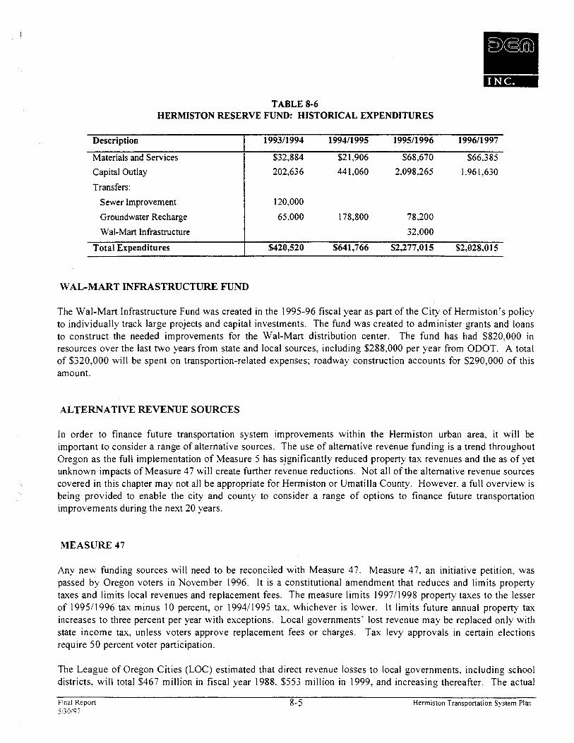
TABLE 8-6 HERMISTON RESERVE FUND: HISTORICAL EXPENDITURES
WAGMART INFRASTRUCTURE FUND
Description
Materials and Services Capital Outlay
Transfers:
Sewer Improvement
Groundwater Recharge
Wal-Mart Infrastructure
Total Expenditures
The Wal-Mart Infrastructure Fund was created in the 1995-96 fiscal year as part of the City of Hermiston's policy to individually track large projects and capital investments. The fund was created to administer grants and loans to construct the needed improvements for the Wal-Mart distribution center. The fund has had $820,000 in resources over the last two years from state and local sources, including $288,000 per year from ODOT. A total of $320,000 will be spent on transportion-related expenses; roadway construction accounts for $290,000 of this amount.
199311 994 199411 995 199511996 199611 997
$32,884 $2 1,906 $68,670 $66.385
202,636 44 1,060 2.098.265 1.96 1.630
120.000
65.000 178,800 78,200
32.000
%420,520 $641,766 $2,277,015 $2,028,015
ALTERNATIVE REVENUE SOURCES
I n order to finance future transportation system improvements within the Hermiston urban area, it will be important to consider a range of alternative sources. The use of alternative revenue funding is a trend throughout Oregon as the full implementation of Measure 5 has s,ignificantly reduced property tax revenues and the as of yet unknown impacts of Measure 47 will create further revenue reductions. Not all of the alternative revenue sources covered in this chapter may not all be appropriate for Hermiston or Umatilla County. However. a full overview is being provided to enable the city and county to consider a range of options to finance future transportation improvements during the next 20 years.
MEASURE 47
Any new funding sources will need to be reconciled with Measure 47. Measure 47, an initiative petition, was passed by Oregon voters in November 1996. It is a constitutional amendment that reduces and limits property taxes and limits local revenues and replacement fees. The measure limits 199711998 property taxes to the lesser of 199511996 tax minus 10 percent, or 199411995 tax. whichever is lower. It limits future annual property tax increases to three percent per year with exceptions. Local governments' lost revenue may be replaced only with state income tax, unless voters approve replacement fees or charges. Tax levy approvals in certain elections require 50 percent voter participation.
The League of Oregon Cities (LOC) estimated that direct revenue losses to local governments. including school districts, will total $467 million in fiscal year 1988. $553 million in 1999. and increasing thereafter. The actual
Final Repon 8-5 Hermiston Transponation System Plan 5130197
revenue losses to local governments will depend on actions of the Oregon Legislature. LOC also estimates that the state will have revenue gains of $23 million in 1988. $27 million in 1999, and increasing thereafter because of increased personal and corporate tax receipts due to lower property tas deduction.
Measure 47 adds another layer of restrictions to those which govern the adoption of tax bases and levies outside the tax base, as well as "Measure 5's tax rate limits for schools and nonschools and tax rate esceptions for voter approved debt. Each new levy and the imposition of a property tax must be tested against a longer series of criteria before the collectible tax amount on a parcel of property can be determined. The Oregon State Legislature will be required to pass implementation statutes during the 1997 legislative session. It is expected that both legislative and judicial action will be necessary to clarify the implementation of Measure 47.
The implementation of Measure 47 will require that cities and counties protect and prioritize funding for public safety and public education. However, the measure provides no guidance or certainty on how local governments are to protect and prioritize funding or what can be classified as a public safety or public education program. Another major requirement of Measure 47 is that cities and counties must obtain voter approval to raise fees for services if the increased fee revenue is a substitute for property tax support.
It is not possible to predict what legislative or judicial actions will take place to implement Measure 47. The Governor's Office is in the process of preparing the new budget for the next biennium. Based the preliminary budget released by the Governor's Office, cities and counties will not receive additional funding from the state to reduce the impacts of Measure 47. Instead, the new budget will focus on retaining and increasing support for basic school education programs. Again, the preliminary state budget will likely be modified during the next legislative session.
This will directly impact the ability of cities to pay for transportation improvements out of general funds or other funds created through property taxes. In addition, it may impact the ability of cities to create alternative funding sources if those sources are perceived to be in replacement of property tax revenue.
Property Taxes
Property taxes are the major revenue source for Oregon cities. Property taxes are levied through I ) tax base levies, 2) serial levies, and 3) bond levies. The most common method uses tax base levies which are continuous and are allowed to increase by six percent per annum. Serial levies are limited by amount and time they can be imposed. Bond levies are for specific projects and are limited by time based on the debt load of the local government.
The historic dependence on property taxes is changing with the passage of Ballot Measure 5 in the early 1990s. With the 199511996 budget year, Ballot Measure 5 will be fully implemented. In brief, Ballot Measure 5 limits the property tax rate for purposes other than payment of certain voter approved general obligation indebtedness. With full implementation in the current budget year. the tax rate for all local taxing authorities is limited to $1 5 per $1.000 of assessed valuation. As a group. all non-school taxing authorities are limited to $10 per $1,000 of assessed valuation. All tax base, serial and special levies are subject to the tax rate limitation. Excluded from the limitation is debt service used to retire voter approved general obligation bonds. Ballot Measure 5 requires that all non-school taxing districts property tax rate be reduced if together they exceed $10 per $1.000 per assessed valuation by county. If the non-debt tax rate exceeds the constitutional limit of $10 per $1.000 of assessed valuation, then all of the taxing districts' tax rates are reduced on a proportional basis. This proportional reduction in the taxing rate is commonly referred to as compression of the tax rate.
Frnal Repon 8-6 Hermis~on Transpona~~on System Plan 5130197
For the 1995196 fiscal year, Hermiston had a taxing rate of 5.89 per thousand. Other taxing districts share the $10 non-school limitation. Historically, Hermiston has most commonly used property taxes (serial levies) to fund public works functions. The city has also relied on State of Oregon shared revenues, Federal ISTEA Grants. and Local Improvement Districts to fund both public works maintenance and new construction. The shared revenues are derived from the local allocation of state gas tax and vehicle registration fees.
DEBT FINANCING
There are a number of debt financing options available to the city. The use of debt to finance capital improvements must be balanced with the city's ability to make future debt service payments and to deal with the impact on its overall debt capacity and underlying credit rating. Debt financing should be viewed not as a source of funding, but as a time shifting of funds available to the city. Its use should be incorporated into the overall financing plan which may include some "pay-as-you-go" funding methods which utilize currently available revenues to meet a portion of the city's transportation needs.
While a wide variety of debt financing techniques exist, some of the primary financing tools used for transportation related projects are listed below. These include general obligation bonds, limited tax general obligation bonds, local improvement district bonds, and special tax revenue bonds.
General Obligation Bonds
General obligation bonds (GOs) are voter approved bond issues and represent the least expensive borrowing mechanism available to municipalities. GO bonds are typically supported by a separate property tax levy specifically approved for the purposes of retiring debt. Since these bonds are voter approved, they may be acceptable for a financing option under Measure 47 given that they were previously employed for this purpose and, therefore, would not be a replacement of property tax generated funds. The levy does not terminate until all the debt is paid off. The property tax levy is distributed equally throughout the taxing jurisdiction according to assessed value of property. General obligation debt is typically used to make publio improvement projects that will benefit the entire community.
State statutes require that the general obligation indebtedness of a city not exceed three percent of the city's true cash value. Bonds issued for water, sewer, and other utility purposes are excluded from this limitation. Since general obligation bonds would be issued subsequent to voter approval, they would not be restricted to the limitations set forth in Ballot Measure 5 described earlier. However, Measure 47 requires that at least 50 percent voter turnout be achieved for a bond measure to pass. If less than 50 percent of the registered voters in the voting area turn out, the bond measure will fail, no matter how the votes are cast. In this event, the bond measure cannot come up again until the next even year general election. Measure 47 also exempts maintenance and repairs of existing infrastructure from the bonding process. Hermiston has used GOs fairly extensively over the last twenty years to fund water, sewer and airport improvements. The total bonded debt for the City of Hermiston for the 199611997 fiscal year is $708.285.
Final R e p o n 8-7 Hermiston Transportat ion System Plan 5130197
Limited Tax General Obligation Bonds
Limited tax general obligation bonds (LTGOs) are similar to general obligation bonds in that they represent an obligation of the municipality. However, a municipality's obligation is limited to its current revenue sources and is not secured by the public entity's ability to raise taxes. As a result, LTGOs do not require voter approval. However. since the LTGOs are not secured by the full taxing power of the issuer, investors typically require a higher rate of return than they would from a more secure, tax-backed general obligation issue. Since LTGOs are not voter approved, they are subject to limitations under Ballot Measures 5 and 47.
Local Improvement District Bonds
Local Improvement Districts (LIDS) may be formed to construct local improvements including street and sidewalk repairs and improvements. They are formed either through petition by the benefited property owners who seek a set of public improvements or through the legislative process of the city council. After the district is formed, public improvements may be made and the costs of those improvements distributed among the properties within the LID according to their respective benefit. The benefit is set by formula by the city council when the district is formed. Once the benefit and cost have been set, an assessment is levied against the benefiting properties. The owners of the benefited properties may pay in one up-front assessment or apply for assessment financing. In Oregon, this means that the city will issue bonds and allow the property owners to pay their assessment over time. Since the security of special assessment bonds lies solely with the assessment payments. potential investors and rating agencies apply a much more rigorous credit evaluation than would they would for a general obligation issue backed by property taxes. As a result, it may be very difficult to sell special assessment bonds at reasonable rates for projects that have marginal credit quality.
In Oregon statute. municipalities are allowed to issue Bancroft bonds which pledge the city's full faith and credit to the assessment bonds. As a result, the bonds become general obligations of the city but are paid with the assessments. Historically. this provided a city with the ability to pledge its full faith and credit in order to obtain a lower borrowing cost without needing to receive voter approval. However, since Bancroft bonds are not voter approved, taxes levied to pay debt service on them are subject to the limitations of Ballot Measure 5 described above. As a result. since 1991. Bancroft bonds have been unused by municipalities who were required to compress their tax rates.
One of the challenges of utilizing a local improvement district is managing the risk of prepaid assessments. Property owners typically have the option to pre-pay assessments in order to forgo paying continued interest payments. However, when the city first issues bonds it commits to meeting a specific stream of debt service payments at certain rates to investors. When a prepayment occurs, the city loses expected interest payments in future years. As a result. the city must actively invest such prepayments in order to maintain previously expected cash flows. The challenge of investing numerous small streams of prepayments can be administratively daunting. More often than not prepayments are left in low interest earning accounts. As a result. when the city is required to make debt service payments. it is forced to make up the difference of a low savings rate and the higher borrowing cost of the issue. To counter this potential difficulty. a city can structure bonds to allow for early redemption. This helps to mitigate the risks posed by prepayments. However. since the predictability of debt service streams are less sure, the investor will require a higher rate of return. thus leaving the city. and ultimately the assessed property owners, with a higher cost of borrowing.
Hermiston has financed several projects using LIDS. However. the future of such bonds are questionable due to both Measure 47's voting restrictions and the level of debt that much be secured using City of Hermiston general funds.
Fmal Repon 8-8 Hemiston Transponation System Plan 5130197

Special Tax Revenue Bonds
Cities may issue revenue bonds based on the expected receipt of special taxes. Examples of such revenues are gas taxes, hotel-motel taxes, or system development charges. Generally, the more predictable the revenue source. the easier it is to support debt financing with the revenue. These types of bonds are more complicated to issue and usually restrict the other uses of the dedicated revenues so the bond holders can be assured timely payment.
A few cities in Oregon have secured revenue bond issues with State gas taxes or other special transportation revenues. In many cases, local governments have become accustomed to using state gas tas revenues solely for maintenance needs. Using gas tax revenues to pay debt service on bonds instead of funding maintenance would require an issuer to either reduce its maintenance budget or provide some other source of funding for maintenance needs.
SYSTEM DEVELOPMENT CHARGES
System Development Charges (SDCs) are becoming increasingly popular in funding public works infrastructure needed for new local development. Local governments have the legal authority to charge property owners and/or developers fees for improving the local public works infrastructure. The charges are most often targeted towards improving community water, sewer, or transportation systems. Cities and counties must have specific infrastructure plans in place that comply with state guidelines in order to collect System Development Charges.
Hermiston could implement a System Development Charge dedicated solely to transportation or include it with SDCs for future water and sanitary sewer system improvements. The SDC fee is collected when new building permits are issued within the corporate city limits. The city would calculate the fee based on trip generation of the proposed development. The city calculates the rate based on the assumption that a typical household will generate a given number of vehicle trips per day. Non residential use calculations are based on employee ratios for the type of business or industrial uses. The SDC fees will help fund construction and maintenance of the transportation network throughout the city.
It may be appropriate for Hermiston and Umatilla County to consider a transportation SDC for the unincorporated urban area around Hermiston. The boundaries of the area to be included can coincide with the area covered by the Hermiston Transportation System Plan. SDCs generated from the area outside the city could be targeted towards maintaining and upgrading county roads. In order to put a SDC in place outside of Hermiston, Umatilla County would need to adopt a SDC Ordinance with a plan showing how the fees would be calculated and how revenues would be spent in the future. In addition, Hermiston and Umatilla County would need to amend the citylcounty Urban Growth Management Agreement (UGMA) to specify how SDC fees would be collected and what urban land areas would be included in the SDC zone.
STATE GAS TAXES
Gas Tax revenues received from the State of Oregon are used by all counties and cities to fund street and road construction and maintenance. In Oregon. the state collects gas taxes. vehicle registration fees, overweightloverheight fines and weightlmile taxes and returns a portion of the revenues to cities and counties through an allocation formula. The State retains approximately 60 percent while allocating 15.5 percent to cities
Final Repon 8-9 Hermiston Transponation Sysrem Plan 560197
and 24.5 percen population.
~t to counties. The actual revenue share to cities is divided among all incorporated cities based on
Like other Oregon cities, Hermiston uses their State Gas Tax allocation to fund street maintenance and some limited new construction. In recent years, this state allocation has accounted for about 45 percent of the total State Street Tax Fund. In the 199511996 budget year, gas tax revenues will account for 38 percent of the Hermiston State Street Tax Fund. The Hermiston Gas Tax allocation is combined with a variety of other revenues to fund both street maintenance and new construction.
The Oregon Constitution permits counties and incorporated cities to levy additional local gas taxes with the stipulation that the moneys generated fiom the taxes will be dedicated to street related improvements and maintenance within the jurisdiction. At present, only a few local governments (City of Woodburn, Multnomah and Washington Counties) levy a local gas tax.
VEHICLE REGISTRATION FEES
The Oregon Vehicle Registration Fee is currently $30 bi-annually for regular passenger vehicles and is allocated to the state, counties and cities for road funding. Cities receive 15.57 percent, counties 24.38 percent, while the state retains 60.05 percent. Oregon counties are granted such authority, which would allow Umatilla County to impose a vehicle registration fee that covered the entire county. The Oregon Revised Statutes would allow Umatilla County to impose a biannual registration fee for all passenger cars licensed within the county. Although both counties and special districts have this legal authority, vehicle registration fees have not been imposed by local jurisdictions. In order for a local vehicle registration fee program to be viable in Umatilla County, all the incorporated cities and the county would need to formulate an agreement which would detail how the fees would be spent on future street construction and maintenance.
LOCAL IMPROVEMENT DISTRICTS
The Oregon Revised Statutes allow local governments to form Local Improvement Districts (LIDs) to construct public improvements. Several LIDs have been successfully implemented in Hermiston. LIDs are most often used by cities to construct localized projects such as streets, sidewalks or bikeways. The statutes allow formation of a district by either the city government or property owners. Cities that use LIDs are required to have a local LID ordinance that provides a process for district formation and payback provisions. Through the LID process, the cost of local improvements are generally spread out among a group of property owners along a public street or within a specified area. The cost can be allocated based on property frontage or other methods such as traffic trip generation. The types of allocation methods are only limited by the Local Improvement Ordinance. The cost of LID participation is considered an assessment against the property which is a lien equivalent to a tax lien. Individual property owners typically have the option of paying the assessment in cash or applying for assessment financing through the city. Since the passage of Ballot Measure 5 , cities have most often funded local improvement districts through the sale of special assessment bonds. Although the interest rate for these special assessment bonds are higher than General Obligation (GO) bonds. they are not subject to the limitation of Ballot Measure 5.
Fmal Rcpon 8-10 Hermiston Transportation System Plan 5130197

GRANTS AND LOANS
Hermiston has been very successful in obtaining a number of grants in recent years to assist with transportation related projects. Examples include the ISTEA grant being used to fund the Court Street Park project. Immediate Opportunities Growth Fund for Wal-Mart road improvements, and Petroleum Antitrust Settlement Grant to fund a dial-a-ride program. The majority of the grant and loan programs available today are geared towards economic development, and not specifically for construction of new streets. Typically, grant programs target areas that lack basic public works infrastructure needed to support new or expanded industrial businesses. Because of the popularity of some grant programs such as the Oregon Special Public Works Fund, the emphasis has shifted to more of a loan program. The loan programs often require an equal match from the local jurisdiction as a condition of approval.
Although Hermiston should continue to pursue public works related grant programs in the future, the city should not base their long term capital improvement funding on future grants or loan programs. Rather, the city should continue to pursue federal and state grants for site specific projects to retain and attract new businesses, and to assist with area specific improvements. Two common state grant4oan programs, the ODOT Immediate Opportunity Growth and the Oregon Special Public Works Fund, are described below.
ODOT Immediate Opportunity Grant Program
ODOT administers a grant program designed to assist local and regional economic development efforts. The program is funded to a level of approximately $5,000,000 per year through state gas tax revenues. ODOT officials use the following as primary factors in determining eligible projects:
Funding used to improve public roads; Used for an economic development related project of regional significance; Primary project must create primary employment: and Preference to grantee providing local funds to match grant (lesser matches may also be considered).
The maximum amount of any grant under the program is $500,000. Local governments which have received grants under the program include Washington County, Multnomah County, Douglas County, the City of Hermiston, the Port of St. Helens, and the City of Newport.
Oregon Special Public Works Fund
The Special Public Works Fund (SPWF) program was created by the 1995 State Legislature as one of the several programs for the distribution of funds from the Oregon Lottery to economic development projects in communities throughout the State. The program provides grant and loan assistance to eligible municipalities primarily for the construction of public infrastructure which supports commercial and industrial development that results in permanent job creation or job retention. To be awarded funds, each infrastructure project must support businesses wishing to locate. expand, or remain in Oregon. SPWF awards can be used for improvement, expansion, and new construction of public sewage treatment plants, public water supply works, public roads, and public transportation.
While SPWF program assistance is provided in the form of both loans and grants, the program emphasizes loans in order to assure that funds will return to the state over time for reinvestment in local economic development infrastructure projects. The maximum loan amount per project is $1 1,000,000 and the term of the loan cannot
Final Repon 8-1 1 Hermiston Transportation System Plan 5130197

exceed the useful life of the project or 25 years, whichever is less. lnterest rates for loans funded with the State of Oregon Revenue Bonds are based on the rate the state may borrow through the Oregon Economic Development Department Bond Bank. The department may also make loans directly from the SPWF and the term and rate on direct loans can be structured to meet project needs. The maximum g-ant per project is $500.000. but may not exceed 85 percent of the total project cost.
Entities to date that have received SPWF funding for projects including some type of transportation related improvement are the Cities of Cornelius, Woodburn, Forest Grove, Portland, Reedsport, Wilsonville. Redmond. Bend, and Douglas County.
ODOT FUNDING OPTIONS
The State of Oregon provides funding for all highway related transportation projects through the Statewide Transportation Improvement Program (STIP) administered by the Oregon Department of Transportation. The STIP outlines the schedule for ODOT projects throughout the State. The STIP, which identifies transportation for a three year funding cycle, is updated on an annual basis. Starting with the 1998 budget year, ODOT will then identify projects for a 4 year funding cycle. In developing this funding program, ODOT must verify that the identified projects comply with the Oregon Transportation Plan (OTP), ODOT Modal Plans, Corridor Plans, local comprehensive plans, and ISTEA Planning Requirements. The STIP must fulfill ISTEA planning requirements for a staged, multi-year, statewide, intermodal program of transportation projects. Specific transportation projects are prioritized based on a review ofthe ISTEA planning requirements and the different State plans. ODOT consults with local jurisdictions before highway related projects are added to the STIP.
The highway related projects identified in the Hermiston Transportation System Plan will be considered for future inclusion on the STIP. The timing of including specific projects will be determined by ODOT based on an analysis of all the project needs within Region 5. The Transportation System Plan will provide ODOT with a prioritized project list for the Hermiston Urban Area for the next 20 years. Hermiston. Umatilla County. and ODOT will need to communicate on an annual basis to review the status of the STIP and the prioritization of individual projects within the Highway 395 and 207 corridors. Ongoing communication will be important for the city, county, and ODOT to coordinate the construction of both local and state transportation projects.
ODOT also has the option of making some highway improvements as part of their ongoing highway maintenance program. The type of road construction projects that can be included within the ODOT maintenance program include intersection realignments, additional turn lanes. and striping for bike lanes. The addition of a left-turn lane on a state highway is the type of project that may be constructed through the ODOT maintenance program. Maintenance related construction projects are usually done by ODOT field crews using state equipment. The maintenance crews do not have the staff or specialized road equipment needed for large construction projects.
An ODOT funding technique that will likely have future application to the Hermiston Transportation System Plan is the use of state and federal transportation dollars for off-system improvements. Until the passage and implementation of ISTEA. state and federal funds were limited to transportation improvements within highway corridors. ODOT now has the authority and ability to fund transportation projects that are located outside the boundaries of the highway corridors. The criteria for determining what off-system improvements can be funded has not yet been clearly established. It is expected that this new funding technique will be used to finance local system improvements that reduce traffic on state highways or reduce the number of access points for future development along state highways.
Final Repon 8- 12 Hermiston 'rransponation System Plan iijOi97

UMATILLA COUNTY FUNDLNG OPTIONS
The Hermiston Transportation System Plan area includes roads that are under the maintenance jurisdiction of Umatilla County. The CityICounty Urban Growth Management Agreement (UGMA) stipulates that Umatilla County retains jurisdiction of county roads within the Urban Growth Boundary until annexation and the roads are brought up to urban standards. At present, there are still a number of county roads within the corporate limits of Hermiston. Umatilla County provides maintenance on all the county roads within the Hermiston area while the city has maintenance responsibility for city streets and former county roads that have been annexed and upgraded to city standards.
Umatilla County allocates limited funding to Hermiston through a county-wide revenue sharing program. For the 199511996 budget year, the city's share will total $9,000. These funds are deposited directly into the city's general fund and are not dedicated specifically for either transportation system maintenance or new construction. In past years, Umatilla County has contributed funding for individual street projects based on allocations of a former five- year road plan. In recent years, the county has not provided funding to Hermiston for construction projects because the county has had to fund major road repair projects elsewhere in the county. After the county completes work on a new road inventory, it is expected that funding for transportation projects within incorporated cities will be made available.
Umatilla County does not have an updated Capital Improvement Plan (CIP) for transportation projects. The county is in the process of developing a comprehensive inventory of their road system. After the inventory has been completed, a classification will be applied based on the amount of service. A new CIP is expected to be prepared after the inventory and road classification phases are completed. The intent of the new CIP will be to plan transportation projects for the entire county and to coordinate construction funding with all the incorporated cities. The projects identified in the Umatilla County Transportation System Plan and the Hermiston Transportation System Plan can form the basis for a new county CIP.
The county does not have a Systems Development Charge (SDC) fee program in place at the present time. The funds generated from an SDC program would be used to finance County transportation projects in the future. Some of these funds could be used to upgrade county roads within the Hermiston Urban Area. At this point: Umatilla County has not yet determined the amount of revenue a transportation SDC would generate in the county.
Local Improvement Districts (LIDs) are a public works infrastructure funding option available to the county. Past LIDs have been used for road improvement projects.
A short term serial levy could be used by Umatilla County as a funding method to supplement limited property taxes and State revenue sharing funds for county transportation system improvements. The serial levy would likely be established to run from one to three years and would be used to finance specific transportation projects within the unincorporated areas of the county. Revenues generated from such a levy could be used to fund some county road projects in and around Hermiston. However, as with the consideration of a SDC fee, Umatilla County will not likely consider a special transportation serial levy until after work has been completed on the transportation road inventory and the application of uniform road classifications.
Final Rrpon 8-13 Hermiston Transportation System Plan il30197

HERMISTON TMSPORTATION SYSTEM PLAN FUNDING REQUIREMENTS
The Hermiston Transportation System Plan identifies a range of transportation improvements that will be needed during the next 20 years to provide for driver and pedestrian safety and expand the transportation system to support a growing population and economy. Overall, a total of 15 transportation system alternatives have been selected for funding as part of the Hermiston Transportation System Plan. These improvements, shown on Table 8-7. are for improvements along the State Highway system and improvements to the local street network within the Hermiston Urban Area. The preliminary estimated cost for the 15 street improvement transportation options is $29.462.950 Hermiston and Umatilla County will be the primary funding agencies for the local improvements within the c i v limits and the unincorporated urban area. The specific project alternatives recommended for funding are detailed below:
Final Report 8- 14 Hermis~on Transportation System Plan 5IjOi97
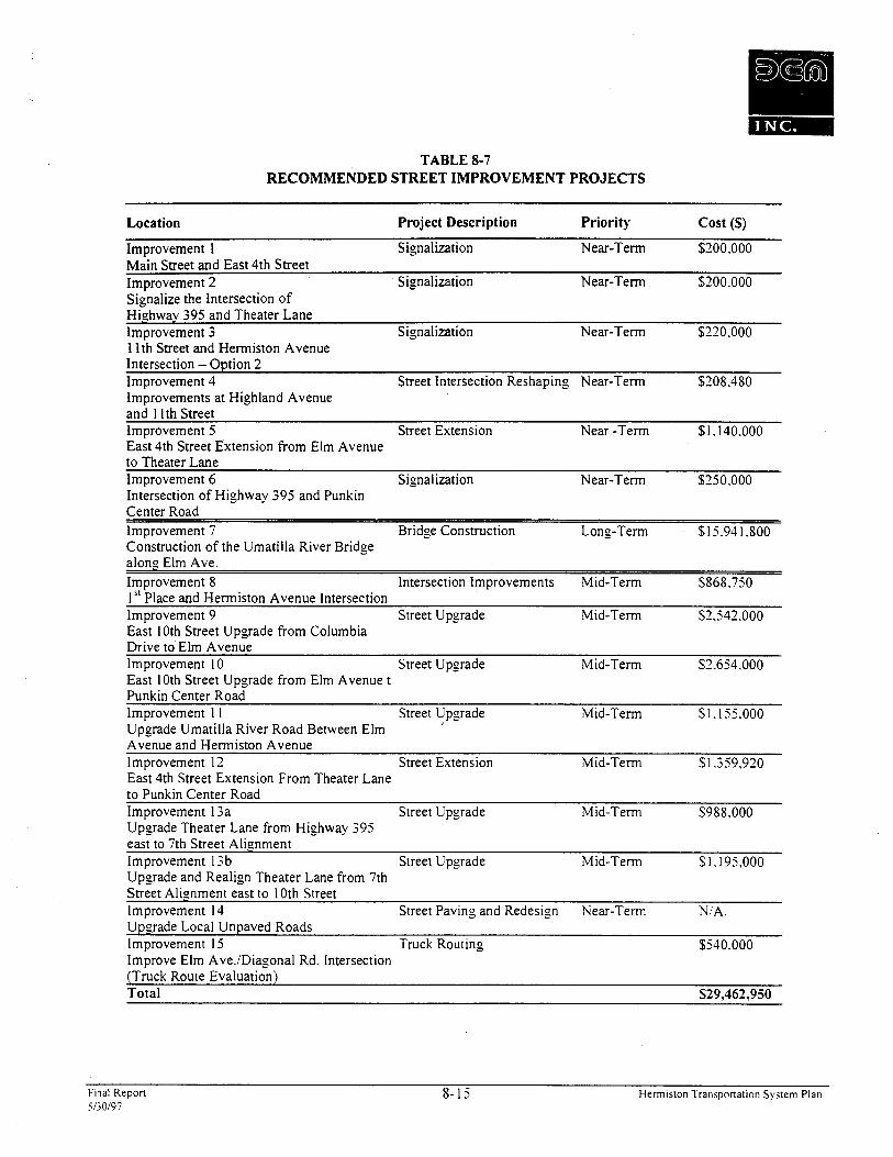
TABLE 8-7 RECOMMENDED STREET IMPROVEMENT PROJECTS
Location Project Description Priority Cost (S)
Im~rovement 1 Signalization Near-Term $200.000 ~ a i n Street and East 4th Street
-
Im~rovement 2 Signalization Near-Term S200.000 - Sionalize the Intersection of " Highway 395 and Theater Lane Improvement 3 Signalization Near-Term $220.000 1l;h Street and Hermiston Avenue
-
Intersection - Option 2 Improvement 4 Street Intersection Reshaping Near-Term $208.480 Improvements at Highland Avenue and 1 lth Street Improvement 5 Street Extension Near -Term $1.140.000 Eait 4th Street Extension from Elm Avenue to Theater Lane Improvement 6 Signalization Near-Term $250.000 Intersection of Highway 395 and Punkin Center Road Improvement 7 Bridge Construction Long-Term $15.941.800 Construction of the Umatilla River Bridge along Elm Ave. Improvement 8 Intersection Improvements Mid-Term $868.750 15 '~ lace and Hermiston Avenue Intersection Improvement 9 Street Upgrade Mid-Term $2.542.000 . - East 10th Street Upgrade from Columbia Drive to Elm Avenue Improvement 10 Street Upgrade Mid-Term $2.654.000 East 10th Street Upgrade from Elm Avenue t Punkin Center Road Improvement 1 1 Street Upgrade Mid-Term $3.155.000 Upgrade Umatilla River Road Between Elm Avenue and Hermiston Avenue Improvement 12 Street Extension Mid-Term $1.359.920 East 4th Street Extension From Theater Lane to Punkin Center Road Improvement 13a Street Upgrade Mid-Term $988.000 Upgrade Theater Lane from Highway 395 east to 7th Street Alignment Improvement 13b Street Upgrade Mid-Term $1.195.000 Upgrade and Realign Theater Lane from 7th Street Alignment east to 10th Street Improvement 14 Street Paving and Redesign Near-Term NIA. Upgrade Local Unpaved Roads Improvement I5 Truck Routing $540.000 lmprove Elm Ave./Diagonal Rd. Intersection
- (Truck Route Evaluation) Total $29,462,950
Final Report 8- 15 Hermiston l'ransponation System Plan 5130197
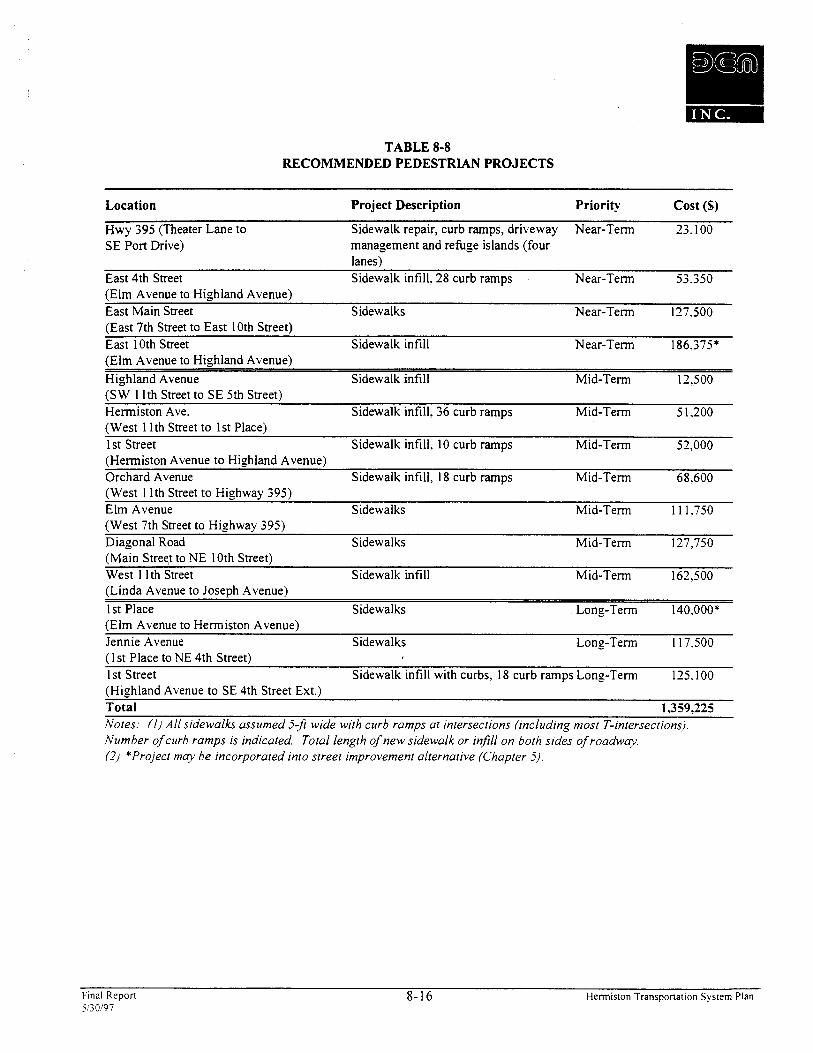
TABLE 8-8 RECOMMENDED PEDESTRIAN PROJECTS
Location Project Description Priority Cost (S)
Hwy 395 (Theater Lane to Sidewalk repair, curb ramps, driveway Near-Term 23.100 SE Port Drive) management and refuge islands (four
lanes) East 4th Street Sidewalk infill. 28 curb ramps Near-Term 53.350 (Elm Avenue to Highland Avenue) East Main Street Sidewalks Near-Term 127.500 (East 7th Street to East 10th Street) East 10th Street Sidewalk infill Near-Term 186,375* (Elm Avenue to Highland Avenue) Highland Avenue Sidewalk infill Mid-Term 12.500 (SW 1 lth Street to SE 5th Street) Hermiston Ave. Sidewalk infill, 36 curb ramps Mid-Term 5 1.200 (West 1 1 th Street to 1st Place) 1 st Street Sidewalk infill, 10 curb ramps Mid-Term 52,000 (Hermiston Avenue to Highland Avenue) Orchard Avenue Sidewalk infill, 18 curb ramps Mid-Term 68.600 (West 1 lth Street to Highway 395) Elm Avenue Sidewalks Mid-Term 11 1,750 (West 7th Street to Highway 395) Diagonal Road Sidewalks Mid-Term 127,750 (Main Street to NE 10th Street) West 1 1 th Street Sidewalk infill Mid-Term 162,500 (Linda Avenue to Joseph Avenue) 1 st Place Sidewalks Long-Term 140,000* (Elm Avenue to Hermiston Avenue) Jennie Avenue Sidewalks Long-Term 1 17$500 (1 st Place to NE 4th Street) I st Street Sidewalk infill with curbs, 18 curb ramps Long-Term 125.100 (Highland Avenue to SE 4th Street Ext.) . - Total 1,359,225 Notes; (I) All sidewalks assumed 5-ft wide with curb ramps at intersections (including most T-intersections). Number of curb ramps is indicated. Total length of new sidewalk or injill on both sides of roadww. (2) *Project ma): be incorporated into street improvement alternative (Chapter 5).
Final Repon 8-16 Hermisron Transponarion Sysrem Plan 5130197
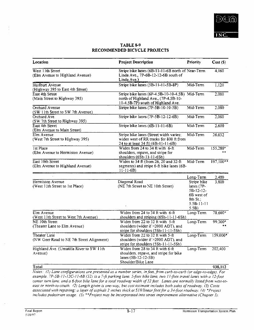
TABLE 8-9 RECOMMENDED BICYCLE PROJECTS
Location Project Description Priority Cost (S)
West I lth Street Stripe bike lanes (6B-11- 11-6B north of Near-Term 4.160 (Elm Avenue to Highland Avenue) Linda Ave., 7P-6B-12-12-6B south of
Linda Ave.) Hurlburt Avenue Stripe bike lanes (5B- 1 1-1 1 -5B-8P) Mid-Term 1.120 (Highway 395 to East 4th Street) East 4th Street Stripe bike lanes (6P-4.5B-10-10-4.5B) Mid-Term 2.080 (Main Street to Highway 395) north of Highland Ave., (7P-4.5B-10-
10-4.5B-7P) south of Highland Ave. Orchard Avenue Stripe bike lanes (7P-5B- 10-1 0-5B) Mid-Term 2.080 (SW 1 Ith Street to SW 7th Avenue) Orchard Ave. Stripe bike lanes (7P-5B-12- 12-6B) Mid-Term 2,080 [SW 7th Street to Highway 395) East 4th Street Stripe bike lanes (6B-11-11-6B) Mid-Term 2.600 (Elm Avenue to Main Street) Elm Avenue Stripe bike lanes (Street width varies; Mid-Term 26.032 (West 7th Street to Highway 395) widen west of RR tracks for 800 fi from
24 to at least 34 fi) (6B-11-11-6B) I st Place Widen from 24 to 34 ft with 6-fi Mid-Term 155.280* (Elm Avenue to Hermiston Avenue) shoulders, repave, and stripe for t t
shoulders (6Sh-11-11-6Sh) East 10th Street Widen to 34 ft (from 26,20 and 32-ft Mid-Term 197,100** (Elm Avenue to Highland Avenue) segments) and stripe 6-ft bike lanes (6B-
1 1 - 1 I-6B)
Long-Term 2.480 Hermiston Avenue Diagonal Road Stripe bike 3,800 (West 1 Ith Street to 1st Place) (NE 7th Street to NE 10th Street) lanes (7P-
5B-12-12- 6B west of 8th St.; 5.5B-1 1-1 1 5SB)
Elm Avenue Widen from 24 to 34 ft with 6-ft Long-Term 78.600* u
(West 1 Ith Street to West 7th Avenue) shoulders and striping (6Sh-1 1-1 1 -6Sh) NE 10th Street Widen from 22 to 32 fi with 5-ft Long-Term 99,300* - (Theater Lane to Elm Avenue) shoulders (wider if >2000 ADT). and t t
stripe for shoulders (5Sh-1 1-1 1:5~h) Theater Lane Widen from 22 to 32 ft with 5-fi Long-Term 1 59,000* (NW Geer Road to NE 7th Street Alignment) shoulders (wider if >2000 ADT), and -
stripe for shoulders (5Sh-1 1-1 1 : 5 ~ h ) Highland Ave. (Umatilla River to SW 1 Ith Widen from 28 to 34 ft with 6-fi Long-Term 202,400 Avenue) shoulders, repave, and stripe for bike
lanes (5B- 12- 12-5B) Shoulder/Bike Lane
Total 938,112 Notes: ( I ) Lane configurations are presented m a number series, in feet, from curb-to-curb (or edge-to-edge). For example, 7P-jB-11-12C-1 I-6B ( j2 ) is a 7-3 parking lane, j-foor bike lane, rwo 1 I-foot travel lanes wirh a 12-foot center turn lane, and a 6-foot bike lane for a total roadwq width of j2feet. Lanes are normallj listed from west-ro- east or north-to-south. (2) Length given is one-way, bur cost estimate includes both sides of roadway. (3) Costs associated wirh repaving; a layer of asphalt 2 inches thick at S18/linear foot for a 3I-foot roadway. ( I ) *Project includes pedestrian usage. (3) **Project m q be incorporated into street improvement alternative (Chapter j).
Fmal Repon 8-17 Hermiston Transportation System Plan 5130197

Oregon Department of Transportation Projects
ODOT will need to be the primary funding source for future improvements that impact the operation of or reduce the amount of local traffic on the state highways within the urban area. The 0 ~ 0 ~ ' r e l a t e d transportation improvement projects include new traffic signals at Highway 395 and Punkin Center and Theater Lane. In addition, ODOT should help with funding the new traffic signal at Main Street and 4th Street. the 4th Street extension, and the improvement and extension of 10th Street. These improvements will reduce future ODOT maintenance and construction costs associated with Highway 395 by improving the local street grid.
Local Projects
Walkway and Bikeway Improvenlents
Hermiston's Transportation System Plan identifies several pedestrian and bikeway improvements recommended for the Hermiston Urban Area during the next 20 years. The sidewalk related improvements to improve pedestrian access within the community are estimated to cost $1,359,225. The bikeway improvements are expected to cost an additional $938,112. Funding for these improvements would be expected to come primarily from local sources with some assistance from ODOT. Local funds can be generated through LIDs along local streets within Hermiston. ODOT would be expected to fund the pedestrian and bikeway improvements along state highways within the planning area.
Basic Street Grid Inlprovenlents
An extensive list of local street improvements has been identified in the Transportation System Plan. The purpose of these improvements will be to continue to improve the street grid pattern throughout the city and the urban area. Funding for these improvements would come from Hermiston, Umatilla County, and ODOT. Some of the basic street grid improvements that would reduce reliance on the state highways could be funded by ODOT in the future. The locally generated finds would include revenues generated by GO bond sales, SDC fees for new developments, and LIDs.
HERMISTON TRANSPORTATION SYSTEM PLAN FUNDING STRATEGY
Hermiston, Umatilla County, and ODOT will need to coordinate and cooperate on a funding strategy to fund the Capital Improvement Plan. It is recommended that ODOT continue as the lead agency in funding the transportation related improvements along Highway 395 and Highway 207 corridors. Hermiston will need to continue as the lead local government in financing the local transportation system improvements. Umatilla County would be expected to assist in funding improvements to county roads within the Hermiston Urban Area. I n order to increase funding to implement the Hermiston Transportation System Plan. the city, county, and ODOT will all need to consider a range of possible funding sources during the next 20 years. The recommended funding strategy for the Hermiston Transportation System Plan is detailed below.
Fmal Repon 8-18 Hermiston Transponation System Plan 5/;0197

Hermiston
The Hermiston Capital Improvement Program of the future should concentrate on funding improvements to the basic street grid and pedestrian and bikeway systems. The adoption of the Transportation System Plan will provide an extensive list of local transportation related projects that should be constructed over the next 20 years. Hermiston will need to increase funding to construct the identified projects. Likely funding sources include adopting a transportation SDC program and increasing the use of LIDs for local pedestrian and bikeway projects. The city will need to work closely with Umatilla County and ODOT on developing funding strategies for non-city urban roads and state highway improvements.
Local Improvement District
Hermiston has a strong Local Improvement District (LID) Ordinance which permits the formation of districts for transportation related projects. The city has actively used LIDs in the past to fund local street projects. It is recommended that Hermiston implement a program to target future LIDs for pedestrian and bikeway improvements within the residential areas of the city. As part of such an LID program, the city should consider funding a portion of the LIDs to make them affordable to property owners.
County And ODOT Coordination
Umatilla County will need to be the lead funding agency for the improvement of county roads within the Hermiston Urban Growth Boundary. Both the city and county should consider formulating a joint Capital Improvement Plan for the Hermiston Urban Area. Such a CIP would be a refinement of the Hermiston and Umatilla County Transportation System Plans. This refined CIP should include all the street, pedestrian, and bikeway projects that have been identified for the Hermiston Urban Area. As part of the process of formulating a joint Urban Growth Area CIP. Umatilla County should be encouraged to adopt a transportation SDC fee and join the discussions on adoption of a local gas tax. Umatilla County and the Hermiston will need to work closely together on funding techniques that will finance the transportation system improvements.
All transportation related improvements on Highway 395 and Highway 207 are assumed to be funded by ODOT. With the adoption of the Transportation System Plan, ODOT will consult Hermiston before any highway related projects are added to the State Transportation Improvement Program (STIP) plan. In the future, ODOT may have the ability to assist in funding some of the basic street grid projects that reduce dependence on the state highways. As Hermiston plans local street improvement projects, ODOT should be consulted to determine whether state transportation funds can be used for specific local transportation projects.
Umatilla County
Urnatilla County has jurisdiction of all the local roads within the Herrniston Urban Growth Area. As the urban area is developed. it is expected that the county roads will be upgraded to city standards and turned over to city jurisdiction at the time of annexation. The county's contribution to the Hermiston Transportation System Plan should include funding the extension of the county roads detailed as part of the basic street grid improvement option. and to bring the non-city urban area roads up to city standards and expanding the pedestrian and bikeway systems throughout the urban area. Adoption of a countwide transportation SDC will likely be the best funding
- Final Repon 8- 19 Herrn~s~on Transportation Sys~em Plan 5130197
technique to bring the non-city roads up to city standards. Another possible funding technique will be the consideration of a county gasoline tax.
Umatilla County will not likely be in a position to increase funding for transportation related projects in the Hermiston Urban Area until after work has been completed on a new county road inventory. As discussed earlier in this chapter, Umatilla County is currently involved with developing a detailed inventory of the entire count4 transportation system. Likewise, the county will then consider adopting a road classification for all arterial and collector roads under their jurisdiction. Until the inventory and road classification process is completed. it will be difficult to make projections on what are the most viable funding techniques to enable Umatilla County to bring the urban area roads up to city standards.
Transportation System Development Charges
Umatilla County should evaluate the feasibility of adopting a county-wide transportation SDC. If a transportation SDC is adopted by Umatilla County, the fees collected within the Hermiston Urban Area should be dedicated to bringing the county roads up to city standards. This funding strategy can also be used to help finance the needed basic street grid improvements and bring non-city streets up to city standards. As discussed above. UmatiIla County will not likely be in a position to consider adopting a transportation SDC until after work has been completed on the county road inventory and road classification.
Oregon Department of Transportation
ODOT will be responsible for funding all highway related transportation projects within the Hermiston Transportation System Plan boundaries. Other than consulting with the city as part of the STIP process, ODOT has the authority to prioritize highway projects based on their own analysis and evaluation. The adoption of the Hermiston Transportation System Plan will provide ODOT with highway related transportation projects that are important to Hermiston and Umatilla County.
The one new ODOT funding technique that should be considered for the Hermiston Transportation System Plan is possible use of State money to fund off-system improvements that reduce reliance on the State highway system. A policy to enable ODOT to use this possible new funding technique is still being formulated as the Hermiston Transportation System Plan is being completed. It is recommended that Hermiston consult ODOT on a yearly basis regarding State funding options for local street improvements.
HERMISTON TRANSPORTATION FUNDING PLAN
Identified Street Improvement Projects
Approximately $30 million in transportation system improvements are projected to be required within the Hermiston Urban Area over the next 20 years. It is assumed that ODOT will fund improvement projects within state right-of- way. Hermiston would be responsible for funding the remaining transportation system costs over the next 20 years.
A review has been conducted of a range of alternative transportation funding mechanisms that are available to the city. This review was done in order to develop a list of options which are considered to be the most feasible methods
Final Repon 8-20 Hermiston Transponation System Plan 5i30107
to fund the local projects. A funding package combining system development charge revenues. state gas tax revenues, Local Improvement Districts, as well as some type of debt financing mechanism backed b). property tases. represents the most feasible funding strategy available to the city to meet expected capital and maintenance funding needs.
Projects need to be assembled into packages for GOs. Packages present a set of projects to voters for funding. which makes the benefits of the transportation improvements more apparent and, therefore, easier to present and esplain. Not all projects can be funded under GOs because the total indebtedness of the city would exceed its three percent limit. Figure 8-3 details two potential packages for GO funding: a short term and a mid-term. Depending on the structure of the bonds, both of these packages could go before the voters.
Final Repon 8-2 1 Hermiston l'ransponarion System Plan 5130197
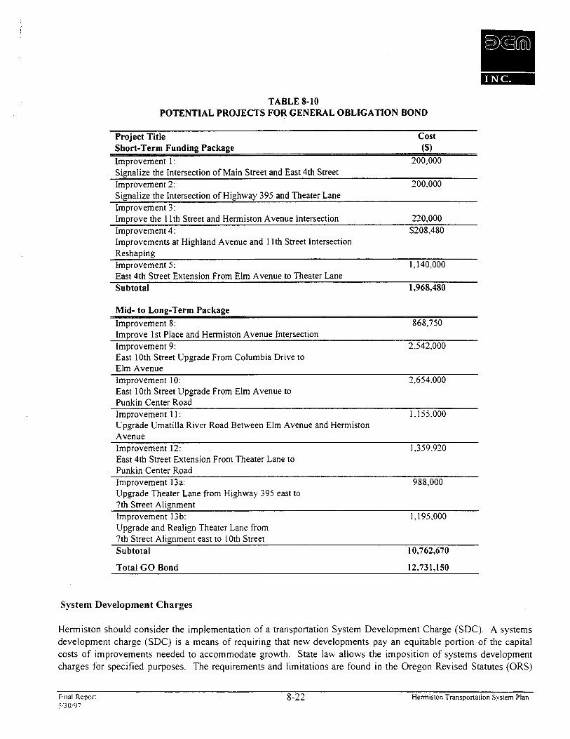
TABLE 8-10 POTENTIAL PROJECTS FOR GENERAL OBLIGATION BOND
Project Title Cost short-~erm Funding Package ($1 Improvement 1 : 200,000 signalize the Intersection of Main Street and East 4th Street Improvement 2: 200,000 signalize the Intersection of Highway 395 and Theater Lane Improvement 3: ~mprove the 1 lth Street and Hermiston Avenue Intersection 220,000 Improvement 4: $208,480 Improvements at Highland Avenue and 1 lth Street Intersection Reshaping Improvement 5: 1,140.000 East 4th Street Extension From Elm Avenue to Theater Lane Subtotal 1,968,480
Mid- to Long-Term Package Improvement 8: 868,750 Improve 1st Place and Hermiston Avenue Intersection Improvement 9: 2.542,OOO East 10th Street Upgrade From Columbia Drive to Elm Avenue Improvement 10: 2,654.000 East 10th Street Upgrade From Elm Avenue to Punkin Center Road Improvement 1 1: 1.155.000 Upgrade Umatilla River Road Between Elm Avenue and Hermiston Avenue Improvement 12: 1,359.920 East 4th Street Extension From Theater Lane to Punkin Center Road Improvement 13a: 988,000 Upgrade Theater Lane from Highway 395 east to 7th Street Alignment Improvement 13b: I, 3 95,000 Upgrade and Realign Theater Lane from 7th Street Alignment east to 10th Street Subtotal 10,762,670
Total GO Bond 12,731,150
System Development Charges
Hermiston should consider the implementation of a transportation System Development Charge (SDC). A systems development charge (SDC) is a means of requiring that new developments pay an equitable portion o f the capital costs o f improvements needed to accommodate growth. State law allows the imposition of systems development charges for specified purposes. The requirements and limitations are found in the Oregon Revised Statutes (ORS)
Final Repon 8-22 Hermiston Transportation System Plan 5120197
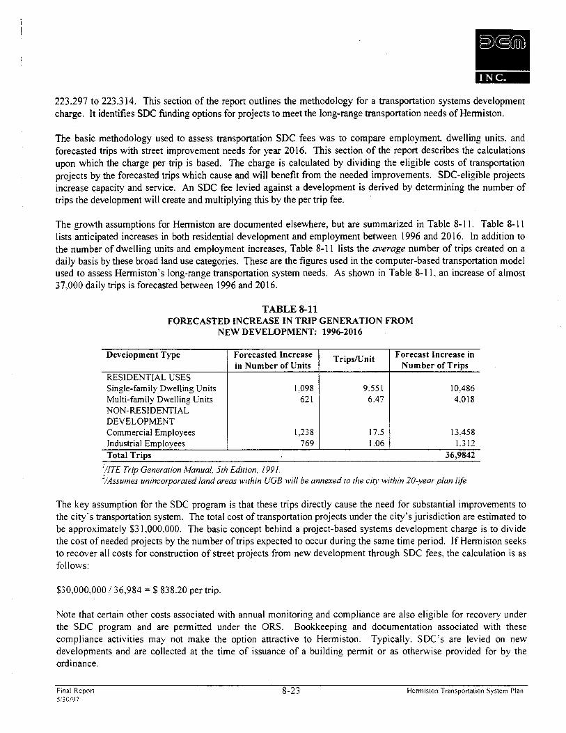
223.297 to 223.3 14. This section of the report outlines the methodology for a transportation systems developn~ent charge. It identifies SDC funding options for projects to meet the long-range transportation needs of Hemiston.
The basic methodology used to assess transportation SDC fees was to compare employment. dwelling units. and forecasted trips with street improvement needs for year 2016. This section of the report describes the calculations upon which the charge per trip is based. The charge is calculated by dividing the eligible costs of transportation projects by the forecasted trips which cause and will benefit from the needed improvements. SDC-eligible projects increase capacity and service. An SDC fee levied against a development is derived by determining the number of trips the development will create and multiplying this by the per trip fee.
The growth assumptions for Hemiston are documented elsewhere, but are summarized in Table 8- 1 1. Table 8- 1 1 lists anticipated increases in both residential development and employment between 1996 and 2016. In addition to the number of dwelling units and employment increases, Table 8-1 1 lists the average number of trips created on a daily basis by these broad land use categories. These are the figures used in the computer-based transportation model used to assess Hermiston's long-range transportation system needs. As shown in Table 8- 1 1. an increase of almost 37,000 daily trips is forecasted between 1996 and 2016.
TABLE 8-11 FORECASTED INCREASE IN TRIP GENERATION FROM
NEW DEVELOPMENT: 1996-2016
. - Total Trips 36,9842
'/ITE Trip Generation Manual, 5th Edition. 1991. ' /~ssumes unincorporated land areas within UGB will be annexed to the city within 20-year plan life.
Development Type
RESIDENTIAL USES Single-family Dwelling Units Multi-family Dwelling Units NON-RESIDENTIAL DEVELOPMENT Commercial Employees Industrial Em~lovees
The key assumption for the SDC program is that these trips directly cause the need for substantial improvements to the city's transportation system. The total cost of transportation projects under the city's jurisdiction are estimated to be approximately $3 1,000,000. The basic concept behind a project-based systems development charge is to divide the cost of needed projects by the number of trips expected to occur during the same time period. If Hermiston seeks to recover all costs for construction of street projects from new development through SDC fees, the calculation is as follows:
TripslLlnit
9.55 1 6.47
17.5 1.06
Forecasted Increase in Number of Units
1.098 62 1
1,238 769
$30,000,000 136,984 = $ 838.20 per trip.
Forecast Increase in Number of Trips
10.486 4,018
13,458 1.312
Note that certain other costs associated with annual monitoring and compliance are also eligible for recovery under the SDC program and are permitted under the ORS. Bookkeeping and documentation associated with these compliance activities may not make the option attractive to Hermiston. Typically, SDC's are levied on new developments and are collected at the time of issuance of a building permit or as otherwise provided for by the ordinance.
Final Repon 8-23 Herrniston Transportation System Plan 5/30197

One potential change to Hermiston's SDC program is to change the basis upon which the fee is calculated. The amount of the transportation systems development charge levied against a development is most easily esplained if it is based upon the average daily number of trips generated multiplied by the per trip fee calculated above. The trip rate for each use should be derived from the latest edition of the Institute of Transportation Engineers' TriD Generation.
Hermiston has the option of choosing the amount of funding it wants to recover from new development to pa!. for needed long-range transportation improvements. To recover 100 percent of the $30 million needed to fund all local projects, the SDC fee is calculated to be $838.20 per trip. If the city chooses to collect only one-fifth of the $10 million amount, the SDC fee could be lowered to approximately $167.64 per daily trip. The remaining 80 percent would come from existing or other new funding sources.
For residential uses, the fee is determined by multiplying the number of units by the per unit trip generation rate. For non-residential uses, the fee is determined by multiplying the gross floor area (measured in thousands of square feet) by the applicable trip generation rate. The city may also give the developer the option of submitting a detailed traffic study to establish a trip generation rate for a specific project. The traffic study must be prepared by a licensed traffic engineer in the State of Oregon and shall be prepared in accordance with the methodology contained in the lnstitute of Transportation Engineers' T r i ~ Generation.
Cities or counties are sometimes concerned that their SDC fees will discourage desired development and choose to adjust the methodology as a matter of policy. In doing so. these agencies also accept the fact that by lowering SDC fees, they will need to find other funding sources to pay for needed transportation projects. Besides the option of choosing a lower recovery percentage, the city may consider other methods of reducing transportation SDC fees. Some of the options the city might consider are: adjustments to account for "passer by" trips, combining specific land uses into broader development categories, or placing "caps'' or maximums on the trip generation rate.
An adjustment to account for "passer-by" trips has an impact on commercial developments. For some uses within the retail sector, a variety of studies indicate some trips are "passer-by" trips. That is. the trip to an individual business is merely an intermediate stop as part of a longer trip made by a motorist who is passing-by. The argument is that since the motorist was using the street anyway, a lesser impact on the street system occurs than would with a non-passer-by trip. The only employment sector for which a passer-by component has been identified is the retail sector. Furthermore, not all retail businesses have a passer-by component. Using a passer-by adjustment would have no impact on SDC fees for residential development.
Another possibility for reducing the SDC fees for some businesses involves combining some categories. Fast food restaurants generate approximately seven times as many trips per thousand square feet than do quality restaurants. In an effort to encourage fast food restaurants. some cities establish a single "restaurant" category and apply the lower trip generation rate from the "quality restaurant" category. In doing so. these cities forego much of the SDC revenue from the development and must find other funding sources to accommodate the transportation needs caused by that restaurant.
Yet another common approach used by cities is to establish a -'cap" or maximum rate to be used in the calculation of trips. This is sometimes set at 200 or 300 trips per thousand square feet. This has the effect of limiting the fees collected from fast food restaurants and convenience markets. Like other adjustments, a cap on trip rates reduces SDC fee collections and forces the cities to find other funding sources.
Final Report 8-24 Hermiston Transponation System Plan 5130197

Additional types of funding will need to be considered in order to reduce the SDC requirements. The city will need to make a determination on what levels of System Development Charges best fit the city's overall growth strategy and development policies.
Since SDCs are a less stable form of revenue than more secure forms such as property taxes. Hermiston will likely need to secure debt paid by the SDC program with additional forms of revenue such as gas tax receipts. In the event that future SDC inflows were not sufficient to pay required debt service, then investors would have claim on additional pledged city revenues. Even with the pledge of other revenues, the city would have a higher cost of borrowing than it would with general obligation debt in order to compensate investors for the additional perceived risk associated with purchasing the city's SDC-based bonds.
General Obligation Debt Secured By Property Taxes
General obligation bond financing secured by property tax revenues is a common method of financing road improvements. Due to the tax's strong security, general obligation bonds are the least costly debt financing tool available to local governments.
Oregon revised statutes provide that the total outstanding general obligation indebtedness of a city not exceed three percent of the city's true cash value. Bonds issued for water, sewer, and utility purposes are excluded from the three percent limitation. For example. based on Hermiston's 199611997 assessed valuation of $370 million and netting out legal deductions, the city's debt limit would be just over $4 million (Table 8-12). This is the remaining capacity that the city has available to issue additional general obligation debt for transportation or any other public improvements. Because the city is growing, it should be able to add more assessed value in future years to its tax roll and be able to increase the issuance limit for general obligation debt.
TABLE 8-12 HYPOTHETICAL CITY STREET FUND CALCULATION OF
LEGAL DEBT LIMIT
Assessed Valuation ( 1 9961 1997) True Cash Value $370,266,9 1 7
x3% $ 1 1,108,008
Current Bonded Debt (Less Legal Deductions)
industrial Park Bonds Phase 1 Phase 11
Sewer Bonds -$1,650,000
Net Debt Subject to 3% Limitations $0
Amount Available for Future Indebtedness $1 1,108,008
Given the city's current debt limitation. bonds to cover the cost of some of the transportation improvement options can be issued up to $1 1.000,000. The role of the general obligation bond financing in the city's overall funding program will be dependent on the willingness of the council to dedicate some or all of the city's debt capacity to
Final Repon 8-25 Hemiston Transportation System Plan 5130197

street improvements. The city will have the ability to issue GO bonds, with repayment by SDC fees. Since these bonds will be secured by the full faith of the city, the bond rates will have a lower interest rate. in addition. this finding technique would not require an increase to the city property tax rate.
HERMISTON TRANSPORTATION SYSTEM PLAN FUNDING RECOMMENDATIONS
A total of $3 1.7 million in state and local transportation improvement projects was identified for the Hermiston TSP (Table 8-13). This includes street, pedestrian, and bikeway projects identified for the next 20 years. it is expected that ODOT will have primary responsibility for $3.4 million while the City of Hermiston will have responsibility for $12.3 million. The cost of a new bridge across the Umatilla River, estimated at $15.9 million, was not assigned to either local or state finding sources. The city has been seeking possible federal funding for the Umatilla River Bridge.
The $3 1.7 million in projects are phased over 20 years. In the next five years, the city will need to fund the near-tern projects which amount to $1,409,865 in city responsibility. The mid-tern projects will be constructed in 6 to 10 years and will require another $1 0,017,142 in city generated funds. The long-term city funded projects will be implemented between 2006 and 2016 and will require a final $928,180. Funding plans should be crafted to provide consistent funding that will provide for these projects over a 20-year implementation span as opposed to generating the $3 1.7 million up front.
The recommended funding techniques for the Hermiston Transportation System Plan have been detailed in the proceeding section. Based on an analysis of historic local funding techniques, it is expected that Herniston will not be able to fund the Transportation System Plan improvement projects unless existing fees are increased and new funding sources are dedicated towards transportation. Even with Hermiston, Umatilla County. and ODOT adopting new funding techniques, it may be difficult to fund all the Transportation System Plan projects during the 20-year planning cycle. The city may want to consider a process to prioritize the local transportation system funding based on a further analysis of available funding.
Ftnal Rcpon 8-26 Hermiston Transponation System Plan 5130197
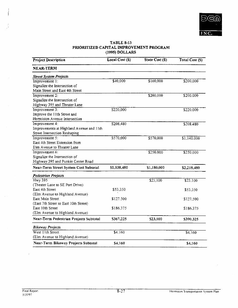
TABLE 8-13 PRIORITIZED CAPITAL IMPROVEMENT PROGRAM
(1995) DOLLARS
Project Description Local Cost (S) State Cost ($) Total Cost (S)
NEAR-TERM
Street System Projects Improvement 1 : $40,000 $160.000 $200.000 Signalize the Intersection of M& Street and East 4th Street Improvement 2: $200.000 $200.000 Signalize the Intersection of - Highway 395 and Theater Lane Improvement 3: $220.000 $220.000 Improve the I 1 th Street and ~e-mis ton Avenue Intersection Improvement 4: $208.480 $208.480 Improvements at Highland Avenue and 1 Ith street Intersection Reshaping Improvement 5: $570,000 $570.000 $1.140.000 East 4th Street Extension from Elm Avenue to Theater Lane Improvement 6: $250.000 $250,000 Signalize the Intersection of -
Highway 395 and Punkin Center Road
Near-Term Street System Cost Subtotal $1,038,480 $1,180,000 $2,218,180
Pedestrian Projects Hwy 395 $23.100 $23.100 (Theater Lane to SE Port Drive) East 4th Street $53,350 $53.350 (Elm Avenue to Highland Avenue) East Main Street $177.500 $177.500 (East 7th Street to East 10th Street) East 10th Street $186.375 $186,375 (Elm Avenue to Highland Avenue)
Near-Term Pedestrian Projects Subtotal $367,225 $23,100 $390,325 -
Bikewuy Projects West I I th Street $4.160 $4.160 (Elm Avenue to Highland Avenue)
Near-Term Bikeway Projects Subtotal $1,160 $1,160
Final Repon 8-27 Herrnislon Tramponation System Plan 5130197
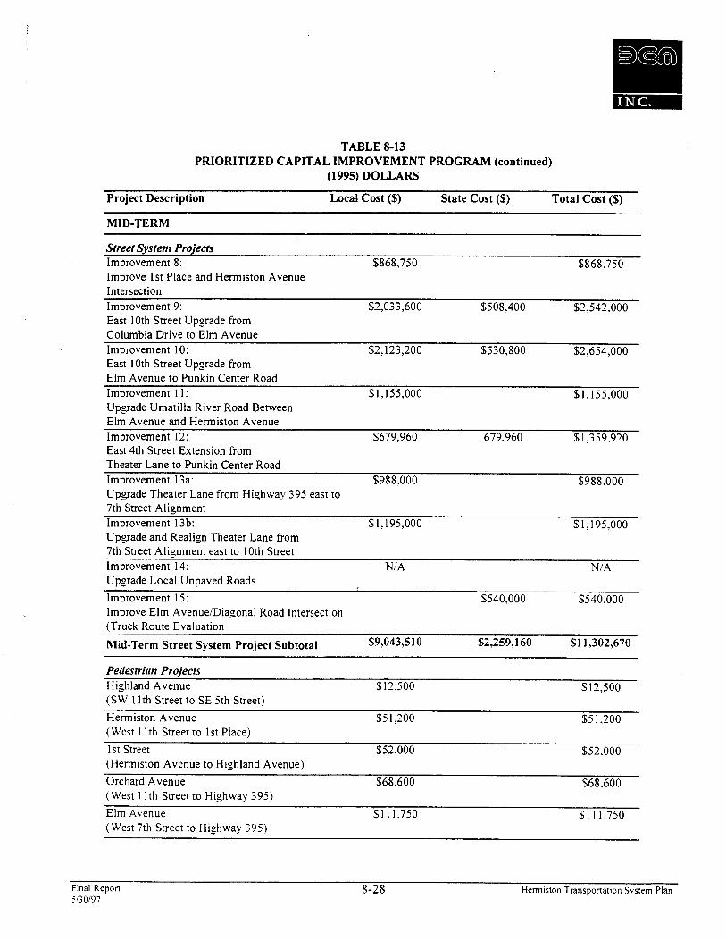
TABLE 8-13 PRIORITIZED CAPITAL IMPROVEMENT PROGRAM (continued)
(1995) DOLLARS
Project Description Local Cost (S) State Cost (S) Total Cost (S) -- -
MID-TERM
Street System Projects Improvement 8: $868,750 $868.750 Improve 1st Place and Hermiston Avenue Intersection Improvement 9: $2,033,600 $508.400 $2.542.000 East 10th Street Upgrade from Columbia Drive to Elm Avenue Improvement 10: $2,123,200 $530,800 $2.654.000 ~ & t 10th Street Upgrade from Elm Avenue to Punkin Center Road Improvement 1 1 : $1,155,000 $1.155.000 Upgrade Umatilla River Road Between Elm Avenue and Hermiston Avenue Improvement 12: $679,960 679.960 $1,359.920 East 4th Street Extension from Theater Lane to Punkin Center Road Improvement 13a: $988.000 $988.000 Upgrade Theater Lane from Highway 395 east to 7th Street Aliznment - Improvement l3b: $1.195,000 $1.195.000 Upgrade and Realign Theater Lane from 7th Street Alignment east to 10th Street Improvement 14: N/A N/A Upgrade Local Unpaved Roads
lmprovement 15: $540,000 $540.000 lmprove Elm AvenueIDiagonal Road lntersection (Truck Route Evaluation
Mid-Term Street System Project Subtotal $9,043,510 $2,259,160 $1 1,302,670
Pedestriun Projects Highland Avenue $12.500 $12,500 (SW 1 lth Street to SE 5th Street)
Hermiston Avenue $5 1.200 $5 1,200 (West 1 I th Street to 1 st Place)
1 st Street $52,000 $52.000 (Hermiston Avenue to Highland Avenue)
Orchard Avenue $68,600 $68,600 (West 1 Ith Street to Highway 395)
Elm Avenue $1 11.750 $1 1 1,750 (West 7th Street to Highway 395)
Final Report 8-28 Hermiston Transportation System Plan 5130/97

TABLE 8-13 PRIORITIZED CAPITAL IMPROVEMENT PROGRAM (continued)
(1995) DOLLARS
Project Description Local Cost (S) State Cost (S) Total Cost (S) -
MID-TERM
Pedestrian Projects - continued Diagonal Road $127,750 $127.750 (Main Street to NE 10th Street)
West I 1 th Street $162,500 $162.500 (Linda Avenue to Joseph Avenue)
Mid-Term Pedestrian Project Subtotal S586JOO $586,300
Bikeway Projects Hurlburt Avenue $1,120 $1.120 (Highway 395 to East 4th Street) East 4th Street $1,040 $1,040 $2.080 (Main Street to Highway 395) Orchard Avenue $2,080 $2.080 (SW 1 Ith Street to SW 7th Ave.) Orchard Avenue $2,080 $2.080 (SW 7th Street to Highway 395) East 4th Street $2,600 $2.600 (Elm Avenue to Main Street) Elm Avenue $26.032 $26.032 (West 7th Street to Highway 395) 1 st Place $1 55,280 $155,280 (Elm Avenue to Hermiston Avenue) East 10th Street $197,100 $197.100 (Elm Avenue to Highland Avenue) -- -
Mid-Term Bikeway Project Subtotal $387,332 $1,040 $388,372
LONG-TERM
Street System Projects Improvement 7: Construction of the Umatilla River Bridoe
- - -
Long-Term Street System Project Subtotal
Pedestrian Projects I st Place $140.000 $140,000 (Elm Avenue to Hermiston Avenue) Jennie Avenue $ 1 17.500 $1 17.500 (1st Place to NE 4th Street.) I st Street $125.100 $125,100 (Highland Avenue to SE 4th Street Ext.)
Long-Term Pedestrian Proiect Subtotal $382,600 $382.600
Final Repon 8-29 Hermiston Transpona~ion System Plan 5130197
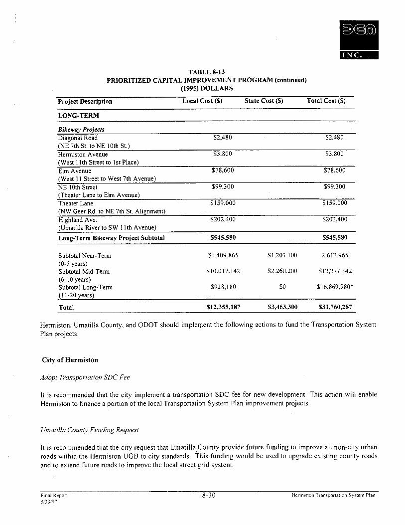
TABLE 8-13 PRIORITIZED CAPITAL IMPROVEMENT PROGRAM (continued)
(1995) DOLLARS
Project Description Local Cost ($) State Cost (S) Total Cost (S)
LONG-TERM
Bikeway Projects Diagonal Road $2.480 $2.480 (NE 7th St. to NE 10th St.) Hermiston Avenue $3.800 $3.800 (West 1 lth Street to I st Place) Elm Avenue $78,600 $78,600 (West 11 Street to West 7th Avenue) NE 10th Street $99,300 $99.300 (Theater Lane to Elm Avenue) Theater Lane $159,000 $159.000 (NW Geer Rd. to NE 7th St. Alignment) Highland Ave. $202,400 $202.400 (Umatilla River to SW 1 lth Avenue)
Long-Term Bikeway Project Subtotal $545,580 $545,580
Subtotal Near-Tern (0-5 years) Subtotal Mid-Term (6- 10 years) Subtotal Long-Term 11 1-20 vears)
Total $12,355,187 $3,463,300 $31,760,287
Hermiston. Umatilla County, and ODOT should implement the following actions to fund the Transportation System Plan projects:
City of Hermiston
Adopt Transportation SDC Fee
It is recommended that the city implement a transportation SDC fee for new development This action will enable Hermiston to finance a portion of the local Transportation System Plan improvement projects.
Umatilla County Funding Request
It is recommended that the city request that Umatilla County provide future funding to improve all non-city urban roads within the Hermiston UGB to city standards. his funding would be used to upgrade existing county roads and to extend future roads to improve the local street grid system.
Final Rrpon 8-30 Hermiston Transportation System Plan 5130197

General Obligation Bond Financing
It is recommended that the city use a portion of the city's bonding debt authority to issue General Obligation bonds to h n d a portion of the Transportation System Plan projects. The bonds should be secured with future SDC fee revenues to make the bonds attractive to investors. The hnds obtained through a GO bond sale should be dedicated towards specific street local street improvement projects identified within the Transportation System Plan.
ODOT Off-Sysrern Funding
It is recommended that the city request ODOT to use Off-System funds to finance a portion of the local street improvements that specifically reduce traffic on either Highway 395 or 207 within the Transportation System Plan boundaries.
Street Improvement LIDS
It is recommended that Hermiston strengthen their comprehensive Local Improvement District program targeted towards walkway improvements along city streets.
Umatilla County
Systenzs Development Charges (SDC) Fee
It is recommended that Umatilla County consider a countywide transportation SDC. As part of the countywide SDC evaluation. SDC fees collected within the Hermiston TSP planning area should be dedicated to improving county roads within the Hermiston TSP. Fee revenues received from new development within the Hermiston Transportation System Plan area should be dedicated to the basic street grid improvements identified in the Transportation System P Ian.
Street Design Standards
It is recommended that Umatilla County amend the CityICounty Urban Growth Management Agreement (UGMA) to require city street design standards for all new development within the Hermiston Urban Growth Area.
Final Repon 8-3 1 Hermiston Transponarion Sysrem Plan il30197

CHAPTER 9: IMPLEMENTATION
TRANSPORTATION SYSTEM PLAN IMPLEMENTATION PROGRAM
Implementation of the Hermiston Transportation System Plan will require both changes to the city comprehensive plan and zoning code and preparation of a 20-year Capital Improvement Plan. These actions will enable Hermiston to address both existing and emerging transportation issues throughout the urban area in a timel). and cost-effective manner. This implementation program is geared towards providing Hermiston with the tools to amend the comprehensive plan and zoning ordinance to conform with the Oregon Transportation Planning Rule and to fund and schedule transportation system improvements.
It is recommended that the City of Hermiston take the following actions to adopt and implement the TSP.
1. Amend policies 33 through 36 of the Hermiston Comprehensive Plan as detailed in this chapter.
2. Amend the Hermiston Zoning Ordinance No. 1840 as detailed in this chapter
3. Incorporate the prioritized capital improvement plan, detailed in Chapter 8 into the existing Hermiston Capital Improvement and Public Facilities Plans.
RECOMMENDED ADDITIONS TO HERMISTON COMPREHENSIVE PLAN, TRANSPORTATION ELEMENT (GOAL 12)
Policy 33: Transportation Project Approval
Section 660-12-045(1) of the Transportation Planning Rule requires that cities and counties amend their land use regulations to conform with the jurisdiction's adopted Transportation System Plan. This section of the Transportation Planning Rule is intended to clarify the approval process for transportation-related projects. The approval process for different types of projects should'be clear.
The City of Hermiston will provide a clear and objective process for the approval of transportation projects.
Implementing Actions
Recognizes the Transportation System Plan as an element of the City of Hermiston Comprehensive Plan identifies the general location of transportation improvements. Changes in the specific alignment of proposed public road and highway projects shall be permitted without plan amendment if the new alignment falls within a transportation corridor identified in the Transportation System Plan.
Allows the operation. maintenance. repair. and preservation of existing transportation facilities without land use review. except where specifically regulated.
Fmal Repon 9- 1 Hermiston Transponarion System Plan 5130'97
Allows the dedication of right-of-way, authorization of construction and the construction of facilities and improvements, for improvements designated in the Transportation System Plan. the classification of the roadway and approved road standards without land use reviekv.
Allows changes in the frequency of transit, rail and airport services that are consistent with the Transportation System Plan without land use review.
Allows an Environmental Impact Study (EIS) or Environmental Assessment (EA). the draft EIS or EA to serve as the documentation for State projects that require local land use review. if local re vie^ is required.
1 . Where the project is consistent with the Transportation System Plan, formal review of the draft EIS or EA and concurrent or subsequent compliance with applicable development standards or conditions;
2. Where the project is not consistent with the Transportation System Plan. formal review of the draft EIS or EA and concurrent completion of necessary goal exceptions or plan amendments.
Policy 34: Protecting Existing and Future Operation of Facilities
Section 60-12-045(2) of the Transportation Planning Rule requires that jurisdictions protect future operation of transportation corridors. For example. an important arterial for through traffic should be protected in order to meet the community's identified needs. In addition, the proposed function of a future roadway must be protected from incompatible land uses. It is also important to preserve the operation of existing and proposed transportation facilities, such as airports. that are vulnerable to the encroachment of incompatible land uses.
Other future transportation facilities that small jurisdictions may wish to protect include the space and building orientation necessary to support future transit. and right-of-ways or other easements for accessways. paths. and trails.
. , Protection of existing and planned transportation systems can be provided by ongoing coordination with other relevant agencies, adhering to the road standards. and to the following implementing actions.
The City of Hermiston will protect the operation of existing and future transportation facilities.
Implementing Actions
Requires the protection of the function of existing and planned roadways as identified in the Transportation System Plan.
Requires the consideration of the impact of all land use decisions on existing or planned transportation facilities.
Final Repon 9-2 Herrniston Transponatton System Plan 5130197

Requires protection of the function of existing or planned roadways or roadway corridors through the' application of appropriate land use regulations.
May consider the potential to establish or maintain accessways, paths, or trails prior to the vacation of any public easement or right-of-way.
Requires the preservation of right-of-way for planned transportation facilities through esactions. voluntary dedication, or setbacks.
Requires the City of Hermiston and the Oregon Aeronautics Section to work together in developing or updating an airport Master Plan for the airport.
Requires that the land use element of the airport Master Plan become part of this comprehensive plan and guide land use decision making in the vicinity of these transportation facilities.
Policy 35: Coordinated Review of Land Use Decisions Affecting Transportation
A lack of coordination between state and local decision processes can result in costly delays and changes in public road and highway projects, as well as some maintenance and operation activities. Section 660-12-045(2)(d) of the Transportation Planning Rule requires that jurisdictions develop a process for the coordinated review of land use decisions affecting transportation facilities.
The City of Hermiston will provide coordinated review of land use decisions affecting transportation.
Implementing Actions
Requires coordination with the Department of Transportation to implement the highway improvements listed in the Statewide Transportation Improvement Program (STIP) that are consistent with the Transportation System Plan and comprehensive plan.
Suggests consideration of the findings of ODOT's draft Environmental Impact Statements and Environmental Assessments as integral parts of the land use decision-making procedures.
Policy 36: Safe and Convenient Pedestrian and Bicycle Circulation
Bicycling and walking are often the most appropriate mode for short trips. Especially in smaller cities where the downtown area is compact. walking and bicycling can replace short auto trips, reducing the need for construction and maintenance of new roads. However, the lack of safe and convenient bikeways and walkways can be a strong discouragement for these mode choices. The Transportation Planning Rule (660-12-045(3)) requires that urban areas plan for bicycling and walking as part of the overall transportation system.
The City of Hermiston shall provide safe and convenient pedestrian and bicycle circulation.
Final Repon 9-3 Hermiston Transportation System Plan 5i30197
Implementing Actions
Requiring the planning and development of a network of streets, accessways. and other improvements, including bikeways, sidewalks, and safe street crossings to promote safe and convenient bicycle and pedestrian circulation within the community.
Requiring that streets and accessways be provided where appropriate to provide direct and convenient access to major activity centers, including downtown, schools, shopping areas. and community centers.
Requiring that bikeways be included on all new arterials and major collectors within the Urban Growth Boundary.
Recommending the retrofitting of existing arterials and major collectors with bike lanes on a prioritized schedule as appropriate and practical.
Requiring that sidewalks be included on all new streets within the Urban Growth Boundap.
Recommending the retrofitting of existing streets with sidewalks on a prioritized schedule.
Requiring that priority be given to developing pedestrian and bicycle access to major activity centers within the Urban Growth Boundary, such as the downtown commercial center, schools, and community centers.
Requiring that bikeways and walkways connect to local and regional travel routes.
Requiring that bikeways and pedestrian accessways be designed and constructed to minimize potential conflicts between transportation modes. Design and construction of such facilities shall follow the guidelines established by the Oregon Bicycle and Pedestrian Plan.
Requiring that bicycle parking facilities be provided at all new residential multifamily developments of four units or more, commercial, industrial, recreational, and institutional facilities.
Recommending that a citizens advisory committee be established to protect and promote bicycle and pedestrian transportation within the Urban Growth Boundary.
RECOMMENDED ORDINANCES T O IMPLEMENTS
Approval Processes for Transportation Facilities
Section 660- lZ-O45(l) of the Transportation Planning Rule requires that cities and counties amend their land use regulations to conform with the jurisdiction's adopted Transportation System Plan. This section of the Transportation Planning Rule is intended to clarify the approval process for transportation-related projects.
Final Repon 9-4 Hermiston Transportation System Plan 5'30197

Recommended Ordinances for Approval Process
Projects that are specifically identified in the Transportation System Plan and for which the jurisdiction has made all the required land use and goal compliance finding are permitted outright. subject only to the standards established by the Plan.
However, a city or county may not allow outright a an improvement that is included in the Transportation System Plan but for which no site-specific decisions have been made. Therefore: it is recommended that small '
jurisdictions review these transportation projects within the Urban Growth Boundary as regulated land use actions, using a conditional use process.
It is recommended that the following ordinances be included in Section 1 9 ~ ~ u ~ ~ l e m e n t a r y Provisions of the Hermiston Zoning Ordinance No. 1840.
. Standards for Transportation Improvements --
. . Uses Permitted Outright. Except where otherwise specifically regulated by this ordinance, the --- - following improvements are permitted outright:
Normal operation, maintenance, repair, and preservation activities of existing transportation facilities.
Installation of culverts, pathways, medians, fencing, guardrails. lighting, and sirnilar types of improvements within the existing right-of-way.
Projects specifically identified in the Transportation Systeni Plan as not requiring Jirrther land use regulation.
Landscaping as part of a transportation facility.
Emergency measures necessary for the safety and protection of pro pert;^.
Acquisition of right-of-way for public roads, highways, and other transportation improvements designated in the Transportation System Plan except for those that are located in exclusive farm use or forest zones.
Construction of a street or road as part of an approved subdivision or land partition consistent with the applicable land division ordinance.
Conditional Uses Permitted
A. Construction, reconstruction, or widening of highways, roads, bridges or other transportation projects that are: ( I ) not inlprovenients designated in the Transportation System Plan or (2) not designed and constructed as part of a subdivision or planned development subject to conditional use perniit review, which shall comply with the Transportation Systeni Plan and applicable standards, and shall address the following criteria. For State projects that require an Enviromlental Impact
Fmal Repon 9-5 Hermiston Transponation System Plan 5130197
Statement (EIS) or EA (Environmental Assessment), the drafr EIS or EA shall be reviewed and used as the basis forjndings to comply with the following criteria:
I . The project is designed to be compatible with existing land use and social patterns. including noise generation, safety, and zoning.
2. The project is designed to minimize avoidable environmental impacts to identified wetlands. wildlife habitat, air and water quality, cultural resources, and scenic qualities.
3. The project preserves or improves the safety and fitnction of the facility through access management, trafJic calming, or other design features.
3. Project includes provision for bicycle and pedestrian circulation as consistent with the comprehensive plan and other requirements of this ordinance.
B. If review under this Section indicates that the use or activity is inconsistent with the Transportation Systeni Plan, the procedure for a plan amendnzent shall be undertaken prior to or in conjunction with the conditional permit review.
. . Time Limitation on Transportation-Related Conditional Use Permits ---
A. Authorization of a conditional use shall be void after a period specljied by the applicant as reasonable and necessary based on season, right-of-wq acquisition, and other pertinent factors. This period shall not exceed three years.
PROTECTING EXISTING AND FUTURE OPERATION OF FACILITIES
Section 60-12-045(2) of the Transportation Planning Rule requires that jurisdictions protect future operation of transportation corridors. For example, an important arterial for through traffic should be protected in order to meet the community's identified needs. Protection of existing and planned transportation systems can be provided by ongoing coordination with other relevant agencies, adhering to the road standards, and to the access management policies and ordinances suggested below.
It is recommended that the following ordinances be added to Hermiston Ordinance No. 490.
Recommended Access Control Ordinances
The following ordinances are recommended to support the access management standards.
Section -. Intent and Purpose
The intent of this ordinance is to manage access to land developnient while preserving the flow of traflc in terms ofsafety, capuciy, functionul classl$cation, and level of service. Major roadways, including highways, arterials. al7d collectors serve as the prirnar): network for moving people and goods. These transportation corridors also provide access to businesses and homes and have served as the focus for comntercial and residential
Fmal Repon 9-6 Hermiston Transponation System Plan SG0197
development. If access points are not properly designed, these roadways will be unable to nccominiodate the needs of development and retain their primary transportation function. This ordinance balances the right of reasonable access to private property with the right of the citizens of the City of Herniiston and the State of Oregon to safe and eflcient travel.
To achieve this policy intent, state and local roadways have been categorized in the Transportation System Plan by finction and classified for access purposes based upon their level of importance and function. Regulations have been applied to these roadways for the purpose of reducing traflc accidents, personal i~tjtriy. and propern- damage attributable to poorly designed access systems, and to thereby improve the safe& and operation of the roadway network. This will protect the substantial public investment in the existing transportation system and reduce the need for expensive remedial measures. These regulations also further the orderk layout and use of land, protect community character, and conserve natural resources by promoting well-designed road and access systems and discouraging the unplanned subdivision of land.
Section -. Applicability
This ordinance shall apply to all arterials and collectors within Ci& of Hermiston and to all properties that abut these roadways.
Section -. Conformance with Plans, Regulations, and Statutes
This ordinance is adopted to implement the access management policies of the City of Hermiston as set forth in the Transportation System Plan.
Section -. Definitions
I . Access. A way or means of approach to provide pedestrian, bicycle, or motor vehicular entrance or exit lo a property.
2. Access Classification. A ranking system for roadways used to determine the appropriate degree of access nlanagement. Factors considered include functional class~fication, the appropriate local governnient's adopted plan for the roadway, subdivision of abutting properties, and existing level of access control.
3. Access Connection. Any driveway, street, turnour or other means of providjng for the n7ovetnent of vehicles to or from the public roadu:av system.
I. Access Management. The process of providing and managing access to land developmenr while preserving the regional flow of trafflc in ternls of safe&, capacity, and speed.
5. Accesswa+~. A walhvuy thar provides pedesrriun and bicycle pussage either betweet7 streets or from u streer to a building or other destination such as a school, purk, or transir stop. Accessways generally include a walkway and udditional land on either side of the walkway. often it7 the fonn of an easenlent or righr-of-way, to provide clearance und separation between (he wulkway and adjacent uses. Accessways through parking lors are generally physically separured from udjacent vehicle purklng or parallel vehicle rrufflc by curbs or sindur devices und include lundscuping, trees, und
Final Repon 9-7 Hermisron Transponation System Plan il>OI97

lighting. Where accessways cross driveways, they are general!,: raised. paved or nrurked iu u manner that provides convenient access for pedestrians.
6. Corner Clearance. The distance fiom a public or private road intersectioti to rhe murest access connection, nieasuredfiom the closest edge of the pavemenr of the intersecting road to the closest edge of the pavement of the connection along the traveled way.
7. Cross Access. A service drive providing vehicular access between two or more conrigtiotis sites so the driver need not enter the public street system.
8. Easement. A grant of one or more propery rights by a property owner to or for use by the public, or another person or entity.
9. Frontage Road. A public or private drive which generally parallels a public streer between the righr-of-way and the fiont building setback line. The fionrage road provides access lo privare properties while separating thenifion7 the arrerial srreet. (see also Service Roads)
10. Functional Area (Intersection). Thar area beyond the physical intersecrio~i of IMJO roads rhar comprises decision and nlaneuver distance, plus any required vehicle srorage lengrh.
I I. Functional Classificarion. A system used to group public roadways into classes according to heir purpose in moving vehicles and providing access.
12. Joint Access (or Shared Access). A driveway connecting two or more contiguous sires lo rhe public streef systen7.
13. Lor. A parcel, rract, or area of land whose boundaries have been esrablished by some legal instrumenr, which is recognized us a separare legal enrio. for purposes of transfer of ritle, has fionrage upon a public or private srreer, and coniplies with rhe dinlensional requirenienrs of rhis code.
14. Lot. Corner. Any lot having at leasr two (2) contiguous sides aburting upon one or more streers. provided that rhe interior angle at rhe inrersecrion of such two sides is less than one hundred rhiry- five (135) degrees.
15. Lot Depth. The average distance measuredfiom rhefiont lot line lo the rear lot line.
16. Lor, Flag. A lot not nieering niinimun7fiontag requirements a17d where access to rhe public road is by a narrow,, privare right-of-way line.
17. Lot, Through. for Double Fronrage Lot). A lot that j-onts upon rwo parallel streets or that fionts tipon two streets rhat do nor intersect at the boundaries of the lots.
18. Lot Fronrage. That porrion of a lot exrending along u street right-of-wa-v line
19. honconforniing Access Features. Features of the property access that existed prior to the date of ordinance adoprion and do not conform with the requirenients of this ordinance.
Final Repon 9-8 Hermiston l'ransponation System Plan il30197
20. Parcel. A division of land comprised of one or more lots in contiguous ounership.
21. Plat. An exact and detailed map of the subdivision of land.
22. Private Road. Any roadwq for vehicular travel which is privately owned and maintained and which provides the principal means of access to abutting properties.
23. Public Road. A road under the jurisdiction of a public body that provides the principal means of access to an abuttingproperry.
21. Reasonable Access. The minimum number of access connections, direct or indirect. itecessay to provide safe access to and >om the roadwq, as consistent with the purpose and intent of this ordinance and any applicable plans and policies of the City of Hermiston.
25. Right-of-Wq. Land reserved, used, or to be used for a highwq, street, alley, walkway, drainage faciliry, or other public purpose.
26. Significant Change in Trip Generation. A change in the use of the property, including land, structures or facilities, or an expansion of the size of the structures or facilities causing an increase in the trip generation of the property exceeding: (I) localk'l0 percent inore trip generation (either peak or daily) and 100 vehicles per day more than the existing use for all roads under local jurisdiction; or (2) S tate~exceedin~ 25 percent more trip generation (either peak or daily) and 100 vehicles per day more than the existing use for all roads under state jurisdiction.
27. Stub-out (Stub-street). A portion of a street or cross access drive used as an extension to an abutting property that may be developed in theJirture.
28. Substantial Enlargements or Improvements. An increase in existing square footage or increase in assessed valuation of the structure as described in Section 20(1) of this ordinance.
Section -. Corner Clearance
I . Corner clearance for connections shall meet or exceed the ntinintunt connection spacing requirements for that roadway.
2. New connections shall not be permitted within the Jirnctional area of an intersection or interchange as defined by the connection spacing standards of this ordinance, unless no other reasonable access to the properry is available.
3. Where no other alternatives exist. the (permitting department) may allolrt construction of an access connection along the properry line farthest >om the intersection. In such cases, directional connections (i.e. right idout, right in only, or right out only) may be required.
Final Repon 9-9 Hermiston Transponation System Plan 5130197

Section -. Joint and Cross Access
1. Adjacent commercial or office properties classiJied as major traffic generators (i.e. shopping plazas. ofJice parks), shall provide a cross access drive and pedestrian access to allow circtrlation benveen sites.
2. A system ofjoint use driveways and cross access easements shall be established wherever feasible and shall incorporate the following:
a. A continuous service drive or cross access corridor extending the entire length of each block served to provide for driveway separation consistent with the access management classijkation system and standards.
b. A design speed of 10 mph and a nmximum width of 22 feet to accommodate two-way travel aisles designated to accommodate automobiles, service vehicles, and loading vehicles:
c. Stub-outs and other design features to make it visually obvious that the abutting properties may be tied in to provide cross-access via a service drive;
d. A uniJied access and circulation system plan for coordinated or shared parking areas is enco uraged.
3. Shared parking areas shall be permitted a reduction in required parking spaces if peak demands do not occur at the same time periods. p o t e : this requires a revision of Ord. 1840 Section lS(3.4) from "hours of operation" to "hours of peak demand."]
4. Pursuant to this section, property owners shall:
a. Record an easement with the deed allowing cross access to andfrom other properties served by the joint use driveways and cross access or service drive;
b. Record an agreement with the deed that remaining access rights along the roadway will be dedicated to the City of Hermiston and pre-existing driveways will be closed and eliminated after construction of the joint-use driveway;
c. Record a joint maintenance agreement with the deed deJining maintenance responsibilities of property owners.
5. The City of Hermiston may reduce required separation distance of access points where they prove impractical. provided all of the following requirements are met:
a. Joint access driveways and cross access easements are provided in accordance with this section.
b. The site plan incorporates a unrJied access and circulation system in accordance with this section.
Final Report 9-10 Hermisron Transponation System Plan 5130197

c. The proper@ owner enters into a written agreement with the Cihu of Hermiston, recorded with the deed, that pre-existing connections on the site will be closed and elimlinated after construction of each side of the joint use driveway.
6. The ('permitting department) may m o d ~ h or waive the requirements of this section where the characteristics or layout of abutting properties would make the development of a unified or shared access and circulation system impractical.
Section -. Access Connection and Driveway Design
I. Driveways shall meet the following standards:
a. If the driveway is a one way in or one way out drive. then the drivewq shall be a minimin1 width of I0 feet and shall have appropriate signage designating the driveway as a one way connection.
b. For two-way access, each lane shall have a minimum width of I0 feet and a m a ~ i n n m width of I2 feet.
2. Driveway approaches must be designed and located to provide an exiting vehicle with an unobstructed view. Construction of driveways along acceleration or deceleration lanes and tapers shall be avoided due to the potential for vehicular weaving conflicts.
3. The length of driveways shall be designed in accordance with the anticipated storage length for entering and exiting vehicles to prevent vehicles >ow backing into the flow of traffic on the public street or causing unsafe conflicts with on-site circulation.
Section -. Requirements for Phased Development Plans
I . In the interest ofpromoting unified access and circulation systems, development sites under the same ownership or consolidated for the purposes of development and comprised of more than one building site shall be reviewed as single properries in relatio~l to the access standards of this ordinance. The number of access points permitted shall be the nzinitntrm number necessai-y to provide reasonable access to these properties, nor the maximum available for that >onrage. All necessary easements, agreements, and stipularions shall be met. This shall also apply to phased development plans. The owner and all lessees within the afjecred area are responsible for conlpliance with the requirements of this ordinance and bofh shall be cited for any violation.
2. All access nzust be internalized using the shared circtrlation sysrem of the principal development or retail cenrer. Driveways shall be designed to avoid queuing across surrounding parking and driving aisles.
Section -. Nonconforming Access Features
I . Legal access connections in place m of (date of adoprion) fhat do not conform with the standards herein are considered nonconforming features and shall be brought into compliance wirh applicable standards under the following conditions:
Final Repon il30197
9-1 1 Hermiston Transponation System Plan

a. When new access connection permits are requested;
b. Change in use or enlargements or improvements that will increase trip generation.
Section -. Reverse Frontage
I . Lots that ffont on more than one street shall be required to locate motor vehicle accesses on the street with the lower finctional classification.
2. When a residential subdivision is proposed that would abut an arterial. it shall be designed to provide through lots along the arterial with access ffom a ffontage road or interior local road. Access rights of these lots to the arterial shall be dedicated to the City of Hermiston und recorded with the deed. A berm or buffer yard may be required at the rear of throtrgh lots to buffer residences fforn trafic on the arterial. The berm or buffer yard shall not be located with the public right-of-
way.
Section -. Flag Lot Standards
I . Flag lots shall not be permitted when the result would be to increase the number of properties requiring direct and individual access connections to the State Highway System or other arterials.
2. Flag lots may be permitted for residential development when necessary to achieve planning objectives, such as reducing direct access to roadways, providing internal platted lots with access to a residential street, or preserving natural or historic resources, under the following conditions:
a. Flag lot driveways shall be separated by at least twice the rninirnuaiffontage requirement of that zoning district.
b. TheJag driveway shall have a minimum width of I 0 feet and maximum width of 2 0 feet.
c. In no instance shallJag lots constitute more than I 0 percent of the total number of building sites in a recorded or unrecordedplat, or three lots or more, whichever is greater.
d. The lot area occupied by the Jag driveway shall not be counted as part of the required minimum lot area of that zoning district.
e. No more than one Jag lot shall be permit tedper private right-of-way or access easement.
Secrion -. Lot Width-to-Depth Ratios
I . To provide for proper site design and prevent the creation of irregularly shaped parcels, the depth of any lot or parcel shall not exceed 3 times its width (or I times its width in rural areas) unless there is u topographical or environmental constraint or an existing man-made feuture such us a railroad line.
Final Repon 9-12 Hermiston Transponation System Plan 5130197

Section -. Shared Access
1. Subdivisions with frontage on the state highway system shall be designed into shared access poiiits to and from the highway. Normally a maximum of two accesses shall be allowed regardless ofthc number of lots or businesses served. I f access o f of a secondary street is possible, then access should not be allowed onto the state highway. If access o f of a secondary street becomes available. then conversion to that access is encouraged, along with closing the state highway access.
2. New direct accesses to individual one and two fainily dwellings shall be prohibited on all bzrt District-level State Highways.
Section -. Connectivity
1. The street system ofproposed subdivisions shall be designed to connect with existing, proposed, and planned streets outside of the subdivision as provided in this Section.
2. Wherever a proposed development abuts unplatted land or a fiture developnient phase of the sanie development, street stubs shall be provided to provide access to abutting properties or to logically extend the street system into the surrounding area. All street stubs shall be provided with a temporary turn-around unless specifically exempted by the City Engineer and the restoration and extension of the street shall be the responsibility ofanyfiture developer of the abutting land.
3. Minor collector and local residential streets shall connect with s w w d m g ci4;occ~~r mtgor ~~ol lcc~or utd L I ~ V W ~ L Z I streets (71 ir7/rrr'rzls c.if'rlo /c.c.$ 1l7uri 1.320 f2e1 /if; /nileL to per~nit the convenient movement
. . of trajic between residential neighborhoods c:- -"..."..-"..-..--
. . . 7 Appropriate
I design. .vzr::l~ ( I . \ U L I ~ I . ~ ~ loc~11 .v/rw/s. 8HB traffic control such as four-way stops and traffic calming measures are the preferred means of discouraging through trajic.
The following Section should be added to Ordinance No. 858:
Section -. Subdivisions
1. A subdivision shall conform to the following standards
a. Each proposed lot must be buildable in co~lformance with the require~nents ofthis ordinance and all other applicable regzrlations.
Final Repon 9-13 Hermiston Transponation System Plan 5130197
b. Each lot shall abut a public or private street for the required minir~lzrnl lot frontage for the zoning district where the lots are located.2
c. Ifany lot abuts a street right-of-way that does not conform to the design specifications of this ordinance, the owner may be required to dedicate up to one-half of the total right-of-war. width required by this ordinance.
2. Further subdivision of the property shall be prohibited unless the applicant submits a plat or development plan in accordance with requirements in this ordinance.
3. The City of Hermiston shall consider a proposed Subdivision upon the submittal of the follou~ing materials.
a. An application form provided by the City of Hermiston:
b. ( ) copies of the proposed Subdivision plat:3
c. A statement indicating that water and/or sanitary sewer service is available to the property; and
d. Land descriptions and acreage or square footage of the original and proposed lots and a scaled drawing showing the intended divisions and proposed street system shall he prepared by a professional land surveyor registered in the State of Oregon. In the event a lot contains any principal or accessory structures, a survey showiig the structures on rhe lor shall accompany the application.
4. Review Procedure
a. The Planning Commission and City Council shall transmi! a cop?; o f rhe proposed Subdivision to the appropriate departments or officials for review and comment.
b. If the proposed Subdivision meets the conditions of this section and otherwise complies with all applicable laws and ordinances, the (approving official) shall approve the Subdivision by signing the application form.
c. Upon approval of the Subdivision, the (approving oflciul) shall record rhe plar on the appropriate maps and documents. and shall, a1 rhe applicailr's expense, record rhe plat in the official county records.
At present. the City of Hermiston has no Site Plan Review procedure. In the event that the city adopts such a procedure, the following ordinances should be included:
1 Communities are encouraged to consider reducing lot widths and front yard setbacks to creale a more pcdostrian friendly street environment These steps expand development options and can help to slon traffic on residential streets.
3 The number of copies required should be based on number of entities that will revieu the plan under adopted procedurcs.
Final Repon 9- 14 Hermiston Transportation System Plan 5130197
Section -. Site Plan Review Procedures for Access Management
I . Applicants shall submit a preliminary site plan for review by (name of department responsible for conducting review). At a mininlum, the site plan shall show:
a. Location of existing andproposed access point(s) on both sides of the road where applicable,
b. Distances to neighboring constructed access points, median openings (where applicable), traflc signals (where applicable), intersections, and other transportation features on both sides of the properr?.:
c. Number and direction of lanes to be constructed on the driveway plus striping plans:
d. All planned transportation features (such as sidewalks, bikeways, auxiliar~. lanes, signals. etc.):
e. Parking and internal circulation plans including walkways and bikeways.
f: A detailed description of any requested variance and the reason the variance is requested.
2. Subdivision and site plan review shall address the following access criteria:
a. All proposed roads shall follow the natural topography and preserve natural features of the site as much as possible. Alignments shall be planned to minimize grading.
b. Access shall be properly placed in relation to sight distance, driveway spacing, and other related considerations, including opportunities for joint and cross access.
c. The road system shall provide adequate access to buildings for residents. visitors, deliveries. emergency vehicles, and garbage collection.
d. An internal pedestrian system of sidewalks or paths shall provide connections to parking areas. entrances to the development, and open space, recreational, and other community facilities associated with the development. Streets shall have sidewalks on both sides. Pedestrian linkages shall also be provided to the peripheral street system.
e. The access shall be consistent with the access management standards adopted in the Transportation System Plan.
3. Any application that involves access to the State Highway System shall be reviewed by the Oregon Department of Transportation for conformance with state access managenient standards.
The following section should be intregrated into Hermiston Ordinance 1840 Section 2 5 ~ ~ a r i a n c e .
Section -. Variance Standards for City of Hermiston Facilities
I . The granting ofthe variation shall be in harmony with the purpose and intent of these regulations and shall not be considered until every feasible option for meeting access standards is explored.
Final Rrpon 9-15 Hermiston Transpo~at ion System Plan 5130197
2. Applicants for a variance from these standards must provide proof of tmiqt~e or special conditions that make strict application of the provisions inrpractical. Applicants shall inclzide proof that:
a. Indirect or restricted access cannot be obtained;
b. No engineering or construction solutions can be applied to nzitigate the condition: and
c. No alternative access is available from a street with a lower finctional classification than the primary roadway.
3. No variance shall be granted where such hardship is self-created.
PROCESS FOR COORDINATED REVIEW OF LAND USE DECISIONS
A lack of coordination between state and local decision processes can result in costly delays and changes in public road and highway projects, as well as some maintenance and operation activities. Section 660-12-045(2)(d) of the Transportation Planning Rule requires that jurisdictions develop a process for the coordinated review of land use decisions affecting transportation facilities. The following recommended policies will establish coordinated review. Ordinance language for coordinated review is provided within the suggested ordinances for Access Management.
Recommended Process for Applying Conditions to Development Proposals
Section 660-12-045(2)(e) of the Transportation Planning Rule requires that jurisdictions develop a process that allows them to apply conditions to development proposals to in order to minimize impacts on transportation facilities.
The Site Plan review process of the small jurisdiction's codes should include a requirement to provide data on the potential traffic impacts of a project through a traffic impact study or, at the minimum. an estimation of the number of trips expected to be generated. At present, the City of Hermiston has no Site Plan Review procedure. In the event that the City adopts such a procedure. the following ordinances should be included:
n The proposed use shall impose an undue burden on the public transportation system. For developments that are likely to generate more than 100 average daily motor vehicle trips (ADTs), the applicant shall provide adequate information, strch as a traffic impact study or traffic counts, to demonstrate the level of impact to the strrrotinding street system. The developer shall be required to mitigate impacts attributable to the projec!.
n The determination of impac! or eflect and the scope of the impuct study should he coordinated with the provider of the affected transportation facility.
Conditions such as the following should be included in the Site Plan Review sections. to be applied in the event that a proposed project is demonstrated to potentially have an adverse affect on the transportation system. These
Final Report 9-16 Hermiston Transportation System Plan 930197

are additional to the conditions imposed by the recommended Access Management Ordinance included previously.
n Dedication of Iand for streets, transit facilities, sidewalks, bikewavs, paths. or accesswq\s shall he required where the existing transportation system will be impacted by or is inadequate to handle the additional burden caused by the proposed use.
n Improvements such as paving, curbing, installation or contribution to trafJic signals, constructio~r of sidewalks, bikeways, accessways, paths, or streets that serve the proposed use where the existing transportation system may be burdened by the proposed use.
Recommended Regulations to Provide Notice to Public Agencies
Review of land use actions is typically initiated by a Notice. This process is defined in Section 27 of the Hermiston Ordinance No. 1840. This Ordinance should be amended at Subsection 27(3.2) to include subdivisions and site plan review (should the City implement a site plan review ordinance) for Notice to ODOT regarding any land use action on or adjacent to a State facility, including subdivisions and site plan. Similarly, all actions by Hermiston or Umatilla County potentially affecting another jurisdiction's road should require notice to that jurisdiction's public works department.
Recommended Regulations to Assure that Amendments are Consistent with the Transportation System Plan
Section 660-12-045(2)(g) of the Transportation Planning Rule requires that jurisdictions develop regulations to assure that all development proposals, plan amendments, or zone changes conform with the Transportation System Plan. The following wording should be added to the Section 26hmendments to the Zoning Ordinance of Hermiston Code No. 1840:
- . A plan or land use regulation amendment signiJicantIy afJects a transportation faciliry if it:
a. Changes the finctional classlJication of an existing or planned transportation facility;
b. Changes standards implementing a finctional classlJicatio17 sysfetn;
c. Allows types or levels of land use that ~~otr ld result in levels of travel or access that are inconsistent with the finctional classljcation of a transportation faciliry: or
d. Would reduce the level of service of the facility below the ntinitnutn acceptuble level identljed in the Transportatiotl System Plan.
Anlendments to the cotnprehensive plan and land use regulations which signiJicantly afJect a transportation facility shall assure that allowed land uses are consistent with the ftinction, capacity, and level of service of the facilip identljed in the Transportation System Plan. This shall be accon~plished by one of the,following:
(a) Limiting allowed land uses to be consislent with the planned funclion of the transportulion faciliry;
Final Repon 9-17 Hemiston Transportation System Plan 5130197

(b) Amending the Transportation System Plan to ensure that existing, improved, or new transportation facilities are adequate to support the proposed land uses consistent with the requirerltent of the Transportation Planning Rule; or,
(c) Altering land use designations, densities, or design requirements to reduce dentand for al~tornobile travel and meet travel needs through other modes.
SAFE AND CONVENIENT PEDESTRIAN AND BICYCLE CIRCULATION
Bicycling and walking are often the most appropriate mode for short trips. Especially in smaller cities where the downtown area is compact, walking and bicycling can replace short auto trips, reducing the need for construction and maintenance of new roads. However, the lack of safe and convenient bikeways and walkways can be a strong discouragement for these mode choices. The Transportation Planning Rule (660-12-045(3)) requires that urban areas plan for bicycling and walking as part of the overall transportation system.
Ordinances for Bicycle Parking
The lack of safe and convenient bicycle parking can waste resources and further discourage bicycling as a transportation mode. The following ordinances should be added to Section 18~0ff-street Parking and Unloading of Hermiston Code No. 1840:
- . A minimum of 2 bicycle parking spaces per use (one sheltered and one zmsheltered) shall be required.
- . The following Special Minimum Standards shall be considered as suppletnental requirementsfor the number of required bicycle parking spaces.
a. Multi-Familv Residences. Every residential use offour (4) or more dwelling units shall provide at least one sheltered bicycle parking space for each unit. Sheltered bicycle parking spaces may be located within a garage, storage shed, basement, utiliry room or similar area. In those instances in which the residential complex has no garage or other easily accessible storage unit, the required bicycle parking spaces shall be sheltered under an eave, overhang, an independent structure, or similar cover.
b. park in^ Lots. All public and commercial parking lots and parking structures shall provide a minimum of one bicycle parking space for every 10 motor vehicle parking spaces.
c. Schools. Elementary and middle schools, both private and public, shall provide one bicycle parking space for every 10 students and employees. High schools shall provide one bicycle parking space for every j students and entployees. All spaces shall be sheltered under an eave, overhang, independent structure. or similar cover.
d. Colleges. Colleges, universities, and rrade schools shall provide one bicycle parking space for every 10 nroror vehicle spaces plus one space for every dormitory unir. Fijii percenr ofthe bicycle parking spaces shall be sheltered under an eave. overhang, independenr structure, or sintilar cover.
Final Repon 9-18 Hermiston Transponation System Plan 5130197
e. Downtown Areas. In downtown areas with on-street parking, bicycle parking for ctrstomers shall be provided along the street at a rate of at least one space per use. Spaces n t q be clt~stered to sene tr/l
to six (6) bicycles; at least one cluster per block shall be provided. Bicycle parking spaces shall be located in front of the stores along the street, either on the sidewalks in special1,v cortstructed areas such as pedestrian curb extensions. Inverted "U" style racks are recommended. Bicycle parking shall not interfere with pedestrian passage, leaving a clear area of at least 5 feet. Custorner spaces are not required to be sheltered. Sheltered parking (within a building, or under an emre, overhang. or similar structure) shall be provided at a rate of one space per 10 employees. with a nlininlt~ni of one space per store.
- . The following fornzulas for Calculating the Number of Required Bicycle Parking Spaces are reconlniended.
a. Fractional numbers of spaces shall be rounded up to the next whole space.
b. For facilities with multiple uses (such as a conimercial center), the bicycle parking requirements shall be calculated by using the total number of motor vehicle parking spaces required for the entire development.
Recommended Ordinances for Bicycle and Pedestrian Circulation and Access
Sections 660-1 2-O45(3)(b), (c), and (d) of the Transportation Planning Rule deals with providing facilities for safe and convenient pedestrian and bicycle circulation and access, both within new residential and commercial development, and on public streets. In order for walking and bicycling to be viable forms of transportation, especially in smaller cities where they can constitute a significant portion of local trips. the proper facilities must be supplied. In addition. certain development design patterns. such as orienting commercial uses to the street and placing parking behind the building. make a commercial district more accessible to non-motorized transportation and to existing or future transit.
The Transportation Planning Rule specifies that, at a minimum, sidewalks and bikeways be provided along arterials and collectors in urban areas. Separate bicycle and pedestrian facilities should be provided where these would safely minimize trips distances by providing a "short cut." Small cities should enhance existing ordinances by including the following recommended language. additions and recommendations. The recommendations should be placed within the appropriate section of the zoning or subdivision ordinance:
Definitions:
I . Accessway. A walkway that provides pedestrian and bicycle passage either between streets or from a street to a building or other destination such s a school, park, or transit stop. Accessways generally include a walkway and additional land on either side of the walkway. often in the form of an easement or right-of-way. to provide clearance and separation between the walkway and adjacent uses. Accesswa.ys through parking lots are generally physically separated j-om adjacent vehicle parking or parallel vehicle traflc b-Y curbs or similar devices and include landscaping, trees, and lighting. Where accesswa~ys cross driveways. thev are generally raised, paved, or marked in a manner that provides converiient access for pedestrians.
F~nal Report 9- 19 Hermiston Transponalion System Plan 530197
Bicycle. A vehicle designed to operate on the ground on wheels, propelled sole!,: by htrr~~ai~ po\ver, upon which any person or persons may ride, and with two tandem wheels at least 14 inches in diameter. An adult tricycle is considered a bicycle.
Bicycle Facilities. A general term denoting improvements and provisions made to accommodate or encourage bicycling, includingparking facilities and all bikeways.
Bikeway. Any road, path, or way that is some manner specifically open to bicycle travel, regardless of whether such facilities are designated for the exclusive use of bicycles or are shared with other transportation modes. The five types of bikeways are:
a. Multi-use Path. A paved 10 to 12-foot wide way that is physically separatedfrorn motorized vehicular traffic: typically shared with pedestrians, skaters, and other non-motorized users.
b. Bike Lane. A 4 to 6-foot wide portion of the roadway that has been designated by pernmlent striping andpavement markings for the exclusive use of bicycles.
c. Shoulder Bikeway. The paved shoulder of a roadwq that is 4 feet or wider: typicallv shared with pedestrians in rural areas.
d. Shared Roadway. A travel lane that is shared by bicyclists and motor vehicles.
e. Multi-use Trail. An unpaved path that accon7modates all-terrain bicycles: typically shared with pedestrians.
Pedestrian Facilities. A general term denoting inlprovements and provisions made to accornn~odate or encourage walking, including sidewalks, accessways, crosswalks, rarnps, paths. and trails.
Neighborhood Activity Center. An attractor or destination for residents of surrotindii~g residential areas. Includes. but is not limited to existing or planned schools, parks, shopping areas, transit stops, enzployit~ent areas.
Reasonably direct. A route that does not deviate unnecessarily from a straight line or a route that does not involve a significant amount of out-of-direction travel for likely users.
Safe and convenient. Bicycle and pedestrian routes that ore:
a. Reasonablyfreefronl hazards. and
b. Provides a reasonably direct route of travel between destinations, considering that the optirnum travel distance is one-half mile for pedestrians and three rniles for bicyclists.
Walkway. A hard-surfaced area intended and suitable for pedestrians, including sidewalks and the surfaced portions of accesswa);~.
At present. the City of Hermiston has no Site Plan Review procedure. In the event that the City adopts such a procedure. the following ordinances should be included:
Final Rrpon 9-20 Hermiston Transponarion System Plan 5130197
- . Bicycle Parking. The development shall include the number and type of bicycle parking faciliries required in the OfflStreet Parking and Loading section of this Title. The location and design of bicycle parking.facilities shall be indicated on the site plan.
- . Pedesnian Access and Circulation.
a) Internal pedestrian circulation shall be provided in new commercial, office, and nlulti-fanlib, residential developments through the clustering of buildings, construction of hard surface ~~alkrvays, landscaping, accessways, or similar techniques.
- . Commercial Development Standards.
a) New commercial buildings, particularly retail shopping and offices, shall be oriented to the street. near or at the setback line. A main entrance shall be oriented to the street. For lots with more than two+ont yards, the building(s) shall be oriented to the two busiest streets.
b) Offlstreet motor vehicle parking for new commercial developments shall be located at the side or behind the building(s).
- . All site plans (industrial and commercial) shall clearly show how the site's internal pedestrian and bicycle facilities connect with external existing or planned facilities or systems.
The City of Hermiston Subdivision Ordinance No. 858 should reflect the intent of the Transportation Planning Rule by adding the following provision to development requirements.
- . Approval of Strbdivision Tentative Plans and Final Plats. Information required shall include the location and design of all proposed pedestrian and bicycle facilities, including accessways.
The City of Hermiston should upgrade its Public Works Standards to include a section such as the following:
- . Pedestrian and Bicycle Circulation.
a) On-site facilities shall be provided that acconlmodate safe and convenient pedestrian and bicycle access within new subdivisions, multi-family developments, planned development, shopping centers, and commercial districts, and connecting to adjacent residential areas and neighborhood activity centers within one-half mile of the development. Residential developments shall include streets with sidewalks and accessways. Pedestrian circulation through parking lots shall be provided in the form of accessways.
b) Bikeways shall be required along arterials and collectors with ADTs greater than 3,000. Sidewalks shall be required along arterials, collectors, and most local streets, except that sidewalks are not required along controlled access roadways (+eeways).
The City of Hermiston Subdivision Ordinance No. 858 should incorporate the following language into the existing requirements for cul-de-sac design.
Final Repon 9-2 1 Hermiston Transportation System Plan 5130197
- . Cul-de-Sacs and Accessways.
a) Cul-de-sacs or permanent dead-end streets may be used as part of a developttzent plan: however. through streets are encouraged except where topographical, environntental, or existing anjaceztr land use constraints make connecting streets infeasible. Where cul-de-sacs are planned. accesswms shall be provided connecting the ends of cul-de-sacs to each other, to other streets, or to neighborhood activity centers.
b) Accessways for pedestrians and bicyclists shall be I0 feet wide and located within a 2O-foot-rtide right-of-way or easement. If the streets within the subdivision are lighted, the accesswqvs shall also be lighted. Stairs or switchback paths may be used where grades are steep.
C) Accessways for pedestrians and bicyclists shall be provided at mid-block where the block is longer than 600 feet.
d) The Hearings Body or Planning Director may determine. based upon evidence in the record, that an accessway is inlpracticable. Such evidence may include but is not limited to:
i ) Physical or topographic conditions make an accessway connection intpractical. Such conditions include but are not limited to ffeeways, railroads, extremely steep slopes. wetlands, or other bodies of water where a connection cannot reasonable be provided.
ii) Buildings or other existing development on adjacent lands physical[v preclude a conilectioit now or in the future, considering potential for redevelopment.
iii) Where accessways would violate provisions of leases, easements, covenants, restrictions, or other agreenzents existing as of May I , 199j that preclude a required accessway coni7ectioil.
Street Standards
Section 660-12-045(7) of the Transportation Planning Rule deals with establishing street standards. Cities must balance mobility, access, and liveability when specifying street standards. Cities have tended to establish street dimensions based on highway standards. Many cities have found it increasingly expensive to construct and maintain very wide streets. In many cases, liveability has been diminished because excessively wide streets make it difficult to walk, and community aesthetics decline as the landscape is dominated by roads and motor vehicles.
As understanding of roadway function has increased. it has become appropriate for local governments to establish standards for local streets and accessways that minimize pavement width and total right-of-way, while staying consistent with the operational needs of the facility. This reduces the costs of new construction, maintenance, and provides for more efficient use of urban land. The goal is to provide for emergency vehicle access while discouraging inappropriate traffic volumes and speeds, along with accommodating pedestrians and bicyclists. The following standards should be added to the City of Hermiston Subdivision Ordiance No. 858:
Final Repon 9-22 Hermiston Transponalion System Plan 5!30197

TABLE 9-1 RECOMMENDED STREET STANDARDS
Pavement Sidewalk Bikeway Parking ROW Design Classification Width (ft) width (ft) Width (ft) Speed
(ft) (MPW Urban (inside UGB)
Local Residential 28-32 5 None 1 side (28') 40-44 15-25 2 sides (32')
Local Residential Cul-de- 34 5 None 2 sides 46 15-25 Sac Minor Collector 3 6 5 None 2 sides 48 - 3 5-3 j Major Collector 4 8 5 5 2 sides 60 35 Minor Arterial (Alt. 1) 50 5 5 2 sides 62 3 5 Minor Arterial (Alt. 2) 60 5 5 2 sides 70 45 Major Arterial 60 8 6 None 80 45-55 Rural (outside UGB) Local 24 none none none 60 15-25 Collector 32-40 4-8 shoulder none 60 3 5 Arterial 36-40 6-8 shoulder none 60 45-55
Final Repon 9-23 Hermiston Transponat~on System Plan 5130197

APPENDIX A
Existing Plans, Policies, and Guidelines

CITY OF HERMISTON TRANSPORTATION SYSTEM PLAN
S U M W Y OF CITY COMPREHENSIVE PLAN, ZONING CODE, MASTER PLANS, M D HIGHWAY 395 CORRIDOR STUDY
The following documents are summarized below: The 1984 City of Hermiston Comprehensive Plan (updated in 1992), City of Hermiston Zoning Ordinance No. 1840 (1994), City of Hemiston Bicycle Plan (1988), City of Hermiston Public Facilities Plan - Transportation Element (1990), Umatilla Comprehensive Plan - Transportation Element (1983), The City of Hemiston-Umatilla County Joint Management Agreement (Amended 1995), City of Hermiston Public Works Standard Plans and Specifications (1993), City of Hermiston Park Master Plan (1 988), Municipal Airport Master Plan (1986), Highway 395 Comdor Study.
COMPREHENSrVE PLAN
The 1984 City of Hermiston Comprehensive Plan (updated in 1992) provides policies and implementing actions to guide the City's development patterns through 2004. The plan's transportation policies were adequate when written, but do not reflect the evolution of the state planning guidelines and principles over the past ten years. Consequently, although the Comprehensive Plan addresses many elements of the Transportation Planning Rule, it often does not go far enough.
The plan addresses the need to integrate different types of travel (multi-modalism) and to use the transportation system to maintain and enhance economic development, and increase overall livability. The Transportation Element briefly discusses the importance of decreasing dependence on single occupancy vehicle trips by increasing the viability of bicycle, pedestrian, and transit trips through actions such as development standards and land-use patterns. The plan also take steps to integrate the land-uses within Hemiston to promote more "neighborhood commercial" development. However, further actions should be taken to initiate mixed land-use zones.
Policy 3 1 identifies Hemiston's importance as a transportation hub by highlighting the Air and Rail facilities which serve the greater region. Union Pacific's Hinkle Yard is the largest yard west of Omaha, Nebraska and provides freight and passenger service to the industrial and agricultural communities. Rail service also connects to barge service at the Port of Umatilla. The General Utility Airport provides a vital link for agricultural and industrial business connections, as well. Emphasis is placed upon the efficiency of the these facilities and the transportation system in general.
February 2. 19% - Drati

Direct attempts at increasing multi-modalism and decreasing dependence on single occupancy vehicles are outlined in Policy 32. Implementing actions call for density bonuses to developers of PUD's that provide bicycle facilities, subsidizing taxi service to provide elderly and handicap transport, and recognizing the importance of sidewalks on major thoroughfares and commercial districts. It also encourages the development of bicycle paths along irrigation canals and the east bank of the Umatilla River.
Implementing actions integrate transportation and other concerns to protect and enhance Hermiston's livability. Policies on air quality; noise; energy conservation; and parks, recreation, and open space have been coordinated with policies on alternative transportation and transportation system integration. The resulting implementing actions focus on investigating the feasibility of pedestrian and bicycle facilities, planting trees along major thoroughfares, and zoning to promote neighborhood shops. Although these are positive steps, a more complete approach would call for a reduction in street widths, a reduction in vehicle miles traveled (VMT), and creation of more bicycle and pedestrian facilities.
The importance of a strong public/transportation facilities for the economic vitality of industry is reflected in the Policy 18: General Industrial Development. Developers are required to design sites to meet current and future industrial needs. Implementing action mandate that developers submit a master plan which include the provision of future arterial and collector streets. They are also required to "determine the appropriate location and timely extension of railroad spurs and water and sewer lines to support development." Implementing actions could go a step further by including incentives for transportation demand management techniques by employers such as staggering shifts, and creating carpools.
Appropriate land use for the reduction of congestion is promoted in Policies 19: Commercial Development and 21: Neighborhood Quality. These policies call for establishing neighborhood commercial centers, outlying commercial centers, improving the downtown commercial core as a community center, and connecting neighborhoods to destinations via local access streets as well a s arterials and major collectors.
ZONING ORDINANCE NO. 1840 (1994)
The City of Hermiston Zoning Ordinance implements the Comprehensive Plan providing zoning for all land within the city and establishing requirements for each zone. Section One of the Ordinance expresses numerous purposes for writing the ordinance. Many of these are important to the development of a good transportation system including: lessening congestion; encouraging the orderly growth of the City; preventing undue concentration of population; facilitating adequate provisions for community utilities and facilities (i.e. transportation), and promoting public safety.
February 2. 1996 - Drafr

The transportation system is defined by the location of land uses as well transportation facilities. Residential development ordinances (Section 6-9) allow neighborhood commercial uses in all residential zones except R-1, Single Family Residential. Providing neighborhood commercial services, like comer grocery stores, in residential neighborhoods is a key strategy for reducing the length and number of automobile trips.
The Off-Street Parking and Loading Ordinances (Section 27) mandate minimum parking and loading spaces for residential, commercial, institutional, and industrial uses. The high number of parking spaces required reflect a recognition of the automobile as the dominant mode of transportation. Some standards may be excessive. For instance, each residential unit is required to provide two off-street parking spaces. There are no reductions in the number of required parking spaces granted for development that promotes alternative modes of travel.
Development Standards (Section 20) mandates the provision of public infrastructure (streets, drainage, sidewalks) for projects. If a new development abuts an existing curb and gutter, the applicant must install sidewalks. Developers are also required to either participate in a future improvement district, or to construct and dedicate facility improvements as a condition of development. If a new development requires the extension of public facilities, costs related to the extension are borne by the applicant.
Ordinances for the commercial core, light industrial, and heavy industrial zones (Sections 10, 1 1, and 12) create a framework in which essential economic activities can be performed, but do not prevent sprawllstrip development or provide standards to create a community identity. Section 14 (Airport Zone A) allows commercial and light industrial uses while protecting the land around the Airport. The City's "Auport Hazard Zoning Ordinance" governs development around the Airport, "so as to minimize the interference with the operations of said airport and reduce hazards to the public health, welfare, and safety."
Of all the ordinances, those on Planned Unit Developments (Section 17) address transportation issues most comprehensively. Section 17 mandates connectivity with arterial streets and future developments and retention of public rights-of-way for future expansion. Density bonuses are also offered for PUD's in general (15%) and additional bonuses (up to 5%) are offered for various criteria. Bonuses are not rewarded for bicycle faciliti& as is encouraged in the Comprehensive Plan.
1988 BICYCLE MASTER PLAN
This document reflects the City's first attempt at designing a comprehensive bicycle system within Hermiston. The objective of the plan was to create a bike plan in coordination with the State Plan. In doing so, the plw used the 1981 AASHTO guidelines to layout a system which met the utilitarian and recreational needs of the community. Two criteria for a bicycle system
February 2. 1996 - Drafi 3 o:\in\dmr\jLsVlemVlemp1~.doc
were identified: (1) it should access major traffic generators (schools, government offices, businesses) and (2) be compatible with the existing transportation facilities.
The plan states that where practical the City "will provide" bike lanes. Separated paths were also considered where traffic volumes were considered to present a safety issue. Bike route signs were to be used to identify routes not designated by bike lanes. Bike lanes for a 44 foot roadway were recommended to be 4 feet with an 8 inch stripe on the outside of the lane and a 4 inch stripe along the curbside of the lane. Stencils would also mark the lanes.
The revised Oregon State Bike Plan calls for wider bike lanes (five foot minimum) and an emphasis on bike facility design, as opposed to signing. These changes should be reflected in any updates to the Hermiston Bicycle Master Plan.
1990 PUBLIC FACILITIES PLAN - TRANSPORTATION ELEMENT
The transportation element of the Public Facilities Plan provides a brief, but comprehensive analysis of the street system serving Hermiston. The plan does not address alternative facilities. Within the plan street standards were defined in the following manner:
Note: Bicycle accommodations were not provided.
Major Collectors = 36' pavement with 50' ROW allowing for 2, 12' travel lanes, 6' sidewalks, and parking where traffic volumes permitted.
Minor Arterials = 44' pavement with 60' ROW allowing for 2 travel lanes, sidewalks, and maybe parking where t raac volumes permitted.
Major Arterials = 62' pavement with 80' ROW allowing for 4 travel lanes, center turn lane, sidewalks, no parking
According to the plan, a key aspect of the development and maintenance of transportation f&lities was coordinating efforts between the State, County, and City, because all three governments have jurisdiction over roadways within the UGB and City limits.
The Public Facilities Plan allocates $27 million for construction and improvement of transportation facilities, primarily roadways, fiom fiscal year 1989 to 2009. $1 million was for airport improvements and an estimated $18 million was needed for 36 miles of roadway improvement. Funding was recognized to come fiom development and LID standards and requirements as well as local and state sources. The plan also indicated that the City was exploring implementing SDC's.
February 2, 1996 - Draft
1983 (AMENDED 1987) UMATILLA COUNTY COMPREHENSIVE PLAN- TRANSPORTATION ELEMENT
The Transportation Element of the Umatilla County Comprehensive Plan identifies twenty-five separate issues that effect the transportation system of the County. It then provides specific policies to address each issue.
To address the need for an efficient transportation system throughout the County, policies require the development of a Transportation Master Plan to integrate city and regional systems. The Transportation Master Plan should coordinate urban and rural needs, integrate different modes of transportation, identify future road areas for rezoning to reflect the intended use, and determine bridge and transit needs.
Other policies in the element focus on maintaining and enhancing current facilities. For example, Policy 17 encourages preservation and expansion of existing rail lines and services and Policy 12 promotes expansion of the Port of Urnatilla.
The land useltransportation connection is recognized in many of the policies. Policy 3 requires designation of the Hinkle-Feedville area south of Hermiston as an industrial and agribusiness zone in order to take advantage of its access to the railroad, 1-84, the Hermiston Airport, and agricultural market roads. Also, Policy 10 requires that adequate access be provided to land locked lots. (Land use applications will be denied if this requirement is not met.)
Other findings and policies deal with hazardous materials, connectivity (to restrict landlocked parcels), transportation demand management, level of service, economic issues, environmental and wildlife issues, setbacks, and parking.
1993 PUBLIC WORKS STANDARD PLANS AND SPECIFICATIONS
The City of Hermiston has standards and specifications for sewer construction, street construction, and water construction. This document contains specific standards fo; manholes, pipe trenches and encasements, local streets, curbs and gutters, driveways, sidewalks, catch basins, irrigation outlets, fire hydrants, standard thrust and blowoff assemblies, and air vacuum valve assembly.
February 2 . 19% - D n t i
1996 CITY OF HERMISTON - UMATILLA COUNTY JOINT MANAGEMENT AGREEMENT AMENDMENT
The intergovernmental agreement between City of Hermiston and the Umatilla County clarifies the role that each agency will play in managing an integrated transportation system. This agreement helps insure that a coordinated and cooperative effort is made to manage systems, in particular roads, which have multi-jurisdictional importance.
1988 PARK MASTER PLAN
The City of Hermiston Park Master Plan identifies and inventories the existing parWschool facilities within the City limits. The Plan discusses a methodology for determining needs, and points out the discrepancies between mathematically projected needs and community desires. Final analysis calls for more ball fields, a swimming pool, and larger community (versus neighborhood) parks to meet park and open space needs of a growing population. The plan briefly addresses bike paths, identifying two existing paths and the need for more to be developed. Specifics were deferred to the Bike Plan.
In regard to implementing the TPR, the plan does not address circulation to and from parks or fields, parking (or bicycle parking), linear park development, or parks as trip generators/destinations. Promoting regional parks, as opposed to smaller neighborhood parks, may be counter productive for reducing the reliance on auto trips.
1986 MUNICIPAL AIRPORT MASTER PLAN UPDATE
The Municipal Airport Master Plan Update provides a comprehensive analysis of the Hemiston Airport including an inventory of facilities, a discussion of use for a twenty year planning period (ending in 2006), and recommendations for facility improvements. The introduction of the plan also provides a good overview of all the major transportation facilities serving Hermiston and Northeast oreion.
Although the plan does not address the need to control the surrounding land-uses, this may be attributable to the fact that the City and airport management acquired land around the airport during the planning process. This action was seen as successfully preventing conflicting land use and infringement upon airport facilities within the twenty year planning period.
According to the plan, the airport is a General Utility Facility serving itinerant and fixed base aircraft. It is showing signs of a reemerging trade in itinerant multiengined GUII aircraft, despite a decrease in use in the early 80's. This reflected the importance of the airport to large
February 2. 19% - Draft
agricultural and industrial companies as well as the Department of Army Depot (the largest in the Northwest). Estimated total operations were 23,100 for 1985 and projected to be 49,140 for 1995 and 76,020 for 2005.
To meet projected use the Plan recommended extending the runway and taxiway to 4500 feet, expanding tie-down and T-hanger facilities, improving the auto parking area and the access road fiom Highland Avenue, obtaining a weather reporting system or personnel (NAV Aids), and improving the approach to the runway for larger aircraft. Upgrading the facility to a Transport Category was not recommended, but keeping that option open was encouraged. Noise was not considered to be a concern within the planning period.
HERMISTON-UMATILLA HIGHWAY 395 CORRIDOR LAND-USE flRANSPORTATION PLAN
This Land-Use\Transportation Plan was completed by Kittelson & Associates, Inc. in June 1995 as a TGM project. The Plan provides up-to-date inventory and analysis of the transportation system and land-use within the Highway 395 Comdor. The Hermiston TSP should incorporate the plan, when applicable, to coordinate transportation planning efforts within the City of Hermiston. The Comdor Study includes the greater Hermiston Area as it relates to access and land-use along Highway 395.
The goal of the Plan is to guide development of land-use and transportation within the comdor to meet the existing and future needs of the Hermiston-Umatilla area while maintaining the integrity of Highway 395. This goal was accomplished through a process of inventory, analysis, improvement recommendations, and policy recommendations.
To meet the land-use and transportation needs identified through the inventory process a comdor overlay zone was proposed to guide development. The implementing policies for the overlay zone include land-use and access management, design standards and functional classification for roadways, circulation plans, upgrading ~ i g h w a ~ ' 3 9 5 to a regional status roadway, and improving the bicycle and pedestrian system. Specific improvements to meet future traf3c demands included developing a signal plan to work with the existing street grid system, implementing specific street improvements to provide an efficient supporting street network to Highway 395, extending Fourth Street to serve as a parallel northlsouth route east of Highway 395, and the realignment of Punkin Center Rd. to increase access and efficiency.
This Plan can serve as an up-to-date resource document for inventory work within the Hermiston UGB as well as provide valuable inventory for areas north and south of the Hermiston TSP study area. The Plan recommends that the Hermiston TSP examine the following:
Extension of Fourth Street Alignment of 10th Street
February 2. 1996 - Drafi

Upgrading public transit to a fixed-route system or a higher level of para-transit service East-West conidor for Highway 207 Truck Route Access management within city limits along 395 Signals as Gladys, Main, and Hurlburt - relocate, remove, combine? Access spacing policies for parallel roadway network Funding mechanisms
February 2. 1996 - Draft

APPENDIX B
Street System Inventory

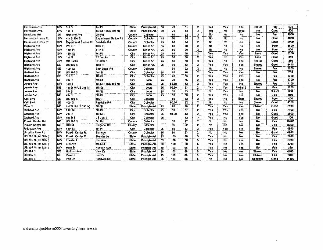
Herm~ston Ave East Loop Rd Herm~ston-Hmkle Rd Herm~ston-Htnkle Rd H~ghland Ave H~ghland Ave H~ghland Ave Highland Ave H~ghland Ave Highland Ave H~ghland Ave Hurlburt Ave Hurlburt Ave Hurlburt Ave Jennie Ave Jennie Ave Jennie Ave Jennie Ave Kelh Blvd KelL Blvd Main St Orchard Ave orchard Ave Orchard Ave Punkln Center Rd Punkin Center Rd
1st PI 1st St N (US 395 N) H~ghland Ave 4th St Ext S Experiment Station Rd
11th St I l e t PI 1st PI RR tracks RR tracks US 395 S US 395 S
- -- 3rd St 4th St 1st PI 1st St N (US 395 N) - - - - 6th St 4th s t
Ridgeway Ave umai~lla R~ver Rd US 395 N (1st S ~ N ) US 395 N (1st SN US 395 N (1st s t N ) US 395 N (1st St N ) US 395 S SE -- US 395 S SE t e w ~ r Po! Dr US 395 S SE ~ & t ~ r Feedville Rd
.-- -- ~~;k in Center -- @ Elm Ave . -- - - - - -
E n k i n e n t e r Rd Theater Ln - Theater L! --- -- Elm!!!? - - Elm fi -- Mdn S! -
Mam SJ Hurlbufl Ave Hurlburt Ave V~ew Dr
- - --. - - - ~ o u n t v Minor Art 1 35 1 - 66 ?ii -
-- - - -- - -- - - - State ~ r i n & l e ~ ~ 4 5 100 66 --- -- .- State Principle Art 55 130 66

APPENDIX C
Demographic Analysis
City of Hermiston
Transportation System Plan
Demographic Analysis
Prepared for:
City of Hermiston, Oregon
June 1996

TABLE OF CONTENTS
Page
I . INTRODUCTION .................................................................................................................. 1 I1 . STUDY AREA ...................................................................................................................... 1
....................................................... I11 . BASE CASE ESTIMATES AND METHODOLOGY 1 ................................................................................................ 1996 Population and Housing 1
................................................................................................................. 1 996 Employment -2 IV . FORECAST ......................................................................................................................... 5
................................................................................................ 20 1 6 Population and Housing 5 ................................................................................................................. 20 16 Employment .5
V . LIMITATIONS OF THE DATA .......................................................................................... 8
LIST OF TABLES
1 . Existing and Projected Housing and Population. The Hermiston Study Area .................... 3 2 . 1995 Employment Estimates. Hermiston Study Area ......................................................... 4 3 . 20 15 Projected Employment. Hermiston Study Area .......................................................... 7
I. INTRODUCTION
This report summarizes the methods and assumptions used by David Evans and Associates, Inc. (DEA) to estimate current (1996) population, housing, and employment in Hemiston and to forecast these demographics for the year 2016. The demographic data, presented in Tables 1, 2, and 3, were prepared for use in a computer transportation model, QRS2, which uses housing, employment, and transportation data to determine future transportation needs. Identified needs then will be utilized to prepare the City of Hemiston's Transportation System Plan (TSP).
11. STUDY AREA
The study area for the TSP includes all of the land within the City's Urban Growth Boundary (UGB) plus land outside of the UGB. The map included with this report shows the study area boundary.
It is important to note that, because the study area boundary differs from Hermiston's city limits and UGB, the demographic data contained in this report should not be compared directly with existing data for the city, nor should the projections be used in other studies associated with the city limits or UGB.
111. BASE CASE ESTIMATES AND METHODOLOGY
To begin the demographic work, DEA divided the study area into 70 transportation analysis zones (TAZs). Dividing the area into zones enables the computer model to analyze traffic movements between localized areas. TAZ boundaries typically are based on land use, major streets, topography, natural constraints; and US Census blocks. All population and employment estimates for existing (base case) and forecasted conditions are divided according to the appropriate TAZs to enable the computer to track demographic change for different portions of the city.
1996 Population and Housing
DEA's calculations result in an estimated 1996 population of 15,181 for the study area. The number of dwelling units in the study area is estimated at 6,119, of which 3,286 (54 percent) are single-family homes and 2,833 (46 percent) are multi-family units and mobile homes. Mobile homes are included as multi-family units due to limitations of census data and

because mobile homes typically have smaller household sizes (persons per household) than other single-family dwellings. Household size affects trip generation rates. Population and housing figures are presented in Table 1.
To estimate current population and housing, DEA relied upon 1990 US Census data at the census block level. Block data were aggregated into study area TAZs to get the 1990 demographic information for each TAZ and the total study area. The 1996 estimates for dwelling units are based primarily on information provided by the City of Hermiston. New dwellings within the city were estimated by using records of residential sewer permits. The number of housing units outside the city were estimated by city employees familiar with recent growth in the area. The additional units thus identified were added to the 1990 census counts. To estimate population, DEA utilized the 1990 census average household size of nearly 2.5 persons per household. Single-family dwellings typically have larger households than multi-family dwellings. 1996 population was estimated using household sizes of 2.8 persons per single-family unit and 2.1 persons per multi-family unit. The resulting average household size is approximately the same as in 1990.
1996 Employment
According to DEA's estimates, Hermiston currently has an average of 7,163 non-agricultural jobs in the TSP study area. Employment estimates by type of work are shown in Table 2.
DEA obtained employment information through document research and telephone interviews. Primary sources included the Hermiston Chamber of Commerce and the Oregon Employment Department. These sources provided information on employment by workplace location, which DEA then allocated to the appropriate TAZ. DEA also utilized the local Yellow Pages and contacted a number of employers by phone to confirm employment and to get information on work shifts, etc.
The 1996 population-to-employment ratio in the study area is 2.1 to 1, indicating a strong employment base. In urban areas, the ratio usually falls between 2.1 and 3.0. Lower ratios occur where almost all employment is contained within an urban area and is based primarily in manufacturing, commercial, and service industries. Higher ratios occur where many jobs in an area are resource-based--agriculture, forestry, etc.; where a large number of employees commute to work in other areas; or where unemployment is high Hermiston's lower ratio is consistent with its distribution of employment type. As shown in Table 2, jobs are concentrated in industriaVrnanufacturing (36.3 %), service (27.1 %), and retail (21.2 %) sectors. The low ratio may also be partially due to residents of nearby communities, such as Stanfield, commuting to jobs in Hermiston. It should be noted that there are large employers outside of the study area within commuting distance (Umatilla Army Depot, UPS). Including these in the study would result in an even lower population-to-employment ratio.
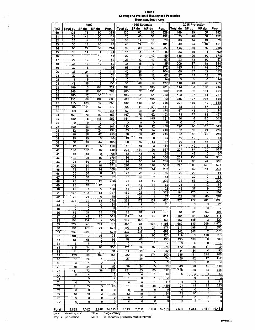
Tabk l Existing and Projected Housing and Population
Hermiston Study A m
du = dwelling unlt SF = single-family Pop. = populat~on MF = multi-fam~ly (~ndudes mobile homes)
121

Table 1 19% Estimated Employmat
Hermutoa Study Arm
Total Employment within Study Area = 7,163 1 12/19/96
I I T o t a l s 1 7.1631 2.5931 1.5161 1.8891 4861 306 1 3291 44
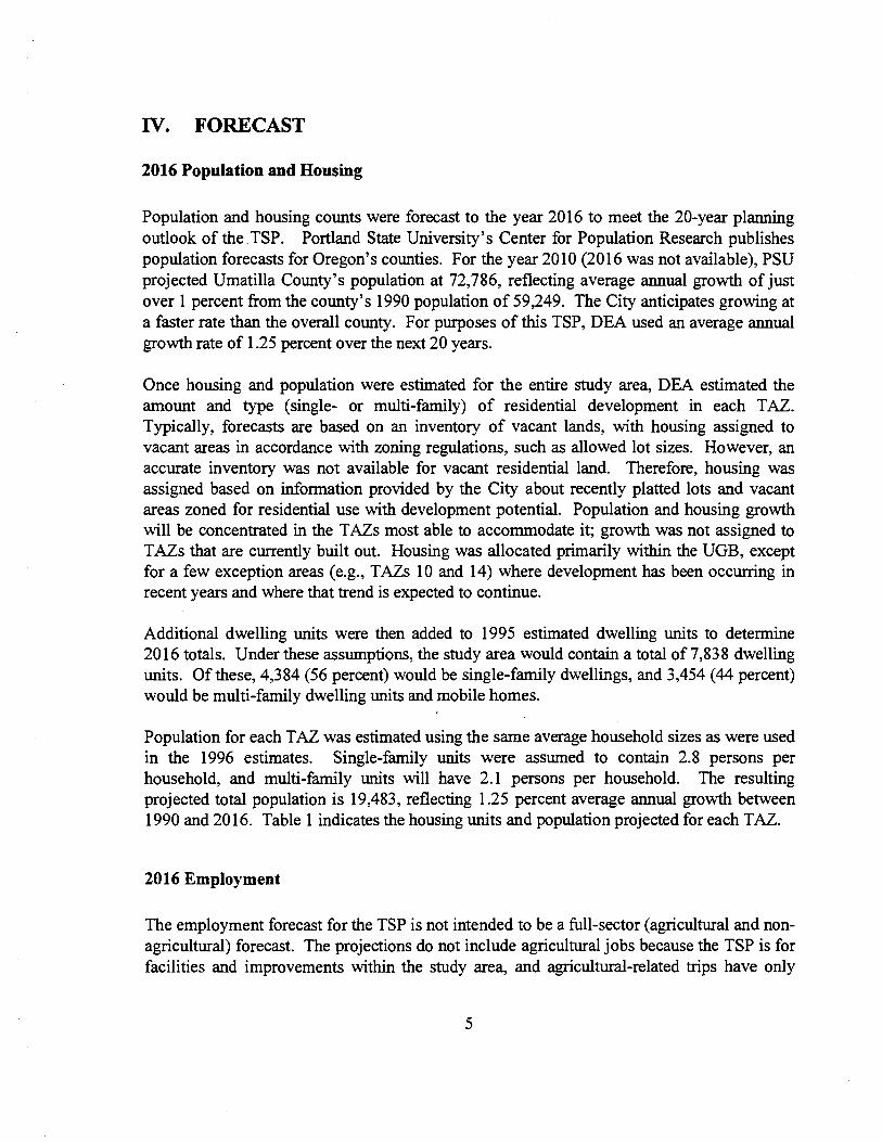
N. FORECAST
2016 Population and Housing
Population and housing counts were forecast to the year 2016 to meet the 20-year planning outlook of the TSP. Portland State University's Center for Population Research publishes population forecasts for Oregon's counties. For the year 20 10 (20 16 was not available), PSU projected Umatilla County's population at 72,786, reflecting average annual growth of just over 1 percent from the county's 1990 population of 59,249. The City anticipates growing at a faster rate than the overall county. For purposes of this TSP, DEA used an average annual growth rate of 1.25 percent over the next 20 years.
Once housing and population were estimated for the entire study area, DEA estimated the amount and type (single- or multi-family) of residential development in each TAZ. Typically, forecasts are based on an inventory of vacant lands, with housing assigned to vacant areas in accordance with zoning regulations, such as allowed lot sizes. However, an accurate inventory was not available for vacant residential land. Therefore, housing was assigned based on information provided by the City about recently platted lots and vacant areas zoned for residential use with development potential. Population and housing growth will be concentrated in the TAZs most able to accommodate it; growth was not assigned to TAZs that are currently built out. Housing was allocated primarily within the UGB, except for a few exception areas (e.g., TAZs 10 and 14) where development has been occuning in recent years and where that trend is expected to continue.
Additional dwelling units were then added to 1995 estimated dwelling units to determine 20 16 totals. Under these assumptions, the study area would contain a total of 7,838 dwelling units. Of these, 4,384 (56 percent) would be single-family dwellings, and 3,454 (44 percent) would be multi-family dwelling units and mobile homes.
Population for each TAZ was estimated using the same average household sizes as were used in the 1996 estimates. Single-family units were assumed to contain 2.8 persons per household, and multi-family units will have 2.1 persons per household. The resulting projected total population is 19,483, reflecting 1.25 percent average annual growth between 1990 and 20 16. Table 1 indicates the housing units and population projected for each TAZ.
2016 Employment
The employment forecast for the TSP is not intended to be a full-sector (agricultural and non- agricultural) forecast. The projections do not include agricultural jobs because the TSP is for facilities and improvements within the study area, and agricultural-related trips have only
minor impacts on traffic patterns in the study area. The 2016 employment forecast, with a total employment of 9,169, is shown in Table 3.
Future employment is based on several assumptions. Overall employment is forecast to grow in proportion to the population, an increase of 28 percent over 20 years, or 2,006 new jobs. Also, the proportion of employment by type was assumed to remain the same. This is based on the fact that Hermiston's relatively large industriallmanufacturing sector (36.3 percent of all jobs in Hermiston, compared to 26.4 percent of jobs in the entire county) is concentrated in stable industries like food manufacturing and mobile home production, instead of shrinking sectors like lumber and wood products industries. Furthermore, unlike other parts of eastern Oregon, Hermiston does not appear to be shifting to a tourism-related economy.
It was also assumed that nearly all growth in employment will occur within the urban growth boundary (UGB) and within appropriately zoned locations. This includes zones that currently allow the type of employment and zones that will allow it in the future (e.g. future commercial zones). The only growth projected to occur outside the UGB is in areas that already have employment. Such TAZs were assumed to have a 5 percent expansion of existing employment. Also, the four future Neighborhood Commercial nodes identified in the City's Comprehensive Plan and located in residential zones (TAZs 21, 25, 42, and 52) were each assumed to gain 10 retail and 5 service jobs. Sources of employment information included the city's inventory of commercially zoned lands, a draft inventory and assessments of industrial lands prepared by Elesco, ltd., and the City's Comprehensive Plan.
Since temporary jobs can include any type of employment, anticipated temporary jobs were distributed to other employment types based on the percent of overall employment. For example, 38 percent of the non-temporary jobs were industrial, so 38 percent of the temporary jobs were counted as industrial.
Commercial growth (retail and senice jobs) were anticipated to occur primarily in vacant C- 1 and C-2 zoned lands. Using a rate of nine employees per vacant acre, DEA assigned anticipated jobs to the appropriately zoned TAZs. (Vacant lands with commercial zoning were identified in an inventory prepared by the City.) The remaining commercial employment was assigned to TAZs with neighborhood commercial nodes and to TAZs with vacant, mixed-use zones identified as prime for development in Elesco's draft analysis of industrial lands.
The majority of industrial jobs were distributed to TAZ 76, because Wal-Mart is building a major distribution facility in that zone. The rest were distributed to TAZs that contained sites with vacant land deemed prime for development. These sites have advantages of large parcel size, flat topography, access to utilities, and proximity to major transportation systems. TAZs that had prime vacant lands were located primarily in the southeastern corner of the UGB along Highway 395. This area was also identified by the Chamber of Commerce as a high growth area.

Table 3 2016 Employment Estimates
Hermiston Study A m
Additional education jobs were distributed to two new school sites and current employment sites. Sandstone Middle School, located in TAZ 42, is anticipated to open next year with 55 employees. Also, a new grade school is anticipated in one of the potential school sites identified in the Hermiston Comprehensive Plan. The new school was assumed to be located at the potential school site in TAZ 65, because the school district has acquired a site and intends to construct a school in that TAZ. The rest of the education jobs were distributed to current job locations based on the proportion of education employment already located there. Government jobs were assumed to occur in current locations, and were distributed based on proportions, as well.
V. LIMITATIONS OF THE DATA
This study was prepared to estimate current conditions and expected growth patterns which will be used in a computer model to determine future transportation needs. The amount of growth, and where it occurs, will affect traffic and transportation facilities in the study area. It should be noted that the study area was defined specifically for use with the computer model and that this demographic analysis was designed specifically for use in developing a TSP for the Hermiston study area. This report is not intended to provide an accurate economic forecast or housing analysis, and it should not be used for any purpose other than that for which it was designed.

APPENDIX D
Public Involvement
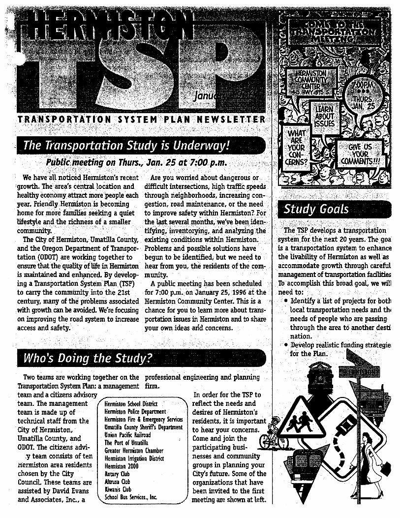
We have all noticed Hermiston's r u wonied about I growth. The area's central location healthy economy attract more people year. Friendly Hermiston is becomin
ensure that the quality of life in Hermiston hear from you, the residents of the com- is maintained and enhpced. By develop- munity. ing a Transportation System PLan (TSP) A public meeting has been scheduled to carry the community into the 21st for 7:00 p.m. on January 25, 1996 at the century, many of the problems associated Hermiston Community Center. This is a with growth can be avoided. We're focusing chance for you to Lam more about trans- on improving the road system to increase portation issues in Hermiston and to share access and safety. your own ideas add concerns.
Two teams are working together on the professional engineering and planning Transportation System P h a management firm. team and a citizens advisory In order for the TSP to team. The management team is made up of technical staff from the City of Hermiston, Umatilla County, and ODOT. The citizens advi- .y team consists of ten
Hermiston area residents chosen by the City Council. These teams are assisted by David Evans and Associates, Inc., a
T \ Hermiston School District Hermiston Police Department Hermiston Fire 8 Emergency Services Umatilla County Sheriffs Department Union Pacific Railroad The Port of Umatilla Greater Hemiston Chamber Hemiston lnigation Dittria Hemiston 2000 Rotary Club Aftrura Uub K i n i s Uub School Bus Senices., Inc.
0'
reflect the needs and desires of Hermiston's residents, it is important to hear your concerns. Come and join the participating busi- nesses and community groups in planning your City's future. Some of the organizations that have been invited to the first meeting are shown at left.
is a transportation system to enhance the livability of Hermiston as well as accommodate growth through careful management of transportation facilities To accomplish this broad goal, we will need to:
Identify a list of projects for both local transportation needs and thc needs of people wh through the area to nation. Develop realistic fup
'iN. -24' 96 (WED) 09 :58 DAVID EVANS & ASSOC I TEL:541 389 7623 ..
-TON TSP FIRST PUBLIC MEETING - STAKIZIOLDERS m A ' I I O N LIST
Jer hrattoq Superintendent 'Elenniston School District 341 NE 3rd St, ~ d t o n , ' OR 97838
Phillip Houk Union Pacific Rsrilroad 125 SE Court Ave. Pendleton, O R 9801
Kim Putey The Port oPUmatilla PO Box 879 Umatilla, Op 97882
Scott Cimniiyiotti Scott's Cycle & Spom 252 E. Main S t EGxmiston, OR 97838
Dennis Burke, Administratw Good Shepard Community Hospital 610 NW 1l"th Street Henniston, OR 97838
Bob McFW Pacific POW^ PO Box 1150 Hemiston, ;OR 97838
Doug Flm Mid Columbia Bus Co. RL 1 Box 417 Pendleton,"R 97801
; .I
John Nordby Pendleton Grain Growers, IdC. PO Box 10 Hermiston, OR 97838
Keith Wilson School Bus Services, Inc. 905 Diagonal Blvd aerrniston, OR 97838
'. George Hash, Mayor Ciity of UmatilIa Box 130 UmatilIa, OR 97882
AUen Piquet Cascade Natural Gas Corp. PO Box 866 aermiston, OR 97838
S w tt Hutchinson Oregon Wheat Growers League 202 SE Dorion Ave. Pendleton, OR 97801
Mike Jewett , Sanitary Disposal, I~Ic. PO Box 316 Hermiston, OR 97838
Tom M c C m , Mayor City of Stanfield PO Box 369 Stanfiehi, OR 97875
Cheryl Humphrey Greater Henniston Chamber PO Box 185 Hermiston, OR 97838
Dale Brown JB's Taxi Service 1180 SW 17th St. Hermiston, OR 97838
Tom Bates Marlette Homes, hc. 400 W. Elm Ave. Hennistoni' OR 97838
John Miller Eermisbn Irrigation District PO Box 208 Hermiston,' OR 97838
I
Jim Stearns Hermiston FWArnbulaace Department 330 S. 1st. St.
.d Hermiston, OR 97838
Rawe Hemiston Aviation Inc. Hermiston Airport PO Box 12.85 Hamiston, OR 97838
._I
PO Box 129 Henniston, OR 97838
Roe Gardner Downtowti .Merchants Assoc. ~oemark'kl~ens & Western Wear 201 E. Main St. Hermiston, "OR 97838
Pbil Hawman Blue Mtn. Potato Growers ~ssoc. Rt. 3, Box 3740 Hermiston, OR 97838
Mike DriscoIl TCB Transportation 675 N. 1st. St. Hermiston, OR 97838
Mike Boise Umatilla County ShaW s Department 305 SE 4th Kesmiston, OR 97838
Phil Konty Wal-Mart 1350 North 1st. St. Heimiston, OR 97838
Dave Umbarger, President Oregon Cattlemen's Assoc. Rt. 3, Box 170 Pendletan, OR 97801
Karen Smith , Altrusa Club
PO Box 213 Hermiston, OR 97838
Phillip Houk Rotary Club PO Box 142 Etermiston, OR 97838
Phyllis Shovelski ICiwanis CIUb PO Box 726 Hemiston, OR 97838
Lee Shaw Hermiston Senior Center 435 W. Orchard Ave. Henniston, OR 97838

Calvin Xeys, Field Manager
- lamb-Weston. Inc. PO Box 705 Hermiston, OR 97838
Andy Anderson Hermiston Police Department 330 South 1st. St Hermiston, OR 97838
Patsy Kcimig Schroth Realty, Inc. 411 E. Main St. Hermiston, 'OR 97838
Bill Earl, Resident Columbia Basin Board of Realtors C. Holt Real Estate 305 a h w a y 395 South aermiston, -OR 97838
Chatlorn Dack ERA Universal Realty, Inc. 985 N. 1st. St. Hermiston, OR 97838
I
Coy Petross J.R. Simplot PO Box 850 Hemiston, ,OR 97838
Greg Turner Hermiston Plaza Merchants Greg's Sleep Center 864 Highway 395 South Hermiston, OR 97838
Roy Stephen Hermiston Foods 2250 Highway 395 South Hemiston, ,OR 97838

APPENDIX E
Typical Facility Unit Costs

Typical Facility Unit Costs
Facility Description Cost
Pedestrian Sidewalk Shoulder
Striping Pedestrian signal Pedestrian1 bicycle bridge Curb cut Curb extension Median Refuge Repair Repair Multi-use path
Multi-use path
Multi-use path
Multi-use path
5-ft wide (4-in concretel2-in aggregate) without curb 4-ft wide on both sides to highway standards (4-in asphalv9-in aggregate) with 4-in stripe Crosswalk Crosswalk 1 0 4 wide Cut and ramp per ADA 1 5 4 radius with 2 ramps Raised island 10-ft wide path, seal every 5 years 10-ft wide path, resurface every 10 years 10-ft wide (2-in asphalv4-in aggregate) with clearing and preparation, no fences 10-ft wide (3-in asphalv6-in aggregate) with clearing and preparation, no fences 12-ft wide (3-in asphaltl6-in aggregate) with clearing and preparation, no fences 10-ft wide (4-in concretel3-in aggregate) with clearing and preparation, no fences
$3.00/linear ft $2500/unit $560/linear ft $450/unit $2500/unit $2000/unit $0.70/linear ft $5/linear ft $16/linear ft (see note) $22/linear ft (see note) $28/linear ft (see note) $55/linear ft (see note)
Bicycle Bike lane 5-ft wide on both sides to highway standards (4-in $45Ainear ft
asphaltl9-in aggregate) with curbs and 8-in stripe Striping 8-in. stripe on clean surface $OAO/linear ft Stencil Bike symbol after every intersection $30 each Sign Typical sign $100 each Parking Short-term $50/bike Parking Long-term and sheltered for 10 bikes $300/bike NOTES: Cost does not include special engineering problems such as steep grades, retaining walls and drainage that increase costs. Because these design features are usually present, costs for paths are frequently 3 to 4 times the amount given here. Land acquisition not included.