AIRPORT CITY MASTER PLAN - City of College Park
124
AIRPORT CITY MASTER PLAN in association with College Park Business and Industrial Development Authority in association with NOELL CONSULTING, VIRIDIAN STUDIOS, LONG ENGINEERING, CERM, K&L CONSULTING & MICHAEL BAKER INTERNATIONAL
-
Upload
khangminh22 -
Category
Documents
-
view
2 -
download
0
Transcript of AIRPORT CITY MASTER PLAN - City of College Park

AIRPORT CITY MASTER PLAN
in association with College Park Business and Industrial Development Authority
in association with NOELL CONSULTING, VIRIDIAN STUDIOS, LONG ENGINEERING, CERM, K&L CONSULTING & MICHAEL BAKER INTERNATIONAL

AIRPORT CITY MASTER PLANin association withCollege Park Business & Industrial Development Authority
SIZEMORE GROUPin association with NOELL CONSULTING, VIRIDIAN STUDIOS, LONG ENGINEERING, CERM, K&L CONSULTING & MICHAEL BAKER INTERNATIONAL
DRAFT JUNE 2019
CREDITS4
CITY OF COLLEGE PARK
• MAYOR & COUNCIL
Jack P. Longino • Mayor
Ambrose Clay • Council Member, Ward I
Derrick Taylor • Council Member, Ward II
Tracey Wyatt • Council Member, Ward III
Roderick Gay • Council Member, Ward IV
• STAFF
Artie Jones, III • Director of Economic Development
Tasha Hall-Garrison • Economic Development Program manager
Terrence R. Moore • City Manager
William Benifield • Human Resources Director
Chris Cook • Director of Administrative Services
Renèe Coakley • Main Street Manager
Bob Elis • Proprietor, College Park Historic Golf Course
Wade Elmore • Fire Chief
Michael Hicks • Chief Information Officer, Department of Information Technology & Telecommunications
Oscar Hudson, Jr. • Director of Inspections/Chief Building Inspector
Mercedes Miller • Executive Director, Georgia International Convention Center
Willis Moody • Purchasing Coordinator, Department of Purchasing
Shavala Moore • Interim City Clerk
William Moore • Director of Engineering
Althea Philord-Bradley • Director of Finance and Accounting
Emmanuel Rainey • Director of Recreation & Cultural Arts
Hugh Richardson • Director of Power
Maurice Ungaro • City Planner, Department of Planning Growth & Management
Belinda J. Wilder • Business/Occupational Tax Clerk, Department of Business License & Occupation Tax
Ferman Williford • Chief of Police
Gary Young • Director, Airport Affairs
CREDITS

CREDITS 5
CORE TEAM ORGANIZATIONS
BIDA Board of DirectorsCollege Park Planning CommissionCity Department HeadsAerotropolis AllianceAerotropolis CIDAerotropolis DMO College Park Department of AviationCollege Park Housing AuthorityFulton County SchoolsGICCGDOTMARTASoutheast CapitolWoodward Academy
CONSULTANT TEAM
LEAD FIRM: URBAN DESIGN, PLANNING & PROJECT MANAGEMENT• SIZEMORE GROUPBill De St. Aubin • Principal-in-Charge
Deanna Murphy • Project Manager & Lead Planner
Tulia Scott, AIA, NCARB, NOMA, LEED AP BD&C • Project Architect
Chirag Date, MCRP, LEED GA • Project Planner
Sarina Sawyer, MCRP • Project Planner
COST ESTIMATING/SCHEDULING• CERMShelley Lamar • Senior Project Manager
COMMUNITY RELATIONS• K&L CONSULTINGKen Jenkins • FounderLauren Paige • Senior Consultant
MARKET EXPERTS• NOELL CONSULTINGTodd Noell • President
LANDSCAPE ARCHITECTURE• VIRIDIAN STUDIOSJill Kelleher, PLA • Owner
TRANSPORTATION ENGINEERING
• LONG ENGINEERINGAndrew Pankopp, PE, LEED AP BD&C •Civil Engineer
• MICHAEL BAKER INTERNATIONALBill Ruhsam • Traffic Expert


TABLE OF CONTENTS
0.0 EXECUTIVE SUMMARY 009
3.0 VISION 075
1.0 INTRODUCTION 029
4.0 RECOMMENDATIONS 081
2.0 FACTS & ANALYSIS 037
1.1 Background1.2 Previous Studies & Plans
3.1 Stakeholder Input3.2 Project Goals Summary
2.1 Assets & Opportunities2.2 Study Area Projects Status2.3 Land Use and Zoning2.4 Topography and Hydrology2.5 Economic Development2.6 Airport Associated Regulations2.7 Civil and Transportation2.8 Landscape Conditions2.9 Market Demand Summary
4.1 Master Plan Concept4.2 Airport City Districts4.3 Transportation Framework Plan4.4 Placemaking and Greenspace4.5 Stormwater Management4.6 Phase One4.7 Five-Year Development Plan4.8 Cost Estimate and Schedule of Activities4.9 Communications and Public Relations
APPENDIX Market Analysis ReportTraffic StudyAquatic Resource Delineation AnalysisExample Blog Post


EXECUTIVE SUMMARY 9

EXECUTIVE SUMMARY10
The Airport City Master Plan is a study of 320 acres of prime, redevelopable, greenfield land directly west of Hartsfield-Jackson Atlanta International Airport (HJAIA), the world’s busiest airport, charming Downtown College Park, and directly north of the Georgia International Convention Center and the new home of Hawks NBA G League team. The study is led by the City of College Park Building and Industrial Development Authority (BIDA).
This plan aims to encourage strategic and sustainable community-centered development to create a publicly accessible, live, work, and play community and global destination at this highly desirable site. Between the 1970s and early 2000s, the City of Atlanta acquired and demolished hundreds of housing units for Airport Noise Reduction (ANR) purposes as part of HJAIA expansion, as a result the property has mostly laid vacant. The City of College Park and its Business and Industrial Development Authority (BIDA) have worked to purchase back these 320 acres from the City of Atlanta and now has an incredible opportunity to reinvigorate the community, entice global visitors, and boost the local economy.
MASTER PLAN GOALS
Airport City Master Plan recommendations address project goals, key area issues, and visions as identified through an existing conditions analysis, a thorough understanding of the area market dynamics (strengths and weaknesses), cost estimating and scheduling, and the needs, aspirations and desires of the community.
STUDY AREA & CONTEXT
The study area encompasses Herschel Road to the west, Camp Creek Parkway to the south, College Street on the east, and extends north to Princeton Avenue and Camp Creek waterway. Refer to Figure A.
The Airport City study area is rich with opportunity and potential. The historic Brady Recreation Center, the first African American community center in the city, has been serving the community for many decades and is the primary asset inside the study area boundary. Due to the airport’s expansion and subsequent property condemnation, few households and businesses remain inside the study area. However, a wealth of community assets can be found just beyond Airport City. Invaluable social networks and city pride keep residents active and engaged. Two MARTA stations (College Park and Airport), HJAIA, and multiple highways provide access to the greater Atlanta region and the world. Historic Downtown College Park provides a unique, local commercial district, with historic architecture and a pedestrian-friendly street grid – all of which is proposed to be connected into the Airport City development.
EXECUTIVE SUMMARYMASTER PLAN GOALS
• Building a global destination rooted in diversity, equity, & inclusion• Providing services & amenities for residents while also appealing to visitors & travelers• Creating community connectivity with enhanced sidewalks, purposeful trails, well designed & strategically located greenspace, and transit access• Creating a sense of arrival & character for Airport City• Highlighting the history & culture of the College Park area• Encouraging a diversity of uses• Creating opportunities for public involvement• Developing a vision for future growth
RECOMMENDATIONS FOCUSED ON:
•Development Opportunities •Greenspace & Trails•Placemaking•Multi-modal Connectivity
CAMP CREEK PARKWAY
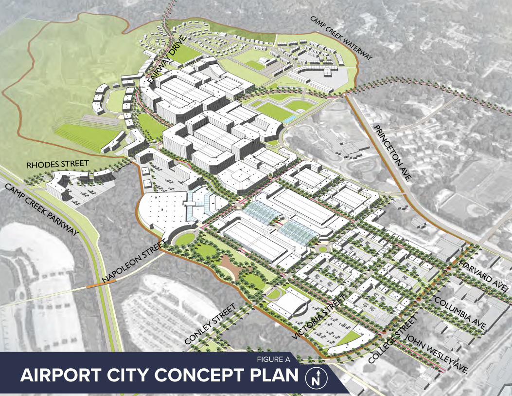
Figure 1: Title
AIRPORT CITY CONCEPT PLANFIGURE A
FAIR
WAY
DRI
VECAMP CREEK PARKWAY
JOHN WESLEY AVE.
COLUMBIA AVE.
HARVARD AVE.
PRINCETO
N AVE.
CAMP CREEK WATERWAY
RHODES STREET
NAPOLEON STREET
CONLEY STREET
VICTORIA ST
REET
COLLEGE ST
REET

PHASE ONE - AFIGURE B

EXECUTIVE SUMMARY 13
MASTER PLAN PROCESS
The Airport City planning and development process included evaluation of previous reports and studies, existing conditions analysis, market understanding, stakeholder engagement, and a thorough master plan development process.The stakeholder engagement process for the Airport City Master Plan engaged stakeholders through three Core Team meetings, interviews, and a Design Workshop. The key stakeholders consisted of City department heads and staff, community leaders, and relevant agencies and authorities within the study area with knowledge and expertise that could enhance and inform the master plan process. Gaining opinions and support from the public and stakeholders in the area is imperative to creating an inclusive and implementable plan.
AIRPORT IMPACTS
Airport City’s proximity to HJAIA requires special considerations in addition to the traditional existing condition analysis. The consultant team reviewed Federal Aviation Administration (FAA) guidelines for building heights, noise contours, and flight paths. These three elements dictate the types of uses, building heights, and their location. For example, residential development is only recommended in areas with sound levels below 65 decibels, which is why the residential area is situated at the northernmost point of the study area – lower than the 65-decibel noise contour.
Furthermore, the transfer of property from the City of Atlanta to the College Park BIDA comes
with deed restrictions. The FAA requires that all land acquired in noise-impacted areas cannot be used for residences. Many of the properties inside Airport City were residences sold to the City of Atlanta in Airport Noise Reduction efforts which means that they cannot be used for residential even though they now belong to the College Park BIDA.
MARKET SUMMARY
The Five-Year Development Plan concept boldly defies current market demands with the vision that the allure of the unique Airport City site could bring additional tenants, such as office headquarters and entertainment venues. Corporate headquarters would greatly increase residential, commercial, and office demand. In the short term, there is already strong demand for office, hotel, destination outlets, and residential. A full market analysis can be found in the Appendix.
MASTER PLAN RECOMMENDATIONS
MASTER PLAN CONCEPT
This master plan is unique in that the City of College Park is working with 320 acres of mostly vacant land with endless possibilities and incredible global access with HJAIA. As such, the entire study area is ripe for redevelopment to enhance the livability, visibility, and sustainability of College Park by creating a quality mixed-use live-work-entertain district: Airport City.
Character Areas
Airport City is divided into character areas with uses targeting the community’s needs and market demands. The character areas include: Office, Commercial/Retail, Entertainment, Residential, Greenspace, and Golf Course.Infrastructure
Phase One
Key to the implementation of this Airport City master plan is the purchase and development of a large parcel of land at the north of the study area into a residential community. This sale will catalyze the rest of the development by bringing new households into the area and enabling the City to transform Rhodes Street into a main access point from Camp Creek Parkway, into Airport City, and up to the proposed residential area. In turning Rhodes Street into a primary North-South boulevard, Phase One would include building the boulevard right of way including: the roadway, sidewalks, landscaping, bike infrastructure, and public art. Refer to Figure B.
Secondary Priorities
As funding becomes available, this master plan proposes doing the same for an East/West Main Street on Columbia Avenue. Similarly, as funding allows, the City should target complementary developments throughout the study area, including: the stormwater park, the commercial parking deck with climbing wall, and the 5k trail. Refer to Figure D.

EXECUTIVE SUMMARY14 PHASE ONE - BFIGURE C
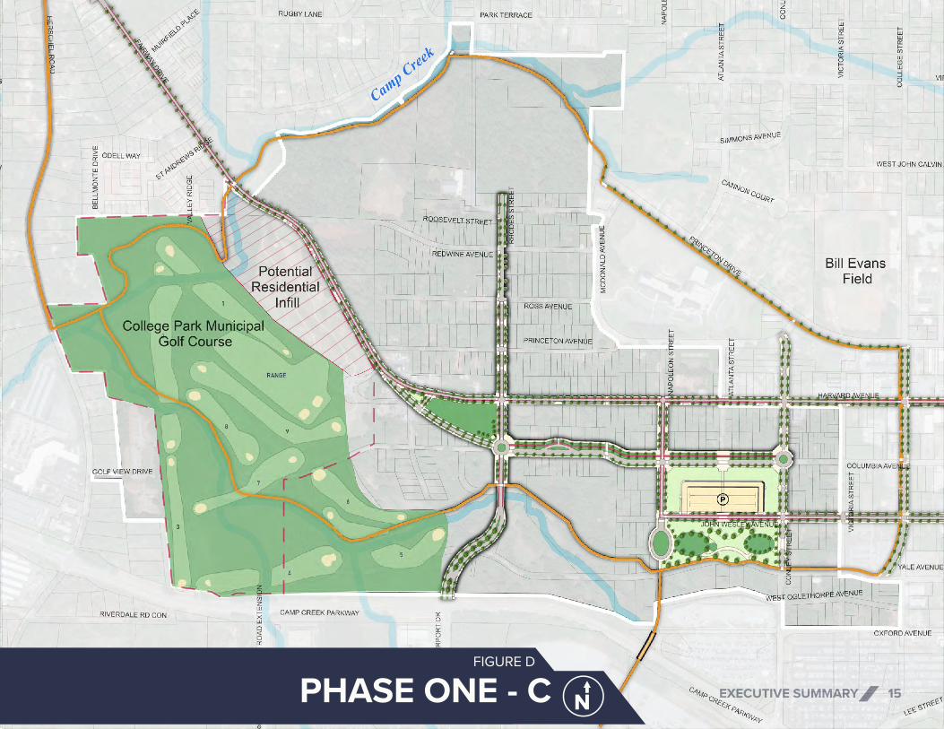
EXECUTIVE SUMMARY 15PHASE ONE - CFIGURE D

EXECUTIVE SUMMARY16
Five-Year Development Plan
The First Build Out/Five Year Plan is an ambitious plan to capitalize on existing community assets and HJAIA traffic to develop the anchor commercial, retail, office space, entertainment amenities, hotels, and golf course improvements, creating a truly iconic, global experience. There is demand for 420,000 square feet of office, 680 hotel rooms, 390,000 square feet of retail, 880 rental apartment units, and 100 for-sale townhomes. Over the following 5-10 years, the remainder of the site is anticipated to grow incrementally. It is envisioned for local developers and entrepreneurs to infill smaller parcels with commercial, office, and entertainment uses.
PLACEMAKING AND GREENSPACE
Placemaking and greenspace strategies are recommended to help define Airport City as a singular place and provide much-needed public amenities. Greenspace and trails provide active transportation, mental and physical health benefits, opportunities for exercise, and access to nature. Similarly, placemaking capitalizes on the existing assets of the community to create public spaces that promote community well-being and branding with art, landscaping, lighting, and signage. Following are those strategies:
Greenspace
Two new parks are proposed within the study area to supply stormwater management and bring open space to the redevelopment. Stormwater Park – The centerpiece of community space in Airport City would be a stormwater park along Camp Creek Parkway. The park is proposed to be bookended at the east end with a heritage/cultural arts/music center and a potential esports arena at the west end. Inside the park would be open space for picnics, family gatherings, public events, and airplane viewing. The park is strategically in-line with a departure runway, so local and global community members can come and view planes taking off. Brady – Elementary Sports Park – Additional greenspace is proposed between the Brady Recreation Center and the College Park Elementary School to safely connect the two and to replace Brady Center fields lost to residential development. It would contain playspaces, baseball fields, flexible sports fields, and parking.
Trails
A network of trails is proposed in the Airport City study area to connect to the proposed redevelopment sites, existing and proposed parks, and to planned trail systems in neighboring communities.
Trails in this plan align with area creeks and stream buffers, as well as, provide connectivity to the many existing and proposed amenities, including the College Park MARTA Station just outside of the study area boundary and the future pedestrian bridge connecting Airport City to the GICC. Ties to the existing neighborhoods are made through East/West (Harvard Avenue and John Wesley Avenue) and North/South (Rhodes Street). Likewise, trail connections are proposed along Herschel Road and Camp Creek Parkway to join with proposed AeroATL Greenway Plan trails and through the northern section of the study area to link to Virginia Avenue. A 5-kilometer trail loop is proposed that would support local schools and provide a venue for events and tournaments. It could be a destination for cross country, 5k events, running, walking, and biking.

FIVE-YEAR DEVELOPMENT PLANFIGURE E

LEGEND
Boulevard
Primary Retail Corridor
Secondary Retail Corridor
Harvard Avenue Corridor
Neighborhood Street
Pedestrian Only Street
Greenway REDWINE AVE.
VIRGINIA AVE.
CAMP CREEK PARKWAY
HARVARD AVE.
CO
LLEG
E ST
.
COLUMBIA AVE.
JOHN WESLEY AVE.
YALE AVE.
OXFORD AVE.
AIR
PORT
DR.
RHO
DES
ST.
ROSS AVE.
FAIRWAY DR.
REDWINE AVE.
NA
POLE
ON
ST.
ATLA
NTA
ST.
CO
NLE
Y ST
.
VIC
TORI
A S
T.
STREET FRAMEWORKFIGURE F

EXECUTIVE SUMMARY 19
MULTI-MODAL CONNECTIVITY
Connectivity will be key to the success of Airport City. A street framework appropriate for all uses and users is critical to this master plan. A thorough traffic analysis was performed to ensure connectivity recommendations align travel volumes with capacity and street functionality. Refer to Figure F. Connectivity recommendations include:
Street Framework
The Airport City Master Plan aims to continue the flow of the existing downtown street grid while adding gateway connections and maximizing function, safety, and beauty. Airport City lies directly adjacent to Historic Downtown College Park, which is the commercial center of the community, and is organized around a traditional street grid. This grid continues into the study area and is ideal for a pedestrian-friendly environment. In addition to road improvements, new connections must be built to facilitate access to Airport City from existing major roadways and surrounding neighborhoods. Refer to Figure F.
Streets for People
This master plan recommends enhancing the Airport City’s street network to manage speeds, prevent safety conflicts, and provide desirable travel environments by implementing sidewalks, bicycle infrastructure, streetscape enhancements, on-street parking, or other community needs in alignment with surrounding uses and users.
Transit
Enhanced transit can have a significant impact on growth in the area, as such, this plan proposes capitalizing on College Park’s MARTA access and the HJAIA ATL SkyTrain by broadening their reach into Airport City. The SkyTrain could be extended from the GICC to the Delta Air Lines Employee Parking Lot, and onwards into the heart of the Airport City development. An autonomous bus circulator could run on a continuous loop from the College Park MARTA Station through the proposed commercial districts into the office center.
COMMUNITY RELATIONS
As the process advances, transparency and community input is critical to the implementation and success of Airport City. A multifaceted Community Relations and Public Relations strategy has been put into action to tell the story of Airport City and receive community feedback. The plan includes a website, email address, official Facebook, online surveys, fact sheet mailers, and traditional public forums, among other mediums.
PLACEMAKING
Highlight History
This plan suggests utilizing plaques, signs, murals, and artwork to highlight local landmarks and influential residents to make sure Airport City uniquely displays College Park.
Activated Greenspace
To effectively activate the proposed trail system and common spaces, the plan recommends placemaking strategies to create people-friendly parks, such as artistic play areas, sculpture parks, or educational markers and trails.
Art
To spotlight Airport City’s amenities and further promote branding efforts for the area, the plan recommends coordination with local artists, musicians, and arts organizations to place artwork and host art events. The area has the potential to be more inviting and engaging by creatively utilizing artistic murals, lighting, music, and signage.
LEGEND
Boulevard
Primary Retail Corridor
Secondary Retail Corridor
Harvard Avenue Corridor
Neighborhood Street
Pedestrian Only Street
Greenway REDWINE AVE.
VIRGINIA AVE.
CAMP CREEK PARKWAY
HARVARD AVE.
CO
LLEG
E ST
.
COLUMBIA AVE.
JOHN WESLEY AVE.
YALE AVE.
OXFORD AVE.
AIR
PORT
DR.
RHO
DES
ST.
ROSS AVE.
FAIRWAY DR.
REDWINE AVE.
NA
POLE
ON
ST.
ATLA
NTA
ST.
CO
NLE
Y ST
.
VIC
TORI
A S
T.

EXECUTIVE SUMMARY20
COST ESTIMATE
Figures G and H outline the planning level rough order of magnitude (ROM) cost estimate developed for the two main North-South and East-West roads identified in the proposed Phase One development of Airport City.
Basis of Estimate
To assist in developing the cost estimates, current Georgia Department of Transportation pricing for similar project types was gathered and analyzed. Additional information was provided which outlined street cross sections and utilities. A contingency of 10% is included.
Exclusions
Several items are not included in this estimate. Relocation or adjustment to the fuel pipelines is not included. Additional environmental studies (i.e. Phase 2 Environmental) are not included.
ROM COSTESTIMATES
Rhodes Street$10.58M
Total$19.57M
Columbia Avenue$8.99M
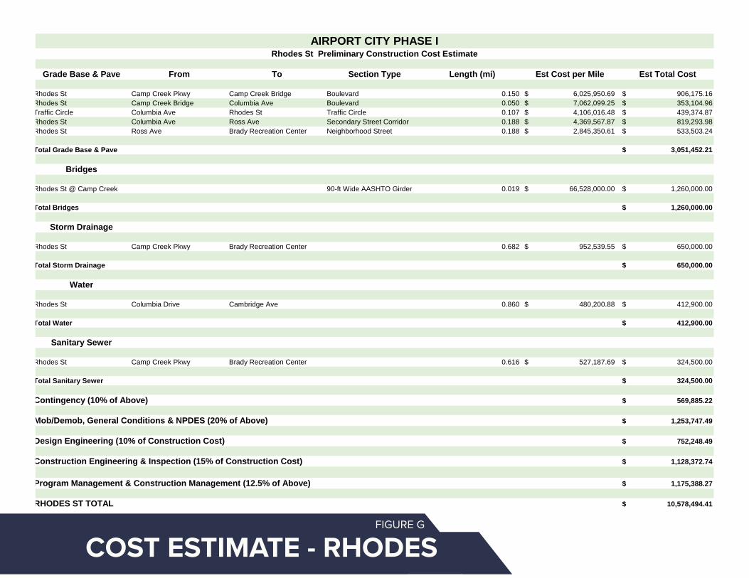
Grade Base & Pave From To Section Type Length (mi) Est Cost per Mile Est Total Cost
Rhodes St Camp Creek Pkwy Camp Creek Bridge Boulevard 0.150 6,025,950.69$ 906,175.16$ Rhodes St Camp Creek Bridge Columbia Ave Boulevard 0.050 7,062,099.25$ 353,104.96$ Traffic Circle Columbia Ave Rhodes St Traffic Circle 0.107 4,106,016.48$ 439,374.87$ Rhodes St Columbia Ave Ross Ave Secondary Street Corridor 0.188 4,369,567.87$ 819,293.98$ Rhodes St Ross Ave Brady Recreation Center Neighborhood Street 0.188 2,845,350.61$ 533,503.24$
Total Grade Base & Pave 3,051,452.21$
Bridges
Rhodes St @ Camp Creek 90-ft Wide AASHTO Girder 0.019 66,528,000.00$ 1,260,000.00$
Total Bridges 1,260,000.00$
Storm Drainage
Rhodes St Camp Creek Pkwy Brady Recreation Center 0.682 952,539.55$ 650,000.00$
Total Storm Drainage 650,000.00$
Water
Rhodes St Columbia Drive Cambridge Ave 0.860 480,200.88$ 412,900.00$
Total Water 412,900.00$
Sanitary Sewer
Rhodes St Camp Creek Pkwy Brady Recreation Center 0.616 527,187.69$ 324,500.00$
Total Sanitary Sewer 324,500.00$
Contingency (10% of Above) 569,885.22$
Mob/Demob, General Conditions & NPDES (20% of Above) 1,253,747.49$
Design Engineering (10% of Construction Cost) 752,248.49$
Construction Engineering & Inspection (15% of Construction Cost) 1,128,372.74$
Program Management & Construction Management (12.5% of Above) 1,175,388.27$
RHODES ST TOTAL 10,578,494.41$
Exclusions
Roadway undercrossing pavements and appurtenances tabulated for sectionBuried utility adjustments and relocations except as listed aboveLateral utility service connectionsRock Excavation, Blasting, and Offsite HaulStorm outfall sewers beyond R/WCost escalation
Basis of Estimate
Unit prices based on current GDOT pricingExtents based on GIS mapping and preliminary Phase I planning documentsSections based on conceptual cross sections for estimation purposes only
AIRPORT CITY PHASE IRhodes St Preliminary Construction Cost Estimate
COST ESTIMATE - RHODESFIGURE G
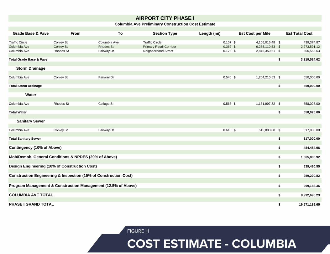
Grade Base & Pave From To Section Type Length (mi) Est Cost per Mile Est Total Cost
Traffic Circle Conley St Columbia Ave Traffic Circle 0.107 4,106,016.48$ 439,374.87$ Columbia Ave Conley St Rhodes St Primary Retail Corridor 0.362 6,285,110.53$ 2,273,591.12$ Columbia Ave Rhodes St Fairway Dr Neighborhood Street 0.178 2,845,350.61$ 506,558.63$
Total Grade Base & Pave 3,219,524.62$
Storm Drainage
Columbia Ave Conley St Fairway Dr 0.540 1,204,210.53$ 650,000.00$
Total Storm Drainage 650,000.00$
Water
Columbia Ave Rhodes St College St 0.566 1,161,997.32$ 658,025.00$
Total Water 658,025.00$
Sanitary Sewer
Columbia Ave Conley St Fairway Dr 0.616 515,003.08$ 317,000.00$
Total Sanitary Sewer 317,000.00$
Contingency (10% of Above) 484,454.96$
Mob/Demob, General Conditions & NPDES (20% of Above) 1,065,800.92$
Design Engineering (10% of Construction Cost) 639,480.55$
Construction Engineering & Inspection (15% of Construction Cost) 959,220.82$
Program Management & Construction Management (12.5% of Above) 999,188.36$
COLUMBIA AVE TOTAL 8,992,695.23$
PHASE I GRAND TOTAL 19,571,189.65$
Exclusions
Roadway undercrossing pavements and appurtenances tabulated for sectionBuried utility adjustments and relocations except as listed aboveLateral utility service connectionsRock Excavation, Blasting, and Offsite HaulStorm outfall sewers beyond R/WCost escalation
Basis of Estimate
Unit prices based on current GDOT pricingExtents based on GIS mapping and preliminary Phase I planning documentsSections based on conceptual cross sections for estimation purposes only
AIRPORT CITY PHASE IColumbia Ave Preliminary Construction Cost Estimate
COST ESTIMATE - COLUMBIAFIGURE H
EXECUTIVE SUMMARY 23
SCHEDULE OF ACTIVITIES
A preliminary schedule of activities has been developed and is provided in Figure I. As shown, it is anticipated that the follow up planning processes, environmental studies, permitting, and design will require approximately 40 months to complete. Following those activities, the project would be ready for advertisement for construction bids. Construction is anticipated to require approximately one year to complete (210 days).
The schedule assumes that there will be no additional procurements of services for planning, environmental, engineering, or other professional services. Additional procurement of services may impact timeline.

EXECUTIVE SUMMARY24

EXECUTIVE SUMMARY 25PHASE ONE SCHEDULEFIGURE I

EXECUTIVE SUMMARY26 AIRPORT CITY CONCEPT PLAN FIGURE J
AIRPORT CITY MASTER PLAN

EXECUTIVE SUMMARY 27
COLUMBIA AVENUE RETAIL DISTRICT

18

INTRODUCTION 29

INTRODUCTION30
Adjacent to the world's busiest airport, Airport City is a 320-acre redevelopment site teeming with potential. The study area encompasses Herschel Road to the west, Camp Creek Parkway to the south, College Street on the east, and extends north to Princeton Avenue and Camp Creek waterway. Refer to Figure A.
1.1 BACKGROUND
The City of College Park is 10.1 square miles sitting at the southern border of the City of Atlanta and the western edge of the Hartsfield-Jackson Atlanta International Airport (HJAIA), in fact, the Domestic Terminal lies within the boundaries of College Park. The airport has greatly shaped the City of College Park and continues to be tied to its future growth. It connects College Park businesses to the world. Outside of the airport, the existing community assets and engaged residents form the critical foundation to investment and growth.Just east of the study area lies the charming and historic Main Street corridor with thriving local businesses, MARTA rail and bus service, and the City’s government offices. This downtown district is known as Historic College Park – Georgia’s fourth largest Historic District – and a gem in the Atlanta region. Residents and business owners take pride in this history and unique character – what makes College Park. In planning Airport City it will be imperative to expand the City’s economic base while preserving the City's historic downtown appeal.
The Airport City master plan has the ability to capitalize on the study area’s connections to Hartsfield-Jackson Atlanta International Airport
(HJAIA), the Georgia International Convention Center (GICC), the convenient interstate access, and Metropolitan Atlanta Rapid Transit Authority (MARTA) to become the Gateway to the Atlanta Region.
1.0 INTRODUCTION

!R
!R
!R
!R
!R
!R
!R
GEORGIA INTERNATIONAL CONVENTION CENTER
COLLEGE PARK CEMETERY
US FEDERAL AVIATION ADMINISTRATION
COLLEGE PARK BRANCH LIBRARY
COLLEGE PARK POLICE DEPARTMENT
BRADY RECREATION CENTER
COLLEGE PARK PUBLIC WORKS
WASHINGTON ROAD
I-85
STONE ROAD
HER
SCH
EL R
OA
D
RUGBY AVENUE
EAST
MAI
N S
TREE
T
VIRGINIA AVENUE
CAMP CREEK PARKWAY
MAI
N S
TREE
T
YALE AVENUE
CO
LLEG
E ST
REET
JANICE DRIVE
FAIRWAY DRIVE
TEMPLE AVENUE
WILLINGHAM DRIVE
LYLE ROAD
FRONTAGE ROAD
COLUMBIA AVENUE
HA
RRIS
DRI
VE
YATE
S RO
AD
REDWINE ROAD
ALE
CIR
CLE
HA
RRIS
ON
RO
AD
Glo
bal G
atew
ay C
onne
ctor
WEST LYLE AVENUE
LAKE SHORE DRIVE
MERCER AVENUE
CENTRAL AVENUE
LEE
STRE
ET
DUKE OF GLOUCESTER
HAWTHORNE AVENUE
MA
DIS
ON
STR
EETHARDIN AVENUE
VIC
TORI
A S
TREE
T CAMBRIDGE AVENUE
CH
ARL
ES D
RIV
E
MO
UN
T O
LIV
E RO
AD
DODSON DRIVE
DUNLAP AVENUE
PELOT DRIVE
PRINCETON AVENUE
HEM
PHIL
L ST
REET
RHO
DES
STR
EET
GLE
ND
A D
RIV
E
COLONIAL DRIVE
CENTER AVENUE
HARVARD AVENUE
BEST
RO
AD
ADAM
S ST
REET
ATLA
NTA
STR
EET
LAKEMONT DRIVE
JEFF
ERSO
N S
TREE
T
REDWINE AVENUE
PRINCETON DRIVE
CHARLESTOWN DRIVE
RUGBY LANE
YORK ROAD
PIER
CE
STRE
ET
ROOSEVELT H
IGHWAY
WEST VESTA AVENUE
SIR
HEN
RY S
TREE
TSU
N V
ALL
EY B
OU
LEVA
RD
CA
RRIA
GE
WAY
KARE
N R
OA
D
CHU
RCH
STR
EET
DO
GW
OO
D D
RIV
E
ROSS AVENUE
JOHN WESLEY AVENUE
BAC
HEL
OR
STRE
ET
EAST VESTA AVENUE
DEL
OW
E D
RIV
E
WILLIAM
SBURG DRIVE
WEST POINT AVENUE
PALM
SPR
ING
S D
RIV
E
AIRPORT DRIVE
BAYA
RD S
TREE
T
EAST
PO
INT
STRE
ET
MC
KEN
ZIE
ROA
D
SCEN
IC D
RIVE
BEECH D
RIVE
LAKE DRIVE
LAFA
YETT
E LA
NE
NA
POLE
ON
STR
EET
CA
LMER
CIR
CLE
PLAN
T ST
REET
DUKE OF WINDSOR
EAST FARRIS AVENUE
CO
NLE
Y ST
REET
PHILLIPS AVENUE
WEST RUGBY AVENUE
ARLINGTON ROAD
GREEN VALLEY DRIVE
WH
ITE
STRE
ET
POTOMAC DRIVE
PARK
VIE
W D
RIV
E
JON
ES S
TREE
T
ENGLISH LA
NE
JACK
SON
STR
EET
BOU
LDER
WAY
WEST POTOMAC DRIVE
SKYLINE DRIVE
FRED
ERIC
KSBU
RG D
RIV
E
LA R
OSE
STR
EET
WA
SHIN
GTO
N S
TREE
T
ROSS
DRI
VE WALKER AVENUE
BRIA
RWO
OD
BO
ULE
VARD
RIVERDALE RD CON
ARLEN
E ROA
D
WEST OGLETHORPE AVENUE
WEST JOHN CALVIN AVENUE
JACKSON DRIVE
LYLE TERRACE
FLO
WER
S D
RIV
E
OXFORD AVENUE
HAG
GER
WAY
HO
WA
RD D
RIV
E
DRESDEN TRAIL
WILLIAMS AVENUE
PENN
Y LA
NE
DESERT DRIVE
TOFF
IE T
ERRA
CE
HARVARD AVENUE
BLOSSOM LANE
CU
MBE
RLA
ND
RO
AD
ROOSEVELT STREET
REVERE COURT
ALM
AN
D D
RIV
E
SOU
TH T
ERM
INA
L PA
RKW
AY
AIRPORT B
OULEVARD
CA
LVIN
CO
URT
EARL GODFREY LANE
LOW
ND
ES S
TREE
T
I-85 NB RAMP
BATTERY WAY
POTO
MAC
TER
RACE
POLL
ARD
STR
EET
CLO
VER
HU
RST
CIR
CLE
PALMOUR CT
MO
CKI
NG
BIRD
LA
NE
REED
STR
EET
ODELL WAY
GOLF VIEW DRIVE
MYRTLE LANE
CAROL COURT
PERKINS D
RIVE
JOHN CALVIN AVENUE
FORT
NER
STR
EET
MO
NRO
E ST
REET
STONETREE APTS
CHASE COURT
BRIAR C
OU
RT
WALKER AVENUE
NO
NA
ME
ROA
D
ATLA
NTA
STR
EET
WALKER AVENUE
JAC
KSO
N S
TREE
T
NA
POLE
ON
STR
EET
PRINCETON AVENUE
CAMP CREEK PARKWAY
I-85
RUGBY AVENUE
NO NAME ROAD
COLUMBIA AVENUE
ROO
SEV
ELT
HIG
HW
AY
HAR
RIS
DRI
VE
AIRPORT LOOP ROAD
MERCER AVENUEMERCER AVENUE
LEE
STRE
ET
WEST POINT AVENUE
SOUTH TERMINAL PKWY
CA
R RE
NTA
L RO
W N
B
S TERMINAL PKWY
ACCE
SS R
D
NORTH TERMINAL PKWY
CROSSWIND RD
AIRPORT CIR
GATEWAY BLVD
ACCESS RD
NORTH TE
RMIN
AL PKW
Y
WOODLAND MIDDLE SCHOOL
FRANK MCCLARIN HIGH SCHOOL
COLLEGE PARK ELEMENTARY SCHOOL
ASA G. HILLIARD ELEMENTRY SCHOOL
WOODWARD ACADEMY
THE MAIN STREET ACADEMY
Airport
College Park
SYKES PARK
COLLEGE PARK MUNICIPAL GOLF COURSE
BARRETT PARK
BRADY RECREATION CENTER PARK
BILL EVANS FIELD
WOODLAND FIELD
BRANNON MEMORIAL PARK
Jamestown Park
JOHN D. MILNER YOUTH SPORTS FACILITY
Camp Creek
North Fork Camp Creek
HARTSFIELD-JACKSON ATLANTA INTERNATIONAL AIRPORT
PHO
ENIX
TRA
IL
BRADY TRAIL
BRADY TRAILEXTENSION
ATL SKYTRAIN
SCHOOLS
LANDMARKS
TRANSIT RAIL STATIONS
MARTA RAIL LINES
RIVERS & STREAMS
AIRPORT
ROADS
LAKES/PONDS
PARKS
COUNTIES
COLLEGE PARK HISTORIC DISTRICT
PROPOSED TRAILS AEROATL GREENWAY PLAN 2018:LOCAL CONNECTIONS
EXISTING TRAILS
ATL SKYTRAIN
STUDY AREA PARCELS
PARCELS
PROPOSED TRAILSAEROATL GREENWAY PLAN 2018:MASTER FRAMEWORK
MAIN STREET/DOWNTOWN COLLEGE PARK
STUDY AREA BOUNDARY
LEGEND
ASSETS & OPPORTUNITIESSchools, Parks, Community Facilities, Landmarks, & Trails
0 800 1,600 2,400 3,200400FEET
!R
STUDY AREA CONTEXTFIGURE 1.1A
SCHOOLS
LANDMARKS
TRANSIT RAIL STATIONS
MARTA RAIL LINES
RIVERS & STREAMS
AIRPORT
ROADS
LAKES/PONDS
PARKS
COUNTIES
COLLEGE PARK HISTORIC DISTRICT
PROPOSED TRAILS AEROATL GREENWAY PLAN 2018:LOCAL CONNECTIONS
EXISTING TRAILS
ATL SKYTRAIN
STUDY AREA PARCELS
PARCELS
PROPOSED TRAILSAEROATL GREENWAY PLAN 2018:MASTER FRAMEWORK
MAIN STREET/DOWNTOWN COLLEGE PARK
STUDY AREA BOUNDARY
LEGEND
ASSETS & OPPORTUNITIESSchools, Parks, Community Facilities, Landmarks, & Trails
0 800 1,600 2,400 3,200400FEET
!R

COLLEGE PARK LCI 2017FIGURE 1.2A
INTRODUCTION 33
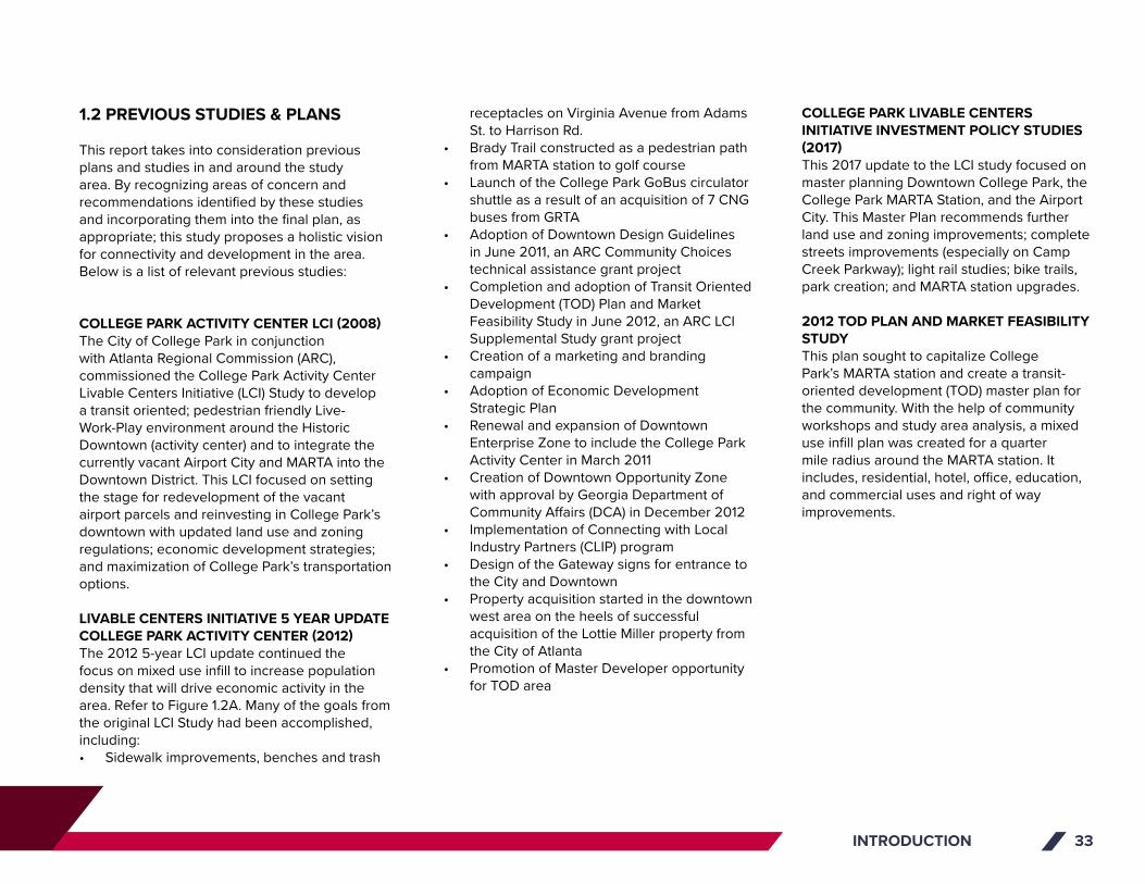
1.2 PREVIOUS STUDIES & PLANS
This report takes into consideration previous plans and studies in and around the study area. By recognizing areas of concern and recommendations identified by these studies and incorporating them into the final plan, as appropriate; this study proposes a holistic vision for connectivity and development in the area. Below is a list of relevant previous studies:
COLLEGE PARK ACTIVITY CENTER LCI (2008)The City of College Park in conjunction with Atlanta Regional Commission (ARC), commissioned the College Park Activity Center Livable Centers Initiative (LCI) Study to develop a transit oriented; pedestrian friendly Live-Work-Play environment around the Historic Downtown (activity center) and to integrate the currently vacant Airport City and MARTA into the Downtown District. This LCI focused on setting the stage for redevelopment of the vacant airport parcels and reinvesting in College Park’s downtown with updated land use and zoning regulations; economic development strategies; and maximization of College Park’s transportation options.
LIVABLE CENTERS INITIATIVE 5 YEAR UPDATE COLLEGE PARK ACTIVITY CENTER (2012)The 2012 5-year LCI update continued the focus on mixed use infill to increase population density that will drive economic activity in the area. Refer to Figure 1.2A. Many of the goals from the original LCI Study had been accomplished, including:• Sidewalk improvements, benches and trash
receptacles on Virginia Avenue from Adams St. to Harrison Rd.
• Brady Trail constructed as a pedestrian path from MARTA station to golf course
• Launch of the College Park GoBus circulator shuttle as a result of an acquisition of 7 CNG buses from GRTA
• Adoption of Downtown Design Guidelines in June 2011, an ARC Community Choices technical assistance grant project
• Completion and adoption of Transit Oriented Development (TOD) Plan and Market Feasibility Study in June 2012, an ARC LCI Supplemental Study grant project
• Creation of a marketing and branding campaign
• Adoption of Economic Development Strategic Plan
• Renewal and expansion of Downtown Enterprise Zone to include the College Park Activity Center in March 2011
• Creation of Downtown Opportunity Zone with approval by Georgia Department of Community Affairs (DCA) in December 2012
• Implementation of Connecting with Local Industry Partners (CLIP) program
• Design of the Gateway signs for entrance to the City and Downtown
• Property acquisition started in the downtown west area on the heels of successful acquisition of the Lottie Miller property from the City of Atlanta
• Promotion of Master Developer opportunity for TOD area
COLLEGE PARK LIVABLE CENTERS INITIATIVE INVESTMENT POLICY STUDIES (2017)This 2017 update to the LCI study focused on master planning Downtown College Park, the College Park MARTA Station, and the Airport City. This Master Plan recommends further land use and zoning improvements; complete streets improvements (especially on Camp Creek Parkway); light rail studies; bike trails, park creation; and MARTA station upgrades.
2012 TOD PLAN AND MARKET FEASIBILITY STUDYThis plan sought to capitalize College Park’s MARTA station and create a transit-oriented development (TOD) master plan for the community. With the help of community workshops and study area analysis, a mixed use infill plan was created for a quarter mile radius around the MARTA station. It includes, residential, hotel, office, education, and commercial uses and right of way improvements.
INTRODUCTION34
COLLEGE PARK REDEVELOPMENT PLAN TAX ALLOCATION DISTRICT #1 – DOWNTOWN AND AIRPORT GATEWAYS (2015)The study explored options to create a Tax Allocation District to support implementation of the City of College Park’s redevelopment efforts and previous plans. The TAD boundary includes Downtown College Park, Virginia Avenue and Camp Creek Parkway. The priorities addressed in this redevelopment plan were to:• Continue redevelopment and commercial expansion within Downtown College Park• Implement Transit Oriented Development around the MARTA Station• Invest in streetscape improvements and attract new commercial infill development along Main Street and Virginia Avenue• Attract new commercial/office development and jobs along Camp Creek Parkway and near the GICC• Replace population and housing losses associated with Airport Noise Reduction (ANR)
AEROTROPOLIS ATLANTA BLUEPRINT (2016)The Aerotropolis Atlanta Alliance (AAA), Aerotropolis CIDS, local governments, and the Atlanta Regional Commission (ARC) partnered to develop the Aerotropolis Atlanta Blueprint. This plan provides a strategic, overarching framework to guide growth and development for the next 5 years that leverages Hartsfield-Jackson Atlanta International Airport (HJAIA). This document is intended to serve as a resource for policymakers to help guide development decisions that further the economic and quality of life interests of the area.
CITY OF COLLEGE PARK COMPREHENSIVE PLAN 2016-2036 (2016)The City of College Park’s 20-year plan follows the Georgia Department of Community Affairs (DCA) Local Comprehensive Planning Framework. It addresses Housing, Economic Development, Transportation, Land Use, and Future Land Use elements. The primary goals of the Comprehensive Plan include: establishing Main Street and Virginia Avenue as Downtown College Park; becoming the Gateway to the Atlanta Region; linking College Park's neighborhoods to each other and the rest of the region; improving branding, arts, and infrastructure; and promote recreational opportunities and sustainability at the same time.
COLLEGE PARK REDEVELOPMENT PLAN TAX ALLOCATION DISTRICT #2 – OLD NATIONAL HIGHWAY CORRIDOR (2017)This Redevelopment Plan was prepared for the City of College Park to analyze the possibility of a second Tax Allocation District, called Old National Highway Corridor. The redevelopment area generally extends from Sullivan Road and the southerly side of Roosevelt Highway, southward to the City limits with Clayton County and the newly formed City of South Fulton. Five parcels to the north of Roosevelt Highway, totaling roughly 32 acres near Hathcock Road are also included.
TAD #2 will help to leverage higher property tax collections from the proposed retail, commercial, office and housing, developments, will increase the City’s existing property tax digest. This revenue increase will be captured through the TAD mechanism to incentivize redevelopment
and help finance needed infrastructure improvements, at no additional cost to College Park taxpayers.
AEROATL GREENWAY PLAN (2018)The AeroATL Greenway Plan was led by the Aerotropolis Atlanta Alliance (Alliance) and the Aerotropolis Atlanta AACIDs (CIDs). The study area includes HJAIA and the surrounding cities of East Point, Hapeville, Forest Park, College Park, South Fulton and portions of Fulton County and Clayton County, totaling approximately 48,000 acres. The AeroATL Greenway Plan provides a visionary framework for trail connectivity across the Aerotropolis region. The result is a true multi-modal network that will provide area residents, visitors, and workers with safe and enjoyable connectivity around the world’s busiest airport.
MARTA COLLEGE PARK STATION CONSTRUCTION PLANS (2019)MARTA is currently undertaking College Park Station Site Improvements and Retail Concession Infrastructure.
CITY OF COLLEGE PARK STORMWATER MANAGEMENT PROGRAM (2019)The City is embarking on stormwater bioretention, treatment, and management system improvements in the Airport City study area.

AEROATL GREENWAY PLANFIGURE 1.2B


FACTS & ANALYSIS 37

FACTS & ANALYSIS38
This section identifies existing study area conditions, including assets and opportunities, previous and current projects, existing land use, zoning, topography and hydrology, economic development tools, regulations and infrastructure, civil and transportation, and landscape conditions.
2.1 ASSETS & OPPORTUNITIES
Key assets and opportunities are identified in Figure 2.1a. Within the study area boundary there are very few remaining structures and active assets because most of the land was condemned by the Federal Aviation Administration. Following are key assets to consider in the planning process.
Wayman & Bessie Brady Recreation Center was built as the African-American recreation center for the City of College park and is a key part of the history of the City. It hosts after-school programs, open gym time, youth basketball, adult basketball leagues, youth camps, exercise classes, and an outdoor park area that can be used for events.
College Park Municipal Golf Course is a historic 9-hole golf course and driving range.
City of College Park Public Works building is located within the study area. The department is based in City Hall, but Public Works vehicles are stored at this location.
Outside of and adjacent to the study area, in the City of College Park, assets include:
Frank McClarin High School is a non-traditional high school as part of the Fulton County school system. About 200 students attend McClarin.
Woodward Academy is a private, K-12, college-preparatory located in both College Park, northeast of the study area.
Georgia International Convention Center (GICC) is the second largest convention center in Georgia, after the Georgia World Congress Center, and the only one directly connected to an airport.
Gateway Center @ College Park will be the home of the Skyhawks, the Atlanta Hawks NBA G League team. It will be a multi-purpose sports and entertainment venue. The Skyhawks will be the primary tenant when the venue opens in November 2019.
ATL SkyTrain is a free elevated train, which runs 24 hours a day between the HJAIA MARTA station, the GICC, and the Rental Car Center.
College Park Library is a branch of the Atlanta-Fulton Public Library System. It is a full-service library with classes for adults and children, story time, and a 60-person meeting room.
The Federal Aviation Administration Southern Region Regional Office is located just east of the College Park MARTA station.
Hartsfield-Jackson Atlanta International Airport (HJAIA) lies east of the study area. HJAIA is the world's busiest airport and with international terminal, domestic terminal and cargo access, the Airport City site is a prime location for anyone who requires easy access to air travel.
Downtown College Park/Main Street is part of the historic charm of the City. Local restaurants, businesses, and shops line Main Street in charming, architecturally unique buildings.
College Park Elementary School lies next to the study area, just east of the Brady Recreation Center. It is a public elementary school, serving over 700 children in grades Pre-K through 5th.
City of College Park and Airport MARTA Stations are both within the boundaries of the City of College Park, but outside of Airport City. They are the second to last and the last train stations on the Red and Gold MARTA public transit lines.
City of College Park Government can be found just east of the study area in Downtown College Park. This includes City Hall and the Public Safety building.
2.0 FACTS & ANALYSIS

!R
!R
!R
!R
!R
!R
!R
GEORGIA INTERNATIONAL CONVENTION CENTER
COLLEGE PARK CEMETERY
US FEDERAL AVIATION ADMINISTRATION
COLLEGE PARK BRANCH LIBRARY
COLLEGE PARK POLICE DEPARTMENT
BRADY RECREATION CENTER
COLLEGE PARK PUBLIC WORKS
WASHINGTON ROAD
I-85
STONE ROAD
HER
SCH
EL R
OA
D
RUGBY AVENUE
EAST
MAI
N S
TREE
T
VIRGINIA AVENUE
CAMP CREEK PARKWAY
MAI
N S
TREE
T
YALE AVENUE
CO
LLEG
E ST
REET
JANICE DRIVE
FAIRWAY DRIVE
TEMPLE AVENUE
WILLINGHAM DRIVE
LYLE ROAD
FRONTAGE ROAD
COLUMBIA AVENUE
HA
RRIS
DRI
VE
YATE
S RO
AD
REDWINE ROAD
ALE
CIR
CLE
HA
RRIS
ON
RO
AD
Glo
bal G
atew
ay C
onne
ctor
WEST LYLE AVENUE
LAKE SHORE DRIVE
MERCER AVENUE
CENTRAL AVENUE
LEE
STRE
ET
DUKE OF GLOUCESTER
HAWTHORNE AVENUE
MA
DIS
ON
STR
EETHARDIN AVENUE
VIC
TORI
A S
TREE
T CAMBRIDGE AVENUE
CH
ARL
ES D
RIV
E
MO
UN
T O
LIV
E RO
AD
DODSON DRIVE
DUNLAP AVENUE
PELOT DRIVE
PRINCETON AVENUE
HEM
PHIL
L ST
REET
RHO
DES
STR
EET
GLE
ND
A D
RIV
E
COLONIAL DRIVE
CENTER AVENUE
HARVARD AVENUE
BEST
RO
AD
ADAM
S ST
REET
ATLA
NTA
STR
EET
LAKEMONT DRIVE
JEFF
ERSO
N S
TREE
T
REDWINE AVENUE
PRINCETON DRIVE
CHARLESTOWN DRIVE
RUGBY LANE
YORK ROAD
PIER
CE
STRE
ET
ROOSEVELT H
IGHWAY
WEST VESTA AVENUE
SIR
HEN
RY S
TREE
TSU
N V
ALL
EY B
OU
LEVA
RD
CA
RRIA
GE
WAY
KARE
N R
OA
D
CHU
RCH
STR
EET
DO
GW
OO
D D
RIV
E
ROSS AVENUE
JOHN WESLEY AVENUE
BAC
HEL
OR
STRE
ET
EAST VESTA AVENUE
DEL
OW
E D
RIV
E
WILLIAM
SBURG DRIVE
WEST POINT AVENUE
PALM
SPR
ING
S D
RIV
E
AIRPORT DRIVE
BAYA
RD S
TREE
T
EAST
PO
INT
STRE
ET
MC
KEN
ZIE
ROA
D
SCEN
IC D
RIVE
BEECH D
RIVE
LAKE DRIVE
LAFA
YETT
E LA
NE
NA
POLE
ON
STR
EET
CA
LMER
CIR
CLE
PLAN
T ST
REET
DUKE OF WINDSOR
EAST FARRIS AVENUE
CO
NLE
Y ST
REET
PHILLIPS AVENUE
WEST RUGBY AVENUE
ARLINGTON ROAD
GREEN VALLEY DRIVE
WH
ITE
STRE
ET
POTOMAC DRIVE
PARK
VIE
W D
RIV
E
JON
ES S
TREE
T
ENGLISH LA
NE
JACK
SON
STR
EET
BOU
LDER
WAY
WEST POTOMAC DRIVE
SKYLINE DRIVE
FRED
ERIC
KSBU
RG D
RIV
E
LA R
OSE
STR
EET
WA
SHIN
GTO
N S
TREE
T
ROSS
DRI
VE WALKER AVENUE
BRIA
RWO
OD
BO
ULE
VARD
RIVERDALE RD CON
ARLEN
E ROA
D
WEST OGLETHORPE AVENUE
WEST JOHN CALVIN AVENUE
JACKSON DRIVE
LYLE TERRACE
FLO
WER
S D
RIV
E
OXFORD AVENUE
HAG
GER
WAY
HO
WA
RD D
RIV
E
DRESDEN TRAIL
WILLIAMS AVENUE
PENN
Y LA
NE
DESERT DRIVE
TOFF
IE T
ERRA
CE
HARVARD AVENUE
BLOSSOM LANE
CU
MBE
RLA
ND
RO
AD
ROOSEVELT STREET
REVERE COURT
ALM
AN
D D
RIV
E
SOU
TH T
ERM
INA
L PA
RKW
AY
AIRPORT B
OULEVARD
CA
LVIN
CO
URT
EARL GODFREY LANE
LOW
ND
ES S
TREE
T
I-85 NB RAMP
BATTERY WAY
POTO
MAC
TER
RACE
POLL
ARD
STR
EET
CLO
VER
HU
RST
CIR
CLE
PALMOUR CT
MO
CKI
NG
BIRD
LA
NE
REED
STR
EET
ODELL WAY
GOLF VIEW DRIVE
MYRTLE LANE
CAROL COURT
PERKINS D
RIVE
JOHN CALVIN AVENUE
FORT
NER
STR
EET
MO
NRO
E ST
REET
STONETREE APTS
CHASE COURT
BRIAR C
OU
RT
WALKER AVENUE
NO
NA
ME
ROA
D
ATLA
NTA
STR
EET
WALKER AVENUE
JAC
KSO
N S
TREE
T
NA
POLE
ON
STR
EET
PRINCETON AVENUE
CAMP CREEK PARKWAY
I-85
RUGBY AVENUE
NO NAME ROAD
COLUMBIA AVENUE
ROO
SEV
ELT
HIG
HW
AY
HAR
RIS
DRI
VE
AIRPORT LOOP ROAD
MERCER AVENUEMERCER AVENUE
LEE
STRE
ET
WEST POINT AVENUE
SOUTH TERMINAL PKWY
CA
R RE
NTA
L RO
W N
B
S TERMINAL PKWY
ACCE
SS R
D
NORTH TERMINAL PKWY
CROSSWIND RD
AIRPORT CIR
GATEWAY BLVD
ACCESS RDNORTH
TERM
INAL P
KWY
WOODLAND MIDDLE SCHOOL
FRANK MCCLARIN HIGH SCHOOL
COLLEGE PARK ELEMENTARY SCHOOL
ASA G. HILLIARD ELEMENTRY SCHOOL
WOODWARD ACADEMY
THE MAIN STREET ACADEMY
Airport
College Park
SYKES PARK
COLLEGE PARK MUNICIPAL GOLF COURSE
BARRETT PARK
BRADY RECREATION CENTER PARK
BILL EVANS FIELD
WOODLAND FIELD
BRANNON MEMORIAL PARK
Jamestown Park
JOHN D. MILNER YOUTH SPORTS FACILITY
Camp Creek
North Fork Camp Creek
SCHOOLS
LANDMARKS
TRANSIT RAIL STATIONS
MARTA RAIL LINES
RIVERS & STREAMS
AIRPORT
ROADS
LAKES/PONDS
PARKS
COUNTIES
COLLEGE PARK HISTORIC DISTRICT
PROPOSED TRAILS AEROATL GREENWAY PLAN 2018:LOCAL CONNECTIONS
EXISTING TRAILS
ATL SKYTRAIN
STUDY AREA PARCELS
PARCELS
PROPOSED TRAILSAEROATL GREENWAY PLAN 2018:MASTER FRAMEWORK
MAIN STREET/DOWNTOWN COLLEGE PARK
STUDY AREA BOUNDARY
LEGEND
ASSETS & OPPORTUNITIESSchools, Parks, Community Facilities, Landmarks, & Trails
0 800 1,600 2,400 3,200400FEET
!R
STUDY AREA ASSETS MAPFIGURE 2.1A
COMPOSTAREA
WASHINGTON ROAD
I-85
STONE ROAD
HER
SCH
EL R
OA
D
RUGBY AVENUE
EAST
MAI
N S
TREE
T
VIRGINIA AVENUE
CAMP CREEK PARKWAY
MAI
N S
TREE
T
YALE AVENUE
CO
LLEG
E ST
REET
JANICE DRIVE
FAIRWAY DRIVE
TEMPLE AVENUE
WILLINGHAM DRIVE
LYLE ROAD
FRONTAGE ROAD
COLUMBIA AVENUE
HA
RRIS
DRI
VE
YATE
S RO
AD
REDWINE ROAD
ALE
CIR
CLE
HA
RRIS
ON
RO
AD
Glo
bal G
atew
ay C
onne
ctor
WEST LYLE AVENUE
LAKE SHORE DRIVE
MERCER AVENUE
CENTRAL AVENUE
LEE
STRE
ET
DUKE OF GLOUCESTER
HAWTHORNE AVENUE
MA
DIS
ON
STR
EETHARDIN AVENUE
VIC
TORI
A S
TREE
T CAMBRIDGE AVENUE
CH
ARL
ES D
RIV
E
MO
UN
T O
LIV
E RO
AD
DODSON DRIVE
DUNLAP AVENUE
PELOT DRIVE
PRINCETON AVENUE
HEM
PHIL
L ST
REET
RHO
DES
STR
EET
GLE
ND
A D
RIV
E
COLONIAL DRIVE
CENTER AVENUE
WEST HARVARD AVENUE
BEST
RO
AD
ADAM
S ST
REET
ATLA
NTA
STR
EET
LAKEMONT DRIVE
JEFF
ERSO
N S
TREE
T
REDWINE AVENUE
PRINCETON DRIVE
CHARLESTOWN DRIVE
RUGBY LANE
YORK ROAD
PIER
CE
STRE
ET
ROOSEVELT H
IGHWAY
WEST VESTA AVENUE
SIR
HEN
RY S
TREE
TSU
N V
ALL
EY B
OU
LEVA
RD
CA
RRIA
GE
WAY
KARE
N R
OA
D
CHU
RCH
STR
EET
DO
GW
OO
D D
RIV
E
ROSS AVENUE
JOHN WESLEY AVENUE
BAC
HEL
OR
STRE
ET
EAST VESTA AVENUE
DEL
OW
E D
RIV
E
WILLIAM
SBURG DRIVE
WEST POINT AVENUE
PALM
SPR
ING
S D
RIV
E
NORTHWEST DRIVE
BAYA
RD S
TREE
T
EAST
PO
INT
STRE
ET
MC
KEN
ZIE
ROA
D
SCEN
IC D
RIVE
BEECH D
RIVE
LAKE DRIVE
LAFA
YETT
E LA
NE
NA
POLE
ON
STR
EET
CA
LMER
CIR
CLE
PLAN
T ST
REET
DUKE OF WINDSOR
EAST FARRIS AVENUE
CO
NLE
Y ST
REET
PHILLIPS AVENUE
WEST RUGBY AVENUE
ARLINGTON ROAD
GREEN VALLEY DRIVE
WH
ITE
STRE
ET
POTOMAC DRIVE
PARK
VIE
W D
RIV
E
JON
ES S
TREE
T
ENGLISH LA
NE
JACK
SON
STR
EET
BOU
LDER
WAY
WEST POTOMAC DRIVE
SKYLINE DRIVE
FRED
ERIC
KSBU
RG D
RIV
E
LA R
OSE
STR
EET
WA
SHIN
GTO
N S
TREE
T
ROSS
DRI
VE WALKER AVENUE
BRIA
RWO
OD
BO
ULE
VARD
RIVERDALE RD CON
ARLEN
E ROA
D
WEST OGLETHORPE AVENUE
WEST JOHN CALVIN AVENUE
JACKSON DRIVE
LYLE TERRACE
FLO
WER
S D
RIV
E
OXFORD AVENUE
HAG
GER
WAY
HO
WA
RD D
RIV
E
DRESDEN TRAIL
WILLIAMS AVENUE
PENN
Y LA
NE
DESERT DRIVE
TOFF
IE T
ERRA
CE
HARVARD AVENUE
BLOSSOM LANE
CU
MBE
RLA
ND
RO
AD
ROOSEVELT STREET
REVERE COURT
ALM
AN
D D
RIV
E
SOU
TH T
ERM
INA
L PA
RKW
AY
AIRPORT B
OULEVARD
CA
LVIN
CO
URT
EARL GODFREY LANE
LOW
ND
ES S
TREE
T
I-85 NB RAMP
BATTERY WAY
POTO
MAC
TER
RACE
POLL
ARD
STR
EET
CLO
VER
HU
RST
CIR
CLE
PALMOUR CT
MO
CKI
NG
BIRD
LA
NE
REED
STR
EET
ODELL WAY
GOLF VIEW DRIVE
MYRTLE LANE
CAROL COURT PERKINS D
RIVE
JOHN CALVIN AVENUE
FORT
NER
STR
EET
MO
NRO
E ST
REET
STONETREE APTS
CHASE COURT
BRIAR C
OU
RT
WALKER AVENUE
ATLA
NTA
STR
EET
WALKER AVENUE
JAC
KSO
N S
TREE
T
NA
POLE
ON
STR
EET
PRINCETON AVENUE
I-85
RUGBY AVENUE
NO NAME ROAD
COLUMBIA AVENUE
ROO
SEV
ELT
HIG
HW
AY
HAR
RIS
DRI
VE
AIRPORT LOOP ROAD
MERCER AVENUEMERCER AVENUE
LEE
STRE
ET
WEST POINT AVENUE
SOUTH TERMINAL PKWY
CA
R RE
NTA
L RO
W N
B
S TERMINAL PKWY
ACCE
SS R
D
NORTH TERMINAL PKWY
CROSSWIND RD
AIRPORT CIR
GATEWAY BLVD
ACCESS RD
NORTH TE
RMIN
AL PKW
Y
Airport
College Park
SYKES PARK
COLLEGE PARK MUNICIPAL GOLF COURSE
BARRETT PARK
BRADY RECREATION CENTER PARK
BILL EVANS FIELD
WOODLAND FIELD
BRANNON MEMORIAL PARK
Jamestown Park
JOHN D. MILNER YOUTH SPORTS FACILITY
Camp Creek
North Fork Camp Creek
Source: Esri, DigitalGlobe, GeoEye, Earthstar Geographics, CNES/Airbus DS, USDA, USGS, AeroGRID, IGN, and the GIS User Community
CONNECTION
CONNECTION
BRADY TRAIL
STREETSCAPE IMPROVEMENTS
STREETSCAPE IMPROVEMENTS
STREETSCAPE IMPROVEMENTS
CITY HALL PARK
GATEWAY SIGN
PEDESTRIAN BRIDGE
1
7
6
1
5
14
10
12
8
9
5
4
3
2
9
12
10
2
8
3
PROPOSED RESIDENTIAL
DEVELOPMENT
BRADYRECREATION CENTER
RENOVATIONS
WALLY PARK (P)
18FOLIA GROUP
DEVELOPMENT
THE PAD ON HARVARD
PRINCETONVILLAGE
MARTA TOD, PEDESTRIAN IMPROVEMENTS,
RETAIL CONCOURSE
TERMINALEXPANSION
OFFICE/MIXED USE
TRAVEL PLAZA & CV LOT
TERMINAL IMPROVEMENTS6
STATION IMPROVEMENTS
7
HOTEL
PROPOSED PARKING DECK
11
13HAWKSARENA
HOTELS
HOTEL
16BMW
11
4
15
17HOTEL
19 1
1
4
4
2
3
6
5
PREVIOUS & CURRENT PROJECTSCOMPLETED, UNDERGOING, AND UPCOMING PROJECTS UNDER DEVELOPMENT, INFRASRUCTURE, AND UTILITIES
0 800 1,600 2,400 3,200400FEET
COMPOSTAREA
WASHINGTON ROAD
I-85
STONE ROAD
HER
SCH
EL R
OA
D
RUGBY AVENUE
EAST
MAI
N S
TREE
T
VIRGINIA AVENUE
CAMP CREEK PARKWAY
MAI
N S
TREE
T
YALE AVENUE
CO
LLEG
E ST
REET
JANICE DRIVE
FAIRWAY DRIVE
TEMPLE AVENUE
WILLINGHAM DRIVE
LYLE ROAD
FRONTAGE ROAD
COLUMBIA AVENUE
HA
RRIS
DRI
VE
YATE
S RO
AD
REDWINE ROAD
ALE
CIR
CLE
HA
RRIS
ON
RO
AD
Glo
bal G
atew
ay C
onne
ctor
WEST LYLE AVENUE
LAKE SHORE DRIVE
MERCER AVENUE
CENTRAL AVENUE
LEE
STRE
ET
DUKE OF GLOUCESTER
HAWTHORNE AVENUE
MA
DIS
ON
STR
EETHARDIN AVENUE
VIC
TORI
A S
TREE
T CAMBRIDGE AVENUE
CH
ARL
ES D
RIV
E
MO
UN
T O
LIV
E RO
AD
DODSON DRIVE
DUNLAP AVENUE
PELOT DRIVE
PRINCETON AVENUE
HEM
PHIL
L ST
REET
RHO
DES
STR
EET
GLE
ND
A D
RIV
E
COLONIAL DRIVE
CENTER AVENUE
WEST HARVARD AVENUE
BEST
RO
AD
ADAM
S ST
REET
ATLA
NTA
STR
EET
LAKEMONT DRIVE
JEFF
ERSO
N S
TREE
T
REDWINE AVENUE
PRINCETON DRIVE
CHARLESTOWN DRIVE
RUGBY LANE
YORK ROAD
PIER
CE
STRE
ET
ROOSEVELT H
IGHWAY
WEST VESTA AVENUE
SIR
HEN
RY S
TREE
TSU
N V
ALL
EY B
OU
LEVA
RD
CA
RRIA
GE
WAY
KARE
N R
OA
D
CHU
RCH
STR
EET
DO
GW
OO
D D
RIV
E
ROSS AVENUE
JOHN WESLEY AVENUE
BAC
HEL
OR
STRE
ET
EAST VESTA AVENUE
DEL
OW
E D
RIV
E
WILLIAM
SBURG DRIVE
WEST POINT AVENUE
PALM
SPR
ING
S D
RIV
E
NORTHWEST DRIVE
BAYA
RD S
TREE
T
EAST
PO
INT
STRE
ET
MC
KEN
ZIE
ROA
D
SCEN
IC D
RIVE
BEECH D
RIVE
LAKE DRIVE
LAFA
YETT
E LA
NE
NA
POLE
ON
STR
EET
CA
LMER
CIR
CLE
PLAN
T ST
REET
DUKE OF WINDSOR
EAST FARRIS AVENUE
CO
NLE
Y ST
REET
PHILLIPS AVENUE
WEST RUGBY AVENUE
ARLINGTON ROAD
GREEN VALLEY DRIVE
WH
ITE
STRE
ET
POTOMAC DRIVE
PARK
VIE
W D
RIV
E
JON
ES S
TREE
T
ENGLISH LA
NE
JACK
SON
STR
EET
BOU
LDER
WAY
WEST POTOMAC DRIVE
SKYLINE DRIVE
FRED
ERIC
KSBU
RG D
RIV
E
LA R
OSE
STR
EET
WA
SHIN
GTO
N S
TREE
T
ROSS
DRI
VE WALKER AVENUE
BRIA
RWO
OD
BO
ULE
VARD
RIVERDALE RD CON
ARLEN
E ROA
D
WEST OGLETHORPE AVENUE
WEST JOHN CALVIN AVENUE
JACKSON DRIVE
LYLE TERRACE
FLO
WER
S D
RIV
E
OXFORD AVENUE
HAG
GER
WAY
HO
WA
RD D
RIV
E
DRESDEN TRAIL
WILLIAMS AVENUE
PENN
Y LA
NE
DESERT DRIVE
TOFF
IE T
ERRA
CE
HARVARD AVENUE
BLOSSOM LANE
CU
MBE
RLA
ND
RO
AD
ROOSEVELT STREET
REVERE COURT
ALM
AN
D D
RIV
E
SOU
TH T
ERM
INA
L PA
RKW
AY
AIRPORT B
OULEVARD
CA
LVIN
CO
URT
EARL GODFREY LANE
LOW
ND
ES S
TREE
T
I-85 NB RAMP
BATTERY WAY
POTO
MAC
TER
RACE
POLL
ARD
STR
EET
CLO
VER
HU
RST
CIR
CLE
PALMOUR CT
MO
CKI
NG
BIRD
LA
NE
REED
STR
EET
ODELL WAY
GOLF VIEW DRIVE
MYRTLE LANE
CAROL COURT PERKINS D
RIVE
JOHN CALVIN AVENUE
FORT
NER
STR
EET
MO
NRO
E ST
REET
STONETREE APTS
CHASE COURT
BRIAR C
OU
RT
WALKER AVENUE
ATLA
NTA
STR
EET
WALKER AVENUE
JAC
KSO
N S
TREE
T
NA
POLE
ON
STR
EET
PRINCETON AVENUE
I-85
RUGBY AVENUE
NO NAME ROAD
COLUMBIA AVENUE
ROO
SEV
ELT
HIG
HW
AY
HAR
RIS
DRI
VE
AIRPORT LOOP ROAD
MERCER AVENUEMERCER AVENUE
LEE
STRE
ET
WEST POINT AVENUE
SOUTH TERMINAL PKWY
CA
R RE
NTA
L RO
W N
B
S TERMINAL PKWY
ACCE
SS R
D
NORTH TERMINAL PKWY
CROSSWIND RD
AIRPORT CIR
GATEWAY BLVD
ACCESS RD
NORTH TE
RMIN
AL PKW
YAirport
College Park
SYKES PARK
COLLEGE PARK MUNICIPAL GOLF COURSE
BARRETT PARK
BRADY RECREATION CENTER PARK
BILL EVANS FIELD
WOODLAND FIELD
BRANNON MEMORIAL PARK
Jamestown Park
JOHN D. MILNER YOUTH SPORTS FACILITY
Camp Creek
North Fork Camp Creek
Source: Esri, DigitalGlobe, GeoEye, Earthstar Geographics, CNES/Airbus DS, USDA, USGS, AeroGRID, IGN, and the GIS User Community
CONNECTION
CONNECTION
BRADY TRAIL
STREETSCAPE IMPROVEMENTS
STREETSCAPE IMPROVEMENTS
STREETSCAPE IMPROVEMENTS
CITY HALL PARK
GATEWAY SIGN
PEDESTRIAN BRIDGE
1
7
6
1
5
14
10
12
8
9
5
4
3
2
9
12
10
2
8
3
PROPOSED RESIDENTIAL
DEVELOPMENT
BRADYRECREATION CENTER
RENOVATIONS
WALLY PARK (P)
18FOLIA GROUP
DEVELOPMENT
THE PAD ON HARVARD
PRINCETONVILLAGE
MARTA TOD, PEDESTRIAN IMPROVEMENTS,
RETAIL CONCOURSE
TERMINALEXPANSION
OFFICE/MIXED USE
TRAVEL PLAZA & CV LOT
TERMINAL IMPROVEMENTS6
STATION IMPROVEMENTS
7
HOTEL
PROPOSED PARKING DECK
11
13HAWKSARENA
HOTELS
HOTEL
16BMW
11
4
15
17HOTEL
19 1
1
4
4
2
3
6
5
TRANSIT RAIL STATIONS
MARTA RAIL LINES
RIVERS & STREAMS
ROADS
LAKES/PONDS
PARKS
COUNTIES
STUDY AREA BOUNDARY
STUDY AREA PARCELS
PARCELS
INFRASTRUCTURE
LEGEND
PREVIOUS & CURRENT PROJECTSCOMPLETED, UNDERGOING, AND UPCOMING PROJECTS UNDER DEVELOPMENT, INFRASRUCTURE, AND UTILITIES
0 800 1,600 2,400 3,200400FEET
- COLLEGE PARK LIVABLE CENTERS INITIATIVE INVESTMENT POLICY STUDIES, AUGUST 2017- CITY OF COLLEGE PARK
BOLD LINES: EXISTING DASHED LINES: PROPOSED
MAP KEY
SOURCES:
STUDY AREA PROJECTS STATUS MAPFIGURE 2.2A
TRANSIT RAIL STATIONS
MARTA RAIL LINES
RIVERS & STREAMS
ROADS
LAKES/PONDS
PARKS
COUNTIES
STUDY AREA BOUNDARY
STUDY AREA PARCELS
PARCELS
INFRASTRUCTURE
LEGEND
PREVIOUS & CURRENT PROJECTSCOMPLETED, UNDERGOING, AND UPCOMING PROJECTS UNDER DEVELOPMENT, INFRASRUCTURE, AND UTILITIES
0 800 1,600 2,400 3,200400FEET
- COLLEGE PARK LIVABLE CENTERS INITIATIVE INVESTMENT POLICY STUDIES, AUGUST 2017- CITY OF COLLEGE PARK
BOLD LINES: EXISTING DASHED LINES: PROPOSED
MAP KEY
SOURCES:

FACTS & ANALYSIS 41
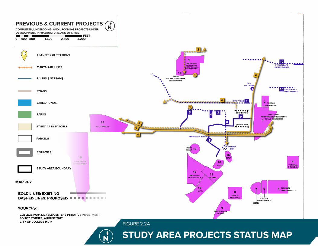
2.2 STUDY AREA PROJECT STATUS
Utility, infrastructure, and development projects are displayed in Figure 2.2a. The Airport City master plan aims to be a holistic and thoughtful development, so it is critical to consider all current and future projects in the area. The developments highlighted in pink include private, transit, and airport endeavors. Infrastructure projects in dark purple are mostly right of way and water management related. Essential utilities are shown in yellow.
COMPOSTAREA
WASHINGTON ROAD
I-85
STONE ROAD
HER
SCH
EL R
OA
D
RUGBY AVENUE
EAST
MAI
N S
TREE
T
VIRGINIA AVENUE
CAMP CREEK PARKWAY
MAI
N S
TREE
T
YALE AVENUE
CO
LLEG
E ST
REET
JANICE DRIVE
FAIRWAY DRIVE
TEMPLE AVENUE
WILLINGHAM DRIVE
LYLE ROAD
FRONTAGE ROAD
COLUMBIA AVENUE
HA
RRIS
DRI
VE
YATE
S RO
AD
REDWINE ROAD
ALE
CIR
CLE
HA
RRIS
ON
RO
AD
Glo
bal G
atew
ay C
onne
ctor
WEST LYLE AVENUE
LAKE SHORE DRIVE
MERCER AVENUE
CENTRAL AVENUE
LEE
STRE
ET
DUKE OF GLOUCESTER
HAWTHORNE AVENUE
MA
DIS
ON
STR
EETHARDIN AVENUE
VIC
TORI
A S
TREE
T CAMBRIDGE AVENUE
CH
ARL
ES D
RIV
E
MO
UN
T O
LIV
E RO
AD
DODSON DRIVE
DUNLAP AVENUE
PELOT DRIVE
PRINCETON AVENUE
HEM
PHIL
L ST
REET
RHO
DES
STR
EET
GLE
ND
A D
RIV
E
COLONIAL DRIVE
CENTER AVENUE
WEST HARVARD AVENUE
BEST
RO
AD
ADAM
S ST
REET
ATLA
NTA
STR
EET
LAKEMONT DRIVE
JEFF
ERSO
N S
TREE
T
REDWINE AVENUE
PRINCETON DRIVE
CHARLESTOWN DRIVE
RUGBY LANE
YORK ROAD
PIER
CE
STRE
ET
ROOSEVELT H
IGHWAY
WEST VESTA AVENUE
SIR
HEN
RY S
TREE
TSU
N V
ALL
EY B
OU
LEVA
RD
CA
RRIA
GE
WAY
KARE
N R
OA
D
CHU
RCH
STR
EET
DO
GW
OO
D D
RIV
E
ROSS AVENUE
JOHN WESLEY AVENUE
BAC
HEL
OR
STRE
ET
EAST VESTA AVENUE
DEL
OW
E D
RIV
E
WILLIAM
SBURG DRIVE
WEST POINT AVENUE
PALM
SPR
ING
S D
RIV
E
NORTHWEST DRIVE
BAYA
RD S
TREE
T
EAST
PO
INT
STRE
ET
MC
KEN
ZIE
ROA
D
SCEN
IC D
RIVE
BEECH D
RIVE
LAKE DRIVE
LAFA
YETT
E LA
NE
NA
POLE
ON
STR
EET
CA
LMER
CIR
CLE
PLAN
T ST
REET
DUKE OF WINDSOR
EAST FARRIS AVENUE
CO
NLE
Y ST
REET
PHILLIPS AVENUE
WEST RUGBY AVENUE
ARLINGTON ROAD
GREEN VALLEY DRIVE
WH
ITE
STRE
ET
POTOMAC DRIVE
PARK
VIE
W D
RIV
E
JON
ES S
TREE
T
ENGLISH LA
NE
JACK
SON
STR
EET
BOU
LDER
WAY
WEST POTOMAC DRIVE
SKYLINE DRIVE
FRED
ERIC
KSBU
RG D
RIV
E
LA R
OSE
STR
EET
WA
SHIN
GTO
N S
TREE
T
ROSS
DRI
VE WALKER AVENUE
BRIA
RWO
OD
BO
ULE
VARD
RIVERDALE RD CON
ARLEN
E ROA
D
WEST OGLETHORPE AVENUE
WEST JOHN CALVIN AVENUE
JACKSON DRIVE
LYLE TERRACE
FLO
WER
S D
RIV
E
OXFORD AVENUE
HAG
GER
WAY
HO
WA
RD D
RIV
E
DRESDEN TRAIL
WILLIAMS AVENUE
PENN
Y LA
NEDESERT DRIVE
TOFF
IE T
ERRA
CE
HARVARD AVENUE
BLOSSOM LANE
CU
MBE
RLA
ND
RO
AD
ROOSEVELT STREET
REVERE COURT
ALM
AN
D D
RIV
E
SOU
TH T
ERM
INA
L PA
RKW
AY
AIRPORT B
OULEVARD
CA
LVIN
CO
URT
EARL GODFREY LANE
LOW
ND
ES S
TREE
T
I-85 NB RAMP
BATTERY WAY
POTO
MAC
TER
RACE
POLL
ARD
STR
EET
CLO
VER
HU
RST
CIR
CLE
PALMOUR CT
MO
CKI
NG
BIRD
LA
NE
REED
STR
EET
ODELL WAY
GOLF VIEW DRIVE
MYRTLE LANECAROL COURT PERKIN
S DRIV
E
JOHN CALVIN AVENUE
FORT
NER
STR
EET
MO
NRO
E ST
REET
STONETREE APTS
CHASE COURT
BRIAR C
OU
RT
WALKER AVENUE
ATLA
NTA
STR
EET
WALKER AVENUE
JAC
KSO
N S
TREE
T
NA
POLE
ON
STR
EET
PRINCETON AVENUE
I-85
RUGBY AVENUE
NO NAME ROAD
COLUMBIA AVENUE
ROO
SEV
ELT
HIG
HW
AY
HAR
RIS
DRI
VE
AIRPORT LOOP ROAD
MERCER AVENUEMERCER AVENUE
LEE
STRE
ET
WEST POINT AVENUE
SOUTH TERMINAL PKWY
CA
R RE
NTA
L RO
W N
B
S TERMINAL PKWY
ACCE
SS R
D
NORTH TERMINAL PKWY
CROSSWIND RD
AIRPORT CIR
GATEWAY BLVD
ACCESS RD
NORTH TE
RMIN
AL PKW
YAirport
College Park
SYKES PARK
COLLEGE PARK MUNICIPAL GOLF COURSE
BARRETT PARK
BRADY RECREATION CENTER PARK
BILL EVANS FIELD
WOODLAND FIELD
BRANNON MEMORIAL PARK
Jamestown Park
JOHN D. MILNER YOUTH SPORTS FACILITY
Camp Creek
North Fork Camp Creek
Source: Esri, DigitalGlobe, GeoEye, Earthstar Geographics, CNES/Airbus DS, USDA, USGS, AeroGRID, IGN, and the GIS User Community
CONNECTION
CONNECTION
BRADY TRAIL
STREETSCAPE IMPROVEMENTS
STREETSCAPE IMPROVEMENTS
STREETSCAPE IMPROVEMENTS
CITY HALL PARK
GATEWAY SIGN
PEDESTRIAN BRIDGE
1
7
6
1
5
14
10
12
8
9
5
4
3
2
9
12
10
2
8
3
PROPOSED RESIDENTIAL
DEVELOPMENT
BRADYRECREATION CENTER
RENOVATIONS
WALLY PARK (P)
18FOLIA GROUP
DEVELOPMENT
THE PAD ON HARVARD
PRINCETONVILLAGE
MARTA TOD, PEDESTRIAN IMPROVEMENTS,
RETAIL CONCOURSE
TERMINALEXPANSION
OFFICE/MIXED USE
TRAVEL PLAZA & CV LOT
TERMINAL IMPROVEMENTS6
STATION IMPROVEMENTS
7
HOTEL
PROPOSED PARKING DECK
11
13HAWKSARENA
HOTELS
HOTEL
16BMW
11
4
15
17HOTEL
19 1
1
4
4
2
3
6
5
TRANSIT RAIL STATIONS
MARTA RAIL LINES
RIVERS & STREAMS
ROADS
LAKES/PONDS
PARKS
COUNTIES
STUDY AREA BOUNDARY
STUDY AREA PARCELS
PARCELS
1 PROPOSED RESIDENTIAL DEVELOPMENT2 THE PAD ON HARVARD3 MARTA TOD, PEDESTRIAN IMPROVEMENTS, RETAIL CONCOURSE4 TERMINAL EXPANSION5 TERMINAL IMPROVEMENTS6 STATION IMPROVEMENTS7 HOTEL8 OFFICE/MIXED USE9 TRAVEL PLAZA & CV LOT10 HOTEL11 HOTELS12 PROPOSED PARKING DECK13 HAWKS ARENA14 WALLY PARK (P)15 PRINCETON VILLAGE16 BMW17 AC MARRIOTT HOTEL18 FOLIA GROUP DEVELOPMENT19 BRADY RECREATION CENTER RENOVATIONS
DEVELOPMENT
1 CITY HALL PARK2 EAST TO WEST TRAIL - BRADY TRAIL3 COLUMBIA AVENUE IMPROVEMENTS4 WATER DETENTION POND5 RHODES STREET EXTENSION (SPLOST)6 PEDESTRIAN BRIDGE7 BREAKAWAY GATEWAY SIGN - CONLEY STREET IMPROVEMENTS8 CONLEY STREET IMPROVEMENTS9 GICC-MARTA PATHWAY10 TEMPLE AVENUE: EAST WEST CONNECTIVITY PROJECT11 VIRGINIA AVENUE SIDEWALK ENHANCEMENTS12 VIRGINIA AVENUE: EAST WEST CONNECTIVITY PROJECT
INFRASTRUCTURE
LEGEND
PREVIOUS & CURRENT PROJECTSCOMPLETED, UNDERGOING, AND UPCOMING PROJECTS UNDER DEVELOPMENT, INFRASRUCTURE, AND UTILITIES
0 800 1,600 2,400 3,200400FEET
1 GROUND WATER WELL2 TWELVE INCH (12”) WATER LINE3 FIBER OPTICS CABLE CONNECTION4 JET FUEL LINE5 FIBER OPTICS CABLE CONNECTION6 FIBER OPTICS CABLE CONNECTION
UTILITIES
- COLLEGE PARK LIVABLE CENTERS INITIATIVE INVESTMENT POLICY STUDIES, AUGUST 2017- CITY OF COLLEGE PARK
BOLD LINES: EXISTING DASHED LINES: PROPOSED
MAP KEY
SOURCES:
COMPOSTAREA
WASHINGTON ROAD
I-85
STONE ROAD
HER
SCH
EL R
OA
D
RUGBY AVENUE
EAST
MAI
N S
TREE
T
VIRGINIA AVENUE
CAMP CREEK PARKWAY
MAI
N S
TREE
T
YALE AVENUE
CO
LLEG
E ST
REET
JANICE DRIVE
FAIRWAY DRIVE
TEMPLE AVENUE
WILLINGHAM DRIVE
LYLE ROAD
FRONTAGE ROAD
COLUMBIA AVENUE
HA
RRIS
DRI
VE
YATE
S RO
AD
REDWINE ROAD
ALE
CIR
CLE
HA
RRIS
ON
RO
AD
Glo
bal G
atew
ay C
onne
ctor
WEST LYLE AVENUE
LAKE SHORE DRIVE
MERCER AVENUE
CENTRAL AVENUE
LEE
STRE
ET
DUKE OF GLOUCESTER
HAWTHORNE AVENUE
MA
DIS
ON
STR
EETHARDIN AVENUE
VIC
TORI
A S
TREE
T CAMBRIDGE AVENUE
CH
ARL
ES D
RIV
E
MO
UN
T O
LIV
E RO
AD
DODSON DRIVE
DUNLAP AVENUE
PELOT DRIVE
PRINCETON AVENUE
HEM
PHIL
L ST
REET
RHO
DES
STR
EET
GLE
ND
A D
RIV
E
COLONIAL DRIVE
CENTER AVENUE
WEST HARVARD AVENUE
BEST
RO
AD
ADAM
S ST
REET
ATLA
NTA
STR
EET
LAKEMONT DRIVE
JEFF
ERSO
N S
TREE
T
REDWINE AVENUE
PRINCETON DRIVE
CHARLESTOWN DRIVE
RUGBY LANE
YORK ROAD
PIER
CE
STRE
ET
ROOSEVELT H
IGHWAY
WEST VESTA AVENUE
SIR
HEN
RY S
TREE
TSU
N V
ALL
EY B
OU
LEVA
RD
CA
RRIA
GE
WAY
KARE
N R
OA
D
CHU
RCH
STR
EET
DO
GW
OO
D D
RIV
E
ROSS AVENUE
JOHN WESLEY AVENUE
BAC
HEL
OR
STRE
ET
EAST VESTA AVENUE
DEL
OW
E D
RIV
E
WILLIAM
SBURG DRIVE
WEST POINT AVENUE
PALM
SPR
ING
S D
RIV
E
NORTHWEST DRIVE
BAYA
RD S
TREE
T
EAST
PO
INT
STRE
ET
MC
KEN
ZIE
ROA
D
SCEN
IC D
RIVE
BEECH D
RIVE
LAKE DRIVE
LAFA
YETT
E LA
NE
NA
POLE
ON
STR
EET
CA
LMER
CIR
CLE
PLAN
T ST
REET
DUKE OF WINDSOR
EAST FARRIS AVENUE
CO
NLE
Y ST
REET
PHILLIPS AVENUE
WEST RUGBY AVENUE
ARLINGTON ROAD
GREEN VALLEY DRIVE
WH
ITE
STRE
ET
POTOMAC DRIVE
PARK
VIE
W D
RIV
E
JON
ES S
TREE
T
ENGLISH LA
NE
JACK
SON
STR
EET
BOU
LDER
WAY
WEST POTOMAC DRIVE
SKYLINE DRIVE
FRED
ERIC
KSBU
RG D
RIV
E
LA R
OSE
STR
EET
WA
SHIN
GTO
N S
TREE
T
ROSS
DRI
VE WALKER AVENUE
BRIA
RWO
OD
BO
ULE
VARD
RIVERDALE RD CON
ARLEN
E ROA
D
WEST OGLETHORPE AVENUE
WEST JOHN CALVIN AVENUE
JACKSON DRIVE
LYLE TERRACE
FLO
WER
S D
RIV
E
OXFORD AVENUE
HAG
GER
WAY
HO
WA
RD D
RIV
E
DRESDEN TRAIL
WILLIAMS AVENUE
PENN
Y LA
NE
DESERT DRIVE
TOFF
IE T
ERRA
CE
HARVARD AVENUE
BLOSSOM LANE
CU
MBE
RLA
ND
RO
AD
ROOSEVELT STREET
REVERE COURT
ALM
AN
D D
RIV
E
SOU
TH T
ERM
INA
L PA
RKW
AY
AIRPORT B
OULEVARD
CA
LVIN
CO
URT
EARL GODFREY LANE
LOW
ND
ES S
TREE
T
I-85 NB RAMP
BATTERY WAY
POTO
MAC
TER
RACE
POLL
ARD
STR
EET
CLO
VER
HU
RST
CIR
CLE
PALMOUR CT
MO
CKI
NG
BIRD
LA
NE
REED
STR
EET
ODELL WAY
GOLF VIEW DRIVE
MYRTLE LANE
CAROL COURT PERKINS D
RIVE
JOHN CALVIN AVENUE
FORT
NER
STR
EET
MO
NRO
E ST
REET
STONETREE APTS
CHASE COURT
BRIAR C
OU
RTWALKER AVENUE
ATLA
NTA
STR
EET
WALKER AVENUE
JAC
KSO
N S
TREE
T
NA
POLE
ON
STR
EET
PRINCETON AVENUE
I-85
RUGBY AVENUE
NO NAME ROAD
COLUMBIA AVENUE
ROO
SEV
ELT
HIG
HW
AY
HAR
RIS
DRI
VE
AIRPORT LOOP ROAD
MERCER AVENUEMERCER AVENUE
LEE
STRE
ET
WEST POINT AVENUE
SOUTH TERMINAL PKWY
CA
R RE
NTA
L RO
W N
B
S TERMINAL PKWY
ACCE
SS R
D
NORTH TERMINAL PKWY
CROSSWIND RD
AIRPORT CIR
GATEWAY BLVD
ACCESS RD
NORTH TE
RMIN
AL PKW
Y
Airport
College Park
SYKES PARK
COLLEGE PARK MUNICIPAL GOLF COURSE
BARRETT PARK
BRADY RECREATION CENTER PARK
BILL EVANS FIELD
WOODLAND FIELD
BRANNON MEMORIAL PARK
Jamestown Park
JOHN D. MILNER YOUTH SPORTS FACILITY
Camp Creek
North Fork Camp Creek
Source: Esri, DigitalGlobe, GeoEye, Earthstar Geographics, CNES/Airbus DS, USDA, USGS, AeroGRID, IGN, and the GIS User Community
CONNECTION
CONNECTION
BRADY TRAIL
STREETSCAPE IMPROVEMENTS
STREETSCAPE IMPROVEMENTS
STREETSCAPE IMPROVEMENTS
CITY HALL PARK
GATEWAY SIGN
PEDESTRIAN BRIDGE
1
7
6
1
5
14
10
12
8
9
5
4
3
2
9
12
10
2
8
3
PROPOSED RESIDENTIAL
DEVELOPMENT
BRADYRECREATION CENTER
RENOVATIONS
WALLY PARK (P)
18FOLIA GROUP
DEVELOPMENT
THE PAD ON HARVARD
PRINCETONVILLAGE
MARTA TOD, PEDESTRIAN IMPROVEMENTS,
RETAIL CONCOURSE
TERMINALEXPANSION
OFFICE/MIXED USE
TRAVEL PLAZA & CV LOT
TERMINAL IMPROVEMENTS6
STATION IMPROVEMENTS
7
HOTEL
PROPOSED PARKING DECK
11
13HAWKSARENA
HOTELS
HOTEL
16BMW
11
4
15
17HOTEL
19 1
1
4
4
2
3
6
5
TRANSIT RAIL STATIONS
MARTA RAIL LINES
RIVERS & STREAMS
ROADS
LAKES/PONDS
PARKS
COUNTIES
STUDY AREA BOUNDARY
STUDY AREA PARCELS
PARCELS
1 PROPOSED RESIDENTIAL DEVELOPMENT2 THE PAD ON HARVARD3 MARTA TOD, PEDESTRIAN IMPROVEMENTS, RETAIL CONCOURSE4 TERMINAL EXPANSION5 TERMINAL IMPROVEMENTS6 STATION IMPROVEMENTS7 HOTEL8 OFFICE/MIXED USE9 TRAVEL PLAZA & CV LOT10 HOTEL11 HOTELS12 PROPOSED PARKING DECK13 HAWKS ARENA14 WALLY PARK (P)15 PRINCETON VILLAGE16 BMW17 AC MARRIOTT HOTEL18 FOLIA GROUP DEVELOPMENT19 BRADY RECREATION CENTER RENOVATIONS
DEVELOPMENT
1 CITY HALL PARK2 EAST TO WEST TRAIL - BRADY TRAIL3 COLUMBIA AVENUE IMPROVEMENTS4 WATER DETENTION POND5 RHODES STREET EXTENSION (SPLOST)6 PEDESTRIAN BRIDGE7 BREAKAWAY GATEWAY SIGN - CONLEY STREET IMPROVEMENTS8 CONLEY STREET IMPROVEMENTS9 GICC-MARTA PATHWAY10 TEMPLE AVENUE: EAST WEST CONNECTIVITY PROJECT11 VIRGINIA AVENUE SIDEWALK ENHANCEMENTS12 VIRGINIA AVENUE: EAST WEST CONNECTIVITY PROJECT
INFRASTRUCTURE
LEGEND
PREVIOUS & CURRENT PROJECTSCOMPLETED, UNDERGOING, AND UPCOMING PROJECTS UNDER DEVELOPMENT, INFRASRUCTURE, AND UTILITIES
0 800 1,600 2,400 3,200400FEET
1 GROUND WATER WELL2 TWELVE INCH (12”) WATER LINE3 FIBER OPTICS CABLE CONNECTION4 JET FUEL LINE5 FIBER OPTICS CABLE CONNECTION6 FIBER OPTICS CABLE CONNECTION
UTILITIES
- COLLEGE PARK LIVABLE CENTERS INITIATIVE INVESTMENT POLICY STUDIES, AUGUST 2017- CITY OF COLLEGE PARK
BOLD LINES: EXISTING DASHED LINES: PROPOSED
MAP KEY
SOURCES:
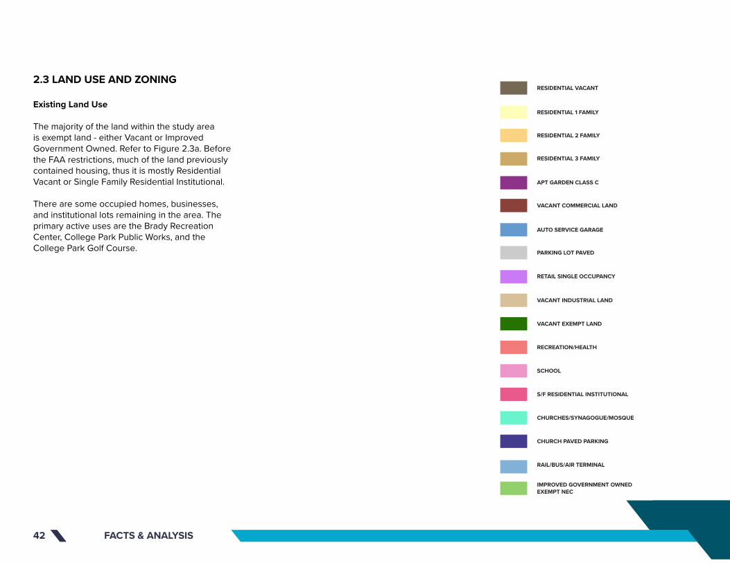
FACTS & ANALYSIS42
2.3 LAND USE AND ZONING
Existing Land Use
The majority of the land within the study area is exempt land - either Vacant or Improved Government Owned. Refer to Figure 2.3a. Before the FAA restrictions, much of the land previously contained housing, thus it is mostly Residential Vacant or Single Family Residential Institutional.
There are some occupied homes, businesses, and institutional lots remaining in the area. The primary active uses are the Brady Recreation Center, College Park Public Works, and the College Park Golf Course.
Source: Esri, DigitalGlobe, GeoEye, Earthstar Geographics, CNES/Airbus DS, USDA, USGS, AeroGRID, IGN, and the GIS User Community
COLLEGE PARK
COLLEGE PARK MUNICIPAL GOLF COURSE
BRADY RECREATION CENTER PARK
BARRETT PARK
BILL EVANS FIELD
RUGBY AVENUE
I-85
YALE AVENUE
HERSC
HEL RO
AD
EAST
MA
IN S
TREE
T
CO
LLEG
E ST
REET
FAIRWAY DRIVE
CAMP CREEK PARKWAY
COLUMBIA AVENUE
ROO
SEV
ELT
HIG
HW
AY
CAMBRIDGE AVENUE
WALKER AVENUE
VIRGINIA AVENUE
MAI
N S
TREE
T
WASHINGTON ROAD
CH
ARL
ES D
RIV
E
PRINCETON AVENUE
RHO
DES
STR
EET
HEM
PHIL
L ST
REET
LEE STREET
VIC
TORI
A S
TREE
T
WEST HARVARD AVENUE
ATLA
NTA
STR
EET
JEFF
ERSO
N S
TREE
T
REDWINE AVENUEPRINCETON DRIVE
RUGBY LANE
CA
RRIA
GE
WAY
ROSS AVENUE
JOHN WESLEY AVENUE
FRONTAGE ROAD
LAKE DRIVE
PIER
CE
STRE
ET
CO
NLE
Y ST
REET
NA
POLE
ON
STR
EET
WH
ITE
STRE
ET
PARK
VIE
W D
RIV
E
WEST RUGBY AVENUE
WA
SHIN
GTO
N S
TREE
T
ROSS
DRI
VE
NORTHWEST DRIVE
RIVERDALE RD CON
W. OGLETHORPE AVENUE
WEST JOHN CALVIN AVENUE
OXFORD AVENUE
DO
DSO
N T
ERRA
CE
RUGBY TERRACE
UNKNOWN
ABBOTT STREET
MC
DO
NA
LD A
VEN
UE
HAR
RIS
DRI
VE
ROOSEVELT STREET
TEMPLE AVENUE
ALM
AN
D D
RIV
E
Glo
bal G
atew
ay C
onne
ctor
EAST HARVARD AVENUE
RIDGEWAY AVENUE
SIMMONS AVENUEBEN HILL AVENUE
LEIG
H C
IRC
LE
ODELL WAY
AIR
PORT
DR
AUD
ITO
RIU
M W
AY
GOLF VIEW DRIVE
RUGB
Y CI
RCLE
DO
DSO
N D
RIV
E C
ON
NEC
TOR
CAROL COURT
HAWTHORNE AVENUE
COX COURT
PERKINS D
RIVE
PARK TERRACE
MC
CRE
E D
RIV
E
ST ANDREWS RIDGE
BELL
MO
NTE
DRI
VE
MUIRFIELD PLACE
CHASE COURT
CANNON COURT
WESTHARVARD AVENUE
NO NAME ROAD
CHARLESTOWN DRIVE
AMY CO
URT
BANKS COURT
DAV
IS C
OU
RT
SIMS C
OURT
RIV
ERD
ALE
RO
AD
EX
TEN
SIO
N
VALL
EY R
IDG
E
LEE STREET
CAMP CREEK PARKWAY
I-85
PRINCETON AVENUEPRINCETON AVENUE
UN
KNO
WN
HAR
RIS
DRI
VE
JEFF
ERSO
N S
TREE
T
CO
NLE
Y ST
REET
I-85
NA
POLE
ON
STR
EET
UN
KNO
WN
CAMP CREEK PARKWAY
VIC
TORI
A S
TREE
T
UN
KNO
WN
ATLA
NTA
STR
EET
I-85
UN
KNO
WN
UN
KNO
WN
I-85 N
BI-8
5 SB
I-85 N
B CD
Camp Creek Pkwy
CO
NLE
Y ST
Convention Center Concouse
Camp Creek Pkwy
RESIDENTIAL VACANT
TRANSIT RAIL STATIONS
RESIDENTIAL 1 FAMILY
RESIDENTIAL 2 FAMILY
APT GARDEN CLASS C
VACANT COMMERCIAL LAND
AUTO SERVICE GARAGE
PARKING LOT PAVED
RETAIL SINGLE OCCUPANCY
VACANT INDUSTRIAL LAND
VACANT EXEMPT LAND
RECREATION/HEALTH
SCHOOL
S/F RESIDENTIAL INSTITUTIONAL
CHURCHES/SYNAGOGUE/MOSQUE
CHURCH PAVED PARKING
RAIL/BUS/AIR TERMINAL
IMPROVED GOVERNMENT OWNED EXEMPT NEC
RESIDENTIAL 3 FAMILY
MARTA RAIL LINES
RAILROADS
STUDY AREA BOUNDARY
CLAYTON COUNTY ROADS
FULTON COUNTY ROADS
PARKS
COUNTIES
LEGEND
UTILITIES MAPUtilities, Water, and Sewer
0 400 800 1,200 1,600200FEET

Source: Esri, DigitalGlobe, GeoEye, Earthstar Geographics, CNES/Airbus DS, USDA, USGS, AeroGRID, IGN, and the GIS User Community
COLLEGE PARK
COLLEGE PARK MUNICIPAL GOLF COURSE
BRADY RECREATION CENTER PARK
BARRETT PARK
BILL EVANS FIELD
RUGBY AVENUE
I-85
YALE AVENUE
HERSC
HEL RO
AD
EAST
MA
IN S
TREE
T
CO
LLEG
E ST
REET
FAIRWAY DRIVE
CAMP CREEK PARKWAY
COLUMBIA AVENUE
ROO
SEV
ELT
HIG
HW
AY
CAMBRIDGE AVENUE
WALKER AVENUE
VIRGINIA AVENUE
MAI
N S
TREE
T
WASHINGTON ROAD
CH
ARL
ES D
RIV
E
PRINCETON AVENUE
RHO
DES
STR
EET
HEM
PHIL
L ST
REET
LEE STREET
VIC
TORI
A S
TREE
T
WEST HARVARD AVENUE
ATLA
NTA
STR
EET
JEFF
ERSO
N S
TREE
T
REDWINE AVENUEPRINCETON DRIVE
RUGBY LANE
CA
RRIA
GE
WAY
ROSS AVENUE
JOHN WESLEY AVENUE
FRONTAGE ROAD
LAKE DRIVE
PIER
CE
STRE
ET
CO
NLE
Y ST
REET
NA
POLE
ON
STR
EET
WH
ITE
STRE
ET
PARK
VIE
W D
RIV
E
WEST RUGBY AVENUE
WA
SHIN
GTO
N S
TREE
T
ROSS
DRI
VE
NORTHWEST DRIVE
RIVERDALE RD CON
W. OGLETHORPE AVENUE
WEST JOHN CALVIN AVENUE
OXFORD AVENUE
DO
DSO
N T
ERRA
CE
RUGBY TERRACE
UNKNOWN
ABBOTT STREET
MC
DO
NA
LD A
VEN
UE
HAR
RIS
DRI
VE
ROOSEVELT STREET
TEMPLE AVENUE
ALM
AN
D D
RIV
E
Glo
bal G
atew
ay C
onne
ctor
EAST HARVARD AVENUE
RIDGEWAY AVENUE
SIMMONS AVENUEBEN HILL AVENUE
LEIG
H C
IRC
LE
ODELL WAY
AIR
PORT
DR
AUD
ITO
RIU
M W
AY
GOLF VIEW DRIVE
RUGB
Y CI
RCLE
DO
DSO
N D
RIV
E C
ON
NEC
TOR
CAROL COURT
HAWTHORNE AVENUE
COX COURT
PERKINS D
RIVE
PARK TERRACE
MC
CRE
E D
RIV
E
ST ANDREWS RIDGE
BELL
MO
NTE
DRI
VE
MUIRFIELD PLACE
CHASE COURT
CANNON COURT
WESTHARVARD AVENUE
NO NAME ROAD
CHARLESTOWN DRIVE
AMY CO
URT
BANKS COURTD
AVIS
CO
URT
SIMS C
OURT
RIV
ERD
ALE
RO
AD
EX
TEN
SIO
N
VALL
EY R
IDG
E
LEE STREET
CAMP CREEK PARKWAY
I-85
PRINCETON AVENUEPRINCETON AVENUE
UN
KNO
WN
HAR
RIS
DRI
VE
JEFF
ERSO
N S
TREE
T
CO
NLE
Y ST
REET
I-85
NA
POLE
ON
STR
EET
UN
KNO
WN
CAMP CREEK PARKWAY
VIC
TORI
A S
TREE
T
UN
KNO
WN
ATLA
NTA
STR
EET
I-85
UN
KNO
WN
UN
KNO
WN
I-85 N
BI-8
5 SB
I-85 N
B CD
Camp Creek Pkwy
CO
NLE
Y ST
Convention Center Concouse
Camp Creek PkwyEXISTING LAND USE MAPFIGURE 2.3A
STUDY AREA BOUNDARY
ROADS
PARKS
COUNTIES
LEGEND
EXISTING LAND USE Existing Land Use Codes
0 400 800 1,200 1,600200FEET

EXISTING ZONING MAPFIGURE 2.3B
STUDY AREA BOUNDARY
ROADS
PARKS
COUNTIES
LEGEND
EXISTING ZONINGExisting Zoning Districts
0 400 800 1,200 1,600200FEET
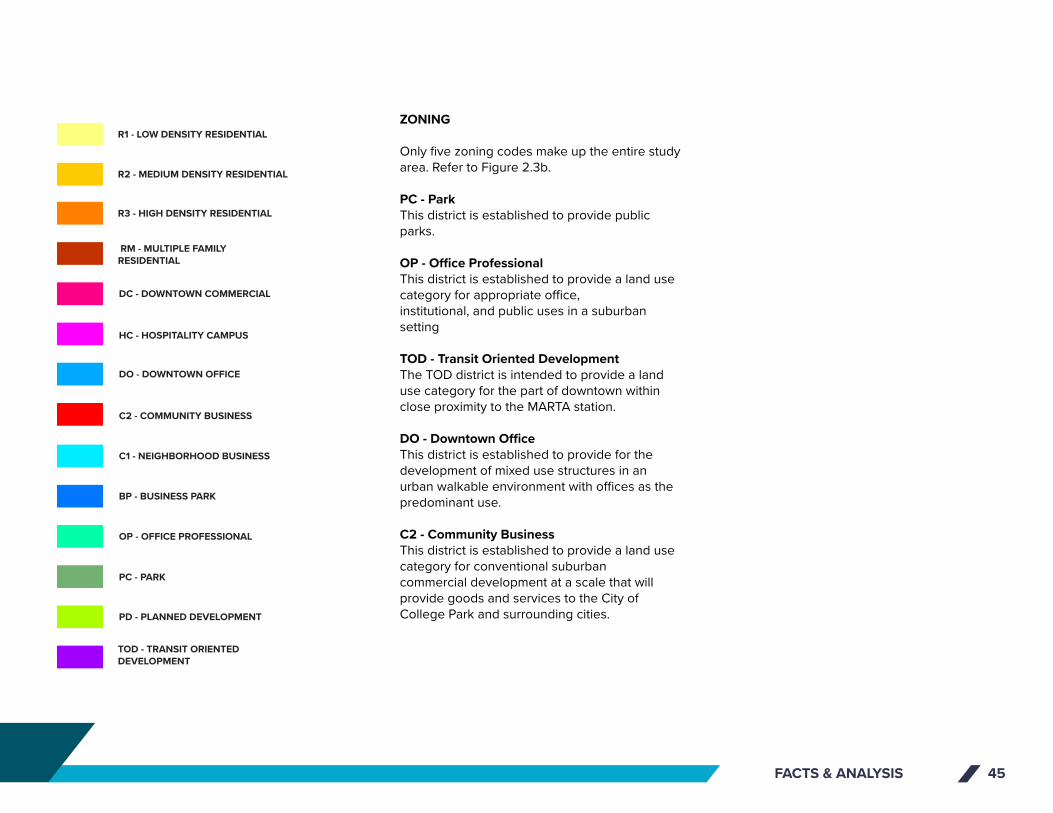
FACTS & ANALYSIS 45
ZONING
Only five zoning codes make up the entire study area. Refer to Figure 2.3b.
PC - ParkThis district is established to provide public parks.
OP - Office ProfessionalThis district is established to provide a land use category for appropriate office,institutional, and public uses in a suburban setting
TOD - Transit Oriented DevelopmentThe TOD district is intended to provide a land use category for the part of downtown within close proximity to the MARTA station.
DO - Downtown OfficeThis district is established to provide for the development of mixed use structures in an urban walkable environment with offices as the predominant use.
C2 - Community BusinessThis district is established to provide a land use category for conventional suburbancommercial development at a scale that will provide goods and services to the City ofCollege Park and surrounding cities.
COLLEGE PARK
COLLEGE PARK MUNICIPAL GOLF COURSE
BRADY RECREATION CENTER PARK
BARRETT PARK
BILL EVANS FIELD
RUGBY AVENUE
I-85
YALE AVENUE
HERSC
HEL RO
AD
EAST
MA
IN S
TREE
T
CO
LLEG
E ST
REET
FAIRWAY DRIVE
CAMP CREEK PARKWAY
COLUMBIA AVENUE
ROO
SEV
ELT
HIG
HW
AY
CAMBRIDGE AVENUE
WALKER AVENUE
VIRGINIA AVENUE
MAI
N S
TREE
T
WASHINGTON ROAD
CH
ARL
ES D
RIV
E
PRINCETON AVENUE
RHO
DES
STR
EET
HEM
PHIL
L ST
REET
LEE STREET
VIC
TORI
A S
TREE
T
WEST HARVARD AVENUE
ATLA
NTA
STR
EET
JEFF
ERSO
N S
TREE
T
REDWINE AVENUEPRINCETON DRIVE
RUGBY LANE
CA
RRIA
GE
WAY
ROSS AVENUE
JOHN WESLEY AVENUE
FRONTAGE ROAD
LAKE DRIVE
PIER
CE
STRE
ET
CO
NLE
Y ST
REET
NA
POLE
ON
STR
EET
WH
ITE
STRE
ET
PARK
VIE
W D
RIV
E
WEST RUGBY AVENUE
WA
SHIN
GTO
N S
TREE
T
ROSS
DRI
VE
NORTHWEST DRIVE
RIVERDALE RD CON
W. OGLETHORPE AVENUE
WEST JOHN CALVIN AVENUE
OXFORD AVENUE
DO
DSO
N T
ERRA
CE
RUGBY TERRACE
UNKNOWN
ABBOTT STREET
MC
DO
NA
LD A
VEN
UE
HAR
RIS
DRI
VE
ROOSEVELT STREET
TEMPLE AVENUE
ALM
AN
D D
RIV
E
Glo
bal G
atew
ay C
onne
ctor
EAST HARVARD AVENUE
RIDGEWAY AVENUE
SIMMONS AVENUEBEN HILL AVENUE
LEIG
H C
IRC
LE
ODELL WAY
AIR
PORT
DR
AUD
ITO
RIU
M W
AY
GOLF VIEW DRIVE
RUGB
Y CI
RCLE
DO
DSO
N D
RIV
E C
ON
NEC
TOR
CAROL COURT
HAWTHORNE AVENUE
COX COURT
PERKINS D
RIVE
PARK TERRACE
MC
CRE
E D
RIV
E
ST ANDREWS RIDGE
BELL
MO
NTE
DRI
VE
MUIRFIELD PLACE
CHASE COURT
CANNON COURT
WESTHARVARD AVENUE
NO NAME ROAD
CHARLESTOWN DRIVE
AMY CO
URT
BANKS COURTD
AVIS
CO
URT
SIMS C
OURT
RIV
ERD
ALE
RO
AD
EX
TEN
SIO
N
VALL
EY R
IDG
E
LEE STREET
CAMP CREEK PARKWAY
I-85
PRINCETON AVENUEPRINCETON AVENUE
UN
KNO
WN
HAR
RIS
DRI
VE
JEFF
ERSO
N S
TREE
T
CO
NLE
Y ST
REET
I-85
NA
POLE
ON
STR
EET
UN
KNO
WN
CAMP CREEK PARKWAY
VIC
TORI
A S
TREE
T
UN
KNO
WN
ATLA
NTA
STR
EET
I-85
UN
KNO
WN
UN
KNO
WN
I-85 N
BI-8
5 SB
I-85 N
B CD
Camp Creek Pkwy
CO
NLE
Y ST
Convention Center Concouse
Camp Creek Pkwy
PARCELS - BOUNDARY AREA
RUNWAY PROTECTION ZONE
COLLEGE PARK CITY LIMITS
PD - PLANNED DEVELOPMENT
PC - PARK
OP - OFFICE PROFESSIONAL
BP - BUSINESS PARK
C1 - NEIGHBORHOOD BUSINESS
C2 - COMMUNITY BUSINESS
DO - DOWNTOWN OFFICE
HC - HOSPITALITY CAMPUS
DC - DOWNTOWN COMMERCIAL
R3 - HIGH DENSITY RESIDENTIAL
R2 - MEDIUM DENSITY RESIDENTIAL
R1 - LOW DENSITY RESIDENTIAL
RM - MULTIPLE FAMILYRESIDENTIAL
TOD - TRANSIT ORIENTEDDEVELOPMENT
TRANSIT RAIL STATIONS
MARTA RAIL LINES
RAILROADS
STUDY AREA BOUNDARY
CLAYTON COUNTY ROADS
FULTON COUNTY ROADS
PARKS
COUNTIES
LEGEND
A IRPORT C ITYCITY OF COLLEGE PARK
EXISTING ZONINGExisting Zoning Districts
0 400 800 1,200 1,600200FEET
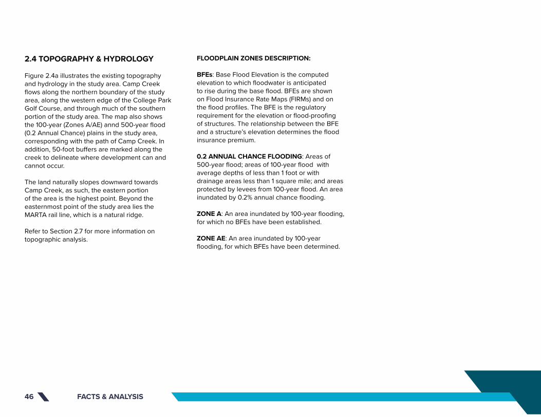
FACTS & ANALYSIS46
2.4 TOPOGRAPHY & HYDROLOGY
Figure 2.4a illustrates the existing topography and hydrology in the study area. Camp Creek flows along the northern boundary of the study area, along the western edge of the College Park Golf Course, and through much of the southern portion of the study area. The map also shows the 100-year (Zones A/AE) annd 500-year flood (0.2 Annual Chance) plains in the study area, corresponding with the path of Camp Creek. In addition, 50-foot buffers are marked along the creek to delineate where development can and cannot occur.
The land naturally slopes downward towards Camp Creek, as such, the eastern portion of the area is the highest point. Beyond the easternmost point of the study area lies the MARTA rail line, which is a natural ridge.
Refer to Section 2.7 for more information on topographic analysis.
FLOODPLAIN ZONES DESCRIPTION:
BFEs: Base Flood Elevation is the computed elevation to which floodwater is anticipated to rise during the base flood. BFEs are shown on Flood Insurance Rate Maps (FIRMs) and on the flood profiles. The BFE is the regulatory requirement for the elevation or flood-proofing of structures. The relationship between the BFE and a structure’s elevation determines the flood insurance premium.
0.2 ANNUAL CHANCE FLOODING: Areas of 500-year flood; areas of 100-year flood with average depths of less than 1 foot or with drainage areas less than 1 square mile; and areas protected by levees from 100-year flood. An area inundated by 0.2% annual chance flooding.
ZONE A: An area inundated by 100-year flooding, for which no BFEs have been established.
ZONE AE: An area inundated by 100-year flooding, for which BFEs have been determined.
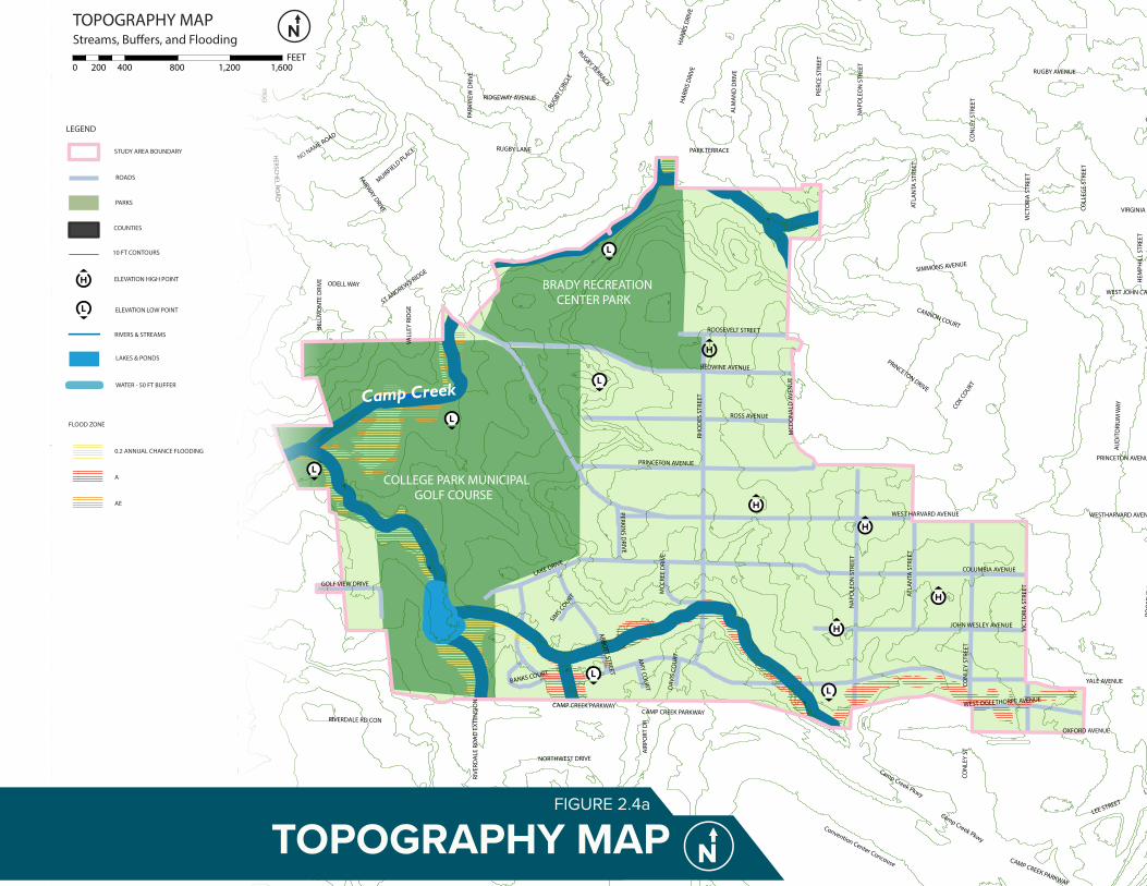
920
940
950
960
980
900
1000
1020
880
1040
860
1050
850
1060
1020
1040
940
960
920
940
960
950
960
920
920
880
1050
860
1040
950
1020
1040
920
940
950
980
1000
950
980
1020
1040
900
940
1050
980
900
1000
1040
1050
960
920
940
920
900
1050
920
1050
1060
960
1020
960
940
1000
1020
1000
980
1040
1020
1000
1050
950
940
920
950
1020
920
980
1020
1050
1050
1040
1000
1060
1000
920
920
980
1020
920
1040
960
960
1050
1050
960
1050
1050
920
920
1020
920
940
940
980
880
960980
1040
940
940
950
960
1000
900
1040
950
950
1000
960
980
1020
940
880
1050
Brannon Memorial Park
Camp Creek
RUGBY AVENUE
I-85
YALE AVENUE
HERSCH
EL ROA
D
EAST
MA
IN S
TREE
T
COLL
EGE
STRE
ET
FAIRWAY DRIVE
CAMP CREEK PARKWAY
COLUMBIA AVENUE
ROO
SEVE
LT H
IGH
WAY
CAMBRIDGE AVENUE
WALKER AVENUE
VIRGINIA AVENUE
MAI
N S
TREE
T
WASHINGTON ROAD
CHA
RLES
DRI
VE
PRINCETON AVENUE
RHO
DES
STR
EET
HEM
PHIL
L ST
REET
LEE STREET
VIC
TORI
A S
TREE
T
WEST HARVARD AVENUE
ATLA
NTA
STR
EET
JEFF
ERSO
N S
TREE
T
REDWINE AVENUEPRINCETON DRIVE
RUGBY LANE
CARR
IAG
E W
AY
ROSS AVENUE
JOHN WESLEY AVENUE
FRONTAGE ROAD
LAKE DRIVE
PIER
CE S
TREE
T
CON
LEY
STRE
ET
NA
POLE
ON
STR
EET
WH
ITE
STRE
ET
PARK
VIEW
DRI
VE
WEST RUGBY AVENUE
WA
SHIN
GTO
N S
TREE
T
ROSS
DRI
VE
NORTHWEST DRIVE
RIVERDALE RD CON
WEST OGLETHORPE AVENUE
WEST JOHN CALVIN AVENUE
OXFORD AVENUE
DO
DSO
N T
ERRA
CE
RUGBY TERRACE
UNKNOWN
ABBOTT STREET
MCD
ON
ALD
AVE
NU
E
HAR
RIS
DRI
VE
ROOSEVELT STREET
TEMPLE AVENUE
ALM
AN
D D
RIVE
Glo
bal G
atew
ay C
onne
ctor
EAST HARVARD AVENUE
RIDGEWAY AVENUE
SIMMONS AVENUE
BEN HILL AVENUE
LEIG
H C
IRCL
E
ODELL WAY
AIR
PORT
DR
AUD
ITO
RIU
M W
AY
GOLF VIEW DRIVE
RUGBY
CIR
CLE
DO
DSO
N D
RIVE
CO
NN
ECTO
R
CAROL COURT
HAWTHORNE AVENUE
COX COURT
PERKINS D
RIVE
PARK TERRACE
MCC
REE
DRI
VE
ST ANDREWS RIDGE
BELL
MO
NTE
DRI
VE
MUIRFIELD PLACE
CHASE COURT
CANNON COURT
WESTHARVARD AVENUE
NO NAME ROAD
CHARLESTOWN DRIVE
AMY CO
URT
BANKS COURTD
AVIS
CO
URT
SIMS C
OURT
RIVE
RDA
LE R
OA
D E
XTEN
SIO
N
VALL
EY R
IDG
E
JEFF
ERSO
N S
TREE
T
I-85
PRINCETON AVENUE
UN
KNO
WN
ATLA
NTA
STR
EET
CON
LEY
STRE
ET
UN
KNO
WN LEE STREET
NA
POLE
ON
STR
EET
UN
KNO
WN
PRINCETON AVENUE
UN
KNO
WN
I-85
I-85
CAMP CREEK PARKWAY
CAMP CREEK PARKWAY
HAR
RIS
DRI
VE
VIC
TORI
A S
TREE
T
UNKN
OW
N
I-85 NB
I-85 SB
I-85 N
B CD
Camp Creek Pkwy
CON
LEY
ST
Convention Center Concouse
Camp Creek Pkwy
COLLEGE PARK MUNICIPAL GOLF COURSE
BRADY RECREATION CENTER PARK
BARRETT PARK
BILL EVANS FIELD
10 FT CONTOURS
ELEVATION HIGH POINT
ELEVATION LOW POINT
RIVERS & STREAMS
LAKES & PONDS
WATER - 50 FT BUFFER
0.2 ANNUAL CHANCE FLOODING
A
AE
FLOOD ZONE
STUDY AREA BOUNDARY
ROADS
PARKS
COUNTIES
LEGEND
TOPOGRAPHY MAPStreams, Bu�ers, and Flooding
0 400 800 1,200 1,600200FEET
Camp Creek
TOPOGRAPHY MAPFIGURE 2.4a
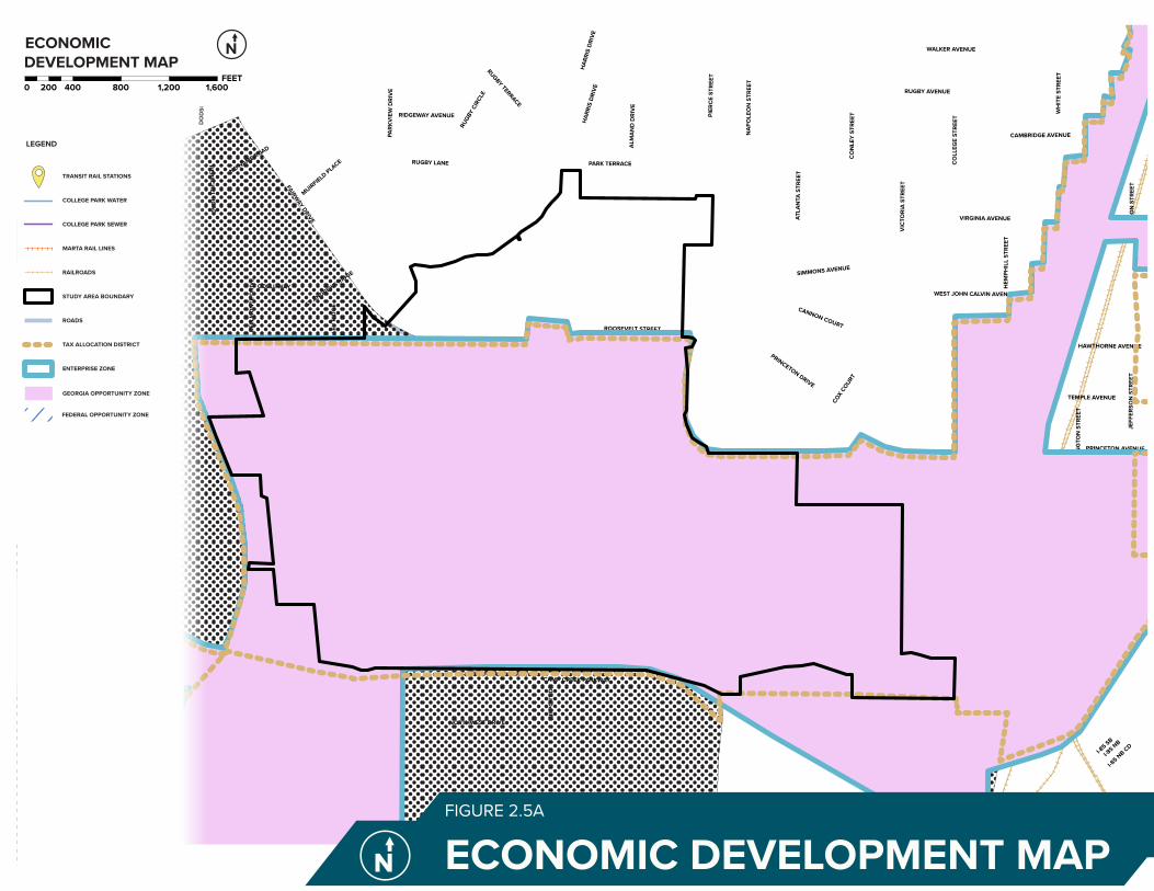
COLLEGE PARK
COLLEGE PARK MUNICIPAL GOLF COURSE
BRADY RECREATION CENTER PARK
BARRETT PARK
BILL EVANS FIELD
RUGBY AVENUE
I-85
YALE AVENUE
HERSC
HEL RO
AD
EAST
MA
IN S
TREE
T
CO
LLEG
E ST
REET
FAIRWAY DRIVE
CAMP CREEK PARKWAY
COLUMBIA AVENUE
ROO
SEV
ELT
HIG
HW
AY
CAMBRIDGE AVENUE
WALKER AVENUE
VIRGINIA AVENUE
MAI
N S
TREE
T
WASHINGTON ROAD
CH
ARL
ES D
RIV
E
PRINCETON AVENUE
RHO
DES
STR
EET
HEM
PHIL
L ST
REET
LEE STREET
VIC
TORI
A S
TREE
T
WEST HARVARD AVENUE
ATLA
NTA
STR
EET
JEFF
ERSO
N S
TREE
T
REDWINE AVENUEPRINCETON DRIVE
RUGBY LANE
CA
RRIA
GE
WAY
ROSS AVENUE
JOHN WESLEY AVENUE
FRONTAGE ROAD
LAKE DRIVE
PIER
CE
STRE
ET
CO
NLE
Y ST
REET
NA
POLE
ON
STR
EET
WH
ITE
STRE
ET
PARK
VIE
W D
RIV
E
WEST RUGBY AVENUE
WA
SHIN
GTO
N S
TREE
T
ROSS
DRI
VE
NORTHWEST DRIVE
RIVERDALE RD CON
W. OGLETHORPE AVENUE
WEST JOHN CALVIN AVENUE
OXFORD AVENUE
DO
DSO
N T
ERRA
CE
RUGBY TERRACE
UNKNOWN
ABBOTT STREET
MC
DO
NA
LD A
VEN
UE
HAR
RIS
DRI
VE
ROOSEVELT STREET
TEMPLE AVENUE
ALM
AN
D D
RIV
E
Glo
bal G
atew
ay C
onne
ctor
EAST HARVARD AVENUE
RIDGEWAY AVENUE
SIMMONS AVENUEBEN HILL AVENUE
LEIG
H C
IRC
LE
ODELL WAY
AIR
PORT
DR
AUD
ITO
RIU
M W
AY
GOLF VIEW DRIVE
RUGB
Y CI
RCLE
DO
DSO
N D
RIV
E C
ON
NEC
TOR
CAROL COURT
HAWTHORNE AVENUE
COX COURT
PERKINS D
RIVE
PARK TERRACE
MC
CRE
E D
RIV
E
ST ANDREWS RIDGE
BELL
MO
NTE
DRI
VE
MUIRFIELD PLACE
CHASE COURT
CANNON COURT
WESTHARVARD AVENUE
NO NAME ROAD
CHARLESTOWN DRIVE
AMY CO
URT
BANKS COURT
DAV
IS C
OU
RT
SIMS C
OURT
RIV
ERD
ALE
RO
AD
EX
TEN
SIO
N
VALL
EY R
IDG
E
LEE STREET
CAMP CREEK PARKWAY
I-85
PRINCETON AVENUEPRINCETON AVENUE
UN
KNO
WN
HAR
RIS
DRI
VE
JEFF
ERSO
N S
TREE
T
CO
NLE
Y ST
REET
I-85
NA
POLE
ON
STR
EET
UN
KNO
WN
CAMP CREEK PARKWAY
VIC
TORI
A S
TREE
T
UN
KNO
WN
ATLA
NTA
STR
EET
I-85
UN
KNO
WN
UN
KNO
WN
I-85 N
BI-8
5 SB
I-85 N
B CD
Camp Creek Pkwy
CO
NLE
Y ST
Convention Center Concouse
Camp Creek Pkwy
TRANSIT RAIL STATIONS
COLLEGE PARK WATER
COLLEGE PARK SEWER
MARTA RAIL LINES
RAILROADS
STUDY AREA BOUNDARY
ROADS
TAX ALLOCATION DISTRICT
ENTERPRISE ZONE
GEORGIA OPPORTUNITY ZONE
FEDERAL OPPORTUNITY ZONE
LEGEND
ECONOMIC DEVELOPMENT MAP0 400 800 1,200 1,600200
FEET
ECONOMIC DEVELOPMENT MAPFIGURE 2.5A

FACTS & ANALYSIS 49
Enterprise ZonesThe City has three designated Enterprise Zones, one of which is in the study area. City Council works with businesses to set minimum employment requirements and the duration of the Enterprise Zone agreement. This incentive can provide real estate and personal business property tax abatements.
Additional economic development tools and partners include:
Bond FinancingIndustrial Revenue Bonds are available through the City of College Park Business and Industrial Development Authority (BIDA) for real estate and personal property. Eligible projects must meet a $10 million threshold.
College Park Business & Industrial DevelopmentAuthority (BIDA)BIDA’s function is to attain development; purchase and sell property; and promote trade, commerce, industry and employment opportunities by facilitating certain development projects through special financing and tax incentives.
College Park Main Street Association (CPMSA)A program of the National Trust for Historic Preservation, Main Street’s goal is to help revitalize historic downtowns through the preservation and adaptive re-use of historic and culturally significant resources. The core of any Main Street program follows the nationally recognized Main Street Approach.
2.5 ECONOMIC DEVELOPMENT
INCENTIVES AND TOOLS
Figure 2.5a illustrates the location of the economic development incentives in the study area, including:
Tax Allocation Districts (TADs)The City, and a large section of Airport City, has a designated TAD, offering infrastructure financing and special development incentives for qualifying projects. The district was created to incentivize development in a targeted area of downtown College Park.
Georgia Opportunity ZoneThe City has a dedicated State Opportunity Zone located adjacent to Hartsfield-Jackson Atlanta International Airport, in the heart of downtown College Park and covering a large swath of the study area. College Park's Opportunity Zone, as designated by the Georgia Department of Community Affairs, offers $3,500 per job tax credit for up to 5 years, applied against state withholding tax for qualifying jobs.
Federal Opportunity ZoneFederal Opportunity Zones (FOZ) are economically-distressed communities where new investments, under certain conditions, may be eligible for preferential tax treatment. They are designed to spur economic development and job creation.
Chambers of CommerceCollege Park is served by three area Chambers of Commerce: South Fulton Chamber of Commerce, Clayton Chamber of Commerce, and Airport Area Chamber of Commerce. In addition, the Metro Atlanta Chamber of Commerce also serves the region. The goal of any Chamber is to enhance the business climate of its respective area, and to enhance economic and community development through leadership, service and advocacy.
College Park Economic Development DepartmentThe College Park Economic Development Department provides research and studies to develop economic and community development plans. It also facilitates business retention, attraction, and incentive programs.
COLLEGE PARK
COLLEGE PARK MUNICIPAL GOLF COURSE
BRADY RECREATION CENTER PARK
BARRETT PARK
BILL EVANS FIELD
RUGBY AVENUE
I-85
YALE AVENUE
HERSC
HEL RO
AD
EAST
MA
IN S
TREE
T
CO
LLEG
E ST
REET
FAIRWAY DRIVE
CAMP CREEK PARKWAY
COLUMBIA AVENUE
ROO
SEV
ELT
HIG
HW
AY
CAMBRIDGE AVENUE
WALKER AVENUE
VIRGINIA AVENUE
MAI
N S
TREE
T
WASHINGTON ROAD
CH
ARL
ES D
RIV
E
PRINCETON AVENUE
RHO
DES
STR
EET
HEM
PHIL
L ST
REET
LEE STREET
VIC
TORI
A S
TREE
T
WEST HARVARD AVENUE
ATLA
NTA
STR
EET
JEFF
ERSO
N S
TREE
T
REDWINE AVENUEPRINCETON DRIVE
RUGBY LANE
CA
RRIA
GE
WAY
ROSS AVENUE
JOHN WESLEY AVENUE
FRONTAGE ROAD
LAKE DRIVE
PIER
CE
STRE
ET
CO
NLE
Y ST
REET
NA
POLE
ON
STR
EET
WH
ITE
STRE
ET
PARK
VIE
W D
RIV
E
WEST RUGBY AVENUE
WA
SHIN
GTO
N S
TREE
T
ROSS
DRI
VE
NORTHWEST DRIVE
RIVERDALE RD CON
W. OGLETHORPE AVENUE
WEST JOHN CALVIN AVENUE
OXFORD AVENUE
DO
DSO
N T
ERRA
CE
RUGBY TERRACE
UNKNOWN
ABBOTT STREET
MC
DO
NA
LD A
VEN
UE
HAR
RIS
DRI
VE
ROOSEVELT STREET
TEMPLE AVENUE
ALM
AN
D D
RIV
E
Glo
bal G
atew
ay C
onne
ctor
EAST HARVARD AVENUE
RIDGEWAY AVENUE
SIMMONS AVENUEBEN HILL AVENUE
LEIG
H C
IRC
LE
ODELL WAY
AIR
PORT
DR
AUD
ITO
RIU
M W
AY
GOLF VIEW DRIVE
RUGB
Y CI
RCLE
DO
DSO
N D
RIV
E C
ON
NEC
TOR
CAROL COURT
HAWTHORNE AVENUE
COX COURT
PERKINS D
RIVE
PARK TERRACE
MC
CRE
E D
RIV
E
ST ANDREWS RIDGE
BELL
MO
NTE
DRI
VE
MUIRFIELD PLACE
CHASE COURT
CANNON COURT
WESTHARVARD AVENUE
NO NAME ROAD
CHARLESTOWN DRIVE
AMY CO
URT
BANKS COURT
DAV
IS C
OU
RT
SIMS C
OURT
RIV
ERD
ALE
RO
AD
EX
TEN
SIO
N
VALL
EY R
IDG
E
LEE STREET
CAMP CREEK PARKWAY
I-85
PRINCETON AVENUEPRINCETON AVENUE
UN
KNO
WN
HAR
RIS
DRI
VE
JEFF
ERSO
N S
TREE
T
CO
NLE
Y ST
REET
I-85
NA
POLE
ON
STR
EET
UN
KNO
WN
CAMP CREEK PARKWAY
VIC
TORI
A S
TREE
T
UN
KNO
WN
ATLA
NTA
STR
EET
I-85
UN
KNO
WN
UN
KNO
WN
I-85 N
BI-8
5 SB
I-85 N
B CD
Camp Creek Pkwy
CO
NLE
Y ST
Convention Center Concouse
Camp Creek Pkwy
TRANSIT RAIL STATIONS
COLLEGE PARK WATER
COLLEGE PARK SEWER
MARTA RAIL LINES
RAILROADS
STUDY AREA BOUNDARY
ROADS
TAX ALLOCATION DISTRICT
ENTERPRISE ZONE
GEORGIA OPPORTUNITY ZONE
FEDERAL OPPORTUNITY ZONE
LEGEND
ECONOMIC DEVELOPMENT MAP0 400 800 1,200 1,600200
FEET

FACTS & ANALYSIS50
2.6 AIRPORT ASSOCIATED REGULATIONS
This section contains regulations associated with development near airports. These regulations were key to understanding how the land can best be developed while continuing to be a good neighbor to the world's busiest airport and following FAA regulations and rules. Studying noise contours, height allowances, and land deed restrictions were all essential to understanding how Airport City can best complement HJAIA.
NOISE CONTOURS
Noise contours as illustrated in Figure 2.6a are in accordance with Part 150 of the Federal Aviation Regulations Study prepared for Hartsfield-Jackson Atlanta International Airport in 2007 (with maps updated in 2012).
The Noise Exposure Maps Report provides a Noise/Land Use Compatibility Standards and Guidelines section. The Day-Night Sound Level (DNL) or Yearly Day and Night Average Sound Levels are divided into six groups; “Below 65”, “65 to 70”, “70 to 75”, “75 to 80”, “80 to 85”, and “Over 85”.
Out of these only “Below 65”, “65 to 70”, and “70 to 75” groups are applicable to the study area.

COLLEGE PARK
COLLEGE PARK MUNICIPAL GOLF COURSE
BRADY RECREATION CENTER PARK
BARRETT PARK
BILL EVANS FIELD
RUGBY AVENUE
I-85
YALE AVENUE
HERSC
HEL RO
AD
EAST
MA
IN S
TREE
T
CO
LLEG
E ST
REET
FAIRWAY DRIVE
CAMP CREEK PARKWAY
COLUMBIA AVENUE
ROO
SEV
ELT
HIG
HW
AY
CAMBRIDGE AVENUE
WALKER AVENUE
VIRGINIA AVENUE
MAI
N S
TREE
T
WASHINGTON ROAD
CH
ARL
ES D
RIV
E
PRINCETON AVENUE
RHO
DES
STR
EET
HEM
PHIL
L ST
REET
LEE STREET
VIC
TORI
A S
TREE
T
WEST HARVARD AVENUE
ATLA
NTA
STR
EET
JEFF
ERSO
N S
TREE
T
REDWINE AVENUEPRINCETON DRIVE
RUGBY LANE
CA
RRIA
GE
WAY
ROSS AVENUE
JOHN WESLEY AVENUE
FRONTAGE ROAD
LAKE DRIVE
PIER
CE
STRE
ET
CO
NLE
Y ST
REET
NA
POLE
ON
STR
EET
WH
ITE
STRE
ET
PARK
VIE
W D
RIV
E
WEST RUGBY AVENUE
WA
SHIN
GTO
N S
TREE
T
ROSS
DRI
VE
NORTHWEST DRIVE
RIVERDALE RD CON
W. OGLETHORPE AVENUE
WEST JOHN CALVIN AVENUE
OXFORD AVENUE
DO
DSO
N T
ERRA
CE
RUGBY TERRACE
UNKNOWN
ABBOTT STREET
MC
DO
NA
LD A
VEN
UE
HAR
RIS
DRI
VE
ROOSEVELT STREET
TEMPLE AVENUE
ALM
AN
D D
RIV
E
Glo
bal G
atew
ay C
onne
ctor
EAST HARVARD AVENUE
RIDGEWAY AVENUE
SIMMONS AVENUEBEN HILL AVENUE
LEIG
H C
IRC
LE
ODELL WAY
AIR
PORT
DR
AUD
ITO
RIU
M W
AY
GOLF VIEW DRIVE
RUGB
Y CI
RCLE
DO
DSO
N D
RIV
E C
ON
NEC
TOR
CAROL COURT
HAWTHORNE AVENUE
COX COURT
PERKINS D
RIVE
PARK TERRACE
MC
CRE
E D
RIV
E
ST ANDREWS RIDGE
BELL
MO
NTE
DRI
VE
MUIRFIELD PLACE
CHASE COURT
CANNON COURT
WESTHARVARD AVENUE
NO NAME ROAD
CHARLESTOWN DRIVE
AMY CO
URT
BANKS COURTD
AVIS
CO
URT
SIMS C
OURT
RIV
ERD
ALE
RO
AD
EX
TEN
SIO
N
VALL
EY R
IDG
E
LEE STREET
CAMP CREEK PARKWAY
I-85
PRINCETON AVENUEPRINCETON AVENUE
UN
KNO
WN
HAR
RIS
DRI
VE
JEFF
ERSO
N S
TREE
T
CO
NLE
Y ST
REET
I-85
NA
POLE
ON
STR
EET
UN
KNO
WN
CAMP CREEK PARKWAY
VIC
TORI
A S
TREE
T
UN
KNO
WN
ATLA
NTA
STR
EET
I-85
UN
KNO
WN
UN
KNO
WN
I-85 N
BI-8
5 SB
I-85 N
B CD
Camp Creek Pkwy
CO
NLE
Y ST
Convention Center Concouse
Camp Creek Pkwy
PARCELS - BOUNDARY AREA
DEPARTURE TRACK
DEPARTURE TRACK - NIGHTTIME
ARRIVAL TRACK
75 DECIBELS
70 DECIBELS
65 DECIBELS
TRANSIT RAIL STATIONS
MARTA RAIL LINES
RAILROADS
STUDY AREA BOUNDARY
CLAYTON COUNTY ROADS
FULTON COUNTY ROADS
PARKS
COUNTIES
LEGEND
A IRPORT C ITYCITY OF COLLEGE PARK
NOISE CONTOURSCONUS Road and Aviation Noise
0 400 800 1,200 1,600200FEET
NOISE CONTOURS & FLIGHT PATH MAPFIGURE 2.6A

FACTS & ANALYSIS52
PAGE TITLE (CHANGE TO SECTION COLOR)
SECTION TITLE
This is where a lot of the things will go. Please erase the things here to put in the new things. The new things should be well written and clear to understand. Also, the new things should be interesting to read and not too visually long. For reals, my dudes. If you need to edit this text, you gotta press and hold CTRL+SHIFT and then click a gazillion times into this box to edit. Then, you can never go back. If you mess up, you gotta drag the slide master again to get the original format. Why is InDesign so complicated? wHy Is InDeSiGn So CoMpLiCaTeD¿
I’m pressing enter and making another paragraph because this stuff is getting far too big up there. No one wants a W A L L O F T E X T. Oh by the way, the text boxes are configured to overflow into the next, so if you run out of room in one box it automatically flows into the next. I made like three columns for text, so you’ve got room to grow. Nnnnnyyyyyeeeeeehhhhh. Text filler. Why are you still reading this. Go back to work. Actually no, don’t work. RUN FREE. GO EAT 15 POUNDS OF SPAGHETTI. FROLICK IN A FIELD OF FLOWERS, BUTTERFLIES AND OTHER INSTAGRAMMABLE THINGS. GO LIVE YOUR LIFE AND BE FREEEEEEEEEEEEEEEEEEEEEE. But I mean, yeah guys, just make sure to maintain these graphic standards and you’ll be juuuuuuuuuuuuuuust fine. :D
Figure 2.3e: Building Heights Map
BUILDING HEIGHTS MAPFIGURE 2.6B

FACTS & ANALYSIS 53
Figure 2.6B illustrate the FAA's height regulations for development within 10,000 feet of airport runways. It lays out the overall height restrictions within 5,000 feet and 10,000 feet., depicting the restrictions in more detail over the Airport City study area. This figure would be used by the FAA to determine building heights on the site.
Below are the exact regulations from the FAA regarding development with 20,000 ft to 5,000 ft within an airport runway.
FAA SAFE, EFFICIENT USE, AND PRESERVATION OF THE NAVIGABLE AIRSPACE
§77.9 Construction or alteration requiring notice.If requested by the FAA, or if you propose any of the following types of construction or alteration, you must file notice with the FAA of:
(a) Any construction or alteration that is more than 200 ft. AGL at its site.
(b) Any construction or alteration that exceeds an imaginary surface extending outward and upward at any of the following slopes:
(1) 100 to 1 for a horizontal distance of 20,000 ft. from the nearest point of the nearest runway of each airport described in paragraph (d) of this section with its longest runway more than 3,200 ft. in actual length, excluding heliports.
(2) 50 to 1 for a horizontal distance of 10,000 ft. from the nearest point of the nearest runway of each airport described in paragraph (d) of this section with its longest runway no more than
3,200 ft. in actual length, excluding heliports.
(3) 25 to 1 for a horizontal distance of 5,000 ft. from the nearest point of the nearest landing and takeoff area of each heliport described in paragraph (d) of this section.
(c) Any highway, railroad, or other traverse way for mobile objects, of a height which, if adjusted upward 17 feet for an Interstate Highway that is part of the National System of Military and Interstate Highways where overcrossings are designed for a minimum of 17 feet vertical distance, 15 feet for any other public roadway, 10 feet or the height of the highest mobile object that would normally traverse the road, whichever is greater, for a private road, 23 feet for a railroad, and for a waterway or any other traverse way not previously mentioned, an amount equal to the height of the highest mobile object that would normally traverse it, would exceed a standard of paragraph (a) or (b) of this section.
(d) Any construction or alteration on any of the following airports and heliports:
(1) A public use airport listed in the Airport/Facility Directory, Alaska Supplement, or Pacific Chart Supplement of the U.S. Government Flight Information Publications;
(2) A military airport under construction, or an airport under construction that will be available for public use;
(3) An airport operated by a Federal agency or the DOD.
(4) An airport or heliport with at least one
FAA-approved instrument approach procedure.
(e) You do not need to file notice for construction or alteration of:
(1) Any object that will be shielded by existing structures of a permanent and substantial nature or by natural terrain or topographic features of equal or greater height, and will be located in the congested area of a city, town, or settlement where the shielded structure will not adversely affect safety in air navigation;
(2) Any air navigation facility, airport visual approach or landing aid, aircraft arresting device, or meteorological device meeting FAA-approved siting criteria or an appropriate military service siting criteria on military airports, the location and height of which are fixed by its functional purpose;
(3) Any construction or alteration for which notice is required by any other FAA regulation.
(4) Any antenna structure of 20 feet or less in height, except one that would increase the height of another antenna structure.
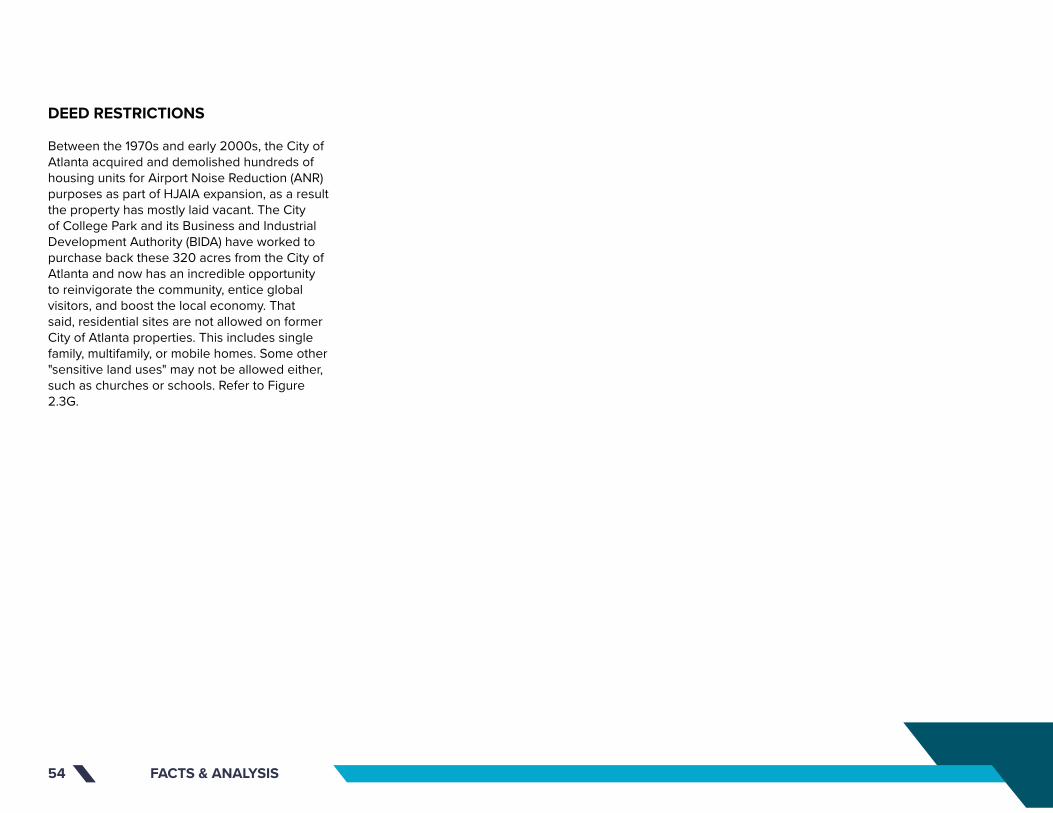
FACTS & ANALYSIS54
DEED RESTRICTIONS
Between the 1970s and early 2000s, the City of Atlanta acquired and demolished hundreds of housing units for Airport Noise Reduction (ANR) purposes as part of HJAIA expansion, as a result the property has mostly laid vacant. The City of College Park and its Business and Industrial Development Authority (BIDA) have worked to purchase back these 320 acres from the City of Atlanta and now has an incredible opportunity to reinvigorate the community, entice global visitors, and boost the local economy. That said, residential sites are not allowed on former City of Atlanta properties. This includes single family, multifamily, or mobile homes. Some other "sensitive land uses" may not be allowed either, such as churches or schools. Refer to Figure 2.3G.

FACTS & ANALYSIS 55 Source: Esri, DigitalGlobe, GeoEye, Earthstar Geographics, CNES/Airbus DS, USDA, USGS, AeroGRID, IGN, and the GIS User Community
COLLEGE PARK
COLLEGE PARK MUNICIPAL GOLF COURSE
BRENNINGHAM PARK
BARRETT PARK
BILL EVANS FIELD
RUGBY AVENUE
I-85
YALE AVENUE
HERSC
HEL RO
AD
EAST
MA
IN S
TREE
T
CO
LLEG
E ST
REET
FAIRWAY DRIVE
CAMP CREEK PARKWAY
COLUMBIA AVENUE
ROO
SEV
ELT
HIG
HW
AY
CAMBRIDGE AVENUE
WALKER AVENUE
VIRGINIA AVENUE
MAI
N S
TREE
T
WASHINGTON ROAD
CH
ARL
ES D
RIV
E
PRINCETON AVENUE
RHO
DES
STR
EET
HEM
PHIL
L ST
REET
LEE STREET
VIC
TORI
A S
TREE
T
HARVARD AVENUE
ATLA
NTA
STR
EET
JEFF
ERSO
N S
TREE
T
REDWINE AVENUEPRINCETON DRIVE
RUGBY LANE
CA
RRIA
GE
WAY
ROSS AVENUE
JOHN WESLEY AVENUE
FRONTAGE ROAD
LAKE DRIVE
PIER
CE
STRE
ET
CO
NLE
Y ST
REET
NA
POLE
ON
STR
EET
WH
ITE
STRE
ET
PARK
VIE
W D
RIV
E
WEST RUGBY AVENUE
WA
SHIN
GTO
N S
TREE
T
ROSS
DRI
VE
NORTHWEST DRIVE
RIVERDALE RD CON
W. OGLETHORPE AVENUE
WEST JOHN CALVIN AVENUE
OXFORD AVENUE
DO
DSO
N T
ERRA
CE
RUGBY TERRACE
UNKNOWN
ABBOTT STREET
MC
DO
NA
LD A
VEN
UE
HAR
RIS
DRI
VE
ROOSEVELT STREET
TEMPLE AVENUE
ALM
AN
D D
RIV
E
Glo
bal G
atew
ay C
onne
ctor
HARVARD AVENUE
RIDGEWAY AVENUE
SIMMONS AVENUEBEN HILL AVENUE
LEIG
H C
IRC
LE
ODELL WAY
AIR
PORT
DR
AUD
ITO
RIU
M W
AY
GOLF VIEW DRIVE
RUGB
Y CI
RCLE
R
CAROL COURT
COX COURT
PERKINS D
RIVE
PARK TERRACE
MC
CRE
E D
RIV
E
ST ANDREWS RIDGE
BELL
MO
NTE
DRI
VE
MUIRFIELD PLACE
CHASE COURT
CANNON COURT
HARVARD AVENUE
CHARLESTOWN DRIVE
AMY CO
URT
BANKS COURT
DAV
IS C
OU
RT
SIMS C
OURT
RIV
ERD
ALE
RO
AD
EX
TEN
SIO
N
VALL
EY R
IDG
E
LEE STREET
CAMP CREEK PARKWAY
I-85
PRINCETON AVENUEPRINCETON AVENUE
UN
KNO
WN
HAR
RIS
DRI
VE
JEFF
ERSO
N S
TREE
T
CO
NLE
Y ST
REET
I-85
NA
POLE
ON
STR
EET
UN
KNO
WN
CAMP CREEK PARKWAY
VIC
TORI
A S
TREE
T
UN
KNO
WN
ATLA
NTA
STR
EET
I-85
UN
KNO
WN
UN
KNO
WN
I-85 N
BI-8
5 SB
I-85 N
B CD
Camp Creek Pkwy
CO
NLE
Y ST
Convention Center Concouse
Camp Creek Pkwy
BRADY CENTER
DEED RESTRICTED PROPERTY
TRANSIT RAIL STATIONS
IMPROVED GOVERNMENT OWNED EXEMPT NEC
PARKS
MARTA RAIL LINES
RAILROADS
STUDY AREA BOUNDARY
ROADS
COUNTIES
NOISE CONTOURS
LEGEND
DEED RESTRICTIONS MAPwith Noise Contours
0 400 800 1,200 1,600200FEET
65 dB
70 dB
75 dB
75 dBDEED RESTRICTIONSFIGURE 2.6C

FACTS & ANALYSIS56 WATER SERVICES MAPFIGURE 2.7A

FACTS & ANALYSIS 57
2.7 CIVIL & TRANSPORTATION
The existing information indicated on the following maps was provided by College Park GIS. This section provides an overview of civil and transportation analysis, including: topography, land use, fire water services, sanitary sewers, and water resources.
TOPOGRAPHY MAP
The project study area includes significant grade change across the site when traversing from east to west. A series of local high points are present within the boundary; however, the highest point of the site is located near the intersection of Harvard Avenue and Napoleon Street at an elevation of 1050’. Grades within the area of the high point slope to the southwest to drain into a stream that runs along Camp Creek Parkway, west, discharging into the golf course pond. Intermediate high points located along the northern portion of the project study area are located in the 990 – 1000’ elevation range. Each of these high point locations slope down to Camp Creek, traversing east to west, along an elevation of 900 at the northern point of the study area, to a low elevation of 860’ at the western most point of the golf course. Refer to Figure 2.7a.
LAND USE ANALYSIS
As part of any proposed development, adding areas of buildings and hardscapes to a project area result in an increase of stormwater flows from the project site. These increases of flows are quantified by comparing the proposed conditions of the study area to the existing land use conditions within a hydraulic model. Utilizing aerial images and site photos, a baseline map and model of the existing conditions is generated to document the total area of pervious (landscape, woods, vegetated) areas and impervious (roadways, buildings, hardscape) areas. Using these areas, an existing conditions model is generated to act as the minimum performance criteria of the proposed stormwater management system. The Land Use Analysis Map indicates the total project boundary of 349 acres, composed of 3.3 acres of buildings, 25.7 acres of hardscape, and 320 acres of pervious areas. During the master planning phase of the study, a proposed land use map was generated taking into account the proposed improvements to the site allowing a conceptual, regional stormwater management system to be designed meeting the intent of the Georgia Stormwater Management Manual and local requirements. Refer to Figure 2.7c.
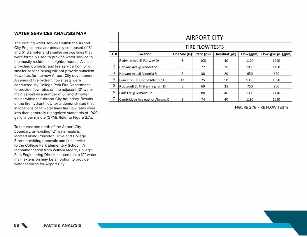
FACTS & ANALYSIS58
WATER SERVICES ANALYSIS MAP
The existing water services within the Airport City Project area are primarily composed of 8” and 6” diameter and smaller service lines that were formally used to provide water service to the mostly residential neighborhoods. As such, providing domestic and fire service from 6” or smaller service piping will not provide sufficient flow rates for the new Airport City development. A series of fire hydrant flows tests were conducted, by College Park Fire Department, to provide flow rates on the adjacent 12” water main as well as a number of 6” and 8” water mains within the Airport City boundary. Results of the fire hydrant flow tests demonstrated that in locations of 6” water lines fire flow rates were less than generally recognized standards of 1000 gallons per minute (GPM). Refer to Figure 2.7b.
To the east and north of the Airport City boundary, an existing 12” water main is located along Princeton Drive and College Street providing domestic and fire service to the College Park Elementary School. A recommendation from William Moore, College Park Engineering Director, noted that a 12” water main extension may be an option to provide water services for Airport City.
FIGURE 2.7B FIRE FLOW TESTS

FIGURE 2.7C
LAND USE MAP

FACTS & ANALYSIS60
PAGE TITLE (CHANGE TO SECTION COLOR)
SECTION TITLE
This is where a lot of the things will go. Please erase the things here to put in the new things. The new things should be well written and clear to understand. Also, the new things should be interesting to read and not too visually long. For reals, my dudes. If you need to edit this text, you gotta press and hold CTRL+SHIFT and then click a gazillion times into this box to edit. Then, you can never go back. If you mess up, you gotta drag the slide master again to get the original format. Why is InDesign so complicated? wHy Is InDeSiGn So CoMpLiCaTeD¿
I’m pressing enter and making another paragraph because this stuff is getting far too big up there. No one wants a W A L L O F T E X T. Oh by the way, the text boxes are configured to overflow into the next, so if you run out of room in one box it automatically flows into the next. I made like three columns for text, so you’ve got room to grow. Nnnnnyyyyyeeeeeehhhhh. Text filler. Why are you still reading this. Go back to work. Actually no, don’t work. RUN FREE. GO EAT 15 POUNDS OF SPAGHETTI. FROLICK IN A FIELD OF FLOWERS, BUTTERFLIES AND OTHER INSTAGRAMMABLE THINGS. GO LIVE YOUR LIFE AND BE FREEEEEEEEEEEEEEEEEEEEEE. But I mean, yeah guys, just make sure to maintain these graphic standards and you’ll be juuuuuuuuuuuuuuust fine. :D
WATER SERVICES MAPFIGURE 2.7D

FACTS & ANALYSIS 61
SANITARY SEWER
Existing sanitary sewer services located within the project area are abundant and anticipated to be sufficiently sized to convey the sanitary flows from the Airport City development. Confirmation/verification on the age and condition of the existing sanitary services shall be completed through discussions with City Sewer and Water Authority. Sanitary sewer within the study area is mostly comprised of 8” services running along the existing road network. Flows from Harvard Avenue south and are routed through the golf course to connect to the 24” sanitary main running along Camp Creek. Flows north of Harvard Avenue collect along Redwine Avenue and connect into the 18” sanitary main just north of the golf course. Sanitary flows then exit the study boundary to the west towards Camp Creek Parkway. Indication from William Moore states the 18” sanitary sewer leaving the site has a flow capacity of 2.3 million gallons per day (MGD) with an estimation of 300 homes within the contributing sewershed, contributing approximately 120,000 gallons per day (GPD), utilizing only about 5% of the approximate sewer capacity. Refer to Figure 2.7e.
AQUATIC RESOURCE DELINEATION ANALYSIS
The purpose of the Airport City Aquatic Delineation is to identify onsite aquatic resources, which may be subject to federal permitting authority under Section 404 of the Clean Water Act as well as the Erosion & Sedimentation Control Act of 1975, and Local Issuing Authority (LIA) ordinances that may apply. Refer to Figure 2.7f.
The central coordinates for the site are latitude 34.121259 north and longitude -83.831711 west. The nearest named water body is Camp Creek, located along a portion of the northern property boundary. All onsite aquatic resources drain in a westerly direction on site and eventually into Camp Creek, which is a tributary of the Chattahoochee River (confluence is 11.98 miles west of the site). On-site aquatic resources are a component of the Middle Chattahoochee River Watershed.
Wetlands are lands where the saturation of water is the dominant factor for determining the nature of soil development as well as the types of plant and animal communities living in the soil and on its surface. Wetlands vary widely due to the regional and local differences in soils, topography, climate, hydrology, water chemistry, vegetation, human disturbance and other factors. For regulatory purposes under the Clean Water Act, the term wetlands means "those areas that are inundated or saturated by surface or groundwater at a frequency and duration sufficient to support, and that under normal circumstances do support, a prevalence
of vegetation typically adapted for life in saturated soil conditions.” For the full Aquatic Resource Delineation Analysis, please refer to the appendix.

FACTS & ANALYSIS62
PAGE TITLE (CHANGE TO SECTION COLOR)
SECTION TITLE
This is where a lot of the things will go. Please erase the things here to put in the new things. The new things should be well written and clear to understand. Also, the new things should be interesting to read and not too visually long. For reals, my dudes. If you need to edit this text, you gotta press and hold CTRL+SHIFT and then click a gazillion times into this box to edit. Then, you can never go back. If you mess up, you gotta drag the slide master again to get the original format. Why is InDesign so complicated? wHy Is InDeSiGn So CoMpLiCaTeD¿
I’m pressing enter and making another paragraph because this stuff is getting far too big up there. No one wants a W A L L O F T E X T. Oh by the way, the text boxes are configured to overflow into the next, so if you run out of room in one box it automatically flows into the next. I made like three columns for text, so you’ve got room to grow. Nnnnnyyyyyeeeeeehhhhh. Text filler. Why are you still reading this. Go back to work. Actually no, don’t work. RUN FREE. GO EAT 15 POUNDS OF SPAGHETTI. FROLICK IN A FIELD OF FLOWERS, BUTTERFLIES AND OTHER INSTAGRAMMABLE THINGS. GO LIVE YOUR LIFE AND BE FREEEEEEEEEEEEEEEEEEEEEE. But I mean, yeah guys, just make sure to maintain these graphic standards and you’ll be juuuuuuuuuuuuuuust fine. :D
SANITARY SEWER MAPFIGURE 2.7E
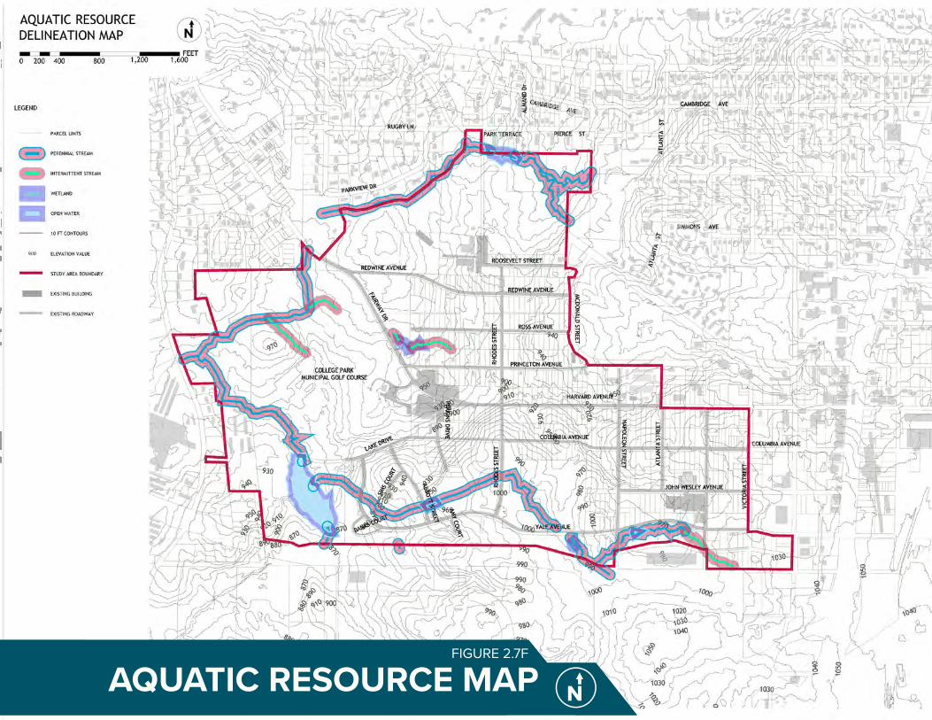
FACTS & ANALYSIS 63
PAGE TITLE (CHANGE TO SECTION COLOR)
SECTION TITLE
This is where a lot of the things will go. Please erase the things here to put in the new things. The new things should be well written and clear to understand. Also, the new things should be interesting to read and not too visually long. For reals, my dudes. If you need to edit this text, you gotta press and hold CTRL+SHIFT and then click a gazillion times into this box to edit. Then, you can never go back. If you mess up, you gotta drag the slide master again to get the original format. Why is InDesign so complicated? wHy Is InDeSiGn So CoMpLiCaTeD¿
I’m pressing enter and making another paragraph because this stuff is getting far too big up there. No one wants a W A L L O F T E X T. Oh by the way, the text boxes are configured to overflow into the next, so if you run out of room in one box it automatically flows into the next. I made like three columns for text, so you’ve got room to grow. Nnnnnyyyyyeeeeeehhhhh. Text filler. Why are you still reading this. Go back to work. Actually no, don’t work. RUN FREE. GO EAT 15 POUNDS OF SPAGHETTI. FROLICK IN A FIELD OF FLOWERS, BUTTERFLIES AND OTHER INSTAGRAMMABLE THINGS. GO LIVE YOUR LIFE AND BE FREEEEEEEEEEEEEEEEEEEEEE. But I mean, yeah guys, just make sure to maintain these graphic standards and you’ll be juuuuuuuuuuuuuuust fine. :D
FIGURE 2.7F
AQUATIC RESOURCE MAP
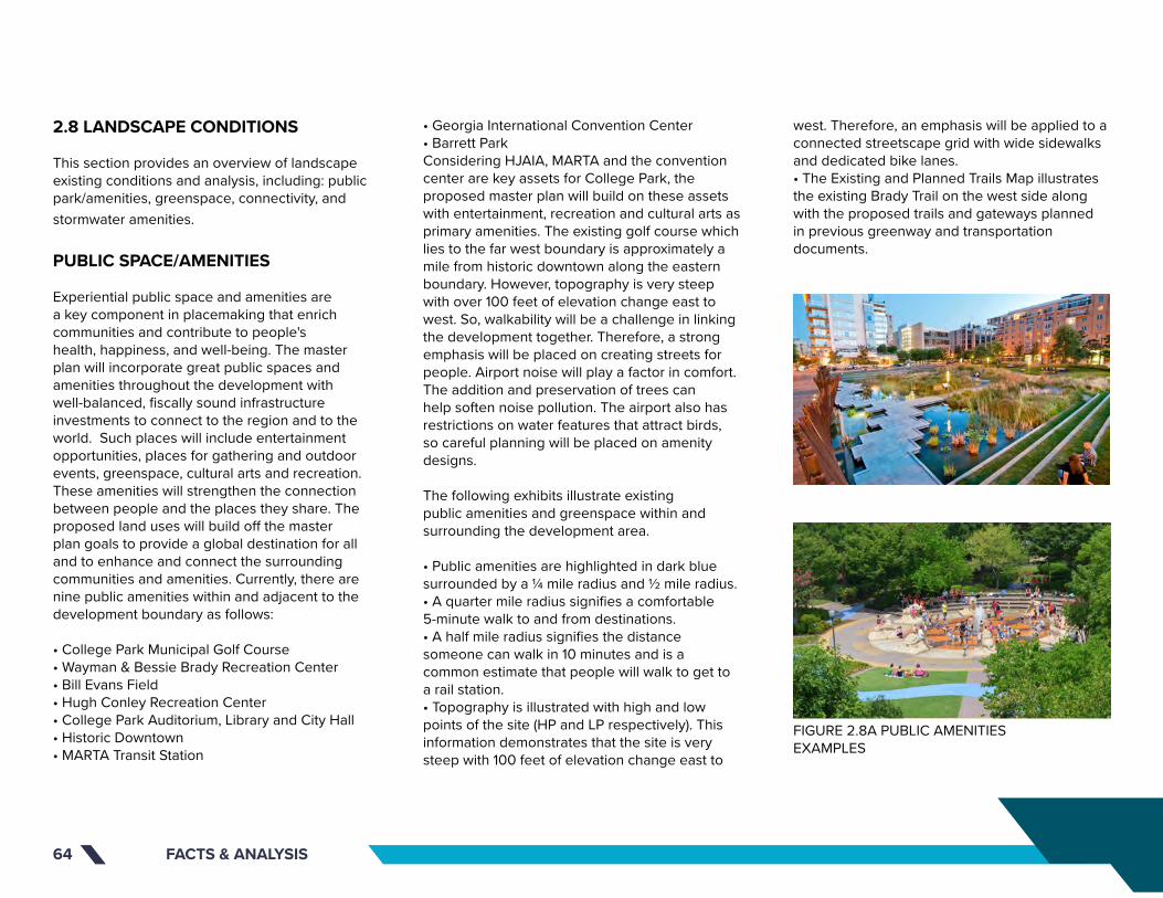
FACTS & ANALYSIS64
2.8 LANDSCAPE CONDITIONS
This section provides an overview of landscape existing conditions and analysis, including: public park/amenities, greenspace, connectivity, and stormwater amenities.
PUBLIC SPACE/AMENITIES
Experiential public space and amenities are a key component in placemaking that enrich communities and contribute to people's health, happiness, and well-being. The master plan will incorporate great public spaces and amenities throughout the development with well-balanced, fiscally sound infrastructure investments to connect to the region and to the world. Such places will include entertainment opportunities, places for gathering and outdoor events, greenspace, cultural arts and recreation. These amenities will strengthen the connection between people and the places they share. The proposed land uses will build off the master plan goals to provide a global destination for all and to enhance and connect the surrounding communities and amenities. Currently, there are nine public amenities within and adjacent to the development boundary as follows:
• College Park Municipal Golf Course• Wayman & Bessie Brady Recreation Center• Bill Evans Field• Hugh Conley Recreation Center• College Park Auditorium, Library and City Hall• Historic Downtown• MARTA Transit Station
• Georgia International Convention Center• Barrett ParkConsidering HJAIA, MARTA and the convention center are key assets for College Park, the proposed master plan will build on these assets with entertainment, recreation and cultural arts as primary amenities. The existing golf course which lies to the far west boundary is approximately a mile from historic downtown along the eastern boundary. However, topography is very steep with over 100 feet of elevation change east to west. So, walkability will be a challenge in linking the development together. Therefore, a strong emphasis will be placed on creating streets for people. Airport noise will play a factor in comfort. The addition and preservation of trees can help soften noise pollution. The airport also has restrictions on water features that attract birds, so careful planning will be placed on amenity designs.
The following exhibits illustrate existing public amenities and greenspace within and surrounding the development area.
• Public amenities are highlighted in dark blue surrounded by a ¼ mile radius and ½ mile radius. • A quarter mile radius signifies a comfortable 5-minute walk to and from destinations. • A half mile radius signifies the distance someone can walk in 10 minutes and is a common estimate that people will walk to get to a rail station.• Topography is illustrated with high and low points of the site (HP and LP respectively). This information demonstrates that the site is very steep with 100 feet of elevation change east to
west. Therefore, an emphasis will be applied to a connected streetscape grid with wide sidewalks and dedicated bike lanes.• The Existing and Planned Trails Map illustrates the existing Brady Trail on the west side along with the proposed trails and gateways planned in previous greenway and transportation documents.
FIGURE 2.8A PUBLIC AMENITIES EXAMPLES

FACTS & ANALYSIS 65
PAGE TITLE (CHANGE TO SECTION COLOR)
SECTION TITLE
This is where a lot of the things will go. Please erase the things here to put in the new things. The new things should be well written and clear to understand. Also, the new things should be interesting to read and not too visually long. For reals, my dudes. If you need to edit this text, you gotta press and hold CTRL+SHIFT and then click a gazillion times into this box to edit. Then, you can never go back. If you mess up, you gotta drag the slide master again to get the original format. Why is InDesign so complicated? wHy Is InDeSiGn So CoMpLiCaTeD¿
I’m pressing enter and making another paragraph because this stuff is getting far too big up there. No one wants a W A L L O F T E X T. Oh by the way, the text boxes are configured to overflow into the next, so if you run out of room in one box it automatically flows into the next. I made like three columns for text, so you’ve got room to grow. Nnnnnyyyyyeeeeeehhhhh. Text filler. Why are you still reading this. Go back to work. Actually no, don’t work. RUN FREE. GO EAT 15 POUNDS OF SPAGHETTI. FROLICK IN A FIELD OF FLOWERS, BUTTERFLIES AND OTHER INSTAGRAMMABLE THINGS. GO LIVE YOUR LIFE AND BE FREEEEEEEEEEEEEEEEEEEEEE. But I mean, yeah guys, just make sure to maintain these graphic standards and you’ll be juuuuuuuuuuuuuuust fine. :D
EXISTING PUBLIC AMENITIES AND GREENSPACE MAPFIGURE 2.8B

EXISTING AND PLANNED TRAILS MAPFIGURE 2.6C

FACTS & ANALYSIS 67
GREENSPACE
The development borders the historic College Park public golf course, the Wayman & Bessie Brady recreation center and Bill Evans Field. Connections to these existing facilities will be provided throughout the master plan to create a walkable, bikeable and transit-oriented development.
The development also borders Camp Creek on the northwest corner of the property and its tributaries on the southwest corner. A vast majority of the land located within the redevelopment boundary is currently vacant, with the exception, of the historic golf course to the west and the Wayman & Bessie Brady Recreation Center to the northwest. Large hardwoods mixed with overgrown vegetation and invasive vines can be found on most of the parcels. It would be ideal to preserve and incorporate the specimen hardwoods into the master plan to preserve the historic college park character and to provide shade throughout the development. Herschel Road and Camp Creek include a model mile trail segment that will be connected to a larger network of trails as part of the AeroATL Greenway Plan. Providing additional connections to the greenway and other surrounding planned trails will be important.
CONNECTIVITY
Several studies have been completed for greenways and trails within the region. The objective will be to provide a connection to all planned trails that surround the development. The topography within the study area could easily deter walking and cycling. Therefore, a strong emphasis will be placed on safe connections with ample lighting, wide connected sidewalks, street trees, protected bike lanes and safe crossings. Comfort, mobility, access and safety all play a significant role in developing appropriate pathways. College Park is a major hub for global, regional and local connections via the airport, MARTA and I-85. The proposed pedestrian bridge and the potential ATL SkyTrain connections will give College Park convenient access from GICC and the airport. The use of nearby sidewalks, streets and other trails connecting neighborhoods, historic downtown and the mixed-use master plan development will increase the use of walking, biking and other alternative methods of transportation.
Design standards for trail and sidewalks should include street trees, lighting, security call boxes, access to restrooms, water fountains, trash cans, benches, playgrounds, pocket parks, Wi-Fi and wayfinding. Creative and sustainable stormwater solutions should also be incorporated into the grid.
FIGURE 2.8D Greenspace EXAMPLES

FACTS & ANALYSIS68
STORMWATER AMENITIES
Incorporating creative stormwater management facilities into parks and public greenspace is a great use of land and promotes environmental stewardship. There are several successfully built examples in the region that were studied as part of the master planning process. It is important to note water features that attract migratory birds will not be permitted per the Federal Aviation Administration.
College Park has implemented a portion of the bioretention project provided for the southeast corner of the development at John Wesley and Napoleon. The plan consists of two detention ponds, new storm lines and tree box filters along the street grid. College Park is the first city in the southeast to incorporate tree filters as a sustainable solution. Additional stormwater solutions that will be appropriate for this development include stormwater parks that infiltrate rainwater through bioretention, stormwater planters, bioswales, preservation of natural areas and underground infiltration.
The following exhibit illustrates existing stormwater flow within the development area. Refer to Figure 2.8e.
• Ridgelines and elevation high points are highlighted in red.• Stormwater flow and water bodies are highlighted in blue.• Topography is illustrated with high and low points of the site (HP and LP respectively). • The 2009 Bioretention project limits are noted for reference to sustainable stormwater strategies implemented within the development boundary.• The stormwater inventory and analysis will help inform locations of proposed sustainable stormwater management facilities including greenspace, parks and detention basins.
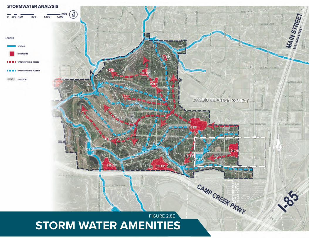
69STORM WATER AMENITIESFIGURE 2.8E

MARKET OPPORTUNITY ANALYSISFIGURE 2.9A
FACTS & ANALYSIS 71
2.9 MARKET DEMAND SUMMARY
This section summarizes the market analysis for the Airport City study area. The full market study is located in the appendix.
AIRPORT CITY ECONOMIC OPPORTUNITIES
In creating Airport City, College Park has a goal of creating a vibrant mixed-use community with a sizable office component. While this is challenging given the modest historic performance of the Airport office market, the creation of a more vibrant mixed-use community is something that has yet to be offered in the Airport area. In understanding the way forward on this effort, we believe it is key to take advantage of both other, larger economic development efforts in the region as well as to invest in the needed infrastructure and improvements needed to maximize these potential opportunities. Refer to Figure 2.9a.
In order to complete this process we must place the subject site into local and regional context. Of critical importance is how the site is situated within Aerotropolis Atlanta, which functions as the blueprint for economic development around Hartsfield Jackson Atlanta International Airport and other complimentary southside neighborhoods. The goal is to transform the airport vicinity into a world-class multi-modal subregion by stimulating investment and strengthening public coordination.
The Aerotropolis Atlanta Blueprint identified the Airport City project as a key catalyst for development in the area around Hartsfield.
Specific recommendations in this study focused on the enhancement of Camp Creek Parkway as a part of College Park and creating greater orientations and connections to the GICC just to the south. Included in this orientation are increased retail and dining opportunities, a significant hotel/lodging component, business incubator and medical facilities.
This study identified these potential uses as targets for the Airport City area:• Transit Oriented Development - TOD
(primarily office)• Federal Offices• Data Hub• Business Incubator• Media Production Creative Cluster• Hotel
FACTS & ANALYSIS72
RECOMMENDATIONS
There are several key items the City of College Park needs to focus on in creating the Airport City project.
Office is indeed the most significant land use within the project and is critical to project's future. As noted, the airport area in general should be a more significant office core relative to its peers elsewhere in the US. Yet it has underperformed significantly due to several key factors:
• A lack of executive housing;• Limited walkability and mixed transit service;• Poor quality of office space in the area currently; and• Negative perceptions regarding disinvestment, crime, etc.
To combat this College Park should undertake several initiatives:
• Issue bonds for basic infrastructure for the project, including streets, sidewalks, water & sewer lines, etc., with those bonds being repaid via the TAD set up in the area;• Proactively leverage the Federal and State Opportunity Zones through various means, including local and regional Chambers of Commerce,State ED offices, Aerotropolis Atlanta, etc.• Utilize State of Georgia Opportunity Zone funds to gain tax credits for companies locating into Airport City• Tap into State Enterprise Zone funds to offer prospective employers tax abatements for state and local taxes• Consider the development of centralized parking structures for office that could lessen development costs and potential lease rates for tenants and be repaid through some level of low monthly rates. At nights and on weekends some of this parking could be used for events at the GICC and arena or other uses.• Seek partnering opportunities with Georgia Tech, Emory, Georgia State, UGA or even outside institutions for technology centers onsite
As noted, quality of life is increasingly important to where companies opt to locate their offices. To this, College Park should:
• Pursue funding options to create significant park and greenspace on the site, including running trails, water features, etc.something other locations around the airport fail to offer• This could be accomplished through either TAD funds, City funds targeted for parks, CDBG Block Grants, or other sources• Identify funding grants and other sources who can help design and build or maintain park space, trails, etc. in Airport City• Seek opportunities for short term land sales that can help fund onsite improvements (roads, parks, sidewalks, etc.), including sales for lodging and or retail.• Pursue the development of a regional-serving upscale outlet center that can cater to Atlanta's large intown residential base.• Such a destination center could fuel growth and demand for restaurants and other services - services that are critical to office tenants.• Finally, work with Aerotropolis Atlanta to aid in providing services for area policing/security, litter pickup, etc. to maximize the image of Airport City.

QUALITY OF LIFE AMENITIESFIGURE 2.9B
TRAILS LUXURY OUTLETS
CORPORATE OFFICE TOWNHOMES


VISION 75
VISION76
3.1 STAKEHOLDER INPUT
The public participation process for the Airport City Master Plan engaged stakeholders through three Core Team meetings, interviews, and a Design Workshop. The key stakeholders consisted of City department heads and staff, community leaders, and relevant agencies and authorities within the study area with knowledge and expertise that could enhance and inform the master plan process.
STAKEHOLDER INTERVIEWS
Prior to the Design Workshop, the consultant team conducted stakeholder Interviews. These interviews helped to promote a clear understanding of the goals, objectives, existing market opportunities and socioeconomic characteristics of the study area. The interviews also provided insight into the overall vision for the study area from those living and/or working within the study area. Interviews were consistent in format utilizing a prepared questionnaire that included a range of discussion points.
Each interview began with an introduction to the study followed by background information prior to beginning the interview. From the interviews, stakeholders provided insight into their overall vision for the study area. Major transportation and land use needs and concerns were also discussed. A total of 7 stakeholder interviews were conducted. Those interviewed include: • Jack P. Longino, Mayor, College Park• Councilmember Ambrose Clay, Ward I,
College Park• Councilmember Derrick Taylor, Ward III,
College Park• Terrence R. Moore, City Manager, College
Park• Michael Hicks, IT Director, College Park• William Moore, Director of Engineering,
College Park• Gary Young, Director of Airport Affairs,
College Park
THE CORE TEAM MEETINGSThe Core Team includes individuals in related fields who are knowledgeable about the study area’s issues and opportunities. The following organizations were represented as members of the Core Team: • BIDA Board of Directors• College Park Planning Commission• City Department Heads• Aerotropolis Alliance• Aerotropolis CID• Aerotropolis DMO • College Park Department of Aviation• College Park Housing Authority• Fulton County Schools• GICC• GDOT• MARTA• Southeast Capitol• Woodward Academy
They met four times during the planning process. The following are brief summaries of these meetings.
Core Team Meeting #1 was held on March 12, 2019: The purpose of the first meeting was to introduce the project process and conduct a goal setting exercise. Core Team Meeting #2 was held on March 25,
2019: The purpose of the this meeting was to review and provide input on project analysis and discuss the upcoming design workshop agenda.
A two-day Design Workshop was held on April 10 and 11, 2019 from 9 am to 5 pm: The design workshop was an opportunity for Key Stakeholders and Core Team Members to provide their vision for the Airport City study area in a workshop setting. The workshop began with a welcome and overview of the existing geographic, demographic, land use, market and socioeconomic conditions of the study area. The remainder of the day was a hands on work session, in which the consultant team worked with stakeholders to develop recommendations for the Airport City study area.
On the second day of the Design Workshop, the consultant team worked on a more detailed level of master planning and presented the updated plans to the Key Stakeholders and Core Team Members for input.
Core Team Meeting #3 was held on May 6, 2019. The consultant team presented their analysis and plans to date. The Core Team asked questions, proposed new ideas, and critiqued existing ideas. Discussions from this meeting were used to determine the recommendations, which were presented to the City of College Park City Council on June 3, 2019.
3.0 VISION
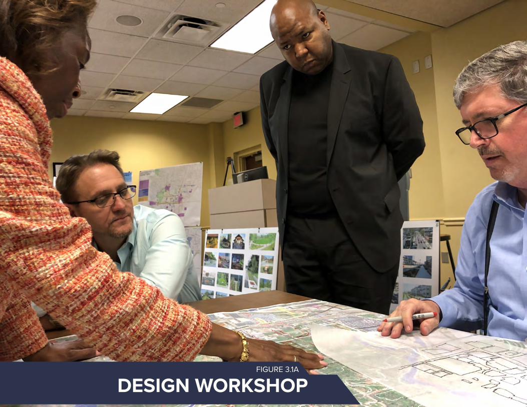
VISION 77
Insert Image
DESIGN WORKSHOPFIGURE 3.1A

VISION78
A global destination rooted in DIVERSITY, EQUITY, and
INCLUSION easily accessible to all – from local residents to
world travelers – a showcase of SMART CITIES and
ECO-FRIENDLY design.
VISION

VISION 79
Create a model sustainable, smart city (eco-district, high-tech)10
01 Develop a plan rooted in diversity, equity, and inclusion (participation, access, economic development) that guides every phase of the process.
02 Design a global destination for travelers, workers, residents, and visitors alike
03 Create live, work, and play spaces
04 Preserve, enhance, and connect to the surrounding community and amenities
05 Generate walkable, bikeable, safe streets for all users
06 Build on the airport assets and access
07 Connect Airport City to the rest of College Park, the region, and the world with easy, safe, and multimodal options
08 Incorporate art into public spaces and new developments
09 Meet the needs of current and future residents of all ages, backgrounds, races
3.2 PROJECT GOALS SUMMARY


RECOMMENDATIONS 81

RECOMMENDATIONS82
PAGE TITLE (CHANGE TO SECTION COLOR)
SECTION TITLE
This is where a lot of the things will go. Please erase the things here to put in the new things. The new things should be well written and clear to understand. Also, the new things should be interesting to read and not too visually long. For reals, my dudes. If you need to edit this text, you gotta press and hold CTRL+SHIFT and then click a gazillion times into this box to edit. Then, you can never go back. If you mess up, you gotta drag the slide master again to get the original format. Why is InDesign so complicated? wHy Is InDeSiGn So CoMpLiCaTeD¿
I’m pressing enter and making another paragraph because this stuff is getting far too big up there. No one wants a W A L L O F T E X T. Oh by the way, the text boxes are configured to overflow into the next, so if you run out of room in one box it automatically flows into the next. I made like three columns for text, so you’ve got room to grow. Nnnnnyyyyyeeeeeehhhhh. Text filler. Why are you still reading this. Go back to work. Actually no, don’t work. RUN FREE. GO EAT 15 POUNDS OF SPAGHETTI. FROLICK IN A FIELD OF FLOWERS, BUTTERFLIES AND OTHER INSTAGRAMMABLE THINGS. GO LIVE YOUR LIFE AND BE FREEEEEEEEEEEEEEEEEEEEEE. But I mean, yeah guys, just make sure to maintain these graphic standards and you’ll be juuuuuuuuuuuuuuust fine. :D
FIGURE 4.1AFIGURE 4.1A
MASTER PLAN CONCEPT

RECOMMENDATIONS 83
4.1 MASTER PLAN CONCEPT
This section provides an overview of the proposed master plan for the Airport City study area. It provides a visionary master plan for these 320 acres of prime redevelopable land, based on market understandings, development potential, and stakeholder and city goals.
While the visionary plan is long range in nature, 10-15 years to implement, portions of this master plan can occur within the next 3 to 5 years and are included in Phase I of the project. The following section explains the design and site considerations that led to the development concepts.
The visionary master plan shown in Figure 4.1a and as described within this section, depicts the future concept for the study area, a global destination rooted in diversity, equity, and inclusion easily accessible to all - from local residents to world travelers - a showcase of smart cities and eco-friendly design.
The Master Plan addresses stakeholder and city goals by developing a plan that:• Provides a mix of uses that can serve the
surrounding existing community, as well as, international travelers;
• Creates safe, walkable streets, trails, and transit options for all transportation modes;
• Incorporates greenspace for community gathering and recreation that incorporates state of the art stormwater management strategies and placemaking opportunities;
• Establishes strong connectivity within the site and to key area assets, including local amenities such as, the Brady Center and Downtown College Park, to global destinations like, HJAIA and the GICC.
The following sections provide more detail on these strategies:4.2 Airport City Districts4.3 Transportation Framework Plan4.4 Placemaking and Greenspace4.5 Stormwater Management4.6 Phase One4.7 Five-Year Development Plan4.8 Cost Estimate and Schedule of Activities4.9 Communications and Public Relations
ENVISION A DAY IN AIRPORT CITY
Stroll from the College Park MARTA Station to Airport City's bustling Columbia
Avenue. Buy fresh veggies from the local farmers/artisan market on your way to catch a musical
performance at the cultural center. Grab lunch at a cafe
overlooking the stunning stormwater park. Catch a
round of golf with friends at the Historic Golf Course.
Finish the day with a glass of wine at a locally-owned Downtown College Park restaurant, taking in the
views of planes overhead.
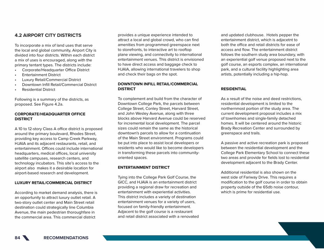
RECOMMENDATIONS84
provides a unique experience intended to attract a local and global crowd, who can find amenities from programmed greenspace next to storefronts, to interactive art to rooftop plane viewing, and connectivity to international entertainment venues. This district is envisioned to have direct access and baggage check to HJAIA, allowing international travelers to shop and check their bags on the spot.
DOWNTOWN INFILL RETAIL/COMMERCIAL DISTRICT
To complement and build from the character of Downtown College Park, the parcels between College Street, Conley Street, Harvard Street, and John Wesley Avenue, along with three blocks above Harvard Avenue could be reserved for incremental local development. The parcel sizes could remain the same as the historical downtown's parcels to allow for a continuation of the Main Street environment. Programs could be put into place to assist local developers or residents who would like to become developers in transforming these parcels into community-oriented spaces.
ENTERTAINMENT DISTRICT
Tying into the College Park Golf Course, the GICC, and HJAIA is an entertainment district providing a regional draw for recreation and entertainment with experiential activities. This district includes a variety of destination entertainment venues for a variety of users, focused on family-friendly entertainment. Adjacent to the golf course is a restaurant and retail district associated with a renovated
4.2 AIRPORT CITY DISTRICTS
To incorporate a mix of land uses that serve the local and global community, Airport City is divided into four districts. Within each district a mix of uses is encouraged, along with the primary tentant types. The districts include: • Corporate/Headquarter Office District• Entertainment District• Luxury Retail/Commercial District• Downtown Infill Retail/Commercial District• Residential District Following is a summary of the districts, as proposed. See Figure 4.2a.
CORPORATE/HEADQUARTER OFFICE DISTRICT
A 10 to 12-story Class A office district is proposed around the primary boulevard, Rhodes Street, providing key access to Camp Creek Parkway, HJAIA and its adjacent restaurants, retail, and entertainment. Offices could include international headquarters, medical offices, local university satellite campuses, research centers, and technology incubators. This site’s access to the airport also makes it a desirable location for airport-based research and development.
LUXURY RETAIL/COMMERCIAL DISTRICT
According to market demand analysis, there is an opportunity to attract luxury outlet retail. A two-story outlet center and Main Street retail destination could strategically line Columbia Avenue, the main pedestrian thoroughfare in the commercial area. This commercial district
and updated clubhouse. Hotels pepper the entertainment district, which is adjacetnt to both the office and retail districts for ease of access and flow. The entertainment district follows the southern study area boundary, with an experiential golf venue proposed next to the golf course, an esports complex, an international park, and a cultural facility highlighting area artists, potentially including a hip-hop.
RESIDENTIAL
As a result of the noise and deed restrictions, residential development is limited to the northernmost portion of the study area. The current development proposal includes a mix of townhomes and single-family detached homes. It will be centered around the historic Brady Recreation Center and surrounded by greenspace and trails.
A passive and active recreation park is proposed between the residential development and the College Park Elementary School to connect these two areas and provide for fields lost to residential development adjacent to the Brady Center.
Additional residential is also shown on the west side of Fariway Drive. This requires a modification to the golf course in order to obtain property outside of the 65db noise contour, which is prime for residential use.

RECOMMENDATIONS 85
PAGE TITLE (CHANGE TO SECTION COLOR)
SECTION TITLE
This is where a lot of the things will go. Please erase the things here to put in the new things. The new things should be well written and clear to understand. Also, the new things should be interesting to read and not too visually long. For reals, my dudes. If you need to edit this text, you gotta press and hold CTRL+SHIFT and then click a gazillion times into this box to edit. Then, you can never go back. If you mess up, you gotta drag the slide master again to get the original format. Why is InDesign so complicated? wHy Is InDeSiGn So CoMpLiCaTeD¿
I’m pressing enter and making another paragraph because this stuff is getting far too big up there. No one wants a W A L L O F T E X T. Oh by the way, the text boxes are configured to overflow into the next, so if you run out of room in one box it automatically flows into the next. I made like three columns for text, so you’ve got room to grow. Nnnnnyyyyyeeeeeehhhhh. Text filler. Why are you still reading this. Go back to work. Actually no, don’t work. RUN FREE. GO EAT 15 POUNDS OF SPAGHETTI. FROLICK IN A FIELD OF FLOWERS, BUTTERFLIES AND OTHER INSTAGRAMMABLE THINGS. GO LIVE YOUR LIFE AND BE FREEEEEEEEEEEEEEEEEEEEEE. But I mean, yeah guys, just make sure to maintain these graphic standards and you’ll be juuuuuuuuuuuuuuust fine. :D
New Boulevard Connection New Boulevard Connection
College Park Golf Course
College Park Golf Course
Club HouseClub
House
Experimental Golf
Venue
Experimental Golf
Venue
Rhodes StreetRhodes Street
Airport Drive
Airport Drive
College Park Elementary
School
College Park Elementary
School
E SportsE Sports
Residential
Entertainment
Corporate / Headquarter Office District
Luxury Retail / Commercial
Downtown Infill Retail / Commercial
Legend
CHARACTER AREASFIGURE 4.2A

HARVARD AVE.HARVARD AVE.
COLUMBIA AVE.COLUMBIA AVE.
JOHN WESLEY AVE.JOHN WESLEY AVE.
YALE AVE.YALE AVE.
REDWINE AVE.REDWINE AVE.
CAMP CREEK PARKWAYCAMP CREEK PARKWAY OXFORD AVE.OXFORD AVE.
CO
LLEG
E ST
.C
OLL
EGE
ST.
CO
NLE
Y ST
.C
ON
LEY
ST.
NA
POLE
ON
ST.
NA
POLE
ON
ST.
ATL
AN
TA S
T.A
TLA
NTA
ST.
VIC
TORI
A S
T.V
ICTO
RIA
ST.
PRINCETON AVE.PRINCETON AVE.
VIRGINIA AVE.VIRGINIA AVE.
AIR
PORT
DR.
AIR
PORT
DR.
RHO
DES
ST.
RHO
DES
ST.
ROSS AVE.ROSS AVE.
Existing/Improved Roadway
New Roadway
Roadway to be Removed
Pedestrian Connection to GICC
Legend
FRAMEWORK PLANFIGURE 4.3A

RECOMMENDATIONS 87
4.3 TRANSPORTATION FRAMEWORK PLAN
EXISTING AND NEW FRAMEWORK
The Airport City Master Plan aims to continue the flow of the existing downtown street grid while adding gateway connections and maximizing function, safety, and beauty. Figure 4.3a illustrates the changes and additions proposed to accomplish the aforementioned goals.
Airport City lies directly adjacent to Historic Downtown College Park, which is the commercial center of the community, and is organized around a traditional street grid. This grid continues into the study area and is ideal for a pedestrian-friendly environment. In addition to road improvements, new connections must be built to facilitate access to Airport City from existing major roadways and surrounding neighborhoods. While the existing downtown and surrounding grid provide a variety of options to access Airport City, the primary entrance is at Camp Creek Parkway and Airport Drive. A new boulevard is proposed to connect the Airport Drive intersection at Camp Creek Parkway north to Rhodes Street, creating the main north/south spine of the development and direct access into the residential development. Fairway Drive provides connectivity from the west and a new street segment is proposed to provide a direct connection from Fairway Drive to Columbia Avenue, the main retail corridor. A longer term proposal to connect the development to Virginia Avenue is also proposed, spurring off of Rhodes Street to the north. The third major connection is providing direct access from College Street to
the Convention Center Concourse, via Conley Street. College Street allows north/south access from the GICC to the development, downtown, and areas farther north. Likewise, two roundabouts – one at Rhodes Street and Columbia Avenue and another at Conley Street and Columbia Avenue – would serve as front doors into Airport City with landscaping, art, and signage welcoming visitors and residents into the community.
HARVARD AVE.HARVARD AVE.
COLUMBIA AVE.COLUMBIA AVE.
JOHN WESLEY AVE.JOHN WESLEY AVE.
YALE AVE.YALE AVE.
REDWINE AVE.REDWINE AVE.
CAMP CREEK PARKWAYCAMP CREEK PARKWAY OXFORD AVE.OXFORD AVE.
CO
LLEG
E ST
.C
OLL
EGE
ST.
CO
NLE
Y ST
.C
ON
LEY
ST.
NA
POLE
ON
ST.
NA
POLE
ON
ST.
ATL
AN
TA S
T.A
TLA
NTA
ST.
VIC
TORI
A S
T.V
ICTO
RIA
ST.
PRINCETON AVE.PRINCETON AVE.
VIRGINIA AVE.VIRGINIA AVE.
AIR
PORT
DR.
AIR
PORT
DR.
RHO
DES
ST.
RHO
DES
ST.
ROSS AVE.ROSS AVE.
Existing/Improved Roadway
New Roadway
Roadway to be Removed
Pedestrian Connection to GICC
Legend
FRAMEWORK PLAN

RECOMMENDATIONS88
TRAILS
The Airport City master plan aims to create a trail system that provides College Park communities with an integrated, comprehensive bike/pedestrian trail system that improves the quality of life, health, connectivity, and economic growth of the region. Trails can connect visitors and residents to area amenities and everyday services, to public transit options, to work, and to other trail systems.
Trails in this plan align with area creeks and stream buffers as well as providing connectivity to the many existing and proposed amenities, including the College Park MARTA Station outside of the study area boundary and the existing Brady Trail, which currently connects Fairway Drive to Herschel Road. Ties to the existing neighborhoods are made through East/West (Harvard Avenue and John Wesley Avenue) and North/South (Rhodes Street). Likewise, trail connections are proposed along Herschel Road and Camp Creek Parkway to join with proposed AeroATL Greenway Plan trails and through the northern section of the study area to link to Virginia Avenue.
Additionally, a trail connection to the Brady Trail is proposed from the Residential District over Camp Creek at Harris Drive to better connect the northern neighborhoods to the many amenities Airport City will have to offer.
As an added amenity for neighborhoods, schools, and visitors, a proposed 5k trail could encircle the entire study area. It could connect the stormwater park (a great race start location)
to downtown, College Park Elementary School, Camp Creek Parkway, the Brady Trail, and the College Park Golf Course. This trail can be used for cross country competitions, 5k races; running or biking; and leisurely exercise.
The streets identified for trails but have been prioritized for multimodal infrastructure such as bike lanes or wide pedestrian pathways/trails to improve connections throughout the development to the residential areas, College Park Elementary School, and the College Park MARTA Station.
TRANSIT
The City of College Park has strong regional connectivity with two MARTA rail stations – the College Park Station lies just east of the Airport City study area boundary and the Airport MARTA Station just to the south. Furthermore, HJAIA’s SkyTrain, a free elevated train, runs 24 hours a day between the Airport MARTA station, the GICC, and the Rental Car Center – all of which are close to the southern border of the study area. This plan proposes capitalizing on these transit assets by broadening their reach into Airport City. The SkyTrain could be extended from the GICC to the Delta Air Lines Employee Parking Lot and onwards into the heart of the Airport City development. The technology for these extensions needs further study, and may need to be a separate system as the SkyTrain is strictly for airport use. An autonomous bus circulator could run on a continuous loop from the College Park MARTA Station through the proposed commercial districts into the office center, providing a convenient and easy means to access Airport City without a car.

REDWINE AVE.REDWINE AVE.
ROSS AVE.ROSS AVE.
PRINCETON AVE.PRINCETON AVE.
NA
POLE
ON
ST.
NA
POLE
ON
ST.
ATL
AN
TA S
T.A
TLA
NTA
ST.
CO
NLE
Y ST
.C
ON
LEY
ST.
VIC
TORI
A S
T.V
ICTO
RIA
ST.
CO
LLEG
E ST
.C
OLL
EGE
ST.
HARVARD AVE.HARVARD AVE.
COLUMBIA AVE.COLUMBIA AVE.
JOHN WESLEY AVE.JOHN WESLEY AVE.
YALE AVE.YALE AVE.
OXFORD AVE.OXFORD AVE.CAMP CREEK PARKWAYCAMP CREEK PARKWAY
VIRGINIA AVE.VIRGINIA AVE.
Existing/Improved Roadway
Roadway to be Removed
Pedestrian Connection to GICC
Brady Trail and Extension
5K
Greenways
New Roadway
Legend
TRAILSFIGURE 4.3B

RECOMMENDATIONS90
PAGE TITLE (CHANGE TO SECTION COLOR)
SECTION TITLE
This is where a lot of the things will go. Please erase the things here to put in the new things. The new things should be well written and clear to understand. Also, the new things should be interesting to read and not too visually long. For reals, my dudes. If you need to edit this text, you gotta press and hold CTRL+SHIFT and then click a gazillion times into this box to edit. Then, you can never go back. If you mess up, you gotta drag the slide master again to get the original format. Why is InDesign so complicated? wHy Is InDeSiGn So CoMpLiCaTeD¿
I’m pressing enter and making another paragraph because this stuff is getting far too big up there. No one wants a W A L L O F T E X T. Oh by the way, the text boxes are configured to overflow into the next, so if you run out of room in one box it automatically flows into the next. I made like three columns for text, so you’ve got room to grow. Nnnnnyyyyyeeeeeehhhhh. Text filler. Why are you still reading this. Go back to work. Actually no, don’t work. RUN FREE. GO EAT 15 POUNDS OF SPAGHETTI. FROLICK IN A FIELD OF FLOWERS, BUTTERFLIES AND OTHER INSTAGRAMMABLE THINGS. GO LIVE YOUR LIFE AND BE FREEEEEEEEEEEEEEEEEEEEEE. But I mean, yeah guys, just make sure to maintain these graphic standards and you’ll be juuuuuuuuuuuuuuust fine. :D
Sky Train Existing
Autonomous Bus Circulator
SkyTrain Extension
Legend
TRANSITFIGURE 4.3C

Sky Train Existing
Autonomous Bus Circulator
SkyTrain Extension
Legend
TRANSIT
LEGEND
Boulevard
Primary Retail Corridor
Secondary Retail Corridor
Harvard Avenue Corridor
Neighborhood Street
Pedestrian Only Street
Greenway REDWINE AVE.
VIRGINIA AVE.
CAMP CREEK PARKWAY
HARVARD AVE.
CO
LLEG
E ST
.
COLUMBIA AVE.
JOHN WESLEY AVE.
YALE AVE.
OXFORD AVE.
AIR
PORT
DR.
RHO
DES
ST.
ROSS AVE.
FAIRWAY DR.
REDWINE AVE.
NA
POLE
ON
ST.
ATLA
NTA
ST.
CO
NLE
Y ST
.
VIC
TORI
A S
T.
FRAMEWORK PLANFIGURE 4.3D
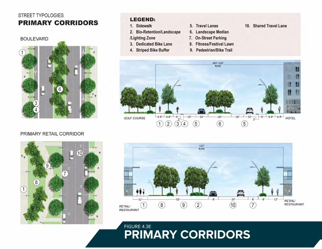
PRIMARY CORRIDORSFIGURE 4.3E
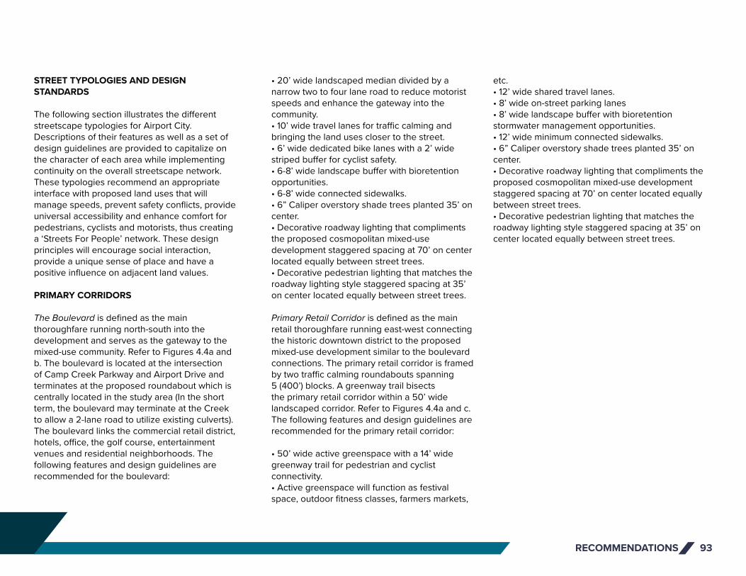
RECOMMENDATIONS 93
STREET TYPOLOGIES AND DESIGN STANDARDS
The following section illustrates the different streetscape typologies for Airport City. Descriptions of their features as well as a set of design guidelines are provided to capitalize on the character of each area while implementing continuity on the overall streetscape network. These typologies recommend an appropriate interface with proposed land uses that will manage speeds, prevent safety conflicts, provide universal accessibility and enhance comfort for pedestrians, cyclists and motorists, thus creating a ‘Streets For People’ network. These design principles will encourage social interaction, provide a unique sense of place and have a positive influence on adjacent land values.
PRIMARY CORRIDORS
The Boulevard is defined as the main thoroughfare running north-south into the development and serves as the gateway to the mixed-use community. Refer to Figures 4.4a and b. The boulevard is located at the intersection of Camp Creek Parkway and Airport Drive and terminates at the proposed roundabout which is centrally located in the study area (In the short term, the boulevard may terminate at the Creek to allow a 2-lane road to utilize existing culverts). The boulevard links the commercial retail district, hotels, office, the golf course, entertainment venues and residential neighborhoods. The following features and design guidelines are recommended for the boulevard:
• 20’ wide landscaped median divided by a narrow two to four lane road to reduce motorist speeds and enhance the gateway into the community.• 10’ wide travel lanes for traffic calming and bringing the land uses closer to the street.• 6’ wide dedicated bike lanes with a 2’ wide striped buffer for cyclist safety.• 6-8’ wide landscape buffer with bioretention opportunities.• 6-8’ wide connected sidewalks.• 6” Caliper overstory shade trees planted 35’ on center.• Decorative roadway lighting that compliments the proposed cosmopolitan mixed-use development staggered spacing at 70’ on center located equally between street trees.• Decorative pedestrian lighting that matches the roadway lighting style staggered spacing at 35’ on center located equally between street trees.
Primary Retail Corridor is defined as the main retail thoroughfare running east-west connecting the historic downtown district to the proposed mixed-use development similar to the boulevard connections. The primary retail corridor is framed by two traffic calming roundabouts spanning 5 (400’) blocks. A greenway trail bisects the primary retail corridor within a 50’ wide landscaped corridor. Refer to Figures 4.4a and c. The following features and design guidelines are recommended for the primary retail corridor:
• 50’ wide active greenspace with a 14’ wide greenway trail for pedestrian and cyclist connectivity.• Active greenspace will function as festival space, outdoor fitness classes, farmers markets,
etc. • 12’ wide shared travel lanes.• 8’ wide on-street parking lanes• 8’ wide landscape buffer with bioretention stormwater management opportunities.• 12’ wide minimum connected sidewalks.• 6” Caliper overstory shade trees planted 35’ on center.• Decorative roadway lighting that compliments the proposed cosmopolitan mixed-use development staggered spacing at 70’ on center located equally between street trees.• Decorative pedestrian lighting that matches the roadway lighting style staggered spacing at 35’ on center located equally between street trees.
PRIMARY CORRIDORS

RECOMMENDATIONS94
PAGE TITLE (CHANGE TO SECTION COLOR)
SECTION TITLE
This is where a lot of the things will go. Please erase the things here to put in the new things. The new things should be well written and clear to understand. Also, the new things should be interesting to read and not too visually long. For reals, my dudes. If you need to edit this text, you gotta press and hold CTRL+SHIFT and then click a gazillion times into this box to edit. Then, you can never go back. If you mess up, you gotta drag the slide master again to get the original format. Why is InDesign so complicated? wHy Is InDeSiGn So CoMpLiCaTeD¿
I’m pressing enter and making another paragraph because this stuff is getting far too big up there. No one wants a W A L L O F T E X T. Oh by the way, the text boxes are configured to overflow into the next, so if you run out of room in one box it automatically flows into the next. I made like three columns for text, so you’ve got room to grow. Nnnnnyyyyyeeeeeehhhhh. Text filler. Why are you still reading this. Go back to work. Actually no, don’t work. RUN FREE. GO EAT 15 POUNDS OF SPAGHETTI. FROLICK IN A FIELD OF FLOWERS, BUTTERFLIES AND OTHER INSTAGRAMMABLE THINGS. GO LIVE YOUR LIFE AND BE FREEEEEEEEEEEEEEEEEEEEEE. But I mean, yeah guys, just make sure to maintain these graphic standards and you’ll be juuuuuuuuuuuuuuust fine. :D
FIGURE 4.3A
THE BOULEVARDFIGURE 4.3F

THE BOULEVARD PRIMARY RETAIL CORRIDORFIGURE 4.3G

RECOMMENDATIONS96
SECONDARY AND NEIGHBORHOOD CORRIDORS
North of Boulevard is defined as the central north-south corridor connecting the residential neighborhoods, active recreation and in the future Virginia Avenue. North of Boulevard has a reduced right of way footprint to enhance the neighborhood character while maintaining wide sidewalks and dedicated bike lanes for safety and connectivity. North of Boulevard serves as a transition zone from the commercial districts to the neighborhood district. Refer to Figure 4.4d. The following features and design guidelines are recommended for north of boulevard:
• 10’ wide travel lanes for traffic calming and bringing the land uses closer to the street.• 6’ wide dedicated bike lanes.• 6’ wide landscape buffer with bioretention opportunities.• 6-8’ wide connected sidewalks.• 3-4” Caliper overstory shade trees planted 35’ on center.• Decorative roadway lighting that compliments adjacent land uses and has a staggered spacing at 70’ on center located equally between street trees.• Decorative pedestrian lighting that matches the roadway lighting style staggered spacing at 35’ on center located equally between street trees.
Secondary Retail Corridors are defined as the secondary streets connecting all the commercial land uses. Similarly, the North of Boulevard corridor, it too has a reduced right of way footprint to bring people closer to the street while maintaining wide sidewalks and dedicated bike lanes for safety and connectivity.
The difference being on-street parking lanes to support the commercial district. Refer to Figure 4.4d. The following features and design guidelines are recommended for the secondary commercial streets:
• 10’ wide travel lanes for traffic calming and bringing the land uses closer to the street.• 6’ wide dedicated bike lanes.• 8’ wide on street parking lanes.• 6’ wide landscape buffer with bioretention opportunities.• 8’ wide minimum connected sidewalks.• 3-4” Caliper overstory shade trees planted 35’ on center.• Decorative roadway lighting that compliments adjacent land uses and has a staggered spacing at 70’ on center located equally between street trees.• Decorative pedestrian lighting that matches the roadway lighting style staggered spacing at 35’ on center located equally between street trees.
Harvard Avenue Corridor is defined as the main north thoroughfare connecting historic downtown to the historic golf course on the west side of the development. Harvard Avenue turns into Fairway Drive which connects to residential neighborhoods outside the Airport City development footprint. High transmission lines run along the right of way creating limitations to the streetscape enhancements. Where poles are located, sidewalks and landscape zones will be reduced in those areas recommended for Harvard Avenue (Refer to Figure 4.4d):
• 10’ wide travel lanes for traffic calming and bringing the land uses closer to the street.• 6’ wide dedicated bike lanes with a 2’ wide
striped buffer.• 8’ wide on street parking lanes adjacent to retail and commercial land uses. • 6’ wide landscape buffer with bioretention opportunities. Narrowed to 4-5’ at transmission poles.• 6’-12’ wide connected sidewalks based on adjacent land use. Narrowed to 4-5’ at transmission poles.• 3-4” Caliper overstory shade trees planted 35’ on center.• Decorative roadway lighting that compliments adjacent land uses and has a staggered spacing at 70’ on center located equally between street trees.• Decorative pedestrian lighting that matches the roadway lighting style staggered spacing at 35’ on center located equally between street trees.
SECONDARY AND NEIGHBORHOOD CORRIDORS
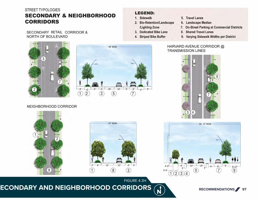
RECOMMENDATIONS 97SECONDARY AND NEIGHBORHOOD CORRIDORSFIGURE 4.3H
RETAIL
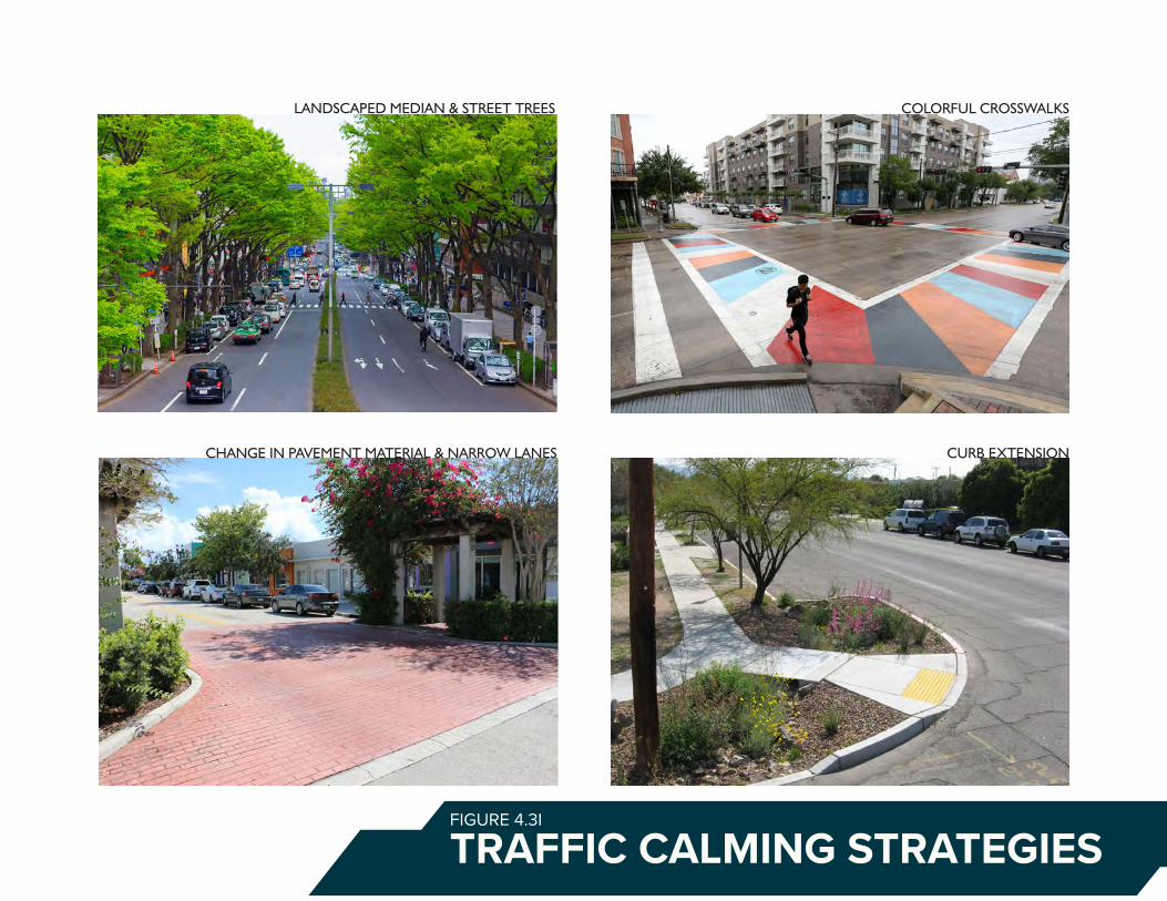
FIGURE 4.3I
TRAFFIC CALMING STRATEGIES
LANDSCAPED MEDIAN & STREET TREES
CHANGE IN PAVEMENT MATERIAL & NARROW LANES CURB EXTENSION
COLORFUL CROSSWALKS

RECOMMENDATIONS 99
Neighborhood Streets are located in the proposed neighborhood district and has a 47’ right of way with the most compact development footprint. High transmission lines run along the right of way creating limitations to the streetscape enhancements. The common goal for all street typologies is to provide safe connected routes with adequate travel lanes, shade, lighting and a sustainable stormwater infiltration solution. Refer to Figure 4.4d. Neighborhood streets include the following features:
• 12’ wide shared travel lanes for traffic calming and enhancing the neighborhood character.• 6’ wide landscape buffer with bio-retention opportunities. • 5-6’wide connected sidewalks.• 3” Caliper overstory shade trees planted 35’ on center.• Decorative roadway lighting that compliments adjacent land uses and has a staggered spacing at 70’ on center located equally between street trees.
Lastly, for all street types, this study proposes developing street furniture specifications and standards unique to the Airport City Development with a cosmopolitan style that compliments the proposed architecture.
TRAFFIC CALMING STRATEGIES
Traffic calming is a traffic management approach used to describe varying methods to slow motorists as they move through commercial and residential neighborhoods. The objective
of implementing traffic calming devices is to create safer and more compatible walking and cycling. The following techniques are sourced and recommended by Global Designing Cities Initiative and can be found on their website globaldesigningcities.org. These recommendations should be considered as streets are implemented within the Master Plan development. Refer to Figure 4.4e.
• Narrow Lanes to reduce speeds and mitigate crashes• Narrow Corner Radii to reduce vehicle turning speeds and reduces pedestrian crossing distances.• Building and Trees placed close to the street to emphasize an urban environment and not a highway.• Gateway Treatments to alert drivers that they are entering a community with a slower speed environment.• Mid-Block Pinch-points with raised pedestrian crossings or pedestrian signals to be located on lower volume roads.• Chicanes and Lane Shifts use alternating parking, curb extensions, or landscape islands to form an S-shaped path of travel to lower travel speeds.• Landscape Medians and Pedestrian Refuge Islands to reduce lane width and provide safe refuge for non-motorists.• Roundabouts to reduce travel speeds and organize traffic routing• Change in Pavement Materials and Appearance at intersections and crossings to alert drivers of a unique place and to slow traffic.
TRAFFIC CALMING STRATEGIES

RECOMMENDATIONS100
4.4 PLACEMAKING AND GREENSPACE
Placemaking and greenspace strategies are recommended to help define Airport City as a singular place and provide much-needed public amenities. Greenspace and trails provide active transportation, mental and physical health benefits, opportunities for exercise, and access to nature. Similarly, placemaking capitalizes on the existing assets of the community to create public spaces that promote community well-being and branding with art, landscaping, lighting, and signage. Following are those strategies:
GREENSPACE
Two parks are proposed within the study area to supply stormwater management through green infrastructure strategies and bring open space to the redevelopment. Green infrastructure is a cost-effective, sustainable approach to reduce and treat stormwater at its source while delivering environmental, social, and economic benefits. The two stormwater parks are noted below and illustrated in Figures 4.5 b and c as follows:
• Stormwater Park – The centerpiece of community space in Airport City would be a stormwater park along Camp Creek Parkway. The park would be bookended at the east end with a heritage/cultural arts/music center and a potential e-sports arena at the west end. Inside the park would be open space for picnics, family gatherings, entertainment, outdoor fitness, public events, and airplane viewing. The park is strategically in-line with a departure runway, so
local and global community members can come and view planes taking off. The park is modeled after several successful parks throughout the United States including Gravelly Park in Washington DC, Millennium Park in Chicago and several stormwater parks located throughout metro Atlanta. The park and surrounding streetscapes within the watershed will manage up to 424,000 cubic feet in stormwater capacity. A combination of green infrastructure strategies provided through underground infiltration chambers, bioretention landscape areas, tree filter boxes, permeable pavements and rainwater harvesting will be incorporated into the design.
• Brady – Elementary Sports Park – Additional greenspace is proposed between the Brady Recreation Center and the College Park Elementary School to safely connect the two and to replace Brady Center fields lost to residential development. It would contain a playground, a baseball field, a flexible sports field, dog park and surface parking. The park would be connected by safe pedestrian crosswalks and pedestrian oriented signals along with wide sidewalks, bike lanes and security lighting. Up to 280,000 cubic feet of stormwater will be managed by a combination of underground infiltration chambers, permeable pavements and rainwater harvesting for irrigation.
The Golf Course if it is renovated, could serve as additional greenspace serving as a regional stormwater management facility through the combination of a retention pond and underground infiltration chambers. The retention pond would continue to serve as the golf course irrigation water source.
ACTIVATED GREENSPACE
To effectively activate the proposed trail system and common spaces, the plan recommends placemaking strategies to create people-friendly parks, artistic play areas, sculpture parks, picnic areas, gathering areas and educational markers located throughout the Master Plan greenspace network. Refer to Figure 4.4a.
ART
To spotlight Airport City’s amenities and further promote branding efforts for the area, the plan recommends coordination with local artists, musicians, and arts organizations to place artwork and host art events. The area has the potential to be more inviting and engaging by creatively utilizing artistic murals, sculptures, lighting, music, and signage.
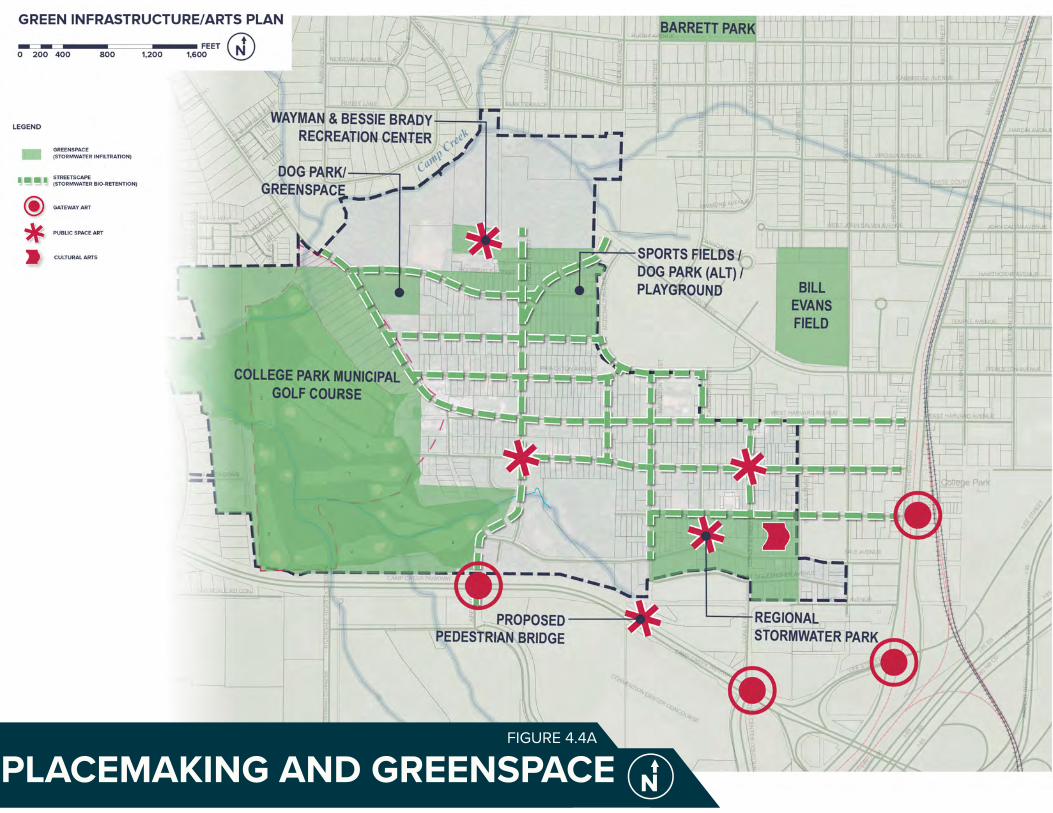
PLACEMAKING AND GREENSPACEFIGURE 4.4A
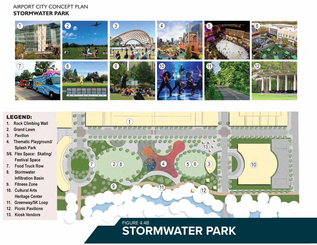
STORMWATER PARKFIGURE 4.4B
AIRPORT CITY CONCEPT PLANSTORMWATER PARK
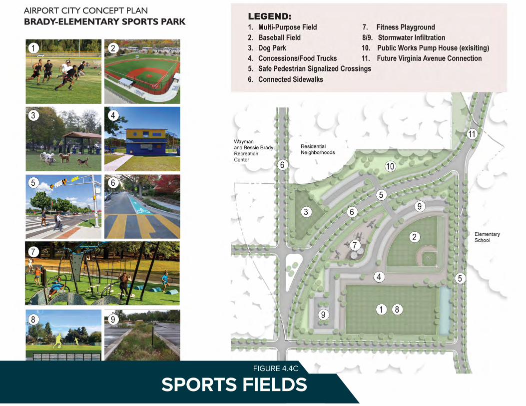
RECOMMENDATIONS 103STORMWATER PARK SPORTS FIELDSFIGURE 4.4C
AIRPORT CITY CONCEPT PLANBRADY-ELEMENTARY SPORTS PARK

RECOMMENDATIONS104
4.5 STORMWATER MANAGEMENT
Stormwater management is a key consideration in ensuring the proposed Airport City development is realistic and feasible. This section provides recommendations on stormwater basin alignments and sizes to ensure water can effectively flow through the site and be appropriately diverted and captured in a manner that works with new development. Additionally, this section provides recommendations on water main extensions that may be necessary to support the first phase of proposed development.
ANALYSIS METHODOLOGY
The goal of the Airport City Master Plan stormwater management analysis is to determine the approximate locations and volumes of stormwater detention necessary to meet state and municipal requirements for stormwater management.
This corresponds to analyzing the 100-year return period rainfall event, which was studied using the Soil Conservation Service (SCS) method. The basis of the analysis is to compare pre-developed and post-developed conditions, and then to determine the volume of stormwater runoff that needs to be detained to control post-developed peak flow rates to pre-developed flow rates at the determined downstream study point.
Drainage basins and study points were delineated using existing topography from Fulton County GIS contours. Offsite basins draining into the Airport City area to be developed were analyzed at the downstream study point,
but were not considered in detention volume calculations.
Curve Numbers (CN) were estimated based on USGS soils data, existing land cover based on Google Earth imagery, and proposed land uses from the master plan. Proposed land uses include parks/ conserved land, hotel/ entertainment,
commercial, office, residential, and roadways.
Runoff time of concentration (Tc) for each pre- and post-developed drainage basin was calculated considering a combination of runoff sheet flow and shallow concentrated flow. Existing or proposed stormwater conveyance structures, such as underground pipes, were
FIGURE 4.5A STORMWATER BASIN PRE REDEVELOPMENT

STORMWATER BASINS POST REDEVELOPMENTFIGURE 4.5B

PHASE ONE FIRE/WATERFIGURE 4.5C

RECOMMENDATIONS 107
ignored as sufficient information was not available.Historical rainfall data from the nearest NOAA station at HJAIA was used in the calculations.
Stream bank information from GIS topography and an environmental study by Contour Engineering were both used to estimate the Camp Creek and tributary stream cross section shape, slope and roughness factors. This information was used to calculate the effect of each basin at the downstream Study Point “0”.
EXISTING CONDITIONS
In existing conditions, the Airport City study area has a minor amount of buildings and paved areas and also includes a network of paved streets with catch basins, a golf course, lake, streams and grassed and wooded areas. The proposed area can generally be divided by a break line into two north and south drainage areas. Both the north and south drainage areas drain to the southwestern corner of the Airport City master planned area, Study Point “0” (SP 0).
The southern area generally drains from east to southwest toward a stream along the southern limits of the development area, which then feeds into a lake on the existing golf course and then feeds into Camp Creek. The northern area generally drains from south to northwest toward Camp Creek and its tributaries. These south and north drainage areas are divided into 7 and 8 smaller drainage basins, respectively, based on where proposed stormwater detention areas will likely be located.
PROPOSED CONDITIONS
The estimated detention volumes for each basin were sized to control the peak flow in that basin, as well as the downstream combined peak flow of all the studied basins. Each drainage basin was analyzed considering the downstream end of the basin being the location of the proposed detention facilities. However, proposed detention could be provided using a combination of multiple methods, including underground chambers or pipes, above ground ponds, and runoff reduction features such as bioretention and swales. Most drainage basins include parkland areas in downstream locations where stormwater could be managed.
The “Phase 1” development area approximately encompasses drainage basins 4A and 5 in the southern drainage area, and basins 8 and 9B in the northern drainage area. Refer to Figure 4.6c.
PHASE I
Following the recommendation for a 12” water main extension, extending the existing 12” water main begins at the corner of Pierce Street and Cambridge Avenue, then proceeds south on Pierce Street to Park Terrace, then west on Park Terrace to Brenningham Drive, then south on Brenningham Drive and Rhodes Street to Columbia Avenue, then east on Columbia Avenue to College Street and connects to the existing 12” water main there creating a 12” main transmission water line for Airport City. Additional 12” water line proceeds south on Conley Street from Columbia Avenue to Oxford Avenue
providing for future opportunity to extend the 12” water line to the north side of Camp Creek Parkway.
Old 6” distribution water lines can then be upgraded to 8” water lines and existing 8” water lines can be reconnected to provide domestic and fire services to the retail, commercial and residential areas of Airport City. Fire Hydrant spacing and new Fire Hydrant installations will be spaced a 500’ intervals for residential areas and 300’ intervals for retail and commercial areas in accordance with fire prevention and protection ordinances.

RECOMMENDATIONS108
4.6 PHASE ONE
Phase One - A
Key to the implementation of this Airport City master plan is the purchase and development of a large parcel of land at the north of the study area into a residential community. This sale will catalyze the rest of the development by bringing new households into the area and enabling the City to transform Rhodes Street into a main access point from Camp Creek Parkway, into Airport City, and up to the proposed residential area. In turning Rhodes Street into a primary North-South boulevard, Phase One would include building the boulevard right of way including: the roadway, sidewalks, landscaping, bike infrastructure, and public art. A roundabout at Columbia Avenue could also be part of Phase One- A. Refer to Figure 4.7a. With sufficient funding, Phase One - A would also include a potential golf course reconfiguration. Holes 1 and 2 could be relocated to shift the golf course to the south. This would maximize available residential land, which is very limited due to FAA restrictions.
Phase One - B
As funding becomes available, this master plan proposes constructing an East/West Main Street on Columbia Avenue from Fairway Drive to Conley Street. Sidewalks, streetscapes, art, traffic calming, roundabout surveys, soil tests, and soft costs would be included in this development phase.
Phase One - C
Lastly, as funding allows, the City should target some of the key public resources throughout the study area, including: the stormwater park, the commercial parking deck with a climbing wall, and the trail system.
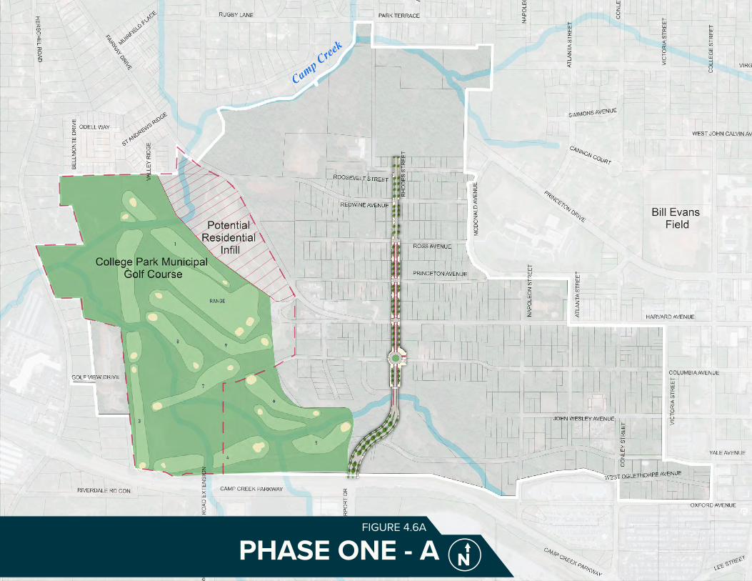
PHASE ONE - AFIGURE 4.6A

RECOMMENDATIONS110 PHASE ONE - BFIGURE 4.6B

RECOMMENDATIONS 111PHASE ONE - CFIGURE 4.6C

FIVE-YEAR DEVELOPMENT PLANFIGURE 4.7A

RECOMMENDATIONS 113
4.7 FIVE-YEAR DEVELOPMENT PLAN
The Five-Year Development Plan, shown in Figure 4.8a, is an ambitious plan to capitalize on existing community assets and HJAIA access to develop the anchor commercial, retail, office, entertainment amenities, hotels, and golf course improvements. This would create a truly iconic, global experience. Figure 4.8a highlights key assets and development concepts in red.
The Five-Year Development Plan concept boldly defies current market demands with the vision that the allure of the unique Airport City site could bring additional tenants, such as corporate office headquarters and entertainment venues. Corporate headquarters would increase residential, commercial, and office demand. A full market analysis can be found in the Appendix.
Over the following 5-10 years, the remainder of the site is anticipated to grow incrementally. It is envisioned for local developers and entrepreneurs to infill smaller parcels with commercial, office, and entertainment uses.
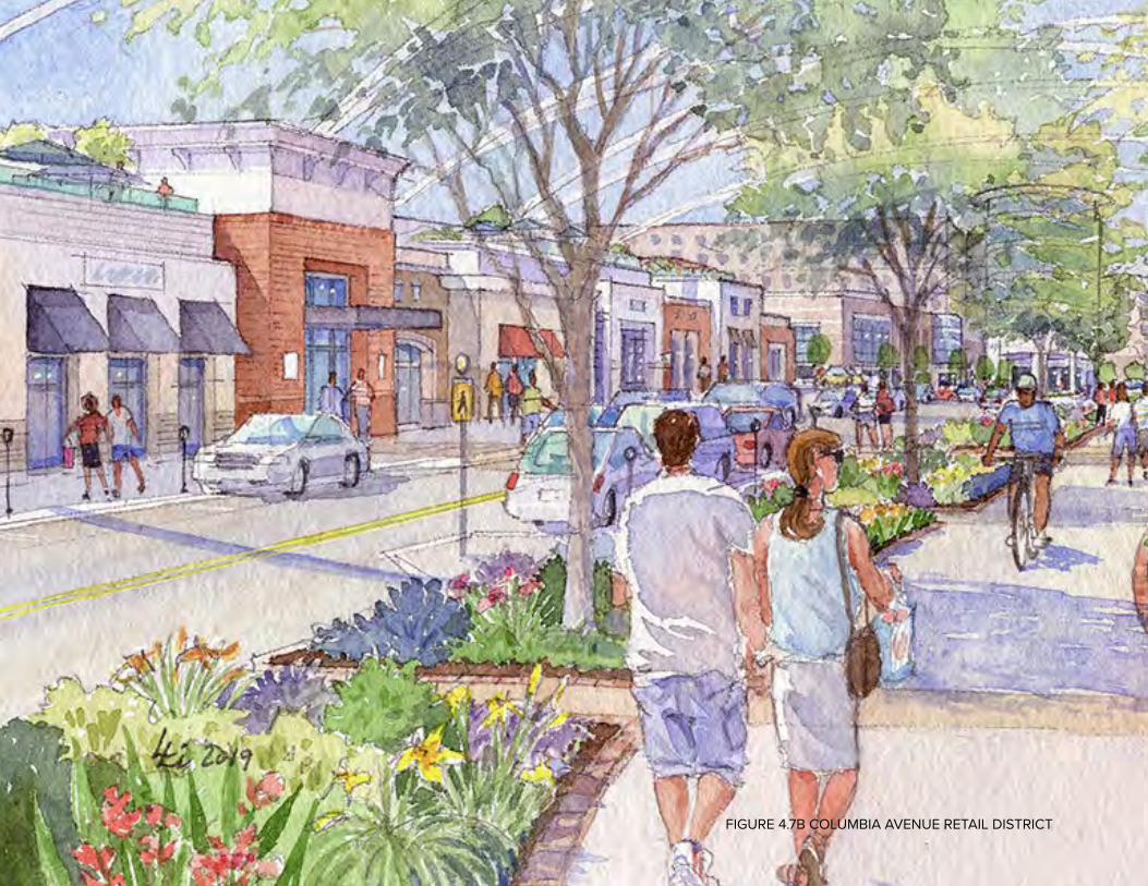
RECOMMENDATIONS114FIGURE 4.7B COLUMBIA AVENUE RETAIL DISTRICT
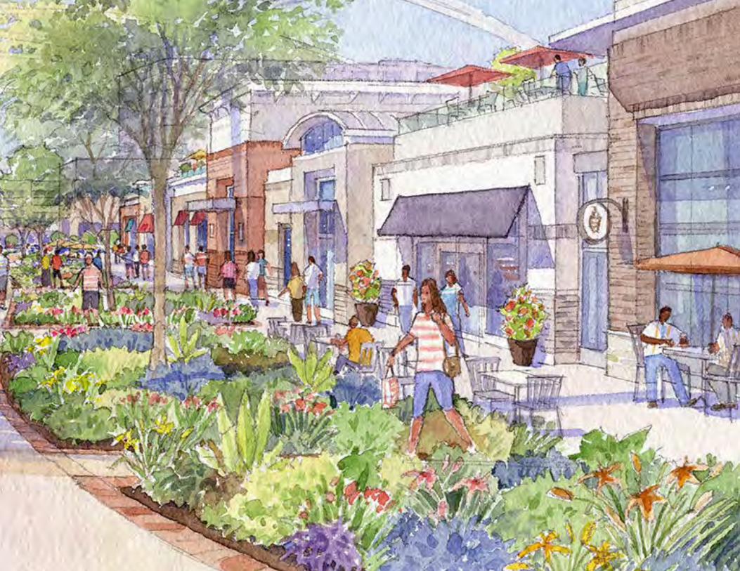
RECOMMENDATIONS 115
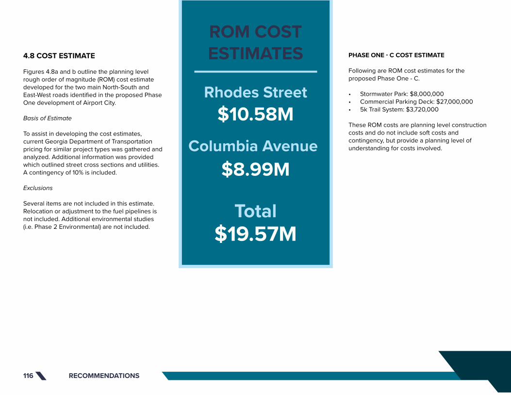
RECOMMENDATIONS116
4.8 COST ESTIMATE
Figures 4.8a and b outline the planning level rough order of magnitude (ROM) cost estimate developed for the two main North-South and East-West roads identified in the proposed Phase One development of Airport City.
Basis of Estimate
To assist in developing the cost estimates, current Georgia Department of Transportation pricing for similar project types was gathered and analyzed. Additional information was provided which outlined street cross sections and utilities. A contingency of 10% is included.
Exclusions
Several items are not included in this estimate. Relocation or adjustment to the fuel pipelines is not included. Additional environmental studies (i.e. Phase 2 Environmental) are not included.
PHASE ONE - C COST ESTIMATE
Following are ROM cost estimates for the proposed Phase One - C.
• Stormwater Park: $8,000,000• Commercial Parking Deck: $27,000,000• 5k Trail System: $3,720,000
These ROM costs are planning level construction costs and do not include soft costs and contingency, but provide a planning level of understanding for costs involved.
ROM COSTESTIMATES
Rhodes Street$10.58M
Total$19.57M
Columbia Avenue$8.99M
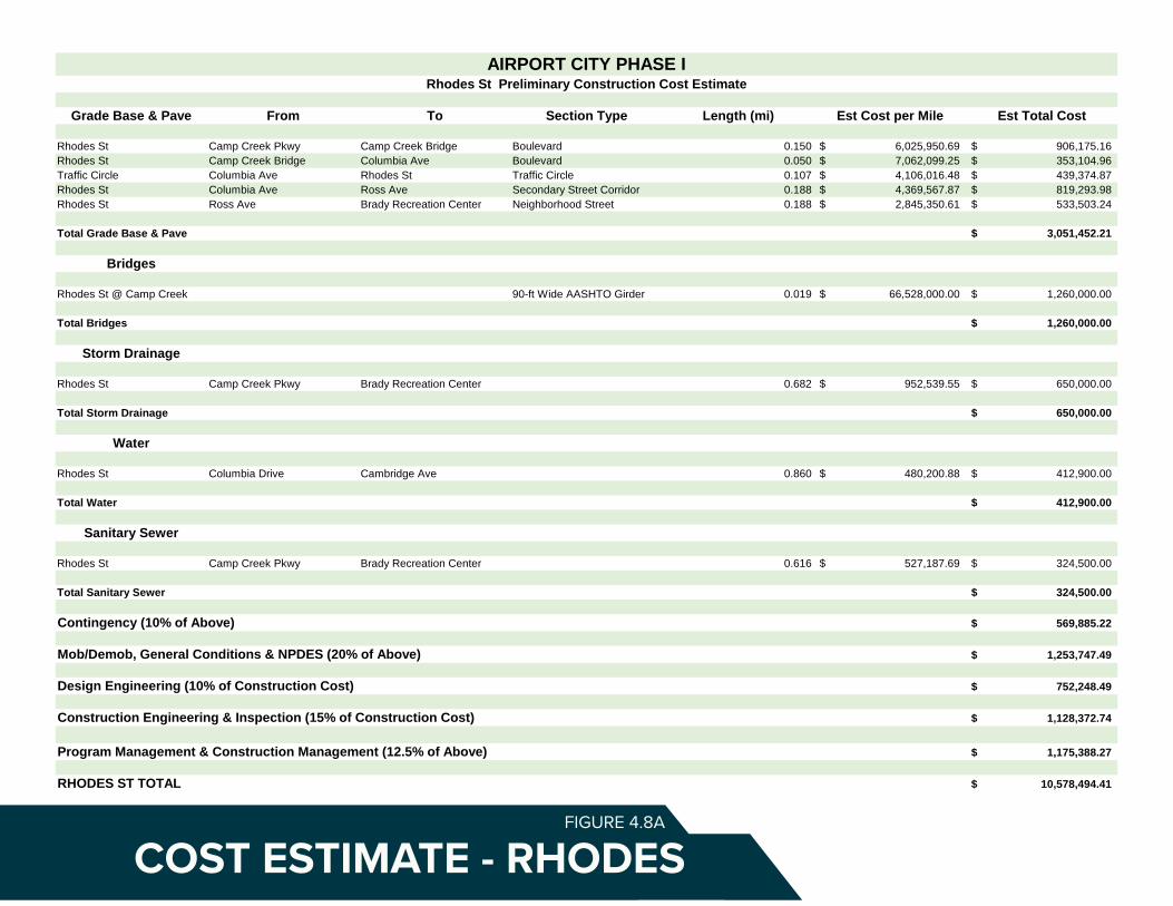
Grade Base & Pave From To Section Type Length (mi) Est Cost per Mile Est Total Cost
Rhodes St Camp Creek Pkwy Camp Creek Bridge Boulevard 0.150 6,025,950.69$ 906,175.16$ Rhodes St Camp Creek Bridge Columbia Ave Boulevard 0.050 7,062,099.25$ 353,104.96$ Traffic Circle Columbia Ave Rhodes St Traffic Circle 0.107 4,106,016.48$ 439,374.87$ Rhodes St Columbia Ave Ross Ave Secondary Street Corridor 0.188 4,369,567.87$ 819,293.98$ Rhodes St Ross Ave Brady Recreation Center Neighborhood Street 0.188 2,845,350.61$ 533,503.24$
Total Grade Base & Pave 3,051,452.21$
Bridges
Rhodes St @ Camp Creek 90-ft Wide AASHTO Girder 0.019 66,528,000.00$ 1,260,000.00$
Total Bridges 1,260,000.00$
Storm Drainage
Rhodes St Camp Creek Pkwy Brady Recreation Center 0.682 952,539.55$ 650,000.00$
Total Storm Drainage 650,000.00$
Water
Rhodes St Columbia Drive Cambridge Ave 0.860 480,200.88$ 412,900.00$
Total Water 412,900.00$
Sanitary Sewer
Rhodes St Camp Creek Pkwy Brady Recreation Center 0.616 527,187.69$ 324,500.00$
Total Sanitary Sewer 324,500.00$
Contingency (10% of Above) 569,885.22$
Mob/Demob, General Conditions & NPDES (20% of Above) 1,253,747.49$
Design Engineering (10% of Construction Cost) 752,248.49$
Construction Engineering & Inspection (15% of Construction Cost) 1,128,372.74$
Program Management & Construction Management (12.5% of Above) 1,175,388.27$
RHODES ST TOTAL 10,578,494.41$
Exclusions
Roadway undercrossing pavements and appurtenances tabulated for sectionBuried utility adjustments and relocations except as listed aboveLateral utility service connectionsRock Excavation, Blasting, and Offsite HaulStorm outfall sewers beyond R/WCost escalation
Basis of Estimate
Unit prices based on current GDOT pricingExtents based on GIS mapping and preliminary Phase I planning documentsSections based on conceptual cross sections for estimation purposes only
AIRPORT CITY PHASE IRhodes St Preliminary Construction Cost Estimate
COST ESTIMATE - RHODESFIGURE 4.8A

Grade Base & Pave From To Section Type Length (mi) Est Cost per Mile Est Total Cost
Traffic Circle Conley St Columbia Ave Traffic Circle 0.107 4,106,016.48$ 439,374.87$ Columbia Ave Conley St Rhodes St Primary Retail Corridor 0.362 6,285,110.53$ 2,273,591.12$ Columbia Ave Rhodes St Fairway Dr Neighborhood Street 0.178 2,845,350.61$ 506,558.63$
Total Grade Base & Pave 3,219,524.62$
Storm Drainage
Columbia Ave Conley St Fairway Dr 0.540 1,204,210.53$ 650,000.00$
Total Storm Drainage 650,000.00$
Water
Columbia Ave Rhodes St College St 0.566 1,161,997.32$ 658,025.00$
Total Water 658,025.00$
Sanitary Sewer
Columbia Ave Conley St Fairway Dr 0.616 515,003.08$ 317,000.00$
Total Sanitary Sewer 317,000.00$
Contingency (10% of Above) 484,454.96$
Mob/Demob, General Conditions & NPDES (20% of Above) 1,065,800.92$
Design Engineering (10% of Construction Cost) 639,480.55$
Construction Engineering & Inspection (15% of Construction Cost) 959,220.82$
Program Management & Construction Management (12.5% of Above) 999,188.36$
COLUMBIA AVE TOTAL 8,992,695.23$
PHASE I GRAND TOTAL 19,571,189.65$
Exclusions
Roadway undercrossing pavements and appurtenances tabulated for sectionBuried utility adjustments and relocations except as listed aboveLateral utility service connectionsRock Excavation, Blasting, and Offsite HaulStorm outfall sewers beyond R/WCost escalation
Basis of Estimate
Unit prices based on current GDOT pricingExtents based on GIS mapping and preliminary Phase I planning documentsSections based on conceptual cross sections for estimation purposes only
AIRPORT CITY PHASE IColumbia Ave Preliminary Construction Cost Estimate
COST ESTIMATE - COLUMBIAFIGURE 4.8B

RECOMMENDATIONS 119
SCHEDULE OF ACTIVITIES
A preliminary schedule of activities has been developed and is provided in Figure 4.8c. As shown, it is anticipated that the follow up planning processes, environmental studies, permitting, and design will require approximately 40 months to complete. Following those activities, the project would be ready for advertisement for construction bids. Construction is anticipated to require approximately one year to complete (210 days).
The schedule assumes that there will be no additional procurements of services for planning, environmental, engineering, or other professional services. Additional procurement of services may impact timeline.
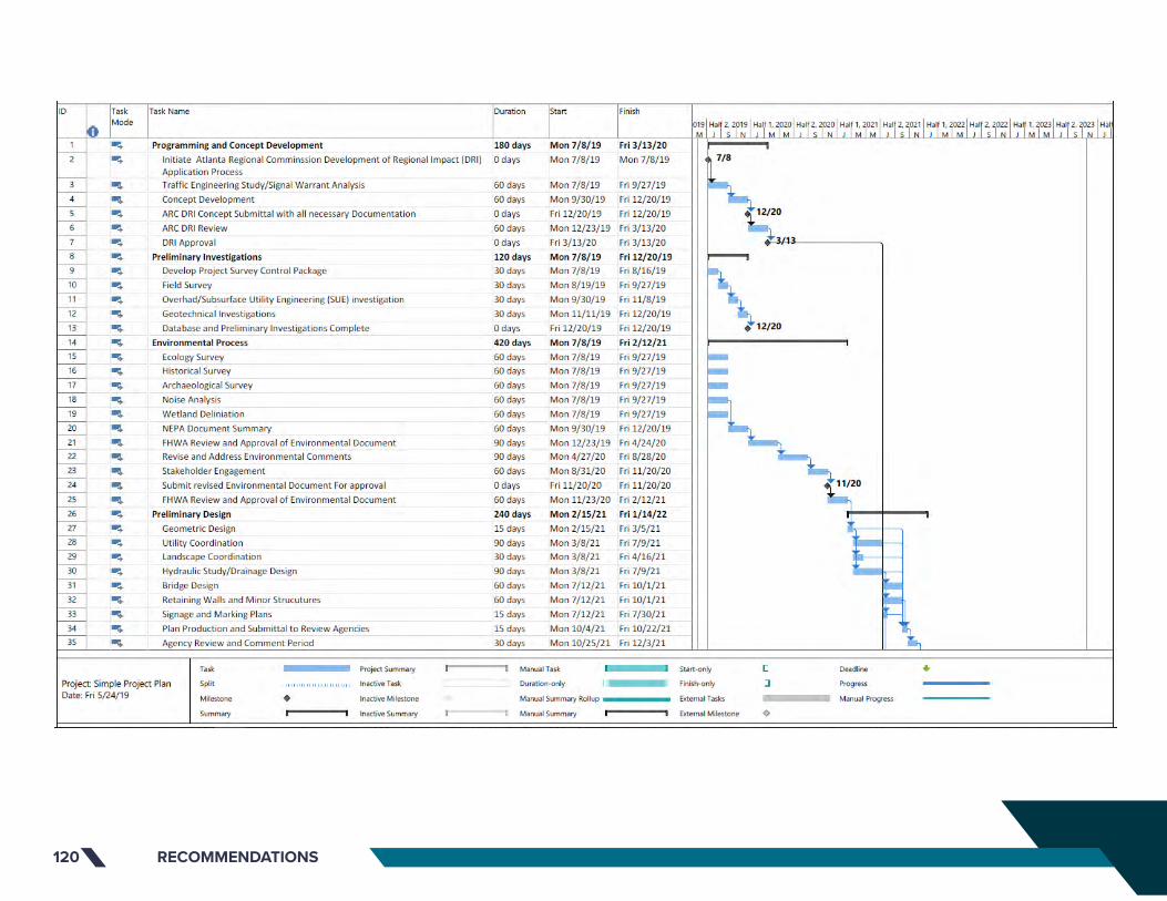
RECOMMENDATIONS120
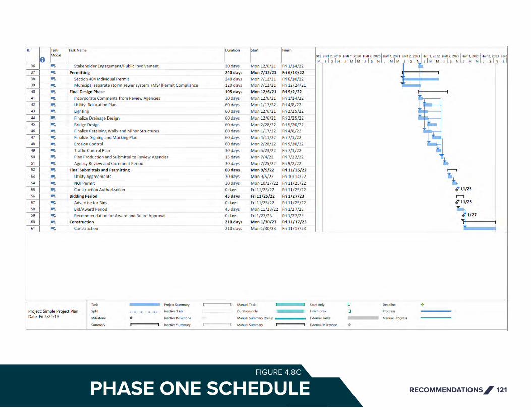
RECOMMENDATIONS 121PHASE ONE SCHEDULEFIGURE 4.8C
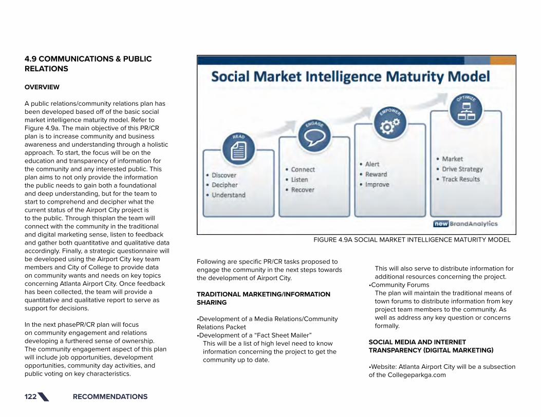
RECOMMENDATIONS122
4.9 COMMUNICATIONS & PUBLIC RELATIONS
OVERVIEW
A public relations/community relations plan has been developed based off of the basic social market intelligence maturity model. Refer to Figure 4.9a. The main objective of this PR/CR plan is to increase community and business awareness and understanding through a holistic approach. To start, the focus will be on the education and transparency of information for the community and any interested public. This plan aims to not only provide the information the public needs to gain both a foundational and deep understanding, but for the team to start to comprehend and decipher what the current status of the Airport City project is to the public. Through thisplan the team will connect with the community in the traditional and digital marketing sense, listen to feedback and gather both quantitative and qualitative data accordingly. Finally, a strategic questionnaire will be developed using the Airport City key team members and City of College to provide data on community wants and needs on key topics concerning Atlanta Airport City. Once feedback has been collected, the team will provide a quantitative and qualitative report to serve as support for decisions.
In the next phasePR/CR plan will focus on community engagement and relations developing a furthered sense of ownership. The community engagement aspect of this plan will include job opportunities, development opportunities, community day activities, and public voting on key characteristics.
Following are specific PR/CR tasks proposed to engage the community in the next steps towards the development of Airport City.
TRADITIONAL MARKETING/INFORMATION SHARING
•Development of a Media Relations/Community Relations Packet•Development of a “Fact Sheet Mailer”
This will be a list of high level need to know information concerning the project to get the community up to date.
This will also serve to distribute information for additional resources concerning the project.
•Community ForumsThe plan will maintain the traditional means of town forums to distribute information from key project team members to the community. As well as address any key question or concerns formally.
SOCIAL MEDIA AND INTERNET TRANSPARENCY (DIGITAL MARKETING)
•Website: Atlanta Airport City will be a subsection of the Collegeparkga.com
FIGURE 4.9A SOCIAL MARKET INTELLIGENCE MATURITY MODEL

RECOMMENDATIONS 123
Collegeparkga.com ->Economic Development -> Atlanta Airport City -> News and Updates (Blog)To be developed with the help of Chris Cook (Director of Administrative Services)The blog with contain easy to read write ups of key issues that are pulled from emailed concerns as well general updates
•Blog posts will be developed, sent to the development team for alignment, sent to the College Park Economic Development Team for approval, and then posted. (Refer to the Appendix for an Example Blog Post )•Email: [email protected]
Questions and Concerns can be collected and leveraged Business Owners can be identified and later utilized
•Official Facebook To be set up using the [email protected] email
•Later phase social media (due to engagement need)
Official Instagram Official Twitter
FEEDBACK AND ANALYSIS
•Develop a pointed questionnaire concerning key issues in the current development. Refer to Figure 4.9b for an example questionnaire.
The plan will utilize issues raised by the College Park Community, Project Team Members, and College Park leaders to develop a questionnaire on key issues concerning the project to provide a holistic approach to community-based decision making.
This questionnaire will be used to determine the key attribute that the public is expecting to gain from the development in their community. The results will be able to determine what developments community members frequent and why they frequent them. The results will also be able to determine what characteristics of the developments are enjoyed and disliked. – Additionally, the plan will utilize the blog to provide the community preliminary education on the options presented in the questionnaire.
COMMUNITY RELATIONS EVENTS
•Development of community inclusive competitions and events:– Public Art
•A great way to get the community involved on multiple levels Elementary School-Professional– Project Name
•Community based input to increase excitement and sense of ownership– Official Project Logo
•Will be an opportunity for graphic artists in the community to go through the process working on a large-scale project, one artist’s work will be chosen for the final logo.
FIGURE 4.9BQUESTIONNAIRE EXAMPLES

AIRPORT CITY MASTER PLANin association withCollege Park Business & Industrial Development Authority
SIZEMORE GROUPin association with NOELL CONSULTING, VIRIDIAN STUDIOS, LONG ENGINEERING, CERM, K&L CONSULTING & MICHAEL BAKER INTERNATIONAL
DRAFT JUNE 2019