Hahamongna Watershed Park Master Plan | City of Pasadena
281
Hahamongna Watershed Park Master Plan Adopted September 29, 2003
-
Upload
khangminh22 -
Category
Documents
-
view
1 -
download
0
Transcript of Hahamongna Watershed Park Master Plan | City of Pasadena
Hahamongna Watershed Park
Master Plan Adopted September 29, 2003

THE CITY OF PASADENA
HAHAMONGNAWATERSHED PARK MASTER PLAN
Adopted: September 29, 2003
The Arroyo Seco Master Plans consist of the following:
Hahamongna Watershed Park Master Plan Central Arroyo Master Plan Lower Arroyo Master Plan Rose Bowl Use Plan Arroyo Seco Design Guidelines
Workstation 03
Rectangle

Hahamongna Watershed Park During the winter months with storm water held
Behind Devil’s Gate Dam
CITY OF PASADENA / ARROYO SECO MASTER PLANS Hahamongna Watershed Park Master Plan
HAHAMONGNA WATERSHED PARK MASTER PLAN Hahamongna Watershed Park Advisory Committee
Tom Selinske, Chair Gregor Edwards Jody Gerstner Frank S. Osen Vannia de la Cuba Michael Hurley Elizabeth Pomeroy Joe Feinblatt Mildred Hawkins Bill Ukropina Anita Fromholz Pixie Boyden Maria Isenberger
Past Committee Members Denise Alvarado Pam Garcia Ramon Oceguera Roy Begley Greg Jones Tony Santilena Eugene Brooks Mark Nelson Tom Seifert, Former Chair Jarratt Brunson Omel Nieves Dr. Ron Williams Jeffery Commons Phil Novelly Katherine Luna Mary Freeman Henreen Nunley John Evans
City of Pasadena Department of Public Works Parks and Natural Resources Division Martin Pastucha, Director Robert C. Baderian, Past Assistant to the City Manager Julie Gutierrez, Past Director Kathy Woods, Parks and Natural Resources Administrator Rosa Laveaga, Arroyo Seco Park Supervisor, Project Manager John Cox, Assistant Project Manager Pasadena Water & Power Phyllis Currie, General Manager Rufus Hightower, Past General Manager Brad Boman, Principal Civil Engineer Gary Takara, Civil Engineer
Raul Garibay, Civil Engineer
Master Plan Consultant Team Takata Associates, Landscape Architecture, Lead Consultant Philip Williams Associates, Hydrology & Geomorphology Hintz & Balvin, Community Outreach The Natelson Company, Inc., Finance Miralles Associates, Architecture Montgomery Watson, Civil & Environmental Engineering

CITY OF PASADENA / ARROYO SECO MASTER PLANS Hahamongna Watershed Park Master Plan
Beth Thielen, Artist Parsons Engineering Sciences, Biology Hunt Design Associates, Graphic Design Cover art by: rhandi
CITY OF PASADENA / ARROYO SECO MASTER PLANS Hahamongna Watershed Park Master Plan
TABLE OF CONTENTS Section Page 1.0 INTRODUCTION 1-1 1.1 Regional Context ………………………………………………………………………. 1-1 1.2 Relationship to the General Plan ………………………………………………………. 1-5 1.3 Project History …………………………………………………………………………. 1-5 1.4 Recent Planning ……………………………………………………………………….. 1-9 1.5 The Guiding Principles for the Arroyo Seco…………………………………………… 1-11 1.6 Goals & Objectives of the Hahamongna Watershed Park Master Plan………………… 1-12 1.7 Report Organization …………………………………………………………………… 1-16 2.0 EXISTING CONDITIONS, ISSUES & OPPORTUNITIES 2-1 2.1 Ownership, Easements & Jurisdiction ……………………………………………….. 2-2 2.2 Zoning & Land Use ………………………..………………………………………….. 2-6 2.3 Natural Environment ………………………………………………………………….. 2-6 2.4 Flood Management ……………………………..…………………………………….. 2-27 2.5 Sediment Delivery & Management …………….…………………………………….. 2-32 2.6 Water Conservation …………………………………………………………………….. 2-34 2.7 Utilities ……………………………………..………………………………………… 2-37 2.8 Circulation …………………………………………………………………………….. 2-48 2.9 Parking ………………………………………………………………………………... 2-54 2.10 Existing Recreation ……………………………..……………………………………… 2-56 2.11 Cultural & Archeaological Resources ………….……………………………………… 2-58 2.12 Summary of Community Outreach …………..……………………………………….. 2-61 2.13 Signage & Graphics ………………………..…………………………………………... 2-66 2.14 Issues & Opportunities …………………….…………………………………………… 2-68 3.0 HAHAMONGNA WATERSHED PARK MASTER PLAN 3-1
3.1 Water Resources Management ………………………………………………………... 3-1 3.2 Conceptual Grading Plan …………………………………………………………… . 3-11 3.3 Habitat Restoration …………………………………………………………………….. 3-16 3.4 Recreation Trails ………………………………………………………………………. 3-42 3.5 West Side & Oak Grove Area Improvements……………………………………………. 3-49 3.6 East Side Park Improvements …………………………………………………………… 3-55 3.7 Circulation & Parking …………………………………………………………………. 3-56 3.8 Utilities & Infrastructure ……………………………………………………………… 3-61 3.9 Safety, Security & Accessibility ……….………………………………………………. 3-68 3.10 Programs ………………………………………………………………………………… 3-70 4.0 IMPLEMENTATION OF THE MASTER PLAN 4-1 4.1 Implementation Plan …………………………………………………………………… 4-1 4.2 Water Resources Commission………………………………………………………….... 4-8 4.3 Environmental Requirements ………………………………………………………….... 4-8
CITY OF PASADENA / ARROYO SECO MASTER PLANS Hahamongna Watershed Park Master Plan
APPENDIX A: Master Plan Concepts and Alternatives A-1
A.1 Master Plan Concepts …………………………………………………………………. A-1 A.2 Disc Golf Altenative …………………………………………………………………… A-4 A.3 Parking Structure Alternatives …………………………………………………………. A-6 A.4 Northern Bridge of Perimeter Trail Alternatives ………………………………………. A-6 A.5 Windsor/Ventura Entrance Alternatives………………………………………………… A-9 A.6 Berkshire Entrance Alternatives …..……………………………………………………. A-11 A.7 Dam Keeper’s Quarters… ………………………………………………………………. A-11 APPENDIX B: Biological Inventories B-1 B.1 Vascular Plants Observed at Hahamongna Watershed Park ………………………….. B-1 B.2 Terrestrial Vertebrate Animals of Hahamongna Watershed Park & Nearby Areas With Similar Habitats …………………………………………………... B-11 B.3 References ……………………………………………………………………………… B-23 APPENDIX C: Plant Community Palettes C-1 C.1 Coast Live Oak Woodland …………………………………………………………… C-1 C.2 Southern Willow Scrub ………………………………………………………………... C-2 C.3 Mule Fat Scrub ….……………………………………………………………………… C-3 C.4 Riversidean Alluvial Fan Sage Scrub ………………………………….……………… C-4 C.5 Coastal Sage & Chapparral Scrub ………….……………………………………………. C-5 C.6 Southern Sycamore Riparian Woodland ………………….……………………………. C-7 APPENDIX D: Water Data: Needs & Costs D-1 APPENDIX E: Master Plan Project Descriptions E-1 APPENDIX F: Technical Report on Athletic Fields F-1

Section 1. Introduction

CITY OF PASADENA / ARROYO SECO MASTER PLANS Hahamongna Watershed Park Master Plan
1-1
SECTION 1:
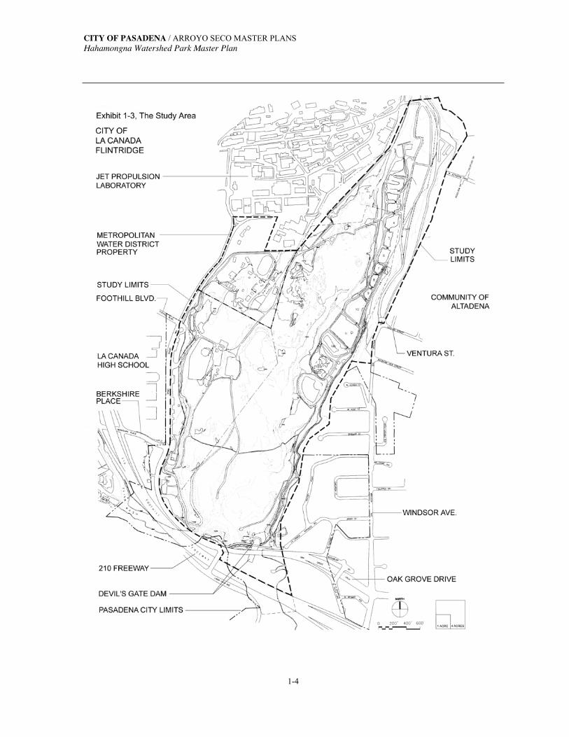
INTRODUCTION 1.1 REGIONAL CONTEXT The Arroyo Seco is a major tributary of the Los Angeles River. It flows out of the San Gabriel Mountains in the northwest corner of the City of Pasadena, forming a physical link between the San Gabriel Mountains and the Los Angeles River. Much of Pasadena’s civic identity is linked to the Arroyo Seco. Numerous museums, cultural institutions, academic and research facilities, and historic sites are associated with the Arroyo Seco; and a series of regional and local parks still preserve its original natural beauty, providing the community with diverse recreational opportunities. See Exhibit 1-1, The Arroyo Seco Environment. As the waters of the Arroyo Seco flow through the City of Pasadena, the streamcourse passes through three distinct geographical areas: Hahamongna Watershed Park (the southern portion of the upper Arroyo Seco), the Central Arroyo, and the Lower Arroyo. The City of Pasadena is currently developing Master Plans for each area of the Arroyo Seco that lies within the City limits. (See Exhibit 1-2, The Arroyo Seco in Pasadena.) The Pasadena City Council conceptually approved the Draft Lower Arroyo Master Plan (LAMP) in February of 1997. LAMP covers the Arroyo Seco from the southern boundary of the City to the Colorado Street Bridge near the 134 Ventura Freeway. The Central Arroyo Master Plan (CAMP) area extends from the Colorado Street Bridge to the 210 Freeway, just south of the Devil’s Gate Dam. The planning process for the Central Arroyo started in 1999 and in January 2000 the Pasadena City Council conceptually approved CAMP. The Draft Hahamongna Watershed Park Master Plan was given conceptual approval in January 1999. The Arroyo Seco Master Plan is comprised of all three Master Plans, plus the Rose Bowl Operating Master Plan and the Arroyo Seco Design Guidelines. Hahamongna Watershed Park (HWP) is located in Township 1 North, Range 12 West on the Pasadena, California 7.5′ USGS quadrangle map. HWP is bounded on the south by the Devil’s Gate Dam area and Oak Grove Drive. Oak Grove Drive and the Jet Propulsion Laboratory (JPL) of the California Institute of Technology bound HWP to the west in the City of La Cañada-Flintridge. To the east, HWP is bounded by the residential neighborhoods of Pasadena and Altadena. The study area extends as far north as the JPL Bridge, which connects the east parking lot to the main JPL campus on the west. See Exhibit 1-3, Study Area.

CITY OF PASADENA / ARROYO SECO MASTER PLANS Hahamongna Watershed Park Master Plan
1-2
Exhibit 1-1, The Arroyo Seco Environment Source: NorthEast Trees

CITY OF PASADENA / ARROYO SECO MASTER PLANS Hahamongna Watershed Park Master Plan
1-3
Exhibit 1-2, The Arroyo Seco in Pasadena
CITY OF PASADENA / ARROYO SECO MASTER PLANS Hahamongna Watershed Park Master Plan
1-4
CITY OF PASADENA / ARROYO SECO MASTER PLANS Hahamongna Watershed Park Master Plan
1-5
In 1920, the Devil’s Gate Dam was constructed at the narrowest section of the Arroyo Seco for flood protection and as a water reservoir to recharge the Raymond Basin Aquifer. Hahamongna Watershed Park (HWP) is approximately 1,300 acres of open space extending up the Arroyo Seco Canyon from the Devil’s Gate Dam. The lower watershed, the 300 acres roughly defined as the flood plain and basin behind the dam, is the focus of this Master Plan. 1.2 RELATIONSHIP TO THE GENERAL PLAN This Master Plan has been completed in response to the policies and principles set forth in the City of Pasadena’s Comprehensive General Plan. The seven guiding principles of the General Plan are as follows: 1. Growth will be targeted to serve community needs and enhance the quality of life.
2. Change will be harmonized to preserve Pasadena’s historic character and environment.
3. Economic vitality will be promoted to provide jobs, services, revenues, and opportunities.
4. Pasadena will be promoted as a healthy family community.
5. Pasadena will be a city where people can circulate without cars.
6. Pasadena will be promoted as a cultural, scientific, corporate, entertainment, and educational center for the region.
7. Community participation will be a permanent part of achieving a greater city. Pursuant to the second Guiding Principle, Objective 9, Open Space Preservation and Acquisition specifically identifies the Arroyo Seco for preservation. Policy 9.2 states “continue and complete comprehensive planning for, and implementation of, plans for the Arroyo, including restoration of the natural area of the Lower Arroyo and the development of the Hahamongna Watershed Park Plan.” This Master Plan directly complies with these mandates. 1.3 PROJECT HISTORY The Hahamongna Watershed Park Master Plan (Master Plan) report is a product of an analysis of existing conditions, a review of pertinent documents, and input from a wide variety of stakeholders and from the community through an extensive outreach program. Additional input was received from City officials and staff. Oversight of the entire project

CITY OF PASADENA / ARROYO SECO MASTER PLANS Hahamongna Watershed Park Master Plan
1-6
was the responsibility of the Hahamongna Watershed Park Advisory Committee (HWPAC). The following summarizes the history of the area and the project. May 1919 The area north of what was commonly known as Devil’s Gate (and today
encompasses the entire study area) was annexed to the City of Pasadena by popular vote. This area was referred to as the “Arroyo Addition.”
The City of Pasadena entered into a lease agreement with the City of Los Angeles for the construction of Devil’s Gate Dam as well as for the maintenance of a reservoir capable of impounding waters of the Arroyo Seco for the purposes of water conservation and flood control.
1920 The County of Los Angeles completed construction of Devil’s Gate Dam at the
narrowest portion of the Arroyo Seco for flood control and water conservation. Jan. 1931 “Arroyo Addition No. 2”, consisting of approximately 1,000 acres in the upper
Arroyo Seco watershed was annexed to the City. Now known simply as the Upper Watershed area, it extends north from the JPL Bridge.
1948 The Los Angeles County Department of Public Works (LACDPW) constructs
13.1 acres of spreading grounds and a two-acre overflow basin (No.13) on the northeast edge of the flood basin.
1960 On the eastside of the basin, 9.6 acres were leased to the Jet Propulsion
Laboratory (JPL) for parking. This resulted in an asphalt lot with 1,132 parking spaces.
1968 The City of Pasadena leased the operation and maintenance of Oak Grove Park
to the County of Los Angeles. Jul. 1970 Approximately 30 acres (on the northwest side of the study area, most within the
Los Angeles County easement and a portion of Oak Grove Park) was sold to the Metropolitan Water District (MWD).
1971 The County designed and implemented major improvements to Oak Grove Park
including roadways, restrooms, maintenance facilities, and other infrastructure. 1978 The Division of Safe Operation of Dams (DSOD) imposed an operational
restriction on Devil’s Gate Dam and officially declared the dam seismically unsafe. These actions were taken in part due to the 1971 Sylmar earthquake.

CITY OF PASADENA / ARROYO SECO MASTER PLANS Hahamongna Watershed Park Master Plan
1-7
May 1986 The City of Pasadena received a grant from the Santa Monica Mountains Conservancy for a study of the use of the Devil’s Gate basin. A formal progress report for the Devil’s Gate Multi-Use Project (DGMUP) was presented to the Pasadena City Council in March of 1988.
Jan. 1987 The Devil’s Gate Multi-Use Project Advisory Committee was established to
further develop and design this plan. Preliminary economic, biological, and feasibility studies were conducted by outside consultants. The Devil’s Gate Project was propelled by Pasadena’s Strategic Planning Process, a citizen’s planning project, which identified it as one the most promising projects necessary to make Pasadena a great city in the year 2000 and beyond.
Mar. 1987 On the west side of the basin, 1.21 acres were leased to JPL for parking. This
resulted in an asphalt lot with 214 spaces. 1986-91 A series of public participation workshops were held which included exhibits by
environmental artists Newton & Helen Harrison.
The Devil’s Gate Joint Power Planning Authority, made up of appointees representing Pasadena, La Cañada-Flintridge, Native Americans, and the Santa Monica Mountains Conservancy held a series of public meetings during an 18-month period. It also oversaw the development of the Preliminary Plan by Takata Associates, held three public workshops as part of the planning process, developed governance and funding recommendations, and obtained $1.86 million in County Parks bond money through the November 1992 election.
Dec. 1992 The Preliminary Park Plan was received and conceptually approved by the
Pasadena City Council. 1993 The area was named Hahamongna Watershed Park Oct. 1993 The Pasadena City Council established a Creation Task Force to develop the
legal structure for the Hahamongna Operating Company (HOC) which would implement, manage, and operate the project. When the transfer of the operation and maintenance responsibility of the Oak Grove Park portion was returned to the City of Pasadena, 500 people attended the dedication of Hahamongna Watershed Park.
The HOC began monthly meetings starting in November of 1994. These meetings were open to the community. A 300-person mailing list was developed for meeting and event notification. During its operation, HOC participated in
CITY OF PASADENA / ARROYO SECO MASTER PLANS Hahamongna Watershed Park Master Plan
1-8
numerous presentations and discussions before the Pasadena City Council and Business Enterprise Committee.
Dec. 1994 All mining operations in the Hahamongna Watershed Park basin ceased. As many as eight mining operations had been in the basin and had been licensed to mine sand and gravel. They had contributed significantly to the dumping of concrete, asphalt, and other materials in the basin.
Nov. 1995 The rehabilitation of Devil’s Gate Dam was initiated by the County of
Los Angeles. HOC staff worked closely with the County and the contractor to minimize neighborhood impacts and begin habitat restoration in the flood basin. This project was completed in January of 1998.
Jan. 1996 Los Angeles County Department of Public Works (LACDPW) began the seismic
strengthening and spillway modification to Devil’s Gate Dam. This project was completed in the winter of 1998.
Aug. 1996 The Pasadena City Council disbanded the Hahamongna Operating Company
Board and transferred all responsibilities of the Hahamongna Watershed Park to the Department of Public Works.
Nov. 1996 Hahamongna Watershed Park was allocated $1 million for capital improvements
as a result of the 1996 Los Angeles County Park Bond Act. Jan. 1997 The Pasadena City Council established the Hahamongna Watershed Park
Advisory Committee (HWPAC) which was comprised of all members of the City’s Recreation and Parks Commission with two additional members representing the Northwest Commission and two members representing the Utility Advisory Commission.
In September and October, two public hearings on Hahamongna Watershed
Park planning were hosted by the HWPAC to reaffirm the Preliminary Park Plan that had been completed nearly five years previous. More than 100 people representing community members, special interest groups, and regulatory agencies attended these meetings. From these meetings the “Park Elements” for HWP were established as the new framework for the final Master Plan.
Dec. 1997 The “Park Elements” that reflected consensus towards the development of the
Park’s Master Plan were presented to the City Council for review.
CITY OF PASADENA / ARROYO SECO MASTER PLANS Hahamongna Watershed Park Master Plan
1-9
Nov. 1998 The City Council reaffirmed its commitment to reinvestment and acquisition of parkland. The landscape architecture firm of Takata Associates was brought on board to develop the final Master Plan for Hahamongna Watershed Park.
Dec. 1998 The Pasadena City Council, with the recommendation of the Recreation and
Parks Commission, approved a motion to pursue the re-purchase of the 30-acre MWD property.
1999 Responsibility for operating and maintaining the 13.1 acres of spreading grounds
on the northeast edge of the flood basin was turned over to the City of Pasadena.
The City Council authorized the use of the JPL parking lot lease funds for the planning, maintenance, and operation (including security) of Hahamongna Watershed Park.
1.4 RECENT PLANNING In January of 1997, Pasadena City Council established the Hahamongna Watershed Park Advisory Committee (HWPAC) which was given the charge of overseeing the Master Plan process. Since a number of years had passed since the approval of the Preliminary Park Plan by City Council in December 1992, and the start of the Devil’s Gate Dam renovation in 1996, the HWPAC held two community workshops to solicit input on the project. Based on this public input, a list of Park Elements was drafted and adopted by the HWPAC in 1997 as a bridge between the Preliminary Park Plan and the start of the Final Park Master Plan Process. The final Master Plan reflects these elements as they have evolved. PARK ELEMENTS of 1997 Major Themes HWP should be a showcase for: Water and natural resources education and utilization The preservation of native plants and habitat Native American culture Passive and active recreation

CITY OF PASADENA / ARROYO SECO MASTER PLANS Hahamongna Watershed Park Master Plan
1-10
Water Feature Water and water resources are major functions of this area that must be protected and
enhanced. An analysis of flood potential and sediment buildup in the basin should be pursued. Now that Devil’s Gate Dam has been rehabilitated, Pasadena should coordinate with
Los Angeles County on the possible development of a water feature to maximize water conservation and habitat restoration in HWP.
Recreation Design children’s play features to emphasize appreciation of the natural environment. Provide the opportunity to experience the natural outdoors by providing overnight
camping, fishing, and nature study. West Athletic Field—upgrade this field in cooperation with youth sports leagues to
promote usage. Johnson Field—integrate this venue into HWP by coordinating use and scheduling
Entrances Create an entrance at Woodbury & Arroyo/Windsor with access to the dam. Create secondary entrances at Foothill Boulevard and Windsor/Ventura. Prohibit any entrance at La Cañada-Verdugo Road or through residential neighborhoods.
Parking Renegotiate the leases for the Jet Propulsion Lab parking lots. Ensure adequate parking at multiple sites around the park and at the central parking area
on the west-side Oak Grove area. Improve the parking area and intersection at Windsor/Ventura to promote safety and
neighborhood protection. .
Structures: Minimize new structures and analyze costs and benefits related to maintenance and
public safety. All facilities should emphasize the natural setting and use of natural materials.
Trails & Linkages: Develop a major perimeter trail around the Hahamongna basin for walkers and joggers. Improve equestrian trails through the park and linkages to nearby trails. Provide a linkage
for bicyclists outside of the basin to connect to the San Gabriel Mountain trails. Trails should be inclusive where possible; multiple uses can coexist.
CITY OF PASADENA / ARROYO SECO MASTER PLANS Hahamongna Watershed Park Master Plan
1-11
Signage & Nomenclature: Tasteful signage should be used for interpretive and educational purposes rather than
facilities that are expensive to build and maintain. Develop a standard nomenclature for all park signs.
Design Standards for Entire Arroyo: Consistent design standards for all Arroyo parks and nature areas should be developed
that would cover entrances, signage, circulation, architecture, native landscaping, and the use of Arroyo materials and crafts (such as rockwork and tiles) to convey the unique character and beauty of the Arroyo Seco.
1.5 THE GUIDING PRINCIPLES FOR THE ARROYO SECO The Guiding Principles for the Arroyo Seco were developed to serve as the umbrella under which fall the specific goals and objectives for each of the Arroyo Seco Master Plans. These six Guiding Principles were developed collaboratively between members of the community, members of the Recreation and Parks Commission members of the Hahamongna Watershed Park Advisory Committee, and City staff. These Guiding Principles will also serve as a bridge between the Arroyo Seco Master Plans and the City's General Plan Update. The six principles are: To encourage and promote the stewardship and enjoyment of the Arroyo Seco in
Pasadena. To balance and integrate the interrelated issues of water resources, recreation, natural
resource preservation and restoration, and flood management in the Arroyo Seco. To provide a safe, secure and accessible Arroyo Seco for public enjoyment. To recognize the importance to Pasadena of the history, cultural resources and unique
character of the Arroyo Seco, and to conserve and enhance these assets. To preserve and acquire open space in or adjacent to the Arroyo Seco. To recognize that the Arroyo Seco in Pasadena is comprised of distinct geographical
areas that are interconnected by a number of resources and features including, but not limited to, water, habitat, geology, recreation, and culture; and that it is part of a larger watershed.
CITY OF PASADENA / ARROYO SECO MASTER PLANS Hahamongna Watershed Park Master Plan
1-12
1.6 GOALS & OBJECTIVES OF THE HAHAMONGA WATERSHED PARK MASTER PLAN The following are the goals and objectives specific to Hahamongna Watershed Park: Goal 1: Preserve, restore, and enhance the native habitats Objectives:
• Develop a habitat restoration plan for Hahamongna Watershed Park.
• Protect and enhance the Hahamongna Watershed Park wildlife corridor linkages to the upper watershed and the downstream reaches of the Arroyo Seco.
• Restore, enhance, and reestablish the historical native plant communities of the Arroyo Seco.
• Create wetland and aquatic habitats in HWP to increase the biodiversity.
• Locate new facilities in developed or disturbed areas so as to minimize impact to established habitats.
• Enhance the edges of the spreading basins with native trees and other appropriate plantings to blend these facilities with the riparian setting.
• Limit exterior lighting for security, safety, and operational purposes to lessen the impact on nocturnal wildlife.
• Relocate existing overhead power and communications lines to restore the natural environment and provide adequate, safe maintenance access.
• Develop dam maintenance and flood control procedures that promote preservation of native habitats.
• Repair the harmful impacts of the mining operations by regrading the highly disturbed, unnatural topography within the flood plain to allow for the successful planting of native plant communities to establish quality habitat.
• Establish a monitoring program to study runoff and sediment delivery in the flood basin to determine impacts on plant communities in HWP.
• Restore areas where erosion has occurred.
CITY OF PASADENA / ARROYO SECO MASTER PLANS Hahamongna Watershed Park Master Plan
1-13
Goal 2: The Devil’s Gate flood control basin will be managed to provide protection to the developed and natural downstream areas. Objectives: • Facilitate the dam and reservoir maintenance operations in a manner that is compatible
with the proposed features of the Master Plan and will result in minimal impacts to the surrounding area.
• Maintain or improve the flood capacity behind Devil’s Gate Dam. • Develop a sediment removal plan that minimizes the impact to the basin and to the
surrounding neighborhoods. • Develop a grading plan that allows habitat restoration and recreational activities to co-
exist with flood management and water conservation. • Develop a multi-agency task force to review maintenance, sediment removal, dam
operation, permit, and liability issues on a continual basis after this plan is adopted. • Develop dam maintenance and flood control procedures that promote water conservation. • Establish a monitoring program to study runoff and sediment delivery in the flood basin
to determine impacts on flood management/water conservation capabilities. Goal 3: Conserve and protect the water resources of the Arroyo Seco. Objectives: • Maximize groundwater recharge to minimize the amount of water purchased from
outside sources. • Develop a grading plan that allows habitat restoration and recreational activities to
coexist with flood management and water conservation. • Monitor water entering the basin from Flint Wash and various storm drains to ensure safe
water quality. • Develop a program to minimize and provide the means to control the inflow of trash from
Flint Wash and various storm drains. • Develop an alternative to the JPL eastside surface parking area for expanded spreading
basins for groundwater recharge.

CITY OF PASADENA / ARROYO SECO MASTER PLANS Hahamongna Watershed Park Master Plan
1-14
Goal 4: Provide diverse recreation opportunities for the Pasadena community. Objectives:
• Balance the recreation needs for active, passive, and educational activities in HWP.
• Develop a grading plan that allows habitat restoration and recreational activities to co-exist with flood management and water conservation.
• Design children’s play areas to emphasize learning and connections to the natural environment.
• Distribute recreation facilities to allow equal access from the surrounding neighborhoods.
• Maintain the historic recreational uses within HWP. Goal 5: Enrich and promote the unique history and culture of Hahamongna Watershed Park. Objectives:
• Develop HWP as a “living laboratory” for local schools and environmental education programs.
• Preserve and encourage Native American use of HWP as a cultural resource.
• Explore the possibilities of a joint partnership with the U.S. Forest Service and Native Americans in developing an interpretive center and native-plant nursery at HWP.
• Develop design guidelines to ensure aesthetic compatibility and quality construction for any improvements made in HWP.
• Develop passive viewing areas with unique vantage points.
• Create programs that inform and educate the public about the natural processes, the history and the culture of the site.
• Underground or relocate the existing above-ground electrical transmission lines. Goal 6: Provide a safe and secure park. Objectives:
• Provide adequate water and sewage infrastructure where needed throughout HWP.
• Develop guidelines and delegate agency responsibilities for recreation, flood management, and water conservation liabilities.

CITY OF PASADENA / ARROYO SECO MASTER PLANS Hahamongna Watershed Park Master Plan
1-15
• Retain and enhance, as needed, the recently reestablished Park Ranger Program to ensure compliance with municipal laws, codes, and regulations. Secure entrances and perimeter of HWP.
• Develop an all-weather perimeter trail/road for emergency and maintenance access as well as for passive recreation.
Goal 7: Provide adequate circulation, access and parking Objectives: • Provide public transportation and nonmotorized access to HWP.
• Provide adequate parking throughout the park for all proposed recreation activities and facilities.
• Maintain and restore the trail links to the Central Arroyo, the surrounding neighborhoods, and the Angeles National Forest.
• Develop separate trail systems for bicycles, hikers, and equestrians wherever possible.
• Comply with ADA (Americans with Disabilities Act) standards for a “natural park.”
• Develop a signage system that provides clear directional information and informs park visitors without being intrusive.
• Improve the east entrance for better access, circulation, and traffic safety.
• Protect residential neighborhoods from the nuisances related to maintenance equipment, traffic, and noise.
• Improve and enhance regional trail connections.
• Continue to assist JPL in meeting its parking needs. The Arroyo Seco Master Plans were developed by the combined efforts of the Planning and Development Department and the Department of Public Works. The implementing department for the completed Arroyo Seco Master Plans will be the Department of Public Works. The projects identified in the Arroyo Seco Master Plans are described and listed to easily translate to the City’s capital improvement program.

CITY OF PASADENA / ARROYO SECO MASTER PLANS Hahamongna Watershed Park Master Plan
1-16
1.7 REPORT ORGANIZATION The HWP Master Plan report is the product of an analysis of existing conditions: A review of previous planning documents; meetings with user groups, neighborhood groups, regulatory agencies, environmental groups and other interested groups; three community workshops; and the guidance and direction given by the Hahamongna Watershed Park Advisory Committee. The Hahamongna Watershed Park Master Plan report consists of four sections: Section 1 - Introduction: This first section provides an overview of the Arroyo Seco and Hahamongna Watershed Park; regional context; history; recent planning efforts; goals and objectives; and scope and content of the Master Plan report. Section 2 - Existing Conditions, Issues, and Opportunities: This section identifies HWP's existing natural and man-made setting. A summary of the park's issues and opportunities, based upon the technical analysis and community outreach, are discussed. Section 3 - Master Plan: This section describes the recommended Master Plan elements. Section 4 - Implementation: This section details the phasing of specific Master Plan projects and provides a summary of environmental requirements needed to implement the Master Plan.

Secttion 2. Existing Conditions Issues & Opportunities
CITY OF PASADENA / ARROYO SECO MASTER PLANS Hahamongna Watershed Park Master Plan
2-1
SECTION 2:
EXISTING CONDITIONS,ISSUES & OPPORTUNITIES
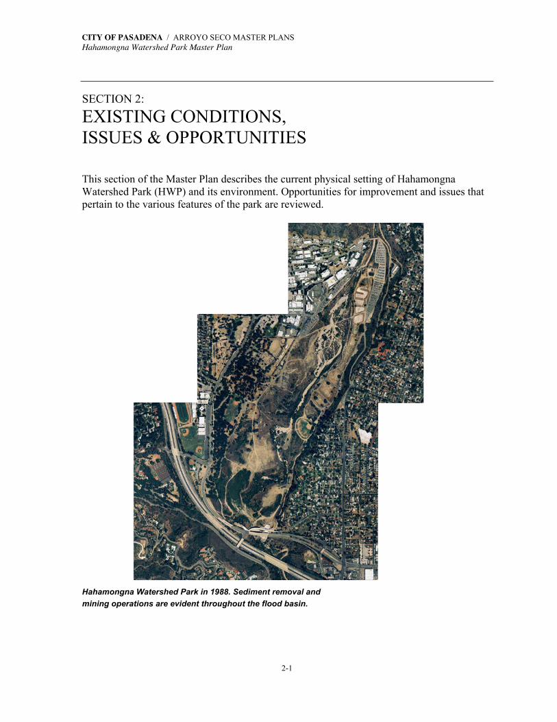
This section of the Master Plan describes the current physical setting of Hahamongna Watershed Park (HWP) and its environment. Opportunities for improvement and issues that pertain to the various features of the park are reviewed.
Hahamongna Watershed Park in 1988. Sediment removal and
mining operations are evident throughout the flood basin.

CITY OF PASADENA / ARROYO SECO MASTER PLANS Hahamongna Watershed Park Master Plan
2-2
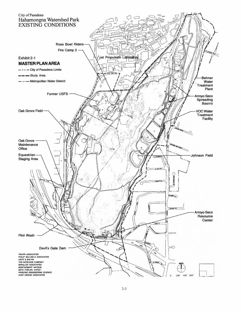
2.1 OWNERSHIP, EASEMENTS & JURISDICTION LAND OWNERSHIP Hahamongna Watershed Park (HWP) is located within the City of Pasadena. Other neighboring landowners within the basin include the Metropolitan Water District (MWD) and the Jet Propulsion Laboratory (JPL). The MWD property is within the master plan study area and although JPL is not a part of this park master plan, it is very much within the sphere of influence of HWP. The majority of the JPL campus is located in the City of La Cañada-Flintridge, northwest of HWP. Refer to Exhibit 2-1, Master Plan Area, for the major physical elements located within the study area. JPL leases the two parking lots within HWP. The 30-acre MWD property was parkland purchased from the City of Pasadena in 1968. The current leaseholders on MWD property include the United States Forest Service (USFS), Los Angeles County Fire Camp 2, and the Rose Bowl Riders who sublet to the Tom Sawyer Camp. The study area also includes a small parcelof land between the mouth of Flint Wash and the dam, including an area southeast of the intersection of Linda Vista Avenue and Oak Grove Drive, which is currently within the La Cañada-Flintridge city limits (Exhibit 1-3, Study Area). EASEMENTS Los Angeles County Flood Control Easement Los Angeles County Department of Public Works (LACDPW) holds an easement granting the County the right to construct and maintain Devil’s Gate Dam, its spillway, bypasses, tunnels and other support facilities as may be necessary or convenient for the construction and maintenance of a reservoir capable of impounding the waters of the Arroyo Seco for purposes of storage and control; and to control such waters as may be necessary in the prevention of damage by flood. The easement applies to land below the 1075′ contour as determined from the benches of the United States Geological Survey (USGS) See Exhibit 2-5, Water Elevations later in this section. Included in this granted easement, the City retained the right to the top of the dam as a public access way and utility corridor across the Arroyo Seco. Gabrielino Trail Easement The U.S. Department of Agriculture / U.S. Forest Service (USFS) has been granted an easement by the City of Pasadena for the Gabrielino Trail. The Gabrielino Trail begins at the intersection of Windsor Avenue and Ventura Street and extends north for 1.5 miles into the
CITY OF PASADENA / ARROYO SECO MASTER PLANS Hahamongna Watershed Park Master Plan
2-3

CITY OF PASADENA / ARROYO SECO MASTER PLANS Hahamongna Watershed Park Master Plan
2-4
Arroyo Seco Canyon and then enters USFS lands in the Angeles National Forest. Two-thirds of a mile is within the HWP study area. This section of the trail from its beginning at the intersection of Windsor and Ventura, is a multi-use, paved trail and a maintenance/ emergency roadway that follows the upper edge of the eastern slope of the basin. Bicyclists, hikers, and equestrians are all allowed access along the trail. Utility Easements Southern California Edison and the Southern California Gas Company hold easements for their utility lines. See Section 2.6, Utilities, for further information on these lines. The Pasadena Department of Water and Power holds easements for utility lines within the MWD property. JURISDICTIONS U.S. Army Corps of Engineers The U. S. Army Corps of Engineers has jurisdiction over the area of potentially impounded waters north of the dam (below the 1040.5 elevation). North of this area and above the 1040.5 elevation, the Corps’ jurisdictional area includes the intermittent, meandering stream corridors at their high-water mark. Any impact to these areas will require the filing of an Army Corps of Engineers 404 Permit (See Environmental Requirements Technical Report). California Department of Fish and Game (CDF&G) The CDF&G has jurisdiction over the entire Master Plan area: Should any project within the HWP Master Plan area change the natural flow or bed,
channel or bank of any river stream or lake, a Section 1601/1603 Stream Alteration Agreement will be required. This same area of jurisdiction is shared with the Army Corps of Engineers.
Should any project within the HWP Master Plan area impact any state-listed or
endangered species or their habitat, then an MOU (Memorandum of Understanding) under the California Endangered Species Act will be required. Again, this jurisdiction is over the entire Master Plan area.
U.S. Fish and Wildlife Service (USFWS) If federally listed sensitive species were to be found in areas of the park that are to be disturbed, Federal Endangered Species Act (FESA) Section 7 or 10 consultations with the USFWS could be required.
CITY OF PASADENA / ARROYO SECO MASTER PLANS Hahamongna Watershed Park Master Plan
2-5
Following the City Council's conceptual approval of the draft Hahamongna Watershed Park Master Plan, USFWS declared approximately half of HWP critical habitat for the Southwestern Arroyo Toad, a federally listed endangered species. On February 7, 2001, approximately 182,000 acres in California were designated critical habitat for the Arroyo Toad pursuant to the Endangered Species Act of 1973, as amended. The federal ruling designated six miles in Arroyo Seco Creek, from the Long Canyon confluence downstream to the central area of the Hahamongna Basin, as Arroyo Toad critical habitat area. On October 30, 2002, the U.S. District Court for the District of Columbia eliminated the current designation of critical habitats for the Arroyo Toad. The Building Industry Legal Defense Foundation sued the U.S. Interior Department to nullify the habitat designation. Under federal law, the costs to industry and the public of designating critical habitat for an endangered species must be considered, and if they outweigh the benefit to the species, then habitat need not be designated. The U.S. Fish and Wildlife Service (USFWS) has until July 30, 2004, to redo its economic impact analysis and the Interior Department will decide by 2005 which areas of critical habitat to re-designate. See Exhibit 2-3, Terrestrial Natural Plant Communities, for the limits of the critical habitat area and Section 3 for more detailed information on this topic. Critical habitat identifies specific areas that are essential to the conservation of a listed species with respect to areas within the geographic range occupied by the species. The City of Pasadena completed focused biological protocol surveys of the Southwestern Arroyo Toad in December 2001, and the presence of the Southwestern Arroyo Toad was not indicated. (See Focused Herpetological Surveys Conducted in Support of the Arroyo Seco Master Plan by AMEC, December 2001.) A minimum of three consecutive years surveying for the Arroyo Toad is needed to establish their presence. Due to the extreme drought in the winter of 2002, the USFWS advised the City to not complete a survey started in 2002, but instead extend the surveys through 2004. California Regional Water Quality Control Board (CRWQCB) Elements of the Park Master Plan may require a Section 401 Water Quality certification under the Clean Water Act if any project results in a discharge into a water body. The CRWQCB also has jurisdiction over the area for any construction project with grading of more than five acres; in this instance a National Pollution Discharge Elimination System (NPDES) program is required. Either the County of Los Angeles and/or the City of Pasadena will review any alterations to storm drains, septic systems, sewer connections, power, communications systems, or fire suppression requirements.
CITY OF PASADENA / ARROYO SECO MASTER PLANS Hahamongna Watershed Park Master Plan
2-6
2.2 ZONING & LAND USE ZONING Hahamongna Watershed Park is zoned as open space with the exception of a parcel zoned as Planned Development Districts (PD-16). This parcel, indicated in Exhibit 2-2, Zoning, is leased to JPL for its east parking area. The adjacent land in Pasadena, Altadena, and La Cañada-Flintridge is zoned residential. All Pasadena areas are zoned RS-4, which permits four residential dwelling units per acre. The JPL parking lots are allowed under a conditional-use permit. LAND USE The entire basin is designated open space by the City of Pasadena’s General Plan. “Open Space” is defined by the Pasadena General Plan as follows: “This category is for a variety of active and passive public recreational facilities and for City-owned open space facilities. This includes natural open spaces and areas which have been designated as environmentally and ecologically significant. This category also applies to land which is publicly owned, though in some instances public access may be restricted. Most importantly, this designation only applies to lands owned by the City.” Within the LACDPW Flood Control Easement, Oak Grove was given the designation of parkland. This area was City-dedicated parkland at the time Los Angeles County assumed control of it; and this designation remains. Permitted uses of City-dedicated parkland include active and passive recreation. Under this permit the County first developed the recreation facilities at Oak Grove. Exhibit 2-2, Zoning, illustrates dedicated parkland and waterfund land. Waterfund land is City land maintained and used by the Pasadena Department of Water and Power for water conservation purposes. 2.3 THE NATURAL ENVIRONMENT Hahamongna Watershed Park (HWP) is located on the south flank or south-facing slopes of the San Gabriel Mountains, in the Arroyo Seco drainage. The San Gabriel Mountains are part of the Transverse Ranges physiographic province of southern California. HWP is situated in what was formerly the Arroyo Seco Canyon. After the dam was constructed, sediments from mountain runoff began to accumulate behind it. This deposition raised the ground surface in the reservoir area and created a broad plain between the canyon walls. Today, this flood sediment plain gently slopes from an upstream elevation of approximately 1100 at the JPL Bridge to a downstream elevation of approximately 986 at the dam face. The former canyon walls slope steeply up from the sediment plain at its edges.

2-7

CITY OF PASADENA / ARROYO SECO MASTER PLANS Hahamongna Watershed Park Master Plan
2-8
The sediment plain itself is quite irregular due to erosion and historical excavation within the reservoir. Throughout the park, shallow ridgecrests, alluvial fan slopes, and riparian areas exist along the floor of the Arroyo Seco drainage. There are a few areas that are level, or have nearly level, terrain. HWP is located approximately at the boundary between two different precipitation regions—The San Gabriel Mountains and the San Gabriel Valley. These two regions receive an average of 27.5" and 17.6" of rain per year, respectively. Most precipitation occurs during the winter months. The upper reaches of the Arroyo Seco watershed cover an area of approximately 21.75 square miles and include runoff from Ladybug, Cloudburst, Daisy, Cloby, Little Bear, Bear, Long, Dark, Twin, Brown, Pine, Falls, Aqua, Fern, El Prieto, and Millard Canyons. Between the JPL Bridge and Devil’s Gate Dam an additional 10.15 square miles drains directly into the basin primarily through municipal storm water culverts, but also through Flint Wash which drains into the southwest corner of the basin from the City of La Cañada-Flintridge. Three large drainages within and near HWP contain ephemeral or intermittent streams with surface water flow only during extended periods of sustained rain and runoff. Streams within these three drainages originate from the upper elevations of the Arroyo Seco, Millard Canyon, and El Prieto Canyon. All streams provide at least minimal surface flow to the JPL Bridge for a portion of their length throughout the year. THE ALLUVIAL FAN ENVIRONMENT Erosion from the steep slopes of the San Gabriel Mountains is commonly deposited where there is a sudden reduction in streambed slope. There, the deposits form a roughly semi-circular arc referred to as an alluvial fan. HWP is situated at the opening of the Arroyo Seco canyon along the upper portion of an alluvial fan environment. Alluvial fans are complex and potentially unstable environments, since they occur at the point between sediment supply and the beginning of extensive channel carving. Processes that have caused extensive damage on alluvial fans include lateral scour in existing channels, the formation of new channels by sudden redirection of flow at the top of the alluvial fan, and inundation by debris and sediment in the alluvial fan environment. These types of channel processes are common. THE BIOLOGICAL ENVIRONMENT The plant communities, vegetation, and wildlife of HWP probably would not exist in their current array without man’s influence. The altered and unnatural environmental conditions currently found there are due mainly to four factors. These are: (1) the presence of Devil’s Gate Dam; (2) the requirements for necessary sediment and debris removal behind the dam; (3) the landscaping practices that have over time significantly changed the appearance and composition of HWP and nearby areas, including the MWD property, from that once familiar to the Native American Gabrielinos; and (4) the encroachment of invasive nonnative plants.

CITY OF PASADENA / ARROYO SECO MASTER PLANS Hahamongna Watershed Park Master Plan
2-9
Field inventory surveys of biological resources in HWP and the MWD property were conducted over a twelve-month period. Both vegetation and wildlife resources were surveyed in a floristic and faunistic manner that ensured a complete and thorough identification of all species encountered during the fieldwork. The inventories also included the identification of existing natural plant communities, and landscaped and ruderal (non-native) vegetation in the park. The inventory information about biological resources in HWP helped to define the existing setting and to lay the foundation for the habitat establishment and restoration plan presented in Section 3 of this Master Plan. More than 300 plant species and nearly 100 animal species were observed during the inventory surveys. These numbers demonstrate a high biodiversity in HWP. See Appendix B.1 & B.2 for an inventory of existing plants and animals observed. Only plants that were actually observed were placed on the plant species inventory list. However, the animal species inventory list includes both recently observed and historical records of animals known from HWP and nearby areas with similar habitats. The vegetation classification of plant communities in the study area was taken mainly from Holland (1986) and Sawyer and Keeler-Wolf (1995).1 Plant nomenclature followed that of Hickman (1993), Munz (1959, 1968, and 1974), Sunset (1995), and Bailey (1949). Animal species nomenclature followed that of Jameson and Peters (1968), Burt and Grossenheider (1980), Whitaker (1980), and Ingles (1995) for mammals; Peterson (1990) National Geographic Society (1983), Stokes and Stokes (1996), Udvardy (1988), and Garrett and Dunn (1981) for birds; and Stebbins (1985), and Behler and King (1979) for reptiles. The Existing Setting HWP, as it exists today, represents a unique albeit somewhat unnaturally occurring set of plant and animal communities that largely would not be present in their current assemblage without Devil's Gate Dam. However, a mixture of California terrestrial natural plant communities (Holland, 1986), or vegetation series (Sawyer and Keeler-Wolf, 1995), continues to dominate the site. Throughout the majority of the Arroyo Seco drainage in HWP, riparian scrub habitats and weedy nonnative grassland dominate the floor of the central portion of the drainage,and a portion of the MWD property. Oak woodland and other types of scrub habitats occupy large and small variable areas along the perimeter and/or side walls of the drainage. Segments of the survey sites (i.e., landscaped areas) are widely populated with introduced ornamental shrubs and trees, and exotic, ruderal weedy species of grasses and forbs (herbaceous, non-grass species). Several of these introduced species are from places other than California, and some of the plants are native to other regions and habitats of California but not to those in which HWP is located. Many of the introduced plant species generally used in landscaped settings are not from North America.
1 See Appendix B.3 for a complete reference list of sources cited in this portion of the Master Plan.
CITY OF PASADENA / ARROYO SECO MASTER PLANS Hahamongna Watershed Park Master Plan
2-10
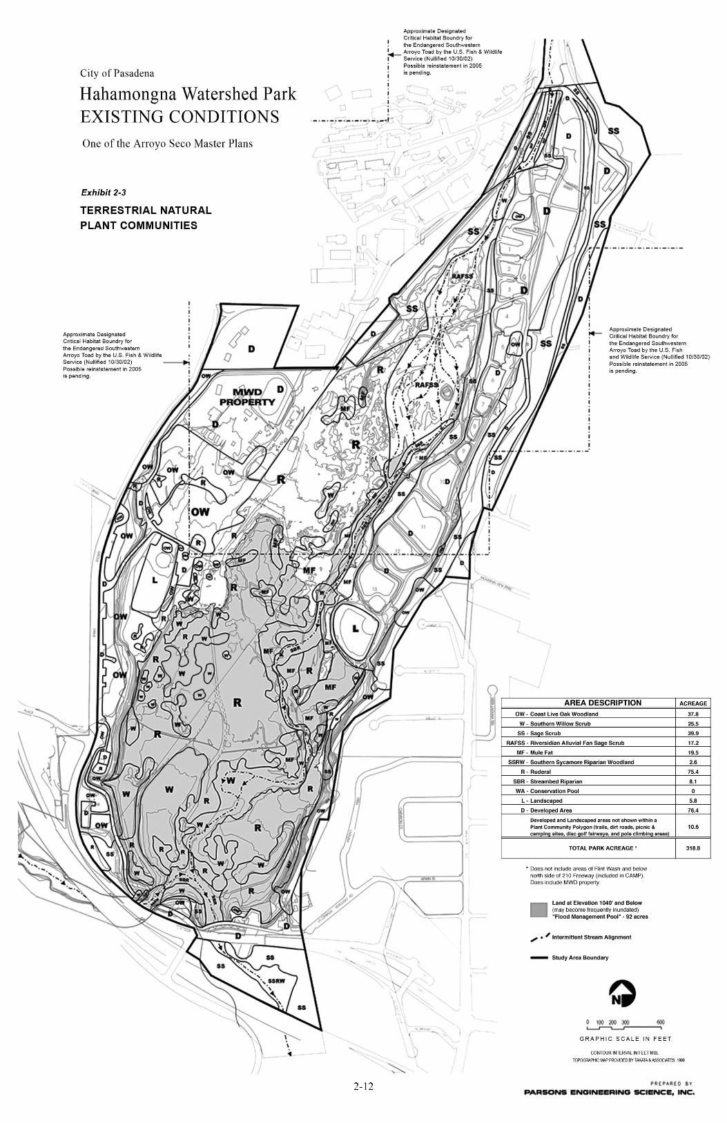
Several terrestrial natural plant communities, that form a patchy mosaic of dominant vegetation types, occupy the survey areas. A particular plant community may fill an area forming relatively pure stands of the dominant species, or the site may contain transitional areas that possess elements of several plant communities, or vegetation series and associations, as the case may be. The Plant Communities At least six native terrestrial natural plant communities exist in the survey areas with characteristics common to (1) coast live oak woodland, (2) southern willow scrub, (3) mule fat scrub, (4) riversidian alluvial fan sage scrub, (5) sage scrub, and (6) southern sycamore riparian woodland. Holland (1986) describes these communities in a document prepared for the California Native Diversity Database. See Exhibit 2-3, Terrestrial Natural Plant Communities. One nonnative, terrestrial natural plant community is also present in large and small sections of the master plan study area survey sites, i.e., ruderal vegetation. In areas of the basin that have undergone considerable disturbance by man due to periodic flood management through sediment and debris removal upstream of Devil’s Gate Dam, much of the vegetation is comprised of ruderal species. The majority of this ruderal vegetation is comprised of herbaceous forbs rather than nonnative grasses. However, certain small areas are dominated by introduced, nonnative grasses and fewer forbs. Holland (1986) refers to this community as nonnative grassland. Nonnative grassland is widely scattered depending on the history of site disturbance by man (e.g., repeated fires and grading). It should be noted that a vegetation category termed “streambed riparian vegetation” is also described below. However, this is not a true terrestrial natural plant community or vegetation series. This vegetation category is used in this report to help depict those locales along the Arroyo Seco stream channel where riparian or wetland indicator species may occur in isolated areas and/or numbers of individual species. These sections of the stream channel are sparsely covered with vegetation since it is still in a state of primary succession due to ongoing disturbance by annual flooding and scouring from seasonal rainfall runoff and sediment deposition. These species may be present in greater numbers and distribution in other major terrestrial natural communities of HWP. Under a more recent classification system of vegetation by Sawyer and Keeler-Wolf (1995), the terrestrial natural plant communities in HWP are more complex. Using Sawyer and Keeler-Wolf’s approach, at least twelve different vegetation series are known from the surveyed areas of the Arroyo Seco and canyon slopes and sidewalls along the site boundaries. The vegetation that dominates the HWP survey sites include the following
CITY OF PASADENA / ARROYO SECO MASTER PLANS Hahamongna Watershed Park Master Plan
2-11
Sawyer and Keeler-Wolf series: Coast live oak, arroyo willow, black willow, red willow, mule fat, scalebroom, California sagebrush-California buckwheat, California sagebrush-black sage, chamise-black sage, sumac, California sycamore series, and California annual grassland.
Descriptions of the terrestrial natural plant communities (Holland, 1986) and/or the related vegetation series (Sawyer and Keeler-Wolf, 1995) are given below. For ease of reading this report, information about a particular vegetation series is combined with that for the respective terrestrial natural community.
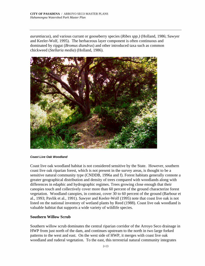
Coast Live Oak Woodland
Coast live oak woodland is typically located on north-facing slopes and shaded ravines in southern California. In HWP and the MWD property, however, it occurs on the more level terrain of old terraces of alluvial fans on the west boundary of the site. There it integrates with southern willow scrub, mule fat scrub, and the ruderal vegetation in the central riparian corridor of the Arroyo Seco. On the drier, west-facing and south-facing sidewalls and slopes of the Arroyo Seco drainage to the east, coast live oak woodland patchily merges with sage scrub and ruderal communities.
The Oak Grove area, on the west side of HWP and portions of the MWD property represent an exquisite, remnant example of the sort of coast live oak woodland that used to cover much of the southern half of the state in the Coast, Transverse, and Peninsular ranges. In many Southern California foothill woodland areas, coast live oak (Quercus agrifolia var. agrifolia)is often codominant with toyon or Christmas berry (Heteromeles arbutifolia), or with southern California black walnut (Juglans californica var. californica) (Holland, 1986; Quinn, 1990). Sawyer and Keeler-Wolf (1995) refer to coast live oak woodland as coast live oak series.
Generally, coast live oak woodlands inhabit upland areas on slopes that are often very steep or on raised stream banks and terraces. Soils are well drained and are often sandstone or shale-derived but may also be granitic in composition. Coast live oak may be the sole or dominant tree in the canopy. These oaks reach heights as great as 100 feet (30 meters), and the canopy may be continuous, intermittent, or open. Shrubs are usually occasional or common in the understory and the terrestrial surface layer is grassy or absent (Holland, 1986; Sawyer and Keeler-Wolf, 1995).
Commonly associated shrub understory species in this plant community include black sage (Salvia mellifera), California blackberry (Rubus ursinus), California bay or laurel (Umbellularia californica), California redberry (Rhamnus californica), California sagebrush (Artemisia californica), chamise (Adenostoma fasciculatum), laurel sumac (Malosma laurina), western poison oak (Toxicodendron diversilobum), scrub oak (Quercusberberidifolia), toyon (Heteromeles arbupifolia), Mexican elderberry (Sambucus mexicana),bigleaf maple (Acer macrophyllum), box elder (A. negundo), hairy ceanothus (Ceanothusoliganthus), Engelmann oak (Quercus engelmannii), bush monkeyflower (Mimulus
CITY OF PASADENA / ARROYO SECO MASTER PLANS Hahamongna Watershed Park Master Plan
2-13
aurantiacus), and various currant or gooseberry species (Ribes spp.) (Holland, 1986; Sawyer and Keeler-Wolf, 1995). The herbaceous layer component is often continuous and dominated by ripgut (Bromus diandrus) and other introduced taxa such as common chickweed (Stellaria media) (Holland, 1986).
Coast Live Oak Woodland Coast live oak woodland habitat is not considered sensitive by the State. However, southern coast live oak riparian forest, which is not present in the survey areas, is thought to be a sensitive natural community type (CNDDB, 1996a and f). Forest habitats generally connote a greater geographical distribution and density of trees compared with woodlands along with differences in edaphic and hydrographic regimes. Trees growing close enough that their canopies touch and collectively cover more than 60 percent of the ground characterize forest vegetation. Woodland canopies, in contrast, cover 30 to 60 percent of the ground (Barbour et al., 1993; Pavlik et al., 1991). Sawyer and Keeler-Wolf (1995) note that coast live oak is not listed on the national inventory of wetland plants by Reed (1988). Coast live oak woodland is valuable habitat that supports a wide variety of wildlife species. Southern Willow Scrub Southern willow scrub dominates the central riparian corridor of the Arroyo Seco drainage in HWP from just north of the dam, and continues upstream to the north in two large forked patterns to the west and east. On the west side of HWP, it merges with coast live oak woodland and ruderal vegetation. To the east, this terrestrial natural community integrates

CITY OF PASADENA / ARROYO SECO MASTER PLANS Hahamongna Watershed Park Master Plan
2-14
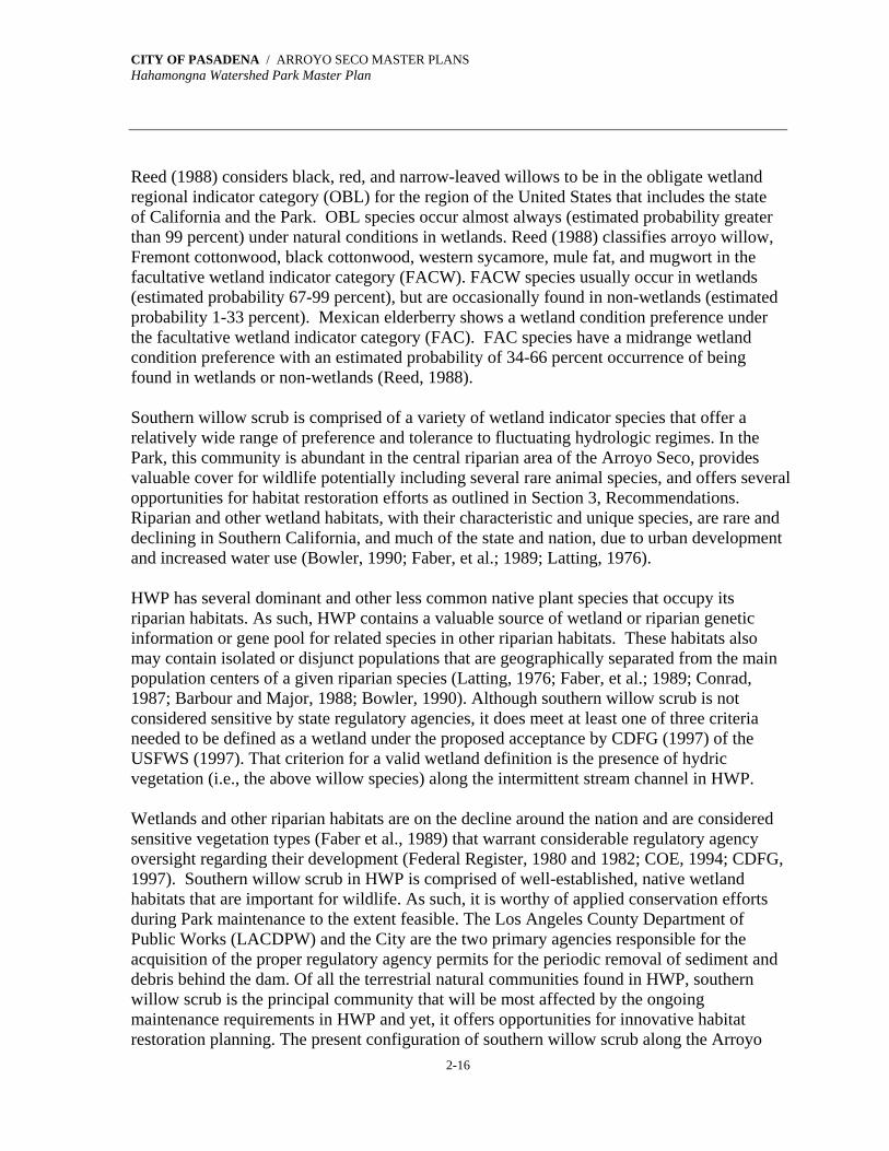
with the ruderal vegetation and coastal sage-chaparral scrub. At the north end of its distribution in HWP, it is replaced by mule fat scrub. According to Holland (1986), southern willow scrub is an early seral or successional type that requires repeated flooding to prevent succession to southern cottonwood-sycamore riparian forest. Sawyer and Keeler-Wolf (1995) refer to southern willow scrub as a combination of arroyo willow series, black willow series, and red willow series.
Hahamongna flood basin June 1998 and Aug 1998, willow scrub along drainage patterns in nonnative grassland This terrestrial natural community is comprised of dense, broad-leaved, winter-deciduous riparian thickets dominated by several willow species including arroyo willow (Salix lasiolepis), black willow (S. gooddingii), red willow (S. laevigata), shining willow (S. lucida ssp. lasiandra), and narrow-leaved willow (S. exigua) (Holland, 1986; Sawyer and Keeler-Wolf, 1995). This riparian scrub community occupies sites with loose, sandy or fine gravelly alluvium deposited along intermittent or perennial stream channels during flood flows. Habitats within this community are usually seasonally flooded and the soils are saturated. Southern willow scrub typically occupies sites on floodplains, or on low-gradient depositions along rivers and streams (Sawyer and Keeler-Wolf, 1995). Shrubs and trees in this community may reach 33 to 100 feet (10 to 30 meters) in height, and the canopy may be continuous. Most stands often are so dense that the understory vegetation layer of shrubs is sparse (Holland, 1986). In more slightly open willow scrub sites, the ground layer of grasses and forbs may vary from sparse to abundant (Sawyer and Keeler-Wolf, 1995).

CITY OF PASADENA / ARROYO SECO MASTER PLANS Hahamongna Watershed Park Master Plan
2-15
Southern willow scrub with black walnuts and western sycamores
Also associated with this riparian scrub community are scattered emergent specimens of Fremont cottonwood (Populus fremontii ssp. fremontii), black cottonwood (P. balsamifera ssp. trichocarpa), and western sycamore (Platanus racemosa). Other commonly associated species in southern willow scrub include mule fat (Baccharis salicifolia), coyote brush (B. pilularis), mugwort (Artemisia douglasiana), Mexican elderberry, and bigleaf maple. Southern willow scrub is one of two terrestrial natural communities in the Park that are composed of vegetation that typify true wetland habitats. The other community is mule fat scrub. In a manual prepared for COE, National List of Plant Species that Occur in Wetlands: National Summary, Reed (1988), along with the collaborative efforts of many biologists, attempts to define the wetland flora of the United States and to assist in the field identification of wetlands. Plant species that occur in wetlands are those species that have shown an ability to achieve maturity and reproduce in an environment where all the soil, or portions of it, is periodically or continuously saturated. This inundation of the plant species root zone occurs during the growing season (Reed, 1988; COE, 1987). Recently, CDFG (1997) has found the USFWS wetland definition and classification system (Cowardin et al., 1979) to be the most biologically valid of those definitions and classification systems presently used in California. The USFWS definition employs hydric soils, saturation or inundation, and vegetative criteria, and requires the presence of at least one of these criteria (rather than all three) in order to classify an area as a wetland (CDFG, 1997).
CITY OF PASADENA / ARROYO SECO MASTER PLANS Hahamongna Watershed Park Master Plan
2-16
Reed (1988) considers black, red, and narrow-leaved willows to be in the obligate wetland regional indicator category (OBL) for the region of the United States that includes the state of California and the Park. OBL species occur almost always (estimated probability greater than 99 percent) under natural conditions in wetlands. Reed (1988) classifies arroyo willow, Fremont cottonwood, black cottonwood, western sycamore, mule fat, and mugwort in the facultative wetland indicator category (FACW). FACW species usually occur in wetlands (estimated probability 67-99 percent), but are occasionally found in non-wetlands (estimated probability 1-33 percent). Mexican elderberry shows a wetland condition preference under the facultative wetland indicator category (FAC). FAC species have a midrange wetland condition preference with an estimated probability of 34-66 percent occurrence of being found in wetlands or non-wetlands (Reed, 1988). Southern willow scrub is comprised of a variety of wetland indicator species that offer a relatively wide range of preference and tolerance to fluctuating hydrologic regimes. In the Park, this community is abundant in the central riparian area of the Arroyo Seco, provides valuable cover for wildlife potentially including several rare animal species, and offers several opportunities for habitat restoration efforts as outlined in Section 3, Recommendations. Riparian and other wetland habitats, with their characteristic and unique species, are rare and declining in Southern California, and much of the state and nation, due to urban development and increased water use (Bowler, 1990; Faber, et al.; 1989; Latting, 1976). HWP has several dominant and other less common native plant species that occupy its riparian habitats. As such, HWP contains a valuable source of wetland or riparian genetic information or gene pool for related species in other riparian habitats. These habitats also may contain isolated or disjunct populations that are geographically separated from the main population centers of a given riparian species (Latting, 1976; Faber, et al.; 1989; Conrad, 1987; Barbour and Major, 1988; Bowler, 1990). Although southern willow scrub is not considered sensitive by state regulatory agencies, it does meet at least one of three criteria needed to be defined as a wetland under the proposed acceptance by CDFG (1997) of the USFWS (1997). That criterion for a valid wetland definition is the presence of hydric vegetation (i.e., the above willow species) along the intermittent stream channel in HWP. Wetlands and other riparian habitats are on the decline around the nation and are considered sensitive vegetation types (Faber et al., 1989) that warrant considerable regulatory agency oversight regarding their development (Federal Register, 1980 and 1982; COE, 1994; CDFG, 1997). Southern willow scrub in HWP is comprised of well-established, native wetland habitats that are important for wildlife. As such, it is worthy of applied conservation efforts during Park maintenance to the extent feasible. The Los Angeles County Department of Public Works (LACDPW) and the City are the two primary agencies responsible for the acquisition of the proper regulatory agency permits for the periodic removal of sediment and debris behind the dam. Of all the terrestrial natural communities found in HWP, southern willow scrub is the principal community that will be most affected by the ongoing maintenance requirements in HWP and yet, it offers opportunities for innovative habitat restoration planning. The present configuration of southern willow scrub along the Arroyo
CITY OF PASADENA / ARROYO SECO MASTER PLANS Hahamongna Watershed Park Master Plan
2-17
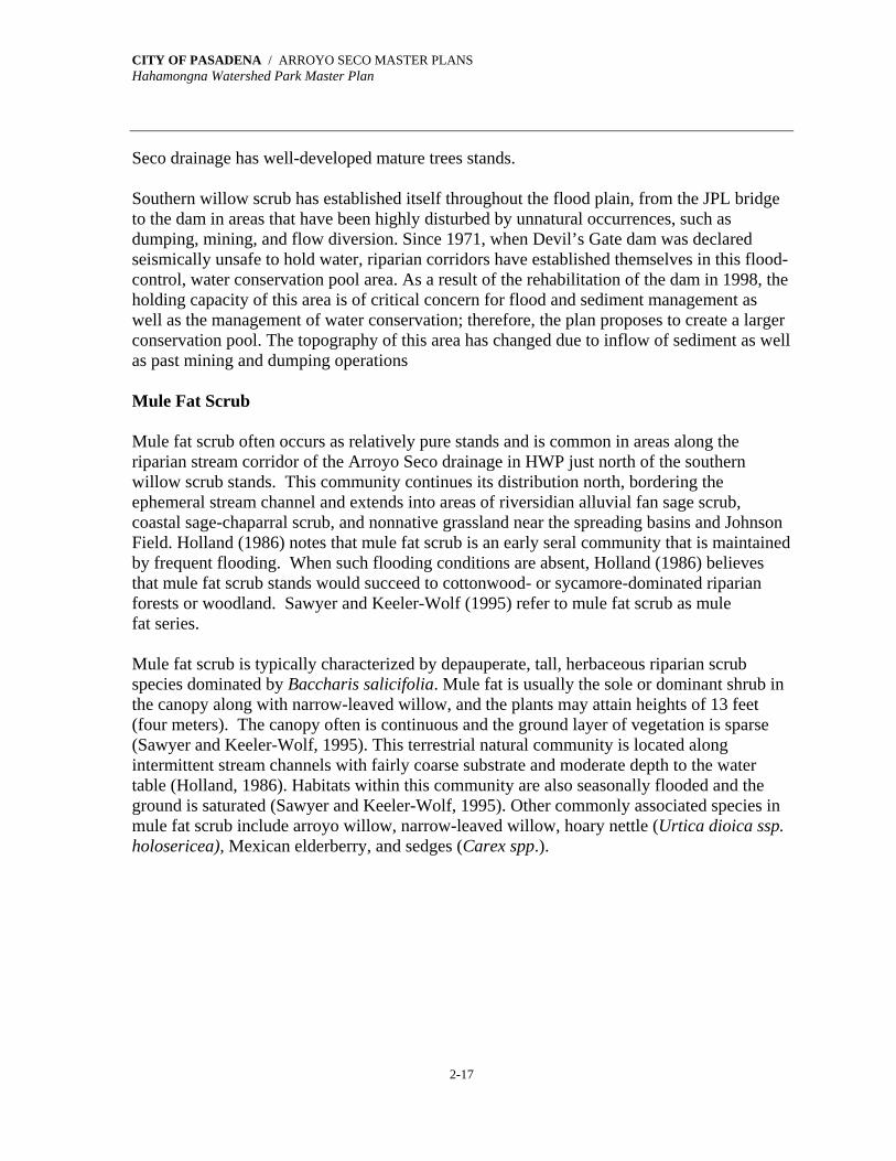
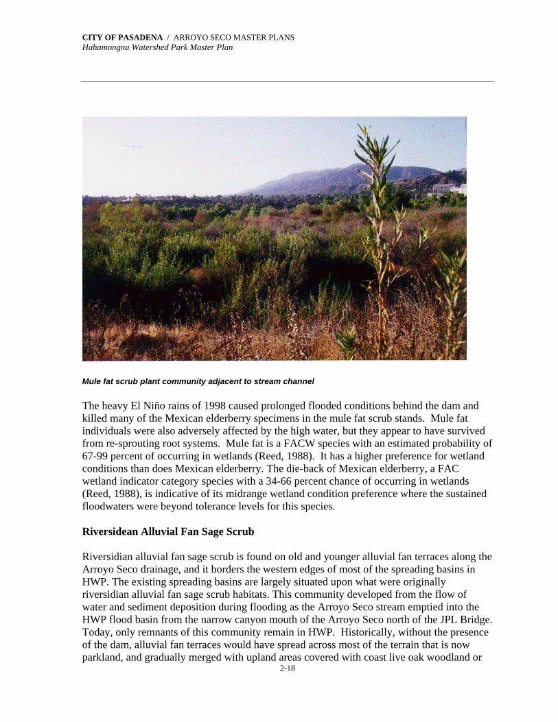
Seco drainage has well-developed mature trees stands. Southern willow scrub has established itself throughout the flood plain, from the JPL bridge to the dam in areas that have been highly disturbed by unnatural occurrences, such as dumping, mining, and flow diversion. Since 1971, when Devil’s Gate dam was declared seismically unsafe to hold water, riparian corridors have established themselves in this flood- control, water conservation pool area. As a result of the rehabilitation of the dam in 1998, the holding capacity of this area is of critical concern for flood and sediment management as well as the management of water conservation; therefore, the plan proposes to create a larger conservation pool. The topography of this area has changed due to inflow of sediment as well as past mining and dumping operations Mule Fat Scrub Mule fat scrub often occurs as relatively pure stands and is common in areas along the riparian stream corridor of the Arroyo Seco drainage in HWP just north of the southern willow scrub stands. This community continues its distribution north, bordering the ephemeral stream channel and extends into areas of riversidian alluvial fan sage scrub, coastal sage-chaparral scrub, and nonnative grassland near the spreading basins and Johnson Field. Holland (1986) notes that mule fat scrub is an early seral community that is maintained by frequent flooding. When such flooding conditions are absent, Holland (1986) believes that mule fat scrub stands would succeed to cottonwood- or sycamore-dominated riparian forests or woodland. Sawyer and Keeler-Wolf (1995) refer to mule fat scrub as mule fat series. Mule fat scrub is typically characterized by depauperate, tall, herbaceous riparian scrub species dominated by Baccharis salicifolia. Mule fat is usually the sole or dominant shrub in the canopy along with narrow-leaved willow, and the plants may attain heights of 13 feet (four meters). The canopy often is continuous and the ground layer of vegetation is sparse (Sawyer and Keeler-Wolf, 1995). This terrestrial natural community is located along intermittent stream channels with fairly coarse substrate and moderate depth to the water table (Holland, 1986). Habitats within this community are also seasonally flooded and the ground is saturated (Sawyer and Keeler-Wolf, 1995). Other commonly associated species in mule fat scrub include arroyo willow, narrow-leaved willow, hoary nettle (Urtica dioica ssp. holosericea), Mexican elderberry, and sedges (Carex spp.).
CITY OF PASADENA / ARROYO SECO MASTER PLANS Hahamongna Watershed Park Master Plan
2-18
Mule fat scrub plant community adjacent to stream channel The heavy El Niño rains of 1998 caused prolonged flooded conditions behind the dam and killed many of the Mexican elderberry specimens in the mule fat scrub stands. Mule fat individuals were also adversely affected by the high water, but they appear to have survived from re-sprouting root systems. Mule fat is a FACW species with an estimated probability of 67-99 percent of occurring in wetlands (Reed, 1988). It has a higher preference for wetland conditions than does Mexican elderberry. The die-back of Mexican elderberry, a FAC wetland indicator category species with a 34-66 percent chance of occurring in wetlands (Reed, 1988), is indicative of its midrange wetland condition preference where the sustained floodwaters were beyond tolerance levels for this species. Riversidean Alluvial Fan Sage Scrub Riversidian alluvial fan sage scrub is found on old and younger alluvial fan terraces along the Arroyo Seco drainage, and it borders the western edges of most of the spreading basins in HWP. The existing spreading basins are largely situated upon what were originally riversidian alluvial fan sage scrub habitats. This community developed from the flow of water and sediment deposition during flooding as the Arroyo Seco stream emptied into the HWP flood basin from the narrow canyon mouth of the Arroyo Seco north of the JPL Bridge. Today, only remnants of this community remain in HWP. Historically, without the presence of the dam, alluvial fan terraces would have spread across most of the terrain that is now parkland, and gradually merged with upland areas covered with coast live oak woodland or

CITY OF PASADENA / ARROYO SECO MASTER PLANS Hahamongna Watershed Park Master Plan
2-19
coastal sage-chaparral scrub. In this scenario without the dam, an ephemeral stream and channel would still be found in the basin along with riparian corridor communities of southern willow scrub and mule fat scrub beside the stream. Holland (1986) states that this terrestrial natural community is very xeric (dry) with coarse soils and some finer soils that are slow to release stored moisture. Sawyer and Keeler-Wolf (1995) refer to riversidian alluvial fan sage scrub as scalebroom series, and note that it is located on upland sites that are rarely flooded with low-gradient deposits along ephemeral or perennial streams. Shrubs in this vegetation type are generally low in height at five feet (one and one-half meters) with the canopy continuous or intermittent, and the ground layer of vegetation variable with grasses and forbs (Sawyer and Keeler-Wolf, 1995).
Riversidian Alluvial Fan Scrub at the northern end of Hahamongna Watershed Park Dominant species in riversidian alluvial fan sage scrub include scalebroom (Lepidospartum squamatum), California sagebrush, California buckwheat (Eriogonum fasciculatum var. foliolosum), black sage, white sage (Salvia apiana), brome grasses (Bromus spp.), western sycamore, Fremont cottonwood, southern California black walnut, brittlebush (Encelia farinosa), chaparral yucca (Yucca whipplei), chaparral mallow (Malacothamnus fasciculatus), hairy yerba santa (Eriodictyon crassifolium), laurel sumac, lemonadeberry (Rhus integrifolia), sugar bush (R. ovata) Mexican elderberry, mule fat, poison oak, birch-leaf mountain-mahogany (Cercocarpus betuloides var. betuloides), prickly pears (Opuntia spp.), deerweed (Lotus scoparius), bladderpod (Isomeris arborea), and four-wing saltbush (Atriplex canescens) (Holland, 1986; Sawyer and Keeler-Wolf, 1995).
CITY OF PASADENA / ARROYO SECO MASTER PLANS Hahamongna Watershed Park Master Plan
2-20
Riversidian alluvial fan sage scrub is considered a sensitive habitat by California state regulatory agencies due to declining habitats lost to urban development and flood control. This sensitive terrestrial natural plant community is not previously recorded in the CNDDB (1999a and f) information for the USGS Pasadena quadrangle in which HWP is located. Therefore, this community warrants consideration for the implementation of conservation efforts to help sustain it, as much as possible, with the ongoing maintenance needs of the City and other Park environmental stakeholders. Since the riversidian alluvial fan sage scrub community in HWP is very small and is only a remnant of what used to exist there, protection is a valid endeavor. Sage Scrub At HWP the ranges of two bio-geographically distinct terrestrial natural plant communities overlap with characteristics common to Venturan coastal sage scrub and Riversidian coastal sage scrub (Westman, 1983; O'Leary, 1990). For convenience of description, these two terrestrial natural plant communities are combined in this report simply as “sage scrub” that also gradually merges in several places with elements of mixed chamise/ceanothus chaparral. Sage scrub is found on slopes and sidewalls of the Arroyo Seco drainage, particularly on west-facing slopes along the east boundary of HWP. This terrestrial natural community forms patchy mosaics well removed from the drainage bottom that are dominated by southern willow scrub, mule fat scrub, riversidian alluvial fan sage scrub, and nonnative grassland. It also blends as indistinct borders with coast live oak woodland and ruderal/landscaped vegetation in developed areas of the Park. Elements of sage scrub exist in riversidian alluvial fan sage scrub in the Park, and in transitional areas of coast live oak woodland. Sage scrub probably was more widely distributed in the Park before the implementation of maintenance efforts. Sage scrub is a mixture of fire-adapted, sclerophyllous (hard-leaved), woody chaparral species and drought-deciduous sage scrub species. This plant community apparently is post-fire successional that is found on dry, rocky, often steep, south-facing slopes and ridges with shallow or poorly differentiated soils (Holland, 1986). Often these soils are derived from rock detritus and soil accumulated at the foot of a slope (Sawyer and Keeler-Wolf, 1995). It may also be located on clay-rich soils that are slow to release stored water that favor the proliferation of California sagebrush over chamise (Holland, 1986). Generally, shrubs in sage scrub are less than six to ten feet (two to three meters) in height, although in some areas with associated emergent shrub or tree species the plants may attain heights up to 13 feet (four meters). The canopy is continuous or intermittent, and the ground layer is sparse or absent (Sawyer and Keeler-Wolf, 1995). Understory cover of forbs and grasses is often variable depending upon the fire history of a particular site. Sage scrub communities are sometimes referred to as “soft chaparral” by various botanists and plant ecologists (Mooney, 1988; Keeley and Keeley, 1988; O’Leary, 1990). Bare ground occurs frequently underneath and between shrubs. Growth season for this community generally happens following the start of winter rains with growth peaking in late winter and spring. Flowering period for most species is during spring but some species continue into summer (Holland, 1986; O’Leary,

CITY OF PASADENA / ARROYO SECO MASTER PLANS Hahamongna Watershed Park Master Plan
2-21
1990). Under the Sawyer and Keeler-Wolf (1995) vegetation series classification of this sage scrub community mingling with elements of chamise/ceanothus chaparral, the Park’s sage scrub community is a mixed combination of California sagebrush-California buckwheat series, California sagebrush-black sage series, chamise-black sage series, and sumac series. Distribution of dominant shrubs often forms a patchy mosaic pattern where areas may be populated by a single species or where sites may be covered by a mixed composition of different species.
Coastal sage chaparral scrub on canyon walls Dominant species in this terrestrial natural community include California sagebrush, chamise, California buckwheat, black sage, white sage, laurel sumac, lemonadeberry, sugar bush, deerweed, chaparral yucca, bush monkeyflower, hoaryleaf ceanothus (Ceanothus crassifolius), other ceanothus or California-lilac species (Ceanothus spp.), scrub oak, birch-leaf mountain-mahogany, poison oak, holly-leaf cherry (Prunus ilicifolia ssp. ilicifolia), southern California walnut, California encelia, Mexican elderberry, toyon, Brazilian pepper (Schinus terebinthifolius), and Peruvian pepper (S. molle) (Holland, 1986; Sawyer and Keeler-Wolf, 1995). Southern Sycamore Riparian Woodland Southern sycamore riparian woodland is very limited in its distribution within HWP boundaries. Currently, it is found bordering the natural stream channel just south of Devil’s Gate Dam and the 210 Freeway, and this woodland continues southward (prior to the concrete stream channel) towards the Central Arroyo Seco and Brookside Golf Course. Here, surface flows of water that run past the dam help sustain the hydrologic regime needed by western sycamore trees. Holland (1986) actually refers to this terrestrial natural community as southern sycamore-alder riparian woodland. For purposes of use in this

CITY OF PASADENA / ARROYO SECO MASTER PLANS Hahamongna Watershed Park Master Plan
2-22
report, only the name “southern sycamore riparian woodland” is used since (white) alder is largely absent but western sycamore is present in naturally occurring habitats of the Park’s southern reaches below the dam. Holland’s vegetation classification system has no “southern sycamore riparian woodland,” but this report utilizes the descriptions given to southern sycamore-alder riparian woodland. Western sycamore is frequently utilized as a landscape tree on properties in surrounding residential and other urban areas. There are other sites within HWP to the north where western sycamore trees have been used in landscape situations, but these trees do not constitute sycamore riparian woodland. Southern sycamore-alder riparian woodland is a tall [<115 feet (35 meters)], open, broad-leaved, winter-deciduous woodland dominated by western sycamore (Platanus racemosa), and by white alder (Alnus rhombifolia) (Holland, 1986) where more perennial water flows exist. These riparian tree stands rarely form closed canopy forests and often exist as trees scattered in shrubby thickets of sclerophyllous (hard-leaved) and deciduous species. Species of vines and brambles such as western poison oak, California blackberry (Holland, 1986), and Himalayan blackberry (Rubus discolor) (Sawyer and Keeler-Wolf, 1995) may tend to dominate the understory layer. Other commonly associated species often include arroyo willow, black willow, red willow, California bay, coast live oak, Fremont cottonwood, mule fat, Mexican elderberry, ash (Fraxinus spp.) big-leaf maple, mugwort, hoary nettle, wild oats (Avena spp.), brome grass (Bromus spp.), and smilo grass (Piptatherum miliaceum) (Holland, 1986; Sawyer and Keeler-Wolf, 1995). Factors that favor the formation of sycamore-alder riparian woodlands include very rocky streambeds that are subject to seasonal high-intensity flooding such as those that occur in the Arroyo Seco. It is important to note that white alder increases in abundance on more perennial streams, while western sycamore prefers more ephemeral or intermittent stream conditions. The Arroyo Seco is typically an ephemeral stream rather than a perennial stream; hence the given Spanish name “arroyo seco” meaning “dry wash.” Sawyer and Keeler-Wolf (1995) refer to southern sycamore-alder riparian woodland as two different series, i.e., white alder series and California sycamore series. White alder series inhabit soils that are intermittently flooded and saturated with fresh water, while California sycamore series prefer soils that are permanently saturated at depth. California (western) sycamore series is found in both wetland and upland site conditions. Sycamores occur as the sole or dominant species in the canopy as widely spaced trees. In wetlands, this series inhabits soils that are permanently saturated at depth with fresh water supplies. This tree species occupies riparian corridors; braided, depositional channels of intermittent streams; gullies; springs; seeps; stream and river banks; and terraces adjacent to floodplains that are subject to high-intensity flooding. Sycamores prefer substrates that are usually composed of alluvial soils with open cobbly and rocky conditions. On upland sites, sycamores are located on slopes that are commonly rocky (Sawyer and Keeler-Wolf, 1995). Reed (1988), in his national list of wetland species, places this sycamore as a facultative wetland indicator (FACW) species, i.e., a species that has a 67-99 percent chance of occurring in wetland conditions. At the survey areas, western sycamore is more abundant while white alder is very sparse immediately downstream of dam. Scattered thickets of

CITY OF PASADENA / ARROYO SECO MASTER PLANS Hahamongna Watershed Park Master Plan
2-23
arroyo willow and mule fat are also present in the natural drainage channel below the dam and south into the Central Arroyo Seco prior to the concrete channel at the north end of the golf course. The State considers southern sycamore-alder woodland to be a sensitive habitat (CNDDB, 1999a and f). Ruderal Ruderal vegetation dominates the central portion of the master plan study area along the drainage from west to east, and north to south within this central portion. Ruderal or weedy mustard and sunflower family members rather than grasses have dominated this community in recent years in the central riparian and graded areas of the basin. Other areas in HWP, such as coast live oak woodland and coastal sage-chaparral scrub, do have smaller, patchy mosaics of actual nonnative grassland and/or other ruderal vegetation scattered within their community boundaries. This nonnative terrestrial natural community, which has very little value to most native wildlife species, offers numerous opportunities for major habitat restoration planning efforts to help eliminate it from HWP. The eradication of ruderal vegetation species will be difficult to achieve since it is composed of introduced, invasive, and very aggressive species that are usually annual grasses and forbs. Weedy species are adapted to, and can thrive on, site disturbance conditions such as grading, clearing, burning, and even flooding that may exclude more desired native plants.
Ruderal vegetation Ruderal vegetation (and/or nonnative grassland) may occur on fine-textured, usually clay soils that are moist or even waterlogged during the winter rainy season and become very dry during the summer and fall (Holland, 1986). Sites favored by this plant community are found on gentle slopes or on more level terrain where finer soil particles have a chance to collect
CITY OF PASADENA / ARROYO SECO MASTER PLANS Hahamongna Watershed Park Master Plan
2-24
favoring the growth of ruderal annual species of grasses and showy-flowered forbs or wildflowers. At the biological inventory survey sites, ruderal vegetation occurs as small to large, patchy mosaics on drainage and side slopes, and it widely covers extensive areas in the central portion of the Arroyo Seco drainage. Sites that are occupied by ruderal vegetation and/or nonnative grassland are related to the fire history and/or mechanical disturbance from grading or clearing of a particular area. Areas with frequent, repeat occurrences of fire tend to lose the dominant shrub community and allow ruderal vegetation and/or nonnative grassland to become established. Once established, this plant community is sustained by repeated fire occurrences to the exclusion of shrubby species. Ruderal vegetation and/or non-native grassland may occur on virtually any direction or aspect of level or sloping terrain where fire or conditions such as mechanical grading are present. Nonnative, introduced, annual grass and forb species tend to dominate the understory or ground layer in this terrestrial natural community. These grasses and some forbs may reach heights as great as three feet (one meter) depending on the amount of rainfall received. They germinate with late-fall and winter rains; and grow, flower, and set seed during winter through spring months (Holland, 1986). Holland (1986) notes that with a few exceptions these weedy plant species are dead but persist as seeds through the summer and fall dry seasons. Shrub and tree species are usually absent or are very sparse, and the ground layer of vegetation is continuous or open (Sawyer and Keeler-Wolf, 1995). Commonly observed species in ruderal vegetation and/or nonnative grassland community include slender wild oats, common wild oats, ripgut, red brome (Bromus madritensis ssp. rubens), soft chess (B. hordeaceus), black mustard (Brassica nigra), turnip or field mustard (B. rapa), shortpod mustard (Hirschfeldia incana), red-stem filaree (Erodium cicutarium), filaree (E. botrys), California poppy (Eschscholzia californica), gilias (Gilia spp.), tarweed (Hemizonia fasciculata), Italian ryegrass (Lolium multiflorum), lupines (Lupinus spp.), peppergrass (Lepidium nitidum), burclover (Medicago polymorpha), phacelias (Phacelia spp.), Mediterranean grass (Schismus barbatus), star-thistles (Centaurea spp.), and vulpias or annual fescues (Vulpia spp.) (Holland, 1986; Sawyer and Keeler-Wolf, 1995). During the inventory surveys, large areas of the nonnative grassland community covered with weedy annual bur-sage (Ambrosia acanthicarpa), horseweed (Conyza canadensis), and plantain (Plantago ovata) were observed. Ruderal plants in the master plan study area are not only terrestrial but also are aquatic and are found immediately along the stream channel, and in and around the spreading ponds. Many of these aquatic ruderal species may be seen only when water is present and then wither and die back to surviving root systems if perennial, and/or may persist as seeds if they are annuals or perennials. Streambed Riparian Vegetation As noted above, an additional vegetation category termed “streambed riparian vegetation” is also described. However, it is not a true terrestrial natural plant community or vegetation series. This vegetation category is used in this report to help depict those locales along the
CITY OF PASADENA / ARROYO SECO MASTER PLANS Hahamongna Watershed Park Master Plan
2-25
Arroyo Seco stream channel within HWP where riparian or wetland indicator species may occur in isolated areas and/or numbers of individual species. These species may be present in greater numbers and distribution in other major terrestrial natural communities of HWP. Often the majority of the channel indicated as streambed riparian habitat has few plants. These sections of the stream channel are sparsely covered with vegetation since it is still in a state of primary succession due to ongoing disturbance by annual flooding and scouring from seasonal rainfall runoff. Examples of streambed riparian vegetation may include dominant or less abundant plant species found in southern willow scrub, riversidian alluvial fan sage scrub, mule fat scrub, and southern sycamore riparian woodland. Representative species from each of these terrestrial natural communities are mentioned above. Other species examples may include sedges (Carex spp.), rushes (Juncus spp.), cattails (Typha spp.), spikerushes (Eleocharis spp.), bulrushes (Scripus spp.), willow weed (Polygonum lapathifolium), and willow herbs (Epilobium spp.). Landscaped Vegetation Landscaped vegetation is largely composed of cultivated ornamental, horticultural plants that may be introduced or native tree, shrub, forb, and grass species. Landscaped plant species are usually aesthetically appealing and are moderately to extremely dependent on man for water, minerals and nutrients (from fertilizers and soil amendments), pruning and maintenance, pest and pathogen control, and for their establishment in an environmental setting. That setting often is in urban surroundings, such as near buildings, roads, parking areas, walls, developed parkland, and percolation ponds. Often landscaped plant species that are native to the part of California in which HWP is located may have existed prior to the development of the land for residential or other uses, or were planted expressly for their aesthetic value and/or ease of growing. Many of the plant species that comprise landscaped vegetation are often drought-tolerant xerophytes that require little or no irrigation by man for their survival. Occasionally, landscaped plants escape from their intended setting and become established in the wild. Landscaped plants can become naturalized by virtue of adaptive dispersal mechanisms and strategies of their fruits, seeds, root systems, vegetative reproduction from plant parts, and animal transport. Ruderal, weedy plants are often annuals or biennials and, therefore, reproduce very rapidly and successfully in places and conditions that other native or even introduced perennial plants cannot. In the master plan study area, the soil types and textures on the various survey sites of landscaped vegetation are characterized as urban land that historically consisted of native alluvial soils comprised of dry, dense, silty and occasionally gravelly sand, rocks and boulders. Several feet of introduced fill material of unknown origin and varying composition may cover the sites currently occupied by landscaped/ruderal vegetation. This vegetation category was not surveyed to the extent and depth as were other native, natural terrestrial plant communities during the inventory surveys of biological resources.
CITY OF PASADENA / ARROYO SECO MASTER PLANS Hahamongna Watershed Park Master Plan
2-26
However, this unnatural plant community type was mapped on the terrestrial natural community map of vegetation. The numbers and types of landscaped vegetation are too numerous and diverse to include in the scope of work for this project. Common landscape plants observed in the master plan study area included species of eucalyptus, pine, oak, acacia, western sycamore, fig, olive, pittosporum, cherry, pepper tree, maple, liquidambar, ash, juniper, cypress, pyracantha, walnut, hibiscus, oleander, privet, redwood, elm, palm, coral tree, periwinkle, lantana, ivy, plumbago, poplar, tree of heaven, agave, and many others. SENSITIVE HABITAT AND SPECIAL STATUS SPECIES Examination for sensitive habitats and protected or other sensitive and special status species was conducted on CNDDB (1999f) information for the USGS 7.5-minute series topographic quadrangle map for Pasadena in which the HWP survey sites are located. Supplementary information about protected and sensitive plant and animal species, and sensitive habitats was also taken from private sources (CNPS, 1994; Pasadena Audubon Society, 1994), and from other state or federal government publications (CNDDB, 1999a, b, c, d, and e; and USFWS, 1992, 1995, 1996, 1997, and 1998). The RareFind 2 computer software program, (CNDDB, 1999f) lists two sensitive natural plant communities (i.e., southern coast live oak riparian forest and southern sycamore-alder riparian woodland), six plant species, and two animal species as having the potential to occur in naturally existing habitats within the USGS Pasadena quadrangle boundaries. Today, there is no southern coast live oak riparian forest or southern sycamore-alder woodland within HWP boundaries. Southern sycamore-alder riparian woodland does exist, though, just one-third mile (one-half kilometer) north of HWP in nearby Millard Canyon. However, small areas of riversidian alluvial fan sage scrub, considered a sensitive habitat by California regulatory agencies, are present near the northern end of HWP but are not recorded in the CNDDB information for the Pasadena quadrangle. Special status or sensitive plant species information obtained from CNDDB and CNPS records for the USGS Pasadena topographic quadrangle map include Nevin’s barberry (Berberis nevinii), Plummer’s mariposa lily (Calochortus plummerae), slender-horned spineflower (Dodecahema leptoceras), Los Angeles sunflower (Helianthus nuttallii ssp. parishii), southern tarplant (Hemizonia parryi ssp. australis), and Parish’s gooseberry (Ribes divaricatum var. parishii). None of these sensitive plant species were observed within the Park boundaries. CNDDB and USFWS information about sensitive animal species potentially occurring in the USGS Pasadena quadrangle that contains the field survey sites and existing habitats, includes the southwestern pond turtle (Clemmys marmorata pallida) and the San Diego horned lizard (Phrynosoma coronatum blainvillei). Four other sensitive animal species, coastal western whiptail (Cnemidophorus tigris multiscutatus), sharp-shinned hawk (Accipiter striatus), Cooper's hawk (A. cooperii), and loggerhead shrike (Lanius ludovicianus) were observed by Parsons ES at HWP during the biological resources survey period. These animal species are listed in CNDDB records (CNDDB, 1999d) for other areas in California but not specifically

CITY OF PASADENA / ARROYO SECO MASTER PLANS Hahamongna Watershed Park Master Plan
2-27
for the topographic quadrangle in which the field sites are located. 2.4 FLOOD MANAGEMENT HWP is located at the foot of one of the most geologically dynamic mountains in the world; the basin receives periodic high-intensity floods that carry very high sediment loads from the San Gabriel Mountains. Los Angeles County Department of Public Works (LACDPW) owns the Devil’s Gate Dam and operates it for flood safety and sediment management. The 1919 lease agreement between LACDPW and the City of Pasadena designated an area easement for flood control, which encompasses approximately 80% of the master plan study area and roughly follows the 1075 elevation contour. Under the most extreme conditions, this area would be flooded for a short period of time. DAM OPERATIONS The dam operation at first appears relatively simple. Under all flow and sediment transport situations, the lowest elevation outlet, the sluice gate, is kept open until water levels behind the dam rise to either the outlet tunnel or the spillway floor. See Exhibit 2-4, Operation of Devil’s Gate Dam. In this way, sediment sluicing through the dam is maximized, thereby reducing the amount of sediment accumulation and the subsequent excavation requirement in the reservoir. This method of reducing the amount of sediment accumulating behind the dam is referred to as the FAST Method—flow-assisted sediment transport method. If the intensity and duration of the incoming storm event has more water and sediment entering the basin than can pass through the opening at the base of the dam (the sluice gate), then a pool will form behind the dam. As the water level of this pool rises above elevation 1008.7 and water begins to flow through the outlet tunnel, the sluice gate is closed. The formation of a pool and closing the sluice gate causes debris and sediment to settle out of suspension farther away from the dam, reducing the possible clogging of the sluice gate. Water with suspended sediment continues to flow through the open outlet tunnel. Once water levels behind the dam reach elevation 1040.5, the spillway floor, the outlet tunnel gates are closed and water begins to flow through the spillway headworks openings. This method of operating the dam maximizes sediment outflow through the dam, but does nothing for water conservation. In addition, not holding water behind the dam has caused vegetation to establish itself below the 1040.5 elevation of the spillway floor. This greatly impedes sediment removal operations.

CITY OF PASADENA / ARROYO SECO MASTER PLANS Hahamongna Watershed Park Master Plan
2-28
CITY OF PASADENA / ARROYO SECO MASTER PLANS Hahamongna Watershed Park Master Plan
2-29
WATER LEVELS Critical to the understanding of the environment of the basin is the impact of the dam on flood elevations. The spillway floor elevation (1040.5), the top of the headworks (elevation 1067), and the top of the dam (elevation 1075) are mapped in Exhibit 2-5, Water Elevations. At elevation 1040.5, accumulated waters will begin to flow through the spillway into the Central Arroyo flood-control channel. The openings of the spillway headworks are designed to limit the water flow so as not to overpower the capacity of the flood-control channel below the dam. The top of the spillway openings are at elevation 1044.5. If the storm event’s intensity and duration causes water and sediment to flow into the basin faster than can exit through the spillway headworks openings, water will accumulate behind the dam—rising in elevation up the face of the spillway headworks and the dam. A capital storm event will cause water to rise up the face of the headworks and the dam to elevation 1067. The headworks acts as a control on the quantity of water released to the downstream channel. Should water continue to rise above the 1076 elevation, it will spill over the crest of the headworks and into the spillway. The top of the dam is set at elevation 1075.0, corresponding to the Los Angeles County Flood Control Easement of the basin. As the flow into the basin equals and then lessens compared to the flow through the spillway,, the water level behind the dam descends. As the water elevation approaches the level of the floor of the spillway, the tunnel outlet is reopened. As the water level descends further, approaching the level of the outlet, the sluice gates are finally reopened and left to continue releasing all the water from behind the dam. Thus, there will be maximum capacity behind the dam for the next storm event. Since 1978, when the dam was declared seismically unsafe to hold water, the operation of the dam occurs as described. Permanent park structures need to be located above the 1075.0 flood line or be designed to handle infrequent, short-term inundations. Trails, emergency/maintenance access, and recreation activities need to be located above elevation 1045 to avoid seasonal inundation. The following most accurately summarizes the critical water levels and the effects on flow discharges associated with the operation of the dam: When water behind the dam is at elevation 1008.7 and the sluice gate (sill elevation
986.0) is fully opened, the discharge is 125cfs; When water level is at elevation 1040.5 and the outlet tunnel (sill elevation 1008.7) is
fully opened and the sluice gate is closed, the discharge is 4,900cfs. This discharge can flow in the downstream channel at 25-30mph;
When water level is at the top of the spillway headworks openings (elevation 1044.5) and
the windows are flowing full and the outlet tunnel and sluice gate are closed, the discharge is 3,800cfs.

2-30

CITY OF PASADENA / ARROYO SECO MASTER PLANS Hahamongna Watershed Park Master Plan
2-31
This method of operation maximizes flood management safety at the dam, but does nothing for water conservation. In addition, by not holding water behind the dam vegetation has established itself below the 1040.5 elevation of the spillway floor, greatly impeding sediment removal operations. FLOOD MANAGEMENT In 1914, a devastating flood occurred in Los Angeles County, primarily the result of floodwaters originating in the San Gabriel Mountains. The flood caused over $10 million in property damage and claimed many lives. As a result, the Los Angeles County Flood Control District (LACFCD) was formed, later becoming part of the LACDPW. Their mandate was to provide flood protection for the County. To begin fulfilling this mandate, the LACFCD initiated construction of multiple dams in the San Gabriel Mountains. Devil’s Gate Dam was the first of these and was completed in 1920. Devil’s Gate Dam was built for the dual purposes of water conservation (increased yields from underground tunnels) and flood control. However, since the 1970’s, flood control has been the only purpose since the dam was deemed unsafe to hold water. In December 1999, the State Division of Safe Operation of Dams (DSOD) certified Devil’s Gate Dam to be safe to hold water once again. When it was originally constructed, the dam created a reservoir with approximately 4,601 acre-feet of active storage capacity. Records indicate that approximately 20% of inflowing sediment passes through the dam when the FAST method is used. But even with a program of regular sediment removal over the years, sediment accumulation in the basin has gradually reduced the active storage capacity of the reservoir. In 1998, the dam was rehabilitated to meet the seismic stability capacity requirements of the State Department of Water Resources, Division of Safe Operation of Dams. Subsurface fractures were filled with concrete. A large, heavy concrete abutment was added to the base of the dam and a new spillway with headworks was constructed at a lower elevation (lowered 13.5 feet, from elevation 1054 feet to elevation 1040.5) to allow flood water to pass safely. At this new elevation, the current active storage capacity is 1424-acre feet. With a normal rainfall season, this storage capacity could be filled three times during a winter season, depending on watershed drought conditions. Downstream of the Devil’s Gate Dam, the Arroyo Seco flows through a short canyon section of natural channel and then emerges at the Brookside Golf Course where flows enter a concrete flood channel. The design capacity of this downstream channel is approximately 11,500 cfs for 500 linear feet. Then the channel size increases to accommodate the inflow from storm drains as the Arroyo Seco Channel continues south to the confluence of the Los Angeles River Channel. Devil’s Gate Dam is operated such that downstream flows do not exceed this design capacity. Since 1934, natural channel migration in the HWP basin has been disturbed by spatially variable sediment management activities (sediment removal and mining/dumping activities) within the reservoir. Virtually all land within the reservoir basin has been altered, removed,

CITY OF PASADENA / ARROYO SECO MASTER PLANS Hahamongna Watershed Park Master Plan
2-32
or overturned by earth-moving equipment (Cotton/Beland/Associates, Inc. 1988). Historical photographs and topographic maps indicate that sediment management has occurred sporadically throughout the upper, middle, and lower basin areas. Thus, it is impossible to assess what aspects of channel migration are primarily fluvial in origin versus anthropo-genically influenced. It is apparent that the gross topography of the reservoir and bank protection along the perimeter of the reservoir has set some absolute limits to channel migration. Although the thalweg, or centerline of the stream, has more commonly been situated within the central portion of the reservoir, occasionally braids have extended into the broader region. In the upper half of the reservoir (upstream of percolation pond 13), Arroyo Seco is braided and has typically been contained within a 800-foot wide corridor within the past 65 years. Variations in migration of the active braided channel appear to be strongly linked to mining and water supply management. The widest active channel area (alongside ponds 6 through 9) coincides with an abandoned gravel pit apparent in the 1934 topographic map. Conversely, some time between 1942 and 1969, construction of the percolation ponds significantly encroached upon the active channel from the east along the present-day percolation ponds 10 through 13. In addition, the mining operators’ expansion of processing, storage, and dumping significantly encroached upon the active channel from the west in the same reach of the channel. 2.5 SEDIMENT DELIVERY & MANAGEMENT2 Flooding and sediment transport processes in the San Gabriel Mountains are extremely episodic. During some years the Hahamongna Watershed Park could experience no significant flooding or sediment delivery. During other years the basin could experience several large flood events, each of which could deliver more sediment than the long-term annual average delivery of 145,200 cubic yards (90 acre-feet). For example, based on regional data we might expect a 50-year storm (as calculated using USGS stream-gauge data) to deliver approximately 1,300 acre-feet (2,097,333 cubic yards) of sediment to the basin, equivalent to more than 14 times the long-term average annual delivery. Sediment management records from the LACDPW for the Devil’s Gate Reservoir were used to calculate long-term average annual sediment delivery to HWP. The long-term average annual sediment delivery to the basin since the construction of the dam in 1920 is approximately 145,200 cubic yards. This is the best estimate of the amount of sediment that would have to be removed annually from HWP to maintain current storage capacity behind the dam. However the current capacity of the dam with the new spillway height is 1,424 acre-feet. LACDPW has stated the minimum capacity for flood safety is 1400 acre-feet (or two debris events). Therefore, at this time, the minimum capacity has been reached and sediment must be removed or moved to above the 1040.5 elevation.
2 Excerpted from “Flood Hazard, Sediment Management, and Water Feature Analyses, Hahamongna Watershed Park, Pasadena, CA” prepared by Philip Williams & Associates in the Technical Reports of this Master Plan.

CITY OF PASADENA / ARROYO SECO MASTER PLANS Hahamongna Watershed Park Master Plan
2-33
Sediment transport modeling and limited debris flow modeling were conducted for several flood events in the Hahamongna Watershed Park. Debris flow modeling assumes extreme concentrations of sediment in floodwater entering the basin such that the physical properties of the flow (e.g., fluid density) are actually significantly different from plain water. Sediment transport modeling assumes lower concentrations of sediment such that the flow essentially behaves like plain water. Both types of flow occur at the Hahamongna Watershed Park. Modeling results also showed that much of the sediment entering the park tends to deposit in one of two locations: (1) adjacent to spreading ponds 2 through 9, or (2) adjacent to the dam. The precise limits of this debris zone are uncertain.
Debris flow from the mouth of the Arroyo Seco Canyon photographed the summer of 1969 Since the construction of the Devil’s Gate Dam, LACDPW has actively excavated sediment from the reservoir area upstream of the dam. During the summer of 1994, LACDPW excavated and removed 250,000 cubic yards of sediment. A pond has existed in this area since. Around the pond and north of it where material was excavated, willows have grown. In the seven years since this sediment removal operation, some of these willows are now thirty feet tall.

CITY OF PASADENA / ARROYO SECO MASTER PLANS Hahamongna Watershed Park Master Plan
2-34
After the removal of the sand and gravel operations, LACDPW proposed a complete re-grading of the flood basin, i.e., all those areas within the 1075 elevation easement with the exception of Oak Grove Park, MWD property, and the spreading basins, to improve flood capacity and management of the sediment inflow. In practice, sediment has not been removed on a regularly scheduled basis but on an as-needed, as-funded basis. Additionally, the sediment removal sites have been those with minor associated permitting issues. The amount of sediment removed over the years was less than the amount of sediment deposited in the basin. This accounts for the overall decline in active storage capacity of the reservoir. 2.6 WATER CONSERVATION Hahamongna Watershed Park is situated over part of an unconfined groundwater aquifer known as the Monk Hill Basin. Together, the Pasadena sub-area aquifer and the Monk Hill Basin make up a larger unconfined aquifer called the Raymond Basin. The Raymond Basin aquifer is approximately 40 square miles in area and underlies much of the City of Pasadena. Average groundwater elevations in the vicinity of HWP are between 900 feet and 1,000 feet with significant seasonal fluctuations. The first groundwater wells were drilled in the Raymond Basin in 1881. Water from these early wells was used for irrigated agriculture and for the municipal water supply. Beginning in 1891, the Pasadena Lake Vineyard Land and Water Company constructed several underground tunnels in the Hahamongna Watershed Park area that provided a significant amount of water which was sold to the City of Pasadena for the municipal water supply. In 1912, the City of Pasadena Water Department was formed that incorporated the Pasadena Lake Vineyard Land and Water Company along with the Devil’s Gate tunnel network. Between 1913 and 1919, the tunnels yielded an average of 3,400 acre-feet of water per year (flowing an average of 4.7cfs). Devil’s Gate Dam was constructed for the joint purpose of increasing the water supply through the City’s tunnels and providing flood control. In the dry years between 1920 and 1928, the tunnels yielded an average of 2,300 acre-feet of water per year. After 1929, the water yield steadily declined until 1938 when a large flood and debris event rendered the water percolating into the tunnels nonpotable due to changes in the upper watershed. Today the water yielded by the tunnels is not being used. The City of Pasadena actively diverts water from the Arroyo Seco and the Millard Canyon streams. The City of Pasadena has a historic right to divert up to 25cfs for the domestic water supply. The City maintains two diversion intakes upstream of the JPL Bridge. An upgrade to the intake at Millard stream was recently completed. In decades past, diverted water was routed to the Behner Treatment Plant (near the northeastern end of the Hahamongna Basin), treated, and then received directly into the municipal water supply system. During this period, Los Angeles County Department of Public Works (LACDPW) operated a series of spreading basins along the east side of the park, used to recharge the over-pumped alluvial aquifer of the Raymond Basin. These basins are called the Arroyo Seco Spreading Grounds and historically received water when flow in the Arroyo Seco

CITY OF PASADENA / ARROYO SECO MASTER PLANS Hahamongna Watershed Park Master Plan
2-35
exceeded the City’s 25cfs diversion right. LACDPW historically would divert as much as 75cfs with the use of a breakaway dam located south of the JPL Bridge and north of the spreading basins. With the advent of more stringent water quality standards, the City’s direct diversions to the municipal water supply system were discontinued. As a result, the City began diverting water into the spreading basins operated by LACDPW. Since 1998, the City has taken over management, including the operations and maintenance of the Arroyo Seco Spreading Grounds from LACDPW and continues to use its 25cfs diversion right to route water through the spreading basins. The spreading basins utilize a total area of approximately 24 acres with a maximum water surface area of 13.1 acres. The 14 basins are identified by number in ascending order beginning with basin no.1 at the north. Total capacity of the ponds is approximately 30 acre-feet, with an estimated average percolation rate of 18cfs. This is equivalent to approximately 1.2 cfs per wetted acre. The City of Pasadena receives groundwater pumping credit equal to approximately 60% of their diversion by percolating water in this way. Groundwater pumping and percolation in the Raymond Basin (an adjudicated groundwater basin) is overseen by the Raymond Basin Management Board (RBMB), comprising a sixteen- member board of various water purveyors including the City of Pasadena. The City of Pasadena operates the 13.1 surface acres of spreading for the Raymond Basin Management Board. The City currently obtains approximately 40% to 50% of their municipal water supply from groundwater pumping with most of the remaining municipal demand being met by water purchased from the Metropolitan Water District (MWD). One acre-foot of groundwater costs the City approximately $91 per acre-foot while MWD water costs the City approximately $431 per acre-foot. Since groundwater is the City’s most economical source of municipal water supply the City’s Water and Power Department has the master planning objective of at least maintaining, and potentially expanding, the amount of groundwater recharge credit they receive from percolation in the Hahamongna Watershed Park. The City’s maximum goal would be to expand percolation capacity in the park to accommodate a diversion of 32cfs. This increased diversion would include a purchased water right of 6.9cfs from the Lincoln Avenue Water Company. A more moderate goal for the City would be to expand spreading capacity to handle the 25cfs diversion right it currently owns. The City’s minimum requirement is that a spreading capacity of 18cfs be maintained. Operation of the Spreading Basins The accumulation of fine sediment particles in the percolation ponds tends to reduce percolation rates over time. Measures are taken to prevent this such as not diverting water during high-sediment transport flood events. Furthermore, the basins are cleaned and scarified annually to remove fine sediment and restore hydraulic conductivity of the soils. To carry out maintenance, access to each of the basins is required.

CITY OF PASADENA / ARROYO SECO MASTER PLANS Hahamongna Watershed Park Master Plan
2-36
Each successive basin steps down following the descending elevation toward the dam. This progression of descending steps results in a 4-foot drop in elevation from the floor of each basin. The controlling weirs between each basin allow for a maximum depth of water of 4 feet. At the present time, spreading basin nos. 13 and 14 are not in operation. Spreading basin nos. 13 and 14 were found to not percolate well due to the thick layer of accumulated fines at the floor of each pond. Therefore, basin no. 13 was converted to an overflow basin. When excessive water is diverted through basins 1 through 12, the excess overflows into basin no. 13, which has an outlet into the Arroyo Seco channel. Spreading basin no. 14 is the current site of Johnson Field, a softball field constructed by the employees of the City of Pasadena Water & Power Department as a volunteer project. Stream Flows Should the combined flows of the Arroyo Seco stream and the Millard stream equal the amount allowed to be diverted, the City is not allowed to take that total amount which allows a percentage to flow in the existing riparian corridor toward the confluence of the Arroyo Seco and Millard streams. When the combined flows are greater than the City’s right to divert (25cfs), then that which is not diverted flows toward the dam. When flows are small, they will percolate before reaching the dam. When flows are greater, a percentage will still percolate in its path toward the dam, but as the flow increases a greater amount will reach the dam. In the last 30 years, LACDPW has allowed these flows to pass through the dam. This practice has also allowed vegetation to establish itself along the course of the flow and below the 1040.5 elevation of the spillway floor. During high-sediment-transport flood events, water is not diverted and the flow races toward the dam. If the incoming flow to the basin is greater than what is passing through the dam, then a pool will form. As this flow reaches the pool and slows, the suspended particles of sediment will be deposited. In time, the sediment builds up and, if not removed, could cover any existing vegetation. This is currently the case behind the dam. Once vegetation is allowed to establish in this area, sediment removal operations are impeded. Since the capacity of the basin is limited by the excessive amount of sediment currently present, LACDPW has typically allowed the pool that accumulates behind the dam to drain as quickly as possible through the dam in order to be ready for any oncoming large storm event. Prior to the dam being declared unsafe to hold water and when LACDPW allowed water to accumulate behind the dam, it was observed to be ineffective for percolation due to the continual buildup of excessive fines in this highly sediment-laden area of the basin. For this reason LACDPW has considered plans to pump water from an accumulated pool behind the dam, via a pump back system, to the spreading basins within this basin and/or divert water to the Eaton Canyon spreading basins in east Pasadena to comply with the County’s mandate for water conservation.

CITY OF PASADENA / ARROYO SECO MASTER PLANS Hahamongna Watershed Park Master Plan
2-37
The streams flowing into the basin are intermittent and not perennial. Water in the streams varies depending upon the winter season. Flows can stop as early as late spring or could flow into the midsummer months but never year-round except for very minor urban runoff flows that enter the basin through storm drains. 2.7 UTILITIES The utility infrastructure within the master plan study area includes storm drains, water mains, water wells, overhead power and communications lines, natural gas, and sewage management systems. The following section reviews utility locations and ownership, and identifies associated issues pertaining to the utility. STORM DRAINS Field studies were conducted by the Pasadena Water and Power Department in May of 1996. The study identified storm drains discharging into the Hahamongna Watershed Park basin. The 23 identified storm drains originate primarily in the residential neighborhoods of Altadena and La Cañada Flintridge, and in the Jet Propulsion Laboratory. Storm water from the MWD property, and the portion of Oak Grove Drive to the west, collects as surface flow entering HWP at three locations on the southern boundary of the MWD property. There are no industrial-zoned areas draining into the basin. Field studies undertaken as part of the Master Plan process assessed the condition of these drains. Many of the storm drains entering the basin are old and will require rehabilitation or repair to assure adequate storm runoff control. The existing configurations of a number of the storm drains have created downstream problems within the basin. Exhibit 2-6, Storm Drains, locates the outfalls of these drains. A description of each drain follows: Altadena Storm Drain No. 1 The Altadena Drain (P-175) is a 7' square, concrete box culvert located west of the Los Angeles Flood Control District headworks and breakaway dam. It drains the foothill area of the San Gabriel Mountains south of Millard Canyon, north of Loma Alta Drive, and west of Las Flores Canyon in Altadena. Due to the length of the culvert undermining has occurred and a number of repairs have been attempted. Since the breakaway dam has been abandoned, the holes in the top of the culvert with slide gate barriers are no longer needed. Heavy runoff coming from this drain causes erosion on the downstream embankment during winter wet weather flow conditions.
CITY OF PASADENA / ARROYO SECO MASTER PLANS Hahamongna Watershed Park Master Plan
2-38
Altacrest Storm Drain No. 2 The Altacrest Drain consists of two 40" diameter reinforced concrete pipes located high on the basin slope east of spreading basin no.1. One exits above the Gabrielino Trail and flows down-slope to and under the trail. The second pipe exits below the trail. The flows merge and continue down-slope to the eastern edge of the JPL parking lot. The drainage pattern follows the edge of the parking lot to its south end, crossing the access road just north of the Arroyo Well and entering spreading basin no. 5. These two lines drain the residential area north of Altadena Drive and south of Loma Alta Drive. Mariposa Street Storm Drain No. 3 Storm drain no. 3 was not part of the 1996 study. A 30" corrugated metal pipe receives the flow from the end of Mariposa Street and carries it to the slope below the Gabrielino Trail. Flows from the residential area south of Mariposa Street enter another 30" pipe at the eastern edge of the Gabrielino Trail, crossing under and exiting down the slope to the west. Both flows join midslope and continue down to the JPL access road north of the Arroyo Well. This flow joins the flow from the Altacrest Drain, crossing the access road and entering spreading basin no. 5. Sterling Place Storm Drain No. 4 Water collected from the residential area along the top of the slope, west and north of Sterling Place, enters a 30" corrugated metal pipe at the eastern edge of the Gabrielino Trail and exits west below the trail. The flow continues down the slope to the edge of the JPL access road, where it flows north to join the flows from the Altacrest and Mariposa drains and crosses the road to spreading basin no. 5. Storm run-off from drains 2, 3, and 4 along with surface runoff from the 9.6-acre JPL parking lot periodically floods the JPL access road at this crossing. Ventura Street Storm Drain No. 5 This 42" concrete storm drain takes in water from Ventura Street and outlying areas. It discharges the water west of spreading basins no. 10 and no. 11 directly into the Arroyo Seco. Lehigh Street Storm Drain No. 6 This storm drain is a 20" corrugated metal pipe that empties at the base of the slope just south of the Johnson Field restrooms alongside the access road. The outfall may need to be extended past spreading basin no. 13 to avoid erosion damage to the access road and ball field.

2-39

CITY OF PASADENA / ARROYO SECO MASTER PLANS Hahamongna Watershed Park Master Plan
2-40
Kent Street Storm Drain No. 7 This storm drain is a 20" steel line that conveys storm water from the residential area of Kent St. and discharges at the base of the slope directly into the Arroyo Seco. Shelly Street Storm Drain No. 8 This storm drain is a 20" corrugated metal pipe that conveys storm water from the residential area of Shelly St. and discharges east of the dirt access road along the perimeter of the Arroyo Seco. West Altadena Storm Drain No. 9 The West Altadena Storm Drain is a 5' diameter concrete drain located at the base of the eastside service road leading into the water conservation pool. The drainage area is north of Figueroa Drive and west of Marengo Avenue in Altadena. The outfall for this storm drain is located at approximately elevation 1008, below the height of the dam spillway floor (elevation 1040.5). When floodwater crests at the spillway, significant backflow and trash buildup in the storm drain occur. Oak Grove No. 9A This storm drain was not part of the 1996 study. The drain line runs along Oak Grove Drive near the dam and takes storm water from the street to the old access road of the dam. An open gutter runs down the center of the access road past the dam keeper’s house, collecting storm water runoff from La Cañada-Verdugo Road and the discharge from the drain line; it carries the flow along the downstream side of Devil’s Gate Dam and into the spillway. When La Cañada-Verdugo Road is closed (see Section 3, Recommendations), it may be necessary to collect the storm runoff in a catch basin and transport the flow via buried pipeline to the spillway. Flint Canyon Channel Wash No. 10 A system of storm drains and channels throughout La Cañada-Flintridge enter the Flint Canyon Channel. This channel discharges into Flint Wash near the Berkshire Place over-crossing, just outside the City of Pasadena. Flint Wash enters the basin at the extreme southwest corner of HWP under the Foothill Freeway and Oak Grove Drive, just west of Devil’s Gate Dam. Oak Drive Storm Drain No. 11 at the Equestrian Staging Area This 18″ corrugated metal pipe discharges storm water at the southwest corner of the equestrian staging parking area. The flow then travels down a natural earthen channel to the park road, toward Flint Wash. This flow and storm water from the western roadway approach

CITY OF PASADENA / ARROYO SECO MASTER PLANS Hahamongna Watershed Park Master Plan
2-41
to Flint Wash enter an 18″ corrugated metal pipe, which crosses under the road and then enters the basin. Berkshire Place Storm Drain No. 12 The Berkshire Drain is a 5' concrete drain emptying into the Oak Grove area west of the service road that runs south of the Oak Grove Maintenance Office. The drain crosses under the service road as a 30" concrete drain. It drains a portion of the Foothill Freeway, Oak Grove Drive, Berkshire Place, the adjacent church parking lot and portions of the High School. The widening and realignment of Oak Grove Drive increased the number of drain inlets and surface area runoff resulting in excessive damage to conditions downstream of the outfall. This outfall location can be extended downstream and damage repaired. Foothill Boulevard Storm Drain No. 13 at Oak Grove Drive The Foothill Drain is a 24" concrete drain located on the upper slope west of the Oak Grove field, just below the entry road leading to the lower Oak Grove area. The line drains areas west of Oak Grove Drive, east of Daleridge Road, south of Rupert Lane and north of Foothill Boulevard in La Cañada-Flintridge. The widening and realignment of Oak Grove Drive increased the number of drain inlets and surface area runoff, resulting in extensive erosion damage to conditions downstream of the outfall. This storm drain should be extended down- slope to prevent erosion damage and enhance the riparian corridor associated with the storm water runoff. JPL Trunk Line No. 14 Trunk Line no. 14 is a 24" concrete drain that daylights on the western slope of the basin, south of the JPL west parking lot. It collects surface runoff from the southeast corner of the JPL campus. There are an insufficient number of drain inlets in the drainage area to transport runoff directly into basin. The west parking lot drains toward the southeast directly into HWP. This storm drain may need to be enlarged and a catch basin installed in the parking lot to mitigate the runoff. Construction of the proposed westside spreading basins (see Section 3, Recommendations) will necessitate the extension of this drain line. JPL Trunk Line Nos. 15 - 18 The 48" concrete line collects surface runoff from the northwest side of the basin. These drains collect water from the residential areas west of JPL and inside the JPL campus. The flows are discharged towards the southeast directly into the basin.

CITY OF PASADENA / ARROYO SECO MASTER PLANS Hahamongna Watershed Park Master Plan
2-42
JPL Trunk Line Nos. 19 - 23 These 24" concrete lines collect surface runoff from the northern corner of the JPL campus and surface waters from the eastern side of the JPL campus, just south of the JPL Bridge, and transport runoff directly into the basin. WATER WELLS & MONITORING FACILITIES The City of Pasadena owns and operates three wells in HWP: The Arroyo Well, Well 52, and the Ventura Well. Pasadena Water & Power has taken the Arroyo Well offline due to the presence of perchlorate. With the installation of new water treatment technology this well can be brought back online. JPL has set up a series of monitoring test wells throughout the basin, on its campus, and in the western residential areas of Altadena to track contaminants in the groundwater. Exhibit 2-7, Wells, indicates the location of the many test wells in the vicinity of HWP. WATER MAINS There are several water lines in the basin area that either cross the basin or run parallel to it. Three water lines owned by the City of Pasadena run along the east side of the basin. The first line is a 16" steel water main that leads from the Mountain View Reservoir to the VOC Water Treatment Plant midpoint along the east access road; see Exhibit 2-8, Water Mains. The second water line is the 30" Hume water line that brings water from the Arroyo Seco stream diversion facility to the Mountain View reservoir. From this line there are taps to divert the water where it is needed, such as the 16" steel Behner bypass line used for recharging the spreading basins, starting at spreading basin no.1. The third water line crossing the basin area is a 12" galvanized steel standard screw end pipeline known as the Calaveras Line. This water line enters the basin from the east at Kent Street, and runs down the slope of the basin to a pressure release valve at the base of the slope. At this point the water line is split up to run along the eastside of the basin and due west towards Foothill Boulevard where the water is used in the westside of HWP and leaseholders within the MWD property. The leaseholders who use this water are the U.S. Department of Forestry, the Rose Bowl Riders, and Tom Sawyer Camp. The section of line that runs along the eastside of HWP north to the JPL Bridge supplies the existing restroom, water and irrigation systems, and a small number of 1.5" fire hydrants.

2-43
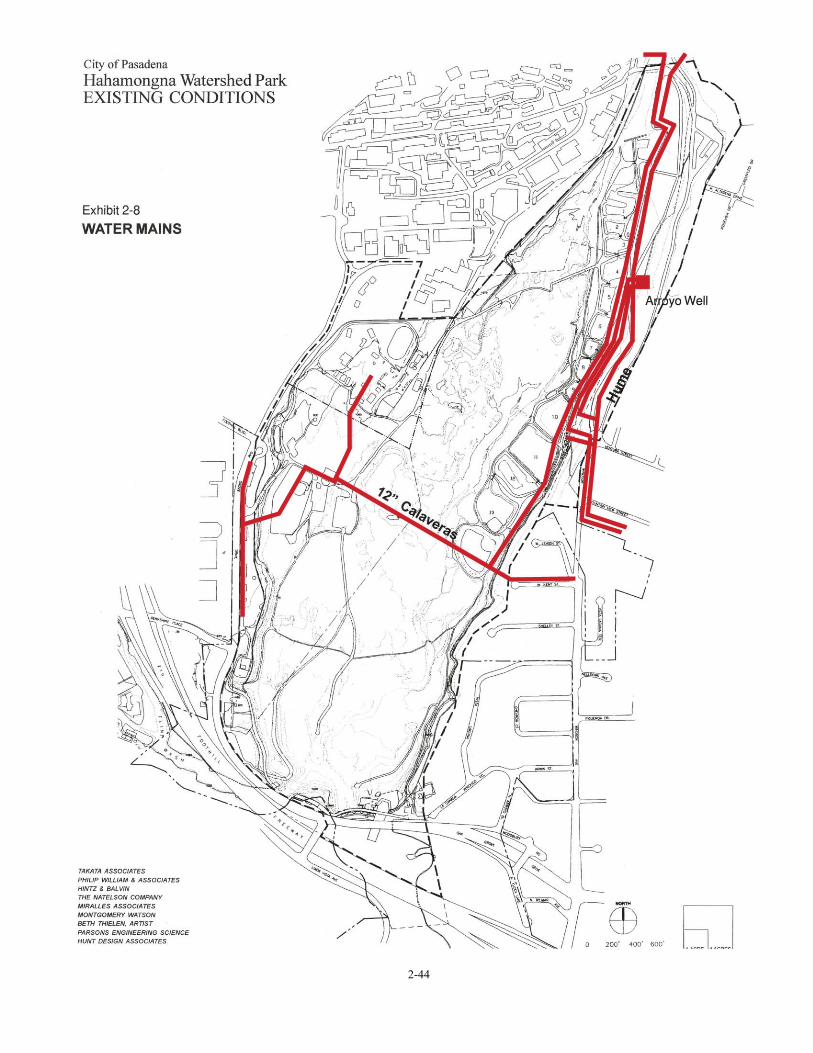
2-44

CITY OF PASADENA / ARROYO SECO MASTER PLANS Hahamongna Watershed Park Master Plan
2-45
OVERHEAD POWER & COMMUNICATION LINES Overhead power lines in the HWP area include Southern California Edison (SCE) and the Pasadena Water & Power Department (PWP). In some cases, the power poles in the basin are utilized by the General Telephone Company, now Verizon, and the local cable companies. The main power lines for transmission in the basin area belong to SCE. These lines follow the toe of the western slope, run the length of the basin from south to north and feed into and from JPL’s main substation. Some distribution lines in the basin belong to PWP and other distribution by SCE emanates from the JPL main substation, see Exhibit 2-9, Overhead Transmission Lines. SCE distribution to the west is at Foothill Boulevard and Berkshire Place; to the east the distribution is at Devil’s Gate Dam, across the basin in line with Altadena drive and diagonally across the basin to Ventura Street. The PWP lines originate at Windsor/Ventura on the eastside of the basin and head west down the eastern slope; one line crosses the basin to the west and distributes power to the park and the MWD property and includes fiber optics to JPL. The other line heads north to the Arroyo well and south to Johnson field. The SCE north/south transmission and distribution lines, from Flint Wash to the lower Oak Grove parking area, have been inaccessible due to inundation during recent floods. PWP’s power lines feed north on the Gabrielino Trail road from the intersection of Windsor Avenue and Ventura Street to the Behner Treatment Plant and JPL’s east parking lot where JPL has erected lighting and communication overhead lines around the perimeter. Along with the power lines there are communication lines which have been installed under-ground starting at Devil’s Gate Dam. These lines travel along the east side of Oak Grove Drive to the JPL campus. NATURAL GAS A 12" high-pressure natural gas line, owned by the Southern California Gas Company is buried from three to eight feet deep and traverses the basin underground from Kent Street to Foothill Boulevard; see Exhibit 2-10. The gas flow for the line is bi-directional but predominately from the Pasadena side (East) to Chatsworth (West). Existing drawings indicate that the 12" line is very near the 12" galvanized Calaveras water line. Due to this close proximity it may be prudent to have this gas line evaluated for corrosion mitigation. There is also a natural gas line leading from west end of La Cañada-Verdugo Road that supplies gas to the dam keeper’s house and facilities. In Oak Grove, near the intersection of Oak Grove Drive and Berkshire Place, there is a natural gas line that runs north to south along Oak Grove Drive. This line connects to various structures requiring gas service such as the park maintenance building.
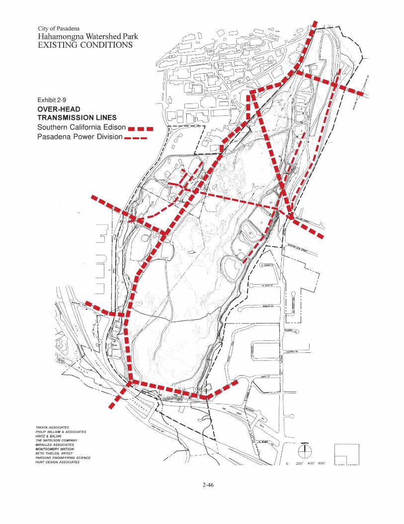
2-46

2-47
CITY OF PASADENA / ARROYO SECO MASTER PLANS Hahamongna Watershed Park Master Plan
2-48
SEWAGE MANAGEMENT SYSTEMS The only major sewer system that runs near HWP is the Oak Grove Drive sewer main. This line starts from JPL and makes it way south toward Devil’s Gate Dam along Oak Grove Drive where the line is mounted directly on the bridge crossing at Flint Wash. Just west of the dam, the line heads south, crosses the Foothill Freeway and continues south towards the Central Arroyo. The sewer has capacity for La Cañada-Flintridge as well as JPL. A recently completed sewer main was installed by the City of La Cañada-Flintridge on Foothill Boulevard which connects to the Oak Grove Drive line at this intersection. The line then continues south where it connects to the Pasadena system near the Rose Bowl, which is being repaired to be turned over to the Los Angeles County Sewer District (LACSD) system. The upper Oak Grove restroom gravity-feeds to the main trunk line in Oak Grove Drive. The remaining three restrooms in the Oak Grove area utilize septic systems (the Equestrian Staging Area, the Oak Grove maintenance yard and the lower Oak Grove). In the area of Devil’s Gate Dam, the LACDPW’s facility and the Pasadena Arroyo Seco Resource Center have septic systems. On the eastside of the basin, the restroom at Johnson field has a septic system. On the MWD property, all of the restrooms in the U.S. Forest Service area are connected by a gravity sewer system. Sewage is collected at a sewer lift station and pumped through a force main discharging into the nearby Oak Grove sewer main. In the Rose Bowl Riders and Tom Sawyer Camp areas the restrooms have septic systems. 2.8 CIRCULATION CIRCULATION AND VEHICULAR ACCESS The regional connections to HWP are from the Foothill Freeway (210) with access from the Berkshire Place and the Foothill Boulevard exits on the west and the Windsor Avenue exit on the east. The arterial connections which service HWP include Oak Grove Drive and Foothill Boulevard on the west and Oak Grove Drive (Woodbury Road), Windsor Avenue, and Ventura Street on the east. Arterial traffic near HWP is heavy during the early morning due to the simultaneous arrivals of JPL commuters and La Cañada High School students. Because the high school includes grades 7 through 12, drop-off traffic is as much an issue as the need for student parking in the area. Complaints from La Cañada residents north of the high school resulted in those residential streets being closed to student parking. This, coupled with inadequate parking at the high school as well as the close proximity of the park to JPL, has created a great parking demand in the upper Oak Grove parking areas. During a recent construction project at the school, students were permitted to use the upper Oak Grove parking areas.

CITY OF PASADENA / ARROYO SECO MASTER PLANS Hahamongna Watershed Park Master Plan
2-49
As part of the 1992 Preliminary Plan for HWP, a traffic impact analysis was prepared.3 Four intersections identified by the City of Pasadena Department of Public Works were studied. They included: • Oak Grove Drive at Foothill Boulevard • Oak Grove Drive at Berkshire Place • Oak Grove Drive at Linda Vista Avenue • Oak Grove Drive (Woodbury Road) at Windsor Avenue In 1992, all four intersections were operating at an acceptable level of service (service level D or better) during the weekday morning and evening peak hours. Only the intersection at Oak Grove and Berkshire Drive had moderate congestion (service level D) during the weekday evening peak hour. The City of Pasadena’s Department of Public Works reported that the historic vehicular traffic growth in the area was at most 1.0 percent. The 1992 Traffic Impact Study developed a baseline projection assuming a 1.06 percent growth rate that indicated that by 1998 the intersection at Oak Grove Drive and Berkshire Place would be approaching an unacceptable level of congestion if there was no development of HWP. The West entrance currently serves as the primary park entrance to HWP. The west entrance also provides access to some of the MWD lessors (USFS and Rose Bowl Riders with Tom Sawyer Camp). The roads and trails within this property were all originally a part of the Oak Grove Park but no longer provide public access or emergency access to the northwest portion of Hahamongna Watershed Park. The Los Angeles County Fire Camp #2 leases the northeast corner of the MWD property, but access to the site is through the JPL service road bordering their facility. The east entrance at the intersection of Windsor Avenue and Ventura Avenue provides access to the east JPL leased parking lot, City and County maintenance vehicles and occasional users of Johnson Field. The 1992 Traffic Impact Report for the Preliminary Plan identified this intersection as confusing and dangerous. It was recommended that a further investigation of the intersection was necessary particularly if facilities were developed on the east side of HWP that would attract park users unfamiliar with the intersection. EMERGENCY AND MAINTENANCE VEHICLE ACCESS On the west side, emergency and maintenance vehicle access is at the main entrance at Oak Grove Drive/Foothill Blvd. Limited maintenance access to Oak Grove Drive is provided by an unimproved road on the southwest portion of the park and west of Flint Wash. The road is used periodically to remove sediment from the basin for flood control purposes.
3 Site Traffic Impact Analysis of the Proposed Devil’s Gate Multi-Use Project, Barton-Ashman Associates, Inc. May 19, 1992.

CITY OF PASADENA / ARROYO SECO MASTER PLANS Hahamongna Watershed Park Master Plan
2-50
On the east side emergency and maintenance vehicle access is at the Windsor Avenue and Ventura Street entrance. Limited access to the Devil's Gate Dam facility is provided at the terminus of La Cañada-Verdugo Road. Emergency and maintenance vehicle access to the flood basin on the westside is via a north/south unimproved road, just east of the Oak Grove park area, which is accessible by its connection to the upper Oak Grove paved road at the south and in the middle, just east of the lower Oak Grove parking area. Emergency and maintenance vehicle access to the eastside of the flood basin is via a north/south road accessible at the southeast end of the Devil’s Gate Dam facility and at the middle in the vicinity of the easterly JPL parking lot though the entrance at Windsor/Ventura. Connections between the east and west sides require leaving and re-entering the park causing lost response time and inefficient maintenance routines. The lack of bridge crossings over Flint Wash and the upper portion of the site precludes an all-weather perimeter access road. The operation of heavy machinery and large trucks and unauthorized parking on La Cañada-Verdugo Road has affected the neighborhood adversely and raised the concerns of the neighbors. BICYCLE ROUTES An existing Class II bicycle lane on Oak Grove Drive to Berkshire Place links Foothill Blvd. to Arroyo Boulevard. This route continues south on Arroyo Boulevard providing street access to the Central and Lower Arroyo. The Gabrielino Trail provides mountain bikers access to the steeper terrain in the Angeles National Forest. Street connections to the start of the Gabrielino Trail are Windsor Drive to the south and Ventura Street from the east. Neither of these streets is within Pasadena city limits. In 2000, the City of Pasadena completed its first Citywide Bicycle Master Plan. The primary focus of the plan was to make the city streets more “bicycle friendly.” Issues pertaining to recreational bicycle riding within City parkland were not addressed with the exception of the Rose Bowl loop. At the present time, bicycles are permitted on existing paved surfaces within HWP. TRAILS Regional Trails The regional trail system is illustrated in Exhibit 2-11, Regional Trail Plan. Trail connections in HWP are part of the Rim of the Valley Trail Corridor that circles the San Fernando and La Crescenta valleys. Trail connections south through the Arroyo Seco link to the Los
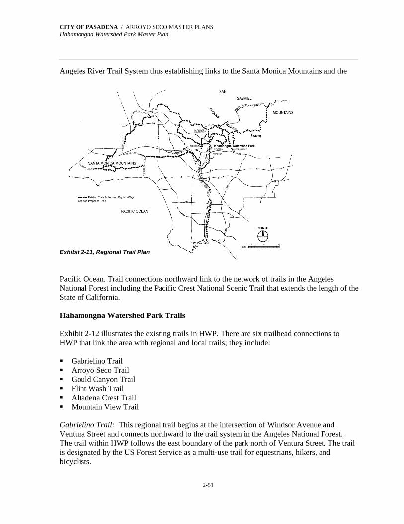
CITY OF PASADENA / ARROYO SECO MASTER PLANS Hahamongna Watershed Park Master Plan
2-51
Angeles River Trail System thus establishing links to the Santa Monica Mountains and the Exhibit 2-11, Regional Trail Plan Pacific Ocean. Trail connections northward link to the network of trails in the Angeles National Forest including the Pacific Crest National Scenic Trail that extends the length of the State of California. Hahamongna Watershed Park Trails Exhibit 2-12 illustrates the existing trails in HWP. There are six trailhead connections to HWP that link the area with regional and local trails; they include: Gabrielino Trail Arroyo Seco Trail Gould Canyon Trail Flint Wash Trail Altadena Crest Trail Mountain View Trail
Gabrielino Trail: This regional trail begins at the intersection of Windsor Avenue and Ventura Street and connects northward to the trail system in the Angeles National Forest. The trail within HWP follows the east boundary of the park north of Ventura Street. The trail is designated by the US Forest Service as a multi-use trail for equestrians, hikers, and bicyclists.
CITY OF PASADENA / ARROYO SECO MASTER PLANS Hahamongna Watershed Park Master Plan
2-52
Arroyo Seco Trail: Linking all three sections of the Arroyo Seco is the Arroyo Seco Trail. The Arroyo Seco Trail is a series of parallel trails on both sides of the arroyo. Typically the east and west trails merge in the transition from one section of the Arroyo Seco to the next. Within each section of the Arroyo Seco, the trails are given local names. The Arroyo Seco Trail is part of the Rim of the Valley Trail Corridor. To the west through La Cañada-Flintridge, the Arroyo Seco Trail follows trails that are part of the Los Angeles County riding and hiking trails systems. The trail continues south from HWP through Central Arroyo via the east tunnel of the Devil's Gate Dam. Connections north to the Pacific Crest Trail in the Angeles National Forest can be made using the Gabrielino Trail. The Arroyo Seco Trail within HWP is currently restricted for equestrian and hiking use only. Gould Canyon Trail: This trail connects the La Cañada trails system through an access tunnel under Foothill Boulevard to the West Rim Trail. Flint Wash Trail: The Flint Wash trailhead is located in the southwest corner of HWP, starting at the confluence of Flint Wash and the HWP flood basin. The trail follows Flint Hiking & Equestrian Trails Wash under the 210 Freeway, connecting to the La Cañada trail system. This trail is part of the Rim of the Valley Trail. Local trail access to the Altadena community is provided at the end of Altadena Drive and at the parking lot at the intersection of Windsor and Ventura. These trailhead connections lead to the Altadena Crest Trail and the Mountain View Trail. Equestrians and hikers use a combination of trails and maintenance roads within HWP. All of these trails can be considered as part of the Arroyo Seco Trail. Internal to the park, trails exist along portions of the upper slope of the basin. The West Rim Trail leads north from the Flint Wash trailhead connection to the Equestrian Staging Area. Following the crest of the basin slope through the upper terrace picnic area, the trail continues north around the MWD property. At the northeast corner of the MWD property, the trail connects to the Angeles National Forest along the eastern edge of the JPL campus. At the JPL Bridge, the trail slopes down to the river bed, passes under the bridge, fords the stream, and connects to the Gabrielino Trail. From the Devil’s Gate Dam, the East Rim Trail follows the upper east crest of the basin slope northward to the VOC Water Treatment Plant. A linking trail connects the slope to the Windsor/Ventura Parking Lot and the Mountain View Trail.

2-53
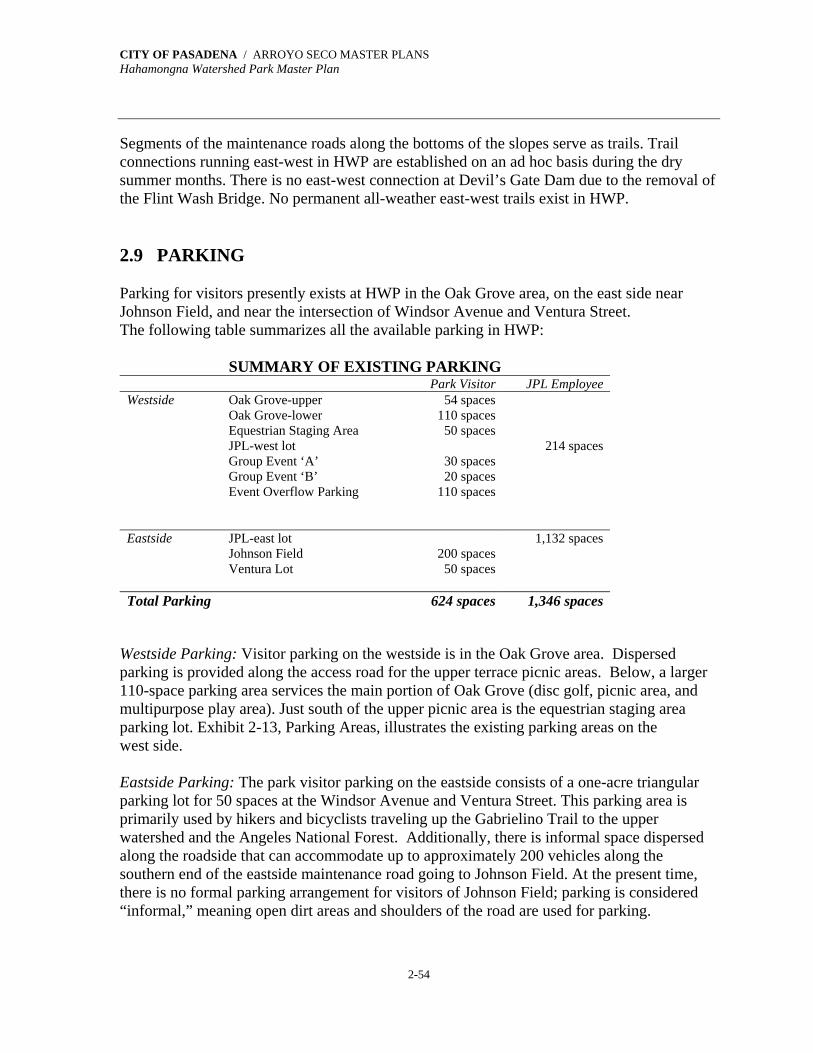
CITY OF PASADENA / ARROYO SECO MASTER PLANS Hahamongna Watershed Park Master Plan
2-54
Segments of the maintenance roads along the bottoms of the slopes serve as trails. Trail connections running east-west in HWP are established on an ad hoc basis during the dry summer months. There is no east-west connection at Devil’s Gate Dam due to the removal of the Flint Wash Bridge. No permanent all-weather east-west trails exist in HWP. 2.9 PARKING Parking for visitors presently exists at HWP in the Oak Grove area, on the east side near Johnson Field, and near the intersection of Windsor Avenue and Ventura Street. The following table summarizes all the available parking in HWP:
SUMMARY OF EXISTING PARKING Park Visitor JPL Employee Westside Oak Grove-upper 54 spaces Oak Grove-lower 110 spaces Equestrian Staging Area 50 spaces JPL-west lot 214 spaces Group Event ‘A’ 30 spaces Group Event ‘B’ 20 spaces Event Overflow Parking 110 spaces
Eastside JPL-east lot 1,132 spaces Johnson Field 200 spaces Ventura Lot 50 spaces Total Parking 624 spaces 1,346 spaces
Westside Parking: Visitor parking on the westside is in the Oak Grove area. Dispersed parking is provided along the access road for the upper terrace picnic areas. Below, a larger 110-space parking area services the main portion of Oak Grove (disc golf, picnic area, and multipurpose play area). Just south of the upper picnic area is the equestrian staging area parking lot. Exhibit 2-13, Parking Areas, illustrates the existing parking areas on the west side. Eastside Parking: The park visitor parking on the eastside consists of a one-acre triangular parking lot for 50 spaces at the Windsor Avenue and Ventura Street. This parking area is primarily used by hikers and bicyclists traveling up the Gabrielino Trail to the upper watershed and the Angeles National Forest. Additionally, there is informal space dispersed along the roadside that can accommodate up to approximately 200 vehicles along the southern end of the eastside maintenance road going to Johnson Field. At the present time, there is no formal parking arrangement for visitors of Johnson Field; parking is considered “informal,” meaning open dirt areas and shoulders of the road are used for parking.

2-55

CITY OF PASADENA / ARROYO SECO MASTER PLANS Hahamongna Watershed Park Master Plan
2-56
JPL PARKING There are two City-owned parking lots, on the west and east sides of the park, currently leased by JPL for employee parking. The five-year lease generates $450,000 per year, which is used for the planning, maintenance, and operations of HWP. The lease will expire in 2004. The 1.2-acre west parking lot provides 214 parking spaces. Access to the west parking lot is through JPL property. The east parking lot is 9.6 acres and provides 1,132 parking spaces. Access to the east parking lot is from the Windsor /Ventura entry. JPL has a shuttle service from the parking area to the campus. Both parking lots are gated when not in use; however, the current lease allows shared parking of the two lots with advance communication and when not in use by JPL. JPL is currently completing its "down-sizing" from 7,000 employees to 5,000 employees—a reduction of 20% of its work force. This process includes the closure of off-site JPL facilities and the relocation of those employees to the JPL campus. Therefore, JPL parking needs at HWP will equal or slightly increase from current conditions in the future. 2.10 EXISTING RECREATION Existing recreation facilities are located on the west and east sides of HWP. The majority of these facilities are located in the Oak Grove area. WESTSIDE (OAK GROVE) The Oak Grove park facilities were developed in the early part of the 20th Century by the City of Pasadena. In 1971, during the period (1968-1993) when Oak Grove was operated as a Los Angeles County regional park, the Los Angeles County Department of Parks and Recreation made extensive improvements to the park. Oak Grove has two activity levels on an upper and a lower terrace separated by a steep slope. Upper Terrace The upper terrace is adjacent to the internal roadway from the west entry at Foothill Boulevard south to the Flint Wash. Facilities include picnic facilities, restrooms, a maintenance building, and the equestrian staging area. Picnic Facilities: The upper terrace is primarily devoted to individual picnic facilities under mature oak trees. Dispersed parking off the access road services the picnic areas. Restroom: There is one restroom in the upper picnic area. The facility needs renovation and
CITY OF PASADENA / ARROYO SECO MASTER PLANS Hahamongna Watershed Park Master Plan
2-57
modifications to comply with disability standards (ADA). Equestrian Staging Area: The equestrian staging area is located south of the picnic areas and the Oak Grove Maintenance Office. This area is open to the general public by permit only. Vehicle access is limited to a single lane around the maintenance office and over the Berkshire Drain. The staging area provides access to nearby trails, parking for cars and horse trailers, and a restroom. It is used for small group gatherings and by Tom Sawyer Camp as a venue for it younger campers. The restroom needs renovation and modifications to comply with disability standards (ADA). Lower Terrace The lower terrace is situated along the base of the western slope of the basin and extends from the MWD property to the group picnic areas south of the existing play field. The lower terrace includes facilities for passive and active recreation; the facilities include group picnicking, a play field, restrooms, and disc golf course. Group Picnicking: Group picnic facilities are located south of the play field. The facilities include picnic benches, barbecue pits, and a drinking fountain. Amphitheater: There is a small rustic amphitheater at the base of the slope near the group picnic area adjacent to the play field. The amphitheater is constructed with telephone pole seating and in need of renovation. Oak Grove Field: This play field is used for baseball, large group activities for Tom Sawyer Camp, and special events such as the recent statewide Police Activities Games. The field is also used as a staging area for major disasters in coordination with the USFS and Los Angeles County Fire Department. Restrooms: There were two restrooms on the lower terrace of Oak Grove Park. The restroom near the group picnic area was destroyed by fire and needs to be replaced. The other restroom is located to the north of the playing field in an area with four camp sinks that was formerly used for overnight group camping. The remaining restroom does not meet current disability standards (ADA) and needs rehabilitation. Disc Golf: The 18-hole disc golf course at HWP is the nation's first disc golf course. Since its inception in early 1970, disc golf courses have been constructed all over the world. The course is quite popular and provides recreation for all ages. The disc golf course is currently located on both the north and south ends of the lower terrace. The front nine follows the perimeter of the play field, picnic area, and parking area. The back nine is located in the oak grove of the north portion of the lower terrace. The back nine weaves in and out of the oak trees impacting the trees due to heavy use.

CITY OF PASADENA / ARROYO SECO MASTER PLANS Hahamongna Watershed Park Master Plan
2-58
EASTSIDE RECREATION Recreation facilities on the eastside of HWP are limited to Johnson Field. The field was constructed by the Department of Water and Power volunteers. It was used for informal softball games but is currently not available for public recreational usage. Facilities at this location include picnic tables, a barbecue pit, and a small restroom. 2.11 CULTURAL & ARCHAEOLOGICAL RESOURCES ARCHAEOLOGICAL RESOURCES In 1987, a Preliminary Assessment of the Prehistoric Cultural Resources of the Devil’s Gate Reservoir 4 (HWP) was undertaken. A record search was conducted of archival materials and a physical inspection of the site was performed. The assessment reports that “no prehistoric sites were found to be located on the property.” The record search looked for existing survey reports and recorded sites within the study area and within a one-mile radius of the study area. While there were no reports or recorded sites within the study area, three sites within the one-mile radius were surveyed and reported. They are as follows: Survey Area L-880: Located adjacent to the study area on JPL property. This 1980
survey concluded that there were “no known or recorded resources” within the survey area.
Survey Area L-108: Located southeast of the Devil’s Gate Dam between Oak Grove Ave.
and the 210 Freeway was also negative. Survey Area L-1659: The study area, known as the La Vina property, is located .25 miles
northeast of HWP. A prehistoric quartzite flake of cultural origin was recorded. Within the one-mile radius there are also two recorded archaeological sites: CA-LAn-342: Located .33 mile north of HWP, the site consists of part of a village known
as the Millard Canyon site. CA-LAn-26: The Sheldon Reservoir site is located southeast of the Devil’s Gate Dam. In
1938, the Pasadena Water Company uncovered a burial ground during the excavation of the reservoir.
4 Environmental Baseline Study, Devil’s Gate Multi-Use Project, Cotton/Beland/Associates, Inc., February 1988.
CITY OF PASADENA / ARROYO SECO MASTER PLANS Hahamongna Watershed Park Master Plan
2-59
The conclusion of the assessment was that the areas should be considered as archaeologically sensitive given the proximity of the two known archaeological sites. CULTURAL RESOURCES The cultural resources, along with the natural environment make up the unique character of Hahamongna Watershed Park that is so appreciated today. The historical and continuing use of this environment by the community contributes significantly to the cultural heritage of the City of Pasadena as formally recognized in the City’s Guiding Principles. What “has been in existence” in the Arroyo for years upon years takes many forms: natural and man-made, physical artifact, and human activity. Some have been present longer than others, but each has become a cultural resource that contributes to the heritage of the Arroyo Seco. These resources need to be enhanced and preserved. The indigenous peoples have a long history as stewards of this landscape. Each year, following the seasons, they have collected botanical material for traditional spiritual, ceremonial, medicinal and utilitarian uses. As guardians of these natural resources, they understand how to collect in a way that does not impair the sustainability of a plant population. As custodians of their culture, individuals, families and tribal groups use sites throughout Hahamongna Watershed Park for spiritual, social, and ceremonial traditions. Although most of these events are traditionally very private, the public at times is welcomed. A number of groups, in addition to the Native Americans, have had a historical presence in the Park and have contributed to its cultural identity. Since the early part of the 20th century, children of the region have had a memorable summer experience by attending Tom Sawyer Camp. A great number of camp attendees are second and even third generation and in many instances they return as camp counselors gaining leadership skills that serve the community. The Oak Grove Disc Golf Course is the first disc golf course in the world. The course dates back to the early 1970’s as a “Frisbee” course where play was started between two posts, throwing the Frisbee several times in turn toward a distant post. A Frisbee hitting the distant post completed that hole. In early 1976, the posts were replaced with a metal basket on a post and the tee became a small octagonal concrete pad which is unique to this course. In the early 80’s, the Frisbee was replaced with a smaller thinner disc. As a result of the popularity of the Oak Gove Disc Golf Course, courses began springing up everywhere across the country and later around the world. Twice a year, the Oak Grove Course hosts a tournament. The tournament in the fall of 2001 brought contestants from as far away as Alaska, Hawaii, and even Sweden. Hahamongna Watershed Park has a well-established equestrian community that regularly draws riders from Pasadena, Altadena, and La Cañada. Visitors bring their horses from as far away as San Diego and Santa Barbara counties to ride. HWP is the hub where many trails come together and spread out in all directions: north, south, east, and west. The equestrian groups actively work to maintain these trails that are used by many others—dog

CITY OF PASADENA / ARROYO SECO MASTER PLANS Hahamongna Watershed Park Master Plan
2-60
walkers, hikers, and joggers. The Pasadena Mounted Police Unit stables its horses in the area and patrols the Arroyo Seco. Additionally, many groups take advantage of this unique environment to support their broader missions. The Audubon Society hosts a monthly tour of the park for bird watching. The Armory Center for the Arts has a continuing program entitled, “Children Investigate the Environment,” in which various City departments collaborate to teach Pasadena Unified School District youth about the area’s natural resources. The plein-air painters use the Arroyo Seco, including HWP, as an open-air studio to create their scenes on canvas. JPL, a neighbor to the park, uses the rough landscape of the flood basin to test its planet-exploring robots. Instructors with the School of Self-Reliance teach survival skills, and provide information about edible and useful plants. Many organized groups have returned time and again to participate in competitive law enforcement training events, nature hikes sponsored by the Sierra Club, scout jamborees, and company picnics. Just below the Devil’s Gate Dam, where the canyon narrows, is a unique rock formation that resembles the profile of a horned devil. In 1858, when Judge B.S. Eaton visited Rancho San Pasqual and this particular site in the Arroyo Seco, he named the location “the Devil’s Gate.” The original concrete gravity-arch dam at Devil’s Gate was dedicated in June of 1920; it is the first dam built for the Los Angeles County’s flood control and water conservation system. From 1920 to 1965, the top of the dam was the main road between Pasadena and La Cañada. In 1998, when the Devil’s Gate Dam was reinforced to hold water, it was also architecturally restored to its original character. For years, Los Angeles County and Pasadena City fire departments, local law enforcement agencies, and other groups have used the dam to train personnel in disaster- and accident-rescue techniques; and numerous photographers and filmmakers have used the dam and spillway as a backdrop. In this age of environmental awareness, it is more likely that the oak woodland that gives name to Oak Grove is recognized as “natural habitat” before it is considered a cultural resource. But the Oak Grove itself is a unique setting—a cool and shady respite with the distinctive arroyo stone walls edging the slopes and trails. Since the beginning of the 20th Century, people have enjoyed the splendor of this great stand of trees, picnicking under the broad canopy, exchanging wedding vows, and celebrating birthdays. The preservation of Oak Grove over the years is testimony to the value the community places on it. From the narrow canyon, just below Devil’s Gate Dam, to the broad flood plain with its wooded and chapparal-covered slopes and up to the prominent points with their grand vistas, this cultural resource called Hahamongna Watershed Park should be enhanced and preserved.

CITY OF PASADENA / ARROYO SECO MASTER PLANS Hahamongna Watershed Park Master Plan
2-61
2.12 SUMMARY OF COMMUNITY OUTREACH COMMUNITY OUTREACH The Master Plan community outreach process was extensive. The process included three community meetings/workshops, site tours, numerous stakeholder meetings, and meetings with community organizations and neighborhood groups. The meetings were well attended by interested and enthusiastic participants. The community expressed the desire that the focus of HWP should be on “keeping it natural” while balancing this concept with the objectives of water conservation, flood protection, and active recreation. The community meetings elicited ideas and reviewed two alternative concepts (see Appendix A). One alternative emphasized a natural park and the other concept emphasized active recreation, including soccer, baseball, and other field activities. Meeting attendees formed teams to discuss and suggest ways to resolve and balance these concepts.
The master plan community outreach process was extensive The community input confirmed the inherent conflict between those that desire to keep the park natural and those who seek to develop needed active recreation facilities. It was recognized that the need for active recreation, especially fields for soccer and baseball is a communitywide issue. The community input encouraged organized sports groups to work with the City of Pasadena and the public schools to identify other venues to meet the demands. Some have mentioned the Central Arroyo as a more appropriate location. For Hahamongna Watershed Park, the community has expressed a desire to: Preserve the hiking and equestrian trails; Provide lakes or a water feature that will bring back birds and, perhaps, put HWP on the
bird flyway that runs the length of the state; Promote those activities that will attract wildlife and protect and enhance native species; Balance recreation with habitat restoration and water conservation; Provide additional active multi-purpose fields;
CITY OF PASADENA / ARROYO SECO MASTER PLANSHahamongna Watershed Park Master Plan
2-62
Provide a year-round perimeter trail for hikers and equestrians; Provide an interpretive center and venues for environmental education and Native
American culture; Protect and buffer adjacent neighborhoods.
SUMMATION OF THE COMMENTS FROMHAHAMONGNA WATERSHED PARK COMMUNITY MEETINGS
During the Master Plan process, three community workshops were held to solicit commentson the progress of the Master Plan. The following summation itemizes by topic both theverbal and written comments made during the workshops. In some cases similar comments,such as “keep it natural” were heard many times, but are not repeated here. As one can see,the list consists of comments from both ends of the spectrum on almost every issue. As theprocess proceeded, participants gravitated toward a balanced approach–not any one interestgroup getting everything it wanted, but instead agreeing to disagree and settling for acompromise.
Habitat
Keep it natural; Watershed area should be kept as natural as possible; Soften all facilities (parking, buildings) with natural vegetation; Most of park should be natural, not full of sports fields; Eliminate sports fields and disc golf course; Keep down the development and buildings in park; Advocate wildlife “rehabitation;” Stress Native American influence on area; Reintroduce native plants and safeguard protected species; Create an Engleman Oak monument; Organized sports are too intense for a wetlands or nature area; Protect the wildlife corridor in basin; Develop a plant nursery for endangered plants, trees, and plants used by “gatherers” –
protect the plant gene pool at Hahamongna; No boating on lakes in order to bring back birds and wildlife; No motorized boating; The bridge at the north end of the Park should be in wood and kept natural and rustic for
hikers and horses; The loop perimeter trail is essential for horses and hikers so we can access all the trails,
hike, watch the birds and animals and enjoy the view of this restored natural habitat.

CITY OF PASADENA / ARROYO SECO MASTER PLANS Hahamongna Watershed Park Master Plan
2-63
Recreation & Sports Keep Disc Golf out of the floodplain to allow for year-round play; Make playing fields multipurpose (overlay)–baseball in summer and soccer the rest of the
year; Eliminate baseball from Oak Grove field and designate it for soccer only; Establish one regulation-size soccer field at Oak Grove; Create more than four soccer fields; they are more important than lakes; Find other locations for soccer fields, not in this basin; Keep bicycles and horses separate; Allow only horses in Hahamongna basin and only allow bicycles north of Ventura; For equestrians, maintain perimeter trail and east-west trails, especially across JPL east
parking lot & do something about blind spots on trails where collisions could occur; Be careful about placement of Native American activity area near equestrian staging area; No overnight camping except for supervised groups; Allow for fishing in one lake; Allow for practice rowing on flood conservation pool; Want playing fields on both eastside (Pasadena/Altadena side) and
westside (La Cañada side); Stop trying to develop soccer fields in a natural area and instead look at school sites; Who pays for soccer fields and why should they get special attention; Sports fields mean pesticides and they are incompatible with a nature park; Make the disc golf ADA accessible and accessible to strollers; For a unique park, create unique recreational features compatible with nature.
Trails Connect the trail in Altadena to the rest of the system; Maintain trail crossings and preserve horse trail linkages at south and north end of basin; Develop a complete trail loop going down east and west side and connecting at the south
with the restoration of the Flint Wash bridge; Keep trails from Hahamongna up the canyon into Angeles National Forest; Keep ability to use trails to get from Hahamongna Park to and from Altadena Drive side
of Arroyo using trail system; Keep ability to get from Hahamongna Park to Flintridge Riding Academy and Club and
the trail system near Flintridge riding complex; Keep ability to get from Hahamongna to Cherry Canyon system of trails that run from
Hahamongna to La Cañada; Keep ability to get from Hahamongna to trails that go south to Rose Bowl; Hahamongna is a hub for reaching a series of trails and that hub must be respected; Keep Rose Bowl Riders in the Park; Keep Tom Sawyer Camp in Oak Grove Park; Develop effluent control; Use school facilities and not park for soccer expansion; Have no soccer in Hahamongna. Impact of noise to eastside residents and impact on
CITY OF PASADENA / ARROYO SECO MASTER PLANS Hahamongna Watershed Park Master Plan
2-64
wildlife is the reason. Also the impact on plant life. Keep it natural!! Hahamongna should not be made into a stadium; Loop/perimeter trail for hikers and horses is essential. No bikes on trails with horses and
hikers. Bikes hit horses/hikers. Keep bikes separate; Make the bridge at the north end of wood so it is more natural. It will be easier for horses
to cross because they will not slip. Wood will also not be so hot on the feet of dogs, horses, and hikers.
Water Features Allow fishing in the proposed lakes; No fishing in proposed lakes; Allow practice rowing when storm water is held behind the dam; Keep lakes natural to attract birds and wildlife; Create “nature blinds” where people can observe wildlife on the water; Create a meandering stream into one of the lakes preferably on east side; Prefer a lake to a pond; Create islands in the lake for protected nesting of birds; Keep water behind dam as long as possible; Call lakes and ponds what they are, use simple language; Isolate some shoreline from human contact; Permanent water features (lakes) must be a part of the new Park Plan.
Noise Add no new fields on east side because it will increase the noise for neighbors; Do not add parking on east side because of noise.
Security Allow only supervised overnight parking for authorized groups; Enforce a “no bicycles on horse trails” ordinance in basin; Increase number of Park Rangers for security reasons; Develop a volunteer equestrian patrol like the one in Lower Arroyo; Provide year-round emergency/maintenance vehicle access and a trail loop for circulation
which will require the restoration of the Flint Wash bridge; Create a landscaped berm at the end of La Cañada-Verdugo Road with a fence to protect
eastside neighbors; Increase patrols on eastside to assist with security.
Enforcement Keep up on graffiti removal; Make pet owners responsible for picking up after their animals; Keep dogs on leash;
CITY OF PASADENA / ARROYO SECO MASTER PLANS Hahamongna Watershed Park Master Plan
2-65
No pit bulls in the Park; Have regular security patrols.
Circulation Keep main entrance on west side; Create a “turn around” area for horse trailers below staging area & widen the road; Don’t bring cars in at proposed Woodbury entrance; continue to use Oak Grove Drive; Keep the sediment removal trucks out of eastside neighborhoods; Find ways to reduce traffic on North Arroyo near Woodbury Avenue; Improve the Windsor/Ventura entrance to eliminate traffic congestion; Allow resident access if you install a cul-de-sac at end of La Cañada-Verdugo Road; Correct point above to read “Close off area to all …Block Wall;” Eliminate vehicular/pedestrian access from La Cañada-Verdugo Road; Improve traffic circulation in and around park to eliminate congestion due to JPL
& High School; Put traffic signal at the Windsor/Ventura intersection; Coordinate with the Flood Maintenance Division of L.A. County Department of Public
Works regarding maintenance routes. Parking Provide adequate access for the disabled to recreation areas; Defray costs of park operation by renting parking lots on weekends; Make a parking area out of Rose Bowl motel; Improve parking at Woodbury (Oak Grove Drive) and at Windsor/Ventura which is
now a traffic hazard; Create weekday parking because JPL now takes it all; Provide adequate parking for park use; Assist to obtain “resident only” parking for eastside residents; Create a No Parking area at the end of La Cañada-Verdugo Road; Keep the eastside or the bluff area the “low impact” part of Hahamongna; Rent one of JPL’s east lots for weekend parking.
Cultural Issues Eliminate any thought of a museum because there is not enough space to accommodate
one; Establish an Interpretive Center with a heavy emphasis on the contribution of Native
Americans and the natural environment of the basin; If an Interpretive Center is established, give careful thought to staffing and maintenance
through adequate funds and grants; Keep up with graffiti removal; Make pet owners responsible for picking up after their animals – all animals; Provide gathering places for basket weavers;
CITY OF PASADENA / ARROYO SECO MASTER PLANS Hahamongna Watershed Park Master Plan
2-66
In trying to balance interests, remember that the ecosystem, although silent, is one of them;
The City of Pasadena should be clear about what it is willing to spend for an Interpretive Center and what educational programs will be included;
Who will fund an Interpretive Center and keep it going. It makes no sense to start one if there is not careful consideration of future funding options and responsibilities provide more workshops and educational programs related to the environment and the Native American contribution to this land;
Create an “out-of-the-way” ceremonial center which could be used by Native Americans; Take care to alert Native American “gatherers” of any spraying in Hahamongna; Create a communications system with “gatherers” to update them on conditions; Create some “off the beaten track” and therefore protected areas for plants used by
“gatherers;” Work cooperatively with other institutions such as the Southwest Museum; Any Interpretive Center should involve native people in the planning; An Interpretive Center should deal not just with past Native American traditions but
should relate to their current role and the future they hope to help shape – “We are a part of yesterday but also a part of today and tomorrow;”
Create a system of permitting for Native American “gatherers” who will protect the plants so that they can regenerate and flourish;
Allow no art work in park other than that which reflects the natural environment/colors. 2.13 SIGNAGE AND GRAPHICS Typically, the signs visitors encounter in a park can be categorized as either wayfinding, interpretive, or regulatory. Wayfinding signs are directional, site identification or amenity identification signs. Interpretive signs are informational. WAYFINDING SIGNAGE & GRAPHICS 1. Park Identification Signs The existing temporary HWP park entrance sign on the west side is effective, but institutional; it does not reflect a natural look and is not especially inviting. The typeface and layout of the sign panel does not harmonize well with the stone monument structure; a better solution would be individual letters mounted directly onto the stone. 2. Attractions Signs that identify the park’s many activities and destinations are inconsistent and generally not well executed. Identifiers such as the Disc Golf Course sign are generic metal panels supported by individual metal posts.
CITY OF PASADENA / ARROYO SECO MASTER PLANS Hahamongna Watershed Park Master Plan
2-67
3. Trail Signage Signage identifying trails and providing information about directions and mileage is varied and inconsistent. Included are “Forest Service” type wood signs and metal in several kinds of mounting conditions. 4. Amenities Identification Identification for restrooms, water fountains, telephones, etc. is inconsistent and the signs poorly constructed. Restroom signs may be in nonconformance with ADA (Americans with Disabilities Guidelines). 5. Safety rules and Regulations Many existing signs in the park are the result of a need to limit or qualify visitor behavior. Many other signs have evolved to cover seemingly obvious safety issues. The unfortunate result is a preponderance of negative messages in an environment that is intended to be a carefree respite from the visitor’s daily life. The fact that many park signs are negative messages is ironic when viewed against the large amount of energy invested in enhancing this natural environment. 6. Code-Required Signage Similar to safety rules and regulations, there is a number of these signs within the park area. Signs that are truly required need to be identified and displayed in an appropriate manner. The remainder should be eliminated or be displayed in another way. 7. Vehicle – Directionals and Parking Signs for drivers are a diverse combination of standard road signs, “Forest Service” signs and painted metal panels. Inconsistent typography, wording, and layouts are found throughout. 8. Pedestrian – Directionals Pedestrian signs in the park suffer from the same inconsistent ad hoc appearance as the vehicle signs. The placement of signs in HWP has occurred on an ad hoc basis with the net result that important intersections within the park are littered with signs of differing style and materials. INTERPRETIVE SIGNAGE & GRAPHICS Very few examples of interpretation through signage and graphics exist in the park at the present time.
CITY OF PASADENA / ARROYO SECO MASTER PLANS Hahamongna Watershed Park Master Plan
2-68
2.14 ISSUES & OPPORTUNITIES Based upon the analyses of the existing conditions and community outreach, specific issues and opportunities were identified to focus the Master Planning efforts; they include: Use of La Cañada-Verdugo Road for sediment removal; Improvements to eastside access at the Windsor/Ventura intersection; Oak Grove Drive traffic resulting from La Cañada High School and JPL; Multi-use conflicts between bicyclists, equestrians, and hikers as in the Central and
Lower Arroyo; Disc Golf (back nine course) impact to the north Oak Grove area, that is, compaction and
disturbance; Cultural resource opportunity to communicate the history of Native Americans, water
resources, environmental education; Multi-use playing fields: organized sports to maximize facilities balance with habitat
rehabilitation and water conservation needs; Water feature for recreation use and for habitat establishment; Habitat establishment and restoration; Devil’s Gate Dam access for maintenance and sediment removal; Parking for JPL and the importance of the revenues generated from the parking lease; Public access to the dam area for observation point, bird watching and hiking; Flood Control issues: When and how the water is held, sediment and habitat removal; Water conservation issues include the ability to spread additional water to recharge the
aquifer. Pump-back system will spread the water retained by the dam to replenish aquifer by pumping water to the spreading basins.
Section 3. Hahamongna Watershed Park Master Plan
CITY OF PASADENA / ARROYO SECO MASTER PLANS Hahamongna Watershed Park Master Plan
3-1
SECTION 3: HAHAMONGNA WATERSHED PARK MASTER PLAN This section describes the Master Plan recommendations for the Hahamongna Watershed Park (HWP) as indicated and partially illustrated in Exhibit 3-1, Hahamongna Watershed Park Master Plan. The recommended Master Plan elements are firmly based upon the goals and objectives outlined in Section 1, as well as a rigorous community outreach process; an inventory and analysis of the natural and man-made environment of the HWP site; the discussion and direction from the Hahamongna Watershed Park Advisory Committee; and consultation with other public agencies that share responsibility for the area. The Master Plan recommendations are presented and discussed as follows: Water Resources Management Conceptual Grading Plan Habitat Restoration Plan Recreation Trails Westside / Oak Grove Improvements East Side Improvements Circulation and Parking Utilities & Infrastructure Safety, Security & Accessibility Programs
3.1 WATER RESOURCES MANAGEMENT Issues pertaining to flood management, water conservation, sediment deposition and removal, as well as habitat restoration, are inextricably related. This fact is reflected in the number of public agencies that are stakeholders in HWP and whose cooperation and commitment are essential to the success of this element of the Master Plan. The conceptual framework for water resources management is outlined below, followed by the Conceptual
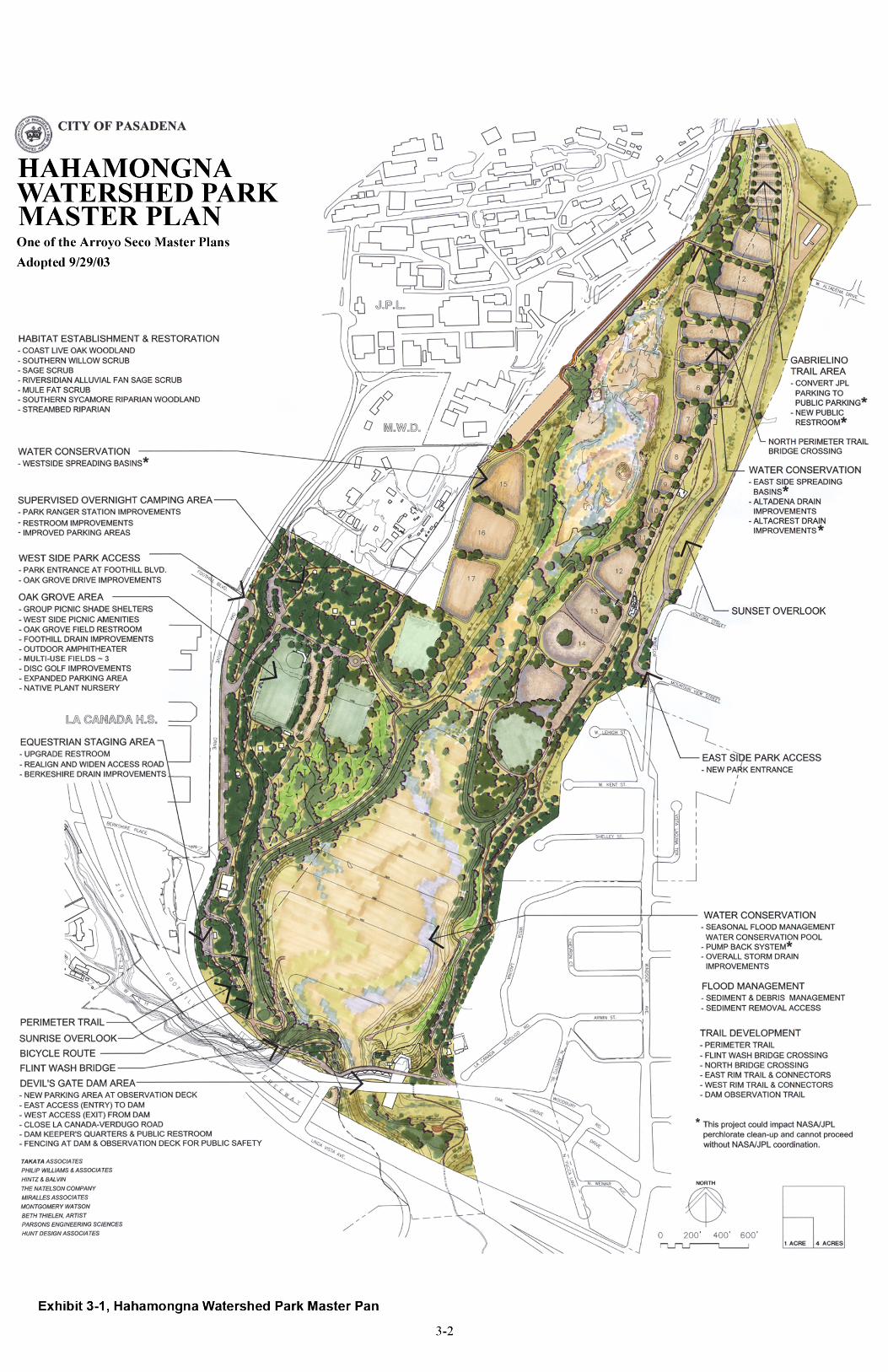

CITY OF PASADENA / ARROYO SECO MASTER PLANS Hahamongna Watershed Park Master Plan
3-3
Grading Plan that details the physical reshaping of the flood basin to achieve the desired balance between all the issues associated with water resources management. FLOOD MANAGEMENT The primary purpose of the Devil’s Gate Dam is to provide flood protection to downstream communities. The dam must be able to contain an appropriate volume of water while a storm passes and then slowly release the water at a rate consistent with the capacity of the downstream flood channels. Floodwater, having risen to elevation 1040.5, can typically be accommodated by flowing out through the windows of the spillway headworks (see Section 2, Existing Conditions, for a detailed description of dam operations). Under the most extreme conditions, when the floodwater rises faster than it can flow through the windows in the spillway headworks, water will rise to the top of the dam. All areas of HWP situated below elevation 1075, the top of the dam, could become flooded. Park elements need to be designed with the following flood considerations: (1) The area that is most frequently inundated is below elevation 1040.5 (the floor of the spillway); (2) park elements sited between elevations 1040.5 and 1075 will need to be reviewed by all parties and designed for the possibility of several days of inundation. The flood capacity below elevation 1040.5 should be as great as possible for flood management, water conservation, and sediment management. Currently, the area below this elevation covers 92 surface acres. When the water level is at spillway height (elev. 1040.5), much of the 92-acre area is covered with only a few feet of water. The conceptual grading plan, described later in this section, proposes to excavate material to create a deeper debris and sediment basin behind the dam. Excavated material will be placed both above and below the 1040.5 elevation. The material excavated will be used to raise areas identified for habitat restoration and recreation facilities to protect them from most annual inundations. The overall flood area will be reduced from 92 surface acres to 69 surface acres, so that an additional 23 acres of land will be gained for habitat restoration and recreation along with five acres of streambed riparian habitat. At the same time, the basin will have an increased holding capacity of 1,894 acre-feet of floodwaters, up from the current capacity of 1,424 acre-feet, measured at 1040 feet elevation. This would meet the County’s desire to increase the capacity behind the dam for holding more storm water and for accumulating inflowing sediment.

CITY OF PASADENA / ARROYO SECO MASTER PLANS Hahamongna Watershed Park Master Plan
3-4
SEDIMENT AND DEBRIS MANAGEMENT Seasonal Flood Management / Water Conservation Pool The flood management/water conservation pool, also referred to as the sediment and debris basin, directly behind Devil’s Gate Dam, is maintained and operated by Los Angeles County Department of Public Works. LACDPW has identified 1,400 acre-feet as the minimum capacity needed for flood management. Therefore, the capacity below the spillway floor must be 1,400 acre-feet or greater. On average, this volume is equal to the deposition from one major debris event. The proposed grading plan creates a maximum capacity of 1,900 acre-feet. The proposed minimum capacity of 1,400 acre-feet behind the dam allows for 500 acre-feet (806,667 cubic yards) of capacity for inflowing sediment. Year after year, as stored sediment builds up toward the 500-acre-feet capacity, thereby decreasing the minimum capacity behind the dam, sediment must be removed. The difference between this maximum capacity and the minimum capacity equals 5½ years of the historical annual average inflow of 145,200 cubic yards of sediment. Debris and sediment removal on an annual basis (approximately 3,000 cubic yards) will occur each summer to maintain the lowest opening in the dam, the sluice gate. This could allow for the continuing operation of the FAST (Flow Assisted Sediment Transport) program. This program has accounted for approximately 20% of the incoming sediment passing through the dam and not accumulating in the flood basin. See Section 2, Existing Conditions, for a detailed description of how the dam is operated. Sediment removal operations will be needed on average every 5½ years to reestablish the full 1,900 acre-feet capacity. Given the unpredictable nature of Southern California rainfall, sediment should be removed from HWP on an “as needed” basis. This means that sediment removal could take place in consecutive years. A review of historical data indicates that it is more likely to occur within a range of three to seven years. The Master Plan recommends that procedural policies and specifications for processing and removal of sediment be cooper-atively developed by the County and the City of Pasadena. Sediment Removal Operations The conceptual grading plan proposes to shape the basin with 3:1 slopes. The grade of the slope balances the need to maximize capacity within a smaller area with safety, stability, and ease of maintenance. Below elevation 1030, newly deposited sediment, debris and emerging vegetation will be excavated. All sediment removal within the 1030 elevation will be done to maintain flood capacity, thereby minimizing the impacts to the rest of the flood plain and allowing opportunities for habitat restoration. The Master Plan recommends that a permitting process be established that allows for this excavation on an “as needed” basis.
CITY OF PASADENA / ARROYO SECO MASTER PLANS Hahamongna Watershed Park Master Plan
3-5
The deposition of sediment entering the basin can be controlled by the elevation of water held behind the dam. When inflowing, sediment-laden waters meet the slower moving water behind the dam, sediment drops out. If water is held behind the dam at elevation 1030, in-coming storms will deposit sediment on the northern edge of the pool away from the lower dam openings. The deposited sediment will be below the restored habitats (situated above elevation 1030) and will minimize the amount of annual sediment removal necessary to keep the sluice gate clear. As a storm passes, water continues to enter the basin, but it becomes less sediment-laden. When this occurs, water should be allowed to accumulate to the maximum capacity inundating the established willow and riparian habitats around the edge of the basin. This will provide those habitats with the nutrients and water regime they require. It will also allow clearer water to rise to the intake level and be pumped back to the spreading basins (see section on “Pump-Back System” on pages 3-7). For the safe operation of the dam and downstream floodwater structures, debris needs to be prevented from passing through the dam and obstructing openings in the dam or spillway headworks. Two areas on the eastside of the flood management/water conservation pool will be raised to elevation 1045, kept clear of vegetation, and used as staging areas for equipment to remove floating debris. One is located adjacent to Johnson Field, the other midway between Johnson Field and Devil’s Gate Dam. Sediment removal operations will be staged from access roads on each side of the flood management/water conservation pool. Access to these roads will be via the proposed entrance and exit ramps to Oak Grove Drive (see Dam Access in this Section of the Master Plan) and via a permanent haul road on the west side of the Flood Management/Water Conservation Pool. The haul road will provide sediment removal trucks and maintenance equipment with direct access to the flood management/ water conservation pool and to all destinations via Oak Grove Drive and the Berkshire Place interchange on the 210 Freeway, without driving through the adjacent residential neighborhoods. Sediment removal activities will occur every three to seven years and last for three to five months during the summer and early fall. To significantly reduce the cost, the sediment could be processed on-site. If it is processed on-site, the portable processing equipment will need to be state-of-the-art to minimize dust and noise. When all of this activity is occurring in the flood management/water conservation pool area and on the sediment removal haul roads, it will create a significant presence in the park. The Master Plan recommends installing interpretive signage and displays, along with the development of a community education and outreach program to explain the critical importance of sediment removal to flood management and to public safety.

CITY OF PASADENA / ARROYO SECO MASTER PLANS Hahamongna Watershed Park Master Plan
3-6
Upper Channel Deposition Zone The alluvial fan that has formed at the mouth of the Arroyo Seco Canyon is by definition a deposition area. The uncompacted soils of this zone support the formation of riversidian alluvial fan sage scrub. Historic photographs indicate that extensive mining occurred throughout this area, resulting in a slight depression. This area will accumulate deposition from smaller storm events and erode during high-velocity events depending on the weather. Sediment removal would eventually need to be considered in order to protect the adjacent spreading basins from flooding. Sediment removal should be event and performance based. The level of deposition should not exceed elevation 1070 in this zone of the channel. WATER CONSERVATION Water in Southern California is a valuable but fickle commodity. In an average rainfall year, Devil’s Gate Dam with a minimum capacity of 1,400 acre-feet below the dam spillway height could fill with inflowing water 1-3 times, depending on the condition of the watershed. In a drought period the watershed could retain most of the rainfall and the dam would not fill up once. In the winter of 1992-93 the dam could have filled more than 40 times, if the water had been held. With such swings in available water, a sophisticated operating procedure needs to be developed to respond to the fluctuating supply of water within the flood basin. Changing the existing method, area, and pattern of recharging groundwater could affect the NASA/JPL remediation activities for groundwater contaminants. Projects to improve water resource operations will require further environmental review and close coordination with NASA/JPL prior to any implementation. Seasonal Flood Management/Water Conservation Pool The flood basin behind the dam has been filling with sediment. With an existing capacity of 1,424 acre-feet, the basin is approaching its minimum capacity of 1,400 acre-feet. Since 1978, when the dam was declared unsafe to hold water, vegetation has been allowed to grow in the 92-acre area that is below the 1040.5 elevation. When water conservation measures are implemented, the vegetation in this area will begin to die back since it is not adapted to inundation. To create new and higher habitat quality above the spillway elevation, to increase the capacity behind the dam, and to allow for inflowing sediment accumulation, the Master Plan

CITY OF PASADENA / ARROYO SECO MASTER PLANS Hahamongna Watershed Park Master Plan
3-7
recommends the creation of a seasonal pool. The pool will require the excavation of 378 acre-feet of material, to be redistributed on site. Of this total, 150 acre-feet will be placed below the 1040.5 spillway elevation and 228 acre-feet will be placed above. In addition, 243 acre-feet of material will be removed off-site to bring the capacity up to 1,900 acre-feet below spillway elevation. This deeper pool will have a reduced surface area (from 92 to 69 acres).that will be frequently inundated It will create a “flood management pool” that can better manage inflowing sediment and floating debris and a “water conservation pool” to allow the seasonal retention of floodwater to pump back to the upstream spreading basins.1 Pump-Back System The infrastructure needed to pump water at selected times from the flood management/water conservation pool will be installed behind the dam. The distribution system will carry water from a new inlet, located near the dam, along the bottom of the eastern slope adjacent to the other domestic water distribution lines. The storm water will be pumped north to the highest east side basins, continuing west across the North Bridge Crossing to gravity-feed metered water to both the proposed westside basins and existing improved eastside basins. A bridge will be constructed across the stream in the vicinity of the Altadena Drain. This will provide the means for utilities and the water distribution system to cross to the proposed westside spreading basins as well as provide the northerly crossing of the perimeter trail to be used by park visitors, maintenance and emergency vehicles.
1 See “Flood Hazard, Sediment Management, and Water Feature Analyses, Hahamongna Watershed Park, Pasadena, CA” prepared by Philip Williams & Associates, Ltd. In the Technical Reports of this Master Plan, The PWA alternative suggested that with further study it might be shown that increased groundwater recharge might be achieved in Hahamongna if natural flows are restored to the Arroyo Seco channel and if ponding were allowed to occur regularly adjacent to the dam. This alternative was not considered as a proposal for the master plan because it did not meet some basic master plan goals and objectives, nor did it adequately address the operation constraints of the involved water agencies. In this alternative, storm water that would have been diverted to the spreading grounds would instead ideally percolate into the groundwater during low flows along the Arroyo Seco. However, during higher flows water would not have the time or ability to percolate in the Arroyo Seco channel due to the grade and topography of the basin floor and would therefore flow to the dam. This added storm water, which would normally be diverted to the spreading basins, would result in the reservoir filling up more rapidly and since the seasonal incoming totals already exceed the limited capacity of the reservoir, even more storm water would be lost to the ocean, again, making the PWA alternatives a less favored alternative, as proposed.
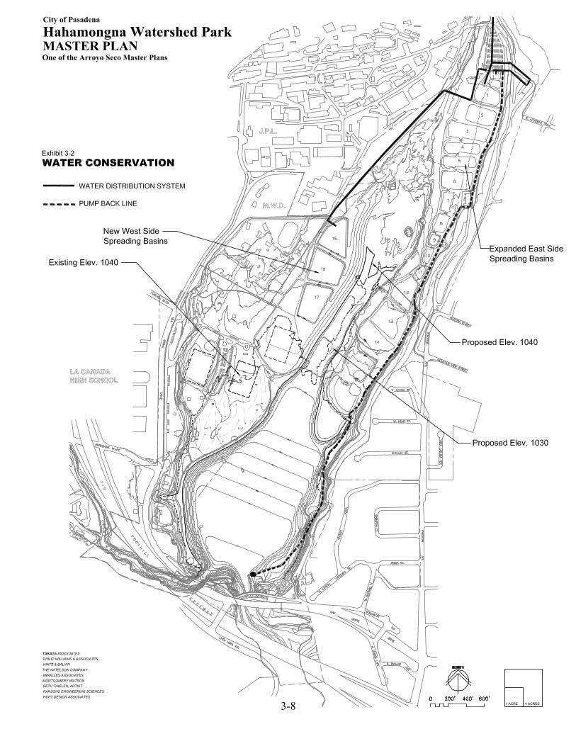
3-8
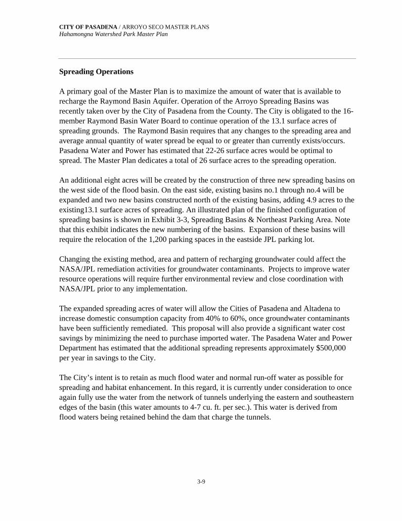
CITY OF PASADENA / ARROYO SECO MASTER PLANS Hahamongna Watershed Park Master Plan
3-9
Spreading Operations A primary goal of the Master Plan is to maximize the amount of water that is available to recharge the Raymond Basin Aquifer. Operation of the Arroyo Spreading Basins was recently taken over by the City of Pasadena from the County. The City is obligated to the 16-member Raymond Basin Water Board to continue operation of the 13.1 surface acres of spreading grounds. The Raymond Basin requires that any changes to the spreading area and average annual quantity of water spread be equal to or greater than currently exists/occurs. Pasadena Water and Power has estimated that 22-26 surface acres would be optimal to spread. The Master Plan dedicates a total of 26 surface acres to the spreading operation. An additional eight acres will be created by the construction of three new spreading basins on the west side of the flood basin. On the east side, existing basins no.1 through no.4 will be expanded and two new basins constructed north of the existing basins, adding 4.9 acres to the existing13.1 surface acres of spreading. An illustrated plan of the finished configuration of spreading basins is shown in Exhibit 3-3, Spreading Basins & Northeast Parking Area. Note that this exhibit indicates the new numbering of the basins. Expansion of these basins will require the relocation of the 1,200 parking spaces in the eastside JPL parking lot. Changing the existing method, area and pattern of recharging groundwater could affect the NASA/JPL remediation activities for groundwater contaminants. Projects to improve water resource operations will require further environmental review and close coordination with NASA/JPL prior to any implementation. The expanded spreading acres of water will allow the Cities of Pasadena and Altadena to increase domestic consumption capacity from 40% to 60%, once groundwater contaminants have been sufficiently remediated. This proposal will also provide a significant water cost savings by minimizing the need to purchase imported water. The Pasadena Water and Power Department has estimated that the additional spreading represents approximately $500,000 per year in savings to the City. The City’s intent is to retain as much flood water and normal run-off water as possible for spreading and habitat enhancement. In this regard, it is currently under consideration to once again fully use the water from the network of tunnels underlying the eastern and southeastern edges of the basin (this water amounts to 4-7 cu. ft. per sec.). This water is derived from flood waters being retained behind the dam that charge the tunnels.
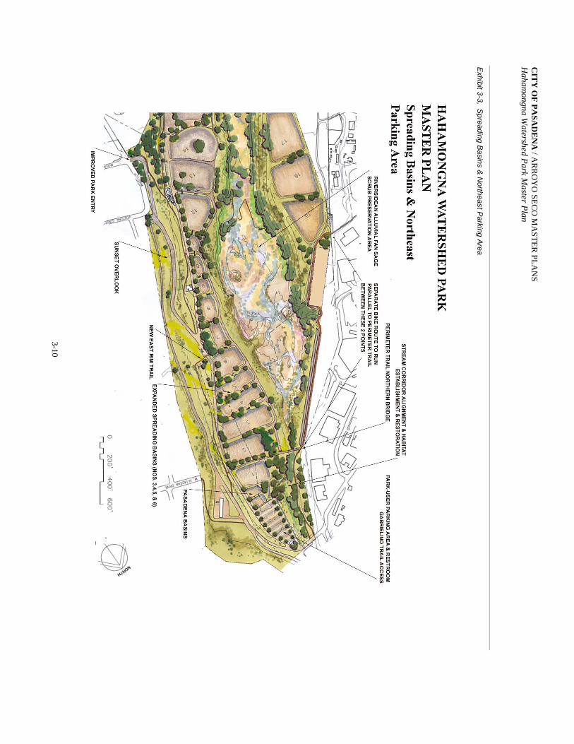
CIT
Y O
F PASA
DE
NA
/ AR
RO
YO
SEC
O M
AST
ER
PLA
NS
Haham
ongna Watershed Park M
aster Plan
3-10
Exhibit 3-3, S
preading Basins &
Northeast P
arking Area
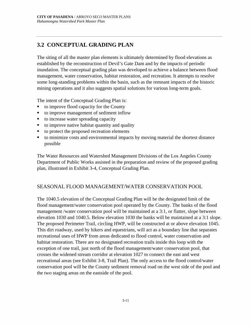
CITY OF PASADENA / ARROYO SECO MASTER PLANS Hahamongna Watershed Park Master Plan
3-11
3.2 CONCEPTUAL GRADING PLAN The siting of all the master plan elements is ultimately determined by flood elevations as established by the reconstruction of Devil’s Gate Dam and by the impacts of periodic inundation. The conceptual grading plan was developed to achieve a balance between flood management, water conservation, habitat restoration, and recreation. It attempts to resolve some long-standing problems within the basin, such as the remnant impacts of the historic mining operations and it also suggests spatial solutions for various long-term goals. The intent of the Conceptual Grading Plan is: to improve flood capacity for the County to improve management of sediment inflow to increase water spreading capacity to improve native habitat quantity and quality to protect the proposed recreation elements to minimize costs and environmental impacts by moving material the shortest distance
possible The Water Resources and Watershed Management Divisions of the Los Angeles County Department of Public Works assisted in the preparation and review of the proposed grading plan, illustrated in Exhibit 3-4, Conceptual Grading Plan. SEASONAL FLOOD MANAGEMENT/WATER CONSERVATION POOL The 1040.5 elevation of the Conceptual Grading Plan will be the designated limit of the flood management/water conservation pool operated by the County. The banks of the flood management /water conservation pool will be maintained at a 3:1, or flatter, slope between elevation 1030 and 1040.5. Below elevation 1030 the banks will be maintained at a 3:1 slope. The proposed Perimeter Trail, circling HWP, will be constructed at or above elevation 1045. This dirt roadway, used by hikers and equestrians, will act as a boundary line that separates recreational uses of HWP from areas dedicated to flood control, water conservation and habitat restoration. There are no designated recreation trails inside this loop with the exception of one trail, just north of the flood management/water conservation pool, that crosses the widened stream corridor at elevation 1027 to connect the east and west recreational areas (see Exhibit 3-8, Trail Plan). The only access to the flood control/water conservation pool will be the County sediment removal road on the west side of the pool and the two staging areas on the eastside of the pool.

3-12
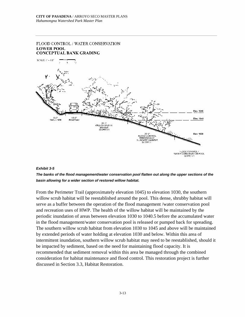
CITY OF PASADENA / ARROYO SECO MASTER PLANS Hahamongna Watershed Park Master Plan
3-13
Exhibit 3-5 The banks of the flood management/water conservation pool flatten out along the upper sections of the basin allowing for a wider section of restored willow habitat. From the Perimeter Trail (approximately elevation 1045) to elevation 1030, the southern willow scrub habitat will be reestablished around the pool. This dense, shrubby habitat will serve as a buffer between the operation of the flood management /water conservation pool and recreation uses of HWP. The health of the willow habitat will be maintained by the periodic inundation of areas between elevation 1030 to 1040.5 before the accumulated water in the flood management/water conservation pool is released or pumped back for spreading. The southern willow scrub habitat from elevation 1030 to 1045 and above will be maintained by extended periods of water holding at elevation 1030 and below. Within this area of intermittent inundation, southern willow scrub habitat may need to be reestablished, should it be impacted by sediment, based on the need for maintaining flood capacity. It is recommended that sediment removal within this area be managed through the combined consideration for habitat maintenance and flood control. This restoration project is further discussed in Section 3.3, Habitat Restoration.
CITY OF PASADENA / ARROYO SECO MASTER PLANS Hahamongna Watershed Park Master Plan
3-14
STREAM CHANNEL WIDENING Directly upstream of the flood control/water conservation pool, the riparian stream channel will be widened. Years of dumping along the western edge of the stream course narrowed its width and raised the elevation. The conceptual grading plan recommends the widening of the channel to reestablish the braided stream course and improve and expand the streambed riparian habitat. See following Section 3.3, Habitat Restoration. As indicated on the conceptual grading plan, recreation facilities and spreading basin embankments need to be raised to elevation 1045 or higher to protect them from annual inundation. Soil excavated from the stream channel widening can be used on-site to raise the grades for the proposed new habitats and facilities. Existing trails that traverse the embankments will be abandoned to limit access to restoration areas and to maintain an area dedicated as a wildlife corridor. OTHER PLAN ELEMENTS The following plan elements will be significantly shaped by the Conceptual Grading Plan: Spreading Basins The Preliminary Plan of 1994 proposed that the edges of the existing spreading basins be recontoured and landscaped to effect a natural setting. Based on further examination of the changes in elevation along the eastside and further discussion with Pasadena Water & Power Maintenance Department, the opportunities for developing a natural landscape are limited. Basins will be shaped for maintenance and functional considerations. Landscape and habitat improvements will be made to the tops of the dikes separating the basins, along the park access road to Johnson Field, and to the edge of the Perimeter Trail adjacent to the basins. Landscaping will not be extended down the inside of the basin slopes. See Section 3.3, Habitat Restoration. To facilitate maintenance of the existing spreading basins, the Perimeter Trail will remain along the western edge of the spreading basins. Basin maintenance operations will be staged from this side. An opening in the habitat restoration will be left on the western edge of the existing basins for basin maintenance access. Sycamore Grove Fields & Relocated Disc Golf Course In order to protect the proposed southern field and relocated fairways of the disc golf course from flood inundation, the grade along the western part of the basin will be raised above

CITY OF PASADENA / ARROYO SECO MASTER PLANS Hahamongna Watershed Park Master Plan
3-15
elevation 1045. Material excavated to increase the capacity of the flood management/water conservation pool will be used to raise the site above inundation level. The small areas of existing willows, between and around the relocated fairways, will be linked and receive less fill to create a system of drainage courses between raised areas with mulefat scrub around the edges. The drainage courses will preserve and extend the existing drainage pattern. The northern Sycamore Grove field will be located where past mining operations excavated a large depression (at elev. 1025), well below the flood inundation level (elev. 1040.5). Earthen material excavated to widen the stream channel will be used to raise the elevation of this adjacent multipurpose field site above elevation 1055.
USE OF LANDFORM GRADING PRINCIPLES The upper slopes of the flood management/water conservation pool, the widened edges of the stream channel, and the eastern slopes of the northern Sycamore Grove field and westside spreading basins will be graded using landform-grading principles. “Landform-grading” is an atypical form of grading that replicates the irregular shapes and gradients of natural, stable slopes.2 The resulting landscape is more sculpted with concave and convex curves mimicking a pattern of drainage that would occur naturally. Re-vegetation of the slopes also follows a distinctly naturalistic pattern with groupings of trees and shrubs clustered in concave areas where the drainage pattern focuses runoff, and with woody and herbaceous scrub species planted on the drier convex slopes. This method of grading seeks to minimize erosion and enhance plant sustainability, thus creating a functioning and evolving ecosystem that will sustain the wildlife that currently exists and the wildlife that one day may come to inhabit HWP. Although the contours indicated in the Conceptual Grading Plan are mechanically drawn, it is the intention of the Master Plan to create a landscape that mimics in as many ways as possible the natural undulations of the foothills using this methodology of grading. IMPLEMENTATION OF THE GRADING PLAN Placement of excavated material to raise an area above the frequently flooded zone will affect the existing drainage and habitat associated with the specific project. Newly restored habitats in these raised areas will require time to become established. This mitigation needs
2 Journal of Geotechnical Engineering, “Landform Grading and Slope Evolution” Horst J. Schor and Donald H. Gray, October 1995. (See the adopted Arroyo Seco Design Guidelines, Appendix C.)

CITY OF PASADENA / ARROYO SECO MASTER PLANS Hahamongna Watershed Park Master Plan
3-16
to occur before other projects in the implementation sequence are started and the excavation and placement of needed material for the next project affects additional habitat. The material excavated from the flood management area, to be used for new raised parkland, will affect flood debris and sediment management. Therefore, all projects where material is excavated to be used as fill within the Los Angeles County Department of Public Works (LACDPW) leased Flood Easement will require its review and approval. Because of the quantities of material involved, LACDPW may choose to engineer some of the proposed projects. Projects requiring extensive grading that affect both existing and proposed habitats will need to be reviewed and approved by the appropriate State and Federal environmental agencies prior to the engineering of the project. This review process will impact the lead-time required for these projects. Additionally, the cost and efficiency of construction will be considered in how the projects are sequenced. 3.3 HABITAT RESTORATION Habitat establishment and restoration is proposed throughout the Hahamongna Watershed Park, as illustrated in Exhibit 3-7, Proposed Terrestrial Natural Plant Communities. For purposes of this Master Plan, “habitat establishment” is the creation of improved habitat quality3 in areas where a particular native plant community is not present or it will involve adding area to an existing plant community where that community does not exist. “Habitat Restoration” is the improvement of the habitat quality, including increasing the plant and animal species diversity in an area where a plant community already exists. In general, all existing native plant communities that are not impacted by proposed projects including grading, removal of exotic species, or inundation, will be restored. The areas designated on the Proposed Plant Communities map are specific plant communities where the specific species is dominant. Some areas can be small, but collectively make up a habitat of sufficiently large area to support diverse wildlife. The master plan includes a map illustrating the habitats and their associated plant communities, Exhibit 3-7A.
3 “Habitat Quality” of a site can be defined in terms of a range of its assessed attributes, functions, and values. Excellent habitat generally refers to undisturbed areas that contain mostly native plants and composed of sustainable biodiversity (vegetation and wildlife). The ranking of habitat as excellent, good, fair, or poor is subjective and varies widely depending on physical condition, degree of biodiversity and species addressed. For example, biologists often generalize that riparian (streamside) habitat is of excellent quality if it provides dense cover, contains wildlife and plant species diversity, is composed of multiple strata of vegetation, is extensive in area, and contains surface water or saturated soils; the non-existence of any or some of these characteristics decreases the habitat quality.
CITY OF PASADENA / ARROYO SECO MASTER PLANS Hahamongna Watershed Park Master Plan
3-17
The proposed habitats (Woodland, Upland Shrub, Alluvial, and Riparian) are broad categories based on physical conditions and associated plant communities supporting wildlife. This mosaic of contiguous plant communities is beneficial for habitat because of the diversity of native plant species and their physical structure. Open spaces as with Streambed Riparian and Riversidian Alluvial Fans Sage Scrub, combined with dense cover as with Mule Fat Scrub and Southern Willow Scrub is beneficial for a diverse wildlife. A larger area of a particular plant community is best for certain wildlife species. The proposed relocated disc golf area has a mosaic of narrow willow scrub plant community surrounded by a band of mule fat scrub plant community. The edge between these two different plant communities is beneficial for wildlife; however, with the close human proximity on the disc golf fairways, this area will not be habitat of high quality for a diverse wildlife, but it will be better habitat than much of what is there now. The existing habitat over all has been heavily impacted by previous mining operations, resulting in an unnatural topography that is not optimum for this plant community. The area also has extensive ruderal areas, which do not support much diversity of wildlife. The USFWS, SDFG and the master plan biologist have commented on this specific area as fragmented habitat. They have suggested that the areas of willow scrub be wider; however, it is further suggested that during the specific project design phase wider bands of willow scrub plant community be created between the Perimeter Trail and the Water Conservation Pool. The area within the proposed Perimeter Trail is to have limited human activity. The information within this section is presented in two parts. The first part is a listing of major, site-specific Habitat Establishment and Restoration Projects proposed by the Master Plan. Their listing is intended to help convey the location, intent and magnitude of the proposed habitat establishment and restoration projects. Some of these habitat projects involve the establishment and restoration of more than one plant community within the same project area and they have been organized to compliment the project area phasing (see Section 4). The second describes the habitat establishment and restoration efforts for each plant community throughout HWP, linking the various projects previously described to proposed acreage goals for each community.
CITY OF PASADENA / ARROYO SECO MASTER PLANS Hahamongna Watershed Park Master Plan
3-18
HABITAT ESTABLISHMENT AND RESTORATION PROJECTS In addition to general improvements to the existing plant communities, eleven specific sites have been identified for restoration. A description of each project follows, and their location is identified in Exhibit 3-6, Habitat Restoration Projects. 1. Realigned Stream Corridor, Restore and Establish Habitat at This project area includes the stream zone and banks from just south of the Altadena Storm Drain outfall north to the JPL Bridge. This portion of the stream has been channelized behind an area that used to contain an earthen breakaway dam built to divert water to the spreading basins. The Master Plan recommends discontinued use of the site as a diversion facility. The area contains elements of degraded ruderal vegetation. In the past, the site probably was a combination of sage scrub and riversidian alluvial fan sage scrub. The higher elevations of the banks have high potential for restoration to sage scrub by using the recommended planting procedures and palette of species. Restoring the site to include riversidian alluvial fan sage scrub would be difficult because the natural dynamics needed for proper alluvial deposition of sediment are incompatible with the area’s topographic constraints and its current and future uses. Because of channelization, the stream zone has the potential for restoration of a native riparian corridor. This restoration would be a continuation of the same plant community immediately north of the JPL Bridge. Enhancing and diversifying the tree and shrub canopy overstories along the central and northern portion of the Arroyo Seco drainage in HWP is recommended. A strategy to accomplish this sort of habitat enhancement is presented in this habitat restoration plan. See information on the native plant palettes and installation methods for the southern willow scrub, mule fat scrub, and riversidian alluvial fan sage scrub communities. Increasing the native tree and shrub species diversity along the stream is possible using western sycamore, white alder, Fremont and black cottonwoods, Mexican elderberry, bigleaf maple, California bay/laurel, southern California black walnut, and several types of willow.

3-19

CITY OF PASADENA / ARROYO SECO MASTER PLANS Hahamongna Watershed Park Master Plan
3-20
2. Restore Riversidian Alluvial Fan Sage Scrub Remnants of riversidian alluvial fan sage scrub are located south of the Altadena Storm Drain and the narrow mouth of the Arroyo Seco drainage as it opens into the basin. Periodic removal of sediment and debris from this area may be necessary in order to protect the spreading basins from inundation. Sediment removal in this area could mean the loss of much of the remaining riversidian alluvial fan sage scrub. It is recommended that a compromise strategy be developed to help conserve as much as possible the sensitive riversidian alluvial fan sage scrub community. Creating several smaller cuts into the sediment deposits, parallel to the present stream flow course, would allow sediment debris removal, and would dissipate the energy from water flows into several drainage patterns. Rather than total removal of the sediment and consequential loss of much or all of the riversidian alluvial fan sage scrub, it would permit more of the alluvial fan sage scrub to remain intact. Such a strategy needs to be considered by the various parties involved with sediment management, and coordinated to develop a feasible design that would help conserve this sensitive community and yet accomplish some of the needed sediment removal. This restoration project involves a number of smaller projects within a larger area. The larger area includes two plant communities: riversidian alluvial fan sage scrub and sage scrub, as shown on the plant community maps. The areas on either side of the stream corridor to the eastside spreading basins and to the westside JPL perimeter fencing and new westside spreading basins will be restored to these plant communities. The current equestrian trail on the westside of the existing spreading basins traverses some of the best old alluvial fan sage scrub in the area, designated as sage scrub on the plant community maps. The proposal is to abandon the equestrian trail, relocate the trail on the spreading basins maintenance road (asphalt to be removed) and restore the existing trail with sage scrub. Habitat restoration will also occur at the various drain outfalls along the JPL border, where exotic species need to be removed, debris and trash collected and disposed, and the riversidian alluvial fan sage scrub, sage scrub and southern willow scrub habitat restored. Similarly, the old stream crossings (from both the east and west) have been covered over in asphalt by past mining operators. Most of this asphalt has been removed. The remaining asphalt needs to be removed and disposed, the stream allowed to take its course, and riversidian alluvial fan sage scrub and sage scrub habitat restored. Additionally, this project establishes riversidian alluvial fan sage scrub at the southern end of this area where it transitions to a streambed riparian plant community. With the Stream

CITY OF PASADENA / ARROYO SECO MASTER PLANS Hahamongna Watershed Park Master Plan
3-21
Channel Widening Project (Project 4) both the streambed riparian and the alluvial fan sage scrub plant community areas are enlarged. 3. Establish Habitat at Spreading Basins The Master Plan calls for construction of three new spreading basins (project 3a) on the west side of the basin in what is now a low-quality habitat of nonnative annuals. Part of this area has old sediment and debris material piled up above grade, covered with a thick layer of dead plant material. The dead plant material is like a thicket or thatch that inhibits many plants, including even weedy species, from becoming established. Most of the dead plant substance appears to be weedy species and willow branches. This area is located in what historically was sage scrub and/or riversidian alluvial fan sage scrub. The dead plant matter will be removed and taken off-site to a disposal facility or treated on-site with solarization techniques (to help kill any living weeds) and ground into a mulch for later use. The embankments along the sides of the new spreading basins will be graded using landform contouring principles and planted with sage scrub species. Such plants require less water than those in a riparian or oak woodland and will not decrease the water infiltration and groundwater recharge rates of the spreading basins. While maintenance regimes hinder the complete restoration of plant communities adjacent to the spreading basins, it is possible to add some native tree species that will establish themselves. However, installation of high numbers of these deep-rooted trees that are sustained by groundwater is at odds with the goals of water infiltration and groundwater recharge. A compromise strategy of using carefully selected and installed native riparian plants should be pursued (projects 3a,b, c) as is currently happening around the older eastside spreading basins. 4. Widen Stream Channel and Establish Riparian Habitat Prior to the construction of the dam, there would have been a more randomly meandering stream channel or number of channels in the large alluvial fan of the Arroyo Seco. Over time, mining and dumping practices greatly altered the stream course. A straighter, rather than meandering or braided, stream channel presently exists in HWP. The present stream channel, however, is stable due to the presence of the vegetation lining the drainage particularly in the mule fat scrub and southern willow scrub communities. Vegetation along the streambed is well established and helps direct predictable flow patterns toward the dam. This stable vegetation and drainage course configuration will be preserved in the central portion of the basin. The western edge of the stream channel will be widened to at least

CITY OF PASADENA / ARROYO SECO MASTER PLANS Hahamongna Watershed Park Master Plan
3-22
double its current width. The grading for this project will be done in conjunction with restoration projects no. 3a and no. 7. 5. Establish Habitat at East Entrance The Master Plan proposes that the existing Windsor/Ventura intersection be reconfigured for safety and other circulation improvements. This project would result in the removal and relocation of the existing 50-space parking lot located south of the intersection. This project will also allow for the enhancement of Sunset Overlook north of the intersection. The restoration site is located in what historically was sage scrub with scattered coast live oaks. Using native plants from the recommended palettes and installation methods for sage scrub and coast live oak woodland would aesthetically enhance the appearance of the area and benefit certain wildlife species. 6. Restore Habitat along Westside Perimeter Trail The new Perimeter Trail connection between the proposed disc golf area and the Flint Wash Bridge will be constructed along the raised edge of the flood management/water conservation pool. This trail will separate the recreation facilities and the activities in Oak Grove from the flood management/water conservation pool. The Master Plan proposes that the southern willow scrub plant community be restored along the trail in conjunction with an interpretive signage component. Much of the trail area currently exists in southern willow scrub. This area is now prone to periodic flooding such as occurred during the 1997-1998 El Niño weather pattern due to the new dam spillway elevation (1040.5). Raising the grade along the trail to be above the average high water mark would increase the chances for successful establishment and survival of recommended trees and shrubs. 7. Establish Habitat at Sycamore Grove Fields & Relocated Disc Golf Establishment of southern sycamore woodlands in association with the new multi-use fields will be accomplished in areas where the grade is raised above elevation 1045. The small areas of existing willows will be linked and receive less fill to create a system of drainage courses between raised areas with mulefat scrub around the edges. The drainage courses will be extensions of the existing drainage pattern. Existing vegetation will be hand-cleared, leaving the willow trees that are taller than the depth of the fill. After the fill is placed, these willows will root at the higher elevation with the help of water conservation management practices. This along with other vegetation will create habitat of southern willow scrub of better quality than currently exists in the relocated disc golf area and along the eastern edge of the Perimeter Trail.

CITY OF PASADENA / ARROYO SECO MASTER PLANS Hahamongna Watershed Park Master Plan
3-23
8. Establish Oak Woodland at Sunrise Overlook Sunrise Overlook is located at the southwestern corner of HWP along Oak Grove Drive and immediately northwest of Flint Wash. This area is now covered with a temporary cover of re-vegetated forb and grass species from an earlier seed mix application, as well as some non-native species. The oak woodland to the north will be extended into this area with random plantings of coast live oak to shade and protect the proposed amphitheater. Because the site exists in what formerly was sage scrub, components of this plant community should also be used. 9. Restore Oak Woodland on Westside The Master Plan proposes a supervised overnight camping area as well as two group picnic areas within the Oak Grove area on the west side of HWP. The existing oak woodland on the west side, including the slopes of the basin, is relatively devoid of immature oak trees and other native plants from this plant community. Once the back nine of the disc golf course is relocated, it is recommended that the plantings be diversified by utilizing native species from the plant palette and planting methods prescribed for coast live oak woodland restoration. Protection of oak and other restoration plantings at the camping and group picnic areas will be necessary. 10. Establish Sycamore Woodland on Eastside The existing mule fat scrub area south of Johnson Field is subject to periodic inundation. During the 1997-1998 El Niño weather pattern, this area was submerged for three weeks with a detrimental effect on the native plants. It is recommended that this area be raised to elevation 1045 and restored with plants associated with the southern sycamore riparian woodland. To the east and north of this area, western sycamores, black cottonwoods, and Mexican elderberry trees have naturalized and could spread to this area if it were protected from consistent flooding. Sycamore woodland is also suggested around the perimeter of the east and west spreading basins as well as around the edges of the multipurpose play areas (see proposed plant community map). 11. Establish Riparian Habitat at Perimeter of Flood Management & Water Conservation Pool The existing riparian southern willow scrub habitat below the 1040 elevation will degenerate and begin to die as soon as water conservation practices are implemented. These areas will be periodically inundated during the winter season. The habitat below the 1030 elevation will be completely submerged for varying lengths of time. The 1030 to 1040 elevation zone

CITY OF PASADENA / ARROYO SECO MASTER PLANS Hahamongna Watershed Park Master Plan
3-24
around the water conservation pool will be habitat of a quality that could benefit from inundation several times a year. Below elevation 1030, emerging vegetation, debris, and sediment will need to be periodically removed from the newly graded flood management/water conservation pool per the sediment management guidelines that will be established by the County. This project proposes a phased operation that will permit the area elevated above the floodplain (elevation 1040) and the perimeter of the water conservation pool (elevation 1030 to 1040) to become established with southern willow scrub habitat. Once these areas are established and considered habitat of high quality, the existing riparian southern willow scrub areas (below elevation 1030) will be removed in a coordinated sediment and debris removal operation. HABITAT RESTORATION PLAN The inventory of biological resources in HWP (see Section 2, Existing Conditions) helped to define the existing setting and lay the foundation for the habitat restoration plan. Exhibit 3-7, HWP Master Plan, Terrestrial Natural Plant Communities, illustrates the proposed spatial organization of the six identified plant communities currently present in HWP. Inherent in the goals of the habitat plan are several criteria: The native species composition in the restoration efforts will be similar to the existing
native plant communities found in HWP. Re-vegetation and restoration efforts are designed to promote habitat of high quality for wildlife and to also be appealing to humans and adapted to their activities. Planning and design must be biologically and ecologically conceived and sound in principle for these efforts to succeed. A sustained responsibility to maintenance of plantings and to the monitoring of their progress is required to accomplish the planned restoration efforts.
Seed and other planting material (e.g., cuttings and container stock) will be collected
from the project vicinity to the extent feasible, and/or, if necessary, will utilize plant stock material from reputable native-plant nurseries. Maintaining the integrity of the local gene pool composition of native vegetation currently found on-site and in nearby areas is a primary concern of this plan.
Suitable planting techniques, monitoring, maintenance, and performance standards will
be specified in order to maximize the opportunities for establishing viable, functional, and self-perpetuating native plant communities on restored sites.


CITY OF PASADENA / ARROYO SECO MASTER PLANS Hahamongna Watershed Park Master Plan
3-27
All of the native plant communities are considered worthy of restoration efforts to enhance and/or increase their diversity, size, and distribution in HWP. The goal of this habitat restoration plan is to eliminate the ruderal areas within HWP, as much as possible, due to their low habitat value for wildlife and native plant diversity. Native plant species, common to virtually any or all six of the native terrestrial natural communities, will be used in the restoration efforts to potentially replace the widespread ruderal areas’ weedy, invasive, and undesirable species compositions. The types of native plant species to be used in the habitat restoration efforts have been selected to be compatible with the existing native plant communities and with current and proposed land uses in HWP. The majority of tree, shrub, forb, and grass species chosen for restoration and/or establishment purposes are mainly based on those native species already present in the various, existing on-site native plant communities. These native plant species are generally beneficial to wildlife’s food and cover. They also add to the floral diversity of plants found in HWP. Several of the plant species are of importance for their use in the spiritual, ceremonial, medicinal, and utilitarian traditions of Native Americans and in their arts and crafts. The native plants help increase educational and recreational use of the area. Many of the plants chosen provide an opportunity to study interesting, informative facts for people interested in the natural history of plants and their interrelationships with wildlife. Finally, the native plants selected for habitat restoration have various adaptive, genetic, morphological, and ecophysiological characteristics that enhance their chances of becoming a self-sustaining system and add to the biodiversity and health of the existing natural plant communities. Since HWP exists in a dynamically fluctuating environment and has many visitors (both wildlife and humans), habitat restoration efforts will be subject to influences and impacts from many sources. The cooperation of public users and maintenance personnel will be important in helping achieve the goals of the habitat restoration plan. Protecting and restoring native plant communities located in floodplain areas are often in direct conflict with traditional flood plain management. Negotiation and cooperation are necessary among the various diverse interests and parties involved with current and proposed uses of HWP to achieve habitat restoration goals.
CITY OF PASADENA / ARROYO SECO MASTER PLANS Hahamongna Watershed Park Master Plan
3-28
The following table summarizes the acreage of each natural plant community and landscaped/developed area within Hahamongna Watershed Park, both existing and proposed.
Area Description
Existing Acres Proposed Acres
OW Coast Live Oak Woodland 37.8 42.6W Southern Willow Scrub 25.5 20.5SS Sage Scrub 39.9 42.9RAFSS Riversidian Alluvial Fan Sage Scrub 17.2 18.8MF Mule Fat Scrub 19.5 11.0SSRW Southern Sycamore Riparian Woodland 2.6 24.8R Ruderal 75.4 2.4SBR Streambed Riparian 8.1 8.3WA Water Conservation Pool 0.0 54.4L Landscaped 5.8 9.8D Developed 76.4 74.8D&L Developed and Landscaped areas not shown
within a plant community polygon (such as a trail, dirt road, picnic & camping site, disc golf fairways and pole climbing area)
10.6 8.5
TOTAL STUDY ACREAGE4 318.8 318.8 Within HWP there are landscaped and developed areas, that have been designated on the plant community maps. The “landscaped areas” within the HWP include predominantly non-native landscaping (turf) for playing fields and native plant landscaping for ornamental purposes. The “developed areas” within HWP include predominantly roads, parking, and buildings, with native landscaping for ornamental purposes. PLANT PALETTES OF SELECTED NATIVE SPECIES Plant palettes for the six terrestrial natural communities in HWP are developed in this habitat restoration plan for: 1) coast live oak woodland, 2) southern willow scrub, 3) mule fat scrub, 4) riversidian alluvial fan sage scrub, 5) sage scrub, and 6) southern sycamore riparian woodland. The proposed plant palettes can be found in Appendix C, Master Plan Plant Community Palettes.
4 Does not include the areas of Flint Wash and below the north side of the 210 freeway (included in CAMP). Both are within the Park property boundary but outside the study area. These areas total 10.7 acres. It does include the MWD property, 28 acres added + 2.4 acres already included = 30.4
CITY OF PASADENA / ARROYO SECO MASTER PLANS Hahamongna Watershed Park Master Plan
3-29
The mix of native plant species that comprises the plant palettes for each respective plant community is based on the inventory surveys of biological resources conducted in HWP. The species chosen are representative of what currently exists in those communities. In some cases, others species are added to what was once known to exist there based on published historical information. Planting guidelines are outlined in this section and fully presented in the Biological Technical Report that was prepared in support of the Master Plan process. Project descriptions in Appendix E provide a more detailed explanation of the habitat restoration projects and the enhancements suggested for each plant community. Coast Live Oak Woodland The collection of coast live oak acorns for planting as acorns and for propagating to create oak seedlings is described in the Biological Technical Report. A mixture of other native, container-grown trees and shrubs will also be planted in the woodland. A hydroseed/hydro-mulch application procedure shall be used to deliver other native shrub, forb, and grass species in the seedmix at planned oak woodland restoration sites. An assortment of native plant species will shape the tree canopy layer. Coast live oak trees that provid acorns for the local revegetation propagation will be planted in various sizes. Other trees and/or shrubs selected for restoration efforts include big leaf maple, Engelmann oak, California bay/laurel, boxelder, toyon, laurel sumac, California coffeeberry, and Mexican elderberry. Additional native floral plantings will include chamise, hairyleaf ceanothus, bush monkeyflower, scrub oak, chaparral gooseberry or currant, California rose and blackberry, black sage, and western poison oak. All containerized specimens will be planted in natural looking combinations or groupings. All tree and shrub plantings in coast live oak woodland will be installed in natural looking groups. The hydroseed/hydromulch mix will consist of numerous shrub, forb, and grass species that are associated with this oak woodland type. Several of the shrub species are included as container plants and in the hydroseed mixture. The hydroseed combination uses chamise, California sagebrush, bush monkeyflower, black sage, California brome (Bromus carinatus), golden yarrow (Eriophyllum confertiflorum), California everlasting (Gnaphalium californicum), wild pea (Lathyrus vestitus), deerweed, deergrass (Muhlenbergia rigens), and purple needlegrass (Nassella pulchra). Of the 37.8 acres of coast live oak woodland in the study area, 11.6 are within the MWD property. There are 26.2 acres of coast live oak woodland within HWP that will receive habitat restoration. The following list of projects is proposed for habitat establishment and restoration of coast live oak woodland:
CITY OF PASADENA / ARROYO SECO MASTER PLANSHahamongna Watershed Park Master Plan
3-30
Westside of the Park: Oak Woodland Restoration (Habitat Project #9): This element, which includes the upper
Oak Grove Picnic Area and the Equestrian Staging Area, has been undergoing habitatrestoration for eight years. After restoration of this area and the slopes down to theLower Oak Grove Area, including the Oak Grove Field and the west half of the overnightcamping area, there will be a net increase of 1.9 acres of oak woodland.
Oak Woodland Restoration (Habitat Project #9**):1 The east half of the overnight area iswithin the critical habitat of the Arroyo Toad. This area is proposed to have an increaseof 1.0 acre of oak woodland.
Sunrise Overlook (Habitat Project #8): The Sunrise Overlook area, adjacent to the southperimeter of the Equestrian Staging Area, is proposed to have an increase of 0.9 acre ofoak woodland.
Eastside of the Park: East Spreading Basins (Habitat Project #3b**): Adjacent to and west of the new eastside
spreading basin No. 2, it is proposed to increase the existing 0.1 acre of oak woodland by0.2 acre for a total of 0.3 acre.
East Spreading Basins(Habitat Project #3b**): The area west of the Arroyo Well,adjacent to spreading basin 7, is proposed to have the existing 0.4-acre oak woodlandincreased by 0.3 acre for a total of 0.7 acre.
East of Spreading Basin 14 and the Overflow Basin (Johnson Field)**: This area isproposed to have the existing 1.1 acres of oak woodland increased by 0.5 acre for a totalof 1.6 acres. This enhances the habitat adjacent to the East Rim Trail. It will convert 0.5acre of sage scrub to oak woodland.
Southern Willow Scrub
Dense, high-quality southern willow scrub habitat will be established around the edge of theflood management/water conservation pool. In those areas where southern willow scrubcurrently exists but must be removed for sediment and debris removal and maintenancepurposes, the areas may be restored naturally on their own from surviving root systems. Thiscommunity, compared to the others, probably endures the greatest impacts from ongoing
1 Subsequent to the conceptual approval of the Hahamongna Watershed Park Master Plan, the U.S. Fish andWildlife Service on February 7, 2001, designated critical habitat in HWP for the federally listed SouthwesternArroyo Toad. Those restoration projects that are wholly or partially located within designated critical habitatfor the Southwestern Arroyo Toad are identified with **. On October 30, 2002, the U.S. District Court forthe District of Columbia nullified all the designated critical habitats for the Arroyo Toad. The USFWS willcomplete a new analysis of economic impacts and consider updated field survey information to refine wherethe Arroyo Toad exists. The Interior Department will decide by 2005 which areas of critical habitat toredesignate.
CITY OF PASADENA / ARROYO SECO MASTER PLANS Hahamongna Watershed Park Master Plan
3-31
maintenance. However, replanting with community-specific native plant species will occur in riparian areas and adjacent sites where willow scrub species can be established and survive. The restoration plan calls for upper and lower dense canopy layers comprised of arroyo, red, black, shining, and narrow-leafed willows along with occasional groupings of Fremont and black cottonwood, western sycamore, Mexican elderberry, California bay/laurel, and big leaf maple. The scattered cottonwoods, sycamores, elderberries, bay/laurels, and maples will be established in areas located approximately 6 to 12 feet above the elevation of groundwater and/or below the low-flow channel of the Arroyo Seco stream. The arroyo, red, black, shining, and narrow-leafed willows will be planted as rooted cuttings that are a minimum of 18" in length, 2' to 12' above the elevation of the groundwater and the low-flow channel. Tree and shrub plantings will be grouped and/or scattered in natural appearing groups. The species comprising the shrub understory layer (e.g., mule fat, coyote brush, California blackberry, California rose, and desert grape (Vitis girdiana) will be established at elevations 4' to 12' above the low-flow channel. The sparse herbaceous understory layer of mugwort, western ragweed, hoary nettle, meadow barley (Hordeum brachyantherum), Santa Barbara sedge (Carex barbarae), and deergrass will be hydroseeded throughout the site. Seeds of the previously mentioned coyote brush and mule fat are also included in the hydroseed mixture. There are currently 25.5 acres of southern willow scrub in the park, of which only 7.7 acres will receive habitat restoration. When water conservation measures are implemented, the remaining 17.8 acres of existing habitat will begin to die as the area is frequently inundated. An additional 12.8 acres of new habitat will be established along with the 7.7 acres of existing habitat to be restored. The following list of the projects are proposed for habitat establishment and restoration of southern willow scrub: Realigned Stream Corridor (Habitat Project #1): This project will keep the size of the habitat area unchanged, but will restore habitat found at the southern end of the project area. Westside Spreading Basins (Habitat Project #3a**): There is currently no southern willow scrub habitat adjacent to the proposed Westside Spreading Basins. This habitat project proposes to establish 1.2 new acres of this plant community east of the spreading basins. The creation of the westside spreading basins will utilize “Landform Grading” principles to improve habitat for this and other plant communities. Widen Stream Channel (Habitat Project #4**): The stream channel widening project will increase the existing 0.6 acre of southern willow scrub to 3.7 acres. This restoration project will widen the stream on its western edge for a new stream channel width total that will at least double its current width. Both the east and west embankments of the stream channel

CITY OF PASADENA / ARROYO SECO MASTER PLANS Hahamongna Watershed Park Master Plan
3-32
will be restored with southern willow scrub to help stabilize and control erosion of the stream banks and to provide an appropriate habitat for native fauna. Westside Perimeter Trail (Habitat Project #6): The Westside Perimeter Trail Project will increase the existing 0.6 acre of southern willow scrub to 1.9 acres. The restoration project proposes to raise the grade on this trail with fill excavated from ruderal areas below the 1030 elevation within the proposed conservation pool. Those willows that are taller than the depth of fill will remain to root at the higher elevation with the help of water conservation management practices. This and additional habitat restoration will create a larger area of southern willow scrub of higher quality than currently exists. Relocate Disc Golf (Habitat Project #7): The Disc Golf Relocation project will increase the existing 4.5 acres of southern willow scrub to 5.2 acres. This component proposes to raise the elevation of an area that has small pockets of existing willow scrub habitat. The areas of existing willows will be linked to create drainage courses that will receive less fill than the terraced areas of this project. The drainage courses will be extensions of the existing drainage patterns from elevation 1050 down to elevation 1030, the edge of the water conservation pool. The existing vegetation in the area will be hand-cleared to leave willow trees taller than the depth of fill. After the fill is placed, these existing willows will root at the higher elevation with the help of water conservation management practices. This and additional habitat restoration will create a larger area of southern willow scrub of higher quality than currently exists. Flood Management/Water Conservation Pool (Habitat Project #11): This project proposes a phased operation that will permit the areas elevated above the floodplain (elevation 1040.5) and the perimeter of the water conservation pool (elevation 1040.5 to 1030) to become established with southern willow scrub habitat. The Flood Management/Water Conservation Pool Project will add 4.5 acres of southern willow scrub in this zone for a new total of 5.7 acres of southern willow scrub. These 5.7 acres represent a wide band around the perimeter of the pool that, once established, will be habitat of higher quality. The existing southern willow scrub habitat below the 1040.5 elevation and in particular below the 1030 elevation will degenerate and begin to die as soon as water conservation practices are implemented and this zone is periodically inundated during the winter season. The next phase of the project will remove the 17.8 acres of existing southern willow scrub areas (below elevation 1030) in a coordinated sediment and debris removal operation once the new willow habitat has become established. Storm Drain Improvements-JPL**: This project will establish 2.0 acres of southern willow scrub at the drainage outfalls along the JPL border just north of the westside parking lot. Exotic species need to be removed and debris needs to be collected and disposed of. These particular drainage outfalls drain through existing sage scrub and some willows. Due to wet
CITY OF PASADENA / ARROYO SECO MASTER PLANS Hahamongna Watershed Park Master Plan
3-33
conditions caused by urban runoff, this project proposes to transition this two-acre area from a sage scrub plant community to a southern willow scrub plant community of higher quality. Mule Fat Scrub The mule fat scrub restoration area is designed to provide cover and foraging habitat in areas susceptible to high flows. The vegetation will be planted on the bottom and sides of the Arroyo Seco high-flow channel and on the banks of the low-flow channel and flood terraces to approximately ten feet above the bottom. Container plants and/or additional rooted cuttings of mule fat, and scattered plantings of rooted cuttings of arroyo willow will be installed in natural groupings to help stabilize the stream channel. Expansions of the existing mule fat habitat will occur to the north and south of its present distribution in HWP along the drainage bottom and low terraces. Mexican elderberry, Fremont cottonwood, black cottonwood, western sycamore, white alder, California bay/laurel, and big leaf maple will also be installed. Installation shall occur in those sections of the mule fat community where the prolonged high water flooding behind the dam killed many elderberries during the rainy season of 1998-1999. The placement of the cottonwoods, sycamore, alder, bay/laurel, and maple trees is an effort to expand their distribution. These plants will be placed in the riparian area just north and south of the existing mule fat community in areas that are set back from the low-flow channel and that will be disturbed by sediment and debris removal maintenance. The upper canopy layer will be comprised primarily of occasional groupings of western sycamore, big leaf maple, white alder, Fremont and black cottonwoods, and California bay/laurel. These six tree species exist in limited distribution in HWP, though historically they were probably more common along the Arroyo Seco before construction of Devil's Gate Dam. Mexican elderberry, a species of high habitat value for local birds and other wildlife, will form the lower portion of the upper canopy layer. Arroyo willow will constitute the lower canopy. The shrub and herbaceous understory layers will be representative of the southern willow scrub community. Mexican elderberries and the other six tall, upper canopy tree species will comprise approximately 60 percent of the tree plantings. Arroyo willows will constitute the remainder of the tree species. The upper canopy layer tree species will be established as container-grown plants in areas located approximately 6 to 12 feet above the elevation of groundwater and/or below the low-flow channel of the Arroyo Seco stream. The arroyo willows shall be planted as rooted cuttings that are a minimum of 18 inches in length, 2 to 12 feet above the elevation of the groundwater and the low-flow channel. The species comprising the shrub understory layer (i.e., mule fat, California rose, California blackberry, and desert grape) will be established as container plants in natural groupings at elevations 4 to 12 feet above the low-flow channel. The sparse herbaceous understory layer of mugwort, hoary nettle, western

CITY OF PASADENA / ARROYO SECO MASTER PLANS Hahamongna Watershed Park Master Plan
3-34
ragweed, giant wild rye, Santa Barbara sedge, and deergrass will be hydroseeded throughout the site. Mule fat will be used in the hydroseed mixture for this community. There are currently 19.5 acres of mule fat scrub in the park, of which only 7.1 acres will receive habitat restoration. When water conservation measures are implemented, 10.7 acres of existing habitat will begin to die as the area is frequently inundated. An additional 3.9 acres of habitat will be established along with the 7.1 acres of habitat to be restored. The following list of the projects is proposed for habitat establishment and restoration of mule fat scrub: Stream Corridor Alignment (Habitat Project #1**): This restoration project will increase the existing 0.9 acre of mule fat scrub habitat by 0.2 acre for a total of 1.1 acres. The project will shorten the Altadena drain and realign the stream corridor to allow for a more natural stream flow. Westside Spreading Basins (Habitat Project #3a**) and Stream Channel Widening (Habitat Project #4**): There are currently 6.7 acres of mule fat scrub habitat within these two project areas. These habitat projects propose to eliminate 1.7 acres of this plant community along the upper banks of the stream and in the vicinity of the new spreading basins. The creation of the westside spreading basins and the widening of the stream channel will utilize “Landform Grading” principles to improve habitat for this and other plant communities. Relocate Disc Golf (Habitat Project #7): There is currently no mule fat scrub habitat at this location. The Disc Golf Relocation project is proposed to establish 3.7 new acres of mule fat scrub to this area of the park. This restoration project proposes to raise the elevation of the area that has small pockets of existing willow scrub habitat to create drainage courses. Raised terraces of mule fat scrub habitat, a very resilient plant community, will serve to border the fairways. The areas of existing willows will be linked to create drainage courses that will receive less fill than the terraced areas of this project. Northern Sycamore Grove Field (Habitat Project No.7**): This project will eliminate the 1.5 acres of low quality mule fat habitat present on the site in order to receive fill material . The site is a predominantly ruderal and highly disturbed habitat due to past mining operations. There will be some debris removal of broken concrete that was dumped from previous construction projects. Until this project is implemented, the site will be flooded, and when water is pumped back or allowed to pass through the dam, the flooded mule fat will die and a pool of water will remain for some time. Flood Management/Water Conservation Pool (Habitat Project #11): When water conservation measures are implemented, an existing 10.7 acres of mule fat scrub will die as the area becomes frequently inundated. This project proposes a phased operation that will

CITY OF PASADENA / ARROYO SECO MASTER PLANS Hahamongna Watershed Park Master Plan
3-35
permit the areas elevated above the floodplain (elevation 1040.5) and the perimeter of the flood management/water conservation pool (elevation 1040.5 to 1030) to become established with southern willow scrub habitat. The Flood Management/ Water Conservation Pool Project will not alter an existing 1.2 acres of mule fat scrub in this zone. The next phase of the project will remove the dying 9.2 acres of existing mule fat scrub areas (below elevation 1030) in a coordinated sediment and debris removal operation. Riversidian Alluvial Fan Sage Scrub Another goal of the habitat restoration plan is to enhance the habitat quality of the small, existing remnant of the riversidian alluvial-fan sage-scrub community, and to eventually expand its distribution. This will be a formidable challenge due to the constraints of ongoing sediment and debris removal, and perhaps more significantly, the ability to simulate conditions that approximate the natural alluvial deposition processes inherent for development of this community. As part of the strategy to enhance and diversify the floristic composition of riversidian alluvial fan sage scrub, several native tree species that are known from other alluvial fan sage scrub areas are included in the plant palette. Tree canopy layer species include big leaf maple, white alder, southern California black walnut, western sycamore, Fremont cottonwood, and Mexican elderberry. These species will be planted as 5- and 15-gallon container plants. The addition of the maple, alder, and sycamore is intentional to help increase the tree overstory diversity along the stream channel in this portion of the Arroyo Seco drainage. Big leaf maple, white alder, and western sycamore are common to abundant just one-half mile to the north in the Arroyo Seco north of the JPL bridge and in nearby Millard, El Prieto, and Fern canyons. Prior to the construction of the dam and maintenance practices, these tree species would have been more widely distributed in what is now within the HWP boundaries. The upper canopy layer tree species will be installed in areas located approximately 6 to 12 feet above the elevation of groundwater and/or below the low-flow channel of the Arroyo Seco stream.
The shrub understory layer will contain California sagebrush, four-wing saltbush, birchleaf mountain mahogany, brittlebush, hairy yerba santa, California buckwheat, bladderpod, scalebroom, laurel sumac, coastal prickly pear, lemonadeberry, sugar bush, white and black sages, poison oak, and chaparral yucca. These species will be planted as 1- and 5-gallon container sizes. The herbaceous understory layer will be hydroseeded and also will include several shrub species that are used as containerized plants. This layer will be composed of such species as California brome, California everlasting, deerweed, deergrass, California sagebrush, brittlebush, California buckwheat, scalebroom, and white and black sages.

CITY OF PASADENA / ARROYO SECO MASTER PLANS Hahamongna Watershed Park Master Plan
3-36
There are currently 17.2 acres of riversidian alluvial fan sage scrub in the park. An additional 1.6 acres of habitat will be established for a new total of 18.8 acres of riversidian alluvial fan sage scrub habitat. Habitat establishment and restoration of this plant community is defined under Habitat Project #2**. A number of smaller habitat restoration projects within a larger area will occur: a) the Stream Channel Widening Project (Habitat Project #4**) will add one acre of habitat; b) the Westside Spreading Basins Project (Habitat Project #3a**) will eliminate ruderal
weedy species and add 0.2 acre of habitat to the embankments of the spreading basins; c) the old east-to-west stream crossing has been abandoned and the asphalt roadway will be
removed and disposed of, adding 0.2 acre of habitat; and d) the various drain outfalls along the JPL border will add another 0.2 acre of riversidian
alluvial fan sage scrub. Sage Scrub Sage scrub occupies sites on slopes along the east, south, and west perimeters of HWP. A goal of this habitat restoration plan is to enhance and increase the diversity and distribution of this scrub community in areas sited for sediment and debris removal. Another large location identified for planned restoration efforts consists of portions of the extensive non-native grassland community. In lieu of natural fire occurrence and/or controlled burning in sage scrub, it may be difficult to achieve success without the interactive, rejuvenating role and benefits of fire. It may be difficult to achieve any changes in the existing and mature status of sage scrub composition. Therefore, any areas scheduled for periodic sediment and debris removal, and/or areas of existing ruderal vegetation, will be desirable targets for sage scrub development through the restoration efforts. As with the above terrestrial natural communities, the restoration plan calls for the use of trees, shrubs, forbs, and grasses that will be planted as container plants placed in natural- looking groups, and others that will by hydroseeded on the sites. A tree canopy layer of southern California black walnut and Mexican elderberry will utilize five- and 15-gallon container plant specimens. The shrub understory layer is diverse and uses one- and five-gallon-sized container plants. Species included on the palette for the shrub understory layer include chamise, California sagebrush, hoaryleaf ceanothus, birchleaf mountain mahogany, bush poppy, California encelia, California buckwheat, golden yarrow, toyon, goldenbush, heartleaf penstemon, Nevin's barberry (a federally and state-listed species that is commercially available), laurel sumac, bush monkeyflower, coastal prickly pear, hollyleaf cherry, lemonadeberry, sugar bush, white and black sages, scrub oak, and chaparral yucca.

CITY OF PASADENA / ARROYO SECO MASTER PLANS Hahamongna Watershed Park Master Plan
3-37
The herbaceous understory layer will utilize numerous forb and grass species plus some previously mentioned containerized shrub species that will be used in the hydroseed/ hydromulch mixture. This layer will include giant wild rye, deerweed, miniature lupine, foothill needlegrass, purple needlegrass, California figwort, chamise, California sagebrush, California encelia, California buckwheat, golden yarrow, goldenbush, coastal prickly pear, and white and black sages. There are currently 39.9 acres of sage scrub in the park of which 36.3 acres of habitat will be restored. An additional 6.6 acres of habitat will be established for new total of 42.9 acres of sage scrub habitat. The following projects are proposed for habitat establishment and restoration of sage scrub: Stream Corridor Alignment (Habitat Project #1): This project will keep the size of the habitat area unchanged and will restore habitat within the project area. Westside Spreading Basins (Habitat Project #3a): There is currently no sage scrub habitat in the area of the proposed westside spreading basins. This existing area is mostly a ruderal plant community. This habitat project proposes to establish 3.0 new acres of sage scrub plant community along the slope east of the spreading basins. Eastside Spreading Basins (Habitat Project #2 and #3c): The East Spreading Basins project will increase the existing 4.9 acres of sage scrub to a total of 6.0 acres. The equestrian trail on the west side of the existing spreading basins traverses some of the best old alluvial fan sage scrub in the area, designated as sage scrub on the plant community maps. Project 3c involves spreading basins 5 through 10 on the east side. The proposal is to abandon the equestrian trail, relocate the trail on the spreading basins maintenance road (asphalt to be removed) and restore the area occupied by the existing trail with sage scrub. Stream Channel Widening (Habitat Project #4): There is currently no sage scrub habitat at this location of the stream channel. On the western slope of the stream channel project, 2.5 acres of sage scrub habitat will be established. This project will widen the stream on its western edge for a new total stream channel width of approximately 200 feet. Both the east and west sides of the stream channel will be restored with sage scrub habitat. Sunrise Overlook (Habitat Project #8): There are currently 1.9 acres of sage scrub habitat in this project area, much of which was established by hydroseeding when the freeway access ramp was eliminated from this location. A total of 0.9 acre of this habitat will be converted to oak woodland habitat leaving one acre of sage scrub. Devil’s Gate Dam Area: This project area currently has 13.2 acres of sage scrub. Although the acreage of habitat will remain the same, 0.2 acre of this habitat will be removed as a

CITY OF PASADENA / ARROYO SECO MASTER PLANS Hahamongna Watershed Park Master Plan
3-38
result of the spillway observation overlook project, but 0.2 acre will also be added as a result of habitat establishment on the slope adjacent to the dam spillway. The existing 13.0 acres remaining will receive habitat restoration. Eastside Park: An acre of sage scrub will be eliminated due to the following projects: a) 0.5 acre will be converted to oak woodland east of basin 14 and the overflow basin
(Johnson Field); b) 0.2 acre will be lost to the east rim trail extension project. The total remaining area in
sage scrub within the Eastside Park Area will be 10.2 acres of restored habitat. JPL Storm Drain Improvements: A total of 7.0 acres of sage scrub exists adjacent to JPL in the vicinity of the westside storm drains. This project will convert 2.0 acres of sage scrub to southern willow scrub at the drainage outfalls just north of the westside parking lot (Habitat Project #2) along JPL. These particular drainage outfalls drain through existing sage scrub and some willows. Due to wet conditions caused by urban runoff, this 2.0-acre area will be established with southern willow scrub. A total of 5.0 acres will remain in sage scrub in this area. Southern Sycamore Riparian Woodland Southern sycamore riparian woodland currently occupies sites downstream and south of the dam in the southern reaches of HWP near the 210/Foothill Freeway. This plant community probably was more widely distributed in the park basin prior to flood control management practices (i.e., sediment and debris removal). The southern sycamore riparian woodland restoration areas are designed to provide cover and foraging habitat in areas presently susceptible to high flows, particularly on the east side of the basin south of Johnson Field. This area is now populated with mule fat and Mexican elderberry, much of which was destroyed during the 1998-1999 El Niño winter storm events. The planned sycamore restoration area will be raised with fill material to above elevation 1040.5. The restoration plan calls for upper and lower canopy layers comprised of occasional groupings of western sycamore, Fremont and black cottonwood, white alder, bigleaf maple, California or foothill ash (Fraxinus dipetala), Mexican elderberry, California bay/laurel, coast live oak, black willow, arroyo willow, red willow, and shining willow. The scattered trees will be planted in five- and 15-gallon specimens. The arroyo, red, black, shining, and narrow-leaved willows shall be planted as rooted cuttings that are a minimum of 18 inches in length. Tree and shrub plantings will be grouped and/or scattered in natural appearing groups. Artificial (drip) irrigation will need to be used for approximately five to ten years to help sustain the plantings and help them develop into mature trees.

CITY OF PASADENA / ARROYO SECO MASTER PLANS Hahamongna Watershed Park Master Plan
3-39
The species comprising the shrub understory layer, i.e., mule fat, California rose (Rosa californica), and California blackberry, will be planted as one-gallon container plants that will also need irrigation supplied to them. The sparse herbaceous understory layer of mugwort, meadow barley (Hordeum brachyantherum), deergrass (Muhlenbergia rigens), and hoary nettle will be hydroseeded throughout the site. There are currently 2.6 acres of southern sycamore riparian woodland habitat in the park. An additional 22.2 acres will be established for a new total of 24.8 acres of southern sycamore riparian woodland habitat. The following list of projects is proposed for habitat establishment and restoration of southern sycamore riparian woodland: Westside Around proposed Southern Sycamore Grove Field (Project 7) 2.1 acres Around proposed Northern Sycamore Grove Field (Project 7**) 4.7 acres Adjacent to proposed Spreading Basins 15, 16 & 17 (Project 3a**) 1.4 acres Stream Corridor Alignment (Project 1**) 1.4 acres Eastside South of and around Johnson Field (Project 10) 3.8 acres Around existing overflow basin (Project 10) 3.2 acres Around Spreading Basins 7−14 (existing nos. 5−12, Project 3c**) 2.6 acres Around new Spreading Basins 1 & 2 and expanded Spreading Basins 3-6 (existing nos.1−4, Project 3b**) 3.0 acres Ruderal The existing 75.4 acres of ruderal habitat within the study area, includes 2.4 acres within the MWD property. The 73.0 acres of ruderal habitat within HWP will be completely replaced with other plant communities, as shown in the proposed plant communities map, or eliminated within the proposed water conservation pool which will be cleared of all vegetation below elevation 1030. The ruderal areas within the designated critical habitat for the federally listed endangered Southwestern Arroyo Toad will be graded using landform grading principles.** The highly disturbed and unnatural topography will be improved and the poor quality habitat will be eliminated and instead quality habitat for the Arroyo Toad and other native flora and fauna will be restored. Streambed Riparian There are currently 8.1 acres of streambed riparian habitat in the park; of this total, 4.9 acres will be destroyed in the creation of the water conservation pool. This will be offset by the

CITY OF PASADENA / ARROYO SECO MASTER PLANS Hahamongna Watershed Park Master Plan
3-40
creation of 5.1 acres of habitat upstream of the pool for a new total of 8.3 acres of streambed riparian habitat. Following is a list of the proposed projects. Inundated Areas (Habitat Project #11): There are two areas below the existing 1030 elevation that will be inundated frequently when water conservation procedures are implemented. This will cause the existing 4.9 acres of streambed riparian habitat in these areas to die. These two areas will be cleared, excavated and graded for the water conservation pool (Habitat Project #11). Stream Channel Widening (Habitat Project #4**): The stream channel widening project will establish 5.0 additional acres of streambed riparian habitat. This restoration project will widen the stream on its western edge to approximately 200 feet. Landform grading principles will be utilized here to improve the habitat for several native plant communities and to create quality habitat for the federally listed endangered Southwestern Arroyo Toad and for other native fauna. Stream Corridor Alignment (Habitat Project #1**): This restoration project will increase the existing streambed riparian habitat by 0.1 acre as a continuation of the same habitat, immediately north of the JPL bridge. The project will shorten the Altadena drain and widen the stream corridor to allow for a more natural stream alignment. Flood Management/Water Conservation Pool Since 1970, when the dam was declared unsafe to hold water, vegetation has been allowed to grow in the flood zone behind the dam (area below elev. 1040.5). The flood management/ water conservation pool will be constructed in an area that is predominantly ruderal habitat See Exhibit 2.3 (Existing Plant Communities). PLANTING GUIDELINES As habitat restoration projects are implemented, collection of native plant seed and cuttings will be carried out for each community, and/or will be acquired from reputable native plant nurseries. Seeds that are gathered and/or purchased will be used in hydroseeding/hydro-mulching applications in each community. Final specifications for the seed mix for each plant community will be developed after tests for purity and seed germination are conducted. Not all of the species depicted on the plant palettes of the six plant communities will be installed because installation depends on the availability and number of species at the time of planting. It is the goal of this habitat restoration plan, however, to plant as many of the palette species as possible in the applied restoration efforts.

CITY OF PASADENA / ARROYO SECO MASTER PLANS Hahamongna Watershed Park Master Plan
3-41
A nurse crop species, plantain (Plantago ovata), will be included in all five natural community hydroseed/hydromulch mixtures at the rate of 40 pounds per acre. This non-native, low-growing annual forb species is an excellent nurse plant that helps shade out potential weedy species, decreases evaporation rates at the ground surface, and helps control erosion during initial revegetation plant establishment for other newly germinating native species in the seed mixes. It is also useful because it does not reseed well. Included in the hydromulch is 2,000 pounds per acre of virgin cellulose wood fiber and 150 pounds per acre of organic soil stabilizer. Detailed recommendations for soil preparation and tillage, soil analysis and testing, soil amendments including possible fertilizer use, pre-planting weed control and removal, and pest and disease control are included in the Technical Report. Highlights from the guidelines are summarized as follows:
Controlling the growth of weedy plant species in the planned restoration areas will be the most significant and difficult task to accomplish. Weed control must be addressed at least one year in advance of revegetation. Mechanical removal of weeds is preferred over the use of herbicides. Herbicides should never be used near aquatic and wetland areas under any circumstances due to the sensitive nature of these habitats and the potential for further spreading of harmful chemicals through water-borne transport. Soil tilling, mechanical cutting, solarization, and spot herbicide treatments should all be considered.
Salvage and reuse of native topsoil should be part of all restoration efforts. A top soil survey should be performed to determine areas where good quality soil exists prior to the start of grading operations.
Soil preparation will include ripping and/or disking of the soil to create a seedbed for broadcast or hydro-seeded material, or to open spaces for easier installation of containerized plant stock. Ripping and disking permit better root development by breaking up compacted soil, and help promote better aeration and water infiltration into the soil. Gravel and/or bark mulch may be used to help retain soil moisture around plantings.
Soil analysis will be conducted to evaluate whether adverse soil conditions exist. Soil tests will be conducted after final grading of each area to be revegetated is completed. A qualified agronomy or soils testing laboratory should analyze soil samples.
Soil amendments may be added to a particular site if the soils testing laboratory results indicate low concentrations or absence of important minerals and/or nutrients.
Pest and disease control will be an ongoing process. Only reputable native plant nurseries and their resources will be used. Sickly plant specimens from a nursery will not be used;

CITY OF PASADENA / ARROYO SECO MASTER PLANS Hahamongna Watershed Park Master Plan
3-42
and should any planted specimens become infested or infected with pests or disease after planting, those specimens will be removed to prevent spreading to healthy stock.
Local native-plant nurseries with a large variety of stocked species and knowledge of the species-specific requirements concerning light, water, soil substrate, and growth rate are recommended. Local, on-site collection of plant materials is highly desirable in order to maintain the genetic diversity of the plant communities.
The implementation schedule for the installation of plants involves seasonal timing and coordination with the anticipated late fall, winter, and early spring rainy seasons. During the implementation phase for planting native species, this strategy is critical for attaining successful restoration. The irrigation of containerized plantings at the time of field installation, regardless of the rainy season conditions, and documentation of the site preparation and installation techniques is recommended. In brief, irrigation efforts will ensure that the selected containerized plant stocks are well watered before, during, and after field installation, at least for a predetermined period of time. This effort also helps reduce loss of plant stocks due to transplant shock. Periodic, supplemental irrigation should continue even during a normal rainy season unless planting occurs within a few days of ample rainfall. If an ample rainfall pattern continues, supplemental watering may be discontinued. Should very low rainfall or drought occur for extended periods of time following planting, irrigation of the plants may be warranted. If establishment irrigation is required, it will be accomplished in such a manner as to encourage deep root growth (i.e., periodic, deep irrigation as opposed to frequent, light irrigation that promotes development of more shallow root systems). 3.4 RECREATION TRAILS PERIMETER TRAIL An all-weather, permeable-surface roadway will loop around the entire basin providing hikers and equestrians an internal recreational trail with links to connecting trails in the Angeles National Forest, the Central Arroyo, and the County-maintained trails to the east and west of the park. This loop also provides internal access for emergency and maintenance vehicles. See following Exhibit 3-8, Trail Plan. The Perimeter Trail will serve as a delineator, separating the stream and its associated restored habitats at the center of HWP from areas of concentrated recreation activity on the westside and water resources facilities on the east side. This delineation helps preserve the streambed and sloped banks as a wildlife corridor. Additionally, it will separate the sediment
CITY OF PASADENA / ARROYO SECO MASTER PLANS Hahamongna Watershed Park Master Plan
3-43
and debris removal activities associated with the dam from those areas of the basin available for recreation. The trail will maintain a minimum elevation of 1045 (4.5 feet above the 1040.5 spillway floor elevation), so that it will be accessible during most storm events. Segments of the trail will need to be raised and storm drains installed at critical cross-drainage points to minimize washouts and to maintain the existing drainage patterns. For example, this type of work will be necessary at the Berkshire Drain and the relocated disc golf area. In large part, the Perimeter Trail utilizes existing trail routes such as the maintenance road along the edge of the spreading basins and Johnson Field down to the Devil’s Gate Dam. New portions of the trail will wrap around the Southern Sycamore Grove Field and the relocated disc golf area. To complete the loop, the Flint Wash Bridge must be reconstructed and a new bridge built at the northern end of the basin. A prefabricated bridge with wood flooring will be installed at each location, spanning approximately 150 feet each. An existing historic abutment will be reconstructed on the east side of Flint Wash and a new abutment on the west. At the North Bridge Crossing of the Perimeter Trial, new abutments will have to be constructed. The North Bridge Crossing will also serve as a utility crossing for the pump-back and diverted storm water distribution systems to the west side spreading basins. Appropriate signage will be posted. The recommended location of the bridge is at the northern end of the existing sloped concrete flood revetment on the east edge of the JPL campus and south of the current JPL bridge crossing. From the Devil’s Gate Dam to Flint Wash Bridge, the Perimeter Trail will be used by equestrians, bicyclists, and hikers as well as maintenance and emergency vehicles. At Devil’s Gate Dam, bicyclists entering the park via the proposed east access (entry) from Oak Grove Drive will cross the dam and Flint Wash, and continue north through the west side on the paved park roadway. (See the following section on the bicycle route for more detail.) Hikers and equestrians approaching the east side of the dam on the Perimeter Trail, the East Rim Trail or from the Arroyo Seco Trail (from the Central Arroyo) will likewise cross the dam and Flint Wash together with other park users. After crossing Flint Wash, the Perimeter Trail diverges from the paved road following the edge of the flood management/water conservation pool.

3-44

CITY OF PASADENA / ARROYO SECO MASTER PLANS Hahamongna Watershed Park Master Plan
3-45
A paved bicycle trail will parallel the Perimeter Trail on top of the existing sloped concrete flood revetment adjacent to the west JPL parking area to the North Bridge Crossing. Equestrians, bicyclists, and hikers as well as maintenance and emergency vehicles will use the North Bridge Crossing to connect to the eastside of the park. After crossing the bridge, the bicycle route will separate from the Perimeter Trail with a paved bicycle trail connecting to the east side paved roads. See the following section on the Bicycle Route for more detail. On the east side, park users will share the Perimeter Trail from Devil’s Gate Dam to Johnson Field with LACDPW Flood Maintenance. For short periods of time during the summer, maintenance of the dam sluice gate will require use of the trail for maintenance vehicle access to the basin. During the winter months, removal of floating debris from the flood management/water conservation pool will necessitate access to the two staging areas located adjacent to the Perimeter Trail. HIKING AND EQUESTRIAN TRAILS All trails in HWP will be for equestrians and hiking as shown in Exhibit 3-8, Trail Plan. All bridge surfaces will be wood to accommodate safe equestrian crossing. Trails will be made accessible throughout the year by constructing them at or above elevation 1045, out of the normal seasonal flood area. Equestrian and hiking trails will have a minimum trail tread width and a minimum trail clearance to provide enough room for safe passage of horse and rider, and to allow hikers and equestrians room to move to the side as necessary. (See the Arroyo Seco Design Guidelines for further information on trail design standards.) In addition to the Perimeter Trail, the following additional trail improvements are proposed as part of the Master Plan: East Rim Trail: Improvements to the East Rim Trail include construction of a new trail from the VOC Water Treatment Plant to the Arroyo Well and the reconstruction of an old trail from the Arroyo Well to the Altadena Crest Trail. It will cross the entry access road close to the north side of the Arroyo Well, skirt the backside of the existing east JPL parking lot, and join with the Altadena Crest Trail and the Gabrielino Trail. Trail Connections from East Rim Trail to Perimeter Trail: This project will create four trail connections along the east side linking the upper East Rim Trail to the lower Perimeter Trail. Each of the trail connections will accommodate pedestrians and equestrians. These connections will allow pedestrians and equestrians to access the East Rim Trail from the Perimeter Trail, so park users can avoid or bypass sediment/debris removal operations as necessary.
CITY OF PASADENA / ARROYO SECO MASTER PLANS Hahamongna Watershed Park Master Plan
3-46
West Rim Trail: The West Rim Trail runs from Flint Wash Bridge through the upper Oak Grove area and the Metropolitan Water District (MWD) property where it converges with the Perimeter Trail south of the west side JPL parking lot. From the Gould Canyon Trail access tunnel to the Perimeter Trail, the West Rim Trail runs parallel to, but separate from. the paved inner park road used by vehicles and bicyclists. Hikers and equestrians entering HWP from the Gould Canyon Trail access tunnel under Oak Grove Drive, and heading south on the West Rim Trail, must ride along the Park’s main entry road at Foothill Boulevard. For improved safety, a portion of the trail will be moved east to a lower elevation to avoid conflicts with vehicle traffic. The new trail will connect to the existing trail just south of the “big bend” in the Park entry road. Trail Connections from West Rim Trail to Perimeter Trail: This component replaces the existing stairs connecting the upper level of Oak Grove to the lower level. The stairs have deteriorated and are unsafe. This project element will grade a new trail linking the West Rim Trail near the upper terrace restroom to the south end of the Oak Grove Field and back up to the West Rim Trail via a reconstructed trail that once led to the Foothill Boulevard park entrance. From the lower level, a connection around the south end of Oak Grove Field ties to the trail connecting from the parking area south to the Perimeter Trail. Dam Observation Trail: A loop will be constructed from the eastern end of the Flint Wash Bridge, along the top of an existing retaining wall to an observation point north of Devil’s Gate Dam and back up to the western end of the dam. The observation point will be located on top of the west abutment of the original “Pasadena-La Cañada Bridge” (1893-1920). From the observation point, park users will have a clear view of the interior face of the dam and the water conservation pool area. This project will require cut and fill to be balanced on-site. This trail connection will be for pedestrians only and, for safety, include a railing the length of the trail. Specific trail segments will be abandoned to allow for plant habitat restoration, improved safety, and to minimize erosion. These segments include: Informal trails in the sage scrub habitat adjacent to the existing spreading basins; Stairway connecting upper and lower terraces of Oak Grove;

CITY OF PASADENA / ARROYO SECO MASTER PLANS Hahamongna Watershed Park Master Plan
3-47
All trails below the Perimeter Trail elevation in the restored habitat and the flood management/water conservation pool areas. This includes at least five existing ad-hoc trails that cross the basin from east to west. Only one trail will remain north of the flood management/water conservation pool crossing the widened stream corridor at elevation 1027 to connect the east and west recreational areas.
BICYCLE ROUTE Bicycle use will be allowed on any existing or proposed paved surfaces within HWP. All major facilities and attractions will be accessible by bicycle. Bicycles will not be allowed on any designated trail or unpaved surfaces within the park nor on the existing JPL bridge crossing. The proposed route follows the perimeter of the park on existing vehicle roads, connecting to bikeways on Foothill Boulevard and Oak Grove Drive, to the JPL campus, the Kenneth Newell Bikeway, and southward to the Central Arroyo. JPL employees who bicycle to work will be able to reach the campus via the proposed internal bicycle route. See Exhibit 3-9, Bicycle Routes. In order to provide access to the roadway across Devil’s Gate Dam and the Flint Wash Bridge, bicyclists will enter HWP using the proposed east access (entry) to the dam. The new entry slip lane from Oak Grove Drive is part of the reconfiguration of access roads to the dam for maintenance and for sediment and debris removal. The control gate will be designed to allow bicycle access. Bicycle access to the Gabrielino Trail from the east side of HWP will be via the yellow pipe gate entry at the Windsor/Ventura intersection and from the proposed new public parking at the northern quarter of the existing JPL east parking lot. These accesses will connect bicycle riders to the Gabrielino Trail via an existing paved road into the Angeles National Forest.

3-48

CITY OF PASADENA / ARROYO SECO MASTER PLANS Hahamongna Watershed Park Master Plan
3-49
3.5 WESTSIDE & OAK GROVE AREA IMPROVEMENTS MULTI-USE PLAY FIELDS The Hahamongna Watershed Park Master Plan recommends the development of multi-purpose play fields on locations where land uses have a history of disturbance. There are two new multi-purpose fields proposed and illustrated in Exhibit 3-1, HWP Master Plan, at the beginning of this section. One is proposed on the westside, adjacent to the existing Oak Grove Field; this field is proposed to be called Sycamore Grove Field. The second new field will be north of Sycamore Grove Field and east of the supervised overnight camping area. The multi-use play fields consist of turf areas suitable for organized field sports, group events, and open play. All three fields will be maintained using the best management practices outlined in the Arroyo Seco Design Guidelines and in Appendix F, “Technical Report on Athletic Fields in Hahamongna Watershed Park,” so as to not have a detrimental affect on groundwater quality. Oak Grove Field The Oak Grove play field has already been upgraded to accommodate an overlaid youth- tournament soccer field as well as a Little League baseball field. This field configuration also allows the area to be divided into two practice fields for youth soccer. The existing mature oaks that surround Oak Grove Field will be preserved and new oaks planted. A detailed illustration of the area is shown in Exhibit 3-10, Oak Grove Improvements. Sycamore Grove Fields 1 & 2 Two additional 2.4-acre, multi-use play fields are proposed. The southern site is currently used for temporary overflow parking just east of the existing parking lot. The northern site is located where past mining operations excavated a large depression. Both Sycamore Grove Fields will accommodate youth tournament soccer, open play, group picnics, and other group and individual activities. This field configuration allows each field to be converted into practice fields for youth soccer. This field will be surrounded by southern sycamore woodland plantings. Best management practices will be utilized for the maintenance of the athletic field turf areas to mitigate against any possible impacts to groundwater quality. Maintenance methods that consider natural solutions and the proper management of the natural resources will be given priority.
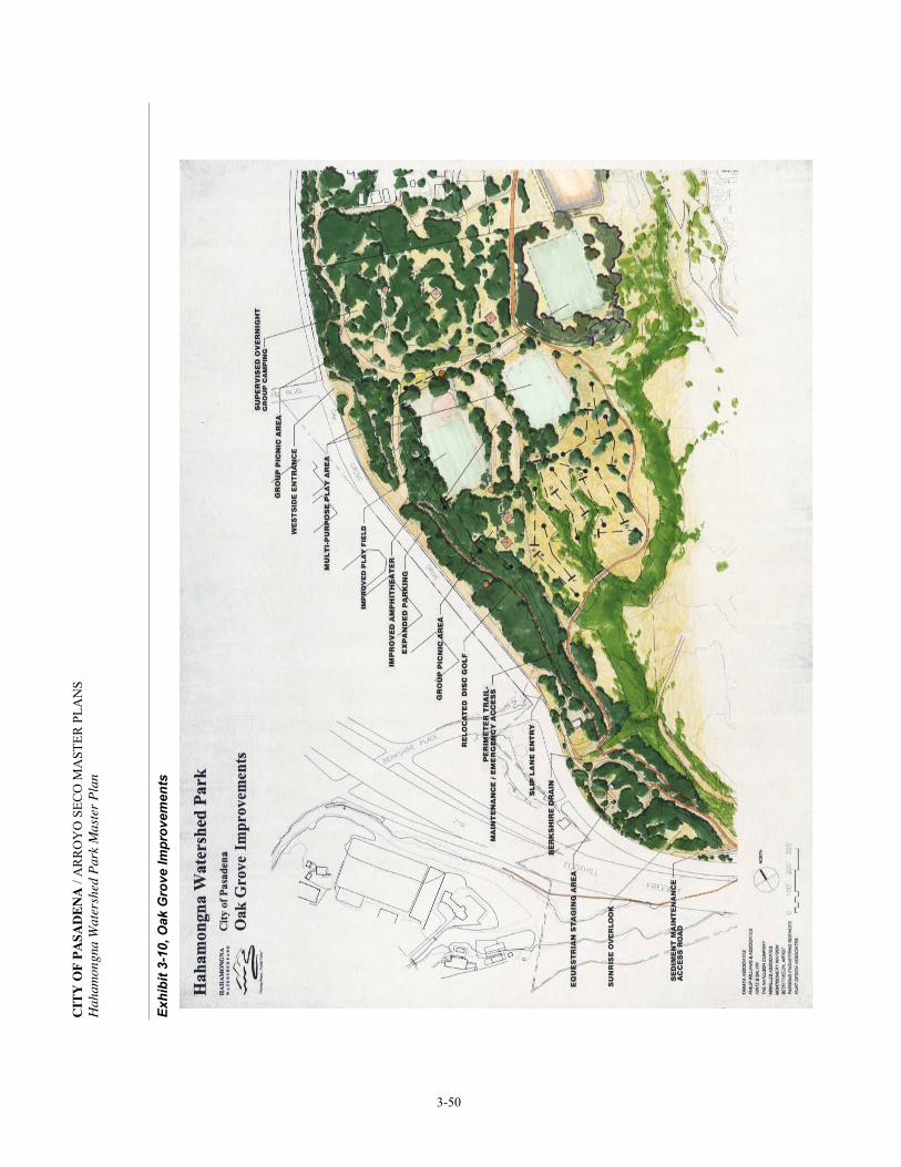
ANE
DAS
AP FO
YTIC
SN
ALP
RE
TSA
M O
CES
OY
OR
RA /
nalP retsaM kraP dehsreta
W angnomaha
H
05-3
stne
mevor
pmI ev
orG ka
O ,01-3 tibi
hxE

CITY OF PASADENA / ARROYO SECO MASTER PLANS Hahamongna Watershed Park Master Plan
3-51
The existing Oak Grove parking area will be expanded to accommodate the abandoned overflow parking and a new Oak Grove Field restroom constructed before the Sycamore Grove Fields are constructed. Under existing conditions, a portion of the Southern Sycamore Grove Field site is prone to flooding, therefore the area will be raised from its current average elevation of 1040 to elevation 1050. Under existing conditions, the proposed northern Sycamore Grove field site is prone to flooding, therefore the existing large depression at elevation 1025, well below the inundation 1040.5 elevation, will be raised above elevation 1055. During disaster emergencies, the Oak Grove area will continue to be used as a staging area for fire crews and other emergency support groups. The perimeter trail to the east and north of the Southern Sycamore Grove Field is planned to provide a strong separation between this active recreational area and the habitat restoration area of the interior basin. This portion of the trail will be ADA-accessible. DISC GOLF COURSE The disc golf improvements include relocation of the back nine from the north Oak Grove Area and pins 6-9 of the front nine to the area south and east of the new expanded parking lot and the Southern Sycamore Grove Field. The relocation of this portion of the disc golf course provides an opportunity for habitat restoration of the north Oak Grove area.
Exhibit 3-11, Conceptual cross section of raised terraces for relocated disc golf course
Portions of the new disc golf course will be raised utilizing excavated material from the water conservation pool area. The material will be placed between existing stands of willows, raising these portions to an average elevation of 1046, above the frequently inundated elevation of 1040.5. Drainage courses in this area will occur within the existing stands of native habitat.
CITY OF PASADENA / ARROYO SECO MASTER PLANS Hahamongna Watershed Park Master Plan
3-52
The upper terraces will be planted to create mule fat scrub habitat along the fairways and southern willow scrub habitat as outlined in the plant restoration plan. The placement of the disc golf pins will be such to minimize conflicts with hikers and equestrians. A bench will be provided at every tee and designed in accordance with the Arroyo Seco Design Guidelines. The Master Plan recommends that the City formally recognize disc golf as a recreational use of HWP. Policies for the use of the course need to be established in a collaborative manner between the City and the disc golf community. OUTDOOR AMPHITHEATER The existing amphitheater located just west of the Oak Grove field will be restored, but not expanded. The telephone pole seating will be rehabilitated for ease of maintenance and to make the area safe. Seating will be designed to prevent movement of the existing unsecured poles and the area will be fine-graded and surfaced with appropriate material to make the area ADA-accessible. WESTSIDE PICNIC AMENITIES Both group picnic areas and smaller/individual picnic areas are planned for improvement. There are currently 52 picnic tables within the Oak Grove Area. This quantity has decreased over the past several years due to a loss of tables (breaking, etc.). It is estimated that the total number of tables will double to accommodate the use anticipated by the park improvements proposed for the Oak Grove Area. Existing picnic tables will be moved to better positions and to also relieve the compaction on sites where they currently sit. A rotation program for the picnic tables should be considered, particularly in areas where the tables are within the drip line of an oak tree. The upper Oak Grove Area will continue to have single picnic tables distributed throughout, while lower Oak Grove will serve as the location for two designated group picnic areas each with two shade structures. The first is south of the Oak Grove field; the second facility will be located in the overnight camp area. Each shelter will have four to six picnic tables. All group picnic areas will be provided with electrical outlets, sinks with running water and grey water drains, and group barbecues. The shade structures for the group picnic areas will be designed to fit the natural character of HWP, following the Arroyo Seco Design Guidelines. The floor of the group picnic areas will be graded level and surfaced with a permeable material such as decomposed granite blended with native soil and a binder. The group picnic areas will meet all ADA-accessibility requirements.

CITY OF PASADENA / ARROYO SECO MASTER PLANS Hahamongna Watershed Park Master Plan
3-53
To support the picnic areas, the two existing restrooms, one in Upper Oak Grove and the other in the overnight camping area, will be renovated with new fixtures and ADA-accessible stalls. The abandoned restroom, which has been removed from the southwest corner of the Oak Grove play field, will be reconstructed near the southeast corner of the field, closer to the parking and to the new group picnic area. The replacement restroom will service group picnicking, multi-purpose play fields, and the disc golf course, and will include a storage area for park maintenance and field user group equipment. SUPERVISED OVERNIGHT CAMPING Supervised overnight camping is proposed in the northern portion of the Oak Grove area. Overnight camping will only be available to organized groups, such as the Boy Scouts and Girl Scouts, with proper supervision. The facilities for group overnight camping to be provided include group-picnic shade structures, grey-water outdoor sinks, barbecues, drinking fountains and renovated rest room. A fire ring with seating for 30 youths and an amphitheater with seating for approximately 60 youths will be created as part of this project. The amphitheater will be constructed in the same style as the existing larger amphitheater adjacent to the Oak Grove field. Access to selected campsites will be provided for the disabled. During the day the site will be available to the general public. The existing Los Angeles County trail maintenance building and storage area will be converted to provide accommodations and administrative space for the park staff. Parking for the overnight campers and trash bin storage will be provided adjacent to the staff building and across the inner park access road. See Section 3.7, Parking & Circulation for more detail. Selected areas of the overnight camping area will be restored to oak woodland. These areas will be identified as restoration areas and corded off. With the exception of the existing trail connecting the West Rim Trail and the Perimeter Trail via the existing restroom, equestrian trails through the oak woodland restoration areas will be removed. Hitching posts and a water trough will be provided at the southeast corner of the overnight camping area, near the vehicle turnaround between the Sycamore Grove Fields EQUESTRIAN STAGING AREA Improvements to the equestrian staging area include improved vehicular access for school bus and horse trailer turnaround, upgrade of the existing restroom, improved trail connections, and picnic amenities for informal gatherings.

CITY OF PASADENA / ARROYO SECO MASTER PLANS Hahamongna Watershed Park Master Plan
3-54
Access improvements will be in conjunction with the Berkshire drain improvements. (See Section 3.8, Utilities & Infrastructure.) The existing single-lane access road will be raised, realigned, and widened as it passes over the Berkshire Drain to allow two-way traffic. South of Berkshire Drain, a one-way loop will allow incoming traffic to enter the parking area on the northern edge. All vehicular traffic will exit via the southeast corner of the parking area, looping back along the old entry roadway. The softer, wider turns and one-way traffic flow will provide easy access for horse trailers, school buses, and camp vans (see Exhibit 3-12, Proposed Road Improvements to Equestrian Staging Area).
Exhibit 3-12, Proposed Road Improvements to Equestrian Staging Area
CALIFORNIA NATIVE PLANT NURSERY A plant nursery will be established at the existing Oak Grove Maintenance Office (OGMO) to allow for the propagation of native plants indigenous to the watershed. These plants will be used for the restoration projects within HWP and other areas of the Arroyo Seco. An unused, open area adjacent to the office will be incorporated into the yard with new fencing. Improvements include propagation tables, interpretive signage, storage bins for soil and amendments, and a holding area for larger container stock. Environmental education programs and associated volunteer programs will have supervised access to the nursery.
CITY OF PASADENA / ARROYO SECO MASTER PLANS Hahamongna Watershed Park Master Plan
3-55
SUNRISE OVERLOOK On an eastward-facing knoll, south of the Equestrian Staging Area, a hollow will be carved from the hillside creating a small amphitheater above the edge of an existing retaining wall. The rising sun and the San Gabriel Mountains form the backdrop to a view of the entire HWP basin. Rounded boulders and recycled historic granite curbs from Old Town Pasadena will be used to build the stepped terraces. Oak woodland will be established around the amphitheater to provide shade, further separation from Oak Grove Drive, and a sound barrier to the 210 Freeway. An existing trail leads from the Equestrian Staging Area to the site. ADA-access will be provided by new trail ramps from both the north and south along the top of the existing retaining wall. 3.6 EAST SIDE PARK IMPROVEMENTS SUNSET OVERLOOK Just north of the Windsor/Ventura entrance to the park, on the crest of the west-facing canyon slope, a small picnic and interpretive area will be developed to take advantage of the broad views of the basin. The site will overlook the spreading basins and the water conservation pool to the south providing opportunities for education on water resources and habitat restoration. A small parking area, located near the intersection of Ventura and Windsor Avenues, will serve this area. GABRIELINO TRAIL AREA A new trailhead at the north end of the existing eastside JPL parking lot will bring park users into this area of the park, up the Gabrielino Trail and into the upper Arroyo Seco watershed area. The Gabrielino Trail area will provide a new restroom, picnic tables, public parking and interpretive signage for area recreational users. When the northern quarter of the existing JPL parking lot becomes available for public parking, then the existing parking at Windsor Avenue and Mountain View Street can be used for a new park entrance. A new restroom will be constructed at the north end of this remodeled parking lot and serve visitors to HWP as well as those headed into the Angeles National Forest. A small storage area and a public telephone will be provided at the structure.

CITY OF PASADENA / ARROYO SECO MASTER PLANS Hahamongna Watershed Park Master Plan
3-56
DEVIL’S GATE DAM AREA Dam Keeper’s Quarters and Public Restroom The existing dam keeper’s quarters located on the east side of the dam will be demolished and a new public restroom constructed to serve park visitors. A new dam keeper’s quarters will be built above the public restroom with sleeping quarters, a small kitchenette, and a private restroom. This second story will afford the dam keeper a view of the basin during storm events. On the ground level, connected to the public restroom, will be a storage area (single-car garage) for materials and equipment related to the operation and maintenance of the dam. Dam and Observation Deck The City of Pasadena will work collaboratively with the County to enhance safety on the deck of the dam, at the observation deck south of the westside tunnel overlooking the spillway, and along the trail that leads down to the observation point overlooking the dam and the water conservation pool. Safety will be enhanced through the installation of ornamental fencing along the dam parapet walls and the spillway observation deck. Fencing will be similar to that installed by the City on the Colorado Street Bridge. Fencing will also be installed along the trail in order to restrict access to the flood management/water conservation pool. 3.7 CIRCULATION & PARKING DEVIL’S GATE DAM AREA At the present time, sediment removal trucks access the flood management/water conservation pool area through the cul-de-sac at the end of La Cañada-Verdugo Road. Use of this residential street for sediment removal has been highly disruptive to the neighborhood. The Master Plan proposes to close La Cañada-Verdugo Road and reroute truck traffic via a slip lane from Oak Grove Drive. The new East Access (entry) to the dam would be gated and provide one-way access to the dam area. The entry gate would be configured to accommodate bicyclists.

CITY OF PASADENA / ARROYO SECO MASTER PLANS Hahamongna Watershed Park Master Plan
3-57
Exhibit 3-13, Slip Lane Entry and Exit to Dam
The new West Access (exit) from the dame area will allow exiting maintenance vehicles and equipment to cross the top of the dam and exit back onto Oak Grove Drive via another one-way slip lane. Exiting vehicles will be required to turn right on Oak Grove Drive and continue on to the Berkshire Place entrance to the 210 Freeway. This route across the top of the dam is part of both the Perimeter Trail and the bike route. Appropriate signage and attention to safety regulations during periods of sediment and debris removal will be necessary to maintain safe multi-modal access for all park visitors. The East Access (entry) from Oak Grove Drive will require the removal of the existing dam keeper’s quarters to raise the road bed and smooth the transition to the east-side haul road used for sediment and debris removal. A new public restroom and dam keeper’s quarters will be constructed near the east end of the dam along with three parking spaces. The existing pipe gate at the end of the cul-de-sac on La Cañada-Verdugo Road will be removed and the street curb restored, eliminating all vehicle access from this residential street. A landscaped berm will be created along the edge of the cul-de-sac to further buffer the adjacent residential neighborhood from park activities. Storm drains and perimeter fencing will be modified as needed. New Dam Parking Area A small landscaped parking area is proposed at Oak Grove Drive and Linda Vista Drive for park visitors who wish to visit the Devil’s Gate Dam area. This scenic overview is the only public-accessible location with a view of the south side of the dam. From this point the rock
CITY OF PASADENA / ARROYO SECO MASTER PLANS Hahamongna Watershed Park Master Plan
3-58
formation for which “Devil’s Gate” is named, is visible, as is the floodwater cascading from the spillway onto the narrow canyon floor. Access to HWP and the top of the dam from this proposed parking area is accommodated through an existing pedestrian tunnel under Oak Grove Drive that leads to the dam. Visitors will be able to access the tunnel via a new ADA-accessible ramp. The chain-link fencing on the existing retaining wall at the entrance to the tunnel will be replaced with ornamental iron safety fencing, similar to that recommended for the dam’s parapet walls. A gate will be installed at the southern opening of the tunnel to provide a secured access at this location during the night when the Park is closed. WESTSIDE/OAK GROVE AREA Park Entrances The main, west park entrance will remain at Oak Grove Drive and Foothill Boulevard. A new park entrance sign and lighting will be installed and the landscaping improved. This entrance will remain open to accommodate the tenants of the MWD property. The need for a traffic control gate or entry kiosk for security and dissemination of information will be assessed. In order to provide safer and efficient access for park visitors during peak traffic hours (during arrivals and departures from La Cañada High School and JPL), a one-way access lane from Oak Grove Drive, north of the Berkshire Place intersection, is proposed to allow entry during park events and morning/afternoon high school student drop-off/pick-up. This project is indicated on Exhibit 3-1, HWP Master Plan under Oak Grove Drive Improvements. The access lane will be ingress only and will have a security gate and appropriate signage installed. See Exhibit 3-12, Proposed Road Improvements to the Equestrian Staging Area. The Foothill Boulevard entrance will continue to be both ingress and egress. Due to public safety concerns, a portion of this project has been temporarily implemented. Circulation and Parking Improvements The main parking lot located on the lower terrace near the existing Oak Grove Field will be expanded. This expansion replaces the overflow parking area which is being converted to the Southern Sycamore Grove Field, therefore, the project will not increase the amount of parking in the area, but will consolidate the two existing lots. Due to current parking demand, this paved parking area needs to be expanded before the Southern Sycamore Grove Field is constructed. The access road will be extended and a turnaround constructed to accommodate fire and emergency vehicles. This project is indicated on Exhibit 3-1, HWP Master Plan, under Oak Grove Area improvements as Expanded Parking Area.

CITY OF PASADENA / ARROYO SECO MASTER PLANS Hahamongna Watershed Park Master Plan
3-59
The existing parking area on the east side of the inner park access road and the north side of the overnight camping area will be upgraded to accommodate parking for buses and a drop-off area for vehicles or a bus. A small parking area, adjacent to the park ranger station, will be constructed with a new trash enclosure in the storage yard area currently used by the County Department of Parks and Recreation. This parking area will have a natural, permeable surface. Improvements to the parking area at the equestrian staging area will include widening of the access road, realignment, and resurfacing. See Exhibit 3-12, Proposed Road Improvements to the Equestrian Staging Area. The existing access road will be widened from the upper Oak Grove turnaround and then raised to allow incoming traffic to drive over the new drainpipe that will be needed for the Berkshire drain upgrade. All vehicular traffic will enter the parking area on the northern edge and will exit via the southeast corner of the parking area, looping back along the old entry roadway. Pavement will be eliminated where possible from the existing roadway between the Berkshire drain and the Flint Wash Bridge. The softer, wider turns and one-way traffic flow will provide easy access for horse trailers, school buses, and camp vans. Ten pull-through parking spaces will be provided. These spaces will be used by no more than two buses, with the remainder of the spaces being designated for horse trailers and cars. EASTSIDE PARK AREA Park Entrance In order to provide a safer entrance for park visitors and JPL employees, a new park entrance is proposed at Windsor Avenue and Mountain View Street. See Exhibit 3-14, Proposed Park Entry. The existing parking lot on Windsor Ave. would be demolished and park visitor parking made available in the Gabrielino Trail Area in what is now the north end of the existing JPL east parking lot. All eastside traffic will enter and exit HWP at a four-way intersection at Mountain View Street and Windsor Avenue. A designated left-hand turn lane will accommodate the stacking of rush-hour traffic into the new entrance without stopping through-traffic. If the County implements any improvements to the Windsor Avenue and Ventura Street intersection prior to the implementation of this proposed project, the intersection will be evaluated for traffic volume safety and whether any further improvements will be necessary.

CITY OF PASADENA / ARROYO SECO MASTER PLANS Hahamongna Watershed Park Master Plan
3-60
Exhibit 3-14, Proposed Park Entry at Windsor and Mountain View
The proposed improvements will require the construction of a new retaining wall along the west edge of the park access road and at the end of Ventura Street. After construction is finished the entrance area will be relandscaped with native plants from the oak woodland and sage scrub palettes. A small parking area will be located near Sunset Overlook. Circulation and Parking Improvements Eastside Parking: Park visitor parking in the northeast section of HWP (Gabrielino Trail Area) will consist of the northern portion of the existing JPL east lot (approximately 25% of the existing JPL parking lot). The remainder of the existing JPL lot will be used for the reconfiguration of the eastside spreading basins. This parking area will be for HWP park users and people connecting to trails in the Angeles National Forest and the upper watershed. EMERGENCY & MAINTENANCE VEHICLE ACCESS Emergency and maintenance vehicle access to the interior of the park is by a proposed all-weather perimeter road/trail, see Exhibit 3-1, HWP Master Plan. Hikers and equestrians will also have use of this unimproved road for recreation. In order to complete the loop road, two bridges will need to be constructed—one bridge at Flint Wash and the other at the north end of the park. Emergency and maintenance vehicles will access the loop road through a system of locked gates at strategic locations throughout the park.

CITY OF PASADENA / ARROYO SECO MASTER PLANS Hahamongna Watershed Park Master Plan
3-61
3.8 UTILITIES & INFRASTRUCTURE Following is a conceptual discussion of the impact to existing utilities and infrastructure along with the recommendations for new utilities that would be required to service the Master Plan proposals. STORM DRAINS The Master Plan does not have a direct impact on the existing storm drain systems that enter the park. However, discharge from the storm drains does have an impact on the park environment. Field studies undertaken as part of the Master Plan process assessed these drains. The 24 storm drains entering the park are shown in Exhibit 2-6, Storm Drains (See Section 2.7, Utilities). Modifications to certain storm drain outfalls are proposed to rectify erosion and habitat damage caused by increased runoff from urban development and to improve performance of the drain. Those drains include the Altadena Drain, Altacrest Drain, Berkshire Drain and Foothill/Oak Grove Drain. Modifications will be needed to JPL Trunk Line #14 because the existing outfall location is within the proposed Westside Spreading Basins. Additionally, there are recommended overall storm drain modifications that apply to all 24 existing storm drains. Other minor modifications to existing and new storm drains needed within HWP will be assessed during project implementation. Overall Storm Drain Modifications Storm water entering the flood management/water conservation pool from Flint Wash, from storm water runoff of adjacent lands, and from all storm drain outfalls will need to comply with state-mandated water quality standards including monitoring and cleanup of pollution from runoff. Runoff pollutants include horticultural fertilizers and pesticides, pathogens from animal manure (dogs and horses), hazardous substances in municipal waste including trash, oil, and grease from motorized vehicles. Remediation may occur at an outfall location in the Park, at the pollutant source, or at the inlet to the storm drain depending on the particular type of pollutant. Water quality becomes important because any water held behind the dam and pumped back for percolation in the spreading basins is a source of drinking water. A fiscally workable and scientifically proven solution to some of these pollution problems requires further investigation. Best management practices will be utilized to ensure TMDL’s (Total Maximum Daily Loads) of pollutants are reduced and that natural/biological alternatives are considered first. Examples of such are bio-swales and the use of riparian systems that can function as biological filters and scrubbers for urban runoff contaminants.
CITY OF PASADENA / ARROYO SECO MASTER PLANS Hahamongna Watershed Park Master Plan
3-62
Altadena Drain Improvements The Altadena drain extends into the stream channel north of the existing spreading basins. Its extended concrete box structure was utilized as part of an earthen breakaway dam, which would divert water to the eastside spreading basins. This site is no longer used as a diversion facility due to the environmental impacts from the breakaway dam and this diversion method. In order to widen the stream corridor, allowing for a more natural stream alignment (see habitat restoration project no. 1), the drain will be shortened and the embankment armored to prevent erosion from the runoff generated by this drain. The stream corridor will then be restored to a riparian habitat, similar to and as a continuation of the same plant community, immediately north of the JPL Bridge. This riparian habitat also exists due to urban runoff for a short stretch of the stream course south of the drain. Extension of Altacrest Drain The discharge from the 40″ reinforced concrete pipe (RCP) adjacent to the Gabrielino Trail and east of the JPL east parking lot (just south of the existing equestrian trail) will continue downslope in an extended enlarged single RCP. This underground drain line will run between the enlarged existing ponds and empty directly into the stream corridor. There would be an inlet to receive runoff from the eastside park road and the remaining northerly quarter of the existing parking lot. Repair at Berkshire Drain The increased volume of runoff resulting from the widening of Oak Grove Drive and Berkshire Place has caused severe scouring of the downstream drainage swale within the park. The park road will be raised four feet and a new transition structure built with a new enlarged pipe running under the road and down the slope and exiting into the basin below the Perimeter Trail. The eroded areas on the upper slope will be filled and restored with oak woodland habitat. The area where the drain line crosses under the Perimeter Trail will be restored with southern willow scrub habitat. From the new outfall to the water conservation pool, the drainage swale will be stabilized with riparian willow habitat to prevent future erosion. The widening of the park road during this project will allow two lanes of traffic to pass safely to and from the Equestrian Staging Area. Repair at Foothill Drain Increased runoff from the widening of Oak Grove Drive, Foothill Boulevard west of the park entrance, and urban development of a portion of the La Cañada-Flintridge area has caused severe erosion within the park on the slope above the existing Oak Grove play field. This project would extend the existing 24″ concrete drain down the slope, make a turn south
CITY OF PASADENA / ARROYO SECO MASTER PLANS Hahamongna Watershed Park Master Plan
3-63
parallel to the play field and discharge into the existing drainage swale. The existing swale that flows south along the toe of the oak grove slope needs to be improved. The new pipe would be covered over and the slope restored with oak woodland habitat. WATER MAINS There are several water lines in the basin area that either cross the basin or run parallel to it. Improvements identified in the Master Plan will require a connection to the existing potable water distribution system. These include new restrooms, campsite sinks, drinking fountains, and the overnight-staff building. The Calaveras water line serves the Park effectively and will be used as the main supply for further improvements. The existing domestic water distribution system will need to be evaluated as part of park improvements and for fire suppression needs. Fire hydrants at appropriate locations will need to be installed as improvements are made. Any utility relocation or new utilities that cross the basin floor are expected to be attached to the proposed North Bridge Crossing. OVERHEAD POWER AND COMMUNICATION LINES Relocation of the power and communication lines is recommended. However, significant costs would be incurred and additional easements would need to be negotiated with the two electrical service providers as well as communication entities. Additional power and telephone lines are planned at the new restroom areas. Some upgrading of existing facilities may also be necessary at Johnson Field, the Oak Grove Maintenance Office, and the Equestrian Staging Area. It is recommended that new utility services be placed underground when inside the HWP boundary. There will be new electrical service to the pump-back facilities near the Devil’s Gate Dam. Any relocated utilities or new utilities that cross the basin floor are expected to be either attached to the proposed North Bridge Crossing or within the adjacent overhead utility easement. Any utility relocation will be based on the Master Plan, its Environmental Impact Report (EIR), and a proposed utility design and cost estimate, all of which will be needed prior to permitting and easement negotiations. Underground Pasadena’s Eastside Overhead Power and Communication Lines This project would occur in two phases. The first phase would be to underground these overhead distribution lines from the VOC Water Treatment Plant to the Arroyo Well. The second would be to underground the existing Pasadena Water and Power overhead distribution lines from the VOC Water Treatment Plant to Johnson field (see Exhibit 3-15, Transmission & Communication Lines).

3-64

CITY OF PASADENA / ARROYO SECO MASTER PLANS Hahamongna Watershed Park Master Plan
3-65
Relocate the Existing Southern California Edison (SCE) Power Line in the Hahamongna Basin This project will minimize the number of overhead basin crossings as well as remove this line from the sensitive Riversidian Alluvial Fan Sage Scrub habitat, which restricts the maintenance of this utility. This overhead distribution line that runs diagonally across the basin from the JPL sub-station to the Windsor/Ventura intersection would be relocated. The new alignment would run north to the east/west distribution lines, adjacent to the North Bridge, crossing the basin with the existing lines, then running south to Ventura Street along the Gabrielino Trail, reconnecting to the distribution system at the Windsor/Ventura intersection. Relocate the Existing Pasadena Power and Communication Line This project would relocate the existing Pasadena power and communication lines that traverse the basin from the VOC Water Treatment Plant to the MWD property and northern portions of the Oak Grove area. This utility will be relocated due to the undesirable aesthetics of these poles, the erosion of the pole bases, and their inaccessibility for maintenance in the project identified as the “Widen Stream Channel and Establish Riparian Habitat Project.” The communication portion of this line would be relocated to a new line that would run to JPL from the Windsor/Ventura intersection north along the Gabrielino Trail. The power portion of this line will be relocated to the Pasadena grid that crosses the Devil’s Gate Dam to feed facilities in the westside portion of the park. This alignment would go from the dam to Foothill Boulevard (preferably underground) and provide a new feed to OGMO, the equestrian staging area restroom, the new restroom near the Oak Grove field, the group picnic shelters south of the Oak Grove field, the park ranger station, the existing restroom in the overnight area, and the group picnic shelters in the overnight camping area. Relocate the SCE North/South Transmission and South Distribution Line These lines currently follow the toe of the western slope of the park, run the length of the basin from south to north, and feed into and from JPL’s main substation. The base of 11 of the 21 power poles will be frequently inundated during heavy storm events, when water conservation measures are implemented, making it impossible to access these poles. The poles either need to be relocated to an alignment in Oak Grove Drive or be raised to an appropriate height in their current location after the westside perimeter trail, relocated disc golf, and improved parking lot areas are raised above the seasonally inundated elevation of 1040.5 (spillway elevation). It is the preference of this Master Plan to have the poles relocated to Oak Grove Drive. Prior to implementing the proposed grading of the Flood

CITY OF PASADENA / ARROYO SECO MASTER PLANS Hahamongna Watershed Park Master Plan
3-66
Management Water Conservation Pool, an analysis of alternative improvements or relocation of this utility will be completed for review and approval. This will guarantee the safety and stability of this critical utility. A mutual agreement between SCE and the City of Pasadena (and potentially other agencies such as JPL, MWD and the City of La Cañada-Flintridge) needs to be worked out. NATURAL GAS City records indicate that the 12″ high-pressure natural gas line that crosses the basin runs parallel to the 12″ Calaveras water line. See Exhibits 2-8, Water Mains, and Exhibit 2-10, Natural Gas & Sewer, in Section 2, Existing Conditions. Due to their close proximity to each other, it would be prudent to have the condition of this gas line and the adjacent water line evaluated. Additionally, the depth of coverage will need to be reviewed when the streambed is widened to determine if it is adequate. In the Oak Grove area near the intersection of the Oak Grove Drive and Berkshire, there is a natural gas line that runs north-south along the Oak Grove Drive. This line currently connects to various structures requiring gas service such as the park maintenance facility. It will also be used to service the overnight camping staff building. The gas line in La Cañada-Verdugo Road that services the Arroyo Seco Resource Center will be extended to the new dam keeper’s quarters on top of the new public restroom at the east end of dam. SEWER SYSTEMS Conforming to California EPA Water Quality Standards, all existing septic systems in HWP will be abandoned and new sewer collection and delivery systems constructed. The existing septic tanks will be pumped out, cleaned, back-filled with sand and abandoned in place. Before back-filling, the bottoms of the tanks will be broken through so that no seeping water will be allowed to stand in the abandoned tanks. Permits for the abandonment will be needed. New sewer systems that include lift stations with force mains to the existing gravity sewer systems outside the Park are proposed; three on the westside and three on the eastside. At these six points of connection outside the Park, capacity will have to be studied and permits obtained with resulting associated fees.

CITY OF PASADENA / ARROYO SECO MASTER PLANS Hahamongna Watershed Park Master Plan
3-67
The following is a summary of proposed projects that impact the sewage system: Existing Restroom upgrades The two existing restrooms in Oak Grove (on the upper terrace and in the overnight camping area) are already approved to be upgraded with new fixtures and partitions under the City’s Capital Improvement Program. The new partitions will be designed to accommodate ADA-access. The upper restroom is currently connected to the Oak Grove Drive gravity sewer main and does not need upgrading. The overnight camping area restroom will be connected to a new lift station and force main. New Restroom at Oak Grove Field (replacement facility) The abandoned restroom at the southwest corner of the existing Oak Grove field will be reconstructed at the end of the new parking lot near the southeast corner of the existing field. The new replacement restroom will have one urinal and two stalls for men and three stalls for women as well as storage space (20' x 30' minimum) and will meet current ADA-accessibility standards. The restroom will have a sewage lift station and a force main to the gravity sewer main on Oak Grove Drive. Security lighting will be installed at this restroom. Upgrade Restroom at Park Ranger Station (Overnight Camping Area) The existing building used by Los Angeles County Trails maintenance personnel will be converted to a park ranger station to supervise the overnight group camping area. The remodel will include adding a bathroom and kitchenette. A sewage lift station will be located between the existing lower restroom and this converted park building with gravity lines from each and a sewage lift station with force main to the gravity sewer main at Oak Grove Drive. Upgrade and Improve Restroom at Equestrian Staging Area During the initial implementation phases of the Master Plan, this restroom will be renovated to meet ADA-accessibility standards and improve its physical appearance. Later, the restroom will be reconstructed to accommodate one urinal and two stalls for men and three stalls for women. This project will be combined with the sewer improvements needed at the Oak Grove Maintenance Office. A gravity feed will lead to a sewage lift station and a force main at a central location next to the Berkshire drain. Sewage will then be pumped up to the gravity sewer main in Oak Grove Drive.

CITY OF PASADENA / ARROYO SECO MASTER PLANS Hahamongna Watershed Park Master Plan
3-68
Upgrade Oak Grove Maintenance Office (OGMO) Sewer The restroom facilities at the OGMO are adequate and do not need upgrading. The office is currently on a septic system that will be abandoned. A gravity sewer will connect to the proposed sewage lift station near the Berkshire drain and sewage will be pumped up to the gravity sewer main in Oak Grove Drive.
New Dam Keeper’s Quarters with Public Restroom (replacement facility) On the eastside of the dam, the existing dam keeper’s quarters would be demolished and rebuilt as a public restroom to serve park visitors at the dam. The restroom will have one urinal and one stall for men, two stalls for women, and will meet current ADA-accessibility standards. On the ground level, connected to the public restroom would be a storage area (single car garage) for materials and equipment related to the operation and maintenance of the dam. Dam keeper’s quarters will be built above the public restroom with sleeping quarters, a small kitchenette and a private restroom. The second story will afford the dam keeper a view of the basin during storm events. The former dam keeper’s house (the current Arroyo Seco Resource Center) will gravity feed to a sewage lift station adjacent to this facility, then a force main will connect to the City system servicing the houses on La Canada-Verdugo Road. New Restroom at the Gabrielino Trailhead Area When the specific need is identified, a new restroom will be constructed at the north end of the proposed public parking lot (currently the existing JPL east parking lot) and serve park visitors using HWP as well as visitors headed into the Angeles National Forest. It will have one urinal and one stall for men and two stalls for women and meet current ADA-accessibility standards. A public telephone will be located at the structure. This restroom may need a sewage lift station with a force main to the JPL gravity lines across the JPL bridge. 3.9 SAFETY, SECURITY & ACCESSIBILITY For security and public safety, HWP will be closed at sundown. The park will be patrolled by the Pasadena Police Department. With the completion of the perimeter trail, the County and City personnel will be able to patrol the perimeter of the water/conservation pool during periods when rapidly flowing floodwater is entering the basin.
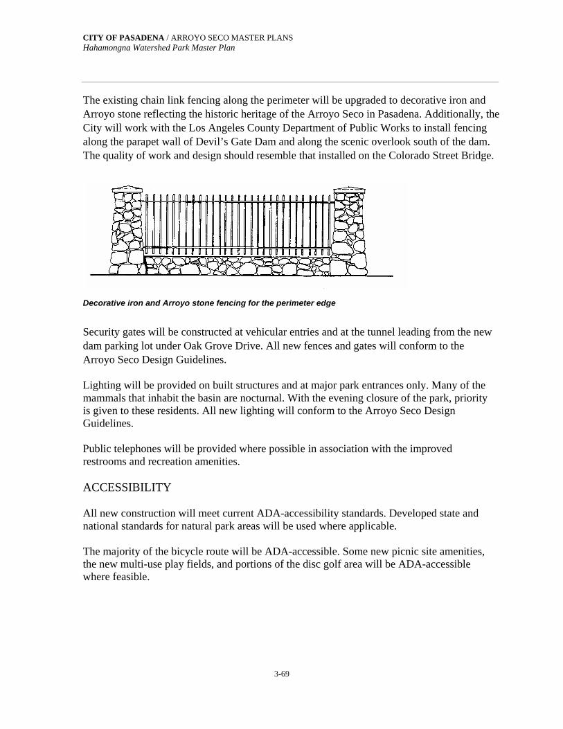
CITY OF PASADENA / ARROYO SECO MASTER PLANS Hahamongna Watershed Park Master Plan
3-69
The existing chain link fencing along the perimeter will be upgraded to decorative iron and Arroyo stone reflecting the historic heritage of the Arroyo Seco in Pasadena. Additionally, the City will work with the Los Angeles County Department of Public Works to install fencing along the parapet wall of Devil’s Gate Dam and along the scenic overlook south of the dam. The quality of work and design should resemble that installed on the Colorado Street Bridge.
Decorative iron and Arroyo stone fencing for the perimeter edge
Security gates will be constructed at vehicular entries and at the tunnel leading from the new dam parking lot under Oak Grove Drive. All new fences and gates will conform to the Arroyo Seco Design Guidelines. Lighting will be provided on built structures and at major park entrances only. Many of the mammals that inhabit the basin are nocturnal. With the evening closure of the park, priority is given to these residents. All new lighting will conform to the Arroyo Seco Design Guidelines. Public telephones will be provided where possible in association with the improved restrooms and recreation amenities. ACCESSIBILITY All new construction will meet current ADA-accessibility standards. Developed state and national standards for natural park areas will be used where applicable. The majority of the bicycle route will be ADA-accessible. Some new picnic site amenities, the new multi-use play fields, and portions of the disc golf area will be ADA-accessible where feasible.
CITY OF PASADENA / ARROYO SECO MASTER PLANS Hahamongna Watershed Park Master Plan
3-70
3.10 PROGRAMS ENVIRONMENTAL EDUCATION ELEMENT In many of the Stakeholder and Community Meetings, people from varied professions and backgrounds expressed the desire for an Interpretive Center somewhere in the Arroyo. Here, children and adults alike could come to study birds, wildlife, and plants. Some participants, such as the Native Americans, saw an Interpretive Center as a place where they could display and share their cultural heritage. Representatives of the Pasadena Unified School District and area science teachers see such a center as an opportunity to create a “living laboratory” where children could study wildlife and learn about the environment. From Native Americans to artists to science teachers, there is widespread support for an Interpretive Center which would be dedicated to ancient and modern indigenous cultures of the area together with the study of the environment and the opportunity to experience nature first-hand. An Interpretive Center could be the main vehicle to communicate the importance of the Arroyo Seco, its history, and its environmental, cultural, and water resources. These resources will also be explained through environmental education programs and through interpretive signage in selected areas of HWP. The environmental and cultural education programs at an Interpretive Center would support the habitat restoration of the park. The ability to plan the restoration effort in part to reflect plantings that are part of Native American culture provides opportunities for Native Americans to share their story. Plants gathered for ceremonies, medicine, basket weaving, musical instruments, and other native arts and crafts are part of the habitat restoration plan. Plant materials for the restoration projects can be grown at the California native plant nursery in partnership with interested groups. To get this effort off the ground, the City of Pasadena should further explore possible locations for an Interpretive Center and involve interested members of the Community including but not limited to: Native American Community Armory Center for the Arts Pasadena Arts Commission Pasadena Unified School District John Muir High School Science Department Project Seed, Caltech St. Francis High School Science Department Local Conservancies Environmental Organizations
CITY OF PASADENA / ARROYO SECO MASTER PLANS Hahamongna Watershed Park Master Plan
3-71
The following organizations are currently using the Arroyo and HWP for their programs. As current stakeholders, continued support for their programs may result in expanded opportunities for park users. The Armory Center for the Arts, Children Investigate the Environment Program Kidspace (soon to be located in Brookside Park) Jet Propulsion Laboratory (JPL), The Planetary Society Tom Sawyer Camps The Sequoia School The Audubon Society
The following programs are possible resources or potential users for HWP The Bay Institute Watershed Education Program The Center for Eco-literacy Pasadena Libraries City of Pasadena Cultural Affairs Division Gallery Space Pasadena Unified School District
Gifted and Talented Program and Community learning Centers Wilson Middle School Washington School The California Arts Council-Artist in Residency Program California Institute of Technology, Division of Geological and Planetary Sciences
An Interpretive Center could support the educational component and could offer the following: Programs relating to the Arroyo Seco environment
Programs led by working artists, focusing on the traditions, arts and crafts of Native
Americans. The intention would be to show to those interested, the plants used and gathering techniques that do not impair the sustainability of a plant population; and
A communications program established to inform and update the public on habitat
restoration, water quality, flood management, sediment removal, and water conservation issues and activities.
Programs offered at an Interpretive Center and educational information at interpretive sites throughout the park would stress the importance of a sustainable ecosystem. Specific topics would include the geology and hydrology of the San Gabriel Mountains and the Raymond
CITY OF PASADENA / ARROYO SECO MASTER PLANS Hahamongna Watershed Park Master Plan
3-72
Basin Aquifer; the importance of a healthy watershed; how a watershed can be managed; management of flood water, debris and sediment; how to restore and preserve native plant habitat; why biological diversity is important to a sustainable ecosystem; which native plants, plant communities, and wildlife exist in the park; the importance of the Arroyo Seco as a wildlife corridor to a sustainable ecosystem; and which plants are used by the Native Americans in their traditions, arts and crafts. INTERPRETIVE CENTER The concept of an Interpretive Center will require further study since a likely location in the Arroyo Seco is not known at this juncture. At such time as a location becomes probable, it is recommended that the planning for such an undertaking becomes a joint effort between the City of Pasadena and organizations that would take an active role in this facility. An Interpretive Center could provide visitors opportunities to learn about the Arroyo Seco environment, water resources and conservation, flood management, and the NativeAmerican culture. It is recommended that such a remodeled or newly constructed facility contain at a minimum the following features: A large flexible space dedicated to exhibits and demonstrations Classroom space for instruction Auditorium/conference space for up to 200 people Multipurpose covered patio for large groups Work area to prepare or repair exhibits Entrance lobby and gift shop Administrative offices Storage area and janitorial/sanitary facilities Expanded nursery facilities for plant propagation Large kitchen for group service Maintenance and storage yard

Section 4. Implementation of the Master Plan

CITY OF PASADENA / ARROYO SECO MASTER PLANS Hahamongna Watershed Park Master Plan
4-1
SECTION 4:
IMPLEMENTATION OF THE MASTER PLAN 4.1 IMPLEMENTATION PLAN The following is a list of the projects that are proposed in the Hahamongna Watershed Park Master Plan. The project planning for a new park is complex. Projects are listed sequentially within each area grouping, like stepping stones. Serious consideration was given to the order in which a project is listed within a group; the initiation of one leading to the ability to begin the next. The projects listed first are suggested improvements to existing park facilities and features. This includes habitat restoration projects. Any improvements to park infrastructure will be made as necessary. There is a considerable amount of grading and earthmoving associated with some of the projects in the HWP Master Plan area. Placement of excavated material to raise an area above the frequently flooded zone will affect the existing drainage as well as habitat associated with the specific project; therefore, newly restored habitats in these raised areas will require time to become established. This type of mitigation needs to occur before other projects in the implementation sequence begin and prior to the excavation and placement of needed material for the next project which may affect additional habitat. The material excavated from the flood management area to increase capacity and to be used for newly raised parkland, will affect debris and sediment management. Therefore, all projects where material is excavated to be used as fill within the County’s leased Flood Easement will require the County’s review and approval. Because of the quantities of material involved, the County may choose to engineer some of the proposed projects within its easement. Projects requiring extensive grading that affect the existing and proposed habitats, and the sequence of these projects, will need to be reviewed and approved by the appropriate state and federal environmental agencies prior to the engineering of the projects. Therefore, the cost and efficiency of construction has been considered in how the following projects are sequenced.

4-2
CITY OF PASADENA / ARROYO SECO MASTER PLANS Hahamongna Watershed Park Master Plan
4-3
A: PRE-MASTER PLAN IMPROVEMENTS Upgrade the two existing restrooms in the Oak Grove Area, including Title 24 and
ADA requirements. Upgrade existing Oak Grove Area picnic amenities and implement conservation of
oak woodland. Remove asphalt from between and along the western edge of the existing spreading
basins on the eastside of Hahamongna Watershed Park. AREA 1: OAK GROVE AREA IMPROVEMENTS Group 1A Construct turnaround and the expanded parking area to replace the overflow parking;
install landscaping and irrigation. Construct gravity sewer lines and lift station with force main for improved water quality
at the Oak Grove Field. Underground power and communication lines. Construct Oak Grove Field restroom replacement and two group-picnic shade structures. Construct the Foothill Drain improvements including improvements to the existing
drainage swale. Construct two trail connections from the West Rim Trail to Oak Grove Field and the
Perimeter Trail. Construct the West Rim Trail improvements and the realignment around the Foothill
Boulevard park entrance. Implement the Oak Woodland Restoration Project including establishment of oak
woodland on the slopes between the upper and lower Oak Grove areas. Improve the Outdoor Amphitheater at Oak Grove Field and provide picnic amenities
when specific need and locations are identified. Group 1B Construct haul road and construction equipment entry at Oak Grove Drive for sediment
removal access. Grade the west approach to the Flint Wash Bridge and the amphitheater at Sunrise
Overlook. Grade the east approach to the Flint Wash Bridge and the southeast portion of the
Perimeter Trail to create a uniform grade to the basin for flood management equipment and erosion control.
Construct the Flint Wash Bridge, including abutments, retaining walls and approaches. Construct Sunrise Overlook and establish coast live oak woodland in this area.

CITY OF PASADENA / ARROYO SECO MASTER PLANS Hahamongna Watershed Park Master Plan
4-4
Group 1C Raise the grade above the flood plain for the Southern Sycamore Grove Field and the
relocated Disc Golf Area. Construct the Southern Sycamore Grove Field and the Perimeter Trail, including the
improved storm drainage and crossings. Implement the Southern Sycamore Grove Field and Disc Golf Habitat Establishment and
Restoration Project. Relocate SCE transmission, distribution and communication lines to Oak Grove Drive or
improve the existing SCE facilities to insure safety, stability, and operation. Relocate to Oak Grove Drive the Pasadena Power lines that cross sensitive habitat in the
basin from the Windsor/Ventura intersection to the Oak Grove Area and MWD property. Group 1D Construct the Berkshire Drain improvements and restore the coast live oak woodland. Raise the grade above the flood plain for the Perimeter Trail from Flint Wash to relocated
Disc Golf Area. Implement the Perimeter Trail Habitat Establishment and Restoration Project on the west
side, including stabilizing the riparian stream corridor below the Berkshire Drain. In the Oak Grove Area, construct the overall storm drain modification improvements. Realign and widen the access road to the Equestrian Staging Area; improve the parking
area and picnic amenities. Upgrade the existing restroom in the equestrian staging area, construct a gravity sewer to
a lift station with a force main for improved water quality, and underground the power to the restroom and the lift station.
Upgrade the Oak Grove Maintenance Office with a gravity sewer to the lift station for improved water quality, and establish the Native Plant Nursery.
Group 1E Construct the park access improvements on the west side, including the park entrance at
Foothill Boulevard and the Oak Grove Drive improvements, and an “enter-only” park access lane at Berkshire Avenue.
Construct decorative perimeter fencing along Oak Grove Drive, from Flint Wash to the MWD property.
Complete the Disc Golf Area improvements, relocating the disc golf course out of the Overnight Camping Area.
Construct the Supervised Overnight Camping Area improvements, including day-use picnic amenities.
Construct improvements to the existing parking areas and to an existing building for the Park Ranger Station.
CITY OF PASADENA / ARROYO SECO MASTER PLANS Hahamongna Watershed Park Master Plan
4-5
Construct gravity sewers from the Park Ranger Station and the Overnight Camping restroom to a lift station with force main located in the Overnight Camping vehicle pull- through, drop-off area. Underground the power in the overnight Camping Area.
Implement the Oak Woodland Restoration and Habitat Establishment Project in the western half of the Overnight Camping Area.
Group 1F Proposed improvements are within the Designated Critical Habitat for the Endangered Southwestern Arroyo Toad. This Designated Critical Habitat, established February 7, 2001, was nullified October 30, 2002. Refer to section 4.3 Environmental Requirements, U.S. Fish and Wildlife Service for details. Complete the Supervised Overnight Camping Area improvements, including day-use
picnic amenities. Construct two group-picnic shade structures (one in the eastern half and one in the
western half of the Overnight Camping Area) Implement the Oak Woodland Restoration and Habitat Establishment Project in the
eastern half of the Overnight Camping Area. AREA 2: NORTHWEST AREA IMPROVEMENTS Proposed improvements are within the Designated Critical Habitat for the Endangered Southwestern Arroyo Toad. This Designated Critical Habitat, established February 7, 2001, was nullified October 30, 2002. Refer to section 4.3 Environmental Requirements, U.S. Fish and Wildlife Service for details.
Group 2A Construct the Stream Channel Widening Project, using Land Form Grading principles,
and restore and establish streambed riparian habitat. Fill and grade the eastern edge of the Overnight Camping Area for proper drainage. Construct the overall storm drain modification improvements in this area. Fill, grade, and construct the northern Sycamore Grove Field Implement the Habitat Establishment Projects from the west side Perimeter Trail, around
the northern Sycamore Grove Field, to the stream corridor including the graded slopes. Implement the Riversidian Alluvial Fan Sage Scrub Habitat Establishment and
Restoration Project. Group 2B Construct the Stream Corridor Realignment Habitat Project and restore and establish the
streambed riparian, sage scrub, and southern sycamore riparian woodland habitats. Improve and realign the Altadena Drain outfall, and stabilize the streambed corridor. Construct the North Bridge Crossing completing the Perimeter Trail.

CITY OF PASADENA / ARROYO SECO MASTER PLANS Hahamongna Watershed Park Master Plan
4-6
Construct the northwest segment of the bicycle route to the North Bridge Crossing. Relocate the SCE diagonal cross basin distribution line out of sensitive habitat to a west-
to-east alignment at the new bridge to insure safety, stability, and operation. Complete the Riversidian Alluvial Fan Sage Scrub Habitat Establishment and Restoration
project, including relocation of the equestrian trail and restoration of the sage scrub habitat.
AREA 3: NORTHEAST AREA IMPROVEMENTS Some of the proposed improvements are within, or are dependent on, listed projects that are within the Designated Critical Habitat for the Endangered Southwestern Arroyo Toad. This Designated Critical Habitat, established February 7, 2001, was nullified October 30, 2002. Group 3A Underground the eastside overhead power and communication lines from the Arroyo
Well to Johnson Field. Construct the water conservation distribution system and the pump-back system from the
Arroyo Well to Johnson Field and improve the domestic water distribution system. Construct the overall storm drain modification improvements on the eastside. Extend the East Rim Trail by reconstructing the trail from the Arroyo Well north to the
Altacrest Trail. Group 3B Construct the completing segment of the East Rim Trail from the VOC Treatment Plant
north to the Arroyo Well. Construct the trail connections from the East Rim Trail to the Perimeter Trail. Construct Sunset Overlook, including interpretive signage and park amenities as needed. Implement the East Entrance Habitat Establishment project at the Sunset Overlook area.
AREA 4: DEVIL’S GATE DAM AREA, FLOOD MANAGEMENT, AND WATER CONSERVATION POOL IMPROVEMENTS
Group 4A At Oak Grove Drive and Linda Vista Avenue, construct the new parking area, walks, and
landscaping to the spillway overlook and the west side dam access tunnel. Construct ornamental fencing for public safety at Devil’s Gate Dam and the Spillway
Overlook Observation Deck. Fill and grade the existing entry to Devil’s Gate Dam and construct new East Access
(Entry) to the Dam from Oak Grove Drive. Construct West Access (Exit) from Dam to Oak Grove Drive and restore and establish
habitat in this area.

CITY OF PASADENA / ARROYO SECO MASTER PLANS Hahamongna Watershed Park Master Plan
4-7
In the Devil's Gate Dam area, construct the overall storm drain modification improvements.
Construct a gravity sewer from the Arroyo Seco Resource Center (existing dam keeper's house) and the new Dam Keeper's Quarters and public restroom to a lift station with force main to City sewers for improved water quality.
Close access to the dam area from La Cañada-Verdugo Road at the cul-de-sac and establish habitat in this area.
Construct the new Dam Keeper's Quarters and public restroom; landscape and provide picnic amenities at this location and at the park area between the dam and the Flint Wash Bridge when specific need and locations are identified.
Construct the Dam Observation Trail, with safety railing, to the Water Conservation Pool Overlook.
Group 4B Raise the grade to above the flood plane and implement the Sycamore Woodland Habitat
Project in the area south of Johnson Field. Grade the eastside of the flood management pool and construct sediment and debris
management staging areas. Complete the sediment removal access haul road. Remove sediment below elevation
1040.5 (spillway floor) to increase capacity to 1,900 acre-feet in the flood management and water conservation pool area.
Remove all vegetation below elevation 1030 in the water conservation pool area except where the widened stream corridor enters. Complete the Flood Management and Water Conservation Pool Habitat Project above elevation 1030.
AREA 5: WATER RESOURCE AND ASSOCIATED IMPROVEMENTS Proposed improvements could impact or are dependent on listed projects that could impact the NASA/JPL remediation activities for groundwater contaminants and will require further environmental review and coordination with NASA/JPL. Proposed improvements are within the Designated Critical Habitat for the Endangered Southwestern Arroyo Road. This Designated Critical Habitat, established February 7, 2001, was nullified October 30, 2002. Group 5A Remove the southern ¾ of the east JPL parking lot. Relocate and improve water conservation distribution system (diverted and pumped-back
storm water). Construct the Eastside Spreading Basins Project including expanded spreading basins 1
through 4, two new basins, and relocated sludge ponds 1 and 2. Complete the pump-back system from the dam area to the spreading basins.

CITY OF PASADENA / ARROYO SECO MASTER PLANS Hahamongna Watershed Park Master Plan
4-8
Construct the overall storm drain modification improvements, including the Altacrest Drain improvements and drainage improvements in the Interpretive Area.
Implement the Habitat Establishment Project at the eastside spreading basins from the remaining northern parking lot south to Johnson Field.
Convert the northern ¼ of the east JPL parking lot to public parking and restore and establish habitat in this area.
Construct a sewer lift station and force main across the JPL bridge to JPL’s sewer system and underground the power to the site for the new public restroom.
Construct a new public restroom at the north end of the east lot; install eastside picnic amenities on the west side of the Stream Corridor Alignment Habitat Project and at the new public restroom. These improvements will be made when specific need and locations are identified.
Group 5B Construct the Westside Spreading Basins and implement the Habitat Establishment from
the westside Perimeter Trail and around the spreading basins. Extend the water conservation distribution system (diverted and pumped-back storm
water) across the North Bridge Crossing and south to the Westside Spreading Basins. Construct the New Park Entrance for the Northeast Area when the specific need is
identified. Implement the East Entrance Habitat Establishment project.
4.2 WATER RESOURCES COMMISSION Interagency coordination will be necessary to effectively oversee the management of the Water Resources Element of the HWP Master Plan. The Master Plan proposes that as part of the ongoing management of the basin a joint agency commission be established. Representatives from the County, Pasadena Water & Power, Pasadena Department of Public Works, and the Raymond Basin Management Board would meet as needed to review and resolve in a timely manner pertinent water conservation and quality issues.
4.3 ENVIRONMENTAL REQUIREMENTS IDENTIFICATION OF AGENCIES AND ISSUES During the Master Plan process, 25 public and private agencies were identified from which permits or approvals will be sought for the Hahamongna Watershed Park. The primary permits that will need to be sought are summarized below for the Master Plan.

CITY OF PASADENA / ARROYO SECO MASTER PLANS Hahamongna Watershed Park Master Plan
4-9
SPECIFIC PERMITS AND APPROVALS FROM PUBLIC AGENCIES Los Angeles County Department of Public Works Permits and approvals will be required for Hahamongna Watershed Park from several County Public Works divisions, including the Water Resources Division, Flood Maintenance Division, Land Development Division, Design Division, and Programs Development Division. These include facilities review and permits for encroachment or construction within the County flood control easement to modify ground surface or construct park facilities. To initiate review, the County will need topographic maps, plans, and specifications that show proposed facilities overlain on maps showing flood easement and other County facilities (roads, lands, etc.). It is anticipated that a request for permit assistance will be made with the Watershed Management and Construction Divisions of County Public Works, and a meeting with the relevant divisions be set up to identify all approvals needed. A description of the project will be provided before the meeting to assist in identifying the appropriate groups within the County. U.S. Army Corps of Engineers, Los Angeles District Some of the proposed projects will need a Clean Water Act Section 404 permit for filling or dredging in waters of the U.S., including wetlands, as applicable to bridge construction or other stream channel modification. Engineer Form 4345 initiates the review process. An Individual Permit may be issued as either ENG Form 1721, the standard permit, or as a Letter of Permission (LOP). The standard permit is processed through the typical review procedures, which include public notice, opportunity for a public hearing and receipt of comments. It is issued following a case-by-case evaluation of a specific activity. Most applications involving public notices are completed within four months, and many within 60 days. If work is minor or routine with minimum impact, and objections are unlikely, then it may qualify for a LOP. A LOP can be issued more quickly and public notice is not required. The District Engineer will notify the applicant if a LOP is appropriate. Information required includes identification of the applicant, description of the activity (in writing and drawings—vicinity map, plan view, elevation or cross-section), names and addresses of property owners adjoining the water body, location of the site, and other approvals being sought or obtained. The Corps will also need to review a jurisdictional wetland delineation for the park. The delineation will need to be completed for the Corps to evaluate wetland effects of proposed

CITY OF PASADENA / ARROYO SECO MASTER PLANS Hahamongna Watershed Park Master Plan
4-10
activities in the Park and to complete the 404 permit process. A delineation was begun by the Corps, but at this writing (March 2002) it remains in draft form. Corps permits will be required, at minimum, for the new northern perimeter bridge and reconstruction of the Flint Wash Bridge, construction or removal of pipelines across waterways, and construction within designated wetlands. The Environmental Impact Report (EIR) for the project is required to identify these specific impact areas, impact significance, and mitigation measures. If significant potential impacts on jurisdictional wetlands are identified for proposed facilities or activities, mitigation will be required. These measures would include habitat enhancement or mitigation/habitat replacement at a ratio to be determined (often 3 to 1). The Corps has been asking applicants to justify proposed mitigation ratios by submitting a quantitative and qualitative functional analysis to demonstrate that the proposed mitigation will compensate for the lost functions of the area affected (habitat functions, biogeochemical functions, and hydrological functions). The EIR will include this analysis. U.S. Forest Service Any proposed park facilities or activities on USFS land will require easements and/or Special Use Permits (per 36 CFR 251.54). Portions of the USFS Gabrielino Trail and Lower Brown Mountain Road lie within Pasadena City limits. The USFS Ranger Station adjacent to the project area is on land owned by the Metropolitan Water District. The USFS will have vacated its facilities on the MWD property and will not be affected by relocation of the power supply serving this property. Prior to implementation of this project, PW&P and PPW will coordinate with MWD and the other tenants on the property so as to not interrupt the service. The additional visitors to the park could increase traffic and impact areas served by the USFS. Additional visitors also increase the potential for fires on USFS land. Beneficial effects of the park include provision of a perimeter road around the park, which improves access to greater areas of the park. Availability of water from the flood management water conservation pool for fire fighting is a second potential benefit. The conservation pool would need to be a minimum of 18 inches deep for a snorkel intake, and three to four feet deep for a bucket-type intake (helicopter mounted) for fire suppression supply (D. Feser, USFS, pers. comm. 1999). Beneficial and adverse impacts will be discussed together with mitigation measures in the Master Plan EIR. USFS compliance with the National Environmental Policy Act (NEPA), the federal counterpart of CEQA, would be incorporated into NEPA compliance associated with other federal approvals for the project through the Corps of Engineers’ 404 process.

CITY OF PASADENA / ARROYO SECO MASTER PLANS Hahamongna Watershed Park Master Plan
4-11
U.S. Fish and Wildlife Service If federally listed sensitive species are found in areas of the park that would be disturbed, Federal Endangered Species Act (FESA) Section 7 or 10 consultations with the U.S. Fish and Wildlife Service (USFWS) could be required. The need for these approvals was evaluated during the course of the Master Plan biological inventory. Subsequent to the conceptual approval of the Hahamongna Watershed Park master Plan (HWPMP), the U.S. Fish and Wildlife Service on February 7, 2001, designated critical habitat for the federally listed Southwestern Arroyo Toad. This included six miles of Arroyo Seco Creek from the Long Canyon confluence downstream to the upper end of Devil’s Gate Reservoir. Those restoration projects and/or areas that are wholly or partially located within this designated critical habitat for the Southwestern Arroyo Toad are identified in the Habitat Restoration Section of this Master Plan. On October 30, 2002, the U.S. District Court for the District of Columbia nullified all the designated critical habitats for the Arroyo Toad. Under federal law, the costs to industry and the public of designating critical habitat for an endangered species must be considered, and if they outweigh the benefit to the species, then habitat need not be designated. The USFWS will complete a new analysis of economic impacts and consider updated field survey information to refine where the Arroyo Toad exists. In the fall of 2003, they will propose new designated critical habitats for review and make a recommendation to the Interior Department by July 30, 2004. The Interior Department will decide by 2005 which areas of critical habitat to redesignate. FESA consultation will be required through the SFWS should critical habitat be designated within the park. The USFWS will, however, coordinate with the Corps on 404 permits (discussed above) to determine whether the proposed project would significantly impact delineated jurisdictional wetlands or the designated critical habitat area, and identify acceptable mitigation measures. California Department of Fish and Game, Region 5 California Endangered Species Act (CESA) Memorandum of Understanding (MOU, formerly a Section 2081 Permit) will be required if the project has the potential to impact state-listed endangered or threatened species or their habitat. From the discussion under USFWS above, it is unlikely that this will be required. A Section 1601/1603 Stream Alteration Agreement between the City and the CDFG will be required for modification of stream channels within the park. The agreement is needed for a project which will divert, obstruct, or change the natural flow or bed, channel or bank or any river, stream or lake. Information on the proposed action is provided on Form FG-2023,

CITY OF PASADENA / ARROYO SECO MASTER PLANS Hahamongna Watershed Park Master Plan
4-12
which describes the proposed action, its location, impacts, and mitigations. The completed form and supporting information are submitted with a copy of the final certified CEQA document (EIR in this case) and copies of any other permits already obtained and as they become available, including 404, Regional Board, USFWS consultations, County/City Public Works and other approvals. Project elements that may require 1601 agreements include reconstruction of the Flint Wash Bridge; the new northern perimeter trail bridge; and construction or removal of pipelines that cross waterways, as their construction would change the stream channel and banks and, depending on construction method identified during detailed design, involve temporary stream diversion. If the design for the new bridge does not require impacting the stream course or banks, a CDFG agreement may not be needed for this project. Diversion of natural inflows greater than 25 cubic feet per second to new spreading basins on the west side of the basin will also require an agreement. Modifications to existing spreading basins may also be included. These impacts will be identified in detail in the project EIR together with acceptable mitigation measures. California Regional Water Quality Control Board, Los Angeles Region The project will require a National Pollution Discharge Elimination System (NPDES) stormwater discharge permit for construction areas larger than five acres. Grading proposed for the Park area as a whole will exceed five acres, although no single element will reach this figure. If simultaneous grading in the park involves less than five acres, a permit will not be required. In addition, a Clean Water Act (CWA) section 401 Water Quality Certification could be required as part of the Corps of Engineers section 404 permit process. All projects which may result in discharge into a water body, such as the construction of the Flint Wash and perimeter trail bridges and storm drain modifications, must request State certification that the project will not violate State and Federal water quality standards. Based on the information provided in the application, the Regional Board may grant a 402 waiver, a certification, a denial, or Waste Discharge Requirements. The 401 application is submitted with a copy of the 404 application and a final EIR. The Regional Board has 60 days to respond. Similarly, if site dewatering is required during construction, a temporary NPDES permit is required from the Regional Board. The supporting information includes the location of the proposed discharge, anticipated discharge water quality, and anticipated discharge volume, as

CITY OF PASADENA / ARROYO SECO MASTER PLANS Hahamongna Watershed Park Master Plan
4-13
well as the expected duration of the discharge. Current plans do not indicate a need for dewatering for foundations of proposed facilities. The Regional Board would also issue Waste Discharge Requirements should reclaimed water be used to irrigate the park in the future. South Coast Air Quality Management District (AQMD) Permits to Construct and Operate will be required for applicable units (internal combustion engines, etc.). At present, all pump motors needed for sewage lift stations are proposed to be electric. In addition, a Fugitive Dust Control Plan and compliance with AQMD Rule 403 will be required. City of Pasadena Planning and Development Department The project will require a Conditional Use Permit (CUP) from the City, although it is a City-sponsored project. Master Plan elements requiring a CUP in an Open Space Zone include restrooms, soccer fields, and power line relocation. Other potential elements triggering a CUP are construction of fences more than six feet high and new night lighting. It is recommended that one master CUP be obtained for all park elements. Conditions for times and types of uses of the site would be identified in the CUP. A public-notice period including a public hearing is part of the CUP process. Conformance with the City’s new tree protection ordinance will be required if the project involves removal or disturbance of oaks or construction activities within the trees’ drip line. Supporting information includes tree location, configuration, health, and proposed project activities. Potential impacts could include construction of new water distribution pipelines to new outdoor sinks, water fountains and restrooms, and new power poles and power distribution to the USFS on the west side of the park. ADDITIONAL APPROVALS FOR PROPOSED MASTER PLAN UTILITIES MODIFICATIONS Storm Drain Modifications The City will need to obtain a permit from the Los Angeles County Department of Public Works for modifications to County storm drains that enter the park. The County will need detailed information on the proposed locations, sizes and materials of the modified drains; how the existing and proposed drains would change drainage characteristics of the park; and evaluate operation and maintenance requirements.
CITY OF PASADENA / ARROYO SECO MASTER PLANS Hahamongna Watershed Park Master Plan
4-14
Power Relocation Relocation of power lines will require coordination with Southern California Edison (SCE) and the Pasadena Water and Power Department involving a written description of the existing line, the need for relocation, the site of the relocated line, and the proposed new corridor. SCE has indicated that relocation costs would be borne by the City. Impacts of relocation will be identified in the project EIR. Impacts of relocation on USFS land will be evaluated by that agency, as described above. Septic Systems to Sewer Connection of existing restrooms and new restrooms to the County Sanitation Districts of Los Angeles system, via the Oak Grove sewer, will require permission from that agency. The City will need to complete an application for sewer and treatment plant capacity, including the location of the discharge, anticipated water quality, and amount of flow. The County will also need to approve the engineering design of the connections. Per City of Pasadena Health Department practice, the septic tanks would be decommissioned by pumping out sludge and water and filling with sand or dirt (M. Lim, pers. comm. 1999). New restrooms located in the floodplain will also be evaluated for protection from flooding to avoid water pollution. Expand or modify telephone systems Provision of additional telephone service to the park will require a written request to the current service provider, SBC (formerly Pacific Bell). Now Verizon (formerly General Telephone) has utility easements that may be encroached upon; if so, permits for construction of park facilities would need to be formally requested. Fire department of review of water system for fire suppression The City of Pasadena Fire Department will review project plans and specifications to ensure that sufficient fire suppression flow, hydrants, and emergency access are provided. SCHEDULE FOR APPROVALS AND PERMITS The agencies identified have, by statute, 180 days to complete permit processing. While certain permit application materials indicate shorter periods, for planning purposes it is prudent to assume the longer time frame.

CITY OF PASADENA / ARROYO SECO MASTER PLANS Hahamongna Watershed Park Master Plan
4-15
As indicated for individual agencies above, the permit review process begins with submittal of an application accompanied either by a completed EIR, or engineering design drawings, or both. Therefore, the permit applications are submitted with these documents as soon as they are available to begin a prescribed process. Ideally, the permit process begins long before these documents are completed. The appropriate agencies are identified and contacted early in the project. The agencies’ issues are considered and incorporated into the planning process, mitigation can be developed and agreed upon, and the project can be modified to minimize impacts and mitigation requirements. In this way, by the time the application is submitted it is merely a formality, because the agency is familiar with the project and can process the review expeditiously. The time-consuming, iterative requests for additional information to support the application and multiple additional agency contacts are minimized.

Appendix A

CITY OF PASADENA / ARROYO SECO MASTER PLANS Hahamongna Watershed Park Master Plan
A-1
APPENDIX A:
MASTER PLAN CONCEPTS AND ALTERNATIVES During the Master Plan process, a number of concepts and alternatives were considered for a variety of situations within the park. This Appendix reviews those concepts and presents the several alternatives to various components of the plan prior to its adoption by City Council. A.1 MASTER PLAN CONCEPTS In order to achieve a balance between habitat restoration, water conservation, and active recreation, two alternative concepts were reviewed during the second community workshop. One alternative (A) emphasized a natural park and the other (B) emphasized active recreation by including open lawn areas for soccer. These two plans are presented on the following pages.
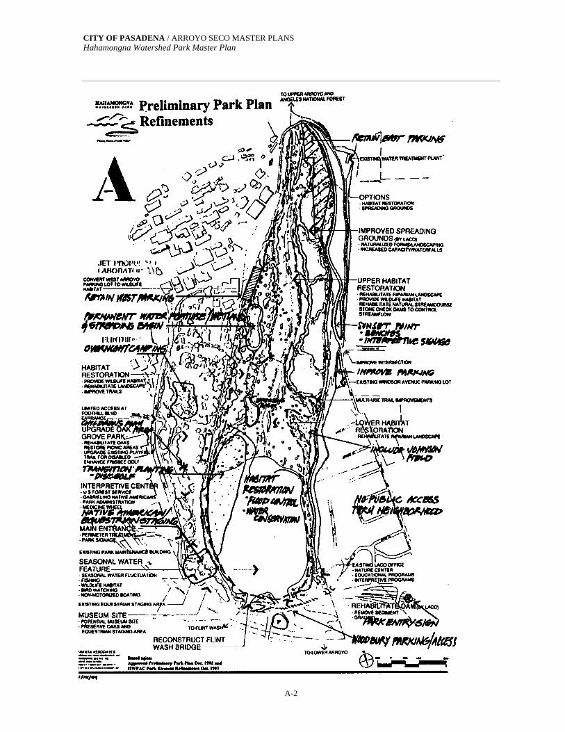
CITY OF PASADENA / ARROYO SECO MASTER PLANS Hahamongna Watershed Park Master Plan
A-2

CITY OF PASADENA / ARROYO SECO MASTER PLANS Hahamongna Watershed Park Master Plan
A-3

CITY OF PASADENA / ARROYO SECO MASTER PLANS Hahamongna Watershed Park Master Plan
A-4
A.2 DISC GOLF ALTERNATIVE In February 2000, the Hahamongna Watershed Park Master Plan was conceptually approved by the Pasadena City Council. The Council also requested the evaluation of an alternative, which would take the relocated disc golf course proposal and consider a multipurpose athletic field on that site instead. This alternative is presented on the following page.
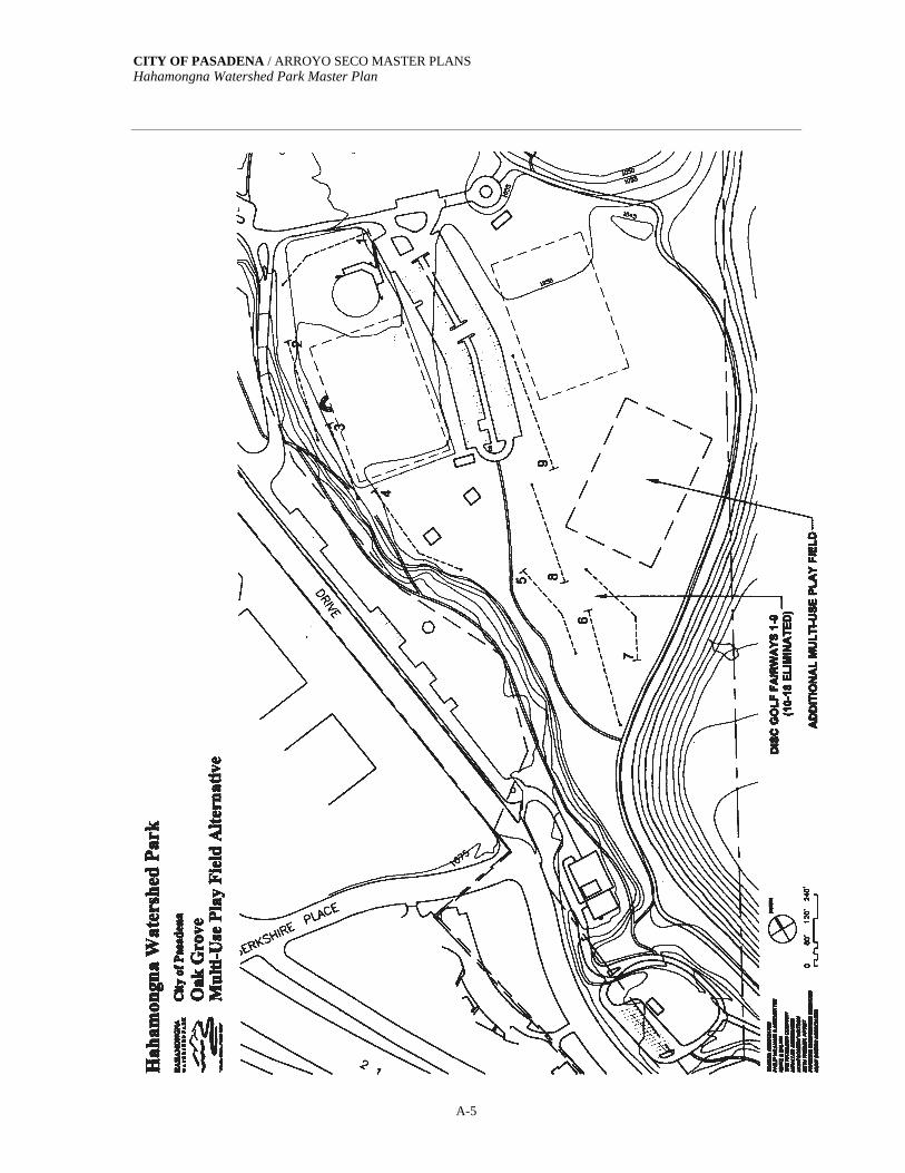
CITY OF PASADENA / ARROYO SECO MASTER PLANS Hahamongna Watershed Park Master Plan
A-5
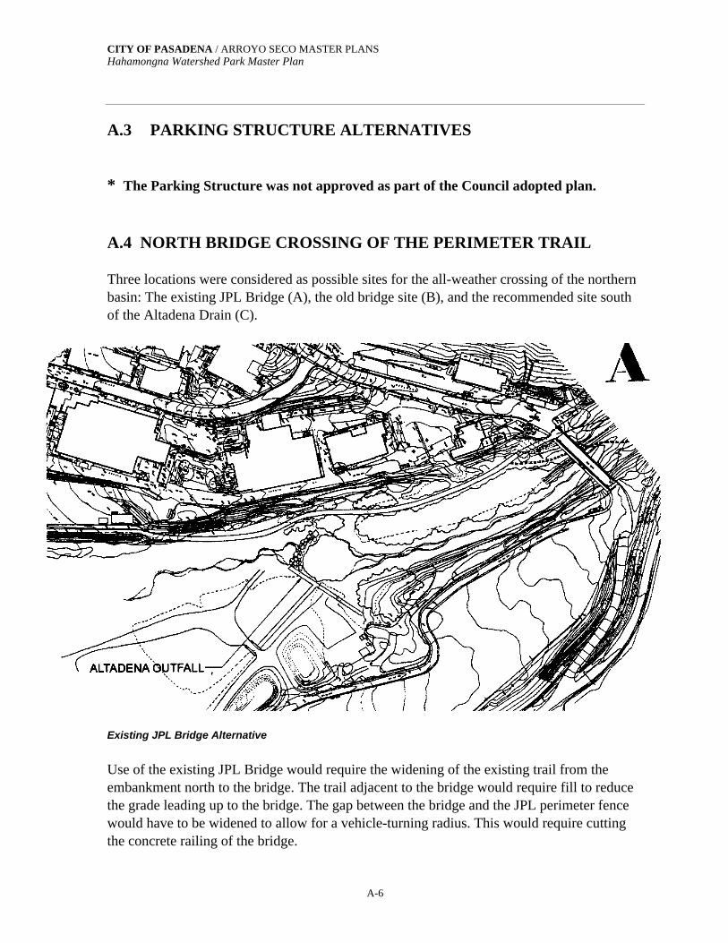
CITY OF PASADENA / ARROYO SECO MASTER PLANS Hahamongna Watershed Park Master Plan
A-6
A.3 PARKING STRUCTURE ALTERNATIVES * The Parking Structure was not approved as part of the Council adopted plan. A.4 NORTH BRIDGE CROSSING OF THE PERIMETER TRAIL Three locations were considered as possible sites for the all-weather crossing of the northern basin: The existing JPL Bridge (A), the old bridge site (B), and the recommended site south of the Altadena Drain (C).
Existing JPL Bridge Alternative
Use of the existing JPL Bridge would require the widening of the existing trail from the embankment north to the bridge. The trail adjacent to the bridge would require fill to reduce the grade leading up to the bridge. The gap between the bridge and the JPL perimeter fence would have to be widened to allow for a vehicle-turning radius. This would require cutting the concrete railing of the bridge.

CITY OF PASADENA / ARROYO SECO MASTER PLANS Hahamongna Watershed Park Master Plan
A-7
Pro Makes use of existing infrastructure by connection to the JPL Bridge Least-expense option Con Potential impact to restoration areas Internal loop requires two more locked gates Equestrians would use JPL Bridge during winter floods Could disturb sensitive EPA Monitoring Area Affects JPL security needs—fenced and gated roads & parking
Old Road Alternative
The historic crossing prior to the construction of the JPL Bridge was approximately 300• to the south. The abandoned bridge abutments are still visible. This location would require new construction and the widening of the existing trail from the west embankment north to the old abutments. Pro Makes use of available infrastructure by using existing footings Equestrians would have winter crossing

CITY OF PASADENA / ARROYO SECO MASTER PLANS Hahamongna Watershed Park Master Plan
A-8
Allows for complete internal loop Avoids Altadena Storm Drain Con Requires new bridge span Potential impact to restoration areas Cost equal to Plan C—Grading road approaches with required habitat mitigation Could disturb sensitive EPA Monitoring Area
South of the Altadena Drain – This alternative was selected and incorporated into the adopted plan. The recommended alternative crossing was for a location south of the Altadena Drain. The proposed span would cross the channel from the northern end of the embankment to the top of the existing spreading basin maintenance road. This alternative would require construction of a new bridge. Pro Avoids sensitive habitat

CITY OF PASADENA / ARROYO SECO MASTER PLANS Hahamongna Watershed Park Master Plan
A-9
Allows for complete internal loop Provides equestrians and other park users with winter crossing Overhead electric power distribution line could be relocated using a bridge conduit crossing Cost equal to Plan C—Grading road approaches with required habitat mitigation Con Close to Altadena Storm Drain Longer bridge span
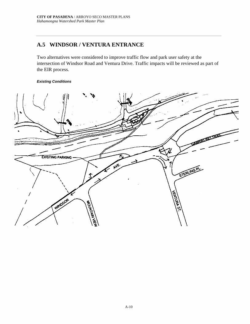
CITY OF PASADENA / ARROYO SECO MASTER PLANS Hahamongna Watershed Park Master Plan
A-10
A.5 WINDSOR / VENTURA ENTRANCE Two alternatives were considered to improve traffic flow and park user safety at the intersection of Windsor Road and Ventura Drive. Traffic impacts will be reviewed as part of the EIR process. Existing Conditions

CITY OF PASADENA / ARROYO SECO MASTER PLANS Hahamongna Watershed Park Master Plan
A-11

CITY OF PASADENA / ARROYO SECO MASTER PLANS Hahamongna Watershed Park Master Plan
A-12
Mountain View Intersection Alternative B—This alternative was selected as part of the adopted plan and will be implemented when and if conditions warrant.
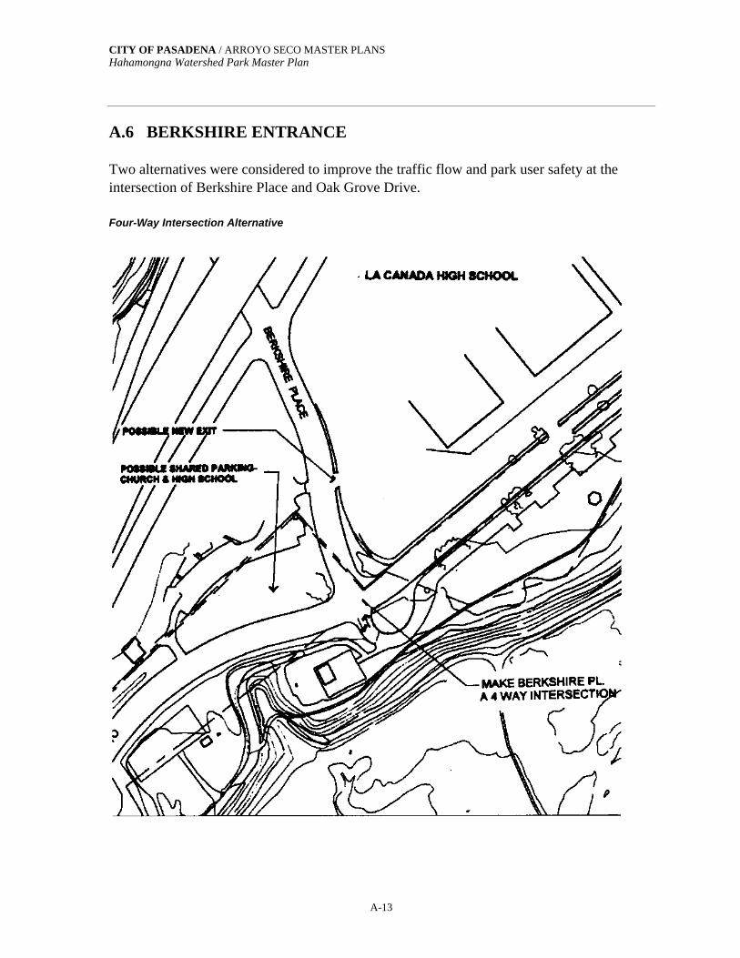
CITY OF PASADENA / ARROYO SECO MASTER PLANS Hahamongna Watershed Park Master Plan
A-13
A.6 BERKSHIRE ENTRANCE Two alternatives were considered to improve the traffic flow and park user safety at the intersection of Berkshire Place and Oak Grove Drive. Four-Way Intersection Alternative

CITY OF PASADENA / ARROYO SECO MASTER PLANS Hahamongna Watershed Park Master Plan
A-14
Entry Slip Lane Alternative ADOPTED
CITY OF PASADENA / ARROYO SECO MASTER PLANS Hahamongna Watershed Park Master Plan
A-15
A.7 DAM KEEPER’S QUARTERS An alternative to constructing the proposed public restroom as a two-story structure at the eastern end of the Devil’s Gate Dam was considered. This alternative would remodel the existing single family home currently being used as the Arroyo Resource Center. A dam keeper’s quarters above the public restroom was included in the Council adopted plan.
Appendix B

CITY OF PASADENA / ARROYO SECO MASTER PLANS Hahamongna Watershed Park Master Plan
B-1
APPENDIX B.1: BIOLOGICAL INVENTORIES VASCULAR PLANT SPECIES OBSERVED AT HAHAMONGNA WATERSHED PARK
Scientific Name1 Common Name2
DIVISION LYCOPHYTA SELAGINELLACEAE SPIKE-MOSS FAMILY Selaginella bigelovii spike-moss DIVISION PTEROPHYTA PTERIDACEAE BRAKE FAMILY Pellaea andromedifolia coffee fern POLYPODIACEAE POLYPODY FAMILY Polypodium californicum California polypody DIVISION CONIFEROPHYTA CONE-BEARING PLANTS CUPRESSACEAE CYPRESS FAMILY Calocedrus decurrens* incense cedar Cupressus arizonica* Arizona cypress Juniperus sp.* ornamental juniper PINACEAE PINE FAMILY Cedrus deodara* deodar cedar Picea sp.* spruce Pinus canariensis* Canary Island pine Pinus halepensis* Aleppo pine Pinus radiata* Monterey pine Pinus spp.* multiple pine species TAXODIACEAE BALD CYPRESS FAMILY Sequoia sempervirens* redwood DIVISION ANTHOPHYTA FLOWERING PLANTS CLASS DICOTYLEDONES DICOTS ACERACEAE MAPLE FAMILY Acer macrophyllum big-leaf maple Acer negundo box elder Acer saccharinum* silver maple AIZOACEAE FIG-MARIGOLD FAMILY Carpobrotus chilensis* ice plant, sea fig Carpobrotus edulis* ice plant AMARANTHACEAE AMARANTH FAMILY Amaranthus albus* tumbleweed Amaranthus blitoides pigweed , amaranth ANACARDIACEAE SUMAC FAMILY Malosma laurina laurel sumac Rhus integrifolia lemonadeberry Rhus ovata sugar bush Schinus molle* Peruvian pepper tree, California pepper tree Schinus terebinthifolius* Brazilian pepper tree
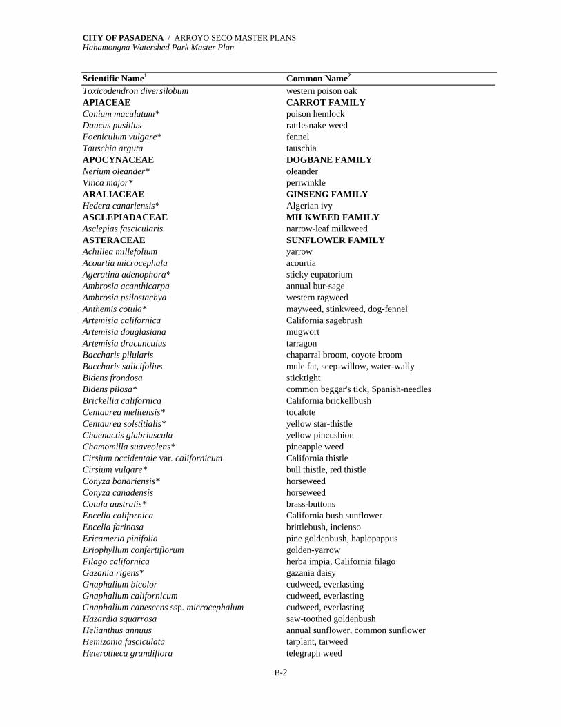
CITY OF PASADENA / ARROYO SECO MASTER PLANS Hahamongna Watershed Park Master Plan
B-2
Scientific Name1 Common Name2
Toxicodendron diversilobum western poison oak APIACEAE CARROT FAMILY Conium maculatum* poison hemlock Daucus pusillus rattlesnake weed Foeniculum vulgare* fennel Tauschia arguta tauschia APOCYNACEAE DOGBANE FAMILY Nerium oleander* oleander Vinca major* periwinkle ARALIACEAE GINSENG FAMILY Hedera canariensis* Algerian ivy ASCLEPIADACEAE MILKWEED FAMILY Asclepias fascicularis narrow-leaf milkweed ASTERACEAE SUNFLOWER FAMILY Achillea millefolium yarrow Acourtia microcephala acourtia Ageratina adenophora* sticky eupatorium Ambrosia acanthicarpa annual bur-sage Ambrosia psilostachya western ragweed Anthemis cotula* mayweed, stinkweed, dog-fennel Artemisia californica California sagebrush Artemisia douglasiana mugwort Artemisia dracunculus tarragon Baccharis pilularis chaparral broom, coyote broom Baccharis salicifolius mule fat, seep-willow, water-wally Bidens frondosa sticktight Bidens pilosa* common beggar's tick, Spanish-needles Brickellia californica California brickellbush Centaurea melitensis* tocalote Centaurea solstitialis* yellow star-thistle Chaenactis glabriuscula yellow pincushion Chamomilla suaveolens* pineapple weed Cirsium occidentale var. californicum California thistle Cirsium vulgare* bull thistle, red thistle Conyza bonariensis* horseweed Conyza canadensis horseweed Cotula australis* brass-buttons Encelia californica California bush sunflower Encelia farinosa brittlebush, incienso Ericameria pinifolia pine goldenbush, haplopappus Eriophyllum confertiflorum golden-yarrow Filago californica herba impia, California filago Gazania rigens* gazania daisy Gnaphalium bicolor cudweed, everlasting Gnaphalium californicum cudweed, everlasting Gnaphalium canescens ssp. microcephalum cudweed, everlasting Hazardia squarrosa saw-toothed goldenbush Helianthus annuus annual sunflower, common sunflower Hemizonia fasciculata tarplant, tarweed Heterotheca grandiflora telegraph weed

CITY OF PASADENA / ARROYO SECO MASTER PLANS Hahamongna Watershed Park Master Plan
B-3
Scientific Name1 Common Name2
Heterotheca villosa goldenaster Hypochaeris glabra* smooth cat's-ear Isocoma menziesii var. menziesii goldenbush Lactuca serriola* prickly lettuce Lepidospartum squamatum scale broom Lessingia filaginifolia California-aster Madia gracilis tarweed, gumweed Malacothrix saxatilis cliff-aster Microseris sp. microseris Picris echioides* bristly ox-tongue Rafinesquia californica California chicory Senecio flaccidus var. douglasii groundsel, ragwort, butterweed, bush senecio Senecio mikanioides* German ivy Sonchus asper* prickly sow thistle Sonchus oleraceus* common sow thistle Stephanomeria cichoriacea stephanomeria, Tejon milk-aster Stephanomeria virgata stephanomeria, wand chicory Taraxacum officinale* dandelion Xanthium spinosum* spiny cocklebur BETULACEAE BIRCH FAMILY Alnus rhombifolia white alder BIGNONIACEAE BIGNONIA FAMILY Catalpa speciosa* western catalpa BORAGINACEAE BORAGE FAMILY Cryptantha intermedia cryptantha Pectocarya penicillata comb-bur BRASSICACEAE MUSTARD FAMILY Arabis sp. rock cress Brassica nigra* black mustard Brassica rapa* turnip, field mustard Capsella bursa-pastoris* shepherd's purse Cardamine oligosperma bitter-cress, toothwort Cardaria draba* heart-podded hoary cress Descurainia pinnata tansy mustard Hirschfeldia incana* short-pod mustard Lepidium lasiocarpum peppergrass, pepperwort Lepidium nitidum peppergrass, pepperwort Lobularia maritima* sweet alyssum Raphanus sativus* radish Rorippa nasturtium-aquaticum water cress Sisymbrium altissimum* tumble mustard, Jim Hill mustard Sisymbrium irio* London rocket Sisymbrium orientale* hedge mustard Thysanocarpus laciniatus lacepod, fringepod BUXACEAE BOXWOOD FAMILY Buxus sempervirens* common boxwood, English boxwood CACTACEAE CACTUS FAMILY Opuntia ficus-indica* Indian-fig Opuntia littoralis coast prickly pear Opuntia ramosissima* pencil cactus, diamond cholla

CITY OF PASADENA / ARROYO SECO MASTER PLANS Hahamongna Watershed Park Master Plan
B-4
Scientific Name1 Common Name2
CAPPARACEAE CAPER FAMILY Isomeris arborea bladderpod CAPRIFOLIACEAE HONEYSUCKLE FAMILY Lonicera subspicata chaparral honeysuckle, wild honeysuckle Sambucus mexicana blue elderberry, Mexican elderberry Symphoricarpos mollis creeping snowberry, trip vine CARYOPHYLLACEAE PINK FAMILY Cerastium glomeratum* mouse-ear chickweed Polycarpon tetraphyllum* four-leaved allseed, polycarp Silene gallica* common catchfly, campion Silene laciniata ssp. major catchfly, firewheel catchfly, Indian pink, campion Spergularia sp. spurrey Stellaria media* common chickweed CHENOPODIACEAE GOOSEFOOT FAMILY Atriplex canescens* four-wing saltbush Chenopodium album* pigweed, lamb's quarters, goosefoot Chenopodium ambrosioides* Mexican tea Chenopodium botrys* Jerusalem oak Chenopodium murale* goosefoot, nettle-leaved goosefoot Salsola tragus* Russian thistle, tumbleweed CISTACEAE ROCK-ROSE FAMILY Helianthemum scoparium peak rush-rose, wild rock-rose CONVOLVULACEAE MORNING-GLORY FAMILY Calystegia macrostegia wild morning-glory CRASSULACEAE STONECROP FAMILY Crassula connata pygmy-weed Crassula argentea* jade plant Dudleya lanceolata lance-leaved liveforever CUCURBITACEAE GOURD FAMILY Cucurbita foetidissima calabazilla, wild gourd, stinking melon Marah macrocarpus wild cucumber, man-root CUSCUTACEAE DODDER FAMILY Cuscuta californica dodder, witch's hair Cuscuta sp. dodder, witch's hair EUPHORBIACEAE SPURGE FAMILY Chamaesyce albomarginata rattlesnake weed Chamaesyce maculata* spotted spurge Chamaesyce serpyllifolia thyme-leafed spurge Eremocarpus setigerus turkey mullein, dove weed Ricinus communis* castor bean FABACEAE LEGUME or PEA FAMILY Acacia baileyana* Cootamundra wattle, acacia Acacia dealbata* silver wattle, acacia Acacia decurrens green wattle, acacia Acacia longifolia* Sydney golden wattle, acacia Albizia lophantha* plume acacia, plume albizia Ceratonia siliqua* carob, St. John's bread Cytisus striatus* broom Erythrina humeana* natal coral tree Genista monspessulana* broom
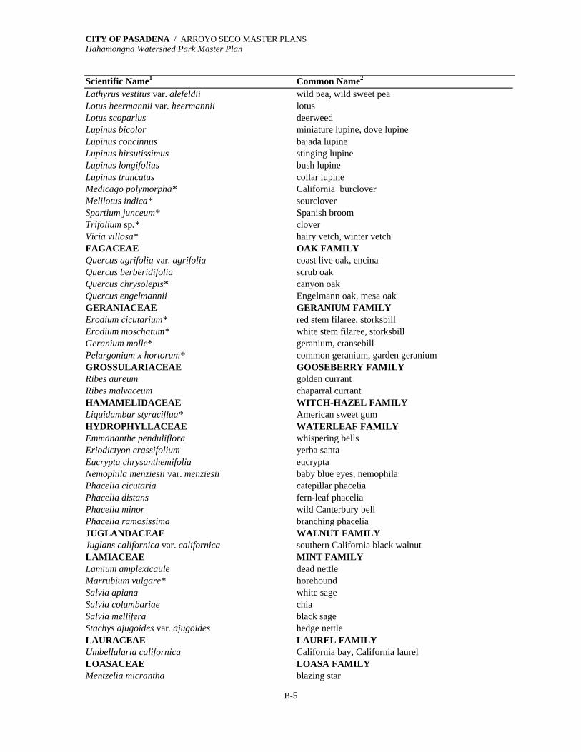
CITY OF PASADENA / ARROYO SECO MASTER PLANS Hahamongna Watershed Park Master Plan
B-5
Scientific Name1 Common Name2
Lathyrus vestitus var. alefeldii wild pea, wild sweet pea Lotus heermannii var. heermannii lotus Lotus scoparius deerweed Lupinus bicolor miniature lupine, dove lupine Lupinus concinnus bajada lupine Lupinus hirsutissimus stinging lupine Lupinus longifolius bush lupine Lupinus truncatus collar lupine Medicago polymorpha* California burclover Melilotus indica* sourclover Spartium junceum* Spanish broom Trifolium sp.* clover Vicia villosa* hairy vetch, winter vetch FAGACEAE OAK FAMILY Quercus agrifolia var. agrifolia coast live oak, encina Quercus berberidifolia scrub oak Quercus chrysolepis* canyon oak Quercus engelmannii Engelmann oak, mesa oak GERANIACEAE GERANIUM FAMILY Erodium cicutarium* red stem filaree, storksbill Erodium moschatum* white stem filaree, storksbill Geranium molle* geranium, cransebill Pelargonium x hortorum* common geranium, garden geranium GROSSULARIACEAE GOOSEBERRY FAMILY Ribes aureum golden currant Ribes malvaceum chaparral currant HAMAMELIDACEAE WITCH-HAZEL FAMILY Liquidambar styraciflua* American sweet gum HYDROPHYLLACEAE WATERLEAF FAMILY Emmananthe penduliflora whispering bells Eriodictyon crassifolium yerba santa Eucrypta chrysanthemifolia eucrypta Nemophila menziesii var. menziesii baby blue eyes, nemophila Phacelia cicutaria catepillar phacelia Phacelia distans fern-leaf phacelia Phacelia minor wild Canterbury bell Phacelia ramosissima branching phacelia JUGLANDACEAE WALNUT FAMILY Juglans californica var. californica southern California black walnut LAMIACEAE MINT FAMILY Lamium amplexicaule dead nettle Marrubium vulgare* horehound Salvia apiana white sage Salvia columbariae chia Salvia mellifera black sage Stachys ajugoides var. ajugoides hedge nettle LAURACEAE LAUREL FAMILY Umbellularia californica California bay, California laurel LOASACEAE LOASA FAMILY Mentzelia micrantha blazing star

CITY OF PASADENA / ARROYO SECO MASTER PLANS Hahamongna Watershed Park Master Plan
B-6
Scientific Name1 Common Name2
LYTHRACEAE LOOSESTRIFE FAMILY Ammannia coccinea ammannia MALVACEAE MALLOW FAMILY Malacothamnus fasciculatus chaparral mallow Malva neglecta* common mallow, cheeses Malva parviflora* cheeseweed, little mallow MORACEAE MULBERRY FAMILY Ficus carica* edible fig MYOPORACEAE MYOPORUM FAMILY Myoporum laetum* myoporum MYRTACEAE MYRTLE FAMILY Eucalyptus camaldulensis* red gum, river red gum Eucalyptus cornuta* yate tree Eucalyptus ficifolia* red-flowering gum Eucalyptus globulus* blue gum, Tasmanian blue gum Eucalyptus leucoxylon* white ironbark Eucalyptus rudis* flooded gum Eucalyptus sideroxylon* red ironbark Eucalyptus spp.* multiple eucalyptus species NYCTAGINACEAE FOUR O'CLOCK FAMILY Bougainvillea spectabilis* bougainvillea Mirabilis californica wishbone plant, wishbone bush OLEACEAE OLIVE FAMILY Fraxinus velutina velvet ash, Arizona ash Fraxinus sp.* ash Ligustrum japonicum* Japanese privet Olea europaea* olive, European olive ONAGRACEAE EVENING PRIMROSE FAMILY Camissonia bistorta California sun cup, southern sun cup, camissonia Camissonia californica sun cup, camissonia Camissonia micrantha small-flowered evening primrose, camissonia Clarkia purpurea purple clarkia Clarkia unguiculata clarkia Epilobium canum ssp. canum California fuschia, zauschneria Epilobium ciliatum ssp. ciliatum willow herb Oenothera elata ssp. hookeri Hooker's evening primrose OXALIDACEAE OXALIS FAMILY Oxalis corniculata* oxalis Oxalis pes-caprae* Bermuda buttercup PAPAVERACEAE POPPY FAMILY Dendromecon rigida bush poppy Eschscholzia californica California poppy Romneya coulteri* matilija poppy PASSIFLORACEAE PASSION FLOWER FAMILY Passiflora caerulea* blue crown passion flower PITTOSPORACEAE PITTOSPORUM FAMILY Pittosporum tobirum* tobira, Japanese pittosporum Pittosporum undulatum* Victorian box PLANTAGINACEAE PLANTAIN FAMILY Plantago erecta California plantain

CITY OF PASADENA / ARROYO SECO MASTER PLANS Hahamongna Watershed Park Master Plan
B-7
Scientific Name1 Common Name2
Plantago lanceolata* English plantain Plantago major* common plantain PLANTANACEAE SYCAMORE FAMILY Platanus racemosa western sycamore PLUMBAGINACEAE PLUMBAGO or LEADWORT FAMILY Plumbago auriculata* cape plumbago PODOCARPACEAE PODOCARPUS FAMILY Podocarpus macrophyllus* yew pine POLEMONIACEAE PHLOX FAMILY Gilia capitata gilia, blue-headed gilia Gilia sp. gilia Leptodactylon californicum prickly phlox Navarretia sp. navarretia POLYGONACEAE BUCKWHEAT FAMILY Eriogonum elongatum var. elongatum buckwheat, wand buckwheat Eriogonum fasciculatum var. foliolosum California buckwheat Eriogonum gracile var. gracile slender buckwheat Polygonum arenastrum* common knotweed, doorweed Polygonum lapathifolium willow weed Rumex crispus* curly dock PORTULACACEAE PURSLANE FAMILY Calyptridium monandrum pussypaws Portulaca oleracea* common purslane PRIMULACEAE PRIMROSE FAMILY Anagallis arvensis* scarlet pimpernel RANUNCULACEAE BUTTERCUP FAMILY Delphinium cardinale scarlet larkspur, cardinal larkspur RHAMNACEAE BUCKTHORN FAMILY Ceanothus crassifolius hoaryleaf ceanothus Ceanothus leucodermis chaparral whitethorn Ceanothus megacarpus bigpod ceanothus Ceanothus oliganthus hairy ceanothus Rhamnus californica California coffeeberry Rhamnus crocea spiny redberry Rhamnus ilicifolia holly-leaf redberry ROSACEAE ROSE FAMILY Adenostoma fasciculatum chamise Cercocarpus betuloides var. betuloides birch-leaf mountain-mahogany Cotoneaster pannosa* cotoneaster Heteromeles arbutifolia toyon, Christmas berry Prunus cerasifera var. atropurpurea* purple-leaf plum Prunus ilicifolia ssp. ilicifolia holly-leaf cherry, islay Prunus ilicifolia ssp. lyonii* Catalina cherry Pyracantha angustifolia* firethorn, pyracantha Rosa californica California rose, wild rose Rosa spp.* cultivated roses Rubus discolor* Himalayan blackberry Rubus ursinus California blackberry RUBIACEAE MADDER FAMILY Galium angustifolium narrow-leaved bedstraw, shrubby bedstraw

CITY OF PASADENA / ARROYO SECO MASTER PLANS Hahamongna Watershed Park Master Plan
B-8
Scientific Name1 Common Name2
Galium aparine goose grass, bedstraw, cleavers SALICACEAE WILLOW FAMILY Populus balsamifera ssp. trichocarpa black cottonwood Populus fremontii ssp. fremontii Fremont cottonwood, alamo Populus nigra* Lombardy poplar Salix exigua narrow-leaved willow, sandbar willow Salix gooddingii Goodding's black willow, black willow Salix laevigata red willow Salix lasiolepis arroyo willow Salix lucida ssp. lasiandra shining willow SCROPHULARIACEAE FIGWORT FAMILY Keckiella cordifolia heart-leaf penstemon Mimulus aurantiacus sticky monkeyflower, orange bush-monkeyflower Mimulus cardinalis scarlet monkeyflower Penstemon spectabilis showy penstemon, beardtongue Scrophularia californica California figwort Verbascum blattaria* moth mullein Verbascum thapsus* mullein, great mullein Veronica americana American brooklime, speedwell Veronica persica* Persian speedwell SIMAROUBACEAE QUASSIA or SIMAROUBA FAMILY Ailanthus altissima* tree of heaven SOLANACEAE NIGHTSHADE FAMILY Datura wrightii jimson weed Nicotiana glauca* tree tobacco Solanum douglasii white nightshade Solanum xanti purple nightshade TAMARICACEAE TAMARISK FAMILY Tamarix sp.* tamarisk, salt cedar ULMACEAE ELM FAMILY Ulmus parvifolia* Chinese elm, evergreen elm Ulmus pumila* Siberian elm URTICACEAE NETTLE FAMILY Urtica dioica ssp. holosericea hoary nettle VERBENACEAE VERVAIN FAMILY Lantana montevidensis* lantana Verbena lasiostachys vervain VISCACEAE MISTLETOE FAMILY Phoradendron macrophyllum bigleaf mistletoe ZYGOPHYLLACEAE CALTROP FAMILY Tribulus terrestris* puncture vine, caltrop CLASS MONOCOTYLEDONES MONOCOTS ARECACEAE PALM FAMILY Washingtonia robusta* Mexican fan palm COMMELINACEAE SPIDERWORT FAMILY Tradescantia fluminensis* wandering Jew, spiderwort CYPERACEAE SEDGE FAMILY Carex sp. sedge Cyperus esculentus nutsedge, galingale
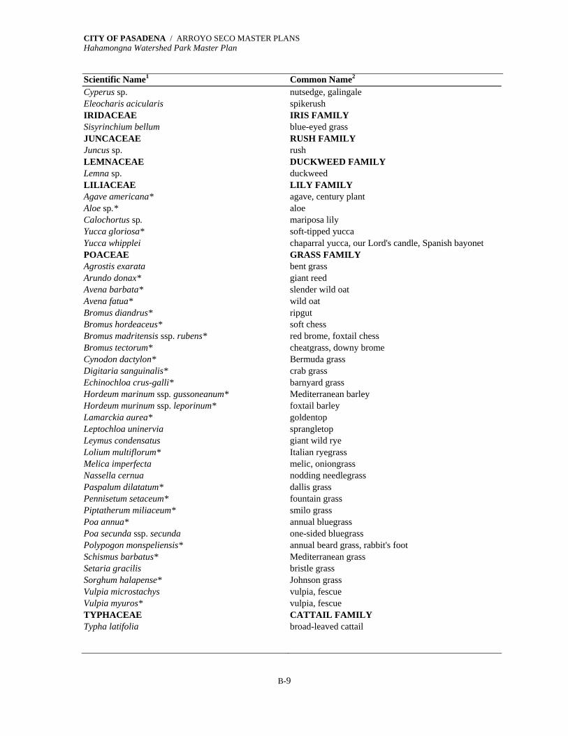
CITY OF PASADENA / ARROYO SECO MASTER PLANS Hahamongna Watershed Park Master Plan
B-9
Scientific Name1 Common Name2
Cyperus sp. nutsedge, galingale Eleocharis acicularis spikerush IRIDACEAE IRIS FAMILY Sisyrinchium bellum blue-eyed grass JUNCACEAE RUSH FAMILY Juncus sp. rush LEMNACEAE DUCKWEED FAMILY Lemna sp. duckweed LILIACEAE LILY FAMILY Agave americana* agave, century plant Aloe sp.* aloe Calochortus sp. mariposa lily Yucca gloriosa* soft-tipped yucca Yucca whipplei chaparral yucca, our Lord's candle, Spanish bayonet POACEAE GRASS FAMILY Agrostis exarata bent grass Arundo donax* giant reed Avena barbata* slender wild oat Avena fatua* wild oat Bromus diandrus* ripgut Bromus hordeaceus* soft chess Bromus madritensis ssp. rubens* red brome, foxtail chess Bromus tectorum* cheatgrass, downy brome Cynodon dactylon* Bermuda grass Digitaria sanguinalis* crab grass Echinochloa crus-galli* barnyard grass Hordeum marinum ssp. gussoneanum* Mediterranean barley Hordeum murinum ssp. leporinum* foxtail barley Lamarckia aurea* goldentop Leptochloa uninervia sprangletop Leymus condensatus giant wild rye Lolium multiflorum* Italian ryegrass Melica imperfecta melic, oniongrass Nassella cernua nodding needlegrass Paspalum dilatatum* dallis grass Pennisetum setaceum* fountain grass Piptatherum miliaceum* smilo grass Poa annua* annual bluegrass Poa secunda ssp. secunda one-sided bluegrass Polypogon monspeliensis* annual beard grass, rabbit's foot Schismus barbatus* Mediterranean grass Setaria gracilis bristle grass Sorghum halapense* Johnson grass Vulpia microstachys vulpia, fescue Vulpia myuros* vulpia, fescue TYPHACEAE CATTAIL FAMILY Typha latifolia broad-leaved cattail

CITY OF PASADENA / ARROYO SECO MASTER PLANS Hahamongna Watershed Park Master Plan
B-10
*Indicates species that are Introduced or Not Native to California and/or the area of California in which Hahamongna Watershed Park is located. 1 Scientific nomenclature follows that of Hickman (1993), Munz (1959, 1968, and 1974), Bailey (1949) Sunset (1995), and Muns (1986). 2 Common names may vary by author and/or regionally in their usage.
This is not intended as an exhaustive listing of the vegetation occurring on the site or surrounding area; some species, particularly annual herbs or very uncommon species may not have been detected during the field surveys.
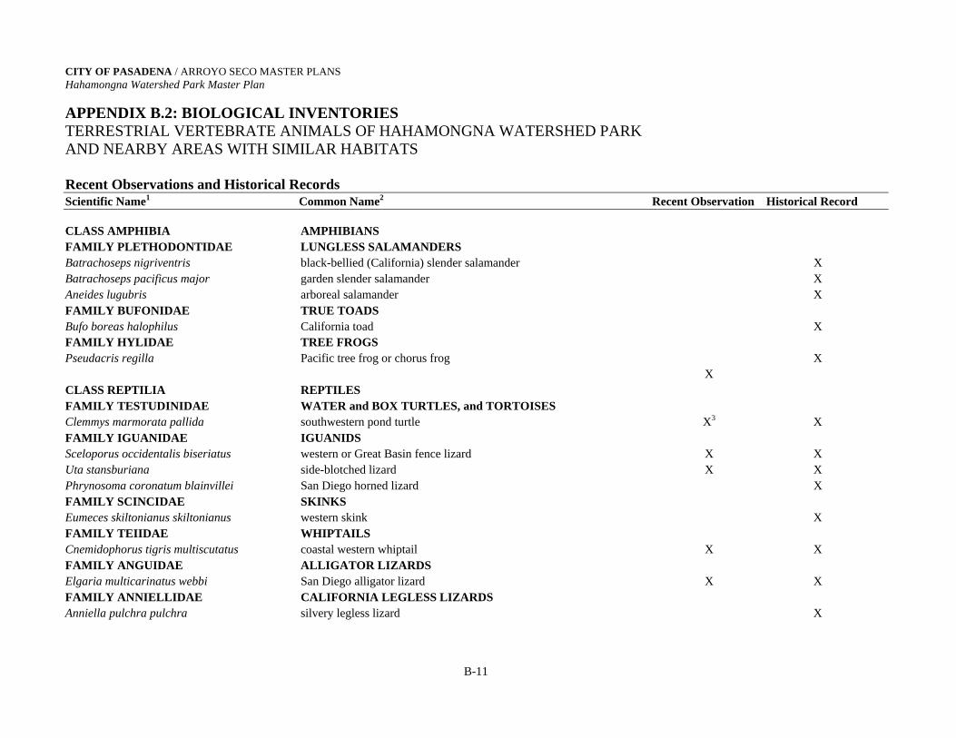
CITY OF PASADENA / ARROYO SECO MASTER PLANS Hahamongna Watershed Park Master Plan
APPENDIX B.2: BIOLOGICAL INVENTORIES
TERRESTRIAL VERTEBRATE ANIMALS OF HAHAMONGNA WATERSHED PARK AND NEARBY AREAS WITH SIMILAR HABITATS Recent Observations and Historical Records Scientific Name1 Common Name2 Recent Observation Historical Record
B-11
CLASS AMPHIBIA AMPHIBIANS FAMILY PLETHODONTIDAE LUNGLESS SALAMANDERS Batrachoseps nigriventris black-bellied (California) slender salamander X Batrachoseps pacificus major garden slender salamander X Aneides lugubris arboreal salamander X FAMILY BUFONIDAE TRUE TOADS Bufo boreas halophilus California toad X FAMILY HYLIDAE TREE FROGS Pseudacris regilla Pacific tree frog or chorus frog X X CLASS REPTILIA REPTILES FAMILY TESTUDINIDAE WATER and BOX TURTLES, and TORTOISES Clemmys marmorata pallida southwestern pond turtle X3 X FAMILY IGUANIDAE IGUANIDS Sceloporus occidentalis biseriatus western or Great Basin fence lizard X X Uta stansburiana side-blotched lizard X X Phrynosoma coronatum blainvillei San Diego horned lizard X FAMILY SCINCIDAE SKINKS Eumeces skiltonianus skiltonianus western skink X FAMILY TEIIDAE WHIPTAILS Cnemidophorus tigris multiscutatus coastal western whiptail X X FAMILY ANGUIDAE ALLIGATOR LIZARDS Elgaria multicarinatus webbi San Diego alligator lizard X X FAMILY ANNIELLIDAE CALIFORNIA LEGLESS LIZARDS Anniella pulchra pulchra silvery legless lizard X
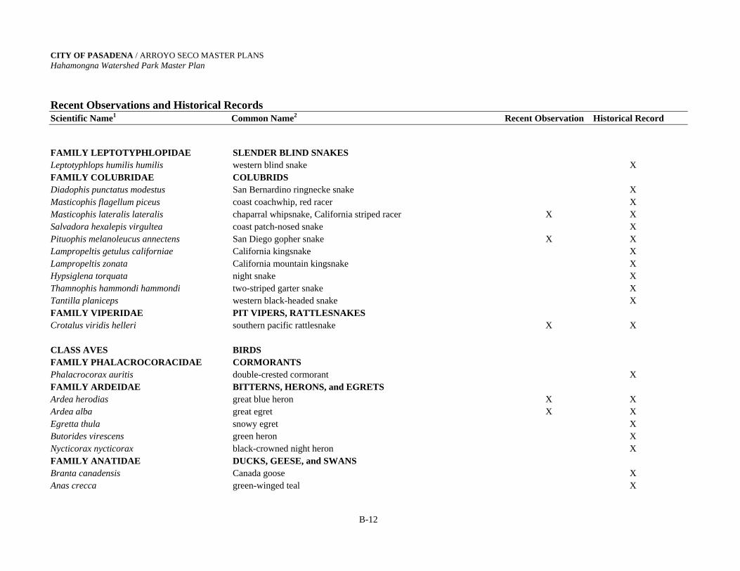
CITY OF PASADENA / ARROYO SECO MASTER PLANS Hahamongna Watershed Park Master Plan Recent Observations and Historical Records Scientific Name1 Common Name2 Recent Observation Historical Record
B-12
FAMILY LEPTOTYPHLOPIDAE SLENDER BLIND SNAKES Leptotyphlops humilis humilis western blind snake X FAMILY COLUBRIDAE COLUBRIDS Diadophis punctatus modestus San Bernardino ringnecke snake X Masticophis flagellum piceus coast coachwhip, red racer X Masticophis lateralis lateralis chaparral whipsnake, California striped racer X X Salvadora hexalepis virgultea coast patch-nosed snake X Pituophis melanoleucus annectens San Diego gopher snake X X Lampropeltis getulus californiae California kingsnake X Lampropeltis zonata California mountain kingsnake X Hypsiglena torquata night snake X Thamnophis hammondi hammondi two-striped garter snake X Tantilla planiceps western black-headed snake X FAMILY VIPERIDAE PIT VIPERS, RATTLESNAKES Crotalus viridis helleri southern pacific rattlesnake X X CLASS AVES BIRDS FAMILY PHALACROCORACIDAE CORMORANTS Phalacrocorax auritis double-crested cormorant X FAMILY ARDEIDAE BITTERNS, HERONS, and EGRETS Ardea herodias great blue heron X X Ardea alba great egret X X Egretta thula snowy egret X Butorides virescens green heron X Nycticorax nycticorax black-crowned night heron X FAMILY ANATIDAE DUCKS, GEESE, and SWANS Branta canadensis Canada goose X Anas crecca green-winged teal X

CITY OF PASADENA / ARROYO SECO MASTER PLANS Hahamongna Watershed Park Master Plan Recent Observations and Historical Records Scientific Name1 Common Name2 Recent Observation Historical Record
B-13
Anas platyrhynchos mallard X X Anas acuta northern pintail X Anas cyanoptera cinnamon teal X X Anas strepera gadwall X Anas americana American wigeon X X Aythya valisineria canvasback X Aythya americana redhead X Aythya collaris ring-necked duck X X Aythya affinis lesser scaup X Bucelphala albeola bufflehead X Oxyura jamaicensis ruddy duck X X FAMILY CATHARTIDAE VULTURES and CONDORS Cathartes aura turkey vulture X X FAMILY ACCIPITRIDAE KITES, HARRIERS, HAWKS, and EAGLES Pandion haliaetus osprey X Elanus leucurus white-tailed kite X Circus cyaneus northern harrier X Accipiter striatus sharp-shinned hawk X X Accipiter cooperii Cooper's hawk X X Buteo lineatus red-shouldered hawk X X Buteo jamaicensis red-tailed hawk X X Aquila chrysaetos golden eagle X FAMILY FALCONIDAE FALCONS Falco sparverius American kestrel X X Falco columbarius merlin X Falco mexicanus prairie falcon X FAMILY PHASIANIDAE TURKEYS, PHEASANTS, GROUSE, and QUAIL Callipepla californica California quail X X Oreortyx pictus mountain quail X

CITY OF PASADENA / ARROYO SECO MASTER PLANS Hahamongna Watershed Park Master Plan Recent Observations and Historical Records Scientific Name1 Common Name2 Recent Observation Historical Record
B-14
FAMILY RALLIDAE RAILS, SORAS, and COOTS Porzana carolina sora X Fulica americana American coot X X FAMILY RECURVIROSTRIDAE STILTS and AVOCETS Himantopus mexicanus black-necked stilt X Recurvirostra americana American avocet X FAMILY CHARADRIIDAE PLOVERS and SANDPIPERS Charadrius vociferus killdeer X X Tringa melanoleuca greater yellowlegs X X Actitis macularia spotted sandpiper X Calidris mauri western sandpiper X Calidris minutilla least sandpiper X Gallinago gallinago common snipe X FAMILY LARIDAE SKUAS, GULLS, TERNS, and SKIMMERS Larus delawarensis ring-billed gull X Larus californicus California gull X X FAMILY COLUMBIDAE PIGEONS and DOVES Columba livia rock dove X X Columba fasciata band-tailed pigeon X X Streptopeilia chinensis spotted dove X X Zenaida macroura mourning dove X X FAMILY CUCULIDAE CUCKOOS, ROADRUNNERS, and ANIS Geococcyx californianus greater roadrunner X FAMILY TYTONIDAE BARN OWLS Tyto alba barn owl X FAMILY STRIGIDAE TRUE OWLS Otus kennicottii western screech owl X Bubo virginianus great horned owl X X

CITY OF PASADENA / ARROYO SECO MASTER PLANS Hahamongna Watershed Park Master Plan Recent Observations and Historical Records Scientific Name1 Common Name2 Recent Observation Historical Record
B-15
Glaucidium gnoma northern pygmy owl X FAMILY CAPRIMULGIDAE POORWILL Phalaenoptilus nuttallii common poorwill X FAMILY APODIDAE SWIFTS Chaetura vauxi Vaux’s swift X Aeronautes saxatalis white-throated swift X X FAMILY TROCHILIDAE HUMMINGBIRDS Archilochus alexandri black-chinned hummingbird X Calypte anna Anna's hummingbird X X Calypte costae Costa’s hummingbird X Selasphorus sasin Allen's hummingbird X X FAMILY ALCEDINIDAE KINGFISHERS Ceryle alcyon belted kingfisher X X FAMILY PICIDAE WOODPECKERS Melanerpes lewis LewisÒs woodpecker X Melanerpes formicivorus acorn woodpecker X X Sphyrapicus nuchalis red-naped sapsucker X Sphyrapicus ruber red-breasted sapsucker X X Picoides nuttallii Nuttall's woodpecker X X Picoides pubescens downy woodpecker X X Picoides villosus hairy woodpecker X Picoides albolarvatus white-headed woodpecker X Colaptes auratus northern (red-shafted) flicker X X FAMILY TYRANNIDAE TYRANT FLYCATCHERS and KINGBIRDS Contopus borealis olive-sided flycatcher X Contopus sordidulus western wood peewee X X Empidonax trailli willow flycatcher X Empidonax difficilis Pacific-slope flycatcher X X Empidonax wrightii gray flycatcher X

CITY OF PASADENA / ARROYO SECO MASTER PLANS Hahamongna Watershed Park Master Plan Recent Observations and Historical Records Scientific Name1 Common Name2 Recent Observation Historical Record
B-16
Sayornis nigricans black phoebe X X Sayornis phoebe eastern phoebe X Sayornis saya Say's phoebe X X Myiarchus cinerascens ash-throated flycatcher X Tyrannus vociferans Cassin's kingbird X Tyrannus verticalis western kingbird X X FAMILY ALAUDIDAE LARKS Eremophila alpestris horned lark X FAMILY HIRUNDINIDAE SWALLOWS Progne subis purple martin X Tachycineta bicolor tree swallow X Tachycineta thalassina violet-green swallow X Stelgidopteryx serripennis northern rough winged swallow X Hirundo pyrrhonota cliff swallow X X Hirundo rustica barn swallow X X FAMILY CORVIDAE CROWS and JAYS Cyanocitta stelleri Steller’s jay X Amphelocoma californica western scrub jay X X Corvus brachyrhynchos American crow X X Corvus corax common raven X X FAMILY PARIDAE CHICKADEES and TITMICE Parus gambeli mountain chickadee X Parus inornatus plain titmouse X X FAMILY AEGITHALIDAE BUSHTITS Psaltriparus minimus bushtit X X FAMILY SITTIDAE NUTHATCHES Sitta canadensis red-breasted nuthatch X X Sitta carolinensis white-breasted nuthatch X Sitta pygmaea pygmy nuthatch X

CITY OF PASADENA / ARROYO SECO MASTER PLANS Hahamongna Watershed Park Master Plan Recent Observations and Historical Records Scientific Name1 Common Name2 Recent Observation Historical Record
B-17
FAMILY CERTHIIDAE CREEPERS Certhia americana brown creeper X FAMILY TROGLODYTIDAE WRENS Campylorhynchus brunneicapillus cactus wren X Salpinctes obsoletus rock wren X X Catherpes mexicanus canyon wren X Thryomanes bewickii Bewick's wren X X Troglogytes aedon house wren X X Cistothorus palustris marsh wren X FAMILY CINCLIDAE DIPPERS Cinclus mexicanus American dipper X FAMILY MUSCICAPIDAE KINGLETS, GNATCATCHERS, and THRUSHES Regulus satrapa golden-crowned kinglet X Regulus calendula ruby-crowned kinglet X X Polioptila caerulea blue-gray gnatcatcher X X Sialia mexicana western bluebird X Myadestes townsendi Townsend’s solitaire X Catharus ustulatus Swainson’s thrush X Catharus guttatus hermit thrush X X Turdus migratorius American robin X X Ixoreus naevius varied thrush X Chamaea fasciata wrentit X X FAMILY MIMIDAE MOCKINGBIRDS and THRASHER Mimus polyglottos northern mockingbird X X Toxostoma redivivum California thrasher X X FAMILY MOTACILLIDAE PIPITS Anthus rubescens American pipit X FAMILY BOMBYCILLIDAE WAXWINGS Bombycilla cedrorum cedar waxwing X X
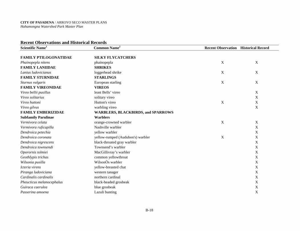
CITY OF PASADENA / ARROYO SECO MASTER PLANS Hahamongna Watershed Park Master Plan Recent Observations and Historical Records Scientific Name1 Common Name2 Recent Observation Historical Record
B-18
FAMILY PTILOGONATIDAE SILKY FLYCATCHERS Phainopepla nitens phainopepla X X FAMILY LANIIDAE SHRIKES Lanius ludovicianus loggerhead shrike X X FAMILY STURNIDAE STARLINGS Sturnus vulgaris European starling X X FAMILY VIREONIDAE VIREOS Vireo bellii pusillus least Bells’ vireo X Vireo solitarius solitary vireo X Vireo huttoni Hutton's vireo X X Vireo gilvus warbling vireo X FAMILY EMBERIZIDAE WARBLERS, BLACKBIRDS, and SPARROWS Subfamily Parulinae Warblers Vermivora celata orange-crowned warbler X X Vermivora ruficapilla Nashville warbler X Dendroica petechia yellow warbler X Dendroica coronata yellow-rumped (Audubon's) warbler X X Dendroica nigrescens black-throated gray warbler X Dendroica townsendi Townsend’s warbler X Oporornis tolmiei MacGillivray’s warbler X Geothlypis trichas common yellowthroat X Wilsonia pusilla WilsonÒs warbler X Icteria virens yellow-breasted chat X Piranga ludoviciana western tanager X Cardinalis cardinalis northern cardinal X Pheucticus melanocephalus black-headed grosbeak X Guiraca caerulea blue grosbeak X Passerina amoena Lazuli bunting X
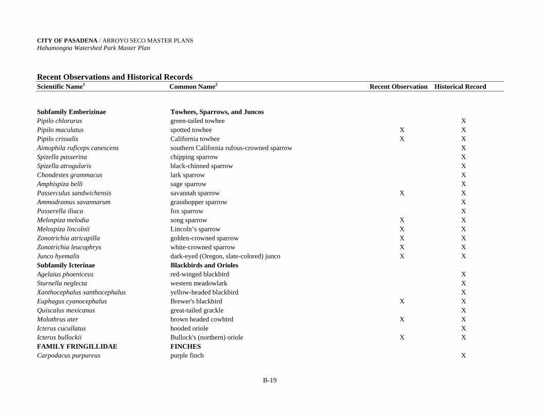
CITY OF PASADENA / ARROYO SECO MASTER PLANS Hahamongna Watershed Park Master Plan Recent Observations and Historical Records Scientific Name1 Common Name2 Recent Observation Historical Record
B-19
Subfamily Emberizinae Towhees, Sparrows, and Juncos Pipilo chlorurus green-tailed towhee X Pipilo maculatus spotted towhee X X Pipilo crissalis California towhee X X Aimophila ruficeps canescens southern California rufous-crowned sparrow X Spizella passerina chipping sparrow X Spizella atrogularis black-chinned sparrow X Chondestes grammacus lark sparrow X Amphispiza belli sage sparrow X Passerculus sandwichensis savannah sparrow X X Ammodramus savannarum grasshopper sparrow X Passerella iliaca fox sparrow X Melospiza melodia song sparrow X X Melospiza lincolnii Lincoln’s sparrow X X Zonotrichia atricapilla golden-crowned sparrow X X Zonotrichia leucophrys white-crowned sparrow X X Junco hyemalis dark-eyed (Oregon, slate-colored) junco X X Subfamily Icterinae Blackbirds and Orioles Agelaius phoeniceus red-winged blackbird X Sturnella neglecta western meadowlark X Xanthocephalus xanthocephalus yellow-headed blackbird X Euphagus cyanocephalus Brewer's blackbird X X Quiscalus mexicanus great-tailed grackle X Molothrus ater brown headed cowbird X X Icterus cucullatus hooded oriole X Icterus bullockii Bullock's (northern) oriole X X FAMILY FRINGILLIDAE FINCHES Carpodacus purpureus purple finch X

CITY OF PASADENA / ARROYO SECO MASTER PLANS Hahamongna Watershed Park Master Plan Recent Observations and Historical Records Scientific Name1 Common Name2 Recent Observation Historical Record
B-20
Carpodacus mexicanus house finch X X Carduelis pinis pine siskin X Carduelis psaltria lesser goldfinch X X Carduelis lawrencei Lawrence’s goldfinch X Carduelis tristis American goldfinch X X FAMILY PASSERIDAE WEAVER FINCHES Passer domesticus house sparrow X X MAMMALIA MAMMALS FAMILY DIDELPHIIDAE OPOSSUMS Didelphis virginiensis virginiensis Virginia opossum X X FAMILY SORICIDAE SHREWs Sorex ornatus ornatus ornate shrew X FAMILY TALPIDAE MOLES Scapanus latimanus occultus broad-handed mole, California mole X FAMILY PHYLLOSTOMIDAE LEAF-NOSED BATS Macrotus californicus California leaf-nosed bat X FAMILY VESPERTILIONIDAE PLAIN-NOSED BATS Myotis yumanensis sociabilis Yuma myotis X Myotis evotis evotis long-eared myotis X Myotis volans interior long-legged myotis X Myotis californicus californicus California myotis X Pipistrellus hesperus hesperus western pipistrel X Eptesicus fuscus bernardinus big brown bat X Lasiurus cinereus cinereus hoary bat X Lasiurus borealis teliotis red bat X Corynorhinus townsendi pallescens pale (western) big-eared bat X Antrozous pallidus pacificus pallid bat X
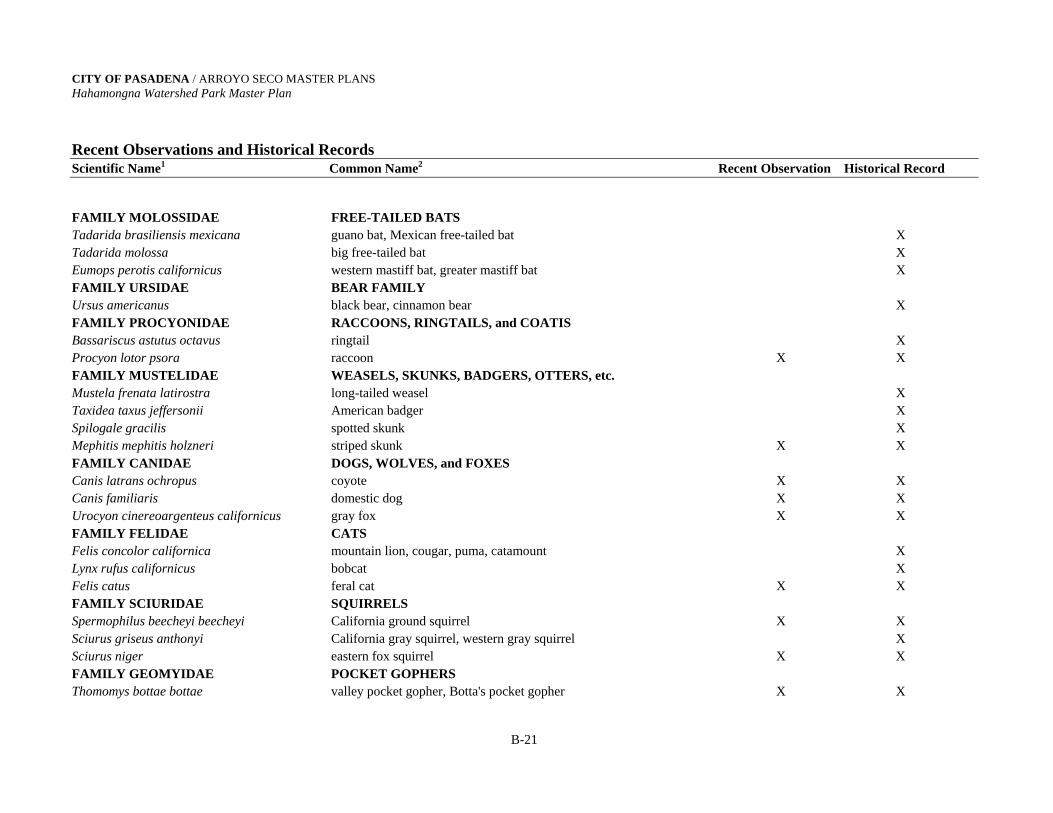
CITY OF PASADENA / ARROYO SECO MASTER PLANS Hahamongna Watershed Park Master Plan Recent Observations and Historical Records Scientific Name1 Common Name2 Recent Observation Historical Record
B-21
FAMILY MOLOSSIDAE FREE-TAILED BATS Tadarida brasiliensis mexicana guano bat, Mexican free-tailed bat X Tadarida molossa big free-tailed bat X Eumops perotis californicus western mastiff bat, greater mastiff bat X FAMILY URSIDAE BEAR FAMILY Ursus americanus black bear, cinnamon bear X FAMILY PROCYONIDAE RACCOONS, RINGTAILS, and COATIS Bassariscus astutus octavus ringtail X Procyon lotor psora raccoon X X FAMILY MUSTELIDAE WEASELS, SKUNKS, BADGERS, OTTERS, etc. Mustela frenata latirostra long-tailed weasel X Taxidea taxus jeffersonii American badger X Spilogale gracilis spotted skunk X Mephitis mephitis holzneri striped skunk X X FAMILY CANIDAE DOGS, WOLVES, and FOXES Canis latrans ochropus coyote X X Canis familiaris domestic dog X X Urocyon cinereoargenteus californicus gray fox X X FAMILY FELIDAE CATS Felis concolor californica mountain lion, cougar, puma, catamount X Lynx rufus californicus bobcat X Felis catus feral cat X X FAMILY SCIURIDAE SQUIRRELS Spermophilus beecheyi beecheyi California ground squirrel X X Sciurus griseus anthonyi California gray squirrel, western gray squirrel X Sciurus niger eastern fox squirrel X X FAMILY GEOMYIDAE POCKET GOPHERS Thomomys bottae bottae valley pocket gopher, Botta's pocket gopher X X
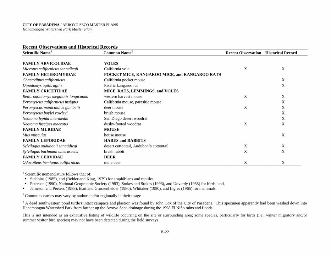
CITY OF PASADENA / ARROYO SECO MASTER PLANS Hahamongna Watershed Park Master Plan Recent Observations and Historical Records Scientific Name1 Common Name2 Recent Observation Historical Record
B-22
FAMILY ARVICOLIDAE VOLES Microtus californicus sanctdiegii California vole X X FAMILY HETEROMYIDAE POCKET MICE, KANGAROO MICE, and KANGAROO RATS Chaetodipus californicus California pocket mouse X Dipodomys agilis agilis Pacific kangaroo rat X FAMILY CRICETIDAE MICE, RATS, LEMMINGS, and VOLES Reithrodontomys megalotis longicauda western harvest mouse X X Peromyscus californicus insignis California mouse, parasitic mouse X Peromyscus maniculatus gambelii deer mouse X X Peromyscus boylei rowleyi brush mouse X Neotoma lepida intermedia San Diego desert woodrat X Neotoma fuscipes macrotis dusky-footed woodrat X X FAMILY MURIDAE MOUSE Mus musculus house mouse X FAMILY LEPORIDAE HARES and RABBITS Sylvilagus audubonii sanctidiegi desert cottontail, Audubon’s cottontail X X Sylvilagus bachmani cinerascens brush rabbit X X FAMILY CERVIDAE DEER Odocoileus hemionus californicus mule deer X X
1 Scientific nomenclature follows that of: Stebbins (1985), and (Behler and King, 1979) for amphibians and reptiles; Peterson (1990), National Geographic Society (1983), Stokes and Stokes (1996), and Udvardy (1988) for birds; and,
Jameson and Peeters (1988), Burt and Grossenheider (1980), Whitaker (1980), and Ingles (1965) for mammals. 2 Commons names may vary by author and/or regionally in their usage. 3 A dead southwestern pond turtle's intact carapace and plastron was found by John Cox of the City of Pasadena. This specimen apparently had been washed down into Hahamongna Watershed Park from farther up the Arroyo Seco drainage during the 1998 El Niño rains and floods.
This is not intended as an exhaustive listing of wildlife occurring on the site or surrounding area; some species, particularly for birds (i.e., winter migratory and/or summer visitor bird species) may not have been detected during the field surveys.
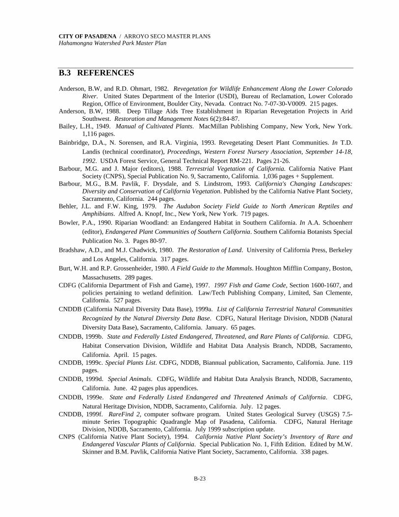
CITY OF PASADENA / ARROYO SECO MASTER PLANS Hahamongna Watershed Park Master Plan
B-23
B.3 REFERENCES Anderson, B.W, and R.D. Ohmart, 1982. Revegetation for Wildlife Enhancement Along the Lower Colorado
River. United States Department of the Interior (USDI), Bureau of Reclamation, Lower Colorado Region, Office of Environment, Boulder City, Nevada. Contract No. 7-07-30-V0009. 215 pages.
Anderson, B.W, 1988. Deep Tillage Aids Tree Establishment in Riparian Revegetation Projects in Arid Southwest. Restoration and Management Notes 6(2):84-87.
Bailey, L.H., 1949. Manual of Cultivated Plants. MacMillan Publishing Company, New York, New York. 1,116 pages.
Bainbridge, D.A., N. Sorensen, and R.A. Virginia, 1993. Revegetating Desert Plant Communities. In T.D. Landis (technical coordinator), Proceedings, Western Forest Nursery Association, September 14-18, 1992. USDA Forest Service, General Technical Report RM-221. Pages 21-26.
Barbour, M.G. and J. Major (editors), 1988. Terrestrial Vegetation of California. California Native Plant Society (CNPS), Special Publication No. 9, Sacramento, California. 1,036 pages + Supplement.
Barbour, M.G., B.M. Pavlik, F. Drysdale, and S. Lindstrom, 1993. California's Changing Landscapes: Diversity and Conservation of California Vegetation. Published by the California Native Plant Society, Sacramento, California. 244 pages.
Behler, J.L. and F.W. King, 1979. The Audubon Society Field Guide to North American Reptiles and Amphibians. Alfred A. Knopf, Inc., New York, New York. 719 pages.
Bowler, P.A., 1990. Riparian Woodland: an Endangered Habitat in Southern California. In A.A. Schoenherr (editor), Endangered Plant Communities of Southern California. Southern California Botanists Special Publication No. 3. Pages 80-97.
Bradshaw, A.D., and M.J. Chadwick, 1980. The Restoration of Land. University of California Press, Berkeley and Los Angeles, California. 317 pages.
Burt, W.H. and R.P. Grossenheider, 1980. A Field Guide to the Mammals. Houghton Mifflin Company, Boston, Massachusetts. 289 pages.
CDFG (California Department of Fish and Game), 1997. 1997 Fish and Game Code, Section 1600-1607, and policies pertaining to wetland definition. Law/Tech Publishing Company, Limited, San Clemente, California. 527 pages.
CNDDB (California Natural Diversity Data Base), 1999a. List of California Terrestrial Natural Communities Recognized by the Natural Diversity Data Base. CDFG, Natural Heritage Division, NDDB (Natural Diversity Data Base), Sacramento, California. January. 65 pages.
CNDDB, 1999b. State and Federally Listed Endangered, Threatened, and Rare Plants of California. CDFG, Habitat Conservation Division, Wildlife and Habitat Data Analysis Branch, NDDB, Sacramento, California. April. 15 pages.
CNDDB, 1999c. Special Plants List. CDFG, NDDB, Biannual publication, Sacramento, California. June. 119 pages.
CNDDB, 1999d. Special Animals. CDFG, Wildlife and Habitat Data Analysis Branch, NDDB, Sacramento, California. June. 42 pages plus appendices.
CNDDB, 1999e. State and Federally Listed Endangered and Threatened Animals of California. CDFG, Natural Heritage Division, NDDB, Sacramento, California. July. 12 pages.
CNDDB, 1999f. RareFind 2, computer software program. United States Geological Survey (USGS) 7.5-minute Series Topographic Quadrangle Map of Pasadena, California. CDFG, Natural Heritage Division, NDDB, Sacramento, California. July 1999 subscription update.
CNPS (California Native Plant Society), 1994. California Native Plant Society’s Inventory of Rare and Endangered Vascular Plants of California. Special Publication No. 1, Fifth Edition. Edited by M.W. Skinner and B.M. Pavlik, California Native Plant Society, Sacramento, California. 338 pages.
CITY OF PASADENA / ARROYO SECO MASTER PLANS Hahamongna Watershed Park Master Plan
B-24
City of Pasadena, 1996. Draft Master Plan for the Lower Arroyo Seco, City of Pasadena. Prepared by the City of Pasadena Department of Recreation and Parks, and the City of Pasadena Department of Public Works and Transportation. 65 pages plus appendices.
COE (US Army Corps of Engineers), 1987. Corps of Engineers Wetlands Delineation Manual. Technical Report Y-87-1. Environmental Laboratory, U.S. Army Corps of Engineers, Waterways Experiment Station, Vicksburg, MS. 169 pages.
COE, 1994. Regulatory Program of the U.S. Army Corps of Engineers, Section 401 and Section 404 of the Clean Water Act of 1972 and 1994 (as amended). The Code of Federal Regulations, January 24, 1994).
Conrad, C.E., 1987. Common Shrubs of Chaparral and Associated Ecosystems of Southern California. General Technical Report PSW-99, Pacific Southwest Forest and Range Experiment Station, USDA Forest Service, Berkeley, California. 86 pages.
Cotton/Beland Associates, Inc., 1988. Devil's Gate Multi-Use Project, Environmental Assessment Baseline Studies. Prepared for the City of Pasadena Water and Power Department.
Cowardin, L.M., V. Carter, F. Golet, and E.T. LaRoe, 1979. Classification of Wetlands and Deepwater Habitats of the United States. U.S. Fish and Wildlife Service report, FWS/OBS 79/31. 103 pages.
Cox, J., 1999. Employee with City of Pasadena Public Works and Transportation Department, Parks and Natural Resources Division. Personal communication with Jim Eckert, Parsons ES biologist, July.
Faber, P.A., E. Keller, A. Sands, and B.M. Massey, 1989. The Ecology of Riparian Habitats of the Southern California Coastal Region: a Community Profile. Prepared for the U.S. Fish and Wildlife Service, Biological Report 85(7.27), Washington, D.C. 152 pages.
Federal Register, 1980. "40 CFR Part 230: Section 404(b) (1) Guidelines for Specification of Disposal Sites for Dredged or Fill Material," Volume 45, Number 249, pages 85352-85353, U.S. Government Printing Office, Washington, D.C.
Federal Register, 1982. "Title 33: Navigation and Navigable Waters; Chapter II, Regulatory Programs of the Corps of Engineers," Volume 47, Number 138, page 31810, U.S. Government Printing Office, Washington, D.C.
Garrett, K. and J. Dunn, 1981. Birds of Southern California: Status and Distribution. Los Angeles Audubon Society, Los Angeles, California.
Griffin, J.R., 1988. Oak Woodland. In M.G. Barbour and J. Major (editors), Terrestrial Vegetation of California. California Native Plant Society (CNPS), Special Publication No. 9, Sacramento, California. Pages 383-415.
Hanes, T.L.,1988. California Chaparral. In M.G. Barbour and J. Major (editors), Terrestrial Vegetation of California. California Native Plant Society (CNPS), Special Publication No. 9, Sacramento, California. Pages 417-469.
Hickman, J.C. (editor), 1993. The Jepson Manual: Higher Plants of California. University of California Press, Berkeley and Los Angeles, California. 1,400 pages.
Holland, R.F., 1986. Preliminary Descriptions of the Terrestrial Natural Communities of California. Nongame Heritage Program. California Department of Fish and Game, Sacramento, California. 156 pages.
Ingles, L.G., 1965. Mammals of the Pacific States. Stanford University Press, Stanford, California. 506 pages. Jameson, E.W. and H.J. Peeters, 1988. California Mammals. University of California Press, Berkeley and Los
Angeles, California. 403 pages. Keeley, J.E. and S.C. Keeley, 1988. Chaparral. In M.G. Barbour and W.D. Billings (editors), North American
Terrestrial Vegetation. Cambridge University Press, Cambridge, England. Pages 165-207. Koebig & Koebig, Inc., 1974. Phase Two Master Improvement Plan: Upper Arroyo Seco. 32 pages plus
appendices. Koler, J.A., 1993. A Survey of the Mammals and Birds of the Lower Arroyo Seco Park, Pasadena, California.
Master of Science thesis, California State University, Los Angeles. 56 pages.

CITY OF PASADENA / ARROYO SECO MASTER PLANS Hahamongna Watershed Park Master Plan
B-25
LACDPW (Los Angeles County Department of Public Works, Hydraulic/Water Conservation Division), 1995. Final Negative Declaration for the Devil's Gate Dam Rehabilitation Project, State Clearinghouse # 94121010. Alhambra, California.
Latting, J. (editor), 1976. Symposium Proceedings: Plant Communities of Southern California. California Native Plant Society, Special Publication No. 2, Berkeley, California. 164 pages.
Linhart, Y.B., 1995. Restoration, Revegetation, and the Importance of Genetic and Evolutionary Perspectives. In B.A. Roundy, E.D. McArthur, J.S. Haley, and D.K. Mann (compilers), Proceedings: Wildland Shrub and Arid Land Restoration Symposium. General Technical Report INT-GTR-315. Pages 271-287.
McCreary, D.D., 1990. Native Oaks--The Next Generation. Fremontia 19(3):44-47. McCreary, D.D., 1991. Artificially Regenerating Native Oaks in California. Oak's 'n Folks Newsletter:
December. Integrated Hardwood Range Management Program, University of California, Berkeley, California. Pages 3-4.
Miller, R.M., 1985. Overview: Mycorrhizae. Restoration and Management Notes 3(1):14-20. Mooney, H.A., 1988. Southern Coastal Scrub. In M.G. Barbour and J. Major (editors), Terrestrial Vegetation
of California. California Native Plant Society (CNPS), Special Publication No. 9, Sacramento, California. Pages 471-489.
Mueller-Dombois, D. and H. Ellenberg, 1974. Aims and Methods of Vegetation Ecology. John Wiley & Sons, Inc., New York, New York. 547 pages.
Muns, B., 1984. Flora of Lower Eaton Canyon, San Gabriel Mountains: a Checklist of the Vascular Plants. Arcadia, California. 24 pages.
Muns, B., 1986. Flora of the Arroyo Seco, San Gabriel Mountains. Arcadia, California. 8 pages. Munz, P.A., 1959. A California Flora. In collaboration with D.D. Keck. University of California Press,
Berkeley and Los Angeles, California. 1,681 pages. Munz, P.A., 1968. Supplement to a California Flora. University of California Press, Berkeley and Los
Angeles, California. 224 pages. Munz, P.A., 1974. A Flora of Southern California. University of California Press, Berkeley and Los Angeles,
California. 1,081 pages. National Geographic Society, 1983. A Field Guide to the Birds of North America. National Geographic
Society, Washington, D.C. 464 pages. O'Leary, J.F., 1990. Californian Coastal Sage Scrub: General Characteristics and Considerations for Biological
Conservation. In A.A. Schoenherr (editor), Endangered Plant Communities of Southern California. Southern California Botanists Special Publication No. 3. Pages 24-41.
Pasadena Audubon Society, 1994. Birds of Devil's Gate Basin, Hahamongna Oak Grove and Lower Arroyo Seco. Pasadena, California. 2 pages.
Pavlik, B.M., P.C. Muick, S.G. Johnson, and M. Popper, 1991. Oaks of California. Published by Cachuma Press and the California Oak Foundation, Los Olivos and Oakland, California. 184 pages.
Peterson, R.T., 1990. A Field Guide to Western Birds. Houghton Mifflin Company, Boston, Massachusetts. 432 pages.
Phillips, E.A., 1959. Methods of Vegetation Study. Holt, Rinehart, and Winston, Inc., New York, New York. 107 pages.
Pillsbury, N.H., J. Verner, and W.D. Tietje (technical coordinators), 1997. Proceedings of a Symposium on Oak Woodlands: Ecology, Management, and Urban Interface Issues; March 19-22, 1996; San Luis Obispo, California. General Technical Report PSW-GTR-160. Pacific Southwest Research Station, UDSA Forest Service, Albany, California. 738 pages.
Plumb, T.R., and M.D. De Lasaux, 1997. An Evaluation of Coast Live Oak Regeneration Techniques. In N.H. Pillsbury, J. Verner, and W.D. Tietje (technical coordinators), Proceedings of a Symposium on Oak Woodlands: Ecology, Management, and Urban Interface Issues; March 19-22, 1996; San Luis Obispo, California. General Technical Report PSW-GTR-160. Pacific Southwest Research Station, UDSA Forest Service, Albany, California. Pages 231-250.

CITY OF PASADENA / ARROYO SECO MASTER PLANS Hahamongna Watershed Park Master Plan
B-26
Quinn, R.D., 1990. The Status of Walnut Forests and Woodlands (Juglans californica) in Southern California. In A.A. Schoenherr (editor), Endangered Plant Communities of Southern California. Southern California Botanists Special Publication No. 3. Pages 42-54.
Raymond Basin Management Board, 1999. Watermaster Service in the Raymond Basin: July 1, 1998-June 30, 1999. Raymond Basin Management Board, La Cañada-Flintridge, California. 63 pages.
Reed, P.B., Jr., 1988. National List of Plant Species That Occur in Wetlands: National Summary. U.S. Fish and Wildlife Service Biological Report 88 (24), Washington, D.C. 244 pages.
Roundy, B.A., E.D. McArthur, J.S. Haley, and D.K. Mann (compilers), 1995. Proceedings: Wildland Shrub and Arid Land Restoration Symposium. General Technical Report INT-GTR-315. 384 pages.
Rundel, P.W., 1995. Adaptive Significance of Some Morphological and Physiological Characteristics in Mediterranean Plants: Facts and Fallacies. In J. Roy, J. Aronson, and F. di Castri (editors), Time Scales of Biological Responses to Water Constraints. SPB Academic Publishing, Amsterdam, The Netherlands. Pages 119-139.
Sawyer, J.O. and T. Keeler-Wolf, 1995. A Manual of California Vegetation. California Native Plant Society, Sacramento, California. 471 pages.
Schaller, F.W., and P. Sutton (editors), 1978. Reclamation of Drastically Disturbed Lands. Published by the American Society of Agronomy, Inc., the Crop Science Society of America, Inc., and the Soil Science Society of America, Inc., Madison, Wisconsin. 742 pages.
Schiechtl, H., 1980. Bioengineering for Land Reclamation and Conservation. The University of Alberta Press, Edmonton, Alberta, Canada. 404 pages.
Schoenherr, A.A., 1992. A Natural History of California. University of California Press, Berkeley and Los Angeles, California. 772 pages.
Society for Ecological Restoration (SERCAL), 1992. Revegetation/Restoration Planning: The Basics. Proceedings for workshop held November 13, 1992, Sacramento, California. Sponsored by SERCAL, California Chapter.
St. John, T.V., 1988. Soil Disturbance and the Mineral Nutrition of Native Plants. In J.P. Rieger and B.K. Williams (editors), Proceedings of the Second Native Plant Revegetation Symposium, San Diego, California. Published by the Society for Ecological Restoration and Management, Madison, Wisconsin. Pages 34-39.
St. John, T.V., 1993. The Importance of Mycorrhizal Fungi and Other Beneficial Microorganisms in Biodiversity Projects. In T.D. Landis (technical coordinator), Proceedings, Western Forest Nursery Association, September 14-18, 1992. USDA Forest Service, General Technical Report RM-221. Pages 99-105.
St. John, T.V., 1996. Specifically-modified land imprinter inoculates soil with mycorrhizal fungi in California. Restoration and Management Notes 14:84-85.
Stebbins, R.C., 1985. A Field Guide to Western Reptiles and Amphibians. Houghton Mifflin Company, Boston, Massachusetts. 336 pages.
Stokes, D. and L. Stokes, 1996. Stokes Field Guide to Birds: Western Region. Little, Brown and Company, Boston, Massachusetts. 519 pages.
Sunset, 1995. Sunset Western Garden Book. By the editors of Sunset Books and Sunset Magazine. Sunset Books, Inc., Menlo Park, California. 624 pages.
Takata Associates, 1992. Devil's Gate Park, Draft Staff Report for Devil's Gate Joint Powers Planning Authority. South Pasadena, California.
TOPO!, 1997. TOPO! Interactive Maps on CD-ROM, Los Angeles, Santa Barbara, and Surrounding Recreational Areas. Wildflower Productions, San Francisco, California. USGS 7.5 minute series topographic quadrangle map of Pasadena, California.
Udvardy, M.D.F., 1977. The Audubon Society Field Guide to North American Birds: Western Region. Alfred A. Knopf, New York, New York. 854 pages.
CITY OF PASADENA / ARROYO SECO MASTER PLANS Hahamongna Watershed Park Master Plan
B-27
USDA Forest Service (United States Department of Agriculture Forest Service), 1979a. User Guide to Vegetation, Mining and Reclamation in the West. Surface Environment and Mining Program (SEAM), USDA Forest Service General Technical Report INT-64. Intermountain Forest and Range Experiment Station, Ogden, Utah. 85 pages.
USDA Forest Service, 1979b. User Guide to Soils, Mining and Reclamation in the West. Surface Environment and Mining Program (SEAM), USDA Forest Service General Technical Report INT-68. Intermountain Forest and Range Experiment Station, Ogden, Utah. 80 pages.
USDA Forest Service, 1995. Negative Declaration and Finding of No Significant Impact for El Prieto Canyon Pipeline Replacement Project. Prepared for USDA Forest Service, Angeles National Forest, by CM Engineering Associates, Inc., San Bernardino, California. 18 pages plus appendices.
USFWS (United States Fish and Wildlife Service), 1992. Endangered and Threatened Wildlife and Plants, Review of Plant Taxa for Listing as Endangered or Threatened Species, Notice of Review. 50 CFR Part 17. U.S. Government Printing Office, Washington, D.C.
USFWS, 1995. Endangered and Threatened Wildlife and Plants. 50 CFR 17.11 Chapter 1 (10-1-95 Edition). U.S. Government Printing Office, Washington, D.C. Pages 94-147.
USFWS, 1996. U.S. Fish and Wildlife Service Issues Revised List of “Candidates” for Endangered (and Threatened) Species List. News release from USFWS, February 27, 1996, Washington, D.C.
USFWS, 1997. Endangered and Threatened Wildlife and Plants; Review of Plant and Animal Taxa that are Candidates or Proposed for Listing as Endangered or Threatened, Annual Notice of Findings on Recycled Petitions, and Annual Description of Progress on Listing Actions. 50 CFR Part 17. U.S. Government Printing Office, Washington, D.C.
USFWS, 1998. Endangered and Threatened Wildlife and Plants. 50 CFR 17.11 (November 1998). U.S. Government Printing Office, Washington, D.C.
USGS (United States Geological Survey), 1966. 7.5-Minute Series Topographic Quadrangle Map of Pasadena, California (photorevised 1981). Reston, Virginia, and Denver, Colorado.
Westman, W.E., 1983. Xeric Mediterranean-type Shrubland Associations of Alta and Baja California and the Community/Continuum Debate. Vegetatio 52:3-19.
Whitaker, J.O., Jr., 1980. The Audubon Society Field Guide to North American Mammals. Alfred A. Knopf, Inc., New York, New York. 745 pages
Appendix C
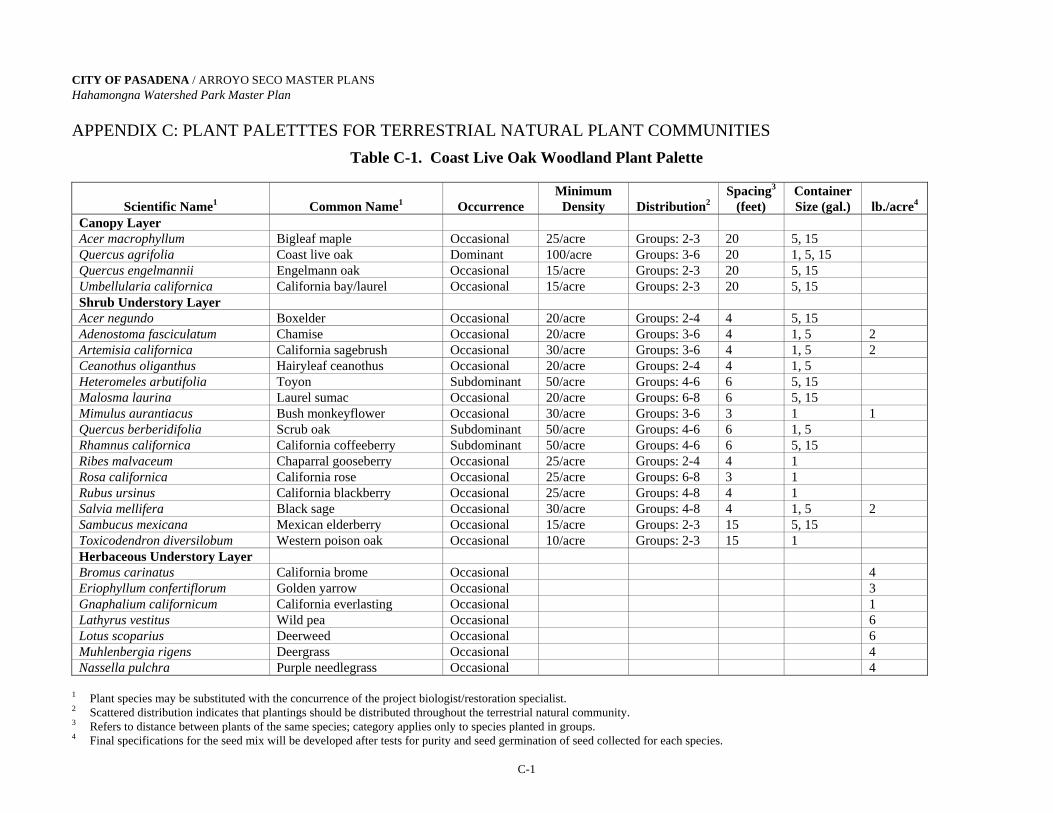
CITY OF PASADENA / ARROYO SECO MASTER PLANS Hahamongna Watershed Park Master Plan
C-1
APPENDIX C: PLANT PALETTTES FOR TERRESTRIAL NATURAL PLANT COMMUNITIES
Table C-1. Coast Live Oak Woodland Plant Palette
Scientific Name1
Common Name1
Occurrence
Minimum Density
Distribution2
Spacing3
(feet) Container Size (gal.)
lb./acre4
Canopy Layer Acer macrophyllum Bigleaf maple Occasional 25/acre Groups: 2-3 20 5, 15 Quercus agrifolia Coast live oak Dominant 100/acre Groups: 3-6 20 1, 5, 15 Quercus engelmannii Engelmann oak Occasional 15/acre Groups: 2-3 20 5, 15 Umbellularia californica California bay/laurel Occasional 15/acre Groups: 2-3 20 5, 15 Shrub Understory Layer Acer negundo Boxelder Occasional 20/acre Groups: 2-4 4 5, 15 Adenostoma fasciculatum Chamise Occasional 20/acre Groups: 3-6 4 1, 5 2 Artemisia californica California sagebrush Occasional 30/acre Groups: 3-6 4 1, 5 2 Ceanothus oliganthus Hairyleaf ceanothus Occasional 20/acre Groups: 2-4 4 1, 5 Heteromeles arbutifolia Toyon Subdominant 50/acre Groups: 4-6 6 5, 15 Malosma laurina Laurel sumac Occasional 20/acre Groups: 6-8 6 5, 15 Mimulus aurantiacus Bush monkeyflower Occasional 30/acre Groups: 3-6 3 1 1 Quercus berberidifolia Scrub oak Subdominant 50/acre Groups: 4-6 6 1, 5 Rhamnus californica California coffeeberry Subdominant 50/acre Groups: 4-6 6 5, 15 Ribes malvaceum Chaparral gooseberry Occasional 25/acre Groups: 2-4 4 1 Rosa californica California rose Occasional 25/acre Groups: 6-8 3 1 Rubus ursinus California blackberry Occasional 25/acre Groups: 4-8 4 1 Salvia mellifera Black sage Occasional 30/acre Groups: 4-8 4 1, 5 2 Sambucus mexicana Mexican elderberry Occasional 15/acre Groups: 2-3 15 5, 15 Toxicodendron diversilobum Western poison oak Occasional 10/acre Groups: 2-3 15 1 Herbaceous Understory Layer Bromus carinatus California brome Occasional 4 Eriophyllum confertiflorum Golden yarrow Occasional 3 Gnaphalium californicum California everlasting Occasional 1 Lathyrus vestitus Wild pea Occasional 6 Lotus scoparius Deerweed Occasional 6 Muhlenbergia rigens Deergrass Occasional 4 Nassella pulchra Purple needlegrass Occasional 4
1 Plant species may be substituted with the concurrence of the project biologist/restoration specialist. 2 Scattered distribution indicates that plantings should be distributed throughout the terrestrial natural community. 3 Refers to distance between plants of the same species; category applies only to species planted in groups. 4 Final specifications for the seed mix will be developed after tests for purity and seed germination of seed collected for each species.

CITY OF PASADENA / ARROYO SECO MASTER PLANS Hahamongna Watershed Park Master Plan
C-2
Table C-2. Southern Willow Scrub Plant Palette
Scientific Name1
Common Name1
Occurrence
Minimum Density
Distribution2
Spacing3
(feet) Container Size (gal.)
lb./acre4
Upper Canopy Layer Acer macrophyllum Bigleaf maple Occasional 15/acre Groups: 1-3 20 5, 15 Platanus racemosa Western sycamore Occasional 20/acre Groups: 2-4 20 5, 15 Populus balsamifera ssp. trichocarpa Black cottonwood Occasional 20/acre Groups: 2-4 20 5, 15 Populus fremontii ssp. fremontii Fremont cottonwood Occasional 25/acre Groups: 3-4 20 5, 15 Sambucus mexicana Mexican elderberry Occasional 25/acre Groups: 3-4 15 5, 15 Salix gooddingii Black willow Subdominant 50/acre Groups: 5-10 10 Umbellularia californica California bay/laurel Occasional 15/acre Groups: 1-3 20 5, 15 Lower Canopy Layer Salix exigua Narrow-leaved willow Occasional 25/acre Groups: 3-4 6 Salix laevigata Red willow Subdominant 50/acre Groups: 5-10 10 Salix lasiolepis Arroyo willow Dominant 250/acre Scattered Salix lucida ssp. lasiandra Shining willow Occasional 25/acre Groups: 3-4 8 Shrub Understory Layer Baccharis pilularis Coyote brush Occasional 50/acre Groups: 3-4 6 1 1 Baccharis salicifolia Mule fat Dominant 200/acre Groups: 5-15 4 1 1 Rosa californica California rose Dominant 150/acre Groups: 5-10 3 1 Rubus ursinus California blackberry Subdominant 100/acre Groups: 4-8 4 1 Vitis girdiana Desert grape Subdominant 100/acre Groups: 4-8 4 1 Herbaceous Understory Layer Ambrosia psilostachya Western ragweed Occasional 10 Artemisia douglasiana Mugwort Occasional 10 Carex barbarae Santa Barbara sedge Occasional 5 Hordeum brachyantherum Meadow barley Occasional 15 Muhlenbergia rigens Deergrass Occasional 8 Urtica dioica ssp. holosericea Hoary nettle Occasional 5
1 Plant species may be substituted with the concurrence of the project biologist/restoration specialist. 2 Scattered distribution indicates that plantings should be distributed throughout the terrestrial natural community. 3 Refers to distance between plants of the same species; category applies only to species planted in groups. 4 Final specifications for the seed mix will be developed after tests for purity and seed germination of seed collected for each species.
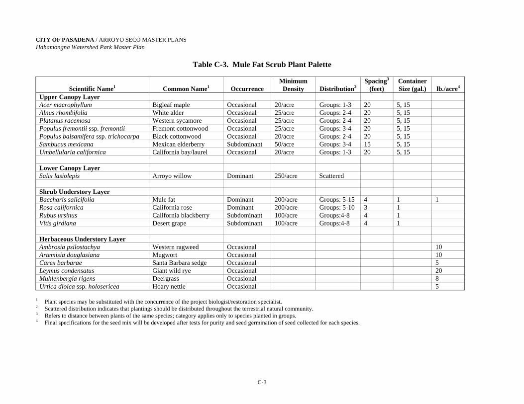
CITY OF PASADENA / ARROYO SECO MASTER PLANS Hahamongna Watershed Park Master Plan
C-3
Table C-3. Mule Fat Scrub Plant Palette
Scientific Name1
Common Name1
Occurrence
Minimum Density
Distribution2
Spacing3
(feet) Container Size (gal.)
lb./acre4
Upper Canopy Layer Acer macrophyllum Bigleaf maple Occasional 20/acre Groups: 1-3 20 5, 15 Alnus rhombifolia White alder Occasional 25/acre Groups: 2-4 20 5, 15 Platanus racemosa Western sycamore Occasional 25/acre Groups: 2-4 20 5, 15 Populus fremontii ssp. fremontii Fremont cottonwood Occasional 25/acre Groups: 3-4 20 5, 15 Populus balsamifera ssp. trichocarpa Black cottonwood Occasional 20/acre Groups: 2-4 20 5, 15 Sambucus mexicana Mexican elderberry Subdominant 50/acre Groups: 3-4 15 5, 15 Umbellularia californica California bay/laurel Occasional 20/acre Groups: 1-3 20 5, 15 Lower Canopy Layer Salix lasiolepis Arroyo willow Dominant 250/acre Scattered Shrub Understory Layer Baccharis salicifolia Mule fat Dominant 200/acre Groups: 5-15 4 1 1 Rosa californica California rose Dominant 200/acre Groups: 5-10 3 1 Rubus ursinus California blackberry Subdominant 100/acre Groups:4-8 4 1 Vitis girdiana Desert grape Subdominant 100/acre Groups:4-8 4 1 Herbaceous Understory Layer Ambrosia psilostachya Western ragweed Occasional 10 Artemisia douglasiana Mugwort Occasional 10 Carex barbarae Santa Barbara sedge Occasional 5 Leymus condensatus Giant wild rye Occasional 20 Muhlenbergia rigens Deergrass Occasional 8 Urtica dioica ssp. holosericea Hoary nettle Occasional 5
1 Plant species may be substituted with the concurrence of the project biologist/restoration specialist. 2 Scattered distribution indicates that plantings should be distributed throughout the terrestrial natural community. 3 Refers to distance between plants of the same species; category applies only to species planted in groups. 4 Final specifications for the seed mix will be developed after tests for purity and seed germination of seed collected for each species.

CITY OF PASADENA / ARROYO SECO MASTER PLANS Hahamongna Watershed Park Master Plan
C-4
Table C-4. Riversidian Alluvial Fan Sage Scrub Plant Palette
Scientific Name1
Common Name1
Occurrence
Minimum Density
Distribution2
Spacing3
(feet) Container Size (gal.)
lb./acre4
Canopy Layer Acer macrophyllum Bigleaf maple Occasional 10/acre Groups: 1-2 20 5, 15 Alnus rhombifolia White alder Occasional 10/acre Groups: 1-2 20 5, 15 Juglans californica var. californica Southern California black
walnut Occasional 10/acre Groups: 1-2 20 5, 15
Plantanus racemosa Western sycamore Occasional 15/acre Groups: 2-3 20 5, 15 Populus fremontii ssp. fremontii Fremont cottonwood Occasional 15/acre Groups: 2-3 20 5, 15 Sambucus mexicana Mexican elderberry Occasional 10/acre Groups: 1-2 15 5, 15 Shrub Understory Layer Artemisia californica California sagebrush Subdominant 30/acre Groups: 2-4 4 1, 5 2 Atriplex canescens Four-wing saltbush Occasional 20/acre Groups: 2-4 4 1, 5 Cercocarpus betuloides Birchleaf mountain-mahogany Occasional 20/acre Groups: 2-4 4 1, 5 Encelia farinosa Brittlebush Occasional 20/acre Groups: 2-4 4 1, 5 2 Eriodictyon crassifolium Hairy yerba santa Occasional 20/acre Groups: 2-4 4 1, 5 Eriogonum fasciculatum California buckwheat Subdominant 30/acre Groups: 2-4 4 1, 5 3 Isomeris arborea Bladderpod Occasional 10/acre Groups: 1-2 4 1, 5 Lepidospartum squamatum Scalebroom Dominant 50/acre Groups: 2-4 6 1, 5 1 Malosma laurina Laurel sumac Occasional 20/acre Groups: 2-4 6 1, 5 Opuntia littoralis Coastal prickly pear Occasional 20/acre Groups: 1-2 4 1 Rhus integrifolia Lemonadeberry Occasional 20/acre Groups: 2-4 6 1, 5 Rhus ovata Sugar bush Occasional 20/acre Groups: 2-4 6 1, 5 Salvia apiana White sage Occasional 20/acre Groups: 2-4 4 1, 5 2 Salvia mellifera Black sage Subdominant 30/acre Groups: 2-4 4 1, 5 2 Toxicodendron diversilobum Western poison oak Occasional 10/acre Groups: 1-2 10 1 Yucca whipplei Chaparral yucca Occasional 20/acre Groups: 2-4 4 1 Herbaceous Understory Layer Bromus carinatus California brome Occasional 4 Gnaphalium californicum California everlasting Occasional 1 Lotus scoparius Deerweed Occasional 6 Muhlenbergia rigens Deergrass Occasional 5 1 Plant species may be substituted with the concurrence of the project biologist/restoration specialist. 2 Scattered distribution indicates that plantings should be distributed throughout the terrestrial natural community. 3 Refers to distance between plants of the same species; category applies only to species planted in groups. 4 Final specifications for the seed mix will be developed after tests for purity and seed germination of seed collected for each species.

CITY OF PASADENA / ARROYO SECO MASTER PLANS Hahamongna Watershed Park Master Plan
C-5
Table C-5. Coastal Sage-Chaparral Scrub Plant Palette
Scientific Name1
Common Name1
Occurrence
Minimum Density
Distribution2
Spacing3
(feet) Container Size (gal.)
lb./acre4
Canopy Layer Juglans californica var. californica Southern California black
walnut Subdominant 30/acre Groups: 1-2 20 5, 15
Sambucus mexicana Mexican elderberry Subdominant 30/acre Groups: 1-2 15 5, 15 Shrub Understory Layer Adenostoma fasciculatum Chamise Dominant 150/acre Groups: 2-4 4 1, 5 2 Artemisia californica California sagebrush Dominant 150/acre Groups: 2-4 4 1, 5 2 Ceanothus crassifolius Hoaryleaf ceanothus Occasional 20/acre Groups: 2-4 4 1, 5 Cercocarpus betuloides Birchleaf mountain-mahogany Occasional 30/acre Groups: 2-4 4 1, 5 Dendromecon rigida Bush poppy Occasional 20/acre Groups: 2-4 4 1, 5 Encelia californica California encelia Subdominant 75/acre Groups: 2-4 4 1, 5 2 Eriogonum fasciculatum California buckwheat Subdominant 75/acre Groups: 2-4 4 1, 5 8 Eriophyllum confertiflorum Golden yarrow Occasional 40/acre Groups: 2-4 4 1, 5 2 Heteromeles arbutifolia Toyon Subdominant 50/acre Groups: 2-4 4 1, 5 Isocoma menziesii var. menziesii Goldenbush Occasional 20/acre Groups: 2-4 4 1, 5 2 Keckiella cordifolia Heartleaf penstemon Occasional 20/acre Groups: 2-4 4 1, 5 Mahonia nevinii Nevin's barberry Occasional 20/acre Groups: 2-4 4 1, 5 Malosma laurina Laurel sumac Occasional 30/acre Groups: 2-4 6 1, 5 Mimulus aurantiacus Bush monkeyflower Occasional 50/acre Groups: 2-4 6 1, 5 1 Opuntia littoralis Coastal prickly pear Occasional 30/acre Groups: 1-2 4 1 Prunus ilicifolia ssp. ilicifolia Hollyleaf cherry Occasional 30/acre Groups: 2-4 6 1, 5 Rhus integrifolia Lemonadeberry Occasional 30/acre Groups: 2-4 6 1, 5 Rhus ovata Sugar bush Occasional 30/acre Groups: 2-4 6 1, 5 Salvia apiana White sage Occasional 30/acre Groups: 2-4 4 1, 5 2 Salvia mellifera Black sage Subdominant 50/acre Groups: 2-4 4 1, 5 2 Quercus berberidifolia Scrub oak Occasional 30/acre Groups: 2-4 6 1, 5 Yucca whipplei Chaparral yucca Occasional 30/acre Groups: 2-4 4 1
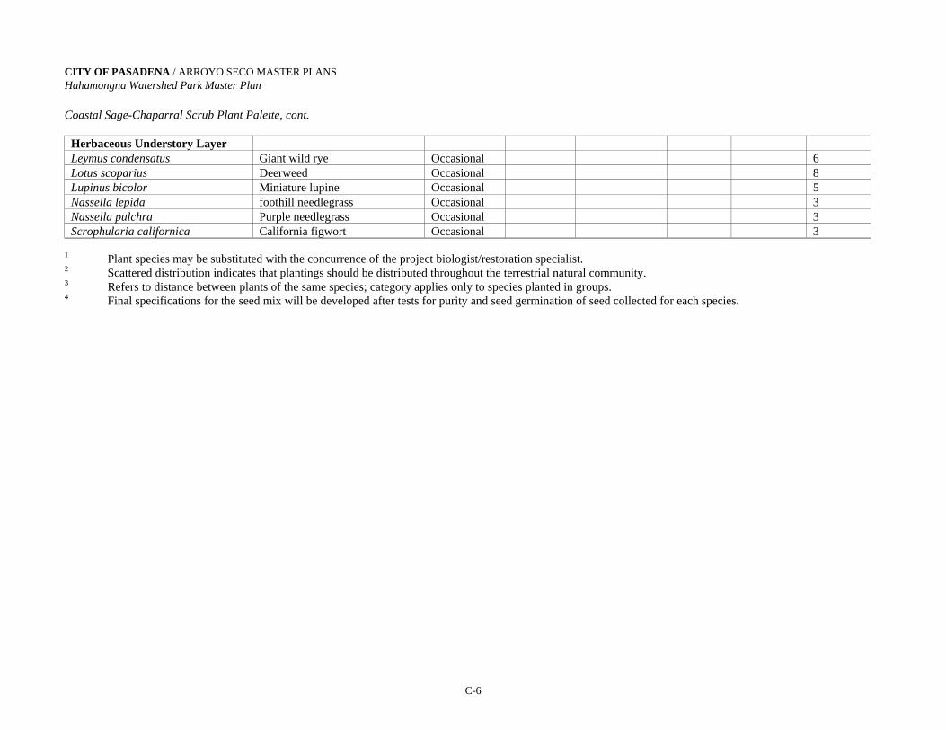
CITY OF PASADENA / ARROYO SECO MASTER PLANS Hahamongna Watershed Park Master Plan
C-6
Coastal Sage-Chaparral Scrub Plant Palette, cont.
Herbaceous Understory Layer
Leymus condensatus Giant wild rye Occasional 6 Lotus scoparius Deerweed Occasional 8 Lupinus bicolor Miniature lupine Occasional 5 Nassella lepida foothill needlegrass Occasional 3 Nassella pulchra Purple needlegrass Occasional 3 Scrophularia californica California figwort Occasional 3
1 Plant species may be substituted with the concurrence of the project biologist/restoration specialist. 2 Scattered distribution indicates that plantings should be distributed throughout the terrestrial natural community. 3 Refers to distance between plants of the same species; category applies only to species planted in groups. 4 Final specifications for the seed mix will be developed after tests for purity and seed germination of seed collected for each species.

CITY OF PASADENA / ARROYO SECO MASTER PLANS Hahamongna Watershed Park Master Plan
C-7
Table C-6. Southern Sycamore Riparian Woodland Plant Palette
Scientific Name1
Common Name1
Occurrence Minimum
Density
Distribution2 Spacing3
(feet) Container Size (gal.)
lb./acre4
Upper Canopy Layer Acer macrophyllum Bigleaf maple Occasional 10/acre Groups: 1-3 20 5, 15 Alnus rhombifolia White alder Occasional 15/acre Groups: 1-3 20 5, 15 Fraxinus dipetala California ash Occasional 10/acre Groups: 1-3 20 5, 15 Platanus racemosa Western sycamore Occasional 30/acre Groups: 2-4 20 5, 15 Populus balsamifera ssp. trichocarpa Black cottonwood Occasional 10/acre Groups: 2-4 20 5, 15 Populus fremontii ssp. fremontii Fremont cottonwood Occasional 10/acre Groups: 3-4 20 5, 15 Quercus agrifolia Coast live oak Occasional 10/acre Groups: 1-3 20 5, 15 Sambucus mexicana Mexican elderberry Occasional 15/acre Groups: 3-4 15 5, 15 Salix gooddingii Black willow Subdominant 10/acre Groups: 2-4 10 Umbellularia californica California bay/laurel Occasional 10/acre Groups: 1-3 20 5, 15 Lower Canopy Layer Salix laevigata Red willow Subdominant 15/acre Groups: 5-10 10 Salix lasiolepis Arroyo willow Dominant 25/acre Scattered Salix lucida ssp. lasiandra Shining willow Occasional 15/acre Groups: 3-4 8 Shrub Understory Layer Baccharis salicifolia Mule fat Dominant 25/acre Groups: 5-10 4 1 1 Rosa californica California rose Dominant 30/acre Groups: 5-10 3 1 Rubus ursinus California blackberry Subdominant 25/acre Groups: 4-8 4 1 Herbaceous Understory Layer Artemisia douglasiana Mugwort Occasional 10 Hordeum brachyantherum Meadow barley Occasional 15 Muhlenbergia rigens Deergrass Occasional 8 Urtica dioica ssp. holosericea Hoary nettle Occasional 5
1 Plant species may be substituted with the concurrence of the project biologist/restoration specialist. 2 Scattered distribution indicates that plantings should be distributed throughout the terrestrial natural community. 3 Refers to distance between plants of the same species; category applies only to species planted in groups. 4 Final specifications for the seed mix will be developed after tests for purity and seed germination of seed collected for each species.

Appendix D

CITY OF PASADENA / ARROYO SECO MASTER PLANS Hahamongna Watershed Park Master Plan
D-1
APPENDIX D:
WATER DATA: NEEDS & COSTS The benefits from projects described in Section 3.1 Water Resources Management DIRECT BENEFITS: - Pasadena Water & Power - Lincoln Avenue Water Company
INDIRECT BENEFITS: - Help maintain safe yield of the Raymond Basin - Help maintain groundwater levels - Reduce dependency on imported water - Increase the amount of water that can be pumped back from the Water Conservation
Pool PERMANENT LAKE FEATURES EVAPORATION WATER NEEDS*: Evaporation from Aquatic and Wetland Habitats; each lake has a 0.3-acre island East Lake = 3.6 Acres = 156,816 ft2
West Lake = 4.8 Acres = 209,088 ft2 Evaporation Rate 0.15 in/day 0.375 ft/month Rainfall in Basin 22 in/year − 0.153 ft/month 0.222 ft/month East Lake 156,816 ft2 × 0.222 ft/month = 34,813 ft3/month = 348 billing units/month West Lake 209,088 ft2 × 0.222 ft/month = 46,418 ft3/month = 464 billing units/month
Average rate for domestic water is $1.54/billing unit
348 billing units/month × $1.54/billing unit = $536/month = $6,432/year for East Lake
464 billing units/month × $1.54/billing unit = $715/month = $8,580/year for West Lake
TOURNAMENT YOUTH SOCCER FIELD IRRIGATION NEEDS: A soccer field is 245 ft × 380 ft = 93,100 ft2 = 2.14 acres
Watering needs are 52.5 in/year = 4.375 ft/year = 0.365 ft/month
93,100 ft2 × 0.365 ft/month = 33,931.5 ft3 /month = 340 billing units/month
340 billing units/month × $1.54/billing units = $524/month = $6,288/year/field
Source: Pasadena Water & Power, September 2003.
*The lakes were not approved as part of the Council adopted plan.
CITY OF PASADENA / ARROYO SECO MASTER PLANSHahamongna Watershed Park Master Plan
E-1
Appendix E:
SUMMARY OF PROPOSED PROJECTSPrepared by
City of Pasadena Parks and Natural Resources Division
DEVIL’S GATE DAM AREA
New Parking Area
A small landscaped parking area will be constructed at the intersection of Linda Vista and Oak GroveDrive with an overlook to the Devil’s Gate Dam spillway. An existing tunnel under Oak Grove Drivewill allow pedestrian access to the western end of the dam. The parking area will be landscaped andlocated on the upper terrace; ADA accessible trail/ramp(s) will take visitors from the parking area tothe lower observation area and the tunnel under Oak Grove Drive giving access to the dam area. Anexisting retaining wall along the observation area will need to have the existing chain link fencingreplaced with ornamental iron safety fencing. This ornamental fencing will be similar to thatrecommended for the dam’s parapet walls. A gate will be installed on the southern opening of thetunnel to allow for securing access at night.
East Access (entry) to Dam
In order to eliminate maintenance vehicle/equipment traffic in adjacent residential neighborhoods, anew entry slip lane allowing direct access to the dam and basin from Oak Grove Drive will beconstructed. This project will retain the existing limited parking for County maintenance vehicles aswell as dam and basin access roads that will allow maintenance vehicles and equipment better accessto the flood management/water conservation pool and dam. The existing road bed at the eastern endof the Devil’s Gate Dam area will be raised to accommodate the new slip lane, tapering off to meetthe existing east side maintenance road/trail, which will be uniformly graded and descend to the floodmaintenance staging area. This access will allow maintenance vehicles a one-way access to enter thearea via a secured entry gate and to drive (westbound) across the dam or down into thedebris/sediment basin. The entry gate will be configured to allow bicycle access to the dam from OakGrove Drive.
West Access (Exit) from Dam
The (westbound) flow of maintenance vehicle traffic across the dam requires an exit on the west endof the dam. This one-way exit will be provided at the location previously used as a temporary accessroad during construction projects on the dam. Vehicles exiting the dam at this location will berequired to turn right. Maintenance vehicles will be able to drive to the 210 Freeway on-ramps atBerkshire Place without driving through a residential neighborhood.
Close La Canada Verdugo Road
The existing pipe gate at the end of the cul-de-sac on La Canada Verdugo Road will be removed andthe curb restored, eliminating vehicle access from this residential street. Vehicular access to the
CITY OF PASADENA / ARROYO SECO MASTER PLANSHahamongna Watershed Park Master Plan
E-2
dam will be through the proposed Oak Grove Drive Entry and Exit. A landscaped berm will becreated along the edge of the cul-de-sac to further buffer the adjacent residential neighborhood frompark activities. Storm drains and perimeter fencing will be modified as needed.
Dam Keeper’s Quarters and Public Restroom
The existing dam keeper’s quarters located on the east side of the dam will be demolished and rebuiltas a public restroom to serve park visitors in the dam area and as they enter/exit the Central Arroyoarea. A new dam keeper’s quarters will be built above the public restroom with sleeping quarters, asmall kitchenette, and a private restroom. This second story will afford the dam keeper a view of thebasin during storm events. On the ground level, connected to the public restroom, will be a storagearea (single-car garage) for materials and equipment related to the operation and maintenance of thedam. The existing septic system at the former dam keeper’s house (the current Arroyo Seco ResourceCenter) will be replaced with a gravity-feed sewer to a sewage lift station pumping sewage to themain sewer east of the La Cañada Verdugo Road cul-de-sac.
Public Safety at Dam and Observation Deck
The City of Pasadena (City) will work collaboratively with the Los Angeles County Department ofPublic Works (County) to enhance safety at the deck on the dam, at the observation deck south of thewestside tunnel overlooking the spillway, and along the trails (see project, Dam Observation Trail)that lead down to an observation point overlooking the dam and the water conservation pool. Safetycould be enhanced through the installation of ornamental fencing along the dam parapet walls and thespillway observation deck. Fencing will be similar to that installed by the City on the Colorado StreetBridge.
WESTSIDE PARK ACCESS
Park Entrance at Foothill Boulevard
The main westside park entrance will remain at Oak Grove Drive and Foothill Boulevard. The entrywill receive a new park entrance sign, landscaping, and entry area lighting. This entrance will be foregress, ingress, and unobstructed access to the Metropolitan Water District (MWD) property,including the Rose Bowl Riders and Tom Sawyer Camp tenants. As needed, the use of a trafficcontrol facility/entry kiosk for security and dissemination of information will be assessed.
Oak Grove Drive Improvements
An access lane will make entry to the park safer and more efficient, as well as alleviate the OakGrove Drive peak-hour traffic at La Canada High School and Jet Propulsion Laboratories (JPL). Aone-way access lane from Oak Grove Drive, north of the Berkshire Place intersection is proposed toallow entry during park events and morning/afternoon high school student drop-off/pick-up. Theaccess lane will be ingress only and will have a secure gate built into the perimeter fence withappropriate signage. Due to public safety concerns, a portion of this project has been temporarilyimplemented.

CITY OF PASADENA / ARROYO SECO MASTER PLANSHahamongna Watershed Park Master Plan
E-3
EASTSIDE PARK ACCESS
New Park Entrance
The new park entrance will be relocated to the intersection of Windsor Avenue and Mountain ViewStreet. The existing parking lot on Windsor Avenue will be demolished and relocated to the north endof the existing Jet Propulsion Laboratory (JPL) parking lot, once and only when the project to convertJPL Parking to Public Parking is ready to be implemented. The widening of the roadway area at theintersection of Windsor Avenue and Ventura Street with the new park entrance road will require anew retaining wall to the west of the current entrance/intersection. After the new entrance roadway isconstructed, the surrounding land will be landscaped with native vegetation including oak woodlandspecies. If the County implements any improvements to the Windsor Avenue and Ventura Streetintersection prior to the implementation of this proposed project, the intersection will be evaluated fortraffic volume safety and whether any further improvements will be necessary.
WATER CONSERVATION
Increasingly, water in southern California is becoming a valuable commodity. Allowing more waterto recharge the Raymond basin for use and not to pass through the dam to the ocean is a major goal ofthe master plan. In an average rainfall year, Devil’s Gate Dam, with a minimum capacity of 1,400acre-feet below spillway height (current capacity is 1,424 acre-feet), will allow the basin behind thedam to fill with inflowing water one to three times, depending on the condition of the watershed. In adrought period, the watershed could retain all the rainfall and the dam could not even fill up once.The watershed, like a sponge, dries out during drought periods. It must reach a saturation point orhave a storm of enough intensity before runoff flows to the basin. In the winter of 1992-93 (El Niñoyear), the basin could have filled over 40 times. Therefore, a sophisticated operating procedure needsto be developed to balance the goals of water conservation, flood control, and sediment management.
The City is obligated to the 16-member Raymond Basin Water Board to continue operation of 13.1surface acres of spreading grounds. The Raymond Basin requires that any changes to the spreadingarea and annual quantity of water spread be equal to or greater than currently exists/occurs. Changingthe existing method, area and pattern of recharging ground water could affect the NASA/JPLremediation activities for groundwater contaminants. Projects to improve water resource operationswill require further environmental review and close coordination with NASA/JPL prior to anyimplementation.
Seasonal Flood Management Water Conservation Pool
The flood basin behind the dam has been filling with sediment. With an existing capacity of 1,424acre-feet, it is approaching the minimum capacity of 1,400 acre-feet. Since 1978, when the dam wasdeclared unsafe to hold water, vegetation has been allowed to grow in the 92 acres that will beflooded now that the dam has been reconstructed. When water conservation measures areimplemented, this vegetation will begin to die as it is frequently inundated. To create new qualityhabitat above the spillway elevation and increase the capacity to a maximum 1,900 acre-feet, to allowfor 500-acre feet of inflowing sediment capacity, this project would move 378 acre-feet of material onsite and remove 243 acre feet of material off-site. This would reduce the area frequently inundated to69 acres and create 23 acres of new recreational and habitat area. It would also create a flood controlpool to better manage inflowing sediment and floating debris and a water conservation pool to allowthe retention of floodwater for pump-back to the spreading basins.
CITY OF PASADENA / ARROYO SECO MASTER PLANSHahamongna Watershed Park Master Plan
E-4
Pump-Back System
This project involves the installation of the infrastructure needed to pump water at selected timesfrom a seasonal flood management/water conservation pool behind the dam, north, to the existingimproved spreading basins on the eastside the proposed spreading basins on the westside of the park.A new inlet structure with pump located near the dam would be created to pump water from the pooland into a new distribution system. The distribution system, including the size of piping and pump,will be designed to take water from the new inlet north along the eastside of the basin, at the bottomof the slope and adjacent to other domestic water distribution lines, to the highest eastside basins,continuing west across the North Bridge Crossing to gravity-feed both the proposed westside basinsand existing improved eastside basins.
Overall Storm Drain Modifications
Storm water entering the proposed Flood Management Water Conservation Pool from Flint Wash,from runoff of adjacent lands, and from all storm drain outfalls, will need to comply with state-mandated water quality standards including monitoring and cleanup of pollution from runoff. Runoffpollutants include horticultural fertilizers and pesticides, pathogens from animal manure (dogs andhorses), and hazardous substances in municipal waste including trash, oil, and grease from motorizedvehicles. Remediation may occur at the outfall location in the Park, at a pollutant source or at theinlet to the storm drain, depending on the particular type of pollutant. This becomes important due tothe planned pumpback of water held behind the dam for percolation in the spreading basins torecharge the Raymond Basin aquifer, a source of drinking water. A fiscally workable solution to someof these pollution problems remains to be found, both technically and scientifically. Best managementpractices will be utilized to ensure that TMDL’s (Total Maximum Daily Loads) of pollutants arereduced and that a natural/biological alternative is considered first in finding a solution.
Westside Spreading Basins
This project creates three new basins (nos. 13, 14 & 15) totaling eight surface acres on the westside ofthe park and brings Pasadena’s total spreading operation to 21 surface acres. The City has the right todivert a maximum of 25 cfs from the Arroyo Seco stream. The Water and Power Department hasconcluded that the optimum water surface acres for spreading, with diversion and pumpback, will be22 to 26 acres. The master plan dedicates a total of 26 surface acres to the spreading operation. Themaximum depth of the water in these ponds will be six feet. This project also involves extending thedistribution system for the new spreading from two sources: a) the diversion of Arroyo Seco andMillard streams as well as from the new pumpback system infrastructure, along the eastside of thebasin. This project is directly related to another project, Construction of the Northerly Perimeter TrailBridge Crossing, described later. The bridge crossing is needed for the successful completion of thenew westside spreading basins as it provides the means for a utility crossing including a waterdiversion and pumpback infrastructure crossings to the westside basins.
Eastside Spreading Basins
Opportunities for spreading water will be enhanced through the expansion of existing and creation ofnew basins in the area now occupied by the JPL east parking lot. Testing has shown the rate ofpercolation of water into the Raymond Basin is greater in this area than in the existing basins.Existing basins nos. 1, 2, 3 and 4 will be expanded to the east. Two new basins will be created to thenorth of basin no. 1 and the existing east-to-west connecting trail. The City of Pasadena's two sludgebasins will be relocated and expanded to the north of the new spreading basins. This expansion will

CITY OF PASADENA / ARROYO SECO MASTER PLANSHahamongna Watershed Park Master Plan
E-5
occupy approximately 75 percent of the current JPL east parking lot, and will add five surface acreson the eastside.
The City of Pasadena is required by the Raymond Basin Management Board to maintain and operatethe existing total of 13.1 surface acres of spreading.
Altadena Drain Improvements
The Altadena drain extends into the stream channel north of the existing spreading basins. Theextended concrete box structure was used as part of an earthen breakaway dam, which would divertwater to the eastside spreading basins. This site is no longer used as a diversion facility due to theenvironmental impact from this diversion method. To widen the stream corridor, allowing for a morenatural stream alignment, (see Habitat Project #1: Stream Corridor Alignment) the drain will beshortened and the embankment armored to prevent erosion. This stream corridor will be restored to ariparian habitat similar to, and as a continuation of, the same plant community immediately north ofthe JPL Bridge. Due to urban runoff, this riparian habitat also exists for a short stretch of the streamcourse south of the drain.
Altacrest Drain Improvements
The discharge from the forty-inch reinforced concrete pipe (RCP), adjacent to the Gabrielino TrailRoad and east of the JPL east parking lot (just south of the equestrian trail), will continue downslopein an extended, enlarged single RCP. This underground drain line will run between the enlargedexisting ponds and empty directly into the stream corridor. There will be an inlet to receive runofffrom the eastside park road and the remaining northerly quarter of the existing parking lot.
FLOOD MANAGEMENT
An important element of the HWP master plan is flood control or management of storm events forpublic safety. The 1919 Lease Agreement between the County and the City designates an area forflood control that encompasses approximately 80% of the HWP acreage. Under the most extremeconditions this area could be flooded. This includes all the area behind the dam below elevation 1075.
Park elements need to be designed with these flooding considerations: The area that is mostfrequently inundated is below an elevation of 1040.5 (the floor of the spillway). Park elementsbetween the elevations of 1040.5 and 1075 will need to be reviewed by all parties and designed forthe possibility of a short period of inundation (maximum of several days). The capacity below theelevation of 1040.5 should be as great as possible for water conservation, sediment management, andflood management. Currently, the area at this elevation of 1040.5 covers 92 surface acres. Much ofthis area is covered with only a few feet of water when the water level is at spillway height (1040.5).The conceptual grading plan proposes to excavate material, creating a deeper debris and sedimentbasin. This excavated material will be placed so that an additional 23 acres will then be above theelevation of 1040.5. This raised area will be infrequently inundated, and could be used for habitatrestoration and recreation. The areas that are frequently inundated (at 1040.5 and below) are reducedto 69 acres (from 92 acres) according to the conceptual grading plan. An additional 243 acre-feet willbe removed from the site to achieve the maximum capacity of the debris and sediment managementbasin as shown on the conceptual grading plan. This grading will achieve the following benefits:

CITY OF PASADENA / ARROYO SECO MASTER PLANSHahamongna Watershed Park Master Plan
E-6
The floodwater and sediment capacity of the management basin will increase, because muchof the material excavated from below the 1040.5 elevation will be placed above the 1040.5elevation.
The needed capacities for flood management could be met by not having to move gradedmaterial off-site for three to five years. By this time, the new willow habitat will beestablished, existing habitat could be removed, and more sediment will have accumulated,reducing the capacity.
There will be an additional 23 acres for habitat establishment and recreation. The StreambedRiparian Habitat, which will be infrequently inundated, will gain five acres.
Most of the existing willow habitat will be inundated if this proposed grading does not occur (seeHabitat Project #2**). The habitat will begin to degenerate as more water conservation measures aretaken and water is kept at the 1040.5 elevation for pump-back purposes. Water conservation measurescan begin as soon as the City and the County resolve a number of liability issues.
Sediment and Debris Management
The minimum capacity for flood management is the volume below the spillway floor, which is 1,400acre-feet (one debris event). This minimum capacity must be maintained. Therefore, as sedimentinflow varies from year to year, and as the total volume of inflowing sediment decreases the capacity,to the minimum 1,400 acre-feet, sediment must be removed. The grading plan illustrates the proposedmaximum capacity, which will be 1,900 acre-feet. This will inundate a 69-acre area at an elevation of1040.5. The difference between this maximum and the minimum capacity (500 acre-feet or 806,667cubic yards) equals 5.5 years of the historical annual average inflow of 145,200 cubic yards ofsediment.
Debris and sediment removal of approximately 3,000 cubic yards will occur each summer to maintainand/or restore the dam’s lowest opening, the sluice gate. This could permit the continuing operationof the flow-assisted sediment transport (FAST) program, which has accounted over the years for theremoval of approximately 20% of the inflowing sediment.
Because drought years transport small amounts of sediment and large sediment transport events occurunpredictably, sediment should be removed from the park on an as-needed basis. Sediment removalcould happen in consecutive years, but in reviewing historical data, it is more likely that this will onlyneed to be done every three to seven years. Procedural policies and specifications for processing andremoval of sediment need to be drafted by the City and the County.
The conceptual grading proposes to shape the basin with sides as steep as can be safe and stable (3:1slope). This maximizes the capacity and allows the space to be easily maintained. At elevations of1030 and below, newly deposited sediment, debris, and emerging vegetation will be excavated. Oneof the goals of the master plan is to establish a permitting process that will allow sediment removal tooccur on an as-needed basis. This area below 1030, the debris and sediment basin (i.e., waterconservation pool) will be shaped not only to facilitate the removal of deposited sediment, but also toinfluence where sediment is deposited. With an incoming storm event, it is ideal to have water atelevations of 1020 to 1030. This causes sediment-laden water to slow as it enters the waterconservation pool, dropping out the sediment below the established habitat and upstream of the dam,thereby not affecting the dam’s control features. If water is at 1040.5 (spillway height), then sedimentwill be deposited in the newly widened stream corridor and will inundate the streambed riparian plantcommunity. As a storm event passes and water continues to enter the basin, it becomes less sediment

CITY OF PASADENA / ARROYO SECO MASTER PLANSHahamongna Watershed Park Master Plan
E-7
laden. When this occurs, water should be allowed to accumulate to the maximum capacity. This willinundate the established willow and riparian habitat with water and nutrients, and accumulate waterfor the proposed pumpback (See project, Pumpback System) for water conservation purposes.
Another aspect of this project element is debris removal. For the safe operation of the dam anddownstream flood-control structures, debris needs to be prevented from passing through the dam, orobstructing openings in the dam, outlet tunnel, and spillway headworks. An area on the east side ofthe debris and sediment management basin (i.e., water conservation pool) will be raised to anelevation of 1045, and used as a staging area for equipment to remove floating debris.
Sediment Removal Access
A permanent haul road will be constructed on the west side of the Flood Management WaterConservation Pool. It will connect Oak Grove Drive with the bottom of the basin behind the dam. Asecure gate built into the perimeter fence will provide sediment removal trucks and maintenanceequipment with access to the sediment and debris management basin. The 210 Freeway on-ramps atBerkshire Place provide access to all destinations eliminating trucks driving through a residentialneighborhood.
OAK GROVE AREA
Group Picnic Shade Structures
Group picnic areas will accommodate four to six picnic tables. The shade structures, two south andtwo north of Oak Grove Field, will be designed to fit the natural character of the park and useindigenous materials as well as conform to the Arroyo Seco Design Guidelines. The floor of thegroup picnic area will be graded level and smooth and surfaced with a permeable material such asdecomposed granite blended with native soil and a binder. Electricity will be provided to thestructure, and amenities such as barbecues with counters, sinks with running water, and gray-waterdrains will be provided. A trash disposal area will also be provided to store multiple cans with lids.The group picnic areas will meet all ADA-accessibility requirements.
Westside Picnic Amenities
Both group picnic areas and smaller/individual picnic areas are planned for the westside park area.The Upper Oak Grove will continue to have a distribution of picnic tables within its use area. TheLower Oak Grove will serve as the location for two designated group picnic areas. The first is in thearea south of the Oak Grove Field where two picnic shelters will be provided for group picnics. Theother is the east end of the overnight camp area, which will also provide two picnic shelters. Aminimum of two picnic areas within the westside park area will be ADA-accessible. There arecurrently 52 picnic tables within the westside park area. The number of picnic tables has steadilydecreased over the past thirty-five years due to age, wear, and misuse. It is estimated that the totalnumber of tables will double to accommodate the use anticipated by the park improvements proposedfor the westside park area. Existing picnic tables will be moved to better positions, which will alsorelieve the compaction on sites where they currently sit. A program to rotate the picnic tables will beimplemented, particularly in areas where a table is within the drip line of an oak tree.
Oak Grove Field Restroom
The burned-out restroom at the southwest corner of the existing Oak Grove Field has been removedand will be replaced by a new restroom facility that includes storage. The new restroom facility is
CITY OF PASADENA / ARROYO SECO MASTER PLANSHahamongna Watershed Park Master Plan
E-8
east of the former location and at the southeast corner of the renovated Oak Grove Field. A sewagelift station will be constructed. The sewage lift station will transport sewage west to the main sewersystem on Oak Grove Drive. The new replacement restroom will be similar in size to the existingrestrooms in the Oak Grove area. The facility will also have security/safety lighting installed.
Foothill Drain Improvements
Increased runoff from the widening of Oak Grove Drive, Foothill Boulevard west of the parkentrance, and a portion of the La Canada-Flintridge area has caused severe erosion on the slope abovethe existing Oak Grove Field. The existing twenty-four-inch concrete drain will be extended down theslope and then turn parallel to the Oak Grove Field. The drain pipe will be covered over and the sloperestored. The new end of the drain will discharge stormwater into an improved existing swale thatflows south at the base of the slope.
Outdoor Amphitheater
The existing amphitheater located just west of Oak Grove Field will be restored. For public safety andease of maintenance the seating will be designed to prevent movement of the existing unsecuredpoles. The area will be fine-graded and surfaced with the appropriate material to make the area ADA-accessible.
Sycamore Grove Fields
Two new, approximately 2.4-acre multipurpose fields will be constructed. This field size also allowsthe area to be converted into multiple practice fields for youth soccer. These multipurpose play areaswill also accommodate youth tournament soccer, open play, group picnics, and other group andnongroup activities. The southern field will be adjacent to and east of the expanded parking lot. Thisarea is currently used for temporary overflow parking. Under existing conditions, the southernportion of this field is prone to flooding; therefore, the area will be built up from its current elevationof 1040 to an elevation of 1050. Fill material for construction of the southern Sycamore Grove Fieldand disc golf course improvements will be provided by excavated material from the conservationpool. The northern field will be adjacent to and east of the Supervised Overnight Camping Area.Under existing conditions, this area is well below the flood inundation elevation of 1040.5. Due topast mining operations, a large depression exists with the bottom at elevation at 1025. Materialexcavated to widen the stream channel will be used to raise this area to above elevation 1055. Duringdisaster emergencies, these areas will be used as a staging area for fire crews and other emergencysupport groups. Best management practices for turf maintenance will be utilized to avoid possibleimpacts to ground water quality. A natural/biological alternative will be considered first for turfmaintenance.
Upgrade Oak Grove Maintenance Office Sewer [Not on Map]
The Oak Grove Maintenance Office (OGMO) is currently on a septic system. The restroom facilitiesdo not need upgrading. The current septic system will be converted to a gravity-flow system that willflow to the proposed sewage lift station near the Berkshire drain, and then be pumped up to theexisting sewer main in Oak Grove Drive.

CITY OF PASADENA / ARROYO SECO MASTER PLANSHahamongna Watershed Park Master Plan
E-9
Disc Golf Course Improvements
The disc golf improvements include relocation of the back nine pins in the north Oak Grove area, andpins 6 through 9 of the front nine to the south and east of the existing parking lot. The relocation ofthe disc golf area provides the opportunity for habitat restoration of the north Oak Grove area. Therelocated disc golf course will be developed by excavating material from the water conservation poolarea (ruderal habitat areas) and placing the material in the area between the existing willow stands toan average elevation of 1046 which is above the frequently inundated elevation of 1040.5. Drainageof courses in this area will occur within the existing stands of native willow habitat. Amenities,including a bench at every tee, will be constructed in accordance with the Arroyo Seco DesignGuidelines.
Expanded Parking Area
This existing parking area, immediately east of the Oak Grove Field, will be expanded toaccommodate the abandoned overflow parking area. The existing parking area will be accessed viathe improved access road. This parking area is intended to replace the dirt overflow lot that is beingconverted to Sycamore Grove Field. This project could be done in conjunction with another element,i.e., the removal of existing asphalt paving in the basin (from past mining operations). The removedasphalt could be used as base fill for the new expanded parking area. As a part of this project, theexisting access road with a small adjacent parking area will be extended and improved to allow for aturnaround for park users, buses, and emergency vehicles. The Arroyo Seco Design Guidelines willprovide further guidance for this project.
Native Plant Nursery
A plant nursery will be established at the existing Oak Grove Maintenance Office (OGMO). It willprovide materials and equipment necessary to produce native stock for revegetation of HahamongnaWatershed Park and other areas of the Arroyo Seco. Such materials and equipment will includepropagation tables, interpretive signage, storage bins for soil and amendments, and a holding area forlarger container stock. An adjacent unused ruderal (weedy) area will be incorporated into the OGMOyard for this purpose, with new fencing to delineate the enhanced area.
SUPERVISED OVERNIGHT CAMPING AREA
Supervised overnight camping is proposed in the northern portion of the Oak Grove area. Theovernight camping area will be available for individuals and groups during the day but will only beavailable to organized groups with proper supervision, such as Boy Scouts, Girl Scouts, or churchgroups for camping during nighttime. The facilities for group overnight camping to be providedinclude shade structures as described under Project 6.1, Group Picnic Shade Structures, foodpreparation counters with sink, barbecues, drinking fountains and a renovated restroom. Selectedcampsites and access will be provided for the disabled. Two gathering areas will be created. A firering will provide seating for small groups. Seating will be provided by wooden poles or elevatedplanks for easy maintenance. An outdoor amphitheater will also be sited within the area. It will be amuch smaller version of the amphitheater west of the Oak Grove Field but built in the same style andof the same materials.
The overnight camping area will be administered by park staff, scheduled around the clock when thearea is reserved. The existing Los Angeles County Trail maintenance and storage area will beconverted to provide accommodations and administrative space for park staff. Parking for staff and

CITY OF PASADENA / ARROYO SECO MASTER PLANSHahamongna Watershed Park Master Plan
E-10
overnight campers will be provided in this area. A trash-bin enclosure will be provided adjacent tothe staff building. A sewage lift station will be located between the existing restroom and theconverted County building (with an added bathroom and kitchenette) with gravity sewer lines fromeach and a force main to the gravity sewer main at Oak Grove Drive.
Selected areas of the overnight camping area will be restored to oak woodland. These areas will beidentified as restoration areas and protected from human interference. With the exception of theexisting trail(s) at the northernmost edge of the overnight camping area, horse trails through the oakwoodland will not be allowed. Hitching posts in the central area of the overnight camping area willnot be allowed. Hitching posts and a watering trough will be provided at the southeast corner of theovernight camping area near the turnaround and away from tree trunks.
Park Ranger Station Improvements
The existing building used by Los Angeles County Trail maintenance will be converted to a parkranger station to oversee the overnight group camping area. A sewage lift station will be locatedbetween the existing overnight area restroom and this converted park building (with an addedbathroom and kitchenette) with gravity sewer lines from each, and a sewage lift station with forcemain to the gravity sewer main at Oak Grove Drive.
Restroom Improvements
The two existing restrooms in the Oak Grove area, on the upper terrace and in the overnight campingareas, will be upgraded with new fixtures, partitions, and other amenities to meet current ADAaccessibility standards. This is already approved and underway as a CIP project.
Improve Existing Parking Areas
The existing dirt parking area adjacent to the ranger station will be developed as a new, decomposedgranite, parking area to serve the overnight camping area. The parking area will provide overnightparking for campers west of the park road on the same side as the ranger station. A new masonryenclosure will be constructed to secure trash dumpsters at the rear of the parking area. The dirtparking area (east of park road) will be improved to accommodate a drop-off area for campers withspace for buses to pull through.
EQUESTRIAN STAGING AREA
Improvements to the equestrian staging area include the following: improved vehicular access andparking for school bus and horse trailer turnaround, restroom rehabilitation, improved observationarea (Sunrise Overlook), trail connections, and picnic amenities for informal gatherings.
Upgrade Existing Restroom
This existing restroom will be renovated to provide access for maintenance, upgrade theaccommodations, meet ADA-accessibility standards and improve the physical appearance. The septicsystem will be replaced with a gravity sewer to a sewage lift station with force main. This could becombined with the sewer improvements needed at the existing OGMO with gravity sewers from both,to a central location next to the Berkshire drain, where a sewage lift station will be located to pumpsewage up to the main gravity sewer line in Oak Grove Drive.
CITY OF PASADENA / ARROYO SECO MASTER PLANSHahamongna Watershed Park Master Plan
E-11
Realign and Widen Access Road
The existing access road will be widened to safely accommodate two-way traffic from the upper OakGrove turnaround and raised to pass over an improved drain line. (See project, Berkshire DrainImprovements.) South of the Berkshire Drain, a new one-way road would allow in coming traffic toenter the existing parking area on the northern edge. All vehicular traffic will exit via the southeastcorner of the parking area, loop back along the old entry road and return to two-way traffic south ofthe new drain crossing. The softer, wider turns and one-way traffic flow will provide easy access forhorse trailers and buses. Pavement will be eliminated where possible from the existing roadwaybetween the Berkshire Drain and the Flint Wash Bridge.
Berkshire Drain Improvements
The increased volume of runoff from the widening of Oak Grove Drive and Berkshire Place hascaused severe scouring of the downstream drainage swale within the park. The park road will beraised and a new transition structure built with a new enlarged, reinforced concrete pipe runningunder the road and down the slope, exiting into the basin on the east edge of the Westside PerimeterTrail. The trail will cross over the Berkshire Drain at this juncture. The erosion on the slope will befilled and the area restored with Coast Live Oak woodland habitat. The area where the drain linecrosses under the Perimeter Trail and from the outfall to the Water Conservation Pool will haverestored Southern Willow Scrub riparian habitat stabilized to prevent future erosion. The widening ofthe park road during this project will allow two lanes of traffic to pass safely from and to theEquestrian Staging Area.
SUNRISE OVERLOOK
This project is located on the knoll off Oak Grove Drive, between Flint Wash and the EquestrianStaging Area (See project Sunrise Overlook). The area will be cleared of all existing vegetation(including many non-native trees, weeds, and some existing native vegetation comprised of seededsage scrub from the 1970’s when the first Foothill Freeway (I-210) off-ramp was removed from thislocation) and a natural appearing hollow will be created that will accommodate a small groupgathering area. The site provides a promontory overlook of the basin and the San Gabriel Mountainrange in the backdrop. The site will allow groups to gather below the rim of the knoll that will createa sight and sound barrier from Oak Grove Drive and the nearby Foothill Freeway. The carved-outhollow will create an intimate gathering area that will be enhanced with planted Coast Live Oakwoodland that will provide shade for the users of the site. Large boulders existing onsite will be usedto form the edges of the hollow and contribute to the area’s character. Boulders and historic carved,granite curbing (from Old Pasadena) will be used to create seating terraces. The stage or front ofSunrise Overlook will sit at the top of the existing retaining wall; access to the top of this area will beprovided by the existing trail from the Equestrian Staging area. The site will be ADA-accessible fromnew trail ramps that will be provided both from the north and the south along the top of the existingretaining wall.

CITY OF PASADENA / ARROYO SECO MASTER PLANSHahamongna Watershed Park Master Plan
E-12
SUNSET OVERLOOK
This project element is on the eastside of the park, immediately north of the Windsor/Venturaintersection. This area is at a great west-facing promontory outlook, providing an overview of thebasin from this side of the park. The project element is largely a clean-up and restoration project. Thearea will be cleared of all weeds, brush, and dead trees. The area will be planted as specified in thehabitat restoration plan. Seating and interpretive signage will be provided at this site for visitors tolearn about the area and to understand what they are viewing from this location. The overlook islocated at the main eastside park entrance. The project element will predominantly serve as aninspirational and educational opportunity. The site will overlook water conservation elements of thepark, habitat restoration areas, and stream corridor restoration in the park. The site will provide asmall area for parking.
GABRIELINO TRAIL AREA
Convert JPL Parking to Public Parking
This project proposes a new trailhead at the north end of the existing eastside JPL parking lot to bringpark users into this area of the park, up the Gabrielino Trail and into the upper Arroyo Seco watershedarea. This location will provide a new restroom, picnic tables, public parking, and interpretivesignage for area recreational users. When the northern quarter of the existing JPL parking lot becomesavailable for public parking, the existing parking at Windsor Avenue and Mountain View Street canbe used for a new park entrance.
New Public Restroom
A new restroom will be constructed at the north end of this remodeled parking lot to serve visitors tothe park as well as those headed into the Angeles National Forest. The size of this restroom will bedetermined to meet the needs of those who visit this area. A public telephone will be located at thestructure. This restroom may need a sewage lift station with a force main to the JPL gravity linesacross the JPL bridge.
TRAIL DEVELOPMENT
Perimeter Trail
Development of the Perimeter Trail will provide a complete loop of HWP for equestrians and hikers.This trail incorporates improved existing trails and will be completed through the addition ofreconstructed trail on the west side below the Equestrian Staging and OGMO areas, and new trail inassociation with the new Sycamore Field and the Disc Golf Course on the west side. The PerimeterTrail will also be available for security, emergency responses, and maintenance vehicles.
The trail will have a minimum elevation of not less than 1045 (4.5 feet above the 1040.5 spillwayelevation), so that it can be accessed during most storm events. Storm drains will be installed underthe perimeter trail at critical cross-drainage points to eliminate trail washouts and to avoid disturbingthe existing drainage patterns entering the basin.
The perimeter trail will serve as a habitat protection delineator; above and outside the perimeter trail,various improvements will be for human benefit. Below and inside the perimeter trail, habitat qualitywill be improved to contain plant and animal species diversity allowed to thrive by minimizinghuman interference.

CITY OF PASADENA / ARROYO SECO MASTER PLANSHahamongna Watershed Park Master Plan
E-13
The construction of the proposed perimeter trail requires a number of project elements to connectvarious junctures and crossings as well as segments of reconstructed and new trail. The trail begins atthe west end of the dam and follows the proposed alignment in a clockwise pattern.
Flint Wash Bridge Crossing
The bridge will provide the perimeter trail system a critical, unifying link between the east and westsides of the park. The west end of the dam will be connected to the westside park via a bridgecrossing over Flint Wash. This crossing will use a prefabricated metal bridge with 12-feet-wide wooddecking to span approximately 150 feet across the wash. The crossing will utilize an existingabutment from a previous historical bridge in this same location. This crossing will be used by allvisitors, including bicyclists, equestrians, and hikers. Bicyclists will come onto the dam via theproposed access off of Oak Grove Drive, cross the dam, cross Flint Wash Bridge and then ride intothe Oak Grove area of the park via the paved park road. Equestrians and hikers will come onto thedam via the eastside perimeter trail, the east rim trail, or from the south via the Arroyo Seco Trail(part of the Santa Monica Mountains Conservancy’s Rim of the Valley trail network), cross the dam,cross Flint Wash Bridge, and then travel west up Flint Wash Trail (part of the Rim of the Valley Trailnetwork) or north on the westside perimeter trail. The dam and Flint Wash Bridge will be “shared”crossings for these various user groups along with emergency and maintenance vehicles.
The portion of the trail on the westside, in the vicinity of Berkshire drain between and below theEquestrian Staging and OGMO areas, will be reconstructed and raised to a 1045 elevation to ensure itis out of the frequent flood zone.
The portion of the trail at the south and east edge of the relocated disc golf area will need to be raisedto a 1045 elevation to ensure it is out of the flood zone.
The portion of the perimeter trail east of the relocated disc golf area and the new “Sycamore GroveField” will go north to the edge of the second new field, around the field on the south western edgeand north on the existing trail, along the western edge of the field and the new westside spreadingbasins to the existing westside JPL parking lot.
From the southern end of the existing JPL westside parking all the way north to the North BridgeCrossing, a paved bicycle trail will parallel the Perimeter Trail.
North Bridge Crossing
The northerly Perimeter Trail bridge crossing will be made of a style and material similar to the FlintWash Bridge crossing and will serve as the northerly connection between the westside and eastsideparks. Hikers, equestrians, bicyclists, and maintenance/emergency vehicles will share the crossing.The bridge will span 150 feet and be 12 feet wide. The bridge will also serve as a utility crossing forwater and power lines needed for eastside uses in which maintenance and emergency vehicles willshare the crossing. Appropriate signage will be posted. This bridge will provide the missing link inthe park perimeter trail system of all-weather, all-year access from the westside of the park to theeastside for park users, emergency and maintenance vehicles. After crossing the bridge, the bicycleroute will separate from the Perimeter Trail with a paved bicycle trail connecting to the eastsidepaved roads.

CITY OF PASADENA / ARROYO SECO MASTER PLANSHahamongna Watershed Park Master Plan
E-14
The improved eastside segment of the perimeter trail is on the western edge of spreading basins 3through 12 (new spreading basin numbers), and Johnson Field. This alignment will be shared as aflood maintenance access road as it extends south to the dam.
East Rim Trail
Development of the East Rim Trail for pedestrians and equestrians consists of constructing new trailfrom the VOC Water Treatment Plant to the Arroyo Well and reconstructing abandoned trail from theArroyo Well to the Altacrest Trail. It will be graded to accommodate pedestrians and equestrians.Construction of the East Rim Trail will require cut and fill to be balanced onsite. This project willextend the existing trail that roughly follows the upper rim of the eastside slope. The new trail will beconstructed parallel to the road leading from the Arroyo Well to the VOC. It will cross the entryaccess road close to the proposed Interpretive Area and skirt the eastside of the existing parking lot,joining up to the existing Altacrest Trail. To further clarify, this will be a new trail going from theVOC to the Arroyo Well and a reconstructed old trail from the Arroyo Well to the northern east/westconnecting trail.
Trail Connections from East Rim Trail to Basin Perimeter Trail
This project will create four trail connections along the eastside linking the upper rim trail to thelower perimeter trail. Each of the trail connections will accommodate pedestrians and equestrians. Itis anticipated that cut and fill can be balanced within the segments. These connections will allowpedestrians and equestrians to access eastside park features from the upper East Rim Trail and parkusers to avoid or bypass sediment/debris removal maintenance operations as necessary.
West Rim Trail and Connectors
The West Rim Trail starts at the west end of the Flint Wash Bridge, past the Equestrian Staging Area,heads north through the upper Oak Grove area on the westerly edge of the park, and then continuesnorth through the MWD property where it converges with the basin perimeter trail. A portion of theWest Rim Trail runs parallel with but is separated from the bike route; this occurs in the stretch fromthe Equestrian Staging Area to the Flint Wash Bridge. Pedestrians and equestrians traveling southfrom the Foothill Boulevard equestrian tunnel currently cross the main entry access road enteringHWP from Foothill Boulevard. This component will reroute to a new constructed trail at a lowerelevation to avoid conflicts with vehicle traffic at the Foothill Entrance. The new trail will connect tothe existing trail just south of the big bend at the park entrance road.
Trail Connections from West Rim Trail to Basin Perimeter Trail
This component replaces the existing stairs connecting the upper level to the lower level, which iseroded and unsafe. This project element will grade a new trail linking the upper terrace restroom tothe south end of the Oak Grove Field and back up to the West Rim Trail via the reconstructed old trailto the Foothill Boulevard park entrance.
Dam Observation Trail
The Dam Observation Trail establishes a trail loop from the eastern end of the reconstructed FlintWash Bridge along the top of an existing retaining wall down to an elevation of 1045, west to anobservation point, and back up to the western end of the Devil’s Gate Dam. This loop trail will onlybe accessed by pedestrians. This will require cut and fill to be balanced onsite. From the top of the
CITY OF PASADENA / ARROYO SECO MASTER PLANSHahamongna Watershed Park Master Plan
E-15
old bridge abutment, park users have a clear view of the interior face of the dam and the waterconservation pool area.
BICYCLE ROUTE
Bicycles will be allowed to travel on any existing or proposed paved surface within the park.Bicycles will not be allowed on any designated trail or unpaved surface within the park. The bicycleroutes are planned to allow bicyclists to utilize the perimeter of the park and to access bikewaysoutside of the basin, including the routes within the Angeles National Forest. The planned route alsoallows riders to access the nearby existing Class III Kenneth Newell Bikeway, the Central ArroyoSeco and the southern reaches of the Arroyo Seco in Pasadena and beyond. Access by bicycles acrossDevil’s Gate Dam and Flint Wash Bridge by will be allowed. The paved bicycle route will parallelthe segment of the perimeter trail on the westside of the park from the westside JPL parking lot, northto the North Bridge Crossing. This bridge will be shared by bicyclists, equestrians and hikers. Aseparate paved bike route will continue east, connecting to the eastside paved roads. At this point,riders will be able to continue on the Gabrielino Trail.
HABITAT RESTORATION
Habitat establishment and restoration is proposed throughout the Hahamongna Watershed Park area,as illustrated in the comparison of the Existing and the Proposed Plant Communities Maps. Habitatestablishment will be the creation of improved habitat quality in an area where a particular plantcommunity is not present (in existing ruderal areas) or involves adding area to an existing plantcommunity. Habitat restoration is the improvement of the habitat quality that includes increasing theplant and animal species diversity in an area where a plant community already exists. In general, allplant communities that are not impacted by proposed projects with grading, removal of exoticspecies, or destroyed by inundation, will be restored. Habitat quality of a site can be defined in termsof a range of its assessed attributes, functions and values as excellent, good, fair, or poor habitat. Theranking of habitat is subjective and varies widely depending on physical condition, degree ofbiodiversity, and the species addressed. The master plan includes a map illustrating the habitats andtheir associated plant communities (See Exhibit 3-7A).
The information within this section is presented in two parts. Part 1 is a listing of major habitatprojects proposed by the plan. These projects are proposed for specific locations within the park.Some of these habitat projects involve the restoration of more than one plant community within thesame project area and have been organized to complement the Park Project Areas phasing (SeeSection 4). Their listing is intended merely to help convey the location, intent, and magnitude of theproposed habitat establishment and restoration projects. Part II encompasses the goal of habitatestablishment and restoration throughout the park and describes projects by Plant Community, linkingthe various projects previously described in this report to their proposed habitat establishment and/orrestoration goals including an indication of the acreage affected. The projects in Part I are brokenapart and listed in their appropriate plant community listing in Part II.
Subsequent to the approval of the Hahamongna Watershed Park (HWP) Master Plan the U.S. Fishand Wildlife Service, on February 7, 2001, designated critical habitat for the federally listedSouthwestern Arroyo Toad. Those restoration projects and/or areas that are wholly or partiallylocated within this designated critical habitat for the Southwestern Arroyo Toad are identified belowwith **. On October 30, 2002, the U.S. District Court for the District of Columbia nullified alldesignated critical habitats for the Arroyo Toad. The USFWS will complete a new analysis ofeconomic impacts and consider updated field survey information to refine where the Arroyo Toadexists. The Interior Department will decide by 2005 which areas of critical habitat to redesignate.
CITY OF PASADENA / ARROYO SECO MASTER PLANSHahamongna Watershed Park Master Plan
E-16
Part I: Proposed Habitat Establishment and Restoration Projects
1. Realign Stream Corridor Restore and Establish Habitat **
This restoration project includes the area from just south of the Altadena Drain, north to the JPLbridge where the stream has been channelized. The Altadena drain extends into the Arroyo Secostream corridor where at one time it was utilized as part of an earthen breakaway dam to containwater that was then diverted to the eastside spreading basins. This site is no longer used as adiversion facility due to the environmental impact from this diversion method. This project proposesto shorten the Altadena drain and widen the stream corridor to allow for a more natural streamalignment. For a short stretch, the stream course south of the Altadena Drain contains riparian habitatdue to urban runoff. This stream corridor will be restored to a riparian habitat similar to and as acontinuation of the same plant community immediately north of the JPL Bridge and south of theAltadena Drain.
2. Restore Riversidian Alluvial Fan Sage Scrub**
This restoration project involves a number of smaller projects within a larger area. The larger areaincludes two plant communities: riversidian alluvial fan sage scrub and sage scrub, as shown on theplant community maps. The areas on either side of the stream corridor to the eastside spreading basinsand to the westside JPL perimeter fencing and new westside spreading basins will be restored to theseplant communities.
The current equestrian trail on the westside of the existing spreading basins traverses some of the bestold alluvial fan sage scrub in the area designated as sage scrub on the plant community maps. Theproposal is to abandon the equestrian trail, relocate the trail on the spreading basins maintenance road(asphalt to be removed) and restore the existing trail with sage scrub.
Habitat restoration will also occur at the various drain outfalls along the JPL border where exoticspecies need to be removed; debris and trash collected and disposed; and the riversidian alluvial fansage scrub, sage scrub and southern willow scrub habitat restored.
The old stream crossing roadway from both the east and west was paved with asphalt by past miningoperators. Most of this asphalt has been removed. The remaining asphalt needs to be removed anddisposed, the stream allowed to take its course, and riversidian alluvial fan sage scrub and sage scrubhabitat restored.
Additionally, this project establishes riversidian alluvial fan sage scrub at the southern end of this areawhere it transitions to a streambed riparian plant community. With the Stream Channel WideningProject (See Project #4), both the streambed riparian and the alluvial fan sage scrub plant communityareas are enlarged.
3. Establish Habitat at Spreading Basins**
The park master plan calls for the expansion and relocation of the existing spreading basins. Thereare three sites for this restoration project. Project 3a comprises nine surface acres of new spreadingbasins, to be numbered 13, 14, and 15, on the westside and will involve the removal of ruderal weedyspecies. The embankment of the new ponds will be planted with sage scrub species. Over-story treespecies need to be considered because of the water they naturally draw for their establishment andgrowth, which could be contrary to the water conservation goal. If acceptable, sycamore woodlandaround the perimeter of the spreading basins is recommended. Project 3b involves two new basinsnorth of basin 1 and the expansion of spreading basins 1 through 4 on the eastside. Project 3c involves
CITY OF PASADENA / ARROYO SECO MASTER PLANSHahamongna Watershed Park Master Plan
E-17
spreading basins 5 through 10 on the eastside. Both 3b and 3c would have habitat establishment asdescribed in 3a, above.
4. Widen Stream Channel and Establish Riparian Habitat **
In this project, the stream channel will be widened on its western edge to at least double its currentwidth. This project is located in the existing narrow riparian corridor between the existing riversidianalluvial fan sage scrub area and the area that will be graded for the water conservation and sedimentmanagement pool. As winter rains saturate the upper watershed, storm water begins to flow throughthis habitat over a larger area, increasing the groundwater recharge for the general benefit of theRaymond Basin as well as providing surface water, encouraging a riparian habitat of higher quality.The existing channel with established vegetation and drainage course configuration to the east will bepreserved and the stream channel will be widened to the west. Embankments of the stream could bestabilized to help control erosion where further study indicates that it is necessary.
5. Establish East Entrance Habitat **
This project involves the reconfiguration of the existing Windsor/Ventura intersection as well as theenhancement of Sunset Overlook, situated north of this intersection. Landscaping adjacent to the newpark entrance will total 0.3 acre and the Sunset Overlook will total 0.5 acre. It will consist of nativeplants from the sage scrub and coast live oak woodland plant communities to enhance the appearanceof the area and to benefit certain wildlife species. The importance of this area as a park entrance andthe absence of landscaping provide the opportunity for both a park project and a habitat establishmentproject.
6. Restore Habitat along Westside Perimeter Trail
This project proposes to raise the perimeter trail to an elevation of 1045 and create a graded slope ofhabitat from the westside perimeter trail down to the conservation pool rim elevation of 1030 for thereestablishment of southern willow scrub that will be infrequently inundated up to elevation 1040.5.Material for the proposed fill will be excavated from the ruderal areas within the proposedconservation pool below elevation 1030. The existing vegetation in the area will be hand-cleared toleave willow trees that are taller than the depth of fill. After the fill is placed, these existing willowswill root at the higher elevation with the help of water conservation management practices that willprovide a higher local water table. This and additional habitat restoration will create a larger area ofsouthern willow scrub of higher quality than exists in this highly disturbed and eroded area.
7. Establish Habitat at Sycamore Fields and Relocated Disc Golf (northern Sycamore Field **)
This portion of the project proposes to raise the elevation of the southern area (southeast of theexisting parking lot) that has small pockets of willows with large expanses of ruderal habitat betweenthem. The small areas of existing willows will be linked and receive less fill to create drainagecourses with raised terraces of mule fat (disc golf fairways) between. The drainage courses will beextensions of existing drainage from elevation 1050 down to elevation 1030, the edge of the waterconservation pool.The perimeter trail at elevation 1045 will be on the eastern edge of this area. The relocated disc golfand the new southern Sycamore Grove field within this area slopes from elevation 1052 down to theperimeter trail and then down to the conservation pool rim elevation of 1030. Material for theproposed fill will be excavated from the ruderal areas within the proposed conservation pool, belowelevation 1030. The existing vegetation in the area to be raised will be hand-cleared leaving willowtrees that are taller than the depth of fill. After the fill is placed, these willows will root at the higherelevation with the help of water conservation management practices, which will provide a higherlocal water table. This and additional habitat restoration will create a riparian habitat area (above the
CITY OF PASADENA / ARROYO SECO MASTER PLANSHahamongna Watershed Park Master Plan
E-18
frequent inundation elevation) of higher quality. Southern Sycamore Riparian Woodland habitat willbe established around this southern field.
This portion of the project proposes to raise the elevation of the northern area, east of the SupervisedOvernight Camping Area, which was excavated by past mining operations that left a large depression.Fill material from the Stream Channel Widening project will be placed to raise this area to elevation1055, above the frequent inundation elevation of 1040.5. After the fill is placed and the northernSycamore Field is constructed, Southern Sycamore Riparian woodland habitat will be establishedaround this northern field.
8. Establish Oak Woodland at Sunrise Overlook
This project is located at the southwestern corner of the park, along Oak Grove Drive andimmediately northwest of Flint Wash. Coast live oak woodland borders the site to the north and isproposed to be expanded south into the overlook area. Sage scrub revegetation is also recommended.
9. Restore Oak Woodland on Westside (partially **)
This project will increase the biological diversity of the Oak Grove area on the westside of the parkby using native species prescribed for coast live oak woodland restoration. It will establish youngoaks in the existing ruderal open areas to enhance the survival of this mature oak woodlandcommunity. Protection of oak and other restoration plantings at the camping area and the groupactivity areas in the park will be necessary.
10. Establish Sycamore Woodland on Eastside (partially **)
Several sites fall within this project. One area that will encompass the creation of sycamore woodlandis at elevation 1030 to 1040 and immediately south of Johnson field. This mule fat habitat will beperiodically inundated every winter season. To improve habitat quality it is recommended to raise thegrade in the area to elevation 1045 and create sycamore riparian woodland. The establishment ofnative tree species such as sycamores and cottonwoods is desirable for this area; to the east and northof this area are western sycamore, black cottonwoods, and Mexican elderberry, all of which havenaturalized. Sycamore Woodland is also suggested around the perimeter of the east and westspreading basins as well as around the edges of the multipurpose play areas (See proposed plantcommunity map).
11. Establish Riparian Habitat at Perimeter of the Flood Management/Water Conservation Pool
The existing riparian southern willow scrub habitat below the 1040.5 elevation will degenerate andbegin to die as soon as water conservation practices are implemented; these areas are periodicallyinundated during the winter season. The habitat below the 1030 elevation will be completelysubmerged for varying lengths of time. The 1030 to 1045 elevation zone around the waterconservation pool and below the Perimeter Trail will be established habitat of good to excellentquality, that could be subject to several inundations a year. Emerging vegetation, debris, andsediment will need to be periodically removed from the newly established Flood Management WaterConservation Pool per the sediment management guidelines that will be established by the County.This project proposes a phased operation that will permit the area elevated above the floodplain(elevation 1040.5) and the perimeter of the water conservation pool (elevation 1030 to 1040.5) tobecome established with southern willow scrub plant community. Once these riparian areas areestablished, the existing southern willow scrub and ruderal plant community areas, that are belowelevation 1030, will be removed in a coordinated sediment and debris removal operation. In additionto pumping storm water retained in the Water Conservation Pool back to the spreading basins for
CITY OF PASADENA / ARROYO SECO MASTER PLANSHahamongna Watershed Park Master Plan
E-19
metered groundwater recharge, this storm water will provide a higher local water table, encouraging ariparian habitat of higher quality, and will provide groundwater recharge for the general benefit of theRaymond Basin.
Part II: Habitat Establishment and Restoration Projects listed by Plant Community
The following table summarizes the acreages of natural plant communities and landscaped/developedareas within Hahamongna Watershed Park, both existing and proposed.
AreaDescription
ExistingAcres
ProposedAcres
OW Coast Live Oak Woodland 37.8 42.6W Southern Willow Scrub 25.5 20.5SS Sage Scrub 39.9 42.9RAFSS Riversidian Alluvial Fan Sage Scrub 17.2 18.8MF Mule Fat Scrub 19.5 11.0SSRW Southern Sycamore Riparian Woodland 2.6 24.8R Ruderal 75.4 2.4SBR Streambed Riparian 8.1 8.3WA Water Conservation Pool 0.0 54.4L Landscaped 5.8 9.8D Developed 76.4 74.8D&L Developed and Landscaped areas not shown within a plant
community polygon (such as a trail, dirt road, picnic &camping site, disc golf fairways and pole climbing area)
10.6 8.5
TOTAL STUDY ACREAGE1
318.8 318.8
Within the Hahamongna Watershed Park (HWP) there are Landscaped and Developed areas, whichhave been designated on the plant community maps. The Landscaped areas within the HWP includepredominantly nonnative landscaping for playing fields and native landscaping for ornamentalpurposes. The developed areas within HWP include predominantly roads, parking, and buildings,with native landscaping for ornamental purposes.
Coast Live Oak Woodland
There are currently 37.8 acres of coast live oak woodland within the Hahamongna Watershed ParkMaster Plan (HWPMP) study area. The 26.2 acres within the park will receive habitat restoration.The following list of projects is proposed for habitat establishment and restoration of coast live oakwoodland:
ProjectExistingAcres
Acres Added orSubtracted
ProposedAcres
West Side Park AreaMWD property
20.211.6
3.8 24.8
East Side Park Area 6.0 1.0 7.0TOTAL 37.8 4.8 42.6
1 Does not include the areas of Flint Wash and south of the 210 freeway (included in CAMP). Both are withinthe Park property boundary but outside the study area. These areas total 10.7 acres. Does include the MWDproperty, 28 acres added + 2.4 acres already included = 30.4`
CITY OF PASADENA / ARROYO SECO MASTER PLANSHahamongna Watershed Park Master Plan
E-20
West Side Park Area: The following three project areas total 3.8 acres of habitat establishment:
Oak Woodland Restoration (Habitat Project #9): This project area, which includes the upper OakGrove Picnic area and Equestrian staging area, has been undergoing habitat restoration for eightyears. This area and the slopes down to the Lower Oak Grove area, including the Oak Grove Fieldand the west half of the overnight area, are proposed to have an increase of 1.9 acres of oakwoodland.
Oak Woodland Restoration (Habitat Project #9**): The east half of the overnight area is within thecritical habitat of the Arroyo Toad. This area is proposed to have an increase of 1.0 acre of oakwoodland.
Sunrise Overlook (Habitat Project #8): The Sunrise Overlook area, adjacent to the south perimeter ofthe Equestrian Staging Area, is proposed to have an increase of 0.9 acre of oak woodland.
Eastside Park Area: The following three project areas total 1.0 acre of oak woodland habitatestablishment:
Eastside Spreading Basins (Habitat Project #3b**): Adjacent to and west of the new eastsidespreading basin No. 2, it is proposed to increase the existing 0.1 acre of oak woodland by 0.2 acre fora total of 0.3 acre.
Adjacent to spreading basin 7 and west of the Arroyo Well, it is proposed to have the existing 0.4-acre oak woodland increased by 0.3 acre for a total of 0.7 acre.
East of spreading basin 14 and the overflow basin**: This area is proposed to have the existing 1.1acres of oak woodland increased by 0.5 acre for a total of 1.6 acres. This enhances the habitatadjacent to the East Rim Trail. It will convert 0.5 acre of sage scrub to oak woodland.
Southern Willow Scrub
There are currently 25.5 acres of southern willow scrub in the park, of which only 7.7 acres willreceive habitat restoration. When water conservation measures are implemented, the remaining 17.8acres of existing habitat will begin to die as the area is frequently inundated. An additional 13.3 acresof habitat will be established along with the 7.7 acres of habitat to be restored. The following list ofthe projects is proposed for habitat establishment and restoration of southern willow scrub:
ProjectExistingAcres
Acres Addedor Subtracted
ProposedAcres
Stream Corridor Alignment (Project 1**) 0.8 0.8Westside Spreading Basins (Project 3a**) 0.0 1.2 1.2Stream Channel Widening (Project 4**) 0.6 3.1 3.7Westside Perimeter Trail (Project 6) 0.6 1.3 1.9Relocate Disc Golf (Project 7) 4.5 0.7 5.2Water Conservation Pool (Project 11) 1.2 4.5 5.7Storm Drain Improvements ~ JPL** 0.0 2.0 2.0TOTAL 7.7 12.8 20.5Habitat lost due to inundation (water conservation) 17.8TOTAL 25.5

CITY OF PASADENA / ARROYO SECO MASTER PLANSHahamongna Watershed Park Master Plan
E-21
Stream Corridor Alignment (Habitat Project #1**): This project will keep the size of the habitat areaunchanged, but will restore habitat found at the southern end of the project area.
Westside Spreading Basins (Habitat Project #3a**): There is currently no southern willow scrubhabitat adjacent to the proposed Westside Spreading Basins. This habitat project proposes to establish1.2 new acres of this plant community east of the spreading basins. The creation of the westsidespreading basins will utilize “Landform Grading” principles to improve habitat for this and otherplant communities.
Stream Channel Widening (Habitat Project #4**): The stream channel is proposed to have theexisting 0.6 acre of southern willow scrub increased by 3.1 acres for a total of 3.7 acres. Thisrestoration project will widen the stream on its western edge for a new, total stream channel width ofat least double its current width. Both the east and west sides of the stream channel will be restoredwith this plant community. Southern willow scrub will be used on the embankments of the stream tonaturalize this habitat for native fauna and to help stabilize and control erosion of the stream banks.
Westside Perimeter Trail (Habitat Project #6): The westside perimeter trail is proposed to have theexisting 0.6 acre of southern willow scrub increased by 1.3 acres to a total of 1.9 acres. Therestoration project proposes to raise the grade on this trail with fill excavated from ruderal areasbelow the 1030 elevation within the proposed conservation pool. Willows taller than the depth of fillwill remain to root at the higher elevation with the help of water conservation management practices,which will provide a higher local water table. This and additional habitat restoration will create alarger area of southern willow scrub of higher quality than currently exists in this highly disturbedand eroded area.
Relocate Disc Golf (Habitat Project #7): The Disc Golf Relocation component is proposed to have theexisting 4.5 acres of southern willow scrub increased by 0.7 acre to a total of 5.2 acres. Thiscomponent proposes to raise the elevation of the area that has small pockets of existing willow scrubhabitat. The areas of existing willows will be linked to create drainage courses that will receive lessfill than the terraced areas of this project. The drainage courses will be extensions of the existingdrainage patterns from elevation 1050 down to elevation 1030, the edge of the water conservationpool. The existing vegetation in the area will be hand-cleared to leave willow trees taller than thedepth of fill. After the fill is placed, these willows will root at the higher elevation with the help ofwater conservation management practices, which will provide a higher local water table. This andadditional habitat restoration will create a larger area of southern willow scrub of higher quality thanexists in this highly disturbed area. However, with the close human proximity on the disc golffairways, this area will not be habitat of a quality suitable for a diverse wildlife. It has beenrecommended that, during the specific project design phase, wider bands of willow scrub plantcommunity be created within the relocated disc golf course and/or between the Perimeter Trail andthe Water Conservation Pool.
Water Conservation Pool (Habitat Project #11): This project proposes a phased operation that willpermit the areas elevated above the floodplain (elevation 1040) and the perimeter of the waterconservation pool (elevation 1040 to 1030) to become established with southern willow scrub habitat.The Water Conservation Pool project will add 4.5 acres of southern willow scrub in this zone for anew total of 5.7 acres of southern willow scrub. These 5.7 acres, inside the Perimeter Trail, form aband around the perimeter of the pool that will provide a higher local water table, encouraging ariparian habitat of higher quality. The existing southern willow scrub habitat below the 1040elevation, and in particular below the 1030 elevation, will degenerate and begin to die as soon aswater conservation practices are implemented and this zone is periodically inundated during thewinter season. The next phase of the project will remove the 17.8 acres of existing southern willow

CITY OF PASADENA / ARROYO SECO MASTER PLANSHahamongna Watershed Park Master Plan
E-22
scrub areas (below elevation 1030) in a coordinated sediment and debris removal operation once thenew willow habitat has become established.
Storm Drain Improvements-JPL**: This project will convert 2.0 acres of sage scrub to southernwillow scrub plant community. This area is below the drainage outfalls, along the JPL border, justnorth of the westside parking lot, where exotic species need to be removed and debris needs to becollected. These particular drainage outfalls drain through a southern willow scrub plant community.Due to wet conditions caused by urban runoff, this project proposes to transition this 2-acre area froma sage scrub plant community to a plant community with willows as the dominant species.
Sage Scrub
There are currently 39.9 acres of sage scrub in the park of which 36.3 acres of habitat will be restored.An additional 6.6 acres of habitat will be established for a new total of 42.9 acres of sage scrubhabitat. The following list of the projects is proposed for habitat establishment and restoration of sagescrub:
ProjectExistingAcres
Acres Added orSubtracted
ProposedAcres
Stream Corridor Alignment (Project 1**) 1.7 1.7Westside Spreading Basins (Project 2 & 3a**) 0.0 3.0 3.0Eastside Spreading Basins (Project 2 & 3c**) 4.9 1.1 6.0Stream Channel Widening (Project 4**) 0.0 2.5 2.5Sunrise Overlook (Project 8) 1.9 -0.9 1.0Dam Area ~ Spillway Observation -0.2 andAdjacent to the Spillway +0.2 13.2 13.2Eastside Park Area ~ (Oak Woodland** -0.5)
(East Rim Trail Extension** -0.2) 11.2 -0.7 10.5Storm Drain Improvements ~ JPL** 7.0 -2.0 5.0TOTAL 39.9 3.0 42.9
Stream Corridor Alignment (Habitat Project #1**): This project will keep the size of the habitat areaunchanged and will restore habitat within the project area.
Westside Spreading Basins (Habitat Project #3a**): There is currently no sage scrub habitat in thearea of the proposed Westside Spreading Basins. The existing area is mostly a ruderal plantcommunity. This habitat project proposes to establish 3.0 new acres of sage scrub plant communityalong the slope east of the spreading basins. The creation of the westside spreading basins will utilize“Landform Grading” principles to improve habitat for this and other plant communities.
Eastside Spreading Basins (Habitat Project #2** and #3c**): The Eastside Spreading Basins projectis proposed to have the existing 4.9 acres of sage scrub increased by 1.1 acre to a total of 6.0 acres.The equestrian trail on the west side of the existing spreading basins traverses some of the best oldalluvial fan sage scrub in the area, designated as sage scrub on the plant community maps. Project 3cinvolves spreading basins 5 through 10 on the eastside. The proposal is to abandon the equestriantrail, relocate the trail on the spreading basins maintenance road (asphalt to be removed) and restorethe area occupied by the existing trail with sage scrub.

CITY OF PASADENA / ARROYO SECO MASTER PLANSHahamongna Watershed Park Master Plan
E-23
Stream Channel Widening (Habitat Project #4**): There is currently no sage scrub habitat at thislocation of the stream channel. On the western slope of the stream channel project, 2.5 acres of sagescrub habitat will be established. This project will widen the stream on its western edge for a newtotal stream channel width at least twice the current width. Both the east and west sides of the streamchannel will be restored with sage scrub habitat.
Sunrise Overlook (Habitat Project #8): There is currently 1.9 acre of sage scrub habitat in this projectarea, much of which was established by hydroseeding when the freeway access ramp was eliminatedfrom this location. A total of 0.9 acre of this habitat will be converted to oak woodland habitatleaving 1 acre of sage scrub.
Dam Area: This project area currently has 13.2 acres of sage scrub. Although the acreage of habitatwill remain the same, 0.2 acre of this habitat will be removed as a result of the spillway observationoverlook project, but 0.2 acre will also be added as a result of habitat establishment on the slopeadjacent to the dam spillway. The existing 13.0 acres remaining will receive habitat restoration.
Eastside Park Area: A total of 11.2 acres of sage scrub make up the eastside park area. A total of 0.7acre of sage scrub will be eliminated due to the following projects: (a) 0.5 acre** will be converted tooak woodland east of basin 14 and the overflow basin; and (b) 0.2 acre** will be lost to the east rimtrail extension project. The total remaining area in sage scrub within the Eastside Park Area will be10.2 acres of restored habitat.
Storm Drain Improvements-JPL**: A total of 7.0 acres of sage scrub exists adjacent to JPL in thevicinity of the westside storm drains. This project will convert 2.0 acres of sage scrub to southernwillow scrub plant community. This area is below the drainage outfalls, just north of the westsideparking lot (Habitat Project #2**) along the JPL border, where exotic species need to be removed,and debris needs to be collected. These particular drainage outfalls drain through a southern willowscrub plant community. Due to wet conditions caused by urban runoff, this 2.0 acre area will betransitioned to a plant community with willows as the dominant species. A total of 5.0 acres willremain in this area as sage scrub plant community.
Riversidian Alluvial Fan Sage Scrub
There are currently 17.2 acres of riversidian alluvial fan sage scrub in the park. An additional 1.6acres of habitat will be established for a new total of 18.8 acres of riversidian alluvial fan sage scrubhabitat. Habitat establishment and restoration for this plant community is defined under HabitatProject #2**. A number of smaller habitat restoration projects within a larger area will occur: a) theStream Channel Widening Project (Habitat Project #4**) will add one acre of habitat; b) the WestsideSpreading Basins Project (Habitat Project #3a**) will eliminate ruderal weedy species and add 0.2acre of habitat to the embankments of the spreading basins; c) the old east-to-west stream crossinghas been abandoned and the asphalt roadway will be removed, adding 0.2 acre of habitat; and d) thevarious drain outfalls along the JPL border, where exotic species need to be removed and debris needsto be collected, will add another 0.2 acre of riversidian alluvial fan sage scrub.
Mule Fat Scrub
There are currently 19.5 acres of mule fat scrub in the park of which only 10.3 acres will receivehabitat restoration. When water conservation measures are implemented, the remaining 9.2 acres ofexisting habitat will begin to die as the area is frequently inundated. An additional 3.9 acres of habitatwill be established along with the 10.3 acres of habitat to be restored. The following list of theprojects is proposed for habitat establishment and restoration of mule fat scrub:
CITY OF PASADENA / ARROYO SECO MASTER PLANSHahamongna Watershed Park Master Plan
E-24
ProjectExistingAcres
Acres Added orSubtracted
ProposedAcres
Stream Corridor Alignment (Project 1**) 0.9 0.2 1.1Westside Spreading Basins (Project 3a**) andStream Channel Widening (Project 4**) 6.7 -1.7 5.0Relocated Disc Golf (Project 7) 0.0 3.7 3.7Northern Sycamore Field (Project 7**) 1.5 -1.5 0.0Water Conservation Pool (Project 13) 1.2 1.2TOTAL 10.3 0.7 11.0Habitat Lost Due to Inundation (Water Conservation) 9.2TOTAL 19.5
Stream Corridor Alignment (Habitat Project #1**): This restoration project will increase the existing0.9 acre of mule fat scrub habitat by 0.2 acre for a total of 1.1 acres in mule fat scrub. The project willshorten the Altadena drain and realign the stream corridor to allow for a more natural stream flow.
Westside Spreading Basins (Habitat Project #3a**) and Stream Channel Widening (Habitat Project#4**): There are currently 6.7 acres of mule fat scrub habitat within these two project areas. Thesehabitat projects propose to eliminate 1.7 acres of this plant community along the upper banks of thestream and in the vicinity of the new spreading basins. The creation of the westside spreading basinswill utilize “Landform Grading” principles to improve habitat for this and other plant communities.This project will widen the stream on its western edge for a new total stream channel width ofapproximately 200 feet.
Relocate Disc Golf (Habitat Project #7): There is currently no mule fat scrub habitat at this location.The Disc Golf Relocation project is proposed to establish 3.7 new acres of mule fat scrub to this areaof the park. This restoration project proposes to raise the elevation of the area that has small pocketsof existing willow scrub habitat to create drainage courses. Raised terraces of mule fat scrub habitat, avery resilient plant community, will serve to border the fairways. The areas of existing willows willbe linked to create drainage courses that will receive less fill than the terraced areas of this project.
Northern Sycamore Field (Habitat Project No.7**): This project will eliminate the 1.5 acre of mulefat present when fill is placed to raise the site above inundation level. The site is a predominantlyruderal and highly disturbed habitat due to past mining operations. There will be some debrisremoval of broken concrete that was dumped from previous construction projects. Until this project isimplemented, the site will be flooded and when water is allowed to pass through the dam, the floodedmule fat will die and a pool of water will remain for some time.
Water Conservation Pool (Habitat Project #11): When water conservation measures are implemented,an existing 9.2 acres of mule fat scrub will die as the area is frequently inundated. This projectproposes a phased operation that will permit the areas elevated above the floodplain (elevation1040.5) and the perimeter of the water conservation pool (elevation 1030) to become established withsouthern willow scrub habitat. The Water Conservation Pool project will not alter the existing 1.2acres of mule fat scrub above this zone. The next phase of the project will remove the dying 9.2 acresof existing mule fat scrub areas (below elevation 1030) in a coordinated sediment and debris removaloperation.
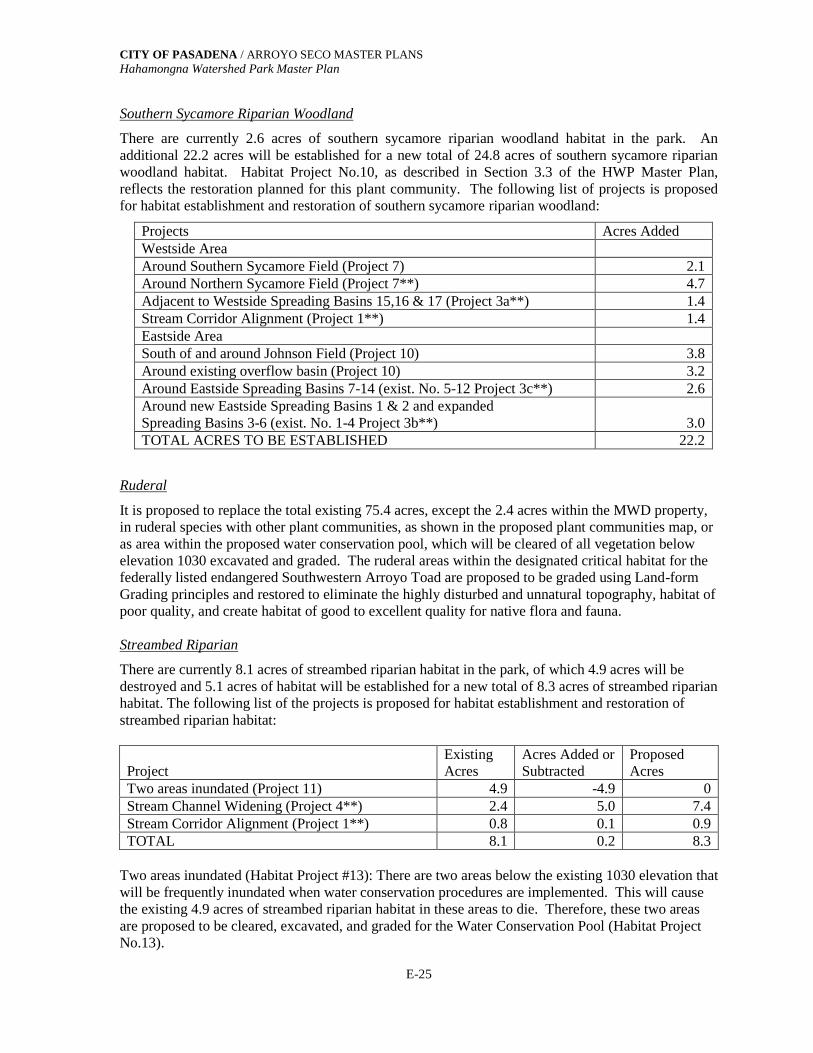
CITY OF PASADENA / ARROYO SECO MASTER PLANSHahamongna Watershed Park Master Plan
E-25
Southern Sycamore Riparian Woodland
There are currently 2.6 acres of southern sycamore riparian woodland habitat in the park. Anadditional 22.2 acres will be established for a new total of 24.8 acres of southern sycamore riparianwoodland habitat. Habitat Project No.10, as described in Section 3.3 of the HWP Master Plan,reflects the restoration planned for this plant community. The following list of projects is proposedfor habitat establishment and restoration of southern sycamore riparian woodland:
Projects Acres AddedWestside AreaAround Southern Sycamore Field (Project 7) 2.1Around Northern Sycamore Field (Project 7**) 4.7Adjacent to Westside Spreading Basins 15,16 & 17 (Project 3a**) 1.4Stream Corridor Alignment (Project 1**) 1.4Eastside AreaSouth of and around Johnson Field (Project 10) 3.8Around existing overflow basin (Project 10) 3.2Around Eastside Spreading Basins 7-14 (exist. No. 5-12 Project 3c**) 2.6Around new Eastside Spreading Basins 1 & 2 and expandedSpreading Basins 3-6 (exist. No. 1-4 Project 3b**) 3.0TOTAL ACRES TO BE ESTABLISHED 22.2
Ruderal
It is proposed to replace the total existing 75.4 acres, except the 2.4 acres within the MWD property,in ruderal species with other plant communities, as shown in the proposed plant communities map, oras area within the proposed water conservation pool, which will be cleared of all vegetation belowelevation 1030 excavated and graded. The ruderal areas within the designated critical habitat for thefederally listed endangered Southwestern Arroyo Toad are proposed to be graded using Land-formGrading principles and restored to eliminate the highly disturbed and unnatural topography, habitat ofpoor quality, and create habitat of good to excellent quality for native flora and fauna.
Streambed Riparian
There are currently 8.1 acres of streambed riparian habitat in the park, of which 4.9 acres will bedestroyed and 5.1 acres of habitat will be established for a new total of 8.3 acres of streambed riparianhabitat. The following list of the projects is proposed for habitat establishment and restoration ofstreambed riparian habitat:
ProjectExistingAcres
Acres Added orSubtracted
ProposedAcres
Two areas inundated (Project 11) 4.9 -4.9 0Stream Channel Widening (Project 4**) 2.4 5.0 7.4Stream Corridor Alignment (Project 1**) 0.8 0.1 0.9TOTAL 8.1 0.2 8.3
Two areas inundated (Habitat Project #13): There are two areas below the existing 1030 elevation thatwill be frequently inundated when water conservation procedures are implemented. This will causethe existing 4.9 acres of streambed riparian habitat in these areas to die. Therefore, these two areasare proposed to be cleared, excavated, and graded for the Water Conservation Pool (Habitat ProjectNo.13).
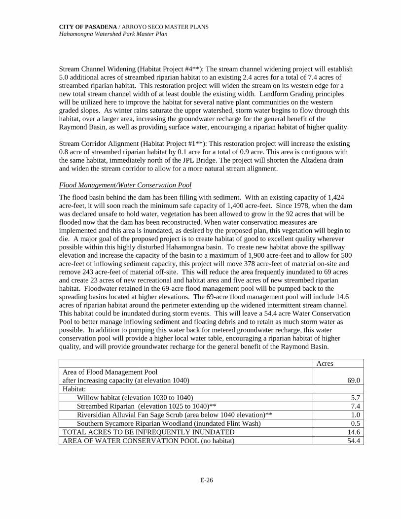
CITY OF PASADENA / ARROYO SECO MASTER PLANSHahamongna Watershed Park Master Plan
E-26
Stream Channel Widening (Habitat Project #4**): The stream channel widening project will establish5.0 additional acres of streambed riparian habitat to an existing 2.4 acres for a total of 7.4 acres ofstreambed riparian habitat. This restoration project will widen the stream on its western edge for anew total stream channel width of at least double the existing width. Landform Grading principleswill be utilized here to improve the habitat for several native plant communities on the westerngraded slopes. As winter rains saturate the upper watershed, storm water begins to flow through thishabitat, over a larger area, increasing the groundwater recharge for the general benefit of theRaymond Basin, as well as providing surface water, encouraging a riparian habitat of higher quality.
Stream Corridor Alignment (Habitat Project #1**): This restoration project will increase the existing0.8 acre of streambed riparian habitat by 0.1 acre for a total of 0.9 acre. This area is contiguous withthe same habitat, immediately north of the JPL Bridge. The project will shorten the Altadena drainand widen the stream corridor to allow for a more natural stream alignment.
Flood Management/Water Conservation Pool
The flood basin behind the dam has been filling with sediment. With an existing capacity of 1,424acre-feet, it will soon reach the minimum safe capacity of 1,400 acre-feet. Since 1978, when the damwas declared unsafe to hold water, vegetation has been allowed to grow in the 92 acres that will beflooded now that the dam has been reconstructed. When water conservation measures areimplemented and this area is inundated, as desired by the proposed plan, this vegetation will begin todie. A major goal of the proposed project is to create habitat of good to excellent quality whereverpossible within this highly disturbed Hahamongna basin. To create new habitat above the spillwayelevation and increase the capacity of the basin to a maximum of 1,900 acre-feet and to allow for 500acre-feet of inflowing sediment capacity, this project will move 378 acre-feet of material on-site andremove 243 acre-feet of material off-site. This will reduce the area frequently inundated to 69 acresand create 23 acres of new recreational and habitat area and five acres of new streambed riparianhabitat. Floodwater retained in the 69-acre flood management pool will be pumped back to thespreading basins located at higher elevations. The 69-acre flood management pool will include 14.6acres of riparian habitat around the perimeter extending up the widened intermittent stream channel.This habitat could be inundated during storm events. This will leave a 54.4 acre Water ConservationPool to better manage inflowing sediment and floating debris and to retain as much storm water aspossible. In addition to pumping this water back for metered groundwater recharge, this waterconservation pool will provide a higher local water table, encouraging a riparian habitat of higherquality, and will provide groundwater recharge for the general benefit of the Raymond Basin.
AcresArea of Flood Management Poolafter increasing capacity (at elevation 1040) 69.0Habitat:
Willow habitat (elevation 1030 to 1040) 5.7Streambed Riparian (elevation 1025 to 1040)** 7.4Riversidian Alluvial Fan Sage Scrub (area below 1040 elevation)** 1.0Southern Sycamore Riparian Woodland (inundated Flint Wash) 0.5
TOTAL ACRES TO BE INFREQUENTLY INUNDATED 14.6AREA OF WATER CONSERVATION POOL (no habitat) 54.4

CITY OF PASADENA / ARROYO SECO MASTER PLANSHahamongna Watershed Park Master Plan
E-27
UTILITIES
Underground Pasadena’s Eastside Overhead Power and Communication Lines
This project element will underground existing Pasadena overhead power and communication linesthat run north and south on the east side of the park. The project will occur in two phases; the firstphase will be to underground these overhead distribution lines from the VOC WTP to the ArroyoWell. The second will be to underground overhead distribution lines from the VOC WTP to JohnsonField.
Relocate the Existing Southern California Edison Power Line in the Hahamongna Basin
This project will minimize the number of overhead basin crossings as well as remove this line fromthe sensitive Riversidian Alluvial Fan Sage Scrub habitat, which restricts the maintenance of thisutility. This overhead distribution line that runs diagonally across the basin from the JPL substation tothe Windsor/Ventura intersection would be relocated. The new alignment would run North to theeast-west distribution lines, adjacent to the proposed North Bridge, crossing the basin with theexisting lines, then running south, along the existing Gabrielino Trail, and reconnecting to the existingSCE power distribution line along Altadena Drive.
Relocate the Existing Pasadena Power and Communication Line
This project will relocate the existing Pasadena power and communication line that traverses thebasin from the VOC WTP to the MWD property and northern portions of the west side of the park.This utility will be relocated due to the undesirable aesthetics of these poles, the erosion of the polebases, and the inaccessibility for maintenance in the Widen Stream Channel and Establish RiparianHabitat project area. The communication portion of this line will be relocated to a new line that willrun to JPL from the Windsor-Ventura intersection north along the Gabrielino trail.
The power portion of this line will be relocated to the Pasadena grid that crosses the Devil’s GateDam to feed facilities in the westside portion of the park. This alignment will go from the dam toFoothill Boulevard (preferably underground) and provide a new feed to OGMO, the EquestrianStaging Area restroom, the new restroom near the Oak Grove Field, the group picnic shelters south ofthe Oak Grove Field, the park ranger station, the existing restroom in the overnight area, and thegroup picnic shelters in the overnight camping area
Relocate the SCE North/South Transmission and South Distribution Line
These lines currently follow the toe of the western slope of the park, run the length of the basin fromsouth to north and feed into and from JPL’s main substation. The bases of 11 of the 21 power polesare frequently inundated during heavy storm events, making it impossible to access these poles. Thepoles will either be relocated to an alignment in Oak Grove Drive or be raised to an appropriateheight in their current location after the westside perimeter trail, relocated disc golf, and improvedparking lot areas are constructed with fill to raise the area above the seasonally inundated elevation of1040.5 (spillway elevation). Relocation of the poles to Oak Grove drive is the preferred solution.Prior to implementing the proposed grading of the Flood Management/Water Conservation Pool, ananalysis of alternative improvements or relocation of this utility will be completed for review andapproval. This will guarantee the safety and stability of this critical utility. A mutual agreementbetween SCE and the City of Pasadena (and potentially other entities such as JPL, MWD, and the cityof La Cañada-Flintridge) will need to be worked out.

CITY OF PASADENA / ARROYO SECO MASTER PLANSHahamongna Watershed Park Master Plan
E-28
SECURITY, SAFETY & ACCESSIBILITY
Two types of security fencing will be used. Decorative fencing consisting of some type of ironfencing with or without the use of Arroyo stone (as pillars or as a low wall on which an iron fencecould be placed) will be used where appropriate and conform to the Arroyo Seco Design Guidelines.Chain link fencing will be used in areas where security fencing is needed but aesthetics are not anissue. Decorative security fencing is recommended at the following locations:
At the south end of the park, from the west side of Flint Wash adjacent to Oak Grove Drive, northto the Gould Canyon Trail tunnel at Foothill Blvd.
At the Windsor Avenue and Ventura Street entrance between Mountain View and Ventura Street,along the west side of Windsor Avenue.
At the west end of Altadena Drive where a trail enters the park.
Gates will be needed at the westside tunnel entrance under Oak Grove Drive, to prevent entry ontothe dam from the new parking lot at Oak Grove Drive and Linda Vista during park closure. Chain-link security fencing will be used at the end of La Canada Verdugo Road and Oak Grove Drive fromthe Woodbury on-ramp to Flint Wash.

Appendix F

CITY OF PASADENA / ARROYO SECO MASTER PLANS Hahamongna Watershed Park Master Plan
F-1
Appendix F:
TECHNICAL REPORT ATHLETIC FIELDS AT HAHAMONGNA WATERSHED PARK
prepared by Parks and Natural Resources Division - Department of Public Works
Introduction The City of Pasadena has proposed the Arroyo Seco Master Plan for the restoration and enhancement of the Arroyo Seco. This plan is divided into three sections, which correspond to distinct geographical features and established uses of the Arroyo Seco within Pasadena’s boundaries. The Upper Arroyo Seco constitutes the northern - most section of this plan, which includes 300 acres known as Hahamongna Watershed Park (HWP) Located just north of Devil’s Gate Dam, Hahamongna Watershed Park presents a unique environment as a sediment and debris basin used for flood control, water conservation, and recreation. Existing features include active spreading basins, athletic fields, paved parking lots for JPL, a disc golf course, public parking, and an oak woodland, formerly known as Oak Grove Park. Although highly disturbed by both man and natural occurrences over the years, the area is biologically extremely diverse. The Arroyo Seco Master Plan and Draft Environmental Impact Report identify at least six native terrestrial plant communities, with over 300 plant species and approximately 100 animal species observed in the area encompassing Hahamongna Watershed Park. Included in this list are state and federally listed sensitive plant and animal species as well as designated critical habitats. Hahamongna Watershed Park is located over a portion of the unconfined groundwater aquifer known as Monk Hill Basin. This, along with the Pasadena Sub-area aquifer, is included in the larger aquifer known as the Raymond Basin. The Raymond Basin is approximately 40 square miles and supplies drinking water to the City of Pasadena and surrounding communities. Although there are great seasonal fluctuations, the average ground water levels under HWP are between 600 and 1000 ft. (Arroyo Seco Master Plan, Hahamongna Watershed Park Master Plan). The Master Plan proposes the addition of two new athletic fields on the west side of the stream, as well as improvements to the existing athletic field (Oak Grove field). These fields will primarily be used for youth soccer and youth softball. The two proposed new fields on the west side of the park will be known as the Sycamore Grove fields. A portion of this site is currently used for temporary overflow parking and is adjacent to the existing parking for Oak Grove Park. The existing Oak Grove athletic field accommodates youth tournament soccer and little league softball. The two new Sycamore

CITY OF PASADENA / ARROYO SECO MASTER PLANS Hahamongna Watershed Park Master Plan
F-2
Grove Fields will also accommodate youth tournament soccer and serve as multi-purpose fields. Due to the biological diversity and native habitats adjacent to the proposed and existing athletic fields, and their proximity to groundwater aquifers and surface water flows, there has been public concern regarding the effects of fertilizers, herbicides and pesticides used in the maintenance of these fields on the environment. The purpose of this report is to investigate and recommend maintenance and management practices to sustain these fields in suitable condition for youth sports, while preserving the quality and biodiversity of the surrounding environment. Turf management The most important element to minimize adverse effects to the environment is to apply proper horticultural practices to establish and maintain healthy turfgrass. Choosing the appropriate cultural practices, such as proper turf for the site and use, proper fertilization, aeration, irrigation and mowing practices will reduce or eliminate the need for chemical treatment of the turf. Well-maintained healthy turf with dense root systems can suppress the growth of weeds and the potential for disease, thus eliminating the need for pesticides. Although there is an obligation to maintain the best possible quality playing field, a few weeds or the mere presence of insects may not justify the use of chemical treatments. The turf manager needs to determine how much turf damage is acceptable before any treatment is needed. In order to maintain a healthy turfgrass system the following cultural practices should be followed: Conduct a complete soil analysis to determine exact nutrient needs. Healthy turf must have healthy soil. Determine nutrient and pH levels. Apply only nutrients that are necessary at times when they can be used most efficiently by the roots. Use slow-release organic fertilizer. Studies have shown that regular applications of compost based organic fertilizers have been proven to significantly suppress the growth of most common turf weeds1. Nutrients released slowly into the soil maintain a more consistent level. Apply less fertilizer more often to maintain a more consistent level and reduce the potential for leaching and runoff by allowing the turf to utilize the nutrients. Organic fertilizer adds organic matter to the soil that is utilized by the soil microorganisms. Mowing. There is a direct relationship between mowing height and the depth of the root system. Removal of more than 40% of the height of the blade in a single mowing stops root growth.2 The larger percentage of the blade is removed, the longer the root
1 Bio-Integral Resource Center (BIRC) IOM for Turfgrass in Schools www.keyed.com/birc/ipmturf 2 Cockerham, S. T. “Mowing Sports Fields” Feb. 2002

CITY OF PASADENA / ARROYO SECO MASTER PLANS Hahamongna Watershed Park Master Plan
F-3
growth is halted, allowing the turfgrass to be more susceptible to disease and insect problems and the encroachment of weeds. Mow more often, cutting less. Mowing heights should be higher in warmer months. Higher blade heights shade the soil, conserve moisture and inhibit the development of weeds. Studies have shown that the minimum height for hybrid bermudagrass to survive in a high- traffic area, such as a sports field, is ½”. 3 Leave clippings on the ground. Turf clippings are 85-90% water. As clippings decompose, nitrogen and other nutrients are returned to the soil, contributing to the organic matter. Shorter grass clippings will decompose faster. Leaving grass clippings can reduce the need for fertilizer by 1-3 applications per year. If mowed regularly at the proper height, there will be no build-up of thatch. Aeration – compacted soil creates conditions for limited root development and increases the turf’s susceptibility to certain diseases. Athletic fields can become extremely compacted. To prevent this, fields should be aerated several times a year. This increases the ability of water to penetrate the soil, provides oxygen to microorganisms, and pushes the thatch layer into the soil, increasing the rate of decomposition and the organic matter in the soil. After aeration, a compost based organic amendment should be applied to further increase the amount of organic matter and provide nutrients to the soil. Composted organic amendments have been found to be among the most consistently effective in reducing the severity of turfgrass diseases, whether applied as a topdressing, or root zone amendment.4 Control thatch layer. Thatch is the accumulation of undecomposed roots and stems at the soil surface. If allowed to become too thick, this can prevent water and nutrients from entering the soil. All hybrid bermudagrass cultivars form thatch. Aeration pushes thatch into the soil, allowing for increased decomposition and increasing organic matter to the soil. Frequent mowing prevents build-up of thatch to unacceptable levels. The use of organic fertilizers also promotes thatch decomposition. Irrigation - Proper irrigation and water management practices are crucial to healthy turf and will reduce the potential for leaching and runoff. Soil moisture levels should be tested and water should be applied only to replace water lost through evapotranspiration. Irrigation applications need to be adjusted according to weather and soil conditions. Use of Fertilizers The primary concern regarding the use of fertilizers is the movement of nitrogen into ground water and surface runoff. In the past several years, numerous studies have been conducted at universities throughout the country regarding the effects of nitrogen and
3 ibid 4 Nelson, Eric B. “Enhancing turfgrass disease control with organic amendments” Turfgrass Trends, June 1996

CITY OF PASADENA / ARROYO SECO MASTER PLANS Hahamongna Watershed Park Master Plan
F-4
nitrates on the environment. In 1991, the United States Golf Association (USGA) initiated a three-year study at various locations throughout the country to investigate the impact of golf courses to people and wildlife. This resulted in studies conducted by research scientists at 11 separate universities involving the fate of fertilizers and pesticides. Five of these studies, conducted at Iowa State University, Michigan State University, University of Nevada, Cornell University, University of California Riverside and Washington State University, specifically analyzed nitrogen leaching.5 The results of these projects were published in the January/February 1995 USGA Green Section Record. In addition, independent studies (not part of this USGA project) have been conducted throughout the country, including the University of California, Riverside, involving nitrogen leaching. All studies were conducted with test plots using various combinations of turf, soil types, fertilizers, and irrigation rates. The fertilizer application and irrigation rates ranged from standard rates to excessive rates in order to promote leaching. Both fast and slow-release fertilizers were tested on a variety of turf, including Kentucky bluegrass, tall fescue, and bermudagrass. The results of all these studies came to an overwhelmingly consistent conclusion: In mature, healthy, well-managed turf, nitrogen levels in leachate are insignificant. The plants and associated soil microorganisms efficiently utilize nitrogen applied to healthy turf with a dense root system. Once established, healthy turf has such a fibrous root system that it filters the nitrogen and there is almost no movement beyond the roots. At the deepest level tested, four feet below the surface, less than .2% of the applied nitrogen was found in the leachate.6 In one study, the turf (bermudagrass) was so efficient at utilizing the nitrogen that the nitrogen levels in the leachate were less than in the irrigation water applied7. The highest levels of nitrogen found in leachate were below the federal drinking water standards in all studies. There were, however, some variations found with differences in cultural and management practices. The least amount of nitrogen leaching resulted from the use of slow-release, natural organic fertilizers. An established turfgrass ecosystem supports a high level of biological activity that consumes nitrogen to support the growth of the microorganisms. In new turf that has not yet established a sufficient root system, the addition of organic matter significantly reduced nitrogen leaching8. Studies also indicate that more leaching occurred in newly planted
5 USGA Green Section Record, Results from the USGA Environmental Research Program, United States Golf Association, January/February 1995 6 Branham, Bruce, and Miltner, Eric and Rieke, Paul “Potential Groundwater Contamination from Pesticides and Fertilizers Used on Golf Courses”, Michigan State University 1995 7Green, Robert, “Soil Type Affects NO3-N Leaching on Overseeded Bermudagrass Fairways” BetterTurf Thru Agronomics, June 2000 8 Brauen, Stanton and Gwen K. Stahnke “Leaching of Nitrate from Sand Putting Greens”, Washington State University, Puyallup Research and Extension Center

CITY OF PASADENA / ARROYO SECO MASTER PLANS Hahamongna Watershed Park Master Plan
F-5
turf than in established turf9 and that more leaching occurred during the dormant season of warm season grasses10. Recommendations: Overall, the key to minimizing the effects of nitrogen on the environment is establishing and maintaining a healthy turfgrass system. Several management practices can be followed that have proven to be effective in reducing the movement of nitrogen and establishing healthy turf:
• Use slow-release organic fertilizer. • Use smaller amounts of fertilizer more frequently so that the turfgrass can
efficiently consume each application. Brauen and Stahnke reported significant differences in nitrogen in the leachate by applying slow- release fertilizer every 14 days vs. every 28 days.11 Keeping grass clippings on the turf reduces fertilizer needs.
• Use foliar applications of fertilizer. • Establish and maintain a dense, healthy root system. Apply organic matter
to new turf to promote the rapid development of the root system. • Irrigate lightly and less frequently after application of fertilizer. Christians
reported that one 2” irrigation application resulted in 40% higher nitrogen levels in leachate than four 1” applications.12
• Water only as necessary. Irrigate at 100% evapotranspiration • Apply fertilizer at appropriate times. Application prior to heavy rain
increases the movement of nitrogen through leaching and runoff. • Use turfgrass cultivar with a shorter dormant period to eliminate the
potential of leaching during dormancy and maintain a dense root system year round.
Pesticides (including herbicides and insecticides) Pesticides have been the cause of concern of many health and pollution problems in the last few decades. The United States Geological Survey has completed extensive monitoring programs through its National Water-Quality Assessment program over the last 20 years. Their findings concluded that pesticides are abundant in ground-water
9 Petrovic, Martin “The Impact of Soil Type and Precipitation on Pesticide and Nutrient Leaching from Fairway Turf” Cornell University 1995 10 Green, Robert ibid 11 Branham, etal. 12 Christians, N. and Shea,P.J. and Horst, G.L. “Pesticide Degradation Under Golf Course Fairway Conditions” 1995
CITY OF PASADENA / ARROYO SECO MASTER PLANS Hahamongna Watershed Park Master Plan
F-6
throughout the country. In 99% of urban streams tested, pesticides were found. Over 70% of those had more than five different kinds of pesticides. The leaching potential of pesticides in turfgrass depends upon several factors. The main factors are the properties of the pesticide itself, which include the ability of the pesticide to adsorb to the soil, water solubility, and persistence, or the time it takes for the pesticide to degrade. These factors, in turn, are dependent upon soil properties, irrigation practices, and the application and handling of pesticides.13 The properties of the pesticide must be carefully matched with the soil properties and cultural practices to minimize the potential for leaching. Numerous university and independent research studies indicate that, like nitrogen, the effect of pesticides on the environment through leaching or runoff can be minimized through proper cultural practices. Under ideal turfgrass conditions, the dense, fibrous turfgrass root systems are capable of adsorbing and absorbing applied pesticides.14 Appling pesticides to turfgrass is not like agricultural applications, where chemicals are often applied to bare soil, increasing the potential for groundwater leaching and surface runoff. Many turfgrass pesticides are formulated as systemic materials designed to be absorbed by the roots. It has been found that most turfgrass pesticides will rarely penetrate more than 1-1” ½” into the soil. The negative environmental effects of pesticides, however, are not limited to groundwater leaching. There is a worldwide decline in amphibian populations and an increase in amphibian deformities that has baffled scientists for years. Recent research has linked these deformities in frogs to chemical contaminants, specifically pesticides. Because of their thin skin, frogs are more susceptible to absorption of chemicals through the skin. Research now shows that even where contaminant levels are below EPA drinking water standards, the effect on amphibians is significant. The exposure to pesticides weakens their immune system sufficiently so that they become susceptible to infections that lead to severe limb deformities.15 There is great diversity in the type of pesticides and their impact on health and the environment. Those products labeled “organic” or natural are not necessarily non-toxic, as there are many toxic natural materials. Because of these variations, and the inability to control all conditions in which pesticides are used, the U.S. Federal law prohibits products to be labeled “safe if used as directed” because absolute safety cannot be guaranteed. There are alternative products available for the control of many pests. Cultural controls are the first priority. A change in irrigation, mowing or fertilization could eliminate the 13 Gan, Jay “How to Reduce Pesticide Leaching” PesticideWise , Spring 2002, Department of Environmental Sciences of the University of California, Riverside 14 Cooper, Richard J. “Evaluating the Runoff and Leaching Potential of Turfgrass Pesticides” Golf Course Management February 1990 15 Kiesecker, Joseph M. “ Synergism between trematode infection and pesticide exposure: A link to amphibian limb deformities in nature?” Proceedings of the National Academy of Science, USA, Vol 99, Issue 15, July 2002
CITY OF PASADENA / ARROYO SECO MASTER PLANS Hahamongna Watershed Park Master Plan
F-7
need for further treatment. If additional treatment is needed, biological controls should be considered. Biological control is the deliberate use of natural enemies to suppress and maintain populations of pest species.16 The advantages of biological controls are that only the target species is affected; there are no residual contaminants to humans or the environment; pests cannot develop a resistance to it; and it is usually more cost effective than chemicals. In order to effectively use biological controls, the exact pest species must be known so that the appropriate, host specific natural enemy is applied. The effect of biological controls cannot, however, be predicted or controlled, and may not completely eliminate the target pest. There is also a risk that the introduction of an exotic species to the environment may have an impact on the natural enemies of a beneficial species. Careful study into the use of the appropriate biological controls for the target pest and its potential impact on other species must be examined before any new species is introduced. Another biological control method is a product that has been developed by Dr. Nick Christians, Professor of Horticulture at Iowa State University, specializing in turfgrass science. Dr. Christians discovered a corn gluten meal that has the ability to inhibit root formation of broadleaf weeds at the time of germination. Corn gluten meal is a naturally occurring plant protein. It is effective as a pre-emergent by inhibiting the formation of root tissues during seed germination. The shoots develop, but then die back due to lack of roots. It has no effect on established plants and must be applied 4-6 weeks prior to germination. Because the corn gluten meal also contains 10% nitrogen, this product also serves as a slow-release organic fertilizer, reducing need for additional fertilizer applications. Research on turfgrass indicates a 50-60% decrease in broadleaf weeds the first year of use, and by the second and third years the corn gluten meal was as effective as synthetic herbicides.17 It is being used on golf courses and sports fields throughout the country. There are no residual affects or contaminants involved and no known hazardous ingredients or conditions related to this product Recommendations: Due to the proximity of the proposed fields to natural areas and sensitive wildlife habitats, the use of chemical pesticides is not recommended. Although the amount of pesticides leaching into the groundwater could be minimized through appropriate cultural practices, the potential risk of pesticides to wildlife in HWP still exists. Cultural controls, biological controls, and new non-toxic methods should be utilized to maintain the HWP athletic fields in appropriate playing condition. The Arroyo Seco Master Plan – Hahamongna Watershed Park Master Plan, Planting Guidelines states: “Herbicides should never be used near aquatic and wetland areas under
16 Aliniazee, M.T. “The Economic, Environmental and Sociopolicial Impact of Biological Control” Biological Controls in the Western United States 17 Christians, Nick “Using biological control strategies for Turf” Grounds Maintenance 34(3):28-32 March 1999

CITY OF PASADENA / ARROYO SECO MASTER PLANS Hahamongna Watershed Park Master Plan
F-8
any circumstances due to the sensitive nature of these habitats and the potential for further spreading of harmful chemicals through water-borne transport. Soil tilling, mechanical cutting, solarization, and spot herbicide treatments should all be considered”…“mechanical removal of weeds is preferred over the use of herbicides” Although this clause refers to the native vegetation restoration areas of HPW it should be extended to include all of HWP for the protection of all wildlife in the park. Rodent control Irrigated areas, such as well-maintained turf, provide optimal conditions for both squirrels and gophers to burrow, feed, and reproduce. Their burrows pose a safety hazard for athletes as well as provide opportunities for the invasion of weeds and the potential for erosion. Squirrels are also the most prevalent sources of plague and are associated with the spread of several other diseases. Effective control measures are necessary for public health and safety. Gophers live in burrows ranging from 6 inches to 6 feet below the ground and can cover an area of several hundred to over a thousand square feet. They do not hibernate and are active year-round. They may also be active at any hour of the day. As they dig their burrows, the soil is pushed to the surface, creating a mound of fresh soil around the opening of the burrow. Feed holes, however, where gophers come to the surface to eat the surrounding vegetation will not have a mound. In irrigated areas, gopher burrow building can take place year-round, as the soil is always soft and moist. Breeding can also take place year-round, producing up to 3 litters per year, with 5-6 young per litter. Breeding and burrowing activity is higher in irrigated areas than in non-irrigated areas.18 Gophers feed on a wide variety of vegetation, but prefer herbaceous plants. They feed on stems and leaves above ground, as well as roots below ground. They can pull an entire plant into their tunnel. California ground squirrels are a native species that can be found in valley and foothill environments, but prefer disturbed areas adjacent to natural areas such as occur at Hahamongna Watershed Park. In fact, due to the creation of optimum soil conditions and abundance of food and water, in disturbed and altered environments squirrel populations can be many times more than they would be in a natural environment.19 Like gophers, ground squirrels also excavate extensive burrows, creating a safety hazard on playing fields. They feed on seeds, vegetation and are known to prey on eggs of ground nesting birds. They hibernate in the winter, are most active in spring and fall and can produce a litter of 4-13 in the spring.
18University of California Statewide Integrated Pest Management Program, UC Pest Management Guidelines, Pocket Gophers, published 1/02 www.ipm.ucdavis.edu/PMG/PESTNOTES/pn7433.html 19 LA County Department of Agricultural Commissioner and Weights and Measures, Ground Squirrel Control

CITY OF PASADENA / ARROYO SECO MASTER PLANS Hahamongna Watershed Park Master Plan
F-9
The most serious problem with ground squirrels is that they are the most prevalent animal carriers of plague. Plague is a highly infectious bacterial disease which primarily affects rodents. However, it can be transmitted from rodents to pets and humans through fleas. In humans, if detected early, antibiotics can successfully treat it. If not treated, it can lead to plague pneumonia, which is highly contagious and can be fatal. The City of Pasadena Environmental Health Department inspects and tests for plague annually. LA County Vector Management inspects and tests for plague in the areas outside the city limits adjacent to Hahamongna, including Altadena and the Angeles National Forest. In the year 2000, coyotes have tested positive at Switzers campground, north of Hahamongna.20 Developed areas adjacent to known infected natural areas are highly susceptible to the spread of the disease through animal movement. Although to date there have been no positive reported cases within the city.21 Recommendation: Due to the potential for serious health and safety problems, squirrels and gophers on the proposed Hahamongna fields should be controlled as soon as they appear. Since irrigated turf areas provide optimal conditions for the breeding of squirrels and gophers, allowing them to remain and reproduce will only amplify the problem. Immediate eradication will result in fewer animals to be eliminated in the long run, maintain safe playing fields, and provide proper public health policies. Gopher control: Elimination of broadleaf vegetation from the turf and immediately adjacent areas will minimize the presence of gophers. Turfgrasses alone do not provide enough of a food source to raise their young22, so they will seek a location with a more ample food supply. Keeping the turf healthy and free of weeds, using cultural practices previously outlined in this report, should significantly limit gopher activity. Encouraging natural predators to the area can also limit gopher activity, but it will not completely eliminate their presence. Although many natural predators of the gopher can be found in Hahamongna, including snakes and coyotes, these predators hunt for other prey as well, and will go where the food sources are abundant and easily obtained. Gophers can avoid capture by these predators by plugging up their burrow with dirt. There is also a public safety concern in encouraging predators to use areas of heavy human activity, such as youth sports fields, where there are expected to be large numbers of families with children and pets.
20 Rood, Michael Environmental Health Specialist, Vector Management, LA County Health Dept. personal communication 9/23/02 21 Mel Lim, City of Pasadena Environmental Health, personal communication 9/23/02 22 University of California Statewide Integrated Pest Management Program, Pest Management Guidelines Pocket Gophers, Jan 2002 www.ipm.ucdavis.edu/PMG/PESTNOTES/pn7433.html

CITY OF PASADENA / ARROYO SECO MASTER PLANS Hahamongna Watershed Park Master Plan
F-10
Attracting barn owls, another natural predator of gophers, has been used with limited success in agricultural areas to reduce rodents. Barn owls are cavity nesters, and placing nesting boxes in the area has been proven to be successful in attracting them to areas where there is abundant food. The more nesting boxes placed, the greater the likelihood that they will be used. In one study in which 10 nesting boxes were installed 100 feet apart, all boxes were used by the second year.23 Mature barn owls can eat 10 rodents per night, and the grassy fields and natural areas of Hahamongna provide appropriate habitat for their prey. However, since they are not territorial, they hunt over large areas where food is available, and the placement of nesting boxes will not ensure they stay in the area. Barn owls and other natural predators may reduce, but not eliminate, the number of gophers on the proposed Hahamongna fields. Although they have not proven to be a reliable source of rodent control, the placement of nesting boxes would increase the potential for barn owls to reduce the gopher population. Natural predators do not eliminate every animal, and a single gopher can cause extensive damage to a field and present a public safety hazard. A safe, effective, and reliable method of gopher control is trapping. The key to successful trapping is setting traps in the proper locations. Bait boxes are not effective and should not be used when attempting to control gophers. Proper trapping methods, types of traps, and proper placement can be obtained from the City’s Pest Control Advisor, UC Pest Management Guidelines or the Los Angeles County Department of Agricultural Commissioner’s office. Squirrel control: The least toxic method of reducing squirrel populations is by cultural practices. Squirrels are scavengers, and will find food where it is most easily obtained, which is often the area of high human activity, including picnic areas and athletic fields. Diligent litter control practices, providing covered trash containers at convenient locations, and keeping the area free of dense vegetation cover will reduce squirrel populations in these areas. If squirrels become a problem, the options available for control are difficult to access, as each poses potential threat to other wildlife. The two methods available are the use of anticoagulant bait boxes and fumigants. Anticoagulant bait can be set in bait boxes, which the squirrel must enter to reach the bait. This option is considered safe for home use as children, pets and larger animals cannot get into the box, and there is a readily available and effective antidote. The squirrel needs to consume the bait for several feedings over a 4-5 day period. It may take 2-4 weeks for the anticoagulant to become effective in reducing the squirrel population. The box is placed in a location frequented by squirrels, such as near the entrance to the burrow, but needs to be hidden from public view and access. It should not be placed in the burrow. Smaller animals such as rabbits, snakes, mice and birds might also enter the bait box and be affected by the bait.
23 Trapp, Douglas E. “International Barn Owl Restoration Project”, 1996 ourworld.compuserve.com/homepages/DTrapp/barnowli.htm

CITY OF PASADENA / ARROYO SECO MASTER PLANS Hahamongna Watershed Park Master Plan
F-11
The other alternative to squirrel control is the use of a fumigant, aluminum phosphide, which can only be applied by a licensed pest control applicator. It is injected in table form directly into active burrows. The moisture in the soil mixes with the aluminum phosphide and produces a toxic gas, hydrogen phosphide. The gas quickly dissipates, leaving no toxic substances in the atmosphere or the soil. This method is more direct, effective, and reliable for the immediate reduction of squirrel populations. However, it is also highly toxic to wildlife. Many other animals often occupy squirrel burrows, and non-target species in the burrow would be affected. The use of either of these controls must be carefully considered, as each may be an appropriate squirrel control method depending upon the severity of the problem and urgency to reduce the squirrel population. Conclusion New products and technology are being tested and created to improve and ease the maintenance and management of turfgrass. Improved irrigation systems, new turfgrass cultivars, and new and creative application of fertilizers are constantly being developed. In order to provide the healthiest and most economical turfgrass system, the city needs to keep pace with these new products and ideas. The City of Pasadena is currently in the process of installing a state-of-the-art water management system in its parks. This system measures evapotranspiration rates through remote sensors placed at key locations throughout the city, including Brookside Park and Oak Grove field at Hahamongna. These sensors can transmit evapotranspiration rates and/or soil moisture rates to a centralized computer system at the City’s park maintenance yards. The computer automatically calculates evapotranspiration rates, and only the amount of water lost is applied to each location. The application rates automatically adjust to changes in soil and weather conditions. This system prevents over-watering and runoff. In addition, a flow sensor detects breaks in the system so that water flow can be turned off automatically to prevent runoff and erosion. This system will significantly increase the ability to apply proper turf management practices and minimize potential leaching and runoff of nutrients. The University of California, Riverside, is currently conducting studies using green waste compost as a turf soil amendment. As mentioned in the cultural practices guidelines, compost based organic amendments are extremely effective in maintaining healthy turfgrass. The study used bermudagrass in a sandy loam soil and simulated heavy traffic, as would be found on a sports field, conditions similar to those at the proposed Hahamongna fields. Although only in the second year of this three-year study, the results so far indicate that with increased used of the green waste compost, there is an increase in water infiltration, softer surface of the turf, and increased organic matter. Increased traffic, however, reduced each of these conditions. As this study concludes in May 2003, this should be explored further. The use of green waste as an organic amendment on

CITY OF PASADENA / ARROYO SECO MASTER PLANS Hahamongna Watershed Park Master Plan
F-12
sports fields would not only improve the quality of the field, but also assist the city in complying with AB939, the requirement to reduce the amount of waste going to landfills. New cultivars are constantly being developed. The greatest risk of leaching and damage to the turfgrass system is during dormancy, which may also be the greatest demand for use. A cultivar with a shorter dormancy period would enable more available playing time and keep the turf healthy year-round. Even with new cultivars, however, scheduling down time to maintain the fields is vital. Providing time without heavy traffic for aeration and fertilization will keep the fields healthy and in better playing condition in the long run. These times should be scheduled with the user groups well in advance to avoid conflicts. The research presented in this report indicates that the key to maintaining fields with minimal effect on the environment is diligent management with proper cultural practices. Maintaining a healthy turfgrass system on heavily used areas such as youth sports fields is not easily accomplished. Proper cultural practices will reduce the need for treatments that would be harmful to the environment. It is recognized that many of the studies cited in this report were conducted on golf-course quality turf under constant supervision and maintenance. Sports fields in a city park rarely have the luxury of such treatment. With appropriate management, however, it is possible to obtain high quality fields and protect the surrounding environment. In order to obtain this level of maintenance, an experienced turf manager, knowledgeable in sports turf best management practices and the use of non-toxic methods should be assigned to the management of these fields. This, of course, requires appropriate funding. In a recent University of California, Riverside survey of 305 turf managers, 58% stated that applying best management practices to sports fields was not difficult, but they were restricted by financial limitations. In the long run, however, the money spent on proper management practices will be offset by the reduction of fertilizers, pesticides, and reseeding, and increased public health and safety, as well as protection of the surrounding environment. A long-term integrated park management plan should be established for HWP. Sports fields amidst natural areas present a unique management challenge. Typically, areas managed as natural areas, such as the U.S. Forest Service area and Los Angeles County Natural Area Parks, do not allow the use of chemical pesticides or toxic materials within their boundaries. These places, however, do not have sports fields. Based on the information presented here, it is possible to establish a non-toxic policy and still maintain sports fields. An integrated park management plan that specifically outlines management practices and policies should be developed for all of Hahamongna Watershed Park. This plan will help to ensure that best management practices are utilized in maintaining sports fields within the environment they are placed in and with consideration of all other factors and uses of Hahamongna Watershed Park.

CITY OF PASADENA / ARROYO SECO MASTER PLANS Hahamongna Watershed Park Master Plan
F-13
REFERENCES Aliniazee, M.T. “The Economic, Environmental and Sociopolicial Impact of Biological Control” Biological Controls in the Western United States Bio-Integral Resource Center (BIRC) IPM for Turfgrass in Schools www.keyed.com/birc/ipmturf Branham, Bruce, and Miltner, Eric and Rieke, Paul “Potential Groundwater Contamination from Pesticides and Fertilizers Used on Golf Courses”, Michigan State University 1995 Brauen, Stanton and Gwen K. Stahnke “Leaching of Nitrate from Sand Putting Greens”, Washington State University, Puyallup Research and Extension Center Christians, Nick, Corn Gluten Meal Research Site www.gluten.iastate.edu/home Christians, Nick “Using biological control strategies for Turf” Grounds Maintenance 34(3): 28-32 March 1999 Christians, N. and Shea, P.J. and Horst, G.L. “Pesticide Degradation Under Golf Course Fairway Conditions” 1995 City of Pasadena, Arroyo Seco Master Plan, Hahamongna Watershed Park Master Plan, May 2002 City of Pasadena, Arroyo Seco Master Plan Environmental Impact Review, May 2002 Cockerham, S. T. “Mowing Sports Fields” University of California, Riverside Feb. 2002 Cooper, Richard J. “Evaluating the Runoff and Leaching Potential of Turfgrass Pesticides” Golf Course Management February 1990 Diegelman, Nathan “Poison in the Grass: The Hazards and Consequences of Lawn Pesticides” www.eisc.ca/poison_in_the_grass Deubert, Karl “Environmental Fate of Common Turf Pesticides, Factors Leading to Leaching” USGA Green Section Record July/August 1990 Gan, Jay, Assistant Professor, Water Quality Specialist, Department of Environmental Sciences, University of California, Riverside, personal communication 8/14/02 Gan, Jay “Understanding Pesticide Risks in Different Landscape Systems, Pesticides in the Urban Environment” www.pw.ucr.edu.LandscapesJayGan-files

CITY OF PASADENA / ARROYO SECO MASTER PLANS Hahamongna Watershed Park Master Plan
F-14
Gan, Jay “Understanding Pesticide Risks in Different Landscape Systems, Pesticides in Groundwater” www.pw.ucr.edu/leaching-lahontan-files Gan, Jay “How to Reduce Pesticide Leaching” PesticideWise , Spring 2002, Department of Environmental Sciences of the University of California, Riverside Gan, Jay “Pesticide and Groundwater Quality” PesticideWise, Winter 2002 www.pw.ucr.edu.textfiles/PesticideWiseWinter 2002 Gilliom, Robert J. “Pesticides in the hydrologic system, what do we know and what’s next?” Hydrological Processes 2001 Gibeault, Victor, Extension Environmental Horticulturist, University of California, Riverside, personal communication Gibeault, Victor “Turfgrass Selection and Culture” University of California, Riverside Gibeault, Victor; Marylynn Yates; Jewell Meyer; Mathew Leonard “Movement of Nitrogen Fertilizer in a Turfgrass System” California Turfgrass Culture vol 48, nos.1 &2, 1998 Green, Robert Department of Botany and Plant Sciences, University of California, Riverside, personal communication 7/15/02 Green, Robert, “Soil Type Affects NO3-N Leaching on Overseeded Bermudagrass Fairways” BetterTurf Thru Agronomics, June 2000 Harivandi, Ali “Thatch, The Turf Manager’s Hidden Enemy”, California Turfgrass Culture vol 34, no.1, 1984 Hartman, Jim, LA County Dept. of Agricultural Commissioner and Weights and Measures, personal communication 8/27/02 Huddelston, J.H. “How soil properties affect groundwater vulnerability to pesticide contamination” Oregon State University Extension Service 1996 Kiesecker, Joseph M. “ Synergism between trematode infection and pesticide exposure: A link to amphibian limb deformities in nature?” Proceedings of the National Academy of Science, USA, Vol 99, Issue 15, July 2002 Klein,Grant J and Robert Green, “A Survey of Professional Turfgrass Managers in Southern California Concerning Their Use of Turfgrass Best Management Practices” University of California, Riverside, 1999

CITY OF PASADENA / ARROYO SECO MASTER PLANS Hahamongna Watershed Park Master Plan
F-15
Lim, Mel, City of Pasadena Environmental Health, personal communication 9/23/02 Lind, Pollyanna “Preparing a Landscape Site without Chemicals” Journal of Pesticide Reform vol 19, no.4 1999 Lloyd, John; Daniel Herms; Benjamin Stinner; Harry Hoitink; “Organic Mulches Enhance Overall Plant Growth” Turfgrass Trends, April 1, 2002 Long, Mickey, Acting Administrator, LA County Natural Area Parks, personal communication, 7/15,02, 10/10/03 Los Angeles County, Environmental Health Vector Management Program “Facts About Plague in Los Angeles County” Los Angeles County, Department of Agricultural Commissioner and Weights and Measures “Ground Squirrel Control” McDade, Meliisa “Corn gluten meal and corn gluten hydrolysate for weed control” Masters thesis, Iowa State University, 1999 Monroe, Michael, City of Pasadena Parks Supervisor, Parks and Natural Resources personal communication, 9/17/02 Nelson, Eric B. “Enhancing turfgrass disease control with organic amendments” Turfgrass Trends, June 1996 Petrovic, Martin “The Impact of Soil Type and Precipitation on Pesticide and Nutrient Leaching from Fairway Turf” Cornell University 1995 Ransom, Viveka, “Corn Gluten Meal, byproduct to wonder Product” The Iowa Horticulturist Rao, R.S. Mansell; L.B. Baldwin, M.F.Laurent, “Pesticides and Their Behavior in Soil and Water” Florida Turf Digest, vol2, no12, Dec. 1985 Rood, Michael Environmental Health Specialist, Vector Management, LA County Health Dept. personal communication 9/23/02 Trapp, Douglas E. “International Barn Owl Restoration Project”, 1996 www.ourworld.compuserve.com/homepages/DTrapp/barnowli.htm University of California Statewide Integrated Pest Management Program, UC Pest Management Guidelines, Pocket Gophers, published 1/02 www.ipm.ucdavis.edu/PMG/PESTNOTES/pn7433.html
CITY OF PASADENA / ARROYO SECO MASTER PLANS Hahamongna Watershed Park Master Plan
F-16
University of California, Division of Agriculture and Natural Resources, UC Pest Management Guidelines, Turfgrass, publication 3365T. July 2000 University of California, Division of Agriculture and Natural Resources Biological Controls in the Western United States, Accomplishments and Benefits of Regional Research Project W-84 1964-1989, publication 3361 University of California, Cooperative Extension, Division of Agriculture and Natural Resources, “Selecting the Best Turfgrass” leaflet 2589 USGA Green Section Record, Results from the USGA Environmental Research Program, United States Golf Association, January/February 1995 Weeden,C.R., A.M. Shelton, Y Li, M.P. Hoffmann, editors, “Biological Control, A Guide to Natural Enemies in North America”, Cornell University April 2002 Young, Steve L. “Alternative Methods for Controlling and Maintaining Vegetation Along Roadsides: Annual Summary Report for Corn Gluten Meal, Year 1” UC Hopland Research and Extension Center Zingiro, Ralph, Bio-Scape, Inc. personal communication 8/27/02