PRESPA LAKE WATERSHED MANAGEMENT PLAN
135
See discussions, stats, and author profiles for this publication at: http://www.researchgate.net/publication/266850433 PRESPA LAKE WATERSHED MANAGEMENT PLAN BOOK · JANUARY 2014 DOWNLOADS 41 VIEWS 39 23 AUTHORS, INCLUDING: Ordan Chukaliev Ss. Cyril and Methodius University 47 PUBLICATIONS 12 CITATIONS SEE PROFILE Igor Ristovski Aberystwyth University 9 PUBLICATIONS 1 CITATION SEE PROFILE Radmila Bojkovska Hydrometeorological Service, Republic of … 7 PUBLICATIONS 12 CITATIONS SEE PROFILE Trajce Stafilov Ss. Cyril and Methodius University 455 PUBLICATIONS 2,022 CITATIONS SEE PROFILE Available from: Trajce Stafilov Retrieved on: 13 August 2015
-
Upload
independent -
Category
Documents
-
view
0 -
download
0
Transcript of PRESPA LAKE WATERSHED MANAGEMENT PLAN

Seediscussions,stats,andauthorprofilesforthispublicationat:http://www.researchgate.net/publication/266850433
PRESPALAKEWATERSHEDMANAGEMENTPLAN
BOOK·JANUARY2014
DOWNLOADS
41
VIEWS
39
23AUTHORS,INCLUDING:
OrdanChukaliev
Ss.CyrilandMethodiusUniversity
47PUBLICATIONS12CITATIONS
SEEPROFILE
IgorRistovski
AberystwythUniversity
9PUBLICATIONS1CITATION
SEEPROFILE
RadmilaBojkovska
HydrometeorologicalService,Republicof…
7PUBLICATIONS12CITATIONS
SEEPROFILE
TrajceStafilov
Ss.CyrilandMethodiusUniversity
455PUBLICATIONS2,022CITATIONS
SEEPROFILE
Availablefrom:TrajceStafilov
Retrievedon:13August2015

1 33
Prespa Lakes
Watershedmanagement plan

The preparation of the Prespa Lake Watershed Management Plan was produced with the technical and financial support of the United Nations Development Programme (UNDP), in the framework of the Integrated Ecosystem Management in the Prespa Lakes Basin project.
The Integrated Ecosystem Management in the Prespa Lakes Basin project is implemented by UNDP with financial support from the Global Environment Facility (GEF). Its overall objective of is to help the region’s people with long term economic and social development,conserve the rich biodiversity and protect the waters of the Prespa Lakes Basin.
ABOUT THE GEF:
The Global Environment Facility unites 182 member governments - in partnership with international institutions, nongovern-mental organizations, and the private sector - to address global environmental issues. As an independent financial organi-zation, the GEF provides grants to developing countries and countries with economies in transition for projects related to biodiversity, climate change, international waters, land degradation, the ozone layer, and persistent organic pollutants. These projects benefit the global environment, linking local, national, and global environmental challenges and promoting sustain-able livelihoods.
ABOUT UNDP:
UNDP partners with people at all levels of society to help build nations that can withstand crisis, and drive and sustain the kind of growth that improves the quality of life for everyone. On the ground in 177 countries and territories, we offer global perspective and local insight to help empower lives and build resilient nations.
Disclaimer:
The opinions and standpoints expressed in this publication are those of the authors and do not necessarily reflect the official position of UNDP or the GEF.

Prespa Lake Watershed Management Plan
Project: Integrated Ecosystem Management in the Prespa Lake Basin
Executing Agency: Ministry of Environment and Physical PlanningImplementing Agency: United Nations Development Programe
A Project is funded by The Global Environmental Facility A Project developed by GTI – GEOTEHNICKI INZENERING doo, Skopje


33
Expert Team:Maja Petrovska Project Director
Todor Conevski Team Leader
Prof. Svetislav Krstić, PhD Deputy Team Leader, Water Quality Monitoring and Management
Prof. Ivan Blinkov, PhD Land use, GIS, Harmful Impact of Water
Vladimir Stavric,, M.Sc. WFD principles, WM Planning
Prof. Ordan Cukaliev, PhD Irrigation, Agriculture
Jens Longholt WM Planning
Igor Ristovski, M.Sc.. SEA expert
Zvonko Kočovski Economist
Ivan Minčev, M.Sc. GIS / Remote Sensing
Ġoko Dinev, M.Sc. SEA expert
Josif Mileski Hydrology
Mitko Dimov Hydrogeology
Radmila Bojkovska Water Quality Monitoring
Trajče Talevski, PhD Fish
Marina Talevska, PhD Macrophyts
Valentina Slavevska Stamenković, M.Sc. Macrozoobenthos
Prof. Trajce Stafilov PhD Chemical Analyses
Ivanco Kaevski, PhD Hydrological Modelling
Sanja Spirovska, M.Sc. Hydrological Modelling
Nenad Krango Project Dynamic Planning
Irina Soreva Field Sampling and Laboratory
Martina Blinkova Field Sampling and Laboratory
During the preparation of various topics, other persons were consulted or participated in fieldwork or laboratory analysis.

ContentsIntroduction ................................................................................................................................................................................... 5
Foreword ..........................................................................................................................................................................6
Background .....................................................................................................................................................................8
Current Legal & Institutional Status in Macedonia .................................................................................................10
Summary ........................................................................................................................................................................12
2. Description of the Watershed..................................................................................................................................................15
2.1 General description of the Prespa Lake Watershed ............................................................................................16
2.2 Location, typology and delineation of waterbodies ...........................................................................................21
2.2.1 Surface waters .......................................................................................................................................... 21
2.2.2 Groundwater ........................................................................................................................................... 25
2.3 Reference conditions for waterbodies in the Prespa region .............................................................................26
2.3.1 Surface waters .......................................................................................................................................... 26
2.3.2 Groundwater bodies ............................................................................................................... ...............31
3. Anthropogenic impacts on the status of surface and groundwater bodies in the Basin.................................................33
3.1 Summary of Surveillance Monitoring Results ....................................................................................................34
3.2 Point Sources of Pollution .....................................................................................................................................36
3.2.1 Wastewater from households and industry ......................................................................................... 36
3.2.2 Summary of wastewater loads .............................................................................................................. 39
3.2.3 Identification of priority substances .................................................................................................... 39
3.3 Estimation of diffuse source pollution ................................................................................................................41
3.3.1 Agriculture ............................................................................................................................................... 41
3.4 Estimation of pressures on the quantitative status of water, including abstraction ......................................44
3.5 Analysis of other impacts of human activity on the water status ....................................................................47
3.6 Harmful impact of water .......................................................................................................................................48
3.7 Other impacts ........................................................................................................................................................50
3.8 The designation of protected areas and management .......................................................................................50
4. Mapping existing monitoring networks and results from monitoring activities.............................................................55
4.1 Surface waters ..........................................................................................................................................................56
4.1.2 Existing monitoring ................................................................................................................................ 56
4.1.2 Monitoring for the purposes of the prespa watershed management plan ...................................... 57
4.2 Groundwater ...........................................................................................................................................................59
4.2.1. Existing monitoring ............................................................................................................................... 59
4.2.2 Groundwater monitoring: the purposes of the Prespa Watershed Management Plan ................. 60
5. Environmental objectives........................................................................................................................................................63
5.1 Objectives for the waterbodies in the Prespa region ..........................................................................................66
5.2 Indicators .................................................................................................................................................................67
6. Overview of the economic analysis of water use..................................................................................................................69
6.1 General overview of water use in the regional economy ...................................................................................70
6.2 Water supply –population and industry..............................................................................................................70
6.3 Wastewater collection and treatment ..................................................................................................................71
6.4 Irrigation water ......................................................................................................................................................72
6.5 Cost recovery ..........................................................................................................................................................73
7. Programme of measures for achieving environmental objectives.................................................................................... 75
7.1 Problem Analysis .....................................................................................................................................................76
7.2 Gap Analysis ............................................................................................................................................................77
7.3 Programme of Measures ........................................................................................................................................83
7.4 Possible Implementation Strategies .....................................................................................................................96
7.5 Sensitivity Analysis .................................................................................................................................................99
8. Public consultation process...................................................................................................................................................101
8.1 Description of public consultation and information measures ..................................................................... 102
8.2 Stakeholders ......................................................................................................................................................... 102
8.3 Consultations ....................................................................................................................................................... 103
8.4. Contact Points and Procedures for Obtaining Background Documentation and Information .............. 103
9. Overall Implementation Strategy in the Macedonian Context........................................................................................105
9.1 Prioritisation of identified measures ................................................................................................................. 106
9.2 Necessary preparatory measures ....................................................................................................................... 107
9.3 Legal requirements.............................................................................................................................................. 108
9.4 Analysis of alternative implementation strategies .......................................................................................... 111
9.4.1 Cost Effectiveness of Proposed Alternatives ..................................................................................... 111
9.5 Implementation Schedule .................................................................................................................................. 113
9.6 Environmental Effects ........................................................................................................................................ 116
Annex 1 List of tables ............................................................................................................................................ 118
Annex 2 List of Figures ......................................................................................................................................... 119
Annex 3 Abbreviations.......................................................................................................................................... 120
Annex 4 Literature ................................................................................................................................................. 121

33 Prespa Lake Watershed Management Plan

1
Introduction

33
33
The present pilot project for watershed management planning in the Prespa Lake Wa-tershed represents an initial stage in Macedonia’s efforts to further EU approximation by applying the principles of the Water Frame¬work Directive in the water management sector.
Work on the Prespa Watershed Manage-ment Plan started in 2009 as part of the GEF/UNDP National Prespa Park Project, following several years of preparation. It is an effort to initiate the implementa¬tion of the Directive and the new Water Law of 2008.
The Water Framework Directive was adopted by the EU in December 2000. The Di-rective lays down the framework for future management of the aquatic environ¬ment in EU Member States. The objec¬tive of the Water Framework Directive is to ensure that, by 2015 at the latest, all parts of the aquatic environment, i.e. water¬courses, wetlands, lakes and coastal waters, achieve ‘good surface water status’ and that ground-water achieves ‘good groundwater status’. This is to be achieved through riv¬er basin management plans in which each river basin is treated as a coherent entity. The Water Framework Directive integrates a number of previously adopted direc-tives aimed at specific sources of pollution (e.g. the Wastewater Directive and the Nitrates Directive) or the protection of specific waters (e.g. the Bathing Water Directive and the Shellfish Waters Directive) and combines the measures in these directives in an in¬tegrated approach. To facilitate this integrated and ambi¬tious reorganization of EU water policy, the EU Water Directors have agreed upon a coor-dinated strategy for implementation of the Water Framework Directive – the Common Implementa-tion Strategy (CIS).
Foreword

7
The reason for designating Prespa Lake Watershed as a pilot basin is that the ba¬sin includes a wide range of aquatic and terrestrial habitats that are subject to major sources of envi-ronmental pressure, such as intensive agricultural production and the presence of the urban centre of Resen. The wider region is also of high environ-mental importance, as has been recognized by the establishment of national parks, a nature reserve and the designation of Prespa Lake itself as a Ramsar site. The Lake and its watershed are shared among three countries and this project is thus an important example of international cooperation for sustainable development.
The aim of carrying out the present pilot project has been to demonstrate and apply the methodology of the Water Framework Directive from the characterization of surface water and groundwater to the establish¬ment of environmen-tal objectives based on reference conditions and the preparation of programmes of measures optimized on the basis of economic analyses and cost-ef-fectiveness. The watershed manage¬ment plan is a technical plan that estab¬lishes the most cost-effective programme of measures for the whole of the aquatic environment within the river basin. No political judgment has been made as to whether the total cost of the programme of measures might be considered dispropor¬tionate for the society. Moreover, the watershed management plan does not deal with how the programme of measures is to be fi¬nanced, including whether the programme is to be paid for by water users/consumers, by busi-nesses, or in some other way. Funding is to be clari-fied in the approval process.
The watershed management plan contains in-depth analysis as to whether or not the necessary
legislation is in place to ensure that the programme of measures can be realized. The institutional/organ-izational setup in the sector, as well as the available capacity, has also been analyzed. The analysis de-termined that it is necessary to draw up statu¬tory orders and establish a necessary legislative basis for the forthcoming implementation of the river basin management plan¬ in Macedonia. As this was not fully in place when the present pilot project started, the present analyses and proposals must be consid-ered provi¬sional.
The watershed management plan has been completed in the context of a serious deficiency of environmental monitoring data, as well as time constraints, meaning that it has at times only been possible to determine the magnitude of the neces-sary measures on the basis of expert judgment/experi¬ence. It is expected that the present exam-ple of the basin manage¬ment plan will serve as a source of inspi¬ration for river basin district au-thorities in Macedonia in coming years when they have to undertake com¬prehensive aquatic environ-ment planning.
The project team would like to take this opportunity to thank all who participated and contributed to the elaboration of this Watershed Management Plan: the expert team and associates, the UNDP Office in Skopje, the UNDP Prespa Pro-ject team, the Ministry of Environment and Physi-cal Planning, the Prespa Watershed Management Council and the Municipality of Resen. Gratitude is also extended to the Ministry of Agriculture, Forestry and Water Economy (Water Economy Ad-ministration) and the Netherlands Commission for Environmental Assessment (NCEA) for their inter-est in the project and their cooperation throughout the project period.

8 Prespa Lake Watershed Management Plan
Background
The Prespa region is situated in the Balkan Peninsula and is shared among the three neighbouring countries of Albania, Macedonia and Greece. It is considered to be an ecosystem of global significance and has been
identified as one of Europe’s major trans-boundary ‘ecological bricks’. The Prespa Region hosts unique habitats which are important from both a European and global conservation perspective. The health of the ecosystem of the Prespa Basin is under stress, however, from unsustainable practices in agriculture, fisheries, water and forest management. There is limited knowledge of environmental protection and conservation issues among the relevant deci-sion-makers and the general population and a lack of streamlined information available for interested parties. The aim of the ongoing GEF/UNDP Prespa Transboundary Project is to mainstream eco-system management objectives and priorities into productive sector practices and policies. The project is designed to strengthen capacity for restoring the health of the ecosystem and conserving biodiversity at local, national and trans-boundary levels in the three neighbour-ing states in the Prespa region by piloting eco-system-oriented approaches to main produc-tive sector practices within the basin, including land-use/spatial planning, water management, agriculture, forest and fishery management, conservation and protected area management. Since one of the key outcomes of the GEF
project is to establish an integrated land and water management basis for maintaining and restoring the health of the ecosystem in Prespa, it has been recognized that the development of an ‘ecosystem-oriented’ watershed management plan for the lake basin provides an excellent opportunity for doing so. Three of the Prespa Basin’s four perennial streams are located in the Macedonian territory of the Prespa region. Three quarters of the population of the Prespa Basin live in this region and more than 75% of the Prespa Basin’s agricultural land is located in the Macedonian territory of Prespa. Effective ecosystem-friendly water management in Mac-edonia is thus central to maintaining the health of the ecosystem of the entire transboundary Prespa Basin. The Ministry of Environment and Physical Planning (MoEPP), supported by the UNDP/GEF Prespa project, is therefore striv-ing to develop a watershed management plan for the Macedonian part of the basin that will also consider water and land-use management aspects in the other two co-basin states. The new Law on Waters prescribes the main provisions for the management of waters at country level. The first phase of the implemen-tation of the Law, which commenced with the entry into force of Chapter III on planning and Chapter XI on organizational / institutional set-up, transferred responsibility for the man-agement of water resources from the Ministry of Agriculture, Forestry and Water Economy to the Ministry of Environment and Physical Planning, with full responsibility transferred

9
by January 2011. Following this phase, the National Water Council needs to be established and will have responsibility for adopting the National Water Strategy. The adoption of the National Water Strategy will pave the way for subsequent preparation of the Water Master Plan, which is due to be adopted within four years of the Law’s entering into force. In addi-tion, four River Basin Management Districts (RBMDs) have been identified which will be administered by three River Basin Management Bodies (RBMBs). RBMBs must be established within four years of the adoption of the Water Law and each RBMB will prepare a River Basin Management Plan that must be finalized within six years of the adoption of the Law on Waters. The law also provides possibilities, where ap-propriate and deemed necessary, to prepare sub-basin management plans. The Prespa Lakes Basin belongs as a sub-basin to the larger Crni Drim River basin and the Law stipulates that watershed management plans prepared for all sub-basins (including the Lake Ohrid Basin) are to be included within the major watershed management plan for the river to which these sub-basins belong. Being the first watershed management plan under the new Law on Water, the watershed management plan for the Prespa Lake sub-basin will be included in the Crni Drim watershed management plan and has the potential to serve as a model plan that will establish basic principles and guidelines for the preparation of other watershed management plans in accordance with the IRBM across the country. Therefore, the watershed manage-ment plan for the MK Prespa Lakes watershed
must be in line with the principles of Integrated River Basin Management (IRBM). As regards transboundary cooperation, the new Water Law commits the country to cooperating with co-basin states in respect of transboundary waters. The watershed management plan accordingly considers the transboundary aspects of water management. The implementation of the plan should be conducted in parallel with efforts to develop watershed management capacity by establish-ing and operationalizing the key organizations/institutions for water management at national level and especially at local/regional level.

10 Prespa Lake Watershed Management Plan
Current Legal & Institutional Status in Macedonia
The new Water Law was adopted in Au-gust 2008. The first phase of implementation, which commenced with the entry into force of Chapter III on planning and Chapter XI on or-ganizational / institutional set-up, is supposed to transfer responsibility for water resources management from the Ministry of Agriculture to the Ministry of Environment and Physi-cal Planning (MEPP), with full responsibility transferred by January 2011. The National Water Council has been estab-lished and will have responsibility for adopting the National Water Strategy. Adoption of the National Water Strategy will pave the way for subsequent preparation of the Water Master Plan which is due to be adopted within four years of the Law’s entry into force. Although the National Water Strategy is currently under preparation, it is not clear when the Strategy and associated strategic documents will be completed. Four River Basin Management Districts (RBMDs) have been identified and these dis-tricts will be administered by three River Basin Management Bodies (RBMBs). The RBMBs will take over some management responsibili-ties from existing Water Managements which are heavily indebted and currently undergoing a fundamental transformation. RBMBs must be established within four years of the adoption of the Water Law and each RBMB will prepare a River Basin Management Plan which must be finalized within six years of the adoption of
the Water Law. It will also be possible, where appropriate, to prepare sub-basin management plans, including one for the Prespa / Ohrid basin.
The Water Law facilitates the full trans-position of the E.C. Water Framework Direc-tive and approximation with seven further E.C. environmental and water-related directives, including the Nitrates Directive, the Bathing Waters Directive, the Drinking Water Directive, and others.
Spatial plans have already been adopted for most of the territory of the Republic of Mac-edonia, including the four RBMDs. Each spatial plan contains specific provisions for the protec-tion of the natural and cultural heritage, requir-ing that these values be taken into considera-tion in the preparation and adoption of RBMPs. Currently, the Regional Spatial Plan (RSP) for the Prespa / Ohrid Region has been completed. The Plan makes express reference to the need to gather further data on water resources in the region and to develop further methodologies for the collection of such data. Conveniently, it would appear that the area of the Prespa / Ohrid basin within the territory of Macedonia corresponds almost exactly with the boundaries of one of the provisionally proposed RBMDs.
Although water quality protection is in-cluded within the focus of a number of national strategic documents, plans and legislation, as

11
Current Legal & Institutional Status in Macedonia
well as some local initiatives, further efforts will need to be made at national level to establish a workable organizational, financial and capacity basis for integrated and comprehensive water management and protection.
Existing institutional structures for the protection of water quality operating under the Ministry of Environment and Physical Plan-ning are currently being restructured. The water quality monitoring system has been established for many years and monitors a range of param-eters, including physical, chemical and bacte-rial pollutants and metals. However, there is a need for this monitoring system to be upgraded and coordinated with the development of the National Water Strategy and the Water Mas-ter Plan. In respect of water monitoring and analysis, funding is a constant constraint. This significant aspect of ensuring a sustainable and operational water sector has also been neglected in the new Water Law. Even if monitoring or analysis equipment were to be donated, signifi-cant funding would be required for the mainte-nance and recalibration of such equipment and the training of operatives. Although the new Water Law assigns responsibility for particular activities to certain institutions, no funding for such institutions is prescribed under the legisla-tion.
The 2011 EC Report on Macedonia’s progress in transposing the EU acquis on water states the following:
“Little progress can be reported in the area of water quality. Administrative reorganization of this sector is underway. The process of transposition of the acquis in this field is not very advanced. Some implementing legislation was adopted to further align with the Urban Waste Water directive and the Water Framework Directive. Administrative capacity is still insufficient at all levels. The lack of sufficient coordination between the competent authori-ties in the water sector is hampering the implementation of the legislation. There is very little progress in addressing the gaps in the water monitoring system. Planning and prepa-ration of infrastructure investments are lagging behind and the funding is far too low in relation to needs. No progress has been made in applying the polluter-pays principle. This creates problems for the sustainability of investments in this sector. Preparations are lagging behind in this area.”
Irrigation and irrigation organizations have suffered greatly during the transition/re-structuring process over the past two decades and are now in complete disarray. The newly established Water Management organizations (WMs) lack funding, capacity and sufficient mandate to rehabilitate the obsolete and dete-riorated irrigation infrastructure. By law, the WMs now have an increased mandate; how-ever, they lack any realistic means of managing the resources that fall within their responsibil-ity. Water Communities (Irrigation Associa-tions) represent a desperate effort to organize a chaotic situation in the irrigation sector. This situation has fostered the development of a number of individual wells/drip-irrigation sys-tems in a region highly dependent on agricul-ture (predominantly apple cultivation, which verges on a monoculture).
As regards transboundary cooperation, the new Water Law commits Macedonia to cooperating with co-basin states in respect of transboundary waters. Although Macedonia has not yet ratified the 1992 UNECE Helsinki Convention, the Government of Macedonia appears to be committed to transboundary cooperation in respect of shared waters.

12 Prespa Lake Watershed Management Plan
Summary
The results of the pilot project presented in this Report can be sum¬marized as follows:
• According to the typology suggested by the WFD, 16 watercourses have been identified as waterbodies: 13 waterbodies as rivers; 1 heavily modified waterbody; and 2 artificial waterbod-ies. Prespa Lake is delineated as a single trans-boundary waterbody. Six groundwater bodies have been identified in the Prespa region.
• Initial 12-month comprehensive surveil-lance monitoring of the water quality and ecological status has been conducted for all the identified/delineated waterbodies and refer-ence conditions have been established.
• The pressures on waterbodies from both natural and anthropogenic origins have been extensively identified and analyzed. These pres-sures include the input of pollutants (e.g. nutri-ents and hazardous sub¬stances) and physical pressures on the wa¬terbodies (e.g. agriculture in the river corridor, drainage, watercourse maintenance and ab¬straction). The input of pollutants takes place via both water and air from diffuse sources (e.g. nutrient leach-ing from farmland) and point sources (e.g. wastewater discharges from house¬holds and industry, emissions from industry and agricul-ture and leaching from disused landfills). The harmful impacts of water (floods, erosion) and the morphological pressures on rivers and on the lake, as well as the state of protected areas,
have all been scrutinized. The results of these analyses are presented in Chapter 3.
• Existing monitoring activities have been analysed and assessed for their compliance with the requirements of the new Law on Water and relevant national regulations (taking into account the WFD and other Directives), and other relevant environmental laws & regula-tions. The absence of monitoring and data, the existing monitoring capacity and the organiza-tional and financial aspects of required moni-toring have also been analysed in depth. Besides establishing the initial network for surveillance monitoring of environmental data, a compre-hensive monitoring programme in accordance with the WFD and the Law on Water has been proposed as part of the Programme of Meas-ures. • As a result of monitoring, the status (in-cluding biological, hydromorphological and physico-chemical quality elements) of all the waterbodies in Prespa region has been deter-mined (Chapter 4).
• The environmental objectives and respec-tive indicators, both for the general environ-ment and for the individual waterbodies in terms of their progress towards ‘achieving good water status for all waterbodies’, are presented in Chapter 5.
• The economic use of water has been ana-lyzed and a summary is presented in Chapter

13
6. This analysis has revealed significant prob-lems regarding institutional setup and capacity, overall management deficiencies, deterioration of infrastructure, low or no cost recovery and, finally, dire prospects for investment in the water sector.
• Based on Problem Analysis (identifying the main problems and root causes) and Gap Analysis (including: Legal and Policy Frame-work, Organizational Setup and Institutional Capacity, Water and Wastewater Management Systems and Procedures), a comprehensive Programme of Measures for achieving the set objectives has been developed. This consists of 45 measures aimed primarily at resolving technical and environmental issues and prob-lems in the region. These measures have been scrutinized and subjected to multi-criteria prioritization and ranking.
• Three implementation strategies have been determined: A Business as Usual Strategy - Alternative 0; A Water Framework Directive Implementation Strategy - Alternative 2; and A Realistic Implementation Strategy -Alternative 1. Specifically:
o Business as Usual Strategy, whereby none of the 45 measures needed are imple-mented and the Prespa Lake Watershed area deteriorates further in terms of economic growth, environmental management and ecological status.
o Water Framework Directive Imple-mentation Strategy, whereby all the needed 45 measures are implemented in full ac-cordance with the WFD, thus assuring the achievement of the environmental objectives at a total cost estimated as being in the area of 52 million EUR.
o Realistic Implementation Strategy, whereby some of the above 45 measures are implemented based on the availability of economic resources, including manpower and skills resources, at a total cost estimated as being in the area of 14.5 million EUR.
• Based on previous assessments—and es-pecially given the insufficiently developed and inconsistent legal and regulatory framework, insufficiently clarified roles and responsibilities in the organisational structure, and the need for improvement of institutional capacity—it is recommended that the WMP processes be initiated with measures at local level as the priority for the first six-year period. Successful implementation of actions and investments at local level may serve as a motivation for action at national level.
• The Prespa Lake Watershed Management Plan will be implemented in accordance with a two-tier strategy:
o The first priority will be to implement measures which address the enabling envi-ronment, the institutional roles and man-agement instruments, thus establishing the foundation and preparatory measures for the more technical measures.
o In parallel with this, and while the legal and regulatory frameworks are put into place and the organisational structures and insti-tutional capacity are developed, the more technical measures will be implemented in a structured ‘learning-by-doing’ process.
• An economic analysis has been made of the proposed Programme of Measures. Based on the previous analyses, an Implementation Schedule for the Prespa Watershed Manage-ment Plan has been proposed.

33 Prespa Lake Watershed Management Plan

1
Description of the Watershed
2

16 Prespa Lake Watershed Management Plan
2.1 General Description of the Watershed
Prespa watershed is a high-altitude basin at approximately 850 meters above sea level. It includes two inter-linked lakes: Micro Prespa (47.4 km2) and Macro Prespa (259.4 km2). The watershed is shared between Mac-edonia, Albania and Greece. The lakes, along
with the surrounding forested mountain slopes of Pelister, Galichica, Mali i Thate, Varnountas and Triklario, cover a total area of 1,386 km2. The area which forms the subject of this study is the Macedonian part of the watershed of Macro Prespa Lake.
Most of the Macedonian part of the basin is classified as hilly and hilly-mountainous. It can be divided into Prespa valley and the surrounding mountains of Baba, Ilinska and Galicica. The hilly and hilly-mountain part of the area is classified as being of a high rank of steepness (i.e. higher than 32%).
Figure 1. Location of the Prespa Lake watershed

2 17Description Of The Watershed
Topography of the working area Slope of the working area
Figure 2. Topography and slope of Prespa Lake watershed
Geology map Soil map
Figure 3. Geology Map and Soil Map
The Prespa region is characterized by a fairly complex geological-tectonic structure, with rocks ranging in age from the oldest Paleozoic formations to the youngest Neogene and Qua-ternary sediment rocks. The mountains and the valley are mainly composed of rocks varying in age and composition.

18 Prespa Lake Watershed Management Plan
The specific orographic conditions that have an impact on the dynamic factors of the climate, together with the impact of geographi-cal and local factors, create three different types of climate throughout the watershed: a warm and cold sub-Mediterranean climatic area; a sub-mountainous and mountainous sub-Mediterranean climatic area; and a sub-alpine and alpine climatic area. The annual average temperature is relatively low; however, it is very suitable for orchards—and for apple trees in particular. The specific local warm continen-tal climate is created by the relief, the altitude, the fluctuation of the water body of the Prespa Lake and the weak influence of the Mediterra-nean climate.
Prespa Valley is surrounded by the mountains of Petrinska Planina, Galicica, Suva Planina, Ivan Planina and Suva Gora. Both the mountains and the valley are composed mainly of rocks varying in age, mineralogi-cal composition and origin. The calcareous rocks are dominant overall, and also, in lesser extent distributed between magmatic rocks and Grano-Diorites. Syenites are present in the higher elevation areas, but Triassic carbonate rock masses are present in many areas as well. Different types of Quaternary sediments, such as alluvial, fluvio-glacial, proluvial, organogen-ic-marsh and deluvial sediments, are dominant in the valley, especially on the riverbeds.
Prespa valley, as part of the western Macedonian hydrogeological province, is characterized by the presence of rocks with different hydrogeological characteristics and types of porosity (fractured, confined, karst and karst-fractured types of aquifer), as well as the occurrence of mineral and thermo-mineral groundwater.
The dominant soils in the Prespa valley are alluvial soils located in the lowest region. A significant part of the valley area and the hills on the western side are mainly used for agriculture. Cabisoils are dominant in the mountain region and are covered with forest vegetation. The subalpine and alpine areas only contain grass vegetation. The Macedonian part
has small deposits of marble, dolomite, lime-stone and peat. The major mineral resource is limestone and dolomite in the western part. Sand and gravel is exploited around the mouth of the Golema River into the Prespa Lake.
Vegetation varies from submerged aquatic formations and reed-beds to shrublands of junipers and oaks, to forests of oak, beech, from mixed broadleaves to alpine grassland. From a phytocoenological perspective, the pres-ence of the endemic plant community Lemne-to-Spirodeletum polyrrhize aldrovandetosum is the most important. In total, there are 1,326 plant species in Prespa; 23 freshwater fish spe-cies; 11 amphibian species; 21 reptile species; more than 42 mammal species, among which are the brown bear, the wolf, the otter and the chamois; and over 260 species of bird. As well as providing a shelter for over 90 species of migratory birds, the Prespa lakes are also home to tens of species that have been officially reg-istered as critically endangered or vulnerable. Among these is the Dalmatian Pelican, one of the largest flying birds in the world, which seeks secluded wetlands to build nests and to hatch chicks in what is its largest breeding colony worldwide. The most important fauna are the fish fauna, 80% of which are endemic species.The population of the Macedonian part of the watershed belong to a single municipality, the Municipality of Resen, comprising a total area of 739 km2, of which 177 km2 is lake area. There are 44 settlements, 43 rural and 1 ur-ban (the town of Resen). Only 39 of these are settlements are currently populated. The total number of inhabitants is 16, 825, living in 4, 848 households. Over the last 10 to 15 years there has been a decline in demography mostly due to local migration from the area. More than 5 percent of the total population of the Mu-nicipality of Resen is illiterate, while the figure for the City of Resen is 3.9 percent. Of the total population aged over 15 in the rural areas of Resen, two thirds have completed at least pri-mary schooling, while 8.9 % have a university degree.
With regard to land use, around 32% of the Macedonian part of the catchment area is

2 19Description Of The Watershed
apple production. Industries—including food, textiles, metal, paper, chemical and construc-tion, and represented mostly by medium-sized enterprises—are the biggest contributor to the local GDP. There is presently no significant tourism industry. Land-use figures from the Prespa-Ohrid Spatial Plan correspond with the CORINE data (Tables 1 and 2).
covered by forest according to the EU CORINE Project (2000), while agriculture comprises 27% of the area, of which 16% is cultivated. The remaining 41% consists of settlements, roads, and unused land. Agriculture plays a significant role in terms of employment and economic sustainability. Currently, over 60% of the total population of the Municipality of Resen depend on agriculture, primarily on
Code CORINE – Class ha %
112 Discontinuous urban fabric 361.34 0.47121 Industrial or commercial units 23.09 0.03131 Mineral extraction sites 22.88 0.03142 Sport and leisure facilities 23.83 0.03211 Non-irrigated arable land 910.61 1.20221 Vineyards 35.81 0.05222 Complex cultivation patterns 9653.27 12.68222 Fruit trees and berry plantations 251.44 0.33231 Pastures 1693.68 2.22243 Land principally occupied by agriculture, with significant areas of natural vegetation 2027.16 2.66311 Broad-leaved forest 24828.8 32.61312 Coniferous forest 619.19 0.81313 Mixed forest 1716.77 2.25321 Natural grasslands 5033.95 6.61324 Transitional woodland-shrub 8102.53 10.64331 Beaches, dunes, sands 85.82 0.11411 Inland marshes 2485.83 3.27512 Waterbodies 18258.3 23.98
Table 1. Land-use classes (year 2000) according to the CORINE delineation (see also Figure 4.)
MunicipalityTotal Area Forests Pastures Cultivated land Non-productive land
ha ha % ha % ha % ha %1 2 3 4 5 6 7 8 9 10
Resen 73884 23625 32 8195 11 11932 16 30123 41
Table 2. Land use pattern in the municipality of Resen (Spatial plan for Ohrid-Prespa region 2005-2020)

20 Prespa Lake Watershed Management Plan
Settlements and road network
Figure 4. Socio-economic maps of the Prespa region: Settlements and road network; Land Use
Household connections to the water supply and to wastewater collection are mainly the responsibility of the ‘Proleter’ Public Utility Enterprise. All houses are equipped with water-meters, though bulk metering is common. Me-tering and billing is performed on a monthly basis. Illegal connections are not a problem in the area. Almost all communities within the Golema Reka watershed (10 out of 13) are part of the regional Krusje – Resen – Sirhan water supply system. Only Leva Reka, Podmocani and Grncari are not connected to the central system, being managed and operated by the Proleter Public Utility Company. The system is quite old but it does provide safe drinking wa-ter to users. During the summer period, some higher zones in the system lack regular water supply due to the reduced capacity of wells.
Corine land cover/use (2000)

2 21Description Of The Watershed
2.2.1 Surface Waters
2.2 Location, Typology and Delineation of Waterbodies
This section of the report summarizes the location, typology and delineation of the wa-ter bodies. The aim of this typology is to as¬sign the water bodies to groups sharing rela¬tively uniform natural reference conditions. The characterization of waterbodies used is in accord-ance with System A (WFD, Annex II).
Prespa watershed includes two inter-linked lakes, Micro Prespa and Macro Prespa, which together constitute an inner-mountain-ous basin that has no natural surface outflow. Drainage happens only through underground links from which the water of the Macro Prespa Lake (approx. 845 m a.s.l) drains west-wards to Ohrid Lake, approximately 150 m lower. On its northern shore, the Ohrid Lake has a natural outlet into the Crni Drim River in the town of Struga. The Micro Prespa Lake is shared between Greece and Albania, while the Macro Prespa Lake is shared between Albania, Macedonia and Greece. Ohrid Lake belongs partly to Macedonia and partly to Albania. Micro and Macro Prespa Lakes are connected by a small natural channel, here referred to as the Isthmus of Koula. The dominant streams in the Macedonian part of the region are Istočka Reka, Golema Reka, Brajčinska Reka, Kranska Reka, and Kurbinska Reka.
The watercourses in the Prespa water-shed are subdivided according to the typology suggested by the WFD. In total, 16 water-
courses have been identified as waterbodies, of which 13 waterbodies are rivers, 1 is a heav-ily modified waterbody and 2 are artificial waterbodies. The large number of delineated waterbodies in a relatively small watershed is due to the fact that Prespa Lake watershed has not been studied sufficiently in the past. Aim-ing to analyze the state of the ecosystem more accurately, the Project Team addressed a larger number of waterbodies. This trade-off between quality assessment and reporting difficulties in later stages of implementation may be subject to further revision in the next WM plans.

22 Prespa Lake Watershed Management Plan
Hydrological network
Figure 5. Hydrological network in the watershed
Istočka Reka was delineated in 3 waterbodies, all of which are classified as rivers.
- Istočka 1 is delineated as the river segment from the source to the village of Carev Dvor. - Istočka 2 encompasses the section from the village of Carev Dvor up to the border of the protected area of “Ezerani”. - Istočka 3 is separated as a waterbody because it belongs to the Ezerani protected area. Golema Reka has been divided into eight wa-terbodies (GR 1-8). Five of these belong to the category of rivers (GR1-GR5); one in the cat-
egory of a heavily modified waterbody (GR6), and two in the category of artificial waterbod-ies (GR7-GR8). - Golema Reka 1 represents Leva Reka (left spring area of the Golema Reka watershed).- Golema Reka 2 represents Krušje (right spring area of the Golema Reka watershed).- Golema Reka 3 represents the part from the mouth of Krušje to Leva Reka up to the mouth of Češinska Reka. - Golema Reka 4 represents the left tributary Češinska Reka. - Golema Reka 5 represents the section be-

2 23Description Of The Watershed
tween the mouths of Češinska Reka up to the beginning of the town of Resen. - Golema Reka 6 is a heavily modified water-body. It represents a section where the river is trained and canalized by a concrete canal and other hydraulic structures. - Golema Reka 7 and Golema Reka 8 are delin-eated as artificial waterbodies.- Golema Reka 8 is a part of the river that be-longs to the Ezerani protected area. Kurbinska Reka is delineated as a single water-body. Kranska Reka has been divided into two water-bodies belonging to the category of rivers. - Kranska 1 represents the upper section up to the village of Asamati.
- Kranska 2 represents the downstream part of the river, i.e. from Asamati up to the mouth to the Prespa Lake. Brajčinska Reka has been divided into two (2) waterbodies, both rivers.- Brajčinska 1 represents part of a river that belongs to the protected area of the National Park of Pelister. - Brajčinska 2 represents the downstream sec-tion up to the mouth in the lake.
Macro Prespa Lake is delineated as a single wa-terbody. It is also a trans-boundary waterbody. Micro Prespa is a separate waterbody.
Water bodies: Rivers, HMWB, AWB Hydrological network (water bodies)
Figure 6. Delineated surface waterbodies in the watershed
The whole region of the Prespa Lake watershed belongs to the Hellenic Western Bal-kan Eco-region 6. All waterbodies are located above 800 m.a.s.l., i.e. in the mountain region (M). The watershed area of all the waterbodies is lower than 100 km2 and they are charac-terized as small (S). According to the petro-graphic structure of the watersheds of each waterbody separately, 11 out of 13 waterbodies consist of silicate rocks. Only in two waterbody
watersheds (Istočka 1 and Golema 2) is there a slight presence of carbonates in a predomi-nantly silicate petrographic structure. Taking into consideration the abovementioned charac-teristics, all the waterbodies (rivers) are catego-rized as one type (type 1). A heavily modified waterbody is characterized as type 1h, while artificial waterbodies belong to type 1a. Sur-face waterbody types in Prespa watershed are presented in Tables 3 and 4.

24 Prespa Lake Watershed Management Plan
Name Eco-region Altitude Size Geology Type
Surface waterbodies – rivers
Istočka Reka 1 6 M S S * 1Istočka Reka 2 6 M S S 1Istočka Reka 3 6 M S S 1Golema Reka 1 6 M S S 1Golema Reka 2 6 M S S * 1Golema Reka 3 6 M S S 1Golema Reka 4 6 M S S 1Golema Reka 5 6 M S S 1Kurbinska Reka 1 6 M S S 1Kranska Reka 1 6 M S S 1Kranska Reka 2 6 M S S 1Brajčinska Reka 1 6 M S S 1Brajčinska Reka 2 6 M S S 1
Surface waterbodies – heavily modified WB
Golema Reka 6 6 M S S 1h
Surface waterbodies – artificial WB
Golema Reka 7 6 M M S 1aGolema Reka 8 6 M M S 1a
Table 3. Typology of surface waterbodies - watercourses *presence of carbonates in the geological structure
Name Lake Prespa Eco-region Hellenic Western Balkan 6Altitude 844.3 – 853.4 MSize 259.4 [>100 km2] LGeology Silicate / Carbonate S/CDepth 55 m [>15 m]Type 1L
According to the typology suggested by the WFD System A, Lake Prespa is delineated as a single waterbody.
Table 4. Typology of surface waterbodies – Lakes - system A
NO. GWB SURFACE(km2)
STRATIGRAPHICELEMENT
GEOLOGIC LAYER TYPE OF AQUIFER CLASS OF
WATER PERMEABILITY
1 GWB01201 68.08 Q [al + pr + j] Youngest Quaternary sediments
Porous poor & moderate2 GWB01202 15.45 Q [al] Porous moderate3 GWB01301 13.20 Q [al] Porous high
4 GWB02201 118.03 Pl3Upper Pliocene
sediments Porous moderate
5 GWB03201 11.80 T21,2
Middle and Upper Triassic carbonate
rocks
Karstic moderate
6 GWB03301 96.73 T21,2 Karstic high
Table 5. Delineated groundwater resources in the Prespa Lake Watershed

2 25Description Of The Watershed
2.2.2 Groundwater
Delineation of the groundwater basins was developed using a conceptual model based on geological and hydrogeological conditions. Delineated groundwater bodies in the Prespa area are situated in three layers. Observation
and numbering was performed by adopting the stratigraphic principle. Additional delineation of groundwater bodies was made according to permeability, i.e. yield. Six groundwater bodies were identified in the Prespa region:
Hydrogeology map
Figure 7. Hydrogeological map of the delineated groundwater bodies in the Prespa Lake Watershed
- Youngest Quaternary sediments are delineated in 3 (three) classes of water permeability(POOR, MODERATE and HIGH); Three GWBs (identified by internal notation GWB01201, GWB01202 and GWB01301) were delineated from the Youngest Quaternary sediments.
- One GWB (GWB02201) was delineated from Upper Pliocene sediments.- Two GWBs (GWB03201and GWB03301) were delineated from Middle and Upper Triassic carbonate rocks.

26 Prespa Lake Watershed Management Plan
2.3.1 Surface Waters
2.3 Reference Conditions for Waterbodies in the Prespa Region
During the project period, an initial 12-month comprehensive surveillance monitoring of water quality and ecological status was conducted for all the identified/delineated waterbod-ies and reference conditions were established.
Watercourses
Although past data about the rivers in the Lake Prespa watershed is very scarce, the reference conditions were quite easy to deter-mine given the following factors: a) all rivers belong to the same river type; b) they have very short and rapid flows prior to their inflow into
Prespa Lake; c) their source waters belong to two different National Parks where they are well protected from any significant human activities; d) even with a limited number of samplings, water chemistry and biology were easily distinguished from the rest of the river watercourses where human impact was much more severe.
Reference conditions for the rivers in the Lake Prespa watershedParameter (units) Value
Dissolved oxygen (mg*L-1) >9
Conductivity (mS*cm-1) <50pH 6-7NHx-N ( mg*L
-1) <0.05NOx-N ( mg*L
-1) <0.6Total N ( mg*L
- ) <1.0PO4-P ( mg*L
-1) <0.020Total P ( mg*L
-1) <0.030Toxic heavy metals and priority substances (mg*L
-1) <0.001
Dominant algae – diatoms
Diatoms: Meridion circulare, Meridion circulare var. constricta, Diatoma hyemalis, Diatoma mesodon, Eunotia spp., Staurosirella pinnata, Hannea arcus, Psammothidium daonense, Amphipleura pellucida, Decussata hexagona, Luticola nivalis, Diadesmis perpusila, Krsticiella ohridana, Pinnularia sudetica. Red algae: Lemanea fluviatilis.
Dominant benthic invertebrates Heptagenia sulphurea, Baetis rhodani, Baetis alpinus, Baetis fuscatus, Baetis vernus, Potamophylax latipennis, Capnia vidua, Brachyptera risi, Nemoura cinerea, Austropotamobius torrentium, Astacus astacus
DSFI index – invertebrates 3 7
Table 6. Reference conditions for rivers

2 27Description Of The Watershed
The reference conditions for the rivers in the Lake Prespa watershed are thus very close to conditions found in Kranska Reka 1 and Brajčinska Reka 1. These are natural rivers with good hydraulic contact with their surround-ings, rich riparian vegetation, clear water with very low conductivity (<100), slightly acidic, low in nutrients which are easily biodegrad-able, and with diverse natural flora and fauna in and around the watercourse.
Lake Prespa
Establishing the reference conditions for Lake Prespa (or any other lake) is much more difficult. If one applies the only reason-able and justified principle of regarding every water ecosystem as a separate entity (the state-changed approach as opposed to spatial state classification, Moss et al., 1997), then Prespa Lake cannot be compared for its refer-ence parameters to any other lake (even with Lake Ohrid, for which Lake Prespa is the major water source. This is even more important if the tur-bulent and variable past of Prespa Lake is taken into account. The lake was formed by three rivers whose underwater flows are still detect-able in the lake and which were constrained by lime masses blocking their way to Lake Ohrid. On this basis, the ecosystem started to develop with a very variable surface area and volume in the past. In addition, numerous human con-structions (buildings, roads, etc.) have been recorded at the bottom of the lake. All of these characteristics describe Prespa Lake as a very large waterbody, intensively mixed by numer-ous sub-lacustrine sources of water and with a very unstable water mass basically depend-ing on climate, hydrologic regime and human activities. It is also a system in which there is a constant mixing of the water column, either by wind or powerful underwater currents and sources, which also means a constant supply of nutrients in the water column. For a water body such as this which suffers from a lack of continual monitoring data (especially regarding biology), establish-ing reference conditions has proven to be an extremely demanding task. However, as part
of this Project, core samples dated from 10 ka before the present (BP) were obtained from the University of Cologne Project B2 – The Climatic and Environmental History of the Balkans During the Last Glacial Cycle (Wagner & Schäbitz, 2009). The basic chemicals (major cations, heavy metals, total N and P content) and biological (diatom assemblages) param-eters in the core layers dating from 0.5, 1, 2, 5 and 10 ka BP respectively, have been analysed within the Prespa WMP assignment and for the first time the historical development of major parameters has been used to establish the refer-ence conditions in the Lake. Regarding the concentrations of major cations and heavy metals obtained from the analyses of Prespa Lake core samples, Prespa Lake is dominated by aluminium and iron throughout the analysed ten thousand year period. On the other hand, calcium concen-tration varies with increases of up to 300 % in the same period. In the last 500 years, sodium concentration has tripled, while potassium has increased by 30%. These are clear signs of hu-man alterations to the natural conditions.
Pres
ent
aver
age
500
BP
1000
BP
2000
BP
5000
BP
1000
0 BP
60
50
40
30
20
10
0
Figure 7. Major cations and heavy metals in core samples from Lake Prespa
NaFeMgKCaAl
mg/g

28 Prespa Lake Watershed Management Plan
Regarding heavy and toxic metals, the great-est increase is recorded in concentrations of zinc and manganese, but lead has also shown a steady increase over time and a recent sudden surge. These results clearly indicate intensified human impact due to waste input in the sedi-ments of the lake over the past 500 years. The results obtained for the total P content in the present-day sediments of Lake Prespa are quite interesting. It can be concluded that the phosphorus in Lake Prespa plays a crucial role in the overall eco-physiology of the system. It is not deposited at a regular pace and it is not used in a predictable manner. A significant increase of phosphorous input has also been recorded during summer months.
Compared to the results obtained from analy-ses of the core samples, the phosphorus in Lake Prespa reveals further important fea-tures. Firstly, it has been deposited in recent sediments in significantly higher quantities (almost 3 times higher) than recorded in the core samples. Secondly, its predominance over nitrogen has taken place over the last 500 years. Thirdly, Lake Prespa has never been a nitrogen-limiting lake, since the values for total nitrogen are almost constant throughout the analysed period. Therefore, the principal nutrient that is driving the observed changes in the lake’s plankton communities (cyanobacterial ‘water blooms’) is phosphorus. The observed occur-rence of cyanobacterial ‘water blooms’ at the L5 sampling site (by the village of Dolno Dupeni) and the results for the phosphorus deposition in the same area of the lake is more than a mere coincidence and deserves much more attention in the future.
Present average
500 BP
1000 BP
2000 BP
5000 BP
10000 BP
μg/g0
Figure 9. Heavy and toxic metals in core samples from Lake Prespa
25002000150010005000Mn
March
July
mg/kgL5L4L3L2L1
0
500
1000
1500
2000
2500
3000
3500
4000
Figure 10. Total P content measured in recent sediments at the sampling sites of Prespa Lake.
Note: L1-Stenje, L2-Pretor, L3-Krani, L4-Nakolec, L5-Dolno Dupeni
10 20 30 40 50 60 70 80 90 100
ZnPbNiCuCrCdAgMn
There are very few well preserved organisms or remains of organisms in the lacustrine sedi-ments that can be easily retrieved for observa-tion. Having siliceous cell walls, diatoms are probably the optimum choice (Krstic et al., 2007) for monitoring recent and paleo environ-ments since they rapidly and constantly change their assemblages according to environmental conditions and their specific autecological pref-erences (Stoermer and Smoll, 1999).
Figure 11. Total P and total N in Prespa Lake core sediments.
0 1 2 3 4 5 6 7 8
0 200 400 600 800 1000 1200 1400
500 BP
1000 BP
2000 BP
5000 BP
10000 BP
total P
total N
total N (mg/g)
total P (mg/kg)

2 29Description Of The Watershed
By analysing the diatom assemblages in differ-ent core layers of Lake Prespa to reveal possible changes in dominant planktonic or benthic taxa and thus deduce the corresponding changes of environmental conditions forced by human activities, the following observations can be formulated:• Diatomassemblagesalongthe10kacore of Lake Prespa are surprisingly uniform. Only very slight changes in the dominance of specific taxa can be observed; typically domi-nant throughout the core are Cyclotella ocel-
lata, Stephanodiscus rotula, Diploneis mauleri and Camplylodiscus noricus. • ThediatomfloraofLakePrespaisveryrich in taxa, as previously recorded (Levkov et al., 2006). But the overall composition of taxa in the communities indicates an ecosystem which is naturally rich in nutrients and enables the development of diverse microflora, reflecting the basic mesotrophic state (according to our present state of knowledge regarding diatom nutrient preferences and autecology) of the environment at least up to 10,000 years BP.
Figure 12. Comparative presentation of diatom assemblages retrieved from 0.5-10 ka BP core samples from Prespa Lake and some of the most dominant and characteristic taxa in the investigated core samples: 1. Cyclotella ocellata, 2. Stephanodiscus rotula, 3. Aulacoseira granulata, 4. Aulacoseira ambigua, 5. Karayevia clevei var.balcanica f.rostrata, 6. Diploneis ostracodarum, 7. Diploneis mauleri, 8. Cavinula scutelloides, 9. Surirella bifrons, 10. Gyrosigma macedonicum, 11. Camplylodiscus noricus.

30 Prespa Lake Watershed Management Plan
The only important occurrence observed of a diatom form that may offer conclusive proof of a significant increase in nutrients in the ecosystem is the appearance of Aulacoseira spp. (especially Aulacoseira granulata) in the sediments approximately 1000 BP and persist-ing in the communities to the present day. This unique but very subtle change in diatom taxa dominance can be connected to the high increase of phosphorus concentration recorded in the Lake Prespa sediments presented in Fig.12. For comparison, the Aulacoseira taxa determined in Lake Prespa can be found in co-dominance with various cyanobacterial taxa (which are usually regarded as potentially toxic) in the plankton of highly eutrophic lakes like Lake Dojran in Macedonia (Fig.13. Krstic et al., in prep).
Since we cannot see the cells of other algae (or their remains) in the core layers, by deduction from our present knowledge we can conclude that Lake Prespa has become eutrophic, at least during the most productive periods, due to an increase of phosphorus and possibly other
nutrients not yet analyzed in the core samples. The presented timeframe supports the strong possibility that human activities have played a crucial role in increasing the eutrophic status of Prespa Lake. The final support for the overall conclusion that Lake Prespa has completed the turnover to a highly eutrophic system comes from analyses of plankton communities during summer months. Only two cyanobacteria forms have produced a typical ‘water bloom’ from May to September, Anabaena affinis and Anabaena contorta, which have fully replaced the usual plankton domi-nance of diatoms belonging to the genus Cyclo-tella. Consequently, ELISA tests for cyanotoxins (microcystins) in the lake’s waters have revealed a significant presence of these toxins in summer months (see Fig. 15): the maximum detected value was 53 mg*L-1 at L1 (v.Stenje) in August 2010. The allowed/recommended maximum concentration is 10 mg*L-1 for bathing wa-ters (BWD, 2006/7/EC) and only 1 mg*L-1 for drinking water (WHO, 2011).
�
25
20
15
10
5
0
μg/L
L1L2L3L4L5
53
March April May July August September October November March June
Figure 15. Cyanotoxins-microcystins in Prespa Lake waters during the 12-month investigation period
Figure 14. ‘Water bloom’ caused by Anabaena affinis and Anabaena contorta in Prespa Lake waters.
Figure 13. Plankton sample from Lake Dojran (August 2010), dominated by Aulacoseira granulata and at least 3 Microcystis taxa; circular filaments belong to Lynbya contorta.

2 31Description Of The Watershed
Clear signs of human alterations to the natural conditions of Prespa Lake have thus been confirmed. The reference conditions of Macro Prespa Lake are presented in Table 7:
Reference conditions for Lake Prespa Parameter (units) Value
Dissolved oxygen (mg*L-1) 6-7 (surface); >4 (bottom)
Conductivity (mS*cm-1) 200-300pH 7-8NHx-N ( mg*L
-1) <0.05NOx-N ( mg*L
-1) <1.0Total N ( mg*L
- ) <3.0PO4-P ( mg*L
-1) <0.005Total P ( mg*L
-1) 0.015-0.025Chlorophyll a (mg*L
-1) <3.8Secchi depth (m) >5
Dominant algaeDiatoms, Chrysophytes, green coccoid algae, Xanthophytes, Charophytes. No cyanobacteria or ‘water blooms’ by any algal group.
Dominant benthic invertebrates Snails, clams, dragonflies, mayflies, caddis flies, leeches, sponges, amphipods, Ddcapods.No Chironomids or Tubificids indicators for eutrophic conditions
BQI indexDiversity index H
>32.33-3.00
Table 7. Reference conditions for Lake Prespa
The reference conditions for the Macro Prespa Lake ecosystem as a single waterbody are pre-sented in Table 9, based on all other analyses and elaborations. The values for the most im-portant parameters are targeted on the bound-ary between good and moderate water qual-ity status for Lake Prespa. These values were exceeded at least a century ago. Given the very high pressure of a variety of pollutants and human influences elaborated in this report, the target reference conditions may seem beyond reach. If current conditions continue, how-ever, a total turnover of Lake Prespa towards a hyper-eutrophic ecosystem should be expected in the very near future. In this case, the overall status of the Prespa-Ohrid-Crni Drim River system will be jeopardized and much more dif-ficult to control, let alone brought to the status of good water quality.
2.3.2 Groundwater Bodies
Due to the geological and hydrogeological preconditions, especially the interconnection of reservoirs and the contamination of resources, it is difficult to establish a reference condition for the groundwater resources. However, there is a possibility of identifying GWB03301 (highly-permeable Triassic car-bonate rocks or “Galičica” karst) as a reference condition due to: The quality status of the ‘Sirhan’ karst spring as a potential reference condition for the upstream part of Galičica karst (given the absence of fruit orchards). The quality status of the occasional ‘Leskoec’ karst spring as a potential reference condition for the upstream part of Galičica karst (given the absence of fruit orchards).The water quality of the Upper Pliocene sedi-ments of GWB02201 could be identified as a reference condition pending further in-vestigation. For the remaining groundwater bodies (Quartenary sediments GWB01201, GWB01202, and GWB01301, as well as the moderately-permeable Triassic carbonate rocks of GWB03201), the establishment of reference conditions will need further elaboration.

33 Prespa Lake Watershed Management PlanDevelopment of Prespa Lake Watershed Management Plan, RF. 50/2009, Contract No. 31/2009
33

1
Anthropogenic Impacts on the Status of Surface and Groundwater
3
Bodies in the BasinThe pressures on the waterbodies are both natu-ral and anthropogenic in origin. These pressures include the input of pollutants, including nutrients and hazardous substances, and physical pressures on the waterbodies, for example agriculture in the river corridor, drainage, watercourse maintenance and abstraction. The input of pollutants takes place via both water and soil from diffuse sources (e.g. nutrient leaching from farmland) and point sources (e.g. wastewater discharges from house-holds and industry, emissions from industry and agriculture, and leaching from disused landfills).

34 Prespa Lake Watershed Management Plan
3.1 Summary of Surveillance Monitoring Results
In the course of project implementa-tion, comprehensive surveillance monitoring was conducted for water quality and ecological status. The results are summarised below:
• Of the 16 delineated river waterbodies, 13 are delineated as type 1 rivers. Of these, the majority (six, or 46.2%) have moderate ecological status and three have either poor (two, or 15.4%) or bad status (one, or 7.7%). On the other hand, there are two waterbodies with good and high ecological status (four in total, or 30.8%). The remaining three, namely the one heavily modified waterbody and the two artificial waterbodies, have bad ecological potential and chemical status. (See Table 14 for further details.)• All the rivers examined contain signifi-cantly increased nutrient concentrations in their lower reaches: phosphates, sulphates, total N and ammonia, typically high above the levels for natural conditions.• Manganese, iron and aluminium were found to be dominant heavy metal pollutants in the rivers, usually indicating III-IV water quality class. The most severely affected rivers were Golema and Istočka, which are also char-acterized by a significant presence of mercury, lead and arsenic.• Macro Prespa Lake receives more than 27 tonnes of iron and almost 26 tonnes of alu-minium per year from its major tributaries. It is also loaded with 4.6 tonnes of manganese, 3.5 tonnes of zinc and more than 1.5 tonnes of copper per year. Toxic metals are less abundant (563, 504, 132 and 118 kg per year for arsenic, lead, chromium and mercury respectively) but they do represent a significant load and a dangerous hazard to humans and water biota through processes of bioaccumulation.
• A total of 18 priority substances were de-tected in the rivers. Bis (2-Ethylhexyl) phthalate was present in almost all samples, the highest amounts being recorded in the Golema and Brajčinska rivers. Dibutilphthalate was also found in all rivers except Kurbinska River, but in slightly lower concentrations. Organchlorine pesticides were recorded in different concen-trations and levels of dominance. Gama-HCH (Lindane), Alpha HCH, and Alpha Endosulfan were the most common, but there were very high values for Heptachlor in Golema Reka 6 and especially in Kranska Reka. • The numerous different priority substances detected, some of them with very high con-centrations (III-IV or V water quality class), represent an increased risk for the environment, water biota and humans. Toxic and already forbidden chemicals like DDD or DDE are still present in the rivers, which proves they are still in use. • Benthic organisms, algae and macrozoob-enthos were used as primary ecological quality elements for evaluating the ecological status of the river waterbodies. A clear distinction of algal assemblages between good-moderate-bad status gradient has been established, with the final mass development of epiphytic and benthic cyanobacteria (Pseudoanabaena lim-netica and Phormidium limosum respectively) as indicators of poor or bad ecological condi-tions. Reference conditions were represented in the headwaters of Kranska and Brajčinska rivers as having acidophilic and oligosaprobic dominant diatom flora and high EPT and DSFI zoobenthos indexes. Due to excessive pollution, the HMWB (Golema Reka 6) did not host any macrozoobenthos taxa, while the full stretch of the benthos was covered by the mass develop-ment of filamentous cyanobacteria.

3 35Anthropogenic Impacts on the Status of Surface and Groundwater
• Macro Prespa Lake is a naturally nutrient-rich environment. Detected values for total N and P content in the sediments from the past 10 ka and the corresponding diatom assem-blages point to the boundary between good and moderate ecological conditions. • Nevertheless, a shift from an N domi-nated environment to P dominance has been recorded over the past 1,000 years, being more intensive in the last 500 years. This evidently human influence has shifted the dominance from diatoms and chrysophytes in plank-ton towards intensive development (‘water blooms’) of potentially toxic cyanobacteria like Anabaena flos-aquae during summer-autumn periods. A change in diatom plankton species dominance by the continual presence of Aula-coseira granulata in the last 1000-500 years has also been recorded.• Nutrient levels in Lake Prespa fully reflect the overall conditions already identified in the watershed. The lake is dominated by sulphates, as are the rivers, but there is also a marked presence of total N basically due to higher concentrations of nitrates and ammonia. Re-garding ammonia, the whole investigated area was found to be in the III-IV category class described in domestic legislation; while the total presence of nitrates in Lake Prespa means it must be declared a Nitrate Vulnerable Zone as described in EU legislation. • The phosphorus content places the lake at a hyper-eutrophic level in accordance with both domestic and EU legislation. • Copper, iron and zinc are the dominant metals. For copper, the detected values were almost entirely within the III-IV category. The increased presence of the other two metals confirms their prolonged input.• Mercury and arsenic have also been detect-ed and increased concentrations were found in July 2010. Mercury has been found at the L2 sampling site with concentrations high above the V water quality class. Arsenic is also pre-sent in all the sampled waters of Lake Prespa, but in much lower concentrations than mercu-ry. It rose to III-IV water quality range only in L4 (Nakolec village – the waters of the mouth of the River Brajčinska) in July 2010. However, its accumulation and persistence in the waters
of Lake Prespa is evident. • Lake Prespa was found to contain 20 prior-ity substances out of more than 70 substances analysed in March and July 2010. As is the case for the rivers, Bis (2-Ethylhexyl) phthalate and Dibutilphthalate dominated in the water sam-ples from Lake Prespa. There is also a marked presence of Benzo (a) pyrene, Benzo (a) anthra-cene and Naphthalene. Gamma-HCH (Lin-dane) was present in all the analyzed samples of sediments. • Macrozoobenthos communities indicate different biological water quality in the littoral and profundal part of the Lake. At different sampling sites, littoral benthic fauna is com-posed of species and diversity indicating good-moderate ecological status, while the profundal is almost totally inhabited by fauna indicative of poor-bad ecological status. • The macrophyte vegetation shows a rela-tively high level of species diversity in different parts of the littoral region. Recorded differences in the number of macrophyte species are most probably the result of different ecological condi-tions present in the localities investigated, espe-cially in the case of nutrients. A higher number of species implies a very intensive anthropogen-ic influence in areas of the littoral region with an increased presence of organic and inorganic material. • The results obtained for macrophyte com-position and abundance point to moderate ecological conditions for Lake Prespa, with a marked tendency for bad ecological status if no measures are taken. • Prespa bleak and roach were the most abundant species caught in Prespa Lake dur-ing the period of the project’s investigations. By contrast, sensitive species like eel, barb and Prespa salmon have not been detected at any of the examined localities in the lake. Carp has been present in the catches but in very low numbers.• In summary, according to the results ob-tained in this surveillance investigation in relation to allochthonous and autochthonous representatives of fish fauna, their age structure and species composition in community, the bad status of Prespa Lake has been confirmed.
36 Prespa Lake Watershed Management Plan
3.2 Point Sources of Pollution
Wastewater pressure on the water-bodies comes from the Ezerani wastewater treatment plant, storm-water outfalls from separate and com¬bined sewerage systems, and from sparsely built-up areas and industry. The pressure on the waterbodies is primar-ily attribut¬able to the wastewater content of organic matter (BOD5), nitrogen, phosphorus, hazardous substances, heavy metals and patho-genic bacteria and viruses. In addition, there are other point-source pressures such as fish farming. According to the most recent census (2002), the Municipality of Resen includes 16,825 inhabitants living in 44 locations. In addition, the following tourist centres exert additional pressure on the sewage network and waterbodies, especially in the summer period: • Hotel Pretor, Pretor (seasonal average of 254 guests) • Hotel Kitka, Resen (seasonal average of 40 guests)• Auto-Camp Krani, Krani (seasonal average of 3298 guests) • Private accommodation in villages (season-al average of 375 guests): Brajčino, D.Dupeni, Pretor, Slivnica, Ljubojno and Stenje.
According to these calculations, the current load from household sewage (without waste-water treatment) plays a significant role in the pollution of waterbodies.
On the Macedonian side of Lake Prespa, there are several mid-size industrial enterprises performing eight different industrial activities: food processing, poultry farming, textiles, metal processing, wood processing, civil construc-tion, ceramics, and chemicals. The companies involved are as follows: - Food and Juices (DOO Swisslion Agroplod & CD Fruit – Carev Dvor, Vita Fruit Ltd.)- Textiles (DOO Hatex, DOO Krznoteks, DOO Tekstilprom)- Chemical Industry (Ohis Prespa Plast AD & Delatask) - Metal Processing (AD Algreta), civil con-structions (AD IGM Sloga)- Poultry Farming (Swisslion Agrar)- Ceramics Production (Hamzali)- Wood Processing (DOO Interbrauk).A wastewater collection system exists in Resen covering 95% of the population/households and some of the surrounding villages (Janko-vec 40%, Ezerani 95%, Carev Dvor 95%). The wastewater system in Resen is planned to be separate. However, only 25% of the stormwater network has been completed. The sewage net-work is burdened with high quantities of rain-water during rainfall. A number of SMEs in the urban areas are also connected to the system.The Ezerani Wastewater Treatment Plant has been constructed near the village of Ezerani, 7 km south of Resen, for the treatment of waste-water sewage. The process at the plant in Ezera-
3.2.1 Wastewater from Households and Industry

3 37
Parameter Unit Value Inhabitant person 20 792Qwater per capita l/d*People Equivalent 150BOD5 g/PE*d 60COD g/PE*d 110TSS g/PE*d 70N (as TKN) g/PE*d 8.8P g/PE*d 1.8 Calculation for Wastewater Quantity and Quality:
Flow (Q)=(People*Qper capita)/1000
m3/d 3,118.8
m3/year 1,138,362BOD5 kg/d 1,247.5
kg/year 455,344.8 mg/l 400COD kg/d 2,287.1
kg/year 834,798.8 mg/l 733.3TSS kg/d 1,455.4
kg/year 531,235.6 mg/l 466 .7N kg/d 183
kg/year 66,783.9 mg/l 58 .7P kg/d 37.4
kg/year 13,660.3 mg/l 12
Table 8. Calculations for 20,792 people (including tourists), based on average load per person
ni comprises of activated sludge and subsquent aerobic sludge treatment. While the treated effluent is being directed into two maturation ponds in series, the stabilized sludge is diverted directly into the sludge-drying beds. The design capacity of the plan is 12000 PE. The inflow of large quantities of rainwater in wet periods hampers the opera-tion of the plant. Apart from the existing WWTP in Resen, a number of treatment facilities have been constructed in the Prespa watershed area. However, few of the existing facilities are op-erational and the facilities functioned only for a short time after construction. An exception is the WWTP in the tourist area of Otesevo. There exists a small WWTP in the village of Nakolec (not covering the upstream villages of Brajcino and Ljubojno). Industrial installations in Macedonia are subject to Integrated Pollution Prevention and Control (the IPPC system harmonized with EU Directives) adopted with the Law on the Environment (Official Gazette of R.M no.
53/05, 81/05 and 24/07) and specifically de-scribed in chapters XII and XIV and the Decree for determining the activities of the installations for which integrated environmental permis-sions have been issued. The adjustment permit with the operative plan and time schedule for submitting the application for the adjustment permit with the operative plan (Official Gazette of RM no. 89/05) are described in detail in the regulations. The Macedonian IPPC system is characterised by a two-level approach. UNDP has provided support to the municipal authori-ties, industrial installations and other interested stakeholders in the Municipality of Resen to introduce and ensure compliance with the integrated pollution prevention and control requirements through the delivery of hands-on training and the preparation of training materials. Major installations require an IPPC A Permit issued by the MoEPP. In the Prespa watershed there are three such installations which require an A Permit for adjustment with the operating plan: 1. A.D Algreta - aluminium and zinc foundry (capacity 10t/day)2. CD Fruit Ltd., Carev Dvor village, Resen – production of juices and juice concentrates (capacity 70 t/day)3. Swisslion Agroplod Ltd. in Resen – food industry (production 40.48 t/day)Within the jurisdiction of the Municipality of Resen there are some installations which re-quire an IPPC B Permit. These include, among others, Swisslion Agrar, a poultry farm with over 40,000 egg-laying hens, and Hamzali in Resen, which produces some 69 t/day of ceram-ics.Small-scale installations are required to prepare an elaborate for environmental protection.The Municipality of Resen has identified all installations within its jurisdiction and has already issued three B Permits. The implemen-tation of IPPC and EIA progresses at local level with generous support from UNDP and other donor organizations/projects. This is expected to result in investments in phased pollution reduction. The plan for the forthcoming period is to complete the issuance of IPPC B Permits in the municipality and then to focus on monitor-ing compliance.
Anthropogenic Impacts on the Status of Surface and Groundwater

38 Prespa Lake Watershed Management Plan
Based on all available data and documentation, as well as the measurements conducted as part of this project, Table 9 presents overall estimates of point source pollution from major industrial plants, with significant pollution values indicated in red:
Indicator:
SwissLion (Agroplod) doo (5.11.2008)3rd point (biscuits-napolitana)
SwissLion (Agroplod) doo (5.11.2008)
2nd point (resana cakes)
SwissLion (Agroplod) doo (5.11.2008)1st point (coffee & peanuts)
Algreta AD Resen(14.10.2009)Recipient Golema River
CD Frut, Carev Dvor(28.11.2008)Recipient Bolsnica river
MDK (II class waters)*
Total:
pH value 6.5 6.5 8.7 6.54 6.2 6.5- 6.3Total suspended solids TSS (mg/L) 25 30 25 29 53 10 – 30 162
BOD5 (mg/L) 4.5 6.6 7.3 7.7 5.3 2 – 4 31.4COD (mg/L) 341 372 341 18.4 9 2.5 – 5 1,081NitratesNO3(mg/L) 3 50 3 0.4 1.3 15 57.7Nitrites NO2(mg/L) 0 0 0 0 0.3 0.5 0.3NH4
(mg/L) 0.4 0.150 0 0.19 0.1 0.02 0.84Fe (mg/L) / / / >1 0.25 0.3 1.25Mn (mg/L) / / / 0.315 0.3 0L05 0.615Al (mg/L) / / / 0.009 / 1-1.5 0.009Cd (mg/L) / / / / 0.0005 0.0001 0.0005Cl2 (mg/L) 14.9 17.7 82.2 / 0.0025 0.002 114.8Cr total (mg/L) / / / / 0.038 0.05 0.038Cu (mg/L) / / / / 0.012 0.01 0.012Ni (mg/L) / / / / 0.035 0.05 0.035Zn (mg/L) / / / / 0.075 0.1 0.075Turbidity (NTU) 20 10 20 393 / 0.5-1 443Total N (mg/L) / / / / / 0.2 -0.32TDS (mg/L) in: surface waters, ground waters
385 290 580 / 146 500 1.401
Total P (mg/L) / / / / / 10 – 25
Eutrophication Indicators – Most probable number of thermo-tolerant coli form bacteria No/100 ml
240,000 240,000 240,000 / / 5 – 50 240,000
Table 9. Calculation of various pollutants per source of pollution* Note: Maximum Allowed Concentration in Waterbodies, according to the Regulation for Classification of Water (Official Gazette of RM, No. 18-99)
In order to estimate overall loads, estimations of loads for poultry farming, ceramics, textile and wood industries have been taken into consideration in addition to the values above. In the absence of measurements, the discharge emissions/loads of these other industries have been estimated from available literature and guidelines. Typical emissions into wastewater from poultry farms include ammonia, uric acid, magnesium,
sulphates, total nitrogen (N) and total phospho-rus (P), as well as small concentrations of heavy metals (Cu, Cr, Fe, Mn, Ni, Zn, Cd, Hg and Pb). Using these emission factors, total releases of NH3 from manure in the SwissLion Agrar poultry farm areas are estimated to be 13,600 kg/year. Some 720 mg/L of total nitrogen and total phosphorus concentrations of 100 mg/L are released on average per year. BOD levels are reported to be 1,000 – 5,000 mg/l.

3 39
Process wastewater is a major source of pol-lutants from textile industries. It is typically alkaline and has high BOD, from 700 to 2,000 milligrams per litre, and high chemical oxy-gen demand (COD) at approximately 2 to 5 times the BOD level. The wastewater also contains chromium, solids, oil, and possibly toxic organics, including phenols from dyeing and finishing and halogenated organics from processes such as bleaching. Dye wastewaters are frequently high in colour and may contain heavy metals such as copper and chromium. Wool processing may release bacteria and other pathogens as well. Pesticides are some-times used for the preservation of natural fibres and these are transferred to wastewaters during washing and scouring operations. Pesticides are used for mothproofing, brominated flame retardants are used for synthetic fabrics, and isocyanides are used for lamination.
3.2.2 Summary of Wastewater Loads
FROM DOMESTIC WASTEWATER (HOUSEHOLD SEWAGE)Total load estimation based on pressure from 20,792 inhabitants (without WWT):• BOD5: c.455 tonnes per year • COD: c. 835 tonnes per year • Total suspended solids: c. 531 t per year • Nitrogen: c.67 tonnes per year• Phosphorous: c.14 tonnes per year
Only 55% of the villages and settlements are connected to a proper domestic wastewater disposal system.
INDUSTRIAL POLLUTIONOn the Macedonian side of Lake Prespa there are several Small and Medium-Scale Enter-prises (SMEs). Their impacts include ammo-nium, nitrates, phosphorus, aluminium, very high concentrations of Cl2, high BOD5 and COD concentrations, an increased number of thermo-tolerant coli form bacteria, an increase in heavy metal pollution-Fe, Zn, Cr, Cd, very high turbidity, phenols, benzene, halogenated organics, illegal pesticides in high quanti-
ties, brominated flame retardants, and isocya-nides used for lamination, oils and grease. Both SwissLion Agroplod and CD Fruit Carev Dvor are planning to make their small WWTP opera-tional in the near future, but currently they are discharging effluents directly into the waterbod-ies with no pre-treatment. Industrial wastewater from the town of Resen is estimated at 69,350 m3/year. The total annual amount of wastewater from CD Fruit is around 9,000 m3. There is also pressure from agricultural activities and from sparsely built-up areas and stormwater outflows that do not have their own infrastructure.
3.2.3 Identification of Priority Substances
Of the proposed priority substances for surveil-lance and operational monitoring purposes (Directive 2008/105/EC), the comprehensive analyses performed so far in Lake Prespa water-shed cover the following substances:• Chlorinated aromatic hydrocarbons• Poly-aromatic hydrocarbons (PAHs)• Poly-chlorinated biphenyls (PCBs)• Organophosphate pesticides• Phenols• Phthalates • Organ chlorine pesticides
A total of 18 priority substances have been de-tected in rivers in the area:• Bis (2-Ethylhexyl) phthalate was present in almost all samples. The highest values were re-corded in the Golema and Brajčinska rivers.• Dibutilphthalate was also found in all river waterbodies except Kurbinska River, but in slightly lower concentrations.• Organ chlorine pesticides were recorded in different concentrations and rates of prevalence.• Gama-HCH (Lindale), Alpha HCH, and Alpha Endosulfan were the most common, but with very high values for Heptachlor in Golema Reka 6 and especially in Kranska Reka.
In summary, the Lake Prespa watershed has suf-fered significant pollution pressure for a consid-erable period of time due to the uncontrolled use of various pesticides and components of indus-
Anthropogenic Impacts on the Status of Surface and Groundwater

40 Prespa Lake Watershed Management Plan
trial production. Even the uphill mountain riv-ers that should be used as reference conditions and which in principle should not be impacted are under obvious pressure. These results highlight the fact that the surface waterbodies in the Lake Prespa watershed have been and continue to be subjected to intensive pressure from agriculture and irregular waste disposal.By comparing the obtained results on prior-ity substances for the river waterbodies and sampling sites of Lake Prespa, some interest-ing correlations can be formulated. Substances detected in high concentrations in the riv-ers, such as Bis (2-Ethylhexyl) phthalate or gamma-HCH (Lindane), remain high in the
lake’s waters. Others that were not recorded in very high concentrations in rivers, such as Dibutilphthalate or Heptachlor, show much higher concentrations in the lake, while PCBs tend to disappear from the lake’s waters. These findings highlight the very complicated and unpredictable pathways followed by the priority substances detected in the Lake Prespa ecosys-tem and indicate the fundamental necessity of monitoring and revealing their final destina-tion and assessing the impact they pose to the ecosystem, to biota and to human health. The major sources of pollution identified in the watershed are presented in Figure 16.
Sources of pollution
Figure 16. Sources of pollution in the Lake Prespa watershed
3 41
3.3.1 Agriculture
3.3 Estimation of Diffuse Source Pollution
Agricultural production affects terrestrial natural habitats and the aquatic environ¬ment in a number of different ways. Crop cultivation re¬sults in a loss of nitrogen and phosphorus, etc. The use and handling of fertilizers and pesticides can cause environmental prob-lems, as can pharmaceutical residues. Agri-cultural activities increase physical pressure on water¬courses and wetlands, resulting in higher nutrient loading of the Prespa lakes.The types and quantities of fertilizers are noted here on the basis of information from the Union of Agricultural Associations and the local AES office. In general, the fertilization of apples/ fruits is performed in 3 phases: • Phase I: Autumn Basic Fertilization with complex NPK (4:7:28) fertilizer in the amount of 500 to 700 kg per hectare.
• Phase II: Early Spring Fertilizing with com-plex NPK (15:15:15) in the amount 400 to 600 kg per hectare. • Phase III: Late Spring Fertilization with usage of nitrate fertilizer such as ammonium nitrate in the amount of 300 to 400 kg per hectare.
Some farmers apply fertilizers only twice a year. The use of organic fertilizers is very rare. Based on these data, the total annual quantity of fertilizers used for apple production in the Golema Reka river basin (for 1,200 ha) equals roughly 1,900 tons. There is no information on fertilizers used for other crop types. However, other crop types are insignificant as compared to apple growing and this is expected to remain the case.
System of Fertilization and Period Fertilizer Type Quantity (kg/ha)
Active substances (kg/ha)
N P2O5 K2OBasic autumn fertilization NPK 4:7:28 700 28 49 196Early spring fertilization NPK 15:15:15 500 75 75 75Late spring fertilization NH4NO3 34 % 400 136 0.0 0.0
Total 1600 239 124 271
Table 10. Practice of fertilization in private orchards in the Prespa region
The spatial distribution of the load of fertilizers and pesticides varies in the catchment, depend-ing on the agricultural land (orchards) avail-able. Table 11 presents the load per identified
waterbody (watercourse stretch) and river, as well as the overall load for Lake Prespa.
Anthropogenic Impacts on the Status of Surface and Groundwater

42 Prespa Lake Watershed Management Plan
Water body or Sub-catchment Apple area Input of N Input of
P2O5 Input of K2O [kg]
Total input of
fertilizersInput of
fungicides Input of
herbicides
Input of insecticides
and acaricides
Total input of
pesticides
[ha] [kg] [kg] [kg] [kg] [kg] [kg] [kg] [kg]Istočka Reka 1 309.5 73970.1 38377.8 83874 196221.9 3095 257.2 1808.8 5161Istočka Reka 2 402.5 96197.7 49910.1 109077.7 255185.5 4025 334.5 2352.3 6711.8Istočka Reka 3 45.1 10773.3 5589.5 12215.7 28578.5 450.8 37.5 263.4 751.7Golema Reka 1 22 5267.3 2732.8 5972.5 13972.6 220.4 18.3 128.8 367.5Golema Reka 2 14.1 3360.1 1743.3 3810 8913.4 140.6 11.7 82.2 234.4Golema Reka 3 135.1 32288.9 16752.4 36612.1 85653.4 1351 112.3 789.5 2252.8Golema Reka 4 45.6 10909.9 5660.4 12370.7 28941 456.5 37.9 266.8 761.2Golema Reka 5 260.4 62244 32294 70577.9 165115.9 2604.4 216.5 1522 4342.8Golema Reka 6 116.8 27911 14481 31648.1 74040.1 1167.8 97.1 682.5 1947.4Golema Reka 7 935.6 223597.1 116008.5 253534.8 593140.4 9355.5 777.6 5467.5 15600.6Golema Reka 8 49.9 11936.9 6193.2 13535.1 31665.2 499.5 41.5 291.9 832.9Kurbinska Reka 16.8 4007.1 2079 4543.6 10629.7 167.7 13.9 98 279.6Kranska Reka 1 4 952.8 494.3 1080.3 2527.4 39.9 3.3 23.3 66.5Kranska Reka 2 110.5 26412.8 13703.7 29949.3 70065.8 1105.1 91.9 645.9 1842.9Brajčinska Reka 1 0 0 0 0 0 0 0 0 0Brajčinska Reka 2 83.2 19883.5 10316.1 22545.8 52745.4 831.9 69.1 486.2 1387.3Galičica with Prespa Lake 757.6 181067.9 93943.2 205311.3 480322.4 7576.1 629.7 4427.6 12633.3Istočka Reka- Golema Reka 9.3 2233.2 1158.7 2532.3 5924.2 93.4 7.8 54.6 155.8Golema - Kurbinska 194.5 46488.5 24119.5 52712.9 123320.9 1945.1 161.7 1136.8 3243.6Kurbinska - Kranska 166.7 39837.9 20669 45171.9 105678.8 1666.9 138.5 974.1 2779.5Kranska - Brajčinska 72.5 17330.5 8991.6 19651 45973.1 725.1 60.3 423.8 1209.2Brajčinska – Markova noga 98.2 23479.5 12181.8 26623.2 62284.5 982.4 81.7 574.1 1638.2
Total 3850 920150 477400 1043350 2440900 38500 3200 22500 64200
In total, around 920 tonnes of nitrogen is ap-plied each season. It is practically impossible to determine to what extent farmers in the region overuse fertilizers. According to relevant publications, the texture of the dominant soil types is sandy with a high per-centage of coarse fractions, making them perme-able for water and dissolved mineral matters.Water from precipitation and irrigation can therefore have a strong impact on the dilution of nitrogen forms from fertilizers and other materi-als that can finally reach the river basin by un-derground leaching or surface runoff. Nitrogen is an especially big problem for water pollution because it is in water-soluble form and readily moves with water. Leaching of nitrogen from soil is a consequence of (a) the presence of nitrogen dissolved in the soil water and (b) the downward movement of soil water after exces-sive precipitation.
In total, around 477 tons of phosphorous are used. A large quantity of P-fertilizers are used as a result of a widely held perception that the soil has low fertility. Examples have been reported of farmers who have had soil samples analyzed in various soil-testing laboratories in the coun-try and have been advised not to apply certain nutrients – in particular P and K – for a period of 3 to 4 years in order to achieve the required balance. However, this cannot be taken as a general rule for the entire region since there are farmers who do not use high quantities of fertilizers due to limited finances. Nevertheless, there is significant evidence of the overuse of phosphorous and it should be assumed to be one of the major risks of pollution and eutroph-ication of water from agricultural sources.More than 1.000 tons of potassium oxide is ap-plied.
Table 11. Use of fertilizers and Pesticides per waterbody and per sub-catchments [in kg]

3 43
There is no exact data available regarding the amount of pesticides used. As is the case with fertilizers, individual producers either purchase pesticides from private agriculture stores or import them from the neighbouring countries of Albania, Greece and Bulgaria. The branch office of MAFWE, which is the institution re-sponsible for the control of agricultural stores, does not have information on the quantities of pesticides sold by stores. The table below represents rough data on the use of pesticides calculated on the basis of average quantities of pesticides used per hectare of apple orchards and wheat production fields.
Pesticide type Quantity (tons) % of total
Fungicides 38.5 60 %Herbicides 3.2 5 %Insecticides 22.5 35 %Total 64.2 100 %
Table 12. Use of pesticides in the Prespa region
In total, it is estimated that around 64 tonnes of pesticides are used each year. It is obvious that a much lower amount of pesticides is used in comparison with fertilizer use.
Due to the inappropriate solid waste manage-ment system currently in use in the Municipal-ity of Resen, including Golema Reka, together with a low level of public awareness, significant quantities of mainly organic waste (waste ap-ples and yard waste) and partly hazardous solid waste generated by agricultural activity (pes-ticide packaging) are being disposed of in the river channel and the riparian corridor. This inappropriately disposed waste has a significant negative impact on the surface waterbodies and the groundwaters and soil, and especially on the Golema Reka water eco-system, hence influencing the Prespa Lake ecosystem.
Anthropogenic Impacts on the Status of Surface and Groundwater
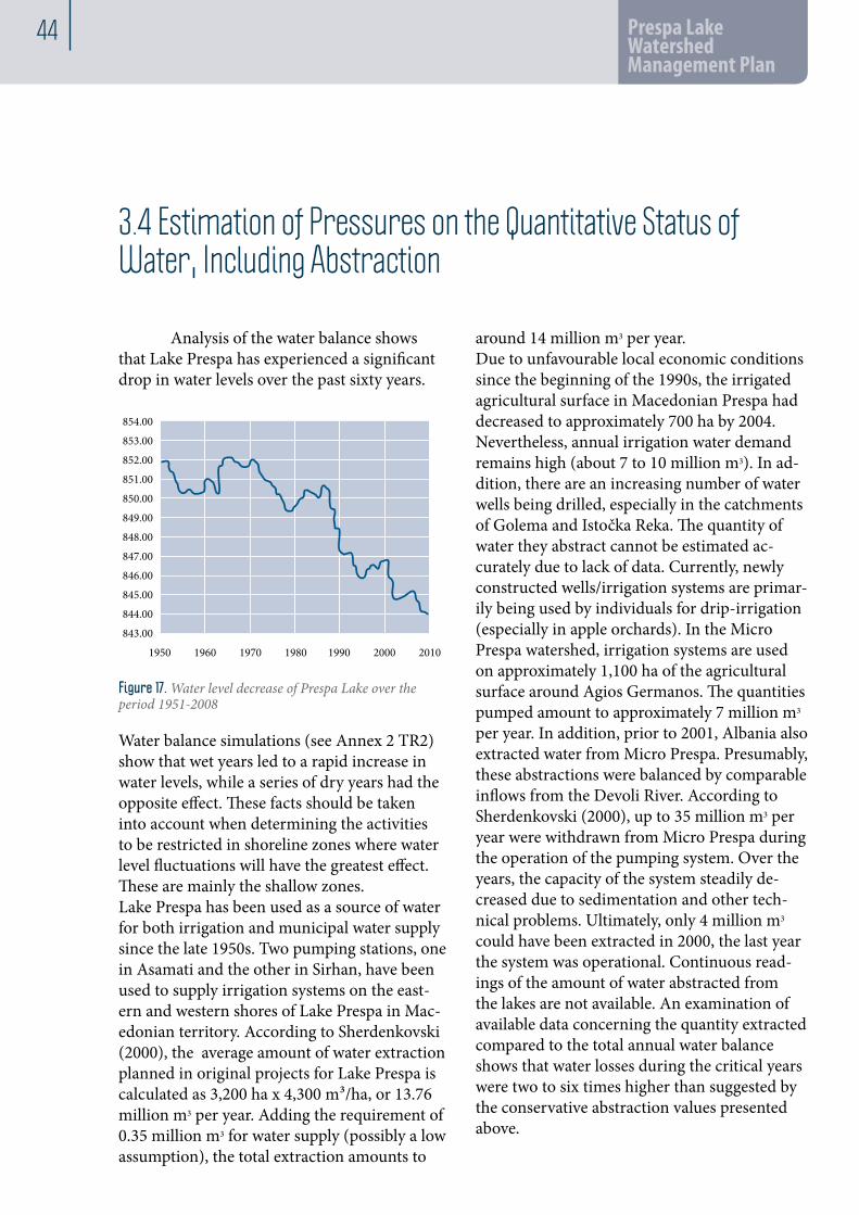
44 Prespa Lake Watershed Management Plan
3.4 Estimation of Pressures on the Quantitative Status of Water, Including Abstraction
Water balance simulations (see Annex 2 TR2) show that wet years led to a rapid increase in water levels, while a series of dry years had the opposite effect. These facts should be taken into account when determining the activities to be restricted in shoreline zones where water level fluctuations will have the greatest effect. These are mainly the shallow zones.Lake Prespa has been used as a source of water for both irrigation and municipal water supply since the late 1950s. Two pumping stations, one in Asamati and the other in Sirhan, have been used to supply irrigation systems on the east-ern and western shores of Lake Prespa in Mac-edonian territory. According to Sherdenkovski (2000), the average amount of water extraction planned in original projects for Lake Prespa is calculated as 3,200 ha x 4,300 m³/ha, or 13.76 million m3 per year. Adding the requirement of 0.35 million m3 for water supply (possibly a low assumption), the total extraction amounts to
around 14 million m3 per year.Due to unfavourable local economic conditions since the beginning of the 1990s, the irrigated agricultural surface in Macedonian Prespa had decreased to approximately 700 ha by 2004. Nevertheless, annual irrigation water demand remains high (about 7 to 10 million m3). In ad-dition, there are an increasing number of water wells being drilled, especially in the catchments of Golema and Istočka Reka. The quantity of water they abstract cannot be estimated ac-curately due to lack of data. Currently, newly constructed wells/irrigation systems are primar-ily being used by individuals for drip-irrigation (especially in apple orchards). In the Micro Prespa watershed, irrigation systems are used on approximately 1,100 ha of the agricultural surface around Agios Germanos. The quantities pumped amount to approximately 7 million m3 per year. In addition, prior to 2001, Albania also extracted water from Micro Prespa. Presumably, these abstractions were balanced by comparable inflows from the Devoli River. According to Sherdenkovski (2000), up to 35 million m3 per year were withdrawn from Micro Prespa during the operation of the pumping system. Over the years, the capacity of the system steadily de-creased due to sedimentation and other tech-nical problems. Ultimately, only 4 million m3 could have been extracted in 2000, the last year the system was operational. Continuous read-ings of the amount of water abstracted from the lakes are not available. An examination of available data concerning the quantity extracted compared to the total annual water balance shows that water losses during the critical years were two to six times higher than suggested by the conservative abstraction values presented above.
Analysis of the water balance shows that Lake Prespa has experienced a significant drop in water levels over the past sixty years.
854.00
853.00
852.00
851.00
850.00
849.00
848.00
847.00
846.00
845.00
844.00
843.00
1950 1960 1970 1980 1990 2000 2010
Figure 17. Water level decrease of Prespa Lake over the period 1951-2008

3 45
Map of water objects
Figure 18. Water objects in the Prespa Lake Watershed
Within the Macedonian part of Lake Prespa, the Prespansko Pole Irrigation System was constructed in the late 1950s. At the present time, Lake Prespa and its tributaries, as well as the groundwater reserves, are all used as water resources for irrigation purposes. Although the area of relatively intensive agriculture accounts for only about 4.5% of the total catchment area, it should be noted that many fields are
located next to the lakeshore or in areas with a high groundwater table and this exacerbates the seepage of nutrients into both the lake and the groundwater. The Prespansko Irrigation System is divided into three sub-systems. All three sub-systems urgently need rehabilitation / reconstruction in order to reduce conveyance losses and increase overall irrigation efficiency (PROWA 2002).
Anthropogenic Impacts on the Status of Surface and Groundwater

46 Prespa Lake Watershed Management Plan
The irrigation system in Macedonian Prespa, which operated seasonally (from June 15 to September 15) with a design capacity of 1.8 m3/s or 15,552,000 m3 per year, now has significantly decreased capacity due to severe deterioration. The irrigation systems in Greece and Albania use water from the catchment of Micro Prespa Lake. Together, the water quan-tity used for irrigation by all three countries was estimated in the late 1990s as accounting for some 88.98% of total water use. Of this amount, estimates indicated the following breakdown: lake water (83.22%), groundwater (10.9%), river water (4.98%), and spring water (1.71%).Currently, wells combined with drip-irrigation systems have become the predominant method of irrigation in the region due to the unreliabil-ity of channel irrigation systems. Some 8,000 to 10,000 wells have been drilled, covering an area estimated to be at least 3,000 ha. Hence the share of groundwater used in the region has significantly increased over the last few decades.Besides wells, a number of irrigation water intakes exist in rivers in the watershed. Some of these use the remnants of the old irrigation system but a significant number are completely new, unregulated and beyond the control of water authorities, with low efficiency and high water losses. These new developments in irrigation seriously jeopardize lake and groundwater quality. This is because of the use of water in the dry sum-mer period of low recharge of both surface and groundwater and low water level in the lake. Depletion of the lake water in the criti-cal summer period, in conjunction with high temperatures, promotes algal and cyanobacte-rial growth.The town of Resen and some of the villages on the northern shore of Lake Prespa are connected to a central drinking water supply system. Their combined populations amount to about 13,600 of the approximately 16,800 total inhabitants within the entire Macedonian part of the catchment area (2004 census). The water distribution network is gravity-fed via water from springs located near the village of Krusje. Additionally, groundwater from two
wells near Carev Dvor can be used to supple-ment the capacity of the distribution network depending on drinking water demand and the availability of sufficient spring water. A second existing water supply system is the local Kurbi-novo - Pretor - Asamati system, supplying three villages with 500 inhabitants. The remaining 16 villages, inhabited by about 4,000 residents, have their own separate supply systems. The water supply system covering the town and the abovementioned villages is managed by the Proleter communal enterprise. The villages of Leva Reka, Podmočani and Grnčari are not connected to the central system but are sup-plied by their own systems, also managed and operated by Proleter. Concurrent investigations estimate an industrial demand of 700 m³ per day and domestic consumption of 110 l/day/capita. Experience with unfavourable hydrolog-ical conditions over the last few summers shows a deficiency of about 30 l/sec. The main pipeline is 11 km long and the sec-ondary lines are 15 km long. Although built at the beginning of the 1980s, they are still in good condition. While the inner-city water supply network is old and in disrepair, it does provide safe drinking water to users. It was built in the 1960s when the town was much smaller. All houses are equipped with water-meters, but bulk metering is common. Metering and billing is performed on a monthly basis. Illegal con-nections are not a problem in the area, but wan-ton damage to water-meters causes difficulties. About 10% of the water-meters do not function. Applying these estimated figures, the total net consumption was 0.9 million m3 in 2009. Thus it appears that 53% of gross production was lost due to deficiencies within the distribution system and so must be considered as uncounted consumption.

3 47
3.5 Analysis of Other Impacts of Human Activity on the Water Status
Due to its vicinity to Lake Prespa, one of the three great natural lakes in Macedonia pro-tected by law, the Municipality of Resen has a basic infrastructure for wastewater collec-tion and treatment. However, the wastewater system does not fully cover all wastewater generated along the Golema Reka basin. Only 80 % of households are connected to sewers. Only the upper part of Jankovec (40 to 50 %) is connected to the gravity sewer, while the lower part closer to the river remains to be connected in the future. Many communities in the vicinity of the main sewer (e.g. Gorna and Dolna Bela Crkva, Koz-jak, Podmočani and Grnčari) are not connect-ed to the system because of the lack of funds and incentives. In the late 1980s, the munici-pality of Resen launched a program to improve the wastewater situation in the town. This program consisted of a wastewater collection network and the construction of a wastewater treatment plant (WWTP) in Ezerani. A feasibility study conducted in 1988 first introduced the idea of extending the collec-tion network in a western and eastern direc-tion, providing a central treatment plant in Ezerani to which the wastewater is presently being transported. This plant has undergone several rehabilitations intended to replace obsolete technical units and improve treatment efficiency, thus reducing operational costs and positively influencing the effluent quality. The process at the WWTP in Ezerani consists of activated sludge with subsequent aerobic
sludge treatment. While the treated effluent is being directed into two maturation ponds in series, the stabilized sludge is diverted directly into the sludge-drying beds. Apart from the existing Ezerani WWTP in Resen, a number of treatment facilities have been constructed in the Prespa watershed area, reflecting a concern to address the requirements of the sensitive environment in the region. However, few of the existing facilities are opera-tional and the facilities were only operational for a short time after construction. An exception is the WWTP near the Institute for the Prevention, Treatment and Rehabilita-tion of Non-Specific, Chronic, Respiratory and Allergic Diseases in the tourist area of Otesevo. A small WWTP exists in the village of Nakolec (not covering the upstream villages of Brajcino and Ljubojno). However, this WWTP has still not been put into operation.Like the public WSS, Proleter Public Utility Enterprise is responsible for the operation and maintenance of sewage collection and treat-ment. It invoices annually around 300,000 m3 for wastewater collection and treatment, or three times less than the actually treated annual quantity. The analysis of JKP Proleter shows that the price should be increased threefold in order to break even with included depreciation costs.
Anthropogenic Impacts on the Status of Surface and Groundwater

48 Prespa Lake Watershed Management Plan
3.6 Harmful Impact of Water
FLOODSSeveral types of floods have been recorded in the area.• The most frequent type of flood results from snow melting in combination with high river water levels that occur in the lower parts of the major watercourses. They are recorded during snow-melt from Baba and Plaken-ska mountains. The most seriously affected areas are the Brajčinska and Golema Rivers in Macedonia. High groundwater levels are customary for the spring period, particularly for Resen valley when the interaction of sur-face and underground water creates ponds and pools on the surface of the terrain. Flows of the Brajčinska and Golema Rivers bigger than 15 m3/s contribute to this condition.• Floods of bigger rivers appear when river flows are larger than 40 m3/s. Three floods of this type have been recorded over the past century, in 1942, 1962 and 1979. The watershed of the Golema Reka River produced the largest flooded area, downstream of Resen, all the way to its mouth into the lake. The Brajcinska River has greater destructive power, rolling mas-sive boulders from Baba Mountain, unlike the Golema River, which brings more suspended sediments. The maximum water flows of the Brajcinska River (Qmax = 45.7 m3/s), and the Golema River (36.7 m3/s) were recorded in the flood of November 1962. • Lake floods occur in cases of high lake surface water level. Such floods took place in 1942/43 and 1963, flooding the villages of
Nakolec, Asamati, Ezerani, Perovo and large areas of agricultural land. The lake level reached its highest value of 851.93 m a.s.l. (Macedonian levels). The most important recorded floods happened in November 1962, November 1963, and November 1979. • Flash floods caused by torrents were prevalent in past periods when there were more barren hills. The high-intensity short-term rainfalls create dry ravines very fast, bringing huge quantities of eroded material and debris into the villages and agricultural land. The best-known torrent watercourses are situated on the eastern coast (Dolno Dupenska River, Podmočanska/Avatska River, etc.).
EROSIONDocumentation related to erosion and tor-rents shows that torrent and erosion damage occurred even before the 1960s, prompting the authorities in the late 1950s and early 60s to prepare necessary technical documentation (final designs and studies), and subsequently carry out construction work for torrent preven-tion and protection. The average annual erosion coefficient of the Lake Prespa watershed is Z = 0.33. Figure 10 presents the erosion risk distribution per cat-egories (where I is the highest risk and V is the lowest risk category).A large part of the watershed (69%) is classified as low erosion risk (III, IV and V), but almost 13% of the watershed belongs to the highest I and II risk categories and actions to control

3 49
erosion control need to be prioritised in these parts of the watershed. The most erosive catch-ments include Ajdra Bair, Kopac, Kutliste, Metok, Istočka Reka, Brajčinska Reka, and Zlatarska Reka. Torrent and erosion control structures (bar-rages, cascades, retention ditches, contour trenches, forestation, etc) are multifunctional. In addition to their main role of controlling erosion, they control the direction and rate
of flow and contribute to reducing the peak of discharge and flash flood hazards. Erosion and torrent control measures and structures have been implemented in the following catchments: Brajčinska Reka, Suica, Slivnička Reka, Metok, Kopac, Podmočanska Reka, Gorica, Zadgorica, Strasen Dol, Dlaboko Doliste, Dunica, Kozjak, Golema Reka, Bolnska Reka, Istočka Reka and Evlanska Reka.
Soil erosion risk map
Figure 19. Soil erosion risk map of Prespa Lake Watershed
Anthropogenic Impacts on the Status of Surface and Groundwater

50 Prespa Lake Watershed Management Plan
3.7 Other Impacts
Sand and gravel are excavated/exploited around the mouth of the Golema River into the Prespa Lake. This is an illegal activity as it takes place within the protected Ezerani Natural Re-serve (ENR). Sand and gravel are exploited in other parts of the catchment. Controlling these
activities appears to be problematic. Agricultural activities in the vicinity of all watercourses in the region take place within the natural river corridor, preventing the establish-ment of a necessary buffer zone as prescribed by the existing regulations.
3.8 The Designation of Protected Areas and Management
The entire Prespa region hosts unique habitats that are important from both a European and global conservation perspective. It is consid-ered to be an ecosystem of global significance and has been identified as one of Europe’s major trans-boundary ‘ecological bricks’. Currently, the following areas in MK Prespa region are protected in accordance with the Law on Nature Protection: • National Parks (IUCN II)• he Pelister National Park • The Galicica National Park • Strictly Protected Nature Reserve (IUCN I) • The Erezani Wetland (Note: the protec-tion category might be changed to IUCN IV In the current process of re-evaluation & designa-tion.)
Pelister National Park covers an area of around 15,000 hectares on the Baba massif at altitudes between 900 and 2,601 m. A part of this area (5,000 ha) is located in the Lake Prespa water-shed. The National Park “Galičica” is situated on Mount Galicica, which is part of the moun-tain range of Sara-Pind. The Park covers an area of around 23 km2 between the Ohrid and Prespa lakes, stretching in a meridian direction. Almost half of this area belongs to the Lake Prespa Watershed. A new management plan for Galicica National Park has been prepared. There are three significant wetlands in the Golema Reka catchment: Krusje spring, a karst source for Golema Reka, three former fish ponds, and Ezerani, a natural lacustrine fringe wetland already designated as a ‘Strictly

3 51
Protected Natural Reserve’ according to na-tional legislation (now proposed as IUCN IV). The location of these wetlands, as well as their significance in terms of biodiversity and their conservation and economic status, differ greatly. In 2002, Lake Prespa became the first designat-ed Ramsar Site in the country. (In 2008, Lake Dojran also gained this designation.)
Protected areas within the working area
Figure 20. Nature reserves (protected areas according to the Law on Nature Protection)
Anthropogenic Impacts on the Status of Surface and Groundwater

52 Prespa Lake Watershed Management Plan
At present, no protection areas have been des-ignated to regulate:• The abstraction of water intended for human consumption. (e.g. the karstic Spring Krusje, but also local waster supply systems, like Kurbinovo-Pretor Asamati and other in-takes for villages in the region.• The protection of economically significant aquatic species. • The use of water for recreation, including areas designated as bathing waters. A number of tourist facilities and recreational areas exist in the Prespa region, especially around the Lake. The designation of bathing water areas and their appropriate management and moni-toring would support the redevelopment of tourism in the region.
• Nitrate-sensitive areas. Analyses show that Lake Prespa is suffering from increasing eutro-phication, which puts it in a category sensitive to nitrates as defined in the new Law on Water. The concentrations of nitrates in the watercour-ses seem to be within the given guidelines, in spite of increased input in agriculture (more than 210 kg/ha) However, the Lake is eutrophic and must be protected. Sources of nitrogen include agricultural activities, poultry farming, illegal dumping of organic matter and, seem-ingly, discharged effluents from wastewater treatment plant in Ezerani which doesn’t have any tertiary de-nitrification treatment. The Pre-liminary Expert Assessment (Technical Report 5) suggests that the entire Prespa region should be proclaimed a nitrate-sensitive area.
Wetlands
Figure 21. Map of wetlands around the Prespa Lake

3 53
Existing and newly proposed protection zones
Figure 22. Existing and newly proposed protection zones
• Waterbodies sensitive to urban wastewa-ters. According to the present Law on Water and preliminary monitoring results, there are eight waterbodies sensitive to the discharge of urban wastewater: Lake Prespa, Istocka 2 and 3, Golema Reka 6, 7 and 8, Brajcinaska Reka 2 and Kranska Reka 2 (in the tourist season). These waterbodies (except for Kranska) show deteriorated conditions (see Ch. 4) and require action.• Areas of protected natural heritage. Besides Lake Prespa, which is already under protec-tion due to important rare, relict and endemic species and habitats, and ‘Ezerani’ protected area, several smaller wetlands and habitats have been identified near Stenje, Ezerani, Krani and
Nakolec.• Riparian zones. In the Law on Water of 2008, as well as in previous water laws, the riparian protection zones for watercourses and lakes are clearly defined. However, these have never been implemented properly, leading to deterioration and misuse of protection buffer zones.
As part of this project, a proposal for the desig-nation of additional protection zones has been elaborated (see Technical Report 5 for further details). The proposed (and existing) protection zones are presented in Figure 22.
Anthropogenic Impacts on the Status of Surface and Groundwater

33 Prespa Lake Watershed Management PlanDevelopment of Prespa Lake Watershed Management Plan, RF. 50/2009, Contract No. 31/2009
33
Deve
lopm
ent o
f Pre
spa L
ake W
ater
shed
Man
agem
ent P
lan,
RF.
50/2
009,
Cont
ract
No.
31/2
009
33

1
Mapping Existing Monitoring Networks and Results from Monitoring Activities
Besides the comprehensive surveillance conducted to monitor water quality and ecological status, existing monitoring has been analysed and assessed for compli-ance with the requirements of the new Law on Water and relevant national regulations (taking into account the WFD and other Directives), relevant environmental laws and regulations. The absence of monitoring and data, existing monitoring capacity and the organizational and financial aspects of required monitoring have also been analysed in depth.
4

56 Prespa Lake Watershed Management Plan
4.1 Surface Waters
Hydrological and meteorological surveillance monitoring has been conducted in accordance with the Law on Hydro-meteorological Affairs, the Law on Waters, and the Programme for the Protection of Ohrid, Prespa and Dojran Lakes. The monitoring system comprises of:• Lake stations to measure water levels and water temperature were established in 1935, 1948 and 1954. • River stations are located on the Golema and Brajcinska rivers.• The Resen Climatologic station was estab-lished in 1947 as a rainfall-measuring station and was in operation between 1980 and 1993.• The Pretor Meteorological station was established in 1980 as a polygon for prevent-ing hail, employing professionals to monitor meteorological parameters.• Seven rainfall measuring stations are situ-ated in the coastal parts of Prespa Lake: Stenje, Carev Dvor, Perovo, Izbista, Asamati, Nakolec, and Brajcino. These rainfall-measuring sta-tions register the condition of the pluviograph regime on the coastal part of Prespa Lake watershed and on the lake surface itself. No information is available for the higher parts of the watershed.As a result of identified insufficiencies in data content and coverage by existing monitor-ing programmes to accurately determine the watershed water balance, further development
and improvement of the regional monitoring programme for Lake Prespa has been discussed amongst the riparian countries. Data from stations In Albania and Greece are useful for meteorological or hydrological calculations, in spite of the different systems and methodologies used. In addition, data from outflow stations and data from stations in the vicinity of Lake Ohrid and Crni Drim are important due to the interconnection of these waterbodies. Although monitoring is a legal obligation, there is no systematic continuous monitoring of the water quality in the Macedonian part of the Lake Prespa watershed. Gaps in the hydrologi-cal data and the lack of accurate data hamper efforts to provide reliable picture of the water balance in the region.Existing monitoring has been analysed and assessed for compliance with the requirements of the new Law on Waters and relevant national regulations (taking into account the WFD and other Directives), environmental laws & regula-tions. Absence of monitoring and data, existing monitoring capacity and organizational and financial aspects of required monitoring have also been analysed in depth. Besides setting up an initial network for surveillance monitoring of environmental data, a comprehensive moni-toring programme in accordance with the WFD and the LoW has been proposed as part of the Programme of Measures.
4.1.1 Existing Monitoring

4 57
An initial 12-month comprehensive surveil-lance monitoring of the water quality and ecological status has been conducted on all waterbodies identified/delineated and refer-ence conditions have been established. Pressures on the waterbodies from natural and anthropogenic sources have been exten-sively identified and analyzed. These pressures include the input of pollutants, nutrients and hazardous sub¬stances, physical pressures on the waer bodies—for example, agriculture in
the river corridor, drainage, watercourse main-tenance and abstraction. The input of pollutants takes place via both water and the soil from dif-fuse sources (e.g. nutrient leaching from farm-land) and point sources (e.g. wastewaterdischarges from households and industry, emis-sions from industry and agriculture and leaching from disused landfills). The harmful impacts of water and the pressures and state of protection areas have been scrutinized. A summary of these analyses is presented in Chapter 3.
4.1.2 Monitoring for the Purposes of the Prespa Watershed Management Plan
Monitoring sites
Figure 23. Monitoring sites in the delineated waterbodies in the Lake Prespa watershed that were continuously monitored during the course of this project
Mapping Existing Monitoring Networks and Results from Monitoring Activities

58 Prespa Lake Watershed Management Plan
As a result of the monitoring, the status of all the waterbodies in Prespa region has been determined, including their biological, hydro-morphological and physico-chemical quality elements. (See Table 13. and Figure 24.). In conclusion, Prespa Lake is under intensive pressure from human activities. This pressure is exerted through various physical impacts, such as alterations of watercourses and water ab-straction, chemical pollution originating from untreated wastewaters and agriculture, and the deterioration of natural biodiversity through the introduction of alien species and overfish-ing. The intensity and duration of the negative human impacts on Lake Prespa have resulted in severe and comprehensive deterioration of the water quality, except for the elevated stretches of the rivers a long distance from human activities. In order to prevent further deterioration of the water quality in the water-shed, substantial measures need to be intro-
duced and implemented. However, even if these measures are implemented and become fully operational, the timeframe for the full recovery of the ecosystems may be prolonged, since the accumulated quantities of harmful substances are at high levels. If none of the recommended measures are initiated and implemented in the area, the overall environmental quality of the Lake Prespa watershed will become much more degraded in the near future. This is especially important for Lake Prespa itself, which has already started to show clear signs of becom-ing eutrophic throughout the year with even more frequent and possibly toxic cyanobacterial ‘blooms’. If the turnover towards a fully eu-trophic system is completed, activities to restore and improve its water quality will become much more difficult and perhaps impossible, thus rendering Prespa Lake unsafe and unusable for future generations.
Waterbody name
WB type
S t a t u s Action needed under
High Good Moderate Poor Bad UWWTD or ND WFD
Surface waterbodies (rivers)Istočka Reka 1 1 Good no NoIstočka Reka 2 1 Bad yes Istočka Reka 3 1 Poor yes Golema Reka 1 1 Good no Golema Reka 2 1 Moderate yes Golema Reka 3 1 Moderate yes Golema Reka 4 1 Moderate yes Golema Reka 5 1 Moderate yes Kurbinska Reka 1 1 Moderate yes Kranska Reka 1 1 High NoKranska Reka 2 1 Moderate yes Brajčinska Reka 1 1 High NoBrajčinska Reka 2 1 Poor yes Surface waterbodies – heavily modified waterbodiesGolema Reka 6 1h Bad yes
Surface water bodies – artificial waterbodies
Golema Reka 7 1a Bad yes Golema Reka 8 1a Poor yes
Surface water bodies (lake)Prespa Lake 1L Moderate yes
Table 13. Classification of the ecological status of identified surface waterbodies

4 59
Classification of the ecological status of the water bodies
Figure 24. Map of the classification of the ecological status of the waterbodies in the Lake Prespa Watershed
4.2 Groundwater
Existing geological maps were used as a first step in defining the boundaries of the ground-water resources. (These included the Basic Geological Maps for Ohrid, Podgradec, Bitola and Lerin in 1: 100.000 scale ) For groundwater resources, a conceptual model of groundwater flow was developed on the basis of geological and hydro-geological conditions and covering large groundwater
4.2.1 Existing Monitoring
reservoirs. Its main purpose was to determine which resources can be sustainably used for water supply and to identify vulnerable ground-water resources that cannot easily be used in a sustainable way for water supply and/or are susceptible to pollution and should thus be protected.In spite of numerous wells in the region, espe-cially in the Istocka and Golema catchments,
Mapping Existing Monitoring Networks and Results from Monitoring Activities

60 Prespa Lake Watershed Management Plan
Hidrology map, groundwater bodies and monitoring sites
Figure 25. Map of the delineated groundwater bodies and monitoring sites
and the importance of groundwater resources for the region, no monitoring data is available from the last few decades on water levels and especially on water quality and trends. The only data avail-able is historical data from the monitoring of a limited set of parameters. Due to intense develop-ments in groundwater use, this data was deemed insufficient as a basis for relevant conclusions.
4.2.2 Groundwater Monitoring: The Purposes Of The Prespa Watershed Management Plan
A monitoring network of seven groundwater sites has been established for the purposes of the Prespa WMP, covering all delineated groundwater bodies (see Figure 25).The following parameters have been monitored:• Groundwater level and seasonal fluctuations• Physico-chemical parameters• Biological characteristics• Pesticides• Sodium Absorption Ratio

4 61
Some of the monitoring results are presented in Table 14 and Figures 26 and 27 below.
No. GW monitoring points Ca mg/l
Mg mg/L
K mg/L
Na mg/L
Fe mg/L
Mn mg/L
As μg/L
Al μg/L
Cd μg/L
Cr μg/L
Cu μg/L
Hg μg/L
Nl μg/L
Pb μg/L
Zn μg/L
1 GW1 (Krani) 14.75 3.19 1.96 4.30 0.48 0.041 <1 329.2 <0.1 2.11 <1 <0.1 1.44 7.0 <5
2 GW2 (Asamati) 33.07 7.06 1.05 8.03 0.22 0.007 <1 96.0 <0.1 <1 <1 <0.1 1.54 <1 <5
3 GW3 (f-ry Swisslion) 48.95 12.16 1.76 11.91 14.78 0.23 1.02 <20 <0.1 <1 <1 <0.1 14.7 <1 <5
4 GW4 (Krusje spring) 73.22 12.39 0.83 3.75 0.042 0.002 <1 <20 0.13 <1 <1 <0.1 1.54 <1 <5
5 GW5 (Carev Dvor) 53.94 7.86 1.17 3.76 0.44 0.015 <1 <20 <0.1 <1 <1 <0.1 <1 <1 <5
6 GW6 (Preljublje) 13.22 8.03 0.85 8.71 2.18 0.30 <1 <20 <0.1 <1 <1 <0.1 <1 <1 <5
7 GW7 (Stenje) 112.37 5.47 0.26 1.18 0.074 0.002 1.14 <20 <0.1 1.73 1.1 <0.1 1.70 2.6 <5
Table 14. Physico-chemical results (measurement of May, 2010)
The results of the groundwater surveillance monitoring conducted as part of this project can be summarised as follows:• HIGH to MODERATE groundwater quality for irrigation purposes• The presence of pesticides has been detected in the majority of the monitored wells• Bacteriological contamination has been detected in all monitored wells• Serious seasonal drawdown of groundwater level has been detected in a number of wells (to be confirmed by the establishment of a comprehensive monitoring network)• Unregulated drilling creates hydraulic connections between different aquifers of various depth, increasing the possibility of the spread of pollution (bacteriological and pesticides)
1816141210
86420
Acenaphthalene
B1GW7 (Stenje)
B2 GW6 (Preljublje)
B3GW4 (Krusje)
B4 GW3 (Swisslion)
B5 GW2 (Asamati)
B6GW1 (Krani)
B7 GW5 (Carev Dvor)
μg/L Bis (2-Ethylhexyl)phthalate MPL <6 ng/L
Benzo (a) pyreneFluoreneNaphthaleneAlachlorAtrazineDibutilphthalateBis(2-Ethylhexyl)phthalate
B1GW7 (Stenje)
B2 GW6 (Preljublje)
B3GW4 (Krusje)
B4 GW3 (Swisslion)
B5 GW2 (Asamati)
B6GW1 (Krani)
B7 GW5 (Carev Dvor)
10987654321
μg/L
0
2.4’-DDD4.4’-DDD2.4’-DDE4.4’-DDE4.4’-DDTDieldrinalpha-Endosulfanbeta-HCHgamma-HCHdelta-HCHHeptachlor
Figure 26. BIS (2-Ethylhexyl)phthalate MPL<6 ng/l
Figure 27. MPL level for organoclorine pesticide
Mapping Existing Monitoring Networks and Results from Monitoring Activities

33 Prespa Lake Watershed Management PlanDevelopment of Prespa Lake Watershed Management Plan, RF. 50/2009, Contract No. 31/2009
33
Deve
lopm
ent o
f Pre
spa L
ake W
ater
shed
Man
agem
ent P
lan,
RF.
50/2
009,
Cont
ract
No.
31/2
009
33

1
Environmental Objectives5

64 Prespa Lake Watershed Management Plan
The Macedonian Law on Water of 2008, as well as the WFD, requires that all surface waterbod-ies be classi¬fied on the basis of their ecologi-cal status (i.e. their biological, hydromorpho-logical and physico-chemical quality elements). Ground¬water bodies are to be classified according to two status classes, quantitative status and chemical status. The status classes are to be established on the basis of reference conditions for the waterbodies, defined as “no, or only very minor anthropogenic alterations” compared with “undisturbed conditions”. The GEF Transboundary Diagnostic Analysis (TDA, 2010) undertaken in the Prespa Wa-tershed is a scientific / technical fact-finding analysis to scale the relative importance of sources, causes and impacts of pressures in the basin. The TDA presented the facts associated with the problems facing the basin and the pressures and stresses on the ecosystem. Fol-lowing the TDA, a GEF Strategic Action Pro-gramme (SAP) is a negotiated policy document that identifies the policy, legal and institutional reforms and investments needed to mitigate the stresses on the ecosystem.Given the transboundary character and the consensus achieved, environmental objectives
identified with the TDA have been taken into account in the course of elaborating the Prespa Watershed Management Plan. In this way, the Macedonian side takes an important first step in compliance with mutually agreed trans-boundary priorities.TDA identified five priority trans-boundary environmental problems: Poor Water Quality (nutrient, organic and hazardous substances pollution); Inappropriate Land Management; Non-Sustainable Fisheries Management; De-clining Lake Level; and Large Sediment Trans-portation.The TDA Report has identified Environmental Objectives, divided into long term (+10 years), mid-term (5-10 years) and short-term (1-5 years) objectives. The following objectives were taken into account for the Prespa Watershed Management Plan.
For surface waterbodies:• Environmental Objective 1: Improvement of environmental conditions ensuring good water and soil quality for human health and for the ecosystem by 2025 (long-term)• Environmental Objective 2: To control wa-ter levels (prevent losses) and promote sustain-
The objective is for all water-bodies to achieve ‘good status’ and to prevent any further deterioration in the existing status of surface waters and ground¬water.

1 65
able use (short-term & continuous)• Environmental Objective 3: To ensure sus-tainable fisheries (mid-term)• Environmental Objective 4: To reduce pes-ticide/fertilizer loadings, waste from packag-ing, and pressure from agriculture (short-term & continuous)• Environmental Objective 5: To reduce physical pressures (short-term & continuous)
For groundwater bodies:These include the abovementioned Environ-mental Objectives 1, 2, 4 and 5, as well as the following objectives:• Environmental objective 6: To base the drinking water supply on pure groundwater without the need for more than simple treat-ment (long-term). To ensure that the water supplied to the population only contains nitrate in natural concentrations (short-term & continuous).• Environmental objective 7: To safeguard the groundwater resource against overexploita-tion (mid-term).• Environmental objective 8: To protect the groundwater against contamination (short-term & continuous). To ensure there are no
pesticides or other hazardous substances in groundwater used for the supply of drinking water (short-term & continuous).
For protected areas:• Environmental Objective 9: To establish an Inventory and evaluate the existing institutional and regulatory systems for lake management at national and transboundary level. To develop a unified methodology for monitoring. To evalu-ate the enforcement of environmental laws in all three countries (short-term).• Environmental Objective 10: To improve land management and planning (mid-term)• Environmental Objective 11: To conserve Prespa’s biodiversity and habitats (short-term & continuous)• Environmental Objective 12: To ensure sus-tainable forestry (short-term & continuous)Environmental objectives 1 and 2, being the most important, have been adopted as bench-marks for further elaboration of the Prespa WMP and as a basis for the development of the Programme of Measures and the 6-year imple-mentation plan.

66 Prespa Lake Watershed Management Plan
5.1 Objectives for the Waterbodies in the Prespa Region
The following objectives have been adopted for the Prespa watershed and the specific waterbodies in the catchment:
For all waterbodies: to achieve GOOD water statusFor artificial waterbodies and heavily modified waterbodies: to achieve good environmental potential
Name Current status Action needed?Objectives
Rivers HMWB & AWB
Istocka 1 Good Istocka 2 Bad Y Good Istocka 3 Poor Y Good Golema 1 Good Golema 2 Moderate Y Good Golema 3 Moderate Y Good Golema 4 Moderate Y Good Golema 5 Moderate Y Good Golema 6 Bad Y Good potentialGolema 7 Bad Y Good potentialGolema 8 Poor Y Good potentialKurbinska Moderate Y Good Kranska 1 High Kranska 2 Moderate Y Good Brajcinska 1 High Brajcinska 2 Poor Y Good
Table 15. Objectives for delineated waterbodies in the Prespa Region
According to WFD, the implementation of measures is planned to be carried out in order to pro-gressively reduce pollution and gradually achieve the objectives. The Prespa Watershed Manage-ment Plan will include two alternative approaches for achieving the environmental quality objec-tives, including elaboration of the defined waterbody-specific objectives as well as the programme of measures for their achievement. The Programme of Measures has been developed to achieve the defined environmental objectives. The Watershed Management Plan refers to measures in the 6-year planning period. Because some of the presented objectives are seen as long-term, the Plan identifies ‘start-up’ actions or ‘road-to-completion’ indicators to monitor progress in achieving those objectives (see Chapter 6 for more details).

5 67
5.2 Indicators
To each of the Environmental Quality Objectives there is attached an indicator to enable the moni-toring of progress made in meeting the objective for surface water and groundwaters. The WFD requires states to implement measures to progressively reduce pollution and to ensure the phase-out of priority hazardous substances by 2025.Some of the objectives for the Lake Prespa watershed identified by the TDA as being most relevant for waters are listed in the following tables, including specific sub-objectives and a number of indi-cators:
Overall Objective 1
Improvement of environmental conditions to ensure good water and soil quality for human health and the ecosystem by 2025
Indicator Measurable decline in levels of the main pollutant groups and pressures in water, sediment and biota
1a:
Good surface water quality:- Reduce / prevent further eutrophication/organic pollution- Reduce / prevent further hydromorphological changes- Reduce / prevent further habitat fragmentation- Maintain biological water quality (phytoplankton, macrophytes, invertebrates and fish)- Reduce / prevent hazardous substances pollution
1b:Good groundwater quality:
- Control water abstraction- Reduce / prevent water pollution from point and non-point sources- Maintain good physical and chemical characteristics
1c:
Good ecological potential for HMWB and AWB:- Reduce / prevent further eutrophication/organic pollution- Reduce / prevent further hydromorphological changes- Reduce / prevent further habitat fragmentation- Improve biological water quality (phytoplankton, macrophytes, invertebrates and fish)- Reduce / prevent hazardous substances pollution
Overall Objective 2
Sustainable and efficient water utilization for maintenance/control of the Lake Prespa water level and groundwater table
Indicator Measurable and sustained water utilization
2a:Introduce water conservation and demand management:
- Irrigation abstraction- Drinking water abstraction- Abstraction of water for industry
2b:
Increase and update knowledge on the hydrological and limnological regime of Prespa Lakes and their catchment area, also integrating climate change impact and disaster management:
- Lake water levels- Irrigated area - Precipitation - Air temperature- Lake evaporation
2c:Increase and update knowledge on the hydrological and limnological regime of Prespa Lakes and their catchment area:
- Karstic spring flow to Ohrid- Groundwater level
Table 16. Key environmental objectives and indicators
The Program of Measures within the Prespa Watershed Management Plan will primarily use the above-listed indicators to assess the effectiveness of the measures and the progress made towards achieving the objectives.
Environmental Objectives

33 Prespa Lake Watershed Management Plan

1
Overview of the Economic Analysis of Water Use
6

70 Prespa Lake Watershed Management Plan
6.1 General Overview of Water Use in the Regional Economy
Water is a significant resource and input in the overall economy of Prespa. Besides the supply of water to the population and to industries, water is used in agriculture. Water manage-ment is also important for fisheries and for the safeguarding of protected areas and tourism.Industry and agriculture make the greatest contribution to the municipal GDP, followed by trade, traffic, construction, and a small contribution from the catering industry and from tourism. There are 4,705 employees. The average employment rate is around 43.5%, with a significant unemployment rate of 30.1%. .Almost two-thirds of the local GDP is generat-ed by industry, predominantly food processing, followed by textiles, chemical, metal, building materials, wood and tobacco industries. In-dustry is the second largest user of water in the region.Agriculture in the region is a very significant economic activity and is by far the major user
of water for irrigation, mostly for growing ap-ples, which are the main agricultural product in the region. Almost all the agricultural land is privately owned (91%). The use of fertilizers is intensive. In this municipality there are 3,500 ha of orchards. By applying modern agro-tech-nical measures, Prespa produces at least 60-70 million kilograms of high quality apples per year. More than 80% are produced for export to other countries in the region.JKP Proleter is the municipal enterprise in charge of the water supply, sewage collection, treatment, and other public services. It was established and is owned by the Municipality of Resen. A description of the water supply systems with their technical capacities has been elaborated in Technical Reports 1-3 and Chapter 2 of this Report; only the financial-economic aspects are summarized here.
6.2 Water Supply –Population and Industry
JKP Proleter supplies water to approximately 13,600 people and 300 legal entities/compa-nies. Some 900,000 m3 are invoiced annually, priced 27.73 MKD for households and 37.73 MKD for legal entities. The water is measured with water meters. In addition, the price for wastewater collection and treatment are added
on the monthly bill.The quantity of water invoiced has decreased from 900,000 m3 in 1994 to 680,000 m3 in 2008, with the greatest fluctuations occurring in the demand and supply of water to industries.The collection rate is 65-70% from the issued invoices.
Covered Area Number
Water Consumption
m3
PriceMKD/ha
CostMKD
Population connected to the public WS system Resen 13,600 720,000 22. .3 16,056,000Population with self-supply 16 villages 4,000 200,000 22. .3 4,460,000WS – industry & companies Resen 300 180,000 37. .73 6,791,400
Table 17. Municipal and industrial water supply, consumption and revenue

6 71
No Description Annual Quantity Monthly Quantity In %
1 Citizens in m3 525,179 mЗ 43,765 79.452 Companies in m3 135,794 mЗ 11,317 20.55
Total: 660,973 mЗ 55,082 100.00
Description Monthly Quantities In m3 Current Price Monthly Revenues In %
Citizens 43,765 m3 16.25 MKD/m3 711,181 MKD/мес 69.56%Companies 11,317 m3 27.50 MKD/m3 311,217 MKD/мес 30.44%
Total: 55,082 m3 1,022,398 MKD/мес 100.00%
Description Monthly Expenses In % Revenues Monthly Water
Quantity New Price In MKD/m3 Increase In %
Citizens 1,403,055 69.56 975,965 43,765 m3 22.30 MKD/m3 37.23Companies 1,403,055 30.44 427,090 11,317 m3 37.73 MKD/m3 37.23
Total: 100.00 1,403,055 55,082 m3
Table 18. Quantity of potable water delivered
According to the previous data, the average price is:1,403,055 MKD/monthly: 55.082 m3/monthly = 25.47 MKD/m3
Accordingly, the monthly revenues are as follows:
Table 19. Revenues from water delivered to users
Only 72.87 % of monthly expenses are covered by this revenue. In order to cover expenses fully, the price of water would need to be as follows:
Table 20. Price of water for full cost coverage
6.3 Wastewater Collection and Treatment
The Ezerani wastewater treatment plant was built 60% by the Government and 40% by the Mu-nicipality and has been given to JKP Proleter for maintenance. JKP Proleter issues water bills with separate lines for water supply, wastewater collection and wastewater treatment. At the treatment station there is a water gauge which measures the water in the station and shows a higher quantity than the supply water delivered, measured and invoiced by the water gauges because of the inflow of stormwaters into the sewage system. According to the manager of JKP Proleter, it is invoiced for 300.000 m3 and purified three times more. The purified water is transferred 2-3 km by pipeline to a marsh and then into the lake. The annually invoiced wastewater quantity varies slightly from 313,000 m3 (1997) to 397,000 m3 (2005), of which around 80% are communal waters from households and 20% from legal entities/companies.
The prices for wastewater collection and treatment are set as follows:
Sewerage collection• Citizens 4.62 MKD./m3
• Companies 6.23 MKD./m3
Wastewater• Citizens 11.23 MKD/m3
• Companies 15.84 MKD/m3
Overview of the Economic Analysis of Water Use

72 Prespa Lake Watershed Management Plan
Covered Area NumberWater
Consumptionm3
PriceMKD/ha
CostMKD
Population connected to sewerage system Resen 8,000 720,000 4.62 3,326,400Sewerage companies Resen 300 180,000 6.23 1,121,400
Population connected to a wastewater treatment plant Resen - 300,000 11.23 3,369,000
Wastewater treatment companies Resen - 60,000 15.84 950,400
Table 21. Wastewater disposal systems and revenues
The analysis of JKP Proleter shows that the price should be increased threefold in order to break even with included depreciation costs.
6.4 Irrigation Water
The construction of the system for the irriga-tion of Prespa started in 1954 and was fully completed in 1962. It is one of the oldest in the country. The irrigation infrastructure consists of a network 263.26 kilometres in length, of which the main channels extend 58.13 km while the secondary and detailed network extends 205.03 km. The concrete channels are open and cover 2,500 ha of apple orchard area. The water is taken from Lake Prespa by pumping stations. Three (2+1) pumps with a capacity of 500 l/s are situated on the east coast of the lake in Pretor. Two pumps of 500 l / sec. and four of 150l/s are located in Sirhan on the western shore. A number of other pumping stations have been constructed for additional pump-ing of water into the system (Kurbinska and Kranska river areas, as well as Dolno Dupeni and Slivnica).Although the abovementioned network cov-ers 2,500 ha of fertile area, only 533.18 ha were irrigated in 2005. This is due to the following factors: the deteriorated physical state and ca-pacity of the system; huge losses of water; poor services; low revenue collection rates; decreas-ing demand from farmers; the low institutional capacity of the Prespansko Pole Water Manage-ment Organization, which had financial prob-lems resulting in liquidation; and bad overall
management in the water sector, including an increase in the number of individual irrigation wells, of which there are now estimated to be over 10,000 in the region. The decreasing trend has continued in recent years with the transfor-mation of the WMO Prespansko Pole and the initial establishment of Water User Associations in the region. Only 300 ha were reported to have been irrigated in 2009. However, irrigation in the apple orchards con-tinues, with individual wells and predominantly individual drip-irrigation installations com-pletely beyond the control of the water authori-ties. The reason for this is the wide availability of groundwater, especially in the Resen Plain. It is conservatively estimated that at least 1,000 ha are irrigated in this way.The costs for the construction of wells/system are borne solely by farmers. According to re-ports, costs include drilling (25 €/m depth) and the purchase of pumps (and other installations, generators, etc.), as well as the installation of drip-irrigation pipelines (c. 1,000 €/ha). Indi-vidual farmers also incur costs of electricity/fuel for pumping and for regular and investment maintenance of the system.Three Water User Associations have recently been established in the region. These charge 28,000 -35,000 MKD/ha (440 – 580 €/ha) for annual irrigation. The collection rate varies

6 73
from 65-70% to 100%. In spite of some prom-ising results, the extent of WUAs is local and does not cover the needs of the wider region. Such associations thus cannot be a comprehen-
sive solution to the problems.Irrigation water consumption over the last few years is presented in the following table:
Irrigated area [ha]
Waterusers
Water Consumption
m3
PriceMKD/ha
CostMKD
Irrigation scheme Prespansko PoleWater User Communities A1 50 102 - 26,600 1,330,000Water User Communities A2 90 - - 28,000 2,520,000Water User Communities B2 7 21 - 35,000 245,000Irrigation from ground water 3,000 10,000 wells / pumps - 20,000 60,000,000Irrigation from rivers 500 - - 20,000 10,000,000
Table 22. Water Consumption for Irrigation and Revenues
In conclusion, irrigation in the region is in complete disarray for all the reasons mentioned above. Besides poor services and low area coverage, there is no recovery of costs and no organized and coherent water management structure for the proper management of resources.
6.5 Cost Recovery
The costs of services from JP Proleter are col-lected on a monthly basis. These costs are un-satisfactory and do not cover the real costs of operations. The problems can be summarized as follows:• The tariffs do not reflect the real costs• Some water is unaccounted for, e.g. from collapsed industries, social welfare receivers, illegal connections, technical water losses, etc. • The rate of collection of invoiced bills is insufficient The methodology for cost calculation in JKP Proleter seems financially and economically sound. It also includes various prices (tariffs) for various users, as well as for various services (WS, WW, treatment). The prices of services, however, are kept low for various reasons. The last water supply price increment was 37.23% in 2008. With this increased price, JKP Pro-leter is close to breaking even.Given the general situation in the region, each investment referring to the fulfilment of the eco-criteria would probably cause a rise in the price of wastewater services in the bills which JKP Proleter delivers to citizens and business entities.
The water supply expenses for private individu-als that are not included in the drinking water system are in the amount of 4,460,000 MKD. The price per m3 is the same as the price in the calculation of JKP Proleter, even though this price may be lower since private individuals do not have the same expenses as JKP Proleter.As far as irrigation is concerned, the great-est problem is that farmers irrigate their land outside of the system. The majority of private individuals irrigate by pumps from wells, while a minority irrigate directly from the rivers. According to the latest assessments, there are around 10,000 pumps in the region. According to the estimated use of water of 24,000,000 m3, this creates an expense of around 60,000,000 MKD.The expenses incurred and revenues collected by the three water communities through the irrigation system are insignificant. Fixed ex-penses, which account for depreciation of the system in order to secure assets for investment and improvement of the irrigation system, are not taken into consideration because the irriga-tion system is old and the quantity of water loss is high.
Overview of the Economic Analysis of Water Use

33 Prespa Lake Watershed Management PlanDevelopment of Prespa Lake Watershed Management Plan, RF. 50/2009, Contract No. 31/2009
33

1
Programme of Measures for Achieving Environmental Objectives
7. The Programme of Measures is the outcome of in-depth expert investigation and research into all technical, environmental, economic, social and other aspects of possible measures to over-come deficiencies in the water management sector and to achieve the objectives. All identified measures have been scrutinized and checked for environmental effectiveness, extent, contribution to specific objectives, cost (economic and finan-cial) and social effects. Analysis of legislation, organizational setup and institutional capacity and sustainability in the sector has highlighted some systemic deficiencies related to the implementation of the Programme of Measures. Some of the actions necessary to create an enabling and sustainable environment for the implementation of the Programme of Measures are given in Chapter 9. For more de-tailed information about the selection and rank-ing process, as well as the results of this process, see Technical Report Part III: Programme of Measures.

76 Prespa Lake Watershed Management Plan
7.1 Problem Analysis
The main problems and the main sources of the problems described in previous chapters and de-tailed in Technical Report Parts I and II are summarized in Table 23:
Cat. Main problems Main causes
Surf
ace W
ater
SW quality: Prespa Lake and most other waterbodies (rivers) do not meet the WFD-criteria
High nutrient concentrations (N, PO4, SO4) Heavy metals in
rivers (Mn, Fe, Al) and in Prespa Lake (Zn, Cu and toxic metals like Hg) Priority substances
(pesticides) Ecological status
partly moderate/poor/bad
Point sources: domestic wastewater industrial pollution (poultry farming, metal processing,
food processing, ceramics production, etc.) - IPPC not implemented Illegal solid-waste landfills Inappropriate WW systems in rural areas, stormwater
outfall in urban areasDiffuse sources: fertilizers (inefficient techniques) pesticides (preparation, application, washing, waste
dumping) organic waste (apples, pesticide packaging)
SW quantity The level of Lake Prespa has dropped significantly in the last 25 years Lack of water for
irrigation and water supply in periods of high consumption
Irrigation network obsolete Unregulated & uncontrolled abstractions in the
catchment (river intakes & groundwater wells) for irrigation and water supply Insufficient institutional & organizational setup and
capacity for sustainable water management
Protection from harmful impacts of water
Erosion Flood
Lack of erosion & flood protection plans & programmes Insufficient institutional & organizational setup and
capacity
Gro
undw
ater
GW quality Contamination with pesticides and bacteria
Negative groundwater quality trend
Leaching from illegal solid-waste landfills & organic waste Current agricultural/irrigation practices fertilizers (inefficient techniques) pesticides (preparation, application, washing,
waste dumping) Large number of extraction wells
GW quantity Drawdown of groundwater level Deepening of
exploitation wells
Unregulated & uncontrolled abstractions in the catchment (river intakes & groundwater wells) for irrigation and water supply Institutional & organizational setup and capacity for
sustainable water management
Table 23. Problem Analysis for the Prespa Lake Watershed

7 77
The criteria and indicators for addressing the above problems and their root causes are given. In the following table:
Theme Criteria Indicator
Water quality
Nutrient concentrations
Heavy metals
Priority substances
Ecological status
% reduction of inflow from wastewater farming use of fertilizers organic waste polluted sediment% reduction of inflow from industry polluted sediment% reduction of inflow from pesticide use (preparing, applying, washing) waste dumpchange of status of water bodies and/or parameters
Waterquantity
Water extraction from Prespa Lake catchmentGroundwater extraction
% reduction of water extraction for irrigation water supply
Nature
(Conditions for) conservation and development of protected habitats
improvement of water quality (expert judgment)maintenance of desired water levelchanges in breeding and foraging area for fishchanges in feeding and resting areas for birds, etc.
Public health Drinking water quality of drinking water (expert judgment)
Functions
Fisheries
AgricultureTourismHousing
conditions for sustainable fisheries (water quality, water levels), etc.
Table 24. Criteria and indicators for addressing the water management problems of the Lake Prespa watershed
7.2 Gap Analysis
Based on previous chapters, and with reference to the detailed description, information and analy-sis in Technical Report Parts I and II, a Gap Analysis has been conducted with the detailed results given in the Technical Report Part III. This Gap Analysis was structured in accordance with the following main water management components:
• Legal and Policy Framework• Organizational Setting and Institutional Capacity • Water and Wastewater Management Systems and Procedures
Detailed results of the Gap Analysis are given in Technical Report Part III. A summarized version is given in Table 25 below.
Programme of Measures for Achieving Environmental Objectives

78 Prespa Lake Watershed Management Plan
Problem: Possible solution:
Legal, institutional and organizational
Legal
The new Water Law does not provide for:a. Clear division of responsibilities in the
water sectorb. Sustainable financing of activities in the
water sector (programme of measures)c. Institutional accountability
Toprepare amendments to the Law on WaterTo implement the provisions of the Law on Water (‘user pays, polluter pays’) for gathering all contributions and compensations for services, for usage and for protection from the harmful impacts of water. To conduct institutional capacity-building programmes & Technical Assistance Projects
Secondary legislation in the water sector (by-laws, regulations, decrees) not available To prepare and adopt secondary legislation
Protected areas (around springs, bathing areas, etc.) have not yet been designated in accordance with the Law on Water
To designate protected areas according to the Law on WaterTo adopt secondary legislation in accordance with the Law on Water
The forestry sector needs to transform its management approach from the traditional practice to ecosystem-oriented forestry, including securing the necessary finances
To introduce instrument “payment for ecosystem services” of forests
Lack of secondary legislation related to the geospatial database
To adopt secondary legislation for the geospatial database: a rulebook for the coding system; a rulebook for data type and format, etc.)
Policy
Policy and strategic documents have not been elaborated
To elaborate strategic documentsa. Water Strategy b. Water Master Plan (national level)c. River Basin (Watershed) Management Plan for Crni Drim
Organizational/institutional
A Water Management Authority has not been established
To establish Water Management Authorities a. At national level b. Watershed Management Authority – Crni Drim
Prespa Park Coordination Committee: the Project does not have the mandate for IWRM; respective Working Groups under the TB UNDP/GEF Project are not yet operational and self sustainable
To strengthen the role and mandate of working groups and and the Prespa Park Coordination Committee
Ezerani PA – management organization/structure not yet appointed
To appoint management organization/institution
MoEPP – Water management sector within the Office of Environment:
a. Insufficient level of capacity at national level for water management
b. Lack of regional structures/ institutions for integrated water management
To strengthen the Water Sector within the MoEPP:- Technical assistance projects & capacity building- Support in the establishment of RBA

7 79
Problem: Possible solution:
Water Economy – Prespansko Pole only recently established and not yet fully operational Limited capacity Weak financial base, inadequate for
sustainable rehabilitation, reconstruction, operation and maintenance of organized irrigation & drainage
Insufficient mandate for integrated water management in the sub-catchment (water quality, watercourse management, flood protection, erosion, etc.)
No capacity for investment in major infrastructural projects
Normal operation might be hampered by existing developments in the water sector in the region (individual wells for irrigation)
To strengthen capacityTo enable a sustainable financial basis for rehabilitation and O&M fundsTo involve WE in the development & implementation of a River Basin Plan (Programme of Measures)To plan for centralized, sustainable & efficient irrigation in the region:-rehabilitation, reconstruction and modernization of irrigation schemeschange of irrigation practicesdevelopment of new sources of irrigation water
protection from the harmful impacts of water protection of the quantity of water resources (efficient water use, decrease of water use per unit area, demand management)
maintenance and of streams and erosion control
Limited capacity & mandate of Irrigation WCs in the Region To strengthen capacity
Water use & management
Shortage of water for irrigation and water supply in high consumption season
To improve overall water supply in the region by the construction of impounding/reservoir structures in the catchment- Dam and reservoir construction to be located on Chesinska
Reka (total storage of app. 20x106 m3)To improve the distribution and control of drinking water
Unlicensed river intakes for irrigation To regulate river intakes
Unlicensed irrigation wellsTo regulate irrigation wellsTo implement the Water Law (2008)
Existing irrigation network is obsolete To introduce by-gravity drip irrigation of some 4,000 ha to replace the existing practice of pumping from the lake for irrigation during the dry season.
Lack of data on irrigation water sources:- groundwater- rivers- lake water- irrigation scheme
To create a database of the irrigation water sources for each field/plot- Relate direct payment scheme (subsidies scheme) with a certificate (permit) for using water for irrigation
- Relate LPIS with source of irrigation water
Harmful impacts of water
Various flood types detected:- groundwater- rivers- torrents
- To prepare preliminary flood risk assessment - To prepare flood hazard maps- To prepare flood risk maps- To prepare a flood risk management plan
Lack of flood control structures- groundwater- rivers- torrents
- To prepare technical documentation - To adopt other plans (urban, forest, agriculture, etc.) on flood
control risk - To prepare contingency plans- To implement flood control measures
Programme of Measures for Achieving Environmental Objectives

80 Prespa Lake Watershed Management Plan
Problem: Possible solution:
Erosion intensity is significant and causes on-site damage and off-site damage (sedimentation, transport of P2 to the streams and lake)
- To develop a study on Erosion Risk Areas (according to the Law on Water)
- To designate erosive risk areas (in accordance with the Law on Water)
- To provide education in Good Agricultural Practices related to erosion
Insufficient erosion control structures and measures- bare lands - afforestation of 5,800 ha bare landProblems with fluvial erosion
- To prepare a long-term plan for the afforestation of bare land- Afforestation of 5,800 ha- Preparation of designs - Implementation of erosion control measures
Surface Water Quality
Point sources of pollution
Incomplete IPPC permits (adjustment permits with adjustment plans) and Environmental elaborates for municipality industries
To enforce the IPPC environmental permit regime and Environmental Elaborates. (To conduct regular measurements of environmental parameters through monitoring programmes for Industries).
Strengthening the capacities of the municipality’s environmental unit.
To employ and train additional staff in the environmental unit within the Municipality.To impose a stricter Inspection regime.
Major direct loadings are causing pressure to waterbodies (mainly to Istocka and Golema Reka)
To put an industrial wastewater treatment plant into operation, designing adequate pre-treatment, sanitation in order to prevent direct discharges of wastewater from industry (to ensure compliance with legal limits prior to discharge).
Insufficient treatment of wastewater from domestic households in the municipality
To rehabilitate the Ezerani wastewater treatment plant in order to achieve the recommended limit values, adding an additional secondary treatment clarifier To introduce tertiary treatment (nitrogen and phosphorous removal) by using the abandoned fish ponds as artificial wetlands (eco-remediation)To construct WWTPs for agglomerations of 2000 PE (population equivalent) and less in the region
Inadequate existing sewage network; villages unconnected to the network
To improve the existing sewage network in Resen and Jankovec and to improve connections in other villages. To construct/expand the wastewater network in rural areas
Pressures from sparsely built-up areas are not assessed.
To model calculations of discharges and reduce possible pollution by half (SIMCAT model or similar).To rehabilitate/reconstruct cess pits or septic tanks for isolated and sparsely built dwellings (several households).
Inappropriate stormwater outfall systemsTo separate stormwater from wastewater, designing appropriate stormwater outfall systems (reducing inflow quantities)To develop options for the re-use of this water.

7 81
Problem: Possible solution:
Overfishing and a decline in endemic fish populations
To assess fish resources, fish stock and fishery capacity. To ensure accurate and permanent monitoring of fish stock and fish catch. To phase out Illegal fishing.To implement fishery laws and sustainable fishing methods. TO establish a hatchery for endemic fish species.
Diffuse sources of pollution
Agricultural practices in the region are not appropriate, causing pressure on waterbodies from leaching.
To improve the irrigation scheme by the introduction of the latest agricultural practices & technologies.To introduce CAP to farmers, common operational plan for organic farming.To measure nutrient leaching from fields.
No designated appropriate waste disposal site in the municipality. Illegal waste dump sites.
To close and sanitize illegal dump sites.
To build a licensed municipality waste disposal site for 44 inhabited places and to introduce organized collection.
Severe impact from illegal overuse of pesticides / fertilizers.
To implement a pilot programme for demonstration projects on the rational use of pesticides and fertilizers (N: P: K ratio). To promote alternatives and safe disposal of packaging. To establish a 10m buffer zone alongside watercourses in lake catchments.
Large amounts of waste apples in the water bodies.
To provide training for farmers; to enforce the law more effectively. To impose penalties for dumping waste apples in waterbodies. To conduct a project for composting waste apples and yard waste
The severity of the impact from atmospheric deposition on the watershed is unknown.
To implement regular monitoring of aero emissions ad depositions in urban and rural areas. To model atmospheric deposition.
Transport of agrochemicals into the waterbodies through erosion
To conduct a project on the possibilities of applying soil conservation practices on sloped areas (plant grass in the orchards)
Leaching of pesticides in the waterbodies (both surface and groundwater bodies)
To upgrade the capacities of the system for the recommendation of plant protection activities.To create buffer zones next to the surface waterbodies free of pesticides. To upgrade the capacities of the system for the collection of hazardous waste.To conduct a project to educate farmers in the proper use of pesticides
Lake Prespa eutrophication
Accelerated eutrophication of Prespa Lake To implement a WFD monitoring system on Prespa Lake
Increased occurrence of nuisance and possible toxic algal ‘water blooms’
- To introduce regular monitoring of algal ‘blooms’ based on WFD principles.
- To designate and monitor recreational areas of the lake.
Negative impacts of Lake Prespa eutrophication on the environment and water use
- To conduct a feasibility study on different aspects of the management of eutrophication.
- To select and implement effective strategies for the management of eutrophication.
Programme of Measures for Achieving Environmental Objectives

82 Prespa Lake Watershed Management Plan
Problem: Possible solution:
Inadequate fertilization practices that influence the eutrophication of the lake
To conduct project/training for optimum fertilization according to crop requirementTo conduct project/training for spreading fertigation as a common fertilization practiceTo strengthen the capacities of the Laboratory for Soil Analysis for recommendations on fertilizationTo apply the GAP to all apple orchardsTo pronounce the entire Prespa area a nitrate-sensitive zone and conduct a project to determine nitrate-sensitive zones
Groundwater quantity and quality
Lack of data related to groundwater bodies in terms of their distribution, depth, number of aquifers, filtration characteristics, reference conditions and characteristics of nourishment, migration and drainage of groundwater.
To undertake regional hydro-geological explorations, with a projected volume and type of research that will cover the entire Prespa region:Hydrogeological mapping of the terrainGeophysical explorationsHydrogeological exploration drilling of the chosen locationsGroundwater tracer testsField and laboratory tests of the filtration parametersInstallation of the groundwater monitoring network
Lack of data on the delineated groundwater body (GWB01301) in terms of its distribution, depth, filtration characteristics, with the aim of establishing the protective zones of the exploitation wells at Carev Dvor.
To undertake local detailed hydrogeological explorations with a projected volume and type of research that will cover the entire groundwater body:Geophysical explorationsHydrogeological exploration drilling of the chosen locationsField and laboratory tests of the filtration parametersInstallation of the groundwater monitoring networkDetermination of the direction and velocity of the groundwater
No cadastre listing the existing individual exploitation wells for irrigating apple orchards. To make records of all existing individual exploitation wells.
Table 25. Identified problems & possible solutions (summarized)

7 83
7.3 Programme of Measures
The Programme of Measures for achieving the Prespa Watershed Management Plan Objective of ensuring good water quality for all water resources in the watershed contains a list of measures to be implemented. The mainly technical and environmental measures follow below. The necessary preparatory measures, dealing with legal, policy, regulatory and organizational measures to estab-lish the enabling environment are presented in Chapter 9. The measures are grouped as follows:
Measures to be adopted to meet the requirements of water used for abstraction of drinking water (to improve the reliability and quality of drinking water)Measures for controlling the abstraction and impoundment of water (to ensure that all ab-straction is licensed and based on the cost-recovery principle)Measures and controls to be adopted for point source discharges and other activities which have an impact on the status of water (to ensure that all point source discharges are licensed and based on the cost-recovery principle)Measures and controls to be adopted to prevent or reduce the impact of accidental pollution incidents (to prevent and/or reduce the impact of accidental pollution incidents)Measures and controls to be adopted to reduce priority substances (to eliminate the dis-charge of priority substances)Measures to be adopted for waterbodies unlikely to achieve good quality status (to improve heavily modified waterbodies)Measures to be adopted for agricultural production to minimize the use of irrigation water and minimize pollution by agrochemicals (to establish environmentally, economically and so-cially sustainable agricultural and irrigation management and practices)Details of the supplementary measures identified as necessary in order to meet water quality environmental objectives (the eutrophication of Lake Prespa) Register of further detailed plans and programmes for the Lake Prespa basin dealing with particular water issues
Programme of Measures for Achieving Environmental Objectives

84 Prespa Lake Watershed Management Plan
Programme of Measures
Prio
rity Respon-sible
institu-tion Implemented by: IndicatorsCosts
[EURO]
Waterbodies and terrestrial natural habitats affected by the measure Expected Effects
Rive
rs
Lake
HMW
B, A
trifi
cial
Wet
land
s
Grou
ndw
ater
Terr
estr
ial n
atur
al H
abita
ts
Nitr
ogen
Phos
phor
us
Phys
ical
Pres
sure
Natu
ral
Hab
itats
Prio
rity
su
bsta
nces
Wat
er su
pply
secu
rity
Harm
ful i
mpa
cts
of w
ater
Othe
r
Redu
ctio
n
of in
put
Redu
ctio
n
of in
put
Redu
ctio
n
Re-e
stab
lishm
ent
and i
mpr
ovem
ent
of qu
ality
Redu
ctio
n of
inpu
t
Safe
& ti
mel
y
supp
ly
Redu
ctio
n
1.2. Measures to be adopted to meet requirements of water used for abstraction of driniking water1.2.1. Specific works necessary to improve reliability and quality of drinking water
Measure 22a - Elaboration of a feasibility study for the improvement of drinking and irrigation water in the Mk Prespa watershed
1 MoAFWE,
MoEPP, USG Resen
MoAFWE,
PCEP,- Feasibility Study
elaborated
Measure 22b - Dam and reservoir construction to be located on Chesinska Reka (total storage of app. 20x106 m3)
- improvement of distribution and control of drinking water
- Improvement of irrigation security
3 MoAFWE,
MoEPP
MoAFWE,
PCEP,
WEPP,
WCs
- Dam built
- improved distribution of drinking water
- improved security & distribution of irrigation water
30,000,000 + + + + + +++ - + + + - o ++ +
1.3. Measures to be adopted on the controls of abstraction and impoundment of water
1.3.1. Specific regulatory measures necessary to ensure that all abstraction and impoundments are licensed - cost recovery
Measure 22 - Regulate/issue water rights for river intakes for irrigation; 1 MoEPP, MoEPP, WEPP ,
WCs, - # of permissions
- database set up +++ + + + + o + +
Measure 23 - Regulate/issue water rights for irrigation wells 1 MoEPP, MoEPP, WEPP,
WCs- # of permissions
- database set up + o o o o o +
1.4. Measures and controls to be adopted for point source discharges and other activities which have an impact on status of water1.4.1. Specific regulatory measures necessary to ensure that all discharges are licensed and, where appropriate, contribute to cost recovery
Measure 411 - Enforcement of the IPPC environmental permits regime and Environmental Elaborates.
1 MoEPP USG ResenInstallations (IPPC A & B) Inspectorate ,
- # of IPPC permits 0 + + + + + + + + + + + + + +
Measure 411 - Employment and training of additional staff in the environmental unit within the Municipality. Stricter Inspection regime
2 MoEPP USG Resen USG Resen Inspectorate ,
- 2 employed and trained inspectors (6-year)
86,400 + + + + + + + + + + + + + +
1.5. Measures and controls to be adopted for point source discharges and other activities which have an impact on status of water
Measure 413 - Putting industrial WWTP into operation, designing adequate pre-treatment and sanitation in order to prevent direct loads of wastewater from industry and to ensure they comply with legal limits prior to discharge
2 MoEPP, USG Resen Industries
- # of designed WWTP
- Decreased input of pollutants
0 +++ +++ +++ +++ +++ +++ +++ +++ +
Measure 414a - Improvement of WWTP “Ezerani” , including primary and secondary treatment (in order to achieve legally set effluent values)
3 USG Resen PCEP- WWTP rehabilitated
& improved treatment
500,000 +++ +++ +++ +++ +++ +++ +++ +++ +
Measure 414b - Introduction of tertiary treatment (N & P) in WWTP Ezerani 3 USG Resen PCEP
- Pond area (ha)
- N removed (kg)
- P removed (kg)
300,000 +expropriation costs +++ +++ +++ +++ +++ +++ +++ +++ +
u

7 85
Programme of Measures
Prio
rity Respon-sible
institu-tion Implemented by: IndicatorsCosts
[EURO]
Waterbodies and terrestrial natural habitats affected by the measure Expected Effects
Rive
rs
Lake
HMW
B, A
trifi
cial
Wet
land
s
Grou
ndw
ater
Terr
estr
ial n
atur
al H
abita
ts
Nitr
ogen
Phos
phor
us
Phys
ical
Pres
sure
Natu
ral
Hab
itats
Prio
rity
su
bsta
nces
Wat
er su
pply
secu
rity
Harm
ful i
mpa
cts
of w
ater
Othe
r
Redu
ctio
n
of in
put
Redu
ctio
n
of in
put
Redu
ctio
n
Re-e
stab
lishm
ent
and i
mpr
ovem
ent
of qu
ality
Redu
ctio
n of
inpu
t
Safe
& ti
mel
y
supp
ly
Redu
ctio
n
1.2. Measures to be adopted to meet requirements of water used for abstraction of driniking water1.2.1. Specific works necessary to improve reliability and quality of drinking water
Measure 22a - Elaboration of a feasibility study for the improvement of drinking and irrigation water in the Mk Prespa watershed
1 MoAFWE,
MoEPP, USG Resen
MoAFWE,
PCEP,- Feasibility Study
elaborated
Measure 22b - Dam and reservoir construction to be located on Chesinska Reka (total storage of app. 20x106 m3)
- improvement of distribution and control of drinking water
- Improvement of irrigation security
3 MoAFWE,
MoEPP
MoAFWE,
PCEP,
WEPP,
WCs
- Dam built
- improved distribution of drinking water
- improved security & distribution of irrigation water
30,000,000 + + + + + +++ - + + + - o ++ +
1.3. Measures to be adopted on the controls of abstraction and impoundment of water
1.3.1. Specific regulatory measures necessary to ensure that all abstraction and impoundments are licensed - cost recovery
Measure 22 - Regulate/issue water rights for river intakes for irrigation; 1 MoEPP, MoEPP, WEPP ,
WCs, - # of permissions
- database set up +++ + + + + o + +
Measure 23 - Regulate/issue water rights for irrigation wells 1 MoEPP, MoEPP, WEPP,
WCs- # of permissions
- database set up + o o o o o +
1.4. Measures and controls to be adopted for point source discharges and other activities which have an impact on status of water1.4.1. Specific regulatory measures necessary to ensure that all discharges are licensed and, where appropriate, contribute to cost recovery
Measure 411 - Enforcement of the IPPC environmental permits regime and Environmental Elaborates.
1 MoEPP USG ResenInstallations (IPPC A & B) Inspectorate ,
- # of IPPC permits 0 + + + + + + + + + + + + + +
Measure 411 - Employment and training of additional staff in the environmental unit within the Municipality. Stricter Inspection regime
2 MoEPP USG Resen USG Resen Inspectorate ,
- 2 employed and trained inspectors (6-year)
86,400 + + + + + + + + + + + + + +
1.5. Measures and controls to be adopted for point source discharges and other activities which have an impact on status of water
Measure 413 - Putting industrial WWTP into operation, designing adequate pre-treatment and sanitation in order to prevent direct loads of wastewater from industry and to ensure they comply with legal limits prior to discharge
2 MoEPP, USG Resen Industries
- # of designed WWTP
- Decreased input of pollutants
0 +++ +++ +++ +++ +++ +++ +++ +++ +
Measure 414a - Improvement of WWTP “Ezerani” , including primary and secondary treatment (in order to achieve legally set effluent values)
3 USG Resen PCEP- WWTP rehabilitated
& improved treatment
500,000 +++ +++ +++ +++ +++ +++ +++ +++ +
Measure 414b - Introduction of tertiary treatment (N & P) in WWTP Ezerani 3 USG Resen PCEP
- Pond area (ha)
- N removed (kg)
- P removed (kg)
300,000 +expropriation costs +++ +++ +++ +++ +++ +++ +++ +++ +
Programme of Measures for Achieving Environmental Objectives

86 Prespa Lake Watershed Management Plan
Programme of Measures
Prio
rity Respon-sible
institu-tion Implemented by: IndicatorsCosts
[EURO]
Waterbodies and terrestrial natural habitats affected by the measure Expected Effects
Rive
rs
Lake
HMW
B, A
trifi
cial
Wet
land
s
Grou
ndw
ater
Terr
estr
ial n
atur
al H
abita
ts
Nitr
ogen
Phos
phor
us
Phys
ical
Pres
sure
Natu
ral
Hab
itats
Prio
rity
su
bsta
nces
Wat
er su
pply
secu
rity
Harm
ful i
mpa
cts
of w
ater
Othe
r
Redu
ctio
n
of in
put
Redu
ctio
n
of in
put
Redu
ctio
n
Re-e
stab
lishm
ent
and i
mpr
ovem
ent
of qu
ality
Redu
ctio
n of
inpu
t
Safe
& ti
mel
y
supp
ly
Redu
ctio
n
Measure 414c- Construction of WWTP for smaller agglomerations (<2000 PE) in the region
3 USG Resen PCEP- WWTP rehabilitated
& improved treatment
2,500,000 +++ +++ +++ +++ +++ +++ +++ +++ +
Measure 415a - Improvement of the existing sewage network in Resen and Jankovec; improved connections in other villages.
2 PCEP PCEP
- constructed/reconstructed sewage network in Resen and Jankovec in [m]
1,000,000 +++ +++ +++ +++ +++ +++ +++ +++ +
Measure 415b - Improvement of existing sewage network in smaller agglomerations in the region.
2 PCEP PCEP
- constructed/reconstructed sewage network in agglomerations
1,000,000 +++ +++ +++ +++ +++ +++ +++ +++ +
Measure 416 - Model calculations of discharges and reduce possible pollution by half (SIMCAT model or similar). Sanitation project design for cesspits or septic tanks for several households.
1 MoEPP, HMA, USG Resen - model set up and
calculations done 500,000 o o o o o + + +
Measure 417 - Separation of stormwater from wastewater, designing appropriate stormwater outfall systems (reducing Q by more than 1,17l/sec), options for re-use of this water.
1 USG Resen - Q reduced 250,000 + + + + + + + +
1.6 Measures and controls to be adopted to prevent or reduce the impact of accidental pollution incidents 1.6.1. Description of necessary measures such as buffer reservoirs to prevent accidental pollution of waterbodies
Measure 62 - Rehabilitation of the former fish ponds and construction of a gate/barrage on Golema Reka -increase of wetland area -eco-remediation treatment of wastewater outflow from the Ezerani WWTP -protection of rare alder forest within the reserve -decrease of input of primary nutrients and sediments into Lake Prespa
3WEPP, USG Resen
- Area fish ponds (ha)
- Alder forest state
- Alder forest (ha)
- Nutrient reduction (P,N in kg)
250,000 ++ +++ + + + + + +
1.7. Measures and controls to be adopted to reduce the priority substances
1.7.1. Description of measures necessary to eliminate the discharge of priority substances NOTE: All measures that are set up for reducing point and diffuse source of pollution are relevant and connected with this measure.
Measure 54 - Improvement of the management of priority substances in the region. Conduct project for Investigation of the sources. Conduct feasibility study for elimination of causes of the presence of priority substances in the surface water
2 MOEPP, MAFWE, FA
- Project completed
- Feasibility Study completed
- Monitoring plan developed and implemented
60,000
u

7 87
Programme of Measures
Prio
rity Respon-sible
institu-tion Implemented by: IndicatorsCosts
[EURO]
Waterbodies and terrestrial natural habitats affected by the measure Expected Effects
Rive
rs
Lake
HMW
B, A
trifi
cial
Wet
land
s
Grou
ndw
ater
Terr
estr
ial n
atur
al H
abita
ts
Nitr
ogen
Phos
phor
us
Phys
ical
Pres
sure
Natu
ral
Hab
itats
Prio
rity
su
bsta
nces
Wat
er su
pply
secu
rity
Harm
ful i
mpa
cts
of w
ater
Othe
r
Redu
ctio
n
of in
put
Redu
ctio
n
of in
put
Redu
ctio
n
Re-e
stab
lishm
ent
and i
mpr
ovem
ent
of qu
ality
Redu
ctio
n of
inpu
t
Safe
& ti
mel
y
supp
ly
Redu
ctio
n
Measure 414c- Construction of WWTP for smaller agglomerations (<2000 PE) in the region
3 USG Resen PCEP- WWTP rehabilitated
& improved treatment
2,500,000 +++ +++ +++ +++ +++ +++ +++ +++ +
Measure 415a - Improvement of the existing sewage network in Resen and Jankovec; improved connections in other villages.
2 PCEP PCEP
- constructed/reconstructed sewage network in Resen and Jankovec in [m]
1,000,000 +++ +++ +++ +++ +++ +++ +++ +++ +
Measure 415b - Improvement of existing sewage network in smaller agglomerations in the region.
2 PCEP PCEP
- constructed/reconstructed sewage network in agglomerations
1,000,000 +++ +++ +++ +++ +++ +++ +++ +++ +
Measure 416 - Model calculations of discharges and reduce possible pollution by half (SIMCAT model or similar). Sanitation project design for cesspits or septic tanks for several households.
1 MoEPP, HMA, USG Resen - model set up and
calculations done 500,000 o o o o o + + +
Measure 417 - Separation of stormwater from wastewater, designing appropriate stormwater outfall systems (reducing Q by more than 1,17l/sec), options for re-use of this water.
1 USG Resen - Q reduced 250,000 + + + + + + + +
1.6 Measures and controls to be adopted to prevent or reduce the impact of accidental pollution incidents 1.6.1. Description of necessary measures such as buffer reservoirs to prevent accidental pollution of waterbodies
Measure 62 - Rehabilitation of the former fish ponds and construction of a gate/barrage on Golema Reka -increase of wetland area -eco-remediation treatment of wastewater outflow from the Ezerani WWTP -protection of rare alder forest within the reserve -decrease of input of primary nutrients and sediments into Lake Prespa
3WEPP, USG Resen
- Area fish ponds (ha)
- Alder forest state
- Alder forest (ha)
- Nutrient reduction (P,N in kg)
250,000 ++ +++ + + + + + +
1.7. Measures and controls to be adopted to reduce the priority substances
1.7.1. Description of measures necessary to eliminate the discharge of priority substances NOTE: All measures that are set up for reducing point and diffuse source of pollution are relevant and connected with this measure.
Measure 54 - Improvement of the management of priority substances in the region. Conduct project for Investigation of the sources. Conduct feasibility study for elimination of causes of the presence of priority substances in the surface water
2 MOEPP, MAFWE, FA
- Project completed
- Feasibility Study completed
- Monitoring plan developed and implemented
60,000
Programme of Measures for Achieving Environmental Objectives

88 Prespa Lake Watershed Management Plan
Programme of Measures
Prio
rity Respon-sible
institu-tion Implemented by: IndicatorsCosts
[EURO]
Waterbodies and terrestrial natural habitats affected by the measure Expected Effects
Rive
rs
Lake
HMW
B, A
trifi
cial
Wet
land
s
Grou
ndw
ater
Terr
estr
ial n
atur
al H
abita
ts
Nitr
ogen
Phos
phor
us
Phys
ical
Pres
sure
Natu
ral
Hab
itats
Prio
rity
su
bsta
nces
Wat
er su
pply
secu
rity
Harm
ful i
mpa
cts
of w
ater
Othe
r
Redu
ctio
n
of in
put
Redu
ctio
n
of in
put
Redu
ctio
n
Re-e
stab
lishm
ent
and i
mpr
ovem
ent
of qu
ality
Redu
ctio
n of
inpu
t
Safe
& ti
mel
y
supp
ly
Redu
ctio
n
Measure 55 - Conduct project for Investigation of the sources. Conduct feasibility study for the elimination of the causes of the presence of priority substances in the groundwater.
2 MOEPP, PCEP
- Feasibility Study completed
- Database of priority substances established
- Monitoring plan developed and implemented
30,000
1.8. Measures to be adopted for waterbodies unlikely to achieve good quality status
1.8.1. Description of measures to be taken to improve heavily modified waterbodies
1.9. Measures to be adopted for agricultural production to minimize use of irrigation water and minimize pollution by agrochemicals
1.9.1. Description of measures to be taken to establish sustainable agricultural and irrigation practices
Measure 24 - Introduction of gravity drip- irrigation of some 4,000 ha to replace existing practices of irrigation by pumping -from the lake during the dry season
1 WEPP, WCs - Area drip-irrigation (ha) 4,000,000 +++ +++ + +++ +++ +++ + ++ +++ + +
Measure 25 - Creation of a database for irrigation water sources by field/plot -Relate direct payment scheme (subvention scheme) with certificate (permit) for using of water for irrigation - Relate LPIS with source of irrigation water
1 MAFWE, SCR , WEPP, WCs
MAFWE, SCR , WEPP, WCs
- created database # of subsidies, Amount of subsidies (Mill. MKD)
100,000
Measure 421 - Improvement of the irrigation scheme through the introduction of the latest agricultural practices & technologies. Implementation of GAP to farmers, common operational plan for organic farming. Measuring nutrient leaching from fields.
3 MAFWE MAFWE - # of farmers using GAP 300,000 ++ ++ ++ ++ ++ +++ +++ + ++ +++ ++
Measure 422 - Closure and sanitation of illegal dump sites. Building of a licensed municipality waste disposal site for 44 inhabited places & organized collection - prioritization according to the following criteria: - location: 1 Protected areas and 2. Areas close to waterbodies (primarily Lake Prespa) - Implementation according to the existing Plan for solid waste management in Prespa region
3 MoEPP, USG Resen, Inspectorate
MoEPP, USG Resen
- # of illegal dumpsites cleaned
- # of settlements with organized waste collection
- population coverage (%)
250,000 ++ ++ +++ +++ ++ +++ +++ +++ +++
Measure 423 - Implementation of pilot/ Programme for demonstration projects on: Rational use of pesticides and fertilizers (N: P: K ratio); Alternatives and safe disposition of packaging; 10m buffer zone alongside watercourses in lake catchments.
3MAFWE, MoEPP, USG Resen, Inspectorate, SCR
MAFWE, USG Resen
- # of implemented pilot programmes
- # of farmers using GAP ,
- % of area designated as buffer zones
100,000
u

7 89
Programme of Measures
Prio
rity Respon-sible
institu-tion Implemented by: IndicatorsCosts
[EURO]
Waterbodies and terrestrial natural habitats affected by the measure Expected Effects
Rive
rs
Lake
HMW
B, A
trifi
cial
Wet
land
s
Grou
ndw
ater
Terr
estr
ial n
atur
al H
abita
ts
Nitr
ogen
Phos
phor
us
Phys
ical
Pres
sure
Natu
ral
Hab
itats
Prio
rity
su
bsta
nces
Wat
er su
pply
secu
rity
Harm
ful i
mpa
cts
of w
ater
Othe
r
Redu
ctio
n
of in
put
Redu
ctio
n
of in
put
Redu
ctio
n
Re-e
stab
lishm
ent
and i
mpr
ovem
ent
of qu
ality
Redu
ctio
n of
inpu
t
Safe
& ti
mel
y
supp
ly
Redu
ctio
n
Measure 55 - Conduct project for Investigation of the sources. Conduct feasibility study for the elimination of the causes of the presence of priority substances in the groundwater.
2 MOEPP, PCEP
- Feasibility Study completed
- Database of priority substances established
- Monitoring plan developed and implemented
30,000
1.8. Measures to be adopted for waterbodies unlikely to achieve good quality status
1.8.1. Description of measures to be taken to improve heavily modified waterbodies
1.9. Measures to be adopted for agricultural production to minimize use of irrigation water and minimize pollution by agrochemicals
1.9.1. Description of measures to be taken to establish sustainable agricultural and irrigation practices
Measure 24 - Introduction of gravity drip- irrigation of some 4,000 ha to replace existing practices of irrigation by pumping -from the lake during the dry season
1 WEPP, WCs - Area drip-irrigation (ha) 4,000,000 +++ +++ + +++ +++ +++ + ++ +++ + +
Measure 25 - Creation of a database for irrigation water sources by field/plot -Relate direct payment scheme (subvention scheme) with certificate (permit) for using of water for irrigation - Relate LPIS with source of irrigation water
1 MAFWE, SCR , WEPP, WCs
MAFWE, SCR , WEPP, WCs
- created database # of subsidies, Amount of subsidies (Mill. MKD)
100,000
Measure 421 - Improvement of the irrigation scheme through the introduction of the latest agricultural practices & technologies. Implementation of GAP to farmers, common operational plan for organic farming. Measuring nutrient leaching from fields.
3 MAFWE MAFWE - # of farmers using GAP 300,000 ++ ++ ++ ++ ++ +++ +++ + ++ +++ ++
Measure 422 - Closure and sanitation of illegal dump sites. Building of a licensed municipality waste disposal site for 44 inhabited places & organized collection - prioritization according to the following criteria: - location: 1 Protected areas and 2. Areas close to waterbodies (primarily Lake Prespa) - Implementation according to the existing Plan for solid waste management in Prespa region
3 MoEPP, USG Resen, Inspectorate
MoEPP, USG Resen
- # of illegal dumpsites cleaned
- # of settlements with organized waste collection
- population coverage (%)
250,000 ++ ++ +++ +++ ++ +++ +++ +++ +++
Measure 423 - Implementation of pilot/ Programme for demonstration projects on: Rational use of pesticides and fertilizers (N: P: K ratio); Alternatives and safe disposition of packaging; 10m buffer zone alongside watercourses in lake catchments.
3MAFWE, MoEPP, USG Resen, Inspectorate, SCR
MAFWE, USG Resen
- # of implemented pilot programmes
- # of farmers using GAP ,
- % of area designated as buffer zones
100,000
Programme of Measures for Achieving Environmental Objectives

90 Prespa Lake Watershed Management Plan
Programme of Measures
Prio
rity Respon-sible
institu-tion Implemented by: IndicatorsCosts
[EURO]
Waterbodies and terrestrial natural habitats affected by the measure Expected Effects
Rive
rs
Lake
HMW
B, A
trifi
cial
Wet
land
s
Grou
ndw
ater
Terr
estr
ial n
atur
al H
abita
ts
Nitr
ogen
Phos
phor
us
Phys
ical
Pres
sure
Natu
ral
Hab
itats
Prio
rity
su
bsta
nces
Wat
er su
pply
secu
rity
Harm
ful i
mpa
cts
of w
ater
Othe
r
Redu
ctio
n
of in
put
Redu
ctio
n
of in
put
Redu
ctio
n
Re-e
stab
lishm
ent
and i
mpr
ovem
ent
of qu
ality
Redu
ctio
n of
inpu
t
Safe
& ti
mel
y
supp
ly
Redu
ctio
n
Measure 424 - Training for farmers, enforcement of law. Penalties for dumping of waste apples in waterbodies. Conduct project for composting waste apple and yard waste
3MAFWE, MoEPP, USG Resen, SCR, FA
MAFWE, USG Resen
- # of trained farmers,
- # of penalties,
- # projects
100,000
Measure 425- Implementation of regular monitoring of aero emissions and depositions in urban and rural areas. Modelling atmospheric deposition (CalPuff or other software).
3 MoEPP, HMA HMA
- # of monitoring stations
- database setup & operartional
50,000
Measure 426- Implementation of agro-environmental measures (green cover in orchards)
3 MAFWE USG Resen, SCR, FA
- # area covered in ha
- # of farmers carrying out new conservation practices
300,000 ++ ++ ++ ++ ++ +++ ++ + + ++ ++
Measure 427- Upgrading capacities of: - System for recommendation of plant protection activities - System for collection of hazardous waste - Farmers for proper use of pesticides
3MAFWE, MoEPP, USG Resen, SCR, FA
USG Resen, SCR, FA
- % of farmers using SRPP
- % of farmers using SCHW
- % of farmers using PUP
50,000 + + + + + +++
Measure 56 - Conduct project/training for optimization of irrigation according to crop water requirements. Develop information system for irrigation scheduling based on measured evapotranspiration and soil moisture
2 MAFWE, SCR, USG RESEN, FA MAFWE
- # of trainings
- # of trainees30,000
Measure 434- Conduct project/training for optimization of fertilization according to crop requirement Conduct project/training for spreading fertigation as a common fertilization practice. Strengthening the capacities of the Laboratory for Soil Analysis. Implementation of nutrient management plans.
2 MAFWE, USG Resen, SCR, FA MAFWE
- # of projects conducted
- # of farmers carrying out new practices
60,000 + + + + + ++ ++ +
1.10. Details of the supplementary measures identified as necessary in order to meet water quality environmental objectives
1.10.1 Eutrophication of Prespa Lake
Measure 431- Implementation of WFD monitoring system on Prespa Lake 3 MoEPP, HMA, SC HMA, SC - WFD Monitoring
system implemented 20000/y
Measure 432a - Regular monitoring of algal ‘blooms’ based on WFD principles. 3 MoEPP, HMA, SC SC
- WFD Monitoring system implemented
40000/y
Measure 432b - Designation and monitoring of recreational areas of the lake. 3 MoEPP, HMA, SC,
USG Resen SC - Recreational areas designated 40000/y
u

7 91
Programme of Measures
Prio
rity Respon-sible
institu-tion Implemented by: IndicatorsCosts
[EURO]
Waterbodies and terrestrial natural habitats affected by the measure Expected Effects
Rive
rs
Lake
HMW
B, A
trifi
cial
Wet
land
s
Grou
ndw
ater
Terr
estr
ial n
atur
al H
abita
ts
Nitr
ogen
Phos
phor
us
Phys
ical
Pres
sure
Natu
ral
Hab
itats
Prio
rity
su
bsta
nces
Wat
er su
pply
secu
rity
Harm
ful i
mpa
cts
of w
ater
Othe
r
Redu
ctio
n
of in
put
Redu
ctio
n
of in
put
Redu
ctio
n
Re-e
stab
lishm
ent
and i
mpr
ovem
ent
of qu
ality
Redu
ctio
n of
inpu
t
Safe
& ti
mel
y
supp
ly
Redu
ctio
n
Measure 424 - Training for farmers, enforcement of law. Penalties for dumping of waste apples in waterbodies. Conduct project for composting waste apple and yard waste
3MAFWE, MoEPP, USG Resen, SCR, FA
MAFWE, USG Resen
- # of trained farmers,
- # of penalties,
- # projects
100,000
Measure 425- Implementation of regular monitoring of aero emissions and depositions in urban and rural areas. Modelling atmospheric deposition (CalPuff or other software).
3 MoEPP, HMA HMA
- # of monitoring stations
- database setup & operartional
50,000
Measure 426- Implementation of agro-environmental measures (green cover in orchards)
3 MAFWE USG Resen, SCR, FA
- # area covered in ha
- # of farmers carrying out new conservation practices
300,000 ++ ++ ++ ++ ++ +++ ++ + + ++ ++
Measure 427- Upgrading capacities of: - System for recommendation of plant protection activities - System for collection of hazardous waste - Farmers for proper use of pesticides
3MAFWE, MoEPP, USG Resen, SCR, FA
USG Resen, SCR, FA
- % of farmers using SRPP
- % of farmers using SCHW
- % of farmers using PUP
50,000 + + + + + +++
Measure 56 - Conduct project/training for optimization of irrigation according to crop water requirements. Develop information system for irrigation scheduling based on measured evapotranspiration and soil moisture
2 MAFWE, SCR, USG RESEN, FA MAFWE
- # of trainings
- # of trainees30,000
Measure 434- Conduct project/training for optimization of fertilization according to crop requirement Conduct project/training for spreading fertigation as a common fertilization practice. Strengthening the capacities of the Laboratory for Soil Analysis. Implementation of nutrient management plans.
2 MAFWE, USG Resen, SCR, FA MAFWE
- # of projects conducted
- # of farmers carrying out new practices
60,000 + + + + + ++ ++ +
1.10. Details of the supplementary measures identified as necessary in order to meet water quality environmental objectives
1.10.1 Eutrophication of Prespa Lake
Measure 431- Implementation of WFD monitoring system on Prespa Lake 3 MoEPP, HMA, SC HMA, SC - WFD Monitoring
system implemented 20000/y
Measure 432a - Regular monitoring of algal ‘blooms’ based on WFD principles. 3 MoEPP, HMA, SC SC
- WFD Monitoring system implemented
40000/y
Measure 432b - Designation and monitoring of recreational areas of the lake. 3 MoEPP, HMA, SC,
USG Resen SC - Recreational areas designated 40000/y
Programme of Measures for Achieving Environmental Objectives

92 Prespa Lake Watershed Management Plan
Programme of Measures
Prio
rity Respon-sible
institu-tion Implemented by: IndicatorsCosts
[EURO]
Waterbodies and terrestrial natural habitats affected by the measure Expected Effects
Rive
rs
Lake
HMW
B, A
trifi
cial
Wet
land
s
Grou
ndw
ater
Terr
estr
ial n
atur
al H
abita
ts
Nitr
ogen
Phos
phor
us
Phys
ical
Pres
sure
Natu
ral
Hab
itats
Prio
rity
su
bsta
nces
Wat
er su
pply
secu
rity
Harm
ful i
mpa
cts
of w
ater
Othe
r
Redu
ctio
n
of in
put
Redu
ctio
n
of in
put
Redu
ctio
n
Re-e
stab
lishm
ent
and i
mpr
ovem
ent
of qu
ality
Redu
ctio
n of
inpu
t
Safe
& ti
mel
y
supp
ly
Redu
ctio
n
Measure 433a - Conduct feasibility study on different aspects of the management of eutrophication.
3 MoEPP, HMA, USG RESEN SC - Feasibility Study
conducted
1,500,000
Measure 433b - Selection and implementation of effective strategies for the management of eutrophication.
3 MoEPP, HMA, USG RESEN SC - Strategies selected &
implemented +++ + +++
1.11. Register of further detailed plans and programmes for the Prespa Lake basin dealing with particular water issues
1.11.1. Description of other necessary work
Measure 51- Regional hydrogeological explorations with projected volume & type of research to cover the entire Prespa region; hydrogeological mapping of the area; geophysical explorations
3
MoE,
MoEPP,
HMA
GPE - # of maps/layers completed 800,000
Measure 52 - Local detailed hydrogeological explorations with projected volume and type of research covering the entire groundwater body: Geophysical explorations; Hydrogeological exploration drilling of the chosen locations; Field and laboratory tests of the filtration parameters; Installation of the groundwater monitoring network; Determination of the direction and velocity of the groundwater
3
MoE,
MoEPP,
HMA
GPE
- GW bodies adequately investigated
- monitoring network set
- Monitoring database established
100,000
Measure 53 - Inventory of all existing individual exploitation wells. 3
MoE,
M0EPP,
WEPP
- cadastre of individual exploitation wells set up and operational
200,000
Measure 61 - Implementation of management plans for the protected areas Ezerani, Galicica and Pelister.
3 MoEPP, PAMB , Inspectorate PAMB - inspector control
reports 0 + + + + +++ + + + +++ + +
Measure 63 - Harmonization of methodology for the collection of environmental data
3 MoEPP, HMA. HBI., SCR MoEPP, SC - approved rulebook
for data collection 25,000
Measure 64 - Implementation of transboundary monitoring programme (50.000 EUR/y)
3 MoEPP, HMA. HBI., SCR MoEPP, SC
- implemented monitoring programme
- reports
300,000
Measure 65 - Conduct project for utilization of biomass as energy source (briquetting, pelleting, syngas)
3 MoEPP, HMA. SCR USG Resen, FA MoEPP, SC
- # of farmers that utilize biomass as energy
- Energy produced (J)
70,000
Measure 418 - Assessment of fish resources, fish stock and fishery capacity. Accurate and permanent monitoring of fish stock and fish catch. Phasing out of Illegal fishing. Implementing fishery laws and sustainable fishing methods. Establishing a hatchery for endemic fish species.
3MAFWE, MoEPP, USG Resen, PA authority
HBI, UKIM, MAFWE
- concession issued
- improved fish stock (in % )
- # of introduced hatcheries
150,000 + + + + +++
u

7 93
Programme of Measures
Prio
rity Respon-sible
institu-tion Implemented by: IndicatorsCosts
[EURO]
Waterbodies and terrestrial natural habitats affected by the measure Expected Effects
Rive
rs
Lake
HMW
B, A
trifi
cial
Wet
land
s
Grou
ndw
ater
Terr
estr
ial n
atur
al H
abita
ts
Nitr
ogen
Phos
phor
us
Phys
ical
Pres
sure
Natu
ral
Hab
itats
Prio
rity
su
bsta
nces
Wat
er su
pply
secu
rity
Harm
ful i
mpa
cts
of w
ater
Othe
r
Redu
ctio
n
of in
put
Redu
ctio
n
of in
put
Redu
ctio
n
Re-e
stab
lishm
ent
and i
mpr
ovem
ent
of qu
ality
Redu
ctio
n of
inpu
t
Safe
& ti
mel
y
supp
ly
Redu
ctio
n
Measure 433a - Conduct feasibility study on different aspects of the management of eutrophication.
3 MoEPP, HMA, USG RESEN SC - Feasibility Study
conducted
1,500,000
Measure 433b - Selection and implementation of effective strategies for the management of eutrophication.
3 MoEPP, HMA, USG RESEN SC - Strategies selected &
implemented +++ + +++
1.11. Register of further detailed plans and programmes for the Prespa Lake basin dealing with particular water issues
1.11.1. Description of other necessary work
Measure 51- Regional hydrogeological explorations with projected volume & type of research to cover the entire Prespa region; hydrogeological mapping of the area; geophysical explorations
3
MoE,
MoEPP,
HMA
GPE - # of maps/layers completed 800,000
Measure 52 - Local detailed hydrogeological explorations with projected volume and type of research covering the entire groundwater body: Geophysical explorations; Hydrogeological exploration drilling of the chosen locations; Field and laboratory tests of the filtration parameters; Installation of the groundwater monitoring network; Determination of the direction and velocity of the groundwater
3
MoE,
MoEPP,
HMA
GPE
- GW bodies adequately investigated
- monitoring network set
- Monitoring database established
100,000
Measure 53 - Inventory of all existing individual exploitation wells. 3
MoE,
M0EPP,
WEPP
- cadastre of individual exploitation wells set up and operational
200,000
Measure 61 - Implementation of management plans for the protected areas Ezerani, Galicica and Pelister.
3 MoEPP, PAMB , Inspectorate PAMB - inspector control
reports 0 + + + + +++ + + + +++ + +
Measure 63 - Harmonization of methodology for the collection of environmental data
3 MoEPP, HMA. HBI., SCR MoEPP, SC - approved rulebook
for data collection 25,000
Measure 64 - Implementation of transboundary monitoring programme (50.000 EUR/y)
3 MoEPP, HMA. HBI., SCR MoEPP, SC
- implemented monitoring programme
- reports
300,000
Measure 65 - Conduct project for utilization of biomass as energy source (briquetting, pelleting, syngas)
3 MoEPP, HMA. SCR USG Resen, FA MoEPP, SC
- # of farmers that utilize biomass as energy
- Energy produced (J)
70,000
Measure 418 - Assessment of fish resources, fish stock and fishery capacity. Accurate and permanent monitoring of fish stock and fish catch. Phasing out of Illegal fishing. Implementing fishery laws and sustainable fishing methods. Establishing a hatchery for endemic fish species.
3MAFWE, MoEPP, USG Resen, PA authority
HBI, UKIM, MAFWE
- concession issued
- improved fish stock (in % )
- # of introduced hatcheries
150,000 + + + + +++
Programme of Measures for Achieving Environmental Objectives

94 Prespa Lake Watershed Management Plan
Programme of Measures
Prio
rity Respon-sible
institu-tion Implemented by: IndicatorsCosts
[EURO]
Waterbodies and terrestrial natural habitats affected by the measure Expected Effects
Rive
rs
Lake
HMW
B, A
trifi
cial
Wet
land
s
Grou
ndw
ater
Terr
estr
ial n
atur
al H
abita
ts
Nitr
ogen
Phos
phor
us
Phys
ical
Pres
sure
Natu
ral
Hab
itats
Prio
rity
su
bsta
nces
Wat
er su
pply
secu
rity
Harm
ful i
mpa
cts
of w
ater
Othe
r
Redu
ctio
n
of in
put
Redu
ctio
n
of in
put
Redu
ctio
n
Re-e
stab
lishm
ent
and i
mpr
ovem
ent
of qu
ality
Redu
ctio
n of
inpu
t
Safe
& ti
mel
y
supp
ly
Redu
ctio
n
Measure 31 - Preparation of flood hazard/risk-related plans Preparation of flood hazard maps Preparation of flood risk maps Preparation of flood risk management plan Adoption of other plans (urban, forest, agriculture etc.) on flood risk Preparation of contingency plans; Technical documentation preparation
2 MoEPP, USG Resen, SCR, WEPP
MoEPP, USG Resen
- # of prepared assessments, maps plans, technical documentation
250,000
Measure 32 - Flood control measures and activities Implementation of flood control measures and structures
1 MoEPP, USG Resen, SCR, WEPP
MoEPP, USG Resen, SCR, WEPP
- # of prepared technical documentation
- adopted plans
- Prepared risk/ contingency plans
- constructed flood control constructions
5,000,000 +++
Measure 33 - Erosion control plans (Development of study for erosion risk areas (according to the Law on Water) Designation of erosive risk areas (according to the Law on Water), Education in good agricultural practices related to erosion
2MAFWE, SCR, USG RESEN, MOEPP, PE MF, FA
MAFWE, SCR, USG RESEN, MOEPP, PE MF, FA
- # of prepared studies,
- # of designated areas,
- # of trained farmers
- # of constructions
50,000
Measure 34 - Erosion control structures and measures (Preparation long-term, plan for afforestation of bare land; afforestation of 5800 ha; Preparation of 15 torrent control final designs; Implementation of erosion control measure
2MAFWE, SCR, USG RESEN, MOEPP, PE MF,
MAFWE, SCR, USG RESEN, MOEPP, PE MF,
- - # of prepared plans for afforestation,
- # final designs,
- Area afforested (ha),
- # of torrents regulated
7,500,000
u
GAP - Good Agricultural Practice (EU)FA - Farmer AssociationsHBI - Hydro-Biological InstituteHMA - Hydro-meteorological AdministrationMAFWE - Ministry of Agriculture, Forestry and Water EconomyMoEPP - Ministry of Environment and Physical Planning PAMB - Protected Area Management BodyPCEP - Public Communal Enterprise Proleter
Table 26. Programme of Measures for the achievement of good water status in the Prespa watershed
PPP - Prespa Park ProjectSCR - Steering Committee ResenUSG Resen - Unit of Self Government ResenWEPP - Water Economy Prespansko Pole

7 95
Programme of Measures
Prio
rity Respon-sible
institu-tion Implemented by: IndicatorsCosts
[EURO]
Waterbodies and terrestrial natural habitats affected by the measure Expected Effects
Rive
rs
Lake
HMW
B, A
trifi
cial
Wet
land
s
Grou
ndw
ater
Terr
estr
ial n
atur
al H
abita
ts
Nitr
ogen
Phos
phor
us
Phys
ical
Pres
sure
Natu
ral
Hab
itats
Prio
rity
su
bsta
nces
Wat
er su
pply
secu
rity
Harm
ful i
mpa
cts
of w
ater
Othe
r
Redu
ctio
n
of in
put
Redu
ctio
n
of in
put
Redu
ctio
n
Re-e
stab
lishm
ent
and i
mpr
ovem
ent
of qu
ality
Redu
ctio
n of
inpu
t
Safe
& ti
mel
y
supp
ly
Redu
ctio
n
Measure 31 - Preparation of flood hazard/risk-related plans Preparation of flood hazard maps Preparation of flood risk maps Preparation of flood risk management plan Adoption of other plans (urban, forest, agriculture etc.) on flood risk Preparation of contingency plans; Technical documentation preparation
2 MoEPP, USG Resen, SCR, WEPP
MoEPP, USG Resen
- # of prepared assessments, maps plans, technical documentation
250,000
Measure 32 - Flood control measures and activities Implementation of flood control measures and structures
1 MoEPP, USG Resen, SCR, WEPP
MoEPP, USG Resen, SCR, WEPP
- # of prepared technical documentation
- adopted plans
- Prepared risk/ contingency plans
- constructed flood control constructions
5,000,000 +++
Measure 33 - Erosion control plans (Development of study for erosion risk areas (according to the Law on Water) Designation of erosive risk areas (according to the Law on Water), Education in good agricultural practices related to erosion
2MAFWE, SCR, USG RESEN, MOEPP, PE MF, FA
MAFWE, SCR, USG RESEN, MOEPP, PE MF, FA
- # of prepared studies,
- # of designated areas,
- # of trained farmers
- # of constructions
50,000
Measure 34 - Erosion control structures and measures (Preparation long-term, plan for afforestation of bare land; afforestation of 5800 ha; Preparation of 15 torrent control final designs; Implementation of erosion control measure
2MAFWE, SCR, USG RESEN, MOEPP, PE MF,
MAFWE, SCR, USG RESEN, MOEPP, PE MF,
- - # of prepared plans for afforestation,
- # final designs,
- Area afforested (ha),
- # of torrents regulated
7,500,000
Programme of Measures for Achieving Environmental Objectives

96 Prespa Lake Watershed Management Plan
7.4 Possible Implementation Strategies
There are basically three alternative implementation strategies:
A Business as Usual Strategy in which none of the 45 necessary measures listed above are implemented and the Prespa Lake Watershed further deteriorates in terms of economic growth, environmental management and ecological status.
Alternative 0
A Water Framework Directive Implementation Strategy in which all 45 measures are implemented in full accordance with the WFD, ensuring the achievement of the environmental objectives.
Alternative 2
A Realistic Implementation Strategy in which some of the above 45 measures are implemented based on the availability of economic resources, manpower and skills. Alternative 1
The selection of a combination of the 45 measures to be implemented should be based on an agreed selection process in accordance with agreed selection criteria, scoring and ranking. These selection criteria should cover hard selection criteria such as available funding, available manpower and nec-essary skills, as well as softer selection criteria reflecting national, regional and local political priori-ties. The most simple selection model would be to identify available funds and then ‘shop’ from the top of the list until the funds are used (see Chapter 9 for more details).As a first step in the prioritization/selection process, the 45 measures have been ranked and prior-itized in accordance with the following factors:
• Environmental effectiveness (contribution to achieving the targets set for the waterbodies)• Legal requirement – to be enforced in accordance with present legislation & regulations• Multi-criteria analysis score (highest score) according to the following criteria:• Legal requirement 0-20 points• Environmental extent 0-10 points• Environmental effect 0-10 points• Security & resources preservation 0-20 points• Prevention of harmful impacts 0-5 points• Economic benefits 0-10 points• Financial costs 0-10 points• Social benefits 0-15 points
Total 0-100 points
The results of this technical ranking are given in Table 27.
Rank Score ID Programme of Measures Legal requirements
CostImplementation
Period /Duration [y]
Proposed Alternatives Total
[103 €]Annual [103 €]
0 Business as usual
1Realistic
2WFD
Implementation 1 68,3 23 Regulate irrigation wells Yes 200 3 2 66,2 22 Regulate irrigation intake from rivers Yes 0 3 3 65,3 426 Develop green cover in orchards - 300 6 4 63,3 34 Erosion control - 7,500 18 5 63,0 421 Upgrade irrigation schemes - 300 5
6 62,3 422Closure of illegal dumping sites and establishment of a controlled sanitary landfill
- 250 2
7 62,2 413 Upgrade industrial wastewater treatment Yes 12

7 97
Rank Score ID Programme of Measures Legal requirements
CostImplementation
Period /Duration [y]
Proposed Alternatives Total
[103 €]Annual [103 €]
0 Business as usual
1Realistic
2WFD
Implementation
8 62,0 414a Upgrade Ezerani wastewater treatment plant - 500 2
9 61,7 62 Rehabilitate fish ponds and construct gate/barrier on Golema River - 250 2
10 61,5 33 Erosion control plans based on erosion risk assessment and training - 500 6
11 61,5 61Implementation of management plans for the protected areas: Ezerani, Galicica and Pelister
- 0 3/cont*
12 61,3 431 Implementation of WFD monitoring for Lake Prespa Yes 20 3/cont
13 60,3 411 Enforcement of IPPC Yes 0 3/cont
14 59,8 424Educating farmers in good agricultural and environmental practices, including the composting of orchard waste
- 100 2
15 59,7 31 Preparation of flood risk and mitigation plans -+ 250 3
16 57,8 423 Pilot project for environmentally safe use of fertilizers and pesticides - 100 2
17 57,7 24 Introduce drip-irrigation systems on 4,000 ha - 4.000 4
18 55,4 22b Construct a dam on Chesinska Reka - 30,000 6
19 55,2 432b Designate and monitor recreational areas -+ 40 2/cont
20 53,8 418 Upgrade fisheries management based on source and catch assessment -+ 150 3/cont
21 53,7 25 Develop a database on irrigation - 100 2 22 53,0 32 Implement flood control measures -+ 5,000 12
23 53,0 414c Construction of WWTP for smaller agglomerations (<2000 PE) 2,500 12
24 52,5 53 Establish inventory of private wells Yes 200 2/cont
25 52,2 427Upgrade farmers’ capacity for proper disposal of hazardous waste and use of pesticides
- 50 2
26 51,8 56 Train farmers in proper irrigation management - 30 1
27 50,8 54 Improve management of priority substances -+ 60 2
28 50,5 415a Improve sewage network in Resen and Jankovec -+ 1,000 6
29 50,0 432a Introduce regular monitoring of algae blooms - 40 2/cont
30 49,0 434Improve fertilizer management, including capacity for laboratory analysis
- 60 2/cont
31 48,8 433b Introduce effective eutrophication strategies - 1,500 4
32 48,0 414b Establish tertiary wastewater treatment in former fish ponds - 300 2
33 47,8 64 Establish transboundary monitoring programme -+ 300 *50 2/cont
34 46,3 63 Ensure harmonization of environmental data management -+ 25 1
35 46,0 415bImprove existing sewage network and construct new sewage networks in smaller agglomerations in the region
-+ 2,500 12
36 45,5 65 Pilot project for use of biomass as energy resource - 70 2
Programme of Measures for Achieving Environmental Objectives

98 Prespa Lake Watershed Management Plan
Rank Score ID Programme of Measures Legal requirements
CostImplementation
Period /Duration [y]
Proposed Alternatives Total
[103 €]Annual [103 €]
0 Business as usual
1Realistic
2WFD
Implementation
37 45,3 52 Conduct detailed local hydrogeological investigations - 100 1
38 44,3 51 Conduct regional hydrogeological investigations - 800 4
39 44,0 433aConduct a feasibility study on alternative eutrophication mitigation strategies
- - 1
40 38,3 55 Conduct source investigations of priority substances in groundwater -+ 30 1
41 37,8 416 Conduct modelling of the effect of different discharge reduction strategies - 500 2
42 37,3 417Implement project for the separation of stormwater and construction of proper outfalls
-+ 250 6
43 37,2 22a
Conduct a comprehensive feasibility study for improving the management of water for drinking purposes and for irrigation covering the whole catchment area
- 200 2
44 36,8 425 Establish air pollution model - 50 1
45 24,8 411Upgrade capacity in terms of both manpower and skills in the Municipal Inspectorates
- 86.4 2/cont
1-17, 22, 43 Alternative 1- Realistic Implementation Strategy Total A1: 14,450
1-45 Alternative 2 – Full WFD Implementation Total A2: 59,95.,4
Table 27. Technical ranking / prioritization of the 45 Measures
The three alternative implementation strategies are listed in Table 27:
A Business as Usual Strategy. Alternative 0
A Water Framework Directive Implementation Strategy (52 million EUR.) Alternative 2
A Realistic Implementation Strategy, ( 14.5 million EUR) Alternative 1

7 99
7.5 Sensitivity Analysis
Technical ranking employing the above criteria was used to rank and select 20 measures for the Realistic Implementation Strategy (Alternative 1). The prioritization was subjected to sensitivity analysis. The ranking of measures was checked with a different set of weights and with focus on various aspects. Specifically, the prioritization of measures was made for the following objectives and sets of criteria:
1. Environmental (impact, extent, resource security & preservation, prevention of harmful impacts)Using ranking purely based on environmental criteria, 16 measures selected in Alternative 1 are in the first 20 measures ranked according to this criteria.2. Socio-economic (economic benefits, financial costs, social benefits)By applying purely socio-economic criteria, the ranking of measures changes. However, 10 out of 20 selected measures in Alternative 1 make the first 20 ranking. With socio-economic factors as the dominant criteria, some of the long-term heavy investment measures (dam for water supply, irrigation improvements, erosion and flood protection measures) score higher in the rankings. This is because, in spite of higher costs, these measures have long-term economic benefits and contribute to greater progress due to increased productivity and revenues, as well as employment.
Based on the sensitivity analysis, it can be concluded that the proposed set of measures in Alterna-tive 1 is robust and well balanced with the set of criteria & weights agreed with the stakeholders.
Programme of Measures for Achieving Environmental Objectives

33 Prespa Lake Watershed Management Plan
33
Development of Prespa Lake Watershed Management Plan, RF. 50/2009, Contract No. 31/2009

1
Public Consultation Process8

102 Prespa Lake Watershed Management Plan
8.1 Description of Public Consultation and Information Measures
This Chapter describes the public consultation process and information measures, in particu-lar the information provided to the public and stakeholders and the changes made to the plan as a result of feedback.The Water Framework Directive requires that the river basin management plans include a summary of public information and consulta-tion regarding the planning process. This section describes the experience gained from public participation in the Prespa Lake watershed project and draws parallels with the public participation process required by the Environmental Objectives Act. The provi-sions of the Water Framework Directive are transposed into the Macedonian Law on Water.
The latter describes the work and planning process that must be carried out to facilitate the achievement of the Water Framework Direc-tive’s objective of ‘good status’ in all surface waters and groundwater. To ensure the successful implementa¬tion of a river basin management plan, it is neces-sary to gain general acceptance of the plan, the proposed environmental objectives, and the measures needed to achieve the environmental objectives in the Lake Prespa Watershed. This necessitates the early identification of all stake-holders and their participation in the planning process—a requirement which the watershed authority fulfilled from the start of the present project.
8.2 Stakeholders
The sectors with the greatest impacts on the Prespa watershed have been identified as fol-lows: the water and waste management sec-tor, agriculture, forestry, land use, fisheries, biodiversity and protected areas, industry and tourism. Stakeholder analysis highlights those sectors in order to assess the capacity to imple-ment various measures aimed at preventing and mitigating these impacts. The Terms of Reference emphasize the follow-ing stakeholders as being most relevant: the MoEPP; the Municipality of Resen; the Forest Enterprise; the Ministry of Agriculture, the Forestry and Water Economy; the Farmers As-sociation for Resen; the NGO representative; the Protected Area Manager(s); the Fisher-men’s Association for MK-Prespa; the Public Water Management Authority for Resen; the Ministry of Transport and Communications; and the Ministry of Foreign Affairs. Details of the sector stakeholders directly involved in the watershed management planning process are given below.
Water and Wastewater management:Ministry of Environment and Physical Plan-ning:Ministry of Agriculture, Forestry and Water EconomyMinistry of Transport and CommunicationsMinistry of EconomyLocal Government/Public Utility JKP “Proleter” – ResenPublic Enterprise “Prespansko Pole” (Water Management Organization)Water User Communities Agriculture, Forestry, Fishing: Ministry of Agriculture, Forestry and Water Economy (MAFWE)National Agency for Agriculture Promotion and Development (NEA) – Agriculture Extension Service (AESUnion of Agricultural Associations, Resen (NGO).PE Macedonian Forests, branch office “Prespa Drvo” - Resen
Industry AD Agroplod – Resen
8 103
AD CD Fruit - Carev DvorHateks DOO - Resen AD Resena – ResenStenje Teks DOO – StenjeAD Krznoteks – ResenAD Prespaplast – ResenChemical Industry AD Hemiski VlaknaWood industry MIntaerrcnoan, iDConstruction Industry AD Sloga – ResenMetal processing Algreta – Resen
Nature protectionPI National Park “Pelister” – BitolaPI National Park “Galicica” – Ohrid
Scientific Institution:Hydrobiological Institute – OhridUniversity of Ss. Cyril and Methodius – Skopje
Municipality Administration, Medical Institu-tions, Local NGOs etc.
8.3 Consultations
Three official stakeholder meetings were held in which representatives of all stakeholders participated. The First Stakeholder Meeting was held in Resen soon after the launch of the project. The aim of this meeting was to introduce the iden-tified stakeholders to the Project.The aim of the second stakeholder meeting, held in Bitola, was to present the current situa-tion of water-related issues in the Prespa Lake watershed.
At the third meeting, also held in Bitola, the Programme of Measures was presented and proposed. Beside these meetings, members of the team organized individual meetings with representa-tives of various institutions in their field of interest during site visits. Very useful information was collected from farmers at informal meetings in the villages. Note: For more information, see Technical Report 1.
8.4 Contact Points and Procedures for Obtaining Background Documentation and Information
Part of the team worked on previous projects in various fields related to Prespa Lake Water-shed, such as biology and ecology, hydrology, erosion and torrents, agriculture, forestry, na-ture protection, civil engineering, spatial plan-ning, etc. Data from these projects was used to provide a basis to be upgraded later. A list of documentation used—projects, re-ports, etc.—is presented in Annex 2.Some data was obtained from the UNDP office (from various projects within the Prespa Park project), while other data was obtained from PCE “Proleter”, from water-user communities, and from the Farmers’ Association.
Much of the data related to agricultural and irrigation activities was obtained from farmers through informal communications. With regard to GIS data, the work had to begin from scratch as the data available was not good or useful due to an incompatible coordinate system and projection. In the course of the project implementation, a great deal of data was collected and input into GIS databases, with new layers created as required. These databases are an inherent part of the Prespa Watershed Management Plan. Note: For more information, see Technical Report 1
Public Consultation Process

33 Prespa Lake Watershed Management Plan
33
Development of Prespa Lake Watershed Management Plan, RF. 50/2009, Contract No. 31/2009

1
Overall Implementation Strategy in the Macedonian Context
9

106 Prespa Lake Watershed Management Plan
9.1 Prioritisation of Identified Measures
1. Regulate irrigation wells. 2002. Regulate irrigation intake from rivers. 03. Green cover in orchards. 3004. Erosion control. 7,5005. Upgrade irrigation schemes. 3006. Closure of illegal dump sites and establishment of a controlled sanitary landfill. 2507. Upgrade industrial wastewater treatment. -8. Upgrade Ezerani wastewater treatment plant. 5009. Rehabilitate fish ponds and construct gate/barrier on Golema River. 25010. Erosion control plans based on erosion risk assessment and training. 50011. Implementation of management plans for the protected areas: 012. Implementation of WFD monitoring for Lake Prespa. 2013. Enforcement of IPPC. 014. Educating farmers in good agricultural and environmental practices. 10015. Preparation of flood risk and mitigation plans. 25016. Pilot project for environmentally safe use of fertilizers and pesticides. 10017. Introduce drip irrigation systems on 4,000 ha. 4,00018. Construct a dam on Chesinska Reka. 30,00019. Designate and monitor recreational areas. 4020. Upgrade fisheries management based on source and catch assessment. 15021. Develop a database on irrigation. 10022. Implement flood control measures. 5,00023. Pilot projects, training and implementation of WWTP for individual households. 5024. Establish inventory of private wells. 20025. Upgrade farmers’ capacity for proper disposal of hazardous waste and use of pesticides. 5026. Train farmers in proper irrigation management. 3027. Improve management of priority substances. 60 28. Improve sewage network in Resen and Jankovec. 1,00029. Introduce regular monitoring of algae blooms. 4030. Improve fertilizer management, including capacity for laboratory analysis. 6031. Introduce effective eutrophication strategies. 1,50032. Establish tertiary wastewater treatment in former fish ponds. 30033. Establish a trans-boundary monitoring programme. 30034. Ensure harmonization of environmental data management. 2535. Pilot project for use of biomass as energy resource. 7036. Conduct detailed local hydrogeological investigations. 10037. Conduct regional hydrogeological investigations. 80038. Conduct a feasibility study on alternative eutrophication mitigation strategies. -39. Conduct source investigations of priority substances in groundwater. 3040. Conduct modelling of the effect of different discharge reduction strategies. 500
The 45 measures identified in the previous chapters have been ranked, scored and prioritised on the basis of multi-criteria analyses, resulting in the following list of prioritisation in which the estimat-ed costs are also given (in thousands of EUR):

9 107
41. Implement project for the separation of storm-water and the construction of proper outfas. 25042. Conduct a comprehensive feasibility study for improving the management of water for drinking purposes and for irrigation covering the whole catchment area. 20043. Installation of regional air quality monitoring station and development of air pollution model. 5044. Upgrade capacity in manpower and skills in the municipal inspectorates. 87
9.2 Necessary Preparatory Measures
The Prespa Lake Watershed Management Plan will be implemented on the basis of a two-tier strate-gy. This approach is based on the assessments described above and takes into account the following factors: the as yet insufficiently developed and inconsistent legal and regulatory framework; the lack of fully clarified roles and responsibilities in the organisational structure; and the need to improve institutional capacity.
The first priority will be to implement measures that address the enabling environment—the institutional roles and management instruments that will be the foundation for the implementation of the technical measures
While the legal and regulatory framework is being put into place and as the organisational structures and institutional capacities are developed, more technical measures will be implemented in a structured ‘learning-by-doing’ process.Based on the two-tier strategy above, the preparatory measures are addressed below in relation to the Macedonian context:
The Enabling EnvironmentPoliciesLegislative FrameworkFinancing and Incentive Structure
Institutional RolesCreating an Organisational StructureBuilding Institutional Capacity
Management InstrumentsSocial Change InstrumentsRegulatory InstrumentsEconomic Instruments
Overall Implementation Strategy in the Macedonian Context

108 Prespa Lake Watershed Management Plan
9.3 Legal Requirements
Many of the gaps identified are the result of poor implementation (or non-implementation) of previously adopted laws and regulations. In the formulation of the Programme of Measures, these implementation needs were thus identi-fied as ‘measures’ and included in the overall list. The rationale for doing so is that the effective implementation of these regulations would itself produce significant results in the achievement of some of the goals of the Prespa Watershed Plan—i.e. the improvement of the environmental status of some of the waterbodies—and would contrib-ute significantly to the overall objective. Some of the regulations which have been adopted and put in place have been partially implemented. For some of the regulations, the timeframe of imple-mentation has been set in the near future (IPPC) and implementation is expected to be simultane-ous with the implementation of the plan.A number of identified gaps will be overcome by full implementation of the provisions of the new Law on Water. This applies to water rights and permissions for water use, registration and record-keeping of all water abstraction and use, discharges into waterbodies, sustainable financ-ing of the water sector and amendments to enable the enactment/enforcement of the princi-ples of ‘polluter/user pays’ and ‘full service cost recovery’ in the water sector and thus ensure the successful and sustainable implementation of the plan.
A number of other key environmental laws also need to be implemented in the country and in the Prespa region. One of the most significant of these is the Law on Environment and the spe-cific IPPC regulations which this law contains. The IPPC operational permits will regulate discharges into the environment/water and sig-nificantly decrease the input of pollutants in the region. At regional/municipal level, installations subject to IPPC B have been identified and the harmonization of their operational permits is an ongoing process. It must be emphasized that the implementation of IPPC A and B permits is not considered a cost for the Watershed Manage-ment Plan since no significant costs are incurred by full implementation of the IPPC in the regular work of the relevant national and local institutions, except for improved monitoring of implementation. These costs will be fully borne by the installations subject to these regulations. Hence, legal requirements have been formulated as ‘measures’ and included in the Plan. The ra-tionale for this approach is that these actions do not have an alternative or substitute, apart from the implementation of the law itself. The full set of measures identified to provide the legal, policy and institutional preconditions nec-essary to create an enabling environment for the implementation of the Prespa Watershed Water Management Plan are listed in Table 28.
Problem / Measures
Prio
rity
Responsible institution Done by: Le
vel
Indicators Costs [EURO]
1.1 Legal1.1.1 New Water Law (85/2008):1.1.1.a Clear division of responsibilities in the water sector
Measure 111a - Amendments to the Law on Water to provide a clear division of responsibilities in the water sector
1 MoEPPMOEPP, Parliament,TA
N # of amendments prepared & adopted
-
1.1.1.b Sustainable financing of activities in the water sector (Programme of Measures)
Measure 111b - Implementation of the provisions of the Law on Water (‘user pays, polluter pays’) for gathering all contributions and compensations for services, for usage, and for protection from the harmful impacts of water.
1 MoEPP
MOEPP, Parliament, MAFWE, MTC, LSGU, MoE
N
Amount of funds collected at local/regional level Amount of funds
returned for IWRM in the region
-

9 109
Problem / Measures
Prio
rity
Responsible institution Done by: Le
vel
Indicators Costs [EURO]
1.1.1.c Institutional accountability
Measure 111c - Institutional capacity- building programmes & technical assistance projects 1
MLSG, MoE, MTC, WEPP and WCs
MoEPP,Bilateral and Multilateral Donor Agencies
N
# capacity-building programmes conducted# trained staff – key
institutions
40,000
1.1.2 Secondary legislation in the water sector (by-laws, regulations, decrees) not available
Measure 112 – Adoption of secondary legislation 1 MoEPP MoEPP, Parliament N # by-laws prepared &
adopted-
1.1.3 Protected areas according to the Law on Water (around springs, bathing areas etc.) not designated yet
Measure 113 – Designation of protected areas in accordance with the Law on Water – potable water sources, bathing areas, sensitive areas, etc.)
3MoEPP,LSGU
MoEPP,LSGU
NL
# protected area designatedArea covered (ha)
60,000
1.1.4 Forestry sector management approach not focused on ecosystem oriented forest management including defining financing of this activity
Measure 114 – Introduction of the instrument “Payment for Ecosystem Services” (PES) 2
MoEPP,MoAFWE,PEMF,LSGU
MoEPP, MoAFWELSGU
N, L
Funds collected for ecosystem servicesRulebook on PES# TA & CB projects
implemented
40,000
1.1.5 Lack of secondary legislation related to the geospatial data & databases
Measure 1.1.5 Adoption of secondary legislation for geospatial database (rulebook for coding system; rulebook for data type and format, etc.)
3
MoEPP,MoAFWE,PEMF,LSGU
MoEPP,MoAFWE,PEMF,LSGU
N, L
# of by-laws & regulations adoptedRulebook preparedGeospatial database
set & functional
20,000
1.2 Policy
1.2.1 Policy & strategic documents have not been elaborated
Measure 121 – National Water Strategy 2 MoEPP MoEPP N Strategy adopted 50,000
Measure 122 - Water Master Plan (national level) 2MoEPP,MoAFWE
MoEPP,MoAFWE
N WMP adopted 200,000
Measure 123 - River Basin (Watershed) Management Plan for Crni Drim 2 MoEPP, MoEPP N, L RBMP adopted 200,000
1.3 Organizational/Institutional
1.3.1 Water Management Authority not established
Measure 131a - Establishment of Water Management Authority at national level 1
MOEPP, MAFWE, FA
MoEPP NWater Authority established & operational
-
Measure 131b - Establishment of Watershed Management Authority – Crni Drim 1
MOEPP, MAFWE, FA
MoEPP NWater Authority established & operational
-
1.3.2 Prespa Park Coordination Committee (PPCC) – The Project does not have the mandate for IWRM and Working Groups (WG) under the TB UNDP/GEF Project are not yet operational and self sustainable
Measure 132 - Strengthening the role and mandate of WG and PPCC 3 MoEPP
PPP, LSGU Resen, TB UNDP GEF Project, MoEPP
N, L
1.3.3 Ezerani PA – management organization/structure not yet appointed
Measure 133 – Appointment of a management organization/institution for PA Ezerani 3
MoEPP,LSGU
MoEPP,LSGU
N, LManagement entity appointed & operational
30,000
Overall Implementation Strategy in the Macedonian Context

110 Prespa Lake Watershed Management Plan
Problem / Measures
Prio
rity
Responsible institution Done by: Le
vel
Indicators Costs [EURO]
1.3.4 MoEPP – Water management sector within the Office of Environment capacity and structuresMeasure 134a – Strengthening the capacity at national level for the IWRM - Water Sector within the MoEPP 1 MoEPP
MoEPP,Donor Agencies
N
# of Technical assistance projects & capacity building implemented
-
Measure 134b - Lack of regional structures/institutions for IWRMSupport for the establishment of RBA
1MoEPP, LSGU Resen,
MoEPP, LSGU Resen N,L RBA established &
sustainable -
1.3.5 Water Economy –“Prespansko Pole” has recently been established and is not yet fully operational. It has a weak financial base inadequate for sustainable rehabilitation, reconstruction, and the operation and maintenance of organized irrigation & drainage, investment etc. Insufficient mandate for IWRM
Measure 135 – Strengthening of the capacity of WE Prespansko PoleTo enable a sustainable financial basis for
rehabilitation and O&M funds. To involve the WE in the development & implementation of a River Basin Plan (programme of measures)Plan for centralized, sustainable & efficient
irrigation in the region: development of new sources of irrigation waterprotection of the quantity of water resources protection against the harmful impact of water;
maintenance of streams and erosion control
1MoAFWE,LSGU
MoAFWE N, L
WE Prespansko Pole established & operationalSustainable financing
securedIrrigation plan
elaborated and implemented
160,000
1.3.6 Limited capacity & mandate of Irrigation WCs in the Region
Measure 136 – Strengthening of the capacity of WCs 3 MoAFWE MoAFWE N, L
# of WCs establishedAgricultural area
covered (ha)# of farmers
10,000
Table 28. Measures to provide an enabling environmentNote: A number of measures listed in Table 18 exceed the mandate and scope of the Prespa Watershed Management Plan. Those which need to be implemented at national level and those which are to be tackled by local authorities at local/regional level are noted with ‘N’ and ‘L’ respectively.

9 111
9.4 Analysis of Alternative Implementation Strategies
In order to better explain the environmental and economic effects of the measures in the two de-fined alternatives, a full dynamic implementation plan has been developed (see Annex). This gives a clear picture of the implementation period or duration (1-6 years or continuous) of each pre-scribed measure in the alternative and its associ-ated costs. Most of the measures are not costly, while some are quite demanding and need to be financed/implemented by the operators/farmers/land owners .
METHODOLOGIES FOR ESTIMATING VAL-UESCost-based valuation method - based on the assumption that the cost of maintaining an envi-ronmental benefit is a reasonable estimate of its value. Necessity of Assessing Disproportionate Costs - an approach for determining whether the total costs of the programme of measures are dis-proportionately costly is relevant for justifying derogation. This approach is relevant for:
Designating heavily modified water bod-ies (HMWB) when the beneficial objectives served by the artificial or modified charac-teristics of the waterbody cannot, for reasons including disproportionate costs, reasonably be achieved by other means that represent a significantly better environmental option;Time derogation when completing the im-provements in the status of waterbodies within the timescale would be disproportionately expensive;Less stringent environmental objectives when the achievement of these objectives would be infeasible or disproportionately expensive and the environmental and socio-economic needs served by such human activity cannot be achieved by other means that are a significantly better environmental option not entailing disproportionate costs; andFailure to achieve good status or failure to
prevent deterioration as a result of new modi-fications to the waterbody when the beneficial objectives served by those modifications or al-terations of the waterbody cannot for reasons including disproportionate costs be achieved by other means that are a significantly better environmental option.
In a cost-effectiveness analysis, the costs of a particular environmental measure are expressed in monetary units, while the environmental ef-fect of the measure is expressed in physical units such as the reduction in the number of tonnes of nitrogen or phosphorus loaded in the aquatic environment.The following assumptions were taken into ac-count:
A. The suggested measures are expected to be realized in the next 24 years, even though the period according to the ToR is 6 years. The period of realization is longer than the period in the ToR because there are a number of precon-ditions that need to be achieved in order for the measures to be realized.
B. The expense of each measure has been estimated/calculated by the expert team. Each expense is increased for running costs. Direct costs (made up of mainly financial and administrative costs) are included in all compo-nents of the economic assessment.Financial costs are the costs of providing and administering water services. Operating costs are all the costs incurred to keep an environmental facility running (e.g. material and staffing costs). The operating costs should take into account additional costs to ensure new capital investments.Maintenance costs are the costs of maintaining existing (or new) assets in good functioning order until the end of their useful life. As many water and wastewater assets are long-lasting and buried underground, it is difficult to estimate
9.4.1 Cost Effectiveness of Proposed Alternatives
Overall Implementation Strategy in the Macedonian Context

112 Prespa Lake Watershed Management Plan
the appropriate level of maintenance needed for exploiting the assets without leading to their deterioration.Capital costs include new investments, the cost of new investment expenditures and associated costs (e.g. site preparation costs, start-up costs, legal fees). Associated costs are also substantial.For projections, the costs of new capital invest-ments are spread over a number of years. The Annual Equivalent Cost (AEC) method al-lows for converting the Net Present Value (NPV) of a new capital expenditure into an annuity (or rental) which has the same value. This is done as follows:
1. By listing all capital expenditures as they are incurred;2. By calculating the net present value of expen-ditures, using the chosen discount rate;3. By converting this net present value into an annual equivalent cost (AEC)
Depreciation - The depreciation allowance rep-resents an annualized cost for replacing existing assets in future. Estimating depreciation requires defining the value of existing assets and a depre-ciation methodology.Administrative costs are the administrative costs related to water resource management.
C. The discount rate used for the calculation of expenses is 6%. The factors taken into considera-tion in determining the discount rate include the following: the reference rate of the Central Bank of the Republic of Macedonia (4% at the moment of the determination of the discount rate); the an-nual rate of EURIBOR (2.14% at the moment of determining the discount rate); and the macroe-conomic policy of the Republic of Macedonia, ac-
cording to which the rate of inflation is expected to be between 3% and 5%
D. The measures are divided into two groups. The first group of measures refers to water used for irrigation. The second group of measures refers to the treatment of wastewater. The reason for this classification is to enable the distribution of the costs for the measures per unit.- The first group of users consists of farmers who will use the water for irrigation. In this group, one hectare of agriculture area is considered as the cost unit. The total irrigation area is 4,000 hectares. - The second group of users consists of the legal entities that will be included in the treatment of wastewater, in which group households and legal entities are considered as cost units. There are 4,000 households and legal entities (compa-nies and institutions) in the area.
E. Two periods have been taken into considera-tion in determining the payback period: 40 years and 20 years. In the first case, the expenses for the implementation of the measures are expect-ed to be recovered over a longer period, i.e. 40 years, which represents the average useful life of the dam. In the second case, if the measures are implemented by issuing concessions for opera-tion of the dam or the establishment of PPP, the private investor is interested in recovering the investment in a shorter period and therefore the payback period is calculated as 20 years.
Net present value (NPV) calculated for the two groups of measures is presented in the following preview:
Measures for treatment of water for irrigation
NPV(‘000 €)
Repayment period 40 years Repayment period 20 years
Annual equivalent cost
(‘000 €)
Annual cost per ha(4,000 ha)
in €
Annual equivalent cost
(‘000 €)
Annual cost per ha(4,000 ha)
in €
Alternative 1 - Full WFD Implementation
42,838 1,071 268 2,142 535
Alternative 2 -Realistic Implementation Strategy
11,035 276 69 552 138
Table 29. NPV - group of measures for water supply & irrigation

9 113
Measures for treatment of water for irrigation
NPV(‘000 €)
Repayment period 40 years Repayment period 20 years
Annual equivalent cost
(‘000 €)
Annual cost per ha(4,000 ha)
in €
Annual equivalent cost
(‘000 €)
Annual cost per ha(4,000 ha)
in €
Alternative 1 - Full WFD Implementation
8,843 221 4.5 442 9
Alternative 2 -Realistic Implementation Strategy
472 12 0.2 24 0.5
Table 30. NPV – group of measures for treatment of wastewater
Conclusions:- If full WFD Implementation is applied for the treatment of irrigation water for a Payback Period of 40 years, the annual cost unit per hectare will be 268 €; while for a Payback Period of 20 years the annual cost unit per hectare will be 535 €.- If the Realistic Scenario is applied for the same measures, the annual cost unit per hectare will be 69 € for a Payback Period of 40 years, or 138 € for a Payback Period of 20 years.- According to the analyses, the current unit cost per hectare for irrigation is 325 €.- If full WFD Implementation is applied for the treatment of wastewater, the monthly cost per entity (households and legal entities) will be 4.5 € for a Payback Period of 40 years, or 9 € for a Payback Period of 20 years.- If the Realistic Scenario is applied, the monthly cost per entity (households and legal enti-ties) will be 0.2 € for a Payback Period of 40 years, or 0.5 € for Payback Period of 20 years.
9.5 Implementation Schedule
Taking all considerations into account, the proposed implementation schedule for the Prespa Wa-tershed Management Plan is presented in Table 31 overleaf.Regardless of the alternative selected, the implementation of the Programme of Measures should follow the proposed Implementation Schedule in order to tackle the issues in the water sector and improve the status of waterbodies in Prespa Watershed in a timely and systematic manner. The Economic Analysis, including the investment requirements of both alternatives, is presented in the previous sub-chapter (see Technical Report 4 for details).In conjunction with the physical measures/actions, it is of paramount importance to address the Enabling Environment measures listed in Table 27. This presupposes actions at both national and local level by the institutions responsible in the sector. Only in this way can the Prespa Watershed Management Plan serve as a pioneering first step towards a new water management paradigm as foreseen by the new LoW and the WFD.
Overall Implementation Strategy in the Macedonian Context
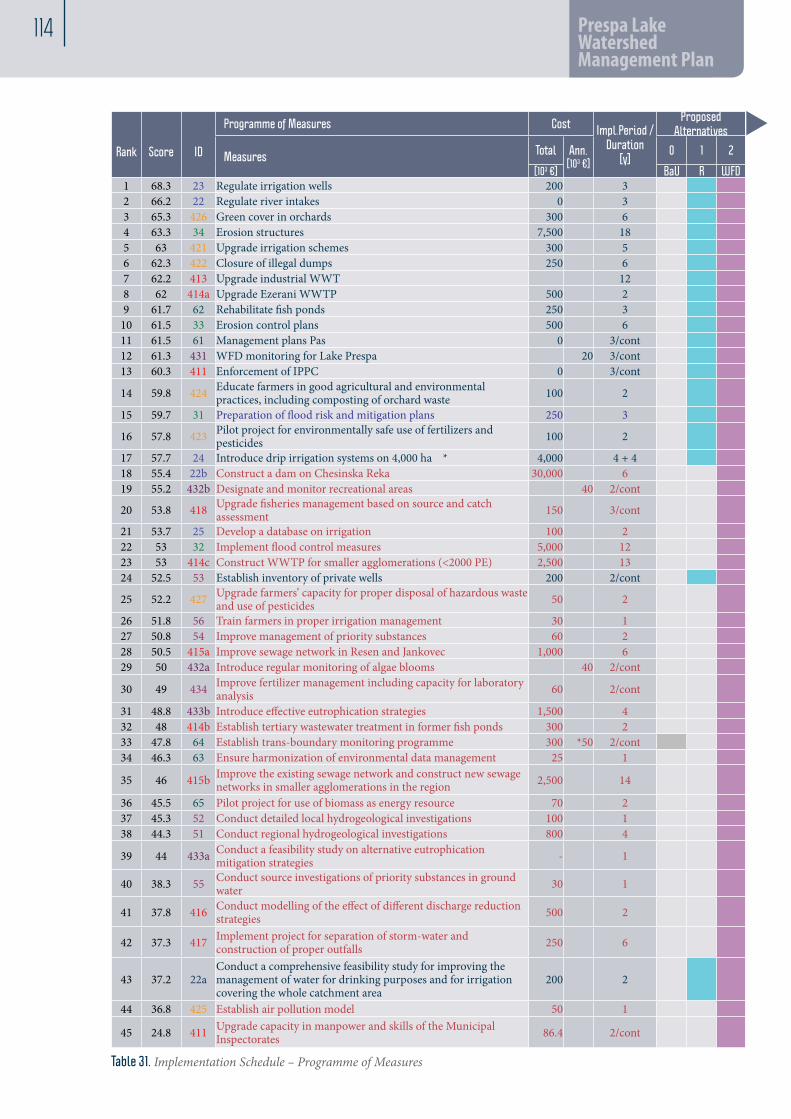
114 Prespa Lake Watershed Management Plan
Rank
Score
ID
Programme of Measures Cost Impl.Period /Duration
[y]
Proposed Alternatives Initial 6-year WMP
implementationSecond 6-year WMP implementation period
Third 6-year WMP implementation period
Predecessor Measures Total Ann.
[103 €]0 1 2
[103 €] BaU R WFD Year 1-6 Year 7-12 Years 13-18 19 201 68.3 23 Regulate irrigation wells 200 3 532 66.2 22 Regulate river intakes 0 3 3 65.3 426 Green cover in orchards 300 6 4 63.3 34 Erosion structures 7,500 18 335 63 421 Upgrade irrigation schemes 300 5 6 62.3 422 Closure of illegal dumps 250 6 7 62.2 413 Upgrade industrial WWT 12 8 62 414a Upgrade Ezerani WWTP 500 2 9 61.7 62 Rehabilitate fish ponds 250 3
10 61.5 33 Erosion control plans 500 6 11 61.5 61 Management plans Pas 0 3/cont EE12 61.3 431 WFD monitoring for Lake Prespa 20 3/cont EE13 60.3 411 Enforcement of IPPC 0 3/cont EE14 59.8 424 Educate farmers in good agricultural and environmental
practices, including composting of orchard waste 100 2
15 59.7 31 Preparation of flood risk and mitigation plans 250 3 16 57.8 423 Pilot project for environmentally safe use of fertilizers and
pesticides 100 2
17 57.7 24 Introduce drip irrigation systems on 4,000 ha * 4,000 4 + 4 22b18 55.4 22b Construct a dam on Chesinska Reka 30,000 6 22a19 55.2 432b Designate and monitor recreational areas 40 2/cont 20 53.8 418 Upgrade fisheries management based on source and catch
assessment 150 3/cont EE/Inst
21 53.7 25 Develop a database on irrigation 100 2 22 53 32 Implement flood control measures 5,000 12 3123 53 414c Construct WWTP for smaller agglomerations (<2000 PE) 2,500 13 415b 24 52.5 53 Establish inventory of private wells 200 2/cont 25 52.2 427 Upgrade farmers’ capacity for proper disposal of hazardous waste
and use of pesticides 50 2
26 51.8 56 Train farmers in proper irrigation management 30 1 27 50.8 54 Improve management of priority substances 60 2 28 50.5 415a Improve sewage network in Resen and Jankovec 1,000 6 29 50 432a Introduce regular monitoring of algae blooms 40 2/cont 30 49 434 Improve fertilizer management including capacity for laboratory
analysis 60 2/cont
31 48.8 433b Introduce effective eutrophication strategies 1,500 4 32 48 414b Establish tertiary wastewater treatment in former fish ponds 300 2 6233 47.8 64 Establish trans-boundary monitoring programme 300 *50 2/cont EE34 46.3 63 Ensure harmonization of environmental data management 25 1 EE
35 46 415b Improve the existing sewage network and construct new sewage networks in smaller agglomerations in the region 2,500 14
36 45.5 65 Pilot project for use of biomass as energy resource 70 2 37 45.3 52 Conduct detailed local hydrogeological investigations 100 1 38 44.3 51 Conduct regional hydrogeological investigations 800 4 39 44 433a Conduct a feasibility study on alternative eutrophication
mitigation strategies - 1
40 38.3 55 Conduct source investigations of priority substances in ground water 30 1
41 37.8 416 Conduct modelling of the effect of different discharge reduction strategies 500 2
42 37.3 417 Implement project for separation of storm-water and construction of proper outfalls 250 6
43 37.2 22aConduct a comprehensive feasibility study for improving the management of water for drinking purposes and for irrigation covering the whole catchment area
200 2
44 36.8 425 Establish air pollution model 50 1
45 24.8 411 Upgrade capacity in manpower and skills of the Municipal Inspectorates 86.4 2/cont
u
Table 31. Implementation Schedule – Programme of Measures

9 115
Rank
Score
ID
Programme of Measures Cost Impl.Period /Duration
[y]
Proposed Alternatives Initial 6-year WMP
implementationSecond 6-year WMP implementation period
Third 6-year WMP implementation period
Predecessor Measures Total Ann.
[103 €]0 1 2
[103 €] BaU R WFD Year 1-6 Year 7-12 Years 13-18 19 201 68.3 23 Regulate irrigation wells 200 3 532 66.2 22 Regulate river intakes 0 3 3 65.3 426 Green cover in orchards 300 6 4 63.3 34 Erosion structures 7,500 18 335 63 421 Upgrade irrigation schemes 300 5 6 62.3 422 Closure of illegal dumps 250 6 7 62.2 413 Upgrade industrial WWT 12 8 62 414a Upgrade Ezerani WWTP 500 2 9 61.7 62 Rehabilitate fish ponds 250 3
10 61.5 33 Erosion control plans 500 6 11 61.5 61 Management plans Pas 0 3/cont EE12 61.3 431 WFD monitoring for Lake Prespa 20 3/cont EE13 60.3 411 Enforcement of IPPC 0 3/cont EE14 59.8 424 Educate farmers in good agricultural and environmental
practices, including composting of orchard waste 100 2
15 59.7 31 Preparation of flood risk and mitigation plans 250 3 16 57.8 423 Pilot project for environmentally safe use of fertilizers and
pesticides 100 2
17 57.7 24 Introduce drip irrigation systems on 4,000 ha * 4,000 4 + 4 22b18 55.4 22b Construct a dam on Chesinska Reka 30,000 6 22a19 55.2 432b Designate and monitor recreational areas 40 2/cont 20 53.8 418 Upgrade fisheries management based on source and catch
assessment 150 3/cont EE/Inst
21 53.7 25 Develop a database on irrigation 100 2 22 53 32 Implement flood control measures 5,000 12 3123 53 414c Construct WWTP for smaller agglomerations (<2000 PE) 2,500 13 415b 24 52.5 53 Establish inventory of private wells 200 2/cont 25 52.2 427 Upgrade farmers’ capacity for proper disposal of hazardous waste
and use of pesticides 50 2
26 51.8 56 Train farmers in proper irrigation management 30 1 27 50.8 54 Improve management of priority substances 60 2 28 50.5 415a Improve sewage network in Resen and Jankovec 1,000 6 29 50 432a Introduce regular monitoring of algae blooms 40 2/cont 30 49 434 Improve fertilizer management including capacity for laboratory
analysis 60 2/cont
31 48.8 433b Introduce effective eutrophication strategies 1,500 4 32 48 414b Establish tertiary wastewater treatment in former fish ponds 300 2 6233 47.8 64 Establish trans-boundary monitoring programme 300 *50 2/cont EE34 46.3 63 Ensure harmonization of environmental data management 25 1 EE
35 46 415b Improve the existing sewage network and construct new sewage networks in smaller agglomerations in the region 2,500 14
36 45.5 65 Pilot project for use of biomass as energy resource 70 2 37 45.3 52 Conduct detailed local hydrogeological investigations 100 1 38 44.3 51 Conduct regional hydrogeological investigations 800 4 39 44 433a Conduct a feasibility study on alternative eutrophication
mitigation strategies - 1
40 38.3 55 Conduct source investigations of priority substances in ground water 30 1
41 37.8 416 Conduct modelling of the effect of different discharge reduction strategies 500 2
42 37.3 417 Implement project for separation of storm-water and construction of proper outfalls 250 6
43 37.2 22aConduct a comprehensive feasibility study for improving the management of water for drinking purposes and for irrigation covering the whole catchment area
200 2
44 36.8 425 Establish air pollution model 50 1
45 24.8 411 Upgrade capacity in manpower and skills of the Municipal Inspectorates 86.4 2/cont
Overall Implementation Strategy in the Macedonian Context

116 Prespa Lake Watershed Management Plan
9.6 Environmental Effects
The implementation of the Prespa Watershed Management Plan in accordance with the pro-posed Implementation schedule will contribute significantly to the achievement of the Environ-mental Objectives set in the WFD and the new Water Law. The primary objective of achieving good status for all waterbodies is possible if the proposed measures are properly implemented. It is recommended that the implementation of the WMP be conducted in a comprehensive but staggered approach, with prudent evaluation/review of implementation processes, results and environmental effects in the prescribed 6-year periods. Simultaneously, it is of utmost impor-
tance to give equal priority to measures provid-ing an ‘enabling environment’ for the implemen-tation of the Plan (legal, institutional & capacity issues).It is important to initiate the process of im-plementation with selected measures that are achievable at local level with existing capacities, which will be enhanced in the course of imple-mentation. The expected effects of WMP implementation on individual surface waterbodies in the Prespa watershed are presented in Table 32. and 33. below:
Name Current status
Action needed?
Objectives Alternatives
Rivers HMWB & AWB
“0”No action
1Realistic
2Full WFD
Istocka 1 Good Good Good GoodIstocka 2 Bad Y Good Bad Moderate GoodIstocka 3 Poor Y Good Poor Moderate GoodGolema 1 Good Good Good GoodGolema 2 Moderate Y Good Moderate Good GoodGolema 3 Moderate Y Good Moderate Good GoodGolema 4 Moderate Y Good Moderate Good GoodGolema 5 Moderate Y Good Moderate Good Good
Golema 6 Bad Y Good potential Bad Moderate Good
Golema 7 Bad Y Good potential Bad Moderate Good
Golema 8 Poor Y Good potential Poor Moderate Good
Kurbinska Moderate Y Good Moderate Good GoodKranska 1 High High High HighKranska 2 Moderate Y Good Moderate Good GoodBrajcinska 1 High High High HighBrajcinska 2 Poor Y Good Poor Moderate Good
Lake Prespa Moderate Good Poor Good Good
Table 32. Expected effects on individual surface waterbodies

9 117
In accordance with the Environmental Objectives set by the TDA and adopted by the Prespa WMP, the implementation of the Plan is expected to achieve the following effects:
Objectives Sub-objective IndicatorsAlternatives“0” No action 1 Realistic 2 Full WFD
Overall Objective 1:Improvement of environmental conditions ensuring good water and soil quality for human health and ecosystem by 2025
Indicator:Measurable decline in levels of the main pollutant groups and pressures on water, sediment and biota
1a: Good surface water quality:
Reduce/prevent further eutrophication/organic pollution
Reduce/prevent further hydromorphological changes
Reduce/prevent further habitat fragmentationMaintain biological water quality (phytoplankton, macrophytes, invertebrates and fish)Reduce/prevent hazardous substances pollution
1b: Good groundwater quality:
Control water abstraction
Reduce/prevent water pollution from point and non-point sources
Maintain good physical and chemical characteristics
1c: Good ecological potential for HMWB and AWB:
Reduce/prevent further eutrophication/organic pollution
Reduce/prevent further hydromorphological changes
Reduce/prevent further habitat fragmentationImprove biological water quality (phytoplankton, macrophytes, invertebrates and fish)
Reduce/prevent hazardous substances pollution
Overall Objective 2: Sustainable and efficient water utilization for maintenance/control of Lake Prespa water level and groundwater table
Indicator: Measurable and sustained water utilization
2a: Introduce water conservation and demand management:
Irrigation abstraction
Drinking water abstraction
Abstraction of water for industry
2b, 2c: Increase knowledge - hydrological & limnological regime; CC impacts & disaster management:
Lake water level
Irrigated area
Precipitation Air temperatureLake evaporation
Karstic spring flow to Ohrid
Groundwater level
Table 33. Environmental Effects on adopted TDA objectives & criteria
Overall Implementation Strategy in the Macedonian Context

118 Prespa Lake Watershed Management Plan
ANNEX 1 List of Tables
Table 1. Land-use classes (year 2000) according to CORINE delineation 8Table 2. Land-use pattern in the municipality of Resen (Spatial plan for Ohrid-Prespa region 2005-2020) 8Table 3. Typology of surface water bodies 12Table 4. Typology of surface water bodies – Lakes - system A 12Table 5. Delineated groundwater resources in the Prespa Lake Watershed 13Table 6. Reference conditions for rivers 14Table 7. Reference conditions for Prespa Lake 19Table 8. Calculations for 20,792 people (including tourists), based on average load per person 23Table 9. Calculation of various pollutants per source of pollution 24Table 10. Practice of fertilization in private orchards in the Prespa region 29Table 11. Fertilizer and pesticide use per waterbody and per sub-catchments 29Table 12. Use of pesticides in the Prespa region 30Table 13. Classification of the ecological status of identified surface waterbodies 42Table 14. Physico-chemical results (measurement May, 2010) 45Table 15. Objectives for delineated waterbodies in Prespa Region 47Table 16. Key environmental objectives and indicators 48Table 17. Municipal and industrial water supply, consumption and revenue 49Table 18. Quantity of potable water delivered 50Table 19. Revenues from water delivered to users 50Table 20. Price of water for full cost coverage 50Table 21. Wastewater disposal systems and revenues 51Table 22. Water Consumption for Irrigation and Revenues 52Table 23. Problem Analysis for the Prespa Lake Watershed 53Table 24. Criteria and Indicators for Addressing the Water Management Problems of the Lake PrespaWatershed 54Table 25. Identified problems & possible solutions (shortened) 55Table 26. Programme of Measures for the achievement of good water status in the Prespa watershed 60Table 27. Technical ranking / prioritization of the 45 Measures 72Table 28. Measures to provide the enabling environment 79Table 29. NPV - group of measures for water supply & irrigation 84Table 30. NPV – group of measures for the treatment of wastewater 84Table 31. Implementation Schedule – Programme of Measures 86Table 32. Expected effects on individual surface waterbodies 87Table 33. Environmental Effects on adopted TDA objectives & criteria 88

119
ANNEX 2 List of Figures
Figure 1. Location of the Prespa Lake watershed 6Figure 2. Topography and slope of Prespa Lake watershed 6Figure 3. Geology Map and Soil Map 7Figure 4. Prespa socio-economic maps: Settlements and road network; Land Use 9Figure 5. Hydrological network in the watershed 10Figure 6. Delineated surface waterbodies in the watershed 11Figure 7. Hydrogeological map of the delineated groundwater bodies in the Prespa Lake Watershed 13Figure 8. Major cations and heavy metals in core samples of Prespa Lake 15Figure 9. Heavy and toxic metals in core samples of Prespa Lake 15Figure 10. Total P content measured in recent sediments at the sampling sites of Prespa Lake. 16Figure 11. Total P and total N core sediments of Lake Prespa 16Figure 12. Comparative presentation of diatom assemblages retrieved from 0.5-10 ka BP core samples of Prespa Lake and some of the most dominant and characteristic taxa in the investigated core samples 17
Figure 13. Plankton sample from Lake Dojran (August 2010) dominated by Aulacoseira granulata and at least three Microcystis taxa; circular filaments belong to Lynbya contorta 18
Figure 14. Water bloom caused by Anabaena affinis and Anabaena contorta in Prespa Lake waters 18Figure 15. Cyanotoxins-microcystins in Prespa Lake waters during the 12-month investigation period 19Figure 16. Sources of pollution in the Prespa watershed 28Figure 17. Water level decrease of Prespa Lake over the period 1951-2008 31Figure 18. Water objects in the Prespa Lake Watershed 32Figure 19. Soil erosion risk map of the Prespa Lake Watershed 36Figure 20. Nature reserves (protected areas according to the Law on Nature) 37Figure 21. Map of wetlands around Lake Prespa 38Figure 22. Existing and newly proposed protection zones 39Figure 23. Monitoring sites in delineated waterbodies in the Prespa Lake watershed which were continuously monitored during the course of this project 41
Figure 24. Map of the classification of ecological status of waterbodies in the Prespa Lake Watershed 43Figure 25. Map of the delineated groundwater bodies and monitoring sites 44Figure 26. BIS (2-Ethylhexyl)phthalate MPL<6 ng/l 45Figure 27 MPL level for organoclorine pesticide 45

120 Prespa Lake Watershed Management Plan
ANNEX 3 Abbreviations
AL AlbaniaAWB Artificial water bodiesCIS Common Implementation Strategy for WFDDSS Decision Support System DPSIR Driver, Pressure, State, Impact, Response EC European CommissionEU European UnionGIS Geographical Information SystemGR GreeceGTI GTI - Geotehnicki Inzenering, Skopje (the Con-sultant)FA Farmer AssociationsHBI Hydro-Biological InstituteHMA Hydro-meteorological AdministrationHMWB Heavily Modified Water BodiesICPDR International Commission for the Protection of the Danube RiverIRBM Integrated River Basin ManagementIT Information TechnologiesIPPC Integrated pollution prevention & control ISO International Standardisation OrganisationIWM Integrated Water ManagementJTWG Joint Technical Working Group (MK-AL-GR)LFM Logical Framework MatrixLSGU Local self-government unit MK MacedoniaMoAFWE Ministry of Agriculture, Forestry and Water EconomyMoTC Ministry of Transport and CommunicationsMoE Ministry of EconomyMoFA Ministry of Foreign AffairsMoEPP Ministry of Environment and Physical PlanningM&O Methodology & OrganizationMR Municipality of ResenNGO Non-Governmental OrganisationNMM Non-stationary Meteorological ModelPE Public enterprise PP Plans and programmesPIU Project Implementation UnitPoM Programmes of MeasuresPAM Protected areas managementPWMP Prespa Watershed Management PlanPWMC Prespa Watershed Management CouncilPWMWG Prespa Water Management Working GroupSoE State of the EnvironmentToR Terms of ReferenceWMA Water Management Administration (of Mac-edonia)WMP Watershed Management PlanWBR Water Bodies at RiskWFD Water Framework DirectiveWMC Water Management CouncilWQM Water Quality ManagementSEA Strategic environmental assessment

121
ANNEX 4 Literature
Projects and project documentation
1 CARDS 2003, Improvement of Management of Transboundary Water Resources
Report on Vardar River Basin GIS Design, Project No: 03/MAC01/10/002 August, 2007 Euroconsult Mott
MacDonald EAR/MoEPP
Work Package 1 - Legal & Institutional Framework, Options for Improved Management of the Vardar River, Project No: 03/MAC01/10/104
August, 2007 Euroconsult Mott MacDonald EAR/MoEPP
Work Package 2 - Water Quality, Preliminary Assessment of the Effects of Pollution and Management on Water Quality in the Vardar River, Project No: 03/MAC01/10/002
August, 2007 Euroconsult Mott MacDonald EAR/MoEPP
Work Package 3 - Industrial Pollution Assesment; A Report on the Most Serious Industrial Pollution Sources in the Vardar Basin …”, Project No: 03/MAC01/10/104
August, 2007 Euroconsult Mott MacDonald EAR/MoEPP
Work Package 4 - Fisheries; Overview of the Fisheries of the Vardar Basin and Influence of River Management and Polution on Fisheries, Project No: 03/MAC01/10/104
August, 2007 Euroconsult Mott MacDonald EAR/MoEPP
Work Package 5a - Dojran Lake Study; Report of Water Balance of Lake Dojran; Project No: 03/MAC01/10/002
August, 2007 Euroconsult Mott MacDonald EAR/MoEPP
Work Package 5b - Dojran Lake Study; Report of Water Balance of Lake Dojran - GROUND WATER; Project No: 03/MAC01/10/002
August, 2007 Euroconsult Mott MacDonald EAR/MoEPP
Work Package 6 - Water resources; Assessment of the Water Resources of Vardar/Axios River Basin; Project No: 03/MAC01/10/104
August, 2007 Euroconsult Mott MacDonald EAR/MoEPP
Work Package 7 - River Basin Management Planning; Project Summary and Recommendations; Project No: 03/MAC01/10/104
August, 2007 Euroconsult Mott MacDonald EAR/MoEPP
2 Fishing Basis for the Fishing Area of Prespa Lake for the Period of 2009-2014
November, 2008
PSI Hydrobiological Institute, Ohrid MoAFWM
Proposal for a Process to Establish Transboundary Fisheries Management Cooperation, Consultancy Report
September, 2009
Wolf D. Hartmann, Transboundary Fish and FM Specialist
Prespa Park, UNDP/GEF
Situational Analysis of the Fisheries in the Prespa Basin (Draft) Consultant Report
September, 2009
Wolf D. Hartmann, Transboundary Fish and FM Specialist
Prespa Park, UNDP/GEF
3Project: 000511409 “Support for integration of Ecosystem Oriented Forest Management in the Prespa region

122 Prespa Lake Watershed Management Plan
Assessment of the current forest ecosystem in the Forest Management Unit “Leva reka/Bigla”, Phase I Report
July, 2008 Dr. Vlatko Andonovski UNDP/GEF
In-depth assessment of the currently used forest management practices in the Forest Management Unit “Leva reka/Bigla” and their impact on forest ecosystem, Phase II Report
August, 2008 Dr. Vlatko Andonovski UNDP/GEF
Sustainable Ecosystem Oriented Forest Management Guidelines
September, 2008 Dr. Vlatko Andonovski UNDP/GEF
Action Plan for Sustainable Forest Management (ecosystem-oriented forest management) practices that will be implemented in two selected pilot areas within the Forest Management Unit “Leva reka/Bigla
October, 2008 Dr. Vlatko Andonovski UNDP/GEF
4 Restoration of Golema Reka
Hydrology December, 2006 Geing Krebs und Kiefer
Swiss Agency for Development and Cooperation/UNDP
Mitigation of Problems Related to Solid Waste Management and Wastewater Pollution October, 2006 PointPro Consulting SDC/UNDP
Wetlands in Golema Reka Catchment October, 2006 Geing Krebs und Kiefer SDC/UNDP
Improvement of the forest cover and protection against erosion in the river basin of Golema Reka
October, 2006 Geing Krebs und Kiefer SDC/UNDP
Mitigation of Problems Related to Current Land Use July, 2006 Geing Krebs und Kiefer SDC/UNDP
Improvement of the river monitoring October, 2006 Geing Krebs und Kiefer SDC/UNDP
5 GIS Report
A preliminary assessment of map requirements, current use of GIS and urgent GIS needs of the productive sector.
December, 2008
UNDP/Prespa Park
6Integrated ecosystem management in the Prespa Lakes basin of Albania, Macedonia and Greece
IPPC Permits System December, 2008 Dekons-Ema UNDP
7Project Preparation & Development of the Transboundary Prespa Park Project, Feasibility Study
Part I: Context and Project Brief August, 2005 GFA Consulting Group GmbH
KfW Bank, Frankfurt/M.
Part II: Republic of Macedonia Project Concept for Galicica National Park August, 2005 GFA Consulting Group
GmbHKfW Bank, Frankfurt/M.
Part III: Republic of Albania Project Concept Prespa National Park August, 2005 GFA Consulting Group
GmbHKfW Bank, Frankfurt/M.
123
Part IV: Report 1, Conservation Management Galicica and Prespa August, 2005 GFA Consulting Group
GmbHKfW Bank, Frankfurt/M.
Part IV: Report 2a, Institutional and Legal Framework for Conservation Management Republic of Macedonia
August, 2005 GFA Consulting Group GmbH
KfW Bank, Frankfurt/M.
Part IV: Report 2b, Institutional and Legal Framework for Conservation Management Albania
August, 2005 GFA Consulting Group GmbH
KfW Bank, Frankfurt/M.
Part IV: Report 3a, Republic of Macedonia, Galicica National Park Stakeholder Analysis Financial Sustainability Socio-Economic Impact
August, 2005 GFA Consulting Group GmbH
KfW Bank, Frankfurt/M.
Part IV: Report 3b, Main stakeholders in the NP Prespa Albania – Socio-economic analysis August, 2005 GFA Consulting Group
GmbHKfW Bank, Frankfurt/M.
Part IV: Report 4, Albania Forestry Management Prespa Park Project Feasibility Study
August, 2005 GFA Consulting Group GmbH
KfW Bank, Frankfurt/M.
8Стратегија за развој на Општина РЕсен, SWOT 1, SWOT 2 (Macedonian version ONLY)
June, 2009 Municipality of Resen
Акционен план развој на Општина Ресен за периодото 2006-2011
(last modified) March, 2008
Municipality of Resen
Project: Стандарди за локален квалитет на Преспа,, No. 05MAC02/01/01/003; Студија за проценка на постоечката состојба и капацитетите за развој на агротуризмот во Oпштина Ресен (Macedonian version ONLY)
September, 2008
Urban Rural Consulting - URC, Skopje
EU-EAR / Municipality of Resen
9 UNDP Project “Integrated Ecosystem Management in the Prespa Lake Basin”
Guidelines for handling of pesticide packaging, Draft version
December, 2008
Foundation Agro-Centre for Education, Skopje MK, Rege-Fox, Brno CH
UNDP
Rulebook on the manner of pesticide and pesticide packaging collection disposal and destruction (DRAFT)
December, 2008
Foundation Agro-Centre for Education, Skopje MK, Rege-Fox, Brno CH
UNDP
10 Просторен план на Република Македонија(Spatial Plan of Macedonia)
Просторен план на Охридско – Преспанскиот регион 2005-2020, Nacrt (Spatial Plan of Ohrid-Prespa region, 2005 – 2020)
2007 Agency of Spatial Planning MoESP
11Integration of the Ecosystem Health Maintenance Objectives into the Spatial Plan for the Prespa Region
Working Paper 1: NATIONAL SPATIAL PLANNING REVEW October, 2008 Mike Sharrocks
Consultancy Pte LtdUNDP/GEF/ Stakeholders
Working Paper 2: EUROPEAN PLANNING MODELS October, 2008 Mike Sharrocks
Consultancy Pte LtdUNDP/GEF/ Stakeholders
Working Paper 3: TERMS OF REFERENCE FOR MUNICIPALITY OF RESEN SPATIAL PLAN
December, 2008
Mike Sharrocks Consultancy Pte Ltd
UNDP/GEF/ Stakeholders

124 Prespa Lake Watershed Management Plan
12Consulting Services of training on Conservation and Action Planning for Priority Transboundary Habitats and Species in the Prespa Lakes basin-Preparatory Phase
Draft Assessment Report, Ref.RFP 26/2009 September, 2009 Dekons-EMA UNDP/Prespa
Park
13 Lake Prespa, Transboundary Diagnostic Analysis
Integral Report (Draft) July, 2009 Regional Environmental Center (REC)
UNDP/GEF/ Prespa Park
Technical Task Team (TTT) for the collection, assessment and evaluation of national information in support of the Transboundary Diagnostic Analysis (TDA) and development of a Strategic Action Programme (SAP) in the Prespa Lakes Basin National Report (Draft), MACEDONIA
July, 2009 Regional Environmental Center (REC)
UNDP/GEF/ Prespa Park
14 Preparation of a Tri-lateral Tourism Strategy and Action Plan for the Prespa Region
A situational analysis and proposal, Consultant Report
December, 2008 Gottfried Hilz-Ward UNDP/GEF/
Prespa Park
15 TRABOREMA (Project No. INCO-CT-2004-509177
Concepts for integrated trans boundary water managemeny and sustainable socio-economic development in the cross border region Albania, FYR Macedonia and Greece, TRABOREMA results and conclusions
May, 2007 Oekosys, ESCi EC/EAR/FP6
16 Integrated Ecosystem Management in the Prespa Lakes Basin
1-st Technical Report, Water resources monitoring - May, 2009 Prespa Park,
UNDP/GEF
2-nd Report, Birds and other biodiversity 1 (species) May, 2009 Prespa Park,
UNDP/GEF
2-nd Report, Land Use May, 2009 Prespa Park, UNDP/GEF
2-nd Report, Socio-Economy May, 2009 Prespa Park, UNDP/GEF
2-nd Report, Water resources monitoring - May, 2009 Prespa Park, UNDP/GEF
2-nd Report, Aquatic Vegetation May, 2009 Prespa Park, UNDP/GEF
Conclusions_15May2009; Thematic Group on Fish and Fisheries; Wetland Habitats and aquatic vegetation; Forests & other terrestrial habitats
May, 2009 Prespa Park, UNDP/GEF
Conclusions_29May2009; Thematic Group on: Birds and other Biodiversity; Water; Socio-economy and Land-use
May, 2009 Prespa Park, UNDP/GEF
Fish and Fisheries – Subfinal May, 2009 Prespa Park, UNDP/GEF

125
Forest & Terrestrial Habitats – Subfinal May, 2009 Prespa Park, UNDP/GEF
Land_use_2ndPhase_final May, 2009 Prespa Park, UNDP/GEF
17Integrated Ecosystem Management in the Prespa Lakes Basin of Albania, FYR of Macedonia and Greece Ref. No. MCD/07/HR/03
Technical Assessment Report, PRESPA PARK COORDINATION COMMITTEE IN TRANSBOUNDARY ECOSYSTEM MANAGEMENT
December, 2007
Dr. Slavko Bogdanovic International Consultant
Prespa Park, UNDP/GEF
Consultant Report, ENHANCING TRANSBOUNDARY COOPERATION IN WATER MANAGEMENT IN THE PRESPA LAKES BASIN
June, 2009Dr. Owen McIntyre University College Cork Ireland
Prespa Park, UNDP/GEF
18 Watershed Management Council
НАЦРТ - ИЗВЕШТАЈ За условите за формирање и работа на Совет за управување со сливот на Преспанско Езеро (Macedonian version ONLY)
October, 2009 Д-р Билјана Пулеска Prespa Park, UNDP/GEF
Eu directives and manuals/guidance documents
Water Framework Directive, 2000/60/EC, amended by Decision on establishing the list of priority substances 2455/2001/ECBathing Water, 76/160/EECPotable Water 98/83/ECUrban Waste Water Treatment, 91/271/ECNitrates Directive, 91/676/EEC, but also the Law takes into consideration:Sewage Sludge Directive, 86/278/EECPlant Protection Products, 91/41/EECBiocides Directive, 98/8/ECGroundwater Directive 2006/118/ECFlood Directive 2007/60/ECWFD CIS Guidance Documents
No. 1. Economics and the Environment - The Implementation Challenge of the Water Framework Directive No. 2. Identification of Water BodiesNo. 3. Analysis of Pressures and Impacts No. 4. Identification and Designation of Heavily Modified and Artificial Water Bodies No. 5. Transitional and Coastal Waters - Typology, Reference Conditions and Classification Systems No. 6. Towards a Guidance on Establishment of the Intercalibration Network and the Process on the Intercalibration Exercise No. 7. Monitoring under the Water Framework Directive No. 8. Public Participation in Relation to the Water Framework Directive No. 9. Implementing the Geographical Information System Elements (GIS) of the Water Framework Directive No. 10. Rivers and Lakes - Typology, Reference Conditions and Classification Systems No. 11. Planning Processes No. 12. The Role of Wetlands in the Water Framework Directive No. 13. Overall Approach to the Classification of Ecological Status and Ecological PotentialNo. 14. Guidance on the Intercalibration Process (2004-2006) N° 15. Groundwater Monitoring (WG C)N° 16. Groundwater in Drinking Water Protected AreasN° 17. Direct and indirect inputs in the light of the 2006/118/EC DirectiveN° 18. Groundwater Status and Trend Assessment

126 Prespa Lake Watershed Management Plan
N° 19. Surface water chemical monitoring.pdfN° 20. Exemptions to the environmental objectivesN° 21. Guidance for reprting under the WFDN° 22. Updated WISE GIS guidance (nov 2008)N° 23 – Eutrophication Assessment in the Context of European Water PoliciesN° 24. River Basin Management in a changing climateN° 25. Chemical Monitoring of Sediment and BiotaN° 26. Risk Assessment and the Use of Conceptual Models for Groundwater
Other literature
A. Sommer (2005). Strategic environmental assessment: From scoping to monitoring - Content requirements and propos- als for practical work.Andersen, J. H.; Conley, D.J. & Heda, S. (2004). Implementation of the European water framework directive from the Basque country (northern Spain): a methodological approach. Marine Pollution Bulletin, 49: 283-290.Belgian Tokai (2004). Wastewater reduction techniques Birk, S. & Hering, D. (2006). Direct comparison of assessment methods using benthic macroinvertebrates: a contribution to the EU Water Framework Directive intercalibration exercise. Hydrobiologia, 566: 401-415. Bode, R. W.; Novak, M.A. & Abele L.A. (1997). Biological stream testing. NYS Department of Environmental Protection; Division of Water; Bureau of Monitoring and Assessment; Stream monitoring unit; Albany., USA.Boon, J.P. (1992). Essential elements in the case for river conservation. In: River Conservation and Management, Boon. P.J. Calow, P. and Petts, G.E. (Eds.), John Wiley and Sons Ltd., Chichester, pp. 11 - 33. Braun-Blanquet, J. (1964). Pflanzensoziologie: Grundzüge der vegetationskunde, 3 ed. — Springer-Verlag, Wien. 865 pp.BREF Documents, 2003. Reference Document on Best Available Techniques for Intensive Rearing of Poultry and PigsCEN (2003). EN 13946 – Guidance standard for the routine sampling and pre-treatment of benthic diatoms. Danish Ministry of the Environment . Odense Pilot River Basin. Pilot project for river basin management planning. Water Framework Directive Article 13.Danish Ministry of the Environment ,Environment Centre Odense . ISBN: 87-92197-03-5Dinsmore, W. P.; Scrimgeour, G. J. & Prepas, E.E. (1999). Empirical relationships between profundal macroinvertebrate biomass and environmental variables in boreal lakes of Alberta, Canada. Freshwater Biology, 41: 91-100.Downes, B.J.; Lake, P.S. & Schreiber, E.S.G. (1993). Spatial variation in the distribution of stream invertebrates: implica- tions of patchiness for models of community organization. Freshwater Biology, 30: 119 - 132.EC (2003) Guidance for the analysis of Pressures and Impacts in accordance with the Water Framework DirectiveEPA (2007). Strategic Environmental Assessment for Water Framework Directive River Basin Management Plans and Programmes of Measures.EPA (2009). Strategic Environmental Assessment statement for the river basin management plan for the Solway Tweed river basin district.Federal Ministry for the Environment, Nature Conservation and Nuclear Safety, Germany (2004). German Ordinance on Requirements for the Discharge of Waste Water into Waters- ATV131A methodology GEF (2010). Strategic action programme for Prespa Lake.Grupce, Lj. (1997). Autochthonous and allochthonous quantities of phosphorus in Prespa Lake waters. Symposium Pro- ceedings, 24-26.10.1997 Korcha, Albania, 68-78. Hering, D.; Moog, O.; Sandin, L. & Verdonschot, P. (2004). Overview and application of the AQEM assessment system. Hydrobiologia, 516, 1-20. ICPDR 2009 ICPDR / International Commission for the Protection of the Danube River / Danube River Basin Manage- ment PlanISO (2003). 7828 – Methods of biological sampling guidance for macroinvertebrates. Jansson, A.M., M. Hammer, C. Folke, and R. Costanza (eds.) (1994). Investing in natural capital: The ecological economics approach to sustainability. Washington, DC: Island Press.Krstic, S. (2007). Saprobiological and trophic models for Lake Prespa (saprographs) for use in similar regions and its application for evaluation of Ecological Quality Ratios (indicators). EC-FP6 project “TRABOREMAINCO- CT-2004-509177, Deliverable 3.3., 98 pp.Krstić, S. (2011). Estimation of the eutrophication level, consequences and remediation methods of some freshwater eco- systems in Republic of China – research on Lake Honghu and the east part of Lake Hubei. Final Project Report,

1 127Description Of The Watershed
Ministry of Education and Science, Bilateral project R.China-R.Macedonia, Project number 03-1735/1, 2010-2011, 50 pp. Krstic, S.; Svircev, Z.; Levkov, Z. & Nakov T. (2007). Selecting appropriate bioindicator regarding the WFD guidelines for freshwaters - a Macedonian experience. International Journal on Algae, 9(1), 41-63.Levkov, Z.; Krstic, S.; Metzeltin, D. & Nakov, T. (2006). Diatoms of Lakes Prespa and Ohrid (Macedonia). Iconographia Diatomologica 16: 603 pp.MER (2010). Draft guidance document on SEA and watershed management planning in MacedoniaMicevski, E. (2000). Geological and hydro-geological characteristics of the Ohrid - Prespa region. Proceedings of the International Symposium “Sustainable Development of Prespa Region”, Oteshevo 23-25.06.2000, Republic of Mac- edonia, 10-17. Moss, B.; Johnes, P. & Phyllips, G. (1997). New approaches to monitoring and classifying standing waters. In: Freshwater quality: Defining the indefinable? Boon, P.J, Howell, D.L.(eds), Scottish natural heritage, Edinburgh, 118-133.Naumovski, T.; Novevska V.; Lokoska L. & Mitic V. (1997). Trophic state of Prespa Lake. Symposium Proceedings, 24- 26.10.1997 Korcha, Albania, 132-137.OECD (1982). Eutrophication of Waters, monitoring assessment and control. Paris, Organisation for Economic Coopera- tion and Development. P. Scott & P. Marsden (2003). Development of Strategic Environmental Assessment (SEA) Methodologies for Plans and Programmes in Ireland.Rockström, J., W. Steffen, K. Noone, Persson, S.F. Chapin III, E.F. Lambin, T.M. Lenton, M. Scheffer (2009). A safe operat- ing space for humanity. Nature 461: 472–475.Rosenberg, D.M. & Resh, V.H. (1993). Freshwater biomonitoring and benthic macroinvertebrates. Chapman and Hall, New York, 488 pp.Rosling, H. 2010. Gapminder, for a fact-based worldview. http://www.gapminder.org/.Sandin, L. & Johnson, R. K. (2000). The statistical power of selected indicator metrics using macroinvertebrates for assessing acidification and eutrophication of running waters. Hydrobiologia, 422/423, 233-243.Skriver, J.; Friberg, N. & Kirkegaard, J. (2000). Biological assessment of running waters in Denmark: Introduction of the Dan- ish stream fauna index (DSFI). Verh. Int. Ver. Limnology, 27:1822–183.Steffen, W., Persson, L. Deutsch, J. Zalasiewicz, M. Williams, K. Richardson, C. Crumley, P. Crutzen (2011). The Anthropo- cene: From global change to planetary stewardship. Ambio. doi:10.1007/s13280-011-0185-x.Steneck, R.S., T.P. Hughes, J.E. Cinner, W.N. Adger, S.N. Arnold, S. Boudreau, K. Brown, Berkes, F. (2011). The gilded trap of Maine’s lobster fishery: A cautionary tale. Conservation Biology. doi:10.1111/j.1523-1739.2011.01717x.Stoermer, E.F. & Smol J.P. (eds.) (1999): The Diatoms: Applications for the Environmental and Earth Sciences, Cambridge University Press, Cambridge, 484 pp. Stumm, W. & Morgan, J. (1981). Aquatic chemistry. New York: Wiley.Svirčev Z, Marković S, Krstić S, Krstić K, Obreht I (2010) Ecoremediation (ERM) and Saprobiology – is there a link? Geophysi- cal Research Abstracts Vol. 12, EGU2010-2052, 2010. UNDP‐GEF project 00058373 ‐ PIMS 3728, “Strengthening the Ecological, Institutional and Financial Sustainability of Mac- edonia’s National Protected Areas System”, Project activity. Ref. RFP 79/2009, “Development of Representative National System of Protected AreasVan Dam, H. et al. (2005). ECOSURV Project Report – BQE for Hungarian water bodies: Phytobenthos, 54 pp. Wagner B. & Schäbitz F., 2009. Project B2 - Climatic and Environmental History of the Balkans during the Last Glacial Cycle. University of Cologne, core Co1215 (15.75 m ~ 40 ka BP). http://www.sfb806.de.
WFD (2008). Directive 2008/105/EC – Priority substances. Official Journal of EU, 24 December 2008.WHO (1993). Assessment of Sources of Air, Water, and Land Pollution. A Guide to Rapid Source Inventory Techniques and their Use in Formulating Environmental Control St

Cover photo: Lj. StefanovDesign: APOLOIMAGES


This first ever watershed management plan for the Prespa region has been prepared with thetechnical and financial support of the United Nations Development Programme and the Global Environment Facility.Fully in line with the EU Water Framework Directive, the plan offers guidance for directing future investments in the Prespa water sector and recommendations to improve water resource management issues in the basin, such as irrigation, water supply and wastewater treatment. This plan is expected to become an important driver for achieving sustainable management of the Prespa waters for many years to come.