An Analysis of McLean County, Illinois Farmers' Perceptions of Genetically Modified Crops
Upload
khangminh22Category
view
4download
0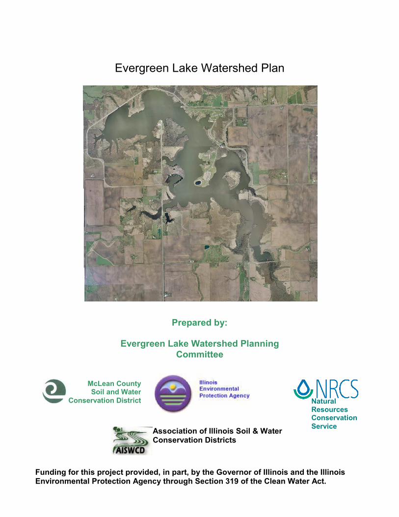
Evergreen Lake Watershed Plan
Natural Resources Conservation
Service
McLean County Soil and Water
Conservation District
Prepared by:
Evergreen Lake Watershed Planning
Committee
Association of Illinois Soil & Water Conservation Districts
Funding for this project provided, in part, by the Governor of Illinois and the Illinois Environmental Protection Agency through Section 319 of the Clean Water Act.

1 Evergreen Lake Watershed Management Plan
Table of Contents
Mission Statement ................................................................................................ 2
Introduction ........................................................................................................... 2
Watershed Description ......................................................................................... 4
General Overview ............................................................................................. 5
Watershed History ............................................................................................ 6
Geological ..................................................................................................... 6
Human Use ................................................................................................... 6
Construction of Evergreen Lake .................................................................... 7
Recent issues ................................................................................................ 8
Watershed Activities ........................................................................................... 11
Conservation Practices ................................................................................... 11
Watershed Resource Inventory .......................................................................... 15
Land Uses ....................................................................................................... 15
Water Uses ..................................................................................................... 18
Evergreen Lake Shoreline Erosion Summary ................................................. 18
Streambank Stablization Study ....................................................................... 21
Problem Statements ........................................................................................... 25
Goals/Objectives ................................................................................................ 27
Implementation strategies/Alternatives ............................................................... 30
1. Reducing Phosphorus Presently in Evergreen Lake .............................. 30
Destratification ............................................................................................. 30
Evergreen Lake aquatic habitat restoration plan ......................................... 33
Wildlife management practices.................................................................... 35
1. Reducing potential sources of phosphorus entering the lake ................. 36
Lake Shoreline stabilization ......................................................................... 36
Streambank Stabilization Program .............................................................. 39
Agricultural Best Management Practices ..................................................... 42
Urban Area Best Management Practices .................................................... 43
3. Monitoring for Evaluation ............................................................................ 52
Cost Summary .................................................................................................... 56
Lakeshore Stabilization ................................................................................... 56
Streambank Stabilization ................................................................................ 57
Destratification ................................................................................................ 58
Wildlife control................................................................................................. 58
Agricultural program costs .............................................................................. 59
Urban Program Costs ..................................................................................... 60
Selection of Implementation Strategies/Alternatives........................................... 63
Shoreline/streambank stabilization ................................................................. 63
Destratification ................................................................................................ 63
Wildlife management ...................................................................................... 63
Agricultural practices ....................................................................................... 63
Urban practices ............................................................................................... 64
Measuring Progress/Success ............................................................................. 65

2 Evergreen Lake Watershed Management Plan
Mission Statement
We, the community of the Evergreen Lake watershed, desire to address
regulatory requirements and to improve & protect agricultural, water, recreational
and other natural resources with proactive strategies that maximize local control.
Introduction In February 2005, the McLean and Woodford County Soil and Water
Conservation Districts, the Association of Illinois Soil and Water Conservation
Districts (AISWCD), and the McLean and Woodford County Natural Resource
Conservation Service (NRCS) invited landowners, representatives of local
governments, local experts, and concerned citizens to meet to address the issue
of elevated levels of phosphorus in Evergreen Lake. From that initial group a
Planning Committee was formed, which then developed a list of action points that

3 Evergreen Lake Watershed Management Plan
needed to be investigated. The Planning Committee then appointed a Technical
Committee to address the individual problem statements, investigate existing
data of Best Management Practices to address the problems, inventory
resources in the watershed and develop alternatives. The Technical Committee
divided into three areas of expertise: the Biological/Streams Committee, the
Urban Committee, and the Agriculture Committee. Funding for the entire
Evergreen Lake Watershed Plan development was through grants by the Illinois
Environmental Protection Agency, while implementation funding will be from
IEPA, Association of Illinois Soil & Water Conservation Districts (AISWCD),
SWCD, Sand County Foundation, and NRCS, as well as other local and private
funding.
The committee started the planning process under the guidance of NRCS
and used a three phase planning approach.
Stakeholders were invited to committee meetings and provided with plan drafts.
Their comments were integrated into the final plan. A list of members of the
Planning and Technical Committees are in Appendix I.
Implement Plan
Phase IPhase I
Phase IIIPhase III
Phase IIPhase II
The Resource Planning ProcessUSDA-Natural Resources Conservation Service
Know the Planning Area1. Identify resource concerns2. Determine objectives3. Conduct inventories4. Analyze resource data
Make Decisions5. Develop alternatives6. Evaluate alternatives7. Make decisions
Implement & Evaluate 8. Implement the plan9. Evaluate the plan
USDA-NRCS Champaign, Illinois. September 1999.

4 Evergreen Lake Watershed Management Plan
Watershed Description

5 Evergreen Lake Watershed Management Plan
General Overview
The Evergreen Lake (Water Body Segment ID SDA) watershed
encompasses 41.1 square miles (25,730 acres) within McLean County and
Woodford County, Illinois. It is within the U.S. Geological Survey Mackinaw River
Basin (Hydrologic Unit Code 0713000404010). Six Mile Creek (Water Body
Segment ID DKN 01) and two major unnamed tributaries and six minor tributaries
drain into Evergreen Lake. (see map p.21)
The watershed includes the village of Hudson and the far north edge of
the Town of Normal. Agriculture and rural grassland are the predominant land
uses, with row crops covering 87 percent of the watershed. The land is gently
sloping (1-4%) except in areas near the Mackinaw River (4-10% slope).
There are seven water, multiple, and/or waste point sources in the
watershed as identified by the EPA. Four are in the village of Hudson: Birkey’s
Farm Store (Waste), Bransfield Inc. (waste), Casey’s General Store (waste), and
Prairie View Homeowners Association (water), and three are out side any urban
boundaries: Whitacre’s, (waste) Ni-Cor (waste) and McLean County Parks and
Recreation (water).

6 Evergreen Lake Watershed Management Plan
Hazardous waste Water discharges
Watershed History
Geological
The geological history of Illinois is dominated by four glacial advances.
The Wisconsinan glaciation of about 15,000 years ago formed a series of
moraines across east-central and northeastern Illinois.
Glaciers played a significant role in shaping McLean County. A number of
glacial moraines run from northwest to southeast across the county. Over time,
the glacial ridges were worn down, lower areas were filled with sediments, and
wind-deposited loess smoothed out the features.
Human Use
This depositional loess base created a perfect environment for the
subsequent prairie formation, which provided natural nutrient loading and water
Evergreen Lake
Lake Bloomington
Watershed boundary

7 Evergreen Lake Watershed Management Plan
retention in the soil. As the land was subsequently farmed, phosphorus was
routinely added to the soil in larger amounts than required. Modern practices
actually use much less fertilizer than required, but due to this heavy historical
phosphate loading, there are still phosphorus reserved in the soil. From a 1990
USDA report (90-130) “Phosphorus fertilizer use peaked in 1978 and remained
largely unchanged until 1983 when phosphorus fertilizer use declined
approximately 25 percent.” As this friable loess based soil erodes, phosphorus
migrates into the waterways.
Construction of Evergreen Lake
Evergreen Lake was constructed in 1971 as a supplemental water
reservoir for the City of Bloomington, population 74,975, as well as for
recreational use. It was formed by an impoundment of Six Mile Creek upstream
of its junction with the Mackinaw River.
In 1995, the city modified the Evergreen Lake dam to increase the normal
pool elevation by five feet, resulting in a 36 percent increase in storage capacity.
Currently, the lake has a surface area of 900 acres, 22.5 miles of shoreline, a
maximum depth of 53 feet, a mean depth of 22 feet, and a storage volume of
15,480 acre-feet.
During the drought of 1988, water quality suffered, leading to complaints
of taste and odor in finished water. These issues were partially due to severely
anaerobic regions and resulting chemical decomposition. In 1996, on the
recommendation of the Illinois State Water Survey, the city installed an Aspir-Air
Aeration System to destratify the lake near the water intake site.
A subsequent study by Raman et al. found that the destratifier had a
significant positive impact on the biological, chemical, and physical health of the
lake. The lake was nearly isothermal to a depth of 30 feet, the depth of the
destratifier. Compared with prior conditions, the dissolved oxygen levels
improved significantly near the water treatment plant intake point, and overall
oxygen conditions improved throughout 95 percent of the lake. Increased
oxygen contributed to a significant decrease in ammonia levels in the bottom
waters. Turbidity decreased and lake transparency increased, although this was

8 Evergreen Lake Watershed Management Plan
in large part due to increased lake depths from the raising of the spillway the
previous year. Total alkalinity values increased, indicating a decrease in algal
activity.
Recent issues
In late fall 2004, after unseasonably warm temperatures and heavy rains,
Bloomington water suffered taste and odor issues. The problem was later
attributed to a species of blue-green algae present in both Lake Bloomington and
Evergreen Lake. Blue-green algae present a particular problem in lake
management because they can fix nitrogen and control their buoyancy to best
utilize dissolved nutrients, allowing them to out-compete other algae. Some
species produce potent toxins, and many are associated with unpleasant tastes
and odors.
The recent taste and odor issues have been attributed to a blue-green
algae called oscillatorid, specifically to geosmin and 2-methylisoborneol (MIB),
two chemicals it produces. While not toxic, these metabolic byproducts are
difficult to remove completely from finished water. Humans are highly sensitive
to their characteristic musty smell and taste, with some people able to detect
their presence at levels lower than the 5 ng/L Method Detection Level.
In April 2005, Wayne Kinney of Stream Technical Resource and
Management Service (STREAMS) surveyed the extent of erosion in the lower
portion of the waterways that feed into Evergreen Lake. Six Mile Creek and
seven unnamed tributaries were surveyed for one to four miles outwards from the
lake, until the start of the upper, actively managed, drainage systems, for a total
of 16.3 miles of streambeds. The survey showed that the inventoried erosion
sites contribute approximately 2,100 tons of sediment to Evergreen Lake per
year. In addition, more than 90 percent of lake sediment due to streambank
erosion originates within 4 miles of the lake. Kinney concluded that the most
effective way to reduce sediment loading from the waterways would be to
achieve and maintain channel stability over long stretches of streambank, not just
in isolated eroding sites. (see map p.21)

9 Evergreen Lake Watershed Management Plan
Several studies have been completed by IDNR on the Mackinaw River
Basin, including Six Mile Creek. In 2000, studies have found that the data
suggests that Six Mile Creek has little mussel habitat or mussels. Six Mile Creek
was rated as the lowest ranking for mussels in the entire Mackinaw River Basin.
Six Mile Creek the largest of the two major tributaries to Evergreen Lake had fish
surveys conducted in 2000 and 2005 by the IDNR. The survey in 2000 was
located just west of Hudson off 2200 N and the 2005 survey was at the bridge on
2000 N. Between the two surveys 17 species of fish were collected of which
none are on the state endangered or threatened species list. These species are
common to streams in central Illinois. Fish samples in streams are characterized
by an Index of Biotic Integrity (IBI). A score for each site is based upon ten
parameters which yield a score from 1-60. The higher the score the better the
quality the streams is considered to be. The IBI score in 2000 was 30, which
would be interpreted as a stream with ‘Limited Aquatic Resources’. In 2005 the
score dropped to 12, though the survey was taken at a different location. This
lower score would give the stream a listing of ‘Restricted Aquatic Resource’.
All of the fish that were collected are considered to be tolerant to
moderately tolerant species, indicating that they can tolerate poorer water quality
and are adaptable to poorer habitat conditions. Almost all are considered to be
generalist feeders indicating that they require no special feeding conditions or
habitats.
Changes in the watershed has altered the characteristics of Six Mile
Creek and influenced its species composition. In addition the lake has eliminated
connectivity between Six Mile Creek and the Mackinaw River, which also would
influence the species composition in Six Mile Creek.
Since1989 development within the Town of Normal has changed almost
1000 acres from agricultural to urban residential land use in the upper reaches of
Six Mile Creek.
In the fall of 2006, Invenergy Wind LLC has proposed to develop the
White Oak Wind Energy Center, which is a $250-million wind farm project located
in McLean and Woodford Counties. The company is requesting zoning variance
approval for the 150+ wind turbines, which will be erected on agricultural land.

10 Evergreen Lake Watershed Management Plan
Most of the turbines will be located in McLean County, with about 60 turbines in
the Evergreen Lake watershed area. Each turbine and access road will occupy
about .33 of an acre of land. The turbines are sited on a concrete base, and the
access roads are a minimum of 15 feet wide with a base of crushed
limestone/gravel. Therefore, the approximate total acreage which will now be
changed from agricultural fields to impervious surface for this project is 20 acres.
This has the potential to change drainage patterns and increase surface runoff,
thereby increasing sedimentation delivery to the associated stream tributaries,
especially tributaries 1, 2 & 3 (see map p.21). While the total acreage affected is
only a tiny percentage of the overall acreage in the watershed, there remains the
potential for increased sediment delivery to the lake, especially during the
construction phase of this project. Since the project has to go through the
NPDES Phase II permit process, it is hoped that appropriate measures will be
taken to minimize soil erosion during construction, and that access road usage
will not contribute substantially to any appreciable erosion and sediment delivery
in the long term. Unfortunately, neither McLean County Zoning or IEPA has the
staff to ensure that all construction sites are monitored for compliance.

11 Evergreen Lake Watershed Management Plan
Watershed Activities
Conservation Practices
The City of Bloomington, Pheasants Forever, and the McLean County Soil
and Water Conservation District (SWCD) have provided funds for filter strips
along waterways in both the Evergreen Lake and Lake Bloomington watersheds.
Between the two watersheds, about 66 acres of new filter strips were installed by
the year 2000.
The McLean County SWCD has promoted and assisted with willow plantings at a
number of points along Six Mile Creek to help stabilize the banks and limit
sediment from entering the lake.

12 Evergreen Lake Watershed Management Plan
The City of Bloomington has installed some erosion control measures
around Evergreen Lake and plans to implement extensive shoreline stabilization
measures, possibly to include riprap and plantings.
Presently, in the 26,500 acres of the Evergreen Lake watershed, there are
758 acres utilizing some type of conservation in agricultural areas, as well as one
concrete block chute, 300 feet of streambank willow plantings and 1200 feet of
water and five sediment control basins. The watershed is located in two adjoining
counties, with 960 cropland acres in Woodford County, and the 900 acres of lake
itself, and 22, 720 acres of land in McLean County. In McLean County the
current conservation acreage practices are:
• Nutrient management- 173 acres
• Waterways- 58 acres
• Conservation cover- 98 acres
• Tree plantings- 269 acres
• Flood plots- 7 acres
• Filter strips- 136 acres
• Riparian buffer-17 acres
COMLARA Park Fish and Wildlife
In 1986, the Department of Parks and Recreation identified improving the
fishery of Evergreen Lake as a primary objective in meeting the goal of

13 Evergreen Lake Watershed Management Plan
expanding recreational usage at COMLARA County Park. The Department of
Parks and Recreation entered into an intergovernmental agreement with the
Illinois Department of Conservation (now the Illinois Dept. of Natural Resources)
for fishery management of Evergreen Lake. This agreement has provided
intensive fishery management including regular population surveys, stocking of
games species to supplant limited natural reproduction, introduction of fish
species to control over populations of certain species and the initiation of an
aquatic vegetation program to increase natural reproductions of fish species and
water quality overall. The fishery management program is performed jointly by
IDNR Biologists, Technicians and County Parks staff.
Evergreen Lake has produced the last two state record hybrid walleye,
has high quality and quantity game fish populations including muskellunge, black
bass and crappie. In 1998, the Department of Parks and Recreation installed a
temporary fish barrier below Evergreen Lake spillway. In 2004, the Department
constructed a permanent fish barrier below the spillway, allowing for game fish to
be retrieved and returned to the lake without threat to the stability of the Dam.
A relatively large portion of the public ownership in the watershed remains
left in its natural condition, with plantings and other modifications to improve the
habitat for wild birds and animals. Migratory water birds including geese, ducks
and herons continue using the lake as a refuge and rest stop. Most of the song
birds found in Central Illinois have been recorded. Muskrats and beaver inhabit
the lake shore, while inland there are squirrel, raccoon, fox, opossum, rabbit,
skunk, and a large herd of deer.
McLean County Parks and Recreation (MCPR) has worked with a wide
range of community organizations and groups to improve wildlife habitat at
COMLARA County Park. In the 1970’s, along with many other public land
agencies, the Department made large plantings of Autumn Olive as a wildlife
cover within the Park. In addition MCPR has made limited plantings of trees in
active use and conservation areas. MCPR has worked with organizations to
improve nesting habitat for a wide range of species including active programs for
waterfowl nesting and, blue-bird houses.

14 Evergreen Lake Watershed Management Plan
In 1987, MCPR removed approximately 260 acres or approximately 20%
of the Park, from cropland production and commenced reforestation and
grasslands replacement in these areas. This program significantly changed the
nature of the facility.
MCPR began working with other landholders along the Mackinaw River
greenbelt in the 1990’s to address dramatic increases in white tail deer
populations. They instituted measures to attempt and assist in minimizing growth
of these populations and in turn the negative impact that such over-population
has on the resource due to over-browsing. Also, MCPR has worked with IDNR
Biologists on a program to release and re-establish river otter in the Evergreen
Lake and Mackinaw watershed.
Based upon significant conflicts with recreational use of facilities, MCPR
began developing methods to assist in controlling increasing populations of
resident Canada geese in 2002. Modifications to grounds management
practices, vegetative plantings and a pilot program of egg transfer in cooperation
with the IDNR Urban Geese Program has provided for some reduction in
recreational conflict.
MCPR initiated a program for removal and control of Autumn Olive
vegetation in 2005. Once thought to be non-invasive, this plant species has been
since identified as an invasive exotic. The program has identified approximately
80 acres of Autumn Olive Plantings and another 80 -120 acres of invasive
impact. This project will entail a multi-year removal, temporary ground cover and
management process, followed by new plantings.
Educational activities in the Evergreen Lake watershed include:
• Earth Express- a county wide activity for 4th and 5th graders
• Conservation Day- 3rd graders
• Wilderness Camp- 5th through 8th graders
• Yard Smart- a county wide campaign to encourage pesticide free and
wildlife friendly yards
• Wellness and Sustainability Fair at Illinois Wesleyan University
• Ecology Action Center- provides ecology and recycling programs for all
grade levels, and the county at large

15 Evergreen Lake Watershed Management Plan
• Lake Fest- Family oriented single day special event providing
presentations/demonstrations of Fishery Management, Aquatic
Vegetation, shoreline/streambank erosion control techniques, and lake
related outdoor recreational activities.
Watershed Resource Inventory
Land Uses
The majority of land in the Evergreen Lake watershed is used to grow row crops,
with soybeans covering 41 percent of the land and corn covering 38 percent,
according to the 1999-2000 Illinois Interagency Landscape Classification Project.
Rural grassland, high density (urban), and surface water each cover less than
ten percent of the total surface area.
In a 1998 study of the Evergreen Lake watershed conducted by the Clean Lakes
Program, there were 263 total livestock animals in the area, a number likely to
have declined over the years. According to the IEPA, this is a relatively low
livestock density and therefore will have a small impact on water quality.
The most common soil type in the watershed is Sable silty clay loam,
which is a byproduct of the windblown silt, called loess, distributed during glacier
retreat. This soil has slow infiltration rates and a high clay content, as well as
Watershed land use
corn
38%
soybeans
41%
rural grassland
7%
high density
9%
surface w ater
5%
16 Evergreen Lake Watershed Management Plan
poor drainage with high runoff levels. The second most common soil is Ipava silt
loam, which, according to the SWCD, resembles “soils with less clay in the
subsoil and with loamy outwash or till in the substratum.”
Subsurface drainage, or tiling of fields, is practiced to remove excess
water from the soil. Drainage pipes are installed below the root zone and release
the water into a ditch or stream. In Illinois, pipes are usually installed at a depth
of 3 to 4 feet and 80 to 120 feet apart. Based on the amount of soil classified as
poorly draining, the SWCD estimates that 7500 acres in the watershed are tiled
(approximately 25%).
Hudson had 1,510 residents in the year 2000, according to the U.S.
Census of Population. The McLean County Planning Commission predicts that
its population will increase by approximately 400 by the year 2020.
The Town of Normal had a population of 45,400 in 2000 and grew to
50,500 as counted by a special census in 2005. The Town’s current
comprehensive plan indicates that another 1,400 acres of the Evergreen Lake
watershed could be urbanized in the next 20 years.
The Evergreen Lake watershed includes two permitted point sources.
According to the McLean County Environmental Health Department, there are
approximately 765 permitted septic systems within the watershed. There are 20
septic systems (2.6%) within a half mile of the lake located at camping and
residential sites within close proximity to Evergreen Lake.
Evergreen Lake is immediately surrounded by Comlara Park. The
vegetation or cover on the park lands generally falls in five categories; namely,
woodlands, reforestation, active use fields, native/warm season grasses, and
wetlands.
• Woodlands(approximately 350 acres) - certain areas are presently
covered with dense stands of mature trees of the native oak-hickory plant
association. The majority of the trees are in good condition and as many
as possible are conserved.
• Reforestation(355 acres). Reforestation efforts in the late 1970’s included
approximately 150 acres. These areas included a mixture of hardwoods
and pines. The Department initiated reforestation projects in the late

17 Evergreen Lake Watershed Management Plan
1980’s adding an additional 200 acres to reforestation which included oak
and ash plantings, as cropland was removed from production. This
program also provides stock for transplanting into woodland areas.
• Active Use Areas (approximately 310 acres). All active recreational use
areas have been seeded to establish a strong, weed free, grass sod.
Shade trees also should be planted, which with mowing will prevent
unsightly weed infestations.
• Native Grasses (100 acres) Native warm season grasses were planted in
several locations totaling approximately 70 acres in the mid 1980’s. An
additional 30 acres were planted in 2005.
• Wetlands (60 acres) Guidelines for wetland design suggest a wetland to
watershed ratio of 0.6 percent for nutrient and sediment removal from
agricultural runoff. Table 9-2 outlines estimated wetland areas for each
subbasin based on these recommendations. A wetland system to treat
agricultural runoff from the four subbasins comprising the 26,000-acre (41-
sq. miles) Evergreen Lake watershed would range between 11 to 93 acres
(Denison and Tilton 1993). According to the U.S. Division of Fish and
Wildlife's National Wetland Inventory, there are approximately 60 acres of
freshwater forested/shrub and emergent wetlands currently existing within
the watershed. Figure 9-2 shows the wetlands identified by the inventory
in the vicinity of Evergreen Lake (where the majority of acreage is
located). Table 9-2 further categorizes the wetlands by subbasin for
reference. Restoring or improving these areas can potentially improve the
quality of agricultural runoff that reaches Evergreen Lake.
• Experimental Tracts (50 acres) Small experimental tracts using natural
succession and different combinations of plantings of native and cultivated
shrubs, trees, and prairie plants for Parks Department, local university
and school research purposes.
• Crop Lands (0 acres). All park lands crop areas have been retired for
recreational or conservation use.

18 Evergreen Lake Watershed Management Plan
Water Uses
The primary use of Evergreen Lake is as reservoir for the city of
Bloomington. The city has three pumps rated at 18 million gallons of water per
day total pumping capacity at the lake. Pumpage levels vary widely between
years, depending on the weather and the water quality in both Evergreen Lake
and Lake Bloomington. At full pumping capacity, the lake contains enough water
for approximately 280 days.
Boats with a 10 horsepower or less motor and park registration are
permitted on the lake. Gas motors are prohibited in certain parts of the lake
between October 15 and January 1 to accommodate migratory waterfowl.
Evergreen lake is inhabited by fish species including largemouth bass,
crappie, muskellunge (muskie), hybrid walleye (saugeye), catfish, bluegill, white
bass, yellow bass, common carp, and buffalo. While some species occur
naturally, the McLean County Department of Parks and Recreation and the
Illinois Department of Natural Resources also direct a long-term fishery
management plan for the lake. Since 1990, the lake has been stocked with
almost 80,000 largemouth bass, 10,000 muskie, and 400,000 hybrid walleye.
Evergreen Lake Shoreline Erosion Summary
In July of 1988 a shoreline erosion inventory was conducted on the 22.5
miles of shoreline of Lake Evergreen in McLean County. This inventory was
completed to update an earlier survey that had been conducted before the level
of the lake was raised to its current 720 foot elevation. This inventory was a
visual estimate of eroding bank conditions completely surrounding the lake. Two
categories of erosion were estimated. “Moderate” erosion consisted of Lateral
Recession Rates on an annual basis of up to 0.5 foot per year. “Severe” erosion
consisted of rates of 1.0 or more feet per year on an average annual basis.
“Lateral Recession Rates” are rates established to estimate the vertical recession
of an exposed bank on a yearly basis. Some banks will erode more than this

19 Evergreen Lake Watershed Management Plan
rate during high water times, but then have lower rates the following years as the
bank reaches a more stable slope. Average annual values are meant to
“average” these years out for lake management planning purposes. These rates
are based on vegetative cover and overhang, type of geologic material exposed
to the lake, estimated shear strength of this material, presence or absence of
rotational slumping, material deposited at the base of the banks, and changes in
associated cultural features. Height of the bank eroding and length of the bank
eroding are based on actual measurements.
It was determined during the inventory that approximately 6,000 feet or
about 1.2 miles of the shoreline was experiencing Moderate Erosion and about
9,000 feet or 1.7 miles was in the Severe Erosion stage. These values are
somewhat less than the earlier report but some of those eroding reaches
identified are now under water as the lake level has risen. If we assume total
miles of shoreline is about 22 miles, then roughly 5 percent is eroding at a
moderate rate and about 8 percent at a severe rate. The remaining 19 miles or
so of lake shoreline varies from a non-eroding stable condition to one of slight
erosion with low grassy banks.
Using the measured values for height and length of eroding bank, the
Moderately Eroding areas contribute about 360 tons of sediment on an average
annual basis to the lake. The Severely Eroding areas are contributing a
significantly greater amount of about 1,750 tons per year. This brings the total
estimated shoreline erosion in the lake to 2,300 tons. There are certainly years
on the lake where the erosion total is significantly less than this and years when it
is much more. What we saw when conducting the inventory might also be a
reflection of what had happened around the lake before the lake level was raised.
No monitoring stations were set up and without detailed surveying; it is difficult to
measure the erosion in exact amounts. The sites most likely to be eroding are
those on points that jut out into the lake and which may have several “faces”
exposed to the wind and waves. The west and southwest portions of the lake
have fewer eroding sites than other sides. This is probably due to being
somewhat protected from the dominant west wind and thus accompanying
waves. The material generally exposed to the erosion is glacial till. Glacial till

20 Evergreen Lake Watershed Management Plan
has a higher shear strength than the overlying silty loess, but will erode if the toe
of the slope (bank) is undercut. In the very upper reaches of the lake, a silty
loess-like alluvium is exposed but the bank heights are very minimal. Thus
erosion rate is low. For the Moderately Eroding areas, bank height ranged from
1 foot to about 5 feet, while on the Severely Eroding areas, bank height ranged
from 2 feet to about 14 feet.
A 2005 study of lakeshore erosion in the Evergreen Lake watershed was
conducted by Wayne Kinney and found that Evergreen Lake is a 900 acre water
supply reservoir for the City of Bloomington. The reservoir was originally
completed in 1971-72 with a surface area of 789 acres. In 1995 the principal
spillway was raised from Elev. 715 to 720 increasing the surface area to its
present size. Prior to the increase in lake elevation there was a retainer wall
approx. 700 ft. long installed along the shoreline on the northwest side of the
beach area. Today the top of this retainer wall is approx. 2.2 feet below normal
pool at 717.8 ft. In addition a portion of the retainer wall has collapsed and the
structural integrity of the remaining wall is uncertain. Therefore, the design for
shoreline stabilization plan will assume that the remaining wall may fail at any
time. The retainer wall was designed with excess material to account for wall
failure. It will become part of the lake bottom.
The 1997 Erosion Control Study presents a very thorough analysis of the
shoreline erosion on Evergreen Lake and concluded that the primary cause of
erosion is wind generated wave action. This study also analyzed historical wind
information and computed wave generation along the maximum fetch (6300 ft) at
various wind velocities. A design wind velocity of 12 mile per hour will provide
erosion protection from 96.8 percent of all waves generated on Evergreen Lake.

21 Evergreen Lake Watershed Management Plan
Streambank Stablization Study
In May 2005 a study of the feeder streams for Evergreen Lake was
completed by Wayne Kinney of STREAMS. The survey found that of the nine
tributaries, four were considered critical for immediate stabilization. Six Mile
Creek, along with tributaries #2, #3, #5 together provide 72% of the erosion
sediment to Evergreen Lake. The percentage of delivery for each tributary is
shown in this chart.
Percentage of sediment total delivered by tributaries
Six Mile Creek
25%
Trib #1
6%
Trib #2
14%
Trib #3
19%
Trib #4
11% Trib #5
14%
Trib #6
0%
Trib #7
2%
Trib #8
4%
all others
5%
Other
11%

22 Evergreen Lake Watershed Management Plan

23 Evergreen Lake Watershed Management Plan
A process referred to as the Rapid Assessment, Point Method (RAP-M)
was conducted to statistically estimate erosion and sedimentation rates within
any given watershed by sampling a portion and then expanding this data to fit the
entire watershed. Inventory data collected in the field from these sites includes
all information necessary to compute sheet, rill and ephemeral erosion losses by
randomly selecting sites, including stratified areas and samples from forested
and agricultural riparian areas. Using this data, an annual sheet and rill soil
loss rate for each type of major land use within the watershed is determined. If
the total number of acres for each land use is multiplied times this rate, a gross
amount of sheet and rill erosion occurring within the watershed is estimated.
From these same 160-acre sample units, gully or concentrated flow reaches are
also selected, again using a random procedure. The T-transect data is gained
from an inventory of land use and tillage in 500 sites taken at 1.5 mile
increments. The T- transect has been conducted by the McLean County Soil and
Water Conservation District for the whole county biannually since the mid 1990's
to give a statistically accurate gauge of the acres in conservation tillage for the
primary crops in the county. The same route is completed each time in early
June with a determination of which crop is growing, how much residue is left on
the field and if no-till, strip till, mulch till or minimum tillage is used to establish the
growing crop. This information when combined with the soil types and slopes in
each field gives an estimate for the field if it is above or below the Tolerable soil
loss or "T" hence the name T-transect.
Data gathered by the RAP-M show from where sediment found in the
feeder creeks are coming.

24 Evergreen Lake Watershed Management Plan
Additional supporting survey data from the RAP-M Inventory and the T-Transect
Inventory can be found in Appendix V.
Cropland
51%
Bedload
13%
Ephemeral
10%Shoreline
9%
Gully
5%
Grasslands
3%
Woodlands
1%
Other
10%
Streambank
8%

25 Evergreen Lake Watershed Management Plan
Problem Statements The primary problem found in the Evergreen Lake watershed area is that
the level of phosphorus is too high. The Evergreen Lake Technical Committees
each addressed the sources of phosphorus and prioritized them.
The IEPA TMDL phosphorus limit level may or may not be attainable, and
as standards might be revised over the course of the implementation, the
planning committee met to address problems in the watershed based on current
regulations. Below are the problems addressed. The plan will strive to
implement strategies to work toward the current limits. Lack of data in many
areas acts as a significant detriment to planning, therefore data gathering is part
of future planning.
Problem statements:
Biological Committee
1. Phosphorus is entering the lake though sediment delivery from feeder
stream streambank erosion.
• Stream survey reports that over 90% of sediment entering Evergreen
Lake comes from within 4 miles of the lake.
2. Phosphorus is entering the lake through sediment delivery from erosion of
the lakeshore.
• The total estimated shoreline erosion in the lake is 2,300 tons annually.
3. Phosphorus is being released from the zero oxygen zone at deeper levels
of the lake.
4. Sediment containing phosphorus that would typically be inert on the lake
floor is being resuspended by the action of wind, fish and boat motor
movement in the lake.
• The 1997 Erosion Control Study presents a very thorough analysis of
the shoreline erosion on Evergreen Lake and concluded that the
primary cause of erosion is wind generated wave action.

26 Evergreen Lake Watershed Management Plan
5. Wildlife in the watershed area is providing a significant amount of
phosphorus from their waste.
• Studies in Wisconsin of Canada geese feces have shown that each
goose adds approximately 400g of phosphorus to its habitat each year.
There is a permanent population of approximately 200 geese and a
migratory population of approximately 500 geese. These birds add
180kg (396 lbs) of phosphorus to the lake and lakeshore each year.
Agriculture Committee
1. Upland erosion from cropland is carrying phosphorus into the feeder
streams.
• Studies done by local fertilizer dealers show an average phosphorus
level in area agricultural land is 37-42 pounds per acre.
2. Agricultural animals in the watershed are contributing phosphorus through
their waste.
3. Upland erosion from cropland and streambed erosion is carrying sediment
into feeder streams and Evergreen Lake.
Urban Committee
1. Increased runoff flow rates during large rain events increase the amount of
erosion in urban streams that adds phosphorous to sediment entering the
watershed through urban storm sewer systems.
2. Sheet flow runoff from paved surfaces carries phosphorus and other
chemicals from urban areas into feeder streams.
3. There is no monitoring or collection of water quality data of urban runoff in
the Evergreen Lake watershed. Lack of primary data prevents effective
evaluation of urban storm water management practices and prevents
setting priorities of proposed programs and improvements.

27 Evergreen Lake Watershed Management Plan
Goals/Objectives The total allowable load of phosphorus set by the USEPA for Evergreen
Lake is 4,900 lbs per year. To reach this level, the total load in Evergreen Lake
needs to be reduced by 85%. Many of the sources of phosphorus in the
watershed are presently not monitored, so the percentage of improvement from
each individual practice has not been modeled. These practices will improve the
water quality, but until further monitoring is in place, the final reduction cannot be
predicted. Goals were calculated based on a percentage of reduction based on
tons of sedimentation per year and converted to tons of phosphorus per year by
taking samples and analyzing phosphorus content.
Goals for each Problem Statement identified in the previous section are as
follows:
1. Streambank erosion
a. Stabilizing the streambank erosion on the lake feeder streams will
reduce the amount of phosphorus entering the lake by 6%.
2. Lakeshore erosion
a. Controlling lake shore erosion will reduce the amount of
phosphorus entering the lake by 6%.
3. Deep lake sediment
a. The destratifier is presently responsible for reducing the amount of
phosphorus held in the deep zone of the lake. We would expect
that the effectiveness of the destratifier would continue. The
destratifier increases the oxygenated zone from 16 ft to 30 ft. The
oxygenated zone has approximately 70% less phosphorus than the
unoxygenated zone.
4. Resuspended sediment
a. A management plan that addresses aquatic plantings to hold
sediment in place, and the influence of carp on the lake floor will
reduce the phosphorus load.

28 Evergreen Lake Watershed Management Plan
5. Wildlife
a. Through wildlife management practices that place control on the
placement and population of Canada Geese, we will reduce the
amount of phosphorus entering the lake by 0.5%.
b. Control of the carp population will reduce the amount of
phosphorus entering the lake from resuspended solids by 0.5%.
6. Upland cropland erosion
Reduce delivery of sediment from upland erosion caused by sheet and
rill, and ephemeral erosion by 33% in the next 10 years to the lake if
there is 100% compliance. The expected compliance is 25%. This will
be accomplished through implementation of agricultural Best
Management Practices such as no-till/strip-till, grassed waterways,
terraces and water and sediment control basins, filter strips and field
borders. Along Agricultural corridors, reduce streambank and shoreline
erosion and the accompanying sediment delivery to the lake by 6%, at
100% compliance, through streambank and shoreline stabilization
projects. The expected compliance is 30%. These practices will
include rock riffles, stream barbs and longitudinal peak stone toe
protection.
7. Agricultural animal waste
Reduce phosphorous loading to the lake from all agricultural sources.
This will be accomplished through implementation of agricultural Best
Management Practices, such as nutrient management plans, filter
strips, field borders and no-till/strip till, wetland restoration, and
conservation cover. There are 263 head of cattle, swine, horses,
sheep and dairy in the watershed in 13 different operations. The
committee decided that agricultural animal waste was not a high
priority as there are no high concentrations of livestock in any one
area.
8. Increased urban runoff
Reduce general phosphorous loading and other pollutants of urban runoff.

29 Evergreen Lake Watershed Management Plan
9. Sheet Flow runoff
Reduce erosion and deposit of phosphorous laden sediment into
watershed streams
10. Monitoring needs
Establish a program to monitor urban runoff and collect water quality
data to better evaluate storm water management practices and propose
improvements
Best Management
Practice
(Presently quantifiable)
Estimated
participation
Estimated
Phosphorus
Reduction
(lbs) At 100%
participation
Phosphorus
Reduction
Percentage
Streambank
Stabilization
20% 1902 6%
Lakeshore Stabilization 100% 1678 6%
Upland cropland
erosion control
25% 9015 33%
Wildlife management
(partially quantifiable)
100% Geese-200lbs
Carp- N/A
>1%
BMP Presently Unquantifiable
Deep Lake Sediment Data not available.
Resuspended
sediment
Data not available
Agricultural Animal
waste control
Data not available
Urban Runoff control Data not available
Sheet flow runoff
control
Data not available
Total Quantifiable 12795 46%
Goal 22,322 85%

30 Evergreen Lake Watershed Management Plan
Implementation strategies/Alternatives The implementation plan focuses on three areas that need attention:
• Reducing the amount of phosphorus presently in Evergreen Lake. • Reducing the amount of phosphorus that will be entering the lake in the
future. • Setting up monitoring systems to measure our effectiveness.
1. Reducing Phosphorus Presently in Evergreen Lake
Using destratifiers in Evergreen Lake will minimize the effect of zero oxygen
areas in the lake and the subsequent phosphorus release from these areas. A
change in shoreline management practices will move the major wildlife source of
phosphorus, Branta canadensis (Canada Goose) away from the lake and feeder
stream shorelines and thus reduce the impact of waste matter on the lake.
Destratification
On June 20, 1996, destratifier units were placed on the bottom of Lakes
Bloomington and Evergreen. The units are designed to maintain adequate
dissolved oxygen levels in the lakes. The City of Bloomington installed the units

31 Evergreen Lake Watershed Management Plan
as part of its overall lake management program. The Illinois State Water Survey
Office of Water Quality Management recommended the system.
Dissolved oxygen is an extremely important substance in lakes. Dissolved
oxygen (D.O.) is essential for fish and other organisms to survive. Lake water
can gain D.O. through the release of oxygen by algae and other submerged
aquatic plants. Another major source of oxygen transfer occurs at the lake
surface, where oxygen from the atmosphere can diffuse into the water. By
moving the destratifier to the deepest part of the lake, the entire 50 feet of water
in the water column would be improved instead of the current 35 feet.
Oxygen can be consumed in lakes by fish and other organisms, by algae and
other plants when no light is present, by the decomposition of organic matter,
and by oxygen demanding substances. Decaying matter in the sediments of the
lake bottom can also cause D.O. levels to drop. In the lower levels of a lake,
oxygen can be consumed faster than it can be replaced, and the D.O. levels can
drop to zero.
Without D.O. in the bottom levels of lakes, compounds can be released by the
lake sediments which can cause excessive growth of algae and can cause taste
and odor problems in drinking water. The part of a lake where no dissolved
oxygen is present is called the anoxic zone.
Like most constructed lakes in the Midwest, Lake Bloomington and Lake
Evergreen develop anoxic zones during the summer months. As the summer
progresses, the anoxic zone grows and undesirable compounds, including
phosphorus, concentrate. The anoxic zone is prevented from mixing with the
oxygen rich upper layer of the lakes by a sharp difference in temperature (called
a thermocline) between the two layers. The depth at which the thermocline forms
is a function of lake morphometry and energy transfer from the wind during the
spring months, and can range from 12 to 18 feet from the surface of the lake..

32 Evergreen Lake Watershed Management Plan
In the fall, the upper layers of the lakes cool down. When the temperature of the
upper layer approaches the temperature of the bottom layer, the entire lake can
mix (lake overturn). The oxygen demanding compounds, the taste and odor
causing compounds, and the nutrients that can cause excessive algae are then
released into the entire lake. This is the time when taste and odor problems most
often occur in drinking water.
The destratifiers provide uniform temperature and oxygen only to the depths at
which they are deployed. The destratifier at Evergreen Lake is deployed near the
water intake structure at a depth of 35 feet. As a result, depths greater than 35
feet will form an anoxic zone.
Samples were taken throughout the water column at the deep station just before
overturn in the fall of 2005. Total P concentrations of 0.5 mg/l and 0.14 mg/l were
observed in samples collected at 1 foot and 3 feet from the lake bottom,
respectively. Samples collected from other depths were all below the detection
limit of 0.1 mg/l.
In order to arrive at a crude, conservative, estimate of internal loading of
phosphorus due to anoxic conditions in the lake and to estimate the load
reduction due to destratification, several assumptions were made. The first
assumption was that all of the phosphorus loading from anoxic release of P
occurs during fall overturn. The second assumption was that elevated P
concentrations only occur in an anoxic zone extending two feet above the
sediment surface, with chemical precipitation and other processes keeping P
concentrations near background levels in zones extending greater than 2 feet
above the sediment. The Total P concentration for the bottom 2 foot layer for
October 2005 was estimated as the average of the concentrations for the 1 foot
and 3 feet samples (0.32 mg/l P).
Using the depth volume relationship developed in the Hanson Engineering
sedimentation survey (1999), 0-2ft above the sediment surface water volumes

33 Evergreen Lake Watershed Management Plan
were calculated for each 2 foot depth increment and multiplied by the 0.32 mg/l
total P concentration. The pounds of phosphorus contained in each 2 foot “ring”
were then summed for a total of the pounds of phosphorus in the anoxic zone of
the lake.
For the October, 2005, samples, the calculated mass of phosphorus was 147
pounds. If the destratifier was not operating and the anoxic zone started at 15
feet, the calculations would result in a mass of 797 pounds of phosphorus. The P
load reduction from the destratifier would then be approximately 650 pounds per
year. The destratifier operated on an intermittent basis over the last few years.
The unit operated continuously last summer.
Evergreen Lake aquatic habitat restoration plan
The McLean County Department of Parks & Recreation and IDNR have
begun planning for aquatic habitat restoration. Restoring habitat to the lake shore
and lake bottom will reduce erosion and resuspension of sediment in the lake.
The first objective to the habitat improvement project is to review pertinent
literature. This process has been initiated and will continue. An extensive
literature review has taken place and indexed by topic and/or plant species.
Further information is being gathered from biologists who have implemented
similar projects. These contacts have proven to be very beneficial.
The second objective is to secure plant material to create an in-lake
nursery. Local lakes were surveyed for aquatic vegetation types to determine the
availability of certain plant species. It was determined that some plants are not
found in enough quantity in local areas. The Missouri Department of
Conservation has agreed to supply some plants for this project. It is felt local
genotypes will be better, but the acquired plants should be fine. Some plants will
be purchased from local wetland owners, while others can be taken from local
lakes.

34 Evergreen Lake Watershed Management Plan
Implementation
The first objective is to establish a nursery area in Evergreen Lake. The
nursery area will be a fenced area that will contain small swimming pools. We
will place nursery pots in the swimming pools. The pots will contain either plant
cuttings or plant tubers. We will add a fertilizer tablet to the pot when we plant the
cuttings. The tubers will be handled the same way. We plant the tubers in pots,
fertilize, and then wait until they are flowering to transplant them into the lake.
This first objective was completed in 2005. Five cages were placed into
Evergreen Lake that contained a total of 14 pools. Plant species contained in the
nursery area include water stargrass, largeleaf pondweed, sago pondweed,
vallisneria, and American pondweed. Two of the pools containing water
stargrass were moved to Jone’s Pond at Comlara Park. Sweet Flag was
transplanted in 2005 but was not found later in the year. This species will be
transplanted again in 2006.
The second objective is to transplant the mature plants into the lake.
Exclosures will be built to protect the plants. Suitable habitats will be selected for
planting. Once the plants have grown outside the exclosure, we will remove the
fencing. This may take several years. Once ideal locations have been
exhausted, sites that exhibit a harsher environment will be planted.
The second objective should be started in May of 2006. With low water levels in
2005, the aquatic nursery might not be as productive as hoped and more
resources might be placed in recovering the nursery.
The third objective is to plant trees and shrubs along the shore to reduce
erosion. Erosion is severe entering the lake and is causing high turbidity. High
turbidity can hinder the establishment of aquatic vegetation.
Willow cuttings were utilized and planted in the winter of 2004/2005 in the lake.
This practice will continue.
Monitoring
All vegetation plots will be monitored for survival. Each species will be
monitored to determine the suitability of each species in Evergreen Lake. It is

35 Evergreen Lake Watershed Management Plan
hoped that once plants have become established they will expand into other
areas of the lake.
Fish populations will be monitored each year to determine if the increase
in vegetation is having a positive effect on sportfish populations.
Wildlife management practices
Goose management:
Evergreen Lake participates in a goose egg removal project, whereby
goose eggs are removed from nests and relocated to southern Illinois for
incubation and hatching. This greatly reduces the number of geese born on the
lake every season.
Carp Management:
Common Carp (Cyprinus carpio) is an exotic species from Asia that was
introduced to the United States in the 1870's. Carp have become so abundant
on Evergreen Lake they have attributed to the increase in lake turbidity and the
destruction of aquatic vegetation from their feeding practices.
Evergreen Lake promotes bow fishing on the lake for carp in an attempt to
reduce the density of the carp population. Bow fishing can remove large
numbers of carp from a lake, but no documentation exists that quantifies the
impact on carp population. In order to significantly reduce carp population, a
commercial fishing program should be initiated. The feasibility of a commercial
fishery for carp is variable and depends on the market demand for carp.
Currently, there is a market for common carp and a commercial fishing program
will be pursued to lower the density of carp in Evergreen Lake.
The removal of common carp would allow more aquatic plants to grow and
help stabilize the sediment on the lake bottom. A carp project in Wisconsin
documented the increase in game fish populations and an increase in aquatic
vegetation after the removal of carp from a lake.

36 Evergreen Lake Watershed Management Plan
1. Reducing potential sources of phosphorus entering the lake
By reducing the amount of phosphorus loaded sediment entering the feeder
streams and lake, the phosphorus loading of Evergreen Lake will decline
dramatically. Finding the major erosion sites and of streambank and shoreline
erosion and remediation of these areas with be the top priority.
Lake Shoreline stabilization
In searching for an effective and yet economical treatment method for
shoreline protection several factors were considered.
1) Cost of materials
2) Ease of Construction
3) Durability
4) Maintenance Costs
5) Appearance
Previous studies at other reservoirs have led some to the option of using a
method of Longitudinal Peaked Stone Toe Protection (LPSTP) as the best
combination of all these factors.

LPSTP is a tried and proven method used ext
Corps of Engineers for bank protection on rivers and streams. Its adaptation to
shoreline protection is relatively new, but very promising, especially where there
is a “wave bench” of sufficient width on which to construct the LPS
method consists of a simple “windrow” of stone of sufficient size to resist
movement by water placed parallel to the eroding bank. The height of the
protection and stone size is determined for each application based on flow depth
or wave heights and velocities.
The Evergreen Lake Erosion Control Study has determined that the
combined pressure that must be withstood to be 777 pounds/square foot and that
an average aggregate size of 1.0 ft. will be sufficient. The study has identified
28,000 feet of shoreline that needs to be stabilized.
Therefore the basic design assumption for Evergreen Lake is that
protection must be provided for 1 ft. high waves with a stone size of 1.0 ft. in
diameter. By adding 0.5 foot of freeboard the design height is then 1
normal pool or Elev. 721.5.
Evergreen Lake Watershed Management Plan
LPSTP is a tried and proven method used extensively by the U.S. Army
Corps of Engineers for bank protection on rivers and streams. Its adaptation to
shoreline protection is relatively new, but very promising, especially where there
is a “wave bench” of sufficient width on which to construct the LPSTP. The
method consists of a simple “windrow” of stone of sufficient size to resist
movement by water placed parallel to the eroding bank. The height of the
protection and stone size is determined for each application based on flow depth
d velocities.
The Evergreen Lake Erosion Control Study has determined that the
combined pressure that must be withstood to be 777 pounds/square foot and that
an average aggregate size of 1.0 ft. will be sufficient. The study has identified
shoreline that needs to be stabilized.
Therefore the basic design assumption for Evergreen Lake is that
protection must be provided for 1 ft. high waves with a stone size of 1.0 ft. in
diameter. By adding 0.5 foot of freeboard the design height is then 1.5 ft. above
37 tershed Management Plan
ensively by the U.S. Army
Corps of Engineers for bank protection on rivers and streams. Its adaptation to
shoreline protection is relatively new, but very promising, especially where there
TP. The
protection and stone size is determined for each application based on flow depth
The Evergreen Lake Erosion Control Study has determined that the
combined pressure that must be withstood to be 777 pounds/square foot and that
an average aggregate size of 1.0 ft. will be sufficient. The study has identified
protection must be provided for 1 ft. high waves with a stone size of 1.0 ft. in
.5 ft. above
38 Evergreen Lake Watershed Management Plan
Freeboard of 0.5 ft. above maximum wave height generated is sufficient to
allow the bank to stabilize behind the LPSTP as there will be a small area of
water pooled behind the LPSTP and in the most critical areas there will be a 3.0
ft. top width to help dissipate the energy before reaching the exposed bank
material.
The advantages of this technique that make it attractive as a shoreline
protection measure are:
1) Material can be placed from the bank with a trackhoe into standing water.
Thus there is no need to lower water levels to make the installation.
2) U.S. Army Corps of Engineers does not recommend any filter fabric or
bedding material be used with LPSTP. This recommendation was
confirmed by a telephone contact to Mr. David Derrick, USACOE,
Waterways Experiment Station, Vicksburg, MS. Therefore the cost of
installation and materials is reduced.
3) No site grading or preparation is required prior to placement of stone.
4) RR-5 Stone with a median diameter of approx. 10 inches is suitable for
this installation and readily available.
5) Should there be additional loss of lakebed material on the lakeside of the
LPSTP the stone will be free to launch and adjust to “self-heal” the
damage. Should the crest elevation be compromised due to stone
launching to the lakeside of the LPTSP, additional RR-5 material can be
easily added to restore the crest elevation.
6) The bankside of the LPSTP will collect bank material from the eroding
bank and form a level bench at the crest elevation which will then promote
natural stabilization of the eroding bank.
Design Specifics for Beach Area Demonstration at Evergreen Lake
1) Stakes have been set at centerline of LPSTP beginning approx. 100 ft
north of the fenced beach area west of the Bath House.
39 Evergreen Lake Watershed Management Plan
2) Some tree removal will be required to get access from the bank with
equipment. The willow growth from approximately 700 to 1200 feetshould
also be “bush-hogged” to remove top growth only so that the equipment
operator can see to place stone.
3) RR-5 material can be stockpiled along shore and then placed along
centerline with a trackhoe to elevation 721.5 allowing the sideslopes to
assume their natural angle of repose. (approx. 1.5:1)
4) Access to site may require removal of some portions of chain link fence
and care must be taken to avoid damage to the pumping stations located
on the bankline west of the beach area.
5) LPSTP will be constructed with a 3.0 ft. top width for the first 700 feet from
the bath house. LPSTP from 700 feet to 1200 feet will have a narrow
peaked crest. All crests shall be constructed to Elev. 721.5.
6) RR-5 Material shall be of sound quality meeting IDOT standards for
gradation and durability.
7) Where the existing retainer wall is intact, the LPSTP is located 13 ft
toward the bank so that if the wall fails a 1.5:1 slope failure will not
compromise the LPSTP. Should the slope failure be flatter than 1.5:1
some additional stone would be needed to maintain the design height.
Streambank Stabilization Program
In Wayne Kinney’s 2005 streambank survey, he makes the following
recommendations:
The “bankfull” widths of all the inventoried stream segments is 40 feet or
less, therefore it is impractical to consider any type of in channel flow redirection,
such as Stream Barbs or Bendway Weirs. Use of these techniques is only
applicable to wider channels with bar material that can be easily moved.
Therefore there are three approaches left to stabilize the eroding banks.
1. Stone Toe Protection (STP)-Each eroding bank can be protected
with non-erodible material. Typically meandering beds similar to
those in Evergreen Lake watershed can be stabilized by placing
hard armor only on the toe of the bank. The most common method

40 Evergreen Lake Watershed Management Plan
is to use quarry stone properly sized to resist movement and placed
on the lower one-third of the bank in a windrow fashion. This
technique is called Stone-Toe protection and is widely accepted
and successful. Some areas will need to be properly stabilized and
realigned for STP to work properly, and several areas will need
STP on both sides of the bank, which can be costly. Channels that
are deepening pose other problems, as the STP can fall into the
channel as the channel lowers, so additional stone should be used
in those areas.
2. Rock Riffle Grade Control (RR)- Use of loose rock grade control
structures at the natural riffle locations in a stream will create or
enhance the riffle-pool flow sequence found in natural channels. In
stable systems, this alternating riffle-pool sequence dissipates the
energy in the stream and allows streambanks to remain stable with
little or no lateral movement. By installing RR in an incised
channel, the riffles will raise the water surface elevation resulting in
lower effective bank heights, which increases the bank stability by
reducing the tractive force on the banks. Research has found that
stable streams have a riffle every 5 to 7 bankfull widths and that at
41 Evergreen Lake Watershed Management Plan
this natural spacing the stream is still able to transport the sediment
generated in the watershed. This is crucial because failure to
transport the sediment would result in the channel filling with
sediment and losing its capacity. Such stable streams therefore
have a well developed floodplain at the one to two year return
interval discharge rate. Thus the flows larger than this go “out-of-
bank” and dissipate excess energy over a wide floodplain, allowing
the banks to remain stable and intact.
In Evergreen Lake watershed nearly half of all cross sections
evaluated require more than twice the bankfull discharge to reach
the floodplain. Under these conditions, energy dissipated on the
floodplain of a stable stream is contained within the channel and
results in unstable, eroding, rapidly migrating banks. Properly
designed rock riffles would restore this connection to the floodplain,
increase pool depths, halt degradation and produce a stream
system that can be maintained in equilibrium. There are drawbacks
to the riffle system for Evergreen Lake watershed. Because the
channel is narrow, there is a need for many riffles, and there would
be more flooding outside the banks as the streams reconnect with
their floodplains. There is a compromise to construct the riffles so
there is little or no flooding of cropland with filterstrips and
easements to prevent economic damage from increased flooding.

42 Evergreen Lake Watershed Management Plan
3. Floodplain Excavation- This is an alternative to raising the water
surface and reconnecting the channel to the existing floodplain to
dissipate energy. By excavation to develop a new floodplain within the
existing stream corridor the channel can be returned to its naturally stable
position. In other words, instead of raising the water level, we lower the
floodplain. By using mechanical means to restore the floodplain we could
utilize the soil that would eventually be eroded as the stream tries to
establish its own floodplain over time. This technique had no obstacles
except land rights, loss of woody vegetation near the stream and the
utilization of excavated material, which can be stockpiled, sold, or put on
adjacent cropland.
The best solution to streambank erosion in the Evergreen lake
watershed would require the use of all three methods.
Agricultural Best Management Practices
Agricultural use of fertilizers has been decreasing in the past several
decades, so that the amount of phosphorus used on fields is less than the
demand from the crop load. Increasing the width and amount of filter strips along

43 Evergreen Lake Watershed Management Plan
stream banks will control runoff from heavy rains after application. Encouraging
landowners in the watershed to participate in Conservation Reserve
Enhancement Program (CREP) will increase the overall amount of acreage used
as streambank buffer strips. The Rapid Assessment Point Method (RAPM)
inventory will help to pinpoint agricultural areas where erosion is a problem.
The phosphorus input from the two major agricultural sources in the
watershed can be addressed with similar solutions. The primary control of
agricultural phosphorus loading is through nutrient management. Working with
watershed farmers, scheduling both the timing of application and the amount
applied will greatly affect the amount of all added nutrients that enter the feeder
streams and lake through runoff. Other practices, in order of effectiveness, are
no-till and strip-till practices, filter strips, riparian forest and contour buffers on
cropland margins, and grassed waterways through croplands. Grade stabilization
programs and developing additional incentive programs to encourage landowner
participation in these programs would also address field runoff issues.
Urban Area Best Management Practices
The Town of Normal was required to submit in 2003 a storm water
management plan in accordance with United States Environmental Protection
Agency law. This document outlines the Town’s program to develop, implement
and enforce a storm water management program designed to reduce the
discharge of pollutants to the maximum extent practicable, to protect water
quality, and to satisfy the appropriate requirements of the Federal Clean Water
Act in accordance with the USEPA NPDES Phase II program. The plan
addresses six minimum control measures as required by state regulations:
● Public Education/Outreach
● Public Participation/Involvement
● Illicit Discharge Detection/Elimination
● Construction Site Runoff Control
● Post Construction Runoff Control

44 Evergreen Lake Watershed Management Plan
● Pollution Prevention/Good Housekeeping
The storm water management plan presents a mix of best management practices
within each control measure to address soil erosion, sedimentation of streams
and Evergreen Lake, fecal coliform, grease and oil, household and lawn/garden
chemicals that could potentially end up in local streams.
Public Education/Outreach This control measure will target homeowners, restaurateurs, industry and
the general public in the entire watershed. An informed and knowledgeable
community is crucial to the success of the storm water management program.
As the public becomes aware of the personal responsibilities expected of them
and others in the community, including the individual actions they can take to
protect or improve the quality of area waters, a greater compliance with the storm
water program will result. The storm water management plan has two major
initiatives: the formation of partnerships and the use of educational materials.
The Ecology Action Center and other educational resources, such as the
SWCD, and Extension Office, will provide program information, give residents an
opportunity to share resources and participate in activities and events in regard
to local environmental issues: greenways, bikeways, natural conservation areas,
recycling and water quality issues. Education topics might include the benefits of
recycling and opportunities for enhancing greenways.
The educational materials will include, but will not be limited to, the following:
1) Brochures
2) Alternative information sources (websites, bumper stickers, posters
etc.)
3) A library of educational materials
4) Summer camp/club programs
5) Portable Storm Water Informational Display/Exhibit
The public education program will use a variety of strategies in which to
reach a diverse audience. Mass media campaigns will use a mix of media to

45 Evergreen Lake Watershed Management Plan
generate a watershed message to our audience. Our local strategies will use
television and radio ads, including multilingual posters.
The school education program will target school age children. The
programs will teach students the water cycle, the watershed, the benefits of
composting and storm water runoff.
The adult education effort would target homeowners about proper septic
system maintenance, proper disposal of used motor oil, chemicals, pesticides
and household products. As noted by the IEPA, septic systems are a potential
source of nonpoint source phosphorus loading. The McLean County
Environmental Health Department estimates that there are 750 permitted septic
systems throughout the Evergreen Lake watershed. McLean County Parks and
Recreation has a permit for a lagoon-type system that is located near the lake.
Conversations with local officials have indicated that there are no known leach
field septic systems in close proximity to the lake. A long range solution to failing
septic systems is connections to a municipal sanitary sewer system. Installation
of a sanitary sewer will reduce existing nutrient sources by replacing failing septic
systems and will allow communities to develop without further contribution of
phosphorus loads to Evergreen Lake. Costs for the installation are generally
paid over a period of several years (average of 20 years) instead of forcing
homeowners to shoulder the entire cost of installing a new septic system
immediately. In addition, costs are sometimes shared between the lake
community and the utility responsible for treating the wastewater generated from
replacing the septic tanks. The planning process is involved and requires
participation from townships, cities, counties, lake associations, and citizens.
Support by the citizenry is crucial to the success of the storm water
management plan. The measure will involve all socio-economic groups. The
public participation program is a key component of the public education measure.
Broader public support in the development and decision making process will
minimize potential legal challenges.
Public Participation/Involvement

46 Evergreen Lake Watershed Management Plan
Public meetings will provide an opportunity to discuss various viewpoints
and provide input concerning appropriate storm water management policies and
practices.
Community cleanup projects for local streams, riparian corridors, trails,
highways, streets, open space and parks will be targeted to increase public
involvement and awareness.
Recycling programs will be enhanced. The largest pollutant components in our
storm drains and water bodies will be identified. A recycling program will be
modified to target the largest pollutant components.
The Town of Normal established a storm water phone hotline (433-3403)
in July 2006 to aid enforcement authorities in the identification of polluters.
“Adopt a Storm Drain” program, will offer individuals and groups an opportunity to
monitor what is entering through our waterways.
A storm water inlet stenciling program was initiated in June 2006 to help
raise community awareness.
A watershed oversight committee comprised of agency officials, residents,
and property and business owners will be organized to provide input and address
concerns and questions that may arise with new policies, programs and
improvements.
Rural communities in the watershed will be included in educational
programs and implementation planning. Rural communities will be encouraged
to adopt sediment erosion control and streambank buffer ordinances like those of
the nearby urban areas and the county at large.
Illicit Discharge Detection/Elimination The illicit discharge detection measure will involve both municipal staff and
local citizens. Each jurisdiction will locate illicit discharge problems areas
through public complaints, visual screening and dry weather screening methods.
The program will work to detect and eliminate illicit discharges.
The local Geographic Information System (GIS) will be used to map the
location of all storm sewer outfalls and all the waters that receive storm water

47 Evergreen Lake Watershed Management Plan
discharges. The GIS will also allow the input of citizen complaints and dry
weather screening and monitoring data.
The Town’s Municipal Code (Section 7.20-20) allows municipal employees
access on private property for inspection in locating potential sources of illicit
discharges. The enforcement actions that will be taken against those properties
found to be in non-compliance or that refuse to allow access to their facilities are
varied. They range from cease and desist orders, suspension of water or sewer
service, and criminal and civil penalties, including charging the owner of the
property for the cost of abatement.

48 Evergreen Lake Watershed Management Plan
Construction Site Runoff Control
It is recognized that construction sites can deposit a significant amount of
silts and sediments in a short period of time. The Town of Normal will adopt an
Erosion and Sediment Control (ESC) Ordinance to reduce construction pollutants
in its storm water runoff. The ordinance will require that land disturbance of
5,000 square feet or more will be regulated. It requires developers, builders or
owners to submit a plan that contains measures to reduce soil erosion and
practices to control sediments. Additionally, ESC requires the submittal of
construction plans prior to ground being broken.
Once a plan is reviewed and approved, staff will endeavor to ensure that
the ESC plan is followed. The ordinance then requires the developer builders or
owners to install and maintain those specified measures and practices agreed to
in the plan. Sites may be inspected for compliance and if found lacking, an
inspector may issue a permit violation, stop work order, fine or other measure to
ensure compliance.

49 Evergreen Lake Watershed Management Plan
In 1987, the Clean Water Act (CWA) was amended to address storm
water runoff in two phases. Phase I of the National Pollutant Discharge
Elimination System (NPDES) began in 1990 and addressed point sources such
as Medium Municipal Separate Storm Sewer Systems (MS4) and other industrial
sources of pollution including construction sites disturbing five acres of land or
more. NPDES phase II was implemented in March of 2003 and requires a permit
for additional MS4s and construction sites disturbing equal to or greater than one
but less than five acres of land (http://www.epa.state.il.us/small-business/phase-
two/). The Illinois Environmental Protection Agency (IEPA) is in charge of
implementing both phases of the NPDES Storm Water Program.
Although IEPA is the regulating agency for Phase II Stormwater permits,
they do not have the workforce to inspect and critique permitted sites. Currently,
IEPA only has enough manpower to visits sites if violations have been reported.
No prophylactic inspections take place. Therefore it is recommended that there
be an intergovernmental agreement that would allow for a voluntary program of
review of sediment and erosion plans, including inspections of worksites, to
ensure they comply with the plan in areas not covered by municipal or
subdivision code.
Example 1.
To assist local developers in avoiding fines and address NPDES phase II
requirements, the Macon County Soil and Water Conservation District (SWCD)
provided plat reviews for erosion control plans. As many of these reports were
being filed away with little or no implementation of the suggested practices, the
SWCD began an educational program for developers. The goal of this program
was to help the construction community implement their plans before IEPA
began fining them for violating their Phase II permits. With funding from IEPA, a
pilot project was developed to support this effort.
The project focuses on opening lines of communication between the
SWCD and developers to explain Phase II rules and inspect construction site soil
erosion and sediment control practices. In one of the first inspections, the SWCD
found that a construction site was discharging sediment to Lake Decatur, a public

50 Evergreen Lake Watershed Management Plan
water supply lake. They met with the developer, and explained that they were
currently not in compliance with Phase II regulations. The erosion control plan
was not on site, and it appeared that none of the plan elements had been
implemented. The SWCD gave the developer seven days to implement their plan
and offered assistance if needed. The second time the SWCD inspected the site,
the plan was on site, all of the suggested BMPs were implemented, and therefore
a report to IEPA was not in order. This particular developer went on to appoint
one person from their firm to handle all the phase II rules.
The news got out quickly that IEPA was serious and that the Macon
County SWCD could help keep developers out of trouble with their site
inspections. Soon developers began seeking the assistance of the SWCD to help
keep the IEPA off their sites.
Example 2.
In Northeastern Illinois, Kane/DuPage SWCD is participating in the NPDES
Phase II pilot program as well as, several MOUs with municipalities and an
Interagency Coordination Agreement (ICA) with the Chicago District of the Army
Corps of Engineers (USCOE).
The USACOE administers a permit program under Section 404 of the Clean
Water Act, which requires appropriate soil erosion and sediment control
measures to be implemented and maintained near sensitive areas including
wetlands. (http://www.kanedupageswcd.org/erosion.htm). The Corps’ program is
similar to the Phase II requirements.
Municipalities in Kane and DuPage Counties that adopted stormwater
regulations based on NPDES Phase II, did not have the work force to monitor
their soil erosion/sediment control ordinances. The SWCD approached these
municipalities with an offer to approve erosion control plans and inspect
construction sites for a fee. According to the Illinois Soil and Water Conservation
District Act, SWCDs have the authority to charge fees to cover the cost of
assistance to municipalities. The fees agreed upon, are charged directly to the
developers and are charged on a per acre basis. This practice came about with
the knowledge that developers would be more willing to pay higher fees as the

51 Evergreen Lake Watershed Management Plan
acres developed increased. County Forest Preserve Districts are charged half for
plan and site inspections while state and federal projects are pro bono.
The municipalities that entered into MOUs with Kane/DuPage SWCD
require the developers to submit their SE/SC plans to the SWCD and allow them
access to sites during construction in order to get a construction permit. Once the
SWCD approves the erosion plan, a permit is issued and CPESC certified SWCD
employees inspect the site on a monthly basis. Inspections are also done after
rain events to determine the effectiveness of the selected practices.
Post Construction Runoff Control The Town of Normal proposes to address the post-construction runoff with
structural and non-structural management practices. The controls seek to
reduce the amount of impervious cover, by increasing natural land set aside for
conservation and to use pervious areas for more effective storm water
management. The Town of Normal has looked at a variety of ways to increase
green spaces. For example, Normal has new landscaping requirements for
parking lots.
The Town of Normal is planning to develop a Stream Buffer Ordinance,
which includes, but is not limited to, the 100-year flood plain.
Structural management practices shall include the use of wet and dry
retention basins, which will principally be used in the urban environment.
Programs for designers and developers will provide information on proper design
and the overall need for retention basins.
Pollution Prevention/Good Housekeeping The Town of Normal’s pollution prevention/good housekeeping measure
for municipal operations program goal is to reduce pollutant runoff from municipal
operations. The vehicle maintenance program requires that all city-owned
vehicles be regularly inspected to eliminate oil, grease, and fluid leaks. Street
sweeping will be more frequent at high traffic areas. A program for the inspection
of storm drains will be developed.
52 Evergreen Lake Watershed Management Plan
An Integrated Pest Management program (IPM) will be developed and
offered. The program will train municipal employees on current best
management practices for pest management. Lawn pesticide application
classes will be offered to municipal employees and city residents.
In addition to the management practices of the Town’s storm water
management plan, the Town with the help of Bloomington Water Reclamation
District and the Illinois Environmental Protection Agency will install a stream
gauging and sampling station on a critical feeder stream of Six Mile Creek to
collect runoff data so that a reliable water quality baseline can be established to
evaluate management practices and propose improvements.
3. Monitoring for Evaluation
The second issue stemming from urban runoff is that there is very little
monitoring of this runoff. An increased monitoring system is needed to pinpoint
problem areas in the urban areas so further plans can be developed.
The primary purpose of the Urban Monitoring program is to measure
contributions in runoff quantity and quality emanating from the urban
development sites within the Six Mile Creek watershed. Storm water runoff from
urban and urbanizing areas is recognized as a cause of water pollution. Three
proposed locations would be constructed and monitored as part of the initial
program. Location of these sites would include monitoring stations on Six Mile
Creek and it’s tributaries at three bridges, Pipeline Road, Towanda Avenue and
Linden Street.

53 Evergreen Lake Watershed Management Plan
Location of monitoring station at Towanda Avenue.

54 Evergreen Lake Watershed Management Plan
Monitoring station at Pipeline Road.
The program would monitor flow, total Phosphorous(TP) and total
Suspended Solids (TSS) contributions from the urban area of north Normal,
IL, measured by analyzing flow-weighted composite samples, with frequency to
be determined. Additional grab samples would be obtained for defined events.
Monitoring of storm water quality and quantity would be conducted as the
Town of Normal's urban development progresses. In addition to quantifying the
contribution from the urban area to the watershed, it could also provide important
information on the differences between the addition of new, traditional or
"environmentally sensitive" development sites to each tributary. Information from
this project could be shared with other communities through ongoing technical
assistance and training programs administered by the NRCS, IEPA, and other
agencies and organizations.
Consideration should also be made to installing similar monitoring facilities
at one or both of the two NPDES point-source discharges within the Watershed.
Due to their low volume and nature, total phosphorus (TP) discharge reporting is
not currently required. An expansion of the urban monitoring program may be
possible within the parameters of the urban program set-forth and thereby only

55 Evergreen Lake Watershed Management Plan
require additional capital investment for installation of monitoring equipment, if
instituted with the remainder of the Urban Discharge Program.

56 Evergreen Lake Watershed Management Plan
Cost Summary
Lakeshore Stabilization
Estimated Construction Cost
Since the installation requires no bedding or site preparation within the
placement zone the installation should go very rapidly. Typical installations of this
type have seen placement of 300 tons RR-5 in an 8 hour day. Therefore the
estimated cost for this project is as follows.
Sta. 0+00 to 7+00
840 Tons RR-5 Stone @ $25 per ton ---------------$21,000
24 hrs Trackhoe @ $125 hr. ------------------------- $ 3,000
24 hrs Hi-Lift @ $100 hr. ------------------------------ $ 2,400
------------
$26,400
Sta. 7+00 to 12+00
525 Tons RR-5 Stone @ $25 per ton ----------------$13,125
16 hrs. Trackhoe @ $125 --------------------------------$ 2,000
16 hrs. Hi-Lift @ $100 ------------------------------------$ 1,600
-----------
$16,725
Site preparation:
Remove and replace fencing ------------------------- $1,500
Clear Trees Sta. 0+00 to Sta. 1+50 ---------------- $ 500
Bush hog Willows Sta. 7+00 to 12+00 ------------ $ 300
----------
$2,300
=======
$45,425
+10% Contingency $ 4,543
========
Total Estimated Cost $49,968

57 Evergreen Lake Watershed Management Plan
The total estimated cost of $49,968 is equal to $41.64 per lineal foot of
bank protected, or about 40% of the $100 per foot estimated for bank protection
in the 1997 Erosion control Study.
Installation of this bank protection treatment will provide an excellent
opportunity to compare actual cost and monitor the effectiveness of this
treatment. If this trial proves successful, as is expected, and then applied to other
portions of the 28,000 ft. of shoreline protection recommended in the 1997 study
it could represent a significant cost savings over other treatment methods.
The above cost summary is for one section of lakeshore stabilization.
Using the same cost data, to stabilize the entire 22 mile Evergreen Lake
shoreline would cost approximately $2.6 million.
Streambank Stabilization
Treatment and cost estimated for Six Mile Creek and tributaries:
Six Mile Creek and High Priority Tributaries #2, #3, and #5 Stream Length
(feet) STP (feet)
Quantity Stone (tons)
Est. cost Riffles (#)
Quantity stone (tons)
Est. cost Floodplain excavation
(yds)
Estimated cost
Total cost
Six Mile 19900 9500 5900 $987,000 42 4140 $513,000 77,500 $155,000 $402,200
Trib #2 11500 7500 5650 $169,500 28 6210 $186,300 17500 $35,000 $390,800
Trib #3 20900 3400 2250 $67,500 27 2850 $85,500 35000 $70,000 $281,500
Trib #5 5260 0 0 0 20 2000 $60,000 10500 $21,000 $81,000
total $1,155,500
Evergreen Lake Lower Priority Tributaries #1, #4, #6, #7, #8
Stream Length (feet)
STP (feet)
Quantity Stone (tons)
Est. cost Riffles (#)
Quantity stone (tons)
Est. cost Floodplain excavation
(yds)
Estimated cost
Total cost
Trib #1 7800 5000 3250 $97,500 35 3500 $105,000 2000 $4,000 $206,500
Trib #4 8300 4000 2700 $81,000 28 1400 $42,000 70000 $140,000 $263,000
Trib #6 5400 500 250 $15,000 0 0 0 0 0 $15,000
Trib #7 4350 1650 825 $24,750 12 480 $14,400 5500 $11,000 $50,150
Trib #8 1775 200 100 $3,000 15 600 $18,000 2600 $5,200 $26,200
total $560,850

58 Evergreen Lake Watershed Management Plan
Total streambank stabilization costs would be $1,716,350. The costs of the
streambank and shoreline stabilization program and demonstration wetlands and
headcut areas would be borne by the City of Bloomington. Funding for wetlands
reconstruction and flood plains on private property would be the responsibility of
the landowner, but grant funding is available for many water improvement
projects such as these.
Destratification
There is presently one destratifier on Evergreen Lake. To be more
effective, it would need to be moved to a deeper part of the lake, at a cost of
approximately $100, 000. This cost would be budgeted for by the City of
Bloomington.
Wildlife control
The Illinois Department of Natural Resources (IDNR), the City of
Bloomington and McLean County Parks would be responsible for programs to
control goose and carp populations, and for planting aquatic plants in the lake.
Commercial removal of carp in Evergreen Lake would need to be
subsidized. The usual charge as of summer 2006 is 25 cents per pound of fish
removed. A one year harvest would cost between $15,000 and $20,000. A
smaller, but still effective program for fish control would be funded by The City of
Bloomington and McLean County Parks and Recreation. For about $2500 for
prizes and incidental costs, a carp bowfishing tournament would encourage local
residents to remove carp from the lake for prize money.
Canada Goose egg relocation programs have been ongoing and are
funded by IDNR. An additional goose hunting season would need to be
approved by the state, but would be virtually self funded by permit fees.

59 Evergreen Lake Watershed Management Plan
Changing mowing practices around the lake would change nesting and roosting
practices, and would not incur additional costs.
The planting of aquatic vegetation in Evergreen Lake would be funded by
IDNR and McLean County parks.
Agricultural program costs
There are many agriculture grant programs and federal programs
designed to assist landowners with the funds needed for nutrient management
and erosion control. Most programs offer a 75/25 government/landowner funding
method so that the brunt of the cost is not shouldered by the landowners.
Landowners can implement these programs with assistance from their county
Soil and Water Conservation District (SWCD) and the Natural Resources
Conservation Service (NRCS). All costs are a one time payment except for
Nutrient Management, which extends over three years.

60 Evergreen Lake Watershed Management Plan
Program Past 10
years
Cost Goal Total Cost
Nutrient Management
173 acres $10 per acre 8,000 acres per year over three years
$240,000
No-Till and Strip-Till on cropland
$15 per acre, 4000 acres $60,000
Filter Strips 136.7 acres $50 per acre, (10 Year) $75 per acre, (15 years)
20 acres 10 acres
$1,750
Riparian Forest
Buffers
17.0 acres $200 per acre 5 acres $1,000
Contour Buffers $50 per acre 10 acres $500
Field Border 31.3 $60 per acre 20 acres $1,200
Windbreaks 269.7
acres
$50 per acre 10 acres $500
Wetlands 1200 feet $3000 per acre 5 acres $15,000 (cost share)
Developing Incentives
$200 per acre 5 acres $1000
Grade Stabilization
One Block Chute
Concrete Block Chutes- $6000 per unit Pipe Drops- $4000 per unit
15 units 30 units
$210,000 (75/25 cost share)
Grassed
Waterways
39.8 acres $2000 per acre 60 acres $120,000
(75/25 cost
share)
Urban Program Costs
On April 17, 2006 the Normal Town Council adopted an ordinance
establishing a storm water utility fee payable by all property owners within the

61 Evergreen Lake Watershed Management Plan
Town of Normal to generate funds to meet the regulatory requirements, goals
and objectives of the storm water management plan. It is estimated that nearly
$1.7 million in new annual revenue will be generated to offset cost to fully
implement the storm water management plan.
Cost to implement the storm water management plan for those areas
within the Town of Normal and the Evergreen Lake watershed will be included
within the Town of Normal’s overall storm water utility budget.
Initial one time costs:
Cost of the Urban Monitoring program would include a capital investment
in monitoring equipment and an agreement with a University based research
entity to perform data gathering, management and analysis, in addition to water
collection.

62 Evergreen Lake Watershed Management Plan
Projected out for a five year program, the costs would be as follows:
INITIAL COSTS ANNUAL COSTS OVER 5 YEARS
Stream Flow Monitors- 3 @ $6,000 = $18,000
Supplies: $14,000 Initial Costs: $28,000
Samplers-3 =$10,000
Research Assistant: $12,000
Annual Costs for Five years- $310,000
Usage and maintenance= $36,000
Total: $28,000 Total: $62,000 Total: $338,000
OVERALL COSTS
Lakeshore Stabilization $2,600,000
Streambank Stabilization $1,716,350
Destratification $100,000
Wildlife Control $20,000
Agricultural $636,000
Urban Monitoring $338,000
Total costs $5,410,350

63 Evergreen Lake Watershed Management Plan
Selection of Implementation Strategies/Alternatives The timeline for implementation (pending funding) is as follows:
Shoreline/streambank stabilization
• Development of primary streambank stabilization survey- ongoing
• Development of headcut area survey- ongoing
• Design of headcut stabilization-ongoing
• Lake shore stabilization- 2007
• Streambank stabilization- 2007-08
• Headcut construction completed – 2007-08
Destratification
• Presently ongoing.
• Moving the destratifier would be scheduled as funding becomes available
Wildlife management
• Carp and goose removal would begin as funding permits and seasons are
allowed.
• Goose egg relocation-ongoing
• Aquatic planting- ongoing
• Shoreline mowing practices-ongoing
Agricultural practices
• Nutrient management-2007-2008
• No-Till and Strip-till on cropland-2007
• Filter Strips-2007
• Riparian forest buffers- 2008
• Contour buffers-2008
• Field borders-2008
• Windbreaks-2008

64 Evergreen Lake Watershed Management Plan
• Wetlands-2008
• Developing landowner incentives- 2008
• Grade stabilization program-2008
• Grassed waterways-2008
Urban practices
1) Public Education/Outreach
• Educational programs 2006-07
2) Public Participation/Involvement
• Storm water hotline (Normal) ongoing
• Storm water inlet stenciling program 2006-07
• Formation:
o Watershed(s) implementation committee 2007
3) Illicit Discharge Detection/Elimination
• GIS mapping of storm sewer outfalls 2007-08
4) Construction Site Runoff Control
• Erosion & Sediment Control Ordinance (ESC) 2006-07
• (ESC) permit & inspection program (Normal) 2007
5) Post Construction Runoff Control
• Stream Buffer Ordinance 2007
6) Pollution Prevention/Good Housekeeping
• Enhanced street sweeping program ongoing
• Storm drain inspection program ongoing
• Install stream gauging/sampling station 2007
• Integrated Pest Management ongoing

65 Evergreen Lake Watershed Management Plan
Measuring Progress/Success There are several plans already in the watershed which will record
changes in the Evergreen Lake watershed after these plans are completed.
Continued water monitoring will show the reduction in sediment and
sediment carrying phosphorus. The urban monitoring system will allow data to
be gathered to indicate the successful progress of urban watershed protection
plans.
Aerial flights for mapping purposes to integrate the area into a GIS data
grid will allow pinpoint changes to be monitored, especially in highly erosional
areas.
A major component to the overall success of this plan is the appointing of
an intergovernmental commission to oversee all watershed issues that affect
McLean County. This committee will include representatives of all municipalities
and community members to over see the implementation and updating of this
and any other watershed plans as required. This plan will be maintained by the
McLean County Soil and Water Conservation Office, 405 Kays Drive, Normal, IL
61761.

1
Appendix Table of Contents 1 2 3 Appendix I ............................................................................................................................ 2 4 Evergreen Lake TMDL Planning Committee Members ..................................................... 2 5 Evergreen Lake Technical Advisory Committee Members ............................................... 3 6
Appendix II ........................................................................................................................... 5 7 Appendix III ........................................................................................................................ 35 8 Appendix IV-Data Tables .................................................................................................... 37 9 Appendix V ......................................................................................................................... 38 10 RAP-M Report................................................................................................................. 38 11 SHEET AND RILL EROSION in Evergreen Lake ........................................................... 43 12 EPHEMERAL EROSION in Evergreen Lake .................................................................. 45 13 GULLY EROSION in Evergreen Lake ............................................................................. 47 14 STREAMBANK EROSION AND SEDIMENTATION in Evergreen Lake ......................... 49 15 SHORELINE EROSION in Evergreen Lake .................................................................... 51 16 SEDIMENT DELIVERY RATE (SDR) ............................................................................. 54 17 SEDIMENT DELIVERY RATES in Evergreen Lake ........................................................ 56 18 SEDIMENT TRANSPORT for Evergreen Lake ............................................................... 59 19 SUMMARY OF EROSION AND SEDIMENTATION IN LAKE EVERGREEN 20 WATER SHED ................................................................................................................ 61 21 CONSIDERATIONS FOR EROSION AND SEDIMENT CONTROL ............................... 65 22 Erosion and Sediment Totals for Evergreen Lake........................................................... 69 23
Appendix VI ........................................................................................................................ 71 24 25 26
27

2
1
Appendix I 2
3
4
Evergreen Lake Planning Committee Members 5
Committee Chair: 6
Bill Wasson, Director McLean County Parks 7
8
Co-Chair: 9
Mary Jo Adams, Mackinaw River Ecosystem Partnership 10
11
Secretary: 12
Judy Wilson, Administrative Coordinator for McLean County SWCD 13
14
Members: 15
Paul E. Kelly, Farmer 16
Robert Whitwood, Jr., Farmer 17
Daniel T. Kelley, Farmer 18
Greg Kelley, Farmer 19
Tom Guth, Farmer 20
Richard L. Follmer, Farmer 21
Clinton Brown, Farmer 22
Maury Whalen, Hudson 23
Mike O’Grady, Hudson Township Supervisor 24
Jim Hinshaw, Farmer 25
Scott Schertz, Farmer 26
John Layden, Sun Ag, Inc. 27
Vance Emmert Jr., Hudson Twp Commissioner 28
Mayor Shaun Hermes, Hudson 29
Robert K. Zimmerman, Farmer 30

3
Mike Callahan, B/N Water Reclamation District 1
Craig Cummings, City of Bloomington 2
Mercy Davison, Town of Normal 3
Rick Twait, City of Bloomington/Lake Bloomington 4
Jill Mayes, City of Bloomington/Lake Bloomington 5
Jim Nelson, AISWCD 6
Mike Hall, Director of Public Works, Town of Normal 7
Janet Beach Davis, Heartland Community College 8
Jim Rutherford, WSC, McLean County SWCD 9
Diane Freeman, RC, Woodford County SWCD 10
Dr. Steve VanDerHoven, ISU 11
12
13
14
Evergreen Lake Technical Advisory Committee Members 15
16
17
Committee chair: 18
Rick Twait, City of Bloomington/Lake Bloomington 19
20
Members: 21
Bill Wasson, Director McLean County Parks 22
Mike Hall, City Engineer,Town of Normal 23
Jill Mayes, City of Bloomington/Lake Bloomington 24
Janet Beach Davis, Heartland Community College 25
Ben Walters, 1st Farm Credit Services 26
Mary Jo Adams, Mackinaw River Ecosystem Partnership 27
Rick Nolan, McLean County Regional Planning 28
Craig Cummings, City of Bloomington 29
Don Meyer, Unit Leader, U of I Cooperative Extension 30

4
Jonathan Evers, County Director, McLean County FSA 1
Phil Dick, McLean County Director of Zoning 2
Tim Kelley, IEPA 3
Darryl Coates, District Wildlife Biologist, IDNR 4
Mike Garthaus, District Fisheries Biologist, IDNR 5
Stan Etter, Habitat Team Program Mgr., IDNR 6
Jack Huggins, The Nature Conservancy 7
Bill Parry, ISU-Dept of Biology 8
Jim Nelson, AISWCD 9
Linda Olson, McLean County Farm Bureau 10
Joe Bybee, Regional Representative, IL Dept of Ag-Bureau of L/W 11
Greg Birky, President, Illini Community Bank 12
Michael J. Swartz, Manager, McLean County Farm Bureau 13
Michael Callahan, B/N Water Reclamation Dist. 14
Brian Thompson, Soy Capital Ag Services 15
Kent Bohnhoff, DC, NRCS 16
Jody Rendziak, NRCS Community Planner 17
Jeremy Beck, DC, NRCS 18
Diane Freeman, Woodford County SWCD 19
Dr. Steve VanDerHoven, ISU 20
Steve Schwoerer, McLean County U of I Extension 21
Keith Eichorst, NRCS Plainfield Special Project Ofc. 22
23
24

5
Appendix II 1
Model Watershed Ordinance 2
100.0 Findings and Purpose 100.0 Findings and Purpose
101.0 Findings 101.0 Findings
The (City Council, County Board, Board of Trustees) of the (County of McLean, City of Bloomington, Town of Normal, Village of_______) hereby finds that:
This section identifies a range of circumstances which threaten the public health, safety, or welfare and from which protection is sought by the enactment of this ordinance. At a number of points in the ordinance, the name of the unit of local government enacting it is to be entered. While the references in this model are to a village, the ordinance is also applicable to a city or county. The reference to the Board of Trustees may be changed to City Council or Board of Commissioners as appropriate.
101.1 Excessive quantities of soil may erode from areas undergoing development for certain non-agricultural uses including but not limited to the construction of dwelling units, commercial buildings and industrial plants, the building of roads and highways, the modification of stream channels and drainageways, and the creation of recreational facilities;
101.2 The washing, blowing, and falling of eroded soil across and upon roadways endangers the health and safety of users thereof, by decreasing vision and reducing traction of road vehicles;
101.3 Soil erosion necessitates the costly repairing of gulleys, washed-out fills, and embankments;
101.4

6
Sediment from soil erosion tends to clog sewers and ditches and to pollute and silt rivers, streams, lakes, wetlands, and reservoirs;
101.5 Sediment limits the use of water and waterways for most beneficial purposes, promotes the growth of undesirable aquatic weeds, destroys fish and other desirable aquatic life, and is costly and difficult to remove; and
101.6 Sediment reduces the channel capacity of waterways and the storage capacity of floodplains and natural depressions, resulting in increased chances of flooding at risk to public health and safety.
102.0 Purpose
The (Board of Trustees) therefore declares that the purpose of this ordinance is to safeguard persons, protect property, prevent damage to the environment, and promote the public welfare by guiding, regulating and controlling the design, construction, use and maintenance of any development or other activity which disturbs or breaks the topsoil or otherwise results in the movement of earth on land situated in the(village). It is the intention of this ordinance that the delivery of sediment from sites affected by land disturbing activities be limited, as closely as practicable, to that which would have occurred if the land had been left in its natural undisturbed state.
1

7
1
200.0 Definitions For the purposes of this Ordinance certain terms used herein are defined as set forth below:
200.0 Definitions The local government adopting the ordinance may wish to expand or shorten the list of definitions provided here, depending on the terms already defined in other ordinances or regulations.
200.1 BUILDING PERMIT
A permit issued by the (village) for the construction, erection or alteration of a structure or building.
200.2 CERTIFY OR CERTIFICATION:
Formally attesting that the specific inspections and tests where required have been performed, and that such tests comply with the applicable requirements of this Ordinance.
200.3 CLEARING
Any activity which removes vegetative ground cover.
200.4 CUBIC YARDS:
The amount of material in excavation and/or fill measured by the method of "average end areas."
200.5 EXCAVATION:
Any act by which organic matter, earth, sand, gravel, rock or any other similar, material is cut into, dug, quarried, uncovered, removed, displaced, relocated or bulldozed and shall include the conditions resulting therefrom.
200.6 EXISTING GRADE:
The vertical location of the existing ground surface prior to excavation or filling.
2

8
1
200.7 FILL:
Any act by which, earth, sand, gravel, rock or any other material is deposited, placed, replaced, pushed, dumped, pulled, transported or moved by man to a new location and shall include the conditions resulting therefrom.
200.8 FINAL GRADE:
The vertical location of the ground or pavement surface after the grading work is completed in accordance with the site development plan.
200.9 GRADING:
Excavation or fill or any combination thereof and shall include the conditions resulting from any excavation or fill.
200.10 NATURAL DRAINAGE:
Channels formed in the existing surface topography of the earth prior to changes made by unnatural causes.
200.11 PARCEL:
All contiguous land in one ownership. All contiguous land used or legally described and recorded as a single unit.
200.12 PERMITTEE:
Any person to whom a site development permit is issued.
200.13 PERSON:
Any individual, firm or corporation, public or private, the State of Illinois and its agencies or political subdivisions, and the United States, of America, its agencies and instrumentalities, and any agent, servant, officer or employee of any of the foregoing.
200.14 REMOVAL:
Cutting vegetation to the ground or stumps, complete extraction, or killing by spraying.

9
200.15 SITE:
A lot or parcel of land, or a contiguous combination thereof, where grading work is performed as a single unified operation.
200.16 SITE DEVELOPMENT:
Altering terrain and/or vegetation and constructing improvements. Definition of development in Subdivision
code needs to be revised in Normal, (COB, County?) to remove the grading exception.
200.17 SITE DEVELOPMENT PERMIT:.
A permit issued by the (village) for the construction or alteration of ground improvements and structures for the control of erosion, runoff and grading.
This is the equivalent of Erosion and Sediment Control permit.
200.18 STREAM: 200.18 STREAM:
Any river, creek, brook, branch, flowage, ravine, or natural or man-made drainageway which has a definite bed and banks or shoreline, in or into which surface or groundwater flows, either perennially or intermittently.
For purposes of this ordinance, a stream does not include very small headwater swales or ditches which generally would not be mapped on U.S.G.S. 7.5 minute quadrangle maps.
200.19 STRIPPING:
Any activity which removes the vegetative surface cover including tree removal, clearing, and storage or removal of topsoil.
200.20 VACANT:
Land on which there are no structures or only structures which are secondary to the use or maintenance of the land itself.
200.21 VILLAGE: 200.21 VILLAGE:
The Village of , County, Illinois. Identification of the City or County should be substituted in the appropriate alphabetic position where one of these is the unit adopting the ordinance.
200.22 WETLANDS: 200.22 WETLANDS
Areas that are inundated or saturated by surface water or groundwater at a frequency
In the context of this ordinance, wetlands are intended to refer to areas which are subject

10
and duration sufficient to support, and that under normal circumstances do support, a prevalence of vegetation typically adapted for life in saturated soil conditions. For the purpose of this ordinance, wetlands shall be defined by the Illinois Department of Conservation National Wetlands Inventory maps.
to regulations of the U.S. Army Corps of Engineers under Section 404 of the Clean Water Act. It is not intended that very small areas meeting the wetland definition (e.g., a roadside ditch) would be subject to the special provisions of this ordinance which require an erosion and sediment control permit for very minor disturbances.
Wetlands: Additional references include Wetland Plants of the State of Illinois, 1986, Hydraulic Soils of the State of Illinois, 1985, and A Field Guide to the wetlands of Illinois, Illinois Department of Conservation, 1988.
1

11
1
300.0 General Principles It is the objective of this ordinance to control soil erosion and sedimentation caused by development activities, including clearing, grading, stripping, excavating, and filling of land, in the (village). Measures taken to control soil erosion and offsite sediment runoff should be adequate to assure that sediment is not transported from the site by a storm event of ten-five-year frequency or less. The following principles shall apply to all development activities within the (village) and to the preparation of the submissions required under Section 400.0 of this ordinance:
300.0 General Principles The approaches outlined here have been proven effective in minimizing soil erosion from development sites and in reducing the damaging effects of that erosion which does occur. They should serve as guidelines for the preparation of site development and erosion control plans required under Section 400.0, and in the conduct of development activities which are exempted from the permit requirements of this ordinance. The erosion and sedimentation control practices discussed in this ordinance and the manual of "Illinois Procedures and Standards for Urban Soil Erosion and Sedimentation Control" (prepared by the Northeastern Illinois Erosion & Sedimentation Control Steering Committee, in cooperation with area Soil and Water Conservation Districts and the U.S. Soil Conservation Service, and known as the Green Book) are designed to provide protection against sediment leaving the site during a ten-year storm. Five year frequency was used to conform with IEPA minimum requirements.
300.1 Development should be related to the topography and soils of the site so as to create the least potential for erosion. Areas of steep slopes where high cuts and fills may be required should be avoided wherever possible, and natural contours should be followed as closely as possible.
300.2 Natural vegetation should be retained and protected wherever possible. Areas immediately adjacent to natural watercourses, lakes, ponds, and wetlands should be left undisturbed wherever possible. Temporary crossings of watercourses, when permitted, must include appropriate stabilization measures.
300.2 In its floodplain and wetland protection model ordinances, NIPC recommends that a minimum 25 foot buffer strip be preserved along waterbodies and wetlands. It is recognized that mitigation wetlands will involve disturbance in their immediate proximity. In these situations, the time of disturbance should be kept to a minimum.
2

12
1
300.3 Special precautions should be taken to prevent damages resultant from any necessary development activity within or adjacent to any stream, lake, pond, or wetland. Preventative measures should reflect the sensitivity of these areas to erosion and sedimentation.
300.4 The smallest practical area of land should be exposed for the shortest practical time during development.
300.5 Sediment basins or traps, filter barriers, diversions, and any other appropriate sediment or runoff control measures should be installed prior to site clearing and grading and maintained to remove sediment from run-off waters from land undergoing development.
300.6 The selection of erosion and sedimentation control measures should be based on assessment of the probable frequency of climatic and other events likely to contribute to erosion, and on evaluation of the risks, costs, and benefits involved.
300.7 In the design of erosion control facilities and practices, aesthetics and the requirements of continuing maintenance should be considered.
300.8 Provision should be made to accommodate the increased run-off caused by changed soil and surface conditions during and after development. Drainageways should be designed so that their final gradients and the resultant velocities and rates of discharge will not create additional erosion onsite or downstream.

13
300.9 Permanent vegetation and structures should be installed and functional as soon as practical during development.
300.10 Those areas being converted from agricultural purposes to other land uses should be vegetated with an appropriate protective cover prior to development.
300.11 All waste generated as a result of site development activity should be properly disposed of and should be prevented from being carried off the site by either wind or water.
300.12 All construction sites should provide measures to prevent sediment from being tracked onto public or private roadways.
400.0 Site Development Permit 400.0 Site Development Permit
401.0 Permit Required 401.0 Permit Required
Except as otherwise provided in this ordinance, no person shall commence or perform any clearing, grading, stripping, excavating, or filling of land which meets the following provisions without having first obtained a site development permit from the (permitting authority) of the (village).
The requirement of a site development permit is the means by which the local government can assure that adequate steps are taken before and during development to control erosion and its effects. The adopted ordinance should specify the official or department (the "permitting authority") responsible for issuing permits, inspecting work in progress, and taking enforcement action if necessary. In most cases, this will be the administrative official responsible for other aspects of development regulation. Depending on practice in the particular local government, this may be the Building Officer, Zoning Officer, Plat Officer, Engineer, or other official with related responsibilities including enforcement authority. Identification of this authority should also be included among the definitions in Section 200.0.
1

14
1
401.1 Any land disturbing activity (i.e., clearing, grading, stripping, excavation, fill, or any combination thereof) that will affect an area in excess of 5000 square feet;
401.2 Any land disturbing activity that will affect an area in excess of 500 1,000 square feet if the activity is within 25 feet of a lake, pond, stream, or wetland; or
401.3 Excavation, fill, or any combination thereof that will exceed 100 cubic yards.
402.0 Exceptions 402.0 Exceptions
A permit shall not be required for any of the following provided that the person responsible for any such development shall implement necessary soil erosion and sediment control measures to satisfy the principles set forth in Section 300.0 of this Ordinance:
For certain soil-disturbing activities, it may be unnecessary or impractical to require application for and issuance of a permit. This is due to the type or scale of development activities involved. These exceptions should be clearly specified in the ordinance.
On development sites below a minimum size, it may be impractical to require the developer to prepare full site development and erosion control plans, given the relatively small area of soil disturbance. However, effective erosion and sedimentation controls should still be required during development to avoid silting of streets and drainage channels and offsite water quality impacts. The local government may wish to include the requirement of basic erosion and sedimentation control measures as a condition for issuance of a building permit in such cases.
Some local governments may wish to establish a more restrictive minimum area for the issuance of permits than the 5000 square feet suggested here. This would be appropriate in areas of relatively steep slopes or erodible soils, in addition to areas involving streams, lakes, and wetlands

15
referenced in the ordinance. An alternative approach is to base the need for a permit on the anticipated soil loss from the site during development. A model ordinance developed in Ohio limits erosion from development sites to an average annual soil loss of 15 tons/acre/year. Such a quantitative standard can take into account the existence of small but steep and highly erodible lots on which stringent erosion controls may be necessary, and larger but extremely pervious and flat areas, from which erosion may not be a serious problem. However, the most common soil-loss estimation techniques are not applicable to sites of much less than 50 acres, making the administration of such an ordinance impractical. The present model ordinance contains procedures for the granting of exceptions which may be applied to unique development sites.
402.1 Excavation below final grade for the basement and footings of a single-family residence and appurtenant structures on a site in excess of two five acres for which a building permit has been issued by the (village);
402.1 This provision permits the construction of single residences in estate-zoned or agricultural areas where much potential sediment may be absorbed by the site itself. Again, the local government should include basic sediment control measures in its building permit requirements.
402.2 Agricultural use of land, including the implementation of conservation measures included in a farm conservation plan approved by the Soil and Water Conservation District, and including the construction of agricultural structures;
402.2 Agricultural Land - Land in farms regularly used for agricultural production. The term includes all land devoted to crop or livestock enterprises, for example, the farmstead lands, drainage and irrigation ditches, water supply, cropland, and grazing land of every kind in farms.
402.3 Installation, renovation, or replacement of a septic system to serve an existing dwelling or structure.
1

16
1
403.0 Application for Permit 403.0 Application for Permit
Application for a site development permit shall be made by the owner of the property or his authorized agent to the (permitting authority) on a form furnished for that purpose. Each application shall bear the name(s) and address(es) of the owner or developer of the site and of any consulting firm retained by the applicant together with the name of the applicant's principal contact at such firm, and shall be accompanied by a filing fee of __. Each application shall include certification that any land clearing, construction, or development involving the movement of earth shall be in accordance with the plans approved upon issuance of the permit. Each application for more than five acres shall be signed by a licensed professional engineer.
The application form for the permit can be relatively brief. It need contain only
(1) identification of the applicant and of the person or firm responsible for development activity and for preparation of the required plans,
(2) identification of the plans and other documents submitted with the application, and
(3) certification that development will take place in accordance with the plans as approved upon issuance of the permit.
The local government may wish to require that each application be signed by a licensed professional engineer as an assurance of the technical validity of the submissions. The filing fee is intended to defray the local government's cost of reviewing and acting upon the permit application. The amount of the fee should be consistent with existing practice of the local government, and may either be a flat amount or be based on a sliding fee scale related to the size and character of the proposed development. It may also be desired to provide for a separate supplemental fee where a hearing is required on an exception requested under Section 600.0.
404.0 Submissions 404.0 Submissions
Submitted permit applications shall be in conformance with site development guidelines of chapter __ §__.
405.0 Bonds 405.0 Bonds
The applicant for a permit to disturb five acres or more is required to file with the (jurisdiction) a faithful performance bond or bonds, letter of credit or cash other improvement security satisfactory to the (municipal attorney) in an amount deemed sufficient by the (permitting authority) to
The filing of a performance bond by the developer may be made mandatory with respect to all developments or left at the discretion of the permitting authority. Some local governments in northeastern Illinois have specified the amount of the performance bond as a percentage of the

17
cover all costs of improvements, landscaping, maintenance of improvements and landscaping, and soil erosion and sediment control measures for such period as specified by the (jurisdiction), and engineering and inspection costs to cover the cost of failure or repair of improvements installed on the site.
cost of improvements and erosion controls on the site.
Bonds for development performance and maintenance may be separate. Where permanent maintenance will be assumed by an agency or entity other than the developer, the time period of the maintenance bond should be limited accordingly.
406.0 Review and Approval
Each application for a site development permit shall be reviewed and acted upon according to the following procedures:
406.1 The (permitting authority) will review each application for a site development permit to determine its conformance with the provisions of this ordinance. The (authority) may also refer any application to the McLean County Soil and Water Conservation District and/or any other local government or public agency within whose jurisdiction the site is located for review and comment. Within thirty (30) days after receiving an application, the (permitting authority) shall in writing:
a. Approve the permit application if it is found to be in conformance with the provisions of this ordinance, and issue the permit;
b. Approve the permit application subject to such reasonable conditions as may be necessary to secure substantially the objectives of this ordinance, and issue the permit subject to these conditions; or
c. Request changes and/or additional information, necessary to secure substantially the objectives of this ordinance, and the procedure for submitting a revised application.
d. Disapprove the permit application, indicating the deficiencies and the
406.1 A reasonable time limit should be placed on local government action on permit applications in order to minimize the serious financial costs to the developer of delays. Informal review of the project prior to submittal of the final application can contribute to this objective. The Soil and Water Conservation Districts have specialized expertise in soils analysis and erosion control techniques. The quality of local plan reviews may be improved by referring projects to the appropriate District for advisory technical review. Review of some projects (e.g., subdivision of agricultural lands) within the overlapping jurisdiction of the local government and a District may be required under 5 Ill. Rev. Stat. 127.2a. Communities which do not wish to retain specialized staff may choose to enter into a contract or intergovernmental agreement with the District for the conduct of all reviews and the preparation of recommended actions. Approval or disapproval of applications would remain the responsibility of the local government.
Where another public body (such as a park district) is to assume ownership and/or

18
procedure for submitting a revised application and/or submission.
maintenance responsibility for part of a development, it should also be given an opportunity to review the development plans. This review should be completed within the 30-day period allowed the permitting authority, in order that the permitting authority may take action on the application within the time allowed.
406.2 No site development permit shall be issued for an intended development site unless:
a. the development, including but not limited to subdivisions and planned unit development, has been approved by the (jurisdiction) where applicable, or
b. such permit is accompanied by or
combined with a valid building permit issued by the (jurisdiction), or
c. the proposed earth moving is
coordinated with any overall development program previously approved by the (jurisdiction) for the area in which the site is situated; and
d. all relevant federal and state permits
(i.e., for floodplains and wetlands) have been received for the portion of the site subject to soil disturbance.
406.2 Before earth movement begins, the local government will wish to be assured that the proposed development will comply with all applicable regulations. This can be done by mandating that the other required approvals or permits be secured prior to or concurrent with the site development permit, or by finding that the proposed earth moving is related to an annexation agreement, planned unit development, or other approved development program. b. Erosion control permit should be issued prior to the issuance of a building permit. d. This paragraph is not intended to address all federal and state permits, only those relevant to soil erosion and sediment control. For example, a site development permit could be issued while a developer awaits final IEPA approval regarding wastewater service.
406.3 Failure of the (permitting authority) to act on an original or revised application within thirty (30) days of receipt shall authorize the applicant to proceed in accordance with the plans as filed unless such time is extended by agreement between the (permitting authority) and the applicant. Pending preparation and approval of a revised plan, development activities shall be allowed to proceed in accordance with conditions
406.3 This provision is directed at reducing development costs by avoiding delays in government action. When some aspects of a proposed plan require modification, it may be reasonable to permit other parts of development to proceed as long as they do not render the modifications nugatory.

19
established by the (permitting authority).
1

20
1
407.0 Expiration of Permit 407.0 Expiration of Permit
Every site development permit shall expire and become null and void if the work authorized by such permit has not been commenced within one hundred and eighty (180) days, one year or is not completed by a date which shall be specified in the permit; except that the (permitting authority) may, if the permittee presents satisfactory evidence that unusual difficulties have prevented work being commenced or completed within the specified time limits, grant a reasonable extension of time if written application is made before the expiration date of the permit. The (permitting authority) may require modification of the erosion control plan to prevent any increase in erosion or offsite sediment runoff resulting from any extension.
Because the erosion control measures required on a site are related to seasonal variations and other factors, changes may be required if the development does not proceed on the anticipated schedule. Some communities in northeastern Illinois have established 90 days (rather than 180) as the period within which development should begin. It is suggested that any fixed completion date be omitted from the ordinance and that this date be specified in the permit itself, relating the date to the developer's proposed schedule.
408.0 Appeals 408.0 Appeals
The applicant, or any person or agency which received notice of the filing of the application, may appeal the decision of the (permitting authority) as provided in Section 406.0, to the (board of appeals). Upon receipt of an appeal, the (board of appeals) shall schedule and hold a public hearing, after giving 15 days notice thereof. The (board) shall render a decision within thirty (30) days after the hearing. Factors to be considered on review shall include, but need not be limited to, the effects of the proposed development activities on the surface water flow to tributary and downstream lands, any comprehensive watershed management plans, or the use of any retention facilities; possible saturation of fill and unsupported cuts by water, both natural and domestic; runoff surface waters that produce erosion and silting of drainageways; nature and type of soil or rock which when disturbed by the proposed development activities may create earth movement and produce slopes that
Provision should be made for the appeal of administrative decisions to a policy body of the local government. Appeal should be available to the applicant or to any body (e.g., the local Planning Commission or Soil and Water Conservation District), which has received the permit application for review. The ordinance should specify the body responsible for hearing and acting upon appeals, and for granting exceptions to the ordinance under Section 600.0. Depending on local practice, this may be the Zoning Board of Appeals, the Council or Trustees or Commissioners or its Planning or Development Committee, or the Planning Commission. The body should be identified among the definitions in Section 200.0. It may be desired to provide that this body seek a recommendation from those bodies which themselves have the right of appeal before it acts.

21
cannot be landscaped; and excessive and unnecessary scarring of the natural landscape through grading or removal of vegetation.
409.0 Retention of Plans
Plans, specifications, and reports for all site developments shall be retained. in original form or on microfilm by the (permitting authority).
500.0 Design and Operation Standards and Requirements
500.0 Design and Operation Standards and Requirements
501.0 Applicability 501.0 Applicability
All clearing, grading, stripping, excavating, and filling which is subject to the permit requirements of this ordinance shall be subject to the applicable standards and requirements set forth in this Section 500.0.
It is reiterated that developments which are exempted from the permit requirements of this ordinance are still required to take actions to control erosion and sedimentation leaving the development site, and that those actions shall be generally consistent with this Section 500.0.
502.0 Responsibility
The permittee shall not be relieved of responsibility for damage to persons or property otherwise imposed by law, and the (village) or its officers or agents will not be made liable for such damage, by (1) the issuance of a permit under this ordinance, (2) compliance with the provisions of that permit or with conditions attached to it by the (permitting authority), (3) failure of (village) officials to observe or recognize hazardous or unsightly conditions, (4) failure of (village) officials to recommend denial of or to deny a permit, or (5) exemptions from the permit requirements of this ordinance.
1

22
1
503.0 Site Design Requirements
503.1 On-site sediment control measures, as specified by the following criteria, shall be constructed and functional prior to initiating clearing, grading, stripping, excavating or fill activities on the site.
a. For disturbed areas draining less than 1 acre, filter barriers (including filter fences, straw bales, or equivalent control measures) shall be constructed to control all offsite runoff as specified in referenced handbooks. Vegetated filter strips, with a minimum width of 25 feet, may be used as an alternative only where runoff in sheet flow is expected.
b. For disturbed areas draining more
than 1 but less than 5 acres, a sediment trap(s) or equivalent control measure(s) shall be constructed at all downslope point(s) of the disturbed area.
c. For disturbed areas draining more
than 5 acres, sediment basin(s) or equivalent control measure(s) shall be constructed at the downslope point(s) of the disturbed area.
503.1
a. Filter barriers are appropriate sediment control measures for small drainage areas where concentrated flow is not present. Existing references specify a range of appropriate drainage areas for their application. The Green Book recommends that filter barrier usage be limited to 1/2 acre drainage areas, except for individual lots where the drainage area may be increased to 1 acre. Draft USEPA guidance allows filter barriers for drainage areas up to 10 acres.
The Green Book recommends a
minimum vegetative filter width of 15 feet
to protect adjacent property or streams.
While there is no clearly recognized
standard for this width, NIPC recommends
25 feet for consistency with its stream and
wetland protection ordinance and
floodplain ordinance.
b. Sediment traps or basins are required to
control sediment runoff in situations
where concentrated or channelized flow is
likely to be present. Generally speaking,
sediment barriers such as silt fences are
ineffective and unreliable in such
situations. In particular, they are subject to
undercutting and blowout due to high
water velocities.
It is recommended that the

23
d. Sediment basins and sediment traps
designs may provide for both detention storage and sediment storage. The detention storage shall be composed of equal volumes of "wet" detention storage and "dry" detention storage and each Sediment basins and sediment traps shall be sized for the 2-year, 24- hour runoff from the site under maximum runoff conditions during construction. The release rate of the sediment basin shall be that rate required to achieve minimum detention times of at least 10 8 hours. The elevation of the outlet structure shall be placed such that it only drains the dry detention storage.
construction of sediment traps or basins be
coordinated with the needs for stormwater
detention. If properly designed, located,
and maintained, sediment basins can be
readily converted to permanent detention
basins after the site is fully stabilized
d. Capacity must be provided in sediment basins for both sediment storage and detention storage. The detention storage detains the water for a sufficient period of time settle out the eroded sediment. The sediment storage stores the settled sediment so that there is no loss of detention storage during the life of the sediment basin.
Both "wet" detention storage and "dry" detention storage are needed to maximize the effectiveness of the sediment basin. The total detention storage equal to twice the volume needed to detain the 2-year, 24-hour runoff for ten hours is approximately equal to the 10-year detention storage recommended by the Green Book and also recommended in draft USEPA guidance. For a typical site, this combined wet/dry storage is equivalent to 2.0 inches of runoff from the site. The wet portion of the detention storage contains a permanent pool which drains by evaporation and infiltration only. The permanent pool prevents resuspension of previously deposited sediment and creates better settling conditions than a basin with no wet detention storage by reducing the energy of the incoming runoff. If the wet detention storage drys between events, it will detain with no release, the majority of runoff generated

24
e. The sediment storage shall be sized to store the estimated sediment load generated from the site over the duration of the construction period with a minimum storage equivalent to the volume of sediment generated in one year. For construction periods exceeding 1 year, the 1-year sediment load and a sediment removal schedule may be substituted.
by the site for most events. The sediment basin should be equally effective if the wet detention storage drys between events or remains a permanent pool. The dry portion of the detention storage is drained by an outlet structure and temporarily stores runoff for a sufficient period of time to allow settling of the settleable solids. The Green Book has examples and figures for calculating the required storage to achieve the design detention times and also has illustrations of outlet control devices. For most applications a release rate of 0.06 cfs/acre-inch of runoff should achieve the required detention time of ten hours. The Greenbook recommends using a Curve Number of 90 for sites under construction.
e. The required sediment storage volume may be calculated using the Universal Soil Loss Equation or from Figure 6-20 in the Green Book.
503.2 Stormwater conveyance channels, including ditches, swales, and diversions, and the outlets of all channels and pipes shall be designed and constructed to withstand the expected flow velocity from the 10-year frequency storm without erosion. All constructed or modified channels shall be stabilized within 48 hours, consistent with the following standards:
a. For grades up to 4 percent, seeding in combination with mulch, erosion blanket, or an equivalent control measure shall be applied. Sod or erosion blanket or mat shall be applied to the bottom of the channel (unless a continuous flow of water is present).
503.2 Conveyance channels, because of the presence of concentrated flows typically having high velocities, warrant special consideration. The slope categories and recommended control measures presented here are derived from language in the Kane County, Illinois draft ordinance.
Diversion channels, which are intended to route off-site flows away from disturbed areas, should be constructed as soon as possible in the construction process.

25
b. For grades of 4 to 8 percent, sod or an equivalent control measure shall be applied in the channel.
c. For grades greater than 8 percent, rock, riprap, or an equivalent control measure shall be applied, or the grade shall be effectively reduced using drop structures.
503.3 Disturbed areas shall be stabilized with temporary or permanent measures within 7 calendar days following the end of active disturbance, or redisturbance, consistent with the following criteria, weather conditions permitting.
a. Appropriate temporary or permanent stabilization measures shall include seeding, mulching, sodding, and/or non-vegetative measures.
b. Areas having slopes greater than 12
25 percent shall be stabilized with sod, mat or blanket in combination with seeding, or equivalent.
503.3 Early stabilization of disturbed areas is essential. USEPA guidance for the permitting of construction activities requires vegetative stabilization within 7 days. The Green Book recommends stabilization within 15 days. b. This provision recognizes the fact that steep slopes generally cannot be effectively stabilized with seeding and mulching alone. Slope instability and high runoff velocities necessitate the use of more substantial measures. The reference to a maximum slope of 12 percent, based on a Kane County 20 criterion, is subject to local discretion and soil conditions. Other ordinances refer to slopes as steep as 33 percent as needing special measures.
503.4 Land disturbance activities in stream channels with permanent or semi-permanent flow shall be avoided, where possible. If disturbance activities are unavoidable, the following requirements shall be met:
a. Construction vehicles shall be kept out of the stream channel to the maximum extent practicable. Where construction crossings are necessary, temporary crossings shall be constructed of non-erosive material, such as riprap or gravel.
b. The time and area of disturbance of
stream channels shall be kept to a minimum. The stream channel,
(see definitions)
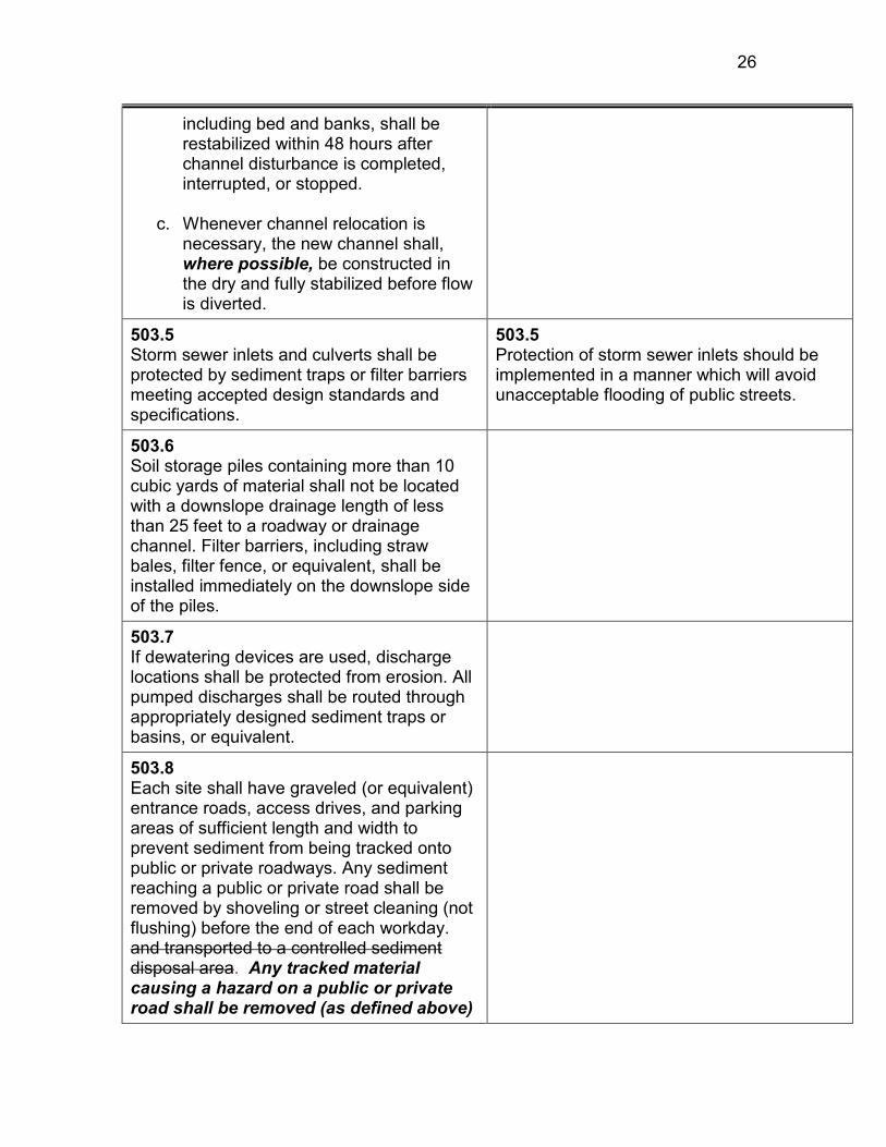
26
including bed and banks, shall be restabilized within 48 hours after channel disturbance is completed, interrupted, or stopped.
c. Whenever channel relocation is
necessary, the new channel shall, where possible, be constructed in the dry and fully stabilized before flow is diverted.
503.5 Storm sewer inlets and culverts shall be protected by sediment traps or filter barriers meeting accepted design standards and specifications.
503.5 Protection of storm sewer inlets should be implemented in a manner which will avoid unacceptable flooding of public streets.
503.6 Soil storage piles containing more than 10 cubic yards of material shall not be located with a downslope drainage length of less than 25 feet to a roadway or drainage channel. Filter barriers, including straw bales, filter fence, or equivalent, shall be installed immediately on the downslope side of the piles.
503.7 If dewatering devices are used, discharge locations shall be protected from erosion. All pumped discharges shall be routed through appropriately designed sediment traps or basins, or equivalent.
503.8 Each site shall have graveled (or equivalent) entrance roads, access drives, and parking areas of sufficient length and width to prevent sediment from being tracked onto public or private roadways. Any sediment reaching a public or private road shall be removed by shoveling or street cleaning (not flushing) before the end of each workday. and transported to a controlled sediment disposal area. Any tracked material causing a hazard on a public or private road shall be removed (as defined above)

27
immediately.
503.9 All temporary and permanent erosion and sediment control practices must be maintained and repaired as needed to assure effective performance of their intended function.
503.10 All temporary erosion and sediment control measures shall be disposed of within 30 days after final site stabilization is achieved with permanent soil stabilization measures. Trapped sediment and other disturbed soils resulting from the disposition of temporary measures should be permanently stabilized to prevent further erosion and sedimentation.
504.0 Handbooks Adopted by Reference 504.0 Handbooks Adopted by Reference
The standards and specifications contained in latest editions of Standards and Specifications for Soil Erosion and Sediment Control (the Yellow Book, issued by the Illinois Environmental Protection Agency,) or as superceded by the Illinois Urban Manual (the Blue Book, developed and issued by the United States Department of Agriculture Natural Resources Conservation Service and the Illinois Environmental Protection Agency, and the Illinois Procedures and Standards for Urban Soil Erosion and Sedimentation Control (the Green Book, issued by the Association of Illinois Soil and Water Conservation Districts) cited in Section 400.0, are hereby incorporated into this Section 500.0 and made a part hereof by reference for the purpose of delineating procedures and methods of operation under site development and erosion and sedimentation control plans approved under Section 400.0. In the event of conflict between provisions of said manuals and of this ordinance, the ordinance shall govern.
As previously indicated, there are certain inconsistencies between this ordinance and the manuals adopted by reference. For example, Paragraph 503.1 specifies design criteria for the sizing of sediment traps and basins. These criteria are similar to, but more explicit than, the Green Book. However, the Yellow Book specifies radically different criteria for the sizing of sediment traps and basins. In these cases, this ordinance governs. Nonetheless, the two references can be valuable in the development of the erosion and sediment control plan and in the design and implementation of erosion and sediment control measures. In particular, the Yellow Book provides design specifications not provided by either the Ordinance or the Green Book.
1

28
1
505.0 Maintenance of Control Measures 505.0 Maintenance of Control Measures
All soil erosion and sediment control measures necessary to meet the requirements of this ordinance shall be maintained periodically by the applicant (owner or developer) or subsequent landowner during the period of land disturbance and development of the site in a satisfactory manner to ensure adequate performance. If a change in owner or developer occurs during the period of land disturbance and development of the site, the subsequent or successor owner or developer shall be required to obtain a new erosion control permit.
Effective maintenance of control measures is critical to their success and should be budgeted into the erosion and sediment control plan. Particular emphasis should be placed on the following types of maintenance needs: repair and replacement of sediment barriers, such as straw bales; removal of excess accumulated sediment from traps, basins, and channels; irrigation, fertilization, or reseeding of vegetatively stabilized areas; repair of scour or gully development on slopes and in channels; removal of sediment from roadways; and control of dust.
506.0 Inspection 506.0 Inspection
1. The (permitting authority) shall make inspections as hereinafter required and shall either approve that portion of the work completed or shall notify the permittee wherein the work fails to comply with the site development or erosion and sedimentation control plan as approved. Applicant shall maintain and make available upon demand plans for grading, stripping, excavating, and filling work bearing the stamp of approval of the (permitting authority) shall be maintained at the site during progress of the work. In order to obtain inspections and to ensure compliance with the approved erosion and sediment control plan, the grading or building permit, and this Ordinance, the permittee shall notify the (permitting authority) within two (2) working days of the completion of the construction stages specified below:
a. Upon completion of installation of
sediment and runoff control measures (including perimeter controls and
On-site inspections are provided at critical junctures in the development process to assure that development practices and erosion control measures are effective in securing the objectives of the ordinance. Local governments will wish to coordinate this inspection schedule with those required under other permits. In general, inspection should be provided at least monthly, or more frequently in the event of major rainfall events. In some instances (e.g., very small sites), fewer inspections than the six suggested here may be sufficient. Provision is made for development to proceed in the event the local government cannot provide timely inspection, and for inspection at the stage of partial completion in the case of large, phased developments. The phases or areas for which separate inspections will be requested should be identified in the plan. The "Illinois Field Manual for Implementation and Inspection of Erosion and Sediment Control Plans" is an excellent reference for conducting inspections. This manual

29
diversions), prior to proceeding with any other earth disturbance or grading,
b. After stripping and clearing (if over
one acre),
c. After rough grading (if over one acre),
d. After final grading,
e. After seeding and landscaping
deadlines (if over one acre), and
f. After final stabilization and landscaping, prior to removal of sediment controls.
If stripping, clearing, grading and/or landscaping are to be done in phases or areas, the permittee shall give notice and request inspection at the completion of each of the above work stages in each phase or area. If an inspection is not made and notification of the results given within five working days after notice is received by the (permitting authority) from the permittee, the permittee may continue work at his/her own risk, without presuming acceptance by the (permitting authority). Notification of the results of the inspection shall be given in writing at the site.
includes a detailed checklist of inspection criteria and recommends that inspection be performed by a designated site inspector after every storm. USEPA recommends inspection by onsite personnel at least once every 7 days
1

30
1
507.0 Special Precautions 507.0 Special Precautions
507.1 If at any stage of the grading of any development site the (permitting authority) determines by inspection that the nature of the site is such that further work authorized by an existing permit is likely to imperil any property, public way, stream, lake, wetland, or drainage structure, the (permitting authority) may require, as a condition of allowing the work to be done, that such reasonable special precautions to be taken as is considered advisable to avoid the likelihood of such peril. "Special precautions" may include, but shall not be limited to, a more level exposed slope, construction of additional drainage facilities, berms, terracing, compaction, or cribbing, installation of plant materials for erosion control, and recommendations of a registered soils engineer and/or engineering geologist which may be made requirements for further work.
507.1 Unanticipated (1) site conditions or (2) storm events may require that erosion control measures beyond those provided for in the approved plan be instituted. These should be reasonable in terms of the additional costs or delays they impose on the developer in relationship to the risks incurred by the failure to undertake such measures.
507.2 Where it appears that storm damage may result because the grading on any development site is not complete, work may be stopped and the permittee required to install temporary structures or take such other measures as may be required to protect adjoining property or the public safety. On large developments or where unusual site conditions prevail, the (permitting authority) may specify the time of starting grading and time of completion or may require that the operations be conducted in specific stages so as to insure completion of protective measures or devices prior to the advent of seasonal rains.
2

31
1
508.0 Amendment of Plans 508.0 Amendment of Plans
Major amendments of the site development or erosion and sedimentation control plans shall be submitted to the (permitting authority) and shall be processed and approved or disapproved in the same manner as the original plans. Field modifications of a minor nature may be authorized by the (permitting authority) by written authorization to the permittee. The (City, Town, County) Engineer shall be authorized to determine the level of modification.
Particularly on large or phased developments, changed conditions during development may require changes in the plans on which the permit was based. Whether these are of such magnitude as to require a complete review of the project and the adequacy of erosion control measures is a matter of administrative judgment as to potential costs to the developer and the public.
600.0 Enforcement 600.0 Enforcement
601.0 Exceptions 601.0 Exceptions
The (board of appeals) may, in accordance with the following procedures, authorize exceptions to any of the requirements and regulations set forth in this ordinance:
Exceptions to the requirements of the ordinance may be granted where such exception would not be contrary to the public welfare and where enforcement of the requirements would work undue hardship on the landowner. The required findings and procedures (including public hearing) are intended to assure that exceptions are granted only after full assessment of their benefits and costs, including any adverse environmental impacts. If it is the local government's practice to permit decisions by the board of appeals to be referred to the principal policy body (county or municipal board or council), provisions for this second appeal should be added to this Section.
601.1 Application for any exception shall be made by a verified petition of the applicant for a site development permit, stating fully the grounds of the petition and the facts relied upon by the applicant. Such petition shall be filed with the site development permit application. In order for the petition to be granted, it shall be necessary that the (board of appeals) find all of the following facts with respect to the land referred to in the petition:

32
a. That the land is of such shape or size
or is affected by such physical conditions or is subject to such title limitations of record, that is impossible or impractical for the applicant to comply with all of the requirements of this ordinance;
b. That the exception is necessary for
the preservation and enjoyment of a substantial property right of the applicant; and
c. That the granting of the exception will
not be detrimental to the public welfare or injurious to other property in the vicinity of the subject property.
601.2 Each application for an exception shall be referred to the (permitting authority) for review. The (authority) shall transmit its recommendations to the (board of appeals), which shall review such recommendations prior to granting or denying the exception.
601.3 The (board of appeals) shall hold a public hearing on each application for exception, within thirty (30) days after receiving application, in the manner provided with respect to appeals. After public hearing, the (board) may approve the site development permit application with the exceptions and conditions it deems necessary or it may disapprove such site development permit application and exception application or it may take such other action as appropriate.
601.3 If local practice includes the use of a hearing officer who makes a report and recommendation to the board of appeals, this provision may be added here.
1

33
1
602.0 Stop-Work Order; Revocation of Permit
602.0 Stop-Work Order; Revocation of Permit
In the event any person holding a site development permit pursuant to this ordinance violates the terms of the permit, or carries on site development in such a manner as to materially adversely affect the health, welfare, or safety of persons residing or working in the neighborhood of the development site or so as to be materially detrimental to the public welfare or injurious to property or improvements in the neighborhood, the (permitting authority) may suspend or revoke the site development permit.
A stop-work order may be issued in the event the requirements of the ordinance are violated. This order is temporary unless confirmed by the body responsible for hearing appeals and exceptions. A local government may wish to specify a maximum term for such a temporary permit (e.g., 30 days), after which action by the appeal body will be necessary for the order to remain in force, rather than referring to the board of appeals' next regular meeting.
602.1 Suspension of a permit shall be by a written stop-work order issued by the (permitting authority) and delivered to the permittee or his agent or the person performing the work. The stop-work order shall be effective immediately, shall state the specific violations cited, and shall state the conditions under which work may be resumed. A stop-work order shall remain in effect until the next regularly scheduled meeting of the (board of appeals) at which the conditions of sub-paragraph 602.2 below can be met.
602.2 No site development permit shall be permanently suspended or revoked until a hearing is held by the (board of appeals). Written notice of such hearing shall be served on the permittee, either personally or by registered mail, and shall state: 1) the grounds for complaint or reasons for
suspension or revocation, in clear and concise language; and
2) the time when and place where such
hearing will be held.

34
Such notice shall be served on the permittee at least five (5) days prior to the date set for the hearing. At such hearing, the permittee shall be given an opportunity to be heard and may call witnesses and present evidence on his behalf. At the conclusion of the hearing the (board of appeals) shall determine whether the permit shall be suspended or revoked.
603.0 Violations and Penalties 603.0 Violations and Penalties
No person shall construct, enlarge, alter, repair, or maintain any grading, excavation or fill, or cause the same to be done, contrary to or in violation of any terms of this ordinance. Any person violating any of the provisions of this ordinance shall be deemed guilty of a misdemeanor, and each day during which any violation of any of the provisions of this ordinance is committed, continued, or permitted shall constitute a separate offense. Upon conviction of any such violation, such person, partnership, or corporation shall be punished by a fine of not more than ($500) for each offense. In addition to any other penalty authorized by this section, any person, partnership, or corporation convicted of violating any of the provisions of this ordinance shall be required to restore the site to the condition existing prior to commission of the violation, or to bear the expense of such restoration.
Financial penalties are provided for conviction of violation of the ordinance. Several referenced ordinances also allow for imprisonment. Depending on local practice, it may be desired to identify in the ordinance the official by whom action against alleged violations will be brought and the procedure to be followed. The amount of the penalty should be related to the local government's overall fine schedule.
604.0 Separability
The provisions and sections of this ordinance shall be deemed to be separable, and the invalidity of any portion of this ordinance shall not affect the validity of the remainder.
1 2
3
4

35
Appendix III 1
Evergreen Lake Watershed Reference List 2 3
• List of Impaired Water Bodies in Evergreen Lake Watershed 4 • List of Potential Sources of Pollutants 5 • Average Monthly Precipitation in McLean County from 1977 to 2003 6 • Historical Water Quality Stations for Evergreen Lake Watershed 7 • Average Total Phosphorus and Dissolved Concentrations (mg/L) in 8
Evergreen Lake at One-Foot Depth 9 • Average Total and Dissolved Phosphorus Concentrations (mg/l) in 10
Evergreen Lake at All Depths 11 • Average Total Phosphorus Concentrations (mg/kg-P dry wt) in Bottom 12
Deposits in Evergreen Lake 13 • Average Total and Dissolved Phosphorus Concentrations (mg/L) in 14
Tributaries to Evergreen Lake 15 • Illinois Interagency Landscape Classification Land Uses in Evergreen 16
Lake (1999-2000) 17 • Evergreen Lake Watershed Livestock Assessment 18 • Tillage Practices in McLean County(Evergreen Lake Watershed) 19 • Average Depths for Evergreen Lake 20 • FSA Aerial MAPS of Evergreen Lake Watershed w/ Conservation 21
Practices, HEL overlays 22 • Mackinaw River Watershed Management Plan 23 • Evergreen Lake Stream Inventory and Analysis 24 • Long Range Plans for Wastewater and Reclamation Services in the 25
Bloomington & Normal Metropolitan Area(BNWRD) 26 • Drought Emergency Water Sources and Options to Improve Existing Lake 27
Supplies for the City of Bloomington, IL(City of Bloomington) 28 • Lake Management Plan for Lake Bloomington and Evergreen Lake (City 29
of Bloomington) 30 • COMLARA County Park Master Plan 31 • Private Sewage and Disposal Ordinance( McLean County) 32 • Evergreen Lake Watershed Best Management Practices Summary 33 • Water Quality Characteristics of Lake Bloomington and Evergreen 34
Lake(City of Bloomington) 35 • Summary Evergreen Lake Watershed Drainage Tile Analysis 36 • Indirect Reuse of Municipal Wastewater for Potable Purposes 37 • Historical Evergreen Lake IDNR Fishery Management Analysis (1986-38
present) 39 • Town of Normal Phase II Storm Water Permit Management Plan(DRAFT) 40 • City of Bloomington Nutrient Management Plan(DRAFT) 41 • McLean County Storm Water Ordinance(DRAFT) 42 • Town of Normal Storm Water Ordinance(DRAFT) 43

36
• IEPA/IDNR Six Mile Creek Water Quality Analysis(DRAFT) 1 • Village of Hudson Septic System Analysis 2 • Historical Evergreen Lake Water Level(19-- -Present) 3 • Six Mile Creek Water Flow Stations 4 • Historical Six Mile Creek Flow 5 • City of Bloomington/COMLARA County Park Head Cut Demonstration 6
Project 7 • City of Bloomington Evergreen Lake Erosion Control Project 8 • IDNR Data and Reports 9 • 2005 Mackinaw Basin Mussel Survey 10 • 1987 Mackinaw Basin Mussel Survey 11 • 2000 Mackinaw Basin Fish Survey 12 • 2005 Mackinaw Basin Fish Survey - not completed 13
14 15
16

37
1
Appendix IV-Data Tables 2
3 4
Fishes of Six Mile Creek, the Major Tributary of Evergreen Lake 5 (Gary Lutterbie, Region 3 Streams Biologist) 6
June 19, 2006 7 Table 1. Fish Collected
from Surveys Conducted in the Evergreen Lake
Six Mile
Six Mile
Creek Creek
Tolerance
Feeding
DKN-01
DKN-02
Grand
Common name Scientific name Type Thursday,Ju
07/06/05
Total
Gizzard shad Dorosoma cepedianum MT GF 11 1 12
Carp Cyprinus carpio T GF 11 14 25
Creek chub Semotilus atromaculatus T GF 8 8
Central stoneroller Campostoma anomalum MT 16 16
Redfin shiner Lythrurus umbratilus MT GF 2 2
Red shiner Cyprinella lutrensis T GF 56 1 57
Bluntnose minnow Pimephales notatus T GF 541 541
Sand shiner Notropis ludibundus MT GF 18 18
Quillback Carpiodes cyprinus MT GF 1 1
White sucker Catostomus commersoni T GF 9 9
Golden redhorse Moxostoma erythrurum MT 4 4
Yellow bullhead Ameiurus natalis T GF 1 2 3
Black crappie Pomoxis nigromaculatus MT 1 1
Largemouth bass Micropterus salmoides MT 2 2
Green sunfish Lepomis cyanellus T GF 23 23
Bluegill Lepomis macrochirus MT GT 22 10 32
Freshwater drum Aplodinotus grunniens MT 1 1
Total fish 702 53 755
Total species 14 8 17
Electrode minutes 19 35
Kilograms of fish 15.002
Extrapolated IBI 12
IBI 30
T = tolerant species; MF= moderate tolerance GF = generalist feeder
8 9 10 11 12 13
14

38
Appendix V 1
RAP-M Report 2
3 4 August 2006 5
R.D. Windhorn 6
EVERGREEN LAKE WATERSHED 7
INVESTIGATION CONDUCTED 8
9
An erosion/sedimentation inventory was conducted for Evergreen Lake 10
watershed in McLean and Woodford Counties. The watershed totals 11
approximately 27,167 acres or about 42.4 square miles. Sediment Delivery Rates 12
(SDR) for each type of erosion occurring within the watershed were also 13
calculated. The main goal was to estimate total sediment load to the lake from 14
the main branch of Six Mile Creek and the major tributaries. 15
WATERSHED PHYSIOGRAPHY 16
17
The entire watershed lies within the Till Plains Section of the Central Lowland 18
Province physiographic area. It is specifically located in the Bloomington Ridged 19
Plain which is the unit that is more rolling and contains most of the Wisconsin 20
glacial moraines located in Illinois. In most areas, Peoria Loess overlies glacial 21
till of the Delavan Member of the Tiskilwa Formation of the Wedron Group 22
(Wisconsin) that is generally loam or clay loam in texture. The Eureka Moraine 23
and the Normal Moraine lie to the southwest of this watershed and the El Paso 24
Moraine lies to the northeast. These low ridges help to funnel water into this 25
watershed and direct it toward the lake. The loess ranges from 4 to 6 feet in 26
thickness over the general area, but can be thicker along the broad ridge tops 27
and thinner on the eroded side slopes. The Delavan Member is a brownish gray 28

39
till that is calcareous and contains lenses of gravel, sand, silt and clay. Stream 1
and gully dissection has exposed the underlying calcareous glacial till in a few 2
areas along Six Mile Creek and the major drainage ways. 3
4
The major stream valley is composed of deposits of Cahokia Alluvium (old) that 5
is generally less than 20 feet thick. Sandy deposits of the Henry Formation can 6
be below the alluvium along Six Mile Creek but glacial till is probably below the 7
alluvium on the upper reaches of the streams or where smaller tributaries join the 8
main drains as they exit from the surrounding uplands. On the steeper slopes, 9
the glacial till can be the surface unit where the loess has been removed by 10
erosion. Soils mapped in this watershed reflect the parent material differences 11
discussed above. The surface texture of the soils in greater than 70% of the 12
watershed is a silt loam, reflecting the characteristics of the loess cover that 13
blankets nearly the entire region. The loess is quite erosive and is easily 14
removed by running water. The alluvium in the stream banks can contain a 15
variety of materials with a variety of textures and grain size content. This is 16
especially noticeable where stones are present in the channel. Stability of the 17
stream banks is greatly dependent on the shear characteristics of the material, 18
and on a watershed scale, it is difficult to make “general” statements about 19
overall conditions. Site specific determinations are essential for future stream 20
bank stabilization activities. 21
22
GEOMORPHIC UNITS 23
The entire watershed was divided into "pieces" to analyze. To do this, three 24
Geomorphic Units (GU) were set up. These Geomorphic Units are simply 25
landscape units that are similar in geology, slope, soil, etc. and in anticipated 26

40
response to erosion. These units are: GU1, Major floodplains and a few large 1
wetlands (sinks); GU2, Upland flats and depressions with slopes generally 5% or 2
less; and GU3, Upland, sloping areas, with slopes generally greater than 5%. 3
GU3 can be further subdivided into those sloping areas immediately adjacent to 4
Evergreen Lake and the main stream channel and those sloping areas farther up 5
in the watershed, generally occurring outside the boundary of the county park. 6
Each GU produces differing sediment amounts depending on dominant erosion 7
within it. Some, as in GU1, serve more as sediment "sinks" or deposition areas 8
than they do as sources or eroding areas. Within GU2, there are a few areas 9
that literally produce no sediment that will impact a surface water body. These 10
areas are called Areas-of-No-Significant-Sediment (ANuSS). Generally they are 11
relatively flat or even depressional areas of less than 2 percent slope that are not 12
impacted by run-on water and are more than 2000 feet from a concentrated flow 13
area (waterway, ditch, gully). These areas have a very low priority for watershed 14
land treatment, in regards to affecting water quality at the outlet. 15
16
EROSION 17
At least six different types of erosion can produce sediment: sheet, rill, 18
ephemeral, gully, streambank and shoreline. In the Evergreen Lake watershed, 19
sheet and rill erosion values are computed from data gathered during the Erosion 20
and Sediment Inventory. In NRCS, we use a process referred to as the Rapid 21
Assessment, Point Method (RAP-M) to statistically estimate erosion and 22
sedimentation rates within any given watershed by sampling a portion and then 23
expanding this data to fit the entire watershed. A Random-Stratified Sampling 24

41
Procedure is used to select areas to be sampled. Generally these units are 160 1
acres in size, and are selected throughout the watershed, with an attempt to 2
characterize all different land uses that are present. Inventory data collected in 3
the field from these sites includes all information necessary to compute sheet, rill 4
and ephemeral erosion losses. Using this data, an annual sheet and rill soil 5
loss rate for each type of major land use within the watershed is determined. If 6
the total number of acres for each land use is multiplied times this rate, a gross 7
amount of sheet and rill erosion occurring within the watershed is estimated. 8
From these same 160-acre sample units, gully or concentrated flow reaches are 9
also selected, again using a random procedure. 10
11
Ephemeral or "annual gully" erosion is evaluated in the field by either actual 12
measurement of area voided or by applying a standard formula to estimate the 13
total erosion produced on an average annual basis. The rates produced using 14
these methods are then projected and expanded to fit the rest of the watershed. 15
16
Gully erosion is measured in the field also within the above mentioned selected 17
sample units. To obtain a representative sample of active gullies, for this 18
watershed seven additional gully segments were randomly selected adjacent to 19
the main water body or the main Six Mile Creek channel. A certain number of 20
the gullies or “concentrated flow areas” are walked and in-field measurements 21
made on both the left and right banks in regard to severity of erosion or 22
deposition. An erosion rate, called a “Lateral Recession Rate,” is applied to each 23
measured section. These values are summarized and combined to produce an 24
annual rate of erosion in tons or pounds of soil material removed per linear foot 25
of gully. The estimated total length of gullies per sample unit is obtained by map 26
wheel measurement from 7.5 minute quadrangle maps, with in-field checking and 27

42
verification. This value is then expanded to fit the watershed, by first determining 1
which GU unit is most affected by this type of erosion. In the Evergreen Lake 2
watershed, GU3 contains virtually all of the "classic" gullies. So, this unit 3
represents the entire watershed. 4
5
Stream bank erosion was also evaluated in the Evergreen Lake watershed by 6
Wayne Kinney, Stream Specialist, STREAMS, in May of 2005. In the stand-7
alone report, entitled “Stream Inventory and Analysis Lake Evergreen 8
Watershed” he explains how the streams were inventoried and the quantity of 9
stream reaches evaluated. The summary of his work will be added to this report 10
and will serve as the stream bank totals for erosion and sedimentation in this 11
watershed. 12
13
A shoreline erosion inventory was also conducted on this lake in 1998 by the 14
NRCS. This data is incorporated into this report as is the in-lake sediment 15
surveys conducted by NRCS in November of 1999 and by Hanson Engineering 16
in January of 2000. The in-lake data will provide a “sink estimate” of sediment 17
which we will use to calibrate the upland erosion portion of the inventory. 18
19

43
1
SHEET AND RILL EROSION in Evergreen Lake 2
3
Sheet and rill erosion occurs on all land whether it is cultivated or not. It is a very 4
natural, unending process. It is more of a concern when it is accelerated by 5
man’s activities. In the Evergreen Lake watershed, sheet and rill erosion is 6
estimated, on a per acre basis, for all the dominant land uses. For cropland, 7
evaluations were made for both the “A” and “B” slope areas (0 to 5%) and for the 8
“C” slope and greater areas (5 to 10%+). These slope groups become quite 9
significant from an erosion standpoint. Average rate of soil loss for A/B slope is 10
1.3 T/A/year. For C slope and greater areas, soil loss is 7.1 T/A/year. In the 11
years immediately following the implementation of the 1985 Farm Bill, efforts by 12
the landowners and operators to remain eligible for future farm programs, 13
prompted many of them to change their farming practices. Often times these 14
changes included less tillage and leaving more residue on the surface. This 15
helped to significantly reduce sheet and rill erosion on their fields. 16
17
Several other land use categories were also set up and evaluated. Areas of 18
woodland that are generally relatively undisturbed on all slope ranges have a soil 19
loss rate of only 0.3 T/A/year. Grasslands, CRP, and pastures areas were 20
grouped together including all slope ranges. The rate for these areas was 0.6 21
T/A/year. Other land uses, which include transportation areas, wetlands, 22

44
farmsteads, urban areas, and open water do not have an erosion rate assigned 1
to them. 2
3
Total sheet and rill erosion from cropland is estimated to be 35,625 tons per 4
year. This figures out to be about 1.9 T/A/year for all cropland. Sheet and rill 5
erosion from grassland is about 3,530 tons per year. Woodland areas are 6
contributing 270 tons per year. Total sheet and rill erosion in the Evergreen 7
Lake watershed is estimated to be 39,425 tons per year. This is roughly 1.45 8
T/A/year for the entire watershed. 9
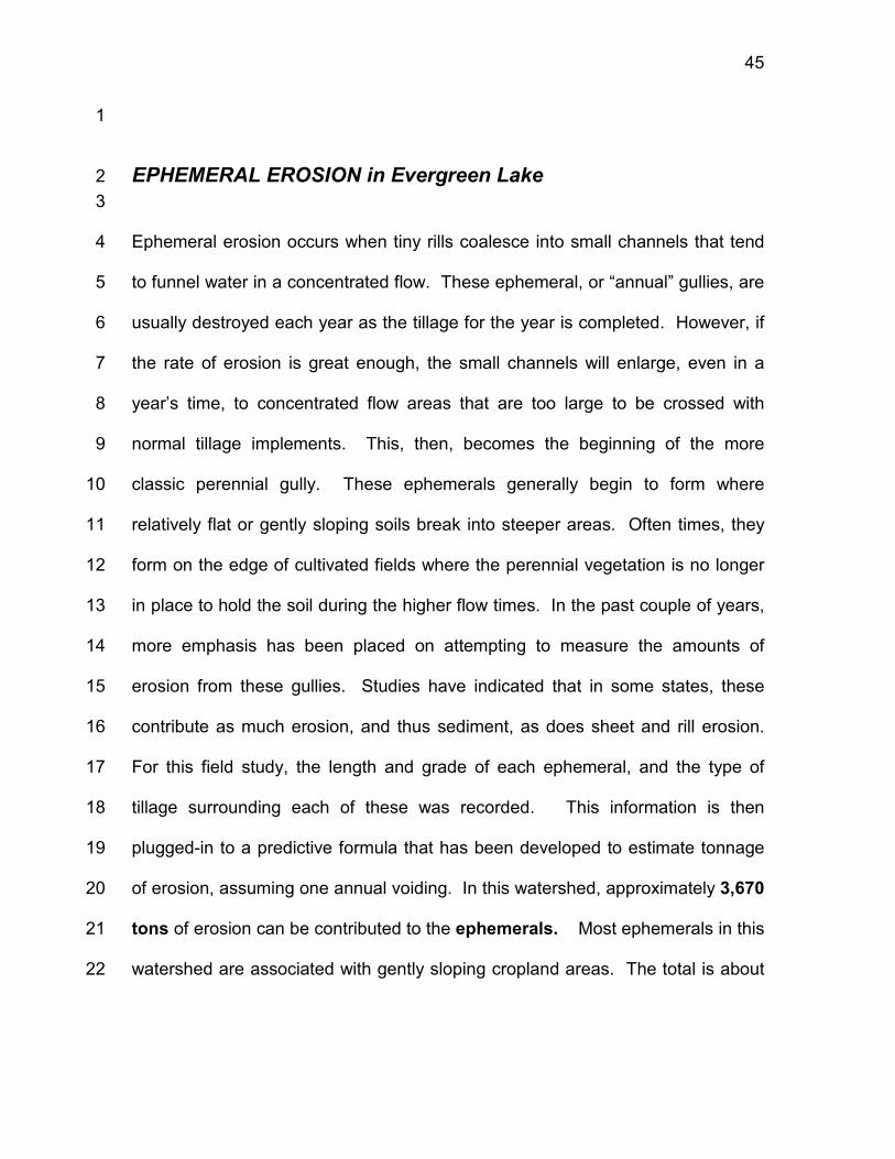
45
1
EPHEMERAL EROSION in Evergreen Lake 2
3
Ephemeral erosion occurs when tiny rills coalesce into small channels that tend 4
to funnel water in a concentrated flow. These ephemeral, or “annual” gullies, are 5
usually destroyed each year as the tillage for the year is completed. However, if 6
the rate of erosion is great enough, the small channels will enlarge, even in a 7
year’s time, to concentrated flow areas that are too large to be crossed with 8
normal tillage implements. This, then, becomes the beginning of the more 9
classic perennial gully. These ephemerals generally begin to form where 10
relatively flat or gently sloping soils break into steeper areas. Often times, they 11
form on the edge of cultivated fields where the perennial vegetation is no longer 12
in place to hold the soil during the higher flow times. In the past couple of years, 13
more emphasis has been placed on attempting to measure the amounts of 14
erosion from these gullies. Studies have indicated that in some states, these 15
contribute as much erosion, and thus sediment, as does sheet and rill erosion. 16
For this field study, the length and grade of each ephemeral, and the type of 17
tillage surrounding each of these was recorded. This information is then 18
plugged-in to a predictive formula that has been developed to estimate tonnage 19
of erosion, assuming one annual voiding. In this watershed, approximately 3,670 20
tons of erosion can be contributed to the ephemerals. Most ephemerals in this 21
watershed are associated with gently sloping cropland areas. The total is about 22

46
9% of the sheet and rill erosion totals which is considered “normal” for 1
watersheds in this physiographic area. 2
3
4
5

47
1
GULLY EROSION in Evergreen Lake 2
3
Gully erosion or concentrated flow erosion is estimated in the entire watershed 4
by selecting random “reaches,” evaluating these qualitatively to obtain 5
quantitative values, and then expanding this data to fit the remainder of the 6
watershed. The premise for this is that if enough segments are sampled, areas 7
that are only slightly eroding as well as those that are very severely eroding will 8
be selected to evaluate. This percentage can then be used throughout the 9
watershed with statistical validity. After the initial assessment, an additional 10
number of samples were selected for further analysis. As mentioned, this was to 11
insure adequate coverage of current, active gullies. These samples were 12
primarily around Evergreen Lake. These samples also allowed for separation of 13
GU3 into two distinctly different landscape units from an erosion perspective. The 14
qualitative assessment used to assign Lateral Recession Rates is one that bases 15
observed physical features of the gullies with actual measured amounts from 16
many Midwestern watersheds. In Evergreen Lake watershed, gullies near the 17
lake contained “knickpoints” or small overfalls in the base of the channel. These 18
can indicate recent downcutting and also indicate a difference in soil material. In 19
areas where loess overlies glacial till a whole series of these knickpoints can be 20
traced up some gullies. In regard to sediment production, each type of material 21
produces different rates - the loess is most susceptible and will readily collapse 22
into the gully and move off-site. The glacial till has more strength and is more 23

48
difficult to erode. If it is exposed on a gully sidewall or along a streambank, the 1
drying and re-wetting will cause it to “weather” or begin to break off in small 2
pieces. When this happens, it, too, can be eroded and moved downstream. 3
Glacial till generally contains the large stones and much of the sand and gravel 4
that is observed in the streambed farther downstream. 5
6
According to the data collected in the field, the vast majority of the concentrated 7
flow areas in the upper part of the watershed were already stabilized with water 8
ways. Therefore, the only concentrated flow areas that were evaluated for 9
erosion were the seven separately designated in the immediate vicinity of the 10
lake itself and the main channel of Six Mile Creek. In this watershed, 11
approximately 1,700 tons of erosion can attributed to the active gullies around 12
the lake. 13

49
1
STREAMBANK EROSION AND SEDIMENTATION in Evergreen 2
Lake 3
4
Streambank erosion in any watershed is a rather complex and detailed process. 5
As the stream meanders across its valley or floodplain, “new” sediment is being 6
added continually as the stream cuts into its banks. However, sediment is also 7
being deposited in perhaps another portion of the stream as energy levels of the 8
stream rise and fall. If the net effect remains somewhat constant over a period of 9
years, the stream is considered “stable” and the changes are considered to be 10
part of a “dynamic equilibrium” condition that exists within the watershed. If, 11
however, this ongoing process is skewed one way or the other and either severe 12
down cutting and bank caving predominates or extreme rates of sedimentation 13
within the stream are occurring, then it is considered to be unstable. In truth, 14
many streams experience all of this variation if the total stream reaches from 15
headlands to mouth are considered. To determine the magnitude of the 16
dominant process occurring, the stream itself must be walked and evaluated. In 17
most cases, no other measured stream bank data has been gathered in the 18
past, so these estimates become the base for determining present sediment 19
yield and future projections that would be modified by treatment measures in the 20
watershed. 21
22
As was mentioned earlier in this report, the stream bank portion of this watershed 23
was inventoried by Wayne Kinney in May of 2005 and the summaries and 24

50
conclusions were written in a stand-alone report entitled, “Stream Inventory and 1
Analysis Lake Evergreen Watershed.” The data and other information presented 2
here comes directly from that report. A total of approximately 16 miles of channel 3
were physically walked. This is considered to be a 100% sample of the perennial 4
streams in this watershed. Stream bank erosion was calculated by estimating 5
the length, height and lateral recession rate of each eroding streambank that met 6
or exceeded the “moderate” level. Lateral recession rates were assigned based 7
on field observations using the guidelines given in the NRCS RAP-M procedure. 8
Lateral Recession Rates or channel erosion rates are attempts to determine how 9
much “bank retreat” is occurring on an average annual basis from vertical slopes. 10
The rates ranged from “slight” (0.03 of a foot per year) up to “very severe” (1.5 11
foot per year or more) of actual bank recession. Areas determined to have only 12
“slight” stream bank erosion were not inventoried as they are assumed to 13
contribute little to the overall sediment yield. 14
15
Wayne found that nearly 2,135 tons of sediment was being transported to the 16
lake from the stream system. A little more than 90% of that sediment was being 17
generated by stream bank erosion in the lower 4 miles of the major tributaries 18
and the main branch of Six Mile Creek. The remaining reaches were only rated 19
as “slight” in their lateral recession rates and contributed a very small quantity of 20
sediment to the lake. The rates of sediment contribution ranged from a low of 11 21
tons per mile or about 5 pounds per linear foot of stream to 213 tons of sediment 22
per mile or about 81 pounds per linear foot. 23
24

51
1
SHORELINE EROSION in Evergreen Lake 2
3
In July of 1988 a shoreline erosion inventory was conducted on Lake Evergreen 4
in McLean County. This inventory was completed to update an earlier survey 5
that had been conducted before the level of the lake was raised to its current 720 6
foot elevation. This inventory was a visual estimate of eroding bank conditions 7
completely surrounding the lake. Two categories of erosion were estimated. 8
“Moderate” erosion consisted of Lateral Recession Rates on an annual basis of 9
up to 0.5 foot per year. “Severe” erosion consisted of rates of 0.5 or more feet 10
per year on an average annual basis. “Lateral Recession Rates” are rates 11
established to estimate the vertical recession of an exposed bank on a yearly 12
basis. Some banks will erode more than this rate during high water times, but 13
then have lower rates the following years as the bank reaches a more stable 14
slope. Average annual values are meant to “average” these years out for lake 15
management planning purposes. These rates are based on vegetative cover 16
and overhang, type of geologic material exposed to the lake, estimated shear 17
strength of this material, presence or absence of rotational slumping, material 18
deposited at the base of the banks, and changes in associated cultural features. 19
Height of the bank eroding and length of the bank eroding are based on actual 20
measurements. 21
22

52
It was determined during the inventory that approximately 6,000 feet or about 1
1.2 miles of the shoreline was experiencing Moderate Erosion and about 9,000 2
feet or 1.7 miles was in the Severe Erosion stage. These values are somewhat 3
less than the earlier report but some of those eroding reaches identified are now 4
under water as the lake level has risen. If we assume total miles of shoreline is 5
about 22 miles, then roughly 5 percent is eroding at a moderate rate and about 8 6
percent at a severe rate. The remaining 19 miles or so of lake shoreline varies 7
from a non-eroding stable condition to one of slight erosion with low grassy 8
banks. 9
10
Using the measured values for height and length of eroding bank, the Moderately 11
Eroding areas contribute about 360 tons of sediment on an average annual basis 12
to the lake. The Severely Eroding areas are contributing a significantly greater 13
amount of about 1,750 tons per year. This brings the total estimated shoreline 14
erosion in the lake to 2,300 tons. There are certainly years on the lake where the 15
erosion total is significantly less than this and years when it is much more. What 16
we saw when conducting the inventory might also be a reflection of what had 17
happened around the lake before the lake level was raised. No monitoring 18
stations were set up and without detailed surveying, it is difficult to measure the 19
erosion in exact amounts. The sites most likely to be eroding are those on points 20
that jut out into the lake and which may have several “faces” exposed to the wind 21
and waves. The west and southwest portions of the lake have fewer eroding 22
sites than other sides. This is probably due to being somewhat protected from 23

53
the dominant west wind and thus accompanying waves. The material generally 1
exposed to the erosion is glacial till. Glacial till has a higher shear strength than 2
the overlying silty loess, but will erode if the toe of the slope (bank) is undercut. 3
In the very upper reaches of the lake, a silty loess-like alluvium is exposed but 4
the bank heights are very minimal. Thus erosion rate is low. For the Moderately 5
Eroding areas, bank height ranged from 1 foot to about 5 feet, while on the 6
Severely Eroding areas, bank height ranged from 2 feet to about 14 feet. 7
8
Qualitative estimates of erosion can be made quickly with a minimum of 9
equipment. They are best used as a first –order estimate for generalized 10
planning purposes. Detailed surveying and establishment of base line monitoring 11
stations would be the next step in obtaining more accurate, measured amounts. 12
13

54
SEDIMENT DELIVERY RATE (SDR) 1
2
Only a portion of the sediment produced reaches a concentrated water source. 3
Then, the stream system itself transports only a portion of what actually enters it. 4
To account for this, Sediment Delivery Rates (SDR) are used. These factors are 5
similar to the "Blue Book" value of a used car - for a car, you start out with a base 6
value and then add to or subtract from that, depending on the options and 7
mileage on the car. For this watershed, you start out with a "standard" value and 8
then adjust this number up or down based on landscape characteristics. The 9
Evergreen Lake watershed is somewhat complex when it comes to overland flow 10
of water and sediment. It is a “youthful” watershed, geologically, with an 11
abundance of short, steep slopes along the major drains and longer, more gentle 12
slopes away from the drains. Stream dissection and down cutting is evident, 13
extending into the upper reaches of the watershed in places. What this means is 14
that some of the sediment moves just to the base of the slopes while other 15
sediment may move entirely through the watershed. 16
17
SDR's vary for each type of erosion, as would be expected. Sheet and rill erosion 18
and the sediment it produces vary dramatically across this watershed. In the 19
area surrounding the main Six Mile Creek channel and the other major 20
tributaries, sheet and rill erosion potential is greatest. The land is more sloping 21
and the slopes are often short and “choppy”. Conversely, in the areas of the 22
watershed where the slopes are longer and more gradual or the land is nearly 23
level, the soils have a lower erosion potential. Along the path to a concentrated 24
water flow area, many options are available for the sediment. Small sinks or 25
traps are found within this watershed and include potholes, small ponds, 26

55
wetlands, and even the flat parts of upland fields. In many cases, the floodplains 1
can serve a very natural and useful purpose by also keeping sediment from 2
entering the streams. Some of these "local" sinks effectively capture nearly 3
100% of the sediment produced above them in their subwatershed. 4
5

56
1
2
SEDIMENT DELIVERY RATES in Evergreen Lake 3
4
Sediment Delivery Rates (SDR) are used to predict the quantity of sediment that 5
is moved “on-site” to be “available for transport”. For example, sediment is 6
produced on a sloping, cultivated field each year as the farmer chisel plows the 7
field. The sediment moves down the slope and some of it becomes immobilized 8
as it imbeds itself within the grass or is deposited where there is a change in 9
slope. Some of it, however, is in a position near a waterway, or ditch, or shallow 10
field channel that makes it available to move farther with the next storm event. 11
SDR’s are developed for each type of erosion and often time, several are 12
developed for sheet and rill erosion, based on where the slopes are within the 13
watershed. 14
15
Sheet and rill erosion has the most complicated Sediment Delivery Rate, 16
because it involves sheet or laminar flow, as opposed to channel flow. Some of 17
the factors involved in determining this are land slope, distance from a 18
concentrated flow area, slope configuration, NRCS runoff curve number, and a 19
surface roughness coefficient. Usually a base rate is determined for the 20
conditions in the watershed or subwatershed, and then adjustments are made to 21
that rate based on subsidiary conditions. A strong attempt is made to apply 22
these criteria in a uniform and consistent manner throughout. Since sheet and rill 23

57
erosion from the cropland areas was so varied, due to slope and land use, no 1
single value of SDR seemed to suffice. For cropland areas, three different SDR’s 2
are used. Woodland is the major land use along the main stream tributaries and 3
is comprised of those areas that are relatively undisturbed and those areas that 4
have been disturbed by grazing. One SDR was used for all slope classes. 5
Grasslands, CRP, pastures, etc. also had just one SDR applied to them. The 6
five different SDR's used in this watershed for sheet and rill erosion ranged from 7
0.22 to 0.60. 8
9
Ephemeral, gully, and streambank erosion are all considered to be a form of 10
“channel” erosion which have larger SDR’s because often time the erosion-11
produced sediment comes from the channel bottom and sides themselves, 12
therefore naturally being more directly tied to delivery into the stream system. 13
Ephemeral SDR’s commonly are in the 0.70 to 0.80 range. In the Evergreen 14
Lake watershed, a value of 0.70 was used for all the ephemeral erosion sediment 15
routing purposes. 16
17
Gullies serve as almost the “perfect funnel” to move sediment directly into the 18
stream system. Gullies that lie immediately adjacent to the main channel have 19
SDR’s of 0.90 to 1.0. Gullies that occur on the extreme upper reaches of the 20
watershed may have a range of 0.70 to 0.90. In this watershed, rates of 0.80 21
were used for all the gullies. 22
23

58
Streambank and shoreline sources, of course, have SDR’s of 0.95 to 1.0. 1
Literally everything that is eroded from the streambank or shoreline exposure 2
falls in the stream or lake and is immediately available for transport. This is one 3
of the reasons that even though the quantity of sediment produced by streams is 4
not as great as from other sources, it is literally 100% “delivered”. Sheet and rill 5
produces large quantities of erosion and sediment, but only a fraction of it 6
actually enters the system. Therefore, it is often times more important to treat 7
the stream bank and shoreline areas because the sediment is much more 8
“concentrated” and can often be considered a “point” source of pollution. 9
10
11
12

59
1
SEDIMENT TRANSPORT for Evergreen Lake 2
3
Sediment Transport is the final step in our erosion/sediment cycle. On smaller 4
watersheds, this factor is incorporated into the Sediment Delivery Rates. It 5
attempts to rate the overall effectiveness of the entire stream system in moving 6
sediment through. Stream systems that are relatively small, have high gradients, 7
and have small tributaries that reach to the upper segments of the uplands move 8
sediment through completely and rapidly. Watersheds that are quite large with 9
numerous locations for sediment to drop out, have low stream gradients, and 10
have numerous undrained upland areas are much less efficient in moving the 11
total sediment load. Sediment transport is based on several factors, including 12
drainage density, drainage texture, relief/length ratios, valley slope of 3rd order 13
streams, size of the watershed, type of sediment that is predominant, percent of 14
the watershed “controlled” by natural or man-made sinks, stage of stream system 15
development, etc. These factors are weighted and then applied to the Sediment 16
Delivery Rates for the stream system in as uniformly and consistent manner as is 17
possible. 18
19
Overall sediment delivery to Evergreen Lake involves several stages of transport. 20
Sediment movement in the upland part is believed to be relatively slow with no-till 21
and mulch-till fields, along with grassed waterways, helping to keep the sediment 22
in place, or at least out of a more concentrated flow area. The stream here is 23

60
moving through a loess-covered till plain. The loess can be as much as 6 feet 1
thick. Bedload quantity is low with most of the sediment suspended, as the 2
primary source is the loess soils and silty alluvium streambanks. As the stream 3
continues to downcut, it eventually contacts the underlying glacial till. 4
Downcutting slows somewhat as the shear strength of this material is greater 5
than that of the loess. The channel reaches are somewhat U-shaped as they 6
tend to widen at the base. They also support vegetation on the side slopes and 7
toe slopes. As we move further downstream, the stream gradient decreases 8
due to the elevated base level of the lake itself. Some bedload begins to settle 9
out here and the water slows dramatically. 10
11

61
SUMMARY OF EROSION AND SEDIMENTATION IN LAKE 1
EVERGREEN WATER SHED 2
3
In Evergreen Lake watershed, an estimated 49,230 tons of erosion occurs on 4
an annual basis from the six major types of soil erosion. If this number is divided 5
by the number of acres in the watershed, a rate of about 1.8 tons per acre per 6
year is obtained, when ALL sources of erosion are considered. Approximately 7
25,250 tons of suspended and bedload sediment is actually “delivered” to the 8
lake on a yearly basis. This estimated amount of sediment delivered is based on 9
watershed-derived erosion and doesn’t represent a measured amount at the 10
outlet end. This gives an overall rate of 0.93 tons per acre per year or 595 tons 11
of sediment per square mile of watershed when the entire watershed is 12
considered. At 30 pounds per cubic foot, this calculates to be 38.7 acre-feet of 13
sediment deposition on an annual basis or at 40 pounds per cubic foot, it 14
calculates to be 29.0 ace-feet of deposition per year. 15
16
Roughly 35% of the suspended sediment comes from sheet and rill erosion 17
occurring on cropland slopes of 5% and greater. In general, this land is the land 18
closest to the gullies and streams, irregardless of use or vegetation. 19
Approximately 12% is coming from ephemeral erosion (channel) and 6% is 20
coming from the concentrated flow areas or gullies. About 10% comes from 21
streambank erosion (channel). The gullies and the streambanks also contribute 22
the majority of the bedload to the system. The A/B slope cropland areas also 23
appear to be contributing significant sediment but there is still much discussion 24

62
on SDR rates for slopes less than 5%. It is believed presently that SDR base 1
rates of 0.10 to 0.15 may be more appropriate. These lower rates would 2
reduce sediment totals from the A/B slopes by nearly 50%. Shoreline erosion 3
also accounts for about 10% of the sediment total. 4
5
Bedload material is commonly sand and gravel and is very seldom measured as 6
an output at the point of delivery, because of the cost and extensive sampling 7
equipment that is necessary to complete this job. USGS gage stations do not 8
routinely sample or measure this material. General estimates can be made, 9
based on suspended sediment quantities. In Illinois, estimates of 5 to 30 percent 10
of this total can be used. In this case, roughly 3,300 tons were added to the total 11
suspended load delivered of 21,950 tons to arrive at the total delivered sediment 12
amount of 25,250 tons. In most cases, bedload type, composition, and grain size 13
coming from the streambanks and streambeds is used extensively in channel 14
design and channel geomorphology studies. 15
16
IN-LAKE SEDIMENT STUDIES 17
18
If we compare the sediment to the lake that is estimated with this inventory to 19
that amount predicted with the in-lake studies, we find some interesting 20
similarities. First of all, there have been two in-lake sediment surveys completed 21
for Lake Evergreen in the past few years. NRCS completed a survey in the fall of 22
1999 using bathometric equipment that measured water depth. Once the 23

63
completed map was finished, a volume of water presently held by the lake was 1
computed. This volume was subtracted from the as-built volume before the dam 2
was originally closed. This initial volume was supplemented by the additional 3
volume added to the lake in 1997 when 5 feet was added to the spillway crest. 4
The lake bottom was also probed and sampled for grain size content. 5
6
In the summer and fall of 1999, Hanson Engineers, Inc. completed an extensive 7
in-lake sedimentation survey, using both bathometric mapping and actual 8
sediment measurements along 12 pre-established range lines that extended 9
entirely across Lake Evergreen. They also took numerous random samples in 10
the lake to fill in any gaps and to account for the recent changes in the lake level. 11
After data collection, digital terrain models were generated for the original lake 12
bed and the present day lake bed. Volumes were then calculated between the 13
two models. They determined that, in 1999, approximately 1,518 acre-feet of 14
total sediment has come into the lake since 1971. This calculates to about 54.2 15
acre-feet per year. Bulk density of the sediment was not directly determined in 16
either survey. If we assume 30 pounds per cubic foot, the total tonnage of 17
sediment coming in annually would be about 35,400 tons. If we assume 40 18
pounds per cubic foot, the total tonnage of sediment coming in annually would be 19
about 47,200 tons. If one compares these numbers to our erosion and sediment 20
estimates in the paragraphs above, there is a close similarity which could 21
indicate that our erosion numbers for the watershed are reasonable. 22
23

64
1
DYNAMIC EQUILIBRIUM 2
Assessing the overall “dynamic equilibrium” stage in a watershed is most difficult 3
indeed! In other words, is the stream system still degrading or has the sediment 4
production in the watershed reached a peak and now will begin to decline?! 5
Several geomorphologists years ago developed a landscape model called the 6
Channel Evolution Model. (CEM) It was intended to determine the relative 7
differences between gullies/streambanks that were progressing from a “stable” 8
condition, Stage 1, through a series of “unstable” steps to a new, but geologically 9
and physically-lower-in-elevation “stable” condition called Stage 5. This process 10
can take decades or several millennium. Evergreen Lake watershed is 11
undergoing incision or downcutting in some of its upper tributaries. (Stage 2) As 12
long as downcutting is occurring, sediment will continue to be produced. In the 13
lower reaches, the stream is no longer downcutting. A “base level” for a stream 14
is that elevation that marks the lowest point that it can cut to, given the in-place 15
hydrology. If the stream can no longer cut down, it must widen its channel to 16
help dissipate the accumulated energy. This has caused the streambanks in the 17
middle and lower reaches to be unstable and a general widening of the channel 18
is occurring. (Stage 3) The rate of sediment production will only begin to 19
decrease when the stream reaches a condition of both bed and bank stability. 20
(Stage 4) 21
22

65
CONSIDERATIONS FOR EROSION AND SEDIMENT CONTROL 1
2
1. Concentrate any land treatment alternatives on the sloping (>5%) areas that 3
lie immediately adjacent to the channels or streams themselves for the most 4
effective land treatment control. In other words, the “flat” land doesn’t really 5
produce much sediment that reaches the lake so let’s not spend unproductive 6
time and effort here. 7
8
2. If needed, select a pilot subwatershed and concentrate land treatment or 9 structural control efforts here. From this base a better estimate as to 10 effectiveness of these controls could be made for the remainder of the entire 11 watershed. These smaller subwatersheds also give the local people a better 12 visual example of how their control methods will work. 13
14
3. Select highly visible or locally known eroding sites for demonstration areas, 15 particularly if streambank stabilization or shoreline stabilization is included as part 16 of the project. Easier to point at these to show how effective local efforts have 17 been. 18
19
4. If structural measures are used in the watershed, it is important to remember 20 that they generally will control the sediment produced from all types of erosion 21 above them in their subwatershed. This is an important point from a watershed 22 management perspective: structures control sediment more so than erosion. 23 What do I mean? If a structure (WASCOB, pond, dry dam, etc.) is placed in a 24 drainageway and surface water runs into it or through it, a sediment reduction will 25 occur due to the trapping efficiency of the water pool. The surface water might 26 be carrying sediment derived from sheet, rill, ephemeral, and gully erosion but 27 much of the suspended and nearly all the bedload is trapped, regardless of the 28 source. These small structures will also dramatically reduce the peak runoff 29 flows developed during rainfall events. The magnitude and timing of these peak 30 flows can significantly affect channel erosion and overall movement of sediment 31 within a given subwatershed. It is more efficient and effective, in general, to 32 have these structures as “low” in the watershed as is possible. The more of a 33 subwatershed that occurs above them, the greater the amount of the runoff and 34 sediment that is “controlled.” A caution always has to be mentioned when 35

66
dealing with “cleaned” water, in that, if the water channels are silts and fine 1 sands, the additional energy of clean water can lead to accelerated channel 2 erosion below these structures. Stabilization and sediment reduction always 3 have to be handled in combination during any engineering design. 4
5
5. Stream bank stabilization projects attack localized sediment production 6 directly. However, streambank projects don’t deal with reducing sediment that is 7 already in the stream system from other upland sources. Therefore, it is 8 important to remember, in general, the entire watershed must be “treated” to 9 effectively reduce the overall sedimentation rate. 10
11
6. If significant land use changes, such as increased urbanization, are 12
anticipated in a certain segment of the watershed, these areas should probably 13
be monitored more closely because of the potential for more rapid change in 14
sediment rates. Even relatively small areas can significantly increase the 15
sediment load on the stream system or subsystem. 16
17
7. Structural means of sediment control have been effective on smaller 18
watersheds, utilizing measures that we already have experience with, such as 19
WASCOB’s, dry dams, ponds, etc. Let’s not overlook these but let’s always be 20
on the lookout for new, innovative ideas and methods that can be applied in the 21
watershed. . 22
23
8. Watersheds of this size and complexity do not have one easy solution to all 24
the erosion and sediment concerns. Cost of treatment versus tons of soil 25
(sediment) saved is always a consideration for implementation strategy. Often 26
time combinations of solutions are most effective since they tend to reinforce the 27
effectiveness each one has individually. 28

67
1
9. Gully erosion is more of a concern for erosion and sediment as the 2
watersheds inventoried become steeper and more dissected. What we are 3
finding out is that even relatively minor rates of gully erosion produce significant 4
amounts of sediment because the density of these is much greater than what 5
was estimated in earlier reports. Since each gully more or less operates as its 6
own tiny subwatershed, a cumulative effect on a large watershed is difficult to 7
assess. 8
9
10. Sometimes on sloping watersheds where conservation tillage, conservation 10
cropping systems, and no-till systems are already in-place, the “best scenario” 11
possible from a sediment reduction standpoint is probably no more than 25 to 30 12
percent without some types of structural sediment basins. 13
14
11. Need to recognize the differences between sediment sources and their 15
effective means of control. Sheet and rill erosion and the sediment it appears to 16
produce always seems significant but remember that many acres of land need to 17
be treated before sediment control efforts will begin to pay off at the lower end of 18
the watershed. If soil loss rates on much of this land are already in the 1 to 2 19
T/A/year range, chances of reducing soil loss further that will significantly reduce 20
sedimentation in the watershed are very poor. With channel erosion, especially 21
streambank erosion, stabilization projects have an almost immediate effect on 22
sediment reduction and movement within the stream. I suggest that more than 23

68
just “totals” are evaluated within a watershed when considering treatment – look 1
also at feasibility of solution, cost:return benefits of solution, and ease with which 2
the solutions can be blended into an overall sediment reduction plan for the 3
watershed. 4
5
12. All totals for erosion and sedimentation in this report are given in “average 6
annual” figures. There are some inherent dangers in this because in some 7
years, the amount projected will vary significantly from that amount actually 8
produced. It is very difficult to measure or estimate streambank erosion, for 9
instance, when it is occurring at its highest rate during extreme storm conditions. 10
Because of this, we try to estimate “what happened” by looking at “what now”. 11
Obviously, discrepancies can arise. Our procedure is considered more 12
appropriate for “planning purposes” than for site-specific “engineering purposes.” 13
It also helps to explain variations in our estimates from those made by other 14
folks. Is there a right or wrong answer? – probably, but very elusive. Use ALL 15
totals as first-order estimates – NOT an absolute number! 16
17

69
Erosion and Sediment Totals for Evergreen Lake 1
2 Erosion (tons) SDR 3
Sediment Delivered (tons) Sheet / Rill 4
Cropland 5
A/B 22,170 0.22 6
4,877 7
C/C+ 13,455 0.57 8
7,670 9
Grassland, CRP, etc. 10
All Slopes 3,530 0.25 11
882 12
Woodland 13
All Slopes 270 0.60 14
160 15
Ephemeral 3,670 0.70 16
2,570 17
Gully 1,700 0.80 18 1,360 19 20 Streambank 2,135 1.0 21
2,135 22
Shoreline 2,300 1.0 23
2,300 24

70
TOTAL 49,230 1
21,950 2
3
SUBTOTAL - Suspended 4
Sediment 21,950 5
Estimated Bedload 6
(15%) 3,300 7
TOTAL Sediment Transported to Lake 8
25,250 Tons 9
10
11

71
Appendix VI 1
Effect of White Oak windfarm on Mackinaw River watershed. 2 3
Memo To: Joel Link and Ben Hach, Invenergy
From: Della N. S. Young, Hydrologist Project: Invenergy – White Oak Wind Farm
CC: Michelle Bissonette, HDR
Date: October 24, 2006 Job No: 43323
RE: : Pre and Post Runoff Calculation from the White Oak Wind Farm Project to Evergreen Lake 4
As requested, a rudimentary runoff model called the Soil Conservation Service or SCS method was 5 used to calculated runoff under pre-construction and post-construction condition for areas within 6 the White Oak Wind Farm project limit that drains to Evergreen Lake. Evergreen Lake, which is 7 located in both Woodford and McLean counties, can be seen in the upper northeastern region, just 8 outside of the project boundary (Figure 1 – Watershed Map). The SCS method estimates the rate 9 of runoff for a site using the drainage area, runoff factor or curve number (CN), time of 10 concentration and rainfall. 11
Q = (P - .2S) 2 / (P + .8S) 12
Q = accumulated direct runoff (Inches) 13
P = accumulated rainfall for 2year 24hour event (inches) 14
S = Potential maximum retention after runoff begins (inches) 15
S is related to the soil cover and conditions of the watershed through CN 16
S = (1000/CN) - 10 17
CN = SCS Curve number (dimensionless) 18
The storm frequency of 2yr-24hr was used. The storm event produces 3.02 inches of 19 rainfall within a 24 hour period. The rainfall and subsequent design information were taken 20 for the town of Normal Manual of Practice. The town of Normal located in McLean County, 21 can be seen in the lower southeast region just outside of the project limits. 22
SCS Method Calculations 23
Total area of project draining to Evergreen Lake = 7,002 acres (10.9 sq. miles) 24
Pre-construction Condition 25

72
Current land use = cultivated with B soils 1
CN = 81 (taken from Exhibit P-2b – Manual of Practice for Normal, Illinois) 2
S = (1000/81) – 10 = 2.35 3
Q = (3.02 - .2 (2.35)) 2 / (3.02 + .8(2.35)) = 1.32 inches of direct runoff 4
Post-construction Condition 5
Future land use for B soils (CN taken from Exhibit P-2b – Manual of Practice for Normal, 6 Illinois) 7
Gravel roads - CN 85 (30.3 ac) 8
Turbine pads – CN 98 (10.8 ac) 9
Cultivated land - CN 81 (6960.4 ac) 10
Weighted CN = (85*30.3ac + 98*10.8ac + 81*6960.4) / (7001.5ac) 11
= 81.04 12
S = (1000/81.04) – 10 = 2.34 13
Q = (3.02 - .2 (2.34)) 2 / (3.02 + .8(2.34)) = 1.33 inches of direct runoff 14
15
Conclusion 16
There is a net increase of .01-in from pre-construction runoff of 1.32-in to post-construction 17 of 1.33-in. 18

73
1
2

74
Appendix VII 1
Community Responses to plan: 2 3 Submitted at the public hearing on November 28, 2006. 4 5 Evergreen Lake Watershed Planning Committee 6 7 RE: draft Evergreen Lake Watershed Plan 8 9 To the Committee: 10 11 I am writing as Conservation Chair for the John Wesley Powell Audubon Society 12 Chapter in McLean County to provide comments on the draft Evergreen Lake 13 Watershed TMDL implementation plan prepared by your committee. Our 14 organization has about 400 local members, is an official chapter of the National 15 Audubon Society and an affiliate of the Illinois Audubon Society. We are 16 concerned about the ecological health of all McLean County lakes and streams, 17 and the effects on habitat, wildlife, and the quality of life in our community. 18 19 All comments below relate to the hardcopy draft which did not include any of the 20 six appendices. Due to the short time frame between the notice (November 20) 21 and the meeting (November 28), which occurred over a major holiday, the 22 comments below are not exhaustive. 23 24 While there is much in the document that we view as positive and that we 25 support, we will focus our specific comments on areas of the document that 26 should be clarified or augmented. 27 28 SPECIFIC COMMENTS 29 30 unnumbered pages v and vi: 31 For the Evergreen Lake Watershed Reference List, please provide web site 32 linkages for all of these reports. 33 34 page 10: 35 It is stated that neither the McLean County Zoning department nor the Illinois 36 Environmental Protection Agency has the staff to ensure that all construction 37 sites for the proposed wind farm are monitored for compliance. We understand 38 that this monitoring issue applies to other construction projects as well. On 39 pages 40-41 it is stated that public participation and involvement is requested. 40 We already have two citizen organizations in the county (SEWERS and Friends 41 of Kickapoo Creek) who have utilized training from the Prairie Rivers Network 42 based in Champaign to work on monitoring. Kurt Haas, City of Bloomington 43 Storm Water Technician, already has experience working with members of these 44 two groups on monitoring. This is a perfect opportunity for the County to 45 increase this public involvement. 46

75
1 page 12: 2 We are surprised that there is no substantive discussion of septic systems. This 3 document says that there are approximately 765 permitted septic systems within 4 the watershed. The IEPA TMDL Implementation Plan for Evergreen Lake (page 5 9-6) stated that the McLean County Environmental Health Department estimates 6 that there are 750. If they are permitted, they must be known, so a precise 7 accounting and a map displaying this distribution would illustrate which 8 subbasins are under greater impact from this source. 9 10 How many of the permitted septic systems are in Hudson? Does Hudson have 11 plans to connect with the Bloomington-Normal Water Reclamation District in the 12 future? With a growth rate of 7.5% (2000 to 2004), this town is likely to be the 13 biggest residential impact area and deserves being a focus of discussion. 14 15 pages 25-26: 16 The expected compliance figures for two of the presently quantifiable Best 17 Management Practices given are rather low. Therefore, it is important to present: 18 1) the basis for the 20% figure for participation in streambank stabilization and 19 the 25% figure for participation in upland cropland erosion control, and 2) what 20 strategies can be implemented to improve compliance. 21 22 page 39: 23 The document states that the Town of Normal will implement various public 24 education and outreach programs, but it is unclear in the document what has 25 actually occurred (versus what will occur) despite the timeline on page 57 26 indicating that the public educational programs are in place. One item we've 27 seen is a web page on the Town of Normal's site that addresses the stormwater 28 management program. However, this page isn't referenced on the home page of 29 their website and unless one knows the precise search terms, it is difficult to find. 30 The precise web page link should be mentioned in this document. 31 32 Although not stated in the document, our understanding is that the public 33 education/outreach effort that is contracted through the Ecology Action Center 34 only targets the Town of Normal portion of the watershed, which occupies a very 35 small percentage of the watershed. Is there any way that McLean County can 36 contract with the Ecology Action Center to expand its public education/outreach 37 into the entire watershed, including Hudson and rural subdivisions? 38 39 page 40: 40 It is stated that the education effort targets homeowners about proper septic 41 system maintenance. With some 765 septic systems in operation within the 42 watershed, this would be valuable. However, it should be stated that educational 43 materials and outreach about septics is NOT part of the current Ecology Action 44 Center (EAC) educational plan. Our understanding is that the EAC has only 45 been contracted to educate homeowners within Normal, which is not served by 46

76
septics. How will this component be incorporated in future public education 1 outreach? 2 3 page 41: 4 The document lists the Town of Normal's storm water phone hotline as 433-3404. 5 However, the Town of Normal's website 6 (http://www.normal.org/Resident/Stormwater.asp) lists that number as 433-3403. 7 Which phone number is correct? 8 9 page 43: 10 What is the status of Normal's Erosion and Sediment Control Ordinance and 11 when will the Town of Normal adopt it? Do they have staff to enforce the 12 ordinance and monitor for compliance? Could they be assisted as referred to in 13 comments regarding page 10? 14 15 Discussion of the equivalent McLean County ordinance and their current staffing 16 capabilities would be very helpful as well. 17 18 pages 44-45: 19 Prominent description is given to the Macon County SWCD erosion control 20 strategy and the Kane/DuPage SWCD erosion control strategies. Does that 21 mean that McLean and Woodford SWCDs will be adopting a similar approach? 22 23 page 46: 24 It states that Normal has looked at a variety of ways to increase green spaces. A 25 brief listing of some of those ways, and how they would contribute to the goals of 26 this document, would be helpful. 27 28 What is the status of the Town of Normal Stream Buffer Ordinance? The timeline 29 states that it will be done in 2006, but as of this writing in late November 2006, 30 we can not find anything on the web site. 31 32 page 46: 33 What is the anticipated start date of the Integrated Pest Management program? 34 We do not see it listed in the timeline given (pages 56-57). 35 36 page 47, Monitoring for Evaluation; pages 54-54, Urban Program Costs: 37 The use of "would be" and "could be" throughout this section begs the question 38 of whether the governmental entities involved "will be" and "can be" implementing 39 any of these proposals. The projected five-year program is a "would be". Is 40 anything here a "will be"? 41 42 We thank the Evergreen Lake Watershed Planning Committee for the opportunity 43 to submit these comments and look forward to the responses to our questions 44 and suggestions. 45 46

77
Sincerely, 1 Angelo Capparella 2 Conservation Chairperson 3 John Wesley Powell Audubon Society 4 5 cc: Bruce Yurdin, Manager, Watershed Management, Bureau of Water 6 Illinois Environmental Protection Agency 7 8 9 10 11 12 13 December 31, 2005 14 15 To: Evergreen Lake Watershed Committee 16 17 From: Mary Jo Adams 18 19 Re: Comments regarding Evergreen Lake Watershed Plan 20 21 22 Please include the following comments as they relate to the final draft of the 23 Evergreen Lake Watershed Plan. 24 25 I continue to have concerns about the proposed wind energy project which, if 26 approved by McLean County, will result in the construction of approximately 63 27 wind turbines, 35 miles of additional roads, and 36 waterway or stream crossings 28 in the Evergreen Lake watershed. If this project is approved, there is the 29 potential for a significant amount of erosion and sedimentation that will result 30 from construction, which would severely hinder the ability of the stated goal in the 31 plan to reduce phosphorus loads by 85%. 32 33 McLean County has not adopted a stormwater/erosion control ordinance to date, 34 therefore there are no county-wide guidelines or requirements relating to 35 construction run-off or erosion. An NPDES permit is required, in addition to a 36 stormwater pollution prevention plan, but the oversight of the plan and inspection 37 of the construction sites is left up to the contractor. Based on personal 38 observation of construction sites of wind turbines in eastern McLean County, 39 erosion control measures are either absent, inadequate, or extremely limited, 40 such as a single straw bale in front of a drainage culvert. 41 42 In addition, the possible alteration or damage of subsurface drainage tile systems 43 during construction could also cause water related problems in the watershed. 44 45
78
Therefore, I feel compelled to make the following recommendations, in the event 1 that the proposal to construct these turbines is approved by McLean County. 2 3 1. Require Invenergy (the wind energy company) to provide funding for McLean 4 County SWCD to prepare a Natural Resource Information (NRI) report. This 5 report is required under the Illinois Soil and Water Conservation Act. Site-6 specific SWPPP plans should then be developed, which are required prior to the 7 start of construction. 8 9 2. Request that Invenergy provide funding to the City of Bloomington to do water 10 quality monitoring for Tributaries #1-3 in the Evergreen Lake watershed prior to, 11 during, and post-construction. 12 13 3. Request that Invenergy provide funding for McLean County staff to do 14 periodic site inspections of wind turbine sites during and post-construction as 15 allowed in the NPDES permit. 16 17 4. Request that participating landowners incorporate at least one agricultural 18 BMP on all sites where a turbine is located (and where it is appropriate). These 19 practices could include incorporating no-till or strip-till practices, adding a filter 20 strip, contour buffer, or wetland. 21 22 Mary Jo Adams 23 2015 Elkins Lane 24 Carlock, IL 61725 25

79
1

To: Chris Davis
From: Evergreen Lake Planning Committee, Janet Beach Davis, Technical Writer
Date: July 21, 2008
RE: Evergreen Lake Watershed Plan
Due to the some unforeseen events, the Evergreen Lake Planning Committee has not been able to
address all of the second round comments you have given us. Jim Rutherford at SWCD has
spearheaded the entire process, and has recently become seriously ill. Our Chairperson, Bill
Wasson has recently changed positions. Should the planning committee or Watershed Oversite
Committee decide to apply for grant funding, these items will be addressed then. As for any
good watershed plan, our plan is a work in progress, and all these valid issues will be addressed
in our first plan review, if not sooner.
Following is a list of the items we have not addressed in this version of the plan. Thank you for
all your time and energy to assist us in making a thorough and effective management plan.
Sincerely,
Janet Beach Davis
Technical Writer
Evergreen Lake Management Plan

1. Page 6 – Human Use
Add any information on:
Farmers, average farm size, part time/full time, socio economics, crop rotations, tillage
methods, urban areas, the proximity to Bloomington and Normal, any levees, channelization,
tile drainage, any towns, subdivisions, any houses on the lake itself…
2. Add captions to photos throughout the document whenever possible.
3. Page 17 – lines 25 + - what about shoreline problems? Same as 1988? ??
4. Page 18 – Lines 13 – 19 – a map would be helpful. And was this limited to the 4 miles
from the lake back into the tributaries?
5. Page 20 – the map is difficult to read – may need to add a separate map earlier that better
shows the tributaries, highways, towns, etc. Then have this map that shows the
tributaries. Then have a map that shows the aerial photos.
6. Watershed Resource Inventory – any woodland, groundwater, livestock, soils, etc>?
7. Page 23 – Urban – how much urban stream is there? Any levees, channelization, etc.?
How much pavement is there?
8. Page 25 – lines 17/18 – seems to address livestock and not livestock facilities. Are they
getting at land application of manure?
9. Page 29 – line 7 – what is the “deep station”?
10. Page 37 – Agriculture BMPs – make sure that soil information and agricultural
information (including land application of livestock waste) shows up in the watershed
resource inventory.
11. Page 38 – Urban section – any urban BMPs happening that are not directly affiliated with
the NPDES Phase II? no
12. Page 41 – Line 7 and 9 – define “near” and “close proximity”.
13. Page 41 – line 21 – define “jurisdictions”
14. Page 41 – lines 15 – 17 – reflect the sediment erosion control and streambank buffer
ordinances in the watershed activities section.
15. Page 42 – when is Normal going to adopt the ESC Ordinance?
16. Page 42 – line 11 – to whom do the plans go?
17. Page 43 – line 13 – identify who the intergovernmental agreement is between.
18. Page 44 – line 34 – who issues the permit?
19. Page 45 – Who at IEPA is working on this monitoring project?
20. Page 47 – line 19 – Is the Urban Discharge Program something to include in watershed
activities?
21. Page 47 – Cost Summary – are there no costs involved for the Aquatic Habitat
Restoration?
22. Page 49 – line 15 – this sounds like all 22 miles needs to be stabilized.
23. Page 50 – lines 1 – 7 – this is the first that I remember seeing about wetlands and headcut
areas. Make sure that they are reflected within the earlier sections. ??
24. Page 53 – rework the table ???
25. Page 54 – line 9 – not much on headcut construction in the earlier portion of the plan.
Make sure that the topic is covered in the earlier sections.
26. Page 54 – lines 22 – page 55 line 1 – identify the number of units proposed
27. Page 56 – consider adding “implementation of bmp installation” and “ordinance tracking,
such as complaint reductions” as ways to measure progress.
28. Appendix 1 – Page 4 – Tim Kelly’s name is misspelled. His last name only has one E.
Copyright © 2022 FDOKUMEN