Ohio Creek Watershed Project DEIS - dhcd.virginia.gov
260
Ohio Creek Watershed Project Draft Environmental Impact Statement SEPTEMBER 2018
-
Upload
khangminh22 -
Category
Documents
-
view
3 -
download
0
Transcript of Ohio Creek Watershed Project DEIS - dhcd.virginia.gov
Ohio Creek Watershed ProjectDraft Environmental Impact Statement
SEPTEMBER 2018

PREPARED FOR
City of Norfolk - Office of Resilience501 Boush StreetNorfolk, VA 23510
PREPARED BY
351 McLaws Circle, Suite 3Williamsburg, VA 23185
i Table of Contents
Contents
Introduction .................................................................................................................... 1
1.1 Project Background ...................................................................................................... 1 1.2 Project Location and Topography .......................................................................... 4 1.3 Project Area...................................................................................................................... 7 1.4 Planning Context and Regulatory Framework ................................................... 7 1.5 Project Purpose and Need ......................................................................................... 8
1.5.1 Purpose of the Project ................................................................................ 9 1.5.2 Need for the Project .................................................................................... 9
1.6 Project Goals and Objectives ..................................................................................13
Alternatives ................................................................................................................... 15
2.1 Alternatives Development ........................................................................................16 2.2 Alternative 1 (No Action) ..........................................................................................16 2.3 Alternative 2 ...................................................................................................................18
2.3.1 Coastal Defense ...........................................................................................18 2.3.2 Stormwater Management........................................................................21 2.3.3 Transportation Infrastructure .................................................................24 2.3.4 Community Amenities ..............................................................................25 2.3.5 Property Acquisitions and Easements ................................................26
2.4 Alternative 3 ...................................................................................................................27 2.4.1 Coastal Defense ...........................................................................................27 2.4.2 Stormwater Management........................................................................27 2.4.3 Transportation Infrastructure .................................................................31 2.4.4 Community Amenities ..............................................................................32 2.4.5 Property Acquisitions and Easements ................................................32
2.5 Alternative 4 (Preferred) ............................................................................................33 2.5.1 Coastal Defense ...........................................................................................33 2.5.2 Stormwater Management........................................................................34 2.5.3 Transportation Infrastructure .................................................................34 2.5.4 Community Amenities ..............................................................................37 2.5.5 Property Acquisitions and Easements ................................................38
2.6 Mitigation .......................................................................................................................38 2.6.1 General Public ..............................................................................................38 2.6.2 Coastal Resource and Soils, Wetland Resources, and
Wildlife Habitat ............................................................................................39 2.6.3 Vegetation .....................................................................................................40 2.6.4 Special Status Species ...............................................................................40 2.6.5 Archaeological Resources ........................................................................40
ii Table of Contents
2.7 Alternative Elements Considered but Dismissed ............................................41 2.8 Summary of Alternatives and Environmental Consequences ....................43
Affected Environment and Environmental Consequences .................................... 59
3.1 General Methodology ................................................................................................59 3.1.1 Cumulative Impacts Methodology .......................................................61
3.2 Resources Dismissed from Detailed Analysis ...................................................63 3.2.1 Air Quality ......................................................................................................63 3.2.2 Airport Hazards ............................................................................................64 3.2.3 Coastal Barrier Resources ........................................................................64 3.2.4 Hazardous Materials ..................................................................................64 3.2.5 Farmland Protection ..................................................................................65 3.2.6 Flood Insurance ...........................................................................................65 3.2.7 Sole Source Aquifers ..................................................................................65 3.2.8 Wild and Scenic Rivers ..............................................................................66
3.3 Natural Resources .......................................................................................................67 3.3.1 Soils ..................................................................................................................67 3.3.2 Surface Water ...............................................................................................76 3.3.3 Wetlands ...................................................................................................... 100 3.3.4 Floodplains ................................................................................................. 114 3.3.5 Biological Resources ............................................................................... 124 3.3.6 Protected Species .................................................................................... 140
3.4 Noise .............................................................................................................................. 146 3.4.1 Methodology ............................................................................................. 146 3.4.2 Affected Environment ............................................................................ 149 3.4.3 Environmental Consequences ............................................................. 153
3.5 Vibration ....................................................................................................................... 155 3.5.1 Methodology ............................................................................................. 155 3.5.2 Affected Environment ............................................................................ 157 3.5.3 Environmental Consequences ............................................................. 157
3.6 Cultural Resources .................................................................................................... 159 3.6.1 Methodology ............................................................................................. 159 3.6.2 Affected Environment ............................................................................ 160 3.6.3 Environmental Consequences ............................................................. 164
3.7 Land Use ....................................................................................................................... 173 3.7.1 Methodology ............................................................................................. 173 3.7.2 Affected Environment ............................................................................ 173 3.7.3 Environmental Consequences ............................................................. 174
3.8 Socioeconomics ........................................................................................................ 178 3.8.1 Methodology ............................................................................................. 178 3.8.2 Affected Environment ............................................................................ 178 3.8.3 Environmental Consequences ............................................................. 181
3.9 Environmental Justice ............................................................................................. 192 3.9.1 Methodology ............................................................................................. 192 3.9.2 Affected Environment ............................................................................ 192
iii Table of Contents
3.9.3 Environmental Consequences ............................................................. 193 3.10 Transportation and Traffic ..................................................................................... 198
3.10.1 Methodology ............................................................................................. 198 3.10.2 Affected Environment ............................................................................ 198 3.10.3 Environmental Consequences ............................................................. 205
3.11 Potential Cumulative Impacts .............................................................................. 215
Consultation and Coordination ................................................................................221
4.1 Public Scoping ........................................................................................................... 222 4.2 Agency and Tribal Coordination ......................................................................... 223
4.2.1 Federal .......................................................................................................... 224 4.2.2 State .............................................................................................................. 224 4.2.3 Local .............................................................................................................. 225
4.3 Public Review ............................................................................................................. 225 4.4 List of Preparers......................................................................................................... 225
4.4.1 VHB ................................................................................................................ 225 4.4.2 Circa ............................................................................................................... 226
4.5 Contributors and Reviewers ................................................................................. 226 4.5.1 Virginia Department of Housing and
Community Development .................................................................... 226 4.5.2 City of Norfolk ........................................................................................... 226 4.5.3 Design Team .............................................................................................. 226
Appendix A: List of Public Meetings ....................................................................... A-1
References
Glossary ..................................................................................................................................... R-1 Bibliography ............................................................................................................................ R-4
iv Table of Contents
List of Figures
Figure 1 Project Location .............................................................................................................. 3 Figure 2 Project Area ...................................................................................................................... 5 Figure 3 Existing Stormwater Infrastructure and Flooding Due to
10 Year Storm with 5.5-foot Storm Surge............................................................ 6 Figure 4 Future Flooding Potential .........................................................................................11 Figure 5 Alternative 2 ...................................................................................................................19 Figure 6 Alternative 3 ...................................................................................................................29 Figure 7 Alternative 4 (Preferred Alternative).....................................................................35 Figure 8 Soils Units .......................................................................................................................69 Figure 9 Wetland Delineation and Resource Protection Area Map ..........................81 Figure 10 Existing Wetlands and Potential Future Flooding ...........................................85 Figure 11 Impacts on Surface Waters and Wetlands––Alternative 2 ..........................86 Figure 12 Impacts on Surface Waters and Wetlands––Alternative 3 ..........................91 Figure 13 Impacts on Surface Waters and Wetlands––Alternative 4 ..........................95 Figure 14 FEMA FIRMette Map ................................................................................................ 116 Figure 15 Essential Fish Habitat and Public Oyster Grounds ....................................... 126 Figure 16 Impacts on Essential Fish Habitat and Public Oyster Grounds––
Alternatives 2 and 3 ................................................................................................. 133 Figure 17 Impacts on Essential Fish Habitat and Public Oyster Grounds––
Alternative 4 ................................................................................................................ 137 Figure 18 Noise Monitoring Locations ................................................................................. 151 Figure 19 Chesterfield Heights Historic District ................................................................ 161 Figure 20 Census Tracts .............................................................................................................. 175 Figure 21 Future Land Use Map .............................................................................................. 176 Figure 22 Transportation Study Area .................................................................................... 199
v Table of Contents
List of Tables
Table 1 Alternative Elements Considered but Dismissed ............................................42 Table 2 Summary of Alternatives ...........................................................................................45 Table 3 Summary of Environmental Consequences ......................................................51 Table 4 Summary of Alternatives and How They Meet Goals ....................................57 Table 5 Summary of NRCS Soil Map Units within the Project Study Area ............67 Table 6 Summary of Ground Disturbing Activities Under Alternative 2 ................72 Table 7 Summary of Ground Disturbing Activities Under Alternative 3 ................74 Table 8 Summary of Ground Disturbing Activities Under Alternative 4 ................75 Table 9 Summary of Surface Water Fill Under Alternative 2 ......................................84 Table 10 Summary of CBPA Tree Impacts Under Alternative 2 ...................................84 Table 11 Summary of Surface Water Fill Under Alternative 3 ......................................89 Table 12 Summary of CBPA Tree Impacts Under Alternative 3 ...................................90 Table 13 Summary of Surface Water Fill Under Alternative 4 ......................................97 Table 14 Summary of CBPA Tree Impacts Under Alternative 4 ...................................97 Table 15 Summary of Cover Class Scale Used for Vegetation Sampling .............. 101 Table 16 Summary of Wetlands and Other Waters of the US Resources ............. 103 Table 17 Summary of Wetland Fill and Creation Under Alternative 2 ................... 106 Table 18 Summary of Wetland Fill and Creation Under Alternative 3 ................... 109 Table 19 Summary of Wetland Fill and Creation Under Alternative 4 ................... 111 Table 20 Summary of Floodplain Disturbance Under Alternative 2........................ 120 Table 21 Summary of Floodplain Disturbance Under Alternative 3........................ 121 Table 22 Summary of Floodplain Disturbance Under Alternative 4........................ 122 Table 23 Federal and State Listed Wildlife Species Potentially Occurring Within
Study Area ................................................................................................................... 141 Table 24 HUD Site Acceptability Noise Standards ......................................................... 148 Table 25 City of Norfolk, VA Maximum Sound Pressure Levels ............................... 148 Table 26 Monitored Ambient Sound Levels ..................................................................... 149 Table 27 FTA Criteria for Potential Structural Damage ................................................ 155 Table 28 Distances to Increased Risk of Structural Damage ...................................... 156 Table 29 Zones within the Study Area ................................................................................ 173 Table 30 Population Characteristics ..................................................................................... 179 Table 31 Study Area Employment ........................................................................................ 181 Table 32 Community of Concern .......................................................................................... 193
vi Acronyms
Acronyms
AEP Annual Exceedance Probability ASD Acceptable Separation Distance BMP best management practice CBLAB Chesapeake Bay Local Assistance Board CBPA Chesapeake Bay Preservation Area CCB Center for Conservation Biology CDBG-DR Community Development Block Grant Disaster Recovery CEQ Council on Environmental Quality CWA Clean Water Act DCR Virginia Department of Conservation and Recreation DEIS Draft Environmental Impact Statement DEQ Virginia Department of Environmental Quality DHCD Virginia Department of Housing and Community Development EFH Essential Fish Habitat EO Executive Order EPA Environmental Protection Agency ESA Endangered Species Act ESRI Environmental Systems Research Institute FEMA Federal Emergency Management Agency FFRMS Federal Flood Risk Management Standard FRA Federal Railroad Administration FTA Federal Transit Administration FWIS Virginia Fish and Wildlife Information Service GIS Geographic Information System GPS Global Positioning System HAPC Habitat Areas of Particular Concern HRT Hampton Roads Transit HUD US Department of Housing and Urban Development IPaC US Fish and Wildlife Service Information, Planning, and Consultation MHW Mean High Water MMPA Marine Mammal Protection Act NAVD 88 North American Vertical Datum of 1988 NDRC National Disaster Resilience Competition NEPA National Environmental Policy Act NHPA National Historic Preservation Act NMFS National Marine Fisheries Service NOAA National Oceanic and Atmospheric Administration NRCS National Resources Conservation Service NSRR Norfolk Southern Railroad
vii Acronyms
RHA Rivers and Harbors Act SHPO State Historic Preservation Officer THPO Tribal Historic Preservation Officer TNW Traditional Navigable Water USACE US Army Corps of Engineers USFWS US Fish and Wildlife Service USGS US Geological Survey VDHR Virginia Department of Historic Resources VDOT Virginia Department of Transportation VMRC Virginia Marine Resources Commission

viii Acronyms
This page intentionally left blank.
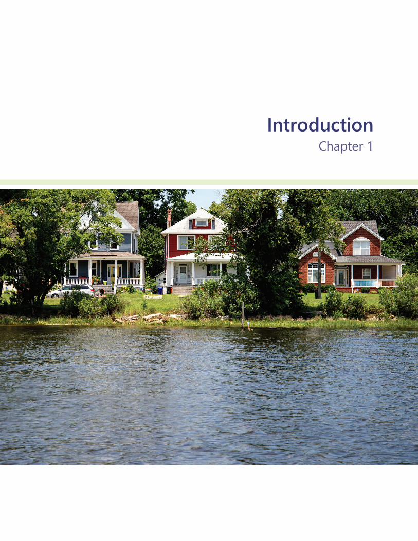
IntroductionChapter 1

1 Introduction
Introduction The Hampton Roads area of Virginia is experiencing the highest rates of relative sea-level rise (sea-level rise and land subsidence) on the East Coast. The area is second only to New Orleans, Louisiana, as the largest population center at risk from sea-level rise in the United States.
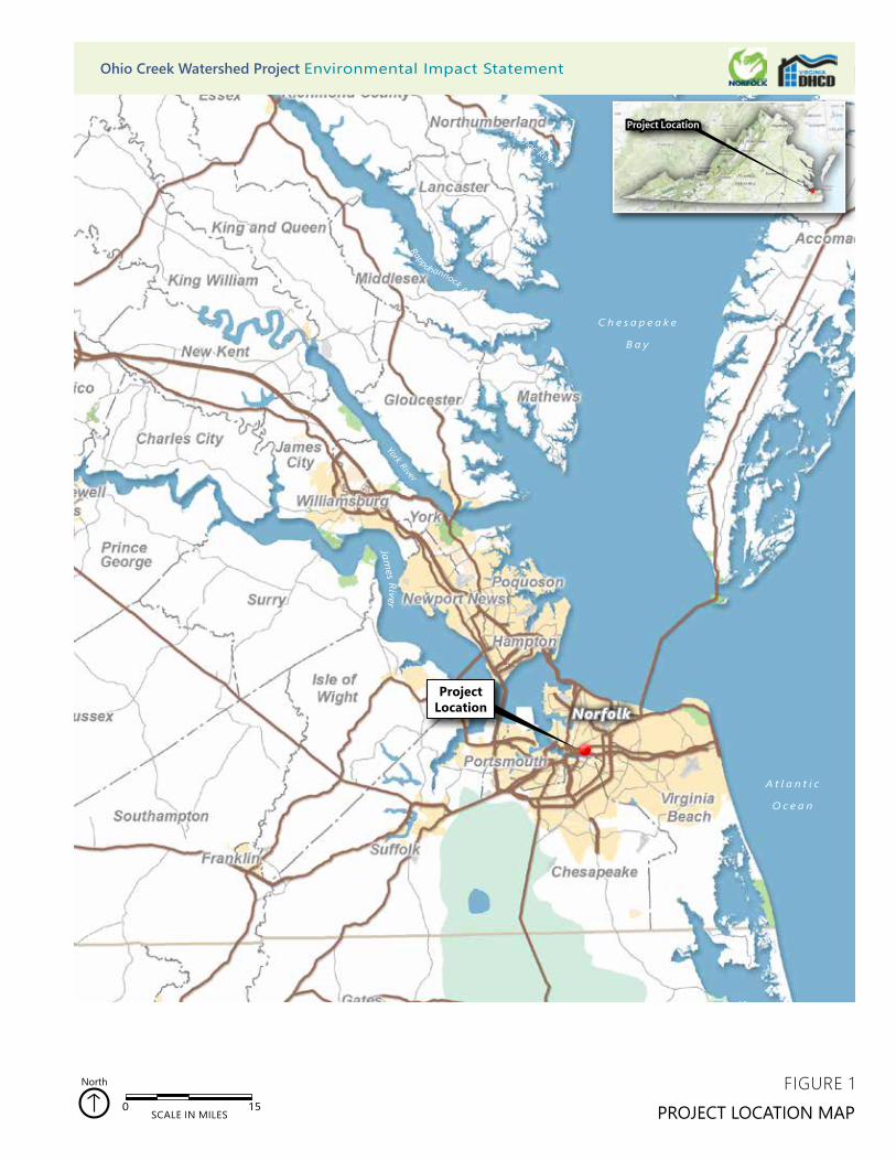
1.1 Project Background The Ohio Creek Watershed project is located in the City of Norfolk (Norfolk), in the Hampton Roads Region of southeastern Virginia (Figure 1). Norfolk, with 245,000 people, is the central hub-city of the Hampton Roads Region, which has a population of over 1.7 million. Norfolk hosts Naval Station Norfolk, the largest naval station in the world, as well as the Port of Virginia, the third largest port on the East Coast, thereby providing security and trade to the world. Due to its geographic position, being bounded and bisected by water, Norfolk is faced with the threat of sea level rise. Flooding from high tides and rain events is becoming more frequent, and the risk of inundation from storm surges is increasing. Compounding the risk from inland and coastal flooding, the southern Chesapeake Bay region is experiencing subsidence (the land naturally sinking) at a rate of 1.1 to 4.8 millimeters per year.1
1 Eggleston, Jack, and Pope, Jason. 2013. Land subsidence and relative sea-level rise in the southern Chesapeake Bay region: U.S. Geological Survey Circular 1392. http://dx.doi.org/10.3133/cir1392. Accessed July 5, 2018.

Ohio Creek Watershed Project Draft Environmental Impact Statement
2 Introduction
In 2014, Norfolk was named to the Rockefeller Foundation’s 100 Resilient Cities, a global designation to bring together cities facing similar challenges; through that process, Norfolk has identified threats to the city’s resilience, including flooding and storms, a lack of economic vitality, and a concentration of poverty.
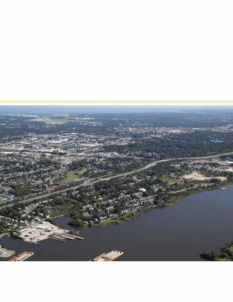
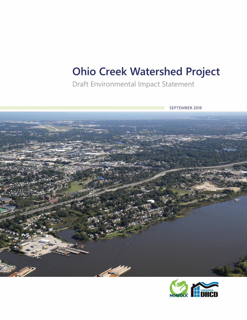
Developed to begin addressing the threats to Norfolk’s resiliency, the Ohio Creek Watershed Project originated in the Commonwealth of Virginia’s application for assistance in the National Disaster Resilience Competition (NDRC) through the US Department of Housing and Urban Development (HUD). The Commonwealth was awarded Community Development Block Grant Disaster Recovery (CDBG-DR) funds in January 2017. Subsequently, in March 2017, Norfolk signed a subrecipient agreement with the Commonwealth to fund the Ohio Creek Watershed Project (project area shown in the photograph below). Designed to improve neighborhood quality in Norfolk by strengthening flood resiliency, supporting economic opportunity, and increasing neighborhood connectivity, this project provides Norfolk with an opportunity to demonstrate a layered resiliency approach. Combining several coastal defense strategies such as earthen berms, raised roads, living shorelines, and floodwalls, with innovative stormwater management design will reduce the increased risk of flooding while expanding neighborhood connectivity and improving water management.
Aerial view of project area, looking northeast.
Project Location
York River Rappahannock River
Potomac River
0 15SCALE IN MILES
North
Project Location
Norfolk
James River
FIGURE 1PROJECT LOCATION MAP
Ohio Creek Watershed Project Environmental Impact StatementOhio Creek Watershed Project Environmental Impact Statement
C h e s a p e a k e
B a y
A t l a n t i c
O c e a n
Ohio Creek Watershed Project Draft Environmental Impact Statement
4 Introduction
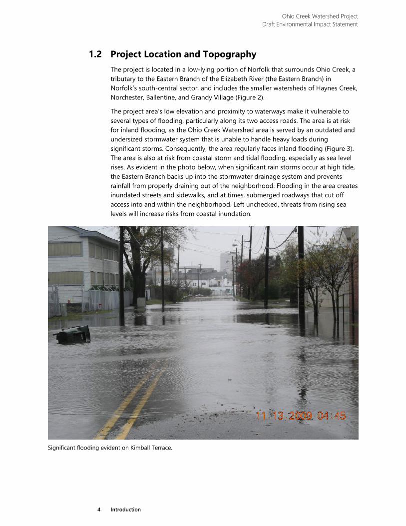
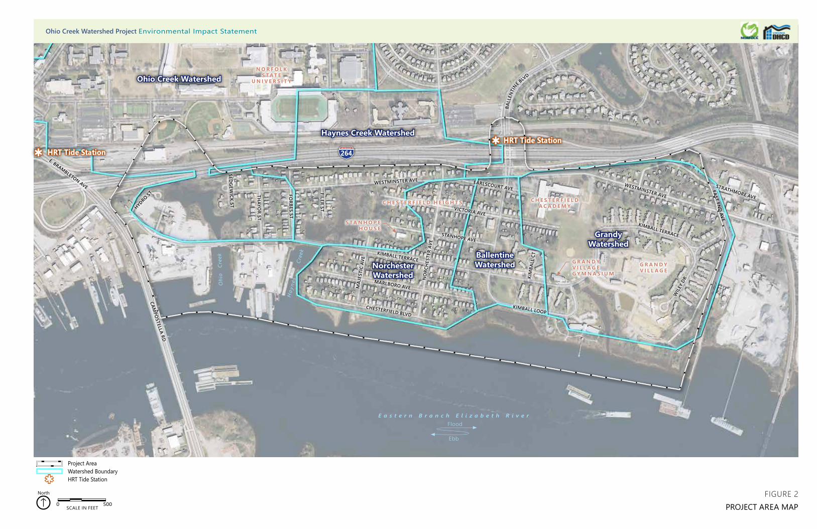
1.2 Project Location and Topography The project is located in a low-lying portion of Norfolk that surrounds Ohio Creek, a tributary to the Eastern Branch of the Elizabeth River (the Eastern Branch) in Norfolk’s south-central sector, and includes the smaller watersheds of Haynes Creek, Norchester, Ballentine, and Grandy Village (Figure 2).
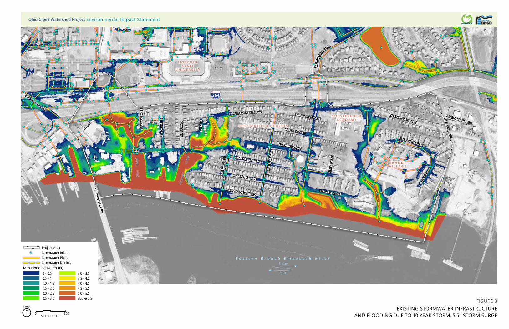
The project area’s low elevation and proximity to waterways make it vulnerable to several types of flooding, particularly along its two access roads. The area is at risk for inland flooding, as the Ohio Creek Watershed area is served by an outdated and undersized stormwater system that is unable to handle heavy loads during significant storms. Consequently, the area regularly faces inland flooding (Figure 3). The area is also at risk from coastal storm and tidal flooding, especially as sea level rises. As evident in the photo below, when significant rain storms occur at high tide, the Eastern Branch backs up into the stormwater drainage system and prevents rainfall from properly draining out of the neighborhood. Flooding in the area creates inundated streets and sidewalks, and at times, submerged roadways that cut off access into and within the neighborhood. Left unchecked, threats from rising sea levels will increase risks from coastal inundation.
Significant flooding evident on Kimball Terrace.
O
hio
Cre
ek
Hay
nes
Cre
ek
264
CHESTERFIELD BLVD
MARLBORO AVE
KIMBALL TERRACE
STANHOPE AVE
NO
RCH
ESTE
R AV
E
MA
JEST
IC A
VE
KIMBALL LOOP
KIM
BALL
CT
EARLSCOURT AVEWESTMINSTER AVE
WESTMINSTER AVE
BALL
ENTI
NE BLV
D
FILER ST
FORBES ST
THAYO
R ST
SEDG
EWICK ST
CAMPO
STELLA RD
WIL
EY D
R
KIMBALL TERRACE
EAST END AVE
STRATHMORE AVE
E. BRAMBLETON AVE
HYDRO ST
VICTORIA AVE
0 500SCALE IN FEET
North
Project AreaWatershed BoundaryHRT Tide Station
G R A N D Y V I L L A G E
C H E S T E R F I E L DA C A D E M Y
N O R F O L K S TAT E
U N I V E R S I T Y
C H E S T E R F I E L D H E I G H T S
Ohio Creek Watershed
Haynes Creek Watershed
Norchester Watershed
BallentineWatershed
GrandyWatershed
PROJECT AREA MAPFIGURE 2
HRT Tide Station HRT Tide Station
S TA N H O P EH O U S E
G R A N D Y V I L L A G EG Y M N A S I U M
Ohio Creek Watershed Project Environmental Impact Statement
E a s t e r n B r a n c h E l i z a b e t h R i v e r
Ebb
Flood
O
hio
Cre
ek
Hay
nes
Cre
ekCHESTERFIELD BLVD
MARLBORO AVE
KIMBALL TERRACE
STANHOPE AVE
NO
RCH
ESTE
R AV
E
VICTORIA AVE
MA
JEST
IC A
VE
KIMBALL LOOP
KIM
BALL
CT
EARLSCOURT AVEWESTMINSTER AVE
WESTMINSTER AVE
BALL
ENTI
NE BLV
D
FILER ST
FORBES ST
THAYO
R ST
SEDG
EWICK ST
CAM
POSTELLA RD
WIL
EY D
R
KIMBALL TERRACE
EAST EN
D AVE
STRATHMORE AVE
264E. BRAMBLETON AVE
HYDRO ST
0 - 0.50.5 - 1 1.0 - 1.5 1.5 - 2.02.0 - 2.52.5 - 3.0
Max Flooding Depth (Ft)3.0 - 3.53.5 - 4.04.0 - 4.54.5 - 5.55.0 - 5.5above 5.5
Project AreaStormwater InletsStormwater PipesStormwater Ditches
0 500SCALE IN FEET
North
G R A N D Y V I L L A G E
C H E S T E R F I E L DA C A D E M Y
N O R F O L K S TAT E
U N I V E R S I T Y
C H E S T E R F I E L D H E I G H T S
EXISTING STORMWATER INFRASTRUCTURE AND FLOODING DUE TO 10 YEAR STORM, 5.5 ‘ STORM SURGE
FIGURE 3
Ohio Creek Watershed Project Environmental Impact Statement
E a s t e r n B r a n c h E l i z a b e t h R i v e r
Ebb
Flood
Ohio Creek Watershed Project Draft Environmental Impact Statement
7 Introduction
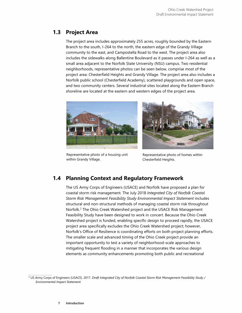
1.3 Project Area The project area includes approximately 255 acres, roughly bounded by the Eastern Branch to the south, I-264 to the north, the eastern edge of the Grandy Village community to the east, and Campostella Road to the west. The project area also includes the sidewalks along Ballentine Boulevard as it passes under I-264 as well as a small area adjacent to the Norfolk State University (NSU) campus. Two residential neighborhoods, representative photos can be seen below, comprise most of the project area: Chesterfield Heights and Grandy Village. The project area also includes a Norfolk public school (Chesterfield Academy), scattered playgrounds and open space, and two community centers. Several industrial sites located along the Eastern Branch shoreline are located at the eastern and western edges of the project area.
1.4 Planning Context and Regulatory Framework The US Army Corps of Engineers (USACE) and Norfolk have proposed a plan for coastal storm risk management. The July 2018 Integrated City of Norfolk Coastal Storm Risk Management Feasibility Study Environmental Impact Statement includes structural and non-structural methods of managing coastal storm risk throughout Norfolk.2 The Ohio Creek Watershed project and the USACE Risk Management Feasibility Study have been designed to work in concert. Because the Ohio Creek Watershed project is funded, enabling specific design to proceed rapidly, the USACE project area specifically excludes the Ohio Creek Watershed project; however, Norfolk’s Office of Resilience is coordinating efforts on both project planning efforts. The smaller scale and advanced timing of the Ohio Creek project provide an important opportunity to test a variety of neighborhood-scale approaches to mitigating frequent flooding in a manner that incorporates the various design elements as community enhancements promoting both public and recreational
2 US Army Corps of Engineers (USACE). 2017. Draft Integrated City of Norfolk Coastal Storm Risk Management Feasibility Study /
Environmental Impact Statement.
Representative photo of homes within Chesterfield Heights.
Representative photo of a housing unit within Grandy Village.
Ohio Creek Watershed Project Draft Environmental Impact Statement
8 Introduction
neighborhood-wide improvements. Due to the scale of the proposed improvements associated with the USACE project, these opportunities are not applicable.
The Commonwealth of Virginia, acting through the Virginia Department of Housing and Community Development (DHCD), is assuming environmental responsibility for the Ohio Creek Watershed Project in accordance with HUD regulations at 24 CFR 58.1(b)(1) and 58.2(a)(7)(i). To comply with its obligations under these regulations, DHCD in partnership with Norfolk has prepared this Draft Environmental Impact Statement (DEIS) in accordance with the National Environmental Policy Act of 1969 (NEPA) and regulations of the Council on Environmental Quality (CEQ) (40 CFR 1500-1508). The proposed action is subject to compliance with NEPA because federal CDBG-DR funds would be used for project design and construction.
Compliance with Section 106 of the National Historic Preservation Act of 1966 (NHPA), as amended (36 CFR Part 800) is being completed separately from and concurrently with the NEPA process and is not included in this DEIS. While applicable cultural resource information, including potential impacts associated with the proposed alternatives, is documented in this DEIS, it is not presented for Section 106 compliance.
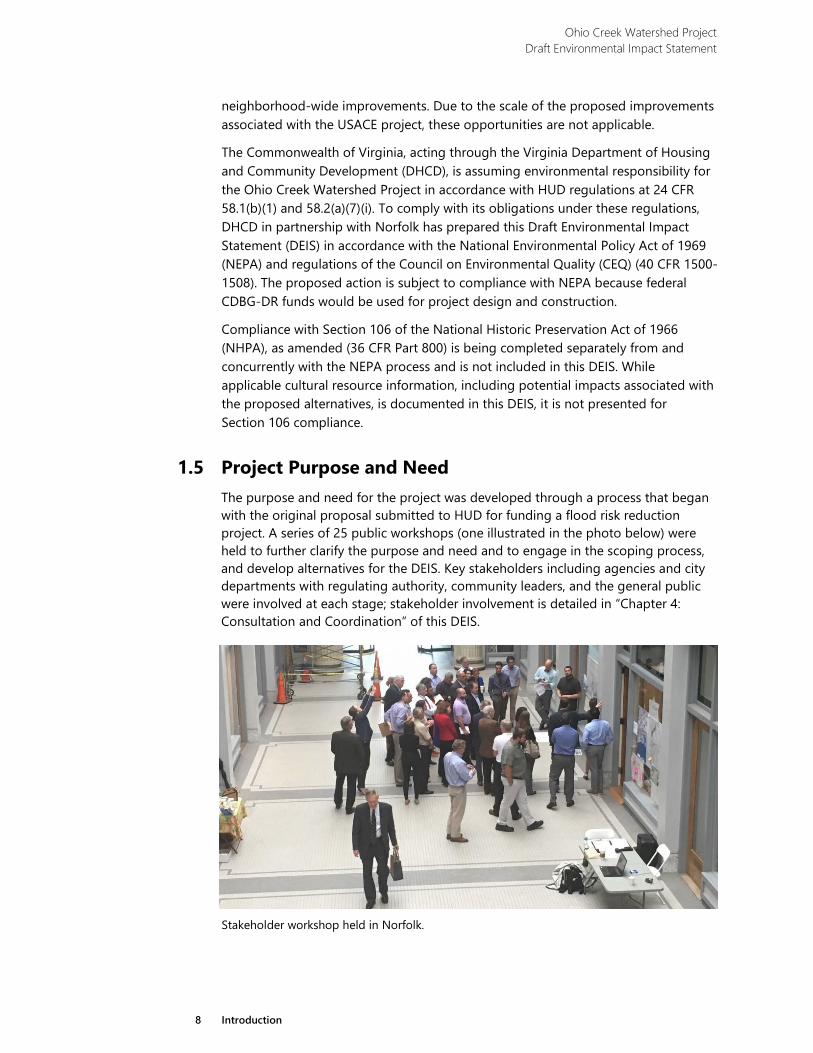
1.5 Project Purpose and Need The purpose and need for the project was developed through a process that began with the original proposal submitted to HUD for funding a flood risk reduction project. A series of 25 public workshops (one illustrated in the photo below) were held to further clarify the purpose and need and to engage in the scoping process, and develop alternatives for the DEIS. Key stakeholders including agencies and city departments with regulating authority, community leaders, and the general public were involved at each stage; stakeholder involvement is detailed in “Chapter 4: Consultation and Coordination” of this DEIS.
Stakeholder workshop held in Norfolk.
Ohio Creek Watershed Project Draft Environmental Impact Statement
9 Introduction
1.5.1 Purpose of the Project
The purpose of the Ohio Creek Watershed project is to:
› Develop adaptations to existing infrastructure and landforms leading to the design of a coastal community capable of resisting the increased risk of flooding due to subsidence, sea-level rise, and increasingly intense and more frequent storm events;
› Support inclusive economic opportunities by advancing efforts to improve existing commercial operations; and
› Advance initiatives to connect communities, deconcentrate poverty, and strengthen neighborhoods.
1.5.2 Need for the Project
The Ohio Creek Watershed Project is needed for several reasons. Norfolk has identified factors that undermine the city’s resilience and drive the need for the project. Those factors include the impact of increased flooding and increased threat from coastal storms coupled with projected sea level rise, the lack of economic vitality, and the concentration of poverty. While these needs are experienced city-wide, the Ohio Creek watershed and Chesterfield Heights provide a microcosm for planning and implementation strategies that can be applied throughout the city, the nation, and the world.
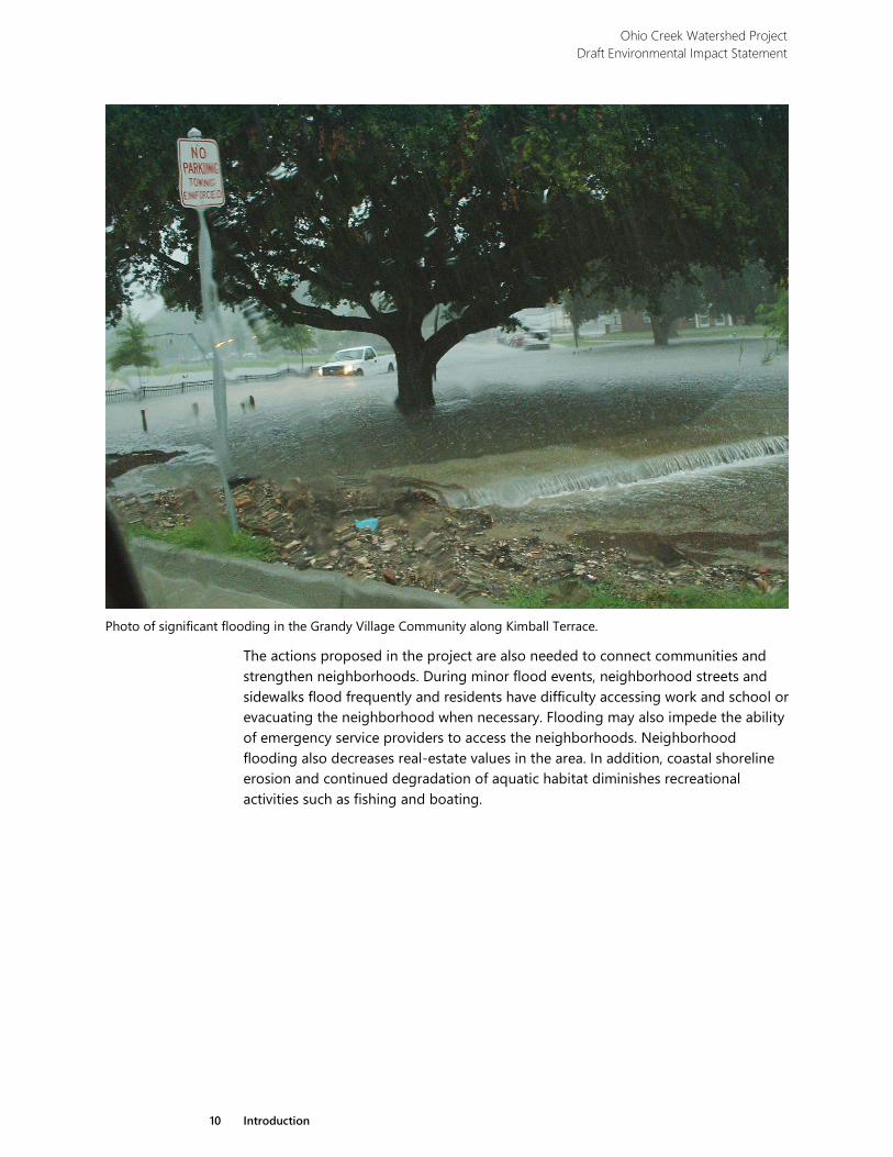
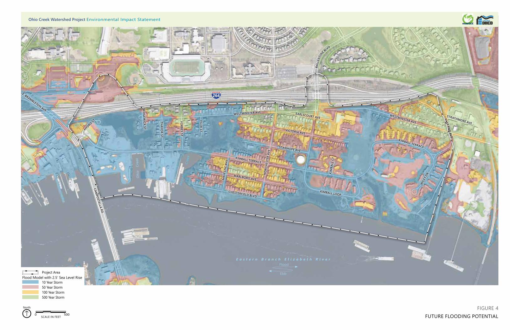
The Ohio Creek watershed experiences tidal and precipitation flooding issues. For example, during Hurricane Irene, the coastal storm surge pushed up the Eastern Branch and into the few remaining low-lying areas that were originally the Ohio Creek bed, and from there, the water slowly inundated the neighborhood as illustrated in the photo below (on page 15). This type of storm surge flooding occurs routinely during hurricane and lesser tropical storms as well as during nor’easters. Both meteorological events are typically accompanied by extreme rains. Even during normal tide conditions in the river, the antiquated stormwater system is too small to convey runoff to the river in a heavy rainfall event. During rainfall and tidal events, residents are at risk of being cut off from the rest of the city because the community is accessed by only two roads—one of which, Kimball Terrace, is completely impassable during regular flood events. All of these factors are exacerbated when modeled storm events and projected 2.5-foot sea level rise are evaluated across the project area (Figure 4).
In addition, the need for the Ohio Creek Watershed Project is driven by economic factors. Flooding and coastal storm threats diminish the economic livelihood of the community, with business disruptions that come from flooding and impassable roads, as well as the continual costs to repair and restore homes, properties, and businesses.
Ohio Creek Watershed Project Draft Environmental Impact Statement
10 Introduction
Photo of significant flooding in the Grandy Village Community along Kimball Terrace.
The actions proposed in the project are also needed to connect communities and strengthen neighborhoods. During minor flood events, neighborhood streets and sidewalks flood frequently and residents have difficulty accessing work and school or evacuating the neighborhood when necessary. Flooding may also impede the ability of emergency service providers to access the neighborhoods. Neighborhood flooding also decreases real-estate values in the area. In addition, coastal shoreline erosion and continued degradation of aquatic habitat diminishes recreational activities such as fishing and boating.
O
hio
Cre
ek
Hay
nes
Cre
ek
264
CHESTERFIELD BLVD
MARLBORO AVE
KIMBALL TERRACE
STANHOPE AVE
NO
RCH
ESTE
R AV
E
VICTORIA AVE
MA
JEST
IC A
VE
KIMBALL LOOP
KIM
BALL
CT
EARLSCOURT AVEWESTMINSTER AVE
WESTMINSTER AVE
BALL
ENTI
NE BLV
D
FILER ST
FORBES ST
THAYO
R ST
SEDG
EWICK ST
CAMPO
STELLA RD
WIL
EY D
R
KIMBALL TERRACE
EAST END AVE
STRATHMORE AVE
264E. BRAMBLETON AVE
HYDRO ST
0 500SCALE IN FEET
North
Project Area
10 Year Storm50 Year Storm100 Year Storm500 Year Storm
Flood Model with 2.5’ Sea Level Rise
FIGURE 4FUTURE FLOODING POTENTIAL
Ohio Creek Watershed Project Environmental Impact Statement
E a s t e r n B r a n c h E l i z a b e t h R i v e r
Ebb
Flood

Ohio Creek Watershed Project Draft Environmental Impact Statement
13 Introduction
1.6 Project Goals and Objectives The ability to meet the project purpose of creating a resilient coastal community in which economic opportunities are supported, communities are connected, and neighborhoods are strengthened will be measured in terms of goals and objectives. Goals are overarching principles that guide decision-making; goals are assessed in terms of objectives, which are measurable steps to meet the goal. The goals and objectives of the project are described below.
Goal: Contribute to community resiliency. Establish a resilient community capable of withstanding the influences of sea level rise, storm surge, and heavy rainfall that are expected to occur between now and 2065. Sea level rise forecasts range from 1 to 3.9 feet in the Norfolk area over the next 50 years. For the purposes of this project the city elected to neither the highest nor lowest estimates and instead use an intermediate forecast. The National Oceanic and Atmospheric Administration (NOAA) intermediate rate was used and provides an estimate of 2.5 feet by the year 2065. Guidance provided by the city was to estimate the crest elevation required to provide protection from the Federal Emergency Management Agency's (FEMA’s) 1% Annual Exceedance Probability (AEP) under future sea level rise for the year 2065. The existing FEMA estimate for the 1% AEP still water level is 8.1 feet near Chesterfield Heights. When combined, 8.1 + 2.5 = 10.6, these elements result in the city established rounded up value of 11 feet (North American Vertical Datum of 1988 (NAVD 88). Rounding up allows for additional freeboard and therefore a small factor of safety.3
Objective: The Ohio Creek Watershed Project will improve resiliency in the community by employing a layered, localized approach to reducing flooding risk. The water management tactics deployed in the project will be integrated into the
existing landscape, offering a community-oriented approach to resiliency at a neighborhood scale that can be replicated by landowners throughout the city.
Examples of specific actions that may be taken include establishing a “resilient perimeter.” This would be done by creating a structure at a sufficient elevation to protect against projected storm surge flooding. This structure could be paired with a natural shoreline (made up of wetlands and other naturally occurring elements). This kind of feature is known as a “living shoreline,” incorporating gradual slopes and planted vegetation that will allow upslope migration of coastal vegetation as sea level rises in the coming decades. In this way, such a structure tends to be naturally self-sustaining. Installation of water management tactics and establishment of this natural perimeter must be accomplished without significant impacts to existing private property in a manner that is compatible with the residential community and industrial properties that make up the Chesterfield Heights area. Coupled with the
protective perimeter described above, the plan must also address rain-driven surface water flooding within the community.
3 Throughout the document, the words “protect” and “protection” are used to describe a reduction in risk. These terms should not be
taken to imply that all risk of flooding or other storm or rainfall-induced damages have been eliminated.
Ohio Creek Watershed Project Draft Environmental Impact Statement
14 Introduction
Goal: Contribute to community economic benefits. Adapt infrastructure and landscape to reduce impacts of flooding on businesses and the local workforce.
Objective: The project will contribute to economic revitalization through the transformation/relocation of roads, leveraging of prior investments to catalyze transit-oriented development, and key corridor development such as the Ballentine Boulevard corridor and adjacent St. Paul’s area. Similarly, these actions will improve conditions for the industrial activities within the community. These will be achieved through establishing more predictable access during storm events so that operations can continue with minimal disruption to the labor force and transportation routes.
Goal: Improve community connections. In adapting Infrastructure and landscape to control flooding provide new and improved vehicular and pedestrian access into the neighborhood and from the neighborhood to the surrounding community.
Objective: The project will connect the Ohio Creek neighborhoods with the greater city at large, while maintaining the communities’ character of place. By mitigating the impacts associated with frequent flooding through raising the road and implementing drainage improvements, the two primary access routes (Ballentine Boulevard and Kimball Terrace) will remain passable to allow more continuous access for residents, industrial uses, and emergency vehicles. Communities will gain connections to neighboring areas of the city through the enhancement of bicyclist and pedestrian routes that are safe and inviting, improved access to the Hampton Roads Transit (HRT) network connections (through both improved bicyclist/pedestrian connections and reduction of flooding), and improved traffic signalization and signal timing.
Goal: Improve public spaces and neighborhood amenities.
Objective: The project will contribute to improving community identity by incorporating public spaces and introducing landscape and streetscape features into the project design. Implementation of infrastructure improvements associated with perimeter control of sea level and storm surge threats, combined with improved drainage systems, provide design opportunities to modernize streetscapes and aesthetics throughout the community. These improved neighborhood amenities will introduce tree and landscape plantings along streets, particularly at intersections, and will leverage existing community assets by improving pedestrian access to the Grandy Village Learning Center, creating new and enhanced gathering spaces, constructing a community pier, and creating playing fields and park amenities.
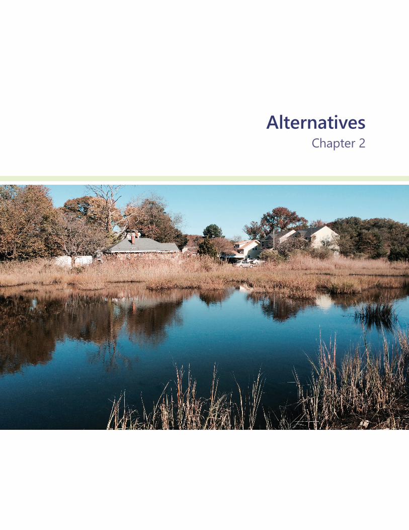
AlternativesChapter 2

15 Alternatives
Alternatives This section describes actions that would take place under each alternative being considered by Norfolk, in partnership with the Virginia Department of Housing and Community Development (DHCD). The action alternatives include a range of ways to develop a coastal defense system for managing storm surge and coastal flooding, using a combination of constructed berms/walls, elevated roadways, tide gates and pump stations, and created wetlands. In addition, the preferred alternative provides various community amenities, such as improved pedestrian and bicycle access, improved playing fields, and new river access through a living shoreline and community pier components. Alternative 4 is the preferred alternative, which is the alternative that Norfolk and DHCD have identified as best meeting the project’s objectives (see Table 4 for more details).
In addition to alternatives for taking action, this chapter describes the No Action Alternative (Alternative 1), which would continue the current conditions within the project limits and serves as the baseline by which to compare the action alternatives. The action alternatives present varying levels of flood protection, stormwater management, and community improvements.
This chapter also includes alternative management concepts that were considered but dismissed from further analysis as well as the rationale for their dismissal.
Ohio Creek Watershed Project Draft Environmental Impact Statement
16 Alternatives
2.1 Alternatives Development The focus of the proposed action is to protect the neighborhood roads and residential housing from frequent flooding and future coastal inundation. During coastal storms, existing low-lying areas become flooded, causing the existing drainage systems to become less effective at removing stormwater runoff (in other words, draining rainwater) from the neighborhoods and streets. Compounding this issue is an outdated stormwater system that is too small to adequately convey runoff to the river during many rainfall events. All three action alternatives each employ three water-management tactics:
1. Develop a coastal defense around the neighborhoods to prevent storm surge and high tides from entering the neighborhood or the stormwater system;
2. Capture rainfall across the watershed to slow its flow into the stormwater system and provide additional storage for rainwater so that the water does not pond in the streets; and
3. Introduce a new living shoreline edge that is sustainable with gradual slopes and coastal vegetation that will allow upslope migration of coastal vegetation as sea level rises.
Norfolk proposes to use these water-management activities as opportunities to improve the neighborhood by increasing neighborhood connectivity, adding new and improved natural habitat, and increasing resilience to future flooding.
The design elements included in the action alternatives were developed initially through a proposal effort to obtain funding for the Ohio Creek Watershed Project. After receipt of funding, the project team hosted a series of 25 public workshops to further clarify the purpose and need, to engage in the scoping process, and develop alternatives for the DEIS. Concepts similar to the following four alternatives were presented to the community at a public scoping meeting on February 21, 2018.
Table 2 at the end of the chapter provides a side-by-side summary comparison of these alternatives.
2.2 Alternative 1 (No Action) In Alternative 1, the No Action Alternative, there would be no construction of flood protection measures and no stormwater management infrastructure changes. Additionally, there would be no transportation improvements or community amenities to increase neighborhood connectivity and economic vitality.
Portions of Kimball Terrace and Westminster Boulevard would remain low-lying and would continue to experience flooding during regular storm events as illustrated in the photo below, resulting in some residents having to drive through flooded areas to reach or leave their homes. Norfolk’s fire and safety response efforts would continue to be impacted during flood events due to constrained access routes.
Ohio Creek Watershed Project Draft Environmental Impact Statement
17 Alternatives
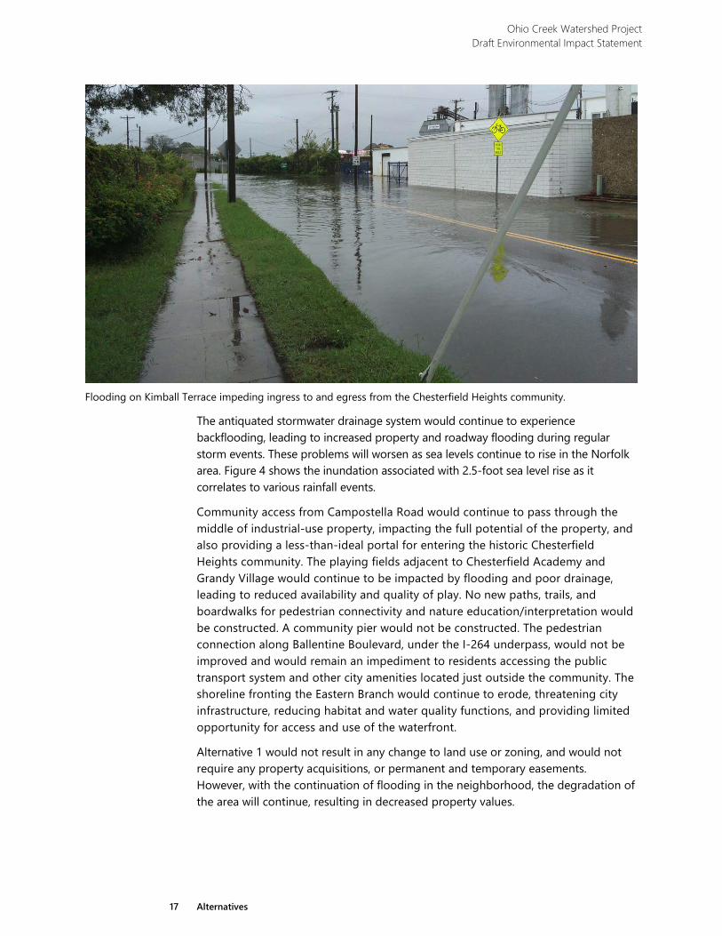
Flooding on Kimball Terrace impeding ingress to and egress from the Chesterfield Heights community.
The antiquated stormwater drainage system would continue to experience backflooding, leading to increased property and roadway flooding during regular storm events. These problems will worsen as sea levels continue to rise in the Norfolk area. Figure 4 shows the inundation associated with 2.5-foot sea level rise as it correlates to various rainfall events.
Community access from Campostella Road would continue to pass through the middle of industrial-use property, impacting the full potential of the property, and also providing a less-than-ideal portal for entering the historic Chesterfield Heights community. The playing fields adjacent to Chesterfield Academy and Grandy Village would continue to be impacted by flooding and poor drainage, leading to reduced availability and quality of play. No new paths, trails, and boardwalks for pedestrian connectivity and nature education/interpretation would be constructed. A community pier would not be constructed. The pedestrian connection along Ballentine Boulevard, under the I-264 underpass, would not be improved and would remain an impediment to residents accessing the public transport system and other city amenities located just outside the community. The shoreline fronting the Eastern Branch would continue to erode, threatening city infrastructure, reducing habitat and water quality functions, and providing limited opportunity for access and use of the waterfront.
Alternative 1 would not result in any change to land use or zoning, and would not require any property acquisitions, or permanent and temporary easements. However, with the continuation of flooding in the neighborhood, the degradation of the area will continue, resulting in decreased property values.
Ohio Creek Watershed Project Draft Environmental Impact Statement
18 Alternatives
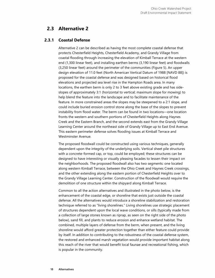
2.3 Alternative 2
2.3.1 Coastal Defense
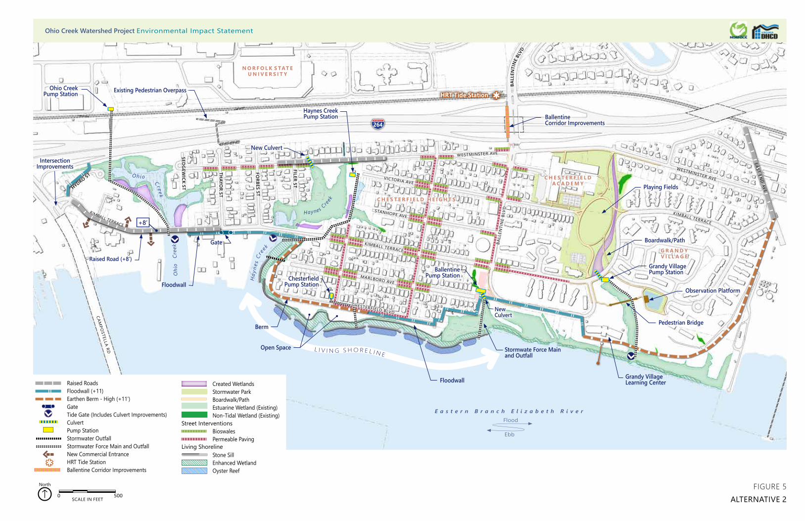
Alternative 2 can be described as having the most complete coastal defense that protects Chesterfield Heights, Chesterfield Academy, and Grandy Village from coastal flooding through increasing the elevation of Kimball Terrace at the western end (1,300 linear feet), and installing earthen berms (3,190 linear feet) and floodwalls (3,250 linear feet) around the perimeter of the communities (Figure 5). An upper design elevation of 11.0 feet (North American Vertical Datum of 1988 [NAVD 88]) is proposed for the coastal defense and was designed based on historical flood elevations and projected sea level rise in the Hampton Roads area. In many locations, the earthen berm is only 2 to 3 feet above existing grade and has side-slopes of approximately 3:1 (horizontal to vertical; maximum slope for mowing) to help blend the feature into the landscape and to facilitate maintenance of the feature. In more constrained areas the slopes may be steepened to a 2:1 slope, and could include buried erosion control stone along the base of the slopes to prevent instability from flood water. The berm can be found in two locations—one location fronts the western and southern portions of Chesterfield Heights along Haynes Creek and the Eastern Branch, and the second extends east from the Grandy Village Learning Center around the northeast side of Grandy Village up to East End Avenue. This eastern perimeter defense solves flooding issues at Kimball Terrace and Westminster Avenue.
The proposed floodwall could be constructed using various techniques, generally dependent upon the integrity of the underlying soils. Vertical sheet pile structures with a concrete-formed cap, or top, could be employed; these structures can be designed to have interesting or visually pleasing facades to lessen their impact on the neighborhoods. The proposed floodwall also has two segments: one located along western Kimball Terrace, between the Ohio Creek and Haynes Creek crossings, and the other extending along the eastern portion of Chesterfield Heights over to the Grandy Village Learning Center. Construction of the floodwall would require the demolition of one structure within the shipyard along Kimball Terrace.
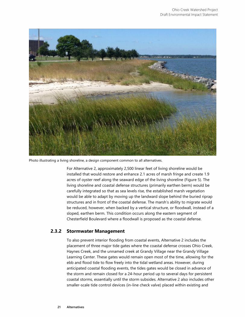
Common to all the action alternatives and illustrated in the photo below, is the enhancement of the coastal edge, or shoreline that exists just outside the coastal defense. All the alternatives would introduce a shoreline stabilization and restoration technique referred to as “living shorelines.” Living shorelines use strategic placement of structures dependent upon the local wave conditions, or sills (typically made from a collection of large stones known as riprap, as seen on the right side of the photo below), sand fill, and plants to reduce erosion and enhance wetland habitat. The combined, multiple layers of defense from the berm, when present, and the living shoreline would afford greater protection together than either feature could provide by itself. In addition to contributing to the robustness of the coastal defense system, the restored and enhanced marsh vegetation would provide important habitat along this reach of the river that would benefit local faunae and recreational fishing, which is popular in the community.
HRT Tide Station
HYDRO ST
BALL
ENTI
NE
BLVD
FILER ST
FORBES ST
THAYO
R ST
SEDG
EWICK ST
264
Haynes Creek Pump Station
Raised RoadsFloodwall (+11)Earthen Berm - High (+11’)GateTide Gate (Includes Culvert Improvements)CulvertPump StationStormwater OutfallStormwater Force Main and OutfallNew Commercial EntranceHRT Tide StationBallentine Corridor Improvements
Created WetlandsStormwater ParkBoardwalk/PathEstuarine Wetland (Existing)Non-Tidal Wetland (Existing)
BioswalesPermeable Paving
Stone SillEnhanced WetlandOyster Reef
Living Shoreline
0 500 1,000250 Feet
0 500 1,000250 Feet
Street Interventions
0 500SCALE IN FEET
North
G R A N D Y V I L L A G E
C H E S T E R F I E L DA C A D E M Y
C H E S T E R F I E L D H E I G H T S
N O R F O L K S TAT E U N I V E R S I T Y
L I V I N G S H O R E L I N E
WESTMINSTER AVE
H
ayne
s C r
ee
k
Oh io Cr eek
CAMPO
STELLA RD
CHESTERFIELD BLVD
MARLBORO AVE
KIMBALL TERRACE
STANHOPE AVE
VICTORIA AVE
WESTMINSTER AVE
KIMBALL TERRACE
WESTMINSTER AVE
KIMBALL TERRACE
BALL
ENTI
NE
BLVD
O
hio
Cre
ek
EAST END
AVE
Haynes C
reek
Ohio Creek Pump Station
Intersection Improvements
Boardwalk/Path
Chesterfield Pump Station
Floodwall
Stormwate Force Mainand Outfall
Pedestrian Bridge
Observation Platform
Ballentine Corridor Improvements
Gate
BallentinePump Station
New Culvert
Grandy Village Pump Station
+8’
Floodwall
Existing Pedestrian Overpass
Grandy Village Learning Center
Playing Fields
New Culvert
FIGURE 5ALTERNATIVE 2
Raised Road (+8’)
Berm
Open Space
E a s t e r n B r a n c h E l i z a b e t h R i v e r
Ebb
Flood
Ohio Creek Watershed Project Environmental Impact Statement

Ohio Creek Watershed Project Draft Environmental Impact Statement
21 Alternatives
Photo illustrating a living shoreline, a design component common to all alternatives.
For Alternative 2, approximately 2,500 linear feet of living shoreline would be installed that would restore and enhance 2.1 acres of marsh fringe and create 1.9 acres of oyster reef along the seaward edge of the living shoreline (Figure 5). The living shoreline and coastal defense structures (primarily earthen berm) would be carefully integrated so that as sea levels rise, the established marsh vegetation would be able to adapt by moving up the landward slope behind the buried riprap structures and in front of the coastal defense. The marsh’s ability to migrate would be reduced, however, when backed by a vertical structure, or floodwall, instead of a sloped, earthen berm. This condition occurs along the eastern segment of Chesterfield Boulevard where a floodwall is proposed as the coastal defense.
2.3.2 Stormwater Management
To also prevent interior flooding from coastal events, Alternative 2 includes the placement of three major tide gates where the coastal defense crosses Ohio Creek, Haynes Creek, and the unnamed creek at Grandy Village near the Grandy Village Learning Center. These gates would remain open most of the time, allowing for the ebb and flood tide to flow freely into the tidal wetland areas. However, during anticipated coastal flooding events, the tides gates would be closed in advance of the storm and remain closed for a 24-hour period up to several days for persistent coastal storms, essentially until the storm subsides. Alternative 2 also includes other smaller-scale tide control devices (in-line check valve) placed within existing and
Ohio Creek Watershed Project Draft Environmental Impact Statement
22 Alternatives
proposed drainage pipes that prevent inflow from flood tides to reduce backwater conditions within the stormwater drainage system and conveyance channels.
The perimeter barriers and control devices would provide significant improvements to the existing stormwater drainage systems because backwater conditions would be improved during low-intensity rain events. Many segments of existing, underground, stormwater pipes, which are significantly undersized by current standards, are proposed to be replaced with a larger diameter, higher capacity piping system. Additionally, chronic flooding can be reduced by capturing and slowing down the water infiltration into the storm system, thereby alleviating any potential backflow or overload.
To further mitigate the vulnerability to street and neighborhood flooding, several tactics are proposed to attenuate the intensity of stormwater runoff within the neighborhood. Flooding can be reduced by capturing and temporarily retaining water in rain barrels, rain gardens, un-paved open areas, and parks. For all the action alternatives, Norfolk proposes to implement a dispersed stormwater collection program using a combination of rain barrels and rain gardens at multiple residential parcels within the watershed. The flow in roof gutters and downspouts would be redirected into a storage device that has a capacity to accommodate some rainfall volume and discharge it slowly from an outlet on the bottom of the device. When each parcel temporarily stores the water that falls on their own property and releases it slowly into the neighborhood drainage, the initial pulse of stormwater into the system is attenuated, which helps to prevent the system from being overwhelmed and backing up into the streets. As part of the stormwater collection program, and to bring about a community-wide sense of responsibility for personal environmental impacts, Norfolk intends to encourage all residents of the watershed to participate by offering grants to implement small-scale stormwater systems.
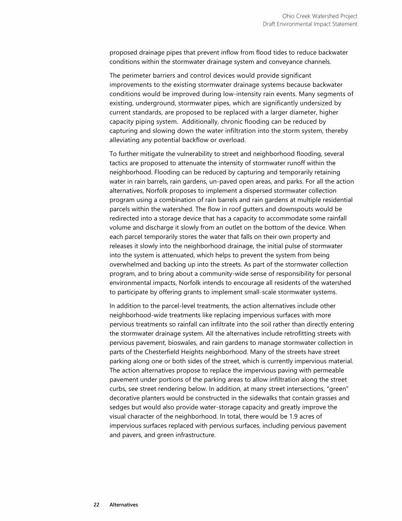
In addition to the parcel-level treatments, the action alternatives include other neighborhood-wide treatments like replacing impervious surfaces with more pervious treatments so rainfall can infiltrate into the soil rather than directly entering the stormwater drainage system. All the alternatives include retrofitting streets with pervious pavement, bioswales, and rain gardens to manage stormwater collection in parts of the Chesterfield Heights neighborhood. Many of the streets have street parking along one or both sides of the street, which is currently impervious material. The action alternatives propose to replace the impervious paving with permeable pavement under portions of the parking areas to allow infiltration along the street curbs, see street rendering below. In addition, at many street intersections, "green" decorative planters would be constructed in the sidewalks that contain grasses and sedges but would also provide water-storage capacity and greatly improve the visual character of the neighborhood. In total, there would be 1.9 acres of impervious surfaces replaced with pervious surfaces, including pervious pavement and pavers, and green infrastructure.
Ohio Creek Watershed Project Draft Environmental Impact Statement
23 Alternatives
Rendering of permeable pavers along the sides of the street at the locations of on street parking.
In addition to the innovative parcel scale and street-level stormwater detention, the action alternatives include increased capacity and improvement of several large stormwater detention areas. For Alternative 2, the area of Ohio Creek between Kimball Terrace and I-264 would be controlled with a tide gate to allow stormwater detention and would be enhanced for this purpose by grading down several upland areas to create wetlands (0.5 acres) and to increase the storage capacity of this detention area. Similar improvements would occur within Haynes Creek, between Kimball Terrace and Westminster Avenue where a tide gate would be installed and an additional 0.3 acres of wetlands would be created to provide increase storage capacity (Figure 5). The next largest detention area is located within the Grandy Village watershed, where a stormwater park and enhanced wetlands would provide a total of 8.0 acres of park and stormwater amenities, including the creation of 0.3 acres of created wetlands within the stormwater complex.
The sum of parcel-scale, street-scale, and large-scale detention would be adequate to accommodate the 10-year rainfall and alleviate chronic flooding of streets, sidewalks, and homes. Because tidal gates would block the discharge of stormwater during coastal flooding and high tides, stormwater would be stored inside the coastal defense in the low-lying areas. Despite the increased capacity of stormwater retention, storage is still limited. For many rain events, stormwater would exceed the storage capacity of the system before the river stage subsides and the gates can be opened to release the stormwater into the river. To address this constraint, Alternative 2 proposes the use of five pump stations that would pump water from detention areas behind the coastal defense, and within the stormwater collection system, for discharge into the Eastern Branch, or adjacent tributaries that are downstream of the coastal defense. Approximately 780 linear feet of force main (the pipes in which the pumps would convey stormwater out of the project area) with
Ohio Creek Watershed Project Draft Environmental Impact Statement
24 Alternatives
associated outfalls would be installed within the Eastern Branch, or adjacent waters, to receive the stormwater discharge.
Due to the significant size of the Ohio Creek watershed, additional drainage structures and pumping systems would be required on the north side of I-264 on Norfolk State University (NSU) and Virginia Department of Transportation (VDOT) properties. These structures are not proposed as part of this project. Current planning underway for NSU stormwater is summarized as a cumulative action in Section 3.1.1.
2.3.3 Transportation Infrastructure
Another step towards improving resiliency, fostering economic improvement, and enabling community connectedness is addressing the recurring flooding that occurs along the neighborhood streets, preventing ingress and egress. Alternative 2 proposes various locations (Figure 5) where the roads are raised to an elevation of at least 8 feet (NAVD 88) so that vehicular access into and out of the neighborhoods are maintained, during flooding events, for the traffic using the western access point (Campostella Road) and the northeastern access point (Ballentine Boulevard). Road raising would occur along the western segment of Kimball Terrace for approximately 1,300 linear feet from Campostella Road to Thayor Street. A low-lying segment of Westminster Avenue, where it crosses the Haynes Creek drainage, would be raised for a length of approximately 900 linear feet. East End Avenue, located in the northeast quadrant of the project area, would be raised for approximately 860 linear feet, providing flood protection and a higher road for the eastern portion of the project.
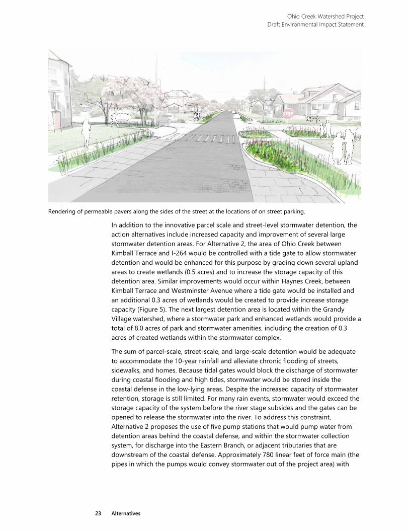
In addition to raising roads, Alternative 2 includes signal and crosswalk improvements at the Kimball Terrace and Campostella Road intersection and sidewalk improvements at the I-264 Ballentine Boulevard underpass. Sidewalk improvements would extend southward along Ballentine Boulevard from the underpass, including the addition of missing segments of sidewalk and possible widening in designated areas, see example photo provided below. These enhancements are aimed at improving safety and connectedness within the community by creating safer routes to schools, community facilities, and overall improved ingress and egress to Chesterfield Heights and Grandy Village.
Ohio Creek Watershed Project Draft Environmental Impact Statement
25 Alternatives
Example photo of underpass improvements.
2.3.4 Community Amenities
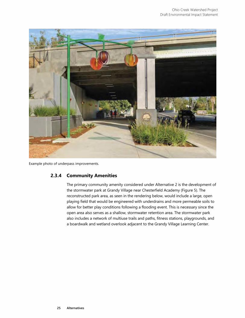
The primary community amenity considered under Alternative 2 is the development of the stormwater park at Grandy Village near Chesterfield Academy (Figure 5). The reconstructed park area, as seen in the rendering below, would include a large, open playing field that would be engineered with underdrains and more permeable soils to allow for better play conditions following a flooding event. This is necessary since the open area also serves as a shallow, stormwater retention area. The stormwater park also includes a network of multiuse trails and paths, fitness stations, playgrounds, and a boardwalk and wetland overlook adjacent to the Grandy Village Learning Center.
Ohio Creek Watershed Project Draft Environmental Impact Statement
26 Alternatives
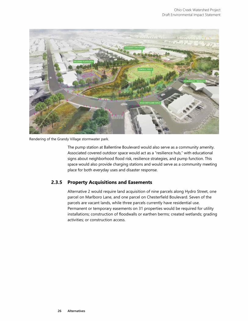
Rendering of the Grandy Village stormwater park.
The pump station at Ballentine Boulevard would also serve as a community amenity. Associated covered outdoor space would act as a “resilience hub,” with educational signs about neighborhood flood risk, resilience strategies, and pump function. This space would also provide charging stations and would serve as a community meeting place for both everyday uses and disaster response.
2.3.5 Property Acquisitions and Easements
Alternative 2 would require land acquisition of nine parcels along Hydro Street, one parcel on Marlboro Lane, and one parcel on Chesterfield Boulevard. Seven of the parcels are vacant lands, while three parcels currently have residential use. Permanent or temporary easements on 31 properties would be required for utility installations; construction of floodwalls or earthen berms; created wetlands; grading activities; or construction access.
Ohio Creek Watershed Project Draft Environmental Impact Statement
27 Alternatives
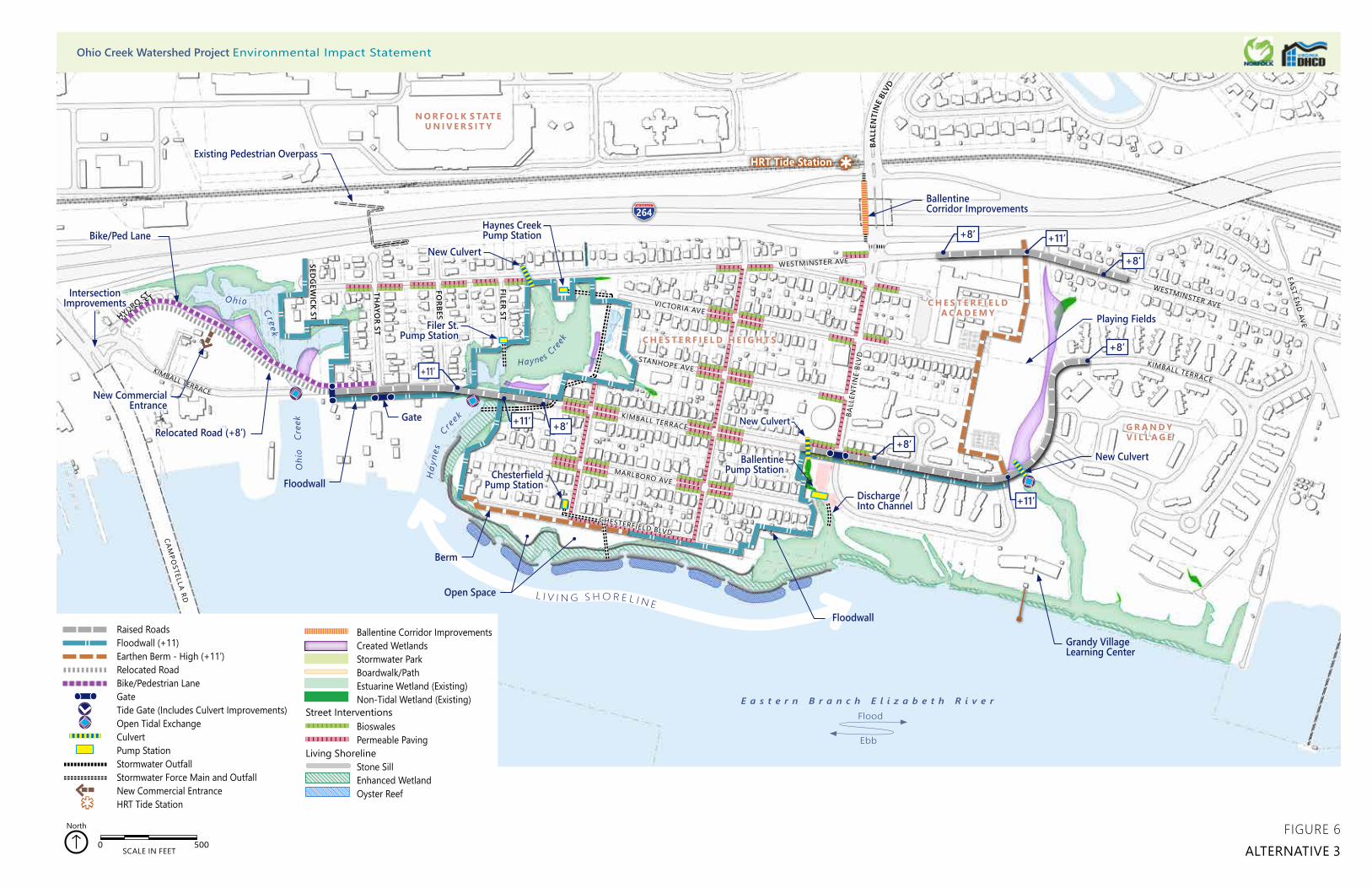
2.4 Alternative 3 Alternative 3 remains consistent with the overall focus of the project with the goal to protect residential housing from frequent flooding and future coastal inundation in a manner that fosters economic vitality and increases community connectedness. However, several significant differences exist within Alternative 3 as compared to Alternatives 2 and 4. Those differences are discussed in the sections found below.
2.4.1 Coastal Defense
Similar to the coastal defense in Alternative 2, the Alternative 3 coastal defense extends across the southern boundary of Chesterfield Heights, but has significant differences in the Ohio Creek, Haynes Creek, and Grandy Village watersheds (Figure 6). To the east, within Grandy Village, the coastal defense is not needed in the eastern portion of Grandy Village because the development was constructed at or above the 11-foot target of the Ohio Creek Project.
In the western portions of the project area, the coastal defense extends up into the Haynes Creek and Ohio Creek wetland areas, rather than following the alignment of Kimball Terrace. These alignment shifts are a result of not having tide gates where Kimball Terrace crosses Ohio Creek and Haynes Creek. Without these gates, the interior portions of Chesterfield Heights would be susceptible to flooding and inundation—therefore, the berm/floodwall alignment extends around portions of these two waterbodies. The Alternative 3 coastal defense maintains a design elevation of +11.0 feet (NAVD 88) for a total distance of 8,900 linear feet, with a breakdown of 2,150 linear feet of earthen berms and 6,750 linear feet of floodwall. The shoreline treatment along Haynes Creek and the Eastern Branch is the same as Alternative 2.
2.4.2 Stormwater Management
Alternative 3 lacks tide control features, or gates, as compared to the other action alternatives. Under this alternative, tidal exchange would be unimpeded in the Ohio Creek and Haynes Creek culvert crossings, allowing for the ebb and flood tide to flow freely into the estuarine wetland areas. However, the proposed culvert at Grandy Village would be elevated such that the normal flood tide would not extend up into low areas, east of the playing fields. Other stormwater discharge pipes would be equipped with inline check valves to prevent backflooding into the drainage system using higher stages of tidal inundation.
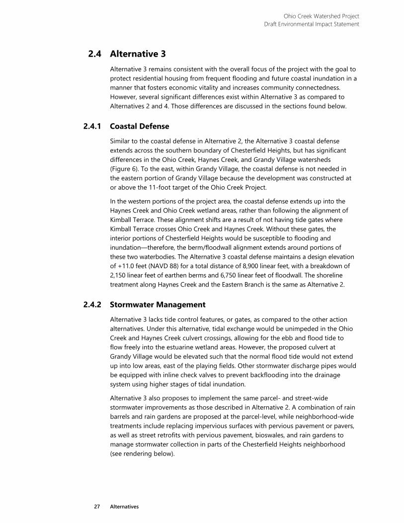
Alternative 3 also proposes to implement the same parcel- and street-wide stormwater improvements as those described in Alternative 2. A combination of rain barrels and rain gardens are proposed at the parcel-level, while neighborhood-wide treatments include replacing impervious surfaces with pervious pavement or pavers, as well as street retrofits with pervious pavement, bioswales, and rain gardens to manage stormwater collection in parts of the Chesterfield Heights neighborhood (see rendering below).
Ohio Creek Watershed Project Draft Environmental Impact Statement
28 Alternatives
In contrast to Alternative 2, Alternative 3 does not propose the use of Ohio Creek and Haynes Creek, north of Kimball Terrace, as stormwater detention areas. Without tide gates in place at Kimball Terrace, these areas would remain open to tidal exchange and flooding events, and would not be utilized as temporary storage areas for stormwater runoff during storm events. However, uplands would be graded down to create wetlands in these two watersheds for approximately 0.8 acres. These new wetlands would be offered as mitigation to offset unavoidable impacts to
other tidal wetlands, would expand/enhance existing wetland communities, and should provide increased aquatic habitat and water quality benefits within these two watersheds.
Example photograph of bioswales used as a street-wide stormwater improvement.
© E
nviro
nmen
tal S
ervi
ces,
City
of P
ortla
nd O
rego
n
HRT Tide Station
HYDRO ST
BALL
ENTI
NE
BLVD
FILER ST
FORBES ST
THAYO
R ST
SEDG
EWICK ST
HYDRO ST
L I V I N G S H O R E L I N E
WESTMINSTER AVE
EAST END
AVE
Raised RoadsFloodwall (+11)Earthen Berm - High (+11’)Relocated RoadBike/Pedestrian LaneGateTide Gate (Includes Culvert Improvements)Open Tidal ExchangeCulvertPump StationStormwater OutfallStormwater Force Main and OutfallNew Commercial EntranceHRT Tide Station
Ballentine Corridor ImprovementsCreated WetlandsStormwater Park Boardwalk/PathEstuarine Wetland (Existing)Non-Tidal Wetland (Existing)
BioswalesPermeable Paving
Stone SillEnhanced WetlandOyster Reef
Living Shoreline
0 500 1,000250 Feet
0 500 1,000250 Feet
Street Interventions
0 500SCALE IN FEET
North
G R A N D Y V I L L A G E
C H E S T E R F I E L DA C A D E M Y
C H E S T E R F I E L D H E I G H T S
N O R F O L K S TAT E U N I V E R S I T Y
264
H
ayne
s
C re
ek
Oh io Cr eek
CAMPO
STELLA RD
CHESTERFIELD BLVD
MARLBORO AVE
KIMBALL TERRACE
STANHOPE AVE
VICTORIA AVE
WESTMINSTER AVE
KIMBALL TERRACE
WESTMINSTER AVE
KIMBALL TERRACE
BALL
ENTI
NE
BLVD
O
hio
Cre
ek
Haynes C
reek
New Commercial Entrance
Intersection Improvements
Bike/Ped Lane
Relocated Road (+8’)
Floodwall
Berm
Floodwall
DischargeInto Channel
BallentinePump Station
Filer St. Pump Station
Chesterfield Pump Station
Ballentine Corridor Improvements
+8’
+8’
New Culvert
New Culvert
Gate New Culvert
Existing Pedestrian Overpass
Grandy Village Learning Center
FIGURE 6ALTERNATIVE 3
+11’
+8’
+8’ +11’
+8’
+11’
Open Space
+11’
Playing Fields
Haynes Creek Pump Station
E a s t e r n B r a n c h E l i z a b e t h R i v e r
Ebb
Flood
Ohio Creek Watershed Project Environmental Impact Statement

Ohio Creek Watershed Project Draft Environmental Impact Statement
31 Alternatives
The Grandy Village drainage system, located east of the playing fields, would be used to retain some stormwater, but not as extensively as in Alternatives 2 and 4. A new culvert would be installed under Kimball Terrace and a 0.5-acre naturalized linear wetland feature would be developed to improve drainage from the surrounding uplands (shown as the purple-shaded “Created Wetlands” on Figure 6). The proposed culvert would be equipped with an inline check valve that would prevent coastal storm surge and extreme high tides from flooding the playing fields.
Without the tide gates and large-scale, stormwater detention areas within Ohio Creek and Haynes Creek, Alternative 3 would require one less pump station than Alternative 2 to remove stormwater. Two pump stations are proposed that would service portions of the Haynes Creek watershed located inside the coastal defense,
while two additional pump stations would service Norchester and Ballentine watersheds. The pump stations would discharge flood waters into the Eastern Branch, or into Haynes Creek.
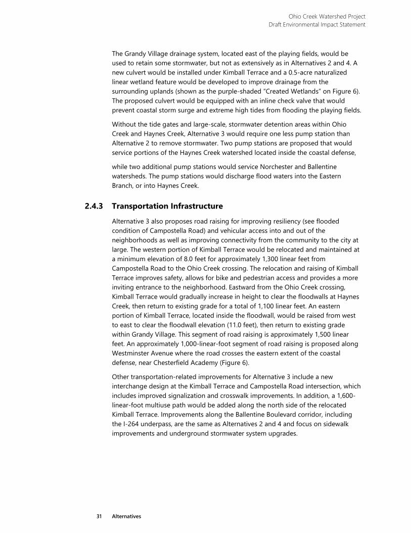
2.4.3 Transportation Infrastructure
Alternative 3 also proposes road raising for improving resiliency (see flooded condition of Campostella Road) and vehicular access into and out of the neighborhoods as well as improving connectivity from the community to the city at large. The western portion of Kimball Terrace would be relocated and maintained at a minimum elevation of 8.0 feet for approximately 1,300 linear feet from Campostella Road to the Ohio Creek crossing. The relocation and raising of Kimball Terrace improves safety, allows for bike and pedestrian access and provides a more inviting entrance to the neighborhood. Eastward from the Ohio Creek crossing, Kimball Terrace would gradually increase in height to clear the floodwalls at Haynes Creek, then return to existing grade for a total of 1,100 linear feet. An eastern portion of Kimball Terrace, located inside the floodwall, would be raised from west to east to clear the floodwall elevation (11.0 feet), then return to existing grade within Grandy Village. This segment of road raising is approximately 1,500 linear feet. An approximately 1,000-linear-foot segment of road raising is proposed along Westminster Avenue where the road crosses the eastern extent of the coastal defense, near Chesterfield Academy (Figure 6).
Other transportation-related improvements for Alternative 3 include a new interchange design at the Kimball Terrace and Campostella Road intersection, which includes improved signalization and crosswalk improvements. In addition, a 1,600-linear-foot multiuse path would be added along the north side of the relocated Kimball Terrace. Improvements along the Ballentine Boulevard corridor, including the I-264 underpass, are the same as Alternatives 2 and 4 and focus on sidewalk improvements and underground stormwater system upgrades.
Ohio Creek Watershed Project Draft Environmental Impact Statement
32 Alternatives
View along Brambleton Avenue, looking southeast towards Campostella Road.
2.4.4 Community Amenities
Alternative 3 proposes little change to the existing community amenities and would not provide significant improvements. Some improvements may occur within the existing playing fields located south of Chesterfield Academy.
As under alternative 2, the pump station at Ballentine Boulevard would also serve as a community amenity. Associated covered outdoor space would act as a “resilience hub,” with educational signs about neighborhood flood risk, resilience strategies, and pump function. This space would also provide charging stations and would serve as a community meeting place for both everyday uses and disaster response.
2.4.5 Property Acquisitions and Easements
Alternative 3 would require land acquisition of 19 parcels along Marlboro Avenue, Sedgewick Street, Forbes Street, Filer Street, Jacob Street, Chesterfield Boulevard, and Ohio Creek; two parcels are vacant land, while 17 parcels have residential use. Structures on the parcels acquired would be demolished. Permanent or temporary easements on 43 properties would be required for utility installations; construction of floodwalls or earthen berms; created wetlands; grading activities; or construction access.
Ohio Creek Watershed Project Draft Environmental Impact Statement
33 Alternatives
2.5 Alternative 4 (Preferred) Alternative 4, as with Alternatives 2 and 3, remains consistent with the overall focus of the project with the goal to protect residential areas from frequent flooding and future coastal inundation while fostering economic growth and community connectedness. The primary difference between Alternative 4 and the other action alternatives is that it strikes a balance between having no large-scale stormwater detention areas as with Alternative 3, to developing both Ohio Creek and Haynes Creek into large-scale stormwater detention areas as with Alternative 2. Alternative 4 proposes to use the upper portion of Haynes Creek, in concert with a tide gate at Kimball Terrace, as a stormwater detention area. Further elements of Alternative 4 are discussed.
2.5.1 Coastal Defense
The Alternative 4 coastal defense is in a similar position as that proposed for Alternative 3, but with subtle differences along Chesterfield Boulevard and within the Haynes Creek and Ohio Creek watersheds (Figure 7). The coastal defense within Ohio Creek is comprised of an earthen berm, while in Alternative 3 the barrier was proposed as a vertical floodwall. The Ohio Creek barrier extends along the Ohio Creek eastern shoreline and terminates at the I-264 embankment. The low-elevation berm within Haynes Creek is more associated with the stormwater detention design than the coastal defense, since the primary flood protection is provided by the floodwall and tide gate along Kimball Terrace. The position of the high-elevation berm along the west end of Chesterfield Boulevard is shifted seaward at the request of the residents, who use the open green space along the waterfront. Wanting to maintain the connectivity with the community, Alternative 4 shifts the berm towards the river as much as possible.
Like Alternative 3, the coastal defense does not include the eastern portions of Grandy Village, because the development was constructed at or above the 11-foot target of the Ohio Creek Project. The Alternative 4 coastal defense maintains a design elevation of 11.0 feet (NAVD 88) for a total distance of 8,170 linear feet, comprised of 1,020 linear feet of floodwall, 750 linear feet of low-elevation berm, and 6,400 linear feet of high berm.
Shoreline treatment for Alternative 4 includes all the areas described in the other action alternatives, but incorporates an additional 1,700 linear feet to the east along the Grandy Village shoreline of the Eastern Branch (Figure 7), for a total of 4,200 linear feet. The additional shoreline stabilization incorporates living shoreline techniques, but is more aptly described as protecting an existing marsh fringe. The additional 1,700 linear feet of living shoreline would establish an additional 0.7 acres of tidal marsh fringe, for a total of 2.8 acres of enhanced tidal marsh for Alternative 4. The living shoreline design also includes a series of oyster reefs, totaling 3.5 acres in size, that are constructed outboard of the living shoreline within the Eastern Branch.
Ohio Creek Watershed Project Draft Environmental Impact Statement
34 Alternatives
2.5.2 Stormwater Management
Alternative 4 has a single tide gate located at the Kimball Terrace crossing of Haynes Creek. This gate operates as described in Alternative 2 where it remains open most of the time, allowing for the ebb and flood tide to flow freely into the tidal wetland areas. However, during anticipated coastal flooding events, the tide gate would be closed in advance of the storm, optimally at a time of low tide when the upstream area is mostly drained and providing the greatest storage capacity. The gate could remain closed for a 24-hour period up to several days until the storm surge subsides.
Like the other action alternatives, Alternative 4 proposes to implement the same parcel- and street-wide stormwater improvements as in the other action alternatives. A combination of rain barrels and rain gardens are proposed at the parcel-level, while neighborhood-wide treatments include replacing impervious surfaces with pervious pavement or pavers, as well as street retrofits with pervious pavement, bioswales, and rain gardens to manage stormwater collection in parts of the Chesterfield Heights neighborhood.
As mentioned above, Alternative 4 proposes the use of Haynes Creek, north of Kimball Terrace, as a stormwater detention area. This requires the placement of a tide gate and pump station, allowing the system to function without flooding the adjacent neighborhood when the detention area reaches capacity. The pump station would be located south of Westminster Avenue and would handle the stormwater detention area (Figure 7). The other, larger Ballentine pump station would service the Norchester and Ballentine watersheds. The pump stations would discharge flood waters into the Eastern Branch, or into Haynes Creek.
2.5.3 Transportation Infrastructure
Alternative 4 also proposes road raising for improving resiliency and vehicular access into and out of the neighborhoods. The western portion of Kimball Terrace would be relocated and maintained at a minimum elevation of 8.0 feet. This 1,600-linear-foot segment of Kimball Terrace would gradually increase in height from west to east to clear the coastal defense berm and floodwall at Ohio Creek, then return to existing grade near Thayer Street (Figure 7). Approximately 900 linear feet of Kimball Loop is raised in two areas where it crosses the coastal defense, as does eastern Kimball Terrace for approximately 1,200 linear feet. A final segment of road raising is proposed along approximately 1,000 linear feet of Westminster Avenue where the road crosses the eastern extend of the coastal defense, near Chesterfield Academy. All other transportation-related improvements for Alternative 4 match those identified in Alternative 3.
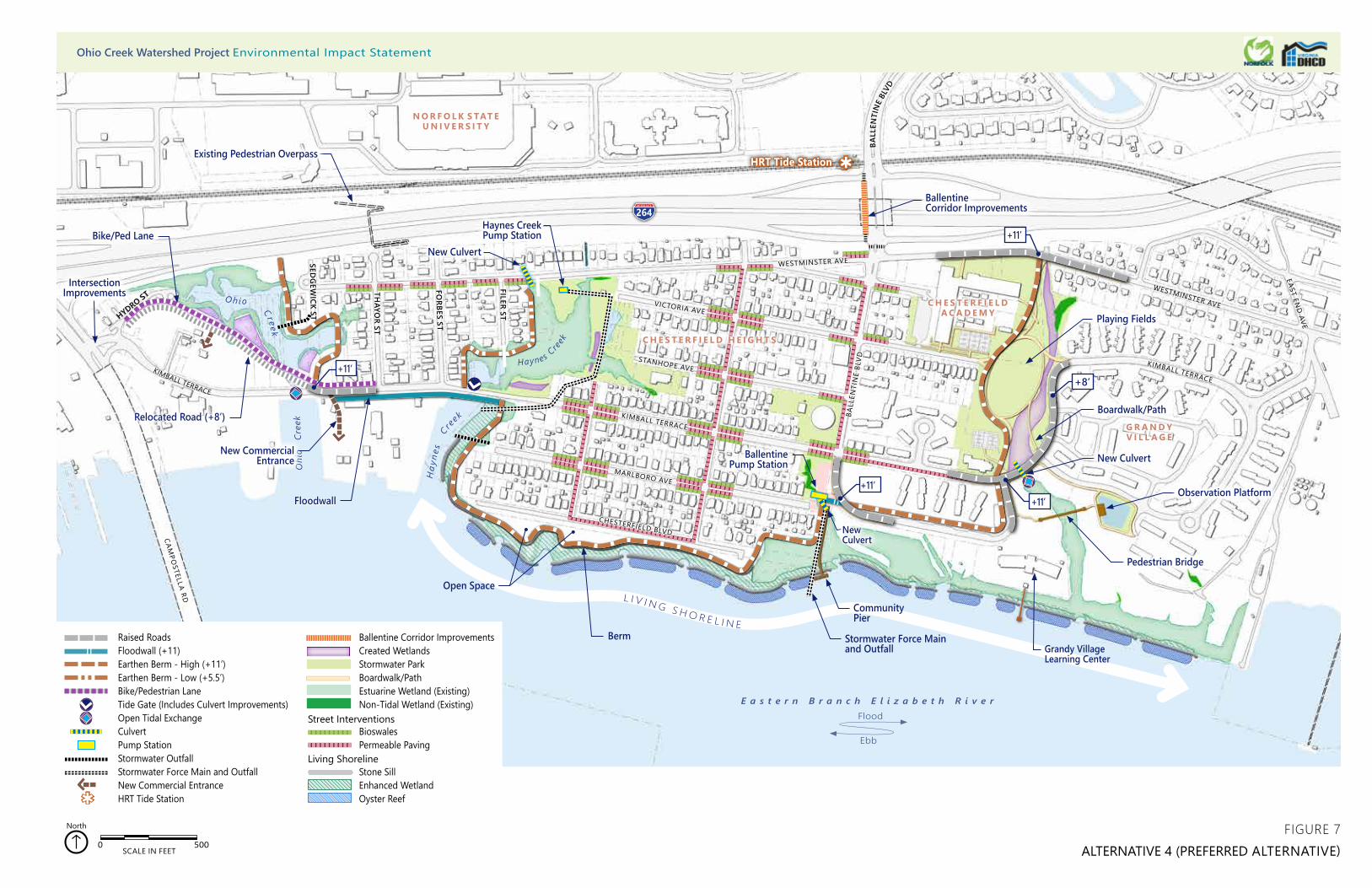
HRT Tide Station
HYDRO ST
BALL
ENTI
NE
BLVD
FILER ST
FORBES ST
THAYO
R ST
SEDG
EWICK STHYDRO ST
EAST END
AVE
264Haynes Creek Pump Station
CulvertStormwater OutfallStormwater Force main and OutfallPump StationBoardwalk/Path
BioswalesPermeable PavingCorner Street Basin
Raised RoadsFloodwall (+11)Earthen Berm - High (+11’)Earthen Berm - Low (+5.5’)Bike/Pedestrian LaneTide Gate (Includes Culvert Improvements)Open Tidal ExchangeCulvertPump StationStormwater OutfallStormwater Force Main and OutfallNew Commercial EntranceHRT Tide Station
Ballentine Corridor ImprovementsCreated WetlandsStormwater Park Boardwalk/PathEstuarine Wetland (Existing)Non-Tidal Wetland (Existing)
BioswalesPermeable Paving
Stone SillEnhanced WetlandOyster Reef
Living Shoreline
0 500 1,000250 Feet
0 500 1,000250 Feet
Street Interventions
0 500SCALE IN FEET
North
G R A N D Y V I L L A G E
C H E S T E R F I E L DA C A D E M Y
C H E S T E R F I E L D H E I G H T S
N O R F O L K S TAT E U N I V E R S I T Y
L I V I N G S H O R E L I N E
Oh io Cr eek
H
ayne
s
C re
ek
CAMPO
STELLA RD
CHESTERFIELD BLVD
MARLBORO AVE
KIMBALL TERRACE
STANHOPE AVE
VICTORIA AVE
WESTMINSTER AVE
KIMBALL TERRACE
WESTMINSTER AVE
KIMBALL TERRACE
BALL
ENTI
NE
BLVD
O
hio
Cre
ek
Haynes C
reek
Floodwall
Stormwater Force Main and Outfall
Berm
Intersection Improvements
Bike/Ped Lane
Relocated Road (+8’)
New Commercial Entrance New CulvertBallentine
Pump Station
Boardwalk/Path
Pedestrian Bridge
Observation Platform
Ballentine Corridor Improvements
+11’
+8’
+11’
+11’
New Culvert
Existing Pedestrian Overpass
New Culvert
Grandy Village Learning Center
Community Pier
FIGURE 7ALTERNATIVE 4 (PREFERRED ALTERNATIVE)
+11’
Playing Fields
Open Space
E a s t e r n B r a n c h E l i z a b e t h R i v e r
Ebb
Flood
Ohio Creek Watershed Project Environmental Impact Statement

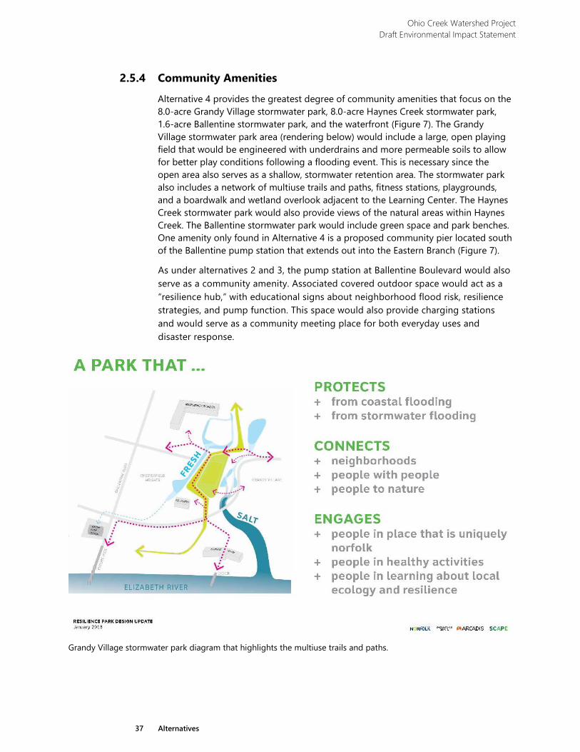
Ohio Creek Watershed Project Draft Environmental Impact Statement
37 Alternatives
2.5.4 Community Amenities
Alternative 4 provides the greatest degree of community amenities that focus on the 8.0-acre Grandy Village stormwater park, 8.0-acre Haynes Creek stormwater park, 1.6-acre Ballentine stormwater park, and the waterfront (Figure 7). The Grandy Village stormwater park area (rendering below) would include a large, open playing field that would be engineered with underdrains and more permeable soils to allow for better play conditions following a flooding event. This is necessary since the open area also serves as a shallow, stormwater retention area. The stormwater park also includes a network of multiuse trails and paths, fitness stations, playgrounds, and a boardwalk and wetland overlook adjacent to the Learning Center. The Haynes Creek stormwater park would also provide views of the natural areas within Haynes Creek. The Ballentine stormwater park would include green space and park benches. One amenity only found in Alternative 4 is a proposed community pier located south of the Ballentine pump station that extends out into the Eastern Branch (Figure 7).
As under alternatives 2 and 3, the pump station at Ballentine Boulevard would also serve as a community amenity. Associated covered outdoor space would act as a “resilience hub,” with educational signs about neighborhood flood risk, resilience strategies, and pump function. This space would also provide charging stations and would serve as a community meeting place for both everyday uses and disaster response.
Grandy Village stormwater park diagram that highlights the multiuse trails and paths.
Ohio Creek Watershed Project Draft Environmental Impact Statement
38 Alternatives
2.5.5 Property Acquisitions and Easements
Alternative 4 would require land acquisition of five parcels along Marlboro Lane, Jacob Street, Sedgewick Street, and Ohio Creek; two parcels are vacant land and three parcels have residential use. Structures on the parcels acquired would be demolished. Permanent or temporary easements on 47 properties would be required for utility installations; construction of floodwalls or earthen berms; created wetlands; grading activities; or construction access.
2.6 Mitigation To prevent and minimize potential adverse impacts associated with the preferred alternative, best management practices (BMPs) and mitigation measures would be implemented during the construction and post-construction phases of the project. General and resource specific BMPs and mitigation measures are listed below. This list is not all-inclusive, as additional mitigation measures would be included in the contractor’s specifications. Furthermore, the state and federal permits that would be required before this project proceeds with construction typically include a variety of conditions specifically related to the protection of water quality and natural resources from additional construction-related impacts (see “Chapter 4: Consultation and Coordination”). Mitigation measures provided below are organized by impact topic.
2.6.1 General Public › Under normal circumstances, work activities would be confined to
weekday business hours. › Ingress/egress to each residential property would be maintained
throughout the construction period, including emergency response operations.
› Noise levels are regulated by Norfolk city code based on land use. The design team intends to not exceed category standards by more than 10 decibels.
› A Construction Vibration Control Plan would be prepared to identify buildings with an increased risk of structural damage, specify need for pre- and post-construction surveys of the buildings, determine need for and location of crack monitoring and/or construction vibration monitoring, determine acceptable vibration thresholds to minimize risk, and outline the process that contractors would follow to respond to vibration exceedances.
Ohio Creek Watershed Project Draft Environmental Impact Statement
39 Alternatives
2.6.2 Coastal Resource and Soils, Wetland Resources, and Wildlife Habitat
› All unimpacted resource areas will be clearly marked prior to any construction related activity.
› Equipment use in vegetated wetland areas would be avoided to the greatest extent possible. Mats would be used to minimize impacts where avoidance is not possible, or other measures would be taken to minimize root disturbance and to preserve preconstruction elevations.
› A contractor kickoff meeting would be held to ensure that all workers are apprised of proper protocol to follow in the event of an emergency, including contact information for first responders.
› Appropriate measures would be employed to prevent or control spills of fuels, lubricants, or other contaminants from entering stormwater systems, waterways, or wetlands. These include safe handling and refueling procedures and proper deployment of containment measures such as oil booms. Actions would be consistent with state water quality standards and Clean Water Act of 1972 (CWA) Section 401 certifications and Section 404 permitting requirements. A hazardous spill plan would be approved by the city prior to construction. This plan would state what actions would be taken in the case of a spill, notification measures, and preventive measures to be implemented, such as the placement of refueling facilities, storage and handling of hazardous materials, etc.
› Regulations require that a Stormwater Pollution Prevention Plan (SWPPP) must be prepared prior to submitting a registration statement for permit coverage under the Virginia Stormwater Management Permit.
› During the design phase, the city would prepare and implement Erosion and Sediment Control Plans that comply with the Virginia Erosion and Sediment Control Law. The city would be responsible for overseeing on-site contractors, conducting regular field inspections, and taking prompt action against non-compliance, if necessary. Appropriate erosion and siltation controls would be maintained during construction, and all exposed soil or fill material would be permanently stabilized at the earliest practicable date.
› BMPs for drainage and sediment control would be implemented to prevent or reduce nonpoint source pollution and minimize soil loss and sedimentation in drainage areas. BMPs would include all or some of the following actions, depending on site-specific requirements:
• Disturbed areas would be kept as small as possible to minimize exposed soil and the potential for erosion;
• Regular site inspections would occur during construction to ensure that erosion-control measures were properly installed and are functioning effectively.
Ohio Creek Watershed Project Draft Environmental Impact Statement
40 Alternatives
› Should high wave and water conditions be forecasted, equipment would be moved to a safe location within the work zone or to another location outside the work zone.
2.6.3 Vegetation › Where plantings or seeding are required, native plant material would be
obtained and used in accordance with local, state, and federal policies and guidance.
› Management techniques would be implemented to foster rapid development of target native plant communities and to eliminate invasion by exotic or other undesirable species. Techniques may include the use of hydroseeding and a tackifier (to ensure seeds remain in place), plant inspection at delivery and before installation to ensure plant health, plant installation during appropriate planting windows and with due regard for tide forecasts, and inspection of installed plants. Planted areas would be monitored after construction to determine if efforts are successful or if plant mortality warrants replanting and controlling non-native plant species.
› Trees impacted within the CBPA will be replaced in accordance with the City’s CBPA Guidance Document to the greatest extent practicable.
› Trees impacted within the City right-of-way will be replaced following guidance from the City arborist to the greatest extent practicable.
2.6.4 Special Status Species › The city would coordinate with the Virginia Marine Resources
Commission (VMRC), National Oceanic and Atmospheric Administration (NOAA), and US Fish and Wildlife Service (USFWS) regarding any need for a time-of-year restriction on in-water construction activities in observance of anadromous fish. Anadromous fish use is typically noted as February 15 to June 30 (VMRC 2018).
2.6.5 Archaeological Resources › The city would make available cultural resources staff during
construction to advise or take appropriate actions should any archeological resources be uncovered during construction.
› If during construction previously undiscovered archeological resources were uncovered, all work in the immediate vicinity of the discovery would be halted and the procedures for unanticipated discoveries outlined in the Programmatic Agreement that will be developed with the State Historic Preservation Officer (SHPO) would be implemented. Construction may proceed only after the city staff has determined that implementation of the actions undertaken to address the discovery are complete.
Ohio Creek Watershed Project Draft Environmental Impact Statement
41 Alternatives
› The city would ensure that all contractors and subcontractors are informed of the penalties for illegally collecting artifacts or intentionally damaging archeological sites or historic properties. Contractors and subcontractors also would be instructed on procedures to follow in the case that previously unknown archeological resources are uncovered during construction.
2.7 Alternative Elements Considered but Dismissed Several alternative elements were identified during the initial design process that were later determined to be unreasonable or much less desirable than similar options retained within the reasonable range of alternatives described above. These elements were therefore not carried forward for analysis in this Draft Environmental Impact Statement (DEIS). Table 1 outlines the alternative elements that were considered but dismissed from further analysis and the rationale behind the dismissal.
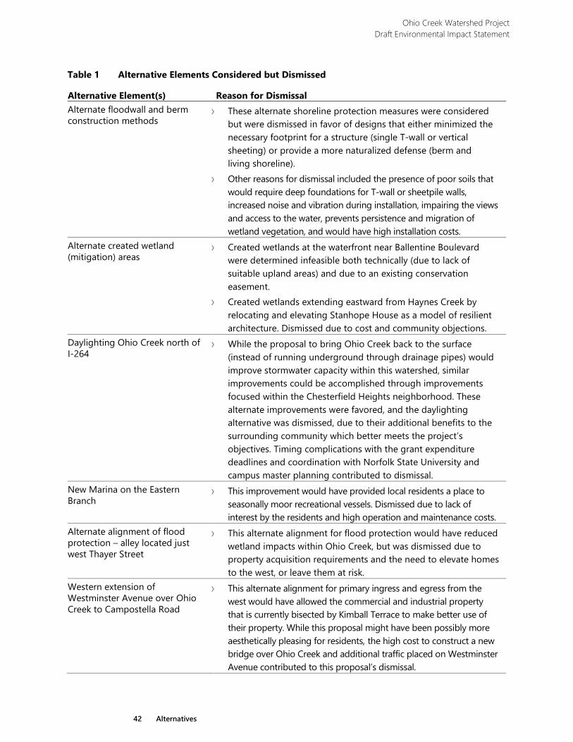
Ohio Creek Watershed Project Draft Environmental Impact Statement
42 Alternatives
Table 1 Alternative Elements Considered but Dismissed
Alternative Element(s) Reason for Dismissal Alternate floodwall and berm construction methods
› These alternate shoreline protection measures were considered but were dismissed in favor of designs that either minimized the necessary footprint for a structure (single T-wall or vertical sheeting) or provide a more naturalized defense (berm and living shoreline).
› Other reasons for dismissal included the presence of poor soils that would require deep foundations for T-wall or sheetpile walls, increased noise and vibration during installation, impairing the views and access to the water, prevents persistence and migration of wetland vegetation, and would have high installation costs.
Alternate created wetland (mitigation) areas
› Created wetlands at the waterfront near Ballentine Boulevard were determined infeasible both technically (due to lack of suitable upland areas) and due to an existing conservation easement.
› Created wetlands extending eastward from Haynes Creek by relocating and elevating Stanhope House as a model of resilient architecture. Dismissed due to cost and community objections.
Daylighting Ohio Creek north of I-264
› While the proposal to bring Ohio Creek back to the surface (instead of running underground through drainage pipes) would improve stormwater capacity within this watershed, similar improvements could be accomplished through improvements focused within the Chesterfield Heights neighborhood. These alternate improvements were favored, and the daylighting alternative was dismissed, due to their additional benefits to the surrounding community which better meets the project’s objectives. Timing complications with the grant expenditure deadlines and coordination with Norfolk State University and campus master planning contributed to dismissal.
New Marina on the Eastern Branch
› This improvement would have provided local residents a place to seasonally moor recreational vessels. Dismissed due to lack of interest by the residents and high operation and maintenance costs.
Alternate alignment of flood protection – alley located just west Thayer Street
› This alternate alignment for flood protection would have reduced wetland impacts within Ohio Creek, but was dismissed due to property acquisition requirements and the need to elevate homes to the west, or leave them at risk.
Western extension of Westminster Avenue over Ohio Creek to Campostella Road
› This alternate alignment for primary ingress and egress from the west would have allowed the commercial and industrial property that is currently bisected by Kimball Terrace to make better use of their property. While this proposal might have been possibly more aesthetically pleasing for residents, the high cost to construct a new bridge over Ohio Creek and additional traffic placed on Westminster Avenue contributed to this proposal’s dismissal.
Ohio Creek Watershed Project Draft Environmental Impact Statement
43 Alternatives
2.8 Summary of Alternatives and Environmental Consequences Table 2 below provides a side-by-side summary of some of the defining elements of the alternatives. Table 3 provides a high-level summary of impacts on the resources within the project area. More detail on the environmental consequences of the alternatives is included in Chapter 3 of this document. Table 4 summarizes how each alternative does or does not meet the project objectives as described in Chapter 1.

Ohio Creek Watershed Project Draft Environmental Impact Statement
44 Alternatives
This page intentionally left blank.
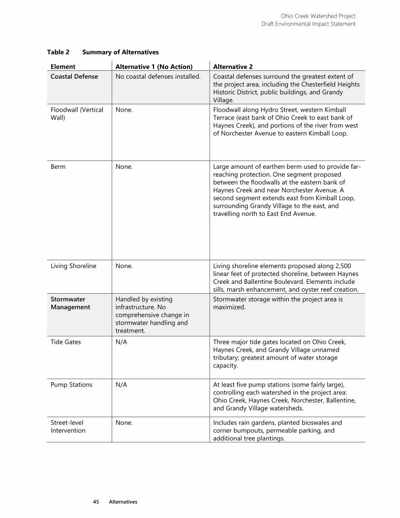
Ohio Creek Watershed Project Draft Environmental Impact Statement
45 Alternatives
Table 2 Summary of Alternatives
Element Alternative 1 (No Action) Alternative 2 Coastal Defense No coastal defenses installed. Coastal defenses surround the greatest extent of
the project area, including the Chesterfield Heights Historic District, public buildings, and Grandy Village.
Floodwall (Vertical Wall)
None. Floodwall along Hydro Street, western Kimball Terrace (east bank of Ohio Creek to east bank of Haynes Creek), and portions of the river from west of Norchester Avenue to eastern Kimball Loop.
Berm None. Large amount of earthen berm used to provide far-reaching protection. One segment proposed between the floodwalls at the eastern bank of Haynes Creek and near Norchester Avenue. A second segment extends east from Kimball Loop, surrounding Grandy Village to the east, and travelling north to East End Avenue.
Living Shoreline None. Living shoreline elements proposed along 2,500 linear feet of protected shoreline, between Haynes Creek and Ballentine Boulevard. Elements include sills, marsh enhancement, and oyster reef creation.
Stormwater Management
Handled by existing infrastructure. No comprehensive change in stormwater handling and treatment.
Stormwater storage within the project area is maximized.
Tide Gates N/A Three major tide gates located on Ohio Creek, Haynes Creek, and Grandy Village unnamed tributary; greatest amount of water storage capacity.
Pump Stations N/A At least five pump stations (some fairly large), controlling each watershed in the project area: Ohio Creek, Haynes Creek, Norchester, Ballentine, and Grandy Village watersheds.
Street-level Intervention
None. Includes rain gardens, planted bioswales and corner bumpouts, permeable parking, and additional tree plantings.
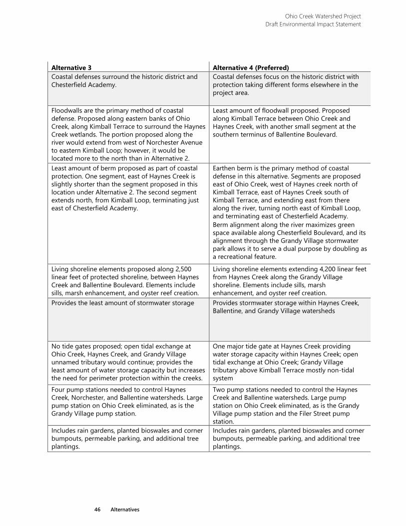
Ohio Creek Watershed Project Draft Environmental Impact Statement
46 Alternatives
Alternative 3 Alternative 4 (Preferred) Coastal defenses surround the historic district and Chesterfield Academy.
Coastal defenses focus on the historic district with protection taking different forms elsewhere in the project area.
Floodwalls are the primary method of coastal defense. Proposed along eastern banks of Ohio Creek, along Kimball Terrace to surround the Haynes Creek wetlands. The portion proposed along the river would extend from west of Norchester Avenue to eastern Kimball Loop; however, it would be located more to the north than in Alternative 2.
Least amount of floodwall proposed. Proposed along Kimball Terrace between Ohio Creek and Haynes Creek, with another small segment at the southern terminus of Ballentine Boulevard.
Least amount of berm proposed as part of coastal protection. One segment, east of Haynes Creek is slightly shorter than the segment proposed in this location under Alternative 2. The second segment extends north, from Kimball Loop, terminating just east of Chesterfield Academy.
Earthen berm is the primary method of coastal defense in this alternative. Segments are proposed east of Ohio Creek, west of Haynes creek north of Kimball Terrace, east of Haynes Creek south of Kimball Terrace, and extending east from there along the river, turning north east of Kimball Loop, and terminating east of Chesterfield Academy. Berm alignment along the river maximizes green space available along Chesterfield Boulevard, and its alignment through the Grandy Village stormwater park allows it to serve a dual purpose by doubling as a recreational feature.
Living shoreline elements proposed along 2,500 linear feet of protected shoreline, between Haynes Creek and Ballentine Boulevard. Elements include sills, marsh enhancement, and oyster reef creation.
Living shoreline elements extending 4,200 linear feet from Haynes Creek along the Grandy Village shoreline. Elements include sills, marsh enhancement, and oyster reef creation.
Provides the least amount of stormwater storage Provides stormwater storage within Haynes Creek, Ballentine, and Grandy Village watersheds
No tide gates proposed; open tidal exchange at Ohio Creek, Haynes Creek, and Grandy Village unnamed tributary would continue; provides the least amount of water storage capacity but increases the need for perimeter protection within the creeks.
One major tide gate at Haynes Creek providing water storage capacity within Haynes Creek; open tidal exchange at Ohio Creek; Grandy Village tributary above Kimball Terrace mostly non-tidal system
Four pump stations needed to control Haynes Creek, Norchester, and Ballentine watersheds. Large pump station on Ohio Creek eliminated, as is the Grandy Village pump station.
Two pump stations needed to control the Haynes Creek and Ballentine watersheds. Large pump station on Ohio Creek eliminated, as is the Grandy Village pump station and the Filer Street pump station.
Includes rain gardens, planted bioswales and corner bumpouts, permeable parking, and additional tree plantings.
Includes rain gardens, planted bioswales and corner bumpouts, permeable parking, and additional tree plantings.
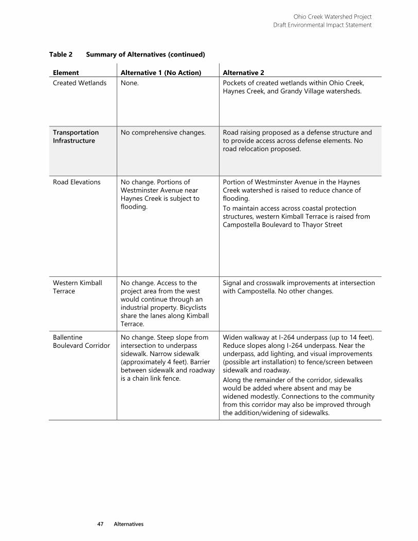
Ohio Creek Watershed Project Draft Environmental Impact Statement
47 Alternatives
Table 2 Summary of Alternatives (continued)
Element Alternative 1 (No Action) Alternative 2 Created Wetlands None. Pockets of created wetlands within Ohio Creek,
Haynes Creek, and Grandy Village watersheds.
Transportation Infrastructure
No comprehensive changes. Road raising proposed as a defense structure and to provide access across defense elements. No road relocation proposed.
Road Elevations No change. Portions of Westminster Avenue near Haynes Creek is subject to flooding.
Portion of Westminster Avenue in the Haynes Creek watershed is raised to reduce chance of flooding. To maintain access across coastal protection structures, western Kimball Terrace is raised from Campostella Boulevard to Thayor Street
Western Kimball Terrace
No change. Access to the project area from the west would continue through an industrial property. Bicyclists share the lanes along Kimball Terrace.
Signal and crosswalk improvements at intersection with Campostella. No other changes.
Ballentine Boulevard Corridor
No change. Steep slope from intersection to underpass sidewalk. Narrow sidewalk (approximately 4 feet). Barrier between sidewalk and roadway is a chain link fence.
Widen walkway at I-264 underpass (up to 14 feet). Reduce slopes along I-264 underpass. Near the underpass, add lighting, and visual improvements (possible art installation) to fence/screen between sidewalk and roadway. Along the remainder of the corridor, sidewalks would be added where absent and may be widened modestly. Connections to the community from this corridor may also be improved through the addition/widening of sidewalks.
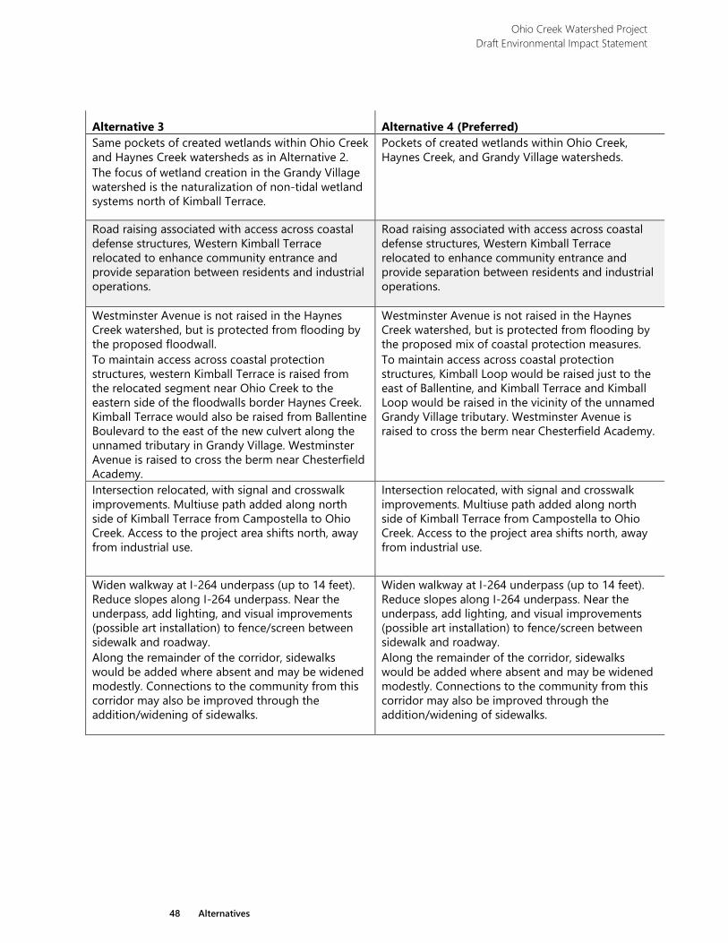
Ohio Creek Watershed Project Draft Environmental Impact Statement
48 Alternatives
Alternative 3 Alternative 4 (Preferred) Same pockets of created wetlands within Ohio Creek and Haynes Creek watersheds as in Alternative 2. The focus of wetland creation in the Grandy Village watershed is the naturalization of non-tidal wetland systems north of Kimball Terrace.
Pockets of created wetlands within Ohio Creek, Haynes Creek, and Grandy Village watersheds.
Road raising associated with access across coastal defense structures, Western Kimball Terrace relocated to enhance community entrance and provide separation between residents and industrial operations.
Road raising associated with access across coastal defense structures, Western Kimball Terrace relocated to enhance community entrance and provide separation between residents and industrial operations.
Westminster Avenue is not raised in the Haynes Creek watershed, but is protected from flooding by the proposed floodwall. To maintain access across coastal protection structures, western Kimball Terrace is raised from the relocated segment near Ohio Creek to the eastern side of the floodwalls border Haynes Creek. Kimball Terrace would also be raised from Ballentine Boulevard to the east of the new culvert along the unnamed tributary in Grandy Village. Westminster Avenue is raised to cross the berm near Chesterfield Academy.
Westminster Avenue is not raised in the Haynes Creek watershed, but is protected from flooding by the proposed mix of coastal protection measures. To maintain access across coastal protection structures, Kimball Loop would be raised just to the east of Ballentine, and Kimball Terrace and Kimball Loop would be raised in the vicinity of the unnamed Grandy Village tributary. Westminster Avenue is raised to cross the berm near Chesterfield Academy.
Intersection relocated, with signal and crosswalk improvements. Multiuse path added along north side of Kimball Terrace from Campostella to Ohio Creek. Access to the project area shifts north, away from industrial use.
Intersection relocated, with signal and crosswalk improvements. Multiuse path added along north side of Kimball Terrace from Campostella to Ohio Creek. Access to the project area shifts north, away from industrial use.
Widen walkway at I-264 underpass (up to 14 feet). Reduce slopes along I-264 underpass. Near the underpass, add lighting, and visual improvements (possible art installation) to fence/screen between sidewalk and roadway. Along the remainder of the corridor, sidewalks would be added where absent and may be widened modestly. Connections to the community from this corridor may also be improved through the addition/widening of sidewalks.
Widen walkway at I-264 underpass (up to 14 feet). Reduce slopes along I-264 underpass. Near the underpass, add lighting, and visual improvements (possible art installation) to fence/screen between sidewalk and roadway. Along the remainder of the corridor, sidewalks would be added where absent and may be widened modestly. Connections to the community from this corridor may also be improved through the addition/widening of sidewalks.
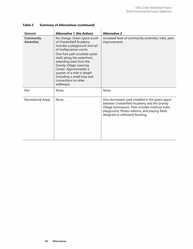
Ohio Creek Watershed Project Draft Environmental Impact Statement
49 Alternatives
Table 2 Summary of Alternatives (continued)
Element Alternative 1 (No Action) Alternative 2 Community Amenities
No change. Green space south of Chesterfield Academy includes a playground and set of multipurpose courts. One foot path (crushed oyster shell) along the waterfront, extending west from the Grandy Village Learning Center. Approximately a quarter of a mile in length (including a small loop and connections to other walkways).
Increased level of community amenities, trails, park improvements
Pier None. None.
Recreational Areas
None. One stormwater park installed in the green space between Chesterfield Academy and the Grandy Village Gymnasium. Park includes multiuse trails, playground, fitness stations, and playing fields designed to withstand flooding.
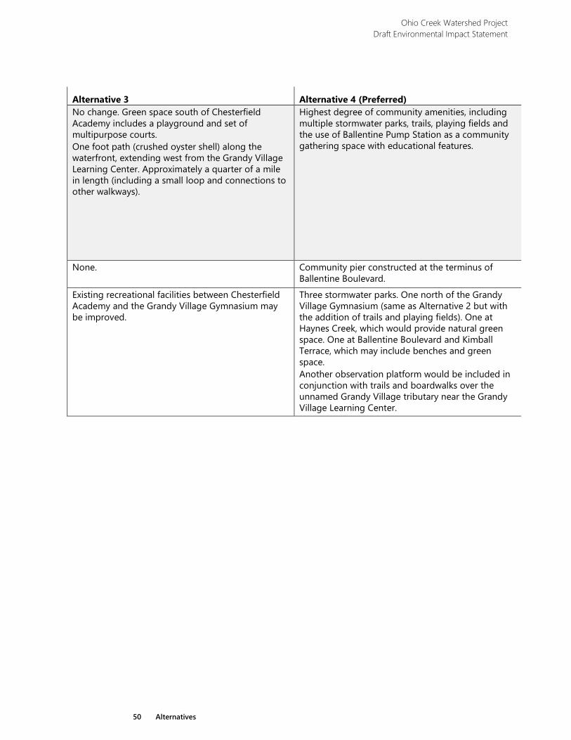
Ohio Creek Watershed Project Draft Environmental Impact Statement
50 Alternatives
Alternative 3 Alternative 4 (Preferred) No change. Green space south of Chesterfield Academy includes a playground and set of multipurpose courts. One foot path (crushed oyster shell) along the waterfront, extending west from the Grandy Village Learning Center. Approximately a quarter of a mile in length (including a small loop and connections to other walkways).
Highest degree of community amenities, including multiple stormwater parks, trails, playing fields and the use of Ballentine Pump Station as a community gathering space with educational features.
None. Community pier constructed at the terminus of Ballentine Boulevard.
Existing recreational facilities between Chesterfield Academy and the Grandy Village Gymnasium may be improved.
Three stormwater parks. One north of the Grandy Village Gymnasium (same as Alternative 2 but with the addition of trails and playing fields). One at Haynes Creek, which would provide natural green space. One at Ballentine Boulevard and Kimball Terrace, which may include benches and green space. Another observation platform would be included in conjunction with trails and boardwalks over the unnamed Grandy Village tributary near the Grandy Village Learning Center.
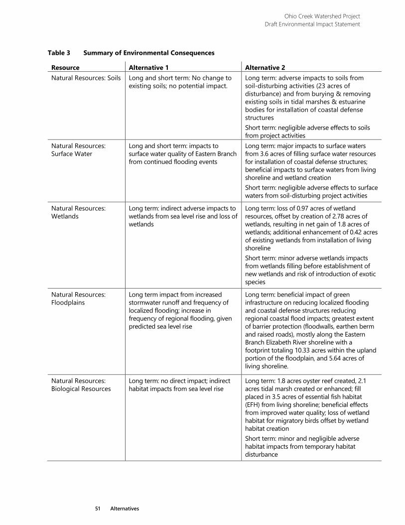
Ohio Creek Watershed Project Draft Environmental Impact Statement
51 Alternatives
Table 3 Summary of Environmental Consequences
Resource Alternative 1 Alternative 2 Natural Resources: Soils Long and short term: No change to
existing soils; no potential impact.
Long term: adverse impacts to soils from soil-disturbing activities (23 acres of disturbance) and from burying & removing existing soils in tidal marshes & estuarine bodies for installation of coastal defense structures Short term: negligible adverse effects to soils from project activities
Natural Resources: Surface Water
Long and short term: impacts to surface water quality of Eastern Branch from continued flooding events
Long term: major impacts to surface waters from 3.6 acres of filling surface water resources for installation of coastal defense structures; beneficial impacts to surface waters from living shoreline and wetland creation Short term: negligible adverse effects to surface waters from soil-disturbing project activities
Natural Resources: Wetlands
Long term: indirect adverse impacts to wetlands from sea level rise and loss of wetlands
Long term: loss of 0.97 acres of wetland resources, offset by creation of 2.78 acres of wetlands, resulting in net gain of 1.8 acres of wetlands; additional enhancement of 0.42 acres of existing wetlands from installation of living shoreline Short term: minor adverse wetlands impacts from wetlands filling before establishment of new wetlands and risk of introduction of exotic species
Natural Resources: Floodplains
Long term impact from increased stormwater runoff and frequency of localized flooding; increase in frequency of regional flooding, given predicted sea level rise
Long term: beneficial impact of green infrastructure on reducing localized flooding and coastal defense structures reducing regional coastal flood impacts; greatest extent of barrier protection (floodwalls, earthen berm and raised roads), mostly along the Eastern Branch Elizabeth River shoreline with a footprint totaling 10.33 acres within the upland portion of the floodplain, and 5.64 acres of living shoreline.
Natural Resources: Biological Resources
Long term: no direct impact; indirect habitat impacts from sea level rise
Long term: 1.8 acres oyster reef created, 2.1 acres tidal marsh created or enhanced; fill placed in 3.5 acres of essential fish habitat (EFH) from living shoreline; beneficial effects from improved water quality; loss of wetland habitat for migratory birds offset by wetland habitat creation Short term: minor and negligible adverse habitat impacts from temporary habitat disturbance
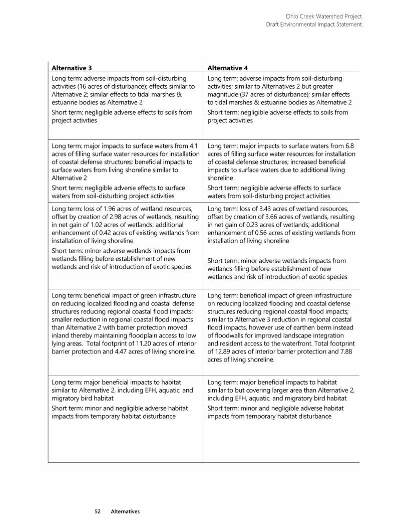
Ohio Creek Watershed Project Draft Environmental Impact Statement
52 Alternatives
Alternative 3 Alternative 4 Long term: adverse impacts from soil-disturbing activities (16 acres of disturbance); effects similar to Alternative 2; similar effects to tidal marshes & estuarine bodies as Alternative 2 Short term: negligible adverse effects to soils from project activities
Long term: adverse impacts from soil-disturbing activities; similar to Alternatives 2 but greater magnitude (37 acres of disturbance); similar effects to tidal marshes & estuarine bodies as Alternative 2 Short term: negligible adverse effects to soils from project activities
Long term: major impacts to surface waters from 4.1 acres of filling surface water resources for installation of coastal defense structures; beneficial impacts to surface waters from living shoreline similar to Alternative 2 Short term: negligible adverse effects to surface waters from soil-disturbing project activities
Long term: major impacts to surface waters from 6.8 acres of filling surface water resources for installation of coastal defense structures; increased beneficial impacts to surface waters due to additional living shoreline Short term: negligible adverse effects to surface waters from soil-disturbing project activities
Long term: loss of 1.96 acres of wetland resources, offset by creation of 2.98 acres of wetlands, resulting in net gain of 1.02 acres of wetlands; additional enhancement of 0.42 acres of existing wetlands from installation of living shoreline Short term: minor adverse wetlands impacts from wetlands filling before establishment of new wetlands and risk of introduction of exotic species
Long term: loss of 3.43 acres of wetland resources, offset by creation of 3.66 acres of wetlands, resulting in net gain of 0.23 acres of wetlands; additional enhancement of 0.56 acres of existing wetlands from installation of living shoreline Short term: minor adverse wetlands impacts from wetlands filling before establishment of new wetlands and risk of introduction of exotic species
Long term: beneficial impact of green infrastructure on reducing localized flooding and coastal defense structures reducing regional coastal flood impacts; smaller reduction in regional coastal flood impacts than Alternative 2 with barrier protection moved inland thereby maintaining floodplain access to low lying areas. Total footprint of 11.20 acres of interior barrier protection and 4.47 acres of living shoreline.
Long term: beneficial impact of green infrastructure on reducing localized flooding and coastal defense structures reducing regional coastal flood impacts; similar to Alternative 3 reduction in regional coastal flood impacts, however use of earthen berm instead of floodwalls for improved landscape integration and resident access to the waterfront. Total footprint of 12.89 acres of interior barrier protection and 7.88 acres of living shoreline.
Long term: major beneficial impacts to habitat similar to Alternative 2, including EFH, aquatic, and migratory bird habitat Short term: minor and negligible adverse habitat impacts from temporary habitat disturbance
Long term: major beneficial impacts to habitat similar to but covering larger area than Alternative 2, including EFH, aquatic, and migratory bird habitat Short term: minor and negligible adverse habitat impacts from temporary habitat disturbance
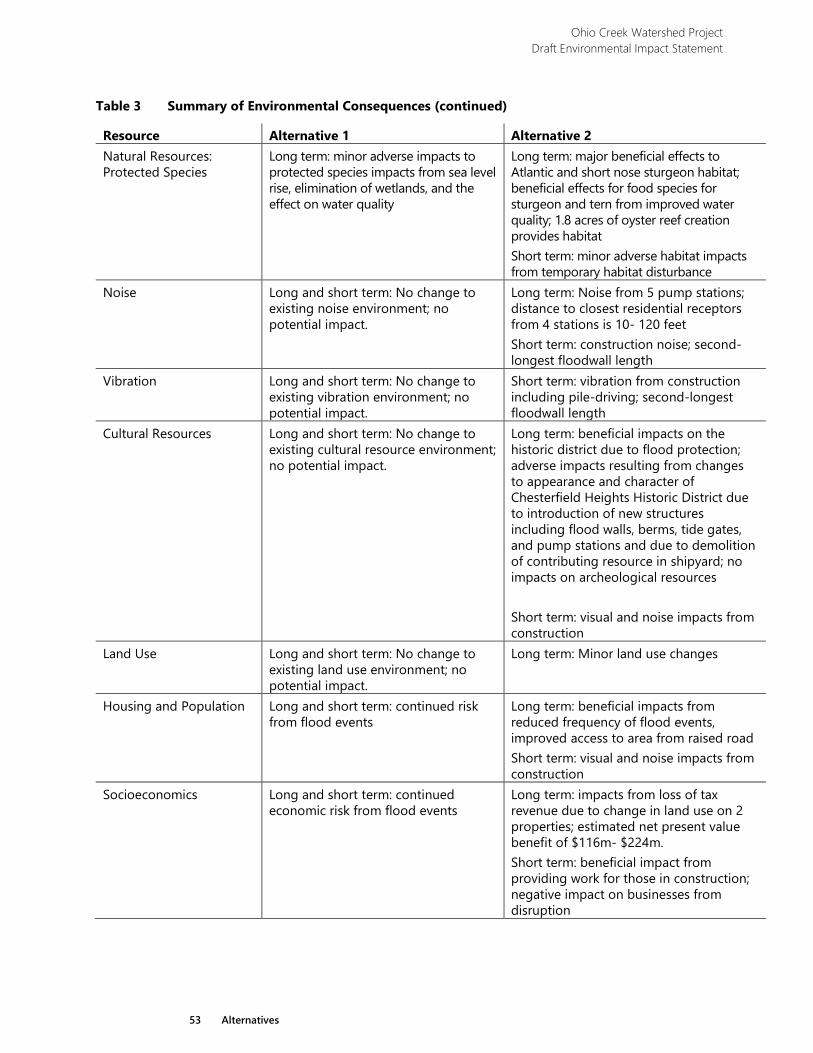
Ohio Creek Watershed Project Draft Environmental Impact Statement
53 Alternatives
Table 3 Summary of Environmental Consequences (continued)
Resource Alternative 1 Alternative 2 Natural Resources: Protected Species
Long term: minor adverse impacts to protected species impacts from sea level rise, elimination of wetlands, and the effect on water quality
Long term: major beneficial effects to Atlantic and short nose sturgeon habitat; beneficial effects for food species for sturgeon and tern from improved water quality; 1.8 acres of oyster reef creation provides habitat Short term: minor adverse habitat impacts from temporary habitat disturbance
Noise Long and short term: No change to existing noise environment; no potential impact.
Long term: Noise from 5 pump stations; distance to closest residential receptors from 4 stations is 10- 120 feet Short term: construction noise; second-longest floodwall length
Vibration Long and short term: No change to existing vibration environment; no potential impact.
Short term: vibration from construction including pile-driving; second-longest floodwall length
Cultural Resources
Long and short term: No change to existing cultural resource environment; no potential impact.
Long term: beneficial impacts on the historic district due to flood protection; adverse impacts resulting from changes to appearance and character of Chesterfield Heights Historic District due to introduction of new structures including flood walls, berms, tide gates, and pump stations and due to demolition of contributing resource in shipyard; no impacts on archeological resources Short term: visual and noise impacts from construction
Land Use Long and short term: No change to existing land use environment; no potential impact.
Long term: Minor land use changes
Housing and Population Long and short term: continued risk from flood events
Long term: beneficial impacts from reduced frequency of flood events, improved access to area from raised road Short term: visual and noise impacts from construction
Socioeconomics Long and short term: continued economic risk from flood events
Long term: impacts from loss of tax revenue due to change in land use on 2 properties; estimated net present value benefit of $116m- $224m. Short term: beneficial impact from providing work for those in construction; negative impact on businesses from disruption
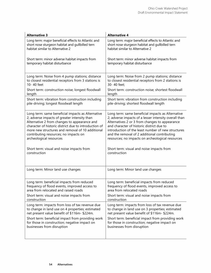
Ohio Creek Watershed Project Draft Environmental Impact Statement
54 Alternatives
Alternative 3 Alternative 4 Long term: major beneficial effects to Atlantic and short nose sturgeon habitat and gullbilled tern habitat similar to Alternative 2 Short term: minor adverse habitat impacts from temporary habitat disturbance
Long term: major beneficial effects to Atlantic and short nose sturgeon habitat and gullbilled tern habitat similar to Alternative 2 Short term: minor adverse habitat impacts from temporary habitat disturbance
Long term: Noise from 4 pump stations; distance to closest residential receptors from 3 stations is 10- 40 feet Short term: construction noise; longest floodwall length
Long term: Noise from 2 pump stations; distance to closest residential receptors from 2 stations is 30- 40 feet; Short term: construction noise; shortest floodwall length
Short term: vibration from construction including pile-driving; longest floodwall length
Short term: vibration from construction including pile-driving; shortest floodwall length
Long term: same beneficial impacts as Alternative 2; adverse impacts of greater intensity than Alternative 2 from changes to appearance and character of historic district due to introduction of more new structures and removal of 10 additional contributing resources; no impacts on archeological resources Short term: visual and noise impacts from construction
Long term: same beneficial impacts as Alternative 2; adverse impacts of a lesser intensity overall than Alternatives 2 or 3 from changes to appearance and character of historic district due to introduction of the least number of new structures and the removal of 2 additional contributing resources; no impacts on archeological resources Short term: visual and noise impacts from construction
Long term: Minor land use changes Long term: Minor land use changes
Long term: beneficial impacts from reduced frequency of flood events, improved access to area from relocated and raised roads Short term: visual and noise impacts from construction
Long term: beneficial impacts from reduced frequency of flood events, improved access to area from relocated roads Short term: visual and noise impacts from construction
Long term: impacts from loss of tax revenue due to change in land use on 4 properties; estimated net present value benefit of $116m- $224m. Short term: beneficial impact from providing work for those in construction; negative impact on businesses from disruption
Long term: impacts from loss of tax revenue due to change in land use on 3 properties; estimated net present value benefit of $116m- $224m. Short term: beneficial impact from providing work for those in construction; negative impact on businesses from disruption
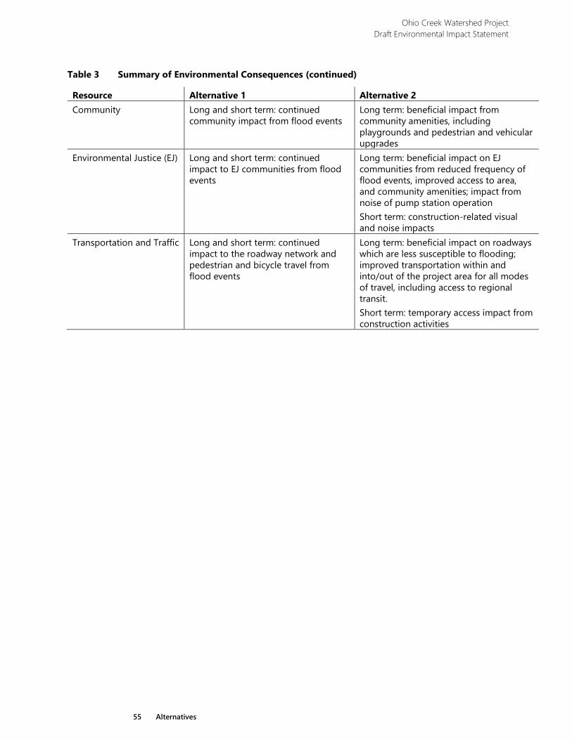
Ohio Creek Watershed Project Draft Environmental Impact Statement
55 Alternatives
Table 3 Summary of Environmental Consequences (continued)
Resource Alternative 1 Alternative 2 Community Long and short term: continued
community impact from flood events Long term: beneficial impact from community amenities, including playgrounds and pedestrian and vehicular upgrades
Environmental Justice (EJ) Long and short term: continued impact to EJ communities from flood events
Long term: beneficial impact on EJ communities from reduced frequency of flood events, improved access to area, and community amenities; impact from noise of pump station operation Short term: construction-related visual and noise impacts
Transportation and Traffic Long and short term: continued impact to the roadway network and pedestrian and bicycle travel from flood events
Long term: beneficial impact on roadways which are less susceptible to flooding; improved transportation within and into/out of the project area for all modes of travel, including access to regional transit. Short term: temporary access impact from construction activities
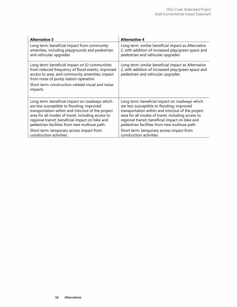
Ohio Creek Watershed Project Draft Environmental Impact Statement
56 Alternatives
Alternative 3 Alternative 4 Long term: beneficial impact from community amenities, including playgrounds and pedestrian and vehicular upgrades
Long term: similar beneficial impact as Alternative 2, with addition of increased play/green space and pedestrian and vehicular upgrades
Long term: beneficial impact on EJ communities from reduced frequency of flood events, improved access to area, and community amenities; impact from noise of pump station operation Short term: construction-related visual and noise impacts
Long term: similar beneficial impact as Alternative 2, with addition of increased play/green space and pedestrian and vehicular upgrades
Long term: beneficial impact on roadways which are less susceptible to flooding; improved transportation within and into/out of the project area for all modes of travel, including access to regional transit; beneficial impact on bike and pedestrian facilities from new multiuse path. Short term: temporary access impact from construction activities
Long term: beneficial impact on roadways which are less susceptible to flooding; improved transportation within and into/out of the project area for all modes of travel, including access to regional transit; beneficial impact on bike and pedestrian facilities from new multiuse path. Short term: temporary access impact from construction activities
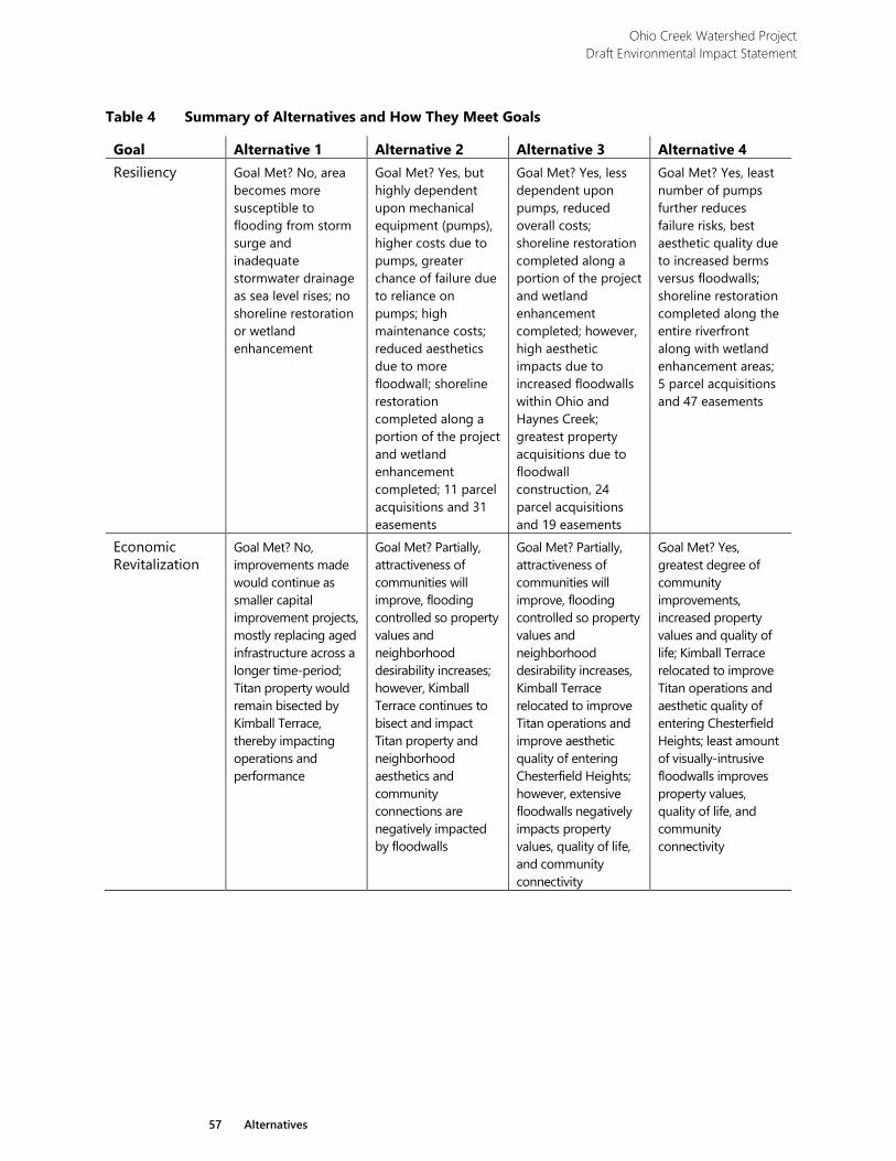
Ohio Creek Watershed Project Draft Environmental Impact Statement
57 Alternatives
Table 4 Summary of Alternatives and How They Meet Goals
Goal Alternative 1 Alternative 2 Alternative 3 Alternative 4 Resiliency Goal Met? No, area
becomes more susceptible to flooding from storm surge and inadequate stormwater drainage as sea level rises; no shoreline restoration or wetland enhancement
Goal Met? Yes, but highly dependent upon mechanical equipment (pumps), higher costs due to pumps, greater chance of failure due to reliance on pumps; high maintenance costs; reduced aesthetics due to more floodwall; shoreline restoration completed along a portion of the project and wetland enhancement completed; 11 parcel acquisitions and 31 easements
Goal Met? Yes, less dependent upon pumps, reduced overall costs; shoreline restoration completed along a portion of the project and wetland enhancement completed; however, high aesthetic impacts due to increased floodwalls within Ohio and Haynes Creek; greatest property acquisitions due to floodwall construction, 24 parcel acquisitions and 19 easements
Goal Met? Yes, least number of pumps further reduces failure risks, best aesthetic quality due to increased berms versus floodwalls; shoreline restoration completed along the entire riverfront along with wetland enhancement areas; 5 parcel acquisitions and 47 easements
Economic Revitalization
Goal Met? No, improvements made would continue as smaller capital improvement projects, mostly replacing aged infrastructure across a longer time-period; Titan property would remain bisected by Kimball Terrace, thereby impacting operations and performance
Goal Met? Partially, attractiveness of communities will improve, flooding controlled so property values and neighborhood desirability increases; however, Kimball Terrace continues to bisect and impact Titan property and neighborhood aesthetics and community connections are negatively impacted by floodwalls
Goal Met? Partially, attractiveness of communities will improve, flooding controlled so property values and neighborhood desirability increases, Kimball Terrace relocated to improve Titan operations and improve aesthetic quality of entering Chesterfield Heights; however, extensive floodwalls negatively impacts property values, quality of life, and community connectivity
Goal Met? Yes, greatest degree of community improvements, increased property values and quality of life; Kimball Terrace relocated to improve Titan operations and aesthetic quality of entering Chesterfield Heights; least amount of visually-intrusive floodwalls improves property values, quality of life, and community connectivity
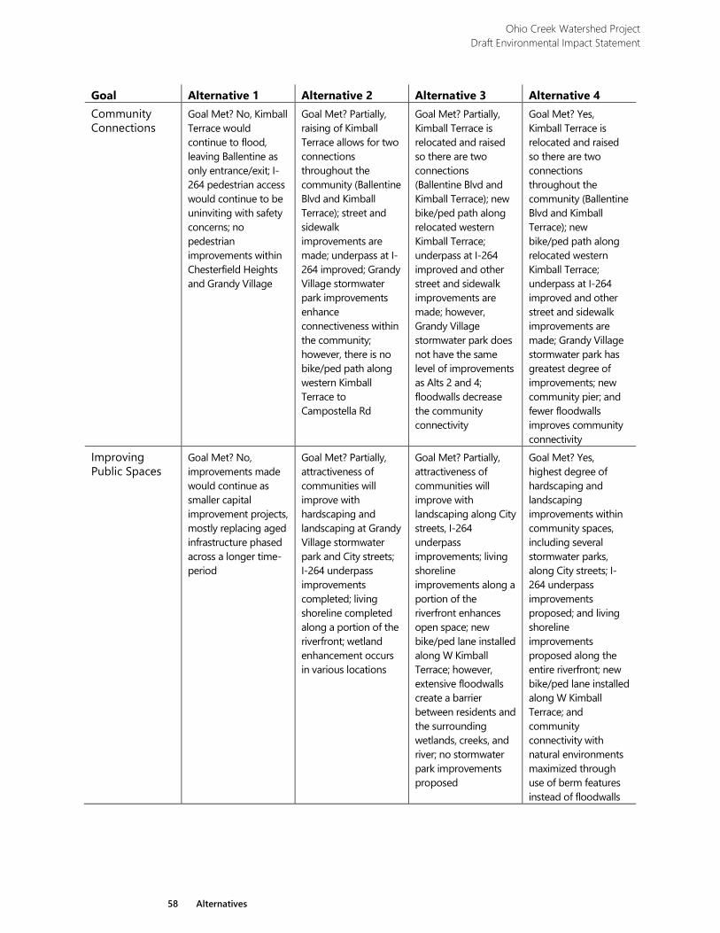
Ohio Creek Watershed Project Draft Environmental Impact Statement
58 Alternatives
Goal Alternative 1 Alternative 2 Alternative 3 Alternative 4 Community Connections
Goal Met? No, Kimball Terrace would continue to flood, leaving Ballentine as only entrance/exit; I-264 pedestrian access would continue to be uninviting with safety concerns; no pedestrian improvements within Chesterfield Heights and Grandy Village
Goal Met? Partially, raising of Kimball Terrace allows for two connections throughout the community (Ballentine Blvd and Kimball Terrace); street and sidewalk improvements are made; underpass at I-264 improved; Grandy Village stormwater park improvements enhance connectiveness within the community; however, there is no bike/ped path along western Kimball Terrace to Campostella Rd
Goal Met? Partially, Kimball Terrace is relocated and raised so there are two connections (Ballentine Blvd and Kimball Terrace); new bike/ped path along relocated western Kimball Terrace; underpass at I-264 improved and other street and sidewalk improvements are made; however, Grandy Village stormwater park does not have the same level of improvements as Alts 2 and 4; floodwalls decrease the community connectivity
Goal Met? Yes, Kimball Terrace is relocated and raised so there are two connections throughout the community (Ballentine Blvd and Kimball Terrace); new bike/ped path along relocated western Kimball Terrace; underpass at I-264 improved and other street and sidewalk improvements are made; Grandy Village stormwater park has greatest degree of improvements; new community pier; and fewer floodwalls improves community connectivity
Improving Public Spaces
Goal Met? No, improvements made would continue as smaller capital improvement projects, mostly replacing aged infrastructure phased across a longer time-period
Goal Met? Partially, attractiveness of communities will improve with hardscaping and landscaping at Grandy Village stormwater park and City streets; I-264 underpass improvements completed; living shoreline completed along a portion of the riverfront; wetland enhancement occurs in various locations
Goal Met? Partially, attractiveness of communities will improve with landscaping along City streets, I-264 underpass improvements; living shoreline improvements along a portion of the riverfront enhances open space; new bike/ped lane installed along W Kimball Terrace; however, extensive floodwalls create a barrier between residents and the surrounding wetlands, creeks, and river; no stormwater park improvements proposed
Goal Met? Yes, highest degree of hardscaping and landscaping improvements within community spaces, including several stormwater parks, along City streets; I-264 underpass improvements proposed; and living shoreline improvements proposed along the entire riverfront; new bike/ped lane installed along W Kimball Terrace; and community connectivity with natural environments maximized through use of berm features instead of floodwalls
Affected Environment and Environmental Consequences
Chapter 3

59 Affected Environment and Environmental Consequences
Affected Environment and Environmental Consequences This chapter describes the current environmental conditions in and surrounding the project as they relate to each impact topic retained for analysis. These conditions serve as a baseline for understanding the resources that could be impacted by implementing the project. This chapter then analyzes the beneficial and adverse impacts that would result from implementing any of the alternatives considered in this Draft Environmental Impact Statement (DEIS). This chapter also includes direct, indirect, and cumulative impacts, as well as the methods used in these analyses. A summary of the environmental consequences for each alternative is provided in Table 3, which can be found at the end of Chapter 2.
3.1 General Methodology In accordance with the Council on Environmental Quality (CEQ) regulations for implementation of the National Environmental Policy Act of 1970 (NEPA), direct, indirect, and cumulative impacts are described under each impact topic (40 CFR 1502.16), and the impacts are assessed in terms of context and intensity (40 CFR 1508.27). Where appropriate, mitigating measures for adverse impacts are also described and incorporated into the evaluation of impacts. The specific methods used to assess impacts for each resource may vary; therefore, these methodologies are described under each impact topic.
Ohio Creek Watershed Project Draft Environmental Impact Statement
60 Affected Environment and Environmental Consequences
The CEQ regulation (40 CFR parts 1500-1508) provides the following definitions:
› Direct effects are caused by the action and occur at the same time and place. Direct effects are analyzed in each resource section.
› Indirect effects are caused by the action and are later in time or farther removed in distance, but are still reasonably foreseeable. Indirect effects may include growth-inducing effects and other effects related to induced changes in the pattern of land use, population density, or growth rate, and related effects on air and water and other natural systems, including ecosystems. Indirect effects are analyzed in each resource section.
› Cumulative impact is the full impact on the environment that results from the compilation of incremental impact of the action when added to other actions. This type of impact analysis and the cumulative actions identified are described in more detail in section 3.1.1 below.
For each resource, the analysis will consider the duration and significance of the effects, and whether effects are beneficial or adverse, as defined below:
› Duration: Short-term effects are those that may occur only during a specific phase of the project; such as during construction activities. Long-term effects are those that would occur over a longer duration, such as the lifetime of the project.
› Significance: Minor effects are those that may be perceptible but are of very low intensity and may be too small to measure. Moderate effects are those that are more perceptible and typically are more amenable to quantification or measurement. Major effects are those that, in their context and due to their intensity, have the potential to meet the thresholds for significance set forth in the CEQ regulations (40 CFR part 1508.27). Significance requires consideration of both context and intensity. Depending on the nature of the topic, relevant contexts include society as a whole (human, national), the affected region, the affected interests, and the locality. Intensity refers to the severity of impact and includes consideration of beneficial and adverse impacts, and a wide range of criteria. Among these criteria are public health and safety, unique characteristics of the geographic locale, the level of public controversy, whether the action threatens to violate other laws, and other considerations.
› Beneficial or Adverse: A beneficial effect may cause positive outcomes to the natural or human environment. An adverse effect may cause unfavorable or undesirable outcomes to the natural or human environment.
Ohio Creek Watershed Project Draft Environmental Impact Statement
61 Affected Environment and Environmental Consequences
3.1.1 Cumulative Impacts Methodology
Cumulative impacts are defined as “the impact on the environment which results from the incremental impact of the action when added to other past, present, or reasonably foreseeable future actions regardless of what agency (federal or nonfederal) or person undertakes such other actions” (40 CFR 1508.7). As stated in the CEQ handbook, Considering Cumulative Effects under the National Environmental Policy Act,4 cumulative impacts need to be analyzed in terms of the specific resource, ecosystem, and human community being affected and should focus on impacts that are truly meaningful. In addition, CEQ guidance states that future actions can be excluded from the analysis of cumulative effects if the action will not affect resources that are the subject of the cumulative effects analysis. Cumulative impacts are considered for all alternatives, including the No Action Alternative.
Cumulative impacts were determined for each impact topic by combining the impacts of the alternative being analyzed and other past, present, and reasonably foreseeable actions that would also result in beneficial or adverse impacts. Because some of these actions are in the early planning stages, the evaluation of the cumulative impacts is based on a general description of the projects. These actions were identified through the internal and external project scoping processes, and through a desktop review of online sources including master plans, news articles, and other planning resources. This information was also used to determine whether a reasonably foreseeable future action was developed enough to be analyzed as part of the cumulative impacts discussion. Information related to whether the action had a sponsor, a source of funding, or had applied for or obtained regulatory approvals was considered. All actions considered were proposed to be completed independently by 2065 because community resiliency from now to 2065 is a project goal. These actions are summarized below.
3.1.1.1 Actions Considered
The most significant past action is the historic filling and development of wetlands and floodplains in area watersheds. Past actions of filling low lying wetland areas to create developable uplands has contributed to poor drainage and frequent flooding. Other past actions include the creation of a one acre oyster reef constructed by the Elizabeth River Project just offshore from Chesterfield Heights. The following descriptions include present and reasonably foreseeable projects or actions that may contribute to cumulative impacts.
Elizabeth River Trail
The Elizabeth River Trail is a 10.5-mile trail that provides pedestrian and bike opportunities along Norfolk’s waterfront. The trail starts at Norfolk State University at the intersection of East Brambleton Avenue and Park Avenue, just over 1,000 feet from the project area, and continues past amenities such as Harbor Park Stadium,
4 CEQ. 1997. Considering Cumulative Effects Under the National Environmental Policy Act.
Ohio Creek Watershed Project Draft Environmental Impact Statement
62 Affected Environment and Environmental Consequences
the newly revitalized Waterside District, Norfolk’s premier dining and entertaining district including trail frontage along Town Point Park and Fort Norfolk where an optional loop through Norfolk’s historic Ghent community is also provided. The trail skirts Plum Point Park then through the entire Old Dominion University campus before ending at Lochhaven and the Hermitage Museum and Gardens. Future developments are planned, including kayak launches, solar lighting, playgrounds, and improved wayfinding, to encourage improved environmental awareness, improve neighborhood connectivity, and become a destination and economic driver for the entire region. This action has the potential to affect socioeconomics and transportation and traffic.
Norfolk State University Stormwater Master Plan
Norfolk State University, north of the project area, has more than 400 stormwater drains throughout campus that direct rainwater, snowmelt, and other surface materials off campus, untreated into the Eastern Branch. Norfolk State University is currently developing a Stormwater Master Plan that will implement various BMPs, such as wet ponds in a centralized location within an existing low-lying area of campus. The stormwater pond illustrated in Norfolk State University’s Master Plan is located approximately 500 feet north of the project area and would likely discharge into Haynes Creek, the majority of which is located within the project area. As such, this action has the potential to affect surface water, wetlands, biological resources, and protected species.
City-wide Initiatives, including plaNorfolk2030, A Green Infrastructure Plan for Norfolk: Building Resilient Communities, and The Harbor Park Brownfields Project
Norfolk’s general plan, plaNorfolk2030, establishes a vision and guide for the development of the city over a period of 20 years. The plan is designed to be a map of the future with goals of creating a comprehensive transportation system, a varied economy with a vibrant downtown, lifelong learning opportunities, and a wide variety of cultural and recreational opportunities. There are many master plan initiatives that include improvements in the Downtown Area of Norfolk. For example, the extension of the esplanade from Town Point Park to Harbor Park with a design that accommodates bicycles and encourages a stronger transit, bicycle, and pedestrian linkage from Ghent to Downtown Norfolk. These initiatives support recreation opportunities by creating multi modal community connectedness. The city also recently adopted A Green Infrastructure Plan which focuses on the city’s green infrastructure such as marshes and parks in the same way that planning is performed for gray infrastructure such as roads and storm drains. Goals include increasing tree canopy throughout the city, increasing water access, and softening existing hardened shorelines to prevent erosion and create wildlife habitat. Implementation of strategies and initiatives defined within plaNorfolk2030 and A Green Infrastructure Plan for Norfolk have the potential to affect surface water, wetlands, biological resources, land use, socioeconomics, and transportation and traffic.
Ohio Creek Watershed Project Draft Environmental Impact Statement
63 Affected Environment and Environmental Consequences
In 2017, the city began moving forward with the Harbor Park Brownfields Project by commissioning SGA. City funds from a Virginia Brownfields Restoration and Economic Redevelopment Fund Commonwealth Planning grant to revitalize the Harbor Park area of Downtown Norfolk. The site is an approximate 40-acre waterfront brownfield site located on the Eastern Branch, located approximately 3,000 feet west of the Ohio Creek Watershed project. The project includes resiliency initiatives, infrastructure improvement and revitalization of the downtown waterfront linking economic development with the redevelopment of the Harbor Park brownfield site. This action has the potential to affect land use and socioeconomics.
Integrated City of Norfolk Coastal Storm Risk Management Feasibility Study
USACE Norfolk District, in cooperation with the City of Norfolk, are performing a study which evaluates identified flood risks and develops and evaluates coastal storm risk management measures. The measures were formulated to reduce flood risk to residents, industries, and businesses which are critical to the nation's economy in ways that support the long-term resilience due to sea level rise, local subsidence and storms. This project surrounds the entirety of the Ohio Creek Watershed project. Varying design components of the USACE project have the potential to affect surface water, wetlands, floodplains, and protected species.
3.2 Resources Dismissed from Detailed Analysis A comprehensive list of resource topics was compiled for consideration based on environmental factors (that is, statutes, Executive Orders, and regulations) listed in the US Department of Housing and Urban Development (HUD) regulations at 24 CFR 50.4, 58.5, and 58.6. This section describes the process of screening resource topics, leading to the selection of topics to dismiss from further analysis in the DEIS. Evaluation was supported using HUD’s environmental review partner worksheets5 and other relevant guidance. The following resource topics are not analyzed further in the context of this DEIS.
3.2.1 Air Quality
The project is located in Norfolk, which is in attainment status for all criteria pollutants. The project will follow all local permitting requirements for stationary sources, such as pump stations, as needed. Therefore, the proposed project is in compliance with the Clean Air Act of 1970 and would not noticeably affect air quality in this area.
5 US Department of Housing and Urban Development. 2018. Environmental Review Partner Worksheets.
https://www.hudexchange.info/resource/5119/environmental-review-record-related-federal-laws-and-authorities-partner-worksheets/. Accessed May 22, 2018.
Ohio Creek Watershed Project Draft Environmental Impact Statement
64 Affected Environment and Environmental Consequences
3.2.2 Airport Hazards
The proposed project site is not located within 15,000 feet of a military airport or 2,500 feet of a civilian airport. Therefore, review for this resource topic is in compliance with 24 CFR 58.6.
3.2.3 Coastal Barrier Resources
According to the US Fish and Wildlife Service’ (USFWS) Coastal Barrier Resources System Mapper, there are no Coastal Barrier Resources Systems located in Norfolk. Review for this resource topic is in compliance with 24 CFR 58.6.
3.2.4 Hazardous Materials
3.2.4.1 Contamination and Toxic Substances
HUD’s policy states that all properties proposed for use be free of hazardous materials, contamination, toxic chemicals and gasses, and radioactive substances, where a hazard could affect the health and safety of occupants or conflict with the intended utilization of the property. A Phase I Environmental Site Assessment was conducted for the project area in March 2018 to identify recognized environmental conditions as a result of current or historical land uses or activities, or from known or suspected off-site sources. A review of federal, tribal, state, and local government records in addition to historical aerial photographs, topographic maps, and Sanborn maps was conducted. The environmental site assessment concluded that evidence observed onsite of a recognized environmental condition is likely associated with impacts from the adjacent, off-site Kimball Terrace Shipyard. The shipyard may have impacted soils on portions of the site with boat hull cleaning materials. If soils are identified onsite with constituents above applicable federal screening levels, disposal at an appropriate landfill or soil treatment would be proposed according to the requirements of the appropriate federal, state, or local oversight agency.
The proposed action is not expected to have an impact on the risks posed by hazardous materials, contamination, or toxic chemicals, when the mitigation measures described with the appropriate agencies are implemented.
3.2.4.2 Explosives and Flammable Operations
An assessment and inventory of all facilities listed as having an aboveground storage tank within a 1-mile radius of the site was conducted utilizing database resources compiled during the Phase I Environmental Site Assessment. Eleven facilities were identified as having an aboveground storage tank (AST) onsite. The Acceptable Separation Distance (ASD) is the area beyond which the explosive or combustible hazard would not cause thermal radiation or blast overpressure damage to buildings or individuals. HUD requirements state that for projects resulting in new outdoor recreational spaces, an analysis considering the vulnerability of recreational users be
Ohio Creek Watershed Project Draft Environmental Impact Statement
65 Affected Environment and Environmental Consequences
considered. The ASD for each aboveground storage tank was calculated using HUD’s online ASD Electronic Tool.6
Based on the database reviews, none of the tanks identified at the 11 facilities were noted as being pressurized. The ASD for blast overpressure, thermal radiation for people, and thermal radiation for buildings were considered. The ASD was then viewed relative to the proposed recreational improvements across all action alternatives. Tanks with ASDs that do not intersect with locations of proposed improvements were excluded from analysis. There were no tanks associated with the 11 facilities identified that were located within the ASD of the proposed recreational improvements.
3.2.5 Farmland Protection
The importance of farmlands to the national and local economy requires the consideration of the impact of activities on land adjacent to prime or unique farmlands. The purpose of the Farmland Protection Policy Act (7 USC 4201 et seq, implementing regulations 7 CFR Part 658, of the Agriculture and Food Act of 1981, as amended) is to minimize the effect of federal programs on the unnecessary and irreversible conversion of farmland to nonagricultural uses. According to the National Resources Conservation Service (NRCS) Web Soil Survey, there is no farmland within the vicinity of the proposed site.
3.2.6 Flood Insurance
The Flood Disaster Protection Act of 1973 (42 USC 4012a) requires that projects receiving federal assistance and located in an area identified by the Federal Emergency Management Agency (FEMA) as being within a Special Flood Hazard Areas be covered by flood insurance under the National Flood Insurance Program. This project would not require flood insurance because it does not involve mortgage insurance, refinance, acquisition, repairs, rehabilitation, or construction of a structure, mobile home, or insurable personal property.
3.2.7 Sole Source Aquifers
Aquifers and surface water are often drinking water systems and may be impacted by development. The Safe Drinking Water Act of 1974 (SDWA) requires protection of drinking water systems that are the sole or principal drinking water source for an area and which, if contaminated, would create a significant hazard to public health.
Sole Source Aquifer designations are one tool to protect drinking water supplies in areas where alternatives to the groundwater resource are few, cost-prohibitive, or nonexistent. The designation protects an area's ground water resource by requiring US Environmental Protection Agency (EPA) review of any proposed projects within the designated area that are receiving federal financial assistance. All proposed
6 US Department of Housing and Urban Development. 2018. Acceptable Separation Distance (ASD) Electronic Assessment Tool.
https://www.hudexchange.info/environmental-review/asd-calculator. Accessed May 22, 2018.

Ohio Creek Watershed Project Draft Environmental Impact Statement
66 Affected Environment and Environmental Consequences
projects receiving federal funds are subject to review to ensure they do not endanger the water source. There are no Sole Source Aquifers within the vicinity of the proposed project.
3.2.8 Wild and Scenic Rivers
The Wild and Scenic Rivers Act (16 USC 1271-1287) provides federal protection for certain free-flowing, wild, scenic, and recreational rivers designated as components or potential components of the National Wild and Scenic Rivers System. The National Wild and Scenic Rivers System was created by Congress in 1968 (Public Law 90-542; 16 USC 1271 et seq., as amended) to preserve certain rivers with outstanding natural, cultural, and recreational values in a free-flowing condition for the enjoyment of present and future generations. HUD-assisted activities are subject to the requirements of the Wild and Scenic Rivers Act (16 USC 1271 et seq.). There are no Wild and Scenic Rivers, Study Rivers, or river segments on the Nationwide Rivers Inventory in the project area vicinity.
Ohio Creek Watershed Project Draft Environmental Impact Statement
67 Affected Environment and Environmental Consequences
3.3 Natural Resources This section describes the soils, surface waters, wetlands, floodplains, biological resources, and protected species found within the project area. It also provides information on how those resources were identified and how the potential for impacts on those resources were evaluated.
3.3.1 Soils
3.3.1.1 Methodology
The soils analysis was based on a review of available reports and data, such as subsurface investigations completed for the project or nearby projects, Natural Resources Conservation Service (NRCS) soil surveys, geologic mapping, reports, local GIS data, and hydrologic and hydraulic studies of the project that were produced as part of the engineering analysis.
3.3.1.2 Affected Environment
According to the NRCS, the study area is underlain by four soil map units. 7 Table 5 provides the map unit symbol, map unit name, and total area in acres for each NRCS soil mapped in the project study area. Figure 8 illustrates the soil map units in the project area.
Table 5 Summary of NRCS Soil Map Units within the Project Study Area
Map Unit Symbol Map Unit Name Approx. Area
(acres) 1 Altavista-Urban land complex,
0 to 3 percent slopes 115.1
6 Bohicket muck, 0 to 1 percent slopes, very frequently flooded
29.1
22 State-Urban land complex, 0 to 3 percent slopes
57.9
26 Udorthents-Dumps complex 10.6 W Water 42.4
Source: USDA NRCS, 2017
7 US Department of Agriculture (USDA) Natural Resources Conservation Service (NRCS). 2017. Web Soil Survey.
http://websoilsurvey.sc.egov.usda.gov/. Accessed June 1, 2017.

Ohio Creek Watershed Project Draft Environmental Impact Statement
68 Affected Environment and Environmental Consequences
This page intentionally left blank.
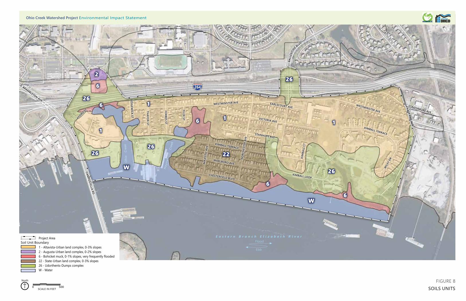
O
hio
Cre
ek
Hay
nes
Cre
ek
264
CHESTERFIELD BLVD
MARLBORO AVE
KIMBALL TERRACE
STANHOPE AVE
NO
RCH
ESTE
R AV
E
VICTORIA AVE
MA
JEST
IC A
VE
KIMBALL LOOP
KIM
BALL
CT
EARLSCOURT AVEWESTMINSTER AVE
WESTMINSTER AVE
BALL
ENTI
NE BLV
D
FILER ST
FORBES ST
THAYO
R ST
SEDG
EWICK ST
CAMPO
STELLA RD
WIL
EY D
R
KIMBALL TERRACE
EAST END AVE
STRATHMORE AVE
E. BRAMBLETON AVE
HYDRO ST
Project Area
1 - Altavista-Urban land complex, 0-3% slopes2 - Augusta-Urban land complex, 0-2% slopes6 - Bohicket muck, 0-1% slopes, very frequently flooded22 - State-Urban land complex, 0-3% slopes26 - Udorthents-Dumps complexW - Water
Soil Unit Boundary
0 500SCALE IN FEET
North
11
1
1
2
6
6
6
6
6
26
26
2626
26
22
W
W
FIGURE 8SOILS UNITS
Ohio Creek Watershed Project Environmental Impact Statement
E a s t e r n B r a n c h E l i z a b e t h R i v e r
Ebb
Flood

Ohio Creek Watershed Project Draft Environmental Impact Statement
71 Affected Environment and Environmental Consequences
Urban Land and Filled Land (Udorthents)
Urban land within the study area includes Altavista-Urban and State-Urban land complexes. These soil map units generally consist of nearly level to moderately sloping areas that are generally built up and occupied by structures and infrastructure. Urban land is an NRCS category describing landscape settings where 80 percent of the area is non-soil covered by asphalt, concrete, buildings, or other surfaces.8 Urban land covers approximately 173 acres, or 68 percent, of the study area.
Udorthents-Dumps complex covers approximately 10.6 acres, or 4 percent, of the study area. The Tidewater area of Virginia has been significantly altered by urban, industrial, residential, and commercial development. Many of the undevelopable, or wetland, areas have been filled to allow for construction. The filled land is known as Udorthents, which consists of soil material which have been cut and filled, or overburden from mines.9 This type of material is found around buildings and industrial areas along the shoreline within the study area. Because Udorthents soils are often formed from mixed spoil removed from other sites, they are generally heterogeneous and different materials can be found throughout the profile including clays, silt loams, sandy loams, and sands. Dumps consists of areas which have been used for waste disposal. Because of the variability of the materials contained within these soils, a detailed onsite investigation is needed to determine the suitability of these soils for a specific use.10
Marine Sediments
The study area lies on the north bank of the Eastern Branch and includes a portion of the river itself. At this location, the Eastern Branch is tidal and the soils within the river and associated tidal marshes are primarily composed of accumulated marine sediments. Marine sediments consist of insoluble materials transported to the ocean from the land by river, wind, ice, including marine organisms, and precipitates of chemical reactions. Development potential in these areas can vary depending on the age of the sediment deposition and current sea level.
Within the study area, marine sediments are found in tidal areas mapped as Bohicket muck, 0 to 1 percent, very frequently flooded. Bohicket muck is most commonly found in tidal marshes and is classified by the NRCS as a hydric soil, which is a soil type that
8 Scheyer, J.M., and K.W. Hipple. 2005. Urban Soil Primer. United States Department of Agriculture, Natural Resources Conservation
Service, National Soil Survey Center, Lincoln, Nebraska. http://soils.usda.gov/use. Accessed March 20, 2018. 9USDA NRCS. 2009. Soils Survey of Tidewater Cities Area, Virginia. https://www.nrcs.usda.gov/Internet/FSE_MANUSCRIPTS/
virginia/TidewaterCitiesVA2009/TidewaterCities.pdf. Accessed March 20, 2018.https://www.nrcs.usda.gov/Internet/FSE_MANUSCRIPTS/ virginia/TidewaterCitiesVA2009/TidewaterCities.pdf. Accessed March 20, 2018.
10 USDA NRCS. 2009.
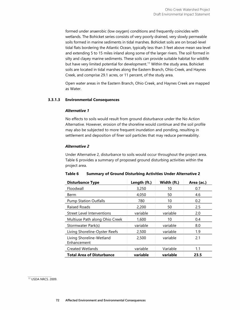
Ohio Creek Watershed Project Draft Environmental Impact Statement
72 Affected Environment and Environmental Consequences
formed under anaerobic (low oxygen) conditions and frequently coincides with wetlands. The Bohicket series consists of very poorly drained, very slowly permeable soils formed in marine sediments in tidal marshes. Bohicket soils are on broad-level tidal flats bordering the Atlantic Ocean, typically less than 3 feet above mean sea level and extending 5 to 15 miles inland along some of the larger rivers. The soil formed in silty and clayey marine sediments. These soils can provide suitable habitat for wildlife but have very limited potential for development.11 Within the study area, Bohicket soils are located in tidal marshes along the Eastern Branch, Ohio Creek, and Haynes Creek, and comprise 29.1 acres, or 11 percent, of the study area.
Open water areas in the Eastern Branch, Ohio Creek, and Haynes Creek are mapped as Water.
3.3.1.3 Environmental Consequences
Alternative 1
No effects to soils would result from ground disturbance under the No Action Alternative. However, erosion of the shoreline would continue and the soil profile may also be subjected to more frequent inundation and ponding, resulting in settlement and deposition of finer soil particles that may reduce permeability.
Alternative 2
Under Alternative 2, disturbance to soils would occur throughout the project area. Table 6 provides a summary of proposed ground disturbing activities within the project area.
Table 6 Summary of Ground Disturbing Activities Under Alternative 2
Disturbance Type Length (ft.) Width (ft.) Area (ac.) Floodwall 3,250 10 0.7 Berm 4,050 50 4.6 Pump Station Outfalls 780 10 0.2 Raised Roads 2,200 50 2.5 Street Level Interventions variable variable 2.0 Multiuse Path along Ohio Creek 1,600 10 0.4 Stormwater Park(s) variable variable 8.0 Living Shoreline-Oyster Reefs 2,500 variable 1.9 Living Shoreline-Wetland Enhancement
2,500 variable 2.1
Created Wetlands variable Variable 1.1 Total Area of Disturbance variable variable 23.5
11 USDA NRCS. 2009.
Ohio Creek Watershed Project Draft Environmental Impact Statement
73 Affected Environment and Environmental Consequences
Project activities would affect Urban soils mapped as Altavista-Urban land complex and State-Urban land complex, fill material mapped as Udorthents-Dumps complex, and natural soils mapped as Bohicket muck. In-water work would also affect sediments in areas mapped as Water.
Short-term negligible adverse effects from project activities would occur to Urban soils and fill materials. Previous disturbances have occurred in these areas, and development has covered or compacted natural soils. Much of the project area consists of existing roadways, rights-of-way for roadways, and residential development with filled and graded areas vegetated with turf grass.
Major long-term adverse effects to natural soils in tidal marshes and estuarine bodies within the project area would occur due to the proposed construction. Construction of coastal defenses such as berms and floodwalls and the living shoreline would fill a total of 0.97 acres of wetland and 3.66 acres of estuarine waters. The installation of these structures would either bury or remove existing soils. Wetland enhancement would occur in 2.1 acres of filled and graded areas associated with the living shoreline. This enhancement would occur as sandy growing medium and protective rock sills are placed over natural soils. This activity results in the conversion of marine sediments and the enhancement of intertidal soils to create a protected marsh fringe and rocky substrate.
Installation of several force main and outfall pipes would also occur within tidal marshes. Armoring or other structures would protect the pipes from damage. Installation of these outfalls would remove soils from 0.18 acres of natural wetlands.
Short-term negligible adverse effects from construction would occur under Alternative 2 including soil disturbance outside the project footprint and offsite deposition of transported or loose soils. Soil disturbance in wetland and estuarine habitats would remove vegetation, disrupt the established microbial community, and displace benthic organisms such as mussels. In most areas, native vegetation would be planted and the tidal marsh ecosystem would reestablish itself within an anticipated 2-3-year timeframe.
Much of the berm construction would occur within wetlands along the waterfront increasing the potential for the deposition of sediments outside the project area. Berms would be stabilized immediately upon final grading with erosion control blankets and seeded, and wetlands would be protected with silt fences. Temporary and/or permanent vegetation would be established within 30 days. Additionally, the potential for erosion of the berm leading to sediment deposition in adjacent areas would continue beyond the construction phase.
Construction effects would be minimized by implementing BMPs including silt fencing and turbidity curtains during construction. BMPs would be designed in
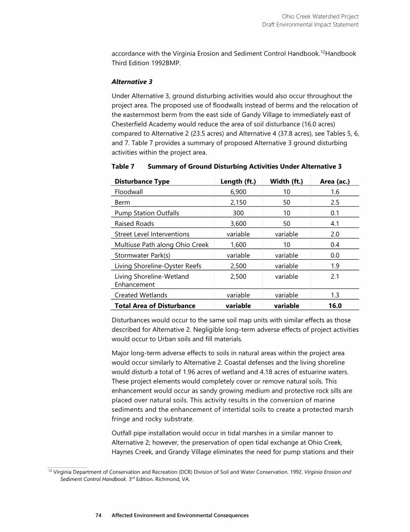
Ohio Creek Watershed Project Draft Environmental Impact Statement
74 Affected Environment and Environmental Consequences
accordance with the Virginia Erosion and Sediment Control Handbook.12Handbook Third Edition 1992BMP.
Alternative 3
Under Alternative 3, ground disturbing activities would also occur throughout the project area. The proposed use of floodwalls instead of berms and the relocation of the easternmost berm from the east side of Gandy Village to immediately east of Chesterfield Academy would reduce the area of soil disturbance (16.0 acres) compared to Alternative 2 (23.5 acres) and Alternative 4 (37.8 acres), see Tables 5, 6, and 7. Table 7 provides a summary of proposed Alternative 3 ground disturbing activities within the project area.
Table 7 Summary of Ground Disturbing Activities Under Alternative 3
Disturbance Type Length (ft.) Width (ft.) Area (ac.) Floodwall 6,900 10 1.6 Berm 2,150 50 2.5 Pump Station Outfalls 300 10 0.1 Raised Roads 3,600 50 4.1 Street Level Interventions variable variable 2.0 Multiuse Path along Ohio Creek 1,600 10 0.4 Stormwater Park(s) variable variable 0.0 Living Shoreline-Oyster Reefs 2,500 variable 1.9 Living Shoreline-Wetland Enhancement
2,500 variable 2.1
Created Wetlands variable variable 1.3 Total Area of Disturbance variable variable 16.0
Disturbances would occur to the same soil map units with similar effects as those described for Alternative 2. Negligible long-term adverse effects of project activities would occur to Urban soils and fill materials.
Major long-term adverse effects to soils in natural areas within the project area would occur similarly to Alternative 2. Coastal defenses and the living shoreline would disturb a total of 1.96 acres of wetland and 4.18 acres of estuarine waters. These project elements would completely cover or remove natural soils. This enhancement would occur as sandy growing medium and protective rock sills are placed over natural soils. This activity results in the conversion of marine sediments and the enhancement of intertidal soils to create a protected marsh fringe and rocky substrate.
Outfall pipe installation would occur in tidal marshes in a similar manner to Alternative 2; however, the preservation of open tidal exchange at Ohio Creek, Haynes Creek, and Grandy Village eliminates the need for pump stations and their
12 Virginia Department of Conservation and Recreation (DCR) Division of Soil and Water Conservation. 1992. Virginia Erosion and
Sediment Control Handbook. 3rd Edition. Richmond, VA.
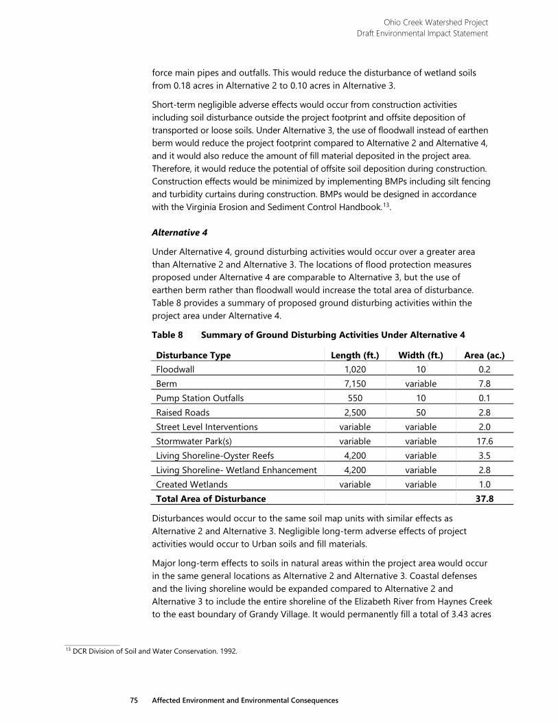
Ohio Creek Watershed Project Draft Environmental Impact Statement
75 Affected Environment and Environmental Consequences
force main pipes and outfalls. This would reduce the disturbance of wetland soils from 0.18 acres in Alternative 2 to 0.10 acres in Alternative 3.
Short-term negligible adverse effects would occur from construction activities including soil disturbance outside the project footprint and offsite deposition of transported or loose soils. Under Alternative 3, the use of floodwall instead of earthen berm would reduce the project footprint compared to Alternative 2 and Alternative 4, and it would also reduce the amount of fill material deposited in the project area. Therefore, it would reduce the potential of offsite soil deposition during construction. Construction effects would be minimized by implementing BMPs including silt fencing and turbidity curtains during construction. BMPs would be designed in accordance with the Virginia Erosion and Sediment Control Handbook.13.
Alternative 4
Under Alternative 4, ground disturbing activities would occur over a greater area than Alternative 2 and Alternative 3. The locations of flood protection measures proposed under Alternative 4 are comparable to Alternative 3, but the use of earthen berm rather than floodwall would increase the total area of disturbance. Table 8 provides a summary of proposed ground disturbing activities within the project area under Alternative 4.
Table 8 Summary of Ground Disturbing Activities Under Alternative 4
Disturbance Type Length (ft.) Width (ft.) Area (ac.) Floodwall 1,020 10 0.2 Berm 7,150 variable 7.8 Pump Station Outfalls 550 10 0.1 Raised Roads 2,500 50 2.8 Street Level Interventions variable variable 2.0 Stormwater Park(s) variable variable 17.6 Living Shoreline-Oyster Reefs 4,200 variable 3.5 Living Shoreline- Wetland Enhancement 4,200 variable 2.8 Created Wetlands variable variable 1.0 Total Area of Disturbance 37.8
Disturbances would occur to the same soil map units with similar effects as Alternative 2 and Alternative 3. Negligible long-term adverse effects of project activities would occur to Urban soils and fill materials.
Major long-term effects to soils in natural areas within the project area would occur in the same general locations as Alternative 2 and Alternative 3. Coastal defenses and the living shoreline would be expanded compared to Alternative 2 and Alternative 3 to include the entire shoreline of the Elizabeth River from Haynes Creek to the east boundary of Grandy Village. It would permanently fill a total of 3.43 acres
13 DCR Division of Soil and Water Conservation. 1992.
Ohio Creek Watershed Project Draft Environmental Impact Statement
76 Affected Environment and Environmental Consequences
of wetland and 6.85 acres of estuarine waters, removing and covering existing natural soils. This fill would occur as sandy growing medium and protective rock sills are placed over natural soils. This activity results in the conversion of marine sediments and the enhancement of intertidal soils to create a protected marsh fringe and rocky substrate. Outfall pipe installation would also occur through tidal marshes, affecting 0.13 acres of wetland soils.
Negligible short-term adverse effects would occur from construction activities. Extensive use of earthen berm increases the project footprint under Alternative 4 (37.8 acres) compared to Alternative 2 (23.5 acres) and Alternative 3 (16.0 acres), and therefore increases the potential of soil deposition outside the project area during construction. Construction effects would be minimized by implementing BMPs including silt fencing and turbidity curtains during construction. BMPs would be designed in accordance with the Virginia Erosion and Sediment Control Handbook.14
3.3.2 Surface Water
3.3.2.1 Methodology
Available Geographic Information System (GIS) data, described below in the Wetlands section methodology, as well as a site visit conducted during the field wetland delineation were used to identify and characterize waterways within the study area with regards to hydrology and flow.
Chesapeake Bay Preservation Area (CBPA) Determination
Wetland scientists conducted a detailed wetland delineation in June and August of 2017. The Wetlands section below provides a detailed description of the wetland delineation and data collection methodology.
Subsequent to the field wetland delineation, scientists determined which wetlands and other surface waters were contiguous to tidal wetlands or water bodies with perennial flow pursuant to the Norfolk Code of Ordinances15 specific to the Chesapeake Bay Preservation Area Overlay District. A 100-foot wide buffer was then placed adjacent to and landward of the wetlands and other surface waters determined to be part of the CBPA.
Regulatory Setting
Surface waters in Virginia are regulated both federally and by the state. USACE jurisdiction of authority includes Sections 10 and 14 of the Rivers and Harbors Act of 1899 (RHA) and Sections 401 and 404 of the Clean Water Act of 1972 (CWA). The geographic jurisdiction of the RHA includes all navigable waters of the United States which are defined as, “those waters that are subject to the ebb and flow of the tide and/or are presently used, or have been used in the past, or may be susceptible to
14 DCR Division of Soil and Water Conservation. 1992. 15 Code of the City of Norfolk, VA. Adopted February 27, 2018. https://library.municode.com/va/norfolk/codes/code_of_ordinances.
Accessed: June 1, 2017.
Ohio Creek Watershed Project Draft Environmental Impact Statement
77 Affected Environment and Environmental Consequences
use, as transport for interstate or foreign commerce” (33 CFR Part 329). This jurisdiction extends seaward to include all ocean waters within a zone of 3 nautical miles from the coast line (the “territorial seas”). Limited authorities extend across the outer continental shelf for artificial islands, installations, and other devices (see 43 USC 1333 [e]).
The CWA uses the term “navigable waters” which is defined as “waters of the United States, including the territorial seas” (Section 502[7]). Thus, Section 404 jurisdiction is defined as encompassing Section 10 waters plus their tributaries and adjacent wetlands and isolated waters where the use, degradation, or destruction of such waters could affect interstate or foreign commerce.
Section 404 of the CWA (33 CFR 320332) regulates discharges of dredged or fill material into waters of the United States, including jurisdictional wetlands. The CWA requires compliance with the Section 404(b)(1) Guidelines, 40 CFR Part 230, developed jointly by the EPA and USACE. CWA compliance requires a sequential evaluation process, which includes verification that all jurisdictional wetland impacts have been avoided to the greatest extent practicable, unavoidable impacts have been minimized to the greatest extent practicable, and unavoidable impacts have been mitigated in the form of wetlands creation, restoration, enhancement or preservation.
Under Section 401 of the CWA, any applicant for a federal permit or license for an activity that may result in a discharge to navigable waters must provide the federal agency issuing a permit with a certificate, either from the state where the discharge would occur or from an interstate water pollution control agency, that the discharge would comply with Sections 301, 302, 303, 306, 307, and 316 (b) of the CWA. Applicants for discharges to navigable waters in Virginia must also obtain a Water Quality Certification from the VA DEQ as part of the permit approval process.
Section 14 of the RHA states that any proposed modifications to an existing USACE project (either federally or locally maintained) beyond those needed for normal operation and maintenance require approval under 33 USC 408. 33 USC 408 also states that there shall be no temporary or permanent alteration, occupation, or use of any public works including but not limited to levees, sea walls, bulkheads, jetties, and dikes for any purpose without the permission of the Secretary of the Army. Under the terms of 33 USC 408, any proposed modification requires a determination by the Secretary of the Army that such proposed alteration, permanent occupation, or use of a federal project is not injurious to the public interest and would not impair the usefulness of such work. The authority to make this determination and to approve modifications to federal works under 33 USC 408 has been delegated to the Chief of Engineers.
The Chesapeake Bay Preservation Act was enacted by the Virginia General Assembly in 1988. The Act’s primary purpose is to improve water quality in the Chesapeake Bay and other waters of the state by providing a framework for effective land management planning. It assigns the responsibilities for enforcement of the Act to local city and county governments. Under the Norfolk Chesapeake Bay Preservation
Ohio Creek Watershed Project Draft Environmental Impact Statement
78 Affected Environment and Environmental Consequences
Area Overlay District, an CBPA is defined as any natural resource meeting the following criteria (§ 11-2.3 [a]):
1. Tidal wetlands; 2. Nontidal wetlands connected by surface flow and contiguous to tidal
wetlands or water bodies with perennial flow;
3. Tidal shores; and
4. A 100-foot vegetated buffer area located adjacent to and landward of the components listed in items (1) through (3) above, and along both sides of any water bodies with perennial flow.
The phrase “connected by surface flow and contiguous” is subject to interpretation and was addressed by the Chesapeake Bay Local Assistance Board (CBLAB) in guidance dated December 10, 2007.16 The CBLAB supported the interpretation that nontidal wetlands are connected by surface flow if shown to be contiguous to CBPA resources without being “spatially separated” from those resources. For most municipalities under a Chesapeake Bay Preservation Area (CBPA) jurisdiction, the other critical element of subsection (2) above is the phrase “water bodies with perennial flow,” that is, perennial streams. Therefore, flow regime in stream channels is evaluated using one of several “perennial flow determination” methods approved by the Virginia Department of Environmental Quality (DEQ).
3.3.2.2 Affected Environment
The study area contains a portion or all of three different surface water systems, the Eastern Branch, Ohio Creek, and Haynes Creek (Figure 2). The study area is bounded on the south by and partially includes the Eastern Branch of the Elizabeth River. The Elizabeth River is an estuary system with an eastern, southern, and western branch, located within the South Hampton Roads area and abutting portions of Chesapeake, Portsmouth, Norfolk, and Virginia Beach. The river flows south to north, and the southern branch connects to the Intracoastal Waterway near the Great Dismal Swamp, which also partially feeds the western branch. At the north end, the confluence of the three branches enters the James River near its mouth, an area also referred to as Hampton Roads harbor. It is an important commercial waterway in the region, and the river is the site of numerous military and industrial activities. The Eastern Branch is considered a Traditional Navigable Water (TNW) under the RHA. The Eastern Branch, specifically the Ohio Creek Watershed, consists of a degraded shoreline fringe or edge. The lack of floodplain wetlands in the area are directly correlated to poor water
16 Virginia Department of Conservation and Recreation (DCR) Chesapeake Bay Local Assistance Board (CBLAB). 2007. DCR-CBLAB-
086. Resource Protection Areas: Nontidal Wetlands. Guidance on CBPA designation and management regulations. http://townhall.virginia.gov/L/GetFile.cfm?File=C:%5CTownHall%5Cdocroot%5CGuidanceDocs%5C440%5CGDoc_DEQ_5413_v1.pdf. Accessed March 20, 2018.
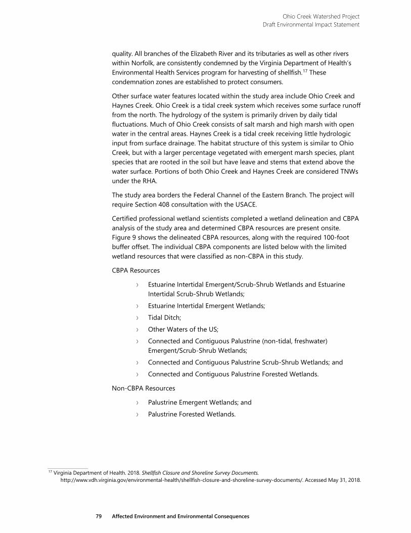
Ohio Creek Watershed Project Draft Environmental Impact Statement
79 Affected Environment and Environmental Consequences
quality. All branches of the Elizabeth River and its tributaries as well as other rivers within Norfolk, are consistently condemned by the Virginia Department of Health’s Environmental Health Services program for harvesting of shellfish.17 These condemnation zones are established to protect consumers.
Other surface water features located within the study area include Ohio Creek and Haynes Creek. Ohio Creek is a tidal creek system which receives some surface runoff from the north. The hydrology of the system is primarily driven by daily tidal fluctuations. Much of Ohio Creek consists of salt marsh and high marsh with open water in the central areas. Haynes Creek is a tidal creek receiving little hydrologic input from surface drainage. The habitat structure of this system is similar to Ohio Creek, but with a larger percentage vegetated with emergent marsh species, plant species that are rooted in the soil but have leave and stems that extend above the water surface. Portions of both Ohio Creek and Haynes Creek are considered TNWs under the RHA.
The study area borders the Federal Channel of the Eastern Branch. The project will require Section 408 consultation with the USACE.
Certified professional wetland scientists completed a wetland delineation and CBPA analysis of the study area and determined CBPA resources are present onsite. Figure 9 shows the delineated CBPA resources, along with the required 100-foot buffer offset. The individual CBPA components are listed below with the limited wetland resources that were classified as non-CBPA in this study.
CBPA Resources
› Estuarine Intertidal Emergent/Scrub-Shrub Wetlands and Estuarine Intertidal Scrub-Shrub Wetlands;
› Estuarine Intertidal Emergent Wetlands;
› Tidal Ditch;
› Other Waters of the US; › Connected and Contiguous Palustrine (non-tidal, freshwater)
Emergent/Scrub-Shrub Wetlands;
› Connected and Contiguous Palustrine Scrub-Shrub Wetlands; and
› Connected and Contiguous Palustrine Forested Wetlands.
Non-CBPA Resources
› Palustrine Emergent Wetlands; and
› Palustrine Forested Wetlands.
17 Virginia Department of Health. 2018. Shellfish Closure and Shoreline Survey Documents.
http://www.vdh.virginia.gov/environmental-health/shellfish-closure-and-shoreline-survey-documents/. Accessed May 31, 2018.

Ohio Creek Watershed Project Draft Environmental Impact Statement
80 Affected Environment and Environmental Consequences
This page intentionally left blank.
O
hio
Cre
ek
Hay
nes
Cre
ek
BALL
ENTI
NE BLV
D
264
CHESTERFIELD BLVD
MARLBORO AVE
KIMBALL TERRACE
STANHOPE AVE
NO
RCH
ESTE
R AV
E
VICTORIA AVE
MA
JEST
IC A
VE
KIMBALL LOOP
KIM
BALL
CT
EARLSCOURT AVEWESTMINSTER AVE
WESTMINSTER AVE
BALL
ENTI
NE BLV
D
FILER ST
FORBES ST
THAYO
R ST
SEDG
EWICK ST
CAMPO
STELLA RD
WIL
EY D
R
KIMBALL TERRACE
EAST END AVE
STRATHMORE AVE
E. BRAMBLETON AVE
HYDRO ST
Project AreaChesapeake Bay Preservation Area (100 Ft Buffer)
E1UB (39.02 Ac)E2EM (7.80 Ac)E2EM/SS (8.72 Ac)E2SS (0.70 Ac)PEM (0.16 Ac)PEM/SS (0.02 Ac)PFO (0.16 Ac)PSS (0.007 Ac)Pond (PEM/UB) (0.17 Ac)Non-Tidal Ditch
Wetlands and Waters of the U.S.
0 500SCALE IN FEET
North WETLAND DELINEATION AND CHESAPEAKE BAY PRESERVATION AREA BUFFER MAP
FIGURE 9
Ohio Creek Watershed Project Environmental Impact Statement
E a s t e r n B r a n c h E l i z a b e t h R i v e r
Ebb
Flood

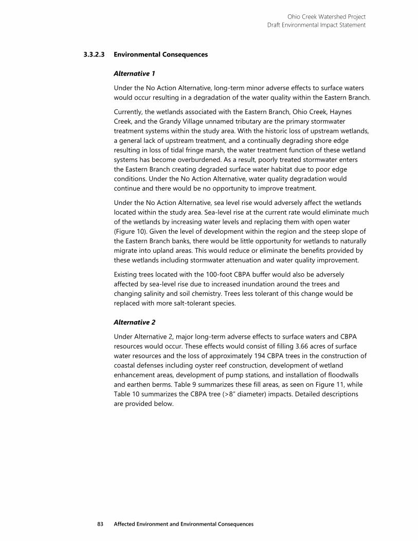
Ohio Creek Watershed Project Draft Environmental Impact Statement
83 Affected Environment and Environmental Consequences
3.3.2.3 Environmental Consequences
Alternative 1
Under the No Action Alternative, long-term minor adverse effects to surface waters would occur resulting in a degradation of the water quality within the Eastern Branch.
Currently, the wetlands associated with the Eastern Branch, Ohio Creek, Haynes Creek, and the Grandy Village unnamed tributary are the primary stormwater treatment systems within the study area. With the historic loss of upstream wetlands, a general lack of upstream treatment, and a continually degrading shore edge resulting in loss of tidal fringe marsh, the water treatment function of these wetland systems has become overburdened. As a result, poorly treated stormwater enters the Eastern Branch creating degraded surface water habitat due to poor edge conditions. Under the No Action Alternative, water quality degradation would continue and there would be no opportunity to improve treatment.
Under the No Action Alternative, sea level rise would adversely affect the wetlands located within the study area. Sea-level rise at the current rate would eliminate much of the wetlands by increasing water levels and replacing them with open water (Figure 10). Given the level of development within the region and the steep slope of the Eastern Branch banks, there would be little opportunity for wetlands to naturally migrate into upland areas. This would reduce or eliminate the benefits provided by these wetlands including stormwater attenuation and water quality improvement.
Existing trees located with the 100-foot CBPA buffer would also be adversely affected by sea-level rise due to increased inundation around the trees and changing salinity and soil chemistry. Trees less tolerant of this change would be replaced with more salt-tolerant species.
Alternative 2
Under Alternative 2, major long-term adverse effects to surface waters and CBPA resources would occur. These effects would consist of filling 3.66 acres of surface water resources and the loss of approximately 194 CBPA trees in the construction of coastal defenses including oyster reef construction, development of wetland enhancement areas, development of pump stations, and installation of floodwalls and earthen berms. Table 9 summarizes these fill areas, as seen on Figure 11, while Table 10 summarizes the CBPA tree (>8” diameter) impacts. Detailed descriptions are provided below.
Ohio Creek Watershed Project Draft Environmental Impact Statement
84 Affected Environment and Environmental Consequences
Table 9 Summary of Surface Water Fill Under Alternative 2
Construction Activity Area (ac.) Floodwalls 0.01 Berms 0.11 Living Shoreline-Oyster Reefs 1.86 Living Shoreline- Wetland Enhancement
1.68
Total Area of Fill 3.66
Table 10 Summary of CBPA Tree Impacts Under Alternative 2
Construction Activity # Trees Removed
Floodwalls 38 Berms 42 Pump Stations 70 Total # of Trees 150
Relocated and Raised Roads: Alternative 2 includes raising 900 linear feet of Westminster Avenue along the north side of Haynes Creek to protect the road from flooding. The north end of East End Avenue would also be raised for 800 linear feet to provide access over flood control structures. These activities would not affect surface waters or CBPA trees within the project area.
Flood Control Structures: Alternative 2 includes construction of a floodwall section near Hydro Street, a section across the Haynes Creek wetland system immediately south of Kimball Terrace, and along portions of the riverfront in Chesterfield Heights and Grandy Village. In association with the Haynes Creek floodwall construction, riprap would protect the shoreline on the south side of the wall from erosion. The floodwall construction would fill approximately 0.01 acres of surface waters in the Haynes Creek system. In addition, approximately 38 trees in the CBPA, mostly in Chesterfield Heights, would be removed to make room for the construction of the floodwall.
Proposed coastal defenses under Alternative 2 would also include the construction of 4,050 linear feet of earthen berm, which consist of 1,350 linear feet along the waterfront from Haynes Creek to approximately 300 feet west of Norchester Avenue and 2,700 linear feet from Kimball Loop Road to the northeast corner of the project. The berm at Haynes Creek would lie adjacent to the properties located along the east side of Haynes Creek and on the south side of Chesterfield Boulevard. Berm construction in this area would fill 0.11 acres of surface waters. The berm around Grandy Village would lie primarily in uplands with a small part constructed in wetlands and surface water. Berm construction would result in the loss of approximately 42 CBPA trees.
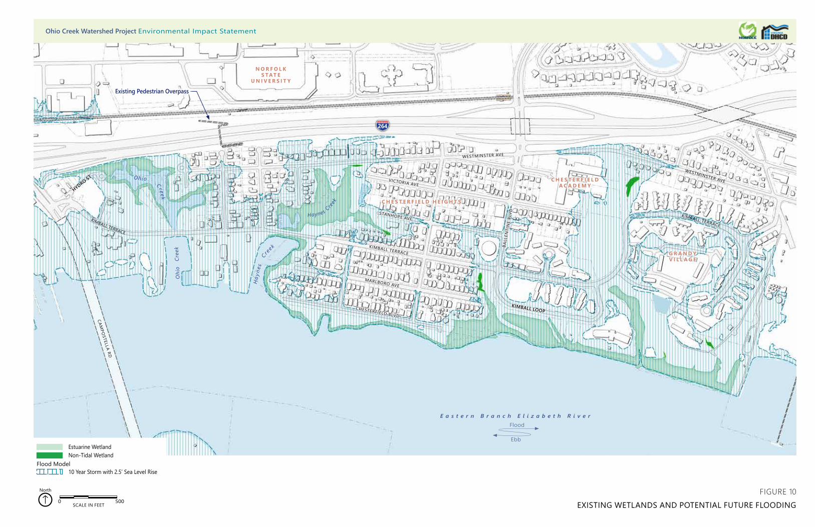
264
Oh io Cr eek
H
ayne
s
C re
ek
CAMPO
STELLA RD
CHESTERFIELD BLVD
MARLBORO AVE
KIMBALL TERRACE
STANHOPE AVE
VICTORIA AVE
WESTMINSTER AVE
KIMBALL TERRACE
WESTMINSTER AVE
KIMBALL TERRACE
BALL
ENTI
NE
BLVD
HYDRO ST
KIMBALL LOOP
0 500SCALE IN FEET
North
Flood Model
Estuarine WetlandNon-Tidal Wetland
10 Year Storm with 2.5’ Sea Level Rise
FIGURE 10EXISTING WETLANDS AND POTENTIAL FUTURE FLOODING
E a s t e r n B r a n c h E l i z a b e t h R i v e r
Ebb
Flood
O
hio
Cre
ek
Haynes C
reek
G R A N D Y V I L L A G E
C H E S T E R F I E L DA C A D E M Y
C H E S T E R F I E L D H E I G H T S
N O R F O L K S TAT E
U N I V E R S I T Y
Existing Pedestrian Overpass
Ohio Creek Watershed Project Environmental Impact Statement
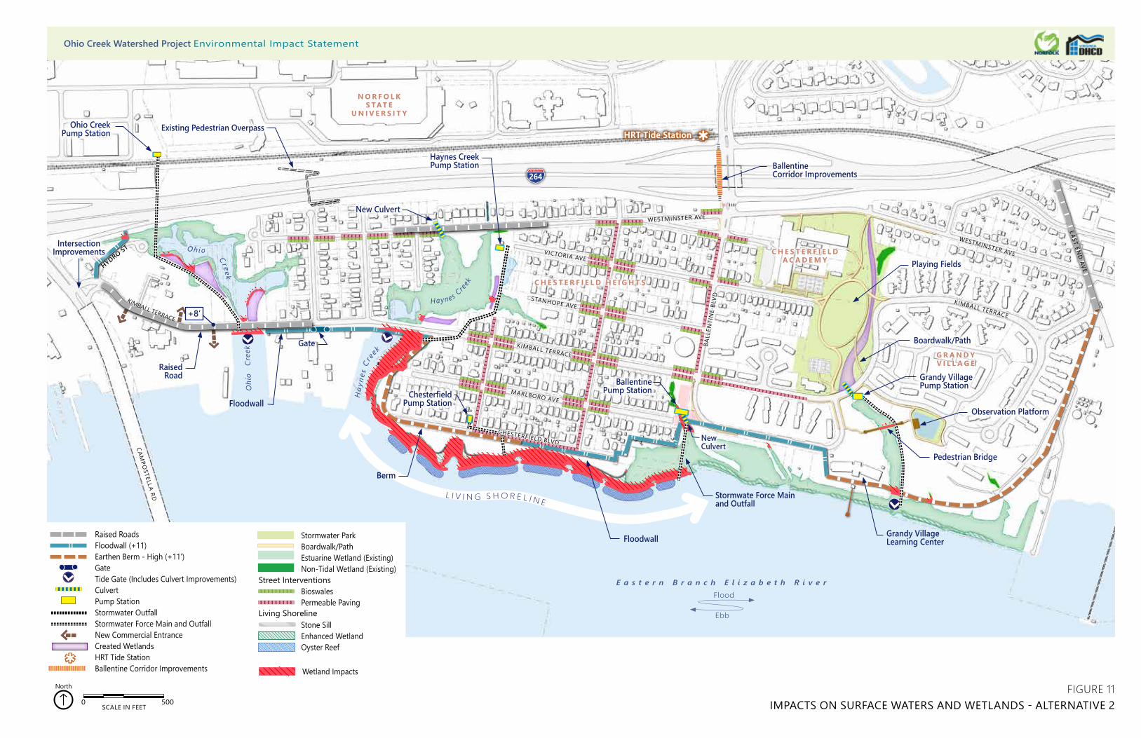
HRT Tide Station
HYDRO ST
264
Haynes Creek Pump Station
Raised RoadsFloodwall (+11)Earthen Berm - High (+11’)GateTide Gate (Includes Culvert Improvements)CulvertPump StationStormwater OutfallStormwater Force Main and OutfallNew Commercial EntranceCreated WetlandsHRT Tide StationBallentine Corridor Improvements
Stormwater ParkBoardwalk/PathEstuarine Wetland (Existing)Non-Tidal Wetland (Existing)
BioswalesPermeable Paving
Stone SillEnhanced WetlandOyster Reef
Living Shoreline
0 500 1,000250 Feet
0 500 1,000250 Feet
Street Interventions
0 500SCALE IN FEET
North
0 500 1,000250 Feet
Wetland Impacts
G R A N D Y V I L L A G E
C H E S T E R F I E L DA C A D E M Y
C H E S T E R F I E L D H E I G H T S
N O R F O L K S TAT E
U N I V E R S I T Y
L I V I N G S H O R E L I N E
0 500 1,000250 Feet0 500 1,000250 Feet0 500 1,000250 Feet
WESTMINSTER AVE
H
ayne
s C r
ee
k
Oh io Cr eek
CAMPO
STELLA RD
CHESTERFIELD BLVD
MARLBORO AVE
KIMBALL TERRACE
STANHOPE AVE
VICTORIA AVE
WESTMINSTER AVE
KIMBALL TERRACE
WESTMINSTER AVE
KIMBALL TERRACE
BALL
ENTI
NE
BLVD
O
hio
Cre
ek
EAST END
AVE
Haynes C
reek
Ohio Creek Pump Station
Intersection Improvements
Boardwalk/Path
Chesterfield Pump Station
Berm
Floodwall
Stormwate Force Mainand Outfall
Pedestrian Bridge
Observation Platform
Ballentine Corridor Improvements
Gate
BallentinePump Station
New Culvert
Grandy Village Pump Station
+8’
Floodwall
Raised Road
Existing Pedestrian Overpass
Grandy Village Learning Center
New Culvert
FIGURE 11IMPACTS ON SURFACE WATERS AND WETLANDS - ALTERNATIVE 2
Playing Fields
E a s t e r n B r a n c h E l i z a b e t h R i v e r
Ebb
Flood
Ohio Creek Watershed Project Environmental Impact Statement
Ohio Creek Watershed Project Draft Environmental Impact Statement
87 Affected Environment and Environmental Consequences
Living Shoreline: Construction of approximately 2,500 feet of living shoreline along the banks of the Eastern Branch would fill a total of 3.54 acres of surface waters. The living shoreline would consist of oyster reef creation areas backed by a rock sill (1.86 acres) with wetland enhancement areas (1.68 acres) on the shoreward side. In the wetland enhancement areas, sand would fill surface water areas to create a 10:1 gradual slope that ties into the coastal defense berm or floodwall. Native wetland plant species would vegetate these areas. Marsh hay would be planted from an elevation of +4.15 feet down to +1.10 feet, or Mean High Water (MHW). Smooth cordgrass would be planted from MHW to -0.30, or Mid Tide.
Although the living shoreline would remove open water areas from the Eastern Branch, the total area filled would represent less than 0.3 percent of the Eastern Branch. The living shoreline would also provide beneficial effects to the surface waters within and adjacent to the study area. The oyster reef and rock sill would not only protect the shoreline from wave action and erosion, but it would provide appropriate structure and substrate for the eastern oyster (Crassostrea virginica) to colonize the reef. As filter feeders, oysters would provide a water quality benefit by removing phytoplankton and particulates from the water column.
The oyster reef and rock sill would also be appropriate habitat for hooked mussels (Ischadium recurvum), the inclusion of which would more than double the filtration capacity of these habitats.18 These species would provide water quality improvement benefits where no water treatment was previously occurring. The oyster reefs would also provide ecological benefits for the river such as shelter and foraging areas for fish and crustaceans. Please see Section 3.3.5 Biological Resources for further discussion of marine organism present within the project area.
The wetland enhancement areas would also benefit water quality by increasing the area of wetland present within the Eastern Branch. The living shoreline would add 1.68 acres of tidal wetlands to the shoreline of the river. The additional tidal marsh would increase nutrient removal and provide shallow grassy flats to filter particulates from the water. The smooth cordgrass areas would also provide habitat for the Atlantic ribbed mussel (Geukensia demissa), another filter feeder which provides water quality benefits by actively removing particulates from the water column, see Section 3.3.5 Biological Resources.
Stormwater Management: Under Alternative 2, the project would also provide long-term major beneficial effects to surface waters by improving the stormwater treatment infrastructure. Alternative 2 would allow for the greatest amount of stormwater storage of all alternatives. Stormwater storage would occur within the Ohio Creek wetland system, the Haynes Creek wetland system, the small PFO wetland at Ballentine Road, the Grandy Village unnamed tributary, and the stormwater park at Grandy Village. Tide gates at Ohio Creek, Haynes Creek, and the unnamed tributary at Grandy Village would close during storm events to prevent storm surges from flooding the wetlands and adjacent neighborhoods. This would
18 Gedan, K.B., Kellog, L., and Breitburg, D.L. 2014. Accounting for multiple foundation species in oyster reef restoration benefits.
Restoration Ecology. Vol. 22: 517-524.
Ohio Creek Watershed Project Draft Environmental Impact Statement
88 Affected Environment and Environmental Consequences
also prevent large amounts of stormwater runoff from flowing directly into these systems and immediately entering the Eastern Branch. Pump stations near each tide gate would regulate water elevations so that stormwater does not flood nearby properties. The increases in residence time and storage volume would lead to substantial increases in removal efficiencies as demonstrated for total phosphorus and total nitrogen19 and other pollutants such as nitric oxide (NOX), soluble reactive phosphorus (SRP), total iron, and total zinc.20 The Ballentine and Haynes Creek pump stations would result in the removal of approximately 70 CBPA trees to allow for the construction of the new stations.
Wetlands created in upland areas adjacent to the Ohio Creek and Haynes Creek wetland systems would also increase stormwater storage volume and residence time. Wetland creation would include 0.5 acres of tidal marsh creation in the Ohio Creek system and 0.3 acres of tidal marsh in the Haynes Creek system. In addition, development of the 8-acre Grandy Village stormwater park would occur within the existing park and playing field area between Chesterfield Academy and Grandy Village. This park would include 0.3 acres of freshwater marsh creation to improve the stormwater treatment potential of the park.
Street level interventions to enhance the existing stormwater infrastructure include the installation of 0.5 acres of pervious pavers for streets and walks, 0.2 acres of pervious pavers for parking lots, and 1.2 acres of bioswales along existing streets. Construction of these improvements would occur in the Chesterfield Heights neighborhood, along Ballentine Boulevard, Westminster Avenue, and Kimball Terrace north of Kimball Loop. These enhancements would increase the rate of stormwater infiltration and the storage volume, reducing the total volume of stormwater runoff entering the wetland and stormwater storage systems.
Temporary Effects: Construction of coastal defenses and raised roads would result in short-term negligible adverse effects to surface waters including the discharge of loose soils and sediment into wetlands and waterbodies. Some of the berm construction would occur within wetlands along the waterfront increasing the potential for offsite deposition of sediments. The use of appropriate BMPs such as silt fencing and floating turbidity curtains would reduce the amount of disturbed soils leaving the construction site. The potential for erosion of the berm leading to offsite sediment deposition would also continue beyond the construction phase. Soil stabilization BMPs would protect the integrity of the berm over the long term and prevent erosion and sediment deposition in nearby wetlands and waterbodies.
Coastal defenses would include the installation of 3,250 linear feet of floodwall, 2,150 feet of which would be along the waterfront. The installation of floodwalls would occur primarily in uplands immediately south of Chesterfield Boulevard and Kimball Loop. A portion of the floodwall construction—1,100 linear feet—would
19 Harper, H.H., and Herr, J.L. 1993. Treatment Efficiency of Detention with Filtration Systems. Final Report to the St. Johns River Water
Management District. 20 Rushton, B. et al. 1997. Three Design Alternatives for Stormwater Detention Ponds. Prepared by the Southwest Florida Water
Management District. Brooksville, FL.
Ohio Creek Watershed Project Draft Environmental Impact Statement
89 Affected Environment and Environmental Consequences
occur along Kimball Terrace through the Haynes Creek wetland system. This construction would involve in-water work and the installation of foundation piles. Vibrations caused by pile driving may result in the loosening of soils and unintentional discharge into the Haynes Creek system as well as an increase in sediment load within the water column. Use of a turbidity curtain would protect the water from this discharge.
The raising of Kimball Terrace from Campostella Boulevard to Thayor Street would occur to maintain access across coastal protection measures. At this location, a tide gate would replace the existing open tidal exchange culvert for Ohio Creek. In addition, the elevation of Westminster Avenue along the north side of the Haynes Creek wetland system would occur to protect the road from flooding. Although the footprint of these roads would not increase, the ground disturbance and foundation pile installation required for construction would disturb soils in adjacent areas and may result in sediment deposition in adjacent wetlands and waterbodies. Construction phase BMPs would protect offsite resources through each phase of construction, and BMP design would occur in accordance with the Virginia Erosion and Sediment Control Handbook.21
Alternative 3
Under Alternative 3, major long-term adverse effects to surface waters and CBPA resources would occur. These effects would include the filling of 4.18 acres of surface water resources and the loss of approximately 234 CBPA trees due to the relocation of the western extent of Kimball Terrace, construction of Haynes Creek and Ballentine pump stations, and construction of coastal defenses. Table 11 summarizes these fill areas, as seen on Figure 12, while Table 12 summarizes the CBPA tree (>8” diameter) impacts. Detailed descriptions are provided below.
Table 11 Summary of Surface Water Fill Under Alternative 3
Construction Activity Area (ac.) Relocated and Raised Roads 0.31 Floodwalls 0.22 Berms 0.11 Living Shoreline-Oyster Reefs 1.86 Living Shoreline-Wetland Enhancement
1.68
Total Area of Fill 4.18
21 DCR Division of Soil and Water Conservation. 1992. Virginia Erosion and Sediment Control Handbook. 3rd Edition. Richmond, VA.
Ohio Creek Watershed Project Draft Environmental Impact Statement
90 Affected Environment and Environmental Consequences
Table 12 Summary of CBPA Tree Impacts Under Alternative 3
Construction Activity # Trees Removed
Floodwalls 142 Berms 12 Pump Stations 80 Total # of Trees 234
Relocated and Raised Roads: Under Alternative 3, relocation and elevation of 1,100 linear feet of western Kimball Terrace from Campostella Road to the east extent of the Ohio Creek wetland system would occur to maintain access across coastal defense structures. The new road would include a multiuse lane on the northeast side. The road would lie along the western boundary of the wetland system and cross Ohio Creek near the existing road crossing. Raising of the road would continue for the next 1,100 feet in its current location; however, elevating the road would increase the footprint. The additional area would be on the north side of the road as it crosses Haynes Creek. In Ohio Creek and Haynes Creek, the road relocation and elevation would fill 0.13 acres and 0.18 acres of surface waters, respectively. These activities would not affect CBPA trees within the project area.
Flood Control Structures: Under Alternative 3, coastal defenses would include the installation of 6,900 linear feet of floodwall, all of which would be along the waterfront or adjacent to Ohio Creek and Haynes Creek. Construction of the floodwall along the waterfront would be similar to Alternative 2, that is, primarily in uplands, and would not affect surface waters. Construction of the proposed floodwall on the east side of the Ohio Creek system would result in 0.04 acres of fill in surface waters, and the floodwall on the west side of the Haynes Creek system would result in 0.18 acres of fill. In addition, approximately 142 CBPA trees would be impacted by the floodwall construction in Ohio Creek, Haynes Creek, and along the riverfront in Chesterfield Heights.
Coastal defenses would also include the construction of 2,150 linear feet of earthen berm. Installation of 750 feet of earthen berm would occur immediately south of Chesterfield Boulevard from the east end of Chesterfield Boulevard to approximately 300 feet west of Norchester Avenue. Construction of a second berm section 1,400 feet in length would occur along the east side of Chesterfield Heights from the northeast corner of Kimball Loop, along the west side of the park and athletic fields, on the east side of Chesterfield Academy, and ending just north of Westminster Avenue. Construction of the berm at Chesterfield Boulevard would result in 0.11 acres of fill in surface waters. This fill includes the placement of shoreline armoring along the waterfront side of the berm at the outlet of Haynes Creek. Berm construction would result in the removal of approximately 12 CBPA trees.
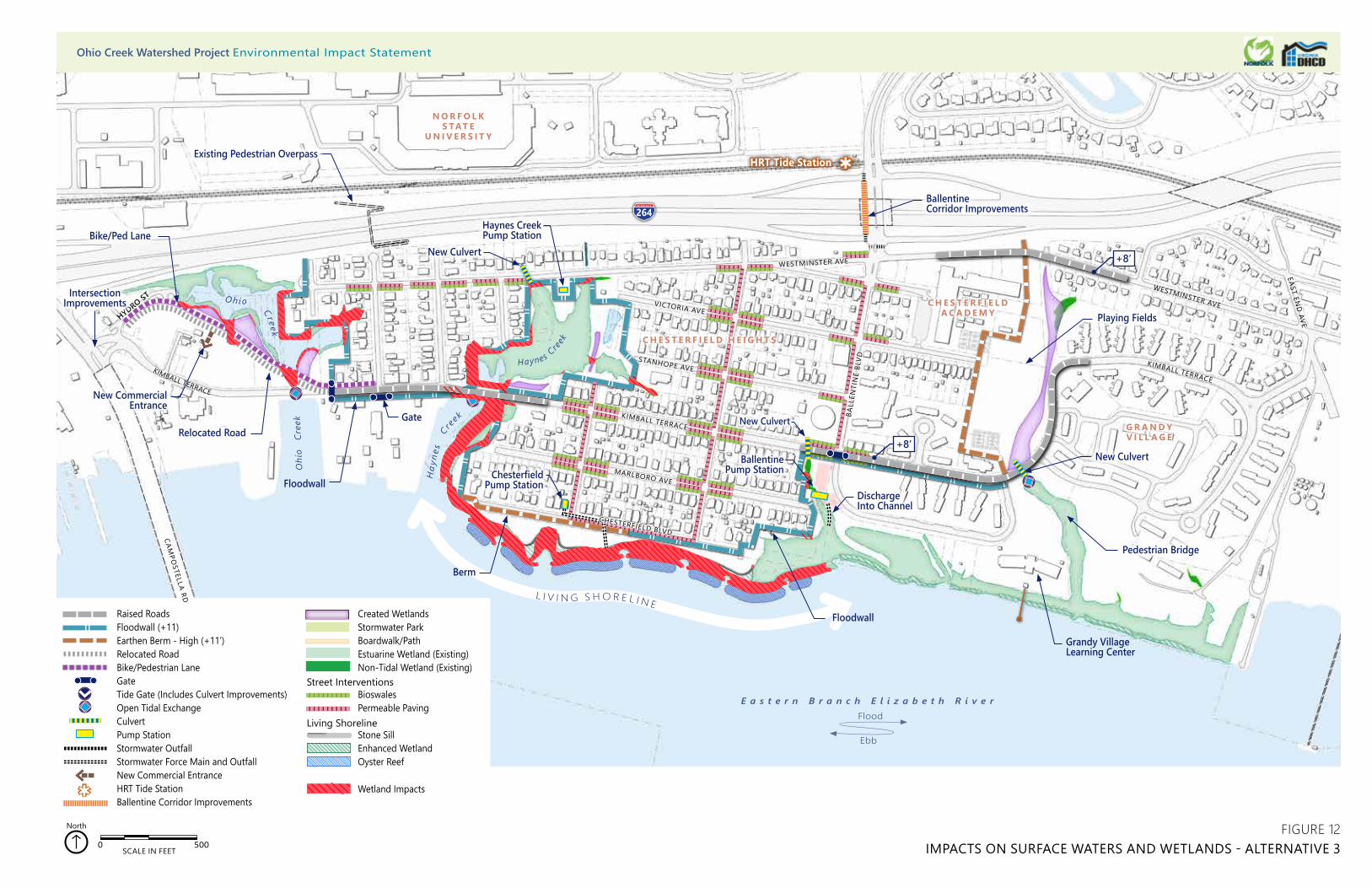
HRT Tide Station
HYDRO ST
L I V I N G S H O R E L I N E
WESTMINSTER AVE
EAST END
AVE
Haynes Creek Pump Station
Raised RoadsFloodwall (+11)Earthen Berm - High (+11’)Relocated RoadBike/Pedestrian LaneGateTide Gate (Includes Culvert Improvements)Open Tidal ExchangeCulvertPump StationStormwater OutfallStormwater Force Main and OutfallNew Commercial EntranceHRT Tide StationBallentine Corridor Improvements
Created WetlandsStormwater Park Boardwalk/PathEstuarine Wetland (Existing)Non-Tidal Wetland (Existing)
BioswalesPermeable Paving
Stone SillEnhanced WetlandOyster Reef
Living Shoreline
0 500 1,000250 Feet
0 500 1,000250 Feet
Street Interventions
0 500SCALE IN FEET
North
0 500 1,000250 Feet
Wetland Impacts
G R A N D Y V I L L A G E
C H E S T E R F I E L DA C A D E M Y
C H E S T E R F I E L D H E I G H T S
N O R F O L K S TAT E
U N I V E R S I T Y
0 500 1,000250 Feet0 500 1,000250 Feet0 500 1,000250 Feet
264
H
ayne
s
C re
ek
Oh io Cr eek
CAMPO
STELLA RD
CHESTERFIELD BLVD
MARLBORO AVE
KIMBALL TERRACE
STANHOPE AVE
VICTORIA AVE
WESTMINSTER AVE
KIMBALL TERRACE
WESTMINSTER AVE
KIMBALL TERRACE
BALL
ENTI
NE
BLVD
O
hio
Cre
ek
Haynes C
reek
New Commercial Entrance
Intersection Improvements
Bike/Ped Lane
Relocated Road
Floodwall
Berm
Floodwall
DischargeInto Channel
BallentinePump Station
Pedestrian Bridge
Chesterfield Pump Station
Ballentine Corridor Improvements
+8’
+8’
New Culvert
New Culvert
Gate New Culvert
Existing Pedestrian Overpass
Grandy Village Learning Center
FIGURE 12IMPACTS ON SURFACE WATERS AND WETLANDS - ALTERNATIVE 3
Playing Fields
E a s t e r n B r a n c h E l i z a b e t h R i v e r
Ebb
Flood
Ohio Creek Watershed Project Environmental Impact Statement

Ohio Creek Watershed Project Draft Environmental Impact Statement
93 Affected Environment and Environmental Consequences
Living Shoreline: The living shoreline under Alternative 3 would be constructed to the same design and in the same location as Alternative 2. It would fill a total of 3.54 acres of surface waters and consist of oyster reef creation areas backed by a rock sill (1.86 acres) with wetland enhancement areas (1.68 acres) on the shoreward side.
Stormwater Management: Alternative 3 would also provide major long-term beneficial effects with the inclusion of some enhancement of the stormwater infrastructure, but the improvements would not be as extensive as those proposed under Alternative 2. Alternative 3 would provide less stormwater storage than Alternative 2 and Alternative 4, but more than the No Action Alternative. Tidal exchange would remain open for Ohio Creek and Haynes Creek limiting the volume of stormwater storage available in these two systems, so residence time of stormwater entering these systems would be the same as the No Action Alternative. Some storage volume increase would occur with the creation of 0.5 acres of tidal marsh in the Ohio Creek system and 0.3 acres of tidal marsh in the Haynes Creek system. The Ballentine and Haynes Creek pump stations would result in the removal of approximately 80 CBPA trees to allow for the construction of the new stations. Under Alternative 3, no stormwater park development would occur. There would be a wetland creation area consisting of freshwater marsh along the western boundary of Grandy Village connecting a small freshwater marsh located just east of Chesterfield Academy with the Grandy Village unnamed tributary. This wetland would provide some additional stormwater storage volume and treatment. It would connect to the unnamed tributary by an open culvert under Kimball Terrace.
Street level interventions to enhance the existing stormwater infrastructure would be the same as Alternative 2, including installation of pervious pavement in parking areas and creation of bioswales along the roadsides.
Temporary Effects: Installation of coastal defenses and raised roads would result in short-term negligible adverse effects to surface waters including the discharge of loose soils and sediment into wetlands and waterbodies. Some of the berm construction would occur within wetlands along the waterfront increasing the potential for offsite deposition of sediments. The use of appropriate BMPs such as silt fencing and floating turbidity barriers would reduce the potential of disturbed soils leaving the construction site.
Installation of the floodwall along the waterfront would mostly occur in uplands immediately south of Chesterfield Boulevard and Kimball Loop, but a small portion of the construction would occur within wetlands south of Chesterfield Boulevard and Kimball Terrace. Also, some of the floodwall construction around Haynes Creek would occur through wetlands, and 120 linear feet of floodwall would be in surface waters. Much of the floodwall installation on the east side of the Ohio Creek system would occur in wetlands with 290 linear feet constructed in surface waters. This construction would involve in-water work and the installation of foundation piles. Ground disturbance associated with construction may cause the deposition of sediments in adjacent surface water or an increase of sediment load in the water column. Vibrations caused by pile installation would result in an increase of suspended sediments and some unintentional discharge into the Ohio Creek and Haynes Creek systems.
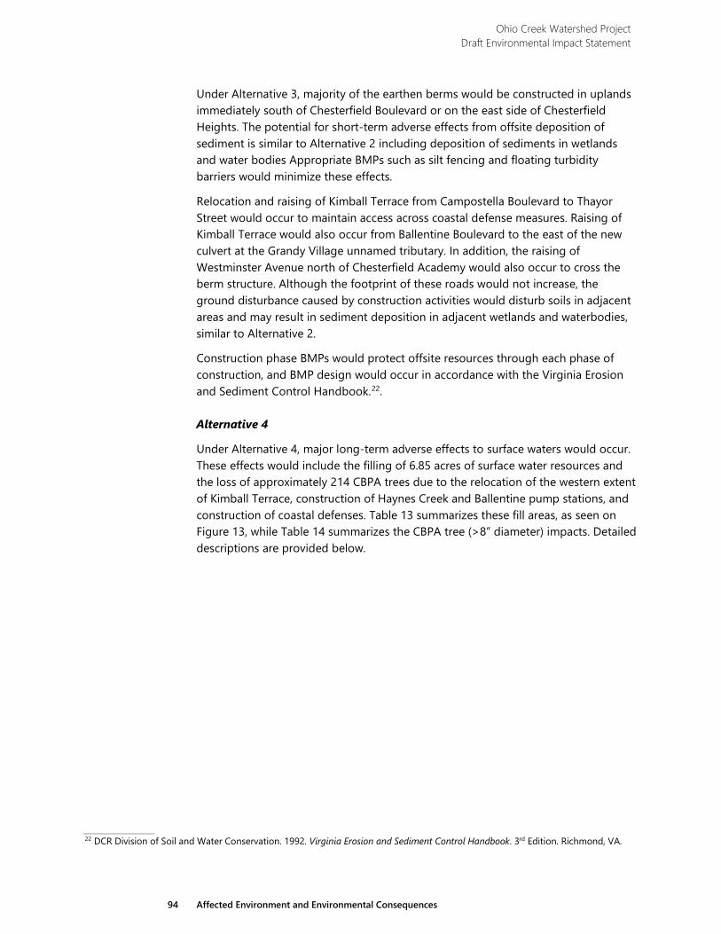
Ohio Creek Watershed Project Draft Environmental Impact Statement
94 Affected Environment and Environmental Consequences
Under Alternative 3, majority of the earthen berms would be constructed in uplands immediately south of Chesterfield Boulevard or on the east side of Chesterfield Heights. The potential for short-term adverse effects from offsite deposition of sediment is similar to Alternative 2 including deposition of sediments in wetlands and water bodies Appropriate BMPs such as silt fencing and floating turbidity barriers would minimize these effects.
Relocation and raising of Kimball Terrace from Campostella Boulevard to Thayor Street would occur to maintain access across coastal defense measures. Raising of Kimball Terrace would also occur from Ballentine Boulevard to the east of the new culvert at the Grandy Village unnamed tributary. In addition, the raising of Westminster Avenue north of Chesterfield Academy would also occur to cross the berm structure. Although the footprint of these roads would not increase, the ground disturbance caused by construction activities would disturb soils in adjacent areas and may result in sediment deposition in adjacent wetlands and waterbodies, similar to Alternative 2.
Construction phase BMPs would protect offsite resources through each phase of construction, and BMP design would occur in accordance with the Virginia Erosion and Sediment Control Handbook.22.
Alternative 4
Under Alternative 4, major long-term adverse effects to surface waters would occur. These effects would include the filling of 6.85 acres of surface water resources and the loss of approximately 214 CBPA trees due to the relocation of the western extent of Kimball Terrace, construction of Haynes Creek and Ballentine pump stations, and construction of coastal defenses. Table 13 summarizes these fill areas, as seen on Figure 13, while Table 14 summarizes the CBPA tree (>8” diameter) impacts. Detailed descriptions are provided below.
22 DCR Division of Soil and Water Conservation. 1992. Virginia Erosion and Sediment Control Handbook. 3rd Edition. Richmond, VA.
HRT Tide Station
HYDRO ST
EAST END
AVE
264Haynes Creek Pump Station
CulvertStormwater OutfallStormwater Force main and OutfallPump StationBoardwalk/Path
BioswalesPermeable PavingCorner Street Basin
Raised RoadsFloodwall (+11)Earthen Berm - High (+11’)Earthen Berm - Low (+5.5’)Bike/Pedestrian LaneTide Gate (Includes Culvert Improvements)Open Tidal ExchangeCulvertPump StationStormwater OutfallStormwater Force Main and OutfallNew Commercial EntranceHRT Tide StationBallentine Corridor Improvement
Created WetlandsStormwater Park Boardwalk/PathEstuarine Wetland (Existing)Non-Tidal Wetland (Existing)
BioswalesPermeable Paving
Stone SillEnhanced WetlandOyster Reef
Living Shoreline
0 500 1,000250 Feet
0 500 1,000250 Feet
Street Interventions
0 500SCALE IN FEET
North
0 500 1,000250 Feet
Wetland Impacts
G R A N D Y V I L L A G E
C H E S T E R F I E L DA C A D E M Y
C H E S T E R F I E L D H E I G H T S
N O R F O L K S TAT E
U N I V E R S I T Y
L I V I N G S H O R E L I N E
0 500 1,000250 Feet0 500 1,000250 Feet0 500 1,000250 Feet
Oh io Cr eek
H
ayne
s
C re
ek
CAMPO
STELLA RD
CHESTERFIELD BLVD
MARLBORO AVE
KIMBALL TERRACE
STANHOPE AVE
VICTORIA AVE
WESTMINSTER AVE
KIMBALL TERRACE
WESTMINSTER AVE
KIMBALL TERRACE
BALL
ENTI
NE
BLVD
O
hio
Cre
ek
Haynes C
reek
Floodwall
Stormwater Force Main and Outfall
Berm
Intersection Improvements
Bike/Ped Lane
Relocated Road
New Commercial Entrance New CulvertBallentine
Pump Station
Boardwalk/Path
Pedestrian Bridge
Observation Platform
Ballentine Corridor Improvements
+11’
+11’
+8’
+11’
+11’
New Culvert
Existing Pedestrian Overpass
New Culvert
Grandy Village Learning Center
Community Pier
FIGURE 13IMPACTS ON SURFACE WATERS AND WETLANDS - ALTERNATIVE 4
Playing Fields
Open Space
E a s t e r n B r a n c h E l i z a b e t h R i v e r
Ebb
Flood
Ohio Creek Watershed Project Environmental Impact Statement

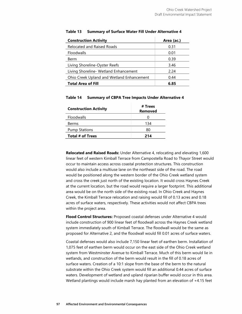
Ohio Creek Watershed Project Draft Environmental Impact Statement
97 Affected Environment and Environmental Consequences
Table 13 Summary of Surface Water Fill Under Alternative 4
Construction Activity Area (ac.) Relocated and Raised Roads 0.31 Floodwalls 0.01 Berm 0.39 Living Shoreline-Oyster Reefs 3.46 Living Shoreline- Wetland Enhancement 2.24 Ohio Creek Upland and Wetland Enhancement 0.44 Total Area of Fill 6.85
Table 14 Summary of CBPA Tree Impacts Under Alternative 4
Construction Activity # Trees Removed
Floodwalls 0 Berms 134 Pump Stations 80 Total # of Trees 214
Relocated and Raised Roads: Under Alternative 4, relocating and elevating 1,600 linear feet of western Kimball Terrace from Campostella Road to Thayor Street would occur to maintain access across coastal protection structures. This construction would also include a multiuse lane on the northeast side of the road. The road would be positioned along the western border of the Ohio Creek wetland system and cross the creek just north of the existing location. It would cross Haynes Creek at the current location, but the road would require a larger footprint. This additional area would be on the north side of the existing road. In Ohio Creek and Haynes Creek, the Kimball Terrace relocation and raising would fill of 0.13 acres and 0.18 acres of surface waters, respectively. These activities would not affect CBPA trees within the project area.
Flood Control Structures: Proposed coastal defenses under Alternative 4 would include construction of 900 linear feet of floodwall across the Haynes Creek wetland system immediately south of Kimball Terrace. The floodwall would be the same as proposed for Alternative 2, and the floodwall would fill 0.01 acres of surface waters.
Coastal defenses would also include 7,150 linear feet of earthen berm. Installation of 1,075 feet of earthen berm would occur on the east side of the Ohio Creek wetland system from Westminster Avenue to Kimball Terrace. Much of this berm would lie in wetlands, and construction of the berm would result in the fill of 0.18 acres of surface waters. Creation of a 10:1 slope from the base of the berm to the natural substrate within the Ohio Creek system would fill an additional 0.44 acres of surface waters. Development of wetland and upland riparian buffer would occur in this area. Wetland plantings would include marsh hay planted from an elevation of +4.15 feet
Ohio Creek Watershed Project Draft Environmental Impact Statement
98 Affected Environment and Environmental Consequences
down to +1.10 feet (MHW) and smooth cordgrass planted from MHW to -0.30 (Mid Tide). Above the elevation of +4.15 feet, the installation of native upland plant species would occur.
A low berm, 750 feet in length, would be constructed along the west boundary of the Haynes Creek wetland system. This berm would protect adjacent properties from flooding when the Haynes Creek tide gate would close and the Haynes Creek basin would store stormwater. Although much of this berm would fill wetland area, it would have no direct effects on surface waters.
In addition, construction of 5,325 linear feet of earthen berm would occur along the waterfront and the west side of the proposed stormwater park between Chesterfield Academy and Grandy Village. The section of berm proposed along Kimball Loop and the west side of the stormwater park would be located entirely in uplands, and therefore would not directly affect surface waters. The waterfront section of berm would lie along the shoreline to preserve the green space on the south side of Chesterfield Boulevard. This berm would represent the shoreward edge of the wetland enhancement associated with the living shoreline described below. The overall berm installation would fill 0.21 acres of surface waters. Approximately 134 CBPA trees would be impacted by the berm construction in Ohio Creek, Haynes Creek, and along the riverfront in Chesterfield Heights
Living Shoreline: Under Alternative 4, the proposed living shoreline system from Haynes Creek to the west end of Kimball Loop would have the same design as Alternative 2 and Alternative 3 from Haynes Creek to Ballentine Boulevard, but it would include an additional 1,700 linear feet of structure along the Eastern Branch shoreline from the west end of Kimball Loop to the east end of Grandy Village. All structures would include oyster reef backed by rock sills and wetland enhancement areas on the shoreward side, as described for Alternative 2. Construction of the living shoreline would fill 3.46 acres of surface waters from the installation of oyster reefs and rock sills and 2.24 acres from wetland enhancement.
Stormwater Management: Alternative 4 would also provide major long-term beneficial effects with the enhancement of the stormwater infrastructure. Alternative 4 provides for a moderate increase in stormwater storage which would occur within Haynes Creek, the stormwater park at Grandy Village, and the stormwater park at Ballentine Boulevard. Within the Haynes Creek wetland system, a tide gate located at the culvert under Kimball Terrace would control water flow into the system during storm events, and it would close to prevent storm surges from entering the system and flooding adjacent properties and roads. Haynes Creek would then store stormwater runoff when the gate is closed, and a large pump system would remove water as needed. As previously described, these storage areas would increase the residence time of stormwater which would increase the treatment potential of this system. The Ballentine and Haynes Creek pump stations would result in the removal of approximately 80 CBPA trees to allow for the construction of the new stations.
Wetlands created in upland areas adjacent to the Ohio Creek and Haynes Creek wetland systems would also increase stormwater storage volume and residence
Ohio Creek Watershed Project Draft Environmental Impact Statement
99 Affected Environment and Environmental Consequences
time. Wetland creation would include 0.5 acres of tidal marsh creation in the Ohio Creek system and 0.3 acres of tidal marsh in the Haynes Creek system. In addition, development of the 8-acre Grandy Village stormwater park would occur within the existing park and playing field area between Chesterfield Academy and Grandy Village. This park would include 0.5 acres of freshwater marsh creation to improve the stormwater treatment potential of the park.
Street level interventions to enhance the existing stormwater infrastructure would be the same as Alternatives 2 and 3. These improvements would include the installation of 0.5 acres of pervious pavers for streets and walks, 0.2 acres of pervious pavers for parking lots, and 1.2 acres of bioswales along existing streets. Construction of these improvements would occur in the Chesterfield Heights neighborhood, along Ballentine Boulevard, Westminster Avenue, and Kimball Terrace north of Kimball Loop.
Temporary Effects: Installation of coastal defenses and raised roads would result in short-term negligible adverse effects to surface waters including the discharge of loose soils and sediment into wetlands and waterbodies. Some of the berm construction would occur within wetlands associated with Ohio Creek and Haynes Creek and along the waterfront increasing the potential for offsite deposition of sediments. Overall, the effects would occur on a larger scale due to the more extensive berm system proposed for Alternative 4. The potential for erosion of the berm leading to offsite sediment deposition would also continue beyond the construction phase. Soil stabilization BMPs would protect the integrity of the berm over the long term and prevent erosion and sediment deposition in nearby wetlands and waterbodies. In addition, an increased volume of fill in surface waters would result in increased sediment load and increased turbidity in the water column. The use of appropriate BMPs such as silt fencing and floating turbidity barriers would reduce the potential of sediment deposition in offsite wetlands and waterbodies.
Relocation and raising of Kimball Terrace from Campostella Boulevard to Thayor Street would maintain access across coastal protection measures. Under Alternative 4, open tidal exchange would remain, but the culvert would be lengthened to accommodate the new road location. The short-term adverse effects during the construction phase would include ground disturbance caused by construction activities which may disturb soils in adjacent areas and result in sediment deposition in adjacent wetlands and waterbodies, similar to Alternative 3. Pile driving required for construction would disturb soils in adjacent areas and result in sediment deposition in adjacent wetlands and waterbodies. Additional short-term adverse effects would occur through the disruption and burial of aquatic habitats at the location of in-water work. Construction-phase BMPs would protect offsite resources through each phase of construction, and BMP design would occur in accordance with the Virginia Erosion and Sediment Control Handbook.23
23 DCR Division of Soil and Water Conservation. 1992.
Ohio Creek Watershed Project Draft Environmental Impact Statement
100 Affected Environment and Environmental Consequences
3.3.3 Wetlands
3.3.3.1 Methodology
Wetland scientists completed a delineation of wetlands and other Waters of the US within the study area (Figure 9). The wetland delineation followed the technical criteria outlined in the Regional Supplement to the Corps of Engineers Wetland Delineation Manual: Atlantic and Gulf Coastal Plain Region24 and associated guidance to identify jurisdictional boundaries with the study area. Prior to beginning onsite fieldwork, scientists conducted a preliminary offsite analysis to research known data pertaining to soils, hydrology, and vegetation at the site. This research informed onsite fieldwork, as described below.
Preliminary offsite research for the study area used data from the following sources:
› US Geological Survey (USGS) Quadrangle Map for Kempsville25 and Norfolk South26
› US Department of Agriculture (USDA), NRCS Web Soil Survey27
› USFWS National Wetland Inventory28
GIS analysts processed data layers from these sources using ArcMap 10.3.1 and included aerial base maps for mobile ArcGIS Collector applications used for onsite fieldwork and analysis.
Wetland scientists conducted the fieldwork during June 2017, and supplementary data collection occurred in August 2017. The lead delineator marked the jurisdictional boundaries with pink flagging labeled “WETLAND DELINEATION”. The supporting scientist logged wetland flag locations using an ArcGIS Collector based mobile technology platform. Geolocation of each individual flag used Global Positioning System (GPS) technology with sub-meter accuracy. Key mobile technology components included:
› Apple iPad Environmental Systems Research Institute (ESRI) ArcGIS Collector application
24 US Army Corps of Engineers (USACE). 2010. Regional Supplement to the Corps of Engineers Wetland Delineation Manual: Atlantic
and Gulf Coastal Plain Region (Version 2.0), ed. J.S. Wakeley, R.W. Lichvar, and C.V. Noble. ERDC/ELTR-10-20. Vicksburg, MS: US Army Engineer Research and Development Center.
25 US Geological Survey (USGS). 2016. USGS US Topo 7.5-minute map for Kempsville, VA 2016. USGS – National Geospatial Technical Operations Center. (NGTOC). https://viewer.nationalmap.gov/basic/. Accessed: June 1, 2017.
26 USGS. 2016. USGS US Topo 7.5-minute map for Norfolk South, VA 2016. USGS –NGTOC. https://viewer.nationalmap.gov/basic/. Accessed: June 1, 2017.
27 USDA NRCS. 2017. Web Soil Survey. https://websoilsurvey.sc.egov.usda.gov/. Accessed: June 1, 2017. 28 US Fish and Wildlife Service (USFWS). National Wetland Inventory (NWI). 2018. Wetlands Mapper.
https://www.fws.gov/wetlands/data/mapper.html. Accessed: June 1, 2017.
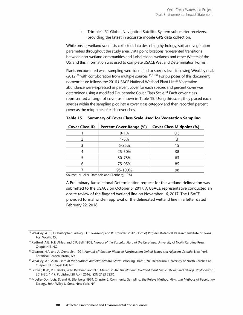
Ohio Creek Watershed Project Draft Environmental Impact Statement
101 Affected Environment and Environmental Consequences
› Trimble’s R1 Global Navigation Satellite System sub-meter receivers, providing the latest in accurate mobile GPS data collection.
While onsite, wetland scientists collected data describing hydrology, soil, and vegetation parameters throughout the study area. Data point locations represented transitions between non-wetland communities and jurisdictional wetlands and other Waters of the US, and this information was used to complete USACE Wetland Determination Forms.
Plants encountered while sampling were identified to species level following Weakley et al. (2012)29 with corroboration from multiple sources.30,31,32 For purposes of this document, nomenclature follows the 2016 USACE National Wetland Plant List.33 Vegetation abundance were expressed as percent cover for each species and percent cover was determined using a modified Daubenmire Cover Class Scale.34 Each cover class represented a range of cover as shown in Table 15. Using this scale, they placed each species within the sampling plot into a cover class category and then recorded percent cover as the midpoints of each cover class.
Table 15 Summary of Cover Class Scale Used for Vegetation Sampling
Cover Class ID Percent Cover Range (%) Cover Class Midpoint (%) 1 0-1% 0.5 2 1-5% 3 3 5-25% 15 4 25-50% 38 5 50-75% 63 6 75-95% 85 7 95-100% 98
Source: Mueller-Dombois and Ellenberg, 1974
A Preliminary Jurisdictional Determination request for the wetland delineation was submitted to the USACE on October 5, 2017. A USACE representative conducted an onsite review of the flagged wetland line on November 16, 2017. The USACE provided formal written approval of the delineated wetland line in a letter dated February 22, 2018.
29 Weakley, A. S., J. Christopher Ludwig, J.F. Townsend, and B. Crowder. 2012. Flora of Virginia. Botanical Research Institute of Texas.
Fort Worth, TX. 30 Radford, A.E., H.E. Ahles, and C.R. Bell. 1968. Manual of the Vascular Flora of the Carolinas. University of North Carolina Press.
Chapel Hill, NC. 31 Gleason, H.A. and A. Cronquist. 1991. Manual of Vascular Plants of Northeastern United States and Adjacent Canada. New York
Botanical Garden. Bronx, NY. 32 Weakley, A.S. 2016. Flora of the Southern and Mid-Atlantic States. Working Draft. UNC Herbarium. University of North Carolina at
Chapel Hill. Chapel Hill, NC. 33 Lichvar, R.W., D.L. Banks, W.N. Kirchner, and N.C. Melvin. 2016. The National Wetland Plant List: 2016 wetland ratings. Phytoneuron.
2016-30: 1-17. Published 28 April 2016. ISSN 2153 733X. 34 Mueller-Dombois, D. and H. Ellenberg. 1974. Chapter 5. Community Sampling, the Releve Method. Aims and Methods of Vegetation
Ecology. John Wiley & Sons. New York, NY.
Ohio Creek Watershed Project Draft Environmental Impact Statement
102 Affected Environment and Environmental Consequences
Regulatory Setting
Wetlands within the study area are regulated and protected under state and federal regulatory programs. Within the State of Virginia, activities conducted in wetlands are regulated by the Virginia Wetlands Act of 1972 and Virginia Code Sections 62.1-44.2 et seq. The USACE administers Section 404 of the CWA (33 CFR 320332) which regulates discharges of fill into wetlands and other Waters of the US. Wetlands as defined by the USACE in 33 CFR 328.3 and by the EPA in 40 CFR 230.3 are “those areas that are inundated or saturated by surface water or groundwater at a frequency and duration sufficient to support, and under normal circumstances do support, a prevalence of vegetation typically adapted for life in saturated soils.”
Executive Order 11990 discourages direct or indirect support of new construction impacting wetlands wherever there is a practicable alternative. Wetlands under E.O. 11990 include isolated and non-jurisdictional wetlands. HUD has issued additional guidance (24 CFR 55.20) for compliance with EO 11990. HUD guidance has established an eight-step process for compliance, which includes public notices and examination of practicable alternatives when addressing floodplains and wetlands. The eight-step process for compliance would be accomplished through completion of the EIS for the project.
Under the federal definition, a wetland requires the presence of three parameters: hydric soil (a soil formed under conditions of saturation or flooding long enough to develop anaerobic, or low oxygen, conditions in the upper part), a dominance of hydrophytic vegetation (plants adapted for life in habitats with saturated or inundated soils for prolonged periods of time), and wetland hydrology (the presence of water at or above the ground surface for a significant duration during the growing season). This determination is tied to Section 404 of the CWA, which provides for the protection of water quality in Waters of the US, including wetlands, and instructs the USACE to issue permits for activities that result in the discharge of dredged or fill material into these areas. Alternatively, the USFWS uses the Cowardin definition, which defines wetlands as:
…lands transitional between terrestrial and aquatic systems where the water table is usually at or near the surface or the land is covered by shallow water. For purposes of this classification, wetlands must have one or more of the following three attributes: (1) at least periodically, the land supports predominantly hydrophytes; (2) the substrate is predominantly undrained hydric soil; and (3) the substrate is non-soil and is saturated with water or covered by shallow water at some time during the growing season of each year.35
The USFWS definition is more comprehensive than the EPA and USACE definition, recognizing that physical or chemical conditions such as wave action, current, or
35 Cowardin, L.M., Carter, V., Golet, F.C., LaRoe, E.T. 1979. Classification of Wetlands and Deepwater Habitats of the United States. US
Department of the Interior. Fish and Wildlife Service Office of Biological Services. Washington, DC.
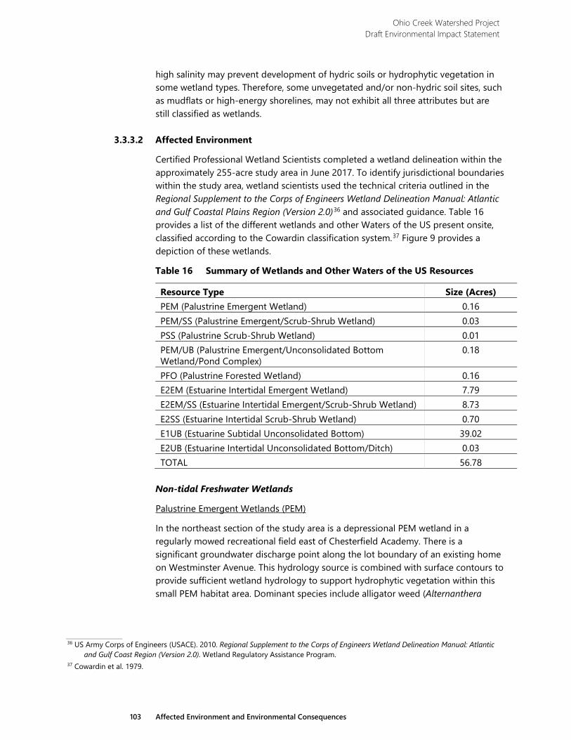
Ohio Creek Watershed Project Draft Environmental Impact Statement
103 Affected Environment and Environmental Consequences
high salinity may prevent development of hydric soils or hydrophytic vegetation in some wetland types. Therefore, some unvegetated and/or non-hydric soil sites, such as mudflats or high-energy shorelines, may not exhibit all three attributes but are still classified as wetlands.
3.3.3.2 Affected Environment
Certified Professional Wetland Scientists completed a wetland delineation within the approximately 255-acre study area in June 2017. To identify jurisdictional boundaries within the study area, wetland scientists used the technical criteria outlined in the Regional Supplement to the Corps of Engineers Wetland Delineation Manual: Atlantic and Gulf Coastal Plains Region (Version 2.0)36 and associated guidance. Table 16 provides a list of the different wetlands and other Waters of the US present onsite, classified according to the Cowardin classification system.37 Figure 9 provides a depiction of these wetlands.
Table 16 Summary of Wetlands and Other Waters of the US Resources
Resource Type Size (Acres) PEM (Palustrine Emergent Wetland) 0.16 PEM/SS (Palustrine Emergent/Scrub-Shrub Wetland) 0.03 PSS (Palustrine Scrub-Shrub Wetland) 0.01 PEM/UB (Palustrine Emergent/Unconsolidated Bottom Wetland/Pond Complex)
0.18
PFO (Palustrine Forested Wetland) 0.16 E2EM (Estuarine Intertidal Emergent Wetland) 7.79 E2EM/SS (Estuarine Intertidal Emergent/Scrub-Shrub Wetland) 8.73 E2SS (Estuarine Intertidal Scrub-Shrub Wetland) 0.70 E1UB (Estuarine Subtidal Unconsolidated Bottom) 39.02 E2UB (Estuarine Intertidal Unconsolidated Bottom/Ditch) 0.03 TOTAL 56.78
Non-tidal Freshwater Wetlands
Palustrine Emergent Wetlands (PEM)
In the northeast section of the study area is a depressional PEM wetland in a regularly mowed recreational field east of Chesterfield Academy. There is a significant groundwater discharge point along the lot boundary of an existing home on Westminster Avenue. This hydrology source is combined with surface contours to provide sufficient wetland hydrology to support hydrophytic vegetation within this small PEM habitat area. Dominant species include alligator weed (Alternanthera
36 US Army Corps of Engineers (USACE). 2010. Regional Supplement to the Corps of Engineers Wetland Delineation Manual: Atlantic
and Gulf Coast Region (Version 2.0). Wetland Regulatory Assistance Program. 37 Cowardin et al. 1979.
Ohio Creek Watershed Project Draft Environmental Impact Statement
104 Affected Environment and Environmental Consequences
philoxeroides), curly dock (Rumex crispus), and various species of flatsedge (Cyperus spp.).
Palustrine Emergent/Scrub-Shrub Wetlands (PEM/SS)
One small PEM/SS wetland was identified just above the tidal limits in a swale that extends along the backyard lot boundaries of several homes on the north side of Kimball Terrace. Vegetation within this wetland consists of saplings of sugarberry (Celtis laevigata), Chinese privet (Ligustrum sinense), common reed (Phragmites australis), trumpet vine (Campsis radicans), and Japanese honeysuckle (Lonicera japonica).
Palustrine Scrub-Shrub Wetlands (PSS)
One small PSS wetland comprises a swale near the southeastern extent of the study area. This feature is the lower section of a man-made depression that conveys stormwater from an active construction site in the southeast quadrant of Grandy Village. The dominant vegetation includes black willow (Salix nigra), elderberry (Sambucus canadensis), and common reed (Phragmites australis) along the upper fringe.
Pond (Palustrine Emergent/Unconsolidated Bottom Wetlands [PEM/UB])
In the west-central portion of the study area is an isolated open water pond. The pond contains aquatic species such as duckweed (Lemna spp. and Wolffia spp.), with scattered emergent species including broadleaf cattail (Typha latifolia), soft rush (Juncus effusus), mild waterpepper smartweed (Persicaria hydropiperoides), and various species of sedge (Carex spp.). This system has been classified as a wetland/pond complex.
Palustrine Forested Wetlands (PFO)
Two small PFO wetlands were identified in the western half of the study area. The first lies just south of Kimball Terrace, opposite from the water tower, and the second is in the far southeast corner. Both wetlands exhibit signs of disturbance and appear to convey surface water from stormwater discharge. Common species within these wetlands include sugarberry, slippery elm (Ulmus rubra), Chinese privet, groundsel tree (Baccharis halimifolia), common reed, poison ivy (Toxicodendron radicans), Japanese honeysuckle, Virginia creeper (Parthenocissus quinquefolia), and Virginia wild rye (Elymus virginicus).
Tidal Estuarine Wetlands
Estuarine Intertidal Emergent Wetlands (E2EM)
E2EM wetlands were identified in various locations throughout the study area, predominantly in sheltered inlets including Ohio Creek, Haynes Creek, marsh habitat along the Eastern Branch, and two created wetland areas in the southeastern quadrant of the study area. The dominant species within the E2EM habitat are smooth or saltmarsh cordgrass (Spartina alterniflora) and saltmeadow hay or cordgrass (Spartina patens), with zones of black needlerush (Juncus roemerianus) present throughout. Soils in the E2EM systems are dark and composed of fibric or
Ohio Creek Watershed Project Draft Environmental Impact Statement
105 Affected Environment and Environmental Consequences
sapric soils in various stages of decomposition, predominantly muck or mucky peat in consistency.
Estuarine Intertidal Emergent/Scrub-Shrub Wetlands (E2EM/SS)
The E2EM/SS wetland habitat type fringes the tidal waterbodies throughout the study area, including the Eastern Branch shoreline, Ohio Creek proper, and Haynes Creek. Common reed dominates the E2EM/SS wetlands. Groundsel tree, wax myrtle (Morella cerifera), marsh elder (Iva frutescens), and greenbrier (Smilax spp.) are the dominant species within the shrub pockets.
Estuarine Intertidal Scrub-Shrub Wetlands (E2SS)
Two E2SS wetlands were identified in a man-made swale between Kimball Loop, the Eastern Branch, and along the wetland upland interface at the southeast extent of the study area. The woody species noted above dominate the community structure in E2SS systems. Consistent with the adjacent E2EM wetlands, soils in E2EM/SS and E2SS habitats are dark and mucky, with shallow surface water usually present.
Tidal Ditch (E2UB)
One small, non-vegetated tidal ditch lies just south of the sound wall along I-264. This feature is in the intertidal zone, as evidenced by physical benchmarks along the banks of the channel, as well as observations of tidal ebb and flow.
Other Waters of the US (E1UB)
The Eastern Branch is a major estuarine tributary in the South Hampton Roads region of the Chesapeake Bay. As such, the river is classified as an E1UB (subtidal) system, meaning the area remains under water at low tide. Ohio Creek is a minor tributary to the Eastern Branch, but the central portion of the channel is deep enough to maintain a wetted perimeter during normal low tide stage. Likewise, a portion of Haynes Creek stays inundated even during normal low tide. These areas are classified as E1UB as well.
3.3.3.3 Environmental Consequences
Alternative 1
Under the No Action Alternative, no wetland filling would occur. However, the No Action Alternative would cause long-term significant adverse effects to wetlands by allowing sea level rise to encroach on the wetlands located within the study area. By 2065, increasing water levels and on-going erosion would eliminate many wetlands located within the study area and replace them with open water. The urban nature of the area and the steep slope of the Eastern Branch banks would provide little opportunity for wetlands to naturally migrate into formerly upland areas. This would reduce or eliminate the benefits provided by these wetlands including stormwater attenuation, water quality improvement, wildlife habitat, and aesthetic benefits.
No wetland creation or enhancement would occur under the No Action Alternative. Many areas between Ohio Creek and Haynes Creek and within Chesterfield Heights
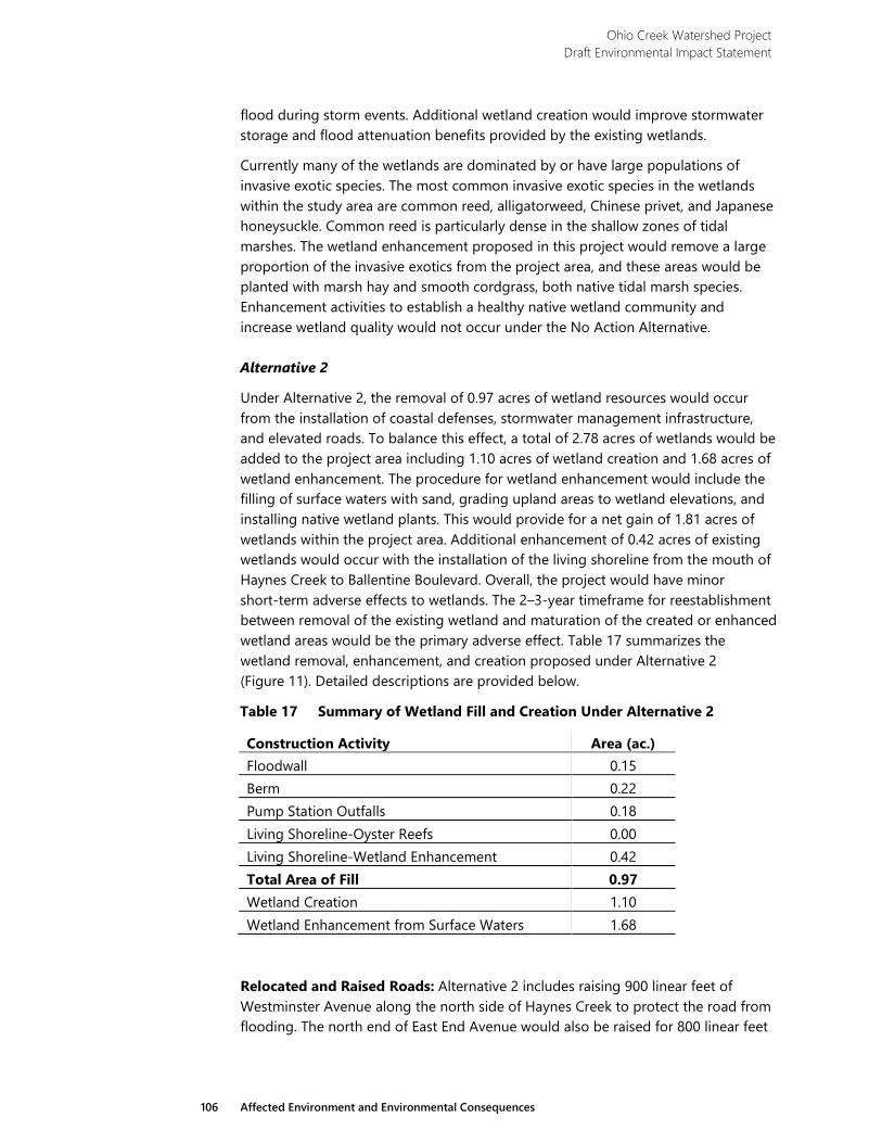
Ohio Creek Watershed Project Draft Environmental Impact Statement
106 Affected Environment and Environmental Consequences
flood during storm events. Additional wetland creation would improve stormwater storage and flood attenuation benefits provided by the existing wetlands.
Currently many of the wetlands are dominated by or have large populations of invasive exotic species. The most common invasive exotic species in the wetlands within the study area are common reed, alligatorweed, Chinese privet, and Japanese honeysuckle. Common reed is particularly dense in the shallow zones of tidal marshes. The wetland enhancement proposed in this project would remove a large proportion of the invasive exotics from the project area, and these areas would be planted with marsh hay and smooth cordgrass, both native tidal marsh species. Enhancement activities to establish a healthy native wetland community and increase wetland quality would not occur under the No Action Alternative.
Alternative 2
Under Alternative 2, the removal of 0.97 acres of wetland resources would occur from the installation of coastal defenses, stormwater management infrastructure, and elevated roads. To balance this effect, a total of 2.78 acres of wetlands would be added to the project area including 1.10 acres of wetland creation and 1.68 acres of wetland enhancement. The procedure for wetland enhancement would include the filling of surface waters with sand, grading upland areas to wetland elevations, and installing native wetland plants. This would provide for a net gain of 1.81 acres of wetlands within the project area. Additional enhancement of 0.42 acres of existing wetlands would occur with the installation of the living shoreline from the mouth of Haynes Creek to Ballentine Boulevard. Overall, the project would have minor short-term adverse effects to wetlands. The 2–3-year timeframe for reestablishment between removal of the existing wetland and maturation of the created or enhanced wetland areas would be the primary adverse effect. Table 17 summarizes the wetland removal, enhancement, and creation proposed under Alternative 2 (Figure 11). Detailed descriptions are provided below.
Table 17 Summary of Wetland Fill and Creation Under Alternative 2
Construction Activity Area (ac.) Floodwall 0.15 Berm 0.22 Pump Station Outfalls 0.18 Living Shoreline-Oyster Reefs 0.00 Living Shoreline-Wetland Enhancement 0.42 Total Area of Fill 0.97 Wetland Creation 1.10 Wetland Enhancement from Surface Waters 1.68
Relocated and Raised Roads: Alternative 2 includes raising 900 linear feet of Westminster Avenue along the north side of Haynes Creek to protect the road from flooding. The north end of East End Avenue would also be raised for 800 linear feet
Ohio Creek Watershed Project Draft Environmental Impact Statement
107 Affected Environment and Environmental Consequences
to provide access over flood control structures. These activities would not affect wetlands within the project area.
Flood Control Structures: Alternative 2 would include the construction of a floodwall on the southwest side of Kimball Terrace to the east side of Ohio Creek to the Haynes Creek wetland system. Installation of a tide gate would occur at the existing culvert for Haynes Creek under Kimball Terrace. The floodwall and associated riprap would lie partially within the Haynes Creek wetland system and fill 0.11 acres of wetland. Installation of 2,150 feet of floodwall would also occur along the waterfront from approximately 300 feet west of Norchester Avenue to the west side of the Grandy Village Learning Center. Most of this floodwall would be constructed in uplands immediately south of Chesterfield Boulevard and the southernmost properties in Chesterfield Heights. Near the Ballentine Pump Station, the wall would be located partially within wetland. This would fill 0.04 acres of wetland within the waterfront wetland system.
Under Alternative 2, coastal defenses would include the construction of an earthen berm. The berm along the eastern portion of Haynes Creek and the waterfront would be constructed as close to adjacent properties as possible; the construction would fill 0.15 acres of wetland. The berm, which would be located from the west side of the Learning Center along the southern and eastern perimeter of Grandy Village, would fill 0.07 acres of wetland where it would cross the Grandy Village unnamed tributary.
Living Shoreline: Construction of approximately 2,500 feet of living shoreline would occur under Alternative 2. The oyster reef creation areas and rock sills would lie in open surface waters, and no direct effects to wetlands would occur. The wetland enhancement areas would fill 0.42 acres of existing wetlands in addition to the 1.68 acres of fill in surface waters. The existing upland slope is very steep and provides no area for wetlands to migrate inland as water levels rise. The enhancements would create a long, gentle slope, increasing total wetland area and providing space into which wetlands would migrate as sea level rises. Enhancement plantings would replace a plant community dominated by common reed, an invasive exotic species, with the native species marsh hay and smooth cordgrass. This would also increase the quality of the wetland and its value as wildlife habitat.
Stormwater Management: Stormwater infrastructure improvements would result in some adverse effects to wetlands under Alternative 2. Installation of force main pipes, outfall pipes, and pump stations at Ohio Creek, Haynes Creek, Chesterfield Boulevard, Ballentine Avenue, and Grandy Village would fill a total of 0.18 acres of wetlands.
Under Alternative 2, tide gates would be installed at the outlets for Ohio Creek, Haynes Creek, and the unnamed tributary at Grandy Village. These gates would close during storm events with large storm surges which could flood areas adjacent to these tidal marshes. It is anticipated that stormwater inputs during tide gate closure would cause salinity decreases in the tidal marsh habitats throughout Ohio Creek, Haynes Creek, and Grandy Village unnamed tributary. Based on research conducted on short-term freshwater inputs in salt marsh ecosystems, is it not likely
Ohio Creek Watershed Project Draft Environmental Impact Statement
108 Affected Environment and Environmental Consequences
that salinity reductions during tide gate closure would result in a change in species composition or abundance in these marshes.38 39 The dominant halophytes (salt-tolerant plant species) in these systems – including saltmarsh cordgrass, saltmeadow hay, black needlerush, marsh elder, and groundsel tree – are able to live in the saline habitat of the salt marsh due to adaptations for hyperosmotic stress, or stress from high levels of salt in the water or soil. Because freshwater wetland species lack these adaptations, they cannot live in salt marsh conditions; therefore, halophytes typically do not have to compete with freshwater wetland plants.40 Although freshwater storage during tide gate closure could make these systems more habitable for non-halophytes, the short-term dilution effects of a typical tide gate closure would not provide sufficient time for freshwater species to become established.41 For these reasons, tide gate closure would not have an effect on salt marsh plant species within the Ohio Creek, Haynes Creek, and Grandy Village wetland systems.
Under Alternative 2, 1.10 acres of marsh creation would occur in uplands adjacent to Ohio Creek and Haynes Creek and within the Grandy Village stormwater park. Adjacent to Ohio Creek, the created wetlands would consist of 0.50 acres of tidal marsh. The bottom elevation of the wetlands would be +0.5, and plantings would consist of smooth cordgrass. A total of 0.30 acres of tidal marsh creation would occur adjacent to Haynes Creek. The bottom elevation would be +0.5 feet for 0.18 acres of wetland and +1.0 for 0.12 acres. Similar to the living shoreline, marsh hay would be planted from an elevation of 4 or 5 feet down to +1.10 feet, or MHW. Smooth cordgrass would be planted from MHW to -0.30, or Mid Tide. The wetland creation area in the Grandy Village stormwater park would lie along the west boundary of Grandy Village and connect a small freshwater marsh near Westminster Avenue to the Grandy Village unnamed tributary. It would connect to the tributary by way of a culvert under Kimball Terrace. The wetland creation area would be 0.30 acres in size and would primarily be freshwater. Plantings would include native freshwater marsh species common to the area such as soft rush, mild waterpepper, and curly dock.
Temporary Effects: Installation of coastal defenses and raised roads would result in short-term negligible adverse effects to wetlands including the discharge of loose soils and sediment into wetlands and waterbodies. Temporary construction impacts would be similar to those discussed for surface waters (section 3.3.2.3). BMPs would be designed in accordance with the Virginia Erosion and Sediment Control Handbook.42
The project would cause indirect short-term negligible adverse effects by facilitating the introduction of invasive exotic plant species through disturbance. Construction activity and soil disturbance would remove vegetation within the project area allowing invasive exotic plant species to colonize the disturbed area.43 Executive
38Zedler, J.B., 1983. Freshwater impacts in normally hypersaline marshes. Estuaries. Vol. 6:346-355. 39 Cronk, J. K. and M. S. Fennessey. 2001. Wetland Plants: Biology and Ecology. Lewis Publishers, Boca Raton, Florida. 40 Cronk and Fennessey. 2001. 41 Zedler. 1983. 42 DCR Division of Soil and Water Conservation. 1992. 43 Lockwood, J.L., Hoopes, M.F., and Marchetti, M.P. 2013 Invasion Ecology. John Wiley & Sons. West Sussex, UK.
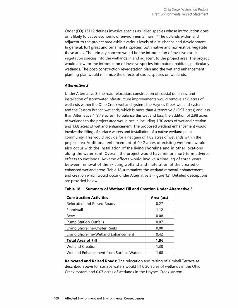
Ohio Creek Watershed Project Draft Environmental Impact Statement
109 Affected Environment and Environmental Consequences
Order (EO) 13112 defines invasive species as “alien species whose introduction does or is likely to cause economic or environmental harm.” The uplands within and adjacent to the project area exhibit various levels of disturbance and development. In general, turf grass and ornamental species, both native and non-native, vegetate these areas. The primary concern would be the introduction of invasive exotic vegetation species into the wetlands in and adjacent to the project area. The project would allow for the introduction of invasive species into natural habitats, particularly wetlands. The post-construction revegetation plan and the wetland enhancement planting plan would minimize the effects of exotic species on wetlands.
Alternative 3
Under Alternative 3, the road relocation, construction of coastal defenses, and installation of stormwater infrastructure improvements would remove 1.96 acres of wetlands within the Ohio Creek wetland system, the Haynes Creek wetland system, and the Eastern Branch wetlands, which is more than Alternative 2 (0.97 acres) and less than Alternative 4 (3.43 acres). To balance this wetland loss, the addition of 2.98 acres of wetlands to the project area would occur, including 1.30 acres of wetland creation and 1.68 acres of wetland enhancement. The proposed wetland enhancement would involve the filling of surface waters and installation of a native wetland plant community. This would provide for a net gain of 1.02 acres of wetlands within the project area. Additional enhancement of 0.42 acres of existing wetlands would also occur with the installation of the living shoreline and in other locations along the waterfront. Overall, the project would have minor short-term adverse effects to wetlands. Adverse effects would involve a time lag of three years between removal of the existing wetland and maturation of the created or enhanced wetland areas. Table 18 summarizes the wetland removal, enhancement, and creation which would occur under Alternative 3 (Figure 12). Detailed descriptions are provided below.
Table 18 Summary of Wetland Fill and Creation Under Alternative 3
Construction Activities Area (ac.) Relocated and Raised Roads 0.27 Floodwall 1.12 Berm 0.08 Pump Station Outfalls 0.07 Living Shoreline-Oyster Reefs 0.00 Living Shoreline-Wetland Enhancement 0.42 Total Area of Fill 1.96 Wetland Creation 1.30 Wetland Enhancement from Surface Waters 1.68
Relocated and Raised Roads: The relocation and raising of Kimball Terrace as described above for surface waters would fill 0.20 acres of wetlands in the Ohio Creek system and 0.07 acres of wetlands in the Haynes Creek system.
Ohio Creek Watershed Project Draft Environmental Impact Statement
110 Affected Environment and Environmental Consequences
Flood Control Structures: Under Alternative 3, the installation of the 6,900 linear feet of floodwall would remove 1.12 acres of wetlands from the project area. Floodwall construction would occur as described for surface water. Wetland removal would include areas disturbed, filled, and isolated by the floodwall. The isolated areas would degrade in quality and normal wetland function once separated from the larger wetland area. The proposed floodwall construction would fill 0.42 acres of wetlands on the east side of the Ohio Creek system, 0.57 acres around the Haynes Creek system, and 0.13 acres along the Elizabeth River.
Berm construction along the waterfront would fill 0.08 acres of wetland at the mouth of Haynes Creek. The east shoreline at the mouth of Haynes Creek would also be armored with a rock revetment. The installation of the flood wall would fill 0.14 acres of wetland along the waterfront.
Stormwater infrastructure improvements would result in some adverse effects to wetlands under Alternative 3. These improvements would include installation of force main pipes, outfall pipes, and pump stations near Westminster Avenue, Filer Street (Haynes Creek), Chesterfield Boulevard, and Ballentine Avenue. Installation of these stormwater infrastructure improvements would fill a total of 0.07 acres of wetlands.
Living Shoreline: Under Alternative 3, approximately 2,500 feet of living shoreline would be constructed to the same design and in the same location as Alternative 2. The oyster reef creation areas and rock sills would lie in open surface waters, and no direct effects to wetlands would occur. The wetland enhancement areas would fill 0.42 acres of existing wetlands in addition to the 1.68 acres of fill in surface waters. The enhancements would create a long, gentle slope, increasing total wetland area and providing space into which wetlands would migrate as sea level rises. Enhancement plantings would replace a plant community dominated by common reed, an invasive exotic species, with the native species marsh hay and smooth cordgrass.
Stormwater Management: Stormwater infrastructure improvements would result in some adverse effects to wetlands under Alternative 3. Installation of outfall pipes or pump stations at Haynes Creek, Chesterfield Boulevard, and Ballentine Avenue would fill a total of 0.07 acres of wetlands.
Under Alternative 3, 1.30 acres of marsh creation would occur in uplands adjacent to Ohio Creek and Haynes Creek and within the Grandy Village stormwater park, compared to 1.10 acres of marsh creation under Alternative 2 and Alternative 4. Adjacent to Ohio Creek, the created wetlands would consist of 0.50 acres of tidal marsh and plantings would consist of smooth cordgrass. A total of 0.30 acres of tidal marsh creation would occur adjacent to Haynes Creek, and it would be planted with saltmeadow hay and smooth cordgrass. The 0.5-acre freshwater wetland creation area in the Grandy Village stormwater park would lie along the west boundary of Grandy Village. Plantings would include native freshwater marsh species common to the area such as soft rush, mild waterpepper, and curly dock.
Temporary Effects: Installation of coastal defenses and raised roads would result in short-term negligible adverse effects to wetlands including the discharge of loose
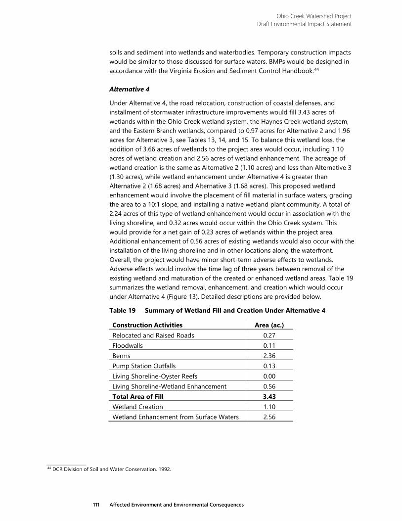
Ohio Creek Watershed Project Draft Environmental Impact Statement
111 Affected Environment and Environmental Consequences
soils and sediment into wetlands and waterbodies. Temporary construction impacts would be similar to those discussed for surface waters. BMPs would be designed in accordance with the Virginia Erosion and Sediment Control Handbook.44
Alternative 4
Under Alternative 4, the road relocation, construction of coastal defenses, and installment of stormwater infrastructure improvements would fill 3.43 acres of wetlands within the Ohio Creek wetland system, the Haynes Creek wetland system, and the Eastern Branch wetlands, compared to 0.97 acres for Alternative 2 and 1.96 acres for Alternative 3, see Tables 13, 14, and 15. To balance this wetland loss, the addition of 3.66 acres of wetlands to the project area would occur, including 1.10 acres of wetland creation and 2.56 acres of wetland enhancement. The acreage of wetland creation is the same as Alternative 2 (1.10 acres) and less than Alternative 3 (1.30 acres), while wetland enhancement under Alternative 4 is greater than Alternative 2 (1.68 acres) and Alternative 3 (1.68 acres). This proposed wetland enhancement would involve the placement of fill material in surface waters, grading the area to a 10:1 slope, and installing a native wetland plant community. A total of 2.24 acres of this type of wetland enhancement would occur in association with the living shoreline, and 0.32 acres would occur within the Ohio Creek system. This would provide for a net gain of 0.23 acres of wetlands within the project area. Additional enhancement of 0.56 acres of existing wetlands would also occur with the installation of the living shoreline and in other locations along the waterfront. Overall, the project would have minor short-term adverse effects to wetlands. Adverse effects would involve the time lag of three years between removal of the existing wetland and maturation of the created or enhanced wetland areas. Table 19 summarizes the wetland removal, enhancement, and creation which would occur under Alternative 4 (Figure 13). Detailed descriptions are provided below.
Table 19 Summary of Wetland Fill and Creation Under Alternative 4
Construction Activities Area (ac.) Relocated and Raised Roads 0.27 Floodwalls 0.11 Berms 2.36 Pump Station Outfalls 0.13 Living Shoreline-Oyster Reefs 0.00 Living Shoreline-Wetland Enhancement 0.56 Total Area of Fill 3.43 Wetland Creation 1.10 Wetland Enhancement from Surface Waters 2.56
44 DCR Division of Soil and Water Conservation. 1992.
Ohio Creek Watershed Project Draft Environmental Impact Statement
112 Affected Environment and Environmental Consequences
Relocated and Raised Roads: The relocation and raising of Kimball Terrace as described above for surface waters would fill 0.20 acres of wetlands in the Ohio Creek system and 0.07 acres of wetlands in the Haynes Creek system.
Flood Control Structures: Construction of the floodwall across the Haynes Creek wetland system immediately south of Kimball Terrace and the floodwall at Ballentine Station would fill 0.11 acres and 0.004 acres of wetlands, respectively. Floodwall construction would occur as described above for surface water (section 3.3.2.3, Alternative 4).
Berm installation represents the largest component of the coastal protection plan under Alternative 4. Within the Ohio Creek wetland system, construction of the berm system would fill 0.74 acres of wetlands. However, a total of 0.83 acres of wetland creation or enhancement would occur in uplands and surface waters. Berm construction in the Haynes Creek wetland system would fill 0.31 acres of wetlands. Within this system, 0.20 acres of wetland creation in uplands would also occur. Berm construction along the waterfront south of Kimball Terrace would fill 0.77 acres of wetlands. In this area, a total of 2.8 acres of wetland enhancement would occur in surface waters and existing wetlands as part of Alternative 4.
Stormwater infrastructure improvements which would affect wetlands under Alternative 4 would include installation of the Haynes Creek Pump Station and outfall into Haynes Creek south of Kimball Terrace; and the Ballentine Pump Station and outfall through Eastern Branch wetlands. Additional culvert installation would occur under Alternative 4, one located at the west end of Marlboro Avenue with an outfall into Haynes Creek south of Kimball Terrace, and one located at the south end of Sedgewick Street with an outfall into Ohio Creek. The installation of these stormwater infrastructure improvements would fill 0.13 acres of wetlands.
Under Alternative 4, a tide gate would be installed at the outlet for Haynes Creek. This gate would close during storm events with large storm surges which could flood areas adjacent to this tidal marshes, and during this time, the marsh will be used for stormwater storage. It is anticipated that stormwater inputs during tide gate closure would cause salinity decreases in the tidal marsh habitat within Haynes Creek. Based on research conducted on short-term freshwater inputs in salt marsh ecosystems, is it not likely that salinity reductions during tide gate closure would result in a change in species composition or abundance in these marshes.45 46 The dominant halophytes (salt-tolerant plant species) in these systems – including saltmarsh cordgrass, saltmeadow hay, black needlerush, marsh elder, and groundsel tree – are able to live in the saline habitat of the salt marsh due to adaptations for
45Zedler, 1983. 46 Cronk and Fennessey. 2001.
Ohio Creek Watershed Project Draft Environmental Impact Statement
113 Affected Environment and Environmental Consequences
hyperosmotic stress, or stress from high levels of salt in the water or soil. Because freshwater wetland species lack these adaptations, they cannot live in salt marsh conditions; therefore, halophytes typically do not have to compete with freshwater wetland plants.47 Although freshwater storage during tide gate closure could make these systems more habitable for non-halophytes, the short-term dilution effects of a typical tide gate closure would not provide sufficient time for freshwater species to become established.48 For these reasons, tide gate closure would not have an effect on salt marsh plant species within the Ohio Creek, Haynes Creek, and Grandy Village wetland systems.
Living Shoreline: Construction of the living shoreline, as described above for surface waters (section 3.3.2.3. Alternative 4), would fill 0.56 acres of wetlands with sand for wetland enhancements. However, a total of 2.8 acres of wetland enhancement or restoration would occur in sand filled areas between the rock sills and the protective berm. As described above, short-term negligible adverse effects would occur due to the time lag of three years between filling the existing wetlands and the full maturation of the enhanced wetland areas.
Under Alternative 4, the tidal marsh creation adjacent to Ohio Creek and Haynes Creek and the Grandy Village stormwater park freshwater marsh would be the same as Alternative 2. Marsh creation would include 0.5 acres of tidal marsh creation in the Ohio Creek system, 0.3 acres of tidal marsh in the Haynes Creek system, and 0.3 acres of freshwater marsh creation in the Grandy Village stormwater park, which would be developed within the existing park and playing field area between Chesterfield Academy and Grandy Village. Construction of additional tidal marsh area would occur within open surface waters in Ohio Creek. Wetland enhancement would occur in the east branch of the wetland system in which sand would fill the basin creating a 10:1 slope from the base of the surrounding berm to the center of the cove. Native wetland plant species would vegetate the areas below +4.15 feet. Marsh hay would be planted from an elevation of +4.15 feet down to +1.10 feet. Smooth cordgrass would be planted from MHW to -0.30 feet.
Temporary Effects: Installation of coastal defenses and raised roads would result in short-term negligible adverse effects to wetlands including the discharge of loose soils and sediment into wetlands and waterbodies. Short-term construction effects would be similar to those discussed for surface waters (section 3.3.2.3, Alternative 4). BMPs would be designed in accordance with the Virginia Erosion and Sediment Control Handbook.49
47 Cronk and Fennessey. 2001. 48 Zedler. 1983. 49 DCR Division of Soil and Water Conservation. 1992.
Ohio Creek Watershed Project Draft Environmental Impact Statement
114 Affected Environment and Environmental Consequences
3.3.4 Floodplains
3.3.4.1 Methodology
Floodplains are regulated by local, state and federal rules and regulations. EO 11988 Floodplain Management (1977) requires federal agencies to “avoid to the extent possible the long and short-term adverse impacts associated with the occupancy and modification of floodplains and to avoid direct or indirect support of floodplain development wherever there is a practicable alternative.”
FEMA has primary federal jurisdiction for administration of EO 11988. FEMA guidance for compliance with EO 11988 is found at 44 CFR 9. HUD has issued additional guidance (24 CFR 55.20) for compliance with EO 11988. HUD guidance has established an eight-step process for compliance, which includes public notices and examination of practicable alternatives when addressing floodplains and wetlands. The eight-step process for compliance would be accomplished through completion of the EIS for the project.
EO 13690 (2015) Establishing a Federal Flood Risk Management Standard (FFRMS) and a Process for Further Soliciting and Considering Stakeholder Input amended EO 11988, and established the FFRMS to improve the nation’s resilience to current and future flood risks, which are anticipated to increase over time due to the effects of climate change and other threats. EO 13690 and the FFRMS encourage the consideration of natural systems, ecosystem processes, and nature-based approaches when development alternatives are considered. This is consistent with recommendations and findings of the 2015 North Atlantic Coast Comprehensive Study, which is aimed at reducing risk and increase reliance of communities’ abilities to withstand and rapidly recover from storm damages. In addition, EO 13690 and the FFRMS expand upon these tenets by calling for agencies to use higher design flood elevations than the base flood for federally funded projects to address current and future flood risk so that projects last as long as intended.
The Virginia Flood Damage Reduction Act of 1989 was enacted to improve Virginia’s flood protection programs and place related programs in one agency, the Virginia Department of Conservation and Recreation (DCR). DCR is the manager of Virginia’s floodplain program, serves as coordinator for all flood protection programs and activities in the Commonwealth of Virginia, and is the designated coordinating agency of the National Flood Insurance Program. Under the Code of Virginia §10.1-602 (Floodplain Code), DCR works with localities to establish and enforce floodplain management zoning.
The Norfolk Zoning Ordinance, Article 3.9.7 FPCH-O: Floodplain/Coastal Hazard Overlay, regulates the uses, activities and development within the floodplain, with the primary goal to prevent loss of property and life, the creation of health and safety hazards, the disruption of commerce and governmental services, the extraordinary and unnecessary expenditure of public funds for flood protection and relief, and the impairment of the tax base. The floodplain ordinance went through a major update in January 1, 2014, which included several revisions to the floodplain regulations to
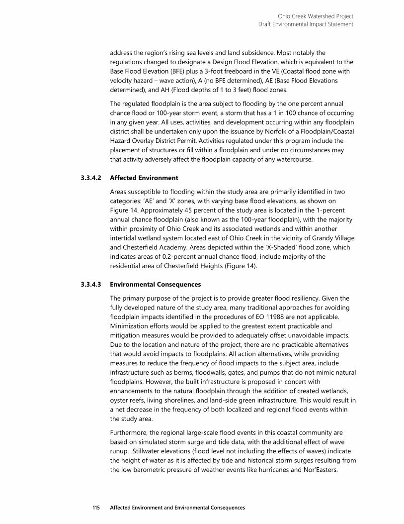
Ohio Creek Watershed Project Draft Environmental Impact Statement
115 Affected Environment and Environmental Consequences
address the region’s rising sea levels and land subsidence. Most notably the regulations changed to designate a Design Flood Elevation, which is equivalent to the Base Flood Elevation (BFE) plus a 3-foot freeboard in the VE (Coastal flood zone with velocity hazard – wave action), A (no BFE determined), AE (Base Flood Elevations determined), and AH (Flood depths of 1 to 3 feet) flood zones.
The regulated floodplain is the area subject to flooding by the one percent annual chance flood or 100-year storm event, a storm that has a 1 in 100 chance of occurring in any given year. All uses, activities, and development occurring within any floodplain district shall be undertaken only upon the issuance by Norfolk of a Floodplain/Coastal Hazard Overlay District Permit. Activities regulated under this program include the placement of structures or fill within a floodplain and under no circumstances may that activity adversely affect the floodplain capacity of any watercourse.
3.3.4.2 Affected Environment
Areas susceptible to flooding within the study area are primarily identified in two categories: ‘AE’ and ‘X’ zones, with varying base flood elevations, as shown on Figure 14. Approximately 45 percent of the study area is located in the 1-percent annual chance floodplain (also known as the 100-year floodplain), with the majority within proximity of Ohio Creek and its associated wetlands and within another intertidal wetland system located east of Ohio Creek in the vicinity of Grandy Village and Chesterfield Academy. Areas depicted within the ‘X-Shaded’ flood zone, which indicates areas of 0.2-percent annual chance flood, include majority of the residential area of Chesterfield Heights (Figure 14).
3.3.4.3 Environmental Consequences
The primary purpose of the project is to provide greater flood resiliency. Given the fully developed nature of the study area, many traditional approaches for avoiding floodplain impacts identified in the procedures of EO 11988 are not applicable. Minimization efforts would be applied to the greatest extent practicable and mitigation measures would be provided to adequately offset unavoidable impacts. Due to the location and nature of the project, there are no practicable alternatives that would avoid impacts to floodplains. All action alternatives, while providing measures to reduce the frequency of flood impacts to the subject area, include infrastructure such as berms, floodwalls, gates, and pumps that do not mimic natural floodplains. However, the built infrastructure is proposed in concert with enhancements to the natural floodplain through the addition of created wetlands, oyster reefs, living shorelines, and land-side green infrastructure. This would result in a net decrease in the frequency of both localized and regional flood events within the study area.
Furthermore, the regional large-scale flood events in this coastal community are based on simulated storm surge and tide data, with the additional effect of wave runup. Stillwater elevations (flood level not including the effects of waves) indicate the height of water as it is affected by tide and historical storm surges resulting from the low barometric pressure of weather events like hurricanes and Nor’Easters.

Ohio Creek Watershed Project Draft Environmental Impact Statement
116 Affected Environment and Environmental Consequences
This page intentionally left blank.
O
hio
Cre
ek
Hay
nes
Cre
ek
264
NO
RCH
ESTE
R AV
E
BALL
ENTI
NE BLV
D
WIL
EY D
R
E. BRAMBLETON AVE
0 500SCALE IN FEET
North
Project Area
Source: National Flodd Insurance Program; Flood Insurance Rate Map for City of Norfolk, Virginia; Map Number 510104 Panels 0057, 0059, 0076, and 0078 of 83; Suffix H. Map Revised February 17, 2017. FIGURE 14
FEMA FIRMETTE MAP
Ohio Creek Watershed Project Environmental Impact Statement
E a s t e r n B r a n c h E l i z a b e t h R i v e r
Ebb
Flood

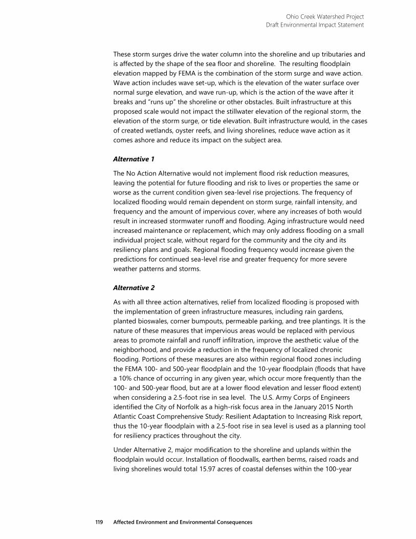
Ohio Creek Watershed Project Draft Environmental Impact Statement
119 Affected Environment and Environmental Consequences
These storm surges drive the water column into the shoreline and up tributaries and is affected by the shape of the sea floor and shoreline. The resulting floodplain elevation mapped by FEMA is the combination of the storm surge and wave action. Wave action includes wave set-up, which is the elevation of the water surface over normal surge elevation, and wave run-up, which is the action of the wave after it breaks and “runs up” the shoreline or other obstacles. Built infrastructure at this proposed scale would not impact the stillwater elevation of the regional storm, the elevation of the storm surge, or tide elevation. Built infrastructure would, in the cases of created wetlands, oyster reefs, and living shorelines, reduce wave action as it comes ashore and reduce its impact on the subject area.
Alternative 1
The No Action Alternative would not implement flood risk reduction measures, leaving the potential for future flooding and risk to lives or properties the same or worse as the current condition given sea-level rise projections. The frequency of localized flooding would remain dependent on storm surge, rainfall intensity, and frequency and the amount of impervious cover, where any increases of both would result in increased stormwater runoff and flooding. Aging infrastructure would need increased maintenance or replacement, which may only address flooding on a small individual project scale, without regard for the community and the city and its resiliency plans and goals. Regional flooding frequency would increase given the predictions for continued sea-level rise and greater frequency for more severe weather patterns and storms.
Alternative 2
As with all three action alternatives, relief from localized flooding is proposed with the implementation of green infrastructure measures, including rain gardens, planted bioswales, corner bumpouts, permeable parking, and tree plantings. It is the nature of these measures that impervious areas would be replaced with pervious areas to promote rainfall and runoff infiltration, improve the aesthetic value of the neighborhood, and provide a reduction in the frequency of localized chronic flooding. Portions of these measures are also within regional flood zones including the FEMA 100- and 500-year floodplain and the 10-year floodplain (floods that have a 10% chance of occurring in any given year, which occur more frequently than the 100- and 500-year flood, but are at a lower flood elevation and lesser flood extent) when considering a 2.5-foot rise in sea level. The U.S. Army Corps of Engineers identified the City of Norfolk as a high-risk focus area in the January 2015 North Atlantic Coast Comprehensive Study: Resilient Adaptation to Increasing Risk report, thus the 10-year floodplain with a 2.5-foot rise in sea level is used as a planning tool for resiliency practices throughout the city.
Under Alternative 2, major modification to the shoreline and uplands within the floodplain would occur. Installation of floodwalls, earthen berms, raised roads and living shorelines would total 15.97 acres of coastal defenses within the 100-year
Ohio Creek Watershed Project Draft Environmental Impact Statement
120 Affected Environment and Environmental Consequences
floodplain. Table 20 summarizes these disturbance areas. Detailed descriptions are provided below.
Table 20 Summary of Floodplain Disturbance Under Alternative 2
Coastal Defense Area (ac.) Floodwalls 2.81 Berms 4.06 Raised Roads 3.46 Living Shoreline 5.64 Total Area of Floodplain Impacted 15.97
Relocated and Raised Road and Flood Control Structures: Alternative 2 proposes the greatest length of hardened barrier creation within the floodplain, including, from west to east, raising Kimball Terrace, floodwall and tide gate at Haynes Creek, earthen berm along the eastern shore of Haynes Creek, transitioning to floodwall midway along Chesterfield Boulevard, and transitioning back to earthen berm west of Kimball Loop to encompass the Learning Center (constructed in 2010) and residential areas of Grandy Village. Raising of roadways and floodwalls are focused primarily in areas of existing roadways, whereas the earthen berm is intended to provide a slight elevation grade at slopes that are easily maintained and in subtle contrast to the flat relief of the current shoreline. Both floodwalls and earthen berms are proposed to have a crest elevation of 11 feet, whereas the FEMA 100-year floodplain has an elevation between 8 and 9 within the project area, thus providing 2 to 3 feet of freeboard (a factor of safety expressed in feet above the flood level).
This hardening of the floodplain would not raise storm surge or tidal elevations. It would reduce the effect of wave action toward landward areas, but would also require the implementation, maintenance, and operation of pump stations to manage stormwater runoff and five tide gates. The tide gates would serve to maintain normal tidal fluctuations during dry and normal rainfall events, but block tidal passage during heavy rainfall to provide temporary stormwater detention, or block tidal passage during storm surge events to prevent tidal flooding in Chesterfield Heights
Living Shoreline and Wetlands: Additional modification to the floodplain includes the design components associated with enhancement of the coastal edge and include wetland creation, providing greater flood capacity along Ohio Creek, Haynes Creek and Grandy Village watersheds; wetland enhancements along the shoreline of the Eastern Branch, where shorelines are currently a mosaic of natural and maintained areas; and living shoreline and oyster reef creation seaward of approximately 2,500 linear feet of shoreline.
No increase in storm surge or tidal elevations would result from the proposed activities within the floodplain, floodplain boundaries are not expected to change, and it is expected that wave action would be reduced by the off- and on-shore measures. These improvements are appropriate for siting in the 100-year floodplain consistent
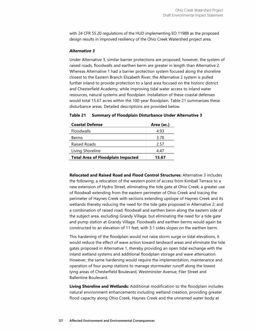
Ohio Creek Watershed Project Draft Environmental Impact Statement
121 Affected Environment and Environmental Consequences
with 24 CFR 55.20 regulations of the HUD implementing EO 11988 as the proposed design results in improved resiliency of the Ohio Creek Watershed project area.
Alternative 3
Under Alternative 3, similar barrier protections are proposed; however, the system of raised roads, floodwalls and earthen berm are greater in length than Alternative 2. Whereas Alternative 1 had a barrier protection system focused along the shoreline closest to the Eastern Branch Elizabeth River, the Alternative 2 system is pulled further inland to provide protection to a land area focused on the historic district and Chesterfield Academy, while improving tidal water access to inland water resources, natural systems and floodplain. Installation of these coastal defenses would total 15.67 acres within the 100-year floodplain. Table 21 summarizes these disturbance areas. Detailed descriptions are provided below.
Table 21 Summary of Floodplain Disturbance Under Alternative 3
Coastal Defense Area (ac.) Floodwalls 4.93 Berms 3.70 Raised Roads 2.57 Living Shoreline 4.47 Total Area of Floodplain Impacted 15.67
Relocated and Raised Road and Flood Control Structures: Alternative 3 includes the following; a relocation of the western point of access from Kimball Terrace to a new extension of Hydro Street, eliminating the tide gate at Ohio Creek; a greater use of floodwall extending from the eastern perimeter of Ohio Creek and tracing the perimeter of Haynes Creek with sections extending upslope of Haynes Creek and its wetlands thereby reducing the need for the tide gate proposed in Alternative 2; and a combination of raised road, floodwall and earthen berm along the eastern side of the subject area, excluding Grandy Village, but eliminating the need for a tide gate and pump station at Grandy Village. Floodwalls and earthen berms would again be constructed to an elevation of 11 feet, with 3:1 sides slopes on the earthen berm.
This hardening of the floodplain would not raise storm surge or tidal elevations, it would reduce the effect of wave action toward landward areas and eliminate the tide gates proposed in Alternative 1, thereby providing an open tidal exchange with the inland wetland systems and additional floodplain storage and wave attenuation. However, the same hardening would require the implementation, maintenance and operation of four pump stations to manage stormwater runoff along the lowest lying areas of Chesterfield Boulevard, Westminster Avenue, Filer Street and Ballentine Boulevard.
Living Shoreline and Wetlands: Additional modification to the floodplain includes natural environment enhancements including wetland creation, providing greater flood capacity along Ohio Creek, Haynes Creek and the unnamed water body at
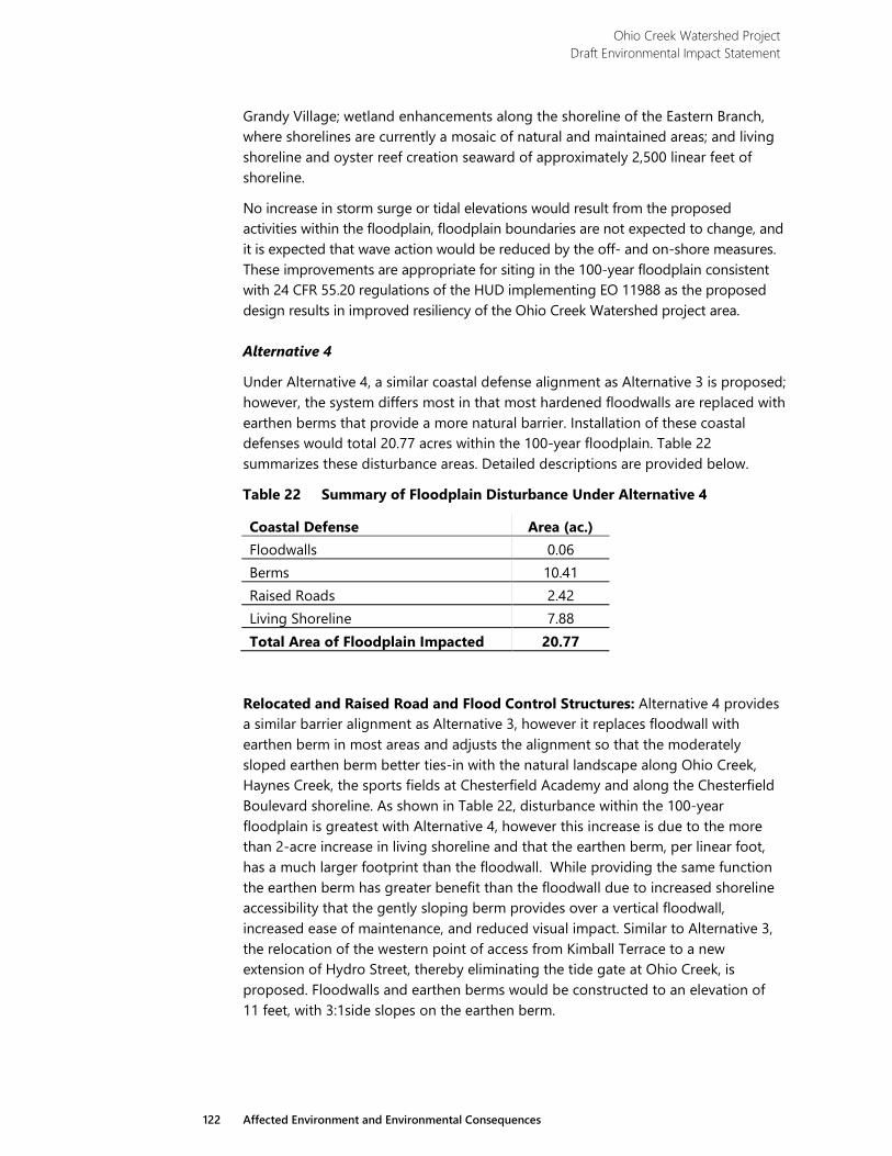
Ohio Creek Watershed Project Draft Environmental Impact Statement
122 Affected Environment and Environmental Consequences
Grandy Village; wetland enhancements along the shoreline of the Eastern Branch, where shorelines are currently a mosaic of natural and maintained areas; and living shoreline and oyster reef creation seaward of approximately 2,500 linear feet of shoreline.
No increase in storm surge or tidal elevations would result from the proposed activities within the floodplain, floodplain boundaries are not expected to change, and it is expected that wave action would be reduced by the off- and on-shore measures. These improvements are appropriate for siting in the 100-year floodplain consistent with 24 CFR 55.20 regulations of the HUD implementing EO 11988 as the proposed design results in improved resiliency of the Ohio Creek Watershed project area.
Alternative 4
Under Alternative 4, a similar coastal defense alignment as Alternative 3 is proposed; however, the system differs most in that most hardened floodwalls are replaced with earthen berms that provide a more natural barrier. Installation of these coastal defenses would total 20.77 acres within the 100-year floodplain. Table 22 summarizes these disturbance areas. Detailed descriptions are provided below.
Table 22 Summary of Floodplain Disturbance Under Alternative 4
Coastal Defense Area (ac.) Floodwalls 0.06 Berms 10.41 Raised Roads 2.42 Living Shoreline 7.88 Total Area of Floodplain Impacted 20.77
Relocated and Raised Road and Flood Control Structures: Alternative 4 provides a similar barrier alignment as Alternative 3, however it replaces floodwall with earthen berm in most areas and adjusts the alignment so that the moderately sloped earthen berm better ties-in with the natural landscape along Ohio Creek, Haynes Creek, the sports fields at Chesterfield Academy and along the Chesterfield Boulevard shoreline. As shown in Table 22, disturbance within the 100-year floodplain is greatest with Alternative 4, however this increase is due to the more than 2-acre increase in living shoreline and that the earthen berm, per linear foot, has a much larger footprint than the floodwall. While providing the same function the earthen berm has greater benefit than the floodwall due to increased shoreline accessibility that the gently sloping berm provides over a vertical floodwall, increased ease of maintenance, and reduced visual impact. Similar to Alternative 3, the relocation of the western point of access from Kimball Terrace to a new extension of Hydro Street, thereby eliminating the tide gate at Ohio Creek, is proposed. Floodwalls and earthen berms would be constructed to an elevation of 11 feet, with 3:1side slopes on the earthen berm.
Ohio Creek Watershed Project Draft Environmental Impact Statement
123 Affected Environment and Environmental Consequences
The earthen berm along the Eastern Branch is pushed seaward to form the boundary between the seaward upland improvements, creating an integrated demarcation of the shoreline improvements and greater separation from the berm and community space. East of the Ballentine pump station Alternative 4 has an extensive earthen berm compared to the floodwalls of Alternatives 2 and 3. The earthen berm follows Kimball Loop to protect additional community buildings, reducing the length of road to be raised and integrating better within the natural landscape between Kimball Loop and the natural areas toward the shoreline and north within the Chesterfield Academy recreational space.
Striking a balance between providing regional floodplain storage and localized stormwater storage, Alternative 4 maintains an open tidal and floodplain exchange at Ohio Creek, while providing a tide gate at Haynes Creek. Floodwall is both removed and replaced with earthen berm at Haynes Creek so that the existing estuarine wetlands and natural buffer surrounding the wetlands may be used as a stormwater park for localized flooding. The tide gate would serve to maintain normal tidal fluctuations during dry and normal rainfall events but block tidal passage during heavy rainfall to provide temporary stormwater detention, or block tidal passage during storm surge events to prevent tidal flooding in Chesterfield Heights. Additional upland stormwater parks are proposed at the water tower along Ballentine Boulevard and on the grounds of Chesterfield Academy.
This hardening of the floodplain would not raise storm surge or tidal elevations—it would reduce the effect of wave action toward landward areas, but it would require the implementation, maintenance and operation of two pump stations at Ballentine, and Haynes Creek. The pump stations at Filer Street and Chesterfield Boulevard were removed due to the addition of stormwater detention at Haynes Creek, by the Ballentine Pump station, and improvements to the storm drainage system.
Living Shoreline and Wetlands: Additional modification to the floodplain includes natural environment enhancements including wetland creation, providing greater flood capacity along Ohio Creek and the Grandy Village unnamed water body; wetland enhancements along the shoreline of the Eastern Branch, where shorelines are currently a mosaic of natural and maintained areas; and living shoreline and oyster reef creation seaward of a greater length of approximately 4,200 linear feet of shoreline.
No increase in storm surge or tidal elevations would result from the proposed activities within the floodplain, floodplain boundaries are not expected to change, and it is expected that wave action would be reduced by the off- and on-shore measures. These improvements are appropriate for siting in the 100-year floodplain consistent with 24 CFR 55.20 regulations of the HUD implementing EO 11988 as the proposed design results in improved resiliency of the Ohio Creek Watershed project area.
Ohio Creek Watershed Project Draft Environmental Impact Statement
124 Affected Environment and Environmental Consequences
3.3.5 Biological Resources
3.3.5.1 Methodology
The National Oceanic and Atmospheric Administration (NOAA) National Marine Fisheries Service (NMFS) EFH Mapper database50 was used to generate a list of species groups with designated EFH within or adjacent to the study area (including all areas with proposed in-water construction). The Virginia Coastal Geospatial and Educational Mapping System51 was used to review coastal resources within or near the study area. These resources included, but were not limited to, oyster reefs, Baylor Grounds, areas reserved for public shellfish harvesting that cannot be leased or used for other purposes, and submerged aquatic vegetation. The Center for Conservation Biology (CCB) Mapping Portal52 was reviewed to determine the presence of colonial waterbird rookeries within or near the study area. Additional resources, which were readily available online, were also reviewed to determine the presence of other resources such as marine mammal populations and important aquatic and terrestrial habitats.
Regulatory Setting
The Magnuson Stevens Fishery- Conservation and Management Act Reauthorization 2006 and the Marine Mammal Protection Act of 1972, amended 1994 (MMPA) protect aquatic resources within and adjacent to the study area. In addition, CEQ guidance Incorporating Biodiversity Considerations into Environmental Impact Analysis Under the National Environmental Policy Act53 requires consideration of natural systems and the effects of the project on non-listed plant and wildlife species.
Reauthorization of the Magnuson-Stevens Fishery Conservation and Management Act in 2006 required NMFS to coordinate with federal and state agencies, resource users, and others to protect, conserve, and enhance EFH. The Mid-Atlantic Fishery Management Council is responsible for the conservation and management of fish stocks within the federal 200-mile limit of the Atlantic Ocean off the coasts of New York, New Jersey, Pennsylvania, Delaware, Maryland, Virginia, and North Carolina. The Mid-Atlantic Fishery Management Council is also responsible for the development of fishery management plans and amendments to ensure sustainable
50 National Oceanic and Atmospheric Administration (NOAA), National Marine Fisheries Service (NMFS). 2017. Essential Fish Habitat
Mapper. https://www.habitat.noaa.gov/protection/efh/efhmapper/index.html. Accessed March 18, 2018. 51 Virginia Coastal Zone Management Program. 2018. Coastal Geospatial and Educational Mapping System.
http://www.coastalgems.org/. Accessed March 18, 2018. 52 The Center for Conservation Biology (CCB). 2018. CCB Mapping Portal. http://www.ccbbirds.org/maps/. Accessed March 18, 2018. 53 Council on Environmental Quality (CEQ). 1993. Incorporating Biodiversity Considerations into Environmental Impact Analysis Under the National
Environmental Policy Act. http://energy.gov/sites/prod/files/nepapub/nepa_documents/RedDont/G-CEQ-BiodiversityConsiderations.pdf. Accessed March 20, 2018.

Ohio Creek Watershed Project Draft Environmental Impact Statement
125 Affected Environment and Environmental Consequences
fisheries. Implementation of the regulations, including federal management of permits for some fisheries, is the responsibility of NMFS. The rule also identifies Habitat Areas of Particular Concern (HAPC). HAPC are subsets of EFH that are particularly important to the long-term productivity of populations of one or more managed species, or are particularly vulnerable to human induced degradation.
The MMPA prohibits the take of marine mammals in US waters and by US citizens on the high seas. Section 3(18) of the Endangered Species Act defines ‘take’ as “to harass, harm, pursue, hunt, shoot, wound, kill, trap, capture, or collect, or to attempt to engage in any such conduct”,54 It also prohibits the importation of marine mammals and marine mammal products into the United States.55 The 1994 amendment of the MMPA allows certain exceptions to take prohibitions including small takes incidental to specific activities, access by Alaskan natives to marine mammal subsistence resources, and permits and authorizations for scientific research. Additionally, the amended MMPA provides for a program to control the loss of marine mammals by commercial fishing operations.
3.3.5.2 Affected Environment
Aquatic Resources
Article XI of the Constitution of Virginia guarantees natural oyster beds, rocks, and shoals be reserved for public use. Beginning in 1894, a two-year survey, known as the Baylor Survey, of state tidal waters was completed to map the location of natural oyster beds. These areas are reserved for public use and cannot be leased or used for other purposes.56 Baylor Grounds are managed by the Virginia Marine Resources Commission (VMRC). According to the Virginia Coastal Zone Management Program Coastal Geospatial and Educational Mapping System Geographic Information System (GIS) portal, the study area is adjacent to Baylor Grounds, or public oyster grounds;57 (Figure 15).
Marshes within the study area support a large population of Atlantic ribbed mussels (Geukensia demissa). This is a euryhaline (able to tolerate a wide range of salinity) mussel which inhabits tidal marshes within estuarine systems. It is commonly found living in association with smooth cordgrass to which it attaches with strong byssal threads, which are strong, flexible fibers made from proteins which are used by
54 U.S. Fish and Wildlife Service (USFWS). 1973. Endangered Species Act. https://www.fws.gov/endangered/esa-library/pdf/ESAall.pdf.
Accessed July 19, 2018.https://www.fws.gov/endangered/esa-library/pdf/ESAall.pdf. Accessed July 19, 2018. 55 NOAA NMFS. 2016. Marine Mammal Protection Act (MMPA). http://www.nmfs.noaa.gov/pr/laws/mmpa/. Accessed March 20, 2018. 56 Virginia Marine Resources Commission (VMRC). 2018. Historical Highlights of the Virginia Marine Resources Commission.
http://mrc.virginia.gov/vmrchist.shtm#eighteenninetyfour. Accessed May 7, 2018. 57 Virginia Coastal Zone Management Program. 2018.
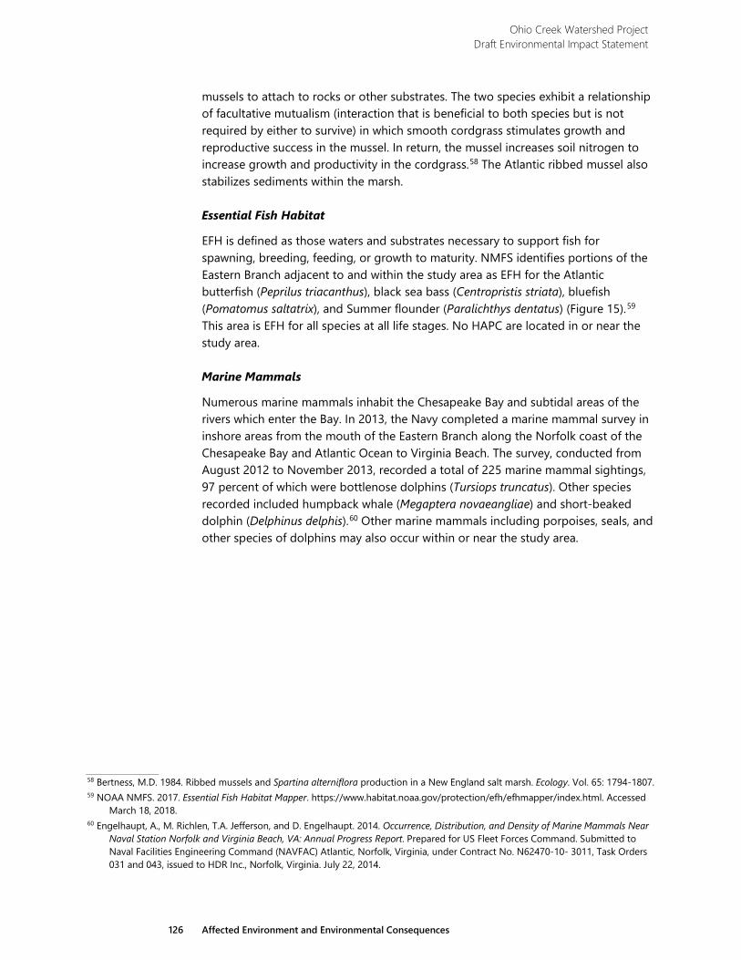
Ohio Creek Watershed Project Draft Environmental Impact Statement
126 Affected Environment and Environmental Consequences
mussels to attach to rocks or other substrates. The two species exhibit a relationship of facultative mutualism (interaction that is beneficial to both species but is not required by either to survive) in which smooth cordgrass stimulates growth and reproductive success in the mussel. In return, the mussel increases soil nitrogen to increase growth and productivity in the cordgrass.58 The Atlantic ribbed mussel also stabilizes sediments within the marsh.
Essential Fish Habitat
EFH is defined as those waters and substrates necessary to support fish for spawning, breeding, feeding, or growth to maturity. NMFS identifies portions of the Eastern Branch adjacent to and within the study area as EFH for the Atlantic butterfish (Peprilus triacanthus), black sea bass (Centropristis striata), bluefish (Pomatomus saltatrix), and Summer flounder (Paralichthys dentatus) (Figure 15).59 This area is EFH for all species at all life stages. No HAPC are located in or near the study area.
Marine Mammals
Numerous marine mammals inhabit the Chesapeake Bay and subtidal areas of the rivers which enter the Bay. In 2013, the Navy completed a marine mammal survey in inshore areas from the mouth of the Eastern Branch along the Norfolk coast of the Chesapeake Bay and Atlantic Ocean to Virginia Beach. The survey, conducted from August 2012 to November 2013, recorded a total of 225 marine mammal sightings, 97 percent of which were bottlenose dolphins (Tursiops truncatus). Other species recorded included humpback whale (Megaptera novaeangliae) and short-beaked dolphin (Delphinus delphis).60 Other marine mammals including porpoises, seals, and other species of dolphins may also occur within or near the study area.
58 Bertness, M.D. 1984. Ribbed mussels and Spartina alterniflora production in a New England salt marsh. Ecology. Vol. 65: 1794-1807. 59 NOAA NMFS. 2017. Essential Fish Habitat Mapper. https://www.habitat.noaa.gov/protection/efh/efhmapper/index.html. Accessed
March 18, 2018. 60 Engelhaupt, A., M. Richlen, T.A. Jefferson, and D. Engelhaupt. 2014. Occurrence, Distribution, and Density of Marine Mammals Near
Naval Station Norfolk and Virginia Beach, VA: Annual Progress Report. Prepared for US Fleet Forces Command. Submitted to Naval Facilities Engineering Command (NAVFAC) Atlantic, Norfolk, Virginia, under Contract No. N62470-10- 3011, Task Orders 031 and 043, issued to HDR Inc., Norfolk, Virginia. July 22, 2014.
O
hio
Cre
ek
Hay
nes
Cre
ek
264
CHESTERFIELD BLVD
MARLBORO AVE
KIMBALL TERRACE
STANHOPE AVE
NO
RCH
ESTE
R AV
E
VICTORIA AVE
MA
JEST
IC A
VE
KIMBALL LOOP
KIM
BALL
CT
EARLSCOURT AVEWESTMINSTER AVE
WESTMINSTER AVE
BALL
ENTI
NE BLV
D
FILER ST
FORBES ST
THAYO
R ST
SEDG
EWICK ST
CAMPO
STELLA RD
WIL
EY D
R
KIMBALL TERRACE
EAST END AVE
STRATHMORE AVE
E. BRAMBLETON AVE
HYDRO ST
Project AreaEssential Fish HabitatPublic Oyster Grounds (Baylor Grounds)
0 500SCALE IN FEET
North
FIGURE 15
ESSENTIAL FISH HABITAT AND PUBLIC OYSTER GROUNDS
Ohio Creek Watershed Project Environmental Impact Statement
E a s t e r n B r a n c h E l i z a b e t h R i v e r
Ebb
Flood

Ohio Creek Watershed Project Draft Environmental Impact Statement
129 Affected Environment and Environmental Consequences
Migratory Birds
Non-listed bird species are afforded some level of protection under the Migratory Bird Treaty Act (16 USC 703-712). Virginia is on the Atlantic flyway, a major migratory route stretching more than 3,000 miles from Baffin Island in Canada to northern South America.61 Common migratory species include many waterfowl (gadwall [Mareca strepera], blue-winged teal [Spatula discors], northern shoveler [Spatula clypeata], northern pintail [Anas acuta], American coot [Fulica americana]), raptors (northern harrier [Circus hudsonius], American kestrel [Falco sparverius], sharp-shinned hawk [Accipiter striatus]), and shorebirds (semipalmated plover [Charadrius semipalmatus], greater yellowlegs [Tringa melanoleuca], least sandpiper [Calidris minutilla], short-billed dowitcher [Limnodromus griseus]), and passerine landbirds (eastern phoebe [Sayornis phoebe], palm warbler [Setophaga palmarum], gray catbird [Dumetella carolinensis], American robin [Turdus migratorius], ruby-crowned kinglet [Regulus calendula], chipping sparrow [Spizella passerina], and Baltimore oriole [Icterus galbula]).62 Passerine migrants are found in hardwood and pine forested habitats, waterfowl on lakes and impoundments, and shorebirds on beaches and flooded agricultural fields.63
Many of the shorebird and wading species are protected by federal or state regulations. According to the CCB Colonial Waterbirds 2013 database,64 nesting colonies are present within the region of the study area. The closest is a colony of yellow-crowned night-herons (Nyctanassa violacea), Colony CW-NO-21, located approximately 0.5 miles to the east of the study area. Environmental Consequences
Alternative 1
Under the No Action Alternative, no direct adverse effects would occur to EFH, marine mammals, or their respective habitats. However, long term- major adverse effects would occur to migratory bird habitat. The No Action Alternative would allow sea level rise to encroach on the wetlands located within the study area. By 2065, increasing water levels would eliminate many wetlands located within the study area and as a result remove significant wading and migratory bird habitat. Improvements to the stormwater infrastructure would not occur, and water quality of the fisheries would continue to be the same. Additionally, the habitat-enhancing benefits from the wetland creation, wetland enhancement, and living shoreline activities proposed in other alternatives would not occur under the No Action Alternative.
The No Action Alternative would allow sea-level rise to affect the wetlands located within the study area. By 2065, increasing water levels would eliminate most wetlands located within the study area and replace them with open water. Given the
61 Ducks Unlimited. Undated. DU Projects: Atlantic Flyway. http://www.ducks.org/conservation/where-we-work/flyways/du-projects-
atlantic-flyway. Accessed March 20, 2018. 62 Bird Watcher’s Digest. Virginia Bird Watching. 2018. https://www.birdwatchersdigest.com/bwdsite/explore/regions/
southeast/virginia.php. Accessed on March 20, 2018. 63 Bird Watcher’s Digest. 2018. Virginia Bird Watching. https://www.birdwatchersdigest.com/bwdsite/explore/
regions/southeast/virginia.php. Accessed March 20, 2018. 64 Center for Conservation Biology (CCB). 2013. Colonial Waterbirds 2013. http://www.ccbbirds.org/maps/. Accessed March 19, 2018.
Ohio Creek Watershed Project Draft Environmental Impact Statement
130 Affected Environment and Environmental Consequences
current level of development in the area, there would be little opportunity for wetlands to migrate into upland areas as the waters rise. Wetlands provide valuable habitat for migratory birds and other wildlife, and the loss of these wetlands would reduce the habitat available within the Eastern Branch watershed.
No wetland creation or enhancement would occur under the No Action Alternative. The uplands in which wetland creation would occur currently consist of highly degraded habitat. Conversion of these areas to wetlands composed of native species would provide additional foraging habitat for wildlife species. Additionally, proposed enhancement of existing wetlands would establish a healthier native community.
The living shoreline enhancements would not occur under the No Action Alternative. The living shoreline would provide additional fish habitat by creating oyster reefs and rock sills. These enhancements would also provide habitat and attachment substrate for oysters, hooked mussels, and multiple species of crustaceans. Filter feeding by oysters and hooked mussels would help improve water quality and develop the reef as fish habitat. In addition, a portion of the reef creation would occur within a Baylor Grounds area, and the reef creation would help develop oyster habitat.
Alternative 2
Under Alternative 2, short-term minor adverse effects would occur to aquatic resources, EFH, and migratory bird habitat, due to fill from construction of flood control structures and living shoreline in aquatic and wetland areas. Short-term negligible adverse effects to marine mammals and migratory birds would occur during construction due to noise, percussive vibration during pile driving, and general disturbance of the construction zone.
Aquatic Resources: During tide gate closure, freshwater from stormwater inputs into Ohio Creek, Haynes Creek, and Grandy Village unnamed tributary will cause salt water dilution for the duration of closure. For benthic organisms like the Atlantic ribbed mussel, water salinity is an important factor in normal biological function. As a substrate-dwelling bivalve, the Atlantic ribbed mussel lacks rapid motility, and therefore cannot use a relocation strategy to avoid osmotic stress caused by changes in water salinity. However, this species has the ability to regulate the volume of its cells to account for short-term osmotic stresses caused by both increases in salinity (hyperosmotic stress) and decreases in salinity (hypoosmotic stress). 65 66 The Atlantic ribbed mussel uses a physiological adaptation referred to as regulatory volume decrease (RVD), in which the intracellular solutes and water are
65 Neufeld, D. and S. Wright. 1998. Effect of cyclical salinity changes on cell volume and function in Geukensia demissa gills. Journal of
Experimental Biology. Vol. 201: 1421-1431. 66 Deaton, L.E. 2001. Hyperosmotic volume regulation in the gills of the ribbed mussel, Geukensia demissa: rapid accumulation of
betaine and alanine. Journal of Experimental Marine Biology and Ecology. Vol. 260:185-197.
Ohio Creek Watershed Project Draft Environmental Impact Statement
131 Affected Environment and Environmental Consequences
reduced in response to hypoosmotic stress (i.e., water becomes less saline). This adaptation prevents the cells from exploding due to the swelling caused by freshwater influx into the cell. In several experimental seawater dilution trials, Atlantic ribbed mussels persisted for a period of weeks by using this adaptation,67 suggesting that the anticipated dilution period in Ohio Creek, Haynes Creek, and Grandy Village unnamed tributary during an abnormal flood event would not result in mortality for this species.
The living shoreline would provide long-term major beneficial effects to the aquatic community within the Eastern Branch. The construction of the oyster reef and rock sills in the living shoreline would increase the habitat quality for fishes and benthic (living on, or in, the substrate) organisms due to the creation of structural habitat with rock and the oyster reef within the subaqueous zone. The rock and oyster reef would provide structure and attachment substrate for eastern oysters and hooked mussels. It would also provide shelter and refuge for crustaceans, fish, and other wildlife. A total of 1.86 acres of oyster reef and rock sill would be placed offshore in the Eastern Branch. The living shoreline would also add 1.68 acres of tidal marsh to the project area. Tidal marshes also provide high quality habitat for benthic organisms and spawning areas for fish. Of particular importance is the Atlantic ribbed mussel which as a filter feeder provides many water quality benefits.
Essential Fish Habitat: The construction of the various elements of the living shoreline would place fill in 3.54 acres of EFH (Figure 16). As described above, the living shoreline would create 1.86 acres of oyster reef and create or enhance 2.10 acres of tidal marsh, which would contribute to the overall improvement of the EFH.
Under Alternative 2, the project would provide long-term major beneficial effects to EFH by improving the stormwater treatment infrastructure. Stormwater infrastructure improvements would occur as described for surface water. These enhancements would increase stormwater infiltration, storage volume, and residence time within Ohio Creek, Haynes Creek, and the Grandy Village unnamed tributary. This would result in a reduction of direct and unfiltered stormwater runoff into the Eastern Branch and an improvement in the water quality within the EFH.
Marine Mammals: Alternative 2 would have no direct effects on marine mammals, but it may have temporary effects during construction. These potential effects are described below under Temporary Effects.
Migratory Birds: Alternative 2 would fill 0.97 acres of wetland which would remove potential migratory bird foraging habitat. This loss would be replaced by 3.20 acres of wetland enhancement and creation, which could serve as foraging habitat. A time lag of three years between wetland removal and maturation of the enhanced or created habitat, is assumed. However, these areas may provide some foraging potential prior to full development.
Temporary Effects: Construction activities would result in short-term negligible adverse effects to EFH, marine mammals, migratory birds, and their habitats. Effects
67 Neufeld and Wright. 1998.
Ohio Creek Watershed Project Draft Environmental Impact Statement
132 Affected Environment and Environmental Consequences
would include temporary disturbance of wildlife, increased sediment loads, and increased turbidity. During construction, the implementation of appropriate BMPs, including silt fencing and turbidity curtains, would minimize the effects. Other construction effects would occur with the disruption and burial of aquatic habitats at the location of the in-water work. BMPs would be designed in accordance with the Virginia Erosion and Sediment Control Handbook.68
Pile driving (percussive or vibratory) can result in short-term- effects on terrestrial and aquatic species.69 In terrestrial habitats, noise and human activity from construction would temporarily cause migratory birds and other vertebrates to avoid areas near construction sites. In aquatic habitats, effects to invertebrates and fishes associated with pile driving would include noise and vibration, sediment deposition, and crushing. Factors that affect the physical interaction of sound with fish include the size of the fish relative to the wavelength of sound, the mass of the fish, its anatomical variation, and the location of the fish in the water column relative to the sound source.70 The highly variable auditory sensitivity of fish means that it is impossible to generalize on the effect of impulse signals from one species to another.
Pile driving would also affect the bottlenose dolphin population. Researchers have demonstrated percussive pile driving can affect dolphin behavior, health, and population density. The response of thresholds of dolphins and other cetaceans are normally the lowest for pulsed sounds, and one of the loudest pulsed sounds is pile driving. It can adversely affect dolphin populations up to 40 kilometers from its source. Masking of strong dolphin vocalizations can occur within a range of 10 to 15 kilometers from the noise source, and weak vocalizations can be masked up to 40 kilometers, affecting intra-species communication.71 Additionally, behavior changes have been observed in dolphins in response to loud noises, including change in feeding behavior and avoidance.72 Noise reduction BMPs, such as air bubble curtains, would be used during in-water pile driving to minimize the potential impacts on federally managed fish species and marine mammals.
68 DCR Division of Soil and Water Conservation. 1992. 69 Popper, A.N. 2005. What do we know about pile driving and fish? In Proceedings of the 2005 International Conference on Ecology and
Transportation, edited by Irwin, C.L., Garrett, P. and McDermott, K.P. Center for Transportation and the Environment, North Carolina State University, Raleigh, North Carolina.
70 Kent, C.S. and R. McCauley. 2006. Review of Environmental Assessment of the Batholiths Marine Seismic Survey, Inland Waterways and Near-Offshore, Central Coast of British Columbia. Center for Marine Science and Technology, Curtin University.
71 David, J.A. 2006. Likely sensitivity of bottlenose dolphins to pile-driving noise. Water and Environment Journal. Vol. 20: 48-54. 72 Würsig, B., Greene, C.R. and Jefferson, T.A. 2000. Development of an Air Bubble Curtain to Reduce Underwater Noise of Percussive
Piling. Marine Environmental Research. Vol. 49: 79-93.
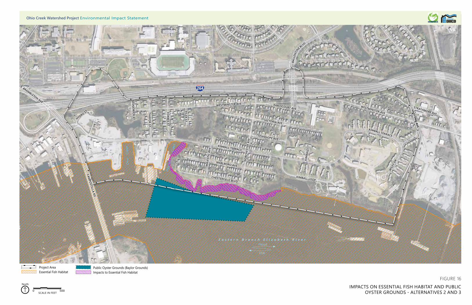
O
hio
Cre
ek
Hay
nes
Cre
ek
264
CHESTERFIELD BLVD
MARLBORO AVE
KIMBALL TERRACE
STANHOPE AVE
NO
RCH
ESTE
R AV
E
VICTORIA AVE
MA
JEST
IC A
VE
KIMBALL LOOP
KIM
BALL
CT
EARLSCOURT AVEWESTMINSTER AVE
WESTMINSTER AVE
BALL
ENTI
NE BLV
D
FILER ST
FORBES ST
THAYO
R ST
SEDG
EWICK ST
CAMPO
STELLA RD
WIL
EY D
R
KIMBALL TERRACE
EAST END AVE
STRATHMORE AVE
264E. BRAMBLETON AVE
HYDRO ST
0 500SCALE IN FEET
North
Public Oyster Grounds (Baylor Grounds)Impacts to Essential Fish Habitat
Project AreaEssential Fish Habitat
FIGURE 16
IMPACTS ON ESSENTIAL FISH HABITAT AND PUBLIC OYSTER GROUNDS - ALTERNATIVES 2 AND 3
Ohio Creek Watershed Project Environmental Impact Statement
E a s t e r n B r a n c h E l i z a b e t h R i v e r
Ebb
Flood

Ohio Creek Watershed Project Draft Environmental Impact Statement
135 Affected Environment and Environmental Consequences
Alternative 3
Under Alternative 3, short-term minor adverse effects would occur to EFH and migratory bird habitat. Short-term negligible adverse effects to marine mammals or migratory birds would occur.
Aquatic Resources: Open tidal flow will be maintained through all culverts, so there will be no effects to aquatic resources from dilution by stormwater inputs.
Under Alternative 3, the living shoreline would provide the same long-term major beneficial effects to the aquatic community within the Eastern Branch as Alternative 2. The rock sills and oyster reef would provide attachment substrate for eastern oysters and hooked mussels and refuge for crustaceans, fish, and other wildlife. A total of 1.86 acres of oyster reef and rock sill would be placed offshore in the Eastern Branch, and 1.68 acres of tidal marsh would be added to the project area. Tidal marshes would also provide habitat for benthic organisms such as the Atlantic ribbed mussel.
Essential Fish Habitat: The construction of the various elements of the living shoreline would place fill in 3.54 acres of EFH (Figure 16). As described above for Alternative 2, the living shoreline would create 1.86 acres of oyster reef and create or enhance 2.10 acres of tidal marsh, which would contribute to the overall improvement of the EFH.
Under Alternative 3, the project would provide long-term major beneficial effects to EFH by improving the stormwater treatment infrastructure. These improvements would occur as described for surface water (section 3.3.2.3, Alternative 3). They would increase stormwater infiltration, storage volume, and residence time within the study area. This would result in a reduction of direct, unfiltered stormwater runoff into the Eastern Branch and an improvement in the water quality within the EFH.
Marine Mammals: Alternative 3 would have no direct effects on marine mammals, but it may have temporary effects during construction. These potential effects are described below under Temporary Effects.
Migratory Birds: Alternative 3 would fill 1.96 acres of wetland which would remove potential migratory bird foraging habitat. This loss would be replaced by 3.40 acres of wetland enhancement and creation, which could replace foraging habitat after the assumed three-year time lag for full development.
Temporary Effects: Construction activities would result in short-term negligible adverse effects on EFH, marine mammals, and migratory birds and their habitats. Adverse effects would include temporary disturbance of wildlife, increased sediment loads, and increased turbidity. Other construction effects would occur with the disruption and burial of aquatic habitats at the location of the in-water work. Short-term construction effects would be the same as those discussed for surface water and wetlands. BMPs would be designed in accordance with the Virginia Erosion and Sediment Control Handbook.73Under Alternative 3, short-term- effects of pile driving
73 DCR Division of Soil and Water Conservation. 1992.
Ohio Creek Watershed Project Draft Environmental Impact Statement
136 Affected Environment and Environmental Consequences
on terrestrial and aquatic species would include avoidance of construction, noise and vibration, sediment deposition, and crushing. Bottlenose dolphins can also experience changes in feeding behavior. Noise reduction BMPs, such as air bubble curtains, would be used during in-water pile driving to minimize the potential impacts on federally managed fish species and marine mammals.
Alternative 4
Under Alternative 4, short-term minor adverse effects would occur to EFH and migratory bird habitat. Short-term negligible adverse effects to marine mammals or migratory birds would occur.
Aquatic Resources: During tide gate closure, freshwater from stormwater inputs into Haynes Creek would cause salt water dilution for the duration of closure. For benthic organisms like the Atlantic ribbed mussel, water salinity is an important factor in normal biological function. As a substrate-dwelling bivalve, the Atlantic ribbed mussel lacks rapid motility, and therefore cannot use a relocation strategy to avoid osmotic stress caused by changes in water salinity. However, this species has the ability to regulate the volume of its cells to account for short-term osmotic stresses caused by both increases in salinity (hyperosmotic stress) and decreases in salinity (hypoosmotic stress).74 75 The Atlantic ribbed mussel uses a physiological adaptation referred to as regulatory volume decrease, in which the intracellular solutes and water are reduced in response to hypoosmotic stress (i.e., water becomes less saline). This adaptation prevents the cells from exploding due to the swelling caused by freshwater influx into the cell. In several experimental seawater dilution trials, Atlantic ribbed mussels were able to persist using this adaptation for a period of weeks,76 suggesting that the anticipated dilution period in Haynes Creek during an abnormal flood event would not result in mortality for this species.
Under Alternative 4, the living shoreline would provide the same long-term major beneficial effects to the aquatic community within the Eastern Branch as Alternative 2 and Alternative 3, but it would cover a larger area. The construction of the various elements of the living shoreline would cover a total of 5.70 acres of EFH, compared to 3.54 acres under Alternative 2 and Alternative 3 (Figure 17). Under Alternative 4, creation of 3.46 acres of oyster reef and creation or enhancement of 3.34 acres of wetland would occur. The rock sills and oyster reef would provide attachment substrate for eastern oysters and hooked mussels and refuge for crustaceans, fish, and other wildlife. A total of 1.86 acres of oyster reef and rock sill would be placed offshore in the Eastern Branch, and 1.68 acres of tidal marsh would be added to the project area. Tidal marshes would also provide habitat for benthic organisms such as the Atlantic ribbed mussel. Construction of the living shoreline would be the same as described above in Section 3.3.2.3. Alternative 2.
74 Neufeld and Wright. 1998. 75 Deaton 2001. 76 Neufeld and Wright. 1998.

O
hio
Cre
ek
Hay
nes
Cre
ek
264
CHESTERFIELD BLVD
MARLBORO AVE
KIMBALL TERRACE
STANHOPE AVE
NO
RCH
ESTE
R AV
E
VICTORIA AVE
MA
JEST
IC A
VE
KIMBALL LOOP
KIM
BALL
CT
EARLSCOURT AVEWESTMINSTER AVE
WESTMINSTER AVE
BALL
ENTI
NE BLV
D
FILER ST
FORBES ST
THAYO
R ST
SEDG
EWICK ST
CAMPO
STELLA RD
WIL
EY D
R
KIMBALL TERRACE
EAST END AVE
STRATHMORE AVE
264E. BRAMBLETON AVE
HYDRO ST
0 500SCALE IN FEET
North
FIGURE 17
IMPACTS ON ESSENTIAL FISH HABITAT AND PUBLIC OYSTER GROUNDS - ALTERNATIVE 4
Public Oyster Grounds (Baylor Grounds)Impacts to Essential Fish Habitat
Project AreaEssential Fish Habitat
Ohio Creek Watershed Project Environmental Impact Statement
E a s t e r n B r a n c h E l i z a b e t h R i v e r
Ebb
Flood

Ohio Creek Watershed Project Draft Environmental Impact Statement
139 Affected Environment and Environmental Consequences
Essential Fish Habitat: Under Alternative 4, the project would provide long-term major beneficial effects to EFH by improving the stormwater treatment infrastructure. Stormwater infrastructure improvements would occur as described for surface water (section 3.3.2.3, Alternative 4) and include the use of Haynes Creek for stormwater storage; wetland creation in Ohio Creek, Haynes Creek, Grandy Village stormwater park, and the living shoreline; and street level interventions. These enhancements would increase stormwater infiltration, storage volume, and residency time within Ohio Creek, Haynes Creek, and the Grandy Village unnamed tributary. This would result in a reduction of direct stormwater runoff into the Eastern Branch and an improvement in the quality of water entering the EFH.
Marine Mammals: Alternative 4 would have no direct effects on marine mammals, but it may have temporary effects during construction. These potential effects are described later in this section under Temporary Effects.
Migratory Birds: Alternative 4 would fill 3.43 acres of wetland which would remove potential migratory bird foraging habitat. This area is greater than Alternative 2 (0.97 acres) and Alternative 3 (1.96 acres). This loss would be replaced by 3.90 acres of wetland enhancement and creation, which could replace foraging habitat after the assumed three-year time lag for full development.
Temporary Effects: Under Alternative 4, construction activities would result in short-term negligible adverse effects on EFH, marine mammals, and migratory birds and their habitats. Adverse effects would include temporary disturbance of wildlife, increased sediment loads, and increased turbidity. Other construction effects would occur with the disruption and burial of aquatic habitats at the location of the in-water work. Short-term construction effects would be the same as those discussed for surface water and wetlands. BMPs would be designed in accordance with the Virginia Erosion and Sediment Control Handbook.77
Under Alternative 4, short-term- effects of pile driving on terrestrial and aquatic species would include avoidance of construction, noise and vibration, sediment deposition, and crushing. Bottlenose dolphins can also experience changes in feeding behavior. Noise reduction BMPs, such as air bubble curtains, would be used during in-water pile driving to minimize the potential impacts on federally managed fish species and marine mammals.
77 DCR Division of Soil and Water Conservation. 1992.
Ohio Creek Watershed Project Draft Environmental Impact Statement
140 Affected Environment and Environmental Consequences
3.3.6 Protected Species
3.3.6.1 Methodology
Resources used to identify rare, threatened, and endangered species within the study area included the USFWS Information, Planning, and Consultation (IPaC) system,78 NOAA Fisheries information, the Virginia Department of Game and Inland Fisheries (VDGIF) Fish and Wildlife Information Service (FWIS),79 and the DCR Natural Heritage Data Explorer.80 These databases were reviewed to determine locations within the study area of habitat suitable for listed species, specifically with respect to life cycle, reproductive phenology, and other relevant habitat provisions. This analysis considered known population loci and demography near the study area.
Regulatory Setting
The federal Endangered Species Act of 1973 (ESA) defines an endangered species as “any species which is in danger of extinction throughout all or a significant portion of its range.” The ESA also defines a threatened species as “any species which is likely to become an endangered species within the foreseeable future throughout all or a significant portion of its range.” The ESA protects species listed as endangered or threatened on a national basis. The current list of federally protected wildlife is provided within the 50 CFR part 17.11 Endangered and Threatened Wildlife, published October 1, 2012. The current list of federally protected plants is provided within 50 CFR part 17.12 Endangered and Threatened Plants, published October 1, 2012. Protection is also provided to bald eagles (Haliaeetus leucocephalus) and golden eagles (Aquila chrysaetos) under the Bald and Golden Eagle Protection Act of 1940 (16 USC 668-668C). The ESA provides regulatory authority to the USFWS for the administration of the ESA over terrestrial and freshwater aquatic plants and animals and to the NMFS for the administration of the ESA over marine species.
The Virginia Endangered Species Act (Code of Virginia, Section 19.1-564568), passed in 1979, protects state-listed wildlife species. This act assigns the regulatory responsibility for listing and protecting endangered and threatened wildlife in Virginia to the VDGIF0. The Virginia Endangered Plant and Insect Act (Code of Virginia, Section 3.11020 through 1030) protects state listed plant species. The act assigns the regulatory responsibility of the listing and protection of endangered and threatened plants to the Virginia Department of Agriculture and Consumer Services Office of Plant Protection.
78 USFWS. 2018. Information for Planning and Consultation. https://ecos.fws.gov/ipac/location/index. Accessed March 18, 2018. 79 Virginia Department of Game and Inland Fisheries. 2018. Fish and Wildlife Information Service (FWIS).
https://vafwis.dgif.virginia.gov/fwis/. Accessed March 18, 2018. 80 Virginia Department of Conservation and Recreation (DCR). 2018. Natural Heritage Data Explorer (NHDE). https://vanhde.org/.
Accessed March 18, 2018.
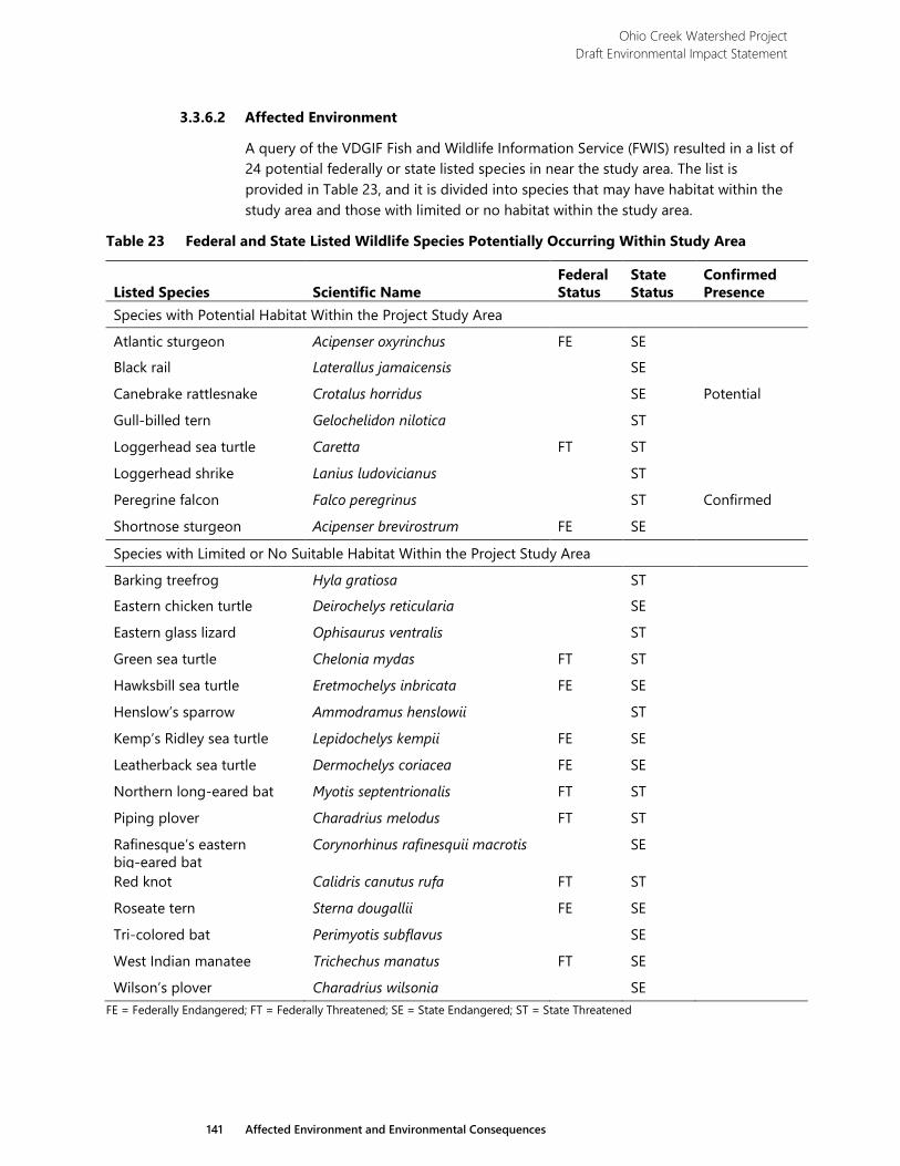
Ohio Creek Watershed Project Draft Environmental Impact Statement
141 Affected Environment and Environmental Consequences
3.3.6.2 Affected Environment
A query of the VDGIF Fish and Wildlife Information Service (FWIS) resulted in a list of 24 potential federally or state listed species in near the study area. The list is provided in Table 23, and it is divided into species that may have habitat within the study area and those with limited or no habitat within the study area.
Table 23 Federal and State Listed Wildlife Species Potentially Occurring Within Study Area
Listed Species Scientific Name Federal Status
State Status
Confirmed Presence
Species with Potential Habitat Within the Project Study Area
Atlantic sturgeon Acipenser oxyrinchus FE SE
Black rail Laterallus jamaicensis SE
Canebrake rattlesnake Crotalus horridus SE Potential
Gull-billed tern Gelochelidon nilotica ST
Loggerhead sea turtle Caretta FT ST
Loggerhead shrike Lanius ludovicianus ST
Peregrine falcon Falco peregrinus ST Confirmed
Shortnose sturgeon Acipenser brevirostrum FE SE
Species with Limited or No Suitable Habitat Within the Project Study Area
Barking treefrog Hyla gratiosa ST
Eastern chicken turtle Deirochelys reticularia SE
Eastern glass lizard Ophisaurus ventralis ST
Green sea turtle Chelonia mydas FT ST
Hawksbill sea turtle Eretmochelys inbricata FE SE
Henslow’s sparrow Ammodramus henslowii ST
Kemp’s Ridley sea turtle Lepidochelys kempii FE SE
Leatherback sea turtle Dermochelys coriacea FE SE
Northern long-eared bat Myotis septentrionalis FT ST
Piping plover Charadrius melodus FT ST
Rafinesque’s eastern big-eared bat
Corynorhinus rafinesquii macrotis SE
Red knot Calidris canutus rufa FT ST
Roseate tern Sterna dougallii FE SE
Tri-colored bat Perimyotis subflavus SE
West Indian manatee Trichechus manatus FT SE
Wilson’s plover Charadrius wilsonia SE FE = Federally Endangered; FT = Federally Threatened; SE = State Endangered; ST = State Threatened
Ohio Creek Watershed Project Draft Environmental Impact Statement
142 Affected Environment and Environmental Consequences
The bald eagle was listed as a federally endangered or threatened species until 2007 when it was determined the species had recovered and could be delisted. The Bald and Golden Eagle Protection Act of 1940, the Migratory Bird Treaty Act of 1918, and the Lacey Act of 1900 (18 USC 42-43; 16 USC 33713378) protect the bald eagle. Bald eagles have been observed within and near the study area. According to the College of William and Mary Center for Conservation Biology VA Eagle Nest Locator, the closest documented bald eagle nests are VB1801 and VB1601 located approximately 4.0- miles east of the study area.81
3.3.6.3 Environmental Consequences
3.3.6.4 Protected Species
Alternative 1
Under the No Action Alternative, long-term minor adverse effects would occur to protected species and habitats. Sea-level rise and its effect on water quality would be the primary cause of the adverse effects. As described earlier for wetlands (section 3.3.3.3, Alternative 1), sea-level rise would eliminate the existing wetlands within the study area. Wetlands play a crucial role in stormwater treatment, so the loss of the existing wetland systems would reduce the level of treatment stormwater would undergo before entering the Eastern Branch. The degradation of water quality within the Eastern Branch would affect many species. The Eastern Branch provides habitat for Atlantic sturgeon, shortnose sturgeon, and loggerhead sea turtle; gull-billed tern use the Eastern Branch for foraging.
Stormwater infrastructure development would help to improve the quality of the water entering the Eastern Branch from Ohio Creek, Haynes Creek, and the Grandy Village unnamed tributary. Without the proposed stormwater infrastructure improvements, the existing wetlands would continue to bear the entire burden of stormwater treatment.
Wetland protection, creation, and enhancement would benefit several listed species including black rail, loggerhead shrike, and peregrine falcon. Wetlands are used by black rail for nesting and foraging; loggerhead shrike and peregrine falcon use wetlands for hunting.
Alternative 2
Under Alternative 2, short-term minor adverse effects would occur to habitat for Atlantic sturgeon, shortnose sturgeon, loggerhead sea turtle, gull-billed tern, black rail, loggerhead shrike, and peregrine falcon. Wetland impacts totaling 0.97 acres, as described earlier for wetlands (section 3.3.3.3, Alternative 2), would remove some foraging habitat for black rail, loggerhead shrike, and peregrine falcon, and potential nesting habitat for black rail. However, the loss of habitat would be balanced by the creation of 1.10 acres of higher quality wetlands with native plant communities and
81 CCB. 2017. VA Eagle Nest Locator. http://www.ccbbirds.org/maps/. Accessed March 19, 2018.
Ohio Creek Watershed Project Draft Environmental Impact Statement
143 Affected Environment and Environmental Consequences
enhancement of 2.10 acres of existing open surface waters and wetland areas. It may take several years for these creation and enhancement areas to develop into suitable habitat, so the time lag between removal of the original wetland and the maturation of the created or enhanced wetland would be a short-term adverse effect to habitat.
As described earlier for surface waters (section 3.3.2.3. Alternative 2), the living shoreline construction proposed under Alternative 2 would fill 3.54 acres of open water in the Eastern Branch, habitat for both the Atlantic and shortnose sturgeon. Construction of the living shoreline would occur as described in section 3.3.2.3. Alternative 2, and it would include oyster reef creation which would provide new habitat for many mollusks, crustacean, and fish species. By creating new habitat, construction of the oyster reef would increase the foraging potential of the river for sturgeon and gull-billed tern.
The project would provide long-term major beneficial effects to fish habitat by improving the stormwater treatment infrastructure. The effects of the proposed stormwater infrastructure improvements were described in the surface water section (section 3.3.2.3, Alternative 2). Higher water quality provided by the stormwater treatment enhancements would improve the habitat for sturgeon and would increase prey populations of fish for gull-billed tern foraging.
Construction activities would result in short-term negligible adverse effects to protected species and their habitats. Under Alternative 2, temporary impacts from construction disturbance, construction noise, and pile driving activities would be similar to those described above for Biological Resources (section 3.3.5.3. Alternative 2). These effects would be minimized by implementing BMPs, per the Virginia Erosion and Sediment Control Handbook.82 including silt fencing and turbidity curtains during construction.
In-water pile driving would result in short-term negligible adverse effects to Atlantic and shortnose sturgeon. The noise would trigger an avoidance response in Atlantic and shortnose sturgeon. Research suggests sturgeon would only spend a short time near pile driving and would leave the area prior to experiencing any physiological effects.83 Subsequently, they would return with the cessation of the activity. BMPs, such as air bubble curtains, would reduce the effects of pile driving on the sturgeon.
Alternative 3
Under Alternative 3, short-term minor adverse effects would occur to protected species and their habitats. Wetland impacts totaling 1.96 acres, as described earlier for wetlands (section 3.3.3.3. Alternative 3 would remove foraging habitat for black rail, loggerhead shrike, and peregrine falcon, and potential nesting habitat for black rail. However, the loss of habitat would be balanced by the creation of 1.30 acres of higher quality wetlands with native plant communities and enhancement of 2.10 acres of existing open water and wetland areas. As described for Alternative 2, the
82 DCR Division of Soil and Water Conservation. 1992. 83 Krebs, J., Jacobs, F., and Popper A.N. 2016. Avoidance of Pile-Driving Noise by Hudson River Sturgeon During Construction of the
New NY Bridge at Tappan Zee. In: Popper, A., Hawkins, A. (eds.). The Effects of Noise on Aquatic Life II. Advances in Experimental Medicine and Biology, vol. 875. Springer, New York, NY.
Ohio Creek Watershed Project Draft Environmental Impact Statement
144 Affected Environment and Environmental Consequences
approximately 3-year timeframe for reestablishment to occur would be the primary short-term adverse effect to wetland habitats.
The effects of living shoreline construction to sturgeon and gull-billed tern habitat in the Eastern Branch would include the removal of 3.54 acres foraging habitat. However, the installation of oyster reefs and rock sills would enhance foraging in the remaining open water areas of the river.
Long-term minor beneficial effects would result from the stormwater improvements proposed under Alternative 3. Stormwater infrastructure improvements were described earlier in surface water (section 3.3.2.3. Alternative 3). They would increase stormwater infiltration, storage volume, and residence time within the study area. This would result in a reduction of direct, unfiltered stormwater runoff into the Eastern Branch and an improvement in the water quality within study area.
Construction activities would result in short-term negligible adverse effects to protected species and their habitats. Under Alternative 3, temporary impacts from construction disturbance, construction noise, and pile driving activities would be similar to those described above for Biological Resources (section 3.3.5.3. Alternative 3). These effects would be minimized by implementing BMPs, per the Virginia Erosion and Sediment Control Handbook.84 including silt fencing and turbidity curtains during construction.
In-water pile driving would result in short-term negligible adverse effects to Atlantic and shortnose sturgeon. The noise would trigger an avoidance response in Atlantic and shortnose sturgeon. Subsequently, they would return with the cessation of the activity. BMPs, such as air bubble curtains, would reduce the effects of pile driving on the sturgeon.
Alternative 4
Under Alternative 4, short-term minor adverse effects would occur to protected species and their habitats. Wetland impacts totaling 3.43 acres, as described earlier in wetlands (section 3.3.3.3. Alternative 4), would remove foraging habitat for black rail, loggerhead shrike, and peregrine falcon, and potential nesting habitat for black rail. This is a greater area than Alternative 2 (0.97 acres) and Alternative 3 (1.96 acres). However, the loss of habitat would be balanced by the creation of 1.10 acres of higher quality wetlands with native plant communities and enhancement of 3.24 acres of existing wetland and surface water areas. The approximately 3-year timeframe for reestablishment to occur would be the primary short-term adverse effect to wetland habitats.
As described above, the living shoreline construction proposed under Alternative 4 would fill 5.70 acres of open water habitat for the Atlantic and shortnose sturgeon in the Eastern Branch. Construction of the living shoreline would provide benefits to protected species as described for Alternative 2, but Alternative 4 would provide for the establishment of an additional 1.60 acres of oyster reef habitat.
84 DCR Division of Soil and Water Conservation. 1992.
Ohio Creek Watershed Project Draft Environmental Impact Statement
145 Affected Environment and Environmental Consequences
The project under Alternative 4 would provide long-term major beneficial effects to sturgeon habitat through the improvement of the stormwater infrastructure and increased aquatic habitat within the project area. Although the benefits would not be as great because stormwater storage volumes would be less, in general, the improvements to stormwater infrastructure would be similar to Alternative 2. They would increase stormwater infiltration, storage volume, and residence time within the study area. This would result in a reduction of direct, unfiltered stormwater runoff into the Eastern Branch and an improvement in the water quality within study area. Higher water quality provided by the stormwater treatment enhancements would improve the habitat for sturgeon and would increase fish populations for gull-billed tern foraging.
Construction activities would result in short-term negligible adverse effects to protected species and their habitats. Under Alternative 4, temporary impacts from construction disturbance, construction noise, and pile driving activities would be similar to those described above for Biological Resources (section 3.3.5.3. Alternative 4). These effects would be minimized by implementing BMPs, per the Virginia Erosion and Sediment Control Handbook.85 including silt fencing and turbidity curtains during construction.
In-water pile driving would result in short-term negligible adverse effects to Atlantic and shortnose sturgeon. The noise would trigger an avoidance response in Atlantic and shortnose sturgeon. Subsequently, the sturgeon would return with the cessation of the activity. BMPs, such as air bubble curtains, would reduce the effects of pile driving on the sturgeon.
85 DCR Division of Soil and Water Conservation. 1992.
Ohio Creek Watershed Project Draft Environmental Impact Statement
146 Affected Environment and Environmental Consequences
3.4 Noise The proposed project has the potential to affect existing noise conditions in the study area. The introduction of pump stations has the potential to affect long-term noise conditions and construction activities have the potential to generate noise that could result in short-term effects in the community. This section provides the methodology and regulatory context, and evaluates potential noise effects and the potential for construction and operational noise impact for the proposed alternatives.
3.4.1 Methodology
The existing noise environment in the project area is dominated by nearby transportation facilities that would not be affected by the proposed project. Since existing noise conditions are generally below 65 A-weighted decibel scale (dBA), exterior day night average sound levels (Ldn) at most receptors, they are considered to be “Acceptable” according to the HUD noise standard.
The primary noise source associated with the project alternatives are the pump stations, presented in Figures 5, 6, and 7. During pumping activity, the pump stations would increase noise for nearby receptors. The pump stations would operate pumps and other associated mechanical equipment when flooding exceeds the storage capacity of the system. During power outages, diesel emergency generators would be needed to operate the pump stations, which would introduce another source of noise. Noise from the emergency generator is exempt from Norfolk noise ordinance under Section 26-3, as the generator would be used to prevent “actual or imminent physical trauma or property damage” as part of an “emergency governmental function.”
Noise from the pumps and other associated mechanical equipment would occur more routinely as part of the operation of the pump stations and has been evaluated according to the Norfolk noise ordinance. The noise ordinance limits pumping equipment noise at residential receptors to 52 dBA during the night or to 10 dBA above the ambient sound levels (whichever is quieter). As described in Section 3.4.2, Affected Environment, ambient noise levels in the study area during the night, when ambient levels are generally quietest, ranged from 41 to 50 dBA. Therefore, the pump stations would be required to generate sound levels of 51 to 52 dBA or lower at the nearest property boundary.
The specific design of the pumping facilities and equipment are not known at this time. As the project advances, pump station materials, equipment, and sound attenuating features would be designed and specified to meet Norfolk noise ordinance requirements. Sound attenuating features that may be needed include specifying low-noise equipment, enclosures, acoustic louvres, or sound attenuating blankets.
Construction of the proposed project has the potential to cause short-term noise effects depending on the phase of construction. Typically, the loudest phase of construction involves earthwork which includes support of excavation activities and may include sheet pile driving, excavation, and heavy trucks. Impact sheet pile
Ohio Creek Watershed Project Draft Environmental Impact Statement
147 Affected Environment and Environmental Consequences
driving, which may be needed for the construction of the floodwalls, can generate noise upwards of 101 dBA at 50 feet. Other sources of construction noise, such as backhoes or bulldozers, generate 80 to 85 dBA at 50 feet. Construction activity is primarily expected to occur during the day. Since noise from construction activities is exempt from Norfolk noise ordinance under Section 26-3 and HUD does not regulate construction noise, potential construction noise effects have been evaluated qualitatively based on the lengths and locations of proposed floodwalls and berms.
3.4.1.1 Regulatory Setting and Noise Standards
HUD’s policy is to provide minimum national standards to protect citizens against excessive noise in the communities and places of residence; to encourage noise-compatible land use planning in relation to airports, highways, railroads, and other sources of high ambient noise; and to encourage the control of noise at its source in cooperation with other federal departments and agencies. HUD regulations require that recipients of Community Development Block Grants, which includes National Disaster Resilience Competition (NDRC) funding, take into consideration the noise criteria and standards during the environmental review process and consider ameliorative actions when noise sensitive land developments are proposed in noise exposed areas. Since this project does not include construction of new noise sensitive uses, the primary purpose of evaluating noise according to the HUD noise standard is to minimize the potential effects of noise on the resale and purchase of otherwise acceptable existing buildings and to facilitate potential HUD assistance for future development of housing and/or other noise sensitive activities.
HUD’s noise standard (24 CFR Part 51.103) is based on exterior day night average sound levels, known as Ldn. Ldn noise levels represent noise over a 24-period taking in to account how loud noise events are, how long they last, and whether they occur during the day or night (with a 10-decibel [dB] penalty given to noise occurring at night due to the greater sensitivity to noise). The HUD exterior noise standard, shown in Table 24, applies at buildings with noise-sensitive uses such as residences, schools and places of worship. The HUD exterior noise standard relates to the HUD interior noise goal, which is to maintain interior noise levels of 45 dBA (Ldn). The HUD noise standard also applies to outdoor locations where quiet is an essential part of the character of the site such as amphitheaters or national landmarks. The HUD noise standards are described as follows:
› Buildings are considered to have “Acceptable” noise conditions if the Ldn does not exceed 65 dBA. An exterior noise level of 65 dBA is considered to meet the interior noise goal of 45 dBA if the building is constructed in a manner common to the area, which would generally provide 20 decibels or more of outdoor-to-indoor sound attenuation.
› The "Normally Unacceptable" noise zone includes community noise levels from above 65 decibels to 75 decibels. Approvals in this noise zone require a minimum of 5 dB additional sound attenuation for buildings having noise-sensitive uses if the day-night average sound
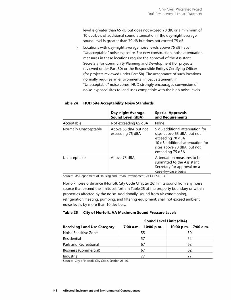
Ohio Creek Watershed Project Draft Environmental Impact Statement
148 Affected Environment and Environmental Consequences
level is greater than 65 dB but does not exceed 70 dB, or a minimum of 10 decibels of additional sound attenuation if the day-night average sound level is greater than 70 dB but does not exceed 75 dB.
› Locations with day-night average noise levels above 75 dB have “Unacceptable” noise exposure. For new construction, noise attenuation measures in these locations require the approval of the Assistant Secretary for Community Planning and Development (for projects reviewed under Part 50) or the Responsible Entity’s Certifying Officer (for projects reviewed under Part 58). The acceptance of such locations normally requires an environmental impact statement. In "Unacceptable" noise zones, HUD strongly encourages conversion of noise-exposed sites to land uses compatible with the high noise levels.
Table 24 HUD Site Acceptability Noise Standards
Day-night Average Sound Level (dBA)
Special Approvals and Requirements
Acceptable Not exceeding 65 dBA None Normally Unacceptable Above 65 dBA but not
exceeding 75 dBA 5 dB additional attenuation for sites above 65 dBA, but not exceeding 70 dBA 10 dB additional attenuation for sites above 70 dBA, but not exceeding 75 dBA
Unacceptable Above 75 dBA Attenuation measures to be submitted to the Assistant Secretary for approval on a case-by-case basis
Source: US Department of Housing and Urban Development, 24 CFR 51.103
Norfolk noise ordinance (Norfolk City Code Chapter 26) limits sound from any noise source that exceed the limits set forth in Table 25 at the property boundary or within properties affected by the noise. Additionally, sound from air conditioning, refrigeration, heating, pumping, and filtering equipment, shall not exceed ambient noise levels by more than 10 decibels.
Table 25 City of Norfolk, VA Maximum Sound Pressure Levels
Receiving Land Use Category Sound Level Limit (dBA)
7:00 a.m. – 10:00 p.m. 10:00 p.m. – 7:00 a.m. Noise Sensitive Zone 55 50 Residential 57 52 Park and Recreational 67 62 Business (Commercial) 67 62 Industrial 77 77 Source: City of Norfolk City Code, Section 26-10.
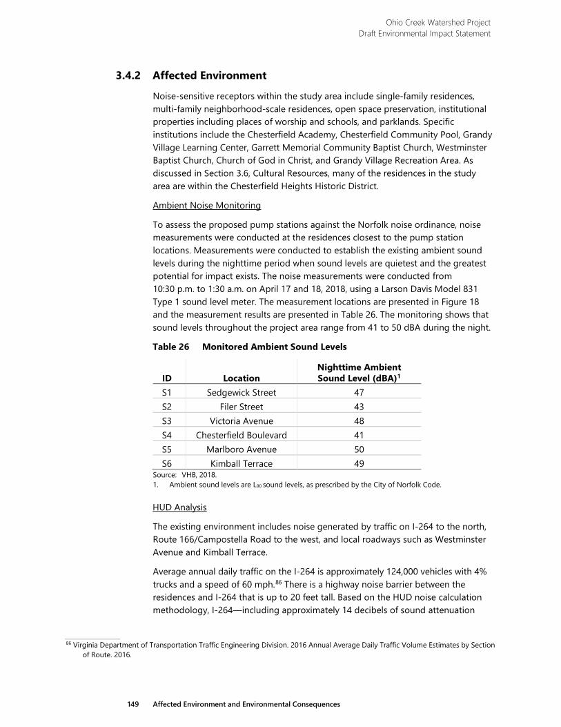
Ohio Creek Watershed Project Draft Environmental Impact Statement
149 Affected Environment and Environmental Consequences
3.4.2 Affected Environment
Noise-sensitive receptors within the study area include single-family residences, multi-family neighborhood-scale residences, open space preservation, institutional properties including places of worship and schools, and parklands. Specific institutions include the Chesterfield Academy, Chesterfield Community Pool, Grandy Village Learning Center, Garrett Memorial Community Baptist Church, Westminster Baptist Church, Church of God in Christ, and Grandy Village Recreation Area. As discussed in Section 3.6, Cultural Resources, many of the residences in the study area are within the Chesterfield Heights Historic District.
Ambient Noise Monitoring
To assess the proposed pump stations against the Norfolk noise ordinance, noise measurements were conducted at the residences closest to the pump station locations. Measurements were conducted to establish the existing ambient sound levels during the nighttime period when sound levels are quietest and the greatest potential for impact exists. The noise measurements were conducted from 10:30 p.m. to 1:30 a.m. on April 17 and 18, 2018, using a Larson Davis Model 831 Type 1 sound level meter. The measurement locations are presented in Figure 18 and the measurement results are presented in Table 26. The monitoring shows that sound levels throughout the project area range from 41 to 50 dBA during the night.
Table 26 Monitored Ambient Sound Levels
ID Location Nighttime Ambient Sound Level (dBA)1
S1 Sedgewick Street 47 S2 Filer Street 43 S3 Victoria Avenue 48 S4 Chesterfield Boulevard 41 S5 Marlboro Avenue 50 S6 Kimball Terrace 49
Source: VHB, 2018. 1. Ambient sound levels are L90 sound levels, as prescribed by the City of Norfolk Code.
HUD Analysis
The existing environment includes noise generated by traffic on I-264 to the north, Route 166/Campostella Road to the west, and local roadways such as Westminster Avenue and Kimball Terrace.
Average annual daily traffic on the I-264 is approximately 124,000 vehicles with 4% trucks and a speed of 60 mph.86 There is a highway noise barrier between the residences and I-264 that is up to 20 feet tall. Based on the HUD noise calculation methodology, I-264—including approximately 14 decibels of sound attenuation
86 Virginia Department of Transportation Traffic Engineering Division. 2016 Annual Average Daily Traffic Volume Estimates by Section
of Route. 2016.
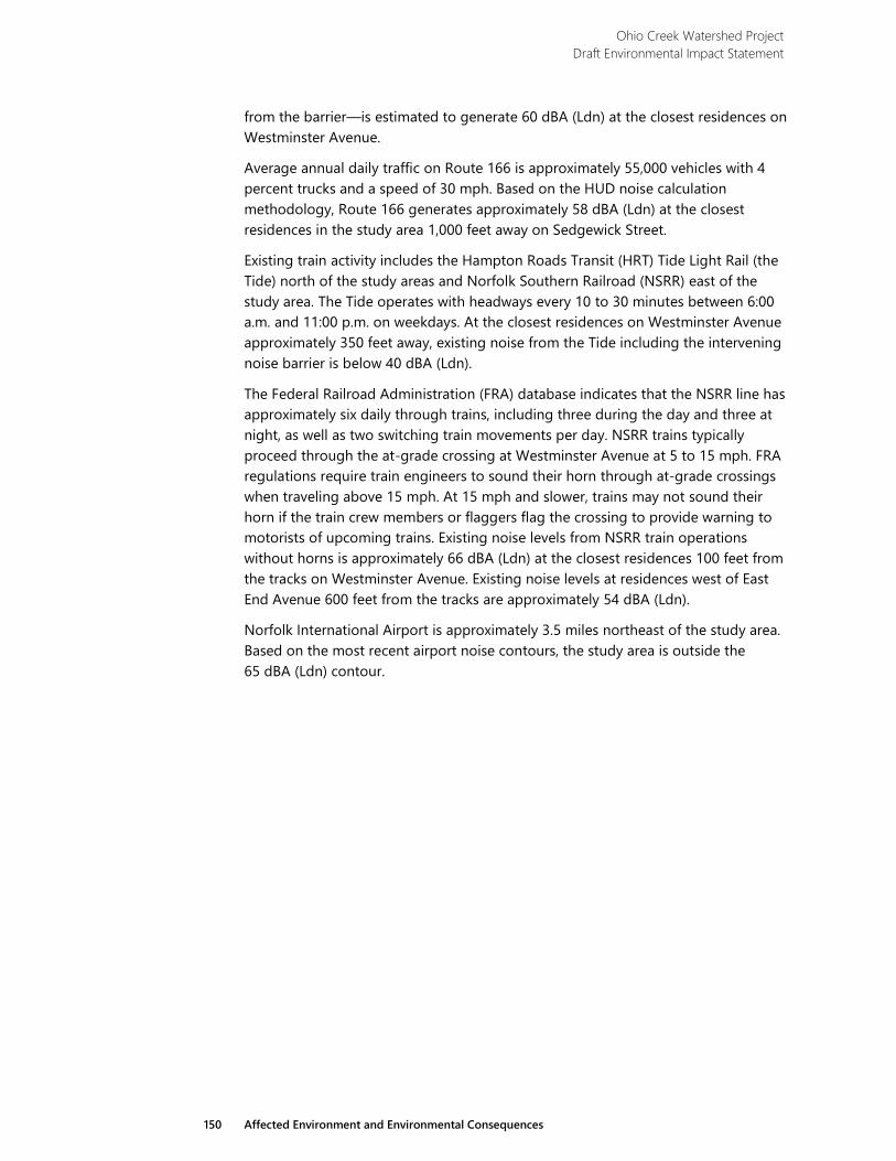
Ohio Creek Watershed Project Draft Environmental Impact Statement
150 Affected Environment and Environmental Consequences
from the barrier—is estimated to generate 60 dBA (Ldn) at the closest residences on Westminster Avenue.
Average annual daily traffic on Route 166 is approximately 55,000 vehicles with 4 percent trucks and a speed of 30 mph. Based on the HUD noise calculation methodology, Route 166 generates approximately 58 dBA (Ldn) at the closest residences in the study area 1,000 feet away on Sedgewick Street.
Existing train activity includes the Hampton Roads Transit (HRT) Tide Light Rail (the Tide) north of the study areas and Norfolk Southern Railroad (NSRR) east of the study area. The Tide operates with headways every 10 to 30 minutes between 6:00 a.m. and 11:00 p.m. on weekdays. At the closest residences on Westminster Avenue approximately 350 feet away, existing noise from the Tide including the intervening noise barrier is below 40 dBA (Ldn).
The Federal Railroad Administration (FRA) database indicates that the NSRR line has approximately six daily through trains, including three during the day and three at night, as well as two switching train movements per day. NSRR trains typically proceed through the at-grade crossing at Westminster Avenue at 5 to 15 mph. FRA regulations require train engineers to sound their horn through at-grade crossings when traveling above 15 mph. At 15 mph and slower, trains may not sound their horn if the train crew members or flaggers flag the crossing to provide warning to motorists of upcoming trains. Existing noise levels from NSRR train operations without horns is approximately 66 dBA (Ldn) at the closest residences 100 feet from the tracks on Westminster Avenue. Existing noise levels at residences west of East End Avenue 600 feet from the tracks are approximately 54 dBA (Ldn).
Norfolk International Airport is approximately 3.5 miles northeast of the study area. Based on the most recent airport noise contours, the study area is outside the 65 dBA (Ldn) contour.
CHESTERFIELD BLVD
MARLBORO AVE
KIMBALL TERRACE
STANHOPE AVE
NO
RCH
ESTE
R AV
E
VICTORIA AVE
MA
JEST
IC A
VE
KIMBALL LOOP
KIM
BALL
CT
EARLSCOURT AVEWESTMINSTER AVE
WESTMINSTER AVE
BALL
ENTI
NE BLV
D
FILER ST
FORBES ST
THAYO
R ST
SEDG
EWICK ST
CAMPO
STELLA RD
WIL
EY D
R
KIMBALL TERRACE
EAST END AVE
STRATHMORE AVE
264E. BRAMBLETON AVE
HYDRO ST
0 500SCALE IN FEET
North
Project AreaPump StationsMonitoring Stations
S1
S2
S4
S3
S5
S6
Ohio Creek Pump Station
Filer StreetPump Station
Haynes CreekPump Station
Alternative
Chesterfield Pump StationBallentine Pump Station
Grandy Pump Station
Haynes CreekPump Station
FIGURE 18NOISE MONITORING LOCATIONS
Ohio Creek Watershed Project Environmental Impact Statement
E a s t e r n B r a n c h E l i z a b e t h R i v e r
Ebb
Flood

Ohio Creek Watershed Project Draft Environmental Impact Statement
153 Affected Environment and Environmental Consequences
3.4.3 Environmental Consequences
3.4.3.1 Alternative 1
The No Action Alternative would not introduce new operational or construction-period sources of noise nor would it modify existing sources of noise including traffic, trains, boats, and industrial facilities. Since there would be no change to the existing noise environment, there would be no potential impact.
3.4.3.2 Alternative 2
Alternative 2 includes the operation of five pump stations: the Ohio Creek Pump Station, the Haynes Creek Pump Station, the Chesterfield Pump Station, the Ballentine Pump Station, and the Grandy Village Pump Station. While Alternative 2 includes more pump stations than other alternatives, the Ohio Creek Pump Station is located on the opposite side of I-264 away from sensitive receptors and would not be a substantial source of noise in the study area. The other pump stations would be located within 120 feet of the closest residential receptors, including the Chesterfield pump station, which would be within approximately 10 feet of nearby residences. Therefore, the pump facilities would need to be designed to attenuate sound to an exterior level of 52 dBA at distances as close as 10 feet for Alternative 2.
The most substantial construction noise associated with Alternative 2 would be due to the construction of the floodwalls and berms. Alternative 2 requires the second-greatest length of floodwall construction and would occur at a distance of 50 to 60 feet from many residences. Berms would be constructed approximately 40 to 50 feet from residences, with the exception of residences on the western end of Marlboro Avenue and towards the eastern end of Kimball Terrace.
3.4.3.3 Alternative 3
Alternative 3 includes the operation of four pump stations: the Haynes Creek Pump Station, the Chesterfield Pump Station, the Ballentine Pump Station, and the Filer Street Pump Station. While Alternative 3 has one less pump station than Alternative 2, the four pump stations are all located adjacent to residential neighborhoods. The pump stations would be located within 40 feet of the closest receptors, including the Chesterfield Pump Station, which would be within approximately 10 feet of nearby residences. The Filer Street Pump Station would be approximately 60 feet from nearby residences, and the Haynes Creek Pump Station would be within approximately 300 feet of nearby residences. Similar to Alternative 3, the pump facilities would need to be designed to attenuate sound to an exterior level of 52 dBA at distances as close as 10 feet.
The most substantial construction noise associated with Alternative 3 would be due to the construction of the floodwalls, berms, and raised roadways. Alternative 3 is proposed to have the greatest length of floodwall which would primarily be constructed adjacent to residential neighborhoods. This Alternative would expose the greatest amount of residences to noise from sheet pile driving. The floodwall
Ohio Creek Watershed Project Draft Environmental Impact Statement
154 Affected Environment and Environmental Consequences
construction would occur at varying distances from residences with some portions being constructed immediately adjacent to homes. Berm construction would be limited to Chesterfield Boulevard and along the west side of the fields near Chesterfield Academy. Berm construction would generally occur within 40 to 50 feet of residences, with some closer distances for residences at the eastern end of Victoria Avenue.
3.4.3.4 Alternative 4
Alternative 4 includes the operation of the Haynes Creek Pump Station and the Ballentine Pump Station. Alternative 4 has fewer pump stations than both Alternatives 2 and 3. Alternative 4 does not include the Chesterfield Pump Station, which is the pump station located within 10 feet of the closest residence in Alternatives 3 and 4 nor does it include the Filer Street Pump Station which was within approximately 60 feet of the nearest residences. The distances between the two pump stations proposed in Alternative 4 and the closest residences range from 100 feet to 300 feet, depending on the location. The Ballentine Pump Station is the closest at approximately 100 feet, while the Haynes Creek Pump Station is the second-closest at approximately 300 feet. The pump facilities would need to be designed to attenuate sound to an exterior level of 52 dBA at a distance of approximately 80 feet for this alternative, which requires fewer sound attenuating features than other alternatives.
Alternative 4 would include the shortest length of floodwall construction amongst the three action alternatives and would expose the fewest residences to sheet pile driving noise. Floodwall construction in Alternative 4 would occur approximately 50 feet away from the nearest residences unlike the other alternatives where floodwalls would be built at closer distances. To insure adequate flood prevention, berm construction in this alternative would replace much of the floodwall construction proposed in other alternatives. Berms would be constructed in close proximity to residences along Filer Street, the southern end of Forbes Street, the western southern end of Sedgewick Street, the eastern end of Marlboro Avenue and the eastern end of Kimball Loop.
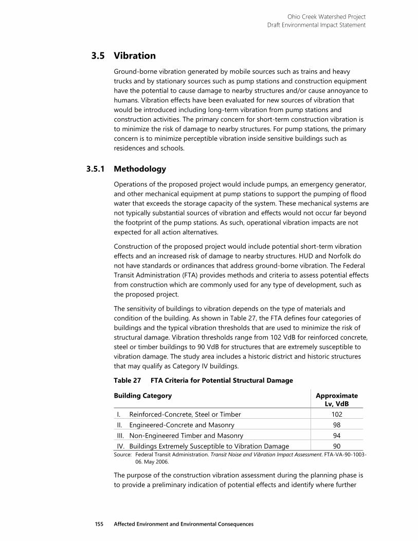
Ohio Creek Watershed Project Draft Environmental Impact Statement
155 Affected Environment and Environmental Consequences
3.5 Vibration Ground-borne vibration generated by mobile sources such as trains and heavy trucks and by stationary sources such as pump stations and construction equipment have the potential to cause damage to nearby structures and/or cause annoyance to humans. Vibration effects have been evaluated for new sources of vibration that would be introduced including long-term vibration from pump stations and construction activities. The primary concern for short-term construction vibration is to minimize the risk of damage to nearby structures. For pump stations, the primary concern is to minimize perceptible vibration inside sensitive buildings such as residences and schools.
3.5.1 Methodology
Operations of the proposed project would include pumps, an emergency generator, and other mechanical equipment at pump stations to support the pumping of flood water that exceeds the storage capacity of the system. These mechanical systems are not typically substantial sources of vibration and effects would not occur far beyond the footprint of the pump stations. As such, operational vibration impacts are not expected for all action alternatives.
Construction of the proposed project would include potential short-term vibration effects and an increased risk of damage to nearby structures. HUD and Norfolk do not have standards or ordinances that address ground-borne vibration. The Federal Transit Administration (FTA) provides methods and criteria to assess potential effects from construction which are commonly used for any type of development, such as the proposed project.
The sensitivity of buildings to vibration depends on the type of materials and condition of the building. As shown in Table 27, the FTA defines four categories of buildings and the typical vibration thresholds that are used to minimize the risk of structural damage. Vibration thresholds range from 102 VdB for reinforced concrete, steel or timber buildings to 90 VdB for structures that are extremely susceptible to vibration damage. The study area includes a historic district and historic structures that may qualify as Category IV buildings.
Table 27 FTA Criteria for Potential Structural Damage
Building Category Approximate Lv, VdB
I. Reinforced-Concrete, Steel or Timber 102 II. Engineered-Concrete and Masonry 98 III. Non-Engineered Timber and Masonry 94 IV. Buildings Extremely Susceptible to Vibration Damage 90
Source: Federal Transit Administration. Transit Noise and Vibration Impact Assessment. FTA-VA-90-1003-06. May 2006.
The purpose of the construction vibration assessment during the planning phase is to provide a preliminary indication of potential effects and identify where further
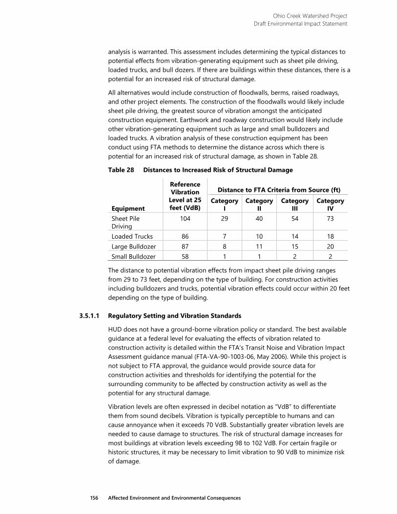
Ohio Creek Watershed Project Draft Environmental Impact Statement
156 Affected Environment and Environmental Consequences
analysis is warranted. This assessment includes determining the typical distances to potential effects from vibration-generating equipment such as sheet pile driving, loaded trucks, and bull dozers. If there are buildings within these distances, there is a potential for an increased risk of structural damage.
All alternatives would include construction of floodwalls, berms, raised roadways, and other project elements. The construction of the floodwalls would likely include sheet pile driving, the greatest source of vibration amongst the anticipated construction equipment. Earthwork and roadway construction would likely include other vibration-generating equipment such as large and small bulldozers and loaded trucks. A vibration analysis of these construction equipment has been conduct using FTA methods to determine the distance across which there is potential for an increased risk of structural damage, as shown in Table 28.
Table 28 Distances to Increased Risk of Structural Damage
Equipment
Reference Vibration
Level at 25 feet (VdB)
Distance to FTA Criteria from Source (ft) Category
I Category
II Category
III Category
IV Sheet Pile Driving
104 29 40 54 73
Loaded Trucks 86 7 10 14 18 Large Bulldozer 87 8 11 15 20 Small Bulldozer 58 1 1 2 2
The distance to potential vibration effects from impact sheet pile driving ranges from 29 to 73 feet, depending on the type of building. For construction activities including bulldozers and trucks, potential vibration effects could occur within 20 feet depending on the type of building.
3.5.1.1 Regulatory Setting and Vibration Standards
HUD does not have a ground-borne vibration policy or standard. The best available guidance at a federal level for evaluating the effects of vibration related to construction activity is detailed within the FTA’s Transit Noise and Vibration Impact Assessment guidance manual (FTA-VA-90-1003-06, May 2006). While this project is not subject to FTA approval, the guidance would provide source data for construction activities and thresholds for identifying the potential for the surrounding community to be affected by construction activity as well as the potential for any structural damage.
Vibration levels are often expressed in decibel notation as “VdB” to differentiate them from sound decibels. Vibration is typically perceptible to humans and can cause annoyance when it exceeds 70 VdB. Substantially greater vibration levels are needed to cause damage to structures. The risk of structural damage increases for most buildings at vibration levels exceeding 98 to 102 VdB. For certain fragile or historic structures, it may be necessary to limit vibration to 90 VdB to minimize risk of damage.
Ohio Creek Watershed Project Draft Environmental Impact Statement
157 Affected Environment and Environmental Consequences
3.5.2 Affected Environment
The primary source of existing vibration are train operations including the NSRR and the Tide Light Rail. The closest residential receptors to the NSRR are approximately 100 feet from the tracks on Westminster Avenue. Existing vibration levels from the freight trains are estimated to be slightly below 70 VdB at these receptors. The Tide Light Rail is approximately 350 feet or farther from residential receptors. At this distance, the existing vibration levels are estimated to be below 65 VdB.
3.5.3 Environmental Consequences
3.5.3.1 Alternative 1
The No Action Alternative would not introduce new operational or construction-period sources of vibration nor would it modify existing sources of vibration, including trains and industrial facilities. Since there would be no change to the existing vibration environment, there would be no potential impact.
3.5.3.2 Alternative 2
Alternative 2 includes the second-greatest length of floodwall construction and sheet pile driving, which would occur 50 to 60 feet from some residences. On the east side of Chesterfield Boulevard and Marlboro Avenue, the floodwall would be constructed at even closer distances to buildings. Alternative construction methods for sheet piling may be required to reduce vibration in these locations. Berm construction would generally be located 40 to 50 feet from residences, with the exception of some residences on the western end of Marlboro Avenue and towards the eastern end of Kimball Terrace. Other construction equipment used for the berms would generally not exceed the FTA criteria at a distance of 40 to 50 feet.
3.5.3.3 Alternative 3
Alternative 3 includes the greatest length of floodwall construction and sheet pile driving which would occur adjacent to some residences. Alternative 3 would have the greatest potential vibration effects from sheet pile driving. Berm construction in this alternative is limited to Chesterfield Boulevard and along the west side of the fields near Chesterfield Academy. Berm construction generally occurs at a distance of 40 to 50 feet of residences, with some closer distances for residences at the eastern end of Victoria Avenue. Other construction equipment used for the berms would generally not exceed the FTA criteria at a distance of 40 to 50 feet.
3.5.3.4 Alternative 4
Alternative 4 would have the shortest length of floodwall amongst the three alternatives and would expose the fewest number of residences to sheet pile driving vibration. The floodwall would be at least 50 feet away from nearest residences unlike the other alternatives where floodwalls would be built at closer distances. At these distances, only building categories III and IV would have the potential for an
Ohio Creek Watershed Project Draft Environmental Impact Statement
158 Affected Environment and Environmental Consequences
increased risk of structural damage. Berm construction would occur in close proximity to residences along Filer Street, the southern end of Forbes Street, the western southern end of Sedgewick Street, the eastern end of Marlboro Avenue, and the eastern end of Kimball Loop.
3.5.3.5 Mitigation – Construction Vibration Control
As the project design advances and the specific methods and locations of vibration-generating construction activities are determined, the potential for vibration effects would be further evaluated. A Construction Vibration Control Plan would be prepared which would identify buildings that have an increased risk of structural damage, would specify the need for pre- and post-construction surveys of the buildings, determine the need for and location of crack monitoring and/or construction vibration monitoring, determine acceptable vibration thresholds to minimize risk, and would outline the process that contractors would follow to respond to vibration exceedances.
If sheet pile driving is needed within 73 feet of buildings considered to be particularly susceptible to vibration damage, such as historic buildings, non-impact methods may be required such as using vibratory hammers or a sheet pile pusher. Instead of using repeated impacts to drive sheet piles, vibratory hammers use a cyclical vibratory motion. Sheet pile pushers apply a constant force to push the piles into the ground. Sheet pile pushing is considered to be “low vibration” compared to other methods. Similarly, if bulldozers are needed within 20 feet of sensitive buildings, it may be necessary to use smaller bulldozers to minimize the risk of damage.

Ohio Creek Watershed Project Draft Environmental Impact Statement
159 Affected Environment and Environmental Consequences
3.6 Cultural Resources
3.6.1 Methodology
Potential impacts on cultural resources were evaluated based on changes to the character-defining features of the resources, which are the characteristics of a historic property that qualify it for inclusion in the National Register of Historic Places (National Register). This approach is derived from the Secretary of the Interior’s Standards for the Treatment of Historic Properties and the regulations of the Advisory Council on Historic Preservation implementing provisions of the National Historic Preservation Act of 1966 (NHPA). Character-defining features contribute to a property’s integrity, which is composed of location, design, setting, materials, workmanship, feeling, and association.
As part of the assessment of cultural resources, research was conducted to establish a baseline upon which the impacts of the alternatives could be evaluated. This included archival research, architectural fieldwork, and archeological fieldwork.
Archival research examined cartographic and historic works in the Library of Congress, the Colonial Williamsburg Rockefeller Library, city directories, census data, slave records, Virginia Department of Historic Resources (VDHR), the Library of Virginia, and Norfolk to determine the history of the Chesterfield Heights Historic District. Data accumulated during previous archival research on historic sites throughout the region was also examined.
Architectural fieldwork was conducted to verify the location of previously-identified dwellings that were identified for acquisition by Norfolk to determine if the structures are contributing to the historic district.
Archaeological fieldwork was conducted to identify any potential resources within the project area. The entire project area where work is proposed was walked and inspected for surface artifacts, activity, or above-ground features. Shovel tests were excavated in areas where development may occur, excluding areas on steep slopes, wetlands, and disturbed areas. Representative shovel test profiles were recorded and soil color was classified with a Munsell Chart.
An underwater survey was conducted to identify any underwater archeological resources that may be present in the vicinity of the project area. Methods of data collection included the use of sidescan sonar and a cesium vapor magnetometer. Necessary data was provided to VDHR to identify any potentially significant anomalies/targets.
The data collected through the methods described above were used to identify cultural resources present in the project area and to establish their baseline condition. The existing conditions of these resources were then compared with the alternatives described in Chapter 2 to determine the impacts on cultural resources within the project area. For this resource, the area of analysis is the same as the project area as described in Chapter 1.
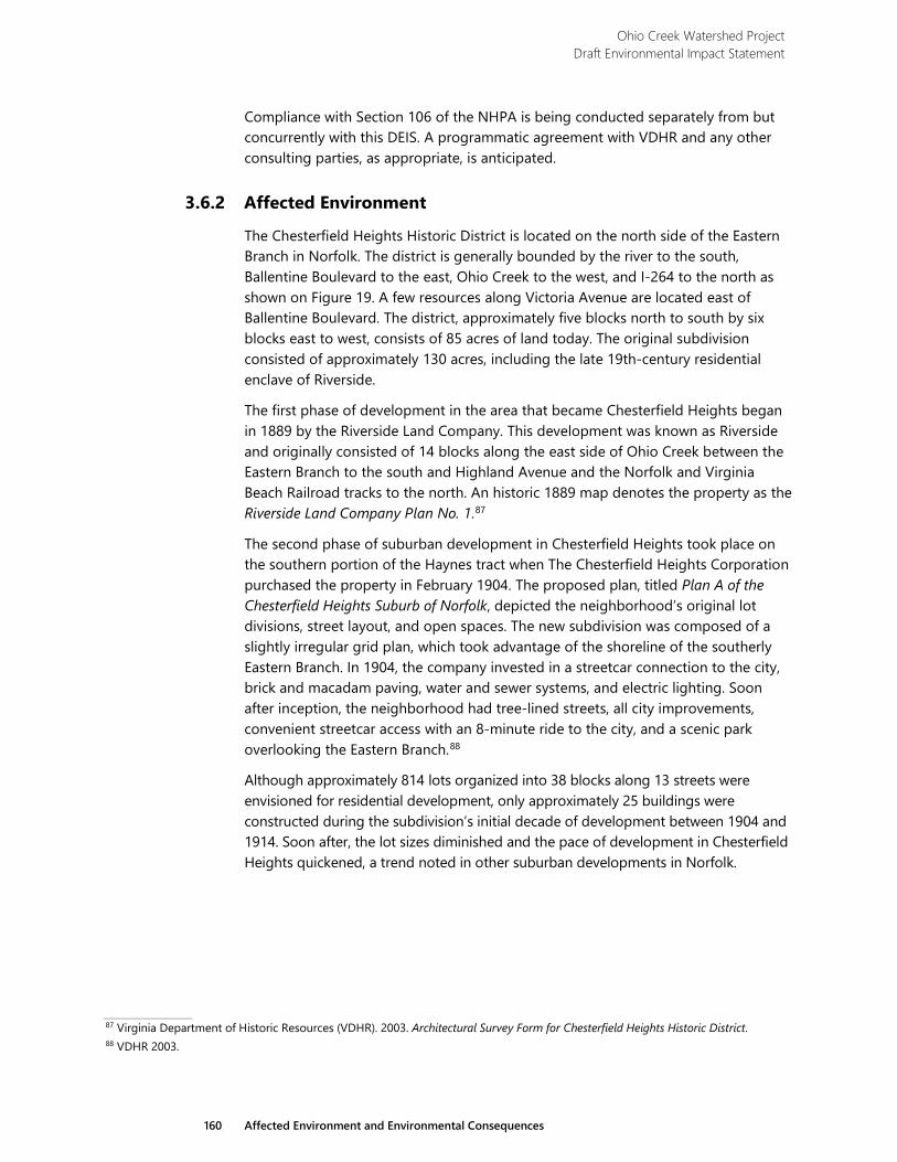
Ohio Creek Watershed Project Draft Environmental Impact Statement
160 Affected Environment and Environmental Consequences
Compliance with Section 106 of the NHPA is being conducted separately from but concurrently with this DEIS. A programmatic agreement with VDHR and any other consulting parties, as appropriate, is anticipated.
3.6.2 Affected Environment
The Chesterfield Heights Historic District is located on the north side of the Eastern Branch in Norfolk. The district is generally bounded by the river to the south, Ballentine Boulevard to the east, Ohio Creek to the west, and I-264 to the north as shown on Figure 19. A few resources along Victoria Avenue are located east of Ballentine Boulevard. The district, approximately five blocks north to south by six blocks east to west, consists of 85 acres of land today. The original subdivision consisted of approximately 130 acres, including the late 19th-century residential enclave of Riverside.
The first phase of development in the area that became Chesterfield Heights began in 1889 by the Riverside Land Company. This development was known as Riverside and originally consisted of 14 blocks along the east side of Ohio Creek between the Eastern Branch to the south and Highland Avenue and the Norfolk and Virginia Beach Railroad tracks to the north. An historic 1889 map denotes the property as the Riverside Land Company Plan No. 1.87
The second phase of suburban development in Chesterfield Heights took place on the southern portion of the Haynes tract when The Chesterfield Heights Corporation purchased the property in February 1904. The proposed plan, titled Plan A of the Chesterfield Heights Suburb of Norfolk, depicted the neighborhood’s original lot divisions, street layout, and open spaces. The new subdivision was composed of a slightly irregular grid plan, which took advantage of the shoreline of the southerly Eastern Branch. In 1904, the company invested in a streetcar connection to the city, brick and macadam paving, water and sewer systems, and electric lighting. Soon after inception, the neighborhood had tree-lined streets, all city improvements, convenient streetcar access with an 8-minute ride to the city, and a scenic park overlooking the Eastern Branch.88
Although approximately 814 lots organized into 38 blocks along 13 streets were envisioned for residential development, only approximately 25 buildings were constructed during the subdivision’s initial decade of development between 1904 and 1914. Soon after, the lot sizes diminished and the pace of development in Chesterfield Heights quickened, a trend noted in other suburban developments in Norfolk.
87 Virginia Department of Historic Resources (VDHR). 2003. Architectural Survey Form for Chesterfield Heights Historic District. 88 VDHR 2003.
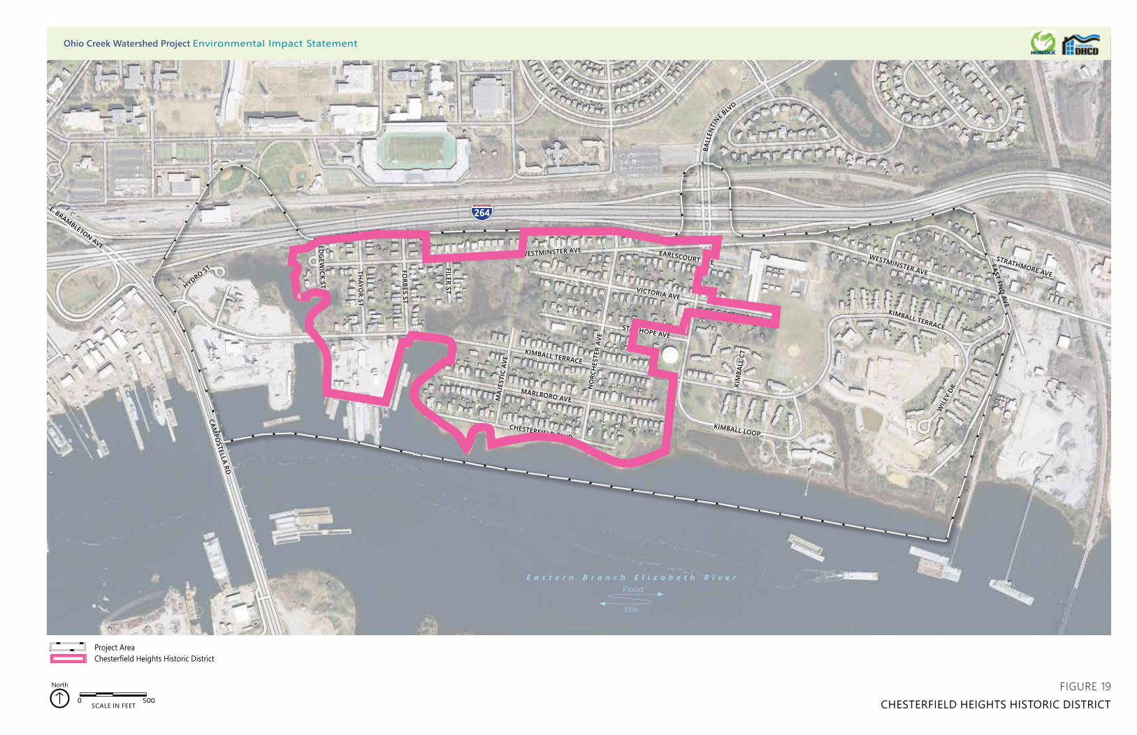
264
CHESTERFIELD BLVD
MARLBORO AVE
KIMBALL TERRACE
STANHOPE AVE
NO
RCH
ESTE
R AV
E
VICTORIA AVE
MA
JEST
IC A
VE
KIMBALL LOOP
KIM
BALL
CT
EARLSCOURT AVEWESTMINSTER AVE
WESTMINSTER AVE
BALL
ENTI
NE BLV
D
FILER ST
FORBES ST
THAYO
R ST
SEDG
EWICK ST
CAMPO
STELLA RD
WIL
EY D
R
KIMBALL TERRACE
EAST END AVE
STRATHMORE AVE
264E. BRAMBLETON AVE
HYDRO ST
0 500SCALE IN FEET
North
Project AreaChesterfield Heights Historic District
FIGURE 19CHESTERFIELD HEIGHTS HISTORIC DISTRICT
Ohio Creek Watershed Project Environmental Impact Statement
E a s t e r n B r a n c h E l i z a b e t h R i v e r
Ebb
Flood

Ohio Creek Watershed Project Draft Environmental Impact Statement
163 Affected Environment and Environmental Consequences
The suburbs were greatly affected by the influx of workers brought to the port city on the eve of World War I. In the years leading up to the United States’ entry into the war in Europe, a second period of significant growth began. By the time residential construction began to take off in the late 1920s, house sizes and stylistic features had changed in response to a new clientele. Larger numbers of smaller, less ornamented houses were built throughout the neighborhood. The dominant styles were modest Colonial Revival dwellings balanced by a significant number of Craftsman-style Bungalows. These later dwellings exhibited less architectural ornament than the houses erected prior to 1914 and were more affordable for middle-income residents. The second building phase lasted until 1950, with only 35 additional buildings constructed after 1950.89
Chesterfield Heights retains many of its original early-20th-century residential revival and American-movement buildings, the majority of which were designed by local builders or architects. The earliest houses erected were generally imposing Colonial Revival- and Queen Anne-style residences constructed for upper-middle and middle-class residents. Construction was originally focused along Chesterfield Boulevard on the pricier and more picturesque waterfront lots, as well as the adjacent Marlboro Avenue. These large single dwellings, ornamented to the specific tastes of the property owners, were sited on spacious lots with landscaped yards. Each of the buildings exhibited high-style ornamentation, including wrap-around porches, bracketing, denticulated moldings, sleeping porches, and a variety of detailed cladding materials.90
Marlboro Avenue, running roughly east to west a block north of the river, maintains a section of its original brick pavers. Appearing to originally run from curb to curb, today the center of the street has exposed brick with asphalt paving along the edges. A review of the broken areas in the asphalt pavement revealed brick pavers intact under the pavement. The bricks appear to be laid in a Flemish-bond pattern changing to a diagonal Flemish-bond pattern at the intersections of cross streets. The bricks have been worn from vehicles driving over the face of the bricks since its construction. A review of damaged areas of pavement on the other streets within the community did not reveal any additional bricks under the pavement.
Also within the Chesterfield Heights Historic District boundaries is a circa 1940s shipyard located south of Kimball Terrace on the west side of the district. This shipyard retains two of its original buildings and is considered a contributing resource to the historic district. The larger of the remaining buildings is a two-story building with a rectangular plan and a front-gable roof. It has a brick exterior on the first floor with piers extending to the top of the first story around each window. Asbestos siding covers the upper story. The smaller of the two buildings is also rectangular in plan, but has a flat roof with metal coping. It is clad in painted brick siding and the windows have been removed and enclosed with plywood.
89 VDHR 2003. 90 VDHR 2003.
Ohio Creek Watershed Project Draft Environmental Impact Statement
164 Affected Environment and Environmental Consequences
The Chesterfield Heights development was listed in the Virginia Landmarks Register on December 4, 2002, and in the National Register on June 10, 2003, under Criteria A and C. The development is listed under Criterion A for its association with events that have made a significant contribution to the broad patterns of our history as a planned community that catered to the expanding suburban population of Norfolk in the early decades of the 20th century. Although Riverside was originally platted as a separate community, its historic associations with Chesterfield Heights were established soon after Riverside’s development. The district is listed under Criterion C for its substantial concentration of high style and, as the market demanded, less ornate architecture.91
The Chesterfield Heights district contains 326 properties, including 308 single dwellings; 10 multiple dwellings; two commercial buildings; four churches; a small park with a monument; and a shipyard with nine contributing support buildings, a contributing dock, a non-contributing dry-dock, and a non-contributing power station within the district boundaries. Additionally, there are 186 other support outbuildings, including 74 sheds, 90 garages, a water tank, two guesthouses, a trailer, and three carports. There are 292 contributing primary resources and 112 contributing secondary resources within the district. In addition, although not listed as contributing elements, the original brick-paved street, street lamps, and other historic infrastructure features could be considered contributing elements to the landscape, setting, design, and feeling of the district.92
Shovel tests excavations conducted during archaeological fieldwork revealed that the area along both sides of Ohio Creek consisted of fill, probably from old flooding events or development of the subdivision. Artifacts recovered from the shovel tests included modern material such as plastic bottles, bags, and aluminum cans. No artifacts associated with the Native American or historic periods were recorded. The underwater archaeological survey recorded three known or potential underwater archeological sites within the vicinity of the project area, including a historic shipwreck near the shoreline.
3.6.3 Environmental Consequences
3.6.3.1 Alternative 1
Under Alternative 1, the Chesterfield Heights Historic District would continue to be at risk of damage due to flooding. Because no flood risk reduction measures would be implemented, the potential for future flooding and risk to properties would be the same or worse as the current condition given sea-level rise projections. If flooding within the historic district continues, or worsens, structures identified as contributing resources would continue to be at risk. Flood waters may damage these structures, which may result in the loss of historic materials. However, the risk of damage or loss would generally be confined to small-scale features and materials.
91 National Park Service (NPS). 2003. National Register of Historic Places Register Form for Chesterfield Heights Historic District. 92 NPS 2003 and VDHR 2003.
Ohio Creek Watershed Project Draft Environmental Impact Statement
165 Affected Environment and Environmental Consequences
The buildings, streetscapes, and views that contribute to the historic character and appearance of the historic district would remain. The historic district would remain listed in the National Register and the Virginia Landmarks Register.
3.6.3.2 Alternative 2
Under Alternative 2, proposed flood protection measures would result in improved resiliency and protection of resources within the historic district. Historic structures, features, and materials would be better protected from damage and/or destruction that could result from flood events. This protection would ensure the character-defining features and contributing resources of the historic district would remain and would continue to convey the historic significance of the district in the future.
Although the flood protection measures would result in beneficial impacts on the historic district, the introduction of new structures would result in changes to the appearance of the Chesterfield Heights Historic District. These impacts are discussed below. A programmatic agreement would be developed with the State Historic Preservation Officer (SHPO) and relevant Tribal Historic Preservation Officers (THPOs), as appropriate, to mitigate or avoid adverse effects on historic properties. The historic district would retain its character-defining features and would remain listed in the National Register and the Virginia Landmarks Register.
Coastal Defense
Floodwalls would be installed within the southern area of the historic district in two segments, as shown on Figure 5. These floodwalls would be approximately 3 to 6 feet higher than the existing ground, depending on the existing elevation. This increase in elevation would result in a visual change to the appearance of the historic district due to the introduction of modern materials and structures. These floodwalls would also somewhat change the historic views and viewshed of the river from areas behind the floodwall. These impacts would be particularly noticeable from the historic houses along Chesterfield Boulevard, which were originally constructed as the most desirable homes due to their close vicinity to and expansive views of the river. Construction of the floodwall along Kimball Terrace at the northern border of the historic shipyard would require the demolition of the larger of the two remaining buildings. This would result in the loss of a resource that is considered contributing to the shipyard itself and to the Chesterfield Heights Historic District overall. Because the building is one of only two remaining original shipyard structures, its demolition would result in a loss of integrity of setting, design, materials, association, and feeling of the shipyard. This would be an adverse impact on the shipyard and the historic district; however, the overall historic character and integrity of Chesterfield Heights Historic District would be retained and the historic district as a whole would remain listed in the National Register and the Virginia Landmarks Register.
As discussed under section 3.5: Vibration above, construction of the floodwall would require sheet pile driving within the vicinity of residences, particularly along the east end of Chesterfield Boulevard and Marlboro Avenue. Pile driving would result in vibrations, which has the potential to result in damage to the historic materials of
Ohio Creek Watershed Project Draft Environmental Impact Statement
166 Affected Environment and Environmental Consequences
the buildings in the vicinity. However, alternative construction methods may be used to reduce vibration in these locations. Additionally, these resources would be monitored during implementation and any potential impacts would be mitigated as needed.
Between the two segments of floodwall, earthen berms would be constructed within the historic district boundary along the eastern shoreline of Haynes Creek and the western portion of Chesterfield Boulevard, as shown on Figure 5. These berms would be approximately the same height as the floodwalls; therefore, the impacts resulting from obstruction of views of the river would be similar. However, the visual change of the appearance of the historic district would be less obtrusive than the floodwall because the berms would be created of natural materials designed to blend in with the surrounding landscape. While the floodwalls would be of materials in contrast with the surrounding lawns and shoreline, the berms would be of complementary and similar materials. The earthen berms would be less conspicuous than the floodwalls when viewed from a distance and would be less of a visual detraction from the views of the river.
The proposed living shoreline would result in beneficial impacts on the historic district because it would allow the natural marsh fringe of the river to be restored and enhanced, and would protect the shoreline within the historic district from flooding impacts related to sea-level rise. New materials such as riprap would be installed, which would somewhat alter the appearance of the shoreline. The riprap would only rise approximately 2 feet above mean high water and would not obstruct the historic views of the river from the historic district. Disturbance to the underwater archeological resources identified near the shoreline would be avoided for all proposed improvements in the vicinity. Therefore, no impacts on archeological resources would occur.
Stormwater Management
Two of the three tide gates proposed under Alternative 2 would be located within or adjacent to the historic district: one at Ohio Creek and one at Haynes Creek. As with the other described improvements, the tide gates would result in the addition of new structures into the historic district. However, these gates would be constructed under the roadways and would not be conspicuous enough to substantially detract from the historic character and appearance of the historic district.
Three of the pump stations proposed under Alternative 2 would be constructed within the historic district: the Haynes Creek Pump Station, the Ballentine Pump Station, and the Chesterfield Pump Station. All three pump stations would be located within or adjacent to residential development. These pump stations would require the construction of new buildings within the historic district, which would introduce new materials and structures. Depending on the design of each pump station, these additions would result in changes to the appearance of the historic district. A building style that deviates from the historic character in terms of design, massing, scale, and materials would detract from the overall historic character and feeling of the resource. This would result in a diminished integrity of design, feeling,
Ohio Creek Watershed Project Draft Environmental Impact Statement
167 Affected Environment and Environmental Consequences
and setting of the historic district in the area in which the pump station is visible. This would result in a localized adverse impact within the historic district. However, if these buildings were designed to be compatible with the historic district in terms of materials, design, scale, and massing, some of the adverse impacts related to a change in appearance could be mitigated. Because the Ballentine Pump Station would be the largest, it would likely result in the highest intensity of adverse impacts on the historic district. Other pump stations would likely be smaller and less conspicuous, thus resulting in adverse impacts of a lesser intensity. Operation of these pump stations would result in the addition of noise within the historic district, but the facilities would be designed to minimize the amount of noise disturbance in the area and the noise would only occur when the pumps were in operation as needed during storm/flood events.
The construction of the Chesterfield Pump Station would require the acquisition and demolition of an existing house located on Majestic Avenue. The existing house at this location was constructed around 1990 and is considered a non-contributing resource to the historic district.93 Therefore, the demolition of this house would not result in the loss of a historic building or character-defining feature of the historic district.
The proposed street-level stormwater improvements such as bioswales, rain gardens, and “green” decorative planters would result in changes to the historic appearance of the streetscape through the addition of these modern features. These improvements would be compatible with the historic character of the district, which originally enticed buyers with its well-landscaped streets.94 These improvements would result in attractive landscaping along the streets shown on Figure 5, which was part of the original intended character of the residential development of Chesterfield Heights.
The installation of stormwater collection systems and street-side drainage improvements underneath Marlboro Avenue would require the existing pavement and brick pavers to be removed and replaced. The removal of the brick would result in the loss of a feature contributing to the overall historic appearance and character of the historic district. However, the bricks would be replaced in-kind, if practicable, or would be replaced with a pervious material that is compatible with the historic character in terms of color, scale, and material to the extent practicable. Pervious pavement proposed throughout the rest of the district, as shown on Figure 5, would only replace modern asphalt pavement and would be designed to be compatible with the historic character in terms of color and material. Coordination with the SHPO would continue as needed during design and selection of materials.
Transportation Infrastructure
Under Alternative 2, low-lying roads would be raised to elevations of 8 or 11 feet, depending on the location, which would be approximately 3 to 6 feet higher than the existing elevation. This would result in a change in appearance of these roads
93 NPS 2003. 94 NPS 2003.
Ohio Creek Watershed Project Draft Environmental Impact Statement
168 Affected Environment and Environmental Consequences
within the historic district, and may result in some visual detraction from the historic character. The raised roads may also somewhat disrupt the views from adjacent dwellings. However, as shown on Figure 5, these locations would be on the edges of the district and would comprise only a small portion of the roads within the historic district when compared to those that would remain in their historic configurations.
Construction Activities
Construction activity would result in visual and noise disturbances throughout the historic district due to the presence of construction equipment, materials, and ongoing activities. However, these impacts would be limited to the duration of construction, or up to three years, and would not result in permanent impacts on the district. Additionally, construction would be phased in a manner than minimizes disturbance to the district to the extent practicable.
No past, present, and reasonably foreseeable future actions may affect cultural resources in the project area. Consequently, there would be no cumulative impacts on cultural resources under Alternative 2.
3.6.3.3 Alternative 3
Alternative 3 would result in the same beneficial impact of flood protection on the historic district as described under Alternative 2. The adverse impacts on the historic district would be similar to those described under Alternative 2, but would be slightly different due to the differences in configurations of the flood protection measures, as discussed below.
Coastal Defense
Under Alternative 3, the impacts related to the installation of floodwalls would be similar to, but more intense than under Alternative 2 because more of the length of the floodwall would be constructed within the historic district, as shown on Figure 6. These floodwalls would obstruct more views of the river, Ohio Creek, and Haynes Creek than the floodwalls described in Alternative 2. These floodwalls would also detract from the historic appearance of the district more than under Alternative 2 because more linear feet of modern structure would be visible within the district. The impacts related to the demolition of the building within the shipyard would be the same as under Alternative 2. Impacts related to vibrations caused by pile driving for construction of the floodwall would be similar to the impacts described under Alternative 2, but would affect more properties than under Alternative 2.
Construction of the floodwall would require several properties to be acquired by Norfolk and would require the demolition of structures on those properties. Of these properties, 10 include houses identified as contributing resources to the historic district. These houses date from 1905 to 1950 and include various styles such as Colonial Revival, Craftsman, and Minimal Traditional. The razing of these houses would result in the loss of contributing resources and a diminished historic character and integrity in the area in which the buildings would be removed. The localized
Ohio Creek Watershed Project Draft Environmental Impact Statement
169 Affected Environment and Environmental Consequences
impact would include a loss of integrity of setting, materials, design, workmanship, and feeling along the streets where the resources would be removed. While this would be a substantial adverse impact within a localized area, just under 400 primary and secondary contributing resources would remain within the historic district. The historic district would retain its overall historic integrity and would remain listed in the National Register and the Virginia Landmarks Register.
The visual impacts of the berm would be similar to those described under Alternative 2, but would cover less linear feet than under Alternative 2.
Impacts related to the living shoreline would be the same as under Alternative 2.
Stormwater Management
The impacts related to pump stations under Alternative 3 would be similar to, but of a greater intensity than those described under Alternative 2. A fourth pump station, the Filer Street Pump Station, would be constructed within the historic district. This additional pump station would result in adverse impacts related to the introduction of a new structure to and the change in appearance of the historic district that is of a greater intensity than under alternative 2. Additionally, the noise disturbance when in operation would impact more contributing resources than would the pump stations under Alternative 2. However, the Haynes Creek Pump Station would be in a slightly different location, farther away from contributing resources in the historic district. This would result in a slight reduction in intensity of the noise and visual impacts within a localized area on the east side of Haynes Creek. The impacts related to the construction of the Ballentine Pump Station and the Chesterfield Pump Station would be the same as under Alternative 2.
Impacts related to street-level interventions would be the same as described under Alternative 2.
Transportation Infrastructure
Under Alternative 3, low-lying roads would be raised to an elevation of 8 or 11 feet, as shown on Figure 6, which would be approximately 3 to 6 feet higher than the existing elevation, depending on the location. This would result in a change in appearance of these roads within the historic district, and may result in some visual detraction from the historic character. The raised roads may also somewhat disrupt the views from adjacent dwellings. These impacts would be similar to those under Alternative 2, but would be of a greater intensity because the raised roads would be in the vicinity of more contributing resources than the roads under Alternative 2.
Construction Activities
Impacts related to construction would be the same as described under Alternative 2.
No past, present, and reasonably foreseeable future actions may affect cultural resources in the project area. Consequently, there would be no cumulative impacts on cultural resources under Alternative 3.
Ohio Creek Watershed Project Draft Environmental Impact Statement
170 Affected Environment and Environmental Consequences
3.6.3.4 Alternative 4 Alternative 4 would result in the same beneficial impact of flood protection on the historic district as described under Alternative 2. The adverse impacts on the historic district would be similar to those described under Alternatives 2 and 3, but would be of slightly different intensities due to the differences in configurations of the flood protection measures, as discussed below.
Coastal Defense
Under Alternative 4, the impacts related to the installation of floodwalls would be the least intense of the alternatives because less of the length of the floodwall would be constructed within the historic district, as shown on Figure 7. The two sections of floodwalls would obstruct views from adjacent properties and would detract from the historic appearance of the district. However, the floodwalls would be located away from areas with prominent views of the river. The impacts related to the demolition of the building within the shipyard would be the same as under Alternative 2. Impacts related to vibrations caused by pile driving for construction of the floodwall would be similar as described under Alternative 2, but would affect fewer properties than in Alternatives 2 or 3.
Creation of the proposed berm would result in a change in appearance within the historic district and some obstruction of views of the river, as described under Alternative 2. However, although longer length of berm would be constructed when compared to Alternatives 2 and 3, the impacts would be of a lesser intensity than the floodwall proposed under those alternatives. Though the berm would be approximately the same height as the floodwall, and thus obstruct a similar amount of river views, the berm would have a more natural appearance than the floodwall. The berm would be less conspicuous when viewed from a distance and would detract less from the overall historic character of the historic district than the floodwall. This less intense impact would be particularly notable along Chesterfield Avenue, which has the most historically prominent views of the river.
Construction of the berm would require several properties to be acquired by Norfolk and would require the demolition of structures on those properties. Unlike alternative 3, only one of those properties includes a building identified as a contributing resource to the historic district. It is a two-and-a-half-story, single-family dwelling constructed in 1905 in the Colonial Revival style. The razing of this dwelling would result in the loss of a contributing resource and would diminish the integrity of materials, design, workmanship, setting, and feeling in the area in which the building is removed. This impact would be highly localized and would be of a much lesser intensity than under Alternative 3. While this would result in a noticeable adverse impact within a highly localized area, the loss would be relatively small compared with the more than 400 primary and secondary contributing resources that would remain within the historic district. The historic district overall would retain its historic integrity and would remain listed in the National Register and the Virginia Landmarks Register. Impacts related to the living shoreline would be the same as under Alternative 2.
Ohio Creek Watershed Project Draft Environmental Impact Statement
171 Affected Environment and Environmental Consequences
Stormwater Management
Impacts related to pump stations under Alternative 4 would be similar to, but of a lesser intensity than those described under Alternatives 2 and 3. Only two pump stations would be constructed within the historic district, which would be the least number of new structures introduced into the historic district of all the alternatives (excepting the no-action alternative). This would result in the least amount of areas within the historic district that would be altered in terms of appearance and historic character and would result in noise impacts to the least amount of resources during pump operation. Impacts related to the Haynes Creek Pump Station and the Ballentine Pump Station would be the same as described under Alternative 3.
Impacts related to tide gates would be the same as under Alternative 2, but would be of a lesser intensity because only one tide gate would be located within the historic district boundaries.
Impacts related to street-level interventions would be the same as described under Alternative 2.
Transportation Infrastructure
The impacts related to raised road elevations would be similar to those described under Alternatives 2 and 3, but would be less intense because Alternative 4 would have the shortest length of raised road within the historic district. The impacts would be concentrated in relatively small areas on the east and west sides of the district, as shown on Figure 7.
Community Amenities
The proposed stormwater parks and community pier under Alternative 4 would result in the addition of new structures within or adjacent to the historic district. These would take the form of observation platforms, piers, and benches. However, these parks and associated green space would be compatible with the historic character of the district, which originally enticed buyers with its well-maintained landscaping.95 Though they would be new features, the community pier, trails, and observations decks would not be out of character for the historic district. Additionally, these features would be designed to be compatible with the historic character in terms of scale, color, materials, and design. Therefore, the addition of these amenities within the boundaries or within the viewshed of the historic district would not meaningfully diminish the overall historic character or integrity of the historic district.
Construction Activities
Impacts related to construction would be the same as described under Alternative 2.
95 NPS 2003.
Ohio Creek Watershed Project Draft Environmental Impact Statement
172 Affected Environment and Environmental Consequences
Construction Activities
Impacts related to construction would be the same as described under Alternative 2.
No past, present, and reasonably foreseeable future actions may affect cultural resources in the project area. Consequently, there would be no cumulative impacts on cultural resources under Alternative 4.

Ohio Creek Watershed Project Draft Environmental Impact Statement
173 Affected Environment and Environmental Consequences
3.7 Land Use
3.7.1 Methodology
Existing and future land use conditions were gathered from Norfolk’s PlaNorfolk 2030, which is a document that encompasses the entire city and guides the city’s physical, social, and economic development. The plan was adopted in 2013 and last updated in 2018. Zoning information was obtained through Norfolk’s ArcGIS mapping system.
The study area for land use extends beyond the project area shown on Figure 2. For the resources within this section, the study area includes Census Tracts 46 and 47 in Norfolk, as shown in Figure 20.
3.7.2 Affected Environment
The current land uses and zoning of the study area are predominately single-family and multifamily residential. Norfolk State University is located just to the north, zoned for institutional use. Industrial areas flank the eastern and western portions of the study area. The zones associated with these specific uses are listed in Table 29.
Table 29 Zones within the Study Area
Category Zones Single-Family Residential SF-T: Single Family-Traditional
PDR: Planned Development Multifamily Residential MF-NS: Multifamily – Neighborhood Scale
PDR: Planned Development Norfolk State University IN-C: Institutional – Campus Industry I-DW: Industrial – Deep Water
I-G: Industrial – General I-L: Industrial – Light
Open Space OSP: Open Space and Preservation
The industrial areas include businesses such as C&M Industries, Branscome, Vulcan Materials, and Titan America.
There are no public parks associated with the study area but there is open space within the public housing development of Grandy Village for its residents along with a common field space in Chesterfield Heights that borders the river. There are also scattered playgrounds located at the Chesterfield Academy elementary school and within Grandy Village.
The project area contains one school, Chesterfield Academy, which is a public elementary school within the Norfolk school system. It had a student population of
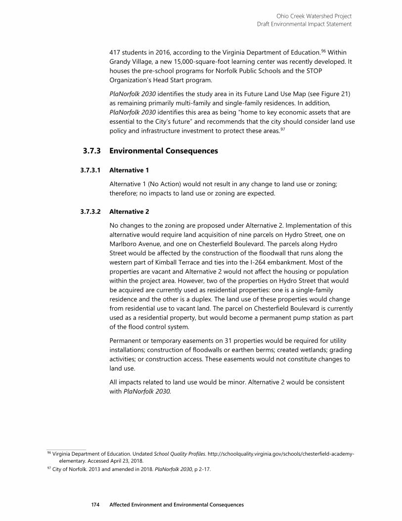
Ohio Creek Watershed Project Draft Environmental Impact Statement
174 Affected Environment and Environmental Consequences
417 students in 2016, according to the Virginia Department of Education.96 Within Grandy Village, a new 15,000-square-foot learning center was recently developed. It houses the pre-school programs for Norfolk Public Schools and the STOP Organization’s Head Start program.
PlaNorfolk 2030 identifies the study area in its Future Land Use Map (see Figure 21) as remaining primarily multi-family and single-family residences. In addition, PlaNorfolk 2030 identifies this area as being “home to key economic assets that are essential to the City’s future” and recommends that the city should consider land use policy and infrastructure investment to protect these areas.97
3.7.3 Environmental Consequences
3.7.3.1 Alternative 1
Alternative 1 (No Action) would not result in any change to land use or zoning; therefore; no impacts to land use or zoning are expected.
3.7.3.2 Alternative 2
No changes to the zoning are proposed under Alternative 2. Implementation of this alternative would require land acquisition of nine parcels on Hydro Street, one on Marlboro Avenue, and one on Chesterfield Boulevard. The parcels along Hydro Street would be affected by the construction of the floodwall that runs along the western part of Kimball Terrace and ties into the I-264 embankment. Most of the properties are vacant and Alternative 2 would not affect the housing or population within the project area. However, two of the properties on Hydro Street that would be acquired are currently used as residential properties: one is a single-family residence and the other is a duplex. The land use of these properties would change from residential use to vacant land. The parcel on Chesterfield Boulevard is currently used as a residential property, but would become a permanent pump station as part of the flood control system.
Permanent or temporary easements on 31 properties would be required for utility installations; construction of floodwalls or earthen berms; created wetlands; grading activities; or construction access. These easements would not constitute changes to land use.
All impacts related to land use would be minor. Alternative 2 would be consistent with PlaNorfolk 2030.
96 Virginia Department of Education. Undated School Quality Profiles. http://schoolquality.virginia.gov/schools/chesterfield-academy-
elementary. Accessed April 23, 2018. 97 City of Norfolk. 2013 and amended in 2018. PlaNorfolk 2030, p 2-17.
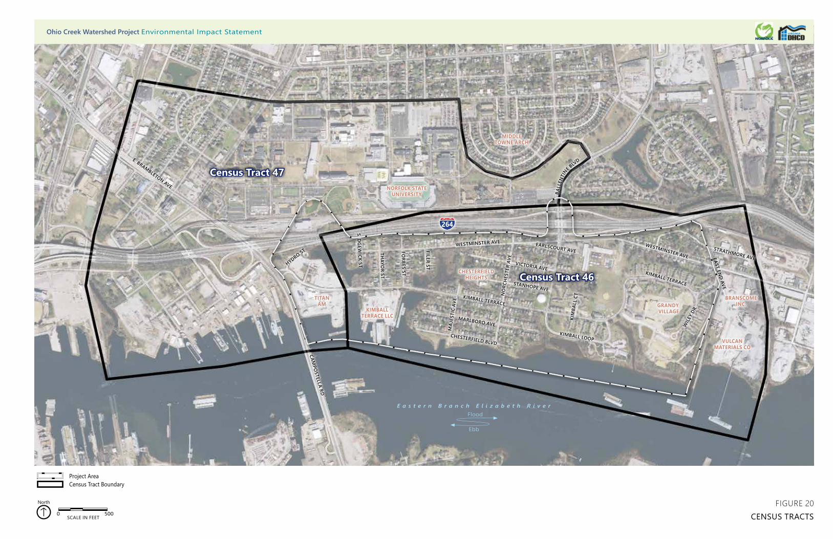
CHESTERFIELD BLVD
MARLBORO AVE
KIMBALL TERRACE
STANHOPE AVE
NO
RCH
ESTE
R AV
E
VICTORIA AVE
MA
JEST
IC A
VE
KIMBALL LOOP
KIM
BALL
CT
EARLSCOURT AVEWESTMINSTER AVE WESTMINSTER AVE
BALL
ENTI
NE BLV
D
FILER ST
FORBES ST
THAYO
R ST
SEDG
EWICK ST
WIL
EY D
R
KIMBALL TERRACE
EAST END AVE
STRATHMORE AVE
264
CAMPO
STELLA RD
E. BRAMBLETON AVE
HYDRO ST
0 500SCALE IN FEET
North
Project AreaCensus Tract Boundary
NORFOLK STATE UNIVERSITY
MIDDLE TOWNE ARCH
KIMBALLTERRACE LLC
TITAN AM
CHESTERFIELD HEIGHTS
GRANDY VILLAGE
VULCANMATERIALS CO
BRANSCOMEINC.
Census Tract 47
Census Tract 46
FIGURE 20CENSUS TRACTS
Ohio Creek Watershed Project Environmental Impact Statement
E a s t e r n B r a n c h E l i z a b e t h R i v e r
Ebb
Flood
CHESTERFIELD BLVD
MARLBORO AVE
KIMBALL TERRACE
STANHOPE AVE
NO
RCH
ESTE
R AV
E
VICTORIA AVE
MA
JEST
IC A
VE
KIMBALL LOOP
KIM
BALL
CT
EARLSCOURT AVEWESTMINSTER AVE WESTMINSTER AVE
BALL
ENTI
NE BLV
D
FILER ST
FORBES ST
THAYO
R ST
SEDG
EWICK ST
CAMPO
STELLA RD
WIL
EY D
R
KIMBALL TERRACE
EAST END AVE
STRATHMORE AVE
264
NORFOLK STATE UNIVERSITY
MIDDLE TOWNE ARCH
KIMBALLTERRACE LLC
TITAN AM
CHESTERFIELD HEIGHTS
GRANDY VILLAGE
VULCANMATERIALS CO
BRANSCOMEINC.
E a s t e r n B r a n c h E l i z a b e t h R i v e r
Ebb
Flood
HYDRO ST
0 500SCALE IN FEET
North
CommercialIndustrialInstitutionalMultifamilyMultifamily CorridorOffice
Future Land UseOpen Space/RecreationResidential MixedSingle Family SuburbanSingle Family TraditionalSingle Family UrbanUtility/Transportation
Project Area Census Tract
Census Tract 47
Census Tract 46
FIGURE 21FUTURE LANDUSE MAP
Ohio Creek Watershed Project Environmental Impact Statement
Ohio Creek Watershed Project Draft Environmental Impact Statement
177 Affected Environment and Environmental Consequences
3.7.3.3 Alternative 3
No changes to the zoning for Alternative 3 are proposed. Alternative 3 would require land acquisition of 19 parcels along the Ohio Creek, Sedgewick Street, Jacob Street, Filer Street, Forbes Street, Chesterfield Boulevard, and Marlboro Lane. The two parcels along the Ohio Creek and Marlboro Lane are vacant, and Alternative 3 would not change the current land use of these properties. The two parcels on Sedgewick Street are currently used as residential land and would change to vacant land. The parcel that would be acquired on Jacob Street is currently used as a residential duplex. The land use of this property would change from residential use to vacant land and is being acquired because the proposed relocation of Kimball Terrace would cut off its access. It is the only residential property on Jacob Street that is surrounded by industrial land uses. The parcel on Chesterfield Boulevard is currently used as a residential property, but would become the location of a permanent pump station as part of the flood control system. 13 residential properties on Filer Street and Forbes Street would be acquired to facilitate the construction of the floodwall and would become vacant land upon completion of the floodwall.
Permanent or temporary easements on 30 properties would be required for utility installations; construction of floodwalls or earthen berms; created wetlands; grading activities; or construction access. These easements would not constitute changes to land use.
All impacts related to land use would be minor. Alternative 3 would be consistent with PlaNorfolk 2030.
3.7.3.4 Alternative 4
No changes to the zoning for Alternative 4 are proposed. Alternative 4 would require land acquisition of five parcels along the Ohio Creek, Jacob Street, Sedgewick Street, and Marlboro Lane. Two parcels along Ohio Creek and Marlboro Lane are vacant and Alternative 4 would not change the current land use of these properties. However, three of the parcels that would be acquired currently contain residential duplexes. One is located on Jacob Street and two are located on Sedgewick Street. The land use of these properties would change from residential use to vacant land. The residential property on Jacob Street is being acquired because the proposed relocation of Kimball Terrace would cut off its access. It is the only residential property on Jacob Street surrounded by industrial land uses. The proposed berm along the Ohio Creek would severely encroach on the two residential properties on Sedgewick Street.
Permanent or temporary easements on 47 properties would be required for utility installations, construction of floodwalls or earthen berms, created wetlands, grading activities, or construction access.
All impacts related to land use would be minor. Alternative 4 would be consistent with PlaNorfolk 2030.
Ohio Creek Watershed Project Draft Environmental Impact Statement
178 Affected Environment and Environmental Consequences
3.8 Socioeconomics
3.8.1 Methodology
The study area for socioeconomics includes Census Tracts 46 and 47 in Norfolk, as shown in Figure 20. The demographic and population data was obtained from the US Census Bureau. The Bureau provides data based on three statistical areas. The largest of the areas is the census tract. Census tracts are broken down into census block groups and then again to block levels. The study area includes Census Tracts 46 and 47 in Norfolk. The project area includes all of Census Tract 46 and a small portion of Census Tract 47. The portion of Census Tract 47 within the project area comprises census blocks 2038, 2039, 2054, 2055, 2056 and 2058. Census information, specifically the 2010 Census and the 2012–2016 American Community Survey (ACS), was used to conduct the demographic analyses. Economic and industry data was obtained by ESRI Business Analyst.
3.8.2 Affected Environment
3.8.2.1 Housing Characteristics
Housing within the study area consists of a mixture of both homeownership and rentals. There are approximately 1,018 units of housing (excluding dormitory housing) with a 91.4 percent occupancy rate. This is an overall increase of 31 housing units since 2010. Of the 1,018 housing units currently in the study area, approximately 31.6 percent is owner occupied and 59.7 percent are rentals.
The median housing value in 2017 was $158,947.98 According to the 2012–2016 American Community Survey the median housing value is $158,800 in Census Tract 46 and $205,600 in Census Tract 47. The median monthly rent is $567 in Census Tract 46 and $863 in Census Tract 47.99 The breakdown of housing units by census tract is 789 in Census Tract 46 and 183 in Census Tract 47. There are also approximately 2,402 dormitory units located in Census Tract 47.100
The project area is home to a National Register Historic District known as Chesterfield Heights. It consists of more than 400 contributing structures that originated in 1898 and continued construction through 1914. The District is composed of an area of 85 acres (see Figure 19) and is mostly single-family homes.
98 ESRI. Business Summary Database. Accessed March 19, 2018. 99 US Census Bureau. 2017. 2012-2016 American Community Survey. https://www.census.gov/programs-surveys/acs/. Accessed
March 19, 2018. 100 Norfolk State University. Undated. Norfolk State University. https://www.nsu.edu/. Accessed March 19, 2018.
Ohio Creek Watershed Project Draft Environmental Impact Statement
179 Affected Environment and Environmental Consequences
The project area is also home to a 363-unit public housing complex called Grandy Village (see Figure 2). This housing complex is run by the Norfolk Redevelopment and Housing Authority. The housing complex was built in 1953 and is in the process of undergoing rehabilitation, which includes rehabilitation of 253 units, construction of new units, and demolition of the older units (following construction of the new units), The proposed flat rents for fiscal year 2018 in Grandy Village are as follows: $680 for a one-bedroom unit; $816 for a two-bedroom unit; and $1,136 for a three-bedroom unit.101
3.8.2.2 Population Characteristics
The study area includes Census Tracts 46 and 47 in Norfolk (see Figure 20). Table 30 displays the population characteristics of the two census tracts. According to the 2012–2016 American Community Survey data, 4,990 people live within the study area. The population has remained relatively stable since 2010, with only a slight increase from 4,961 people in 2010 to 4,990 people in 2016. The study area includes all students from Norfolk State University living on campus.
Table 30 Population Characteristics
Census Tract 46 Census Tract 47 Total Population Total Population 1,985 3,005 4,990
White 138 (7.0%) 479 (15.9%) 617 (12.3%) Black 1,738 (87.6%) 2,429 (80.8%) 4,167 (83.5%) Asian 0 53 (1.8%) 53 (1.0%) Hispanic (of any race) 10 (0.5%) 69 (2.3%) 79 (1.5%)
Source: 2012–2016 American Community Survey
As discussed above, the project area includes all of Census Tract 46 and a small portion of Census Tract 47, and the portion of Census Tract 47 within the project area comprises census blocks 2038, 2039, 2054, 2055, 2056, and 2058. However, as these census blocks are largely industrial, they contain a very small population of 10 residents, according to the 2010 Census. Therefore, population data for Census Tract 46 provides an accurate portrayal of the project area.
The population of the project area was 1,985 in 2016, down from 2,193 in 2010. Overall, the project area experienced a decrease in the total number of households from 739 in 2010 to 724 in 2016.
The study area is a majority Black/African American with over 83.5 percent of the study area identifying as Black/African American. The project area (Census Tract 46) percentage is slightly higher, with 87.6 percent of the population identifying as Black/African American.
101 Norfolk Housing and Redevelopment Authority. 2018. Norfolk Housing and Redevelopment Authority Plan.
Ohio Creek Watershed Project Draft Environmental Impact Statement
180 Affected Environment and Environmental Consequences
The population is relatively young, with a median age of 26.8 years for Census Tract 46 and 20.6 years for Census Tract 47. Only 8.5 percent of the population in Census Tract 46 is over the age of 65. Census Tract 47 contains an even smaller senior population, with 4.2 percent of its population over the age of 65.
3.8.2.3 Socioeconomics
The demographic and population data was obtained from the US Census Bureau. The Bureau provides data based on three statistical areas. The largest of the areas is the census tract. Census tracts are broken down into census block groups and then again to block levels. The study area includes Census Tracts 46 and 47 in Norfolk. The project area includes all of Census Tract 46 and a small portion of Census Tract 47. The portion of Census Tract 47 within the project area comprises census blocks 2038, 2039, 2054, 2055, 2056, and 2058. Census information, specifically the 2010 Census and the 2012–2016 American Community Survey, was used to conduct the demographic analyses. Economic and industry data was obtained by ESRI Business Analyst.
According to ERSI Business Analyst, the median household income for the study area in 2017 is $26,277. The median household income is $27,708 for Census Tract 46 and $51,677 for Census Tract 47. Thirty-four percent of the population in Census Tract 46 is below the poverty level and 13 percent of the population in Census Tract 47 is below poverty level.102 The US Census Bureau definition of household includes all people occupying a housing unit; however, housing units do not include the dormitory housing that would be found at Norfolk State University.
Table 31, Study Area Employment, provides the number of businesses and employees in each business sector in the study area. Overall, there are approximately 51 businesses located within the study area that employ a total of 1,194 people. The dominant industries by percent of employees include Manufacturing (17.6%), Transportation (21.4%), Retail Trade (28.1%, primarily food stores), and the Services industry (24.1%), which includes education institutions and libraries. Major employers include Lyon Shipyard, Inc.; Moran Environmental Recovery; RJR Elite Trucking; Capital Concrete, Inc.; and several educational institutions, including Chesterfield Academy (elementary school) and Norfolk State University. Manufacturing companies in the project area include C&M Industries, Branscome, Vulcan Materials, and Titan America.103
102 US Census Bureau. 2017. 103 ESRI. 2018. Business Summary Database. Accessed March 19, 2018.
Ohio Creek Watershed Project Draft Environmental Impact Statement
181 Affected Environment and Environmental Consequences
Table 31 Study Area Employment
Industry Sector Businesses Employees Employees %
Construction 4 55 4.6% Manufacturing 5 210 17.6% Transportation 6 255 21.4% Communication 2 10 0.8% Utility 1 8 0.7% Wholesale Trade 1 12 1.0% Retail Trade 8 336 28.1% Finance, Insurance, Real Estate 2 20 1.7% Services 21 288 24.1% Unclassified Establishments 1 0 0.0% Total 51 1,194 100.0% Source: ESRI Business Summary accessed on March 19, 2017. Sector is by Standard Industrial
Classification (SIC) Codes.
3.8.2.4 Community
As described above, the study area is characterized by largely single-family and multi-family residential uses proximate to industrial areas and a significant institutional use, Norfolk State University. The project area is primarily residential uses with smaller industrial areas in the eastern and western sections of the project area. Certain factors contribute to the community within the project area, including the Chesterfield Heights Historic District and the presence of the Grandy Village housing complex. In addition, the project area is home to two educational facilities for elementary and preschool children. I-264—an eight-lane interstate highway—and the Tide Light Rail tracks, separates the project area from the rest of the city, limiting access for the project area and its residents and workers. There are only two access roads to the project area, Ballentine Boulevard and Kimball Terrace.
3.8.3 Environmental Consequences
3.8.3.1 Alternative 1
Housing and Population
Alternative 1 (No Action) would not result in any changes to the housing and population of the study area. However, the project area would continue to be at risk for flooding during storm events which directly impacts the housing within the project area. This includes flooding associated with storm surges, elevated tides, and heavy rainfall storm events. These events could ultimately lead to decreased property values and even property degradation in more severe instances. In addition, the residents living within the project area would continue to have only two access roads, one of which, Kimball Terrace, is known to be impassable during
Ohio Creek Watershed Project Draft Environmental Impact Statement
182 Affected Environment and Environmental Consequences
flood events. Flooding due to rain and high tides regularly disconnect the approximately 2,000 residents from the rest of the city and includes the residents of Grandy Village. This disconnection during flood events would continue under the Alternative 1. The No Action Alternative would leave the project area exposed to both short and long-term flood related impacts.
Socioeconomics
Alternative 1 (No Action) would not result in any changes to the socioeconomics of the area. However, the long-term economic benefits of decreased flooding frequency would not be realized and the residents and businesses would continue to experience impacts from flood events. Flood insurance rates rise every year and it is anticipated that this would continue and increase the economic burden on property owners and businesses. In the long-term, frequent flood events could cause property values to decrease due to the negative impacts of flooding.
Community
Alternative 1 (No Action) would not result in any changes on the community within the study area. However, the project area would continue to be at risk for flooding during flood events, which directly impacts the community within the study area. This includes flooding associated with storm surges, elevated tides, and heavy rainfall storm events. In addition, the residents living within the study area would continue to have only two access roads, one of which, Kimball Terrace, is known to be impassable during flood events. Flooding due to rain and high tides regularly disconnects some residents of Grandy Village from the rest of the city, and this would continue under Alternative 1. This alternative would leave the project area exposed to both short and long-term flood related impacts. In addition, the project area would continue to have the existing recreational amenities it does now and the existing road network would remain the same with no improvements to be implemented.
3.8.3.2 Alternative 2
Housing and Population
Alternative 2 would require land acquisition of nine parcels on Hydro Street, one on Marlboro Lane, and one on Chesterfield Boulevard. The Hydro Street parcels would be affected by the construction of the floodwall that runs along the western part of Kimball Terrace and ties into the I-264 embankment. Impacts to the housing and population as a result of the property acquisition would be minor. Most of the properties are vacant. However, two of the properties that would be acquired on Hydro Street are currently used as residential properties: a single-family residence and a duplex. The parcel on Chesterfield Boulevard is currently used as a residential property, but would become the location of a permanent pump station as part of the flood control system. These residences would be demolished. The property located on Chesterfield Boulevard is owned by the city. Early conversations indicate that the
Ohio Creek Watershed Project Draft Environmental Impact Statement
183 Affected Environment and Environmental Consequences
majority of landowners are willing sellers. The city is committed to working with landowners and does not intend to take any properties without consent.
Permanent or temporary easements on 31 properties would be required for utility installations; construction of floodwalls or earthen berms; created wetlands; grading activities; or construction access. These easements would not affect the current housing or population within the study area.
Alternative 2 would provide a long-term benefit to the existing housing and current population of approximately 2,000 residents in the project area, including the public housing complex of Grandy Village. Alternative 2 would reduce the frequency of flood events from rainfall, or larger regional flooding from storm surges as a result of increasing the coastal defenses through the installation of tide gates, floodwalls, berms, and living shorelines (Figure 5). Housing would be further protected by a reduction in the intensity of the stormwater runoff and frequency of flood events through the installation of stormwater controls such as pump stations, created wetlands, rain gardens, and bioswales.
Residents would have improved access to and from the project area because Alternative 2 proposes to raise a portion of Kimball Terrace from Campostella Road to Thayor Street to reduce the frequency of flooding caused by wave action and tidal surges. A portion of Westminster Avenue would also be raised to reduce the chance of flooding.
The residents within the project area would experience short-term minor impacts due to the construction work. It is anticipated that all construction would be completed within 3 years and all local, state, and federal regulations would be followed. Construction would be phased to minimize neighborhood disturbance to the greatest extent practicable. Construction impacts are temporary and any impacts would cease upon project completion.
Socioeconomics
Both short-term and long-term impacts would be associated with Alternative 2. The short-term impacts would include construction-related impacts. Alternative 2 would include approximately $106,000,000 of total construction costs, providing several hundred full-time equivalent jobs during the course of the 3-year phased construction (assuming labor costs are 40% of total construction costs).104 In addition, businesses located within the project area would experience minor impacts due to the construction work, especially during the implementation of the roadway improvements. It is anticipated that all construction would be completed within three years and all local, state, and federal regulations would be followed. Construction would be phased to minimize disturbances to existing businesses to the greatest extent practicable.
104 Data retrieved from the Bureau of Labor Statistics 2017 and calculated using labor costs divided by average hourly compensation
per construction worker divided by average hours worked per year.
Ohio Creek Watershed Project Draft Environmental Impact Statement
184 Affected Environment and Environmental Consequences
Long-term impacts include the loss of property taxes due to the change in land use from residential to vacant land for two properties, and a third residential property becoming the location of a pump station. The economic impact of this would be minor. However, there is a long-term economic benefit to the study area. Based on the Norfolk Coastal Adaptation and Community Transformation Plan’s Cost Benefits Analysis, improvements presented in Alternatives 2, 3, and 4 would provide an estimated net present value benefit of $116,968,617 (low estimate) to $224,119,946 (high estimate). This includes benefits in resiliency (direct physical damages, essential facility and critical service loss, human impact, and economic losses); environmental; social (recreational, health, and aesthetics); and economic revitalization.105
Community
Alternative 2 would have a net positive long-term impact on the community. Improvements proposed within Alternative 2 include various pedestrian and vehicular upgrades, such as additional walkways and paths constructed from permeable materials, and intersection improvements at Campostella Road and Kimball Terrace (Figure 5). A stormwater park would be installed in the existing open space within Grandy Village. This would include new and improved playgrounds, playing fields, and open park space. Ballentine Boulevard would have improvements to the pedestrian sidewalk beneath I-264, improving a sense of safety while using this connection. All of these improvements would provide benefits to the residents in the project and study areas. Overall, Alternative 2 would enhance transportation within the community by creating safer routes to schools, community facilities, and overall ingress and egress to Chesterfield Heights and Grandy Village.
The pump station at Ballentine Boulevard would also serve as a new community amenity under this alternative. Associated covered outdoor space would act as a “resilience hub,” with educational signs about neighborhood flood risk, resilience strategies, and pump function. This space would also provide charging stations and would serve as a community meeting place for both everyday uses and disaster response. This would allow residents of and visitors to the community to understand the resilience strategies in use while improving safety during major storms.
3.8.3.3 Alternative 3
Housing and Population
Alternative 3 would require land acquisition of 19 parcels along the Ohio Creek, Jacob Street, Forbes Street, Filer Street, Sedgewick Street, Chesterfield Boulevard, and Marlboro Lane. Impacts to the housing and population as a result of the property acquisition would be minor. Two of the parcels are vacant along Ohio
105 Commonwealth of Virginia. Undated. Norfolk Coastal Adaptation and Community Transformation Plan.
Ohio Creek Watershed Project Draft Environmental Impact Statement
185 Affected Environment and Environmental Consequences
Creek and Marlboro Lane. One of the parcels that would be acquired, located on Jacob Street, is currently used as a residential duplex and would be demolished as a result of the project. The property is being acquired because the proposed relocation of Kimball Terrace would cut off its access. Two other parcels that would be acquired currently contain residential duplexes, both are located on Sedgewick Street. These residential houses would be demolished and are being acquired because the proposed floodwall along the Ohio Creek would severely impact the two parcels. Similarly, 13 residential properties on Filer Street and Forbes Street would be acquired to facilitate the construction of the floodwall and would become vacant land upon completion of the floodwall. The parcel on Chesterfield Boulevard is currently used as a residential property, but would become the location of a permanent pump station as part of the flood control system. Early conversations indicate that the owners are willing sellers. The city is committed to working with landowners and does not intend to take any properties without consent. Impacts to the housing and population as a result of the property acquisition would be minor.
Permanent or temporary easements on 30 properties would be required for utility installations, construction of floodwalls or earthen berms, created wetlands, grading activities, or construction access. These easements would not affect the current housing or population within the study area.
Similar to Alternative 2, Alternative 3 would provide a long-term benefit to the existing housing and current population of approximately 2,000 residents in the project area, including the public housing complex of grandy Village. Alternative 3 would reduce the frequency of flood events from rainfall, or larger regional flooding from storm surges as a result of increasing the coastal defenses through the installation of floodwalls, berms, and living shorelines (Figure 6). Housing would be further protected by a reduction in the intensity of the stormwater runoff and frequency of flood events through the installation of stormwater controls such as pump stations, created wetlands, rain gardens, and bioswales.
Residents would have improved access to and from the project area because Alternative 3 proposes to relocate the western portion of Kimball Terrace to reduce the frequency of flooding caused by wave action and tide surges. A portion of Westminster Avenue would be protected by a floodwall and another portion would be raised.
The residents within the project area would experience short-term minor impacts due to the construction work. It is anticipated that all construction would be completed within 3 years and all local, state, and federal regulations would be followed. Construction would be phased to minimize neighborhood disturbance to the greatest extent practicable. Construction impacts are temporary and any impacts would cease upon project completion.
Socioeconomics
Both short-term and long-term impacts would be associated with Alternative 2. The short-term impacts would include construction-related impacts. Alternative 2 would
Ohio Creek Watershed Project Draft Environmental Impact Statement
186 Affected Environment and Environmental Consequences
include approximately $106,000,000 of total construction costs, providing several hundred full-time equivalent jobs during the course of the 3-year phased construction (assuming labor costs are 40% of total construction costs).106 In addition, businesses located within the project area would experience minor impacts due to the construction work, especially during the implementation of the roadway improvements. It is anticipated that all construction would be completed within three years and all local, state, and federal regulations would be followed. Construction would be phased to minimize disturbances to existing businesses to the greatest extent practicable.
Long-term impacts include the loss of property taxes due to the change in land use from residential to vacant land for 15 properties, and a third residential property becoming the location of a pump station. The economic impact of this would be minor and may even be positive due to the potential of increased property values. However, there is a long-term economic benefit to the study area. Based on the Norfolk Coastal Adaptation and Community Transformation Plan’s Cost Benefits Analysis, improvements presented in Alternatives 2, 3, and 4 would provide an estimated net present value benefit of $116,968,617 (low estimate) to $224,119,946 (high estimate). This includes benefits in resiliency (direct physical damages, essential facility and critical service loss, human impact, and economic losses); environmental; social (recreational, health, and aesthetics); and economic revitalization.107
Both short term and long-term impacts would be associated with Alternative 3. The short-term impacts would include construction-related impacts. Alternative 3 would include approximately $115,000,000 of total construction costs, generating about 663 full time equivalent jobs during the course of the 3-year phased construction (assuming labor costs are 40% of total construction costs).108 In addition, businesses located within the project area would experience minor impacts due to the construction work, especially during the implementation of the roadway improvements. Alternative 3 road improvements include realigning the western portion of Kimball Terrace and modifying the existing intersection at Campostella Road. The realigned road would no longer traverse between the commercial properties, but instead extend along the edge of Ohio Creek. New commercial entrances would be developed for the two major businesses that exist along this stretch of Kimball Terrace. It is anticipated that all construction would be completed within 3 years and all local, state, and federal regulations would be followed. Construction would be phased to minimize disturbances to existing businesses to the greatest extent practicable.
Long-term impacts include the loss of property taxes due to the change in land use from residential to vacant land, or utility infrastructure, for 17 properties. The economic impact of this would be minor. However, there is a long-term economic
106 Data retrieved from the Bureau of Labor Statistics 2017 and calculated using labor costs divided by average hourly compensation
per construction worker divided by average hours worked per year. 107 Commonwealth of Virginia. Undated. Norfolk Coastal Adaptation and Community Transformation Plan. 108 Data retrieved from the Bureau of Labor Statistics 2017 and calculated using labor costs divided by average hourly compensation
per construction worker divided by average hours worked per year.
Ohio Creek Watershed Project Draft Environmental Impact Statement
187 Affected Environment and Environmental Consequences
benefit to the study area. Based on the Norfolk Coastal Adaptation and Community Transformation Plan’s Cost Benefits Analysis, improvements presented in Alternatives 2, 3, and 4 would provide an estimated net present value benefit of $116,968,617 (low estimate) to $224,119,946 (high estimate). This includes benefits in resiliency (direct physical damages, essential facility and critical service loss, human impact, and economic losses); environmental; social (recreational, health, and aesthetics); and economic revitalization.109
Community
Similar to Alternative 2, Alternative 3 would have a net positive long-term impact on the community. Community amenities within Alternative 3 are very similar to those proposed for Alternative 2. Improvements include pedestrian and vehicular upgrades, such as additional walkways and paths constructed from permeable materials, new and improved play/playing fields and open park space, and improvements along Ballentine Boulevard that includes a pedestrian sidewalk beneath I-264 (Figure 6). Alternative 3 improvements also include realigning the western portion of Kimball Terrace and modifying the existing intersection at Campostella Road. New commercial entrances would be developed for the two major businesses that exist along this stretch of Kimball Terrace. Overall, Alternative 3 would enhance transportation within the community by creating safer routes to schools, community facilities, and overall ingress and egress to Chesterfield Heights and Grandy Village.
Another improvement common to Alternative 2 is the pump station at Ballentine Boulevard, which would serve as a new community amenity. Associated covered outdoor space would act as a “resilience hub,” with educational signs about neighborhood flood risk, resilience strategies, and pump function. This space would also provide charging stations and would serve as a community meeting place for both everyday uses and disaster response. This would allow residents of and visitors to the community to understand the resilience strategies in use while improving safety during major storms.
3.8.3.4 Alternative 4
Housing and Population
Alternative 4 would require land acquisition of five parcels along the Ohio Creek, Jacob Street, Sedgewick Street, and Marlboro Lane. Two of the parcels are vacant. However, three of the parcels that would be acquired currently contain residential duplexes. One is located on Jacob and two are located on Sedgewick Street. The residential houses would be demolished. The residential property on Jacob Street is being acquired because the proposed relocation of Kimball Terrace would cut off its
109 Commonwealth of Virginia. Undated. Norfolk Coastal Adaptation and Community Transformation Plan.
Ohio Creek Watershed Project Draft Environmental Impact Statement
188 Affected Environment and Environmental Consequences
access and the proposed berm along the Ohio Creek would severely encroach on the two residential properties on Sedgewick Street. Early conversations indicate that the owners are willing sellers. The city is committed to working with landowners and does not intend to take any properties without consent. Impacts to the housing and population as a result of the property acquisition would be minor.
Permanent or temporary easements on 47 properties would be required for utility installations, construction of floodwalls or earthen berms, created wetlands, grading activities, or construction access. These easements would not affect the current housing or population within the study area.
Similar to Alternative 2 and 3, Alternative 4 would provide a long-term benefit to the existing housing and current population of approximately 2,000 residents in the project area, including the public housing complex of Grandy Village. Alternative 4 would reduce the frequency of flood events from rainfall events, or larger regional flooding events from storm surges as a result of increasing the coastal defenses through the installation of tide gates, floodwalls, berms, and living shorelines (Figure 7). Housing would be further protected by a reduction in the intensity of the stormwater runoff and frequency of flood events through the installation of stormwater controls such as pump stations, created wetlands, rain gardens, and bioswales.
Residents would have improved access to and from the project area because Alternative 4 proposes to relocate the western portion of Kimball Terrace to reduce the frequency of flooding caused by wave action and tide surges. A portion of Westminster Avenue would be protected by a mix of coastal protection measures.
The residents within the project area would experience short-term minor impacts due to the construction work. It is anticipated that all construction would be completed within 3 years and all local, state, and federal regulations would be followed. Construction would be phased to minimize neighborhood disturbance to the greatest extent practicable. Construction impacts are temporary and any impacts would cease upon project completion.
Socioeconomics
Both short-term and long-term impacts would be associated with Alternative 2. The short-term impacts would include construction-related impacts. Alternative 2 would include approximately $106,000,000 of total construction costs, providing several hundred full-time equivalent jobs during the course of the 3-year phased construction (assuming labor costs are 40% of total construction costs).110 In addition, businesses located within the project area would experience minor impacts due to the construction work, especially during the implementation of the roadway improvements. It is anticipated that all construction would be completed within three years and all local, state, and federal regulations would be followed.
110 Data retrieved from the Bureau of Labor Statistics 2017 and calculated using labor costs divided by average hourly compensation
per construction worker divided by average hours worked per year.
Ohio Creek Watershed Project Draft Environmental Impact Statement
189 Affected Environment and Environmental Consequences
Construction would be phased to minimize disturbances to existing businesses to the greatest extent practicable.
Long-term impacts include the loss of property taxes due to the change in land use from residential to vacant land for two properties. The economic impact of this would be minor and may even be positive due to the potential of increased property values. However, there is a long-term economic benefit to the study area. Based on the Norfolk Coastal Adaptation and Community Transformation Plan’s Cost Benefits Analysis, improvements presented in Alternatives 2, 3, and 4 would provide an estimated net present value benefit of $116,968,617 (low estimate) to $224,119,946 (high estimate). This includes benefits in resiliency (direct physical damages, essential facility and critical service loss, human impact, and economic losses); environmental; social (recreational, health, and aesthetics); and economic revitalization.111
Both short term and long-term impacts would be associated with Alternative 3. The short-term impacts would include construction-related impacts. Alternative 3 would include approximately $115,000,000 of total construction costs, generating about 663 full time equivalent jobs during the course of the 3-year phased construction (assuming labor costs are 40% of total construction costs).112 In addition, businesses located within the project area would experience minor impacts due to the construction work, especially during the implementation of the roadway improvements. Alternative 3 road improvements include realigning the western portion of Kimball Terrace and modifying the existing intersection at Campostella Road. The realigned road would no longer traverse between the commercial properties, but instead extend along the edge of Ohio Creek. New commercial entrances would be developed for the two major businesses that exist along this stretch of Kimball Terrace. It is anticipated that all construction would be completed within 3 years and all local, state, and federal regulations would be followed. Construction would be phased to minimize disturbances to existing businesses to the greatest extent practicable.
Long-term impacts include the loss of property taxes due to the change in land use from residential to vacant land, or utility infrastructure, for four properties. The economic impact of this would be minor. However, there is a long-term economic benefit to the study area. Based on the Norfolk Coastal Adaptation and Community Transformation Plan’s Cost Benefits Analysis, improvements presented in Alternatives 2, 3, and 4 would provide an estimated net present value benefit of $116,968,617 (low estimate) to $224,119,946 (high estimate). This includes benefits in resiliency (direct physical damages, essential facility and critical service loss,
111 Commonwealth of Virginia. Undated. Norfolk Coastal Adaptation and Community Transformation Plan. 112 Data retrieved from the Bureau of Labor Statistics 2017 and calculated using labor costs divided by average hourly compensation
per construction worker divided by average hours worked per year.
Ohio Creek Watershed Project Draft Environmental Impact Statement
190 Affected Environment and Environmental Consequences
human impact, and economic losses); environmental; social (recreational, health, and aesthetics); and economic revitalization.113
Both short-term and long-term impacts would be associated with Alternative 4. The short-term impacts would include construction-related impacts. Alternative 4 would include approximately $89,000,000 of total construction costs, generating about 513 full time equivalent jobs during the course of the 3-year phased construction (assuming labor costs are 40% of total construction costs).114 In addition, businesses located within the project area would experience minor impacts due to the construction work, especially during the implementation of the roadway improvements. Alternative 4 road improvements include realigning the western portion of Kimball Terrace and modifying the existing intersection at Campostella Road. The realigned road would no longer traverse between the commercial properties, but instead extend along the edge of Ohio Creek. New commercial entrances would be developed for the two major businesses that exist along this stretch of Kimball Terrace. It is anticipated that all construction would be completed within 3 years and all local, state, and federal regulations would be followed. Construction would be phased to minimize disturbances to existing businesses to the greatest extent practicable.
Long-term impacts include the loss of property taxes due to the change in land use from residential to vacant land for three properties. The economic impact of this would be minor. However, there is a long-term economic benefit to study area. Based on the Norfolk Coastal Adaptation and Community Transformation Plan’s Cost Benefits Analysis, improvements presented in Alternatives 2, 3, and 4 would provide an estimated net present value benefit of $116,968,617 (low estimate) to $224,119,946 (high estimate). This includes benefits in resiliency (direct physical damages, essential facility and critical service loss, human impact, and economic losses); environmental; social (recreational, health, and aesthetics); and economic revitalization.115
Community
Community amenities within Alternative 4 would have a net positive long-term impact on the project area. The amenities proposed are very similar to those described in Alternatives 2 and 3, but Alternative 4 offers additional amenities. There would be a total of three stormwater parks: one would be installed in the existing open space within Grandy Village, the second at Haynes Creek, and the third along Ballentine Road (Figure 7). As under Alternatives 2 and 3, the pump station at Ballentine Boulevard would also serve as a new community amenity under this alternative. Associated covered outdoor space would act as a “resilience hub,” with charging stations. It would serve as a community meeting place for both everyday uses and disaster response. This would allow residents of and visitors to the
113 Commonwealth of Virginia. Undated. Norfolk Coastal Adaptation and Community Transformation Plan. 114 Data retrieved from the Bureau of Labor Statistics 2017 and calculated using labor costs divided by average hourly compensation
per construction worker divided by average hours worked per year. 115 Commonwealth of Virginia. Undated. Norfolk Coastal Adaptation and Community Transformation Plan.
Ohio Creek Watershed Project Draft Environmental Impact Statement
191 Affected Environment and Environmental Consequences
community to understand the resilience strategies in use while improving safety during major storms.
Improvements in Alternative 4 also include various pedestrian and vehicular upgrades, such as additional walkways and paths constructed from permeable materials, and new and improved playgrounds and playing fields and open park space. Alternative 4 would provide improvements to the pedestrian sidewalk along Ballentine Boulevard beneath I-264. Alternative 4 improvements would realign the western portion of Kimball Terrace, install a bike/pedestrian lane adjacent to the re-aligned road, and modify the existing intersection at Campostella Road. The realigned road would no longer traverse between the commercial properties, but extend along the edge of Ohio Creek. New commercial entrances would be developed for the two major businesses that exist along this stretch of Kimball Terrace.
Additional paths, boardwalks, and pedestrian bridges are proposed within Grandy Village in Alternative 4. Another key amenity added to Alternative 4 is the proposed community pier installed within the Eastern Branch, near the Ballentine pump station, a specific request made by residents during initial planning.
Alternative 4 would enhance transportation within the community by creating safer routes to schools, community facilities, and overall ingress and egress to Chesterfield Heights and Grandy Village.
All of the improvements outlined in Alternative 4 would provide benefits to the residents in the project and study areas.
Ohio Creek Watershed Project Draft Environmental Impact Statement
192 Affected Environment and Environmental Consequences
3.9 Environmental Justice
3.9.1 Methodology
Executive Order 12898 signed in 1994 by President Clinton and entitled Federal Actions to Address Environmental Justice in Minority Populations and Low-Income Populations requires federal agencies to identify and address as appropriate disproportionately high and adverse effects of federal projects on the health or environment of minority and low-income populations. The purpose of the environmental justice review is to determine if a disproportionate portion of a project’s adverse impacts is taking place within or affecting a minority and/or low-income population. The methodology to identify populations of concern follows the Virginia Department of Transportation Environmental Justice Guidelines.
The study area for environmental justice includes Census Tracts 46 and 47 in Norfolk, as shown in Figure 20. Census information, specifically the 2010 Census and the 2012–2016 American Community Survey, was obtained to conduct the demographic analyses. As a result of the entire study area and project area being identified as an environmental justice area, as detailed in the next section, the analysis used only the census tract level data. It was not necessary to break down the data to block group level.
3.9.2 Affected Environment
As stated in the VDOT Environmental Justice Guidelines, the principles of environmental justice are:
› To avoid, minimize, or mitigate disproportionately high and adverse human health and environmental effects, including social and economic effects, on minority populations and low-income populations.
› To ensure the full and fair participation by all potentially affected communities in the transportation decision-making process.
› To prevent the denial of, reduction in, or significant delay in the receipt of benefits by minority and low-income populations.
The first step in the process is to identify minority or low-income populations within the project area. Based on the race and economic data for Census Tracts 46 and 47, both census tracts are identified as environmental justice populations. The Black/African American population within Census Tract 46 totals 87.6 percent and the Hispanic population is 0.5 percent; overall, the total minority population for Census Tract 46 is 93.5 percent. In Census Tract 47, 80.8 percent of the total population is Black/African American and 2.3 percent is Hispanic; overall, 85.2 percent of the population is minority. In addition, 34 percent of the population in Census Tract 46 is below the poverty level, with a median household income of $27,708 and 13 percent of the population in Census Tract 47 is below poverty level with a median household income of $51,677. According to Norfolk, both census tracts identify as Low to Moderate Income.
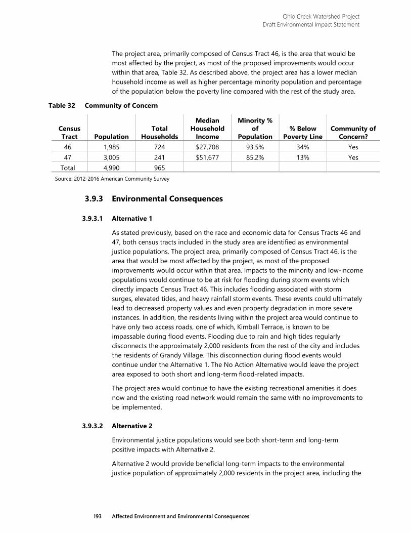
Ohio Creek Watershed Project Draft Environmental Impact Statement
193 Affected Environment and Environmental Consequences
The project area, primarily composed of Census Tract 46, is the area that would be most affected by the project, as most of the proposed improvements would occur within that area, Table 32. As described above, the project area has a lower median household income as well as higher percentage minority population and percentage of the population below the poverty line compared with the rest of the study area.
Table 32 Community of Concern
Census Tract Population
Total Households
Median Household
Income
Minority % of
Population % Below
Poverty Line Community of
Concern? 46 1,985 724 $27,708 93.5% 34% Yes 47 3,005 241 $51,677 85.2% 13% Yes
Total 4,990 965 Source: 2012-2016 American Community Survey
3.9.3 Environmental Consequences
3.9.3.1 Alternative 1
As stated previously, based on the race and economic data for Census Tracts 46 and 47, both census tracts included in the study area are identified as environmental justice populations. The project area, primarily composed of Census Tract 46, is the area that would be most affected by the project, as most of the proposed improvements would occur within that area. Impacts to the minority and low-income populations would continue to be at risk for flooding during storm events which directly impacts Census Tract 46. This includes flooding associated with storm surges, elevated tides, and heavy rainfall storm events. These events could ultimately lead to decreased property values and even property degradation in more severe instances. In addition, the residents living within the project area would continue to have only two access roads, one of which, Kimball Terrace, is known to be impassable during flood events. Flooding due to rain and high tides regularly disconnects the approximately 2,000 residents from the rest of the city and includes the residents of Grandy Village. This disconnection during flood events would continue under the Alternative 1. The No Action Alternative would leave the project area exposed to both short and long-term flood-related impacts.
The project area would continue to have the existing recreational amenities it does now and the existing road network would remain the same with no improvements to be implemented.
3.9.3.2 Alternative 2
Environmental justice populations would see both short-term and long-term positive impacts with Alternative 2.
Alternative 2 would provide beneficial long-term impacts to the environmental justice population of approximately 2,000 residents in the project area, including the
Ohio Creek Watershed Project Draft Environmental Impact Statement
194 Affected Environment and Environmental Consequences
public housing complex of Grandy Village. Alternative 2 would reduce the frequency of flood events from rainfall events, or larger regional flooding events from storm surges as a result of increasing the coastal defenses through the installation of tide gates, floodwalls, berms, and living shorelines (Figure 5). Housing would be further protected by a reduction in the intensity of the stormwater runoff and frequency of flood events through the installation of stormwater controls such as pump stations, created wetlands, rain gardens, and bioswales.
Residents would have improved access to and from the project area because Alternative 2 proposes to raise a portion of Kimball Terrace from Campostella Road to Thayor Street to reduce the frequency of flooding caused by wave action and tide surges. Portions of Westminster Avenue would also be raised to reduce the chance of flooding.
Community improvements proposed within Alternative 2 include various pedestrian and vehicular upgrades, such as additional walkways and paths constructed from permeable materials, and intersection improvements at Campostella Road and Kimball Terrace (Figure 5). A stormwater park would be installed in the existing open space within Grandy Village. This would include new and improved playgrounds, playing fields, and open park space. Ballentine Boulevard would have improvements to the pedestrian sidewalk beneath I-264. All of these improvements would provide benefits to the residents in the environmental justice areas. Overall, Alternative 2 would enhance transportation within the community by creating safer routes to schools, community facilities, and overall ingress and egress to Chesterfield Heights and Grandy Village.
The only long-term impact on the environmental justice populations would include the noise when the pump stations are operable. The pump stations would operate pumps and other associated mechanical equipment when flooding exceeds the storage capacity of the system. As a mitigating measure, the pump facilities would need to be designed to attenuate sound to an exterior level of 52 dBA at distances as close as 10 feet and this level of sound attenuation is achievable.
There would be minor short-term impacts related to the construction activities. They would include noise and vibrations as a result of the construction of the floodwalls and berms. If sheet pile driving is involved, this would generate the most noise and vibration. It is anticipated that all construction would be completed within 3 years and all local, state, and federal regulations would be followed. Construction would be phased to minimize neighborhood disturbance to the greatest extent practicable.
Alternative 2 would require land acquisition of three residential properties, located on Hydro Street and Chesterfield Boulevard. Two are single-family residences and the other is a duplex. Early conversations indicate that the owners are willing sellers. The city is committed to working with landowners and does not intend to take any properties without consent. The Hydro Street parcels would be affected by the construction of the floodwall that runs along the western part of Kimball Terrace to the I-264 embankment, and the Chesterfield Boulevard parcel would be affected by the installation of a pump station.
Ohio Creek Watershed Project Draft Environmental Impact Statement
195 Affected Environment and Environmental Consequences
Permanent or temporary easements on 31 properties would be required for utility installations; construction of floodwalls or earthen berms; created wetlands; grading activities; or construction access. These easements would not affect the current environmental justice population within the study area.
In order to achieve the long-term beneficial impacts within the environmental justice areas, short-term construction impacts are necessary. Therefore, because the entire project area is an environmental justice area and the project would provide long-term benefits to the population, the short-term construction impacts would not result in a disproportionately high and adverse effect on the health or environment of minority and low-income populations. Construction impacts are temporary and any impacts would cease upon project completion.
No past, present, and reasonably foreseeable future actions may affect environmental justice in the project area. Consequently, there would be no cumulative impacts on environmental justice under Alternative 2.
3.9.3.3 Alternative 3
Environmental justice populations would see both short-term and long-term impacts with Alternative 3.
Similar to Alternative 2, Alternative 3 would provide a long-term benefit to the population of approximately 2,000 residents in the project area, including the public housing complex of Grandy Village. Alternative 3 would reduce the frequency of flood events from rainfall events, or larger regional flooding events from storm surges as a result of increasing the coastal defenses through the installation of floodwalls, berms, and living shorelines (Figure 6). Housing would be further protected by a reduction in the intensity of the stormwater runoff and frequency of flood events through the installation of stormwater controls such as pump stations, created wetlands, rain gardens, and bioswales.
Residents would have improved access to and from the project area because Alternative 3 proposes to relocate the western portion of Kimball Terrace to reduce the frequency of flooding caused by wave action and tide surges. A portion of Westminster Avenue would be protected by a floodwall and another portion would be raised.
Community improvements proposed within Alternative 3 would have a net positive long-term impact on the community. Community amenities within Alternative 3 are very similar to those proposed for Alternative 2. Improvements include pedestrian and vehicular upgrades, such as additional walkways and paths constructed from permeable materials, new and improved play/playing fields and open park space, and improvements along Ballentine Boulevard that include a pedestrian sidewalk beneath I-264 (Figure 6). Alternative 3 improvements also include realigning the western portion of Kimball Terrace and modifying the existing intersection at Campostella Road. New commercial entrances would be developed for the two major businesses that exist along this stretch of Kimball Terrace. Overall, Alternative 3 would enhance transportation within the community by creating safer routes to
Ohio Creek Watershed Project Draft Environmental Impact Statement
196 Affected Environment and Environmental Consequences
schools, community facilities, and overall ingress and egress to Chesterfield Heights and Grandy Village.
The only long-term impact on the environmental justice population would include the noise when the pump stations are operable. The pump stations would operate pumps and other associated mechanical equipment when flooding exceeds the storage capacity of the system. As a mitigating measure, the pump facilities would need to be designed to attenuate sound to an exterior level of 52 dBA at distances as close as 10 feet and this level of sound attenuation is achievable.
There would be minor short-term impacts related to the construction activities. They would include noise and vibrations as a result of the construction of the floodwalls and berms. If sheet pile driving is involved, this would generate the most noise and vibration. It is anticipated that all construction would be completed within 3 years and all local, state, and federal regulations would be followed. Construction would be phased to minimize neighborhood disturbance to the greatest extent practicable.
Alternative 3 would require land acquisition of four residential properties located on Jacob Street, Sedgewick Street, and Chesterfield Boulevard. The property on Jacob Street is being acquired because the proposed relocation of Kimball Terrace would cut off its access. It is a residential property surrounded by industrial uses and the property owners are willing sellers. The two properties on Sedgewick Street are being acquired because the floodwall would greatly impact these parcels. The parcel on Chesterfield Boulevard is being acquired so that a pump station can be installed to support the flood control system.
Permanent or temporary easements on 43 properties would be required for utility installations; construction of floodwalls or earthen berms; created wetlands; grading activities; or construction access. These easements would not affect the current environmental justice population within the study area.
In order to achieve the long-term beneficial impacts within the environmental justice areas, short-term construction impacts are necessary. Therefore, because the entire project area is an environmental justice area and the project would provide long-term benefits to the population, the short-term construction impacts would not result in a disproportionately high and adverse effect on the health or environment of minority and low-income populations. Construction impacts are temporary and any impacts would cease upon project completion.
No past, present, and reasonably foreseeable future actions may affect environmental justice in the project area. Consequently, there would be no cumulative impacts on environmental justice under Alternative 3.
3.9.3.4 Alternative 4
Environmental justice populations would see both short-term and long-term impacts with Alternative 4.
Similar to Alternative 2 and 3, Alternative 4 would provide a long-term benefit to the population of approximately 2,000 residents in the project area, including the public
Ohio Creek Watershed Project Draft Environmental Impact Statement
197 Affected Environment and Environmental Consequences
housing complex of Grandy Village. Alternative 4 would reduce the frequency of flood events from rainfall events, or larger regional flooding events from storm surges as a result of increasing the coastal defenses through the installation of tide gates, floodwalls, berms, and living shorelines (Figure 7). Housing would be further protected by a reduction in the intensity of the stormwater runoff and frequency of flood events through the installation of stormwater controls such as pump stations, created wetlands, rain gardens, and bioswales.
Residents would have improved access to and from the project area because Alternative 4 proposes to relocate the western portion of Kimball Terrace to reduce the frequency of flooding caused by wave action and tide surges. A portion of Westminster Avenue would be protected by a mix of coastal protection measures.
Community amenities within Alternative 4 are very similar to those described in Alternatives 2 and 3, but Alternative 4 exceeds them with the additional amenities. There would be a total of three stormwater parks: one would be installed in the existing open space within Grandy Village, the second at Haynes Creek, and the third along Ballentine Road (Figure 7). Improvements in Alternative 4 also include pedestrian and vehicular upgrades, such as additional walkways and paths constructed from permeable materials, and new and improved playgrounds and playing fields and open park space. Ballentine Boulevard would provide improvements to the pedestrian sidewalk beneath I-264. Alternative 4 would enhance transportation within the community by creating safer routes to schools, community facilities, and overall ingress and egress to Chesterfield Heights and Grandy Village.
Alternative 4 improvements would realign the western portion of Kimball Terrace, installing a bike/pedestrian lane adjacent to the re-aligned road, and modifying the existing intersection at Campostella Road. The realigned road would no longer traverse between the commercial properties, but extend along the edge of Ohio Creek. New commercial entrances would be developed for the two major businesses that exist along this stretch of Kimball Terrace.
Additional paths, boardwalks, and pedestrian bridges are proposed within Grandy Village in Alternative 4. Another key amenity added to Alternative 4 is the proposed community pier installed within the Eastern Branch, near the Ballentine pump station, a specific request made by the community.
The only long-term impact on the environmental justice population would include the noise when the pump stations are operable. The pump stations would operate pumps and other associated mechanical equipment when flooding exceeds the storage capacity of the system. As a mitigating measure, the pump facilities would need to be designed to attenuate sound to an exterior level of 52 dBA at distances as close as 10 feet and this level of sound attenuation is achievable.
There would be minor short-term impacts related to the construction activities. They would include noise and vibrations as a result of the construction of the floodwalls and berms. If sheet pile driving is involved, this would generate the most noise and
Ohio Creek Watershed Project Draft Environmental Impact Statement
198 Affected Environment and Environmental Consequences
vibration. It is anticipated that all construction would be completed within 3 years and all local, state, and federal regulations would be followed. Construction would be phased to minimize neighborhood disturbance to the greatest extent practicable.
Alternative 4 would require land acquisition of three of the parcels that currently contain residential duplexes. One is located on Jacob and two are located on Sedgewick Street. The residential houses would be demolished. The residential property on Jacob Street is being acquired because the proposed relocation of Kimball Terrace would cut off its access and the proposed berm along the Ohio Creek would severely encroach on the two residential properties on Sedgewick Street.
Permanent or temporary easements on 47 properties would be required for utility installations, construction of floodwalls or earthen berms, created wetlands, grading activities, or construction access. These easements would not affect the current environmental justice population within the study area.
In order to achieve the long-term beneficial impacts within the environmental justice areas, short-term construction impacts are necessary. Therefore, because the entire project area is an environmental justice area and the project would provide long-term benefits to the population, the short-term construction impacts would not result in a high and adverse effect on the health or environment of minority and low-income populations. Construction impacts are temporary and any impacts would cease upon project completion.
No past, present, and reasonably foreseeable future actions may affect environmental justice in the project area. Consequently, there would be no cumulative impacts on environmental justice under Alternative 4.
3.10 Transportation and Traffic
3.10.1 Methodology
The study area for this topic is generally the same as the project area, which is illustrated in Figure 2 in Chapter 1; however, it also takes into consideration regional connections made through the bus and light rail connections described below. The area considered within the study area for this topic is shown on Figure 22.
3.10.2 Affected Environment
Transportation access into and egress out of the project area is limited to two roadways and their associated sidewalks. Access is otherwise limited by I-264 to the north, Campostella Road to the west, and the Eastern Branch (and its tributaries) to the south and east. Residents and other users of the project area enter the project area either along Ballentine Boulevard from the north or along Kimball Terrace from the west.
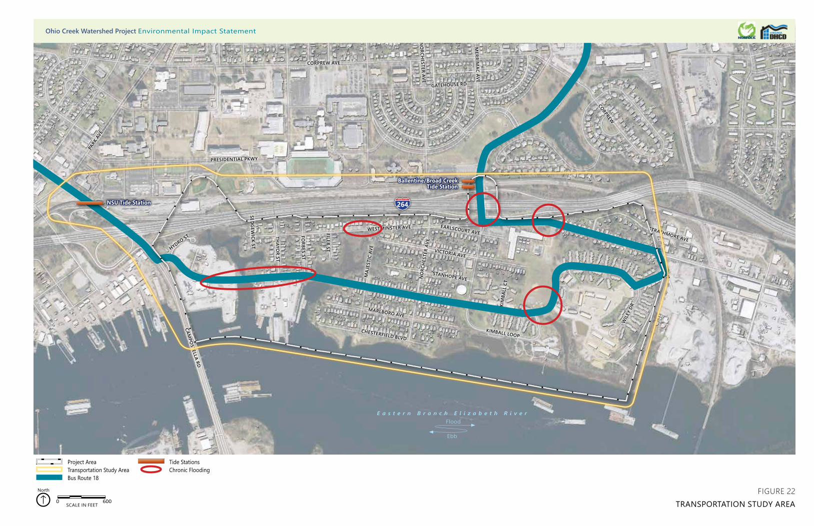
264
CHESTERFIELD BLVD
MARLBORO AVE
KIMBALL TERRACE
STANHOPE AVENO
RCH
ESTE
R AV
E
VICTORIA AVE
MA
JEST
IC A
VE
KIMBALL LOOP
KIM
BALL
CT
EARLSCOURT AVEWESTMINSTER AVE
WESTMINSTER AVE
BALL
ENTI
NE BLV
D
FILER ST
FORBES ST
THAYO
R ST
SEDG
EWICK ST
CAMPO
STELLA RDW
ILEY
DR
KIMBALL
EAST END AVE
STRATHMORE AVE
TERRACE
CORPREW
MERRIM
AC AVE
NO
RCHESTER AVE
GATEHOUSE RD
PRESIDENTIAL PKWY
E. BRAMBLETON AVE
HYDRO ST
KIMBALL TERRACE
CORPREW AVE
PARK
AVE
0 600SCALE IN FEET
North
Project AreaTransportation Study AreaBus Route 18
Tide StationsChronic Flooding
Ballentine/Broad Creek Tide Station
NSU Tide Station
FIGURE 22TRANSPORTATION STUDY AREA
Ohio Creek Watershed Project Environmental Impact Statement
E a s t e r n B r a n c h E l i z a b e t h R i v e r
Ebb
Flood

Ohio Creek Watershed Project Draft Environmental Impact Statement
201 Affected Environment and Environmental Consequences
Within the project area, an extensive residential roadway network provides internal connectivity for vehicular, pedestrian, and transit transportation modes. Many of the area’s residents and other users rely on vehicular transportation for daily activities; these residents are well served by easy access during normal conditions, to main roads such as I-264, Ballentine Boulevard, and Brambleton Avenue/Campostella Road. Others may walk, bicycle, transit, or use a combination of options to reach destinations beyond the project area. The accommodations currently provided for these modes of transportation are also described in more detail below.
3.10.2.1 Roadway Network and Vehicular Circulation
Although there are limited routes into and out of the project area, both options provide almost immediate access to I-264, a 25-mile-long freeway route that provides connectivity among the four major cities in the southern Hampton Roads region: Chesapeake, Portsmouth, Norfolk, and Virginia Beach. There are two existing access points to the project area from I-264: Exit 11 (Brambleton Avenue/ Campostella Road) and Exit 12 (Ballentine Boulevard).
In addition to I-264, both Campostella Road (and East Brambleton Avenue) and Ballentine Boulevard provide connectivity to the portions of Norfolk located north of I-264. In addition, Campostella Road provides connectivity to south Norfolk and to the City of Chesapeake south of the project area, across the Eastern Branch.
Campostella Road is a six-lane divided arterial, located along the western boundary of the project area. According to the Virginia Department of Transportation (VDOT) 2014 functional classification data maps, Campostella Road is a Principal Arterial that provides connectivity between Norfolk’s downtown area and the southern sections of Norfolk and Chesapeake.116 During 2016, Campostella Road served an average of 45,000 vpd.117 In the study area, the current posted speed limit on Campostella Road is 30 mph. Campostella Road is connected to Kimball Terrace; this intersection is one of the two ingress/egress points for the neighborhoods in the project area, located on the western side of the study area. This intersection is sometimes inaccessible to residents due to frequent flooding around the Ohio Creek Bridge. Northeast of the project area (in the vicinity of the Tide station), this roadway is known as East Brambleton Avenue.
Ballentine Boulevard runs in a north/south direction through the study area, providing access to I-264 and points north from the eastern side of the study area. This is the other access/egress point for the project area. Ballentine Boulevard is a major roadway that provides connectivity between the study area and northern
116 VDOT 2014 Approved Functional Classification Map. Accessed from http://www.arcgis.com/home/webmap/viewer.html?
webmap=3eca6c9adb6649c988d98734f85baddb. Accessed March 27, 2018. 117 VDOT Traffic Volume Estimates Including Vehicle Classification Estimates Special Locality Report 122. P. 22.
Ohio Creek Watershed Project Draft Environmental Impact Statement
202 Affected Environment and Environmental Consequences
portions of Norfolk. According to VDOT’s 2014 functional classification map, south of I-264, Ballentine Boulevard is a two-lane Major Collector with posted speed limit of 25 mph.118 North of I-264, Ballentine Boulevard is a four-lane divided Minor Arterial with a posted speed limit of 30 mph.119 According to the available data from VDOT, in 2016 Ballentine Boulevard served an average of 22,000 vpd north of the I-264 interchange and 4,200 vpd south of I-264 near Kimball Terrace.120
Kimball Terrace is a two-lane roadway that serves as a primary transportation corridor within the study area between Campostella Road and Ballentine Boulevard. The western part of the study area consists of an industrial park, and its heavy industrial traffic uses western Kimball Terrace primarily for access. On the eastern part of the study area, Kimball Terrace serves as a collector for residential traffic. According to the VDOT 2014 functional classification map, Kimball Terrace is a Major Collector with posted speed limit of 25 mph.121 According to the available data from VDOT, in 2016 AADT Kimball Terrace served 4,200 vpd east of the Brambleton Avenue/Campostella Road intersection.122
Westminster Avenue is another two-lane roadway that serves as a major access point to and from I-264 at Ballentine Boulevard for Ohio Creek residents and industrial traffic. According to the VDOT 2014 functional classification map,123 Westminster Avenue is a Minor Collector with posted speed limit of 25 mph. According to the available data from VDOT, in 2016, Westminster Avenue served approximately 2,900 vpd east of Chick Street.124
There are 17 additional residential streets within the project area, including Chesterfield Boulevard, Marlboro Avenue, Kimball Loop, and Norchester Avenue. These streets are two-lane residential roadways with a posted speed limit of 25 mph. Because these streets are city streets, AADT data is not available from VDOT for these residential roadways.
Jacob Street and Hydro Street are industrial streets are located in the western part of the project area. Most heavy industrial traffic typically uses Campostella Road to access Kimball Terrace and the above-listed roadways to access industrial facilities on the western part of the study area.
In addition, there is an industrial park on the eastern part of the study area. There are no posted names on the internal industrial streets. Most of the heavy industrial
118 VDOT 2014 Approved Functional Classification Map. Accessed from http://www.arcgis.com/home/webmap/viewer.html?
webmap=3eca6c9adb6649c988d98734f85baddb. Accessed March 27, 2018. 119 VDOT 2014 Approved Functional Classification Map. Accessed from http://www.arcgis.com/home/webmap/
viewer.html?webmap=3eca6c9adb6649c988d98734f85baddb. Accessed March 27, 2018. 120 VDOT Traffic Volume Estimates Including Vehicle Classification Estimates Special Locality Report 122. P. 27, P. 39. 121 DOT 2014 Approved Functional Classification Map. Accessed from http://www.arcgis.com/home/webmap/
viewer.html?webmap=3eca6c9adb6649c988d98734f85baddb. Accessed March 27, 2018. 122 VDOT Traffic Volume Estimates Including Vehicle Classification Estimates Special Locality Report 122. P. 39. 123 DOT 2014 Approved Functional Classification Map. Accessed from http://www.arcgis.com/home/webmap/
viewer.html?webmap=3eca6c9adb6649c988d98734f85baddb. Accessed March 27, 2018. 124 VDOT Traffic Volume Estimates Including Vehicle Classification Estimates Special Locality Report 122. P. 39.
Ohio Creek Watershed Project Draft Environmental Impact Statement
203 Affected Environment and Environmental Consequences
traffic uses Ballentine Boulevard and eastern Westminster Avenue to access industrial facilities in the eastern area.
Much of this roadway network is between 4 and 13 feet above mean sea level and falls within the 100- and 500-year floodplains (Figure 4). In low-lying areas, several locations (shown on Figure 22) experience flooding following heavy rainfall. These areas include
› Western Kimball Terrace (especially in the vicinity of Ohio Creek);
› Western Westminster Avenue at the upper reaches of Haynes Creek; › The intersection of Ballentine Boulevard and Westminster Avenue
(including the ramps onto/off of I-264);
› Eastern Westminster Avenue near Chesterfield Academy; and
› Eastern Kimball Terrace, just east of Kimball Loop.
During storm surges such as those experienced during tropical storms, hurricanes, and nor’easters, this flooding is exacerbated, and portions of these roadways may flood to the point of no longer being passable. Such extreme events can result in portions of the neighborhoods within the project area, specifically eastern Grandy Village and western portions of Chesterfield Heights, being isolated and with no way to safely enter/leave the area by car. Access to and from the industrial areas in the eastern portion of the project area may also be restricted.
3.10.2.2 Pedestrian Facilities
Residents of the project area walk within the study area for a variety of reasons. Some walk for fresh air and recreation, some walk their children to school, and some walk to catch the bus or the light rail (discussed below), among other reasons.
Pedestrian sidewalks are provided along most of the streets in the study area, although many of the sidewalks are narrow (2 to 4 feet) and there are occasionally gaps in the network where no sidewalks are provided. There are also some pedestrian crosswalks provided, mostly at relatively busy intersections.
For residents wishing to walk north of I-264 from the project area, most use the same two egress points described above: Campostella Road or Ballentine Boulevard. Leaving the project area via Campostella Road requires travelling along western Kimball Terrace, between industrial land uses. There is a sidewalk along one side of the road, but it is overgrown by the surrounding grass, providing only a couple feet of width for much of the length. The more heavily used egress point more centrally located to the two neighborhoods is Ballentine Boulevard. A sidewalk is provided on one side of Ballentine Boulevard as it passes under I-264. This sidewalk is dark, narrow (approximately 4 feet wide), and raised from the surrounding grade, separated from the traffic lanes of the roadway by a chain link fence and the concrete columns supporting the overpass.
The third option provided for pedestrian access across I-264 is the pedestrian overpass at the northern terminus of Thayor Street. However, the northern side of this overpass lands between I-264 and the light rail tracks and remains pinched
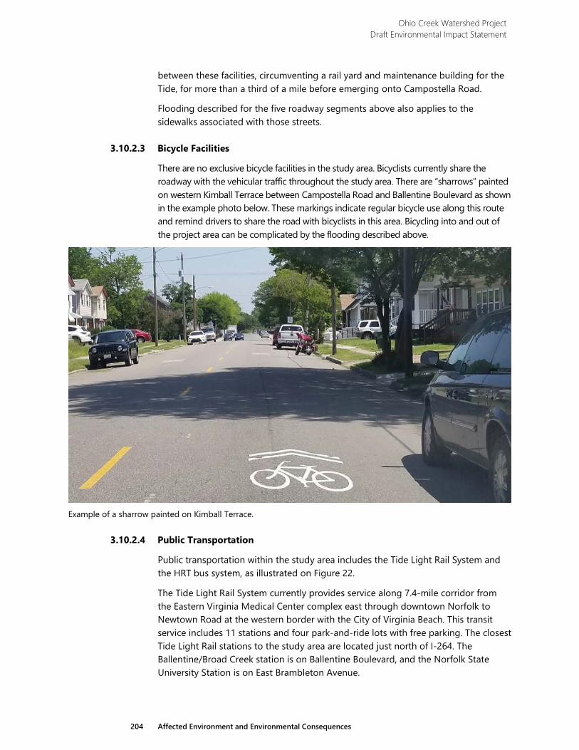
Ohio Creek Watershed Project Draft Environmental Impact Statement
204 Affected Environment and Environmental Consequences
between these facilities, circumventing a rail yard and maintenance building for the Tide, for more than a third of a mile before emerging onto Campostella Road.
Flooding described for the five roadway segments above also applies to the sidewalks associated with those streets.
3.10.2.3 Bicycle Facilities
There are no exclusive bicycle facilities in the study area. Bicyclists currently share the roadway with the vehicular traffic throughout the study area. There are “sharrows” painted on western Kimball Terrace between Campostella Road and Ballentine Boulevard as shown in the example photo below. These markings indicate regular bicycle use along this route and remind drivers to share the road with bicyclists in this area. Bicycling into and out of the project area can be complicated by the flooding described above.
Example of a sharrow painted on Kimball Terrace.
3.10.2.4 Public Transportation
Public transportation within the study area includes the Tide Light Rail System and the HRT bus system, as illustrated on Figure 22.
The Tide Light Rail System currently provides service along 7.4-mile corridor from the Eastern Virginia Medical Center complex east through downtown Norfolk to Newtown Road at the western border with the City of Virginia Beach. This transit service includes 11 stations and four park-and-ride lots with free parking. The closest Tide Light Rail stations to the study area are located just north of I-264. The Ballentine/Broad Creek station is on Ballentine Boulevard, and the Norfolk State University Station is on East Brambleton Avenue.
Ohio Creek Watershed Project Draft Environmental Impact Statement
205 Affected Environment and Environmental Consequences
HRT provides extensive bus service in Norfolk that connects transit mode to other cities in the surrounding area. Bus Route 18 provides service between downtown Norfolk Transit Center and Ballentine Boulevard within the project area. This route runs mostly along Kimball Terrace. There are 13 bus stops located on residential streets with the study area: 11 bus stops located on Kimball Terrace and two stops located on Westminster Avenue. Severe flooding requires bus service within the project area to be altered.
3.10.3 Environmental Consequences
3.10.3.1 Alternative 1 (No Action)
Under the No Action Alternative, no changes would be implemented. Roadways would remain vulnerable to flooding because of heavy rainfall and may have increased vulnerability due to rising sea levels. Pedestrian and bicyclist accommodations would remain unchanged. Connections to regional transit would continue to be available using existing infrastructure.
Roadway Network and Vehicular Transportation
Vehicular traffic entering and leaving the project area would continue to be serviced by two main roadways: Kimball Terrace and Ballentine Boulevard. The first roadway, Kimball Terrace, enters the development from the west and provides ingress and egress for the industrial area located in the western part of Ohio Creek area and neighborhoods via the intersection at Campostella Road. Traffic leaving the project area is then directed to the north and south, providing access to I-264, other parts of Norfolk, and the City of Chesapeake.
The second major road that services Chesterfield Heights and Grandy Village is Ballentine Boulevard. The roadway enters the project area from the north while connecting the neighborhoods to Norfolk, I-264, Virginia Beach Boulevard, Princess Anne Road, and the Tide Light Rail. A major component of the Ballentine Boulevard corridor is an existing underpass with I-264 that provides ingress and egress from the project area.
Under this alternative, the roadway network would continue to be susceptible to flooding in the areas described under the “Affected Environment” section (section 3.8.2.1), and flooding events would likely become more frequent and more wide-reaching given projected rates of subsidence and sea-level rise. Modeling indicates that major portions of Kimball Terrace, Ballentine Boulevard, and several other streets within the study area would flood with 2.5 feet of sea-level rise and a 10-year storm event, as shown on Figure 4. As a result, eastern Grandy Village and western portions of Chesterfield Heights would be isolated, and ingress and egress would be restricted for both residential and industrial traffic.
Ohio Creek Watershed Project Draft Environmental Impact Statement
206 Affected Environment and Environmental Consequences
Pedestrian Facilities
Under existing conditions, pedestrians can access Chesterfield Heights and Grandy Village via the same two major roadways as vehicular traffic (Kimball Terrace and Ballentine Boulevard). These corridors then feed into Majestic Avenue, Norchester Avenue, Westminster Avenue, and Kimball Loop (among others) and provide access to the rest of the study area.
When entering the project area from the west, pedestrians must do so via an intersection of Campostella Road and Kimball Terrace. While traveling east from this intersection, a network of sidewalks runs along Kimball Terrace through a series of industrial developments. These sidewalks eventually provide access to the neighborhoods of Chesterfield Heights and Grandy Village.
The eastern half of the project area is serviced by the existing Ballentine Boulevard pedestrian facilities. This corridor provides pedestrian access to residents from the north while intersecting several avenues within the transportation network. Throughout the neighborhoods, sidewalks tend to be narrow and in varying states of repair.
In addition, the corridor contains a critical I-264 underpass. This underpass provides access to several key locations such as Norfolk State University, the Tide Light Rail System, I-264, and Virginia Beach Boulevard. Currently, the underpass sidewalk is narrow and is unable to support a combination of pedestrian and bicycle traffic. In addition, the area is poorly lit and has only a chain link fence and support columns from the bridge to serve as a partition between pedestrian and vehicular traffic (thus raising safety concerns). Since no improvements are considered under this alternative, such unfavorable conditions may discourage pedestrian traffic between north of I-264 and Chesterfield Heights and Grandy Village waterfront area.
Flooding poses the same challenges to pedestrian travel through the study area as it does to vehicular transportation, resulting in similar isolation during extreme events.
Bicycle Facilities
Bicyclists within the project area experience many of the same challenges as pedestrians, as there are presently no existing exclusive bicycle facilities and bicycles must share the roadway with vehicular traffic. Bicyclists must also use Kimball Terrace or Ballentine Boulevard to leave or enter the study area and therefore experience the same challenges as pedestrians with regards to these areas.
Under this alternative, ongoing and increasing flooding poses the same challenges to bicyclist travel through the study area as it does to vehicular and pedestrian transportation, resulting in similar isolation during extreme events.
Public Transportation
HRT provides extensive bus service in the project area with a route running along Kimball Terrace and Ballentine Boulevard. The area is also connected via the I-264 underpass to the Tide Light Rail System with stops along Ballentine Boulevard and
Ohio Creek Watershed Project Draft Environmental Impact Statement
207 Affected Environment and Environmental Consequences
East Brambleton Avenue. Pedestrian and bicyclists access to the light rail would continue to be hindered by limited pedestrian facilities along Ballentine Boulevard. Severe flooding would require bus service within the project area to be altered.
3.10.3.2 Alternative 2
Alternative 2 includes construction of coastal defense features around the greatest extent of the project area. It also incorporates intensive use of pump stations, stormwater, drainage, and infrastructure improvements. The infrastructure improvements would include raising of some roadways, installation of floodwalls and earthen berms, intersection improvement, widening of sidewalks, underpass improvements, installation of permeable pavers, construction of bioswales, and more. These improvements are shown on Figure 5 in Chapter 2 of this document.
As a result of these improvements, roadways would be less susceptible to flooding, which would improve transportation within and into/out of the project area for all modes of travel. Connections to and operations of regional transit would be more reliable due to these infrastructure improvements.
Roadway Network and Vehicular Transportation
Alternative 2 calls for several modifications to the roadway network. Under this alternative, Kimball Terrace would be raised from Campostella Road to Thayor Street to prevent flooding from Ohio Creek. During construction, vehicular traffic may be impeded; therefore, Ballentine Boulevard may see an increase in vehicular activity, particularly in heavy truck traffic flow to access the industrial area in the western side of the development. However, upon completion of construction, traffic patterns should return to normal with reduced risk of inundation.
Westminster Avenue would also be raised along the north side of the Haynes Creek watershed to protect the roadway against inundation. Vehicular traffic may be restricted during construction; however, upon completion of construction, vehicular access would be improved to provide continuous operations during storm events and other crises.
In addition to raising the roads, Alternative 2 would employ several practices to promote runoff infiltration and to increase the amount of greenspace throughout the project area. These changes include the addition of permeable parking lanes as well as the use of bioswales and corner street basins along Majestic, Norchester, and Westminster Avenues. Similar design elements would be included along Ballentine Boulevard. Tree cover along roadsides and the number of curb bump-outs would subsequently increase throughout the transportation network and, in some locations, may affect the number of on-street parking spaces.
Pedestrian Facilities
Several changes would be made to the network to improve conditions for pedestrians. In Alternative 2, adjustments would be made to the signals and
Ohio Creek Watershed Project Draft Environmental Impact Statement
208 Affected Environment and Environmental Consequences
crosswalks at the intersection of Kimball Terrace and Campostella Road to address deficiencies in the pedestrian facility network and improve operations.
Alternative 2 also calls for enhancements to the pedestrian corridor along Ballentine Boulevard, which would include several modifications to the I-264 underpass and improvements to provide continuous pedestrian connectivity from I-264 to the Eastern Branch. The plan is to improve the sidewalk by widening it (up to 14 feet) and to reduce the side slopes at the I-264 underpass. Additionally, the I-264 underpass would be renovated to improve lighting, meet ADA standards, allow for both pedestrian and bicyclist access, improve security through the addition of security lights, and enhance the aesthetics of the fence/screen between the sidewalk and roadway. The proposed improvements would enhance pedestrian network connectivity, improving safety and continuous pedestrian access between the Ballentine/Broad Creek Tide station located north of I-264 and the Eastern Branch waterfront in a safer and more efficient manner.
Where road segments are raised, as described in the “Roadway Network and Vehicular Transportation” section, the sidewalks associated with those roadways would also be raised. This would keep these sidewalks useable during events that currently cause flooding.
During construction, pedestrian access may become restricted or blocked. Detours for pedestrian access would need to be developed and may increase walking times for residents. However, these inconveniences would be temporary and pedestrian accessibility would be improved following the completion of construction.
Bicycle Facilities
Under Alternative 2, bicyclists would experience improved travel conditions at the intersection of Campostella Road and Kimball Terrace, as well as along the Ballentine Boulevard Corridor. The corridors would be enhanced to allow for continuous and improved conditions from I-264 to Chesterfield Heights and Grandy Village for bicyclists. The I-264 underpass would be renovated to improve lighting, meet ADA standards, allow for both pedestrian and bicyclist access, improve security through the addition of security lights, and improve the aesthetics of the fence/screen between sidewalk and roadway to promote comfort for sidewalk users. Under this alternative, bicycle traffic may be restricted during construction phase, particularly along the Ballentine Boulevard Corridor, but access and connectivity would be improved upon the completion of the construction phase.
Where road segments are raised, as described in the “Roadway Network and Vehicular Transportation” section, roadways used by bicyclists would remain useable during events that currently cause flooding.
Public Transportation
Alternative 2 proposes no direct changes to the transit network. The bus system may experience some restrictions during construction phase, particularly while Kimball Terrace is being raised. Alternative access would be required or buses would have to
Ohio Creek Watershed Project Draft Environmental Impact Statement
209 Affected Environment and Environmental Consequences
return to Ballentine Boulevard to exit the neighborhood. Once construction is completed, the Chesterfield Heights and Grandy Village neighborhoods should experience safe and continuous transit access during storm events.
Upon completion of Alternative 2, residents of the project area would have improved access to the Tide at the Ballentine/Broad Creek and Norfolk State University stations. However, during construction of the improvements, pedestrians and bicyclists may experience temporary access restrictions.
3.10.3.3 Alternative 3
Alternative 3 includes construction of coastal defense features surrounding the historic district and Chesterfield Academy; open tidal exchange at Ohio Creek, Haynes Creek, and Grandy Village; and fewer pump stations than the other concepts. In this alternative, floodwalls would be employed as the primary method of coastal defense, while the use of berms would be relatively limited. In addition, this alternative includes the relocation of portions of Kimball Terrace, the raising of roadway segments, installation of permeable pavement and bioswales, and addition/expansion of infrastructure for pedestrians and bicyclists. These improvements are shown on Figure 6 in Chapter 2 of this document.
As a result of these improvements, roadways would be less susceptible to flooding, which would improve transportation within and into/out of the project area for all modes of travel. Connections to and operations of regional transit would be more reliable due to these infrastructure improvements.
Roadway Network and Vehicular Transportation
Alternative 3 calls for several changes in the roadway network and several modifications to Kimball Terrace. The westernmost portion of the road would be relocated north to shift vehicular traffic away from the local industrial developments. This relocation would necessitate changes to the intersection of Kimball Terrace and Campostella Road and may cause temporary disruptions in local traffic patterns during the construction phase. Heavy truck traffic may divert to Ballentine Boulevard to access the industrial area located within the western part of the development, increasing truck traffic on the corridor throughout construction. Once the new intersection is in place, traffic flow should improve.
Two segments of roadway located north and south of Chesterfield Academy, would be raised under Alternative 3. The first is a section of Kimball Terrace to the south of Chesterfield Academy that stretches from just west of Ballentine Boulevard to the east of the proposed new culvert along the unnamed tributary in Grandy Village. The second portion of road that needs to be raised is on Westminster Avenue, north of Chesterfield Academy. This stretch of road would be raised east of Ballentine Boulevard to cross a proposed berm near the school to just west of Strathmore Avenue. Construction efforts must be coordinated to allow access throughout construction east of these locations given that there are no other routes into Grandy Village. Once completed, the risk of flooding would be reduced and with the
Ohio Creek Watershed Project Draft Environmental Impact Statement
210 Affected Environment and Environmental Consequences
proposed improvements traffic flow would have lower chances for disruptions and impacts from flooding.
Alternative 3 also calls for the protection of two sections of road on the western side of the project area. First, the section of Kimball Terrace from the relocated roadway segment near Ohio Creek to west of Majestic Avenue would be raised. Second, a section of Westminster Avenue adjacent to Haynes Creek would be protected from flooding by a proposed floodwall. These changes would temporarily interrupt vehicular traffic and construction efforts should be coordinated to minimize impacts to traffic patterns. Once completed, the risk of flooding would be reduced and with the proposed improvements traffic flow would have lower chances for disruptions and impacts from flooding.
In addition to raising the roads, Alternative 3 employs several practices to promote runoff infiltration and to increase the amount of greenspace throughout the project area. These changes include the addition of permeable parking lanes as well as the use of bioswales and corner street basins along Majestic, Norchester, and Westminster Avenues. Similar design elements would also be included along Ballentine Boulevard. These additional improvements may affect the number of on-street parking spaces in some locations. Any interruptions to traffic during installation would be localized and temporary.
Pedestrian Facilities
Under Alternative 3, the intersection of Kimball Terrace and Campostella Road would be relocated to the north. This relocation is to be accompanied by the redesign of signals and crosswalks. In addition to the new intersection, a multi-use path would be added from Campostella Road to Ohio Creek. This would provide safer access to and from the neighborhoods by moving pedestrian traffic away from the vehicular traffic.
Alternative 3 also calls for enhancements to the pedestrian corridor along Ballentine Boulevard, which would include several modifications to the I-264 underpass and improvements to provide continuous pedestrian connectivity from I-264 to the Chesterfield Heights and Grandy Village. The plan is to widen the pedestrian sidewalk (up to 14 feet) and reduce side slopes at I-264 underpass. Additionally, the I-264 underpass would be renovated to improve lighting, meet ADA standards, allow for both pedestrian and bicyclist access, improve security through the addition of security lights, and improve aesthetic enhancements to the fence/screen between the sidewalk and the roadway to provide more comfort for sidewalk users.
The proposed improvements would enhance pedestrian network connectivity, providing safer and continuous pedestrian access between the Ballentine/Broad Creek Tide station located north of I-264 and the Chesterfield Heights and Grandy Village waterfront in a safer and more efficient manner.
Where road segments are raised, as described in the “Roadway Network and Vehicular Transportation” section, the sidewalks associated with those roadways would also be raised. This would keep these sidewalks useable during events that currently cause flooding.
Ohio Creek Watershed Project Draft Environmental Impact Statement
211 Affected Environment and Environmental Consequences
During construction, pedestrian access may become restricted or blocked. Detours for pedestrian access would need to be developed and may increase walking times for residents. However, these inconveniences would be temporary and pedestrian accessibility would be improved following the completion of construction.
Bicycle Facilities
Under Alternative 3, bicyclists would benefit from the new multiuse path along the western end of Kimball Terrace and the new intersection with Campostella Road. These changes would promote safety for bicyclists and reduce potential conflicts with industrial and residential traffic.
Travel for bicyclists would also be improved with the proposed changes to the Ballentine Boulevard Corridor. The corridor would be enhanced from I-264 to the Chesterfield Heights and Grandy Village waterfront for pedestrians and bicyclists. Additionally, the I-264 underpass would undergo improvements to better accommodate bicyclists.
With this alternative, bicycle traffic may be restricted during construction, particularly along the Ballentine Boulevard Corridor; however, upon completion of construction, conditions should improve for both pedestrians and bicyclists.
Where road segments are raised, as described in the “Roadway Network and Vehicular Transportation” section, roadways used by bicyclists would remain usable during events that currently cause flooding.
Public Transportation
Alternative 3 proposes no direct changes to the transit network. The bus system may experience some disruption in service, particularly while Kimball Terrace is being raised and relocated. During these times, buses would either have to return to Ballentine Boulevard to exit the neighborhood or would require alternative access to Campostella Road. Upon completion of construction, the project area will have a transit network with lower chances for service disruptions from flooding.
Upon completion of Alternative 3, residents of the project area would have improved access to the Tide at the Ballentine/Broad Creek and Norfolk State University stations. However, during construction of the improvements, pedestrians and bicyclists may experience temporary access restrictions.
3.10.3.4 Alternative 4
Alternative 4 includes coastal defenses focusing on the historic district and Chesterfield Academy, open tidal exchange at Ohio Creek and Grandy Village, and maximized stormwater storage within the project area. Improvements to the project area would include using earthen berms as the primary method of coastal defense, the construction of floodwalls, a tidal gate within Haynes Creek, the implementation of bioswales and permeable pavement, the raising and/or relocation of sections of
Ohio Creek Watershed Project Draft Environmental Impact Statement
212 Affected Environment and Environmental Consequences
roadway, and the expansion/improvement of infrastructure for pedestrians and bicyclists. These improvements are shown on Figure 7 in Chapter 2 of this document.
As a result of these improvements, roadways would be less susceptible to flooding, which would improve transportation within and into/out of the project area for all modes of travel. Connections to and operations of regional transit would be more reliable due to these infrastructure improvements.
Roadway Network and Vehicular Transportation
Two segments of roadways near Chesterfield Academy would be raised under Alternative 4. The first is a section of Kimball Terrace to the south of Chesterfield Academy. It stretches from west of Kimball Loop to east of the proposed new culvert along the unnamed tributary in Grandy Village. The second portion of roadway that needs to be raised is Westminster Avenue, north of Chesterfield Academy. This stretch of road would be raised east of Ballentine Boulevard to cross the proposed berm near the school to just east of Strathmore Avenue. Construction efforts must be coordinated to allow access east of these locations throughout construction, given that there are no other routes into Grandy Village.
Alternative 4 also calls for several additional changes to Kimball Terrace. The western end of the road would be relocated north to shift vehicular traffic away from the local industrial developments. This relocation would necessitate changes to the intersection of Kimball Terrace and Campostella Road. Also, the portion of Kimball Terrace west of Thayor Street would be raised. These changes would likely increase the volume of traffic flowing through Ballentine Boulevard during the construction phase. Once construction is complete, conditions should improve and the road network would be protected from flooding to better serve the residents.
In addition to raising the roads, Alternative 4 employs several practices to promote runoff infiltration and to increase the amount of greenspace throughout the project area. These changes include the addition of permeable parking lanes as well as the use of bioswales and corner street basins along Majestic, Norchester, and Westminster Avenues. Similar design elements would also be included along Ballentine Boulevard. Interruptions to traffic during installation would be localized and temporary. These additional improvements in some locations might affect the number of on-street parking spaces.
Pedestrian Facilities
In Alternative 4, the intersection of Kimball Terrace and Campostella Road would be relocated to the north. This relocation is to be accompanied by the redesigning of signals and crosswalks. In addition to the relocated intersection, a multi-use path would be added from Campostella Road to Ohio Creek. This would provide safer access to and from the neighborhoods by moving pedestrian traffic away from the main road.
Alternative 4 also calls for enhancements to the pedestrian corridor along Ballentine Boulevard, which would include several modifications to the I-264 underpass and
Ohio Creek Watershed Project Draft Environmental Impact Statement
213 Affected Environment and Environmental Consequences
improvements to provide continuous pedestrian connectivity from I-264 to the Chesterfield Heights and Grandy Village. The plan is to widen the pedestrian sidewalk (up to 14 feet) and reduce side slopes at I-264 underpass. Additionally, the I-264 underpass would be renovated to improve lighting, meet ADA standards, allow for both pedestrian and bicyclist access, improve security through the addition of security lights, and improve aesthetic enhancements to the fence/screen between the sidewalk and the roadway to provide comfort for sidewalk users.
The proposed improvements would enhance pedestrian network connectivity, providing safe and continuous pedestrian access between the Ballentine/Broad Creek Tide station located north of I-264 and the Chesterfield Heights and Grandy Village waterfront in a safer and more efficient manner.
Where road segments are raised, as described in the “Roadway Network and Vehicular Transportation” section, the sidewalks associated with those roadways would also be raised. This would keep these sidewalks useable during events that currently cause flooding.
During construction, pedestrian access may become restricted or blocked. Detours for pedestrian access would need to be developed and may increase walking times for residents. However, these inconveniences would be temporary and pedestrian accessibility would be improved following the completion of construction.
Bicycle Facilities
Under Alternative 4, bicyclists would benefit from the new multi-use path along the western end of Kimball Terrace and the new intersection with Campostella Road. These changes would promote safety for bicyclists and limit interaction with industrial and residential traffic.
Travel for bicyclists would also be improved with the proposed changes to the Ballentine Boulevard Corridor. The corridor would be enhanced from I-264 to the Chesterfield Heights and Grandy Village waterfront for pedestrians and bicyclists. Additionally, the I-264 underpass would undergo improvements to better accommodate bicyclists.
With this alternative, bicycle traffic may be restricted during construction, particularly along the Ballentine Boulevard Corridor; however, upon completion of construction, conditions should improve for both pedestrians and bicyclists.
Where road segments are raised, as described in the “Roadway Network and Vehicular Transportation” section above, roadways used by bicyclists would remain useable during events that currently cause flooding.
Transit
Alternative 4 proposes no direct changes to the transit network. The bus system may experience some service disruptions and restrictions particularly while Kimball Terrace is being raised and relocated. Buses would have to return to Ballentine Boulevard to exit the neighborhood or would require alternative access to
Ohio Creek Watershed Project Draft Environmental Impact Statement
214 Affected Environment and Environmental Consequences
Campostella Road. After construction, the project area would have a more efficient and continuous transit network with lower chances of service disruption during storms.
Upon completion of the construction of Alternative 4, residents of the project area would have improved access to the Tide at the Ballentine/Broad Creek and Norfolk State University stations. However, during the construction of improvements, transit users may experience temporary access restrictions.
Ohio Creek Watershed Project Draft Environmental Impact Statement
215 Affected Environment and Environmental Consequences
3.11 Potential Cumulative Impacts
Natural Resources
Soils
The no Action Alternative would have no impacts to soils and, therefore, would not contribute to the impacts of other actions. Consequently, there would be no cumulative impacts on soils under Alternative 1.
The actions considered would not have the potential to result in cumulative impacts to soils and would not change impacts to these resources as presented in Alternatives 2, 3, and 4.
Surface Water
Implementation of the No Action Alternative would continue to put existing surface water features at risk of degradation due to anticipated flooding associated with sea level rise. The adverse impact of the No Action Alternative would outweigh the beneficial impacts of the actions considered resulting in an overall adverse cumulative impact.
The actions considered are consistent and complimentary with Alternatives 2, 3, and 4 and would have the potential to result in beneficial cumulative impacts. The Norfolk State University Stormwater Masterplan proposes improved surface water conditions by treating stormwater before discharging it into the Ohio Creek watershed. City-wide initiatives, specifically the Green Infrastructure Plan for Norfolk, will enhance city-wide efforts to create living shorelines resulting in additional wetland acreage. Wetlands in the area function as the main source of water quality treatment, additional wetlands would improve surface water quality. The Integrated City of Norfolk Coastal Storm Risk Feasibility Study may affect surface water through the construction of nearby resiliency features such as floodwalls, tide gates, and levees. Resilience features constructed nearby may reduce coastal flooding, protecting currently overburdened wetlands from inundation and enabling their water treatment function.
Wetlands
Implementation of the No Action Alternative would continue to put existing wetlands at risk of inundation and continued loss as sea level rises. The adverse impact of the No Action Alternative would outweigh the beneficial impacts of the actions considered resulting in an overall adverse cumulative impact.
Actions considered are consistent and complimentary with Alternatives 2, 3, and 4 and would have the potential to result in beneficial cumulative impacts. For instance, implementation of the stormwater plan on Norfolk State University’s campus would improve wetland conditions by treating stormwater before discharging it into the Ohio Creek watershed where the wetland systems have become overburdened. City-wide initiatives, specifically the Green Infrastructure Plan for Norfolk, will enhance
Ohio Creek Watershed Project Draft Environmental Impact Statement
216 Affected Environment and Environmental Consequences
city-wide efforts to treat stormwater through rain gardens and creation of living shorelines resulting in additional wetlands which function as the main source of water quality treatment in the area. Additionally, the Integrated City of Norfolk Coastal Storm Risk Feasibility Study may affect the longevity of wetlands through the construction of nearby resiliency features such as floodwalls, tide gates, and levees. Resilience features constructed nearby may reduce coastal flooding, protecting currently overburdened wetlands from inundation and enabling their water treatment function.
Floodplains
Implementation of the No Action Alternative would continue to put existing floodplains at risk due to increased stormwater runoff, increased frequency of localized flooding, and increased frequency of regional flooding related to sea-level rise. The No Action Alternative would not implement flood risk reduction measures, leaving the potential for future flooding and risk to lives or properties the same or worse as the current conditions given sea-level rise projections. The adverse impact of the No Action Alternative would outweigh the beneficial impacts of the actions considered resulting in an overall adverse cumulative impact.
Actions considered are consistent with and would complement Alternatives 2, 3, and 4 and would have the potential to result in beneficial cumulative impacts. The Integrated City of Norfolk Coastal Storm Risk Feasibility Study includes the construction of nearby resiliency features such as floodwalls, tide gates, and levees. Resilience features constructed nearby may reduce the frequency of flooding, making the project area more resilient to storm surge, rainfall intensity and frequency. As a result, the overall cumulative impact of the action alternatives would be beneficial.
Biological Resources
Implementation of the No Action Alternative would continue to put existing biological resources at risk due to the continued loss of wetlands which results in loss of wading and migratory bird habitat. Living shoreline enhancements would not occur under the No Action Alternative which would provide fish habitat by creating oyster reefs and rock sills, provide habitat and attachment substrate for oysters, hooked mussels, and multiple species of crustaceans. Additionally, filter feeding by oysters and hooked mussels would help improve water quality and develop the reef as fish habitat. The adverse impact of the No Action Alternative would outweigh the beneficial impacts of the actions considered resulting in an overall adverse cumulative impact.
Actions considered are consistent with and complement Alternatives 2, 3, and 4 and would have the potential to result in beneficial cumulative impacts. For instance, implementation of the stormwater plan on Norfolk State University’s campus would improve surface water conditions by treating stormwater before discharging it into the Ohio Creek watershed. Improved water quality enhances wetland resources. Additionally, City-wide initiatives such as the Green Infrastructure Plan for Norfolk,
Ohio Creek Watershed Project Draft Environmental Impact Statement
217 Affected Environment and Environmental Consequences
will enhance city-wide efforts to treat stormwater through raingardens and create living shorelines resulting in additional wetland acreage. Wetlands in the area provide valuable wildlife habitat. The overall cumulative impact of the action alternatives would be beneficial.
Protected Species
Implementation of the No Action Alternative would put existing protected species at risk due to the continued reduction in their habitat resulting from the continued loss of wetlands. Fewer wetlands also reduces capacity to improve water quality resulting in increased stress on protected species. The adverse impact of the No Action Alternative would outweigh the beneficial impacts of the actions considered resulting in an overall adverse cumulative impact.
Actions considered are consistent and complementary with Alternatives 2, 3, and 4 and would have the potential to result in beneficial cumulative impacts to water quality and therefore to many protected species. For instance, implementation of the stormwater plan on Norfolk State University’s campus would improve surface water conditions by treating stormwater before discharging it into the Ohio Creek watershed. Additionally, the Integrated City of Norfolk Coastal Storm Risk Feasibility Study may affect the longevity of wetlands through the construction of nearby resiliency features such as floodwalls, tide gates, and levees. Resilience features constructed nearby may reduce coastal flooding, protecting currently overburdened wetlands from inundation and enabling their value as critical habitat.
Noise
There would be no cumulative impacts on noise under Alternative 1. The actions considered would not have the potential to result in cumulative impacts that would change the noise impacts associated with Alternatives 2, 3, and 4.
Vibration
There would be no cumulative impacts on vibration under Alternative 1. The actions considered would not have the potential to result in cumulative impacts that would change the vibration impacts associated with Alternatives 2, 3, and 4.
Cultural Resources
Implementation of the No Action Alternative would put existing cultural resources at risk of damage and degradation due to flooding based on projected sea level rise. The adverse impact of the No Action Alternative would outweigh the beneficial impacts of the actions considered resulting in an overall adverse cumulative impact.
The actions considered would not have the potential to result in cumulative impacts to cultural resource and would not change impacts to these resources as presented in Alternatives 2, 3, and 4.

Ohio Creek Watershed Project Draft Environmental Impact Statement
218 Affected Environment and Environmental Consequences
Land Use
There would be no cumulative impacts on land use. Any impacts to land use would be minor and localized to the extent that they would not have the opportunity to accumulate and result in cumulative impacts.
Socioeconomics
Implementation of the No Action Alternative would put existing socioeconomic factors at risk due to flooding events. Factors include impassable roads which isolate and disconnect residents within the project area, decreased property values, property damage, and increased insurance rates. The adverse impact of the No Action Alternative would outweigh the beneficial impacts of the actions considered resulting in an overall adverse cumulative impact.
Actions considered are consistent and complementary with Alternatives 2, 3, and 4 and would have the potential to result in beneficial cumulative impacts to socioeconomics. The Elizabeth River Trail would improve neighborhood connectivity with a goal of becoming a destination and economic driver for the entire region. City-wide Initiatives such as the extension of the esplanade from Town Point Park to Harbor Park with a design that accommodates bicycles and pedestrians would enhance and strengthen the trail networks proposed in the action alternatives as well as provide safe routes to employment opportunities in the city. City-wide initiatives defined within plaNorfolk2030 will provide a wide variety of cultural and recreational opportunities and create a varied economy with a focus on a vibrant downtown. The overall cumulative impact of the action alternatives would be beneficial.
Environmental Justice
Implementation of the No Action Alternative would put existing minority populations at risk due to flooding events. Risk factors include impassable roads which isolate and disconnect residents within the project area from the city, decreased property values, property damage, and increased insurance rates. The adverse impact of the No Action Alternative would outweigh the beneficial impacts of the actions considered resulting in an overall adverse cumulative impact.
Actions considered are consistent and complementary with Alternatives 2, 3, and 4 and would have the potential to result in beneficial cumulative impacts to environmental justice. City-wide initiatives such as the extension of the esplanade from Town Point Park to Harbor Park and the Harbor Park Brownfields Project would enhance and strengthen the trail networks proposed in the action alternatives and create an opportunity for community connectedness. In addition, the Elizabeth River Trail would improve neighborhood connectivity and enhance recreational opportunities resulting in an overall cumulative benefit.
Transportation and Traffic
Under the No Action Alternative existing roadways would remain vulnerable to flooding. Impassable roads would continue to isolate and disconnect residents
Ohio Creek Watershed Project Draft Environmental Impact Statement
219 Affected Environment and Environmental Consequences
within the project area from the city. The adverse impact of the No Action Alternative would outweigh the beneficial impacts of the actions considered resulting in an overall adverse cumulative impact.
Actions considered are consistent and complementary with Alternatives 2, 3, and 4 and would have the potential to result in beneficial cumulative impacts to transportation and traffic. For instance, the Elizabeth River Trail would improve neighborhood connectivity and enhance recreational opportunities resulting in an overall cumulative benefit.

Ohio Creek Watershed Project Draft Environmental Impact Statement
220 Affected Environment and Environmental Consequences
This page intentionally left blank.
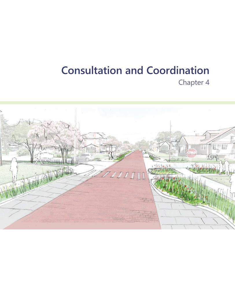
Consultation and CoordinationChapter 4

221 Affected Environment and Environmental Consequences
Consultation and Coordination The Ohio Creek Watershed Project has involved collaboration with the public, as well as with local, state, and federal officials, to build an understanding among stakeholders.
This coordination has taken place to ensure the public and all stakeholders remain well informed and engaged throughout the project and to satisfy requirements under the National Environmental Policy Act (NEPA) and other agency requirements. This chapter describes the public involvement and agency consultation undertaken leading up to and during the preparation of this draft environmental impact statement (DEIS). A combination of activities, including planning workshops, public scoping, and agency briefings, has helped to guide the project team in developing this DEIS. This chapter provides a detailed list of the various consultations initiated during the development of the DEIS as well as a list of preparers.
The project team has made a diligent effort to involve the interested and affected public in this planning and NEPA process. This involvement, known as scoping, occurs at the beginning of the process to identify the range of issues, resources, and alternatives to address in the environmental assessment. Public scoping is conducted to address these elements. State and federal agencies were contacted to uncover any additional planning issues and to fulfill statutory requirements, as described below.
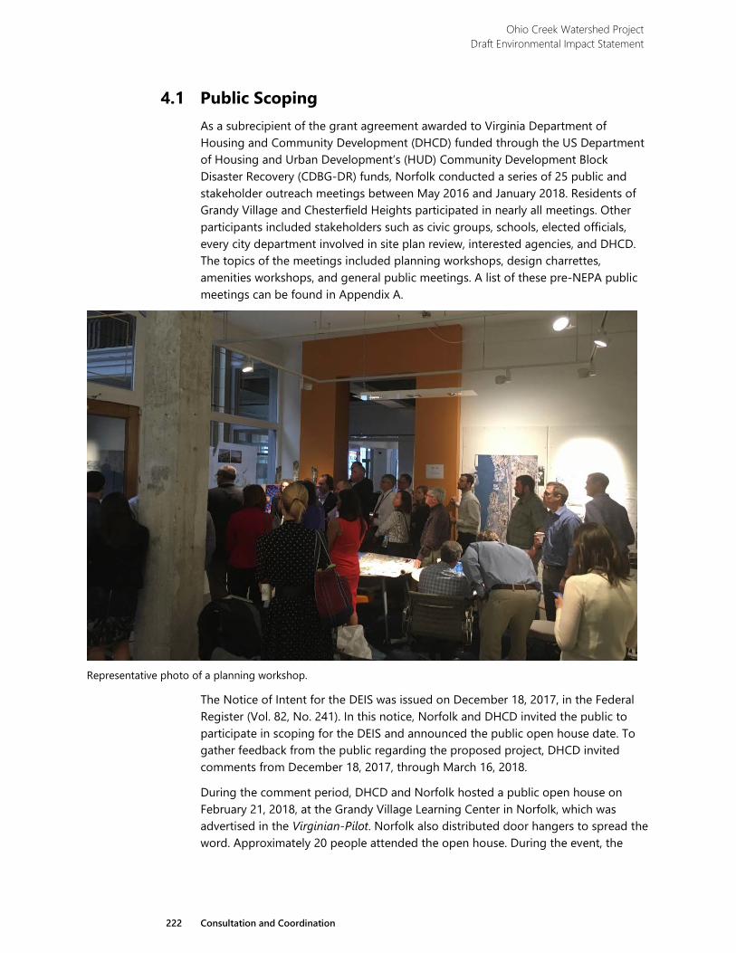
Ohio Creek Watershed Project Draft Environmental Impact Statement
222 Consultation and Coordination
4.1 Public Scoping As a subrecipient of the grant agreement awarded to Virginia Department of Housing and Community Development (DHCD) funded through the US Department of Housing and Urban Development’s (HUD) Community Development Block Disaster Recovery (CDBG-DR) funds, Norfolk conducted a series of 25 public and stakeholder outreach meetings between May 2016 and January 2018. Residents of Grandy Village and Chesterfield Heights participated in nearly all meetings. Other participants included stakeholders such as civic groups, schools, elected officials, every city department involved in site plan review, interested agencies, and DHCD. The topics of the meetings included planning workshops, design charrettes, amenities workshops, and general public meetings. A list of these pre-NEPA public meetings can be found in Appendix A.
Representative photo of a planning workshop.
The Notice of Intent for the DEIS was issued on December 18, 2017, in the Federal Register (Vol. 82, No. 241). In this notice, Norfolk and DHCD invited the public to participate in scoping for the DEIS and announced the public open house date. To gather feedback from the public regarding the proposed project, DHCD invited comments from December 18, 2017, through March 16, 2018.
During the comment period, DHCD and Norfolk hosted a public open house on February 21, 2018, at the Grandy Village Learning Center in Norfolk, which was advertised in the Virginian-Pilot. Norfolk also distributed door hangers to spread the word. Approximately 20 people attended the open house. During the event, the
Ohio Creek Watershed Project Draft Environmental Impact Statement
223 Consultation and Coordination
project team displayed presentation boards summarizing the project’s purpose, existing conditions in the project area, and possible concepts for improvements. Meeting materials also informed the public that the team would be complying with Section 106 of the National Historic Preservation Act (NHPA; described in more detail below) concurrently with development of the DEIS. Team members circulated among the attendees to explain the project, answer questions, and listen to concerns. DHCD posted the information presented at the meeting online at http://www.dhcd.virginia.gov/index.php/virginias-resiliency-plan/347-ohio-creek-watershed.html. No written comments were received from the public during the comment period.
4.2 Agency and Tribal Coordination DHCD contacted eight agencies and eight tribes during scoping for the Ohio Creek Watershed Project DEIS. The agencies contacted were:
› The Virginia Department of Environmental Quality (DEQ), which serves as a clearinghouse for review by other relevant Virginia agencies;
› The Virginia Department of Historic Resources (VDHR);
› The US Army Corps of Engineers (USACE);
› The National Oceanic and Atmospheric Administration (NOAA);
› The US Coast Guard;
› National Marine Fisheries Service (NMFS); › The US Fish and Wildlife Service (USFWS); and,
› The US Environmental Protection Agency (EPA), Region 3.
DHCD has continued to coordinate with many of these agencies throughout the NEPA process, including coordination for permits and approvals. Pre-application meetings were held with staff from the Virginia Marine Resources Commission (VMRC), Virginia DEQ, and the USACE. Furthermore, quarterly progress meetings have been held with staff from DHCD, Virginia DEQ (Environmental Review), and HUD. While there are no cooperating agencies participating in development of this DEIS, the project team has coordinated closely with agencies such as the USACE throughout the planning process and DEIS development.
The tribes contacted are the Chickahominy Tribe, the Eastern Chickahominy Tribe, the Upper Mattaponi Tribe, the Rappahannock Tribe, the Nansemond Tribe, the Monacan Indian Nation, the Delaware Nation, and the Pamunkey Indian Tribe.
Implementation of the proposed action would require that DHCD coordinate with relevant agencies to ensure compliance with all applicable federal, state, and local regulations. These are described below.
Ohio Creek Watershed Project Draft Environmental Impact Statement
224 Consultation and Coordination
4.2.1 Federal › USACE––Permitting of the proposed improvements will be required
under Section 404 of the Clean Water Act (CWA) and under Sections 10 and 14 (408 compliance) of the Rivers and Harbors Act (RHA).
› USFWS––Given that this project may affect but is not likely to adversely affect federally threatened or endangered species or designated critical habitat, informal consultation is required under Section 7 of the Endangered Species Act (ESA) to acquire concurrence with this determination from USFWS. DHCD will reinitiate consultation if the project area changes or if federally-listed species are encountered.
› National Oceanic and Atmospheric Administration––National Marine Fisheries Service
• Given that this project may affect, but is not likely to adversely affect, federally threatened or endangered species or designated critical habitat, informal consultation will be required under Section 7 of the ESA to acquire concurrence with this determination from NMFS for species under their jurisdiction.
• Given that essential fish habitat is designated within the project area, consultation will be required under the Magnuson-Stevens Fishery Conservation and Management Act.
› Federal Emergency Management Agency (FEMA)––FEMA review is anticipated for confirmation of no net rise based on fill within the floodplain from the living shoreline, floodwall, road elevating, and berm project components.
› National Historic Preservation Act (NHPA)––Section 106 of the NHPA requires a consultative process to identify historic properties; assess project impacts to historic properties; and avoid, minimize, or mitigate adverse effects prior to approval to use federal funds. Consultation under Section 106 was conducted concurrently to but separately from this DEIS. DHCD has consulted and coordinated with the State Historic Preservation Officer (SHPO) and relevant Tribal Historic Preservation Officers (THPOs) from the tribes listed above throughout this process. Because it is anticipated that this project would have an adverse effect on historic properties, a Programmatic Agreement will be developed with the SHPO and THPOs, as appropriate, to avoid or mitigate the adverse effects.
4.2.2 State › Virginia DEQ––The project may require various approvals from DEQ to
demonstrate compliance with several acts/authorities, such as Virginia Coastal Zone Management Program (Executive Order 35, 2014), Stormwater Management (9 VAC 25-880), and Section 401 of the CWA.
Ohio Creek Watershed Project Draft Environmental Impact Statement
225 Consultation and Coordination
› VMRC––The project may require approval from VMRC for activities occurring over, under, or on state-owned land (4 VAC 20-1330-10 et seq).
› VDHR––Consultation will take place under Section 106 of the NHPA (as described above).
4.2.3 Local › Norfolk Wetlands Board––The project may require review and/or
approval from the Norfolk Wetlands Board in accordance with Chapter 13 of Title 28.2 of the Code of Virginia.
› Norfolk Chesapeake Bay Preservation Act––A Chesapeake Bay Preservation Area (CBPA) is defined as any land designated by the city pursuant to part III of the management regulations, 9 VAC 10-20-70, and Code of Virginia, § 10.1-2107. A CBPA consists of a resource protection area and a resource management area. CBPAs are located throughout the proposed project area, coordination and compliance efforts with Norfolk’s Environmental Services office are anticipated.
4.3 Public Review The Ohio Creek Watershed Project DEIS will be available for public and agency review for 45 days and has been distributed to interested individuals, agencies, and organizations. It also is available on the internet at http://www.dhcd.virginia.gov/ index.php/virginias-resiliency-plan/347-ohio-creek-watershed.html.
4.4 List of Preparers
4.4.1 VHB Staff Title Role Neville Reynolds Principal Document review and oversight Christopher Frye Project Manager, Sr.
Environmental Scientist Document review and team management; alternatives documentation
Kimberly Blossom
Deputy Project Manager, Environmental Scientist
Document review and team management
Tracy Littell Environmental Planner Document preparation; transportation technical assistance
Sean Murray Environmental Scientist Technical writer Doug DeBerry Senior Environmental
Scientist Technical writer
Ian Smith Hydrologist Technical writer Jason Ross Director of Noise and
Vibration Services Technical writer
Valerie Monastra Senior Planner Technical writer
Ohio Creek Watershed Project Draft Environmental Impact Statement
226 Consultation and Coordination
Staff Title Role Nadia Boller Traffic Analyst Technical writer Jennifer Morrissey
Sr. Environmental Planner Document preparation
Erin Leatherbee Preservation Planner Document preparation Jen McGovern Mid-Atlantic Regional
Marketing Manager Copy editing
Carmen Bernett Environmental Scientist Technical review
4.4.2 Circa Staff Title Role Carol Tyrer President, Circa Cultural
Resource Management LLC Technical writer
4.5 Contributors and Reviewers
4.5.1 Virginia Department of Housing and Community Development Staff Title Erik Johnston Director Traci Munyan Resiliency Program Manager Lee Hutchinson Resiliency Program Analyst
4.5.2 City of Norfolk Staff Title Christine Morris Chief Resilience Officer Scott Smith Coastal Resilience Manager Kyle Spencer Deputy Resilience Officer
4.5.3 Design Team Staff Title Company John Millspaugh Project Engineer Arcadis Kyle Graham Project Manager Arcadis Ramiro Diaz Architectural Designer Waggonner & Ball
Appendix AList of Public Meetings

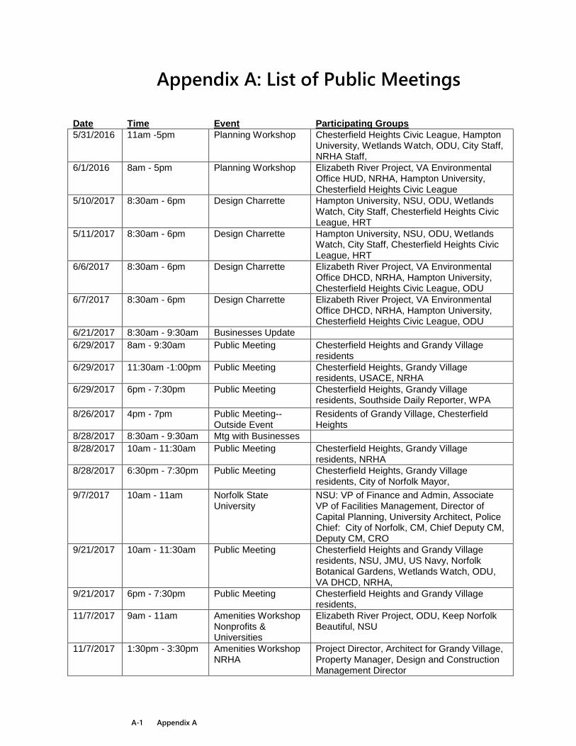
A-1 Appendix A
Appendix A: List of Public Meetings
Date Time Event Participating Groups 5/31/2016 11am -5pm Planning Workshop Chesterfield Heights Civic League, Hampton
University, Wetlands Watch, ODU, City Staff, NRHA Staff,
6/1/2016 8am - 5pm Planning Workshop Elizabeth River Project, VA Environmental Office HUD, NRHA, Hampton University, Chesterfield Heights Civic League
5/10/2017 8:30am - 6pm Design Charrette Hampton University, NSU, ODU, Wetlands Watch, City Staff, Chesterfield Heights Civic League, HRT
5/11/2017 8:30am - 6pm Design Charrette Hampton University, NSU, ODU, Wetlands Watch, City Staff, Chesterfield Heights Civic League, HRT
6/6/2017 8:30am - 6pm Design Charrette Elizabeth River Project, VA Environmental Office DHCD, NRHA, Hampton University, Chesterfield Heights Civic League, ODU
6/7/2017 8:30am - 6pm Design Charrette Elizabeth River Project, VA Environmental Office DHCD, NRHA, Hampton University, Chesterfield Heights Civic League, ODU
6/21/2017 8:30am - 9:30am Businesses Update
6/29/2017 8am - 9:30am Public Meeting Chesterfield Heights and Grandy Village residents
6/29/2017 11:30am -1:00pm Public Meeting Chesterfield Heights, Grandy Village residents, USACE, NRHA
6/29/2017 6pm - 7:30pm Public Meeting Chesterfield Heights, Grandy Village residents, Southside Daily Reporter, WPA
8/26/2017 4pm - 7pm Public Meeting--Outside Event
Residents of Grandy Village, Chesterfield Heights
8/28/2017 8:30am - 9:30am Mtg with Businesses
8/28/2017 10am - 11:30am Public Meeting Chesterfield Heights, Grandy Village residents, NRHA
8/28/2017 6:30pm - 7:30pm Public Meeting Chesterfield Heights, Grandy Village residents, City of Norfolk Mayor,
9/7/2017 10am - 11am Norfolk State University
NSU: VP of Finance and Admin, Associate VP of Facilities Management, Director of Capital Planning, University Architect, Police Chief: City of Norfolk, CM, Chief Deputy CM, Deputy CM, CRO
9/21/2017 10am - 11:30am Public Meeting Chesterfield Heights and Grandy Village residents, NSU, JMU, US Navy, Norfolk Botanical Gardens, Wetlands Watch, ODU, VA DHCD, NRHA,
9/21/2017 6pm - 7:30pm Public Meeting Chesterfield Heights and Grandy Village residents,
11/7/2017 9am - 11am Amenities Workshop Nonprofits & Universities
Elizabeth River Project, ODU, Keep Norfolk Beautiful, NSU
11/7/2017 1:30pm - 3:30pm Amenities Workshop NRHA
Project Director, Architect for Grandy Village, Property Manager, Design and Construction Management Director
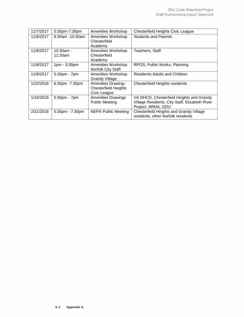
Ohio Creek Watershed Project Draft Environmental Impact Statement
A-2 Appendix A
11/7/2017 5:30pm-7:30pm Amenities Workshop Chesterfield Heights Civic League 11/8/2017 9:30am -10:30am Amenities Workshop
Chesterfield Academy
Students and Parents
11/8/2017 10:30am -11:30am
Amenities Workshop Chesterfield Academy
Teachers, Staff
11/8/2017 1pm - 3:30pm Amenities Workshop Norfolk City Staff
RPOS, Public Works, Planning
11/8/2017 5:30pm - 7pm Amenities Workshop Grandy Village
Residents Adults and Children
1/22/2018 6:30pm -7:30pm Amenities Drawing--Chesterfield Heights Civic League
Chesterfield Heights residents
1/24/2018 5:30pm - 7pm Amenities Drawings Public Meeting
VA DHCD, Chesterfield Heights and Grandy Village Residents, City Staff, Elizabeth River Project, NRHA, ODU
2/21/2018 5:30pm - 7:30pm NEPA Public Meeting Chesterfield Heights and Grandy Village residents, other Norfolk residents
References

R-1 References
Glossary A
anadromous fish. Fish that hatch in freshwater, migrate to the ocean to mature, then return to freshwater to spawn. Examples include Atlantic sturgeon or salmon.
B
benthic organism. Organisms that inhabit the ecological region at the lowest level (on the bottom) of a body of water such as tidal creeks and rivers, including the sediment surface and some sub-surface layers.
blast overpressure. The pressure wave exerted by detonation of a set mass quantity of trinitrotoluene, or TNT. Used in calculation of acceptable separation distances for projects near stationary facilities that store, handle, or process explosive or fire prone substances.
bioswale. Landscape element designed to remove debris and pollution from surface runoff water. Typically consists of a depressed elevation drainage course with gently sloped sides and lined with vegetation and/or riprap.
C
corner basins. Landscape element designed to collect water at street corners. Typically a depressional feature, often planted with native species.
corner bumpout. A traffic calming measure, primarily used to extend the sidewalk, reducing the crossing distance and allowing pedestrians about to cross and approaching vehicle drivers to see each other when vehicles parked in a parking lane would otherwise block visibility.
D
daylighting. The removal of stormwater pipes along a drainage course to restore open channel flow.
E
emergent. A plant community characterized by frequent or continual inundation dominated by herbaceous species of plants typically rooted in saturated soils and emerging into air.
euryhaline. Organisms that area able to adapt to a wide range of salinities.
Ohio Creek Watershed Project Draft Environmental Impact Statement
R-2 References
F
force main. A pressurized sewer pipe that conveys wastewater in a situation where gravity sewage flow is not possible. Pumps or cpmpressors are used to move sewage through the force main from lower to higher elevations or across landscapes where deep excavation is not feasible.
H
hydric soil. A soil formed under conditions of saturation, flooding, or ponding long enough during the growing season to develop anaerobic conditions in the upper layers.
hydrophytic vegetation. A plant growing in water or a substrate that is at least periodically deficient of oxygen during a growing season as a result of excessive water content.
hydroseeding. A planting process that uses a slurry of seed and mulch. It is often used as an erosion control technique on construction sites, as an alternative to the traditional process of broadcasting or sowing dry seed.
I
impervious surface. A soil surface composed of any material that impedes or prevents natural infiltration.
N
nonpoint source pollution. Unlike pollution from industrial and sewage treatment plants, nonpoint source pollution comes from many diffuse sources. Nonpoint source pollution is caused by rainfall or snowmelt moving over and through the ground.
P
palustrine. A plant community that includes all nontidal wetlands dominated by trees, shrubs, and emergent vegetation. Examples include marshes, wet meadows, fens, playas, potholes, pocosins, bogs, swamps, and small shallow ponds.
preferred alternative. The alternative within the range of alternatives presented in an environmental assessment that the agency believes would best fulfill the purpose and need of the proposed action.
R
Ohio Creek Watershed Project Draft Environmental Impact Statement
R-3 References
rain barrel. A container or barrel used to collect water runoff, often from a gutter system on a residential home.
rain garden. A landscape feature also known as a stormwater garden. A depressional feature with native plantings that is designed to collect rainwater runoff from impervious surfaces like roofs, driveways, or streets, and allows it to be absorbed into the ground.
S
soil map units. The basic geographic units of the soil survey data set that delineates the extent of different soils and data for each unit.
stillwater flood elevation. The projected flood level not including the effects of waves resulting from wind. In coastal areas, stillwater elevations are determined when modeling coastal storm surge; the results of overland wave modeling are used in conjunction with the stillwater elevations to develop Base Flood Elevations.
subsidence. The gradual settling or sinking of the Earth’s surface related to subsurface movement of earth materials such as groundwater.
subtidal. Of or relating to the benthic environment below the level of low-tide that is always covered by water.
T
take. The term ‘take’ means to harass, harm, pursue, hunt, shoot, wound, kill, trap, capture, collect, or attempt to engage in any such conduct of a listed species.
thermal radiation. A measurement based on heat flux used to calculate acceptable separation distances as defined by the U.S. Department of Housing and Urban Development.
t-wall. A vertical retaining wall system with a broad foundation used for structural support which appears as a T in cross-section; often used as a sea wall or retaining wall.
V
vertical sheeting. Steel or concrete panels driven vertically into the ground to prevent slope failure or to serve as a barrier.
R-4 References
Bibliography
Bertness, M. D. 1984. Ribbed mussels and Spartina alterniflora production in a New England salt marsh. Ecology. Vol. 65: 1794-1807.
Bird Watcher’s Digest. Virginia Bird Watching. 2018. https://www.birdwatchersdigest.com/bwdsite/explore/regions/southeast/ virginia.php (accessed on March 20, 2018).
Center for Conservation Biology. 2013. Colonial Waterbirds 2013. http://www.ccbbirds.org/maps/ (accessed March 19, 2018).
––––––. 2017. VA Eagle Nest Locator. http://www.ccbbirds.org/maps/ (accessed March 19, 2018).
––––––. 2018. CCB Mapping Portal. http://www.ccbbirds.org/maps/ (accessed March 18, 2018).
City of Norfolk. 2013 and amended in 2018. PlaNorfolk 2030, p 2-17.
––––––. 2018. Code of the City of Norfolk, VA. Adopted February 27, 2018. https://library.municode.com/va/norfolk/codes/code_of_ordinances (accessed June 1, 2017).
Commonwealth of Virginia. Undated. Norfolk Coastal Adaptation and Community Transformation Plan.
Council on Environmental Quality. 1993. Incorporating Biodiversity Considerations into Environmental Impact Analysis Under the National Environmental Policy Act. http://energy.gov/sites/prod/files/nepapub/nepa_documents/RedDont/ G-CEQ-BiodiversityConsiderations.pdf (accessed March 20, 2018).
––––––. 1997. Considering Cumulative Effects Under the National Environmental Policy Act.
Cowardin, L. M., Carter, V., Golet, F. C., LaRoe, E. T. 1979. Classification of Wetlands and Deepwater Habitats of the United States. US Department of the Interior. Fish and Wildlife Service Office of Biological Services. Washington, DC.
Cronk, J. K. and M. S. Fennessey. 2001. Wetland Plants: Biology and Ecology. Lewis Publishers, Boca Raton, Florida.
David, J. A. 2006. Likely sensitivity of bottlenose dolphins to pile-driving noise. Water and Environment Journal. Vol. 20: 48-54.
Deaton, L. E. 2001. Hyperosmotic volume regulation in the gills of the ribbed mussel, Geukensia demissa: rapid accumulation of betaine and alanine. Journal of Experimental Marine Biology and Ecology. Vol. 260: 185-197.
Ohio Creek Watershed Project Draft Environmental Impact Statement
R-5 References
Ducks Unlimited. Undated. DU Projects: Atlantic Flyway. http://www.ducks.org/conservation/where-we-work/flyways/du-projects-atlantic-flyway (accessed March 20, 2018).
Eggleston, Jack, and Pope, Jason. 2013. Land subsidence and relative sea-level rise in the southern Chesapeake Bay region: U.S. Geological Survey Circular 1392. http://dx.doi.org/10.3133/cir1392 (accessed July 5, 2018).
Engelhaupt, A., M. Richlen, T.A. Jefferson, and D. Engelhaupt. 2014. Occurrence, Distribution, and Density of Marine Mammals Near Naval Station Norfolk and Virginia Beach, VA: Annual Progress Report. Prepared for US Fleet Forces Command. Submitted to Naval Facilities Engineering Command Atlantic, Norfolk, Virginia, under Contract No. N62470-10- 3011, Task Orders 031 and 043, issued to HDR Inc., Norfolk, Virginia.
ESRI. Business Summary Database. https://doc.arcgis.com/en/esri-demographics/ data/business.htm (accessed on March 19, 2018).
Gedan, K. B., Kellog, L., and Breitburg, D. L. 2014. Accounting for multiple foundation species in oyster reef restoration benefits. Restoration Ecology. Vol. 22: 517-524.
Gleason, H. A. and A. Cronquist. 1991. Manual of Vascular Plants of Northeastern United States and Adjacent Canada. New York Botanical Garden. Bronx, NY.
Harper, H. H., and Herr, J. L. 1993. Treatment Efficiency of Detention with Filtration Systems. Final Report to the St. Johns River Water Management District.
Kent, C. S. and R. McCauley. 2006. Review of Environmental Assessment of the Batholiths Marine Seismic Survey, Inland Waterways and Near-Offshore, Central Coast of British Columbia. Center for Marine Science and Technology, Curtin University.
Krebs, J., Jacobs, F., and Popper A. N. 2016. Avoidance of Pile-Driving Noise by Hudson River Sturgeon During Construction of the New NY Bridge at Tappan Zee. In: Popper, A., Hawkins, A. (eds.). The Effects of Noise on Aquatic Life II. Advances in Experimental Medicine and Biology, vol. 875. Springer, New York.
Lichvar, R. W., D. L. Banks, W. N. Kirchner, and N. C. Melvin. 2016. The National Wetland Plant List: 2016 wetland ratings. Phytoneuron. 2016-30: 1-17. Published 28 April 2016. ISSN 2153 733X.
Lockwood, J. L., Hoopes, M. F., and Marchetti, M. P. 2013 Invasion Ecology. John Wiley & Sons. West Sussex, UK.
Mueller-Dombois, D. and H. Ellenberg. 1974. Chapter 5. Community Sampling, the Releve Method. Aims and Methods of Vegetation Ecology. John Wiley & Sons. New York, NY.
Ohio Creek Watershed Project Draft Environmental Impact Statement
R-6 References
National Oceanic and Atmospheric Administration, National Marine Fisheries Service. 2016. Marine Mammal Protection Act (MMPA). http://www.nmfs.noaa.gov/pr/laws/mmpa/ (accessed March 20, 2018).
––––––. 2017. Essential Fish Habitat Mapper. https://www.habitat.noaa.gov/protection/efh/efhmapper/index.html (accessed March 18, 2018).
National Park Service. 2003. National Register of Historic Places Register Form for Chesterfield Heights Historic District.
Neufeld, D. and S. Wright. 1998. Effect of cyclical salinity changes on cell volume and function in Geukensia demissa gills. Journal of Experimental Biology. Vol. 201: 1421-1431.
Norfolk Housing and Redevelopment Authority. 2018. Norfolk Housing and Redevelopment Authority Plan.
Norfolk State University. Undated. Norfolk State University. https://www.nsu.edu/ (accessed March 19, 2018).
Popper, A. N. 2005. What do we know about pile driving and fish? In Proceedings of the 2005 International Conference on Ecology and Transportation, edited by Irwin, C. L., Garrett, P. and McDermott, K. P. Center for Transportation and the Environment, North Carolina State University, Raleigh, North Carolina.
Radford, A. E., H. E. Ahles, and C. R. Bell. 1968. Manual of the Vascular Flora of the Carolinas. University of North Carolina Press. Chapel Hill, NC.
Rushton, B. et al. 1997. Three Design Alternatives for Stormwater Detention Ponds. Prepared by the Southwest Florida Water Management District. Brooksville, FL.
Scheyer, J.M., and K.W. Hipple. 2005. Urban Soil Primer. United States Department of Agriculture, Natural Resources Conservation Service, National Soil Survey Center, Lincoln, Nebraska. http://soils.usda.gov/use (accessed March 20, 2018).
US Army Corps of Engineers. 2010. Regional Supplement to the Corps of Engineers Wetland Delineation Manual: Atlantic and Gulf Coastal Plain Region (Version 2.0), ed. J. S. Wakeley, R. W. Lichvar, and C. V. Noble. ERDC/ELTR-10-20. Vicksburg, MS: US Army Engineer Research and Development Center.
––––––. 2017. Draft Integrated City of Norfolk Coastal Storm Risk Management Feasibility Study/Environmental Impact Statement.
US Census Bureau. 2017. 2012-2016 American Community Survey. https://www.census.gov/programs-surveys/acs/ (accessed March 19, 2018).
US Department of Agriculture, Natural Resources Conservation Service. 2009. Soils Survey of Tidewater Cities Area, Virginia. https://www.nrcs.usda.gov/Internet/ FSE_MANUSCRIPTS/virginia/TidewaterCitiesVA2009/TidewaterCities.pdf (accessed March 20, 2018).
Ohio Creek Watershed Project Draft Environmental Impact Statement
R-7 References
––––––. 2017. Web Soil Survey. http://websoilsurvey.sc.egov.usda.gov/ (accessed June 1, 2017).
US Fish and Wildlife Service. 1973. Endangered Species Act. https://www.fws.gov/endangered/esa-library/pdf/ESAall.pdf (accessed July 19, 2018).
––––––. 2018. Information for Planning and Consultation. https://ecos.fws.gov/ipac/location/index (accessed March 18, 2018).
––––––. 2018. National Wetland Inventory. Wetlands Mapper. https://www.fws.gov/wetlands/data/mapper.html (accessed June 1, 2017).
US Geological Survey. 2016. USGS US Topo 7.5-minute map for Kempsville, VA 2016. USGS – National Geospatial Technical Operations Center. (NGTOC). https://viewer.nationalmap.gov/basic/ (accessed June 1, 2017).
––––––. 2016. USGS US Topo 7.5-minute map for Norfolk South, VA 2016. USGS –NGTOC. https://viewer.nationalmap.gov/basic/ (accessed June 1, 2017).
US Department of Housing and Urban Development. 2018. Acceptable Separation Distance (ASD) Electronic Assessment Tool. https://www.hudexchange.info/ environmental-review/asd-calculator (accessed May 22, 2018).
––––––. 2018. Environmental Review Partner Worksheets. https://www.hudexchange.info/resource/5119/environmental-review-record-related-federal-laws-and-authorities-partner-worksheets/ (accessed May 22, 2018).
Virginia Coastal Zone Management Program. 2018. Coastal Geospatial and Educational Mapping System. http://www.coastalgems.org/ (accessed March 18, 2018).
Virginia Department of Conservation and Recreation. 2018. Natural Heritage Data Explorer (NHDE). https://vanhde.org/ (accessed March 18, 2018).
––––––, Chesapeake Bay Local Assistance Board. 2007. DCR-CBLAB-086. Resource Protection Areas: Nontidal Wetlands. Guidance on CBPA designation and management regulations. http://townhall.virginia.gov/L/GetFile.cfm?File= C:%5CTownHall%5Cdocroot%5CGuidanceDocs%5C440%5CGDoc_DEQ_5413_ v1.pdf (accessed March 20, 2018).
––––––, Division of Soil and Water Conservation. 1992. Virginia Erosion and Sediment Control Handbook. 3rd Edition. Richmond, VA.
Virginia Department of Education. Undated School Quality Profiles. http://schoolquality.virginia.gov/schools/chesterfield-academy-elementary (accessed April 23, 2018).
Virginia Department of Game and Inland Fisheries. 2018. Fish and Wildlife Information Service (FWIS). https://vafwis.dgif.virginia.gov/fwis/ (accessed March 18, 2018).
Ohio Creek Watershed Project Draft Environmental Impact Statement
R-8 References
Virginia Department of Health. 2018. Shellfish Closure and Shoreline Survey Documents. http://www.vdh.virginia.gov/environmental-health/shellfish-closure-and-shoreline-survey-documents/ (accessed May 31, 2018).
Virginia Department of Historic Resources. 2003. Architectural Survey Form for Chesterfield Heights Historic District.
Virginia Department of Transportation. Undated. Traffic Volume Estimates Including Vehicle Classification Estimates Special Locality Report 122.
––––––. 2014. 2014 Approved Functional Classification Map. http://www.arcgis.com/home/webmap/viewer.html?webmap= 3eca6c9adb6649c988d98734f85baddb (accessed March 27, 2018).
––––––, Traffic Engineering Division. 2016 Annual Average Daily Traffic Volume Estimates by Section of Route. 2016.
Virginia Marine Resources Commission. 2018. Historical Highlights of the Virginia Marine Resources Commission. http://mrc.virginia.gov/ vmrchist.shtm#eighteenninetyfour (accessed May 7, 2018).
Weakley, A.S. 2016. Flora of the Southern and Mid-Atlantic States. Working Draft. UNC Herbarium. University of North Carolina at Chapel Hill. Chapel Hill, NC.
Weakley, A. S., J. Christopher Ludwig, J. F. Townsend, and B. Crowder. 2012. Flora of Virginia. Botanical Research Institute of Texas. Fort Worth, TX.
Würsig, B., Greene, C. R. and Jefferson, T. A. 2000. Development of an Air Bubble Curtain to Reduce Underwater Noise of Percussive Piling. Marine Environmental Research. Vol. 49: 79-93.
Zedler, J. B. 1983. Freshwater impacts in normally hypersaline marshes. Estuaries. Vol. 6: 346-355.