Gretna Resilience District Gretna City Park Phasing ...
58
WAGGONNER & BALL ARCHITECTURE/ENVIRONMENT 2200 PRYTANIA STREET NEW ORLEANS, LA 70130 +1 504 524 5308 WBAE.COM Gretna Resilience District Gretna City Park Phasing Recommendation Report in association with: 8 JANUARY 2020 CITY OF GRETNA, LOUISIANA
-
Upload
khangminh22 -
Category
Documents
-
view
0 -
download
0
Transcript of Gretna Resilience District Gretna City Park Phasing ...

WAGGONNER & BALLARCHITECTURE/ENVIRONMENT
2200 PRYTANIA STREETNEW ORLEANS, LA 70130+1 504 524 5308WBAE.COM
Gretna Resilience DistrictGretna City ParkPhasing Recommendation Report
in association with:
8 JANUARY 2020 CITY OF GRETNA, LOUISIANA


3GRETNA CITY PARK PHASING RECOMMENDATION REPORT
Table of Contents
I Project Principles & Priorities 6
Project Boundary & Impact 8 Water First 10 Nature-Based 10 Rooted in History 12 Building on Assets 12
II Analysis & Engagement 14
Stormwater Modeling 17 Water Quality & Ecology in Park 18 Endangered & Invasive Flora & Fauna 20 Public Engagement 22
III Proposed Design Program 24
Added Water Storage 26 Water-Based Recreation 29 Landforms 30 Boardwalks & Trails 31 Arrival & Wayfinding 32 Multipurpose Pavilion 33 Design Phase Data Needs 34 Low-Maintenance Plan 35 Proposed Budget 36
IV Future Phase 38
Future Resilience District Projects 40 Environmental & Water Quality 42 Future Proposed Budget 43
V Appendix 44
Maximum Potential Water Storage Analysis 46 Detailed Cost Breakdown 47 Deltares Water Quality & Ecology Report 48 Floodplain Maps 52

4 PHASE I EXECUTIVE SUMMARY
Phasing Recommendation Report Executive Summary
Gretna Resilience District
Gretna City Park is one of two primary interventions within the Gretna Resilience District. The District was established by the City Council in 2017 to showcase low impact design strategies in an area of the City that has some of the country's highest concentrations of severe repetitive loss and repetitive loss properties. The District has two distinct drainage sub-basins, one north of Gretna Blvd., centered around the 25th Street Canal; and one south of Gretna Blvd., surrounding Gretna City Park. The City has secured approximately $20 million to date to support projects throughout the Gretna Resilience District. The first such award was received from the HUD-OCD funded Louisiana Strategic Adaptations for Future Environments (LASAFE) program - $5 million to support improvements within Gretna City Park.
This vision and an intial concept for the Park were developed in 2017 through the LASAFE planning process, a U.S. Department of Housing & Urban Development (HUD) funded effort to increase community resiliency. In addition, precedent analysis and design within the Park were conducted by the Tulane Regional Urban Design Center.
Land & Water Analysis
The Waggonner & Ball/Carbo team began by analyzing the water flows, surface elevations, and recreational uses of the Park. The team determined that stormwater runoff is captured from the immediate surroundings of the Park between Gretna Boulevard, Claire Avenue, and Creagan Avenue, and enters the Park from one
inlet at the north and one inlet at the eastern edge. Stormwater fills the ponds, then exits through a weir structure into Hero Canal. This flow-path loosely follows the historic course of Bayou Couvant. The team's stormwater modeling confirmed invert (inlet and weir) elevation measurements in the field, determined a target stormwater storage volume of 20 acre feet, and revealed that water backing up from the Hero Canal is a significant source of flooding within and around the Park.
The informal playing fields behind Gretna Middle School are located on the highest ground in the Park, approximately +2 feet above sea level, and the ground below is thought to be landfill, potentially from excavation of the ponds. The lowest ground—other than the ponds—is found within the densely forested area at the south end, approximately -2 feet.
Based on these analyses, two water storage scenarios were developed: a "max" scenario if all land in the Park were to be converted to stormwater storage (59 acre feet) and the "proposed" scenario that adds water storage while preserving existing recreational uses (26 acre feet). These results and proposals were presented at a community meeting at Mel Ott Park in October 2019, where the design team also gathered feedback on Park uses and needs.
Program Recommendations
Based on public feedback, City of Gretna goals and input, and design, five program elements are recommended for Gretna City Park:
1. Added Water Storage: Enlarge and extend existing ponds to mitigate flooding within Park
2. Landforms: Improve visitor-experience by creating berms and path-landscapes with fill
The Future of Gretna City Park

5GRETNA CITY PARK PHASING RECOMMENDATION REPORT
3. Boardwalks & Trails: Increase connectivity to adjacent neighborhood and add multi-use paths
4. Arrival & Wayfinding: Add parking, create defined entries, and add signage
5. Multipurpose Pavilion: Outdoor covered space with integral dock and potential storage opportunities
Water is the key identity of the park: water storage program elements come first, with recreational opportunities layered on and around water features. New paths and amenities will highlight the flow of water and build on the existing beauty and infrastructure assets of the park. Soil excavated from pond expansion is a resource to create iconic topography. Functional upgrades including parking, arrival and wayfinding are guided by locations of other park features and improvements.
Next Steps
Following the completion of this Report, the team will begin the design and construction phase, with construction to be completed by summer 2022. This phase will include a topographic and tree survey, geotechnical analysis, and additional stormwater modeling to confirm no downstream impacts from park improvements.
Future Resilience District improvements surrounding the Park, including connecting the 25th Street Canal sub basin and potential berms or floodwalls on the Hero Canal, will begin if and when funding becomes available. Together with water storage within the Park, these improvements are expected to function as a system to reduce flooding, protecting homes from canal overtopping while storing runoff within the District.
Mayor Constant and Councilman Miller at the public meeting; existing park environment; envisioned pavilion and boardwalks.

Project Principles & PrioritiesProject Boundary & Impact
Project Principles A. Water First B. Nature-Based C. Rooted in History D. Building on Assets
8 PHASE I PROJECT PRINCIPLES & PRIORITIES
25TH STREET CANAL RESILIENCY PROJECT
arcadis.com 1
1 INTRODUCTION Numerous properties within the 25th Street Canal neighborhood in the City of Gretna have experienced repetitive losses due to historical flood events. Figure 1 shows the density and spatial extent of the repetitive losses in the neighborhood. A dense concentration of repetitive losses is shown around 25th Street, and along the Heebe Canal between 23rd Street and 33rd Street.
Figure 1. Repetitive loss properties along Heebe Canal and 25th Street Canal in the City of Gretna.
This report presents the hydrologic and hydraulic analysis performed to identify the flood risk in the 25th street drainage area. With the source of flood risk identified, the report then presents a strategy to mitigate the flood risk in the 25th Street Canal neighborhood.
Site Location & Description
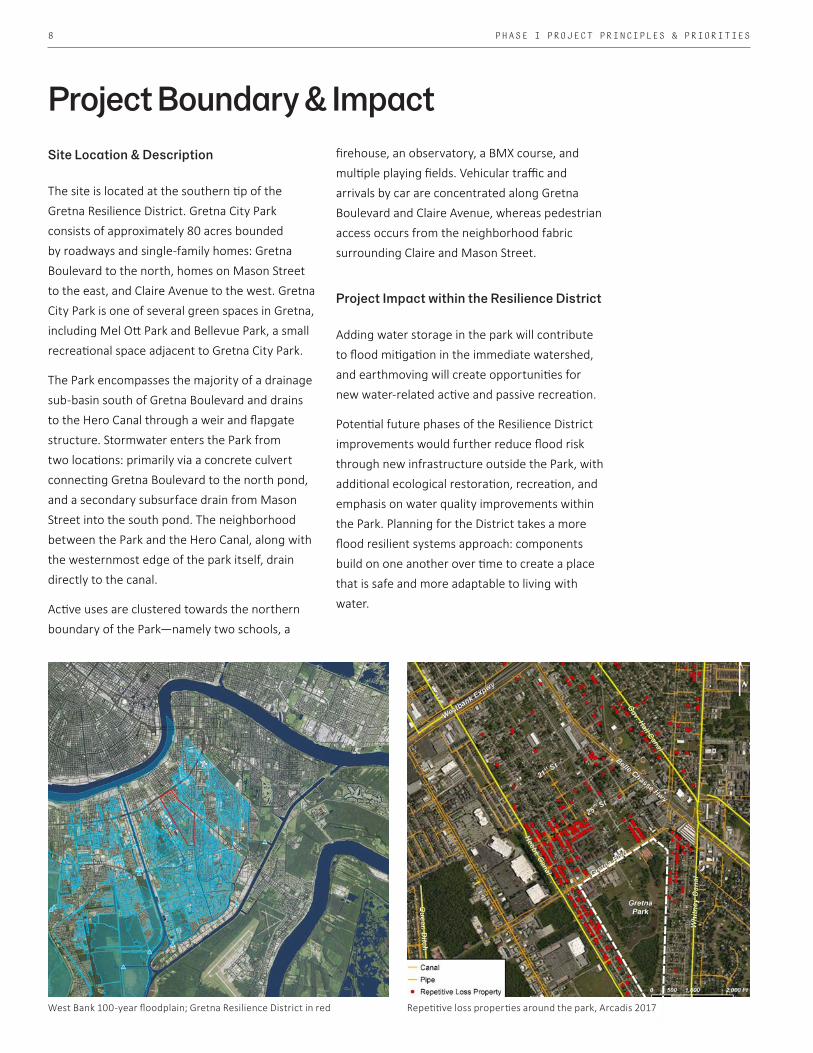
The site is located at the southern tip of the Gretna Resilience District. Gretna City Park consists of approximately 80 acres bounded by roadways and single-family homes: Gretna Boulevard to the north, homes on Mason Street to the east, and Claire Avenue to the west. Gretna City Park is one of several green spaces in Gretna, including Mel Ott Park and Bellevue Park, a small recreational space adjacent to Gretna City Park.
The Park encompasses the majority of a drainage sub-basin south of Gretna Boulevard and drains to the Hero Canal through a weir and flapgate structure. Stormwater enters the Park from two locations: primarily via a concrete culvert connecting Gretna Boulevard to the north pond, and a secondary subsurface drain from Mason Street into the south pond. The neighborhood between the Park and the Hero Canal, along with the westernmost edge of the park itself, drain directly to the canal.
Active uses are clustered towards the northern boundary of the Park—namely two schools, a
West Bank 100-year floodplain; Gretna Resilience District in red
Project Boundary & Impact
Phase 1: Within Park
Repetitive loss properties around the park, Arcadis 2017
firehouse, an observatory, a BMX course, and multiple playing fields. Vehicular traffic and arrivals by car are concentrated along Gretna Boulevard and Claire Avenue, whereas pedestrian access occurs from the neighborhood fabric surrounding Claire and Mason Street.
Project Impact within the Resilience District
Adding water storage in the park will contribute to flood mitigation in the immediate watershed, and earthmoving will create opportunities for new water-related active and passive recreation.
Potential future phases of the Resilience District improvements would further reduce flood risk through new infrastructure outside the Park, with additional ecological restoration, recreation, and emphasis on water quality improvements within the Park. Planning for the District takes a more flood resilient systems approach: components build on one another over time to create a place that is safe and more adaptable to living with water.

9GRETNA CITY PARK PHASING RECOMMENDATION REPORT
Hero / Hebee Canal
Gov. Hall Canal
Whi
tney
Can
al
Gretna Blvd.
25th St. Canal
Gretna ResilienceDistrict
25th St. Sub-basin
DisconnectedDrainage Sheds
Gretna City Hall
NotModeled
Gretna CityPark
Gretna CityPark Sub-basin
Weir
Dense RepetitiveProperty Loss
The Park and 25th St. sub-basins are disconnected, and the Park receives stormwater runoff from a limited surrounding watershed
Phase 1: Within Park
Repetitive loss properties around the park, Arcadis 2017
10 PHASE I PROJECT PRINCIPLES & PRIORITIES10
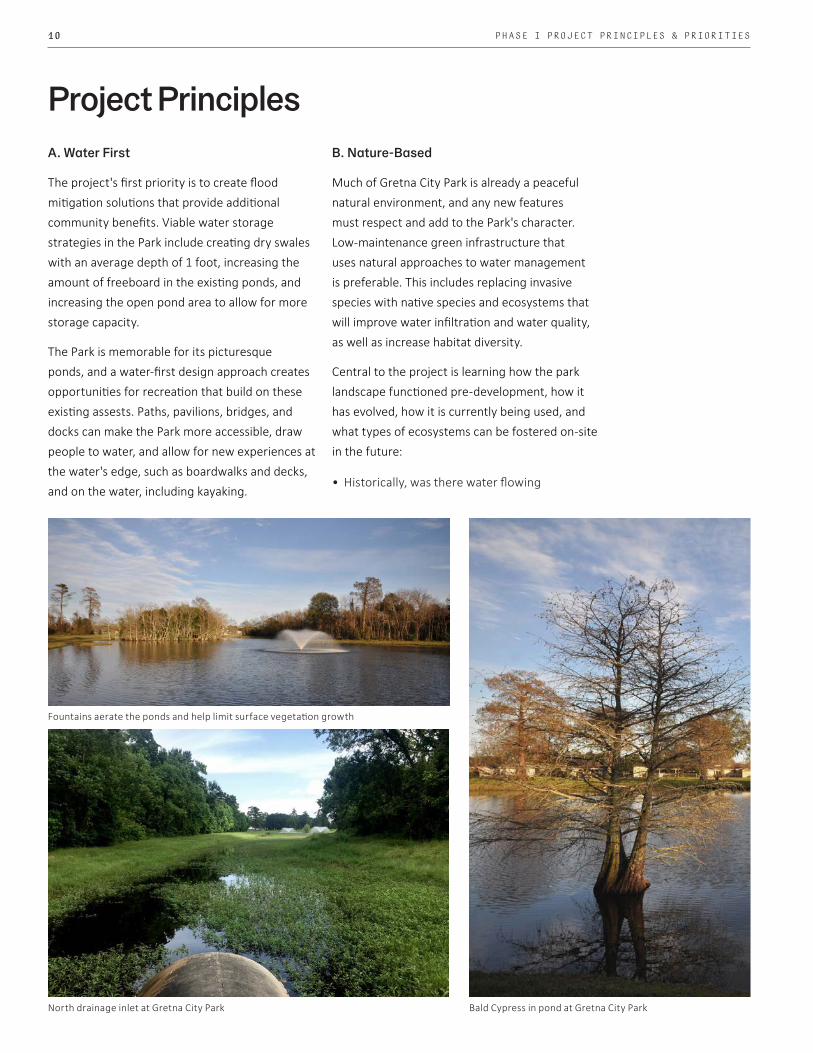
A. Water First
The project's first priority is to create flood mitigation solutions that provide additional community benefits. Viable water storage strategies in the Park include creating dry swales with an average depth of 1 foot, increasing the amount of freeboard in the existing ponds, and increasing the open pond area to allow for more storage capacity.
The Park is memorable for its picturesque ponds, and a water-first design approach creates opportunities for recreation that build on these existing assests. Paths, pavilions, bridges, and docks can make the Park more accessible, draw people to water, and allow for new experiences at the water's edge, such as boardwalks and decks, and on the water, including kayaking.
B. Nature-Based
Much of Gretna City Park is already a peaceful natural environment, and any new features must respect and add to the Park's character. Low-maintenance green infrastructure that uses natural approaches to water management is preferable. This includes replacing invasive species with native species and ecosystems that will improve water infiltration and water quality, as well as increase habitat diversity.
Central to the project is learning how the park landscape functioned pre-development, how it has evolved, how it is currently being used, and what types of ecosystems can be fostered on-site in the future:
• Historically, was there water flowing
Project Principles
Bald Cypress in pond at Gretna City Park
Fountains aerate the ponds and help limit surface vegetation growth
North drainage inlet at Gretna City Park

11GRETNA CITY PARK PHASING RECOMMENDATION REPORT 11
A snapshot of plant and animal diversity in the Park Standing water and existing trail in Park
through the park? • Were there wetlands? • What plant communities existed there?
Through historic maps, field investigation, and resources supplied by Louisiana Wildlife and Fisheries, historic Bayou Convent was found to have flowed through a variety of native habitats on the park site: wetlands, wet-meadow or prairie, and bottomland hardwood forests. The team then researched what currently exists on site to better understand: • What plants and animals are
already on-site? • Are there currently designated wetlands
on site?• What nearby parks/natural areas
are precedents for enhancing Gretna City Park?
• How can this project balance the need for recreational activity and the preservation of sensitive ecologies on-site?
The site is home to many nesting birds, including a rookery on "Bird Island," and birds of prey that the community is interested in protecting. Nearby, there are several areas that are
important bird habitats, including Brechtel Park, Jean Lafitte National Park, New Orleans City Park, Bayou Savage National Wildlife Refuge, as well as the Barataria/Terrebone, LA East Delta Plain, and Lake Pontchartrain Important Bird Areas. Several invasive species were identified, including Chinese Tallow Trees and Golden Apple Snails, which impede the growth and development of native habitats.
Finally, balancing the need for recreation and habitat on site will be achieved by creating a gradient of activities that range from active to passive, with active recreation clustered near Gretna Boulevard in the north, and passive recreation spread throughout the Park to protect sensitive habitats, such as the rookery on the island located within the southernmost pond. There are currently no federally designated wetlands on site; however, efforts must be made to protect the collection of hero trees and native landscapes in the Park.

12 PHASE I PROJECT PRINCIPLES & PRIORITIES
1826 Collot Map of the Course of the Mississippi
1891 Appleton Map of New Orleans
1858 Persace, Norman's Chart of the Lower Mississippi
1891 Collot Map
C. Rooted in History
Landscape history, from pre-development forest to old canals and building foundations, lends special character and meaning to shared public places. An understanding of historic features and natural systems can layer meaning and memories into the everyday function of City Park, a window into the landscape that supports delta life.
Historically, present-day Gretna was “land covered with cypress trees” and “morass covered with reeds."1 Pierre d'Iberville, founder of New Orleans, described areas around the Mississippi during his early explorations as, “nothing other than canes and bushes” and stated that the “land becomes inundated to a depth of 4 feet during high water.”
According to John Kendall, who authored a 1922 History of New Orleans, the Verret Canal (later Whitney Canal) was dug to drain a sugar plantation on Algiers Point around 1814, confirming a long history of draining and channelizing water in the region. The draining and clearing of Southeast Louisiana has shaped the land, culture, and the communities that reside here. Gretna City Park is no exception;
it is surrounded by canals and lies just south of the Mississippi River. Historically, Bayou Convent ran through the park, and what remains of it are thought to be the two ponds on site.
Gretna City Park lies within the Deltaic Coastal Marshes and Barrier Island Ecoregion, which was dominated by marshes before the land was developed. This historic landscape-type provides a framework for new layers of identity within the park, native plant species restoration, and invasives removal.
D. Building on Assets
Gretna City Park is aesthetically rich and already provides many recreational assets, primarily grouped along the Gretna Boulevard and Claire Avenue edges. Park improvements will seek to provide better linkages between and access to these existing features, and make better use of the ponds and naturalized areas that are currently difficult to reach within the central and southern portions of the park.
1 Georges Collot, Map of the Course of the Mississippi from the Missouri and the Country of the Illinois to the Mouth of this River, 18262 Library of Congress
Gretna City Park

13GRETNA CITY PARK PHASING RECOMMENDATION REPORT
GRETNA resilience districtG R E T N A c i t y p a r k i m p r o v e m e n t s
A) Mason Ave. corridor
B) Claire Ave. corridor
C) South lake
D) SOCCER FIELD
e) nATURE tRAIL
f) Gretna Blvd. entrance
Existing conditionsWhat the park already offers
2
5
3
4
67
9
8
1
A
B
C
E
F
D
e x i s t i n g f e a t u r e s
1
2
3
4
5
6
7
8
9
O b s e r v a t o r y
r u g b y f i e l d
b a s k e t b a l l c o u r t s
b m x c o u r s e
n a t u r e t r a i l
s o c c e r f i e l d
t e n n i s c o u r t s & P a r k i n g
D o g P a r k
B e l l v u e p a r k p l ay g r o u n d & p a v i l i o n
MASON
AVE.
HERO
/HEE
BE C
ANAL
GRETNA BLVD.
gRETNAmIDDLE sCHOOL
DAVID CROCKETTfIRE dEPT.
SHIRLEY jOHNSON/gRETNA PARK
ELEMENTARY sCHOOL
HERO
DR.
CLAI
RE A
VE.
CREA
GAN AV
E.WHITN
EY/V
ERRE
T CAN
AL
SCALE: 1” = 150’-0”
0 75 150 300 NORTH


Analysis &EngagementStormwater Modeling
Water Quality & Ecology in Park
Public Engagement
16 PHASE I ANALYSIS & ENGAGEMENT
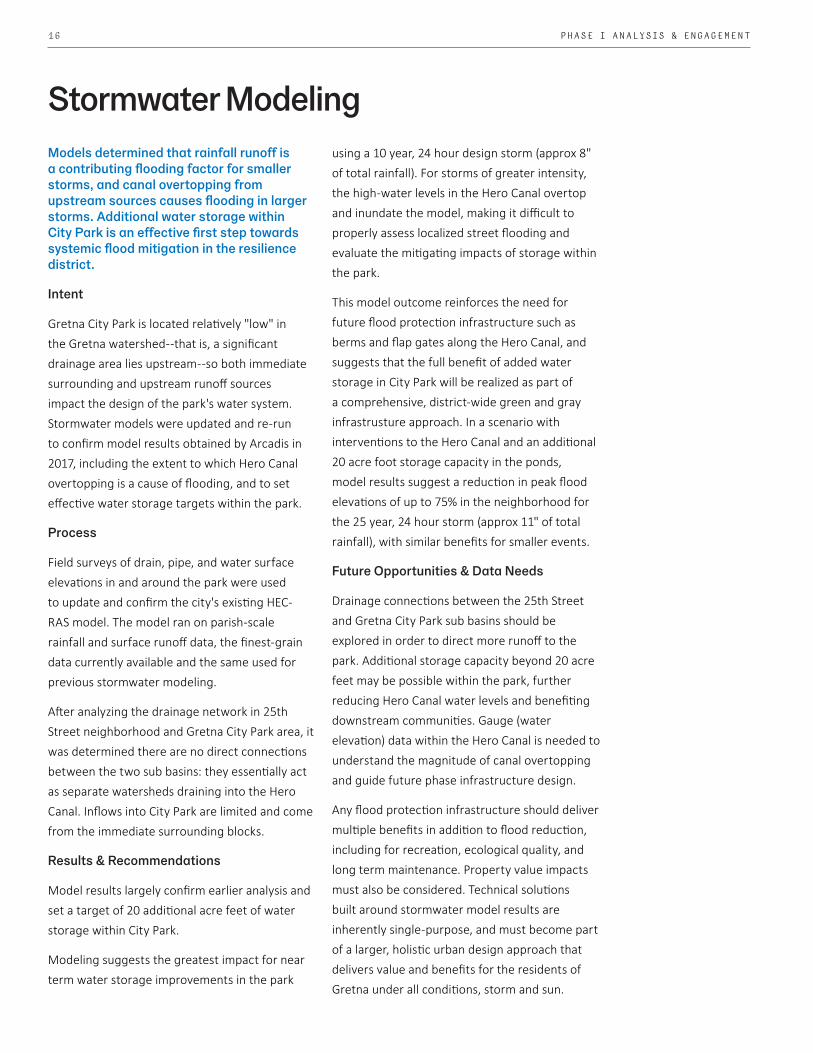
Models determined that rainfall runoff is a contributing flooding factor for smaller storms, and canal overtopping from upstream sources causes flooding in larger storms. Additional water storage within City Park is an effective first step towards systemic flood mitigation in the resilience district.
Intent
Gretna City Park is located relatively "low" in the Gretna watershed--that is, a significant drainage area lies upstream--so both immediate surrounding and upstream runoff sources impact the design of the park's water system. Stormwater models were updated and re-run to confirm model results obtained by Arcadis in 2017, including the extent to which Hero Canal overtopping is a cause of flooding, and to set effective water storage targets within the park.
Process
Field surveys of drain, pipe, and water surface elevations in and around the park were used to update and confirm the city's existing HEC-RAS model. The model ran on parish-scale rainfall and surface runoff data, the finest-grain data currently available and the same used for previous stormwater modeling.
After analyzing the drainage network in 25th Street neighborhood and Gretna City Park area, it was determined there are no direct connections between the two sub basins: they essentially act as separate watersheds draining into the Hero Canal. Inflows into City Park are limited and come from the immediate surrounding blocks.
Results & Recommendations
Model results largely confirm earlier analysis and set a target of 20 additional acre feet of water storage within City Park.
Modeling suggests the greatest impact for near term water storage improvements in the park
using a 10 year, 24 hour design storm (approx 8" of total rainfall). For storms of greater intensity, the high-water levels in the Hero Canal overtop and inundate the model, making it difficult to properly assess localized street flooding and evaluate the mitigating impacts of storage within the park.
This model outcome reinforces the need for future flood protection infrastructure such as berms and flap gates along the Hero Canal, and suggests that the full benefit of added water storage in City Park will be realized as part of a comprehensive, district-wide green and gray infrastrusture approach. In a scenario with interventions to the Hero Canal and an additional 20 acre foot storage capacity in the ponds, model results suggest a reduction in peak flood elevations of up to 75% in the neighborhood for the 25 year, 24 hour storm (approx 11" of total rainfall), with similar benefits for smaller events.
Future Opportunities & Data Needs
Drainage connections between the 25th Street and Gretna City Park sub basins should be explored in order to direct more runoff to the park. Additional storage capacity beyond 20 acre feet may be possible within the park, further reducing Hero Canal water levels and benefiting downstream communities. Gauge (water elevation) data within the Hero Canal is needed to understand the magnitude of canal overtopping and guide future phase infrastructure design.
Any flood protection infrastructure should deliver multiple benefits in addition to flood reduction, including for recreation, ecological quality, and long term maintenance. Property value impacts must also be considered. Technical solutions built around stormwater model results are inherently single-purpose, and must become part of a larger, holistic urban design approach that delivers value and benefits for the residents of Gretna under all conditions, storm and sun.
Stormwater Modeling

17GRETNA CITY PARK PHASING RECOMMENDATION REPORT
%
0 1,000500 Ft
CanalPipe
!( Repetitive Loss PropertyMaximum Depth (ft)
0.1 - 0.50.5 - 11 - 22 - 33 - 44 - 5> 5
Gretna Park: 25-Year Flood Depthwith Heebe Canal Wall, Gates, and Extra Storage
%
0 1,000500 Ft
CanalPipe
!( Repetitive Loss PropertyMaximum Depth (ft)
0.1 - 0.50.5 - 11 - 22 - 33 - 44 - 5> 5
Gretna Park: 25-Year Flood Depthfor the Existing Conditions
25-year storm modeled flood conditions (above) and with Hero Canal sheet pile wall, flap gates & extra storage in City Park (below)
Gretna Resilience District Gretna City Park
25th Street neighborhood
Hero Canal
100-Year floodplain
Design Storm rainfall values (subject to variation per individual model parameters; also subject to climate data upward revision)
Design Storm EventsRainfall Intensity and Volume
5.4 inches in 24 hours
2.3 inches in 1 hour
2.9 inches in 1 hour
3.3 inches in 1 hour
5.4 inches in 1 hour
4.1 inches in 1 hour
6.9 inches in 24 hours
8.3 inches in 24 hours
12.4 inches in 24 hours
10.5 inches in 24 hours
2-Year 50% Chance
5-Year 20% Chance
10-Year 10% Chance
100-Year 1% Chance
25-Year 4% Chance

18 PHASE I PROJECT PRINCIPLES & PRIORITIES
AMER
ICAN
KES
TREL
GRE
AT E
GRE
T
BROW
N P
ELIC
AN
AMER
ICAN
WH
ITE
PELI
CAN
MOT
TLED
DUC
K
LITT
LE B
LUE
HER
ON
AMER
ICAN
PIP
ITRO
SEAT
E SP
OON
BILL
BALD
EAG
LE
BLAC
K-CR
OWN
ED N
IGH
T H
ERON
AMER
ICAN
WH
ITE
IBIS
GRE
AT B
LUE
HER
ON
COM
MON
BIR
D S
PECI
ES
AMER
ICAN
KES
TREL
GRE
AT E
GRE
T
BROW
N P
ELIC
AN
AMER
ICAN
WH
ITE
PELI
CAN
MOT
TLED
DUC
K
LITT
LE B
LUE
HER
ON
AMER
ICAN
PIP
ITRO
SEAT
E SP
OON
BILL
BALD
EAG
LE
BLAC
K-CR
OWN
ED N
IGH
T H
ERON
AMER
ICAN
WH
ITE
IBIS
GRE
AT B
LUE
HER
ON
COM
MON
BIR
D S
PECI
ES
AMER
ICAN
KES
TREL
GRE
AT E
GRE
T
BROW
N P
ELIC
AN
AMER
ICAN
WH
ITE
PELI
CAN
MOT
TLED
DUC
K
LITT
LE B
LUE
HER
ON
AMER
ICAN
PIP
ITRO
SEAT
E SP
OON
BILL
BALD
EAG
LE
BLAC
K-CR
OWN
ED N
IGH
T H
ERON
AMER
ICAN
WH
ITE
IBIS
GRE
AT B
LUE
HER
ON
COM
MON
BIR
D S
PECI
ES
AMER
ICAN
KES
TREL
GRE
AT E
GRE
T
BROW
N P
ELIC
AN
AMER
ICAN
WH
ITE
PELI
CAN
MOT
TLED
DUC
K
LITT
LE B
LUE
HER
ON
AMER
ICAN
PIP
ITRO
SEAT
E SP
OON
BILL
BALD
EAG
LE
BLAC
K-CR
OWN
ED N
IGH
T H
ERON
AMER
ICAN
WH
ITE
IBIS
GRE
AT B
LUE
HER
ON
COM
MON
BIR
D S
PECI
ES
AMER
ICAN
KES
TREL
GRE
AT E
GRE
T
BROW
N P
ELIC
AN
AMER
ICAN
WH
ITE
PELI
CAN
MOT
TLED
DUC
K
LITT
LE B
LUE
HER
ON
AMER
ICAN
PIP
ITRO
SEAT
E SP
OON
BILL
BALD
EAG
LE
BLAC
K-CR
OWN
ED N
IGH
T H
ERON
AMER
ICAN
WH
ITE
IBIS
GRE
AT B
LUE
HER
ON
COM
MON
BIR
D S
PECI
ES
AMER
ICAN
KES
TREL
GRE
AT E
GRE
T
BROW
N P
ELIC
AN
AMER
ICAN
WH
ITE
PELI
CAN
MOT
TLED
DUC
K
LITT
LE B
LUE
HER
ON
AMER
ICAN
PIP
ITRO
SEAT
E SP
OON
BILL
BALD
EAG
LE
BLAC
K-CR
OWN
ED N
IGH
T H
ERON
AMER
ICAN
WH
ITE
IBIS
GRE
AT B
LUE
HER
ON
COM
MON
BIR
D S
PECI
ES
AMER
ICAN
KES
TREL
GRE
AT E
GRE
T
BROW
N P
ELIC
AN
AMER
ICAN
WH
ITE
PELI
CAN
MOT
TLED
DUC
K
LITT
LE B
LUE
HER
ON
AMER
ICAN
PIP
ITRO
SEAT
E SP
OON
BILL
BALD
EAG
LE
BLAC
K-CR
OWN
ED N
IGH
T H
ERON
AMER
ICAN
WH
ITE
IBIS
GRE
AT B
LUE
HER
ON
COM
MON
BIR
D S
PECI
ESAM
ERIC
AN K
ESTR
EL
GRE
AT E
GRE
T
BROW
N P
ELIC
AN
AMER
ICAN
WH
ITE
PELI
CAN
MOT
TLED
DUC
K
LITT
LE B
LUE
HER
ON
AMER
ICAN
PIP
ITRO
SEAT
E SP
OON
BILL
BALD
EAG
LE
BLAC
K-CR
OWN
ED N
IGH
T H
ERON
AMER
ICAN
WH
ITE
IBIS
GRE
AT B
LUE
HER
ON
COM
MON
BIR
D S
PECI
ES
Threatened & Endangered Regional Bird Species
Situated within the Mississippi Flyway, Louisiana is the last stopover habitat for migratory birds during the spring and fall seasons. The State is also a wintering ground for many flocking birds, such as geese and ducks, as well as several species of specialized birds. Within Louisiana, there are over twenty-seven thousand acres of Important Bird Areas (IBAs), or an area determined to be of global importance in the protection and conservation of bird populations. These areas are typically critical for breeding and wintering, and they tend to be stopover habitats for migratory birds as well. Lastly, IBAs provide critical opportunities for research of threatened and endangered species.
Gre
en a
sh(F
raxi
nus
penn
sylv
anic
a) W
ater
locu
st(G
ledi
tsia
aqu
atic
a)
Hac
kber
ry(C
eltis
laev
igat
a )
Swee
tgum
(Liq
uida
mba
r sty
raci
flua)
Bald
cyp
ress
(Tax
odiu
m d
istic
hum
)Sy
cam
ore
(Pla
tanu
s oc
cide
ntal
is)
Wat
er o
ak(Q
uerc
us n
igra
) W
ater
hic
kory
(Car
ya a
quat
ica)
COM
MON
HER
BACE
OUS
SPEC
IES
Red
mul
berr
y(M
orus
rubr
a)
Amer
ican
elm
(Ulm
us a
mer
ican
a)
Red
map
le
(Ace
r rub
rum
)
Nutta
ll oa
k(Q
uerc
us n
utta
llii )
Bottomland & Hardwood Forests
Bottomland Forest is a forested, alluvial wetland occupying broad floodplain area that flank large river systems. They are predominantly associated with the Mississippi, Red, Ouachita, Pearl, Tensas, Calcasieu, Sabine, and Atchafalaya River floodplains. Bottomland Forests may be called a fluctuating water level ecosystem characterized and maintained by a natural hydrologic regime of alternating wet and dry periods. They are important natural communities for maintenance of water quality, providing a very productive habitat for a variety of fish and wildlife, and are important in regulation of flooding and stream recharge.
Within Gretna City Park, there are many indicator species that suggest certain ecosystems once thrived here and that they can be reestablished. With planting, the goal of the team is to enhance and protect what exists, and to weed out invasive species that prevent the success of native plant communities.
Reestablishing Ecosystems
19GRETNA CITY PARK PHASING RECOMMENDATION REPORT
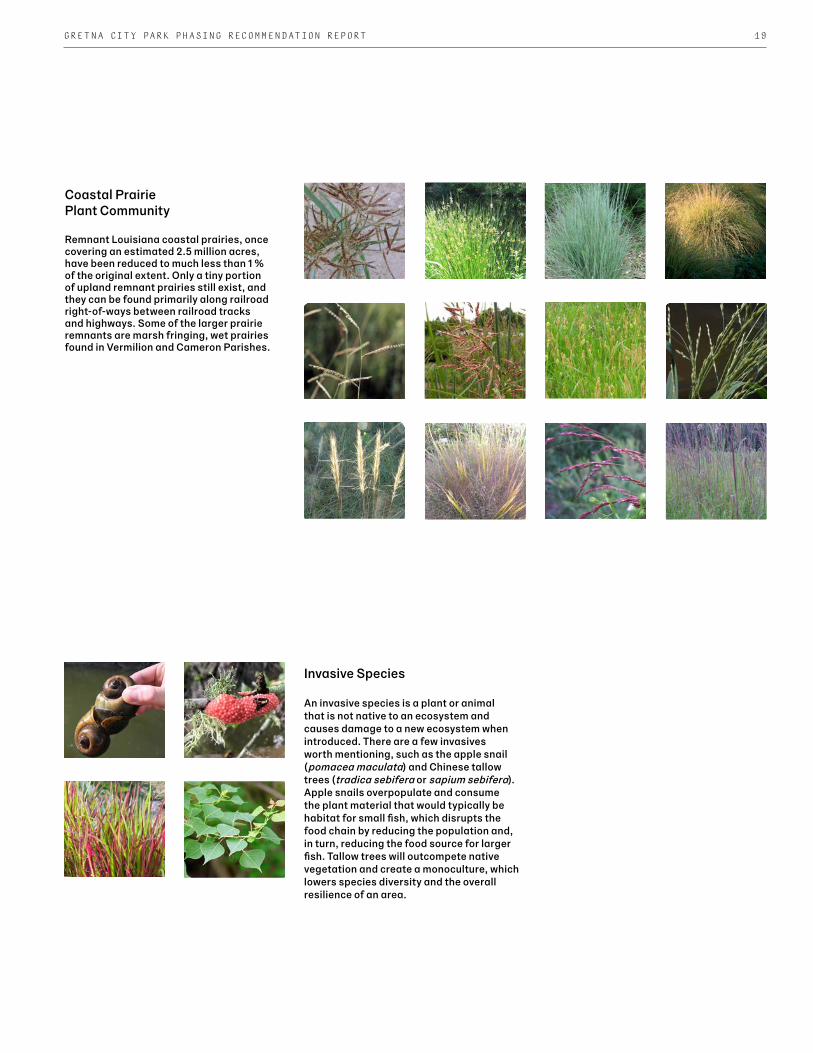
Coastal Prairie Plant Community
Remnant Louisiana coastal prairies, once covering an estimated 2.5 million acres, have been reduced to much less than 1 % of the original extent. Only a tiny portion of upland remnant prairies still exist, and they can be found primarily along railroad right-of-ways between railroad tracks and highways. Some of the larger prairie remnants are marsh fringing, wet prairies found in Vermilion and Cameron Parishes.
Gol
den
Appl
e Sn
ail E
gg M
ass
(Pom
acea
can
alic
ulat
a)
Chin
ese
Tallo
w T
ree
(Tria
dica
seb
ifera
)
Gol
den
Appl
e Sn
ails
(Pom
acea
can
alic
ulat
a)
Cogo
n G
rass
(Impe
rata
cyl
indr
ica)
COM
MON
INVA
SIVE
SPE
CIES
Gol
den
Appl
e Sn
ail E
gg M
ass
(Pom
acea
can
alic
ulat
a)
Chin
ese
Tallo
w T
ree
(Tria
dica
seb
ifera
)
Gol
den
Appl
e Sn
ails
(Pom
acea
can
alic
ulat
a)
Cogo
n G
rass
(Impe
rata
cyl
indr
ica)
COM
MON
INVA
SIVE
SPE
CIES
Gol
den
Appl
e Sn
ail E
gg M
ass
(Pom
acea
can
alic
ulat
a)
Chin
ese
Tallo
w T
ree
(Tria
dica
seb
ifera
)
Gol
den
Appl
e Sn
ails
(Pom
acea
can
alic
ulat
a)
Cogo
n G
rass
(Impe
rata
cyl
indr
ica)
COM
MON
INVA
SIVE
SPE
CIES
Gol
den
Appl
e Sn
ail E
gg M
ass
(Pom
acea
can
alic
ulat
a)
Chin
ese
Tallo
w T
ree
(Tria
dica
seb
ifera
)
Gol
den
Appl
e Sn
ails
(Pom
acea
can
alic
ulat
a)
Cogo
n G
rass
(Impe
rata
cyl
indr
ica)
COM
MON
INVA
SIVE
SPE
CIES
Beak
ed s
edge
s(R
hync
hosp
ora
spp.
)
Wire
gra
ss(S
part
ina
pate
ns)
Caric
sed
ges
(Car
ex s
pp. )
Big
blue
stem
(And
ropo
gon
gera
rdii)
Dro
psee
ds(S
poro
bolu
s sp
p.)
Littl
e bl
uest
em
(Sch
izac
hyriu
m s
copa
rium
)
Pani
c gr
ass
(Pan
cium
spp
.)
Brow
nsee
d pa
spal
um(P
aspa
lum
plic
atul
um)
Switc
h gr
ass
(Pan
cium
virg
atum
)Lo
ve g
rass
(Era
gros
tis s
pp.)
Purp
le-to
p (T
riden
s sp
p.)
Thre
e-aw
n gr
ass
(Aris
tida
spp.
)
Indi
an g
rass
(Sor
ghas
trum
nut
ans)
Nut
rush
es(S
cler
ia s
pp.)
Umbr
ella
sed
ge(C
yper
us s
pp.)
COM
MON
HER
BACE
OUS
SPEC
IES
Invasive Species
An invasive species is a plant or animal that is not native to an ecosystem and causes damage to a new ecosystem when introduced. There are a few invasives worth mentioning, such as the apple snail (pomacea maculata) and Chinese tallow trees (tradica sebifera or sapium sebifera). Apple snails overpopulate and consume the plant material that would typically be habitat for small fish, which disrupts the food chain by reducing the population and, in turn, reducing the food source for larger fish. Tallow trees will outcompete native vegetation and create a monoculture, which lowers species diversity and the overall resilience of an area.

20 PHASE I ANALYSIS & ENGAGEMENT
Water quality benefits and ecological restoration can be realized at the same time as stormwater upgrades, and serve as a first step toward comprehensive ecological improvements in the park.
Observations
The defining feature of the park is its variety of native habitats--almost wilderness--in the midst of the city. While some large hero trees remain, improvements are required to return ecological function to a more natural state.
Water quality in the ponds is reduced by pollutants such as pesticides and excess fertilizer nutrients in stormwater runoff from surrounding areas. Nutrient surges and decomposition of organic matter in the water, like grass clippings, causes algae growth, reducing oxygen levels for wildlife. Aerating fountains partially mitigate this effect but do not address contaminants at the source.
Invasive plants and animals are a regional problem, including in Gretna City Park. Chinese Tallow trees quickly proliferate and shade out native species. The City of Gretna has already cleared limited perimeter areas of invasive trees along Claire Avenue. Invasive Apple Snails found in the ponds consume aquatic plants and steal resources from native species.
Design Approach
First, identification and mapping of hero trees and groves is needed for preservation. Invasive trees will be identified and mapped, with planned eradication in highly visible demonstration areas. Pond expansion can be planned for areas with high densities of invasive trees, and pond construction can optimize the depth of lagoons for sunlight penetration, aquatic plant growth, and fish habitat.
Pollutants and nutrients from urban runoff should be filtered through bioswales or settling basins
Water Quality & Ecologybefore entering the ponds. These features can be incorporated in areas where grade changes are already planned for new walking paths. Selective edges of ponds will be regraded to better support biofiltration of aquatic plant life.
Education about natural systems and their maintenance will be provided through signage, both for city crews and park patrons. Valuable education opportunities are available for Gretna Park Elementary and Gretna Middle School students in their own backyard.
Future Opportunities
A comprehensive ecological restoration and maintenance strategy is recommended as part of a future phase.
Full invasive plant and animal remediation would include a plan for sustained eradication, potentially in collaboration with state agencies and local schools and non -profits.
Water monitoring is recommended to document stormwater volumes, suspended sediments, salinity, phosphates, and other pollutants. Groundwater monitoring wells are needed to understand the interaction of surface and groundwater in order to balance the water table and limit subsidence.
Reference the Deltares water quality memo in the appendix for more information.
Invasive Apple Snails in City Park, first documented in Louisiana near Gretna in 2006

21GRETNA CITY PARK PHASING RECOMMENDATION REPORT
Existing conditions survey of Gretna City Park, September 2019. To increase water storage within Park, existing ponds will need to be dredged and pond edges will take on new shapes, providing opportunities for habitat improvements.
Potential "shelf" re-grades for aquatic plants
Stormwater inlet; potential settling basin location
Stormwater inlet; potential settling basin location
Aeration fountain
Aeration fountain
Weir structure (Outlet to Hero Canal)
Shirly Johnson/Gretna Park Elementary
Gretna Middle School
Approximate area of previous invasive tree remediation

22 PHASE I ANALYSIS & ENGAGEMENT
In addition to current park uses, residents prefer new opportunities for passive (non-competitive) recreation and gathering in City Park.
Building on the City of Gretna's past public engagement within the Resilience District through LASAFE, a public meeting was held on September 5, 2019 at Mel Ott Multipurpose Center to share stormwater model results, initial design ideas, and gather input on residents' needs, uses, and ideas for Gretna City Park. A site walk was also conducted with City and State project leadership in spring 2019.
Community Program Preferences
A "dot exercise" allowed community members to select the types of elements they would like to see in the park. The activities with the highest number of votes are listed first, indicating a preference for passive exercise and gathering activities.
• Walking / Running • Kayaking / Canoeing • Nature Pavilion • Exercise Course • Amphitheater Lawn • Biking • Butterfly Garden • Boardwalks • Pick-Up Games • Splash Pad • Cultural Festival • Interpretive Trails • Zip-Lining • Birding • Treehouse
Additional comments and feedback received during the public meeting included:
• Handicap accessiblity on a fishing pier• Tallow tree abatement• Leaving the island as natural as possible;
activity would harm woodduck nesting• Interest in a cross-country racecourse
concept for walking trails• Bat houses• Plan for improvements to support an active
rugby community, including seating and parking
• Recommendation to investigate national organizations for grant-funding
These findings generally support and align with design proposals and with the City of Gretna's goals of low maintenance program and landscapes.
Future engagement with neighborhood residents is expected to occur via the City of Gretna with updates throughout the design process.
Public Engagement
Gretna representatives & project team, site visit & public meeting

23GRETNA CITY PARK PHASING RECOMMENDATION REPORT
Community Meeting Program Preferences by Theme
Pick-Up Games Splash Pad Ziplining Treehouse
Walking / Running Kayaking / Canoeing Exercise Course Biking Boardwalks
Butterfly Garden Interpretive Trails Birding
Nature Pavilion Amphitheater Lawn Cultural Festival
Play
15%
Exercise
49%
Learn
13%
Gather
23%


5.
Proposed Design ProgramProgrammatic Elements:
1. Added Water Storage2. Landforms3. Boardwalks & Trails4. Arrival & Wayfinding5. Multipurpose Pavilion
Low-Maintenance Plan
Proposed Budget
26 PHASE I PROPOSED DESIGN PROGRAM
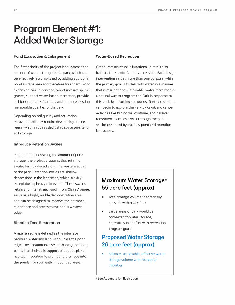
Pond Excavation & Enlargement
The first priority of the project is to increase the amount of water storage in the park, which can be effectively accomplished by adding additional pond surface area and therefore freeboard. Pond expansion can, in concept, target invasive species groves, support water-based recreation, provide soil for other park features, and enhance existing memorable qualities of the park.
Depending on soil quality and saturation, excavated soil may require dewatering before reuse, which requires dedicated space on-site for soil storage.
Introduce Retention Swales
In addition to increasing the amount of pond storage, the project proposes that retention swales be introduced along the western edge of the park. Retention swales are shallow depressions in the landscape, which are dry except during heavy rain events. These swales retain and filter street runoff from Claire Avenue, serve as a highly visible demonstration area, and can be designed to improve the entrance experience and access to the park's western edge.
Riparian Zone Restoration
A riparian zone is defined as the interface between water and land, in this case the pond edges. Restoration involves reshaping the pond banks into shelves in support of aquatic plant habitat, in addition to promoting drainage into the ponds from currently impounded areas.
Water-Based Recreation
Green infrastructure is functional, but it is also habitat. It is scenic. And it is accessible. Each design intervention serves more than one purpose: while the primary goal is to deal with water in a manner that is resilient and sustainable, water recreation is a natural way to program the Park in response to this goal. By enlarging the ponds, Gretna residents can begin to explore the Park by kayak and canoe. Activities like fishing will continue, and passive recreation—such as a walk through the park—will be enhanced by the new pond and retention landscapes.
Program Element #1: Added Water Storage
Maximum Water Storage*55 acre feet (approx)• Total storage volume theoretically
possible within City Park
• Large areas of park would be converted to water storage, potentially in conflict with recreation program goals
Proposed Water Storage26 acre feet (approx)• Balances achievable, effective water
storage volume with recreation priorities
*See Appendix for illustration

27GRETNA CITY PARK PHASING RECOMMENDATION REPORT
G R E T N A r e s i l i e n c e K I C K S T A R TG R E T N A c i t y p a r k i m p r o v e m e n t s
1.76 ac
1.46 ac
1.64 ac
3.70 ac
2.19 ac
detention: 26.29 ac. ft.
1.22 a
c
1.00 a
c
1.39 a
c
1.12
ac
3.12
ac
HERO
/HEE
BE C
ANAL
CLAI
RE A
VE.
MASON
AVE.
CREA
GAN AV
E.
TOTAL: 15.26 ACtotal pond area
water
1
2
3
4
56
SCALE: 1” = 150’-0”
0 75 150 300 NORTH
L e g e n d
1
2
3
4
5
6
g r e t n a b l v d i n l e t
E X I S T I N G P O N D - N O R T H
P O N D C O N N E C T I O N
E X I S T I N G P O N D S O U T H
o p e n w a t e r - 1 F T. A D D E D F R E E B O A R D
d i r e c t i o n o f d r a i n a g e f l o w t o c i t y p a r k
l i m i t s o f c i t y p a r k d r a i n a g e b a s i n
F L O O D P L A I N - A V E R A G E 1 F T. D E P T HP E R I M E T E R S W A L E S - A V E R A G E 1 F T. D E P T H
B E L L E V U E E N T R Y D E M O N S T R A T I O N
h e e b e / h e r o e n t r y / d e m o n s t r a t i o n
p r e s e r v e d f o r e s t e d l a n d
forest pond
floodplain
perimeter swales - wet
perimeter swales - dry
enhanced ponds
H I G H G R O U N D
BACKYARD BUFF
ER
BACKYARD BUFF
ER
Proposed Water Storage Scenario 26 acre feet
The design approach creates recreational opportunities through water storage and filtration strategies.

28 PHASE I PROPOSED DESIGN PROGRAM
Groudparken, LINK Arkitektur - strategy for western edge of Park
Kayaking is a great way for residents to engage with wildlifehttps://www.latimes.com/lifestyle/story/2019-08-13/best-paddling-kayaking-in-los-angeles
Gretna resident fishing in northern pond at City Park
Riparian edgehttps://www.usga.org/course-care/forethegolfer/managing-water-features.html
Riparian edgehttps://www.usga.org/course-care/forethegolfer/managing-water-features.html
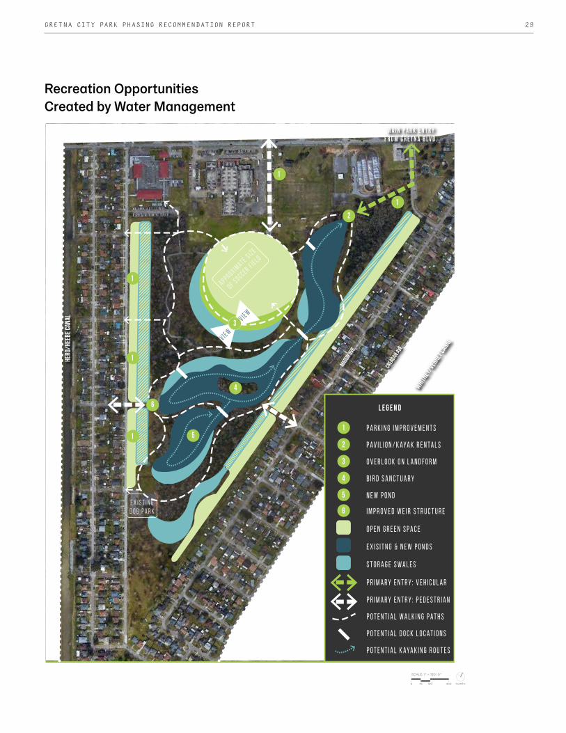
29GRETNA CITY PARK PHASING RECOMMENDATION REPORT
Kayaking is a great way for residents to engage with wildlifehttps://www.latimes.com/lifestyle/story/2019-08-13/best-paddling-kayaking-in-los-angeles
G R E T N A r e s i l i e n c e K I C K S T A R TG R E T N A c i t y p a r k i m p r o v e m e n t s
kayaking/canoeing
SCALE: 1” = 150’-0”
0 75 150 300 NORTH
New opportunities for recreation
HERO
/HEE
BE C
ANAL
MASON
AVE.
CREA
GAN AV
E.
WHITNEY
/VER
RET C
ANAL
Park features
1
1
1
1
1
2
6
3
4
51
2
3
4
5
L e g e n d
P a r k i n g i m p r o v e m e n t s
P a v i l i o n / k aya k r e n t a l s
B i r d s a n c t u a r y
O v e r l o o k o n l a n d f o r m
N e w p o n d
6 I m p r o v e d w e i r s t r u c t u r e
O p e n g r e e n s p a c e
P r i m a r y e n t r y : p e d e s t r i a n
P o t e n t i a l w a l k i n g p a t h s
P o t e n t i a l d o c k l o c a t i o n s
P o t e n t i a l k aya k i n g r o u t e s
P r i m a r y e n t r y : v e h i c u l a r
e x i s i t n g & n e w p o n d s
S t o r a g e s w a l e s
A p p r ox i mat e s i z e
o f s o c c e r f i e l d
v i e w
v i e w
parking
multi-use spaces
kayak rentals/entry pavilion
open lawn at pond edge
bird sanctuary
landform
boardwalks
acti
ve r
ecre
atio
npa
ssiv
e rec
reat
ion
e x i s t i n g d o g p a r k
M A I N P A R K E N T R Y F R O M G R E T N A B L V D .
Recreation OpportunitiesCreated by Water Management

30 PHASE I PROPOSED DESIGN PROGRAM
Cut & Fill
The process of excavating (cut) and enlarging the ponds will result in surplus soil (fill material). Utilizing this material on-site eliminates the need (and cost) for soil removal, and can dramatically elevate visitors' experiences.
The fill is proposed to serve two purposes. The first involves creating a berm, or mound, that surrounds the pick-up playfield. This is already the highest part of the site, but by adding fill to this area, there exists the opportunity to build a hill from which visitors can more easily view sporting events occuring in the heart of the park. Imagine if spectators could see the New Orleans skyline from the top—a topographic icon.
The second use is in creating unique path-landscapes that weave in and out of the berms. These paths will shape view corridors in the park and support "dry feet" elevation through low areas.
Program Element #2: Landforms
The Hills on Governors Island, West 8
Limelight, Meyer + Silberberg Landscape Architects
Harrington Grove Country Club, Hassell Architects

31GRETNA CITY PARK PHASING RECOMMENDATION REPORT
Active & Passive Recreation
Active recreation generally refers to team or individual activities that require equipment, fields, or courses, whereas passive recreation, such as walking or picnicking, does not require any special equipment. With a robust system of boardwalks and trails snaking through Gretna City Park, visitors will encounter activities that range from more active components near Gretna Boulevard to more passive activities as they reach the southern end of the park.
The trails will provide connectivity between adjacent neighborhoods across the park, providing access to amenities such as the existing dog park. These trails will also lead through different types of ecosystems, providing educational opportunities on native species and habitats, and highlight the natural beauty of the park.
Multi-Use Paths
There are several paths that currently exist within the park. A goal of the project is to strengthen this network of paths, providing connectivity and the potential for people to access the park more easily. In wet areas, these paths will likely be boardwalks; in dry areas, they will likely be an aggregate material. These paths will be ADA accessible, and will be fit for walking, running, and potentially biking. Adding mile markers along the paths will allow the park to be used as a 2k or 5k cross-country course.
Gravel path in lawnhttps://bettsremodeling.com/blog/build-beautiful-and-cheap-garden-path/
Shangri La Botanical Gardens in Orange, Texas by Carbo Landscape Architects
Program Element #3: Boardwalks & Trails

32 PHASE I PROPOSED DESIGN PROGRAM
Access points into Gretna City Park
Park Access
Parking
At present, Gretna City Park is entered by vehicle along the northern edge, on an extension of Huey P. Long Avenue. This minor road terminates near the Gretna Observatory, located within the fenced-in portion of Gretna Middle School. Parking either occurs here, near the BMX zone, or along the streets bordering the park.
The project's strategy is to supplement parking off Gretna Boulevard for public programming, and improve ad hoc lawn parking off Claire Avenue and in front of the water control structure. Through site visits and discussions with the City, it became clear that the residents on the western edge of the Park treat the strip of grass along Claire Avenue as an extension of their front yards and driveways. This use can be organized, and muddy lawn mowing eliminated, through the introduction of retention swales, natural berms, and possibly footpaths in this area.
Signage
As with any public space, signage and wayfinding are important components to the visitors' collective experience. Signage will be introduced at key entrance points to announce entry to the Park, and along the trails, provide information on distance traveled, ecosystem function and protection, and park safety.
Middleton Place Parking Lot, Charleston, South Carolina
Program Element #4: Arrival & Wayfinding
Claire Ave Entrance
Dog Park Entrance
Mason St Entrance
Huey P. Long Ave Entrance
Lafayette St Entrance

33GRETNA CITY PARK PHASING RECOMMENDATION REPORT
Covered Outdoor Space
The multipurpose pavilion will provide a covered outdoor space under which programming can take place—whether it be yoga, casual conversations among neighbors, or a quick duck out of the rain. This key piece of architecture will define the space and energy of the park. The pavilion will be constructed of materials that can stand up to the heat and humidity, as well as age beautifully, with a preference for traditional forms and natural materials including wood and stone.
Ecological Education Center
Both Shirley Johnson/Gretna Park Elementary School and Gretna Middle School are located adjacent to Gretna City Park. This provides a unique opportunity to incorporate an educational component into the park redesign. The pavilion can serve as an outdoor classroom sited near key
The Dixon Water Foundation Josey Pavilion, Lake | Flato Architects Cajun Encounters Pavilionhttps://www.cajunencounters.com/blog/cajun-encounters-where-spice-and-adventure-meet-in-louisiana/
Program Element #5: Multipurpose Pavilion
native and restored habitats. As the design of the pavilion is developed, it will be important to envision groups of different sizes with different types of instructors using the space.
Kayak Storage
With increased water accessibility comes kayaking and canoeing, which necessitates storage. The pavilion may include boat storage, and this, in turn, creates an opportunity for the City to rent out kayaks and canoes, and/or offer private kayak storage for Gretna residents.

34 PHASE I PROPOSED DESIGN PROGRAM
Tree Survey
Gretna City Park contains specific plants that the community would like to preserve, such as existing stands of forested areas and a sizable blackberry bush that has significance within the community, as well as a significant population of invasive plant species. Park improvements will include selective removal of invasive species from designated areas, to promote the growth of native species.
A professional tree survey is needed to identify significant and/or sizable trees that will be maintained. A tree survey can serve as a solid foundation for preserving existing habitats, developing a maintenance schedule, and exercising control over drainage and erosion. Highlighting the floral diversity present within the park will also be a priority during this task.
Soil Borings
Before sampling site soils, it is important to understand how the site was used previously—was there a landfill, or historic body of water here? It is also important to know if there have been soil tests historically, which can help determine if the site had any contamination that was (or needs to be) remediated.
Understanding the types of soils and how quickly they allow stormwater to infiltrate can impact how a site is designed. Soils can have different physical, chemical, and biological properties. Soil borings can also indicate how high the water table is, and if it is only high seasonally, which impacts how much water can be stored on-site. These tests can also inform what will grow best in an area and load requirements for structural foundations.
Design Phase Data Needs
WBAE & Deltares soil and water analysis for Mirabeau Water Garden in Gentilly A tree survey indicates trees of interest on a sitehttp://www.georgialandsurveying.com/wp-content/uploads/2011/04/DSC_00741.jpg

35GRETNA CITY PARK PHASING RECOMMENDATION REPORT
Mature Specimen Trees
• Every three years: under arborist supervision, prune in late winter to encourage high branching near paths
• Seasonally: Monitor and inspect trees for signs of disease, treat as needed
• As needed: Remove dead, broken, or fallen branches from circulation routes
New Trees
• Late Winter: Under arborist supervision, prune to encourage high branching near parking, paths, and open space
• Early Spring: Maintain 3” mulch layer and fertilize• Twice annually: Remove vines and sucker growth• Seasonally: Monitor and inspect trees for signs of disease,
treat as needed• As needed: Remove dead, broken, crossing, or fallen
branches, water during drought
Forested Areas
• 2-3 times per year: Perform understory clearing on the outer edge, removing understory planting including trees of 3” DBA and below in the first 25 feet from forested edge
• Following storm events: remove fallen branches and debris from pathways
Floodplain Planting
• Early Spring: maintain 3" mulch layer; remove silt/sediment accumulation from drainage structures
• Monthly: within the first 3 years of establishment, manually remove invasive plant species
• Seasonally: After the first 3 years of establishment, remove invasive plant species
• First 3 years of establishment: Monitor and water plants during drought
• Following storm events: remove debris and sediment accumulation, check overflow catch basins for clogging
Meadow Planting
• Early Spring: cut back to 6” above the ground• Late Summer: cut back to 18-24” above the ground to
control height if necessary• Monthly: within the first 3 years of establishment, remove
invasive plant species• Seasonally: After the first 3 years of establishment,
manually remove invasive plant species• First 3 years of establishment: Monitor and water plants
during drought
Anticipated Low-Maintenance Design Elements
Parking Planting
• Annually: replace dead or dying plant material• Early Spring: Maintain 3” mulch layer and remove silt/
sediment accumulation; prune shrubs and cut back dead foliage
• Monthly: within the first 3 years of establishment, manually remove invasive plant species
• Seasonally: After the first 3 years of establishment, manually remove invasive plant species
• First 3 years of establishment: Monitor and water plants during drought
• Following storm events: remove debris and sediment accumulation, check overflow catch basins for clogging; replace any displaced mulch
Grass Swales, Open Lawn & Berm
• Twice annually: fertilize• Monthly: inspect for ant hills and treat• March – September: remove trash and debris, mow weekly• October – February: remove trash and debris, mow twice
monthly• Following storm events: remove debris and sediment
accumulation, check overflow catch basins for clogging
Paths, Boardwalks & Paved Areas
• Following storm events: remove trash and debris• Early Spring: Maintain top gravel layer on all paths,
providing a level walking surface• Seasonally: inspect boardwalks for any warping, splitting,
or rot and repair and replace as needed, inspect guardrails for any loose or sagging cables, loose fasteners, or rust and repair or replace as needed, clean boardwalks by sweeping, cleaning with soap and water and a stiff brush and rinse off
• March – September: mow lawn paths weekly• October – February: mow lawn paths twice monthly• Weekly: sweep or blow-off all walks, curbs, and parking
areas; remove all litter from sidewalks and parking areas• Inspect concrete areas for any cracks, spalling, control
or expansion joint deterioration and repair as needed by sealing cracks, resealing joints, or cutting and patching damaged concrete
Lighting
• Twice annually: inspect fixtures and replace bulbs as needed; inspect poles and repair as needed
Pavilion
• Inspected periodically for signs or premature aging, rust, or issues related to overall safety

36 PHASE I PROPOSED DESIGN PROGRAM
Proposed Budget*Program Element:
#1 Added Water Storage
#2 Landforms
#3 Boardwalks & Trails
#4 Arrival & Wayfinding
#5 Multipurpose Pavilion
Includes: Approximate Cost:
• Earthwork• Pond Excavation• Selective Clearing• Drainage Infrastructure• Floodplain & Tree Planting• Seeded Lawn
• Earthwork• Seeded Lawn
• Paths• Boardwalks• Lighting• Selective Clearing
• Parking• Entry Signage• Wayfinding Signage• Lighting• Drainage Infrastructure
• Interior Space• Exterior Space
$1,936,000
$264,000
$1,288,000
$1,156,000
$550,000
Grand Total: $5,194,000
*See Appendix for more detailed cost breakdown.

37GRETNA CITY PARK PHASING RECOMMENDATION REPORT
The weir structure is a potential site for a new dock or pavilion structure.


Future PhasesOpportunities
Program
Budget Outline

40 FUTURE PHASES
Water Storage
Initial storage estimates during the programming phase identified up to 29 future additional acre feet of storage in City Park, depending on need to reserve ground for recreation priorities. Additional storage could accomodate runoff volumes of larger storms and potentially new inflows from the 25th Street sub basin. Drainage & Flood Protection Infrastructure
Berms and flap gates along the Hero Canal have been proposed to prevent overtopping, a cause of repetitive flooding in the area during large storms.
There is potential for subsurface drainage connections between the 25th Street and Gretna City Park sub basins to make use of park storage capacity and reduce drainage pressure on the Hero Canal.
Drainage "self sufficiency" in the Resilience District can benefit downstream communities by limiting runoff volumes, but new canal infrastructure must be studied to determine watershed impacts.
Improved Environmental & Water Quality
Water quality can be further improved through additional future bioremediation within the park. Settling basins, treatment trains, and pond edge improvements can be enlarged and extended. Strategies to clean water before it enters the park should also be considered, such as bioswales and pervious parking in surrounding parking lots and streets.
Invasive species removal can occur beyond the initial demonstration scope of the proposed work to encompass the entire park.
Monitoring networks for water levels, water
quality, and groundwater can be installed in the park to gather data for future design, maintenance and mitigation (see appendix for Deltares report).
Local groups may be able to participate in water quality monitoring; this will build local buy-in and provide educational opportunities. School property can become a living laboratory connected to City Park's ecosystems.
Recreation & Amenities
Additional park amentities can build on the water-centric redesign while preserving its natural character. Future recreational opportunities may include preferences from previous public meetings, including an exercise course throughout the park, a butterfly garden, paths designated for biking, and a youth play space. Rugby and playing field upgrades, including additional parking, may be developed.
Resilience Awareness & Education
The goal of the LA SAFE and the Gretna Resilience District is to address community resilience holistically. Part of this approach engaging stakeholders throughout the watershed, upstream and downstream, and educating residents about flooding and environmental impacts at the district, city, and parish scales.
Future Resilience District Project Opportunities
Initiatives like the GRD build knowledge, and projects like Gretna City Park can become feedback loops for best practices for future efforts.

41GRETNA CITY PARK PHASING RECOMMENDATION REPORT
Topography indicates potential future use: informal playing fields are open space, but occupy high ground, which makes water storage here difficult.

42 FUTURE PHASES
G R E T N A r e s i l i e n c e K I C K S T A R TG R E T N A c i t y p a r k i m p r o v e m e n t s
SCALE: 1” = 150’-0”
0 75 150 300 NORTH
phase 2: improvements to water quality and ecology
LANAC EBEEH/OREH
MASON
AVE.
CREA
GAN AV
E.WHITN
EY/V
ERRE
T CAN
AL
Park features
L e g e n d
f o r e b ay / s e t t l i n g b a s i n
c o n s t r u c t e d w e t l a n d s
g r a s s s w a l e c o n v e r t e d t o p l a n t e d b i o s w a l e
r i p a r i a n e d g e p l a n t i n g s
1
2
n u t r i e n t t r e a t m e n t p o n d
r e c r e a t i o n p o n dg
M A I N P A R K E N T R Y F R O M G R E T N A B L V D .
1
2
2
O p e n g r e e n s p a c e
e x i s i t n g & n e w p o n d s
S t o r a g e s w a l e s
f l o o d w a l l B e r m & p a t h s
t r a i l & E n t r i e s t o p a r k
Gretna City Park Potential Improvements
• Additional water storage volume may be increased by expanding the ponds or adding detention along perimeter edges, below fields and parking lots, or within recreated wetlands.
• The treatment pond is still considered navigable by kayaks and canoes, but will serve primarily as treatment of the stormwater runoff as it enters from both inlets.
• The other two ponds (one existing and one proposed in planned improvements) will serve primarily as recreation ponds, as they will have cleaner water and increased habitat through the proposed improvements.
• Forebay/settling basins at the inlet locations will allow sediment and debris to settle and nutrients, organic debris, and other pollutants to filter through plants.
• Constructed wetlands are proposed surrounding the perimeter of the treatment pond to further filter and clean the runoff conveyed to the pond by the adjacent bioswales.
• Riparian edge plantings along the recreation ponds are proposed to increase habitat at the pond edge.
• Portions of the grass swales are proposed to be converted to planted bioswales for added filtration and pollutant removal from the runoff of neighboring streets and residences.
Focus for Future Phase: Environmental & Water Quality

43GRETNA CITY PARK PHASING RECOMMENDATION REPORT
Future Phase Budget Outline*
Element:
#1 Flood Risk Reduction
#2 Ecological Restoration & Water Quality Interventions
#3 Added Boardwalk & Trail Connectivity
#4 Opportunities for Additional Recreational Development
#5 Expanded Arrival & Wayfinding Interventions
Includes: Approximate Cost:
• Sheet piling and flap gates relative to Hero Canal
• Earthen mounding relative to Hero Canal overflow conditions
• Added internal water storage
*Budget estimates provided by the City of Gretna
• Wetland, coastal prairie, bottomland, and hardwood forest plantings
• Constructed meadows, constructed wetlands, bioswale plantings, riparian restoration, other RoW and placemaking planting opportunities
• Invasive species removal• Water quality demonstration points• Other environmental education opportunities
• Boardwalks and trails• Low impact lighting• Exercise course
• Exercise course• Interactive water feature• Butterfly garden• Urban birdwatching programming
• Additional expressed neighborhood entry points
• Gretna Boulevard arrival interventions
$2,210,000
$1,760,000
$750,000
$660,000
$420,000
Total: $5,800,000


AppendixGretna City Park Floodplain Maps
Water Quality & Ecology Report
Endangered Flora & Fauna

46 APPENDIX: ENDANGERED FLORA & FAUNAG R E T N A r e s i l i e n c e K I C K S T A R TG R E T N A c i t y p a r k i m p r o v e m e n t s
1.14 ac
3.19 ac 7.50 ac
14.96 ac
20.23 ac
detention: 55.31 ac. ft.water
CLAI
RE A
VE.
MASON
AVE.
WHITNEY
/VER
RET C
ANAL
1
2
3
4
56
HERO
/HEE
BE C
ANAL
CREA
GAN AV
E.
SCALE: 1” = 150’-0”
0 75 150 300 NORTH
TOTAL: 8.29 ACtotal pond area
L e g e n d
1
2
3
4
5
6
g r e t n a b l v d i n l e t
E X I S T I N G P O N D - N O R T H
P O N D C O N N E C T I O N
E X I S T I N G P O N D S O U T H
E X I S T I N G P O N D - 1 F T. A D D E D F R E E B O A R D
d i r e c t i o n o f d r a i n a g e f l o w t o c i t y p a r k
l i m i t s o f c i t y p a r k d r a i n a g e b a s i n
F L O O D P L A I N - A V E R A G E 1 F T. D E P T HP E R I M E T E R S W A L E S - A V E R A G E 1 F T. D E P T H
B E L L E V U E E N T R Y D E M O N S T R A T I O N
h e e b e / h e r o e n t r y / d e m o n s t r a t i o n
55 acre feet* *For conceptual estimating & analysis purposes only; potentially conflicts with recreational, ecological, and character-defining aspects of the park.
Maximum Water Storage Scenario

47GRETNA CITY PARK PHASING RECOMMENDATION REPORT
Gretna Resilience District Kickstart
Gretna, Louisiana
December 9, 2019
PROGRAMMING PHASE
Legend
includes:
70% Earthwork 1 LS 458,122$ 458,112$ LS = Lump SumPond excavation - 5' depth 54,259 CY 8$ 406,943$ CY = Cubic Yards
50% Selective Clearing 1 LS 4,500$ 4,500$ EA = Each50% Drainage 1 LS 313,125$ 313,125$ AC = AcresWetland Planting 28,620 EA 15$ 429,300$ SF = Square Feet
Trees 200 EA 500$ 100,000$ ALLOW = Allowance
Seeded Lawn - 12 acres 12 AC 4,000$ 48,000$
1,759,979$
1,935,977$
includes:
30% Earthwork 1 LS 196,334$ 196,334$
Seeded Lawn - 11 acres 11 AC 4,000$ 44,000$
240,334$
264,367$
includes:
Gravel Paths, 2 miles, 8' wide 84,480 SF 6$ 506,880$
Boardwalks, 8' wide 3,200 SF 75$ 240,000$
Railing 800 LF 175$ 140,000$
Concrete Paths, 6' wide 24,330 SF 8$ 194,640$
Interpretive Trail Signage 25 EA 400$ 10,000$
Lighting 1 ALLOW 75,000$ 75,000$
50% Selective Clearing 1 LS 4,500$
1,171,020$
1,288,122$
includes:
Park Entrance Lot: paving 15,000 SF 12$ 180,000$
Park Entrance Lot: curb 800 LF 25$ 20,000$
Park Entrance Lot: landscape 6,400 SF 15$ 96,000$
Claire Ave: paving 15,000 SF 12$ 180,000$
Claire Ave: curb 1,560 LF 25$ 39,000$
Claire Ave: landscape 7,500 SF 15$ 112,500$ Gretna Blvd. Entrance Monument Signage, 5' X 6' 1 ALLOW 20,000$ 20,000$ Claire Ave. Entrance Monument, 4' X 3' 1 ALLOW 15,000$ 15,000$ Bellevue Entrance Monument, 4' X 3' 1 ALLOW 15,000$ 15,000$
Lighting 1 ALLOW 60,000$ 60,000$
50% Drainage 1 LS 313,125$ 313,125$
1,050,625$
1,155,688$
includes:
Interior space 500 SF 200$ 100,000$
Open-air space 2,000 SF 200$ 400,000$
500,000$
550,000$
TOTAL 4,721,958$
10% Contingency 472,196$
GRAND TOTAL 5,194,153$
W/ 10% CONTINGENCY
W/ 10% CONTINGENCY
W/ 10% CONTINGENCY
W/ 10% CONTINGENCY
W/ 10% CONTINGENCY
Program Element #3 Subtotal
Program Element #1: Added Water Storage
Program Element #4: Arrival & Wayfinding
Program Element #1 Subtotal
Program Element #4 Subtotal
Program Element #2: Landforms
Program Element #2 Subtotal
Program Element #5: Multipurpose Pavilion
Program Element #5 Subtotal
Program Element #3: Boardwalks & Trails
Design & Construction Cost Breakdown

48 APPENDIX: WATER QUALITY & ECOLOGY REPORT
Grety City Park Memo Water Monitoring & Environmental Quality 24 September 2019 Roelof Stuurman Geohydrologist
1 Introduction
Deltares has a long history of collaboration on water management projects with Waggonner & Ball, including the Greater New Orleans Urban Water Plan and the Mirabeau Water Garden. Based on the experiences in Mirabeau, and as partner in the New Orleans City Park storage initiative, Deltares can advise on water monitoring and environmental quality for Gretna City Park with an understanding of regional hydrodynamics.
2 City Park visit and other observations
As we could see during our April 2019 visit to the park, after studying Google Earth time series maps, and reviewing Louisiana Department of Natural Resources ecology reports, water quality and ecology are serious concerns. Therefore we need: • To understand water quality and ecology deterioration processes:
o Water quality of recharged storm drainage water (time series); o Water quality (seasonal) in present lagoons (3 sample locations: inflow, middle,
outflow); o Thickness, origin (urban, or local organic material like leaves or algae?) and quality
of lake bed sediments; o Methods for remediating polluted dredge (drying/burning, covering); o A better understanding of the relationship water quality, trees shadow, and sunlight
(perhaps helpful in design). I recommend a spatial lagoon design based on a differentiation in lagoons: (a) runoff reception and collection lagoons, (2) water quality treatment lagoons, (3) Recreational lagoons with high water quality.
o Water circulation between some or all of these lagoons may increase water quality; o The existing local City Park hydraulic model can support this design.
I recommend beginning as soon as possible with monitoring the existing conditions.
o Multiple sample locations (incl. a variety of habitats and ecologies) o Meteorological data, especially rainfall events and evaporation o 3 sensors to monitor surface water level fluctuations and temperature; o Approx. 6 sensors to monitor shallow groundwater and groundwater – surface
water relationships.
Water Monitoring & Environmental Quality Memo

49GRETNA CITY PARK PHASING RECOMMENDATION REPORT
Based on this data, Deltares has had success in the past developing a 3D-geology model (incl. old dumps, etc.) and groundwater model to explain the subsurface transport of pollutants and potential subsidence implications for surrounding structure.
3 Objectives of Deltares study
In consultation with Waggonner & Ball and Carbo, the following Deltares project objectives are determined: 1. Water quality/ecology improvement recommendations: design parameters for settling
basins, biofiltration, pond dredging. 2. Water levels: how do we test different levels for the weir? What are impacts to
groundwater, bank stabilization, wildlife, pond habitats? 3. Monitoring: how to measure baseline volume and quality to prove impact? How to continue
to measure and improve over time? Groundwater monitoring? 4. Phasing: can any of this become the basis for a future project? How to connect sub-basins
in the future to possibly store more runoff?
4 Improvement of water quality and ecology
Despite not having the opportunity to access and study any existing water quality data, it is obvious that water quality is poor in the ponds. Low oxygen content seems to be an especially negative issue. Google Earth history records show that aerators were installed some years back in an attempt to remedy this negative situation. Low oxygen contents are related to eutrophication, and eutrophication is related to the quality of accepted storm water and local constraints. Storm water is supplying oxygen consuming substances like organic materials (leaves, grass clippings), but also nutrients like phosphates and nitrogen, mainly from lawn fertilizers. These nutrients stimulate algae growth in City Park lagoons. The decay of these algae and local leaves also consumes oxygen. The lagoon geomorphology (shape and depth), related water temperature, and the quality of lagoon bed soils will impact water quality. 1 The water quality of stormwater inflows needs to be improved;
a) By filtering out organic materials b) By creating awareness among the citizens to reduce fertilizer use (and pesticides, etc.)
2 Environmental quality can be improved within the park through better design and maintenance; a) Better manage of local organics, like more frequently dredging leaves (and algae) falling at the bottom of the lagoons or reducing entry of local grass clippings into lagoons b) Map and analyse existing dredge (lagoon bed) distribution c) Optimize depth of lagoons and light-shadow situations. d) Perhaps adding nutrient consuming wetland vegetation in combination with low-mow-grasses and/or less frequent mowing

50 APPENDIX: WATER QUALITY & ECOLOGY REPORT
e) Optimize water circulation and add more (nature-based) oxygenation f) Re-design connections between lagoons, thereby creating lagoons with different water quality and recreational functions. g) Incorporate the creation of ecological opportunities and habitats, such as creating more ecological quality and species diversity (e, g. aquatic fauna, dragon flies etc.) and in removing invasive species.
5 Surface water levels and groundwater interaction
At this moment no information is available about the relationship between surface water and groundwater. A better understanding can be helpful for the following purposes: 1 Reduce groundwater flooding of recreational areas (walkways etc.); 2 Create specific wetland zones; 3 Evaluate the impact of different (perhaps seasonal) lagoons’ water levels on the
surrounding area; 4 Understand the possible risks of drainage of polluted groundwater. These questions can be solved by installation of a monitoring network (see following section). After installation of the monitoring network we can also apply adaptive water management by executing several tests, like raising or lowering water levels and measuring the impact.
6 Water Monitoring
A surface and groundwater monitoring sensor network is proposed to improve water management of the City Park lagoons and in support of an improved lagoon design (to achieve more water storage, better water quality and ecology). The main monitoring objectives are: 1 Better understand surface water quality; 2 Understand surface water and groundwater interaction; 3 Understand groundwater flow towards the lagoons. The map below indicates the locations of proposed monitoring sites. All sites must be levelled and investigated for pre-existing underground utilities and infrastructure. Ad.1: 3 surface water monitoring sites are proposed (red dots). We propose to install high
frequency (1 hour) sensors (ECT-diver type) monitoring electrical conductivity, temperature and water level at the same time. Based on the first results we propose incidental sampling to determine nutrients and other constituents. The network is designed in a way that we measure the quality of supplied storm water and its alteration during residence in the lagoons.
Ad.2: 3 monitoring locations (a, b and c) are proposed to understand groundwater surface water interaction. The locations a and b are shallow (6-8 feet deep) groundwater

51GRETNA CITY PARK PHASING RECOMMENDATION REPORT
observation wells at approx. 30-40 feet distance from the lagoon banks. We propose to use high frequency (1 hour) water level sensors (Diver type or similar). The location c needs to be installed in the lagoon itself. This monitoring site will deliver information about infiltration or groundwater discharge into the lagoon.
Ad.3: 6 monitoring locations are proposed to better understand groundwater flow. If interested in only water quantity, shallow (6-9 feet) observation wells will suffice. If also interested in groundwater quality we advise to install additional deeper observation screens (30-40 feet).
Locations and depths can be adapted based on new information.
Figure 1: Proposed monitoring locations. Red: surface water level and quality monitoring locations; Brown: groundwater surface water interaction monitoring locations, Orange: groundwater observation well.

52 APPENDIX: FLOOD MAPS
ElevationThe dark-blue forms within the Park are the outlines of the existing ponds

53GRETNA CITY PARK PHASING RECOMMENDATION REPORT
100-Year FloodplainThe only areas that currently lie outside of the 100-year floodplain are Gretna Middle School, the Observatory, and the sports field

54 APPENDIX: FLOOD MAPS
ElevationThe darkest blue represents the lowest elevation

55GRETNA CITY PARK PHASING RECOMMENDATION REPORT
100-Year FloodplainThe majority of Gretna's Resilience District lies within the 100-year floodplain, as does most of the Park
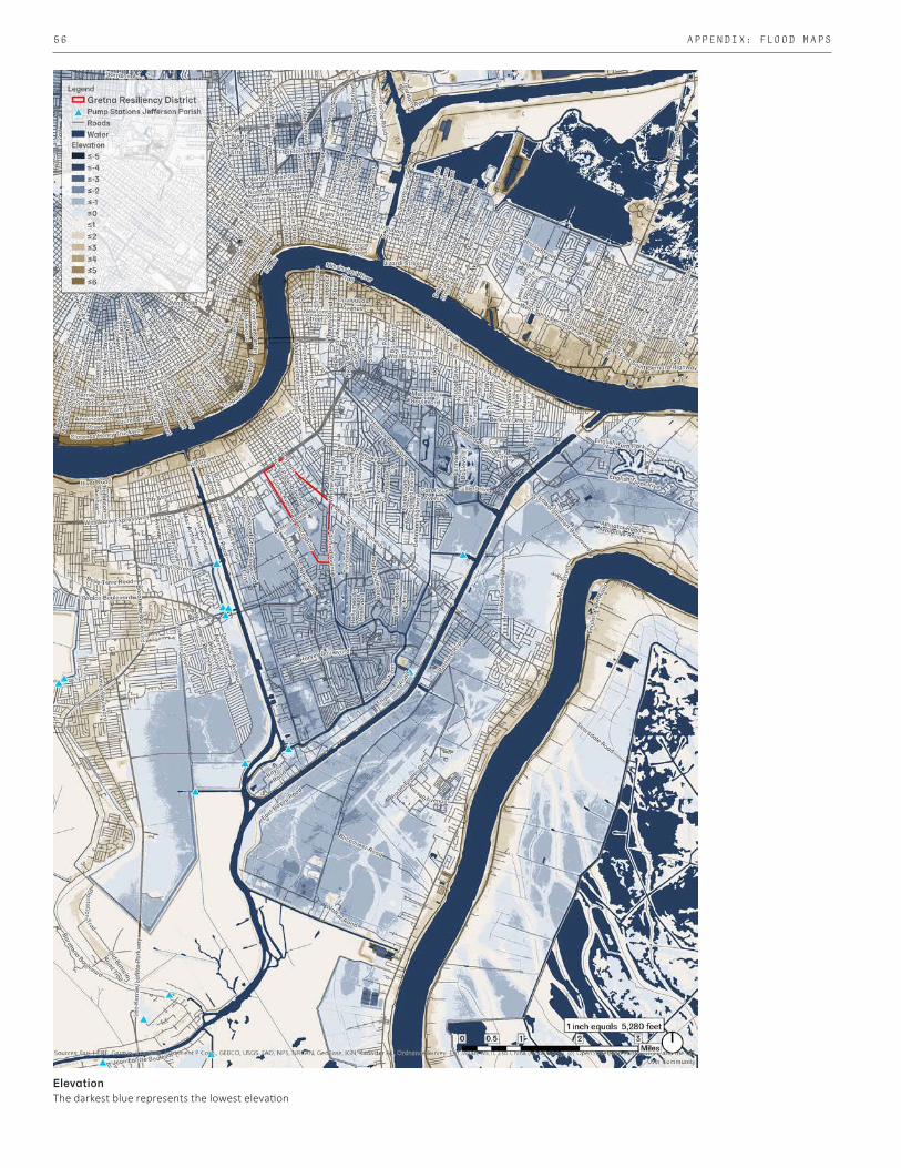
56 APPENDIX: FLOOD MAPS
ElevationThe darkest blue represents the lowest elevation

57GRETNA CITY PARK PHASING RECOMMENDATION REPORT
100-Year FloodplainThe majority of Gretna's Resilience District lies within the 100-year floodplain, as does most of the Park