Camdeboo National Park Park Management Plan - SANParks
83
Camdeboo National Park Park Management Plan For the period 2013 - 2023
-
Upload
khangminh22 -
Category
Documents
-
view
1 -
download
0
Transcript of Camdeboo National Park Park Management Plan - SANParks
Camdeboo National
Park
Park Management
Plan
For the period 2013 - 2023
CNP MP 2013 – 2023 - i
This management plan is hereby internally accepted and authorised as required for managing the Camdeboo National Park in terms of Sections 39 and 41 of the National Environmental Management: Protected Areas Act (Act 57 0f 2003).
Mr P. Burdett Date: 01 November 2012 Park Manager: Camdeboo National Park
Mr L. Moolman Date: 01 November 2012 General Manager: Frontier Cluster
Mr P. Daphne Date: 01 November 2012 Managing Executive: Parks
Dr David Mabunda Chief Executive: SANParks Date: 05 June 2013
Mr K.D. Dlamini Date: 10 June 2013 Chair: SANParks Board
Approved by the Minister of Water and Environment Affairs
Mrs B.E. E. Molewa, MP Date: 05 September 2013 Minister of Water and Environment Affairs
Section 1: Authorisation
CNP MP 2013 – 2023 - ii
No. Index Page
1 Section 1: Authorisations i
Table of contents ii
Glossary Iv
Acronyms and abbreviations v
Lists of figures, tables and appendices vi
Introduction vii
Section 2: Legal status 1
2.1 Name of the area 1
2.2 Location 1
2.3 History of establishment 1
2.4 Co-management agreements 1
2.5 Contractual agreements 1
2.6 Total area 1
2.7 Highest point 1
2.8 Municipal areas in which the park falls 1
2.9 International listings 2
2.10 Environmental planning authorisations 2
2.11 Biophysical and socio-economic description
2.11.1 Climate 2
2.11.2 Topography, geology and soils 2
2.11.3 Hydrology 2
2.11.4 Vegetation 2
2.11.5 Fauna 3
2.11.6 Palaeontology 3
2.11.7 Cultural heritage 3
2.11.8 Socio economic context 5
Section 3: Legal and policy framework 7
3 Introduction 7
Section 4: Consultation 9
Section 5: Purpose and vision 11
5.1 Purpose of the park 11
5.2 Vision and mission 11
5.3 SANParks corporate vision and mission of the desired state of Camdeboo National Park
11
5.4 Operating principles / values 11
5.5 Park context 12
5.6 Vital attributes 12
5.7 High level objectives 15
Section 6: Zoning plan 19
Section 7: Access and facilities 23
7.1 Public access and control 23
7.2 Airfields, flight corridors and their restrictions 23
7.3 Facilities for vessels 23
7.4 Visitor facilities 23
7.5 Administrative facilities 24
7.6 Other facilities 24
7.7 Mining 24
7.8 Commercial activities 24
7.9 Community use 24
CAM
DEB
OO
NATIO
NAL P
AR
K –
MANAG
EM
ENT P
LAN
Table of contents
CNP MP 2013 – 2023 - iii
No. Index Page
7.10 Servitudes 24
Section 8: Consolidation and expansion strategy 25
Section 9: Concept development plan 27
9.1 Long term development plan 27
9.2 Development node 27
Section 10: Strategic plan 28
10 Introduction 28 10.1 Bioregional 29
10.1.1 Bioregional landscape 29 10.2 Biodiversity 30
10.2.1 Ecological integrity 30
10.2.2 Alien and invasive species 31 10.3 Cultural heritage 32 10.4 Responsible tourism 33 10.5 People and conservation 34
10.5.1 Stakeholder engagement 34
10.5.2 Local socio-economic development 36
10.5.3 Environmental education 37 10.5 Effective park management 39
10.5.1 Security and safety 39
10.5.2 Environmental management 40
10.5.3 Human capital development 41
10.5.4 Information management 42
10.5.5 Risk 42
10.5.6 Finance and administration 43
10.5.7 Infrastructure 44
Section 11: Costing 46
References 50
Appendix 1:Declarations 52
Appendix 2: Zoning 53
Appendix 3: Stakeholder participation 62
Appendix 4: Maps 66
CNP MP 2013 – 2023 - iv
Balanced scorecard The performance management tool used by SANParks to ensure feedback and effective implementation of various management objectives
Desired state The overall conditions of the park (across the full V-STEEP range) that stakeholders desire
Endemism Confined to a specific place or area
Objectives hierarchy The objectives for a park, with the most important, high level objectives at the top, cascading down to objectives at finer levels of detail, and eventually to operational actions at the lowest level
Mission An articulation of the Vision that describes why the park exists and its overall philosophy on how to achieve its desired state
Stakeholder a person, an organ of state or a community contemplated in section 82(1)(a); or an indigenous community contemplated in section 82(1)(b) of NEM:BA
Vision A word “picture” of the future, or what the stakeholders see as the future for the park
Vital attributes Unique or special characteristics of the park, the determinants of which management should strive to protect, and the threats towards which management should strive to minimise
V-STEEP The values (social, technological, economic, ecological and political), used to understand, with stakeholders, the social, economic and ecological context of the system to be managed, and the principles/values that guide management. These are used to develop a broadly acceptable vision of the future
the Act National Environmental Management: Protected Areas Act (Act 57 of 2003)
Guidelines DEAs Guidelines for the Development of a Management Plan for a protected area in terms of NEM:PAA (Cowan & Mpongoma 2010)
CAM
DEB
OO
NATIO
NAL P
AR
K –
MANAG
EM
ENT P
LAN
Glossary
CNP MP 2013 – 2023 - v
1 BDM Business development unit
2 BMP Biodiversity monitoring programme
3 BMS Biodiversity monitoring system
4 BSC Balanced scorecard
5 CARA Conservation of Agricultural Resources Act (Act 43 0f 1983)
6 CDF Conservation development framework
7 CPF Coordinated policy framework
8 CNP Camdeboo National Park
8 CSD Conservation services division
9 DEA Department of Environment Affairs
10 EE Environmental education
11 EIA Environmental impact assessment
12 EMP Environmental management plan
13 EMS Environmental management system
14 EPWP Expanded public works programme
15 GEF Global Environmental Facility
16 GG Republic of South Africa Government gazette
17 GN Government notice
18 HIA Heritage impact assessment
19 HR Human resources
20 IDP Integrated Development Plan
21 ISCU Invasive species control unit
22 MPA Marine protected area
23 NBSAP South Africa’s National biodiversity strategy and action plan
24 NEM National Environmental Management Act (Act 107 of 1998)
25 NEM:BA National Environmental Management: Biodiversity Act (Act 10 of 2004)
26 NEM:ICMA National Environmental Management: Integrated Coastal Management Act (Act 24 of 2008)
27 NEM:PAA National Environmental Management: Protected Areas Act (Act 57 of 2003)
29 NPT National Parks Trust
30 P&C People and conservation
31 PM Park manager
32 RM Regional manager
33 RMM Regional marketing manager
34 SANBI South African National Biodiversity Institute
35 SANParks South African National Parks
36 SAPS South African Police Service
37 SDF Spatial Development Framework
38 SMME Small, medium and micro enterprises
39 SDF Spatial Development Framework
40 SKEP Succulent Karoo ecosystem programme
41 SR Section ranger
42 SSC Species of special concern
43 TO Tourism officer
44 TPC Threshold of potential concern
45 WftC Working for the coast
46 WfW Working for water
47 WWF-SA Worldwide Fund for Nature South Africa
Acronyms and abbreviations
CNP MP 2013 – 2023 - vi
CAM
DEB
OO
NATIO
NAL P
AR
K –
MANAG
EM
ENT P
LAN
Lists of figures, tables and appendices
Figures Figure 1: Park organogram Figure 2a: Park high level objectives. Figure 2b: Sub-objectives for bioregional lanscape. Figure 2c: Sub-objectives for ecological integrity. Figure 2d: Sub-objectives for responsible tourism. Figure 2e: Sub-objectives for environmental education. Figure 2f: Sub-objectives for social investment. Figure 2g: Sub-objectives for effective park management.
Tables Table 1: Estimated annual operational costs for year 1 Table 2: Estimated once off cost of the various programmes Table 3: Estimated replacement value of the existing infrastructure and any new infrastructure required with the estimated annual maintenance budget for the existing and new infrastructure Table 4: Total value based on the original purchase price of various categories of minor assets Table 5: Summary of the annual and once off operational costs (based on actual expenditure) that is required to fully implement the activities in the management plan over the next five years
Appendices Appendix 1: Declarations Appendix 2: Stakeholder consultation report Appendix 3: Zoning Plan Appendix 4: Maps
CNP MP 2013 – 2023 - vii
Introduction The first management plan for the Camdeboo National Park (CNP) required in terms of the National Environmental Management: Protected Areas Act (Act 57 of 2003 as amended) (NEM:PAA) was submitted to, and approved in part, by the Department of Environment Affairs (DEA) in 2008 (SANParks 2008). This first review of the management plan builds on the foundation of the first plan and addresses its inadequacies. The layout of the plan follows the format provided in the Guidelines drawn up by the DEA (Cowan & Mpongoma 2010) (Guidelines) while also incorporating the adaptive planning process adopted by South African National Parks (SANParks). Local municipalities, the district municipality and other organs of state as well as other stakeholders were consulted as required (Appendix 2). Relevant aspects of local authority plans were considered in the compilation of the plan. The plan serves as a reference to the management and development of the park in its current and envisaged future form with information on the background, biophysical context, desired state, management and programmes at strategic and operational levels. This management plan will come into effect following the approval by the Minister in terms of sections 39 and 41 of NEM:PAA on a date specified by the Minister and is intended for a timeframe of 10 years after commencement unless it is replaced earlier by a newly approved plan. SANParks will review this plan no later than ten years after the commencement date. The plan follows the DEA guidelines and contains the following sections for this plan:
Section 1 provides for the required authorisation
Section 2 provides a record of the legal status of the park, descriptions of its context as well as relevant local, regional, national and international agreements
Section 3 sets out the framework of legislation, national policies, SANParks structures, policies, guidelines, practices regarding management
Section 4 describes the consultation process followed in the preparation of this plan
Section 5 presents the vision, purpose, values, principles and attributes considered in developing a desired state for the park and provides the high level objectives as basis for the management programmes contained in Section 10 of the plan
Section 6 outlines the zoning plan
Section 7 describes access to and facilities
Section 8 summarises the expansion and consolidation strategy
Section 9 sets out the concept development plan
Section 10 provides a strategic plan with programmes, objectives and activities with cost estimates. Monitoring and evaluation are integrated into the actions
Section 11 contains detailed costing of the programmes
Appendices to this plan contain further details such as proclamations, co-management areas, legislation and policies.
CNP MP 2013 – 2023 - 1
Section 2: Legal status
2.1 Name of the area, declaration dates and gazette references The Camdeboo National Park (CNP) was proclaimed in Government Notice 1070 in Government Gazette 28185 of 28 October 2005, having formerly existed as the Karoo Nature Reserve since 1976. A full list of declarations is given in Appendix 1. 2.2. Location Situated in the Eastern Cape Province, about 250 km north of Port Elizabeth, the Camdeboo National Park virtually surrounds the historic town of Graaff-Reinet. This town - often referred to as the “Gem of the Karoo” - lies at the junction of the R63 to Murraysburg, the N9 to Middelburg, the R75 to Port Elizabeth and the R57 to Aberdeen. The park is effectively divided by the R57 and by the N9 into an Eastern section of 7, 900 ha and a Western section of 6, 600ha (Appendix 4, Map 1). 2.3 History of establishment The area around the Valley of Desolation was proclaimed a scenic national monument in 1935. In September 1974, Dr. Anton Rupert of the South African Nature Foundation (SANF) suggested the idea of a Karoo Nature Park with the valley as its core. A campaign was launched to raise funds, whereby schoolchildren could buy a symbolic piece of the proposed park. The contributions of 300, 000 schoolchildren from all over the country made possible the funding of a 14, 500 ha Karoo Nature Reserve, stretching west of town towards the valley. This nature reserve was officially handed over to the Cape Administrator, Dr. L.A.P.A. Munnik, by Dr. Anton Rupert on 24 August 1976. The area was proclaimed a provincial nature reserve in terms of the provisions of the Nature Conservation Ordinance no 19 of 1974. During 1993 the SANF purchased the Graaff-Reinet golf course in a move to consolidate the Karoo Nature Reserve and provide facilities for field ranger training. Legal title to the land constituting the Karoo Nature Reserve was finally transferred from the Camdeboo municipality to the WWF in 2003 after being in abeyance for some 27 years. Subsequently legal title of the land was transferred to SANParks and the Camdeboo National Park was proclaimed on the 28 of October 2005. 2.4 Co-management agreements There are currently no co-management agreements. A lower-level plan for the maintenance and improvement of recreational activities on the Nqweba Dam will be developed for approval by the Boat Club, Camdeboo municipality and Department of Water Affairs. Once this has been approved by all parties it will constitute a co-management agreement for the management of the dam. 2.5 Contractual agreements There are currently no contractual agreements. 2.6 Total area The original size of the park before it was transferred to SANParks was 14, 456.3 ha. It has subsequently been consolidated by the acquisition of a few farms. The total current area is thus 19, 021.66 ha, of which 14, 459.38 ha has been declared and the rest is in the process of being declared. 2.7 Highest point The highest point in the park (1, 482 amsl) is Hangklip in the south eastern corner (-32° 18’ 14.83” S; 24° 38’ 31.41” E) Appendix 4 Map 2. 2.8 Municipalities within which the park falls The park is situated within the Camdeboo local municipality and forms part of the Cacadu district municipality. Integration of the park with the local municipal Integrated Development Plan (IDP) and Spatial Development Framework (SDF) is ongoing, the park
CNP MP 2013 – 2023 - 2
CAM
DEB
OO
NATIO
NAL P
AR
K –
MANAG
EM
ENT P
LAN
manager frequently attends municipal meetings where issues such as the impact of alien vegetation on municipal land and the waste disposal site on the park have been highlighted and included as IDP projects. Park management is trying to play a role in the addition of an environmental chapter to address a wide range of local environmental issues in the IDP and is currently discussing the addition of tourism development projects in the park, with IDP staff. 2.9 International listings There are no relevant international listings. 2.10 Environmental planning authorisations There are no relevant authorisations. 2.11 Biophysical and socio-economic description 2.11.1 Climate The climate is semi-arid, with 32% of the average annual total of 336 mm of rain falling between February and April. Fog occurs frequently over the higher areas, predominantly from February to April, and contributes to moisture availability in these areas. Frost is usually experienced from April to September, and snow occurs sporadically in winter on the high plateaux. Maximum air temperatures during summer may exceed 43º C, with winter minima falling below -3º C. Although there is no evidence of progressive desiccation at Graaff-Reinet, oscillatory variations in the rainfall are apparent. 2.11.2 Topography, geology and soils The greater part of the Park is situated between 740 and 1, 480 m above sea level on the foothills of the Sneeuberg range, while only a small section of the adjacent low-lying plains are included within the boundary. Gradients may vary to very steep where the landscape is deeply bisected by numerous kloofs or level ‘vlaktes’ of sedimentary origin. The park forms part of the southern portion of the Karoo mountain complex which is in turn, part of the Great Escarpment. The mountains within the CNP contain dolerites which have been forced through the older Karoo sedimentary rocks. These dolerite intrusions affect the adjacent mudstone, siltstone and sandstone, creating metamorphic rocks such as lidianite from the mudstone. Subsequent erosion of the weaknesses in the dolerite has resulted in the characteristic landscape of buttes and mesas. The rock terraces, mesas, buttes and needles are characteristic profiles of arid landscapes. The geological system consists of very thick layers of near horizontal strata of sedimentary rocks. The largest part of the pediment is covered with alluvium, wash, gravel, sands, mud and wash stone of recent origin, with characteristic superficial calcrete. These tertiary to quaternary deposits are an important feature influencing the vegetation of the Karoo biome, as they represent the growth medium for many dwarf shrubs in the region.
The soils are generally calcareous duplex forms of a secondary nature, having been deposited as alluvium on the impermeable sandstone. These duplex soils are subject to sheet and gully erosion, which is aggravated by a reduction in vegetation cover. While there are no mines inside the park there are three mining licenses in effect on land adjacent to the game viewing area of the park which has considerable negative impacts within the park. Two of these licenses granted recently by the Department Mineral Resources are for activities in the adjacent camp 39 belonging to the Camdeboo municipality. 2.11.3 Hydrology The park is situated on the edge of the Great escarpment and is part of the Sneeuberg mountain complex which is drained, in the park, by the Sundays, Gats, Melk, Camdeboo, Pienaars and Erasmuskloof Rivers. These rivers are generally seasonal, although surface water persists year-round in riverbed pools fed by fountains. The greater amount of runoff is via these seasonal rivers and streams and occurs during the sporadic, strong thunderstorms of spring and late summer. The rivers of the Sneeuberg mountain complex drain towards the Nqweba Dam in the central area. As a result of poor grazing and hydrology management during the decades preceding 1990 the dam is almost completely silted up and has only about 60% of its original storage capacity. 2.11.4 Vegetation The Karoo is generally arid sub-desert country – vegetation cover and composition is thus generally variable and is primarily influenced by the variation in rainfall. While the system is highly resilient, and recovers rapidly from drought, floods, insect outbreaks and overgrazing, the veld in the park is still impacted by prolonged effects of previous veld mismanagement. Overgrazing of the more palatable grasses and karoo bushes in the past has resulted in their gradual replacement by unpalatable species, dwarf shrubs and poor ground cover. This in turn promotes soil erosion as the cover by such dwarf shrubs is much less effective in preventing surface water run-off than is a mixed cover of karroid plants. The diverse landscape of the park in relation to altitude, aspect and soil type has led to the development of three distinct physiognomic classes of vegetation, namely Shrubland, Succulent thicket and Dwarf shrubland (Appendix 4, Map 8). The Shrub land is located on the sandstone dominated uplands above 1, 300 m in elevation and displays a gradient from the moist condition in which the
CNP MP 2013 – 2023 - 3
shrubs are separated by grassland, to a dry condition in which the inter-clump cover is dominated by dwarf shrubs. The Succulent thicket is a distinctive unit, dominated by shrubs and succulents of sub-tropical affinity. The Dwarf shrubland is restricted to the bottomlands, where the alkaline alluvial soils are encountered. The Dwarf shrublands may be grassy, succulent or degraded, depending on the nature of the near surface substrate, the frequency of precipitation and the recent land-use history (Palmer, 1989). To date 336 plant species have been collected, among which 71 families of flowering plants are represented. The most important of these are the daisies (55 species), the grasses (36 species), the lilies (25 species) and the Crassula’s (16 species). A checklist of the plants recorded in the Camdeboo National Park is available from the office of the park manager. 2.11.5 Fauna The park has 43 mammal species including a population of Cape Mountain Zebra, a herd of valuable disease-free buffalo and an abundant population of kudu. Plains game species such as springbok, blesbok and wildebeest populations are limited in size owing to the inadequate extent of their habitat. Thirteen carnivore species are included in the checklist of the mammals recorded in the Park. The vertebrate fauna recorded in the Camdeboo NP includes a diversity of at least 225 birds with an interesting ecotonal mix including species typical of both the Great Karoo and Eastern Region avifauna. The herpetofauna has been well documented and includes five frog, five tortoise, 19 lizard and 10 snake species. Ten fish species including two aliens of sustenance angling value (carp and barbel) are present in the Park. Invertebrate fauna is largely unrecorded, although the biotic influences of brown locust outbreaks as well as the cyclical eruptions of the Karoo caterpillar and harvester termite on the vegetation, are characteristic features of this ecosystem. Checklists of the mammals, birds, reptiles and amphibians as well as fish species recorded to date within the park, are available from the Park Manager. 2.11.6 Palaeontology The uniqueness of the Karoo Basin lies partly in the fact that its 50-million-year fossil record, covering a period from 240 to 190 million years ago, is largely unbroken. The intricate evolutionary pathways followed by different animal groups through time can thus be more closely traced than in other fossil-bearing systems of rock strata. The CNP is characterised by sedimentary rocks of the Beaufort Series. These rocks, approximately 230 million years old, are rich in the fossils of the two main groups of early Karoo reptiles: The Pareiasaurs were large bulky herbivores of primitive descent while the mammal-like reptiles (Therapsida) are well represented by Dicynodonts, which gave rise to the modern mammals (Cluver, 1987). Exposed along the slopes of the karoo koppies and in the sides of river channels are the fossilized bones of reptiles. These animals lived in the prehistoric Karoo marshlands and in many cases their bones or skeletons were washed into lakes or pools and rapidly covered in mud. The fossils on display in the Reinet Museum in Graaff-Reinet are from an extensive collection made over an 18-year period from localities in the Graaff-Reinet district by Mr Alex T Bremmer. 2.11.7 Cultural heritage The area in which park is now situated was settled by a powerful Inqua tribe in the mid-1600's. The Inqua grazed vast herds of cattle and fat-tailed sheep on the apron veld from the Camdeboo River near Aberdeen across the Sundays River to the Agter-Bruintjieshoogte near Somerset-East. The first white farmers settled the Camdeboo plains and Sneeuberg in 1770 introducing merino sheep and angora goats as well as
CNP MP 2013 – 2023 - 4
foreign plants (Coetzee 1990). Although the first landdrost of Graaff-Reinet was appointed in 1785, the area was already settled by trekboers well before this date. Early accounts of the district make note of the fact that large numbers of Khoikhoi people were settled here but they are not discussed in any of the early ‘white’ histories of the district. Furthermore, the area to the north of Graaff-Reinet (Sneeuberg) is known to have been a refuge of San groups who periodically raided trekboer farms for livestock. Significant cultural heritage features include:
Rock Paintings On the northern boundary of the eastern section of the park an overhang protects a number of handprints.
Gideon Scheepers Monument This monument was erected in honour of Gideon Scheepers (aged 23) by the Graaff-Reinet Afrikaans Cultural Society. He was executed in the river bed, approximately 100meters from the monument on 18 January 1902. The monument is comprised of three rocks, supporting a needle of stainless steel symbolizing the hope and faith in God. The large base rock represents the steadfastness of the young Afrikaner nation. The two tilted boulders it supports exemplify the Afrikaner nation suppressed, but not fallen. A fourth boulder bears an inscription, tombstone-like in design.
Andries Pretorius Monument This monument is situated about three km out of Graaff-Reinet adjacent to the N9 to Middleburg. It honours Andries Pretorius, a Voortrekker who left the Cape to escape oppression by the British, as well as the oxen that pulled the wagons of the Voortrekkers. Plans to relocate this monument to a site within the park, due to the lack of security and the threat of defacement, have been approved by executive management of SANParks but delayed by lack of resources required by the Rapportryers as custodians of the monument.
Valley of Desolation
The Valley of Desolation was proclaimed by Notice 2116 of the government gazette dated 22 December 1939, as a national monument of geological and scenic significance.
The piled dolerite columns viewed against the backdrop of the plains of Camdeboo, are the product of the volcanic and erosive forces of nature during the Jurassic Period. At this time (150 – 190 million years ago) dolerite sills and dykes intruded the Beaufort sediments of the Karoo Sequence.
Wall of the Nqweba Dam On 27 September 1920 the Municipality of Graaff-Reinet signed an agreement with the Van Rynevelds Pass Irrigation Board to provide certain commonage land for the site of a dam, in return for nine million liters of water per day in order to assure a water supply for the town erfholders. Work on the dam commenced in earnest in June 1921 and the Van Rynevelds Pass Dam was opened by the chairman of the Irrigation Board, H. Urquhart, on 14 July 1925.
Cupule boulder
A granite boulder with a number of shallow circular depressions ground into the upper and lateral surfaces was discovered on the Gannaleegte boundary of the park. These circular depressions, known as cupules, are well-documented in the Limpopo region of the country, where they are found on sloping or vertical rock faces or on large boulders within rock shelters. Generally their position on rock faces suggests that they were made for a specific ritual rather than mundane purposes, while their location and planar orientation on big boulders similarly imply a ritual and symbolic function. The apparent age alone of the cupules suggests that they were made by hunter gatherers.
Isivivane Several heaps of similar sized stones about the size of a fist have been found in the vicinity of the dam wall on what would have been the eastern bank of the Sundays River. Although these features have not been examined by experts they are thought to be good examples of Isivivane, or cairns of stones created by travellers of Bantu origin who placed a stone on the heap in passing to ensure safe passage across the river.
Windmill no. One
This windmill is a classic feature of the Karoo and is situated in the game viewing area where it feeds a waterhole adjacent to a tourist route.
CAM
DEB
OO
NATIO
NAL P
AR
K –
MANAG
EM
ENT P
LAN
CNP MP 2013 – 2023 - 5
Winterhoek house and wagon shed The Winterhoek house and wagon shed are thought to have been built around 1844. In an 1869 advertisement in the Graaff-Reinet Herald the house was described as a ‘splendid dwelling house’. It has subsequently been added to and plans to restore this building to its original state with the assistance of the Historic Homes Foundation could see it used as an upmarket guest lodge.
Barbergat veepos Not much is known about this feature which is situated near to Barbergat adjacent to the Gideon Scheepers trail. It is in a ruinous condition but worthy of interpretation.
2.11.8 Socio-economic context Camdeboo NP shares a common boundary of 64.3 km with twelve farms ranging in size from 250 to 11, 111 ha (average size 3, 456 ha). In addition to this the park is a neighbour to the Municipality both externally, with 15.5 km, and internally with 18.5 km of common boundary. All of the park neighbours, including the municipal authorities, have a positive attitude with respect to the park as a neighbour, with five who view the park as beneficial to their own interests and one, though positive, is critical of its management. The surrounding land use is typical of the eastern Karoo where the production of livestock is the main concern. Virtually all of the park neighbours run merino sheep which they support with cattle, angoras or boer goats. Two of the park neighbours have a substantial interest in game farming. Farming with ostriches in the area is taking off especially with deregulation in the industry and the establishment of an ostrich / game abattoir in Graaff-Reinet. The Camdeboo municipality constitutes the most significant park neighbour in terms of shared boundary length and impact on the park. Five separate land areas border the park and land use varies externally from hired grazing (sheep, cattle and boer goats) to underground water resource utilisation, building sand mining in the Sundays River, brick making and an airfield, while internal borders lie adjacent to residential/industrial and 'vacant' land. Camdeboo NP experiences a few problems originating from adjacent land use patterns. These include irregular invasion by stock from neighbouring farms as well as town animals such as goats and marauding dogs. Poor waste management practices within the town result in pollution of the Sundays River (albeit not within the park boundary) while littering constitutes a serious problem, especially in those areas of the park directly adjacent to residential areas. With the park enclosing a community of some 35 000 people there is an appreciable level of undesirable activity within the boundaries. This includes most significantly poaching with the use of dogs, snares or traps; illegal wood collecting by individuals as well as commercial concerns where both dead wood and live trees are removed, and theft, including the removal of material from fences. Breaking and entering and subsequent theft, as well as vandalism of a diverse nature throughout the park, are risks that have to be taken into account in all management ventures. Negative impacts of the park on neighbours that requires careful management includes mainly the emigration from the park of black-backed jackal Canis mesomelas and the spread of alien cactus species. Expansion of the park is also seen by some neighbours to constitute a threat. In this regard it is of great importance that the park maintains a boundary that is adequate to prevent the movement of predators. Currently this is by no means the case, and most of the park is enclosed by old farm fencing in very poor condition.
CNP MP 2013 – 2023 - 6
NAMAQUA NAT ION
CAM
DEB
OO
NATIO
NAL P
AR
K –
MANAG
EM
ENT P
LAN
Good progress is however being made on alien vegetation control and the park is even controlling cactus species on adjacent municipal ground. This effort will have to be maintained in order to keep neighbours happy. The perceptions around park expansion are complex and include an escalation in the threat posed by predators, facilitation of stock theft by providing uncontrolled access by thieves to their stock, contributing to crime by creating unemployment of ex-farm workers, stimulation of unrealistic land prices and simply the threat of being forced off their land.
CNP MP 2013 – 2023 - 7
AL PARK – MANA
Section 3: Policy framework
SANParks, like all protected area management authorities, is subject to the constitution, legislation, international agreements, national policies and government priorities. Section 41 of the NEMA:PAA requires that management plans be located within the context of a Coordinated Policy Framework (CPF). SANParks’ current CPF, developed in 2006, summarizes the institutional, ecological, economic and social environment for park management and includes:
1. An introduction to the management plan requirements of the NEM:PAA, what it means for stakeholders, and the corporate provisions SANParks has made to comply with NEM:PAA.
2. SANParks as an organization: including its organisational structure, vision, mission, biodiversity values and performance management system (by means of the Balanced Scorecard), and its approach to strategic adaptive management.
3. Policies and guiding principles: a. Finances and commercialisation; b. Tourism; c. Zoning system in parks; d. Stakeholder relationships; e. Management to maintain biodiversity and ecosystem processes; f. Risk management; g. Safety and security; h. Cultural heritage resources; i. Resource use; j. Research.
The CPF can be downloaded from the SANParks website using the link http://www.sanparks.org/conservation/park_man/. A revised and updated CPF is due in 2013. SANParks policies are guided by its vision and mission statements. As a public entity, SANParks is committed to act in pursuit of transformation of South Africa’s society in support of entrenching South Africa’s democracy. And as such, this policy framework is open to public review by stakeholders. The planning cycle for management plans in SANParks is 10 years, although programmes and costing will be revised at a more regular basis, normally every five years or more often if needed.
CNP MP 2013 – 2023 - 8
GEMET PLAN
CAM
DEB
OO
NATIO
NAL P
AR
K –
MANAG
EM
ENT P
LAN
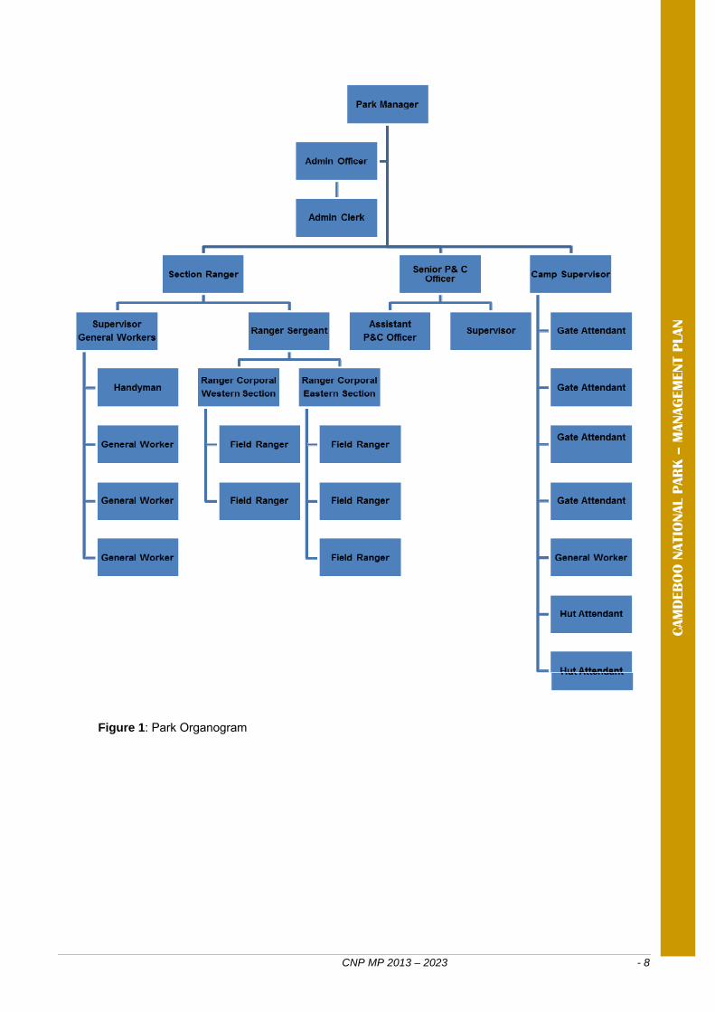
Figure 1: Park Organogram
CNP MP 2013 – 2023 - 9
Section 4: Consultation
SANParks recognises that parks must serve societal values and that they need to be part of and interrelate with the broader landscape and socio-economic context within which they are situated. The goal of the park within the public participation process is to work directly with stakeholders to ensure that the stakeholder concerns and aspirations are consistently understood and considered. Therefore stakeholders, both interested and affected, were included in the revision process of the park management plan by notifying them of participation processes through mechanisms suitable for the different stakeholder groups. These processes provided the opportunity for input from all stakeholders within reasonable timeframes, with the emphasis on sharing of information and joint learning. Processes also aimed to recognise all knowledge, indigenous, ordinary and expert, as well as the diversity of values and opinions that exist between stakeholders. Feedback was provided on the outcome of the processes to stakeholders which demonstrated how their inputs were captured and considered in the decision making process. The commitment to the incorporation of public opinion into this plan is rooted in the parks’ management activities and is therefore geared towards promoting conservation values (and society’s connection with those values, as also outlined in the NEM:PAA ) and promoting this goal in part, by engaging the broader context in which the park is situated. The adaptive planning process that was followed was designed to (a) help stakeholders express opinions and values in a structured way, (b) to use the opinions and expressed values to formulate a vision for CNP, and (c) to translate the vision into management objectives that reflect the values as expressed by stakeholders. The development of the desired state, vision and mission for CNP was guided by a stakeholder workshop held on 31 May and 1 June in the Johann Rupert Hall, Graaff-Reinet (SANParks 2011). Detail of the stakeholder participation process to the review of the Park management plan is recorded in a Stakeholder participation report (Appendix 3). To facilitate ongoing consultation between parks management and stakeholders a Park Forum was has been established which represents all stakeholders (communities, municipalities, tourism forums, business, formalised agriculture and relevant local and provincial government departments). The establishment and activities of the forum are guided by Terms of reference. Formal meetings of the forum take place quarterly.

CNP MP 2013 – 2023 - 10
CAM
DEB
OO
NATIO
NAL P
AR
K –
MANAG
EM
ENT P
LAN

CNP MP 2013 – 2023 - 11
Section 5: Purpose and vision
5.1 The purpose of the park NEM:PAA requires that the park be managed in accordance with purpose for which it was declared. The original purpose of the park is not specified either in the first gazetted declaration or in subsequent additions (Appendix 1). Hence SANParks will manage the park firstly in accordance with its organisational vision and secondly in accordance with the mission and objectives hierarchy that were derived through consultation with stakeholders, as set out in this section. 5.2 Vision and mission The vision is an inspirational statement designed to provide a picture of the envisaged future for the park. It answers the question of ‘where do we want to go?’ The mission defines the fundamental purpose of the park, succinctly describing why it exists and what it does to achieve its vision. The SANParks vision, which holds for all national parks, is:
South African National Parks connecting to society
The following mission was developed after consultation with stakeholders at the workshop of May-June 2011:
MISSION
To develop, consolidate, and integrate the Camdeboo National Park as a key part of the Graaff-Reinet region which transparently restores, conserves and advocates a diversity of heritage values (both biodiversity and cultural) of the region to enhance sustainable socio-economic development and tourism opportunities for local communities and other stakeholders. 5.3 SANParks corporate vision of the desired state of Camdeboo National Park Examined from the perspective of the entire system of national parks, SANParks has identified a broad vision and strategic direction for each individual park. This corporate strategic direction is intended to complement the role of other parks in adding overall value to South Africa’s national park system in terms of biodiversity conservation, recreational opportunities and regional socio-economic contribution. Thus the following strategic direction for Camdeboo National Park has also informed the programmes of implementation (Section 10) of this management plan: Biodiversity risks are low in CNP compared to most other parks. Environmental education and awareness, as well as the diversity of tourism products, are to be improved. A focus will be on the status of socio-economic catalyst. There is moderate potential for generation of income through animal sales. There is potential to become a major grasslands park through contractual arrangement with neighbouring land owners. Infrastructure requirements are confined to fences. 5.4 Operating principles / values The stakeholders recognised and endorsed the SANParks corporate and conservation values as outlined in the Coordinated Policy Framework, but added the following additional values for emphasis in the park context:
• Accountability and responsibility;
CNP MP 2013 – 2023 - 12
CAM
DEB
OO
NATIO
NAL P
AR
K –
MANAG
EM
ENT P
LAN
• Integrity; • Transparency; • Sustainable utilisation; • Respect for cultural diversity; • Ecological balance; • Benefit sharing; • Adaptive management; • Community participation / stakeholder
engagement; • Sense of ownership: linked to
responsibility; • respect for ecosystems;
5.5 Park context The context refers to the current circumstances and the conditions that determine these circumstances. The context is therefore important as a set of agreed-upon realities that will influence the setting of management objectives. International commitments to protected
area contribution, these commitments trickles down to provincial targets;
A town surrounded by a national park; Huge unbroken fossil record – Geopark;
UNESCO Geopark; Enclosed rural population with high
unemployment; Cooperative governance; Adjacent possibility for stewardship /
contractual inclusions - four conservancies, three nature reserves;
Possible corridor to Mountain Zebra National Park;
Possible four to five biomes converging / overlapping in the park, grasslands is a national priority;
Natural resources – how could there be co-benefit;
Opportunities - carbon sequestration, socio-ecological system value;
Weak judicial response to poaching; Fracking – articulate a position, including
neighbouring farms and viewshed protection;
Landscape values; Valley of desolation – leverage; SANParks policy favourable to
bioregionalism; Relationship between tourism and
conservation is beneficial but not optimal – possible opportunities;
Low perception of the park; Potential cycling / hiking destination; Fragmented nature of the park (east /
west); Opportunities for different experiences; Inappropriate operations / landuse on
boundary – road condition;
Water security (dam and well fields); a. Weed infestation from
upstream; b. Short river sections in the
park; Dam; Town planning capacity questionable; Geographical isolation – future venture
to link tourism sites making use of the local airport;
Differences in perception of the park – exclusion of certain sectors;
Financially excluded; Agriculture / farming and the park Enforcement of rules, regulations,
laws. 5.6 Vital attributes The vital attributes which can also be described as the key characteristics of a park are listed below:
Juxtaposition of a large (mostly poor) urban community, heritage town with its own developed identity and scenic natural surroundings in a national park (aiming at system integrity);
• Tourism is established driver; • Valley is already branded.
Park and town embedded in a region with a variety of land uses, many of which are conservation friendly, and which are configured in such a way that expansion is possible;
Co-operative governance Nqweba dam, although an artificial
wetland, is a central feature of the park and town;
Functional environmental education facilities and initiative;
Passionate people (culture, nature, equity);
Existing and potential biological important special species;
Disease free buffalo; Mountain Zebra.
CNP MP 2013 – 2023 - 13
1(a). Combination of large (mostly poor) urban community, heritage town with its own developed identity and scenic natural surroundings in a national park (aiming at system integrity). Determinants of community and heritage town with its own well developed identity: historical vision and funding, heritage act, geographic location, horse shoe bend in the river, fourth oldest town in country, republic for eight months, poverty is a legacy of the past and continues because of limited economic opportunities, strong historical agricultural base but diminishing, melting pot of cultures, awesome natural surroundings largely undeveloped because of municipal commonage. Threats
Fracking / wind and solar farms; Poor funding for small local
municipalities; Inappropriate zoning and land use
planning; Freight traffic; Lack of skills and resources; Low level of education;
Inappropriate development; Unabated poverty; Poor environmental
management (water security and quality etc);
Over reliance on tourism; Poor park management.
1(b). The close proximity to one another of a large (mostly poor) urban community, a heritage town with its own developed identity, and the scenic natural surroundings of a national park (aiming at system integrity). Determinants of scenic natural surroundings in a national park (aiming at system integrity): geological processes, sedimentation, volcanic upliftment and erosion, municipal commonage, nature reserve, stock farming history, at least three biomes represented, and climate. Threats
Mining; Fracking; Wind and solar farms; Waste disposal; Inappropriate developments i.e.
visual pollution, breaking viewsheds in key places;
Erosion, alien plants and animals; Invasion of the park by livestock; Lack of effective buy-in by majority
of stakeholders;
Habitat fragmentation and isolation in a small park;
Poor commonage management; Excessive commercial tourism; Poor land use practices by
neighbours; Poor herbivore management in
park; Climate change (multi biome); Emerging diseases. Speeding on the R63.
CNP MP 2013 – 2023 - 14
2. Park and town are embedded in a region with a variety of land uses, many of which are conservation friendly, which are configured in such a way that expansion is possible. Determinants: Compatible forms of land use, limited degradation, large number of well-established private nature reserves, many of the farms have a game-farming component and conservation ethic, conservancies, formal recognition of each other, widespread appreciation for untransformed Karoo environment, willingness to co-operate across different land uses, potential for geo-park in conservation landscape. Threats
Stock theft (park act as a conduit);
Poaching; Problem animals (i.e. control can
be contentious, mistrust and frustration);
Lack of cohesive bioregional vision;
Unresolved conflict of objectives; Poor land use practises; Lack of financial resources; Alien animals and plants;
Change of ownership (land use, lack of sense of permanency);
Inappropriate development (i.e. mining);
Public perception that changes regarding wildlife management (socio-economic implications);
Disease; Different perceptions of certain
animals. Increased and unregulated air
traffic from the adjacent airfield.
3. Nqweba dam, an artificial wetland, is a central feature of the park and town. Determinants: Confluence of rivers, dam wall, particular topography, silt trap, associated with recreation, need for water, used by all, fishing (source of food and recreation), creating habitats, birdlife, water sport. Threats
Need for water (initially for irrigation);
Security of the dam wall; Transferring the management of
the dam to the DWA;
Alien fish and plants; Pollution (increase in irrigation); Increased demand for water; Drought.
4. Functional environmental education facilities and initiative. Determinants: Proximity of park to large urban community, capacitated staff, facility, articulated community need, diverse environmental opportunities, possibility of ‘new approach’, curriculum. Threats
Declining infrastructure; Schools lacking resources (i.e.
funds, means of transport); Potential threats (fire, water
supply etc);
Internal funding constraints; Decline in demand – linked to the
curriculum;
5. Passionate people (culture, nature, equity). Determinants: Historical legacy (i.e. fossils), ethos of enjoying surrounding, proximity of park, stable farming community, diversity of cultural resources, innovative community, active contribution by retirees, progressive town and municipality, pride in park and town (Rupert), where history and nature meet, cohesive community, several champions, reliable water supply, critical mass of people, stability. Threats
Poor governance; Exclusion of certain parts of
community (i.e. lack of employment);
Over and inappropriate development (destroy character of town);
Lack of co-operative vision;
Broken expectations (poor component of community);
Vulnerability due to lack of passionate young people;
Seasonal usage of town; Security; Degradation of the park; Lack of community development;
CAM
DEB
OO
NATIO
NAL P
AR
K –
MANAG
EM
ENT P
LAN
CNP MP 2013 – 2023 - 15
6. Existing and potential biological important special species. • Disease free buffalo; • Mountain Zebra; • Thirteen Plant species.
Determinants: Part of wider initiative, national species management initiative, tourism draw card, one of the few buffalo populations under national protection, suitable habitat, market value of disease free buffalo. Threats
Disease; Poaching and illegal collection
of plants; Unsuitable habitat;
Genetic contamination – inbreeding;
Alien plant competition.
5.7 High level objectives The desired state is achieved by means of a hierarchy of objectives, starting with an overall objective aligned with SANParks’ organisational structure and the park’s Vision and Mission statements, then broad, high level objectives (this Section) and then to finer and finer levels of detail, ending with specific operational or management actions (section 10). Discussions at the stakeholder meeting gave rise to an initial set of high level objectives. These were refined to reflect the following:
MISSION To develop, consolidate, and integrate the Camdeboo National Park as a key part of the Graaff-Reinet region which transparently restores, conserves and advocates a diversity of
heritage (both conservation and cultural) values of the region to enhance sustainable socio-economic development and tourism opportunities for local communities and other
stakeholders.
1. Bio-regional landscape objective:
To enhance co-
operative management
through a bioregional
approach by using a range of
options to expand across a patchwork of conservation friendly land uses and in doing so, mitigate
conflicts and provide
opportunities that improve livelihoods of local people.
2. Ecological integrity
objective:
To ensure the persistence of
the biodiversity associated
with biomes of the broader Camdeboo region by restoring
ecological patterns and
processes and minimising detrimental
human induced
disturbances.
3. Responsible tourism
objective:
To ensure that Camdeboo
National Park is an integral part of tourism in the
Graaff-Reinet region by
developing, managing and enhancing a
range of complementary and sustainable
tourism products including
opportunities for local
stakeholders.
4. Environmental education objective:
To maintain and
enhance collaborative
environmental education
programmes that enhances
inclusive local stakeholder
relations using the facilities and
location associated with the park thereby
advocating integrated
approaches to conservation in
the Graaff-Reinet region.
5. Social investment objective:
To ensure
appreciation of the heritage
identity of the park and
Graaff-Reinet, embedded in
a landscape of scenic natural surroundings
by advocating, promoting and
developing conservation-
friendly opportunities for integrated life styles and livelihoods.
6. Effective park
management objective:
To strive for
effective management
and administrative
support services
through good corporate
governance enabling
Camdeboo National Park to achieve its
objectives.
Figure 2a: Park high level objectives.
CNP MP 2013 – 2023 - 16
CAM
DEB
OO
NATIO
NAL P
AR
K –
MANAG
EM
ENT P
LAN
1. Bio-regional landscape objective: To enhance co-operative management through a bioregional approach by using a range of options to expand across a patchwork of conservation friendly land uses and in doing so, mitigate conflicts and provide opportunities that improve livelihoods of local people.
1.1 Conservation partnerships sub-objective: To promote ecological linkages across the landscape through contractual land partnerships.
1.2 Responsible neighbourliness sub-objective: To minimise potential conflicts that arise from the different objectives of non-aligned land uses through responsible engagement with neighbours.
2. Ecological integrity objective: To ensure the persistence of the biodiversity associated with biomes of the broader Camdeboo region by restoring ecological patterns and processes and minimising detrimental human induced disturbances.
2.1 Restore degraded areas sub-objective: Restore the composition, structure and function of degraded areas in the park
2.2 Ecological patterns and processes sub-objective: Incorporate the spectrum of biodiversity patterns and processes characteristic of the Camdeboo region which support the long-term ecological persistence of the park.
3. Responsible tourism objective: To ensure that Camdeboo National Park is an integral part of tourism in the Graaff-Reinet region by developing, managing and enhancing a range of complementary and sustainable tourism products including opportunities for local stakeholders.
Marketing sub-objective To promote and market the park in conjunction with Graaff-Reinet as part of regional tourism routes
New products sub-objective To improve the park’s revenue-generation by ensuring that any new tourism products complement established local business, while providing affordable rates as well as concessions for local people.
Figure 2b: Sub-objectives for bioregional.
Figure 2c: Sub-objectives for ecological integrity.
Figure 3d: Sub-objectives for responsible tourism.

CNP MP 2013 – 2023 - 17
4. Environmental education objective: To maintain and enhance collaborative environmental education programmes that enhances inclusive local stakeholder relations using the facilities and location associated with the park thereby advocating integrated approaches to conservation in the Graaff-Reinet region.
4. 1 Education opportunities sub-objective: To promote integrated approaches to sustainable use of the environment in the region by implementing a diverse range of education opportunities as well as provide for the youth development needs of the community.
4. 2 Education programmes sub-objective: To address the specific environmental challenges and opportunities associated with the park and local environment by reviewing, identifying and developing environmental education programmes.
4. 3 Local focus sub-objective: To improve the long term future of the park currently threatened by illegal activity by focusing environmental education attention and effort on the local community of Graaff-Reinet.
4. 4 Effective use of facilities sub-objective: To transfer knowledge to a significant number of people by using the EE Center and its resources to their full potential.
5. Social investment objective: To ensure appreciation of the heritage identity of the park and Graaff-Reinet, embedded in a landscape of scenic natural surroundings by advocating, promoting and developing conservation-friendly opportunities for integrated life styles and livelihoods.
5. 1 Heritage sub-objective Ensure appreciation of the cultural heritage of Graaff-Reinet, embedded in the scenic natural landscape of Camdeboo National Park
5. 2 Stakeholder engagement sub-objective To ensure appreciation of the heritage identity of Graaff-Reinet embedded in the scenic natural landscape of Camdeboo National Park, by advocating, promoting and developing conservation-friendly opportunities that improve life styles and livelihoods.
5. 3 Local socio economic development sub-objective: Uplift members of the local community through developing tourism and conservation friendly opportunities.
Figure 3e: Sub-objectives for environmental education.
Figure 3f: Sub-objectives for social investment.
CNP MP 2013 – 2023 - 18
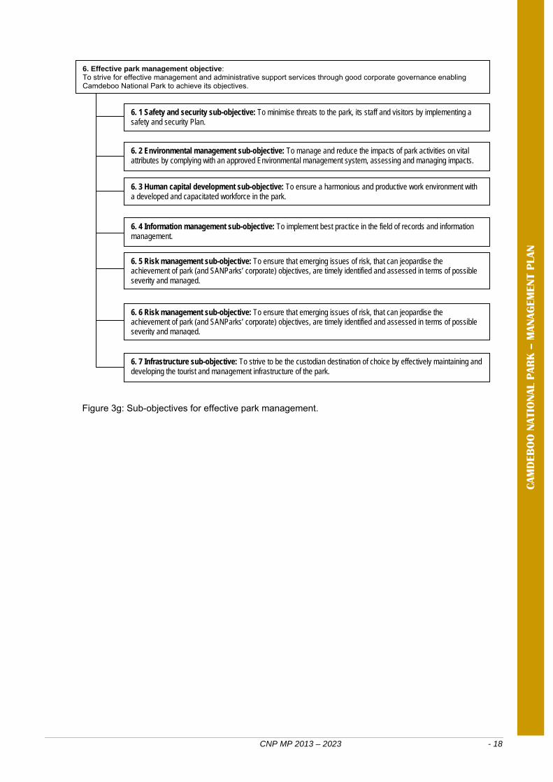
6. Effective park management objective: To strive for effective management and administrative support services through good corporate governance enabling Camdeboo National Park to achieve its objectives.
6. 1 Safety and security sub-objective: To minimise threats to the park, its staff and visitors by implementing a safety and security Plan.
6. 2 Environmental management sub-objective: To manage and reduce the impacts of park activities on vital attributes by complying with an approved Environmental management system, assessing and managing impacts.
6. 3 Human capital development sub-objective: To ensure a harmonious and productive work environment with a developed and capacitated workforce in the park.
6. 4 Information management sub-objective: To implement best practice in the field of records and information management.
6. 5 Risk management sub-objective: To ensure that emerging issues of risk, that can jeopardise the achievement of park (and SANParks’ corporate) objectives, are timely identified and assessed in terms of possible severity and managed.
CAM
DEB
OO
NATIO
NAL P
AR
K –
MANAG
EM
ENT P
LAN
6. 6 Risk management sub-objective: To ensure that emerging issues of risk, that can jeopardise the achievement of park (and SANParks’ corporate) objectives, are timely identified and assessed in terms of possible severity and managed.
6. 7 Infrastructure sub-objective: To strive to be the custodian destination of choice by effectively maintaining and developing the tourist and management infrastructure of the park.
Figure 3g: Sub-objectives for effective park management.
CNP MP 2013 – 2023 - 19
The primary objective of a park zoning plan is to establish a coherent spatial framework in and around a park to guide and co-ordinate conservation, tourism and visitor experience initiatives. A zoning plan plays an important role in minimising conflicts between different users of a park by separating potentially conflicting activities such as game viewing and day-visitor picnic areas whilst ensuring that activities which do not conflict with the park’s values and objectives (especially the conservation of the protected area’s natural systems and its biodiversity) can continue in appropriate areas. The zoning of Camdeboo National Park was based on an analysis and mapping of the sensitivity (Appendix 4, Map 5) and value of a park’s biophysical, heritage and scenic resources; an assessment of the regional context; an assessment of the park’s current and planned infrastructure and tourist products; and an assessment of the expansion plan for the park and its implication for use zoning. In addition to internal use zoning, the zoning plan also describes how the park interacts with the processes which control land use and activities in the buffer zones around national parks (e.g. Spatial Development Frameworks) and municipal IDPs. The buffer zones identify the area within which activities such as landuse change may have an influence on the park (current and future extent), describe responses at a strategic level, and serve to define the buffer zone in terms of the DEA Policy on buffer zones for national parks and the SANParks buffer zone policy. Overview of the use zones of Camdeboo National Park: The summary of the use zoning plan for Camdeboo National Park is shown in Appendix 4, Map 4. Full details of the use zones (including high resolution maps), the activities and facilities allowed in each zone, the conservation objectives of each zone, the zoning process, the park buffer zone (detailing park interaction with adjacent areas) and the underlying landscape analyses are included in Appendix 2: Camdeboo National Park Zoning Plan. Remote zone: This is an area retaining an intrinsically wild appearance and character, or capable of being restored to such and which is undeveloped and roadless (although limited unimproved management tracks are allowed). There are no permanent improvements or any form of human habitation. It provides outstanding opportunities for solitude, with awe inspiring natural characteristics with sight and sound of human habitation and activities barely discernible and at far distance. The conservation objective is to maintain the zone in a natural state with no impact on biodiversity pattern or processes. Existing impacts on biodiversity either from historical usage or originating from outside the zone should be minimised. The aesthetic / recreational objectives for the zone specify that activities which impact on the intrinsically wild appearance and character of the area, or which impact on the wilderness characteristics of the area (solitude, remoteness, wildness, serenity, peace etc) will not be tolerated. In Camdeboo NP, remote areas were designated in the mountain areas in the east of the park, as these areas have high environmental sensitivity and value as well as reasonable (in the context of the park) wilderness characteristics. It is anticipated that as the park expands eastwards, more remote areas will be incorporated. Primitive zone: The prime characteristic of the zone is the experience of wilderness qualities with access controlled in terms of numbers, frequency and size of groups. The zone has wilderness qualities, but with limited access roads (mostly 4x4) and the potential for basic small-scale self-catering accommodation facilities or small concession lodges (which would generally have more sophisticated facilities). Views of human activities and development outside of the park may be visible from this zone. The conservation objective is to maintain the zone in an almost completely natural state with little or no impact on biodiversity processes, and very limited and site specific impacts on biodiversity pattern.
Section 6: Zoning plan
CNP MP 2013 – 2023 - 20
CAM
DEB
OO
NATIO
NAL P
AR
K –
MANAG
EM
ENT P
LAN
The aesthetic / recreational objectives for the zone specify that activities which impact on the intrinsically wild appearance and character of the area, or which impact on the wilderness characteristics of the area (solitude, remoteness, wildness, serenity, peace etc) should be restricted and impacts limited to the site of the facility. Ideally visitors should only be aware of the facility or infrastructure that they are using, and this infrastructure / facility should be designed to fit in with the environment within which it is located in order to avoid aesthetic impacts. In Camdeboo NP, primitive areas were designated to buffer remote areas and to protect most of the remaining sensitive areas (such as the remaining mountain areas and high priority vegetation types) from high levels of tourism activity. Primitive areas were also designated to allow management access into the remote mountain areas in the east, as well as to accommodate the existing overnight trail hut. In areas where remote zones border on the park boundary, a 100 m wide primitive zone was designated to allow park management access to fences. Quiet zone: This zone is characterised by unaccompanied (or accompanied under some circumstances) non-motorised access, where visitors can walk or cycle and experience nature without the intrusion of any form of motorised transport. Visitor numbers and density are higher than in the Primitive zone and contact between visitors is frequent. The conservation objective is to maintain the zone in a generally natural state, with the proviso that limited impacts on biodiversity patterns and processes are allowed in order to accommodate park recreational and tourism objectives. Infrastructure should only be allowed within a restricted development footprint, and infrastructure, especially paths and viewpoints should be designed to limit the impacts of large numbers of visitors on the biophysical environment. The aesthetic / recreational objectives for the zone specify that the zone should retain a relatively natural appearance and character and activities which impact on this should be restricted. In particular visitors are not allowed motorised access to this zone. It is however recognised that the presence of larger numbers of visitors and the facilities they require, may impact on the feeling of wildness found in this zone. In CNP, a Quiet zone was designated to allow visitors access on foot to the Valley of Desolation trails and to a proposed trail area around the proposed Koedoeskloof view sites. Low intensity leisure zone: The underlying characteristic of this zone is motorised self-drive access with the possibility of small basic camps.
Facilities along roads are limited to basic picnic sites with toilet facilities. The conservation objective is to maintain the zone in a largely natural state that is in keeping with the character of a Protected Area, mitigate the biodiversity impacts of the relatively high levels of tourism activity and infrastructure that are accommodated within this zone through careful planning and active management, and to ensure that both the negative effects of the activities and infrastructure are restricted to the zone. The aesthetic/recreational objectives for the zone specify that although activities and facilities will impact on the wild appearance and reduction of the wilderness characteristics of the area (solitude, remoteness, wildness etc) is inevitable, these should be managed and limited to ensure that the area still provides a relatively natural outdoor experience. In Camdeboo NP, Low Intensity Leisure areas were designated on the northern plains (including the current game viewing area, new administration block and bush camp), the existing tarred access road to the Valley of Desolation, the proposed access to the Koedoeskloof view site, the community access areas west of Graaff-Reinet, and in the low altitude areas in the south west (around the environmental education facility). Low intensity leisure zones (apart from the existing Valley of Desolation access road) almost entirely avoid areas with high landscape sensitivity and value. Overview of the Special Management Overlays of Camdeboo National Park: Special management overlays which designate specific areas of the park that require special management interventions (e.g. areas requiring rehabilitation) were identified. Two areas were designated:
Rehabilitation Area: The areas with high concentrations of alien woody vegetation around Nqweba dam were identified as requiring rehabilitation.
Shore Angling Resource Use Area:
Areas along the south shore of the Nqweba Dam are used for shore angling. The entire dam area is used for boat-based angling.
Summary of the Buffer zones around Camdeboo National Park: This section describes how the park interacts with the processes which control land use and activities in the Buffer zones around national parks (e.g. SDFs) and municipal IDPs.
CNP MP 2013 – 2023 - 21
The buffer zone section identifies the area within which activities such as landuse change may have an influence on the park (current and future extent), describes responses at a strategic level, and serves to define the buffer zone in terms of the DEA Policy on buffer zones for national parks and the SANParks buffer zone policy. The current extent of Camdeboo National Park is included in a conservation focused category in the land use maps included in the SDFs of the local and district municipalities in which the park is located. These SDFs are the spatial components of municipal IDPs. The park interacts with the appropriate local government processes such as SDF and IDP development on an ongoing basis as part of the Bioregional Programme, in order to ensure that issues such as appropriate development of Buffer zones around parks are also incorporated into proactive land use planning instruments such as SDFs and IDPs. The park buffer zones shows the areas within which landuse changes could affect a national park. The zones, in combination with guidelines, will serve as a basis for a.) identifying the focus areas in which park management and scientists should respond to EIA’s, b.) helping to identify the sort of impacts that would be important at a particular site, and most importantly c.) serving as the basis for integrating long term protection of a national park into the spatial development plans of municipalities (SDF/IDP) and other local authorities. In terms of EIA response, the zones serve largely to raise red-flags and do not remove the need for carefully considering the exact impact of a proposed development. In particular, they do not address activities with broad regional aesthetic or biodiversity impacts. Camdeboo National Park has three buffer zone categories (Appendix 4, Map 6). The first two are mutually exclusive, but the final visual / aesthetic category can overlay the others. Priority natural areas: These are key areas for both pattern and process that are required for the long term persistence of biodiversity in and around the park. The zone also includes areas identified for future park expansion. Inappropriate development and negative land-use changes should be opposed in this area. Developments and activities should be restricted to sites that are already transformed. Only developments that contribute to ensuring conservation friendly land-use should be viewed favourably. Catchment protection areas: These are areas important for maintaining key hydrological processes within the park. Inappropriate development (dam construction, loss of riparian vegetation etc.) should be opposed. Control of alien vegetation and soil erosion as well as appropriate land care should be promoted. Viewshed protection areas: These are areas where development is likely to impact on the aesthetic quality of the visitor’s experience in a park. Within these areas any development proposals should be carefully screened to ensure that they do not impact excessively on the aesthetics of the park. The areas identified are only broadly indicative of sensitive areas, as at a fine scale many areas within this zone would be perfectly suited for development. In addition, major projects with large scale regional impacts may have to be considered even if they are outside the Viewshed protection zone. Current status and future improvements: The current park use zonation is based on the same biodiversity and landscape analyses undertaken for a Conservation Development Framework (CDF); however certain elements underlying a CDF such as a full tourism market analysis and detailed investigation of development nodes are not fully incorporated into this park use zonation. A CDF will be developed for CNP once the park approaches its planned final extent. In the interim, as the park is rapidly expanding, it is anticipated that the zoning will need to be updated regularly.
CNP MP 2013 – 2023 - 22
CAM
DEB
OO
NATIO
NAL P
AR
K –
MANAG
EM
ENT P
LAN
CNP MP 2013 – 2023 - 23
Section 7: Access and facilities
In accordance with the Guidelines for the preparation of management plans (Cowan and Mpongoma 2010) Section 7 provides information on the current access to the protected area, access controls, air fields, visitor and administrative facilities, commercial activities, community use and servitudes. Appendix 4, Map 7 shows the distribution of infrastructure in the park. 7.1 Public access and control
Pay points are staffed gates where a conservation fee is levied in exchange for an entry permit. There are pay points at the Valley of Desolation, the game viewing area and at Lake view adjacent to the park main office. Management guidelines have been drawn up for the pay points.
Key control points are points of access where keys are required to operate
locked gates. Keys may be issued for a season in respect of boating or fishing areas, or signed out at the park administration office on an opportunity basis for other gates. Tariffs for activities and permits may be issued. There are six key control points in the park: at the Camdeboo environmental education centre, at the eastern section / Lootsfontein gate, at the eastern section / Skuinsveldhoek gate, at the eastern section / Kroonvale gate, at Nqweba dam / Boating area and at Nqweba dam / Fishing area.
Gateways are points of access where there is no control over public entry. These
are all public roads going through the park with the exception of Piekniekbos which is an open access picnic site. Gateways in Camdeboo NP include those at Mountain drive / Berg-en-Dal, at the Mountain drive / Urquhart park, at the Erasmuskloof throughfare / N9, at the Erasmuskloof throughfare / Broederstroom, at Gannaleegte and at Piekniekbos.
Minor access points are open to the public but a permit, available from the parks
administration office is required for legal entry. The two minor access points in the park are at the Eerstefontein trail and at Gannalapa.
Local access points are uncontrolled and provide local sustenance anglers
access to the Nqweba Dam. There are two local access points in the park, one at the Fishing area / North gate, and one at the Fishing area / South gate.
7.2 Airfields and their restrictions There are no airfields or helicopter landing sites in the park. There is a municipal airfield adjacent to the Game Viewing Area eastern boundary (just off the N9 to Middleburg). This strip is a tarred runway 1, 500 m long which can accommodate medium size aircraft. 7.3 Facilities for vessels There is one boat launching site in the park at the boat club area. There are no docking or mooring facilities. 7.4 Visitor facilities Current visitor infrastructure includes:
The Camdeboo environmental education centre, consisting of two dormitories, a lecture hall, kitchen, admin office, storeroom and ablution blocks, and accommodates 48 children and four teachers.
There are seven picnic areas with 40 sites that each have a table, braai stand and refuse drums provided.
CNP MP 2013 – 2023 - 24
CAM
DEB
OO
NATIO
NAL P
AR
K –
MANAG
EM
ENT P
LAN
There are three trails of 1.5 km; 16 km and 22 km, respectively, totalling 39.5 km.
Khwalimanzi Hide on the eastern side of the Nqweba Dam for game and bird viewing.
Lake view tented camp includes four two bed tented units with communal kitchen and ablutions.
Nqweba camp site with fifteen sites for caravan camping with ablution block.
Koedoeskloof four wheel drive route offers views of the Camdeboo plains.
7.5 Administrative facilities Management infrastructure consists of the Lakeview office complex, including an office block occupied by park management and an adjacent cottage used for accommodating students. In addition, the Gannaleegte complex has a rondavel for visiting staff, a workshop, stores, garages and ablution facilities. Field ranger outposts at Spandaunek and Skuinsveldhoek include a rondavel with very basic facilities for overnight operations in sensitive areas. 7.6 Other infrastructure There are approximately 11 km of tarred tourist roads in CNP, leading to the Valley of Desolation. Other surfaced tourist roads include approximately 10 km between the Lakeview and Impangele gates of the game viewing area, while unsurfaced tourist roads comprise approximately 14 km in the game viewing area and 5 km access to the education center (total 19 km). Tourist roads requiring high ground clearance (or 4X4) include 24 km in the Eastern Section of the park. There are approximately 33 km of management roads and tracks in various areas of the park. The park boundaries total some 97 km, of which 17 km are game fenced while the remainder has stock fencing. Conservation infrastructure includes 12 water points supplied with windmills or solar pumps, some with storage reservoirs or tanks and drinking troughs. Finally, two double pens with a circular kraal exist to hold buffalo for disease testing. 7.7 Mining and quarries There is registered quarry off the Erasmuskloof road which is used for road repairs and maintenance in the park. 7.8 Commercial activities There are no commercial activities apart from the nature-based tourism provided by SANParks: camping, hiking, picnicking walks to spectacular viewpoints.
7.9 Community access: use of natural resources Permits are issued to members of the local community to catch alien fish species in the Nqweba Dam. 7.10 Servitudes There are no servitudes on the title deeds of the park.
CNP MP 2013 – 2023 - 25
Section 8: Consolidation and expansion
The expansion and consolidation of the park is in line with the national strategic objective (DEA 2005) of expanding South Africa’s protected area system. The expansion and consolidation programme are also informed by SANParks policy regarding land inclusion (SANParks 2006; Knight et al. 2009), and the National Protected Areas Expansion Strategy (DEA 2008) and the three year rolling land acquisition plan. It is important to note that this three year plan can change due to the availability of funds, willing buyer willing seller concept and the negotiation process. Specifically, this programme aims to achieve the high level Bioregional landscape objective, namely “to promote a bioregional approach through enhanced co-operative management by using a range of options to expand across a patchwork of conservation-friendly land uses, and concomitantly mitigate conflicts and provide opportunities that improve livelihoods of local people”. Although the park is not situated within an identified priority habitat according to the South African national biodiversity conservation assessment (Driver et al. 2005), it does fall within the Albany - Pondoland hotspot and the Camdeboo escarpment focus areas identified in the NPAES (DEAT 2008). Moreover, the expansion and consolidation of the park eastwards towards Mountain Zebra National Park remains an important focus of SANParks in its attempt to establish a large protected area representative of the Thicket – Nama-Karoo – Grassland - Riparian Biome interface (Holness et al. 2003). The aim is to link the Mountain Zebra and Camdeboo National Parks through progressive expansion, primarily through agreements with private land owners. A current initiative to test land owner willingness to enter some form of contractual/stewardship type agreement (funded by the Critical ecosystems project fund - CEPF) will go a long way to lay the foundation for this proposed greater protected area. The park cover currently has five vegetation types represented, namely the Camdeboo escarpment thicket, Karoo escarpment grassland, Eastern lower karoo, Upper karoo hardeveld, and Southern karoo riverine making up 63%, 5%, 9%, 3% and 29%, respectively of the 19, 021.66 ha large park (Appendix 4,Map 3). A total of 14, 459.38 ha are proclaimed. Although relatively small this includes representation from a mix of Thicket, Nama-Karoo and Grasslands biomes as well as the azonal wetlands vegetation types (Mucina and Rutherford 2006). The vision of a unified Camdeboo and Mountain Zebra National Parks would form a protected area extending over 330, 000 ha, including eight vegetation types, with the Tarkastad montane grassland new to both parks. In addition, the expanded park would collectively include representation by thicket (22 %), grassland (49 %), Nama-Karoo (21 %) biomes and the azonal wetlands (8%) vegetation types (Mucina and Rutherford 2006). Although Camdeboo National Park’s five vegetation types are classified as least threatened they are all either hardly (0-5% of conservation target) to poorly (5-50% of conservation target) protected within formal conservation areas (Mucina and Rutherford 2006). The planned link with Mountain Zebra National Park would make an important contribution towards meeting these targets. In addition, with 50% of the 330, 000 ha area made up of grassland vegetation types, it would play a significant role in increasing protection of the threatened grassland biome. The priority area for inclusion will create a link with Samara (≈27, 000 ha) and adjacent Mount Camdeboo (≈14, 000 ha) properties, the owners of which have expressed an interest in coming into a long-term contractual agreement with SANParks. With a reduction in national land acquisition support, no land purchases are contemplated in the foreseeable future. However, as opportunities periodically arise, one need remain flexible in re-allocating the limited resources to possible acquisitions in this footprint.
CNP MP 2013 – 2023 - 26
CAM
DEB
OO
NATIO
NAL P
AR
K –
MANAG
EM
ENT P
LAN
CNP MP 2013 – 2023 - 27
Section 9: Concept development plan
9.1 Long term development plan However, there is a need for major improvement of the Valley of Desolation pathway system and for 95 km of new 2.4 m game fencing (see Sections 10 and 11). These developments are subject to the availability of funds. However the park is currently replacing 5 km stretches of stock fence with a 2.4 m game fence on an annual basis. Any new products or activities developed in future will follow the zonation and nature based responsible tourism principles, as well as all legal requirements governing development. 9.2 Development nodes No new development nodes are currently envisaged for the park over the next decade.
CNP MP 2013 – 2023 - 28
CAM
DEB
OO
NATIO
NAL P
AR
K –
MANAG
EM
ENT P
LAN
CNP MP 2013 – 2023 - 28
Section 10: Strategic Plan
10 Introduction Sections 3, 4 and 5 of this plan outlined the policy framework, the consultation process and development of a mission and high level objectives for the park. In this section the goals and higher level objectives of the park are developed into lower level objectives and sub-objectives and finally into operational actions. In this way decision-making, even at the operational level, can be traced all the way back to the core values and inputs from stakeholders on which they have been based. This approach conforms to the requirements of the NEM:PAA, the NEM:BA, SANParks policy, and ratified international conventions. Programmes of implementation, developed as outlined above, form the strategic plan for this planning cycle, are arranged under the following headings: Bioregional Biodiversity Tourism People and conservation Effective park management
Each programme is presented as follows: Programme name: A name describing the programme. High level objective: Stating the overall goal of the programme. Background: Overview of intent, guiding principles, description, outcome, research and
monitoring and risk (all where applicable). Tables: Outline of objectives, initiatives and management actions within the scope of the
objective with an indication if the programme is once odd, continuing or conditional on the availability of resources. These tables have the following headings: o Initiatives or objectives The various initiatives or objectives, derived from the
hierarchy of higher level objectives, which make up each programme. o Actions: The actions necessary to achieve the objective. o Responsibility: The SANParks person, section, department, division or unit
responsible for implementing the action. o Indicator: A measure whereby the achievement of the objective can be evaluated. o Timeframe: An indication of when the action is likely to be completed (indicated by
year over the planning cycle). o References: References to relevant programmes, Lower level plans (LLPs) or other
documents.
CNP MP 2013 – 2023 - 29
High level objective: To enhance co-operative management through a bioregional approach by using a range of options to expand across a patchwork of conservation friendly land uses and in doing so, mitigate conflicts and provide opportunities that improve livelihoods of local people.
Objectives Actions Responsibility Indicators Timeframe References
Conservation partnerships sub-objective
To promote ecological linkages across the landscape through contractual land partnerships.
Expand the park through agreements with adjoining landowners
Park planning and development unit, Regional manager, Park manager
Annual reports from Wilderness Foundation initiative; Establishment of biodiversity corridor between Mountain Zebra National Park and Camdeboo National Park
Dependent on successful conclusion of agreements with landowners.
CEPF funding proposal
Internal report on Sneeuberg grasslands conservation
Responsible neighbourliness
Sub-objective
To minimise potential conflicts that arise from the different objectives of non-aligned land uses through responsible engagement with neighbours
Patrol and maintain a boundary that is adequate to enclose problem animals
Section ranger
Number of boundary patrols carried out
Ongoing
Provide assistance to neighbours and authorities with the investigation and follow-up in respect of stock theft incidents
Section ranger
Field rangers
Responses to stock theft incidents in Section ranger monthly reports
Ongoing
Park Forum meetings
Park manager
People and conservation officer
Minutes of Park Forum meetings
Ongoing
Keep open communication channels with neighbours regarding problem animal
Park manager
Number of farmers’s association meetings attended
Ongoing
Engage with all relevant land use planning processes within the buffer zone of the park to ensure that biodiversity priorities and objectives are addressed in EIA and land use change applications.
Park Manager,
Database of registration as Interested / Affected Party in any land use change proposals within the buffer zone
Ongoing
CAM
DEB
OO
NATIO
NAL P
AR
K –
MANAG
EM
ET P
LAN
10.1 Bioregional The purpose of the bioregional goal is to conserve systems and processes within and around the park by establishing corridors and buffer zones and consolidating the park by acquiring appropriate land for the conservation of threatened biodiversity. It aims to collaborate with relevant international, national, provincial and local government structures, NGO’s and land owner groups. Currently there are plans for and developments around the park from urban and industrial sectors. Partnerships with local government require more interaction and working closer on joint issues. 10.1.1 Bioregional landscape programme The bioregional landscape objective is driven by the need to expand the park without undue negative impacts on the adjacent rural community.
As noted in Section 8, a project is underway with a view to testing the willingness of landowners in the area between Camdeboo and Mountain Zebra National Parks to consider including their land through contractual agreements. SANParks will engage with willing landowners towards stewardship agreements. Another objective of this programme is to ensure that the park is perceived as a responsible neighbour through a number of actions aimed at mitigation of a range of neighbour conflicts. These would typically include the impact of problem animals which can be minimised through adequate fencing which is regularly patrolled and maintained. Currently the park is also perceived as a conduit for stock thieves to gain access to neighbouring properties. This conflict may be mitigated by providing assistance to neighbours and other authorities in the investigation and follow-up of any incidents of this nature.
CNP MP 2013 – 2023 - 30
High level objective: To ensure the persistence of the biodiversity associated with biomes of the broader Camdeboo region by restoring ecological patterns and processes and minimising detrimental human induced disturbances
Objectives Actions Responsibility Indicators Timeframe References
Restore the composition, structure and function of degraded areas in the park
Minimise the impact of alien species on the natural ecosystem by control or elimination
WfW Project manager, BSP
Progress in relation to APO, reported in annual/quarterly reports
Annual WfW best practice guidelines and Policies
Restore the wildness and aesthetic appeal of land that was previously transformed through removal of undesirable infrastructure and unnatural features of the landscape.
Section ranger Removal of targeted structures - Quarterly reports
Ongoing Section Ranger performance appraisals
Restore natural soil erosion processes and the aesthetic appeal of the landscape by combating erosion
WfW (WoL) Project manager
Progress in relation to APO, reported in Annual / quarterly reports
Annual LLP for ecological integrity
10.2 Biodiversity 10.2.1 Ecological integrity programme
This programme is addressed in detail by the Biodiversity Lower level plan for Camdeboo National Park (SANParks 2012), only the main objectives and actions are summarised here. The highest priority issues that require management focus for maintaining the park’s ecological integrity are herbivory, rehabilitating degraded areas (including control of alien and invasive species) and combating illegal harvesting. Rehabilitation of degraded areas is particularly important because of the history of overgrazing prior to the establishment of the protected area, and entails mainly controlling of alien plants and erosion. Illegal harvesting in the park is driven by an incentive for commercial gain (particularly through wood collecting), biltong hunting and a subsistence need from the impoverished community living in close proximity to the park that sees the park as a source for traditional hunting or harvesting. In accordance with SANParks policy, the park must aim to manage herbivores to maintain or restore diversity at appropriate scales, thereby maintaining the system’s resilience. The key driver of such appropriate scales of herbivory is herbivore space use. The ecological integrity objective is supported by two sub-objectives, one aimed at restoring degraded areas, and the other aimed at ecological patterns and processes, as elaborated in the table below.
CNP MP 2013 – 2023 - 31
Objectives Actions Responsibility Indicators Timeframe References
Incorporate the spectrum of biodiversity patterns and processes characteristic of the Camdeboo region which support the long-term ecological persistence of the park.
Control illegal harvesting to ensure persistence of a naturally functioning and representative ecosystem
Section ranger Field rangers
Number of illegal harvesting incidents from law enforcement reports/database
Ongoing LLP for Safety and security
Maintain, restore or, where unfeasible, mimic the appropriate scale of predation as a natural disturbance process
Regional ecologist
Minutes of science management committee meetings; Aerial survey reports, Wildlife management committee proposals (including risk-benefit analyses), Minutes of wildlife management committee meetings
Ongoing LLP for Ecological integrity
Maintain or restore the diversity and appropriate scale of herbivorous impacts that impart ecosystem resilience.
Park manager Regional ecologist
Minutes of science management committee meetings; aerial survey reports, Wildlife management committee proposals (including risk-benefit analyses), Minutes of wildlife management committee meetings
Ongoing LLP for ecological integrity
CAM
DEB
OO
NATIO
NAL P
AR
K –
MANAG
EM
ET P
LAN
Readers are referred to the Biodiversity lower level plan (SANParks 2012) for further details of the management actions, as well as monitoring requirements and underlying rationale for each of these programmes. However, to comply with the provisions of NEM:BA, details are given below on the alien control programme. 10.2.1 Alien and invasive species control There are about 39 alien plants listed in the park, of which 11 are invasive and three are transformer weeds according to the CARA regulation system as amended in 2001. Over 60% of alien plants are a potential threat to the vegetation types and ecosystems around the park, with three species having the weed status of transformers (8%), 11 as invasive (27%), 10 as potential transformers (26%) and the remaining 15 as either casual, naturalised or potential invaders. A list of the priority species for clearing follows below: Problem cactus species are found scattered throughout the park, rather than in dense stands. The three species of importance are:
prickly pear (Opuntia ficus-indica), jointed cactus (Opuntia aurantiaca), Tunicate cactus (Cylindropuntia tunicata) and Imbricate Cactus (Opuntia imbricata). The cacti are effectively controlled by foliar spray once or twice per year. The bio-control agents Cactoblastis cactorum (Cactoblastis moth, Pyralidae) and Dactylopius austrinus (cochineal, Dactylopiidae) are effective on Jointed cactus. Dactylopius tomentosus (cochineal, Dactylopiidae) has also been used with limited results on Tunicate cactus. The major areas of infestation of Prickly Pear in order of priority are:
Valley of desolation and south facing slopes
Cave mountain and east facing slopes Tafelkop and east facing slopes Diepkloof and south facing slopes Fonteinkloof and south facing slopes Hanglip and west facing slopes Waaihoek and east facing slopes
CNP MP 2013 – 2023 - 32
Ensure appreciation of the cultural heritage of Graaff-Reinet, embedded in the scenic natural landscape of Camdeboo National Park
Objectives Actions Responsibility Indicators Time- frame References
Heritage sub-objective
To develop and promote an appreciation of Graaff-Reinet’s cultural heritage
Develop a database of cultural heritage assets and protection plan for visited sites.
P&C officer Database and site protection plans.
Year 1
Incorporate cultural heritage assets into Responsible tourism and Environmental education programmes
Park manager Interpretive material Ongoing
Chemical methods appear to adequately control these infestations, as they do not appear to be increasing. Bio-control of prickly pear is effective on the lower lying plains but not in mountainous areas. The cosmopolitan weed area is found primarily in the dam camp in the western game viewing area in the park. A number of Category 1 weeds (Conservation of Agricultural Resources Act (CARA) (Act No. 43 of 1993) occur in the area, e.g. bloudissel / white-flowered Mexican poppy (Argemone subfusiformis), blasiesbrak (Atriplex halimoidea), and scotch thistle (Cirsium vulgare), with satansbos (Solanum elaeagnifolium) being the most established. The eradication and control of satansbos has been mostly left to the biological control agent that was introduced in 1992, Leptinotarsa defecta (Chrysomelidae) and L. texana (Chrysomelidae), which has established well in priority sectors of the park. The biological control of satansbos is extensive and ongoing, while the other weeds are not an immediate threat at present. The pink tamarisk (T. ramosissima) is found in large stands and high densities in the game viewing area, in the natural flooding areas and extending to the edge of the Nqweba Dam. The population is spreading significantly and is thought to be the source of Tamarisk found in the Darlington section of Addo Elephant NP, downriver of Camdeboo NP. The extent of invasions and the efficacy of control methods - including off-park clearing / control operations within the adjacent catchments – are monitored by park staff during routine patrols and through the Working for water programme. Creating awareness through the environmental education programmes helps to prevent re-infestation from outside. The Working for water programme has extensively addressed alien infestations on neighbouring municipal land. Owing to continuous re-infestation of alien species from outside the park, the alien control programme will need to be ongoing and is unlikely ever to reach completion. 10.3 Cultural heritage programme The protection of cultural heritage assets within the park will be linked to environmental education and responsible tourism.
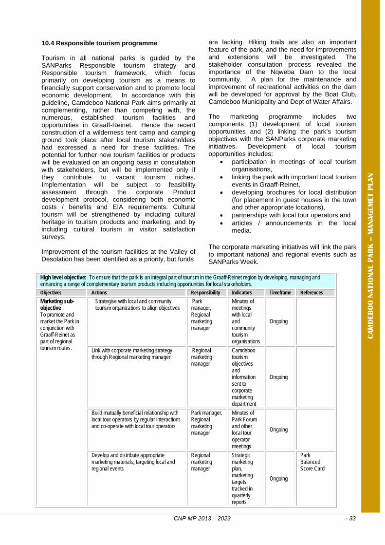
CNP MP 2013 – 2023 - 33
High level objective: To ensure that the park is an integral part of tourism in the Graaff-Reinet region by developing, managing and enhancing a range of complementary tourism products including opportunities for local stakeholders. Objectives Actions Responsibility Indicators Timeframe References
Marketing sub-objective To promote and market the Park in conjunction with Graaff-Reinet as part of regional tourism routes.
Strategise with local and community tourism organizations to align objectives
Park manager, Regional marketing manager
Minutes of meetings with local and community tourism organisations
Ongoing
Link with corporate marketing strategy through Regional marketing manager
Regional marketing manager
Camdeboo tourism objectives and information sent to corporate marketing department
Ongoing
Build mutually beneficial relationship with local tour operators by regular interactions and co-operate with local tour operators
Park manager, Regional marketing manager
Minutes of Park Forum and other local tour operator meetings
Ongoing
Develop and distribute appropriate marketing materials, targeting local and regional events
Regional marketing manager
Strategic marketing plan, marketing targets tracked in quarterly reports
Ongoing
Park Balanced Score Card
CAM
DEB
OO
NATIO
NAL P
AR
K –
MANAG
EM
ET P
LAN
10.4 Responsible tourism programme Tourism in all national parks is guided by the SANParks Responsible tourism strategy and Responsible tourism framework, which focus primarily on developing tourism as a means to financially support conservation and to promote local economic development. In accordance with this guideline, Camdeboo National Park aims primarily at complementing, rather than competing with, the numerous, established tourism facilities and opportunities in Graaff-Reinet. Hence the recent construction of a wilderness tent camp and camping ground took place after local tourism stakeholders had expressed a need for these facilities. The potential for further new tourism facilities or products will be evaluated on an ongoing basis in consultation with stakeholders, but will be implemented only if they contribute to vacant tourism niches. Implementation will be subject to feasibility assessment through the corporate Product development protocol, considering both economic costs / benefits and EIA requirements. Cultural tourism will be strengthened by including cultural heritage in tourism products and marketing, and by including cultural tourism in visitor satisfaction surveys. Improvement of the tourism facilities at the Valley of Desolation has been identified as a priority, but funds
are lacking. Hiking trails are also an important feature of the park, and the need for improvements and extensions will be investigated. The stakeholder consultation process revealed the importance of the Nqweba Dam to the local community. A plan for the maintenance and improvement of recreational activities on the dam will be developed for approval by the Boat Club, Camdeboo Municipality and Dept of Water Affairs. The marketing programme includes two components (1) development of local tourism opportunities and (2) linking the park’s tourism objectives with the SANParks corporate marketing initiatives. Development of local tourism opportunities includes:
participation in meetings of local tourism organisations,
linking the park with important local tourism events in Graaff-Reinet,
developing brochures for local distribution (for placement in guest houses in the town and other appropriate locations),
partnerships with local tour operators and articles / announcements in the local
media. The corporate marketing initiatives will link the park to important national and regional events such as SANParks Week.
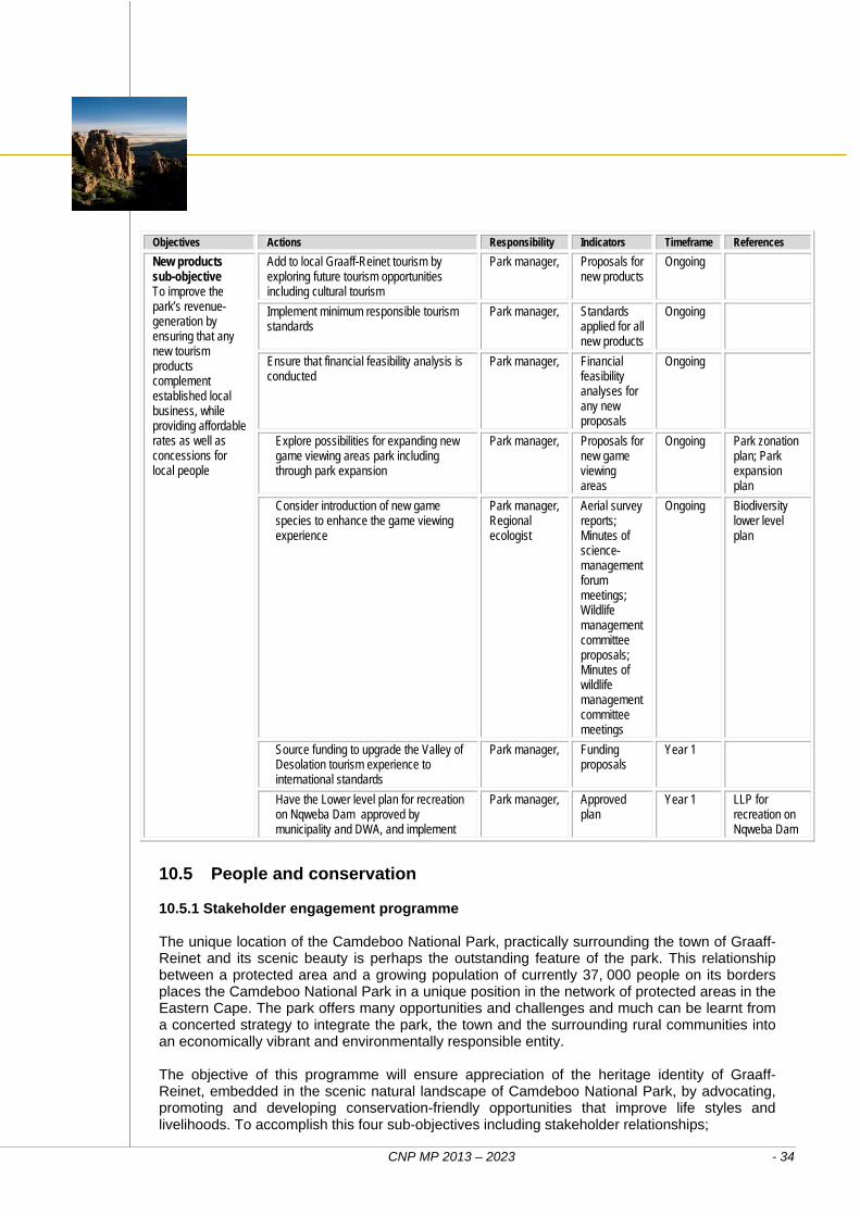
CNP MP 2013 – 2023 - 34
Objectives Actions Responsibility Indicators Timeframe References
New products sub-objective To improve the park’s revenue-generation by ensuring that any new tourism products complement established local business, while providing affordable rates as well as concessions for local people
Add to local Graaff-Reinet tourism by exploring future tourism opportunities including cultural tourism
Park manager,
Proposals for new products
Ongoing
Implement minimum responsible tourism standards
Park manager, Standards applied for all new products
Ongoing
Ensure that financial feasibility analysis is conducted
Park manager,
Financial feasibility analyses for any new proposals
Ongoing
Explore possibilities for expanding new game viewing areas park including through park expansion
Park manager,
Proposals for new game viewing areas
Ongoing Park zonation plan; Park expansion plan
Consider introduction of new game species to enhance the game viewing experience
Park manager, Regional ecologist
Aerial survey reports; Minutes of science-management forum meetings; Wildlife management committee proposals; Minutes of wildlife management committee meetings
Ongoing Biodiversity lower level plan
Source funding to upgrade the Valley of Desolation tourism experience to international standards
Park manager, Funding proposals
Year 1
Have the Lower level plan for recreation on Nqweba Dam approved by municipality and DWA, and implement
Park manager,
Approved plan
Year 1 LLP for recreation on Nqweba Dam
10.5 People and conservation 10.5.1 Stakeholder engagement programme The unique location of the Camdeboo National Park, practically surrounding the town of Graaff-Reinet and its scenic beauty is perhaps the outstanding feature of the park. This relationship between a protected area and a growing population of currently 37, 000 people on its borders places the Camdeboo National Park in a unique position in the network of protected areas in the Eastern Cape. The park offers many opportunities and challenges and much can be learnt from a concerted strategy to integrate the park, the town and the surrounding rural communities into an economically vibrant and environmentally responsible entity. The objective of this programme will ensure appreciation of the heritage identity of Graaff-Reinet, embedded in the scenic natural landscape of Camdeboo National Park, by advocating, promoting and developing conservation-friendly opportunities that improve life styles and livelihoods. To accomplish this four sub-objectives including stakeholder relationships;
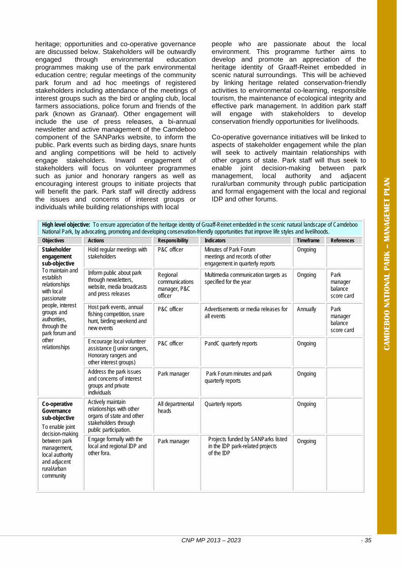
CNP MP 2013 – 2023 - 35
High level objective: To ensure appreciation of the heritage identity of Graaff-Reinet embedded in the scenic natural landscape of Camdeboo National Park, by advocating, promoting and developing conservation-friendly opportunities that improve life styles and livelihoods. Objectives Actions Responsibility Indicators Timeframe References
Stakeholder engagement sub-objective To maintain and establish relationships with local passionate people, interest groups and authorities, through the park forum and other relationships
Hold regular meetings with stakeholders
P&C officer Minutes of Park Forum meetings and records of other engagement in quarterly reports
Ongoing
Inform public about park through newsletters, website, media broadcasts and press releases
Regional communications manager, P&C officer
Multimedia communication targets as specified for the year
Ongoing Park manager balance score card
Host park events, annual fishing competition, snare hunt, birding weekend and new events
P&C officer Advertisements or media releases for all events
Annually Park manager balance score card
Encourage local volunteer assistance (Junior rangers, Honorary rangers and other interest groups)
P&C officer PandC quarterly reports Ongoing
Address the park issues and concerns of interest groups and private individuals
Park manager Park Forum minutes and park quarterly reports
Ongoing
Co-operative Governance sub-objective
To enable joint decision-making between park management, local authority and adjacent rural/urban community
Actively maintain relationships with other organs of state and other stakeholders through public participation.
All departmental heads
Quarterly reports Ongoing
Engage formally with the local and regional IDP and other fora.
Park manager Projects funded by SANParks listed in the IDP park-related projects of the IDP
Ongoing
CAM
DEB
OO
NATIO
NAL P
AR
K –
MANAG
EM
ET P
LAN
heritage; opportunities and co-operative governance are discussed below. Stakeholders will be outwardly engaged through environmental education programmes making use of the park environmental education centre; regular meetings of the community park forum and ad hoc meetings of registered stakeholders including attendance of the meetings of interest groups such as the bird or angling club, local farmers associations, police forum and friends of the park (known as Granaat). Other engagement will include the use of press releases, a bi-annual newsletter and active management of the Camdeboo component of the SANParks website, to inform the public. Park events such as birding days, snare hunts and angling competitions will be held to actively engage stakeholders. Inward engagement of stakeholders will focus on volunteer programmes such as junior and honorary rangers as well as encouraging interest groups to initiate projects that will benefit the park. Park staff will directly address the issues and concerns of interest groups or individuals while building relationships with local
people who are passionate about the local environment. This programme further aims to develop and promote an appreciation of the heritage identity of Graaff-Reinet embedded in scenic natural surroundings. This will be achieved by linking heritage related conservation-friendly activities to environmental co-learning, responsible tourism, the maintenance of ecological integrity and effective park management. In addition park staff will engage with stakeholders to develop conservation friendly opportunities for livelihoods. Co-operative governance initiatives will be linked to aspects of stakeholder engagement while the plan will seek to actively maintain relationships with other organs of state. Park staff will thus seek to enable joint decision-making between park management, local authority and adjacent rural/urban community through public participation and formal engagement with the local and regional IDP and other forums.
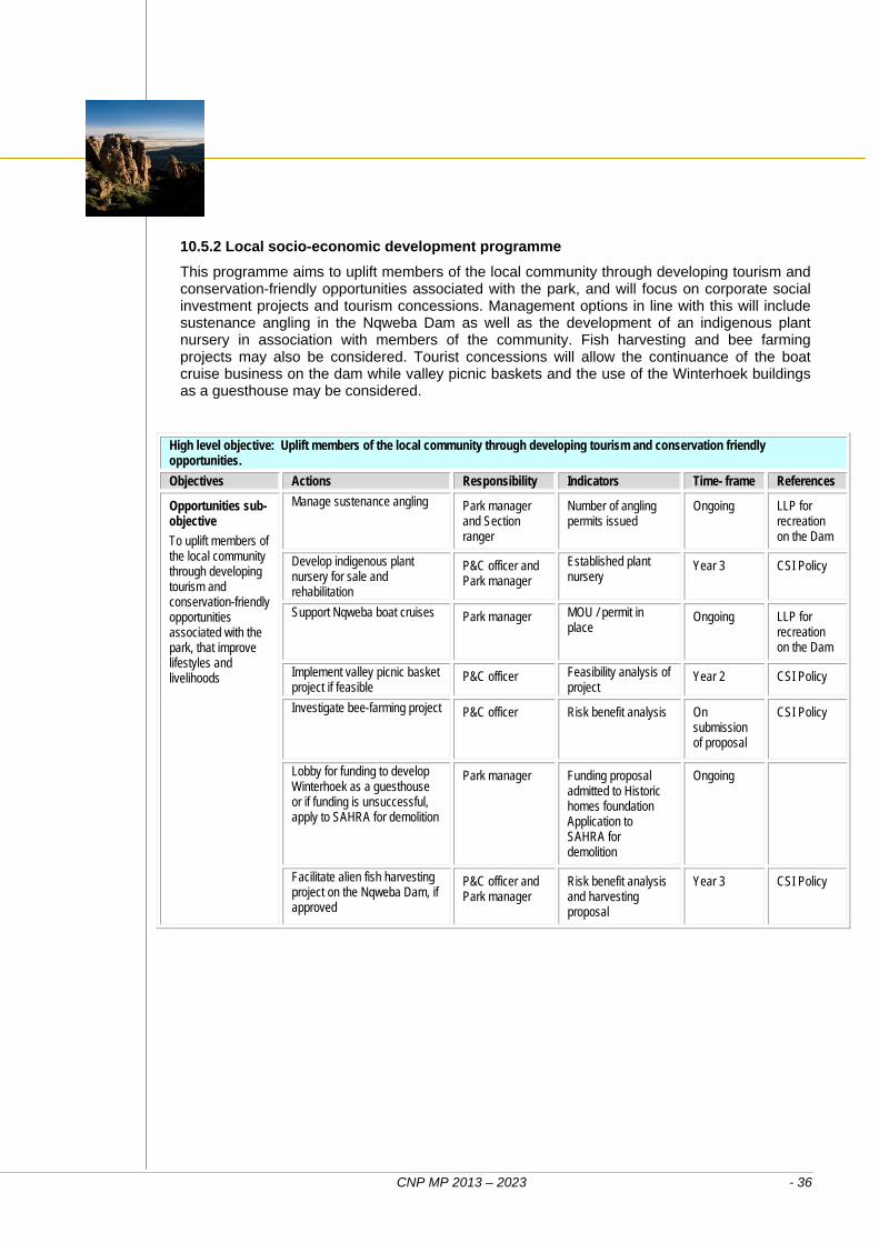
CNP MP 2013 – 2023 - 36
High level objective: Uplift members of the local community through developing tourism and conservation friendly opportunities.
Objectives Actions Responsibility Indicators Time- frame References
Opportunities sub-objective
To uplift members of the local community through developing tourism and conservation-friendly opportunities associated with the park, that improve lifestyles and livelihoods
Manage sustenance angling Park manager and Section ranger
Number of angling permits issued
Ongoing LLP for recreation on the Dam
Develop indigenous plant nursery for sale and rehabilitation
P&C officer and Park manager
Established plant nursery
Year 3 CSI Policy
Support Nqweba boat cruises Park manager MOU / permit in place
Ongoing LLP for recreation on the Dam
Implement valley picnic basket project if feasible
P&C officer Feasibility analysis of project
Year 2 CSI Policy
Investigate bee-farming project P&C officer Risk benefit analysis On submission of proposal
CSI Policy
Lobby for funding to develop Winterhoek as a guesthouse or if funding is unsuccessful, apply to SAHRA for demolition
Park manager Funding proposal admitted to Historic homes foundation Application to SAHRA for demolition
Ongoing
Facilitate alien fish harvesting project on the Nqweba Dam, if approved
P&C officer and Park manager
Risk benefit analysis and harvesting proposal
Year 3 CSI Policy
10.5.2 Local socio-economic development programme
This programme aims to uplift members of the local community through developing tourism and conservation-friendly opportunities associated with the park, and will focus on corporate social investment projects and tourism concessions. Management options in line with this will include sustenance angling in the Nqweba Dam as well as the development of an indigenous plant nursery in association with members of the community. Fish harvesting and bee farming projects may also be considered. Tourist concessions will allow the continuance of the boat cruise business on the dam while valley picnic baskets and the use of the Winterhoek buildings as a guesthouse may be considered.
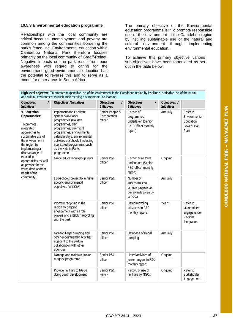
CNP MP 2013 – 2023 - 37
High level objective: To promote responsible use of the environment in the Camdeboo region by instilling sustainable use of the natural and cultural environment through implementing environmental co-learning
Objectives / Initiatives
Objectives / Initiatives Objectives / Initiatives
Objectives / Initiatives
Objectives / Initiatives
1. Education Opportunities: To promote integrated approaches to sustainable use of the environment in the region by implementing a diverse range of education opportunities as well as provide for the youth development needs of the community.
Implement and Facilitate generic SANParks programmes (Holiday programmes, day programmes, overnight programmes, environmental calendar days, environmental activities at schools ) including sponsored programmes such as the Kids in Parks programme
Senior People & Conservation officer
Record of programmes undertaken (Senior P&C Officer monthly report)
Annually Refer to Environmental Education Lower Level Plan
Guide educational group tours Senior P&C officer
Record of all tours undertaken (Senior P&C officer monthly report)
Ongoing
Eco-schools project to achieve specific environmental objectives (WESSA)
Senior P&C officer
Number of successful eco-schools projects as per awards given by WESSA
Annually
Promote recycling in the region by ongoing engagement with all role players and establish recycling with the park
Senior P&C officer
Listed recycling initiatives in P&C monthly reports
Year 1 Refer to stakeholder engage under Regional Integration
Monitor illegal dumping and other eco-unfriendly activities adjacent to the park in collaboration with other agencies
Senior P&C officer
Database of illegal dumping
Annually
Manage and maintain Junior rangers' programme
Senior P&C officer
Listed activities of junior rangers in P&C monthly report
Ongoing
Provide facilities to NGOs doing youth development
Senior P&C officer
Record of use of facilities by NGOs
Ongoing Refer to Stakeholder Engagement
CAM
DEB
OO
NATIO
NAL P
AR
K –
MANAG
EM
ET P
LAN
10.5.3 Environmental education programme
Relationships with the local community are critical because unemployment and poverty are common among the communities bordering the park’s fence line. Environmental education within Camdeboo National Park therefore focuses primarily on the local community of Graaff-Reinet. Negative impacts on the park result from poor awareness with regard to caring for the environment; good environmental education has the potential to reverse this and to serve as a model for other areas in South Africa.
The primary objective of the Environmental education programme is: ‘To promote responsible use of the environment in the Camdeboo region by instilling sustainable use of the natural and cultural environment through implementing environmental education. To achieve this primary objective various sub-objectives have been formulated as set out in the table below.
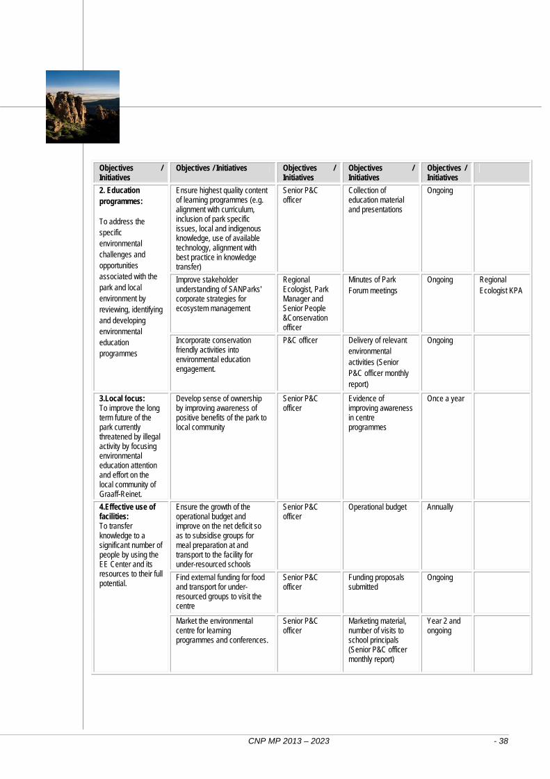
CNP MP 2013 – 2023 - 38
Objectives / Initiatives
Objectives / Initiatives Objectives / Initiatives
Objectives / Initiatives
Objectives / Initiatives
2. Education programmes:
To address the specific environmental challenges and opportunities associated with the park and local environment by reviewing, identifying and developing environmental education programmes
Ensure highest quality content of learning programmes (e.g. alignment with curriculum, inclusion of park specific issues, local and indigenous knowledge, use of available technology, alignment with best practice in knowledge transfer)
Senior P&C officer
Collection of education material and presentations
Ongoing
Improve stakeholder understanding of SANParks' corporate strategies for ecosystem management
Regional Ecologist, Park Manager and Senior People &Conservation officer
Minutes of Park Forum meetings
Ongoing Regional Ecologist KPA
Incorporate conservation friendly activities into environmental education engagement.
P&C officer Delivery of relevant environmental activities (Senior P&C officer monthly report)
Ongoing
3.Local focus: To improve the long term future of the park currently threatened by illegal activity by focusing environmental education attention and effort on the local community of Graaff-Reinet.
Develop sense of ownership by improving awareness of positive benefits of the park to local community
Senior P&C officer
Evidence of improving awareness in centre programmes
Once a year
4.Effective use of facilities: To transfer knowledge to a significant number of people by using the EE Center and its resources to their full potential.
Ensure the growth of the operational budget and improve on the net deficit so as to subsidise groups for meal preparation at and transport to the facility for under-resourced schools
Senior P&C officer
Operational budget Annually
Find external funding for food and transport for under-resourced groups to visit the centre
Senior P&C officer
Funding proposals submitted
Ongoing
Market the environmental centre for learning programmes and conferences.
Senior P&C officer
Marketing material, number of visits to school principals (Senior P&C officer monthly report)
Year 2 and ongoing
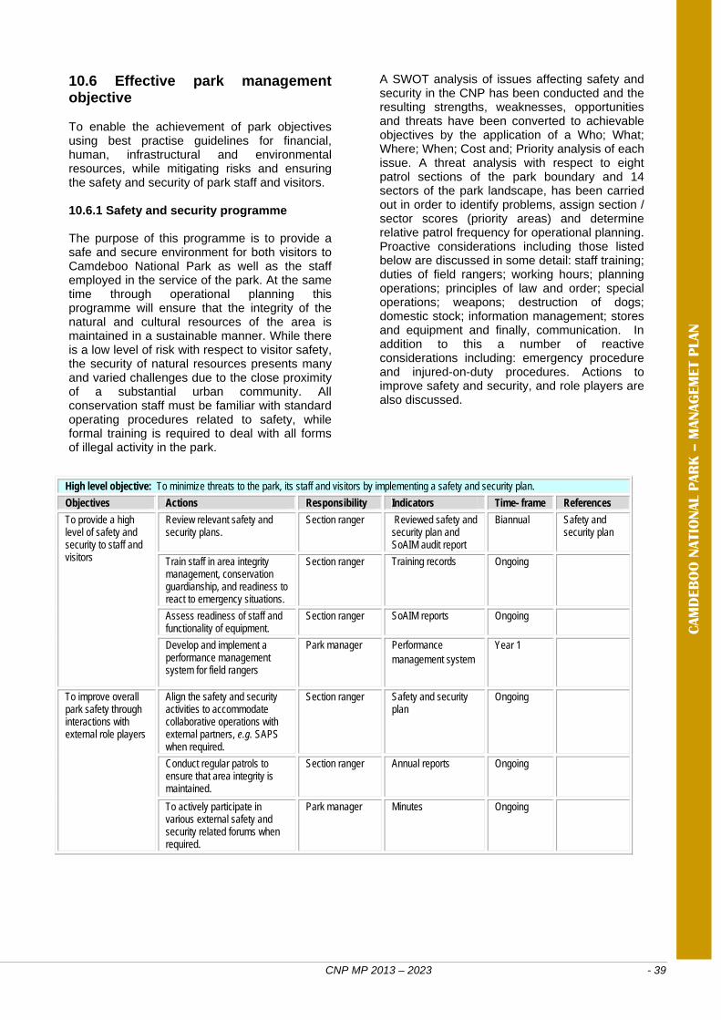
CNP MP 2013 – 2023 - 39
High level objective: To minimize threats to the park, its staff and visitors by implementing a safety and security plan.
Objectives Actions Responsibility Indicators Time- frame References
To provide a high level of safety and security to staff and visitors
Review relevant safety and security plans.
Section ranger Reviewed safety and security plan and SoAIM audit report
Biannual Safety and security plan
Train staff in area integrity management, conservation guardianship, and readiness to react to emergency situations.
Section ranger Training records Ongoing
Assess readiness of staff and functionality of equipment.
Section ranger SoAIM reports Ongoing
Develop and implement a performance management system for field rangers
Park manager Performance management system
Year 1
To improve overall park safety through interactions with external role players
Align the safety and security activities to accommodate collaborative operations with external partners, e.g. SAPS when required.
Section ranger Safety and security plan
Ongoing
Conduct regular patrols to ensure that area integrity is maintained.
Section ranger Annual reports Ongoing
To actively participate in various external safety and security related forums when required.
Park manager Minutes Ongoing
CAM
DEB
OO
NATIO
NAL P
AR
K –
MANAG
EM
ET P
LAN
10.6 Effective park management objective To enable the achievement of park objectives using best practise guidelines for financial, human, infrastructural and environmental resources, while mitigating risks and ensuring the safety and security of park staff and visitors. 10.6.1 Safety and security programme The purpose of this programme is to provide a safe and secure environment for both visitors to Camdeboo National Park as well as the staff employed in the service of the park. At the same time through operational planning this programme will ensure that the integrity of the natural and cultural resources of the area is maintained in a sustainable manner. While there is a low level of risk with respect to visitor safety, the security of natural resources presents many and varied challenges due to the close proximity of a substantial urban community. All conservation staff must be familiar with standard operating procedures related to safety, while formal training is required to deal with all forms of illegal activity in the park.
A SWOT analysis of issues affecting safety and security in the CNP has been conducted and the resulting strengths, weaknesses, opportunities and threats have been converted to achievable objectives by the application of a Who; What; Where; When; Cost and; Priority analysis of each issue. A threat analysis with respect to eight patrol sections of the park boundary and 14 sectors of the park landscape, has been carried out in order to identify problems, assign section / sector scores (priority areas) and determine relative patrol frequency for operational planning. Proactive considerations including those listed below are discussed in some detail: staff training; duties of field rangers; working hours; planning operations; principles of law and order; special operations; weapons; destruction of dogs; domestic stock; information management; stores and equipment and finally, communication. In addition to this a number of reactive considerations including: emergency procedure and injured-on-duty procedures. Actions to improve safety and security, and role players are also discussed.
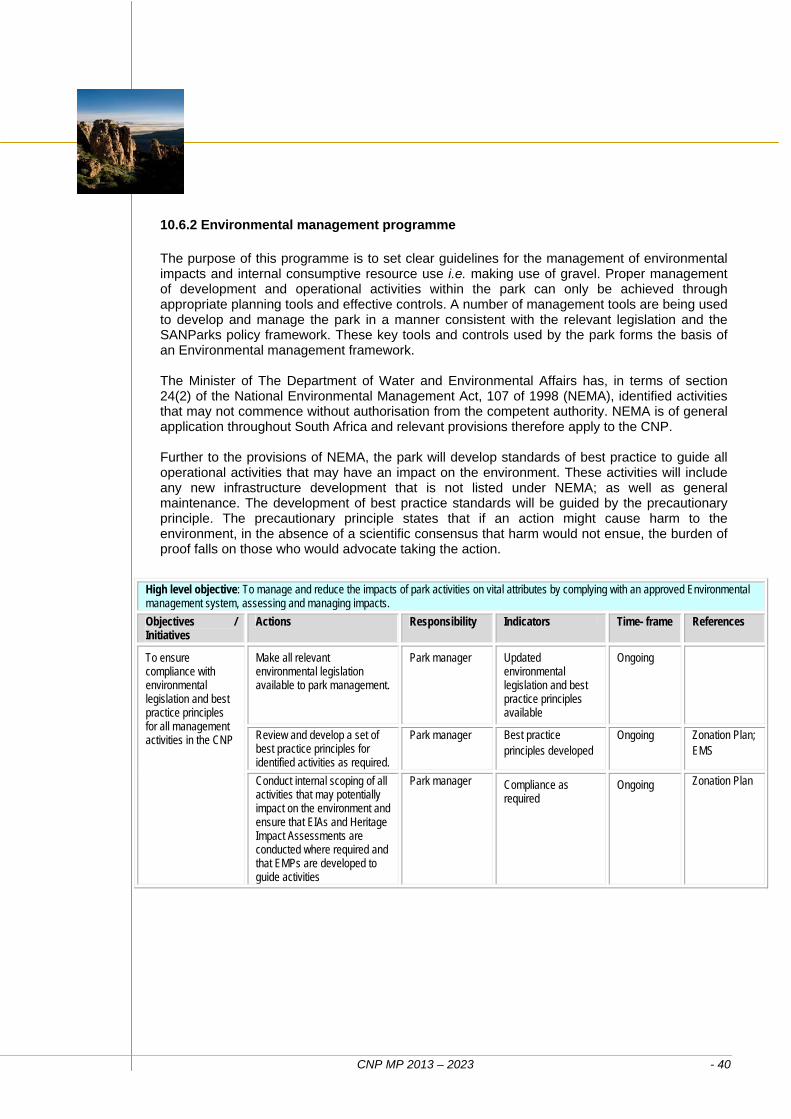
CNP MP 2013 – 2023 - 40
High level objective: To manage and reduce the impacts of park activities on vital attributes by complying with an approved Environmental management system, assessing and managing impacts.
Objectives / Initiatives
Actions Responsibility Indicators Time- frame References
To ensure compliance with environmental legislation and best practice principles for all management activities in the CNP
Make all relevant environmental legislation available to park management.
Park manager Updated environmental legislation and best practice principles available
Ongoing
Review and develop a set of best practice principles for identified activities as required.
Park manager Best practice principles developed
Ongoing Zonation Plan; EMS
Conduct internal scoping of all activities that may potentially impact on the environment and ensure that EIAs and Heritage Impact Assessments are conducted where required and that EMPs are developed to guide activities
Park manager Compliance as required
Ongoing
Zonation Plan
10.6.2 Environmental management programme The purpose of this programme is to set clear guidelines for the management of environmental impacts and internal consumptive resource use i.e. making use of gravel. Proper management of development and operational activities within the park can only be achieved through appropriate planning tools and effective controls. A number of management tools are being used to develop and manage the park in a manner consistent with the relevant legislation and the SANParks policy framework. These key tools and controls used by the park forms the basis of an Environmental management framework. The Minister of The Department of Water and Environmental Affairs has, in terms of section 24(2) of the National Environmental Management Act, 107 of 1998 (NEMA), identified activities that may not commence without authorisation from the competent authority. NEMA is of general application throughout South Africa and relevant provisions therefore apply to the CNP. Further to the provisions of NEMA, the park will develop standards of best practice to guide all operational activities that may have an impact on the environment. These activities will include any new infrastructure development that is not listed under NEMA; as well as general maintenance. The development of best practice standards will be guided by the precautionary principle. The precautionary principle states that if an action might cause harm to the environment, in the absence of a scientific consensus that harm would not ensue, the burden of proof falls on those who would advocate taking the action.
CNP MP 2013 – 2023 - 41
High level objective: To ensure a harmonious and productive work environment with a developed and capacitated workforce in the park
Objectives Actions Responsibility Indicators Timeframe References
To ensure the park attracts and retains the most suitable human capital
Recruit staff according to corporate selection and recruitment policy
Park manager and HR officer
Interview records
Ongoing
Appraise staff according to performance management system
Park manager and HR officer
Balanced Score Cards
Ongoing
To implement plans and skills development strategies to meet the strategic goals of the organisation
Facilitate skills audit Park manager and HR officer
Skills audit report
Ongoing
Facilitate the development of skills plans
Park manager and HR officer
Skills development plan
Ongoing
Facilitate training interventions Park manager and HR officer
Training records
Ongoing
CAM
DEB
OO
NATIO
NAL P
AR
K –
MANAG
EM
ET P
LAN
10.6.3 Human capital development programme The purpose of the human capital development programme is to ensure that the park is supported by an adequate human resources function in order to provide effective conservation, visitor and supporting services. SANParks has developed corporate human resources policies, guidelines and procedures to guide the park and its workforce in an effectively organised structure focusing operations. By adhering to these policies, guidelines and procedures the park will ensure that competent staff is appointed, and that current staff will be managed in an effective manner to keep them positive, proactive and committed to their tasks and responsibilities. This will also ensure that human resource management will comply with the relevant national legislation. The park strives for the effective management of human capital through the recruitment and selection of highly qualified individuals to meet the strategic objectives of the organisation. We seek to promote lifelong learning within the organisation by implementing a skills development programme informed by a skills audit. The park furthermore seeks to maintain a healthy workforce within a supportive environment, and specific objectives include inculcating a sense of wellness, to maximise work performance and to develop an institutional culture that is sensitive to the needs of those in need of help. Transformation will be enhanced by implementing the Employment equity plan and ensure the attainment of the set equity targets. The park has an establishment figure of 28. Each employee has set goals in terms of defined individual development plans. These development plans are based on the individual’s training needs as agreed upon by the employee and his / her supervisor.
The use of the SETA’s for funding the training will be explored both at head office and park level. A Work place skills development plan is also produced for the park every year as required by legislation. This is coordinated at head office level, with input from the park and the Employment equity forum. The park reviews training needs on an annual basis and submits this to SANParks head office for authorisation. Compilation of training needs starts off with the Individual development plan for each staff member and then finalised with performance appraisals. Management also encourages and analyses all staff to improve their levels of skills and qualifications in their relevant field of expertise on an ongoing basis. The administration of procurement, human resource issues, bookings and finances are implemented through the park’s offices and all are governed and directed through SANParks’ standard processes and procedures. The management actions would typically involve:
Conducting a skills audit and aligning staff development with both park expansion and development objectives. Training needs are also established in this way.
Annual training calendars are drawn up for implementation (dependant on funding and management issues such as travel restrictions).
SANParks has established Employment equity and skills development forums in which the park should participate.
Individual development plans are drawn up for every staff member.
Study bursaries are annually made available for employees.
Various training interventions are assessed and considered for implementation, such as Adult basic education traing.
CNP MP 2013 – 2023 - 42
Objectives Actions Responsibility Indicators Timeframe References
Implement workplace health care programmes which focus on preventative physical and mental health care
Conduct wellness awareness workshops
Park manager and HR officer
Wellness programme
Ongoing
Ensure staff have access to ICAS Park manager and HR officer
Access available
Ongoing
Invite professionals to the park to promote awareness on OHS and mental health issues
Park manager and HR officer
Monthly reports
Ongoing
High level objective: To implement best practice in the field of records and information management
Objectives Actions Responsibility Indicators Timeframe References
To develop and implement a records management and file plan for the park in accordance with SANParks policies and procedures
Implement the corporate file plan Park manager, Administration officer
Records and documents filed in terms of plan
Ongoing Corporate file plan and policy
To establish a park based geographic information system capacity
Park manager GIS software and trained personnel
Year 1
Ensure appropriate access to park files and records in accordance to corporate records management policy and guidelines.
Park manager, Administration officer
Access procedures recorded and implemented
Ongoing Corporate file plan and records management policy
10.6.4 Information management programme The management and dissemination of information plays a significant role in ensuring the efficient management of the park. Such data is not only essential for formulating effective long-term management objectives, plans, programmes and systems, but also for educating and informing residents associations, user groups, local authorities, provincial and national decision and policy makers, international organisations and aid / donor agencies. It is vital that the appropriate data and information is collected, maintained and made readily accessible to staff responsible for all aspects of management. As such the park requires integration with SANParks national information systems, i.e. financial, human resources and reservations while acting as a source of spatial and research information for both SANParks and research institutions. In order to keep the information in SANParks databases current, pertinent information systems and management support needs to be setup for the park.
10.6.5 Risk management programme The management of business risk is regarded by SANParks as an integral part of management across all business operations. In line with corporate governance best practices and as per PFMA requirements, the Board of SANParks has formalised the risk management processes by adopting a Corporate Risk Management Framework. As its foundation, the risk management framework has enterprise-wide risk identification and an assessment process, based on a thorough understanding of the environment in which the organisation operates and the strategic corporate objectives it intends to deliver on. The main aim of the Corporate Risk Management Framework is to instil a culture of corporate risk management and risk ownership being practised as the responsibility of all. This will provide SANParks with a comprehensive understanding of all identified risks and their potential impact on the achievement of objectives - thereby creating a good basis for the effective management of those risks that are assessed as exceeding the risk appetite of the organisation.
CNP MP 2013 – 2023 - 43
High level objective: To ensure that emerging issues of risk, that can jeopardise the achievement of park (and SANParks’ corporate) objectives, are timely identified and assessed in terms of possible severity and managed. Objectives Actions Responsibility Indicators Timeframe References
To establish and maintain effective, efficient and transparent systems of risk management
To identify and assess risks for all business operations in the park.
Park manager
Risk register Ongoing
To develop and implement responses to address and prevent or mitigate issues of risk.
Park manager, Section ranger, P&C officer, HR and administration officer
Risk response plan
Ongoing PFMA, OHS Act, NEM:PAA, NHBRC regulations and other
To monitor effectiveness in terms of the risk response plan and improve as needed.
Park manager, Section ranger, P&C officer, HR and administration officer
BSC Ongoing
CAM
DEB
OO
NATIO
NAL P
AR
K –
MANAG
EM
ET P
LAN
Acknowledging that all activities occurring at different levels within the organisation are exposed to various types of risks, the focus of SANParks’ risk management framework is to shift the attention of the organisation towards a philosophy of optimising the balance between potential risks and the potential rewards that may emanate from both pro-active and conscious risk oriented actions. As such SANParks maintains a corporate risk profile of the identified key strategic risks the organisation faces. This profile is communicated to the Board and is reviewed on an ongoing basis. The risk profile reflects among others the risks identified, how each is addressed and or monitored. At individual park level the park manager is responsible for risk management. Being the link between the operational activities and its environment on the one hand, and the corporate support and management structure on the other, the park manager is in many instances responsible for implementation of corporate initiatives, programmes, the management plan and others that form part of the SANParks strategy to address or mitigate issues of risk.
Examples are the implementation and roll-out of a safety and security plan, implementing and maintaining ecological monitoring systems to identify and assess the impact of environmental change, and complying with financial and cash-flow directives especially in economically depressed times. Similarly, the park manager needs to ensure that emerging issues of risk, that can jeopardise the achievement of park (and SANParks’ corporate) objectives, are timely identified and assessed in terms of possible severity. In consultation with the corporate support structure such issues are either assessed to be within the management capacity of the park and its existing resources, or the matter is elevated to a corporate level, where a specific risk management strategy is agreed upon, resources allocated where applicable, and a risk management or monitoring plan is implemented. A particular risk area in the park is the recreational use of the Nqweba Dam, an aspect that will be taken up in the lower level plan for recreational use of the dam.
10.6.6 Financial management and administration programme As a public entity, SANParks is also governed by the Public Finance Management Act, Act 1 of 1999 (as amended by Act 29 of 1999), and it is listed as Schedule 3 Part A: 25 public entity. SANParks adopted the zero-based approach, which implies that every category must be critically assessed, evaluated and supported by an approved business plan. Annual budgets should be compiled in accordance to budget guidelines and instructions issued by SANParks Corporate finance division.
The budget period is for one financial year starting on 1 April and end on 31 March the following year. Without incisive financial management of the park, there can be no realistic conservation effort. For the next 10 years the park will ensure that all park operations and park projects are cost effective and financially sound. In addition particular attention will be given to developing a diverse income base and proactive financial networking to enable to the park to move towards being financially sustainable.
CNP MP 2013 – 2023 - 44
High level objective: To ensure sound financial management and administration
Objectives Actions Responsibility Indicators Timeframe References
To attain effective financial management of the CNP
Ensure less than 1% variance on cost of operations
Park manager, Financial manager
Monthly financial statements reflecting less than 1% variance
Ongoing Financial management systems
Ensure sound financial management of special projects; i.e Working for Water and others
ISCU Project manager
Budget targets achieved
Ongoing Project business plans
Identify possible external funding to supplement current income streams
Park manager, Financial manager
Funding proposals submitted
Ongoing Partnership contracts signed
Develop support mechanisms and procedures to receive grants and donations.
Park manager, Financial manager
Mechanisms and procedures in place
Year 1
To ensure financial accountability and align financial management systems
Facilitate an annual independent audit of financial records
Park manager, Financial manager
Audit report Ongoing
To ensure sound asset management Park manager, Heads of departments
Asset register Ongoing
To improve the management of financial resources
Prepare accurate and realistic annual budgets in consultation with management team that are in line with the management plan objectives
Park manager, Financial manager Heads of departments
Annual budgets prepared
Ongoing Annual budgets
Provide monthly financial reports timeously by cost centre
Financial manager
Financial reports prepared
Ongoing
10.6.7 Infrastructure programme The purpose of this programme over the next ten years will be on the upgrading and maintenance (day to day and scheduled) of existing infrastructure. Infrastructure in the park consists of facilities in support of conservation (such as management roads and tracks, office facilities, fences, bulk services, workshops and stores) and tourism (such as tourist roads and tracks, walking trails, bulk services, lookout points, hides, picnic site, and tourism accommodation). These facilities enable staff to execute the respective duties towards achieving the parks objectives and providing a tourism product at the best possible standard. A phased approach to the development of visitor infrastructure aims to provide a balanced range of facilities and opportunities for both local community and foreign tourists. The product development strategy, applicable legislation and limitations of the zonation shall guide new infrastructure development. Infrastructure must be developed and maintained in accordance with all applicable legislation, policies, standards and codes. Maintenance must be undertaken in a cost effective manner. As far as practicable incorporate good, cost effective environmental design, use low maintenance designs and material, and utilise existing roads and tracks and disturbed sites and to limit green field developments. All current infrastructure in CNP is listed in Section 7 Access and Facilities.
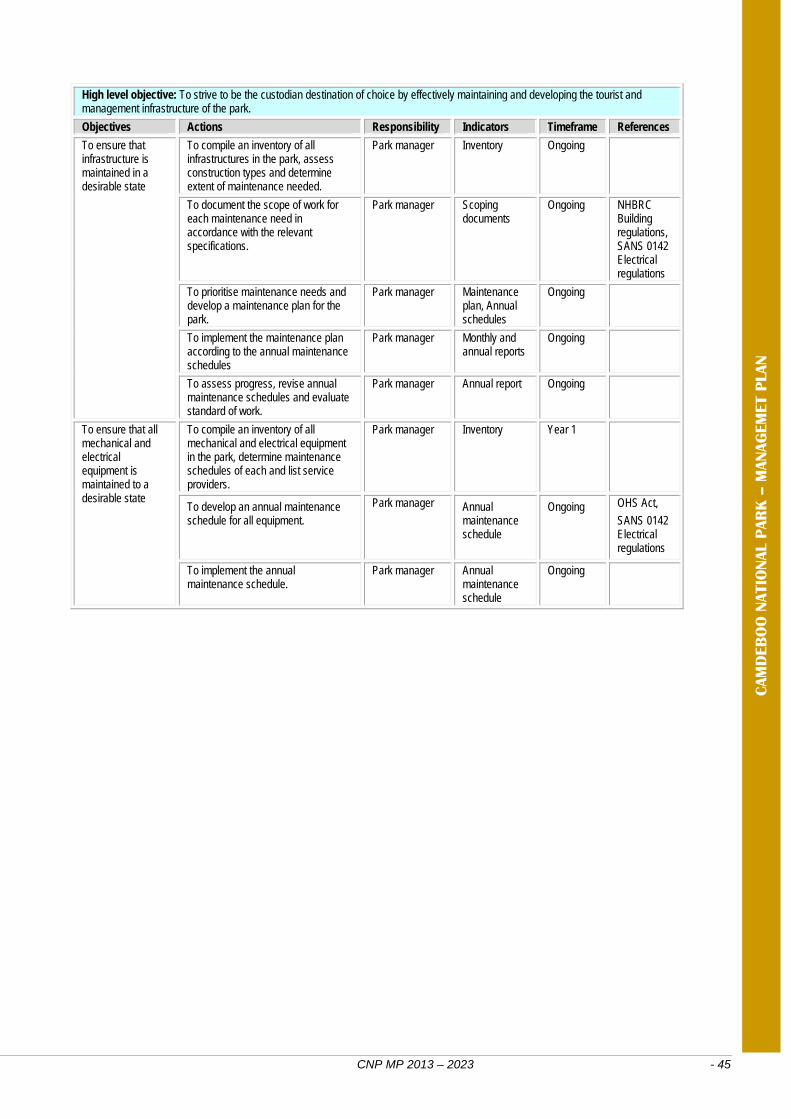
CNP MP 2013 – 2023 - 45
High level objective: To strive to be the custodian destination of choice by effectively maintaining and developing the tourist and management infrastructure of the park.
Objectives Actions Responsibility Indicators Timeframe References
To ensure that infrastructure is maintained in a desirable state
To compile an inventory of all infrastructures in the park, assess construction types and determine extent of maintenance needed.
Park manager Inventory Ongoing
To document the scope of work for each maintenance need in accordance with the relevant specifications.
Park manager Scoping documents
Ongoing NHBRC Building regulations, SANS 0142 Electrical regulations
To prioritise maintenance needs and develop a maintenance plan for the park.
Park manager Maintenance plan, Annual schedules
Ongoing
To implement the maintenance plan according to the annual maintenance schedules
Park manager Monthly and annual reports
Ongoing
To assess progress, revise annual maintenance schedules and evaluate standard of work.
Park manager Annual report Ongoing
To ensure that all mechanical and electrical equipment is maintained to a desirable state
To compile an inventory of all mechanical and electrical equipment in the park, determine maintenance schedules of each and list service providers.
Park manager Inventory Year 1
To develop an annual maintenance schedule for all equipment.
Park manager Annual maintenance schedule
Ongoing OHS Act,
SANS 0142 Electrical regulations
To implement the annual maintenance schedule.
Park manager Annual maintenance schedule
Ongoing
CAM
DEB
OO
NATIO
NAL P
AR
K –
MANAG
EM
ET P
LAN
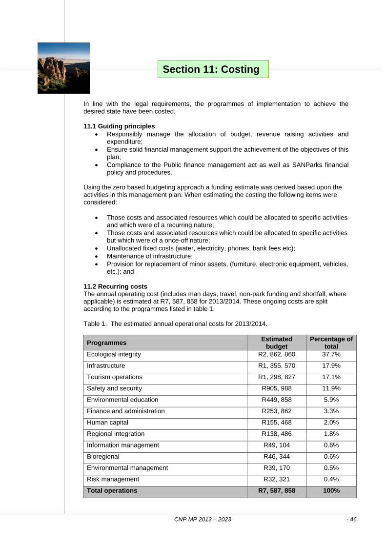
CNP MP 2013 – 2023 - 46
In line with the legal requirements, the programmes of implementation to achieve the desired state have been costed. 11.1 Guiding principles
Responsibly manage the allocation of budget, revenue raising activities and expenditure;
Ensure solid financial management support the achievement of the objectives of this plan;
Compliance to the Public finance management act as well as SANParks financial policy and procedures.
Using the zero based budgeting approach a funding estimate was derived based upon the activities in this management plan. When estimating the costing the following items were considered:
Those costs and associated resources which could be allocated to specific activities and which were of a recurring nature;
Those costs and associated resources which could be allocated to specific activities but which were of a once-off nature;
Unallocated fixed costs (water, electricity, phones, bank fees etc); Maintenance of infrastructure; Provision for replacement of minor assets, (furniture, electronic equipment, vehicles,
etc.); and 11.2 Recurring costs The annual operating cost (includes man days, travel, non-park funding and shortfall, where applicable) is estimated at R7, 587, 858 for 2013/2014. These ongoing costs are split according to the programmes listed in table 1. Table 1. The estimated annual operational costs for 2013/2014.
Programmes Estimated
budget Percentage of
total Ecological integrity R2, 862, 860 37.7%
Infrastructure R1, 355, 570 17.9%
Tourism operations R1, 298, 827 17.1%
Safety and security R905, 988 11.9%
Environmental education R449, 858 5.9%
Finance and administration R253, 862 3.3%
Human capital R155, 468 2.0%
Regional integration R138, 486 1.8%
Information management R49, 104 0.6%
Bioregional R46, 344 0.6%
Environmental management R39, 170 0.5%
Risk management R32, 321 0.4%
Total operations R7, 587, 858 100%
Section 11: Costing
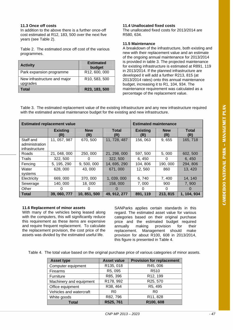
CNP MP 2013 – 2023 - 47
Asset type Asset value Provision for replacement Computer equipment R135, 018 R45, 006 Firearms R5, 095 R510 Furniture R85, 396 R12, 199 Machinery and equipment R178, 992 R25, 570 Office equipment R38, 464 R5, 495 Vehicles and watercraft R0 R0 White goods R82, 796 R11, 828
Total R525, 761 R100, 608
Estimated replacement value Estimated maintenance
Existing (R)
New (R)
Total (R)
Existing (R)
New (R)
Total (R)
Staff and administration infrastructure
11, 057, 987 670, 500 11, 728, 487 156, 063 9, 655 165, 718
Roads 21, 048, 000 250, 000 21, 298, 000 597, 500 5, 000 602, 500 Trails 322, 500 0 322, 500 6, 450 0 6, 450 Fencing 5, 195, 290 9, 500, 000 14, 695, 290 104, 806 190, 000 294, 806 Water systems
628, 000 43, 000 671, 000 12, 560 860 13, 420
Electricity 669, 000 370, 000 1, 039, 000 6, 740 7, 400 14, 140 Sewerage 140, 000 18, 000 158, 000 7, 000 900 7, 900 Other 0 0 0 0 0 0 Total 39, 060, 777 10, 851, 500 49, 912, 277 891, 119 213, 815 1, 104, 934
11.3 Once off costs In addition to the above there is a further once-off cost estimated at R12, 183, 500 over the next five years (see Table 2). Table 2. The estimated once off cost of the various programmes.
Activity Estimated
budget Park expansion programme R12, 600, 000
New infrastructure and major upgrades
R10, 583, 500
Total R23, 183, 500
11.4 Unallocated fixed costs The unallocated fixed costs for 2013/2014 are R580, 634. 11.5 Maintenance A breakdown of the infrastructure, both existing and new with their replacement value and an estimate of the ongoing annual maintenance for 2013/2014 is provided in table 3. The projected maintenance for existing infrastructure is estimated at R891, 119 in 2013/2014. If the planned infrastructure are developed it will add a further R213, 815 (at 2013/2014 rates) onto this annual maintenance budget, increasing it to R1, 104, 934. The maintenance requirement was calculated as a percentage of the replacement value.
CAM
DEB
OO
NATIO
NAL P
AR
K –
MANAG
EM
ET P
LAN
11.6 Replacement of minor assets With many of the vehicles being leased along with the computers, this will significantly reduce this requirement as these items are expensive and require frequent replacement. To calculate the replacement provision, the cost price of the assets was divided by the estimated useful life.
SANParks applies certain standards in this regard. The estimated asset value for various categories based on their original purchase price and the estimated budget required annually making provision for their replacement. Management should make provision for about R100, 608 in 2013/2014, this figure is presented in Table 4.
Table 4. The total value based on the original purchase price of various categories of minor assets.
Table 3. The estimated replacement value of the existing infrastructure and any new infrastructure required with the estimated annual maintenance budget for the existing and new infrastructure.
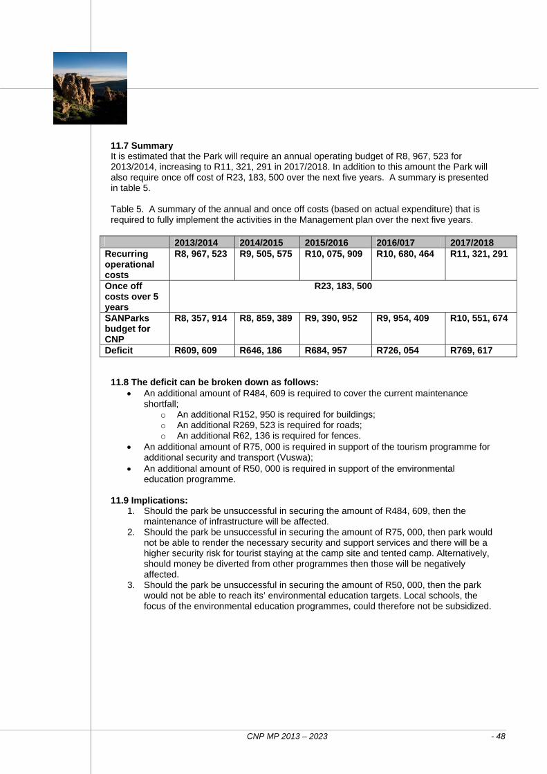
CNP MP 2013 – 2023 - 48
2013/2014 2014/2015 2015/2016 2016/017 2017/2018 Recurring operational costs
R8, 967, 523 R9, 505, 575 R10, 075, 909 R10, 680, 464 R11, 321, 291
Once off costs over 5 years
R23, 183, 500
SANParks budget for CNP
R8, 357, 914 R8, 859, 389 R9, 390, 952 R9, 954, 409 R10, 551, 674
Deficit R609, 609 R646, 186 R684, 957 R726, 054 R769, 617
11.7 Summary It is estimated that the Park will require an annual operating budget of R8, 967, 523 for 2013/2014, increasing to R11, 321, 291 in 2017/2018. In addition to this amount the Park will also require once off cost of R23, 183, 500 over the next five years. A summary is presented in table 5. Table 5. A summary of the annual and once off costs (based on actual expenditure) that is required to fully implement the activities in the Management plan over the next five years.
11.8 The deficit can be broken down as follows: An additional amount of R484, 609 is required to cover the current maintenance
shortfall; o An additional R152, 950 is required for buildings; o An additional R269, 523 is required for roads; o An additional R62, 136 is required for fences.
An additional amount of R75, 000 is required in support of the tourism programme for additional security and transport (Vuswa);
An additional amount of R50, 000 is required in support of the environmental education programme.
11.9 Implications:
1. Should the park be unsuccessful in securing the amount of R484, 609, then the maintenance of infrastructure will be affected.
2. Should the park be unsuccessful in securing the amount of R75, 000, then park would not be able to render the necessary security and support services and there will be a higher security risk for tourist staying at the camp site and tented camp. Alternatively, should money be diverted from other programmes then those will be negatively affected.
3. Should the park be unsuccessful in securing the amount of R50, 000, then the park would not be able to reach its’ environmental education targets. Local schools, the focus of the environmental education programmes, could therefore not be subsidized.
CNP MP 2013 – 2023 - 49
CAM
DEB
OO
NATIO
NAL P
AR
K –
MANAG
EM
ET P
LAN
CNP MP 2013 – 2023 - 50
References
Cluver, M.A. 1987. Fossil Reptiles of the South African Karoo. South African Museum, Cape Town. Coetzee. K.C. 1990. Karoo Nature Reserve Management Plan. Unpublished Report: CPA Chief Directorate: Nature and Environmental Conservation Cowan, G.I. & Nobusika Mpongoma, 2010. Guidelines for the development of a management plan for a protected area in terms of the National Environmental Management: Protected Areas Act, 2003. Unpublished document, Department of Environment Affairs, Pretoria. 17pp. DEA, 2008: South Africa’s National Protected Area Expansion Strategy: Priorities for Expanding the Protected Area Network for Ecological Sustainability and Climate Change Adaptation, Unpublished report. Department of Environmental Affairs, Pretoria Driver A, K Maze, M Rouget, AT Lombard, J Nel, JK Turpie, RM Cowling, P Desmet, P Goodman, J Harris, Z Jonas, B Reyers, K Sink, and T Strauss. 2005. National Spatial Biodiversity Assessment 2004: Priorities for biodiversity in South Africa. Strelitzia 17. South African National Biodiversity Institute, Pretoria. Holness S, MH Knight and G Castley. 2003. The greater Mountain Zebra National Park Development Plan: Linking Graaff-Reinet to Cradock. Internal report. Conservation Services Department, SANParks, Port Elizabeth. 36pp. Mucina L and MC Rutherford. 2006. The Vegetation of South Africa, Lesotho and Swaziland. Strelitzia 19 South African National Biodiversity Institute, Pretoria. Palmer, A.R. 1989. The vegetation of the Karoo Nature Reserve, Cape Province. 1. A phytosociological reconnaissance. S. Afr.J. Bot.,1989,55(2): 215-230 SANParks 2011. Report on the Camdeboo National Park Adaptive Planning Process for a Desired State. Unpublished document, South African National Parks, Pretoria, 12 pp. SANParks 2012. Biodiversity Lower Level Plan, Camdeboo National Park. Unpublished document, South African National Parks, Pretoria, 58 pp.

CNP MP 2013 – 2023 - 51
CAM
DEB
OO
NATIO
NAL P
AR
K –
MANAG
EM
ET P
LAN
CNP MP 2013 – 2023 - 52
Appendix 1: Declarations
CAMDEBOO NATIONAL PARK Government Notice 1070 in Government Gazette 28185 of 28 October 2005 proclaimed the following land as part of the Camdeboo National Park in terms of the National Parks Act, 1976 (Act 57 of 1976).
1. Erf 4311, a portion of Erf 1814, Graaff-Reinet in the extent of 7, 693.1067 ha situated in the municipality and district of Graaff-Reinet as described in SG Diagram 1548/1988.
2. Erf 3908, a portion of Erf 1814, Graaff-Reinet in the extent of 2, 359.1783 ha situated in the municipality and district of Graaff-Reinet as described in SG Diagram 8779/1981.
3. Erf 3569, a portion of Erf 1814, Graaff-Reinet in the extent of 2, 230.0292 ha situated in the municipality and district of Graaff-Reinet as described in SG Diagram 790/1977.
4. Erf 1920, Graaff-Reinet in extent of 54.3331 ha situated in the municipality and district of Graaff-Reinet as described in SG Diagram 3860/1939.
5. Erf 3570, a portion of Erf 1814, Graaff-Reinet in the extent of 1, 586.1569 ha situated in the municipality and district of Graaff-Reinet as described in SG Diagram 791/1977.
6. Erf 3866, a portion of Erf 1814, Graaff-Reinet in the extent of 311.5285 ha situated in the municipality and district of Graaff-Reinet as described in SG Diagram 3417/1980.
7. Erf 5289, a portion of Erf 1814, Graaff-Reinet in the extent of 221.9590 ha situated in the municipality and district of Graaff-Reinet as described in SG Diagram 7314/1990.
Government Notice 152 in Government Gazette 35073 of 2 March 2012 gave notice of the intention to declare the following land as part of the Camdeboo National Park in terms of the National Environmental Management: Protected Areas Act, 2003 (Act 57 of 2003).
1. Portion 3 of the Farm Pienaars River No 208, Graaff-Reinet Registration Division, Eastern Cape Province, in extent measuring 122,2142 ha, held by Deed of Transfer No. T71460/2006.
2. Portion 4 (Soethoek) (a portion of portion 1) of the Farm Grasrand No 334, Graaff-Reinet Registration Division, Eastern Cape Province, in extent measuring 112,9771 ha, held by Deed of Transfer No. T71460/2006.
3. Remainder of the Farm Winterhoek No 269, Graaff-Reinet Registration Division, Eastern Cape Province, in extent measuring 3, 983,2293 ha, held by Deed of Transfer No. T71460/2006.
4. Farm No. 271, Graaff-Reinet Registration Division, Eastern Cape Province, in extent measuring 119,8031 ha, held by Deed of Transfer No. T71460/2006.
5. Farm No. 272, Graaff-Reinet Registration Division, Eastern Cape Province, in extent measuring 46,3241 ha, held by Deed of Transfer No. T71460/2006.
6. Remainder of the Farm Annex Comdale No. 335, Graaff-Reinet Registration Division, Eastern Cape Province, in extent measuring 71,7303 ha, held by Deed of Transfer No. T71460/2006 and
7. Farm Annex Winterhoek No. 336, Graaff-Reinet Registration Division, Eastern Cape Province, in extent measuring 33,4390 ha, held by Deed of Transfer No. T71460/2006.
CNP MP 2013 – 2023 - 53
INTRODUCTION The primary objective of a park zoning plan is to establish a coherent spatial framework in and around a park to guide and co-ordinate conservation, tourism and visitor experience initiatives. A zoning plan plays an important role in minimising conflicts between different users of a park by separating potentially conflicting activities such as game viewing and day-visitor picnic areas whilst ensuring that activities which do not conflict with the park’s values and objectives (especially the conservation of the protected area’s natural systems and its biodiversity) can continue in appropriate areas. A zoning plan is also a legislated requirement of the Protected Areas Act, which stipulates that the management plan, which is to be approved by the Minister, must contain “a zoning of the area indicating what activities may take place in different sections of the area and the conservation objectives of those sections”. The zoning of Camdeboo National Park was based on an analysis and mapping of the sensitivity and value of a park’s biophysical, heritage and scenic resources; an assessment of the regional context; an assessment of the park’s current and planned infrastructure and tourist products; and an assessment of the expansion plan for the park and its implication for use zoning. This was undertaken in an iterative and consultative process. This document sets out the rationale for use zones, describes the zones, and provides management guidelines for each of the zones. In addition to internal use zoning, the zoning plan also describes how the park interacts with the processes which control land use and activities in the buffer zones around national parks (e.g. SDFs) and municipal IDPs. The buffer zones identify the area within which activities such as landuse change may have an influence on the park (current and future extent), describe responses at a strategic level, and serve to define the buffer zone in terms of the DEA Policy on buffer zones for national parks and the SANParks buffer zone policy. RATIONALE FOR USE ZONES The prime function of a protected area is to conserve biodiversity. Other functions, such as the need to ensure that visitors have access to the park, and that adjoining communities and local economies derive benefits from the area, potentially conflict with and compromise this primary function. Use zoning is the primary tool to ensure that visitors can have a wide range of quality experiences without comprising the
integrity of the environment. Further, people visit a park with differing expectations and recreational objectives. Some people are visiting a park purely to see wildlife as well as natural landscapes. Others wish to experience intangible attributes such as solitude, remoteness, wildness, and serenity (which can be grouped as wilderness qualities), while some visit to engage in a range of nature-based recreational activities, or to socialise in the rest camp. Different people have different accommodation requirements ranging from extreme roughing it, up to luxury catered accommodation. There is often conflict between the requirements different users and different activities. Appropriate use zoning serves to minimising conflicts between different users of a park by separating potentially conflicting activities such as game viewing and day-visitor picnic areas whilst ensuring that activities which do not conflict with the park’s values and objectives (especially the conservation of the protected area’s natural systems and its biodiversity) can continue in appropriate areas. Use zones serve to ensure that high intensity facilities and activities are placed in areas that are robust enough to tolerate intensive use, as well as to protect more sensitive areas of the park from over-utilization. PARK USE ZONATION SYSTEM The zoning system SANParks has adopted a dual zoning system for its parks. The system comprises: Visitor use zones covering the entire park, and Special management overlays which designate specific areas of a park that require special management interventions. The zoning of Camdeboo National Park is shown in Map 4, and summarised in Table One. The Zoning process and its linkage to the underlying environmental analysis The park use zonation plan is a lean version of the CDF. The park use zonation is based on the same biodiversity and landscape analyses undertaken for a CDF. However, certain elements underlying the CDF may not be fully incorporated into the park use zonation. In particular, the park use zonation plan will usually not incorporate elements such as a full tourism market analysis. Typically the park use zonation approach is applied in smaller and developing parks such as Camdeboo National Park, though the long term objective is to have a full CDF for all parks.
Appendix 2: Zoning
CAM
DEB
OO
NATIO
NAL P
AR
K –
MANAG
EM
ENT P
LAN
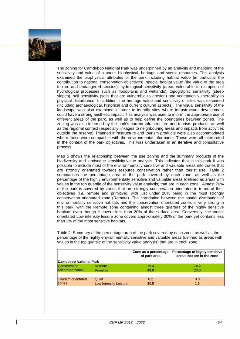
CNP MP 2013 – 2023 - 54
The zoning for Camdeboo National Park was underpinned by an analysis and mapping of the sensitivity and value of a park’s biophysical, heritage and scenic resources. This analysis examined the biophysical attributes of the park including habitat value (in particular the contribution to national conservation objectives), special habitat value (the value of the area to rare and endangered species), hydrological sensitivity (areas vulnerable to disruption of hydrological processes such as floodplains and wetlands), topographic sensitivity (steep slopes), soil sensitivity (soils that are vulnerable to erosion) and vegetation vulnerability to physical disturbance. In addition, the heritage value and sensitivity of sites was examined (including archaeological, historical and current cultural aspects). The visual sensitivity of the landscape was also examined in order to identify sites where infrastructure development could have a strong aesthetic impact. This analysis was used to inform the appropriate use of different areas of the park, as well as to help define the boundaries between zones. The zoning was also informed by the park’s current infrastructure and tourism products, as well as the regional context (especially linkages to neighbouring areas and impacts from activities outside the reserve). Planned infrastructure and tourism products were also accommodated where these were compatible with the environmental informants. These were all interpreted in the context of the park objectives. This was undertaken in an iterative and consultative process. Map 5 shows the relationship between the use zoning and the summary products of the biodiversity and landscape sensitivity-value analysis. This indicates that in this park it was possible to include most of the environmentally sensitive and valuable areas into zones that are strongly orientated towards resource conservation rather than tourist use. Table 2 summarises the percentage area of the park covered by each zone, as well as the percentage of the highly environmentally sensitive and valuable areas (defined as areas with values in the top quartile of the sensitivity value analysis) that are in each zone. Almost 70% of the park is covered by zones that are strongly conservation orientated in terms of their objectives (i.e. remote and primitive), with just under 20% being in the most strongly conservation orientated zone (Remote). The correlation between the spatial distribution of environmentally sensitive habitats and the conservation orientated zones is very strong in this park, with the Remote zone containing almost three quarters of the highly sensitive habitats even though it covers less than 20% of the surface area. Conversely, the tourist orientated Low intensity leisure zone covers approximately 30% of the park yet contains less than 2% of the most sensitive habitats.
Table 2: Summary of the percentage area of the park covered by each zone, as well as the percentage of the highly environmentally sensitive and valuable areas (defined as areas with values in the top quartile of the sensitivity value analysis) that are in each zone.
Zone as a percentage of park area
Percentage of highly sensitive areas that are in the zone
Remote 19.4 74.2Primitive 49.9 20.6
Quiet 0.2 0.0Low Intensity Leisure 30.5 1.3
Camdeboo National ParkConservation orientated zones
Tourism orientated zones
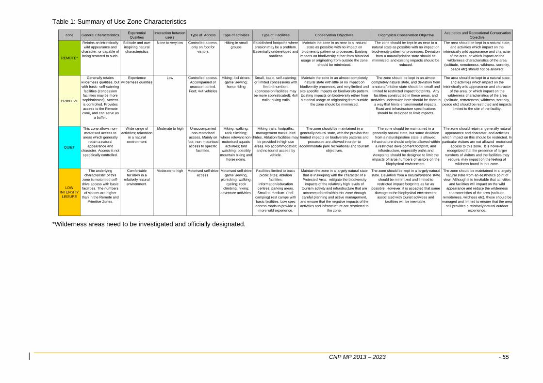
CNP MP 2013 – 2023 - 55
Table 1: Summary of Use Zone Characteristics
Zone General CharacteristicsExperential Qualities
Interaction between users
Type of Access Type of activities Type of Facilities Conservation Objectives Biophysical Conservation Objective Aesthetics and Recreational Conservation
Objective
REMOTE*
Retains an intrinsically wild appearance and
character, or capable of being restored to such.
Solitude and awe inspiring natural characteristics
None to very low Controlled access, only on foot for
visitors
Hiking in small groups
Established footpaths where erosion may be a problem.
Essentially undeveloped and roadless
Maintain the zone in as near to a natural state as possible with no impact on
biodiversity pattern or processes. Existing impacts on biodiversity either from historical usage or originating from outside the zone
should be minimized.
The zone should be kept in as near to a natural state as possible with no impact on biodiversity pattern or processes. Deviation
from a natural/pristine state should be minimized, and existing impacts should be
reduced.
The area should be kept in a natural state, and activities which impact on the
intrinsically wild appearance and character of the area, or which impact on the
wilderness characteristics of the area (solitude, remoteness, wildness, serenity,
peace etc) should not be allowed.
PRIMITIVE
Generally retains wilderness qualities, but with basic self-catering
facilities (concession facilities may be more sophisticated). Access is controlled. Provides access to the Remote
Zone, and can serve as a buffer.
Experience wilderness qualities
Low Controlled access. Accompanied or unaccompanied.
Foot; 4x4 vehicles
Hiking; 4x4 drives; game viewing;
horse riding
Small, basic, self-catering; or limited concessions with
limited numbers (concession facilities may
be more sophisticated); 4x4 trails; hiking trails
Maintain the zone in an almost completely natural state with little or no impact on
biodiversity processes, and very limited and site specific impacts on biodiversity pattern. Existing impacts on biodiversity either from historical usage or originating from outside
the zone should be minimized.
The zone should be kept in an almost completely natural state, and deviation from a natural/pristine state should be small and limited to restricted impact footprints. Any facilities constructed in these areas, and
activities undertaken here should be done in a way that limits environmental impacts. Road and infrastructure specifications should be designed to limit impacts.
The area should be kept in a natural state, and activities which impact on the
intrinsically wild appearance and character of the area, or which impact on the
wilderness characteristics of the area (solitude, remoteness, wildness, serenity,
peace etc) should be restricted and impacts limited to the site of the facility.
QUIET
This zone allows non-motorised access to
areas which generally retain a natural appearance and
character. Access is not specifically controlled.
Wide range of activities; relaxation
in a natural environment
Moderate to high Unaccompanied non-motorised
access. Mainly on foot, non-motorised access to specific
facilities.
Hiking; walking; rock climbing;
where relevant non-motorised aquatic
activities; bird watching; possibly
mountain biking and horse riding.
Hiking trails; footpaths; management tracks; bird
hides. Ablution facilities may be provided in high use
areas. No accommodation; and no tourist access by
vehicle.
The zone should be maintained in a generally natural state, with the proviso that limited impacts on biodiversity patterns and
processes are allowed in order to accommodate park recreational and tourism
objectives.
The zone should be maintained in a generally natural state, but some deviation
from a natural/pristine state is allowed. Infrastructure should only be allowed within
a restricted development footprint, and infrastructure, especially paths and
viewpoints should be designed to limit the impacts of large numbers of visitors on the
biophysical environment.
The zone should retain a generally natural appearance and character, and activities
which impact on this should be restricted. In particular visitors are not allowed motorised
access to this zone. It is however recognized that the presence of larger
numbers of visitors and the facilities they require, may impact on the feeling of
wildness found in this zone.
LOW INTENSITY LEISURE
The underlying characteristic of this
zone is motorised self-drive access with basic facilities. The numbers
of visitors are higher than in the Remote and
Primitive Zones.
Comfortable facilities in a
relatively natural environment.
Moderate to high Motorised self-drive access.
Motorised self-drive game viewing,
picnicking, walking, cycling; rock
climbing; hiking; adventure activities.
Facilities limited to basic picnic sites; ablution
facilities; information/education
centres; parking areas. Small to medium (incl.
camping) rest camps with basic facilities. Low spec access roads to provide a
more wild experience.
Maintain the zone in a largely natural state that is in keeping with the character of a Protected Area, mitigate the biodiversity
impacts of the relatively high levels of tourism activity and infrastructure that are accommodated within this zone through
careful planning and active management, and ensure that the negative impacts of the activities and infrastructure are restricted to
the zone.
The zone should be kept in a largely natural state. Deviation from a natural/pristine state
should be minimized and limited to restricted impact footprints as far as
possible. However, it is accepted that some damage to the biophysical environment
associated with tourist activities and facilities will be inevitable.
The zone should be maintained in a largely natural state from an aesthetics point of
view. Although it is inevitable that activities and facilities will impact on the wild
appearance and reduce the wilderness characteristics of the area (solitude,
remoteness, wildness etc), these should be managed and limited to ensure that the area
still provides a relatively natural outdoor experience.
*Wilderness areas need to be investigated and officially designated.
CNP MP 2013 – 2023 - 56
Remote zone: Characteristics: This is an area retaining an intrinsically wild appearance and character, or capable of being restored to such, and which is undeveloped. There are no permanent improvements or any form of human habitation. It provides outstanding opportunities for solitude with awe inspiring natural characteristics. If present at all, sight and sound of human habitation and activities are barely discernable and at a far distance. The zone also serves to protect sensitive environments from development impacts and tourism pressure. Visitor activities and experience: Activities: Access is strictly controlled and on foot. Groups must be small, and can either be accompanied by a guide or unaccompanied. Several groups may be in area at the same time, but if necessary densities and routes should be defined so that no signs can be seen or heard between the groups. The principles of “Pack it in Pack it out” must be applied. Interaction with other users: There is no interaction between groups. The numbers of groups within the area will be determined by the ability to ensure that there is no interaction between groups. Conservation objectives of the zone: The conservation objective is to maintain the zone in as near to a natural state as possible with no impact on biodiversity pattern or processes. Existing impacts on biodiversity either from historical usage or originating from outside the zone should be minimised. The zone should be managed within the following specific objectives: Biophysical environment: The zone should be kept in as near to a natural state as possible with no impact on biodiversity pattern or processes. Deviation from a natural / pristine state should be minimised, and existing impacts should be reduced. Aesthetics and recreational environment: The area should be kept in a natural state, and activities which impact on the intrinsically wild appearance and character of the area, or which impact on the wilderness characteristics of the area (solitude, remoteness, wildness, serenity, peace etc) should not be allowed. Facilities: Type and size: No facilities are provided. Should overnight facilities be required to serve this zone, these should be placed in the adjoining zones. Sophistication of facilities: No facilities except self carried portable tents. Guidelines for washing, ablution and cooking must be defined according to the “Pack it in Pack” it out principles. Camping is only allowed at designated sites. Audible equipment and communication structures: None. Access and roads: Public access is non-motorised. Vehicular access and parking is provided in the adjoining Primitive zone. Established footpaths may be provided where erosion risks occur. Limited low specification management tracks (i.e. not built up roads) are acceptable within this zone, though these should be rationalised, and eventually removed.
CNP MP 2013 – 2023 - 57
Conservation objectives of the zone: The conservation objective is to maintain the zone in an almost completely natural state with little or no impact on biodiversity processes, and very limited and site specific impacts on biodiversity pattern. Existing impacts on biodiversity either from historical usage or originating from outside the zone should be minimised. The zone should be managed within the following specific objectives: Biophysical environment: The zone should be kept in an almost completely natural state from a biodiversity perspective, and deviation from a natural / pristine state should be small and limited to restricted impact footprints. Existing impacts should be reduced. Any facilities constructed in these areas, and activities undertaken here should be done in a way that limits environmental impacts. Road and infrastructure specifications should be designed to limit impacts. Aesthetics and recreational environment: The area should be kept in a natural state, and activities which impact on the intrinsically wild appearance and character of the area, or which impact on the wilderness characteristics of the area (solitude, remoteness, wildness, serenity, peace etc) should be restricted and impacts limited to the site of the facility. Ideally visitors should only be aware of the facility or infrastructure that they are using, and this infrastructure / facility should be designed to fit in with the environment within which it is located in order to avoid aesthetic impacts. Facilities: Type and size: Facilities are small, often very basic, and are distributed to avoid contact between users. Alternatively facilities designed for high levels of luxury, but limited visitor numbers can be accommodated here (e.g. controlled access private camps or concession sites). Sophistication of facilities: Generally facilities are small, basic and self-catering, though concession facilities may be significantly more sophisticated. Audible equipment and communication structures: None. Access and roads: Vehicular access to facilities is limited to low-spec roads, often 4x4 only. Tourist and game viewing roads are 4x4 only. Established footpaths are provided to avoid erosion and braiding.
Location in park: In CNP, remote areas were designated in the mountain areas in the east of the park, as these areas have high environmental sensitivity and value as well as reasonable (in the context of the park) wilderness characteristics. It is anticipated that as the park expands eastwards, more remote areas will be incorporated. Primitive zone: Characteristics: The prime characteristic of the zone is the experience of wilderness qualities with the accent on controlled access. Access is controlled in terms of numbers, frequency and size of groups. The zone shares the wilderness qualities of wilderness areas and remote zones, but with the provision of basic self-catering facilities and access. It also provides access to the remote zone and wilderness area. Views of human activities and development outside of the park may be visible from this zone. This zone has the following functions: It provides the basic facilities and access to serve wilderness wreas and remote zones. It contains concession sites and other facilities where impacts are managed through strict control of the movement and numbers of tourists, for example if all tourists are in concession safari vehicles. It serves as a buffer to the fringe of the park and other zones, in particular wilderness and remote. It serves to protect sensitive environments from high levels of development. Visitor activities and experience: Activities: Access is controlled in terms of numbers, frequency and size of groups. Activities include hiking, 4x4 drives and game viewing. Access is controlled either through only allowing access to those with bookings for specific facilities, or alternatively through a specific booking or permit for a particular hiking trail or 4x4 route. Several groups may be in area at the same time, but access should be managed to minimise interaction between groups if necessary. Interaction with other users: Interaction between groups of users is low, and care must be taken in determining the number and nature of facilities located in the area in order to minimise these interactions.
CAM
DEB
OO
NATIO
NAL P
AR
K –
MANAG
EM
ENT P
LAN
CNP MP 2013 – 2023 - 58
Location in park: In CNP, primitive areas were designated to buffer remote areas and to protect most of the remaining sensitive areas (such as the remaining mountain areas and high priority vegetation types) from high levels of tourism activity. Primitive areas were also designated to allow management access into the remote mountain areas in the east, as well as to accommodate the existing overnight trail hut. In areas where remote zones border on the park boundary, a 100m wide primitive zone was designated to allow park management access to fences. Quiet Zone: Characteristics: This zone is characterized by unaccompanied non-motorised access without specific access control and permits. Visitors are allowed unaccompanied (or accompanied) access, mainly on foot, for a wide range of experiences. Larger numbers of visitors are allowed than in the Primitive zone and contact between visitors is frequent. The main accent is on unaccompanied non-motorised access. Larger numbers of visitors are allowed and contact between visitors is frequent. It is important to note that this zone may have different interpretations in different parks and the CDF documentation for each park should set the objectives specific to that park. Thus, in some instances horses and mountain bikes could be accommodated. This zone can also provide non-motorised access within Low and High intensity leisure zones away from vehicular access roads. Visitor activities and experience: Activities: Hiking, rock climbing, bird watching, self-guided constructed trails and walks. Interaction with other users: Interaction between groups of users is frequent. Conservation objectives of the zone: The zone should be maintained in a generally natural state, with the proviso that limited impacts on biodiversity patterns and processes are allowed in order to accommodate park recreational and tourism objectives. The zone should be managed within the following specific objectives: Biophysical environment: The zone should be maintained in a generally natural state, but some deviation from a natural / pristine state is allowed. Infrastructure should only be allowed within a restricted development footprint, and infrastructure, especially paths and viewpoints should be designed to limit the impacts of large numbers of visitors on the biophysical environment. Aesthetics and recreational environment: The zone should retain a generally natural appearance and character, and activities which impact on this should be restricted. In particular visitors are not allowed motorised access to this zone. It is however recognised that the presence of larger numbers of visitors and the facilities they require, may impact on the feeling of wildness found in this zone. Facilities: Type and size: Hiking trails, footpaths, bird hides. No accommodation. Ablution facilities may be provided in high use areas. Heritage structures may be used for recreation purposes.
CNP MP 2013 – 2023 - 59
However, it is accepted that some damage to the biophysical environment associated with tourist activities and facilities will be inevitable. Aesthetics and recreational environment objectives: The zone should be maintained in a largely natural state from an aesthetics point of view. Although it is inevitable that activities and facilities will impact on the wild appearance and reduce the wilderness characteristics of the area (solitude, remoteness, wildness etc), these should be managed and limited to ensure that the area still provides a relatively natural outdoor experience. Facilities: Type and size: Picnic sites, view sites, information centres, ablution facilities, parking areas, education centres etc. Small (including camping) camps of low to medium density 25-35 beds. Additional facilities can include swimming pools. Trails for 4x4 vehicles can also be provided. Day visitor site are not placed within the camps. Sophistication of facilities: Self contained units with bathroom facilities. Camp sites will include ablution facilities. Audible equipment and communication structures: Cell phone coverage in vicinity of camps. Code of use for cell phones and radios required to retain relative level of solitude. Access and roads: Motorised self drive sedan car access (traditional game viewing) on designated routes which are preferably gravel roads. In some parks, large busses and open safari vehicles are not permitted. When busses are permitted some roads should be designated as accessible to self drive only. Roads are secondary gravel tourist roads or minor game viewing roads. Location in Park: In CNP, Low intensity leisure areas were designated on the northern plains (including the current game viewing area, new administration block and bushcamp), the existing tarred access road to the Valley of Desolation, the proposed access to the Koedoeskloof viewsite, the community access areas west of Graaff-Reinet, and in the low altitude areas in the south west (around the environmental education facility). Low intensity leisure zones (apart from the existing Valley of Desolation access road) almost entirely avoid areas with high landscape sensitivity and value.
Sophistication of facilities: Where provided these should be basic. Audible equipment and communication structures: Allowed, but should be managed to retain a relative level of solitude. Access and roads: Essentially pedestrian access, but in certain parks horse and mountain bikes can be accommodated. Pedestrian only or in some cases cycles. No access for tourists by vehicle. The only roads are essential management tracks. Location in park: In CNP, a quiet zone was designated to allow visitors access on foot to the Valley of Desolation trails and to a trail area around the proposed Koedoeskloof viewsites. Low Intensity Leisure Zone: Characteristics: The underlying characteristic of this zone is motorised self-drive access with basic facilities. The numbers of visitors are higher than in the Remote and Primitive zones. Relatively comfortable facilities are positioned in the landscape retaining the inherent natural and visual quality which enhances the visitor experience of a more natural and self providing experience. Access roads are low key, preferably gravel roads and / or tracks to provide a more wild experience. Facilities along roads are limited to basic self-catering picnic sites with toilet facilities. In some parks, large busses and open safari vehicles are not permitted. Visitor activities and experience: Activities: Self drive motorized game viewing, picnicking, walking, cycling, rock climbing, hiking, adventure activities. Interaction with other users: moderate to high Conservation objectives of the zone: The conservation objective is to maintain the zone in a largely natural state that is in keeping with the character of a protected area, mitigate the biodiversity impacts of the relatively high levels of tourism activity and infrastructure that are accommodated within this zone through careful planning and active management, and to ensure that both the negative effects of the activities and infrastructure are restricted to the zone. The zone should be managed within the following specific objectives: Biophysical environment objectives: The zone should be kept in a largely natural state. Deviation from a natural / pristine state should be minimised and limited to restricted impact footprints as far as possible.
CAM
DEB
OO
NATIO
NAL P
AR
K –
MANAG
EM
ENT P
LAN
CNP MP 2013 – 2023 - 60
\
Overview of the special management overlays of Camdeboo National Park: Special management overlays which designate specific areas of the park that require special management interventions (e.g. areas requiring rehabilitation) were identified. Three areas were designated (Map 4). Rehabilitation area: The areas with high concentrations of alien woody vegetation around Nqweba dam were identified as requiring rehabilitation. Shore angling resource use area: Areas along the south shore of the Nqweba Dam are used for shore angling. The entire dam area is used for boat-based angling. THE PARK BUFFER ZONE This section describes how the park interacts with the processes which control land use and activities in the buffer zones around national parks (e.g. SDFs) and municipal IDPs. The buffer zone section identifies the area within which activities such as landuse change may have an influence on the park (current and future extent), describes responses at a strategic level, and serves to define the buffer zone in terms of the DEA policy on buffer zones for national parks and the SANParks buffer zone policy. The current extent of Camdeboo National Park is included in a conservation focused category in the land use maps included in the SDFs of the local and district municipalities in which the park is located. These SDFs are the spatial components of municipal IDPs. The park interacts with the appropriate local government processes such as SDF and IDP development on an ongoing basis as part of the Bioregional Programme, in order to ensure that issues such as appropriate development of buffer zones around parks are also incorporated into proactive land use planning instruments such as SDFs and IDPs. The Park buffer zones shows the areas within which landuse changes could affect a national Park. The zones, in combination with guidelines, will serve as a basis for a.) identifying the focus areas in which park management and scientists should respond to EIA’s, b.) helping to identify the sort of impacts that would be important at a particular site, and most importantly c.) serving as the basis for integrating long term protection of a national park into the spatial development plans of municipalities (SDF/IDP) and other local authorities. In terms of EIA response, the zones serve largely to raise red-flags and do not remove the need for carefully considering the exact impact of a proposed development. In particular, they do not address activities with broad regional aesthetic or biodiversity impacts. Camdeboo National Park has two buffer zone categories (Map 6). These two are mutually exclusive.
Priority natural areas:
This zone aims to ensure the long term persistence of biodiversity, within and around the park, by identifying the key areas on which the long term survival of the park depends. This includes areas important to both biodiversity pattern (especially reasonably intact high priority natural habitats) and processes (ecological linkages, catchments, intact hydrological systems, etc.). This does not imply any loss of existing rights (e.g. current agricultural activities or legal extractive biodiversity use such as fishing), but rather aims to ensure the parks survival in a living landscape.
CNP MP 2013 – 2023 - 61
CAMDEBOO NATIONAL PARK – MANAGEMENT PLA
CURRENT STATUS AND FUTURE IMPROVEMENTS: The current park use zonation is based on the same biodiversity and landscape analyses undertaken for a CDF; however certain elements underlying a CDF such as a full tourism market analysis and detailed investigation of development nodes are not fully incorporated into this park use zonation. A CDF will be developed for CNP once the park approaches its planned final extent. In the interim, as the park is expanding, it is anticipated that the zoning will need to be updated regularly. REFERENCES: Department of Environmental Affairs and Tourism. 2003. National Environmental Management: Protected Areas Act (Act 57 of 2003). Department of Environmental Affairs and Tourism, Pretoria. SANParks. September 2005. Sensitivity-Value analysis Manual. Unpublished. SANParks , Pretoria. SANParks. November 2005. CDF Planning Manual. Unpublished. SANParks , Pretoria.
Priority natural areas include areas identified for future park expansion as well as reasonably natural areas of high biodiversity value which are critical for the long-term persistence of biodiversity within the park. These include adjacent natural areas (especially high priority habitats) which function as an ecologically integrated unit with the park, as well as areas critical for maintaining ecological links and connectivity with the broader landscape. Development guidelines: Inappropriate developments and negative land use changes (such as additional ploughing of natural veld, development beyond existing transformation footprints, urban expansion, intensification of landuse through golf estates etc) should be opposed within this area. Developments with site specific impacts (e.g. a lodge on a game farm) should be favourably viewed if they contribute to ensuring conservation friendly land use within a broader area. Guidelines applicable for the catchment protection section would also apply to these areas. Catchment protection: These are areas important for maintaining key hydrological processes (surface and groundwater) within the park. Development guidelines: Within these areas inappropriate development such as dam construction, loss of riparian vegetation and excessive aquifer exploitation should be opposed. In addition, the control of alien vegetation, the control of soil erosion, and appropriate land care (e.g. appropriate stocking rates) should be promoted. Viewshed protection: These are areas where developments could impact on the aesthetic quality of a visitors experience in a park. This zone is particularly concerned with visual impacts (both day and night), but could also include sound pollution. Development guidelines: Within these areas any development proposals should be carefully screened to ensure that they do not impact excessively on the aesthetics of the park. The areas identified are only broadly indicative of sensitive areas, as at a fine scale many areas within this zone would be perfectly suited for development. In addition, major projects with large scale regional impacts may have to be considered even if they are outside the viewshed protection zone.
CAM
DEB
OO
NATIO
NAL P
AR
K –
MANAG
EM
ENT P
LAN
CNP MP 2013 – 2023 - 62
Objectives The objectives of the stakeholder participation process are to:
Create a channel for the accurate and timely dissemination of information to interested and affected stakeholders;
Create the opportunity for communication between SANParks and the public; Promote opportunities for the building of understanding between different parties; Provide the opportunity for stakeholders to give meaningful input into the decision-
making processes that drive the development of the park management plan. Approach The approach to the Stakeholder Participation Process is based on the principles embodied in the following legal framework:
The Constitution of the Republic of South Africa Act No. 108 of 1996; National Environmental Management Act No. 107 of 1998 (NEMA); and The National Environmental Management: Protected Areas Act No.57 of 2003 as
amended by the National Environmental Management: Protected Areas Act No.31 of 2004.
In addition to the above legal framework, the stakeholder process was developed with the Guiding Principles for SANParks Stakeholder Participation in mind. SANParks thus undertakes to:
Seek to notify stakeholders of participation processes through appropriate mechanisms. Ensure that the process provides the opportunity for input from all stakeholders within
reasonable timeframes, emphasising the sharing of information, joint- learning and capacity building.
Promote participation by stakeholders through timeous and full disclosure of all relevant and appropriate information.
Provide feedback on the outcome of the process to stakeholders and demonstrate how their inputs have been considered in the decision making process.
Ensure that methodologies accommodate the context of the issue at hand and the availability of resources (people, time, money) and do not conflict with these guiding principles.
Give particular attention to ensuring participation by marginalised communities, communities with specific concerns, or communities that have contractual rights in the National Park.
The stakeholder participation strategy for Camdeboo National Park The various stakeholder events and activities carried out during the process are summarised in the tables below.
Appendix 3: Stakeholder participation report
CNP MP 2013 – 2023 - 63
STAKEHOLDER EVENTS AND ACTIVITIES Stakeholder consultation This table reflects the various organisations that were identified to participate in the park management plan process. The government departments are at national, provincial and local level. The intention is to show that, in terms of the spirit of co-operative governance SANParks has approached these parties. Local Government Camdeboo Municipality Provincial Government Department of Education
Eastern Cape Parks Board National Government National Monuments Council
Department of Labour (Manpower) Department of Roads & Traffic South African Police Service
Traditional Authority None Park Forum Yes Visitors to Parks Yes Local Residents/ Neighbours Yes Community Organisations Friends of CNP (GRANAAT)
Graaff-Reinet Boat Club Graaff-Reinet Ekko Club Graaff-Reinet Bird Club Graaff-Reinet Woolgrowers Association Buffelshoek Farmers Association Camdeboo Farmers Association Eyethu Small Farmers Association
Business associations Graaff-Reinet Business Forum Media Graaff-Reinet Advertiser
Radio Graaff-Reinet Conservation Organisations Eastern Cape Game Management Association
Camdeboo Conservancy Amandelhoogte Conservancy
NGO
World Wide Fund For Nature Peace Parks Foundation
Tourist Associations
Graaff-Reinet Publicity Association Graaff-Reinet Tourism Foundation
Tour operators
Karoo Connections Karoo Park Guesthouse
Other NEHAWU Wood zone users Fishing zone users Local professional hunters
Registration as an interested and affected party Stakeholders had the following opportunities to register as interested and affected parties.
Mechanism to register Description 1. Media advertisements An advertisement to inform all interested and affected parties of
the desired state workshop and request to register to participate was placed in the following newspaper:
Graaff-Reinet advertiser on 17 May 2011. Advertisements to inform interested and affected parties of the public day and request to register to participate was placed in the following newspapers:
Rapport and Sunday Times on 29 July 2012. Graaff-Reinet advertiser on 15 and 22 August 2012.
2. Registration at meetings Participants were also able to register at the following meetings: Desired State Workshop on 31 May 2011 and 01 June
2011.
Public day on 29 August 2012.
CAM
DEB
OO
NATIO
NAL P
AR
K –
MANAG
EM
ENT P
LAN
CNP MP 2013 – 2023 - 64
Desired state workshop The Desired state workshop took place on the 31 May 2011 and 01 June 2011. A range of stakeholders and SANParks specialists participated in the development of the Desired state which entails developing a vision for the Park supported by higher level objectives which forms the basis of the management plan.
Activities Description Invitations
Park management, certain SANParks specialists and certain stakeholders i.e. the Park Forum were invited. An open invitation was also send out via the local media.
Desired State Workshop
The workshop took place on 31 May and 01 June 2011 at the John Rupert Theatre in Graaff-Reinet.
Attendance: Forty one participants (24 stakeholders and 17 SANParks staff members) partook representing the following constituencies:
GRANAAT Camdeboo municipality Camdeboo emerging farmers association; Eastern Cape provincial conservation agency; Rupert farms; Bed and Breakfast establishments; GRWGA union; Graaff-Reinet transport; Living lands; Camdeboo tourism; Local chamber of commerce; Endangered wildlife trust; Department of fishery and forestry; SANParks.
Focus group meetings These are meetings called with constituencies to discuss critical issue raised during the park management plan revision process.
Group Purpose Attendants Date No focus group meetings took place Public day to allow comment on the draft management plan
Venue Date Number of stakeholders that attended
John Rupert Theatre, Graaff-Reinet 29 August 2012 12 Stakeholders attended and 22 comments were registered.
CNP MP 2013 – 2023 - 65
CAM
DEB
OO
NATIO
NAL P
AR
K –
MANAG
EM
ENT P
LAN
Dissemination of documentation and feedback to stakeholders
Item Action Dissemination of Comment and Response Document
Emailed, mailed, faxed and delivered by hand where no contact details were supplied.
Dissemination of finalised Park Management Plan
The Plans will be available on the SANParks Website once approved by the Minister;
They will be made available to registered stakeholders by email and post;
Copies of the management plan will be available from the Park on request;
CNP MP 2013 – 2023 - 66
Map 1: Regional context Map 2: Physical features Map 3: Land tenure and Park expansion Map 4: Zoning Map 5: Zoning with sensitivity value Map 6: Buffer areas Map 7: Infrastructure and development Map 8: Vegetation
Appendix 4: Maps
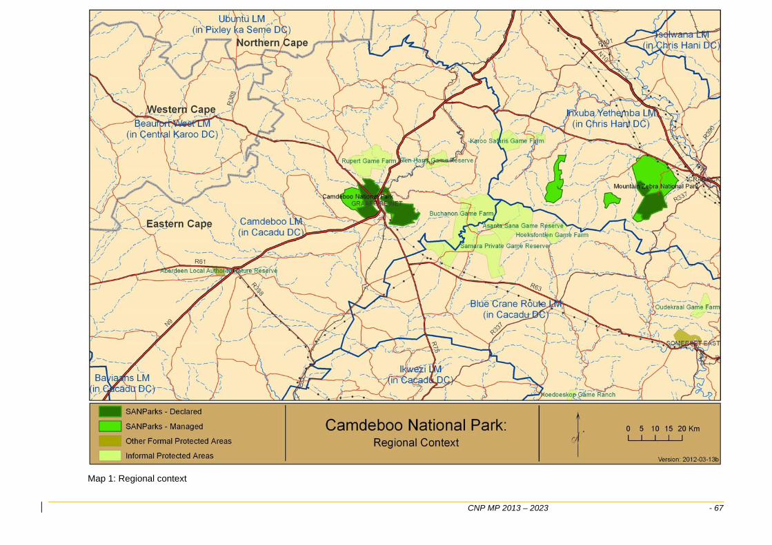
CNP MP 2013 – 2023 - 67
Map 1: Regional context
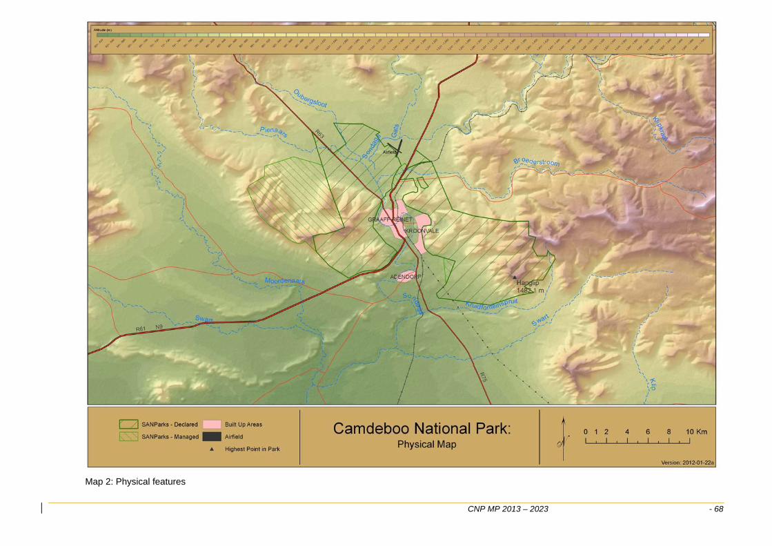
CNP MP 2013 – 2023 - 68
Map 2: Physical features
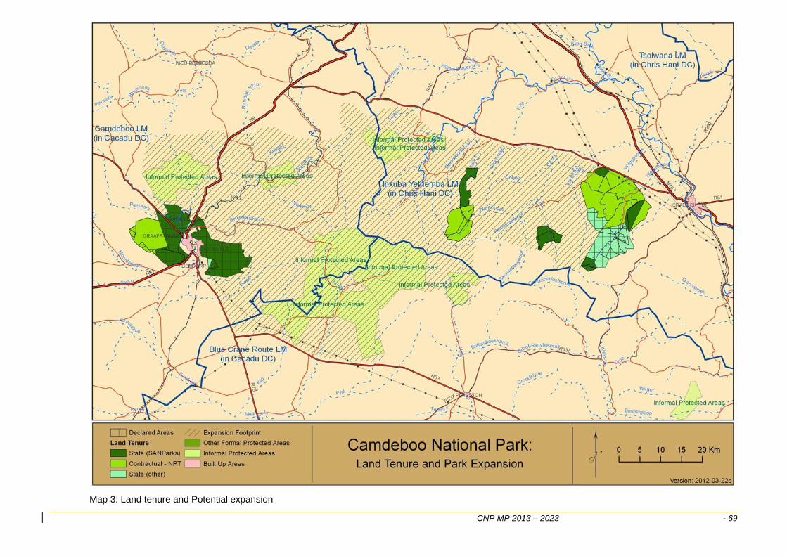
CNP MP 2013 – 2023 - 69
Map 3: Land tenure and Potential expansion
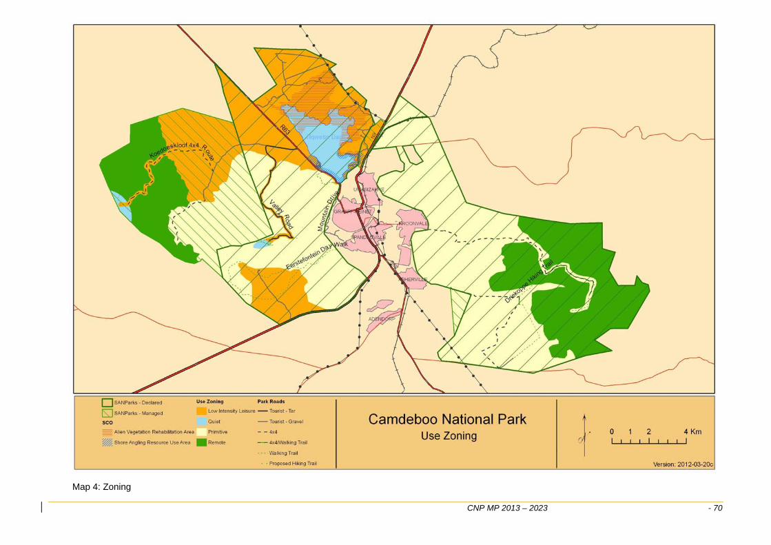
CNP MP 2013 – 2023 - 70
Map 4: Zoning
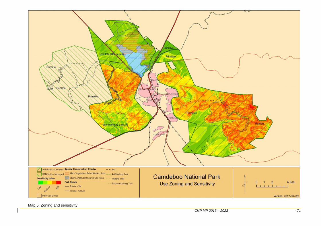
CNP MP 2013 – 2023 - 71
Map 5: Zoning and sensitivity
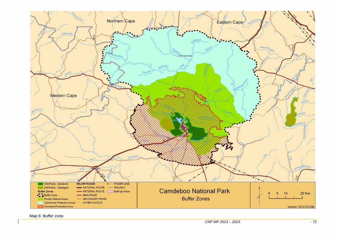
CNP MP 2013 – 2023 - 72
Map 6: Buffer zone
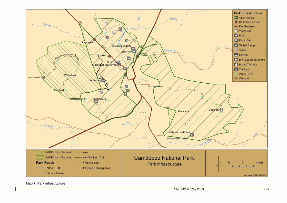
CNP MP 2013 – 2023 - 73
Map 7: Park infrastructure
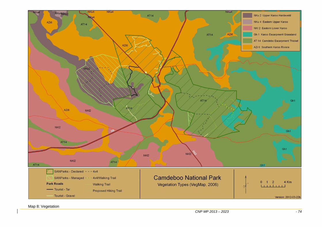
CNP MP 2013 – 2023 - 74
Map 8: Vegetation