National Park Development in China: Conservation or Commercialization?
Upload
khangminh22Category
view
3download
0
ipac SSiittee LLeevveell FFiieelldd AApppprraaiissaall ffoorr
IInntteeggrraatteedd PPrrootteecctteedd AArreeaa CCoo--MMaannaaggeemmeenntt
KKAAPPTTAAII NNAATTIIOONNAALL PPAARRKK
CChhiittttaaggoonngg HHiillll TTrraaccttss CClluusstteerr IInntteeggrraatteedd PPrrootteecctteedd AArreeaa CCoo--mmaannaaggeemmeenntt PPrroojjeecctt
RRaannggaammaattii,, AApprriill –– 22000099

ipac
Site-Level Field Appraisal for Integrated Protected Area Co-Management
KKAAPPTTAAII NNAATTIIOONNAALL PPAARRKK
Prepared by Nikhilesh Chakma, Partha Dewan,
Mostafa Omar Sharif, Pulak Chakma Integrated Protected Area Co-Management (ipac) project
CIPD Adivashi Unnayan Kendra (CIPD)
April 2009
With partners: CIPD, CODEC, RDRS and WorldFish Centre

Site Level Field Appraisal for Protected Area Co-management: Kaptai National Park
TABLE OF CONTENTS
TABLE OF CONTENTS .............................................................................................................................. 1
LIST OF TABLES......................................................................................................................................... 3
LIST OF FIGURES....................................................................................................................................... 3
1. INTRODUCTION ..................................................................................................................................... 4
1.1 PROJECT BACKGROUND ...................................................................................................................... 4 1.2 INFORMATION NEEDS OF IPAC AND LOGICAL BASIS FOR CONDUCTING PRA/RRA ......................... 6 1.3 PURPOSE OF THE REPORT.................................................................................................................... 8 1.4 OUTLINE OF THE REPORT.................................................................................................................... 8
2. DESCRIPTION OF THE PROJECT SITE.......................................................................................... 10
2.1 BASIC INFORMATION ......................................................................................................................... 10 2.2 FOREST MANAGEMENT & ADMINISTRATION FOR KAPTAI NP ........................................................ 15 2.3 TOURISM FACILITIES ......................................................................................................................... 16
3. METHODOLOGY .................................................................................................................................. 17
3.1 DEVELOPING THE RRA AND PRA: ISSUES AND METHODS .............................................................. 17 3.2 FIELDWORK PREPARATION ............................................................................................................... 22
3.2.1. Selection of RRA and PRA Sites............................................................................................... 22 3.2.2 Formation of RRA and PRA Field Teams ................................................................................ 23
3.3 FIELD IMPLEMENTATION STRATEGIES ............................................................................................. 24 3.3.1. Organization of the RRA and PRA field work ......................................................................... 24 3.3.2 Household (HH) interview......................................................................................................... 25 3.3.3 Key informant (KI) interview ..................................................................................................... 25 3.3.4 Focus Group Discussion ............................................................................................................ 25 3.3.5 Other PRA tools ......................................................................................................................... 26 3.3.6. Direct Observation .................................................................................................................... 26 3.3.7 Secondary Information Collection ............................................................................................ 26
3.4 LIMITATIONS OF THE FIELDWORK .................................................................................................... 26
4. OUTCOMES............................................................................................................................................ 28
4.1 STATUS AND TREND IN THE FOREST AND FOREST RESOURCES ....................................................... 28 4.2 SETTLEMENTS IN AND AROUND KAPTAI NP AND ITS LEVEL OF STAKES WITH THE NP................... 30 4.3 STAKEHOLDER ASSESSMENT ............................................................................................................. 35
4.3.1 Primary stakeholders ................................................................................................................. 35 4.3.2. Secondary Stakeholders ............................................................................................................ 39
4.3.2.1 Timber traders .....................................................................................................................................40 4.3.2.2 Sawmill owners....................................................................................................................................41 4.3.2.3 Furniture Shop Owners ......................................................................................................................41 4.3.2.4. Fuel wood trader ................................................................................................................................41 4.3.2.5 Brickfield owners.................................................................................................................................41
4.3.3. Institutional / Organizational Stakeholders ............................................................................. 42 4.3.3.1 Forest Department (FD)......................................................................................................................42 4.3.3.2 NGOs and Banks .................................................................................................................................42 4.3.3.3 Army, Police and BDR ........................................................................................................................43
4.3.4 Dependency of the Stakeholders on the Forest Resources ....................................................... 44 4.4. CAUSES FOR THE DECLINE IN FOREST RESOURCES ........................................................................ 46
4.4.1 General cause ............................................................................................................................. 46 4.4.2 Exploitation of Forest Resources .............................................................................................. 48 4.4.3 Seasonal changes in resource extraction .................................................................................. 50 4.4.4 Exploitation of Major Resources from KNP ............................................................................. 50
4.4.4.1. Fuel wood collection ..........................................................................................................................50 4.4.4.2 Illicit Timber Felling ...........................................................................................................................51 4.4.4.3 Bamboo Collection ..............................................................................................................................52
4.5. COLLECTION OF OTHER RESOURCES ............................................................................................... 52 4.5.1 Broomstick.................................................................................................................................. 52
Page 1 of 79

Site Level Field Appraisal for Protected Area Co-management: Kaptai National Park
4.5.2 Vegetables................................................................................................................................... 53 4.5.3 Fruits: ......................................................................................................................................... 53 4.5.4 Maricha Lota.............................................................................................................................. 53 4.5.5 Tree Bark.................................................................................................................................... 53 4.5.6 Cane............................................................................................................................................ 54 4.5.7 Sungrass ..................................................................................................................................... 54 4.5.8 Wildlife ....................................................................................................................................... 54 4.5.9 Honey.......................................................................................................................................... 54
4.6 OTHER CAUSES FOR FOREST DEGRADATION ................................................................................... 54 4.6.1 Land Encroachment................................................................................................................... 54 4.6.2 Jhum cultivation ........................................................................................................................ 54 4.6.3 FD’s Plantation practice............................................................................................................ 55
4.7 LOCAL COMMUNITY AND POWER STRUCTURE AND LOCAL GOVERNANCE .................................... 55 4.7.1 Local decision makers and influential people........................................................................... 55 4.7.2 Local governance: ...................................................................................................................... 57 4.7.3 Local conflict, conflict resolution, social adhesion and cohesion ............................................ 59
4.7.3.1 Sources of conflict...............................................................................................................................59 4.7.3.2 Conflict resolution ..............................................................................................................................60 4.7.3.3 Conflict resolution mechanism ..........................................................................................................60 4.7.3.4 Conflict with FD .................................................................................................................................61
4.7.4. Social cohesion and adhesion: ................................................................................................. 61 4.8 LOCAL SOCIO-ECONOMIC SETTINGS AND DYNAMICS ...................................................................... 62
4.8.1 Demographic Profile .................................................................................................................. 62 4.8.1.1 HHs number ........................................................................................................................................62 4.8.1.2 Education.............................................................................................................................................62
4. 8.2 Livelihood strategies analysis ................................................................................................... 62 4.8.2.1 Occupation...........................................................................................................................................62 4.8.2.2 Richness-poverty level .........................................................................................................................63 4.8.2.3 Unemployment.....................................................................................................................................63 4.8.2.4 Credit ...................................................................................................................................................63 4.8.2.5 Income and expenditure profile ..........................................................................................................63
4.9 SOCIAL DYNAMICS (TREND IN CHANGES IN SOCIO-ECONOMICS) .................................................... 64 4.9.1 General Dynamics ...................................................................................................................... 64 4.9.2 Seasonal changes in socio-economics of the local people ........................................................ 65
4.10 LOCAL PROBLEMS ........................................................................................................................... 66 4.11. GENDER ISSUE ................................................................................................................................. 66
4.11.1 HH decision-making ................................................................................................................ 66 4.11.2 Outdoor mobility and access to credit and IGA ...................................................................... 67 4.11.3 Workload .................................................................................................................................. 68 4.11.4 Daily workload ......................................................................................................................... 68 4.11.5 Education ................................................................................................................................. 70
4.12 LOCAL LEVEL AWARENESS AND BEHAVIOR LOCAL LEVEL AWARENESS: ..................................... 70 4.12.1. Local level Awareness:............................................................................................................ 70 4.12.2 Behavioural Aspect: ................................................................................................................. 71
5. PRESENT THREATS, ISSUES AND CHALLENGES FOR IPAC: ................................................. 72
5.1 PRIORITY THREATS TO THE NATIONAL PARK:................................................................................. 72 5.2 ISSUES OF CONCERN .......................................................................................................................... 73
5.2.1 Reduced Forest regeneration..................................................................................................... 73 5.2.2 Jhuming and encroachment for expansion of settlements in the forest................................... 73 5.2.3 Over- and unsustainable resource exploitation......................................................................... 73 5.2.4 Local dependence on the forest resources................................................................................. 73 5.2.5 Deteriorating local law and order situation .............................................................................. 73 5.2.6 Poor forest management by FD & lack of specific NP management action plan ................... 74 5.2.7 Local poverty and unemployment.............................................................................................. 74 5.2.8 Poor law enforcement for forest protection............................................................................... 74 5.2.9 Association of local influential people in illegal felling ........................................................... 74 5.2.10. Brickfield operations ............................................................................................................... 75 5.2.11 Lack of awareness among local people about biodiversity conservation ............................... 75 5.2.12 Extensiveness and inaccessibility of the project site ............................................................... 75
5.3 CHALLENGES FOR THE PROJECT....................................................................................................... 75
Page 2 of 79

Site Level Field Appraisal for Protected Area Co-management: Kaptai National Park
5.4 OPPORTUNITIES ................................................................................................................................. 76
6. SUGGESTIONS AND RECOMMENDATIONS ................................................................................. 77
6.1 ADMINISTRATIVE ............................................................................................................................... 77 6.2 SCIENTIFIC AND TECHNICAL MANAGEMENT OF THE PARK ............................................................. 77 6.3 PROJECT ACTIVITIES TARGETED TO LOCAL STAKEHOLDERS .......................................................... 78
ANNEXURE & PHOTO GALLERY ........................................................................................................ 79
List of Tables
Table 1: Selected RRA Issues for Kaptai NP, Specific Activities and Tools used ................................18 Table 2: PRA Issues, Specific Activities Performed & Tools used in Kaptai NP .................................19 Table 3: List of Selected RRA / PRA Spots and Schedule for Visits ....................................................23 Table 4: RRA/PRA Team for Kaptai National Park ..............................................................................23 Table 5: Summary of Performed Activities in Kaptai NP during PRA RRA ........................................24 Table 6: Status and Trend in Changes of Forest Resources in Kaptai National Park ............................29 Table 7: Information on Villages Having Stakes with Kaptai National Park ........................................31 Table 8: Stakeholders of KNP (Based on Resource Extraction & Direct Activities) ............................36 Table 9: List of NGOs / Banks in the Kaptai Area and Their Activities................................................43 Table 10: Uses of Various Resources by Stakeholders in and around KNP ..........................................44 Table 11: Pair wise ranking for identifying main causes for forest destruction.....................................46 Table 12: Cause and Effect – Ranking (underlying facts for forest degradation)..................................47 Table 13: Cause and effect (FD’s management practice and local situation) ........................................48 Table 14: Information on Resource Extraction from Kaptai National Park..........................................48 Table 15: Seasonal Calendar of Resources Exploitation in Kaptai NP..................................................50 Table 16: List of Powerful and Influential persons for Kaptai National Park........................................56 Table 17: Educational Status of the People Living Adjacent and Inside the Villages* .........................62 Table 18: Trend in changes in occupation of people in the KNP...........................................................63 Table 19: Livelihood Status of the Adjacent and Inside Villagers.........................................................63 Table 20: Trend in Changes in Socio-economics Matrices for KNP .....................................................64 Table 21: Seasonal Changes in Socio-economics of the Local People ..................................................65 Table 22: Causes of local problems and possible solutions ..................................................................66 Table 23: Information on Family Decision Making...............................................................................67 Table 24: Outdoor Mobility and Access to Credit and IGA ..................................................................68 Table 25: Seasonal Workload of Male and Female in Sitapara Villages Near to KNP .........................68 Table 26: Comparison of Educational Status of Male and Female in Sitapara......................................70
List of Figures
Figure 1. Map of the KNP showing Blocks & Compartments...............................................................14 Figure 2: Flow of RRA/PRA Field Activities (3-4 days).......................................................................24 Figure 3: Map of Kaptai National including the Impact Area, RRA/PRA Sites....................................33 Figure 4: Map of Kaptai National including the Landscape Interface Area ..........................................34 Figure 5: Link of Timber Traders with Different Stakeholders .............................................................40 Figure 6: Causes of Forest Resources Destruction with scale in the Kaptai NP....................................45 Figure 7: Venn diagram showing Power Structure in and around Kaptai NP........................................57 Figure 8: Prevalent Administrative system of Chittagong Hill Tracts ...................................................58 Figure 9: Sources of Conflicts in and around the Kaptai NP .................................................................59 Figure 10: Conflicts Resolution Process in and around the Kaptai NP..................................................60 Figure 11: Ven Diagram: Conflicts with FD..........................................................................................61 Figure 12: Yearly Income Profile of Village: Sitapara ..........................................................................64 Figure 13: Yearly Expenditure Profile of Village: Sitapara...................................................................64 Figure 14: Venn Diagram showing roles of family members in family decision making .....................67 Figure 15: Typical daily activities of male living in and around Kaptai NP..........................................69 Figure 16: Typical daily activities of female living in and around Kaptai NP.......................................69
Page 3 of 79

Site Level Field Appraisal for Protected Area Co-management: Kaptai National Park
1. INTRODUCTION
1.1 Project Background
Forests are essential for humans and others living beings on the earth to remain survived.
Forests are depleting throughout the world at an alarming rate. Out of the total land mass
in a country, at least 25% forest coverage is essential to ensure better and healthy
environment. However, very limited countries over the world have such amount of
forests. In Bangladesh, 17.08 % lands are forests (Forest Department, 2009); but, forest
coverage is only about 9%. Therefore, it can easily be assessed that we are far away to
ensure healthy environment for people. Natural forests in many countries comprise the
bulk of its forest areas rather than plantations. According to Forest Department (2009),
there are about 4.54 % hill forests, 4.07 % natural mangrove forests, 0.88 % mangrove
plantations, 0.81 % is plain land Sal forests, 4.95 % Unclassed State Forests (USF) and
1.83 % village forests available in the country out of total land areas in the country.
Like many other countries throughout the world, our natural forests are under constant
pressure and have already been significantly degraded and fragmented. However, tropical
natural forests are thought be the major biodiversity reservoir in the world. According to
some of the estimates, forest cover in the country has fallen by more than 50% since
independence. This situation is threatening the value of these forests as habitat for
biodiversity and for provision of vital environmental services. If this trend continues, it
will soon result in a serious ecological catastrophe and will lead to the declination of
forest productivity and services. This will in turn create irreversible pressure to the
livelihood of thousands resource dependent people living in and around the forest areas
and in some of the forests, this is quite evident now. Therefore, it is urgent to reduce or
reverse the ever-increasing pressure on forest resources and harmful effect on forest
biodiversity with the introduction of an effective sustainable resources management
system. To reduce the pressure on biodiversity and resources, there must have provisions
for the creation of alternative livelihood opportunities and support to the resource
dependent people living in and around the forest areas.
Conservation of biological diversity in these days became a global issue rather than
national. A developing country like Bangladesh with limited potential to fund particularly
for conservation and management ratified many national, regional and international
Page 4 of 79

Site Level Field Appraisal for Protected Area Co-management: Kaptai National Park
conventions, treaties, protocols etc. related to biodiversity conservation. That actually
proves that, Bangladesh has a strong commitment to conserve its existing biodiversity and
this actually led the policy makers to designate and establish 19 protected areas in the
country so far including National Parks, Wildlife Sanctuaries and Game Reserves with
significant biodiversity resources under the provision of Wildlife Preservation Act, 1973.
Nevertheless, no provable change became evident after such declaration in the context of
management and conservation of natural resources. Therefore, degradation of forest
resources and its biodiversity continues to decline and Forestry Department with its
traditional management system failed to safeguard.
USAID/Bangladesh seeks to continue its support to the environment sector through a
new, five-year project, entitled “Integrated Protected Area Co-management (IPAC).”
According to IPAC (2008), this Task Order is procured under the Prosperity, Livelihoods
and Conserving Ecosystems (PLACE) IQC, and is USAID’s main vehicle for achieving
results under the IPAC Project. The duration of the task order is from June 2008 to June
4, 2013. The Contractor will provide technical advisory and assistance services to a range
of stakeholders, including the Government of Bangladesh (GOB) and relevant ministries
and technical agencies to promote and institutionalize an integrated protected area (PA)
co-management system for sustainable natural resources management and biodiversity
conservation that results in responsible, equitable economic growth and good
environmental governance. The definition and core of co-management is the full
participation of local stakeholders, such as communities and government towards
sustainable management of natural resources. IPAC is a continuation of two ongoing
USAID co-management activities: the Management of Aquatic Ecosystems through
Community Husbandry (MACH) project and the NSP. Moreover, IPAC has included
some new sites like Kaptai National Park (KNP), Pablakhali Wildlife Sanctuary (PWS)
and Kaptai Lake in the Chittagong Hill Tracts (CHT) that were not included in MACH
and NSP. IPAC Project will embark upon a strategic goal of scaling-up natural resource
co-management at the policy and operational levels by achieving recognition, acceptance
and integration of this approach by the GOB into its management tactics. IPAC will
achieve its goals through three major components:
• development of a coherent integrated protected areas co-management strategy • building stakeholder and institutional capacity, and • site-specific implementation
Page 5 of 79
Site Level Field Appraisal for Protected Area Co-management: Kaptai National Park
The purpose of this Task Order is therefore, to:
• Provide high quality technical advisory services to GOB environment, forestry and fisheries agencies to support the further development of the natural resources sector and the conservation of biological diversity;
• Develop a protected area strategy that applies to all ecologically and economically significant areas, including those outside of freshwater and forest ecosystems;
• Build technical capacity within national and local level institutions for protected areas co-management;
• Expand the geographic area of Bangladesh under co-management to ensure the long-term success of the co-management model;
• Address within IPAC a series of short-, medium-, and long-term climate change mitigation and adaptation issues.
1.2 Information needs of IPAC and logical basis for conducting PRA/RRA
Proper planning is essential before going into interventions and simultaneously baseline
information on different aspects is very much necessary to plan interventions effectively.
In true sense, information is necessary at all the phases of the project e.g. before, during
and after the implementation of project activities. Such phases include designing and
planning project interventions, setting priorities and implementation strategies,
performance monitoring and evaluation, action/applied research, scale up further etc. No
doubt, collection of information continues throughout the project life, however, bulk of
information collected at the initial stage of the project for better understanding of the
situation, effective designing, smooth and hassle free operation of interventions and
finally reaping very good project outputs. Therefore, in IPAC, implementers decide to go
for collection of basic and baseline information at the initial stage of the project
interventions. This is very much logical and effective particularly for Chittagong Hill
Tracts (CHT) Cluster, as in the recent past immense lack of interventions in the natural
resource management (NRM) arena is quite evident. In the Kaptai National Park (KNP)
efforts from the project were in place to collect relevant information by using appropriate
methodologies including rapid and participatory approaches. Therefore, it was one of the
prime responsibilities of the CHT team to carefully scrutinize the information needs and
determine its relevance to the project objectives and activities. IPAC project in the KNP
is particularly concerned with the establishment and demonstration of an effective co-
management model of forest resources without bypassing the potential impacts on the
adjoining inland fisheries resources. IPAC will also develop set of prescriptions for
technical management of different resources. Therefore, it is necessary to include all the
Page 6 of 79

Site Level Field Appraisal for Protected Area Co-management: Kaptai National Park
relevant stakeholders in the collection and generation of information and they are likely to
be involved with the project and management of local resources.
In the Kaptai National Park, IPAC’s main portfolio is to establish a co- management
hallmark with a view to conserve and manage its resources and to trigger encouragement
to practice it to many potential areas as well. Therefore, it is necessary to focus on these
two terms e.g. co-management and resource management. Resource management
includes resources and its status, trend and causes for resource degradation, resource
exploitation, threats to local resources and biodiversity. However, co-management
involves stakeholders and their activities, socio-economics, behavior, community power
structure, their needs and expectations, conflict, challenges etc. Therefore, some common
areas are present as well between these two terms
Initial scoping exercise and Nishorgo Support Project (NSP) documents helped to
construct the list of specific information needs that will be collected / generated through
subsequent appraisals. At the initial stage of the project, it was thought that a rapid
appraisal would be very appropriate in terms of cost effectiveness, usefulness, reliability,
and overcoming time constraints.
Rapid Rural Appraisal (RRA)/Participatory Rural Appraisal (PRA) are two most widely
used packages of tools/methods to collect qualitative information about local people, their
life, environment, their resources, activities and living conditions in a short time.
Moreover, this is rather quick and very much effective as well. Such an approach is very
much effective to utilize the knowledge of local people living in and outside of the Kaptai
NP in designing and setting implementation strategies and also to monitor and evaluate
project performances and impact. It is also considered as a process for involving local
people in the project planning and /or implementation and monitoring. In fact, RRA/PRA
is thus considered as an integral part in the bottom-up planning process in many
development or resource conservation projects.
RRA was carried out as an initial activity in the field with primary focus on resource
status and stakeholder assessment. It also equally intended for generating information that
will help to get a sense of range of key issues and challenges that need to be addressed
and be better informed on the context (social, economic, ecological) in which the project
Page 7 of 79

Site Level Field Appraisal for Protected Area Co-management: Kaptai National Park
is likely to intervene. Built upon the outcome of the RRA, subsequently PRA was planned
to collect in depth information on the identified issues and to ensure greater participation
of local people in information collection.
1.3 Purpose of the Report
From January to February 2009, a large volume of information collected during
RRA/PRA exercises in the field level. Several personal communications were been made
to search secondary data from different institutions as well. This report is actually the
synthesized form of all the pertinent findings that been collected through mentioned
interventions. Moreover, this report also details the ways that information been collected
(e.g. methodology and tools used) and highlight the issues in forest management and
biodiversity conservation and identify the challenges for the IPAC. Finally necessary
suggestions and guidance for the project and the relevant department been provided to
step ahead. Moreover, this report also enclosed some recommendations for better
management of the Kaptai National Park.
1.4 Outline of the Report
This report covers six chapters
Chapter 1 of this report covers a general introduction, which includes the information on
background of the project, information needs of IPAC and logical basis for conducting
PRA/RRA, the purpose of the report etc.
Chapter 2 covers a brief description of the site along with a site map of Kaptai NP.
Chapter 3 spells out the total study methodology including methods used for study,
approach to implement fieldwork for RRA and PRA, study team formation, study period
setting, settings objectives of the study etc. This chapter also includes setting RRA and
PRA issues and questions, selection of RRA and PRA spots, choice of RRA and PRA
methods and tools and the limitation of the study.
Chapter 4 describes the outcomes of RRA and PRA exercises, which contain major
findings and analyses. The findings are mainly presented as situational analysis of the
forest resources, stakeholder analysis, resource and resource extraction, trend analysis,
Page 8 of 79

Site Level Field Appraisal for Protected Area Co-management: Kaptai National Park
socioeconomic situation of the surrounding area, seasonal trends in resource extraction,
etc. In short, this chapter reflects the status of the forest dynamics with social dynamics.
Chapter 5 presents issues and challenges for IPAC, an extended section based on
PRA/RRA outcomes, identifying present issues of concern and challenges for IPAC. The
final
Chapter 6 embodies a set of suggestions and recommendations regarding the
implementation of the project. At last, a number of necessary references of all documents
consulted and photographs are appended as annexure with the report.
Page 9 of 79

Site Level Field Appraisal for Protected Area Co-management: Kaptai National Park
2. DESCRIPTION OF THE PROJECT SITE
2.1 Basic Information
The Kaptai National Park (KNP) is a part of the Sitapahar Reserved Forest (actually
whole Sitapahar Reserved Forest declared as KNP) and located in Kaptai Upazila under
Rangamati hill district. KNP is unique for its monumental oldest plantations in the Indian
Sub-continent. Burma-Teak has very good fame in the world considering its unique
texture and color. In the year 1871, first teak plantation was established here after
importing seeds from neighboring Burma (presently Myanmar) (CHT District Gazette,
1971). However, mass scale raising of teak plantation started in the Sita Pahar area since
1873 (Forest Department, 2001). This national park is situated on the gateway of
Chittagong Hill Tracts from Chittagong district and 57 Km away from Chittagong City.
This forest area is declared as ‘Sitapahar Reserved Forest’ in 1883 and finally in 1945
(gazette in 1946). Later, in the year 1999, Government of Bangladesh with the given
power under section 23(3) of Bangladesh Wildlife (Preservation) (Amendment) Act 1974
(17 no. act of 1974) declared the Sitapahar Reserved Forest as ‘Kaptai National Park’ and
determined its boundary. Kaptai NP covers an area of 13,498.00 acres e.g. 5464.78
hectare and it is within the jurisdiction of Kaptai and Karnaphuli Forest Range under
Chittagong Hill Tracts South Forest Division and divided into five forest blocks e.g.
Kaptai Block, Kaptai Mukh Block, Kaptai Khal East Block, Kaptai Khal West Block and
Sitapahar Block. Actually, the park includes entire area of Karnafuly range and Kaptai
range. There are 50 Compartments, 25 in Kaptai range and 25 in Karnafuly range. Fifty
compartments of Kaptai Range comprise 2540.08 hectare and other fifty compartments of
Karnaphuli Range comprise 2924.7 heactare. Famous Sitapahar Natural Forest is a part of
this national park. KNP also includes a small portion of unproductive area. Chittagong -
Kaptai highway passes through the Kaptai NP and is about 1 km away from Kaptai
Upazila head quarter.
Boundary of the National Park lies in the north from Kamilachari and Ziptoli mouza,
along the east towards Rampahar top and other side of Raikheong Khal mukh along
Karnaphuli River up to Bhaibonchara along Raikheong Khal. In the South from
Bhaibonchara Mukh source up to Kaptai Khal in the south-west corner. In the East, from
the source of Harinchara and Kalmichara right side of Kaptai Khal to along the hilltops
upto Jamaichara source along the chara. In the west from Jamaichara source along the
Page 10 of 79

Site Level Field Appraisal for Protected Area Co-management: Kaptai National Park
Sitapahar top and left side of the Karnaphuli river up to right side of Karnaphuli river
along Rampahar top.
GPS coordinates of the boundaries of Kaptai National Park are in the North Kaptai Range
and Bangladesh Navy’s main gate adjoining area 22030’1.3’’ N and 92010’11.9’’E. In the
South Chakua Camp boundary of Karnaphuli Range 22027’18.2’’N and 92012’40.4’’E. In
the East adjoining boundary of Harinchara Mukh and Bhajjatoli Mouza of Karnaphuli
Range 22029’53.5’’N and 92017’0’’E. In the West on the entrance point of the metalled
road towards 1873’s plantation under Rampahar Beat of Kaptai Range 22030’1.3’’N and
92010’25.5’’E.
This is one of the oldest formation belongs to upper miocene and lower miocene epoch of
tertiary period. Apart from this rock of pliocene epoch of tertiary period is also found.
Mostly sandstones with small amount of intercalated shale’s represent the later.
Sandstones are light grey and fine grained.
The soils in the valley bottoms on level ground are clays or clayey loams and are very
fertile. The soil on the hills is sand or sandy loam. The soils are impregnated with iron
and have a reddish or yellowish tinge. Humus is noticed throughout the forest. However,
its degree of accumulation varies from place to place depending on the topography.
Usually there are more deposits on the flat lands and less on the undulating hills. Amount
of Silt in Kaptai Soil is about 65% and Clay is about 28%. Soil is lot more acidic with a
PH 5.9. Cation Exchange Capacity (CEC) and Base Saturation Percentage (BSP) are
16.3% and 50% respectively. C/N Ratio is 4.1. Amount of nutrients (ppm) in the soil is
about 250 for Pottassium (K) and trace amount for P2O5 (SRDI, 1998).
The climate is typically sub-tropical with a long dry season extending from November to
May, punctuated by largely unpredictable periods of rainstorm from June to September.
The southwestern monsoons provide the majority of the average annual rainfall of about
2889 cm (Source: Meteorological Department, 1981). Temperatures vary considerably
over the year. Monthly mean maximum/ minimums are lowest during December-January
(approximately 25° C/ 12° C) and highest between March and May when they rise to
approximately 34° C/ 24° C. The humidity overall is very high throughout the year.
Page 11 of 79

Site Level Field Appraisal for Protected Area Co-management: Kaptai National Park
In March, the wind starts to prevail from south to west and continue up to May. However,
it prevails South to East from June to September and north to west from October to
February. The cyclones are of frequent occurrence and periodically cause severe damage
and occur mainly during May to October.
Lofty trees of dense evergreen forest characterized by large number of species occur in
the sanctuary. The most important species are Civit, Garjan, Uriam, Kanak, Goda, Black
Siris, White Siris, Chapalish, Champa, Chatian, Jarul, Dhakijam, Dharmara, Shimul,
Pitraj, Shonalu, Bhadi, Banderhola, Tali, Bohera, Amloki, Horitoki, Toon etc. Cane
brakes and secondary bamboo brakes are also prominant in wildlife santuary. The main
bamboo spp. are Muli bans (Melocanna baccifera), Mitinga(Bambusa.
tulda),DuluBans(Neohoazeua dulloa). Calamus tenuis, C. latifolius, Daemonorops
jenkinsianus are the common species of cane.
This sanctuary is the largest protected area in the hilly areas of Bangladesh, which is the
habitat of the biggest terrestrial mammal – the Asian elephant. Other available wild
animals are - Hoolock gibbon, Sambar Deer, Barking Deer, Bison, Wild Dog, Sun Bear,
Rhesus macaque, Langur, Wild Boar, Rock Python, Grey Lizard, Brass tailed Porcupine,
Indian Pangolin, Squirrel, Rose ringed parakeet, Red vented bulbul, Hill myna, Red
jungle fowl, Greater Racket-tailed Drongo (Dicrurus paradiseus), White-breasted
Kingfisher, Yellow bird, Koel, Red-turtle Dove, Jungle Myna, Grey-headed Myna, Baya
(Ploceus philippinus) and Pond Heron etc.
Once upon a time, the entire area was covered by dense evergreen forests. However,
flooding of Kaptai Lake because of dam construction together with gradual deforestation,
political unrest in the hills, jhum cultivation, illicit felling and encroachments cause
severe biodiversity loss in most of the hill forests including Kaptai National Park. Even
some of the species are now locally extinct. In some areas, sporadically the forest floor is
opened up and mineral soil is exposed causing large-scale soil erosion.
KNP is also a vital natural forest area for biodiversity conservation. The conservation of
flora is of utmost importance in the national park in consideration to watershed
management to ensure permanent and all season supply of water in Kaptai lake as well as
Page 12 of 79
Site Level Field Appraisal for Protected Area Co-management: Kaptai National Park
the Karnaphuli river in down stream. The stream flow of Karnaphuli River in turn is of
immense importance to ensure water supply for the dwellers of fast growing Chittagong
city. The life of Chittagong seaport is fully dependent on the stream flow of Karnaphuli
River. It may also be mentioned here that diminished stream flow in the Karnaphuli River
would cause the salinity intrusion in various upazillas of Chittagong Districts mainly
Anwara, Hathazari, Boalkhali, Patiya, Rangunia and Raozan causing destruction of crop
in these areas.
One can enjoy splendid scenario of nature in the park on both banks of the Karnaphuli
River while cruising by boat in the river. Visitors from all over the country rush in the
Park throughout the year for its easy communication.
Kaptai town itself is situated with in the national Park. Kaptai Hydro electric Project,
Lumber processing complex of BFIDC, Kaptai army region head quarter naval base is
also situated within the area of National Park. This Protected area is connected with
Chittagong by metalled road and most of the area of the park can be reached by metalled
road.
Whole Chittagong Hill Tracts (CHT) including Kaptai NP area lies in the humid tropical
forest zone – where species-rich, three-storied closed-canopied tropical lowland
rainforests of high biodiversity values are supposed to dominate – unless disturbed by
external influences. Tropical Moist Evergreen Forests have virtually disappeared from the
region. Especially in lower valleys, Swintonia spp., Dipterocarpus spp., Hopea spp.,
Sterculia spp., Tetramelis spp. and Artocarpus spp. were represented in the canopy storey
of such forests. The middle stories were dominated species of the Meliaceae and
Leguminoseae families. Only small pockets of this forest formation still survive (ADB,
2001).
Higher valley and lower hill slopes tended to be covered in Semi-Evergreen Forests
(Tropical Mixed Forests). This forest ecosystem has a more open canopy with a large
numbers of deciduous trees, with a well-developed understorey of smaller trees and
shrubs, epiphytes and climbers. A clumped distribution of a giant dipterocarp species
(Dipterocarpus turbinetas or garjan) is characteristic for this forest type. Other canopy
species include Swintonia or civit, Sterculia, Salmalia and Tetrameles. Its second storey
Page 13 of 79

Site Level Field Appraisal for Protected Area Co-management: Kaptai National Park
is well developed and includes species of Amoora, Mesua, Cedrella, Bombax. Lower
stories contained a variety (ADB, 2001).
Where a forest canopy has been “opened” (due to timber extraction or jhum plots),
secondary species – including bamboos, vines and ferns – invade. Fire disturbances can
produce similar effect – to the point where bamboo stands develop as a stable fire sub-
climax ecosystem – completely replacing the primary forest species. On drier, exposed
hill slopes with shallow soil, sub-climax formations of low open forest may also arise
(ADB, 2001).
Much of the original forest cover of the CHT has been logged and converted to jhum plots
or to low shrub/grass vegetation – such as Eupatorium odoratum, Saccharum
spontaneum, Imperata cylindrica, Arundinaceae spp., Mikania vines and bamboo
thickets. The grass/shrub pioneer vegetation rapidly invades abandoned or fallow jhum
plots – and is therefore considered weed species. Logging has been active in the
Chittagong Hills area since around 1900. Unsustainable jhum practises developed rapidly
between 1960 and the mid-seventies due to politically motivated settlement of the area
and due to massive loss of arable land for the construction of a hyrdo-power reservoir -
Kaptai Lake (ADB, 2001)
Map of Kaptai NP
Figure 1. Map of the KNP showing Blocks & Compartments.
Page 14 of 79

Site Level Field Appraisal for Protected Area Co-management: Kaptai National Park
2.2 Forest Management & Administration for Kaptai NP
In 1875, modern forest management practice started in the Kaptai NP areas with the
declaration of Sitapahar Reaserved Forest. Before that, in 1862 a Forest tax station
initiated at Kaptai Mukh along the bank of the river Karnaphuli for the collection of
revenues on the forest products. That time, Government had permitted timber extraction
from the Sitapahar reserved forest with the payment of revenues and there was no local
market of timbers and timbers were generally exported to London and Calcutta and other
Indian towns. In 1860, Chittagong Hill District formed after the separation from
Chittagong district and in 1909, Chittagong Hill Tracts Forest Division formed with
Sitapahar, Kachalong and Raikheong Reserved Forests after separation from Chittagong
Forest Division.
In 1871, Mr. H. Dhar, an ACF collected teak seeds from Burma (now Myanmar) and
bring it to Kaptai areas and identified Rampahar areas of Sitapahar Reserved Forest as
suitable plantation site for teak. Later on, in 1972 – ’73, Forest Department raised teak
plantation over 8 acres. Teak plantation in the CHT was confined to Sitapahar Reserved
Forest only until 1919. For teak plantation, clear felling followed by artificial
regeneration through Taungya system practiced. Indigenous people were particularly
interested for Taungya system culture.
From 1922 – ’23 onwards, scientific management system started with the introduced of
working/management planning in the Kaptai NP areas and Forest Department became
entitled to total control of forest management. So far, five working plans been
implemented. Those are:
• Cowan’s Working Plan 1922-23 to 1942-43
• R. Banarjee’s Working Scheme 1942-43 to 1952-53
• Zahir Uddin’s Working Plan 1952-53 to 1972-73.
• Mahbub Uddin Chaudhury’s Working Plan 1969-70 to 1988-89.
After completion of Mahbub Uddin Chaudhury’s Working Plan, no further working plan
developed for Chittagong Hill Tracts South Forest Division and implemented. After that,
Government imposed ban on tree felling or logging moratorium from reserved forests for
several years and this is continuing.
Page 15 of 79

Site Level Field Appraisal for Protected Area Co-management: Kaptai National Park
2.3 Tourism Facilities
Kaptai NP is regarded as one of the major tourist spots in the CHTs. There are two forest
rest houses e.g. Kaptai Mukh Forest Rest House and Banophul Forest Rest House inside
the NP. There is picnic spot inside the Kaptai NP; people can enter after paying a little
revenue to FD. There are some sitting arrangements in different places of the, some trails
are here. Two elevated watchtowers are present in the park
Page 16 of 79

Site Level Field Appraisal for Protected Area Co-management: Kaptai National Park
3. METHODOLOGY
The methodology followed in the study was a two-step rapid appraisal strategy. In the
appraisal process, the team conducted RRA first, followed by PRA. RRA was carried out
as an initial activity in the field with a primary focus on generating information that
would help to get a sense of the range of stakeholders, key issues and challenges that need
to be addressed and provide information on the context (social, economic, ecological) in
which the project will operate. Built upon the outcome of the RRA, a subsequent PRA
exercise done that actually collected the in-depth information on the identified issues. In
the information collection process, study was designed to ensure greater participation of
local people in information sharing.
The overall purpose of the RRA and PRA was to analyze the present situation of the
Kaptai NP comprehensively with a view to understand the followings -
• who destroys and how the forest is destroyed
• what are the underlying driving forces for the degradation of forest
• cause and effects of the behavior of local people
• opportunities for improvement in forest management
3.1 Developing the RRA and PRA: Issues and Methods
After recruitment of all the major project staffs and completion of Project Inaugural
Ceremony and Inception Workshop in the CHT Cluster, all the technical project staffs sat
together in a discussion meeting in the IPAC Cluster Office, K K Roy Road at Rangamati
on 4 January 2009. The purpose of this meeting was to discuss about the necessity to
collect baseline information and set out the priority issues and methodologies to collect
such information at the beginning of the project. In the discussion, experiences of
Nishorgo Support Project (NSP) came into action by the two NSP experienced staffs in
the team. They had shared their view particularly based on the activities done in NSP
sites. Other staffs present in the session share their views and finally reach a consensus to
conduct the field activities under NSP adopted methodologies. They have also mentioned
that there are some of the status reports prepared on NSP sites are now available in the
Nishorgo website. Therefore, those reports will act as guidance for the team to design the
study, set methodology, use tools, develop questionnaire and conduct the RRA/PRA
Page 17 of 79

Site Level Field Appraisal for Protected Area Co-management: Kaptai National Park
sessions in the field and finally reporting. The team then drafted a simple questionnaire
and finalized it after subsequent revisions in several sessions.
To minimize time constraints, more or less same spots with the same community been
targeted for both RRA and PRA activities. RRA sessions were unstructured and semi-
structured household interviews, KI interviews and focus group discussions based. The
issues and activities covered in the RRA are shown in Table 1. In the PRA sessions, tools
like Venn diagramming, resource mapping, seasonal analysis, trend analysis, livelihood
analysis etc., were used in addition to interviews, focus groups and more informal
discussions.
Table 1: Selected RRA Issues for Kaptai NP, Specific Activities and Tools used Sl. RRA Issues Specific Activities Tools Used Participants 1 Stakeholder
Assessment Identification of settlements, resource users, local institutions and agencies and organization, community organizations etcand their roles and activities
HHs Interview, KI FGD Sketch mapping
Local HHs; school teacher, doctor, community people (villagers, elites etc) community people Headman, Karbari, Local Govt. Rep.
2 Stakeholder Demographic Profile
Settlement wise no. of HHs/population HH occupation, education, forest use, land holding
Secondary Info HH Interview, KI, FGD Trend Analysis
Upazilla Statistics Office / Local union parishad, HHs heads/members community people School/College teachers & Headman, Karbari, Local Govt. Rep.
3 Stakeholder Economic Activities/ Livelihood Strategies and Human Capital Development
HH primary and secondary income sources of HH Richness/poverty Unemployment and its seasonal trend Credit and AIG opportunities Skill and skill development opportunities Seasonal workload of male and female
HH Int. KI FGD Seasonal Calendar
HHs heads/members Headman, Karbari, Local Govt. Rep. Teacher, retired officers, old people, Local elite, Community people, Forest villagers
4 Gender Issues General impression on living standard, education and health status etc. Participation in decision making (household and PA management) Women mobility in the area Access to IGA and credit etc
HH Interview FGD KI, Direct observation
HHs heads Community people Local elites RRA team members
5 Behaviour of Local People
Initial response of the local people and FD staff towards the project - Sources of conflict and conflict resolution
FGD Discussion HH interview
Local community FD staff HHs heads
6 Local Level Awareness
Awareness and perceptions about resource degradation and conservation - Willingness for resource conservation Awareness about the existence of nearby park/game reserve and reserved forest Knowledge about forest and wildlife
HH interview FGD
HHs heads Local community
Page 18 of 79

Site Level Field Appraisal for Protected Area Co-management: Kaptai National Park
Sl. RRA Issues Specific Activities Tools Used Participants preservation acts
7 Resources/Resource Status
Trend in changes in major resource bases Endangered/extinct plant and animals Causes for the decline in different resources
Trend analysis, HH interview FGD KI
Local people/FD staff Local HHs heads Community, FD staff Headman, Karbari, Local Govt. Rep., Local educated old
8 Resource Exploitation
Major forest resources collected, including NTFPs: Reasons and extent of exploitation of different forest resources Dependency on the forest/forest products Seasonal trend in resource exploitation Future risks Medicinal plant uses and reason for not using these
HH interview FGD, KI, Trend analysis, Seasonal calendar
Local HHs heads Public representatives, Community & FD staff Headman, Karbari, Local Govt. Representatives Community people Local educated old, Local elite and FD staff
9 Resources Regeneration Practices
Plantation status in the locality Problem with natural regeneration in the forest Plant nursery General land use pattern in the buffer zoneMajor agricultural crop Seasonal pattern in agriculture
Secondary Information, FGD, KI, Seasonal Calendar
Secondary data from FD FD staff Headman, Karbari, Local Govt., FD Officer Community people Local elite, teacher
10 Legal Aspects Access to the forest by locals Forest villagers and land use agreement Conflict and negotiation with FD staff Land encroachment/recovery Law enforcement mechanisms in the PA Illegal tree felling and forest cases
FGD KI FGD
FD staff and forest villagers Headman, Karbari, Local Govt. Rep. Local elites, FD staff, community people, teacher
11 Power Structure
Local influential and their role, local hierarchy Nature and sources of power and their domain of influence Conflict and conflict resolution Social cohesion and adhesion
HH interview FGD, KI
Local HHs heads Local community and local govt. Headman, Karbari, Local Govt. Representatives
12 Others Access to areas and settlements NGO activities in the locality Challenges for conservation Local problems Mobility in the area
HH interview FGD, KI
HHs heads Local community and local govt. Headman, Karbari, Local Govt. Rep. & FD Staff Local elites
To allow the team to triangulate the information gathered, more than one tool been used
for any particular issue. The issues and activities performed in the PRA are summarized
in Table 2.
Table 2: PRA Issues, Specific Activities Performed & Tools used in Kaptai NP Sl. PRA Issues Specific Activities Tools Used Participants 1 Forest make
up Dynamics -observation on forest physiography and topography and forest make up -land use cover, resource exploitation and regeneration areas, animal distribution
Transect walk KI Resource mapping
PRA Team Local elite, FD staff FD staff and Village headman, forest villagers.
Page 19 of 79

Site Level Field Appraisal for Protected Area Co-management: Kaptai National Park
Sl. PRA Issues Specific Activities Tools Used Participants -changes in forest cover, thickness, vegetation, settlements, animals and availability of resources
Secondary data, FGD,KI Trend analysis
Local people and FD staff, forest Villagers
2 Local governance system and community structure and functions
Decision makers--- influential people Local community organizations and institutions and their linkages Local conflict and conflict resolution Social cohesion and adhesion Collective action Local problem, cause and possible Solution
Venn diagram Ven diagram Venn diagram FGD/GD FGD & GD and Ranking
Community People Community As above As above and local elite
3 Livelihood Strategies
Income and expenditure sources, Livestock, Richness and poverty
Wealth ranking HH interview
Women group and local people
4 Gender issue Family decision making mobility workload Education and access to credit
Decision making chart Mobility map Daily and seasonal work chart HHs Int.; FGD
Women group Women group Women group Women and local educated people
5 Fuel wood Collection
Information on collector Purpose and driving force for collection Dependence on the extraction for their livelihood and its extent Uses and marketing channel of the resource Level of extraction and seasonality Conflict with FD or other people over the extraction Negotiation for carrying out the activity Alternate source for the collection of the resources Needs and expectation of the collector Impact on the forest and future risks for the collector
FGD & seasonal Analysis
Fuel wood collector, Community people, local hotel and tea stall owners
6 Illegal timber Felling
Information collector - key people behind the activity and network Purpose and driving force for collection uses and marketing channels and dependence What encourages them to take up the activity Anybody protect them, if they are in problem Protection by FD or by any other agencies (e.g. Police etc.) conflict and negotiation with FD or other people needs and expectation of the feller impact on the forestand future risks for the illegal feller Seasonality and trend in timber extraction
FGD, GD and KI Seasonal calendar and trend analysis
Illegal timber feller, FD staff and community people, teacher and local elite
7 Collection of trees as building materials
Information on collector; purpose and reasons for collection; uses of the resource and extent of extraction; dependence on the extraction and marketing conflict and negotiation with FD or other people over the extraction alternate source for the collection of the
FGD, Gdand KI
Community people, FD staff , , forest villagers, local public rep. and elite
Page 20 of 79

Site Level Field Appraisal for Protected Area Co-management: Kaptai National Park
Sl. PRA Issues Specific Activities Tools Used Participants resources needs and expectation of the collector impact on the forest and future risk for
8 Bamboo and cane collection
Information on collector purpose and reasons for collection uses of the resource and extent of extraction dependence on the extraction and marketing conflict and negotiation with FD or other people over the extraction alternate source for the resources needs and expectation of the collector impact on the forest and future risk for the seasonal changes and trend in abundance
FGD, GD Seasonal calendar and trend analysis
Bamboo and cane collector, community, people and FD staff Bamboo collector and local people
9 Information onForest villagers
Distribution of forest villager’s settlementsRegistered and actual number of forest villagers compliances to FD agreement Present economic activities Resources exploitation and dependence on forest resources land encroachment by the forest villagers or by their dependant relationship and conflict with FD internal governance system needs and expectation
FGD Secondary data
Forest villagers and FD staff FDs villagers register
10 Jhum Cultivation
Amount and distribution of jhum cultivation in and around the Kaptai NP, major activity in jhum crop field, seasonality, variety of crops cultures atc. Impact on the forest resources particularly due to burning Conflict with FD
FGD
Betel leaf cultivator FD staff; Local Community
11 Land Encroachment
Historical perspective and trend information on encroaches and reason for encroachment and what drives to undertake the activity Legalization of process Conflicts and negotiation process Uses and transformation of encroached land Local mechanisms/system or traditional practice for land encroachment
Secondary data and trend analysis FGD and KI
FDs encroacher Register; Encroacher Group and FD staff, local elite and community people
Each PRA tool was used to collect information about more than one issue, as shown
below:
Venn diagramming: local power structure, local community organizations, local
institutions and agencies, local conflict and conflict resolution, family decision making,
mobility of women & men, local NGO/CBOs .
Seasonal calendar: fuel wood, bamboo and timber collection, unemployment, workload,
accessibility to forest, transportation problem, brickfield/sawmill operation, forest patrol,
Page 21 of 79

Site Level Field Appraisal for Protected Area Co-management: Kaptai National Park
agricultural activities, collection of building materials, hunting, vegetable collection,
damages by elephant, sand collection, sungrass extraction.
Trend analysis: forest cover, forest thickness, tall trees, herbs and shrubs, forest use,
unemployment, local solvency, land encroachment, settlement/population solvency/
income, livelihood expenditure, literacy, unemployment, use of forest for income, use of
forest for HH needs, transportation and mobility, homestead plantation, food scarcity,
credit and IGA, occupation, damages by elephant, wildlife, hunting, illegal tree felling,
fuel wood collection, bamboo and cane collection, fruit bearing trees in the wild,
livestock, turtles and tortoises, agricultural activities, medicinal plants.
Ranking and scoring: local problem ranking, wealth ranking, and livelihood analysis
Transect walk: Soil, vegetation, land use, elevation, crops, wildlife, human activities etc
Forest resource mapping: Forestland use cover, resource zones, resource exploitation
zones, animal distribution and settlements.
3.2 Fieldwork Preparation
3.2.1. Selection of RRA and PRA Sites
Based on the information provided by local FD staffs responsible for the management of
Kaptai NP, RRA/PRA team decides on the representative villages as sample locations for
the purpose of information collection. These locations were then termed as RRA and PRA
spots. Selection of those representative villages was based on a number of selection
criteria. The selection criteria were based on the availability and distribution of major
resources, degree of dependence on resources, diversity in people, ethnic groups, distance
from the park, presence of conflicts/challenges, presence of any other issues that may
affect project planning etc.
While the number of sites visited during the RRA was limited, the team focused on
gaining an overview of issues covering the whole of the National Park area. However,
because of the size of the National Park, it became clear there would have to be a trade off
between the size of the study area and the depth and quality of the information collected.
Therefore, it was decided that the PRA would focus on only issues and stakeholders
relating to the management of forest within the Kaptai NP area. A list of the selected
RRA and PRA spots for Kaptai NP is given in Tables 3
Page 22 of 79

Site Level Field Appraisal for Protected Area Co-management: Kaptai National Park
Table 3: List of Selected RRA / PRA Spots and Schedule for Visits
Name of Spots (Village) Visited Date Village Location
Remarks
07/01/2009 Bangchari Inside KNP 12/01/2009 Chakuapara Outside KNP 13/01/2009 Chimorom Headmanpara Outside KNP 18/01/2009 Moidongpara Outside KNP 19/01/2009 Shilchari Outside KNP 19/01/2009 Shilchari Marmapara Outside KNP 20/01/2009 Debachari Outside KNP 25/01/2009 Kalabunia Outside KNP 26/01/2009 Zibtoli Inside KNP 26/012009 Kamilachari Outside KNP 04/02/2009 Bhaiboncharapara Outside KNP 04/02/2009 Harincharapara Outside KNP 08/02/2009 Arachari Outside KNP 09/02/2009 Sitapara Outside KNP 10/02/2009 Wagga Tea Estate Outside KNP
3.2.2 Formation of RRA and PRA Field Teams
The same team who developed the questionnaire others employed to carry out RRA/PRA
activities in the field level under the leadership of Site Coordinator, Kaptai NP. The full
team moved in the field in a body and after reaching to a specific site, the team always
been divided into two groups to carry out two different set of activities. One group was
responsible to carry out household survey and other group to carry out / conduct focus
group discussions and KI interview. Participants in the RRA/PRA team is given in the
Table 4.
The RRA and PRA field exercises were conducted between 6 January to 10 February
2009. The detailed time schedule for the field activities are provided in Tables 3.
Table 4: RRA/PRA Team for Kaptai National Park Name Designation & Workstation Organization Gazi Sazzad Hossain Site Coordinator (SC), KNP, Kaptai CIPD Nikhilesh Chakma Site Coordinator (SC), PWS, Rangamati CIPD Partha Dewan Communication, Outreach & Governance Facilitator
(COGF), Rangamati CIPD
Pulak Chakma Enterprise Support Facilitator (ESF), Rangamati CIPD Subinoy Khisa Site Facilitator (SF), PWS, Baghaichari CIPD Sunayan Chakma Site Facilitator (SF), PWS, Baghaichari CIPD Mostofa Omar Sharif PMA Research Associate, Rangamati WorldFish Center
Page 23 of 79
Site Level Field Appraisal for Protected Area Co-management: Kaptai National Park
3.3 Field Implementation Strategies
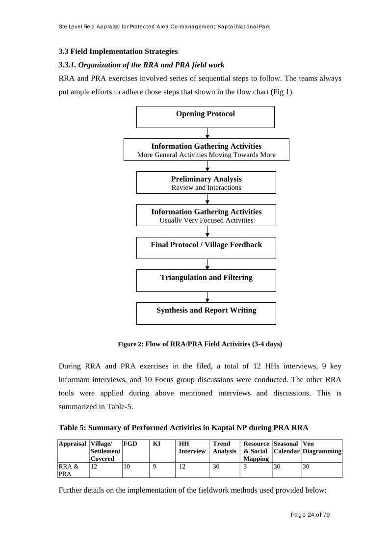
3.3.1. Organization of the RRA and PRA field work
RRA and PRA exercises involved series of sequential steps to follow. The teams always
put ample efforts to adhere those steps that shown in the flow chart (Fig 1).
Opening Protocol
Information Gathering Activities More General Activities Moving Towards More
Preliminary Analysis Review and Interactions
Information Gathering Activities Usually Very Focused Activities
Final Protocol / Village Feedback
Triangulation and Filtering
Synthesis and Report Writing
Figure 2: Flow of RRA/PRA Field Activities (3-4 days)
During RRA and PRA exercises in the filed, a total of 12 HHs interviews, 9 key
informant interviews, and 10 Focus group discussions were conducted. The other RRA
tools were applied during above mentioned interviews and discussions. This is
summarized in Table-5.
Table 5: Summary of Performed Activities in Kaptai NP during PRA RRA Appraisal Village/
Settlement Covered
FGD KI HH Interview
Trend Analysis
Resource & Social Mapping
Seasonal Calendar
Ven Diagramming
RRA & PRA
12 10 9 12 30 3 30 30
Further details on the implementation of the fieldwork methods used provided below:
Page 24 of 79

Site Level Field Appraisal for Protected Area Co-management: Kaptai National Park
3.3.2 Household (HH) interview
HH interviews were conducted with randomly selected interviewees, typically visiting
one household at each stop.
Both male and female respondents were considered. HH interviews typically last for
about 1 hr – 1:15 hr. The interviews were conducted with both closed and open structured
questionnaires. A Checklist of issues was used, though not necessarily addressed all
questions in each interview and often deviated from basic questions to pursue interesting,
unexpected or new information, relevant to the project and situation.
3.3.3 Key informant (KI) interview
Key informants are traditional leaders e.g. Headman, Karbari and public representative
e.g. UP chairman, member etc. who have extensive knowledge on the local environment,
situation and events. The purpose of this interview was to utilize them in collecting
Information from them relevant to the project needs.
• KI interview was conducted by both prior appointment and spot visit. A local guide
helped in making appointment with the KI. The interview was taken by paying visit to
Key informant HH or by inviting him to the team base
• A typical KI interview lasted for about 1.5-2 hrs.
• As with HH interview, a similar checklist of questions was used for the purpose of
• KI interview.
3.3.4 Focus Group Discussion
• The purpose of the planned FGD was to collect information on the locality and local
situation based on the consensus of the local people.
• Interviews were conducted at places, preferably at local tea stalls, road junctions and
other local community places, where local people gathered spontaneously.
• Mapping, seasonality, ranking and scoring exercises etc. were done in such FGD.
• Typically a FGD lasted for about 2-3 hrs
• At least one FGD was held each day
• This was based on structured and unstructured interview and a checklist of issues was
used as a basis for questions
Page 25 of 79

Site Level Field Appraisal for Protected Area Co-management: Kaptai National Park
3.3.5 Other PRA tools
Various other PRA tools like Resource mapping, Venn diagramming, seasonal
calendaring, trend analysis, ranking, scoring etc. were used as part of RRA activities.
Most often, these exercises were performed during focus group and key informant
interviews. Participants in these sessions were either invited by local leaders or local
people instantly gathered at places.
3.3.6. Direct Observation
This is another way to collect information from the field level through direct observation
the RRA/PRA participants. The participants in the team met with number of local people,
discussed many things on different matters. Moreover, they had observed the resources,
people’s behavior and their activities, etc. These observations and informal discussions
helped the team to triangulate collected information and generate new questions for
interview or discussions.
3.3.7 Secondary Information Collection
During the field visit by the team, some demographic data were collected from Statistics
office of Kaptai upazilla and some collected from relevant Union Parishad offices. There
are some other secondary data presented in the report actually collected from the local
Forest Department office at Kaptai, some from Divisional Forest Office in Rangamati and
some after discussion with the experienced staffs working in the Kaptai National Park and
adjoining areas. Some of the presented information actually collected from other different
organizations particularly UNDP-CHTDF including NGOs.
3.4 Limitations of the Fieldwork
Large areas of the Kaptai National Park are remote to access. Only way to reach these
areas is by boat followed by a long walk Therefore, it was always difficult for the
RRA/PRA team to reach there and to organize a large-scale participants gathering to
meeting the needs for PRA. In traditional PRA approach, participants work together to
complete large-scale matrices on the ground and the information is analyzed and owned
by the participants themselves. However, that was quiet impossible for most parts of the
KNP at the initial stage of the project with a limited number of staffs and limited support.
Therefore, the team recorded information in note form and by completing matrices
themselves either during the group discussion or afterwards. Therefore, this work does
Page 26 of 79

Site Level Field Appraisal for Protected Area Co-management: Kaptai National Park
not match the usual requirements of a PRA. The difficulty of access and the time required
to travel to the actual sites, meant that time actually collecting data was often limited to 3
or 4 hours a day.
When the field level activity started for RRA and PRA sessions, there was no approved
Technical Project Proposal (TPP) for Chittagong Hill Tracts (CHT) Cluster. Therefore,
full-fledged assistance from different departments particularly from Forest Department
(FD) could not be ensured. The team had assistance from FD in respect to field level
work planning process rather informally. FD officials could not spare their staffs who are
believed to having much better experience regarding the field conditions, conflicts of
local people with the FD, National Park boundary tracing, information sharing, attitudes
of local people towards FD activities, finding out potential persons who have great
influence on forest resources either positively or negatively etc. When team moved to
different other govt. departments particularly for secondary data collection, they have
shown their inability to assist before government’s approval of the project.
Arranging Focus Group Discussion and ensure participation of mass people is always
tough. To ensure better participation of local people in such gatherings, it is necessary to
schedule and disseminate the information to the respective persons earlier. A community
mobilizer or any ranked/designated staff at can arrange such a discussion meeting well
before the actual program very easily. Due to uncertainty of the project continuation in
the CHTs, authority could not recruit community mobilzer for the project locations. That
actually affects the mass participation of the local people in the focus group discussion. In
some cases, the targeted key informant was not present on the site during the team’s visit
to the area, as the team could not reach him before. Unlike other parts of the country,
most of the parts of the CHTs particularly in and neighboring sites of the Kaptai NP is out
of mobile phone network. This actually affected the message sending process to the
individuals and resource users groups.
Until then, there was no office facility available at Kaptai. Discussions were going on
with the Forest Department at higher level to spare the Project Director’s Office of
recently completed Kaptai National Park Project for setting office facilities of IPAC
Kaptai National Park Site Office. Moreover, there was no supply of data gathering (e.g.
GPS, Camera etc,) and recording (computer in particular) devices until the end of the
field activities. Afterwards, the team has received computers during the phase of
reporting.
Page 27 of 79

Site Level Field Appraisal for Protected Area Co-management: Kaptai National Park
4. OUTCOMES
4.1 Status and Trend in the Forest and Forest Resources
Natural forests in the Chittagong Hill Tracts (CHT) had shrunk quite badly. Clear felling
and subsequent long and short rotational plantation practices have altered a portion of the
natural forest. Still a big portion of natural forests is present in the Ram Pahar and Sita
Pahar area under Kaptai NP. According to FD officials responsible for Kaptai NP, about
10 – 15% of the park area is still under natural forest cover. However, in some of the
oldest long-rotation plantations, the vegetation cover has taken on the structure of a
secondary natural forest with the re-growth of creepers and naturally occurring trees and
undergrowth species. There is about 30% area of the Kaptai NP under scattered tree
coverage. Total area of plantations in Karnaphuli Range is much higher than that of
Kaptai Range. There is no recent inventory on Kaptai NP.
Major tree species in the Kaptai NP are Garjan (Dipterocarpus turninatus), Champaful
(Mechelia champaca), Boilam (Anisoptera scaphula), Gutguria (Fortium serratum),
Bohera (Terminalia belerica), Civit (Swintonia floribunda), Chakua (Albizia chinensis),
Narikeli (Pterygota alata), Chapalish (Artocarpus chaplasha), Pitraj (Aphanamixis
polystachya), Nageshwar (Mesua nagessarium), Dharmara (Stereospermum personatum),
Banspata (Podocarpus neriifolia), Chalta (Dillenia indica), Udal (Sterculia villosa),
Kanak (Schima wallichii), Chickrassi (Chickrassia tabularis) etc. There are many types
of bamboo such as Jai bansh, Muli bansh and various cane like Jali bet, Golla bet, Kerak
bet. Besides these, there are many types of climbers and vines, herbs and shrubs present
in this national park.
Major wildlife are Elephant (Elephus maximus), Indian Muntjac (Muntiacus muntjak),
Para Harin (Cervus porcinus), Barosinga (Cervus duvauceli), Rabbit (Lepus nigricolis),
Langur (Presbytes entellus), Hoolock Gibbons (Hylobates hoolock), Wild Cat (Felis
chaus), Wild Boar (Sus scrofa), Porcupine (Hystrix indica), Otter (Lutra lutra), Wild
Goat (Capricornis sumatracnsis), Samber Deer (Cervus unicolor), Monkey (Macaca sp.),
Mongoose (Herpestes sp.)
Cane species available in the Kaptai NP are Jali Bet (Calamus guruba), Korak Bet
(Calamus viminalis), Budum Bet (Calamus latifolius), Golok Bet (Daemonorops
jenkinsiana)
Page 28 of 79

Site Level Field Appraisal for Protected Area Co-management: Kaptai National Park
There are several orchid species available in the Kaptai NP, however, most commonly
found species are Jibonti (Dendrobium pierardi), Rasna (Venda roxburghii), Kettleya
(Kettleya spp.)
Almost all the bamboo species particularly available in the CHTs are found in the Kaptai
NP. They are Muli (Melocanna baccifera), Ora (Dendrocalamus longispathus), Pekua
(Dendrocalamus hamiltonii), Dulu (Neohouzeaua dullooa), Mitinga (Bambusa tulda),
Betua (Bambusa poymorpha), Lata Bansh (Melocalamus compactiflorus), Bariwala
(Bambusa vulgaris), Kalisheri (Oxytenanthera auriculata), Kali Bansh (Oxytenanthera
nigrociliata)
The new plantations are very poor in its wildlife. The monkeys are more or less regularly
seen in the periphery of the National Park. Table 6: Status and Trend in Changes of Forest Resources in Kaptai National Park Issue Pre-1971 15
Years Ago
Present Cause of Changes Future Risk
Forest Cover 00000 0000 0000 Clear felling in the past, Illicit felling, land encroachment
Medium
Forest Thickness 00000 000 00 Legal felling in the past, illegal tree felling, burning and weeding practice for plantation, fuel wood collection etc.
High
Tall Trees 00000 000 00 Legal feeling in the past, selective illegal felling
High
Herbs and Shrubs 00000 0000 000 burning and wedding, new plantations, plantation practices, fuel wood collection
Medium
Wildlife 00000 000 0 Loss of habitat, food scarcity, lack of safety, hunting in the past, disturbances by visitors
High
Hunting 000 000 0 Prohibition, and unavailability of game animals and birds
Less
Illegal Tree Felling 00 00000 0 Local poverty and unemployment, excessive forest cases, greed of some FD local staff for extra income
High
Fuel wood Collection 00 000 00000 Local poverty, HH needs and little alternate source for fuel wood, increased population
High
Land Encroachment - 0 00 Increased population, migration from other areas
Less
Bamboo 00000 0000 000 No permit now although permits were given previously, less bamboo stock
High
Cane 00000 000 00 Plantation by FD Moderate Fruit Bearing Trees in the Wild
00000 0000 0 Felling, natural death, fuel wood collection, absence of fruit trees in new plantations
Moderate
Page 29 of 79

Site Level Field Appraisal for Protected Area Co-management: Kaptai National Park
Issue Pre-1971 15 Years Ago
Present Cause of Changes Future Risk
Livestock 00 0000 0 Less grazing area, lack of fodder
Moderate
Jhum Cultivation 00000 0000 00 Production from Jhum falls, people interested in some other business
Moderate
Agricultural Activities -
- 00000 Cultivation of various agricultural species, new variety cultivation
Moderate
Sungrass 00000 000 00 Over exploitation, land reclaimed for plantation, plantation practice, over exploitation
Moderate
Medicinal Plants 00000 000 00 Land clearing in the way of plantation, fuelwood collection, grazing
Moderate
Vegetable 00000 000 00 land clearing in the way of plantation; grazing
Moderate
Fodder 00000 000 00 -do- Moderate Honey 00000 000 00 Clear felling of trees, decrease
in fruit trees and monoculture with exotic species
Moderate
Changes in forest make up, forest resources and activities related to resource regeneration
and exploitation is shown in the Table 6. A little change in forest cover, compared to pre-
liberation period has occurred; the forest cover has decreased by only about 20%.
However, forest thickness and abundance of tall trees have decreased by about 60%. The
abundance of herbs and shrubs has decreased about 40% and sun grass has decreased by
about 80% due to clearing and claiming of land for plantations. Except birds, the
abundance of major wildlife has also decreased by about 80%. The abundance of
medicinal plants has also decreased by 60%. The abundance of bamboo and cane has
decreased by 40% and 60% respectively due to excessive harvesting. Particularly, this
year flowering followed by dying of bamboo occurred in most of the bamboo groves in
and around the Kaptai NP. Naturally, new seedlings come out from flowers and take at
least 3-4 years to harvest mature bamboo once again. Therefore, crisis for bamboo is
prevalent in the upcoming days.
There was limited illegal felling of timbers in the Sita Pahar Reserved Forest in the past.
However, after 90s wide spread tree felling occurred and gradually tends to increase up to
2003. Then the trend slowed down after 2003 and now it became very limited.
4.2 Settlements in and around Kaptai NP and its level of stakes with the NP
The team has identified around 21 villages whose inhabitants have varied degree of stakes
with Kaptai NP. Name of those villages with total household number, community type,
Page 30 of 79

Site Level Field Appraisal for Protected Area Co-management: Kaptai National Park
location and level of stake with the KNP is presented in Table 8. In Kaptai NP, only 2
villages (inhabited by Marma community) are located inside e.g. Kalabunia (under
Karnaphuli Range, known as Kaptai Mukh forest village as well) and Bangchari (under
Kaptai Range), 9 villages (Chakuapara, Arachari Mukhpara, Sitapara, Debachari,
Bhaiboncharapara, Ujanchari, Shilchari, Moidonpara, Kamilachari) are just on the
periphery of the forest and others are within one to four km away. Information on these
villages’s household number, location and level of stakes with KNP is summarized in
Table 7. There are approximately 1500 households with 9000 population living in these
villages that are either partly or fully dependent on the park’s resources. The study team
has found that out the 31 identified villages, 8 (Bangchari, Chakuapara, Sitapara, Arachari
Mukhpara, Shilchari, Kalabunia, Moidongpara and Kamilachari) have major stakes as
more people from these villages extract various resources from the forest. Nine villages
(Debachari, Chitmorom Headmanpara, Chitmorom Boropara, Chitmorom Muslimpara,
Bhaiboncharapara, Doluchari, Zibtoli, Puttachari and Kamilachari) have medium level of
stakes, while 4 (Arachari Headmanpara, Haricharapara, Shilchari Marmapara and Wagga
Tea Estate ) have minor stakes and the rest have rather negligible stakes with the Kaptai
NP.
Table 7: Information on Villages Having Stakes with Kaptai National Park Sl. Name of Village HH
Nos. Community Type Location Level of Stake
01 Bangchari 91 Marma and Tanchayanga Inside Major 02 Debachari 53 Chakma and Tanchayanga Outskirt Medium 03 Chitmorom Headmanpara 52 Marma, Bangali Outside Medium 04 Chitmorom Boropara 84 Marma, Bangali Outside Medium 05 Chitmorom Muslimpara 126 Marma, Bangali Outside Medium 06 Chakuapara 31 Marma Outskirt Major 07 Sitapara 51 Marma, Tanchayanga Outskirt Major 08 Arachari Mukhpara 17 Chakma, Tanchangya, Marma Outskirt Major 09 Arachari Headmanpara 32 Chakma, Tanchangya, Marma Outside Minor 10 Bhaiboncharapara 41 Chakma Outskirt Medium 11 Harincharapara 55 Chakma, Tanchangya, Marma Outside Minor 12 Shilchari 271 Marma, Bangali Outskirt Major 13 Shilchari Marmapara 48 Marma Outside Minor 14 Doluchari 110 Marma Outside Medium 15 Wagga Tea Estate (Idris Farm) 06 Bangali Outside Minor 16 Zibtoli 56 Chakma Outside Medium 17 Kalabunia 16 Marma Inside Major 18 Moidongpara 48 Marma Outskirt Major 19 Puttachari 15 Marma Outside Medium 20 Ujanchari 28 Marma Outskirt Major 21 Kamilachari 170 Chakma Outskirt Medium
Page 31 of 79
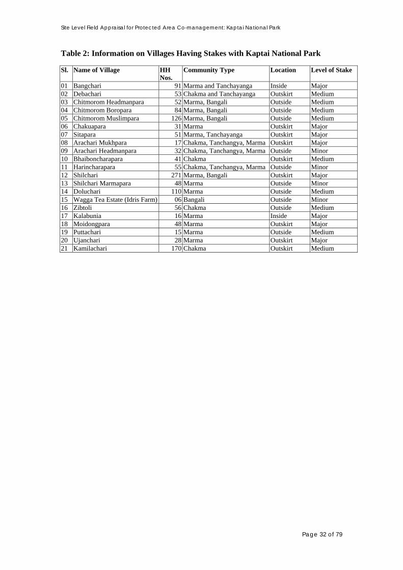
Site Level Field Appraisal for Protected Area Co-management: Kaptai National Park
Table 2: Information on Villages Having Stakes with Kaptai National Park Sl. Name of Village HH
Nos. Community Type Location Level of Stake
01 Bangchari 91 Marma and Tanchayanga Inside Major 02 Debachari 53 Chakma and Tanchayanga Outskirt Medium 03 Chitmorom Headmanpara 52 Marma, Bangali Outside Medium 04 Chitmorom Boropara 84 Marma, Bangali Outside Medium 05 Chitmorom Muslimpara 126 Marma, Bangali Outside Medium 06 Chakuapara 31 Marma Outskirt Major 07 Sitapara 51 Marma, Tanchayanga Outskirt Major 08 Arachari Mukhpara 17 Chakma, Tanchangya, Marma Outskirt Major 09 Arachari Headmanpara 32 Chakma, Tanchangya, Marma Outside Minor 10 Bhaiboncharapara 41 Chakma Outskirt Medium 11 Harincharapara 55 Chakma, Tanchangya, Marma Outside Minor 12 Shilchari 271 Marma, Bangali Outskirt Major 13 Shilchari Marmapara 48 Marma Outside Minor 14 Doluchari 110 Marma Outside Medium 15 Wagga Tea Estate (Idris Farm) 06 Bangali Outside Minor 16 Zibtoli 56 Chakma Outside Medium 17 Kalabunia 16 Marma Inside Major 18 Moidongpara 48 Marma Outskirt Major 19 Puttachari 15 Marma Outside Medium 20 Ujanchari 28 Marma Outskirt Major 21 Kamilachari 170 Chakma Outskirt Medium
Page 32 of 79

Site Level Field Appraisal for Protected Area Co-management: Kaptai National Park
Page 33 of 79
Figure 3: Map of Kaptai National Park including the Impact Area, RRA/PRA Sites

Site Level Field Appraisal for Protected Area Co-management: Kaptai National Park
Page 34 of 79
Figure 4: Map of Kaptai National park including the Landscape Interface Area

Site Level Field Appraisal for Protected Area Co-management: Kaptai National Park
There are one tea estates near to the NP namely Wagga Tea Estate. This is situated at the
bank of the Karnaphuly River under Ujanchari village near to Rampahar Beat and
adjacent to Sita Pahar under Chitmaram Union. There are 10 landless and extreme poor
families living in the garden who are mainly laborer in the garden. These people are
originally native to India; their ancestors came during British Era and started to work in
the garden, and are still following the footsteps of their ancestors. They are not aware and
even do not bother education, rights and uplifting living status. Usually they work there
for 6 hours (from 8:00 AM to 2:00 PM) and receive wage of Tk. 28 and half K.G. rice per
day, yearly bonus vary from Tk. 50 to Tk. 200. Sometime they have to work for extra
hours (up to 4:00 PM) when average plucking of leaf is high and receive wage Tk. 20 for
these extra hours. These people are completely dependent on earnings from daily labor in
the tea garden.
This community does not enter into the Kaptai NP because of special restrictive directives
from the owner of the tea garden not to enter to collect anything. They are allowed to
collect fuel wood in the tea garden area. If surplus remains after household consumption,
they sell a bit to the local market.
4.3 Stakeholder Assessment
Like most other protected areas in the country, three categories of stakeholders identified
in the Kaptai NP. Stakeholders are:
• Primary stakeholder- involved with direct extraction of resources from Kaptai NP or
their activities directly affect the park
• Secondary stakeholders – indirectly linked with the Kaptai NP, involved with trading
or exert influences on the park
Institutional stakeholder- involved with developmental activities and administration of
the adjoining areas of the Kaptai NP
4.3.1 Primary stakeholders
Primary stakeholders are those who are directly involved in resource extraction and forest
conversion activities in the Kaptai NP. Information of the stakeholder’s type, category,
description, activities, dependency, relative level of stakes with KNP and influence are
presented in Table 8. Study team has identified 23 stakeholder groups (excluded
institutional stakeholder) of the Kaptai NP and of them 18 are primary stakeholders, the
Page 35 of 79

Site Level Field Appraisal for Protected Area Co-management: Kaptai National Park
rest are secondary stakeholders. Among the identified stakeholders, four groups (fuel
wood collector, illicit timber feller, bamboo collectors and building materials collectors)
have major stakes with the Kaptai NP as they have major use of forest. While nine have
medium stakes (Jhum cultivator, cane collector, broom stick collector, land encroacher,
timber trader, sawmill owners, furniture shop owners, fuel wood trader and brickfield
owner) and the rest have minor stakes with the forest.
Table 8: Stakeholders of KNP (Based on Resource Extraction & Direct Activities) Sl. Stakeholder
Name Stakeholder Type
Stakeholder Description
Stakeholder Activities
Dependency Level of Stake
Remarks
1 Fuel wood Collector
Primary Local poor people, Forest villagers
Collect dead, dry trees, small non-commercial trees, and young timber trees. Cut, chop, bundle & carry away
Meet household needs; many families depend for livelihood; sell for added income
Major
2 Illicit timber Feller
Primary Adult male from adjacent villages particularly organized laborers from Rangunia (Kodala, Mariamnagar, Raikhali, Boalkhali) & Chakaria
Selective felling of valued timber trees particularly teak
Many households entirely dependent on this activity they are funded by illegal timber traders
Major Mainly organized gangs. Some influential people are also behind it; local people allow to use their house as pri. store of illegal timber
3 Bamboo collector
Primary Local poor people, Forest villagers
Cut naturally occurring bamboo legally by paying revenue to FD for selling and illegally for day to day use
Sell for added income, meet household needs; Use for mat and basket making
Major Present stock of bamboo is declining; this year it is very limited due to flowering followed by natural dying
4 House Building Materials Collector
Primary Local poor andmiddle class, forest villagers people from adjacent areas
Collect small trees, timber, vines and other plant materials
Meet household needs; Some sell for added income
Major
5 Jhum Direct / Indigenous Grow crops Major, Medium Practiced
Page 36 of 79

Site Level Field Appraisal for Protected Area Co-management: Kaptai National Park
Sl. Stakeholder Name
Stakeholder Type
Stakeholder Description
Stakeholder Activities
Dependency Level of Stake
Remarks
cultivator Primary People, Forest villagers, people from neighboring areas
through jhum cultivation; clear land through slash &burn process
sometimes only income source
over 60 ha. in Kamilachari & Bangchari; possibility in Kalmichara
6 Broom Stick Collector
Primary Local poor people, Forest villagers
Cut naturally occurring broom stick
Sell to the market to earn livelihood expenses
Medium Present Stick is declining; seasonal activity
7 Cane Collector
Primary Local poor people, Forest villagers
Cut naturally Occurring cane
Sell for added income, manufacture small items like mora, tray, cradle, basket etc.
Medium Very limited stock; declining very rapidly
8 Morichalata (Peper) Collector
Primary Local poor people, Forest villagers
Collect morichalata & sell to traders
Not dependent Minor No market in CHTs; used in the southern districts
9 Vegetable Collector
Primary Forest villagers Some poor people from adjacent villages
Collect dheki shak, kalar mocha & thor kachu, kachur lati, wild tubers, dumur,bacchari (bamboo shoot) etc.
Forest villagers partly dependent
Minor Fuelwood collector sometimes collect vegetable Tribal peoplecollect bamboo shoot
10 Sungrass Collector
Primary Local poor people, Forest villagers
Collect sungrass as house building material
Not dependent Minor Very limited stock
11 Land encroacher
Direct /primary
Mostly the migrant indigenous People
Encroached land, convert to jhum culture, homestead, agriculture land etc.
Become established
Medium About 36.80 acre land been encroached
12 Agriculture farmer
Direct/ primary
Local people, encroacher Forest villager
Cultivate land around the NP particularly bottom of hills
Not dependent Negligible
13 Visitors Direct People form different parts of the country,
Walking across the forest, litter
Not dependent Minor Unplanned tourism
Page 37 of 79
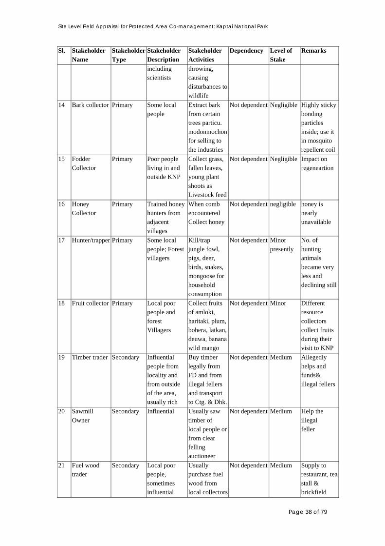
Site Level Field Appraisal for Protected Area Co-management: Kaptai National Park
Sl. Stakeholder Name
Stakeholder Type
Stakeholder Description
Stakeholder Activities
Dependency Level of Stake
Remarks
including scientists
throwing, causing disturbances to wildlife
14 Bark collector Primary Some local people
Extract bark from certain trees particu. modonmochon for selling to the industries
Not dependent Negligible Highly sticky bonding particles inside; use it in mosquito repellent coil
15 Fodder Collector
Primary Poor people living in and outside KNP
Collect grass, fallen leaves, young plant shoots as Livestock feed
Not dependent Negligible Impact on regeneartion
16 Honey Collector
Primary Trained honey hunters from adjacent villages
When comb encountered Collect honey
Not dependent negligible honey is nearly unavailable
17 Hunter/trapper Primary Some local people; Forest villagers
Kill/trap jungle fowl, pigs, deer, birds, snakes, mongoose for household consumption
Not dependent Minor presently
No. of hunting animals became very less and declining still
18 Fruit collector Primary Local poor people and forest Villagers
Collect fruits of amloki, haritaki, plum, bohera, latkan, deuwa, banana wild mango
Not dependent
Minor Different resource collectors collect fruits during their visit to KNP
19 Timber trader Secondary Influential people from locality and from outside of the area, usually rich
Buy timber legally from FD and from illegal fellers and transport to Ctg. & Dhk.
Not dependent
Medium Allegedly helps and funds& illegal fellers
20 Sawmill Owner
Secondary Influential Usually saw timber of local people or from clear felling auctioneer
Not dependent Medium Help the illegal feller
21 Fuel wood trader
Secondary Local poor people, sometimes influential
Usually purchase fuel wood from local collectors
Not dependent Medium Supply to restaurant, tea stall & brickfield
Page 38 of 79

Site Level Field Appraisal for Protected Area Co-management: Kaptai National Park
Sl. Stakeholder Name
Stakeholder Type
Stakeholder Description
Stakeholder Activities
Dependency Level of Stake
Remarks
22 Brickfield Owner
Secondary Influential people from outside Settlements
Use fuel wood to burn bricks.
Not dependent Medium
Purchase from fuel wood traders
23 Furniture shop Owner
Secondary Businessmen from the locality and outside of the locality
Use illegal timber with legal timber
Not dependent Medium Encourages illegal timber feller to carry out the activity
Primary stakeholders including illicit timber fellers are mostly poor and they live in the
forest villages and in the adjacent villages of the forest within the landscape interface area
as well. However, it is alleged that illicit timber fellers are largely funded by the timber
traders and furniture shop owners and most of them are inhabitants of Kodala,
Mariamnagar, Raikhali, Boalkhali of Rangunia upazilla far away (over 20 KM) from
Kaptai NP. Even they come from distant Chakaria upazilla under Cox’s Bazar district.
Local people provide them shelter, leave their house to store stolen timber primarily, and
are paid by the fellers due to their service provision. In a way, local people are assisting
illicit felling of timber from the Kaptai NP. Illicit fellers even carry firearms with them
and go to confrontation with the FD staffs more or less regularly. Women and children
are mainly involved with fuel wood, bamboo, fruit and vegetable collection and jhum
farming. Sometimes old and unemployed adults also collect fuel wood. Usually poor
adult male go inside the reserved forests particularly Kaptai NP to fell timber trees
illegally. Usually, the rich and middle class people are not involved with direct extraction
of forest resources. However, they often buy forest resources or finished products from
the primary stakeholders, including fuel wood, bamboo and other resources.
Different villages have different levels of stake with Kaptai NP based on resource
extraction. Almost all HHs of the inside villages (Forest villages) are involved with
resource extraction, mainly for meeting their HH needs. Other than these two villages,
most resource extractor come from Dhebachari, Sitapara, Shilkhali, Moidongpara,
Chitmorom, Doluchari, Ujanchari, Futtachari and some other adjoining villages.
4.3.2. Secondary Stakeholders
Secondary stakeholders are not directly involved with forest resource extraction from the
Kaptai NP however are linked with its purchasing, process, trading and utilization. The
study team has identified five secondary stakeholder groups active in and around Kaptai
Page 39 of 79

Site Level Field Appraisal for Protected Area Co-management: Kaptai National Park
NP. Information relating to those stakeholders groups along with their activities discussed
here under:
4.3.2.1 Timber traders
There are numbers of timber traders in and around Kaptai NP. About 7-10 persons in
Kaptai Notun Bazar, 5-7 persons at Boroichori Bazar and 5-7 persons at Lichubagan are
involved with timber trading. They may often be regarded as legal timber traders as they
have legal license for timber trading and are enlisted with the Forest Department.
Therefore, they used to bid in the FD auctions in different forest areas particularly Kaptai
NP areas. Generally, they purchase stolen, recovered or confiscated forest products
through open auction or sealed tender from the Forest Department. However, people
neighboring the Kaptai NP believe that majority of them have linkages with illegal timber
feller/syndicates. As alleged, they usually buy the illegal timber at a very cheap rate and
sell it to the local market along with the timber produced in the homestead. Legal timber
that are bought at a rather higher rate through auctions and transport those to other places,
particularly Chittagong and Dhaka. Local people believe that timber traders have strong
linkage with police, sawmill owners, furniture shop owners and sometimes with FD. Fig.
5 shows that the various linkages they have with different institutions and persons.
Figure 5: Link of Timber Traders with Different Stakeholders
Furniture Shop owners
Local Administration
Local UP members and chairman
Law Enforcement Agencies
Timber Traders Local
Politicians
Sawmill Owners
Forest Department
Fuel wood CollectorsIllicit
Fellers
Page 40 of 79

Site Level Field Appraisal for Protected Area Co-management: Kaptai National Park
4.3.2.2 Sawmill owners
There are two sawmills located in the industrial area of Kaptai near Kaptai Notun Bazar.
Sawmills are Munshi Mia’s saw mill and Zakir Hossain’s saw mill. These two saw mills
create lot of problem to the forests in this area. Due to increased pressure of the Forest
Department officials, these two sawmills most often remained closed. However, sawmill
owners are influential in the locality. These sawmills usually receive legally felled
timbers for sawing into planks and sometimes timbers that are produced in the
homesteads of local people. It is alleged that they size illegal timbers as well in the name
of legal timbers mainly felled from reserved forests and in a way, they encourage illegal
felling of trees from nearby forests, including Kaptai NP. Sometimes they may have
internal linkages with timber traders and illegal fellers. However, recently FD is putting
lot of efforts to seize or confiscate illegal timbers/planks/lumbers from these two sawmills
alleged involvement with illegal timber business.
4.3.2.3 Furniture Shop Owners
Furniture shop owners have good links with sawmills and sometimes with illegal feller as
well. According to local people, the shops, in addition to legal timber, also use smuggled
timber from the forest. There are about 15 furniture shops in and around Kaptai area
mainly located in Notun Bazar, Jetty Ghat, Boroichari Bazar etc. areas. They usually
collect sawn timber from sawmills, sometimes buy round timber directly from the illegal
fellers or timber traders and get it sawn in sawmills. Majority of the traders are from
outside of the project area particularly from Chittaong and Comilla.
4.3.2.4. Fuel wood trader
People neighboring Kaptai NP collect fuel wood primarily for their household cooking
secondarily selling the surplus amount to the traders. Some other collectors collect to sell
for subsistence earning to their families. However, generally small fuel-wood traders do
not enter the Kaptai NP for collection of fuel wood rather purchase fuel wood from the
individual collectors and transport it preferably by van or small type rental vehicle to the
sell point like Kaptai Bazar, Boroichori, Chandraghona, Lichubagan and some other local
markets. It can go as far as Rangunia, Rajsthali, Raikhali, Raozan and even Chittagong.
Some of those fuel wood traders sell directly to the restaurants and tea stalls for cooking.
These fuel wood traders supply fuel wood to the brickfields in Rangunia and Raozan
areas to use for brick burning. A small stack/pile of fuel wood of 8-10 Kg. is sold in the
local market for Tk. 15-20.
4.3.2.5 Brickfield owners
There is no brickfield in and around Kaptai NP. The nearest brickfields are located in
Rangunia Upazilla under Chittagong district and about 15 - 20 K.M. away from KNP
Page 41 of 79

Site Level Field Appraisal for Protected Area Co-management: Kaptai National Park
boundary. Still those brickfields have strong detrimental effect on the KNP particularly
for the supply of fuel for brick burning. There is a provision to use coal only in the brick
kilns although no use of coal has been seen during team’s visit to those brickfields. They
have just stored coals but not using it. Brickfield owners are using fuel wood in stead and
the majority of supply of these fuel woods is coming from forests particularly from KNP.
4.3.3. Institutional / Organizational Stakeholders
There are some institutions and organizations, which have stakes with the Kaptai NP. List
of the identified major institutional / organizational stakeholders along with their
activities regarding Kaptai NP are mentioned hereunder:
4.3.3.1 Forest Department (FD)
Forest Department is the key institutional stakeholders in the Kaptai NP and has the
overall responsibility for management, conservation and development of the NP through
planting, harvesting, patrolling and guarding the forest resources. Presently, FD has
deployed 136 staffs of different status and designation at different Ranges, Beats, Stations
and Check Stations for the management and administration of Kaptai NP. Among them,
one Assistant Conservator of Forests (ACF) is posted at Kaptai with the overall
responsibility of Kaptai NP management and administration. Besides, 1 Forest Ranger
(FR), 3 Deputy Ranger (DR), 8 Foresters, 25 Forest Guards (FG), 8 Boatman (BM), 15
Gardeners and 5 secretarial staffs are posted within the territory of Kaptai Range.
However, 1 Forest Ranger (FR), 3 Deputy Ranger (DR), 9 Forester, 38 Forest Guards &
Boatman, 15 Gardener and 4 secretarial staffs are posted within the territory of
Karnaphuly Range. Overall, FD plays a positive role in the protection of the Kaptai NP.
Local people have alleged that a few FD local staffs at the NP are involved indirectly with
illegal felling activities. In addition, local people also reported that FD staff takes money
(e.g. 10-20 taka for each entry) from fuel wood and bamboo collectors to allow them to
enter into the NP. However, the local FD staff denied such allegation. Local people think
that illegal felling in the Kaptai NP reduced considerably in these days and corruption of
FD staffs also reduced largely. However, still this is present with limited magnitude.
Forest Department staffs do regular patrolling in groups at the strategic location of the
Kaptai NP and often became successful to confiscate stolen good and sometimes arrest
illicit fellers. However, number of FD staffs to protect this vast forest area is very limited.
Therefore, they often become unable to guard all the pockets within the Kaptai NP and
chase the illicit fellers.
4.3.3.2 NGOs and Banks
There are several NGOs and Banks operating their activities in and adjoining areas of
Kaptai NP. Major NGOs that operate in the locality are Grameen Bank, IDF, BRAC,
Page 42 of 79

Site Level Field Appraisal for Protected Area Co-management: Kaptai National Park
ASA, CARITAS, Green Hill, Hilley Hilli and UNDP through Community Empowerment
Project (CEP). Besides, Bangladesh Krishi Bank and BRDB’s Rural Livelihood Project
(Palli Jibikayan Prokalpa) also operate here. The major activities of the NGOs are
concentrated on health, education and alternate income generation. Most of them have
credit programs exclusively for the women. However, Bangladesh Krishi Bank provide
credit to the male members only as the bank needs land tenure documents and in the
CHTs, all the lands tenure documents belong to the male members of households.
Bangladesh Krishi Bank and Palli Jibikayan Prokalpa of BRDB and several NGOs
provide micro credit to the local people (Table 9) for improving the livelihood of local
people. There is no NGO available in the locality to deal with the forest related matters
i.e. conservation, management resource management, wildlife protection and environment
related issues.
Table 9: List of NGOs / Banks in the Kaptai Area and Their Activities Name of NGOs / Banks Location Activities BRAC Kaptai Micro-credit, Education & Health, Social Development Green Hill Kaptai Micro-credit, Water Supply Grameen Bank Kaptai Micro-credit ASA Kaptai Micro-credit Proshika Kaptai Micro-credit CARITAS Kaptai Micro-credit, Heath and Education UNDP – CHTDF Rangamati Community Empowerment Project Bangladesh Krishi Bank Kaptai Agricultural Loans BRDB Kaptai Palli Jibikayan Project (RLP)
NGOs operating in this area provide micro-credit to their members on several income
generating activities (IGAs) particularly small trade, poultry rearing, vegetable culture,
cottage industries. These IGA programs concentrate mostly on small business, poultry,
livestock, Jhum cultivation etc. NGO’s provide micro-credit mostly to the female
members. Overall, NGO activities are not sufficient to support the livelihoods of the
surrounding people of Kaptai NP. Local people reported that NGOs do not offer skill
development training to their members rather provide micro-credit for skilled activities to
generate alternative income. It is evident that NGOs working in the locality have very
limited coordination among themselves. More IGA initiatives are essential for upgrading
the livelihood of the local people better. Local people, particularly the indigenous people
(Marma, Tanchangya, Chakma, Pankhoya etc.), have some skills like bamboo basket and
mat making, weaving, etc. Marma and Chakma community are also interested to rear pig
as an alternative income generating activity
4.3.3.3 Army, Police and BDR
There are some camps of Army, Police and BDR forces around the Kaptai NP areas.
These forces also do some kind of checking of forest products during transportation.
Page 43 of 79

Site Level Field Appraisal for Protected Area Co-management: Kaptai National Park
There is a army camp adjacent to Arachari village outside of Kaptai NP. Army personnel
help in protecting illegal forest products movement from this area regularly. Near
Boroichori, there is a BDR camp cum inspection / checkpoint. BDR often confiscate
illegal forest products particularly timber in this checkpoint. They also put a notice board
in front of their camp for the vehicle drivers regarding legal products carrying
specification. When a vehicle carrying with forest products come to the checkpoint,
responsible BDR personnel carry out regular checking of the products and examine valid
papers. Any anomaly found with the products and papers beyond specification, they
confiscate and hand over the products to the Forest Department and Forest Department
then filed cases against the owners of the products.
4.3.4 Dependency of the Stakeholders on the Forest Resources
Local people are heavily dependent on the Kaptai NP for the supply of different forest
products particularly on fuel wood for their household needs. Many local households also
get some bamboo and other house building materials from the forest.
Table 10: Uses of Various Resources by Stakeholders in and around KNP Sl Name of
Resources Users Causes Extent Resource
dependency Risk
Saw mill owner Business Purpose Medium 30% Furniture shops Business Purpose Medium 40% Timber trader Business Purpose Medium 30%
01 Timber
Local People Household use as furniture and building materials
High 25%
Matured & Tall trees removed
Local household
Domestic use, selling for livelihood
High 90%
Local tea stall/ restaurant owners
burning in tea stalls Medium 30%
Local Brickfields Owners
burning in brickfields Less 80%
Outside household users
Domestic use Medium 5%
Outside tea stall/ restaurant owners
burning in tea stalls very less
2%
02 Fuel Wood
outside brickfield owners
burning in brickfields Nil 0%
Mainly collect dead and decayed wood, however sometimes collect young timber and non-commercial timber trees
Local users As poles, fencing, ceiling, basket, fuel and others
Medium 30% 03 Bamboo
outside users -do- Less 70%
Stock declining
04 Cane Local Users Basket Binder/ Others Less 5% Nearly depleted
Local Users Sweepings for cleaning Less 25% 05 Broom Stick Outside Users Sweepings for cleaning Less 50%
06 Medicinal Plants
Local People, a few Saman (local Badya)
As Medicine Less 25%
07 Fruits Local People Food Less 10% very limited 08 Vegetables Local People Food Less 5% 09 Wild Pig Indigenous
Community As meat Very
Less 5%
10 Honey Local people Food, medicine Less 5%
Page 44 of 79

Site Level Field Appraisal for Protected Area Co-management: Kaptai National Park
Sl Name of Resources
Users Causes Extent Resource dependency
Risk
11 Bark Outside people Mosquito repellent coil Less 2% 12 Moricha
Lata Outside people Medicinal value, tasty
pepper Less 3%
Dependence of different stakeholder groups on different resources for their household
needs and supporting their livelihoods is shown in Table10. Almost, all households of the
two forest villages inside the NP are dependent on the fuel wood, bamboo and house
building material, vegetables etc. supplies from the forest for their household needs. They
collect these for own purposes however sometimes they sell it for added income as well.
Many poor people from the neighboring villages are largely dependent on selling of fuel
wood and many of them sell it for added income.
FD’s Plantation Strategy
KNP Causes of
Degradation
Illicit Felling
Fuel Wood Collection
Bamboo Collection
Jhum Cultivation
Inadequate Patrolling by
FD
Hunting Brickfield Operation
Building Materials Collection
Population Pressure
Figure 6: Causes of Forest Resources Destruction with scale in the Kaptai NP
Page 45 of 79
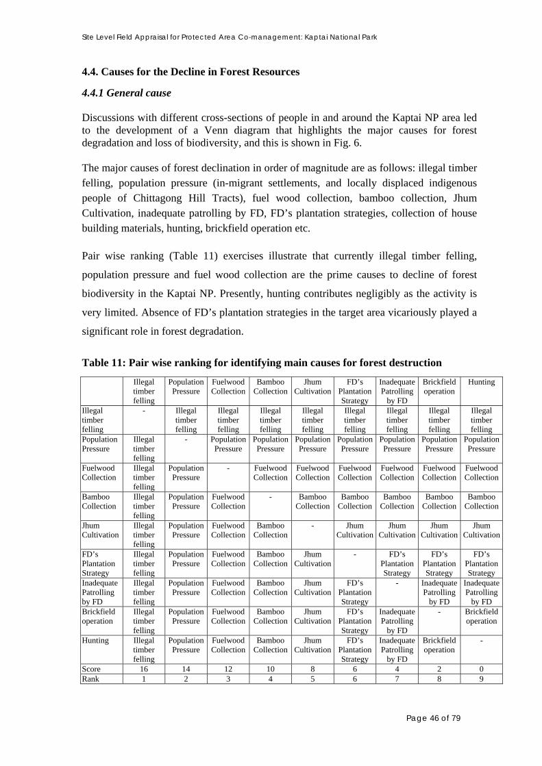
Site Level Field Appraisal for Protected Area Co-management: Kaptai National Park
4.4. Causes for the Decline in Forest Resources
4.4.1 General cause
Discussions with different cross-sections of people in and around the Kaptai NP area led to the development of a Venn diagram that highlights the major causes for forest degradation and loss of biodiversity, and this is shown in Fig. 6. The major causes of forest declination in order of magnitude are as follows: illegal timber felling, population pressure (in-migrant settlements, and locally displaced indigenous people of Chittagong Hill Tracts), fuel wood collection, bamboo collection, Jhum Cultivation, inadequate patrolling by FD, FD’s plantation strategies, collection of house building materials, hunting, brickfield operation etc. Pair wise ranking (Table 11) exercises illustrate that currently illegal timber felling,
population pressure and fuel wood collection are the prime causes to decline of forest
biodiversity in the Kaptai NP. Presently, hunting contributes negligibly as the activity is
very limited. Absence of FD’s plantation strategies in the target area vicariously played a
significant role in forest degradation.
Table 11: Pair wise ranking for identifying main causes for forest destruction
Illegal timber felling
Population Pressure
Fuelwood Collection
Bamboo Collection
Jhum Cultivation
FD’s Plantation Strategy
Inadequate Patrolling
by FD
Brickfield operation
Hunting
Illegal timber felling
- Illegal timber felling
Illegal timber felling
Illegal timber felling
Illegal timber felling
Illegal timber felling
Illegal timber felling
Illegal timber felling
Illegal timber felling
Population Pressure
Illegal timber felling
- Population Pressure
Population Pressure
Population Pressure
Population Pressure
Population Pressure
Population Pressure
Population Pressure
Fuelwood Collection
Illegal timber felling
Population Pressure
- Fuelwood Collection
Fuelwood Collection
Fuelwood Collection
Fuelwood Collection
Fuelwood Collection
Fuelwood Collection
Bamboo Collection
Illegal timber felling
Population Pressure
Fuelwood Collection
- Bamboo Collection
Bamboo Collection
Bamboo Collection
Bamboo Collection
Bamboo Collection
Jhum Cultivation
Illegal timber felling
Population Pressure
Fuelwood Collection
Bamboo Collection
- Jhum Cultivation
Jhum Cultivation
Jhum Cultivation
Jhum Cultivation
FD’s Plantation Strategy
Illegal timber felling
Population Pressure
Fuelwood Collection
Bamboo Collection
Jhum Cultivation
- FD’s Plantation Strategy
FD’s Plantation Strategy
FD’s Plantation Strategy
Inadequate Patrolling by FD
Illegal timber felling
Population Pressure
Fuelwood Collection
Bamboo Collection
Jhum Cultivation
FD’s Plantation Strategy
- Inadequate Patrolling
by FD
Inadequate Patrolling
by FD Brickfield operation
Illegal timber felling
Population Pressure
Fuelwood Collection
Bamboo Collection
Jhum Cultivation
FD’s Plantation Strategy
Inadequate Patrolling
by FD
- Brickfield operation
Hunting Illegal timber felling
Population Pressure
Fuelwood Collection
Bamboo Collection
Jhum Cultivation
FD’s Plantation Strategy
Inadequate Patrolling
by FD
Brickfield operation
-
Score 16 14 12 10 8 6 4 2 0 Rank 1 2 3 4 5 6 7 8 9
Page 46 of 79

Site Level Field Appraisal for Protected Area Co-management: Kaptai National Park
Cause and effect ranking was done in order to investigate the underlying factors
responsible for forest degradation activities by the local people and the outcomes are
shown in Table 12 and Table 13. The exercises revealed that local poverty and
unemployment are the main driving factors for the extraction of forest resources,
followed by additional income needs and squeezed income opportunities. Lacks of some
local resources are also driving the people for increased timber felling (Table 12).
Brickfield operations though not responsible for the decline of KNP, it is leading to huge
amount of fuel wood collection around surrounding areas of KNP (landscape area).
Table 12: Cause and Effect – Ranking (underlying facts for forest degradation)
Name of Resource Identified Problems
Timber to sell
Fuel wood collection
Bamboo sell
Building Materials Collection
Land encroachment
and Jhum Cultivation
Poverty 000 000 00 00 000
Unemployment 0000 0000 0
Additional income needed 000 00 00 0 0
No resource for house building 0 0000 0000 000
Income opportunities squeezed 000
HHs consumption 0 00000 000 00 0000
Marketing opportunities dev 00 000 0 0
Emerged as new income generation activity
000 00 000 00
Brick Field 00 00
Jhum cultivation 0 00 00 0000
Forest cases 000 00 00 00 Not explored
Several factors contributing to the illicit felling of timber trees from the Kaptai NP and
surrounding areas are FD’s poor forest patrol, easy negotiation with local FD staff, poor
strength of local FD and emergence of increased local influential groups. Fuel wood
collection is being enhanced by the limited fuel wood plantation in the homestead,
development of transportation system and marketing opportunities. FD (Table 13) has
always linkage to encroachment followed by jhum cultivation as the customary rights of
the indigenous people of CHT and lack of control over forest. Deforestation is also
caused by over extraction and illegal logging combined with a slow afforestation rate.
Unplanned settlement, encroachment and inadequate forest management are part of the
problem; apart from this, there is a wide lack of information on forest status and forest
management. The regulations in CHT [such as the Chittagong Hill Tracts Forest Transit
Page 47 of 79

Site Level Field Appraisal for Protected Area Co-management: Kaptai National Park
Rules (1973)] necessitate farmers to have written permission from the FD officials for
cutting farm-trees and transporting to the market centers. Because of the bureaucratic
meandering and bribe-seeking attitude of officials, getting permission is very difficult,
predominantly for small farmers and it compels them to sell timber in the black market at
a very low price. Therefore, selling of timber actually contributes little to eradicate
poverty from the lives of local people.
Table 13: Cause and effect (FD’s management practice and local situation) Practice/management practice
Tim
ber
to
sell
Fue
lwoo
d co
llec
tion
Bam
boo
coll
ecti
on
Jhum
ing
&
Lan
d en
croa
chm
ent
Bui
ldin
g M
ater
ials
C
olle
ctio
n
Poor forest patrol 000 0 00 0
Easy negotiation 000 0 0
Lack of control over forest
by FD
000 0 0 0000 0
Transportation
development
00 0 0 000 0
Traditional practice 0 000 0 000 00
Increased role of
influential groups
00000 00000
4.4.2 Exploitation of Forest Resources
Table 14 presents summarized information on resource, collector, and their purpose,
extent of exploitation, impact, future risk and destination of products from the Kaptai NP.
It has been identified that there are about 14 different types of resources extracted/
collected from the forest. Two types of resources (fuel wood, bamboo) are extracted on a
large scale; however, three on a moderate scale, four on a minor scale and rest five are in
very negligible scale. The main purposes for resource extraction include meeting HH
needs, selling for added income/and or to support and supplement livelihood. Timber
felling, fuel wood and bamboo collection, collections of house building materials, hunting
etc. all are posing threats to the forest and its biodiversity.
Page 48 of 79

Site Level Field Appraisal for Protected Area Co-management: Kaptai National Park
Table 14: Information on Resource Extraction from Kaptai National Park Sl Name of
Resources Resource Collector
Purpose Extent Impact Risk Destination
1 Timber Poor people from adjacent villages, unemployed people
For selling Medium Reduce large tree & forest thickness selectively, loss of habitat for gibbon and others
High Local timber trader, saw mill, furniture shop, urban areas
2 Fuel wood Local poor people, forest villagers, mainly women and children
For HH consumption Selling and HHcomp , selling
Large Loss of habitat, loss of forest biodiversity,
High Local HHs, local markets, brickfield, transported to urban areas
3 Bamboo Forest villagers, some local poor people from adjacent villages
Meet HH needs Selling for added Income
Large Wild stock already heavily depleted, further extract aggravate the situation
Moderate Local HHs Local and nearby Areas
4 Building Materials
Forest villagers Local people
Meet HH needs; selling for added Income
Medium Reduce abundance of small trees, loss of habitat, loss of wildlife
Moderate Local HHs Local markets
5 Cane Local people HH Use Minor Little collected as they are not much available
Moderate Natural cane & from plantations
6 Broom Stick Local People HH Use and Sell
Medium Seasonally collected manily to sell
Moderate Throughout the country
7 Fruits Local people, children and women
Own consumption, few for sale in the locality
Minor Hamper forest regeneration to a little extent
Minor
8 Wildlife Forest villagers Local people
consumption Minor Stock heavily depleted
High Local HHs
9 Vegetables Local people, mainly forest villagers
Collect number of species of vegetable
Minor No apparent impact
Negligible
10 Sungrass Local people Collect as house building materials
Presently little
Reduce forest biodiversity
Negligible
Removed in the process of plantations
11 Medicinal Plants
Few local people, forest villagers
Occasionally collect some selective species
Little Negligible Negligible
12 Moricha Lata Local People For selling Negligible None Negligible Southern Districts
13 Tree Bark Few local people
For selling to mosquito repellent mat industries
Negligible Negligible Negligible Dhaka & Chittagong
14 Honey Local people Own consumption
Negligible None Negligible -----
Page 49 of 79

Site Level Field Appraisal for Protected Area Co-management: Kaptai National Park
4.4.3 Seasonal changes in resource extraction Trend in forest resource exploitation in different months is shown in Table 15. The
exploitation of resources varies depending on the seasons. Timbers are felled throughout
the year, especially in the dry months. In the rainy season, collection continues in a
limited scale rather. However, this season is particularly helpful for illegal timber
transportation, as that time there will be ample water in the Kaptai Lake to transport the
timber rather easily though floating devices. Fuel wood collection continues throughout
the year more or less in a similar rate except the rainy season. That is due to that easy
accessibility and mobility in the dry seasons inside the forest and less accessibility,
mobility and less drying and storing facilities during rainy season. Bamboo extraction
mainly takes place in drier months however collection continues throughout the year that
corresponds to local needs for house building. Broom stick, honey, fruits etc. collected in
particular seasons and that not available throughout the year in the forests. Medicinal
plants, vegetables and some other forest resources are extracted to some extent mainly
during rainy season.
Table 15: Seasonal Calendar of Resources Exploitation in Kaptai NP
Name of Resources
Boi
sak
Jois
tha
Ash
ar
Sra
bon
Vad
ro
Ash
win
Kar
tik
Agh
ran
Pou
sh
Mag
h
Fal
gun
Cho
itra
Timber 000 000 0 0 00 00 000 000 000 000 000 000 Fuelwood 000 000 0 0 00 00 000 000 000 000 000 000 Broomstick - - - - - - - - 000 000 - - Bamboo 0 0 0 0 0 00 00 00 00 00 00 00 House building Materials
0 0 - - 0 0 0 0 00 00 00 00
Medicinal plants 0 0 0 0 0 0 0 0 0 0 0 0 Leafy vegetables 00 0 0 0 0 0 0 0 0 0 0 00 Jungle Fruits - - - 000 000 - - - - - - - Moricha Lata 0 0 0 0 0 0 0 0 0 0 Bark -Modonmochon
0 0 0 0 0 0 0 0 0 0
Honey 00 0
4.4.4 Exploitation of Major Resources from KNP
4.4.4.1. Fuel wood collection
Fuel wood collection is a major and visible activity in Kaptai NP. It continues throughout
the year, however, most of the extraction occurs during the dry months. Most of the
villagers, especially from inside villages and villages that are adjacent to the NP are 90%
dependant on the forest for their fuel wood requirements to meet their household
Page 50 of 79

Site Level Field Appraisal for Protected Area Co-management: Kaptai National Park
consumption (Table 11). A large number of families undertake fuel wood collection to
supplement their HH income. Both men and women collect fuel wood, however
sometimes children also go for collection of fuel wood.
According to local people, almost all the households neighboring Kaptai NP collect fuel
wood for their daily consumption. Usually, a person collects a 20-40 kg fuel wood each
day. They carry it either as their shoulder or head loads. Most often they do not pay any
amount to FD however some of the respondents claimed that they needs to pay a small for
entering the forest for collecting fuel wood. FD does not restrict access to the forest for
collecting fuel wood. However, the PRA team did notice during their exercise in the field
that the collectors are allowed to collect dead branches of trees. However, in practice,
sometimes they cut some soft trees, chop and bundle it. Sometimes they leave the cut
trees to get a dead appearance. They also cut the young trees of valued timber trees. They
also cut the small bushy trees.
Besides the local HH use, local tea stalls/ restaurants use fuel wood for burning in their
kitchen, some of the local brickfields also use fuel wood for brick burning. Other local
people buy fuel wood from the local market sold by collectors. The fuel wood collected
for commercial purpose mainly purchased by the fuel wood traders locally and transports
it to Boroichori, Lichubaga, Raikhali, Boalia, Rangunia, Kodala, Moriamnagar where it is
sold local consumers and brickfields.
4.4.4.2 Illicit Timber Felling
Illicit timber felling is also major activity in Kaptai though it has lessened largely in
recent days and still regarded as the major cause of forest destruction. Although, timber
felling is illegal in Kaptai NP, the activity is going on in a shorter scale. Many people
from surrounding villages of Kaptai NP are indirectly involved with illicit felling of
timber from the forest. The illicit fellers come in groups mostly from Kodala,
Mariamnagar, Raikhali, Boalia etc. villages of Rangunia upazilla and some even come
from Chakaria upazilla of Cox’s Bazar district. The timber traders outside Kaptai NP area
mostly fund them to supply forest timbers particularly teak as teak furniture has high
demand throughout the country. They take shelter in the houses or any other hideouts
with the assistance of local people. Most often, illicitly felled timbers are stored to local
people’s house and the fellers pay local people due to their service. FD officials regularly
patrol the vulnerable areas and they often chase the fellers. Sometimes, fellers resist them
even with their illegal firearms.
Illicit fellers mainly cut the medium sized valued timber trees, like teak, gamar, civit etc.
The activity is carried out at night and intensively during the rainy season when the
Page 51 of 79

Site Level Field Appraisal for Protected Area Co-management: Kaptai National Park
access to the forest is very difficult and forest patrol is restricted. Usually, they select
suitable trees during daytime. Sometimes, the fellers come across the forest patrol. Illegal
tree fellers from the locality cannot break their affiliation with illegal felling of trees once
forest case is filed against them. They need to meet the expenses to fight the case and thus
try to collect the same from timber selling.
4.4.4.3 Bamboo Collection
Bamboo has many uses in the locality, e.g. as house building materials, as material for
fencing, as roof ceiling, basket and mat making and as fuel. About ten species of bamboo
available in the park and are collected by the local people. Earlier, bamboo was abundant
in the forest. Now, their stocks are seriously depleted, primarily due to extensive
extraction. This year in most the bamboo clumps, flowering occurred and natural dying of
bamboo is in progress. New bamboo is growing from seeds naturally and that will take
around 3-4 years to have large supply of mature bamboo again. FD has planted several
commercially important bamboo species previously in the Kaptai NP. Forest villagers and
local people collect bamboos from the wild, mainly for meeting their HH needs and sell
for added income as well. It is reported by local people that some people undertook this
as a commercial activity. According to local people, about 10-15% of the local
households are completely or partially dependent on bamboo collection for their
livelihood. Forest Department applies Dakhila system and collectors pay revenue to be
entitled to collect bamboo legally. However, most of the neighboring people collect
bamboo without paying revenues to FD for household uses and as building materials.
Bamboo is carried as shoulder and head load. Some traders from distant villages also
come to the locality for purchasing bamboo. They prepare bamboo mats, many fishing
traps and baskets and sell those to outside markets.
4.5. Collection of other Resources
Besides major forest products, Local people also collect some other Minor Forest
Products (MFPs) from the park, mainly for household consumption and some of the
products sell for added income as well. The collectors are mainly from the forest villages
and local poor people and children from the adjacent villages. Information on such
resources is given below.
4.5.1 Broomstick
Dependent people particularly women in and around the Kaptai NP collects broomstick
(Thysanolaena maxima) in the winter season. This is popularly known as Phul Jharoo
and used as sweep. Broomsticks become mature in the winter. Collection starts in winter
and sometimes continues in some parts of the summer months as well. This is totally a
Page 52 of 79

Site Level Field Appraisal for Protected Area Co-management: Kaptai National Park
seasonal activity for the collectors, not continues year round. This is often collected for
added income to the family. Broomstick has a very good market and demand throughout
the country. Broomstick produced in the Kaptai NP largely transported to the other
districts of the country. A medium sized broomstick is sold at Tk. 10 in and around
Kaptai NP, however, cost of the same in other districts is about Tk. 25.
4.5.2 Vegetables
People including Forest villagers’ and neighboring to the National Park almost everyday
collect some vegetables from the forest. Besides, the fuel wood collectors collect some
vegetables during the time of collection of fuelwood. The vegetables exploited are
bamboo shoots (bacchari), bonkachu (bandhugi), wild tubers, kalar mocha & thor, wild
banana, dumus (Ficus), leafy vegetables eg. thankuni, dheki shak, kochu, kochur shak,
kochur loti, etc. from the Kaptai NP.
4.5.3 Fruits:
Different resource collectors collect fruits during their visit to KNP as a supporting
activity. Fruits are collected for household consumption not to sell for added income.
They collect fruits of amloki, haritaki, plum, bohera, latkan, deuwa, banana, wild mango
etc.
4.5.4 Maricha Lota
Moricha Lota popularly known as Chui Jhal (Chui Pepper) is favorite throughout the
country especially in Southern districts. It enhances the taste of some foods like Halim,
Chotpati. It has some medicinal values as well. Very few people collect moricha lota from
Kaptai NP and sell it to the traders coming from Khulna and other districts at approximate
Tk. 10-20 per KG and the traders transport it to other parts of the country. However, that
is sold at Tk. 100 per KG in the southern districts.
4.5.5 Tree Bark
Some people from Kaptai NP collect bark of a tree locally known as modonmochon. The
bark of modonmochon tree contains sticky substances and act as binding particles. This is
a raw material for mosquito repellent mat industries as a particle-binding agent. There is
no use of modonmochon bark in the locality rather than selling it to the industries for
added income.
Page 53 of 79

Site Level Field Appraisal for Protected Area Co-management: Kaptai National Park
4.5.6 Cane
Four species of canes are available in the Kaptai NP. Of them, Korak, Budhum and Golok
are largely used for making basket, cradle, mirror hood, mora, small furnitures etc.
However, canes are seldom available in these days as the stock of cane in the Kaptai NP
is declining day by day and this is under severe threat.
4.5.7 Sungrass
Sungrass (Imperata cylindrical) is very limited in these days. People mainly collect
sungrass as building materials for roofing their houses. This is not sold for added income.
4.5.8 Wildlife
Hunting is now a days, is very limited in Kaptai NP as there is a serious decline in the
resource and due to increased awareness. The local people haunt for jungle fowl. Some
people still look for barking deer and that seldom available. Indigenous people sometimes
also haunt for wild boar / pig that they consume not sell for added income.
4.5.9 Honey
Honey is seldom available in the wild. Still some trained honey hunters look for honey in
the Kaptai NP especially in the flowing months. Honey is mostly hunted in the month of
Boishak and Joistha.
4.6 Other Causes for Forest Degradation
4.6.1 Land Encroachment
Out of 13,498 acres of land in the Kaptai NP, only about 36.40 acres of land is under
encroachment now. In Kaptai Sadar Beat amount of encroached land is 8.72 acre, in
Suknachari Beat 8.56 acre, in Bangchari Beat 18.30 acre and in Rampahar Beat only 1.22
acre. This is not a big in amount obviously however possess possible threat to the NP.
4.6.2 Jhum cultivation
Jhum cultivation or traditional slash and burn agriculture is done by the most of the
indigenous community in and around Kaptai National Park particularly by Chakma. That
is also called ‘shifting cultivation’. Crops grown on cleared hill slope fields include
upland rice, lemon, papaya, turmeric, ginger and recently introduced pineapple. In the
past, when population density was still low, most crops grown were subsistence food
Page 54 of 79

Site Level Field Appraisal for Protected Area Co-management: Kaptai National Park
crops that were grown on a freshly cleared and burned hill slope for 2 or 3 years, where
after the field was left fallow for 10 to 15 years. At present, the fallow period has been
reduced to 5 to 6 years. This, and the introduction of cash crops, has increased the need
for chemical fertilisers if reasonable yields are to be maintained.
For a number of reasons, previous resettlement attempts, with the objective to replace
non-sustainable shifting cultivation by permanent cropping systems, have not been
successful. First, some indigenous communities still prefer food crops from jhum field.
Second, horticulture and agro-forestry attempts failed because of insufficient farm
returns, poor marketing opportunities, lack of quality grading, farmers’ preference for
food crops, lack of soil conservation measures and high costs for herbicides (Roundup,
Grammoxone) to suppress invading weeds, especially sungrass (Imperata cylindrica) and
trailing and climbing weeds (Mucuna, Dioscorea). Most importantly also, insufficient
consultations were held with the farming communities involved, whereas the lack of land
title eroded farmers’ incentives to actively support these schemes.
There are around 60 hectares of jhum cultivation plots with in the territory of Kaptai
National Park. Around 50 hectares of jhum plot near to Bangchari forest village and
another 10 hectares at Kamilachari area. Both the sites are within in the territory of Kaptai
Range. There is no jhum practice in Karnaphuly Range however there is a possibility to
jhum cultivation at Kalmichara.
4.6.3 FD’s Plantation practice
The park has been converted a plantations in the past. The earlier plantations included
long rotational plants. At present plantation is being done with short rotational trees, often
monoculture. The plantation practice includes clearing of undergrowth by burning and
subsequent weeding to facilitate plant growth. This practice contributes most to the
degradation in local biodiversity.
4.7 Local Community and Power Structure and Local Governance
4.7.1 Local decision makers and influential people
A total of 48 influential persons (including personnel of traditional administrative system
of CHT as well as formal national administrative system) have been identified so far in
the locality and many of them have control over the local people, their activities and
often, even over local administration though the regional and national political leaders.
Page 55 of 79

Site Level Field Appraisal for Protected Area Co-management: Kaptai National Park
Table 16 provides the name and address of the influential persons, while Fig. 7 shows the
social dimension of power structure of the area.
Table 16: List of Powerful and Influential persons for Kaptai National Park Sl. Name of Villages Name of most influential
Persons Designation
01 Bangchari Chuiching Marma Mong Pru Maiyadhon Tanchangya
Headman (Forest) Local Elite Local Elite
02 Debachari Vabatosh Dewan Bhagyadhan Chakma Ranatosh Dewan Turulakka Tanchangya Babul Tanchangya Peti kumar tanchangya
Headman,Kamilachari Karbari,Debachari Head Teacher, Govt. school Karbari,Dighalchari Elite,Dighalchari Elite,Dighalchari
03 Chitmorom Headmanpara Chain thoyala Marma Headman 04 Chitmorom Boropara Labre chai Marma Karbari 05 Chitmorom Muslimpara Md. Fazal Rahman Karbari 06 Chakuapara Mongcha sing Marma
Suepru sin Marma Polao Marma Pulo ching Marma
Member, Chitmorom Karbari, Karbari Local Elite
Chakua Rehabilitation Uthai pru Marma Member, Chitmorom UP 07 Sitapara Sue Pru Cha Marma Karbari 08 Arachari Mukhpara Mahendralal Chakma
Montu Member Karbari Ex-UP Member
09 Arachari Headmanpara Kholamohon Tanchangya Bijali Mohon Tanchangya Jagadish Tanchjangya
Headman Karbari Member
Juracharipara Chikandhan Karbari Badyapara Duntiong Karbari 10 Bhaiboncharapara Bishuram Chakma
Sijoy Bikash Chakma Karbari Member, Kaptai UP,
11 Harincharapara Thoaiong Marma Lakshidhon Marma Supriya Marma
Headman Karbari Member, Ward- 2, Kaptai
12 Shilchari Belabopara Omeching Marma Local Elite 13 Shilchari Marmapara Paimong Marma
Aunglasing Marma Siddique Ahmed Chala Pru Marma Thai Pru Marma Moagshi Pru Marma
Karbari Chairman, Wagga UP Member, Wagga UP local, age: 60-65 yrs. local, age: 60 yrs local, age: 65 yrs
14 Doluchari Data not available 15 Wagga Tea Estate (Idris Farm) Khurshid Alam
Chaithoi Marma Babul Das Kayohla Marma
Owner, Tea Estate Manager (Tila Babu) Community Leader Karbari,Uzanchari
16 Zibtoli Data not available Headman Former Headman
17 Kalabunia Kyazohla Marma Thoai cha pru Marma Aungshi Marma Chiku Marma Ushasing Marma
Headman Headman (incharge) Former Headman Local Elite, Shopkeeper Local Elite
18 Moidongpara Fochao Marma Karbari 19 Puttachari Data not available 20 Ujanchari Data not available 21 Kamilachari Bhaiggadhan Chakma Karbari
Page 56 of 79

Site Level Field Appraisal for Protected Area Co-management: Kaptai National Park
Besides, several outsiders also have influence on the local people and their activities and
are involved with illegal harvesting of trees. These outsiders are mostly timber traders
who invest money to organized gangs of illicit fellers to fell trees from the Kaptai NP.
Members of those organized gangs then involve local people in storing stolen timber
primary in their custody and often provide their shelter on payment basis. Information on
the domain of their power is expected to be investigated with the progress of work at the
site level. However, the sociogram of Power structure (Fig. 7) of Kaptai NP has shown
below.
KAPTAI National Park
Indigenous Youth Leader
UP Member
Pourasava Chairman
UP Chairman
UP Member
Local Political Groups
Karbari
Headman
UP Chairman
Figure 7: Venn diagram showing Power Structure in and around Kaptai NP
4.7.2 Local governance:
As part of the adminstrative and governacne systems prevalent in Chittagong Hill Tracts,
the landscape area of Kaptai NP falls under the jurisdiction of Traditional Adminstrative
System of CHT, and formal National Adminstrative System. The formal administrative
legal system works through the chief executive of a sub-district, district commissioner
and the district council. The two administrations often work independently and the
decision-making process is therefore ambiguous and affects the adminstrative processes
at the lower level.
The indigenous adminstrative system is three tiered:
• Village level: the basic adminstrative unit is a village with a karbari as its leader
(head), appointed from among the villages , by the raja directly or on the
Page 57 of 79

Site Level Field Appraisal for Protected Area Co-management: Kaptai National Park
recommendation of the mauza headman. The karbari is responsible for all matter
relating to that village;
• Mouza level: A number of villages are clustered together to form a territorial unit of
jurisdiction called mouza, of which there are more than 350 in the entire CHT. Each
mouza has a headman/woman, who is responsible for collection of revenue,
preservation of peace, allocation of agricultural lands including the jums, conservation
of the nautral resources of the mouza, administration of customary law etc.
• Territorial level: At the highest level, it is the Raja who has authority over his / her
territory.
The british introduced the present system of dyarchy in the Hill Tracts. Parallel to the
three chiefs (each for Rangamati, Bandarban, and Khagrachari), there is a state-operated
administrative structure with the deputy commissioner as the chief executive (Fig. 8). The
gradual expanding role of the state apparatus has been at the expense of the indigeous
system. The power and authority of the Rajas and their headman and karbaris gradually
weakened with each successive administration. And, at present, although they retain
certain judicial and revenue powers (including land adminstration), and in matters relating
to personal law, their authority has been progressively more undermined by the
concentration of more and more power in the hand of government officials.
Headman
Karbari
CHT Regional Council
Upazilla Nirbahi Officer
Advisor
Ministry
Distrcit Council
Development Board
District Commissioner
Union Parishad
Village Parishad
CIRCLE CHIEF
Figure 8: Prevalent Administrative system of Chittagong Hill Tracts
Currently, local Union Parishad is the lower level local government entity and look after
local welfare and development. The local public representatives are consulted whenever
there is a local issue.
Page 58 of 79

Site Level Field Appraisal for Protected Area Co-management: Kaptai National Park
Police administration at Upazila level is the local law-enforcing agency and is involved
with maintaining local law and order situation. They are the authority to make arrests of
warranted person by forest cases. BDR also plays supportive role in forest protection and
several BDR set-ups are there in and around Kaptai NP. Both parties claim that they help
in forest protection. The indigenous people have their own traditional way of governance
and administrative system of their community as mentioned earlier. They are very
organized community having respect to their community leaders.
4.7.3 Local conflict, conflict resolution, social adhesion and cohesion
4.7.3.1 Sources of conflict
Fig. 9 illustrates the relative causes for conflicts in the area. The main sources of conflict
among local people are centered on land disputes, over both legal and illegally occupied,
and for money lending, family matter, kid’s matter etc. It was found some different
dimensions of conflict into different communities. Between the in-migrant settlers and
indigenous people, in most of the cases conflict arises in the case of deciding the
boundary and ownership of land, which is in fact the scenario of the whole of CHTs.
Government, Land Commission, and Regional Council along with public representatives
are in the process of resolving this land dispute.
KNP Sources of Conflicts
Land Dispute
(with FD)
Political Conflict
Family Matters
Land Disputes (with Settlers)
Jhum Cultivation
Kids Matters
Money Lending & Recovery
Drinking Liquor
(Nuisance)
Figure 9: Sources of Conflicts in and around the Kaptai NP
Page 59 of 79
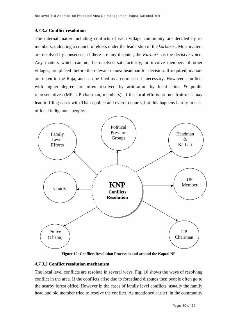
Site Level Field Appraisal for Protected Area Co-management: Kaptai National Park
4.7.3.2 Conflict resolution
The internal matter including conflicts of each village community are decided by its
members, inducting a council of elders under the leadership of the karbaris . Most matters
are resolved by consensus; if there are any dispute , the Karbari has the decisive voice.
Any matters which can not be resolved satisfactorily, or involve members of other
villages, are pIaced before the relevant mauza headman for decision. If required, mattars
are taken to the Raja, and can be filed as a court case if necessary. However, conflicts
with higher degree are often resolved by arbitration by local elites & public
representatives (MP, UP chairman, members). If the local efforts are not fruitful it may
lead to filing cases with Thana-police and even to courts, but this happens hardly in case
of local indigenous people.
KNP Conflicts
Resolution
Family Level Efforts
Headman &
Karbari
UP Member
Political Pressure Groups
UP Chairman
Courts
Police (Thana)
Figure 10: Conflicts Resolution Process in and around the Kaptai NP
4.7.3.3 Conflict resolution mechanism
The local level conflicts are resolute in several ways. Fig. 10 shows the ways of resolving
conflict in the area. If the conflicts arise due to forestland disputes then people often go to
the nearby forest office. However in the cases of family level conflicts, usually the family
head and old member tried to resolve the conflict. As mentioned earlier, in the community
Page 60 of 79

Site Level Field Appraisal for Protected Area Co-management: Kaptai National Park
level, conflict usually resolved primarily by the village head locally called Headman as
mentioned earlier in Governance section.
4.7.3.4 Conflict with FD
The conflict with local people dependant on jhuming in Kaptai NP area as well as living
around Kaptai NP is very severe due to existing land dispute and practice of customary
rights issue prevalent in Chittagong hill tracts. There is a huge conflict with local FD
with local people, particularly with tree feller from various villages. Fig. 11 shows the
relative sources of conflict with FD and local people. The other causes of conflict arising
with FD are forest and land encroachment, forest cases by local FD staff, prevention in
resource exploitation. While FD sees jhuming and the settlements in and around Kaptai
NP as land encroachment, the indigenous people take it as part of ‘Practice of their
customary rights”.
KNP Conflicts with FD
Jhuming in the KNP
Plantation
Illicit Felling
Fue lwood Collection
Settlements of Locally Displaced Indigenous People in and around KNP
Figure 11: Ven Diagram: Conflicts with FD
4.7.4. Social cohesion and adhesion:
Many social activities in the KNP areas maintain social adhesion and cohesion among the
villagers. Some of them are cultural events like Bizu, Sangrai, Boisu; marriage ceremony,
religious functions, national programme (e.g. National Victory Day, National Marty’s
Day, Independence Day etc.), annual sports and prize giving ceremony in the schools,
collective action through local community organizations and many other events bring all
the villagers together.
Page 61 of 79

Site Level Field Appraisal for Protected Area Co-management: Kaptai National Park
4.8 Local Socio-economic Settings and Dynamics
4.8.1 Demographic Profile
4.8.1.1 HHs number
Total number of households in and around the villages surrounding the park is
approximately 1500 except missing data of some villages. All these households have
different degrees of stakes and dependency with the Kaptai NP. Most of them are
indigenous community particularly Marma, Chakma and Tanchangya.
4.8.1.2 Education
In the tribal community around the Kaptai NP, still do not leave their children to school in
a large proportion. However, this trend is changing day by day. Now-a-days even 80%
children of some villages go to primary school, however, only 5 - 18% goes to High
School and only 5% study in the colleges. Among the adult, about 90% are illiterate
(above 30 years of old). Information collected during RRA exercises are presented in
Table 17.
Table 17: Educational Status of the People Living Adjacent and Inside the Villages* Sl Villages Illiterate Primary Secondary Graduation Bangchari 55 40 5 - Debachari 60 36 4 - Chitmorom Headmanpara 75 20 4 1 Chakuapara 90 10 - - Sitapara 75 22 3 - Arachari Mukhpara 90 9 1 - Bhaiboncharapara 90 10 - - Harincharapara 90 7 2 1 Shilchari Belabopara 20 72 8 - Shilchari Marmapara 10 81 9 - Wagga Tea Estate (Idris Farm) 90 10 - - Zibtoli 10 68 18 4 Kalabunia 70 30 - - *percentage in comparison to the total population of the village
4. 8.2 Livelihood strategies analysis
4.8.2.1 Occupation
Jhum cultivation is still one of the major occupations of the indigenous community living
around the Kaptai NP followed by day labor. There is an increasing tendency of the local
people on agriculture is quite evident around the NP. Indigenous people in these days are
not leaving any suitable agricultural lands idle rather practicing crop cultivation,
vegetable cultivation even planting lot of horticultural species. Table 18 shows the
changes in occupation of the local people over time.
Page 62 of 79
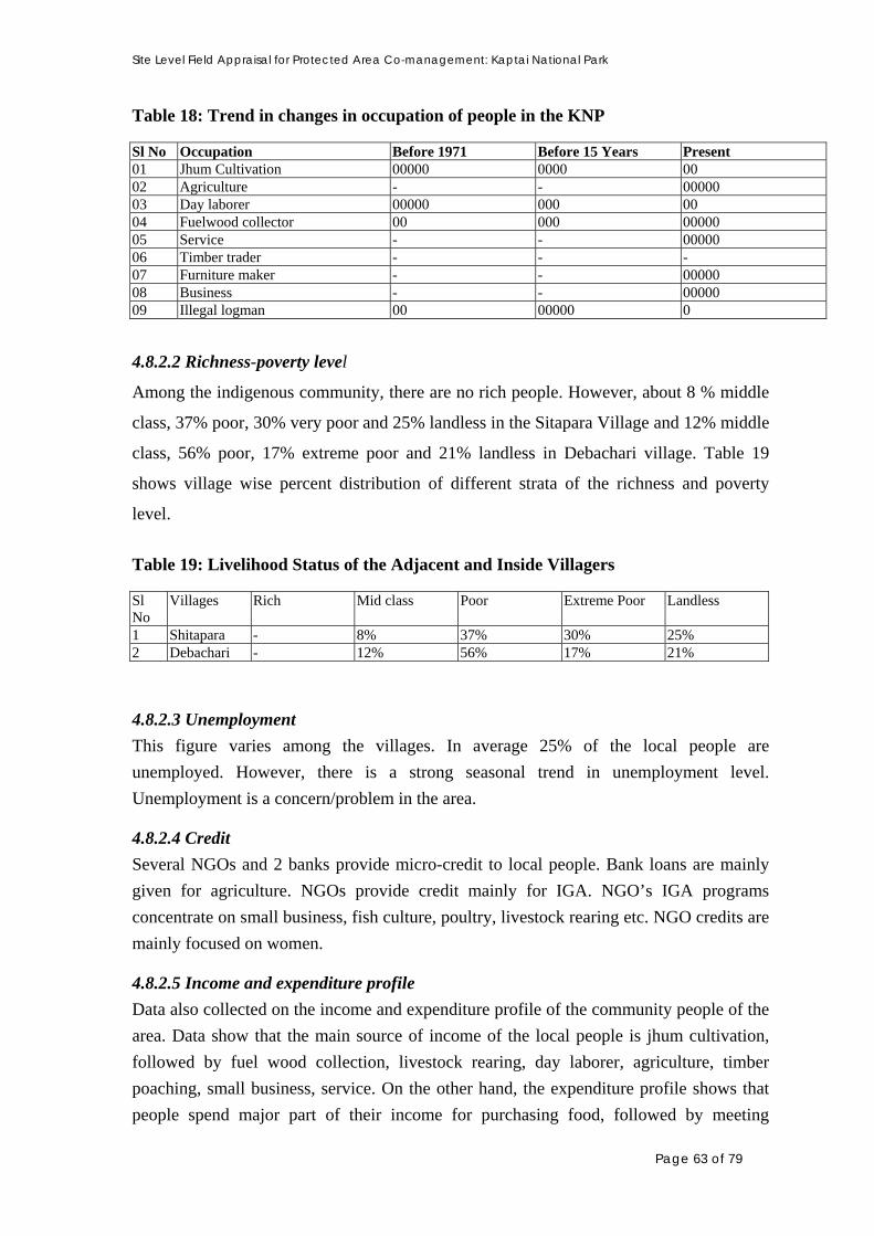
Site Level Field Appraisal for Protected Area Co-management: Kaptai National Park
Table 18: Trend in changes in occupation of people in the KNP Sl No Occupation Before 1971 Before 15 Years Present 01 Jhum Cultivation 00000 0000 00 02 Agriculture - - 00000 03 Day laborer 00000 000 00 04 Fuelwood collector 00 000 00000 05 Service - - 00000 06 Timber trader - - - 07 Furniture maker - - 00000 08 Business - - 00000 09 Illegal logman 00 00000 0
4.8.2.2 Richness-poverty level
Among the indigenous community, there are no rich people. However, about 8 % middle
class, 37% poor, 30% very poor and 25% landless in the Sitapara Village and 12% middle
class, 56% poor, 17% extreme poor and 21% landless in Debachari village. Table 19
shows village wise percent distribution of different strata of the richness and poverty
level.
Table 19: Livelihood Status of the Adjacent and Inside Villagers Sl No
Villages Rich Mid class Poor Extreme Poor Landless
1 Shitapara - 8% 37% 30% 25% 2 Debachari - 12% 56% 17% 21%
4.8.2.3 Unemployment
This figure varies among the villages. In average 25% of the local people are
unemployed. However, there is a strong seasonal trend in unemployment level.
Unemployment is a concern/problem in the area.
4.8.2.4 Credit
Several NGOs and 2 banks provide micro-credit to local people. Bank loans are mainly
given for agriculture. NGOs provide credit mainly for IGA. NGO’s IGA programs
concentrate on small business, fish culture, poultry, livestock rearing etc. NGO credits are
mainly focused on women.
4.8.2.5 Income and expenditure profile
Data also collected on the income and expenditure profile of the community people of the
area. Data show that the main source of income of the local people is jhum cultivation,
followed by fuel wood collection, livestock rearing, day laborer, agriculture, timber
poaching, small business, service. On the other hand, the expenditure profile shows that
people spend major part of their income for purchasing food, followed by meeting
Page 63 of 79

Site Level Field Appraisal for Protected Area Co-management: Kaptai National Park
cultivation expenses, clothing, religious events, marriage of child, heath care purposes,
but less for educational purpose. Fig. 12 and Fig. 13 represent the income and expenditure
profiles of village Sitapara, as an example.
Jhum, 50
Agriculture, 5
Day Labor, 10Fuelwood, 20
Small Business, 2
Livestock, 15
Service, 1
Timber Poaching, 2
Other, 18
Jhum
Agriculture
Day Labor
Fuelwood
Small Business
Livestock
Service
Timber Poaching
Figure 12: Yearly Income Profile of Village: Sitapara
65%
13%
3%
1%
5%
2%
5%
5% 1%
Food Purchasing
Cultivation
Education
Healthcare
Clothing
HH construction
Religious
Marriage
Social welfare
Figure 13: Yearly Expenditure Profile of Village: Sitapara
4.9 Social Dynamics (Trend in changes in socio-economics)
4.9.1 General Dynamics
Changes in some key socio-economic matrices and local activities are presented in Table
20. Compared to 1970 situation, population had increased with corresponding decline in
solvency. Although, literacy rate has increased, unemployment rates have also increased.
During the time, use of forest for both as HH needs and income generation has increased.
Local food scarcity has reduced while an opportunity for alternate income has increased
to manifold.
Table 20: Trend in Changes in Socio-economics Matrices for KNP Issue Pre-1971 15 years ago Present Causes for change Settlement/Population 0
00 00000 Popln. Growth, migration
Page 64 of 79
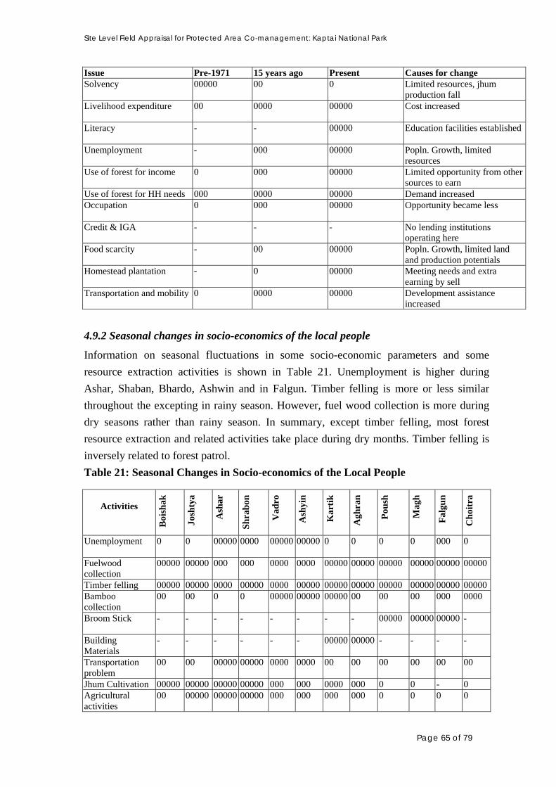
Site Level Field Appraisal for Protected Area Co-management: Kaptai National Park
Issue Pre-1971 15 years ago Present Causes for change Solvency 00000
00 0 Limited resources, jhum
production fall Livelihood expenditure 00
0000 00000 Cost increased
Literacy -
- 00000 Education facilities established
Unemployment -
000 00000 Popln. Growth, limited resources
Use of forest for income 0 000 00000 Limited opportunity from other sources to earn
Use of forest for HH needs 000 0000 00000 Demand increased Occupation 0 000 00000
Opportunity became less
Credit & IGA -
- - No lending institutions operating here
Food scarcity -
00 00000 Popln. Growth, limited land and production potentials
Homestead plantation -
0 00000 Meeting needs and extra earning by sell
Transportation and mobility 0
0000 00000 Development assistance increased
4.9.2 Seasonal changes in socio-economics of the local people
Information on seasonal fluctuations in some socio-economic parameters and some
resource extraction activities is shown in Table 21. Unemployment is higher during
Ashar, Shaban, Bhardo, Ashwin and in Falgun. Timber felling is more or less similar
throughout the excepting in rainy season. However, fuel wood collection is more during
dry seasons rather than rainy season. In summary, except timber felling, most forest
resource extraction and related activities take place during dry months. Timber felling is
inversely related to forest patrol.
Table 21: Seasonal Changes in Socio-economics of the Local People
Activities
Boi
shak
Josh
tya
Ash
ar
Sh
rab
on
Vad
ro
Ash
yin
Kar
tik
Agh
ran
Pou
sh
Mag
h
Fal
gun
Cho
itra
Unemployment 0
0 00000 0000 00000 00000 0 0 0 0 000 0
Fuelwood collection
00000
00000 000 000 0000 0000 00000 00000 00000 00000 00000 00000
Timber felling 00000 00000 0000 00000 0000 00000 00000 00000 00000 00000 00000 00000Bamboo collection
00 00 0 0 00000 00000 00000 00 00 00 000 0000
Broom Stick -
- - - - - - - 00000 00000 00000 -
Building Materials
-
- - - - - 00000 00000 - - - -
Transportation problem
00
00 00000 00000 0000 0000 00 00 00 00 00 00
Jhum Cultivation 00000 00000 00000 00000 000 000 0000 000 0 0 - 0 Agricultural activities
00 00000 00000 00000 000 000 000 000 0 0 0 0
Page 65 of 79

Site Level Field Appraisal for Protected Area Co-management: Kaptai National Park
Activities
Boi
shak
Josh
tya
Ash
ar
Sh
rab
on
Vad
ro
Ash
yin
Kar
tik
Agh
ran
Pou
sh
Mag
h
Fal
gun
Cho
itra
Accessibility to forest
00
00 00000 00000 0000 0000 00 00 00 00 00 00
Brickfield/sawmill operation
Vegetable collection
000
000 00000 0000 000 000 000 000 000 000 000 000
Hunting
000 000 000 000 000 000 000 000 000 000 000 000
Honey - - - - - - - - - - 00000 00000Jungle Fruits 000 000 000 - - - - - - - 00000 00000Medicinal Plants 000 000 000 000 000 000 000 000 000 000 000 000 4.10 Local Problems
During PRA/RRA activities, causes of the local problems and its possible solutions were
also investigated and that in shown in Table 22. The major problems, according to the
magnitude, relate to poverty, unemployment, health and sanitation, road communication,
education, electricity, drinking water, forest cases, etc.
Table 22: Causes of local problems and possible solutions Name of Problems
Reason Solutions
Poverty Over population, limited land & resources, limited income opportunity, unemployment, lack of capital to initiate small business, lack of alternative income generating activities, lack of skills
Generation of opportunities for new IGA ,and provision of interest-free credit, skill development training, more NGO activities; increase income by maximizing utilization of land & other resources
Unemployment Lack of agricultural land, lack of sufficient work, population pressure, Lack of education, lack of innovation
Provide ideas, capital and training
Education Absence of sufficient educational institution
Establishment of new and technical schools, awareness, and financial support
Road communication
Roads are yet to be developed involving local government or NGOs in road construction
Health care facilities
No hospital/clinic and good doctor near villages, lack of sanitary latrine & tube well
Promoting government and NGO health and sanitation programmes
Drinking water lack of deep tube well and deep pond Need Government and NGO efforts to provide tub well and pond construction.
Electricity Lack of electricity supply Electricity should be supplied through REB or PDB.
Forest case Cases lodged by local FD against illegal resource extraction, sometimes causes are not valid
Illegal use of forest resource should be stopped. FD should not file any case based on falsehood.
4.11. Gender Issue
4.11.1 HH decision-making
Table 23 and Fig. 14 shows the role of different family members in taking HH decisions.
In Kaptai NP areas, husband takes the major HH decisions, followed by wife and sons.
Page 66 of 79

Site Level Field Appraisal for Protected Area Co-management: Kaptai National Park
Daughters are rarely consulted in decision making. Women of ethnic community have a
major role in many HH decisions making.
Table 23: Information on Family Decision Making
Name of Decision
Hu
sban
d
Wif
e
Fat
her
Mot
her
Eld
er
bro
ther
You
nge
r b
roth
er
son
dau
ghte
r
Marriage - - 00000 00000 00000 - - - Education - - 00000 00000 00000 - - - Sowing crops 0000 00 00 - 0 - 0 - Land purchase 0000 00 0 - 0 - 0 - Land selling 0000 00 00 0 0 - 0 - Tree selling
0000 00 - - - - - -
House making 0000 00 - - - - - - Cattle purchase 0000 000 - - - - - - Loan 0000 000 - - - - - - Savings 0000 000 - - - - - - Treatment 00000 00000 - - - - - - General expenditure
0000 000 - - - - - -
Resources collection from the forest (Timber, fuelwood)
0000 000 - - - - - -
Figure 14: Venn Diagram showing roles of family members in family decision making
4.11.2 Outdoor mobility and access to credit and IGA
Overall, in and around KNP, outdoor mobility of females is considered to be moderate to
high depending on the geographic location. Participation to social events by women is
comparatively less than males (Table 24). However, now-a-days access to NGO credit
and IGA is much higher in case of women. On the other hand, access to bank loan is very
Page 67 of 79

Site Level Field Appraisal for Protected Area Co-management: Kaptai National Park
limited for women. Figure 8 and 9 represent the nature of daily activities of male and
female in the region.
Table 24: Outdoor Mobility and Access to Credit and IGA Outdoor
mobility Participation in social events
Access to credit
Access to AIGA
Education Employment
Male Male 0000 0000 0 000 0000 Female Female 000 000 0000 0000 000
4.11.3 Workload
Workload for male and female in the indigenous communities in and around Kaptai NP is
more or less similar. However, Male have rather limited works in Sharaban, Vadro,
Ashwin and Kartik. On the other hand, female members in the families have rather
limited workload in Vadro, Ashwin, Kartik. Workload depends on differentiated
responsibilities in the Jhum field for male and female. Table 25 shows the seasonal work
load of male and female in a Khasia inhabited settlement. In general, women in the
locality have less work load than the men.
Table 25: Seasonal Workload of Male and Female in Sitapara Villages Near to KNP
Boi
shak
Josh
tya
Ash
ar
Sh
rab
on
Vad
ro
Ash
yin
Kar
tik
Agr
ahan
Pou
sh
Mag
h
Fal
gun
Cho
itra
Male 00000 00000 00000 00 00 000 000 0000 0000 00000 00000 00000 Female 00000 00000 00000 00000 00 000 000 0000 0000 00000 00000 00000
4.11.4 Daily workload
Fig. 15 and Fig. 16 show the daily work chart of male and female in the indigenous
families in Sitapahar Village near to Kaptai respectively.
Page 68 of 79
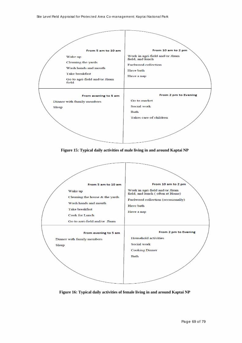
Site Level Field Appraisal for Protected Area Co-management: Kaptai National Park
Figure 15: Typical daily activities of male living in and around Kaptai NP
Figure 16: Typical daily activities of female living in and around Kaptai NP
Page 69 of 79
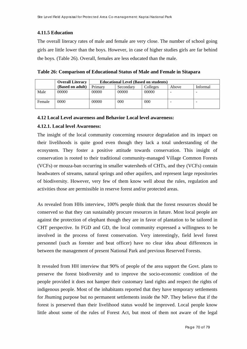
Site Level Field Appraisal for Protected Area Co-management: Kaptai National Park
4.11.5 Education
The overall literacy rates of male and female are very close. The number of school going
girls are little lower than the boys. However, in case of higher studies girls are far behind
the boys. (Table 26). Overall, females are less educated than the male.
Table 26: Comparison of Educational Status of Male and Female in Sitapara
Educational Level (Based on students)
Overall Literacy (Based on adult) Primary Secondary Colleges Above Informal
Male 00000
00000
00000
00000
- -
Female 0000
00000
000
000
- -
4.12 Local Level awareness and Behavior Local level awareness:
4.12.1. Local level Awareness:
The insight of the local community concerning resource degradation and its impact on
their livelihoods is quite good even though they lack a total understanding of the
ecosystem. They foster a positive attitude towards conservation. This insight of
conservation is rooted to their traditional community-managed Village Common Forests
(VCFs) or mouza-ban occurring in smaller watersheds of CHTs, and they (VCFs) contain
headwaters of streams, natural springs and other aquifers, and represent large repositories
of biodiversity. However, very few of them know well about the rules, regulation and
activities those are permissible in reserve forest and/or protected areas.
As revealed from HHs interview, 100% people think that the forest resources should be
conserved so that they can sustainably procure resources in future. Most local people are
against the protection of elephant though they are in favor of plantation to be tailored in
CHT perspective. In FGD and GD, the local community expressed a willingness to be
involved in the process of forest conservation. Very interestingly, field level forest
personnel (such as forester and beat officer) have no clear idea about differences in
between the management of present National Park and previous Reserved Forests.
It revealed from HH interview that 90% of people of the area support the Govt. plans to
preserve the forest biodiversity and to improve the socio-economic condition of the
people provided it does not hamper their customary land rights and respect the rights of
indigenous people. Most of the inhabitants reported that they have temporary settlements
for Jhuming purpose but no permanent settlements inside the NP. They believe that if the
forest is preserved than their livelihood status would be improved. Local people know
little about some of the rules of Forest Act, but most of them not aware of the legal
Page 70 of 79

Site Level Field Appraisal for Protected Area Co-management: Kaptai National Park
framework of the Kaptai NP. As revealed so far, from FGD and HH interview that
majority people know that the forest is a reserve but only 40% of them have heard a little
about the NP but not aware about the restrictions. However, the study revealed that 60%
of the respondents know nothing, 4% have heard about the rules & regulations, and
negligible portions know about some restrictions in the Kaptai NP. Compared to males,
females are less aware of this issue though they are very much linked with natural
resource utilization process.
4.12.2 Behavioural Aspect:
So far the PRA/RRA was carried out, initial response of local people towards the project
is positive but still they believe that co-operation and necessary advices from the
Regional Council of Chittagong Hill Tract will encourage them to comfortably participate
in the co-management approach of the project. However, a number of local leaders, and
people appeared to be fostering negative attitude towards the project, with an assumption
that they might be dislocated from their current settlements in the course of advancement
of project activities.
However, 90% of interviewed HHs of the area supports the Govt. plan to implement such
a project towards preserving the forest biodiversity by developing co-management. By
observing the current scenario of forest, local people are able to realize that forest should
be conserved and should have more plantations. However, they demand that these
initiatives should be in harmony with their traditional norms, customs and indigenous
rights. However, in most of the cases lower level FD staff is not aware about the project.
They have a curiosity to know about this project, FD’s role, implementation strategies,
provision of infrastructural development and plantation program under the project and
many other issues.
The indigenous communities are well behaved and cooperative but their total active
participation seems to be happening only if the regional political powers act in favor of
the project. People assume that if the project really can provide alternative income to the
people then the project may see the light of success. However, some of the villagers
predicted that a small amount of earning through alternative income might not attract the
illegal poacher as they earn a lot of money by cutting timbers in comparison to the
alternative income. Some people expressed their concern that if the program negatively
affects the livelihood of local people they will not cooperate and may oppose the
program.
Page 71 of 79

Site Level Field Appraisal for Protected Area Co-management: Kaptai National Park
5. PRESENT THREATS, ISSUES AND CHALLENGES FOR IPAC:
5.1 Priority Threats to the National Park:
a. Continued unsustainable large scale and commercially targeted harvesting of most
forest resources, including timber, fuel wood and bamboo, which have led to loss and
decline in many forest natural resources. Extraction is being carried out by timber
traders and organized illegal loggers by involving local communities as ‘wage-
earners’.
b. Repeated burning and shortened fallow period of Jhuming (Shifting cultivation) in the
NP area is preventing regeneration of the few remnant natural forest. Jhuming is
reported to be practiced at least half of the Kaptai NP
c. Illegal and extensive use of fuel wood rather than coal in the nearest brickfields
d. Hunting of wildlife, especially wild boar and barking deer resulting in the depletion of
wildlife
e. Widespread habitat destruction is leading to a loss of forest dwelling wildlife species.
f. Encroachment of forestland and its subsequent conversion to settlement leads to
habitat loss resulting in the decline in forest biodiversity
g. Lack of understanding of conservation issues and values, wildlife protection and
management of protected areas by FD personnel who are the stewards of the Reserve,
has lead to inappropriate management practices
h. FD’s plantation strategies and practice include clearing and burning of forest,
plantation only valued timber tree, exotic tree and monoculture probably caused most
harm by removing the indigenous species, wilderness, and alien environment for the
wildlife resulting in the serious depletion in forest biodiversity
i. Increasing development of road network inside around the NP, resulting in increased
access to and removal of forest resources
j. In-migrant settlers from the plain as well as indigenous people locally displaced from
their original location due to the built-up of Kaptai dam in late 60s, and during the
period of insurgency are concentrated around the NP ,and their activities has a
detrimental impact on the forest and still remains as an important threat
k. Operation of brickfield around the KNP has a great indirect role in forest degradation
as they use huge quantity of fuel wood
Page 72 of 79

Site Level Field Appraisal for Protected Area Co-management: Kaptai National Park
5.2 Issues of Concern
5.2.1 Reduced Forest regeneration
Forest regeneration is severely impacted in the Kaptai NP, primarily due to large-scale
monoculture of teak. Teak leaf is much known for its allelopathy (definition - suppression
of growth of a plant species by another due to the release of chemicals produced from a
nearby plant of the same or another species) character. There are several other reasons
e.g. intentional fire on the forest floors by jhum farmers to make lands suitable to practice
slash and burn agriculture, fuel wood collection, cattle grazing etc. This poses a threat to
attaining wilderness resulting in the loss of forest biodiversity. In order to bring back
wilderness forest regeneration aspect should be given a priority.
5.2.2 Jhuming and encroachment for expansion of settlements in the forest
Jhuming, illegal commercial scale logging, and conversion of forests into settlements
have been identified as potential causes for degradation to Kaptai NP. The process is
continuing and remains as an important threat to forest and its biodiversity. Future
success of NP management will depend largely on the stopping and recovery of the
encroached land.
5.2.3 Over- and unsustainable resource exploitation
Commercially targeted over exploitation of various resources of the forest, including
timber, bamboo, fuel wood, wildlife etc. in the past mainly contributed to the depletion in
the resources and the fauna they supported. These remain as threats equally to the
sustainable management of the NP.
5.2.4 Local dependence on the forest resources
Traditionally, almost all inside HHs and many HHs of the adjacent villages are depend
directly or indirectly for their needs of fuel wood, building materials and some other
forest products of the forest. Apparently, it seems that there is little alternative for these
resources. Besides, many poor HHs are entirely or partially dependent on the forest for
their livelihood. Thus, this issue remains as a concern for the project
5.2.5 Deteriorating local law and order situation
The law and order situation in the region as whole has deteriorated greatly and this has an
influence on the people living in and around the NP. Therefore, some people particularly
Page 73 of 79

Site Level Field Appraisal for Protected Area Co-management: Kaptai National Park
those who are bit powerful show disregard to law and the local FD staff has lose control
in many areas of the NP. Similarly, the other law enforcing agencies, except BDR, can do
little in this regard. This is a particular concern to be considered.
5.2.6 Poor forest management by FD & lack of specific NP management action plan
It is quite evident from the field discussions and interviews that the Forest Department is
not capable enough to manage the National Park properly. This is primarily due to lack of
adequate and skilled work force for NP management and lack of logistics and incentives.
Besides, Forest Department staffs particularly lower level staffs posted in the remote
areas miss their family member greatly as there are no standard facilities regarding
housing, schooling for kids, medical and many other basics inside the NP. Therefore,
most often they need to maintain two families at a time, one in nearby developed areas
with mentioned facilities and other inside the NP areas. This often becomes very costly
and they do not get any special package from the government to minimize such costs.
Local people have identified local FD staff as a major cause for illegal use of the NP and
this is mostly due to meet the extra expenses incurred by them while posted in the remote
areas. Most importantly, there is no specific management action plans for the NP and
therefore these are important issues for consideration.
5.2.7 Local poverty and unemployment
Local poverty and unemployment have been identified as the driving forces for the illegal
forest use by the local people. Unless the problem is reduced it is unlikely to achieve
success in the implementation of the project and therefore draws particular attention for
addressing the issue.
5.2.8 Poor law enforcement for forest protection
Forest patrol is inadequate to check illegal tree felling. Often, the fellers are organized
armed gangs. The help from the other local law enforcing agencies is not adequate, rather
the activities of local police is not conducive to forest protection and encourage the illegal
tree feller.
5.2.9 Association of local influential people in illegal felling
Many local people those who are influential help in illegal tree felling in the way of
negotiating with FD or other law enforcing agencies to ensure safe transit of illegally
Page 74 of 79

Site Level Field Appraisal for Protected Area Co-management: Kaptai National Park
felled logs, and sometimes they impose their influence to cover up the offences. The
project should take into account this issue while plan for the management of the forest.
5.2.10. Brickfield operations
Though huge quantity of fuel wood to meet the demand of brickfields still comes from
the Sitapahar Reserved Forest area of KNP, in near future, this increasing demand of fuel
wood (which is currently reported to be 40000 maund per year/brickfield) will pose threat
KNP, and thus, will contribute to the depletion of forest resource and existing
biodiversity. The operation of fuel wood operated brickfield is the violation of the forest
laws. This issue needs to be addressed in the project.
5.2.11 Lack of awareness among local people about biodiversity conservation
There is serious lack in understanding about benefit of biodiversity conservation and need
for sustainable management among the local people. It seems that enhancement local
level awareness could help in successful implementation of the project.
5.2.12 Extensiveness and inaccessibility of the project site
The Kaptai NP is extensive in its area coverage, and it is often inaccessible due to not
only the geographic remoteness and terrain but also geo-political situation even after the
peace treaty. Apart from co-operation of Regional Council and regional political parties is
a prerequisite for successful implementation of the co-management approach of this
project.
5.3 Challenges for the Project
There are certain issues that could be challenging for the project in the course of
implementation. This section prioritizes a number of such issues that should be given due
consideration while planning and implementing the project. The following major
challenges are identified:
• Strategically branding IPAC to the grass-root indigenous communities as well as to
the political leaders of CHT in such a way that ‘trust’ is built in them about the
project, and they become ensured that the project activities will not go against the
Peace Accord.
Page 75 of 79

Site Level Field Appraisal for Protected Area Co-management: Kaptai National Park
• Diversification of production methods of indigenous people from their traditional
Jhuming (Shifting Cultivation), and reducing their dependence on forest for livelihood
• Stopping of commercial scale collection of fuel wood, bamboo and other building
materials
• Reversing FD’s plantation strategies and practices towards biodiversity conservation
• Preventing illegal tree felling
• Bringing changes in morale of the local FD staff
• Reduction in local poverty and unemployment
• Ensuring participation of local influential people
• Curbing dependence of local people on the resources of KNP
• Establishing co-management system over the entire NP
• Recovery of encroached lands and stop further encroachment
5.4 Opportunities
• Local people are very much positive about the project and they are ready to
participate in the co-management process if CHT Regional Council provides green
signal regarding assistance
• A good number of people visit the park and picnic spot. Some of the infrastructures
and facilities been arranged under the recently completed project. Still some facilities
need to be developed and that will definitely attract more eco-tourists in the KNP.
Once ecotourism is established in the park, local people will have provisions for
added earning for different enterprises relating to eco-tourism.
• The whole Sitapahar Reserved Forest is declared as Kaptai NP. However, in the
periphery or buffer area of the KNP is still lot more denuded. Therefore, plantation in
these areas under social forestry practiced modality will create income opportunity for
the poor indigenous people in and around Kaptai NP and that may reduce the
dependency on the park’s resources.
• Project will have provisions to support alternative livelihood opportunities for the
resource dependent communities living in and around Kaptai NP.
• In the denuded areas within the park plantation with indigenous and eco-friendly plant
species is necessary to restore and rehabilitate wildlife habitat. Besides, natural
regeneration may be assisted to bring back the wilderness in the park.
Page 76 of 79

Site Level Field Appraisal for Protected Area Co-management: Kaptai National Park
6. SUGGESTIONS AND RECOMMENDATIONS
6.1 Administrative
During RRA/PRA exercise, local people identified poor forest management as one of the
major causes for forest degradation in Kaptai NP. Therefore, it is urgent to strengthen the
local FD in the Park with adequate and skilled work force and capacitate them in dealing
with co-management effectively. FD may strongly consider the followings:
- adequate staffing, particularly for forest patrol under a skilled PA manager
- capacity building of FD staffs on sustainable forest resources management and
biodiversity conservation
- provide appropriate logistics i.e. vehicle, modern arms & ammunitions for local FD
- provide incentives to local FD staff to make the job lucrative i.e. extra allowances
- improving the morale of local FD staff and make them dedicated to conservation
- strong monitoring and supervision of activities by high powered team regularly
6.2 Scientific and Technical Management of the park
Now, there is no management plan in action in the Kaptai NP. Moreover, previous
management plans had been developed with primary focus in production forestry.
Therefore, habitat restoration and biodiversity conservation do not have optimum priority
in management of the Reserved Forest. After declaration of the National Park, an
appropriate, site specific and technically sound management plan is necessary to develop
and implement with prior consultation of the key stakeholders particularly local people.
The action plan, among others, should have the following provisions:
• re-introduction and rehabilitation of endangered plants and animal species
• wildlife habitat restoration and rehabilitation
• protection and sustainable use of forest resources and biodiversity
• plantations with plus tree propagules of indigenous species rather than exotic
• plantations that reached into maturity may be felled with the retention of seed trees at
a suitable interval and plantation with native species.
• re-establishment of habitat continuity between the fragmented habitats of the primates
• plantation scheme with food trees suitable for non-human primates
• ensure sustainable use of some resources like vegetables, honey, medicinal plants and
other non-timber forest products
Page 77 of 79

Site Level Field Appraisal for Protected Area Co-management: Kaptai National Park
• establishment of a buffer sustainable resource use zone around the PA with provision
for fuel wood plots, woodlots and other plantations required for house building
purposes
• providing resource substitution
• promotion of fuel efficient stoves in the locality o promotion of homestead plantations
6.3 Project activities targeted to local stakeholders
• identify poor resource users and provide support to AIGAs with provision of leaving
unsustainable use of forest resources.
• bring the influential people, local elites, public representatives, community leaders on
board with the concept of forest protection
• raising awareness to make the people understand how they could be benefited from
project interventions
• As there are many allegations about the local police helping the illegal resource users,
(illegal tree fellers in particular), strong dialogue should be initiated with them
involving the higher authority
• forest cases should be reviewed and if merit is not there then withdrawn
• ecotourism with proper planning needs to be promoted in and around Kaptai NP
• recover encroached land and stop further encroachment.
• effort to negotiate with local development partners/agencies to extend their social
welfare services to the area
• project should initiate dialogues with secondary stakeholders
• A long-term biodiversity monitoring scheme should be planned with provision for
database development.
• prioritize the issues of biodiversity conservation in forest management rather than
revenue earning.
Page 78 of 79

Site Level Field Appraisal for Protected Area Co-management: Kaptai National Park
Page 79 of 79
Annexure & Photo Gallery

Fig. : A Forest Villager is on the way to local market to sell broom stick collected from KNP
Fig. : RRA/PRA team holding a FGD in the Bangchari Forest Village of Kaptai NP

Fig. : Forest path towards Bangchari Village inside Kaptai NP

Fig. : Forest path towards Bangchari Village inside Kaptai NP
Fig. : Staking & loading of collected fuel wood on the bank of river Karnaphuly to transport

Fig. : RRA/PRA team holding a KI Interview in the Village ………. Outside the KNP
Fig. : Small Piles of fuel wood for household consumption
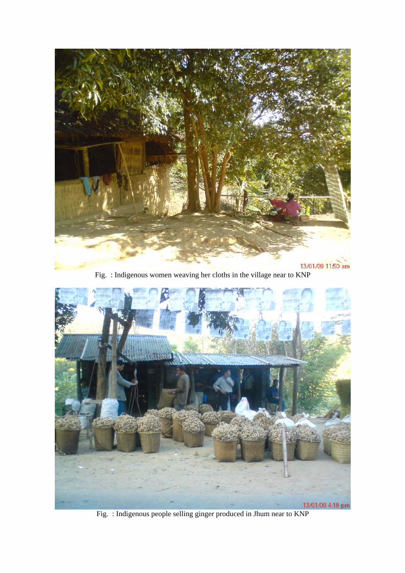
Fig. : Indigenous women weaving her cloths in the village near to KNP
Fig. : Indigenous people selling ginger produced in Jhum near to KNP
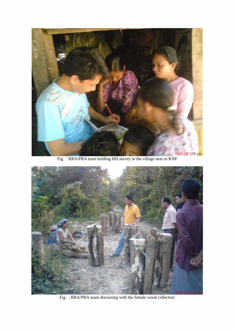
Fig. : RRA/PRA team holding HH survey in the village near to KNP
Fig. : RRA/PRA team discussing with the female wood collectors

Fig. : Proof of presence of Bengal Tiger once upon a time in the Kaptai NP (after hunting a tiger by
the members of UTAH Company – Hydro-Electric Project construction contractor in 1959)

Fig. : Stacked piles of fuel woods to transport to outside of KNP
Fig. : RRA/PRA team’s movement inside the remote areas of KNP

Fig. : Indigenous woman making crafts with bamboo from KNP
Copyright © 2022 FDOKUMEN