DESIGN, FABRICATION AND EVALUATION OF A MOTORIZED FRUIT JUICE EXTRACTOR
Upload
khangminh22Category
view
2download
0
Non-Motorized Transportation Plan
Prepared by:
CITY of SANTA CLARITA
2020SEPTEMBER 2020

2 | SANTA CLARITA NON-MOTORIZED TRANSPORTATION PLAN
AcknowledgementsCity CouncilCameron Smyth, Mayor
Bill Miranda, Mayor Pro-Tem
Bob Kellar, Councilmember
Laurene Weste, Councilmember
Marsha McLean, Councilmember
City Manager’s OfficeKenneth W. Striplin, Ed.D., City Manager
Frank Oviedo, Assistant City Manager
Public Works StaffRobert Newman, Director
Gus Pivetti, City Traffic Engineer
Joel Bareng, Senior Traffic Engineer
Tom Reilly, Trails and Bikeways Planning Administrator
Mark Hunter, Transportation Planning Analyst
Alta Planning + DesignSam Corbett, Principal-in-Charge
Ryan Johnson, Project Manager
Courtney Banker
Anne Bothner-By
Jorge Cáñez
Alex Jauregui
Marguerite Schumm
Zane Taylor
Ryan Taylor-Gratzer
Kim Voros
Special Thanks to Nina Moskol, Chairperson, Los Angeles County Bicycle Coalition, Santa Clarita Valley Chapter.

SANTA CLARITA NON-MOTORIZED TRANSPORTATION PLAN | 3
Table of ContentsExecutive Summary . . . . . . . . . . . . .6NMTP Goals. . . . . . . . . . . . . . . . . . . . . . . . . . . . . . . . . . .7
Current Challenges. . . . . . . . . . . . . . . . . . . . . . . . . . . . . .7
Our Community’s New Network. . . . . . . . . . . . . . . . . .8
Introduction . . . . . . . . . . . . . . . . . . .12Introduction. . . . . . . . . . . . . . . . . . . . . . . . . . . . . . . . . . .13
Why Develop a NMTP? . . . . . . . . . . . . . . . . . . . . . . . .13
Benefits of Active Transportation. . . . . . . . . . . . . . . . .15
Relationship to Other Documents . . . . . . . . . . . . . . . .17
The Vision . . . . . . . . . . . . . . . . . . . . .18Overview . . . . . . . . . . . . . . . . . . . . . . . . . . . . . . . . . . . . .19
The Vision . . . . . . . . . . . . . . . . . . . . . . . . . . . . . . . . . . . .19
Goal 1. Safety & Health . . . . . . . . . . . . . . . . . . . . . . . . .20
Goal 2. Access & Comfort . . . . . . . . . . . . . . . . . . . . . . .22
Goal 3. Maintain & Expand the Network . . . . . . . . . .26
Existing Conditions . . . . . . . . . . . .28Existing Conditions . . . . . . . . . . . . . . . . . . . . . . . . . . . .29
Local Context. . . . . . . . . . . . . . . . . . . . . . . . . . . . . . . . . .29
Walking and Biking Today . . . . . . . . . . . . . . . . . . . . . .46
Major Trails . . . . . . . . . . . . . . . . . . . . . . . . . . . . . . . . . . .51
Bikeway Types. . . . . . . . . . . . . . . . . . . . . . . . . . . . . . . . .53
Adapting to New Needs . . . . . . . . . . . . . . . . . . . . . . . .60
Barriers to Active Transportation. . . . . . . . . . . . . . . . .63
Demand Analysis . . . . . . . . . . . . . . . . . . . . . . . . . . . . . .73
Future Capital Improvement Projects . . . . . . . . . . . . .74
Community Collaboration . . . . . .76Community Survey . . . . . . . . . . . . . . . . . . . . . . . . . . . .78
Online Interactive Mapping Tool . . . . . . . . . . . . . . . . .80
Pop-Up Events . . . . . . . . . . . . . . . . . . . . . . . . . . . . . . . . .81
Recommendations . . . . . . . . . . . . .88How Recommended Projects Advance Our Goals . . . . . . . . . . . . . . . . . . . . . . . . . . . .89
How We Developed Recommended Projects . . . . . . . . . . . . . . . . . . . . . . . . .90
Bicycle Facilities . . . . . . . . . . . . . . . . . . . . . . . . . . . . . . .90
Programs . . . . . . . . . . . . . . . . . . . . .110Building on Existing Programs . . . . . . . . . . . . . . . . .111
Future Program Recommendations. . . . . . . . . . . . . .115
How Will Active Transportation Programs Achieve the Goals of the NMTP? . . . . . . . . . . . . . . .117
Implementation & Funding . . . .118Administration . . . . . . . . . . . . . . . . . . . . . . . . . . . . . . .120
Cost Estimates . . . . . . . . . . . . . . . . . . . . . . . . . . . . . . . .120
Prioritization Framework . . . . . . . . . . . . . . . . . . . . . .120
Funding Strategy . . . . . . . . . . . . . . . . . . . . . . . . . . . . .127
Design Guidelines . . . . . . . . . . . . . . . . . . . . . . . . . . . .133
Appendices . . . . . . . . . . . . . . . . . . 134A: Plan and Policy Review . . . . . . . . . . . . . . . . . . . . .134
B: Complete Streets. . . . . . . . . . . . . . . . . . . . . . . . . . . .135
C: Community Outreach Details . . . . . . . . . . . . . . . .136
D: Active Transportation Plan Compliance Checklist . . . . . . . . . . . . . . . . . . . . . . . . .137
4 | SANTA CLARITA NON-MOTORIZED TRANSPORTATION PLAN
List of FiguresFigure 1. Location of Santa Clarita. . . . . . . . . . . . . . . .31
Figure 2. Existing Land Use . . . . . . . . . . . . . . . . . . . . .32
Figure 3. Major Destinations in Santa Clarita . . . . . 34
Figure 4. Median Household Income in the Past 12 Months Santa Clarita and Los Angeles County* . . . . . . . . . . . . . . . . . . . . . . . . . . .37
Figure 5. Percentage of Population Under 200% of Federal Poverty Level . . . . . . . . . . . . . . . . . . .38
Figure 6. Percentage of Population that are People of Color . . . . . . . . . . . . . . . . . . . . . . . . . . . . . . . .38
Figure 7. Distribution of Ages in Santa Clarita and Los Angeles County . . . . . . . . . . . . . . . . . . . . . . . .40
Figure 8. Percentage of Population Under 18 . . . . . . .41
Figure 9. Percentage of Population Over 65 . . . . . . . .41
Figure 10. Percentage of Households Without Access to a Motor Vehicle . . . . . . . . . . . . . . 42
Figure 11. Composite Equity Analysis . . . . . . . . . . . .43
Figure 12. CalEnviroScreen 3.0 Index . . . . . . . . . . . . 44
Figure 13. Combined Composite Equity Score and CalEnviroScreen 3.0 Percentile . . . . . . . . . . . . . . .45
Figure 14. Existing Active Transportation Facilities . . . . . . . . . . . . . . . . . . . . . . . . . . . . . . . . . . . . . .47
Figure 15. Total Mileage of Existing Bikeways. . . . . .50
Figure 16. Means of Transportation to Work in Santa Clarita . . . . . . . . . . . . . . . . . . . . . . . . . . . . . . . .60
Figure 17. Locations of Trail Use Counts 2016 - 2019. . . . . . . . . . . . . . . . . . . . . . . . . . . . . . . . . . . . .61
Figure 18. Trail Use Count Locations 2016 - 2019 (Bicycles Only) . . . . . . . . . . . . . . . . . . . . . . .61
Figure 19. Bicycle and Pedestrian Counts at Seco Canyon Road and Garzota Drive . . . . . . . . . . . .62
Figure 20. Pedestrian Counts at Walnut Street and Lyons Avenue . . . . . . . . . . . . . . . . . . . . . . . . . . . . .62
Figure 21. Pedestrian Level of Traffic Stress . . . . . . . 64
Figure 22. Pedestrian Level of Traffic Stress (As Percentage of All Roads) . . . . . . . . . . . . . . . . . . . . 64
Figure 24. Bicycle Level of Traffic Stress . . . . . . . . . . .67
Figure 23. Bicycle Level of Traffic Stress (As Percentage of All Roads) . . . . . . . . . . . . . . . . . . . . .67
Figure 25. Pedestrian Access to Schools . . . . . . . . . . .69
Figure 26. Pedestrian Access to Major Workplaces . . . . . . . . . . . . . . . . . . . . . . . . . . . . . .69
Figure 27. Pedestrian Access to Community Facilities . . . . . . . . . . . . . . . . . . . . . . . . . . .70
Figure 28. Bicycle Access to Schools . . . . . . . . . . . . . .71
Figure 29. Bicycle Access to Major Workplaces . . . . .72
Figure 30. Bicycle Access to Public Facilities . . . . . . .72
Figure 31. Potential Active Transportation Demand . . . . . . . . . . . . . . . . . . . . . . . . . . . . . . . . . . . . . .73
Figure 32. Survey Question: Top Three Mobility Interventions . . . . . . . . . . . . . . . . . . . . . . . . . .79
Figure 33. Complete Streets Voting Board Results . .82
Figure 34. Community Feedback . . . . . . . . . . . . . . . . .86
Figure 35. Recommended Cross-Section for Dry Creek Trail . . . . . . . . . . . . . . . . . . . . . . . . . . . . . . . .98
Figure 36. Recommended Cross-Section for Orchard Village Road. . . . . . . . . . . . . . . . . . . . . . . . . .101
Figure 37. Recommended Cross-Section for South Fork Trail Extension . . . . . . . . . . . . . . . . . . . . .103
Figure 38. Potential Intersection Treatment for Walnut Street and Lyons Avenue. . . . . . . . . . . . . . . .104

SANTA CLARITA NON-MOTORIZED TRANSPORTATION PLAN | 5
List of TablesTable 1. Progress Made Since 2014 NMTP. . . . . . . . . .14
Table 2. Existing Bicycle Parking . . . . . . . . . . . . . . . . .54
Table 3. Bicycle/Pedestrian-Involved Collisions in 2018 and 2019 . . . . . . . . . . . . . . . . . . . . . .63
Table 4. FY 2019-2020 Capital Improvement Projects Related to Active Transportation . . . . . . . .74
Table 5. List of Requested Spot Improvements . . . . 84
Table 6. Public Input Guiding Network Recommendations . . . . . . . . . . . . . . . . . . . . . . . . . . . . .89
Table 7. Miles of Recommended Bikeways by Type . . . . . . . . . . . . . . . . . . . . . . . . . . . . . . . . . . . . . . .93
Table 8. List of Recommended Bikeways by Type . . . . . . . . . . . . . . . . . . . . . . . . . . . . . . . . . . . . . . .93
Table 9. Recommendations for Bicycle Parking Locations and Quantities . . . . . . . . . . . . . . .107
Table 10. Estimated Unit Costs per Recommended Facility Type. . . . . . . . . . . . . . . . . . . .120
Table 11. Prioritization Criteria. . . . . . . . . . . . . . . . . .121
Table 12. Recommended Bicycle Projects Including Length and Estimated Costs: Tier 1. . . . .123
Table 13. Recommended Bicycle Projects Including Length and Estimated Costs: Tier 2. . . . .124
Table 14. Recommended Bicycle Projects Including Length and Estimated Costs: Tier 3. . . . .125
Table 15. Funding Sources . . . . . . . . . . . . . . . . . . . . . .128

6 | SANTA CLARITA NON-MOTORIZED TRANSPORTATION PLAN
EXECUTIVE SUMMARY

SANTA CLARITA NON-MOTORIZED TRANSPORTATION PLAN | 7
Vision: This Plan supports the City of Santa Clarita’s vision as a thriving community where people of all ages and abilities feel empowered to walk or bicycle to the widest range of destinations including school, work, transit, recreation, and shopping as part of daily life.
Current ChallengesCommunity and stakeholder participation played a central role in shaping the project, from workshops and pop-up events to a community survey, online public input map, and coordination with Los Angeles County. This planning process engaged over 800 community members who overall expressed support for:
• More bike/multi-use trails.
• Safer and more convenient routes.
• Completion of the Santa Clara River Trail.
• Improved regional connections through expanded trails, bikeways, and Metrolink’s Antelope Valley Line.
• Amenities such as pedestrian scale lighting, hydra-tion stations, restrooms, shade, and bike parking to make walking and biking more pleasant and comfortable.
• Increased education on walking and biking for all residents (drivers and active transportation users).
The 2020 Non-Motorized Transportation Plan (“NMTP”) represents a renewed commitment by Santa Clarita to walking and biking. It builds on the previous NMTP, adopted in 2014, and helps advance our community toward a sustainable transportation system—a system which supports motor vehicle use, but also enables the use of streets by other modes, such as bicycling, walking, and transit.
Active transportation has an overwhelmingly positive benefit for public health: people biking and walking get healthier with every mile traveled, rarely injure others in a collision, and do not pollute. Walking and biking claim significantly less public space than other modes, and help make our largest community asset—our streets—more efficient at moving people.
NMTP GoalsCollectively, the various strategies and components of the NMTP assist the City to meet three goals:
1. Improve safety and health;
2. Improve access and comfort; and
3. Identify, develop, and maintain a complete and comfortable active transportation network.

8 | SANTA CLARITA NON-MOTORIZED TRANSPORTATION PLAN
Our Community’s New NetworkThe NMTP designates an ambitious 237-mile active transportation system and introduces a comprehensive collection of programs and policies. Among the elements of the NMTP are several innovations in active transportation planning for Santa Clarita, including recommendations for Bicycle Boulevards and Class IV Separated Bikeways. The NMTP includes an implementation strategy that details the sequencing and priorities for the selection and installation of new pedestrian and bicycle facilities.
The policies, programs, projects, and other recommendations in this NMTP will create an environment that increases, improves, and enhances active transportation in the City, and makes walking and biking a safe, healthy, and enjoyable means of transportation and recreation.
Bike Share Pilot Station in 2019

SEEINSETMAP
CENTRALPARK
EAST WALKERRANCH OPEN
SPACE
GOLDEN VALLEYRANCH REGIONAL
OPEN SPACE
QUIGLEYCANYON
OPEN SPACE
WILLIAM SHART PARK
HASKELLCANYON
OPEN SPACE
WHITNEYCANYON
OPEN SPACE
SAN TA CL ARA RIVER
8th Street
HenryMayo Drive
Cheyenne Drive
Cro
ssStreet
IronCanyon Road
Del
Va
lleRoad
Can
yo
n Crest Drive
Knoll Road
Portan
aL
ane
Market Stre
et
Vis
taD
elR
ioDriv
e
Has
kell
Can
yon
Ro
ad
Festividad Drive
Hil l
sbo
roug
h
McB
ean
Park
way
Par
kway
Golden Valley Road
Wag
on Wheel Road
Grovepark Drive
Je�ers Lane
Rainb
ow
Glen
Drive
Arr
oyo
Park
Driv
e
Darling Road
Valley S
treet
Rainbow G
len Dr
Carri
zoDrive
IsabellaParkway
Gra
ndvi
ewD
rive
Paragon
Dri
ve
Ap
ple S
treet
Lake Hughes Road
TesoroD
el ValleRoad
Valle
Del
Oro
Big Cedar Drive
Riv
erTr
ail L
ane
16thStre
et
Brooks Circle
Decoro Drive
Royal Road
Sandy Drive
Poe Parkway
Mal
lory
Driv
e
Cap
raR
oad
Sout
hern
Oak
s D
rive
Car
away
Lan
e
Lowridge Place
Tam
arac
kLa
ne
El Paseo Drive
Trai
l Ro
ad
Barcotta Drive
Rotunda
Ro
ad
Via
Barra
Jaso
n D
rive
Skyc
rest
Circle
Gol
d
Canyon Drive
Cam
bri
dg
e A
ven
ue
Beecher Lane
Comet
Way
Maple Street
Ag
ua D
ulce
Can
yon
Ro
ad
ShakespeareLane
Claremore Way
Las
Man
an
itas
Dri
ve
Ab
elia
Ro
a d
Gibraltar Lane
Benz
Road
Calgrove Boulevard
Alta
Madera Drive
Lady Linda Lane
Avenue of the Oaks
Rue
the
rA
venue
Del
Mon
teD
rive
AlaminosDrive
Burton Way
Fox
lane
Dri
ve
Delden Road
Rid
ge
Tout
e R
oad
Dis
cove
ryRidge Drive
Waym
an Street
Sagecrest Circle
Walnut StreetHuston Stre
et
Espuella Drive
Wistaria
ValleyRoad
Garza
Drive
Hem
ingw
ayAvenue
Oak Orchard Road
Ro
bt
C L
ee P
kwy
Parker Road
TourneyRoad
Hillcrest Parkway
BellisDrive
Ave
nue
Pen
n
Card
ina l
Drive
Catala A
venu
e
Com
merce
CenterDrive
Industry Drive
Creekside Road
Pico Canyon Road
Davenport Road
Oak Crest Drive
Ad
en A
venu
e
Stev
enso
nR
anch
Park
way
The
Old
Ro
ad
Firebrand Drive
Ro
ckwell C
anyon R
oad
Sand
Canyo
nR
oad
Circle
J
Ranch Road
Trevino Drive
Tournament Road
Castaic Road
Avenue Scott
Gat
eR
oad
Elm Avenue
DrillR
oad
AvenueHopkins
GoldcrestDrive
Placeritos Boulevard
Golden Valley Road
Canon
es C i rc
le
Kavenagh
Lane
Sloa
nCan
yo
nRoad
Orchard
VillageRoad
De W
olfe R
oad
Seq
uoia
Road
Rai
ntre
eL
ane
Livingston Avenue
Wild
wo
od
Can
yon
Ro
ad
Everett D
rive
Iron
Villa
ge Drive
Texas Oil Company Road
Wheeler R
oad
Coltrane Avenue
Grandifloras
Road
Lost Canyon
Canyon Park Blvd
Road
Avenue
Tib
bitts
Brady Parkway
Mam
mot
hLa
ne
Dockweiler Drive
Valencia Boulevard
Win
terd
ale
Dri
ve
Witherspoon Parkway
Potrero Canyon Road
Mys
tery
Mes
aD
rive
Jakes Way
Fambrough Street
Road
Hasley Canyon Road
Sultus Street
Bar
ber
Ro
ad
BiscaliuzDrive
Vasquez Canyon Road
Ravenhill
Ro
ad
Live Oak Springs Canyon R oa
d
Fran
klin
Park
way
Placerita Canyon Road
Ave n
ue
A
Chase Avenue
Sec
oC
anyo
nR
oa d
Wind
rushR
oad
Dairy Road
Wiley
Canyon
Road
Car
izD
rive
Co
mp
any
Ro
ad
Bridgeport Lane
Spring
brook
Av
enue
Gary D
rive
Avenue Stanford
Whi
tes
Can
yon
Road
Heard Drive
Stadium
Way
Remsen
Street
Avenue Crocker
Ro
llin
g H
ills
Ave
nue
Bis
cailu
z R
oad
Pin
e S
tree
t
Need
ham R
anch Parkw
ay
Charli
eCan
yon
Road
Smyth Drive
ParvinDriv
e
Little Tujunga Canyon Road
Oak Springs Canyon Road
Robinson Ranch Road
Edison Road
Feedmill Road
Centre Pointe Parkway
Sand
Canyo n
Roa
d
Soledad Canyon Road
Po
pp
y Meadow Street
Shad
ow P
ines
Blv
d
Cedar V
alley Way
Kelly Jo
hnson Pa rkway Skyline Ranch Road
Newhall Avenue
Lyons Avenue
Railroad Ave
Bouquet Canyon
Road
Sier
ra H
ighw
ay
Sier
ra H
ighw
ay
Fra
nci s
qui
toC
anyo
nRo
ad
Rye Canyon
Ro
ad
McBean Parkw
ay
Copper Hill Drive
TheO
ldR
oad
Newhall Ranch Road
Valencia Boulevard
Magic Mountain Parkway
Golden
ValleyR
oad
Soledad Canyon Road
VIA PRINCESSAMETROLINK STATION
CORPORATEYARD
CITY HALL
MCBEAN REGIONALTRANSIT CENTER
SANTA CLARITAMETROLINK
STATION SC SPORTSCOMPLEX
CANYONCOUNTRYLIBRARYVALENCIA
LIBRARY
VISTA CANYONMETROLINK
STATION
HENRY MAYONEWHALLHOSPITAL
TESOROADOBE PARK
FUTURE PARK
SIX FLAGSMAGIC
MOUNTAIN
CANYONCOUNTRY
COMMUNITYCENTER
5
126
14
CASTAICELEMENTARY
CASTAICMIDDLE
LIVE OAKELEMENTARY
PICO CANYONELEMENTARY
OAKHILLS
ELEMENTARY
PEACHLANDAVENUE
ELEMENTARY
WILEYCANYON
ELEMENTARY
OLD ORCHARDELEMENTARY
MEADOWSELEMENTARY
COLLEGE OFTHE CANYONS
CALIFORNIAINSTITUTE
OF THE ARTS
VALENCIAVALLEY
ELEMENTARY
STEVENSONRANCH ELEMENTARY
TESORODEL VALLE
ELEMENTARY
WEST CREEKACADEMY
CEDARCREEKELEMENTARYRIO VISTA
ELEMENTARY
ROSEDELLELEMENTARY
SANTA CLARITAELEMENTARY
SKYBLUE MESAELEMENTARY
HIGHLANDSELEMENTARY
HELMERS ELEMENTARY
FOSTERELEMENTARY
MOUNTAINVIEWELEMENTARY
PLUM CANYONELEMENTARY
NORTH PARKELEMENTARY
BRIDGEPORTELEMENTARY
GOLDEN OAKELEMENTARY
CANYON SPRINGSELEMENTARY
COX ELEMENTARY
MINT CANYONELEMENTARY
SULPHURSPRINGS
ELEMENTARY
MITCHELLELEMENTARY
VALLEY VIEWELEMENTARY
PINETREEELEMENTARY
COLLEGE OFTHE CANYONS,
CANYON COUNTRYCAMPUS
FAIROAKS
RANCH
RIO NORTEJUNIOR
HIGH
GOLDENVALLEY HIGH
RANCHO PICOJUNIOR HIGH
WEST RANCHHIGH SCHOOL
SANTACLARITAVALLEY
INTERNATIONALCHARTER
CANYONHIGH
SAUGUSHIGH
LEARNINGPOST HIGH
HARTHIGH
BOWMAN HIGH
VALENCIAHIGH
ARROYO SECOJUNIOR HIGH
PLACERITAJUNIOR HIGH
THE MASTER'SUNIVERSITY
SIERRA VISTAJUNIOR HIGH
LA MESAJUNIOR
HIGH
Via Princessa (Planned)
Pam
plic
o Driv
e
Dry
Cre
ek C
hann
el
S
AN
FR
AN
CIS
QU
I TO
CR
EEK
Val
ley
Cent
er
Dr.
Golden Triangle Road
So
uth
Fork
0 2.5 51.25 Miles
Paseo
Metrolink Station
School
Destination
Park / Open Space
River or Creek
Active Transportation FacilitiesProposed Facilities
Bike Path (Class I)
Bike Lane (Class II)
Bike Route (Class III)
Separated Bikeway (Class IV)
Multi-Use Trail
Existing Facilities
Bike Path (Class I)
Bike Lane (Class II)
Bike Route (Class III)
Multi-Use Trail
Paseo
Planned Facilities in L.A. County
Bike Path (Class I)
Bike Lane (Class II)
Bike Route (Class III)
Existing Facilities in L.A. County
Bike Lane (Class II)
Metrolink Station
School
Destination
Park / Open Space
River or Creek
Street
2020 Non-Motorized Transportation Plan RecommendationsSeptember 2020
9th Street
5th Street
13th Place
6th Street
13th Street
14th Street
11th Stre
et
Pine Street
Am
elia
Lan
e
Oak Street
ArchStreet
Race Street
Ad
en A
venu
e
8th
Stre
et
Walnut Street
Chestnut Street
Mea
dvi
ew A
venu
e
Cas
t A
venu
e
New
hall Avenue
Kansas Street
12th Street
Placerita Canyon Road
Arcadia Street
Railroad Ave
Lyons Avenue
NEWHALLCOMMUNITY
CENTERNEWHALLMETROLINK
STATION
NEWHALLLIBRARY
SC BUSINESSINCUBATOR
Old Town Newhall Recommendations
0 0.50.25 Miles

This page is intentionally left blank.

SANTA CLARITA NON-MOTORIZED TRANSPORTATION PLAN | 11
This page is intentionally left blank.
12 | SANTA CLARITA NON-MOTORIZED TRANSPORTATION PLAN
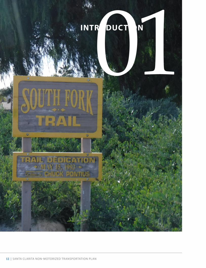
01INTRODUCTION

SANTA CLARITA NON-MOTORIZED TRANSPORTATION PLAN | 13
IntroductionWhy Develop a NMTP?Santa Clarita is a vibrant city committed to improving the quality of life for residents and visitors by providing walking and biking as convenient, comfortable, and healthy modes of transportation and recreation. The third-most populous city in Los Angeles County after the cities of Los Angeles and Long Beach, Santa Clarita boasts ample outdoor recreation opportunities. Our existing active transportation network features over 70 miles of paved paseos and Class I shared-use paths, an incredible amenity for people of all ages and abilities, and a great foundation to build on.
This 2020 Non-Motorized Transportation Plan (NMTP) establishes a long-term vision for improving walking and biking in our city, and is a critical tool for guiding city staff and the development community in building a balanced transportation system that is pedestrian- and bicycle-friendly and encourages residents to use these modes of transportation. The ultimate goal is to create more opportunities for walking, biking, and rolling to be a normal part of daily life.
PURPOSE OF THE NMTP
This NMTP updates the previous Non-Motorized Transportation Plan adopted by the City Council in 2014. Similar to the previous plan, this update seeks to ensure comfortable, safe, and attractive places to bike and walk so that walking becomes a first choice for travelling around the City. Since adoption of the previous plan, the City has made great strides in improving active transportation in our community. Many more pedestrian and bicycle projects and programs have been completed or are underway, including these highlights:
• The City has increased the mileage of Class I bike paths, Class II bike lanes, and Class III bike routes by 24%.
• Nearly all elementary schools are participating in the Safe Routes to School Program, and since the adoption of the 2014 plan, 5 middle and 5 high schools are developing programs.
• The League of American Bicyclists designated Santa Clarita as a silver-level Bicycle Friendly Community in 2019.
• The City has continued receiving grant funding each year from Metro and Caltrans.
Table 1 highlights additional progress made since the 2014 NMTP.

14 | SANTA CLARITA NON-MOTORIZED TRANSPORTATION PLAN
Table 1 . Progress Made Since 2014 NMTP
PROJECT DESCRIPTION
Class I Bike Paths
6 new miles
• Installed bike paths on the Golden Valley Road bridge over the State Route 14 freeway, and on the Lost Canyon Road bridge
• Installed a Class I bike path connecting McBean Parkway and the Santa Clara River Trail
• Added segment 4 of the Santa Clara River Trail and extension of the Golden Valley Road Trail in the Five Knolls community (2.5 miles total)
• Completed the segment of the Santa Clara River Trail through the River Village Development
• Completed the widening of the Newhall Ranch Road Bridge over San Francisquito Creek providing full grade separation and interconnection of three paths in this location
Class II Bike Lanes
12 new miles*
• Installed Class II bike lanes on Tourney Road, Center Pointe Parkway, Avenue Tibbitts, Smyth Drive, Cinema Drive, Market Street, Plum Canyon Road, and Skyline Ranch Road
Class III Bike Routes
• Designated Class III bike routes on Orchard Village Road and Golden Triangle Road
Multi-Use Trails • Opened a 1.3 mile trail in the New Golden Valley Ranch Open Space
Trailheads • Installed wayfinding signage at all trailheads and along 20 miles of the most heavily-traveled sections of the trail network
Pedestrian/Bicycle Bridges
• Widened Newhall Ranch Road Bridge and completed trail connections along West Side
• Completed new ped/bike bridges across Sierra Highway and Soledad Canyon Road
• Upgraded six timber bridges to steel truss frames within the paseo network
Pedestrian Improvements
• Completed over 70,000 square feet of sidewalk repairs
• Installed 34 ADA-compliant pedestrian access curb ramps
• Installed decomposed granite walkway on Tournament Road
Additional Improvements
• Repaired truncated domes at the Newhall and Via Princessa Metrolink stations
• Installed bicycle lockers at the McBean Transit Center
Safe Routes to School
• Removed and replaced school area signage, refurbished pavement markings, and modified existing crosswalks at 12 elementary schools
• Completed a citywide Safe Routes to School Plan
Programs • Continued regularly conducting counts on trails
• Launched a dockless bike share pilot program in 2019
• Implemented an Emergency Locating System on trails
• Piloted the GiveMeGreen! bicycle detection app
*Note: In 2019, the City began measuring bike lane mileage using in-lane miles.

SANTA CLARITA NON-MOTORIZED TRANSPORTATION PLAN | 15
The NMTP continues to build upon a long-standing effort to make Santa Clarita a place known for its extensive bicycle and pedestrian network and as an active, healthy place to live, work, and play. It expands upon the 2014 NMTP by providing new and updated infrastructure, program, and policy recommendations. In addition to updating the 2014 plan, the NMTP takes advantage of new, innovative solutions to guide City staff in prioritizing resources when implementing future projects and programs, and finally, helps make the City eligible for more outside funding for these pursuits. With this in mind, this document includes an inventory of the City’s current bicycle and pedestrian network and recommends specific infrastructure, program, and policy changes to encourage more bicycling and walking.
The planning process provided opportunities for elected and appointed members of the City’s Boards, Commissions, and the public to participate in the development process of the NMTP by evaluating, commenting, and suggesting ideas for walking and bicycling. Following requirements set by the California Transportation Commission, the NMTP should be updated every five years.
Benefits of Active TransportationPUBLIC HEALTH
Physical inactivity is now widely understood to play a significant role in the most common chronic diseases in the United States, including heart disease, stroke, and diabetes. Each year, approximately 280,000 adults in the United States die prematurely due to obesity-related illnesses. A 2004 study published in the American Journal of Preventive Medicine by Frank et al. reported that for each additional 60 minutes spent in a car daily, one’s chance of becoming obese increases by six percent. Creating a physical environment that encourages biking and walking—and improves access to parks and active recreation opportunities in other neighborhoods—is a key strategy to fighting obesity and inactivity. Better yet, it has been shown to have substantial impacts on health with a relatively small public investment.
This NMTP identifies interventions that support safe walking, biking, and recreational opportunities as effective strategies for addressing public health concerns in our community.
This Plan continues to build on the City’s ample opportunities for outdoor recreation and healthy living.
COLLISION REDUCTION
Conflicts between people walking, biking, and driving can result not just from poor behavior, but also from insufficient or ineffective design. Encouraging development and redevelopment in which biking and walking are supported and prioritized can enhance safety and comfort levels for all users. Designated biking and walking facilities, well-designed crossings, and continued education and enforcement can reduce the risk of crashes and injuries and increase overall active transportation mode share.
This NMTP recommends active transportation network improvements and programmatic changes to help reduce collisions and improve traffic safety in our community.
16 | SANTA CLARITA NON-MOTORIZED TRANSPORTATION PLAN
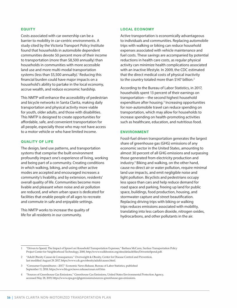
EQUITY
Costs associated with car ownership can be a barrier to mobility in car-centric environments. A study cited by the Victoria Transport Policy Institute found that households in automobile dependent communities devote 50 percent more of their income to transportation (more than $8,500 annually) than households in communities with more accessible land use and more multi-modal transportation systems (less than $5,500 annually).1 Reducing this financial burden could have major impacts on a household’s ability to partake in the local economy, accrue wealth, and reduce economic hardship.
This NMTP will enhance the accessibility of pedestrian and bicycle networks in Santa Clarita, making daily transportation and physical activity more viable for youth, older adults, and those with disabilities. This NMTP is designed to create opportunities for affordable, safe, and convenient transportation for all people, especially those who may not have access to a motor vehicle or who have limited income.
QUALITY OF LIFE
The design, land use patterns, and transportation systems that comprise the built environment profoundly impact one’s experience of living, working and being part of a community. Creating conditions in which walking, biking, and using other active modes are accepted and encouraged increases a community’s livability, and by extension, residents’ overall quality of life. Communities become more livable and pleasant when noise and air pollution are reduced, and when urban space is dedicated for facilities that enable people of all ages to recreate and commute in safe and enjoyable settings.
This NMTP works to increase the quality of life for all residents in our community.
1 “Driven to Spend; The Impact of Sprawl on Household Transportation Expenses,” Barbara McCann, Surface Transportation Policy Project Center for Neighborhood Technology, 2000, http://www.walkboston.org/sites/default/files/DriventoSpend.pdf.
2 “Adult Obesity Causes & Consequences,” Overweight & Obesity, Center for Disease Control and Prevention, last modified August 29, 2017, https://www.cdc.gov/obesity/adult/causes.html.
3 “Consumer Expenditures—2017,” Economic News Release, Bureau of Labor Statistics, published September 11, 2018, https://www.bls.gov/news.release/cesan.nr0.htm
4 “Sources of Greenhouse Gas Emissions,” Greenhouse Gas Emissions, United States Environmental Protection Agency, accessed May 28, 2019, https://www.epa.gov/ghgemissions/sources-greenhouse-gas-emissions.
LOCAL ECONOMY
Active transportation is economically advantageous to individuals and communities. Replacing automobile trips with walking or biking can reduce household expenses associated with vehicle maintenance and fuel costs. These savings are accompanied by potential reductions in health care costs, as regular physical activity can minimize health complications associated with an inactive lifestyle. In 2009, the CDC estimated that the direct medical costs of physical inactivity to the country totaled more than $147 billion.2
According to the Bureau of Labor Statistics, in 2017, households spent 13 percent of their earnings on transportation—the second highest household expenditure after housing.3 Increasing opportunities for non-automobile travel can reduce spending on transportation, which may allow for households to increase spending on health-promoting activities such as healthcare, education, and nutritious food.
ENVIRONMENT
Fossil-fuel driven transportation generates the largest share of greenhouse gas (GHG) emissions of any economic sector in the United States, amounting to almost 30 percent of all GHG emissions and surpassing those generated from electricity production and industry.4 Biking and walking, on the other hand, cause no direct air or water pollution, require minimal land use impacts, and emit negligible noise and light pollution. Bicyclists and pedestrians occupy less space than cars and help reduce demand for road space and parking, freeing up land for public space, buildings, food production, housing, and stormwater capture and street beautification. Replacing driving trips with biking or walking trips reduces emissions associated with mobility, translating into less carbon dioxide, nitrogen oxides, hydrocarbons, and other pollutants in the air.

SANTA CLARITA NON-MOTORIZED TRANSPORTATION PLAN | 17
Implementation of this NMTP not only reduces our contribution and enhances our resiliency to climate change, but also improves the health and quality of life for residents who are vulnerable to asthma or other chronic respiratory diseases.
Relationship to Other Documents
Non-Motorized Transportation Plan
Prepared by Alta Planning + Design August 2014
In 1992, the City adopted Resolution 92-102, reaffirming that the City “vigorously support[s] bicycle use within the City limits on both road and off road bikeways.” Since that resolution, many of the City’s plans and policies have addressed bicycle planning in addition to expanding pedestrian facilities and transit connections.
In addition to Resolution 92-102, this NMTP is consistent with and builds upon the efforts of various planning, policy, and regulatory documents. These include the City’s own documents, such as the General Plan, the Municipal Code, the 2014 NMTP, the 2019 Transit Development Plan, and the Climate Action Plan. Santa Clarita also intends to design a bicycle and pedestrian network that continues to complement existing and planned bikeways and pedestrian projects in surrounding communities. Therefore, the planning context also includes bicycle and pedestrian plans, policies, and projects of Los Angeles County and the State of California. A full review of these documents can be found in Appendix A, and the City’s Complete Streets strategy can be found in Appendix B.
s a n t aMARCH 24, 2009COMMUNITY CHARACTER & DESIGN GUIDELINES
c l a r i t a
City of Santa Clarita
April 2010
Prepared By:
I M P A C T S C I E N C E S803 Camarillo Springs Road, Suite ACamarillo, Californoa 93012
Draft
VISTA CANYONSPECIFIC PLAN
Prepared by:Vista Canyon Ranch, LLC
27451 Tourney Road, Suite 100Valencia, California 91355Contact: Glenn Adamick
Prepared for:City of Santa Clarita
Department of Community Development23920 Valencia Boulevard
Santa Clarita, California 91355Contact: Jeff Hogan, Senior Planner
FINAL REPORT MAY 2019
City of Santa ClaritaTransit Development Plan
moore& associates
C I T Y O F S A N T A C L A R I T A
O L D T O W N N E W H A L L S P E C I F I C P L A N
Prepared by:Moule & Polyzoides Architects and Urbanists
Van Atta AssociatesEconomics Research Associates
Nelson / Nygaard AssociatesPsomas
Crawford Multari & Clark Associatesfor:
City of Santa Clarita
The NMTP builds upon other City planning efforts, including the Community Character and Design Guidelines, Vista Canyon Specific Plan, Old Town Newhall Specific Plan, and the Transit Development Plan.

18 | SANTA CLARITA NON-MOTORIZED TRANSPORTATION PLAN
02THE VISION

SANTA CLARITA NON-MOTORIZED TRANSPORTATION PLAN | 19
OverviewThe goals of the NMTP reflect the priorities expressed by the community throughout the public outreach phase. Discussions with City departments, best practices across the nation, and input from community stakeholders have shaped the proposed strategies and policies intended to help the City achieve these goals.
All of the following goals, strategies, and policies support the larger citywide “Complete Streets” policy, which instructs staff to consider the needs of all modes of travel when developing any transportation facility. The goals, strategies, and policies are designed to guide the work of City staff and elected officials, partner agencies, and private developers to improve the livability, economic vitality, and non-motorized accessibility for residents and visitors throughout Santa Clarita. Reducing the amount of driving and automobile ownership is an overarching goal embodied in this NMTP.
The NMTP is organized around a vision statement, three overarching goals tied to relevant performance measures, and a series of specific policies and actions.
BICYCLE AND WALK FRIENDLY COMMUNITY DESIGNATION
In 2019, the League of American Bicyclists honored the City’s efforts to build better places to bike with a silver-level Bicycle Friendly Community award. Recognizing Santa Clarita’s infrastructure improvements, educational and encouragement programs, and enforcement efforts, the League upgraded the City’s award from bronze, making our community one of only six cities in the nation to move from a bronze-level to a silver-level recognition during this round of judging. This voluntary assessment and award program evaluates communities on ten criteria that the League believe affect three key outcomes: ridership, crashes, and fatalities. These goals, policies, and actions are designed specifically to help elevate the City to a Gold or higher designation (Platinum and Diamond) in the near future.
There are programs that also recognize places for their walkability, such as Walk Friendly Communities, a program operated by the UNC Highway Safety Research Center. Taking the actions listed in this chapter can position the City for recognition through this national program as well.
The VisionThis Plan supports the City of Santa Clarita’s vision as a thriving community where people of all ages and abilities feel empowered to walk or bicycle to the widest range of destinations including school, work, transit, recreation, and shopping as part of daily life.

20 | SANTA CLARITA NON-MOTORIZED TRANSPORTATION PLAN
Goal 1. Safety & Health
This NMTP will empower residents to live a more active lifestyle by providing a network of safe and comfortable walking routes and bikeways for everyone to enjoy.
ASKING THE RIGHT QUESTIONS
• Will the NMTP help reduce crashes and fatalities while increasing opportunities for physical activity among vulnerable populations?
• Does the NMTP help reduce air pollution, asthma rates, and greenhouse gas emissions, particularly within vulnerable populations?
HOW DO WE MEASURE PROGRESS?
• Develop a Vision Zero program to reduce the number of severe and fatal pedestrian and bicycle collisions to zero by 2040
• Increase percentage of K-12 students receiving bicy-cling education on an annual basis from 1% to 10%
• Expand Safe Routes to School Programs to all City schools
• Reduce vehicle miles traveled annually
• Reduce air pollution from motor vehicles by 5% due to more people biking and walking

SANTA CLARITA NON-MOTORIZED TRANSPORTATION PLAN | 21
OBJECTIVE ACTIONS
A Reduce bicycle and pedestrian collisions through safe and comfortable facilities
1 Prioritize quick implementation of bicycle and pedestrian facilities on Santa Clarita’s high-injury network to rapidly address possible safety issues.
2 Implement facilities recommended in this plan, which follow a “Complete Streets” approach. Refer to national and state best practices.
3 Continue citywide traffic safety campaigns that educate all roadway users about safe driving, walking, and biking. Expand existing safety education programs for drivers as well as pedestrians and bicyclists through grants and partnerships with community stakeholders.
4 Include bicycle and pedestrian safety in the Local Road Safety Program.
B Promote an active lifestyle that includes biking and walking
1 Develop programs that encourage residents to walk and bike as part of their daily life.
2 Encourage local school districts to create programs that incorpo-rate safe biking and walking into the curriculum.
3 Train residents and/or City staff as League Certified Instructors (LCI) and bicycle/trail ambassadors. Host bicycle safety, training, and education courses.
4 Partner with the Los Angeles County Department of Public Health and local healthcare providers to promote healthy lifestyle choices, such as bicycling and walking for errands and other short trips.
C Reduce air pollution, asthma rates, and greenhouse gas emissions
1 Build a bicycle network that encourages residents to choose modes of transportation other than driving by providing low-stress facilities, robust pedestrian networks, and seamless bicycle and transit integration.
2 Incorporate Green Infrastructure strategies where possible (e.g., bulb-outs, planted bikeway buffers, and landscaped areas adjacent to sidewalks and Class I paths). Utilize permeable paving for new facilities or re-paving, especially where facilities are adjacent to waterways or parks.

22 | SANTA CLARITA NON-MOTORIZED TRANSPORTATION PLAN
Goal 2. Access & Comfort
This NMTP will support increased access to neighborhood destinations such as parks, shopping and employment centers, libraries, schools, recreation centers, and transit stops. Pedestrian and bicycle facilities will be accessible and comfortable for people of all ages and abilities to use.
ASKING THE RIGHT QUESTIONS
• Does the NMTP prioritize the needs and trip patterns of vulnerable users?
• Does the NMTP address barriers so that vulner-able populations can take part in or enjoy the improvements?
• Does the NMTP help support and not impede public transit service?
• Does the NMTP serve people with physical disabilities?
HOW DO WE MEASURE PROGRESS?
• Double the share of people walking and bicycling to work to 3.4% by 2025 and triple to 5.1% by 2040
• Double trail use by 2025
• Increase the number of ADA-compliant trailheads, paseos, and sidewalks
• Increase the share of students walking or bicycling to school
• Reduce the percent of streets that are Bicycle Level of Traffic Stress (LTS) 3 and 4 by half
• Increase percentage of residents within a ½-mile of a trail
• Increase transit trips by 50% by 2025
The City is striving to serve all ages, needs, and abilities.
SANTA CLARITA NON-MOTORIZED TRANSPORTATION PLAN | 23
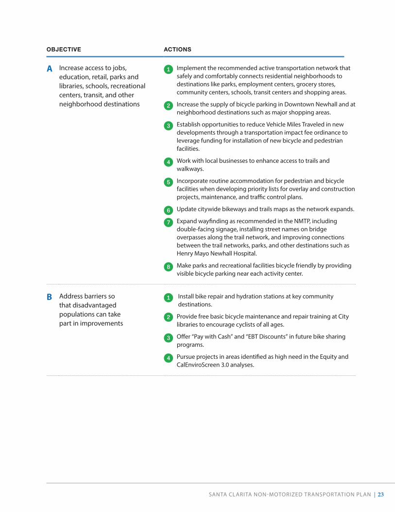
OBJECTIVE ACTIONS
A Increase access to jobs, education, retail, parks and libraries, schools, recreational centers, transit, and other neighborhood destinations
1 Implement the recommended active transportation network that safely and comfortably connects residential neighborhoods to destinations like parks, employment centers, grocery stores, community centers, schools, transit centers and shopping areas.
2 Increase the supply of bicycle parking in Downtown Newhall and at neighborhood destinations such as major shopping areas.
3 Establish opportunities to reduce Vehicle Miles Traveled in new developments through a transportation impact fee ordinance to leverage funding for installation of new bicycle and pedestrian facilities.
4 Work with local businesses to enhance access to trails and walkways.
5 Incorporate routine accommodation for pedestrian and bicycle facilities when developing priority lists for overlay and construction projects, maintenance, and traffic control plans.
6 Update citywide bikeways and trails maps as the network expands.
7 Expand wayfinding as recommended in the NMTP, including double-facing signage, installing street names on bridge overpasses along the trail network, and improving connections between the trail networks, parks, and other destinations such as Henry Mayo Newhall Hospital.
8 Make parks and recreational facilities bicycle friendly by providing visible bicycle parking near each activity center.
B Address barriers so that disadvantaged populations can take part in improvements
1 Install bike repair and hydration stations at key community destinations.
2 Provide free basic bicycle maintenance and repair training at City libraries to encourage cyclists of all ages.
3 Offer “Pay with Cash” and “EBT Discounts” in future bike sharing programs.
4 Pursue projects in areas identified as high need in the Equity and CalEnviroScreen 3.0 analyses.

24 | SANTA CLARITA NON-MOTORIZED TRANSPORTATION PLAN
OBJECTIVE ACTIONS
C Reduce air pollution, asthma rates, and greenhouse gas emissions
1 Design bikeways on transit streets using best practices that do not impact transit reliability while improving access to transit.
2 Work with Santa Clarita Transit to improve bicycle and pedestrian access (first/last mile connections) to transit stations as outlined in the 2019 Transit Development Plan. Similarly, collaborate to improve the comfort of transit stops and onboard transit vehicles, especially during peak commute hours, and to provide secure bike parking, benches, and covered waiting areas at stations and stops.
3 Locate future bike sharing stations near major bus and train hubs.
4 Work with Santa Clarita Transit to require and install rear wheel side guards on all City buses.
5 Install more secure, long-term bicycle parking at major transit hubs.
D Reduce travel times for disadvantaged households
1 Increase the overall mileage of the sidewalks and low-stress bicycle network in high-need neighborhoods (as identified in the Equity Analysis).
E Prioritize the needs and trip patterns of disadvantaged populations
1 Prioritize the construction of facilities that address disparities, and close gaps in the active transportation network between neighborhoods.
F Serve people with disabilities 1 Ensure that active transportation facility designs do not create additional barriers for people with disabilities, but instead create safer, more welcoming public spaces for everyone. Adjust gates at entryways to paseos and trailheads that currently prohibit access of recumbent bicycles, wheelchairs, and other mobility devices.
2 Work with Santa Clarita Transit to improve bicycle and pedestrian access (first/last mile connections) to transit stations as outlined in the 2019 Transit Development Plan. Similarly, collaborate to improve the comfort of transit stops and onboard transit vehicles, especially during peak commute hours, and to provide secure bike parking, benches, and covered waiting areas at stations and stops.
3 Work with Santa Clarita Transit to require and install rear wheel side guards on all City buses.

SANTA CLARITA NON-MOTORIZED TRANSPORTATION PLAN | 25
Although many streets feature marked crosswalks, facilities do not always capture where, when, and how people want to use our streets. The City will continue to work to ensure routes for walking and biking are convenient, accessible, and responsive to community needs.

26 | SANTA CLARITA NON-MOTORIZED TRANSPORTATION PLAN
Goal 3. Maintain & Expand the Network
This NMTP will help our community identify, develop, and maintain a complete and convenient bicycle and pedestrian network.
ASKING THE RIGHT QUESTIONS
• Does the NMTP adequately position our community for successful implementation?
• Does the NMTP ensure equitable distribution of proposed facilities?
HOW DO WE MEASURE PROGRESS?
• Double the number of short-term and secure long-term bicycle parking locations by 2040
• Maintain adequate pavement quality, striping, and sign visibility and signal/beacon functionality on all bicycle and pedestrian facilities
• Continue tracking and publishing annual bicycle and pedestrian counts
• Prioritize grant funding requests to Complete Tier 1 projects recommended in this NMTP by 2030 and Tier 2 projects by 2040
OBJECTIVE ACTIONS
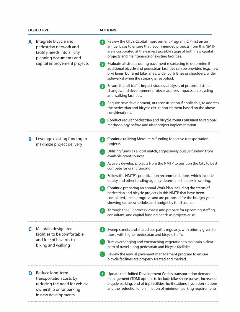
A Integrate bicycle and pedestrian network and facility needs into all city planning documents and capital improvement projects
1 Review the City’s Capital Improvement Program (CIP) list on an annual basis to ensure that recommended projects from this NMTP are incorporated at the earliest possible stage of both new capital projects and maintenance of existing facilities.
2 Evaluate all streets during pavement resurfacing to determine if additional bicycle and pedestrian facilities can be provided (e.g., new bike lanes, buffered bike lanes, wider curb lanes or shoulders, wider sidewalks) when the striping is reapplied.
3 Ensure that all traffic impact studies, analyses of proposed street changes, and development projects address impacts on bicycling and walking facilities.
4 Require new development, or reconstruction if applicable, to address the pedestrian and bicycle circulation element based on the above considerations.
5 Conduct regular pedestrian and bicycle counts pursuant to regional methodology before and after project implementation.
B Leverage existing funding to maximize project delivery
1 Continue utilizing Measure M funding for active transportation projects.
2 Utilizing funds as a local match, aggressively pursue funding from available grant sources.
3 Actively develop projects from the NMTP to position the City to best compete for grant funding.
4 Follow the NMTP’s prioritization recommendations, which include equity and other funding-agency-determined factors in scoring.
5 Continue preparing an annual Work Plan including the status of pedestrian and bicycle projects in this NMTP that have been completed, are in progress, and are proposed for the budget year showing scope, schedule, and budget by fund source.
6 Through the CIP process, assess and prepare for upcoming staffing, consultant, and capital funding needs as projects arise.
C Maintain designated facilities to be comfortable and free of hazards to biking and walking
1 Sweep streets and shared use paths regularly, with priority given to those with higher pedestrian and bicycle traffic.
2 Trim overhanging and encroaching vegetation to maintain a clear path of travel along pedestrian and bicycle facilities.
3 Review the annual pavement management program to ensure bicycle facilities are properly treated and marked.
D Reduce long-term transportation costs by reducing the need for vehicle ownership or for parking in new developments
1 Update the Unified Development Code’s transportation demand management (TDM) options to include bike-share passes, increased bicycle parking, end of trip facilities, fix-it stations, hydration stations, and the reduction or elimination of minimum parking requirements.

28 | SANTA CLARITA NON-MOTORIZED TRANSPORTATION PLAN
03EXISTING CONDITIONS

SANTA CLARITA NON-MOTORIZED TRANSPORTATION PLAN | 29
Existing ConditionsThere is great potential to expand the role and use of active transportation in Santa Clarita. The city enjoys mild weather, has limited topographical challenges, has over 126 miles of existing bicycle facilities , already experiences relatively high rates of walking and biking and has installed an extensive wayfinding network. These investments provide a foundation upon which Santa Clarita can build a high quality, citywide active transportation network that is safe, comfortable, and appealing for daily use.
Local ContextOriginally incorporated in 1987 from the communities of Canyon Country, Newhall, Saugus, and Valencia, Santa Clarita has continued to grow throughout the decades. The City has completed two annexations since the 2014 Non-Motorized Transportation Plan: West Creek/West Hills (2016) and Plum Canyon (2018). With these annexations, Santa Clarita is now home to over 210,000 people,5 making it the third most populous city in Los Angeles County.6
5 2017 American Community Survey 5-Year Estimates6 “E-1 Population Estimates for Cities, Counties, and the State—January
1, 2018 and 2019,” State of California Department of Finance, http://www.dof.ca.gov/Forecasting/Demographics/Estimates/E-1/.
Santa Clara River Trail over the Los Angeles Aqueduct

30 | SANTA CLARITA NON-MOTORIZED TRANSPORTATION PLAN
This high growth rate, combined with high growth in the surrounding communities and the large area of the City, has placed increasing transportation pressures on the community.
Located in the Santa Clara River Valley, the City is bounded by the Sierra Pelona Mountain Range to the north and the Santa Susanna and San Gabriel mountain ranges to the south (see Figure 1). It sits 35 miles north of downtown Los Angeles, and is bounded generally on the west by Interstate 5 and the east by State Route 14 (SR-14). The City is bordered by unincorporated Los Angeles County, including the unincorporated communities of Acton, Agua Dulce, Castaic, and Stevenson Ranch.
COMMUNITY OPINION SURVEY (2018)
Every two years, the City commissions a community-wide survey to gather an objective, representative, and statistically-reliable understanding of its residents’ satisfaction, priorities, and concerns about services and facilities provided by the City. In an open-ended question, the majority of respondents reported that the biggest problem facing the community is traffic congestion.
When asked to indicate the one thing the City could do to make Santa Clarita a better place to live, the most common answers were limiting growth and development (21%); reducing traffic congestion (15%); providing affordable housing (8%); and improving/maintaining infrastructure, roads, and sidewalks (6%). The NMTP seeks to remain sensitive to these concerns, and offers recommendations to improve transportation options in the community.
Quality of Life
True North Research, Inc. © 2018 10City of Santa Clarita. . . . . . . . . . . . . . . .
Q U A L I T Y O F L I F E
The opening series of questions in the survey was designed to assess residents’ top of mindopinions about the most important issues facing Santa Clarita, the perceived quality of life in theCity, as well as ways the city government could improve the overall quality of life in the commu-nity.
MOST IMPORTANT ISSUE FACING SANTA CLARITA At the outset of the interview,respondents were asked to indicate the most important issue facing the Santa Clarita commu-nity. Question 2 was posed in an open-ended manner, thereby allowing residents to mention anyissue that came to mind without being prompted by—or restricted to—a particular list ofoptions. True North later reviewed the verbatim responses and grouped them into the categoriesshown in Figure 1.
Santa Clarita residents were most apt to cite traffic congestion (37%) as the most important issuefacing the community, followed by growth and development (26%) and public safety/crime/drugs (17%). Other specific issues that were mentioned by at least 5% of respondents includedhomelessness (9%), infrastructure maintenance and improvement (8%), and cost of housing/affordable housing (6%). Approximately 14% of residents were unsure/could not think of anyimportant issues (13%) or stated that there were no issues facing the community (1%). Whencompared to the 2016 study, traffic congestion and concerns about growth/developmentremained in the top three responses, whereas concerns about the drought (a top three issue in2016) have been replaced with mentions of public safety/crime/drugs.
Question 2 What would you say is the most important issue facing the Santa Clarita commu-nity today?
FIGURE 1 MOST IMPORTANT ISSUE FACING COMMUNITY
0.50.80.80.90.90.91.01.01.2
1.41.4
1.81.82.6
3.76.2
8.38.5
13.216.5
25.537.1
1.5
1.3
0 5 10 15 20 25 30 35 40
Restaurants, shopping optionsPublic transportation
Healthcare services, optionsGovernment, leadershipProtecting quality of life
No issuesHigh cost of living
High taxes, feesDisaster preparedness
Illegal immigration issuesSchool, education issues
Environmental issuesTraffic light synchronization
Diversity, racial concernsEconomy, jobs
Enforcing traffic lawsWater issues, concerns
Cost of housing, affordable housingInfrastructure maintenance, improvement
HomelessnessNot sure, cannot think of any
Public safety, crime, drugsCity growth, development
Traffic congestion
% Respondents
In the 2018 Community Opinion Survey, residents reported that traffic congestion is the most important issue facing the Santa Clarita community.

SANTA CLARITA NON-MOTORIZED TRANSPORTATION PLAN | 31
Decoro Drive
New
hall A
venue
Rain
bo
wG
len
Drive
Poe Parkway
Ab
elia
Ro
ad
Del
Mon
teDrive
Ala
min
osD
rive
Hillcrest Parkway
Pico Canyon Road
Hasley Canyon Road
Plum Canyon Road
Santa Clara Truck Trail
Gold
enVa
lley
Road
Via Princessa
Ermine Street
LostCanyon Road
Potrero Canyon Road
Jakes Way
Vasquez Canyon Road
Placerita Canyon Road
Se
co
Can
yo
nR
oad
Wile
yC
anyo
n
Road
Avenue Stanford
Whit
es
Ca
nyo
nR
oad
SkylineRanchR
oad
EdisonRoad
San
dC
anyo
nR
oad
Newhall Avenue
Lyons Avenue
Railroad Ave
Bouquet Canyon Road
Soledad Canyon Road
Sier
raHig
hway
McB
ean
Par
kway
Copper Hill Drive
The Old
Road
Newhall Ranch Road
Valencia Boulevard
Magic Mountain Parkway
Golden Valley Road
¥126
¥14U
¥5S
¥14
¥5¬«126
¬«14U¬«14
§̈¦5S
§̈¦5
Santa
Clara
River
vern
al
pool
SANTA CLARITAACTIVE MOBILITY PROPOSAL
SantaMonica
PalosVerdesEstates
Los Angeles
Malibu
La Mirada
Montebello
AlhambraAzusa
Glendora
La Canada FlintridgeGlendale
San Fernando
Palmdale
Lancaster
Santa ClaritaUnincorporated
LomitaLongBeach
Bell
Hawthorne ¥72¥1
¥101
¥39
¥134
¥138
¥710
¥27
¥2
¥110
¥5
¥210¥405
¥23
¥14
¥60
¥605
¥10¬«71
¬«39
¬«134
¬«138
¬«27
¬«2¬«126
¬«18
¬«107
¬«164¬«187¬«23
¬«14
¬«60
¬«213
§̈¦10
§̈¦5
§̈¦210
§̈¦710§̈¦110
§̈¦405
§̈¦605
£¤101
CA
LI F
OR
NI A
PROJECT AREASanta Clarita, CA
0 10 205 Miles
OExtent of Bottom
Left Map
0 2 41 Miles
OLOS ANGELES COUNTY
Figure 1 . Location of Santa Clarita

32 | SANTA CLARITA NON-MOTORIZED TRANSPORTATION PLAN
Figure 2 . Existing Land Use
Newhall Ave
Lyons Ave
Railroad AveBo
uque
t Can
yon
Rd
Soledad Canyon Rd
Sier
raHw
y
McB
ean
Pkw
y
The
Old
Ro
a d
Cop
per
Hill
Dr
Newhall Ranch Rd
Valencia Blvd
Magic Mountain Pkwy
Golden Valley Rd
5S
5
126
14
0 2 41 Miles
ZoningCommercial
Industrial
Mixed Use
Non-Urban Residential
Open Space
Specific Plan
Urban Residential
Other
Metrolink Station
LAND USE & MAJOR DESTINATIONS
Development in Santa Clarita is generally suburban in character, with most development occurring on the valley floor and lower canyons. The City is mostly residential with low-density single-family residential areas located throughout, commercial areas located along major arterials, business parks located primarily along Interstate 5 and along Soledad Canyon Road, and neighborhood commercial centers scattered throughout the city.
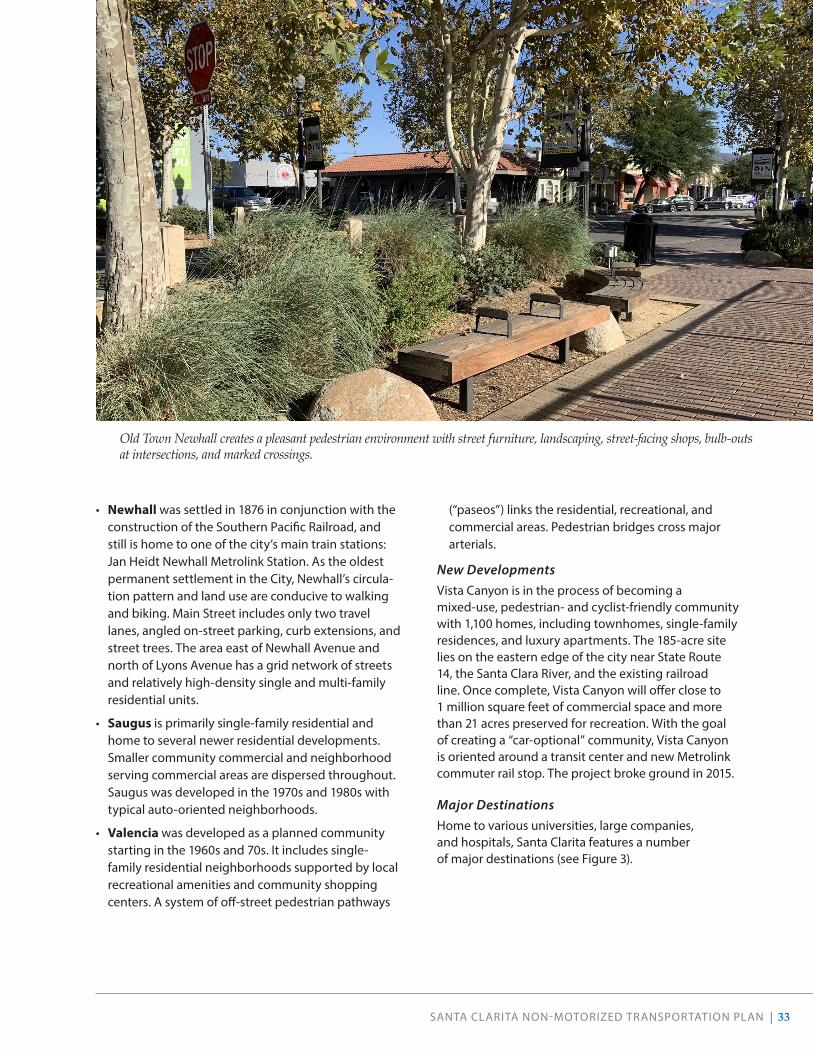
Four Original CommunitiesThe four communities (Canyon Country, Newhall, Saugus, and Valencia) which were joined together to form Santa Clarita still have distinct characteristics:
• Canyon Country contains a variety of housing types, including large-lot single-family custom homes, single-family tract homes, and multi-family development and mobile home parks. Neighborhood serving commercial areas are concentrated along Soledad Canyon Road and Sierra Highway. Sand Canyon, a sub-community of Canyon Country, is located south of SR-14. The develop-ment standards are intended to maintain, preserve, and enhance the rural and equestrian character of Sand Canyon by limiting curb, gutter, sidewalk, and streetlight improvements in any new development (Zoning Code Section 17.39.030). Most streets in the neighborhood do not have sidewalks. The neigh-borhood is home to several horse ranches, and equestrian use is common.
SANTA CLARITA NON-MOTORIZED TRANSPORTATION PLAN | 33
• Newhall was settled in 1876 in conjunction with the construction of the Southern Pacific Railroad, and still is home to one of the city’s main train stations: Jan Heidt Newhall Metrolink Station. As the oldest permanent settlement in the City, Newhall’s circula-tion pattern and land use are conducive to walking and biking. Main Street includes only two travel lanes, angled on-street parking, curb extensions, and street trees. The area east of Newhall Avenue and north of Lyons Avenue has a grid network of streets and relatively high-density single and multi-family residential units.
• Saugus is primarily single-family residential and home to several newer residential developments. Smaller community commercial and neighborhood serving commercial areas are dispersed throughout. Saugus was developed in the 1970s and 1980s with typical auto-oriented neighborhoods.
• Valencia was developed as a planned community starting in the 1960s and 70s. It includes single-family residential neighborhoods supported by local recreational amenities and community shopping centers. A system of off-street pedestrian pathways
(“paseos”) links the residential, recreational, and commercial areas. Pedestrian bridges cross major arterials.
New DevelopmentsVista Canyon is in the process of becoming a mixed-use, pedestrian- and cyclist-friendly community with 1,100 homes, including townhomes, single-family residences, and luxury apartments. The 185-acre site lies on the eastern edge of the city near State Route 14, the Santa Clara River, and the existing railroad line. Once complete, Vista Canyon will offer close to 1 million square feet of commercial space and more than 21 acres preserved for recreation. With the goal of creating a “car-optional” community, Vista Canyon is oriented around a transit center and new Metrolink commuter rail stop. The project broke ground in 2015.
Major DestinationsHome to various universities, large companies, and hospitals, Santa Clarita features a number of major destinations (see Figure 3).
Old Town Newhall creates a pleasant pedestrian environment with street furniture, landscaping, street-facing shops, bulb-outs at intersections, and marked crossings.

34 | SANTA CLARITA NON-MOTORIZED TRANSPORTATION PLAN
SanFrancisquitoCanyonRoad
Sole
dad
Can
yon
Ro
ad
Lyon
s A
venu
e
Railroad Ave
Mag
icM
ount
ain
Park
way
New
hall
Ran
chR
oad
New
hall
Aven
ue
BouquetCanyonRoad
GoldenValleyRoad
Vale
ncia
Boul
evar
dMcBeanParkway
Cop
per
Hil l
Dr i
ve
The Old RoadSierra
Highw
ay
5
126
14
Exis
ting
Bik
eway
s / T
rails
Bike
Pat
h (C
lass
I)Bi
ke L
ane
(Cla
ss II
)Bi
ke R
oute
(Cla
ss II
I)M
ulti-
Use
Tra
ilPa
seo
Scho
olD
estin
atio
nPa
rk /
Ope
n Sp
ace
Riv
er o
r Cre
ekC
ity B
ound
ary
Trai
lhea
d
Met
rolin
k St
atio
n
Bus
Tran
sfer
Sta
tion
Ret
ail /
Mix
ed U
se D
evel
opm
ent
Maj
or W
orkp
lace
Publ
ic F
acilit
y
02
41
Mile
s
Figure 3 . Major Destinations in Santa Clarita
SANTA CLARITA NON-MOTORIZED TRANSPORTATION PLAN | 35
TRANSIT ACCESS
Santa Clarita is served by two transit providers and several routes that offer connections to local and regional destinations. Most transit riders begin and/or end their trip as a pedestrian or cyclist, making connections to transit stops and stations a crucial part of the active transportation network.
Santa Clarita TransitSince its creation in 1991, Santa Clarita Transit has expanded its services to include 11 local fixed routes within the Santa Clarita Valley; supplemental school day schedules to multiple junior high and high schools in the city; and commuter services between Santa Clarita and downtown Los Angeles, Century City, Westwood, North Hollywood, and Warner Center. Additionally, Santa Clarita Transit operates paratransit service seven days a week for seniors and disabled within the Santa Clarita Valley, as well as for the general public during evening hours. Their 100-vehicle fleet now provides service for 3 million riders annually, traveling a total of 12,000 miles each weekday.
According to the 2019 Transit Development Plan (TDP), people most frequently use the bus to travel between Newhall, Valencia, Magic Mountain, and the Santa Clarita Metrolink Station. The most popular origin and destination pair is Magic Mountain at Media Center and McBean at Valencia, followed closely by Magic Mountain at Media Center and Commuter Way at Soledad Canyon. Non-motorized transportation plays a critical role in transit riders’ journeys. Most notably, 68% of all riders surveyed during the TDP walk to the bus stop, and 75% walk from their final stop to their destination. Approximately 4% of riders surveyed use a bicycle to get to and from their bus stops.
All local buses are equipped with bicycle racks that hold two or three bicycles. The City sponsors a public outreach campaign that includes video instructions for loading bicycles on the racks, and provides buses with racks at city-sponsored events to allow people to practice loading bicycles on bus racks. Commuter buses have under-bus storage that holds bicycles.
Bicycle racks, lockers, and restrooms are provided at the McBean Regional Transit Center, located at the corner of McBean Parkway and Valencia Boulevard. Bicycle racks are not generally available at local bus stops.
MetrolinkSanta Clarita is served by Metrolink’s Antelope Valley Line, which provides commuter rail service to the San Fernando Valley, downtown Los Angeles, and Palmdale/Lancaster. Approximately 14 trains run from the city to downtown every weekday. Bicycles are allowed on all Metrolink train cars; each train car is designed to hold three bikes. Metrolink also has “Bike Cars” to accommodate more bikes on select trains, including the Antelope Valley Line. The Bike Cars can hold up to nine bikes.
Three Metrolink stations are within the City of Santa Clarita: Jan Heidt Newhall Station, Santa Clarita Station, and Via Princessa Station. Bicycle lockers with space for 10 to 34 bicycles are provided at all three Metrolink stations, as detailed in Table 2. Bicycle connections to the Santa Clarita station are provided by the Chuck Pontius Commuter Rail Trail, which parallels Soledad Canyon Road. Jan Heidt Newhall Station is close to the South Fork Trail, and access between the trail and the station is possible via low-traffic residential streets. A Class I shared-use path is planned for Railroad Avenue and will connect the station to the existing trail network. The Via Princessa Station does not have direct bicycle access, though there are bike lanes on Sierra Highway approaching the station from the south and the Santa Clara River Trail is to the north of the station.
An additional Metrolink Station and transit hub will be built as part of the Vista Canyon development project, approximately two miles east of the Via Princessa Station. Construction began in 2020 and the station is projected to open in 2021.
California High-Speed Rail The California High-Speed Rail Authority has proposed high-speed train service for intercity travel in California between the major metropolitan centers of the San Francisco Bay Area and Sacramento in the north, through the Central Valley, to Los Angeles and San Diego in the south. The proposed alignment will travel adjacent to the City of Santa Clarita’s southern boundary, near existing Metrolink rail lines in the vicinity of Sand Canyon and eastern Canyon County through the mountains and into Palmdale. There is no station planned for Santa Clarita, though the project will create impacts and changes to the City’s existing infrastructure and developments. The 171-mile Central Valley segment from Bakersfield to Merced is under construction. As of publication of this NMTP, the rail authority is pursuing possible alignments and environmental clearance for the rest of the proposed system.

36 | SANTA CLARITA NON-MOTORIZED TRANSPORTATION PLAN
EQUITY ANALYSIS
Making improvements for populations that rely on walking, bicycling, and transit to meet their daily needs is critical. Demographic factors provide insight into where network improvements may positively impact Santa Clarita residents. Some people choose to walk, bike, and take transit, but have additional options for their personal mobility, such as driving. For others, walking, biking, and transit are their only options for transportation. Those who use these modes out of necessity tend to be lower-income, vulnerable populations.
The equity analysis considers demographic factors that, when combined, indicate where there are concentrations of historically vulnerable populations. Active transportation investments in these areas could help alleviate a broader range of issues (access to jobs, education, and healthcare, for example). This analysis brings attention to neighborhoods or corridors that may be most in need of improvements, and provides a starting point for identifying priority areas.
The equity analysis for the NMTP uses a combination of socioeconomic characteristics as indicators to identify vulnerable populations at the census block group level. All data was obtained from the 2017 American Community Survey (ACS) Five-Year Estimates. The indicators include:
• Income: This indicator measures individuals of working age living at or below 200% of the Federal Poverty Level, which is a threshold set by the U.S. Census Bureau and is updated annually.
• Race: This indicator measures the percentage of the population that identifies as non-white.
• Age: This indicator assesses individuals under the age of 18 and over the age of 65, as both age groups are more likely to have less access to motor vehicles and therefore be more dependent upon active trans-portation and transit.
• Access to a Vehicle: This indicator measures the percentage of households that do not have regular access to a motor vehicle.

SANTA CLARITA NON-MOTORIZED TRANSPORTATION PLAN | 37
B19001 - HOUSEHOLD INCOME IN THE PAST 12 MONTHS (IN 2017 INFLATION-ADJUSTED DOLLARS) Source: U.S. Census Bureau, 2013-2017 American Community Survey 5-Year Estimates
Calfornia Los Angeles County Santa ClaritaTotal: 12,888,128 +/-18,518 3,295,198 +/-5,018 67,914 +/-718
Calfornia: $71,805 Los Angeles County: $65,006 Santa Clarita: $90,961Less than $10,000 694,945 +/-5,695 5% 201,863 +/-3,086 6% 1,852 +/-264 3%$10,000 to $14,999 604,666 +/-4,671 5% 178,737 +/-2,595 5% 1,688 +/-269 2%$15,000 to $19,999 536,203 +/-4,622 4% 156,089 +/-2,589 5% 1,432 +/-234 2%$20,000 to $24,999 568,994 +/-4,888 4% 162,639 +/-2,601 5% 1,918 +/-330 3%$25,000 to $29,999 523,563 +/-5,441 4% 144,700 +/-2,324 4% 1,955 +/-311 3%$30,000 to $34,999 539,988 +/-4,625 4% 149,564 +/-2,398 5% 1,979 +/-323 3%$35,000 to $39,999 500,571 +/-5,022 4% 135,954 +/-2,513 4% 1,896 +/-251 3%$40,000 to $44,999 509,113 +/-5,289 4% 138,917 +/-2,377 4% 2,431 +/-335 4%$45,000 to $49,999 456,152 +/-4,342 4% 120,529 +/-2,357 4% 1,804 +/-307 3%$50,000 to $59,999 895,758 +/-6,671 7% 233,537 +/-3,013 7% 4,333 +/-461 6%$60,000 to $74,999 1,199,773 +/-7,298 9% 306,351 +/-3,356 9% 6,090 +/-508 9%$75,000 to $99,999 1,568,843 +/-8,228 12% 387,502 +/-4,162 12% 10,153 +/-601 15%$100,000 to $124,999 1,206,637 +/-7,785 9% 287,785 +/-3,613 9% 7,672 +/-596 11%$125,000 to $149,999 818,690 +/-5,903 6% 189,618 +/-2,665 6% 6,863 +/-478 10%$150,000 to $199,999 1,008,388 +/-7,237 8% 224,078 +/-2,648 7% 7,744 +/-455 11%$200,000 or more 1,255,844 +/-8,241 10% 277,335 +/-3,455 8% 8,104 +/-398 12%
100% 100% 100%
Los Angeles $65,006Santa Clarita $90,961
1.39927139.9%
$25,955.0$90,961.0
0%
2%
4%
6%
8%
10%
12%
14%
16%
Perc
enta
ge o
f Hou
seho
lds
Median Household Income in the Past 12 Months2017 ACS 5-Year Estimates
Los Angeles County: $65,006 Santa Clarita: $90,961
Figure 4 . Median Household Income in the Past 12 Months Santa Clarita and Los Angeles County*
IncomeHousehold incomes in Santa Clarita are significantly higher than those in Los Angeles County (see Figure 4). In fact, the median income for households in Santa Clarita—$90,961—is approximately 1.4 times that of the county. Over half of households in Santa Clarita have incomes over $60,000. Nevertheless, portions of Santa Clarita experience lower household incomes than others.
Poverty is a socioeconomic vulnerability, linked with disproportionate exposure to poor housing, homelessness, and limited access to resources, such as transportation services, quality food, recreation facilities and health care facilities.7 With transportation costs, especially those associated with vehicle ownership, often comprising the second largest portion of an individual’s income
7 Dannenberg A, Frumkin H, Jackson R. Making Healthy Places. 1st ed. Washington D.C.: Island Press; 2011.
(second to housing), reduced access to transit and active transportation networks may lead to greater reliance on an automobile and therefore have significant financial impacts on poor households.
Block groups in Newhall around the Jan Heidt Newhall Metrolink Station and in Canyon Country along Sierra Highway have higher concentrations of households at or below 200% of the Federal Poverty Level (FPL). While some block groups do not have any households at or below 200% of the FPL, some block groups have up to 76% households at or below 200% FPL. However, the mean for the city falls closer to 21%. The block groups that represent higher need are typically found within areas of the city that have less access to existing trail networks.
*2017 ACS 5-Year Estimate
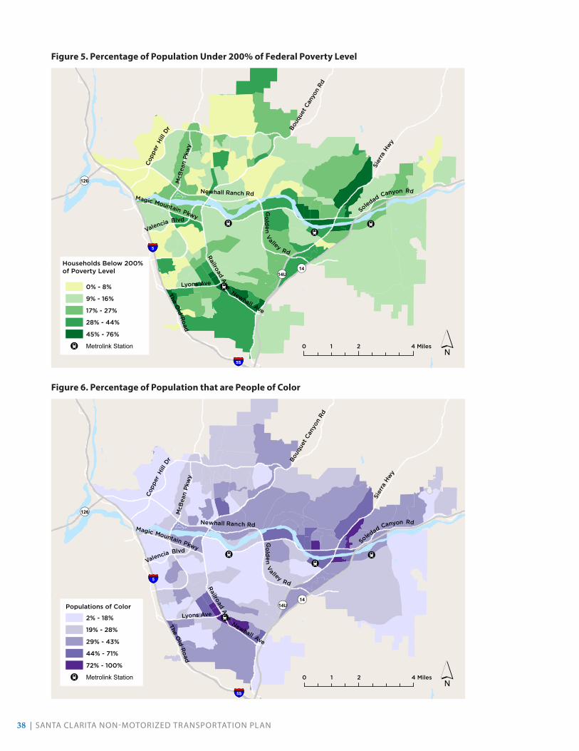
38 | SANTA CLARITA NON-MOTORIZED TRANSPORTATION PLAN
!!
!
!
Newhall Ave
TheO
ldR
oad
Lyons Ave
Railroad Ave
Bouq
uet C
anyo
n Rd
Soledad
Canyon Rd
Sier
raHw
y
McB
ean
Pkw
y
Cop
per
Hill
Dr
Newhall Ranch Rd
Valencia Blvd
Magic Mountain Pkwy
Go
lde
nV
a lley Rd
¬«126
¬«14U¬«14
§̈¦5
§̈¦5S
0 2 41 Miles
0% - 8%
9% - 16%
17% - 27%
28% - 44%
45% - 76%
! Metrolink Station ´
Households Below 200%of Poverty Level
!!
!
!
Newhall Ave
TheO
ldR
oad
Lyons Ave
Railroad Ave
Bouq
uet C
anyo
n Rd
Soledad Canyon Rd
Sier
raHw
y
McB
ean
Pkw
y
Cop
per
Hill
Dr
Newhall Ranch Rd
Valencia Blvd
Magic Mountain Pkwy
Go
lde
nV
a lley Rd
¬«126
¬«14U¬«14
§̈¦5
§̈¦5S
0 2 41 Miles
Populations of Color
2% - 18%
19% - 28%
29% - 43%
44% - 71%
72% - 100%
! Metrolink Station ´
Figure 5 . Percentage of Population Under 200% of Federal Poverty Level
Figure 6 . Percentage of Population that are People of Color

SANTA CLARITA NON-MOTORIZED TRANSPORTATION PLAN | 39
For some in our community, walking, biking, and riding transit are their only options for getting around.
People of Color
Racial or ethnic minorities are more likely to live in areas with poor or limited active transportation facilities, educational opportunities, job resources, and healthy food outlets.8 They tend to be more dependent on transit and active transportation; black individuals are more than four times and Hispanics three times as likely to not have access to a household car compared to their white counterparts, regardless of income.9 In turn, these deficits exacerbate the disproportionate health burdens communities of color experience. Lastly, communities of color experience a greater proportion of pedestrian crashes and have increased risk of mortality after pedestrian injury.10 Therefore, increasing active transportation facilities and connectivity may promote physical activity, enhance economic opportunities, and increase transportation safety.
In Santa Clarita, community members who identify as people of color, or non-white, range from 2% of a block group’s population to 99%; however, in total, 33% of city residents identify as a person of color. Higher concentrations of non-white populations are located within the Newhall and Canyon Country neighborhoods, and mirror the distribution of households below 200% of the FPL (see Figure 5 and Figure 6).
Age & Vulnerable PopulationsAge is an important indicator of mobility. The population under 18 years of age is thought to be more dependent upon active transportation options because they have less access to motor vehicles. Other youth-related vulnerabilities may include lacking knowledge of safe travel behaviors; greater susceptibility to environmental exposures, such as damage caused to developing bodies through emissions; and difficulty navigating poorly-designed areas.11 Youth especially need safe transportation to/from places to be physically active and to build social connections.12
8 Dannenberg et. al.9 Berube A, Deakin E, Raphael S. Socioeconomic Differences
in Household Automobile Ownership Rates: Implications for Evacuation Policy. Brookings Inst. 2006.
10 Maybury RS, Bolorunduro OB, Villegas C, et al. Pedestrians struck by motor vehicles further worsen race- and insurance-based disparities in trauma outcomes: The case for inner-city pedestrian injury prevention programs. Surgery. 2010;148(2):202-208. doi:10.1016/j.surg.2010.05.010.
11 Dannenberg et. al.12 Dannenberg et. al.
Similarly, demand for transportation alternatives to driving increases among adults over 65 years of age. Prioritizing active transportation needs enables older adults to maintain positive well-being, despite the onset of functional limitations.13 Walkable access to adequate public transportation is essential for older adults to maintain their daily activities and independence.14 Additionally, safe, walkable communities that promote physical activity help prevent or delay chronic diseases such as arthritis, osteoporosis, and diabetes in older adults.15 As 61% of American adults ages 65 years or older have at least one activity-based limitation, creating communities where older adults can safely be active and access necessary resources is crucial to the future prevention of such disability.16 Lastly, older adults are especially vulnerable to social isolation, which can result in significant declines in physical and mental health; increasing walkability enhances older adults’ ability to connect with others.17
13 Cvitkovich Y, Wister A. The Importance of Transportation and Prioritization of Environmental Needs to Sustain Well-Being among Older Adults. Environ Behav. 2001;33(6):809-829. doi:10.1177/00139160121973250.
14 Michael YL, Green MK, Farquhar SA. Neighborhood Design and Active Aging. Vol 12.; 2006. doi:10.1016/j.healthplace.2005.08.002.
15 Marquet, O., Hipp J., Miralles-Guasch, C. Neighborhood Walkability and Active Ageing: A difference in differences assessment of active transportation over ten years. Journal of Transport & Health. 2017;7(B):190-201.
16 National Center for Health Statistics. Health, United States, 2015. Cent Dis Control Prev. 2016.
17 Michael YL, Green MK, Farquhar SA. Neighborhood Design and Active Aging. Vol 12.; 2006. doi:10.1016/j.healthplace.2005.08.002.

40 | SANTA CLARITA NON-MOTORIZED TRANSPORTATION PLAN
In Santa Clarita, the median age is 36.9 years of age. Approximately 26% of city residents are under 19 years of age; eleven percent are 65 years and over. Together, one-third of Santa Clarita residents classify as vulnerable due to their age (see Figure 7). While the highest concentrations of people under 18 are found in the northern parts of the city, the block groups with the highest proportions of people over 65 are found to the south (see Figure 8 and Figure 9).
S0101 - AGE AND SEXSource: U.S. Census Bureau, 2013-2017 American Community Survey 5-Year Estimates
Estimate Margin of EEstimate Margin of EEstimate Margin of EEstimate Margin of EEstimate Margin of EEstimate Margin of ErrorTotal population 38,982,847 ***** (X) (X) 10,105,722 ***** (X) (X) 209,489 +/-78 (X) (X)AGE Calfornia Los Angeles County Santa ClaritaUnder 5 years <5 2,493,545 +/-578 6.40% +/-0.1 631,911 ***** 6.30% ***** 13,285 +/-816 6.30% +/-0.45 to 9 years 5-9 2,526,231 +/-7,484 6.50% +/-0.1 619,989 +/-3,656 6.10% +/-0.1 14,972 +/-839 7.10% +/-0.410 to 14 years 10-14 2,543,419 +/-7,599 6.50% +/-0.1 625,971 +/-3,657 6.20% +/-0.1 15,567 +/-699 7.40% +/-0.315 to 19 years 15-19 2,609,110 +/-1,164 6.70% +/-0.1 669,371 ***** 6.60% ***** 15,676 +/-788 7.50% +/-0.420 to 24 years 20-24 2,859,724 +/-1,268 7.30% +/-0.1 756,629 ***** 7.50% ***** 13,652 +/-811 6.50% +/-0.425 to 29 years 25-29 2,989,780 +/-938 7.70% +/-0.1 831,276 ***** 8.20% ***** 13,599 +/-759 6.50% +/-0.430 to 34 years 30-34 2,833,092 +/-1,005 7.30% +/-0.1 762,619 ***** 7.50% ***** 12,851 +/-722 6.10% +/-0.335 to 39 years 35-39 2,609,639 +/-8,822 6.70% +/-0.1 702,594 +/-4,274 7.00% +/-0.1 13,718 +/-847 6.50% +/-0.440 to 44 years 40-44 2,570,431 +/-8,658 6.60% +/-0.1 695,261 +/-4,276 6.90% +/-0.1 14,147 +/-656 6.80% +/-0.345 to 49 years 45-49 2,590,399 +/-847 6.60% +/-0.1 698,048 ***** 6.90% ***** 16,112 +/-853 7.70% +/-0.450 to 54 years 50-54 2,611,934 +/-908 6.70% +/-0.1 683,199 ***** 6.80% ***** 16,754 +/-824 8.00% +/-0.455 to 59 years 55-59 2,453,244 +/-6,790 6.30% +/-0.1 628,513 +/-3,654 6.20% +/-0.1 14,481 +/-696 6.90% +/-0.360 to 64 years 60-64 2,143,851 +/-6,766 5.50% +/-0.1 535,357 +/-3,654 5.30% +/-0.1 11,321 +/-738 5.40% +/-0.465 to 69 years 65-69 1,722,390 +/-5,666 4.40% +/-0.1 415,243 +/-2,563 4.10% +/-0.1 8,240 +/-493 3.90% +/-0.270 to 74 years 70-74 1,224,419 +/-5,733 3.10% +/-0.1 295,420 +/-2,563 2.90% +/-0.1 5,365 +/-483 2.60% +/-0.275 to 79 years 75-79 872,609 +/-4,542 2.20% +/-0.1 215,181 +/-2,409 2.10% +/-0.1 3,902 +/-443 1.90% +/-0.280 to 84 years 80-84 636,919 +/-4,395 1.60% +/-0.1 161,647 +/-2,485 1.60% +/-0.1 2,723 +/-324 1.30% +/-0.285 years and over 85≤ 692,111 +/-4,072 1.80% +/-0.1 177,493 +/-2,305 1.80% +/-0.1 3,124 +/-377 1.50% +/-0.2
SELECTED AGE CATEGORIES Calfornia Los Angeles County Santa Clarita5 to 14 years 5,069,650 +/-765 13.00% +/-0.1 1,245,960 ***** 12.30% ***** 30,539 +/-1,122 14.60% +/-0.515 to 17 years 1,551,525 +/-539 4.00% +/-0.1 395,709 ***** 3.90% ***** 9,972 +/-628 4.80% +/-0.3Under 18 years 9,114,720 +/-405 23.40% +/-0.1 2,273,580 ***** 22.50% ***** 53,796 +/-865 25.70% +/-0.418 to 24 years 3,917,309 +/-952 10.00% +/-0.1 1,030,291 ***** 10.20% ***** 19,356 +/-907 9.20% +/-0.4 36.80%15 to 44 years 16,471,776 +/-1,114 42.30% +/-0.1 4,417,750 ***** 43.70% ***** 83,643 +/-1,300 39.90% +/-0.616 years and over 30,910,058 +/-4,537 79.30% +/-0.1 8,102,402 +/-2,349 80.20% +/-0.1 162,488 +/-993 77.60% +/-0.518 years and over 29,868,127 +/-405 76.60% +/-0.1 7,832,142 ***** 77.50% ***** 155,693 +/-873 74.30% +/-0.421 years and over 28,224,727 +/-5,656 72.40% +/-0.1 7,405,562 +/-2,575 73.30% +/-0.1 147,396 +/-922 70.40% +/-0.460 years and over 7,292,299 +/-6,791 18.70% +/-0.1 1,800,341 +/-3,654 17.80% +/-0.1 34,675 +/-1,135 16.60% +/-0.562 years and over 6,375,911 +/-5,952 16.40% +/-0.1 1,569,415 +/-3,584 15.50% +/-0.1 29,811 +/-1,030 14.20% +/-0.565 years and over 5,148,448 +/-582 13.20% +/-0.1 1,264,984 ***** 12.50% ***** 23,354 +/-820 11.10% +/-0.4
SUMMARY INDICATORSMedian age (years) 36.1 +/-0.1 (X) (X) 36 +/-0.1 (X) (X) 36.9 +/-0.5 (X) (X)Sex ratio (males per 100 females) 98.7 +/-0.1 (X) (X) 97.1 ***** (X) (X) 98.4 +/-2.1 (X) (X)Age dependency ratio 57.7 +/-0.1 (X) (X) 53.9 ***** (X) (X) 58.3 +/-1.2 (X) (X)Old-age dependency ratio 20.8 +/-0.1 (X) (X) 19.3 ***** (X) (X) 17.6 +/-0.7 (X) (X)Child dependency ratio 36.9 +/-0.1 (X) (X) 34.6 ***** (X) (X) 40.7 +/-0.9 (X) (X
Santa ClaritaTotal PercentTotal Percent
Calfornia Los Angeles CountyTotal Percent
0.00%
1.00%
2.00%
3.00%
4.00%
5.00%
6.00%
7.00%
8.00%
9.00%
Perc
enta
ge o
f Pop
ulat
ion
Years of Age
Distribution of Ages2017 ACS 5-Year Estimates
Los Angeles County Santa Clarita
Figure 7 . Distribution of Ages in Santa Clarita and Los Angeles County
*2017 ACS 5-Year Estimate

SANTA CLARITA NON-MOTORIZED TRANSPORTATION PLAN | 41
!!
!
!
Newhall Ave
Lyons Ave
Railroad Ave
Bouq
uet C
anyo
n Rd
Soledad Canyon Rd
Sier
raHw
y
McB
ean
Pkw
y
Cop
per
Hill
Dr
Newhall Ranch RdMagic Mountain Pkwy
Go
lden
Va lley
Rd
The
Old
Ro
ad
¬«126
¬«14U
¬«14
§̈¦5S
§̈¦5
0 2 41 Miles
Population Under 18
0% - 10%
11% - 19%
20% - 25%
26% - 31%
32% - 42%
! Metrolink Station ´
!!
!
!
Newhall Ave
TheO
ldR
oad
Lyons Ave
Railroad Ave
Bouq
uet C
anyo
n Rd
Soledad
Canyon Rd
Sier
raHw
y
McB
ean
Pkw
y
Cop
per
Hill
Dr
Newhall Ranch Rd
Valencia Blvd
Magic Mountain Pkwy
Go
lde
nV
a lley Rd
¬«126
¬«14U¬«14
§̈¦5
§̈¦5S
0 2 41 Miles
Population Over 65
1% - 6%
7% - 10%
11% - 15%
16% - 25%
26% - 50%
! Metrolink Station ´
Figure 8 . Percentage of Population Under 18
Figure 9 . Percentage of Population Over 65

42 | SANTA CLARITA NON-MOTORIZED TRANSPORTATION PLAN
No Access to VehiclesIn less urbanized locations, specifically those with limited transit access and coverage, access to a motor vehicle carries strong implications for one’s ability to reach employment, access healthy foods, and reach basic services.18 A diverse transportation system that offers multiple modes, including transit, bicycling, and walking, reduces reliance on automobiles and can provide for more equitable access to services.
In general, areas with higher concentrations of households with no motor vehicle access are found in the Valencia neighborhood south of McBean Parkway. Block groups range from having no households to up to 38% of households without access to a motor vehicle. In total, 4% of households in Santa Clarita do not have access to a vehicle.
18 Blumenberg E., Pierce G., Smart M. Transportation Access, Residential Location, and Economic Opportunity: Evidence from Two Housing Voucher Experiments. Cityscape. v17
!!
!
!
Newhall Ave
TheO
ldR
oad
Lyons Ave
Railroad Ave
Bouq
uet C
anyo
n Rd
Soledad Canyon Rd
Sier
raHw
y
McB
ean
Pkw
y
Cop
per
Hill
Dr
Newhall Ranch Rd
Valencia Blvd
Magic Mountain Pkwy
Go
lde
nV
a lley Rd
§̈¦5
§̈¦5S
¬«126
¬«14U¬«14
0 2 41 Miles
Households with Zero
Motor Vehicles Available
0% - 1%
2% - 5%
6% - 12%
13% - 24%
25% - 38%
! Metrolink Station ´
Figure 10 . Percentage of Households Without Access to a Motor Vehicle

SANTA CLARITA NON-MOTORIZED TRANSPORTATION PLAN | 43
COMPOSITE EQUITY ANALYSIS
The composite equity analysis displays the sum of the results from each of the indicators explored above. Higher relative need is found in Newhall around the Jan Heidt Newhall Metrolink Station, and in Canyon Country along the Santa Clara River and Sierra Highway. Investing in active transportation facilities in these areas of highest need will likely improve access to health, social and economic advancement opportunities.
!!
!
!
Newhall Ave
TheO
ldR
oad
Lyons Ave
Railroad AveBo
uque
t Can
yon
Rd
Soledad
Canyon Rd
Sier
raHw
y
McB
ean
Pkw
y
Cop
per
Hill
Dr
Newhall Ranch Rd
Valencia Blvd
Magic Mountain Pkwy
Go
lden
Va lley
Rd
¬«126
¬«14U ¬«14
§̈¦5
§̈¦5S
0 2 41 Miles
Equity AnalysisHigh
Low
! Metrolink Station
concentration of demographicindicators analyzed
´
Figure 11 . Composite Equity Analysis

44 | SANTA CLARITA NON-MOTORIZED TRANSPORTATION PLAN
CALENVIROSCREEN 3.0
The State of California uses CalEnviroScreen 3.0 (updated June 2018) to identify communities by census tract (a larger geographic scale than used in the Equity Analysis) that are disproportionately burdened by, and vulnerable to, multiple sources of pollution. The CalEnviroScreen 3.0 uses a variety of indicators including levels of environmental contamination, health indicators, and economic burden to determine how disadvantaged a community is considered. The higher the percentile, the higher the pollution burden within a community. If the census tract is in the top 25th percentile of statewide tracts, it is considered a disadvantaged community (DAC), and is given additional consideration in statewide funding sources.
None of the City’s census tracts are considered a DAC using the CalEnviroScreen 3.0 tool. The census tracts in Newhall and on the western edge of Canyon Country are the most burdened of the City, scoring in the 65th and 73rd percentiles, respectively. Although the Equity Analysis identified both regions as having a high need, additional areas were highlighted as having equal if not greater need. This is due to the different indicators and spatial scales (i.e., block groups for the Equity Analysis and census tracts—a larger geographic area—for CalEnviroScreen 3.0) utilized in each analysis. Findings from both guide recommendations set forth in this NMTP. 19
19 The California Healthy Places Index (HPI) is another resource communities may use to understand existing health conditions. Developed by the Public Health Alliance of Southern California, the HPI aggregates data on a variety of categories (including employment, education levels, commuting, social engagement, air quality, housing, and healthcare) to predict life expectancy and compare community conditions across the state.
!!
!
!
TheOld
Road
Lyons Ave
Railroad Ave
Bouquet C
anyo
n Rd
Soledad Canyon Rd
Sier
raHw
yCopper Hill Dr
Newhall Ranch
Rd
Magic Mountain Pkwy Gold en
Valley Rd
¬«126
¬«14U ¬«14
§̈¦5
§̈¦5S
58%
20%
21%
59%
10%
37%
9%
40%
48%
30%
28%
65%
49%
25%
23%
73%
6%
27%
52%
51%
27%
41%
14%
14%
16%
55% 18%60%
52%
52%
52%
49%
47%
56%
48%39%
35%
3%
42%
11%67% 12%
14%
22%
13%24%
41%37%
25%
47%
47%
37%
1%
53%
59%
21%
18%
0 2 41 Miles
1% - 16%
17% - 30%
31% - 42%
43% - 56%
57% - 73%
! Metrolink Station ´
CalEnviroScreen 3.0 Percentile
Figure 12 . CalEnviroScreen 3 .0 Index

SANTA CLARITA NON-MOTORIZED TRANSPORTATION PLAN | 45
COMBINED EQUITY AND CALENVIROSCREEN 3.0
To see where the block groups identified as highest need in the Equity Analysis overlap with the census tracts with the highest pollution burden per CalEnviroScreen 3.0, two metrics were combined into one map (see Figure 13). Together, these metrics indicate higher vulnerabilities in Newhall near the Metrolink Station; in Saugus near Central Park; and along Soledad Canyon Road in the eastern part of the city.
!!
!
!
TheO
ldR
oad
Lyons Ave
Railroad AveBo
uque
t Can
yon
Rd
Soledad
Canyon Rd
Sier
raHw
y
McB
ean
Pkw
y
Cop
per
Hill
Dr
Newhall Ranch Rd
Valencia Blvd
Magic Mountain Pkwy
Go
lden
Va lley
Rd
¬«126
¬«14U ¬«14
§̈¦5
§̈¦5S
58%
59%
65%
73%52%
51%
55%60%
52%
52%
52%
56%
67%
53%
59%
0 2 41 Miles
CalEnviroScreen 3.0Percentile
42% - 56%
56% - 73%
Equity AnalysisHighest Concentration
High Concentration
! Metrolink Station
School
Park / Open Space ´
Figure 13 . Combined Composite Equity Score and CalEnviroScreen 3 .0 Percentile

46 | SANTA CLARITA NON-MOTORIZED TRANSPORTATION PLAN
Walking and Biking Today Since adopting the 2014 NMTP, the City has made impressive progress in expanding the community’s active transportation network (see Table 1). The existing active transportation network in Santa Clarita can be seen in Figure 14. Due to limited data, this map does not include sidewalks . However, critical gaps in sidewalk continuity were captured during community engagement efforts (see Chapter 4: Community Collaboration), and are reflected in the Pedestrian Level of Traffic Stress analysis at the end of this chapter.
EXISTING PEDESTRIAN NETWORK
There are many features that contribute to a convenient and comfortable walking environment. Significant investments and commitments to future improvements have been made that continue to enhance the pedestrian experience in Santa Clarita. The City’s existing pedestrian network is comprised of sidewalks, paseos, crosswalks, and multi-purpose trails.
SidewalksSidewalks are defined as walkways running parallel to a roadway while paseos are paved walking paths that provide pedestrian links outside of the street network. Most of Santa Clarita’s major roadways have sidewalks along portions of their length. Recently built sidewalks and sidewalks along some roadways, such as McBean
Parkway, are buffered from the vehicle traffic by a planter strip, while sidewalks along other roadways, such as Soledad Canyon Road, are directly adjacent to the vehicle traffic. In some cases, sidewalk facilities are adjacent to Class I bike paths and are either separated from the bike paths by striping (as on Newhall Ranch Road and McBean Parkway) or are separated by landscaping (as on sections of Soledad Canyon Road).
Some major roadways, such as Orchard Village Road, lack sidewalks altogether. Others, such as Wiley Canyon Road, have intermittent sidewalks. Nevertheless, many of Santa Clarita’s suburban neighborhoods boast excellent sidewalk connectivity. In some neighborhoods, sidewalks connect to a system of paseos and may even connect to the longer citywide trail network. However, older neighborhoods that were previously a part of the County have a more rural character and may lack sidewalks. Sidewalks are provided in most neighborhood commercial areas. Santa Clarita has increased connectivity by building pedestrian bridges over busy streets and providing sidewalk facilities on bridges. However, there are some gaps in the network, particularly in areas that were recently annexed from unincorporated Los Angeles County. Sidewalks may not be provided along some arterial streets (such as Orchard Village Road). In general, industrial areas and rural roads do not include sidewalks.
Much of Orchard Village Road, such as this stretch by 16th Street, lacks sidewalks.
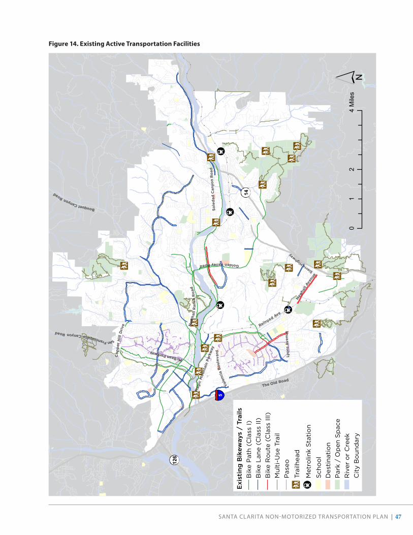
SANTA CLARITA NON-MOTORIZED TRANSPORTATION PLAN | 47
Sole
dad
Can
yon
Ro
ad
The Old Road
Lyon
s A
venu
e
SanFrancisquitoCanyonRoad
Railroad Ave
Mag
icM
ount
ain
Park
way
New
hall
Ran
chR
oad
New
hall
Aven
ue
GoldenValleyRoad
Vale
ncia
Bou
leva
rd
BouquetCanyonRoad
McBeanParkway
Co
pper
Hill
Dri
ve
SierraHighway
5
126
14E
xist
ing
Bik
eway
s /
Trai
lsB
ike
Pat
h (
Cla
ss I)
Bik
e L
ane
(Cla
ss II
)B
ike
Ro
ute
(C
lass
III)
Mu
lti-
Use
Tra
ilP
aseo
Trai
lhea
d
Met
rolin
k S
tati
on
Sch
oo
lD
esti
nati
on
Par
k /
Op
en S
pac
eR
iver
or
Cre
ekC
ity
Bo
und
ary
02
41
Mile
s
Figure 14 . Existing Active Transportation Facilities

48 | SANTA CLARITA NON-MOTORIZED TRANSPORTATION PLAN
PaseosAn extension of the City’s sidewalk network, paseos are paved paths that provide connections between cul-de-sacs, schools, neighborhood parks and pools, local commercial centers, and, in some areas, the citywide trail network. There are almost 30 miles of paseos throughout our city. Well-landscaped, paseos tend to be quiet, calm routes that enhance pedestrian and bicycle access in areas without vehicle traffic. Residential yards are separated from the paseos by walls. Most paseos have lighting and signage that identifies nearby streets. Access to nearby major streets is limited in some paseo networks. In some cases, a development that has a paseo system will not have sidewalks on adjacent major roads.
Both the northern and southern neighborhoods of Valencia have well-developed paseo networks linking residential neighborhoods to each other and to surrounding land uses.
Crosswalks & IntersectionsCrosswalks are considered an extension of the sidewalk across the roadway. Crosswalk markings provide guidance for pedestrians who are crossing roadways by defining and delineating paths across intersections or other crossing points. In Santa Clarita, major intersections are striped with standard “transverse” crosswalks (two parallel lines). Signalized intersections have pedestrian push buttons to actuate walk signals. Every signalized intersection in the City has countdown pedestrian signals to inform the pedestrian the time remaining to cross the street. Some locations also have mid-block crossings with pedestrian refuges, including on Creekside Road.
Mid-block crossings on Creekside Road include pedestrian refuges, bulb-outs, raised tables, and landscaping. (Google Streetview)

SANTA CLARITA NON-MOTORIZED TRANSPORTATION PLAN | 49
Multi-Use TrailsMulti-use trails as defined in this NMTP refer to unpaved trails that are suitable for walkers, hikers, equestrians, cross-country runners, and mountain bikers, but are not considered bicycle transportation facilities according to the Caltrans definition. Our community enjoys over 77 miles of nearby multi-use trails, 51 miles of which are located within the City boundaries. The trails are largely located in rural or semi-rural areas, and generally in the southern and western parts of the City. The multi-purpose trail network includes an equestrian path that parallels the South Fork Trail and one that parallels Sand Canyon Road. Other multi-use trails are located off Oak Springs Canyon Road, north of Placerita Canyon Road, south of Newhall Avenue (parallel to the Union Pacific Railroad tracks), and in open space areas.
Multi-purpose trails, such as this one in Central Park, offer recreational opportunities to people on foot, bikes, and horses.

50 | SANTA CLARITA NON-MOTORIZED TRANSPORTATION PLAN
EXISTING BICYCLE NETWORK
The California Department of Transportation (Caltrans) designates four classes of bicycle facilities: Class I shared-use paths, Class II bicycle lanes, Class III bicycle routes, and Class IV separated bikeways. The City’s current bicycle network has approximately 112 miles of bikeways (see Figure 15). Descriptions of each bikeway class are included in the following section, and bikeways are mapped in Figure 14 to show where they currently exist in Santa Clarita.
Class I Bike Paths Also called “shared-use paths,” Class I bike paths are paved trails completely separated from the street. They allow two-way travel by people bicycling and walking, and are often considered the most comfortable facilities for people of all ages and abilities as there are few potential conflicts between people bicycling and people driving.
The City of Santa Clarita has an extensive 43-mile network of paved, off-street bike paths. These paved bike paths should not be confused with the city’s unpaved “multi-use trails” (discussed in the Existing Pedestrian Network) which are not considered bicycle transportation facilities according to Caltrans. This section refers only to paved bike paths that meet the Caltrans definition of a Class I bike facility.
The first bike paths built in the city generally followed the Santa Clara River and its tributaries. Newer paths have been developed that connect residential neighborhoods to the river paths. The network provides connections to the Santa Clarita Metrolink Station, several schools, businesses along Soledad Canyon Road and McBean Parkway, and recreational opportunities along the river. The City typically provides grade-separated under crossings where a Class I path crosses a major highway.
In addition to the Santa Clara River Trail, major paths include the South Fork Trail, along a south tributary of the Santa Clara River; the Chuck Pontius Commuter Rail Trail, along Soledad Canyon Road; the San Francisquito Creek Trail; the path along Newhall Ranch Road; and the path along Golden Valley Road. Some paths, such as the South Fork Trail, are recreational in nature, and are part of a combined pedestrian-equestrian-bicycle trail corridor. Other paths, such as the Chuck Pontius Commuter Rail Trail, are more commuter-oriented and run parallel to major roadways.
Facility Type DistanceBike Lane (Class II) 74.83854Bike Route (Class III) 5.683942Multi-Use Trail 73.516106Bike Path (Class I) 41.882135Total 195.920723Test total 195.920723
*Note that for Class II and Class III, they measure each direction.
Bikeway Class Conventional NameEXISTING Length (Miles)
PROPOSED Length (Miles)
TOTAL Length (Miles)
Class I Shared-Use Paths 43 24 67Class II Bicycle Lanes 61 45 106Class III Bicycle Routes 8 42 50Class IV Separated Bikeways 0 3 3
112 114 226
Multi-Use Trails (all in la 76.5 29.2 105.6Multi-Use Trails (within 50.9 25.7 76.6Paseos 29.0 29.0TOTAL OVERALL 192.1 332.1
TOTAL
43
62
8
0.10
10
20
30
40
50
60
70
Shared-Use Paths Bicycle Lanes Bicycle Routes Separated Bikeways
Class I Class II Class III Class IV
Mile
sTotal Mileage of Existing Bikeways
43
61
8
24
45
42
30
20
40
60
80
100
120
Shared-Use Paths Bicycle Lanes Bicycle Routes Separated Bikeways
Class I Class II Class III Class IV
Mile
s
Total Mileage of Existing + Recommended Bikeways
Figure 15 . Total Mileage of Existing Bikeways
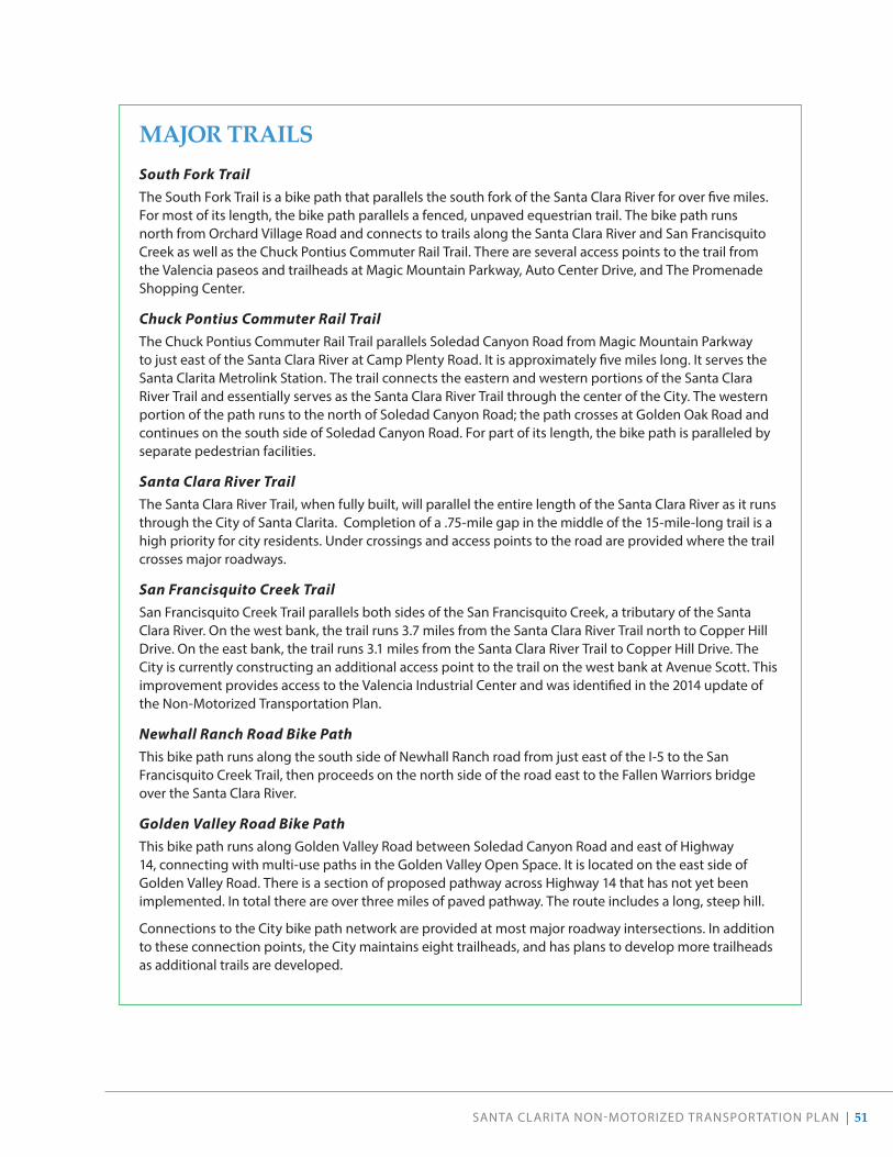
SANTA CLARITA NON-MOTORIZED TRANSPORTATION PLAN | 51
MAJOR TRAILSSouth Fork TrailThe South Fork Trail is a bike path that parallels the south fork of the Santa Clara River for over five miles. For most of its length, the bike path parallels a fenced, unpaved equestrian trail. The bike path runs north from Orchard Village Road and connects to trails along the Santa Clara River and San Francisquito Creek as well as the Chuck Pontius Commuter Rail Trail. There are several access points to the trail from the Valencia paseos and trailheads at Magic Mountain Parkway, Auto Center Drive, and The Promenade Shopping Center.
Chuck Pontius Commuter Rail Trail The Chuck Pontius Commuter Rail Trail parallels Soledad Canyon Road from Magic Mountain Parkway to just east of the Santa Clara River at Camp Plenty Road. It is approximately five miles long. It serves the Santa Clarita Metrolink Station. The trail connects the eastern and western portions of the Santa Clara River Trail and essentially serves as the Santa Clara River Trail through the center of the City. The western portion of the path runs to the north of Soledad Canyon Road; the path crosses at Golden Oak Road and continues on the south side of Soledad Canyon Road. For part of its length, the bike path is paralleled by separate pedestrian facilities.
Santa Clara River Trail The Santa Clara River Trail, when fully built, will parallel the entire length of the Santa Clara River as it runs through the City of Santa Clarita. Completion of a .75-mile gap in the middle of the 15-mile-long trail is a high priority for city residents. Under crossings and access points to the road are provided where the trail crosses major roadways.
San Francisquito Creek TrailSan Francisquito Creek Trail parallels both sides of the San Francisquito Creek, a tributary of the Santa Clara River. On the west bank, the trail runs 3.7 miles from the Santa Clara River Trail north to Copper Hill Drive. On the east bank, the trail runs 3.1 miles from the Santa Clara River Trail to Copper Hill Drive. The City is currently constructing an additional access point to the trail on the west bank at Avenue Scott. This improvement provides access to the Valencia Industrial Center and was identified in the 2014 update of the Non-Motorized Transportation Plan.
Newhall Ranch Road Bike Path This bike path runs along the south side of Newhall Ranch road from just east of the I-5 to the San Francisquito Creek Trail, then proceeds on the north side of the road east to the Fallen Warriors bridge over the Santa Clara River.
Golden Valley Road Bike Path This bike path runs along Golden Valley Road between Soledad Canyon Road and east of Highway 14, connecting with multi-use paths in the Golden Valley Open Space. It is located on the east side of Golden Valley Road. There is a section of proposed pathway across Highway 14 that has not yet been implemented. In total there are over three miles of paved pathway. The route includes a long, steep hill.
Connections to the City bike path network are provided at most major roadway intersections. In addition to these connection points, the City maintains eight trailheads, and has plans to develop more trailheads as additional trails are developed.

52 | SANTA CLARITA NON-MOTORIZED TRANSPORTATION PLAN
A Class IV Separated Bikeway connects the Santa Clarita Metrolink Station with Soledad Canyon Road.
Class II Bicycle Lanes Class II bicycle lanes are striped preferential lanes on the roadway for one-way bicycle travel. Some bicycle lanes include a striped buffer on one or both sides to increase separation from the traffic lane or from parked cars, where people may open doors into the bicycle lane.
There are currently 61 miles of Class II bicycle lanes in the city.
Class III Bicycle Routes Class III bicycle routes are signed routes where people bicycling share a travel lane with people driving. Because they are shared facilities, bicycle routes are generally appropriate on quiet, low-speed streets with relatively low traffic volumes. Some Class III bicycle routes include shared lane markings or “sharrows” that recommend proper bicycle positioning in the center of the travel lane and alert drivers that bicyclists may be present. Others include more robust traffic calming features to promote bicyclist comfort and are often known as “bicycle boulevards” or “neighborhood greenways.”
There are currently 8 miles of Class III bicycle routes in Santa Clarita.
Class IV Separated Bikeways Class IV separated bikeways are on-street bicycle facilities that are physically separated from motor vehicle traffic by a vertical element or barrier, such as a curb, bollards, or vehicle parking aisle. They can allow for one- or two-way travel on one or both sides of the roadway.
As of this plan, the only Class IV separated bikeway in Santa Clarita can be found along the northwestern edge of the Santa Clarita Metrolink Station adjacent to Commuter Way (less than 0.1 miles total). Not well marked or signed, it is not clear to users that this facility is intended for use by bicycles.
Class I bike paths, such as this section of the Commuter Rail Trail, sometimes offer separate travel lanes for bikes and pedestrians.

SANTA CLARITA NON-MOTORIZED TRANSPORTATION PLAN | 53
BIKEWAY TYPES
CLASS I BIKE PATH
• Paths completely separated from motor vehicle traffic used by people walking and biking.
• Comfortable for people of all ages and abilities.
• Typically located immediately adjacent and parallel to a roadway or in its own independent right-of-way, such as within a park or along a body of water.
CLASS IIBICYCLE LANE
• A dedicated lane for bicycle travel adjacent to traffic.
• A painted white line separates the bicycle lane from motor vehicle traffic.
• Can be enhanced by providing a painted buffer.
CLASS IVSEPARATED BIKEWAY
• An on-street bikeway separated from motor vehicle traffic by a curb, median, planters, parking delineators, or other physical barrier.
CLASS IIIBICYCLE ROUTE
• A signed bike routes that people biking share with motor vehicles.
• Can be enhanced with pavement markings, wayfinding, and traffic calming features.
• Comfortable facility for more confident bicyclists.
• Recommended when space for a bike lane may not be feasible.

54 | SANTA CLARITA NON-MOTORIZED TRANSPORTATION PLAN
Table 2 . Existing Bicycle Parking
LOCATION TYPE OF PARKING NOTES
Santa Clarita Metrolink Station 34 locker spaces 26 for long-term rental
Via Princessa Metrolink Station 10 locker spaces 3 for long-term rental
Jan Heidt (Newhall) Metrolink Station 22 locker spaces 6 for long-term rental
City Hall 6 locker spaces
Bike racks 5 for long-term rental
McBean Regional Transit Center 10 locker spaces
Total 82 locker spaces 46 for long-term rental
Newhall Community Center Bike racks
Santa Clarita Sports Complex Bike racks
City Parks Bike racks at all parks except Chesebrough Park
Six Flags Magic Mountain Bike racks Provides changing facilities
Valencia Town Center Bike racks
College of the Canyons Bike racks
California Institute of the Arts Bike racks
The Master’s College Bike racks Provides changing facilities
Transit Maintenance Facility Bike racks
Kaiser Permanente Facility Bike room Available for employee use
Source: City of Santa Clarita, 2014 NMTP and 2019 phone survey of Kaiser Permanente
EXISTING SUPPORT FACILITIES
WayfindingIn 2015, Santa Clarita adopted a citywide Active Transportation Wayfinding Plan, which established guidelines for sign design, placement, and content. Since adoption, the City has worked to implement this plan by installing signage at all trailheads and along 20 miles of the most-heavily traveled sections of the trail network to help users identify trailheads, destinations, and local streets.
Bike ParkingSanta Clarita provides bicycle racks and lockers at major transit stops, parks, and at City Hall. Several major employers also provide bicycle parking for employees. Bicycle parking is required for office, commercial, industrial, and multi-family residential uses through the Unified Development Code. A list of major bicycle parking locations is provided in Table 2. In general, bicycle parking is insufficient to meet demand in downtown Newhall.
City staff orients visitors to the network map on the South Fork River Trail.
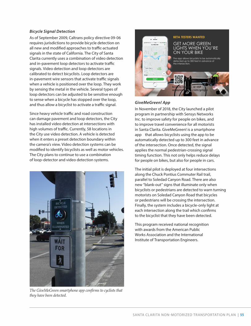
SANTA CLARITA NON-MOTORIZED TRANSPORTATION PLAN | 55
Bicycle Signal Detection As of September 2009, Caltrans policy directive 09-06 requires jurisdictions to provide bicycle detection on all new and modified approaches to traffic-actuated signals in the state of California. The City of Santa Clarita currently uses a combination of video detection and in-pavement loop detectors to activate traffic signals. Video detection and loop detectors are calibrated to detect bicyclists. Loop detectors are in-pavement wire sensors that activate traffic signals when a vehicle is positioned over the loop. They work by sensing the metal in the vehicle. Several types of loop detectors can be adjusted to be sensitive enough to sense when a bicycle has stopped over the loop, and thus allow a bicyclist to activate a traffic signal.
Since heavy vehicle traffic and road construction can damage pavement and loop detectors, the City has installed video detection at intersections with high volumes of traffic. Currently, 58 locations in the City use video detection. A vehicle is detected when it enters a preset detection boundary within the camera’s view. Video detection systems can be modified to identify bicyclists as well as motor vehicles. The City plans to continue to use a combination of loop-detector and video detection systems.
GiveMeGreen! AppIn November of 2018, the City launched a pilot program in partnership with Sensys Networks Inc. to improve safety for people on bikes, and to improve travel convenience for all motorists in Santa Clarita. GiveMeGreen! is a smartphone app that allows bicyclists using the app to be automatically detected up to 300 feet in advance of the intersection. Once detected, the signal applies the normal pedestrian-crossing signal timing function. This not only helps reduce delays for people on bikes, but also for people in cars.
The initial pilot is deployed at four intersections along the Chuck Pontius Commuter Rail trail, parallel to Soledad Canyon Road. There are also new “blank-out” signs that illuminate only when bicyclists or pedestrians are detected to warn turning motorists on Soledad Canyon Road that bicycles or pedestrians will be crossing the intersection. Finally, the system includes a bicycle-only light at each intersection along the trail which confirms to the bicyclist that they have been detected.
This program received national recognition with awards from the American Public Works Association and the International Institute of Transportation Engineers.
The GiveMeGreen smartphone app confirms to cyclists that they have been detected.
BETA TESTERS WANTED
GET MORE GREEN LIGHTS WHEN YOU’RE ON YOUR BIKEThe app allows bicyclists to be automatically detected up to 300 feet in advance of the intersection.
Scan to register, or visitsensysnetworks.com/gmgsc
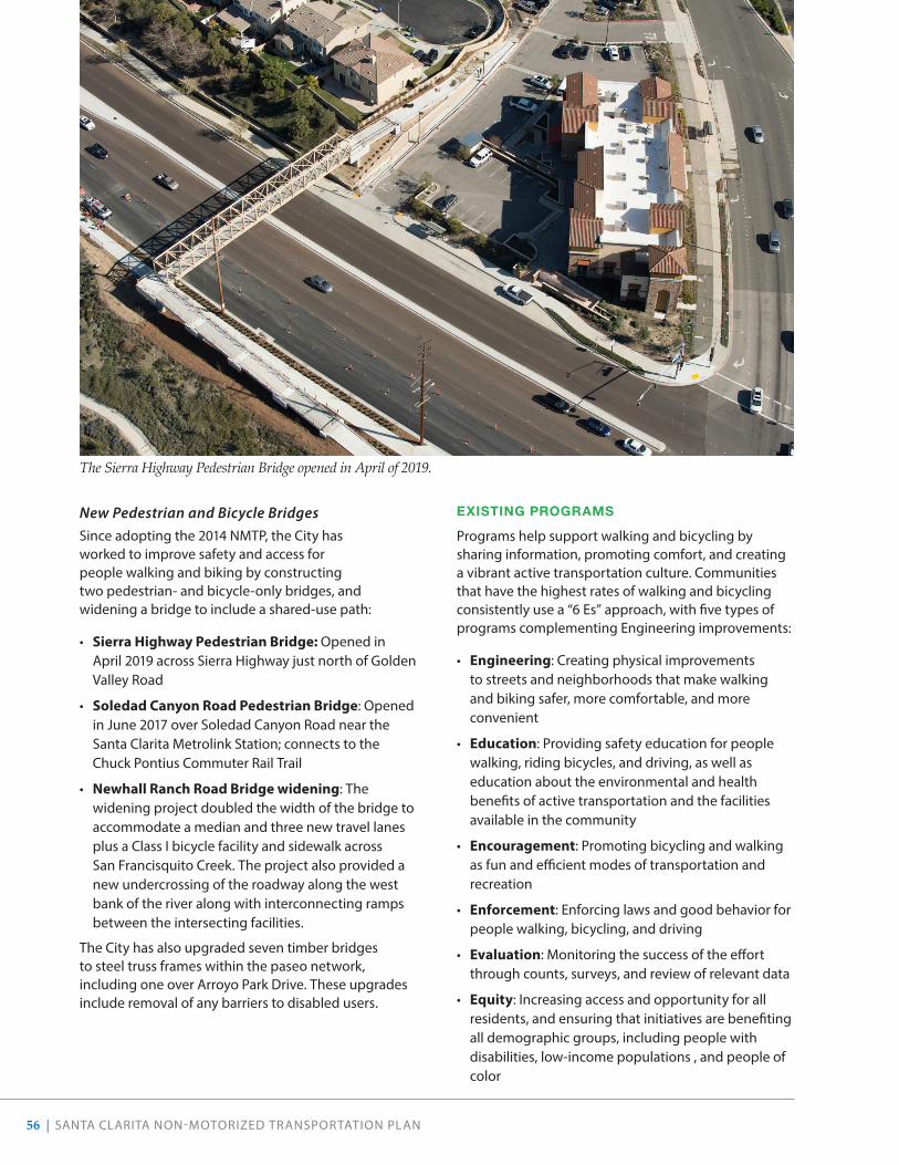
56 | SANTA CLARITA NON-MOTORIZED TRANSPORTATION PLAN
New Pedestrian and Bicycle BridgesSince adopting the 2014 NMTP, the City has worked to improve safety and access for people walking and biking by constructing two pedestrian- and bicycle-only bridges, and widening a bridge to include a shared-use path:
• Sierra Highway Pedestrian Bridge: Opened in April 2019 across Sierra Highway just north of Golden Valley Road
• Soledad Canyon Road Pedestrian Bridge: Opened in June 2017 over Soledad Canyon Road near the Santa Clarita Metrolink Station; connects to the Chuck Pontius Commuter Rail Trail
• Newhall Ranch Road Bridge widening: The widening project doubled the width of the bridge to accommodate a median and three new travel lanes plus a Class I bicycle facility and sidewalk across San Francisquito Creek. The project also provided a new undercrossing of the roadway along the west bank of the river along with interconnecting ramps between the intersecting facilities.
The City has also upgraded seven timber bridges to steel truss frames within the paseo network, including one over Arroyo Park Drive. These upgrades include removal of any barriers to disabled users.
EXISTING PROGRAMS
Programs help support walking and bicycling by sharing information, promoting comfort, and creating a vibrant active transportation culture. Communities that have the highest rates of walking and bicycling consistently use a “6 Es” approach, with five types of programs complementing Engineering improvements:
• Engineering: Creating physical improvements to streets and neighborhoods that make walking and biking safer, more comfortable, and more convenient
• Education: Providing safety education for people walking, riding bicycles, and driving, as well as education about the environmental and health benefits of active transportation and the facilities available in the community
• Encouragement: Promoting bicycling and walking as fun and efficient modes of transportation and recreation
• Enforcement: Enforcing laws and good behavior for people walking, bicycling, and driving
• Evaluation: Monitoring the success of the effort through counts, surveys, and review of relevant data
• Equity: Increasing access and opportunity for all residents, and ensuring that initiatives are benefiting all demographic groups, including people with disabilities, low-income populations , and people of color
The Sierra Highway Pedestrian Bridge opened in April of 2019.

SANTA CLARITA NON-MOTORIZED TRANSPORTATION PLAN | 57
The City and its partners have been carrying out the following programs in recent years to support bicycling and walking.
Encouragement EventsThe City of Santa Clarita and partners host a variety of events centered on walking and biking.
BIKE TO WORK DAY
In 2004, the City began its tradition of celebrating national Bike Month with a Bike to Work Day in May. The City sponsors various pit stops for riders that include refreshments, information, and giveaways; Santa Clarita Transit and Metrolink offer free rides for anyone on local routes that have their bike and/or helmet.
HIT THE TRAILS!
A non-competitive, guided, family-friendly bike ride, the Hit the Trails event offers attendees a variety of route lengths to accommodate all participants. Typically hosted in May, this community ride has been a Santa Clarita staple since 2008.
AMGEN TOUR OF CALIFORNIA
One of the nation’s largest and most recognized annual sporting events, the Amgen Tour of California challenges the world’s elite cyclists with more than 750 miles and seven days of racing. In May 2019, Santa Clarita hosted the race for a record tenth time. As with previous years, the City hosted additional special events, including school assemblies, fundraising events, kids’ rides, kids’ parades, galas, essay contests, a community cycling fair, keynote cycling speaking engagements, and bicycle safety classes.
SANTA CLARITA MARATHON
An official qualifying race for the Boston Marathon, the Santa Clarita Marathon takes place every November and includes a variety of races. A total of 2,625 participants registered for the 2019 event. The city first hosted the race in 1995.
Above: Not even rain could keep these riders from participating in the 2019 Bike to Work Day challenge.
Below: Families take to the trails during the 2019 Hit the Trails Community Ride.

58 | SANTA CLARITA NON-MOTORIZED TRANSPORTATION PLAN
ResourcesIn addition to resources available on the City’s website, the City also maintains two websites specifically dedicated to biking and hiking in Santa Clarita. Both sites share information about routes and maps; frequently asked questions; upcoming events; and safety and etiquette.
• BikeSantaClarita.com
• HikeSantaClarita.com
Pace Bike ShareThe City welcomed its first bike share program in December 2018. Launched with 50 bikes among 12 stations, the Pace program gained 772 members whose activity amounted to a total of 711 trips in the first month and a half of operation. The pilot program remained active until May 2020 and recorded almost 5,000 trips by 3,350 total users.
Heads Up! Traffic Safety Campaign Following a spike in pedestrian collisions, the City of Santa Clarita and Los Angeles County Sheriff’s Department launched the “Heads Up” campaign in 2017 to combat unsafe behaviors in drivers and pedestrians. The campaign aims to reach drivers and pedestrians in the Santa Clarita Valley and help them understand that everyone contributes to safer roadways.
Pedestrian Safety Campaign
2017-18 Traffic Safety PlanPART OF THE DRIVE FOCUS LIVE TRAFFIC SAFETY PLAN

SANTA CLARITA NON-MOTORIZED TRANSPORTATION PLAN | 59
Traffic EnforcementThe Santa Clarita Valley Sheriff’s station, in response to a recent surge in pedestrian and bicyclist collisions and pedestrian fatalities, increased traffic enforcement of all road users. Traffic enforcement operations are conducted four to five times per year, and typical driver citations include unsafe speed, illegal cell phone use, and failure to yield to pedestrians. Typical pedestrian and bicycle citations include right-of-way violations such as jaywalking or riding against traffic. The City and Sheriff’s Department have a Traffic Safety Committee that reviews safety problems comprehensively and applies a data-driven approach to engineering, education, and enforcement programs.
Bicycle Task ForceThe Bicycle & Pedestrian Advisory Committee (BPAC) was recently formed to increase bicycle ridership, support and promote public awareness of City events and City projects that impact the cycling community, and to enhance bicycle safety. The BPAC works to accomplish these objectives by developing bicycle programs, conducting bicycle safety outreach and by working with City Departments to design and construct new facilities, and upgrade existing bicycle facilities. The BPAC helps promote the recognition of Santa Clarita as a bicycle-friendly community.
Emergency Locating SystemIn April of 2019, the City launched an award-winning Emergency Locating System to more easily pinpoint people in need of emergency assistance while using the City’s trail network. As part of the system, a total of 658 markers have been posted every 1/8 mile on all City trails, including bike paths and hiking trails. In October of 2019, the California Emergency Services Association Southern Chapter honored the City with a certificate for the development and implementation of the locator system.20
20 https://signalscv.com/2019/11/citys-emergency-trails-locator-system-receives-state-award/
Safe Routes to School ProgramThe City of Santa Clarita began its Safe Routes to School (SRTS) efforts during the development of the first Non-Motorized Transportation Plan between 2006 and 2008. Since then, the City has successfully funded Safe Routes efforts through state and federal grant sources, and concluded a pilot education and encouragement program in 2011 . The City of Santa Clarita received numerous SRTS grants that expanded the program to cover all 27 of the City’s public elementary schools. The expansion allowed the City to conduct walk audits at the remaining elementary schools, and to provide education and encouragement programming at four pilot schools. In 2012, the City conducted three additional walk audits at elementary schools in unincorporated Los Angeles County that would become City jurisdiction as the result of annexation later in the year. The City also received funding from Caltrans’s Active Transportation Program to develop SRTS plans for all junior and high schools in our community.
Blue signs such as this one in Central Park help first responders locate people on city trails.

60 | SANTA CLARITA NON-MOTORIZED TRANSPORTATION PLAN
Local Bicycle CommunitySanta Clarita has an active local bicycle community that sponsors rides, races, and other bicycle-related events, such as the Chuck Pontius Criterium and the Santa Clarita Century. Several of the five major bicycle shops in the City offer organized group rides ranging from introductory to intermediate and advanced. Santa Clarita Velo and the local branch of the Los Angeles County Bicycle Coalition—Santa Clarita Valley Bicycle Coalition—are the primary organizations that support bicycle advocacy and events throughout the year.
PEDESTRIAN AND BICYCLE TRIPS
Mode ShareOf the 100,616 Santa Clarita residents 16 or older officially in the workforce, the 2017 ACS 5-Year Estimates suggest that 1.2% (1,207 residents) walk and 0.5% (466 residents) bike to work (see Figure 16). However, bicycle ridership could be higher than this, as the ACS does not factor non-work trips (e.g., recreational trips or errands) or trips where commuters use more than one mode when traveling to work, such as taking a bus partway then riding a bicycle to the final destination.
CountsTo get a more indicative picture of active transportation activity in Santa Clarita, the City conducts ongoing counts of people on bicycles throughout the trail network. Figure 17 displays the locations of trail counts conducted between 2016 and 2019. Count data from 2016 to 2019 is shown in Figure 18. Average ridership tends to be higher on weekends than during weekdays. This suggests a high prevalence of recreational trips, which supports the idea that many more people in Santa Clarita bike than what is captured in the ACS commute data.
As part of various traffic studies, the City also obtained bicycle and pedestrian counts at the intersection of Seco Canyon Road and Garzota Drive in Saugus; and pedestrian counts at the intersection of Walnut Street and Lyons Avenue in downtown Newhall.
B08006 - SEX OF WORKERS BY MEANS OF TRANSPORTATION TO WORK Universe: Workers 16 years and over
Estimate MOE %Total: 100,616 +/-1,372Car, truck, or van: 88,439 +/-1,499 87.9%Drove alone 77,049 +/-1,606 76.6%Carpooled: 11,390 +/-825 11.3%In 2-person carpool 8,159 +/-726 8.1%In 3-person carpool 1,728 +/-306 1.7%In 4-or-more-person carpool 1,503 +/-284 1.5%Public transportation (excluding taxicab): 3,056 +/-395 3.0%Bus or trolley bus 1,973 +/-296 2.0%Streetcar or trolley car (carro publico in Puerto Rico) 0 +/-29 0.0%Subway or elevated 144 +/-128 0.1%Railroad 926 +/-200 0.9%Ferryboat 13 +/-18 0.0%Bicycle 466 +/-155 0.5%Walked 1,207 +/-245 1.2%Taxicab, motorcycle, or other means 815 +/-150 0.8%Worked at home 6,633 +/-592 6.6%
Drove Alone 76.6%Biked 0.5%Carpooled 11.3%Public Transit 3.0%Walked 1.2%Worked at Home 6.6%Taxi, Motorcycle, or Other Means 0.8%
Drove Alone, 76.6%
Biked, 0.5% Carpooled, 11.3%
Public Transit, 3.0%Walked, 1.2%
Worked at Home, …
Taxi, Motorcycle, or Other Means,
0.8%
MEANS OF TRANSPORTATION TO WORK2017 ACS 5-YEAR ESTIMATES
Drove Alone, 76.6%
Biked, 0.5%
Carpooled, 11.3%
Public Transit, 3.0%
Walked, 1.2%
Worked at Home, 6.6%
Taxi, Motorcycle, or Other Means, 0.8%
MEANS OF TRANSPORTATION TO WORK2017 ACS 5-YEAR ESTIMATES
Drove Alone, 76.6%
Biked, 0.5%
Carpooled, 11.3%
Public Transit, 3.0%
Walked, 1.2%
Worked at Home, 6.6%
Taxi, Motorcycle, or Other Means, 0.8%
MEANS OF TRANSPORTATION TO WORK2017 ACS 5-YEAR ESTIMATES
Figure 16 . Means of Transportation to Work in Santa Clarita
*2017 ACS 5-Year Estimate
ADAPTING TO NEW NEEDSActive Transportation in a PandemicBiking and walking increased in some parts of the city during the COVID-19 pandemic, with trails seeing a more than 200% increase in average daily use after initial shelter-in-place policies. To ensure safe use of Santa Clarita trails, paseos, and other facilities for walking and biking, the City utilized media and other platforms to educate residents about social distancing practices for safe trail use. Education efforts also reminded users of proper trail etiquette.

SANTA CLARITA NON-MOTORIZED TRANSPORTATION PLAN | 61
Figure 17 . Locations of Trail Use Counts 2016 - 2019
Figure 18 . Trail Use Count Locations 2016 - 2019 (Bicycles Only)
ID Count Location Date(s) Average Daily Average Weekday Average Weekend Day1 Iron Horse Trailhead 1/21 -28/2016 2682 Valencia Boulevard 9/28/17 (Ongoing) 256 216 3553 South Fork Trailhead 9/14-18/2016 312 188 4604 Commuter Trail at Villa Metro 5/24-30/2017 185 120 2555 Camp Plenty Trailhead 9/13-17/2017 332 241 3936 South Fork Trail Access 7/17-18/2018 192 1927 South Fork Trail @ Via Princessa Bridge 5/31-6/3/2019 104 92 1158 Commuter Trail W/O Bouquet Cyn. 6/4-6/6/2019 131
0
50
100
150
200
250
300
350
400
450
500
Iron HorseTrailhead
ValenciaBoulevard
South ForkTrailhead
Commuter Trailat Villa Metro
Camp PlentyTrailhead
South Fork TrailAccess
South Fork Trail@ Via Princessa
Bridge
Commuter TrailW/O Bouquet
Cyn.
1 2 3 4 5 6 7 8
Trail Use Counts 2016 - 2019 Bicycles Only
Average Daily Average Weekday Average Weekend Day

62 | SANTA CLARITA NON-MOTORIZED TRANSPORTATION PLAN
Figure 19 . Bicycle and Pedestrian Counts at Seco Canyon Road and Garzota Drive
Figure 20 . Pedestrian Counts at Walnut Street and Lyons Avenue
GARZOTA01 SC T HU - T MCThu Jan 24, 2019Full Leng th (6 AM-10 PM)All Classes (Lig hts and Motorcycles, Heavy, Pedestrians, Bicycles on Road, Bicycles on Crosswalk)All MovementsID: 615447, Location: 34.437518, -118.532761
Location Bicycles on Road Bicycles in Crosswalk PedestriansSeco Canyon Rd: Southbound 6 3 24Garzota Dr: Westbound 0 10 52Seco Canyon Rd: Northbound 2 6 48Garzota Dr: Eastbound 0 6 15
WALNUTLyons Avenue and Walnut Street T MC - T MCTue Dec 4, 2018AM Peak (Dec 04 2018 7 AM - 9 AM)PedsAll MovementsID: 577153, Location: 34.380895, -118.530909
Location PedestriansWalnut St: Southbound 8Lyons Ave: Westbound 12Walnut St: Northbound 8Lyons Ave: Eastbound 13
0
10
20
30
40
50
60
Seco Canyon Rd:Southbound
Garzota Dr:Westbound
Seco Canyon Rd:Northbound
Garzota Dr:Eastbound
Bicycle and Pedestrian Counts: Seco Canyon Road and Garzota Drive
Thursday, January 24, 2019: 6 AM - 10 PM
Bicycles on Road Bicycles in Crosswalk Pedestrians
0
2
4
6
8
10
12
14
Walnut St:Southbound
Lyons Ave:Westbound
Walnut St:Northbound
Lyons Ave:Eastbound
Pedestrian Counts:Walnut Street and Lyons Avenue
Tuesday, December 4, 2018: 7 - 9 AM

SANTA CLARITA NON-MOTORIZED TRANSPORTATION PLAN | 63
Barriers to Active TransportationCOLLISIONS
Systemic Safety Analysis ReportIn 2018, Santa Clarita commissioned a city-wide Systemic Safety Analysis Report (SSAR) to perform a collision analysis, identify safety issues on the roadway network, and develop a list of low-cost countermeasures that can be used to prepare future Highway Safety Improvement Program (HSIP) and other safety program applications. Completed in 2019, the SSAR evaluates collision data from January 2013 to December 2017 and focuses specifically on reducing collisions and improving safety for pedestrians and bicyclists.
Although bicycle and pedestrian collisions occur throughout the city, the SSAR found that intersections along the Valencia Boulevard / Soledad Canyon Road corridor have the highest number of crashes. Additional high crash corridors include Sierra Highway, Bouquet Canyon Road, and various segments and intersections in the Newhall area. Over the five-year study period, there were 273 pedestrian-involved collisions in the City of Santa Clarita, 16 of which were fatal; additionally, there were 176 bicycle-involved collisions, of which one was fatal.
Pedestrian-Involved CollisionsThe majority of the pedestrian-involved collisions that occurred within the city during the study period resulted in some form of injury. Many of these collisions occurred during daylight hours on clear days with pedestrians either crossing in a crosswalk or identified as “not in road.” As a result,
the SSAR identified countermeasures that would impact normal day-to-day activities, including:
• Pedestrian countdown signal heads
• Raised medians/refuge islands (pedestrian/bike only)
• Enhanced pedestrian crossing features (e.g., signs/markings, curb extensions, pedestrian hybrid beacons with advanced yields)
Bicycle-Involved CollisionsSimilar to pedestrian-involved collisions, the majority of bicycle-involved collisions occurred during clear daylight conditions. Approximately 85% of bicycle collisions were “broadside”; when at fault, most bicyclists were found to be riding on the wrong side of the road (62) or using an unsafe movement (45). The SSAR identified countermeasures that impact normal operating conditions, including:
• Protected intersections
• Roadway reconfiguration (striping only)
• Bike lanes (both new and increased width of existing lanes), bicycle boulevards, separated bikeways)
• Colored bicycle lanes at signalized intersections
Additional Collision DataMore collisions involving people walking and biking have occurred in our city since the years studied in the SSAR. An additional 50 collisions involved bicyclists or pedestrians between January and December of 2018, and 61 in 2019 (see Table 3). Five of the 2019 collisions resulted in fatalities (two bicyclists, three pedestrians).
Table 3 . Bicycle/Pedestrian-Involved Collisions in 2018 and 2019
Year PopulationTotal
Collisions
Pedestrian-Involved Collisions Bicycle-Involved Collisions
Count% of Total
Rate per 100,000 Count
% of Total
Rate per 100,000
Jan-Dec 2018 216,589 1,414 26 1.8% 12 24 1.7% 11
Jan-Dec 2019 218,103 1,339 42 3.1% 19 20 1.5% 9

64 | SANTA CLARITA NON-MOTORIZED TRANSPORTATION PLAN
USER EXPERIENCE & PERCEIVED COMFORT
The experience of being a pedestrian or riding a bike can differ greatly throughout any city. Roads with higher speeds, less separation between traffic and people, lack of adequate facilities, and other factors can create unpleasant experiences.
PedestriansPEDESTRIAN LEVEL OF TRAFFIC STRESS
A Pedestrian Level of Traffic Stress (PLTS) model helps identify where pedestrian improvements could improve comfort, and where they may have the greatest impact given the existing conditions and the anticipated demand. The model scores street segments and intersections based on characteristics that impact pedestrian safety, comfort, and ease of movement. The PLTS analysis considers:
• Substantial gaps in the sidewalk network, as identi-fied by the City
• Posted speed limit
• Roadway width (number of travel lanes)
The PLTS is scored on a scale of 1 to 4 with PLTS 1 providing the most comfortable travel
conditions and PLTS 4 providing the least comfortable or desirable travel conditions.
FINDINGS
Shown in Figure 21, the PLTS highlights roadways where pedestrians are likely to encounter relatively comfortable travel conditions, as well as roadways with known sidewalk gaps that create significant barriers to travel along higher speed and volume roadways. Roadways containing sidewalk gaps include Copper Hill Road, Wiley Canyon Road, Orchard Village Road, and Dockweiler Drive. Due to the prevalence of trails and neighborhood streets, most of Santa Clarita’s roadways score as a PLTS 1 or 2 (see Figure 22).
Soledad Canyon Road
TheO
ldR
oad
Lyons Avenue
San
Fran
cisq
uito
Can
yon
Roa
d
RailroadAve
Magic Mountain Parkway
Newhall Ranch Road
Newhall Avenue
Go
lden
Val
ley
Ro
ad
Valencia Boulevard
Bo
uque
t Can
yon
Road
McB
ean
Par
kway
Copper Hill Drive
Sier
raHig
hway
5
5S
126
14
Pedestrian Level of Traffic StressPLTS 1 (Most Comfortable)PLTS 2PLTS 3PLTS 4 (Least Comfortable)SchoolDestinationPark / Open SpaceRiver or CreekCity BoundaryMetrolink Station
0 2 41 Miles
Figure 21 . Pedestrian Level of Traffic Stress
Figure 22 . Pedestrian Level of Traffic Stress (As Percentage of All Roads)
Pedestrian Level of Traffic Stress
Score Length % Shape_Length PercentageLevel 1 4149705.73 82%Level 2 202367.4858 4%Level 3 667340.5526 13%Level 4 60803.3986 1%Test Total 5080217.167 100%Total 5080217.167Total excluding 0/12.5 5313017.285
Score PercentageLevel 1 82%Level 2 4%Level 3 13%Level 4 1%
Score Pedestrian BicycleLevel 1 78% 78%Level 2 4% 7%Level 3 13% 10%Level 4 5% 5%
Level 182%
Level 24%
Level 313%
Level 41%
PEDESTRIAN LEVEL OF TRAFFIC STRESS
0%10%20%30%40%50%60%70%80%90%
Level 1 Level 2 Level 3 Level 4
Chart Title
Pedestrian Bicycle
Level 182%
Level 24%
Level 313%
Level 41%
PEDESTRIAN LEVEL OF TRAFFIC STRESS
Level 182%
Level 24%
Level 313%
Level 41%
PEDESTRIAN LEVEL OF TRAFFIC STRESS

SANTA CLARITA NON-MOTORIZED TRANSPORTATION PLAN | 65
BicyclistsTYPES OF BICYCLISTS
Research indicates that the majority of people in the United States (56-73%) would bicycle if dedicated bicycle facilities were provided. However, only a small percentage of Americans (1-3%) are willing to ride if no facilities are provided.21 This research into how people perceive bicycling as a transportation choice has indicated that most people fall into one of four categories.
21 Roger Geller, City of Portland Bureau of Transportation. Four Types of Cyclists. https://www.portlandoregon.gov/transportation/44597?a=237507; Dill, J., McNeil, N. Four Types of Cyclists? Testing a Typology to Better Understand Bicycling Behavior and Potential. 2012.
BICYCLE LEVEL OF TRAFFIC STRESS
For people riding bicycles, the Bicycle Level of Traffic Stress (BLTS) is the perceived sense of discomfort associated with riding in or adjacent to vehicle traffic when there is significant variation in the travel speed differential. Studies have shown that traffic stress is one of the greatest deterrents to bicycling. The less stressful—and therefore more comfortable—a bicycle facility is, the wider its appeal to a broader segment of the population. A bicycle network will attract a large portion of the population if it is designed to reduce stress associated with potential motor vehicle conflicts and if it connects people bicycling with where they want to go.
50-60%INTERESTED,BUT CONCERNED
1-3%STRONG AND
FEARLESS
5-10%EXCITED AND
CONFIDENT
30%CURRENTLY NOT
INTERESTED
CURRENTLY NOTINTERESTED
This group comprises residents who currently are not interested at all in bicycling, may be physically unable or don’t know how to ride a bicycle, and they are currently unlikely to adopt bicycling in any way.
EXCITED ANDCONFIDENT
This group consists of people riding bicycles who are confident riding in most roadway situations but prefer to have a designated facility. Comfortable riding on major streets with a bike lane.
INTERESTED,BUT CONCERNED
This group is more cautious and has some inclination towards bicycling, but is held back by concern over sharing the road with cars. Not very comfortable on major streets, even with a striped bike lane, and prefer separated pathways or low traffic neighborhood streets.
STRONG ANDFEARLESS
This group is willing toride a bicycle on any roadway regardlessof traffic conditions.Comfortable taking the lane and riding in a vehicular manner on major streets without designated bicycle facilities.

66 | SANTA CLARITA NON-MOTORIZED TRANSPORTATION PLAN
Bikeways are considered low stress if they involve very little traffic interaction by nature of the roadway’s vehicle speeds and volumes (e.g., a shared, low-traffic neighborhood street) or if greater degrees of physical separation are placed between the bikeway and traffic lane on roadways with higher traffic volumes and speeds (e.g., a separated bikeway on a major street).
A rating given to a road segment or crossing, the BLTS indicates the amount of traffic stress use of a particular facility imposes on bicyclists. The analysis, based on methods developed by the Mineta Institute, considers posted speed, number of travel lanes, presence of bicycle facility, and land use context to calculate a bicyclist comfort level.
The combination of these criteria creates four levels of traffic stress for the existing roadway network. The lower the number, the lower the stress and the higher the level of comfort for people on bicycles. BLTS 1 and 2 roads are typically the roadways that appeal to the “interested but concerned” cyclists. Levels of traffic stress range from 1 to 4:
• BLTS 1 – All Ages and Abilities: Strong separation from all except low speed, low volume traffic. Simple crossings. Suitable for children.
• BLTS 2 – Average Adult: Physical separation from higher speed and multilane traffic. Corresponds to design criteria for Dutch bicycle route facilities. A level of traffic stress that most adults can tolerate, particularly those sometimes classified as “interested but concerned.”
• BLTS 3 – Confident Adult: Involves interaction with moderate speed or multilane traffic, or close prox-imity to higher speed traffic. A level of traffic stress acceptable to those classified as “enthused and confident.”
• BLTS 4 – Fearless Adult: Involves interaction with higher speed traffic or close proximity to high speed traffic. A level of stress acceptable only to those clas-sified as “strong and fearless.”
Levels of comfort when bicycling vary widely between community members, and between types of facilities. For many residents, on-street riding can be intimidating.

SANTA CLARITA NON-MOTORIZED TRANSPORTATION PLAN | 67
Soledad Canyon Road
TheO
ldR
oad
Lyons Avenue
San
Fran
cisq
uito
Can
yon
Roa
d
RailroadAve
Magic Mountain Parkway
Newhall Ranch Road
Newhall Avenue
Go
lden
Val
ley
Ro
ad
Valencia Boulevard
Bo
uque
t Can
yon
Road
McB
ean
Par
kway
Copper Hill Drive
Sier
raHig
hway
5
5S
126
14
Bicycle Level of Traffic StressBLTS 1 (Most Comfortable)BLTS 2BLTS 3BLTS 4 (Least Comfortable)SchoolDestinationPark / Open SpaceRiver or CreekCity BoundaryMetrolink Station
0 2 41 Miles
Figure 24 . Bicycle Level of Traffic Stress
FINDINGS
Figure 24 depicts the Bicycle Level of Traffic Stress for roadways in Santa Clarita. Similar to the findings from the PLTS analysis, just over 80% of the city’s roads classify as BLTS 1 (see Figure 23). Roadways and trails rated as an BLTS 2 and below are places where an average adult is likely to feel comfortable biking. The city benefits from a network of lower speed residential roadways and local collectors. Class I paths along roadways like Newhall Ranch Road enhance the connections between otherwise disconnected areas within Santa Clarita. Eleven percent of roadways in Santa Clarita are rated as an BLTS 3 or 4, corresponding to higher stress roadways where most bicyclists are likely to feel uncomfortable. Examples of these roadways include Bouquet Canyon Road, Railroad Avenue, Lyons Avenue, McBean Parkway, Seco Canyon Road, Copper Hill Drive, and Soledad Canyon Road.
Figure 23 . Bicycle Level of Traffic Stress (As Percentage of All Roads)
Bicycle Level of Traffic Stress
Score Length % Shape_Length PercentageLevel 1 4164076.045 82% 4164076 82%Level 2 375422.1503 7% 375422.2 7%Level 3 512133.0885 10% 512133.1 10%Level 4 28585.88399 1% 191921 4%Test Total 5080217.167 100%Total (no 0/12.5) 5080217.167Total ALL 5313017.285
Score PercentageLevel 1 82%Level 2 7%Level 3 10%Level 4 1%
Level 182%
Level 27%
Level 310%
Level 41%
BICYCLE LEVEL OF TRAFFIC STRESS
Level 182%
Level 27%
Level 310%
Level 41%
BICYCLE LEVEL OF TRAFFIC STRESS

68 | SANTA CLARITA NON-MOTORIZED TRANSPORTATION PLAN
ACCESS ANALYSIS
The development pattern in Santa Clarita includes a high separation of land uses, neighborhoods with cul-de-sacs and limited through-routes, and large arterials that can create barriers for travel throughout the city. These characteristics can lead to longer trip distances and trip times, discouraging trips by bike or by foot. Further, high speed roadways, high volumes of traffic, and infrequent signalized crossings can negatively affect the perceived length of a trip. For many, a walking or bicycling trip in these conditions will feel more difficult and cause a greater degree of discomfort or stress.
To better understand the effects of both real and perceived trip distance, the project team conducted an analysis to assesses bicycle and pedestrian access to destinations throughout our community. Travel along higher stress roadways is weighted to reflect longer perceived travel times in order to more accurately represent the experience of residents. The results of this analysis demonstrate the distance to the nearest destination from any given roadway intersection.
The maps that follow seek to identify opportunities to improve access to destinations including schools, major workplaces, and community facilities (e.g., parks, libraries, Metrolink stations and other transit centers). Results are displayed based on distance and correspond to average walking or bicycling times. For example, a one-half mile walk will take an average resident approximately 10 minutes to complete, while a 10-minute bike ride will typically cover around one-and-a-half miles. With many trips across the United States covering distances of 3 miles or less, these thresholds can help us understand where switching trips to an active mode may be more viable with improved networks.
Pedestrian AccessWithin most residential areas, a public school is accessible within a one-mile walk or less. Pedestrian access to schools is shown in Figure 25. Generally, schools located within neighborhoods and on lower-speed roadways have a larger access shed than schools located on major roadways. For example, Valencia High School on Dickason Drive has restricted access from the west due to its proximity to Copper Hill Drive.
Figure 26 shows pedestrian access to major workplaces. Major employers are typically located on the western side of the city. Access to major employers may be restricted by size of the employer campus (e.g., Six Flags Magic Mountain) and the form of the surrounding roadway network. Access is greatest in areas with a dense, well connected roadway network that provides many choice points for people on foot.
Pedestrian access to community facilities, defined as parks, libraries, Metrolink Stations, and other transit centers, is shown in Figure 27. Many areas of the city are within one mile of a park. The Santa Clarita and Via Princessa Metrolink stations are generally accessible from the east but not the west; access is constrained by topography and the roadway network. Access to the Newhall Station is less constrained.
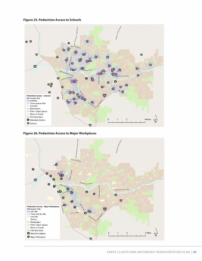
SANTA CLARITA NON-MOTORIZED TRANSPORTATION PLAN | 69
Figure 25 . Pedestrian Access to Schools
Figure 26 . Pedestrian Access to Major Workplaces

70 | SANTA CLARITA NON-MOTORIZED TRANSPORTATION PLAN
Figure 27 . Pedestrian Access to Community Facilities

SANTA CLARITA NON-MOTORIZED TRANSPORTATION PLAN | 71
Bicycle AccessChanging from a pedestrian perspective to that of biking demonstrates that many more destinations are within a 10-minute bike ride than a 10-minute walk. For students who are able to bike to school, a greater number of schools, including middle and high schools, are accessible across more neighborhoods (Figure 28). Generally, students located on the western side of Santa Clarita can reach the nearest school within a one-mile bicycle ride.
Similarly, many areas in the western portion of the city are within a one-mile bicycle ride to the closest major employers (Figure 29). The southern area of the city, south of Lyons Avenue, will require a bicycle ride of two or three miles to reach nearby employers. The general lack of roadways and hilly topography in Santa Clarita’s center restrict access between the east and west sides of the city.
Figure 30 shows bicycle access to public facilities (defined as parks, libraries, Metrolink Stations, and other transit centers). Because such facilities are located throughout the city, access to community facilities is more equally distributed across the east and west sides of Santa Clarita. The distribution of parks across the city means that many areas are within a one-mile bicycle ride, and most areas are within a three-mile bicycle ride. Access to the Santa Clarita Metrolink Station and the Via Princessa Metrolink Station are constrained to the west by roadways, topography, and land use patterns. Access to the Newhall Station is relatively unconstrained. Higher stress roadways such as Lyons Avenue create travel barriers and increase travel distance in neighborhoods to the north.
Figure 28 . Bicycle Access to Schools

72 | SANTA CLARITA NON-MOTORIZED TRANSPORTATION PLAN
Figure 29 . Bicycle Access to Major Workplaces
Figure 30 . Bicycle Access to Public Facilities

SANTA CLARITA NON-MOTORIZED TRANSPORTATION PLAN | 73
Demand AnalysisThe project team also sought to understand another large component of non-motorized trips in additional to access: demand. This demand analysis paired destinations evaluated in the access analysis with additional trip generators, such as residential density. These factors were then mapped, normalized, and combined into a composite map that shows relative demand across the city, overlaid with the existing active transportation network (see Figure 31).
Demand for walking and bicycling generally overlaps with existing facilities, especially when paseos are considered. However, there are noticeable gaps in which areas of high demand (such as Newhall, eastern Saugus, and Canyon Country) have minimal existing bikeways.
Soledad Canyon Road
TheO
ldR
oad
Lyons Avenue
San
Fra
ncis
quit
o C
anyo
n R
oad
RailroadAve
Magic Mountain Parkway
Newhall Ranch Road
Newhall Avenue
Go
l de n
Val
ley
Ro
ad
Valencia Boulevard
Bo
uque
tC
anyo
nRo
ad
McBean Parkway
Copper Hill Drive
Sier
raHig
hw
ay
5
5S
126
14
Potential ActiveTransportationDemand
Lower
HigherRiver or CreekMetrolink StationExisting Bikeway / Paseo
0 2 41 Miles
Figure 31. Potential Active Transportation Demand

74 | SANTA CLARITA NON-MOTORIZED TRANSPORTATION PLAN
Future Capital Improvement ProjectsSanta Clarita’s Capital Improvement Program (CIP) identifies capital improvement projects for the 2019 to 2020 fiscal year. Capital improvement projects add to or improve the City’s infrastructure and may include projects such as bridge widening, trail and bike lane construction, installation of sidewalks, intersection improvements, and development of public facilities such as the Sports Complex Center or Metrolink stations. The current CIP identifies $36.7 million in improvements and projects, of which approximately $3 million is dedicated to projects that include a non-motorized component. Table 4 describes each project with a non-motorized component, as well as the estimated cost of implementation.
Table 4 . FY 2019-2020 Capital Improvement Projects Related to Active Transportation
Project Description Estimated Cost
D0002 2019-20 ADA Access Ramps
Construction $50,000
*T1017 Avenue Scott Trail Connection
Design & Construction
$200,000
T1018 2019-20 Trail Fence Replacement
Construction $106,600
T2007 Soledad Canyon/Golden Valley Road Bike Path
Construction $334,010
T2011 Railroad Avenue Class I Bike Trail
Design & Right-of-Way
$1,500,000
T3020 Vista Canyon Multi-Modal Center (Metrolink Station)
Design & Right-of-Way
$181,728
T3021 Vista Canyon Regional Transit Center (Bus Station)
Design $90,000
T3024 Sand Canyon Trail
Construction $429,893
T3025 Sierra Highway Sidewalks
Construction $624,000
Total Trails and Transit:
$3,316,231
*Note: Part of the 2017-2018 CIP.
New curb ramps, crosswalks, sidewalks, and bike paths will help to make walking and biking in Santa Clarita more accessible.

SANTA CLARITA NON-MOTORIZED TRANSPORTATION PLAN | 75
FIVE-YEAR PAVEMENT PLAN 2019-2023
The City’s Five-Year Pavement Plan outlines which roadways will be resurfaced or overlaid between 2019 and 2023. This NMTP prioritizes recommendations that coincide with scheduled pavement updates.
MEASURE M FIVE-YEAR PLAN
Additionally, the City has received County funding from Measure M for the following projects:
• Sierra Highway Sidewalk Improvements
• Newhall Area Bicycle Facilities, including the Walnut Street Bicycle Boulevard
The following projects have been identified for Measure M funding between 2020 and 2025, and are expected to be implemented within the next five years:
• Valencia Industrial Center Bicycle and Pedestrian Improvements Phase I
• Valencia Industrial Center Bicycle and Pedestrian Improvements Phase II
• Santa Clara River Trail Gap Closure (Five Knolls to Discovery Park)
• Railroad Avenue Class I Trail
• Bicycle Network Connectivity Between City-County Facilities
Measure M funding will help enhance biking and walking throughout Santa Clarita, including along Walnut Street in Newhall.

76 | SANTA CLARITA NON-MOTORIZED TRANSPORTATION PLAN
04COMMUNITY COLLABORATION

SANTA CLARITA NON-MOTORIZED TRANSPORTATION PLAN | 77
Throughout the year-long planning process, we prioritized engaging and listening to the community by attending existing events which resulted in engaging with a wider and more diverse audience. A variety of engagement opportunities were used to seek input from all residents and community members in order to develop recommendations reflective of the community’s vision. All materials were made available in Spanish and English, and at least one bilingual team member attended every outreach event.
This chapter presents an overview of the format and approach for each outreach opportunity, along with a summary of feedback received.
“I think introducing the bus and walking/biking to younger children would help them grow up without the stigma that it isn’t cool to ride a bus or walk/bike somewhere. Our City is easily bikeable for errands/outings but it needs to be more normalized.” RESIDENT FOR OVER 21 YEARS
“There needs to be a culture change within the City of Santa Clarita that focuses on pedestrians and cyclists and safe driving.” NEW RESIDENT
“The city has done great work to create the infrastructure for cycling and jogging (such as the paseos). People here want to commute via bike, but it is too dangerous with the high speed of traffic and lack of bike lanes or even shoulders on major roads, where most commuters need to go.” RESIDENT FOR OVER 6 YEARS
“I love that we already have bike trails that extend throughout the city, more would be better.” RESIDENT FOR OVER 11 YEARS
PARTICIPANT FEEDBACK

78 | SANTA CLARITA NON-MOTORIZED TRANSPORTATION PLAN
Community SurveyA community survey was developed to gather input on walking and bicycling challenges, preferences, and opportunities throughout Santa Clarita. The survey was made available online in both Spanish and English from March 2019 through January 2020. The survey was advertised at all outreach events, through the City newsletter and email notifications, and by community partners. In total, 665 people responded to the survey. The following findings were key to informing our recommendations. The complete survey results are available in Appendix C.
FINDINGS
• 9% bike as their primary means of transportation (58 total). Although self-selection bias may be at play, this suggests a higher use of bicycles than captured in the ACS 2017 estimates.
• The biggest transportation issue in Santa Clarita, according to an open-ended question, is traffic congestion and the high number of cars .
• If the City could do THREE things to improve mobility, respondents would most like the City to:
• Build more bike/multi-use trails (60% - 374 total)
• Increase connectivity (44% - 278 total)
• Build more bike lanes (38% - 239 total)
Participants were invited to respond to the following open-ended prompts. Key themes from each of the questions are captured below.
I would bike more if…• there were safer places to ride.
• there were more places to lock up bikes.
• there were more bridges and paths connecting to other parts of the city.
• there were more lights, drinking fountains, restrooms, and places to stop.
• work were closer to home.
I would bike more “If it were safer. There are simply too many near misses and cars striking bikes. The bike lanes are on streets with far too fast vehicles and frankly the drivers in the SCV are too distracted.” -Resident for over 20 years
I would bike more if “I felt safer on the roadway in Santa Clarita to get to and from the bike paths.” -Resident for over 11 years
I would bike more if “My husband and kids cycle, though, and our biggest concern is them having safe places to cycle. The separated cycle tracks are their favorites (and put my mind at ease).” -New resident
I would take public transit more if…• buses came more frequently.
• I knew how the bus system worked, and had help riding.
I would walk more if…• there were more shops and restaurants nearby.
• there was more shade, especially in the summer months.
• I were in better health.
I would walk more if “Crosswalks at intersections were better marked and made pedestrians feel safe.” -Resident for over 11 years

SANTA CLARITA NON-MOTORIZED TRANSPORTATION PLAN | 79
Santa Clarita Pedestrian and Bicycle Master Plan Survey 2019If the City could do THREE things to improve mobility in Santa Clarita, what would you want the City to do?
Answer Choices Responses CountAdd more car parking 4.29% 26Expand the City's bikeshare program 6.44% 39Install more water fountains 8.58% 52Improve street and pedestrian-scale lighting 10.56% 64Increase bus service 12.05% 73Build more sidewalks 12.71% 77Add more bike parking 12.87% 78Implement traffic calming measures (e.g., speed humps) 15.35% 93Increase shade coverage (e.g., street trees, transit shelters) 17.66% 107Construct safer intersections 17.99% 109Decrease vehicle speeds on certain roads 20.13% 122Reduce delay on major highways 34.49% 209Build more bike lanes 37.79% 229Increase connectivity b/w commercial + residential 44.06% 267Build more bike/shared-use trails 60.23% 365
Answered 606Skipped 35
0.00%10.00%20.00%30.00%40.00%50.00%60.00%70.00%
If the City could do THREE things to improve mobility in Santa Clarita, what
would you want the City to do?
Responses
Build more bike lanes
Increase connectivity b/w commercial + residential
Build more bike/shared-use trails
If the City could do THREE things to improve mobility in Santa Clarita, what would you want the City to do?
0% 10% 20% 30% 40% 50% 60% 70%
Add more car parking
Expand the City's bikeshare program
Install more water fountains
Improve street and pedestrian-scale lighting
Increase bus service
Build more sidewalks
Add more bike parking
Implement traffic calming measures (e.g., speed humps)
Increase shade coverage (e.g., street trees, transit shelters)
Construct safer intersections
Decrease vehicle speeds on certain roads
Reduce delay on major highways
Build more bike lanes
Increase connectivity b/w commercial + residential
Build more bike/shared-use trails
If the City could do THREE things to improve mobility in Santa Clarita, what would you want the City to do?
60% (365 total)
44% (267 total)
38% (229 total)Build more bike lanes
Increase connectivity b/w commercial + residential
Build more bike/shared-use paths
Figure 32 . Survey Question: Top Three Mobility Interventions
I would use a car less if…• transit were more reliable.
• there were more places nearby to walk or bike to.
• I felt safer walking and biking around the city.
I would use a car less if “I had better bike access from my neighborhood to bike paths/bike lanes/sidewalks” -Resident for over 3 years
I would use a car less if “Transit and bike facilities were expanded beyond what is currently available” -Resident for over 11 years
What do you think the biggest transportation issue is in Santa Clarita?• There is too much traffic and too much dependence
on cars.
• Signals need to be better synchronized.
Are there any additional ideas, comments, or concerns you would like to share regarding mobility in Santa Clarita?• Increase education on walking and biking for all resi-
dents (drivers and active transportation users).
• The paseos are excellent facilities and should be replicated throughout the city.
• Expand and enhance Metrolink’s Antelope Valley line in Santa Clarita.
• Increase the availability of bike and scooter share.

80 | SANTA CLARITA NON-MOTORIZED TRANSPORTATION PLAN
Online Interactive Mapping ToolAn interactive mapping tool was shared on the Bike Santa Clarita website, promoted on the City’s website, and used throughout development of this NMTP to gather input and feedback from the community directly on a map of the city.
From February 2019 through January 2020, community members were encouraged to draw routes or place pins on the map and add comments to identify desired walking or bicycling improvements, challenging locations, and other information
about the walking and bicycling environment. Approximately 75 community members engaged with the public input map. Together, they made 272 contributions (including noting routes in need of improvements, destinations, and votes on other people’s comments); the most popular comment involved closing the gap on the Santa Clara River Trail.
The project team used feedback captured in the public input map to develop corresponding improvements to the bicycling and walking network.
!
!
!
8th Street
HenryMayo Drive
New
hall Avenue
Diver Street
Cheyenne Drive
Cro
ss Street
IronCanyon Road
Del
Va
lleRoad
Can
yo
n Crest Drive
Summit Knoll Road
Bridlewood Drive
Port
ana
Lane
Market
Stre
et
Vis
taDel
RioDrive
Has
kell
Can
yon
Ro
ad
Arch Street
Bension Drive
Festividad Drive
Race Street
Mar
ilyn
Dri
veHil l
sbo
roug
hP
arkw
ay
Oxford Lane
Shangri-LaD
rive
Via Princessa
Wag
onW
heel
Road
Qui
ncy
Street
Grovepark Drive
Je�ers Lane
Cascade Road
Rainb
owG
l enD
rive
Dic
kaso
nD
rive
BerylPlace
Arr
oyo
Park
Driv
e
Cherry
Dri
ve
Ro
ck Canyo
n D
rive
Darling Road
Valley S
treet
Wre
n D
rive
Mill Valle
y Road
Gilbert Drive
Begonias Lane
Holly Drive
Carrizo Drive
IsabellaParkway
Gar
net
Can
yon
Dri
ve
Alta
Vista
Avenue
Lisa Gail Drive
Gra
ndvi
ewD
rive
Paragon
Dri
ve
Lotu
sgar
denDrive
Ap
ple S
treet
Lake Hughes Road
TesoroD
el ValleRoad
Val
le D
el O
roFaulkner Drive Big Cedar Drive
Riv
erTr
ail L
ane
Fo
url Ro
ad
16thStre
et
Stillmore Street
Laroda Lane
Ag
ajan
ian
Dri
ve
Brooks Circle
Decoro Drive
O ak Me
ad
owDrive
Aldbury Street
Heller Circle
Canyo
n View
Drive
Royal Road
Sandy Drive
Poe Parkway
Mal
lory
Driv
e
Cap
raR
oad
Sout
hern
Oak
s D
rive
Car
away
Lan
e
No
rthp
arkD
rive
Fairview Drive
Cam
pP
len tyR
oad
Lowridge Place
Tam
ara c
kLa
ne
El Paseo Drive
Trai
l Ro
ad
Sarda Road
Barcotta Drive
Rotunda
Road
Via
Barra
Jaso
n D
rive
Gol
d
Canyon Drive
Cambridge Avenue
Comet W
ay
Sidani Lane
Sant
aC
atar
i na
Ro
ad
Maple Street
Ag
ua D
ulce
Can
yon
Ro
ad
Nadal Street
ShakespeareLane
Claremore Way
Las
Man
an
itas
Dri
ve
Ab
elia
Ro
a d
Sier
raEstates Drive
Gibraltar Lane
Flo
wer
pa r
kD
rive
Benz
Road
Calgrove Boulevard
Alta
Madera Drive
Lady Linda Lane
Avenue of the Oaks
Canvas Street
Rue
ther
Ave
nue
Del Monte Drive
Suns
et
HillsDrive
Alaminos Driv
e
Burton Way
Pamplico Drive
Fox
lane
Dri
ve
Delden Road
Cirrus Drive
Cardi� DriveD
isco
ve
ryRidge Drive
Waym
an Street
Sagecrest Circle
Dorothy Street
Walnut Street
Rod
gersDrive
Huston Stre
et
Espuella Drive
Shadow
Valley
L ane
Wistaria
ValleyRoad
Crossg
lade
Avenue
Steinway Street
Main
Street
Gar
za D
rive
Hem
ingw
ayAvenue
Oak Orchard Road
Pe
ach
land
Ave
nue
Parker Road
Centre Pointe Parkway
Woo
dla
nds
Driv
e
TourneyRoad
Hillcrest Parkway
BellisDrive
Ave
nue
Pen
n
Card
ina l
Drive
Catala
Avenue
Carranza Lane
Com
merce
CenterDrive
Stratus Street
Lauren Lane
Industry Drive
Creekside Road
Pico Canyon Road
Davenport Road
Oak Crest Drive
Ad
en A
venu
e
Stev
enso
nR
anch
Park
way
Rancho Tesoro
Tapia Canyon Road
Firebrand Drive
Fa
rrier
Drive
Ro
ckwellC
anyon
Ro
ad
Sand
Canyo
nR
oad
Circle
J
Ranch Road
Trevino Drive
Tournament Road
Plum Canyon Road
Avenue Scott
Gat
eR
oad
Delight Street
Elm Avenue
DrillR
oad
AvenueHopkins
GoldcrestDrive
Sant
aC
lara
Truc
kTr
ail
Placeritos Boulevard
Golden Valley Road
Medley Ridge Drive
Alton Way
Canon
es C i rc
le
Northcli�Drive
Kavenagh
Lane
Road
Avenid
aRo
tella
AvenidaR
anchoTesoro
Orchard
VillageRoad
Via
Joyc
eDrive
Arcadia Street
De W
olfe R
oad
Seq
uoia
Road
West Hills Drive
Rai
ntre
eL
ane
Triu
mp
h R
oad
Livingston Avenue
Castille Lane
Wild
wo
od
Can
yon
Ro
ad
Everett D
rive
Iron
Villa
ge Drive
CenturionW
ay
Texas Oil Company Road
Wheeler R
oad
Saddleback Road
Coltrane Avenue
Grandifloras
Road
Syc
amo
r eC
reek
Dri
ve
Lost
Canyon Road
Ermine Street
Avenu
e Tib
bitts
Brady Parkway
Mam
mot
hLa
ne
Dockweiler Drive
Live
Oak
Roa
d
Valencia Boulevard
Terri Drive
Win
terd
ale
Dri
ve
Witherspoon Parkway
Potrero Canyon Road
Mys
tery
Mes
aD
rive
Jakes Way
Fambrough Street
Lang Station Road
Triu
mp
h A
ven
ue
Hasley Canyon Road
Sultus Street
Seco
Can yo
nF
rontag
eR
oad
Bar
ber
Ro
ad
BiscaliuzDrive
May
Way
Vasquez Canyon Road
Kelly Johnson Parkway PoppyM
eadowStreet
Ravenhill
Ro
ad
Town Ce nte
rD
riv
e
Live Oak Springs Canyon R oa
d
AnzaDriv
e
Fran
klin
Park
way
Placerita Canyon Road
Ave n
ue
A
Chase Avenue
Seco
Canyo
n Ro
ad
Wind
rushR
oad
Dairy Road
Barbacoa Drive
Wiley
Canyo
nR
oad
Car
izD
rive
Co
mp
any
Ro
ad
Bridgeport Lane
Spring
brook
Av
enue
Gary D
rive
Avenue Stanford
Whi
tes
Can
yon
Road
Graham Lane
Heard Drive
Stadium
Way
Remsen
Street
AltaK
noll
Drive
Avenue Crocker
Golden Triangle Road
Ro
lling
Hill
s A
ven
ue
Bis
cailu
z R
oad
Skyline Ranch Road
Pin
e S
tree
t
Charli
eCan
yon
Road
Smyth Drive
ParvinDriv
e
Little Tujunga Canyon Road
Oak Springs Canyon Road
Robinson Ranch Road
Edison Road
Feedmill Road
Rye Canyon Loop
Newhall Avenue
Lyons Avenue
Railroad Ave
Bouquet Canyon Road
Sier
ra H
ighw
ay
Road
Rye Canyon
Ro
ad
McBean Parkw
ay
Copper Hill Drive
TheO
ldR
oad
Newhall Ranch Road
Valencia Boulevard
Magic Mountain Parkway
Go
lden
Valle y
Ro
ad
Soledad Canyon Road
Complete the bikeway network gap from Tourney Road to the Iron Horse Trail. Add sidewalks on north side of the parkway.
Downtown Newhall
Provide safer, more comfortable routes to downtown and the transit station.
Santa Clara River Trail
Close the gap in the trail.
(This received the most comments)
Bouquet Canyon
Enhance rider comfort on Bouquet Canyon Road. Consider alternate routes where possible. Sierra Highway
Close the network gaps to createmore comfortable conditions.
Santa Clara River Trail
Extend the trail to the east.
Placerita Canyon Road & Sand Canyon Road
Enhance popular bike route with signage and overall roadway maintenance.
Lyons Avenue
Improve east/west access through Newhall,particularly to the Metrolink Station.
Newhall Avenue
Create a north/south bike route to improve safety and access for students.
Valencia Boulevard
Improve the connection between Tourney Road and Rockwell Canyon Road.
Magic Mountain Parkway
5
14
Santa Clarita Input MapTop Comments
Existing Bikeways
Shared-Use Path / Bike Path (Class I)
Bike Lane (Class II)
Bike Route (Class III)
Proposed Bikeways / Trails
Shared-Use Path / Bike Path (Class I)
Multi-Use Trail
Bike Lane (Class II)
Bike Route (Class III)
! Metrolink Station
School
Destination
Park / Open Space
Top Commented Corridor or Destination
0 2.5 51.25 Miles
Separated Bike Lane (Class IV)

SANTA CLARITA NON-MOTORIZED TRANSPORTATION PLAN | 81
Pop-Up EventsAt the beginning of the planning process, the project team attended three community events in order to hear from the public about current issues they experience while walking and rolling in the city:
• Earth Day Festival: Saturday, April 27, 2019, from 10 a.m. to 5 p.m. at Central Park
• Hit the Trails: Saturday, May 11, 2019, from 9 a.m. to 1 p.m. at Valencia Heritage Park
• Old Town Newhall Farmers Market: Saturday, June 15, 2019, from 8:30 to 11 a.m. at Old Town Newhall Library
At these events, community members were invited to mark up a map of the existing and previously proposed active transportation facilities in the community. The public was also invited to take a paper version of the survey (the results of which are reported under the community survey section), and to vote on their top three preferred elements of a complete street.
WHAT WE HEARD
Paper Input MapCommunity members:
• Suggested opening the trail on the Dry Creek Channel to people walking and bicycling to provide a safer, parallel route to Seco Canyon Road.
• Wanted an easier connection to Central Park from Saugus and other nearby areas that does not involve traversing Bouquet Canyon Road, which feels too dangerous for most bicycle riders.
• Asked for the bridge overpasses on the trail network to be labeled to enhance navigability and wayfinding.
• Noted that there are many dangerous intersections for pedestrians along McBean Parkway, which resi-dents said is very busy and might merit “scramble crossings” to improve safety.
• Wanted better bike/ped connections to the Newhall Library/Old Town area. The existing railroad acts as a barrier and encourages people to drive so as to avoid taking a circuitous route if walking or biking.
• Wanted better wayfinding signage within the paseo network, as it is easy to get lost.
• Suggested a new bike connection from Plum Canyon Road to the Santa Clara River Trail near Canyon Springs Community Elementary.
• Expressed support for bike facilities and improve-ments on Bouquet Canyon Road, especially near Emblem Academy.
• Expressed a desire to connect to more recreational trails and to places outside of the city.
• Shared concerns about speeding cars, particularly around schools, and noted that morning drop-offs are especially chaotic.
Community members of all ages helped inform this plan.

82 | SANTA CLARITA NON-MOTORIZED TRANSPORTATION PLAN
Complete Streets BoardCommunity members ranked shared-use paths, trails, and bike lanes as the preferred amenity, followed by wayfinding and transit stop improvements (Figure 33).
The least popular amenity options were traffic calming, branding/art opportunities, and bike parking/bike share. Some contributing factors for why these options received fewer votes are:
• Community members did not know what bike sharing was and have never used the Pace program before.
• People did not want traffic calming amenities on their street and hesitated to vote for such amenities.
• A community member in favor of art opportunities noted that art had been promised along certain paseos, but never implemented.
BIKE AUDITS
On Thursday, June 13, 2019, the project team facilitated bike audits in Saugus and Newhall with community members and City staff to assess existing conditions, identify potential trail routing options, and evaluate improvements in first- and last-mile connections. In Saugus, the audit route evaluated Central Park, Bouquet Creek Trail, the Dry Creek
Channel, Seco Canyon Road, Garzota Drive, and Alamogordo Road. The Newhall audit evaluated Walnut Street, Orchard Village Road, the South Fork Trail, and Railroad Avenue. On both routes, community members and City staff discussed existing obstacles to active transportation in these neighborhoods and potential improvements, including finding low-stress alternatives to Seco Canyon Road and Railroad Avenue. Overall, attendees expressed support for:
• Improving access points, crossings, and wayfin-ding to trails . Some existing entry points are poorly marked or have gates that restrict access to people on recumbent bicycles, wheelchairs, or other mobility devices. Connecting between trails without existing crossings or designated bridges is difficult, and can require riders to take circuitous routes.
• Utlizing flood control channels and quieter roads to offer low-stress routes that bypass high-traffic arterials. Many flood control channels already feature Class I shared-use paths; bike audit attendees expressed support for replicating such a treatment to provide alternative routes to Seco Canyon Road and Bouquet Canyon Road. Seco Canyon Frontage Road and Pamplico Drive similarly offer lower-stress options for bicycle routes.
Category
0
5
10
15
20
Shared-use paths, trails, bike lanes
Wayfinding, signage with distance to
destinations
Transit stop improvements
Wider sidewalks,
benches, and trees/shade
New or improved crossings
Bike parking and bikeshare
Branding, identity, art
opportunities
Traffic calming
Old Town Newhall Farmer's Market Hit the Trails Earth Day Festival
Complete Streets Board: Voting ResultsFigure 33 . Complete Streets Voting Board Results
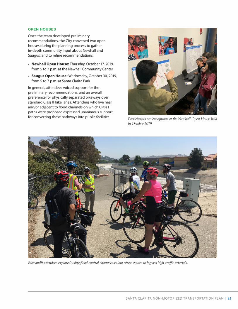
SANTA CLARITA NON-MOTORIZED TRANSPORTATION PLAN | 83
OPEN HOUSES
Once the team developed preliminary recommendations, the City convened two open houses during the planning process to gather in-depth community input about Newhall and Saugus, and to refine recommendations:
• Newhall Open House: Thursday, October 17, 2019, from 5 to 7 p.m. at the Newhall Community Center
• Saugus Open House: Wednesday, October 30, 2019, from 5 to 7 p.m. at Santa Clarita Park
In general, attendees voiced support for the preliminary recommendations, and an overall preference for physically separated bikeways over standard Class II bike lanes. Attendees who live near and/or adjacent to flood channels on which Class I paths were proposed expressed unanimous support for converting these pathways into public facilities.
Bike audit attendees explored using flood control channels as low-stress routes to bypass high-traffic arterials.
Participants review options at the Newhall Open House held in October 2019.

84 | SANTA CLARITA NON-MOTORIZED TRANSPORTATION PLAN
SPOT IMPROVEMENT REQUESTS
Throughout the various community engagement efforts, the project team captured specific requests for spot improvements pertaining to lighting, maintenance, potential sites for public art, and expanded public access. Requested spot improvements are listed in Table 5 and mapped in Figure 35.
Table 5 . List of Requested Spot Improvements
Type of Improvement Requested Location Cross Street
Bike Crossing
Improved Bike Detection 16th Street Orchard Village Road
Improved Bike Detection Garzota Drive Seco Canyon Road
Bike Crossing Newhall Avenue 16th Street
Bike Crossing Placerita Canyon Road Sierra Highway
Bike Crossing Soledad Canyon Road Golden Valley Road
Bike Parking / Hub Valencia Town Center Magic Mountain Parkway
Reduce Conflict for Bikes Soledad Canyon Road Lost Canyon Road
Reduce Conflict for Bikes Seco Canyon Road Copper Hill Drive
Crossing
Adjust to Walk Light Newhall Ranch Road Hillsborough Pkwy
Adjust to Walk Light Newhall Ranch Road Grandview Drive
Bridge Proposed Trail Park Street
Bridge San Francisquito Creek Trail Avenue Scott
Bridge Underpass Santa Clara River Trail Newhall Ranch Road
Bridge Underpass San Francisquito Trail Copper Hill Drive
Bridge Underpass Bouquet Canyon Road Santa Clara River Trail
Curb Extension Railroad Avenue Market Street
Crosswalk Rockwell Canyon Road Summit Place
Crosswalk River Village Park Trail Newhall Ranch Road
Crosswalk Copper Hill Drive Deer Springs Drive
Crosswalk Pamplico Drive Seco Canyon Road
Crosswalk McBean Parkway Magic Mountain Parkway
Crosswalk Sawmill Lane Newhall Ranch Road
Crosswalk/Curb Ramp McBean Parkway Henry Mayo Fitness
Install Signal Walnut Street Lyons Avenue
No Right on Red Rockwell Canyon Road Valencia Boulevard
Pedestrian Access Newhall Ranch Road I-5
Scramble Crossing McBean Parkway Valencia Boulevard

SANTA CLARITA NON-MOTORIZED TRANSPORTATION PLAN | 85
Type of Improvement Requested Location Cross StreetSidewalk Soledad Canyon Road Golden Oak Road
Lighting
PaseValencia Meadows Park Orchard Village Road
Trail Santa Clara River Trail (south side) McBean Parkway
Trail McBean Parkway Trail Avenue Scott
Street Walnut Street 15th Street
Street Copper Hill Drive Northpark Drive
Street Copper Hill Drive Paragon Drive
Maintenance
Adjust Gates Valencia Summit Park Brighton Drive
Adjust Gates Golden Valley Road Sierra Highway
Improve Paseo Access Valencia (All Paseos)
Repave San Francisquito Creek Trail Newhall Ranch Road
Repave South Fork Trail Alta Madera Drive
Trail Connection Central Park Paraguay Drive
Provide Access
Close Gap Golden Valley Road Near Valley Center Drive
Open to the Public Utility Easement Near Copper Hill Drive McBean Parkway
Other
Art Wiley Canyon Road (bridge) Railroad Avenue
Limit Automobile Parking Pamplico Drive Seco Canyon Road
New Trailhead
Trailhead Shadow Pines
Trailhead Garnet Canyon Dr Discovery Ridge Dr
Trailhead Central Park (south) Newhall Ranch Road
Trailhead Santa Clara River Trail Mariposa St
Trailhead Santa Clara River Trail Granada Villa Mobile Home Park
Sidewalks
Location From To
Bouquet Canyon Road Copper Hill Drive City Line
Canyon Park Boulevard (north side) Jason Drive Flynn Drive
Copper Hill Drive Hidden Hill Drive Kenton Lane
Copper Hill Drive (north side) Northpark Drive Sycamore Creek Drive
Decoro Drive/Chaparro Drive Seco Canyon Road Seco Canyon Road
Market Street Cross Street 900 ft. west of Newhall Avenue

86 | SANTA CLARITA NON-MOTORIZED TRANSPORTATION PLAN
Figure 34 . Community Feedback
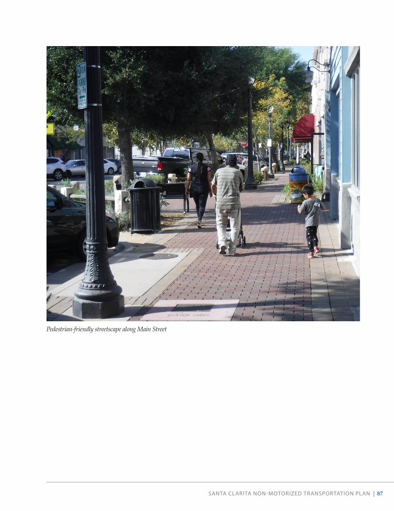
SANTA CLARITA NON-MOTORIZED TRANSPORTATION PLAN | 87
Pedestrian-friendly streetscape along Main Street

88 | SANTA CLARITA NON-MOTORIZED TRANSPORTATION PLAN
05RECOMMENDATIONS

SANTA CLARITA NON-MOTORIZED TRANSPORTATION PLAN | 89
This chapter introduces the bicycle and pedestrian infrastructure and supporting amenities that the City intends to implement in the coming years, and the overall strategy employed in evaluating which kind of facilities should be recommended at specific locations.
Recommendations are considered planning-level. In some cases, traffic impact analysis and more detailed design analysis will be required to evaluate specific site conditions and develop designs that reflect conditions and constraints. For recommendations along flood control channels, the City will hold community-specific workshops and tours of potential facilities, and will coordinate with the Los Angeles County Flood Control District accordingly.
How Recommended Projects Advance Our GoalsSAFETY & HEALTH
Network recommendations address the most critical safety issues and prioritize improvements at high-injury corridors and intersections.
ACCESS & COMFORT
Network recommendations create continuous routes throughout the community, connecting neighborhoods to major destinations and to one another.
MAINTAIN & EXPAND THE NETWORK
The NMTP provides a roadmap for achieving a complete and connected active transportation network.
Table 6 . Public Input Guiding Network Recommendations
What We Heard What We Propose
Biking and walking can feel unsafe
Make it comfortable and safe Multiple new shared-use paths (Class I) and bridge undercrossings aim to help people avoid high-stress corridors and access key destinations on low-stress facilities.
The network is disconnected
Make it connected Recommendations include closing critical gaps in the existing network to help increase access to places people want to travel to (including community facilities, transit hubs, and employment centers) and complete the network.
Active transportation is not adequately supported
Make it easy Additional recommendations include increasing support facilities such as bike parking, pedestri-an-scale lighting, trail amenities, and programs and policies to help foster a culture of biking and walking.

90 | SANTA CLARITA NON-MOTORIZED TRANSPORTATION PLAN
How We Developed Recommended ProjectsPUBLIC INPUT
Various outlets allowed for public demand for new and improved bicycle and pedestrian facilities to be voiced and recorded: community meetings and outreach events, an online public input map, and the community survey. Roadways and areas that were mentioned multiple times across different outreach methods were examined as highest priority for inclusion in the recommended projects. Public input also informed the City’s understanding of safety issues, local destinations not currently served by adequate facilities, and additional gaps in the network (see Table 6).
INJURY PREVENTION
Understanding that physical separation and other design techniques not only enhance pedestrian/bicyclist comfort, but also user safety, the City identified active transportation improvements that work to save lives.
CONNECTIONS TO LOCAL DESTINATIONS
The City identified bicycle and pedestrian low-stress facilities serving people of all ages and abilities that better connect users to parks, commercial centers, transit stops, and local schools.
GAP CLOSURE
The City identified where new facilities were needed to close key gaps in the existing bicycle and pedestrian networks.
CONCURRENT PLANNING EFFORTS
The City incorporated other active transportation projects that were part of recent or upcoming planning efforts.
Bicycle FacilitiesPrior to embarking on this planning process, the City had just over 112 miles of existing bikeways. An additional 124 miles are proposed in this NMTP, including over 22 miles of Class I bike paths and almost 2.5 miles of Class IV separated bikeways (see Table 7). The majority of recommended facilities are new projects where bikeways do not exist today, while a portion include recommendations to upgrade an existing bikeway. Recommended bicycle projects are shown on page 91.
EXPANDING REGIONAL CONNECTIVITY
Santa Clarita is surrounded by unincorporated Los Angeles County communities and is just north of the City of Los Angeles. All modes of transportation flow between the jurisdictions. Throughout this planning process, community members expressed a strong desire for increased bicycle connectivity between our City and nearby areas including Magic Mountain and new developments to the west. The City will continue collaborating with the County and other agencies to improve regional connectivity.
FUTURE OPPORTUNITIES
Although this NMTP sets forth a robust vision for biking and walking in our community, additional opportunities may exist in the future to further expand our network. Opportunities could include opening additional utility roads or flood control channels for recreational access and connectivity, or expanding Class III bicycle boulevards along residential streets.

SEEINSETMAP
CENTRALPARK
EAST WALKERRANCH OPEN
SPACE
GOLDEN VALLEYRANCH REGIONAL
OPEN SPACE
QUIGLEYCANYON
OPEN SPACE
WILLIAM SHART PARK
HASKELLCANYON
OPEN SPACE
WHITNEYCANYON
OPEN SPACE
SAN TA CL ARA RIVER
8th Street
HenryMayo Drive
Cheyenne Drive
Cro
ssStreet
IronCanyon Road
Del
Va
lleRoad
Can
yo
n Crest Drive
Knoll Road
Portan
aL
ane
Market Stre
et
Vis
taD
elR
ioDriv
e
Has
kell
Can
yon
Ro
ad
Festividad Drive
Hil l
sbo
roug
h
McB
ean
Park
way
Par
kway
Golden Valley Road
Wag
on Wheel Road
Grovepark Drive
Je�ers Lane
Rainb
ow
Glen
Drive
Arr
oyo
Park
Driv
e
Darling Road
Valley S
treet
Rainbow G
len Dr
Carri
zoDrive
IsabellaParkway
Gra
ndvi
ewD
rive
Paragon
Dri
ve
Ap
ple S
treet
Lake Hughes Road
TesoroD
el ValleRoad
Valle
Del
Oro
Big Cedar Drive
Riv
erTr
ail L
ane
16thStre
et
Brooks Circle
Decoro Drive
Royal Road
Sandy Drive
Poe Parkway
Mal
lory
Driv
e
Cap
raR
oad
Sout
hern
Oak
s D
rive
Car
away
Lan
e
Lowridge Place
Tam
arac
kLa
ne
El Paseo Drive
Trai
l Ro
ad
Barcotta Drive
Rotunda
Ro
ad
Via
Barra
Jaso
n D
rive
Skyc
rest
Circle
Gol
d
Canyon Drive
Cam
bri
dg
e A
ven
ue
Beecher Lane
Comet
Way
Maple Street
Ag
ua D
ulce
Can
yon
Ro
ad
ShakespeareLane
Claremore Way
Las
Man
an
itas
Dri
ve
Ab
elia
Ro
a d
Gibraltar Lane
Benz
Road
Calgrove Boulevard
Alta
Madera Drive
Lady Linda Lane
Avenue of the Oaks
Rue
the
rA
venue
Del
Mon
teD
rive
AlaminosDrive
Burton Way
Fox
lane
Dri
ve
Delden Road
Rid
ge
Tout
e R
oad
Dis
cove
ryRidge Drive
Waym
an Street
Sagecrest Circle
Walnut StreetHuston Stre
et
Espuella Drive
Wistaria
ValleyRoad
Garza
Drive
Hem
ingw
ayAvenue
Oak Orchard Road
Ro
bt
C L
ee P
kwy
Parker Road
TourneyRoad
Hillcrest Parkway
BellisDrive
Ave
nue
Pen
n
Card
ina l
Drive
Catala A
venu
e
Com
merce
CenterDrive
Industry Drive
Creekside Road
Pico Canyon Road
Davenport Road
Oak Crest Drive
Ad
en A
venu
e
Stev
enso
nR
anch
Park
way
The
Old
Ro
ad
Firebrand Drive
Ro
ckwell C
anyon R
oad
Sand
Canyo
nR
oad
Circle
J
Ranch Road
Trevino Drive
Tournament Road
Castaic Road
Avenue Scott
Gat
eR
oad
Elm Avenue
DrillR
oad
AvenueHopkins
GoldcrestDrive
Placeritos Boulevard
Golden Valley Road
Canon
es C i rc
le
Kavenagh
Lane
Sloa
nCan
yo
nRoad
Orchard
VillageRoad
De W
olfe R
oad
Seq
uoia
Road
Rai
ntre
eL
ane
Livingston Avenue
Wild
wo
od
Can
yon
Ro
ad
Everett D
rive
Iron
Villa
ge Drive
Texas Oil Company Road
Wheeler R
oad
Coltrane Avenue
Grandifloras
Road
Lost Canyon
Canyon Park Blvd
Road
Avenue
Tib
bitts
Brady Parkway
Mam
mot
hLa
ne
Dockweiler Drive
Valencia Boulevard
Win
terd
ale
Dri
ve
Witherspoon Parkway
Potrero Canyon Road
Mys
tery
Mes
aD
rive
Jakes Way
Fambrough Street
Road
Hasley Canyon Road
Sultus Street
Bar
ber
Ro
ad
BiscaliuzDrive
Vasquez Canyon Road
Ravenhill
Ro
ad
Live Oak Springs Canyon R oa
d
Fran
klin
Park
way
Placerita Canyon Road
Ave n
ue
A
Chase Avenue
Sec
oC
anyo
nR
oa d
Wind
rushR
oad
Dairy Road
Wiley
Canyon
Road
Car
izD
rive
Co
mp
any
Ro
ad
Bridgeport Lane
Spring
brook
Av
enue
Gary D
rive
Avenue Stanford
Whi
tes
Can
yon
Road
Heard Drive
Stadium
Way
Remsen
Street
Avenue Crocker
Ro
llin
g H
ills
Ave
nue
Bis
cailu
z R
oad
Pin
e S
tree
t
Need
ham R
anch Parkw
ay
Charli
eCan
yon
Road
Smyth Drive
ParvinDriv
e
Little Tujunga Canyon Road
Oak Springs Canyon Road
Robinson Ranch Road
Edison Road
Feedmill Road
Centre Pointe Parkway
Sand
Canyo n
Roa
d
Soledad Canyon Road
Po
pp
y Meadow Street
Shad
ow P
ines
Blv
d
Cedar V
alley Way
Kelly Jo
hnson Pa rkway Skyline Ranch Road
Newhall Avenue
Lyons Avenue
Railroad Ave
Bouquet Canyon
Road
Sier
ra H
ighw
ay
Sier
ra H
ighw
ay
Fra
nci s
qui
toC
anyo
nRo
ad
Rye Canyon
Ro
ad
McBean Parkw
ay
Copper Hill Drive
TheO
ldR
oad
Newhall Ranch Road
Valencia Boulevard
Magic Mountain Parkway
Golden
ValleyR
oad
Soledad Canyon Road
VIA PRINCESSAMETROLINK STATION
CORPORATEYARD
CITY HALL
MCBEAN REGIONALTRANSIT CENTER
SANTA CLARITAMETROLINK
STATION SC SPORTSCOMPLEX
CANYONCOUNTRYLIBRARYVALENCIA
LIBRARY
VISTA CANYONMETROLINK
STATION
HENRY MAYONEWHALLHOSPITAL
TESOROADOBE PARK
FUTURE PARK
SIX FLAGSMAGIC
MOUNTAIN
CANYONCOUNTRY
COMMUNITYCENTER
5
126
14
CASTAICELEMENTARY
CASTAICMIDDLE
LIVE OAKELEMENTARY
PICO CANYONELEMENTARY
OAKHILLS
ELEMENTARY
PEACHLANDAVENUE
ELEMENTARY
WILEYCANYON
ELEMENTARY
OLD ORCHARDELEMENTARY
MEADOWSELEMENTARY
COLLEGE OFTHE CANYONS
CALIFORNIAINSTITUTE
OF THE ARTS
VALENCIAVALLEY
ELEMENTARY
STEVENSONRANCH ELEMENTARY
TESORODEL VALLE
ELEMENTARY
WEST CREEKACADEMY
CEDARCREEKELEMENTARYRIO VISTA
ELEMENTARY
ROSEDELLELEMENTARY
SANTA CLARITAELEMENTARY
SKYBLUE MESAELEMENTARY
HIGHLANDSELEMENTARY
HELMERS ELEMENTARY
FOSTERELEMENTARY
MOUNTAINVIEWELEMENTARY
PLUM CANYONELEMENTARY
NORTH PARKELEMENTARY
BRIDGEPORTELEMENTARY
GOLDEN OAKELEMENTARY
CANYON SPRINGSELEMENTARY
COX ELEMENTARY
MINT CANYONELEMENTARY
SULPHURSPRINGS
ELEMENTARY
MITCHELLELEMENTARY
VALLEY VIEWELEMENTARY
PINETREEELEMENTARY
COLLEGE OFTHE CANYONS,
CANYON COUNTRYCAMPUS
FAIROAKS
RANCH
RIO NORTEJUNIOR
HIGH
GOLDENVALLEY HIGH
RANCHO PICOJUNIOR HIGH
WEST RANCHHIGH SCHOOL
SANTACLARITAVALLEY
INTERNATIONALCHARTER
CANYONHIGH
SAUGUSHIGH
LEARNINGPOST HIGH
HARTHIGH
BOWMAN HIGH
VALENCIAHIGH
ARROYO SECOJUNIOR HIGH
PLACERITAJUNIOR HIGH
THE MASTER'SUNIVERSITY
SIERRA VISTAJUNIOR HIGH
LA MESAJUNIOR
HIGH
Via Princessa (Planned)
Pam
plic
o Driv
e
Dry
Cre
ek C
hann
el
S
AN
FR
AN
CIS
QU
I TO
CR
EEK
Val
ley
Cent
er
Dr.
Golden Triangle Road
So
uth
Fork
0 2.5 51.25 Miles
Paseo
Metrolink Station
School
Destination
Park / Open Space
River or Creek
Active Transportation FacilitiesProposed Facilities
Bike Path (Class I)
Bike Lane (Class II)
Bike Route (Class III)
Separated Bikeway (Class IV)
Multi-Use Trail
Existing Facilities
Bike Path (Class I)
Bike Lane (Class II)
Bike Route (Class III)
Multi-Use Trail
Paseo
Planned Facilities in L.A. County
Bike Path (Class I)
Bike Lane (Class II)
Bike Route (Class III)
Existing Facilities in L.A. County
Bike Lane (Class II)
Metrolink Station
School
Destination
Park / Open Space
River or Creek
Street
2020 Non-Motorized Transportation Plan RecommendationsSeptember 2020
9th Street
5th Street
13th Place
6th Street
13th Street
14th Street
11th Stre
et
Pine Street
Am
elia
Lan
e
Oak Street
ArchStreet
Race Street
Ad
en A
venu
e
8th
Stre
et
Walnut Street
Chestnut Street
Mea
dvi
ew A
venu
e
Cas
t A
venu
e
New
hall Avenue
Kansas Street
12th Street
Placerita Canyon Road
Arcadia Street
Railroad Ave
Lyons Avenue
NEWHALLCOMMUNITY
CENTERNEWHALLMETROLINK
STATION
NEWHALLLIBRARY
SC BUSINESSINCUBATOR
Old Town Newhall Recommendations
0 0.50.25 Miles

This page is intentionally left blank.
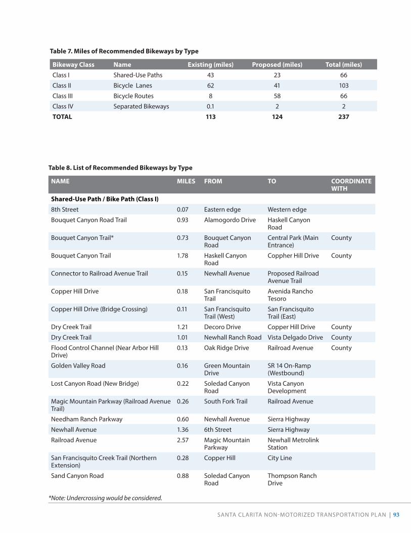
SANTA CLARITA NON-MOTORIZED TRANSPORTATION PLAN | 93
Table 7 . Miles of Recommended Bikeways by Type
Bikeway Class Name Existing (miles) Proposed (miles) Total (miles)
Class I Shared-Use Paths 43 23 66
Class II Bicycle Lanes 62 41 103
Class III Bicycle Routes 8 58 66
Class IV Separated Bikeways 0.1 2 2
TOTAL 113 124 237
Table 8 . List of Recommended Bikeways by Type
NAME MILES FROM TO COORDINATE WITH
Shared-Use Path / Bike Path (Class I)
8th Street 0.07 Eastern edge Western edge
Bouquet Canyon Road Trail 0.93 Alamogordo Drive Haskell Canyon Road
Bouquet Canyon Trail* 0.73 Bouquet Canyon Road
Central Park (Main Entrance)
County
Bouquet Canyon Trail 1.78 Haskell Canyon Road
Coppher Hill Drive County
Connector to Railroad Avenue Trail 0.15 Newhall Avenue Proposed Railroad Avenue Trail
Copper Hill Drive 0.18 San Francisquito Trail
Avenida Rancho Tesoro
Copper Hill Drive (Bridge Crossing) 0.11 San Francisquito Trail (West)
San Francisquito Trail (East)
Dry Creek Trail 1.21 Decoro Drive Copper Hill Drive County
Dry Creek Trail 1.01 Newhall Ranch Road Vista Delgado Drive County
Flood Control Channel (Near Arbor Hill Drive)
0.13 Oak Ridge Drive Railroad Avenue County
Golden Valley Road 0.16 Green Mountain Drive
SR 14 On-Ramp (Westbound)
Lost Canyon Road (New Bridge) 0.22 Soledad Canyon Road
Vista Canyon Development
Magic Mountain Parkway (Railroad Avenue Trail)
0.26 South Fork Trail Railroad Avenue
Needham Ranch Parkway 0.60 Newhall Avenue Sierra Highway
Newhall Avenue 1.36 6th Street Sierra Highway
Railroad Avenue 2.57 Magic Mountain Parkway
Newhall Metrolink Station
San Francisquito Creek Trail (Northern Extension)
0.28 Copper Hill City Line
Sand Canyon Road 0.88 Soledad Canyon Road
Thompson Ranch Drive
*Note: Undercrossing would be considered.

94 | SANTA CLARITA NON-MOTORIZED TRANSPORTATION PLAN
NAME MILES FROM TO COORDINATE WITH
Sand Canyon Road 0.08 Fire Dept. Station 132
437 ft. North of Fire Station
County
Santa Clara River Trail 0.36 Santa Clara River Trail (West)
The Old Road County
Santa Clara River Trail 0.79 Lost Canyon Road Sand Canyon Rd
Santa Clara River Trail (Eastern Extension) 0.69 Sand Canyon Road Oak Springs Canyon Road
County
Santa Clara River Trail (Gap by Discovery Park)
0.75 1540 ft. W. of Edgewater Drive
Discovery Park
Santa Clara River Trail (South Side) 0.86 Lost Canyon Road La Veda Avenue
Santa Clara River Trail (South Side) 0.94 Sierra Highway Lost Canyon Road
Santa Clara River Trail (South Side) 1.31 Soledad Canyon Road
Sierra Highway County
South Fork Trail (South Side) 0.30 Orchard Village Road
Newhall Avenue County
South Fork Trail (Southern Extension) 0.71 Orchard Village Road
Lyons Avenue County
Valley Center Drive 0.31 Soledad Canyon Road
Golden Valley Road
Via Princessa (Extension) 2.77 Claibourne Lane Sheldon Avenue
Total 22 .49
Bike Lane (Class II)
Arroyo Park Drive 1.81 Summit Place McBean Parkway
Avenida Rancho Tesoro 0.54 Copper Hill Drive Rancho Tesoro County
Bouquet Canyon Road (Proposed Segment)
1.51 Steve Jon Street City Line
Calgrove Boulevard 0.71 The Old Road Wiley Canyon Road County, Caltrans
Canyon Park Boulevard 1.54 Sierra Highway Lost Canyon Road
Citrus Street 0.57 Valencia Boulevard Magic Mountain Parkway
Copper Hill Drive 2.47 Haskell Canyon Road
Bouquet Canyon Road
Copper Hill Drive 1.78 Tesoro Del Valle Road
Seco Canyon Road
Copper Hill Drive (Extension) 0.40 Copper Hill Drive (Terminus)
Bouquet Canyon Rd (New Align.)
Del Monte Drive 3.78 Summit Place Estaban Parkway
Dockweiler Drive 0.75 Terminus Ivy Lane
Dockweiler Drive (Extension) 2.07 12th Street Dockweiler Drive (Terminus)
Goldcrest Drive 0.77 Valencia Boulevard Del Monte Drive

SANTA CLARITA NON-MOTORIZED TRANSPORTATION PLAN | 95
NAME MILES FROM TO COORDINATE WITH
Golden Valley Road 2.08 Claremore Way Plum Canyon Road
Jakes Way 2.03 Canyon Park Boulevard
Lost Canyon Road
Lost Canyon Road 2.27 Lark Way Medley Ridge Drive
Magic Mountain Parkway 0.62 Citrus Street Auto Center Drive
Market Street 0.37 Newhall Avenue Railroad Tracks
McBean Parkway 0.37 The Old Road I-5 County, Caltrans
Placerita Canyon Road 1.46 Choke Cherry Lane Sierra Highway
Rye Canyon Road (Eastbound) 0.12 Avenue Scott Gateway Village
Rye Canyon Road (Westbound) 0.33 Newhall Ranch Road Avenue Scott
Sand Canyon Road 1.18 Railroad (Lost Canyon Rd.)
Soledad Canyon Road
Seco Canyon Road (Northbound) 0.08 Paragon Drive Tupelo Ridge Drive
Seco Canyon Road (Southbound) 0.03 Terminus of Existing Bike Lane
Tupelo Ridge Drive
Shadow Pines Boulevard 1.26 Soledad Canyon Road
Grandifloras Road
Shadow Pines Boulevard (Extension) 1.57 Grandifloras Road Tick Canyon Road
Sierra Highway 3.38 Campus Circle Soledad Canyon Road
Sierra Highway (Southbound) 0.37 Linda Vista Street City Limits
Summit Place 0.33 Rockwell Canyon Road
Arroyo Park Drive
Via Princessa 1.54 Jason Drive Golden Valley Road
Whites Canyon Road 3.13 Steinway Road Stillmore Street
Total 41 .21

96 | SANTA CLARITA NON-MOTORIZED TRANSPORTATION PLAN
NAME MILES FROM TO COORDINATE WITH
Bike Route (Class III)
8th Street 0.73 Valley Street Terminus
8th Street / Newhall Avenue 0.65 Terminus Market Street
Benz Road 0.68 Copper Hill Drive Bouquet Canyon Road
Calla Way 0.33 Canyon View Drive Camp Plenty Road
Camp Plenty Road 1.95 Nadal Street Soledad Canyon Road
Decoro Drive 0.16 Rio Garza Drive Seco Canyon Road
Dorothy Street / Langside Avenue / Steinway Street
2.33 Golden Valley Road Whites Canyon Road
Espuella Drive 0.94 Bouquet Canyon Road
Central Park
Four Oaks Street 0.49 Canyon View Drive Camp Plenty Road
Garzota Drive / Barbacoa Drive 1.55 Dry Creek Trail Alamogordo Road
Isabella Parkway (Southbound) 1.71 Golden Triangle Road
Via Princessa
Lost Canyon Road 0.56 La Veda Avenue Sand Canyon Road
McBean Parkway 0.60 I-5 Rockwell Canyon Road
Nadal Street 1.19 Camp Plenty Road Whites Canyon Road
Northpark Drive 2.11 Copper Hill Road McBean Parkway
Pamplico Drive 1.25 Seco Canyon Road Copper Hill Drive
Placerita Canyon Road 3.77 City Line Sand Canyon Road
Pleasantdale Street 1.04 Camp Plenty Road Crossglade Avenue
Race Street 1.07 Market Avenue Newhall Avenue
Rainbow Glen Drive 1.71 Soledad Canyon Road
Sierra Highway
Sand Canyon Road 5.39 Placerita Canyon Road
Lost Canyon Road
Sandy Drive 1.00 Sierra Highway Zev Drive

SANTA CLARITA NON-MOTORIZED TRANSPORTATION PLAN | 97
NAME MILES FROM TO COORDINATE WITH
Seco Canyon Frontage Road 1.78 Decoro Drive End of Frontage Road
Sierra Highway 2.18 Vista Del Canon Soledad Canyon Road
Sierra Highway 9.68 City Limits (South) Friendly Valley Parkway
Stillmore Street 1.12 Camp Plenty Road Crossglade Avenue
Sunset Hills Drive 0.50 McBean Parkway Northpark Drive
Valley Street 1.96 Lyons Avenue Terminus
Via Jacara / Avenida Jolita / Avenida Frasca 1.04 Ave Navarre Orchard Village Road
HOA
Via Princessa 1.81 Isabella Parkway Whites Canyon Road
Walnut Street Bike Route 2.63 Yvette Lane Market Street
Whites Canyon Road 1.23 Stillmore Street Via Princessa
Wiley Canyon Road 2.40 Vista Ridge Drive Calgrove Boulevard
Total 57 .57
Separated Bikeway (Class IV)
Magic Mountain Parkway (Connector to Iron Horse Trail)
0.21 Tourney Road Iron Horse Trailhead
Orchard Village Road 2.08 Mill Valley Road Lyons Avenue
Seco Canyon Road 0.07 Tupelo Ridge Drive Seco Canyon Frontage Road
Vista Delgado Drive 0.09 Dry Creek Trail Decoro Drive
Total 2 .45
TOTAL RECOMMENDED 123 .71

98 | SANTA CLARITA NON-MOTORIZED TRANSPORTATION PLAN
SAUGUS CONNECTIONS
This NMTP envisions multiple recommendations to improve connectivity and safety in the Saugus neighborhood, including a Class I shared-use path along the Dry Creek and Bouquet Creek Channels, and improvements to Central Park. Some of these facilities are owned and operated by Los Angeles County and as such will be subject to the County’s permitting and approval process before any permanent improvements are designed and installed.
These facilities will help provide options that are comfortable for people of all ages and abilities, and will increase access to key community destinations including Central Park, Arroyo Seco Junior High School, Santa Clarita Elementary School, and Saugus High School.
0 5’ 10’ 20’DRY CANYON CHANNEL -
38’
62’
BIKE PATH
PRIVATE PROPERTY 6’
SERVICE ROAD 12’ VARIES
PRIVATE PROPERTY
NOTE: THE SHARED-USE PATH WOULD TRANSITION TO THE EAST BANK OF THE CHANNEL NORTH OF DECORO DRIVE.
VARIES 6’
BIKE PATH
RANCH RAIL FENCING
WEST BANK
EAST BANK
CENTRALPARK
Cheyenne Drive
Dri
ve
Riv
erTr
ail L
ane
Decoro Drive
Las
Man
anit
asD
rive
San
taC
lari
taR
oad
Syc
amo
reC
r ee k
Dri
veS
eco
Can
yon
Ro
ad
Bridgeport Lane
Bouq
uet C
anyo
n Ro
ad
Copper Hill Drive
McB
ean
Park
way
Newhall Ranch Road
EMBLEM ACADEMY
SANTA CLARITAELEMENTARY
HIGHLANDSELEMENTARY
CHARLESHELMERS
ELEMENTARY
JAMES FOSTERELEMENTARY
NORTH PARKELEMENTARY
BRIDGEPORTELEMENTARY
ARROYO SECOJUNIOR HIGH
0 0.3 0.60.15 Miles
Figure 35 . Recommended Cross-Section for Dry Creek Trail
Dry Creek TrailSeco Canyon Road presents formidable conditions for walking and biking, and attracts only the most confident of cyclists. The Dry Creek Channel offers a parallel route that provides direct access to multiple schools, parks, and neighborhoods. This NMTP envisions a Class I shared-use path along Dry Creek Channel and corresponding trail crossings.

SANTA CLARITA NON-MOTORIZED TRANSPORTATION PLAN | 99
Above: Rendering of the Dry Creek Trail At bottom: Rendering of a potential Dry Creek Trail crossing at Garzota Drive

100 | SANTA CLARITA NON-MOTORIZED TRANSPORTATION PLAN
Central Park The recommendations for Central Park envision improved access within the park and connections to the rest of the city. Many community members expressed a desire for a safer, more comfortable route from adjacent neighborhoods to Central Park than what Bouquet Canyon Road currently provides. A Class I shared-use path along Bouquet Creek Channel would offer a low-stress route to the park, and would connect the park to the City’s trail network. With a new undercrossing below the Bouquet Canyon Road bridge over Bouquet Creek, this path would connect the Newhall Ranch Road Trial with Saugus, greatly improving access to Central Park.
A gateway plaza could greet visitors at the park entrance near Alamogordo Road . With decorative signage and a shaded rest area, the plaza would help visitors arriving by walking or biking feel welcome. New and improved multi-use trails, trailheads, and wayfinding would help ensure visitors are properly oriented in the park, and are prepared to enjoy their time in Central Park. Furthermore, community members noted that many intersections lack curb ramps and stop signs . Upgrading intersections with stop signs, curb ramps, bulb-outs, and raised crosswalks where appropriate would help calm traffic within the park, and ensure all visitors can access this great community asset.
An example gateway on the Park to Playa Trail (Los Angeles County, CA)

SANTA CLARITA NON-MOTORIZED TRANSPORTATION PLAN | 101
NEWHALL CONNECTIONS
This NMTP envisions multiple recommendations for Newhall, including a Class IV separated bikeway on Orchard Village Road, an extended South Fork Trail, a Class III bicycle boulevard on Walnut Avenue, and additional bike parking in Old Town Newhall. Enhancing Newhall’s active transportation network will expand access to key community destinations, including the Newhall Metrolink Station, Old Town Newhall Library, and Main Street.
Orchard Village RoadOrchard Village Road currently presents difficult conditions for people walking and biking, given the lack of sidewalks and dedicated bicycle facilities, along with high traffic volumes and speeds. This NMTP recommends a Class IV separated bikeway and new sidewalks on Orchard Village Road, the treatment option which garnered the most support from the community during engagement efforts (Figure 38).
ORCHARD VILLAGE RD. CLASS IV SEPARATED BIKEWAY
83’97’
EX. C
URB
EX. C
URB
PLANTED PARKWAY
TRAVEL LANE
8’11’
TRAVEL LANE
11’
TRAVEL LANE
12’
TURN LANE / MEDIAN 15’
TRAVEL LANE
12’
SEPARATED BIKEWAY
5’
SEPARATED BIKEWAY
5’4’
PLANTED PARKWAY
4’
PEDESTRIAN WAY
PEDESTRIAN WAY
6’ 2’ 2’
PLANTEDBUFFER
PLANTEDBUFFER
0 5’ 10’ 20’
Orchard Village Road presents difficult conditions for walking and biking in its current design.
Figure 36 . Recommended Cross-Section for Orchard Village Road

102 | SANTA CLARITA NON-MOTORIZED TRANSPORTATION PLAN
Continuation of South Fork Trail The South Fork Trail currently terminates at Orchard Village Road on the north side of the creek bed. This NMTP recommends the City expand access to Lyons Avenue and Old Town Newhall by utilizing the maintenance path on the south side of the creek as a Class I shared-use path. Providing public access to this path would require an underpass on the south side of the creek at Orchard Village Road, opening the corresponding segment on the eastern side of Orchard Village Road, and conducting additional community outreach to adjacent neighbors.
Below: A vision of the proposed South Fork Trail undercrossing at Orchard Village Road

SANTA CLARITA NON-MOTORIZED TRANSPORTATION PLAN | 103
SOUTH FORK RIVER TRAIL - 0 5’ 10’ 20’
BIKE PATH
6’6’
BIKE PATH
EAST BANK
Walnut Street
16thStre
et
Orchard Village Road
Wile
yC
anyo
nR
oad
Via Princessa
Lyons Avenue
McBean Park
way
Railro
adAve
OLD ORCHARDELEMENTARY
MEADOWSELEMENTARY
PLACERITAJUNIOR HIGH
0 0.25 0.50.125 Miles
Figure 37 . Recommended Cross-Section for South Fork Trail Extension
SOUTH FORK RIVER TRAIL - 0 5’ 10’ 20’
BIKE PATH
6’6’
BIKE PATH
EAST BANK
Walnut Street
16thStre
et
Orchard Village Road
Wile
yC
anyo
nR
oad
Via Princessa
Lyons Avenue
McBean Parkway
Railro
adAve
OLD ORCHARDELEMENTARY
MEADOWSELEMENTARY
PLACERITAJUNIOR HIGH
0 0.25 0.50.125 Miles
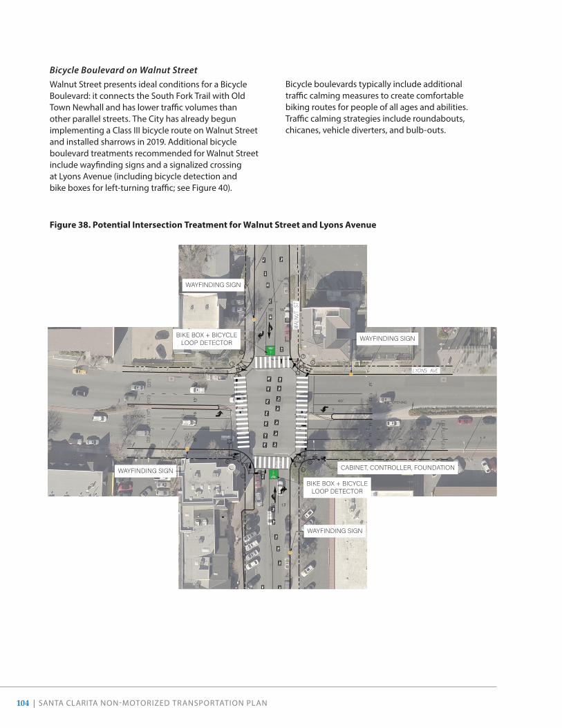
104 | SANTA CLARITA NON-MOTORIZED TRANSPORTATION PLAN
Bicycle Boulevard on Walnut StreetWalnut Street presents ideal conditions for a Bicycle Boulevard: it connects the South Fork Trail with Old Town Newhall and has lower traffic volumes than other parallel streets. The City has already begun implementing a Class III bicycle route on Walnut Street and installed sharrows in 2019. Additional bicycle boulevard treatments recommended for Walnut Street include wayfinding signs and a signalized crossing at Lyons Avenue (including bicycle detection and bike boxes for left-turning traffic; see Figure 40).
�������������������������������
�������������������������������
�������������������������������
�������������������������������
��������������������� ������������������������������ ���������
��� ����������� ��������
��� ����������� ��������
��� ����������� ��������
��� ����������� ��������
Figure 38 . Potential Intersection Treatment for Walnut Street and Lyons Avenue
Bicycle boulevards typically include additional traffic calming measures to create comfortable biking routes for people of all ages and abilities. Traffic calming strategies include roundabouts, chicanes, vehicle diverters, and bulb-outs.

SANTA CLARITA NON-MOTORIZED TRANSPORTATION PLAN | 105
Above: Sharrows on Walnut Street indicate that bicyclists may be present.
Below: Bulb-outs, high-visibility crosswalks, and other strategies help calm traffic.

106 | SANTA CLARITA NON-MOTORIZED TRANSPORTATION PLAN
Old Town NewhallOld Town Newhall is a major destination for the community. To improve the walking and biking experience in the downtown, this NMTP envisions new bike facilities, wayfinding, curb extensions, and increased bike parking. Pedestrian- and bicycle-oriented wayfinding should direct visitors to destinations such as Main Street, Old Town Newhall Library, Newhall Community Center, and the Newhall Metrolink Station. Bulb-outs at Railroad Avenue and Market Street, coupled with wayfinding signage, will improve the experience for residents and visitors entering our community from the Metrolink station. The existing angled parking on Main Street presents opportunities to utilize the striped no-parking zones for bike corrals, significantly expanding the short-term bike parking stock in Old Town Newhall. Striped no-parking zones on Main Street present ideal
conditions for bike corrals.
Bike corrals provide ideal short-term parking near businesses. (Portland, OR)

SANTA CLARITA NON-MOTORIZED TRANSPORTATION PLAN | 107
SUPPORTING FACILITIES
Bike ParkingIn addition to increasing bike parking in Old Town Newhall, the City will partner with major employers and major community destinations (e.g., Valencia Town Center) to ensure end-of-trip facilities are provided. The City will also work to enforce parking requirements at commercial properties. To help implement uniform bike parking standards, the City could update Unified Development Code (UDC) 17.51.060.I to include bike parking requirements at
public facilities (e.g., parks, schools, libraries, transit hubs). Table 9 presents an overview of current bike parking requirements as established in the UDC, and best practices per the Association of Pedestrian and Bicycle Professionals’ (APBP) recommendations for bicycle parking locations and quantities. These guidelines and recommendations are based on industry best practices as well as APBP’s Essentials of Bicycle Parking, and can help guide the City when making decisions about bicycle parking needs.
Table 9 . Recommendations for Bicycle Parking Locations and Quantities
Land Use or Location Type
Physical Location Existing Requirement (UDC 17 .51 .060 .I)
Recommended Quantity (Minimum )
Parks Adjacent to restrooms, picnic areas, fields, and other attractions
- 8 bicycle parking spaces per acre
Schools Near office and main entrance with good visibility
- 8 bicycle parking spaces per 40 students
Public Facilities (e.g., libraries, community centers)
Near main entrance with good visibility
- 8 bicycle parking spaces per location
Commercial, Retail, and Industrial Developments (over 10,000 square feet)
Near main entrance with good visibility
Retail/Commercial: 1 space per 25 vehicle parking stalls
Industrial: 1 space per 40 vehicle parking stalls
1 bicycle parking space per 15 employees or 8 bicycle parking spaces per 10,000 square feet
Shopping Centers (over 10,000 square feet)
Near main entrance with good visibility
- 8 bicycle parking spaces per 10,000 square feet
Transit Stations Near platform, security, or ticket booth
- 1 bicycle parking space or locker per 30 automobile parking spaces
Multi-Family Residential Near main entrance with good visibility
1 space per 5 residential units
1 short-term bicycle parking space per 10 residential units and 1 long-term bicycle parking space per 2 residential units

108 | SANTA CLARITA NON-MOTORIZED TRANSPORTATION PLAN
Green InfrastructureGreen infrastructure is an approach to water management that protects, restores, and simulates the natural water cycle by capturing, filtering, and slowing stormwater. This impro ves water quality, recharges groundwater resources, provides opportunity for water storage and reuse, and decreases the burden on traditional gray infrastructure systems. 1
Green infrastructure is effective, economical, and provides a multitude of benefits to people and wildlife. Green Infrastructure strategies incorporate both the natural environment (forests, wetlands, and other open spaces) and engineered systems (bioswales, rain gardens, tree root vault systems, and pervious paving). Bioswales, for example, manage water runoff from a paved surface and reduce the risks of erosion or flooding of local streams and creeks. Plants in the swale trap pollutants and silt from entering a river system.
Plant material provides a wide array of co-benefits beyond water management. Trees, for example, help reduce greenhouse gases, aid in carbon sequestration, increase urban habitat, and provide shade. In fact, trees are estimated to cool surface temperatures by as much as 45 degrees Fahrenheit, a
1 American Rivers, “What is Green Infrastructure?”, accessed February 20, 2020, https://www.americanrivers.org/threats-solutions/clean-water/green-infrastructure/what-is-green-infrastructure/.
differential that help keep walking and biking on our trails a pleasant experience even in the summer. 2
Bulb-outs, planted bikeway buffers, and landscaped areas adjacent to sidewalks and Class I paths present ideal locations for green infrastructure. The City will take advantage of these opportunities and install green infrastructure where possible, using the design standards specified in the City’s Median Landscaping Guidelines (2014). The City will also consider utilizing permeable paving for new facilities or facilities requiring re-paving, especially where facilities are adjacent to waterways or parks.
WayfindingTo help improve wayfinding throughout the city, this NMTP recommends the City expand signage to highlight connections between trails, parks, and other community destinations; double-face existing signage where needed; and install street name signs on bridge overpasses along trails. Additionally, the City could consider adding road name plaques to stop signs at all street and Class I shared-use path intersections to comply with the 2019 updates to the California Manual on Uniform Traffic Control Devices (CA MUTCD):
“Street Name (D3-1 or D3-1a or G7-1(CA)) signs should be installed at all street and Class I bikeway intersections and at all Class I bikeway intersections” (p. 1360).
ADDITIONAL SIGNAGE
The 2019 revisions to the CA MUTCD also allow for “PASS Bicycle 3 FT MIN” (R117(CA)) signage in “situations where there is a need to remind motorists to pass bicyclists with sufficient lateral clearance in compliance with [California Vehicle Code] 21760 (Three Feet for Safety Act)” (p. 1363). This is intended for roadways with lanes that are too narrow for a bicycle and vehicle to travel safely side by side within the same lane. R117(CA) signs would be appropriate on roadways with both Class III bike routes and Class II bike lanes. The City will consider adding this and other signage as recommended in the CA MUTCD to highlight that bicyclists may be present, particularly along popular cycling routes such as Sand Canyon Road.
2 EPA, “Using Trees and Vegetation to Reduce Heat Islands,” accessed March 27, 2019, https://www.epa.gov/heat-islands/using-trees-and-vegetation-reduce-heat-islands#1.
Rain gardens and bioswales help capture and filter stormwater, recharging our aquifers and improving the quality of our waterways. (Portland, OR)

SANTA CLARITA NON-MOTORIZED TRANSPORTATION PLAN | 109
Bike Repair StationsNumerous locations throughout Santa Clarita currently provide bike parking, but there is a lack of other amenities like bike self-repair/fix-it stations. Being able to fix bikes and have access to water in a secure and welcoming place would allow residents and visitors to engage in outdoor physical activity more frequently and more comfortably. The City can add bicycle fix-it stations and hydration stations to various key destinations, including transit stations and major trailheads.
Intersection Accommodations + Bicycle DetectionTo facilitate safe crossings, the City will consider installing green paint along bicycle lanes near intersections and at conflict zones with demonstrated safety issues. The City shall also consider expanding the GiveMeGreen! program to other busy intersections. Following community feedback regarding the limitations of solar-powered loop detection (which is not detectable at night), and intersections without loop detectors, the City will pursue installing additional bicycle detection systems and test non-solar powered options.
Above: With air pumps and tools, bike repair stations help keep riders moving. (Half Moon Bay, CA)
Below: Green conflict striping helps alert bicyclists that drivers might be crossing the bicycle lane, and drivers that bicyclists have the right of way.

110 | SANTA CLARITA NON-MOTORIZED TRANSPORTATION PLAN
06PROGRAMS

SANTA CLARITA NON-MOTORIZED TRANSPORTATION PLAN | 111
Building on Existing Programs
Following the “6 Es” approach, the City will continue to develop and support the following existing programs in our community.
This mural by DALeast on 9th Street by Main Street adds beauty and thought to Old Town Newhall.

112 | SANTA CLARITA NON-MOTORIZED TRANSPORTATION PLAN
HEADS UP!
The City’s Heads Up! traffic safety campaign has helped increase awareness of road safety among all roadway users in our community. The City should continue this campaign and could expand it to include education efforts for law enforcement personnel.
UPDATE COMMUNITY RESOURCES
As the active transportation network expands, it is crucial that the City maintain up-to-date resources on BikeSantaClarita.com and HikeSantaClarita.com. These platforms and corresponding materials could also include information on trail etiquette, including where to walk/ride and how to pass, and using portable lights to help illuminate trails.
BICYCLE & PEDESTRIAN ADVISORY COMMITTEE
To help ensure implementation of this NMTP, the City’s existing Bicycle & Pedestrian Advisory Committee (BPAC) could begin convening every month. The BPAC could also hold a Valley-wide summit among local law enforcement and user groups to identify specific training needs that will achieve better mutual understanding and enforcement of laws related to pedestrians and cyclists .
ARTISTIC STREETS
Our Public Art Program highlights local community identity through artistic expression, and provides a venue for improving the public realm while celebrating local artists. This program could be expanded to include more artwork on trails and streets with high volumes of people walking and biking. For example, traffic signal cabinets are often a predominant feature on sidewalks near intersections. They contain the computer systems that operate traffic signals and provide a unique canvas for art in the streetscape. Pathways with fencing, particularly along bridges, (such as on Wiley Canyon Road above Railroad Avenue) could include murals and other artwork to enhance the experience of walking or biking along high-speed roads. There are several ways the City can support expanding this program, either through partnerships or contests with local artists, schools, or community groups, and/or by having an application process.
CONTINUE AND EXPAND BICYCLE AND PEDESTRIAN EDUCATION PROGRAMS
The City of Santa Clarita currently sponsors a bicycle safety class through its recreation program. The City should consider developing a similar educational program for pedestrians and working with the school districts to incorporate this type of safety class into the school curriculum. Typical school-based bicycle and pedestrian education programs educate students about the rules of the road, proper use of bicycle equipment, biking skills, street crossing skills, and the benefits of biking and walking. Education programs can be part of a Safe Routes to School program and, in Santa Clarita, could use the Suggested Routes to School Maps that are developed each year. These types of education programs are usually sponsored by a joint City/school district committee that includes appointed parents, teachers, student representatives, administrators, police, active bicycle riders, and engineering department staff.
Walking and biking curriculum frequently covers traffic rules, signals, and markings. (Anaheim, CA)

SANTA CLARITA NON-MOTORIZED TRANSPORTATION PLAN | 113
Education need not be limited to younger children. The City’s current bicycle safety classes are available to adults as well as children. The City may consider working with the Sheriff’s Department to utilize adult bicycle education programs as a “bicycle traffic school” in lieu of fines for bicycle or pedestrian-related traffic violations. These courses could be geared toward motorists as well as bicyclists and pedestrians.
The City may also consider training more residents and staff to be League Certified Instructors (LCI) by the League of American Bicyclists, as LCIs are able to teach multiple curricula such as biking on city streets, bike maintenance, and bicycling etiquette. The City can support these efforts by funding classes or providing meeting space or other in-kind donations to support education opportunities.
Trail EtiquetteFollowing community requests to increase education on trail etiquette, the City could foster “safe and courteous use” throughout the trail network using a variety of tools:
• Installing more triangular yield priority signs
• Establishing and posting speed limit guidance for bike and e-bike users
• Creating “Announce Yourself” or “On Your Left” campaigns for safe passing
• Posting trail user guidelines at trailheads, on trail maps, and on City websites and social media
Additionally, the City could produce a “Code of Conduct” manual with key pointers (e.g., “On Your Left”). Trail etiquette campaigns could also include information about the importance of using portable lights to illuminate trails so that the City can continue adhering to dark sky practices in order to diminish our impact on sensitive lands.
CONTINUE SRTS PROGRAM
With the 2019 SRTS Plan, the City’s SRTS Program has grown to include all schools in our community, including middle and high schools. The City should continue the program at elementary schools and begin implementing improvements at all middle and high schools.
Defining and encouraging proper trail etiquette helps create positive experiences for all trail users.

114 | SANTA CLARITA NON-MOTORIZED TRANSPORTATION PLAN
CONTINUE THE CITY SIDEWALKS PROGRAM
As part of the Resident Service Center, the City offers residents an online platform for reporting sidewalks in need of repair. Once a request is submitted, the City prepares a service request and conducts temporary repairs within 14 days. From 2017 to 2018, the City repaired over 70,000 square feet of sidewalks, and installed 34 pedestrian access curbs compliant with the ADA Act. The City will continue supporting the Resident Service Center and City Sidewalk Program.
FACILITATE THE DEVELOPMENT OF EMPLOYER INCENTIVE PROGRAMS
The City could facilitate employer incentive programs to encourage employees to try bicycling and walking to work and include strategies such as providing bicycle lockers and shower facilities, offering more flexible arrival and departure times, and developing fun incentives such as entry into monthly raffle contests. The City may offer incentives to employers to institute these improvements through air quality credits, lowered parking requirements, reduced traffic mitigation fees, or other means.
CONTINUE TO SUPPORT BIKE-TO-WORK AND BIKE-TO-SCHOOL DAYS
The City of Santa Clarita should continue its participation in the annual Bike-to-Work day in May, in conjunction with the Los Angeles County and California bike-to-work week activities. City staff should be present at “energizer” stations along the designated routes. Local Bike- and- Walk-to-School days can be held annually in conjunction with bicycle education programs.
CONTINUE TO SUPPORT BIKE FAIRS AND RACES
Hosting bike fairs and races in Santa Clarita, such as the Amgen Bike Tour of California that the City hosted in 2019, can raise the profile of bicycling in the area and provide entertainment for all ages. Bike fairs and races provide an opportunity to educate and encourage current and potential bicyclists. These events can also bring visitors to Santa Clarita that may contribute to the local economy. These events could be sponsored and implemented through collaboration between City and local employers.
The City Sidewalk Program offers residents a way to help the City keep our sidewalks smooth and in good repair.

SANTA CLARITA NON-MOTORIZED TRANSPORTATION PLAN | 115
CONTINUE TO IMPROVE UPON BICYCLE FRIENDLY COMMUNITY AWARD
The City of Santa Clarita should develop an action plan to meet the League of American Cyclist’s requirements to become a gold and eventually platinum Bicycle Friendly Community. Many of the programmatic recommendations will help advance this goal, including convening the Bicycle Task Force more regularly, training more League Certified Instructors, and educating law enforcement about bicycling-related issues.
CONTINUE TO COORDINATE WITH LOS ANGELES COUNTY, CALTRANS, AND OTHER AGENCIES TO EXPAND THE REGIONAL BIKEWAY NETWORK
Expanding and enhancing the regional bikeway network is an important part of making active transportation viable for commuting. Santa Clarita’s employers attract employees from outside the City limits, while some City residents are commuting to jobs in the San Fernando Valley and throughout Los Angeles County. The City of Santa Clarita should actively encourage and facilitate the construction and improvement of bikeway facilities on regionally important routes. The City should place a high priority on filling in gaps in the regional network as identified in the Los Angeles County Bicycle Master Plan and forthcoming update. Regionally important bikeway facilities include, but are not limited to the extension of San Francisquito Creek Trail north to Castaic Lake, extension of the Santa Clara River Trail, The Old Road, and Sierra Highway.
Future Program RecommendationsTo further advance our three goals, the City will work towards implementing new programs to help encourage active transportation in our community.
WALKING CLUBS
Encouraging regular walking trips helps develop active habits and promote the health and wellness of the community. Organized group walkabouts held on lunch breaks,
weekends, or evenings can encourage walking for physical activity while connecting Santa Clarita residents with popular destinations such as Old Town Newhall, trails, or hidden treasures, such as gardens or vistas. A number of organizations already incorporate group walks within their programming. Such programming could be incorporated into the City’s existing Walking Challenge to foster additional participation and social connections.
LAW ENFORCEMENT TRAININGS
Finding ways to involve law enforcement in traffic safety efforts has been a challenging topic nationwide. Many police officers have limited (or no) training specific to active transportation. Inconsistent application of laws related to walking and biking continues to make for troubling headlines and perpetuates historic inequities between the public and officers. Officers need training specific to active transportation laws, especially since people with limited income and people of color tend to walk and bicycle more often than the average population.
Cities across the country have found that training local law enforcement improves officers’ knowledge of Primary Collision Factors and understanding of the vehicle code. Officers need to know the law well in order to enforce the law equitably and fairly. The City of Santa Clarita, in partnership with the Los Angeles County Sheriff’s Department, should pursue grant funding to conduct trainings for officers serving the Santa Clarita Station. This could be incorporated into the Heads Up! Campaign or other existing education efforts.
Training law enforcement officers on the frequent Primary Collision Factors (PCF) of pedestrian- and bicycle-involved collisions can help improve traffic enforcement efforts. (Irvine, CA)
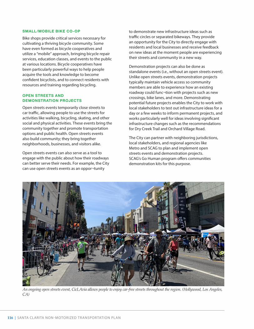
116 | SANTA CLARITA NON-MOTORIZED TRANSPORTATION PLAN
SMALL/MOBILE BIKE CO-OP
Bike shops provide critical services necessary for cultivating a thriving bicycle community. Some have even formed as bicycle cooperatives and utilize a “mobile” approach, bringing bicycle repair services, education classes, and events to the public at various locations. Bicycle cooperatives have been particularly powerful ways to help people acquire the tools and knowledge to become confident bicyclists, and to connect residents with resources and training regarding bicycling.
OPEN STREETS AND DEMONSTRATION PROJECTS
Open streets events temporarily close streets to car traffic, allowing people to use the streets for activities like walking, bicycling, skating, and other social and physical activities. These events bring the community together and promote transportation options and public health. Open streets events also build community; they bring together neighborhoods, businesses, and visitors alike.
Open streets events can also serve as a tool to engage with the public about how their roadways can better serve their needs. For example, the City can use open streets events as an oppor¬tunity
to demonstrate new infrastructure ideas such as traffic circles or separated bikeways. They provide an opportunity for the City to directly engage with residents and local businesses and receive feedback on new ideas at the moment people are experiencing their streets and community in a new way.
Demonstration projects can also be done as standalone events (i.e., without an open streets event). Unlike open streets events, demonstration projects typically maintain vehicle access so community members are able to experience how an existing roadway could func¬tion with projects such as new crossings, bike lanes, and more. Demonstrating potential future projects enables the City to work with local stakeholders to test out infrastructure ideas for a day or a few weeks to inform permanent projects, and works particularly well for ideas involving significant infrastructure changes such as the recommendations for Dry Creek Trail and Orchard Village Road.
The City can partner with neighboring jurisdictions, local stakeholders, and regional agencies like Metro and SCAG to plan and implement open streets events and demonstration projects. SCAG’s Go Human program offers communities demonstration kits for this purpose.
An ongoing open streets event, CicLAvia allows people to enjoy car-free streets throughout the region. (Hollywood, Los Angeles, CA)

SANTA CLARITA NON-MOTORIZED TRANSPORTATION PLAN | 117
CREATE A MULTI-MODAL ACCESS GUIDE
A multi-modal access guide provides concise customized information on how to access specific destinations with an emphasis on biking, walking and transit. Access guides can be as simple as a map printed on the back of a business card or as complex as a multi-page packet distributed to employees.
Best practices include using graphics, providing specific step-by-step travel directions, providing parking locations, and pricing information, and providing information about the benefits of walking and biking.
WORK WITH BUSINESSES TO DEVELOP INCENTIVES FOR BIKING AND WALKING
Incentive programs to encourage biking and walking to local businesses can be developed in coordination with individual businesses, the Chamber of Commerce, the Santa Clarita Valley Bicycle Coalition, and Santa Clarita Velo.
Such efforts may include:
• Creating promotional events such as “Bicycle to the Grocery Store” days, when bicyclists get vouchers for or discounts on items in the store.
• Holding an annual community event to encourage residents to replace one car trip a week with a walking or bicycling trip.
• Developing, promoting, and publicizing bicycle commuter services, such as bike shops selling commute gear, bike-on-transit policies, and regular escorted commute rides.
• Creating an annual commuter challenge for area businesses.
• Encouraging and facilitating the development of small satellite business services near bicycle trailheads such as mobile cafes and stands that sell amenities such as snacks, sunscreen, first aid supplies, and trail maps.
• Encouraging and facilitating the development of lunchtime amenities, such as outdoor lunch areas and satellite or mobile food stations in the Industrial Center.
ECONOMIC IMPACT STUDY OF ACTIVE TRANSPORTATION TOURISM
Our community boasts one of the best trail networks in Southern California, providing recreation opportunities for existing residents and attracting visitors for casual rides and large events alike. To better understand how our active transportation facilities attract tourism—and the economic benefits herein—the City could conduct an economic impact study.
How will active transportation programs achieve the goals of the NMTP?SAFETY & HEALTH The programs proposed in this NMTP both support safe bicycling and walking behaviors and address unsafe driving behaviors. Programs also encourage Santa Clarita residents and visitors to live a more active lifestyle.
ACCESS & COMFORT The programs proposed in this NMTP help expand the reach of the active transportation network with information and support facilities that make bicycling and walking preferred travel options for more trips.
MAINTAIN & EXPAND THE NETWORKThe programs proposed in this NMTP enhance our network by encouraging safe, frequent, and fun bicycling and walking.
SCAG’s Go Human demonstration kit allows cities to test out design ideas, such as parking-protected Class IV separated bikeways. (Glendora, CA)
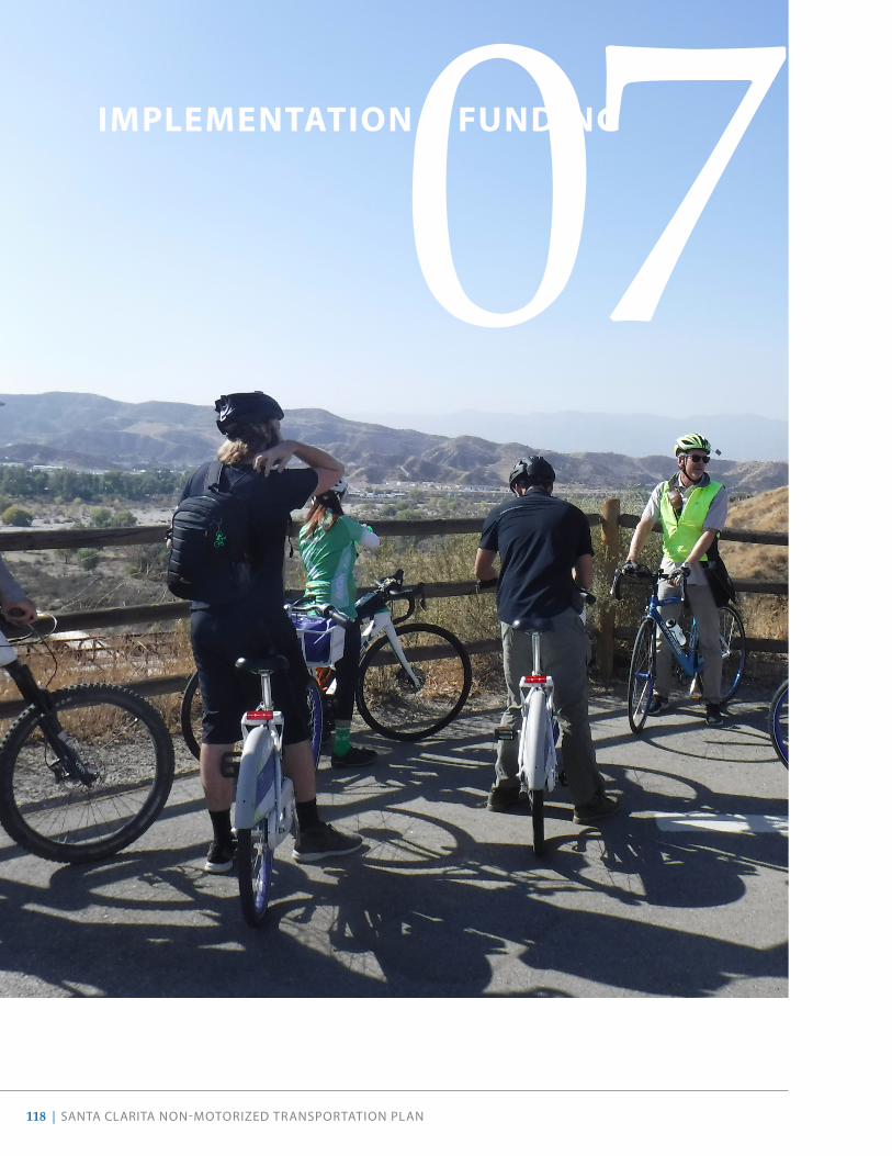
118 | SANTA CLARITA NON-MOTORIZED TRANSPORTATION PLAN
07IMPLEMENTATION & FUNDING

SANTA CLARITA NON-MOTORIZED TRANSPORTATION PLAN | 119
This chapter provides a roadmap for achieving the vision and goals established at the beginning of the NMTP by outlining a prioritization strategy, cost estimates, maintenance strategy, and funding sources. Santa Clarita is responsible for the implementation of active transportation infrastructure projects within the city boundaries. Programs to encourage walking, bicycling, and using other active modes or to provide safety education are the responsibility of City departments and of regional agencies such as the Los Angeles County Sheriff’s Department. Additionally, a safer and more active Santa Clarita is not possible without the involvement of community members. Our residents have priceless knowledge about the streets in our community. As the City
moves forward with the implementation of active transportation projects, additional community engagement and outreach will be essential.
The City commits to regularly evaluating how well performance measures set forth in this NMTP are met, and whether the many recommendations established in this NTMP still meet the needs of our residents and visitors. The City aims to track progress on implementation every year.
In addition, the recommendations in this NMTP should be re-evaluated at least every five years to ensure that these still constitute best practices and reflect our community’s long-term vision for a safer and more active community.
The NMTP provides the long-term vision for the development of a citywide biking and walking network that can be used by all residents for all types of trips. Implementation of the NMTP will take place in small steps over many years. This NMTP recommends that the City pursue the following strategies to implement the NMTP’s vision:
1 Maintain implementation responsibility by continuing to assign the duties of a non-motorized transportation planner to a City staff person.
2 Strategically implement infrastructure projects and programmatic initiatives by pursuing funding for high-priority projects and program first, and by installing projects of all priorities in conjunction with larger construction projects.
3 Regularly update project prioritization to ensure that new projects are added to the list, completed projects are removed, and the priorities are revised as conditions change.
4 Update the NMTP on a regular basis. The bicycle portion of the NMTP should be updated every five years to remain eligible for California Active Transportation Program funding. Other elements of the NMTP may be reviewed and updated as needed.
5 Use performance measures to determine how well the City is achieving the goals of the NMTP. The NMTP identifies several measures of effectiveness that the City should consider.

120 | SANTA CLARITA NON-MOTORIZED TRANSPORTATION PLAN
AdministrationCEQA
The California Environmental Quality Act (CEQA) provides a process for evaluating the environmental effects of plans or applicable projects undertaken or approved by public agencies. Active transportation plans, such as this one, are generally exempt from the CEQA process and do not require an Environmental Impact Report (EIR). Additionally, when implementing this NMTP, specific projects that do not significantly alter land, water, or vegetation (e.g., striping bikeways or crosswalks) are also exempt from the environmental review process. For pedestrian and bicycle facilities that are not exempt from CEQA review but are initially shown to not have a significant impact on the environment, the City can file either a Categorical Exemption or a Mitigated Negative Declaration in lieu of completing an EIR.
To comply with Senate Bill 743, City Council adopted guidelines in 2020 to utilize Vehicle Miles Traveled (VMT) thresholds in order to identify transportation impacts under CEQA. The City will continue to consult with our guidelines and state regulations when implementing specific infrastructure projects.
ACTIVE TRANSPORTATION PROGRAM COMPLIANCE
The Active Transportation Program (ATP) is a Caltrans program with specific requirements for bicycle and/or pedestrian plans. Although plans are no longer required to comply with the ATP guidelines in order to receive Caltrans funding, it is strongly recommended that communities have an approved plan prior to applying for implementation funds. This NMTP is in compliance with ATP guidelines as shown in Appendix D.
Cost EstimatesPlanning-level cost assumptions can be used to determine general cost estimates for particular infrastructure projects, based on additional information as projects are further developed and designed. The cost assumptions in Table 10 show the industry standard costs in 2020 dollars for the bicycle and pedestrian treatments recommended in this NMTP. While the estimates reflect typical costs per mile of bikeway (as opposed to per mile of roadway), unit costs do not consider project-specific factors such as right-of-way acquisition, intensive grading, landscaping, intensive utility relocation, or other location-specific factors that
may increase actual costs. For some projects, costs may be significantly greater. City staff may use these unit cost figures when estimating a project’s overall cost.
It is important to note the following general assumptions regarding the cost estimates. First, all cost estimates are conceptual, since there is no feasibility or preliminary design completed, and second, the design and administration costs included in these estimates may not be sufficient to fund environmental clearance studies.1 Costs do not include environmental remediation or acquisition of right-of-way. Finally, cost estimates fluctuate over time as construction costs escalate, and as such, the costs presented should be considered as rough order of magnitude only.
Table 10 . Estimated Unit Costs per Recommended Facility Type
Facility Type Cost per Mile of Bikeway
Class I Bike Path $1,575,000
Class II Bike Lane $25,000
Class III Bike Route $15,000
Class IV Separated Bikeway
$70,000
Prioritization FrameworkTo guide implementation, a prioritization framework was developed to evaluate proposed bicycle and pedestrian projects using the criteria outlined in Table 11. These criteria included findings from public input, improving access to schools and other key destinations, enhancing connectivity of the overall network, cost efficiency, safety, and ensuring facilities serve areas of high need. For each criterion, projects received an individual score; a composite score was developed based on the sum of all five factors evaluated. Total scores falling within the top third are considered high priority projects; total scores falling in the middle third are considered medium priority; and scores falling in the lower third are considered low priority projects.
1 Class II and IV facilities may be substantially higher in cost in the event curb or median modifications are required.
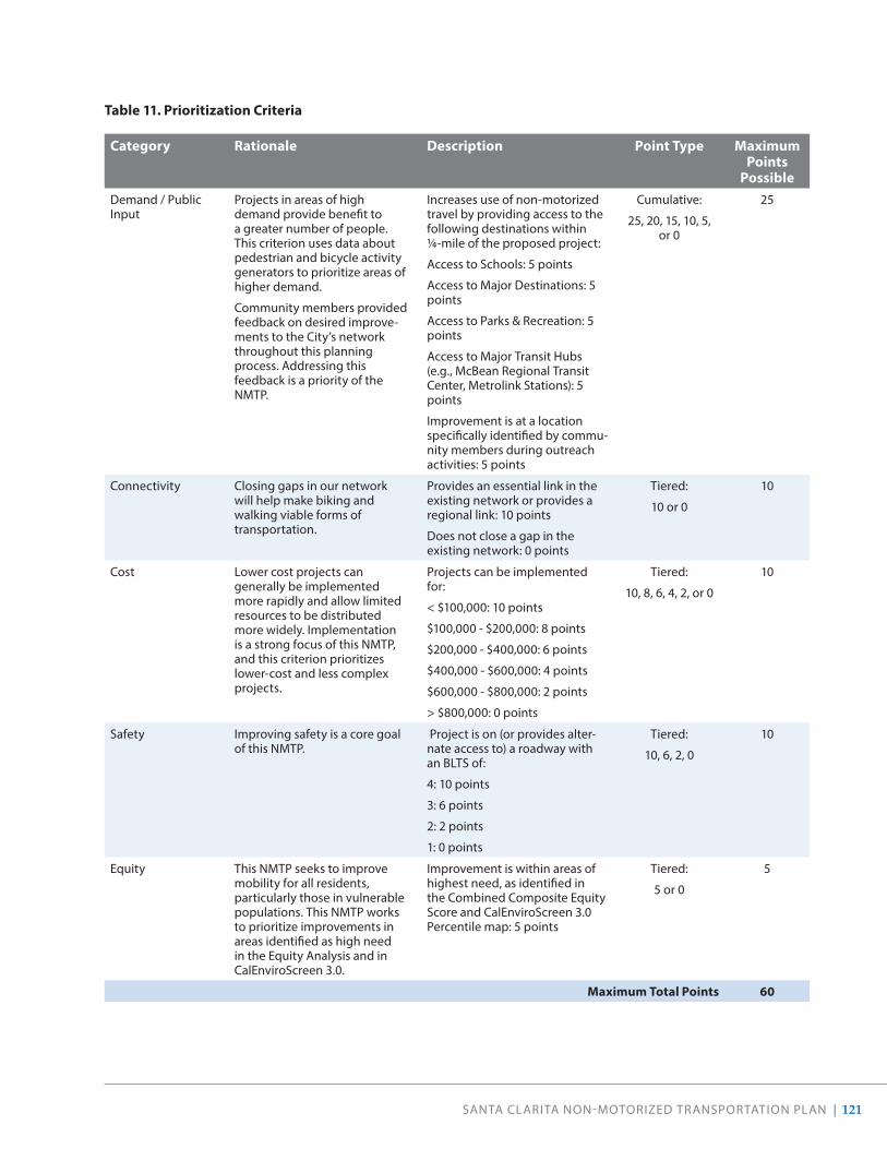
SANTA CLARITA NON-MOTORIZED TRANSPORTATION PLAN | 121
Table 11 . Prioritization Criteria
Category Rationale Description Point Type Maximum Points
PossibleDemand / Public Input
Projects in areas of high demand provide benefit to a greater number of people. This criterion uses data about pedestrian and bicycle activity generators to prioritize areas of higher demand.
Community members provided feedback on desired improve-ments to the City’s network throughout this planning process. Addressing this feedback is a priority of the NMTP.
Increases use of non-motorized travel by providing access to the following destinations within ¼-mile of the proposed project:
Access to Schools: 5 points
Access to Major Destinations: 5 points
Access to Parks & Recreation: 5 points
Access to Major Transit Hubs (e.g., McBean Regional Transit Center, Metrolink Stations): 5 points
Improvement is at a location specifically identified by commu-nity members during outreach activities: 5 points
Cumulative:
25, 20, 15, 10, 5, or 0
25
Connectivity Closing gaps in our network will help make biking and walking viable forms of transportation.
Provides an essential link in the existing network or provides a regional link: 10 points
Does not close a gap in the existing network: 0 points
Tiered:
10 or 0
10
Cost Lower cost projects can generally be implemented more rapidly and allow limited resources to be distributed more widely. Implementation is a strong focus of this NMTP, and this criterion prioritizes lower-cost and less complex projects.
Projects can be implemented for:
< $100,000: 10 points
$100,000 - $200,000: 8 points
$200,000 - $400,000: 6 points
$400,000 - $600,000: 4 points
$600,000 - $800,000: 2 points
> $800,000: 0 points
Tiered:
10, 8, 6, 4, 2, or 0
10
Safety Improving safety is a core goal of this NMTP.
Project is on (or provides alter-nate access to) a roadway with an BLTS of:
4: 10 points
3: 6 points
2: 2 points
1: 0 points
Tiered:
10, 6, 2, 0
10
Equity This NMTP seeks to improve mobility for all residents, particularly those in vulnerable populations. This NMTP works to prioritize improvements in areas identified as high need in the Equity Analysis and in CalEnviroScreen 3.0.
Improvement is within areas of highest need, as identified in the Combined Composite Equity Score and CalEnviroScreen 3.0 Percentile map: 5 points
Tiered:
5 or 0
5
Maximum Total Points 60

122 | SANTA CLARITA NON-MOTORIZED TRANSPORTATION PLAN
The prioritization list is a guide for the City. When funding sources become available, the City will take all available opportunities to propose the most competitive projects. Should opportunities arise to complete projects on lower tiers of the prioritization list, they should be taken. For example, if a new development is required to provide a public benefit along these corridors, proposed bikeways should be considered as an option. If the City plans to repave a corridor that has a recommended bikeway, the City will explore ways to complete bikeways as the street is repaved.
Projects were given one of three priorities:
• Tier 1: High Priority Projects . These are projects that the City will actively seek funding for and dedicate resources to planning and implementation in the next five years (see Table 12). Since many of these projects are of a large-scale, transformational nature, they will require significant outreach and funding. Timelines for outreach and identification of funding sources should be a high priority and immediate next step. The Tier 1 projects that are
lower-scale and lower-cost should be considered for immediate implementation in the coming fiscal years.
• Tier 2: Secondary Priority Projects . These are projects that the City will maintain as potential projects, in the event that funding sources (such as developer impact fees) become available (see Table 13). The City’s repaving plan will also take these projects into account as street repaving plans are implemented. These projects may be combined with Tier 1 projects to strengthen the network and gap closure portions of grant applications, and to complement other projects.
• Tier 3: Other Projects . These are projects that represent long-term opportunities for the City to pursue (see Table 14). While many of these projects received community support, they do not represent the most strategic options for improving connec-tivity, safety, and equity. However, should the City have the opportunity to implement projects from any of the three tiers, it is recommended as all projects have been developed to close network gaps and improve walking, biking, and connecting to transit.

SANTA CLARITA NON-MOTORIZED TRANSPORTATION PLAN | 123
Table 12 . Recommended Bicycle Projects Including Length and Estimated Costs: Tier 1
Name Facility Type
Miles From To Cost Estimate
Priority Score
Dockweiler Drive (Extension)
2 2.07 12th Street Dockweiler Drive (Terminus)
$52,000 51
Sierra Highway 2 3.38 Campus Circle Soledad Canyon Road $84,000 51
Via Princessa 3 1.81 Isabella Parkway Whites Canyon Road $27,000 51
Race Street 3 1.07 Market Avenue Newhall Avenue $16,000 50
Walnut Street Bike Route 3 2.63 Yvette Lane Market Street $39,000 50
Whites Canyon Road 3 1.23 Stillmore Street Via Princessa $19,000 47
Market Street 2 0.37 Newhall Avenue Railroad Tracks $9,000 46
Orchard Village Road 4 2.08 Mill Valley Road Lyons Avenue $805,000 46
Railroad Avenue 1 2.57 Magic Mountain Parkway
Newhall Metrolink Station
$10,000,000 46
Seco Canyon Frontage Road
3 1.78 Decoro Drive End of Frontage Road $27,000 46
Sierra Highway 3 2.18 Vista Del Canon Soledad Canyon Road $33,000 46
Valley Street 3 1.96 Lyons Avenue Terminus $29,000 46
Whites Canyon Road 2 3.13 Steinway Road Stillmore Street $78,000 46
Santa Clara River Trail 1 0.79 Lost Canyon Road Sand Canyon Rd $1,250,000 45
Sierra Highway (Southbound)
2 0.37 Linda Vista Street City Limits $9,000 42
Decoro Drive 3 0.16 Rio Garza Drive Seco Canyon Road $2,000 41
Del Monte Drive 2 3.78 Summit Place Estaban Parkway $94,000 41
Sand Canyon Road 2 1.18 Railroad (Lost Canyon Rd.)
Soledad Canyon Road $29,000 41
Wiley Canyon Road 3 2.40 Vista Ridge Drive Calgrove Boulevard $36,000 41
Bouquet Canyon Trail 1 0.73 Bouquet Canyon Road
Central Park (Main Entrance)
$1,149,000 40
Calgrove Boulevard 2 0.71 The Old Road Wiley Canyon Road $18,000 40
Garzota Drive / Barbacoa Drive
3 1.55 Dry Creek Trail Alamogordo Road $23,000 40
Via Princessa 2 1.54 Jason Drive Golden Valley Road $38,000 40
Sierra Highway 3 9.68 City Limits (South) Friendly Valley Parkway
$145,000 39
Bouquet Canyon Road Trail
1 0.93 Alamogordo Drive Haskell Canyon Road $1,460,000 36
Connector to Railroad Avenue Trail
1 0.15 Newhall Avenue Proposed Railroad Avenue Trail
$234,000 36
Copper Hill Drive 2 2.47 Haskell Canyon Road
Bouquet Canyon Road
$62,000 36
Golden Valley Road 1 0.16 Green Mountain Drive
SR 14 On-Ramp (Westbound)
$250,000 36
Sand Canyon Road 1 0.88 Soledad Canyon Road
Thompson Ranch Drive
$1,379,000 36
Santa Clara River Trail (South Side)
1 1.31 Soledad Canyon Road
Sierra Highway $2,060,000 36

124 | SANTA CLARITA NON-MOTORIZED TRANSPORTATION PLAN
Name Facility Type
Miles From To Cost Estimate
Priority Score
Via Princessa (Extension) 1 2.77 Claibourne Lane Sheldon Avenue $4,360,000 36
8th Street / Newhall Avenue
3 0.65 Terminus Market Street $10,000 35
Dockweiler Drive 2 0.75 Terminus Ivy Lane $19,000 35
Dorothy Street / Langside Avenue / Steinway Street
3 2.33 Golden Valley Road Whites Canyon Road $35,000 35
Espuella Drive 3 0.94 Bouquet Canyon Road
Central Park $14,000 35
Isabella Parkway (Southbound)
3 1.71 Golden Triangle Road
Via Princessa $26,000 35
Vista Delgado Drive 4 0.09 Dry Creek Trail Decoro Drive $6,000 35
TOTAL 64 .31 $23,926,000
Table 13 . Recommended Bicycle Projects Including Length and Estimated Costs: Tier 2
Name Facility Type
Miles From To Cost Estimate
Priority Score
Canyon Park Boulevard 2 1.54 Sierra Highway Lost Canyon Road $39,000 32
Lost Canyon Road 3 0.56 La Veda Avenue Sand Canyon Road $8,000 32
Newhall Avenue 1 1.36 6th Street Sierra Highway $2,150,000 32
Arroyo Park Drive 2 1.81 Summit Place McBean Parkway $45,000 31
Dry Creek Trail 1 1.21 Decoro Drive Copper Hill Drive $1,912,000 31
Dry Creek Trail 1 1.01 Newhall Ranch Road
Vista Delgado Drive $1,597,000 31
Goldcrest Drive 2 0.77 Valencia Boulevard
Del Monte Drive $19,000 31
Lost Canyon Road (New Bridge)
1 0.22 Soledad Canyon Road
Vista Canyon Development
$341,000 31
Magic Mountain Parkway (Connector to Iron Horse Trail)
4 0.21 Tourney Road Iron Horse Trailhead $15,000 31
Sand Canyon Road 3 5.39 Placerita Canyon Road
Lost Canyon Road $81,000 31
Seco Canyon Road 4 0.07 Tupelo Ridge Drive
Seco Canyon Frontage Road
$5,000 31
Seco Canyon Road (Northbound)
2 0.08 Paragon Drive Tupelo Ridge Drive $2,000 31
Seco Canyon Road (Southbound)
2 0.03 Terminus of Existing Bike Lane
Tupelo Ridge Drive $1,000 31
South Fork Trail (South Side)
1 0.30 Orchard Village Road
Newhall Avenue $470,000 31
Summit Place 2 0.33 Rockwell Canyon Road
Arroyo Park Drive $8,000 31
McBean Parkway 2 0.37 The Old Road I-5 $9,000 30
Rainbow Glen Drive 3 1.71 Soledad Canyon Road
Sierra Highway $26,000 30
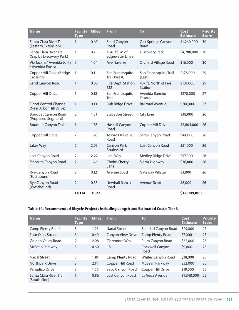
SANTA CLARITA NON-MOTORIZED TRANSPORTATION PLAN | 125
Name Facility Type
Miles From To Cost Estimate
Priority Score
Santa Clara River Trail (Eastern Extension)
1 0.69 Sand Canyon Road
Oak Springs Canyon Road
$1,240,000 30
Santa Clara River Trail (Gap by Discovery Park)
1 0.75 1540 ft. W. of Edgewater Drive
Discovery Park $4,700,000 30
Via Jacara / Avenida Jolita / Avenida Frasca
3 1.04 Ave Navarre Orchard Village Road $16,000 30
Copper Hill Drive (Bridge Crossing)
1 0.11 San Francisquito Trail (West)
San Francisquito Trail (East)
$176,000 29
Sand Canyon Road 1 0.08 Fire Dept. Station 132
437 ft. North of Fire Station
$131,000 29
Copper Hill Drive 1 0.18 San Francisquito Trail
Avenida Rancho Tesoro
$278,000 27
Flood Control Channel (Near Arbor Hill Drive)
1 0.13 Oak Ridge Drive Railroad Avenue $206,000 27
Bouquet Canyon Road (Proposed Segment)
2 1.51 Steve Jon Street City Line $38,000 26
Bouquet Canyon Trail 1 1.78 Haskell Canyon Road
Copper Hill Drive $2,804,000 26
Copper Hill Drive 2 1.78 Tesoro Del Valle Road
Seco Canyon Road $44,000 26
Jakes Way 2 2.03 Canyon Park Boulevard
Lost Canyon Road $51,000 26
Lost Canyon Road 2 2.27 Lark Way Medley Ridge Drive $57,000 26
Placerita Canyon Road 2 1.46 Choke Cherry Lane
Sierra Highway $36,000 26
Rye Canyon Road (Eastbound)
2 0.12 Avenue Scott Gateway Village $3,000 26
Rye Canyon Road (Westbound)
2 0.33 Newhall Ranch Road
Avenue Scott $8,000 26
TOTAL 31 .22 $12,989,000
Table 14 . Recommended Bicycle Projects Including Length and Estimated Costs: Tier 3
Name Facility Type
Miles From To Cost Estimate
Priority Score
Camp Plenty Road 3 1.95 Nadal Street Soledad Canyon Road $29,000 25
Four Oaks Street 3 0.49 Canyon View Drive Camp Plenty Road $7,000 25
Golden Valley Road 2 2.08 Claremore Way Plum Canyon Road $52,000 25
McBean Parkway 3 0.60 I-5 Rockwell Canyon Road
$9,000 25
Nadal Street 3 1.19 Camp Plenty Road Whites Canyon Road $18,000 25
Northpark Drive 3 2.11 Copper Hill Road McBean Parkway $32,000 25
Pamplico Drive 3 1.25 Seco Canyon Road Copper Hill Drive $19,000 25
Santa Clara River Trail (South Side)
1 0.86 Lost Canyon Road La Veda Avenue $1,348,000 25

126 | SANTA CLARITA NON-MOTORIZED TRANSPORTATION PLAN
Name Facility Type
Miles From To Cost Estimate
Priority Score
Shadow Pines Boulevard 2 1.26 Soledad Canyon Road
Grandifloras Road $31,000 25
South Fork Trail (Southern Extension)
1 0.71 Orchard Village Road
Lyons Avenue $1,113,000 25
Sunset Hills Drive 3 0.50 McBean Parkway Northpark Drive $8,000 25
Santa Clara River Trail 1 0.36 Santa Clara River Trail (West)
The Old Road $564,000 24
8th Street 1 0.07 Eastern edge Western edge $103,000 23
Citrus Street 2 0.57 Valencia Boulevard Magic Mountain Parkway
$14,000 21
Magic Mountain Parkway 2 0.62 Citrus Street Auto Center Drive $15,000 21
Placerita Canyon Road 3 3.77 City Line Sand Canyon Road $57,000 21
Sandy Drive 3 1.00 Sierra Highway Zev Drive $15,000 21
Santa Clara River Trail (South Side)
1 0.94 Sierra Highway Lost Canyon Road $1,487,000 21
8th Street 3 0.73 Valley Street Terminus $11,000 20
Avenida Rancho Tesoro 2 0.54 Copper Hill Drive Rancho Tesoro $14,000 20
Benz Road 3 0.68 Copper Hill Drive Bouquet Canyon Road $10,000 20
Calla Way 3 0.33 Canyon View Drive Camp Plenty Road $5,000 20
Copper Hill Drive (Extension)
2 0.40 Copper Hill Drive (Terminus)
Bouquet Canyon Rd (New Align.)
$10,000 20
Magic Mountain Parkway (Railroad Avenue Trail)
1 0.26 South Fork Trail Railroad Avenue $409,000 20
Pleasantdale Street 3 1.04 Camp Plenty Road Crossglade Avenue $16,000 20
Shadow Pines Boulevard (Extension)
2 1.57 Grandifloras Road Tick Canyon Road $39,000 20
Stillmore Street 3 1.12 Camp Plenty Road Crossglade Avenue $17,000 20
Valley Center Drive 1 0.31 Soledad Canyon Road
Golden Valley Road $492,000 19
Needham Ranch Parkway 1 0.60 Newhall Avenue Sierra Highway $938,000 17
San Francisquito Creek Trail (Northern Extension)
1 0.28 Copper Hill City Line $434,000 14
TOTAL 28 .18 $7,514,000

SANTA CLARITA NON-MOTORIZED TRANSPORTATION PLAN | 127
Funding StrategyCOORDINATION WITH OTHER AGENCIES & DEPARTMENTS
Our City will continue to work with adjacent communities to align priorities for projects where facilities abut boundaries. The City also commits to continue integrating active transportation projects with the regional network of walkways and bikeways in partnership with County agencies and regional bodies such as Los Angeles County, Metro, Metrolink, SCAG, and more. For recommendations along flood control channels and other bodies of water, the City will coordinate with the Los Angeles County Flood Control District. In addition, the City will coordinate with Southern California Edison and the Metropolitan Water District to implement active transportation projects along utility rights-of-way.
Lastly, as Caltrans is a large funding source for active transportation projects within the state, and further maintains freeways inside the Santa Clarita boundaries, additional coordination with this agency is important.
FUNDING SOURCES
As with many jurisdictions in the region, Santa Clarita utilizes regional, state, and federal funding sources to implement bicycle and pedestrian infrastructure projects and programs. Typically, these dollars are distributed to jurisdictions throughout California through a competitive grant process. The City has a successful track record of securing funding from these sources for pedestrian and bicycle infrastructure projects and programs. However, these funding sources continue to become increasingly competitive.
Transportation funding can change drastically when there are modifications to policies and new taxes and
fees are adopted. Regionally, transportation funding increased with the approval of Measure M in 2016 by Los Angeles County voters. A portion of Measure M dollars are granted to the City as local return funding, and an additional two percent of County funding is specifically set aside for active transportation projects, similar to those identified in this plan.
In 2017, state-level funding for transportation augmented through increases in the statewide gas tax and vehicle registration fee (SB 1). The California State Legislature passed these increases to address the growing backlog of roadway maintenance issues statewide, coupled with the adoption of several climate initiatives, such as cap-and-trade, which brings new revenue to the State from the sale and transfer of emission credits.
Federal transportation funding is primarily secured through grant programs run by State and regional agencies such as Metro, SCAG, and Caltrans. Federal funding is perhaps the most uncertain, as the primary federal source of funding—the federal gas tax—has not been raised since 1993. Federal revenue for transportation is allocated through the federal surface transportation bill, which is developed and authorized by Congress infrequently.
A full list of potential funding sources and the types of projects eligible for these sources is provided in Table 15. As the funding environment is constantly changing, many of the sources identified may be discontinued or new funding opportunities may become available. City staff will remain vigilant and maintain focus on adapting to secure funding from sources of revenue as opportunities arise.

128 | SANTA CLARITA NON-MOTORIZED TRANSPORTATION PLAN
Program Agency/Source Description
FEDERAL
Fixing America’s Surface Transportation Act (FAST Act)
Federal Highway Administration (FHWA)
The FAST Act, which replaced the Moving Ahead for Progress in the 21st Century Act (MAP-21) in 2015, provides long-term funding for certain surface transportation projects, including walking- and biking-related projects, through 2020.
Congestion Mitigation and Air Quality Improvement Program (CMAQ)
Federal Highway Administration (FHWA)
CMAQ provides funding to state and local agencies for transportation projects that help meet Clean Air Act objectives. CMAQ funds can be used for bicycle and pedestrian projects that are included in the Metropolitan Planning Organization (MPO) current long-term transpor-tation plan and Transportation Improvement Program (TIP).
Highway Safety Improvement Program (HSIP)
Federal Highway Administration (FHWA)
HSIP is a data-driven program aimed at reducing traffic fatalities and injuries on all public roads. Eligible projects include crossing treatments, traffic calming projects, and other bicycle and pedestrian safety improvements.
Recreational Trails Program (RTP) Federal Highway Administration (FHWA)
RTP is an annual federal funding program for recreational trails and trails-related projects. Eligible applicants include local public agencies and nonprofit organizations. The program is administered by the California Department of Parks and Recreation and requires a 12% local match.
Rivers, Trails, and Conservation Assistance Program (RTCA)
National Park Service (NPS) RTCA is a National Park Service program that supports community-led natural resource conser-vation and outdoor recreation projects.
Better Utilizing Investments to Leverage Development Discretionary Grants (BUILD)
U.S. Department of Transportation (USDOT)
The BUILD (formerly TIGER) reimbursement grant is available to state and local agencies. Eligible projects include: recreational trails, road diets, separated bike lanes, shared- use paths, side-walks, signal improvements, signed pedestrian or bicycle routes, traffic calming, trailside and trailhead facilities, bicycle parking, repair stations, and bike share programs.
Community Development Block Grant Program (CDBG)
U.S. Department of Housing and Urban Development (USHUD)
This program funds local development activities, such as affordable housing and anti-poverty programs, in low-to-moderate-income commu-nities, as well as supporting infrastructure. Funds can be used to acquire property and build public facilities such as streets, sidewalks, and recre-ational facilities.
National Priority Safety Program National Highway Traffic Safety Administration (NHTSA)
This program encourages States to address national priorities for reducing highway deaths and injuries through a variety of programs including non-motorized safety. Grants are awarded to State Highway Safety agencies for implementation or disbursement.
Table 15 . Funding Sources

SANTA CLARITA NON-MOTORIZED TRANSPORTATION PLAN | 129
Program Agency/Source Description
STATE
Active Transportation Program (ATP)
California Department of Transportation (Caltrans)
The program consolidates previous existing state and federal transportation programs, including the Transportation Alternatives Program (TAP) and Safe Routes to School (SRTS) Program into a single program for improving active transpor-tation facilities in the state of California. Eligible projects include improvements to existing bikeways and walkways which improve mobility, access, or safety for non-motorized users.
Sustainable Transportation Planning Grant Program
California Department of Transportation (Caltrans)
Available to all levels of government, this program offers two types of grants: Strategic Partnerships and Sustainable Communities. Projects are expected to “identify and address mobility defi-ciencies in the multimodal transportation system, encourage stakeholder collaboration, involve active public engagement, integrate Smart Mobility 2010 concepts, and ultimately result in programmed system improvements.”
Transportation Development Act Article III (SB 821)
California Department of Transportation (Caltrans)
The Transportation Development Act (TDA) Article III (SB 821) uses monies collected from the state gasoline tax to provide grants through Regional Transportation Planning agencies to fund transportation improvements. The Los Angeles County Metropolitan Transportation Authority (Metro) is responsible for allocating this money on a per capita basis to cities within Los Angeles County with a focus on active transporta-tion and public transit development.
State Transportation Improvement Program (STIP)
California Transportation Commission
STIP funds are available for new construction projects that add capacity to the transportation network. Funding is a mix of state, federal, and local taxes and fees and consists of two compo-nents: Caltrans’s Interregional Transportation Improvement Program (ITIP) and Regional Transportation Planning agencies’ Regional Transportation Improvement Program (RTIP). Pedestrian and bicycle projects may be programmed under ITIP and RTIP.
Local Partnership Program California Transportation Commission
This program provides local and regional trans-portation agencies that have passed sales tax measures, developer fees, or other imposed trans-portation fees with a continuous appropriation of $200 million annually to fund transportation improvement projects including biking, walking, safety, and health-related projects.
Table 15 . Funding Sources, continued

130 | SANTA CLARITA NON-MOTORIZED TRANSPORTATION PLAN
Program Agency/Source Description
Solution for Congested Corridors Program (SCCP)
California Transportation Commission
This statewide, competitive program makes $250 million available annually for projects that implement specific transportation performance improvements and are part of a comprehen-sive corridor plan. Projects must provide more transportation choices while preserving the character of local communities. All projects must be identified in a currently adopted regional transportation plan and an existing comprehen-sive corridor plan.
Office of Traffic Safety (OTS) Grants
Office of Traffic Safety (OTS)
These grants can be used to fund existing or new traffic safety programs. Proposals should include the seriousness of the problem, crash statistics, and potential traffic safety impacts. Grants for bicycle and pedestrian safety programs have included bicycle rodeo education programs in schools, free helmets, senior education, and Vision Zero outreach, among others.
Environmental Enhancement and Mitigation Funds
California Natural Resources Agency
This grant funds projects that reduce pollution or the consumption of natural resources and energy. Projects fall into one of the following categories: urban forestry, resource lands, or mitigation projects. Trails qualify as air pollution mitigation projects and can be funded by the program.
Recreational Trails and Greenways Grant Program
California Natural Resources Agency
The California Natural Resources Agency provides funding for non-motorized infrastructure devel-opment and improvement projects that promote access to parks, waterways, and outdoor recre-ational pursuits.
Affordable Housing and Sustainable Communities Program
California Strategic Growth Council
This program provides grants and affordable housing loans for transit-oriented development and related infrastructure and programs that reduce greenhouse gas emissions. Bikeway, walkway, and trail projects are key elements of successful affordable housing grant applications and must connect the housing site to transit or other key destinations (school, health care, etc.) and be constructible within a 4-year period.

SANTA CLARITA NON-MOTORIZED TRANSPORTATION PLAN | 131
Program Agency/Source Description
REGIONAL + LOCAL
Sustainable Communities Program
Southern California Association of Governments (SCAG)
The program provides technical assistance and a variety of grants to SCAG member jurisdic-tions. Grants are available in three categories: Integrated Land Use (Sustainable Land Use Planning, Transit Oriented Development (TOD) and Land Use & Transportation Integration); Active Transportation (Bicycle, Pedestrian and Safe Routes to School Plans); and Green Region (Natural Resource Plans, Climate Action Plans (CAPs) and Greenhouse Gas (GHG) Reduction programs).
Metro Local Return Program Los Angeles County Metropolitan Transportation Authority (Metro)
Proposition A, Proposition C, Measure R, and Measure M Local Return programs are each one-half cent sales taxes that finance countywide transit development. Funds from Propositions C, R, and M can be used for bicycle-related uses such as infrastructure, signage, bicycle sharing, and education efforts. These Local Return Funds are distributed monthly to jurisdictions on a per capita basis.
Metro Active Transport (MAT) Program
Los Angeles County Metropolitan Transportation Authority (Metro)
Established by Measure M, the MAT Program is expected to fund more than $857 million (in 2015 dollars) in active transportation infrastructure projects over the course of 40 years. The Program will operate in two to five-year cycles; applica-tions for Cycle 1 close April 2, 2020.
Metro Open Streets Program Los Angeles County Metropolitan Transportation Authority (Metro)
Metro will allocate up to $2 million annually through a competitive application process, to fund local Open Streets events in Los Angeles County cities. There is just over $1 million avail-able for grants for the FY 2020 Mini-cycle. Any city/jurisdiction or multi-jurisdictional team can apply for a maximum of $500,000 per single event.
Benefit Assessment Districts Local Agencies Benefit Assessment Districts are used by local governments in California to pay for the cost of providing services to a community. Charges to the community are based on the concept of assessing only those properties that directly benefit from the service. Bikeways, walkways, trails, and related facilities are eligible to be funded.
Community Facilities Districts or Mello-Roos
Local Agencies The designation of Community Facilities Districts (CFDs), also known as Mello-Roos, allows any county, city, special district, or school district to obtain additional public funding to pay for public works projects within the district. Funding can be used for programs, projects and amenities related to walking, biking, and trails.
Enhanced Infrastructure Financing District (EIFD)
Local Agencies EIFDs were approved by the California Legislature in 2015 to allow communities to establish specific districts in which they can collect local property tax revenues to fund local infrastructure projects.
Table 15 . Funding Sources, continued

132 | SANTA CLARITA NON-MOTORIZED TRANSPORTATION PLAN
Program Agency/Source Description
PRIVATE
PeopleForBikes Community Grant Program
PeopleForBikes This program supports bicycle infrastructure projects including bike paths, lanes, trails, and bridges, as well as bike parks and pump tracks. Also included are end-of-trip facilities such as bike racks, bike parking, bike repair stations and bike storage. Funding can be used for engineering and design work, construction costs including mate-rials, labor, and equipment rental, and reasonable volunteer support costs.
Plan4Health Coalitions American Planning Association/American Public Health Association
The American Planning Association (APA) and the American Public Health Association (APHA) work to build local capacity in addressing popu-lation health goals and promoting the inclusion of health in non-traditional sectors such as transportation.
Doppelt Family Trail Development Fund
Rails-to-Trails Conservancy This fund offers two types of grants: Community Support Grants and Project Transformation Grants. The grants help organizations begin or complete trail development and improvement projects.
National Fish and Wildlife Foundation
National Wildlife Foundation
The Foundation provides grants for bicycle and pedestrian projects through a program called Acres for America. Government agencies and nonprofit organizations may apply.
10-Minute Walk Campaign National Recreation and Park Association
The 10-Minute Walk Campaign is focused on increasing access to high-quality parks. Applicants must be local government agencies or non-profits that manages parks.
American Greenways Eastman Kodak Awards
Getches-Wilkinson Center This national program provides small grants to local, regional, or statewide nonprofit organi-zations to support the planning and design of greenways. Funds may be used for the planning and design of greenways.

SANTA CLARITA NON-MOTORIZED TRANSPORTATION PLAN | 133
Design GuidelinesVarious pedestrian and bicycle design guidelines present tools for creating a pedestrian- and bicycle-friendly, safe, and accessible community. These guidelines are not a substitute for a more thorough evaluation by a professional upon implementation of facility improvements, but instead offer an overview of best practices established across the nation. The design guidelines and recommendations listed are not intended to replace existing state or national mandatory or advisory standards nor the exercise of engineering judgment by licensed professionals, but will instead help inform the City’s decisions when evaluating new projects. National and state design guidance and details can be found in the following documents.
NATIONAL GUIDANCE
The American Association of State Highway and Transportation Officials (AASHTO) Guide for the Planning, Design, and Operation of Pedestrian Facilities (2004) provides comprehensive guidance on planning and designing for people on foot and using other mobility devices such as wheelchairs.
Offering similar guidance for bicycle facility design, the AASHTO Guide for the Development of Bicycle Facilities (2012) provides guidance on dimensions, use, and layout of specific bicycle facilities.
The National Association of City Transportation Officials’ (NACTO) Urban Street Design Guide (2013) is the most recent publication of nationally recognized urban street design standards, and offers guidance on the current state of the practice designs.
AASHTO’s A Policy on Geometric Design of Highways and Streets (2011), commonly referred to as the “Green Book,” contains current design research and practices for highway and street geometric design.
FHWA’s Small Town and Rural Multimodal Networks Report (2016) is a resource to help small towns and rural communities support safe, accessible, comfortable, and active travel for people of all ages and abilities. It provides an overview of bicycle and pedestrian designs for these communities, as well as examples of peer communities.
STATE GUIDANCE
The California Manual on Uniform Traffic Control Devices (CA MUTCD) (2014) is an amended version of the FHWA MUTCD 2009 edition modified for use in California. While standards presented in the CA MUTCD substantially conform to the FHWA MUTCD, the State of California follows local practices, laws, and requirements with regards to signing, striping, and other traffic control devices. As of publication, the document has been published as Revision 4 in March 2019.
The California Highway Design Manual (HDM) (Updated 2015) establishes uniform policies and procedures to carry out highway design functions for the California Department of Transportation.
Complete Intersections: A Guide to Reconstructing Intersections and Interchanges for Bicyclists and Pedestrians (2010) is a reference guide presenting information and concepts related to improving conditions for pedestrians and bicycle riders at major intersections and interchanges. The guide can be used to inform minor signage and striping changes to intersections, as well as major changes and designs for new intersections.
Main Street, California: A Guide for Improving Community and Transportation Vitality (2013) reflects California’s current manuals and policies that improve multimodal access, livability, and sustainability within the transportation system. The guide recognizes the overlapping and sometimes competing needs of main streets, especially those that are operated as part of the State’s highway system.
Caltrans produced a memorandum entitled “Design Flexibility in Multimodal Design” (2014) that encourages flexibility and context-sensitivity in highway design. The memo stated that “Publications such as NACTO’s Urban Street Design Guide and Urban Bikeway Design Guide... are resources that Caltrans and local entities can reference when making planning and design decisions on the State highway system and local streets and roads.”

134 | SANTA CLARITA NON-MOTORIZED TRANSPORTATION PLAN
AAPPENDIX
PLAN AND POLICY REVIEW

SANTA CLARITA NON-MOTORIZED TRANSPORTATION PLAN | 135
BAPPENDIX
COMPLETE STREETS

136 | SANTA CLARITA NON-MOTORIZED TRANSPORTATION PLAN
CAPPENDIX
COMMUNITY OUTREACH DETAILS

SANTA CLARITA NON-MOTORIZED TRANSPORTATION PLAN | 137
DAPPENDIX
ACTIVE TRANSPORTATION PLAN COMPLIANCE CHECKLIST

Copyright © 2022 FDOKUMEN