Noblesville Alternative Transportation Plan – 2015
102
Transforming Horizons Noblesville Alternative Transportation Plan – 2015
-
Upload
khangminh22 -
Category
Documents
-
view
4 -
download
0
Transcript of Noblesville Alternative Transportation Plan – 2015

Transforming Horizons
Noblesville Alternative Transportation Plan – 2015
!
!

Transforming Horizons
Noblesville Alternative Transportation Plan – 2015
!
!
This report document was prepared under Contract for the Noblesville Department of Parks and Recreation by: Lehman & Lehman, Inc. Landscape Architecture |Planning | Placemaking 510 Lincolnway East, Suite C Mishawaka, Indiana 46544 Report Dated: October 2015
Copyright © 2015 Lehman & Lehman, Inc.
This is an updated 2015 version of the Noblesville Alternative Transportation (NAT) Master Plan document. This update of the NAT Master Plan with current trail inventory, standards, layout trail links/segments, 2015-16 Priority Trail Segments and new Trail Route Signage and Graphics. This Document is coordinated with the City’s current Recreational Impact Fee Infrastructure Plan and the Park Master Plan Update, both dated 2015. All rights reserved. Except as it is used by the Client in direct relationship to the NAT Plan implementation, no part of this publication may be reproduced or used in any way without expressed permission by Lehman & Lehman, Inc.

Noblesville Alternative Transportation Plan – 2015 Table of Contents •1
Transforming Horizons
Table of Contents A. Preface ....................................................................................................... A.1 Acknowledgements ...................................................................................................... A.2
Mayor ...................................................................................................................... A.2
City Clerk/Treasurer ................................................................................................. A.2
Common Council .................................................................................................... A.2
Plan Commission ..................................................................................................... A.2
Noblesville Park Board ............................................................................................ A.2
Executive Summary ..................................................................................................... A.3
Noblesville Alternative Transportation Plan – 2015 Statistics ..................................... A.3
What Are Pathways and Greenways? ....................................................................... A.3
Noblesville’s Citizen Survey ..................................................................................... A.3
Why Establish Pathways and Greenways? ................................................................ A.3
Master Plan Document ............................................................................................... A.5
Usage of the Master Plan Document ........................................................................ A.6
Recommendations ....................................................................................................... A.6
Plan Directions ............................................................................................................ A.7
Overview of the Planning Process ................................................................................ A.7
Resolution Adopting the Noblesville Alternative Transportation — 2015 ....................... A.8
B. Planning Approach and Plan Development ................................................. B.1
Benefits of Alternative Transportation .......................................................................... B.2
Transportation Benefits ............................................................................................ B.2
Economic Benefits ................................................................................................... B.2
Health and Recreation Benefits ................................................................................ B.3
Cultural Benefits ...................................................................................................... B.3
Security and Safety Benefits ..................................................................................... B.4
Water Quality and Water Quantity Benefits ............................................................. B.5
Air Quality Benefits ................................................................................................. B.5
Plant and Animal Habitat Benefits ........................................................................... B.5
Connecting People through “Hubs and Spokes” .......................................................... B.6
Hubs: Destination Points in the Community ............................................................ B.6
Identified Benefits .................................................................................................... B.6

Noblesville Alternative Transportation Plan – 2015 Table of Contents • 2
Transforming Horizons
Complete Streets ................................................................................................................ B.7
Policy Components ....................................................................................................... B.8
Handling Costs ............................................................................................................. B.9
Principles of Complete Streets ....................................................................................... B.9
Reducing Street Width .............................................................................................. B.9
Vehicle Speed Management ..................................................................................... B.9
Green Streets ................................................................................................................ B.10
Lessons Learned ............................................................................................................ B.10
Additional Studies Having Influence to this Study ........................................................ B.11
Noblesville Recreation Impact Fee Study - Update .................................................. B.11
Noblesville Parks and Recreation Five Year Master Plan 2014-2019 ........................ B.11
Planning Approach for the Noblesville Alternative Transportation Plan – 2015 ............. B.11
Identified Trail Segment Criteria ................................................................................... B.12
Project Goals ............................................................................................................ B.12
Planning Worksessions ............................................................................................ B.12
Position Statement ................................................................................................... B.13
Priority Strategies ......................................................................................................... B.14
Funding Resources ....................................................................................................... B.14
Local Funding Sources and Resources ..................................................................... B.14
State Funding Sources and Resources ...................................................................... B.15
Federal Funding Sources and Resources .................................................................. B.17
Grant Programs ........................................................................................................ B.17
Foundations ............................................................................................................. B.18
Corporate Sponsorship ............................................................................................. B.18
Organizations and Resources ....................................................................................... B.18
Alternative Transportation ........................................................................................ B.18
Greenways .............................................................................................................. B.19
C. Design Guidelines ....................................................................................... C.1
Design Guidelines ....................................................................................................... C.2
Identified Users ............................................................................................................ C.2
Facility Components .................................................................................................... C.2
Design for Special Areas .............................................................................................. C.3
Maintenance Guidelines .............................................................................................. C.3

Noblesville Alternative Transportation Plan – 2015 Table of Contents •3
Transforming Horizons
Logo and Signage ........................................................................................................ C.4
Proposed Trails and Pathways Design Standards .......................................................... C.5
A – Shared / Multi-Use Trails ....................................................................................... C.5
Shared / Multi-Use Easement or Park Development ................................................. C.5
Shared / Multi-Use Trails Right of Way Development .............................................. C.6
B – Improved Sidewalks ............................................................................................... C.7
C – Bike Lane .............................................................................................................. C.8
D – Blueway Water Trails ............................................................................................ C.9
What is a Water Trail? .............................................................................................. C.9
Trail Surface Types ....................................................................................................... C.10
D. Implementation Strategies .......................................................................... D.1
Noblesville Alternative Transportation — 2015 ............................................................. D.2
Planning Maps ............................................................................................................. D.2
Noblesville Alternative Transportation Plan – 2015 Overall Map ............................. D.3
Section A1 of NAT Plan ............................................................................................ D.4
Section A2 of NAT Plan ............................................................................................ D.5
Section A3 of NAT Plan ............................................................................................ D.6
Section B1 of NAT Plan ............................................................................................ D.7
Section B2 of NAT Plan ............................................................................................ D.8
Section B3 of NAT Plan ............................................................................................ D.9
Section C1 of NAT Plan ............................................................................................ D.10
Section C2 of NAT Plan ............................................................................................ D.11
Section C3 of NAT Plan ............................................................................................ D.12
2015 – 2016 NAT Priority Trail Connections ................................................................ D.13
Noblesville Alternative Transportation — 2015 Forecast Inventory ................................ D.15
NAT Trailheads ............................................................................................................ D.18
Trails Plan Summary ..................................................................................................... D.20
Community Level of Service Standards ......................................................................... D.21
Implementation Strategies and Priorities ...................................................................... D.21
Policy Development ................................................................................................ D.21
Planning .................................................................................................................. D.21
Programming ........................................................................................................... D.22

Noblesville Alternative Transportation Plan – 2015 Table of Contents • 4
Transforming Horizons
Operation/Maintenance ........................................................................................... D.22
Implementation Schedule and Costs ............................................................................ D.22
Associated Costs for Development ................................................................................ D.22
Establishment of a Noblesville Alternative Transportation Plan Advisory Committee .... D.23
Next Steps Recommended ....................................................................................... D.23
NPTAC Strategy ....................................................................................................... D.23
Inclusions and Updates ................................................................................................ D.24
Potential Developing Partners ...................................................................................... D.24
Asset Management Resources – Cityworks .................................................................... D.25
Trails Signage Update ................................................................................................... D.26
Trailhead Sign ........................................................................................................... D.26
Multi-Purpose Trail Sign ........................................................................................... D.27
Trail Traffic Sign ....................................................................................................... D.28
Trails Signage – Priority Locations and Implementation ................................................ D.29
Inter-Urban Trail • Hazel Dell Parkways • Dillon Park Signage ............................... D.29
Riverwalk Depot • Forest Park • Lakeview Drive Signage ........................................ D.30
NAT Trail System – Other Considerations ..................................................................... D.31
NAT Trail System App .............................................................................................. D.31
NAT Trail System Names and Location Metrics ........................................................ D.31
E. Appendix ..................................................................................................... E.1 Appendix Index ............................................................................................................... E.2
Definitions ....................................................................................................................... E.2
Reference Sources ........................................................................................................... E.3
Sample Trail Head Signage .............................................................................................. E.6
Indianapolis Cultural Trail System .................................................................................... E.7
The 2006 Indiana Trails, Greenways and Bikeways Plan – Value Added Features of Trails
American Canoe Association – 2005-06 ACA Recommended Water Trails

Noblesville Alternative Transportation Plan –2015 Preface – A•1
Transforming Horizons
A. Preface

Noblesville Alternative Transportation Plan – 2015 Preface – A•2
Transforming Horizons
Acknowledgements
This plan was prepared with the assistance, direction, and cooperation of the City of Noblesville Parks and Recreation Board, the Noblesville NAT Committee, and the citizens of the City of Noblesville.
Mayor John Ditslear
City Clerk/Treasurer Janet Jaros
Common Council Roy Johnson, District 1 Steve Wood, District 2 Rick Taylor, District 3 Mark Boice, District 4, President Greg O’Connor, District 5 Brian Ayer, At-large Jeff Zeckel, At-large
Plan Commission Gretchen Hanes, President Bryan Glover, Vice President George Beason John Beery Dave Burtner Doug DeJarnatt David Dragoo Scott Noel “Twig” Smith Linda Wilcox Jeff Zeckel
Noblesville Park Board Todd Thurston, President Marcia Granger, Vice President Scott Noel, Member Ann Minnich, Member Donna Clark, Noblesville School Board Representative

Noblesville Alternative Transportation Plan – 2015 Preface – A•3
Transforming Horizons
“Today we wouldn’t consider building a home or an office without a blueprint, just as we should not continue to grow and develop our communities without a greenprint. The Noblesville Alternative Transportation Plan – 2015 will continue to provide the greenprint (infrastructure) for the future growth of the Noblesville community.” – Chuck Lehman, ASLA President, Lehman & Lehman, Inc.
Executive Summary
Noblesville Alternative Transportation Plan – 2015 Statistics
The proposed routes and pathway segments of the Noblesville Alternative Transportation Plan — 2015 will cover 236.18 miles throughout the Noblesville study area, with 94.95 miles currently in place (including Blueways, 80.45 miles without Blueways). The Roadway / Right-of-Way Trail is planned to have 150.38 miles of trail, with 67.89 miles currently in place. Easement routes will cover 61.39 miles, with 5.51 miles currently in place. Open Space routes will cover 9.91 miles, with 7.06 miles currently in place, and the Blueway traverses 14.50 miles, which is already established.
What Are Pathways and Greenways?
Pathways and greenways are corridors of protected open space managed for conservation, recreation and alternative transportation purposes. Greenways often follow natural land or water features, and link nature reserves, parks, cultural features and historic sites with each other and with populated areas. Greenways can be publicly or privately owned, and some are the result of public/private partnerships.
Pathways are trails used for walking, bicycling, horseback riding or other forms of recreation. Some greenways include pathways, while others do not. Some appeal exclusively to people, while others attract wildlife. From the hills of inland America to the beaches and barrier islands of the coast, greenways provide a vast network linking America’s special places.
Noblesville’s Citizen Survey
The City of Noblesville had a citizen survey conducted that captured peoples’ community values and quality of life matters. The Noblesville NAT system continues to be a highly valued community asset and in many categories rank high when compared to national averages. The health benefits and values that trails provide the citizens as well as the connectivity from neighborhoods to public places and spaces all result in the quality of life characteristics of the Noblesville community.
Why Establish Pathways and Greenways?
Pathways and greenways positively impact individuals and improve communities by providing recreation and transportation opportunities and also by influencing economic and community development. Some of the many pathways and greenways benefits include:
• Making communities better places to live by preserving and creating open spaces;
• Encouraging physical fitness and healthy lifestyles; • Creating new opportunities for outdoor recreation and
non-motorized transportation; • Strengthening local economies; • Protecting the environment; and
• Preserving culturally and historically valuable areas.
The City of Noblesville, lead by the Park Department, several years ago undertook an important step toward meeting both the current

Noblesville Alternative Transportation Plan – 2015 Preface – A•4
Transforming Horizons
Slogan
“Noblesville Parks... Your Vacation
In Town!”
and future alternative transportation needs of its citizens. The Noblesville Alternative Transportation Plan —2015 continues to provide a “greenprint” for the City to use as a guide in forming a pathway network through existing developments and into future expansions of the community.
The Noblesville Alternative Transportation Plan —2015 reaches the goals of the Noblesville Pathways Mission by providing safe, non-motorized transportation pathways to the Noblesville community. Once implemented the Noblesville Alternative Transportation Plan — 2015 will fulfill the Noblesville Pathways Vision by improving the health, fitness, and quality of life of Noblesville residents and providing safe and attractive alternative options for movement and circulation through the community.
The Noblesville Alternative Transportation Plan — 2015 represents a commitment by the City to design, construct, and maintain a network of safe, convenient, and attractive bicycle and pedestrian facilities for commuting and recreational use throughout the Noblesville community. One of the goals and benefits of an alternative transportation system is to minimize the use of cars, especially for short, frequent trips. As the City of Noblesville continues to grow, more and more vehicles will congest city streets, especially if no easy alternative transportation routes exist for citizens to use when traveling short distances. Increased traffic equates to increased road maintenance costs, the need for new and wider streets, traffic congestion, driver / bicyclist / pedestrian frustration, additional safety concerns and an image of a non-pedestrian friendly community.
The Noblesville Alternative Transportation Plan — 2015 will form a network of multiuse alternative transportation options including walkers, runners, cyclists, skaters, all resulting in many benefits to the City of Noblesville. These include:
• Connecting the neighborhoods with neighborhoods, the community to adjacent communities and outward to the region;
• Further enhancing the community image / pride and visitors’ impressions;
• Promoting the healthier lifestyles through exercise and leisure recreation;
• Expanding the tourism opportunities, related commerce and local economy;
• Being accessible to persons with disabilities;
• Increase the self-reliance for non-drivers;
• Providing “linear parks and parkways” throughout the community;
• Connecting neighborhoods to schools, parks and other community destination points;
• Promoting quality of life issues to current and
future residents of Noblesville; and
• Improving and stabilizing natural environments and
natural areas.
• Safe Routes to Schools
Vision
“Noblesville Parks envisions a future where there is growth and unification of community recreation, programs, services
and facilities. The promotion of these resources and the contributions of individuals will result in an enhanced quality
of life.”

Noblesville Alternative Transportation Plan – 2015 Preface – A•5
Transforming Horizons
Master Plan Document The Noblesville Alternative Transportation Plan — 2015 document is composed of three sections. These include Planning Approach and Plan Development, Design Guidelines, and Implementation Strategies.
The Planning Approach and Plan Development section reviews the planning approach and process in the formation of the master plan. In this section the benefits of alternative transportation and greenways development as well as the vision, goals, and objectives for the Plan will be described.
The Design Guidelines section sets pathway and trail standards to ensure uniformity of bicycle and pedestrian facilities throughout the Noblesville community.
The Implementation Strategies section discusses the development and implementation of the overall pathway and greenway network system. In this section key project areas will be addressed as well as funding strategies.
The Appendix includes:
• Definitions
• Reference Sources
• Sample Trail Head Signage
• Indianapolis Cultural Trail System
• 2006 Indiana Trails, Greenways and Bikeways Plan (Chapter 3) – Value Added Features of Trails
• American Canoe Association – 2005-06 ACA Recommended Water Trails
The Noblesville Alternative Transportation Plan — 2015 should not be viewed as static, never-to-be-changed set of ideas or project. It must be seen and used as a dynamic plan. For effectiveness in its implementation, the plan must be reviewed, evaluated on a regular basis, and, when necessary, updated to reflect changing growth trends and attitudes of the community. In doing so, the City of Noblesville can always be on the “front end” of the master plan. Besides the physical component of the master plan there needs to be an educational
element of the citizens in promoting and usage of an alternative transportation system.
The realization of the Noblesville Alternative Transportation Plan — 2015 will require a cooperative effort among public agencies, private and nonprofit organizations within the City of Noblesville. To assist in this coordination, the Noblesville Alternative Transportation Plan — 2015 recommends the creation of an Advisory Committee (NATPAC). This group would be seen as a resource to all City Departments in the promotion of the
Noblesville Alternative Transportation Plan —2015, coordinating projects and priorities, assistance in obtaining funding and sponsorships, education of the community on the benefits of the system, etc.
Noblesville Alternative Transportation Plan – 2015 Preface – A•6
Transforming Horizons
Usage of the Master Plan Document
The Noblesville Alternative Transportation Plan — 2015 is intended to be adopted and used in daily and long-term decision making by elected and appointed officials and City staff. These individuals, as well as the general public, should become familiar with the goals and objectives of the plan and implement them to the greatest extent possible. The concepts, goals, and objectives discussed in this Plan should complement and be a part of the City’s Comprehensive Plan, Thoroughfare Plan, Parks Master Plan, etc.
The Noblesville Alternative Transportation Plan — 2015 reflects the current and anticipated alternative transportation needs of Noblesville. However, as a dynamic plan it must respond, evolve and expand, as does the City. The plan’s effectiveness will be measured through periodic reviews and refinements. A master plan update should occur every five to ten years to reflect changing trends, growth, and desires of the community. Using the plan as a guide, while periodically updating/refining it, will be an act of positive stewardship in maintaining and promoting the “greenprint” infrastructure of the Noblesville Community.
Recommendations There are several recommendations that have been concluded as a result of this planning effort. They are listed below:
1. Adoption of the Noblesville Alternative Transportation Plan — 2015 as the City’s alternative transportation and “greenprint” plan.
2. Adoption of the plan by the Park Board as an amendment to their 5-Year master plan.
3. Adoption by the Plan Commission and Common Council as an amendment to the City’s thoroughfare plan, comprehensive plan and any other applicable plans.
4. Modification of existing subdivision and development ordinances incorporating the pathway and greenway standards.
5. Establishment of cost estimates and a priority action plan for phased implementation of the trail segments.
6. Formulation of an ongoing, citizen-driven Noblesville Alternative Transportation Plan Advisory Committee (NATPAC). This Advisory Committee would serve as a volunteer resource group to the City and its various departments. Assistance can be in the areas of educating the community on the benefits of the system, identification of need and priority, funding and sponsorships, marketing and promotion of the greenways and pathways system, organizing community functions and festivals utilizing the greenway system.
7. Commitment to annually review the Noblesville Alternative Transportation Plan — 2015 and make refinements and adjustments in response to trends, community need and development growth.
8. Commitment to seek out connectivity outside of the Noblesville planning limits expanding the system to adjacent communities. The City becomes an active partner and catalyst in the Noblesville area in the promotion and connections of trails, pathways for the betterment of the communities and region.
9. Commitment to seek out funding options. Study the application of special funding resources such as TE grants, recreation impact fees, etc.
10. Utilize the identified priority trail segments done as part of this study and anticipated to be implemented with funding commitments over the years 2015-2016. These trail segments are highly visible segments that maximizes achievement of the implementation criteria and serves as a demonstration of the master plan components for the community.
Noblesville Alternative Transportation Plan – 2015 Preface – A•7
Transforming Horizons
Plan Directions The directions of the plan established at the threshold of the planning startup were identified as follows:
• Establish a vision for the community alternative transportation, pathways and greenways network,
• Identify key destinations and potential linkages within Noblesville,
• Develop a conceptual design routing plan for alternative transportation, pathways and greenways route segments,
• Identify goals and objectives to guide future decision making, and
• Coordinate this plan with Noblesville’s Comprehensive Plan and Thoroughfare Plan, the City’s implications to the subdivision ordinances, and the Parks and Recreation 5-Year Master Plan.
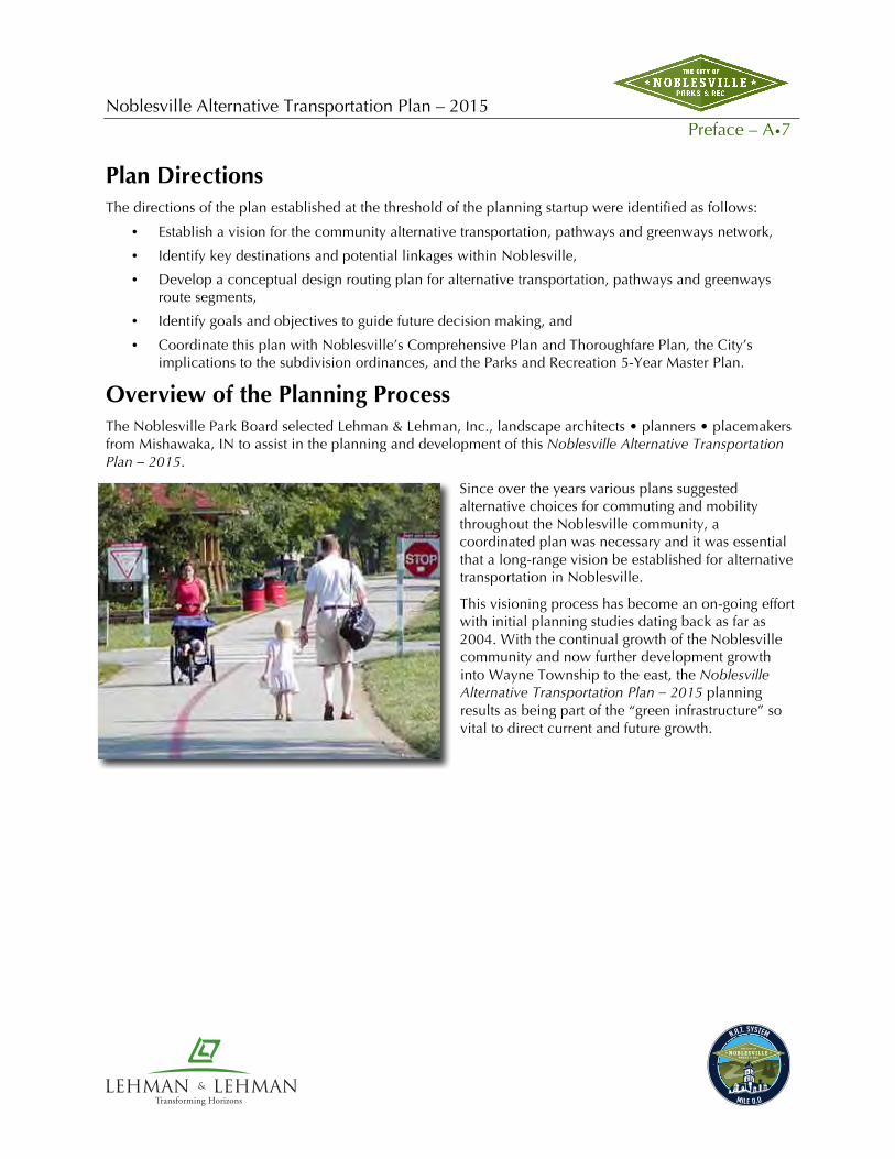
Overview of the Planning Process The Noblesville Park Board selected Lehman & Lehman, Inc., landscape architects • planners • placemakers from Mishawaka, IN to assist in the planning and development of this Noblesville Alternative Transportation Plan – 2015.
Since over the years various plans suggested alternative choices for commuting and mobility throughout the Noblesville community, a coordinated plan was necessary and it was essential that a long-range vision be established for alternative transportation in Noblesville.
This visioning process has become an on-going effort with initial planning studies dating back as far as 2004. With the continual growth of the Noblesville community and now further development growth into Wayne Township to the east, the Noblesville Alternative Transportation Plan – 2015 planning results as being part of the “green infrastructure” so vital to direct current and future growth.

Noblesville Alternative Transportation Plan – 2015 Preface – A•8
Transforming Horizons
Resolution Adopting the Noblesville Alternative Transportation Plan — 2015
WHEREAS, The City of Noblesville Parks and Recreation Board is focused on providing a quality parks
and recreation system for the citizens of Noblesville, Indiana as defined by its Mission Statement and its
Vision Statement; and,
WHEREAS, in doing so the City of Noblesville Parks and Recreation Board has sought opinions and
input from the officials and citizens of City of Noblesville in developing the Noblesville Alternative
Transportation Plan — 2015; and,
WHEREAS, the City of Noblesville Parks and Recreation Board is committed, with the assistance of the
City of Noblesville, to the implementation of the Noblesville Alternative Transportation Plan — 2015 by
establishing standards, defining priorities, targeting development schedules and seeking funding sources;
and,
WHEREAS, the City of Noblesville Parks and Recreation Board desires to make the Noblesville
Alternative Transportation Plan — 2015 a part of its current 5-Year Parks and Recreation Master Plan by
addendum; and,
WHEREAS, the City of Noblesville Parks and Recreation Board desires to make itself eligible to meet
certain requirements for participation in grant programs; and,
WHEREAS, on _______________________, the City of Noblesville Parks and Recreation Board received
the final document of the proposed Noblesville Alternative Transportation Plan — 2015, prepared by
Lehman & Lehman, Inc. of Mishawaka, Indiana.
NOW THEREFORE, BE IT RESOLVED that the City of Noblesville Parks and Recreation Board hereby
accepts and adopts the final document of the Noblesville Alternative Transportation Plan — 2015
presented on _____________________________, as its official Alternative Transportation, Pathways and
Greenways System Master Plan.
Dated this ____ day of _______, 2015

Noblesville Alternative Transportation Plan – 2015 Planning Approach & Plan Development – B•1
Transforming Horizons
B. Planning Approach & Plan Development

Noblesville Alternative Transportation Plan – 2015 Planning Approach & Plan Development – B•2
Transforming Horizons
Benefits of Alternative Transportation The Noblesville Alternative Transportation Plan — 2015 is designed to address and resolve community issues that affect the current and future environmental and economic health of the Noblesville metropolitan area.
Greenways have been implemented by communities throughout the United States in order to provide recreation and alternative transportation, control flooding, improve water quality, protect wetlands, conserve habitat for wildlife and buffer adjacent land uses. Greenways typically incorporate varying types and intensities of human use, including pathways for recreation and travel and passive and active park facilities, including open playing fields. Greenways increase the value of adjacent private properties as an amenity to residential and commercial developments. These and other benefits of the Noblesville Alternative Transportation network are described in the following pages. (Adapted from the Kansas City MetroGreen Plan)
Transportation Benefits
In past years, American communities have grown in a sprawling, suburban form as a result of dependence upon the automobile as the sole means of transportation. As automobile use has increased, traditional forms of transportation (such as passenger train service) have become less available and communities have been slow to offer alternatives such as bicycle and pedestrian networks, bus systems and local rail service. In order to provide relief from automobile congestion on the streets and highways in metro areas, future transportation planning and development must be concentrated on providing residents with choices in modes of travel. These choices should be appealing and should offer the same benefits currently provided by the automobile: efficiency, safety, comfort, reliability and flexibility.
Noblesville’s greenways corridors will be designed to serve as extensions of road networks, offering realistic and viable connections between origins and destinations such as work, schools, libraries, parks, shopping areas, historical and cultural sites and tourist attractions. Greenway-based bikeways and walkways are most effective for certain travel distances. National surveys by the Federal Highway Administration have shown that Americans are willing to walk as far as two miles to a destination and bike as far as five miles. Destinations can be linked to multiple origins throughout the Noblesville area with a combination of off-road trails and on-road bicycle and pedestrian facilities.
Economic Benefits
Noblesville’s greenways corridors offer numerous economic benefits, including higher real estate property values, increased tourism and recreation-related revenues, and cost savings for public services. Greenways have been shown to raise the value of adjacent properties by as much as five to 20 percent. For example, in a residential development in Raleigh, North Carolina, new lots situated on a greenway were priced $5,000 higher than comparable lots off the greenway. Many homebuyers and corporations are looking for real estate that provides direct access to public and private greenway systems.
Noblesville Alternative Transportation Plan – 2015 Planning Approach & Plan Development – B•3
Transforming Horizons
“Green infrastructure is our nation’s natural life support system—an interconnected network of waterways, wetlands, woodlands, wildlife habitats, and other natural areas; greenways, parks and other conservation lands; working farms, ranches and forest; and wilderness and other open spaces that support native species, maintain natural ecological processes, sustain air and water resources, and contribute to the health and quality of life for America’s communities and people. Green infrastructure is smart conservation that address the ecological, social, economic impacts of sprawl and the accelerated consumption and fragmentation of land.”
— Definitions of green
infrastructure are found in a report titled Green Infrastructure: Smart Conservation for the 21st Century, by Mark Benedict and Ed McMahon of the Conservation Fund.
Greenways are viewed as amenities by residential, commercial and office park developers who realize higher rental values and profits from when they locate next to greenways. Additionally, greenways can save local tax dollars by utilizing resource-based strategies for hazard mitigation and managing community storm water, thus placing into productive use landscapes that would not normally be considered for conventional development.
Greenways enhance the role tourism plays in the economy. Tourism is ranked as the number one economic force in the world. In several states, regional areas and localities throughout the nation, greenways have been specifically created to capture the tourism potential of a regional landscape or cultural destination. The state of Missouri, for example, spent $6 million to create the 200-mile KATY Trail, which, in its first full-year of operation, generated travel and tourism expenditures of more than $6 million.
Health and Recreation Benefits
Studies show that as little as 30 minutes a day of moderate-intensity exercise (such as bicycling, walking, in-line skating or cross-country skiing) can significantly improve mental and physical health and prevent certain diseases. Greenways contribute to public health by encouraging more people to walk or bike to short-distance destinations. Providing opportunities for participation in these outdoor activities, close to where people live and work is an important component of promoting healthy lifestyles.
The President’s Commission on Americans Outdoors released a report several years ago that profiled the modern pursuit of leisure and defined the quality of life for many Americans. Limited access to outdoor resources was cited as a growing problem throughout the nation. The commission recommended that a national system of greenways could provide all Americans with access to linear open space resources.
The Noblesville Alternative Transportation Plan — 2015 will complement the community’s existing parks and open-space system, and serve as a primary recreation and fitness resource.
Cultural Benefits
Indianapolis’ newest trail system, The Indianapolis Cultural Trail, is a world class urban bike and pedestrian path that will connect all six Indianapolis cultural districts and bring users to the front door of nearly every arts, cultural, heritage, sport and entertainment venue in the downtown. Through the public/private partnership the 7.5-mile trail will serve as the downtown hub for the central Indiana greenway system, not only providing an inspiring and safe way to travel and exercise throughout Indianapolis, but also exposing users to downtown dynamic arts amenities and the city’s rich heritage.
The Indianapolis Cultural Trail will boost tourism, quality of place and quality of life in central Indiana. It will increase downtown residential

Noblesville Alternative Transportation Plan – 2015 Planning Approach & Plan Development – B•4
Transforming Horizons
development and inspire new businesses. It is forecasted to position Indianapolis as a dynamic city, which is essential for attracting and retaining talented professionals, which is the key to succeeding in a global economy.
With the growing epidemic of obesity in Indiana, the Cultural Trail, as well as other trails throughout the state, will provide a safe and free form of exercise that supports both state and city initiatives, INShape and FitCity.
The Noblesville Alternative Transportation Plan – 2015 system will connect with The Indianapolis Cultural Trail in the future years allowing the physical connections and the cultural benefits to be realized by its users and visitors to both cities.
Greenway systems like Noblesville Alternative Transportation Plan – 2015 enhance the culture of their regions and protect historic resources in metropolitan areas. Successful greenway projects across the United States have served as new “main streets,” where neighbors meet, children play and community groups gather to celebrate. For cities and towns large and small, greenways have become cultural assets and focal points for community activities. Some communities sponsor “greenway days” to celebrate the outdoors and local traditions. Various walking and running events are held on greenways to support charity events or extend traditional sporting events. Many civic groups adopt segments of greenways for cleanup, litter removal and environmental awareness programs. Some greenways, like San Antonio’s Riverwalk, are the focal point not only for community activities, but also for economic development.
Locally or nationally significant historic sites and districts represent the richness and diversity of area historic and cultural resources. The interpretation of historic and archeological sites along greenways can serve to increase the awareness and appreciation of the area’s rich history. Greenways can also serve as vehicles to provide controlled public access to important cultural sites in a manner that promotes preservation and enhances interpretive opportunities.
Security and Safety Benefits
Most Americans are concerned about crime. Safe neighborhoods are of prime concern and priority to metro area residents. Some of the most successful deterrents to criminal activity involve increasing neighborhood awareness by citizens and participation in community watch programs. Greenways have proven to be an effective tool to encourage local residents to participate in neighborhood programs. Some greenways have been developed as part of efforts to deter criminal activity in a neighborhood. Crime statistics and reports from law enforcement officials have shown that parks and greenways are typically land uses with the lowest incidence of reported criminal activity.
As a recreation resource, alternative transportation corridor or area where fitness activities take place, most greenways provide a safer and much more user-friendly resource than other linear corridors, such as local roads. Greenways typically attract local residents who use the facilities frequently, creating an environment that is virtually self-policing. Additionally, greenways — whether publicly or privately owned — are
“Increased access to open space has been linked to better physical fitness leading to decreased public health care costs, reduced social service and police/ justice costs; as well as reduced self-destructive and anti-social behavior.”
— U.S. National Park Service, “The Economic Benefits of
Protecting Rivers, Trails and Greenway Corridors”

Noblesville Alternative Transportation Plan – 2015 Planning Approach & Plan Development – B•5
Transforming Horizons
dedicated for multiple uses and are normally designed to meet federal, state and local standards for public safety and use.
In 1969, about half of all students walked or bicycled to school. Today, fewer than 15 percent of all school trips are made by walking or bicycling. Over half of all school children arrive at school in private autos.
This decline in walking and bicycling has had an adverse effect on traffic congestion and air quality, as well as affecting the health of children. Studies show that children that lead sedentary lifestyles are at risk for obesity, diabetes, and cardiovascular disease. Parents often cite safety concerns such as traffic dangers as a reason for their children not walking or bicycling to school.
Water Quality and Water Quantity Benefits
Greenways preserve wooded open spaces along creeks and streams that absorb flood waters and filter pollutants from storm water. In some cases buildings and other land uses have encroached into flood-prone areas. By designating floodplains as greenways, encroachments can be managed, and sometimes replaced with linear open space, an amenity to residents and businesses occupying adjacent property.
As a flood-control measure, Noblesville’s greenways corridors serve as primary storage zones during periods of heavy rainfall. The protected floodplain can also be used during non-flood periods for recreation and alternative transportation. In conjunction with existing storm water management policies and programs in the region, greenway lands can be set aside as development occurs. Greenway corridors also serve to improve the surface water quality of local rivers and creeks. The floodplain forests and wetlands contained within greenway corridors filter pollutants from storm water. These pollutants are not removed if storm water is collected in pipes and discharged directly into local streams and rivers. Improving surface water quality in streams benefits both local residents and numerous forms of wildlife that depend on streams for their habitat.
As a water supply protection measure, Noblesville’s greenways corridors can buffer streams and lakes with vegetation to absorb pollution from runoff. As a flood control measure, Noblesville’s greenways corridors will serve as primary storage zones during periods of heavy rainfall. The protected floodplain can also be used during non-flood periods for recreation and alternative transportation.
Air Quality Benefits
Greenways as alternative transportation corridors serve to reduce traffic congestion, thus helping to improve air quality. Since the majority of automobile trips are less than two miles in length, offering alternative transportation choices through greenways would encourage residents to bicycle or walk these short distances more often, thereby reducing traffic congestion and automobile emissions.
Plant and Animal Habitat Benefits
Noblesville’s greenways corridors can serve as viable habitat for many species of plants and wildlife. Greenway corridors provide essential food sources and, most importantly, access to water that is required by all wildlife. Greenways in the Noblesville area could become primary migratory routes for terrestrial wildlife, serving to help maintain the integrity of many plant and animal gene pools. Some wildlife biologists have extolled greenways as future “gene-ways” because these migration routes are essential to maintaining healthy wildlife populations.
Greenways can also serve as “gene-ways” for plant species that migrate with changes in climate and habitat. These “greenways” often follow river and stream corridors that have long served as transportation routes for

Noblesville Alternative Transportation Plan – 2015 Planning Approach & Plan Development – B•6
Transforming Horizons
animals and humans. Noblesville greenways promote local programs to protect valuable existing forested and wetland areas and to reclaim and restore streams to support higher quality habitat.
Connecting People through “Hubs and Spokes”
Connections are the most tangible product of pathways and greenways plans. The physical framework of the Noblesville Alternative Transportation Plan — 2015 is based on a popular concept known as “Hubs and Spokes.” Under this concept, residential, commercial and business landscapes (hubs) are linked to parks, preserves and open spaces via greenway and physical corridors (spokes). For residents this means improved access to the outdoors for recreation, auto-alternative transportation, and participation in activities that can
improve health, fitness and quality of life.
The strategy for implementation will be in applying the following elements:
• Start with the Trails Master Plan (general routes and destinations) and the findings of the master planning study
• Work with all stakeholders (citizens, government officials, businesses, etc.)
• Recognize that “users” (walkers, runners, cyclists, families, etc.) have differing needs
• Route around, not through, private property except where that access is offered voluntarily
• Choose first to construct those trails that are simplest to accomplish in terms of land, funding, etc. Easy, early successes provide project momentum and fastest benefits to citizens.
Hubs: Destination Points in the Community
One of the primary reasons for developing a pathway and greenway system is to provide access to a destination. While the pathway system evolves it will connect neighborhoods on its way to other destinations. Many possible destinations in the Noblesville community have been identified.
• Recreational—Golf, Cinemas, Parks, Swimming Pool • Services—Banks, Medical • Commercial—Restaurants, Shopping, Video Stores, Arcades • Civic—Schools, Churches, Parks, Library, City Buildings • Residential—Houses, Apartments, Retirement Communities, Hotels/Motels
Identified Benefits
S 1. Increased safety for those currently biking, running, walking, pushing strollers (etc.) along our sidewalk-less and shoulder-less roads.
Q, S 2. Transportation routes for wheelchairs where none existed before.
S, T 3. Safe routes for children to parks, schools and other places they frequent.
Q, S 4. Parents can send kids on trails with confidence (no traffic permits).

Noblesville Alternative Transportation Plan – 2015 Planning Approach & Plan Development – B•7
Transforming Horizons
Q, T 5. Parents can encourage children’s self-reliance (in getting themselves where they want to go).
C 6. Increased sense of community—of something that is “ours” to share.
C 7. Increased sense of community among frequent users as community members get to know each other.
S 8. Increased sense of community promotes increased safety—watching out for one another.
E, H, T 9. Every person that chooses to walk (or wheel) to a destination avoids one car trip—decreased traffic; decreased pollutants.
H, Q 10. Studies show that people will use trails once they exist—increased activity brings health benefits community-wide.
S 11. Crime goes down when trails go through—increased activity and surveillance deter negative activity.
Q, T 12. Employees who live in Noblesville can more readily choose to walk or bike to work—even if only occasionally.
Q, T 13. Employees, whether they live in Noblesville or not, can choose to walk to lunch locations.
S, $ 14. Hotel guests in our city can safely walk to nearby restaurants and shops.
S, $ 15. Many hotel guests look for safe and convenient running routes while in town on business—more likely to use that hotel next time.
T, $ 16. Business guests in our hotels may find that they can walk each day to the facility they are in town to visit.
$ 17. We will draw trail users from nearby communities that do not have such systems – they will spend money while they are here in our restaurants and shops.
Q, $ 18. Nationwide, there is evidence that nearby trails raise property values—for trail adjacent properties; but also for the community at large, which becomes a more desirable place.
E, Q 19. Areas set aside for trails through greenways preserve that greenspace permanently creating a more livable community.
E 20. Greenspaces preserve animal habitats, plant habitats and wetlands, all contributing to a healthy ecosystem.
Complete Streets Complete streets serve everyone – pedestrians, bicyclists, transit riders, and drivers – and they take into account the needs of people with disabilities, older people, and children. The complete streets movement seeks to change the way transportation agencies and communities approach every street project and ensure safety, convenience, and accessibility for all.
The complete streets movement initially arose within the bicycle advocacy community as a response to the absence of space for bicyclists and pedestrians along too many roads. But a sidewalk without curb ramps is useless to someone who uses a wheelchair (and is difficult to use for parents with strollers and travelers with suitcases). An awkwardly placed bus stop that does not provide a safe and convenient way to cross the street
Identified Benefits Key C = Community E = Environmental H = Health Q = Quality of Life R = Recreation S = Safety T = Transportation $ = Business & Tourism
Identified Uses Foot
Walking Running
Wheeled Wheelchairs Baby strollers Bicycling Skating Scooters Skateboards

Noblesville Alternative Transportation Plan – 2015 Planning Approach & Plan Development – B•8
Transforming Horizons
can endanger transit riders. A true complete streets policy does not simply call for the addition of bicycle and pedestrian facilities but rather inspires a careful consideration of the needs of all travelers.
At the heart of the complete streets movement are important political, policy, and procedural changes. The following explores what communities across the country have learned when implementing their complete streets visions.
Policy Components The National Complete Streets Coalition has identified 10 elements that should appear in a comprehensive complete streets policy document. A good complete streets policy:
! Includes a vision for how and why the community wants to complete its streets.
! Specifies that “all users” include pedestrians, bicyclists, and transit passengers of all ages and abilities, as well as automobile drivers and transit-vehicle operators.
! Encourages street connectivity and aims to create a comprehensive, integrated, connected network for all modes.
! Is adoptable by all relevant agencies to cover all roads.
! Applies to both new and retrofit projects, including design, planning, maintenance, and operations, for the entire right-of-way.
! Makes any exceptions specific and sets a clear procedure that requires high-level approval of exceptions.
! Directs the use of the latest and best design standards while recognizing the need for flexibility in balancing user needs.
! Directs that complete streets solutions will complement the context of the community.
! Establishes performance standards with measurable outcomes.
! Includes specific next steps for implementing the policy.

Noblesville Alternative Transportation Plan – 2015 Planning Approach & Plan Development – B•9
Transforming Horizons
Handling Costs Paying for transportation projects is always a challenge, regardless of jurisdiction or project design. Most often, successful implementation of complete streets policies is achieved by integrating multimodal facilities into general project design. This folds the costs for these facilities into the costs for the overall project.
Principles of Complete Streets Two principles are critical to achieving the primary goal of complete streets: reducing street width and managing vehicle speeds. These two principles work together to improve the roadway for all users.
Reducing street width
Wide roads make it more difficult to provide for the needs of the walkers, bicyclists, and transit users traveling along the road, crossing the street, or navigating complex intersections. They consume much of the right-of-way, leaving less space for these modes, and make crossing the street more difficult. Reducing the width or number of travel lanes (”road diets”) has safety and operational benefits for drivers, too, and should be one of the first options considered when balancing the needs of all travelers.
Vehicle speed management
Speed management is an overarching concern for complete streets design. Lower traffic speeds make roads safer in two ways: Drivers are more able to avoid a crash, and in the case of a crash the resulting injuries are less serious. Slower vehicle speeds make the street safer and more pleasant for non-motorized users.
Another advantage of lower speeds is that most design manuals require higher design standards for high-speed roadways, which are incompatible with pedestrian, bicyclist, and transit use. A lower design speed allows designs that are more favorable to non-motorized users. This creates a virtuous cycle because the design features that are allowed at lower speeds actually encourage lower operating speeds. Virtually all of the elements of good complete streets design help slow traffic; narrow travel lanes, medians and pedestrian islands, on-street parking, sidewalks, and street trees.

Noblesville Alternative Transportation Plan – 2015 Planning Approach & Plan Development – B•10
Transforming Horizons
Green Streets This term commonly refers to streets designed to minimize environmental impacts through reducing impervious surfaces. Most of the time, the goals for green streets and complete streets are mutually compatible, and features such as planting strips can promote the needs of both. Other features, such as bioswales and pervious surfaces, can work well on a complete street if pedestrian and bicyclist access and safety are carefully considered. However, eliminating bikeways or walkways to reduce the overall width of impervious surfaces is contrary to complete streets goals. Reducing the width of the motor vehicle way is a better approach.
Lessons Learned 1) Complete streets policies are valuable tools in changing transportation priorities, establishing a new
ideal for street function, and communicating with the public.
2) Complete streets policies are most often one part of a broader move to change transportation and land-use planning.
3) The policy development process should include a wide variety of stakeholders to ensure that all needs are addressed.
4) Linking achievement of complete streets to funding eligibility helps institutionalize complete streets practices.
5) Successful policies affect the practices of all the entities responsible for road building in the jurisdiction.
6) Policies work best when they exist across all governmental levels.
7) Successful implementation reaches beyond the initial policy document to include changes to zoning codes, plans, standards, manuals, and procedures.
8) Advocates inside the agency can make or break policy implementation, especially during early stages.
9) Successful implementation at the local level is often marked by empowering planners and engineers to approach each project creatively, continually collecting data, and evaluating progress to confirm success.
10) Early consideration of the needs of all road users helps avoid potential implementation problems, saves money, and encourages a paradigm shift in thinking about street design.
11) Using every opportunity to improve multimodal accommodation speeds creation of a complete network and saves money.
12) The first projects are often the hardest. (Reference: Complete Streets: Best Policy and Implementation Practices, Barbara McCann and Suzanne Rynne, Editors; American Planning Association Planning Advisory Service Report # 559)

Noblesville Alternative Transportation Plan – 2015 Planning Approach & Plan Development – B•11
Transforming Horizons
Additional Studies Having Influence to this Study
There were several previous studies that were referenced as a resource throughout the Noblesville Alternative Transportation Plan — 2015 planning process.
Noblesville Recreation Impact Fee Study – Update
Noblesville Parks and Recreation Facilities Infrastructure Improvement Plan 2014 (RIF) was referred in this study as it relates to standards and requirements for the Community Level of Service of recreation infrastructure. The RIF established that Multi-use / Nature Pathways show a current surplus of 11.82 miles, while there will be a deficiency in 2023 of 12.29 miles. These deficiencies are based on the established community level of service of 1 mile for every 775 persons.
Noblesville Parks and Recreation Five-Year Master Plan Update 2014-2019
The Park Department’s Five Year Master Plan was also used as a resource in this planning study. The identified goals of the Five Year Master Plan were considered as a foundation to this pathways study, such as the goal to “Expand Trails System (connecting neighborhoods with key destinations)”.
Planning Approach for the Noblesville Alternative Transportation Plan — 2015 Lehman & Lehman, Inc. (Mishawaka, IN) served as the Consultant for the Noblesville Alternative Transportation Plan — 2015. The approach of the Consultant was as follows:
1. Form a Planning Team – This was made up of various members of City Departments, including the Park Department, Streets Department & City of Noblesville Planning Department, as well as Hamilton County Park Agencies (HAMPA).
2. Prepare a base map of the study area – Utilizing the existing CAD information provided by the City, a base map indicating streets, key landmarks, etc. was created.
3. Delineate an initial routing layout looking at destination points, priorities, “coat-tail” projects, etc. – This work was prepared by the Consultant and then shared with the Stakeholders.
4. Meeting with the Planning Group – the Consultant provided an orientation overview, defined goals and values to incorporate into the plan, addressed known priorities, outlined the next steps and assignments, reviewed the initial routing layout plan and received additional feedback. Also, any new stakeholders that would have input for the Noblesville Alternative Transportation Plan — 2015 were identified.
5. Expand on the initial routing layout plan – Identify priorities, trail and greenway types, land ownerships, incorporate the City’s Comprehensive Growth Plan, locate and identify proposed new subdivisions, etc.
6. Provide a written Progress Report – Document the Plan progress which included goals, values, visions, routing concepts, design of typical trail sections, priorities, etc.
7. Prepare in-progress presentations of the Conceptual Noblesville Alternative Transportation Plan — 2015. Share the conceptual design and the benefits of the plan with various service clubs, public groups, etc. to share the Greenways Vision for Noblesville and to solicit feedback and response.

Noblesville Alternative Transportation Plan – 2015 Planning Approach & Plan Development – B•12
Transforming Horizons
8. Meet with the various city departments (streets, utilities, etc.) to discuss impact of the proposed Noblesville Alternative Transportation Plan — 2015.
9. Master Plan Inclusion – Review and process the inclusion of the Noblesville Alternative Transportation Plan — 2015 with the City’s Comprehensive and Thoroughfare Plans and Subdivision Standards.
10. Finalize the Noblesville Alternative Transportation Plan — 2015 – Document the planning process, outline the overall master plan and its phases or priorities, related construction cost estimates, identify various funding sources, etc. Provide suggested policies and operations/management structures in the greenways implementation and operations. Also, address possible organization structures of the Noblesville Alternative Transportation Plan — 2015.
11. Present the Master Plan to the Park Board and other agencies (i.e. Plan Commission, Common Council, etc.)
Identified Trail Segment Criteria Project Goals
By the end of this project the project team will:
1. Provide a recommended routes map that has taken into consideration:
a. Anticipated uses and development vision
b. Destinations
c. Access and easements
2. Present a concluding policy statement that includes:
a. A vision for the final trail system
b. A list of anticipated uses, destinations, and benefits
3. Recommendations for the next steps
Planning Worksessions
There were various meetings with the City during the course of this study. The meetings included a review of the goals and values of the study as well as an open discussion regarding the routes of the system, documented current inadequacies and problems, surveyed goals for the trails system and designed a master plan to meet the goals.
Several assignments to complete for each meeting were given. Some of the assignments included on-site assessment activities. Activities included the following actions:
1. Identify key destination points in the community that should be connected with a greenway route.
2. Study areas of the community that carried concerns of safety, security, poor visibility, high maintenance, neighborhood acceptance, etc.

Noblesville Alternative Transportation Plan – 2015 Planning Approach & Plan Development – B•13
Transforming Horizons
3. Develop thoughts regarding how best to communicate the applications of the Greenway System to the community.
Other planning ideas and concerns that this Master Plan addressed included the following:
1. The plan should address the connections of the existing sidewalks ... connecting the open segments.
2. Parks, schools, and churches may all serve as parking and trail heads for the greenway system.
3. Bikes should be used on streets or expanded pathways and not on existing sidewalks.
4. The minimum width of the sidewalk/pathway should be 8-10 feet when following existing streets.
5. The plan should develop design standards for the various trail/pathway/greenway types.
6. Trails in remote areas may want to provide a width to accommodate emergency vehicle access.
7. As the Master Plan evolves involve existing homeowners associations for input.
In identifying the routings of the greenway master plan and their priority for implementation the City identified several values to be considered as criteria (the list may be refined and added to in the master planning process):
1. Maximum length of the trail segment
2. Minimum expense in trail development
3. The practicality of the trail segment (whom it will serve)
4. Connections of the trail segments to community destinations
5. Safety factors of the trail segment (i.e. visibility of the trails)
6. Minimum stops or hesitations of the trail segment
7. The availability of water and other trail amenities
8. The circuit routes of the trail segment
9. The diversity of the trail segment
10. Ownership of the land (i.e. is there need to acquire, easements, etc.)
Position Statement
Cities nationwide are realizing the benefits of establishing trail systems. They are taking action and seeing the positive results. The Indy Greenways and the Indianapolis Cultural Trail are local examples.
Trail systems serve many purposes, including recreation, which may take the form of exercise, or simply the enjoyment of an evening stroll. Trail systems, if properly designed, also provide a network of paths that connect desirable destinations. They enable a mode of transportation to the places people want to go. Imagine a city in which one is not forced by dangerous conditions
“To make a greenway is to make a community.”
—Charles Little, Author, Greenways for America

Noblesville Alternative Transportation Plan – 2015 Planning Approach & Plan Development – B•14
Transforming Horizons
to drive to a destination only three blocks away. Imagine a city in which children, seniors, and non-drivers can walk safely to a park, a grocery store or a video store.
Such a network should include multi-use trails, footpaths, bike lanes and exiting and/or improved sidewalks. It is equally important that it include will-identified “connectors” that enable users to depart for a destination with the confidence that the trail system is contiguous. Finally, the network should ultimately include walkable connections between residential areas that are otherwise isolated from one another.
Priority Strategies
The implementation of a greenway system as large and complex as the Noblesville Alternative Transportation Plan — 2015 cannot be accomplished immediately. The system will take years to build, giving full consideration to the way each segment is designed, surveying the miles and securing adequate funding. As this Action Plan was formulated, segments of the overall system will need to be prioritized into four distinct phases.
Prioritization of Segments suggested to be of prime importance for implementation was identified based on a set of criteria suggested to seek out the best applied loop segments of the overall system. This information is based on the following criteria:
• Connections of links to destination points
• Number of persons served by link
• Costs and funding sources for link
• Link’s potential for multi-users
• Link’s relation with other projects (“coat tails”)
• Partnerships: public and/or private
• Link’s proximity to identified loop or existing link
• Community / Neighborhood need requests
• Property availability
• Follows the overall alternative transportation plan
• How link applies to standards and pending impact fee strategies
Funding Resources
The following is a partial list of possible funding opportunities and resources for the City of Noblesville to further explore. It includes Local, State, and Federal Funding, Grant Programs, Foundations, and Corporate Sponsorship.
Local Funding Sources and Resources
1. Mayor and City Council—May supply direct funding and local matching for funds for state and federal grants. May adopt regulatory measures for setbacks, open space requirements, and trail easements. May provide political support.
2. City Departments—Parks and Recreation, Public Works, Traffic/Streets, Utilities, Planning, and Engineering Departments. May coordinate the planning, land acquisition, implementation, and maintenance efforts among individual departments, which will lessen the financial burden of trail development on one department. Includes alternative transportation efforts in each department.

Noblesville Alternative Transportation Plan – 2015 Planning Approach & Plan Development – B•15
Transforming Horizons
3. Private Developers—With the inclusion of the trail/pathway standards housing developers will be required to meet such standards as part of their development’s Recreation Impact Fee.
4. Tourism Agency—May provide funds or services for promotion and publishing information regarding trails, routes, destinations, etc.
5. School Districts—Funding for land for use as outdoor classrooms/labs and greenways.
6. Special Interest Groups—May collaborate funding with organizations with compatible interests.
7. Recreation Impact Fees—Alternative funding mechanism for infrastructure improvements in fast growing areas
State Funding Sources and Resources
(Taken from Hoosiers on the Move, The Indiana State Trails, Greenways and Bikeways Plan, July 2006)
Indiana Department of Transportation (INDOT) administers multiple programs on behalf of the Federal Highway Administration (FHWA) that relate directly to trail/greenway development. Safe Accountable, Flexible, Efficient, Transportation Equity Act: A Legacy for Users (SAFETEA-LU) is the current highway bill in which these programs are funded. All projects funded through this federal money must be programmed in the State’s Transportation Improvement Program (TIP) and those in urbanized areas must also be in their respective Metropolitan Planning Organizations (MPOs) TIP.
Transportation Enhancement (TE): Is a provision of the Inter-modal Surface Transportation Efficiency Act of 1991 (ISTEA) that requires states to set aside 10 percent of their share of Surface Transportation Program (STP) funds for projects that enhance the existing transportation system. States have the flexibility to design a program to best suit their needs within the limits of the law. This program was continued and somewhat expanded under TEA-21 (Transportation Equity Act for the 21st Century) and under the current transportation bill. This program is an 80/20% matching fund. There are 12 eligible categories within TE that relate to surface transportation and 4 of those relate specifically to bicycle/pedestrian activities. Those categories are:
1. Pedestrian and bicycle facilities
2. Pedestrian and bicycle safety and education
3. Preservation of abandoned railroad corridors
4. Historic transportation building, structures, and facilities (places historic bridges on bike/ped systems).
Indiana’s TE program funds transportation projects that expand beyond the traditional accommodations for cars, trucks, buses and transit. This fund is Indiana’s largest funding source for trails/greenways projects. TE funding is a cost reimbursement program and not a grant. The sponsor must pay at least 20 percent of a project’s cost to show commitment by the local group or community. Applicants may receive reimbursement for eligible costs as work is completed. TE strengthens the cultural, aesthetic, and environmental aspects of the nation’s intermodal transportation system.
Congestion Mitigation & Air Quality (CMAQ): an 80/20 federal funding program is only available in urbanized areas (areas exceeding population of 50.000) designated by the US EPA as NOT meeting current air quality standards for various pollutants. Six areas in Indiana currently qualify. Key considerations for projects funded with this source are improving air quality and being able to document that positive impact. The MPOs evaluate all sorts of projects that help air quality. As a result transit projects, ride-sharing projects,

Noblesville Alternative Transportation Plan – 2015 Planning Approach & Plan Development – B•16
Transforming Horizons
certain signal upgrade projects, ozone alert projects, etc., provide competition for limited funds. Candidate projects are annually submitted to and evaluated by INDOT in a statewide application process.
Safe Routes to School (SR2S): A new federal funding source that was created specifically to encourage and improve the safety of children walking and bicycling to and from school. There are limitations on the use of these funds. They target only elementary and middle schools (K-8), not high schools. Improvements need to be located within two miles of the intended schools. Schools can be public or private.
There is no match requirement for these funds. There should be a demonstrable positive effect on the numbers of children biking or walking to school. Most of the available funds (70% - 90%) would be directed toward construction projects, while a smaller amount (10% - 30%) is required to be directed toward education, encouragement and enforcement efforts (non-construction projects). These projects can have secondary beneficiaries, such as area residents, employees or adults walking and biking in the vicinity of the school, but the primary targets are schoolchildren. Secondary impacts on school children are insufficient to justify a project.
Transit Enhancement Funds: This is a general category of funds administered by the Federal Transit Administration; it is not a specific program. Transit funds in general improve or promote better access to public transportation (e.g. bus or rail). Near transit stops or along corridors used frequently by transit vehicles there may be opportunities to improve transit use that would, at the same time, make it easier or safer to walk or bike. For example, sidewalk improvements near transit stops will improve access for transit users but also enable people who are not catching the bus to walk more safely. Transit funds can be used to purchase bike racks for buses or to install bicycle racks and bike lockers at transit centers. The objective is to make it more convenient to use transit and that remains the primary purpose of transit funds. Pedestrians and bicyclists would be secondary beneficiaries.
National Scenic Byway (NBS): this discretionary grant program makes federal funding available for 8 project types that directly benefit designated byways. Among eligible uses are projects that improve bicycle and pedestrian safety and access along the byways and to important byway-related resources in the corridor. The 80/20 federal funds in this program are required to contribute directly to the byway and the experience of byway travelers and not simply in an incidental way. Indiana has two nationally designated byways and one state-designated byway. These funds are not available outside the byway corridors. Once a year NSB applications are submitted to the state DOT, thoroughly reviewed and forwarded to FHWA for consideration under a national merit-based program. Walkways, curb ramps, crosswalk treatments, bicycle racks, trail facilities, and rest stops that are readily available and intended for by-way travelers are examples of improvements benefiting cyclists and pedestrians.
Indiana Recreational Trails Program (RTP): This 80/20 matching program is intended to develop and maintain non-motorized and motorized recreational trails. Originally called the National Recreation Trails Trust Fund Program, this money comes from federal motor fuel excise taxes paid by users of motorized off-highway vehicles. In Indiana, this fund is administered by the Indiana Department of Natural Resources. By legislation, at least thirty percent of the funds are to be used for non-motorized trails, and at least thirty percent of the funds are to be used for motorized trails. The remaining forty percent is discretionary for diversified trail uses and education.
To date, RTP has provided more than $4.9 million for trail projects including Indiana’s first publicly owned motorized vehicle riding area, Redbird State Riding Area. Since its inception in 1995, RTP has put over 100 miles of trail on the ground, helping to create safer, more livable communities through the development of walking, hiking, equestrian, mountain bicycling, bicycling, off-road motorized, and water trails.

Noblesville Alternative Transportation Plan – 2015 Planning Approach & Plan Development – B•17
Transforming Horizons
Land and Water Conservation Fund (LWCF): This is a 50/50 matching program administered by the IDNR through the National Park Service, Department of Interior. The program is for the acquisition and development of outdoor recreation areas. Trails are one priority of this program in Indiana.
Indiana Heritage Trust (IHT): This state land acquisition program was established to preserve land and among the priorities is greenways acquisition. Matching requirements vary with the program. Funds come from the sale of the environmental license plate and sometimes from legislative appropriations.
Federal Funding Sources and Resources
1. Department of the Interior
a. National Park Service—Funds are currently available for land acquisition and trail development through the “Land & Water Conservation Fund” and “Rivers, Trails and Conservation Assistance Program.”
b. U.S. Fish and Wildlife—Funds are currently available for wildlife habitat conservation along greenways.
c. Bureau of Land Management—Funds are available for forest restoration, wildlife habitat studies, riparian habitat restoration and other programs benefiting public land.
2. Department of Transportation—Funds for bicycle and pedestrian trails are currently available through the Transportation Equity Act (TEA-21) including “Recreational Trails Program,” “Bicycle Transportation and Pedestrian Walkways” and “Scenic Byways Program”.
3. Environmental Protection Agency—Funding is currently available for planning, public information, and wetland projects related to greenways.
4. Department of Defense—U.S. Army Corps of Engineers have funds available for recreation and conservation projects in conjunction with flood control improvements.
5. Department of Housing and Urban Development—Community Development Block Grants are funds available to projects that benefit low and moderate-income people.
6. Department of Commerce
a. Economic Development Administration—Supports projects that promote long-term economic development and private sector job creation especially in areas in severe economic distress.
b. Small Business Administration—Funds are currently available for tree planting programs.
7. Federal Emergency Management Agency—Funds available through local flood insurance programs.
8. Department of Energy—Funds are currently available to assist communities cleanup contaminated sites.
9. National Endowment for the Arts and Humanities—Funds are currently available for including art along trails and greenways.
Grant Programs
1. American Greenways Kodak Awards Program—Grants of $500 to $2,500 are currently available through The Conservation Fund to local greenways projects including planning, design, or development. Contact American Greenways Program at The Conservation Fund, 1800 North Kent Street, Suite 1120, Arlington, VA, 22209

Noblesville Alternative Transportation Plan – 2015 Planning Approach & Plan Development – B•18
Transforming Horizons
2. Recreational Equipment Incorporated (REI)—Seed grants of $200 to $2,000 are available to state and local conservation groups for river protection projects. Contact National Rivers Coalition, American Rivers, Inc., 801 Pennsylvania Ave., SE, Washington DC, 20013.
3. The Global Relief Heritage Forest Program, American Forestry Association—Grants are available (unspecified amount) for tree planting on public lands. Contact American Forestry Association, P.O. Box 2000, Washington DC, 20013
4. The Design Arts Program of the National Endowment for the Arts—Grants are also available (unspecified amount) to promote excellence in urban design, historic preservation, planning, architecture, and landscape architecture. Contact National Endowment for the Arts, Room 625, Nancy Hawks Center, 1100 Pennsylvania Ave., NW, Washington DC, 20506
Foundations
National, regional and local foundations may be able to fund trail development. The National Foundation Center (ww.fdncenter.org) maintains a database of foundations.
Corporate Sponsorship
Corporate donations have been used to build boardwalks, interpretive signage, trail furniture, and provide funds for annual awards programs.
Organizations and Resources
The following is a partial listing of alternative transportation and greenways organizations that may provide valuable policy, planning, design, and technical information to the City of Noblesville.
Alternative Transportation
1. American Association of State Highway and Transportation Officials (AASHTO). A national organization representing highway transportation departments, published “Guide for the Development of Bicycle Facilities” in 1999. Contact AASHTO, 444 North Capital St., NW, Washington, DC 20001 or www.aashto.org
2. National Bicycle Greenway. A national organization dedicated to creating and maintaining a coast-to-coast network of multi-use transportation and recreational bicycle trails. Public education information available. Contact www.bikeroute.com
3. Association of Pedestrian and Bicycle Professionals. A national organization dedicated to promoting better conditions for bicycling and walking. Contact www.apbp.org
4. National Center for Bicycling & Walking. A national organization promoting the increased safe use of bicycles and walking in transportation planning. Contact National Center for Bicycling & Walking, 1506 21st St., NW, Suite 200, Washington, DC 20036 or www.bikewalk.org
5. League of American Bicyclists. A national organization devoted to increased bicycle use for commuting and recreation. Contact League of American Bicyclists, 1612 K St., NW, Suite 401, Washington, DC 20006 or www.bikeleague.org
6. Surface Transportation Policy Project. A national organization lobbying for alternative transportation and instrumental in passage of ISTEA. Contact Surface Transportation Policy Project, 1100 17th St., NW, 10th Floor, Washington, DC 20036 or www.transact.org

Noblesville Alternative Transportation Plan – 2015 Planning Approach & Plan Development – B•19
Transforming Horizons
7. Transportation Access Project. A national organization dedicated to integrating alternative transportation into communities. Contact Transportation Access Project, 503 W. 4th Ave., Olympia, WA 98501.
8. Pedestrian & Bicycle Information Center. A national organization dedicated to providing sound policy, design, and research information regarding alternative transportation. Contact www.bicyclinginfo.org
Greenways
1. The American Greenways Program. A national organization dedicated to establishing a network of public and private open space corridors. Information and technical assistance is available on all aspects of greenways planning and development. Contact The Conservation Fund, 1800 N. Kent St., Suite 1120, Arlington, VA 22209 or www.conservationfund.org
2. American Farmland Trust. A national organization charged with protecting agricultural land. Technical information is available regarding land preservation strategies. Contact American Farmland Trust, 1920 N. St., NW, Suite 400, Washington DC 20036 or www.farmland.org
3. American Hiking Society. A national organization dedicated to protecting the interests of hikers and preserving footpaths and the natural environment. Information about volunteer recruitment, trail building and maintenance is available. Contact The American Hiking Society, 1422 Fenwich Lane, Silver Spring, MD, 20910 or www.americanhiking.org
4. American Rivers. A national organization leading the charge of preserving the nation’s outstanding rivers and their landscape. Contact American Rivers, 1025 Vermont Avenue, Suite #720, Washington, DC 20005 or www.amrivers.org
5. Land Trust Alliance. A national organization of land trusts. Expertise in establishing land trusts is available. Contact Land Trust Alliance, 1319 F St., NW, Suite 501, Washington DC 20004 or www.lta.org
6. National Wildlife Federation. A national organization dedicated to the protection of wildlife, wild places, and the environment. Sponsors a program called The Community Wildlife Habitat Program/Wild City Initiative. www.nwf.org
7. Rails-to-Trails Conservancy. A national organization dedicated to assist local governments and nonprofits convert abandoned railroad right-of-ways into public recreational trails. Contact Rails-to-Trails Conservancy, 1100 17th St., NW, 10th Floor, Washington, DC 20036 or www.railstotrails.org
8. Scenic America. A national organization devoted to preserving America’s scenic beauty. Information and technical assistance is available to assist identifying, designating, and protecting scenic roads in urban and rural settings. Contact Scenic America, 801 Pennsylvania Ave., SE, Suite 300, Washington, DC 20003 or www.scenic.org
9. Trust for Public Land. A national organization formed to help public agencies acquire land of significant recreation, cultural, and ecological value. Contact Trust for Public Land, 116 New Montgomery St., 3rd Floor, San Francisco, CA 94105 or www.tpl.org
10. Trails and Greenways Clearinghouse. A national organization dedicated to promoting greenway development. Technical assistance and information is available. Contact Trails and Greenways Clearinghouse, 1100 17th St., NW, 10th Floor, Washington, DC 20036, or www.trailsandgreenways.org

Noblesville Alternative Transportation Plan – 2015 Planning Approach & Plan Development – B•20
Transforming Horizons
This Page left blank Intentionally.

Noblesville Alternative Transportation Plan – 2015 Design Guidelines – C•1
Transforming Horizons
C. Design Guidelines

Noblesville Alternative Transportation Plan – 2015 Design Guidelines – C•2
Transforming Horizons
Design Guidelines The intent of the Noblesville Alternative Transportation Plan — 2015 is a planned network of bicycle and pedestrian routes and facilities for residents and visitors of all ages. This network allows its users to walk or bike to their destinations in lieu of taking their car.
The Noblesville Alternative Transportation Plan — 2015 fulfills the goals identified in the previous studies. It provides opportunities to improve the health, fitness, and quality of life of Noblesville’s residents. However, motivating individuals to walk or bike sometime requires developing safe, convenient, and attractive facilities.
Noblesville Alternative Transportation Plan — 2015 has required the establishment of design guidelines in order to successfully implement the vision, goals, and objectives of this Master Plan. The guidelines will assist the City Administration and Departments along with the proposed 2015 Advisory Committee (NPTAC) in the development of bicycle and pedestrian facilities that are safe, convenient, and attractive as well as ensure uniformity of the design, layout, and construction of these facilities throughout the Noblesville community.
The Development Guidelines should be used in conjunction with the standards developed by the City of Noblesville Public Works Department, the Indiana Department of Transportation (INDOT), and American Association of State Highway and Transportation Officials (AASHTO).
Identified Users The users of Noblesville Alternative Transportation Plan — 2015, including bicycle and pedestrian users, vary in age, experience, mobility, as well as confidence in traveling with, or crossing, vehicular, bicycles and people traffic.
Users wish to experience the multi-use trails and pathways, greenways in nature areas and parks, and bike lanes as part of the city streets. Trails, pathways and sidewalks will need to accommodate walkers, bikers, runners, roller bladers, persons in wheelchairs, as well as accommodations for large groups.
Experienced users bike or walk with vehicular traffic even if designated facilities do not exist. However, average users prefer to bike or walk on less busy neighborhood streets and on designated bicycle and pedestrian facilities.
The Noblesville Alternative Transportation Plan — 2015 attempts to improve the routes and connectivity for experienced users as well as create safe, convenient and attractive facilities to attract average users. Providing accessibility for users of varying experience, mobility and confidence requires careful attention to the visibility of users, width and surface condition of routes, and design speed of bicycle and pedestrian facilities.
Facility Components The Noblesville Alternative Transportation Plan — 2015 system will comprise many different facility components. These will include the trail or pathway itself, supporting infrastructure such as trailheads, signage, etc. Also, the design and applications of the use of landscape plantings, fencing, lighting, emergency phones, design and details of intersections and crossings, etc. will enhance the trail system. Trail signage and kiosks are also a vital component of the trail system. Standardization of the graphics/logos is recommended as well as the use of such signage to provide directions and information.

Noblesville Alternative Transportation Plan – 2015 Design Guidelines – C•3
Transforming Horizons
The locations of trailheads and their related elements would best be placed in common areas such as parks, schools, churches, public facilities (e.g. fire stations), etc. They should have ample visibility and necessary infrastructure elements such as utilities, lighting, parking, etc.
Other on-trail components (i.e. landscape plantings, fencing, lighting, etc.) should be designed and used for best compatibility with the adjacent land uses and neighbors.
A sample of conceptual design for typical trailhead signage found in the Noblesville Trails system can be found in the Appendix of this document.
Design for Special Areas The Noblesville Alternative Transportation Plan – 2015 system routing plan calls for several areas that will require special design considerations. There are segment routes that in lieu of crossing busy streets and highways may potentially need to be routed under the highway using existing drainage way bridges.
There are other areas of the city where such bridge or under crossings will not be possible. Where these occur the route segments have been located at major street intersections that are signaled. These intersections may need to be enhanced to provide this access and accessibility to the users.
Potential exists for possible utilization of the railroad right of way. This has been done successfully in other Indiana communities on active rail lines. The City and the railroad company should explore this trail option further.
Trail segments have been noted occurring in areas of drainage ways and easements. These trail segments can have two trail type applications. As a nature type trail the trail composition may be an earthen trail surface. If utility vehicles will use the segment it is recommended that the trail be multiuse and be 12’ in width and be asphalt surface designed to handle traffic loads.
Where possible and feasible the City should consider the inclusion of “bike lanes” as part of the City Thoroughfare Plan. The design standards used for these applications should comply with both INDOT and AASHTO guidelines and requirements.
Maintenance Guidelines The Noblesville Alternative Transportation Plan – 2015 system requires both maintenance and management policy for its usage and operation. The City should establish maintenance policy and guidelines that would define responsibility and be used in the overall system. Generally, the trail segment in the parks and open spaces will be the responsibility of the Parks Department (or jointly with the Utility Departments, where applicable). Segments where the trails are within street right of ways will be part of the maintenance responsibilities of the Public Works Department. Regular maintenance may include:
• Inspecting and replacing bicycle and pedestrian routes and roadway signs, • Repairing cracks and holes in bicycle and pedestrian routes surface, • Sweeping routes to remove loose gravel, sand, garbage, leaves, etc. • Removing dead or dangerous tree limbs and regular pruning of vegetation along the bicycle and
pedestrian routes, • Removing snow and ice, • Assuring that there is positive drainage off of and away from the trail segment, and • Documenting regular inspection to limit risk and liability.

Noblesville Alternative Transportation Plan – 2015 Design Guidelines – C•4
Transforming Horizons
The City of Noblesville is currently using a software program called Cityworks, which is a public asset management software. (See the implementation section of this document for more information and use of this management software for the NAT system). The City may wish to consider promoting an “adopt a trail” program where the adjacent property owners or businesses would become “partners” with the City in the maintenance of trail segments.
Logo and Signage The Noblesville Alternative Transportation Plan – 2015 system is becoming better known by its users through its usage. Trail Signage Graphic Standards will be used in identifying trail segments and the overall system and can be found in the Appendix of this document. Such logo design will be used to identify the Noblesville Trails system in Noblesville. The logo is a form of identity and marketing for the system.
The logo and signage will serve various functions including identifying trailheads, providing direction and safety information, identifying segment names, and communicating unique information such as historic or interpretive uses.
While the Noblesville Trails system should have its own identity in its graphics and logos, etc. common regional logos and graphics should apply where the system extends to the adjacent communities and trail systems.
Other components of the Trail Logo and Signage system should incorporate the flavor of the City’s Logo standards in a colorful and aesthetic format as shown below.

Noblesville Alternative Transportation Plan – 2015 Design Guidelines – C•5
Transforming Horizons
Proposed Trails and Pathways Design Standards The Noblesville Alternative Transportation Plan — 2015 calls for four (4) trail/pathway applications. They are as follows:
A. Right-of-Way Pathways
B. Easement Pathways
C. Open Space Pathways
D. Blueway Pathways (Waterways)
Where applicable the Consultant recommended the inclusion of conduits within the trailway. Such conduits can serve the City now and in the future in running fiber optics and other similar utility lines. With the construction of the trails and pathways such a piece of “utility infrastructure” should be seen as an asset.
As stated previously, it is not the intention of the Noblesville Alternative Transportation Plan — 2015 to acquire land for such development unless it is donated or negotiated with the City and the Property Owner.
A – Shared / Multi-Use Trails The most predominant and preferred greenway type is the shared / multi-use trail. This trail type serves both recreational and transit-type uses and is generally located in unobstructed right-of-ways, easements, or parks. These greenway segments serve as major connection corridors of the greenway network and are typically 10 to 12 feet wide with a 2’ shoulder on each side. Shared-use paths are historically constructed of a 4” thick asphalt surface over a minimum 4” aggregate base sufficient enough to support maintenance and emergency vehicles. AASHTO standards are required for all trail development and INDOT design standards are required for those projects that are state or federally funded.
• Shared / Multi-Use Easement or Park Development
!

Noblesville Alternative Transportation Plan – 2015 Design Guidelines – C•6
Transforming Horizons
• Shared / Multi-Use Trails Right of Way Development
!

Noblesville Alternative Transportation Plan – 2015 Design Guidelines – C•7
Transforming Horizons
B – Improved Sidewalks Many of the greenway segments outlined in the master plan are located within existing neighborhoods and serve as connection routes to the community. Improving these connection corridors is not only important to the greenway users, but also to the quality of life already established within the neighborhoods. Developing full-width shared-use paths would adversely affect much of the private property in these areas, thus making them problematic. In an effort to maintain the connectivity provided by these designated corridors, it is recommended that these segments be developed into improved sidewalks, with widths of 6 to 9 feet and located within the City right-of-way. These “extra wide” sidewalks are essentially sidewalk improvements but are wider than the City standard sidewalk and have the ability to accommodate a greater number of users. Constructed out of 4” thick concrete or asphalt over a compacted aggregate base, these sidewalks must meet the requirements of the Americans with Disabilities Act (ADA). The City of Goshen design standards must be followed for all improved sidewalk located on local streets and INDOT design standards for those improvements federally funded or within a designated state highway corridor.

Noblesville Alternative Transportation Plan – 2015 Design Guidelines – C•8
Transforming Horizons
C – Bike Lane Where off-street trails are not feasible, bicycle-friendly streets should have designated bicycle lanes. These routes help preserve overall connectivity by providing trail users and local residents safe routes to various destination points throughout the city. Bicycle lanes must be designed to comply with AASHTO and INDOT standards and all markings and signage must meet the Traffic Control for Bicycle Facilities requirements set forth in the Manual on Uniform Traffic Control Devices. Located on the right outer, most edge of the pavement, bicycle lanes are typically 5’ wide and follow the same direction as vehicular traffic. Designated with striping, signage and pavement markings, bicycle lanes are part of the roadway for the exclusive use of bicyclists. Experienced bicyclists prefer bicycle lanes. They have been proposed as part of the greenway master plan as a result of need and the site constraints in many of the traffic corridors and the difficulties with developing designated separated multi-use pathways.

Noblesville Alternative Transportation Plan – 2015 Design Guidelines – C•9
Transforming Horizons
D – Blueway Water Trails What is a Water Trail?
Water trails embody the nexus between rivers and trails. They provide recreational boating opportunities along a river, lake, canal or coastline; most water trails are managed in public-private partnership with the philosophies of environmental stewardship, environmental education, and accessibility for all users.
By definition, a water trail, also known as a blueway, is a route along a river or across other bodies of water, such as a lake or salt water, for people using small beachable boats like kayaks, canoes, day-sailers or rowboats. Water trails are most often identified by the land facilities that support water travel. These include launch and landing sites (trailheads), campsites, rest areas, and other points of interest. On land, trails have distinct surfaces or walkways, while on water the entire water surface is constantly changing with flow, current, boat wakes and wind.
American Canoe Association (ACA) – Recommended Water Trails meet a set of basic criteria and stand out as particular good destinations for paddlers. To be eligible, a trail must meet the following requirements:
• The trail must be a contiguous or semi-contiguous waterway or series of waterways that is open to recreational use by paddlers;
• The trail must have public access points for paddlers;
• The trail must be covered by a map, guide, signage or a web site that is of reasonable quality and detail and available to the public.
• Published or printed materials for the trail (e.g. guidebook, map, signs, website) must communicate low-impact ethics to trail users; and
• The trail must be supported and/or managed by one or more organizations.

Noblesville Alternative Transportation Plan – 2015 Design Guidelines – C•10
Transforming Horizons
Trail Surface Types Design and material selection will often be the most important decisions, and can have a major impact on annual maintenance costs. The cost comparison of the three trail-surface options can provide planners with an accurate analysis for future maintenance costs. The larger and more heavily used trails will have the greatest impact on budgets.
In general, trails in larger parks generate heavier use, and will require a trail design that appeals to a more diverse user group. Heavier use will also result in a new set of expectations for trail quality, and dictates the need to make some tough decisions on how best to stretch the dollars.

Noblesville Alternative Transportation Plan –2015 Implementation Strategies – D•1
Transforming Horizons
D. Implementation Strategies

Noblesville Alternative Transportation Plan – 2015 Implementation Strategies – D•2
Transforming Horizons
Noblesville Alternative Transportation Plan – 2015 Each year since its original plan development the City continues to implement segments of the overall Noblesville Alternative Transportation Plan. In addition as the City continues to grow so does its priority of connecting those growth areas to the other community destinations and assets. Annual planning updates along with related organizing, adopting, defining priorities, funding, etc. continues to be studied and evaluated for implementation.
This master plan update should be used as a guide in the implementation of the plan. It is meant to be dynamic allowing for change and refinement to take place when needed.
The following pages represent the overall Noblesville Alternative Transportation Plan — 2015 and its various routes. The organization of the routing plan consists of segments of trail/pathway loops that make up the whole. Breaking down the overall system of pathways into segments becomes a useful tool. It allows for segments to be phased for implementation and funding. Segments can be named establishing a “sense of place” in a neighborhood. Segments can become known as routes towards various destinations. Segments can also describe the type of trail or pathway that it is. As it relates to the dynamic nature of the plan and as the plan evolves and expands, new segments can be added to the system.
Planning Maps
The Noblesville Alternative Transportation Plan — 2015 should be incorporated into the City’s Comprehensive Plan and Thoroughfare Plan. The design details and standards should be incorporated into the Public Works/Street Right-of-Way standards. Also the green infrastructure should be an update to the Park and Recreation Master Plan. While this document studied the pathways and trails within the study area, the results of this study truly formed an “alternative transportation plan” that can be used by the City for marketing and grant funding, etc.
The Noblesville Alternative Transportation Plan — 2015 development resulted in various planning maps. These maps can be found on the following pages. Key elements of the community have been identified on these maps including schools, parks, and other community destination points.
The planning area of the NAT System covers and touches the City Limits and the expanse of multiple Townships. The following maps provide first an overall map, overlaid on aerial photography. For richer detail the overall study area was divided into nine (9) plan zones identified in a matrix layout alphanumeric number across (A, B, and C) the northern edges and numbers (1, 2, 3, and 4) running the western edge.

Noblesville Alternative Transportation Plan – 2015 Implementation Strategies – D •3

Noblesville Alternative Transportation Plan – 2015 Implementation Strategies– D • 4

Noblesville Alternative Transportation Plan – 2015 Implementation Strategies – D •5
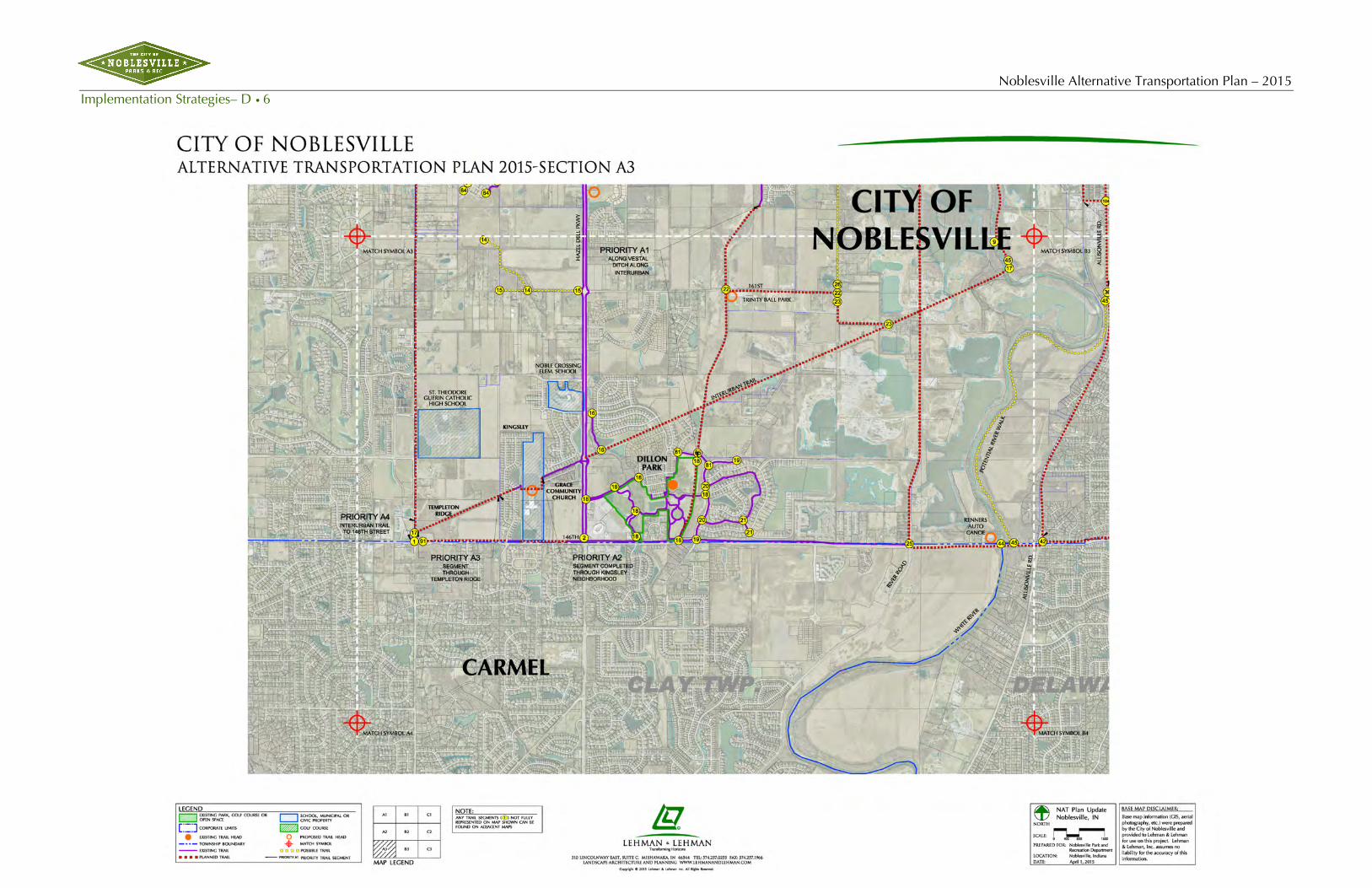
Noblesville Alternative Transportation Plan – 2015 Implementation Strategies– D • 6

Noblesville Alternative Transportation Plan – 2015 Implementation Strategies – D •7

Noblesville Alternative Transportation Plan – 2015 Implementation Strategies– D • 8

Noblesville Alternative Transportation Plan – 2015 Implementation Strategies – D •9

Noblesville Alternative Transportation Plan – 2015 Implementation Strategies– D • 10

Noblesville Alternative Transportation Plan – 2015 Implementation Strategies – D •11

Noblesville Alternative Transportation Plan – 2015 Implementation Strategies– D • 12

Noblesville Alternative Transportation Plan –2015 Implementation Strategies – D•13
Transforming Horizons
2015-2016 NAT Priority Trail Connections During the course of this plan update the Consultant conducted as series of meetings with the Park and Planning staff and City Administration in identifying the trail segments that carry priority for implementation over the next couple of years. There were twelve (12) trail segments that were identified. Their descriptions and details are noted below and each of the priority segments has been noted on the planning maps.
A. Interurban Trail (East & West of Hazel Dell Road) 1. Along Vestal Ditch along Interurban (8,508 Linear Feet = 1.61 Miles) 2. Segment completed through Kingsley Neighborhood (1,542 Linear Feet = 0.29 Miles) 3. Segment through Templeton Ridge (2,870 Linear Feet = 0.54 Miles) 4. Interurban to 146th Street (612 Linear Feet = 0.12 Miles)
B. SR 37 Area 1. From LA Fitness to Stony Creek Trail eastward to Union Chapel (4,002 Linear Feet = 0.76 Miles) 2. Undercrossing Cumberland from LA Fitness to continue west crossing Cumberland Road, with
switchbacks down and under SR 37, switchback up to Hare Chevrolet, to north side of Stony Creek Road (2,129 Linear Feet = 0.40 Miles)
3. South of Cherry Street, following west side of SR 37 south to Pleasant Street (1,617 Linear Feet = 0.31 Miles)
4. Grade crossing at SR 37 and 191st Street, south on the west side of SR 37 to Field Dr., including trail head (2,570 Linear Feet = 0.49 Miles)
C. Little Chicago Road Area 1. West Harbour’s pool area south to SR 38 (2,288 Linear Feet = 0.43 Miles) 2. Small trail segment at West Harbour’s pool area (409 Linear Feet = 0.08 Miles) 3. Trail improvements north of Buttonwood north to the bridgeway (1,701 Linear Feet = 0.32 Miles) 4. Lion’s Creek to Lakeside subdivision (722 Linear Feet = 0.14 Miles) 5. Pedestrian bridgeway to wrap around Northwest corner of Harbour Town Shops (2,123 Linear Feet
= 0.40 Miles) 6. Extend trail along 211th Street to Oakbay Dr. (4,242 Linear Feet = 0.80 Miles)
D. Levee Trail 1. From Morse Park to Dakota Drive on west side of the levee (4,573 Linear Feet = 0.87 Miles) 2. From Dakota Drive to Carrigan Road on top of levee (4,272 Linear Feet = 0.81 Miles) 3. Carrigan Road to 216th Street on top of levee (5,143 Linear Feet = 0.97 Miles) 4. New trail segment within the Morse Beach County Park following the water’s edge on the north side
of park to existing trail on west side of the park (1,240 Linear Feet = 0.23 Miles)
E. Union Chapel Road 1. Connect the segments of trail on the east side of Union Chapel Road, south of 166th Street (511
Linear Feet = 0.10 Miles)
F. Federal Hill Commons Trail connection to Forest Park 1. New trail from Logan Street north along Nixon Street to the railroads, switchbacks up to RR
elevations and boardwalks across into Forest Park (1,582 Linear Feet = 0.30 Miles)

Noblesville Alternative Transportation Plan – 2015 Implementation Strategies – D•14
Transforming Horizons
G. Allisonville Road 1. From where 8th Street ends at Carbon Street trail to East Allisonville Road, crossing at grade. Then
south along east side either with grade or boardwalk to Wellington Parkway (2,913 Linear Feet = 0.55 Miles)
2. Continue south along east side of Allisonville Road to 146th Street (8,209 Linear Feet = 1.55 Miles)
H. Greenfield Avenue Area 1. From Stony Creek Road continue north on east side of 16th Street to northern edge of Stony Creek
Elementary School to Greenfield Avenue (3,460 Linear Feet = 0.66 Miles)
I. Stony Creek/Union Chapel Road 1. Connect trail from Union Chapel Road east along northern side of Stony Creek to Stony Creek
Estates (3,556 Linear Feet = 0.67 Miles)
J. 166th Street/ Union Chapel Road 1. Connect trail with missing segment on east side of 166th Street (6,350 Linear Feet = 1.20 Miles)
K. 156th Street/ Deer Path 1. Connect existing trails with missing segments near Deer Path Development (946 Linear Feet = 0.18
Miles)
L. New Cumberland Road, near SMC 1. Connect existing trails with missing segment near SMC (383 Linear Feet = 0.07 Miles)

Noblesville Alternative Transportation Plan –2015 Implementation Strategies – D•15
Transforming Horizons
Noblesville Alternative Transportation — 2015 Forecast Inventory The Noblesville Alternative Transportation Plan — 2015 identified proposed routes and pathway segments based on identified trail types. The following table represents the inventory of the proposed plan broken down by trail types:

Noblesville Alternative Transportation Plan – 2015 Implementation Strategies – D•16
Transforming Horizons

Noblesville Alternative Transportation Plan –2015 Implementation Strategies – D•17
Transforming Horizons

Noblesville Alternative Transportation Plan – 2015 Implementation Strategies – D•18
Transforming Horizons
NAT Trailheads With this NAT Plan Update locations of existing and proposed Trailheads were identified on the plan. Twenty five (25) Trailheads were identified with this update plan with six (6) being a part of the Priority Trail Segment list. The locations of these trailheads are typically on key locations with available parking and resource facilities. Existing park and public land provides adequate resources for the trail user this also includes Fire Stations.
The NAT Trailheads can be classified with two (2) types: Full Trailhead and a Mini Trailhead.
The Full Trailhead development would include the following:
• Site size approximately .25 acre • Be a part of a public facility (e.g. park, public space, fire house, etc.) with directional signage and
marquees directing the user to the trailhead facility • Parking facilities that are close

Noblesville Alternative Transportation Plan –2015 Implementation Strategies – D•19
Transforming Horizons
• Bike Racks, benches, trash receptacles • Trail Signage with map and directional marquees • Restroom Facilities (note: if part of a public park facilities restroom facilities could be close to the
trailhead) • Site lighting for safety and security • If available an emergency call device • Signage of possible Sponsors
The Mini Trailhead development would be similar to the Full Trailhead development but on a smaller site and will less number of amenities and facilities.
Sample Trailheads

Noblesville Alternative Transportation Plan – 2015 Implementation Strategies – D•20
Transforming Horizons
Trails Plan Summary The above matrix tallies the identified trail segments as delineated on the plan maps. The summary of the inventory is shown in the following table.
In graphic form the summary would look like the following chart (illustrated in miles)

Noblesville Alternative Transportation Plan –2015 Implementation Strategies – D•21
Transforming Horizons
Community Level of Service Standards The total mileage of the Noblesville Alternative Transportation Plan — 2015 represents the forecasted “build out” of the City with its expansion into the townships over the future decades.
The use of standards should be established and applied to Noblesville Alternative Transportation Plan — 2015. Such standards can be used as a gauge in maintaining the Noblesville Alternative Transportation Plan — 2015 implementation, keeping pace with the community growth.
The 2023 population is projected to be 76,164 (Recreation Impact Fee Study 2014). When applying the Community Level of Service using the standard of one (1) mile of trail/pathway per 775 persons there will be a need for 98.28 miles of trail. As of the date of this study there are over 80.45 miles of trails in place. Implementation is already forecasted to take place on an annual basis keeping pace with the identified community level of service standard. Of the 12 Priority Segments, identified as part of this study the tally of those trail segments alone equals 14.85 miles.
Implementation Strategies and Priorities Policy Development
• Take action in support of the Noblesville Alternative Transportation Plan – 2015 Action Plan.
• Designate a lead agency/department to work with the proposed 2015 Advisory Committee (NATPAC) to implement the Action Plan.
• Integrate the Noblesville Alternative Transportation Plan — 2015 and any local trails and greenways plans into the community’s parks and open space, land use and transportation plans.
• Adopt a stream buffer ordinance that protects stream corridors.
• Adopt a park/open space dedication requirement to support the acquisition of land and development of Noblesville Trails.
• Incorporate Noblesville Alternative Transportation Plan — 2015 objectives into the development of the community’s parks and open space, land use and transportation plans.
Planning
• Conduct a Natural Resources Inventory as part of the City’s comprehensive or land-use planning process to identify important resources to protect and preserve and to determine appropriate stream setback provisions.
• Identify land ownership for each segment within each neighborhood, and determine how acquisition or access will be accomplished if it is required.
• Determine the facility type for each Noblesville Trails segment.
• Identify partners from the public and private sectors that can help implement Noblesville Trails segments.
• Continue to assist Municipalities and Counties in building a regional GIS inventory of natural resources including open space, parks and trails.

Noblesville Alternative Transportation Plan – 2015 Implementation Strategies – D•22
Transforming Horizons
Programming
• Refine priorities for the Noblesville Alternative Transportation Plan — 2015 on a periodic basis.
• Identify and program local funding sources for the highest priority Noblesville Trails segments and seek grants and other funds to supplement local resources.
• Evaluate how new funding sources could support the development of Noblesville trail segments. In particular, Noblesville should determine how to best utilize such new programs as Recreation Impact Fees, etc. which could be a major support base of the implementation of Noblesville Alternative Transportation Plan — 2015.
Operation/Maintenance
• Adopt the Noblesville Alternative Transportation Plan — 2015 design guidelines for Noblesville Trails.
• Adopt the Noblesville Trails logo into the City’s signage for its trail system, using one of the proposed design concepts.
• Determine how and by whom each segment of Noblesville Trails will be operated and maintained.
• Develop maintenance standards for Noblesville Trails.
Implementation Schedule and Costs As previously mentioned, a greater inventory of each of the trail segments needs to be completed. This inventory will identify the improvement needs, consistency of trail flow and safety issues. Consideration should be given to the ease of making route segments accessible as part of the plan.
Associated Costs for Development A planning component for the implementation of the Noblesville Alternative Transportation Plan — 2015 is cost. It is recommended by the Consultant that average construction costs be developed for each of the trail types. Generally, construction costs per running foot of trail is the typical costing unit that would apply. This information should be updated periodically and be used in evaluating phasing and priorities of trail segments. This applies to both new trail construction as well as upgrading improvements to existing trails and sidewalks. The Advisory Committee of Public Works and Engineering Department should keep these costs updated.
The Streets and Parks Departments should also establish a maintenance cost per trail segment. This will be useful in defining annual maintenance and operation budgets.

Noblesville Alternative Transportation Plan –2015 Implementation Strategies – D•23
Transforming Horizons
Establishment of a 2015 Advisory Committee (NATPAC) Next Steps Recommended
The Noblesville Alternative Transportation Plan — 2015 should be considered a dynamic document and updated periodically. City officials and its various government entities will continue to need ongoing citizen input in order to make informed decisions with respect to a developing trail system. The Consultant therefore proposes that the City consider a voluntary NAT Plan Advisory Committee, led by a private citizen, and composed of both appropriate city officials and private citizens who have interest and knowledge related to greenway and pathway development.
NATPAC Strategy
An overall strategy to advise city officials and citizens, and to develop trail policy and plans, would include the following elements:
• Accept and start with Noblesville Alternative Transportation Plan — 2015 findings and Position Statement.
• Recommend further detail that must be added to the plan—trail type, exact routes.
• Work with all stakeholders—citizens, government officials and businesses.
• Recognize that “users” have differing needs—walkers, runners, cyclists, etc.
• Route around, not through, private property—except where that access is offered voluntarily.
• Use all practical means to solicit input.
• Use all practical means to disseminate and communicate information about plans & about trail system progress & successes—education, presentations, and publicity.
• Organize trail-use events to publicize opened trails and familiarize citizens with them.
• Assist the City in documenting infrastructure conditions and issues by soliciting volunteer survey/inspection crews.
• Advising the City in developing creative financing arrangements that facilitate trail funding.
• Advising the City in developing creative financing arrangements that create access for trails.
• Advising the City with respect to trail-type needs.
• Enlist a group of interested citizens, with skills and interests in the needed areas, to serve on the Advisory Committee.
• Meet regularly; run the Advisory Committee effectively with clear responsibilities, assignments & goals.

Noblesville Alternative Transportation Plan – 2015 Implementation Strategies – D•24
Transforming Horizons
Inclusions and Updates One of the recommended outcomes of the Noblesville Alternative Transportation Plan — 2015 is the inclusion of the system plan into the existing planning documents, ordinances and guidelines of the City.
The Park and Recreation Advisory Committee is advised to include the Noblesville Alternative Transportation Plan — 2015 in their current five-year master plan, adopting the overall development strategies as well as the trail standards affection both current and future populations in this recreation amenity.
The Common Council and Plan Commission are advised, similarly, to include the Noblesville Alternative Transportation Plan — 2015 as part of the City’s Comprehensive Plan and the Thoroughfare Plan, adopting the overall development strategies as well as the trail standards affection both current and future populations in this recreation amenity. The City’s subdivision ordinance and related development standards are also recommended to be updated to include the trail standards set forth in the Noblesville Alternative Transportation Plan — 2015.
Once these plans and guidelines have been adopted, the City, with the assistance of the NATPAC, can establish priorities for implementing as well as seek grants and other funding sources for development projects. The City can budget annually for matching grants using local resources and funding mechanisms.
Continual inclusion in the exiting operations policies (maintenance and upkeep) as well as marketing and promotion, etc. should be carried out.
On a regional scale, the City of Noblesville should be an active “partner” with surrounding greenways and trails providers allowing the inclusion of the Noblesville Alternative Transportation Plan — 2015 to become part of a larger, regional system.
The Consultant feels it is critical to conduct annual review of progress and accomplishments and to report to the City such findings.
Potential Developing Partners Throughout the implementation of the Noblesville Alternative Transportation Plan — 2015 the City will benefit by forming partnerships with various organizations. Some potential partners identified as part of this study are as follows:
• Noblesville Parks Department
• City of Noblesville/Public Works
• Commercial/Residential developers
• Businesses and Corporations
• Hamilton County Highway Department
• Hamilton County Park Agencies (HAMPA)

Noblesville Alternative Transportation Plan –2015 Implementation Strategies – D•25
Transforming Horizons
Asset Management Resources – Cityworks The Consultant worked with the City’s GIS Coordinator in compiling the “as-built” data on the existing trails. The GIS Coordinator also carries the responsibility for asset management. The City is using the software program called, Cityworks (www.cityworks.com). Cityworks empowers GIS to manage both physical infrastructure and land-focused asset management. Municipalities allocate considerable resources toward developing and maintaining their GIS, Cityworks capitalizes on this valuable resource. Cityworks and Esri ArcGIS combine to make the perfect platform for designing and creating GIS-centric public asset management solutions.
Cityworks can be a valuable resource as related to the NAT Trail System. Since it is GIS based “as-built” drawings can be easily entered into the GIS system for accuracy of inventory information. In addition NAT system amenities such as lighting, signage, benches, bike racks, etc. can all be entered into the GIS and Cityworks database. Since GIS is a database system various fields under each asset component can be added such as date of installation, life expectancy, value of the component, when repairs were made, etc. As new trail segments are installed Cityworks could be used to recognize the date of that trail segment and enter a date when that trail segment will require resurfacing, etc.
Cityworks also is mobile and if a City employee finds there to be a hazardous condition on a trail using a smartphone they could upload a work order for repair of the condition and have it directed to the appropriate Department.

Noblesville Alternative Transportation Plan – 2015 Implementation Strategies – D•26
Transforming Horizons
Trails Signage Update The Consultant worked with the City and a signage vendor to develop new signage types and related graphic. CSI Signs from Noblesville provided design and graphic assistance. A simple list of three (3) signs were identified. These three sign types and their features and uses are described as follows:
TRAILHEAD SIGN The Trailhead Sign would be the largest of the signs and would be used at the trailheads and major trail facilities. The top of the Trailhead Sign would include a new graphical circular sign face that incorporates many features of the City’s Graphic Standards. The circular portion would have the Park Dept. Logo and City’s County Courthouse image over a landscape graphic background. The circular band around the sign face can incorporate the name of the Trail or Trailhead and the Mile Mark number.
Below the circular sign face at the top there would be panels between two support posts. There could be a space identifying “sponsors” for the trail segment or trailhead. Below that panel would be a larger panel that can contain elements such as Trail Rules, Directional Graphics with narrative, location map of the NAT area, etc. At the bottom of this panel would be the Noblesville Park Logos.

Noblesville Alternative Transportation Plan –2015 Implementation Strategies – D•27
Transforming Horizons
MULTI-PURPOSE TRAIL SIGN A smaller version of the Trailhead Sign is the Multi-Purpose Trail Sign. The components of the Trail Locator sign is the same or similar to the larger Trailhead Sign. The intent of this sign is much more of a “multipurpose” use. It can carry the following uses:
• As an Identifier of key elements or facilities along a trail
• As a Trail Entry Sign for the start of a trail
• Informational panels that could include narrative and trail maps, directional arrows, etc.

Noblesville Alternative Transportation Plan – 2015 Implementation Strategies – D•28
Transforming Horizons
TRAIL TRAFFIC SIGN A different sign type is the Trail Traffic Sign. This sign type’s purpose is to function for traffic and direction uses. The traffic sign face can serve as a traffic sign on one face and street names and the NAT logo on the other. The sign’s post can have mile markers noted as well.

Noblesville Alternative Transportation Plan – 2015 Implementation Strategies – D • 29
Transforming Horizons
Trail Signage – Priority Locations and Implementation – Inter-Urban Trail • Hazel Dell Parkway • Dillon Park Area
Inter-Urban Trail underpass at Hazel Dell Road
Inter-Urban Trail Start Point at Grey Road
Hazel Dell Trail Start Point at Hazel Dell
Parkway / 146th Street
A
BC
Inter-Urban Trail at Midland Lane Area
Dillon Park Signage Areas A
C
C
C
C
C
C
BB
BB
C
BB

Noblesville Alternative Transportation Plan – 2015 Implementation Strategies– D • 30
Transforming Horizons
Trail Signage – Priority Locations and Implementation – Riverwalk Depot Park • Forest Park • Lakeview Drive Area
A
C
A
CC
CC
CC
B
CCC B
C
BC
C
Riverwalk Depot Park
Forest Park
Lakeview Drive Area

Noblesville Alternative Transportation Plan –2015 Implementation Strategies – D•31
Transforming Horizons
NAT Trail System – Other Considerations NAT Trail System App
The Consultant recommends consideration by the City for the development of a NAT Trail System App that can be used by users on their Smartphones and other cellular devices. Such an app could allow the user to:
• Learn their locations on a GPS map
• Learn the distances to area destinations
• View the NAT Trail Rules
• Measure physical and time distances to certain locations
• Could be coordinated with adjacent communities’ trail apps
• Could be ad supported to engage sponsorships
NAT Trail System Names and Location Metrics
The Consultant recommends consideration by the City in naming of trails segments, logical trail loops, trailheads, etc. Also, a mile marker strategy should be studied in where the beginning of a trail segment mileage marker would start and how it blends with other segments and even adjacent communities’ trail systems.

Noblesville Alternative Transportation Plan – 2015 Appendix – E•1
Transforming Horizons
E. Appendix

Noblesville Alternative Transportation Plan – 2015 Appendix – E•2
Transforming Horizons
Appendix Index The following Appendix items served as part of this study:
• Definitions
• Reference Sources
• Sample Trail Head Signage
• Indianapolis Cultural Trail System
• The 2006 Indiana Trails, Greenways and Bikeways Plan (Chapter 3) Value Added Features of Trails
• American Canoe Association – 2005-06 ACA Recommended Water Trails
Definitions • Bicycle – Every vehicle propelled solely by human power upon which any person may ride, having
two tandem wheels, except scooters and similar devices. The term “bicycle” for this publication also includes three and four-wheeled human-powered vehicles, but not tricycles for children.
• Bicycle Facilities – A general term denoting improvements and provisions made by public agencies to accommodate or encourage bicycling, including parking and storage facilities, shared roadways not specifically designated for bicycle use.
• Bicycle Land or Bike Land – A portion of a roadway which has been designated by striping, signing, and pavement markings for the preferential or exclusive use of bicyclists.
• Bicycle Path or Bike Path – See Shared Use Path
• Bicycle Route System – A system of bikeways designated by the jurisdiction having authority with appropriate directional and informational route markers, with or without specific bicycle route numbers. Bike routes should establish a continuous routing, but may be a combination of any and all types of bikeways.
• Bikeway – A generic term for any road, street, path or way which in some manner is specifically designated for bicycle travel, regardless of whether such facilities are designated for the exclusive use of bicycles or are to be shared with other transportation modes.
• Highway – A general term denoting a public way for purposes of vehicular travel, including the entire area within the right-of-way.
• Rail-Trail – A shared use path, either paved or unpaved, built within the right-of-way of an existing or former railroad.
• Right-of-Way – A general term denoting land, property or interest therein, usually in a strip, acquired for or devoted to transportation purposes.
• Right of Way – The right of one vehicle or pedestrian to proceed in a lawful manner in preference to another vehicle or pedestrian.
• Roadway – The portion of the highway, including shoulders, intended for vehicular use.
• Rumble Strips – A textured or grooved pavement sometimes used on or along shoulders of highways to alert motorists who stray onto the shoulder.
• Shared Roadway – A roadway which is open to both bicycle and motor vehicle travel. This may be an exiting roadway, street with wide curb lanes, or road with paved shoulders.

Noblesville Alternative Transportation Plan – 2015 Appendix – E•3
Transforming Horizons
• Shared Use Path – A bikeway physically separated from motorized vehicular traffic by an open space or barrier and either within the highway right-of-way or within an independent right-of-way. Shared use paths may also be used by pedestrians, skaters, wheelchair users, joggers and other non-motorized users.
• Shoulder – A portion of the roadway contiguous with the traveled way for accommodation of stopped vehicles, for emergency use and for lateral support of sub-base, base and surface courses.
• Sidewalk – The portion of a street or highway right-of-way designed for preferential or exclusive use by pedestrians.
• Signed Shared Roadway (Signed Bike Route) – A shared roadway which has been designated by signing as a preferred route for bicycle use.
• Traveled Way – The portion of the roadway for the movement of vehicles, exclusive of shoulders.
• Unpaved Path – Paths not surfaced with asphalt or Portland cement concrete.
Reference Sources The following is a listing of reference books, articles, newsletters, documents and studies referred to and used in the planning and processing of this master plan.
References: Benefits of Trails, Pathways, Greenways
Increasing Physical Activity Through Community Design, A Guide for Public Health Practitioners. National Center for Bicycling and Walking, May 2002. (www.bikewalk.org)
Benefits of Trails and Greenways. Rails-to-Trails Conservancy website. (www.trailsandgreenways.org)
Policy and Planning: Benefits of Bicycling. Pedestrian and Bicycle Information Center website. (www.bicyclinginfo.org)
Economic Benefits of Greenways: Summary of Findings. The Conservation Fund website. (www.conservationfund.org/conservation)
Economic Benefits of Trails and Greenways. Rails-to-Trails Conservancy website. (www.trailsandgreenways.org)
Economic Benefits of Wildlife and Habitat. The Conservation Fund website. (www.conservationfund.org/conservation)
Enhancing the Environment With Trails and Greenways. Rails-to-Trails Conservancy website. (www.trailsandgreenways.org)
Guide for the Development of Bicycle Facilities. The League of Illinois Bicyclists website. (www.bikelib.org)
Health and Wellness Benefits. Rails-to-Trails Conservancy website. (www.trailsandgreenways.org)
Preserving Historic and Cultural Resources. Rails-to-Trails Conservancy website. (www.trailsandgreenways.org)
Trails and Greenways for Livable Communities. Rails-to-Trails Conservancy website. (www.trailsandgreenways.org)
Who Pays for Roads? The League of Illinois Bicyclists website. (www.bikelib.org)
The Indianapolis Hiking Club. Newsletter of group that sponsors outdoor activities in the form of hikes and outings. (http://community-2.webtv.net/indyhike/theindianapolis/)

Noblesville Alternative Transportation Plan – 2015 Appendix – E•4
Transforming Horizons
Hoosiers on the Move The Indiana State Trails – Greenways & Bikeways Plan (www.in.gov/dnr/outdoor/planning/trailsplan)
Indy Cultural Trail (www.indyculturaltrail.org)
Safe Routes to School. (safety.fhwa.dot.gov/saferoutes)
References: Data Collection as Part of this Study
2010 U.S. Census Data for Noblesville, Indiana.
2014-2019 Parks and Recreation Master Plan – City of Noblesville. Prepared by Lehman & Lehman, Inc., Mishawaka, IN
2014-2023 Recreation Impact Fee Study – City of Noblesville. Prepared by Lehman & Lehman, Inc., Mishawaka, IN
References: Sources and References of Design Standards
Minnesota Bicycle Transportation Planning and Design Guidelines. Minnesota Department of Transportation. June, 1996. Parks, Recreation, Open Space, and Greenway Guidelines. 1996.
Building the Riverfront Greenway – The State of Greenway Investments along the Detroit River. A Greater Detroit American Heritage River Initiative and Metropolitan Affairs Coalition Project. Metropolitan Affairs Coalition (MAC), circa 2000.
A Guide to Transportation Enhancements. National Transportation Enhancements Clearinghouse, circa 1999. (www.enhancements.org)
Guide for the Development of Bicycle Facilities. AASHTO Task Force on Geometric Design. American Association of State Highway and Transportation Officials, 1993.
National Complete Streets Coalition, Washington, D.C. 20036
Concrete, Asphalt, Gravel, Steve Saitta Author, Parks & Rec Business, March 2011
References: General Resources of Greenway Planning
Successful Strategies for Trail Development – Resource Manual. From a seminar sponsored by the Rails-To-Trails Conservancy, September 17, 2002 in Bloomington, IN
Bicycle Blueprint: A Plan to Bring Bicycling Into the Mainstream In New York City. Prepared by, Transportation Alternatives NYC, 1993.
Bicycle as a Vehicle in Indiana. Indiana Bicycle Coalition, Inc. website. (www.bicycleindiana.org)
BTS TransGlide 2000. Bicycle Transportation Systems Inc. website. (www.biketrans.com)
Greenprint Gallery. Susan Ives, Editor. The Trust for Public Land, 2000.
How Greenways Work: A Handbook on Ecology. Jonathan M. Labaree. National Park Service and Atlantic Center for the Environment, 1992.
Indiana Bicycling Laws. Indiana Bicycle Coalition, Inc. website. (www.bicycleindiana.org)
The Future of Mass Transportation. Bicycle Transportation Systems Inc. website. (www.biketrans.com)

Noblesville Alternative Transportation Plan – 2015 Appendix – E•5
Transforming Horizons
Trails for the Twenty-First Century (2nd Ed.). Charles A. Flink, Kristine Olka, and Robert M. Searns. Rails-to-Trails Conservancy, 2001.
Walking the Safe Walk, Land and People. Harry Austin. The Trust for Public Land. Fall, 2000.
References: Implementation Steps
Rail-Trails and Utilities: How to Share Your Corridor With Other Uses. Rails-to-Trails Conservancy Fact Sheet. May, 1997.
Who Actually Owns the Right-of-Way? Rails-to-Trails Conservancy Fact Sheet. May, 1997.
References: Policy Development
City of Portland (OR) Bicycle Master Plan Policies and Objectives. City of Portland Bureau of Transportation System Management. (www.trans.ci.portland.or.us/Traffic_Management)
Pedestrian Transportation Plan Executive Summary. City of Madison (WI) Traffic Engineering Division. September, 1997. (www.ci.madison.wi.us/transp/trindex)
Policy and Planning: Policies. Pedestrian and Bicycle Information Center website. (www.bicyclinginfo.org)
Policy and Planning: Predicting Demand. Pedestrian and Bicycle Information Center website. (www.bicyclinginfo.org)
Massachusetts Statewide Bicycle Transportation Plan. Massachusetts Highway Department, 1998. (www.state.ma.us/mhd/sitemap)
Policy and Planning: Types of Planning Activities-Local Planning. Pedestrian and Bicycle Information Center website. (www.bicyclinginfo.org)
Guide for the Development of Bicycle Facilities. AASHTO Task Force on Geometric Design. American Association of State Highway and Transportation Officials, 1993.
Wisconsin Bicycle Transportation Plan: Plan Vision, Goals and Objectives. Wisconsin Department of Transportation. September, 1998.
References: Public Education and Communication
Crime and Vandalism. The Conservation Fund website. (www.conservationfund.org/conservation)
Making Boulder More Walkable Program. City of Boulder, Colorado website. (www.ci.boulder.co.us/publicworks)
Property Owner and Tenant Concerns. The Conservation Fund website. (www.conservationfund.org/conservation)
What Pedestrians Should Know About Their Rights and Responsibilities. City of Boulder, Colorado website. (www.ci.boulder.co.us/goboulder)
Top Ten Ways to Work With the Opposition. Rails-to-Trails Conservancy Fact Sheet. June, 1997.

Noblesville Alternative Transportation Plan – 2015 Appendix – E•6
Transforming Horizons
Sample Trail Head Signage

Noblesville Alternative Transportation Plan – 2015 Appendix – E•7
Transforming Horizons
The Indianapolis Cultural Trail System

Noblesville Alternative Transportation Plan – 2015 Appendix – E•8
Transforming Horizons
This page intentionally left blank.

43
In the late 19�0s the value of trails in the United States was beginning to be recognized on a national level. As early as 19�5, President Ronald Reagan appointed a bi-partisan commission to look ahead for a generation and determine how to meet the nation’s needs for outdoor activities. That commission’s report, Americans and the Outdoors (President’s Commission on Americans Out-doors, 19��), recognized the increased problems and pressures on the outdoors. As a solution, the commis-sion offered the following recommendation.
“Our communities can create a network of greenways across the USA… We can tie this country together with threads of green that everywhere grant us access to the natural world. Rivers and streams are the most obvi-ous corridors, offering trails on the shores and boating at mid-channel. They could link open areas already existing as national and state parks, grasslands, forests, lakes, and reservoirs, the entire network winding through both rural and urban populations. Thousands of miles of abandoned rail lines should become hiking, biking and bridle paths. Utility rights-of-way could share their open space not only with hikers and cyclists but also with wildlife. Citizens and landowners, both individual and corporate, can look for opportunities to establish and maintain volunteer labor. Imagine every person in the US being within easy walking distance of a greenway that could lead around the entire nation. It can be done if we act soon.”
Fewer things in the 21st century development in-dustry make better sense than combining commu-nity infrastructure with quality of life amenities, especially those that ac-commodate pedestrian and bikeway needs of citizens demanding better health and fitness opportuni-ties in their communities. Entrepreneurs and hous-ing developments located along a network of linear green space corridors in-vite, entertain and engage citizens in an atmosphere that establishes a quality of life that will make Indi-ana a leader on the Ameri-can landscape.
“Green Infrastructure” was coined to describe our
nation’s natural life support system - an interconnected network of protected land and water that supports native species, maintains natural ecological processes, sustains air and water resources and contributes to the health and quality of life for America’s communities and people. Trails are a perfect example of green infrastructure that adds both quantifiable and non-quantifiable value to a community. Combining green infrastructure with built infrastructure under and over the ground creates a cor-ridor system that provides countless benefits for those who live close to a trail, those who travel to use and en-joy trails and those who derive an economic benefit from a trail.
On the surface these corridors serve as greenway or bikeway trails emphasizing the human component tied directly to the health of local populations. Functionally, these corridors can also serve as emergency utility access roads. Utilizing existing, though no longer used, corri-dors can re-create opportunities for energy, information and opportunity to travel and flow to every town and city along these corridors. Consequently, valuable transit and utility corridors are not lost. They just evolve into a trail system that could have, just a few feet below the user’s feet, an infrastructure of pipes and cables that will ac-commodate the flow of resources, such as wastewater and fresh water, and commerce.
This statewide trails planning effort should address
CHAPTER 3VALUE ADDED FEATURES OF TRAILS

44
THE INDIANA STATE TRAILS, GREENWAYS & BIKEWAYS PLAN
VALUE ADDED FEATURES OF TRAILS
the needs and create a ven-ue for citizens to become more active. As people grow more accustomed to having access to a devel-oped trail network they will continue to recognize the value that such systems add locally and throughout Indiana.
TRAILS AND ECONOMIC DEVELOPMENT
Trails and greenways provide multiple benefits. Their primary value, of course, is the enjoyment they bring to people who use them. But they have many other advantages.
Because trails may at-tract people to rural or remote parts of the state, they have significant poten-tial to serve as engines of economic development. Even new trails in an already developed area may heighten economic activity in the vicinity of the trail.
Here are some of the ways in which trails may spur economic development:
• They may increase property values near the trails.• They may lead to greater tourism along the routes
people take to get to the trails or in the region where the trails are.
• They may lead to new restaurants, grocery stores, bike shops, motels, camping areas, and suppliers/renters/repairers of recreation equipment, or they may increase the traffic these businesses get.
Trails almost always have a positive economic influ-ence. In 1992, the National Park Service studied three multi-purpose trails in California, Florida, and Iowa. The annual combined economic impact of these three trails was found to be $1.5 million.
Others have gauged the economic effects of trails and have come up with dramatic results.
• In early 1996, the Company of Pilgrims surveyed 6,000 households represented at the Indianapolis Home Show. One question, directed to those con-sidering buying or building a house in the near fu-ture, asked people about recreation. The results: 55% wanted nearby playgrounds, 73% wanted nearby basketball or tennis courts, and 83% wanted nearby hiking or biking trails.
• In 2001, PriceWaterhouseCoopers determined that a 201-mile section of a proposed trans-Canada trail sys-tem would create 170 jobs and increase the income in that province permanently by $7 million U.S.
• The Little Miami Scenic Trail in Ohio has 150,000 trail users each year who spend an average of about $15 per visit on food, beverages, and transportation to the trail.
• New trails have led to the economic revitalization of communities as diverse as Leadville, Colorado; Rockmart, Georgia; and Milford, Delaware.
• In 2002, the National Association of Realtors and the National Association of Home Buyers conducted a joint survey. In a list of eighteen community ameni-ties, trails were chosen as the second most important.
• Home lots next to trails sell faster and at a 9 percent premium than homes farther away.
Increasingly, communities are realizing the economic aspects of quality-of-life issues. The ability of residents and visitors alike to “escape” to a trail for hiking, biking, jogging, etc. is no longer seen as a luxury but as a vital component of what makes a particular location attractive and livable.
Trails are rarely created to increase a region’s econom-ic vitality. But they almost always have that result.
• In 2004, the Indiana Chamber of Commerce named Muncie Indiana Community of the Year because of the city’s development around its downtown – in-cluding $12 million (mostly in federal dollars) de-voted to hiking and biking trails accessible near the downtown.
• A 2001 study of the Rivergreenway Trail in Fort Wayne revealed that the average user of that trail spent $1,350 a year in connection with using that trail. The same study showed that half of those who used the trail fell into two categories: industry/tech-

45
THE INDIANA STATE TRAILS, GREENWAYS & BIKEWAYS PLAN
CHAPTER 3
nology/trades and business/clerical/management.• Bloomington, Indiana recently acquired a rail line
that the city will convert into a paved urban trail in order to revitalize the arts district and, with it, cre-ate a more vibrant downtown.
• In February 2006, a software manufacturer from Muncie announced that it was moving its opera-tions to Yorktown. Even before the move, the com-pany had drawn up plans to provide scenic ameni-ties that it knew would be of value to its employees: a park and a walking trail.
• The Monon Greenways Trail that stretches sixteen miles from Indianapolis to Carmel is a model com-bination of the rails-to-trails concept with econom-ic development. Bike shops and cafes line parts of the trail. The trail goes through the artsy commu-nity of Broad Ripple through open country into the sophisticated environs of Carmel with easy access to parks, a shopping center, and a farmers market. As a local television station reported, “There was a time that the trail met with some resistance from people who lived nearby. They thought it would lower their property value. Now a lot of them are using it as an attribute in their real estate listings.”
In June 200�, the Monon Trail celebrated its 10th anniversary. The trail, with 1.2 million visits a year, is so popular that developers are building thousands of high-end condominiums and townhouses along or near the trail. Above the northernmost point of the trail, two housing subdivisions totaling 1,000 homes are plan-ning to make the trail part of their developments. Town planner Kevin Buchheit explained, “Everyone wants to be on the Monon.”
Two shopkeep-ers near a new Indianapolis trail summed it up. Over 4,000 people now use this trail every day, and at peak hours more than �00 walk on one three-mile stretch. A deli owner near the trail observed, “A lot of people are coming in here that have never been here before.” The owner of a lo-cal store likewise commented, “The trail has helped to put our name at the front of peo-ple’s minds.”
TRAILS AS ALTERNATIVE TRANSPORTATION
Providing alternative transportation is often touted as one of many trail benefits. Before looking at the role trails can play in providing alternative transportation, it may be helpful to note how bicycle and pedestrian commuting has typically been measured in the past. Commuting is often mistakenly thought of as simply the journey to work. The latest Journey to Work Survey by the U.S. Census Bureau in 2000 found 3.3% of workers rode bicycles or walked to work. However, the National Household Travel Survey in 2001 reported that journey to work trips only comprise 15% of all trips. In other words, �5% of all travel is trips other than to and from work. Accordingly, it makes sense to consider all types of trips when assessing the level of commuting done via trail.
Although further research is necessary, initial stud-ies show significant use of Indiana trails for alternative transportation. In January 2002, The Indiana Depart-ment of Transportation (INDOT) released the Indiana Trails Study, the most comprehensive evaluation of trails in the state to date. A summary of the study is available on INDOT’s Web site at http://www.state.in.us/dot/proj-ects/trails/index.html. This study of six Indiana trails found that 5% of visits to the Monon Trail in Indianapo-lis were for the main purpose of commuting. Another 15% of visits were for a secondary purpose of commut-ing or running errands. In other words, approximately 20% of trips resulted in some type of commuting. With a monthly visit count of 25,000 on the Monon Trail in Indianapolis, this would translate to 5000 commuting trips per month. Since 2002, the Monon Trail has been extended five miles to the north through Carmel and 3

4�
THE INDIANA STATE TRAILS, GREENWAYS & BIKEWAYS PLAN
VALUE ADDED FEATURES OF TRAILS
Roadway improvements that incorporate bicycle/pedestrian facilities are important for trail expansion and providing modes of alternative transportation.
There needs to be a coordinated effort between trail development and public transit services to provide viable transportation alternatives.

4�
THE INDIANA STATE TRAILS, GREENWAYS & BIKEWAYS PLAN
CHAPTER 3
miles to the south near downtown Indianapolis. Also, the Fall Creek Trail has since been connected. These extensions and connections have greatly increased the potential for commuting on the Monon Trail.
There are several factors that could influence the level of commuting done via trails. Provision of sidewalks, bike lanes and other street related amenities is important for bicyclists and pedestrians who are trying to safely ac-cess a trail. Trail connections to transit and bike racks on buses and trains could encourage use of trails to access the transit stop or station. Destination amenities such as “bikeports”, bicycle parking and shower/locker facilities also make it easier to choose bicycling and walking to work. In addition, incentives for alternative transporta-tion commuters and disincentives for auto commuters could encourage more commuters to hit the trail. Con-versely, limiting speed or allowing only daylight use on trails could reduce the level of trail commuting.
INDOT became increasingly attuned to the needs of cyclists and pedestrians in the mid-1990s, adding the Indiana Bicycle and Pedestrian Facility Planning and Development Plan to the statewide multimodal transpor-tation plan. Now more and more INDOT projects fea-ture improvements unheard of ten years ago. INDOT
incorporates sidewalks, separated multi-use paths, con-crete pedestrian underpasses and widened shoulders in many of its projects to accommodate pedestrians and bi-cyclists. Secure and convenient bicycle parking allows employees and visitors to state offices to exercise travel options. In 2003 INDOT and the Department of Admin-istration purchased and installed bicycle parking racks at the Indiana Government Center.
Nationwide, initiatives supporting sustainable devel-opment, smart growth and livable communities are fuel-ing interest in bicycle and pedestrian travel. A renewed emphasis on walking and the need for physical activity makes sidewalks mandatory in many new residential de-velopments. More bridges in urban areas are designed with walkways to facilitate pedestrians. Cantilevered walkways can be added when bridges are reconstructed. Curb ramps in cities and small towns improve access for people with disabilities and the elderly, wheelchairs and baby strollers. Pedestrian overpasses will soon per-mit safer crossing of major roads in communities like Bloomington, Fort Wayne and Evansville. With the growth in bicycling, the need for bike racks on buses has also grown. Hammond, Fort Wayne, Lafayette, Bloom-ington, Columbus, Evansville, Muncie, Indianapolis and

4�
THE INDIANA STATE TRAILS, GREENWAYS & BIKEWAYS PLAN
VALUE ADDED FEATURES OF TRAILS
Trails supporting the Indiana strategic initiative in biofuel and agriculture

49
THE INDIANA STATE TRAILS, GREENWAYS & BIKEWAYS PLAN
CHAPTER 3
the Louisville area transit systems mount bike racks on their buses. Tunnels provide grade-separated access for pedestrian and bicycle use in Columbus, Schererville, Merrillville, Carmel, Delphi, Portage and Indianapolis. When new highway bridges were built across the Wabash River in Lafayette and the White River in Indianapolis, the old bridges were converted to accommodate pedestrians.
Improvements that encourage bicycle and pedestrian commuting are supported by the 2003 Surface Transpor-tation Policy Project. The Project makes note of a finding by the National Household Travel Survey in 2001 that �1% of trips under a half mile distance are made in a vehicle. On the other hand, the Surface Transportation Policy Project reports that a national poll in 2003 found ��% of Americans chose public transportation and walk-able communities, rather than new roads, as the best long term solution to traffic congestion. The Project also found that �4% of Americans want their children to be able to walk to school safely. So, from an alternative transporta-tion perspective, it appears there is strong public support to continue to invest in trails and related facilities.
TRAILS AND TOURISM
Tourism in Indiana is big business. Annually, the tour-ism industry brings in approximately $�.9 billion in spending from 59 million leisure visitors—people who travel at least 50 miles to reach one of Indiana’s many destinations (this figure does not include the hundreds of thousands of people who travel as part of conven-tions or on business). Tourism contributes to a diversi-fied economic base, and visitor spending creates nearly 200,000 tourism-related jobs each year. The effects of visitor spending within local economies reach not only traditional tourism entities, but other businesses includ-ing gas stations, restaurants and grocery stores. Over the past several years, Indiana’s leisure market has grown at a rate higher than the national average.
Outdoor recreation is one of Indiana’s major forms of tourist at-traction. Brown County State Park is the nation’s most visited state park. Sites like the Indiana Dunes National Lakeshore are well known tourist attractions. According to Strategic Marketing & Research, 54.9 percent of leisure travelers to the state enjoy scenic beauty while visiting. Tourists visit lakes, riv-ers and other natural features 40.� percent of the time. Nationally, top leisure activities include outdoor walking at 12 percent (3rd highest), rural sightseeing at 11 percent (4th highest) and visiting a national/state park at � percent.
Trails are an increasingly impor-tant aspect of the outdoor recre-ation industry. In 2004, the Office
of Tourism awarded $�5,000 to the National Road Heri-tage Trail (NRHT), Inc. and Indiana Trails Fund to help create a trail development guide. The resulting 9-volume NRHT Development Guide is an important resource for the state, � counties, 30 communities and countless citi-zens’ groups along the proposed route of the 150-mile National Road Heritage Trail. The guide provides back-ground information and context with which to launch or modify greenways development plans in order to create a continuous, interconnected network of bicycle and pe-destrian facilities across the width of the state, includ-ing equestrian facilities for much of the route. Other ex-amples of the evolving connection between tourism and trails include recent winter hikes in Brown County State Park organized and promoted by the local Convention and Visitors Bureau and the feature article on the Ameri-can Discovery Trail in the 200� Indiana Travel Guide.
The value of tourism goes beyond jobs it creates and dollars visitors spend staying in Indiana hotels, dining in restaurants and visiting attractions. Tourism has a di-rect impact on the quality of life for Hoosiers by creating stronger communities and offering unique experiences. The driving motivators influencing visitor travel are of-ten the same factors considered by Indiana residents and potential residents when choosing where to live.
TRAILS AS CO-LOCATED INFRASTRUCTURE
Another opportunity exists which future trail devel-opers could utilize to implement trail networks on a statewide level. Co-locating trails and infrastructure in the same corridor could serve a dual purpose. Combin-ing utility corridors with trails. This concept could be expanded to connect towns throughout rural Indiana for sharing services such as waste water treatment. A facil-ity located in one community could serve several other cities and towns in the region by developing a collector

50
THE INDIANA STATE TRAILS, GREENWAYS & BIKEWAYS PLAN
VALUE ADDED FEATURES OF TRAILS
system of infrastructures under old rail beds and road right-of-ways.
Many towns were founded originally along rail lines that could be used to revitalize smaller communities throughout Indiana. Waste water facilities in one com-munity and fresh water facilities in another could support an entire region at a fraction of the cost communities now spend developing and maintaining their own facilities.
Reducing inefficiencies associated with communities duplicating services could be a significant cost-saving measure at the local level. Reconnecting municipal in-frastructures through a corridor along old rail or other utility corridors could set the tone for Indiana communi-ties to attract new business developments. Easy access to fresh water supply, sanitary disposal, fuel, high speed data connections and other resources would be augment-ed by a higher quality of life for prospective employees.
For example, in 19�9, a lift station on the north side of Marion County failed, dumping millions of gallons of raw sewage into Williams Creek and the White River resulting in a massive fish kill. That incident prompted the Envi-ronmental Protection Agency to require a new interceptor sewer system be built to serve the entire north & central regions of Marion County. This needed project had been postponed for years but there were no funds to build it.
Concurrently, the Indianapolis Department of Metro-politan Development was negotiating for 10.5 miles of the old Monon rail corridor that ran through the north central center of Marion County. Within days of the corridor being secured by the city, a quick engineering study was completed. A 4�-inch sewer main was co-located under the old Monon rail bed in record time and for a fraction of the cost of locating it under high traffic streets. The list of other co-located utilities along old rail corridors and greenways has grown throughout Indiana and includes fiber optic cable, cable TV, sewer lines, wa-ter, gas lines, high speed Internet, power lines and live steam from the solid waste recycling burn facility.
As manufacturing alternative fuels expands in Indiana, there are growing opportunities to utilize this network of facilities to further develop trails. Trail systems could be built over and alongside an infrastructure of pipes and cables that accommodate the flow of resources and commerce. Pumping corn slurry from grain elevators and Indiana farms to ethanol refineries and on to waiting markets will require expanding the network of existing utility corridors beyond those currently available. Ad-ditional above and below ground space for trails and in-frastructure could be created based on the model of the railroads 150 years ago that launched Indiana and the

51
THE INDIANA STATE TRAILS, GREENWAYS & BIKEWAYS PLAN
CHAPTER 3
United States into world leadership as it towered over the 20th century.
With all of these utility corridor opportunities availing themselves to the development of trails, careful planning is necessary to make sure the trails developed will serve their respective populations effectively. Building trails for the sake of trails is ideal. However in these days of reduced government spending and concern for govern-ment waste, building trails near populations that will uti-lize the networks to their fullest extent will provide the biggest return for trail dollars spent.
INDIANA HEALTH BY THE NUMBERS
In recent decades the Centers for Disease Control and Prevention (CDC) have reported dramatic increases in the number of Americans who are overweight or obese. Both adults and children across the country and in the State of Indiana have recorded drastic negative changes in health indicators that contribute to a host of prevent-able chronic illnesses. Those illnesses have a profound effect on quality and length of life and cost individuals, businesses, and the state billions of dollars each year in health care expenditures. Those often preventable condi-tions, positively impacted by physical activity are:
• Hypertension • Dyslipidemia (for example, high total cholesterol or
high levels of triglycerides) • Type 2 diabetes • Coronary heart disease • Stroke
According to the U.S. Department of Health and Human Services report Physical Activity Funda-mental to Preventing Disease,
“Encouraging more activity can be as simple as establishing walking programs at schools, work sites and in the community. Some communi-ties have an existing infrastructure that supports physical activity, such as sidewalks and bicycle trails, and worksites, schools, and shopping areas in close proximity to residential areas. In many other areas, such community amenities need to be developed to foster walking, cycling, and other types of exercise as a regular part of daily activity.”
U.S. Department of Health and Human Services. Physical activity fundamental to preventing dis-ease 2002 June 20. Available from URL: http://aspe.hhs.gov/health/reports/physicalactivity/
The Role of Recreation and Trails in Maintaining a Healthy Lifestyle
Adapted from an essay contributed by: Helen Steussy, M.D. Chairman, Healthy Communities of Henry County, swww.hchcin.org.
• Gallbladder disease • Osteoarthritis • Sleep apnea and respiratory problems • Some cancers (endometrial, breast and colon)
OVERWEIGHT & OBESITY TRENDS
The incidences of people being overweight and obese has drastically increased both in the United States and in Indiana. Using Body Mass Index (or BMI, a number based solely on a formula using height and weight), the prevalence of people overweight (those with a BMI of 25.0-29.9) or obese (those with a BMI over 30), has grown significantly.
In 2002, 3�.0 percent of Americans and 3�.2 percent of Hoosiers were considered overweight while 22.1 percent of Americans and 24.1 percent of Hoosiers were consid-ered obese. Over �0 percent of Hoosiers are considered overweight or obese, a significant increase from 4� per-cent in 1990. For children, between 2003 and 2005 the percentage of overweight students in Indiana rose from 11.5 percent to 15.0 percent.
PHYSICAL ACTIVITY
Physical activity directly impacts the incidence of obe-sity and related conditions that affect health and qual-ity of life. Simply engaging in 30 minutes of moderate physical activity at least five days each week is sufficient to result in health benefits. Moderate physical activity includes walking, hiking and other activities easily ac-cessible in park and recreation areas statewide.
In 2004, 22.� percent of Americans and 25.3 percent of Hoosiers reported no physical activity in the past month. Only 4� percent of Hoosiers engage in a suf-ficient amount of physical activity. The statistics for children are also alarming. In addition to startling over-weight numbers, only 2�.2 percent of ninth graders in Indiana take part in daily physical education instruction, which affects lifelong health habits.
The CDC’s Guide to Community Preventive Services recommends creating or improving access to trails and other venues as a way to address this problem. These assets, combined with effective community educational outreach efforts inspire increasing physical activity in the population. CDC studies have shown that this strategy can increase the number of individuals who engage in the recommended amount of physical activity by 25 percent.
FINANCIAL IMPACT OF HEALTH
The financial impact of physical inactivity is stagger-ing. Recent data from Active Living Leadership, at San Diego State University, estimates the total cost of physi-cal inactivity in the State of Indiana to be almost $� bil-lion annually, with most of this burden coming in the form of lost productivity. It is also estimated that if five percent of the Indiana population became physically ac-
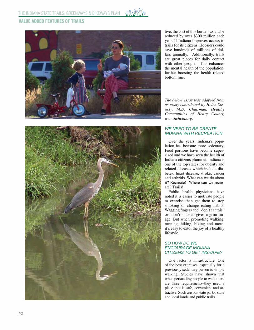
52
THE INDIANA STATE TRAILS, GREENWAYS & BIKEWAYS PLAN
VALUE ADDED FEATURES OF TRAILS
tive, the cost of this burden would be reduced by over $300 million each year. If Indiana improves access to trails for its citizens, Hoosiers could save hundreds of millions of dol-lars annually. Additionally, trails are great places for daily contact with other people. This enhances the mental health of the population, further boosting the health related bottom line.
The below essay was adapted from as essay contributed by Helen Ste-ussy, M.D. Chairman, Healthy Communities of Henry County, www.hchcin.org.
WE NEED TO RE-CREATE INDIANA WITH RECREATION
Over the years, Indiana’s popu-
lation has become more sedentary. Food portions have become super-sized and we have seen the health of Indiana citizens plummet. Indiana is one of the top states for obesity and related diseases which include dia-betes, heart disease, stroke, cancer and arthritis. What can we do about it? Recreate! Where can we recre-ate? Trails!
Public health physicians have noted it is easier to motivate people to exercise than get them to stop smoking or change eating habits. Wagging fingers and “don’t eat this” or “don’t smoke” gives a grim im-age. But when promoting walking, running, hiking, biking and more, it’s easy to extol the joy of a healthy lifestyle.
SO HOW DO WE ENCOURAGE INDIANA CITIZENS TO GET INSHAPE?
One factor is infrastructure. One
of the best exercises, especially for a previously sedentary person is simple walking. Studies have shown that when persuading people to walk there are three requirements–they need a place that is safe, convenient and at-tractive. Such are our state parks, state and local lands and public trails.

53
THE INDIANA STATE TRAILS, GREENWAYS & BIKEWAYS PLAN
CHAPTER 3
Walking on a broken sidewalk past parking lots and traffic does not encourage citizens to get out and exer-cise. But when spring peeks around the window, migrat-ing birds start to sing and ephemeral wildflowers color the ground, people want an opportunity to visit the natu-ral lands of Indiana and celebrate the cycle of the sea-sons. They want an opportunity to get outside.
Too many children are more familiar with the World Wide Web but have not experienced the sparkle of a spi-der’s web covered with dew on a summer morning. How can we expect the next generation to protect the land or even care about Indiana if all they know is the inside of a fast food restaurant and the entertainment on a screen? Children need to know the natural environment of the Hoosier state so they will choose to live here and care for the land of Indiana.
The benefits from exercise on our public lands goes beyond physical health. Nature has a calming effect on many symptoms of an increasingly crowded world. Neighborhoods with trees have less vandalism and graf-fiti. Surgical patients who look out on trees and nature heal faster. Long distance athletes get renewal by run-ning through woodlands where the oxygen concentration is higher.
Trails also promote economic health. In today’s in-formation economy everything is connected. People and businesses can locate wherever they choose. And the draw to entrepreneurs who drive the economy is the quality of life in a state and town. When studies are done to determine the most livable towns of America they al-ways look at much the same things: clean air, clean water, good parks and good schools, Indiana state parks, from the sands of the Indiana Dunes to the waters of Clifty Falls, are a major selling point for bringing people to In-diana. Thriving state and local park systems can attract entrepreneurs, retirees and families looking for a place to live and raise kids. All these people may appreciate the sound of a thrush in the woodlands or the sight of a Monarch butterfly hovering over a field of wildflowers. Trails can be the thread that ties it all together.
Trails also create opportunities for public art on places such as on the back side of warehouse buildings. Murals depicting local cultural and historic events add educa-tional benefit. Including venues for local artists, youth groups and schools allows them to communicate ideas of nature and community.
Trails and greenways protect our environmental health. Clean air and water are essential to a healthy life. For-ests and grasslands help clean the rainfall and return it to the underlying aquifers and streams. Greenery produces photosynthesis that clears the air of toxins and produces fresh, clean oxygen.
And don’t forget social health. In today’s fast paced society we need time and a place for social interactions. There is a need for third spaces in our world - places that are not work and not home where people can gather away from the noise and frantic pace of the city. When we in New Castle built a community playground, partly as an effort to battle childhood obesity, our goal was
In 2005 Gov. Mitch Daniels launched the IN-Shape Indiana initiative in response to growing health concerns related to the lifestyles of Hoosiers. Physical inactivity, poor nutrition and tobacco use are the three primary factors leading to a host of chronic diseases that affect the health, quality of life and financial stability of individuals, organizations and the State of Indiana.
The INShape Indiana initiative aims to encourage all Hoosiers to move more, eat better and give up smoking. The spirit of INShape Indiana is being im-plemented across each agency of state government and is joined in partnership by organizations, facili-ties and events with similar goals statewide.
Indiana ranks at or near the bottom in every nega-tive health indicator, including physical inactivity. An effective trails system is vital to Gov. Daniels’ vision for a healthier Indiana. Regular physical ac-tivity comes naturally while using a trail for walk-ing or bicycling. Ease of access to recreational in-frastructure such as parks and trail systems in the State of Indiana is a large component to the activity level of citizens.
A plan for the statewide development of trails helps to improve access to trails across the state by encouraging connections across varied communi-ties. Americans who live or work near well devel-oped trails systems tend to be healthier and lead a higher quality of life. Therefore, expanding and connecting existing trails will serve to increase op-portunities to become more active, thereby improv-ing health and quality of life in Indiana.
not for children to go to their own backyards and swing alone. We envisioned a place where children of all ages and backgrounds could gather and enjoy the thrill of ac-tive play in a vibrant setting.
The Indiana trail network can be an integral part of im-proving the health of Hoosiers from physical to mental, economic, environmental and social health. If we want to get InShape Indiana, our trail networks and parks are essential to the process. Our activities can recreate In-diana and lead the way to a healthy, dynamic place for Hoosiers to live and cherish.

American Canoe Association 2005-06 ACA-Recommended Water Trails
The American Canoe Association is proud to announce the ACA-Recommended Water Trails! ACA-Recommended Water Trails meet a set of basic criteria and stand out as particular good destinations for paddlers. To be eligible, a trail must meet the following requirements:
• The trail must be a contiguous or semi-contiguous waterway or series of waterways that is open to recreational use by paddlers;
• The trail must have public access points for paddlers; • The trail must be covered by a map, guide, signage or a web site that is of reasonable
quality and detail and available to the public. • Published or printed materials for the trail (e.g. guidebook, map, signs, website) must
communicate low-impact ethics to trail users; and • The trail must be supported and/or managed by one or more organizations.
ACA-Recommended Water Trails earn the right to use a special ACA logo, shown above, in maps, signs and other printed material related to the trail. The ACA will name a new group of recommended trails each year. To find out about water trails in your area, visit the ACA’s website at www.americancanoe.org. There, you will find information on 400 water trails around the United States and Canada. The 2005-06 ACA-Recommended Water Trails are: Apalachicola Paddling Trail System - A extensive network of trails in the creeks and sloughs of Apalachicola Bay, in the Florida panhandle. The Apalachicola Paddling Trail System was established by the Florida Fish and Wildlife Conservation Commission with support from the Florida Department of Environmental Protection. For more information, contact:
Florida Fish and Wildlife Conservation Commission 620 S. Meridian St. Tallahassee, FL 32399-1600 Phone: 850-488-5520 Trail website: http://myfwc.com/recreation/apalachicola_river/recreation.asp Organization website: http://myfwc.com/

2
Bartram Canoe Trails - An interlocking network of trails and camping platforms in the cyprus-tupelo swamps of the Mobile-Tensaw River Delta in Southern Alabama. The Bartram Canoe Trails were established by the Alabama Department of Conservation and Natural Resources. For more information, contact:
Alabama Department of Conservation and Natural Resources 64 N. Union Street Montgomery, AL 36130 (334) 242-3151 www.outdooralabama.com/outdoor-adventures/bartram.cfm
Big Bend Saltwater Paddling Trail - A 105-mile trail through remote saltmarshes and wetlands along Florida's gulf coast. The Big Bend Saltwater Paddling Trail was established by the Florida Fish and Wildlife Conservation Commission. For more information, contact:
Wildlife Foundation of Florida Big Bend Paddling Trail P.O. Box 6181 Tallahassee, FL 32314-6181 (850) 488-5520 www.myfwc.com/recreation/big_bend/paddling_trail.asp [email protected]
Blackwater National Wildlife Refuge Paddling Trails - A network of trails through spectacular wildlife habitat on Maryland's Eastern Shore. The Blackwater National Wildlife Refuge Paddling Trails were established by the Friends of Blackwater National Wildlife Refuge and the U.S. Fish and Wildlife Service. For more information, contact:
Friends of Blackwater National Wildlife Refuge P. O. Box 1231 Cambridge, MD 21313 Phone: 410-228-2677 Trail website: http://www.friendsofblackwater.org/paddling.html Organization website: http://www.friendsofblackwater.org/index.html
Cascadia Marine Trail - A spectacular open water paddling trail providing access to dozens of campsites along 2000 miles of shoreline in Washington's Puget Sound. The Cascadia Marine Trail was established by the Washington Water Trail Association. For more information, contact:
Washington Water Trails Association 4649 Sunnyside Ave N #305 Seattle, WA 98103 (206) 545-9161 www.wwta.org [email protected]

3
Conodoguinet Creek Water Trail - A 40-mile water trail on a historic creek in Southern Pennsylvania. The Conodoguinet Creek Water Trail was established by the Cumberland County Planning Commission and the Pennsylvania Fish & Boat Commission. For more information, contact:
Cumberland County Planning Commission 18 North Hanover Street, Suite 102 Carlisle, PA 17013 Phone: 717-240-6100 Trail website: http://www.ccpa.net/cumberland/cwp/view.asp?A=1725&Q=483549 Organization website: http://www.ccpa.net/cumberland/site/default.asp
French Broad River Blueway - A 102 mile trail on the French Broad River through the mountains of southeastern Tennessee. The French Broad River Blueway was established by the Parks and Recreation Department of Knox County, Tennessee and its partners. For more information, contact:
Knox County Parks & Recreation 2447 Sutherland Ave. Knoxville, TN 37919 (865) 215-2090 www.knoxcounty.org/openspace/frenchbroad/pdf/fbrbguide.pdf
Hudson River Water Trail - An extended trail of 158 miles through the wild and urban sections of New York's Hudson River Valley. The Hudson River Water Trail was established by the Hudson River Watertrail Association. For more information, contact:
Hudson River Watertrail Association 118 Old Ox Road Ghent, NY 12075 Phone: 518-392-5771 Trail website: http://www.hrwa.org/ Organization website: http://www.hrwa.org/
Janes Island Water Trail - Thirty miles of trails through the marshes and crystal blue waters of the lower Chesapeake Bay. The Janes Island Water Trail was established by the Maryland Department of Natural Resources. For more information, contact:
Maryland Department of Natural Resources 580 Taylor Avenue Tawes State Office Building Annapolis, MD 21401 (877) 620-8367 www.dnr.state.md.us/outdooradventures/watertrail.html [email protected]

4
Janes Island State Park 26280 Alfred Lawson Drive Crisfield, MD 21817 (410) 968-1565
Lake Superior Water Trail - A 150-mile trail along Minnesota's Lake Superior coastline, part of a broader effort to ring the lake with paddling trails. The Lake Superior Water Trail was established by Lake Superior Water Trail Association of Minnesota and the Minnesota Department of Natural Resources. For more information, contact:
Lake Superior Water Trail Waters of Superior 395 S. Lake Ave. Duluth, MN 55802 (612) 729-9591 www.lswta.org/main.html Minnesota Department of Natural Resources DNR Information Center 500 Lafayette Road St. Paul, MN 55155-4040 (888) 646-6367 www.dnr.state.mn.us/kayaking/lswt/index.html
Lake Tahoe Water Trail - A unique trail along the perimeter of Lake Tahoe on the California-Nevada border. The Lake Tahoe Water Trail was established by the Action Team of Tahoe Tomorrow, an all-volunteer non-profit organization supporting conservation and community development in the Lake Tahoe area. For more information, contact:
Lake Tahoe Water Trail Committee P.O. Box 612234 South Lake Tahoe, CA 96152 (530) 542-5651 www.laketahoewatertrail.org/ [email protected]
Lower Mattaponi and Pamunkey Rivers Canoe Trail - Connected trails on two tributaries of Virginia's York River, featuring some of the last pristine fresh water paddling on the Atlantic seaboard. The Lower Mattaponi and Pamunkey Rivers Canoe Trail was established by the Mattaponi & Pamunkey Rivers Association. For more information, contact:
Mattaponi & Pamunkey Rivers Association P.O. Box 157 Walkerton, VA 23177 Trail website: http://www.mpra.org/ Organization website: http://www.mpra.org/

5
Maine Island Trail - A 325-mile trail along Maine's coast from Casco to Machias Bay. The Maine Island Trail was established by the Maine Island Trail Association, the State of Maine, and numerous private landowners. For more information, contact:
Maine Island Trail Association 58 Fore St. Bldg 30 3rd Floor Portland, ME 04101 207-761-8225 www.mita.org [email protected]
Middle Allegheny River Water Trail - A 107-mile trail on the Allegheny River, a federally-designated Wild and Scenic River in Northwest Pennsylvania. The Middle Allegheny River Water Trail was established by the Pennsylvania Fish & Boat Commission and the U.S. Forest Service. For more information, contact:
Pennsylvania Fish & Boat Commission 1601 Elmerton Avenue Harrisburg, PA 17106-7000 Phone: 717-705-7800 Trail website: http://sites.state.pa.us/PA_Exec/Fish_Boat/watertrails/alleg/trailguide.htm Organization website: http://sites.state.pa.us/PA_Exec/Fish_Boat/mpag1.htm
Milwaukee Urban Water Trail - Twenty-five miles of urban paddling on three rivers in the heart of Milwaukee, Wisconsin. The Milwaukee Urban Water Trail was established by the Friends of Milwaukee's Rivers. For more information, contact:
Friends of Milwaukee's Rivers 1845 N. Farwell Ave., Suite 100 Milwaukee, WI 53202 Phone: 414-287-0207 Trail website: http://www.mkeriverkeeper.org/watertrail/home.htm Organization website: http://www.mkeriverkeeper.org/index.html
Muskingum River Water Trail - A 112-mile water trail on the Muskingum River, a historic transportation corridor in southeast Ohio. The Muskingum River Water Trail was established by the Ohio Department of Natural Resources. For more information, contact:
Ohio Department of Natural Resources 2045 Morse Road, Bldg. A-2 Columbus, OH 43229-6693 Phone: 614-265-6672 Trail website: http://ohiodnr.com/watercraft/watertrails/ohiotrails.shtm Organization website: http://ohiodnr.com/default.htm

6
Northern Forest Canoe Trail - The longest inland water trail in the the Northeast, NFCT features 740 miles of trail that follows historic Native American travel routes through New York, Vermont, New Hampshire, Maine and Quebec. The Northern Forest Canoe Trail was established by the Northern Forest Canoe Trail organization, which coordinates the work of twelve sectional trail management organizations. For more information, contact:
Northern Forest Canoe Trail P.O. Box 565 Waitsfield, VT 05673 (802) 496-2285 www.northernforestcanoetrail.org/index.html [email protected]
Ohio River Water Trail - Markland Pool Section - A 75-mile water trail on the Ohio River near Cincinnati, the first segment of planned trail that will extend from Pittsburgh, PA to Cairo, IL. The Markland Pool Section of the Ohio River Water Trail was established by Ohio River Way. For more information, contact:
Ohio River Way 2055 Reading Road Cincinnati, OH 45202 Phone: 513.588.6936 Trail website: http://ohioriverway.org/paddlefest/ Organization website: http://ohioriverway.org/paddlefest/
Potomac River Water Trail - History-rich paddling on one of America's heritage rivers, from the Allegheny mountains to the Chesapeake Bay. The Potomac River Water Trail was established by the Maryland Dept. of Natural Resources, the West Virginia Division of Natural Resources, the Virginia Dept. of Conservation and Recreation, the National Park Service and the Interstate Commission on the Potomac River Basin. For more information, contact:
Maryland Dept. of Natural Resources Maryland Greenways and Water Trails Program 580 Taylor Avenue, E-3 Annapolis, MD 21401 Phone: 800-830-3974 Trail website: http://www.dnr.state.md.us/greenways/trailsbyregion.html#WM Organization website: http://www.dnr.state.md.us/sw_index_flash.asp Virginia Department of Conservation and Recreation Division of Planning and Recreation Resources 203 Governor Street, Suite 326 Richmond, Virginia 23219 Phone: (804) 786-5046 Organization website: http://www.state.va.us/dcr/

7
Schuylkill River Water Trail - A Federally designated National Recreation Trail along 148 miles of the Schuylkill River in Eastern Pennsylvania. The Schuylkill River Water Trail was established by the Schuylkill River Heritage Area, the State of Pennsylvania and the Delaware River Basin Commission. For more information, contact:
Schuylkill River Heritage Area 140 College Drive Pottstown, PA 19464 (484) 945-0200 [email protected] www.schuylkillriver.org/maps/water_trails.asp Pennsylvania Fish & Boat Commission 1601 Elmerton Avenue Harrisburg, PA 17110 717-705-7800 http://sites.state.pa.us/PA_Exec/Fish_Boat/watertrails/trailindex.htm Delaware River Basin Commission P. O. Box 7360 West Trenton, NJ 08628-0360 (609) 883-9500 www.state.nj.us/drbc/schuylkillmaps.htm
Susquehanna Water Trail - A 440-mile trail on the West Branch, North Branch and main stem of the Susquehanna River in New York, Pennsylvania and Maryland. The Susquehanna Water Trail was established by a broad coalition of organizations that includes the Lumber Heritage Region of Pennsylvania, the Susquehanna Greenways Partnership, the Susquehanna River Trail Association, the Lancaster - York Heritage Region, the Pennsylvania Fish and Boat Commission, and the Pennsylvania Department of Conservation and Recreation. For more information, contact:
Lower Section: Lancaster – York Heritage Region / Susquehanna Water Trail c/o Lancaster County Planning Commission P.O. Box 83480 Lancaster, PA 17608-3480 (717) 299-8333 www.lyhr.org/susriver_watertrail.htm Middle Section: Susquehanna River Trail Association P.O. Box 62023 Harrisburg, PA 17106 (717) 737-8622 http://cgis.hbg.psu.edu/SRTA/index.htm

8
West Branch: Lumber Heritage Region of Pennsylvania Cameron County Courthouse 20 East Fifth Street Emporium, PA 15834 (814) 486-0213 www.lumberheritage.org/ [email protected]
Thousand Islands Water Trail - A trail through the scenic Thousand Islands region on the St. Lawrence River in Ontario, Canada. The Thousand Islands Water Trail was established by the Thousand Islands Water Trail Project Team, Parks Canada, and the Biosphere Network. For more information, contact:
Thousand Islands Water Trail c/o Thousand Islands - Frontenac Arch Biosphere Reserve 19 Reynolds Road Lansdowne, ON K0E 1L0 (613) 659-4824 www.paddle1000.com/index.htm [email protected]
Tilghman Island Water Trail - Spectacular paddling around Tilghman Island in the Central Chesapeake Bay, where the land and water intertwine. The Tilghman Island Water Trail was established by the Maryland Department of Natural Resources and the Talbot County Office of Tourism. For more information, contact:
Maryland Department of Natural Resources Maryland Park Service 580 Taylor Avenue, E-3 Annapolis, MD 21401 Phone: 800-830-3974 Trail website: http://www.dnr.state.md.us/publiclands/eastern/tilghmantrail.html Organization website: http://www.dnr.state.md.us/sw_index_flash.asp
Willamette River Water Trail - 132 miles of urban and rural paddling on one of the great rivers of the Pacific Northwest. The Willamette River Water Trail was established by the Willamette Riverkeeper and the Mid-Willamette River Connections Group. For more information, contact:
Willamette Riverkeeper 49 SE Clay Portland, OR 97214 Phone: 503-223-6418 Trail website: http://www.willamettewatertrail.org/ Organization website: http://willamette-riverkeeper.org