A northern Cordilleran ocean-continent transect: Sitka Sound, Alaska, to Atlin Lake, British...
14
A northern Cordilleran ocean-continent transect: Sitka Sound, Alaska, to Atlin Lake, British Columbia DAVID A. BREW United States Geological Survey, MS 904, Menlo Park, CA 94025, U.S.A. SUSAN M. KARL United States Geological Survey, 4200 University Drive, Anchorage, AK 9950, U.S.A. DAVID F. BARNES AND ROBERT C. JACHENS United States Geological Survey, MS 989, Menlo Park, CA 94025, U.S.A. ARTHUR B. FORD United States Geological Survey, MS 904, Menlo Park, CA 94025, U.S.A. AND ROBERT HORNER Geological Survey of Canada, Pacific Geoscience Centre, Sidney, B.C., Canada V8L 4B2 Received July 18, 1990 Revision accepted January 24, 1991 The 155 km wide, 310 km long Sitka Sound - Atlin Lake continent-ocean transect includes almost all the geologic, geophysical, and geotectonic elements of the Canadian Cordillera. It crosses the Chugach, Wrangellia, Alexander, Stikine, and Cache Creek terranes, the Gravina and Laberge overlap assemblages, intrusive and metamorphic belts, and neotectonic faults that bound major blocks. Linear belts of magnetic highs are associated with Jurassic and Cretaceous granitic belts in Wrangellia and the western and central parts of the Alexander terrane and with the granitic rocks of the Coast plutonic-metamorphic complex (CPMC). The Border Ranges fault may be expressed at depth on either side of the Peril Strait fault. An enigmatic northeast- trending gradient in the CPMC and adjacent rocks separates a regional magnetic low to the northwest from a 300 nT high field to the southeast. The Bouguer gravity field decreases in broad steps from Pacific crust high values to lows at the international boundary, with pronounced gradients at the east edge of Chugach terrane and west edge of of CPMC. It indicates that the crust thickens from about 20 to 40 km from southwest to northeast. Ultramafic bodies in the Chugach, Alexander, and Wrangellia terranes and Gravina assemblage underlie local highs. Most of the accumulated seismic strain is released by large earthquakes on the Fainveather - Queen Charlotte Islands plate-margin fault, but the northern part of the Glacier Bay region, the Denali fault zone, and the Coast Mountains also have significant seismicity. Part of the Glacier Bay region is being uplifted at a high rate. Most of these features are related to the joining of (i) Wrangellia to Alexander terrane (Carboniferous), (ii) Stikine to Cache Creek terrane (Early Jurassic), (iii) Alexander terrane and Gravina assemblage to Stikine (Late Cretaceous), and (iv) Chugach to Wrangellia and Alexander terrane (Late Cretaceous or Paleogene). Dans la zone tranversale de Sitka Sound - Atlin Lake, du continent a I'ocCan, d'une largeur de 155 km et d'une longueur de 3 10 km, on rencontre presque tous les ClCments gkologiques, gtophysiques et gkotectoniques de la Cordillbre canadienne. Elle traverse les terrains de Wrangellia, Alexander, Stikine et Cache Creek; les sCquences chevauchantes de Gravina et Laberge; les ceintures intrusives et mktamorphiques; et les failles nCotectoniques qui separent les principaux blocs. Les bandes lintaires de fortes valeurs magnCtiques sont assocites aux ceintures granitiques crCtacCes dans le terrain de Wrangellia et aux parties occidentale et centrale du terrain d' Alexander, ainsi qu'aux roches granitiques du complexe plutonique-mttamorphique CBtier (CPMC). Le prolongement en profondeur des failles des c( Border Ranges >> peut Ctre estimt de chaque cBtC de la faille de Peril Strait. Un gradient de direction nord-est dans le CPMC et dans les roches adjacentes, de caractbre ambigu, sCpare les faibles valeurs magnCtiques regionales au nord-ouest d'un champ dlintensitC ClevCe, 300 nT, au sud-est. Le champ gravimktrique de Bouguer dCcroit, selon des Cchelons larges, de valeurs ClevCes dans la croDte Pacific 2 des valeurs faibles 2 la frontibre internationale, le gradient augmente rapidement a la bordure orientale du terrain de Chugach et A la bordure occidentale du CPMC. Ces observations indiquent un Cpaississement de la croDte d'environ 20 ?i 40 km, du sud-ouest vers le nord-est. Les ultramafites dans les terrains de Chugach, Alexander et Wrangellia et dans la sCquence de Gravina fournissent les valeurs ClevCes, localement. La contrainte sismique accumulte est libCrCe, en majeure partie, par les forts tremblements de terre le long de la faille de Fainveather - iles de la Reine-Charlotte A la bordure de la plaque, cependant la partie nord de la rCgion de la baie Glacier, la zone de failles de Denali, et la chaine CBtibre sont le lieu d'une activitk sismique importante. Une partie de la baie Glacier se souli?ve actuellement h un taux ClevC. En gCnCral, ces particularitks sont relites au collage des terrains (i) de Wrangellia Alexander (Carbonifere), (ii) de Stikine 2 . Cache Creek (Jurassique prtcoce), (iii) d'Alexander et de la sCquence de Gravina A Stikine (CrCtacC tardif), et (iv) de Chugach B Wrangellia et 2 Alexander (CretacC tardif ou Paltoghe). [Traduit par la rCdaction] Can. J. Earth Sci. 28, 84C853 (1991) Introduction plutonic-metamorphic complex (CPMC) (Brew and Ford 1984) This report is the first synthesis of geological, geophysical, of southeastern Alaska; andDNAGtransect B-1 to the southeast and geotectonic information for a unique transect of the Canadi- (Fig. 1) (Yorath et al. 1985) does not include the Chugach, an Cordillera that includes important elements not found in Wrangellia, and Alexander terranes or well-developed Gravina neighboring Decade of North American Geology (DNAG) overlap assemblagerocks. The Sitka Sound - Atlin Lake transect transects. The southern part of DNAG transect A-3 to the (Fig. 1) thus fills the important gap between the two widely northwest (Fig. 1) (Grantz et al. 1991)does not include the Coast separated DNAG transects, even though it includes less of the Rinted in Canada I Imprim-? au Canada Can. J. Earth Sci. Downloaded from www.nrcresearchpress.com by Peking University on 06/05/13 For personal use only.
-
Upload
unitedstatesgeologicalsurvey -
Category
Documents
-
view
3 -
download
0
Transcript of A northern Cordilleran ocean-continent transect: Sitka Sound, Alaska, to Atlin Lake, British...

A northern Cordilleran ocean-continent transect: Sitka Sound, Alaska, to Atlin Lake, British Columbia
DAVID A. BREW United States Geological Survey, MS 904, Menlo Park, CA 94025, U.S.A.
SUSAN M. KARL United States Geological Survey, 4200 University Drive, Anchorage, AK 9950, U.S.A.
DAVID F. BARNES AND ROBERT C. JACHENS United States Geological Survey, MS 989, Menlo Park, CA 94025, U.S.A.
ARTHUR B. FORD United States Geological Survey, MS 904, Menlo Park, CA 94025, U.S.A.
AND
ROBERT HORNER Geological Survey of Canada, Pacific Geoscience Centre, Sidney, B.C., Canada V8L 4B2
Received July 18, 1990 Revision accepted January 24, 1991
The 155 km wide, 310 km long Sitka Sound - Atlin Lake continent-ocean transect includes almost all the geologic, geophysical, and geotectonic elements of the Canadian Cordillera. It crosses the Chugach, Wrangellia, Alexander, Stikine, and Cache Creek terranes, the Gravina and Laberge overlap assemblages, intrusive and metamorphic belts, and neotectonic faults that bound major blocks. Linear belts of magnetic highs are associated with Jurassic and Cretaceous granitic belts in Wrangellia and the western and central parts of the Alexander terrane and with the granitic rocks of the Coast plutonic-metamorphic complex (CPMC). The Border Ranges fault may be expressed at depth on either side of the Peril Strait fault. An enigmatic northeast- trending gradient in the CPMC and adjacent rocks separates a regional magnetic low to the northwest from a 300 nT high field to the southeast. The Bouguer gravity field decreases in broad steps from Pacific crust high values to lows at the international boundary, with pronounced gradients at the east edge of Chugach terrane and west edge of of CPMC. It indicates that the crust thickens from about 20 to 40 km from southwest to northeast. Ultramafic bodies in the Chugach, Alexander, and Wrangellia terranes and Gravina assemblage underlie local highs. Most of the accumulated seismic strain is released by large earthquakes on the Fainveather - Queen Charlotte Islands plate-margin fault, but the northern part of the Glacier Bay region, the Denali fault zone, and the Coast Mountains also have significant seismicity. Part of the Glacier Bay region is being uplifted at a high rate. Most of these features are related to the joining of (i) Wrangellia to Alexander terrane (Carboniferous), (ii) Stikine to Cache Creek terrane (Early Jurassic), (iii) Alexander terrane and Gravina assemblage to Stikine (Late Cretaceous), and (iv) Chugach to Wrangellia and Alexander terrane (Late Cretaceous or Paleogene).
Dans la zone tranversale de Sitka Sound - Atlin Lake, du continent a I'ocCan, d'une largeur de 155 km et d'une longueur de 3 10 km, on rencontre presque tous les ClCments gkologiques, gtophysiques et gkotectoniques de la Cordillbre canadienne. Elle traverse les terrains de Wrangellia, Alexander, Stikine et Cache Creek; les sCquences chevauchantes de Gravina et Laberge; les ceintures intrusives et mktamorphiques; et les failles nCotectoniques qui separent les principaux blocs. Les bandes lintaires de fortes valeurs magnCtiques sont assocites aux ceintures granitiques crCtacCes dans le terrain de Wrangellia et aux parties occidentale et centrale du terrain d' Alexander, ainsi qu'aux roches granitiques du complexe plutonique-mttamorphique CBtier (CPMC). Le prolongement en profondeur des failles des c( Border Ranges >> peut Ctre estimt de chaque cBtC de la faille de Peril Strait. Un gradient de direction nord-est dans le CPMC et dans les roches adjacentes, de caractbre ambigu, sCpare les faibles valeurs magnCtiques regionales au nord-ouest d'un champ dlintensitC ClevCe, 300 nT, au sud-est. Le champ gravimktrique de Bouguer dCcroit, selon des Cchelons larges, de valeurs ClevCes dans la croDte Pacific 2 des valeurs faibles 2 la frontibre internationale, le gradient augmente rapidement a la bordure orientale du terrain de Chugach et A la bordure occidentale du CPMC. Ces observations indiquent un Cpaississement de la croDte d'environ 20 ?i 40 km, du sud-ouest vers le nord-est. Les ultramafites dans les terrains de Chugach, Alexander et Wrangellia et dans la sCquence de Gravina fournissent les valeurs ClevCes, localement. La contrainte sismique accumulte est libCrCe, en majeure partie, par les forts tremblements de terre le long de la faille de Fainveather - iles de la Reine-Charlotte A la bordure de la plaque, cependant la partie nord de la rCgion de la baie Glacier, la zone de failles de Denali, et la chaine CBtibre sont le lieu d'une activitk sismique importante. Une partie de la baie Glacier se souli?ve actuellement h un taux ClevC. En gCnCral, ces particularitks sont relites au collage des terrains (i) de Wrangellia Alexander (Carbonifere), (ii) de Stikine 2. Cache Creek (Jurassique prtcoce), (iii) d'Alexander et de la sCquence de Gravina A Stikine (CrCtacC tardif), et (iv) de Chugach B Wrangellia et 2 Alexander (CretacC tardif ou Paltoghe).
[Traduit par la rCdaction] Can. J. Earth Sci. 28, 84C853 (1991)
Introduction plutonic-metamorphic complex (CPMC) (Brew and Ford 1984) This report is the first synthesis of geological, geophysical, of southeastern Alaska; andDNAGtransect B-1 to the southeast
and geotectonic information for a unique transect of the Canadi- (Fig. 1) (Yorath et al. 1985) does not include the Chugach, an Cordillera that includes important elements not found in Wrangellia, and Alexander terranes or well-developed Gravina neighboring Decade of North American Geology (DNAG) overlap assemblage rocks. The Sitka Sound - Atlin Lake transect transects. The southern part of DNAG transect A-3 to the (Fig. 1) thus fills the important gap between the two widely northwest (Fig. 1) (Grantz et al. 1991) does not include the Coast separated DNAG transects, even though it includes less of the Rinted in Canada I Imprim-? au Canada
Can
. J. E
arth
Sci
. Dow
nloa
ded
from
ww
w.n
rcre
sear
chpr
ess.
com
by
Peki
ng U
nive
rsity
on
06/0
5/13
For
pers
onal
use
onl
y.
BREW ET AL.
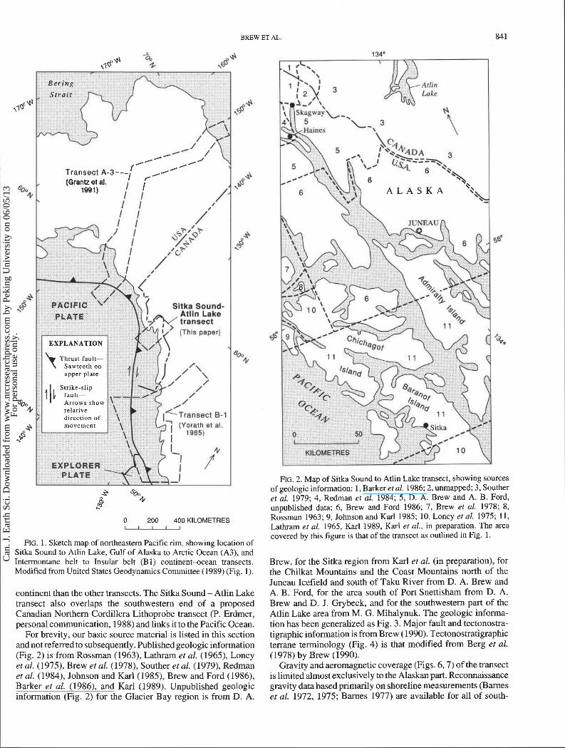
FIG. 1. Sketch map of northeastern Pacific rim, showing location of Sitka Sound to Atlin Lake, Gulf of Alaska to Arctic Ocean (A3), and Intermontane belt to Insular belt (Bl) continent-ocean transects. Modified from United States Geodynamics Committee (1989) (Fig. 1).
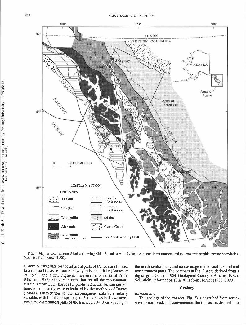
continent than the other transects. The Sitka Sound - Atlin Lake transect also overlaps the southwestern end of a proposed Canadian Northern Cordillera Lithoprobe transect (P. Erdmer, personal communication, 1988) and links it to the Pacific Ocean.
For brevity, our basic source material is listed in this section and not referred to subsequently. Published geologic information (Fig. 2) is from Rossman (1963), Lathram et al. (1965), Loney et al. (1975), Brew et al. (1978), Souther et al. (1979), Redman et al. (1984), Johnson and Karl (1985), Brew and Ford (1986), Barker et al. (1986), and Karl (1989). Unpublished geologic information (Fig. 2) for the Glacier Bay region is from D. A.
FIG. 2. Map of Sitka Sound to Atlin Lake transect, showing sources of geologic information: 1, Barker et al. 1986; 2, unmapped; 3, Souther et al. 1979; 4 , Redman et al. 1984; 5, D. A. Brew and A. B. Ford, unpublished data; 6, Brew and Ford 1986; 7, Brew et al. 1978; 8, Rossman 1963; 9, Johnson and Karl 1985; 10, Loney et al. 1975; 11, Lathram et al. 1965, Karl 1989, Karl et al., in preparation. The area covered by th~s figure is that of the transect as outlined in Fig. 1.
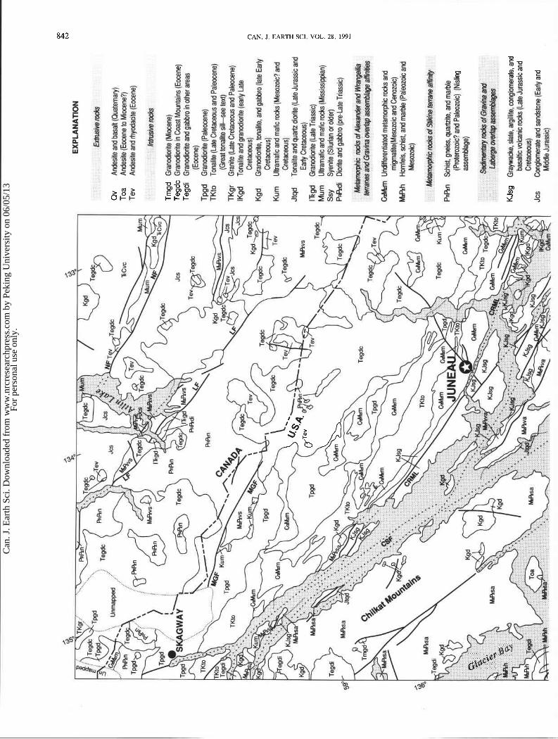
Brew, for the Sitka region from Karl et al. (in preparation), for the Chilkat Mountains and the Coast Mountains north of the Juneau Icefield and south of Taku River from D. A. Brew and A. B. Ford, for the area south of Port Snettisharn from D. A. Brew and D. J. Grybeck, and for the southwestern part of the Atlin Lake area from M. G. Mihalynuk. The geologic informa- tion has been generalized as Fig. 3. Major fault and tectonostra- tigraphic information is from Brew (1990). Tectonostratigraphic terrane terminology (Fig. 4) is that modified from Berg et al. (1978) by Brew (1990).
Gravity and aeromagnetic coverage (Figs. 6,7) of the transect is limited almost exclusively to the Alaskan part. Reconnaissance gravity data based primarily on shoreline measurements (Barnes et al. 1972, 1975; Barnes 1977) are available for all of south-
Can
. J. E
arth
Sci
. Dow
nloa
ded
from
ww
w.n
rcre
sear
chpr
ess.
com
by
Peki
ng U
nive
rsity
on
06/0
5/13
For
pers
onal
use
onl
y.
EX
PLA
NA
TIO
N
Qv
Ande
sie a
nd b
asail
(Qua
tern
ary)
T
oa
Ande
site
(Eoo
ene t
o M
ioce
ne?)
T
ev
Ande
site
and
myo
dacjt
e (Eo
cene
)
Trng
d G
rarc
dior
ite (M
ioce
ne)
Teg
dc G
ram
dior
ite in
Coa
st M
ount
ains
(Eoc
ene)
Te
gdi
Gra
nodi
orite
and
gabb
ro in
othe
r are
as
(Eoc
ene)
Tp
gd
Gra
nodi
wite
(Pale
acen
e)
TK
to
Tona
l'te (L
ate C
reta
oeou
s and
Pa
hn
e)
(Gre
at to
nafite
silt
-see
text
) TK
gr
Gra
nite
(Lat
e Cre
tacm
s and
Pal
eoce
ne)
lKgd
To
nafit
e and
gm
cdfo
rite
(ear
ty L
ate
Cret
aceo
us)
Kg
d
Gra
nadi
orite
, tana
lite, a
nd ga
bbro
(lat
e Ear
ly Cr
etac
eous
) K
um
Ultr
amaf
ic and
mdi
c ro&
(M
esoz
oic? a
nd
Cret
aceo
us)
Jtqd
To
nalite
and
quar
tz dio
rite (
Late
Jura
ssic
and
Early
Cre
tace
ous)
I+
gd
Gra
nodi
orite
(Lat
e Tria
ssic)
M
um
Uhm
afic
and
ma
f~ rock
s (M
ississ
ippi
an)
Ssy
Sy
mite
(Si
luria
n or o
kler)
PR
W~
D
iorit
e and
gabb
m (p
re-L
ate T
riass
ic)
Gsl
mm
Unc
tmere
ntiate
d rne
tam
wph
ic ro
cks a
nd
rnig
mat
ite(M
esoz
oic a
nd C
enoz
oic)
M
Rh
Hom
fels,
schi
st a
nd m
arbt
e (P
aleo
zoic and
Mes
ozoi
c)
PRR
n Sc
hid,
gneis
s, qJarhite, a
nd m
arble
(P
mte
rozo
k? an
d Pa
leoz
oic)
(Nisl
ing
asse
mbl
age}
KJs
g Gr
aywa
cke,
slate
. arg
ilAte
, mng
bmer
ate,
and
bg
salB
c vob
nic r
ocks
(Lat
e Jur
assic
and
Cr
etac
eous
) Jc
s Co
nglo
mer
ate a
nd sa
ndsto
ne {Eady a
nd
Mdd
k Ju
rass
ic)
Can
. J. E
arth
Sci
. Dow
nloa
ded
from
ww
w.n
rcre
sear
chpr
ess.
com
by
Peki
ng U
nive
rsity
on
06/0
5/13
For
pers
onal
use
onl
y.
BREW ET AL.
Can
. J. E
arth
Sci
. Dow
nloa
ded
from
ww
w.n
rcre
sear
chpr
ess.
com
by
Peki
ng U
nive
rsity
on
06/0
5/13
For
pers
onal
use
onl
y.
CAN. J. EARTH SCI. VOL. 28. 1991
" Area of
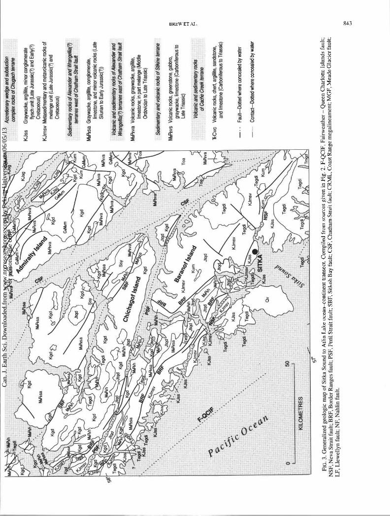
FIG. 4. Map of southeastern Alaska, showing Sitka Sound to Atlin Lake ocean+ontinent transect and tectonostratigraphic terrane boundaries. Modified from Brew (1990).
eastern Alaska; data for the adjacent parts of Canada are limited to a railroad traverse from Skagway to Bennett lake (Barnes et al. 1972) and a few highway measurements north of Atlin (Oldham 1958). Gravity information for all the mountainous terrain is from D. F. Barnes (unpublished data). Terrain correc- tions for this study were calculated by the methods of Barnes (1984~). Distribution of the aeromagnetic data is similarly variable, with flight-line spacings of 3 km or less in the western- most and easternmost parts of the transect, 10-13 krn spacing in
the north-central part, and no coverage in the south-central and northernmost parts. The contours in Fig. 7 were derived from a digital grid (Godson 1984; Geological Society of America 1987). Seismicity information (Fig. 8) is from Homer (1983, 1990).
Geology Introduction
The geology of the transect (Fig. 3) is described from south- west to northeast. For convenience, the transect is divided into
Can
. J. E
arth
Sci
. Dow
nloa
ded
from
ww
w.n
rcre
sear
chpr
ess.
com
by
Peki
ng U
nive
rsity
on
06/0
5/13
For
pers
onal
use
onl
y.

_ _ _ _ _ _ _ _ _ _ _ _ - - - - - - - BRITISH COLUMBIA
50 KILOMETRES u
FIG. 5. Map of southeastern Alaska, showing Sitka Sound to Atlin Lake ocean-continent transect and major neotectonic (and some other) faults (heavy lines). Border Ranges fault is not shown. Fault name abbreviations as in Fig. 3. Modified from Brew (1990).
several major structural blocks at selected major faults; these 1988). The Chugach terrane (Fig. 4), east of the fault, is a Late faults more or less bound contrasting parts of the transect. Cretaceous subduction complex consisting of two facies: an
outboard flysch facies of graywacke turbidites and argillite with Structural block between Fainveather- Queen Charlotte Islands lesser conglomerate and minor volcanic rocks; and an inboard
and Peril Strait faults tectonic melange facies of tectonic blocks of Late Triassic and The western limit of the transect is the Fainveather - Queen younger metasedimentary and metavolcanic rocks, mostly in a
Charlotte Islands right-lateral transform fault (Figs. 3, 5), west tuffaceous argillite matrix. Middle Tertiary granodiorite, tonalite, of which are oceanic rocks of the Pacific plate (Carlson et al. and some gabbro plutons intrude the Chugache terrane through-
Can
. J. E
arth
Sci
. Dow
nloa
ded
from
ww
w.n
rcre
sear
chpr
ess.
com
by
Peki
ng U
nive
rsity
on
06/0
5/13
For
pers
onal
use
onl
y.
CAN. J. EARTH SCI. VOL. 28, 1991
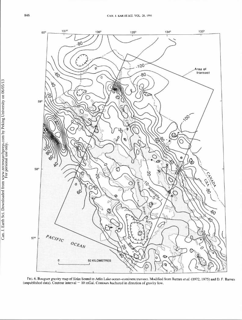
FIG. 6. Bouguer gravity map of Sitka Sound to Atlin Lake ocean~ontinent transect. Modified from Barnes et al. (1972, 1975) and D. F. Barnes (unpublished data). Contour interval = 10 mGal. Contours hachured in direction of gravity low.
Can
. J. E
arth
Sci
. Dow
nloa
ded
from
ww
w.n
rcre
sear
chpr
ess.
com
by
Peki
ng U
nive
rsity
on
06/0
5/13
For
pers
onal
use
onl
y.

BREW ET AL.
600 1 SF 1 3 8 135' 1 3 4 O 133' I I I 1 I
FIG. 7. Aeromagnetic map of the Sitka Sound to Atlin Lake ocean-continent transect. Modified from Geological Society of America (1987). Contour interval = 200 nT.
Can
. J. E
arth
Sci
. Dow
nloa
ded
from
ww
w.n
rcre
sear
chpr
ess.
com
by
Peki
ng U
nive
rsity
on
06/0
5/13
For
pers
onal
use
onl
y.

848 CAN. J. EARTH SCI. VOL. 28, 1991 I
FIG. 8. Seismicity map of Sitka Sound to Atlin Lake ocean4ontinent transect, showing events located during 1980-1989 (from Geological Survey of Canada Earthquake Epicentre File). Magnitude thresholds are about M = 2.5 onshore and M = 3.0 offshore.
out its length. Near Sitka, close to the Fairweather - Queen Charlotte Islands fault, the terrane is overlain by a Holocene volcanic field.
The Chugach terrane is juxtaposed against the Wrangellia terrane to the east along the Border Ranges fault (Figs. 3, 4). This fault is interpreted to be the surface exposure of the upper contact of the subduction complex to the west (Plafker et al. 1976). Wrangellia terrane pelite, quartzite, calc-schist, and metavolcanic rocks are inferred to represent an upper paleozoic to pre- Upper Triassic volcanic-arc assemblage that is overlain
by massive tholeiitic rift-basin basalts and a laterally persistent Upper Triassic(?) limestone. Wrangellia rocks are intruded by abundant Middle Jurassic to late Early Cretaceous tonalite, diorite, and granodiorite plutons that are the roots of a volcanic arc and by a few middle Tertiary plutons.
Structural block between Peril Strait and Sitkoh Bay faults The Peril Strait fault (Figs. 3-9, an inactive splay of the
Fairweather - Queen Charlotte Islands fault, has about 20 km of right-lateral separation. To the northwest it splits the Chugach
Can
. J. E
arth
Sci
. Dow
nloa
ded
from
ww
w.n
rcre
sear
chpr
ess.
com
by
Peki
ng U
nive
rsity
on
06/0
5/13
For
pers
onal
use
onl
y.
BREW ' ET AL. 849
terrane, and it separates Alexander terrane rocks from Wran- gellia and Chugach terrane units to the southeast.
The contact of Wrangellia rocks with the Alexander terrane to the east is observed by postaccretionary late Early Cretaceous granodiorite and gabbro plutons and by the Peril Strait fault. Evidence from 200 km to the northwest of the transect indicates that either the two terranes are one and the same or were juxtaposed before Middle Pennsylvanian time (Gardner et al. 1988).
The Alexander terrane rocks represent a long-lived volcanic arc built on transitional or continental crust. Its preaccretionary location is uncertain. The Alexander terrane in the western part of the transect is divided into two parts by the Sitkoh Bay fault (Figs. 3,5). The western part, which adjoins Wrangellia, consists of a large volume of late Early Cretaceous granodiorite, tonalite, and gabbro intrusions with minor middle Tertiary(?) leucogabbro bodies together with marble and hornfelsic rocks.
Structural blocks between Sitkoh Bay fault and Coast Range megalineament
Displacement on the Sitkoh Bay fault is uncertain, but the contrast between the dominant intrusive rocks to the west and the well-preserved stratigraphic section to the east suggests at least a few kilometres of west-side-up vertical movement.
The Alexander terrane east of the Sitkoh Bay fault is cut by the Chatham Strait fault (Figs. 3, 5), a segment of the Denali fault system which probably has about 150 km of right-lateral separation (Ovenshine and Brew 1972; Sonnevil 198 1 ; Hudson et al. 1982b). Except for a shared Upper Silurian graywacke turbidite unit, the stratigraphic sections across the Chatham Strait fault differ considerably. The section west of the fault is Alexan- der terrane that ranges from indeterminate early Paleozoic through Late Silurian to Mississippian age; the section to the east of the fault ranges from the Middle Ordovician through Late Triassic. We consider the Permian through Late Triassic part of this east-of-the-fault section to be a lateral facies of the Wran- gellia rocks, and we thus group Wrangellia and Alexander rocks together in this area (Fig. 4).
The oldest rocks in the Alexander terrane west of the Chatham Strait fault are schist, marble, gneiss, and phyllite exposed in the northern Chilkat Mountains. They are overlain by discontinuous limestones of the Upper Silurian graywacke turbidite unit, which in turn are overlain by Lower through Upper Devonian shallow marine limestone, sandstone, and polymictic conglomerate, by Upper Devonian mafic to felsic volcanic rocks, and by Missis- sippian cherty limestone. Wrangellia-affinity Permian argillite, limestone, and volcanic rocks with overlying Lower(?) Jurassic chert and sandstone occurr locally. These rocks were intruded by Middle Jurassic, late Early Cretaceous, Late Cretaceous, middle Tertiary, and late Tertiary granodiorite and are overlain at one locality by late Tertiary andesitic flows and breccias.
The oldest rocks in the Alexander terrane east of the Chatham Strait fault (Fig. 3) are Middle Ordovician graptolite-bearing siliceous shale and carbonaceous chert, inferred to be overlain by the widespread Upper Silurian graywacke turbidite unit. Stratigraphic relations higher in the section are less clear. We interpret most of the Devonian carbonate rocks present to be olistostromal and (or) tectonic blocks in an extensive Upper Triassic unit. We consider this unit, as well as the Permian siliceous argillite, graywacke, chert, and dolostone units and the Upper Triassic shallow marine sedimentary and mafic volcanic rocks, to be part of Wrangellia. The relation between these
contrasting facies of Upper Triassic rocks is poorly understood. Jurassic through Lower Cretaceous flysch and intermediate to mafic volcanic breccias and flows of the Gravina overlap assemblage unconformably overlie both Upper Triassic units along the eastern side of Admiralty Island. Several Jurassic or Cretaceous, late Early Cretaceous, and one Tertiary(?) granodio- ritic plutons intrude the section. Paleogene continental coal- bearing sandstone and conglomerate (not shown in Fig. 3) unconformably overlie all the older rocks and intertongue with and are overlain by extensive Paleogene and Neogene andesitic volcanic flows.
In its northwesternmost exposures (Figs. 3, 4), the Gravina overlap assemblage is bounded on the west by the Chatham Strait fault. To the south, the assemblage extends east of the fault and occurs on both sides of the next major fault to the east, the Coast Range megalineament (Figs. 3,5) (Brew and Ford 1978).
Structural blocks between Coast Range megalineament and Llewellyn fault
The Coast Range megalineament is an engimatic structural boundary that extends the whole length of southeastern Alaska (Brew and Ford 1978). It more or less coincides with the northeastern limit of recognizable Gravina assemblage rocks. Eastward from the Gravina rocks are the western metamorphic belt rocks of the CPMC, in which tectonostratigraphic terrane boundaries are unclear. The nature of most of the protoliths has been obscured by metamorphism, and the rocks are extensively intruded by early Late Cretaceous, latest Cretaceous and Paleocene, Paleocene, and Eocene tonalite and granodiorite. These metamorphic rocks were called the Taku terrane by Berg et al. (1978) but were reinterpreted as having Gravina and Alexander protoliths (Brew 1983; Brew and Ford 1984). A narrow band of slightly metamorphosed Upper Triassic basalt east of the Coast Range megalineament also belongs to Wran- gellia (Plafker et al. 1989). Late Early Cretaceous magnetite- bearing mdic-ultramafic and early Late Cretaceous granodiorite intrusions occur in this unit.
In general, the metamorphic section consists of pelitic schist, less abundant quartz-rich schist, metavolcanic rocks, and minor carbonate units that have been metamorphosed at subgreenschist to amphibolite facies along the southwest side of the 55-70 Ma composite great tonalite sill (Brew 1988) that extends the length of southeastern Alaska (unit TKto in Fig. 3). East of the sill are a variety of migmatites, quartzofeldspathic gneiss, pelitic schist, large discontinous carbonate masses, large bodies of both 60 and 50 Ma granodiorite, and scattered serpentinized peridotite intrusions. East of and interspersed with the essentially continu- ous 50 Ma granodiorite masses are siliceous schist and gneiss, quartzite, some metavolcanic rocks, large carbonate masses, and minor serpentinite bodies of inferred Proterozoic(?) to early Paleozoic(?) age of the Nisling assemblage which we interpret here to be the lowest part of the Stikine terrane (Figs. 3, 4). Wheeler and McFeely (1987), Wheeler et al. (1988), and Gehrels et al. (1990) suggest that this is a NortH American continental margin assemblage. These metamorphic rocks are overlain by Early through Late(?) Triassic metagabbro, amphibolite, greenstone, graywacke, and carbonate rocks.
The terrane boundary between the metamorphosed strata of the Alexander-Wrangellia terrane and Gravina assemblage rocks to the west and rocks of the Stikine terrane to the east lies between the Coast Range megalineament and the Meade Glacier fault (Fig. 3,5). Both our field mapping and Gehrels et al. (1990)
Can
. J. E
arth
Sci
. Dow
nloa
ded
from
ww
w.n
rcre
sear
chpr
ess.
com
by
Peki
ng U
nive
rsity
on
06/0
5/13
For
pers
onal
use
onl
y.
850 CAN. J . EARTH SCI. VOL. 28, 1991
isotopic studies indicate that the contact is a concealed and (or) metamorphosed fault zone. Gehrels et al. (1990) place the boundary more or less along the western edge of the great tonalite sill (Unit TKto in Fig. 3). Our mapping, however, indicates that in this transect the boundary has been entirely obliterated by the 60 and 50 Ma plutons.
We interpret the Meade Glacier fault (Figs. 3, 5) as a local contact between upper and lower Stikine terrane rocks. Limited evidence suggests that the fault is transtensional and had right- lateral, west-side-down movement before the emplacement of 60 Ma plutons.
Between the Meade Glacier fault and the Llewellyn fault (Figs. 3, 4) to the east are mostly lower Stikine terrane Proterozoic(?) to lower Paleozoic(?) rocks similar to those described west of the Meade Glacier fault. They are intruded by abundant Tertiary(?) granodiorite bodies, by at least one pre- Late Triassic foliated hornblende diorite and gabbro pluton, one Late Triassic granodiorite body, and one large Cretaceous and (or) Tertiary granite. To the south, the Stikine terrane includes Carboniferous and Permian limestone and other sedimentary and volcanic rocks, together with Upper Triassic strata similar to those within the CPMC. The contact relations indicate that this part of the section overlaps the Proterozoic(?) to lower Paleo- zoic(?) part.
Structural block between Llewellyn and Nahlin faults The Llewellyn fault connects with the Tally-Ho shear zone to
the north of the transect. Along strike to the south, the Llewellyn fault splays, some parts die out, and other parts are concealed by middle Tertiary volcanic rocks. Within the northern part of the transect, the fault is cut by a middle Tertiary(?) granodiorite body. This part of the transect contrasts with that to the west across the Llewellyn fault in that (i) no lower Stikine terrane Proterozoic(?) to lower Paleozoic(?) rocks are exposed and (ii) almost all of the units are overlain at least locally by the Lower and Middle Jurassic Laberge overlap assemblage rocks, consist- ing of marine to transitional sandstone, shale, and conglomerate. Cretaceous and middle Tertiary plutons are scattered throughout this block; the latter are associated with volcanic flows and breccias.
Structural block east of Nahlin fault East of the Nahlin fault (Figs. 3,4) is the Cache Creek terrane,
and ophiolitic and oceanic assemblage of Carboniferous through Late Triassic(?) ultramafic and mafic rocks, chert, basalt, argillite, and carbonate rocks (Monger and Ross 1971). This terrane contains a Tethy an Permian fusulinid fauna that has been contrasted with cosmopolitan faunas of the same age from the terranes to the west and east (Monger and Ross 1971). It is locally intruded by Cretaceous and middle Tertiary granodiorite and granite bodies and is interpreted by Monger and Ross (197 1) to be overlapped by Triassic rocks of the Stikine terrane that are in turn overlapped by the Lower and Middle Jurassic LaBerge assemblage.
Bouguer gravity field The dominant feature of the Bouguer gravity field in the
transect is a steplike decrease from high values indicative of relatively thin crust (about 20 km) at the present continental shoreline to low values representing a much thicker crust (about 40 km) beneath the high mountains near and east of the interna- tional boundary (Fig. 6). At the southwest end of the transect, closely spaced contours representing a steep segment of this gradient characterize both the Chugach and Wrangellia terranes.
Eastward curvature of these contours at the southern edge of Wrangellia rocks shows a 10-20 mGal gravity increase to the north-this represents a thin layer of high-density metavolcanic rocks above the fairly flat-lying Border Ranges fault (Plafker et al. 1976).
Contours subparallel to both the Peril Strait and Sitkoh Bay fault systems suggest that small gravity gradients may be associated with both of these features. Both faults have strong magnetic expression.
Between the Chugach terrane and the Coast Range mega- lineament gravity decreases less sharply and the contour pattern is dominated by the effects of a few plutons. Late Cretaceous and Eocene granodiorites are associated with distinct gravity lows, the largest of which was measured along the east side of Baranof Island (Fig. 6). Older, more mafic plutons, such as the Early Cretaceous granodiorite and gabbro, and ultramafic rocks are associated with gravity highs. The largest of these was measured along the west shore of Admiralty Island, midway from north to south. The largest gravity high was measured near the northwest edge of the transect, at Haines. There a peridotite stock is calculated to have a vertical extent of 5-12 km (Barnes 1986). This is the largest of a string of gravity highs associated with a chain of ultramafic bodies that more or less parallels the Coast Range megalineament the length of southeasten Alaska. East of the megalineament are the dominantly granitic rocks of the CPMC; there gravity decreases sharply to minimal values close to the international boundary or a few kilometres farther north- east, near the crest of the Coast Mountains.
Magnetic features The magnetic field of the Sitka Sound -Atlin Lake transect
(Fig. 7) is dominated by anomalies located over Mesozoic and younger plutonic rocks (Griscom and Case 1982) on regional and local scales. Magnetic anomalies are rare over the Chugach terrane, suggesting that the numerous middle Tertiary plutons that intrude it have background values. In contrast, plutons that intrude the adjacent Wrangellia and Alexander terranes produce short-wavelength, high-amplitude anomalies that define a linear northwest-trending pattern in the southwestern part of the transect and a more variable, scattered pattern in the central part. The linear magnetic grain parallels the tectonic grain in the region and probably reflects structural control of postaccre- tionary plutonism. The scattered pattern may simply indicate that plutons in the central part are sparsely distributed. The strongest regional anomaly within the transect is the high above the dominantly Eocene intrusive rocks in the topographically higher parts of the CPMC and over the adjacent, slightly older great tonalite sill (unit TKto in Fig. 3). Both the Eocene intrusions and the tonalite sill extend across the entire transect, however, the southeastern part of each is strongly magnetic and the northwest- em part weakly magnetic. The northwestern, weakly magnetic parts are dominated by Paleocene plutons that are slightly older than their (Eocene) counterparts to the southeast.
On a local scale, magnetic Mesozoic granitoids occur on both sides of the Peril Strait fault and cause anomalies that are markedly different on each side. Anomalies are more subdued on the southwest side than on the northeast side. The contrast is more pronounced than can be accounted for by 20 km of right- laberal separation across the fault. The magnetic data may reflect a deep structural boundary that predates the Hoonah Sound fault, possibly the contact between the Chugach and Wrangellia terranes. It is possible that locally abundant gabbroic rocks to the northeast are more magnetic.
Can
. J. E
arth
Sci
. Dow
nloa
ded
from
ww
w.n
rcre
sear
chpr
ess.
com
by
Peki
ng U
nive
rsity
on
06/0
5/13
For
pers
onal
use
onl
y.

SOUTH-
BREW ET AL.
NORTH-
SEA LEVEL
SOUTHWEST NORTHEAST
SBF MGF PSF CRML
CSF MZR vs LF
BRF NF TKto
SEA - LEVEL
KJss h4Rvs
Jtqd
- 20
- - 30
- 40 VERTICAL EXAGGERATION X3
FIG. 9. Diagrammatic profile of Sitka Sound to Atlin Lake ocean<ontinent transect, showing tectonostratigraphic terranes and major neotectonic and other faults. Diagram constructed from a series of disconnected en echelon sections along the length of the transect (Figs. 3, 5). Fault name abbreviations as in Fig. 3.
An enigmatic, northeast-striking steep magnetic gradient extends from Chatham Strait across the tip of Admiralty Island to the great tonalite sill (unit TKto in Fig. 3) and beyond. This zone represents the transition from a large region of low mag- netic field strength in the north to a background field strength more than 200 nT higher in the south. The cause of this anomaly is unknown, but it is perpendicular to the structural grain of the region and to the strike of all map units; it may reflect a deep crustal structure that is not expressed at the surface.
Neotectonic activity Neotectonic activity is expressed as seismicity, regional
uplift, and tilt. Four disinct zones of seismicity occur in and close to the Sitka Sound- Atlin Lake transect (Fig. 8). The most active zone is at the southwestern end of the transect where it follows the Pacific -North American plate boundary. Relative motion is predominantly right-lateral strike-slip; recent motion is concen- trated on the Fairweather - Queen Charlotte Islands fault and occurs almost exclusively in large earthquakes, thus the apparent lack of seismicity along the coast (Fig. 8). With the exception of two recent events in the Gulf of Alaska, all major (M 2 7) earthquakes in the region were located along this plate boundary. A second seismic zone extends across the north end of Glacier Bay proper, immediately north of the transect (Fig. 8). It extends from the Fairweather - Queen Charlotte Islands fault and the offshore transition fault, east almost to the Denali fault system near Haines. The largest earthquake recorded from this zone is an M = 6.0 event that occurred in 1952. preliminary fault-plane solution for a M = 5.6 event in 1990 indicates north-south
compression. A third zone is along the Denali fault system northwest of Haines (Fig. 8); it does not appear to involve the Chatham Strait fault or the Coast Range megalineament. The fourth ''zone" lies in the northern Coast Mountains. Some of the epicenters appear to be in northeast-trending linear or elongate clusters. The intense cluster on the southeast side of the transect has a pronounced seasonal activity rate that may be related to glacial processes; however, the events do not have the monotonic character of typical glacial events. Their spatial extent may also be more restricted than indicated. The largest earthquake recorded in this zone is an M = 5.3 event that occurred in 1987, just south of Skagway. The causes and detailed geologic relations of this last zone of earthquakes are not known; one of the clusters is approximately coincident with the magnetic gradient described in the previous seciton, however. Similarly, a north-trending elongate uplift that extends across the western part of the transect (Hicks and Schofnos 1965; Hudson et al. 1982a; Barnes 19846) is enigmatic. Broad west-side-up tilt of the CPMC in the transect (Small and Wharton 1969) is probably a continuation of an earlier pattern of differential uplift and tilt (Brew 1990).
Tectonic summary The three main groups of postaccretionary tectonic events
recorded in the transect are transitional in the sense that they merge into each other: they are the original accretionary events, the development of late-accretionary and postaccretionary features, and the postaccretion adjustment of terranes relative to each other. The final result of all these events in the transect is depicted diagrammatically in Fig. 9.
Can
. J. E
arth
Sci
. Dow
nloa
ded
from
ww
w.n
rcre
sear
chpr
ess.
com
by
Peki
ng U
nive
rsity
on
06/0
5/13
For
pers
onal
use
onl
y.
852 CAN. J. EARTH SCI. VOL. 28, 1991
Evidence for original accretionary and for the late-ac- cretionary events is as follows: (i) major tectonostratigraphic boundaries (Berg et al. 1978; Brew and Ford 1984; Brew 1990), (ii) subduction-related and other granitic belts (Brew 1988), and (iii) belts of metamorphic rocks with synorogenic and postoro- genic plutons (Brew et al. 1992). These geological features are directly or indirectly related to the tranpressional and (or) orthogonal joining of (i) Wrangellia terrane to Alexander terrane in the Carboniferous, (ii) Stikine terrane to the Cache Creek terrane in the Middle Jurassic, (iii) Alexander, Wrangellia, and Gravina overlap assemblage to Stikine terrane in the Late Cretaceous, and(iv) chugach terrane to Wrangellia and Alexan- der terranes in Late Cretaceous or Paleogene time. Major shear zones along and near the footwall of the great tonalite sill (unit TKto in Fig. 3) in the CPMC are inferred to be closely associated with early Tertiary uplift and tilt. The general increase in crustal thickness from ocean to continent inferred from the Bouguer gravity field is interpreted to be related to the successive outward accretion of terranes and to magmatic underplating and the generation of large volumes of granitic rocks following the accretion of the Alexander terrane (with Gravina overlap assem- blage) to the Stikine terrane. Crustal contrasts inferred from magnetic gradients that do not parallel surface structures may indicate large-scale heterogeneity of the subducted material, or hidden deep structures. Postaccretionary transtensional magmatism occurred in one belt in the transect (Brew 1988).
Postaccretionary movement of terranes and parts of terranes is shown by modification of their boundaries, by the abundance of high-angle strike- and oblique-slip faults, by differential uplift of blocks along those faults, and by a general pattern of east- side-down tilting of major fault-bounded blocks and groups of blocks to reveal deeper levels of metamorphic and plutonic rocks exposed on the west sides of the Alexander terrane, the CPMC, and the Stikine terrane. This large-scale tilting and shuffling of blocks is interpreted to be a result of long-lived right-lateral transpression related to oblique convergence of the Farallon, Kula, and Pacific plates with North America and its previously accreted plates during the late Mesozoic and Cenozoic (Enge- bretson et al. 1985). Most of the large-scale high-angle faults have persisted as Holocene features, but one regional uplift area and some current seismicity are new and unrelated to the older features.
Acknowledgments W e thank Robert A. Loney, Andrew Griscom, Phillipe
Erdmer, M. L. Hill, and R. G. Anderson for pertinent and constructive reviews.
BARKER, F., ARTH, J. G., and STERN, T. W. 1986. Evolution of the Coast batholith along the Skagway traverse, Alaska and British Columbia. American Mineralogist, 71: 632443.
BARNES, D. F. 1977. Bouguer garvity map of Alaska. United States Geological Survey, Geophysical Investigation Map GP-09 13.
1984a. Digital elevation models improve processing of Alaskan gravity data. In The United States Geological Survey in Alaska: Accomplishments during 1981. Edited by W. L. Coomad and R. L. Elliott. United States Geological Survey, Circular 868, pp. 5-7.
19846. No measurable gravity change at Glacier Bay regional uplift area. In The United States Geological Survey in Alaska: Accomplishments during 1982. Edited by K. L. Reed and S. Bartsch- Winkler. United States Geological Survey, Circular 939, pp. 88-90.
1986. Gravity data indicate large mass and depth of the gabbro body at Haines. In The United States Geological Survey in Alaska: Accomplishments during 1985. Edited by S. Bartsch-Winkler and
K. L. Reed. United States Geological Survey, Circular 978, pp. 88-92.
BARNES, D. F., POPENOE, P., OLSON, R. C., MACKENZIE, R. V., and MORIN, R. L. 1972. Tabulated gravity data from southeastern Alaska obtained during the 1969 field season. United States Geological Survey, Open-file Report 72-21.
BARNES, D. F., ERWIN, M.J. HOLDEN, K. O., and MORIN, R. L. 1975. U.S.G.S. Alaskan gravity data maps of the Port Alexander, Sitka, Juneau, Mount Fainveather, and Skagway 1 : 250 000 quadrangles, Alaska. United States Geological Survey, Open-file Report 75-6.
BERG, H. C., JONES, D. L., and CONEY, P. J. 1978. Map showing pre- Cenozoic tectono-stratigraphic terranes of southeastern Alaska and adjacent areas. United States Geological Survey, Open-file Report 78-1085, scale 1 : 1 000 000.
BREW, D. A. 1983. Evaluation of suspect terranes in the Coast plu- tonic-metamorphic complex, southeastern Alaska and part of British Columbia. Geological Society of America, Abstracts with Programs, 15: 324.
1990. The plate-tectonic setting of Glacier Bay National Park and Preserve and of Admiralty Island National Monument, south- eastern Alaska. In Proceedings, 2nd Glacier Bay Science Confer- ence. Edited by A. Milner and J. D. Wood, Jr. United States National Park Service, Science Publications Office, Atlanta, GA, pp. 1-5.
BREW, D. A., and FORD, A. B. 1978. Megalineament in southeastern Alaska marks southwest edge of Coast Range batholithic complex. Canadian Journal of Earth Sciences, 15: 1763-1772.
1984. Tectonostratigraphic terranes in the Coast plutonic-meta- morphic complex, southeastern Alaska. In The United States Geological Survey in Alaska: Miscellaneous geologic research 1982. Edited by S. Bartsch-Winkler and K. M. Reed. United States Geological Survey, Circular 939, pp. 105-108.
1986. Preliminary reconnaissance geologic map of the Juneau, Taku River, Atlin, and part of the Skagway 1 : 250 000 quadrangles, southeastern Alaska. United States Geological Survey, Open-file Report 85-395.
BREW, D. A., JOHNSON, B. R., GRYBECK, D. J., GRISCOM, A., BARNES, D. F., KIMBALL, A. L., STILL, J. C., and RATAJ, J. L. 1978. Mineral resources of Glacier Bay National Wilderness Study Area, Alaska. United States Geological Survey, Open-file Report 78-494.
BREW, D. A., HIMMELBERG, G. R., LONEY, R. A,, and FORD, A. B. 1992. Styles of metamorphismin the southeastern Alaska part of the Cordilleran orogen. Journal of Metamorphic Geology. (In press.)
CARLSON, P. R., BRUNS, T. R., and PLAFKER, G. 1988. Late Cenozoic offsets on the offshore connection between the Fairweather and Queen Charlotte faults off southeast Alaska. Marine Geology, 85: 89-97.
ENGEBRETSON, D. C., COX, A., and GORDON, R. G. 1985. Relative motions between oceanic and continental plates in the Pacific basin. Geological Society of America, Special Paper 206.
GARDNER, M. C., BERGMAN, S. C., CUSHING, G. W., MACKEVETT, E. M., JR., PLAFKER, G., CAMPBELL, R. B., DODDS, C. J. MCCLEL- LAND, W. C., and MUELLER, P. A. 1988. Pennsylvanian pluton stitching of Wrangellia and the Alexander terrane, Wrangell Mountains, Alaska. Geology, 16: 967-971.
GEHRELS, G. E., MCCLELLAND, W. C., SAMSON, S. C., PATCHETT, P. J., and JACKSON, J. L. 1990. Ancient continental margin assem- blage in the northern Coast Mountains, southeast Alaska and northwest Canada. Geology, 18: 208-21 1.
GEOLOGICAL SOCIETY OF AMERICA. 1987. Magnetic anomaly map of North America. Geological Society of America, Committee for the magnetic anomaly map of North America, Continental Scale Map-003, scale 1 : 5 000 000.
GODSON, R. H. 1984. Composite magnetic anomaly map of the United States: Part B: Alaska and Hawaii. United States Geological Survey, Geophysical Investigations Map GP-954-B, scale 1 : 2 500 000.
GRANTZ, A., MOORE, T. E., and ROESKE, S. M. 1991. Centennial continent-ocean transect A-3: Gulf of Alaska to Arctic Ocean. Geological Society of America, Boulder, CO, scale 1 : 500 000. (In press.)
Can
. J. E
arth
Sci
. Dow
nloa
ded
from
ww
w.n
rcre
sear
chpr
ess.
com
by
Peki
ng U
nive
rsity
on
06/0
5/13
For
pers
onal
use
onl
y.
BREW ET AL. 853
GRISCOM, A., and CASE, J. E. 1982. Magnetic expression of geologic terranes in southern Alaska. Proceedings, Society of Exploration Geophysicists 52nd Annual Meeting, Dallas, TX, Technical Program Abstracts and Biographies, pp. 230-232.
HICKS, S. D., and SHOFNOS, W. 1965. The determination of land emergence from sea level observations in southeastern Alaska. Journal of Geophysical Research, 70: 33 15-3320.
HORNER, R. 1983. Seismicity in the St. Elias region of northwestern Canada and southeastern Alaska. Bulletin of the Seismological Society of America, 73: 1 1 17-1 137.
1990. Seismicity in the Glacier Bay region of southeast Alaska and adjacent areas of British Columbia. In Proceedings, 2nd Glacier Bay Science Conference. Edited by A. M. Milner and J. D. Wood, Jr. United States National Park Service, Science Publications Office, Atlanta, GA, pp. 6-1 1.
HUDSON, T., DIXON, K., and PLAFKER, G. 1982a. Regional uplift in southeastern Alaska. In The United States Geological Survey in Alaska: Accomplishments during 1980. Edited by W. L. Coonrad. United States Geological Survey, Circular 844, pp. 132-135.
HUDSON, T., RAFKER, G., and DIXON, K. 1982b. Horizontal offset history of the Chatharn Strait fault. In The United States Geological Survey in Alaska: Accomplishments during 1980. Edited by W. L. Coonrad. United States Geological Survey, Circular 844, pp. 128-132.
JOHNSON, B. R., and KARL, S. M. 1985. Geologic map of western Chichagof and Yakobi Islands, southeastern Alaska. United States Geological Survey, Miscellaneous Investigations Series, Map I- 1506, scale 1 : 125 000.
KARL, S. M. 1989. Preliminary reconnaissance geologic map of the Sitka quadrangle. In Sitka quadrangle, Alaska-an AMRAP preassessment planning document. In A. B. Ford, S. M. Karl, K. A. Duttweiler, D. M. Sutphin, C. A. Finn, and D. A. Brew. United States Geological Survey, Administrative Report.
KARL, S. M., DICKEY, C. F., and BREW, D. A. In preparation. Prelimi- nary geologic map of the Sitka quadrangle, Alaska. United States Geological Survey, Miscellaneous Map, scale 1 : 250 000.
LATHRAM, E. H., POMEROY, J. S., BERG, H. C., and LONEY, R. A. 1965. Reconnaissance geology of Admiralty Island, Alaska. United States Geological Survey, Bulletin 1 18 1-R.
LONEY, R. A., BREW, D. A., MUFFLER, L. J. P., and POMEROY, J. S. 1975. Reconnaissance geology of Chichagof, Baranof, and Kruzof Islands. United States Geological Survey, Professional Paper 792.
MONGER, J. W. H., and Ross, C. A. 197 1. Distribution of fusulinaceans in the western Canadian Cordillera. Canadian Journal of Earth Sciences, 8: 259-278.
OLDHAM, C. H. G. 1958. Gravity and magnetic investigations along the Alaska Highway. Publications of the Dominion Observatory, Ottawa, 21(1).
OVENSHINE, A. T., and BREW, D. A. 1972. Separation and history of the
Chatham Strait fault, southeastern Alaska, North America. Pro- ceedings, 24th International Geological Congress, MontrCal, Que., Vol. 3, pp. 245-254.
PLAFKER, G., JONES, D. L., HUDSON, T., and BERG, H. C. 1976. The Border Ranges fault system in the Saint Elias Mountains and Alexander Archipelago. In The United States Geological Survey in Alaska: Accomplishments during 1975. Edited by E. H. Cobb. United States Geological Survey, Circular 733, pp. 14-16.
PLAFKER, G., BLOME, C. D., and SILBERLING, N. J. 1989. Reinterpretation of lower Mesozoic rocks on the Chilkat Peninsula, Alaska, as a displaced fragment of Wrangellia. Geology, 17: 3-6.
REDMAN, E. C., RETHERFORD, R. M., and HICKOK, B. D. 1984. Geology and geochemistry of the Skagway B-2 quadrangle, south- eastern Alaska. Alaska Division of Geological and Geophysical Surveys, Reports of Investigations 84-31, scale 1 : 40 000.
ROSSMAN, D. L. 1963. Geology of the eastern part of the Mount Fairweather quadrangle, Glacier Bay, Alaska. United States Geologi- cal Survey, Bulletin 1121-K.
SMALL, J. B., and WHARTON, L. C. 1969. Vertical displacements determined by surveys after the Alaska earthquake of March 1964. In The Prince William Sound, Alaska, earthquake of 1964 and aftershocks. Edited by L. E. Leipold. United States Department of Commerce, Publication 10-3 (C&GS), pp. 21-33.
SONNEVIL, R. A. 1981. The Chilkat - Prince of Wales plutonic province, southeastern Alaska. In The United States Geological Survey in Alaska: Accomplishments during 1979. Edited by N. R. D. Albert and T. Hudson. United States Geological Survey, Circular 823-B, pp. 112-1 15.
SOUTHER, J. G., BREW, D. A,, and OKULITCH, A. V. 1979. Iskut River 1 : 1 000 000 Geological Atlas, NTS 104, 114. Geological Survey of Canada, Map 141 8A.
United States Geodynamics Committee. 1989. North American continent-ocean transects program. National Academy Press, Washington, DC.
WHEELER, J. O., and MCFEELY, P. 1987. Tectonic assemblage map of the Canadian Cordillera and adjacent parts of the United States of America. Geological Survey of Canada, Open File Report 1565, scale 1 : 2 000 000.
WHEELER, J. O., BROOKFIELD, A. J., GABRIELSE, H., MONGER, J. W. H., TIPPER, H. W., and WOODSWORTH, G. J. 1988. Terrane map of the Canadian Cordillera. Geological Survey of Canada, Open File Report 1894, scale 1 : 2 000 000.
YORATH, C. J., WOODSWORTH, G. J., RIDDIHOUGH, R. P., CURRIE, R. G., HYNDMAN, R. D., ROGERS, C. G., SEEMAN, D. A., and COLLINS, A. D. 1985. Centennial continent-ocean transect B-1(#8): Intermontane belt (Skeena Mountains) to Insular belt (Queen Charlotte Islands). Geological Society of America, Boulder, CO, Scale 1 : 1 000 000.
Can
. J. E
arth
Sci
. Dow
nloa
ded
from
ww
w.n
rcre
sear
chpr
ess.
com
by
Peki
ng U
nive
rsity
on
06/0
5/13
For
pers
onal
use
onl
y.