Geological Society of America Bulletin Cordilleran fold-and-thrust belt of southwestern Montana
25
Geological Society of America Bulletin doi: 10.1130/B30766.1 published online 22 February 2013; Geological Society of America Bulletin Theresa M. Schwartz and Robert K. Schwartz Cordilleran fold-and-thrust belt of southwestern Montana Paleogene postcompressional intermontane basin evolution along the frontal Email alerting services articles cite this article to receive free e-mail alerts when new www.gsapubs.org/cgi/alerts click Subscribe America Bulletin to subscribe to Geological Society of www.gsapubs.org/subscriptions/ click Permission request to contact GSA http://www.geosociety.org/pubs/copyrt.htm#gsa click official positions of the Society. citizenship, gender, religion, or political viewpoint. Opinions presented in this publication do not reflect presentation of diverse opinions and positions by scientists worldwide, regardless of their race, includes a reference to the article's full citation. GSA provides this and other forums for the the abstracts only of their articles on their own or their organization's Web site providing the posting to further education and science. This file may not be posted to any Web site, but authors may post works and to make unlimited copies of items in GSA's journals for noncommercial use in classrooms requests to GSA, to use a single figure, a single table, and/or a brief paragraph of text in subsequent their employment. Individual scientists are hereby granted permission, without fees or further Copyright not claimed on content prepared wholly by U.S. government employees within scope of Notes articles must include the digital object identifier (DOIs) and date of initial publication. priority; they are indexed by GeoRef from initial publication. Citations to Advance online prior to final publication). Advance online articles are citable and establish publication yet appeared in the paper journal (edited, typeset versions may be posted when available Advance online articles have been peer reviewed and accepted for publication but have not Copyright © 2013 Geological Society of America as doi:10.1130/B30766.1 Geological Society of America Bulletin, published online on 22 February 2013
Transcript of Geological Society of America Bulletin Cordilleran fold-and-thrust belt of southwestern Montana

Geological Society of America Bulletin
doi: 10.1130/B30766.1 published online 22 February 2013;Geological Society of America Bulletin
Theresa M. Schwartz and Robert K. Schwartz Cordilleran fold-and-thrust belt of southwestern MontanaPaleogene postcompressional intermontane basin evolution along the frontal
Email alerting servicesarticles cite this article
to receive free e-mail alerts when newwww.gsapubs.org/cgi/alertsclick
SubscribeAmerica Bulletin
to subscribe to Geological Society ofwww.gsapubs.org/subscriptions/click
Permission request to contact GSAhttp://www.geosociety.org/pubs/copyrt.htm#gsaclick
official positions of the Society.citizenship, gender, religion, or political viewpoint. Opinions presented in this publication do not reflectpresentation of diverse opinions and positions by scientists worldwide, regardless of their race, includes a reference to the article's full citation. GSA provides this and other forums for thethe abstracts only of their articles on their own or their organization's Web site providing the posting to further education and science. This file may not be posted to any Web site, but authors may postworks and to make unlimited copies of items in GSA's journals for noncommercial use in classrooms requests to GSA, to use a single figure, a single table, and/or a brief paragraph of text in subsequenttheir employment. Individual scientists are hereby granted permission, without fees or further Copyright not claimed on content prepared wholly by U.S. government employees within scope of
Notes
articles must include the digital object identifier (DOIs) and date of initial publication. priority; they are indexed by GeoRef from initial publication. Citations to Advance online prior to final publication). Advance online articles are citable and establish publicationyet appeared in the paper journal (edited, typeset versions may be posted when available Advance online articles have been peer reviewed and accepted for publication but have not
Copyright © 2013 Geological Society of America
as doi:10.1130/B30766.1Geological Society of America Bulletin, published online on 22 February 2013

For permission to copy, contact [email protected]© 2013 Geological Society of America
1
GSA Bulletin; Month/Month 2013; v. 125; no. X/X; p. 000–000; doi: 10.1130/B30766.1; 10 fi gures; 3 tables.
†E-mail: [email protected]
Paleogene postcompressional intermontane basin evolution along the frontal Cordilleran fold-and-thrust belt of southwestern Montana
Theresa M. Schwartz1,† and Robert K. Schwartz2
1Geological and Environmental Sciences, Stanford University, 450 Serra Mall, Building 320, Stanford, California 94305, USA2Department of Geology, Allegheny College, 520 North Main Street, Meadville, Pennsylvania 16335, USA
ABSTRACT
The Paleogene Renova Formation is the earliest record of postcompressional sedi-mentation within and adjacent to the Helena Salient of the Cordilleran fold-and-thrust belt in southwestern Montana. Paleocurrent and compositional data from basin-margin facies document radiating paleodispersal away from high-relief (≥2 km) highlands coincident with modern mountainous ar-eas. Source rocks within the paleohighlands included the same Archean metamorphic; Proterozoic, Paleozoic, and Mesozoic sedi-mentary; and Mesozoic plutonic and volca-nic rocks as exposed in modern uplifts. Paleo-current and compositional data from trunk fl uvial conglomerates and sandstones docu-ment the existence of an interbasinal drain-age system that connected the Three Forks, western Gallatin, and Townsend Basins with headwaters farther to the west and southwest near the present-day Montana-Idaho border. Overall, the distribution of Paleogene moun-tainous areas and basins closely resembled modern geography, and the Paleogene drain-age network was strikingly similar to the modern Missouri River headwater system.
The Renova Formation records the early stages of decay of the Cordilleran orogenic belt, including the evolution of a complex intermontane basin network in southwest-ern Montana. High-energy Late Cretaceous to early Eocene fl uvial systems carved deep, large-scale paleovalleys into the orogenic wedge along zones of structural and strati-graphic weakness. At least a 5 km thick-ness of overburden was removed during this time. Incision was temporally correla-tive with early Cenozoic regional uplift and subtropical climatic conditions. Subsequent deposition of the Renova Formation was
temporally correlative with the cessation of uplift, the initiation of crustal extension, and climatic cooling. However, extension is not in-terpreted to have played a major role in earli-est basin development.
INTRODUCTION AND BACKGROUND
Unconformity-bound, continental strata of the mid-Eocene to early Miocene (ca. 42–21 Ma) Renova Formation are the fi rst record of wide-spread sedimentation following compressional deformation of the Sevier and Laramide orog-enies of southwestern Montana (Hanneman and Wideman, 1991). The tectonic and paleogeo-graphic signifi cance of the Renova Formation is a subject of much debate. Traditionally, the Renova Formation has been described as pre-dominantly fi ne grained with a minor amount of coarse material (Kuenzi and Fields, 1971; Fields et al., 1985). However, coarse lithofacies within the Renova Formation are more abundant than previously thought (Hanneman and Wideman, 1991; this study), and they are a means with which to document intermontane basin evolu-tion and assess the postcompressional geologic evolution of southwestern Montana.
Scientifi c Framework and Purpose
Multiple hypotheses exist regarding deposi-tion of the Renova Formation and the Cenozoic tectonic and topographic evolution of south-western Montana and adjacent regions. As sum-marized here, these hypotheses can be grouped into three broad ideas: (1) The Renova Forma-tion was deposited in multiple, interconnected depocenters across southwestern Montana that were separated by low-relief highlands, and subsequently segmented by mid-Miocene ex-tension. (2) Deposition was coeval with post-Laramide (Eocene) extension in a series of
grabens and half grabens that underwent mul-tiple episodes of Cenozoic extensional reactiva-tion. (3) Deposition took place upon a broad, beveled alluvial plain that stretched eastward across most of southwestern Montana and was subsequently segmented by Miocene extension.
Early workers in the region described the Pa-leogene as a period of crustal stability character-ized by erosion of large volumes of rock in the Cordilleran fold-and-thrust belt (Pardee, 1950; Kuenzi and Fields, 1971). Eocene strata were described as successions of fi ne fanglomerates grading into lacustrine mudstones in broad, low-relief depocenters (Pardee, 1950; Reyn-olds, 1979) that had been incised into a stable, post-Laramide Eocene surface (Kuenzi and Fields, 1971). The depocenters and their fl ank-ing “highlands” were interpreted to be approxi-mately in the same locations as some modern intermontane basins and uplifts. By Oligocene time, the region was thought to have been eroded to a surface of slight to moderate relief (Pardee, 1950). Deposition of lacustrine sedi-ments, many of which are now recognized as calcareous paleosols (Hanneman and Wideman, 2010), continued into the mid-Miocene, when regional normal faulting contemporaneous with the onset of Basin and Range extension seg-mented the Paleogene landscape (Pardee, 1950; Reynolds, 1979). This caused tilting and erosion of Renova strata (Reynolds, 1979), followed by deposition of the Neogene Sixmile Creek For-mation in active normal fault-bounded basins.
More recent work suggests that the Renova Formation was deposited in a series of semi-isolated extensional basins (Rasmussen and Fields, 1983; Coney and Harms, 1984; Fields et al., 1985; Hanneman, 1989; Constenius, 1996), most recently attributed to gravitational collapse of the Cordilleran orogenic wedge (Coney and Harms, 1984; Constenius, 1996). Extensional collapse of the Cordilleran orogenic
as doi:10.1130/B30766.1Geological Society of America Bulletin, published online on 22 February 2013

Schwartz and Schwartz
2 Geological Society of America Bulletin, Month/Month 2012
wedge is interpreted to have occurred in a southward-sweeping wave beginning ca. 55–52 Ma in British Columbia, reaching south-western Montana by ca. 45 Ma, and reaching northern Nevada by ca. 40–30 Ma (Chamber-lain et al., 2012). Rift basins were interpreted to be deep, semi-isolated, and separated by high-relief, normal fault–bounded uplifts (Rasmus-sen and Fields, 1983; Hanneman, 1989). Some of the Paleogene basins, such as the ancestral northern Beaverhead and Jefferson Basins, were reported to closely resemble their modern counterparts (Hanneman, 1989). Extension is thought to have continued into the early Mio-cene (Constenius, 1996) as Paleogene basin fi ll locally approached 5000 m in thickness (Ras-mussen, 2003). Renova deposition ceased in the mid-Miocene, corresponding to onset of a second extensional event, temporally associated with Basin and Range extension in the Great Basin (Constenius, 1996). With renewed exten-sional tectonism, the Paleogene basin complex is thought to have been variably buried, seg-mented, and/or reactivated, resulting in the pres-ent basin confi guration (Constenius, 1996).
Presently, many workers in the region con-tend that although Paleogene extension did oc-cur farther west in the orogenic wedge, most of southwestern Montana was tectonically qui-escent until the onset of mid-Miocene regional extension (Fritz and Sears, 1993; Janecke, 1994; Thomas, 1995; Janecke et al., 2000; Sears and Ryan, 2003; Fritz et al., 2007; Stroup et al., 2008). Paleogene extension, associated with postcompressional gravitational collapse of the orogenic wedge, was reportedly confi ned to a north-northwest–trending rift zone along the Montana-Idaho border that extended northward into British Columbia (Janecke, 1994; Sears and Ryan, 2003). This elongate rift system contained a large, longitudinal drainage system that fl owed southward, possibly into the Elko Basin (Ne-vada) or Green River Basin (Wyoming) (Janecke, 1994; Stroup et al., 2008; Chetel et al., 2011). The Renova Formation, however, is thought to have been deposited in the eastward-adjacent “Renova Basin” as a broad, continuous wedge of dominantly fi ne-grained sediment that blan-keted a topographically featureless southwestern Montana (Fritz and Sears, 1993; Thomas, 1995; Fritz et al., 2007). According to this model, the Renova Formation represents an eastward-prograding, low-relief, fl uvial-alluvial plain and widespread lacustrine system (Thomas, 1995; Fritz et al., 2007) that emanated from the eastern shoulder of the active rift zone (Janecke, 1994). The eastern margin of the rift zone is interpreted to extend northward, near the western border of this study area, along the eastern margin of the modern Divide intermontane basin and the
western margin of the Highland Range (Stroup et al., 2008). With the onset of mid-Miocene Ba-sin and Range–style extension (Fritz and Sears, 1993; Sears and Ryan, 2003; Fritz et al., 2007), the Renova alluvial plain was purportedly seg-mented and preferentially preserved in down-dropped, normal fault–bounded basins (Fritz and Sears, 1993; Thomas, 1995). Remnants on ad-jacent uplifts were eroded and incorporated into a Neogene fl uvial system (recorded by the Six-mile Creek Formation) that closely resembled the modern Missouri River headwater drainage (Sears et al., 2009). Late Miocene to Pliocene (ca. 6–2 Ma) extension associated with migration of the Yellowstone hotspot along the Montana-Idaho-Wyoming border is thought to have fur-ther reactivated and segmented the Neogene basins, initiating modern regional topography (Fritz and Sears, 1993; Fritz et al., 2007).
This study is a detailed examination of the facies assemblages, paleocurrent patterns, and provenance of the Renova Formation that aims to defi ne the Paleogene geography of south-western Montana. This information is used to evaluate the late-stage compressional to early postcompressional evolution of the Cordilleran orogenic belt and adjacent foreland, and to eval-uate controls on intermontane basin formation and evolution.
Geologic Setting
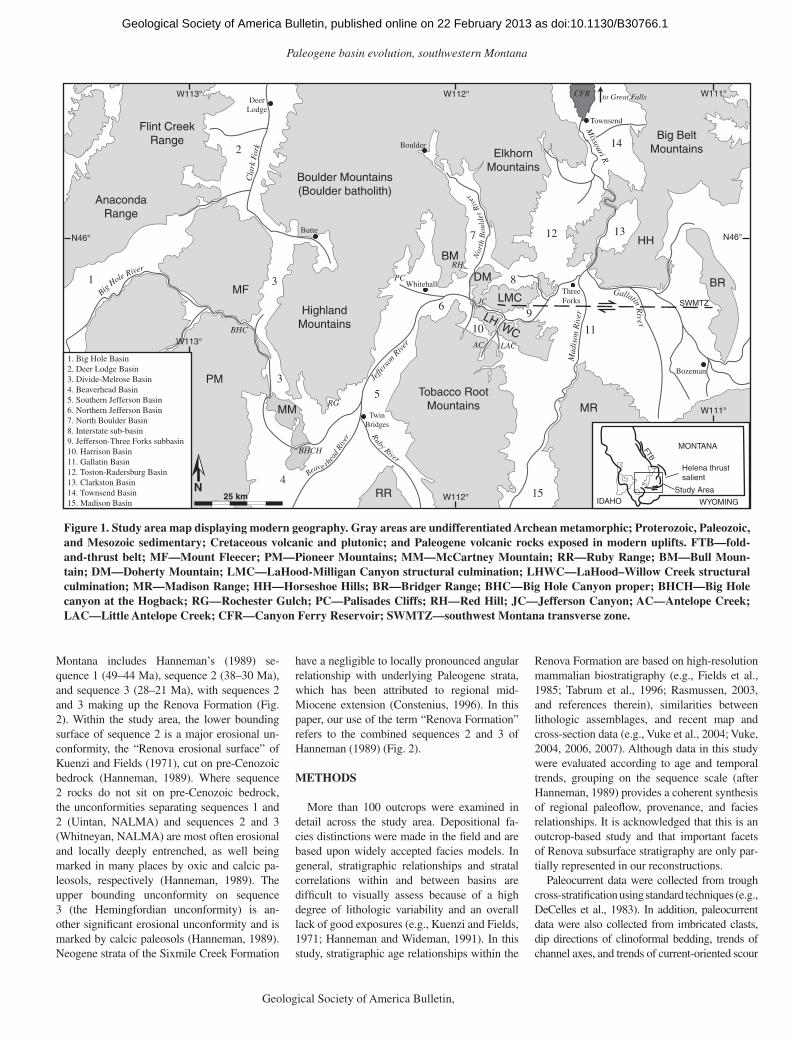
The Big Hole, Divide, northern Beaverhead, Jefferson, North Boulder, Harrison, Three Forks, Gallatin, Radersburg, and Townsend Ba-sins are located within or directly adjacent to the Helena Salient of the Cordilleran fold-and-thrust belt (Fig. 1). In this paper, the traditional Three Forks Basin is separated based on modern physiography into the informal Interstate and Jefferson–Three Forks subbasins (Fig. 1). Short-ening in the Sevier fold-and-thrust belt began during Late Jurassic time, and propagation of Sevier frontal thrust sheets in the Helena Salient of southwestern Montana continued into the Pa-leocene (Schmidt and O’Neill, 1982; Harlan et al., 1988; Constenius, 1996; DeCelles, 2004). Basement-cored Laramide uplifts became emer-gent in the Cordilleran foreland prior to and dur-ing encroachment of the fold-and-thrust belt (Schmidt and Garihan, 1983; Schwartz and De-Celles, 1988) and culminated during the latest Cretaceous (Maastrichtian) (DeCelles, 2004).
Widespread arc volcanism and emplacement of major Cordilleran batholiths also occurred during latest Cretaceous–early Eocene time. Within and adjacent to the study area, plutonic complexes include the Idaho batholith (ca. 100–55 Ma; Armstrong et al., 1977; Lageson et al., 2001), the Boulder batholith and its satellites
(81–73 and 64–61 Ma; Tilling et al., 1968; Hamilton and Meyers, 1974; Brumbaugh and Hendrix, 1981; Lund et al., 2002; Wooden et al., 2008), the Pioneer batholith (77–65 Ma; Snee, 1982; Marvin et al., 1983; Arth et al., 1986), and the Tobacco Root batholith (77–71 Ma; Mueller et al., 1996). Extrusion of the Creta-ceous Elkhorn Mountains volcanics was coeval with early stages of Boulder batholith intrusion (80–83 Ma; Robinson et al., 1968; Tilling, 1974; Lageson et al., 2001), resulting in a thick vol-canic carapace (26,000 km2 and 4.6 km thick) that blanketed the area (Klepper and Smedes, 1959; Robinson et al., 1968). Extrusion of the Lowland Creek, Dillon, Challis, Absaroka, and Helena volcanic fi elds occurred during the early Eocene (ca. 53–45 Ma; Rasmussen, 2003; Fritz et al., 2007; Dudás et al., 2010).
Within and surrounding the frontal region of the relict fold-and-thrust belt, modern to-pography is characterized by a series of north-south–trending mountainous uplifts separated by low-lying intermontane basins (Fig. 1). Smaller, east-west–trending uplifts parallel the southern margin of the Helena thrust salient along the southwest Montana transverse zone (Fig. 1), a structural lineament of Precambrian ancestry (Schmidt and O’Neill, 1982). The uplifted ar-eas contain Archean metamorphic basement; deformed Proterozoic, Paleozoic, and Meso-zoic strata; and Cretaceous and Paleogene plu-tons and volcanics. In the basins, lower-lying rounded foothills, alluvial fans, and basin-central river valleys are composed of Paleogene, Neo-gene, and Quaternary sediments. Most basins are bounded on the east by high-angle faults of mixed contractional, strike-slip, and extensional history. The basins are connected by through-going trunk fl uvial systems that constitute the headwaters of the upper Missouri River (Fig. 1).
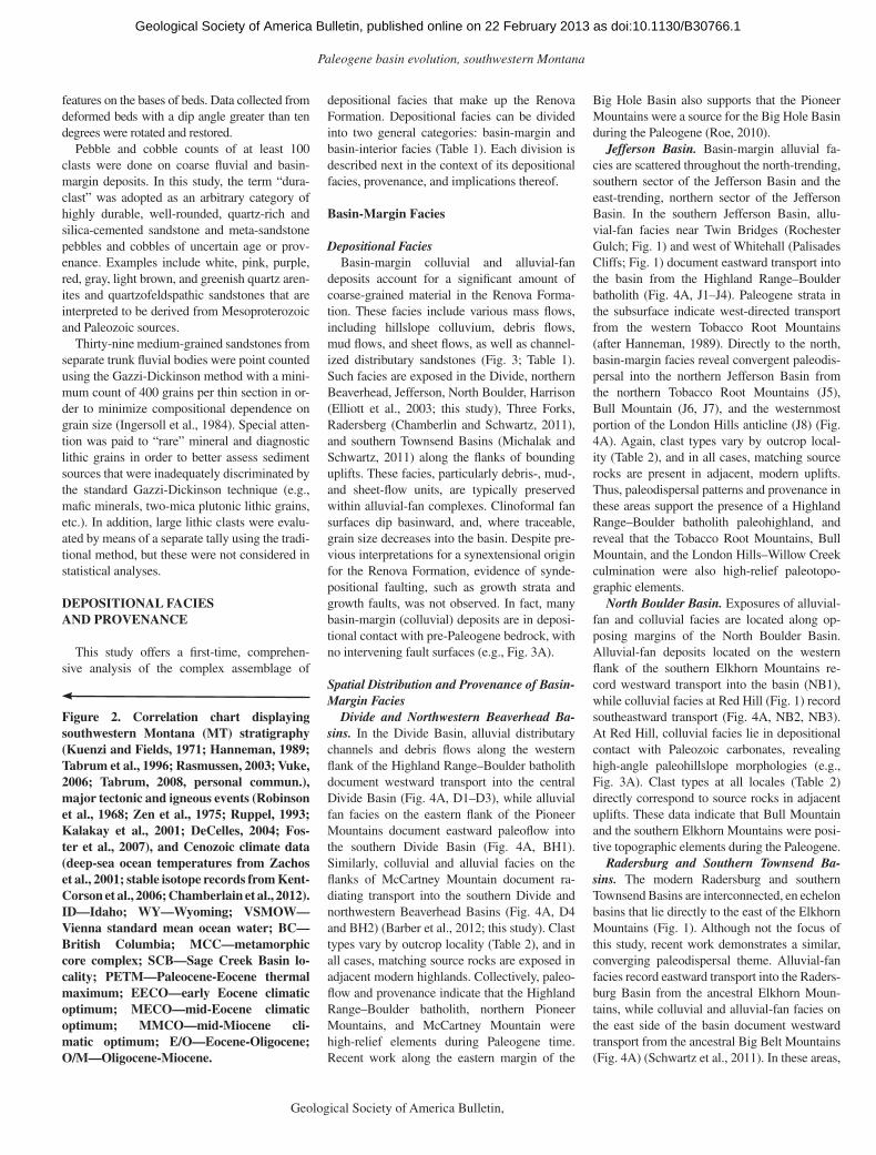
Renova Formation Stratigraphy
Rasmussen (2003) provided a detailed syn-thesis of lithostratigraphic studies of the Renova Formation, reviewing the highly variable no-menclature and stratigraphic partitioning that have been applied to the Paleogene strata of southwestern Montana over the past century. Renova Formation stratigraphy is subdivided according to the North American Land Mammal Ages (NALMA) time scale (Fig. 2). The most comprehensive description of the Paleogene section that can be applied across the study area, however, was provided by Hanneman (1989), who defi ned three stratigraphic sequences based on biostratigraphic and lithostratigraphic con-trols, supplemented by seismic profi les in the Jefferson, northern Beaverhead, and Divide Basins. The Paleogene section in southwestern
as doi:10.1130/B30766.1Geological Society of America Bulletin, published online on 22 February 2013
Paleogene basin evolution, southwestern Montana
Geological Society of America Bulletin, Month/Month 2012 3
Montana includes Hanneman’s (1989) se-quence 1 (49–44 Ma), sequence 2 (38–30 Ma), and sequence 3 (28–21 Ma), with sequences 2 and 3 making up the Renova Formation (Fig. 2). Within the study area, the lower bounding surface of sequence 2 is a major erosional un-conformity, the “Renova erosional surface” of Kuenzi and Fields (1971), cut on pre-Cenozoic bedrock (Hanneman, 1989). Where sequence 2 rocks do not sit on pre-Cenozoic bedrock, the unconformities separating sequences 1 and 2 (Uintan, NALMA) and sequences 2 and 3 (Whitneyan, NALMA) are most often erosional and locally deeply entrenched, as well being marked in many places by oxic and calcic pa-leosols, respectively (Hanneman, 1989). The upper bounding unconformity on sequence 3 (the Hemingfordian unconformity) is an-other signifi cant erosional unconformity and is marked by calcic paleosols (Hanneman, 1989). Neogene strata of the Sixmile Creek Formation
have a negligible to locally pronounced angular relationship with underlying Paleogene strata, which has been attributed to regional mid-Miocene extension (Constenius, 1996). In this paper, our use of the term “Renova Formation” refers to the combined sequences 2 and 3 of Hanneman (1989) (Fig. 2).
METHODS
More than 100 outcrops were examined in detail across the study area. Depositional fa-cies distinctions were made in the fi eld and are based upon widely accepted facies models. In general, stratigraphic relationships and stratal correlations within and between basins are diffi cult to visually assess because of a high degree of lithologic variability and an overall lack of good exposures (e.g., Kuenzi and Fields, 1971; Hanneman and Wideman, 1991). In this study, stratigraphic age relationships within the
Renova Formation are based on high-resolution mammalian biostratigraphy (e.g., Fields et al., 1985; Tabrum et al., 1996; Rasmussen, 2003, and references therein), similarities between lithologic assemblages, and recent map and cross-section data (e.g., Vuke et al., 2004; Vuke, 2004, 2006, 2007). Although data in this study were evaluated according to age and temporal trends, grouping on the sequence scale (after Hanneman, 1989) provides a coherent synthesis of regional paleofl ow, provenance, and facies relationships. It is acknowledged that this is an outcrop-based study and that important facets of Renova subsurface stratigraphy are only par-tially represented in our reconstructions.
Paleocurrent data were collected from trough cross-stratifi cation using standard techniques (e.g., DeCelles et al., 1983). In addition, paleocurrent data were also collected from imbricated clasts, dip directions of clinoformal bedding, trends of channel axes, and trends of current-oriented scour
Tobacco Root Mountains
RR
PM
MF
Anaconda Range
Flint Creek Range
Highland Mountains
Boulder Mountains(Boulder batholith)
Elkhorn Mountains
Big Belt Mountains
HH
BR
BM
MM
DM
LMC
LHWC
25 km
MR
N
N46° N46°
W112°
W112°
W111°
W111°
W113°
W113°
Nor
th B
ould
er R
iver
Townsend
Three Forks
Whitehall
Bozeman
Twin Bridges
Boulder
Butte
Deer Lodge
to Great FallsBig
Hole River
Cla
rk F
ork
Gallatin Rive r
Beave rhea
d Ri
ver R
uby River
Jeffe
rson
Rive
r
Mad
ison
Riv
er
Missouri R.
1 3
3
2
4
5
6
7
8
910 11
12 13
14
BHC
BHCH
JC
CFR
RG
PC
AC LAC
15
RH
SWMTZ
WYOMING
MONTANA
IDAHO
FTB
Study Area
Helena thrust salient
1. Big Hole Basin2. Deer Lodge Basin3. Divide-Melrose Basin4. Beaverhead Basin5. Southern Jefferson Basin6. Northern Jefferson Basin7. North Boulder Basin8. Interstate sub-basin9. Jefferson-Three Forks subbasin10. Harrison Basin11. Gallatin Basin12. Toston-Radersburg Basin13. Clarkston Basin14. Townsend Basin15. Madison Basin
Figure 1. Study area map displaying modern geography. Gray areas are undifferentiated Archean metamorphic; Proterozoic, Paleozoic, and Mesozoic sedimentary; Cretaceous volcanic and plutonic; and Paleogene volcanic rocks exposed in modern uplifts. FTB—fold-and-thrust belt; MF—Mount Fleecer; PM—Pioneer Mountains; MM—McCartney Mountain; RR—Ruby Range; BM—Bull Moun-tain; DM—Doherty Mountain; LMC—LaHood-Milligan Canyon structural culmination; LHWC—LaHood–Willow Creek structural culmination; MR—Madison Range; HH—Horseshoe Hills; BR—Bridger Range; BHC—Big Hole Canyon proper; BHCH—Big Hole canyon at the Hogback; RG—Rochester Gulch; PC—Palisades Cliffs; RH—Red Hill; JC—Jefferson Canyon; AC—Antelope Creek; LAC—Little Antelope Creek; CFR—Canyon Ferry Reservoir; SWMTZ—southwest Montana transverse zone.
as doi:10.1130/B30766.1Geological Society of America Bulletin, published online on 22 February 2013

Schwartz and Schwartz
4 Geological Society of America Bulletin, Month/Month 2012
Plio
.M
ioce
neO
ligoc
ene
Eoc
ene
Pal
eoce
ne
CR
ETA
CE
OU
S
Ma
2.02
5.3
N.A. LANDMAMMAL
AGES
Blancan
Hemphillian
Clarendonian
Barstovian
Hemingfordian
Arikareean
Whitneyan
Orellan
Chadronian
Duchesnean
Uintan
Bridgerian
Wasatchian
Clarkforkian
Tiffanian
Torrejonian
Puercan
Lancian
“Edmontonian”
Judithian
8.41
11.5
15.9
19.0
23.0
30.0
31.7
33.9
37.7
42.2
46.4
50.9
55.8
57.5
61.1
63.0
65.5
69.7
70.672.1
83.5
Maa
st.
Cam
pani
an
Modern glacial, fluvial, etc.
SOUTHWEST MONTANASTRATIGRAPHY
REGIONALIGNEOUSACTIVITY
Abs
arok
a V
olcs
. (W
Y)
Col
umbi
a R
iver
bas
alts
REGIONALTECTONICACTIVITY
Bou
lder
bat
holit
h
Idah
o ba
thol
ith
Pio
neer
bat
holit
h
Toba
cco
Roo
t bat
holit
h
Elk
horn
Mou
ntai
ns V
olcs
.
Low
land
Cre
ek V
olcs
. (M
T)
Cha
llis
Vol
cs. (
ID)
Yello
wst
one
Hot
spot
0 1284Ocean Temp (oC)
CLIMATEFLUV.INCIS.
Min
or in
cisi
on in
to p
aleo
basi
n fil
l
Sev
ier-
Lara
mid
e co
mpr
essi
on
“BO
ZE
MA
N G
RO
UP
”SIXMILE CREEK
FORMATION(undivided)
RE
NO
VA
FO
RM
ATIO
N
Negro Hollow member
Cabbage Patch Member
Dunbar Creek Member
Dunbar Creek Member
Bone Basin Member
Climbing Arrow Member& Red Hill member
Sage Creek Formation (SCB)
Dell Formation (SCB)
Cook Ranch member (SCB)B
itter
root
MC
C (
ID)
Prie
st R
iver
MC
C (
WA
)
Ana
cond
a M
CC
(M
T)
PETM
EE
CO
MECO
E/O cooling
O/M cooling
MMCO
RE
GIO
NA
L PA
LEO
GE
NE
EX
TE
NS
ION
RE
GIO
NA
L N
EO
GE
NE
EX
TE
NS
ION
BC
MT
prot
o-B
asin
& R
ange
Bas
in &
Ran
ge; Y
ello
wst
one
12 16 20 24δ18O (VSMOW)
-7 to -10‰
Inte
rmon
tane
pal
eova
lleys
inci
sed
into
Sev
ier-
Lara
mid
e in
fras
truc
ture
SYSTEM/PERIOD
BEAVERHEAD GROUP
seq.
1
sequ
ence
2se
quen
ce 3
PALE
OG
EN
EN
EO
GE
NE
as doi:10.1130/B30766.1Geological Society of America Bulletin, published online on 22 February 2013
Paleogene basin evolution, southwestern Montana
Geological Society of America Bulletin, Month/Month 2012 5
features on the bases of beds. Data collected from deformed beds with a dip angle greater than ten degrees were rotated and restored.
Pebble and cobble counts of at least 100 clasts were done on coarse fl uvial and basin-margin deposits. In this study, the term “dura-clast” was adopted as an arbitrary category of highly durable, well-rounded, quartz-rich and silica-cemented sandstone and meta-sandstone pebbles and cobbles of uncertain age or prov-enance. Examples include white, pink, purple, red, gray, light brown, and greenish quartz aren-ites and quartzofeldspathic sandstones that are interpreted to be derived from Mesoproterozoic and Paleozoic sources.
Thirty-nine medium-grained sandstones from separate trunk fl uvial bodies were point counted using the Gazzi-Dickinson method with a mini-mum count of 400 grains per thin section in or-der to minimize compositional dependence on grain size (Ingersoll et al., 1984). Special atten-tion was paid to “rare” mineral and diagnostic lithic grains in order to better assess sediment sources that were inadequately discriminated by the standard Gazzi-Dickinson technique (e.g., mafi c minerals, two-mica plutonic lithic grains, etc.). In addition, large lithic clasts were evalu-ated by means of a separate tally using the tradi-tional method, but these were not considered in statistical analyses.
DEPOSITIONAL FACIES AND PROVENANCE
This study offers a fi rst-time, comprehen-sive analysis of the complex assemblage of
Figure 2. Correlation chart displaying southwestern Montana (MT) stratigraphy (Kuenzi and Fields, 1971; Hanneman, 1989; Tabrum et al., 1996; Rasmussen, 2003; Vuke, 2006; Tabrum, 2008, personal commun.), major tectonic and igneous events (Robinson et al., 1968; Zen et al., 1975; Ruppel, 1993; Kalakay et al., 2001; DeCelles, 2004; Fos-ter et al., 2007), and Cenozoic climate data (deep-sea ocean temperatures from Zachos et al., 2001; stable isotope records from Kent- Corson et al., 2006; Chamberlain et al., 2012). ID—Idaho; WY—Wyoming; VSMOW—Vienna standard mean ocean water; BC— British Columbia; MCC— metamorphic core complex; SCB—Sage Creek Basin lo-cality; PETM—Paleocene-Eocene thermal maximum; EECO—early Eocene climatic optimum; MECO—mid-Eocene climatic optimum; MMCO—mid-Miocene cli-matic optimum; E/O—Eocene-Oligocene; O/M—Oligocene-Miocene.
depositional facies that make up the Renova Formation. Depositional facies can be divided into two general categories: basin-margin and basin- interior facies (Table 1). Each division is described next in the context of its depositional facies, provenance, and implications thereof.
Basin-Margin Facies
Depositional FaciesBasin-margin colluvial and alluvial-fan
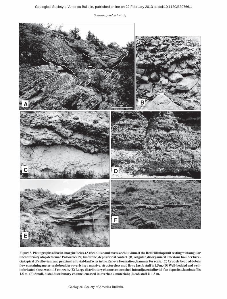
deposits account for a signifi cant amount of coarse-grained material in the Renova Forma-tion. These facies include various mass fl ows, including hillslope colluvium, debris fl ows, mud fl ows, and sheet fl ows, as well as channel-ized distributary sandstones (Fig. 3; Table 1). Such facies are exposed in the Divide, northern Beaverhead, Jefferson, North Boulder, Harrison (Elliott et al., 2003; this study), Three Forks, Radersberg (Chamberlin and Schwartz, 2011), and southern Townsend Basins (Michalak and Schwartz, 2011) along the fl anks of bounding uplifts. These facies, particularly debris-, mud-, and sheet-fl ow units, are typically preserved within alluvial-fan complexes. Clinoformal fan surfaces dip basinward, and, where traceable, grain size decreases into the basin. Despite pre-vious interpretations for a synextensional origin for the Renova Formation, evidence of synde-positional faulting, such as growth strata and growth faults, was not observed. In fact, many basin-margin (colluvial) deposits are in deposi-tional contact with pre-Paleogene bedrock, with no intervening fault surfaces (e.g., Fig. 3A).
Spatial Distribution and Provenance of Basin-Margin Facies
Divide and Northwestern Beaverhead Ba-sins. In the Divide Basin, alluvial distributary channels and debris fl ows along the western fl ank of the Highland Range–Boulder batholith document westward transport into the central Divide Basin (Fig. 4A, D1–D3), while alluvial fan facies on the eastern fl ank of the Pioneer Mountains document eastward paleofl ow into the southern Divide Basin (Fig. 4A, BH1). Similarly, colluvial and alluvial facies on the fl anks of McCartney Mountain document ra-diating transport into the southern Divide and northwestern Beaverhead Basins (Fig. 4A, D4 and BH2) (Barber et al., 2012; this study). Clast types vary by outcrop locality (Table 2), and in all cases, matching source rocks are exposed in adjacent modern highlands. Collectively, paleo-fl ow and provenance indicate that the Highland Range–Boulder batholith, northern Pioneer Mountains, and McCartney Mountain were high-relief elements during Paleogene time. Recent work along the eastern margin of the
Big Hole Basin also supports that the Pioneer Mountains were a source for the Big Hole Basin during the Paleogene (Roe, 2010).
Jefferson Basin. Basin-margin alluvial fa-cies are scattered throughout the north-trending, southern sector of the Jefferson Basin and the east-trending, northern sector of the Jefferson Basin. In the southern Jefferson Basin, allu-vial-fan facies near Twin Bridges (Rochester Gulch; Fig. 1) and west of Whitehall (Palisades Cliffs; Fig. 1) document eastward transport into the basin from the Highland Range–Boulder batholith (Fig. 4A, J1–J4). Paleogene strata in the subsurface indicate west-directed transport from the western Tobacco Root Mountains (after Hanneman, 1989). Directly to the north, basin-margin facies reveal convergent paleodis-persal into the northern Jefferson Basin from the northern Tobacco Root Mountains (J5), Bull Mountain (J6, J7), and the westernmost portion of the London Hills anticline (J8) (Fig. 4A). Again, clast types vary by outcrop local-ity (Table 2), and in all cases, matching source rocks are present in adjacent, modern uplifts. Thus, paleodispersal patterns and provenance in these areas support the presence of a Highland Range–Boulder batholith paleohighland, and reveal that the Tobacco Root Mountains, Bull Mountain, and the London Hills–Willow Creek culmination were also high-relief paleotopo-graphic elements.
North Boulder Basin. Exposures of alluvial-fan and colluvial facies are located along op-posing margins of the North Boulder Basin. Alluvial-fan deposits located on the western fl ank of the southern Elkhorn Mountains re-cord westward transport into the basin (NB1), while colluvial facies at Red Hill (Fig. 1) record southeastward transport (Fig. 4A, NB2, NB3). At Red Hill, colluvial facies lie in depositional contact with Paleozoic carbonates, revealing high-angle paleohillslope morphologies (e.g., Fig. 3A). Clast types at all locales (Table 2) directly correspond to source rocks in adjacent uplifts. These data indicate that Bull Mountain and the southern Elkhorn Mountains were posi-tive topographic elements during the Paleogene.
Radersburg and Southern Townsend Ba-sins. The modern Radersburg and southern Townsend Basins are interconnected, en echelon basins that lie directly to the east of the Elkhorn Mountains (Fig. 1). Although not the focus of this study, recent work demonstrates a similar, converging paleodispersal theme. Alluvial-fan facies record eastward transport into the Raders-burg Basin from the ancestral Elkhorn Moun-tains, while colluvial and alluvial-fan facies on the east side of the basin document westward transport from the ancestral Big Belt Mountains (Fig. 4A) (Schwartz et al., 2011). In these areas,
as doi:10.1130/B30766.1Geological Society of America Bulletin, published online on 22 February 2013

Schwartz and Schwartz
6 Geological Society of America Bulletin, Month/Month 2012
TAB
LE 1
. TH
E A
SS
EM
BLA
GE
S O
F B
AS
IN-M
AR
GIN
AN
D B
AS
IN-I
NT
ER
IOR
DE
PO
SIT
ION
AL
FAC
IES
TH
AT F
OR
M T
HE
RE
NO
VA
FO
RM
ATIO
N
Dep
ositi
onal
fa
cies
Lith
olog
y an
d be
ddin
g st
yle
Cla
st s
ize
and
shap
eS
ortin
g an
d te
xtur
al tr
ends
Phy
sica
l str
uctu
res
Trac
e fo
ssils
, bi
otur
batio
nD
epos
ition
al p
roce
sses
Pal
eoge
ogra
phic
an
d/or
pal
eocl
imat
ic
sign
ifi ca
nce
Faci
es r
efer
ence
s
Bas
in-m
argi
n fa
cies
Col
luvi
al b
recc
ia
Red
to g
ray,
m
onom
ictic
to
poly
mic
tic b
recc
ias
and
meg
abre
ccia
s;
mas
sive
Peb
bles
, bou
lder
s,
± bl
ocks
up
to
7 m
in le
ngth
; an
gula
r
Very
poo
rly
sort
ed; c
last
±
mat
rix
supp
orte
d;
mas
sive
Non
en/
a
Mas
s-w
astin
g ev
ents
in
clud
ing
aval
anch
e,
slid
e-bl
ock,
an
d de
bris
-fl ow
m
echa
nism
s on
pa
leoh
illsl
ope
Col
luvi
um is
in
depo
sitio
nal c
onta
ct
with
pre
–mid
-Eoc
ene
land
scap
e; b
right
red
lim
esto
ne b
recc
ias
are
rem
obili
zed,
w
eath
ered
reg
olith
s fr
om e
arlie
r, w
arm
er/
wet
ter
clim
ate
Ped
erso
n et
al.
(200
0)
Deb
ris fl
ow
Mon
omic
tic to
po
lym
ictic
, m
atrix
-sup
port
ed
cong
lom
erat
es;
mas
sive
to c
rude
ly
bedd
ed; t
abul
ar to
br
oadl
y le
ntic
ular
; ca
n fi l
l ero
sion
al
furr
ows
and
smal
l gu
llies
Peb
bles
and
co
bble
s; a
ngul
ar
to s
ubro
unde
d
Very
poo
rly
sort
ed;
mat
rix ±
cla
st
supp
orte
d;
crud
e in
vers
e gr
adin
g
Very
cru
de c
last
im
bric
atio
n
Rar
e, c
rude
pe
doge
nic
fabr
ic in
clud
ing
root
lets
, bur
row
s
Deb
ris fl
ows
near
bas
in
mar
gins
; pro
xim
al
allu
vial
fan
Indi
cate
s th
e pr
esen
ce
of a
djac
ent h
igh-
relie
f, ba
sin-
mar
gin
upla
nds
Bla
ir an
d M
cPhe
rson
(1
994a
, 199
4b)
Mud
fl ow
Red
to ta
n di
amic
tites
w
ith r
are
susp
ende
d pe
bble
s an
d co
bble
s
Peb
bles
to c
obbl
es;
angu
lar
Very
poo
rly
sort
ed; m
atrix
su
ppor
ted;
m
assi
ve
Non
e
Blo
cky
pedo
geni
c ho
rizon
s w
ith
root
lets
, dra
b ha
lo s
truc
ture
s,
larg
e m
amm
al
burr
ows,
Ta
enid
ium
bu
rrow
s
Mud
fl ow
s ne
ar b
asin
m
argi
ns, e
xten
ding
to
bas
in in
terio
r;
prox
imal
to m
edia
l al
luvi
al fa
n
Indi
cate
s th
e pr
esen
ce
of a
djac
ent h
igh-
relie
f, ba
sin-
mar
gin
upla
nds
Bul
l (19
72);
Rod
ine
and
John
son
(197
6)
She
et fl
ow
Coa
rse
cong
lom
erat
ic
sand
ston
e; ta
bula
r to
bro
adly
lent
icul
ar;
shar
p sc
our
base
Coa
rse
sand
and
gr
anul
es to
co
bble
s; a
ngul
ar
to s
ubro
unde
d
Mod
erat
ely
to
wel
l sor
ted;
no
rmal
±
inve
rse
grad
ing;
cla
st/
fram
ewor
k ±
mat
rix
supp
orte
d
Pla
nar
lam
inat
ions
and
be
ds; l
ow-a
ngle
cr
oss-
stra
tifi c
atio
n;
scou
r-an
d-fi l
l
Roo
tlets
and
no
ndes
crip
t bu
rrow
s
She
et fl
ows
near
bas
in
mar
gins
, ext
endi
ng
to b
asin
inte
rior;
pr
oxim
al to
med
ial
allu
vial
fan
Indi
cate
s th
e pr
esen
ce
of a
djac
ent h
igh-
relie
f, ba
sin-
mar
gin
upla
nds
Bla
ir an
d M
cPhe
rson
(1
994a
, 199
4b)
Cha
nnel
ized
di
strib
utar
y sa
ndst
one
Nar
row
(~4
–5 m
) an
d th
ick
(~3–
4 m
) to
w
ide
(~5–
6 m
) an
d th
in (
<1 m
) sa
ndst
one
lens
es;
conc
ave
scou
r ba
se
Coa
rse
sand
ston
e w
ith p
ebbl
es a
nd
cobb
les;
ang
ular
to
sub
roun
ded
Mod
erat
ely
to
wel
l sor
ted;
up
war
d fi n
ing;
fr
amew
ork
supp
orte
d
Larg
e-sc
ale
trou
gh
cros
s-st
ratifi
cat
ion;
cl
ast i
mbr
icat
ion
Cru
de b
iotu
rbat
ion
in th
inne
r sa
ndst
one
units
Pro
xim
al e
ntre
nche
d an
d di
stal
di
strib
utar
y ch
anne
l fi l
ls; m
edia
l to
dist
al
allu
vial
fan
Doc
umen
ts a
dow
n-fa
n ev
olut
ion
of fa
n-ch
anne
l mor
phol
ogy
Bla
ir an
d M
cPhe
rson
(1
994a
); N
icho
ls
and
Fis
her
(200
7) (Con
tinue
d)
as doi:10.1130/B30766.1Geological Society of America Bulletin, published online on 22 February 2013

Paleogene basin evolution, southwestern Montana
Geological Society of America Bulletin, Month/Month 2012 7
TAB
LE 1
. TH
E A
SS
EM
BLA
GE
S O
F B
AS
IN-M
AR
GIN
AN
D B
AS
IN-I
NT
ER
IOR
DE
PO
SIT
ION
AL
FAC
IES
TH
AT F
OR
M T
HE
RE
NO
VA
FO
RM
ATIO
N (
Con
tinue
d)
Dep
ositi
onal
fa
cies
Lith
olog
y an
d be
ddin
g st
yle
Cla
st s
ize
and
shap
eS
ortin
g an
d te
xtur
al tr
ends
Phy
sica
l str
uctu
res
Trac
e fo
ssils
, bi
otur
batio
nD
epos
ition
al p
roce
sses
Pal
eoge
ogra
phic
an
d/or
pal
eocl
imat
ic
sign
ifi ca
nce
Faci
es r
efer
ence
s
Bas
in-in
terio
r fa
cies
Bra
ided
fl uv
ial
cong
lom
erat
e an
d sa
ndst
one
Tabu
lar,
late
rally
ex
tens
ive
cobb
le
cong
lom
erat
es a
nd
coar
se, g
ranu
lar
sand
ston
e; p
lana
r to
co
ncav
e sc
our
base
Med
ium
-gra
ined
to
gra
nula
r sa
ndst
one,
pe
bble
an
d co
bble
co
nglo
mer
ate;
m
inor
ang
ular
bo
ulde
rs;
pebb
les,
cob
bles
ar
e an
gula
r to
w
ell r
ound
ed
Mod
erat
ely
to
wel
l sor
ted;
up
war
d fi n
ing;
cla
st/
fram
ewor
k su
ppor
ted
Pla
nar,
low
-ang
le, a
nd
plan
ar-t
abul
ar c
ross
-st
ratifi
cat
ion;
cla
st
imbr
icat
ion;
wed
ges
of tr
ough
cro
ss-
stra
tifi e
d sa
ndst
one
Non
e
Hig
h-en
ergy
, tra
nspo
rt-
effi c
ient
bra
ided
fl u
vial
sys
tem
s co
mm
only
inci
sed
into
pre
-Ter
tiary
be
droc
k
Rep
rese
nts
an e
arly
, hi
gh-e
nerg
y ph
ase
of
fl uvi
al e
rosi
on th
en
depo
sitio
n w
ithin
the
Ren
ova
basi
n ne
twor
k
Rus
t and
Kos
ter
(198
4); W
alke
r an
d C
ant (
1984
); B
ridge
(20
06)
Ana
stom
osin
g fl u
vial
sa
ndst
one
Isol
ated
, len
ticul
ar
sand
ston
e bo
dies
up
to 5
m th
ick
and
20 m
wid
e en
case
d in
thic
k m
udst
ones
; tr
ansi
tion
upw
ard
into
san
dsto
ne
bodi
es a
s sm
all a
s 1
m th
ick
and
0.5
m w
ide
Coa
rse
sand
an
d gr
anul
es,
± pe
bble
s;
subr
ound
ed
Mod
erat
ely
to
wel
l sor
ted;
up
war
d fi n
ing;
fr
amew
ork
supp
orte
d
Trou
gh c
ross
-st
ratifi
cat
ion,
rar
e cl
ast i
mbr
icat
ion;
m
ud r
ip-u
p cl
asts
; ra
re e
psilo
n cr
oss-
stra
tifi c
atio
n (H
anne
man
, 198
9)
Per
vasi
ve b
urro
win
g in
hig
her
units
Low
-ene
rgy
anas
tom
osin
g fl u
vial
sy
stem
s co
nfi n
ed
late
rally
by
mud
dy
over
bank
faci
es
Rep
rese
nts
a la
ter,
low
er-e
nerg
y ph
ase
of fl
uvia
l dep
ositi
on
asso
ciat
ed w
ith b
asin
ba
ck-fi
lling
thro
ugho
ut
Pal
eoge
ne ti
me
Sm
ith a
nd S
mith
(1
980)
; Wal
ker
and
Can
t (19
84);
Mak
aske
(20
01)
Cre
vass
e sp
lay
sand
ston
e
Thi
n, ta
bula
r to
wed
ge-
shap
ed s
ands
tone
bo
dies
Med
ium
-gra
ined
sa
ndst
one;
su
brou
nded
Wel
l sor
ted;
no
rmal
gr
adin
g;
fram
ewor
k su
ppor
ted
Rar
e, c
rude
tang
entia
l cr
oss-
stra
tifi c
atio
n an
d rip
ple
bedd
ing
Mod
erat
ely
to
wel
l-dev
elop
ed
biot
urba
tion
fabr
ic
Spl
ay s
ands
tone
s de
posi
ted
durin
g le
vee-
brea
chin
g fl o
odin
g ev
ents
Con
sist
ent w
ith
inte
rpre
tatio
n of
low
er-e
nerg
y (a
nast
omos
ing?
) fl u
vial
com
plex
Mak
aske
(20
01)
Ove
rban
k m
udst
one
and
pale
osol
s
Thi
ck, t
abul
ar, m
assi
ve
mud
ston
es th
at
are
gree
nish
and
fr
iabl
e w
here
be
nton
itic;
tabu
lar
calc
ic p
aleo
sols
(H
anne
man
and
W
idem
an, 2
006,
20
10)
Mud
ston
eM
oder
atel
y so
rted
Cal
cret
e no
dule
s,
calc
areo
us la
min
ae,
mas
sive
car
bona
te
beds
, soi
l pis
olith
s (H
anne
man
and
W
idem
an, 2
010)
; lo
cally
abu
ndan
t m
amm
al fo
ssils
Roo
tlets
, bur
row
s (in
clud
ing
Taen
idiu
m),
dra
b ha
lo s
truc
ture
s
Ove
rban
k pr
oces
ses
gene
tical
ly r
elat
ed
to b
asin
-inte
rior
fl uvi
al s
yste
ms;
pe
doge
nesi
s on
in
terfl
uves
and
du
ring
depo
sitio
nal
hiat
uses
Con
sist
ent w
ith
inte
rpre
tatio
n of
low
er-e
nerg
y (a
nast
omos
ing?
) fl u
vial
com
plex
; w
ell-d
evel
oped
cal
cic
pale
osol
s in
dica
te
mor
e ar
id c
limat
ic
regi
me
for
Ren
ova
depo
sitio
n
Sm
ith a
nd S
mith
(1
980)
; Wal
ker
and
Can
t (19
84);
Ebe
rth
and
Mia
ll (1
991)
; K
raus
(19
99);
Mak
aske
(20
01);
Ret
alla
ck (
2007
); H
anne
man
and
W
idem
an (
2010
)
Lacu
strin
e-pa
lust
rine
mud
ston
e an
d lim
esto
ne
Thi
ck, t
abul
ar,
tuffa
ceou
s to
ca
lcar
eous
m
udst
one
units
; th
in, t
abul
ar,
gray
foss
ilife
rous
lim
esto
nes
(Kue
nzi
and
Fie
lds,
197
1;
Elli
ott e
t al.,
200
3);
som
etim
es o
nlap
pr
e-Te
rtia
ry b
edro
ck
Cal
care
ous
silts
tone
± s
mal
l ga
stro
pods
, pe
lecy
pods
, and
os
trac
odes
Mod
erat
ely
to
wel
l sor
ted;
no
rmal
gra
ding
Mill
imet
er-s
cale
la
min
atio
ns a
nd
cent
imet
er-s
cale
be
ds; s
trai
ght-
cres
ted
wav
e rip
ple
bed
form
s
Bur
row
ing,
ca
rbon
aceo
us
plan
t fra
gmen
ts
(gro
wth
pos
ition
)
Sus
pens
ion
fallo
ut
of fi
nes
with
in
lacu
strin
e/pa
lust
rine
setti
ngs;
rew
orki
ng b
y w
aves
and
bio
ta
Inte
rmitt
ent
deve
lopm
ent o
f lak
es/
pond
s in
res
pons
e to
se
dim
enta
ry d
amm
ing;
pr
esen
ce o
f lim
esto
ne
indi
cate
s de
posi
tion
in
rest
ricte
d la
cust
rine-
palu
strin
e se
tting
s
Kue
nzi a
nd F
ield
s (1
971)
; Dea
n an
d F
ouch
(19
83);
Eug
ster
and
Kel
ts
(198
3); M
akas
ke
(200
1); F
reyt
et
and
Ver
recc
hia
(200
2); E
lliot
t et
al.
(200
3);
Alo
nso-
Zar
za
and
Wrig
ht
(201
0)
as doi:10.1130/B30766.1Geological Society of America Bulletin, published online on 22 February 2013
Schwartz and Schwartz
8 Geological Society of America Bulletin, Month/Month 2012
Figure 3. Photographs of basin-margin facies. (A) Scab-like and massive colluvium of the Red Hill map unit resting with angular unconformity atop deformed Paleozoic (Pz) limestone, depositional contact. (B) Angular, disorganized limestone boulder brec-cia typical of colluvium and proximal alluvial-fan facies in the Renova Formation; hammer for scale. (C) Crudely bedded debris fl ow containing meter-scale boulders overlying a massive, structureless mud fl ow; Jacob staff is 1.5 m. (D) Well-bedded and well- imbricated sheet wash; 15 cm scale. (E) Large distributary channel entrenched into adjacent alluvial-fan deposits; Jacob staff is 1.5 m. (F) Small, distal distributary channel encased in overbank materials; Jacob staff is 1.5 m.
as doi:10.1130/B30766.1Geological Society of America Bulletin, published online on 22 February 2013

Paleogene basin evolution, southwestern Montana
Geological Society of America Bulletin, Month/Month 2012 9
Tobacco Root Mountains
Pioneer Mountains
Highland Mountains
Boulder Mountains(Boulder batholith)
Elkhorn Mountains
25 km
N
D1D2D3
D4
BH1
J1
J2
J3
J4
J5
J6,7
NB1NB2,3
H1
JT2
JT4
JT5
I1I2
J8
BH2
JT3
Da
Db
BHaBHb
Ja Jb
HaJTc
JTb
JTa
I3 JT1
Dc
Basin-Margin
Trunk Fluvial
*Schwartz et al. (2011)
*
*
*
*
*
*
*
*
*
*
*
*
*
*
* *
*
*
N(fluvial) = 1821N(alluvial) = 682
NBa
Tobacco Root Mountains
Pioneer Mountains
Highland Mountains
Boulder Mountains(Boulder batholith)
Elkhorn Mountains
25 km
N
?
?
?
?
Interpreted Flow
Inferred Flow
Paleorelief
??
*
A
B
W113°
W113° W112°
W112°
N46°N46°
W113°
W113° W112°
W112°
N46°N46°
Figure 4. (A) Distribution of paleocurrent rose diagrams for basin-margin and basin-interior facies across the study area. Site names (e.g., D1 or Da) correspond to compositional data displayed in Table 1. Gray polygons represent modern mountainous regions. (B) Paleodrainage system that is interpreted to have existed through-out Paleogene time. A through-going trunk fl uvial system connected the ancestral Divide, northern Beaver-head, Jefferson, and Three Forks Basins (see Fig. 1 for basin locations). Fluvial systems in the ancestral North Boulder (this study) and Harrison Basins (Elliott et al., 2003; this study) were tributary to the Jefferson–Three Forks tract. Lower-order headwaters drained ancestral highlands coincident with modern uplifts.
as doi:10.1130/B30766.1Geological Society of America Bulletin, published online on 22 February 2013

Schwartz and Schwartz
10 Geological Society of America Bulletin, Month/Month 2012
TAB
LE 2
. CLA
ST
CO
MP
OS
ITIO
NS
IN B
AS
IN-M
AR
GIN
AN
D B
AS
IN-I
NT
ER
IOR
BR
EC
CIA
S A
ND
CO
NG
LOM
ER
ATE
S (
%)
Bas
inS
iteQ
uart
z &
fe
ldsp
arE
ocen
e vo
lcan
ics
Cre
tace
ous
gran
itoid
Cre
tace
ous
volc
anic
sC
reta
ceou
s se
dim
enta
ryP
aleo
zoic
lim
esto
neP
aleo
zoic
ch
ert
Pal
eozo
ic/
Pro
tero
zoic
sa
ndst
one
Mes
o-pr
oter
ozoi
c La
Hoo
d F
m.
Mes
o-pr
oter
ozoi
c Q
F
sand
ston
e
Arc
hean
m
etam
orph
ic
B
asin
-mar
gin
brec
cias
and
con
glom
erat
es
Div
ide
D1
00
101
040
09
400
0D
22
030
30
450
020
00
D3
10
202
025
030
220
0D
40
1015
020
250
300
00
Bea
verh
ead
BH
12
30
090
20
30
00
BH
20
205
075
00
00
00
Jeffe
rson
J15
01
40
00
045
045
J20
045
550
00
00
00
J30
040
450
00
105
00
J40
050
450
00
50
00
J52
00
619
616
60
00
J60
00
100
00
090
00
J70
00
150
00
085
00
J838
00
00
460
016
00
Nor
th B
ould
erN
B1
00
010
080
37
00
0N
B2
00
00
098
02
00
0N
B3
00
00
098
20
00
0
Har
rison
H1
00
00
098
20
00
0
Jeffe
rson
–T
hree
For
ks
JT1
00
00
010
00
00
00
JT2
00
00
090
28
00
0JT
30
00
00
100
00
00
0JT
40
00
00
100
00
00
0JT
50
00
00
10
099
00
Inte
rsta
teI1
00
00
010
00
00
00
I20
00
00
100
00
00
0I3
00
00
010
00
00
00
Tru
nk fl uv
ial c
obb
le c
ongl
omer
ates
Big
Hol
e C
anyo
n*D
a0
34
00
00
115
689
Div
ide*
Db
00
94
70
00
1169
0D
c0
01
511
451
520
102
Bea
verh
ead*
BH
a0
21
617
40
41
650
BH
b0
02
319
01
310
620
Jeffe
rson
*Ja
00
22
150
240
330
6Jb
20
925
05
226
722
2
Nor
th B
ould
erN
Ba
00
085
010
05
00
0
Har
rison
Ha
310
350
04
09
00
21
Jeffe
rson
–T
hree
For
ks*
JTa
00
85
100
330
621
17JT
b1
08
228
43
47
3013
JTc
20
610
42
719
038
12*D
enot
es r
epre
sent
atio
n in
Fig
ure
7.
as doi:10.1130/B30766.1Geological Society of America Bulletin, published online on 22 February 2013

Paleogene basin evolution, southwestern Montana
Geological Society of America Bulletin, Month/Month 2012 11
clast types again directly correspond to source rocks in adjacent uplifts (Chamberlin and Schwartz, 2011; Michalak and Schwartz, 2011).
Interstate, Jefferson–Three Forks, and Harrison Basins. The Interstate, Jefferson–Three Forks, and Harrison Basins are east- to southeast-trending basins that roughly parallel major faults and structural culminations related to the southwest Montana transverse zone (Fig. 1). Paleogene colluvium on the eastern fl ank of Doherty Mountain (I1) and on the northern fl ank of the LaHood–Milligan Canyon culmina-tion (I2, I3) documents southward and north-ward paleodispersal into the Interstate subbasin, respectively (Fig. 4A). Similarly, Paleogene col-luvium on the southern margin of the LaHood–Milligan Canyon culmination (JT1, JT5) and the northern margin of the London Hills–Willow Creek culmination (JT2–JT4) documents con-verging paleodispersal into the Jefferson–Three Forks subbasin (Fig. 4A). In the Harrison Basin, colluvial facies display eastward transport into the eastern Harrison Basin (Fig. 4A, H1). In all three basins, colluvium lies in depositional con-tact with Paleozoic source rocks, revealing pa-leohillslope trends. As in other basins, all clast types refl ect derivation from source rocks in ad-jacent uplifts (Table 2). Collectively, these data suggest that the LaHood–Milligan Canyon and London Hills–Willow Creek structural culmina-tions were positive topographic elements during the Paleogene.
Paleogeographic and Paleotopographic Implications of Basin-Margin Facies
Coupled with paleocurrent data, the spatial distribution and composition of basin-margin deposits allow for reconstruction of Paleogene geography within the study area. It is a basic tenet that alluvial-fan and hillslope deposits in-dicate signifi cant relief where substantial uplifts are adjacent to lower-lying areas of sediment accommodation (e.g., Blissenbach, 1954; Rust and Koster, 1984; Blair and McPherson, 1994a, 1994b). Hence, the mere presence of such depo-sitional facies indicates that a rugged topography existed in southwestern Montana throughout Pa-leogene time. Paleorelief estimates for this study, based upon the difference in elevation of late Eocene–Oligocene paleohillside colluvium and contiguous modern highlands where there are no known intervening syn- or postdepositional faults, indicate a minimum of 2 km of paleorelief.
Based on the presence of coarse colluvium and the textural immaturity of basin-margin fa-cies (e.g., Figs. 3A and 3B), it is clear that de-position was proximal to adjacent source areas. The clast compositions of the basin-margin de-posits unequivocally reveal the lithologies that made up the adjacent Paleogene highlands. A
comparison of clast types that occur in any of the basin-margin deposits to lithologies compris-ing adjacent uplifts documents that Paleogene source rocks were the same as those presently exposed in modern uplifts. Intrabasinal varia-tion in clast populations is due to lateral changes in source rocks along the basin margin. For example, the lateral change in composition of basin-margin deposits along the eastern edge of the Divide Basin refl ects the northward in-crease in Mesoproterozoic (LaHood Formation) sedimentary and Cretaceous granitoid (Boulder batholith) source rocks, as well as a correspond-ing decrease in Paleozoic carbonates, in the ad-jacent Highland Mountains.
In summary, Paleogene basin-margin de-posits radiated from Paleogene highlands co-incident with the modern Pioneer Mountains, Highland Range, McCartney Mountain, To-bacco Root Mountains, Bull Mountain, and the Big Belt Mountains, as well as from the Doherty-Elkhorn, London Hills–Willow Creek, and LaHood–Milligan Canyon structural culmi-nations (Fig. 4A). The Paleogene landscape was rugged with a distribution of mountainous high-lands remarkably similar to that of today.
Basin-Interior Facies
Depositional FaciesBasin-interior facies are those adjacent or
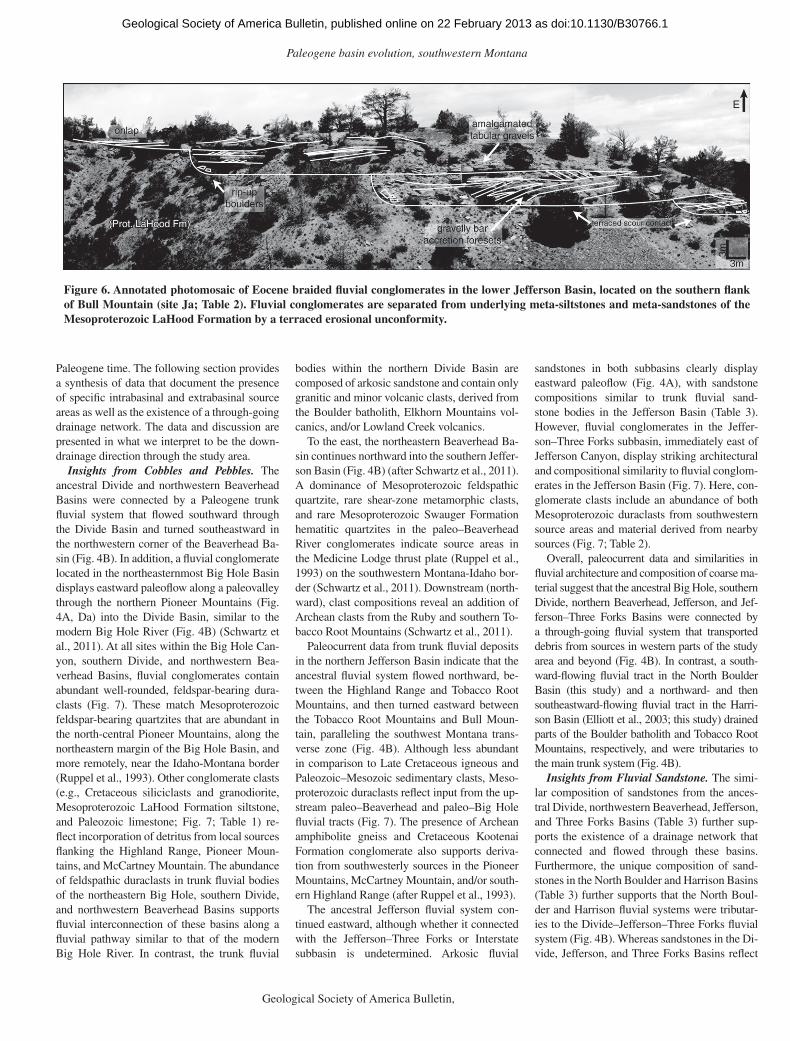
distal to basin-margin facies without necessar-ily implying those deeply buried within modern basin tracts. These facies include braided to anastomosing fl uvial conglomerates and sand-stones, crevasse-splay sandstones, overbank mudstones and paleosols, and lacustrine-palus-trine mudstones and limestones (Fig. 5; Table 1). Braided-fl uvial conglomerates lie in direct, incisional contact with pre-Cenozoic bedrock, resulting in terraced erosional unconformities (Fig. 6). Such facies are exposed in the Divide, northern Beaverhead, Jefferson, North Boulder, Harrison (Elliott et al., 2003; this study), Three Forks, and Townsend Basins (Michalak and Schwartz, 2011). Trunk fl uvial facies also ac-count for much of the coarse-grained material in the exposed Renova sequences, but they have traditionally been considered volumetrically minor in comparison to fi ner-grained mudstones and paleosols (Fields et al., 1985). This study in-dicates that coarse fl uvial facies are more com-mon than previously suggested.
Spatial Distribution and Provenance of Basin-Interior Fluvial Facies
Compositional Properties of Cobbles and Pebbles. Paleogene fl uvial deposits in the north-eastern Big Hole, Divide, northwest and north-east Beaverhead, Jefferson, and Jefferson–Three
Forks Basins contain polymictic cobbles and peb-bles in a gray to tan, medium- to coarse-grained sand matrix (e.g., Fig. 5B). Pebbles, cobbles, and rare boulders consist primarily of well-rounded duraclasts of Mesoproterozoic and Paleozoic origin, as well as diagnostic, more locally derived clasts such as Mesoproterozoic LaHood Forma-tion siltstones and graywackes; Paleozoic lime-stone, chert, and sandstone; Early Cretaceous Kootenai Formation conglomerate and lithic sandstone; Late Cretaceous Elkhorn Mountains volcanics and granodiorite; and Eocene Dillon–Melrose–Lowland Creek volcanics (Fig. 7; Table 2). Arkosic fl uvial sandstones in the Divide and North Boulder Basins contain minor quartzofeld-spathic crystalline pebbles and cobbles, whereas fl uvial pebble conglomerates in the Harrison Ba-sin contain abundant Late Cretaceous granitic, Paleozoic limestone and sandstone, and Archean metamorphic clasts (Table 2).
Compositional Properties of Fluvial Sand-stone. Other than in the northeastern Beaverhead Basin, Paleogene fl uvial sandstones, including the sandstone matrix of conglomerates, are arkoses to lithic arkoses (Fig. 8) (after Folk, 1974). Fluvial sandstones and conglomerates in the northeast-ern Beaverhead Basin are lithic rich and refl ect a distinctly different provenance (Schwartz et al., 2011). However, the provenance signatures from all sites indicate derivation from a dissected arc (Fig. 8) (Dickinson et al., 1983). Table 3 displays the average composition of fl uvial sandstones for all basins except the northeastern Beaverhead Ba-sin. Individual grains are angular to subrounded, and may be cemented by silica (chalcedony), sparry calcite, and/or kaolinite. Quartz, feldspar, and plutonic lithic grains constitute an average of 96% of all sand-sized material. Quartz grains are predominantly monocrystalline, with minor polycrystalline grains. Rutile and tourmaline inclusions are common. Euhedral to subhedral, non- to slightly undulose volcanic quartz grains with curvilinear grain boundaries also occur, but these are minor in comparison to anhedral, inclusion-bearing monocrystalline grains. Feld-spars include plagioclase and orthoclase, as well as microcline in some basins. Myrmekite and perthite textures are relatively common. Plagio-clase grains typically exhibit sericite overgrowth, and some orthoclase grains display kaolinization of grain boundaries. The types and abundances of volcanic, sedimentary, and metamorphic lithic grains vary (Table 3).
Paleogeographic Implications of Trunk Fluvial Facies
Paleodispersal patterns (Fig. 4A) and prov-enance (Fig. 7; Tables 2 and 3) of trunk fl uvial facies indicate the existence of an intercon-nected, interbasinal drainage network during
as doi:10.1130/B30766.1Geological Society of America Bulletin, published online on 22 February 2013

Schwartz and Schwartz
12 Geological Society of America Bulletin, Month/Month 2012
Figure 5. Photographs of basin-interior facies. (A) Braided fl uvial conglomerate in scour contact with deformed Mesoproterozoic LaHood Formation siltstone. (B) Braided fl uvial cobble conglomerate with interbedded wedges of trough cross-stratifi ed sandstone. (C) Stacked braided fl uvial sandstone bodies displaying large-scale tangential cross-stratifi cation. (D) Isolated fl uvial sandstone body encased in thick overbank mudstone and paleosols; channel body is ~6 m thick. (E) Miocene small-scale isolated fl uvial sandstone body encased in thick overbank mudstone; backpack for scale. (F) Stacked calcic paleosols. Jacob staff in A–C and F is 1.5 m.
as doi:10.1130/B30766.1Geological Society of America Bulletin, published online on 22 February 2013
Paleogene basin evolution, southwestern Montana
Geological Society of America Bulletin, Month/Month 2012 13
Paleogene time. The following section provides a synthesis of data that document the presence of specifi c intrabasinal and extrabasinal source areas as well as the existence of a through-going drainage network. The data and discussion are presented in what we interpret to be the down-drainage direction through the study area.
Insights from Cobbles and Pebbles. The ancestral Divide and northwestern Beaverhead Basins were connected by a Paleogene trunk fl uvial system that fl owed southward through the Divide Basin and turned southeastward in the northwestern corner of the Beaverhead Ba-sin (Fig. 4B). In addition, a fl uvial conglomerate located in the northeasternmost Big Hole Basin displays eastward paleofl ow along a paleovalley through the northern Pioneer Mountains (Fig. 4A, Da) into the Divide Basin, similar to the modern Big Hole River (Fig. 4B) (Schwartz et al., 2011). At all sites within the Big Hole Can-yon, southern Divide, and northwestern Bea-verhead Basins, fl uvial conglomerates contain abundant well-rounded, feldspar-bearing dura-clasts (Fig. 7). These match Mesoproterozoic feldspar-bearing quartzites that are abundant in the north-central Pioneer Mountains, along the northeastern margin of the Big Hole Basin, and more remotely, near the Idaho-Montana border (Ruppel et al., 1993). Other conglomerate clasts (e.g., Cretaceous siliciclasts and granodiorite, Mesoproterozoic LaHood Formation siltstone, and Paleozoic limestone; Fig. 7; Table 1) re-fl ect incorporation of detritus from local sources fl anking the Highland Range, Pioneer Moun-tains, and McCartney Mountain. The abundance of feldspathic duraclasts in trunk fl uvial bodies of the northeastern Big Hole, southern Divide, and northwestern Beaverhead Basins supports fl uvial interconnection of these basins along a fl uvial pathway similar to that of the modern Big Hole River. In contrast, the trunk fl uvial
bodies within the northern Divide Basin are composed of arkosic sandstone and contain only granitic and minor volcanic clasts, derived from the Boulder batholith, Elkhorn Mountains vol-canics, and/or Lowland Creek volcanics.
To the east, the northeastern Beaverhead Ba-sin continues northward into the southern Jeffer-son Basin (Fig. 4B) (after Schwartz et al., 2011). A dominance of Mesoproterozoic feldspathic quartzite, rare shear-zone metamorphic clasts, and rare Mesoproterozoic Swauger Formation hematitic quartzites in the paleo–Beaverhead River conglomerates indicate source areas in the Medicine Lodge thrust plate (Ruppel et al., 1993) on the southwestern Montana-Idaho bor-der (Schwartz et al., 2011). Downstream (north-ward), clast compositions reveal an addition of Archean clasts from the Ruby and southern To-bacco Root Mountains (Schwartz et al., 2011).
Paleocurrent data from trunk fl uvial deposits in the northern Jefferson Basin indicate that the ancestral fl uvial system fl owed northward, be-tween the Highland Range and Tobacco Root Mountains, and then turned eastward between the Tobacco Root Mountains and Bull Moun-tain, paralleling the southwest Montana trans-verse zone (Fig. 4B). Although less abundant in comparison to Late Cretaceous igneous and Paleozoic–Mesozoic sedimentary clasts, Meso-proterozoic duraclasts refl ect input from the up-stream paleo–Beaverhead and paleo–Big Hole fl uvial tracts (Fig. 7). The presence of Archean amphibolite gneiss and Cretaceous Kootenai Formation conglomerate also supports deriva-tion from southwesterly sources in the Pioneer Mountains, McCartney Mountain, and/or south-ern Highland Range (after Ruppel et al., 1993).
The ancestral Jefferson fl uvial system con-tinued eastward, although whether it connected with the Jefferson–Three Forks or Interstate subbasin is undetermined. Arkosic fl uvial
sandstones in both subbasins clearly display eastward paleofl ow (Fig. 4A), with sandstone compositions similar to trunk fl uvial sand-stone bodies in the Jefferson Basin (Table 3). However, fl uvial conglomerates in the Jeffer-son–Three Forks subbasin, immediately east of Jefferson Canyon, display striking architectural and compositional similarity to fl uvial conglom-erates in the Jefferson Basin (Fig. 7). Here, con-glomerate clasts include an abundance of both Mesoproterozoic duraclasts from southwestern source areas and material derived from nearby sources (Fig. 7; Table 2).
Overall, paleocurrent data and similarities in fl uvial architecture and composition of coarse ma-terial suggest that the ancestral Big Hole, southern Divide, northern Beaverhead, Jefferson, and Jef-ferson–Three Forks Basins were connected by a through-going fl uvial system that transported debris from sources in western parts of the study area and beyond (Fig. 4B). In contrast, a south-ward-fl owing fl uvial tract in the North Boulder Basin (this study) and a northward- and then southeastward-fl owing fl uvial tract in the Harri-son Basin (Elliott et al., 2003; this study) drained parts of the Boulder batholith and Tobacco Root Mountains, respectively, and were tributaries to the main trunk system (Fig. 4B).
Insights from Fluvial Sandstone. The simi-lar composition of sandstones from the ances-tral Divide, northwestern Beaverhead, Jefferson, and Three Forks Basins (Table 3) further sup-ports the existence of a drainage network that connected and fl owed through these basins. Furthermore, the unique composition of sand-stones in the North Boulder and Harrison Basins (Table 3) further supports that the North Boul-der and Harrison fl uvial systems were tributar-ies to the Divide–Jefferson–Three Forks fl uvial system (Fig. 4B). Whereas sandstones in the Di-vide, Jefferson, and Three Forks Basins refl ect
Figure 6. Annotated photomosaic of Eocene braided fl uvial conglomerates in the lower Jefferson Basin, located on the southern fl ank of Bull Mountain (site Ja; Table 2). Fluvial conglomerates are separated from underlying meta-siltstones and meta-sandstones of the Mesoproterozoic LaHood Formation by a terraced erosional unconformity.
as doi:10.1130/B30766.1Geological Society of America Bulletin, published online on 22 February 2013

Schwartz and Schwartz
14 Geological Society of America Bulletin, Month/Month 2012
0
20
40
60
80
100
1 2 3 4 5 6 7 8 9 10 11
com
posi
tion
(%)
0
20
40
60
80
100
1 2 3 4 5 6 7 8 9 10 11
com
posi
tion
(%)
0
20
40
60
80
100
1 2 3 4 5 6 7 8 9 10 11
com
posi
tion
(%)
0
20
40
60
80
100
1 2 3 4 5 6 7 8 9 10 11
com
posi
tion
(%)
0
20
40
60
80
100
1 2 3 4 5 6 7 8 9 10 11
com
posi
tion
(%)
Site
Da
Site
Db
Site
Dc
Site
BH
aS
ite B
Hb
Site
Ja
Site
Jb
Site
JTa
Site
JT
bS
ite J
Tc
0
20
40
60
80
100
1 2 3 4 5 6 7 8 9 10 11
com
posi
tion
(%)
0
20
40
60
80
100
1 2 3 4 5 6 7 8 9 10 11
com
posi
tion
(%)
0
20
40
60
80
100
1 2 3 4 5 6 7 8 9 10 11
com
posi
tion
(%)
0
20
40
60
80
100
1 2 3 4 5 6 7 8 9 10 11
com
posi
tion
(%)
1 2 3 4 5 6 7 8 9 10 11
Divide Basin
Beaverhead BasinJefferson Basin
Jefferson-Three Forks subbasinBig Hole Canyon
E/S
E p
aleo
flow
sout
hwar
d pa
leof
low
SE/E paleoflow
nort
hwar
d th
en e
astw
ard
pale
oflo
w*local dilution of Proterozoic Ss (10) *local dilution of Proterozoic Ss (10) by integration of Mz/Pz (5, 6) by integration of Mz/Pz (5, 6) clasts clasts
*local dilution of Proterozoic Ss (10) by integration of Mz/Pz (5, 6) clasts
*progressive incorporation of *progressive incorporation of non-Proterozoic Ss (10) non-Proterozoic Ss (10) sourcessources
*progressive incorporation of non-Proterozoic Ss (10) sources
*well-mixed clast populations
Clast Key:1 - massive quartz or feldspar2 - Eocene volcanics3 - Cretaceous granitoids4 - Cretaceous (Elkhorn) volcanics
5 - Cretaceous sedimentary (Kootenai Fm, etc.)6 - Paleozoic limestone7 - Paleozoic chert8 - Paleozoic/Proterozoic quartz arenite
9 - Mesoproterozoic LaHood Fm10 - Mesoproterozoic feldspathic quartzite (Belt Supergroup)11 - Archean metamorphics
*Cret. granitoids (3) contain both *Cret. granitoids (3) contain both muscovite and biotitemuscovite and biotite*Cret. granitoids (3) contain both muscovite and biotite
0
20
40
60
80
100
com
posi
tion
(%)
Figure 7. Histograms displaying the interbasinal trends in the composition of cobbles and pebbles in trunk fl uvial cobble conglomerates. Histograms are arranged to depict how composition changes in the interpreted downstream direction, beginning in the Big Hole Canyon and Divide Basin. The relative proportion of Mesoproterozoic feldspathic quartzites (Belt Supergroup) decreases downstream as mate-rial is added from other, locally derived Cenozoic, Mesozoic (Ms), Paleozoic (Pz), and Archean sources. Ss—sandstone.
as doi:10.1130/B30766.1Geological Society of America Bulletin, published online on 22 February 2013
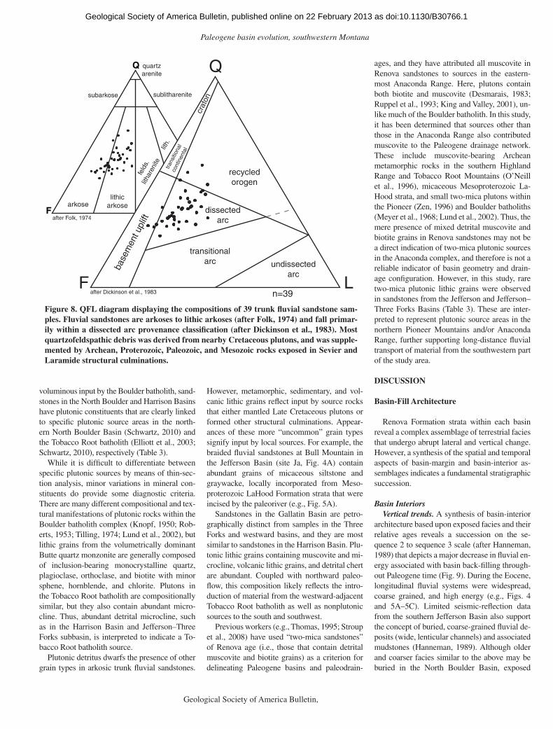
Paleogene basin evolution, southwestern Montana
Geological Society of America Bulletin, Month/Month 2012 15
voluminous input by the Boulder batholith, sand-stones in the North Boulder and Harrison Basins have plutonic constituents that are clearly linked to specifi c plutonic source areas in the north-ern North Boulder Basin (Schwartz, 2010) and the Tobacco Root batholith (Elliott et al., 2003; Schwartz, 2010), respectively (Table 3).
While it is diffi cult to differentiate between specifi c plutonic sources by means of thin-sec-tion analysis, minor variations in mineral con-stituents do provide some diagnostic criteria. There are many different compositional and tex-tural manifestations of plutonic rocks within the Boulder batholith complex (Knopf, 1950; Rob-erts, 1953; Tilling, 1974; Lund et al., 2002), but lithic grains from the volumetrically dominant Butte quartz monzonite are generally composed of inclusion-bearing monocrystalline quartz, plagioclase, orthoclase, and biotite with minor sphene, hornblende, and chlorite. Plutons in the Tobacco Root batholith are compositionally similar, but they also contain abundant micro-cline. Thus, abundant detrital microcline, such as in the Harrison Basin and Jefferson–Three Forks subbasin, is interpreted to indicate a To-bacco Root batholith source.
Plutonic detritus dwarfs the presence of other grain types in arkosic trunk fl uvial sandstones.
However, metamorphic, sedimentary, and vol-canic lithic grains refl ect input by source rocks that either mantled Late Cretaceous plutons or formed other structural culminations. Appear-ances of these more “uncommon” grain types signify input by local sources. For example, the braided fl uvial sandstones at Bull Mountain in the Jefferson Basin (site Ja, Fig. 4A) contain abundant grains of micaceous siltstone and graywacke, locally incorporated from Meso-proterozoic LaHood Formation strata that were incised by the paleoriver (e.g., Fig. 5A).
Sandstones in the Gallatin Basin are petro-graphically distinct from samples in the Three Forks and westward basins, and they are most similar to sandstones in the Harrison Basin. Plu-tonic lithic grains containing muscovite and mi-crocline, volcanic lithic grains, and detrital chert are abundant. Coupled with northward paleo-fl ow, this composition likely refl ects the intro-duction of material from the westward-adjacent Tobacco Root batholith as well as nonplutonic sources to the south and southwest.
Previous workers (e.g., Thomas, 1995; Stroup et al., 2008) have used “two-mica sandstones” of Renova age (i.e., those that contain detrital muscovite and biotite grains) as a criterion for delineating Paleogene basins and paleodrain-
n=39
feld
s. li
thar
enite
lith.
arkoselithic
arkose
subarkose sublitharenite
quartz arenite
after Folk, 1974
Q
LF
Q
LF
recycled orogen
dissected arc
transitional arc undissected
arc
base
men
t upl
ift
crat
on
trans
ition
al
cont
inen
tal
after Dickinson et al., 1983
Figure 8. QFL diagram displaying the compositions of 39 trunk fl uvial sandstone sam-ples. Fluvial sandstones are arkoses to lithic arkoses (after Folk, 1974) and fall primar-ily within a dissected arc provenance classifi cation (after Dickinson et al., 1983). Most quartzofeldspathic debris was derived from nearby Cretaceous plutons, and was supple-mented by Archean, Proterozoic, Paleozoic, and Mesozoic rocks exposed in Sevier and Laramide structural culminations.
ages, and they have attributed all muscovite in Renova sandstones to sources in the eastern-most Anaconda Range. Here, plutons contain both biotite and muscovite (Desmarais, 1983; Ruppel et al., 1993; King and Valley, 2001), un-like much of the Boulder batholith. In this study, it has been determined that sources other than those in the Anaconda Range also contributed muscovite to the Paleogene drainage network. These include muscovite-bearing Archean metamorphic rocks in the southern Highland Range and Tobacco Root Mountains (O’Neill et al., 1996), micaceous Mesoproterozoic La-Hood strata, and small two-mica plutons within the Pioneer (Zen, 1996) and Boulder batholiths (Meyer et al., 1968; Lund et al., 2002). Thus, the mere presence of mixed detrital muscovite and biotite grains in Renova sandstones may not be a direct indication of two-mica plutonic sources in the Anaconda complex, and therefore is not a reliable indicator of basin geometry and drain-age confi guration. However, in this study, rare two-mica plutonic lithic grains were observed in sandstones from the Jefferson and Jefferson–Three Forks Basins (Table 3). These are inter-preted to represent plutonic source areas in the northern Pioneer Mountains and/or Anaconda Range, further supporting long-distance fl uvial transport of material from the southwestern part of the study area.
DISCUSSION
Basin-Fill Architecture
Renova Formation strata within each basin reveal a complex assemblage of terrestrial facies that undergo abrupt lateral and vertical change. However, a synthesis of the spatial and temporal aspects of basin-margin and basin-interior as-semblages indicates a fundamental stratigraphic succession.
Basin InteriorsVertical trends. A synthesis of basin-interior
architecture based upon exposed facies and their relative ages reveals a succession on the se-quence 2 to sequence 3 scale (after Hanneman, 1989) that depicts a major decrease in fl uvial en-ergy associated with basin back-fi lling through-out Paleogene time (Fig. 9). During the Eocene, longitudinal fl uvial systems were widespread, coarse grained, and high energy (e.g., Figs. 4 and 5A–5C). Limited seismic-refl ection data from the southern Jefferson Basin also support the concept of buried, coarse-grained fl uvial de-posits (wide, lenticular channels) and associated mudstones (Hanneman, 1989). Although older and coarser facies similar to the above may be buried in the North Boulder Basin, exposed
as doi:10.1130/B30766.1Geological Society of America Bulletin, published online on 22 February 2013

Schwartz and Schwartz
16 Geological Society of America Bulletin, Month/Month 2012
Eocene facies in that basin document a lower-energy, bank-stable, anastomosing fl uvial sys-tem with laterally confi ned channels.
During the Oligocene and into the early Mio-cene, subtle to pronounced changes in fl uvial style occurred within each paleobasin. In the Divide Basin, the cobble-dominated braided fl uvial system that existed during Eocene time was replaced by a sand- and granule-dominated braided fl uvial system that became increasingly confi ned by fi ner-grained overbank facies. Flu-vial systems in the eastward-adjacent Jefferson, Three Forks, and Gallatin Basins transitioned from higher-energy braided to more bank- stable, anastomosing fl uvial systems dominated by deposition of fi ne-grained overbank and la-custrine material. This transition is marked by a decrease in the dimensions and clustering of fl uvial bodies and a corresponding increase in fi ne-grained overbank deposits and paleosols (Fig. 9). Maximum grain size of trunk fl uvial deposits decreases from cobbles and pebbles to granules and sand with a substantial amount of entrained mud. The North Boulder Basin, which contained a lower-energy fl uvial system during Eocene time, retained this style into the earliest Miocene. However, deposition of fi ne-grained material became increasingly dominant and channels became progressively smaller, fi ner grained, muddier, and more poorly developed (e.g., Figs. 5D and 5E).
Lateral trends. A comparison of roughly contemporaneous basin-interior facies through the network of Paleogene basins also indicates a lateral change in fl uvial style and associated depositional facies. The trunk fl uvial system in the Divide Basin to the west was laterally widespread and locally conglomeratic during the Oligocene and early Miocene. During this time, nearby basins to the east were occupied by lower-energy fl uvial systems with isolated chan-nels, relatively extensive fl oodplains, and locally ponded areas. Oligocene and early Miocene ba-sin-interior deposits in the Townsend Basin are almost entirely mud dominated with abundant fl oodplain and lacustrine facies and relatively few isolated fi ne-grained fl uvial facies (Vuke, 2011; S. Vuke, 2009, personal commun.). The overall lateral trend represents a substantial de-crease in gradient and fl uvial energy as would naturally occur with progressive westward (up-stream) back-fi lling of the paleobasins.
Basin MarginsTwo fundamentally different basin-margin
successions are recognizable. These include relatively large-scale (e.g., >100 m thick) upward-coarsening successions associated with alluvial-fan progradation and smaller-scale (e.g., 5–20 m thick) upward-fi ning successions
TAB
LE 3
. AV
ER
AG
E C
OM
PO
SIT
ION
OF
TR
UN
K F
LUV
IAL
SA
ND
STO
NE
S IN
EA
CH
PA
LEO
BA
SIN
TR
AC
T
Bas
inN
o. o
f thi
n se
ctio
ns%
Q
avg
%F
av
g%
L av
gV
olca
nic
lithi
c gr
ains
Sed
imen
tary
lith
ic g
rain
sM
etam
orph
ic li
thic
gr
ains
Not
es
Div
ide
and
Nor
th
Bea
verh
ead
842
4414
Mic
rocr
ysta
lline
(pl
agio
clas
e la
ths)
; por
phyr
ies
cont
aini
ng
plag
iocl
ase,
bio
tite,
and
/or
quar
tz p
heno
crys
ts
Sha
le, m
icac
eous
qua
rtz
sand
ston
e, s
ilice
ous
mud
ston
e,
quar
tz a
reni
te, d
etrit
al c
hert
(r
are)
, mic
rite
(rar
e)
Met
a-sh
ale,
qua
rtz-
mus
covi
te s
chis
t, qu
artz
-bio
tite-
mus
covi
te s
chis
t
Abu
ndan
ce o
f vol
cani
c lit
hic
grai
ns d
ecre
ases
fr
om n
orth
to s
outh
alo
ng fl
uvia
l tra
ct. D
etrit
al
mus
covi
te is
abu
ndan
t rel
ativ
e to
adj
acen
t ba
sins
. Rar
e tw
o-m
ica
plu
ton
ic g
rain
s.
Jeffe
rson
838
4616
Mic
rocr
ysta
lline
(pl
agio
clas
e la
ths)
; por
phyr
ies
cont
aini
ng
plag
iocl
ase
phen
ocry
sts
Qua
rtz
aren
ite, k
aolin
ite, s
ilice
ous
mud
ston
e, m
icac
eous
sa
ndst
one,
det
rital
che
rt, m
icrit
e (r
are)
, dol
omite
(ra
re)
Met
a-sh
ale,
met
a-sa
ndst
one,
qua
rtz-
biot
ite s
chis
t, qu
artz
-m
usco
vite
sch
ist
Mus
covi
te is
abu
ndan
t rel
ativ
e to
adj
acen
t bas
ins,
bu
t not
as
abun
dant
as
in D
ivid
e B
asin
. Rar
e tw
o-m
ica
plu
ton
ic g
rain
s.
Jeffe
rson
–T
hree
For
ks8
3942
19
Mic
rocr
ysta
lline
(pl
agio
clas
e la
ths)
, aph
aniti
c w
elde
d tu
ff, p
orph
yrie
s co
ntai
ning
pl
agio
clas
e an
d/or
bio
tite
phen
ocry
sts
Qua
rtz
aren
ite, m
icac
eous
qua
rtz
sand
ston
e, d
etrit
al c
hert
, si
liceo
us m
udst
one,
kao
linite
, m
icrit
e (r
are)
, dol
omite
(ra
re)
Met
a-sh
ale,
qua
rtz-
biot
ite s
chis
t, qu
artz
-m
usco
vite
sch
ist
Rel
ativ
ely
abun
dant
mic
rocl
ine
com
pare
d to
w
estw
ard-
adja
cent
bas
ins.
Rar
e tw
o-m
ica
plu
ton
ic g
rain
s. S
ampl
es a
long
Mad
ison
Riv
er
have
a r
elat
ive
abun
danc
e of
det
rital
che
rt a
nd
plut
onic
lith
ic g
rain
s co
ntai
ning
mus
covi
te a
nd
mic
rocl
ine.
Inte
rsta
te3
3845
17
Mic
rocr
ysta
lline
(pl
agio
clas
e la
ths)
, por
phyr
ies
cont
aini
ng
plag
iocl
ase
and/
or b
iotit
e ph
enoc
ryst
s
Kao
linite
, qua
rtz
sand
ston
e,
dolo
mite
(ra
re)
xN
o de
trita
l mic
rocl
ine,
mic
rocl
ine-
bear
ing
plut
onic
lit
hic
grai
ns, o
r de
trita
l mus
covi
te.
Nor
th B
ould
er9
3846
16
Mic
rocr
ysta
lline
(pl
agio
clas
e la
ths)
, aph
aniti
c w
elde
d tu
ff, p
orph
yrie
s co
ntai
ning
pl
agio
clas
e an
d/or
bio
tite
phen
ocry
sts
Sili
ceou
s m
udst
one,
kao
linite
, qu
artz
are
nite
(ra
re),
mic
rite
and
dolo
mite
(ra
re),
det
rital
ch
ert (
rare
), m
icac
eous
qua
rtz
sand
ston
e (r
are)
x
No
plag
iocl
ase
in E
ocen
e R
ed H
ill m
ap u
nit fl
uvi
al
sand
ston
es; r
efl e
cts
alas
kitic
sou
rces
in th
e E
lkho
rn M
ount
ains
and
Bou
lder
, Mon
tana
, are
a (S
chw
artz
, 201
0).
Har
rison
235
5015
xM
icrit
e (r
are)
, sha
le (
rare
)Q
uart
z-bi
otite
sch
ist,
amph
ibol
ite
Rel
ativ
ely
abun
dant
met
amor
phic
lith
ic g
rain
s.
Abu
ndan
t mic
rocl
ine;
refl
ect
s a
Toba
cco
Roo
t ba
thol
ith s
ourc
e (E
lliot
t et a
l., 2
003;
this
stu
dy).
as doi:10.1130/B30766.1Geological Society of America Bulletin, published online on 22 February 2013

Paleogene basin evolution, southwestern Montana
Geological Society of America Bulletin, Month/Month 2012 17
associated with lower-slope and alluvial-plain onlap of paleohillslopes.
The larger-scale, upward-coarsening succes-sions are present along basin margins where large alluvial fans developed at the mouths of pa-leovalley tracts in adjacent highlands. Examples include the Palisades Cliffs area (Fig. 4A, J4), where Orellan overbank and lacustrine mudstone and small, channelized, distal-fan debris fl ows are overlain by coarse Arikareean (A. Tabrum, 2008, personal commun.) debris, sheet, and mud fl ows, as well as coarse fan-channel facies. A
similar upward-coarsening succession is pres-ent along the Big Belt Mountains in the south-ern Townsend Basin (Michalak and Schwartz, 2011). At several locations within the study area, erosional remnants of Paleogene and superposed Neogene alluvial-fan deposits indicate that some of the Paleogene fans extended across the full width of a paleo–intermontane basin.
The smaller-scale, upward-fi ning succes-sions associated with paleohillslope settings are present both along basin margins and along paleovalley tracts within adjacent highlands. In
these areas, coarse colluvium and proximal fan facies that are in depositional contact with pre-Cenozoic bedrock are overlain by mudstone of the onlapping lower slope or alluvial plain.
Basin Evolution
The results of this study have many implica-tions for the topographic and tectonic evolution of southwestern Montana and can therefore be used to evaluate some of the various hypotheses for intermontane basin origin.
mud m
d-xr
s
sand pe
b &
cob
bould
.
mud m
d-xr
s
sand pe
b &
cob
bould
.
mud m
d-xr
s
sand pe
b &
cob
bould
.
Basin-Margin Basin-Interior
basinward
e.g.
, 5-1
0 m
pre-Tertiary bedrock
T/HC
SF
SF
SF
SF
SF
SF
SFDF
DF
DF
DF
DF
MF
MF
Braided Fluvial
Anastomosing Fluvial
F/P
F/P
F/P
F/P
F/P
L-PL-P
Figure 9. Schematic stratigraphic sections drawn to depict the possible vertical and lateral facies changes within the Paleogene basins, with an emphasis on coarse-grained facies. In reality, there is a much larger volume of fi ner-grained fl oodplain and lacustrine facies (after Fields et al., 1985). Refer to Table 1 for facies descriptions. Basin-margin depositional elements (left) include talus and hillslope colluvium (T/HC), debris fl ows (DF), mud fl ows (MF), sheet fl ows (SF), and fan-associated channels. Basin-margin facies interfi nger with fl uvial and fl oodplain facies into the basin (center). Basin-interior depositional elements (right) include widespread (braided) fl u-vial conglomerates and sandstones, isolated (anastomosing) fl uvial sandstones, crevasse splays, fl oodplain mudstones and paleosols (F/P), and lacustrine-palustrine deposits (L-P). Eocene fl uvial systems were predominantly braided and evolved into smaller, more anastomosing-like fl uvial systems in the Oligocene and earliest Miocene. md-xrs—medium to coarse.
as doi:10.1130/B30766.1Geological Society of America Bulletin, published online on 22 February 2013

Schwartz and Schwartz
18 Geological Society of America Bulletin, Month/Month 2012
Renova Braidplain HypothesisThe Renova Formation ranges in thickness
from <1 m along the basin margins up to ~2.5 km in deeper parts of the basins (Richard, 1966; Hanneman, 1989; Rasmussen and Fields, 1983; Hanneman and Wideman, 1991). This recurring basin-fi ll geometry and the presence of basin-margin facies documenting divergent transport away from intervening paleohighlands clearly establish that a strongly three-dimensional to-pography existed during Paleogene time in southwestern Montana. Thus, the Paleogene landscape was not simply a subdued erosional surface blanketed by an apron of eastward-transported sediment (e.g., Fritz and Sears, 1993; Thomas, 1995; Fritz et al., 2007). All of the major highlands and intervening basins within the study area were present in the same location as today. Some exceptions include ar-eas where Neogene tectonics modifi ed the Pa-leogene topography, such as along the western margin of the Jefferson Canyon.
Extensional Tectonics and Rift Basin Hypothesis
The intermontane basins of southwestern Montana lie within an extensional province that originated during presumed gravitational col-lapse of the Cordilleran orogenic wedge. On the regional scale, there is compelling evidence for extension in eastern Idaho and western Montana beginning in the middle Eocene, perhaps < 2 m.y. following the end of contractional deformation (Constenius, 1996; Constenius et al., 2003). Some of the most convincing evidence for middle Eocene extensional tectonism includes normal faulting west and southwest of the study area, in eastern Idaho and southwesternmost Montana, as well as exhumation of the Anaconda, Priest River, and Bitterroot metamorphic core com-plexes (Coney and Harms, 1984; Constenius, 1996; O’Neill et al., 2004; Foster et al., 2007). Constenius et al. (2003) contended that the gra-bens developed along reactivated, basement-related faults as a regional network rather than discrete and isolated entities. Although a re-gional network of extensional basins is consis-tent with our interconnected drainage network, we later provide an alternative view on the role of regional tectonism in basin generation. Over-all, initial extension is interpreted to have been coeval with the extrusion of Eocene volcanic fi elds (sequence 1 time; Hanneman, 1989) and the onset of sequence 2 deposition (Kuenzi and Fields, 1971; Hanneman, 1989). Constenius et al. (2003) stated that the thick (e.g., 1–5 km) late Paleogene and Neogene stratal assemblages in grabens throughout the Cordilleran foreland are a product of downdropping and rotation of basin fi ll along listric normal faults, and, in turn, serve
as testimony to the exceptional accommodation and preservation potential of extensional basins.
In spite of evidence for early Paleogene ex-tension, our fi ndings strongly suggest that initial basin development and accommodation had a pre-extensional origin, rather than having been caused solely by extension.
Some New Constraints for a Basin Evolution Model
Our observations provide evidence for a net-work of basins interconnected by a through-go-ing fl uvial system that was fully established by the time of early Renova deposition (ca. 43 Ma). The basins were, for the most part, parallel to the structural fabric of Sevier and Laramide structures, including the transverse structures along the southern margin of the Helena Sa-lient. Basin-margin depositional facies plastered along present-day uplifts suggest that the di-mensions of the paleobasins were on the same scale as modern intermontane basins with ≥2 km paleorelief. Recent stable isotope paleoal-timetry studies have provided similar paleorelief estimates of 1.5–3 km (Dettman and Lohmann, 2000; Lielke, 2012), as well as evidence for Pa-leocene to early Eocene regional elevation gain of 2.5–3.5 km (Kent-Corson et al., 2006; Cham-berlain et al., 2012).
The composition of trunk fl uvial deposits provides much information regarding the tim-ing of source rock exposure and basin evolution. The paucity of Elkhorn Mountains volcanics detritus relative to the abundance of plutonic detritus in the oldest exposed fl uvial units of the Renova Formation is indicative of long-term up-lift and erosion prior to Renova deposition. By mid-Eocene time, much of the Elkhorn Moun-tains volcanics mass (originally 26,000 km2 and 4.6 km thick; Klepper and Smedes, 1959; Smedes, 1966; Robinson et al., 1968) had to have been stripped from the Boulder batholith region and was likely transported eastward (e.g., Gill and Cobban, 1973; Rice and Shurr, 1983). Dissection of this carapace exposed the batho-liths, as well as other metamorphic and sedimen-tary rocks in the Sevier and Laramide structural culminations. Although provenance and paleo-fl ow data for basin-margin facies unequivocally document fully exposed batholiths within the Highland Range, McCartney Mountain, and To-bacco Root Mountains, as well as in the Elkhorn Mountains (Chamberlin and Schwartz, 2011), other studies also confi rm batholith exposure by mid-Eocene time. Recent detrital zircon data document that the Boulder batholith served as a source for the Paleogene Divide, Jefferson, and North Boulder Basins (Stroup et al., 2008; Roth-fuss et al., 2009, 2012). In addition, facies and detrital zircon analyses from along the eastern
(Rothfuss et al., 2012; Weislogel et al., 2010; this study) and western (Roe, 2010) fl anks of the Pioneer Mountains document that the Pio-neer batholith provided detritus to the adjacent Beaverhead and Big Hole Basins. Furthermore, a granite cobble from a fl uvial conglomerate in the Harrison Basin yields a zircon age con-sistent with that of the Tobacco Root batholith (A. Weislogel, 2008, personal commun.), docu-menting that it was also exposed.
Another constraint on basin formation and the onset of deposition is that the unconformity-bounded sequences of Hanneman (1989) are correlative with sequence boundaries that ex-tend westward from the northern Great Plains to Washington and southward from southern Canada to Mexico (Cheney, 1994; Constenius et al., 2003; Hanneman and Wideman, 1991, 2006; Hanneman et al., 2003). This widespread distri-bution of Paleogene and Neogene sequences, well beyond the intermontane basins of south-western Montana and stretching across other structural provinces, contradicts the notion that the primary driver for Renova basin develop-ment and accommodation in southwestern Mon-tana was exclusively local extensional faulting. In other words, accommodation existed in spite of regional extension, and the synchronicity of extension and initial deposition was largely coincidental. This may have been the result of tectonism on a much larger, plate-tectonic scale, potentially resulting from mantle processes such as slab rollback or lithospheric delamination (e.g., Humphreys, 1995; Constenius et al., 2003; DeCelles, 2004; DeCelles et al., 2009).
Intermontane Fluvial Incision in Basin Generation
In addition to the previously presented factors that indicate controls on basin evolution beyond normal faulting, our results indicate that pre- extensional and predepositional erosion and in-cision by large fl uvial networks were of primary importance in constructing the Late Cretaceous to mid-Eocene landscape.
The concentration of coarse-grained fl uvial facies in the lower part of Renova sequence 2 (Hanneman, 1989) and their provenance docu-ment the early presence of high-energy fl uvial systems in the study area that had long-distance, through-going transport. This, in turn, indicates a phase of pre–middle Eocene, high-energy fl u-vial erosion into the orogenic wedge.
The basal Renova unconformity (Fig. 2) rep-resents the land surface prior to mid-Eocene deposition. Both geophysical and outcrop data support that Renova sediments were depos-ited within an erosional landscape that was deeply incised into pre-Cenozoic basement rock. Seismic refraction–based maps of the
as doi:10.1130/B30766.1Geological Society of America Bulletin, published online on 22 February 2013
Paleogene basin evolution, southwestern Montana
Geological Society of America Bulletin, Month/Month 2012 19
paleotopography beneath Paleogene fi ll in por-tions of the North Boulder and Three Forks Ba-sins document buried, valley-shaped profi les of two different scales that were incised into the basin fl oor (Burfi end, 1967; Richard, 1966). In many cases, basement contours defi ne inter-montane-scale paleovalley shapes with centrally to marginally located thalwegs. Paleovalley profi le shapes range from wide and round- or fl at-bottomed (over 1 km wide, up to 300 m valley-margin relief) to narrow and gorge-like (≤160 m wide, ~280 m deep; data of Richard, 1966). Similarly, Roe (2010) illustrated gravity-based profi les across the Big Hole Basin that are consistent with those of modern profi les of fl u-vially incised valleys. In addition to subsurface evidence for paleovalleys in these basins, ex-humed erosional surfaces are exposed along the fl anks of uplands that bound the modern basins. Here, Paleogene colluvial and alluvial facies clearly document lower-order tracts that served as tributaries to the larger paleovalleys. Overall, combined subsurface and outcrop data docu-ment an intermontane-scale erosional surface cut into pre-Cenozoic basement that includes steep to low-angle basin-margin slopes, basin-interior paleovalley tracts, and paleotributary tracts entering from adjacent uplifts.
Another factor consistent with this geophysi-cal evidence for pre-Cenozoic bedrock incision and paleovalley development is the preserva-tion of a Cretaceous paleovalley buried beneath the Late Cretaceous Elkhorn Mountains volca-nics in the southern Elkhorn Mountains. Here, Klepper et al. (1957) interpreted that deposi-tion of the Elkhorn Mountains volcanics fi lled a broad, deep, erosional valley that coincided with the axis of a syncline, with the axis of the syncline most likely controlling stream and paleovalley location. They further concluded that, subsequent to the intrusion of the Boulder batholith, the Elkhorn Mountains were subject to continuous erosion from Late Cretaceous to mid-Eocene time, that this erosion generated a mountainous, high-relief terrain that had the same basic confi guration as today, and that Pa-leogene and Neogene sediments later accumu-lated within this terrain.
Despite limited age data for rocks making up pre-Cenozoic basement in deep Paleogene ba-sins, existing age data are also consistent with deep erosion and removal of relatively younger strata along paleovalley tracts. The deeply bur-ied basin fl oors are interpreted to primarily con-sist of Precambrian rocks (after Wernicke, 1989; Ruppel, 1993) as well as Cretaceous intrusive (plutonic) rocks in some locales. Modern basin margins and intervening uplifts contain the same lithologies but also contain abundant Paleozoic and Mesozoic sedimentary rocks. Prolonged
erosion would reasonably account for the selec-tive removal of Paleozoic and Mesozoic strata within the paleovalley tracts, leaving a Precam-brian or Cretaceous plutonic paleovalley fl oor.
Given that our data indicate an interconnected basin system with intervening mountainous uplifts, it is implicit that, in some cases, longi-tudinal basin tracts were connected by rivers fl owing through gaps in uplifted areas, such as universally occurs in foreland drainage systems. Likely paleogaps include the main Big Hole River Canyon between the Big Hole and Di-vide Basins, the Big Hole River Canyon (Notch Bottom) in the Hogback ridge of the northern Beaverhead Basin, and the Jefferson Canyon between the Jefferson and Three Forks Basin, and possibly paleovalleys that incised highlands fl anking the paleo–Clarkston Basin (Fig. 1). In addition to connectivity being indicated by pa-leofl ow and compositional data, the Big Hole and Jefferson Canyons are marked by wider, up-lifted paleovalley profi les perched above those of the modern, narrow, steep-walled gorges.
Overall, parallelism among paleobasin geom-etries, paleodrainage pathways of major trunk fl uvial systems, and the Sevier-Laramide struc-tural grain indicates that the tectonostratigraphic framework for the Cordilleran orogenic wedge and adjacent Laramide foreland controlled in-cisional pathways during the latest Cretaceous and early Paleogene. Paleovalleys were pref-erentially incised along zones of structural and stratigraphic weakness, prior to extension and Paleogene deposition. Such incision and sub-sequent fi lling occur universally in modern and exhumed ancient foreland regions. Modern ana-logues include the eastern edge of the Andean fold-and-thrust belt in Bolivia, where recent work has documented the erosional response to regional uplift (e.g., Barnes et al., 2006; Gar-zione et al., 2006), and the mountain belts of Taiwan, where recent work has illustrated the importance of fl uvial incision and mass wasting in generating topography (e.g., Chen et al., 2001; Hartshorn et al., 2002; Schaller et al., 2005).
Reconciling Extension, Uplift, and Erosion
It is well recognized that the Neogene Sixmile Creek Formation is separated from the under-lying Renova Formation by the mid-Miocene (Hemingfordian) unconformity (Fig. 2). It is also widely accepted that local folding of Renova strata, development of the Hemingfordian un-conformity, and the initiation of Sixmile Creek deposition were temporally associated with Ba-sin and Range–related extensional events (begin-ning ca. 17 Ma) (Pardee, 1950; Reynolds, 1979; Fritz and Sears, 1993; Constenius, 1996; Sears and Ryan, 2003; Fritz et al., 2007). However, the
relative roles of earlier extension and erosion in the development of Paleogene intermontane ba-sins merit further consideration.
A fundamental consequence of uplift is an in-crease in erosion rate, particularly along zones of structural and stratigraphic susceptibility. This was undoubtedly the case with uplift associated with Sevier-Laramide contractional events, as well as with any subsequent regional tectonism. As was previously discussed, the pre-Cenozoic tectonostratigraphy strongly controlled early Pa-leogene erosion and incision. Preexisting zones of structural weakness also served as spatial controls on extensional reactivation (e.g., Fields et al., 1985; Ruppel, 1993; Constenius, 1996). Although Constenius (1996) clearly established the overall synchronicity of extensional defor-mation with early Renova deposition, it is clear that a prolonged period of erosion and incision preceded mid-Eocene extension in southwestern Montana (this study). Moreover, the magnitude of extensional deformation decreased eastward across the eastern Idaho and southwestern Mon-tana region, becoming progressively more ob-scure beyond the eastern limit of the study area. Thus, the effect of Eocene extension upon relief and accommodation may have been signifi cantly less within our study area than suggested for westward locations (e.g., Portner et al., 2011). Therefore, we submit that during the latest Cre-taceous and early Paleogene, fl uvial incision was a primary mechanism for forming an intercon-nected network of large-scale paleovalleys that served as primary depocenters (basins) through-out Cenozoic time.
It is beyond the scope of this paper to assess the many models for the tectonic and topo-graphic evolution of the latest Cretaceous to Eocene Cordillera (e.g., Humphreys, 1995; De-Celles et al., 2009; Chamberlain et al., 2012). However, our fi ndings do have important impli-cations for assessing the larger-scale processes that may have controlled the topographic evolu-tion of southwestern Montana. These implica-tions, in turn, can lend important insight into the evolution of postcontractional retroforeland systems in general. The widespread existence of the major Cenozoic unconformities (early Eocene and mid-Miocene) and widespread ini-tiation of Paleogene and Neogene depositional intervals across the northwestern United States (e.g., Hanneman and Wideman, 1991) suggest continental-scale allocyclic controls, rather than basin-specifi c faulting or local fl uctuations in base level.
On a fundamental level, deep incision and topographic development are dependent upon regional uplift, a corresponding decrease in base level, and/or a climatic regime that promotes erosional rather than depositional processes.
as doi:10.1130/B30766.1Geological Society of America Bulletin, published online on 22 February 2013
Schwartz and Schwartz
20 Geological Society of America Bulletin, Month/Month 2012
It is widely accepted that Sevier and Laramide events generated regional (e.g., the fold-and-thrust belt) and local (e.g., intraforeland uplifts) topographic elements. Recent work has also suggested that, during or shortly following the end of Sevier and Laramide tectonism, there was widespread, tectonically driven surface uplift and kilometer-scale elevation gain (e.g., Kent-Corson et al., 2006; Chamberlain et al., 2012). Assuming that this area was externally drained, surface uplift would certainly have caused a decrease in base level, thereby promot-ing fl uvial incision.
Major Paleogene and early Eocene erosional landscape development also bears a strong temporal relationship with well-documented climatic change. Climatic shifts can infl uence the dominance of erosional versus depositional processes by infl uencing the ratio of water sup-ply to sediment supply (Tucker and Slingerland, 1997). An increase in the water-sediment ratio encourages fl uvial incision, while a decrease in the water-sediment ratio encourages sedimentary aggradation (McMillan et al., 2006). Deep-sea cores reveal that during the Late Cretaceous and into the early Eocene (ca. 65–51 Ma), a global trend of increasingly warm and humid (subtropi-cal) conditions was followed by cooler, yet still subtropical, conditions through the middle Eo-cene (ca. 51–42 Ma; Fig. 2) (Zachos et al., 2001). Global cooling continued through the late Eo-cene (ca. 42–34 Ma), followed by abrupt cooling and aridifi cation at the Eocene-Oligocene bound-ary (ca. 34 Ma; Fig. 2) (Zachos et al., 2001). Lithologic, fl oral, vertebrate paleontological, clay mineral, and geochemical data from south-western Montana and the Western Interior region mimic the global paleotemperature record. These data document a long-lived subtropical climate during the Late Cretaceous and Paleocene, punc-tuated warming at the Paleocene-Eocene bound-ary (the Paleocene-Eocene thermal maximum), and overall cooling and aridifi cation into the late Eocene (e.g., Dorf, 1960; Thompson et al., 1982; Retallack, 1983; Fields et al., 1985; Retal-lack et al., 1987; Hanneman, 1989; Prothero and Heaton, 1996; Axelrod, 1998; Koch et al., 2003; Bowen et al., 2004). Overall, both global and re-gional data support a long-term warm and wet climate from the Late Cretaceous to early Eocene followed by a cooler and drier climate in the late Eocene and Oligocene.
In the context of our work, deposition of the Renova Formation occurred shortly after tec-tonically driven surface uplift. While uplift oc-curred, subtropical climatic conditions in the Late Cretaceous and early Eocene would have prompted widespread erosion and fl uvial inci-sion into the orogenic wedge. The cessation of major uplift coincided with subsequent cli-
matic cooling and aridifi cation, which would have promoted fl uvial aggradation and basin back-fi lling.
Long-Lived Structural Controls on Sediment Dispersal
When compared to paleodrainage interpre-tations for the Early Cretaceous foreland in southwestern Montana, as well as Neogene and modern drainage pathways, our interpretation of the Paleogene drainage network bears a strik-ing resemblance. This suggests the existence of long-lived, recurring structural controls on drainage patterns (Fig. 10).
Fluvial drainage patterns in the Early Cre-taceous foreland of southwestern Montana were marked by longitudinal drainage systems that fl owed around emerging intraforeland up-lifts. Combined paleocurrent data from Walker (1974), Berkhouse (1985), and DeCelles (1986) document that primary drainages in the Early Cretaceous foreland region were north-ward along the foreland basin axis (Fig. 10A) (Schwartz and Vuke, 2006). During this time, at least some nascent Laramide intraforeland uplifts were in approximately the same loca-tions as some of the Paleogene highlands docu-mented in this study (Schwartz and DeCelles, 1988). These basement-cored structures, includ-ing the proto-Highland, proto–Tobacco Root, and proto-Madison uplifts, controlled drainage pathways in front of the fold-and-thrust belt that was encroaching from the west (Fig. 10A) (De-Celles, 1986; Schwartz and DeCelles, 1988).
An alternative interpretation can be made to DeCelles’ (1986) interpretation of southward paleofl ow in the proto–North Boulder Basin into Idaho (Fig. 10A). Although southward con-tinuation of the Early Cretaceous North Boulder drainage system into the northern Beaverhead Basin was originally interpreted (DeCelles, 1986, his fi gs. 8b and 17b), no Kootenai For-mation outcrop data are available to constrain southward interconnectivity between the High-land and Tobacco Root Laramide uplifts. It is equally probable that the southward drainage system was defl ected eastward along the south-west Montana transverse zone, as it was during the Paleogene (this study) and remains so today (Figs. 10A and 10D). In such a case, it is likely that the eastward-fl owing Early Cretaceous sys-tem eventually turned northward, as is indicated by Kootenai outcrop data in the western Big Belt Mountains (DeCelles, 1986).
The interpreted fl uvial network for Neogene time (Sears et al., 2009, and references within) also mimics that of the Paleogene (Figs. 10B and 10C). This suggests at least a 50 m.y. ancestry for much of the Missouri River headwater sys-
tem, accounting for the phase of fl uvial incision that preceded deposition of the Renova Forma-tion. It is not our claim that the Cretaceous and Cenozoic drainage systems were identical or had all of the same structural controls. However, large tectonic structures repeatedly infl uenced Cretaceous and Cenozoic drainage patterns, whether the structures were active in generating topography and accommodation (e.g., during the Cretaceous and Neogene; DeCelles, 1986; Schwartz and DeCelles, 1988; Sears et al., 2009; etc.) or were more passive topographic controls on fl uvial incision (this study).
CONCLUSIONS
In this study, we document paleotopography, paleodrainage patterns, and fl uvial aggrada-tion within a network of Paleogene basins that formed within the frontal fold-and-thrust belt region of southwestern Montana. This docu-mentation provides constraints for assessing postcompressional basin evolution, genera-tion of relief, and sedimentation, which in turn provide implications for the relative roles of tectonics, climate, and erosion in shaping the Cenozoic landscape.
This study provides a fi rst-time detailed syn-thesis of the diverse depositional facies and strati-graphic architecture of the Paleogene Renova Formation (sequences 2 and 3; Hanneman, 1989). The ages, distributions, and composi-tions of basin-margin alluvial and trunk fl uvial facies reveal a relict, largely erosional Paleogene landscape. Narrow, steep-walled canyons and V-shaped erosional paleovalleys, exhumed pa-leotributaries in adjacent uplands, the age distri-bution of pre-Cenozoic rocks making up basin fl oors, terraced erosional unconformities be-tween Renova strata and underlying rocks, col-luvium in depositional contact with steep-sloped basin margins, and coarse-grained, high-energy fl uvial deposits in the lower Renova Formation collectively testify to deep erosion by rivers prior to Eocene extension and deposition. The period of large-scale valley incision corresponds tem-porally with regional surface uplift closely fol-lowing the Sevier and Laramide orogenies, as well as a Late Cretaceous–early Eocene warm and humid climatic period. The parallelism of Paleogene basin axes, trunk fl uvial drainage systems, and the Sevier-Laramide structural fab-ric suggests strong control of the contractional fabric upon basin distribution and paleodrainage patterns. This does not exclude the role of exten-sional modifi cation of intermontane basins in the northern Rockies, but rather specifi es the impor-tant role of fl uvial incision at the end of Sevier-Laramide deformation and subsequent regional uplift prior to Eocene extension.
as doi:10.1130/B30766.1Geological Society of America Bulletin, published online on 22 February 2013

Paleogene basin evolution, southwestern Montana
Geological Society of America Bulletin, Month/Month 2012 21
Widespread erosion of the orogenic wedge followed by widespread deposition of the Renova Formation and its equivalents further suggest regional tectonic and climatic controls, rather than local tectonic drivers (e.g., discrete rift basin development). Widespread basin fi ll-ing corresponded temporally with climatic cooling and drying, as well as syndepositional extension, both of which could increase sedi-ment supply (Fig. 2). However, extensional
modifi cation of the orogenic wedge was not uni-form in space and time, with earlier and higher magnitudes of extension west of the study area. Despite evidence for syndepositional exten-sion (e.g., Hanneman, 1989; Constenius, 1996), trunk fl uvial channel bodies within the study area indicate long-lived, through-fl owing rivers in an integrated intermontane basin system. Al-though there is no evidence for the development of long-lived, closed basins in the study area,
lakes of various sizes intermittently formed within the basins. Periodic lake development may have resulted from local base-level controls such as alluvial-fan progradation, hillslope fail-ures, volcanic damming, or autocyclic shifting of drainage systems.
Recognition of the importance of fl uvial inci-sion provides further insight into the controls on basin evolution atop and peripheral to orogenic wedges during their initial stages of decay. The
?
Bz
D
B
Bz
D
B
?
?
?
BzBzBz
D
B
Bz
D
B
A. Early Cretaceous
B. Paleogene
C. Neogene D. Modern
Ponded Area
Positive topography
Probable topography
Drainage pathwayDeCelles (1986)
Previous interpretation of DeCelles (1986)
Reinterpretation (this study)
Foreland synthesis (Walker, 1974; Berkhouse, 1985; Schwartz and Vuke, 2006)
This study
Drainage pathway
Sears et al. (2009)
Drainage pathway
Schwartz et al. (2011)
pH
pTR
pMR
pNB
Sunburst Sea
PM
HM
TR
MR
PM
HM
TR
MR
PM
HM
TR
MR
BB
BBBB
Lielke (2012)
~50 km ~50 km
~50 km~50 km
Figure 10. Paleogeographic maps displaying similarities in paleodrainage interpretations for (A) Early Cretaceous time (modifi ed from DeCelles, 1986); (B) Paleogene time (this study); (C) Neogene time (modifi ed from Sears et al., 2009); and (D) the modern Missouri River headwater system. B—Butte; D—Dillon; Bz—Bozeman; pH—proto–Highland Mountains; pTR—proto–Tobacco Root Moun-tains; pMR—proto–Madison Range; pNB—proto–North Boulder Basin; PM—Pioneer Mountains; HM—Highland Mountains; TR—Tobacco Root Mountains; MR—Madison Range; BB—Big Belt Mountains.
as doi:10.1130/B30766.1Geological Society of America Bulletin, published online on 22 February 2013

Schwartz and Schwartz
22 Geological Society of America Bulletin, Month/Month 2012
structural and stratigraphic framework of the Sevier-Laramide orogen served as the template for Late Cretaceous to early Eocene fl uvial inci-sion. This is consistent with the developing rec-ognition that fl uvial erosion in bedrock-cored rivers, driven by tectonics and climate, causes much of the relief in orogens. River incision ul-timately controls regional denudation and hill-slope erosion, and therefore strongly infl uences the character of mountainous landscapes (e.g., Dahlen and Suppe, 1988; Whipple, 2004).
Overall, the study area was a structurally complex orogenic belt with an intricate, high-relief topography and a moderate mean eleva-tion (after Kent-Corson et al., 2006; Fan et al., 2011; Chamberlain et al., 2012). Thus, it does not necessarily conform to the concept of an orogenic plateau, such as the “Nevadaplano” (DeCelles, 2004) and the Tibetan Plateau. Rel-ict Sevier and Laramide structural culminations were separated by deep, interconnected, inter-montane valley (basin) tracts. The distribution and composition of different facies indicate that Paleogene topography and geography were strikingly similar to the landscape of today, sug-gesting that the modern southwestern Montana landscape has an ancestry of ≥50 million years.
ACKNOWLEDGMENTS
Much of this paper stemmed from undergradu-ate thesis research at Allegheny College by T.M. Schwartz. Financial support was provided by the Dean of the College, Linda DeMeritt, the William Howard Parsons Geology Endowment Fund, and the John R. McCune Charitable Trust. We are indebted to Susan Vuke, Colleen Elliott, and others at the Mon-tana Bureau of Mines and Geology (MBMG) for suggestions, fi eld assistance, and scientifi c discus-sion. We also thank Alan Tabrum and Ed Ruppel for thought-provoking discussions about southwestern Montana geology. Amy Weislogel, Jennifer Roth-fuss, and Douglas Barber provided help in the fi eld and laboratory, as well as providing information con-cerning detrital zircon ages. Thanks are extended to Debra Hanneman, Bill Elliott, editor Rob Rainbird, and an anonymous reviewer for reviews that greatly improved the manuscript.
REFERENCES CITED
Alonso-Zarza, A.M., and Wright, V.P., 2010, Palustrine car-bonates, in Alonso-Zarza, A.M., and Tanner, L.H., eds., Carbonates in Continental Settings: Facies, Environ-ments, and Processes: Developments in Sedimentol-ogy, v. 61, p. 103–131.
Armstrong, R.L., Taubeneck, W.H., and Hales, P.O., 1977, Rb/Sr and K/Ar geochronometry of the Mesozoic granitic rocks and their Sr isotopic composition, Oregon, Washington, and Idaho: Geological Society of America Bulletin, v. 88, p. 397–411, doi:10.1130/0016-7606(1977)88<397:RAKGOM>2.0.CO;2.
Arth, J.G., Zen, E-an, Sellers, G., and Hammerstrom, J., 1986, High initial Sr isotope ratios and evidence for magma mixing in the Pioneer batholith of southwest Montana: The Journal of Geology, v. 94, p. 419–430, doi:10.1086/629040.
Axelrod, D.I., 1998, The Eocene Thunder Mountain fl ora of central Idaho: University of California Publications in Geological Sciences, v. 142, p. 1–61.
Barber, D.E., Schricker, L., Schwartz, R.K., Weislogel, A.L., and Thomas, R.C., 2012, Paleogeographic and tectonic implications of the Paleogene paleo-Missouri headwater system in southwest Montana: Geological Society of America Abstracts with Programs, v. 44, no. 7, p. 547.
Barnes, J.B., Ehlers, T.A., McQuarrie, N., O’Sullivan, P.B., and Pelletier, J.D., 2006, Eocene to Recent varia-tions in erosion across the central Andean fold-thrust belt, northern Bolivia: Implications for plateau evo-lution: Earth and Planetary Science Letters, v. 248, p. 118–133.
Berkhouse, G.A., 1985, Sedimentology and Diagenesis of the Lower Cretaceous Kootenai Formation in the Sun River Canyon Area, Northwest Montana [M.S. thesis]: Bloomington, Indiana, Indiana University, 151 p.
Blair, T.C., and McPherson, J.G., 1994a, Alluvial fans and their natural distinction from rivers based on morphol-ogy, hydraulic processes, sedimentary processes, and facies assemblages: Journal of Sedimentary Research, v. A64, p. 450–489.
Blair, T.C., and McPherson, J.G., 1994b, Alluvial fan pro-cesses and forms, in Abrahams, A.D., and Parsons, A.J., eds., Geomorphology of Desert Environments: London, Chapman & Hall, p. 354–402.
Blissenbach, E., 1954, Geology of alluvial fans in semi-arid regions: Geological Society of America Bulletin, v. 66, p. 175–190, doi:10.1130/0016-7606(1954)65[175:GOAFIS]2.0.CO;2.
Bowen, G.J., Beerling, D.J., Koch, P.L., Zachos, J.C., and Quattlebaum, T., 2004, A humid climate state during the Palaeocene/Eocene thermal maximum: Nature, v. 432, p. 495–499, doi:10.1038/nature03115.
Bridge, J.S., 2006, Fluvial facies models: Recent develop-ments, in Posamentier, H.W., and Walker, R.G., eds., Facies Models Revisited: Society for Sedimentary Ge-ology Special Publication 84, p. 85–170.
Brumbaugh, D.S., and Hendrix, T.E., 1981, The McCartney Mountain structural salient, southwestern Montana, in Tucker, T.E., Aram, R.B., Brinker W.F., and Grabb, R.F., Jr., eds., Montana Geological Society Field Con-ference and Symposium to SW Montana: Billings, Montana, Montana Geological Society, p. 201–208.
Bull, W.B., 1972, Recognition of alluvial-fan deposits in the stratigraphic record, in Rigby, J.K., and Hamblin, W.K., eds., Recognition of Ancient Sedimentary En-vironments: Society of Economic Paleontologists and Mineralogists Special Publication 16, p. 63–83.
Burfi end, W.J., 1967, A Gravity Investigation of the Tobacco Root Mountains, Jefferson Basin, Boulder Batholith, and Adjacent Areas of Southwestern Montana [Ph.D. thesis]: Bloomington, Indiana, Indiana University, 180 p.
Chamberlain, C.P., Mix, H.T., Mulch, A., Hren, M.T., Kent-Corson, M.L., Davis, S.J., Horton, T.W., and Graham, S.A., 2012, The Cenozoic climate and topographic evolution of the western North American Cordillera: American Journal of Science, v. 312, p. 213–262, doi:10.2475/02.2012.05.
Chamberlin, E.P., and Schwartz, R.K., 2011, Facies and provenance analysis of Eocene deposits in the Rad-ersburg-Toston region: Understanding the role of Cenozoic tectonics on changing intermontane ba-sin geometry in southwestern Montana: Geological Society of America Abstracts with Programs, v. 43, no. 5, p. 315.
Chen, W.S., Ridgway, K.D., Horng, C.S., Chen, Y.G., Shea, K.S., and Yeh, M.G., 2001, Stratigraphic architecture, magnetostratigraphy, and incised-valley systems of Pliocene-Pleistocene collisional marine foreland basin of Taiwan: Geological So-ciety of America Bulletin, v. 113, p. 1249–1271, doi:10.1130/0016-7606(2001)113<1249:SAMAIV>2.0.CO;2.
Cheney, E.S., 1994, Cenozoic unconformity-bounded se-quences of central and eastern Washington: Washing-ton Division of Geology and Earth Resources Bulletin, v. 80, p. 115–139.
Chetel, L.M., Janecke, S.U., Carroll, A.R., Beard, B.L., Johnson, C.M., and Singer, B.S., 2011, Paleogeo-graphic reconstruction of the Eocene Idaho River, North American Cordillera: Geological Society of America Bulletin, v. 123, p. 71–88, doi:10.1130/B30213.1.
Coney, P.J., and Harms, T.A., 1984, Cordilleran metamor-phic core complexes: Cenozoic extensional relics of Mesozoic compression: Geology, v. 12, p. 550–554, doi:10.1130/0091-7613(1984)12<550:CMCCCE>2.0.CO;2.
Constenius, K.N., 1996, Late Paleogene extensional col-lapse of the Cordilleran foreland fold and thrust belt: Geological Society of America Bulletin, v. 108, no. 1, p. 20–39, doi:10.1130/0016-7606(1996)108<0020:LPECOT>2.3.CO;2.
Constenius, K.N., Esser, R.P., and Layer, P.W., 2003, Ex-tensional collapse of the Charleston-Nebo Salient and its relationship to space-time variations in Cordilleran orogenic belt tectonism and continental stratigraphy, in Raynolds, R.G., and Flores, R.M., eds., Cenozoic Sys-tems of the Rocky Mountain Region: Denver, Rocky Mountain Section, Society for Sedimentary Geology, p. 303–343.
Dahlen, F.A., and Suppe, J., 1988, Mechanics, growth, and erosion of mountain belts, in Clark, S.P.J., Burchfi el, B.C., and Suppe, J., eds., Processes in Continental Lithospheric Deformation: Geological Society of America Special Paper 218, p. 161–178.
Dean, W.E., and Fouch, T.D., 1983, Lacustrine environ-ment, in Scholle, P.A., Bebout, D.G., and Moore, C.H., eds., Carbonate Depositional Environments: Ameri-can Association of Petroleum Geologists Memoir 33, p. 97–130.
DeCelles, P.G., 1986, Sedimentation in a tectonically par-titioned, nonmarine foreland basin: The Lower Cre-taceous Kootenai Formation, southwestern Montana: Geological Society of America Bulletin, v. 97, p. 911–931, doi:10.1130/0016-7606(1986)97<911:SIATPN>2.0.CO;2.
DeCelles, P.G., 2004, Late Jurassic to Eocene evolution of the Cordilleran Thrust belt and foreland basin system, western USA: American Journal of Science, v. 304, p. 105–168, doi:10.2475/ajs.304.2.105.
DeCelles, P.G., Langford, R.P., and Schwartz, R.K., 1983, Two new methods of paleocurrent determination from trough cross-stratifi cation: Journal of Sedimentary Pe-trology, v. 53, p. 629–642.
DeCelles, P.G., Ducea, M.N., Kapp, P., and Zandt, G., 2009, Cyclicity in Cordilleran orogenic systems: Nature Geoscience, v. 2, p. 251–257, doi:10.1038/ngeo469.
Desmarais, N.R., 1983, Geology and Geochronology of the Chief Joseph Plutonic-Metamorphic Complex, Idaho-Montana [Ph.D. thesis]: Seattle, Washington, Univer-sity of Washington, 143 p.
Dettman, D.L., and Lohmann, K., 2000, Oxygen isotope evidence for high-altitude snow in the Laramide Rocky Mountains of North America during the Late Cretaceous and Paleogene: Geology, v. 28, p. 243–246, doi:10.1130/0091-7613(2000)28<243:OIEFHS>2.0.CO;2.
Dickinson, W.R., Beard, L.S., Brakenridge, G.R., Erjavec, J.L., Ferguson, R.C., Inman, K.F., Knepp, R.A., Lind-berg, F.A., and Ryberg, P.T., 1983, Provenance of North American Phanerozoic sandstones in relation to tec-tonic setting: Geological Society of America Bulletin, v. 94, p. 222–235, doi:10.1130/0016-7606(1983)94<222:PONAPS>2.0.CO;2.
Dorf, E., 1960, Climatic changes of the past and present: American Scientist, v. 48, p. 341–364.
Dudás, F.O., Ispolatov, V.O., Harlan, S.S., and Snee, L.W., 2010, 40Ar/39Ar geochronology and geochemical recon-naissance of the Eocene Lowland Creek volcanic fi eld, west-central Montana: The Journal of Geology, v. 118, p. 295–304, doi:10.1086/651523.
Eberth, D.A., and Miall, A.D., 1991, Stratigraphy, sedi-mentology, and evolution of a vertebrate-bearing, braided to anastomosing fl uvial system, Cutler For-mation (Permian-Pennsylvanian), north-central New Mexico: Sedimentary Geology, v. 72, p. 225–252, doi:10.1016/0037-0738(91)90013-4.
Elliott, W.S., Douglas, B.J., and Suttner, L.J., 2003, Struc-tural control on Quaternary and Tertiary sedimentation in the Harrison Basin, Madison County, Montana: The Mountain Geologist, v. 40, p. 1–18.
Eugster, H.P., and Kelts, K., 1983, Lacustrine chemical sediments, in Goudie, J.J., and Pye, K., eds., Chemical Sediments and Geomorphology: New York, Academic Press, p. 321–368.
as doi:10.1130/B30766.1Geological Society of America Bulletin, published online on 22 February 2013
Paleogene basin evolution, southwestern Montana
Geological Society of America Bulletin, Month/Month 2012 23
Fan, M., Quade, J., Dettman, D., and DeCelles, P.G., 2011, Widespread basement erosion during the late Paleo-cene–early Eocene in the Laramide Rocky Mountains from 87Sr/86Sr ratios of freshwater bivalve fossils: Geo-logical Society of America Bulletin, v. 123, p. 2069–2082, doi:10.1130/B30219.1.
Fields, R.W., Rasmussen, D.L., Tabrum, A.R., and Nichols, N., 1985, Cenozoic rocks of the intermontane basins of western Montana and eastern Idaho: A summary, in Flores, R.M., and Kaplan, S.S., eds., Cenozoic Paleo-geography of the West-Central United States: Denver, Rocky Mountain Section, Society for Sedimentary Ge-ology, p. 9–36.
Folk, R.L., 1974, Petrology of Sedimentary Rocks: Austin, Texas, Hemphill Publishing Company, 182 p.
Foster, D.A., Doughty, P.T., Kalakay, T.J., Fanning, C.M., Coyner, S.C., Grice, W.C., and Vogl, J., 2007, Kine-matics and timing of exhumation of metamorphic core complexes along the Lewis and Clark fault zone, north-ern Rocky Mountains, USA, in Till, A.B., Roeske, S.M., Sample, J.C., and Foster, D.A., eds., Exhumation Associated with Continental Strike-Slip Fault Systems: Geological Society of America Special Paper 434, p. 207–232.
Freytet, P., and Verrecchia, E.P., 2002, Lacustrine and palustrine carbonate petrography: An overview: Journal of Paleolimnology, v. 27, p. 221–237, doi:10.1023/A:1014263722766.
Fritz, W.J., and Sears, J.W., 1993, Tectonics of the Yellowstone hotspot wake in southwestern Montana: Geology, v. 21, p. 427–430, doi:10.1130/0091-7613(1993)021<0427:TOTYHW>2.3.CO;2.
Fritz, W.J., Sears, J.W., McDowell, R.J., and Wampler, J.M., 2007, Cenozoic volcanic rocks of southwestern Mon-tana: Northwest Geology, v. 36, p. 91–110.
Garzione, C.N., Molnar, P., Libarkin, J.C., and MacFadden, B.J., 2006, Rapid late Miocene rise of the Bolivian Al-tiplano: Evidence for removal of mantle lithosphere: Earth and Planetary Science Letters, v. 241, p. 543–556, doi:10.1016/j.epsl.2005.11.026.
Gill, J.R., and Cobban, W.A., 1973, Stratigraphy and geo-logic history of the Montana Group and equivalent rocks, Montana, Wyoming, and North and South Da-kota: U.S. Geological Survey Professional Paper 776, p. 1–37.
Hamilton, W., and Meyers, W., 1974, The nature of the Boulder batholith of Montana: Geological Society of America Bulletin, v. 85, p. 365–378, doi:10.1130/0016-7606(1974)85<365:NOTBBO>2.0.CO;2.
Hanneman, D.L., 1989, Cenozoic Basin Evolution in a Part of Southwestern Montana [Ph.D. thesis]: Missoula, Montana, University of Montana, 205 p.
Hanneman, D.L., and Wideman, C.J., 1991, Sequence stratigra-phy of Cenozoic continental rocks, southwestern Montana: Geological Society of America Bulletin, v. 103, p. 1335–1345, doi:10.1130/0016-7606(1991)103<1335:SSOCCR>2.3.CO;2.
Hanneman, D.L., and Wideman, C.J., 2006, Calcic pedo-complexes—Regional sequence boundary indicators in Tertiary deposits of the Great Plains and western United States, in Alonso-Zarza, A.M., and Tanner, L.H., eds., Paleoenvironmental Record and Applica-tions of Calcretes and Palustrine Carbonates: Geologi-cal Society of America Special Paper 416, p. 1–15.
Hanneman, D.L., and Wideman, C.J., 2010, Continental sequence stratigraphy and continental carbonates, in Alonso-Zarza, A.M., and Tanner, L.H., eds., Carbon-ates in Continental Settings: Facies, Environments, and Processes: Developments in Sedimentology, v. 61, p. 215–273.
Hanneman, D.L., Cheney, E.S., and Wideman, C.J., 2003, Cenozoic sequence stratigraphy of northwestern USA, in Raynolds, R.G., and Flores, R.M., eds., Cenozoic Systems of the Rocky Mountain Region: Denver, Rocky Mountain Section, Society for Sedimentary Ge-ology, p. 135–155.
Harlan, S.S., Geissman, J.W., Lageson, D.R., and Snee, L.W., 1988, Paleomagnetic and isotopic dating of thrust-belt deformation along the eastern edge of the Helena Sa-lient, northern Crazy Mountains Basin, Montana: Geo-logical Society of America Bulletin, v. 100, p. 492–499, doi:10.1130/0016-7606(1988)100<0492:PAIDOT>2.3.CO;2.
Hartshorn, K., Hovius, N., Dade, W.B., and Slingerland, R.L., 2002, Climate-driven bedrock incision in an active mountain belt: Science, v. 297, p. 2036–2038, doi:10.1126/science.1075078.
Humphreys, E.D., 1995, Post-Laramide removal of the Faral-lon slab, western United States: Geology, v. 23, p. 987–990, doi:10.1130/0091-7613(1995)023<0987:PLROTF>2.3.CO;2.
Ingersoll, R.V., Bullard, T.F., Ford, R.L., Grimm, J.P., Pickle, J.D., and Sares, S.W., 1984, The effect of grain size on detrital modes: A test of the Gazzi-Dickinson point-counting method: Journal of Sedimentary Petrol-ogy, v. 54, p. 103–116.
Janecke, S.U., 1994, Sedimentation and paleogeography of an Eocene to Oligocene rift zone, Idaho and Mon-tana: Geological Society of America Bulletin, v. 106, p. 1083–1095, doi:10.1130/0016-7606(1994)106<1083:SAPOAE>2.3.CO;2.
Janecke, S.U., VanDenburg, C.J., Blankenau, J.J., and M’Gonigle, J.W., 2000, Long-distance longitudinal transport of gravel across the Cordilleran thrust belt of Montana and Idaho: Geology, v. 28, p. 439–442, doi:10.1130/0091-7613(2000)28<439:LLTOGA>2.0.CO;2.
Kalakay, T.J., John, B.E., and Lageson, D.R., 2001, Fault-controlled pluton emplacement in the Sevier fold-and-thrust belt of southwest Montana, USA: Journal of Structural Geology, v. 23, p. 1151–1165, doi:10.1016/S0191-8141(00)00182-6.
Kent-Corson, M.L., Sherman, L.S., Mulch, A., and Cham-berlain, C.P., 2006, Cenozoic topographic and climatic response to changing tectonic boundary conditions in western North America: Earth and Planetary Sci-ence Letters, v. 252, p. 453–466, doi:10.1016/j.epsl.2006.09.049.
King, E.M., and Valley, J.W., 2001, The source, magmatic contamination, and alteration of the Idaho batholith: Contributions to Mineralogy and Petrology, v. 142, p. 72–88, doi:10.1007/s004100100278.
Klepper, M.R., and Smedes, H.W., 1959, Elkhorn Moun-tains volcanic fi eld, western Montana: Geological So-ciety of America Bulletin, v. 70, p. 1631.
Klepper, M.R., Weeks, R.A., and Ruppel, E.T., 1957, Geol-ogy of the Southern Elkhorn Mountains Jefferson and Broadwater Counties, Montana: U.S. Geological Sur-vey Professional Paper 292, 82 p.
Knopf, A., 1950, The Marysville Granodiorite Stock, Mon-tana: The American Mineralogist, v. 35, p. 834–844.
Koch, P.L., Clyde, W.C., Hepple, R.P., Fogel, M.L., Wing, S.L., and Zachos, J.C., 2003, Carbon and oxygen iso-tope records from paleosols spanning the Paleocene-Eocene boundary, Bighorn Basin, Wyoming, in Wing, S.L., Gingerich, P.D., Schmitz, B., and Thomas, E., eds., Causes and Consequences of Globally Warm Cli-mates in the Early Paleogene: Geological Society of America Special Paper 369, p. 49–64.
Kraus, M.J., 1999, Paleosols in clastic sedimentary rocks: Their geologic applications: Earth-Science Reviews, v. 47, p. 41–70, doi:10.1016/S0012-8252(99)00026-4.
Kuenzi, W.D., and Fields, R.W., 1971, Tertiary stra-tigraphy, structure, and geologic history, Jef-ferson Basin, Montana: Geological Society of America Bulletin, v. 82, p. 3373–3394, doi:10.1130/0016-7606(1971)82[3373:TSSAGH]2.0.CO;2.
Lageson, D.R., Schmitt, J.G., Horton, B.K., Kalakay, T.J., and Burton, B.R., 2001, Infl uence of Late Cre-taceous magmatism on the Sevier orogenic wedge, western Montana: Geology, v. 29, p. 723–726, doi:10.1130/0091-7613(2001)029<0723:IOLCMO>2.0.CO;2.
Lielke, K.J., 2012, The Climatic, Biotic and Tectonic Evo-lution of the Paleogene Renova Formation of South-western Montana [Ph.D. thesis]: Missoula, Montana, University of Montana, 208 p.
Lund, K., Aleinikoff, J.N., Kunk, M.J., Unruh, D.M., Zeihen, G.D., Hodges, W.C., du Bray, E.A., and O’Neill, J.M., 2002, SHRIMP U-Pb and 40Ar/39Ar age constraints for relating plutonism and mineralization in the Boulder batholith region, Montana: Economic Geology and the Bulletin of the Society of Economic Geologists, v. 97, p. 241–267, doi:10.2113/gsecongeo.97.2.241.
Makaske, B., 2001, Anastomosing rivers: A review of their classifi cation, origin and sedimentary products: Earth-Science Reviews, v. 53, p. 149–196, doi:10.1016/S0012-8252(00)00038-6.
Marvin, R.F., Zen, E-an, Hammerstrom, J., and Mehnert, H.H., 1983, Cretaceous and Paleocene K-Ar mineral ages of the northern Pioneer batholith and nearby ig-neous rocks in southwestern Montana: Isochron-West, no. 38, p. 11–16.
McMillan, M.E., Heller, P.L., and Wing, S.L., 2006, History and causes of post-Laramide relief in the Rocky Moun-tain orogenic plateau: Geological Society of America Bulletin, v. 118, p. 393–405, doi:10.1130/B25712.1.
Meyer, C., Shea, E.P., Goddard, C.C., Jr., Zeihen, L.G., Guilbert, J.M., Miller, R.N., McAleer, J.F., Brox, G.B., Ingersoll, R.G., Jr., Burns, G.J., and Wigal, T., 1968, Ore deposits at Butte, Montana, in Ridge, J.D., ed., Ore Deposits of the United States, 1933–1967 (Graton-Sales Volume 2): New York, American Institute of Mining and Metallurgical Engineers, p. 1373–1416.
Michalak, S.A., and Schwartz, R.K., 2011, Evidence of pa-leotopography and evolution of the depositional sys-tems within the southern Townsend Basin, southwest Montana, from the late Eocene to early Miocene: Geo-logical Society of America Abstracts with Programs, v. 43, no. 5, p. 547.
Mueller, P.A., Heatherington, A.L., D’Arcy, K.A., Wooden, J.L., and Nutman, A.P., 1996, Contrasts between Sm-Nd whole rock and U-Pb zircon systematics in the Tobacco Root batholith, Montana: Implica-tions for the determination of crustal age provinces: Tectonophysics, v. 265, p. 169–179, doi:10.1016/S0040-1951(96)00151-5.
Nichols, G.J., and Fisher, J.A., 2007, Processes, facies, and architecture of fl uvial distributary system deposits: Sedimentary Geology, v. 195, p. 75–90, doi:10.1016/j.sedgeo.2006.07.004.
O’Neill, J.M., Klepper, M.R., Smedes, H.W., Hanneman, D.L., Frazer, G.D., and Mehnert, H.H., 1996, Geologic Map and Cross-Sections of the Central and Southern Highland Mountains, Southwestern Montana: U.S. Geological Survey Miscellaneous Investigations Series Map I-2525, scale 1:50,000.
O’Neill, J.M., Lonn, J.D., Lageson, D.R., and Kunk, M.J., 2004, Early Tertiary Anaconda metamorphic core complex, southwestern Montana: Canadian Journal of Earth Sciences, v. 41, p. 63–72, doi:10.1139/e03-086.
Pardee, J.T., 1950, Late Cenozoic block faulting in western Montana: Geological Society of America Bulletin, v. 61, p. 359–406, doi:10.1130/0016-7606(1950)61[359:LCBFIW]2.0.CO;2.
Pederson, J., Pazzaglia, F., and Smith, G., 2000, Ancient hill-slope deposits: Missing links in the study of climate controls on sedimentation: Geology, v. 28, p. 27–30, doi:10.1130/0091-7613(2000)028<0027:AHDMLI>2.0.CO;2.
Portner, R.A., Hendrix, M.S., Stalker, J.C., Miggins, D.P., and Sheriff, S.D., 2011, Sedimentary response to oro-genic exhumation in the northern Rocky Mountain Ba-sin and Range province, Flint Creek basin, west-central Montana: Canadian Journal of Earth Sciences, v. 48, p. 1131–1154, doi:10.1139/e10-107.
Prothero, D.R., and Heaton, T.H., 1996, Faunal stability during the early Oligocene climatic crash: Palaeo-geography, Palaeoclimatology, Palaeoecology, v. 127, p. 257–283, doi:10.1016/S0031-0182(96)00099-5.
Rasmussen, D.L., 2003, Tertiary history of western Montana and east-central Idaho: A synopsis, in Raynolds, R.G., and Flores, R.M., eds., Cenozoic Systems of the Rocky Mountain Region: Denver, Rocky Mountain Section, Society for Sedimentary Geology, p. 459–477.
Rasmussen, D.L., and Fields, R.W., 1983, Structural and Depositional History, Jefferson and Madison Basins, Southwestern Montana: American Association of Pe-troleum Geologists Bulletin, v. 67, p. 8.
Retallack, G.J., 1983, A paleopedological approach to the in-terpretation of terrestrial sedimentary rocks: The mid-Tertiary fossil soils of Badlands National Park, South Dakota: Geological Society of America Bulletin, v. 94, p. 823–840, doi:10.1130/0016-7606(1983)94<823:APATTI>2.0.CO;2.
as doi:10.1130/B30766.1Geological Society of America Bulletin, published online on 22 February 2013

Schwartz and Schwartz
24 Geological Society of America Bulletin, Month/Month 2012
Retallack, G.J., 2007, Cenozoic paleoclimate on land in North America: The Journal of Geology, v. 115, p. 271–294, doi:10.1086/512753.
Retallack, G.J., Leahy, G.D., and Spoon, M.D., 1987, Evidence from paleosols for ecosystem changes across the Cretaceous/Tertiary boundary in east-ern Montana: Geology, v. 15, p. 1090–1093, doi:10.1130/0091-7613(1987)15<1090:EFPFEC>2.0.CO;2.
Reynolds, M.W., 1979, Character and extent of Basin and Range faulting, western Montana and east-central Idaho, in Newman, G.W., and Goode, H.D., eds., Basin and Range Symposium and Great Basin Field Conference: Denver, Colorado, Rocky Mountain Asso-ciation of Geology and Utah Geological Association, p. 185–193.
Rice, D.D., and Shurr, G.W., 1983, Patterns of sedimentation and paleogeography across the Western Interior Sea-way during the time of deposition of Upper Cretaceous Eagle Sandstone and equivalent rocks, northern Great Plains, in Reynolds, M.W., and Dolly, E.D., eds., Me-sozoic Paleogeography of West-Central United States: Denver, Colorado, Society of Economic Paleontolo-gists and Mineralogists, Rocky Mountain Section, p. 337–358.
Richard, B.H., 1966, Geologic History of the Intermontane Basins of the Jefferson Island Quadrangle, Montana [Ph.D. thesis]: Bloomington, Indiana, Indiana Univer-sity, 73 p.
Roberts, W.A., 1953, Notes on the alaskitic rocks in the Boulder batholith near Clancey, Western Montana: Northwest Science, v. 27, p. 121–124.
Robinson, G.D., Klepper, M.R., and Obradovich, J.D., 1968, Overlapping plutonism, volcanism, and tectonism in the Boulder batholith region, western Montana, in Coats, R.R., et al., eds., Studies in Volcanology: Geo-logical Society of America Memoir 116, p. 557–576.
Rodine, J.D., and Johnson, A.M., 1976, The ability of debris, heavily freighted with coarse clastic materials, to fl ow on gentle slopes: Sedimentology, v. 23, p. 213–234, doi:10.1111/j.1365-3091.1976.tb00047.x.
Roe, W.P., 2010, Tertiary Sediments of the Big Hole Valley and Pioneer Mountains, Southwestern Montana: Age, Provenance, and Tectonic Implications [M.S. thesis]: Missoula, Montana, University of Montana, 117 p.
Rothfuss, J.L., Weislogel, A.L., Schwartz, T.M., and Schwartz, R.K., 2009, Regional connectivity of Pa-leogene fl uvial systems in the vicinity of the Boulder batholith: Evidence from detrital zircons, Renova For-mation, southwest Montana: Geological Society of America Abstracts with Programs, v. 41, no. 7, p. 663.
Rothfuss, J.L., Lielke, K., and Weislogel, A.L., 2012, Appli-cation of detrital zircon provenance in paleogeographic reconstruction of an intermontane basin system, Pa-leogene Renova Formation, southwest Montana, in Rasbury, E.T., Hemming, S.R., and Riggs, N.R., eds., Mineralogical and Geochemical Approaches to Prov-enance: Geological Society of America Special Paper 487, p. 63–96.
Ruppel, E.T., 1993, Cenozoic Tectonic Evolution of South-west Montana and East-Central Idaho: Montana Bu-reau of Mines and Geology Memoir 65, 51 p.
Ruppel, E.T., O’Neill, J.M., and Lopez, D.A., 1993, Geo-logic Map of the Dillon 1° × 2° Quadrangle, Idaho and Montana: U.S. Geological Survey Miscellaneous Investigations Series Map I-1803-H, scale 1:250,000.
Rust, B.R., and Koster, E.H., 1984, Coarse alluvial deposits, in Walker, R.G., ed., Facies Models (2nd ed.): Kitch-ener, Ontario, Ainsworth Press Ltd., 317 p.
Schaller, M., Hovius, N., Willet, S.D., Ivy-Ochs, S., Synal, H.A., and Chen, M.C., 2005, Fluvial bedrock incision in the active mountain belt of Taiwan from in situ– produced cosmogenic nuclides: Earth Surface Pro-cesses and Landforms, v. 30, p. 955–971, doi:10.1002/esp.1256.
Schmidt, C.J., and Garihan, J.M., 1983, Laramide tectonic development of the Rocky Mountain foreland of south-western Montana, in Lowell, J., ed., Rocky Mountain Foreland Basins and Uplifts: Denver, Colorado, Rocky Mountain Association of Geologists, p. 271–294.
Schmidt, C.J., and O’Neill, J.M., 1982, Structural evolu-tion of the southwester Montana transverse zone, in
Powers, R.B., ed., Geologic Studies of the Cordilleran Thrust Belt: Denver, Colorado, Rocky Mountain As-sociation of Geologists, p. 193–218.
Schwartz, R.K., and DeCelles, P.G., 1988, Foreland basin evolution and synorogenic sedimentation in response to interactive Cretaceous thrusting and reactivated foreland partitioning, in Schmidt, C.J., and Perry, W.J., Jr., eds., Interaction of the Rocky Mountain Foreland and the Cordilleran Thrust Belt: Geological Society of America Memoir 171, p. 489–513.
Schwartz, R.K., and Vuke, S.M., 2006, Tide-dominated fa-cies complex at southern terminus of Sunburst Sea, Cretaceous Kootenai Formation, Great Falls, Mon-tana, in American Association of Petroleum Geolo-gists Rocky Mountain Section Meeting 2006: Billings, Montana, Rocky Mountain Section, American Asso-ciation of Petroleum Geologists.
Schwartz, R.K., O’Brien, T.J., Barber, D.E., Ness, J.B., and Weislogel, A.L., 2011, Braided channel system in the Paleogene Beaverhead intermontane basin: A longitu-dinal segment in the paleo-Missouri headwater system of southwest Montana: Geological Society of America Abstracts with Programs, v. 43, no. 5, p. 431.
Schwartz, T.M., 2010, Facies Assemblages and Prov-enance of the Paleogene Renova Formation: Implica-tions for Paleogeography and Early Paleogene Basin Development atop the Cordilleran Orogenic Wedge, Southwestern Montana [B.S. thesis]: Meadville, Penn-sylvania, Allegheny College, 131 p.
Sears, J.W., and Ryan, P.C., 2003, Cenozoic evolution of the Montana Cordillera: Evidence from paleovalleys, in Raynolds, R.G., and Flores, R.M., eds., Cenozoic Systems of the Rocky Mountain Region: Denver, Colo-rado, Rocky Mountain Section, Society for Sedimen-tary Geology, p. 289–299.
Sears, J.W., Hendrix, M.S., Thomas, R.C., and Fritz, W.J., 2009, Stratigraphic record of the Yellowstone hotspot track, Neogene Sixmile Creek Formation grabens, southwest Montana: Journal of Volcanology and Geo-thermal Research, v. 188, p. 250–259, doi:10.1016/j.jvolgeores.2009.08.017.
Smedes, H.W., 1966, Geology and Igneous Petrology of the Northern Elkhorn Mountains, Jefferson and Broadwa-ter Counties, Montana: U.S. Geological Survey Profes-sional Paper 510, 116 p.
Smith, D.G., and Smith, N.D., 1980, Sedimentation in anas-tomosed river systems: Examples from alluvial valleys near Banff, Alberta: Journal of Sedimentary Petrology, v. 50, p. 157–164.
Snee, L.W., 1982, Emplacement and Cooling of the Pioneer Batholith, Southwest Montana [Ph.D. thesis]: Colum-bus, Ohio, Ohio State University, 320 p.
Stroup, C.N., Link, P.K., Janecke, S.U., Fanning, C.M., Yaxley, G.M., and Beranek, L.P., 2008, Eocene to Oli-gocene provenance and drainage in extensional basins of southwest Montana and east-central Idaho: Evi-dence from detrital zircon populations in the Renova Formation and equivalent strata, in Spencer, J.E., and Titley, S.R., eds., Ores and Orogenesis: Circum-Pacifi c Tectonics, Geologic Evolution, and Ore Deposits: Ari-zona Geological Society Digest, v. 22, p. 529–546.
Tabrum, A.R., Prothero, D.R., and Garcia, D., 1996, Mag-netostratigraphy and biostratigraphy of the Eocene- Oligocene transition, southwestern Montana, in Prothero, D.R., and Emry, R.J., eds., The Terrestrial Eocene-Oligocene Transition in North America: New York, Cambridge University Press, 688 p.
Thomas, R.C., 1995, Tectonic signifi cance of Paleogene sandstone deposits in southwestern Montana: North-west Geology, v. 24, p. 237–244.
Thompson, G.R., Fields, R.W., and Alt, D., 1982, Land-based evidence for Tertiary climatic variations: Northern Rockies: Geology, v. 10, p. 413–417, doi:10.1130/0091-7613(1982)10<413:LEFTCV>2.0.CO;2.
Tilling, R.I., 1974, Composition and time relations of plutonic and associated volcanic rocks, Boul-der batholith region, Montana: Geological So-ciety of America Bulletin, v. 85, p. 1925–1930, doi:10.1130/0016-7606(1974)85<1925:CATROP>2.0.CO;2.
Tilling, R.I., Klepper, M.R., and Obradovich, J.D., 1968, K-Ar ages and time span of emplacement of the Boul-der batholith, Montana: American Journal of Science, v. 266, p. 671–689, doi:10.2475/ajs.266.8.671.
Tucker, G.E., and Slingerland, R., 1997, Drainage basin re-sponses to climate change: Water Resources Research, v. 33, p. 2031–2047, doi:10.1029/97WR00409.
Vuke, S.M., 2004, Geologic Map of the Divide Area, South-western Montana: Montana Bureau of Mines and Geol-ogy Open-File Report 502, 36 p.
Vuke, S.M., 2006, Geologic Map of the Cenozoic Deposits of the Lower Jefferson Valley, Southwestern Montana: Montana Bureau of Mines and Geology Open-File Re-port 537, 42 p.
Vuke, S.M., 2007, Geologic Map of the Radersburg-Toston Basin, Montana: Montana Bureau of Mines and Geol-ogy Open-File Report 561, 16 p.
Vuke, S.M., 2011, Geologic Map of the Canyon Ferry Lake Area, West-Central Montana: Montana Bureau of Mines and Geology Open-File Report 607, 17 p.
Vuke, S.M., Coppinger, W.W., and Cox, B.E., 2004, Geo-logic Map of the Cenozoic Deposits of the Upper Jef-ferson Valley: Montana Bureau of Mines and Geology Open-File Report 505, 36 p.
Walker, R.G., and Cant, D.J., 1984, Sandy fl uvial systems, in Walker, R.G., ed., Facies Models (2nd ed.): Kitchener, Ontario, Ainsworth Press Ltd., 317 p.
Walker, T.F., 1974, Stratigraphy and Depositional Environ-ments of the Morrison and Kootenai Formations in the Great Falls Area, Central Montana [Ph.D. thesis]: Mis-soula, Montana, University of Montana, 195 p.
Weislogel, A.L., Schwartz, R.K., Rothfuss, J.L., and Schwartz, T.M., 2010, Long-lived sediment dispersal pathways of the US Cordillera in southwest Montana: Evidence from Paleogene intermontane basin deposits and relationship to regional structure, in 2010 Ameri-can Geophysical Union Fall Meeting Abstracts: Wash-ington, D.C., American Geophysical Union, abstract EP54A-04.
Wernicke, B., 1989, The fl uid crustal layer and its implica-tions for continental tectonics, in Garside, L.J., and Shaddrick, D.R., eds., Compressional and Extensional Structural Styles in the Northern Basin and Range: Seminar Proceedings: Reno, Nevada, Nevada Petro-leum Society, p. 42.
Whipple, K.X., 2004, Bedrock rivers and the geomorphol-ogy of active orogens: Annual Review of Earth and Planetary Sciences, v. 32, p. 151–185, doi:10.1146/annurev.earth.32.101802.120356.
Wooden, J.L., Mazdab, F.K., Mueller, P.A., Aleinikoff, J.N., Lund, K., Wiegand, B., Kita, N., and Valley, J.W., 2008, Geochemical and isotopic evidence for the ori-gin of the Boulder batholith, Montana: Geochimica et Cosmochimica Acta, v. 72, p. A1034.
Zachos, J., Pagani, M., Sloan, L., Thomas, E., and Billups, K., 2001, Trends, rhythms, and aberrations in global climate 65 Ma to present: Science, v. 292, p. 686–693, doi:10.1126/science.1059412.
Zen, E-an, 1996, Plutons in the Eastern Part of the Pioneer Batholith: Field Relations and Petrographic Descrip-tions: U.S. Geological Survey Open-File Report 96–97, 98 p.
Zen, E-an, Marvin, R.F., and Mehnert, H.H., 1975, Pre-liminary petrographic, chemical, and age data on some intrusive and associated contact metamorphic rocks, Pioneer Mountains, southwestern Montana: Geologi-cal Society of America Bulletin, v. 86, p. 367–370.
SCIENCE EDITOR: NANCY RIGGS
ASSOCIATE EDITOR: R.H. RAINBIRD
MANUSCRIPT RECEIVED 17 JULY 2012REVISED MANUSCRIPT RECEIVED 17 DECEMBER 2012MANUSCRIPT ACCEPTED 18 DECEMBER 2012
PRINTED IN THE USA
as doi:10.1130/B30766.1Geological Society of America Bulletin, published online on 22 February 2013