The Green Infrastructure Transect: An Organizational Framework for Mainstreaming Adaptation Planning...
13
The Green Infrastructure Transect: An Organizational Framework for Mainstreaming Adaptation Planning Policies Yaser Abunnasr and Elisabeth M. Hamin Abstract When considering the range of spatial planning actions that cities can take to adapt to climate change, many of them fall under the conceptual umbrella of green infrastructure (GI). GI has been defined as the spatial planning of landscape systems at multiple scales and within varying contexts to provide open space, safeguard natural systems, protect agricultural lands, and ensure ecological integrity for cultural, social, and ecosystem benefits (Benedict and McMahon, Renew Resour J 20:12–17, 2002, Green infrastructure: linking landscape and communities. Island Press, Washington, DC, 2006; Ahern, Cities of the future. IWA Publishing, London, 2008). While the traditional definition of GI refers to areas of land that are least intervened by human action, in this expanded definition, we are deliberately including areas that are engineered to mimic natural processes and which provide cost-effective ecosystem services. Although climate adaptation is a fairly new policy goal for GI (Gill et al., Built Environ 33(1):115–133, 2007; CCAP, http://www.ccap.org/docs/resources/ 989/Green Infrastructure FINAL.pdf, 2011), three key characteristics qualify GI as a suitable tool for adaptation planning including multifunctionality (to match ecosystem benefits with adaptation needs), multi-scalar nature of the spatial elements, and a ‘no-regrets approach’. However, GI needs to be matched to the character of the urban environment and coordinated across jurisdictions and planning scales to become an effective adaptation policy. In this chapter, we present a policy framework, the green infrastructure transect, that can help planners and Y. Abunnasr () Department of Landscape Design and Ecosystem Management, American University of Beirut, Bliss Street, P.O. Box 110236, Beirut, Lebanon Y. Abunnasr • E.M. Hamin Department of Landscape Architecture and Regional Planning, University of Massachusetts Amherst, 109 Hills North, 01003 Amherst, MA, USA e-mail: [email protected]; [email protected]; [email protected] K. Otto-Zimmermann (ed.), Resilient Cities 2, Local Sustainability 2, DOI 10.1007/978-94-007-4223-9 22, © Springer ScienceCBusiness Media B.V. 2012 205
Transcript of The Green Infrastructure Transect: An Organizational Framework for Mainstreaming Adaptation Planning...

The Green Infrastructure Transect: AnOrganizational Framework for MainstreamingAdaptation Planning Policies
Yaser Abunnasr and Elisabeth M. Hamin
Abstract When considering the range of spatial planning actions that cities cantake to adapt to climate change, many of them fall under the conceptual umbrella ofgreen infrastructure (GI). GI has been defined as the spatial planning of landscapesystems at multiple scales and within varying contexts to provide open space,safeguard natural systems, protect agricultural lands, and ensure ecological integrityfor cultural, social, and ecosystem benefits (Benedict and McMahon, Renew ResourJ 20:12–17, 2002, Green infrastructure: linking landscape and communities. IslandPress, Washington, DC, 2006; Ahern, Cities of the future. IWA Publishing, London,2008). While the traditional definition of GI refers to areas of land that areleast intervened by human action, in this expanded definition, we are deliberatelyincluding areas that are engineered to mimic natural processes and which providecost-effective ecosystem services.
Although climate adaptation is a fairly new policy goal for GI (Gill et al.,Built Environ 33(1):115–133, 2007; CCAP, http://www.ccap.org/docs/resources/989/Green Infrastructure FINAL.pdf, 2011), three key characteristics qualify GIas a suitable tool for adaptation planning including multifunctionality (to matchecosystem benefits with adaptation needs), multi-scalar nature of the spatialelements, and a ‘no-regrets approach’. However, GI needs to be matched tothe character of the urban environment and coordinated across jurisdictions andplanning scales to become an effective adaptation policy. In this chapter, we presenta policy framework, the green infrastructure transect, that can help planners and
Y. Abunnasr (�)Department of Landscape Design and Ecosystem Management, American University of Beirut,Bliss Street, P.O. Box 110236, Beirut, Lebanon
Y. Abunnasr • E.M. HaminDepartment of Landscape Architecture and Regional Planning, University of MassachusettsAmherst, 109 Hills North, 01003 Amherst, MA, USAe-mail: [email protected]; [email protected]; [email protected]
K. Otto-Zimmermann (ed.), Resilient Cities 2, Local Sustainability 2,DOI 10.1007/978-94-007-4223-9 22,© Springer ScienceCBusiness Media B.V. 2012
205

206 Y. Abunnasr and E.M. Hamin
policymakers identify appropriate GI policies for different urban environments anddescribe how these policies can create a regional adaptation planning framework.
Keywords Adaptation planning • Green infrastructure • Resilience • Urbanregions • Urban and regional planning
1 Introduction
One of the primary principles of green infrastructure (GI) planning is to reconnectcommunities in urban regions to natural environments (Lewis 1964; McHarg1969; Noss and Harris 1986; Benedict and McMahon 2002, 2006; Jongman 1995;Jongman et al. 2004; Fabos 2004). This is achieved through practices withinand around cities that identify, protect, and create spatial elements that provideecosystem services that communities depend on (Benedict and McMahon 2006;Forman 2008). Development of community parks and recreation trails, greenways,ecological networks, restored streams, natural reserves, gardens, engineered naturalsystems, green roofs and facades, and conserved agricultural land are all within thescope of GI. Furthermore, the same spatial areas also provide urban cooling, stormwater management, flood water storage, flora and fauna habitat, and biking andwalking routes. All of these urban functions must be increased to build resilienceto climate change. By connecting ecosystem benefits to community well-being(Nassauer 2006) and adaptation needs, GI planning may be mainstreamed to becomean integral part of adaptation planning policies.
A key advantage of the GI approach to adaptation is that it is already becomingan accepted practice (Benedict and McMahon 2002; Ahern 2008). GI has becomepart of current sustainable planning and design practices in many cities (EPA 2011;Newman and Jennings 2008; Farr 2008). These initiatives function at multiple scalesto improve urban living conditions. These may include retention ponds and swales(at the parcel scale), green streets and parks (at the neighbourhood scale), increasedtree canopies (at the urban scale), and greenways (at the regional scale). As anaccepted practice, GI is also a ‘no-regrets approach’ (Bedsworth and Hanak 2010)when considered as an adaptation measure. As we move into the future, investmentin GI policies will prove to be beneficial regardless of whether climate changescenarios materialize. For example, urban greening results in cleaner air and coolertemperatures that would address current problems (pollution and urban island heateffect) as well as ameliorate future increasing temperatures. As a result, fairly minorchanges to the technical specifications for GI could, quite effectively, bring adapta-tion into mainstream practice. As GI is implemented to accommodate increasedflooding, ameliorate rising temperatures, or address the rise in sea levels, commu-nities can take advantage of the cultural, social, and health benefits of cleaner andgreener environments, regardless of the future magnitude of climate change impacts.
Furthermore, the same characteristics that qualify GI as a spatial adaptationtool within urban regions (notably GI’s multifunctional and multi-scalar properties)
The Green Infrastructure Transect: An Organizational Framework for Mainstreaming. . . 207
make it difficult to mainstream GI into adaptation planning. These characteristicscreate problems in organizing intervention areas, jurisdictional coordination andimplementation, and trade-offs in economic benefits and urban quality.
2 The Green Infrastructure Transect
To address these problems, we propose the green infrastructure transect (GI transect)as a framework to utilize GI as an adaptation policy and to mainstream adaptationinto current planning practices. The GI transect is a conceptual tool that integratesGI measures across varying urban contexts and across planning scales. It buildson transect concepts from ecology, landscape planning, and urban planning.1 Wespecifically use the urban transect as a stepping stone to develop this framework.
The urban transect (Duany and Talen 2002) was devised as an urban planningtool to plan and design physical environments according to peoples’ preferences ofwhere to live and work. The urban transect identifies six zones (urban core, urbancentre, general urban, suburban, rural, and natural) with distinct physical boundariesas units of study. These zones form a planning model applicable within manyurban contexts. The zones provide the basis for a neighbourhood structure based onwalkable streets, mix of uses, transportation options, and traditional architecturalstyles and housing diversity. The strength of the urban transect is in describingthe appropriate built forms and identifying interventions within each urban zonein a simple and comprehensible manner. The concept falls short of specifying therespective open spaces and natural functions that respond to the specific urbancontexts and needs within each transect zone.
In contrast, the natural transect used by ecologists and biologists is a scientificmethod of assessment of habitat. It is based on the fundamental principles ofrelationships and interdependencies between ecozones and used to assess the phys-ical, biological, and natural processes within and across ecozones. Contrary to theurban transect, it does not specify distinct spatial zones. Rather, the characteristicsof different local ecosystems define different habitat zones and the relationshipbetween them. This same principle is later adopted within landscape and regional
1In the early twentieth century, the natural transect became one of the foundational tools ofecological research. The evidence that certain flora and fauna flourished symbiotically together,and within a specific mineral and climactic environment, became the ethical basis for the protectionof species. Patrick Geddes (1854–1932) adopted the ecological transect as a model to devise the‘valley section’ (Geddes 1915). Taken from ridgeline to shoreline, the ‘valley section’ showsnatural conditions with their associated human presence and occupation to show a gradationof human preference for location and work. Based on Geddes, Lewis Mumford’s (1895–1990)concept of human ecology was used to develop a decentralized regional vision of metropolitanareas (Mumford 1937). Ian McHarg (1920–2001) applied the natural transect for land conservationin landscape planning showing transitions and relationships within and across natural ecozones(McHarg 1969).

208 Y. Abunnasr and E.M. Hamin
Fig. 1 The green infrastructure transect: concept and organization
planning to assess and understand relationships between land, and natural andhuman systems in order to plan and manage natural resources within urban regions(McHarg 1969; Picket 2004; Berger 2006).
Overall, the GI transect combines the general principles of urban and naturaltransects into a single assessment model. The primary characteristics are three:(1) the simultaneous consideration of human and natural systems as a mutualcause-and-effect relationship effecting the functional capability of GI (pervious andimpervious surfaces as indicators), (2) the designation of urban zones as uniquespatial contexts that may impact the adaptive capacity of communities within, and(3) the explicit consideration that GI is an interconnected system that transcendsadministrative and political boundaries.
This interconnectedness of GI serves as an impetus and analogy to integrate adap-tation policies across the GI zones increasing the local capacity for adaption. Wequalify this level of policy integration as ‘horizontal integration’. The term is meantto generate targeted GI recommendations specific to each GI zone and coordinatethem across boundaries2 (within scales). This is achieved by mapping and assessingeach GI zone against a set of criteria to be able to recommend targeted GI measures.Six GI zones are identified and are intended to represent an alternative model (to theurban transect) of contemporary urban regions. These include coastal (if present),urban core, urban, transition (the middle ground), suburban, and peri-urban zones.In addition, we use the following criteria to assess each GI zone: vulnerabilityassessment using spatial data (physical and social), identifying the primary climatechange impact based on spatial configuration and character, identifying the spatialcharacter of each GI zone, determining the spatial configuration of pervious andimpervious surfaces (existing and potential GI), determining GI typology relevantto each zone, and recommending appropriate GI measures within each GI zone(Fig. 1). The sequential process of assessment begins with vulnerability assessment
2Cross-jurisdictional coordination was identified as a primary concern when assessing the 4,000GI networks across the conterminous USA for their ecological connectivity where 10% of the hubsand links cross administrative and political boundaries. When downscaling the same observationto regional and local scales, forest stands, water bodies, and wetlands are not restricted to regional,city, town, or property boundaries (Fig. 4).

The Green Infrastructure Transect: An Organizational Framework for Mainstreaming. . . 209
and concludes with recommendations providing a specific policy focus to localcommunities for adaptation and the possible responses through GI.
Furthermore, several existing GI recommendations relevant to adaptation poli-cies call for the protection of forest stands and wetlands or increasing tree canopyor engineering swales and rain garden systems. These GI spatial elements arenot restricted to regional, city, town, or property boundaries as they are subjectto conditions (i.e. topography, geology, and hydrology) beyond the control ofgoverning bodies. Therefore, analysis and assessment should consider recom-mendations within each zone and the outward extensions of GI. By mappingadjacent spatial configurations, horizontal integration is attained. This enhances theadaptation capacity of local communities through coordination of policies. Yet, itdoes not account for coordination across jurisdictional boundaries and planningscales necessary for regional resiliency.
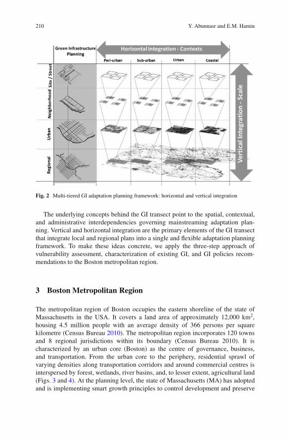
Developing a network of GI increases the resiliency of a region. It providesalternative evacuation routes, species migration routes, CO2 sinks, flood waterstorage, buffer zones against rising sea water and reduction in regional temperatures.To achieve a coordinated regional network requires the integration of planningscales (neighbourhood, urban, regional) into a single regional planning frameworkproviding a platform for communication and coordination across jurisdictions. Weterm this integration across scales as ‘vertical integration’.
Vertical integration provides the mean to respond to the multi-scalar andhierarchal nature of GI by considering current planning processes. GI networks arehierarchal especially when planned within urban contexts. When considering GI forstorm water management, connectivity of GI elements should be considered acrossthe hierarchy of urban planning scales (street or parcel neighbourhood, city, andurban region) (Kato 2010). For example (Fig. 2), several streets with bioswales andretention ponds in residential yards at the neighbourhood scale can constitute a greencorridor at the city scale which, in turn, with city parks can be part of a regionalpark system (Jim and Chen 2003; Girling and Kellett 2005). But each individualGI element (parcel to regional scales) is planned and implemented differently,depending on the context, size, and planning process. Vertical integration providesa way to unify these processes under a hierarchal single framework that leads to aregional vision.
Integration across scales is necessary to increase the adaptive capacity at boththe regional and local levels. The adaptive planning meta-model developed by Kato(2010), for a planning framework to manage GI, is an example of such a process.It is an iterative process designed for the US context. Similar to the GI hierarchy,neighbourhood plans that are participatory in nature form the basis of an urbanplan. The sum of the several urban plans could define a vision for a region. In theUS context, a bottom-up approach (participatory) could lead to a regional vision.The reverse (top-down planning) may also hold true when considered within otherplanning and administrative contexts. Regardless of whether the vision (top-down)or local planning (bottom-up) comes first, the intention here is to advocate for atwo-way and iterative approach that includes both and provides the flexibility andadaptability to respond as circumstances arise and change.
210 Y. Abunnasr and E.M. Hamin
Fig. 2 Multi-tiered GI adaptation planning framework: horizontal and vertical integration
The underlying concepts behind the GI transect point to the spatial, contextual,and administrative interdependencies governing mainstreaming adaptation plan-ning. Vertical and horizontal integration are the primary elements of the GI transectthat integrate local and regional plans into a single and flexible adaptation planningframework. To make these ideas concrete, we apply the three-step approach ofvulnerability assessment, characterization of existing GI, and GI policies recom-mendations to the Boston metropolitan region.
3 Boston Metropolitan Region
The metropolitan region of Boston occupies the eastern shoreline of the state ofMassachusetts in the USA. It covers a land area of approximately 12,000 km2,housing 4.5 million people with an average density of 366 persons per squarekilometre (Census Bureau 2010). The metropolitan region incorporates 120 townsand 8 regional jurisdictions within its boundary (Census Bureau 2010). It ischaracterized by an urban core (Boston) as the centre of governance, business,and transportation. From the urban core to the periphery, residential sprawl ofvarying densities along transportation corridors and around commercial centres isinterspersed by forest, wetlands, river basins, and, to lesser extent, agricultural land(Figs. 3 and 4). At the planning level, the state of Massachusetts (MA) has adoptedand is implementing smart growth principles to control development and preserve

The Green Infrastructure Transect: An Organizational Framework for Mainstreaming. . . 211
Fig. 3 Metropolitan region of Boston: spatial distribution of pervious and impervious surfaces
natural and cultural assets.3 Part of the smart growth initiative is the Climate ActionPlan (CAP 2007, 2010). The plan is focused on mitigation measures to reduceemissions from buildings, transportation, waste management, and land use. In the2010 update of the plan, recommendations for adaptation were included as part ofaddressing causes and effects of climate change.
The NECIA (2007) report on climate change impacts within the New Englandregion shows that Massachusetts climate will resemble the southern states of theEastern Coast of the USA.4 Taking the year 2000 as the baseline, the reportdemonstrates that the metropolitan region of Boston will experience increase intemperatures by 4–7ıC in the winter and 3–8ıC in the summer, rising sea levelof 25–60 cm, and increased precipitation by 20–30%. To address these impacts,the City of Boston identified guidelines for adaptation planning (CAP 2010) thatinclude, in addition to economic and social measures, spatial measures that focuson GI.
3Since planning is locally based and participatory, the state of Massachusetts may only advancethese planning principles through financial incentive means. Towns and cities may develop theircomprehensive zoning, recreation and open space, and economic development plans based onsmart growth principles in return for financial incentives.4Under the high emissions scenario, the Massachusetts climate will likely resemble that of thecurrent Florida climate and under a lower emissions scenario will resemble the current weather ofNorthern Carolina.

212 Y. Abunnasr and E.M. Hamin
Fig. 4 Metropolitan region of Boston: green infrastructure across town boundaries
The adaptation recommendations for Boston (CAP 2010) set priorities and definethe required information and planning priorities and approaches. Out of the 13recommendations, many focus on GI principles such as greening the city, greenroofs, sustainable water management, and protection and increase of large tracts ofvegetated surfaces. In addition, planning cross-jurisdictions and scales is identifiedas a priority to increase the adaptive capacity of the urban region.
In the process of transforming these adaptation recommendations into actions,we apply the GI transect to assess the applicability of the multi-tiered organizationalframework to Boston. In the assessment stage, we map vulnerability, climate changeimpacts, and the physical environment across the GI zones (Fig. 5). Vulnerability

The Green Infrastructure Transect: An Organizational Framework for Mainstreaming. . . 213
Fig. 5 Green infrastructure transect application to Boston region, step one: vulnerabilityassessment
is mapped using the following spatial data layers from Mass GIS5: topography,open space, roads, location within the watershed, and socio-economic data for eachlocation. Climate impact is mapped according to the NECIA (2007) report showingthe magnitude and focus within each zone. Aerial images are used to map the urbancharacter identifying the physical environment of work and housing.
We found that the coastal zone is predominantly impacted by rising sea level, theurban to transition zones are affected by a high magnitude of increased temperaturesand flooding, and the peripheral zones are impacted, at a lower magnitude, bytemperature rise and flooding. The exposure to physical risks is further exasperatedby the effect of the urban heat island effect (UHI) and the gradation of imperviousand pervious surfaces across the GI transect. The compounded impacts of climatechange and the physical characteristics of the urban region of Boston are groundsto consider different adaptation planning focuses for communities across theGI transect. To be able to devise and recommend GI policies within existingpervious surfaces, which address the variation of vulnerability, we map the existingdistribution of GI across the zones.
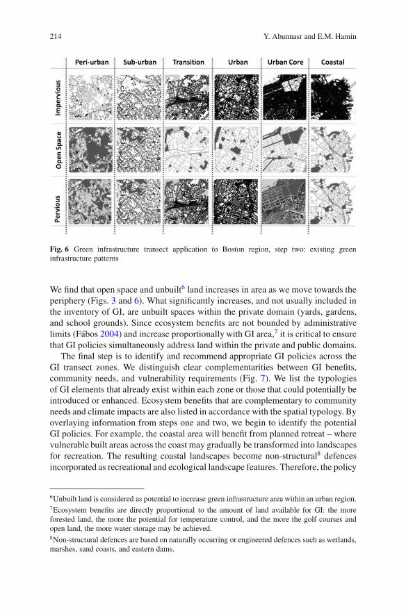
To map the spatial distribution of GI across the zones, we also use Mass GIS data.We overlay the following layers: impervious surfaces, digital terrain, open spacelayers (public domain), waterways, forests, roads, and administrative boundaries.
5Mass GIS is a spatial data portal managed by the state of Massachusetts that provides a freedownload service of available data layers across the state. See http://www.mass.gov/mgis/.
214 Y. Abunnasr and E.M. Hamin
Fig. 6 Green infrastructure transect application to Boston region, step two: existing greeninfrastructure patterns
We find that open space and unbuilt6 land increases in area as we move towards theperiphery (Figs. 3 and 6). What significantly increases, and not usually included inthe inventory of GI, are unbuilt spaces within the private domain (yards, gardens,and school grounds). Since ecosystem benefits are not bounded by administrativelimits (Fabos 2004) and increase proportionally with GI area,7 it is critical to ensurethat GI policies simultaneously address land within the private and public domains.
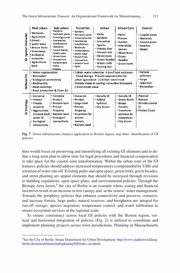
The final step is to identify and recommend appropriate GI policies across theGI transect zones. We distinguish clear complementarities between GI benefits,community needs, and vulnerability requirements (Fig. 7). We list the typologiesof GI elements that already exist within each zone or those that could potentially beintroduced or enhanced. Ecosystem benefits that are complementary to communityneeds and climate impacts are also listed in accordance with the spatial typology. Byoverlaying information from steps one and two, we begin to identify the potentialGI policies. For example, the coastal area will benefit from planned retreat – wherevulnerable built areas across the coast may gradually be transformed into landscapesfor recreation. The resulting coastal landscapes become non-structural8 defencesincorporated as recreational and ecological landscape features. Therefore, the policy
6Unbuilt land is considered as potential to increase green infrastructure area within an urban region.7Ecosystem benefits are directly proportional to the amount of land available for GI: the moreforested land, the more the potential for temperature control, and the more the golf courses andopen land, the more water storage may be achieved.8Non-structural defences are based on naturally occurring or engineered defences such as wetlands,marshes, sand coasts, and eastern dams.
The Green Infrastructure Transect: An Organizational Framework for Mainstreaming. . . 215
Fig. 7 Green infrastructure transect application to Boston region, step three: identification of GIpolicies
here would focus on preserving and intensifying all existing GI elements and to de-fine a long-term plan to allow time for legal procedures and financial compensationto take place for the coastal zone transformation. Within the urban zone of the GItransect, policies should address increased temperatures (compounded by UHI) andretention of water run-off. Existing parks and open space, green roofs, green facades,and street planting are spatial elements that should be increased through revisionsto building regulations, open space plans, and environmental policies. Through theBiotope Area factor,9 the city of Berlin is an example where zoning and financialincentives result in an increase in tree canopy and ‘at the source’ water management.Towards the periphery, policies that enhance connectivity and preserve, conserve,and increase forests, large parks, natural reserves, and biospheres are integral forrun-off storage, species migration, temperature control, and water infiltration toensure ecosystem services at the regional scale.
To ensure consistency across local GI policies with the Boston region, ver-tical and horizontal integration of policies (Fig. 2) is utilized to coordinate andimplement planning projects across town jurisdictions. Planning in Massachusetts
9See the City of Berlin, Senate Department for Urban Development: http://www.stadtentwicklung.berlin.de/umwelt/landschaftsplanung/bff/index en.shtml.

216 Y. Abunnasr and E.M. Hamin
is predominantly participatory and happens at the local (town) scale. This meansthat parcel and neighbourhood scale plans should build up to form an overalltown plan that explicitly considers GI measures for adaptation. The open spaceplans that are mandatory to US towns could be extended beyond recreation toincorporate ecological and adaptation plans. Town plans then need to build theoverall regional vision. This may be achieved by expanding the mandate of regionalplanning bodies beyond transportation and economic development towards a moreactive role to coordinate and integrate local plans. Even more, regional bodiesshould be responsible to monitor and develop regional climate projections thathelp in providing the vision for regional and local adaptation plans. A hierarchalorganizational structure that works in both directions (from local to regional orfrom regional to local) ensures that all constituents and measures serve an intendedlocal role within a larger regional approach. The proposed structure that we havepresented may be a first step in integrating local adaptation planning across scalesand jurisdictions using current and accepted knowledge.
4 Conclusion
Adaptation policies run the risk of a piecemeal, systematized approach. It is easyto prescribe a green roof here and a rain garden there and hope that they willadd up to a proper systematic approach. However, the challenges of adaptation aretoo significant for this to be effective. Framing GI planning through the transectapproach provides a way to conceptualize a whole system of GI spatial elements,identify coming climate challenges, and plan to integrate local policies at site scalewith adaptation needs at the neighbourhood, city, and regional scales. In this chapter,we briefly used Boston as a case study to demonstrate how the GI transect may beapplied and how it can assist in interpreting and framing overall GI for adaptation.We conclude that GI will be an effective adaptation policy when it is matched tothe physical character of urban environments (urban, suburban, and rural) and theneeds of communities they are intended to serve. This approach is a first step inmainstreaming adaptation planning using current GI practices.
References
Ahern, J. (2008). Green infrastructure for cities: The spatial dimension. In V. Novotny & P. Brown(Eds.), Cities of the future (p. 2). London: IWA Publishing.
Bedsworth, L. W., & Hanak, E. (2010). Adaptation to climate change: A review of challenges andtradeoffs in six areas. JAPA, 76(4), 477–495.
Benedict, M. A., & McMahon, M. T. (2002). Green infrastructure: Smart conservation for the 21stcentury. Renewable Resources Journal, 20, 12–17.
Benedict, M. A., & McMahon, M. T. (2006). Green infrastructure: Linking landscape andcommunities. Washington, DC: Island Press.
The Green Infrastructure Transect: An Organizational Framework for Mainstreaming. . . 217
Berger, A. (2006). Drosscape: Wasting land in urban America. New York: Princeton ArchitecturalPress.
CAP. (2007/2010). The city of Boston’s climate action plan. City of Boston. December 2007. http://www.abettercity.org/environment/bostoncap.html. Accessed 18 June 2011.
CCAP. (2011). The value of green infrastructure for urban climate adaptation. Center for Clean AirPolicy, February 2011. http://www.ccap.org/docs/resources/989/Green Infrastructure FINAL.pdf. Accessed 18 June 2011.
Duany, A., & Talen, E. (2002). Transect planning. Journal of American Planning Association,68(3), 245–266.
EPA – US Environmental Protection Agency. http://www.epa.gov/. Accessed 20 June 2011.Fabos, J. G. (2004). Greenway planning in the United States: Its origins and recent case studies.
Landscape and Urban Planning, 68, 321–342.Farr, D. (2008). Sustainable urbanism: Urban design with nature. Hoboken: Wiley.Forman, R. T. T. (2008). Urban regions: Ecology and planning beyond the city. Cambridge:
Cambridge University Press.Geddes, P. (1915). Cities in evolution: An introduction to the town planning movement and to the
study of civics. London: Williams & Norgate.Gill, S. E. (2007). Adapting cities for climate change: The role of the green infrastructure. Built
Environment, 33(1), 115–133.Girling, C., & Kellett, R. (2005). Skinny streets and green neighborhoods: Design for environment
and community. Washington, DC: Island Press.Jim, C. Y., & Chen, S. S. (2003). Comprehensive greenspace planning based on landscape ecology
principles in compact Nanjing city, China. Landscape and Urban Planning, 65(3), 95–116.Jongman, R. H. G. (1995). Nature conservation planning in Europe: Developing ecological
networks. Landscape and Urban Planning, 32, 169–183.Jongman, R. H. G., Kulvik, M., & Kristiansen, I. (2004). European ecological networks and
greenways. Landscape and Urban Planning, 68, 305–319.Kato, S. (2010). Green space conservation planning framework for urban regions based on a forest
bird-habitat relationship study and the resilience thinking. Ph.D. dissertation, Umass, Amherst;AAT 3409604.
Lewis, P. H., Jr. (1964). Quality corridors for Wisconsin. Landscape Architecture, 54, 100–107.McHarg, I. (1969). Design with nature. Garden City: The Natural History Press.Mumford, L. (1937). What is a city? New York: McGraw-Hill.Nassauer, J. (2006). Landscape planning and conservation biology: Systems thinking revisited.
Conservation Biology, 20, 677–678.NECIA. (2007). Confronting climate change in the U.S. Northeast: Science, impacts, and solu-
tions: A report of the Northeast Climate Impacts Assessment. Union of Concerned Scientists.http://www.climatechoices.org/ne/resources ne/nereport.html. Accessed 19 June 2011.
Newman, P., & Jennings, I. (2008). Cities as sustainable ecosystems: Principles and practices.Washington, DC: Island Press.
Noss, R. F., & Harris, L. D. (1986). Nodes, networks, and mums: Preserving diversity at all scales.Environmental Management, 10(3), 299–309.
Pickett, S. T. A., Cadenasso, M. L., & Grove, J. M. (2004). Resilient cities: Meaning, models, andmetaphor for integrating the ecological, socio-economic, and planning realms. Landscape andUrban Planning, 69(4), 369–384.
United States Census Bureau, Data section, http://2010.census.gov/2010census/. Accessed 18 June2011.