The Baniyas Survey
28
CHAPTER 1 THE BANIYAS SURVEY MOSHE HARTAL The archaeological survey conducted by the author at Baniyas in 1983 1 was aimed at defining the extent of the settlement in the various periods. 2 In the framework of the survey, the site and the hills in its vicinity were submitted to meticulous examination and the limits of the urban space were determined (Fig. 1.1). In the years since the survey, extensive excavations have been carried out within the site; they have supplied much more fundamental information compared to that of the survey. However, most of the excavations were conducted in the civic center of the city, and the data on the suburbs remained limited. It therefore appears appropriate to present succinctly the results of the survey and the settlement picture arising from it. In the following description we shall integrate data from the excavations as well as data collected during years of inspection and archaeological work at the site. THE TOPOGRAPHICAL BACKGROUND Baniyas is situated at the junction of the northern Golan, the northern Hula Valley and Mount Hermon. The area is rich in water. Nahal Hermon (Baniyas River). The water source of this river is the Baniyas spring; it joins Nahal Govta after a short distance. The first part of this river runs through a deep ravine, albeit with moderate banks (see Figs. 1.16, 1.21). As the river continues, it cuts through a canyon with steep sides and cliffs. The canyon begins at a 17 m high waterfall. Once the river exits the Baniyas Plateau, it runs in the Hula Valley in a shallow gully until it unites with Nahal Dan. Nahal Govta. This wadi begins in the east, on the slopes of Mt. Hermon and delimits the Hermon Spur from the north (see Figs. 1.16, 2.1, 2.32). After exiting the confines of Mt. Hermon, the wadi cuts through the travertine rocks of the Baniyas Plateau and joins Nahal Hermon at Baniyas. There are small springs in the lower part of the ravine. Nahal Sa‘ar (see Figs. 1.4, 1.16). This perennial stream begins at the foothills of Mt. Hermon south of Majdal Shams, passes Marj el-Ya‘afuri and traverses the Druse village, Mas‘ada. From there, it cuts through the geological border between the limestone of Mt. Hermon and the basalts of the Golan. Along its course toward Baniyas, the wadi is occasionally deep and canyon-like, with two waterfalls. Its lower part, upon entering Baniyas, creates a shallow canyon until it unites, within the confines of Baniyas, with Nahal Hermon. A lava flow (Sa‘ar Basalt), the termination of which is within the city, can be detected in the wadi. Wadi en-Naqib. This wadi begins in the hills north of ‘Ein Quneiyye. Three small springs, ‘Ein el-Rahman, gush forth in its upper part, but since the wadi passes through karstic limestone, no water flows in it. The wadi crosses Marj el-Wata to the west and continues between the slopes of the Hermon Spur and the Sa‘ar Basalt (see Fig. 1.4). The debris of the civic center of the city of Paneas covers its final section. It seems that the water from the Baniyas spring flows in its ravine until it joins Nahal Govta. Masil ‘Eisha. This wadi begins west of ‘Ein Quneiyye and collects the water of springs at the foot of the ‘Ein Quneiyye hill. The wadi runs parallel to Nahal Sa‘ar, enters the southeastern part of Marj el-Wata, turns to the south and joins Nahal Sa‘ar (see Fig. 1.4) in a waterfall. It apparently served as the source of the aqueduct (see Chapter 2). The archaeological site of Baniyas is comprised of several landscape units, which differ from each other in lithology, topography and flora: The Baniyas Plateau. This height slopes gently from east to west (Fig. 1.2) and terminates in a steep slope toward the Hula Valley. The slope was created by a geological fault. In the east the plateau is limited by the margins of the Hermon Spur. On the northeast, the
-
Upload
antiquities -
Category
Documents
-
view
2 -
download
0
Transcript of The Baniyas Survey

Chapter 1
The BaniyaS Survey
MoShe harTal
The archaeological survey conducted by the author at Baniyas in 19831 was aimed at defining the extent of the settlement in the various periods.2 In the framework of the survey, the site and the hills in its vicinity were submitted to meticulous examination and the limits of the urban space were determined (Fig. 1.1). In the years since the survey, extensive excavations have been carried out within the site; they have supplied much more fundamental information compared to that of the survey. However, most of the excavations were conducted in the civic center of the city, and the data on the suburbs remained limited. It therefore appears appropriate to present succinctly the results of the survey and the settlement picture arising from it. In the following description we shall integrate data from the excavations as well as data collected during years of inspection and archaeological work at the site.
the topographiCal BaCkground
Baniyas is situated at the junction of the northern Golan, the northern Hula Valley and Mount Hermon. The area is rich in water.
Nahal Hermon (Baniyas River). The water source of this river is the Baniyas spring; it joins Nahal Govta after a short distance. The first part of this river runs through a deep ravine, albeit with moderate banks (see Figs. 1.16, 1.21). As the river continues, it cuts through a canyon with steep sides and cliffs. The canyon begins at a 17 m high waterfall. Once the river exits the Baniyas Plateau, it runs in the Hula Valley in a shallow gully until it unites with Nahal Dan.
Nahal Govta. This wadi begins in the east, on the slopes of Mt. Hermon and delimits the Hermon Spur from the north (see Figs. 1.16, 2.1, 2.32). After exiting the confines of Mt. Hermon, the wadi cuts through the travertine rocks of the Baniyas Plateau and joins Nahal Hermon at Baniyas. There are small springs in the lower part of the ravine.
Nahal Sa‘ar (see Figs. 1.4, 1.16). This perennial stream begins at the foothills of Mt. Hermon south of Majdal Shams, passes Marj el-Ya‘afuri and traverses the Druse village, Mas‘ada. From there, it cuts through the geological border between the limestone of Mt. Hermon and the basalts of the Golan. Along its course toward Baniyas, the wadi is occasionally deep and canyon-like, with two waterfalls. Its lower part, upon entering Baniyas, creates a shallow canyon until it unites, within the confines of Baniyas, with Nahal Hermon. A lava flow (Sa‘ar Basalt), the termination of which is within the city, can be detected in the wadi.
Wadi en-Naqib. This wadi begins in the hills north of ‘Ein Quneiyye. Three small springs, ‘Ein el-Rahman, gush forth in its upper part, but since the wadi passes through karstic limestone, no water flows in it. The wadi crosses Marj el-Wata to the west and continues between the slopes of the Hermon Spur and the Sa‘ar Basalt (see Fig. 1.4). The debris of the civic center of the city of Paneas covers its final section. It seems that the water from the Baniyas spring flows in its ravine until it joins Nahal Govta.
Masil ‘Eisha. This wadi begins west of ‘Ein Quneiyye and collects the water of springs at the foot of the ‘Ein Quneiyye hill. The wadi runs parallel to Nahal Sa‘ar, enters the southeastern part of Marj el-Wata, turns to the south and joins Nahal Sa‘ar (see Fig. 1.4) in a waterfall. It apparently served as the source of the aqueduct (see Chapter 2).
The archaeological site of Baniyas is comprised of several landscape units, which differ from each other in lithology, topography and flora:
The Baniyas Plateau. This height slopes gently from east to west (Fig. 1.2) and terminates in a steep slope toward the Hula Valley. The slope was created by a geological fault. In the east the plateau is limited by the margins of the Hermon Spur. On the northeast, the

MOSHE HARTAl4
Fig.
1.1
. Sur
vey
map
of B
anyi
as.
263000
262500
263500
264000
264500
265000
265500
266000
266500
Exca
vatio
n
Surv
ey P
oint
Anc
ient
Site
Aqu
educ
t
Hol
y To
mb
Chu
rch
52
51
57
1
2
34
32
3337 38
34
39
3635
58
76
1011
1217
2019
2122
232425
2627
28
30
4445
4647 48
42
43
4029
31
TAP Line
61
4950
5354
555613
1415
16
59
60
N. G
ovta
N. H
erm
on
N. S
i’on
NW
Sub
urb
Civ
ic C
ente
rN
E Su
burb
E Su
burb
SW S
ubur
bSE
Sub
urb
W S
ubur
b
W C
emet
ery
NE
Cem
eter
y
NW
Cem
eter
y
S C
emet
ery
Her
mon
Spu
r
Kib
butz
Sni
r
B a
n i
y a
s P
l a t
e a
u
Sa‘ar
Bas
alt
Wad
i en-
Naqi
b
N. Sa‘a
r
U n
d i
v i d
e d
B a
s a
l t
G i
v‘a
t H
a m
r a
H u
l a
V a
l l e
y
Her
mon
Fiel
d St
udy
Cen
ter
N. F
ar‘a
G o
l a
n
Mas
il ‘E
isha
Mar
jel
-Wat
a
Sprin
g
Sul
tan
Ibra
him
City
Wal
l B
irket
Abu
Suw
iada
Wat
erfa
ll
Far‘
a B
ridge
050
0 m
795
000
794
500
794
000
793
500
793
000

CHAPTER 1: THE BANIYAS SuRVEY 5
Fig. 1.2. Baniyas Plateau, general view to the west.
1. Grotto and Sacred Precinct 2. Nebi Khadar (A-4299/04) 3. Western terrace (K-5/77, K-2/78) 4. Mosaic floor 5. Basilica and ‘Water Gate’ 6. Palace 7. Byzantine street 8. Cardo 9. Medieval fortifications10. Southwestern tower (A-3390/01)11. Southern gate12. Bridge13. Watch tower(?)14. Roman building15. Round structure16. Bathhouse(?) (A-3415/01)17. Maronite church18. Eastern road19. Byzantine city wall20. Subterranean chamber21. Burial caves
22. Southeastern road23. Southwestern road24. Villa (A-1332/84)25. Villa (A-1783/91)26. ‘Ein Hilu—‘Officers’ Pool’27. Roman building (A-1783/91)28. Mosaic floor29. Anti-tank trench30. Travertine quarry31. Far‘a bridge32. Bridge33. Bridge34. Bridge35. Roman buildings36. Roman street (A-3315/00)37. Roman structure (K-3/74)38. Ashlar-block pile39. Roman buildings40. Milestone41. Western road
◄ Fig. 1.1. Key to Sites
42. Roman tombs (A-3214/00)43. First-century tombs (A-4174/04)44. Burial cave (K-2/75)45. Monumental burial system46. Burial cave (A-1440/86)47. Burial cave (A-1650/89)48. Mausoleum (A-4420/05)49. Late Roman farm50. Late Roman villa51. El-Naqara52. Kh. el-Wata53. Mugharet el-Wata54. Cistern 7855. Tomb 80056. Naiskos57. Quarry58. Aqueduct bridge59. Distribution installations60. Enclosure 53 and Tomb 70061. Khan ed-Duwer

MOSHE HARTAl6
plateau is bounded by a lofty cliff, which terminates above the spur, inside which there is a large karstic cave—the Grotto of Baniyas (Fig. 1.1:1). On the northwest, the plateau ends at the hill to the east of Giv‘at Hamra. The plateau extends in the south beyond Nahal Hermon and Nahal Sa‘ar and is delimited by a lava flow. The descent toward the upper part of Nahal Hermon is in the form of wide steps. West of the Trans-Arabian-Pipeline (TAP; see Fig. 1.1), the slope to the river is very steep. The plateau is covered by a thick layer of travertine rock (Heimann and Porat, in preparation). At the northeastern edge of the plateau, below the grotto, gush forth the waters of the Baniyas spring, the second largest water source of the Jordan River (125 million cu m per annum). As this spring pours out from a high part of the plateau, it served as the water source of the site.
Giv‘at Hamra. A hill, built of conglomerate defined as the Si’on Formation (Mor 1986:104–105; Heimann and Porat, in preparation), towers to the north of the Baniyas Plateau (Fig. 1.3). On the east it is bounded by Nahal Govta, on the north by Nahal Si’on and on the west by the Hula Valley, a steep slope. The southern slope of the hill is moderate and descends in wide steps. The ground is covered by soil and pebbles with
no exposed rocks. The hill is higher than the level of Baniyas Spring and does not have any independent water sources.
The Hermon Spur. A narrow rocky ridge, part of the Mt. Hermon slopes, descends from Nimrod Fortress (as-Subaybah). On the north and west it is delimited by Nahal Govta and on the south by Wadi en-Naqib (see Figs. 1.4, 1.16, 2.1, 2.32). The spur is composed of hard limestone and dolomite rocks. It is very stony and covered with oak trees and herbs. The spur ends in the west at Giv‘at Hamra. To the west of Marj el-Wata, the southern slope of the ridge descends in steps to the lower part of Wadi en-Naqib. To the west of this stepped slope, the spur is bordered by the high cliff of the Grotto of Baniyas (Heiman and Porat, in preparation). An additional small cave, Mugharet el-Wata, opens in the lower step of the slope in front of Marj el-Wata.
Marj el-Wata. This fertile depression extends between the Hermon Spur and Nahal Sa‘ar (see Figs. 1.4, 2.1). On the east, this valley is bordered by the margins of the ‘Ein Quneiyye Hills. The valley bed is covered by alluvial soil suitable for agriculture.
Fig. 1.3. Nebi Khadar on the Hermon Spur. To left, the western terrace; in background, the northwestern suburb and Giv‘at Hamra. Looking west.

CHAPTER 1: THE BANIYAS SuRVEY 7
Fig. 1.4. Marj el-Wata below the Hermon Spur. To left, Nahal Sa‘ar; center, Wadi en-Naqib (within Marj el-Wata) passes in the middle of the orchard; looking north.
The Sa‘ar Basalt. A relatively young lava flow filled Nahal Sa‘ar. The flow ends in the west in a steep slope which borders the Baniyas Plateau (see Fig. 1.16). To the north of Nahal Sa‘ar, the flow’s front is situated to the east of the city’s medieval walls. To the south of the river, the flow continued several dozens of meters westward to encircle Birket Abu Suweida. To the northwest, the flow descends to Nahal Sa‘ar in moderate, wide steps, while to the west, the flow ends in a steep slope (see Fig. 1.20).
Undivided Basalt. A flow of undefined and undivided lava lies to the west of the Sa‘ar Basalt. The terrain descends in wide steps toward the northwest. The lower part of the flow touches the travertine of the Baniyas Plateau, and in some points it extends as far as Nahal Hermon.
parts of the City
The Civic Center
The urban center, covering 110 dunams, was built on the eastern part of the Baniyas Plateau. It is bounded on the north by the grotto’s lofty cliff, on the west by Nahal Govta and Nahal Hermon, on the south by Nahal
Sa‘ar and on the east by the Sa‘ar Basalt. The Baniyas spring—the main source of water for the town—gushes forth on the northern edge. There is no doubt that the impressive spring was a major attraction in the civic center. Zvi u. Ma‘oz (1999:97–99) has restored, according to the description of the coins, a semicircular colonnade around a sacred lake. However, the survey found no evidence for such a structure, perhaps because of the many changes undergone by the city center. Wide walls appear sporadically on the surface in the vicinity of the presumed lake, but their attribution to structures is beyond recognition.
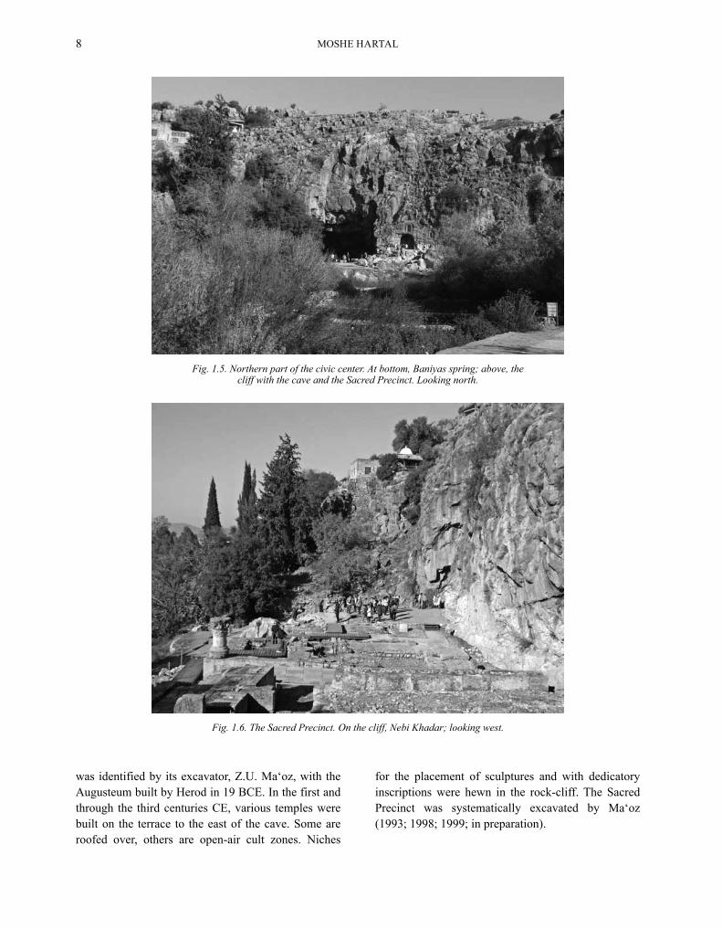
To the north of the spring there is a 10 m high ledge which is bounded on three sides (north, east and west) by 30 m high cliffs (see Fig. 1.1:1). Opening at the left corner of the northern rock-scarp is a large karstic cave (Fig. 1.5; 25 m wide, 15 m deep and 8 m high), at the bottom of which subterranean water is reached. As the consequence of an earthquake, the mouth of the cave was destroyed and blocked by a large pile of rocks. It appears that the present cave is a relict of a much larger grotto that collapsed in the past, creating the ledge, or terrace, upon which the temples are built (Fig. 1.6; Heimann and Porat, in preparation). During the Hellenistic period the cave was dedicated to the cult of Pan. At the entrance to the cave there is a temple which
NE Suburb
Masil ‘Eisha↓
Hermon Spur
Marj el-WataWadi en-Naqib
Nah
al S
a‘ar
MOSHE HARTAl8
Fig. 1.5. Northern part of the civic center. At bottom, Baniyas spring; above, the cliff with the cave and the Sacred Precinct. Looking north.
Fig. 1.6. The Sacred Precinct. On the cliff, Nebi Khadar; looking west.
was identified by its excavator, Z.u. Ma‘oz, with the Augusteum built by Herod in 19 BCE. In the first and through the third centuries CE, various temples were built on the terrace to the east of the cave. Some are roofed over, others are open-air cult zones. Niches
for the placement of sculptures and with dedicatory inscriptions were hewn in the rock-cliff. The Sacred Precinct was systematically excavated by Ma‘oz (1993; 1998; 1999; in preparation).

CHAPTER 1: THE BANIYAS SuRVEY 9
To the west of the spring, an elevated terrace (‘the western terrace’; Fig. 1.1:3) rises 20 m above the plateau, which is part of the southern slope of the Hermon Spur (see Fig. 1.3). On this rocky terrace, which overlooks the spring, Nahal Hermon and the entire Baniyas Plateau, quarrying, exposed on the surface and in excavations, testifies to the existence of a large public building. The walls of the building themselves have not survived and the finds were not sufficient to date it (Netzer 1998; Ma‘oz 1993:141). Covering the southern scarp of the terrace are fragments of walls built in the opus reticulatum masonry style (Fig. 1.7). This masonry dates the building apparently to the period of the House of Herod. The remains were identified by their excavator, Ehud Netzer, as the Augusteum of Herod. High above the terrace is Nebi Khadar (Figs. 1.1:2, 1.3, 1.6), sacred to Muslims and Druse. The Nebi tombs there, whose dates are unclear, probably date from recent centuries (Hartal 2008a).
Monumental public structures were unearthed in the excavations of the civic center. They include a vast palace (see Figs. 1.1:6, 1.8), with halls, vaults,
Fig. 1.7. Opus reticulatum wall on the western terrace; looking north.
Fig. 1.8. The civic center. The excavated area of the Roman city lies behind the parking lot. Top left, the medieval moat and fortification. In background, the southeastern suburb. Looking south.
underground passages, a colonnaded street (see Fig. 1.1:8), a street (see Fig. 1.1:7) and a basilica (see Fig. 1.1:5). A mosaic floor was found west of the spring (see Fig. 1.1:4). In the area of the city there were complex systems of water supply whose origin was in the main

MOSHE HARTAl10
spring. The excavations of the civic center have thus far failed to expose domestic structures. This sector was systematically excavated by Vassilios Tzaferis and Shoshana Israeli (Tzaferis 1998; Tzaferis and Israeli 2008).
During the medieval period, the city shrank to the area of the Roman civic center and was surrounded by walls, towers and a moat (see Fig. 1.8). The spring was not included in the walled city, probably because of the need to stay far from the high cliff above the spring, to avoid the shooting of arrows into the city. The northern wall, only the foundations of which survived, included ‘the Water Gate’ (see Fig. 1.1:5), exposed by Tzaferis (2008:41–44). The eastern wall, defended by three towers, was separated from the surrounding area by a wide moat (see Fig. 1.1:9). The counter-scarp of the fosse joined the terminating cliff of the Sa‘ar Basalt, so that there was no need of excavations to determine its construction. The moat was cleared by Dan urman (HA 1969:3–4). Moats were unnecessary on the other sides of the walled city, as the defense relied on deep ravines. The southern wall was built along Nahal Sa‘ar and included a tower-gate (Figs. 1.1:11, 1. 9) and two corner towers. The southwestern tower (Figs. 1.1:10, 1.10) was excavated by the author (Hartal 2007).
Fig. 1.9. The southern gate and Nahal Sa‘ar; looking north.
Fig. 1.10. The southwestern tower; looking northeast.
The western wall was built along Nahal Hermon and included three additional towers, as yet unexcavated. An arched bridge astride Nahal Sa‘ar led up to the

CHAPTER 1: THE BANIYAS SuRVEY 11
southern gate (see Fig. 1.1:12). The bridge was used until the nineteenth century CE (Wilson 1880:114). Today only the spring vaults remain. In the piazza flanking the southern gate, there is an ancient and giant Tabor oak tree, beside which is the tomb of Sultan Ibrahim, venerated by Muslims and Druse alike. The village of Baniyas in recent generations has resided inside the medieval city.
The survey in the civic center produced sherds from the Roman, the Byzantine (few) and Mamluk (the majority) periods. The excavations added finds from the Hellenistic, Early and late Roman, the early Byzantine (very few), the Fatimid and the Crusader–Mamluk periods.
The Hermon Spur
The area above the Baniyas Grotto cliff is in fact the lowest part of the rocky spur that descends from Mt. Hermon. Because of its topographic location and rocky character, the area was never part of the built-up parts of the site and was used only for the path of the aqueduct and the cemeteries described below. In the medieval period, the area functioned as a large quarry for the building stones typical of the city (see below and Figs. 1.1:57, 1.11, 1.33, 1.34).
East of the quarry is a rock-cut tomb (0.70 × 1.70 m, 2.00 m deep; Figs. 1.1:13, 1.12), which is similar to other tombs in the nearby cemetery. At a later stage this tomb was enveloped by a structure (4.40 × 4.40 m) with wide walls (1.80 m), constructed of roughly dressed
Fig. 1.11. The medieval quarry on the Hermon Spur; to left, Nebi Khadar. Looking north.
Fig. 1.12. Rock-cut tomb enveloped by a structure, a watch-tower(?); looking north.

MOSHE HARTAl12
blocks bonded with lime-mortar. The southern part of the tomb, as well as cracks in the natural bedrock, was filled with the same mortar. The purpose of this structure is unclear. It is situated both at the cliff’s edge, a site with an extensive view, and on the path descending from the fortress. It is therefore possible that the structure was a watch-tower monitoring the path, perhaps part of the fortifications erected in the vicinity of Baniyas in the Byzantine period.
The Northeastern Suburb
A domestic suburb covering 70 dunams extends along the southern slope of the Hermon Spur (Figs. 1.13, 2.1). It is bounded on the north by the upper edge of the slope, on the east by Marj el-Wata, on the south by the lower part of Wadi en-Naqib, and on the west by the civic center. The upper part of the western slope is very steep (Fig. 1.14) and therefore was not occupied.
Fig. 1.13. The northeastern suburb on the south slope of the Hermon Spur. The area without trees is part of the eastern suburb on the Sa‘ar Basalt. Bottom, Nahal Sa‘ar. Looking north.
Fig. 1.14. The west slope of the northeastern suburb; to left, the Sacred Precinct; to right, the spring. Looking southeast.

CHAPTER 1: THE BANIYAS SuRVEY 13
The lower part of the slope is more comfortable and has buildings extending as far as the urban center.
This suburb is built on a slope descending in wide steps suitable for the erection of houses. In the western part of the suburb, terraces are seen that, although constructed as field fences, incorporate remains of walls of buildings (Fig. 1.15). Among the latter was an entrance to a burial tomb, the opening of which was blocked. Above this tomb
are the remains of an ancient quarry. Stone column bases lay between the terraces. A large area covered by ruined houses that descend from the top of the hill down to the wadi bed is situated to the east of the terraces. A column base was located among these houses. The northeastern suburb extends as far as Marj el-Wata; the eastern houses of this part are built far from one another, with agricultural tracts between them.
Fig. 1.15. The west part of the northeastern suburb; looking north.
Fig. 1.16. Aerial view of Baniyas; looking southeast.
NE Suburb
NW Suburb
E Suburb
SE Suburb
Sa‘ar Basalt
Marj el-Wata
Civic Center
Hermon Spur
Nahal Govta
Nahal Hermon
Nahal Sa‘ar
MOSHE HARTAl14
The area of the suburb is disturbed by modern Syrian trenches, one of which penetrated a house from the Roman period (see Fig. 1.1:14). The trench exposed three courses of the walls with the foundation course below. According to the testimony of the broken plaster fragments seen in the trench sections, the house sported green and red frescos. The same sections produced fragments of pottery vessels dated to the third and fourth centuries CE. Also found was a household grinding stone.
Remains of a round structure (diam. 7.5 m) were located in the southeastern part of the suburb (see Fig. 1.1:15). The encircling wall, 2.30 m wide, is built of small stones held by mortar. This wall today protrudes 1.05 m above the ground and houses a pit (diam. 3.60 m), partly choked up. Its present depth is c. 2 m. Common oak grows inside the pit. In the west, two steps descend to the pit from a 0.90 m wide opening.
The northeastern suburb is built on hills whose level is higher than that of the spring (360–405 m asl). Its main source of water was the aqueduct passing above its northern border. The ceramic horizon of this suburb is mainly the third through the fifth centuries CE.
The Eastern Suburb
This suburb, covering 45 dunams, was built on top of the Sa‘ar Basalt, south of the northeastern suburb, between the ravine and Nahal Sa‘ar (see Fig. 1.13). The lava flow descends to Wadi en-Naqib in a short
and steep slope over which ruins of houses can be detected. On the upper, level part of the flow, which descends moderately from east to west, are construction remains, but their nature is unclear. A section of a burnt brick structure, which may have been a third–fourth-century CE bathhouse, was excavated in this area (see Fig. 1.1:16; Smithline 1986). In the west the suburb terminates near the modern road cutting through Nahal Sa’ar. West of the road is a deserted Maronite church (see Fig. 1.1:17), erected in 1950. There are no settlement remains in the vicinity of the church as far as the medieval moat.
The water source of the eastern suburb could have been Masil ‘Eisha, which was also the source of the aqueduct. The excavated building (above) was supplied by a pipe coming from Marj el-Wata. Since this valley was entirely reclaimed for modern agriculture, the origin of the pipe is unclear.
The Southeastern Suburb
A suburb, covering 62 dunams, is located south of Nahal Sa‘ar, atop the southwestern edge of the Sa‘ar Basalt (see Figs. 1.8, 1.17). On the east it is bounded by Birket Abu Suweida, on the west by the lava flow front, on the north by a stepped slope descending to Nahal Sa‘ar, and on the south by a city wall (see below).
The territory of this suburb was outside the limits of the modern village and was used mainly by the Syrian army. A modern road divides it into two parts
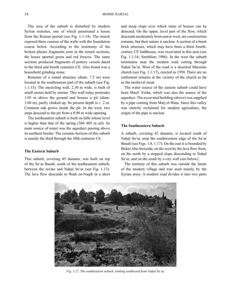
Fig. 1.17. The southeastern suburb; looking southward from Nahal Sa‘ar.

CHAPTER 1: THE BANIYAS SuRVEY 15
of unequal size. North of the road was a Syrian army camp. During its construction, the ancient remains above the surface were disturbed; ashlar blocks in secondary use are spread throughout. Remains of an ancient building are visible in one of the army trenches. The finds are more numerous in the western part of the camp than in the east, where bedrock lies immediately below ground; very few pottery sherds were found.
South of the road the trenches of the Syrian army fortifications hit early structures. At the southern end of the Syrian fortifications is a 1.60 m wide wall (Figs. 1.1:19, 1.18, 1.19), the remains of which stretch for a length of 380 m. The wall is constructed of ashlar and fieldstones bonded in hard mortar. In one segment the wall is preserved to the height of 2 m above ground. Along its length, wall heads occasionally appear or can be seen in sections in the trenches of the Syrian fortification. The wall extends parallel to the modern road and terminates at the front of the Sa‘ar Basalt. In all likelihood, this wall served as the southern city wall of Paneas. The continuation of the wall was not uncovered; however, it probably lined the edge of the Sa‘ar Basalt front and joined Nahal Sa‘ar. The city-wall sector in the east of the suburb also did not survive. A boulder made of stones bonded in mortar, no doubt part of the wall, was moved from its original location by a bulldozer, apparently during the construction of the Syrian fortifications. It appears that the city wall enclosed the suburb tangential to Birket Abu Suweida and continued northward to Nahal Sa‘ar; its remains, however, were not located. Similarly, remains of towers
were also not observed. North of this city wall is an accumulation of ruins, in sizable quantities, indicating settlement there. Contrarily, the bedrock is exposed south of this wall, indicating the area was outside the settlement.
The wall enclosing the southeastern suburb is the only city wall found from the Roman and Byzantine periods. According to its masonry, whose construction is almost identical to that of city walls at Tiberias and Bet She’an, it can be assigned to the Byzantine period, during which the territory of the urban space diminished, apparently due to deteriorating security (Hartal 2005:446–447).
Fig. 1.18. The Byzantine city wall in the southeastern suburb; looking south.
Fig. 1.19. The Byzantine city wall in the southeastern suburb; looking north.

MOSHE HARTAl16
A subterranean structure, constructed of large dressed limestone blocks, was found in the eastern part of the Syrian fortifications (see Fig. 1.1:20). An entrance corridor leads to the structure, 3.13 m long, roofed with large limestone plates. The ceiling is flat for a length of 1.70 m; only the end is built as a gable, from two ashlar stones, 0.70 m wide. The entrance lies immediately following the gable, and leads to a space measuring 0.78 × 2.05 m, 1.23 m high.
A stone-paved road—the beginning of the road ascending from Baniyas to Damascus—emerges from the southeastern edge of the suburb (see Fig. 1.1:22; Hartal 1989:75). The city wall was not preserved at this point; therefore, there is no evidence of a gate structure.
A wide road passes the southern part of the suburb (see Fig. 1.1:23); it is the continuation of the road from H. ‘Omrit. This road crossed Nahal Sa‘ar via a bridge and was in use until the beginning of the nineteenth century (see below).
The quantity of ceramics gathered in the survey in this suburb is rather lean. Most of the pottery is from the late Roman period; the remainder dates to the Byzantine period.
The Southwestern Suburb
A domestic suburb, covering 49 dunams, lies south of Nahal Hermon. The eastern border of the area is the bottom of the Sa‘ar Basalt, over which lies the southeastern suburb (Fig. 1.20). The territory of this suburb includes wide steps of undivided Basalt and sectors covered by travertine rocks. A large amount of pottery can be found on the surface, generally as far southwest as the TAP line. Remains of buildings are visible in the area adjacent to the river, beyond the olive grove. Remains of quarries, perhaps sunken courts of tomb systems, were found near the oil pipe. A villa dating to the third through the fifth centuries CE in the area south of the Officers’ Pool (itself on the northern bank of the river) was partly exposed (see Fig. 1.1:24; Hartal and Ma‘oz 1985; Hartal 1989:132). East of this villa, a fourth-century CE villa was excavated (see Fig. 1.1:25; Shaked 1993:8). It should be noted that the settlement in this quarter covers only the eastern part of the area in which the river is relatively wide and its southern bank ascends moderately in wide steps.
The survey gathered sherds from the Early Roman period (a few) and especially from the late Roman and early Byzantine periods. Noteworthy is the absence of sherds dating to the late Byzantine, Early Islamic and Mamluk periods.
Fig. 1.20. East end of the southwestern suburb bounded by the flow of the Sa‘ar Basalt, underlying the southeastern suburb; looking east.

CHAPTER 1: THE BANIYAS SuRVEY 17
The Western Suburb
The western suburb is the largest sector of the city, covering 210 dunams, located on the northwestern quarter of the Baniyas Plateau to the west of Nahal Hermon (Fig. 1.21). On the east and southeast, it is delimited by Nahal Hermon. The Baniyas Plateau descends here in wide terraces to the gorge of the river, parallel to the topography of the southwestern suburb (above). Adjacent to the river, ‘Ein Hilu pours its waters, usurped by the Syrian army for the sake of the Officers’ Pool (see Fig. 1.1:26). Remains of a structure built of fieldstones were exposed in the excavations conducted by Idan Shaked north of the pool (see Fig. 1.1:27). This earliest structure is dated to the first and second centuries CE. Above it, an additional edifice was constructed of fieldstones and coated with gray plaster. The finds on the floor date it to the third and fourth centuries CE (Shaked 1993).
Beyond the TAP line (which crosses the quarter from end to end), Nahal Hermon deepens; its banks are too steep for urban use. In this sector the southern border of the suburb draws farther from the river banks and passes at the head of the slope.
The western cemetery (below), inside Kibbutz Snir, borders the quarter on the west and flanks the
northwestern suburb (below). The territory of this quarter descends in wide steps from north to south. It is generally covered by thick vegetation, which makes it difficult to locate ancient remains. However, remains of structures with mosaic floors and frescoed walls are still visible in the trenches, dug in the 1970s for water pipes (see Fig. 1.1:28).
A Syrian anti-tank trench cuts near the western edge the western suburb (see Fig. 1.1:29). Evidence in this trench section indicates that the area close to the river was not settled and that bedrock is very close to the surface. Further along the trench, walls of several structures were cut, and ashlar blocks were found at the bottom of the trench. The section shows only one settlement floor, at a depth of approximately 1.50 m below ground surface. The trench produced a large amount of pottery and glass fragments. The pottery is typical of Baniyas in the third through the fifth centuries CE.
West of the anti-tank trench and as far as the asphalt road branch leading to the Baniyas waterfall are many basalt ashlar blocks. It appears that the western border of the quarter and the town as a whole was near this road. Its exact definition is today impossible since these fields were reclaimed for agriculture. Coins, however, were collected as far as the waterfall parking.
Fig. 1.21. The western suburb. To left, Nahal Hermon. Looking west.

MOSHE HARTAl18
The Northwestern Suburb
The northwestern suburb, covering 182 dunams, is located on the southern slope of Giv‘at Hamra (Figs. 1.22, 2.1). It is bounded on the east by the lower part of Nahal Govta, which cut through here in a deep and narrow gorge. The banks of the wadi are supported by lofty retaining walls. Along this wadi segment there were at least three bridges that connected the suburb to the civic center (Fig. 1.23). Of two of the bridges that no longer exist (see Fig. 1.1:32, 33), one served as a viaduct supporting the aqueduct from the spring to the lower level of the quarter. The third bridge (Figs. 1.1:34, 1.24), now vaulted in stone, carried the road from Tyre to Baniyas. It appears that this road, as yet unexposed, served also as the southern border of the quarter. It rises above elevation 350 m asl, the elevation of the Baniyas spring. This elevation contour divides the settlement into parts that received water from the spring and those that were higher and therefore presumably obtained their water from the aqueduct reported on here.
On the west, this suburb extends to the foothills of Giv‘at Hamra. There is no clear northern geographical boundary, since the suburb appears to terminate on mid-slope. The aqueduct passed above this border, in the area of the northwestern cemetery. Quantities of pottery, perhaps from third- to fifth-century CE kilns that were in this area, were noted.
Fig. 1.22. The northwestern suburb on the south slope of Giv‘at Hamra; looking west.
The area of this suburb exhibits extensive building remains, as well as many ashlar blocks that were incorporated into agricultural terrace walls. Noteworthy are several huge ashlar blocks and column drums. Construction is not dense on the northern edges of the suburb; however, at the heart of the quarter, there is evidence for a dense urban fabric. The remains of two luxury mansions can be detected near the military fence-road and to its north (see Fig. 1.1:35). One mansion yielded columns and marble slabs, as well as colored frescoes. The other exhibited column drums of soft chalk, large ashlar blocks and colored frescoes. The road and the drainage channel infringed upon these two houses, as well as others in the direction of the spring. Various walls, one frescoed, can be observed along the drainage channel. Mosaic tesserae were also recovered. On the southern border of the suburb, the modern road cut a series of third–fourth-century buildings with mosaic floors (Figs. 1.1:39, 1.25). A pile of large ashlar blocks (see Fig. 1.1:38) was apparently pushed alongside the bridge during the road’s construction. A rescue excavation conducted by David Amir near the eastern boundary of the suburb revealed remains of an ashlar building and an oil press (see Fig. 1.1:37; not published, see Ma‘oz 1993:139–140). Three strata, from the first–second centuries, the third–fifth centuries and the tenth century, were excavated.3

CHAPTER 1: THE BANIYAS SuRVEY 19
Fig. 1.23. Remains of a bridge in Nahal Govta; looking west.
Fig. 1.24. An ancient bridge over Nahal Govta; looking south.
Fig. 1.25. Cross section of the Roman building with a mosaic floor; looking north.

MOSHE HARTAl20
In the eastern part of the suburb, the survey collected ceramics dating to the first century CE through the medieval period. Most of the finds from the western half of the suburb date to the third through fifth centuries CE. A very small amount of pottery can be dated to the late Byzantine and Early Islamic periods. Finds from the latter periods were retrieved also in the excavations conducted in this suburb (see Fig. 1.1:36, 37; see Part 4 below, where the remains of a street and structures from the Roman period are described).
Roads
Four roads leave Baniyas:
The Eastern Road (Figs. 1.1:18, 1.26). The lower part of Wadi en-Naqib, passing between the northeastern and eastern suburbs, is devoid of architectural remains and is bounded, in segments, by agricultural stone fences. This ravine links the civic center with Marj el-Wata. The ascent from the wadi bed is moderate and comfortable, and thus comprises the preferable passage for movement from Baniyas to the east. It appears likely that the road connecting Baniyas to Damascus passed here. Since the road was not paved,
its exact course is not clear and may have very well changed over the ages. In the Early Roman period this road is mentioned by Josephus Flavius, alluding to the pool of Phiale (now Birket Ram): “Phiale will be found at a distance of a hundred and twenty furlongs from Caesarea (Philippi), on the right of and not far from the road ascending to Trachonitis” (Josephus, War III, 510). The road had therefore passed via Marj el-Ya‘afuri, situated on the left of Birket Ram as you ascend the road to Damascus. It stands to reason that the road reached this point through the springs of ‘Ein Quneiyye and the foothill of Kh. el-Hawarit. In the medieval period, as a consequence of the construction of Nimrod Fortress, the course of the road changed slightly. It now ascended Wadi en-Naqib, at the foot of the fortress, and continued eastward, through Neve Ativ and Majdal Shams.
The Southeastern Road (see Fig. 1.1:22). From the southeastern suburb emerges a paved road c. 6.60 m in width, with curb stones and a central ridge—a typical Roman road. This is the beginning of a parallel road to Damascus, ascending from Baniyas to the slopes of the Golan. Remains of the pavement and towers of this road were located in various segments and its path is known.
Fig. 1.26. The eastern road in the lower part of Wadi en-Naqib; looking east.
CHAPTER 1: THE BANIYAS SuRVEY 21
From Baniyas it ascended to Qala‘at el-Mughara, Kh. Ra‘abane, Buqa‘ata and Ophani and continued via S‘as‘a to Damascus (Hartal 1989:75, 140–141). This road appears to have been paved in the second century CE, replacing the old road to the north of Nahal Sa‘ar. The course of the road inside the suburb is not known. It must have crossed Nahal Sa‘ar via a bridge, perhaps on the same spot as the later medieval bridge.
The Southwestern Road (Fig. 1.1:23). From the border between the southeastern and the southwestern suburbs emerged a paved road stretching to the southwest. The road probably commenced at a bridge over Nahal Sa‘ar (that which connected to the medieval gatehouse). From the bridge there extends a wide road, in use until recently, which traverses the southeastern suburb. The road here is leveled, although lacking traces of pavement. The road encircles the Sa‘ar Basalt front and continues with the modern, asphalt road to Giv‘at ‘Azaz. It crosses Nahal Far‘a via an ancient bridge (see Fig. 1.1:31), located in the survey of I. Shaked. South of the bridge, paved segments, which were not covered by the modern road, were located. The road presumably bypassed the outskirts of H. ‘Omrit
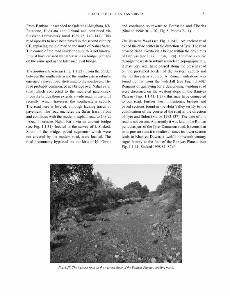
Fig. 1.27. The western road on the western slope of the Baniyas Plateau; looking north.
and continued southward to Bethsaida and Tiberias (Shaked 1998:101–102, Fig. 5, Photos 7–11).
The Western Road (see Fig. 1.1:41). An ancient road exited the civic center in the direction of Tyre. The road crossed Nahal Govta via a bridge within the city limits of Baniyas (see Figs. 1.1:34, 1.24). The road’s course through the western suburb is unclear. Topographically, it may very well have passed along the present road on the presumed border of the western suburb and the northwestern suburb. A Roman milestone was found not far from the waterfall (see Fig. 1.1:40).4 Remains of quarrying for a descending, winding road were discerned on the western slope of the Baniyas Plateau (Figs. 1.1:41, 1.27); this may have connected to our road. Further west, milestones, bridges and paved sections found in the Hula Valley testify to the continuation of the course of the road in the direction of Tyre and Sidon (Ma‘oz 1993:137). The date of this road is not certain. Apparently it was laid in the Roman period as part of the Tyre–Damascus road. It seems that in its present state it is medieval, since its lower section leads to Khan ed-Duwer, a twelfth–thirteenth-century sugar factory at the foot of the Baniyas Plateau (see Fig. 1.1:61; Shaked 1998:81–82).5

MOSHE HARTAl22
Cemeteries
The city of Paneas was surrounded by cemeteries:
The Northeastern Cemetery. Tombs were hewn into the rock along the western part of the Hermon Spur (see Fig. 1.1; for a detailed description, see Chapter 4).
The Northwestern Cemetery. Built-up tombs were located on Giv‘at Hamra (see Fig. 1.1; Chapter 4).
The Southeastern Cemetery. A graveyard was probably situated on the southern edge of the southeastern suburb. Two caves were found (see Fig. 1.1:21). One is almost completely blocked. Attempts at looting were clear; outside the cave was pottery that had been removed. The entrance to the second cave is through a square shaft, 1.50 m deep. The cave at the bottom is irregular and partly filled in. A Syrian communication trench divided the shaft from the cave.
The Western Cemetery. An extensive graveyard covered the western edges of the Baniyas Plateau. Cist tombs were hewn on the flat areas of the plateau (see Fig. 1.1:42, 43; Stepansky 2004; Hartal 2008b). At Kibbutz Snir, D. Amir excavated a first–second-
century CE burial cave, which included a room with arcosolia and kokhim (see Fig. 1.1:44; Amir 1974). Several cist tombs were unearthed outside the cave (Ma‘oz 1993:142). A monumental burial system, including two courtyards and two halls, opens on the grounds of Kibbutz Snir (Figs. 1.1:45, 1.28, 1.29). One hall contained kokh burials, the other, arcosolium burials. Decorated sarcophagi stood in the center. The tomb was emptied in ancient times and lacks dating material (Ma‘oz 1993:142). A first-century two-
Fig. 1.28. Entrance to the monumental burial system west of Kibbutz Snir; looking east.
Fig. 1.29. Burial cave west of Kibbutz Snir; looking northeast.

CHAPTER 1: THE BANIYAS SuRVEY 23
Fig. 1.30. Entrance to a burial cave; looking east.
Fig. 1.32. Roman travertine quarry south of Nahal Hermon; looking northeast.
chambered burial cave was excavated by Z.u. Ma‘oz at the Hermon Field Study Center (Fig. 1.1:46; Ma‘oz 1993:142). Two burial caves with a common courtyard were excavated at the foot of the slope (Figs. 1.1:47, 1.30). Their finds dated them to the first–fifth centuries (Ma‘oz 1993:142). Remains of a mausoleum were exposed west of the caves (see Fig. 1.1:48; Barbé 2007). The western cemetery stretches northward as far as Kh. Shaba‘a (Tahan and Hartal 2007). The surface finds indicate the cemetery was in use from the first through the fifth centuries CE.
Fig. 1.31. Quarrying terraces in the travertine quarry; looking east.
Quarries
Two extensive quarries and other evidence for quarrying were located in the survey.
South of Nahal Hermon, just across from the Baniyas waterfall, is a large quarry (covering 3.5 dunams) in the travertine rock (Figs. 1.1:30, 1.31, 1.32). This quarry probably supplied the building stones for the Roman city. During this period there was widespread use of travertine stones, which are easy to dress and treat. limestone blocks were utilized during this period mainly in the northeastern suburb, which exploited limestone exposures and is far from the travertine quarries.

MOSHE HARTAl24
Fig. 1.33. Medieval quarry on the Hermon Spur. To left, Nebi Khadar; in back, the northwestern suburb. Looking west.
Fig. 1.34. Cutting-off trenches in the quarry; looking north.
A large, nine-dunam quarry is located on the Hermon Spur, above the cliff and the cave, where hard dolomite rock was quarried (Figs. 1.1:57, 1.11, 1.33; Heimann and Porat, in preparation). Naturally inclined layers of the rock were used for the extraction of blocks. The usual disconnection channels around the stone are missing; apparently the workmen employed natural vertical and horizontal cracks in the rock. Short trenches with a trapezoidal cross-section were hewn at a distance appropriate to the size of the desired block (Fig. 1.34), indicating the technique by which a long metal lever was inserted in order to extract the stone. A similar quarrying technology was also identified at Nimrod Fortress (Hartal 2001:61, Figs. 115, 116). Apparently during the Middle Ages, the use of hard limestone increased, since this is the material from which the city walls and their towers are constructed.
The quarry above the cliff bisected the aqueduct and therefore postdates the aqueduct’s latest use, namely the fifth century CE. The use of similar technology in the Nimrod Fortress and the employment of hard limestone in the medieval town indicate that this quarry should be dated to the Middle Ages.

CHAPTER 1: THE BANIYAS SuRVEY 25
summary
The city of Paneas was founded near a rich spring, in a region with a comfortable climate and agricultural soils. The surveys and the excavations failed to uncover evidence of a settlement here prior to the Hellenistic period. The reason for this eludes us. The city comprised a civic center surrounded by domestic suburbs. The areas of the town which were lower in level than the spring were supplied from the latter by a system of channels and pipes. The northeastern, the eastern and the northwestern suburbs, which were higher than the main spring, received their water from an aqueduct which was discovered in the survey.
The ceramic finds corroborate the historical sources, which date the foundation of the city to the year 2/1 BCE. In the first century CE, the urban center was born, as well as the domestic structures in the western and northwestern suburbs. In the second through the fourth centuries CE, all the domestic suburbs were filled with houses, the town having reached its peak. In the first half of the fifth century CE, the town suffered a decline in its state of security, or perhaps the decline is due to
other events whose nature is not clear. Evidence for a fire was found in the ‘Byzantine Street of Shops’; the settlement was not renewed after the fire (Israeli 2008). The temples and most of the houses were destroyed and deserted. During this period a city wall was built south of Nahal Sa‘ar, and apparently surrounded the southeastern suburb. It is tempting to assume that the city moved to this suburb, which is easier to defend. However, the meager ceramic finds collected here do not support this suggestion.
late Byzantine-period finds were recovered from a garbage pit dug over the ruins of the temples (Magness, in preparation) and from Stratum 1 of the excavations in the northwestern suburb (see Chapter 9). In neither case did the finds derive from domestic units. Settlement in the city was renewed during the tenth century CE and continued through the Mamluk period. In these periods, the urban fabric was confined to the limits of the Roman civic center (partly defended by rivers). In recent generations, the area was occupied by a humble village, built among the ruins of the medieval city.
notes
1 The survey of Baniyas was part of the Northern Golan Survey, conducted by the author on behalf of the Archaeological Survey of Israel from 1983 to 1985. The final report of the Golan survey only briefly described the survey of Baniyas (Hartal 1989:74–75). The map of Baniyas according to the survey results (Fig. 1.1) was prepared in November 2007 by M. Hartal and A. Shapiro.2 Previous surveys of Baniyas were conducted in 1967 by Ya‘akov Olami (1967), on behalf of the Archaeological
Survey of Israel. For more details and for the history of the exploration, see Ma‘oz 1993:139–140.3 The strata were dated based on the pottery from the excavation. The pottery is stored in the IAA.4 Now in Bet ussishkin in Kibbutz Dan (Amir 1968: Fig. 42).5 On the route of this road in the Hula Valley, see Shaked 1998:100–101.

MOSHE HARTAl26
referenCes
Amir D. 1968. Banias: From Ancient till Modern Times. Dan (Hebrew).
Amir D. 1974. Burial Cave in Senir. HA 48–49:24.Barbé H. 2007. Sneir. HA–ESI 119. http://www.hahashot-esi.
org.il/report_detail_eng.asp?id=488&mag_id=112.HA 1969. The Golan. HA 30:2–4.Hartal M. 1989. Northern Golan Heights: The Archaeological
Survey as a Source of Regional History. Qazrin (Hebrew; English summary).
Hartal M. 2001. The Al-Subayba (Nimrod) Fortress: Towers 11 and 9 (IAA Reports 11). Jerusalem.
Hartal M. 2005. The Land of the Ituraens: Archaeology and History of the Northern Golan in the Hellenistic, Roman and Byzantine Periods (Golan Studies 2). Qazrin (Hebrew; English summary).
Hartal M. 2007. Banias, the Southwestern Tower. HA–ESI 119. http://www.hadashot-esi.org.il/report_detail_eng.asp?id=503&mag_id=112.
Hartal M. 2008a. Banias, Final Report. HA–ESI 120. http://www.hadashot-esi.org.il/report_detail_eng.asp?id=951&mag_id=114.
Hartal M. 2008b. Banias, Final Report. HA–ESI 120. http://www.hadashot-esi.org.il/report_detail_eng.asp?id=713&mag_id=114.
Hartal M. and Ma‘oz Z.u. 1985. Banias Salvage Excavations—1984. ESI 4:8–9.
Heimann A. and Porat N. In preparation. Excavations at the Sanctuary of Pan, Banyas: Geological Aspects. In Z.u. Ma‘oz. Paneion: Excavations at the Sanctuary of Pan at Caesarea Philippi, 1988–1993 (IAA Reports). Jerusalem.
Israeli S. 2008. Area F: Stratigraphic Analysis of the ‘Burnt’ Street of Shops and Its Pottery. In V. Tzaferis and S. Israeli. Paneas I: The Roman to the Early Islamic Periods: Excavations in Areas A, B, E, F, G and H (IAA Reports 37). Jerusalem. Pp. 105–128.
Josephus War: Josephus. The Jewish War. H. St.J. Thackeray transl. (loeb Classical library). london–New York 1927–1928.
Magness J. In preparation. Pottery from a Seventh Century CE Pit locus 243 (Stratum III). In Z.u. Ma‘oz. Paneion:
Excavations at the Sanctuary of Pan at Caesarea Philippi–Baniya, 1988–1993 (IAA Reports). Jerusalem.
Ma‛oz Z.U. 1993. Banias. NEAEHL I:136–143.Ma‛oz Z.U. 1998. The Sanctuary of Pan in Baniyas.
Qadmoniot 115:18–25 (Hebrew).Ma‛oz Z.U. 1999. Coins and Temple—The Case of Caesarea
Philippi–Paneas. INJ 13:90–102.Ma‘oz Z.u. In preparation. Paneion: Excavations at the
Sanctuary of Pan at Caesarea Philippi–Baniya, 1988–1993 (IAA Reports). Jerusalem.
Mor D. 1986. The Volcanism of the Golan Heights. Geological Survey of Israel, Report GSI/5/86. Jerusalem (Hebrew; English summary).
Netzer E. 1998. Where Did Herod Build the Temple Dedicated to Augustus at Banias? Qadmoniot 116:134–135 (Hebrew).
Olami Y. 1967. Survey in Baniyas. HA 24:35–37 (Hebrew).Shaked I. 1993. Banias, the ‘Officer Pool’. ESI 13:7–8.Shaked I. 1998. The Settlement Pattern and the Road System
in Hula Valley during the 10th–13th Centuries. M.A. thesis. Bar-Ilan university. Ramat-Gan.
Smithline H. 1986. Banias. HA–ESI 118. http://www.hahashot-esi.org.il/report_detail_eng.asp?id=311&mag_id=111.
Stepansky Y. 2004. Senir, Final Report. HA–ESI 116. http://www.hadashot-esi.org.il/report_detail_eng.asp?id=2&mag_id=108.
Tahan H. and Hartal M. 2007. Har Dov (Khirbat Shab‘a). HA–ESI 119. http://www.hadashot-esi.org.il/report_detail_eng.asp?id=490&mag_id=112.
Tzaferis V. 1998. Ten Years of Archaeological Research at Baniyas. Qadmoniot 115: 2–17 (Hebrew).
Tzaferis V. 2008. The Site: Stratigraphy and Architectural Remains. In V. Tzaferis and S. Israeli. Paneas I: The Roman to the Early Islamic Periods: Excavations in Areas A, B, E, F, G and H (IAA Reports 37). Jerusalem. Pp. 15–53.
Tzaferis V. and Israeli S. 2008. Paneas I: The Roman to the Early Islamic Periods: Excavations in Areas A, B, E, F, G and H (IAA Reports 37). Jerusalem.
Wilson C.W. 1880. Picturesque Palestine, Sinai and Egypt II. london.

IAA Reports, No. 40
ISRAEL ANTIQUITIES AUTHORITYJERUSALEM 2009
Paneas IVThe aqueducT and The norThern suburbs
Moshe harTal
With contributions byGabriela Bijovsky, Lev Eppelbaum, Yael Gorin-Rosen and Sonia Itkis
IAA ReportsPublications of the Israel Antiquities Authority
Editor-in-Chief: Judith Ben-Michael
Series and Volume Editor: Ann Roshwalb Hurowitz
Production Coordinator: Lori Lender
Front Cover: Northern Baniyas: the northwestern suburb, the spring and the Cave of Pan; looking west (photographer: M. Hartal)Back Cover: Close-up of the Baniyas spring; looking west (photographer: M. Hartal)
Typesetting, Layout and Cover Design: Ann AbuhavProduction: Ann AbuhavIllustrations: Natalia Zak and Tania KornfeldPrinting: Keterpress Enterprises, Jerusalem
Copyright © 2009, The Israel Antiquities Authority, JerusalemPOB 586, Jerusalem, 91004ISBN 978-965-406-230-5
www.antiquities.org.il

conTenTs
Preface v
PART ONE: THE SURVEY OF BANIYAS 1Chapter 1: The Baniyas Survey 3
PART TWO: THE PANEAS AQUEDUCT 27Chapter 2: The Paneas Aqueduct 29Chapter 3: Coins from the Aqueduct Gabriela Bijovsky 109
PART THREE: THE NORTHERN CEMETERIES 111Chapter 4: Excavations in the Northern Cemeteries 113Chapter 5: Glass Vessels from the Northwestern Cemetery Yael Gorin-Rosen 135Chapter 6: Coins from the Northern Cemetery Gabriela Bijovsky 139Chapter 7: Analysis of the Finds from the Northern Cemeteries 141Chapter 8: Magnetic Survey in the Vicinity of Paneas Sonia Itkis and Lev Eppelbaum 143
PART FOUR: THE NORTHWESTERN SUBURB 153Chapter 9: Excavations in the Northwestern Suburb 155Chapter 10: Finds from the Northwestern Suburb 161Chapter 11: Coins from the Northwestern Suburb Gabriela Bijovsky 179Chapter 12: The Northwestern Suburb: Conclusion 185
PART FIVE: CONCLUSIONS 187Chapter 13: Baniyas in Light of the Survey and the Excavations 189
Locus List 195

iv
abbreVIaTIons
‘Atiqot (ES) English Series‘Atiqot (HS) Hebrew SeriesBA Biblical ArchaeologistBAR Biblical Archaeological ReviewBAR Int. S. British Archaeological Report International SeriesBASOR Bulletin of the American Schools of ResearchDOP Dumbarton Oaks PapersESI Excavations and Surveys in IsraelHA Hadashot Arkheologiyot (Archaeological Newsletter; Hebrew)HA–ESI Hadashot Arkheologiyot–Excavations and Surveys in IsraelIAA Reports Israel Antiquities Authority ReportsIEJ Israel Exploration JournalINJ Israel Numismatic JournalJGS Journal of Glass StudiesJRA Journal of Roman ArchaeologyNEAEHL E. Stern and A. Lewinson-Gilboa eds. New Encyclopedia of
Archaeological Excavations in the Holy Land I–IV. Jerusalem 1993Paneas I V. Tzaferis and S. Israeli. Paneas I: The Roman to Early Islamic Periods: Excavations in
Areas A, B, E, F, G and H (IAA Reports 37). Jerusalem 2008Paneas II V. Tzaferis and S. Israeli. Paneas II: Small Finds and Other Studies (IAA Reports 38).
Jerusalem 2008Paneas III V. Tzaferis. Paneas III. (IAA Reports). Jerusalem in preparation


![[The 34th report on survey of the adverse reaction to radiopharmaceuticals (the 37th Survey in 2011)]](https://static.fdokumen.com/doc/165x107/6343c841b6b0c9b2390d1b4c/the-34th-report-on-survey-of-the-adverse-reaction-to-radiopharmaceuticals-the.jpg)