THE PREPARATORY SURVEY ON BALI BEACH ...
213
DIRECTORATE GENERAL OF WATER RESOURCES MINISTRY OF PUBLIC WORKS THE GOVERNMENT OF THE REPUBLIC OF INDONESIA THE PREPARATORY SURVEY ON BALI BEACH CONSERVATION PROJECT-PHASE II IN THE REPUBLIC OF INDONESIA FINAL REPORT [SIMPLE VERSION] March 2013 JAPAN INTERNATIONAL COOPERATION AGENCY NIPPON KOEI CO., LTD. KOKUSAI KOGYO CO., LTD. FUTABA CONSULTING SERVICE CO., LTD. EI JR 13-072
-
Upload
khangminh22 -
Category
Documents
-
view
1 -
download
0
Transcript of THE PREPARATORY SURVEY ON BALI BEACH ...

DIRECTORATE GENERAL OF WATER RESOURCES MINISTRY OF PUBLIC WORKS THE GOVERNMENT OF THE REPUBLIC OF INDONESIA
THE PREPARATORY SURVEY ON
BALI BEACH CONSERVATION PROJECT-PHASE II
IN THE REPUBLIC OF INDONESIA
FINAL REPORT
[SIMPLE VERSION]
March 2013
JAPAN INTERNATIONAL COOPERATION AGENCY
NIPPON KOEI CO., LTD. KOKUSAI KOGYO CO., LTD.
FUTABA CONSULTING SERVICE CO., LTD. EI
JR
13-072

The Project for the Preparatory Survey on Bali Beach Conservation Project-Phase-1I in The Republic of Indonesia Final Report (Simple Version)
i
Table of Contents
Summary
Chapter 1 Introduction ................................................................................................................... 1-1
1.1 Background .......................................................................................................................... 1-1 1.2 Objectives of the Study ........................................................................................................ 1-1 1.3 Study Area ............................................................................................................................ 1-2 1.4 Scope of Work ...................................................................................................................... 1-3 1.5 Outline of Previous Phase-1 Project ..................................................................................... 1-4 1.6 Understanding the Current Condition ................................................................................... 1-9
REVIEW OF THE BEACH MONITORING & MAINTENANCE SYSTEM ON PHASE-I
Chapter 2 Review of the Current Situation on Beach Management .............................................. 2-1
2.1 Overview of the Current Situation on Beach Management .................................................. 2-1 2.2 Current Situation on Beach Monitoring and Maintenance ................................................... 2-2 2.3 Current Situation on Beach Management System ................................................................ 2-8 2.4 Current Situation on Beach Management Policy ............................................................... 2-22
Chapter 3 Beach Management Issues and Improvement Plan ....................................................... 3-1
3.1 Overview of the Beach Management Issues and Improvement Plan ................................... 3-1 3.2 Improvement Plan on Beach Monitoring and Maintenance ................................................. 3-2 3.3 Improvement Plan on Beach Management System .............................................................. 3-4 3.4 Improvement Plan on Beach Management Policy ............................................................. 3-13
Chapter 4 Support for Consensus Building and Capacity Building .............................................. 4-1
4.1 Outline of Programs for Consensus Building and Capacity Building .................................. 4-1 4.2 Working Group (WG) Meeting ............................................................................................ 4-4 4.3 Programs for Capacity Building for Government Institutions ........................................... 4-12 4.4 Stakeholders’ Meeting ........................................................................................................ 4-14 4.5 Collaboration with Private and Other Sectors, and Public Relations ................................. 4-25 4.6 Seminar on the Sustainable Beach Management ................................................................ 4-28
Chapter 5 Establishment of Sustainable Beach Management System ........................................... 5-1
5.1 Overview .............................................................................................................................. 5-1 5.2 Background on Establishment of Beach Management System ............................................ 5-2 5.3 Establishment of Beach Management System Under Cooperation Between Public
and Private Sectors ............................................................................................................... 5-5 5.4 Proposed Road Map And Action Plan for the Establishment of a Beach
Management System ............................................................................................................ 5-9
Chapter 6 Beach Change After the Nourishment and Review of Adaptation Measures ............. 6-1
6.1 Overview .............................................................................................................................. 6-1 6.2 Beach Change and Sand Remaining after the Nourishment ................................................. 6-2 6.3 Evaluation and Necessity of Adaptation Measures ............................................................ 6-16 6.4 Recommended Adaptation Measures ................................................................................. 6-17 6.5 Implementation Plan of Adaptation Measures .................................................................... 6-25

The Project for the Preparatory Survey on Bali Beach Conservation Project-Phase-1I in The Republic of Indonesia Final Report (Simple Version)
ii
FEASIBILITY STUDY ON PHASE-II PROJECT
Chapter 7 Basic Information about the Study Area ....................................................................... 7-1
7.1 Overview .............................................................................................................................. 7-1 7.2 Review of Existing Reports for Phase-1 Project .................................................................. 7-2 7.3 Review of Natural Conditions .............................................................................................. 7-3 7.4 Review of Socio-Economic Conditions ............................................................................. 7-14 7.5 Review of External Conditions Related to Beach Erosion ................................................. 7-26
Chapter 8 Review of Current Situation on Beach Management and Maintenance ....................... 8-1
8.1 Beach Maintenance and Monitoring by Government Institutions Related to Beach Management ......................................................................................................................... 8-1
8.2 Beach Violation due to Intrusion of Property on Beaches .................................................... 8-2 8.3 Beach Cleaning by Communities, Hotels, and Beach Users ................................................ 8-5 8.4 Involvement from NGOs, Private Companies, and Other Sectors ....................................... 8-6
Chapter 9 Selection of Three Candidate Sites ............................................................................... 9-1
9.1 Overview on the Selection of Candidate Site for Phase-2 Project ....................................... 9-1 9.2 Evaluation on the Socio-economic Condition ...................................................................... 9-5 9.3 Evaluation of Beach Condition ............................................................................................ 9-9 9.4 Preliminary Selection ......................................................................................................... 9-20 9.5 Consideration on Social-Environment ................................................................................ 9-21 9.6 Consideration on Coastal Environment .............................................................................. 9-22 9.7 Evaluation on Realization of Beach Management.............................................................. 9-25 9.8 Final Selection of Candidate Site ....................................................................................... 9-27
Chapter 10 Field Survey and Sediment Analysis for the Candidate Site ...................................... 10-1
10.1 Overview ............................................................................................................................ 10-1 10.2 Tide Measurements along the Southwest and East Coast ................................................... 10-2 10.3 Sounding (Bathymetric and Topographic Survey) ............................................................. 10-3 10.4 Beach Profile Survey and Sand Sampling on the Beach .................................................... 10-9 10.5 Diving Survey for Potential Area of Sand Borrow ........................................................... 10-21 10.6 Comprehensive Analysis for Sediment Transport in Candidasa ....................................... 10-25 10.7 Comprehensive Analysis for Sediment Transport in the Southwest Coast ....................... 10-38
Chapter 11 Planning and Design for Beach Conservation Measures ............................................ 11-1
11.1 Overview ............................................................................................................................ 11-1 11.2 Validity of the Project ......................................................................................................... 11-1 11.3 Objectives of the Project .................................................................................................... 11-6 11.4 Scope of the Project .......................................................................................................... 11-11 11.5 Study for Suitable Beach Conservation Measures ........................................................... 11-13 11.6 Basic Layout and Design at Candidasa ............................................................................ 11-19 11.7 Basic Layout and Design at North Kuta〜Legian〜Seminyak ........................................ 11-32 11.8 Basic Layout and Design for Improvement at Kuta ......................................................... 11-34 11.9 Principle for Planning of Beach Control at Other East Coast Area .................................. 11-37
Chapter 12 Implementation Plan ................................................................................................... 12-1
12.1 Overview of the Implementation Plan ................................................................................ 12-1 12.2 Implementation Plan for Hard Component ........................................................................ 12-2 12.3 Implementation Plan for Soft Component ........................................................................ 12-16 12.4 Cost Estimation ................................................................................................................ 12-21 12.5 Project Implementation Schedule ..................................................................................... 12-26
g0113
長方形

The Project for the Preparatory Survey on Bali Beach Conservation Project-Phase-1I in The Republic of Indonesia Final Report (Simple Version)
iii
12.6 Executive Structure and Financial Condition ................................................................... 12-28 12.7 Study of Appropriate Contract Package ........................................................................... 12-41 12.8 Proposed Sustainable Beach Management System .......................................................... 12-42
Chapter 13 Economic Impact Analysis and Operation and Effect Outcome Measure .................. 13-1
13.1 Overview of the Economic Impact Analysis ...................................................................... 13-1 13.2 Benefits Calculation and Economic Analysis ..................................................................... 13-5 13.3 Operation and Effect Outcome Measure .......................................................................... 13-28
Chapter 14 Environmental and Social Considerations .................................................................. 14-1
14.1 Overview of the Environmental and Social Considerations ............................................... 14-1 14.2 Legal and Organizational Framework of EIA .................................................................... 14-1 14.3 Candidasa Coast ............................................................................................................... 14-11 14.4 Southwest Coast ............................................................................................................... 14-16 14.5 Environmental Impact and Mitigation Measures ............................................................. 14-23
Recommendation
g0113
長方形
g0113
長方形

The Project for the Preparatory Survey on Bali Beach Conservation Project-Phase-1I in The Republic of Indonesia Final Report (Simple Version)
iv
List of Figures Figure 1.3.1 Location of the Phase-1 Project and Phase-2 Study Area .......................................... 1-2 Figure 1.4.1 Scope of Work and Schedule ..................................................................................... 1-5 Figure 1.5.1 Outline of Previous Phase-1 Project (1/2) .................................................................. 1-7 Figure 1.5.1 Outline of Previous Phase-1 Project (2/2) .................................................................. 1-8 Figure 1.5.2 Coastal Management Based on “Adaptive Management System” ............................ 1-9 Figure 1.6.1 Candidate Beaches for Coastal Protection/Beach Conservation Proposed
by GOI ..................................................................................................................... 1-11 Figure 2.1.1 Process Flow on the Review of the Beach Management Current Situation ............... 2-2 Figure 2.2.1 Sand Stockpile at South Sanur ................................................................................... 2-7 Figure 2.4.1 Chronology of Discussion for Beach Management System ..................................... 2-23 Figure 3.1.1 Flow of Improvement Plan on Beach Management ................................................... 3-1 Figure 3.3.1 Steps of the Beach Management Cycle, Richter 2001 ............................................... 3-4 Figure 3.3.2 Organizational Structure of Coordination Team for Beach Management .................. 3-5 Figure 3.3.3 Basic Philosophy for Beach O&M Structure ............................................................. 3-6 Figure 4.1.1 Image of Integrated Beach Management ................................................................... 4-1 Figure 4.1.2 Proposed Programs for Each Group ........................................................................... 4-2 Figure 4.2.1 Structure of WG ......................................................................................................... 4-5 Figure 4.4.1 Sequence of Stakeholders Meetings on Phase-1 Beaches ........................................ 4-16 Figure 4.4.2 Sand Erosion and Accumulation in Intaran Traditional Village ............................... 4-17 Figure 4.4.3 Results of Beach Cleanliness Evaluation ................................................................. 4-18 Figure 5.1.1 Flow for the Contents of Chapter 5 ............................................................................ 5-2 Figure 5.2.1 Flow for the Necessity of Coordination Team for Beach Management ..................... 5-4 Figure 5.3.1 Members of the Coordination Team for Beach Management (TKMPP) ................... 5-7 Figure 5.3.2 Expected Organizational Structure of TKMPP .......................................................... 5-7 Figure 6.1.1 Process Flow on the Review on Countermeasures for Adaptation ............................ 6-1 Figure 6.2.1 Layout of Sanur Beach ............................................................................................... 6-2 Figure 6.2.2 Shoreline Change at S1 (Based on its Initial Shoreline Position) .............................. 6-3 Figure 6.2.3 Shoreline Change at S2 (Based on its Initial Shoreline Position) .............................. 6-3 Figure 6.2.4 Shoreline Change at S3 (Based on Initial Shoreline Position) ................................... 6-4 Figure 6.2.5 Nusa Dua Beach ......................................................................................................... 6-7 Figure 6.2.6 Shoreline Change at N1 (Based on Initial Shoreline Position) .................................. 6-7 Figure 6.2.7 Shoreline Change at N2 (Based on Initial Shoreline Position) .................................. 6-8 Figure 6.2.8 Shoreline Change at N3 (based on initial shoreline position) .................................... 6-9 Figure 6.2.9 Area of Nourishment at Kuta Beach ........................................................................ 6-12 Figure 6.2.10 Change of Position of Shoreline and Difference from the Initial Position .............. 6-13 Figure 6.2.11 Sand Loss for Each Sub-Area .................................................................................. 6-14 Figure 6.2.12 Rate of Sand Remaining after the Nourishment in Phase-1 Project ........................ 6-15 Figure 6.4.1 Alternative of Adaptation between G7 and GN4 in S2, Sanur ................................. 6-18 Figure 6.4.2 Comparison of Maintenance Cost for each Alternative between
G7 and GN4 ............................................................................................................. 6-18 Figure 6.4.3 Wave Propagation and Littoral Transport Surrounding G32 ................................... 6-20 Figure 6.4.4 Littoral Transport at Tanjung Benoa Area ................................................................ 6-24 Figure 6.4.5 Recommended Sand Rotation at GA2 ..................................................................... 6-24 Figure 6.4.6 Cost Comparison of Repetitive Sand Re-nourishment and Additional
Groin to Maintain Sandy Beach at GA2 .................................................................. 6-25 Figure 6.5.1 Schedule and Cost of Beach Maintenance at Sanur and Nusa Dua Beach .............. 6-26

The Project for the Preparatory Survey on Bali Beach Conservation Project-Phase-1I in The Republic of Indonesia Final Report (Simple Version)
v
Figure 6.5.2 Plan of Use of Sand Stock at Mertasari for Sanur and Nusa Dua Maintenance Works .................................................................................................. 6-27
Figure 7.3.1 Coastal Geography and Seabed Topography ............................................................. 7-3 Figure 7.3.2 Distribution of Coral Reefs ........................................................................................ 7-4 Figure 7.3.3 Coral Reef Coast at Candidasa ................................................................................... 7-5 Figure 7.3.4 Southwest Coastal Area (from Norh Kuta to Canggu) ............................................... 7-6 Figure 7.3.5 Kuta Beach ................................................................................................................. 7-7 Figure 7.3.6 Bottom Slope along Representative Lines ................................................................. 7-7 Figure 7.3.7 Legian ~ Seminyak ~ Canggu .................................................................................... 7-8 Figure 7.3.8 Monthly Rainfall and Temperature (1961 to 1990) ................................................. 7-9 Figure 7.3.9 Wind Roses for Two Seasons in Kuta and Sanur ..................................................... 7-10 Figure 7.3.10 Offshore Wave Distribution (Period:16 sec) ............................................................ 7-12 Figure 7.3.11 Directional Wave Energy Flux at Three Sites .......................................................... 7-14 Figure 7.4.1 Percentage Distribution of GDRP of Bali Province at Current Market
Prices by Industrial Origin ....................................................................................... 7-15 Figure 7.4.2 Share of Tourist Arrivals in Bali .............................................................................. 7-15 Figure 7.4.3 Growth of Tourist Arrivals in Bali ........................................................................... 7-16 Figure 7.4.4 Number of Accommodations and Restaurants, and Room Occupancy
Rates ......................................................................................................................... 7-17 Figure 7.4.5 Use of Coastal Area in Candidasa ............................................................................ 7-18 Figure 7.4.6 Modified T-shape Groin and Nourishment with Volcanic Sand ............................... 7-20 Figure 7.4.7 Land Use at North Kuta ~ Legian and Seminyak .................................................... 7-21 Figure 7.4.8 Spatial Plan .............................................................................................................. 7-24 Figure 7.5.1 Location and Name of Rivers .................................................................................. 7-26 Figure 7.5.2 Number for Constructed Check Dams in Bali Island ............................................... 7-28 Figure 7.5.3 Coral Mining Area ................................................................................................... 7-30 Figure 8.2.1 Location of Property which is Located Close to the Shore ........................................ 8-5 Figure 9.1.1 Location of Subject Beaches ...................................................................................... 9-2 Figure 9.1.2 Basic Procedure for the Selection of Candidate Site ................................................. 9-3 Figure 9.3.1 Aerial and Satellite Imagery between 1981 and 2011 (East Coast) ........................... 9-9 Figure 9.3.2 Shoreline Change between 1981 and 2011 (Souteast Coast) ................................... 9-10 Figure 9.3.3 Aerial and Satellite Imagery between 1981 and 2011 (Candidasa) ......................... 9-11 Figure 9.3.4 Shoreline Change between 1981 and 2011 (Candidasa) .......................................... 9-11 Figure 9.3.5 Aerial and Satellite Imagery between 1981 and 2010 (Southwest Coast) ............... 9-12 Figure 9.3.6 Shoreline Change between 1981 and 2010 .............................................................. 9-13 Figure 9.3.7 Present Condition on Beach Use and Facilities, and Anticipated Obstacles (1/5) ... 9-16 Figure 9.3.7 Present Condition on Beach Use and Facilities, and Anticipated Obstacles (2/5) ... 9-17 Figure 9.3.7 Present Condition on Beach Use and Facilities, and Anticipated Obstacles (3/5) ... 9-18 Figure 9.3.7 Present Condition on Beach Use and Facilities, and Anticipated Obstacles (4/5) ... 9-19 Figure 9.3.7 Present Condition on Beach Use and Facilities, and Anticipated Obstacles (5/5) ... 9-20 Figure 9.6.1 Coral Reef Surrounding Candidasa .......................................................................... 9-23 Figure 10.2.1 Result of Sea Water Level Measurements in Candidasa and Kuta .......................... 10-2 Figure 10.3.1 Bathymetric Survey Areas ....................................................................................... 10-3 Figure 10.3.2 Bathymetric Chart for Candidasa ............................................................................. 10-4 Figure 10.3.3 Bathymetric Chart for the South East Coast from North Kuta to Part of
Canggu ..................................................................................................................... 10-5 Figure 10.3.4 Location of Representative Survey Lines in Candidasa........................................... 10-5 Figure 10.3.5 Cross Section Charts of Representative Survey Lines in Candidasa ....................... 10-6 Figure 10.3.6 Locations of Representative Survey Lines in Kuta .................................................. 10-6

The Project for the Preparatory Survey on Bali Beach Conservation Project-Phase-1I in The Republic of Indonesia Final Report (Simple Version)
vi
Figure 10.3.7 Comparison on the Results of Cross Section Charts for the Southwest Coast ........................................................................................................................ 10-8
Figure 10.3.8 Comparison on the Results of Cross Section Charts for the Southwest Coast ........................................................................................................................ 10-9
Figure 10.4.1 Location of Beach Profile Survey and Sand Sampling at Candidasa .................... 10-10 Figure 10.4.2 Location of Beach Profile Survey and Sand Sampling at the South East
Coast from North Kuta to Part of Canggu ............................................................. 10-10 Figure 10.4.3 Position of Sand Sampling in a Cross Section Line ............................................... 10-11 Figure 10.4.4 Comparison on the Beach Profile Taken at Typical Survey Lines in
Candidasa ............................................................................................................... 10-13 Figure 10.4.5 Comparison on the Beach Profile Taken at Typical Survey Lines from
North Kuta to Seminyak ........................................................................................ 10-14 Figure 10.4.6 Comparison on the Beach Profile Taken at Typical Survey Lines from
North Kuta to Seminyak ........................................................................................ 10-15 Figure 10.4.7 Alongshore Distribution of Medium Grain Size (D50), Contents of Fine
Sand and Average Slope in Candidasa ................................................................... 10-17 Figure 10.4.8 Seabed Material Composition in Candidasa .......................................................... 10-18 Figure 10.4.9 Alongshore Distribution of Medium Grain Size (D50), Contents of Fine
Sand, and Average Slope in the Southwest Coast from North Kuta to Part of Canggu ............................................................................................................... 10-19
Figure 10.4.10 Seabed Material Composition in the Southwest Coast from North Kuta to Part of Canggu ................................................................................................... 10-20
Figure 10.5.1 Diving Survey Area in Candidasa .......................................................................... 10-21 Figure 10.5.2 Diving Survey Area in the Southwest Coast from Kuta to Part of Canggu ........... 10-22 Figure 10.6.1 Candidasa Area ...................................................................................................... 10-25 Figure 10.6.2 Location Map Showing Where Photos were Taken in the West Area of
Candidasa (November 2011) .................................................................................. 10-27 Figure 10.6.3 Location Map Showing Where Photos were Taken in the Central Area
of Candidasa (November 2011) ............................................................................. 10-29 Figure 10.6.4 Location Map Showing Where Photos were Taken in the East Area of
Candidasa (November 2011) .................................................................................. 10-31 Figure 10.6.5 Seabed Material Composition on Foreshore Slope at Candidasa .......................... 10-33 Figure 10.6.6 Comparison on the Beach Condition between 2004 and 2011 .............................. 10-34 Figure 10.6.7 Comparison on the Beach Condition between 2004 and 2011 .............................. 10-35 Figure 10.6.8 Relation between Offshore and Incident Wave Direction in Candidasa ................ 10-36 Figure 10.6.9 Distribution of the Rate of Wave Heights and Directions along the East
Coast Area .............................................................................................................. 10-36 Figure 10.6.10 Definition of Wave Direction ................................................................................. 10-37 Figure 10.6.11 Calculated Longshore Sediment Transport Rate in Candidasa .............................. 10-37 Figure 10.7.1 Southwest Coast Area ............................................................................................ 10-38 Figure 10.7.2 Location Map of North Kuta Showing Positions Where Photos were
Taken ...................................................................................................................... 10-40 Figure 10.7.3 Location Map of Legian-Seminyak Showing Positions Where Photos
were Taken ............................................................................................................. 10-42 Figure 10.7.4 Location Map of Canggu Showing Positions Where Photos were Taken .............. 10-45 Figure 10.7.5 Sand Sampling Points in the Southwest Cost ........................................................ 10-49 Figure 10.7.6 Alongshore Distribution of Sand Composition in the Southwest Coast ................ 10-49 Figure 10.7.7 Alongshore Distribution of D50 and Beach Slope ................................................. 10-49 Figure 10.7.8 Distribution of Wave Height and Direction ........................................................... 10-51 Figure 10.7.9 Image of Dominant Incident Wave Direction Obtained from Numerical
Computation ........................................................................................................... 10-51 Figure 10.7.10 Calculated Longshore Sediment Transport Rate in the Southwest Coast .............. 10-52 Figure 11.2.1 Multifunction of Beach Conservation Project .......................................................... 11-2 Figure 11.2.2 Planned and Actual Layout at Kuta Project (Phase-1 Project) ................................. 11-5

The Project for the Preparatory Survey on Bali Beach Conservation Project-Phase-1I in The Republic of Indonesia Final Report (Simple Version)
vii
Figure 11.5.1 Comparison of Alternatives for Beach Conservation Measures at Candidasa ............................................................................................................... 11-15
Figure 11.5.2 Comparison of Alternatives for Beach Conservation Measures at North Kuta~Legian~Seminak .......................................................................................... 11-16
Figure 11.5.3 Preliminary Evaluation for Each Alternative at North of Kuta Reef ..................... 11-17 Figure 11.5.4 Case Study for Numerical Analysis ....................................................................... 11-17 Figure 11.5.5 Comparison of Calculated Sand Loss for Each Case ............................................. 11-18 Figure 11.5.6 Checking Points of Seabed Elevation .................................................................... 11-18 Figure 11.5.7 Calculated Seabed Elevation at Toe Part of Revetment (P1 and P2) ..................... 11-18 Figure 11.6.1 Image for Modification of Existing Seawall .......................................................... 11-19 Figure 11.6.2 Image for Modification of Existing Groins ............................................................ 11-20 Figure 11.6.3 Layout Plan at Candidasa (Area 1) ........................................................................ 11-22 Figure 11.6.4 Layout Plan at Candidasa (Area 2) ........................................................................ 11-22 Figure 11.6.5 Relation Between Grain Size(D50) and Foreshore Slope ...................................... 11-28 Figure 11.6.6 Determination of Cross Section Dimension ........................................................... 11-29 Figure 11.6.7 Typical Cross Section for Beach Nourishment ...................................................... 11-30 Figure 11.6.8 Typical Cross Section for Revetment ..................................................................... 11-30 Figure 11.6.9 Typical Cross Section for Groin ............................................................................. 11-31 Figure 11.7.1 Layout Plan for Beach Nourishment at Southwest Coast
(North Kuta - Legian - Seminyak)) ........................................................................ 11-32 Figure 11.7.2 Relation between Grain Size (D50) and Foreshore Slope ...................................... 11-33 Figure 11.7.3 Typical Cross Section for Beach Nourishment ...................................................... 11-34 Figure 11.8.1 Layout Drawing for the Improvement at Kuta ....................................................... 11-35 Figure 11.8.2 Typical Cross Section for the Improvement of Existing Offshore
Breakwater (BWN2) .............................................................................................. 11-36 Figure 11.8.3 Typical Cross Section for New L-shape Groin ...................................................... 11-36 Figure 11.9.1 Shoreline Change at East Coast between 1981 and 2011 ...................................... 11-37 Figure 12.1.1 Procedure of the Implementation Plan ..................................................................... 12-1 Figure 12.2.1 Quarry Site for Andesite .......................................................................................... 12-4 Figure 12.2.2 Potential Site of Limestone ...................................................................................... 12-5 Figure 12.2.3 Layout Plan at Candidasa (Area 1, re-posted from Chapter 11) .............................. 12-6 Figure 12.2.4 Layout Plan at Candidasa (Area 2, re-posted from Chapter 11) .............................. 12-6 Figure 12.2.5 Sequence of Beach Conservation Project at Candidasa ........................................... 12-7 Figure 12.2.6 Temporary Jetty, Temporary Stock Yard, and Transportation Method of
Main Materials ......................................................................................................... 12-7 Figure 12.2.7 Sequence of Demolition Works................................................................................ 12-8 Figure 12.2.8 Sequence of Revetment Works ................................................................................ 12-8 Figure 12.2.9 Work Flow of Groin Works ...................................................................................... 12-9 Figure 12.2.10 Sequence of Beach Nourishment Works ................................................................ 12-10 Figure 12.2.11 Layout Plan for Beach Nourishment at North Kuta-Legian-Seminyak
(Re-posted from Chapter 11) ................................................................................. 12-11 Figure 12.2.12 Flow Chart of Construction Method at North Kuta-Legian-Seminyak .................. 12-12 Figure 12.2.13 Construction Image of Sand Mining Work ............................................................ 12-12 Figure 12.2.14 Construction Image for Sand Transportation from Borrow Site ............................ 12-13 Figure 12.2.15 Layout Plan for the Improvement at Kuta (Reposted from Chapter 11) ................ 12-13 Figure 12.6.1 Organizational Chart of DGWR ............................................................................. 12-28 Figure 12.6.2 Work Relationship between BWS-BP, DGWR, and the Local Goverment ........... 12-29 Figure 12.6.3 Proposed Structure of PMU ................................................................................... 12-34 Figure 12.8.1 Proposed Beach Management Structure for Phase-2 ............................................. 12-42 Figure 13.1.1 Procedure for the Economic Analysis ...................................................................... 13-2 Figure 13.2.1 Change in the Number of Tourist Who Stayed in Denpasar by Tourist
Area .......................................................................................................................... 13-5
g0113
長方形

The Project for the Preparatory Survey on Bali Beach Conservation Project-Phase-1I in The Republic of Indonesia Final Report (Simple Version)
viii
Figure 13.2.2 Tourist Increase Rate from 2004 to 2010 Based on 2004, and Linear Approximation of Increase Tendency ...................................................................... 13-6
Figure 13.2.3 Linear Approximation on the Increase Rate of Hotel Occupancy Based on 2004.......................................................................................................................... 13-8
Figure 13.2.4 Analysis Result for WTP ....................................................................................... 13-11 Figure 13.2.5 Analysis Result for WTP ....................................................................................... 13-19 Figure 13.2.6 Shoreline Change from Dec. 2008 to Sep. 2011 .................................................... 13-23 Figure 13.2.7 Location and Occupancy Change of Hotels at Kuta .............................................. 13-24 Figure 14.2.1 EIA Flowchart of Indonesia ..................................................................................... 14-2 Figure 14.2.2 Spatial Plan of Bali Province (Tourism and Coastal Conservation Area) ................ 14-7 Figure 14.2.3 Spatial Plan of Candidasa Area (East), Karangasem Regency ................................. 14-8 Figure 14.2.4 Spatial Plan of Candidasa Area (West), Karangasem Regency ................................ 14-9 Figure 14.3.1 Proposed Project Coverage Areas .......................................................................... 14-11 Figure 14.3.2 Cross Section of Alternative-3 ............................................................................... 14-12 Figure 14.3.3 Western Area of Candidasa .................................................................................... 14-12 Figure 14.3.4 Central Area of Candidasa ..................................................................................... 14-13 Figure 14.3.5 Eastern Area of Candidasa ..................................................................................... 14-13 Figure 14.3.6 Sand Dredging, Transportation, and Sand Filling .................................................. 14-15 Figure 14.4.1 Proposed Coverage of the Southwest Coast ........................................................... 14-16 Figure 14.4.2 Proposed Profile of Beach for South West Coast ................................................... 14-17 Figure 14.4.3 Proposed Sand Nourishment Implementation Works ............................................ 14-18 Figure 14.4.4 Location of Hotels and Restaurants at the Proposed Area ..................................... 14-20 Figure 14.5.1 Cross Section of Typical Coral Reef ...................................................................... 14-28 Figure 14.5.2 Location of Reef Limestone ................................................................................... 14-29 Figure 14.5.3 Hard Coral Coverage Ratio .................................................................................... 14-29 Figure 14.5.4 Soft Coral Coverage Ratio ..................................................................................... 14-30 Figure 14.5.5 Locations of Survey Points .................................................................................... 14-32 Figure 14.5.6 Aerial View in the Eastern End of Candidasa ........................................................ 14-34 Figure 14.5.7 Aerial View of the Area in between Breakwater No.7 to No.11 ............................ 14-35 Figure 14.5.8 Modification (Setback) of the Protection Line ....................................................... 14-36 Figure 14.5.9 Bucket Type Dredger Equipped With Screen ........................................................ 14-38

The Project for the Preparatory Survey on Bali Beach Conservation Project-Phase-1I in The Republic of Indonesia Final Report (Simple Version)
ix
List of Tables
Table 1.5.1 Project Information for Previous Phase-1 Project ...................................................... 1-6 Table 2.2.1 Summary of the Past Records and Budget for Beach Monitoring and
Maintenance (Phase-1) ............................................................................................... 2-6 Table 2.3.1 List of Partial Retreat of Beach and Damages to Facilities........................................ 2-8 Table 2.3.2 Summary of Beach Cleaning Condition in Sanur Beach ......................................... 2-11 Table 2.3.3 Summary of Beach Cleaning Condition in Nusa Dua Beach ................................... 2-12 Table 2.3.4 Summary of Beach Cleaning Condition in Kuta Beach ........................................... 2-12 Table 2.3.5 Summary of the Current Situation on Beach Management (Sanur) ......................... 2-20 Table 2.3.6 Summary of the Current Situation on Beach Management (Nusa Dua) .................. 2-21 Table 2.3.7 Summary of the Current Situation on Beach Management (Kuta) .......................... 2-22 Table 2.4.1 Summary on the Demarcation of Responsibility for Beach Management ............... 2-25 Table 2.4.2 List of Permanent Structures and Building Located in the Nourished
Beach ........................................................................................................................ 2-25 Table 2.4.3 Official Regulations Relating to Beach Use in Phase-1 Area .................................. 2-26 Table 3.2.1 Summary of Beach Monitoring Issues and Improvement Plan .................................. 3-2 Table 3.2.2 Important Notice for Review of the Beach O&M Manual......................................... 3-3 Table 3.3.1 Issues and Countermeasures of Beach Cleaning with Stakeholders .......................... 3-7 Table 3.3.2 Proposed Framework Model for Consolidating Educational Network on
Beach Management in Sanur ................................................................................... 3-10 Table 3.3.3 Blueprint of Awareness Mobilization ....................................................................... 3-12 Table 4.1.1 Recommended Programs on Capacity Building and Consensus Building ................ 4-3 Table 4.2.1 Summary of 1st Pre-WG Meeting ............................................................................. 4-6 Table 4.2.2 Summary of the 1st WG Meeting .............................................................................. 4-7 Table 4.2.3 Summary of 2nd WG Meeting ................................................................................... 4-8 Table 4.2.4 Summary of the Pre- 3rd WG Meeting ...................................................................... 4-9 Table 4.2.5 Summary of the 3rd WG Meeting ............................................................................ 4-10 Table 4.4.1 Comparison between Volunteer Activities and Adopt Program ............................... 4-22 Table 4.4.2 Comparison of Adopt Program between Japan and Phase-I Beaches ...................... 4-23 Table 4.6.1 Overview of the Seminar on the Sustainable Beach Management .......................... 4-28 Table 5.3.1 Categorized Management Item and Required Actions ............................................... 5-5 Table 5.3.2 Demarcation of Responsibilities of TKMPP Members (Draft Idea) .......................... 5-8 Table 5.4.1 Road Map for the Establishment of Beach Management System ............................ 5-10 Table 5.4.2 Action Plan in the 2nd Term of Preliminary Stage in 2013 (Draft) ......................... 5-10 Table 6.2.1 Comparison of Evaluation Result on Beach Condition at Sanur ............................... 6-6 Table 6.2.2 Comparison of Evaluation Result on Beach Condition at Nusa Dua ....................... 6-11 Table 6.2.3 Comparison of Evaluation Result on Beach Condition at Kuta ............................... 6-15 Table 6.3.1 Evaluation for Necessity of Adaptation at Sanur ..................................................... 6-16 Table 6.3.2 Evaluation for Necessity of Adaptation at Nusa Dua ............................................... 6-16 Table 6.4.1 Recommended Adaptation between Groin G7 and GN4 ......................................... 6-19 Table 6.4.2 Recommended Adaptation at North Side of G32 in S3 ........................................... 6-19 Table 6.4.3 Recommended Adaptation between Groin G37 and GN5 ....................................... 6-21 Table 6.4.4 Comparison of Three Alternatives of Adaptations between G38 and GA2
in S3 ......................................................................................................................... 6-22 Table 6.4.5 Recommended Adaptation between Groin G38 and GA2 ....................................... 6-22 Table 6.4.6 Recommended Adaptation between Groin G0 and GA8 ......................................... 6-23 Table 6.4.7 Recommended Adaptation at GA2 to the North ...................................................... 6-24

The Project for the Preparatory Survey on Bali Beach Conservation Project-Phase-1I in The Republic of Indonesia Final Report (Simple Version)
x
Table 7.1.1 Overview of Chapter 7 ............................................................................................... 7-1 Table 7.2.1 Summary of Existing Main Reports for Phase-1 Project ........................................... 7-2 Table 7.3.1 Wind Characteristics .................................................................................................. 7-9 Table 7.3.2 Design Tidal Elevation for Phase-1 Project ............................................................. 7-10 Table 7.3.3 Calculation Conditions ............................................................................................. 7-11 Table 7.3.4 Situation of Wave Observation ................................................................................ 7-13 Table 7.4.1 GRDP at Current Market Prices in Bali Province by Industrial Origin,
2006 – 2009 (Trillion Rupiahs) ................................................................................ 7-15 Table 7.4.2 Ranking of Tourist Arrivals from Each Country ...................................................... 7-17 Table 7.4.3 Number of Accommodations and Restaurants, and Room Occupancy
Rates ......................................................................................................................... 7-17 Table 7.4.4 Beach Erosion and Coastal Protection Measures in Candidasa ............................... 7-20 Table 7.4.5 Beach Erosion and Coastal Protection Measures in North Kuta .............................. 7-22 Table 7.5.1 Ranking of Rivers in Terms of Quantity of Sediment Yield .................................... 7-27 Table 7.5.2 Record of Constructed Check Dams (Sabo Dam) and Weirs ................................... 7-28 Table 8.1.1 Summary of Beach Management at the Subject Beaches for Phase-2 Area .............. 8-1 Table 8.2.1 Regulations to Define the “Beach Conservation Area” ............................................. 8-3 Table 8.3.1 Cleaning Activities in Phase 2 Candidate Beaches .................................................... 8-6 Table 9.1.1 Subject Beaches ......................................................................................................... 9-1 Table 9.1.2 Checklist Items for Each Evaluation Criteria ............................................................. 9-3 Table 9.1.3 Evaluation Results (Preliminary) ............................................................................... 9-4 Table 9.1.4 Evaluation Results (Final) .......................................................................................... 9-4 Table 9.2.1 Criteria for Scoring .................................................................................................... 9-5 Table 9.2.2 Evaluation Results for the Identification of World Tourist Area ................................ 9-5 Table 9.2.3 Beach Area Ranked by Number of Rooms and Hotels .............................................. 9-6 Table 9.2.4 Beach Area Ranked by Number of Seating Capacity and Restaurants ...................... 9-7 Table 9.2.5 Criteria for Scoring .................................................................................................... 9-7 Table 9.2.6 Evaluation Results for Land Use along the Coast ...................................................... 9-8 Table 9.2.7 Evaluation Results on the Contribution of Tourism Development Plan .................... 9-8 Table 9.3.1 Criteria for Scoring .................................................................................................. 9-14 Table 9.3.2 Evaluation Result for the Degree of Beach Erosion ................................................ 9-14 Table 9.3.3 Evaluation for Obstruction on Beach Use and Land Facilities ................................ 9-15 Table 9.5.1 Interview Results on the Necessity of Coastal Protection Measures ....................... 9-21 Table 9.5.2 Relation between Hotels and Communities ............................................................. 9-22 Table 9.6.1 Summary on the Impact to Coastal Environment .................................................... 9-22 Table 9.6.2 Commercial Fishing (Species and Area) .................................................................. 9-24 Table 9.6.3 Occurrence of Degradation of Water Quality........................................................... 9-24 Table 9.7.1 Evaluation Results on the Realization of Beach Management by the
Government .............................................................................................................. 9-25 Table 9.7.2 Present Beach Maintenance Activities Being Done by Stakeholders ...................... 9-26 Table 9.8.1 Summary of the Evaluation Results on the Social Environment, Coastal
Environment, and Beach Management .................................................................... 9-27 Table 10.1.1 Overview of Chapter 10 ........................................................................................... 10-1 Table 10.3.1 Range and Intervals of Bathymetric Survey ............................................................ 10-3 Table 10.3.2 Results of Coastal Accretion and Erosion Conditions at Each Survey Line ............ 10-7 Table 10.4.1 Outline of Sand Sampling on the Beach ................................................................ 10-11 Table 10.5.1 Outline of Diving Survey ....................................................................................... 10-21 Table 10.5.2 Results of the Diving Survey of Seabed Materials in Candidasa ........................... 10-23 Table 10.5.3 Results of the Diving Survey of Seabed Materials from Kuta to Canggu ............. 10-24 Table 10.7.1 Result of Checking of the River Mouth and Beach Change due to
Obstacles ................................................................................................................ 10-50

The Project for the Preparatory Survey on Bali Beach Conservation Project-Phase-1I in The Republic of Indonesia Final Report (Simple Version)
xi
Table 11.1.1 Overview for Planning and Design for Beach Conservation Measures ................... 11-1 Table 11.6.1 Statistical Offshore Wave Height with Each Return Period ................................... 11-24 Table 11.6.2 Offshore Design Waves (50-year Return Period) ................................................... 11-24 Table 11.6.3 Equivalent Offshore Wave Height for Each Wave Direction ................................. 11-25 Table 11.6.4 Design Wave Height for Coastal Structures ........................................................... 11-25 Table 11.6.5 Required Weight for Armor Material ..................................................................... 11-27 Table 11.6.6 Armor Size for Each Part of Groin, Headland ....................................................... 11-27 Table 12.2.1 Scope of Works for Hard Component ...................................................................... 12-2 Table 12.2.2 Sources of Major Materials Expected to be Procured .............................................. 12-3 Table 12.2.3 Volume of Main Materials ....................................................................................... 12-3 Table 12.2.4 Comparison of Dredger Types for Sand Mining .................................................... 12-10 Table 12.2.5 Construction Schedule (Package-1 with Beach Nourishment) .............................. 12-15 Table 12.3.1 Contents of Soft Component (1/2) ......................................................................... 12-17 Table 12.3.1 Contents of Soft Component (2/2) ......................................................................... 12-18 Table 12.3.2 Assignment Plan for Soft Component ................................................................... 12-19 Table 12.3.3 Schedule for the Plan of Beach Management System............................................ 12-20 Table 12.4.1 Billing Rate of Consultant ...................................................................................... 12-21 Table 12.4.2 Project Cost for Each Package ............................................................................... 12-23 Table 12.4.3 Summary of Total Project Cost .............................................................................. 12-24 Table 12.4.4 Training Cost for Soft Component ......................................................................... 12-25 Table 12.5.1 Implementation Schedule ....................................................................................... 12-26 Table 12.6.1 Number of Staff at DGWR and BWS-BP in 2012
(Employment status : Central Government) .......................................................... 12-30 Table 12.6.2 Number of BWS-BP Staff (2009-2012) ................................................................. 12-30 Table 12.6.3 Financial Data of DGWR and BWS-BP for the Past Four Years ........................... 12-31 Table 12.6.4 Financial Data of BWS-BP for the Past Four Years ............................................... 12-31 Table 12.6.5 Proposed Project for DGWR Sector ...................................................................... 12-31 Table 12.6.6 OM Cost Spent by BWS-BP from 2006 ................................................................ 12-32 Table 12.6.7 Past Records of Beach Management ...................................................................... 12-38 Table 12.6.8 Implementation Status of Government Institutions which are related to
Beach Management ................................................................................................ 12-39 Table 12.6.9 Summary of Beach Management Plan ................................................................... 12-40 Table 12.7.1 Contract Packages .................................................................................................. 12-41 Table 13.1.1 List of Benefits Evaluated in this Study ................................................................... 13-3 Table 13.1.2 Candidasa; Summary of Economic Analysis for the Entire Project ......................... 13-4 Table 13.1.3 Legian~Seminyak; Summary of Economic Analysis for the Entire Project ............ 13-4 Table 13.1.4 Kuta; Summary of Economic Analysis for the Entire Project ................................. 13-4 Table 13.2.1 Number of Tourist Who Stayed in Denpasar by Tourist Area .................................. 13-5 Table 13.2.2 Tourist Increase Rate 2004-2010 (based on 2004) ................................................... 13-6 Table 13.2.3 Assumed Total Number of Visitors in Nusa Dua Beach Area Based on
Number of Hotel Guests .......................................................................................... 13-7 Table 13.2.4 Change of Hotel Occupancy Rate from 2004 to 2011
(Source: Interview with hotels) ................................................................................ 13-8 Table 13.2.5 Calculation of the Benefit by Erosion Prevention .................................................... 13-9 Table 13.2.6 Number of Guest per Stay Period, Year ................................................................. 13-10 Table 13.2.7 Result of Willingness to Pay for Beach Conservation Project ............................... 13-11 Table 13.2.8 Total WTP .............................................................................................................. 13-12 Table 13.2.9 Tourist Expenditure and Proportion of Foreign and Domestic Tourists ................. 13-12 Table 13.2.10 Assumed Number of Visitor to Candidasa Beach per Year .................................... 13-13 Table 13.2.11 Increase of Tourist Expenditure ............................................................................. 13-13 Table 13.2.12 Annual Cost (Upper: 3 km, Lower: 5 km) ............................................................. 13-14 Table 13.2.13 Summary of the Economic Analysis for the Entire Project ................................... 13-16 Table 13.2.14 Summary of the Economic Analysis for the Maintenance Project ......................... 13-16
g0113
長方形
g0113
長方形
g0113
長方形

The Project for the Preparatory Survey on Bali Beach Conservation Project-Phase-1I in The Republic of Indonesia Final Report (Simple Version)
xii
Table 13.2.15 Calculation of the Benefit by Erosion Prevention .................................................. 13-17 Table 13.2.16 Number of Guest per Stay Period, Year ................................................................. 13-18 Table 13.2.17 Result of Willingness to Pay for Beach Conservation Project ............................... 13-19 Table 13.2.18 Total WTP .............................................................................................................. 13-20 Table 13.2.19 Tourist Expenditure and Proportion of Foreign and Domestic Tourists ................. 13-20 Table 13.2.20 Assumed Number of Visitor to Legian~Seminyak Beach per Year ....................... 13-20 Table 13.2.21 Increase of Tourist Expenditure ............................................................................. 13-21 Table 13.2.22 Annual Cost ........................................................................................................... 13-21 Table 13.2.23 Summary of the Economic Analysis for the Entire Project ................................... 13-22 Table 13.2.24 Summary of the Economic Analysis for the Maintenance Project ......................... 13-23 Table 13.2.25 Calculation of the Benefit by Erosion Prevention .................................................. 13-24 Table 13.2.26 Tourist Expenditure and Proportion of Foreign and Domestic Tourists ................. 13-25 Table 13.2.27 Assumed Number of Visitor to Eroded Area in Kuta ............................................. 13-25 Table 13.2.28 Assumed Number of Visitor for With and Without the Project ............................. 13-25 Table 13.2.29 Avoidance on the Decrease of Tourist Expenditure ............................................... 13-25 Table 13.2.30 Annual Cost ........................................................................................................... 13-26 Table 13.2.31 Summary of the Economic Analysis for the Entire Project ................................... 13-27 Table 13.2.32 Summary of the Economic Analysis for the Maintenance Project ......................... 13-27 Table 13.3.1 Operation and Effect Outcome Measure ................................................................ 13-28 Table 14.2.1 Regulation of Environment Minister Number 11, Year 2006 (Attachment I) .......... 14-3 Table 14.2.2 Differences between JICA and Indonesian EIAs ..................................................... 14-5 Table 14.2.3 Bali Province Spatial Plan (2009-2029) ................................................................... 14-6 Table 14.2.4 Responsible Offices for Sand Dredging Permission .............................................. 14-10 Table 14.3.1 Cross Section of Alternatives ................................................................................. 14-12 Table 14.3.2 Natural and Social Comparison of Alternatives in Candidasa ............................... 14-13 Table 14.3.3 Fishing Activities in the Dredging Area ................................................................. 14-16 Table 14.4.1 Comparison of Facilities with Other Alternatives .................................................. 14-18 Table 14.4.2 Natural and Social Comparison of Alternatives in the Southwest Coast ............... 14-19 Table 14.4.3 Fishing Activities in the Dredging Area ................................................................. 14-22 Table 14.5.1 Scoping for Candidasa and Southwest Coast (1/4) ................................................ 14-23 Table 14.5.1 Scoping for Candidasa and Southwest Coast (2/4) ................................................ 14-24 Table 14.5.1 Scoping for Candidasa and South West Coast (3/4)............................................... 14-25 Table 14.5.1 Scoping for Candidasa and South West Coast (4/4)............................................... 14-26 Table 14.5.2 Survey Summary of Present Condition in Candidasa and Southwest Coast .......... 14-27 Table 14.5.3 Results of Coral Recognition Survey ..................................................................... 14-34 Table 14.5.4 Expected Impacts on Corals ................................................................................... 14-35 Table 14.5.5 Expected Impacts on Fishery and the Remedies .................................................... 14-36 Table 14.5.6 Draft Monitoring Plan ............................................................................................ 14-40
g0113
長方形
g0113
長方形

The Project for the Preparatory Survey on Bali Beach Conservation Project-Phase-1I in The Republic of Indonesia Final Report (Simple Version)
xiii
ABBREVIATIONS
ASITA : Association of Indonesian Travel Agents BWS-BP : Department of River Region Bali-Penida (Balai Wilayah Sungai
Bali-Penida) BAPPEDA
: Regional Agency for Planning and Development (Badan Perencana Pembangunan Daerah)
BAPPENAS
: National Agency for Planning and Development (Badan Perencana Pembangunan Nasional)
BBCP : Bali Beach Conservation Project BBCU : Bali Beach Cleaning Up BLH : Environment Agency (Badan Lingkungan Hidup) BMCC : Bali Medical Clinic Centre BPS : Statistic Centre Agency (Badan Pusat Statistik) BTDC : Bali Tourism Development Center CBR : Cost-Benefit Ratio CCAI : Coca-Cola Amatil Indonesia CSR : Corporate Social Responsibility CVM : Contingent Valuation Method DD : Detailed Design DGWR : Directorate General of Water Resources Dinas PU : Department of Public Works (Dinas Pekerjaan Umum) DKP : Department of Sanitation and Landscaping (Dinas Kebersihan dan
Pertamanan) DPRD : Regional Parliament (Dewan Perwakilan Rakyat Daerah) DPSPS : Sanur Development Accompany Fund EIA : Environmental Impact Assessment EIRR : Economic Internal Rate of Return ESE : East South East FIRR : Financial Internal Rate of Return GDP : Gross Domestic Product GOI : Government of Indonesia GPS : Global Positioning System GRDP : Gross Regional Domestic Products GUS Foundation
: Foundation which dedicated to improving Bali's environment (Yayasan Gelombang Udara Segar)
HWL : High Water Level HHWL : Highest High Water Level HHWS : Highest Astronomical Tide HIS : Travel Agency in Japan IMF : International Monetary Found JICA : Japan International Cooperation Agency JTB : Japan Travel Bureau JTOA : Japan Tour Operator Association JUMALI : Environment Control Unit Loka Pantai / Loka Penerapan Teknologi Pantai
: Sub Experimental Station for Coastal Engineering
LP2IPTEK
: Laboratory Research and Development of Science and Technology (Laboratorium Pengetahuan dan Pengembangan Ilmu Pengetahuan dan Teknologi
LPM
: Institution for Community Development (Lembaga Pemberdayaan Masyarakat)

The Project for the Preparatory Survey on Bali Beach Conservation Project-Phase-1I in The Republic of Indonesia Final Report (Simple Version)
xiv
LWL : Low Water Level M/M : Minutes of Meeting MNC TV : Indonesian private television channel (Media Nusantara Citra Televisi) MPW : Regional Advisory Council (Majelis Pertimbangan Wilayah) NGO : Non-Governmental Organization NPO : Non Profit Organizations NPV : Net-Present Value O&M : Operations and Maintenance OJT : On the Job Training OP : Operations and Maintenance (Operasi dan Pemeliharaan) PCR : Project Completion Report Pertamina
: Indonesian Oil Company (Perusahaan Pertambangan Minyak dan Gas Bumi Negara)
PHRI
: Association of Hotel and Restaurant Indonesian (Perhimpunan Hotel Restaurant Indonesia)
PJSA : Executor Network of Water Resources (Pelaksana Jaringan Sumber Air)
PLN : Indonesian Electric Company (Perusahaan Listrik Nasional) PMU : Project Management Unit PP : Coast Guard (Penjaga Pantai) PPK : District Development Program (Program Pengembangan Kecamatan) PPP : Public Private Partnership PR : Public Relation REPELITA
: Development Plans on the Five Years (Rencana Pembangunan Lima Tahun)
ROLE Foundation : Rivers, Oceans, Lands, Ecology Foundation SATGAS : Task Force (Satuan Tugas) SCB : Stakeholder Consensus Building SCTV : Indonesian private television channel (Surya Citra Televisi) SDA : Water Resources (Sumber Daya Air) S : South SE : South East SHM : Stakeholders Meeting SSE : South by South East SSW : South by South West TKMPP : Coordination Team for Beach Management (Tim Koordinasi
Pengelolan dan Pemeliharaan Pantai) TVRI : Television Republic of Indonesian (Televisi Republik Indonesia) UNEP : United Nations Environment Program UPT : Implementing Unit Scheme (Unit Pelaksana Teknis) VOA : Visa on Arrival W : West WG : Working Groups WMO : World Meteorology Organization WNW : West North West WSW : West South West YPS : Sanur Development Foundation (Yayasan Pembangunan Sanur)

The Project for the Preparatory Survey on Bali Beach Conservation Project-Phase II in the Republic of Indonesia Final Report (Simple Version)
1
Summary
(1) Review of the Beach Monitoring and Maintenance System on Phase-1
a) Current Condition at Phase-1: Beaches and its Problems
Intended Purposes of Phase I: The Bali Beach Conservation Project (the Phase-1
Project) serves a multi-function on the contribution for conservation of different fields;
that is the “Conservation of property (effect on property protection)”, “Conservation of
tourism (effect on the economy)”, “Conservation of Balinese culture and society”, and
“Conservation of coastal environment”
Achievements: It was proven that the Phase-1 Project has a great contribution for the
development and maintenance of tourism in Bali Island. These were proven based on
collected information, tourism statistics data, and back analysis of economical
contribution using actual data for the change of occupation rate of hotels after the
completion of the project.
Problems Prevailed on Beach Maintenance: On the other hand, several problems
have been exposed regarding beach maintenance, monitoring, and management in the
post project stages of the Phase-1 Project at Sanur, Nusa Dua, and Kuta. The problems on
beach maintenance and management in the Phase-1 Project are; 1) insufficient and
ineffective actions adapted for the partial beach retreats, 2) coastal facilities, such as
revetments, groins and offshore breakwaters, and public facilities such as walkway,
gazebo, light stand, etc., were left unfixed, 3) beach trash such as washed-up seaweeds,
plastics, cans, and bottles were left at public beach areas, 4) encroachment of buildings on
recovered sandy beach, such as the illegal construction of facilities and changes of
alignment of walkways done not only by stakeholders but also by the local governments,
5) detailed definition of illegal construction practices and procedures on permission to
construct the buildings were not clear, not only in the Phase-1 beaches, but also in other
beaches in Bali. The encroachment of facilities into the beach induces the deterioration of
its environment, loss of foreshore area which leads to new beach erosion.
Cause-1 (Lack of Engineering Skills and Experience): For the technical part on
beach management including beach monitoring and evaluation, Balai Wilayah Sungai
Bali Penida (BWS-BP) has been responsible for its post-project stage. The BWS-BP has
also made a contract with the local consultant to carry out continuous beach monitoring
based on the topographic survey. However, due to lack of experience and skill of
BWS-BP for understanding the adaptive management system on beach nourishment, the
effective and systematic monitoring, evaluation, and countermeasures of maintenance

The Project for the Preparatory Survey on Bali Beach Conservation Project-Phase II in the Republic of Indonesia Final Report (Simple Version)
2
works have not been doing well. The accumulated monitoring data have not been well
maintained and the obtained data have not been used appropriately.
Cause-2 (Unclear Division of Responsibilities Among Managing Bodies): According
to a Minute of Discussion (MOD) which was agreed by the central and local governments
after the completion of the Phase-1 Project, it was decided that the local governments of
Bali Province, Badung Regency, and Denpasar City would take responsibility for the
maintenance work of the beaches after handing over the project area from the central
government to the local government. However until now, no action has been undertaken
by the local governments so far. Until now, the maintenance work in the Phase-1 Project
area has been undertaken by the central government (BWS-BP) as required. The present
condition on the beach maintenance was caused by the following reasons; 1) Previous
MOD was concluded among the common rank of each party and was not authorized by
higher officials. As a result, the responsibilities of managing bodies were remained
unclear and the agreement became useless eventually; and 2) Actual and definite
maintenance and management works were not clear enough for each related party. Each
party actually did not understand the required actions and works on beach maintenance
and management.
Cause-3 (Insufficient Participation of Stakeholders in Beach Maintenance and Management): There were no active involvements from stakeholders (communities,
hotels, restaurants, marine sports shops, etc., in each area) in the maintenance and
management work of the beach after the completion of the Phase-1 Project (except beach
cleaning at their territory area). A basic understanding of the stakeholders was that the
governments would take care of all beach maintenance and management works using
government budget.
Cause-4 (Lack of Understanding on the Importance of Maintaining Beach Environment among Stakeholders): Beach cleaning, which is one of the beach
management items, has been mostly conducted by the stakeholders in Sanur, Nusa Dua,
and Kuta. Although the specific area (the South Kuta area) has been well controlled by
stakeholders in cooperation with the private sector or/and NGOs, rubbishes, seaweeds,
driftwoods, etc., were left on the beach at some local areas. These conditions were
causing the deterioration of the beach environment and utilization of tourism resources.
This problem was thought to be caused by the lack of understanding on the importance of
a comprehensive beach management and maintenance among each stakeholder.
Cause-5 (Lack of Understanding on the Rule of Beach Use and Function of Walkway): Illegal construction of facilities such as public facilities, souvenir shops,
etc., which were constructed by hotels, communities, and sometimes by the local
government, were identified on the recovered sandy beaches at Sanur, Nusa Dua, and

The Project for the Preparatory Survey on Bali Beach Conservation Project-Phase II in the Republic of Indonesia Final Report (Simple Version)
3
Kuta, even though the beach area is designated as a public space by the government.
Furthermore, the alignment of walkways was illegally moved to the ocean in some areas,
even though walkways have an important function in identifying the boundary between
private and public properties. This problem was mainly caused by insufficient public
understanding for the rule of beach use and unclear definition of the walkway as the
boundary between public and private properties at beach area.
Cause-6 (Unclear Regulation at Foreshore Area as Buffer Zone and its Procedures): The construction of facilities at the beach areas is not allowed by the regulation of each
regency to keep the beach as a buffer zone in coastal areas. New construction of facilities
such as fences, seawalls, and other coastal protection facilities, in addition to the
construction of hotels, villas, shops, and restaurants, are being built at foreshore public
areas even though it was prohibited by government regulations. This problem was mainly
caused by unclear regulations on beach riparian, restrictions, procedure for permission,
and punishment.
Particular Issue of Sand Outflow at Kuta: Topographic change and volume of sand
remains of the beach were reanalyzed by using shoreline monitoring data which has
continuously carried out since the Phase-1 Project stage. The remaining rate of nourished
sand at Sanur and Nusa Dua still maintained approximately 90% of its sand in eight years
since the completion of the project. However, partial beach retreats were also observed at
some sections which were protected by groins (headlands) at both sides. Some
maintenance works such as sand relocation from deposit area to retreat area, and
small-scale additional re-filling of sand were required at some sections. At Kuta, serious
sand outflow after the beach nourishment and the decline of grand level at toe part of
constructed revetment were observed at the northern part of the Kuta coral reef area
(nearby the third offshore breakwater BWN3). Further, the beach recession between the
south end sand stopper and the first offshore breakwater (BWN1) was also observed.
These problems at Kuta were mainly due to the difference of beach conservation method
between original design and actual which was caused by the social problems at Kuta
during the Phase-1 Project.
b) Measures Implemented for the Improvement of Beach Management and
Maintenance
Activity-1 (Categorizing the Issues): In order to improve the current condition on
beach maintenance and management, the beach maintenance and management were
divided into five items, such as: 1) Monitoring and maintenance of beach fill area; 2)
Maintenance of coastal facilities; 3) Maintenance of landscape and public facilities; 4)
Beach cleaning; and 5) Beach utilization (Control of beach use). The necessary action and

The Project for the Preparatory Survey on Bali Beach Conservation Project-Phase II in the Republic of Indonesia Final Report (Simple Version)
4
the desirable responsibility for each maintenance and management item were examined
by the JICA Study Team. The drafts of the beach management system and its action plan
were also examined and presented in Chapter 5. This aims to achieve sustainable beach
management based on the cooperation of public and private sectors.
Activity-2 (Active Involvement of Local Governments and Stakeholders to be Promoted): Not only the central governments but also the local governments and
related stakeholders, should take responsibilities of beach maintenance and management
with their ownership. Based on the draft idea on beach maintenance and management
examined by the JICA Study Team presented in Chapter 5, continuous and thorough
discussions and consultations were conducted to the central and local governments
through the working group meetings (WG1 to WG3) and to the related stakeholders
through several individual and comprehensive stake holder’s meeting, as shown in
Chapter 4.
Activity-3 (Establishment of Inter-organizational Committee): In order to achieve
sustainable beach management activities among related parties, namely, the central and
local governments, and representative stakeholders, the JICA Study Team proposed to
establish a comprehensive coordination organization namely, “Coordination Team for
Beach Management (TKMPP)” to discuss and make a decision for the required long-term
beach maintenance and management for the Phase-1 Project beaches. The main objective
of TKMPP is shown in Section 5.3 (2), Chapter 5.
The organizational structure, task sharing on beach maintenance and management, as well
as the legalization process of this TKMPP were outlined based on several case studies
which were examined by the JICA Study Team through the discussions in WG1 to WG3.
Activity-4 (Transfer of Engineering Skills): In order to improve the technical skills on
beach monitoring and maintenance, which is especially necessary for the staff of the
central government (BWS-BP and other related technical sectors in water resources, ex.
Loka Pantai) for controlling the sandy beach after the nourishment, capacity development
through lectures from the JICA Study Team and technical advisers (Dr Uda and Dr Seino),
were held during this study. The previous OM manual was also updated by employing the
latest monitoring data. By using the newest monitoring data, a lecture on “adaptive
management” for the project on beach nourishment was given. The transfer of knowledge
for beach management to relative institutions was carried out through WG meetings and
capacity building by lecture and OJT as described in Section 4.2 and 4.3, Chapter 4.
Activity-5 (Promoting Participation of Stakeholders on Beach Management): In
order to enhance the stakeholders’ awareness on the importance of participating in beach
maintenance and management, consultation and consensus building based on group
discussions were conducted with the stakeholders at Sanur, Nusa Dua, and Kuta. The

The Project for the Preparatory Survey on Bali Beach Conservation Project-Phase II in the Republic of Indonesia Final Report (Simple Version)
5
stakeholder’s meetings were held at each beach area to discuss the selected issue, such as:
1) small-scaled recovery of shoreline by stakeholder level through sand relocation from
nearby accumulation area to retreat area in Sanur; 2) Beach cleaning issue of Kuta
beaches; and 3) Prevention of illegal construction on the beach in Nusa Dua. Furthermore,
a seminar was held on September 13, 2012 for the purpose to enhancing the awareness on
the importance and necessity of sustainable beach management and maintenance, which
was participated by both related stakeholders and governments. The methods and
activities for stakeholder’s meeting are described in Section 4.4, Chapter 4 in detail. The
further discussion is necessary to achieve the involvement of stakeholders on beach
maintenance trough individual discussion and TKMPP.
Activity-6 (Promoting Participation of Private Business Firms): The possibility for
cooperation of private sectors as CSR scheme on beach management or public relation
(PR) was examined. Many private sectors are already participating in the management of
the beaches. They are cleaning the beaches while some are already involved in minor
transportation of sand, placing securities, and rising fund for beach management. Many
private firms expressed positive opinions on cooperating with government sectors. As for
public relation (PR), major Japanese tourist agencies agreed to support its PR activities.
Further discussions including schedule and budget were required for new PR
development with private firms. The approach and activities for promoting participation
is described in Section 5.5, Chapter 5 in detail. It is necessary to discuss continuously
about PR activities and establish new PR system for sustainable beach management
among private companies during implementation of the Phase-2 Project because it takes
for a long time to establish this system.
Activity-7 (Catalyzing Public and Private Sectors): The action for beach
maintenance and management in cooperation with the public and private sectors has just
been proposed and started in Indonesia. The experience and skill of the public sectors in
Indonesia for beach maintenance and management especially the adaptive management,
which is required to the management to maintain the sandy beach, is still insufficient. In
the Asian countries, only Japan has lessened and learned the beach maintenance and
management trough both of excellent and inferior experiences. Thus, continuous support
based on the experiences in Japan may be contributed to achieve the effective
management system and to rise up technical skills which are necessary to proceed the
suitable beach maintenance and management with the ownership of Indonesia.

The Project for the Preparatory Survey on Bali Beach Conservation Project-Phase II in the Republic of Indonesia Final Report (Simple Version)
6
c) Outcomes for the Study of Review of the Beach Monitoring and Maintenance
System on Phase-1
TKMPP to be Formulated: In the final working group meeting (WG3) held on July 20,
2012 it was concluded and agreed by the following top level management of the central
and local governments to establish a “Coordination Team for Beach Management
(TKMPP)” of which the function is to discuss and make decisions for necessary actions
for beach maintenance and management for the Phase-1 Project beaches. The members of
TKMPP will be authorized by governor of Bali Province in order to empower them to
make a decision of countermeasures and implementations against beach management
issues.
- Mr. N. Donny Azdan (Director of Watering and Irrigation , BAPPENAS)
- Mr. I Gusti Ngurah Raka (Head of BWS-BP)
- Mr. Tjol. Pemayum (Head of Bappeda, province of Bali)
- Mr. Wayan Suambara (Head of Bappeda, Badung Regency)
- Mr. I Gusti Anindya Putra (Head of Bappeda, Denpasar City)
In this meeting, five management items as mentioned before were agreed. The central and
local governments (provincial, regency and city) promised to clarify the task and
responsibility for each management item. Furthermore, the government organizations
have committed to take necessary actions for the establishment of TKMPP immediately.
TKMPP to be Managed and Organized: The decree of the Governor of Bali to
establish the beach management coordination team (No. 1.694/02-C/HK/2012) was
issued on 19th October, 2012. According to this decree, BAPPEDA (Planning Department
in Bali Provincial Government) is in charge to organize the TKMPP. The head of Public
Works Services of Bali Province (Dinas PU of Bali Province) is the chairman for TKMPP
in cooperation with BWS-BP. Regency governments (DINAS of Badung Regency and
DINAS of Denpasar City) will also take action on the part of beach maintenance and
management works as one of main players, including budget allocation. However, certain
technical part such as monitoring, evaluation, planning, and design, will be handled by
the central government (BWS-BP) which will give technical suggestions to the local
governments. Details on the division of responsibilities and required actions shall be
discussed and decisions will be made in the TKMPP.
Stakeholders’ Participation is Confirmed: Stakeholders for each beach fully
understood the importance and necessity for beach maintenance and management.
Stakeholders also understood the necessity for sharing the task of beach maintenance and
management at their level. In the seminar, the representatives of each stakeholder
including hotels and communities informed that they are ready to participate in the beach

The Project for the Preparatory Survey on Bali Beach Conservation Project-Phase II in the Republic of Indonesia Final Report (Simple Version)
7
maintenance works possibly at their level. To achieve this, they requested governments to
take necessary action such as establishment of TKMPP and discussions, etc immediately.
(2) Feasibility Study of the Phase-2 Project
a) Condition at the Study Area
Definition of the Study Area: The study area is divided into two coastal areas; the east
coast and southeast coast. The study area in the east coast is defined in this study to
extend from North Sanur (north end of the Phase-1 Project area at Sanur) up to Candidasa
with approximately 30 km alongshore. The study area in the southwest coast is from
North Kuta (north end of the Phase-1 Project Area at Kuta) up to Canggu with
approximately 15 km alongshore.
General Information at East Coast: In the east coast, there are more than ten beaches
situated alongshore. Most of the beaches belong to the local tourism or residential area
with volcanic sandy beaches. Serious beach erosion caused by the rapid decrease of sand
inflow from rivers was identified at the area from the mouth of the Ayung River up to the
mouth of the Unda River, with approximately 20 km alongshore. Padangbai and
Candidasa, which is located 25 km and 30 km far from the south tourism area are
international tourism areas with coral reef. Based on the previous technical reports and
papers, beach erosion at Candidasa which has occurred since the 1980s due to tourism
development was caused by large-scale coral mining.
General Information at Southwest Coast: The southwest coast from North Kuta ~
Legian ~ Sminyak, which consists of sandy beaches with mixed corals and volcanic sand,
is now the highest international beach resort area in Bali Island. A lot of foreign and
domestic tourists visit there. Many kinds of beach and marine activities are performed
such as sunbathing, walking, surfing, body boarding, and sightseeing as it is one of the
best location to watch the sunset.
b) Selection of Three Candidate Sites
Requirement: According to the Minute of Meeting between Indonesian Government
and JICA, three candidate sites shall be selected in this study by employing an
appropriate evaluation criteria and checking items. Further, it was required that the
candidate beach shall contribute to further development of world tourism in Bali.
Procedure for Selection: Two main criteria are firstly considered for the selection that
are; a) contribution to tourism in Bali and b) beach condition that is degree of beach
erosion and obstacle to beach activities. If the subject beaches fulfill above two criteria,
the candidate sites are preliminary selected. Among the selected beaches, further three

The Project for the Preparatory Survey on Bali Beach Conservation Project-Phase II in the Republic of Indonesia Final Report (Simple Version)
8
checking points are considered, that are c) socio-environment, d) coastal environment,
and e) realization of beach management. If these points are expected not to affect the
negative impact to the preliminary selected beaches, these beaches finally become the
candidate beaches for the Phase-2 Project.
Selected Sites: Based on two main criteria, Candidasa, North Kuta ~ Legian, and
Seminyak were selected as the first priority of candidate beaches for the Phase-2 Project.
As the result for the evaluation of three checkpoints, no obstacle was expected for
selected candidate beaches. The selected two beaches at the south west coast, which is
North Kuta ~ Legian and Seminyak belong to continuous stretched sandy beach. Thus, it
was combined as one package. The candidate sites for the Phase-2 Project are
summarized as shown below.
Package-1: Candidasa (East coast)
Package-2: North Kuta ~ Legian ~ Seminyak (Southwest Coast)
Necessity for Improvement at Kuta: Kuta is one of Phase-1 Project beaches. Beach
nourishment with construction of three offshore breakwaters was undertaken from
runway to the end of Kuta reef with 2.6km alongshore distance. Furthermore, beach
nourishment without any kinds of coastal structures was undertaken from the north end of
Kuta reef to the Alam Kul-kul Hotel with 1.6 km alongshore distance. However, as
presented in Chapter 6, the significant sand outflow after undertaking the beach
nourishment has been observed at the south reef area of Kuta. This was mainly due to the
difference of beach conservation method between original design and actual which was
caused by the social problems at Kuta during the Phase-1 Project as mentioned in (1), a)
in Summary. Thus, it was recommended to conduct the improvement measures at Kuta to
mitigate the further outflow of sand, even though Kuta belongs to the Phase-1 Project and
it is out of the study area.
c) Beach Conservation Plan
Validity on the Future Development Policy: The validity of the Phase-2 Project was
examined based on the Indonesian development policy, contributions of the Phase-1
Project, and needs for the Phase-2 Project. From the Indonesian development policies
such as the National Medium-Development Plan (RPJMN) in 2010-2014, Bali Province
Medium-Development Plan in 2008-2013, Spatial Plan in Bali Province in 2009-2029,
and Strategic Plan of Ministry of Public Works in 2010-2014, it was confirmed that the
proposed beach conservation project has the same direction and follow the said policies.
Validity Based on the Contribution of the Phase-1 Project: It was proved that the
Phase-1 Project gave a great contribution not only to maintain and develop the tourism,

The Project for the Preparatory Survey on Bali Beach Conservation Project-Phase II in the Republic of Indonesia Final Report (Simple Version)
9
but also to enhance the welfare of residents to conserve the culture, religion, and their
life. Similar contribution was expected for the Phase-2 Project.
Package-1: Candidasa
Beach Erosion: The first selected area, in Candidasa is the most major tourism beach at
the east coast area. On the other hand, the sandy beach has almost disappeared by beach
erosion and the beach utilization, beach approaching and the landscaping as the tourism
area has deteriorated by the existing vertical concrete seawalls, a lot of groins and
offshore breakwaters. According to the long term shoreline change, the retreat of
shoreline due to beach and land erosion was 20 m to 40 m in the east area, and 40 m to 60
m in the west area for 30 years. Even though the large-scale coral mining on the reef,
which was carried out from 1969 to 1974, was the primary cause of beach erosion,
uncontrolled construction of seawalls and groins caused further deterioration of the beach
condition. The mechanism of littoral sand drift and cause of erosion are described in
section 10.6, Chapter 10.
Beach Conservation Plan: It was requested to recover the sandy beach as previous
condition in order to maintain the beach utilization and landscaping as world tourism area.
On the other hand, westward littoral drift due to oblique incident waves from the south to
south-south-east direction exists at Candidasa. Thus, it was required to minimize the
littoral sand movement by employing the groin system as the same method as that in
Sanur and Nusa Dua in the Phase-1 Project. As the suitable beach conservation measures,
sand nourishment with a combination of modification of the existing groins and seawalls
was recommended. The detail of layout plan and design is described in Chapter 11.
Consideration in the Design: The width of coral reef at Candidasa is narrower than
that at Sanur and Nusa Dua. It is expected that the difficulty to maintain the sandy beach
is as the same level as that for Sanur and Nusa Dua after the beach nourishment. To
secure the maintenance of nourished sand as much as possible, the following
considerations are recommended on planning beach conservation measures; 1) Sand
nourishment is planned to recover the beach width not too much as the same level as that
at Sanur and Nusa Dua, taking into account the original situation of the beach width at
Candidasa (originally the beach width was not so wide). Basically, only recovering the
foreshore part was considered, and recovering of the backshore was not expected, 2)
Position of the modified revetment is planned to be set-back as much as possible.
However, further consultation and consensus building is required to each hotel owner to
finalize the alignment of revetment to obtain their agreements.
Subject to Project Distance: There are two options for the project area. One is from
the peninsula located at the east end of Candidasa (Tanjung Nti) to the temple (Pura

The Project for the Preparatory Survey on Bali Beach Conservation Project-Phase II in the Republic of Indonesia Final Report (Simple Version)
10
Dalem Samudra), 3 km alongshore (Case-1). Another is from the peninsula to Alilla
Manggis Resort Hotel, 5 km alongshore in order to cover the whole problem area
(Case-2). The extended area for Case-2 with 2km alongshore belongs to mostly private
properties, and the foreshore area was altered by the owners to construct the private villas.
Taking into account of this social condition as well as the economical efficiency based on
economic analysis, Case-1 was recommended as the first phase of the Candidasa project.
However, further discussion is required with the Indonesian government to determine the
scope of the project.
Economic Feasibility: The results of economic analysis show that the implementation
of Package-1 is economically feasible with CBR=1.27 and EIRR=14.93% for Case-1,
CBR=1.10 and EIRR=13.16% for Case-2.
Package-2: North Kuta ~ Legian ~ Seminyak
Beach Erosion: Beach erosion at this area seems not so serious compared to that of the
east coast. However, according to the long term shoreline change, the beach recession for
30 years was observed at 5 m to 15 m at Legian-Seminyak and 10 m to 20 m at north
Semiyak. The beach space becomes too narrow during high tide and is causing the
disturbance of beach activities. The mechanism of littoral sand drift and cause of erosion
are described in section 10.7, Chapter 10.
Beach Conservation Plan: The most advantage of this beach area is still the
maintenance of the natural sandy beach and without any kind of artificial coastal
protection facilities. This present beach condition and its utilization shall be maintained in
the long term as the highest beach resort area in Bali. This is the purpose of the proposal
on beach conservation project at this area. This area was expected as a “balanced area” on
littoral sand movement based on the technical study. Taking into account the
abovementioned beach condition and technical point of view, beach nourishment without
any kind of coastal structures is recommended. The detail of layout plan and design is
described in Chapter 11.
Project Area and Design: The recommended area for beach nourishment is from the
north end of beach nourishment which is carried out in the Phase-1 Project (Alam Kul-kul
Hotel) up to Kudeta Restaurant at Semiyak, 2.9 km alongshore. The target width of the
beach is 20 m to recover almost the same condition of the beach 30 years ago. The beach
slope is assumed at 1:10 taking into account the current beach slope and assumed grain
size for filling sand.
Economic Feasibility: The results of economic analysis show that the implementation
of Package-2 is economically feasible with CBR=3.45 and EIRR=29.64%.
g0113
長方形
g0113
長方形

The Project for the Preparatory Survey on Bali Beach Conservation Project-Phase II in the Republic of Indonesia Final Report (Simple Version)
11
Package-3: Improvement at Kuta
Issue after Completion of the Phase-1 Project: Kuta is one of the Phase-1 Project
beaches where beach nourishment was undertaken from the runway at the south end up to
Alam Kul-kul Hotel at the north end, with a 4.2 km alongshore distance. Based on the
monitoring result, undesirable outflow of sand was observed at the south part of the
nourishment area which is located at the Kuta reef area. According to the monitoring
result, the total amount of sand loss during the last three years was estimated roughly at
80,000 m3 (20% from total quantity of nourishment). This quantity of sand loss was
significantly higher than that in Sanur and Nusa Dua (10% for eight years)
Cause of the Issue: The undesirable outflow of sand was mainly caused by the
difference between the proposed design and the actual implemented layout due to social
problems encountered during the Phase-1 Project. Originally, the beach nourishment with
three headlands and one groin system were proposed in the detailed design in 1998.
However, before commence of the implementation, strong objections on the construction
of headland system was suddenly brought up by the communities and related NGO group.
Due to this, the project was suspended for three years. After conducting the socialization
for more than 100 times, the communities agreed to carry out the project to employ beach
nourishment with three offshore breakwaters as well with their proposed crown height.
Even though the effectiveness to maintain the nourished sand became low, the project
side should agree on their conclusion in order to proceed with the implementation of the
project.
Improvement Plan: In order to reduce further outflow of nourished sand, it was
recommended to improve the current beach condition at Kuta as Package-3, even though
the proposed site is the Phase-1 Project area and is out of the study area. The
recommended improved measures is to add the groin part at the onshore side of exiting
offshore breakwaters; BWN1and BWN2, following the original design concept in the
Phase-1 Project. In addition, based on the monitoring result after the beach nourishment,
it was recommended to construct the new L-shape groin at the south part of the existing
offshore breakwater (BWN3) in order to stop further beach recession surrounding this
area.
No Possibility of Further Social Problem: Local people and communities, who had
strong objection in the Phase-1 Project, have already realized the insufficiency of the
present structures to control the sand movement after identifying the different condition
for maintaining nourished sand between Kuta and Sanur, Nusa Dua. Thus, it is expected
that there will be no further social problems to undertake the recommended measures for
improvement.

The Project for the Preparatory Survey on Bali Beach Conservation Project-Phase II in the Republic of Indonesia Final Report (Simple Version)
12
Economic feasibility: The results of economic analysis show that the implementation
of Package-3 is economically feasible with CBR=3.38 and EIRR=29.48%.
d) Implementation Plan
Package-1: Candidasa
Mitigation Measures for Natural Environment: One of the attractive points of
Candidasa for tourists is the transparency of seawater and the existence of coral habitat.
This has to be fully taken into consideration for the planning and implementation of the
project to maintain marine environmental conditions. Some of the existing corals which
are attached at some parts of the surface will be affected by the removal of existing
offshore breakwaters. To mitigate this, coral transplantation by utilizing a newly formed
space at the head part of modified groins is proposed. In the implementation, turbidity
should be minimized as much as possible during the excavation and filling of sand on the
beach. Taking into account this point of view, the sand mining from the offshore area
using trailer suction hopper dredger, which is the same method used in Phase-1 Project,
is not recommended. The grab-dredger with attached special sealing type bucket to
minimize the turbidity during sand mining is recommended. Furthermore, the double
handling method for transport of mining sand, unloading on the land, land transportation
and filling on the beach is recommended.
Mitigation Measures for Social Environment Problem: During the sand filling work
in Phase-1 Project, a serious discontentment was raised by the community nearby the
sand borrow site because the sand is taken to benefit other communities on their
sacrifice.. In order to avoid the same kind of problem, it is recommended to avoid
transporting sand for outsiders’ benefit: sand procurement should be done within the
community.
Package-2: North Kuta ~ Legian ~ Seminyak
Availability of Sand Borrow: Based on the results of the diving survey for the
potential area for sand borrow pit, the fine grain size of sand, which is not suitable for
stable sand nourishment, is predominant located offshore of the Legian - Seminyak area.
On the other hand, there is a potential area to obtain suitable sand at the offshore area of
the Kuta coral reef. Thorough explanation on sand excavation plan and the impact is
necessary to the Kuta community.
Method for the Nourishment: Taking into account the economical and environmental
considerations as well as present beach use, direct pumping method using trailer suction
hopper dredger, which is the same method used in Phase-1 Project, is recommended.
g0113
長方形

The Project for the Preparatory Survey on Bali Beach Conservation Project-Phase II in the Republic of Indonesia Final Report (Simple Version)
13
Package-3: Improvement at Kuta
Use of Stocked Sand for Sand filling: Sand stockpile with 140,000 m3 of sand was
prepared south of Sanur, mainly taking into account the future possibility for refilling of
sand at Kuta during the Phase-1 Project after the change of conservation plan due to
social problems. This stocked sand can be available for refilling of sand which is required
in this improvement.
e) Project Cost, Schedule and Engineering Services
Project Cost for Hard Component: The project cost for Package-1 (Candidasa)
including consulting services is estimated at US$50.9 million for Case-1 (3 km
alongshore), and US$79.3 million for Case-2 (5 km alongshore). For Package-2 (North
Kuta ~ Legian ~ Seminyak), the project cost is estimated at US$18.5 million, and for
Package-3 (improvement at Kuta), US$9.3 million. The total project cost is estimated at
US$78.6 million for Case-1 and US$107.1 million for Case-2.
Duration of Construction: The estimated construction period is 36 months for
Package-1, 10 months for Package-2, and 16 months for Package-3.
Road Map to Operate the Beach Maintenance and Management System: The
establishment of beach maintenance and management system was proposed in this study
and the expected road map was proposed in section 5.4, Chapter 5. However the
establishment of beach maintenance and management system is the first trial in Indonesia,
and it is necessary to lesson and learn through the actual operation work on beach
maintenance and management. To support the beach maintenance and management works
in the Phase-1 and future implemented Phase-2 Project Beaches, the soft component was
proposed as the engineering services in the Phase-2 Project. Detail is described in section
12.3, Chapter 12
Cost for Soft Component: The cost for soft component is estimated at US$ 2.6
million.
Engineering Services: The components of engineering services in the Phase-2 Project
are; 1) Detailed Design, 2) Assistance in Bidding, 3) Construction Supervision and 4) Soft
Component.
g0113
長方形
g0113
長方形

The Project for the Preparatory Survey on Bali Beach Conservation Project-Phase-1I in The Republic of Indonesia Final Report (Simple Version)
1-1
Chapter 1 Introduction
1.1 Background
More than 30% of the coastal area in Bali Island, Indonesia has been utilized as a tourist area and its beaches have been contributed to the country’s tourism economic development. Beaches are utilized not only as resort area for foreign and domestic tourists, but also for local residents holding religious events and other common recreational activities. On the other hand, beach erosion problems have been serious due to tourism development since 1970. Several reasons were realized as causes of erosion such as; 1) sand mining from the river and river mouse to obtain the construction material, 2) coral mining on the coral reef flat to obtain the building material, and 3) uncontrolled construction of coastal facilities (seawall, groins, etc.) individually at foreshore area.
To recover the original natural coral sandy beaches, the Indonesian government decided to conduct a beach conservation project, namely, “Bali Beach Conservation Project (BBCP)” (hereafter referred to as “the Phase-1 Project”) financed by the Japan Bank for International Cooperation (JBIC, presently the Japan International Cooperation Agency, JICA). Three seriously eroded beaches, namely, Sanur, Nusa Dua, and Kuta, with a total length of 18 km, and one sea cliff erosion area at Tanah Lot Temple were selected taking into consideration their tourism importance. The sand nourishment with supplementary coastal facilities in combination with groins, headlands, and offshore breakwaters were employed to recover the coral sandy beaches at the said three beaches except Tanah Lot. This project was first implemented in Tanah Lot in July 2000, while those for other beaches commenced subsequently. The project was finally completed in December 2008 with Kuta as the final package.
The recovered sandy beaches highly contributed to the maintenance of the tourism industry in Bali. On the other hand, several problems on beach maintenance and management were exposed after the completion of the project. Consequently, unsatisfactory beach conditions, which are related to beach maintenance and management system, were observed at several areas. Based on these conditions, it has been strongly required to establish sustainable beach maintenance and management system to the Phase-1 Project beaches for both public (government) and private (stakeholders) sectors.
The international beach resort area is concentrated at the south part of Bali Island, which has adverse influence on tourism considering the constant increase of tourists. To relieve the concentration at the said area, a new resort site shall be developed as part of the tourism area extending towards the east and west coastal area. On the other hand, beach erosion problem has expanded to almost all the coast areas in Bali Island. Based on these conditions and since the completion of the Phase-1 Project, a similar beach conservation project has been requested by the Indonesian government, particularly by the local government in Bali.
1.2 Objectives of the Study
This study will proceed on the basis of “The Minutes of Meeting for the Preparatory Survey on Bali Beach Conservation Project (Phase-2)” agreed by the Ministry of Public Works (PU), the National Development Planning Agency (BAPPENAS) and JICA on May 20, 2011. The objectives of the preparatory survey are as follows:

The Project for the Preparatory Survey on Bali Beach Conservation Project-Phase-1I in The Republic of Indonesia Final Report (Simple Version)
1-2
Component 1 (Review of the monitoring and maintenance system of the Phase-1 Project)
To review and study the sustainable monitoring and maintenance system for the beaches of the Phase-1 Project involving related stakeholders, to achieve a sustainable and appropriate beach maintenance after the project.
Component 2 (Feasibility study for the project)
To review and study the feasibility of the next beach conservation project (as the Phase-2 Project) considering selection of a candidate beach, scale of project, and feasibility for sustainable beach maintenance based on the study result for component 1
1.3 Study Area
The study areas covered in this preparatory survey work are shown in Figure 1.3.1.
For component 1:
Sanur, Nusa Dua, and Kuta (nourishment of beaches in the Phase-1 Project)
For component 2:
East coast area (from north Sanur to Candidasa with approximately 30 km alongshore)
West coast area (from north Kuta to Canggu with approximately 15 km alongshore)
Figure 1.3.1 Location of the Phase-1 Project and Phase-2 Study Area (Source: JICA Study Team)

The Project for the Preparatory Survey on Bali Beach Conservation Project-Phase-1I in The Republic of Indonesia Final Report (Simple Version)
1-3
1.4 Scope of Work
The scope of work for each component is as follows:
(1) Review of the Beach Monitoring and Maintenance System of Previous Phase-1 Project
[1-1] Review the current situation of coastal management
[1-2] Review the problems and countermeasures on beach conservation
[1-3] Support consensus building among stakeholders concerned on coastal management
[1-4] Support the implementation of coastal maintenance and management
(2) Feasibility Study for the Project (as Phase-2 Project)
[2-1] Data collection and analysis
[2-1-1] Review existing reports
[2-1-2] Natural condition of the survey area
[2-1-3] Social-economic condition of the survey area
[2-1-4] Review of the external condition outside the study area
[2-2] Review the current situation on coastal management
[2-3] Review the problems and countermeasures on beach conservation
[2-4] Selection of three candidate sites
[2-5] Field survey and analysis
[2-5-1] Coastal survey
[2-5-2] Beach erosion survey
[2-5-3] Survey of existing facilities related to coastal conservation
[2-6] Formulation of urgent coastal conservation plan
[2-6-1] Setup the objective for the project
[2-6-2] Consideration and recommendation of suitable project scope to meet the balance between economic activity and coastal erosion
[2-6-3] Clarification on the causes of erosion
[2-6-4] Selection of proper countermeasures against coastal erosion
[2-6-5] Design the basic layout,coastal conservation facilities, and other related facilities
[2-6-6] Estimation of feasible project cost
The Project for the Preparatory Survey on Bali Beach Conservation Project-Phase-1I in The Republic of Indonesia Final Report (Simple Version)
1-4
[2-6-7] Consideration of appropriate project implementation schedule and construction plan
[2-6-8] Consideration of effective structure for project implementation
[2-6-9] Analysis on the financial condition of the executing agency, and consideration of the financial plan
[2-6-10] Consideration of appropriate contract packages
[2-6-11] Consideration of project effectiveness including economic cost and benefit, e.g., EIRR and FIRR (if possible)
[2-6-12] Consideration of appropriate "Operation and Effective Indicators"
[2-6-13] Consideration of effective structure for the project operation and maintenance
[2-6-14] Environmental and social considerations
[2-7] Support for consensus building among stakeholders concerned on coastal management
[2-8] Support for the implementation of coastal maintenance and management
The overview of this study and its schedule is shown in Figure 1.4.1.
1.5 Outline of Previous Phase-1 Project
(1) Project Outline
The Bali Beach Conservation Project (the Phase-1 Project) consists of four packages, namely, Sanur (Package-1), Nusa Dua (Package-2), Tanah Lot (Package-3), and Kuta (Package-4). Among these, Sanur, Nusa Dua, and Kuta are facing serious beach erosion problems on coral sandy beaches. On the other hand, Tanah Lot has cliff erosion problems.
The Bali project sites are highly populated with tourists. Hence, the project is expected to contribute in maintaining and further developing the tourism sites in Bali as a world famous beach resort. To achieve this, it is required to consider not only the protection point of view, but also beach utilization, landscaping, and beach environment as a tourist area. Beach nourishment was the only measure to fulfill these requirements, and was undertaken to recover the coral sandy beach at Sanur, Nusa Dua, and Kuta.
Design principles for these three beaches are intended to form a static stable condition of the beaches after its nourishment, in order to minimize future maintenance for sandy beach, which is done through frequent sand refilling. To obtain such stable condition, the beach nourishment was executed together with supplementary coastal facilities such as groins, headlands, and offshore breakwaters to prevent littoral sand movement. The project information and outline of beach conservation measures for each site are shown in Table 1.5.1, and Figures 1.5.1(1) and (2).

The Project for the Preparatory Survey on Bali Beach Conservation Project-Phase-1I in The Republic of Indonesia Final Report (Simple Version)
1-5
Figure 1.4.1 Scope of Work and Schedule (Source: JICA Study Team)
Yea
r
Sep
Oct
Nov
Dec
Jan
Feb
Mar
Apr
May
Aug
Sep
Oct
Nov
Dec
Jan
Co
mp
on
ent
[1] Review of Beach Operationand Maintenance System on
Phase 1
Fie
ld S
urv
ey(S
ub
con
trac
t)
2012
2013
Mo
nth
2011
Mee
tin
g/
Sem
inar
June
Jul
Work Item
[2] Feasibility Study for Phase 2
Stu
dy
Ph
ase
Dis
cuss
ion
for t
he
Est
ablis
hmen
t of B
each
M
anag
emen
t Sys
tem
[1]
Rev
iew
of M
on
ito
rin
g a
nd
Mai
nte
nan
ce S
yste
m o
n P
has
e 1
[2] F
easi
bil
ity
Stu
dy
for
Th
e p
roje
ct (P
has
e-II
)
1st S
tag
e
Preparation of Final Report
S/C
Presentation/Finalization of Inception Report
[1-1
] R
evie
w th
e C
urre
nt S
ituat
ion
onC
oast
al
[1-2
]R
evie
w th
e P
robl
ems
and
Cou
nter
mea
sure
s on
Bea
ch C
onse
rvat
ion
[1-3
] S
uppo
rt C
onse
nsus
B
uild
ing
amon
g S
take
hold
ers
conc
erne
d on
Coa
stal
Man
agem
ent
[1-4
]S
uppo
rt th
e Im
plem
enta
tion
of C
oast
al M
aint
enan
ce a
nd
Man
agem
ent
[2-1
] D
ata
Col
lect
ion
and
Ana
lysi
s
[2-1
-1]
Rev
iew
Exi
stin
g R
epor
ts
[2-1
-2]
Nat
ural
Con
ditio
n of
S
urbe
y A
rea
[2-1
-3]
Soc
io-E
cono
mic
C
ondi
tion
of S
urve
y A
rea
[2-6
] Fo
rmul
atio
n of
Urg
ent C
oast
al
Con
serv
atio
n P
lan
[2-6
-1] S
etup
the
Obj
ectiv
e fo
r the
Pro
ject
[2-6
-2] C
onsi
dera
tion
and
Rec
omm
enda
tion
of s
uita
ble
Pro
ject
Sc
ope
[2-6
-3] C
larif
icat
ion
ont h
eCau
se o
f E
rosi
on
[2-6
-4] S
elec
tion
of P
rope
r C
ount
erm
easu
res
[2-2
] R
evie
w th
e C
urre
nt
Situ
atio
n on
Coa
stal
M
anag
emen
t
[2-7
] S
uppo
rt fo
r C
onse
nsus
B
uild
ing
amon
g S
take
hold
ers
who
re
late
to C
oast
al
Man
agem
ent
[2-3
] R
evie
w th
e Pr
oble
ms
and
Cou
nter
mea
sure
s on
Be
ach
Con
serv
atio
n[2
-8]
Sup
port
for t
he
Impl
emen
tatio
n of
C
oast
al
Mai
nten
ance
M
anag
emen
t[2
-4]
Sele
ctio
n of
3
Can
dida
te S
ites
[2-5
]Fi
led
Sur
bey
and
Ana
lysi
s
2nd
Sta
ge
3rd
Sta
ge
Preparation/Presentation/Finalization of Interim Report
Sem
inar
Topo
grap
hic
& B
athy
met
ric S
urve
y
Bot
tom
San
d S
ampl
ing
& L
ab.
Map
ping
Ana
lysi
s
Dis
cuss
ion
for t
he
Est
ablis
hmen
t of B
each
M
anag
emen
t Sys
tem
SH
MS
/CS
HM
S/C
Preparation/Presentation/Finalization of Progress Report
Su
pp
ort
for
Est
abli
shm
ent o
f Bea
ch M
anag
emen
t Sys
tem
on
Ph
ase
1
4th
Sta
ge
[2-1
-4]
Rev
iew
of t
he
Ext
erna
l Con
ditio
n ou
tsid
e of
the
Stu
dy
Are
a
[2-5
-1]
Coa
stal
Sur
vey
[2-5
-2]
Bea
ch E
rosi
on
Sur
vey
[2-5
-3]
Sur
vey
of E
xist
ing
Faci
litie
s re
late
d to
C
oast
al
Con
serv
atio
n
Preparation of Draft Final Report
[2-6
] Fo
rmul
atio
n of
Urg
ent C
oast
al
Con
serv
atio
n P
lan
[2-6
-5] D
esig
n B
asic
Lay
out,
Coa
stal
C
onse
rvat
ion
Faci
litie
s
[2-6
-6] E
stim
atio
n of
Fea
sibl
e P
roje
ct
Cos
t
[2-6
-7] C
onsi
dera
tion
of A
ppro
pria
te
Pro
ject
Impl
emen
tatio
n Sc
hedu
le a
nd
Con
stru
ctio
n P
lan
[2-6
-8] C
onsi
dera
tion
of E
ffect
ive
Stru
ctur
e fo
r Pro
ject
Impl
emen
tato
n
[2-6
-9] A
naly
sis
on th
e Fi
nanc
ial
Con
ditio
n of
Exe
cutin
g Ag
ency
and
co
nsid
erat
ion
of th
e Fi
nanc
ial P
lan
[2-6
-10]
Con
sida
ratio
n of
App
ropr
iate
C
ontra
ct P
acka
ges
[2-6
-11]
Con
side
ratio
n of
Pro
ject
E
fffec
tiven
ess
EIR
R
[2-6
-13]
Con
side
ratio
n of
Effe
ctiv
e S
truct
ure
for t
he P
roje
ct O
pera
tion
and
Mai
nten
ance
[2-6
-14]
Env
ironm
enta
l and
Soc
ial
Con
side
ratio
n
[2-6
-12]
Con
side
ratio
n of
App
ropr
iate
"O
pera
tion
and
Effe
ctiv
e In
dica
tors
"
S/C

The Project for the Preparatory Survey on Bali Beach Conservation Project-Phase-1I in The Republic of Indonesia Final Report (Simple Version)
1-6
Table 1.5.1 Project Information for Previous Phase-1 Project GENERAL - Project Name : Bali Beach Conservation Project
- Executive Agency : Directorate General of Water Resources, Ministry of Public Works
- Location of Site : Sanur, Nusa Dua, Kuta and Tanah Lot - Bali Island, Indonesia
- Construction Period : July 2000 - December 2008 (For All packages)
Package I (Sanur Beach) - Construction Period : November 2001 - October 2004
- Length of Project Area : 4,910 m (Original Area) + 2050 m (Additional Area)
- Beach Fill : 301,200 m3
- Demolition of Existing Structures : 10,800 m3
- Breakwater : BWN-1 (1 nos)
- New Groins :GN-1, 2, 3 and 4 (4 nos in Original Area),GA-1 and GA-2 (2 nos in Additional Area)
- Modification of Existing Groins : G-3, G-4, G-7, G-16, G-32, G-38, G-39 (7 nos in Original Area)
- Extension of Existing Outlets : 6 Nr
- Walkway : 5,830 m
- Landscaping : Lump Sum
Package II (Nusa Dua Beach with Quarry Development) - Construction Period : August 2001 - October 2004
- Length of Project Area : 2,900 m (Original Area) + 3500 m (Additional Area)
- Beach Fill : 342,600 m3
- Supply of Rock for Package I : 74,800 m3
- Demolition of Existing Structures : 16,600 m3
- Y - Groin UG-1 : UG-1 (1 nos)
- New Groins :GN-1 and 2 (2 nos in Original Area),GA1, 2, 3 and 4 (4 nos in Additional Area)
- Modification of Existing Groins : G-0, 1, 4, 5, 9, 10 and 12 (7 nos in Original Area)
- Revetment : 592 m for Additional Area
- Walkway : 3,280 m
- Landscaping : Lump Sum
Package III (Tanah Lot) - Construction Period : July 2000 - February 2003
- Submerged Breakwater : 1 nos (182m Length, 70m Width)
Number of Tetrapod 2,700 nos (16-T Tetrapod), 4,400nos (6.3-T Tetrapod)
- Removal of Existing Tetrapod : 1,500 nos
- Artificial Rock : 3,287 m2
- Removal of Existing Sand : 707 m3
Landscaping : Lump Sum
Package IV (Kuta Beach) - Construction Period June 2006 - December 2008
- Length of Project Area : Approx. 7,000 m (4,200m for Beach Nourishment Area)
- Demolition : 9,200 m3
- Revetment : 1,230 m
- Offshore Breakwater : BWN1(L 155m) ,2(L 125m) and 3 (L 100m) (3 nos)
- Beachfill : 519,000 m3
- Reef Flat Restoration : Group-A (Approx. 10,000 m2), Group-MD (Approx. 7,000 m2)
- Coral Transplantation : 110,000 nos of Fragment at Group A (10,000m2)
- Walkway : 3,400 m
- Permanent Stockpile Volume : 140,000 m3
- Drainase : 350 m
- Parking Area : 3,300 m2
- Public Facilities : Lump Sum
- Landscaping Works : Lump Sum
Total Project Cost Approx. 9,600 Million Yen (675 Billion Rp.) (Source: Project Completion Report -Technical Edition- )

The Project for the Preparatory Survey on Bali Beach Conservation Project-Phase-1I in The Republic of Indonesia Final Report (Simple Version)
1-7
(1) Package-1 (Sanur)
(2) Package-2 (Nusa Dua)
Figure 1.5.1 Outline of Previous Phase-1 Project (1/2) (Source: Data for BBCP Phase-1 arranged by the JICA Study Team)

The Project for the Preparatory Survey on Bali Beach Conservation Project-Phase-1I in The Republic of Indonesia Final Report (Simple Version)
1-8
(3) Package-3 (Tanah Lot)
(4) Package-4 (Kuta)
Figure 1.5.1 Outline of Previous Phase-1 Project (2/2) (Source: Data for BBCP Phase-1 arranged by the JICA Study Team)

The Project for the Preparatory Survey on Bali Beach Conservation Project-Phase-1I in The Republic of Indonesia Final Report (Simple Version)
1-9
(2) Problems
As shown in the latter chapter, the project has significantly contributed to tourism. The number of visitors who stayed or visited the project beaches have significantly increased compared without the project.
On the other hand, the nourished beach is always subjected to natural hydraulic impact such as waves and current. Beach nourishment is noted as a kind of “soft structure”, with sand fill constantly moving (or sometimes flow out) due to wave and current, despite the existence of supplementary coastal facilities. Thus, beach maintenance and management based on an “adaptive management system” shown in Figure 1.5.2 is strongly recommended.
After the completion of the Phase-1 Project, the issue for beach maintenance and management system was discussed. The sharing of responsibilities on beach maintenance and management were also discussed between the central and local governments. However, beach maintenance and management has not been doing well, and unsatisfactory beach conditions due to insufficient maintenance and management have been observed at several areas in the Phase-1. Such conditions include partial beach retreat, damaged coastal facilities, inefficient cleaning of beaches, and uncontrolled beach use, especially illegal construction activities along the beach.
These problems will cause the deterioration of beach conditions for the Phase-1 beaches and might have negative effects on tourism development.
1.6 Understanding the Current Condition
Current Condition of Beach Maintenance and Management of Phase-1 Beaches
(1) Problems of the Governments in charge of Coastal Management
a) Insufficient skills and experience on beach maintenance and management
The beach monitoring and maintenance after the Phase-1 Project has been carried out basically by the Department of River Region Bali-Penida (Balai Wilayah Sungai Bali-Penida, hereinafter referred to as “BWS-BP”). According to the information from BWS-BP, three technical staff and other four administrative staff are in charge of beach maintenance works including other beaches in Bali Island. Some of the beach maintenance projects were conducted by BWS-BP for the part of Sanur and Nusa Dua beaches, as countermeasures against partial beach retreat problems after the completion of the Phase-1 Project. However, the effective and useful monitoring, and undertaking of countermeasures did not seem to be carried out successfully. This was caused by insufficient capacity of beach management system (monitoring → evaluation → planning → execution) based on “Adaptive Management System”, which was required to the beach nourishment project as shown in Figure 1.5.2.
feed backProcess
Implementation(BBCP I)
Monitoring andData
Processing
Study oncountermeasures
(inc. additionalsand filling)
Analysis andEvaluation
Implementation
SoftComponent
Figure 1.5.2 Coastal Management Based on “Adaptive Management
System” (Source: JICA Study Team)

The Project for the Preparatory Survey on Bali Beach Conservation Project-Phase-1I in The Republic of Indonesia Final Report (Simple Version)
1-10
b) Unclear issues on sharing of responsibilities on beach maintenance and management between central and local governments.
According to the agreement between the central and local governments during the Phase-1 Project in the workshop, the beach maintenance work will be handed over by the central government (PU) to the local government (Bali province and regency). However, there was no activity by the local government in terms of beach maintenance and management.
(2) Problems of the Stakeholders
a) Insufficient involvement on beach maintenance and management
The cleaning of the beach, which is one of the periodic maintenance items, has been carried out continuously at most in the project beach areas by hotels and each community within their territory. A clean beach condition could be maintained at these areas. On the other hand, there exist some unsatisfactory cleaning conditions at some areas. Seaweeds and rubbishes have accumulated on the beach, which causes deterioration of beach’s landscape and coastal environment.
b) Illegal construction on recovered sandy beach
Recovered sandy beach area is under the territory of the government. The boundary between the private and beach areas under the government territory was defined by a newly constructed walkway. However, some illegal facilities were constructed by hotel owners and communities after the completion of the Phase-1 Project. The narrowness of foreshore area and deterioration of beach’s landscape were observed at some areas.
(3) Problems of End Users and Private Sectors
The beach conservation project can directly contribute to the tourists and residents who visited the project beaches. Furthermore, the project beach area can be utilized for holding some events and other businesses. From this point of view, the contribution and participation of end users (tourists and residents) and private sectors are desired through sharing some responsibilities on beach maintenance works. However, most visitors (including both Indonesian and foreign tourists) did not realize the execution of the Phase-1 Project, and misunderstood that the condition of the Phase-1 beaches were maintained without further effort. Due to this, people’s awareness in participating in beach maintenance was regarded low.
Understanding the Phase-2 Study Area
(1) Development of Infrastructure at East Coast and Expansion of Resort Area at West Coast
Several famous beach resorts in Bali are concentrated at the south coast area. The proliferation of beach resorts has caused some socio-environmental problems such as chronic traffic jams, improper waste disposals, etc. To solve this, the Government of Bali has developed the east and west coast area in order to disperse and expand the tourism area. The new development of infrastructures and tourist sites have been executed at the east coast area. These include construction of new toll road from north Sanur to Padangbai, new development
Photo 1.6.1 Illegal Construction on Recovered Sandy Beach Area
(Source: Nippon Koei)

The Project for the Preparatory Survey on Bali Beach Conservation Project-Phase-1I in The Republic of Indonesia Final Report (Simple Version)
1-11
of tourist area at Lebih, pening of new cruiser port at Tanah Ampo, etc. The high grade villas, hotels, and restaurants are being developed at the south west coast area from north Seminak to Canggu.
(2) Proposed Area for Coastal Protection and Beach Conservation Measures by the Government of Indonesia (GOI)
Figure 1.6.1 shows the location map of the beaches, where coastal protection and beach conservation measures are required. This location map was made by GOI based on site investigation, to check the current beach condition after the completion of the Phase-1 Project. More than 20 eroded beaches were selected as beaches requiring coastal protection and beach conservation measures.
Among these, ten beaches are included in the study area for Phase-2.
Lessons Learned from the Phase-1 Project
(1) Importance of Concensus Building to the Communities
As the Phase-1 Project was the first large-scale beach conservation project employing the method of beach nourishment, several social problems were exposed as follows:
Strong objection from the Kuta community for employing groin system (This was caused by the negative image of this type of structure based on their previous experience).
Strong objection from the neighborhood community for dredging sand from offshore area (This was basically due to jealousy for using dredged sand to other beaches as part of beach conservation project).
Hard negotiation with private owners of land properties and hotels regarding the identification of walkway alignment, which will serve as the boundary between the beach area (under the control of the government) and their property.
LegendPhase I
Candidate Beach as Phase II
Study Area for Phase II
Figure 1.6.1 Candidate Beaches for Coastal Protection/Beach Conservation Proposed by GOI
(Source: BWS-BP arranged by the JICA Study Team)

The Project for the Preparatory Survey on Bali Beach Conservation Project-Phase-1I in The Republic of Indonesia Final Report (Simple Version)
1-12
One of the uniqueness of Bali society is the strong power of the community. The area of the Phase-1 Project was widely spread with several different communities. Hence, individual consensus building for each community was required to obtain the final acceptance for the project. To proceed with the consensus building smoothly, it was learned from the Phase-1 Project that frequent face to face explanation and discussion with each community to gain mutual trust is very important.
(2) Necessity of Understanding the Difference between “Beach Conservation” and “Coastal Protection”
There were many coastal protection projects in Indonesia. These include construction of coastal facilities such as seawalls, revetments, groins, and offshore breakwaters to protect the land side, taking into consideration only the functional point of view. Basically, there was no consideration on utilization, landscaping, and coastal environment, which are strongly required for beach conservation in the tourist area. The most important consideration for beach conservation is how to maintain the beach taking into account not only the functional point of view, but also utilization, landscaping, and coastal environment as a tourist area. Beach nourishment is the most common method for fulfilling the multi-purpose beach conservation measures. On the other hand, outflow of sand is anticipated and frequent maintenance work to re-fill the sand is commonly required. In order to reduce the outflow of sand and minimize maintenance cost, construction of coastal facilities such as groins, headlands, breakwaters, and revetments are sometimes excessive. Consequently, this leads to the deterioration of beach utilization, natural landscaping, and coastal environment, which are strongly required especially for the tourist beaches. Thus, it is very important to consider the balance between “functional and economical point of view” and “utilization, landscaping, and coastal environment” as beach conservation measures, especially at tourist beaches.
Previous (Sanur)
Beach Conservation considering utilizationand landscaping (same position)
Photo 1.6.2 Beach Conservation (Sanur)
(Source: Nippon Koei)

The Project for the Preparatory Survey on Bali Beach Conservation Project-Phase II in The Republic of Indonesia Final Report (Simple Version)
REVIEW OF THE BEACH MANAGEMENT SYSTEM ON PHASE-I

The Project for the Preparatory Survey on Bali Beach Conservation Project-Phase II in the Republic of Indonesia Final Report (Simple Version)
2-1
Chapter 2 Review of the Current Situation on Beach Management
2.1 Overview of the Current Situation on Beach Management
The following three items were studied in order to have a grasp of the current situation on beach management for Phase-1.
Current situation on beach monitoring and maintenance [2.2]
Current situation on beach management system [2.3]
Current situation on beach management policy [2.4]
As a result of the studies conducted, most of the beaches are in good condition and received a lot of benefits after the project completion. However, various issues such as technical management, financial condition, organizational operation, demarcation of responsibility, legislative preparations, etc., were pointed out. These comprise the following five principal issues from the viewpoint of beach management;
1) Uncontrolled partial retreat of beaches (Refer to Section 2.3 (1))
2) Uncontrolled damage of coastal protection facilities (Refer to Section 2.3 (1))
3) Uncontrolled damage of public facilities (Refer to Section 2.3(1))
4) Lack of cleaning activities especially in public areas (Refer to Section 2.3(2))
5) Uncontrolled construction of illegal buildings and structures and relocation of walkway without permission (Refer to Section 2.4 (2))
According to the study and analysis of beach management issues, the above issues from items 1) to 3) have common obstructive factors, as follows;
Lack of awareness on the importance of continuous monitoring and maintenance among government institutions and stakeholders related to beach management;
Unclear demarcation of responsibilities among government institutions; and
Lack of technical skill for evaluation of monitoring results, analysis of data, planning of countermeasures.
The obstructive factors for above item 4) on lack of cleaning activities pointed out the following issues;
Lack of awareness against the importance of beach cleaning especially at the stakeholders level; and
Lack of involvement of the project’s direct and indirect beneficiaries on beach management.
The obstructive factors for above item 5) on uncontrolled beach utilization pointed out the following issues;
Unclear representation of walkway along the beach as boundary between the public and private;

The Project for the Preparatory Survey on Bali Beach Conservation Project-Phase II in the Republic of Indonesia Final Report (Simple Version)
2-2
Insufficient daily monitoring and control against illegal buildings in the beach nourishment area; and
Unclear permit approval system by governments against construction in the coastal zone.
For the establishment of an appropriate beach management, the whole community members consisting of government institutions and stakeholders related to beach management should understand all important points/issues, and most importantly share countermeasures against these issues through the cooperation and initiatives of the public and private sectors. The contents of this chapter are described in Figure 2.1.1.
Chapter 2 Review of the current situation on beach management
2.2 Current situation on beach monitoring and maintenance
2.3 Current situation on beach management system
2.4 Current situation on beach management policy
(1) Technical skill for monitoring and data archive system
(2) Technical skill for planning of beach maintenance
(3) Capability of beach monitoring and maintenance by government institutions which relate to beach management
(4) Usage of sand stock for maintenance of Phase-1 beaches
(1) Current situation on management of nourished beach and facilities
(2) Current situation on beach cleaning control
(3) Summary of current situation on beach management
(1) Demarcation of responsibility for beach management
(2) Regulation and permission of coastal zone at Phase-1 beaches
(3) Summary of beach management with policy matter issues
2.1 Overview of the current situation on beach management
Figure 2.1.1 Process Flow on the Review of the Beach Management Current Situation (Source: JICA Study Team)
2.2 Current Situation on Beach Monitoring and Maintenance
(1) Technical Skill for Monitoring and Data Archive System
The monitoring activities were handed by the international consultant and contractor to BWS-BP since 2009 after project completion. The past records of beach monitoring and maintenance activities from 2007 to 2011 are summarized in Appendices 2.2.1 to 2.2.3.
According to the information, beach monitoring has been carried out continuously at least twice a year and its quality also has been kept in good condition until 2008. The monitoring activity was not carried out in Sanur last 2010 and the monitoring area was narrowed in Nusa Dua in 2009 and 2010. At the same time, the quality of beach monitoring had changed for the worse from 2009 to 2010. It is difficult to use some monitoring data for quantitative analysis and evaluation to understand the change of shoreline and quantity of sand lost. It is thought that possible causes of unstable condition are the 1) lack of benchmark on site (lost of bench mark) and 2) lack of quality control by BWS-BP for results monitoring. Also, the quality of archiving monitoring data was not good. Recent monitoring data as well as series of old monitoring data were not archived properly by BWS-BP. This makes the evaluation of beach monitoring data incomplete since some of data were lost.

The Project for the Preparatory Survey on Bali Beach Conservation Project-Phase II in the Republic of Indonesia Final Report (Simple Version)
2-3
The current situation of beach monitoring becomes worse as capability of technical skill for monitoring has declined since the completion of the project. The objective of monitoring surveys and how to analyze/evaluate and conclude the required maintenance activity based on “Adaptive Management Concept” are not well understood by BWS-BP.
Archiving of monitoring data by BWS-BP is also one of the problems. Data of long monitoring period is very important and useful to be able to evaluate and know the actual beach phenomena and shoreline movement.
(2) Technical Skill for Planning on Beach Maintenance
The principal maintenance works in Sanur, Nusa Dua, and Kuta beaches after project completion are summarized as follows:
(Sanur)
- Construction of groins (G37 and G5) and supplementary sand nourishment in 2006;
- Repair of revetment on the south side of G16 in 2008 and 2010; and
- Construction of retaining wall and repair of walkway on the north side of GA2 in 2011.
(Nusa Dua)
- Repair of walkway around GA8 and G0 in 2008;
- Construction of groins (GN5 and GN6) and supplementary sand nourishment in Tanjung Benoa area in 2010; and
- Construction of groin (GN4) and supplementary sand nourishment in Tanjung Benoa area in 2011.
(Kuta)
- Replacing stones to reinforce revetment in front of Kartika Plaza Hotel in 2010.
According to inventory survey and result of shoreline data, construction of groins in the Sanur area has an effect on controlling beach erosion. However, beach erosion has not reduced even though three additional groins which serve as countermeasures were constructed in the north of Nusa Dua. It is observed that the technical skills required for the evaluation of monitoring data and planning on beach maintenance are not enough.
(3) Capability of Beach Monitoring and Maintenance by Government Institutions Related to Beach Management
In order to understand the capability of beach monitoring and maintenance by government institutions related to beach management, past records and budget for beach monitoring and maintenance activities at Phase 1 area are summarized in Table 2.2.1. The government institutions consist of the following five institutions:
BWS-BP for Sanur, Nusa Dua, and Kuta Beaches;
Dinas PU of Bali Province for Sanur, Nusa Dua, and Kuta Beaches;
Environmental Agency of Bali Province for Sanur, Nusa Dua, and Kuta Beaches;
Dinas PU of Denpasar City for Sanur Beach; and
Dinas PU of Badung Regency for Nusa Dua and Kuta Beaches.

The Project for the Preparatory Survey on Bali Beach Conservation Project-Phase II in the Republic of Indonesia Final Report (Simple Version)
2-4
Government institutions except for BWS-BP and Environmental Agency of Bali Province did not allocate a budget for monitoring activities for Phase-1 Project. Both budget of BWS-BP and Environmental Agency have increased gradually and their budget for 2011 were Rp.380,000,000 and Rp.50,000,000, respectively. The principal monitoring activities of BWS-BP and Environmental Agency were 1) beach profile survey and 2) monitoring of seawater, coral reef, sea grass, and mangrove based on EIA, respectively.
Government institutions except for BWS-BP have never allocated budget for maintenance activities. The fiscal budget scale of BWS-BP is between Rp.8,000,000 and Rp.6,470,000,000 since 2007. BWS-BP allocated a maximum budget in 2007, and this consists of construction of groins and additional sand nourishment from sand stockpile in Sanur as countermeasure against partial retreat of the beach. In the 2010 and 2011 budget, comparatively, more budget was also allocated for the construction of groins and additional sand nourishment in the north of Nusa Dua (Tanjung Benoa Area) such as Rp.4,460,000,000 and Rp.3,330,000,000, respectively.
The detailed information on beach monitoring and activities and budget for government institutions are shown as follows.
Appendix 2.2.1 describes the contents of beach monitoring and maintenance for Phase-1 as follows;
Specific item and frequency of beach monitoring;
Item and number of own equipment for beach monitoring;
Method of beach monitoring;
Engineer and staff for beach monitoring;
Past records of maintenance activities; and
Possession situation of equipment, heavy machinery for maintenance work.
Appendices 2.2.2 and 2.2.3 describe the beach monitoring and maintenance activities and budget for the whole area excluding Phase-1 as follows;
Past records of beach monitoring activities;
Past records of beach maintenance activities;
Past records of beach conservation project;
Budget for beach monitoring in the last five years;
Budget for beach maintenance in the last five years;
Budget for beach conservation project in the last five years; and
Budget for relative division and department for beach management in the last five years.
According to Appendix 2.2.1, the capability of beach monitoring and maintenance for government institutions is summarized as follows:
BWS-BP and Bali Province have total station, water pass, GPS, eco sounder, current meter, etc., for monitoring activities. On the other hand, Denpasar City and Badung Regency have only camera, measuring tape, and GPS. It is likely that they cannot carry out beach monitoring except visual inspection;

The Project for the Preparatory Survey on Bali Beach Conservation Project-Phase II in the Republic of Indonesia Final Report (Simple Version)
2-5
They have some engineers and staffs for beach monitoring and maintenance. However, there are no coastal engineers and experts in all government institutions to evaluate the monitoring data and to plan countermeasures against partial retreat of the beach; and
BWS-BP and Dinas PU of Bali Province have implemented maintenance work not only at Phase-1 area but also in other beaches in Bali. The principal maintenance work by Dinas PU of Bali Province is the construction of revetment to protect land against beach erosion. BWS-BP, Denpasar City and Badung Regency have dump trucks and/or trucks for maintenance.
According to Appendix 2.2.3, the capability of beach monitoring and maintenance from the viewpoint of budget scale is summarized as follows:
BWS-BP has been allocating budget for maintaining a proper balance among monitoring, maintenance activities, and beach conservation project (new project) in the whole Bali. On the other hand, Dinas PU of Bali Province has not prepared a budget for monitoring activities, and fiscal budget for maintenance activities and beach conservation project has been unstable. The annual budget scale in the last five years for BWS-BP were :
Monitoring activities : Rp.91,000,000 to Rp.250,000,000
Maintenance activities : Rp.8,000,000 to Rp.6,470,000,000
Beach conservation project : Rp.1,500,000,000 to Rp.52,457,200,000
According to the budget for the past five years of related division and department in government institutions, the fiscal budget scale for government institutions is shown as follows. The budget of related division and department differed substantially among them, where BWS-BP and Bali Province made relatively bigger budget and Denpasar City and Badung Regency made markedly less budget.
(Department of Public Works)
BWS-BP : Rp.35,704,064,000 to Rp.124,964,224,000
Dinas PU of Bali Province : Rp.119,614,238,100 to Rp.193,445,315,174
Dinas PU of Denpasar City : Rp.47,017,000,000 to Rp.60,080,000,000
Dinas PU of Badung Regency : Rp.35,278,000,000 to Rp.93,811,000,000
(Related division/unit for beach O&M)
PPK O&M & PPK River and Coastal II (BWS-BP) : Rp.5,960,000,000 to Rp.55,787,600,000
Section of Water Resources Engineering (Bali Province) : Rp. 8,599,007,000 to Rp. 54,834,827,200
Sub-unit of Water Resources Engineering (Denpasar City) : Rp.4,712,000,000 to Rp.7,688,000,000
Irrigation Sub-unit (Badung Regency) : Rp.1,428,000,000 to Rp.7,481,000,000

The Project for the Preparatory Survey on Bali Beach Conservation Project-Phase II in The Republic of Indonesia Final Report (Simple Version)
2-6
Bala
i Wila
yah
Sung
ai B
ali -
Pen
ida
(BW
S-BP
)D
inas
PU
of B
ali P
rovin
ceEn
viron
men
tal A
genc
y of
Bal
iPr
ovin
ceD
inas
PU
of D
enpa
sar c
ityD
inas
PU
of B
adun
g Re
genc
y
Sanu
r, Nu
sa d
ua a
nd K
uta
Beac
hSa
nur,
Nusa
dua
and
Kut
a Be
ach
Sanu
r, Nu
sa d
ua a
nd K
uta
Beac
hSa
nur B
each
Nu
sa d
ua a
nd K
uta
Beac
h- B
each
prof
ile su
rvey
twice
a y
ear
(June
& S
epte
m);
- An
alysis
of s
hore
line c
hang
e and
sand
lost;
-
Reco
mm
enda
tion s
evera
lco
unte
rmea
sure.
- The
re is
no fu
nding
allo
catio
nfro
m th
e Loc
al Bu
dged
(APB
D) fo
rco
asta
l mon
itorin
g ac
tivitie
s- S
urveil
lance
of t
he be
ach
utiliz
ation
per
form
ed b
y City
Plan
ning A
genc
y wi
th co
ordin
ation
by P
ublic
wor
k of B
ali P
rovin
ce
- Mon
itorin
g of S
eawa
ter Q
uality
for s
ever
al sp
ot ar
ea
(San
ur,Nu
sa D
ua a
nd K
uta);
- Mon
itorin
g and
Con
trollin
g th
eIm
plem
enta
tion
of EI
A;- M
onito
ring C
oral R
eef,
Seag
rass
and
Man
grov
e as
indic
ator
ofen
viron
men
tal co
nditio
n.
- No
Activ
ity fo
r Bea
ch M
onito
ring.
- No
Activ
ity fo
r Bea
ch M
onito
ring.
- The
main
tenan
ce w
orks
were
carrie
d ou
t for
dam
aged
stru
ctures
such
as w
alkwa
y, w
alkro
ad o
n the
groin
and
pub
lic fa
cilitie
s.- A
dditio
nal b
each
fillin
g wa
s car
ried
out a
t som
e ret
reate
d ar
ea fr
ompe
rman
ent s
and
stock
pile.
- Bea
ch co
nserv
ation
struc
ture
ssu
ch a
s groi
n and
reve
tmen
t was
cons
tructe
d in
orde
r to r
educ
e th
esh
oreli
ne ch
ange
and
the
sand
lost
base
d on
the l
ong t
erm
beac
hm
onito
ring
and
requir
emen
t from
local
peop
le at
Sou
th Sa
nur a
rea
(GN5
and
G37
) and
Nort
h Nu
saDu
a are
a (G
N4, G
N5 a
nd G
N6).
- No
activ
ity fo
r bea
chM
ainten
ance
-Dinu
s PU
of Ba
li Pro
vince
has
Oper
ation
and M
ainten
ance
Unit
,bu
t the
y co
nduc
ted
for irr
igatio
nse
ctor o
nly.
- Plan
tatio
n of
Man
grov
e at
Mer
tasar
i (San
ur) a
nd C
oral
Reef
at S
eran
gan
and S
outh
San
urAr
ea.
- No
Activ
ity fo
r Bea
chM
ainten
ance
.- N
o Ac
tivity
for B
each
Main
tenan
ce.
2011
Rp 38
0.00
0.00
0,-
Rp.
50.0
00.0
00,-
2010
Rp 25
0.00
0.00
0,-
Rp.
42.0
00.0
00,-
2009
Rp 20
6.00
0.00
0,-
Rp.
25.0
00.0
00,-
2008
Rp 91
.000
.000
,-20
07-
Rp.
15.0
00.0
00,-
2011
Rp 3.
330.
000.
000,
-20
10Rp
4.46
0.00
0.00
0,-
2009
Rp 8.
000.
000,
-20
08Rp
96.0
00.0
00,-
2007
Rp 6.
470.
000.
000,
-
Gov
ernm
ent i
nstit
utio
ns w
hich
rela
te to
bea
ch m
anag
emen
t
Beach monitoring and maintenance activities Budget
Activ
ities
for m
aint
enan
ceof
bea
ches
Category
Obj
ect b
each
es
Item
Budg
et fo
rm
onito
ring
ofbe
ache
s in
the
last
5 y
ears
Budg
et fo
rm
aint
enan
ce o
fbe
ache
s in
the
last
5 y
ears
Activ
ities
for m
onito
ring
ofbe
ache
s
Tabl
e 2.
2.1
Sum
mar
y of
the
Past
Rec
ords
and
Bud
get f
or B
each
Mon
itori
ng a
nd M
aint
enan
ce (P
hase
-1)
(Sou
rce:
JIC
A S
tudy
Tea
m)

The Project for the Preparatory Survey on Bali Beach Conservation Project-Phase II in The Republic of Indonesia Final Report (Simple Version)
2-7
(4) Usage of Sand Stock for Maintenance of Phase-1 Beaches
In the Phase-1 Project, the sand stockpile was constructed at south Sanur (Mertasari Area), and 140,000m3 of sand was stocked taking into account future re-filling of sand as the maintenance of the Phase-1 Beaches for ten years. Main portion of the sand stock was expected to be used for the sand re-filling at Kuta Beach based on the predicted quantity of sand outflow.
Until now, only roughly 21,000m3 of sand was utilized by BWS-BP for the sand re-filling between Groin No GA8 and GA3, and GA3 and GA2 at North of Nusa Dua together with the construction of additional groins in order to mitigate the beach retreat which was observed after completion of the project (refer to Fig. 1.5.1 (2)). However as the beach monitoring after this measure was not conducted, the effectiveness for the measures was not clear.
There was no determined plan for the usage of sand stock based on the evaluation result of beach monitoring, and still 120,000m3 of sand was remaining, even though almost ten years has already passed since completion of the nourishment at Sanur and Nusa Dua.
The reason why the stock sand was not used effectively is;
1) The beach change and the condition of beach retreat doesn’t be well evaluated by BWS-BP based on the result of beach monitoring
2) The ownership and usage of sand stockpile and stocked sand was not clear to the governments (local governments) and stakeholders. Due to this, even if some parties or hotels has a problem on the beach retreat in front of their property, and they want to consider some rehabilitations to recover the sandy beach, there is no chance to consider the usage of stock sand with cooperation of BWS-BP.
Figure 2.2.1 Sand Stockpile at South Sanur (Source: Nippon Koei)

The Project for the Preparatory Survey on Bali Beach Conservation Project-Phase II in The Republic of Indonesia Final Report (Simple Version)
2-8
2.3 Current Situation on Beach Management System
(1) Current Situation on Management of Nourished Beach and Facilities
Some coastal and public facilities have been damaged after completion of the project due to progression of partial retreat of beach, wave overtopping, various human activities, etc. In order to reduce partial retreat of beach, some maintenance and construction works have been implemented by BWS-BP as shown in the lower column of Appendices 2.2.1 to 2.2.3. However, these works have not reached the inclusive maintenance because only a small portion of countermeasures were done. Based on the inventory survey, the situation and location of the partial retreat of beach, damage of coastal facilities, and public facilities in Sanur, Nusa Dua, and Kuta beaches are summarized in Table 2.3.1. Serious beach erosion has been occurring in the following areas; southern part of Sanur, northern part of Nusa Dua, and in front of Kartika Plaza Hotel in Kuta. Some parts of the revetment were damaged due to progressing beach erosion and scouring due to waves. Regarding public facilities, some pavement parts of the walkroad on the groin were damaged due to wave overtopping and some areas of the walkway were also damaged and washed out due to beach erosion.
Table 2.3.1 List of Partial Retreat of Beach and Damages to Facilities
Location Situation of partial retreat of beach and damage to coastal and public facilitiesSanur Beach G3–G4 - Damage a part of the walkroad in G3G4–G5 - Damage a part of the walkroad in G4G7–GN4 - Partial retreat of beach in the north of GN4G38–G39 - Damage a part of the walkroad in G38G39–GA2 - Partial retreat of beach in the north of GA2
- Damage of walkway in the north side of GA2 GA1–GA3 - Damage of sandbags
- Damage a part of the walkroad in GA1 Nusa Dua Beach GA1-GA2 - Damage a part of the walkroad in GA2
GA8–G0 - Serious partial retreat of beach in the north of G0- Damage a part of the walkway
G4-G5 - Damage a part of the walkroad in G4 G5-GN1 - Damage a part of the walkroad in G5
- Damage a part of the walkwayGN1–G9 - Damage a part of the walkroad in GN1
G9–G10 - Damage a part of the walkroad in G10 and G9
G10–UG1 - Damage a part of the walkroad in G10
UG1–GN2 - Damage a part of the walkroad in GN2 and UG1
GN2–G12 - Damage a part of the walkroad in G12 and GN2 Kuta Beach German Beach–Restaurant Pantai
- All street lights along the walkway were already broken
Restaurant Pantai–BWN2 - All street lights along the walkway were already broken
BWN2–BWN3 - Serious beach erosion at the whole area - A part of the revetment has already been broken
BWN3 to north - Serious beach erosion in front of Kartika Plaza Hotel - A part of the revetment has already been broken
Remarks: Partial retreat or beach erosion Damage to coastal facilities Damage to public facilities
(Source: JICA Study Team)

The Project for the Preparatory Survey on Bali Beach Conservation Project-Phase II in The Republic of Indonesia Final Report (Simple Version)
2-9
Photo 2.3.1 Partial Retreat of Beaches (Source: JICA Study Team)
Photo 2.3.2 Damages to Coastal Facilities (Source: JICA Study Team)
Photo 2.3.3 Damages to Public Facilities (Source: JICA Study Team)
(2) Current Situation on Beach Cleaning Control
Improper disposal of trashes is one of the major problems faced by Phase-1 beaches. Continuous cleanup is necessary to keep the beach clean since trashes are not only coming from the land but also from the ocean continuously. In most cases, the beach surroundings in front of a hotel is properly kept clean by hotel employees; on the other hand, public areas and fisherman’s quarters located just next to the hotel are covered with trashes. The trashes degrade the area’s tourism value which also affects the hotel business. In addition, some parts of the walkway are covered with sand where stakeholders neglect to clean.
Sanur Nusa Dua Kuta
Sanur Nusa Dua
Sanur Nusa Dua
Sanur Nusa Dua Kuta

The Project for the Preparatory Survey on Bali Beach Conservation Project-Phase II in The Republic of Indonesia Final Report (Simple Version)
2-10
Plastic wastes are scattered along Nusa Dua Beach Coastline
Walkway almost covered by the sand (Nusa Dua)
Dump site located in the public area of Kuta Beach
Beach cleaning was intermitted in some parts of Sanur Beach
Photo 2.3.4 Current Situation on Beach Cleaning (Source: JICA Study Team)
The current situation on beach cleaning is summarized in Tables 2.3.2 to 2.3.4. Denpasar City and Badung Regency had reached a settlement between public and private beaches that beach cleaning will be implemented in cooperation with stakeholders. DKP of Denpasar City has been conducting beach cleaning activities in Sanur and Padang Galak areas. Denpasar City has formed three groups with one shift conducted in Sanur area. Denpasar City has already coordinated with Sanur community, e.g., Sanur Kauh Village, Sanur Kaja Village, Sanur Village, and Yayasan Pembangunan Sanur (YPS). There are two kinds of cleaning works, as follows;
Routine condition: This activity is handled by 30 staffs from Denpasar City everyday with one shift from 6:00 to 11:00; and
Incidental condition: This activity will be carried out if lots of rubbish and seaweeds are accumulated on the beach especially during rainy season, which occur from November to April. The number of laborers and equipment are determined based on the discussion with responsible community.
DKP of Badung Regency has been conducting cleaning activities in Kuta and Nusa Dua areas. For Kuta area, DKP carries out cleaning activity by shift system; however, for Nusa Dua area, DKP has never conducted cleaning activities. DKP just supervise the cleaning activities of the residents of Tanjung Benoa Village and Benoa Village only. All beach cleaning at this area are done by the communities or hotels.
The immaculate condition of the tourist beach located in front of the hotels and restaurants in the project area is voluntarily kept well. Hotels generally conduct good cleaning practices for beaches in front of them. Hotel associations collaborate in general with local governments. For instance, a member hotel of the Kuta Hotel Association contributes Rp.400,000 monthly to a traditional village.

The Project for the Preparatory Survey on Bali Beach Conservation Project-Phase II in The Republic of Indonesia Final Report (Simple Version)
2-11
In public beaches, there is a successful case of beach cleaning activity that was implemented by the corporate social responsibility (CSR), sellers, traditional village, and Badung Regency, etc., on a systematic basis. Since 2008, the Coca-Cola Amatil Indonesia (CCAI) and Quiksilver Indonesia (Quicksilver), a company that deals with surfing equipment and clothing have been providing funds for beach cleaning activities in Kuta, Legian, Seminyak, Jimbaran, and Kedonganan as a framework of corporate social responsibility. The beach cleaning activity of CCAI is named as the Bali Beach Cleaning Up (BBCU) program. This is one of the five major CSR programs of CCAI. The CCAI management direction sees a balance between business and society especially creating a positive impact to the environment, and therefore, regards CSR as an important way of giving back to the society and the environment.
However, cleaning activities have not been implemented sufficiently in most public areas of Sanur, Nusa Dua, and Kuta except in the north of Kuta and Legan area. The unoccupied lands in between hotel properties especially in Nusa Dua are not kept clean due to unclear responsibilities.
Table 2.3.2 Summary of Beach Cleaning Condition in Sanur Beach
Location Condition of the Beach Category of the Beach
South of GA3 Rubbish and seaweeds in the south side of the groin (G3) Low Public A3–GA1 Rubbish and seaweeds in the south side of the groin (GA1) Low Public
GA1–GA2 Rubbish and seaweeds in the whole area Low Public GA2–G39 Rubbish and seaweeds in the north side of the groin (GA2) Low Public G39–G38 Good condition in front of the hotel High Private/Hotel
Rubbish and seaweeds in the north side of the groin (G39) Low Public G38–GN5 Good condition in front of the hotel Low Private/hotel
Seaweeds in the whole area. But hotel carry out beach cleaning by themselves every morning
Middle Public/Private
GN5–G37 Rubbish and seaweeds in the whole area, dirt around local café
Low Public
G37–G32 Rubbish and seaweeds between groins Low Public G32–G16 Rubbish and dirt at the fisherman’s quarter, local village,
local restaurant Low Public
South G16
Good condition in front of the hotel High Private/Hotel Rubbish and dirt at the fisherman’s quarter, local village, local restaurant
Low Public
G16–GN4 Good condition in between groins High Private/Hotel N4–G7 Good condition in between groins High Private/Hotel G7–GN3 Good condition in between groins High Private/Hotel GN3–GN2 Little rubbish and seaweed in public areas Middle Private GN1–GN2 Good condition in front of hotel and restaurant High Private/Hotel GN1–G5 Little rubbish and seaweeds in public areas Middle Private/Public G5–G4 Good condition in front of the hotel and restaurant High Private/Hotel
Rubbish and seaweeds in the north of GN1 Low Public G4–G3 Rubbish and seaweeds in between groins Low Public
Rubbish and seaweeds in between groins Low Public (Source: JICA Study Team)

The Project for the Preparatory Survey on Bali Beach Conservation Project-Phase II in The Republic of Indonesia Final Report (Simple Version)
2-12
Table 2.3.3 Summary of Beach Cleaning Condition in Nusa Dua Beach
Location Condition of the Beach Category of the Beach
Nusa Kecil-G12 Good condition in front of the hotel High Private/Hotel G12–GN2 Rubbish and seaweed in the whole area Low Empty GN2–UG1 Good condition in front of the hotel High Private/Hotel UG1–G10 Good condition in front of the hotel High Private/Hotel G10–G9 Rubbish and seaweeds in the north side of the groin
(G10) :public area Low Public
Good condition in front of the hotel High Private/Hotel G9–GN1 Rubbish and seaweed in the whole area Low Empty GN1–G5 Rubbish and seaweed : public area Low Public
Good condition in front of the hotel High Private/Hotel G5–G4 Good condition in front of the hotel High Private/Hotel G4–G1 Rubbish and seaweed : public area Low Public G1–G0 Rubbish and seaweed : public area Low Empty G0–GA8 Rubbish and seaweed : public area Low Public
Good condition in front of the hotel High Private/Hotel GN8–G.TB Cleaning by private sector High Private/Hotel G.TB–GN4 Good condition in between groins High Private/Hotel GN4–GA3 Rubbish and seaweeds in public areas Low Public
Good condition in front of the hotel and restaurant High Private/Hotel GA3–GN6 Rubbish and seaweed in public areas Low Public
Good condition in front of the hotel and restaurant High Private/Hotel GN6–GN5 Good condition in front of the hotel High Private/Hotel GN5–GA2 Good condition in front of the hotel High Private/Hotel GA2–Novotel Good condition in front of the hotel High Private/Hotel Novotel–GA1 Rubbish and seaweed in public areas Low Public
(Source: JICA Study Team)
Table 2.3.4 Summary of Beach Cleaning Condition in Kuta Beach Location Condition of the Beach Category of
the Beach Sand Stopper– Pemelisan
Rubbish and seaweeds in the whole area Low Public
Pemelisan–BWN1 Good condition in front of the hotel High Private/Hotel
BWN1–Holiday Inn Hotel
Good condition in front of the hotel High Private/Hotel
German Beach– Restaurant Pantai
Rubbish and seaweeds in the whole area Low Public
Restaurant Pantai– BWN2
Rubbish and seaweeds around huts Low Public Good condition in front of the hotel High Private/Hotel
BWN2–BWN3 Good condition in front of the hotel High Private/Hotel Graveyard–Hotel Alam Kul-kul
Good cleaning condition maintained by each stakeholder which has activity on the beach, coordinated by SATGAS KUTA
High Public
(Source: JICA Study Team)
(3) Current Situation on Beach Management with End Users Matter
The end users can be generally referred to as the people who use the beaches for recreational and socio-cultural activities. Those are therefore mostly tourists and local residents in particular and, in a broader sense, tourism business and local communities.
One of the beach management issues most salient and relevant to those end users is a beach cleaning. Yet this particular issue in the realm of those users cannot be well analyzed in effective and sustainable manner without dealing with broader issues over environment/sanitation and education/awareness. It is because of the proposition that a

The Project for the Preparatory Survey on Bali Beach Conservation Project-Phase II in The Republic of Indonesia Final Report (Simple Version)
2-13
clean and attractive beach can truly be maintained only if people’s behaviors become environmentally sound and friendly.
A negative manifestation of the proposition is actually observed in Kuta. Abandoned wastes have been one of the biggest environment problems in Bali and complaints about wastes by Kuta beach surfers become louder and more frequent. It is said that 70% of Kuta beach garbage are organic and 30% non-organic (mostly plastics and cans). A quantity of the garbage from Java increases especially during a rainy reason through November to March and in April with a strong wind.
Thus, in this chapter, some situations over three subjects related to the proposition from the end user perspective are described; (1) beach cleaning, (2) environmental activities, and (3) educational and awareness-raising activities. In the description of beach cleaning, not only through the business and local communities but also a private sector is there a remarkable situation worth noting.
a) Beach Cleaning
i) Business Community
The community mainly represented by hotels, restaurants and shops keep good cleaning practices for its own beaches. Their collective associations are said to be generally collaborative with local governments. For instance, the Kuta Executive Club (Hotel Association) contributes a monthly Rp.400,000 for a beach management and other amounts to the Seminyak traditional village office. The head of the Association is the General Manager of the Puri Saron Hotel and enjoys other executive functions in other tourism institutions. The Association is composed of 24 four- and five-star hotels (totaling to 3,000 rooms) stretching from Kuta, Legian, and to Seminyak. Although he does not know much about the BBCP, he appreciates its Phase I execution and has a full confidence in JICA projects. He is well aware of erosions at Seminyak beach since the 1990s. Although he has made a request for some actions against the erosions to the local governments, he knows that they have little budget to deal with. Over the past few years, particularly in 2011, he is anxious about a strong tendency of high tide reaching properties of restaurants and hotels. His hotel has been active in corporate social responsibility (CSR) activities by donating materials of household goods such as towels and blankets.
ii) Local Community
A local community in general is keenly aware of the issue of beach cleaning and takes actions in its own mandate. Local leaders at Sanur Beach, for instance, are very much concerned with the issue. Compared to other two beaches in the Project, as the Sanur community is characterized with its strong presence of local culture and society, traditional and voluntary beach management groups exist. A consciousness of beach cleaning among fishermen (200-250 fishermen in Sanur, about 1,000 in Nusa Dua, and about 200 in Kuta) are said to be generally low but this should be altered because there is a tendency for them to become involved in a marine tourism industry. Yet public beaches are usually not as clean as private beaches taken care of the business community.
Local leaders are also said to be active. One of the local community leaders in Sanur is a native businessman, NGO activist and a specialist of environmental/costal management. Over the years, he has witnessed an everlasting growth of the tourism infrastructure with influx of immigrant workers from Java and with environmental degradation in which coconuts trees and other plants have been cut. He has a positive observation on the BBCP with a few technical comments in Sanur and expects the Project to be modified and

The Project for the Preparatory Survey on Bali Beach Conservation Project-Phase II in The Republic of Indonesia Final Report (Simple Version)
2-14
to be continued as the concerned government offices lack of financing new projects to mitigate beach erosions. In addition to a routine beach cleanings, he also organizes a beach clean-up every three months with hotels, schools, fishermen, shops, etc., and a water clean-up every six months.
iii) Private Sector
In the Project sites, there is one salient beach cleaning activity sponsored by private companies within a framework of corporate social responsibility (CSR).
Two companies stand out in their CSR accomplishments in Bali beach cleanings, the Coca-Cola Amatil Indonesia (CCAI) and the Quiksilver Indonesia (the Austrian brand surfer equipment and clothing company). Since 2008, they have been supporting a Bali Beach Clean Up (BBCU) program along a beach extending 9.7km long over five beaches, Seminyak, Legian, Kuta, Kedonganan and Jimbaran. With a help of local NGOs such as the ROLE Foundation, they employ 74 daily cleaning staff from local communities. A field coordinator is stationed in each beach and makes a daily monitoring record on cleaning activities and equipment conditions.
The both companies maintain a 50/50 financial sharing with no-time-limit commitment. Major supports include donations of equipment such as 4 tractors, 3 garbage trucks, 4 garbage trailers and 300 garbage bins, and employment of the 74 cleaning crew staff. Monthly crew remuneration is said to be Rp.1,000,000 per person.
There is no other companies engaged in a beach cleaning activity in such a constant way, but there are some companies engaged on an ad hoc basis, naming a few, Suferguard surfing equipment company and Tiara Dewata department store. The Tiara Dewata, established in 1985 in Bali, is the oldest and biggest local supermarket/department store with approximately 2,000 staff. Since 2000, on the its anniversary of 25 March, over 200 staff have been engaged in beach cleanings and coastal planting activities at Kadoganan and Martasari Beaches in collaboration with the forest department and the military cooperation of Denpasar city.
There is little doubt either that there are some potential companies who would be able to follow the examples of the CCAI and the Quiksilver. The Bali Tourism Board is said to be one of the important information warehouses on such companies engaged in CSR.
According to a coordinator of Quiksilver, in January 2012, the Bali Province Government and the owner of Pullman Hotel donated two loaders and a few trucks for beach cleaning activities. This can be regarded as a little but good example of an embodiment of a Public Private Partnership (PPP).
b) Environmental Activities
During field studies, remarkable activities on environmental issues were being conducted by NGOs. One of the activities was done by the Nusa Dua Reef Foundation in October 2011. They celebrated a kick-off ceremony for a coral recovery project in Nusa Dua with invitation of its sponsor, the Eximbank who made a donation of Rp.100 million. They installed the first a half-ton concrete ball structure at the bottom of the sea about four meters deep which allows coral seeds to start growing. They plan to install other 15 structures along the beach.
The ROLE Foundation is focusing on education of the disadvantaged women in coastal communities in Bali. Their focus lies in an idea that education for those women on environmental issues raises their consciousness and then it can be passed on to the next generations. Some of their coastal community-based projects are as follows: (1) Public

The Project for the Preparatory Survey on Bali Beach Conservation Project-Phase II in The Republic of Indonesia Final Report (Simple Version)
2-15
sanitary management within a surfing sports industry in Uluwatu with two local NGOs. (2) Solid waste collection and recycling management in Sawangan (around the Nikko Hotel area, the south of Nusa Dua) in collaboration with the Rotary Club Nusa Dua. (3) Beach cleaning project initiated by Rotary Club Canggu by installing a structure of floating bins at the mouth of rivers to prevent plastic from drifting to the sea in Canggu. Since 2011, they have been also collaborating with private companies, the CCAI and the Quiksilver, on their CSR beach cleaning activities in providing weekly and monthly trainings for cleaning personnel.
Since 2011, the Nusa Dua Reef Foundation has been forming the Bali Marine Conservation Community (BMCC) with a view to formulating Marine Protected Areas (MPA) in Bali and thus supports local governments for consolidating marine protection regulations and practices. The provincial decree in 2009 shows only rough conservation areas without details in water area. Regency is now conducting a detailed study asking technical advice from NGOs like the BMCC. The NGOs MPA studies are necessary at district level and make complement to a zoning at the province level. Almost all districts do not agree the provincial zoning. Under some autonomy laws, a district can be more powerful than a province. A BMCC first book on marine conservation in Bali that is still in an editing process can become one of the important educational materials on coastal environment. The MPA formulates a mapping with a core zone utilized for only research and education, a sustainable fishing zone, a marine tourism zone, a civic farming zone, a sacred zone for temple, etc. The Foundation has been forming a larger working group through stakeholder meetings about MPA planning in Nusa Dua. They have already agreed in principle and started defining a zoning that is to be presented to the Badung Regency in 2012. The BMCC’s work on MPA is technically appreciated and can play a role as a strong advocate to a business community in their direction of tourism promotion and to the government authorities as well in their consolidating regulations on marine environment.
Lastly it should be noted that a contribution to environmental issues also comes from a private sector. The CCAI and the Quiksilver have provided a local community with a donation for constructing an incubation center of sea-turtle in Kuta.
c) Educational and Awareness-Raising Activities
It is encouraging that, even in a few-month-period of field studies, the following concrete activities could be observed. Small but impressive examples in five different entities are presented.
i) Government
Since 1995, the Denpasar City Tourism Office has been conducting the Extension Program (extra-curriculum education) to senior-high schools in Denpasar between April and August every year. There are 51 high schools (8 public and 43 private) in Denpasar. Every year, the Program is offered to about 18 schools where 70 students per school become beneficiaries. In the Program, some visiting-specialists in tourism give the students lectures in order to enhance understanding and awareness of eco-tourism in Bali focusing seven issues, i.e., safety, discipline, cleanness, coolness, beauty, hospitality and image.
ii) School
In Sanur, there are 11 elementary schools composed of ten public schools and one private school that is an international school. An elementary school has six grades starting from seven years old. It is said that approximately 10% of the school-age-children go to schools in Denpasar city and the rest goes to schools in Sanur. Every Saturday, Balinese

The Project for the Preparatory Survey on Bali Beach Conservation Project-Phase II in The Republic of Indonesia Final Report (Simple Version)
2-16
elementary schools conduct extra curricula activities on a subject of Self-Development. On top of the subject, the elementary schools in Sanur conduct environmental education.
Especially, in 2006, the Sanur Elementary School No. 12 with about 400 pupils became the first pilot school to be reinforced in environmental education with some practical elements incorporated such as waste management learning and recycling production activities. Its technical cooperation has been provided by NGO called the PPLH Sanur. The pilot project has been duplicated to nine other public schools. The Sanur Development Foundation (YPS) then adopted the project within its Blue and Green Program. Now the spirit of the project has turned into a “school life style” as the schoolmaster of Elementary School No. 12 assures its sustainability/continuity of environmental education. The School has obtained some prizes in nation-wide environmental education contests/competitions and has been always encouraging pupils to participate in environmental events outside of school.
In Sanur, there are two junior high schools, one is managed by the YPS and the other is public. The school has three grade (7, 8 and 9 grade) starting with age 13. As for the senior high schools (with three grades), there are two public schools in Sanur. The YPS-managed Wisata Junior High School has recently been awarded the first prize in nation-wide environmental education contests/competitions. The school is well equipped with environmentally-friendly equipment such as separated garbage cans by type, signs/bulletin-boards on waste management, a classified garbage disposal site with composted fertilizers ready to use and an exhibition room of handicraft work made by students from recycled materials. One of the impressive works done by a teacher is his experiment over four years at home over processing inflammable oil from the plastic garbage materials. He has developed a simple machine with four colleagues for a small business, but it has not reached at application stage in industry yet.
Hearings from those Sanur schools indicated that schools located near Nusa Dua and Kuta beaches should be engaged in environmental education and activities.
Photo 2.3.5 Wisata Junior High School (Source: JICA Study Team)
The Project for the Preparatory Survey on Bali Beach Conservation Project-Phase II in The Republic of Indonesia Final Report (Simple Version)
2-17
iii) NGO
A NGO called the Reef Check Foundation has an experience to outreach schools in Sanur areas for environmental education and beach cleaning awareness. The Foundation envisages and expands the same activities again in Sanur, Nusa Dua, Kuta and Lovia in the North. In 2012, they aim at doubling the school members and concentrates on teacher education. They maintain that the quality of water in Sanur cannot be regarded as good because of its location of river-mouth and drainage facilities. In 2008-09, with a funding from the Coca-Cola Amatil Indonesia (CCAI), the Foundation made a stakeholder mapping analysis in a solid-waste management in Sanur. Yet the Foundation has not received a further funding in implementation of garbage cleaning activities. They have established a good relationship with the Sanur Development Foundation (YPS) who is a key actor to organize various stakeholders in beach cleaning activities at local level.
The ROLE Foundation, working closely with coastal communities and targeting at women’s empowerment, manages a 1.5 hectare Eco-Learning Park in Sawangan, Nusa Dua. The Park is equipped with 22 education stations for income-generating trainings and environment awareness education such as Marine Education Center. The Park is well connected to their waste management project in the Sawangan area. They are engaged in coastal solid waste cleanups and one of their partners, Rotary Club, is said to be an organization who has a potential capacity to work with for coastal environmental issues.
iv) Private Sector
For the Coca Cola Amatil (CCAI), year 2012 is the year of revision and sustainability, thus although the Bali Beach Clean Up program expansion is not expected, more involvement in public relations in media and in governments is to be made. In this sense, one of the most important events for them was the second Bali Clean and Green Weekend Festival on 7 and 8 of July 2012 where local government authorities got together in an effort to reactivating its Bali Clean and Green Program. For that weekend, the CCAI organized environmental awareness campaigns. This event can be characterized as a multi-stakeholder networking with a view to raising awareness on beach environmental issues. These events are put on publicity though local media. Their tractor garage also plays a role of materials exhibitions and education information for publicity.

The Project for the Preparatory Survey on Bali Beach Conservation Project-Phase II in The Republic of Indonesia Final Report (Simple Version)
2-18
Photo 2.3.6 Bali Clean and Green Weekend Festival (Source: JICA Study Team)
v) Volunteer
A clean-up volunteer activity under the Bali Japan Club is one of the most remarkable examples to show how much the ordinary public can do in the cause of environmental issues. The Clean Up Bali volunteer group has been formed since January 2008. With nearly 40 members in increasing participation of Balinese children and the youth, the group has been engaged in various waste/garbage treatment/management activities. Some activities include researches on recycle waste treatment situation in Sanur, environmental education exhibitions in various events/festivals, production of environment education goods/materials, twice-a-year Sanur beach cleanings and environmental study/eco-cleaning tours in Bali.
The current major concentration is a waste management and environmental education at elementary school level employing Japanese style playing cards. The card play called “Bali Eco Karuta” brings informative and educational messages in each of 40 different color-illustrated cards in total. Since 2010, they have visited over 30 schools demonstrating the play and donating the cards. This has been also exhibited in a booth of the 2011 Bali Clean and Green Weekend Festival in Kuta beach. They target two to three schools per month for the card demonstration/donation with increasing member of young Balinese volunteers such as students from the Udayana University who learn the Japanese language.
There is no doubt that such similar activities dedicated to a costal environment protection are increasingly active in Bali. For example, the Environment Board of Denpasar City invites students from elementary schools to universities for beach cleaning activities. The International Bali Tourism Institute conducts a mangrove plantation program in Sanur for new students every year.

The Project for the Preparatory Survey on Bali Beach Conservation Project-Phase II in The Republic of Indonesia Final Report (Simple Version)
2-19
(4) Summary of the Current Situation on Beach Management
According to the above inventory survey, the current situation of various activities for beach management between government institutions and stakeholders are summarized in Tables 2.3.5 to 2.3.7. Most of beach monitoring and maintenance have been carried out by BWS-BP and local governments such as the province of Bali, Denpasar City, and Badung Regency which have been responsible for indirect activities such as environmental monitoring. On the other hand, stakeholders have been involved in various beach management on their own initiative. However, their activities were limited in scale in spite of the high awareness on beach management since this activity has not been organized well by the public and private sectors In addition, cooperative and coordinative organizations for beach management composed of private and public sectors such as central and local governments have also not been established. It is important to establish an organization under the cooperation of public and private sectors and clarify the demarcation of responsibility between central and local governments as well as between government institutions and stakeholders.

The Project for the Preparatory Survey on Bali Beach Conservation Project-Phase II in The Republic of Indonesia Final Report (Simple Version)
2-20
Table 2.3.5 Summary of the Current Situation on Beach Management (Sanur) Category
Area Relative Group Beach Monitoring Beach Maintenance
Environmental Management
Beach Cleaning G
over
nmen
t ins
titut
ions
rela
ted
to b
each
man
agem
ent
Who
le S
anur
Pha
se-1
Are
a
BWS-BP
Beach monitoring is being conducted twice a year since the completion of the project. The works will be carried out by local consultant and usually conducted in June-November
Controlling of shoreline and structures along the Sanur Beach. If unstable condition happened, they will study countermeasures and prepare budget allocation.
Dinas PU of Bali province
Controlling water quality on the beach, and publish it with the Environmental Agency (BLH)
Denpasar city
Control sewerage outflow to the beach. But during rainy season, uncontrolled rubbish comes out from the outlet
Sta
keho
lder
Who
le S
anur
Are
a
Yayasan Pembangunan Sanur (YPS)
They improve the welfare of the community.
Hold beach cleaning campaign once a year between August and November involving the entire community, major hotels , schools, private companies, NGOs, etc.
G38
- G
A3 Sanur Kauh
Village
Carried out cleaning at Permanent Sand Stockpile (two employees). For cleanliness in Mertasari area, they control the cleaning activity of each local seller along the beach.
Blanjong Sub-village
Carried out beach cleaning
in G38 - GA3 area.
GN
1 - G
38
Sanur Village
They are in charge of securing, maintaining, and cleaning the beach. But they have no beach management activity.
Nor
th o
f GN
1 - G
3
Sanur Kaja Village
They manage beach sellers to clean the beach twice a week every Monday and Wednesday from 5:30 to 8:00 in the morning. The sellers were divided into two groups : 1) Sunrise Beach (north area of alit bungalows : 95 sellers) and 2) Le Mayeur Beach (Hang Tuah Art Market : 24 sellers)
Sanur Lifeguard
Involving maintenance of beach cleanliness surrounding the area
(Source: JICA Study Team)

The Project for the Preparatory Survey on Bali Beach Conservation Project-Phase II in The Republic of Indonesia Final Report (Simple Version)
2-21
Table 2.3.6 Summary of the Current Situation on Beach Management (Nusa Dua) Category
Area
Relative group
Beach Monitoring Beach MaintenanceEnvironmental Management
Beach Cleaning
Gov
ernm
ent i
nstit
utio
ns re
late
d to
bea
ch
man
agem
ent
Who
le N
usa
Dua
Pha
se-1
Are
a BWS-BP
Beach monitoring is being conducted twice a year since the completion of the project. The works will be carried out by a local consultant and usually conducted in June-November.
Controlling of shoreline and structures along the Nusa Dua Beach. If unstable condition happened, they will study countermeasures and prepare budget allocation.
Dinas PU of Bali Province
Controlling beach pollution by taking sample and gradually publish it together with the Environmental Agency (BLH)
Badung Regency
Controlling sewerage outflow to the beach in cooperation with Dinas PU Province.
Sta
keho
lder
UG
1-N
usa
Bes
ar
Bali Tourism Development Center (BTDC)
- Implementing beach cleaning program in coordination with hotel side. - 18 employees for beach cleaning every day.
Benoa Village
Implementing beach cleaning during rainy season (A lot of rubbish drift down to the beach)
Terrora Sub- village
Implementing beach cleaning program in cooperation with other sub-village)
GA
2 - U
G1
Tanjung benoa Village
Safety control, maintaining and cleaning the beach. But they have no beach management activity.
Tengkukung Sub- village
Implementing beach cleaning program in cooperation with other sub-village)
(Source: JICA Study Team)

The Project for the Preparatory Survey on Bali Beach Conservation Project-Phase II in The Republic of Indonesia Final Report (Simple Version)
2-22
Table 2.3.7 Summary of the Current Situation on Beach Management (Kuta)
Category
Area Relative Group
Beach Monitoring Beach MaintenanceEnvironmental Management
Beach Cleaning
Gov
ernm
ent i
nstit
utio
ns re
late
d to
bea
ch m
anag
emen
t
Who
le K
uta
Pha
se-1
Are
a
BWS-BP Beach monitoring is being conducted twice a year since the completion of the project. The works will be carried out by local consultant and usually conducted in June-November.
Controlling of shoreline and structures along the Kuta Beach. If unstable condition happened, they will study countermeasures and prepare budget allocation.
Dinas PU of Bali Province
Controlling beach pollution by taking sample and publish it together with the Environmental Agency (BLH)
Environmental Agency of Bali Province
- Controlling the air and water quality and beach utilization monthly. - Controlling the conditions of coral and seagrass at several points in coral reef area.
Badung Regency
- Controlling sewerage outflow to the beach in cooperation with Dinas PU Province. - Keeping plantation around the beach to keep it in good condition.
Sta
keho
lder
Pha
se -
1 A
rea
Kuta Village - Established "Kuta Beach Task Unit" to perform several activities. - Controlling the beach cleaning from Kuta Graveyard to Pullman Hotel from 8 am every day.
South Kuta Beach Business Association
Member of SKBBA responsible in cleaning the beach at each respective area. For the entire Kuta area, SKBBA donated to Kuta Village for Kuta Cleaning Activity.
(Source: JICA Study Team)
2.4 Current Situation on Beach Management Policy
(1) Chronology of Discussion for Beach Management System
The demarcation of responsibilities for beach management have been discussed and recorded since 2004 as shown in Figure 2.4.1. According to the Minutes of the Meeting (M/M) in March 2004, Badung Regency and the governor of Bali agreed to arrange budget allocation and implementation for the operation and maintenance of BBCP in combination with the change of design from headlands type to offshore breakwater type in Kuta Beach. After that, statement letters for budget allocation for related O&M were submitted by the Regent of

The Project for the Preparatory Survey on Bali Beach Conservation Project-Phase II in The Republic of Indonesia Final Report (Simple Version)
2-23
Badung Regency and the Governor of Bali to JBIC. The beach management scheme and demarcation of responsibilities for beach management were discussed and determined among the central and local governments in the workshop held in February 2009.
MOM, March 20041. Government of Badung Regency agreed to arrange budget allocation t for operation and maintenance
at Kuta and Nusa Dua.2. Governor of Bali agreed to follow up statement to execute some work eligibility of operations and
maintenance by the Bali Province (Public Works and Environmental Agency (BLH)).
STATEMENT LETTER 1. Statement Letter from Regent of Badung for preparing budged allocation related O&M of Beach BBCP.2. Statement Letter from Governor of Bali for preparing budged allocation related O&M of Beach BBCP.
WORKSHOP, February 20091. Beach Management Scheme will be set up and Formulate as Working Group with same vision, mission
and Long-term Management Framework.2. Routine Maintenance will carried out by Denpasar City and Badung Regency;3. Shoreline Monitoring will be carried out by BWS-BP and Coastal Research Center (Loka Pantai).4. Additional sand nourishment (from stockpile) will carried out by Bali Province.5. Supervision of land utilization at beach nourishment area will be carried out by Regency and City.6. Huge Amount of Sand Nourishment from Borrow Area will further discussion.
Figure 2.4.1 Chronology of Discussion for Beach Management System (Source : JICA Study Team)
(2) Demarcation of Responsibility for Beach Management Set Up in the Workshop 2009
As mentioned above, the basic concept on the demarcation of responsibilities for beach management was set up among central and local governments based on the conclusion obtained in the “Workshop of Beach Management and Coral Restoration/Transplantation in Bali Province” held in February 2009 after completion of all packages. According to the conclusion, beach management consists of three components: 1) Routine maintenance work, 2) Re-forming beach, and 3) Continuous coral transplantation work. The government institutions related to beach management consist of the central and local governments as follows.
BWS-BP for all beaches (Central government)
Loka Pantai, Coastal Research Center for all beaches (Central government)
Province of Bali for all beaches (Local government)
Denpasar City for Sanur Beach (Local government)
Badung Regency for Nusa Dua and Kuta beaches (Local government)
The demarcation of responsibility for routine maintenance work and re-forming beach was determined as follows.

The Project for the Preparatory Survey on Bali Beach Conservation Project-Phase II in The Republic of Indonesia Final Report (Simple Version)
2-24
Beach Management Item Responsibility
Routine Maintenance Work
Repair works of coastal facilities (revetment, groin, headland, and breakwater)
Province of Bali
Repair works of other facilities (public facility, parking area, walkway, landscape, etc.)
Denpasar City and Badung Regency
Beach cleaning works Denpasar City and Badung Regency together with stakeholders
Controlling and permission of beach utilization Denpasar City and Badung Regency
Re-forming of Beach
Monitoring of the shoreline BWS-BP in cooperation with Loka Pantai, Coastal Research Center
Sand transportation from permanent sand stockpile in the south of Sanur (supplementary beach filling)
Province of Bali
Refilling sand in permanent sand stockpile, if needed
Province of Bali and BWS-BP
Table 2.4.1 shows the comparison of demarcation of responsibilities that was set up in the workshop in 2009 and present situation. Although each demarcation of responsibility was shared considering balance, beach management has been carried out by BWS-BP except for cleaning works and controlling and permission of beach utilization. Originally, BWS-BP, taking the side of the central government, should take responsibility on the technical consideration especially on monitoring works which include evaluation of monitoring data and recommendation of countermeasures after it is handed over to the local government. In addition, BWS-BP should also take responsibility for the implementation of additional facilities in case serious beach erosion occurred in the Phase-1 area. Basically, at least local government and stakeholders should take responsibility for routine maintenance because they have been getting a lot of benefits from recovered beaches for a long period of time.
The problem is that there are no further actions being done after the agreement/responsibility statement made by the governments (BWS-BP, Bali Province, Badung Regency and Denpasar City). As a reason why government institutions did not follow this agreement except BWS-BP, is thought to be that the signatories of this agreement were not the top level executives of each central and local government such as director class, mayor of Denpasar, regent of Badung Regency and governor of Bali considering the consuetude of Indonesia. However, government institutions related to beach management should consider and carry out continuous beach management to keep the beach in good condition for a long time based on the previous MoM and discussions in 2004 as mentioned above.

The Project for the Preparatory Survey on Bali Beach Conservation Project-Phase II in The Republic of Indonesia Final Report (Simple Version)
2-25
Table 2.4.1 Summary on the Demarcation of Responsibility for Beach Management
Set up in Workshop in 2009
Repairing work of coastal facilities (revetment, groin, headland,breakwater)
Province of Bali for all beaches
SanurNusa Dua
Dinas PU, ProvinceDenpasar CityDinas PU, ProvinceBadung Regency
Monitoring of shoreline BWS-BP in coorperation with LokaPantai, Water Resources ResearchCenter, Department of Public Works
Sand re-nourishment transported frompermanent sand stockpile
Province of Bali for all beaches
Oth
ers Controlling of air, water, beach utilization
, coral, seagrass, etc based on AMDALNone
Present situation (2011)
Demarcaton of responsibilities for beach management
Cat
egor
y
Item
BWS-BP
Nusa dua and Kuta
- BTDC
Rou
tine
mai
nten
ance
wor
k Repairing work of other facilities (public facility, parking area, walkway,landscape)Cleaning work on the beach area
BWS-BP
Badung Regency, Denpasar City
- Denpasar City
Environmental Agency, Bali Province
Kuta - Kuta Village
Ref
orm
ing
ofB
each BWS-BP
BWS-BP
- CSR (Coca Cola,- Legan Village
Controlling and permission of beachutilization
Sanur
Badung Regency, Denpasar City
Badung Regency and Denpasar Citywith participation of stakeholder
(Source: JICA Study Team)
(3) Regulation and Permission of Coastal Zone at Phase-1 Beaches
One of the main problems related to beach use are the permanent buildings constructed at the nourished beach area. Permanent structures are still being built at the beach area. The illegal facilities and buildings located in the project area are listed as follows and are summarized in more detailed information in Appendix 2.4.1~3.
Table 2.4.2 List of Permanent Structures and Building Located in the Nourished Beach
Location
Utilization of Beach
Permanent Structure and Building in the Nourished Beach
Builder
Year of
Completion G38–GN5
(Sanur) Sofa and boardwalk in front of the hotel Puri Santrian Hotel
1998
GN5–G37 (Sanur)
A lot of local cafés were built Walkway was shifted to offshore side
Small cafés were constructed by Semawang Traditional Sub-village. Walkway was shifted by owner of the land.
2010
2007
GN1–GN2 (Sanur)
Restaurant with floor pavement on the beach
Restaurant 2008
G5–G4 (Sanur)
Plant bed and boardwalk Restaurant with floor pavement on the beach
Local people 2010
G4–G3 (Sanur)
Restaurant with floor pavement on the beach Plant bed and boardwalk
City Planning Agency of Denpasar City
2007
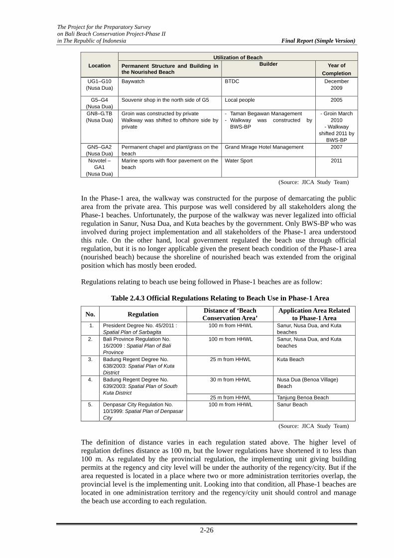
The Project for the Preparatory Survey on Bali Beach Conservation Project-Phase II in The Republic of Indonesia Final Report (Simple Version)
2-26
Location
Utilization of Beach
Permanent Structure and Building in the Nourished Beach
Builder
Year of
Completion
UG1–G10 (Nusa Dua)
Baywatch BTDC December 2009
G5–G4 (Nusa Dua)
Souvenir shop in the north side of G5 Local people 2005
GN8–G.TB (Nusa Dua)
Groin was constructed by private Walkway was shifted to offshore side by private
- Taman Begawan Management - Walkway was constructed by
BWS-BP
- Groin March 2010
- Walkway shifted 2011 by
BWS-BP GN5–GA2 (Nusa Dua)
Permanent chapel and plant/grass on the beach
Grand Mirage Hotel Management 2007
Novotel – GA1
(Nusa Dua)
Marine sports with floor pavement on the beach
Water Sport 2011
(Source: JICA Study Team)
In the Phase-1 area, the walkway was constructed for the purpose of demarcating the public area from the private area. This purpose was well considered by all stakeholders along the Phase-1 beaches. Unfortunately, the purpose of the walkway was never legalized into official regulation in Sanur, Nusa Dua, and Kuta beaches by the government. Only BWS-BP who was involved during project implementation and all stakeholders of the Phase-1 area understood this rule. On the other hand, local government regulated the beach use through official regulation, but it is no longer applicable given the present beach condition of the Phase-1 area (nourished beach) because the shoreline of nourished beach was extended from the original position which has mostly been eroded.
Regulations relating to beach use being followed in Phase-1 beaches are as follow:
Table 2.4.3 Official Regulations Relating to Beach Use in Phase-1 Area
No. Regulation Distance of ‘Beach Conservation Area’
Application Area Related to Phase-1 Area
1. President Degree No. 45/2011 : Spatial Plan of Sarbagita
100 m from HHWL Sanur, Nusa Dua, and Kuta beaches
2. Bali Province Regulation No. 16/2009 : Spatial Plan of Bali Province
100 m from HHWL Sanur, Nusa Dua, and Kuta beaches
3. Badung Regent Degree No. 638/2003: Spatial Plan of Kuta District
25 m from HHWL Kuta Beach
4. Badung Regent Degree No. 639/2003: Spatial Plan of South Kuta District
30 m from HHWL Nusa Dua (Benoa Village) Beach
25 m from HHWL Tanjung Benoa Beach 5. Denpasar City Regulation No.
10/1999: Spatial Plan of Denpasar City
100 m from HHWL Sanur Beach
(Source: JICA Study Team)
The definition of distance varies in each regulation stated above. The higher level of regulation defines distance as 100 m, but the lower regulations have shortened it to less than 100 m. As regulated by the provincial regulation, the implementing unit giving building permits at the regency and city level will be under the authority of the regency/city. But if the area requested is located in a place where two or more administration territories overlap, the provincial level is the implementing unit. Looking into that condition, all Phase-1 beaches are located in one administration territory and the regency/city unit should control and manage the beach use according to each regulation.

The Project for the Preparatory Survey on Bali Beach Conservation Project-Phase II in The Republic of Indonesia Final Report (Simple Version)
2-27
Photo 2.4.1 Property Built at the Beach Area (Tanjung Benoa Beach)
Photo 2.4.2 Permanent Restaurant Built at the Nourished Beach Area
(Sanur)
Photo 2.4.3 Permanent Restaurants Built by Local Community Authority
at the Nourished Area (Sanur)
Photo 2.4.4 Permanent “Chapel” Built by Hotel Operator at the Nourished Beach (Nusa Dua)
(Source: JICA Study Team)
The problems of the present beach use related to coastal zone regulation can be concluded as follows:
The function of the walkway and rule on the beach area was never legalized by a government regulation for the Phase-1 beaches. And this rule was only known by BWS-BP as implementing unit during Phase-1;
No coordination among government sides after completion of Phase-1 to manage the beach utilization;
No legal regulation available for BWS-BP to manage the beach utilization referring to the basic concept of beach use at the nourished beach;
Lack of knowledge and control by local government in making regulation (at natural beach and nourished beach);
(4) Summary of Beach Management with Policy Matter Issues
Beach management is the proper use of the nourished beach area. As recognized in the Phase-1 area, the regulation was issued by government to manage and control the beach use. Regulation issued by each authority (Bali Province, Denpasar City, and Badung Regency) has
Build adjacent to natural shoreline
Nourished beach
Walkway
Nourished beach
walkway
Offshore side
walkway

The Project for the Preparatory Survey on Bali Beach Conservation Project-Phase II in The Republic of Indonesia Final Report (Simple Version)
2-28
varied definition of “distance” for the beach conservation area. On the other hand, during implementation stage, the walkway was constructed to demarcate the boundary between public and private areas.
The function of the walkway was only understood by parties involved in the Phase-1 implementation stage, which were the BWS-BP, consultant, and stakeholders along the beach. Most of the stakeholders still follow the rule but some of stakeholders do not. Problems related to beach use can be described as follows:
Difference in determining the distance of ‘beach conservation area’ by each level of government. In Phase-1 beaches (nourished beach), the rule on the walkway was not legalized as an official regulation. If the present regulation will be applied, it will not be suitable anymore because the beach width was extended from its original position.
[Examples]
Distance of beach conservation area in Nusa Dua Beach was defined as 30 m from highest high water level HHWL by present legal regulation. On the other hand, position of the walkway varies from 30 m to 60 m from HHWL due to nourished beach; and
Beach conservation area in Kuta Beach is 25 m from HHWL by present legal regulation. On the other hand, position of walkway varied from 30 m to 80 m from HHWL due to nourished beach.
Lack of knowledge and low level of public awareness regarding beach use rule (as demarcated by walkway) to control the level of beach use. This condition still permits some illegal structures to be built at the beach area, same with motorcycles/cars passing through the walkway.

The Project for the Preparatory Survey on Bali Beach Conservation Project-Phase II in the Republic of Indonesia Final Report (Simple Version)
3-1
Chapter 3 Beach Management Issues and Improvement Plan
3.1 Overview of the Beach Management Issues and Improvement Plan
The following three items were studied in order to improve the beach management system in accordance with various current situations on beach management as described in Chapter 2.
Improvement plan on beach monitoring and maintenance [3.2]
Improvement plan on beach management system [3.3]
Improvement plan on beach management policy [3.4]
As a result of the studies, improvement points against various beach management issues were pointed out as follows; 1) enhancement of skills for beach monitoring and maintenance, 2) update of beach operation and maintenance manual, 3) establishment of beach management system and organization, 4) cooperation and coordination between the public and private sectors, 5) enhancement of awareness and involvement of end users, 6) enhancement of policy matter related to beach management, and 7) enhancement of consensus building for stakeholders.
According to these management issues, the improvement plans for beach management were studied and proposed in this chapter in detail. The contents of this chapter are described in Figure 3.1.1. These improvement plans will become the basic concept and policy for the establishment of sustainable beach management system as described in Chapter 4.
Chapter 3 Beach management issues and improvement plan
3.2 Improvement plan on beach monitoring and maintenance
3.3 Improvement plan on beach management system
3.4 Improvement plan on beach management policy
Table 3.2.1 Summary of beach monitoring issues and improvement plan
Table 3.2.2 Important notice for review of the Beach O&M Manual
(1) Improvement of overall beach management system1) Understanding the basic principle of integrated beach management2) Establishment of beach management organization under the cooperation between government institutions and stakeholders3) Determination for demarcation of responsibility between government institutions and stakeholders
(2) Improvement plan for beach cleaning activities by stakeholders
(3) Improvement plan for beach management with end users
(1) Improvement of policy matter related to beach management
(2) Improvement of policy matter and stakeholder consensus building related to beach utilization and regulation
3.1 Overview of the beach management issues and improvement plan
Figure 3.1.1 Flow of Improvement Plan on Beach Management (Source: JICA Study Team)

The Project for the Preparatory Survey on Bali Beach Conservation Project-Phase II in the Republic of Indonesia Final Report (Simple Version)
3-2
3.2 Improvement Plan on Beach Monitoring and Maintenance
Monitoring works have been continued by BWS-BP since it was handed over by each contactor after the completion of the project. However, quality and reliability of the monitoring data have a tendency to decline as compared with the monitoring data before it was handed over. To improve this condition, problems should be resolved in the capacity building program. The points, issues and improvement plans are summarized as shown in Table 3.2.1.
Table 3.2.1 Summary of Beach Monitoring Issues and Improvement Plan
No Points at issues Improvement plans 1 Some permanent bench marks in Sanur and Nusa
Dua have already been lost or become non-functional due to the construction of new hotels and some development activities behind the beach. These issues have been an obstacle to an accurate field survey.
In order to improve the accuracy of survey results, it is necessary to install new permanent benchmark as required (number) at a safe place.
2 Beach profile survey was carried out by local private survey company through tender by BWS-BP. However, result of the beach profile survey varied from each company. Some of the beach profile data could not be used in the analysis of shoreline change and volume of sand lost caused by being inconsistent with the current situation.
The cause of this problem is not just the skills of the private survey company but also the lack of a BWS-BP engineer when evaluating the survey result. These conditions become worse because some of the benchmarks have been lost. In order to solve this problem, it is necessary to install additional benchmarks at 400 m interval at the least. BWS-BP as ordering party should rigorously instruct the private survey company based on sufficient understanding and improvement of survey method.
3 BWS-BP as ordering party does not sufficiently understand the issues of monitoring method and have not instructed the private survey company on site.
The operation and maintenance manual (O&M manual) prepared by the international consultant before the completion of the Phase-1 Project should be revised so as to make it useful for government institutions.
4 The monitoring works have been following the existing O&M manual. On the other hand, the monitoring area sometimes changes because the area was decided according to the degree of fiscal scale. The reason perhaps is that unstable budget was allocated by the central government.
Regarding unstable budget allocation, we think that BWS-BP has insufficiently understood the significance and importance of monitoring activities. Therefore, it is necessary to get someone to understand the importance of the monitoring based on adaptive management by using the revised O&M manual. It is also important to periodically involve the Coastal Research Center (Lola Pantai) so as to enhance technical backup system.
5 Some information such as work items, frequency, personnel, and so on for the monitoring works are described in the O&M report. However, the accuracy and quality of monitoring results showed different output due to capability of the investigator The checklist, evaluation sheet, etc., to qualitatively evaluate the condition of the beach and facilities were not included in the O&M manual.
In order to gain an understanding of the qualitative condition such as the extent of damage and obsolescence of the beach and facilities, it is necessary to carry out primary observation by using a checklist. Furthermore, it is necessary to prepare survey sheets, evaluation sheet for degree of soundness, and so on, as secondary survey to gain an understanding of the quantitative evaluation and to have control over the errors of personnel.
6 The quality of data archive for monitoring data has gone down since it was handed over by the international contractor and consultant. The cause of these issues pointed out loss of quality of monitoring activities as mentioned above and the lack of ability to archive data by BWS-BP.
The improvement of monitoring and data archive activities should be enhanced with the technical and management skills of BWS-BP as responsible member within government institutions which relate to beach management through capacity building. The O&M manual should also be revised as mentioned above.
(Source: JICA Study Team)

The Project for the Preparatory Survey on Bali Beach Conservation Project-Phase II in the Republic of Indonesia Final Report (Simple Version)
3-3
On the other hand, some of the monitoring items have not been carried out, and the frequency and method of monitoring have not followed the O&M manual. The O&M manual was transferred from the Consultant to BWS-BP as one of the government institutions, especially in charge of technical matters. The O&M manual consists of eight chapters as shown in Table 3.2.2. According to present beach operation and management issues, important considerations for review of the O&M is summarized in this table.
Table 3.2.2 Important Notice for Review of the Beach O&M Manual
Chapter Improvement points Chapter 1 Outline of maintenance works in post-project stage
The contents should be renewed based on present information.
Chapter 2 Monitoring works
Specific methodology, checklist, and evaluation sheet for monitoring activities should be prepared to keep the same accuracy. It is necessary to provide revised manual to all members through working group WG and/or capacity building program.
Chapter 3 Routine maintenance works
Specific maintenance methods should be described in this chapter showing photographs of the actual parts damaged. According to present site situation based on the monitoring data, frequency and area for monitoring works should be reviewed and additional beach nourishment and repair facilities should be recommended.
Chapter 4 Adaptive management for re-forming of beach
The concept of adaptive management should be reviewed based on monitoring data, beach utilization condition, and requirements of government institutions and stakeholders through WG and stakeholders’ meeting SHM, etc.
Chapter 5 Responsibility for each maintenance work
The sharing of responsibilities should be clarified based on the result of WG by government institution related to coastal management.
Chapter 6 Adaptive management for Sanur and Nusa Dua
Adaptive management for Sanur and Nusa Dua should be reviewed based on monitoring data, present beach conditions, and requirements of government institutions and stakeholders though WG and SHM, etc.
Chapter 7 Adaptive management for Kuta
Adaptive management for Kuta should be reviewed based on monitoring data, present beach conditions, and requirements of government institutions and stakeholders though WG and SHM, etc.
Chapter 8 Summary and recommendation
The necessary correspondences and countermeasures should be recommended and concluded in this chapter based on the abovementioned points. These recommendation are described in “Chapter 6 Review of Operation and Maintenance for Phase-1”
(Source: JICA Study Team)
The following capacity building programs were conducted during the JICA Study to enhance the skills and understanding of government institutions (BWS-BP and Loka Pantai) which have the responsibility for technical management. The detailed information of these programs is described in Section 5.3 Programs for Capacity Building.
Program-1: Technical support for “Enhancement of Understanding for Adaptive Management and Planning Skill on Beach Maintenance”
Program-2: Technical Support for “Enhancement of Technical Skills for Monitoring Data Analysis and Archive System”
The main goals of the program are as follows:
Improving technical skills of government institutions for monitoring and data archive works. It includes planning skills and monitoring skills; and
Intensify understanding of the “Beach Adaptive Management” through iterative cycle.

The Project for the Preparatory Survey on Bali Beach Conservation Project-Phase II in the Republic of Indonesia Final Report (Simple Version)
3-4
3.3 Improvement Plan on Beach Management System
(1) Improvement of Overall Beach Management System
The lack of technical skills, budget allocation, arrangement of engineers and staffs, unclear demarcation of responsibility, and so on are pointed out as beach management issues in Chapter 2. In order to establish a sustainable beach management system for Phase-1, it is important to 1) understand the original purpose of continuous beach monitoring and maintenance among government institutions, 2) establish organization under the cooperation between the public and private sectors, and 3) make clear demarcation of responsibility for beach management between public and public sectors. These actions and goals should be discussed and set up among government institutions and stakeholders in parallel to matters that are required to connect thoroughly among them. The following three points are pointed out as important matters to improve beach management system.
Understanding the basic principle of integrated beach management;
Establishment of beach management organization under the cooperation between government institutions and stakeholders; and
Determination of demarcation of responsibility of beach management between government institutions and stakeholders.
a) Understanding the basic principle of integrated beach management
The beach management, which needs many sectors, should be managed as an integrated organization to perform sustainable beach management concerning each sector; such as technical aspect, policy aspect, stakeholder awareness, and beach user level. Through this process, beach management is united into one complex “general system” government and community, science/technology and planning, and sectoral and public interest by promoting and implementing an integrated plan for the protection and development of the coastal system and resources.
Integrated beach management covers the cycle of information collection, design of planning, decision making, management, and implementation, but the cycle is repeated as it is dynamic and iterative. This means that there is a need to review and adapt to the new conditions continuously so that the cycle can restart.
Issue Identificationand Assesment 1
2
3
4
5 1
2
3
4
5Evaluation
ProgramPreparationImplementation
Formal Adoptionand Funding
T i m e
Figure 3.3.1 Steps of the Beach Management Cycle, Richter 2001 (Source: JICA Study Team)

The Project for the Preparatory Survey on Bali Beach Conservation Project-Phase II in the Republic of Indonesia Final Report (Simple Version)
3-5
Integrated beach management is also based on awareness, i.e., it is necessary to use not only traditional and scientific knowledge but also adequate participation and cooperation of all stakeholders in order to assess the societal goals in a given beach area and take actions towards meeting those objectives. The key points are the discussion and cooperation among related parties (government, public stakeholders, and community) and its coordination and integration.
In the long term, integrated beach management can keep the balance among environmental, economic, social, cultural, and recreational objectives, within limits of natural dynamics. These concepts were presented and explained to government institutions which relate to beach management and stakeholders in working group, capacity building, and stakeholder meeting as part of the enhancement of awareness.
b) Establishment of beach management organization under the cooperation between government institutions and stakeholders
In order to implement sustainable beach management based on the integrated beach management system as mentioned above, it is necessary to establish the organization under the cooperation between government institutions and stakeholders. The basic concept of this organization called “Coordination Team for Beach Management” (TKMPP) is proposed and discussed in Figure 3.3.2. Government institutions which relate to beach management should enhance its partnership among them as center of BAPPEDA and Public Works of Bali Province. Loka Pantai (Coastal Research Center, PU) which will move its head office north of Bali from Bandung in fiscal year 2012 should involve itself in government institutions through technical support such as monitoring activities, analysis of monitoring data, study of countermeasures, construction method, and so on. Furthermore, JICA will support technical and management advisors for comprehensive beach monitoring and maintenance from the point of view of long term and multidirectional beach management.
CommunityHotels Organization boards
Representative Group in Nusa Dua
CommunityHotels Organization boards
Representative Group in Sanur
CommunityHotels Organization boards
Representative Group in Kuta
Coordination team for beach management (to control Beach Management at Sanur, Nusa Dua and Kuta) Main Task
・Keep Common Understanding for current beach condition・Discuss and decision of required Maintenance・Budget arrangement ・Control of Beach Area (Control of Illegal and undesirable beach use)
BWS‐BPCentral Gov.(PU) Loka PantaiDenpasar City
(DInas PU, BAPPEDA)Bali Province
(Dinas PU, Bappeda)Badung Regency
(Dinas PU, Bappeda)
JICA
Figure 3.3.2 Organizational Structure of Coordination Team for Beach Management (Source: JICA Study Team)
The organization of stakeholders consists of some representative groups which include communities, organization boards which relate to beach management and representative from hotels that receive direct and indirect benefit from the beach conservation project. The Stakeholder Consensus Building (SCB) should be established and conducted to achieve sustainable beach cleaning, environmental monitoring, beach use control, etc. The records of SCB are described in Section 5.4, Stakeholder Meeting.

The Project for the Preparatory Survey on Bali Beach Conservation Project-Phase II in the Republic of Indonesia Final Report (Simple Version)
3-6
Furthermore, it is necessary to consider the possibility of the participation of private companies at Sanur and Nusa Dua beaches in reference to corporate social responsibility (CSR) activities for the beach cleaning program at Kuta Beach. This consideration is also described in Section 5.5, Collaboration with Private and Other Sectors, and Public Relations.
c) Determination of demarcation of responsibility between government institutions and stakeholders
In order to carry out beach management for a long period of time, one point to remember is to consider balance among three components such as beach protection, beach utilization, and beach environment as shown in Figure 3.3.3. It is possible to maintain the beaches in good condition by exchange and linkage among the three components. In order to maintain the beaches used by the general public, it is important to work together, share information, and clarify demarcation of responsibility among government institutions (central and local government) and stakeholders.
Beach Utilization
Beach Environment
Beach Protection
Governm
ent institu
tions
(Central & local governm
ent)
Stakeholders
Figure 3.3.3 Basic Philosophy for Beach O&M Structure (Source: JICA Study Team)
Some of the government institutions and stakeholders have been engaged in beach management in diverse ways. However, these activities have not led to comprehensive beach management due to the unclear demarcation of responsibility, unorganized and unshared information among each other.
In the three components of beach management, there are different tasks between government institutions and stakeholders. Members of government institutions who are executants of the project should be engaged in all components, and should have higher proportion on beach protection such as supplementary beach fill, repair, and reinforcement works of beach facilities related to the technical and financial capabilities On the other hand, the demarcation of responsibility for stakeholders are mainly assumed as familiar activities such as daily cleaning, monitoring for beach utilization and environment because they have limitations on fiscal scale and technical capacity. As to the activities of stakeholders, especially in hotels and restaurants, they have been maintaining the beach in front of their property in clean condition as an independent and continuous effort for service and care to guests. Most public areas have been cleaned by seller, stall holders, and beach cleaners employed by the local government and communities. However, these activities have not led to sufficient beach cleaning because rubbish and seaweed still accumulate on the beach. In order to improve these situations, it is important to clarify demarcation of responsibility, organizations, methods, among stakeholders in the early stage.

The Project for the Preparatory Survey on Bali Beach Conservation Project-Phase II in the Republic of Indonesia Final Report (Simple Version)
3-7
(2) Improvement Plan for Beach Cleaning Activities by Stakeholders
There is a clear difference in cases between cleaning the beach in front of hotels and other beach areas used by fishermen and village people. Beach garbage degrades the value of tourism resources, not only the beach but also of the surrounding areas. Despite the stakeholders’ efforts, the beaches are receiving dishonorable reputation from the outside world. Raising the cleaning level of public areas closer to the level of hotels is an urgent task.
Table 3.3.1 Issues and Countermeasures of Beach Cleaning with Stakeholders
Subject Cause of Problem Preferable Improvement by Stakeholders
Laws/ Regulations Regulations for operation and maintenance of the respective beach are missing.
Propose necessary laws or regulations to the law makers or government organization.
Organization There are many organizations; however, the efforts to integrate them are weak and have just begun.
Establishment of stakeholder organization for each beach is recommended.
Integrated Action Plan There is no official plan which covers operation and maintenance of the respective beach. The Operation Manual of Phase-1: Bali Beach Conservation Project needs to be represented to the related organizations, and implemented with their agreement.
Formulation of beach O&M rules for each beach, which clarifies the responsibilities of the stakeholders, is recommended. Beach cleaning goals, method, number of personnel, subject area, responsibilities of each organization, monitoring plan, and section of contact to the responsible organization of the government need to be defined in the plan.
Fund Non-governmental organization (NGO) and traditional village lack fund for beach cleaning. These organizations require beach trash loaders and trucks for transporting the collected trash.
Fund allocation to implement beach O&M is necessary.
Activities There are a lot of beach cleaning activities but they do not cover the area systematically and continuously.
Activities integrated with the beach O&M under the proposed beach O&M board of stakeholders need to be established.
Monitoring Traditional villages are monitoring the beach every day.
Monitoring items and frequency of monitoring, evaluation and analysis of the monitored results, analysis, and feed back to action plan should be clarified in the plan.
(Source: JICA Study Team)
(3) Improvement Plan for Beach Management with End Users
a) Basic Issues
Some readings on solid waste management reveal clearly a degradation of coastal environment in Bali. For example, a frequently cited warning is a situation of river rubbishes that drift into the sea. Various recommendations are given in improving institutional, regulatory, and facilities/equipment matters in waste management of urban areas such as Denpasar city. But what is relevant to this chapter and probably the most basic issue is a matter of public education and awareness about sanitation and waste management at the level of each individual. In other words, without education there is no fundamental solution to improving coastal environment.

The Project for the Preparatory Survey on Bali Beach Conservation Project-Phase II in the Republic of Indonesia Final Report (Simple Version)
3-8
The education in this sense includes not only formal education within school but also non-formal and informal education. The non-formal education is organized systematic education provided by non-academic institutions such as NGOs. The informal education indicates all leaning activities processed through any information of not-intentionally-education-oriented such as publicities.
Thus educating actors who can play a role of changing people’s minds and behaviors can be schools, NGOs, institutions and volunteer groups engaged in educational activities and events. Private companies can also become such actors, for example, in their CSR activities. In the sphere of informal education, the public relations and the media activities can play a far-reaching role to the public in general.
On top of the rationale above, there is another compelling empirical reason why education becomes basic issue in beach management for and by the end users. A blueprint of consensus building and organization on beach cleaning work had already been described in the BBCP Completion Report based on a result of the workshop on “Beach Management & Coral Restoration/Transplantation in Bali Province” in February 2009. According to the Report, a routine maintenance work encompasses three kinds of activities: 1) Cleaning work, 2) Repairing work, and 3) Observation and controlling of beach utilization. A fairly detailed plan on demarcation of the work among all stakeholders had been laid out, but this mechanism has not been implemented as expected. A lesson learned from this experience was a necessity to incorporate a component of education and trainings into the mechanism before and during the implementation. No institutions and systems can work in a sustainable manner without those soft components.
b) Countermeasures
The basic issues over education related to end users of beaches can converge into one question: What kind of countermeasures can be taken in order to make those users acquire environmentally-friendly knowledge that can be translated into some positive behaviors? What ought to be challenging is to translate those educational achievement into actions for a beach management. A success to the challenge should lie in establishing the best coordination mechanism in which all concerned actors can build consensus and work in collaboration with concerted efforts. A framework model to create such educational mechanism is proposed under this section. Then a further attempt is to be made to reinforce the mechanism by means of informal education outreach, i.e., publicity. It aims at raising awareness of the public in an attempt to mobilize CSR by a private sector.
i) Consolidating educational network on beach management: Proposed Case in Sanur Beach
An effective educational network consolidation would require at least three powers; (1) political, (2) knowledge/skills, and (3) financial. Relevant proponents to those powers can be simply represented by (1) a leadership with the maximum confidence by the local people, (2) schools and NGOs, and (3) the business community respectively.
Against this background, Sanur would be able to provide a model case with comparatively more favorable factors among three beaches in Phase I. There are at least four salient factors that satisfies three powers mentioned above: (1) Local population are more visible; (2) the Sanur Development Foundation (YPS) with people’s strong confidence and technical expertise in development/welfare work; (3) solid experiences of environmental education in schools under the technical support from NGOs; and (4) a strong presence of local business community. In addition to these factors, a hearing result from the YPS reveals that they are very much satisfied with the

The Project for the Preparatory Survey on Bali Beach Conservation Project-Phase II in the Republic of Indonesia Final Report (Simple Version)
3-9
BBCP and yet at the same time they are well aware of a subject of beach management and environment.
The YPS established in 1966 is a very important non-governmental organization unique to Sanur (equivalent entities exist neither in Nusa Dua nor in Kuta) and they are the most influential agent to the local government authorities. Their decision-making is made by representatives of 27 villages (banjars) of 30,000 Sanur populations. A father of the current president of YPS Secretariat was a member of cofounders. Their activities encompass promotions of business/co-operation, religion/culture/arts/sports, education, health, waste/sanitation/environment, tourism and safety/stability of Sanur community. The president is a big hotel owner with open mind who would be able to make an effective influence to a business community in Sanur. For example, a garbage accumulation from rivers in the mangrove area of south-west Sanur has been an acute environmental problem. The YPS organizes cleaning activities in the area and some festivals incorporating environment and cleaning activities throughout a year.
According to the Table 3.3.2 of a proposed framework model below, it is needed to pay a special attention to the following points.
1. Better ordinations/implementations must go through the YPS.
2. The YPS does not always welcome occasional/sporadic beach cleaning activities by companies with the overt publicity-only-purposes.
3. No big company’s CSR presence in beach management/cleaning activities yet. YPS welcomes such initiatives, but companies are requested to work with YPS.
4. What makes Sanur different and attractive is the fact that most of beach hotels are owned by locals (such as the YPS president royal family).
5. Increasing presence of business/shops by non-Balinese Indonesians in Sanur cannot be ignored.
6. The Reef Check Foundation plans to re-launch a Costal Clean Up Program involving schools in Sanur as soon as funding is assured.
7. Potential collaborators in Sanur are right around the corner. YPS are always ready to facilitate their introductions: e.g., PPLH Sanur, Eco Sanur and other would-be-CSR-interested companies.

The Project for the Preparatory Survey on Bali Beach Conservation Project-Phase II in the Republic of Indonesia Final Report (Simple Version)
3-10
Rat
iona
le f
or C
hoos
ing
Sanu
r M
isgi
ving
s (1
) L
ocal
com
mun
itie
s ar
e m
ore
visi
ble.
(2)
The
San
ur D
evel
opm
ent F
ound
atio
n (Y
PS)
enjo
ys p
eopl
e’s
conf
iden
ce,
tech
nica
l exp
ertis
e an
d a
rele
vant
pol
icy
"Blu
e an
d G
reen
and
Cle
an
Com
mun
ity
(BG
CC
)", e
mbr
acin
g al
l sta
keho
lder
s on
bea
ch m
anag
emen
t.
(3)
Scho
ols
in S
anur
hav
e so
lid
expe
rien
ce in
env
iron
men
tal e
duca
tion
and
ac
tivi
ties
unde
r th
e te
chni
cal a
nd a
dvis
ory
supp
ort f
rom
NG
Os.
(4)
Str
ong
pres
ence
of
loca
l bus
ines
s co
mm
unit
y is
ther
e.
Shou
ld a
larg
e ca
pita
l inv
estm
ent a
nd d
evel
opm
ent i
n to
uris
m o
ccur
s,
it m
ay b
ecom
e a
dest
abil
izin
g fa
ctor
in th
is f
ram
ewor
k.
A c
entr
ipet
al
forc
e ar
ound
the
YPS
mig
ht b
e w
eake
ned
or/a
nd d
istu
rbed
by
infl
ux o
f ou
tsid
ers.
N
ot to
men
tion
inte
rnat
iona
l, ev
en th
e in
flux
of
non-
Bal
ines
e In
done
sian
s in
tour
ism
indu
stry
in S
anur
is in
fac
t fo
rmin
g so
me
mis
givi
ngs
to s
ome
exte
nt in
the
loca
l com
mun
ity.
Supe
rvis
ion
Sanu
r D
evel
opm
ent F
ound
atio
n (Y
PS)
Prin
cipa
l Act
ors
Not
es:
1.
Nam
es o
f ca
ndid
ate
info
rmal
edu
cati
on
acto
rs a
re s
how
n in
the
Tab
le “
Blu
epri
nt
of A
war
enes
s M
obili
zatio
n”.
2.
DP
S: D
enpa
sar
Cit
y T
ouri
sm O
ffic
e E
xten
sion
Pro
gram
. 3.
N
GO
s: A
mon
g ot
hers
, the
Ree
f C
heck
F
ound
atio
n In
done
sia
and
the
PPL
H
San
ur.
Pro
gres
s St
ages
1. M
akin
g Y
PS s
tand
ard
envi
ronm
enta
l edu
cati
on p
rogr
ams
and
mat
eria
ls w
ith N
GO
tech
nica
l and
CS
R f
inan
cial
sup
port
.
2. P
rom
otin
g a
prog
ress
ive
expa
nsio
n of
the
prog
ram
to th
e sp
here
of
non-
form
al a
nd in
form
al e
duca
tion
(fr
om s
tude
nts
to th
e pu
blic
).
3. A
pply
ing
the
prog
ram
to a
cqui
ring
life
ski
lls
and
beha
vior
s ov
er s
olid
was
te, s
anit
atio
n an
d co
asta
l env
iron
men
t man
agem
ent.
Info
rmal
Edu
catio
n
Med
ia/P
R
Busi
ness
(CSR
)
Non
-For
mal
Edu
catio
n
DPS
NG
Os
Form
al E
duca
tion
Scho
ols/
Uni
vers
ities
Tabl
e 3.
3.2
Pro
pose
d Fr
amew
ork
Mod
el fo
r C
onso
lidat
ing
Edu
catio
nal N
etw
ork
on B
each
Man
agem
ent i
n Sa
nur
(Sou
rce:
JIC
A S
tudy
Tea
m)

The Project for the Preparatory Survey on Bali Beach Conservation Project-Phase II in the Republic of Indonesia Final Report (Simple Version)
3-11
The model of Sanur shall eventually be applied to other project sites taking into account of unique features of a certain beach. The application process can be facilitated by NGOs the best. It is because the fact that not only they possess the knowledge base relevant to localities but also do they enjoy well-established networking. There are dozens of environmental NGOs in Bali. Some of their activities can shed light on an effective implementation of the BBCP. The study team has made contacts with some of them and identified a few as collaborators. Above all, the Nusa Dua Reef Foundation is well aware of the BBCP and wishes a close collaboration with the Project.
The Foundation established in 2009 is gaining a momentum in networking by forming the Bali Marine Conservation Community (BMCC). The BMCC is a networking group consisting of some NGOs, national parks, private sectors and local fishermen associations. Some of the main partner-NGOs are the Coral Reefs For Life working in the North since 2003, the Reef Check Foundation working in the North and the East since 2005, and the Indonesia Nature Foundation (LINI) working in the North and the East since 2000. The Reef Check Foundation takes a multi-sartorial approach with participation of larger stakeholders, incorporating for example an environmental education and beach/river cleaning activities. The LINI has been engaged in a coral monitoring since 2003 and conducting a social-economic survey at local community. They have a technical support program for the Marin Fishery Department.
ii) Awareness Mobilization Involving Private Sector
In addition to the educational network consolidation model presented in Table 3.3.2, another effective countermeasure sheds light on informal education. This measure can influence upon the people’s sub-consciousness that can trigger a critical awareness among the masses.
Government policies and regulations with regard to the environment protection and the private sector’s involvement in social affairs by way of CSR can stimulate the people’s awareness. There is also little doubt that increasing awareness on coastal environment is growing in Bali. An example of embodiment of such awareness is a concerted gesture toward the Bali Beach Clean Up (BBCU) program sponsored by the Coca Cola Amatil and the Quicksilver as shown in Chapter 2.3.(3).
Awareness-raising also contributes to making the people observe regulations well. It has been pointed out so often that what is more required to do is to establish a mechanism to enforce the existing regulations. For example, against a seven-meter regulation for each vendor site in beach, a hotel manager reports a sheer reality that three to four times larger number of vendors installed along a 70-meter hotel beach in Kuta in the past few years. Such a problem cannot be eradicated overnight without tackling deeper underlying causes in a larger scale for a longer term. One of the effective measures is an awareness campaign and education mobilizing maximum number of stakeholders especially from the beach end users.
It is therefore clear that in a long run the awareness-raising by means of informal education measure has a far reaching impact in affecting actions from a level of government to a level of private company.
Against this background, the BBCP employs one of the most effective and popular measures for raising awareness, that is to say the publicity. The publicity should be more effective if it includes not only an introduction of BBCP but also educational elements on environment and waste management. When the mobilization gains a momentum and reaches a threshold over the critical masses, behavioral changes shall occur to even a small local vendor in beach.

The Project for the Preparatory Survey on Bali Beach Conservation Project-Phase II in the Republic of Indonesia Final Report (Simple Version)
3-12
The target groups of the BBCP publicity are threefold: tourists, the public and children/the youth. A financial support in the form of CSR is to be sought with the business community/private sector. It goes without saying that one of the most important tourist groups is the Japanese tourists. It is therefore indispensable to ask a collaboration of the Japan Tour Operator Association of Bali (JTOA) composed of five travel agencies. Such equivalent associations exist in Bali for Australian nationals and Chinese ones, not to mention the Association of Indonesian Travel Agents (ASITA) and the Indonesian Hotel and Restaurant Association. In terms of preventive, long-term and sustainable effects, the third group, the succeeding younger generations, is most important.
A blueprint matrix of such awareness mobilization is shown in the Table 3.3.3 and a list of candidate collaboration with PR and CSR is shown in Appendix 3.3.1. Some concrete examples of collaboration are presented in Chapter 4.5.
Table 3.3.3 Blueprint of Awareness Mobilization
Matrix of Public Relations (PR) and Corporate Social Responsibility (CSR) on BBCP
Objective
To make the target groups (i.e., tourists, the public, the youth) aware of the Bali Beach Conservation Project (BBCP) and eventually to enhance their understanding and behaviors toward clean beach conservation in particular and costal environmental issues in general.
Methods
1. Brochure/Pamphlet distribution. 2. Article contribution. 3. Website presentation. 4. Signboard installation. 5. Panel presentation 6. Lecture/tour.
Steps to Proceed
1. PR materials to be prepared. 2. Principle agreement to be signed with collaborator. 3. Budget estimation to be made. 4. Budget arrangement to be assured. 5. Detailed agreement to be signed with collaborator. 6. Coordination and sustainability mechanism to be programmed among
collaborators. 7. Implementation. 8. Monitoring/Evaluation/Feedback/Re-programming to be implemented
among collaborators. (Source: JICA Study Team)

The Project for the Preparatory Survey on Bali Beach Conservation Project-Phase II in the Republic of Indonesia Final Report (Simple Version)
3-13
3.4 Improvement Plan on Beach Management Policy
(1) Improvement of Policy Matter related to Beach Management
Various physical issues including damage of walkway and revetment due to partial retreat of beach and damage of walk road and gazebo, etc., caused by wave overtopping have become more serious as time advances. Actually, maintenance works have been carried out after the situation worsened. As a result, delay of correspondences has created an adverse result to beach utilization and environment.
The causes of these issues are pointed out as follows:
Demarcation of responsibility for beach management was not clarified among government institutions which relate to beach management;
Tasks for beach maintenance have not been followed up among central, provincial, regency, and city.
Government institutions lack understanding of the significance of beach conservation, beach O&M, etc.
In order to discuss and make a conclusion for the abovementioned issues, it is necessary to establish a working group which consists of the following government institutions. The detailed organization for the working group is described in Section 5.2, Working Group Meeting.
Central Government Province of Bali Denpasar City Badung Regency- BWS-BP - Coastal Research Center - PU, Jakarta
- BAPPEDA - Dinas PU - BLH
- BAPPEDA - Dinas PU
- BAPPEDA - Dinas PU
If necessary, the demarcation of responsibility for beach management will be legalized through a regulation.
(2) Improvement of Policy Matter and Stakeholder Consensus Building related to Beach Utilization and Regulation
As described in previous sections, illegal beach use or practices are still found at Phase-1 area. Illegal beach use is not limited only on the construction of permanent buildings on the nourished beach. Besides various beach utilization issues caused by built souvenir shops and water sport stalls, planting of lawn grass, flowers, and low trees are also serious. The main cause of this condition lies in the lack of knowledge of beach use regulations.
At the present condition, inconsistent regulation in defining the distance of beach conservation area was already pointed out. Regulations that are presently available did not mention the following:
The function of walkway and rule of beach use as ruled during implementation of beach conservation works. This rule was only known by BWS-BP as implementing unit during Phase-1;
No coordination between governments after completion of Phase-1 to manage the regulation and permission of beach use at Phase-1 area; and
Lack of knowledge of the regulation on beach utilization at community level. Information from the government is not conveyed.

The Project for the Preparatory Survey on Bali Beach Conservation Project-Phase II in the Republic of Indonesia Final Report (Simple Version)
3-14
As explained in the beginning of this chapter, integrated beach management involves many sectors. Relating to beach use at Phase-1, clear demarcation of beach areas should be defined.
The WG among related parties as mentioned above should be established to discuss and formulate the beach conservation area based on fundamental understanding of nourished beach. The final goal is to revise or redefine the beach conservation area at Phase-1 beach area. Definition of beach conservation area should be modeled on natural beach area in different ways.
Consensus buildings related to beach use at stakeholder level should also be conducted. Beach use at stakeholder level such as planting of grass, flower, low tree and souvenir stall at nourished beach area should be discussed first and be concluded to build consensus at the stakeholder level, since all of these activities support the tourism business. Finally, the consensus relating to beach use should meet with the regulations concluded by the WG. The results of consensus building are described in Section 4.4, Stakeholder Meeting.

The Project for the Preparatory Survey on Bali Beach Conservation Project-Phase II in the Republic of Indonesia Final Report (Simple Version)
4-1
Chapter 4 Support for Consensus Building and Capacity Building
4.1 Outline of Programs for Consensus Building and Capacity Building
The current situation and issues on monitoring, maintenance, and beach management of Phase-I Project beaches were presented in Chapters 2 and 3. Some problems are common to Phase-I Project beaches and other beaches including the study area for Phase-II.
Based on this understanding, some programs are recommended to improve the current situation of Phase-I Project beaches as well as other beaches, and to enhance the possibility of sustainable and integrated beach management in which related government institutions and stakeholders will gain benefit from the beach and end users (tourists and residents) participation.
Figures 4.1.1 and 4.1.2 show the image of desirable integrated beach management and proposed programs based on the survey results by checking the current situation of beach monitoring, maintenance, and management. In order to simplify overlapping problems, beach management was divided into four categories as follows;
Policy Matter(Representative of government institution
which relate to beach management .)
Demarcation of Responsibility and Budget Allocation
Establishment of Adequate Beach Zone Management (to avoid illegal
Establishment of Beach Management System based on
Establishment of Bech Management System based on
PPP Scheme
Public (Stakeholder) Matter(Community, Hotels, Shops,
Consensus Building for Understanding of Self- Management
based on "Benefit Principle"
Establishment of Beach Management System by Stakeholder (Private) Level
Enhancement of Awareness for Conservation of Coastal Environment
Enhancement of Participation toBeach Management
(beach cleaning, partial burdening of management fee, etc.)
End User Matter(tourists and residents)
Technical Matter(Government institutions which relate to
technical matter :BWS-BP and Loka Pantai,)
Capacity Building of Monitoring Skill (Data collecting, Evaluation and Data
Base)
Capacity building of "Adaptive Management" to Beach Conservation
NGO, PrivateSector(CSR),
University,
Cooperation
Figure 4.1.1 Image of Integrated Beach Management
(Source: JICA Study Team)

The Project for the Preparatory Survey on Bali Beach Conservation Project-Phase II in the Republic of Indonesia Final Report (Simple Version)
4-2
Policy Matter(Representative of government institution
which relate to beach management .)
Demarcation of Responsibility and Budget Allocation
Establishment of Adequate Beach Zone Management (to avoid illegal
use and construction)
Establishment of Beach Management System based on
Establishment of Bech Management System based on
PPP Scheme
Program for Supporting of Capacity Building
1.Lecture and discussion for "enhancement of understanding for adaptive management & planing skill on beach management"
2. Lecture and discussion for "enhancement of techncial skill for monitorng data analysis and archive system"
Establishment and Execution of Working Group (WG) Meeting
1.Discussion for establishment of beach management system under the cooperation between the public and private sector.
2. Discussion to make clear demarcation of task and respnsibility for beach management
3. Verification of adequate beach zone management
Public (Stakeholder) Matter(Community, Hotels, Shops, Other Beach Beneficiaries)
Consensus Building for Understanding of Self- Management
based on "Benefit Principle"
Establishment of Beach Management System by Stakeholder (Private) Level
Program for Supporting of Consensus Building
1. Individual discussion at each beach to enhance understanding of self management ( understanding for common property of nourished sand, beach cleaning , basic rule for use of beach area)
2.Comprehensive stakeholder meeting for consensus building on"Self Management"
3. Proposal for concrete plan of self management system and its discussion (Sanur)
Enhancement of Awareness for Conservation of Coastal Environment
Enhancement of Participation toBeach Management
(beach cleaning, partial burdening of management fee, etc.)
End User Matter(tourists and residents)
Discussion to Achieve Realization
1. Discussion with private company (CSR), university, NGO for the possibility of support and cooperation
2. Public relation (PR)to tourists through brochure
3. Discussion with education sector for the possibility of cooperation to enhance awareness for coastal environment
Technical Matter(Government institutions which relate to
technical matter :BWS-BP and Loka Pantai))
Capacity Building of Monitoring Skill (Data collecting, Evaluation and Data
Base)
Capacity building of "Adaptive Management" to Beach Conservation
Project
NGO, PrivateSector(CSR),
University, Educational Sector, etc.
Target of Achievement and Proposed Supporting Program for each Group
Cooperation
Proposed Program
Realization of Sustainable Beach Management based on PPP Scheme by Indonesia
Figure 4.1.2 Proposed Programs for Each Group (Source: JICA Study Team)
Technical matter: mainly for beach management bodies, which consist of BWS-BP and Loka Pantai
Policy matter: mainly for government institutions related to coastal management
Public (stakeholders) matter: mainly for communities, hotels, and other beneficiaries
End user matter: mainly for tourists (both foreign and domestic) and residents
The programs for capacity building, consensus building, and establishment of working group (WG) are summarized in Table 4.1.1.

The Project for the Preparatory Survey on Bali Beach Conservation Project-Phase II in the Republic of Indonesia Final Report (Simple Version)
4-3
Table 4.1.1 Recommended Programs on Capacity Building and Consensus Building
Category Title Name Background ParticipantsSuggest under Action
Taken by JICA Study Team
Establishment of WG
WG for "Demarcation of beach
management and beach area"
- Demarcation for the responsibility (Taskand Budget Allocation) on beachmaintenance is not clear- Demarcation of beach area is not clearand not effective (problem on regulationand permission). This causes intrusion ofproperty into beach conserve area, andinduce the damage of facility andacceleration of beach retreat
-BALAI-DINAS PU of BaliProvince-DINAS PU ofDenpasar City-DINAS PU of BadungRegency- BAPPEDA (ifrequired frombeginning)
- Support to establish WG- To coordinate for holdingfrequent WG meeting- Preparation of material to bediscuss and presentation toexplain current condition andproblems
Technical Support to"Enhancement of
understanding for AdaptiveManagement and Planning
skill on beachmaintenance"
-Their understanding for AdaptiveManagement applying accumulated ofmonitoring data is insufficient.
-Due to this, the effective and systematicplanning and implementation ofmaintenance work didn't conduct
- Periodical lecture based on OMManual- Joint site inspection as on-the-job training and discussion
Technical Support to"Enhancement of technical
skill for monitoring anddata analysis and archive
system"
- Even though the monitoring has beencarried out until now, the collected datawas not well maintained by ManagementBody, and most of data cannot be wellutilized.- The skill for checking of monitoringmethod, quality of data, etc. isinsufficient. This is causing themisunderstanding of actual condition.
- Lecture for planning of dataarchive method- Lecture for data analysis,monitoring method and procedure
Consensus building on"Enhancement to
understanding for commonproperty of nourished sand
among stakeholders"
<Target Area>South Sanur between G39
and GN2
Most of property and building ownersmisunderstand that the accumulatedsand at up-drift side of groin is his ownproperty sand, and they want to keepthis accumulated area. Sometimes, theyconstruct their own facilities on this area.
Communities, HotelsandPrivate propertyowner
- Section of related stakeholders- Frequent discussion betweenrelated stakeholders to enhancetheir understanding for "sandmovement" and "common propertyof sand", and possibility to improveby stakeholders level- Coordination betweenstakeholders and beachmanagement body regardingimplementation of required
Consensus building on "Beach cleaning based on
benefit principle"
<Target Area>German Beach at Kuta
- Some area of beach cleaning conditionseems not so good, especially at publicarea.- Some of beneficiary at public areadidn't shear their responsibility and notcooperate for public-level beachmanagement activities such as beachcleaning (benefit principle).
community,restaurant, fishery andmarine sportsbeneficiary
- Selection of related stakeholders- Frequent discussion betweenrelated stakeholders to enhancetheir understanding for "advantageand necessity" and "benefitprinciple"- Introduce and site visit to showanother success case- Coordination with NGO, privatecompany and other sectors, ifnecessary
Consensus building on" Basic rule for use of
beach area in public level"
<Target Area>Tanjung Benoa
(North Nusa Dua)
- Illegal contraction on the recoveredbeach- Unsatisfied use of walkway (ex.Intrusion of motor bicycle into walkway)
Communities, HotelsandPrivate propertyowner
- Selection of related stakeholders- Frequent discussion betweenrelated stakeholders to enhancetheir understanding for "desirablebeach use" and "basic rule"- Coordination with beachmanagement body to control andpunishment for illegal use
Consensusbuilding of
stakeholders
Capacitybuilding of
governmentinstitutions
BWS-BP and LokaPantai
(Source: JICA Study Team)
The Project for the Preparatory Survey on Bali Beach Conservation Project-Phase II in the Republic of Indonesia Final Report (Simple Version)
4-4
4.2 Working Group (WG) Meeting
The main objective for the establishment of the WG is to discuss the following two main agenda related to policy matters of beach management:
1) Agenda-1 : The purpose of the following agenda is to discuss demarcation of responsibility on beach management including task sharing and budget allocation
Clarification of category of beach management
Demarcation and responsibility between governments and stakeholders for every beach management items
Process of monitoring and maintenance of every beach management items
2) Agenda-2 : The purposes of the following agenda are to make clear the demarcation and boundary of space for Phase-I Project beaches, and to discuss control measures
Legalization of walkway as the boundary between public space and private space
Clarification of illegal structures on the beach
The WG meeting shall be held frequently until a consensus from all organizations is reached. Further, the agenda discussed in WG meetings include not only technical matters but also policy matters on beach management. Thus, the decision maker from each organization is required to participate in WG meetings for a certain period. In order to establish beach management system and clarify demarcation and responsibilities among relevant parties, WG and pre-WG meetings were held three times and twice, respectively, among central government, local government and stakeholders from January to July 2012. The results of the above mentioned five WG meetings are summarized in Tables 4.2.1 to 4.2.5.
The members of WG consist of central/local government institutions related to beach management, observers (BAPPENAS, JICA) and organizers (JICA Study Team). The detailed members of WG are shown as follows. Organization and structure of WG are shown in Figure 4.2.1. In the 3rd WG meeting, related stakeholders of Sanur, Nusa Dua, and Kuta also act as members of WG.
Government institutions related to coastal management
(Central government)
Ministry of Public Works
- Department of River and Coastal
- Department of Operation and Maintenance
- Department of Planning Program
- Bali Penida-River Basin Bureau (BWS-BP)
- Experimental Station for Coastal Engineering (Loka Pantai)
(Local government)
Province of Bali
- Regional Development Agency (BAPPEDA)
- Public Works Service Agency (Dinas PU)
- Environmental Agency (BLH)

The Project for the Preparatory Survey on Bali Beach Conservation Project-Phase II in the Republic of Indonesia Final Report (Simple Version)
4-5
Denpasar City
- BAPPEDA
- Public Works Service (Dinas PU)
- Urban Planning and Housing Service (Dinas Tata Kota and Perumahan)
- Peace, Order and Civil Police Force Service (Dinas Trantib and Satpol PP)
Badung Regency
- BAPPEDA
- Highways and Irrigation (Dinas Bina Marga and Pengairan)
- Settlement Service (Dinas Cipta Karya and Perijinan)
- Civil Police Force Government Service (Satuan Polisi Pamong Praja)
WG Observers
Watering and Irrigation, National Development Planning Agency (BAPPENAS)
Japan International Cooperation Agency (JICA)
BWS – BPLoka Pantai
Ministry of Public Works (Jakarta)
‐BAPPEDA‐Dinas PU‐BLH
Agenda-1(To discuss the responsibility of
beach management including task share and budget
allocation)
Agenda-2(To make clear the demarcation and boundary of beach space at Phase-I Project beaches and to discuss the control measures)
ORGANIZER
JICA Study Team
Representative
Representative
Chairman
Member
PROVINCE OF BALI
‐ BAPPEDA‐ Dinus PU‐ Dinas Tata Kota & Perumahan‐ Dinas Trantib & Satpol PP
DENPASAR City
‐BAPPEDA‐Dinas Bina Marga & Pengairan‐Dinas Cipta Karya & Perijinan‐ Satuan Polisi Pamong Praja
BADUNG Regency
CENTRAL GOVERNMENT
BAPPENASJICA
Observer
Figure 4.2.1 Structure of WG (Source: JICA Study Team)

The Project for the Preparatory Survey on Bali Beach Conservation Project-Phase II in the Republic of Indonesia Final Report (Simple Version)
4-6
Table 4.2.1 Summary of 1st Pre-WG Meeting
Outline • Date : January 20, 2012 • Time : 10:00 am – 12:15 pm • Venue : Tirta Room, Dinas PU of Bali Province • Chaired by : Mr Ketut Suharta (Head of Water Resources Division of PU, Bali
Province) • Agenda : Establishment of working group
Contents of presentation
• Introduction of the JICA study • Establishment of working group for enhancement of operation and maintenance • Regulation and permission for beach utilization
Conclusion • As forms of cooperation in beach management, the JICA Study Team suggested that implementing unit scheme (UPT) as well as the technical agency as to have legal binding force.
• The JICA Study Team need further discussion on sharing of budget allocation, principal tasks, and functions of each member to attain optimal results in the WG-1.
• WG-1 meeting shall be attended by decision makers because the meeting will discuss policies and active follow-up, formation of business entities/unit manager of Beach Post BBCP I.
• Agreement and a strong will to find a solution are the foundation that must be shared by all members of the WG. About how much sharing, concepts of cooperation, and organizational arrangements shall be determined in the WG-1 meeting
Participants Central Government
Name of the Institutions Number of Participants BWS-BP 1
Province of Bali Bappeda 1 Dinas PU 2 BLH 1
Denpasar City Dinas PU 2 Badung Regency Bappeda 1
Dinas Bina Marga and Pengairan 3 JICA Study Team 3
Total 14
(Source: JICA Study Team)

The Project for the Preparatory Survey on Bali Beach Conservation Project-Phase II in the Republic of Indonesia Final Report (Simple Version)
4-7
Table 4.2.2 Summary of the 1st WG Meeting
Outline • Date : January 30, 2012 • Time : 10:00 am – 12:00 nn • Venue : Melati Meeting Room, Bappeda of Province, Bali • Chaired by : Mr Cok, Ngurah Pemayun (Head of Bappeda, Bali)
Contents of presentation
• Introduction of the JICA study • Integrated beach management and proposed programs • Objective of the establishment of working group • Discussion point -1:Task and budget allocation • Discussion point -2: Regulation and permission for beach utilization
Conclusion • Working group is a means of coordination between relevant agencies involved in the beach management. Through cooperation in the management of the WG, beach management is expected to be fulfilled and legalized.
• BWS-BP will draw a map of the existing condition related to services and potential of economic development.
• Weakness of the implementing agencies: the limitations of human resources, equipment and budget (insufficient human resources, equipment, and budget).
• Sources for beach management fund: a. Corporate social responsibility (CSR); b. Direct retribution from visitor at beach; and c. Retribution from guest of starred hotel around the beach.
• Participation of stakeholders and traditional villages in beach management should be improved. Through appropriate schemes, the organized and controlled coastal management involving all elements of both formal and informal sectors will succeed.
Participants Central Government Name of Institutions Number of Participants BWS-BP 6 PU-Jakarta 1 BAPPENAS 2
Province of Bali Bappeda 5 Dinas PU 1 BLH 2
Denpasar City Bappeda 1 Dinas PU 1
JICA Study Team 8 Total 27
(Source: JICA Study Team)

The Project for the Preparatory Survey on Bali Beach Conservation Project-Phase II in the Republic of Indonesia Final Report (Simple Version)
4-8
Table 4.2.3 Summary of 2nd WG Meeting
Outline • Date : April 5, 2012 • Time : 10:00 am – 1:00 pm • Venue : Meeting Room of Bappeda, Province of Bali • Chaired by : Mr Djayadijaya (Secretary of Bappeda, Bali Province)
Contents of presentation
Agenda 1 • How to establish beach management system based on public-private partnership
(PPP) scheme? • How to share tasks and responsibilities between the government and the private
sector and central government and local government on beach management? Agenda 2 • Management of beach riparian
1) BBCP I area (nourishment area) 2) Other general beach area
Conclusion Conclusion of Agenda 1 • It is agreed that Coordination Team of Beach Management and Maintenance
(TKMPP) should be established for BBCP I beaches. • BAPPEDA of Bali Province will form a ‘small team’ for the establishment of
coordination team (TKMPP). This should be reported at the 3rd WG Meeting (June 2012).
• JICA will provide support by preparing agenda and concept of beach management, which later will become part of discussion agenda at TKMPP.
• TKMPP will function as the coordination forum of proper beach management and maintenance by preparing relevant programs. The programs will be implemented by each government task unit or stakeholder.
Conclusion of Agenda 2 • Model of task sharing and responsibility between the government (central and local
government) and stakeholder will be discussed further after TKMPP is established. • Problem in implementing beach riparian regulation is typical - easy to regulate, but
difficult to implement. • With legalization of coordination team structure and its members, it is expected that
all related authorities can be involved to discuss and solve the problem Participants Central Government Name of Institutions Number of Participants
BWS-BP 3 Loka Pantai 2 PU-Jakarta 1 BAPPENAS 1
Province of Bali Bappeda 3 Dinas PU 1 BLH 1
Denpasar City Dinas PU 1 Dinas Tata Kota and Perumahan 1 Dinas Trantib and Satpol PP 1
Badung Regency Bappeda 1 Dinas Bina Marga and Pengairan 2 Dinas Cipta Karya and Prtijnan 1 Satuan Polisi Pamong Praja 1
JICA Study Team 7 Total 27
(Source: JICA Study Team)

The Project for the Preparatory Survey on Bali Beach Conservation Project-Phase II in the Republic of Indonesia Final Report (Simple Version)
4-9
Table 4.2.4 Summary of the Pre- 3rd WG Meeting
Outline • Date : July 16, 2012 • Time : 10:15 am – 12:30 pm • Venue : Melati Meeting Room Office of BAPPEDA Bali Province • Chaired by : Ms Naning (Head of Regional Infrastructure Division, Bappeda of Bali
Province) Contents of presentation
• Determination and legalization of member and task of coordination team for beach management (TKMPP) among central government, local government, and stakeholders
• Finalization of demarcation and responsibilities for beach management among central government, local government, and stakeholders
• Legalization of walkway as boundary between public space and private space, and finalization of basic concept of illegal buildings and structures on the beach
• Finalization of road map for sustainable beach management • Confirmation of commitment of above four points based on conclusion of WG3
Conclusion 1. All participants realized the importance of coordination team for the management and monitoring of beach facilities, thus, TKMPP is expected to be established.
2. All participants agreed to form a coordination team with their respective tasks and responsibilities at regency/city level, but still under the cooperation of coordination team at provincial level.
3. Regency of Badung and the city of Denpasar government will provide commitment statement to implement TKMPP.
Participants Central Government
Name of Institutions Number of Participants BWS-BP 1
Province of Bali Bappeda 2 Dinas PU 1 BLH 1
Denpasar City Bappeda 1 Dinas PU 2 BLH 1 Camat 1
Badung Regency Dinas Bina Marga and Pengairan 3 Dinas Cipta Karya and Perijinan 1 Satuan Polisi Pamong Praja 1 BLH 1 Dinas Kebersihan and Pertamanan 2 Dinas Pariwisata 1 Camat 1
JICA Study Team 5 Total 25
(Source: JICA Study Team)

The Project for the Preparatory Survey on Bali Beach Conservation Project-Phase II in the Republic of Indonesia Final Report (Simple Version)
4-10
Table 4.2.5 Summary of the 3rd WG Meeting
Outline • Date : July 20, 2012 • Time : 9:15 am – 12:15 pm • Venue : Cempaka Meeting Room, Bappeda of Bali Province • Chaired by : Ms Putu Naning (Head of Regional Infrastructure Sector, Bappeda of
Bali Province) Contents of presentation
• Background • Summary of the 1st WG and 2nd WG • Establishment of coordination team for beach management (TKMPP) • Basic concept of road map for establishment of beach management system • Basic concept of demarcation and responsibilities of beach management • Legalization of walkway as boundary between public and private spaces and basic
concept of illegal building and structures on the beach • Commitment for MOU
Conclusion
1. In order to preserve beaches as among Bali's tourism assets, a mutual commitment is required among the central government, province, and regency/city to synergize the implementation of sustainable beach management in Bali Province.
2. Concept of beach management for Sanur, Nusa Dua, and Kuta, which proposed that five managements principally could be acceptable, noting that division of task and responsibility should be clarified among the central government, province, and regency/city.
3. Commitment to synergize the implementation of sustainable beach management in Badung Regency and Denpasar City will be realized by establishing a coordination team for beach management (TKMPP) in both the provincial government and regency/city with the leading sector in their respective BAPPEDA of local governments.
4. Tasks, responsibilities, and technical implementation of beach management in Bali Province will be outlined in technical guidelines that will serve as a mutual guidance in the realization of synergistic effect of sustainable beach management by central government, province, and regency/city.
5. This agreement will be followed up with a memorandum of agreement (MoA) among central government, provincial and district/municipality concerned, so that goals that must be met in terms of mechanism of coordination, funding for team operation, as well as other funding requirements can be implemented as appropriate.
6. Preparation of MoA will be done together with the central government, provincial, and regency/city, and will be further coordinated by Bali BAPPEDA together with BAPPEDA of regency/municipality concerned.
Participants Central Government Name of Institutions Number of Participants BWS-BP 3 BAPPENAS 3 Province of Bali Bappeda 5 Dinuas PU 1 BLH 1 PHRI Bali 1 Denpasar City Dinas PU 1 BLH 1 Dinua Kebersihan and Pertamanan 1 Lurah Sanur 1 Badung Regency Bappeda 1 Cinus Cipta Karya and Perijinan 1 BLH 1 Dinas Parwisata 1 Dinas Kelautan & Perikanan 1 Camat 2 Lurah Benoa 1
(Continued to the Next Page)

The Project for the Preparatory Survey on Bali Beach Conservation Project-Phase II in the Republic of Indonesia Final Report (Simple Version)
4-11
Stakeholders Desa Sanur Kaja 1 Desa Sanur Kauh 1 Bendesa Sanur 1 Bendesa Intaran 1 YPS 2 PHRI Denpasar 1 Bendesa Bualu 1 BTDC 1 PHRI Badung 1 Karangasem Regency
(Observer) Dinas PU 1
PHRI Karangasem 1 JICA Study Team 8 Total 45
(Source: JICA Study Team)
In the 1st WG meeting, central government recommended that necessary budget for beach maintenance should be obtained from CSR by a private sector, direct beneficiary, beach user and so on, in consideration of lack of budget from government institutions and raising awareness of stakeholders. The implementation of beach monitoring and maintenance was also recommended to establish collaborative structure between government and stakeholder sectors.
In the 2nd WG meeting, importance of establishment of coordination team was confirmed between the central government and local government in order to determine a suitable beach management system and demarcation of responsibilities as it takes a long time to solve such outstanding matters. In addition, it is necessary to conduct discussions and coordination among government institutions and stakeholders related to beach management, through the coordination team.
In the 3rd WG meeting, all participants (central government, local government, and stakeholders) basically agreed to establish a coordination team for beach management (TKMPP), and to discuss and decide demarcation of responsibilities based on the proposed five management items. However, some participants insisted on the necessity of follow-up and support to establish TKMPP, and prepare the technical and implementation guidance by experts from JICA. Their insistence is due to a concern that TKMPP will not be able to function after demobilization of JICA Study Team since there are few members among government officials and stakeholders related to beach management who have initiative and technical capabilities.
Contents of the agreement through conclusion of the 3rd WG meeting for beach management of Phase-1, signed by central governments and local governments, are described in Table 4.2.5. The signatories of above agreement are as follows:

The Project for the Preparatory Survey on Bali Beach Conservation Project-Phase II in the Republic of Indonesia Final Report (Simple Version)
4-12
Mr N. Donny Azdan (Director of Watering and Irrigation , BAPPENAS)
Mr I Gusti Ngurah Raka (Head of BWS-BP)
Mr Tjol. Pemayum (Head of Bappeda, province of Bali)
Mr Wayan Suambara (Head of Bappeda, Badung Regency)
Mr I Gusti Anindya Putra (Head of Bappeda, Denpasar City)
The presentation materials for working groups are shown in Appendixes 4.2.1 to 4.2.5.
4.3 Programs for Capacity Building for Government Institutions
As presented in Chapters 2 and 3, one of the main problems on beach management is that government institutions in charge of beach management lack technical capability on monitoring, maintenance work, and management skills. To improve this, it is very important to enhance various beach management skills and capabilities through OJT and lecture in a systematic manner. The following programs for capacity building were proposed and conducted by the JICA Study Team:
Technical Support for "Enhancement of Understanding for Adaptive Management and Planning Skill on Beach Maintenance"
Technical Support for "Enhancement of Technical Skill for Monitoring, Data Analysis, and Archive System"
However, enhancement of skills and capabilities for beach management especially related to monitoring and maintenance, are actually not so easy due to the following:
Even though project that applies coastal protection structures (mostly seawall or revetment) has been undertaken frequently in Indonesia, beach conservation project for sand nourishment measure was very rare (Only Bali Beach Conservation Project Phase 1, hereafter defined as BBCP-I). Due to this, most engineers who work in the coastal field have no opportunity to learn about beach conservation work.
To manage nourished sandy beaches, adaptive management (feedback approach based on monitoring, evaluation, and implementation) is required. Thus, sufficient technical background on coastal engineering and experience are required. However, it is difficult to find engineers who have such a high level of skills.
For abovementioned reasons, it is difficult to achieve capacity building on beach management in a short period. The continuous technical support for a long duration capacity building is strongly required. Two programs were prepared in this study, but will need continuous capacity building for a long period since such programs are just the initial steps.
The target persons of this program are mainly BWS-BP engineers engaged in coastal engineering. On the other hand, a new head office of Experimental Station for Coastal Engineering (Loka Pantai) under the Ministry of Public Works is under construction at the north Bali. All of its members will mobilize there in 2013 (plan) after completion of construction of building with laboratory. Even though the current member is limited (five engineers), this organization is expected to provide technical support for coastal works in Indonesia, not only for Bali beaches, but also for other islands in the whole of Indonesia in the future. However, this organization is also insufficient in terms of experience based on actual beach conservation work, and required capacity building. Therefore, a member from Loka Pantai should participate in this program.

The Project for the Preparatory Survey on Bali Beach Conservation Project-Phase II in the Republic of Indonesia Final Report (Simple Version)
4-13
(1) Technical Support for "Enhancement of Understanding for Adaptive Management and Planning Skill on Beach Maintenance"
The reasons why this program was proposed to beach management body are as follows:
The understanding about “Adaptive Management” based on the accumulated monitoring data is insufficient.
Due to this, the effective and systematic planning and implementation of maintenance work are difficult to undertake.
The program was set up as follows:
Joint site inspection as part of OJT and discussion about cause of erosion and countermeasures based on the basic concept of adaptive management (Lectured by Dr T. Uda : See Photo 4.3.1).
Adaptive sand management and human habitat sustainability (Lectured by Dr S. Seino : Refer to Photo 4.3.2).
The participants in this program are manager/staff of BWS-BP and Loka Pantai who have been carrying out monitoring and maintenance at beach fill area.
All participants have deepened their understanding on the importance of continuous beach management based on the concept of “Adaptive Management”. Moreover, their skills for monitoring and maintenance work were enhanced through presentation and discussion in these meetings. The final goal is to enable government institutions related to beach management prepare plans and perform maintenance works based on the adaptive management procedure.
Photo 4.3.1 Lecture in this Study-1 (Source: JICA Study Team)
Photo 4.3.2 Lecture in this Study-2 (Source: JICA Study Team)
(2) Technical Support for "Enhancement of Technical Skill for Monitoring, Data
Analysis, and Archive System"
The reasons why this program was proposed are as follows:
Even though monitoring has been carried out frequently until now, collected data was not kept well by government institutions related to beach management (for this case BWS-BP OM Section), and most data have not been well utilized.
Skills for checking monitoring method, quality of data, etc., are insufficient. This causes misunderstanding of actual condition.

The Project for the Preparatory Survey on Bali Beach Conservation Project-Phase II in the Republic of Indonesia Final Report (Simple Version)
4-14
The program was set up as follows:
Joint field investigation.
Planning of data archive method (selection of required data as long term monitoring, fixing of format, etc.).
The skills for checking monitoring method, quality of data, etc., are insufficient. This causes misunderstanding of actual condition.
Conduct periodic lecture for data analysis, monitoring method, and procedure.
In order to follow up the results of the 3rd WG, capacity building was conducted to enhance the management of beach fill area (Management 1) and management of coastal structure (Management 2). The JICA Study Team invited staff from BWS-BP and Loka Pantai (Coastal Research Centre of Public Works), which are central government institutions responsible for executing beach monitoring, data analysis, and several case studies of data failure. The participants of this program consist of managers and staff of BWS-BP and Loka Pantai who have been carrying out monitoring and maintenance in the beach fill area.
All participants have developed an advanced understanding as to the importance of continuous beach monitoring based on the concept of adaptive beach management using several study cases, through presentation and discussion in the meeting. The final goal is to develop the skills of government institutions to coastal monitoring in terms of checking monitoring method, quality of data, etc., which are insufficient for several actual conditions. Moreover, monitoring data with high reliability can be accumulated. Such data will be kept properly, and can be readily available anytime when needed.
Photo 4.3.3 Lecture for Beach Monitoring (1)
(Source: JICA Study Team)
Photo 4.3.4 Lecture for Beach Monitoring (2)
(Source: JICA Study Team)
4.4 Stakeholders’ Meeting
Active participation of local stakeholders is essential for maintaining the nourished beaches in good condition. It was found that the local stakeholders are beneficiaries of the JICA coastal protection project. However, they are also causing the degradation of beach environment in BBCP-I beaches.
The way to support the local stakeholders is by providing appropriate information on maintenance, mobilizing their resources by offering incentives for better beach environment, and organizing each stakeholder in an integrated manner through series of stakeholders meetings described as follows.

The Project for the Preparatory Survey on Bali Beach Conservation Project-Phase II in the Republic of Indonesia Final Report (Simple Version)
4-15
A questionnaire survey was conducted at the first stage, and focus group SHM was held at each beach site within a limited area, regarding typical issue. Such information will be the basis for the questionnaire in the second stage. Then, a comprehensive stakeholder’s meeting of stakeholders from all three beaches was held to discuss all beach maintenance issues. The JICA Study Team provided results of prior discussions at three beaches, and encouraged participation of local stakeholders to initiate beach maintenance (Figure 4.4.1). This section describes the following three consensus building items to enhance understanding of self-management and to support establishment of beach management system by stakeholders level:
Individual discussion at each beach to enhance understanding of self management
Comprehensive stakeholder meeting for consensus building on self management
Proposal for concrete plan of self management system “Adopt Program” and its discussion (Sanur)

The Project for the Preparatory Survey on Bali Beach Conservation Project-Phase II in the Republic of Indonesia Final Report (Simple Version)
4-16
Purpose: Formulation of sustainable management system of the beaches
Sanur Kuta Nusa Dua [Questionnaire survey on present status of beach maintenance by local stakeholders] Subjects: Hotel managements, communities, fisherman groups, beach users groups
[Stakeholders’ Meeting] Participants: Stakeholders of each beach (community, hotels, NGO etc.), and coastal management body as observers (BWS-BP)
[General Stakeholders’ Meeting] Participants: Stakeholders of all coast (community, hotels, NGO etc.) , and coastal management body as observers (BWS-BP, Bali Province, Badung Regency/ city of Denpasar)
Working Group 3 Participants: Stakeholders of all beaches and chiefs of regency (including city), province, and BAPPENAS
Negotiations among local stakeholders (leading organizations for beach management ) and the government
Figure 4.4.1 Sequence of Stakeholders Meetings on Phase-1 Beaches (Source: JICA Study Team)
Individual discussion at each beach site to enhance understanding on self management
Stakeholders’ Meeting in Kuta (Agenda: Beach Trash)
Stakeholders’ Meeting in Nusa Dua (Agenda: Beach Utilization)
Sanur Development Foundation
(YPS)
Consensus building on beach management responsibilities
among all stakeholders including the government Jul.20, 2012
Agreements signed by the government side Jul, 2012
Negotiations
Questionnaire survey on each stakeholder
Questionnaire survey on each stakeholder
Stakeholders’ meeting on a focused issue [Partial Retreat of
Beach] Dec.22,2011
Stakeholders’ meeting on a focused
issue [Beach Trash] Dec.21,2011
Stakeholders’ meeting on a focused issue
[Beach Utilization] Dec.20,2011
Questionnaire Survey on each stakeholder
Consensus formulation on coastal management system
among stakeholders Jan.26,2012
To apply Nusa Dua and Kuta Beach Management
Suggestion for ‘Adopt Program’ by JICA Study Team Jul.19, 2012 Chap.5.4

The Project for the Preparatory Survey on Bali Beach Conservation Project-Phase II in the Republic of Indonesia Final Report (Simple Version)
4-17
(1) Individual discussion at each beach site to enhance understanding on self management
a) Stakeholders’ Meeting in Sanur (Agenda: Partial Retreat of Beach)
i) Background
Partial retreats of beaches are evident at some places in three beaches. One of the locations chosen for evaluation of applicability of sand transformation among stakeholders is in Sanur. A beach at the southern end of Intaran Traditional Village has eroded severely; however, remarkable accumulation of sand is seen at the adjacent area (Figure 4.4.2). In order to keep the designed shoreline, continuous sand transportation activity is required with understanding that “the nourished sand is a public property” and the accumulated sand needs to be removed from where sand is excessively accumulated.
In this case, beach in front of Intaran Traditional Village has suffered from partial retreat of beach compared with the area in front of Mercure Hotel used by the hotel and Naya Gandhi (boat rental business). The JICA Study Team provided stakeholders with the nature of nourished sand and asked them for their understanding and cooperation for sand transportation.
Figure 4.4.2 Sand Erosion and Accumulation in Intaran Traditional Village
(Source: JICA Study Team)
ii) Contents of the Presentation
Precedent projects with JICA’s assistance
Necessity of spontaneous beach management practice due to the dynamic nature of the shoreline
Periodic sand transfer from the accumulated to the eroded section is recommended, but taking sand from stockpile is the last choice since due to its limited availability.
iii) Summary of Discussions
All stakeholders, such as traditional village, fisherman’s association, beach users group, and hotel (Mercure Hotel did not attend but was interviewed after the stakeholders’ meeting) agreed on the following:
Sand transportation is confirmed as a good erosion control measure in their area and will support the idea,
Implementation of sand transfer requires consultation with all stakeholders, and
Further coordination with government and stakeholders is essential for technical and financial matter, including usage of sand stockpile.

The Project for the Preparatory Survey on Bali Beach Conservation Project-Phase II in the Republic of Indonesia Final Report (Simple Version)
4-18
The outline of SHM and list of participants are shown in Appendices 4.4.1 and 4.4.2, respectively.
b) Stakeholders’ Meeting in Kuta (Agenda: Beach Trash)
i) Background
Beach trash is one of the biggest problems in three beaches. Beaches in front of hotels are maintained in good condition. On the other hand, beach trash at public areas degrade the quality of beach environment.
Beach cleaning is a type of operation where local stakeholders can play a principal role. Jarman Beach in Kuta was selected as the case study to be used during the stakeholders’ meeting. Public area in Kuta Beach is known for its unfavorable condition due to issue on cleanliness.
Photo 4.4.2 Scattered Trash on Jerman Beach (Source: JICA Study Team)
ii) Contents of the Presentation
Results of cleanliness evaluation of Kuta Beach:public spaces are not kept in good condition
Analysis of the cause: attribution of responsibility for the dirtiness of public spaces
Explanation on the consequences of not cleaning the public area
Proposal for “Integrated Beach Cleaning Management System” as a solution
Figure 4.4.3 Results of Beach Cleanliness Evaluation (Source: JICA Study Team)

The Project for the Preparatory Survey on Bali Beach Conservation Project-Phase II in the Republic of Indonesia Final Report (Simple Version)
4-19
iii) Summary of Discussions
[Illegal occupation of the land]
Although some discussions went on to other fields of issue, stakeholders agreed that beach trash on Jarman Beach is caused by some families who came from other regions and use the area illegally. The families reject moving away but expel other parties from coming into the area to establish business. Said families construct many hatch establishments with vending machines for drinks, food, and other uses, then scatter trashes in the area. The Kuta Beach cleaning task forces refuse to clean the area to solely benefit the families staying illegally. Villagers are not willing to eject the families from the place, and have no authority to urge them to leave. Government support is strongly requested by the villagers to oust the families.
[Beach cleanliness]
Hotels are complaining about the dirtiness of the beach. Hotel managements feel a strong sense of crisis.
Low awareness of local users regarding cleanliness of the beach is pointed out.
The local residents are ready to clean the beaches; but machineries such as loaders and trucks are required because of the volume of trash, especially from December to March.
[Government support required]
A comprehensive policy, plan, garbage loading and transportation machines, facilities, budget, and action for beach management are missing. Traditional villages and the Badung Regency should work closely.
The government should spare a budget, especially for beach management, considering large amount of taxes they are earning from hotels and restaurants on the beach.
Participants realized that no one takes the responsibility for fixing broken lamps. Hotels are willing to pay the electricity fee if these are repaired.
The government organization responsible for nourished sand is not clear to every stakeholder.
The outline of SHM and list of participants are shown in Appendices 4.4.1 and 4.4.2, respectively.
c) Stakeholders’ Meeting in Nusa Dua (Agenda: Beach Utilization)
i) Background
Beach encroachment is a serious problem, which is common in Nusa Dua. Although building a permanent structure is prohibited by law, many new buildings are being constructed on beaches newly established under the JICA project. Beach encroachment narrows the beach, and reduces the area where sand can be deposited by large waves during high tide. Illegal buildings are not only endangering the stability of the beaches, but are also causing strong return waves, which aggravate partial retreat of beaches. It is noted that such beach encroachment is getting worse.
The JICA Study Team selected a beach in front of Mirage Hotel in Nusa Dua as the model for the study. A chapel was constructed by the beach users in the area. The participants jointly sought a solution for the prevention of beach encroachment.

The Project for the Preparatory Survey on Bali Beach Conservation Project-Phase II in the Republic of Indonesia Final Report (Simple Version)
4-20
Photo 4.4.3 Illegal Permanent Buildings Encroaching Shoreline on Nourished Sand
(Source: JICA Study Team)
ii) Contents of the Presentation
Explanation of beach encroachment in Bali Island as an example, and similar cases in other Asian countries. The JICA Study Team explained how beach encroachment degrades the area as a tourism resource. The instances of serious progress of beach encroachment in Tanjun Benoa are also presented using satellite photos.
Agreement between the landowners and BWS-BP on the boundary (walkway) of public land is also explained to the participants.
iii) Summary of Discussions
The agreement that ‘no permanent building in public area’ is clear and agreeable.
The participants do not know who is responsible for enforcing the regulation.
The violators (hotels) were granted permissions by higher authorities of the government to construct the illegal buildings.
The term “permanent building” needs further explanation. Its specific definition is required with regards to planting trees, grass, placing stones, installing shades, temporary decks, protection walls, etc.
Public border is not clear on beaches without walkways.
Bali Khama Hotel initiated construction of a private protective wall as they received no reply to their official letters sent to the government. Consequently, severe erosion is progressing since 2005, and no information about long-term plan of the government is laid out.
The outline of SHM and list of participants are shown in Appendices 4.4.1 and 4.4.2, respectively. In addition, presentation materials for Stakeholders’ meeting and consensus formulation as described above are shown in Appendices 4.4.3 to 4.4.6.
(2) Comprehensive stakeholders’ meeting for consensus building on “self management”
a) Background
In order to maintain Phase I beaches (Sanur, Kuta, and Nusa Dua) in preferable condition, local stakeholders participation is essential as they are the beneficiaries and users who are sometimes causing degradation of beaches. Based on the results of discussions from three stakeholders meetings, a general stakeholders’ meeting was further organized to discuss relevant beach maintenance by themselves. Stakeholders from all three beaches gathered in one place, and management bodies such as BWS-BP, Badung Regency, city of Denpasar were also present as observers.

The Project for the Preparatory Survey on Bali Beach Conservation Project-Phase II in the Republic of Indonesia Final Report (Simple Version)
4-21
b) Contents of the Presentation
Introduction of BBCP-1 was introduced with photographs showing “before and after” the project. The benefits and difficulty of maintaining sand nourishment were explained.
The purpose of the stakeholders’ meeting was defined as follows:
Super Goal
To sustain the attractiveness of Sanur, Nusa Dua, and Kuta beaches for good tourism business.
Output of the SHM
Agreement on commencement of talk on “appropriate beach maintenance system” by stakeholders
Case Studies: stakeholders’ meetings were conducted in Sanur, Kuta, and Nusa Dua where conclusions were introduced.
Sanur : Sand transportation is agreed
Kuta : Impacts on Bali beaches’ reputation due to beach trash were acknowledged by all participants. Integration of traditional village with hinterland management bodies (Badung Regency and city of Denpasar), formulation of beach management policy, and the implementation plan were requested from the stakeholders.
Nusa Dua : Negative impacts on tourism resources and the illegality of building permanent structures were acknowledged by all participants.
The following proposals are presented.
Proposal-1 : To establish a “Beach Management Board” for each beach Proposal-2 : To agree on the responsibilities of each stakeholder Proposal-3 : To collect “`beach environment tax” from beach users to be utilized
only for beach maintenance
c) Summary of Discussions
[Beach cleaning]
The traditional village of Kuta has prepared a proposal for beach cleaning system.
Traditional village of Sanur Kauh thinks that formulation of systems for beach conservation and maintenance of Sanur Beach is of utmost importance.
Waste management of inland area is important for the coastal area considering that the river carries trashes to the beaches.
[Land usage (Illegal building)]
The city of Denpasar has a regulation on beach utilization, but has none on beach conservation and maintenance.
Definition of illegal “permanent structure” needs to be clarified.
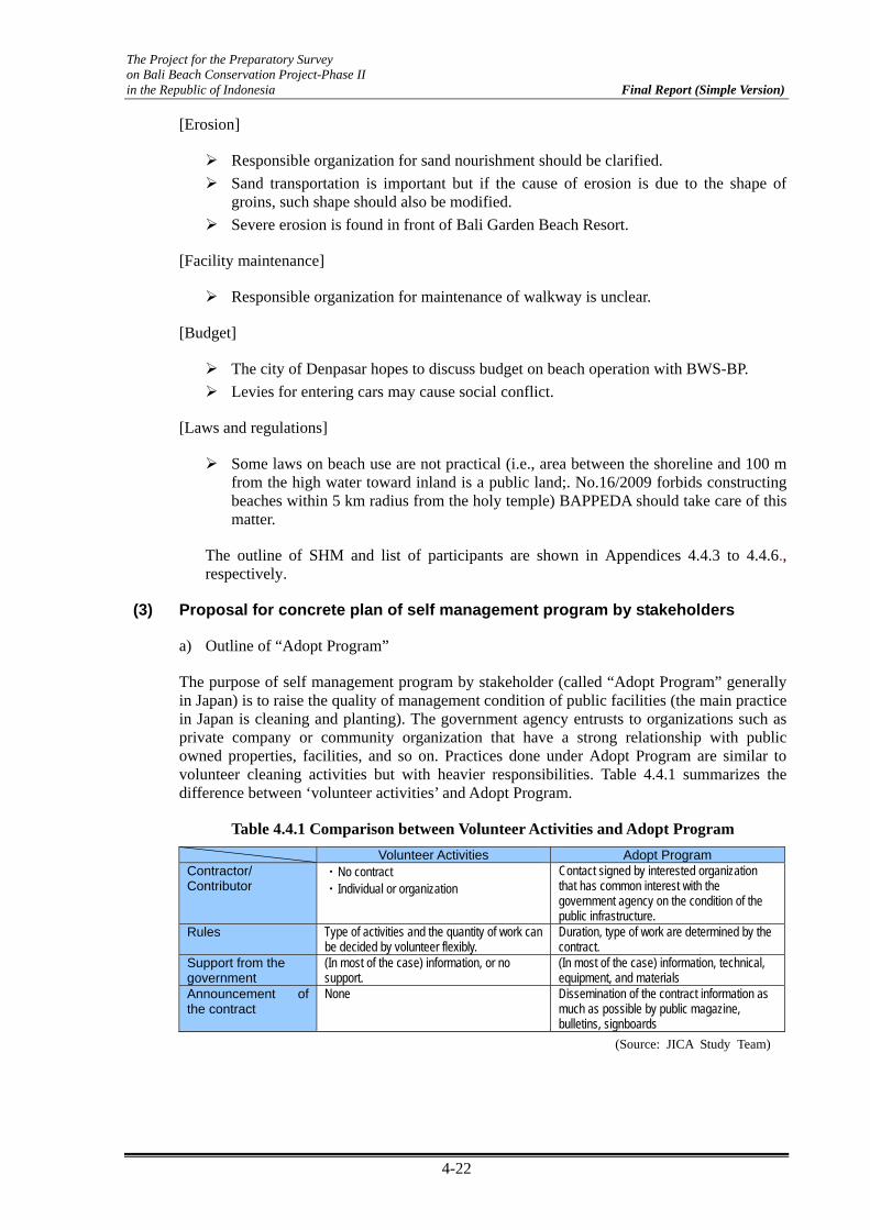
The Project for the Preparatory Survey on Bali Beach Conservation Project-Phase II in the Republic of Indonesia Final Report (Simple Version)
4-22
[Erosion]
Responsible organization for sand nourishment should be clarified.
Sand transportation is important but if the cause of erosion is due to the shape of groins, such shape should also be modified.
Severe erosion is found in front of Bali Garden Beach Resort.
[Facility maintenance]
Responsible organization for maintenance of walkway is unclear.
[Budget]
The city of Denpasar hopes to discuss budget on beach operation with BWS-BP.
Levies for entering cars may cause social conflict.
[Laws and regulations]
Some laws on beach use are not practical (i.e., area between the shoreline and 100 m from the high water toward inland is a public land;. No.16/2009 forbids constructing beaches within 5 km radius from the holy temple) BAPPEDA should take care of this matter.
The outline of SHM and list of participants are shown in Appendices 4.4.3 to 4.4.6., respectively.
(3) Proposal for concrete plan of self management program by stakeholders
a) Outline of “Adopt Program”
The purpose of self management program by stakeholder (called “Adopt Program” generally in Japan) is to raise the quality of management condition of public facilities (the main practice in Japan is cleaning and planting). The government agency entrusts to organizations such as private company or community organization that have a strong relationship with public owned properties, facilities, and so on. Practices done under Adopt Program are similar to volunteer cleaning activities but with heavier responsibilities. Table 4.4.1 summarizes the difference between ‘volunteer activities’ and Adopt Program.
Table 4.4.1 Comparison between Volunteer Activities and Adopt Program Volunteer Activities Adopt Program Contractor/ Contributor
・No contract ・Individual or organization
Contact signed by interested organization that has common interest with the government agency on the condition of the public infrastructure.
Rules Type of activities and the quantity of work can be decided by volunteer flexibly.
Duration, type of work are determined by the contract.
Support from the government
(In most of the case) information, or no support.
(In most of the case) information, technical, equipment, and materials
Announcement of the contract
None Dissemination of the contract information as much as possible by public magazine, bulletins, signboards
(Source: JICA Study Team)

The Project for the Preparatory Survey on Bali Beach Conservation Project-Phase II in the Republic of Indonesia Final Report (Simple Version)
4-23
Table 4.4.2 Comparison of Adopt Program between Japan and Phase-I Beaches
Adopt Program in Japan (Example)Proposed Adopt Program
for Phase-I Beaches (Underlined item is original action in Bali)
・ Beach cleaning ・ Plants maintenance ・ Monitoring erosion and illegal practice ・ Environmental research and education ・ Establishment of information center
・ Sand recycle (within groins) ・ Beach cleaning and installation of trash bins ・ Plants maintenance ・ Fixing of walkway surface ・ Installation of lights and supply electricity, and the maintenance ・ To raise security level of the area by hiring security personnel ・ Monitoring erosion and illegal practice ・ Priority use of the public beach for tourism use
(Source: JICA Study Team)
b) Effectiveness of Application of Adaptive Management in Phase-I Beaches
i) Cause of Beach Degradation
Appropriate management of the beach in front of their business facilities is private sectors’ utmost importance. Beaches in front of public sectors (managed by the government) are often more deteriorated than those in front of the hotels. These are causes of tourism resource degradation of the whole area.
ii) Responsibilities of the Private Sector
The governmental beach management organizations have been discussing their responsibilities in WGs, and the outcome would likely to request private sector to manage:
Beach cleaning
Repairing of walkway surface
Monitoring of beach erosion and illegal usage of the beach, and
Sand transportation between groins.
However, the private sectors are likely to oppose the proposal of the WG. Based on reports from previous hearing survey with private sector, they claim that they are already paying huge taxes, and thus, such public property should be maintained by the government themselves.
iii) ‘Beach and the Strongest Interest Group’
Keeping the beach in good condition, with proper security and pleasant atmosphere provided by plants and other structures are essential; therefore, delegation of management rights to organizations with strong interest, such as a hotel, is expected to have positive impacts. Nourished beaches of Phase-I (Sanur and Nusa Dua) are protected by groins on both sides. However, littoral drift may occur during large waves and high tide. Moreover, sand has the tendency to be transported to one direction. The civil works to bring back the shifted sand to its original position (sand recycle) should continuously be implemented in order to prevent erosion and keep the appropriate width.

The Project for the Preparatory Survey on Bali Beach Conservation Project-Phase II in the Republic of Indonesia Final Report (Simple Version)
4-24
c) Application of Adopt Program for Phase-I Beaches
The following are the implementation plan of Adopt Program to Bali beaches.
i) Selection of Beach
Sanur Beach was chosen as a model for Adopt Program case because there is a clear leading organization, Sanur Development Foundation (YPS), which represents private sectors in Sanur. YPS is expected to understand and implement Adopt Program in Sanur. Then, Adopt Program will be disseminated to the other two beaches.
ii) Discussions with Leading Agency in Sanur
The JICA Study Team explained to YPS the concept of Adopt Program and its benefits, including undergoing discussions among government agencies regarding responsibilities in beach management. YPS was also invited to be part of WG-III. The result of discussions is presented in Appendix 4.4.7.
d) Implementation Plan of Adopt Program
Implementation of Adopt Program is planned to be taken through the following steps:
YPS obtains Minutes of Understanding from city of Denpasar ↓ YPS designates beach section to be adopted ↓ YPS to invite ‘host parent’ Business firm (Hotel) should be given first priority; other
business firms can participate if there is no participation from the hinterland area.
↓
Adopt Program to be submitted by the candidate host parent to YPS ↓
YPS to select host parent ↓
Discussion on contents of contract Activity, duration, reporting (agency, frequency, contents) ↓
Agreement, contract ↓
Implementation of the activities BWS-BP to provide technical guidance on sand recycle ↓
Host parent to submit report periodically
4.5 Collaboration with Private and Other Sectors, and Public Relations
(1) Corporate Social Responsibility (CSR)
Along a CSR movement from a private sector, it is recommended that BWS-BP, Badung Regency and Denpasar City start joint coordination on beach maintenance activities taking

The Project for the Preparatory Survey on Bali Beach Conservation Project-Phase II in the Republic of Indonesia Final Report (Simple Version)
4-25
into account the CSR initiatives. The background of this CSR is described in Appendix 4.5.1(1). Necessity of such coordination involving important stakeholders has been consulted to BWS-BP with a view to organizing a committee. The BWS-BP has done a social study on beach maintenance in Bali, yet an application of the study results does not seem to be in practice at the moment. Considering the capacity of the institution (e.g., limited number of staff in charge of socialization of beach management), it would be more realistic at the moment to promote and encourage such coordination mechanism among local communities, NGOs, and related companies. One example can be made in Sanur. YPS enjoys the potential of CSR. Not only by their technical expertise in development based on their traditional culture and spirit, but also by a strong leadership of the President of Indonesia who is also an influential and successful businessman in tourism, would they be able to become a flagship in leading CSR activities on beach maintenance/management and coastal environment. This positive observation is based on hope expressed by the President during an interview. The President very much appreciated the results of BBCP and expressed gratitude on behalf of the people of Sanur. Yet he was very much concerned about its maintenance. He clearly recalled the February 2009 stakeholders’ workshop in which there had been some results of discussions in quite detail with regards to the maintenance organization/management among participants. Although there had been some written agreements over maintenance of BBCP beaches, application/execution of such agreements has remained a big question to him. He encouraged follow-up and re-establishment of the agreement, as well as welcomes CSR beach cleaning activities in Sanur. Further, diligent consultations with YPS are certainly necessary. One of the consultation issues would be their Sanur Development Accompany Fund (DPSPS).
(2) Concrete Action of Public Relations (PR)
The BBCP PR activities shall be well accepted and adopted by all stakeholders of the project in particular, and the public in general. Furthermore, within a collaboration framework with CSR activities, the BBCP PR activities would be able to improve and expand, interacting with a certain company’s PR expertise. The background of this PR is described in Appendix 4.5.1(2).
Incidentally, a consideration over characteristics similar to that of BBCP, dealing with the issue on coastal environment, has generated an idea to initiate some collaborative PR activities with the Mangrove Information Center that had been established under JICA cooperation projects. However, it turned out that the current central situation had not yet been well-organized enough to launch a publicity with the BBCP.
As to formulation of the BBCP PR strategies, three target groups have been identified; (1) tourist, (2) the public, and (3) the youth. Considering the project characteristics as Japan’s ODA, priority has been given to Japanese tourists in terms of starting with concrete actions.
Among the member agencies of the Japan Tour Operator Association of Bali (JTOA), hearing surveys have been done with two well-known larger agencies, the Japan Travel Bureau (JTB) and the HIS. It has been confirmed that BBCP can be advertised in JTB’s yearly publication (approximately 50,000 copies) called “My Bus Bali” for its 2013 fiscal year edition. In principle, US$1,600 per page can be charged, but a negotiation is under way. It is also suggested that their supplier companies such as Dekom and Bali Kurabu can become effective by means of PR. HIS has a ten-year reputation of publishing 10,000-15,000 copies of free monthly publication on touristic information in the Japanese language called “Bali Freak”. With a spirit of CSR, the head of its Bali office welcomes the BBCP publicity in the publication. A discussion with the “Bali Freak” editor-in-chief later poses a question about the style of writing. A further consultation has to be made with JICA to see if the style is characterized with a light-touch story-telling, consistent with some standards and criteria expected by JICA.

The Project for the Preparatory Survey on Bali Beach Conservation Project-Phase II in the Republic of Indonesia Final Report (Simple Version)
4-26
Besides the two Japanese tourism agencies, a groundwork has been laid out by contacting various institutions as follows.
(1) The Association of Indonesian Tourism Education Institutes is the sole association of its kind in Bali embracing more than 6000 students in 12 universities. The association members include 50,000 hotel staff in Bali. Its president welcomes the PR activities through the association network.
(2) The International Bali Tourism Institute, one of seven well-known four-year universities on tourism in Bali with about 1300 students, welcomes the BBCP PR initiatives in their magazines and extra-curriculum lectures to the students.
(3) The Wisnu Foundation has been executing an eco-tourism program incorporating land use/water management education in Balinese villages. They express collaboration in disseminating the BBCP information in their project villages.
(4) The Bali Japan Club has 356 individual members and 50 company members. The BBCP article contribution to their quarterly publication called Rakuen Tsushin and to their event posters can be realized through a final approval from its president.
(5) The Triatma Surya Jaya Foundation manages educational institutions. Among four undergraduate level universities under the foundation, two are on tourism in which about 600 students study. They also offer vocational tourism to 900 high school students. The president of the foundation welcomes the BBCP PR activities through lectures, magazines, web sites and so on, free of charge.
(3) Educational Programs
Education as broadly defined is treated as the basic issue and a key tool for maintaining a sustainable beach management for and by the end users. Based on the countermeasures proposed in the Chapter 3.3.(3), a pilot educational program can be launched with more detailed studies on the actual situation of environmental education and practice in the Denpasar City area. According to the city statistics, there are 216 elementary schools, 44 junior high schools and 26 senior high schools in Denpasar City. Further consolidation and coordination with more intensified and enlarged efforts on the part of YPS is indispensable. The pilot program should be formulated with careful examinations of the proposed countermeasures and include the following components:
(1) The BBCP lecture is to be integrated in the Extension Program by the Denpasar City Tourism Office.
(2) The Bali Japan Club organizes for its Japanese school students a spring excursion every year. The excursion to the BBCP beaches and a prior special lecture on coastal environment is to be incorporated especially for its OB class students.
(3) Such activities in the Japanese school can be duplicated at Bali International School, the Australia International School, and other private local schools with English curriculum.
(4) Collaboration with the Bali Japan Club volunteers who have been implementing the “Bali Eco Karuta” project is to be done.
(5) In YPS standard environmental education program, a successful Japanese project entitled, “Foster Parent” beach management is to be introduced. In its application in Sanur, a team of collective stakeholders can be organized in each section between two groins, whose activity on financing can be partly channeled through a collective business

The Project for the Preparatory Survey on Bali Beach Conservation Project-Phase II in the Republic of Indonesia Final Report (Simple Version)
4-27
community by means of their CSR. Names of a team, its members and publisher sponsors are to be displayed in plates and signboards between the designated groins. YPS coordinates and supervises their activities within a systematic program and motivates them to perform better. Such incentive practices should be encouraged in order to stimulate healthy competitions among those teams. This initiative should also be designed to facilitate a multiplier effect and synergy among the local government, the private sector and the social sector, especially that of education. Because of the fact that more than 80% of Sanur population is engaged in tourism-related work, involving its residents into the project would not be so difficult.
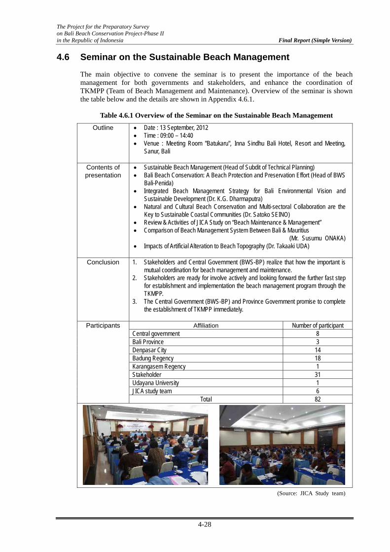
The Project for the Preparatory Survey on Bali Beach Conservation Project-Phase II in the Republic of Indonesia Final Report (Simple Version)
4-28
4.6 Seminar on the Sustainable Beach Management
The main objective to convene the seminar is to present the importance of the beach management for both governments and stakeholders, and enhance the coordination of TKMPP (Team of Beach Management and Maintenance). Overview of the seminar is shown the table below and the details are shown in Appendix 4.6.1.
Table 4.6.1 Overview of the Seminar on the Sustainable Beach Management
Outline • Date : 13 September, 2012 • Time : 09:00 – 14:40 • Venue : Meeting Room "Batukaru", Inna Sindhu Bali Hotel, Resort and Meeting,
Sanur, Bali
Contents of presentation
• Sustainable Beach Management (Head of Subdit of Technical Planning) • Bali Beach Conservation: A Beach Protection and Preservation Effort (Head of BWS
Bali-Penida) • Integrated Beach Management Strategy for Bali Environmental Vision and
Sustainable Development (Dr. K.G. Dharmaputra) • Natural and Cultural Beach Conservation and Multi-sectoral Collaboration are the
Key to Sustainable Coastal Communities (Dr. Satoko SEINO) • Review & Activities of JICA Study on “Beach Maintenance & Management” • Comparison of Beach Management System Between Bali & Mauritius
(Mr. Susumu ONAKA) • Impacts of Artificial Alteration to Beach Topography (Dr. Takaaki UDA)
Conclusion 1. Stakeholders and Central Government (BWS-BP) realize that how the important is
mutual coordination for beach management and maintenance. 2. Stakeholders are ready for involve actively and looking forward the further fast step
for establishment and implementation the beach management program through the TKMPP.
3. The Central Government (BWS-BP) and Province Government promise to complete the establishment of TKMPP immediately.
Participants Affiliation Number of participant
Central government 8 Bali Province 3 Denpasar City 14 Badung Regency 18 Karangasem Regency 1 Stakeholder 31 Udayana University 1 JICA study team 6
Total 82
(Source: JICA Study team)

The Project for the Preparatory Survey on Bali Beach Conservation Project-Phase II in the Republic of Indonesia Final Report (Simple Version)
5-1
Chapter 5 Establishment of Sustainable Beach Management System
5.1 Overview
Until now, there was no authorized system for beach management system in Indonesia. This is one of the main reasons to cause the problems on beach maintenance and management as presented in Chapter 3. To improve such situations, it was required to keep the same perception for the necessity of beach management in cooperate with public and private sectors, and to establish the beach management system and start the activities, immediately.
As the first step to achieve the establishment of the beach management system in the Phase-1 beaches, the establishment of working group (WG) was proposed by JICA study team to discuss above mentioned issues among related parties, and the official meeting has held on 3 times as presented in Chapter 4. As important conclusion in the WG 3 meeting held on 20th September 2012, the central and local governments agreed to take necessary actions for the early establishment of the “Coordination Team on Beach Management (TKMPP)”
These action for the establishment of TKMPP has been just started, and continuous discussions and active performance which strong ownership of Indonesian governments are required for the establishment of TKMPP and for running well of this system. In order to support this, the following studies are conducted in this chapter taking, into account of beach management issues described in Chapter 3 and based on the results of the discussion of working group meeting.
Background on the establishment of beach management system [5.2]
Establishment of a beach management system under the cooperation between the public and private sectors [5.3]
Proposed road map for the establishment of a beach management system [5.4]
The contents of this chapter are summarized in Figure 5.1.1.

The Project for the Preparatory Survey on Bali Beach Conservation Project-Phase II in the Republic of Indonesia Final Report (Simple Version)
5-2
Chapter 5 Establishment of Sustainable Beach Management System
5.3 Establishment of beach management system under thecooperation between the public and private sector
(Appendix 5.3.1) Detail Procedure and responsibility foreach Management Item (Draft)
(1) Category and required actions for beach management(2) Objective of coordination team for beach management (TKMPP)(3) Member and organization of TKMPP(4) Implementation Policy and tasks for TKMPP
(1) Basic conceptof demarcation of task and responsibility(2) Process of monitoring and maintenance for Management-1(3) Process of monitoring and maintenance for Management-2(4) Process of monitoring and maintenance for Management-3(5) Process of beach cleaning activities for Management-4(6) Process of controlling beach utilization for Management-5
5.1 Overview of establishment of beach managementsystem
5.2 Background on establishment of beach managementsystem
(1) Summary of improvement plan for beach management(2) Summary of result of Working Group(3) Necessity of coordination organization under the cooperation
between the public and private sectors
(Appendix 5.3.2) Adequate BeachZone Management (Draft)
(1) Legalization of walkway as boundarybetween public and private lands
(2) Basic concept of illegal structure on thebeach
5.4 Proposed road map for establishment of beachmanagement system
Table 5.4.1 Road map for establishment of beach management systemTable 5.4.2 Action plan for middle term stage (draft)
Figure 5.1.1 Flow for the Contents of Chapter 5 (Source: JICA Study Team)
5.2 Background on Establishment of Beach Management System
(1) Summary of Improvement Plan for Beach Management
In accordance with the studies for beach management, issued in Chapter 3, required improvements on beach maintenance and management were summarized as follows;
Enhancement of skill for beach monitoring and maintenance of government institutions;
Necessity for revision of the existing beach operation and maintenance manual;
Enhancement on the understanding of the basic principles integrated in the “Adaptive Beach Management System” among all government institutions to comprehend the need for continual beach monitoring and maintenance;
Establishment of a beach management organization under the cooperation between public and private sectors to share responsibilities and exchange information and requirement;

The Project for the Preparatory Survey on Bali Beach Conservation Project-Phase II in the Republic of Indonesia Final Report (Simple Version)
5-3
Determination of the demarcation of responsibility among government institutions and stakeholders to clarify the division of roles for beach management;
Clarification on the function of walkways as boundary between the public and private control construction of facilities, building, planting, etc., on nourished beach; and
Enhancement of knowledge on the regulations of beach utilization at community level to control various illegal activities.
(2) Summary of Conclusions in the Working Group Meeting
The summary of conclusions in connection with the establishment of a beach management system on WG 1 to WG 3 is shown as follows.
WG 1 (January 30, 2012)
Need to establish a form of organization which will manage the condition and utilization of the beach as well as to keep the beach shore wide
The beach management should coordinate with all relevant parties such as the central and local governments and stakeholders
Main issues raised on the local government side are lack of human resources, equipment, technical skill, etc.
The demarcation of tasks and responsibilities should be clarified between governments and stakeholders
WG 2 (April 5, 2012)
The Coordination Team on Beach Management (TKMPP) should be established among government institutions (central government, Province of Bali, Denpasar City, Badung Regency) to clarify their specific tasks and responsibilities
BAPPEDA will establish a small team for preparing the TKMPP with support from the JICA Study Team
The function of TKMPP will be a coordination forum for beach management and maintenance. Schemes, tasks, and responsibilities will be discussed in this coordination team after being established by the Bali Governor’s Degree.
Final Agreement in WG 3 (September 20, 2012)
Governments agreed to take necessary actions for the early establishment of the “Coordination Team on Beach Management (TKMPP)”.
Five management items related to beach management were accepted among the governments who are related to beach management.
Governments and stakeholders agreed to establish a beach management system under the cooperation of the public and private sectors.
In addition, a road map consensus was obtained among government institutions and stakeholders as a milestone for the establishment of a sustainable beach management system in the WG 3 meeting. The following actions were also confirmed in the said meeting to be the next action of the public and private sectors:
Establishment of TKMPP by 2012 at the latest;
Continuous discussion and consultation to set up the demarcation of responsibilities of the TKMPP;
Consultation to legalize walkways as the boundary between public and private properties;

The Project for the Preparatory Survey on Bali Beach Conservation Project-Phase II in the Republic of Indonesia Final Report (Simple Version)
5-4
Consultation on how to control illegal buildings and structures built on nourished beaches;
Budget allocation for related government institutions based on the fixed demarcation of responsibilities through discussions of the TKMPP;
Consultation on the significance of sand stock pile and the role of sand utilization and transportation among government institutions and stakeholders;
Consultation on the clarification of the permit’s approval system, role, regulation, etc., to be used for beach utilization;
Trial of pilot case study to show the beach management cooperate with public and private sectors that were indicated in the road map.
(3) Necessity of Coordination Organization under the Cooperation Between Public and Private Sectors
Based on the above results from the study of the improvement plan and results of the working group, the necessity of coordination team among government institutions and stakeholders was evaluated in the following procedure;
Figure 5.2.1 Flow for the Necessity of Coordination Team for Beach Management (Source: JICA Study Team)
In accordance with the above evaluation, the necessity for a coordination team was confirmed to establish sustainable beach management. Therefore, specific organization, task, action plan, etc., for the coordination team were proposed and discussed in the third working group meeting (July 20, 2012). Finally, a road map was set for future direction and milestone as described in this chapter.
Why is there a necessity for a coordination team for beach management (TKMPP)?
The perception of a consensus for beach utilization not kept among governments and stakeholders.
Maintenance of the beach and its facilities has never systematized among governments and stakeholders.
Shared awareness and common rule on beach utilization is required for all parties between the government side and stakeholders
Sustainable and systemic beach management system is required
Coordination team for beach management is required to make a common rule, that is to establish a sustainable beach management under the cooperation between the government and stakeholder sector

The Project for the Preparatory Survey on Bali Beach Conservation Project-Phase II in the Republic of Indonesia Final Report (Simple Version)
5-5
5.3 Establishment of Beach Management System Under Cooperation between Public and Private Sectors
(1) Category and Required Actions for Beach Management
The required beach management is categorized into five items in accordance with the basic categories described in the Beach Operation and Maintenance Manual and the results of discussion of the Working Groups. These five items are as follows;
Management-1: Monitoring, evaluation and maintenance of sandy beach
Management-2: Maintenance of coastal facilities
Management-3: Maintenance of landscape and public facilities
Management-4: Beach cleaning
Management-5: Control of beach utilization (for illegal construction)
The categorized management items and required actions for each are summarized in Table 5.3.1. Management-1 for monitoring, evaluation and maintenance for nourished beach should be carried out based on the basic concept of integrated beach management (Adaptive Beach Management), as described in Section 3.3 Chapter 3. Managements-2 and -3 consist of: 1) monitoring of facilities, and 2) evaluation of required maintenance and implementation. Management-4 consists of: 1) daily beach cleaning 2) transportation of rubbish to disposal areas and 3) public participation as environmental education program. Management-5 consists of: 1) daily checking and self-control of beach utilization and 2) sanctions for violation of beach utilization.
Table 5.3.1 Categorized Management Item and Required Actions
Required actions
Monitoring (by visual) and reporting
Monitoring (by survey)
Analysis and evaluation
Planning and design for required adaptation
Implementation of adaptation (rotation/refilling of sand)
Monitoring and reporting
Evaluation and repairing
Monitoring and reporting
Evaluation and repairing
Daily cleaning
Disposal of gabage
Public participation as environmental education program
Daily checking and self-control of beach use
Sanction for violation of beach utilization
4 Beach cleaning
5Control of beach utilization
(for illegal construction on the Beach)
Category of Beach Management
1
Monitoring, Evaluation and Maintenance of Sandy Beach
(Adaptive Management for Sandy Beach)
2Maintenance of Coastal Facilities(Revetment, Groin, Breakwater)
3Maintenance of Landscaping and PublicFacilities (walkway, gazebo, lamp, etc.)
(Source: JICA Study Team)

The Project for the Preparatory Survey on Bali Beach Conservation Project-Phase II in the Republic of Indonesia Final Report (Simple Version)
5-6
(2) Objectives of the Coordination Team for Beach Management (TKMPP)
The cross-sectional actions between them are needed in order to implement adequate beach management in the five management items stated above. The official pre-WG meetings were held three times while official WG meetings were held three times. The meetings discussed about the necessity of a beach management system in the Phase-1 Beaches and required action under the cooperation between the public and private sectors. Measures for organization and systematization among the central governments, local governments, and stakeholders were also discussed. The establishment of TKMPP was settled as one of the main conclusions in the WG meeting, among government institutions. A small team was set-up for the preparation committee in BAPPEDA, Province of Bali.
The main function of TKMPP is expected as follows:
To enhance shared awareness on beach maintenance and management among all members.
To maintain the same understanding for the problems on beach maintenance and management at the Phase-1 Beaches due to exposing from each parties (especially from stakeholders) in TKMPP
To discuss and determine the measures for the issue on beach maintenance and management at the Phase-1 Beaches including sharing of responsibility and budget allocation.
To determine the common roles on beach utilization among governments and stakeholders. Further, to control and to make clear the sanction for the violation on beach area such as illegal use of sandy beach in the Phase-1 Beaches and other beaches in Bali.
To promote awareness programs to a wide range of beach users and enhance the ability of beach management
To establishment the successful beach management system for the Phase-2 Project Beaches based on the experience of both implementation and activity of beach maintenance and management for the Phase-1 Beaches.
To examine and if possible to establish the comprehensive beach management at whole Bali beaches.
(3) Proposed Members and Organization of TKMPP
Members of TKMPP consist of different government sectors such as the central government, Bali Province, Denpasar City, and Badung Regency. Also members are stakeholders such as traditional villages, administrative villages, tourist development board and center, hotel and restaurant associations. The detailed member of TKMPP is shown in Figure 5.3.1. And the expected organization of TKMPP was indicated as a basic concept of an organizational diagram, as shown in Figure 5.3.2. It was recommended that TKMPP will be organized by BAPPEDA in Bali Province as chairman, the provincial public works as vice-chairman. BWS-BP was recommended as secretariat to lead the right way for beach maintenance and management, because only BWS-BP has undertaken the beach monitoring and maintenance after the completion of the Phase-1 Project. Other members from both governments and stakeholders were recommended as shown in Figure 5.3.1.
The final members and organization will be determined and legalized as Bali Governor’s Decree as implementation body for sustainable beach management of the Phase-1 Beaches.

The Project for the Preparatory Survey on Bali Beach Conservation Project-Phase II in the Republic of Indonesia Final Report (Simple Version)
5-7
Sanur Beach Nusa Dua Beach Kuta Beach
Government Sector
Central Government
Bali Province
Denpasar City
CoordinationTeam for Beach Management (TKMPP)
Stakeholders Sector Traditional VillagesAdministrative villagesKuta Beach Task UnitSouth Kuta Beach Business Association
Traditional VillagesAdministrative villagesBali Tourism Development Center (BTDC)
Traditional villagesAdministrative vilagesSanur Development Board (YPS)
Indonesian Hotel and Restaurant Association Chapter Bali (PHRI Bali)
BappedaTourism AgencyPublic WorksCity Planning and Residential AgencyCleanlines AgencyEnvironmental AgencyTrantib and Satpol PP AgencyPermission AgencySouth Denpasar District
Bali Penida-River Basin Bureau (BWS-BP)Experimental Station for Coastal Engineering (Loka Pantai)
Regional Development Agency (Bappeda)Public Works Service Agency (Dinas PU)Environmental Agency (BLH)
Badung RegencyBappedaTourism AgencyHighway and Irrigation AgencyCipta Karya and Permission AgencyCleanliness AgencyEnvironmental Agency
Satpol PP AgencyLand AgencyKuta DistrictSouth Kuta District
Figure 5.3.1 Members of the Coordination Team for Beach Management (TKMPP) (Source: JICA Study Team)
Chairmann(Bappeda, Bali Province)
Vice-Chairmann(Dinas, Bali Province)
Secretariat(BWS-BP)
MembersGovenments Sectors
MembersStakeholders Sectors
Figure 5.3.2 Expected Organizational Structure of TKMPP (Source: JICA Study Team)
(4) Implementation Image of TKMPP and Draft Idea of Responsibility
The TKMPP meeting will be basically held periodically in the year by the official announcement of BAPPEDA with all members participate to discuss and determine the annual required beach maintenance and management. The image of the frequency for holding the meeting is three or four times per year. However, if it is necessary to discuss and determine the urgent issues regarding beach maintenance and management matters, the irregular meeting will be also considered to be held by the instruction of BAPPEDA.

The Project for the Preparatory Survey on Bali Beach Conservation Project-Phase II in the Republic of Indonesia Final Report (Simple Version)
5-8
The members of TKMPP will report the present situation and issues of every management item. Discussions on necessity of measures, strategy and implementation plan against several management issues will also be tackled. They will also discuss some subjects for sustainable beach management that was set up during previous meetings and will conclude on improvement plan and enforcement policy in TKMPP.
The draft idea for the demarcation of responsibilities for each management item and its required action is summarized in Table 5.3.2. The draft of detail procedure and responsibility for each management item were examined by JICA Study Team (shown in Appendix 5.3.1). However, the final demarcation plan will be further discussed and concluded among all members of TKMPP refer to the draft idea shown in Appendix 5.3.1.
Table 5.3.2 Demarcation of Responsibilities of TKMPP Members (Draft Idea)
Required Actions Main Responsibility
Monitoring (by visual) and reporting Stakeholders
Monitoring (by survey)
Analysis and evaluation
Planning and design for requiredadaptation
Implementation of adaptation (rotation/refilling of sand)
Monitoring and reporting Stakeholders
Evaluation and repairing Central Government(BWS-BP)
Monitoring and reporting Stakeholders
Evaluation and repairing Local Government(Badung Regency, Denpasar City)
Daily cleaning Stakeholders
Disposal of gabage Local Government(Badung Regency, Denpasar City)
Public participation as environmental education program Stakeholders cooperate with NGO
Daily checking and self-control of beach use Stakeholders
Sanction for violation of beachutilization
Local Government(Bali Province, Badung Regency,
Denpasar City)
3Maintenance of Landscaping and PublicFacilities (walkway, gazebo, lamp, etc.)
4 Beach cleaning
5Control of beach utilization
(for illegal construction on the Beach)
Category of Beach Management
1
Monitoring, Evaluation and Maintenance of Sandy Beach
(Adaptive Management for Sandy Beach)Central Government
(BWS-BP and Loka Pantai)
2Maintenance of Coastal Facilities(Revetment, Groin, Breakwater)
(Source: JICA Study Team)

The Project for the Preparatory Survey on Bali Beach Conservation Project-Phase II in the Republic of Indonesia Final Report (Simple Version)
5-9
5.4 Proposed Road Map And Action Plan for the Establishment of a Beach Management System
It is expected that various beach management issues will be improved through the discussion and determination in TKMPP meeting hereafter. However, this activity is the first trial as beach management in Indonesia, and it was thought that they will have a difficulty in operating TKMPP and sustainable beach management as they have no specialist for coastal management and no experience on comprehensive beach management based on both technical and institutional point of view. To assist the activity conducted by Indonesia with their ownership, it is recommended to hold TKMPP meeting and required action for beach maintenance and management continuously in accordance with the proposed road map that describes the goals and action plans as a milestone in order to take initiative in solving problems.
Table 5.4.1 shows the proposed road map to show the target or achievement in each stage.
The preliminary stage is divided into “1st term” and “2nd term”. The 1st term is to set up a basic concept of suitable sustainable beach management system during the JICA study. 2nd term is to establish TKMPP and holding the regular meeting to discuss and implement countermeasures against beach management issues in the Phase-1 Beaches while basically there is no support of JICA experts from the completion of JICA study until starting of engineering services in the Phase-2 Project.
The middle stage is divided into “3rd term” and “4th term”. The 3rd term is to holding the regular meeting of TKMPP not only for the Phase-1 Beaches but also for the Phase-2 Beaches to establish the suitable beach management system before the commencement of implementation of the Phase-2 Project. Annual beach maintenance and management are undertaken in accordance with the decision of TKMPP. Capacity development for beach management are also conducted by the assist of Japanese experts as soft component programs in the Phase-2 Project (refer to Chapter 12). The 4th term is to holding the regular meeting of TKMPP for both Phase-1 and Phase-2 Project Beaches, and annual beach maintenance and management for both beaches are undertaken and monitored in TKMPP.
The final stage (5th term) is the last term in the Phase-2 Project. The beach maintenance and management for Phase-1 and Phase-2 Beaches is expected going well only by Indonesian side. The beach management system including other beaches in Bali is discussed to expand the successful result of beach management for Phase-1 and Phase-2 Project.
Specific action plan especially in the 2nd term of the preliminary stage is shown in Table 5.4.2. This stage is very important because TKMPP should be established, and some fundamental issues shall be discussed and determined in the TKMPP by Indonesian side without assistance of Japanese expert.
This action plan describes regularly scheduled discussion, subjects of discussion, and contents of pilot case studies and the timing of its implementation. As the pilot case study, the maintenance of sandy beach at specific area of Sanur and Nusa Dua in cooperation with related stakeholders is expected. The objective of the pilot case study is to enhance the understanding and right way of maintenance of sandy beach in corporation with the public and private sectors. As pilot case study, the trial of sand rotation with re-filling of sand from stockpile at south Sanur (between groin No.G38 and GA2), and north of Nusa Dua (north of

The Project for the Preparatory Survey on Bali Beach Conservation Project-Phase II in the Republic of Indonesia Final Report (Simple Version)
5-10
groin No.GA2) was recommended as model case based on the monitoring result presented in section 6.4, Chapter 6.
Table 5.4.1 Road Map for the Establishment of Beach Management System Year 2011 2012 2016 2017 2018
5th term
(Final Stage)
Main Activity ditto
Targetor
Achievement
- Continuous beachmanagement atPhase-1and 2Beaches
- Discussion toexpand whole Balibeaches
Image for Skill-up & Experience
of Indonesia
- Establishment of TKMPP- Finalization of responsibilityfor each management item
- Determination of beachmanagement system(common rule, control ofbeach area, etc.)
- Trial of pilot case formaintenance of sandy beachwith PPP scheme
(Preliminary Stage)
Stage
(Middle Stage)
Implementation for Phase-2
- Identification of problemsfor each beach and to makedecision for annual beachmaintenance work
- Establishment anddetermination of beachmanagement system forPhase-2 beaches
-Holding regular meeting(for Phase-1 & 2 Beaches)- Capacity building for skill-up ofbeach management
4th term
- Continuous beachmanagement at Phase-1Beaches
- Starting beach managementat Phase-2 Beaches with PPPscheme
JICA Study(Preparatory Survey on BBCP-2)
- Establishment of Working Group(WG) and holding meeting (WG1 -WG3)- Seminar
- Obtaining common understandingfor importance of BeachMaintenance and Managementcooperate with Governments andStakeholders
- Agreement for sharing ofresponsibility on beachmaintenance and management
- Agreement to establishcoordination team for beachmanagement (TKMPP)
-Holding regular meeting(for Phase-1 & 2 Beaches)- Capacity building for skill-up of beach management
1st term 2nd term 3rd term
2013 2014 2015
Preparation Periodfor Phase-2
E/S for Phase-2(DD & Bidding Assistance)
- Establishment of TKMPPand holding regular meeting(for Phase-1 Beaches)
(Source: JICA Study Team)
Table 5.4.2 Action Plan in the 2nd Term of Preliminary Stage in 2013 (Draft)
Jan Apr Jul Sep Oct Nov Dec Jan Feb Mar Apr May Jun Jul Aug Sep Oct Nov Dec Jan Feb Mar Feb Mar
Working Group (WG), Seminar
Establishment of TKMPP
Discussion amongGovernments
(BAPPEDA, BWS-BP, Central)
TKMPP Meeting (to establishmanagement system)
Trial of Pilot Case
TKMPP Meeting (to discussand determine annual
maintenance )
2nd Term (in Preliminary Stage) 3rd Term ( in Middle Stage)
Activ
ity
Support and Capacity Development by JICA
Year & Month2012 2013 2014
TermJICA Study (Preparatory Survey of Phase-2) Preparation Stage for Phase-2 E/S Stage for Phase-2
1st Term (in Preliminary Stage)
WG1 WG2 WG3 Seminar
GovernorDecreeRevise of Decree(as required)
Already undertaken
Planned
Revise decree as required how to participate regency, city and Stakeholders legally
Maintenance of Sandy Beachfor specific area at Sanur
Maintenance of Sandy Beachfor specific area at Nusa Dua
(Source: JICA Study Team)
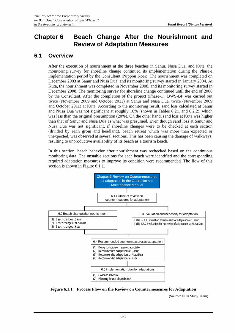
The Project for the Preparatory Survey on Bali Beach Conservation Project-Phase II in the Republic of Indonesia Final Report (Simple Version)
6-1
Chapter 6 Beach Change After the Nourishment and Review of Adaptation Measures
6.1 Overview
After the execution of nourishment at the three beaches in Sanur, Nusa Dua, and Kuta, the monitoring survey for shoreline change continued its implementation during the Phase-I implementation period by the Consultant (Nippon Koei). The nourishment was completed on December 2003 at Sanur and Nusa Dua, and its monitoring survey started in January 2004. At Kuta, the nourishment was completed in November 2008, and its monitoring survey started in December 2008. The monitoring survey for shoreline change continued until the end of 2008 by the Consultant. After the completion of the project (Phase-1), BWS-BP was carried out twice (November 2009 and October 2011) at Sanur and Nusa Dua, twice (November 2009 and October 2011) at Kuta. According to the monitoring result, sand loss calculated at Sanur and Nusa Dua was not significant at roughly 10% (shown in Tables 6.2.1 and 6.2.2), which was less than the original presumption (20%). On the other hand, sand loss at Kuta was higher than that of Sanur and Nusa Dua as what was presumed. Even though sand loss at Sanur and Nusa Dua was not significant, if shoreline changes were to be checked at each section (divided by each groin and headland), beach retreat which was more than expected or unexpected, was observed at several sections. This has been causing the damage of walkways, resulting to unproductive availability of its beach as a tourism beach.
In this section, beach behavior after nourishment was rechecked based on the continuous monitoring data. The unstable sections for each beach were identified and the corresponding required adaptation measures to improve its condition were recommended. The flow of this section is shown in Figure 6.1.1.
Chapter 6 Review on Countermeasures for adaptation in the Operation and
Maintenance Manual
6.2 Beach change after nourishment 6.3 Evaluation and necessity for adaptation
6.4 Recommended countermeasures as adaptation
(1) Beach change at Sanur(2) Beach change at Nusa Dua(3) Beach change at Kuta
Table 6.3.1 Evaluation for necessity of adaptation at SanurTable 6.3.2 Evaluation for necessity of adaptation at Nusa Dua
(1) Design principle on required adaptation(2) Recommended adaptations at Sanur(3) Recommended adaptations at Nusa Dua(4) Recommended adaptations at Kuta
6.1 Outline of review on countermeasures for adaptation
6.5 Implementation plan for adaptations
(1) Cost and schedule(2) Planning for use of sand stock
Figure 6.1.1 Process Flow on the Review on Countermeasures for Adaptation (Source: JICA Study Team)

The Project for the Preparatory Survey on Bali Beach Conservation Project-Phase II in the Republic of Indonesia Final Report (Simple Version)
6-2
6.2 Beach Change and Sand Remaining after the Nourishment
(1) Sanur
The project area at Sanur beach is shown in Figure 6.2.1. This area is divided into three sub-areas which are called S1, S2, and S3. The shoreline change after the nourishment until this year is shown below for each sub-area.
Figure 6.2.1 Layout of Sanur Beach (Source: JICA Study Team)
a) Section S1
The beach condition in S1 is shown in Photo 6.2.1 and the shoreline change based on the initial position just after beach fill is shown in Figure 6.2.2. S1 is enclosed by two headlands (G3 and G4) and one existing groin (G5) with a 430 m alongshore distance. In Figure 5.7.2, although the shoreline position has moved from its initial position, an almost stable beach condition was already obtained.
From the result, there is no need to consider further adaptations at this time.
G 5 G 4 G 3281 m 144 m
Photo 6.2.1 Bird’s Eye View of S1
(Source: Nippon Koei Co., Ltd & BWS-BP)
S1
S2
S3

The Project for the Preparatory Survey on Bali Beach Conservation Project-Phase II in the Republic of Indonesia Final Report (Simple Version)
6-3
G3~G4, G4~G5
-20
-15
-10
-5
0
5
10
15
20
BC
- 0
BC
- 2
BC
- 4
BC
- 6
BC
- 8
BC
- 10
BC
- 12
BC
- 14
BC
- 16
BC
- 18
BC
- 20
BC
- 22
BC
- 24
BC
- 26
BC
- 28
BC
- 30
BC
- 32
BC
- 34
BC
- 36
L - 2
0
L - 2
0a
L - 2
1
L - 2
1a
L - 2
2
L - 2
2a
L - 2
3
L - 2
4
L - 2
5
Monitoring Point
Sho
relin
e C
hanc
e (m
)
Feb-04
Oct-05
Dec-06
Nov-07
Nov-08
Oct-11
G-3 G-4 G-5
144m 281m 527m
Stable Stable Stable
Figure 6.2.2 Shoreline Change at S1 (Based on its Initial Shoreline Position) (Source: Nippon Koei Co., Ltd & BWS-BP)
b) Section S2
The present beach condition in S2 is shown in Photo 6.2.2 and the shoreline change based on the initial beach position just after beach fill is shown in Figure 6.2.3. S2 is enclosed by six groins and headlands with 1700 m alongshore distance. Unstable condition is recognized at section S2-1 (between GN7 and GN4). Continued beach recession at the north side of GN4 were observed. The narrowness of the beach is causing unsatisfactory results in beach use as shown in Photo 6.2.3.
G 16
BWN 1GN 4
GN 7 GN 3 GN 2 GN 1330 m
324 m 180 m 244 m 227 m92 m
258 m
Photo 6.2.2 Bird’s Eye View of S2 (Source: Nippon Koei Co., Ltd & BWS-BP)
North to GN1~GN2, GN2~GN3, GN3~
-25.0
-20.0
-15.0
-10.0
-5.0
0.0
5.0
10.0
15.0
20.0
SG
- 29
SG
- 27
SG
- 25
SG
- 23
SG
- 21
SG
- 20
SG
- 18
SG
- 16
SG
- 14
SG
- 10
SG
- 8
SG
- 6
SG
- 4
SG
- 2
SB
- 42
SB
- 40
SB
- 38
SB
- 36
SB
- 34
SB
- 32
SB
- 30
SB
- 28
SB
- 26
SB
- 24
SB
- 22
SB
- 20
SB
- 18
SB
- 16
SB
- 14
SB
- 12
SB
- 10
SB
- 8
SB
- 6
SB
- 4
SB
- 2
AD
D -
14
Sho
relin
e C
hang
e (m
)
227m 244m 180m92m
GN-1 GN-2 GN-3 GN-7
Stable Stable Stable Stable
2~GN3, GN3~GN7, GN7~G4, G4~G16, G16 to South
SB
- 4
SB
- 2
AD
D -
14
AD
D -
12
AD
D -
10
AD
D -
8
AD
D -
6
AD
D -
4
AD
D -
2
BW
- 1
BW
- 3
BW
- 5
BW
- 7
BW
- 9
BW
- 11
BW
- 13
BW
- 15
BW
- 17
BW
- 19
BW
- 21
BW
- 23
BW
- 25
BW
- 27
BW
- 29
BW
- 31
BW
- 33
BW
- 35
BW
- 37
BW
- 39
BW
- 41
BW
- 43
BW
- 45
BW
- 47
BW
- 50
BW
- 52
BW
- 54
BW
- 56
BW
- 58
BW
- 60
BW
- 62
BW
- 64
BW
- 66
BW
- 68
BW
- 70
BW
- 72
BW
- 74
Monitoring Point
Feb-04Oct-05Dec-06Nov-07Nov-08Oct-11
324m 330m 258m
BWN-1GN-7 GN-4 G-16
Stable
StableCheck
Section S2-1
Figure 6.2.3 Shoreline Change at S2 (Based on its Initial Shoreline Position) (Source: Nippon Koei Co., Ltd & BWS-BP)

The Project for the Preparatory Survey on Bali Beach Conservation Project-Phase II in the Republic of Indonesia Final Report (Simple Version)
6-4
Photo 6.2.3 North Side of GN4 at Section S2-1
(Source: JICA Study Team) c) Section S3
The present beach condition in S3 is shown in Photo 6.2.4 and the shoreline change based on the initial beach position just after beach fill is shown in Figure 6.2.4. S3 is enclosed by five groins and headlands with a 1700 m alongshore distance. Two additional groins (G37 and GN5) were constructed between G32 and G38 by BWS-BP, owing to the strong request of the Purisantrian Hotel. Unstable conditions were recognized at section S3-1 (north side of G32), S3-2 (between G37 and GN5), S3-3 (between G38 and G39), and S3-4 (between G39 and GA2).
GA 1 GA 2 G 39192 m 312 m 441 m
G 38 G 32600 m 124 m
Photo 6.2.4 Bird’s Eye View of S3 (Source: Nippon Koei Co., Ltd & BWS-BP)
L84~G32, G32~G38, G38~G39, G
-30.0
-20.0
-10.0
0.0
10.0
20.0
30.0
R -
108
R -
106
R -
104
R -
102
R -
100
R -
98
R -
97R
- 96
R -
94R
- 92
R -
90R
- 88
R -
86R
- 84
R -
82R
- 80
R -
78R
- 76
R -
74R
- 72
R -
70R
- 68
R -
66R
- 64
R -
62R
- 60
R -
58R
- 56
R -
54R
- 52
R -
50R
- 48
R -
46R
- 44
R-4
2R
-40
Sho
relin
e C
hang
e (m
)
124m (110m) (260m) (230m)
G-32 G-38GN-5 (2006)G37 (2006)
Stable StableCheckSection S3-2
CheckSection S3-1
38, G38~G39, G39~G3A2, GA2~GA1
R -
46R
- 44
R-4
2R
-40
R-3
8R
-36
R-3
4R
-32
R-3
0R
-28
R-2
6R
-24
R-2
2R
-20
R-1
8R
-16
R-1
4R
-12
R-1
0R
-8R
-6R
-4R
-2
MR
- 2
MR
- 4
MR
- 6
MR
- 8
MR
- 10
MR
- 12
MR
- 14
MR
- 16
MR
- 18
MR
- 20
MR
- 22
MR
- 24
MR
- 26
MR
- 28
MR
- 30
MR
- 32
MR
- 34
MR
- 36
MR
- 38
MR
- 40
MR
- 42
MR
- 46
MR
- 48
MR
- 50
Monitoring Point
Feb-04
Oct-05Dec-06
Nov-07Nov-08
Oct-11
441m 312m 192m
G-38 G-39 GA-2 GA-1
Stable
Check
Section S3-4
Check
Section S3-3
Figure 6.2.4 Shoreline Change at S3 (Based on Initial Shoreline Position)
(Source: Nippon Koei Co., Ltd & BWS-BP)

The Project for the Preparatory Survey on Bali Beach Conservation Project-Phase II in the Republic of Indonesia Final Report (Simple Version)
6-5
Photo 6.2.5 shows the beach condition at the north side of G32 in section S3-1. Beach recession continued and beach slope has reached the position of walkway.
Photo 6.2.6 shows beach conditions at the south side of G37 (constructed in 2006) in section S3-2. After the construction of additional groin G37, the beach recession at the south side of G37 occurred and the narrowness of its beach width is causing unsatisfactory conditions on beach use.
Photo 6.2.5 North Side of G32 at Section S3-1
Photo 6.2.6 South Side of G37 at Section S3-2
(Source: JICA Study Team)
Photo 6.2.7 shows the beach condition at the south side of G38 in section S3-3. Beach scarp due to the recession was observed. On the other hand, the accretion of the beach at the north side of G39 in section S3-3 was observed as shown in Photo 6.2.8.
Photo 6.2.7 South Side of G38 at Section S3-3
Photo.6.2.8 North Side of G39 at Section S3-3
(Source: JICA Study Team)
Photo 6.2.9 shows the beach condition at the north side of GA2 in section S3-4. Significant beach recession was observed resulting in damage of some walkway parts. The impermeable type concrete seawall was constructed in October 2011, however, this seawall has been already damaged due to high wave action in February 2012, as shown in Photo 6.2.10.

The Project for the Preparatory Survey on Bali Beach Conservation Project-Phase II in the Republic of Indonesia Final Report (Simple Version)
6-6
Photo 6.2.9 North Side of GA2 at Section S3-4 (Sep 18, 2011)
Photo.6.2.10 Same Position (Feb 5, 2012)(Source: JICA Study Team)
Table 6.2.1 shows the comparison of evaluation result on beach condition between the previous (in 2007 presented in the O&M report) and present (2011) beach sections. Results for the volume of sand loss for both sections after 4 and 8 years are also shown.
Table 6.2.1 Comparison of Evaluation Result on Beach Condition at Sanur
Sub-area Section Previous Evaluation(by the Consultant of BBCP-1in 2007)
Present Evaluation
(by the Study Team in 2011)
Volume of Sand Loss (Based on Initial Condition)
After 4 years After 8 years
S1 G3-G4 Stable Stable -5% 0% G4-G5 Stable Stable -1% 0%
South G6 Stable Stable
S2
North GN1 Unstable Stable -46% -52% GN1-GN2 Stable Stable -8% -10%
GN2-GN3 Stable Stable -5% -8%
GN3-G7 Stable Stable -5% -7% G7-GN4 Unstable Unstable -5% -11%
GN4-G16 Stable Stable -6% -5%
South G16 Stable Stable -7% -8%
S3
North G32 Unstable Unstable -25% -27%
G32-G37*)
Stable
Stable 21% 30%
G37*)-GN5*) Unstable 11% 10%
GN5*)-G38 Stable -28% -27%
G38-G39 Unstable Unstable -18% -21% G39-GA2 Unstable Unstable -18% -23%
GA2-GA1 Stable Stable -2% 5%
Total -9% -9% *) G37 and GN5 were constructed by BWS-BP in 2006
(Source: JICA Study Team)
(2) Nusa Dua
The project area at Nusa Dua beach is shown in Figure 6.2.5. This area is divided into three sub-areas which are called N1, N2, and N3. The shoreline change after beach fill is shown for each sub-area.

The Project for the Preparatory Survey on Bali Beach Conservation Project-Phase II in the Republic of Indonesia Final Report (Simple Version)
6-7
Figure 6.2.5 Nusa Dua Beach (Source: JICA Study Team)
a) Section N1
The present beach condition in N1 is shown in Photo 6.2.11 and the shoreline change based on the initial beach position just after beach fill is shown in Figure 6.2.6. N1 is enclosed by six headlands (from G12 until GN1) with a distance of approximately 1200 m alongshore. In Figure 6.2.6, although the shoreline position has moved from its initial position, the almost stable beach condition has already been obtained. However, unstable condition was observed at section N1-1 (between G12 and GN2).
G 12297 m
GN 2 UG 1 G 10
G 9 GN 1G 12
211 m 196 m222 m
248 m244 m
Photo 6.2.11 Bird’s Eye View N1
(Source: Nippon Koei Co., Ltd & BWS-BP)
G12~GN2, GN2~UG1, UG1~G10, G10~G9, G9~GN1
-35-30-25-20-15-10-505
1015202530
L-67
L-66
L-65
L-64
L-63
L-62
L-61
L-60
L-59
L-58
L-57
L-56
L-55
L-54
L-53
L-52
L-51
L-50
L-49
L-48
L-47
L-46
L-45
L-44
L-43
L-38
B
L-37
L-36
L-35
L-34
L-33
L-32
L-31
L-30
L-29
L-28
L - 2
6L
- 25
L - 2
4L
- 23
L - 2
2L
- 21
L - 2
0L
- 19
L - 1
8L
- 17
L-15
BL-
14B
L-13
BL-
12B
L-11
BL-
10B
L-10 L-9
L-7B
L-6B
L-5B
L-4B
L-3B
L-2B
Monitoring Point
Sho
relin
e C
hang
e (m
)
Jan-04
Nov-05
Jan-07
Dec-07
Jun-08
Oct-11
G12GN2UG1G10G9GN1
Existing B W
248m 222m 196m 211m 297m
Stable Stable Stable Stable Check
Section N1-1
Figure 6.2.6 Shoreline Change at N1 (Based on Initial Shoreline Position) (Source: Nippon Koei Co., Ltd & BWS-BP)
Photo 6.2.12 shows the beach condition at the north side of G12 in section N1-1. Even though the beach change was observed, sufficient beach width is still maintained.
N1
N2 N3
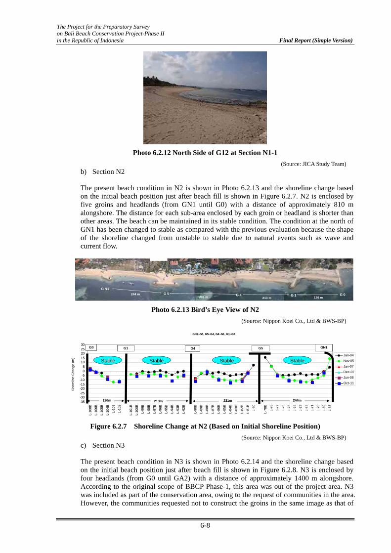
The Project for the Preparatory Survey on Bali Beach Conservation Project-Phase II in the Republic of Indonesia Final Report (Simple Version)
6-8
Photo 6.2.12 North Side of G12 at Section N1-1 (Source: JICA Study Team)
b) Section N2
The present beach condition in N2 is shown in Photo 6.2.13 and the shoreline change based on the initial beach position just after beach fill is shown in Figure 6.2.7. N2 is enclosed by five groins and headlands (from GN1 until G0) with a distance of approximately 810 m alongshore. The distance for each sub-area enclosed by each groin or headland is shorter than other areas. The beach can be maintained in its stable condition. The condition at the north of GN1 has been changed to stable as compared with the previous evaluation because the shape of the shoreline changed from unstable to stable due to natural events such as wave and current flow.
G N1
244 m G 5 G 4231 m 213 m
G 1 G 0126 m
Photo 6.2.13 Bird’s Eye View of N2 (Source: Nippon Koei Co., Ltd & BWS-BP)
GN1~G5, G5~G4, G4~G1, G1~G0
-35-30-25-20-15-10-505
1015202530
L-10
8B
L-10
6B
L-10
5B
L-10
4B
L-10
3
L-10
2
L-10
1B
L-10
0B
L-99
B
L-98
B
L-97
B
L-96
B
L-95
B
L-94
B
L-93
B
L-92
B
L-90
B
L-89
B
L-88
B
L-87
B
L-86
B
L-85
B
L-84
B
L-83
B
L-82
B
L-81
B
L-80
L-78
B
L-78
L-77
L-76
L-75
L-74
L-73
L-72
L-71
L-70
L-69
L-68
Sho
relin
e C
hang
e (m
)
Jan-04Nov-05Jan-07Dec-07Jun-08Oct-11
GN1G5G4G1G0
126m 213m 231m 244m
Stable Stable Stable Stable
Figure 6.2.7 Shoreline Change at N2 (Based on Initial Shoreline Position) (Source: Nippon Koei Co., Ltd & BWS-BP)
c) Section N3
The present beach condition in N3 is shown in Photo 6.2.14 and the shoreline change based on the initial beach position just after beach fill is shown in Figure 6.2.8. N3 is enclosed by four headlands (from G0 until GA2) with a distance of approximately 1400 m alongshore. According to the original scope of BBCP Phase-1, this area was out of the project area. N3 was included as part of the conservation area, owing to the request of communities in the area. However, the communities requested not to construct the groins in the same image as that of
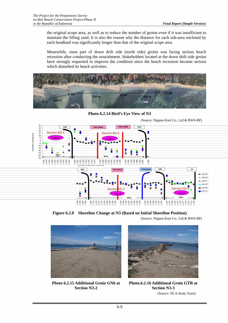
The Project for the Preparatory Survey on Bali Beach Conservation Project-Phase II in the Republic of Indonesia Final Report (Simple Version)
6-9
the original scope area, as well as to reduce the number of groins even if it was insufficient to maintain the filling sand. It is also the reason why the distance for each sub-area enclosed by each headland was significantly longer than that of the original scope area.
Meanwhile, most part of down drift side (north side) groins was facing serious beach recession after conducting the nourishment. Stakeholders located at the down drift side groins have strongly requested to improve the condition since the beach recession became serious which disturbed its beach activities.
G 0
G A8 G A3G A2
250 m255 m226 m
Photo 6.2.14 Bird’s Eye View of N3 (Source: Nippon Koei Co., Ltd & BWS-BP)
Figure 6.2.8 Shoreline Change at N3 (Based on Initial Shoreline Position) (Source: Nippon Koei Co., Ltd & BWS-BP)
Photo 6.2.15 Additional Groin GN6 at Section N3-2
Photo.6.2.16 Additional Groin GTB at Section N3-3
(Source: JICA Study Team)
-35-30-25-20-15-10-505
1015202530
L-24
5L-
243
L-24
1L-
239
L-23
7L-
235
L-23
3L-
231
L-22
9L-
227
L-22
6L-
224
L-22
2L-
220
L-21
8L-
216
L-21
4L-
212
L-21
0L-
208
L-20
6L-
204
L-20
2L-
200
L-19
8L-
196
L-19
4L-
192
L-19
0L-
188
L-18
6L-
184
L-18
2
L-18
0
Sho
relin
e C
hang
e (m
)
467m191m
GA3GA2 GN5 (2009) GN6 (2009)
Check Check
Section N3-1 Section N3-2
G0~GA8, GA8~GA3, GA3~GA2
L-18
8L-
186
L-18
4L-
182
L-18
0L-
178
L-17
6L-
174
L-17
2L-
170
L-16
8L-
166
L-16
4L-
162
L-16
0L-
158
L-15
6L-
154
L-15
2L-
150
L-14
8L-
146
L-14
4L-
142
L-14
0L-
138
L-13
6L-
134
L-13
2
L-12
9L-
127
L-12
5L-
123
L-12
1L-
119
L-11
7L-
115
L-11
3L-
111
L-10
9
Jan-04
Nov-05
Jan-07
Dec-07
Jun-08
Oct-11
505m 226m
G0GA8GA3 GTB (2010)GN4 (2011)
Check CheckSection N3-3 Section N3-4
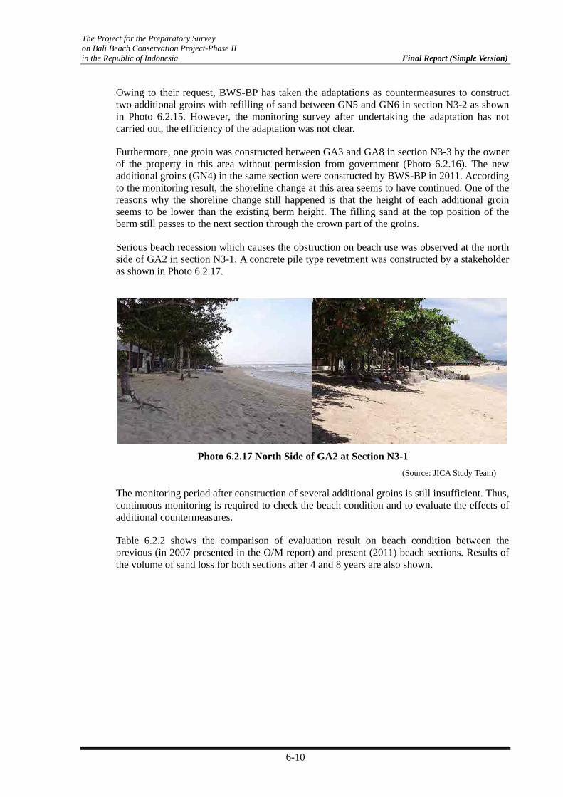
The Project for the Preparatory Survey on Bali Beach Conservation Project-Phase II in the Republic of Indonesia Final Report (Simple Version)
6-10
Owing to their request, BWS-BP has taken the adaptations as countermeasures to construct two additional groins with refilling of sand between GN5 and GN6 in section N3-2 as shown in Photo 6.2.15. However, the monitoring survey after undertaking the adaptation has not carried out, the efficiency of the adaptation was not clear.
Furthermore, one groin was constructed between GA3 and GA8 in section N3-3 by the owner of the property in this area without permission from government (Photo 6.2.16). The new additional groins (GN4) in the same section were constructed by BWS-BP in 2011. According to the monitoring result, the shoreline change at this area seems to have continued. One of the reasons why the shoreline change still happened is that the height of each additional groin seems to be lower than the existing berm height. The filling sand at the top position of the berm still passes to the next section through the crown part of the groins.
Serious beach recession which causes the obstruction on beach use was observed at the north side of GA2 in section N3-1. A concrete pile type revetment was constructed by a stakeholder as shown in Photo 6.2.17.
The monitoring period after construction of several additional groins is still insufficient. Thus, continuous monitoring is required to check the beach condition and to evaluate the effects of additional countermeasures.
Table 6.2.2 shows the comparison of evaluation result on beach condition between the previous (in 2007 presented in the O/M report) and present (2011) beach sections. Results of the volume of sand loss for both sections after 4 and 8 years are also shown.
Photo 6.2.17 North Side of GA2 at Section N3-1 (Source: JICA Study Team)
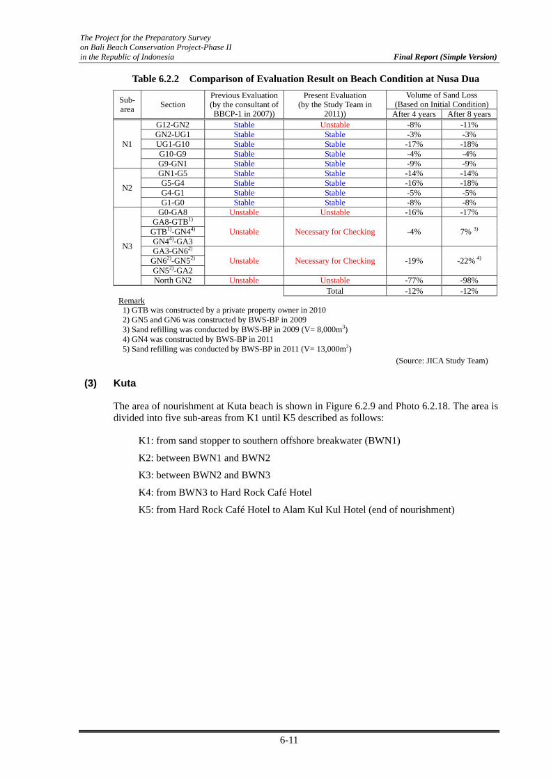
The Project for the Preparatory Survey on Bali Beach Conservation Project-Phase II in the Republic of Indonesia Final Report (Simple Version)
6-11
Table 6.2.2 Comparison of Evaluation Result on Beach Condition at Nusa Dua
Sub- area
Section Previous Evaluation(by the consultant of BBCP-1 in 2007))
Present Evaluation (by the Study Team in
2011))
Volume of Sand Loss(Based on Initial Condition)
After 4 years After 8 years
N1
G12-GN2 Stable Unstable -8% -11%GN2-UG1 Stable Stable -3% -3%UG1-G10 Stable Stable -17% -18%G10-G9 Stable Stable -4% -4%G9-GN1 Stable Stable -9% -9%
N2
GN1-G5 Stable Stable -14% -14%G5-G4 Stable Stable -16% -18%G4-G1 Stable Stable -5% -5%G1-G0 Stable Stable -8% -8%
N3
G0-GA8 Unstable Unstable -16% -17%GA8-GTB1)
Unstable Necessary for Checking -4% 7% 3) GTB1)-GN44) GN44)-GA3 GA3-GN62)
Unstable Necessary for Checking -19% -22% 4) GN62)-GN52) GN52)-GA2 North GN2 Unstable Unstable -77% -98%
Total -12% -12%Remark 1) GTB was constructed by a private property owner in 2010 2) GN5 and GN6 was constructed by BWS-BP in 20093) Sand refilling was conducted by BWS-BP in 2009 (V= 8,000m3)4) GN4 was constructed by BWS-BP in 20115) Sand refilling was conducted by BWS-BP in 2011 (V= 13,000m3)
(Source: JICA Study Team) (3) Kuta
The area of nourishment at Kuta beach is shown in Figure 6.2.9 and Photo 6.2.18. The area is divided into five sub-areas from K1 until K5 described as follows:
K1: from sand stopper to southern offshore breakwater (BWN1)
K2: between BWN1 and BWN2
K3: between BWN2 and BWN3
K4: from BWN3 to Hard Rock Café Hotel
K5: from Hard Rock Café Hotel to Alam Kul Kul Hotel (end of nourishment)

The Project for the Preparatory Survey on Bali Beach Conservation Project-Phase II in the Republic of Indonesia Final Report (Simple Version)
6-12
PU 4
PK 5
PK 38
BEACH FILL
WALKWAY
REVETMENT
OFFSHORE BREAKWATER
REEF FLAT RESTORATION
Figure 6.2.9 Area of Nourishment at Kuta Beach
(Source: JICA Study Team)
BWN 3
BWN 1
BWN 2602 m
649m 446 m
Photo 6.2.18 Bird’s Eye View of Kuta
(Source: Nippon Koei Co., Ltd & BWS-BP)
The change of the position of shoreline and the difference from the initial position six months after undertaking nourishment from June 2009 until September 2011 are shown in Figure 6.2.10.
a) Section K1 (from Sand Stopper to BWN1)
The area behind offshore breakwater BWN1 obtained almost a stable condition. On the other hand, the shoreline retreat in the open area between the sand stopper and BWN1 continues with more than 10 m from the beginning. Taking into consideration the direction of littoral drift at Kuta beach, which is from south to northward, it was thought that a part of sand at this area might be shifted to the next area (K2). However, even though the beach gradually retreats, this area still maintains the sufficient beach width.
b) Section K2 (BWN1 ~ BWN2)
The beach at this area can be maintained in good condition. The retreat of the beach was not observed since the beginning, and stable condition seems to be obtained. This condition might be obtained probably due to the effect of reef flat restoration (submerged breakwater) as well as the inflow of sand from the K1 area.
K1
K2
K3
K4 K5

The Project for the Preparatory Survey on Bali Beach Conservation Project-Phase II in the Republic of Indonesia Final Report (Simple Version)
6-13
Figure 6.2.10 Change of Position of Shoreline and Difference from the Initial Position (Source: Nippon Koei Co., Ltd & BWS-BP)
0102030405060708090100
110
120
LK 06
LK 07
LK 08
LK 09
LK 10
LK 11
LK 12
LK 13
LK 14
LK 15
LK 16
LK 17
LK 18
LK 19
LK 20
LK 21
LK 22
LK 23
LK 24
LK 25
LK 26
LK 27
LK 28
LK 29
LK 30
LK 31
LK 32
LK 33
LK 34
LK 35
LK 36
LK 37
LK 38
LK 39
LK 40
LK 41
LK 42
LK 43
LK 44
LK 45
LK 46
LK 47
LK 48
LK 49
LK 50
LK 51
LK 52
LK 53
LK 54
LK 55
LK 56
LK 57
LK 58
LK 59
LK 60
LK 61
LK 62
LK 63
Mon
itorin
g Po
int
Shoreline Position (m)
Dec-
08
Jun-
09
Nov-
09
Nov-
10
Sep-
11
BWN 1
BWN 2
BWN 3
Reef Flat Re
s.
-70
-60
-50
-40
-30
-20
-1001020
LK 06
LK 07
LK 08
LK 09
LK 10
LK 11
LK 12
LK 13
LK 14
LK 15
LK 16
LK 17
LK 18
LK 19
LK 20
LK 21
LK 22
LK 23
LK 24
LK 25
LK 26
LK 27
LK 28
LK 29
LK 30
LK 31
LK 32
LK 33
LK 34
LK 35
LK 36
LK 37
LK 38
LK 39
LK 40
LK 41
LK 42
LK 43
LK 44
LK 45
LK 46
LK 47
LK 48
LK 49
LK 50
LK 51
LK 52
LK 53
LK 54
LK 55
LK 56
LK 57
LK 58
LK 59
LK 60
LK 61
LK 62
LK 63
Mon
itorin
g Po
int
Change from initial beach fill (m)
Jun
09 (6
mnt
hs)
Nov
09 (1
1 m
nths
)No
v 10
(23
mnt
hs)
Sep
11 (3
3 m
nths
)
BWN 1
BWN 2
BWN 3
Reef Flat Re
s.
Revetm
ent
K1K2
K3K4
K5
Revetm
ent
Revetm
ent
Revetm
ent

The Project for the Preparatory Survey on Bali Beach Conservation Project-Phase II in the Republic of Indonesia Final Report (Simple Version)
6-14
c) Section K3 (BWN2 ~ BWN3)
K3 has difficulty in maintaining the sandy beach which has been already anticipated during the design stage. It is the reason why the revetment was constructed at this area even though nourishment was undertaken. Significant retreat was observed behind BWN3 with more than 50 m distance. The filling sand behind BWN3 has almost moved and the constructed revetment is exposing roughly 500 m of distance alongshore. This is due to the disappearance of tombolo behind BWN3 after 11 months of nourishment. At the open area between BWN2 and BWN3, continuous beach retreat was observed since the beginning.
d) Section K4 (BWN3 ~ Hard Rock Café Hotel)
Significant beach retreat was observed up to the north end of the new revetment, which is still continuing. However from Line No. 41 to the north part where no coral reef exists, beach retreat is suddenly decreasing. Sand accumulation was observed from Line No.42. This accumulation might be caused by the inflow of sand from the retreat area at K3.
e) Section K5 (Hard Rock Café Hotel ~ Alam Kul-Kul Hotel)
This area is maintained in good condition. The shoreline has been gradually increasing after the completion of nourishment with more or less than 10 m. The beach at this area is sandy beach which has continuous shoreline until Canggu. It is difficult to identify the reason for accumulation of sand in this area. However, one of the possibilities is that sand inflow from the south area (K3 and K4) might have contributed to the accumulation of sand in this area.
Figure 6.2.11 shows the volume of sand loss for each sub-area. At K1 and K2, even though some degree of sand loss was observed especially at K1, the beach is almost balanced. On the other hand, significant sand loss was observed with a volume of approximately 55,000 m3 at K3 until September 2011. At K4, sand was balanced until November 2010. However on September 2011, the retreat area has intruded K4. More than 15,000 m3 of sand loss was observed. At K5, sand has retreated until November 2010, although sand accumulation was observed during its monitoring period in 2011 (June and September 2011) with a volume of 13,000 m3 by September 2011.
60,000
50,000
40,000
30,000
20,000
10,000
0
10,000
20,000
Sand Loss (m3)
Sub Area
Jun‐09
Nov 09
Nov‐10
Sep‐11
K1 K2 K3 K4 K5
Figure 6.2.11 Sand Loss for Each Sub-Area (Source: Nippon Koei Co., Ltd & BWS-BP)
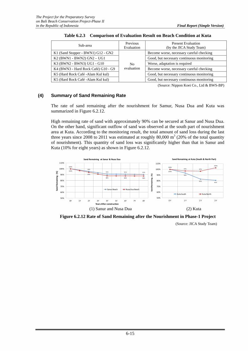
The Project for the Preparatory Survey on Bali Beach Conservation Project-Phase II in the Republic of Indonesia Final Report (Simple Version)
6-15
Table 6.2.3 Comparison of Evaluation Result on Beach Condition at Kuta
Sub-area Previous Evaluation
Present Evaluation (by the JICA Study Team)
K1 (Sand Stopper - BWN1) G12 - GN2
No evaluation
Become worse, necessary careful checking
K2 (BWN1 - BWN2) GN2 – UG1 Good, but necessary continuous monitoring
K3 (BWN2 - BWN3) UG1 - G10 Worse, adaptation is required
K4 (BWN3 - Hard Rock Café) G10 - G9 Become worse, necessary careful checking
K5 (Hard Rock Café -Alam Kul kul) Good, but necessary continuous monitoring
K5 (Hard Rock Café -Alam Kul kul) Good, but necessary continuous monitoring
(Source: Nippon Koei Co., Ltd & BWS-BP) (4) Summary of Sand Remaining Rate
The rate of sand remaining after the nourishment for Samur, Nusa Dua and Kuta was summarized in Figure 6.2.12.
High remaining rate of sand with approximately 90% can be secured at Sanur and Nusa Dua. On the other hand, significant outflow of sand was observed at the south part of nourishment area at Kuta. According to the monitoring result, the total amount of sand loss during the last three years since 2008 to 2011 was estimated at roughly 80,000 m3 (20% of the total quantity of nourishment). This quantity of sand loss was significantly higher than that in Sanur and Kuta (10% for eight years) as shown in Figure 6.2.12.
100%
94%
83%81%
100%97% 97%
103%
50%
60%
70%
80%
90%
100%
110%
0 Y 1 Y 2 Y 3 Y
Sand
Rem
aining
(%
)
Sand Remaining at Kuta (South & North Part)
Kuta South Kuta North
100%97.81%
96%93.43%
91% 91.05% 91% 90.71% 91%100%
97.07%94%
91.21%88% 88.18% 88% 87.98% 88%
50%
60%
70%
80%
90%
100%
110%
0Y 1Y 2Y 3Y 4Y 5Y 6Y 7Y 8Y
Sand
Rem
aining
(%)
Years After construction
Sand Remaining at Sanur & Nusa Dua
Sanur Beach Nusa Dua Beach
(1) Sanur and Nusa Dua (2) Kuta
Figure 6.2.12 Rate of Sand Remaining after the Nourishment in Phase-1 Project (Source: JICA Study Team)

The Project for the Preparatory Survey on Bali Beach Conservation Project-Phase II in the Republic of Indonesia Final Report (Simple Version)
6-16
6.3 Evaluation and Necessity of Adaptation Measures
Beach behavior after the nourishment was checked by the result of continuous monitoring as presented in Section 6.2. The necessity for the adaptation will be evaluated based on this result taking into account obstacles of beach use at the recession area.
Table 6.3.1 shows the evaluation result for the necessity of adaptation at Sanur. The following three sections were selected as a required adaptation area.
Section between G7–GN4 in S2
North of G32 in S3
Section between G37–GN5 in S3
Section between G39–GA2 in S3
Table 6.3.2 shows the evaluation result for the necessity of adaptation at Nusa Dua. The following two sections were selected as a required adaptation area.
Section between G0 - GA8 in N3
Section at North GN2 in N3
It seems that no adaptation is required at other sections of N3 at this moment based on visual checks for obstacles of beach use. However, it is difficult to evaluate the necessity of adaptation in these sections due to insufficiency of monitoring data after undertaking additional countermeasures. Thus, further accumulation of monitoring data is strongly required.
Table 6.3.1 Evaluation for Necessity of Adaptation at Sanur
Sub-area Section Present Evaluation
(by the JICA Study Team)Obstacle to Beach
Activities Necessity of
Adaptation (Now)
S2 G7–GN4 Unstable Yes Yes
S3
North G32 Unstable Yes Yes
G37–GN5 Unstable Yes Yes
G38–G39 Unstable No
G39–GA2 Unstable Yes Yes
(Source: JICA Study Team)
Table 6.3.2 Evaluation for Necessity of Adaptation at Nusa Dua
Sub-area Section Present Evaluation
(by JICA Study Team) Obstacle to Beach
Activities Necessity of
Adaptation (Now)
N1 G12-GN2 Unstable No
N3
G0-GA8 Unstable Yes Yes
GA8-GTB
Unstable
No
GTB-GN4 No
GN4-GA3 No
GA3-GN6
Unstable
No
GN6-GN5 No
GN5-GA2 No
North GN2 Unstable Yes Yes
(Source: JICA Study Team)

The Project for the Preparatory Survey on Bali Beach Conservation Project-Phase II in the Republic of Indonesia Final Report (Simple Version)
6-17
6.4 Recommended Adaptation Measures
The adaptation measures have been recommended in the O/M report (Technical Edition, Volume III, Monitoring and Maintenance Part of the Project Completion Report). Based on the monitoring data included in the latest result, the adaptation measures at unstable area was re-examined.
(1) Categorizing of Required Adaptation
As presented in the previous O/M report, the required adaptations for maintenance of the beaches are divided into several levels depending on the condition of the beach at each section.
a) Adaptation Level 1: No Action (only continue beach monitoring, but not frequently)
If the beach seems to be stable or it is expected to be stable in the near future, and the present beach conditions do not disturb the beach activities as a high tourism area, there is no need to consider further any additional adaptations. Only beach monitoring to check the condition of beach change is recommended. It is also not necessary to carry out monitoring frequently as compared with unstable areas. On the other hand, the filling sand is always exposed to the wave actions, and contents of fine sand which was included into the filling sand will gradually flow offshore and never come back to the beach. According to the results of sieve analysis between sediment and recession section after the nourishment, it was realized that roughly 20% of the total volume of nourished sand was not expected to remain on the beach due to the existence of fine contents. Thus, even if the beach condition is in level 1, some amount of sand filling (± 5,000 m3) is assumed to be required for beach maintenance at Sanur and Nusa Dua every five years during its maintenance period. This amount of sand is excluded from the required sand for periodical maintenance at each adaptive countermeasure.
b) Adaptation Level 2: Sand re-rotating from Accumulation Area to Retreat Area
If the remarkable sedimentation of sand is observed at some parts of the project area and the negative impact on the beach environment and utilization is not expected, sedimentation sand can be available as the refilling material at recession beach areas. An example is the section which is enclosed by groin G39 and GA2 at south Sanur. For the said area, this method will be applied.
c) Adaptation Level 3: Only refilling of Sand (without new construction or modification of existing coastal structures)
This adaptation can be applied at unstable beach areas with the condition that both side of the existing groins (or headlands) in certain section still have sufficient length to keep the enclosed filling sand. Basically, the most desirable beach for tourism is only sandy beach that is natural and without any additional artificial coastal structures such as groins, headlands, etc. Thus, this aspect shall be considered to avoid the construction of additional artificial structures as much as possible.
d) Adaptation Level 4: Refilling of sand with new construction or modification of existing coastal structures
If the beach is still under unstable condition and significant sand outflow is continued, it is evaluated that the total maintenance cost including the additional implemented countermeasures are expected to be smaller than that of the present condition. It is therefore recommended to carry out the additional countermeasures at the final level (level 4) of adaptations. The adaptation measure is the refilling of sand with the construction of an

The Project for the Preparatory Survey on Bali Beach Conservation Project-Phase II in the Republic of Indonesia Final Report (Simple Version)
6-18
additional coastal facility to minimize the sand outflow, or with the modification of the existing facilities to enhance its functions to control the littoral sand movement. However, the construction of additional artificial structures commonly causes the deterioration of its natural condition due to beach use and landscaping when compared with that of the present condition. Furthermore, the construction of additional facility might cause new coastal problems at surrounding areas. Thus, it is required that this level of adaptation is considered as a final solution to minimize the maintenance cost in a technical and economical viewpoint.
(2) Adaptation Plan at Sanur
a) Section Between G7 and GN4 in S2
This section is one of the high tourism areas in Sanur beach. A lot of foreign tourists stay at surrounding hotels and the beach area is highly utilized for beach activities such as swimming and sunbathing. The beach recession north of GN4 still continues and narrowness of the sandy beach disturbs these activities. The distance of this area enclosed between G7 and GN4 is approximately 320 m, longer than that of the other surrounding enclosed areas. Based on the monitoring result, the filling sand is shifting to the north side (toward G7), although shifting sand at the south side of G7 will not overflow the next section. Also, the length of groin G7 is still sufficient.
Figure 6.4.1 shows two alternatives for adaptation. Alternative-1 is to construct the additional groins between G7 and GN4 to shorten the longshore length and to reduce the littoral sand drift northward. Alternative-2 is to do periodical maintenance by the combination of sand refilling from stockyards and sand rotation from sedimentation areas to the recession area. Figure 6.4.2 shows the comparison of expected maintenance cost between the two alternatives.
Figure 6.4.1 Alternative of Adaptation between G7 and GN4 in S2, Sanur (Source: JICA Study Team)
0.0
0.5
1.0
1.5
2.0
2.5
1 6 11 16 21 26 31 36 41 46
Cost (*1,00
0,00
0,00
0Rp.)
year
Alt‐1
Alt‐2
Figure 6.4.2 Comparison of Maintenance Cost for each Alternative between G7 and GN4
(Source: JICA Study Team)
From stockpile From stockpile

The Project for the Preparatory Survey on Bali Beach Conservation Project-Phase II in the Republic of Indonesia Final Report (Simple Version)
6-19
The desirable beach resort area in Bali is to keep the natural sandy beach as much as possible. Taking into account the difference of maintenance cost for each alternative, the combination of sand refilling from sand stockpile and sand rotation (Alternative-2) is recommended as the form of adaptation (Adaptation Level 3). The estimated sand volume for refilling presented in the previous O/M report was 10,800 m3. According to the monitoring result, sand is drifting from south to north, causing the beach recession at the north side of GN4. Thus, it might be effective that the sand is refilled mainly at the recession part only and leave the northward sand movement as natural phenomena. Some degree of refilling sand can be relocated from the accumulation area. However, the total sand volume in this section was decreasing than its initial condition. Thus, additional refilling of sand will also be required. Based on the monitoring result, the following adaptation is recommended.
Table 6.4.1 Recommended Adaptation between Groin G7 and GN4
Adaptation Method Combination of sand refilling from sand stockpile and sand
rotation from accumulation areas to recession areas (Level-3)
Expected Volume Refilling from sand stockpile: 1,200 m3
Sand rotation: 500 m3 Frequency for Refilling Every 5 years
(Source: JICA Study Team)
b) Section at north side of G32 in S3
Beach recession is continuing at the north side of G32. There is a large-scale reef gap in front of G32 groin. The sand movement around this area is significantly influenced by the topographical change due to the existence of reef gap. According to the beach change surrounding this area, the littoral sand drift at the northern side from the reef gap is flowing northward. On the other hand, the littoral sand drift at the south side from the reef gap is flowing southward. The position of G32 is just the diverging point of littoral sand drift as shown in Figure 6.4.3. If the additional groin is constructed at the north side from G32 to reduce the recession of the beach at this area, it is anticipated to cause further beach recession at the north side of the new additional groin. Taking into account that the speed of the beach recession at this area has not been significant based on the monitoring result, it is recommended to do periodical refilling of sand at this area as adaptations (Adaptation on Level 3). Based on the monitoring result, the sand loss at this section is approximately 2500 m3 from initial nourishment. If the refilling of sand is carried out until the recovery of the initial beach line after nourishment, the significant outflow of the sand will occur again in the initial stage. Thus, it is recommended to refill the sand considering the present beach shape and to refill the sand with not too much volume. Based on this opinion, the following adaptations are recommended.
Table 6.4.2 Recommended Adaptation at North Side of G32 in S3
Adaptation Method Sand refilling from sand stockpile (Level-3) Expected Volume 1,000 m3
Frequency for Refilling Every 5 years (Source: JICA Study Team)

The Project for the Preparatory Survey on Bali Beach Conservation Project-Phase II in the Republic of Indonesia Final Report (Simple Version)
6-20
ANTA
RA
GR
OU
P
SAD
IPA
HO
TEL
G32
G32A
R =13.04
G3 2D
1:3 1:3
E LEV 3 .60 M PDEL EV 4.5 0 M T O
G32 B
R=4 .0 0
G3 2C
1 :3
R =4.00
G3 2D
0.0 150m10050
Incident Wave Direction
Direction of drift sand
G32
Reef Gap
Figure 6.4.3 Wave Propagation and Littoral Transport Surrounding G32 (Source: JICA Study Team)
c) Section between G37 and GN5 in S3
After the completion of the project at Sanur in 2004, beach recession occurred between G32 and G38. The distance between G32 and G38 was longer than in other sections with approximately 600 m. It might be difficult to keep the conditions of the section stable. Considering the condition after the completion of the project, BWS-BP decided to construct two additional groins (G37 and GN5) in 2006. However, the unstable condition has been observed until now. Narrowness of the beach width at the south side of G37 is causing obstruction to beach activities at this area.
According to the monitoring result, the sand is shifting southward, and some degree of shifting sand has overflowed to the next south section through the crown part of GN5 as shown in Photo 6.4.1. One of the reasons why the beach recession south side of G37 has still continued even though the additional groin (GN5) was constructed is that the crown elevation for GN5 was not sufficient to interrupt the southward longshore transported sand.
Based on this understanding and the obtained monitoring result, the adaptation as shown in Table 6.4.3 was recommended. As the modification of the existing groin GN5, the increase of crown elevation at least up to the same level of the existing berm elevation is recommended not to cause the overflow of sand into the next section. However, this adaptation will cause the decrease of sand inflow at the next south section (section between GN5 and G38). Continuous monitoring is important to check the impact to surrounding areas.
Photo 6.4.1 Overflow of Sand through Crown Part of GN5
(Source: JICA Study Team)

The Project for the Preparatory Survey on Bali Beach Conservation Project-Phase II in the Republic of Indonesia Final Report (Simple Version)
6-21
Table 6.4.3 Recommended Adaptation between Groin G37 and GN5
Adaptation Method Sand refilling from sand stockpile with modification of
existing groin (increase of crown elevation for GN5) (Level-4)
Expected Volume 1,000m3 Frequency for Refilling Every 5 years
(Source: JICA Study Team)
d) Section Between G38 and GA2 in S3
Beach recession has been continuing at the north side of GA2. Its shoreline has already reached the walkway. The walkway was damaged and repair of the walkway was conducted several times. Even though the additional construction of impermeable type revetment was constructed by BWS-BP in 2011, this revetment was suddenly damaged by further wave overtopping. The beach recession at this area was caused by the shifting of sand southward. A part of the southward area transported its sand to G39 which already overflowed to the next south section as shown in Photo 6.4.2. This is why the beach recession at south side of GA2 still continues. The domestic southward littoral transports only at this area and was caused by the change of incident wave direction due to large-scale coral digging which was carried out by private companies in 2004. The beach condition at this recession area is serious and it is necessary to take suitable adaptations.
Two basic ideas can be considered as alternatives; one is to stop the overflow of sand by forming a static condition as much as possible due to modification or add new additional construction (Alternative-1 and 2). Another idea is to keep the present natural conditions as much as possible. Sandy beaches will be maintained by sand recycling (addition of sand filling as required) without any construction or modification to the coastal structure (Alternative-3).
Table 6.4.4 shows the comparison of three alternatives and Figure 6.4.6 shows the comparison of running cost for the three alternatives.
Photo 6.4.2 Condition between G38 and GA2
(Source: Nippon Koei Co., Ltd & BWS-BP)

The Project for the Preparatory Survey on Bali Beach Conservation Project-Phase II in the Republic of Indonesia Final Report (Simple Version)
6-22
Table 6.4.4 Comparison of Three Alternatives of Adaptations between G38 and GA2 in S3
Alternative-1 Alternative-2 Alternative-3
Image
G39 GA2
Before sand fill
Present (2011)
Sand Re-nourishment (Adaptation)
Before sand fill
Present (2011)
Sand Re-nourishment (Adaptation)
G39 GA2 G39 GA2
Idea To form static condition due to the extension of G39 and sand refilling(Extension of G39: 20m Sand refilling: 7,800 m3)
To form a static condition due to the construction of additional offshore breakwater + sand refilling (New breakwater: L=50 m, Sand refilling: 4,000 m3)
Periodical sand relocation from deposit areas with sand refilling (as required) in order to minimize construction of artificial structures and to keep its natural and open image (Sand recycle from deposit area: 3,000 m3)
Advantage and
Disadvantage
Advantage Periodical maintenance can be minimized than in Alternative-3. Disadvantage - Initial cost for extension of groin
is required. - Sand refilling is required for all
area in this section - Extension and refilling of sand
causes further undesired widening of the beach width at deposition area
Advantage Periodical maintenance can be minimized than in Alternative-3. Disadvantage - Initial cost for construction of
breakwater is required. - Construction of breakwater
encloses an open-image beach. This will cause the deterioration of the coastal environment on natural landscaping, stagnation of water, and disturbance of beach activity
Advantage Natural landscaping can be maintained than in Alternative-1 and Alternative-2. There is no disturbance to beach activity Disadvantage - Repetitive maintenance (mainly
sand recycle) is required
Total cost (Initial and
Maintenance for 15 years)
Extension of G39: 890 (mil. Rp.) Sand refilling: 790 (mil. Rp.)
Offshore BW: 2,500 (mil. Rp.) Sand refilling 410 (mil. Rp.)
Periodical sand relocation: 120 (mil. Rp./time)
Total: 1,780 (mil. Rp.) Total: 2,910 (mil. Rp.) Total (every 3 year *5 times): 600 (mil. Rp.)
(Source: Nippon Koei Co., Ltd & BWS-BP)
Based on the result, Alternative-3 was recommended as the suitable adaptations between G38 and GA2 in S3 as shown in Table 6.4.5.
Table 6.4.5 Recommended Adaptation between Groin G38 and GA2
Adaptation Method Sand rotation from accumulation area to recession area
(Level-2) Expected Volume Sand rotation: 3,000 m3
Frequency for Refilling Every 3 years (Source: JICA Study Team)
(3) Adaptation Plan at Nusa Dua
a) Section between G0–GA8 in N3
At this section, the retreat of shoreline happens at the south part (down drift G0) and accumulation happens at GA8 position. From the monitoring data, it is shown that shoreline retreat at G0 trunk is almost stable when compared with the data between October 2011 and June 2008. This year, the shoreline retreat is disturbing the conditions of walkway and damaging the walkway. Present distance of the flat part of its beach fill surrounding G0 is less than 10 m. This condition happens approximately 100 m from G0 which disturbs the use of the beach.

The Project for the Preparatory Survey on Bali Beach Conservation Project-Phase II in the Republic of Indonesia Final Report (Simple Version)
6-23
The littoral drift to the north is still observed from the monitoring data. The shoreline position of GA8 still show the accumulation at up drift from the monitoring data. Observed sand loss was determined at about 1900 m3. The sand was lost to the next groin section by passing through the top of GA8. It was proven that sand elevation was higher than the groin (GA8) crown elevation.
The recommended adaptation at this section is to increase the crown height of GA.8 to stop the sand outflow. Sand renourishment at about 1500 m3 (adaptation level 4) is also recommended. The shoreline position of sand renourishment is recommended to be similar with the position of the shoreline in December 2007 (four years after the project), which is the stable position line based on the monitoring data.
Photo 6.4.3 Damaged Walkway at G0 Trunk
Photo 6.4.4 Shoreline Condition Surrounding G0 Trunk (Low Tide)
(Source: Nippon Koei Co., Ltd & BWS-BP)
Table 6.4.6 Recommended Adaptation between Groin G0 and GA8
Adaptation Method Sand refilling from sand stockpile and modification of existing groin (increase groin GA8 crown elevation)
(Level-4) Expected Volume Refilling from sand stockpile: 1,500 m3
Frequency for Refilling Every 5 years (Source: JICA Study Team)
b) Section between GA2 to the north
Beach retreat at the down drift of GA2 is caused by the littoral drift of sand that is filled to the north. From the monitoring data, it was shown that the sand was accumulated at the northward position from GA2. Littoral drift at this position cannot be avoided due to main littoral transport at Tanjung Benoa area moving in the northern direction. From the natural shoreline condition, undulation at the northern side of GA2 is functioning naturally to stop the littoral flow from the south.

The Project for the Preparatory Survey on Bali Beach Conservation Project-Phase II in the Republic of Indonesia Final Report (Simple Version)
6-24
Figure 6.4.4 Littoral Transport at Tanjung Benoa Area (Source: JICA Study Team)
Considering the littoral transport direction in the area and the present condition of the beach, the concept of maintaining the beach in its natural state is recommended. Additional structures to retain the sand are not necessary due to the natural shoreline that has undulation at the northern side which will retain the sand flow. Periodic sand rotation is recommended at this section to maintain the beach width at the north side of GA2.
Based on the monitoring data, the most stable shoreline position is the shoreline in December 2007 (four years after the project). To obtain that position, sand rotation of about 2500 m3 from the present condition is required. Even the littoral drift to the north is continuing. From the monitoring data, it was proven that the amount of sand will be transported to the north in approximately four years. It is therefore recommended that sand renourishment should be done every five years.
Garis pantai Sept 2011
GA.2
Figure 6.4.5 Recommended Sand Rotation at GA2 (Source: JICA Study Team)
Table 6.4.7 Recommended Adaptation at GA2 to the North
Adaptation Method Periodic sand rotation from northern side (Level-2) Expected Volume Rotating sand: 2,500 m3
Frequency for Refilling Every 5 years (Source: JICA Study Team)
Figure 6.4.6 below show the cost comparison if additional structure (groin) and sand re-nourishment from stockpile is selected to maintain the sandy beach at the north side of GA2 (Alternative 1) when compared with the repetitive sand rotation every five years. A groin with length of approximately 50 m and sand re-nourishment of 13,000 m3 is required to
Natural undulation to retain the litoral drift

The Project for the Preparatory Survey on Bali Beach Conservation Project-Phase II in the Republic of Indonesia Final Report (Simple Version)
6-25
replace the beach condition as an initial beach fill. On the other hand, repetitive sand re-nourishment only requires 2500 m3 of sand from the stockpile every five years.
0.0
0.5
1.0
1.5
2.0
2.5
3.0
3.5
1 26 51 76 101 126
Cost (*1,000,000,000Rp.)
year
Alt‐1
Alt‐2
Figure 6.4.6 Cost Comparison of Repetitive Sand Re-nourishment and
Additional Groin to Maintain Sandy Beach at GA2 (Source: JICA Study Team)
(4) Adaptation Plan at Kuta
Serious condition for the beach retreat was observed at the section of K3. Furthermore, the condition of the beach at the section of K1 and K4 became worse and still didn’t obtain the stable condition.
It is necessary to do the continuous monitoring at Kuta beaches to check the beach behavior, and the suitable improvement to reduce the further beach retreat was recommended. Further explanation at Kuta was described in the Chapter 11 and 12 as one of the scopes for the Phase-2 Project.
6.5 Implementation Plan of Adaptation Measures
(1) Cost and Schedule
Figure 6.5.1 shows the maintenance schedule and predicted maintenance cost for Sanur and Nusa Dua beaches. Repetitive adaptive beach management is recommended basically every five years at the required areas as explained above. A volume of sand (5000 m3 for each beach) from the stockpile is assumed to cover adaptive maintenance at other sections as required based on the monitoring result.

The Project for the Preparatory Survey on Bali Beach Conservation Project-Phase II in the Republic of Indonesia Final Report (Simple Version)
6-26
A.
Sanu
r Beach
Main
tenance w
orks
asum
ption :
infla
tion rate 6% per y
ear
No.
Qty (m3)
Freq
uency
1Section
G7 ‐
GN4
Level 3
Sand
rotatio
n 500
@ 5 Y
VV
VV
VCo
st25
.3
33.8
45.3
60.6
81.1
Sand
re‐filling
from
stockpile
1,2
00
@ 5 Y
VV
VV
VCo
st12
1.3
162.4
217.3
290.8
389.2
2Section
G.32
‐ north
Level 3
Sand
re‐filling
from
stockpile
1,0
00
@ 5 Y
VV
VV
VCo
st10
1.1
135.3
181.1
242.3
324.3
3Section
G37 ‐ G
N5Level 4
Sand
re‐filling
from
stockpile
1,0
00
@ 5 Y
VV
VV
VCo
st10
1.1
135.3
181.1
242.3
324.3
Incre
ase o
f groin crow
n height
150
1 tim
eV
‐‐
‐‐
Cost
101.1
‐
‐
‐
‐
4Pe
riodic sand f
illing for ot
her sectio
nLevel 3
5,000
@ 5 Y
VV
VV
VCo
st50
5.6
676.6
905.5
1,21
1.7
1,62
1.6
Total Cost (IDR *
1,000,0
00)
0955.6
1,1
43.5
1,5
30.3
2,0
47.9
2,7
40.5
Ye
ar2004
2014
2019
2024
2029
2034
asum
ption :
infla
tion rate 6% per y
ear
No.
Qty (m3)
Freq
uency
1Section
GA.2 ‐
G.39
Level 2
Sand
rotatio
n2,0
00
@ 3 Y
VV
VV
VV
VTotal Cost (IDR *
1,000,0
00)
0101.1
120.4
143.4
170.8
203.5
242.3
288.6
324.3
Year
2004
2014
2019
2024
2029
2034
B.
Nusa Dua
Beach
Main
tenance w
orks
asum
ption :
infla
tion rate 6% per y
ear
No.
Qty (m3)
Freq
uency
1Section
G.0 ‐ G
A.8
Level 4
Sand
re‐filling
from
stockpile
1,5
00
@ 5 Y
VV
VV
VCo
st25
2.8
338.3
452.7
605.9
810.8
Incre
ase o
f groin crow
n height
150
1 tim
eV
‐‐
‐‐
Cost
101.1
0.0
0.0
0.0
0.0
2Section
GA.2 to t
he no
rthLevel 2
Sand
rotatio
n 2,5
00
@ 5 Y
VV
VV
VCo
st12
6.4
169.2
226.4
302.9
405.4
3Pe
riodic sand f
illing for ot
her sectio
nLevel 3
5,000
@ 5 Y
VV
VV
VCo
st84
2.7
1127
.715
09.1
2019
.627
02.7
Total Cost (IDR *
1,000,0
00)
01,3
23.0
1,6
35.2
2,1
88.3
2,9
28.4
3,9
18.8
Ye
ar2004
2014
2019
2024
2029
2034
Work Item
Perio
d and
Cost (ID
R * 1,000,0
00)
Impe
lemen
tatio
n sched
ule a
nd OM co
st
Impe
lemen
tatio
n sched
ule a
nd OM co
st
Work Item
Perio
d and
Cost (ID
R * 1,000,0
00)
Work Item
Perio
d and
Cost (ID
R * 1,000,0
00)
Figure 6.5.1 Schedule and Cost of Beach Maintenance at Sanur and Nusa Dua Beach (Source: JICA Study Team)

The Project for the Preparatory Survey on Bali Beach Conservation Project-Phase II in the Republic of Indonesia Final Report (Simple Version)
6-27
(2) Planning for Use of Sand Stock
The use of sand from Stockpile Mertasari for maintenance work at this time is planned for beach maintenance of Sanur and Nusa Dua Beaches only. The required sand for maintenance work at Kuta Beach is not yet decided at present because the maintenance plan for Kuta needs a more detailed study in order to reduce the rate of sand outflow observed from the monitoring data up to this year. At present, the remaining sand available at Mertasari is about 120,000 m3. About 20,000 m3 of sand was already used by BWS-BP to do adaptive maintenance at the Nusa Dua area in 2009 and 2011.
‐
20,000
40,000
60,000
80,000
100,000
120,000
140,000 20
14
2019
2024
2029
2034
Sand
volme (m
3)
Sand stock availibilty at Mertasari Stockpile
Sand stock
Figure 6.5.2 Plan of Use of Sand Stock at Mertasari for Sanur and Nusa Dua Maintenance Works
(Source: JICA Study Team)

The Project for the Preparatory Survey on Bali Beach Conservation Project-Phase II in The Republic of Indonesia Final Report (Simple Version)
FEASIBILITY STUDY ON PHASE-II PROJECT

The Project for the Preparatory Survey on Bali Beach Conservation Project-Phase II in The Republic of Indonesia Final Report (Simple Version)
7-1
Chapter 7 Basic Information about the Study Area
7.1 Overview
Existing data and information were collected in order to know the basic characteristics of the study area, including its natural, socio-economic, and other external conditions, which are related to beach erosion. Table 7.1.1 shows the overview of Chapter 7.
Table 7.1.1 Overview of Chapter 7
Ref. to Obtained Information Utilized forReview of Existing Reports
Feasibility Study Report
Detailed Design Report
Project Completion Reportetc.
Review of Natural Conditions
Geographical Conditions 7.3 (1)General information for seabedtopography, distribution of coralreef at the study area
Study on the mechanism of beacherosion and littoral sand drift
Metrological Conditions 7.3 (2)General information for Rainfall,Temperature and Wind at BaliIsland
Input condition for the study onthe mechanism of beach erosionand littoral sand drift
Hydraulic Conditions 7.3 (3)General information for tide andoffshore wave characteristics at thestudy area
Input condition for the study onthe mechanism of beach erosionand littoral sand drift
Review of Socio-Economic Conditions
Tourism Development in Bali 7.4 (1)Tourism growth and itscontribution on economy
Study on Economic analysis
Process of Tourism Developmentand Beach Erosion
7.4 (2)Relation between tourismdevelopment and beach erosion
Study for the cause of erosion inBali Island
Further Development andStrategic Plan in Bali
7.4 (3)Future development plan at thestudy area
Study on the selection ofcandidate site on economicalpoint of view
Review of External Conditions Related to Beach Erosion
Decrease of Sand Inflow fromRiver
7.5 (1)Significant impact of riverdevelopment to the beach erosionat east coast area
Study for the cause of erosion ateast coast area
Coral Mining on the Reef Flat 7.5 (2)Significant impact of coral miningto the coral beaches at Phase-1beaches and Candidasa
Study for the cause of erosion atcoral reef beaches
7.2
Study Items
- Information for outline of Phase-1 Project- Information for natural conditions- Information for contribution ofproject, etc.
-Planning & Design for Phase-2project-Study on the mechanism ofbeach erosion and littoral sanddrift
(Source: JICA Study Team)

The Project for the Preparatory Survey on Bali Beach Conservation Project-Phase II in The Republic of Indonesia Final Report (Simple Version)
7-2
7.2 Review of Existing Reports for Phase-1 Project
Several reports were prepared and submitted to DGWR for the Phase-1 Project. Table 7.2.1 shows the summary of the existing main reports, which are required for review, and its overview.
Table 7.2.1 Summary of Existing Main Reports for Phase-1 Project
No Title of the Report Year Issued by Overview
1Feasibility Study Report
on the Urgent Bali Beach Conservation Project
1989 JICA
- 4 sites was selected as candidate for the Project, such asSanur, Nusa Dua, Kuta and Tanah Lot.- Field measurements for waves and current observation inshort period, Hydraulic model test (waves and currentmeasurements) and numerical analysis (sediment transportand shoreline change) was conducted- Basic design for 4 sites was proposed
2 Detailed Design Report 1992 JICA
- Detail design for 4 sites was carried out.- Field observation for waves and current for a few monthand numerical analysis for waves, current and beachchange was conducted
3Reviewed Detailed Design
Report1998 DGWR
- The detailed design report was reviewed taking intoaccount of latest beach condition for 4 sites- Field observation for waves and current for a few monthand numerical analysis for waves, current and beachchange was conducted
4Additional Detailed Design
Report2002 DGWR
- In accordance with the amendment to extend the projectarea at south of Sanur (Kesumasari to Mertasari area) andnorth of Nusa Dua (Tanjung Benoa), the additional detaileddesign was carried out.
5 Project Completion Report 2008 DGWR-This report was to present the overview of Bali BeachConservation Project (Phase-1) including non-technical part(contract, administration, etc.) following the JICA guideline
6Project Completion Report
(Technical Edition)2009 Nippon Koei
-Beach conservation project was the first experience inIndonesia and DGWR requested to prepare the additionalPCR focused to the technical point of view.- Based on this request, the PCR for technical edition wasprepared by the consultant (Nippon Koei).- The report consisted of four set of volumes as;Volume-I (General Part)Volume-II (Technical Part)Volume-III (OM Manual)Volume-IV (Selected Drawing )All technical information for the Project were included inthis report.
(Source: JICA Study Team)

The Project for the Preparatory Survey on Bali Beach Conservation Project-Phase II in The Republic of Indonesia Final Report (Simple Version)
7-3
7.3 Review of Natural Conditions
(1) Geographical Conditions
a) General Description of the Study Area
Bali Island is located between Lombok Island and Java Island as shown in Figure 7.3.1. Nusa Penida Island is located at the southeast direction about 10 km away from Bali Island. The existence of this island causes sheltering effect on the offshore wave field on the east coastal area. The bottom slope at the southwest coast is milder than that on the east coast, and the bottom slope becomes milder toward the south. The average bottom slope from the coastline to a depth of 50 m is about 1/180 at Tanah Lot, and 1/220 at Kuta on the southwest coast. On the other hand, on the east coast, the bottom slope at Sanur is about 1/50 and 1/20 at Candidasa.
Figure 7.3.1 Coastal Geography and Seabed Topography (Source: Sea Chart arranged by JICA Study Team)
Distribution of the coral reefs on the south area of Bali Island is shown in Figure 7.3.2. Coral reefs are mainly distributed surrounding Bukit Island from Kuta on the southwest area to
0.0 10.0km
Candi Dasa
PatangBai Kusamba
Sanur
Unda River
Ayung River
Tanah Lot
Canggu
Seminyaku
Legian
Kuta

The Project for the Preparatory Survey on Bali Beach Conservation Project-Phase II in The Republic of Indonesia Final Report (Simple Version)
7-4
Sanur on the east area, and Nusa Penida. Further, some coral reefs exist in Padangbai Candidasa on the east coast.
Figure 7.3.2 Distribution of Coral Reefs (Source: STATUS LINGKUNGAN HIDUP DAERAH PROVINSI BALI TAHUN 2010)
b) East Coastal Area
The beach in the east coastal area is divided into two types with different characteristics. One is sandy beaches from north Sanur up to Kusanba as shown in Figure 7.3.1, which are formed by volcanic sand inflow from the river. The other is coral reef beaches, which exist in Padangbai and Candidasa.
i) Volcanic Sandy Beaches (from North Sanur to Kusamba)
The beaches from North Sanur to Kusamba shown in Figure 7.3.3 are formed by volcanic sand, which is an inflow from nearby rivers with black color. The average bottom slope up to a depth of 100 m in North Sanur (Photo 7.3.1) is about 1/70 and becomes steep going eastward. The Unda River exists at the middle section of the east coast in the study area (Photo 7.3.1). On the west side from the Unda River mouth, the bottom slope becomes 1/40. From the east side of the Unda River to Padangbai through Kusamba, the bottom slope becomes significantly steep with 1/10.
0 3 6km
Sanur
PadangGalak
Photo 7.3.1 East Coastal Area (from North Sanur to Padangbai) (Source: Data for Phase-1 Project)
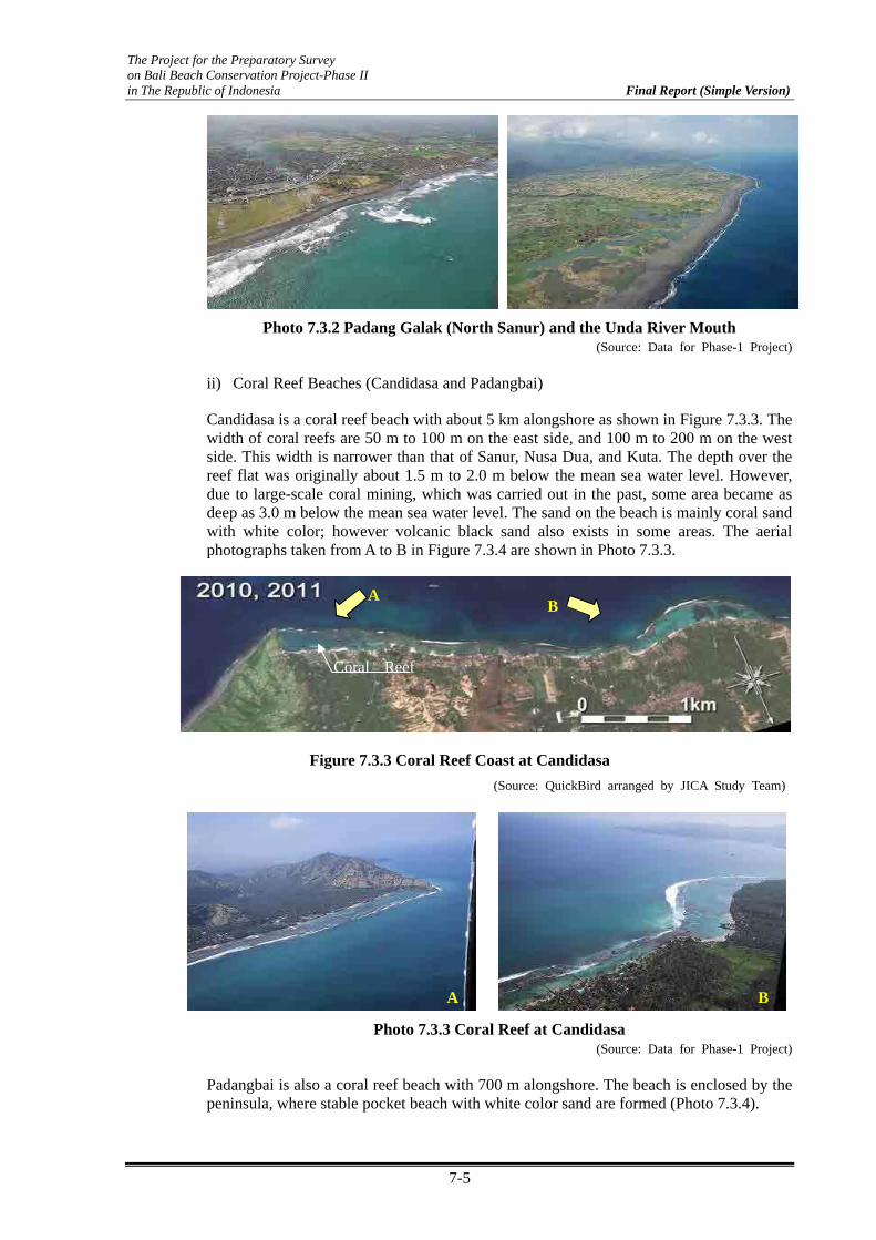
The Project for the Preparatory Survey on Bali Beach Conservation Project-Phase II in The Republic of Indonesia Final Report (Simple Version)
7-5
Photo 7.3.2 Padang Galak (North Sanur) and the Unda River Mouth (Source: Data for Phase-1 Project)
ii) Coral Reef Beaches (Candidasa and Padangbai)
Candidasa is a coral reef beach with about 5 km alongshore as shown in Figure 7.3.3. The width of coral reefs are 50 m to 100 m on the east side, and 100 m to 200 m on the west side. This width is narrower than that of Sanur, Nusa Dua, and Kuta. The depth over the reef flat was originally about 1.5 m to 2.0 m below the mean sea water level. However, due to large-scale coral mining, which was carried out in the past, some area became as deep as 3.0 m below the mean sea water level. The sand on the beach is mainly coral sand with white color; however volcanic black sand also exists in some areas. The aerial photographs taken from A to B in Figure 7.3.4 are shown in Photo 7.3.3.
Figure 7.3.3 Coral Reef Coast at Candidasa (Source: QuickBird arranged by JICA Study Team)
Photo 7.3.3 Coral Reef at Candidasa (Source: Data for Phase-1 Project)
Padangbai is also a coral reef beach with 700 m alongshore. The beach is enclosed by the peninsula, where stable pocket beach with white color sand are formed (Photo 7.3.4).
BA
Coral Reef
AB

The Project for the Preparatory Survey on Bali Beach Conservation Project-Phase II in The Republic of Indonesia Final Report (Simple Version)
7-6
Photo 7.3.4 Padangbai (Source: Data for Phase-1 Project)
c) Southwest Coast
Figure 7.3.4 shows the coastal line on the southwest coast in the study area. The area consists mostly of volcanic sandy beach. However, coral reef exists in Kuta, which is located on the south side of this study area.
Kuta
Figure 7.3.4 Southwest Coastal Area (from Norh Kuta to Canggu) (Source: QuickBird arranged by JICA Study Team)
i) Kuta ~ North Kuta
Kuta Beach is divided into two areas with different geographical characteristics as shown in Figure 7.3.6. One is in the south area from runway to 2.5 km north side. This area belongs to the coral reef beach with 0.5 km to 1.3 km width of reef flat. The depth over the coral reef flat is DL 0 to -1.8 m. The remaining north area in Kuta is 1.6 km alongshore. No coral reef exists in this area, and the sandy beach continues northward. Based on the result of the previous survey carried out during the Phase-1 Project, the bottom slopes along the representative four lines are shown in Figure 7.3.6. In south Kuta where coral reef exists, the bottom slope of the outer reef is approximately 1/50. The bottom slope in north Kuta is 1/60 to 1/80 in the shallow water area (depth is until -8 m) and 1/100 to 1/200 in the offshore area (depth is until -12 m). Significant shallow area exists along line C.
The oblique views taken from A to B after Phase-1 Project in Figure 7.3.5 are shown in Photo 7.3.5.

The Project for the Preparatory Survey on Bali Beach Conservation Project-Phase II in The Republic of Indonesia Final Report (Simple Version)
7-7
A: Kuta South (Coral Reef Beach) B: North Kuta (Sandy Beach)
Photo 7.3.5 Kuta Beach (Source: Data for Phase-1 Project)
Line A
-18.0-15.0-12.0
-9.0-6.0-3.00.03.06.0
0 500 1000 1500 2000
On-Offshore Distance(m)
Ele
vatio
n (D
. L.)
Line B
-18.0-15.0-12.0
-9.0-6.0-3.00.03.06.0
0 500 1000 1500 2000
On-Offshore Distance(m)
Ele
vatio
n (D
. L.)
Line C
-18.0-15.0-12.0
-9.0-6.0-3.00.03.06.0
0 500 1000 1500 2000
On-Offshore Distance(m)
Ele
vatio
n (D
. L.)
Line D
-18.0-15.0-12.0
-9.0-6.0-3.00.03.06.0
0 500 1000 1500 2000
On-Offshore Distance(m)
Ele
vatio
n (D
. L.)
Coral Reef Flat
Coral Reef Flat
Coral Reef FlatS= 1:50
S= 1:50
S= 1:60
S= 1:200
S= 1 :100
Figure 7.3.6 Bottom Slope along Representative Lines (Source: Data for Phase-1 Project)
Coral reef
0 1km
Sandy Beach
A
B
N
Line ALine B
Line C
Line D
Figure 7.3.5 Kuta Beach (Source: Data for Phase-1 Poject)

The Project for the Preparatory Survey on Bali Beach Conservation Project-Phase II in The Republic of Indonesia Final Report (Simple Version)
7-8
ii) Legian ~ Seminyak ~ Canggu
Legian ~ Seminyak ~ Canggu is located on the north side of Kuta. An existing sandy beach, which is approximately 10 km long, extends continuously from Kuta. However, volcanic rocks appear in some places in Canggu. The aerial photographs taken from C to D in Figure 7.3.7 are shown in Photo 7.3.6.
(2) Metrological Conditions
a) Rainfall and Temperature
The climate of Bali Island is divided into two seasons namely, rainy season and dry season as shown in Figure 7.3.8. The rainy season occurs from October to March, and the northwestern monsoon is predominant. The dry season occurs from April to September, and the east monsoon is predominant. Throughout the year, there is no significant change in temperature, which ranges between 24OC and 31OC.
C
D
Figure 7.3.7 Legian ~ Seminyak ~ Canggu (Source: JICA Study Team)
C: Seminyak D: Canggu
Photo 7.3.6 Seminyak and Canggu (Source: Data for Phase-1 Project)

The Project for the Preparatory Survey on Bali Beach Conservation Project-Phase II in The Republic of Indonesia Final Report (Simple Version)
7-9
Figure 7.3.8 Monthly Rainfall and Temperature (1961 to 1990) (Source: Wikipedia, WMO data)
b) Wind
The predominant monthly wind direction and average wind velocity observed in Kuta and Sanur, which are located in the southwest and southeast coast, respectively, of Bali Island, are shown in Table 7.3.1. Meanwhile, the wind roses for rainy and dry seasons are shown in Figure 7.3.9 (1) and (2). In Kuta, the wind from SSE direction is dominant during the dry season from April to September. On the other hand, the wind from W direction is dominant during the rainy season from October to March. In Sanur, the wind from SSE to SE direction is dominant during the dry season, while the wind from WNW direction is dominant during the rainy season.
Table 7.3.1 Wind Characteristics
Kuta 12/2002-8/2011 7am-7pm
Month Jan. Feb. Mar. Apr. May Jun. Jul. Aug. Sep. Oct. Nov. Dec.
prev. winddirection
W W W ESE ESE ESE ESE ESE ESE ESE ESE W
ave. windspeed(knot
9 8 7 8 7 9 9 10 8 8 8 8
Sanur 5/2010-8/2011 7am-7pm
Month Jan. Feb. Mar. Apr. May Jun. Jul. Aug. Sep. Oct. Nov. Dec.
prev. winddirection
WNW WNW WNW SSE SE SE SE SSE SSE SSE SSE WNW
ave. windspeed(knot
5 5 5 4 5 9 8 9 8 6 5 4
(Source: Wave Site Windfinder.com)

The Project for the Preparatory Survey on Bali Beach Conservation Project-Phase II in The Republic of Indonesia Final Report (Simple Version)
7-10
(3) Hydraulic Conditions
a) Tide Change
A long term tidal observation has been carried out in Benoa Port located near Serangan Island in the southwest coast. The design tide condition at four sites for Phase-1 Project has been determined as shown in Table 7.3.2.
Table 7.3.2 Design Tidal Elevation for Phase-1 Project (Unit: m)
Tide Sanur Nusa Dua Kuta Tanah Lot
H.W.L. +2.6 +2.6 +2.6 +2.6
M.S.L +1.3 +1.3 +1.3 +1.3
L.W.L ±0.0 ±0.0 ±0.0 ±0.0
(Source: Project Completion Report -Technical Edition-)
(1) Kuta
(2) Sanur
Figure 7.3.9 Wind Roses for Two Seasons in Kuta and Sanur (Source: Wave Site Windfinder.com arranged by JICA Study Team)

The Project for the Preparatory Survey on Bali Beach Conservation Project-Phase II in The Republic of Indonesia Final Report (Simple Version)
7-11
b) Offshore Wave Characteristics
It was known from the previous report that the direction of offshore was distributed mainly from SSE to ESE. However, there was no permanent station for wave observation in Bali. The distribution of offshore waves has been predicted using numerical computation. On the other hand, the incident waves outside the reef for Phase-1 beaches were observed during the Phase-1 Project period. It is very important to know the characteristics of waves in the study area in order to examine the littoral sand transport. Thus, two kinds of information are shown in this section, such as “numerical analysis for offshore waves” and “incident wave observation in Phase-1 beaches”.
i) Offshore Wave Distribution by Numerical Analysis
Numerical computation was carried out to determine the longshore distribution of the offshore waves. Calculation conditions are shown in Table 7.3.3, and the results for the case of T=16s are shown in Figure 7.3.10. From the results, the following tendencies were recognized:
The existence of Nusa Penida Island causes a shadow effect on wave filed in the southeast coast, which greatly influenced the distribution of wave height and direction.
In the southwest coast, most parts of the study area (from north Kuta to Canggu) are influenced by the diffraction effect on waves due to existence of Bukit Island.
Table 7.3.3 Calculation Conditions
Computation Condition Parameters/Values
Method Energy Balance Equation
Number of Grid North-South: 115 East-West : 214
Grid Width 600 m
Wave Height 1.0 m
Wave Period 12 sec, 16 sec.
Wave Direction SSW, S, SSE
Spreading Parameter (Smax) 75
Period Division Number 10
Direction Division Number 31 (Source: JICA Study Team)

The Project for the Preparatory Survey on Bali Beach Conservation Project-Phase II in The Republic of Indonesia Final Report (Simple Version)
7-12
0 20000 40000 60000 80000 100000 1200000
20000
40000
60000
16 sec. S
-0.1
0.1
0.3
0.5
0.7
0.9
1.1
0 20000 40000 60000 80000 100000 1200000
20000
40000
60000
16 sec. SSW
-0.1
0.1
0.3
0.5
0.7
0.9
1.1
0 20000 40000 60000 80000 100000 1200000
20000
40000
60000
16 sec. SSE
-0.1
0.1
0.3
0.5
0.7
0.9
1.1
Candidasa
Sanur
Kuta
Legian
Seminyak
Canggu
Nusa Dua
Tanah Lot
LebihKusamba
Candidasa
Sanur
Kuta
Legian
SeminyakCanggu
Nusa Dua
Tanah LotLebih
Kusamba
Candidasa
Sanur
Kuta
Legian
SeminyakCanggu
Nusa Dua
Tanah LotLebih
Kusamba
T=16s, Incident Wave Direction: SSW
T=16s, Incident Wave Direction: S
T=16s, Incident Wave Direction: SSE
Figure 7.3.10 Offshore Wave Distribution (Period:16 sec) (Source: JICA Study Team)

The Project for the Preparatory Survey on Bali Beach Conservation Project-Phase II in The Republic of Indonesia Final Report (Simple Version)
7-13
ii) Observed Incident Waves Outside the Coral Reef
During the implementation period of the Phase-1 Project, wave observation was carried out at each project site. The observation period for each site is shown in Table 7.3.4. The incident waves were measured at the outer reef area with a depth of more than 10 m.
Distribution of energy flux in each direction in two different seasons in Tanah Lot, Kuta, and Nusa Dua are shown in Figure 7.3.11. The predominant wave direction in Tanah Lot and Kuta located in the southwest coast is the same as in the WSW direction, regardless of the season. The wave energy flux in Tanah Lot is about 1.5 times higher than that in Kuta. On the other hand, the predominant wave direction in Nusa Dua located in the east coast is from ESE direction, regardless of the season. Meanwhile, its wave energy is smaller than that in Tanah Lot and Kuta.
The joint frequency tables for combined wave height - wave period and wave height – wave direction at Tanah Lot, Nusa Dua and Kuta are shown in Appendix 7.3.1.
Table 7.3.4 Situation of Wave Observation
Location Obs. Depth Wave observation term Obs. intervalTanahLot 2001/5/14-2004/2/29 2hour
Kuta -15m 2006/4/19-2008/6/7 2hour2003/2/1-2004/2/29 2hour2005/5/31-2005/9/22 2hour2006/8/24-2006/9/17 15min.2006/11/16-2007/2/2 2hour2008/4/3-2008/7/21 1hour
-19.2m
-13m
NusaDua
Sanur
(Source: Data for Phase-1 Project)
The Project for the Preparatory Survey on Bali Beach Conservation Project-Phase II in The Republic of Indonesia Final Report (Simple Version)
7-14
Tanah Lot : 2001/5/14 - 2004/2/29 Annual Dry Wet Kuta: 2006/4/19 - 2008/6/7 Annual Dry Wet NusaDua: 2003/2/1 - 2004/2/29, 2005/5/31 - 2005/9/22 Annual Dry Wet
Figure 7.3.11 Directional Wave Energy Flux at Three Sites (Source: Data for Phase-1 Project)
7.4 Review of Socio-Economic Conditions
(1) Tourism Development in Bali
a) Tourism Contribution on Industry in Bali
Table 7.4.1 and Figure 7.4.1 show the gross regional domestic products (GRDP) at current market price in Bali Province by industrial origin. It showed that the industrial origin of “Trade, Hotel, and Restaurant”, which is directly related to tourism industry, shared the highest portion at 30.0% among all other industrial origins in 2009. From this, tourism is the highest contributor to the economy of Bali Island.
N
E
S
W
NE
SESW
NW
NNE
ENE
ESE
SSESSW
WNW
NNW
Wave energy flux
2.0E+7
4.0E+7
6.0E+7
WSW
N
E
S
W
NE
SESW
NW
NNE
ENE
ESE
SSESSW
WNW
NNW
Wave energy flux
1.0E+7
2.0E+7
3.0E+7
WSW
N
E
S
W
NE
SESW
NW
NNE
ENE
ESE
SSESSW
WNW
NNW
Wave energy flux
1.0E+7
2.0E+7
3.0E+7
WSW
N
E
S
W
NE
SESW
NW
NNE
ENE
ESE
SSESSW
WNW
NNW
Wave energy flux
1.0E+7
2.0E+7
3.0E+7
WSW
N
E
S
W
NE
SESW
NW
NNE
ENE
ESE
SSESSW
WNW
NNW
Wave energy flux
1.0E+7
2.0E+7
3.0E+7
WSW
N
E
S
W
NE
SESW
NW
NNE
ENE
ESE
SSESSW
WNW
NNW
Wave energy flux
2.0E+7
4.0E+7
6.0E+7
WSW
N
E
S
W
NE
SESW
NW
NNE
ENE
ESE
SSESSW
WNW
NNW
Wave energy flux
2.0E+7
4.0E+7
6.0E+7
WSW
N
E
S
W
NE
SESW
NW
NNE
ENE
ESE
SSESSW
WNW
NNW
Wave energy flux
1.0E+7
2.0E+7
3.0E+7
WSW
N
E
S
W
NE
SESW
NW
NNE
ENE
ESE
SSESSW
WNW
NNW
Wave energy flux
1.0E+7
2.0E+7
3.0E+7
WSW

The Project for the Preparatory Survey on Bali Beach Conservation Project-Phase II in The Republic of Indonesia Final Report (Simple Version)
7-15
Table 7.4.1 GRDP at Current Market Prices in Bali Province by Industrial Origin, 2006 – 2009 (Billion Rupiahs)
Industrial Origin
Aguriculture, Livestock, Forestry, and Fishery 7,463.26 (19.96%) 8,216.47 (19.41%) 9,152.61 (18.33%) 10,487.15 (18.21%)
Mining and Quarrying 257.16 (0.69%) 281.09 (0.66%) 337.26 (0.68%) 374.96 (0.65%)
Manufacturing Industry 3,254.65 (8.70%) 3,804.93 (8.99%) 4,661.92 (9.34%) 5,272.10 (9.16%)
Electricity, Gas and Water Supply 725.86 (1.94%) 846.07 (2.00%) 1,048.60 (2.10%) 1,152.26 (2.00%)
Construction 1,600.86 (4.28%) 1,877.52 (4.43%) 2,346.55 (4.70%) 2,532.20 (4.40%)
Trade, Hotel, and Restaurant 10,797.66 (28.88%) 12,269.74 (28.98%) 14,458.73 (28.96%) 17,271.57 (30.00%)
Transport and Communication 4,435.85 (11.86%) 5,219.10 (12.33%) 6,449.26 (12.92%) 7,920.90 (13.76%)
Financial, Ownership, and Bank 2,788.35 (7.46%) 3,108.10 (7.34%) 3,803.83 (7.62%) 4,092.59 (7.11%)
Services 6,064.82 (16.22%) 6,713.39 (15.86%) 7,663.84 (15.35%) 8,475.53 (14.72%)
TOTAL 37,388.47 (100.00%) 42,336.41 (100.00%) 49,922.60 (100.00%) 57,579.26 (100.00%)
2006 2007 2008 2009
(Source: BPS-Statistics of Bali Province)
Percentage Distribution of GDRP of Bali Province at Current Market Prices byIndustrial Origin, 2009
0.7%
9.2%
18.2%14.7%
7.1%
13.8%
30.0%
2.0%
4.4%
Aguriculture, Livestock, Forestry, and Fishery
Mining and Quarrying
Manufacturing Industry
Electricity, Gas and Water Supply
Construction
Trade, Hotel, and Restaurant
Transport and Communication
Financial, Ownership, and Bank
Services
Figure 7.4.1 Percentage Distribution of GDRP of Bali Province at Current Market Prices by Industrial Origin
(Source: BPS-Statistics of Bali Province)
b) Tourism Development
i) Share of Tourist Arrivals in Bali
Figure 7.4.2 shows the number of foreign tourist arrivals in Indonesia and Bali in 1970 and 2010, respectively. The share of Bali increased with 35.6% of occupancy in 2010.
1970
129,319
24,340
2010
7,002,944
2,493,058
Indonesia
Bali
Figure 7.4.2 Share of Tourist Arrivals in Bali (Source: Bali Government Tourism Office)

The Project for the Preparatory Survey on Bali Beach Conservation Project-Phase II in The Republic of Indonesia Final Report (Simple Version)
7-16
ii) Growth of Tourist Arrivals in Bali
Figure 7.4.3 shows the growth of foreign and domestic tourist arrivals in Bali from 2004 to 2010. The number of tourist arrivals in Bali increased in terms of both foreign and domestic tourists.
1.46 1.39 1.26
1.661.97
2.232.49
2.04
2.41 2.47 2.48
2.90
3.52
4.65
0.0
0.5
1.0
1.5
2.0
2.5
3.0
3.5
4.0
4.5
5.0
2004 2005 2006 2007 2008 2009 2010
year
Num
. of T
ouris
t (m
illio
nForeignDomestic
50%
100%
150%
200%
250%
2004 2005 2006 2007 2008 2009 2010
year
Gro
wth
Rat
e b
ased
on 2
004 (
%) Foreign
Domestic
Figure 7.4.3 Growth of Tourist Arrivals in Bali (Source: Bali Government Tourism Office)
iii) Ranking of Tourist Arrivals from Each Country
Table 7.4.2 shows the top five ranking tourist arrival rates from each county from 2006 to 2010. Tourists from Japan was ranked 1st until 2008. This was surpassed by Australian tourists who ranked 1st since 2009. The decrease in Japanese tourists in 2009 and 2010 was mainly caused by the closure of the direct flights of Japan Airlines from Japan to Bali. Nevertheless, tourists from Japan and Australia highly contributed to the tourism development in Bali.

The Project for the Preparatory Survey on Bali Beach Conservation Project-Phase II in The Republic of Indonesia Final Report (Simple Version)
7-17
Table 7.4.2 Ranking of Tourist Arrivals from Each Country
Country (%) Country (%) Country (%) Country (%) Country (%)
1 Japan 20.29 Japan 21.12 Japan 18.02 Australia 20.00 Australia 25.99
2 Taiwan 11.27 Australia 12.28 Australia 15.68 Japan 14.33 Japan 9.89
3 Australia 10.49 Taiwan 8.34 South Korea 6.73 China 8.95 China 7.90
4 South Korea 7.13 South Korea 8.08 Malaysia 6.59 Malaysia 5.96 Malaysia 6.23
5 Malaysia 5.77 Malaysia 6.30 China 6.56 South Korea 5.56 South Korea 5.01
2010Rank
2006 2007 2008 2009
(Source: Bali Government Tourism Office)
iv) Number of Accommodations and Restaurants, and Room Occupancy Rates
Table 7.4.3 and Figure 7.4.4 show the number of accommodations and restaurants as well as the room occupancy rates from 2006 to 2010. The number of accommodations did not increase significantly for the last five years. However, room occupancy rates increased from 44% in 2006 to 61% in 2010. The number of restaurants also increased significantly from 2006 to 2008.
Table 7.4.3 Number of Accommodations and Restaurants, and Room Occupancy Rates
2006 2007 2008 2009 2010
unit 2021 1973 2079 2175 2190
Room 40902 42107 44848 46014 45438
unit 152 153 155 157 158
Room 20293 20499 20719 21118 20588
unit 943 961 999 1037 1036
Room 16979 17772 19917 20516 20410
44.46 53.32 62.77 59.41 60.77
Restaurant unit 1264 1364 1655 1693 1685
Item
Room Occupancy Rate (%)
Accomodation
(Classified Hotel)
(Non Classified Hotel)
(Source: Bali Government Tourism Office)
1000
1200
1400
1600
1800
2000
2200
2400
2006 2007 2008 2009 2010
(year)
unit o
f H
ote
l, Rest
aura
nt
30
40
50
60
70
80
Room Occupancy Rate (%)
Accomodation
Restaurant
Room Occupancy Rate (%)
Figure 7.4.4 Number of Accommodations and Restaurants, and Room Occupancy Rates
(Source: Bali Government Tourism Office)

The Project for the Preparatory Survey on Bali Beach Conservation Project-Phase II in The Republic of Indonesia Final Report (Simple Version)
7-18
(2) Process of Tourism Development and Beach Erosion
Beaches selected as international resorts in Bali include Sanur, Nusa Dua, Kuta ~ Legian, Seminyak ~ Canggu, Jimbaran, Candidasa, Lovina, etc. Among these, 1) Candidasa, 2) Kuta ~ Legian, and 3) Seminyak ~ Canggu belong to the present study area. Thus, the relation between tourism development and history of beach erosion in the above three beaches are described in this section.
a) Candidasa
i) Tourism Development
Candidasa is one of the famous beach resorts in Karangasem Regency, which is located in the east coast, 40 km away from Ngrurah Rai International Airport. Candidasa is a coral reef beach with 100 m to 200 m width and 4 km length.
0 0.5 1.0km
Photo 7.4.1 Candidasa Beach (Source: Nippon Koei)
The tourism development in Candidasa started since 1969, during the commencement of the Five-Year Development Plan (REPELITA). Many hotels and cottages have been constructed in the areas such as Sanur, Kuta, Nusa Dua, and Candidasa beaches, in relation to the development of tourism. However, since no suitable regulations on beach preservation have been made, some hotels and cottages were built close to the shoreline. Especially in Candidasa, serious problems in beach preservation have occurred. In relation to the rapid increase of tourists who want to enjoy the natural and tropical environment at cheap cost, Candidasa Beach has been developed abruptly. Since 1969 to 1974, a large scale coral mining has been undertaken to easily obtain construction materials. During the said years, hotels and villas were built close to the shoreline even though the width of the natural beaches was originally very narrow as shown in Photo 7.4.1.
Almost 50 registered hotels and villas, and 40 restaurants exist along the coastal area in Candidasa as shown in Figure 7.4.5. At present, the development area has extended eastward with the construction of many high grade private villas.
Figure 7.4.5 Use of Coastal Area in Candidasa (Source: Regional Map by PERIPLUS)

The Project for the Preparatory Survey on Bali Beach Conservation Project-Phase II in The Republic of Indonesia Final Report (Simple Version)
7-19
ii) Chronology of Beach Erosion and Coastal Protection Measures
Beach erosion has occurred since the 1970s. As protection to the coastal line, the Ministry of Public Works carried out beach protection measures from 1989 to 1998, with the combination of T-shape groins, offshore breakwaters, and submerged breakwaters as shown in Photo 7.4.2. The total number of such coastal facilities is 25 along the 4 km shoreline. However, the condition of the beach has not improved considering the continuing beach erosion problem. Hotels and villas fronting the beach have continued to construct vertical impermeable concrete seawall to protect their property on the foreshore area, or close to the shoreline, as shown in Photo 7.4.3. The construction of such seawall caused acceleration of further loss of the foreshore area. Consequently, beach erosion has extended eastward as shown in Photo 7.4.4.
Photo 7.4.2 Existing T-shape Groins and Offshore Breakwaters (Source: Nippon Koei)
Photo 7.4.3 Seawall Constructed by Hotels and Villas Close to the Shoreline (Source: JICA Study Team)
Photo 7.4.4 Beach Erosion Extending Eastward (2001) (Source: Nippon Koei)

The Project for the Preparatory Survey on Bali Beach Conservation Project-Phase II in The Republic of Indonesia Final Report (Simple Version)
7-20
In 2006 to 2007, the extension of the existing T-shape groins, and the beach nourishment with volcanic black sand, which was transported from the mountain side, have been carried out between the modified groins at the east area of Candidasa (Figure 7.4.6). However, expected function to protect the sand fill was not achieved. The chronology of beach erosion and coastal protection measures are summarized in Table 7.4.4.
Modification of T-groin
Nourishment ofblack sand
Figure 7.4.6 Modified T-shape Groin and Nourishment with Volcanic Sand (Source: JICA Study Team)
Table 7.4.4 Beach Erosion and Coastal Protection Measures in Candidasa
year Chronology of beach erosion and its countermeasures
1969 ~ 1974 Significant coral mining
1970 ~ Started beach erosion problem
1989 ~ 1998 Construction of T-shape groins, breakwaters (by Public Works)
Beach erosion was continue and expanded to east area
Seawall construction individually by Hotel and Villa
2006 ~ 2007Modification of T-shape groins and nourishment in limited area (by Karagasam Dinas PU using Central Gov. Budget))
(Source: Project Completion Report –Technical Edition-)
b) North Kuta ~ Legian
i) Tourism Development
Kuta and Legian, which belong to Badung Regency, are located in the north side of Ngurah Rai International Airport.. The famous beach resorts such as Kuta, Legian, Seminyak, Jimbaran, and Tanjung Benoa were concentrated in Badung Regency. Due to this, Badung has the highest economy among regencies in Bali.
In the beginning of tourism development since the 1960s, north Kuta and Legian beaches were well-known to young generations who enjoy surfing as their sports, and other recreational activities. Significant tourism development has been ongoing since the 1970s after the construction of a runway at Ngurah Rai International Airport. At present, north Kuta to Legian beaches have the highest number of tourists among all tourist places in Bali. A lot of foreign and domestic tourists visit this area for marine activities such as surfing, swimming, sunbathing, walking, and sightseeing. This area is also one of the famous spots for sunset viewing. Many hotels and restaurants exist at the hinterlands as shown in Figure 7.4.7.
The Project for the Preparatory Survey on Bali Beach Conservation Project-Phase II in The Republic of Indonesia Final Report (Simple Version)
7-21
ii) Chronology of Beach Erosion and Coastal Protection Measures
In this report, north Kuta was defined from the north side of Kuta reef area (around Kartika Plaza Hotel) to Melasti Street (before Legian Beach Hotel), which is 2.2 km alongshore. Meanwhile, Legian Beach is defined from Melasti Street until Double Six Street, which is 1.5 km. The coral reef, which continues from the runway side, exists at the south of North Kuta. However, the width of the coral reef suddenly decreases and vanishes in front of Kartika Plaza Hotel to the north. From Bali Garden Hotel, which is located at the end of a newly constructed revetment in BBCP Phase-1 to the north side, natural sandy beach exists.
Beach width in front of Kartika Plaza Hotel was originally not so wide. After the construction of a runway in 1968, beach erosion in Kuta has occurred in front of Pertamina Cottage (now Patra Bali Resort & Villa), which further extended to the north side. By 1985, seawall and small groin were constructed in front of Santika and Kartika Hotel (Photo 7.4.5).
During the socialization period for Kuta Project in BBCP Phase-1 in 2003, the existing groins were all demolished by Kuta community due to strong objections against such structures as shown in Photo 7.4.5. This people’s clamor required the change in the design of coastal facility in Phase-1, from construction of headland to offshore breakwater.
In BBCP Phase-1 Project, the nourishment was carried out from the runway side including this area. However, the outflow of sand fill in the near future was anticipated in this area. Thus, a permeable revetment was also constructed at the location of the walkway prior to nourishment works as shown in Photo 7.4.6. After nourishment, the beach is retreating continuously in front of Kartika Plaza Hotel, and most of the sand fill has already flown out as shown in Photo 7.4.6.
North Kuta - Legian
Seminyak -Kerobokan
Figure 7.4.7 Land Use at North Kuta ~ Legian and Seminyak
(Source: Regional Map by PERIPLUS)

The Project for the Preparatory Survey on Bali Beach Conservation Project-Phase II in The Republic of Indonesia Final Report (Simple Version)
7-22
(1) Seawall and Groins (2000) (2) After Demolishing Groin (2006)
Photo 7.4.5 Previous Beach Condition in front of Kartika Plaza Hotel (Source: Nippon Koei)
(1) Just after Nourishment (2008) (2) After 2 years (2010)
Photo 7.4.6 Beach Condition in front of Kartika Plaza Hotel after Nourishment
(Source: Nippon Koei)
The chronology of beach erosion and coastal protection measures in north Kuta are summarized in Table 7.4.5.
Table 7.4.5 Beach Erosion and Coastal Protection Measures in North Kuta
year Chronology of beach erosion and its countermeasures
1968 Completion of Runway Construction
1970 ~ Started beach erosion problem
1985 Construction of seawall and small groins in front of Santika Kartika Hotel
2003 Demolish all groins at Kuta by community
2007 ~ 2008 Construction of revetment and nourishment (by JICA Phase-I)
2009 ~ Beach retreat in front of Kartika Plaza Hotel (between BWN2 and BWN3) (Source: Project Completion Report –Technical Edition-)
From Bali Garden Hotel, which is located at the end of a newly constructed revetment in the north, a coral reef has disappeared and natural sandy beach continues northward. Any kinds of coastal structures such as groins, revetment, and offshore breakwaters do not exist along this beach. The beach width was originally wide and has no erosion problems until 1990. Since the 1990s, the beach has been retreating occasionally especially during the stormy/rainy season. When the big storm (Glenda) attacked Bali in March 2006, the

The Project for the Preparatory Survey on Bali Beach Conservation Project-Phase II in The Republic of Indonesia Final Report (Simple Version)
7-23
beach condition worsened as shown in Photo 7.4.7. According to the result of continuous monitoring carried out by the Consultant in BBCP Phase-1, the trend of decrease in beach width was observed since 1996 until 2006, even though significant change of shoreline was only seasonal. Due to this, the Ministry of Public Works decided to extend the area of nourishment until Alam Kul Kul Hotel in BBCP Phase-1 in order to widen the beach up to 10 m width (Original scope in Phase-1 was only until Hard Rock Café). The present beach condition is shown in Photo 7.4.8.
c) Seminyak ~ Canggu
i) Tourism Development
Seminyak is located in the north of Legian. Since the 1990s, this area was developed as a residential area for expatriates. Due to concentration of tourism in Kuta and Legian areas, the tourism development has expanded to the north. Consequently, many high class hotels, villas, restaurants, and spas have rapidly developed along the coastal area. The accommodation price around this area is the highest in Bali.
Canggu is located in the north of Kerobokan. The territory is defined from Berawa Village (near Seminyak) until Cemagi Village (near Tanah Lot), which belongs to Badung and Tabanan Regency with 8 km long coastal line. Even though most area is classified as rural, the beach front is actively being developed as tourism area. Luxury hotels, villas, and restaurants have been constructed or were under construction at said location.
Photo 7.4.7 Before (after Storm Glenda in 2006) (Source: Nippon Koei)
After BBCP Phase-I (2010)
Photo 7.4.8 Change of Condition of North Kuta (Source: Nippon Koei)

The Project for the Preparatory Survey on Bali Beach Conservation Project-Phase II in The Republic of Indonesia Final Report (Simple Version)
7-24
ii) Beach Erosion
Seminyak ~ Canggu consists of volcanic black sandy beach with wide beach width. According to the interview survey and visual check, the beach around this area appeared to be eroded. During high tide condition, the waves reach up to the revetment in front of a hotel. Beach scarps at roots of trees were observed, and beach width seemed to be narrowing at some areas. The detailed analysis for such shoreline change will be examined later using aerial and satellite photos.
(3) Future Development and Strategic Plan in Bali
The future development and strategic plan in Bali Island related to the land and infrastructure development was presented in the spatial plan of Bali Province Regulation No.16 in 2009. On the other hand, the south area of Bali, which includes Denpasar City, Badung, Gianyar, and Tabanan regencies (which is called the Sarbagita Urban Area) was defined as the national strategic area in 2008 under a presidential regulation. In 2011, urban spatial plan for the Sarbagita Urban Area was issued under the Presidential Regulation of the Republic of Indonesia, No.45, 2011. Based on such two regulations, the spatial development plan in Bali is presented.
Figure 7.4.8 shows the spatial development plan for infrastructure network, which will enhance the tourism industry, and the area defined in the coastal zone.
Soka Beach
Se
la
t
Ba
d u n g
International Cruise &Yacht Port
S3
T1
T2 T2
T2
T4
T2
T4
T7T5
T3
T5
T5T6
A1
A1
A1
A2
A1
A2
A1
T1
T4
T1
T7A1
T7
T3
T3
0 2.5 5 7.5 10 12.5Km
SCALE
International & DomesticAirport
National SeaTransportation
S1
Tanah Lot Siyut
Padanggalak
Pabean
Purnama
Lebih
Tegal BesarKlotok
Candidasa
Seminyak
Canggu
Tanjung Benoa( Phase - I )
Legian
Nusa Dua( Phase - I )
Sanur( Phase - I )Kuta
( Phase - I )
Kusamba
Masceti
Ferry Transportation Route
Bali - Nusa Penida
Tall Road Plan
Artery Road Plan
Primary Road
Regency Border
Tourism Area
T1 T7
A1 A2
Beach Conservation
INDEX
S1 Port
Figure 7.4.8 Spatial Plan (Source: Bali Province Regulation No.16 in 2009 arranged by JICA Study Team)

The Project for the Preparatory Survey on Bali Beach Conservation Project-Phase II in The Republic of Indonesia Final Report (Simple Version)
7-25
a) Main Road Network Plan
The toll and arterial road network plan in the south area, which is related to the study area, is as follows. Among these networks, T1 and T2 are expected to contribute to tourism development especially in the west coast area, while T3 is expected to contribute in the east coast area.
<Tall road network>
T1: Kuta ~ Tanah Lot ~ Soka
T2: Canggu ~ Beringkit ~ Batuan ~ Purnama
T3: Topati ~ Kusamba ~ Padangbai
T4: Serangan ~ Benoa ~ Ngurah Rai International Airport ~ Nusa Dua ~ Tanjung Benoa
T5: Serangan ~ Tohpati
T6: Kuta ~ Ngurah Rai International Airport
T7: Kuta ~ Denpasar ~ Tohpati
<Arterial road network plan>
A1: Tabanan ~ Mengwitani ~ Denpasar ~ Tohpati ~ Simpang Sidan
A2: Simpang Pesanggaran ~ Ngurah Rai International Airport
b) Sea Transportation Plan
As for the sea transport plan, the following development plan is presented.
S1: International cruise and yacht harbor at Tanah Ampo
S2: Domestic ferry port from Amed to Lembar (Lombok)
S3: Domestic ferry port from Gunaksa to Nusa Penida
The construction of international cruise and yacht harbor in Tanah Ampo (S1) has almost been completed. Some international sea lines will be opened in 2013. This new harbor is expected to contribute to tourism development especially in the Candidasa tourism area.
c) Tourism area
More than 50% of the coastal area in Bali is defined as tourism area as shown in Figure 7.4.8.
d) Beach conservation area
Most of the coastal area in south Bali is defined as beach conservation area due to the existence of coral reefs and mangrove forests as shown in Figure 7.4.8.

The Project for the Preparatory Survey on Bali Beach Conservation Project-Phase II in The Republic of Indonesia Final Report (Simple Version)
7-26
7.5 Review of External Conditions Related to Beach Erosion
The sand, which form the beaches covered in the study area, mainly consists of two kinds:
Volcanic sand, which is supplied from upstream (river) and sea cliff; and
Organic sand (coral, foraminifera, shell, etc.).
The external conditions, which will cause negative impacts to the beach in the study area, are thought as follows.
Decrease of (volcanic) sand supply from river
Volcanic sand and gravel mining from river mouth and coastal area
Coral mining on the coral reef flat
(1) Decrease of Sand Inflow from River
At east coast area from north Sanur to Candidasa, most beaches were formed by black volcanic sand, except the two beaches namely, Padangbai and Candidasa. West coast areas from Seminyak to Canggu were also formed by black volcanic sand. Several rivers flow out to the east and west coast, such as Unda, Ayung, Sangsang, Petanu at the east coast, and Penet at the west coast as shown in Figure 7.5.1.
T. U
nda
T. J
inah
T.S
angs
ang
T. P
etan
uT.
Oos
T. A
youn
g
T. P
enet
Figure 7.5.1 Location and Name of Rivers (Source: JICA Study Team)

The Project for the Preparatory Survey on Bali Beach Conservation Project-Phase II in The Republic of Indonesia Final Report (Simple Version)
7-27
Table 7.5.1 Ranking of Rivers in Terms of Quantity of Sediment Yield
Area Km2 1 3,412,029.81 Bumbung; Timbul; Musiaman 146.36 Kubu 2 786,431.31 Ayung 300.85 Denpasar3 725,705.38 Pale; Sayang. dll 322.60 Kubu 4 464,090.76 Unda 224.79 Klungkung5 391,007.77 Daya 114.87 6 382,934.33 Balian 154.93 5km west side Soka Beach7 375,753.86 Selahu 78.82 Kubu 8 338,221.88 Saba 32.60 Seririt9 304,215.34 Batuniti 67.18 Tulamben10 252,239.52 Penet 189.49 2km "SE" side Tanah Lot
Location of River MouthRank Catchment AreaSediment Yield(ton/year)
(Source: BWS-BP arranged by JICA Study Team)
Based on the river data (from BWS-BP), the top 10 ranking rivers in terms of sediment yield is presented in Table 7.5.1. Here, sediment yield means the potential of sediment inflow from surrounding catchment area into the river. Actual condition of sand supply from the river depends on the geographical characteristics of the river and catchment area, as well as condition of sediment trap due to construction of weir dam, and mining activities in the river. Hence, it is difficult to evaluate the quantity of sand supply from the river. However, sediment yield will be used as one of indices to evaluate the contribution of sand supply from river to coastal area.
At the east coast of the study area, Ayung and Unda rivers significantly contributed to the supply of sand on the coast. On the other hand, Penet River is expected to contribute in the south coast of the study area. Table 7.5.2 shows the record related to the construction of check (Sabo) dams and weirs in the representative three rivers shown in Photo 7.5.1. Figure 7.5.2 shows the number of constructed check (Sabo) dams in Bali Island. Active construction of check dam was observed from 1990 to 1995.
The beach erosion surrounding the river mouth might be arrested due to the construction of the check dam.
(1) Check (Sabo) Dam (2) Weir for Irrigation
Photo 7.5.1 Check Dam and Weir (Unda River) (Source: JICA Study Team)
The Project for the Preparatory Survey on Bali Beach Conservation Project-Phase II in The Republic of Indonesia Final Report (Simple Version)
7-28
Table 7.5.2 Record of Constructed Check Dams (Sabo Dam) and Weirs
1 Ayung River Peraupan Weir Irrigation weir
Oongan Weir Irrigation weir
2 Unda River Check Dam Akah Check Dam/Sabo Dam 1992
Unda Irrigation Weir Irrigation weir
Check Dam Tangkas I Check Dam/Sabo Dam 1986
Check Dam Tangkas II Check Dam/Sabo Dam 2004
3 Penet Kacangan Weir Irrigation weir
Puitan I Weir Irrigation weir
Penarungan Weir Irrigation weir
Munggu Weir Irrigation weir
Luwus Carangsari Weir Irrigation weir
Check Dam Penet Check Dam/Long storage 2008
Padanggalak, Sanur
Jumpai/Gunaksa, Klungkung Regency
3.5 km west side fromBatu Mejan Temple
No. Structure Type YearPosition of EstuaryRiver
(Source: BWS-BP arranged by JICA Study Team)
13
1
54
36
8
0
10
20
30
40
50
60
1975-1980
1981-1985
1986-1990
1991-1995
1996-2000
2001-2005
2006-2010
Figure 7.5.2 Number for Constructed Check Dams in Bali Island (Source: BWS-BP arranged by JICA Study Team)
(2) Sand and Gravel Mining from River Mouth and Coastal Area
As presented in section (1), the Unda River has high potential for sand supply in the study area of the west coast. Significant sand and gravel mining were undertaken at the upstream and river mouth of the Unda River. According to the collected information, active sand mining at the river mouth of the Unda River was undertaken since 2000. Although this activity has been already prohibited since 2007, illegal mining still continues as shown in Photo 7.5.2.
Activities for mining gravel stones were also conducted at some beaches in the east coast. Photo 7.5.3 shows the mining activity in Tegal Besar Beaches, which is located 6.5 km south from the Unda River mouth. As no record on sand and gravel mining is obtained, it is difficult to know its impact to beach erosion. However, several ten thousand cubic meters per year of sand seem to have been obtained from mining annually from the Unda River mouth before such activities were prohibited. This quantity is the same level of the quantity of littoral transport in the east coast area.

The Project for the Preparatory Survey on Bali Beach Conservation Project-Phase II in The Republic of Indonesia Final Report (Simple Version)
7-29
(3) Coral Mining on the Coral Reef Flat
The mining of coral rock on the reef was undertaken for many years from 1960s to 1970s in several coral reef beaches, in order to construct houses, block fences, and produce quicklime. Large scale coral mining was carried out in Sanur, Nusa Dua, Kuta and Candidasa beaches. The large amount of coral blocks have been removed from the coral reef flat, which might have affected the change in reef profile. The mining of coral rocks induces 1) increase of wave action inside of the reef due to deepening of reef flat with approximately 1m, 2) decrease of sand sources on coral reef beaches, and 3) sand trap at mining pocket area. Thus, the coral mining could be the primary factor that caused beach erosion on coral reef beaches.
The mining area in Sanur, Nusa Dua and Candidasa is presented in the doctoral thesis of Dr. Syamsudin in 1993, as shown in Figure 7.5.3.
Photo 7.5.2 Sand Mining at the River Mouth (Unda River)
Photo 7.5.3 Gravel Mining from the Beach (Tegal Besar Beach) (Source: JICA Study Team)

The Project for the Preparatory Survey on Bali Beach Conservation Project-Phase II in The Republic of Indonesia Final Report (Simple Version)
7-30
(1) Sanur
(2) Nusa Dua
(3) Candidasa
Figure 7.5.3 Coral Mining Area (Source: Doctoral Thesis of Syamsudin (1993))
In Sanur Beach, the main areas identified as coral mining areas included the north portion (in front of Alit Hotel), middle portion (Sindu), and the south portion (Kesumasari). Here, the water deepened to over 0.5 m due to coral mining. According to the information from the previous report (Syamsudin, 1993), the coral mining areas were 75,000 m2, 200,000 m2, and 600,000 m2 in the north, middle and south areas, respectively.

The Project for the Preparatory Survey on Bali Beach Conservation Project-Phase II in The Republic of Indonesia Final Report (Simple Version)
7-31
In Nusa Dua Beach, the total area of coral mining was estimated to be 200,000 m2.
In Candidasa Beach, coral mining was actively carried out from 1969 to 1974 at roughly 3 km alongshore as shown in Photo 7.5.4. The elevation of the coral reef after coral mining was about 1 m below of LWL. The mining area was estimated to be about 200,000 m2.
Photo 7.5.4 Trace of Coral Mining (Candidasa) (Source: Data for BBCP Phase-1 Project)
In Kuta Beach, coral mining was also probably undertaken before the construction of runway (before 1968). However, remarkable traces of coral mining on the reef flat were not observed as compared to Sanur, Nusa Dua, and Candidasa beaches.
Coral mining activities have already been prohibited since the 1980s, under a regulation. However, small-scale coral mining activities have continued until the 2000s at several coral reef beaches such as Candidasa, and Serangan Island as shown in Photo 7.5.5.
Photo 7.5.5 Coral Mining (at Serangan Island in 2002) (Source: Data for BBCP Phase-1 Project)
The Project for the Preparatory Survey on Bali Beach Conservation Project-Phase II in The Republic of Indonesia Final Report (Simple Version)
8-1
Chapter 8 Review of Current Situation on Beach Management and Maintenance
8.1 Beach Maintenance and Monitoring by Government Institutions Related to Beach Management
Table 8.1.1 shows the present situation of beach management at beaches targeted in the Phase-2 area. Beach monitoring has never been conducted in Candidasa and Sanur North– Padang Galak. In other beaches, beach monitoring was conducted only once until now. It is difficult to analyze and evaluate shoreline change and tendency of erosion since the monitoring data has not been gathered at the abovementioned beaches. Maintenance work has been carried out at five beaches, that is, three beaches in the east coast (Candidasa, Lebih, and Sanur North-Padang Galak) and two beaches in the southwest coast (Seminyak and Canggu).
Table 8.1.1 Summary of Beach Management at the Subject Beaches for Phase-2 Area
Central Province Regency/City
E1 Candidasa ManggisDistrict Karangasem 6.00 Never
By Publicworks of
Karangasem
from 2007 until2010 by
Karangasem
Not yetestablish, stillunderKarangasem
- Rp. 4,750 Mill - Rp. 56,000Mill -
E2 Kusamba Dawan District Klungkung 3.00 1 time, 2010 (by BWS-BP) - - - - - - - -
E3 Klotok Dawan District Klungkung 1.00 1 time, 2010 (by BWS-BP) - - - - - - - -
E4 Tegal Besar Dawan District Klungkung 4.00 1 time, 2010 (by BWS-BP) - - - - - - - -
E5 Siyut Gianyar District Gianyar 1.00 1 time, 2010 (by BWS-BP) - - - - - - - -
E6 Lebih Gianyar District Gianyar 1.30 1 time, 2010 (by BWS-BP) BWS-BP 2007 and
2011 - - Rp. 39,243Mill - - -
E7 Masceti Gianyar District Gianyar 1.00 1 time, 2010 (by BWS-BP) - - - - - - - -
E8 Saba,Purnama
SukawatiDistrict Gianyar 1.50 1 time, 2010
(by BWS-BP) - - - - - - - -
E9 Pabean SukawatiDistrict Gianyar 1.00 1 time, 2010
(by BWS-BP) - - - - - - - -
E10 Sanur North -Padang Galak
SouthDenpasar
DistrictDenpasar 1.60 - BWS-BP 2007, 2008
and 2011 - - Rp. 35,172Mill - - -
W1 Kuta North Kuta District Badung 1.30 1 time, 2011 - - - - - - - -
W2 Legian Kuta District Badung 1.60 1 time, 2011 - - - - - - - -
W3 Seminyak Kuta District Badung 2.00 1 time, 2011 BWS-BP - - - - - - -
W4 Canggu South KutaDistrict Badung 3.20 1 time, 2011 BWS-BP - - - Rp. 4,123 Mill - - -
Regency / CityAdministrativedistrict
Evaluation for presence of beachmanagement activities Evaluation for presence of management systemGeneral
Budget for Beach Management andMaintenance Operation &
MaintenanceManual
Policy ofBeach
Management
BeachManagementStructure andOrganization
Constructionfor CoastalProtectionFacilities
Maintenancefor beach and
facilities
BeachMonitoring
Lengthof Beach
(km)
EastCoast
WestCoast
Subjected beachesNo.StudyArea
(Source: JICA Study Team)

The Project for the Preparatory Survey on Bali Beach Conservation Project-Phase II in The Republic of Indonesia Final Report (Simple Version)
8-2
The structure, organization and policy, and the operation and maintenance manual required for suitable beach management were not prepared by related government institutions. As a result, monitoring and maintenance works from a strategic viewpoint have not been implemented both by the central government and the local government. It is necessary to establish a beach management system as reference experience in the Phase-1 project. The enhancement of beach management system for these beaches is proposed in Section 12.3, Study of Implementation Plan for Soft Components.
8.2 Beach Violation due to Intrusion of Property on Beaches
One of the important viewpoints on beach management is the proper use of beach area. These include regulation and permission matters for construction of building and structures such as seawall and revetment by the owner of property and building.
Areas that have been developed and that are under development were observed to have several structures such as seawalls, fences, revetments, etc., and buildings which are positioned close to the sea waterline. Some of these structures and buildings were damaged by wave action which accelerated the scouring of the front of the structures.
To conserve the beach area, the distance of the property from the waterline has been defined in the presidential, provincial, and regency regulations as a ‘beach conservation area’. A fix distance from the waterline is defined as the length of the ‘beach conservation area’ measured from the HHWS line. The meaning of “beach conservation area” is a conservation area along the coast which has function to preserve the natural and religious characteristics of the beach, the safety of the building, and the availability of public space. According to the provincial regulation (Spatial Plan of Bali Province, No.16/2009), it is prohibited to construct any kind of structures inside the “beach conservation area”, except the construction of structures which will support beach recreation activities, beach protection, fishery, and port activities.
Several definitions for “beach conservation area” are presented in each regulation as shown in Table 8.2.1. However, the following problems are also pointed out.
The definition of the distance for coastal areas is different among the different levels, i.e., presidential, provincial, and regency.
Even if the definition of the distance for coastal area exists, this distance did not meet the actual condition, especially in areas that are already developed and eroded beaches.
The local government (regency) is responsible in giving permission for construction of building and coastal structures such as seawalls and revetments. However, it seems that no attention is being provided to regulate the distance of the structure from the beach. Also, it is not clear how to measure certain distance from the waterline and how to determine the waterline position.

The Project for the Preparatory Survey on Bali Beach Conservation Project-Phase II in The Republic of Indonesia Final Report (Simple Version)
8-3
Table 8.2.1 Regulations to Define the “Beach Conservation Area”
No. Regulation Distance of ‘Beach Conservation
Area’
Application Area
1. Presidential Degree No. 45/2011 : Spatial Plan of Sarbagita
100 m from HHWL Coastline in Denpasar, Badung, Gianyar, Tabanan
2. Bali Province Regulation No. 16/2009 : Spatial Plan of Bali Province
100 m from HHWL All coastline in the Bali Island
3. Badung Regent Degree No. 638/2003: Spatial Plan of Kuta District
25 m from HHWL Seminyak, Legian, Kuta, Tuban and Kedonganan Beach
4. Badung Regent Degree No. 637/2003: Spatial Plan of North Kuta District
100 m from HHWL Canggu Beach
50 m from HHWL Kerobokan/Petitenget Beach
5. Badung Regent Degree No. 639/2003: Spatial Plan of South Kuta District
50 m from HHWL Jimbaran, Pecatu, Ungasan and Kutuh Beach
30 m from HHWL Nusa Dua (Benoa Village) Beach
25 m from HHWL Tanjung Benoa Beach
6. Denpasar City Regulation No. 10/1999: Spatial Plan of Denpasar City
100 m from HHWL Denpasar City
7. Karangasem Regency Regulation No. 11/2000: Spatial Plan of Karangasem Regency
Building structure: 25 m from shoreline
Fence structure: 10 m from shoreline
Padangbai (exclude port facility), Candidasa, Seraya, Bunutan, Amed Beach
Building structure: 50 m from shoreline
Fence structure: 10 m from shoreline
Tianyar and other beaches not specified above.
(Source: Spatial Plan of Presidential Degree- Bali Province and each district)
Lack of checking the land boundary stated in the land certificate as compared with the actual condition (e.g., boundaries of land stated in the certificate are already lost due to soil erosion).
Today, the active expansion of tourism development was undertaken, especially in the eastern part of Candidasa and Seminyak to Canggu. New villas and hotels were constructed or are under construction. Photo 8.2.1 shows an example of newly constructed seawalls and buildings in the east coast study area. The position of the seawall/revetment was extended up to the shore side. Sometimes, the seawall/revetment was constructed on the beach slope. This is one of the big issues on beach management in the preservation of the beach area.

The Project for the Preparatory Survey on Bali Beach Conservation Project-Phase II in The Republic of Indonesia Final Report (Simple Version)
8-4
Photo 8.2.1 Newly Extended Property by a Private Villa (East Side of Candidasa) (Source: JICA Study Team)
Photo 8.2.2 Seawall Built on the Foreshore (Pabean) (Source: JICA Study Team)
In the west coast study area, especially in Seminyak to Canggu, the development of its coastal areas is on-going in many places. Some of the facilities for their property such as fences, revetments, swimming pools, and buildings are located close to the shore as shown in Photo 8.2.3. It seems that their property intrudes the “beach conservation area”. The location of facilities that might have intruded the beach was checked by site surveying as shown in Figure 8.2.1. According to the recent newspaper (Warta Bali, November 3, 2011), DPRD of Badung (legislative of Badung Regency) carried out the site investigation concerning the demarcation and beach violation of beach area at Batu Belig Beach, Kerobokan, and North Kuta. The investigation was done at two hotels and five restaurants which were suspected to have seized the beach demarcation.
New buildings at the foreshore area On-going large-scale land development
Photo 8.2.3 Beach Violation in Canggu (Source: JICA Study Team)
Natural beach slopes
Natural beach slopes

The Project for the Preparatory Survey on Bali Beach Conservation Project-Phase II in The Republic of Indonesia Final Report (Simple Version)
8-5
Figure 8.2.1 Location of Property which is Located Close to the Shore (Source: JICA Study Team)
8.3 Beach Cleaning by Communities, Hotels, and Beach Users
Beach cleaning is being conducted intensely by traditional villages, hotels, fisherman groups, and other beach users without renumeration. This may be because of the number of visitors at the candidate sites are smaller than the beaches of Phase-I, trash on the beach are seldom seen and all the beaches are in good condition. Results of the social survey on beach cleaning are summarized in Table 8.3.1.

The Project for the Preparatory Survey on Bali Beach Conservation Project-Phase II in The Republic of Indonesia Final Report (Simple Version)
8-6
Table 8.3.1 Cleaning Activities in Phase 2 Candidate Beaches
Area Town Frequency of
Beach CleaningDistance Organizations/Persons Involved
Canggu Canggu 4 persons 2 hrs/day 7 times/week
50 m in front of Puri Saron Hotel and Spa
Traditional village (Hotels pay local authority to clean the beach)
- 0.2 km Fisherman association, without any payment
Brawa 10 persons 4 hrs/day 7 times/week
- Traditional villages Budget: 56 (million Rp/yr)
25-30 persons 5 hrs/day twice a month
0.2 km Fisherman association, without payment
Seminyak Kerobokan 10 persons 8 hrs/day 7 times/week
2 km DKP Badung Regency Budget: 12 (million Rp/yr)
Seminyak 2 km Hotel employees
Legian 15 persons 7 times/week
1.8 km Blue Ocean-Kamasutra Beach Management, hotels, traditional villages, sometimes school students Budget: Legian beach management: 162 (Rp million/yr) Traditional Village: 200 (Rp million/yr)
East coast
Candidasa 200 persons 1.5-2 hrs/day Twice a yr as necessary
1.5 km Community (IBB), hotel association, fisherman
Lebih 4 persons 4 hrs/day 7 times/week
1 km Fisherman groups, traditional villages government, student group, NGOs, Lebih Green Village
Sanur (North)
150-200 persons 2 hrs/day Once a week
4 km Youth organizations, school students
39 persons 1 hr/day Once a week
0.5 km Fisherman’s members and sub-villages, youth organization
(Source: JICA Study Team)
8.4 Involvement from NGOs, Private Companies, and Other Sectors
Since the last progress report study, there have been little results or clear indications on the involvement of NGOs, private companies, and other sectors near the candidate beaches for Phase II except for the Bali Beach Clean Up (BBCU) program sponsored by Coca Cola Amatil and Quicksilver. Further studies of potential collaborators for PR and CSR will pave the way to identify clearer the situations along the beaches.

The Project for the Preparatory Survey on Bali Beach Conservation Project-Phase II in the Republic of Indonesia Final Report (Simple Version)
9-1
Chapter 9 Selection of Three Candidate Sites
9.1 Overview on the Selection of Candidate Site for Phase-2 Project
According to the minutes of meeting on the mission of this preparatory survey, which was agreed among MPW, BAPPENAS, and JICA, three candidate sites shall be selected by employing an appropriate evaluation criteria and checklist items.
(1) Premise Condition
According to the agreement between GOI and JICA, it is required that “the candidate beach will contribute further development to the world tourism in Bali”.
(2) Subject Beach
Firstly, the subject beaches will be identified from the study area. Balai has already carried out a preliminary survey to check the condition of the entire coastal area with respect to coastal erosion in Bali Island including the study area. Using the said preliminary survey, 13 beaches were identified as subject beaches as shown in Table 9.1.1. The location for each beach is presented in Figure 9.1.1.
Table 9.1.1 Subject Beaches
Study Area No Subjected Beaches
E1 CandidasaE2 Kusamba E3 KlotokE4 Tegal BesarE5 SiyutE6 LebihE7 MascetiE8 Saba, Purnama E9 PabeanE10 North Sanur ~ Padang GalakW1 North Kuta (End of nourishment at Phase-1(Alam Kul-kul) ~ LegianW2 Seminyak W3 Canggu
South-EastCoast
South-WestCoast
(Source: JICA Study Team)

The Project for the Preparatory Survey on Bali Beach Conservation Project-Phase II in the Republic of Indonesia Final Report (Simple Version)
9-2
Figure 9.1.1 Location of Subject Beaches (Source: JICA Study Team)
(3) Procedure for Selection
Figure 9.1.2 shows the basic procedure for the selection of candidate site for Phase-2 Project.
At first, the subject beach shall be evaluated based on the two main points of view, i.e., economic contribution as world tourism and beach condition (degree of beach erosion and obstacle to beach activities);
The preliminary selected beaches will come from the subject beaches who met the above two requirements. This means that even if the beach is not under serious condition of beach erosion but its potential as world tourist area might be low or its vice versa, it will not be selected as candidate site for Phase-2 Project;
The selected beaches that met the above two criteria will undergo another set of three-point evaluation on the following areas; a) socio-environment, b) coastal environment, and c) realization of beach management; and
If there will be no issues or negative impact on the above areas to the preliminary selected beaches, these beaches will finally become the candidate beaches for Phase-2 Project.
Table 9.1.2 shows the checklist items for each evaluation criteria. For the main two criteria on the selection of preliminary candidate beaches, such as a) economic contribution as world tourism and b) degree of beach erosion and obstacle to beach activities, the evaluation result are shown in Table 9.1.3 adopting the scoring for each checklist item.
Soka Beach
Se
la
t
Ba
d u n g
0 2.5 5 7.5 10 12.5Km
SCALE
Tanah Lot Siyut
Padanggalak
Pabean
Purnama
Lebih
Tegal BesarKlotok
Candidasa
Seminyak
Canggu
Tanjung Benoa( Phase - I )
Legian
Nusa Dua( Phase - I )
Sanur( Phase - I )Kuta
( Phase - I )
Kusamba
Masceti

The Project for the Preparatory Survey on Bali Beach Conservation Project-Phase II in the Republic of Indonesia Final Report (Simple Version)
9-3
Figure 9.1.2 Basic Procedure for the Selection of Candidate Site (Source: JICA Study Team)
Table 9.1.2 Checklist Items for Each Evaluation Criteria
Evaluation Criteria No Check Item Refer to
a-1Identification of world-famous tourism area(Information from tourism statistic data and site visit)
9.2 (1)
a-2Land use at coastal area (Number of existing Hotel & restaurant, important facilities)
9.2 (2)
a-3Contribution of development Plan on tourism(Spatial Plan in Bali Province))
9.2 (3)
b-1Degree of beach erosion(Long term shoreline change)
9.3 (1)
b-2Obstruction on beach activities and utilization(Purpose of beach use and required width)
9.3 (2)
b-3 Obstruction on land facilities(Wave intrusion, overtopping to the property)
9.3 (2)
c-1 Request of beach conservation from hotels and communities 9.5 (1)
c-2 Relation between hotels and communities 9.5 (2)
d-1Impact to coastal environment (coral, fish, fauna & flora, water quality)
9.6 (1)
d-2 Restriction on regulation, rule for coastal environment 9.6 (2)
e-1 Management system (government) 9.7 (1)
e-2 Self-management by stakeholders 9.7 (2)
9.8
a) Economical Contribution asworld tourism
b) Beach Condition
c) Socio-Environment
d) Coastal Environment
e) Realization of BeachManagement
Conclusion for Evaluation
(Source: JICA Study Team)

The Project for the Preparatory Survey on Bali Beach Conservation Project-Phase II in the Republic of Indonesia Final Report (Simple Version)
9-4
(4) Summary of the Evaluation Result
Table 9.1.3 shows the evaluation result of the preliminary selection of candidate beaches for Phase-2 Project using the two main criteria. Based on the results, Candidasa got the highest score, followed by North Kuta〜Legian (2nd), and Seminyak (2nd), which were selected as first priority of candidate beaches for Phase-2 Project. As to the second priority, Canggu and Lebih were selected. North Sanur〜Padang Galak was selected as third priority. Table 9.1.4 shows the final evaluation result for the selected five beaches by checking three aspects. No negative issue was expected for the selected candidate beaches.
Table 9.1.3 Evaluation Results (Preliminary)
a-1 a-2 a-3 b-1 b-2
Identification ofworld-famoustourism area
Land usealong coast
DevelopmentPlan & its
contribution
Degree ofBeach Erosion
Obstruction onbeach activities,ladn facilities
Refer to 9.2 (1) 9.2 (2) 9.2 (3) 9.3 (1) 9.3 (2)
E1 Candidasa 4 4 4 5 5 22 1
E2 Kusamba 1 2 1 1 0 5
E3 Klotok 1 1 2 5 1 10
E4 Tegal Besar 1 2 1 5 1 10
E5 Siyut 1 2 2 5 1 11
E6 Lebih 3 2 2 5 3 15 3
E7 Masceti 1 1 2 2 1 7
E8 Saba, Purnama 1 1 2 3 1 8
E9 Pabean 1 1 2 5 1 10
E10North Sanur~ Padang Galak
3 2 2 5 1 13 5
W1North Kuta ~ Legian
5 5 2 3 3 18 2
W2 Seminyak 5 5 2 3 3 18 2
W3 Canggu 4 5 2 2 2 15 3
Evaluation(Priority asPhase-2)
SouthEast
Coast
SouthWestCoast
Study Area
NoTotalScore
Subjected Beaches
a) Economical Condition as World Tourismb) Degree of Beach Erosion &Obstacle to Beach Activities
(Source: JICA Study Team)
Table 9.1.4 Evaluation Results (Final)
c-1 c-2 d-1 d-2 e-1 e-2
Request forProject
Relationbetween hotel& community
Impact toCoastal
Environment
Restriction onregulation, rule
Managementsystem
Self-management
by stakeholders
Refer to 9.5 (1) 9.5 (2) 9.6 (1) 9.6 (2) 9.7 (1) 9.7 (2)
E1 Candidasa High No problemNecessity of
carefulattention
No Ready Medium Selected
W1North Kuta
~LegianHigh No problem Not impacted No Ready High Selected
W2 Seminyak High No problem Not impacted No Ready High Selected
W3 Canggu High - Not impacted No Ready Medium
E6 Lebih High - Not impacted No Low Medium
3rd E10North Sanur~Padang Galak
Medium - Not impacted No Medium Medium
Priority
1st
2nd
NoFinal
Result
c) Social Environment d) Coastal Environment e) Beach Management
SelectedBeach
(Source: JICA Study Team)

The Project for the Preparatory Survey on Bali Beach Conservation Project-Phase II in the Republic of Indonesia Final Report (Simple Version)
9-5
9.2 Evaluation on the Socio-economic Condition
(1) (a-1) Identification of World Tourist Area
World-famous tourism beach was identified among the subject beaches based on general information obtained from tourism statistics data, guide book, and web site. Site investigation was also carried out to check the present condition of each area.
Evaluation was carried out by adopting the scoring from 1 to 5. Here, each score was taken based on the following criteria shown in Table 9.2.1.
Table 9.2.1 Criteria for Scoring
Score Criteria
5 International tourism area (highest tourism area in Bali)
4 International tourism area (2nd highest tourism area in Bali)3 Domestic tourism area (with future tourism development plan)2 Domestic tourism area 1 Others
(Source: JICA Study Team)
The evaluation result for the identification of world tourist area is shown in Table 9.2.2.
Table 9.2.2 Evaluation Results for the Identification of World Tourist Area
Area No Subjected Beaches Description Score
E1 Candidasa Highest international tourism area at east coast area 4
E2 Kusamba Out of tourism area 1E3 Klotok Out of tourism area 1E4 Tegal Besar Out of tourism area 1E5 Siyut Out of tourism area 1
E6 LebihDomestic tourism area but there is future tourismdevelopment plan
3
E7 Masceti Out of tourism area 1E8 Saba, Purnama Out of tourism area 1E9 Pabean Out of tourism area 1
E10Sanur North~ Padang Galak
Domestic tourism area, but foreign tourist alsosometimes visit
3
W1North Kuta ~ Legian
Highest international tourism area in Bali 5
W2 Seminyak Highest international tourism area in Bali 5W3 Canggu Developing international tourism area 4
South EastCoast
South WestCoast
(Source: JICA Study Team)
(2) (a-2) Land Use along the Coast
To know the contribution on tourism in current condition, the land use along the coast in the study area was examined. For this purpose, the number of hotels and restaurants were checked at the coastal area with the distance of up to 2km from the coast.
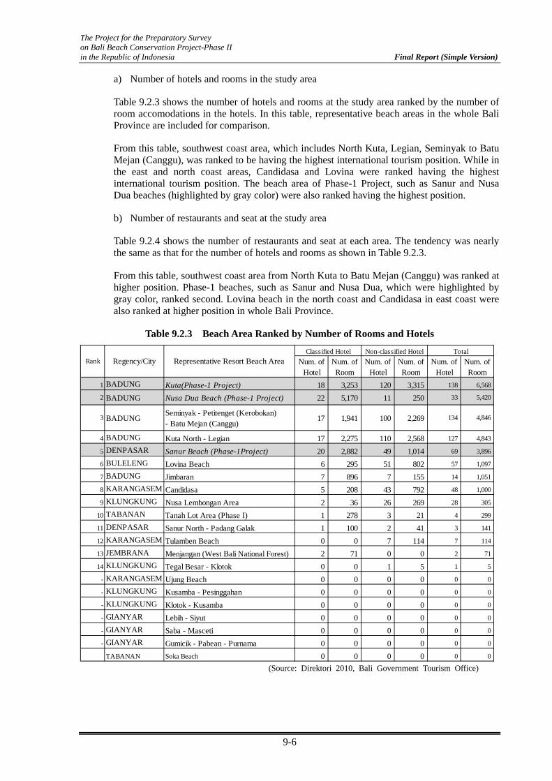
The Project for the Preparatory Survey on Bali Beach Conservation Project-Phase II in the Republic of Indonesia Final Report (Simple Version)
9-6
a) Number of hotels and rooms in the study area
Table 9.2.3 shows the number of hotels and rooms at the study area ranked by the number of room accomodations in the hotels. In this table, representative beach areas in the whole Bali Province are included for comparison.
From this table, southwest coast area, which includes North Kuta, Legian, Seminyak to Batu Mejan (Canggu), was ranked to be having the highest international tourism position. While in the east and north coast areas, Candidasa and Lovina were ranked having the highest international tourism position. The beach area of Phase-1 Project, such as Sanur and Nusa Dua beaches (highlighted by gray color) were also ranked having the highest position.
b) Number of restaurants and seat at the study area
Table 9.2.4 shows the number of restaurants and seat at each area. The tendency was nearly the same as that for the number of hotels and rooms as shown in Table 9.2.3.
From this table, southwest coast area from North Kuta to Batu Mejan (Canggu) was ranked at higher position. Phase-1 beaches, such as Sanur and Nusa Dua, which were highlighted by gray color, ranked second. Lovina beach in the north coast and Candidasa in east coast were also ranked at higher position in whole Bali Province.
Table 9.2.3 Beach Area Ranked by Number of Rooms and Hotels
Num. ofHotel
Num. ofRoom
Num. ofHotel
Num. ofRoom
Num. ofHotel
Num. ofRoom
1 BADUNG Kuta(Phase-1 Project) 18 3,253 120 3,315 138 6,568
2 BADUNG Nusa Dua Beach (Phase-1 Project) 22 5,170 11 250 33 5,420
3 BADUNGSeminyak - Petitenget (Kerobokan)- Batu Mejan (Canggu)
17 1,941 100 2,269 134 4,846
4 BADUNG Kuta North - Legian 17 2,275 110 2,568 127 4,843
5 DENPASAR Sanur Beach (Phase-1Project) 20 2,882 49 1,014 69 3,896
6 BULELENG Lovina Beach 6 295 51 802 57 1,097
7 BADUNG Jimbaran 7 896 7 155 14 1,051
8 KARANGASEM Candidasa 5 208 43 792 48 1,000
9 KLUNGKUNG Nusa Lembongan Area 2 36 26 269 28 305
10 TABANAN Tanah Lot Area (Phase I) 1 278 3 21 4 299
11 DENPASAR Sanur North - Padang Galak 1 100 2 41 3 141
12 KARANGASEM Tulamben Beach 0 0 7 114 7 114
13 JEMBRANA Menjangan (West Bali National Forest) 2 71 0 0 2 71
14 KLUNGKUNG Tegal Besar - Klotok 0 0 1 5 1 5
- KARANGASEM Ujung Beach 0 0 0 0 0 0
- KLUNGKUNG Kusamba - Pesinggahan 0 0 0 0 0 0
- KLUNGKUNG Klotok - Kusamba 0 0 0 0 0 0
- GIANYAR Lebih - Siyut 0 0 0 0 0 0
- GIANYAR Saba - Masceti 0 0 0 0 0 0
- GIANYAR Gumicik - Pabean - Purnama 0 0 0 0 0 0
TABANAN Soka Beach 0 0 0 0 0 0
TotalRank Regency/City Representative Resort Beach Area
Classified Hotel Non-classified Hotel
(Source: Direktori 2010, Bali Government Tourism Office)

The Project for the Preparatory Survey on Bali Beach Conservation Project-Phase II in the Republic of Indonesia Final Report (Simple Version)
9-7
Table 9.2.4 Beach Area Ranked by Number of Seating Capacity and Restaurants
Rank Regency/City Representative Resort Beach AreaNumber of Restaurant
Number ofSeat
1 BADUNG Kuta (Phase-1 Project) 203 12,048
2 BADUNG Kuta North - Legian 131 8,650
3 BADUNGSeminyak - Petitenget (Kerobokan)- Batu Mejan (Canggu)
133 7,359
4 DENPASAR Sanur Beach (Phase I Project) 91 4,602
5 BADUNG Nusa Dua Beach (Phase-1 Project) 53 3,5806 BULELENG Lovina Beach 23 1,263
7 KARANGASEM Candidasa 35 1,112
8 BADUNG Jimbaran 24 998
9 KLUNGKUNG Nusa Lembongan Area 21 725
10 GIANYAR Lebih - Siyut 21 657
11 KLUNGKUNG Kusamba - Pesinggahan 4 176
12 KARANGASEM Tulamben Beach 4 78
13 TABANAN Tanah Lot Area (Phase I) 6 -
- KARANGASEM Ujung Beach 0 0
- KLUNGKUNG Klotok - Kusamba 0 0
- KLUNGKUNG Tegal Besar - Klotok 0 0
- GIANYAR Saba - Masceti 0 0
- GIANYAR Gumicik - Pabean - Purnama 0 0
- DENPASAR Sanur North - Padang Galak 0 0
- TABANAN Soka Beach 0 0
JEMBRANA Menjangan (West Bali National Forest) 0 0 (Source: Direktori 2010, Bali Government Tourism Office)
Evaluation was carried out by adopting the scoring from 1 to 5. Here, each score was taken based on the following criteria shown in Table 9.2.5.
Table 9.2.5 Criteria for Scoring
Score Criteria
5 within top 5 for both
4 within top 10 for both3 within top 15 for both2 within top 15 for either1 out of rank
(Source: JICA Study Team)
The evaluation result for land use along the coast is shown in Table 9.2.6.

The Project for the Preparatory Survey on Bali Beach Conservation Project-Phase II in the Republic of Indonesia Final Report (Simple Version)
9-8
Table 9.2.6 Evaluation Results for Land Use along the Coast
Study Area No Subjected Beaches Description Score
E1 Candidasa Hotel (rank 8), Restaurant (rank 7) 4
E2 Kusamba Hotel (out of rank), Restaurant (rank 11) 2E3 Klotok Hotel (out of rank), Restaurant (out of rank) 1E4 Tegal Besar Hotel (rank 14), Restaurant (out of rank) 2E5 Siyut Hotel (out of rank), Restaurant (rank 10) 2E6 Lebih Hotel (out of rank), Restaurant (rank 10) 2E7 Masceti out of ranking 1E8 Saba, Purnama out of ranking 1E9 Pabean out of ranking 1
E10Sanur North~ Padang Galak
Hotel (rank 11), Restaurant (out of rank) 2
W1North Kuta ~ Legian
Hotel (rank 1), Restaurant (rank 1) 5
W2 Seminyak Hotel (rank 3), Restaurant (rank 3) 5W3 Canggu Hotel (rank 3), Restaurant (rank 3) 5
South EastCoast
South WestCoast
(Source: JICA Study Team)
(3) (a-3) Contribution of the Tourism Development Plan
The existing and future development plan of Bali Province was presented in the spatial plan issued in 2009. Based on this information, the potential contribution on tourism of the spatial development plan at each area was examined
According to the spatial plan, most of the study area belonged to the tourist area except for Kusamba, Klotok, and Tegal Besar located at the southeast coast area. For the infrastructure development plan, toll road development will contribute directly to increase the number of visitors at the study area, this criterion has higher priority than others. Furthermore, international cruise port in Tanah Ampo is expected to contribute to increase the number of visitors especially in Candidasa. The scoring was made to summarize each contribution items. Table 9.2.7 shows the summarized evaluation result on the contribution of the Tourism Development Plan.
Table 9.2.7 Evaluation Results on the Contribution of Tourism Development Plan
Sanur toPadangbai
Kuta to Soka
Internationalcruise port
Ferry (Amedto Lember)
Ferry(Gunaksa to
Nusa Penida)
E1 Candidasa 1 1 1 1 4
E2 Kusamba 1 1
E3 Klotok 1 1 2
E4 Tegal Besar 1 1
E5 Siyut 1 1 2
E6 Lebih 1 1 2
E7 Masceti 1 1 2
E8 Saba, Purnama 1 1 2
E9 Pabean 1 1 2
E10Sanur North ~ Padang Galak
1 1 2
W1North Kuta ~ Legian
1 1 2
W2 Seminyak 1 1 2
W3 Canggu 1 1 2
Tourism area
Score
Toll Road Sea Transport Access
SouthEast
Coast
SouthWestCoast
Study Area
No Subjected Beaches
Infrastructure Development
(Source: Bali Province Regulation No.16/2009 arranged by the JICA Study Team)

The Project for the Preparatory Survey on Bali Beach Conservation Project-Phase II in the Republic of Indonesia Final Report (Simple Version)
9-9
9.3 Evaluation of Beach Condition
(1) (b-1) Degree of Beach Erosion
The beach recession occurring for a long time was examined by the use of mapping analysis based on aerial and satellite photographs. The vertical aerial photographs which were taken in 1981 (scale S=1/50,000), 1982 (S=1/15,000), and 1993 (S=1/50,000) were collected in this study, and the satellite photographs (Quick Bird) taken in 2011were obtained as of the latest condition. Of these, the positions of shoreline between 1981 and 2011 (30 years) were compared. The change of shoreline position due to tide condition was considered taking into account the time when the photos were taken and slope of the beach.
a) Southeast Coast Area (from north Sanur to Padangbai)
Figure 9.3.1 shows the comparison of shoreline between 1981 and 2011, from north Sanur to Padangbai. For conducting detailed comparison, the area was divided into five sub-areas. The comparison of shoreline for each sub area is shown in Appendix 9.3.1. Figure 9.3.2 shows the result of the change of shoreline obtained from the mapping analysis.
Figure 9.3.1 Aerial and Satellite Imagery between 1981 and 2011 (East Coast) (Source: JICA Study Team)

The Project for the Preparatory Survey on Bali Beach Conservation Project-Phase II in the Republic of Indonesia Final Report (Simple Version)
9-10
Figure 9.3.2 Shoreline Change between 1981 and 2011 (Souteast Coast) (Source: JICA Study Team)
Beach erosion was observed in most of the study area. The most significant beach
recession was observed at X=9~12.5 km (West side from the Unda River mouth) with 240 m width of the recession. The shoreline at east side (from the Unda River to Padangbai) was not so significant.
The beach recession at X=20~26 km was about 20 m to 40 m (less than 50 m). According to the satellite photograph, hard soil and rock layer were partially observed behind the sandy beach.
From X=27 km to west side, the shoreline has gradually retreated toward the Ayung River mouth, and the width of the recession reaches approximately 100 m.
The area for erosion was estimated at about S =2.04 million m2 based on the mapping analysis. Assuming 6~7 m as the height of sand movement, the sand loss in this area was estimated roughly at 12~14 million m3 for 28 years.
b) Candidasa
Figure 9.3.3 shows the comparison of shoreline between 1981 and 2011 in Candidasa. The details are shown in the Appendix 9.3.1. Figure 9.3.4 shows the change of shoreline.

The Project for the Preparatory Survey on Bali Beach Conservation Project-Phase II in the Republic of Indonesia Final Report (Simple Version)
9-11
Figure 9.3.3 Aerial and Satellite Imagery between 1981 and 2011 (Candidasa) (Source: JICA Study Team)
Figure 9.3.4 Shoreline Change between 1981 and 2011 (Candidasa) (Source: JICA Study Team)
The beach recession at Area E (X = 1 km to 3.5 km) was observed roughly at 20 m to 40 m.
Several revetments were constructed along the coastal line, and the position of the revetment was 20 m to 30 m land side from the shoreline position in 1981.

The Project for the Preparatory Survey on Bali Beach Conservation Project-Phase II in the Republic of Indonesia Final Report (Simple Version)
9-12
The beach recession at Area F (X = 4 km to 6 km) was more significant than that at Area E and was observed roughly at 40 m to 60 m.
Originally, the beach width in Candidasa was narrow with 20 m width more or less.
c) Southwest Coast (from North Kuta to Canggu)
Figure 9.3.5 shows the comparison of shoreline between 1981 and 2011 from North Kuta to Canggu. The details are shown in Appendix 9.3.1. Figure 9.3.6 shows the results of the change of shoreline.
Beach recession was observed in most of the study area, but the change of beach recession was less than 20 m and smaller than that in the east coast area.
The beach recession at X = 3 km to 8 km (Legian ~ Seminyak area) was observed roughly to be more or less than 10 m. Significant local beach retreat at X=7.3 km was due to change of small river mouth at this area.
The beach from X=8 km to north side seems stable. Such condition might have been preserved due to the existence of beach rock at some areas.
Figure 9.3.5 Aerial and Satellite Imagery between 1981 and 2010 (Southwest Coast) (Source: JICA Study Team)

The Project for the Preparatory Survey on Bali Beach Conservation Project-Phase II in the Republic of Indonesia Final Report (Simple Version)
9-13
Figure 9.3.6 Shoreline Change between 1981 and 2010
(Source: JICA Study Team)
Beach recession was not observed in Area C (Canggu area) except at X=11.3 km. The large scale beach rock exists at X=11.3 km. Due to this, the beach at south side was accumulated with approximately 30 m while the beach at north side has retreated.
The area for erosion was estimated about S =24,000 m2 based on this mapping analysis. Assuming 10 m as the height of sand movement, sand loss in this area was estimated roughly at 240,000 m3 for 28 years (9000 m3/year in average). This sand loss might have been caused by outflow to the north.
It was suggested that the sediment balance was maintained before the 1970s. At that time, sand from the south area (coral reef area) flow out to the north side, and sediment balance was maintained. After causing beach erosion mainly in the south area (coral reef area) due mainly to the construction of runway, the sand supply from the south side has stopped. This might induce sediment unbalance in this area and cause beach erosion.
Evaluation was carried out by adopting the scoring from 1 to 5. Here, each score was taken based on the following criteria as shown in Table 9.3.1.
The evaluation result for the degree of beach erosion is shown in Table 9.3.2.

The Project for the Preparatory Survey on Bali Beach Conservation Project-Phase II in the Republic of Indonesia Final Report (Simple Version)
9-14
Table 9.3.1 Criteria for Scoring
Score Criteria
5 Beach retreat more than 50m for 30 years
4 Beach retreat from 20m to 50m for 30 years3 Beach retreat from 10m to 20m for 30 years2 Beach retreat from 0m to 10m for 30 years1 No beach retreat
(Source: JICA Study Team)
Table 9.3.2 Evaluation Result for the Degree of Beach Erosion
Study Area No Subjected Beaches Description Score
E1 Candidasa 20 to 30m retreat at east side, 40 to 60m at west side 5
E2 Kusamba No retreat 1E3 Klotok 150 to 200m retreat 5E4 Tegal Besar 100 to 150m retreat 5E5 Siyut 100 to 150m retreat 5E6 Lebih 100m retreat 5E7 Masceti 5 to 10m retreat 2E8 Saba, Purnama 10 to 20m retreat 3E9 Pabean 50 to 80m retreat 5
E10Sanur North~ Padang Galak
70 to 100m retreat 5
W1North Kuta ~ Legian
5 to 12m retreat 3
W2 Seminyak 5 to 15m retreat 3W3 Canggu 0 to 10m retreat 2
South EastCoast
West Coast
(Source: JICA Study Team)
(2) (b-2) Obstruction of Beach Activities, Utilization, and Land Facilities
It is required to check the beach condition based on beach utilization and protection. Even if beach recession occurs, the necessity to conduct beach conservation measures might be low in case of no obstruction on beach utilization and protection.
As to the point of beach utilization, the possibility of obstructing beach activities related to tourism such as sunbathing, walking, swimming, fishing, and religious activities for Balinese residents, was checked.
As to the point of protection, the present condition of land facilities and the possibility of obstruction due to beach recession and wave intrusion into land side and facilities were checked based on the site investigation and interview survey.
Figures 9.3.7(1/5) to 9.3.7(5/5) show the present condition for beach use and the facilities at hinter area, and anticipated obstacles for each subjected beach.
Actually, it was difficult to set the criteria for scoring. As one method, the scoring was made by counting the number of comments on obstacles as shown in Table 9.3.3.

The Project for the Preparatory Survey on Bali Beach Conservation Project-Phase II in the Republic of Indonesia Final Report (Simple Version)
9-15
Table 9.3.3 Evaluation for Obstruction on Beach Use and Land Facilities
StudyArea
NoSubjected Beaches
Main Purpose of Beach Use
Obstruction on beach activitiesand utilization
Obstruction on land facilities Score
E1 CandidasaTourism area for foreigner and domestic
- Difficulty to beach access- Difficulty of walking along thebeach- No space for beach activities
- Wave over topping into hotelproperty- Loss of property
5
E2 Kusamba Fishery and sea transport no problem no problem 0
E3 Klotok Religious area Wave intrusion into temple 1
E4 Tegal Besar Wave intrusion into property 1
E5 Siyut Wave intrusion into property 1
E6 Lebih Religious and recreation areaInsufficient space for beachactivities
-Wave run up in front of somefacilities-Possibility for damage offacility
3
E7 Masceti Religious and recreation area Wave intrusion into temple 1
E8 Saba, Purnama Religious and recreation area Wave intrusion into property 1
E9 Pabean Recreation area Wave intrusion into property 1
E10Sanur North ~ Padang Galak
Tourism recreation area for domestic, religious andrecreation area
Wave intrusion into property 1
W1North Kuta ~ Legian
Tourism area for foreigner and domestic
- Insufficient of beach spacefor activities during high tide
-Wave run up in front of somefacilities-Possibility for damage offacility
3
W2 Seminyak Tourism area for foreigner- Insufficient of beach spacefor activities during high tide
-Wave run up in front of somefacilities-Possibility for damage offacility
3
W3 CangguTourism and residential area for foreigner, religious area
-Wave run up in front of somefacilities-Possibility for damage offacility
2
SouthEast
Coast
SouthWestCoast
(Source: JICA Study Team)

The Project for the Preparatory Survey on Bali Beach Conservation Project-Phase II in the Republic of Indonesia Final Report (Simple Version)
9-16
E
1: C
andi
Das
aE
2: K
usam
baE
3: K
loto
k
(Resort area for both foreign and domestic tourists) - Almost coastal area is utilized by property of hotels and villas, but no sandy beach exists. - Tourist cannot walk along the beach due to construction of sea wall, partition and disappearing of beach. - During high tide condition, wave is overtopping into hotel property. This is causing the damage of seawalland disturb the hotel activities.
(Fishery and Sea Transport area to Nusa Penida, not tourism area ) - Beach width seems to be sufficient for present beach use, and no obstruction to land facility is observed.
(Rerigious Area, not tourism area) - Temple is located at beach area and residents come to the beach for religious event and there is no otherfacilities. - During high tide condition, the space in front of the temple seems to be insufficient.
Figure 9.3.7 Present Condition on Beach Use and Facilities, and Anticipated Obstacles (1/5) (Source: JICA Study Team)

The Project for the Preparatory Survey on Bali Beach Conservation Project-Phase II in the Republic of Indonesia Final Report (Simple Version)
9-17
E5:
Siy
utE
6: L
ebih
E4:
Teg
al B
esar
(Not tourism and religious area) - A few villa exists, but no active beach use is observed. - Gravel mining by manual method is carried out on the beach.
(not tourism and religious area) - No active beach use is observed. - Revetment to enclose the property is under construction at close to shoreline.
(Recleation and religious area for domestic)- Local restaurant and small fish marcket is on the beach.- Clearance between beach and newly constructed toll road is narrow with 100-150m distance.- Revetment was construction with 1.4km length by Balai to protect the land side.
Figure 9.3.7 Present Condition on Beach Use and Facilities, and Anticipated Obstacles (2/5) (Source: JICA Study Team)

The Project for the Preparatory Survey on Bali Beach Conservation Project-Phase II in the Republic of Indonesia Final Report (Simple Version)
9-18
E9:
Pab
ean
E7:
Mas
ceti
E8:
Pur
nam
a
(Rerigious and recreation area for residents) - There is temple close to the beach and temple area is protected by seawall. - Beach area is utililized as religious events and recreation for residents. No obstraction on beach use isobserved.
(Rerigious and recreation area for residents) - There is temple close to the beach and temple area is protected by seawall. - Beach area is utililized as religious events and recreation for residents. No obstraction on beach use isobserved.
(Recreation area for residents) - A few villa exists at close to the beach. - Sandy berm was dissapeared in front of seawall which seems to be constructed recently.
Figure 9.3.7 Present Condition on Beach Use and Facilities, and Anticipated Obstacles (3/5) (Source: JICA Study Team)

The Project for the Preparatory Survey on Bali Beach Conservation Project-Phase II in the Republic of Indonesia Final Report (Simple Version)
9-19
(Resort area for foreign tourists)- Beach area is utilized by foreigner as marine and beach activities. Hinter area is highly utilized by high class hotels andrestaurants.- The space of beach at some area seems to be insufficient especially during high tide condition.
(Tourism area mainly for domestic at north Sanur, religious and recreation area for residents at Padang Galak) - Villa and small restaurant exists just behind the existing revetment at north Sanur area. Even though sandy beachdoesn't exist, no obstruction for beach use and facilities is observed. - Revetment was constructed 1.9km length by Balai at Padang Galak. Most of hinter area is field and active use was notobserved.
(Resort area for both foreign and domestic tourists)- Beach area is always highly utilized by both foreign and domestic tourists as marine and beach activities.- After the boundary of nourishment area to north. Beach width becomes narrow. The space of beach seems to beinsufficient especially during high tide condition.
W2:
Sem
inya
kE
10: N
orth
San
ur -
Pad
ang
Gal
akW
1: N
orth
Kut
a -
Leg
ian
Figure 9.3.7 Present Condition on Beach Use and Facilities, and Anticipated Obstacles (4/5) (Source: JICA Study Team)
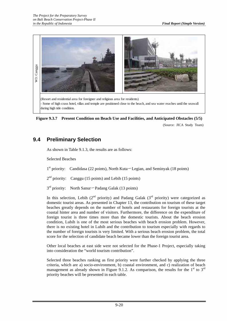
The Project for the Preparatory Survey on Bali Beach Conservation Project-Phase II in the Republic of Indonesia Final Report (Simple Version)
9-20
(Resort and residential area for foreigner and religious area for residents)- Some of high crass hotel, villas and temple are positioned close to the beach, and sea water reaches until the seawallduring high tide condition.
W3:
Can
ggu
Figure 9.3.7 Present Condition on Beach Use and Facilities, and Anticipated Obstacles (5/5) (Source: JICA Study Team)
9.4 Preliminary Selection
As shown in Table 9.1.3, the results are as follows:
Selected Beaches
1st priority: Candidasa (22 points), North Kuta〜Legian, and Seminyak (18 points)
2nd priority: Canggu (15 points) and Lebih (15 points)
3rd priority: North Sanur〜Padang Galak (13 points)
In this selection, Lebih (2nd priority) and Padang Galak (3rd priority) were categorized as domestic tourist areas. As presented in Chapter 13, the contribution on tourism of these target beaches greatly depends on the number of hotels and restaurants for foreign tourists at the coastal hinter area and number of visitors. Furthermore, the difference on the expenditure of foreign tourist is three times more than the domestic tourists. About the beach erosion condition, Lubih is one of the most serious beaches with beach erosion problem. However, there is no existing hotel in Lubih and the contribution to tourism especially with regards to the number of foreign tourists is very limited. With a serious beach erosion problem, the total score for the selection of candidate beach became lower than the foreign tourist area.
Other local beaches at east side were not selected for the Phase-1 Project, especially taking into consideration the “world tourism contribution”.
Selected three beaches ranking as first priority were further checked by applying the three criteria, which are a) socio-environment, b) coastal environment, and c) realization of beach management as already shown in Figure 9.1.2. As comparison, the results for the 1st to 3rd priority beaches will be presented in each table.

The Project for the Preparatory Survey on Bali Beach Conservation Project-Phase II in the Republic of Indonesia Final Report (Simple Version)
9-21
9.5 Consideration on Social-Environment
(1) (c-1) Request for beach conservation from hotels and communities
A series of interviews with the personnel responsible for the subject beaches were conducted. Their responses on the necessity of beach conservation measures are shown in Table 9.5.1. The request for necessity of beach conservation was observed high for most beaches, especially for the 1st priority beaches.
Table 9.5.1 Interview Results on the Necessity of Coastal Protection Measures
Priority NoSelectedBeach
InterviewerRequest for Beach
ConservationEvaluation
The Head of Samuh Traditional Sub-Village Immediately
The Head of Sengkidu Traditional Village Immediately
The Head of Hotel Association Immediately
Candidasa Fisherman Group Immediately
Subagan Traditional Village Teacher Immediately
The Head of Traditional village Immediately
The Head of Legian beach management Immediately
Hotel Bali MandiraIt might be
necessary in future
The Head of Seminyak Traditional village Immediately
The Head of Seminyak Beach Management Immediately
The Head of Traditional village Immediately
The Head of Fisherman AssociationIt might be
neceesary in future
The Head of Hotel and Restaurant Executive Club Case to case
The Head of Traditional village (Brawa) Immediately
The Head of Fisherman Association (Brawa) Immediately
The Head of Lebih Fisherman Groups Immediately
The Head of Lebih Traditional Village Immediately
The Head of Kesiman Traditional VillageIt might be
neceesary in future
The Head of Padanggalak Fisherman GroupIt might be
necessary in future
North Kuta ~ Legian
Canggu
3rd
High
High
High
High
High
E1 Candidasa
Seminyak
Medium
E6 Lebih
W1
W2
1st
2nd
E10North Sanur ~Padang Galak
W3
(Source: JICA Study Team)
(2) (c-2) Relationship between Hotels and Communities
The present condition of the relationship between hotels and communities, who are the main stakeholders, is based on the obtained information at each site as summarized in Table 9.5.2. Basically, active cooperation between hotels and communities concerning beach maintenance and management was not observed because there is no existing management system at each site. The only cooperation observed is the beach cleaning activities being done by the hotels and the communities. Furthermore, there was no observed discord among the stakeholders at least for the 1st and 2nd priority sites.

The Project for the Preparatory Survey on Bali Beach Conservation Project-Phase II in the Republic of Indonesia Final Report (Simple Version)
9-22
Table 9.5.2 Relation between Hotels and Communities
Priority NoSelectedBeach
Present Condition Evaluation
Community and Hotels do the beach cleaning together
Coordination meeting is sometimes held between village andhotels as required
W1North Kuta ~ Legian
Community and Hotels do the beach cleaning in cooperationwith private sector and NGO
W2 Seminyak Community and Hotels coordinate for beach cleaning
Coordination meeting is sometimes held between village andhotels as required
Hotels pay local authority to clean the beach
E6 Lebih No coordination (due to no hotel exists) -
3rd E10North Sanur~Padang Galak
No coordination (due to no hotel exists) -
No problem
2ndW3 Canggu No problem
1st
E1 Candidasa No problem
(Source: JICA Study Team)
9.6 Consideration on Coastal Environment
(1) (d-1) Impact to Coastal Environment
a) Summary
Table 9.6.1 shows a summary of the environmental conditions of candidate beaches. The most vulnerable environment was observed to be Candidasa. Candidasa is a coral reef beach and many live corals, sea grasses, and several species of fish exist in the area. Other beaches have relatively general sandy beaches facing the open sea.
Table 9.6.1 Summary on the Impact to Coastal Environment
Priority NoSelectedBeach
Type ofBeach
CoralHabitat
SeaGrasses
WaterQuality
Target fish species forfishery
Restriction onEnvironmental
RegulationEvaluation
E1 CandidasaCoral Reef
BeachExiting Exiting Good
Mackerel, Snapper,Grouper, Albacore Tuna
NoNecessity of
careful attention
W1North Kuta ~ Legian
SandyBeach
- - Moderate Lobster No Not impacted
W2 SeminyakSandyBeach
- - Moderate Lobster No Not impacted
W3 CangguSandyBeach
- - Moderate Lobster No Not impacted
E6 LebihSandyBeach
- - ModerateMackerel, Snapper,
Grouper, Albacore Tuna,Lobster
No Not impacted
3rd E10North Sanur~Padang Galak
SandyBeach
- - Moderate - No Not impacted
1st
2nd
(Source: JICA Study Team)
b) Impact to Existing Corals
Among the candidate beaches, only Candidasa was categorized as coral reef beach. There is an existing coral habitat both inside and outside the coral reef, but the main habitat area is located at the outer reef slope area with shallow water. A 162.2 ha of healthy coral reefs is

The Project for the Preparatory Survey on Bali Beach Conservation Project-Phase II in the Republic of Indonesia Final Report (Simple Version)
9-23
situated in front of the beach-eroded area (Figure 9.6.1). Inside the coral reef, the branching type of coral is the primary specie. This type of coral lived mainly in the surrounding offshore breakwater (Photo 9.6.1). The detail is presented and discussed in Chapter 13.
Figure 9.6.1 Coral Reef Surrounding Candidasa (Source: Environmental Status of Bali Province 2010)
(1) Branching Corals around Existing Breakwaters
(2) Corals at the Outer Reef Slope
Photo 9.6.1 Lived Corals in Candidasa
(Source: JICA Study Team)
The location for the construction of coastal facilities and planned sand nourishment is just in front of the beach. This may not interfere with the corals directly because the coral habitat area is mainly located out of the coral reef. However, the indirect impact of the construction activities, such as turbidity and damage by big vessels, may be anticipated.
c) Impact to Existing Marine Fauna and Flora
Sea Grass Ecosystem
Offshore environment of Candidasa offers a living ground for sea grasses. The area is about 20 ha (Environmental Status of Bali Province 2010, I-138). Sea grass is known for being a nursery for micro-organisms and as food sources for turtles and dugong. The massive growth is seen in the western area of Candidasa.
Commercial Fish Species
Sandy seabed at the offshore area of eastern coast is being used as a productive commercial fishing (lobster) ground of fishermen. Disturbance of the seabed by dredging may affect the fish catch. A more precise survey on the fishing area and season should be surveyed, and agreement with fishermen will be necessary.
5 km

The Project for the Preparatory Survey on Bali Beach Conservation Project-Phase II in the Republic of Indonesia Final Report (Simple Version)
9-24
Table 9.6.2 Commercial Fishing (Species and Area)
Priority NoSelectedBeach
Target fish species forfishery
Fishing area(Distance from coast)
E1 CandidasaMackerel, Snapper, Grouper,
Albacore Tuna5 - 25 km
W1North Kuta ~ Legian
Lobster 1 - 10 km
W2 Seminyak Lobster 1 - 10 km
W3 Canggu Lobster 1 - 10 km
E6 LebihMackerel, Snapper, Grouper,
Albacore Tuna, Lobster25 km area
3rd E10North Sanur~Padang Galak
- -
1st
2nd
(Source: Interview Survey from the Fisherman’s Association)
d) Impact to the Water Quality
Impact to the water quality by implementation of beach conservation work and sand mining in the offshore area are not expected, except in Candidasa where water circulation is not active. It is noted that protection works in Candidasa require high attention.
Table 9.6.3 Occurrence of Degradation of Water Quality
Priority No BeachPresent
ConditionPhysical Characteristics
of the ShoreImpact for
Nourishment
Impact forOffshore Sand
Mining
E1 Candi Dasa Good
-Inside the coral reef-Partial stagnation ofwater due to existinggroins and breakwaters
Some impact isexpected due toturbidity anddecrease ofwater exchange
Some impact isexpected tocorals due toturbidity duringmining
W1North Kuta ~
LegianModerate Open shore
No impact isexpected
No impact isexpected
W2 Seminyak Moderate Open shoreNo impact isexpected
No impact isexpected
W3 Canggu ModerateOpen shore with partial rock cliff
No impact isexpected
No impact isexpected
E6 Lebih Moderate Open shoreNo impact isexpected
No impact isexpected
3rd E10Sanur North ~Padanggalak
Moderate Open shoreNo impact isexpected
No impact isexpected
1st
2nd
(Source: JICA Study Team)
(2) (d-2) Restriction, Regulation, and Rules for Coastal Environment
The 1st priority candidate site, namely, Candidasa, North Kuta to Legian, and Seminyak were defined as “tourist area” in the spatial plan in 2009 issued by Bali Province. Further, these areas were defined as “coastal conservation area”. Most of the coral reef beaches, offshore islands, and estuary were categorized as “coastal conservation area”. According to the explanation in the spatial plan, no construction of industrial facility is allowed in the area. Furthermore, maintenance and preservation of the nature is required. However, the spatial plan did not mention any restrictions related to beach conservation project in these areas.
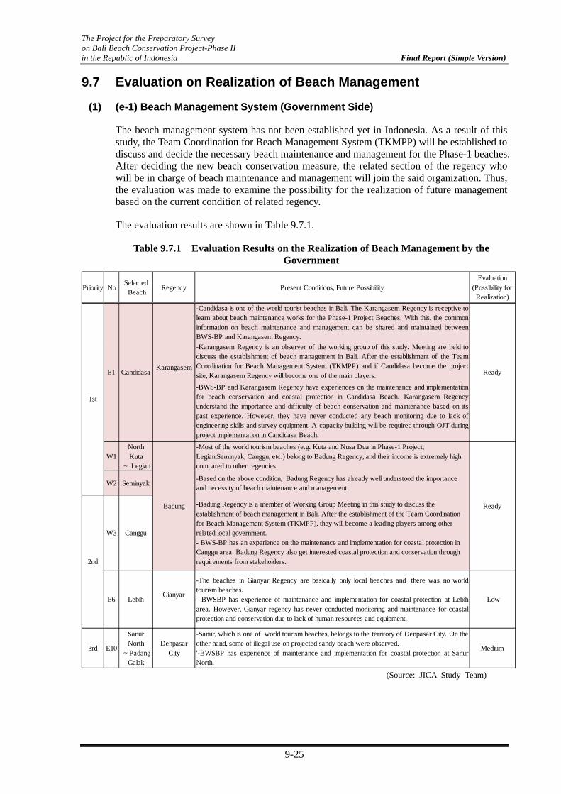
The Project for the Preparatory Survey on Bali Beach Conservation Project-Phase II in the Republic of Indonesia Final Report (Simple Version)
9-25
9.7 Evaluation on Realization of Beach Management
(1) (e-1) Beach Management System (Government Side)
The beach management system has not been established yet in Indonesia. As a result of this study, the Team Coordination for Beach Management System (TKMPP) will be established to discuss and decide the necessary beach maintenance and management for the Phase-1 beaches. After deciding the new beach conservation measure, the related section of the regency who will be in charge of beach maintenance and management will join the said organization. Thus, the evaluation was made to examine the possibility for the realization of future management based on the current condition of related regency.
The evaluation results are shown in Table 9.7.1.
Table 9.7.1 Evaluation Results on the Realization of Beach Management by the Government
Priority NoSelected Beach
Regency Present Conditions, Future PossibilityEvaluation
(Possibility forRealization)
-Candidasa is one of the world tourist beaches in Bali. The Karangasem Regency is receptive tolearn about beach maintenance works for the Phase-1 Project Beaches. With this, the commoninformation on beach maintenance and management can be shared and maintained betweenBWS-BP and Karangasem Regency.
-Karangasem Regency is an observer of the working group of this study. Meeting are held todiscuss the establishment of beach management in Bali. After the establishment of the TeamCoordination for Beach Management System (TKMPP) and if Candidasa become the projectsite, Karangasem Regency will become one of the main players.
-BWS-BP and Karangasem Regency have experiences on the maintenance and implementationfor beach conservation and coastal protection in Candidasa Beach. Karangasem Regencyunderstand the importance and difficulty of beach conservation and maintenance based on itspast experience. However, they have never conducted any beach monitoring due to lack ofengineering skills and survey equipment. A capacity building will be required through OJT duringproject implementation in Candidasa Beach.
W1NorthKuta
~ Legian
-Most of the world tourism beaches (e.g. Kuta and Nusa Dua in Phase-1 Project,Legian,Seminyak, Canggu, etc.) belong to Badung Regency, and their income is extremely highcompared to other regencies.
W2 Seminyak-Based on the above condition, Badung Regency has already well understood the importanceand necessity of beach maintenance and management
W3 Canggu
-Badung Regency is a member of Working Group Meeting in this study to discuss theestablishment of beach management in Bali. After the establishment of the Team Coordinationfor Beach Management System (TKMPP), they will become a leading players among otherrelated local government.- BWS-BP has an experience on the maintenance and implementation for coastal protection inCanggu area. Badung Regency also get interested coastal protection and conservation throughrequirements from stakeholders.
E6 LebihGianyar
-The beaches in Gianyar Regency are basically only local beaches and there was no worldtourism beaches.- BWSBP has experience of maintenance and implementation for coastal protection at Lebiharea. However, Gianyar regency has never conducted monitoring and maintenance for coastalprotection and conservation due to lack of human resources and equipment.
Low
3rd E10
SanurNorth
~ PadangGalak
DenpasarCity
-Sanur, which is one of world tourism beaches, belongs to the territory of Denpasar City. On theother hand, some of illegal use on projected sandy beach were observed.'-BWSBP has experience of maintenance and implementation for coastal protection at SanurNorth.
Medium
CandidasaKarangasem
Ready
Badung Ready
2nd
1st
E1
(Source: JICA Study Team)

The Project for the Preparatory Survey on Bali Beach Conservation Project-Phase II in the Republic of Indonesia Final Report (Simple Version)
9-26
(2) (e-2) Self-management Being Done by the Stakeholders
Table 9.7.2 shows the present condition of beach management, which has been carried out by stakeholders. The main self-management activity being done by stakeholders is beach cleaning. At north Kuta to Seminyak, some of public facilities such as public toilet, bay watch, etc., which were constructed under Phase-1 Project, are being maintained by the communities after the project completion.
Basically, beach cleaning is well managed by stakeholders at most of the selected beaches. On the other hand, there are no other management items or activities expected to be individually managed by stakeholders, such as beach monitoring, self-control of beach utilization, etc.
However, based on the current condition, related stakeholders, which are mainly hotels and communities, have the potential to do self-management.
Table 9.7.2 Present Beach Maintenance Activities Being Done by Stakeholders
Priority No Beach Management Item Present ConditionEvaluation
(Possibility)
E1 Candidasa Beach CleaningCommunities and hotel associations managedwell their responsible territories.
Medium
Beach Cleaning
Communities and hotel and restaurantexecutive clubs managed the beach area incooperation with the private sector andNGOs
Maintenance of PublicFacilities
Some of public facilities (e.g., public toilet,bay watch set in Phase-1 Project) aremaintained by communities after the Phase-1Project.
Beach cleaningCommunities and Hotel Association are wellmanaged at their territory by theirresponsibility.
Maintenance of PublicFacilities
Some of public facilitied (e.g. Public Toilet,Bay watch, which were set in Phase-1Project) was maintained by communitiesafter Phase-1 Project
W3 Canggu Beach cleaningCommunities and Hotels are well managed attheir territory by their responsibility
Medium
E6 Lebih Beach cleaningFisherman groups managed the limited area(around fish market and restaurant on thebeach)
Medium
3rd E10Sanur North ~Padanggalak
Beach cleaning Communities managed their territories. Medium
SeminyakW2
High
High
1st
2nd
North Kuta ~ Legian
W1
(Source: JICA Study Team)

The Project for the Preparatory Survey on Bali Beach Conservation Project-Phase II in the Republic of Indonesia Final Report (Simple Version)
9-27
9.8 Final Selection of Candidate Site
The summary of the evaluation results on the “social environment”, “coastal environment”, and “beach maintenance” for preliminary selected beaches is shown in Table 9.8.1.
The three beaches (Candidasa, North Kuta ~ Legian, and Seminyak) which were selected as 1st priority in the preliminary selection encountered no obstacle on the above mentioned three checking points. Therefore, these three beaches were finally selected as proposed candidate beaches.
In this survey, coral habitat located both inside and outside of the coral reef were observed in good condition furthermore, water quality is still maintained in Candidasa. This is one of the advantages in tourism which the south resort area, such as Sanur, Nusa Dua, and Kuta does not possess. Thus, great attention on coastal environment is required during the project implementation in Candidasa.
Table 9.8.1 Summary of the Evaluation Results on the Social Environment, Coastal Environment, and Beach Management
c-1 c-2 d-1 d-2 e-1 e-2
Request forProject
Relationbetween hotel& community
Impact toCoastal
Environment
Restriction,Regulation and
Rules
Managementsystem
Self-management
by stakeholders
Refer to 9.5 (1) 9.5 (2) 9.6 (1) 9.6 (2) 9.7 (1) 9.7 (2)
E1 Candidasa High No problemNeed careful
attentionNo Ready Medium Selected
W1North Kuta
~LegianHigh No problem Not impacted No Ready High Selected
W2 Seminyak High No problem Not impacted No Ready High Selected
W3 Canggu High - Not impacted No Ready Medium
E6 Lebih High - Not impacted No Low Medium
3rd E10North Sanur~Padang Galak
Medium - Not impacted No Medium Medium
Priority
1st
2nd
NoFinal
Result
c) Social Environment d) Coastal Environment e) Beach Management
SelectedBeach
(Source: JICA Study Team)
The selected two beaches in the southwest coast, which is W1 (North Kuta ~ Legian) and W2 (Seminyak), is located along the continuous stretch of sandy beach. From the technical point of view, it is practical to combine W1 and W2 into one package. Thus, the candidate sites are defined as the two main areas presented below:
Site-1 (East Coast): Candidasa (5 km more or less)
Site-2 (South West Coast): North Kuta ~ Legian ~ Seminyak (3 km more or less)