
preparatory survey on the project for the disaster ...
191
Republic of Vanuatu Ministry of Infrastructure and Public Utilities, Public Works Department PREPARATORY SURVEY ON THE PROJECT FOR THE DISASTER RECONSTRUCTION OF TEOUMA BRIDGE FINAL REPORT November 2019 JAPAN INTERNATIONAL COOPERATION AGENCY CTI ENGINEERING INTERNATIONAL CO., LTD. KOKUSAI KOGYO CO., LTD. EI JR 19-108
-
Upload
khangminh22 -
Category
Documents
-
view
0 -
download
0
Transcript of preparatory survey on the project for the disaster ...

Republic of Vanuatu Ministry of Infrastructure and Public Utilities, Public Works Department
PREPARATORY SURVEY ON THE PROJECT FOR
THE DISASTER RECONSTRUCTION OF TEOUMA BRIDGE
FINAL REPORT
November 2019
JAPAN INTERNATIONAL COOPERATION AGENCY
CTI ENGINEERING INTERNATIONAL CO., LTD. KOKUSAI KOGYO CO., LTD.
EI
JR
19-108


Republic of Vanuatu
Ministry of Infrastructure and Public Utilities,
Public Works Department
PREPARATORY SURVEY
ON THE PROJECT FOR
THE DISASTER RECONSTRUCTION
OF TEOUMA BRIDGE
FINAL REPORT
November 2019
JAPAN INTERNATIONAL COOPERATION AGENCY
CTI ENGINEERING INTERNATIONAL CO., LTD.
KOKUSAI KOGYO CO., LTD.


PREFACE
Japan International cooperation Agency (JICA) decided to conduct the preparatory survey and
entrust the survey to the Consortium of CTI Engineering International Co., LTD. and Kokusai Kogyo Co.,
LTD.
The survey team held a series of discussions with the officials concerned of the Government of
the Republic of Vanuatu, and conducted field investigations. As a result of further studies in Japan, the
present report was finalized.
I hope that this report will contribute to the promotion of the project and to the enhancement of
friendly relations between our two countries.
Finally, I wish to express my sincere appreciation to the officials concerned of the Government
of the Republic of Vanuatu for their close cooperation extended to the survey team.
November 2019
Itsu ADACHI
Director General
Infrastructure and Peacebuilding Department
Japan International Cooperation Agency


SUMMARY
1. OUTLINE
(1) Background and Outline of the Project
Most of the residents of Efate Island where the capital of the Republic of Vanuatu is located live
along the Ring Road. The Ring Road plays an important role for inland transportation. Teouma Bridge has
been constructed on the Teouma River which is the largest river in the island. It is located at the entrance
to the capital from the eastern part of the island.
The bridge was completely destroyed by an earthquake of magnitude M7.2. In response, the bridge
was reconstructed through the Japan’s Grant Aid Program “The Project for Rehabilitation of Bridges on
the Ring Road in the Efate Island in the Republic of Vanuatu” in 2003.
However, the rehabilitated Teouma Bridge had been blocked for six days due to the damage of the
approach road on the right bank by Cyclone Pam in 2015. The damage was caused by the changing of the
river course. The bridge has been temporarily rehabilitated and it is at the risk of being destroyed and
blocked by another sever flood.
Under this circumstance, JICA conducted a data collection survey in 2016 to investigate and confirm
the direction for the bridge rehabilitation. It has been proposed to implement three types of works, which
are: 1) Stabilization of the river course; 2) Extension of the bridge to increase flow capacity; and 3)
Overflow approach road.
Based on the survey results, background, purpose and content of the project has been identified in
“The Project for the Disaster Reconstruction of Teouma Bridge in Republic of Vanuatu”, based on the
assumption that Japan’s Grant Aid will be used. Effectiveness, human / technical / economic relevance was
examined, outline design was conducted for the necessary and optimal project content and scale, and the
approximate project cost was estimated. Moreover, the survey and study covered obligations of recipient
country, drafted an implementation plan, operation and maintenance key points and considerations to
achieve the project objectives.
(2) Summary of Vanuatu
Vanuatu is in the Pacific Rim orogenic belt extending from the Solomon Islands to Fiji and consists
of more than 80 islands. The total land area is about 12,190 km2 with a population of about 270,000 (2017
estimation). The area of Efate Island, where the capital city Port-Vila locates, is about 900km2. This island
has the highest population density in Vanuatu.
Real GDP of Vanuatu is US$ 863,000,000 (The World Bank, 2017), and the economic growth rate
has been positive since 2004 except in 2015 due to Cyclone Pam. In 2017, economic growth rate was
estimated at 4.5% (The World Bank). Agriculture and tourism are two major economy sectors of Vanuatu.
Vanuatu climate is tropical oceanic with stable temperatures, high humidity, and rainy throughout
the year. Wind is calm except during tropical storms (about 9.3 km/hour to18.5 km/hour). The Vanuatu
climate can be classified into two seasons: dry season, from May to November, and the rest is rainy season.
The annual average temperature is about 25 degrees Celsius. The average temperature of the hottest season,

that is in February, is about 27o C while the average temperature of the coolest season, that is in August is
about 23o C. The average annual precipitation is about 2,100 mm.
(3) Result of the Survey and Contents of the Project
JICA dispatched four survey teams to Vanuatu from November 2017 to March 2019 as shown in
Table 1 below.
The first field survey was conducted during the rainy season. Following discussions with concerned
officials of Vanuatu, the survey team determined the scope of the project and carried out a field survey for
road plans (width composition, pavement type, road geometry, etc.), bridge plans and selection of
superstructure type, natural conditions and topography, procurement of construction materials and
equipment as well as operation and maintenance system.
The second field survey was conducted during the dry season. The survey team carried out project
site confirmation, natural conditions and geology, traffic volume survey, axle load survey, implementation
plan and also cost estimation. The results of the first and second field surveys helped the survey team to
design a bridge and road, draft an implementation plan as well as come up with a rough project cost
estimation back in Japan.
During the third survey, Vanuatu side requested that a sidewalk be provided for the bridge. The team
then redesigned the bridge as per the request.
During the fourth field survey, the design outline as well as obligations of Vanuatu side were
confirmed.
Table-1 Field Survey Period
Survey Period
First Field Survey (first team) From 12th Nov. 2017 to 22nd Dec. 2017
First Field Survey (second team) From 16th Jan. 2018 to 4th Feb. 2018
Second Field Survey From 24th Apr. 2018 to 7th Jun. 2018
Third Field Survey From 19th Mar. 2019 to 3rd Apr. 2019
Fourth Field Survey From 25th Aug. 2019 to 3rd Sep. 2019
In this Survey, H.W.L. was set to 100-year precipitation return period for bridge design. The survey
team selected seal pavement according to the local procurement situations and specification. The proposed
outline of the plan is as follows.
[Bridge Type] Superstructure : 2 Spans Continuous Steel Plate Girder
Substructure : Reversed T Type Abutment and Wall Type Pier
Pile : Spiral Steel Rotation Pile
[Bridge Length] 58 m
[Road Width] Approach road: Effective Width 8.0 m
(Lane 3.0 m * 2 + Shoulder 1.0 m * 2)
Bridge: Effective Width 9.5 m
(Lane 3.0 m * 2 + Shoulder 0.5 m * 2 + Sidewalk 1.25 m * 2)
[Approach Road] Total Length: 562 m (B.P. side 245.5 m, E.P. side 316.5 m),

20,000 m3 Embankment
[River Improvement] Total Length 482.5 m, Reinforced Concrete Revetment 100.0 m,
Stone Pitching 302.5 m, Riprap 80.0 m
(4) Construction Period and Rough Cost of the Project
The construction period of the project is approximately 7 months (including the bidding period) for
the detailed design, and 26 months for the construction of facilities. The project cost to be borne by the
recipient country is estimated to be about 73 million Vanuatu Vatu (75 million Japanese Yen,
VUV1.0=JPY1.039).
For confidentiality, the cost to be borne by the Japan’ Grant Aid is not shown in this report.
(5) Project Evaluation
1) Relevancy
Implementations of this cooperation projects is recommended using Japan’s grant aid as follows:
1. The beneficiaries’ populations are almost half of the east Efate Island. It is a big number.
2. The project is urgently needed on the Ring Road to contribute to the strengthening of trunk road
transport networks and to stabilize and improve the livelihoods of residents.
3. Vanuatu authorities could operate and maintain bridges and roads using internal resources and
technologies. There is no need for sophisticated technology for operation and maintenance.
4. This project contributes to the environmental and economic objectives of Vanuatu national
development plan: “Recovery from climate change and disasters” and “Improving
infrastructure”.
5. There is little negative environmental and social impact.
6. In addition to the necessity and superiority of using bridge construction technology of Japan,
Japanese grant aid system allows the project to be implemented without any difficulty.
2) Effectiveness
a) Quantitative Effect
There is a high possibility of interruption of bridge service and closure of the connected road due to
inundation and also scouring and erosion of approach road due to the progressive erosion of riverbanks in
the upstream as well as potential change in river course. However, by implementation of this project, the
risk of inundation will be highly reduced by raising the road elevation, and also the river course will be
stabilized by river works and erosion prevention countermeasures.
The expected quantitative effect of the project implementation is shown in Table-2. The base value
was measured in 2018 and the target value is set for three years after project completion.

Table-2 The Quantitative Effects Expected from the Implementation of the Projects
Items Base Value
(FY2018 Actual) Target Value
(3 yrs after completion)
Traffic Volume (Unit/day) 2,980 3,600
Number of Passengers (person/day) 755 905
Weight of Cargo (ton/year) 60,000 72,000
b) Qualitative effect
The qualitative effects of the project are:
1. Maintenance of economic activities and access to various services are ensured by eliminating
the blockage of logistics and commuting due to flooding after heavy rain.
2. By changing from emergency rehabilitation to permanent restoration, there is no fear of a
falling bridge and the toughness of the bridge is secured.
3. River erosion to private land on the upper right bank can be avoided.

Table of Contents
Preface
Summary
Contents
Location Map / Perspective
Target Area for Tow Dimensional Flood Simulation
List of Figures & Tables
Abbreviations
CHAPTER 1 Basic Concept of the Project ......................................................................................... 1-1
1.1 Outline ....................................................................................................................................... 1-1
1.2 Natural Condition ...................................................................................................................... 1-1
1.2.1 Climate and Hydrology ...................................................................................................... 1-1
1.2.2 Topography and Geology ................................................................................................... 1-5
1.2.2.1 Topographical Survey ..................................................................................................... 1-5
1.2.2.2 Geological Survey (Boring Survey) ............................................................................... 1-9
1.2.2.3 Geological Survey (Material Testing) .......................................................................... 1-13
1.3 Environmental and Social Considerations ............................................................................... 1-17
1.3.1 Environmental Impact Assessment .................................................................................. 1-17
1.3.1.1 Outline of Project Components with Socio-environmental Impacts ............................ 1-17
1.3.1.2 Current Socio-environmental Conditions ..................................................................... 1-19
1.3.1.3 Policy, Legal, and Administrative Frameworks of Environmental and Social
Considerations ............................................................................................................................. 1-28
1.3.1.4 Alternative Analysis including No Project (No Action) ............................................... 1-37
1.3.1.5 Scoping ......................................................................................................................... 1-40
1.3.1.6 ToR for Survey of Environmental and Social Considerations...................................... 1-44
1.3.1.7 Survey Result of Environmental and Social Considerations ........................................ 1-46
1.3.1.8 Impact Assessment ....................................................................................................... 1-60
1.3.1.9 Environmental Management Plan (Proposed Actions and Implementation Cost) ....... 1-64
1.3.1.10 Environmental Management and Monitoring Plan (Implementation details,
Methodology and Cost) ............................................................................................................... 1-67
1.3.1.11 Stakeholder Meetings................................................................................................ 1-69
1.3.2 Land Acquisition and Resettlement .................................................................................. 1-75
1.3.2.1 Target Area for Action Plan ......................................................................................... 1-75
1.3.2.2 Outline of Laws and Regulations regarding Land Acquisition and Resettlement ........ 1-76
1.3.2.3 Practices in Resettlement and Land Acquisition .......................................................... 1-78
1.3.2.4 Comparison between JICA Policy and Vanuatu Resettlement Laws ........................... 1-79
1.3.2.5 Scale and Scope of Land Acquisition ........................................................................... 1-84
1.3.2.6 Policies for Compensation and Assistance ................................................................... 1-90
1.3.2.7 Grievance Redress Mechanism (GRM) and Addressing Complaints ........................... 1-93
1.3.2.8 Implementation System ................................................................................................ 1-94
1.3.2.9 Implementation Schedule ............................................................................................. 1-95
1.3.2.10 Costs Estimation ....................................................................................................... 1-96
1.3.2.11 Monitoring System ................................................................................................... 1-97
1.3.2.12 Public Consultation ................................................................................................. 1-100
1.3.2.13 Gender Equity ......................................................................................................... 1-101
CHAPTER 2 Contents of the Project .................................................................................................. 2-1
2.1 Basic Concept of the Project and Design Policy ....................................................................... 2-1
2.1.1 Basic Concept for Flood Disaster Countermeasure ............................................................ 2-1
2.1.2 Policies for Flood Disaster Countermeasure ...................................................................... 2-2

2.1.3 Design Policy of River Improvement Works ................................................................... 2-14
2.1.4 Policies for Utilization of Existing Teouma Bridge ......................................................... 2-20
2.1.5 Policies for Seismic Design Condition ............................................................................. 2-20
2.1.6 Policies for Bridge Planning ............................................................................................. 2-21
2.1.7 Policies for Road Planning ............................................................................................... 2-23
2.1.8 Policies for Procurement .................................................................................................. 2-25
2.1.9 Policies for Utilization of Local Contractors .................................................................... 2-25
2.1.10 Policies for operation and maintenance ............................................................................ 2-25
2.2 Outline Design of the Japanese Assistance ............................................................................. 2-26
2.2.1 Basic Plan ......................................................................................................................... 2-26
2.2.1.1 Applicable Criteria........................................................................................................ 2-27
2.2.1.2 Road Class and Specifications ...................................................................................... 2-27
2.2.1.3 Design Speed ................................................................................................................ 2-27
2.2.1.4 Geometric Condition .................................................................................................... 2-27
2.2.1.5 Traffic Demand Forecast .............................................................................................. 2-28
2.2.1.6 Riverbank Protection Plan ............................................................................................ 2-34
2.2.1.7 Bridge Plan ................................................................................................................... 2-37
2.2.1.8 Accessories of the Bridge ............................................................................................. 2-44
2.2.1.9 Approach Road Plan ..................................................................................................... 2-44
2.2.2 Outline Design Drawing ................................................................................................... 2-47
2.2.3 Implementation Plan ......................................................................................................... 2-48
2.2.3.1 Implementation Policy .................................................................................................. 2-48
2.2.3.2 Implementation Conditions .......................................................................................... 2-49
2.2.3.3 Scope of Works ............................................................................................................ 2-49
2.2.3.4 Consultant Supervision ................................................................................................. 2-50
2.2.3.5 Quality Control Plan ..................................................................................................... 2-51
2.2.3.6 Procurement Plan .......................................................................................................... 2-53
2.2.3.7 Soft Component Plan .................................................................................................... 2-56
2.2.3.8 Implementation Schedule ............................................................................................. 2-57
2.3 Security Plan............................................................................................................................ 2-57
2.4 Obligations of Recipient Country ............................................................................................ 2-57
2.5 Project Operation and Maintenance Plan ................................................................................ 2-58
2.6 Project Cost Estimation ........................................................................................................... 2-59
2.6.1 Initial Cost Estimation ...................................................................................................... 2-59
2.6.1.1 Government of Vanuatu’s Contribution ....................................................................... 2-59
2.6.1.2 Government of Vanuatu’s Contribution ....................................................................... 2-59
2.6.1.3 Cost Estimation Condition ............................................................................................ 2-60
2.6.2 Operation and Maintenance Cost ..................................................................................... 2-60
CHAPTER 3 Project Evaluation ......................................................................................................... 3-1
3.1 Preconditions ............................................................................................................................. 3-1
3.2 Necessary Inputs by Recipient Country .................................................................................... 3-1
3.3 Important Assumptions ............................................................................................................. 3-1
3.4 Project Evaluation ..................................................................................................................... 3-2
3.4.1 Relevancy ........................................................................................................................... 3-2
3.4.2 Effectiveness....................................................................................................................... 3-2
3.4.2.1 Quantitative Effect .......................................................................................................... 3-2
3.4.2.2 Qualitative effect ............................................................................................................ 3-2
[Appendices]
1. Survey Team Member List
2. Survey Schedule
3. List of Stakeholder
4. Minutes of Discussion/Meeting

5. Technical Note
6. Outline Design Drawings
7. Environment Monitoring Form
8. Results of Geotechnical Investigation


LOCATION MAP

PE
RS
PE
CT
IV
E

Target Area for Two-Dimensional Flood Simulation

List of Figures
Figure 1.2-1 Flood Hydrographs for Different Return Period at Teouma Bridge ......................... 1-4
Figure 1.2-2 Longitudinal Water Level Profile for Different Flood Return Periods ..................... 1-5
Figure 1.2-3 Outline of Survey Results around Teouma Bridge .................................................... 1-7
Figure 1.2-4 Location of Boring Survey Sites ................................................................................ 1-9
Figure 1.2-5 Equipment used for boring survey ........................................................................... 1-10
Figure 1.2-6 Boring logs of BH-1 to 4 ......................................................................................... 1-12
Figure 1.2-7 Locations of CBR test samples around Teouma bridge........................................... 1-14
Figure 1.2-8 Location of Quarry .................................................................................................. 1-15
Figure 1.3-1 Scope of Environmental Impact Assessment ........................................................... 1-18
Figure 1.3-2 Central Efate Forest Conservation Area .................................................................. 1-20
Figure 1.3-3 EIA Approval Process ............................................................................................. 1-34
Figure 1.3-4 Locations of Sampling Points .................................................................................. 1-48
Figure 1.3-5 Location of Noise Level Measurement .................................................................... 1-50
Figure 1.3-6 Location of sensitive facilities such as schools around the project area ................. 1-51
Figure 1.3-7 Drainage Systems along the Flood-proofing Road .................................................. 1-54
Figure 1.3-8 Locations of Teouma Bridge, Stockyard, and Bouffa Landfill sites ....................... 1-59
Figure 1.3-9 Location of Project Components ............................................................................. 1-76
Figure 1.3-10 Location and Area of land necessary to acquire ................................................... 1-86
Figure 2.1-1 Results of Flooding Simulation during Cyclone Pam ............................................... 2-3
Figure 2.1-2 Changes of Hydraulics Parameters in River Widening ............................................. 2-5
Figure 2.1-3 Flood Disaster Mitigation Alternatives and Longitudinal Profiles ............................ 2-6
Figure 2.1-4 Result of Flooding Simulation by Alternatives in 50-year return period flood ......... 2-8
Figure 2.1-5 Result of Flooding Simulation by Alternatives in 100-year Return Period Flood..... 2-9
Figure 2.1-6 Longitudinal Profile of Deepest Riverbed at Bend upstream of Teouma Bridge .... 2-11
Figure 2.1-7 River Cross-sectional Survey Location at Bend upstream of Teouma Bridge ........ 2-11
Figure 2.1-8 Relation between Hmax/Hm and r/B at Bend ......................................................... 2-12
Figure 2.1-9 Relation between Fr, ho/dm and Z/D for Prediction of Scouring Depth ................. 2-13
Figure 2.1-10 Teouma Bridge Damaged by Cyclone Pam ........................................................... 2-15
Figure 2.1-11 Proposed Typical Cross Section of River Channel (at Bridge) ............................. 2-16
Figure 2.1-12 Types of Slope Protection ...................................................................................... 2-18
Figure 2.1-13 Comparison of Earthquake Response Spectra ....................................................... 2-21
Figure 2.1-14 Seal Pavement Structure ........................................................................................ 2-25
Figure 2.2-1 Survey Locations ..................................................................................................... 2-29
Figure 2.2-2 Traffic Volume by Vehicle Type ............................................................................. 2-30
Figure 2.2-3 Result of Roadside OD Interview Survey (Purpose of the Trip) ............................. 2-31
Figure 2.2-4 Result of Roadside OD Interview Survey (Departure and Destination) .................. 2-32
Figure 2.2-5 Determination of Bridge Length .............................................................................. 2-38
Figure 2.2-6 Comparison of Live Load Strength ......................................................................... 2-39
Figure 2.2-7 Geological Profile and Soil Model .......................................................................... 2-42
Figure 2.2-8 Typical Cross Section of Approach Road................................................................ 2-45
Figure 2.2-9 Photo of Local Concrete Plant and Quarry .............................................................. 2-55
Figure 2.2-10 Construction Implementation Schedule ................................................................. 2-57
Figure 2.5-1 Organization of MIPU ............................................................................................. 2-59
Figure 2.5-2 Organization of PWD .............................................................................................. 2-59

List of Tables
Table 1.2-1 Monthly Average of Major Climate Indicators of Port Vila ....................................... 1-2
Table 1.2-2 Daily Rainfall Observed during Cyclone Pam ............................................................ 1-3
Table 1.2-3 Computation of Probable Daily Rainfall..................................................................... 1-3
Table 1.2-4 Probable Flood Discharges at Teouma Bridge ............................................................ 1-3
Table 1.2-5 Harmonic Analysis Results on Tidal Data at Port Vila ............................................... 1-4
Table 1.2-6 Coordinates, elevation and drilling depth of each boring survey sites ........................ 1-9
Table 1.2-7 Boring Survey Equipment ......................................................................................... 1-10
Table 1.2-8 Material test items at each laboratory ....................................................................... 1-13
Table 1.2-9 Test results at the Japan Road Contractors Association Road Test Laboratory ........ 1-13
Table 1.2-10 Test results at Material Laboratory of PWD ........................................................... 1-13
Table 1.2-11 Classification based on compressive strength of Rubble (JIS5006) ....................... 1-14
Table 1.2-12 Result of Hydration Tests ....................................................................................... 1-16
Table 1.2-13 Compaction Tests .................................................................................................... 1-16
Table 1.2-14 Result of CBR test / Atterberg's limit test ............................................................... 1-17
Table 1.3-1 Terrestrial Flora (Along the Ridge and Cliff of the Teouma-Etas Escarpment) ...... 1-20
Table 1.3-2 Terrestrial Flora (Secondary Forest on Alluvial Soil) ............................................... 1-21
Table 1.3-3 Freshwater Fauna ...................................................................................................... 1-21
Table 1.3-4 Terrestrial Fauna ....................................................................................................... 1-22
Table 1.3-5 Main source of income by region: Number of households and percentage .............. 1-24
Table 1.3-6 Household Well-being Indicators ............................................................................. 1-25
Table 1.3-7 Main source of drinking water (Number of households and percentage) ................. 1-25
Table 1.3-8 Household by alternative source of drinking water by region (only private houses) 1-26
Table 1.3-9 Reported HIV cases by province, 2015..................................................................... 1-28
Table 1.3-10 STI situation ............................................................................................................ 1-28
Table 1.3-11 Comparison between JICA Guidelines and EIA Related Laws/Regulations .......... 1-34
Table 1.3-12 Result of Scoping .................................................................................................... 1-40
Table 1.3-13 ToR of survey of Environmental and Social Considerations .................................. 1-44
Table 1.3-14 Result of Baseline Survey ....................................................................................... 1-47
Table 1.3-15 Expected Noise Level ............................................................................................. 1-52
Table 1.3-16 Construction Machinery Schedule .......................................................................... 1-58
Table 1.3-17 Result of Impact Assessment .................................................................................. 1-60
Table 1.3-18 Proposed Actions and Implantation Cost ................................................................ 1-64
Table 1.3-19 Environmental Management and Monitoring Plan (EMMP) .................................. 1-67
Table 1.3-20 Stakeholder Consultation Meeting .......................................................................... 1-70
Table 1.3-21 Questions and Answers ........................................................................................... 1-70
Table 1.3-22 Preparatory Stakeholder Inception Meeting ............................................................ 1-71
Table 1.3-23 Questions and Answers ........................................................................................... 1-72
Table 1.3-24 Public Consultation of the Environment & Social Impact Assessment (ESIA)...... 1-73
Table 1.3-25 Questions and Answers ........................................................................................... 1-73
Table 1.3-26 Public Consultation of the Environment & Social Impact Assessment (ESIA)...... 1-74
Table 1.3-27 Questions and Answers ........................................................................................... 1-74
Table 1.3-28 Comparison result of JICA Guidelines and Vanuatu Related Laws ....................... 1-80
Table 1.3-29 List of Affected Household and Population ............................................................ 1-85
Table 1.3-30 Affected Land ......................................................................................................... 1-85
Table 1.3-31 Affected Structures ................................................................................................. 1-86
Table 1.3-32 Affected Agricultural Products/ Trees/ Cattle ......................................................... 1-87
Table 1.3-33 Age Composition of Household Heads ................................................................... 1-87
Table 1.3-34 Educational Background of Household Heads ....................................................... 1-88
Table 1.3-35 Occupation of Household Heads ............................................................................. 1-88
Table 1.3-36 Household Size ....................................................................................................... 1-88
Table 1.3-37 Age Composition of Household Members .............................................................. 1-89
Table 1.3-38 Educational Background of Members ..................................................................... 1-89
Table 1.3-39 Occupation of Household Members ....................................................................... 1-90
Table 1.3-40 Household Income .................................................................................................. 1-90
Table 1.3-41 Draft Entitlement Matrix ......................................................................................... 1-92
Table 1.3-42 RAP Implementation Schedule ............................................................................... 1-96
Table 1.3-43 Cost Estimation for RAP Implementation .............................................................. 1-96
Table 1.3-44 Internal Monitoring Indicators ................................................................................ 1-98
Table 1.3-45 External Monitoring Indicators ............................................................................... 1-99
Table 1.3-46 Outlines and Opinions/Attitude from Participants in each Consultation .............. 1-100
Table 2.1-1 Hydrological Parameters for Design ........................................................................... 2-1
Table 2.1-2 Results of Hydraulics Analysis for Channel Widening .............................................. 2-4
Table 2.1-3 Comparative Study on Hydraulics Parameters of the Alternatives ............................. 2-6
Table 2.1-4 Overall Comparative Study Results of the Flood Disaster Mitigation Alternatives . 2-10
Table 2.1-5 Changes of Hydraulics Analysis Results Considering Climate Change ................... 2-14
Table 2.1-6 Bank Sections to be Covered with Revetment .......................................................... 2-17
Table 2.1-7 Comparison of Slope Protection ............................................................................... 2-19
Table 2.2-1 Overall Project Plan .................................................................................................. 2-26
Table 2.2-2 Traffic Classes........................................................................................................... 2-27
Table 2.2-3 Design Speed ............................................................................................................ 2-27
Table 2.2-4 Geometric Condition for Road and Bridge in Vanuatu............................................. 2-28
Table 2.2-5 Outline of the Traffic Survey .................................................................................... 2-28
Table 2.2-6 Result of Traffic Count Survey ................................................................................. 2-29
Table 2.2-7 Result of Traffic Count Survey (Pedestrian) ............................................................. 2-30
Table 2.2-8 Result of Roadside OD Interview Survey ................................................................. 2-31
Table 2.2-9 Outline of Axle Load Survey .................................................................................... 2-32
Table 2.2-10 Load Regulation for Road of Vanuatu .................................................................... 2-33
Table 2.2-11 Number of Overloaded Truck and Its Rate ............................................................. 2-33
Table 2.2-12 Traffic Demand Forecast ........................................................................................ 2-34
Table 2.2-13 Design Top Elevation of Riverbanks ...................................................................... 2-34
Table 2.2-14 Comparative Study for Bridge Location ................................................................. 2-37
Table 2.2-15 Comparative Study on Superstructure Type ........................................................... 2-40
Table 2.2-16 Comparative Study on Bridge Pier Type ................................................................ 2-41
Table 2.2-17 Comparative Study for Pile Type ............................................................................ 2-43
Table 2.2-18 Daily Traffic Volume in 2031 ................................................................................. 2-45
Table 2.2-19 ESAL Conversion Factor by Vehicle Type ............................................................ 2-46
Table 2.2-20 Estimated ESAL Value from Year 2022 to Year 2031 ........................................... 2-46
Table 2.2-21 Table of Contents of Drawings of Outline Design .................................................. 2-47
Table 2.2-22 Responsibility of Each Government ....................................................................... 2-50
Table 2.2-23 Quality Control Plan for Superstructure Works ...................................................... 2-52
Table 2.2-24 Quality Control Plan for Rotating Pile (Spiral Steel Pipe Pile) Works ................... 2-53
Table 2.2-25 Quality Control Plan for Concrete Works ............................................................... 2-53
Table 2.2-26 List of Main Procurement Construction Materials .................................................. 2-54
Table 2.2-27 List of Procurement Construction Equipment ......................................................... 2-56
Table 2.6-1 Approximate Cost Estimate of Vanuatu Contribution .............................................. 2-59
Table 2.6-2 Main Maintenance Items and Annual Cost ............................................................... 2-60
Table 3.4-1 The Quantitative Effects Expected from the Implementation of the Projects ............. 3-2

Abbreviations
AADT : Annual Average Daily Traffic
AASHTO : American Association of State Highway and Transportation Officials
ADB : Asian Development Bank
ARAP : Abbreviated Resettlement Action Plan
D/D : Detailed Design
EIA : Environmental Impact Assessment
E/N : Exchange of Notes
ESAL : Equivalent Single Axle Loadings
G/A : Grant Agreement
GDP : Gross Domestic Product
IEE : Initial Environmental Examination
IOL : Inventory of Loss
JICA : Japan International Cooperation Agency
JRA : Japan Road Association
MIPU : Ministry of Infrastructure and Public Utilities
PAPs : Project Affected Persons
PWD : Public Works Department
RAP : Resettlement Action Plan
ROW : Right of Way
VRRM : Vanuatu Resilient Road Manual
WB : World Bank
1-1
CHAPTER 1 Basic Concept of the Project
1.1 Outline
Most of the residents of Efate Island where the capital of the Republic of Vanuatu is located live
along the Ring Road. The Ring Road plays an important role for inland transportation. Teouma Bridge has
been constructed on the Teouma River which is the largest river in the island. It is located at the entrance
to the capital from the eastern part of the island.
The bridge was completely destroyed by an earthquake of magnitude M7.2. In response, the bridge
was reconstructed by the Japan’s Grant Aid Program “The Project for Rehabilitation of Bridges on the Ring
Road in the Efate Island in the Republic of Vanuatu” in 2003.
However, the rehabilitated Teouma Bridge had been blocked for six days due to the damage of the
approach road on right bank by Cyclone Pam in 2015. The damage was caused by the changing of river
course. The bridge has been temporarily rehabilitated and it is at the risk of being destroyed and blocked
by another sever flood.
Under this circumstance, JICA conducted a data collection survey in 2016 to investigate and confirm
the direction of the bridge rehabilitation. It has been proposed to implement three types of works, which
are 1) Stabilization of the river course; 2) Extension of bridge to increase flow capacity; 3) Overflow
approach road.
Based on the results of this survey, the Vanuatu government requested a full-scale reconstruction
work for Teouma Bridge to the Government of Japan.
1.2 Natural Condition
1.2.1 Climate and Hydrology
(1) Climate
Vanuatu has tropical marine climate with uniform temperature, high humidity and large amount of
rainfall. Wind speed is generally moderate (9.3 km/hr to 18.5 km/hr) except during tropical storms.
The climate of Vanuatu could be categorized in two distinct seasons according to the Vanuatu
Meteorology & Geo-Hazards Department (VMGD), Ministry of Infrastructure and Public Utilities (MIPU):
One is cold (dry) season from May to October and the other one is hot (wet/cyclone) season for the rest of
year. Generally speaking, the highest temperature is observed in February and the lowest one in August.
The annual average temperature in Port Vila is at about 25°C, ranging from average monthly high
temperature of 27°C in February and average monthly lowest temperature in August at about 23°C.
Rainfall in Vanuatu is highly affected by monsoon and varies from southeast to northwest of the
island. The predominant southeast wind-flow is often moisture saturated and contributes to an extremely
variable rainfall pattern. More rainfall is observed in the southeast of the islands due to winds direction
compared to the northwest of the island. Rainfall in Efate Island shows this particular pattern very well. In
the coming wind direction, annual rainfall ranges from 2,400 mm to 3,000 mm. However. it is almost half

1-2
on the other side. Heavier rainfall is observed during La Niña years in the South Pacific Convergence Zone
(SPCZ). Higher rainfall is usually observed from January to March. Flood occurs frequently during the
cyclones or La Niña season at the lowland areas close to rivers. Heavy rainfall during La Nina sometimes
causes severe damage to crops and farmlands.
Vanuatu is frequently hit by cyclones which is categorized as storm with the wind speed of over
63.0 km/hr (or 34 knots). Three cyclones hit Vanuatu every year on average.
Lower rainfall and drought is very much related to El Niño Southern Oscillation (ENSO). Average
annual rainfall during El Niño with negative Southern Oscillation Index (SOI) is less than half of the normal
year. Last drought conditions have been observed in 1982/83, 1994/95, and 1997/98. Drought damage is
normally severely occurred in rain shadow areas.
Major monthly climate indexes of Port Vila are shown in Table 1.2-1.
Table 1.2-1 Monthly Average of Major Climate Indicators of Port Vila
Month Jan Feb Mar Apr May Jun Jul Aug Sep Oct Nov Dec
Season Rainy Dry Rainy
Rainfall (mm) 270 293 323 215 168 161 92 86 90 104 135 191
Min Temperature (°C) 22 22 22 22 20 19 18 17 18 18 20 21
Max Temperature (°C) 31 31 30 29 28 27 26 26 27 28 30 30
Sunshine Hour (hr) 198 172 176 173 169 139 159 180 182 208 200 196
Relative Humidity (%) 84 84 87 87 85 86 85 81 82 82 83 82
Source: Vanuatu Meteorology and Geo-Hazard Department
(2) Rainfall during Cyclone Pam and Computation of daily Rainfall Return Period
1) Rainfall Stations
The survey team collected a report of “Cyclone Dani Rehabilitation Project, Rainfall Analysis,
January 2000” including historical rainfall data before 2000. As a result, daily rainfall time series of the
following two stations were collected:
Station 1: Port Vila established in 1948 with 68 years observation period, 6 years missing data, 33
years consecutive record
Station 2: Bauerfield established in 1986 with 30 years observation period
2) Filling of Missing Data
In the time series of daily rainfall data of Bauerfield, the most critical data during Cyclone Pam was
missing due to harsh climate condition and difficulties of reading hydro-meteorological parameters. Only
data for three days rainfall were available in this station. However, Port Vila station, fortunately, has
complete daily rainfall observation during Cyclone Pam as shown in Table 1.2-2. Therefore, missing daily
rainfall data of Bauerfield station could be estimated during Cyclone Pam using Port Vila station data by a
ratio of daily rainfall in 4 days. The allotment ratios are 0.814 (514 mm) on 13th, 0.185 (117 mm) on 14th,
0.001 (1 mm) on 15th, March 2015, respectively.

1-3
Table 1.2-2 Daily Rainfall Observed during Cyclone Pam
Date in March, 2015 Bauerfield Port Vila
13 48 mm 388.5 mm 14 - 88.1 mm
15 - 0.4 mm 16 584 mm 0.0 mm
Total 632 mm 477.0 mm
Source: Vanuatu Meteorology and Geo-Hazard Department
3) Daily Rainfall Return Period
Daily rainfall data of Bauerfield and Port Vila stations as well as a few observations of Mt.
Macdonald station located in the upstream of river basin have been studied. As a result, rainfall data
observed at Bauerfield station is considered a better representative for spatial rainfall of Teouma river basin.
Log-Pearson Type 3 has been fitted to 30 years observed data of Bauerfield station in order to estimate
daily rainfall for different return period. The result is shown in Table 1.2-3.
Table 1.2-3 Computation of Probable Daily Rainfall
Recurrence Period (Year) Probable Daily Rainfall (mm)
2 167.9
5 261.9
10 338.3
20 423.4
50 553.0
100 666.4
Source: JICA Survey Team
As described in section (2) above, maximum daily rainfall of 514 mm has been recorded on March
13 in 2015, during Cyclone Pam. This amount of rainfall is almost equal to daily rainfall with 50 years
return period.
4) Flood Return Period and Flooding Situations during Cyclone Pam
Flood hydrographs at Teouma Bridge are developed using Muskingum Routing and river discharge
is estimated by SCS (Soil Conservation Service, US) Unit Hydrograph method. The maximum daily floods
for different return periods at Teouma Bridge are presented in Table 1.2-4 and Figure 1.2-1.
According to the interview survey on flooding during Cyclone Pam, maximum flood level was near
road surface at Teouma Bridge, which was equivalent to about 7.6 m above MSL. Flood water extended
widely over the left bank along the Ring Road.
Table 1.2-4 Probable Flood Discharges at Teouma Bridge
Recurrence Period (Year)
Probable Daily Rainfall (mm)
Probable Flood Peak (m3/s)
Runoff Ratio
2 167.9 20 0.044
5 261.9 120 0.165
10 338.3 250 0.258
20 423.4 420 0.350
50 553.0 720 0.464
100 666.4 1020 0.544
Source: JICA Survey Team

1-4
Source: JICA Survey Team
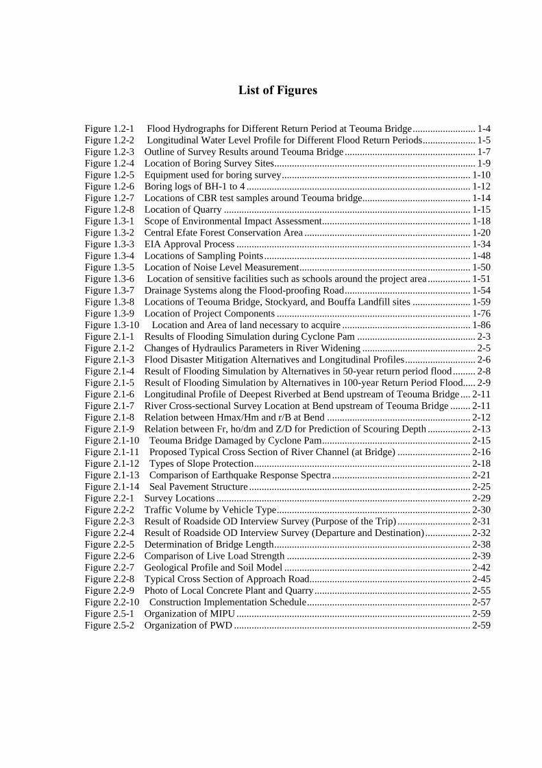
Figure 1.2-1 Flood Hydrographs for Different Return Period at Teouma Bridge
(3) Tidal Conditions at Teouma River Mouth
The following tidal information in Table 1.2-5 was obtained through the harmonic analysis using
observed data by tidal recorder at Port Vila with reference to “Basic Design Study Report on the Project
for Improvement of Port Vila Main Wharf in Public of Vanuatu, 2017, JICA”. In this study, Highest High
Water Level of +0.7 m above MSL (1.58 m) is adopted for an initial condition in hydraulic analysis.
Table 1.2-5 Harmonic Analysis Results on Tidal Data at Port Vila
Anharmonic Constant Height above Base
Level (m)
Height above Mean Sea
Level (m)
Nearly Highest High Water Level 1.58 +0.7
High Water Level Ordinary Spring Tide 1.33 +0.4
Mean Sea Level 0.88 0.0
Low Water Level Ordinary Spring Tide 0.44 -0.4
Nearly Lowest Low Water Level 0.19 -0.7
Base Level 0.00 -0.9
Source: Basic Design Study Report on the Project for Improvement of Port Vila Main Wharf in Public of Vanuatu, 2007, JICA
(4) Flood Profile and River Channel Carrying Capacity
Non-uniform flood profiles have been developed for different return period of flood using river
cross-sections and examining of river channel carrying capacity. Initial water level at river-mouth is set at
+0.7m above MSL and roughness coefficient of river channel is set at 0.035. Simulation results are shown
in Figure 1.2-2 and the followings are summary of particular features of flood carrying capacity of
Teouma River.
0
100
200
300
400
500
600
700
800
900
1000
1100
0.0
1.0
2.0
3.0
4.0
5.0
6.0
7.0
8.0
9.0
10.0
11.0
12.0
13.0
14.0
15.0
16.0
17.0
18.0
19.0
20.0
21.0
22.0
23.0
Flo
w (m
3/s
)
Time (Hour)
100-year
50-year
20-year
10-year
5-year
2-year

1-5
Source: JICA Survey Team
Figure 1.2-2 Longitudinal Water Level Profile for Different Flood Return Periods
1) Downstream of the Teouma Bridge
Baneful discharge is a little less than 100 m3/s equivalent to 5-year return period flood (120 m3/s) or
less.
2) Teouma Bridge Section
Since Teouma Bridge forms a man-made constriction, relatively rapid flow velocity and lowering of
flood water level occurs at the bridge section. Further it accelerates water level rising in the upstream for a
long distance in upstream.
3) Upstream of the Teouma Bridge
The flood carrying capacities in the upstream range from 120 to 250 m3/s (5- to 10-year return period),
excluding unstable segment of flood water level rising immediately upstream of the bridge due to
constriction of the channel.
This shows any flood exceeding 10-year return period will cause flooding in the upstream of the
bridge and inundation of Ring Road. The situation is even worse downstream as any flood exceeding 5-
year return period could cause inundation of Ring Road.
1.2.2 Topography and Geology
1.2.2.1 Topographical Survey
The scope and details of conducted topographical survey are as follow:
(1) River Survey
⚫ Benchmark installation: 2 points (TBM1 on the right bank side, TBM2 on the left bank side)
⚫ Longitudinal survey: 1 section from 1,600m upstream of the bridge to 4,940m downstream of the bridge
for a total of 6,540m.
⚫ Cross-section survey: 32 cross-sections with 200m interval and 100 m width
-2
-1
0
1
2
3
4
5
6
7
8
9
10
11
12
0 1000 2000 3000 4000 5000 6000
Wat
er L
evel
(M
SL)
Longitudinal Distance (m)
2-yr (20m3/s) 5-yr (120m3/s) 6-7yr程度 (150m3/s) 8-9yr程度 (200m3/s)
10-yr (250m3/s) 25-yr (420m3/s) 50-yr (720m3/s) 100-yr (1020m3/s)
Bed Level Left Bank Level Right Bank Level
Teouma Bridge

1-6
(2) Floodplain Survey
⚫ Benchmark installation: 2 points (TBM1 at the start point and TBM2 at the end point)
⚫ Reference point installation: 6 points (POLY1 to POLY6)
⚫ Longitudinal survey: 1 section from 320m upstream of bridge to 300m downstream of bridge for total
620m
⚫ River cross-sections: 17 cross-sections with 40m interval and 100m width
⚫ Road centerline survey: 1 survey line for 420m from each side of bridge, total of 840m, 20m interval
⚫ Road longitudinal survey: 1 section for 420m from each side of bridge, total of 840m, 20m interval)
The outline of surveying points is shown in the following Figure 1.2-3.

1-7
Source: JICA Survey Team
Figure 1.2-3 Outline of Survey Results around Teouma Bridge
"/"/
"/"/
"/"/
#*
#*
#*#*#*#*
#*#*
"/"/
"/"/
#*
#*
"/
"/"/
#*#*
"/
"/"/
"/
DDDDDDDDDDDDDDD
DDD
DDDDDDD
DDDDDDDDDDDDD
DDDDD
DDDDDDDDD
DDDDDDDDDDDD
DDDDDDDDDDDDDDDDDDDDDDDDDDDDDDDDDDDDDDDDDDDDDDDDDDDDDDDDDDD
DDDDDDDDDD
DDDDDDDDDDDDDDDDDDDDDDDDDDD
DDDDDDDDDDDDDDDDDDDDDD
DDDDDDDDDDDDDDDDDDDDDD
DD
DDDDD
DDDDDDDDDDDDDDDD
DDDDDD
DD
DD
DD
DD
DD
DD
DD
DD
DD
DD
DD
DD
DD
DD
DD
DD
DD
DD
DDDDDDDDDDDDDDDDDDDDDDDDDDDDDDDDDDDDDDDDDDDDDDDDDDDDDDDDDDDDDDDDDDDDDDDDDDDDDDDDDDDDDDDDDDDDDDDDDDDDDDDDDDDDDDDDDDDDDDDDDDDDDDDDDDDDDDDDDDDDDDDDDDDDDDDDDDDDDDDDDDDDDDDDDDDDDDDDDDDDDDDDDDDDDDDDDDDDDDDDDDDDDDDDDDDDDDDDDDDDDDDDDDDDDDDDDDDDDDDDD
"/"/
"/"/
"/"/
#*#*
#*#*#*#*#*#*
"/"/
"/"/
#*#*
"/
"/"/
#*#*
"/
"/"/
"/
DDDDDDDDDDDDDDD
DDDDDDDDDD
DDDDDDDDDDDDDDDDDD
DDDDDDDDD
DDDDDDDDDDDD
DDDDDDDDDDDDDDDDDDDDDDDDDDDDDDDDDDDDDDDDDDDDDDDDDDDDDDDDDDD
DDDDDDDDDDDDDDDDDDDDDDDDDDDDDDDDDDDDD
DDDDDDDDDDDDDDDDDDDDDD
DDDDDDDDDDDDDDDDDDDDDDDD
DDDDDDDDDDDDDDDDDDDDDDDDDDD DDDDDDDDDDDDDDDD
DDDDDDDDDDDDDDDD
DDDD
DDDDDDDDDDDDDDDDDDDDDD
DDDDDDDDDDDDDDDDDDDDDDD
DDDDDDDDDDDDDDDDDDDDDDD
DDDDDDDDDDDDDDDDDDDDDDDDDD
DDDDDDDDDDDDDDDDDDDDDDDDDDDDDD
DDDDDDDDDDDDDDDDDDDDDDDDDDDDDDDDDDDD
DDDDDDDDDDDDDDDDDDDDDDDDDDDDDDDDDDDDDDDDDDDDDDDDDDDDDDDDDDDDDDDDDDDDDDDDDDDDDDDDD
Scope of river longitudinal /
transection surveying
Scope of enlarged view
(lower figure)
Scope of longitudinal /
transection surveying

1-8
(3) Photos
Confirmation of surveying method
Confirmation of National Benchmark and Temporary Benchmark
Confirm reference point
Source: JICA Survey Team

1-9
1.2.2.2 Geological Survey (Boring Survey)
(1) Survey Location
Boring survey was conducted at four points (BH - 1 to 4) in order to grasp the ground conditions of
target bridge and revetment works. Locations of boring survey sites are shown in Figure 1.2-4 and Table
1.2-6 below.
Source: JICA Survey Team
Figure 1.2-4 Location of Boring Survey Sites
Table 1.2-6 Coordinates, elevation and drilling depth of each boring survey sites
ID
Coordinates
(latitude and longitude) Elevation
(m)
Drilling depth
(m) Latitude(°) Longitude(°)
BH-1 -17.76678 -168.38239 5.80 45.45
BH-2 -17.76670 -168.38258 5.80 37.50
BH-3 -17.76645 -168.38284 6.00 45.45
BH-4 -17.76600 -168.38226 5.50 20.00
Source: JICA Survey Team
(2) Equipment
The equipment shown in Table 1.2-7 is used for the boring survey.

1-10
Table 1.2-7 Boring Survey Equipment
Item Specifications
Drilling Machine Trailer mounted drilling machine (Rotary type)
Hole size φ=86mm
Sampler High Quality triple tube sampler
Raymond-type spoon sampler
Source: JICA Survey Team
Source: JICA Survey Team
Figure 1.2-5 Equipment used for boring survey
(3) Photos
Road maintenance for loading equipment
(BH-1,2)
Loading of boring equipment (BH-3)

1-11
Core removal operation Implementation of SPT
Example of acquired core Observation of core
Source: JICA Survey Team
(4) Result of Boring Survey
The boring survey of BH-1 to BH-4 was conducted from May to June 2018. The maximum depth of
drilling was -45.45m. Standard Penetration Tests (SPTs) are conducted every 1.5m. The boring logs are
shown in Figure 1.2-6. No rock stratum has been found in the drilling survey.

1-12
Source: JICA Survey Team
Figure 1.2-6 Boring logs of BH-1 to 4
BH-1 BH-2 BH-3 BH-4
EL(m)Depth
(m)
SPT
N-
Value
Graphic
Log
Depth
(m)
SPT
N-
Value
Graphic
Log
Depth
(m)
SPT
N-
Value
Graphic
Log
Depth
(m)
SPT
N-
Value
Graphic
Log
7
6 EL=5.8m EL=5.8m EL=6.0m
0 - Core Loss 0 - Core Loss 0 - Core Loss EL=5.5m
5 - Colluvium - Core Loss - Core Loss 0 - Core loss
1 - Silt 1 - Core Loss 1 - Core Loss - Core loss
4 4 Sand - Core Loss 3 Core Loss 1 - Sand Organic
2 - Sand 2 - Core Loss 2 - Core Loss 0 Sand
3 - Core Loss - Core Loss - Core Loss 2 - Core loss
3 6 Sand 3 2 Silt 3 2 Core Loss - Sand
2 - Core Loss - Core Loss - Core Loss 3 1 Sand
4 - Sand 4 - Silt 4 - Core Loss - Sand
1 6 Sand+Gravel 9 Sand+Gravel 1 Core Loss 4 - Sand+Gravel
5 - Sand 5 - Sand 5 - Core Loss 1 Sand+Gravel
0 - Sand+Gravel - Sand+Gravel - Core Loss 5 - Core loss
6 10 Sand 6 9 Sand+Gravel 6 15 Sand Organic - Core loss
-1 - Sand - Sand+Gravel - Core Loss 6 17 Sand Organic
7 - Sand 7 - Sand+Gravel 7 - Silt Organic - Core loss
-2 9 Sand 5 Silt 12 Silt 7 - Silt
8 - Sand 8 - Silt 8 - Core Loss 7 Sand Wood/Shell
-3 - Sand - Sand - Core Loss 8 - Sand Wood/Shell
9 7 Sand 9 19 Sand 9 17 Sand - Sand Wood/Shell
-4 - Sand - Sand - Core Loss 9 11 Sand Wood/Shell
10 - Sand 10 - Sand 10 - Sand - Sand Wood/Shell
-5 17 Sand 16 Sand 6 Sand Organic 10 - Sand Wood/Shell
11 - Sand 11 - Sand 11 - Core Loss 7 Sand Wood/Shell
-6 - Sand - Sand - Sand 11 - Silt Shell
12 15 Sand 12 9 Sand 12 17 Sand - Silt Shell
-7 - Sand - Sand - Sand 12 1 Silt Shell
13 - Sand 13 - Sand 13 - Sand - Silt Shell
-8 15 Sand 14 Sand 12 Sand 13 - Silt Shell
14 - Sand 14 - Sand Organic/Shell 14 - Silt Organic/Shell 1 Silt Shell
-9 - Sand - Sand Organic/Shell - Silt Organic/Shell 14 - Core loss
15 14 Sand 15 10 Sand Organic/Shell 15 4 Silt Organic/Shell - Silt Organic
-10 - Silt Wood - Silt Organic/Shell - Silt Organic/Shell 15 7 Silt Organic/Shell
16 - Silt Organic/Shell 16 - Silt Organic 16 - Silt Organic/Shell - Core loss
-11 10 Silt Organic/Shell 4 Silt Organic 0 Silt Organic/Shell 16 - Silt Organic/Shell
17 - Silt Organic/Shell 17 - Core Loss 17 - Silt Organic/Shell 8 Silt Organic/Shell
-12 - Silt Organic/Shell - Silt - Silt Organic/Shell 17 - Sand
18 1 Silt Organic/Shell 18 4 Silt 18 0 Silt Organic/Shell - Silt Organic/Shell
-13 - Silt Organic/Shell - Core Loss - Silt Organic/Shell 18 0 Silt Organic/Shell
19 - Silt Organic/Shell 19 - Core Loss 19 - Silt Organic/Shell - Core loss
-14 6 Silt Organic/Shell 4 Silt Organic/Shell 0 Silt Organic/Shell 19 - Silt Organic
20 - Core Loss 20 - Silt Organic/Shell 20 - Silt Organic/Shell 2 Silt Shell
-15 - Silt Organic/Shell - Silt Organic/Shell - Silt Organic/Shell 20
21 0 Core Loss 21 0 Silt Organic/Shell 21 8 Silt Organic/Shell
-16 - Silt Organic/Shell - Silt Organic/Shell - Silt Organic/Shell
22 - Silt Organic 22 - Core Loss 22 - Silt Organic/Shell
-17 1 Silt 4 Silt Organic 4 Sand Organic/Shell
23 - Core Loss 23 - Silt Organic 23 - Sand Organic/Shell
-18 - Silt - Silt Organic - Sand Organic/Shell
24 14 Silt Wood 24 5 Core Loss 24 4 Sand Organic/Shell
-19 - Silt - Core Loss - Sand Organic/Shell
25 - Silt 25 - Silt 25 - Sand Organic/Shell
-20 21 Sand 6 Silt 2 Sand Organic/Shell
26 - Sand 26 - Sand Shell 26 - Core Loss
-21 - Sand - Sand Shell - Core Loss Legend
27 29 Sand 27 21 Sand Shell 27 11 Sand Shell Core loss
-22 - Sand - Sand Shell - Sand Shell Colluvium
28 - Sand 28 - Sand Shell 28 - Sand Shell Sand+Gravel
-23 12 Sand 23 Sand Shell 19 Sand Shell Sand
29 - Sand 29 - Sand Shell 29 - Sand Shell Sand Wood/Organic
-24 - Sand - Sand Shell - Sand Shell Silt
30 12 Sand 30 17 Sand Shell 30 11 Sand Shell Silt Wood/Organic
-25 - Sand - Silt - Sand Shell Goundwater level
31 - Sand 31 - Silt 31 - Sand Shell
-26 12 Sand 17 Sand 0 Sand Shell
32 - Sand 32 - Sand 32 - Core Loss
-27 - Sand - Core Loss - Core Loss
33 7 Sand 33 - Sand Shell 33 11 Sand Organic/Shell
-28 - Sand - Sand Shell - Sand Organic/Shell
34 - Sand 34 - Core Loss 34 - Sand Organic/Shell
-29 22 Sand Shell - Sand 13 Sand Wood
35 - Sand Shell 35 - Sand 35 - Sand Shell
-30 - Sand - Core Loss - Sand Shell
36 18 Sand 36 - Core Loss 36 18 Sand Shell
-31 - Sand - Sand Wood - Sand Shell
37 - Sand 37 37 - Sand Shell
-32 1 Sand 16 Sand Shell
38 - Sand 38 38 - Sand Shell
-33 - Sand - Sand Shell
39 12 Sand 39 10 Sand Shell
-34 - Sand - Silt Wood
40 - Sand 40 - Silt Wood
-35 1 Sand 23 Silt Wood
41 - Sand 41 - Silt Wood
-36 - Sand - Silt Wood
42 1 Sand Shell 42 21 Sand Shell
-37 - Sand Shell - Sand Shell
43 - Sand Shell 43 - Sand Shell
-38 15 Sand Shell 10 Sand Shell
44 - Sand Shell 44 - Sand Shell
-39 - Sand Shell - Sand Shell
45 12 Sand Shell 45 9 Sand Shell
-40
Soil Description
2018/5/312018/6/1
Soil Description
2018/6/1
Soil Description
2018/6/1
Soil Description

1-13
1.2.2.3 Geological Survey (Material Testing)
(1) Laboratory Tests
All tests were conducted at Material Laboratory under Public Works Department, Ministry of
Infrastructure and Public Utilities, Port Vila. A few tests were conducted at the Japan Road Contractors
Association Road Test Laboratory as the tests could not be conducted at PWD material laboratory. The test
items are shown in Table 1.2-8.
Table 1.2-8 Material test items at each laboratory
Material Laboratory of PWD Road Test Laboratory in Japan
Bulk Density of Aggregate Sieving test of aggregate
Aggregate PSD Organic impurity test of aggregate
Flakiness Index Stability test of aggregate with sodium sulfate
Particle Density and Water Absorption Alkali silica reactivity test of aggregate
(chemical method)
Los Angeles Value Aggregate sieving test
Atterberg Limits Organic impurity test of fine aggregate
Particle Size Distribution Stability test of aggregate with sodium sulfate
Moisture Content Chloride content test
Apparent specific gravity test
Water absorption test
Compressive strength test
Source: JICA Survey Team
Results of the material tests are summarized in the following Table 1.2-9, Table 1.2-10 and Table
1.2-11.
Table 1.2-9 Test results at the Japan Road Contractors Association Road Test Laboratory
Coarse
aggregate
Sieving test of aggregate Loss mass fraction 0.4% (Less than 12%)
Alkali silica reactivity test of
aggregate (chemical method)
Harmless
Silt content 0.9% (Less than 1%)
Organic impurity test Colorless
Fine
aggregate
Sieving test of aggregate Loss mass fraction 0.9% (Less than 10%)
Silt content 18.9% (Less than 5%)
Organic impurity test Colorless
Chloride test 0.001%
Rubble
(Semi-hard
stone)
Apparent specific gravity test 2.293 g/cm3 (Semi-hard stone)
Water absorption test 1.553 % (Hard stone)
Compressive strength test 2,908 N/cm2 (Semi-hard stone)
Source: JICA Survey Team
Table 1.2-10 Test results at Material Laboratory of PWD
Coarse
aggregate
Apparent specific gravity test 2.43 (g/cm3)
Water absorption test 6.0% (Less than 3.0%)
Wear test 33% (Less than 30%:Asphalt)
Source: JICA Survey Team
1-14
Table 1.2-11 Classification based on compressive strength of Rubble (JIS5006)
Type Compressive Strength
N/cm2
Reference value
Water absorption rate Apparent specific
gravity (g/cm3)
Hard Stone More than 4903.3 Less than 5% About 2.7 - 2.5
Semi-Hard Stone Less than 4903.3
More than 980.66
More than 5%
Less than 10%
About 2.5 - 2.0
Soft stone Less than 980.66 More than 10% Less than 2.0
Source: JIS5006
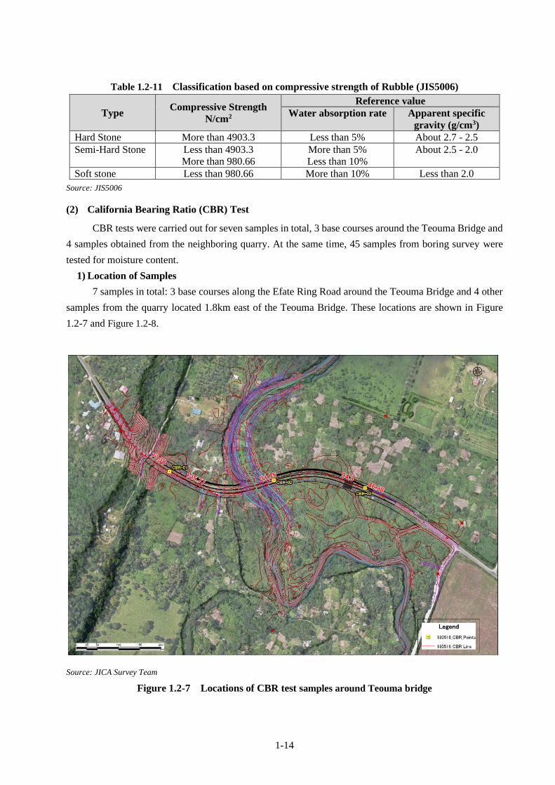
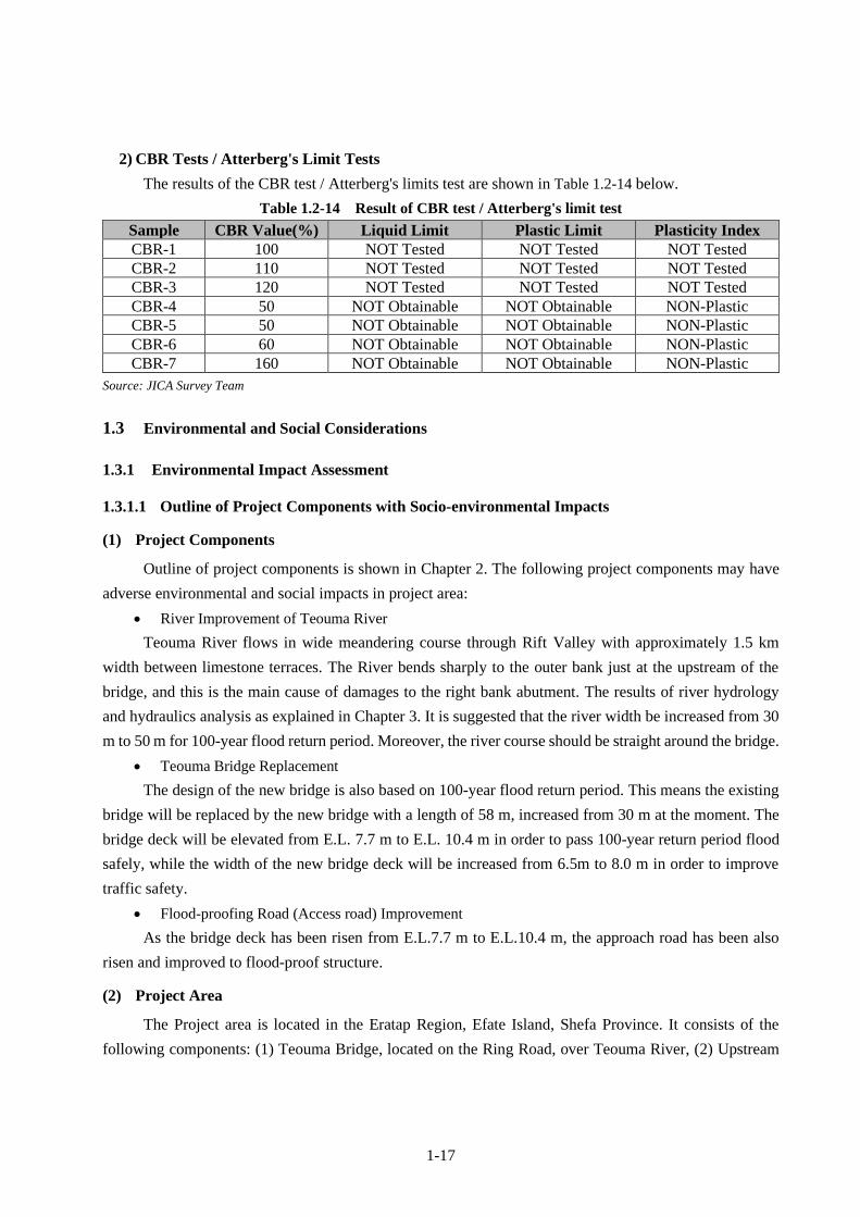
(2) California Bearing Ratio (CBR) Test
CBR tests were carried out for seven samples in total, 3 base courses around the Teouma Bridge and
4 samples obtained from the neighboring quarry. At the same time, 45 samples from boring survey were
tested for moisture content.
1) Location of Samples
7 samples in total: 3 base courses along the Efate Ring Road around the Teouma Bridge and 4 other
samples from the quarry located 1.8km east of the Teouma Bridge. These locations are shown in Figure
1.2-7 and Figure 1.2-8.
Source: JICA Survey Team
Figure 1.2-7 Locations of CBR test samples around Teouma bridge
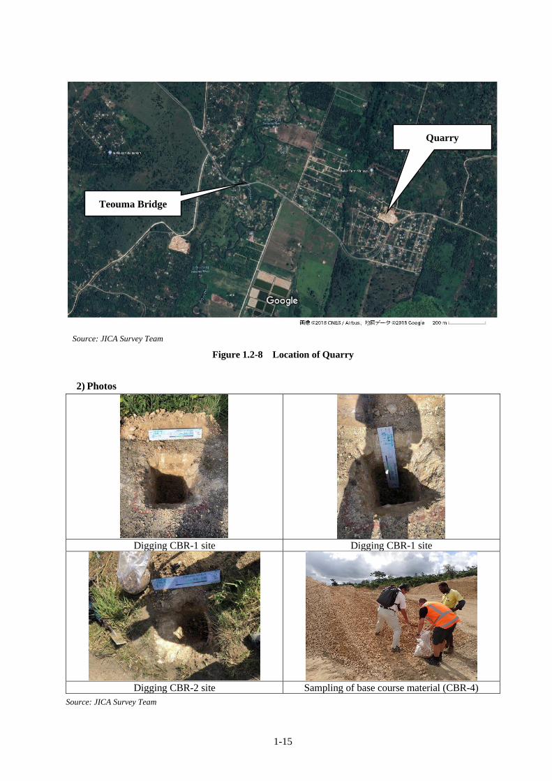
1-15
Source: JICA Survey Team
Figure 1.2-8 Location of Quarry
2) Photos
Digging CBR-1 site Digging CBR-1 site
Digging CBR-2 site Sampling of base course material (CBR-4)
Source: JICA Survey Team
Teouma Bridge
Quarry

1-16
3) Results
a) Hydration Tests
Results of the moisture content tests are shown in Table 1.2-12 below.
Table 1.2-12 Result of Hydration Tests
ID Sample
location
Sample
Depth (m)
Moisture
Content (%) ID
Sample
location
Sample
Depth (m)
Moisture
Content (%)
1 BH-1 0.00 47.2 27 BH-3 12.00 46.4
2 BH-1 7.95 92.5 28 BH-3 16.50 88.0
3 BH-1 9.00 49.2 29 BH-3 19.50 34.8
4 BH-1 15.45 89.0 30 BH-3 21.00 40.4
5 BH-1 16.50 66.0 31 BH-3 22.50 75.5
6 BH-1 25.50 51.5 32 BH-3 30.00 69.0
7 BH-1 24.50 64.5 33 BH-3 36.00 42.2
8 BH-1 27.45 53.0 34 BH-3 39.00 64.5
9 BH-1 30.00 64.5 35 BH-3 45.00 58.5
10 BH-1 34.50 63.0 36 BH-4 1.50 67.0
11 BH-1 39.00 67.5 37 BH-4 1.95 40.6
12 BH-1 40.50 71.0 38 BH-4 3.45 76.0
13 BH-2 3.00 76.0 39 BH-4 4.50 43.2
14 BH-2 4.95 54.0 40 BH-4 7.50 74.5
15 BH-2 7.50 72.0 41 BH-4 7.95 81.0
16 BH-2 9.45 53.5 42 BH-4 12.00 76.0
17 BH-2 10.95 62.5 43 BH-4 12.50 94.5
18 BH-2 15.45 85.0 44 BH-4 15.45 93.0
19 BH-2 19.50 74.5 45 BH-4 16.50 87.0
20 BH-2 19.95 82.0 46 CBR-1 Base course 14.3
21 BH-2 28.95 64.5 47 CBR-2 Base course 11.7
22 BH-2 30.00 66.5 48 CBR-3 Base course 10.4
23 BH-2 31.50 68.5 49 CBR-4 Base course 12.4
24 BH-3 6.00 54.0 50 CBR-5 Embankment fill 11.7
25 BH-3 7.50 60.5 51 CBR-6 Base course 10.9*
26 BH-3 10.00 39.2 52 CBR-7 Base course 11.8*
*Field moisture content from CBR test results
Source: JICA Survey Team
1) Compaction Tests
The results of the compaction test are shown in Table 1.2-13 below.
Table 1.2-13 Compaction Tests
Sample Maximum Dry Density (t/m3) Optimum Moisture Content (%)
CBR-1 1.78 15.5
CBR-2 1.97 11.5
CBR-3 2.01 11.0
CBR-4 1.93 15.5
CBR-5 1.90 15.5
CBR-6 1.96 14.0
CBR-7 1.90 13.0
Source: JICA Survey Team
1-17
2) CBR Tests / Atterberg's Limit Tests
The results of the CBR test / Atterberg's limits test are shown in Table 1.2-14 below.
Table 1.2-14 Result of CBR test / Atterberg's limit test
Sample CBR Value(%) Liquid Limit Plastic Limit Plasticity Index
CBR-1 100 NOT Tested NOT Tested NOT Tested
CBR-2 110 NOT Tested NOT Tested NOT Tested
CBR-3 120 NOT Tested NOT Tested NOT Tested
CBR-4 50 NOT Obtainable NOT Obtainable NON-Plastic
CBR-5 50 NOT Obtainable NOT Obtainable NON-Plastic
CBR-6 60 NOT Obtainable NOT Obtainable NON-Plastic
CBR-7 160 NOT Obtainable NOT Obtainable NON-Plastic
Source: JICA Survey Team
1.3 Environmental and Social Considerations
1.3.1 Environmental Impact Assessment
1.3.1.1 Outline of Project Components with Socio-environmental Impacts
(1) Project Components
Outline of project components is shown in Chapter 2. The following project components may have
adverse environmental and social impacts in project area:
• River Improvement of Teouma River
Teouma River flows in wide meandering course through Rift Valley with approximately 1.5 km
width between limestone terraces. The River bends sharply to the outer bank just at the upstream of the
bridge, and this is the main cause of damages to the right bank abutment. The results of river hydrology
and hydraulics analysis as explained in Chapter 3. It is suggested that the river width be increased from 30
m to 50 m for 100-year flood return period. Moreover, the river course should be straight around the bridge.
• Teouma Bridge Replacement
The design of the new bridge is also based on 100-year flood return period. This means the existing
bridge will be replaced by the new bridge with a length of 58 m, increased from 30 m at the moment. The
bridge deck will be elevated from E.L. 7.7 m to E.L. 10.4 m in order to pass 100-year return period flood
safely, while the width of the new bridge deck will be increased from 6.5m to 8.0 m in order to improve
traffic safety.
• Flood-proofing Road (Access road) Improvement
As the bridge deck has been risen from E.L.7.7 m to E.L.10.4 m, the approach road has been also
risen and improved to flood-proof structure.
(2) Project Area
The Project area is located in the Eratap Region, Efate Island, Shefa Province. It consists of the
following components: (1) Teouma Bridge, located on the Ring Road, over Teouma River, (2) Upstream

1-18
and downstream river banks from the bridge, and (3) Access road (400 m in the east and 300 m in the west
side of the bridge).
(3) Area for Studying Environmental Impact Assessment
Area of the Environmental Impact Assessment is summarized in Figure 1.3-1 below. This area can
be divided to two segments which would be affected by the project: (1) the construction segment including
the above mentioned three components and (2) the floodplain segment in the east side of the river and
downstream of the bridge.
Source: JICA Survey Team
Figure 1.3-1 Scope of Environmental Impact Assessment
Construction Area
Improvement of Teouma River
• River improvement (250 m in the upstream and 110 m in the downstream of the bridge)
✓ River widening (from 30 m to 50 m)
✓ River course straightening (around the bridge)
✓ Riverbank protection
Replacement of the Teouma Bridge
• Replacement of the Teouma Bridge
✓ Elevation of bottom of the girder: elevated from E.L. 6.8 m to E.L. 8.9 m
✓ Bridge length: from 30 m to 58 m
✓ Number of spans: from 1 to 2
✓ Effective width: from 6.5 m to 9.5 m
• Construction of detour and a temporary bridge
Improvement of Flood-proofing Road (access road)
• Elevation of the road surface: from E.L. 7.7 m to E.L. 10.4 m

1-19
• Flood prevention measures: installation of drainage system (box culvert and trapezoidal drainage)
Other Areas
• Floodplain in the east side of Teouma River (elevation of the access road will increase flooding area
in the north of road)
• Downstream of the construction area (the construction work could affect water quality, ecosystem,
and downstream hydrology)
1.3.1.2 Current Socio-environmental Conditions
(1) Natural Conditions
1) Topography and Geology
Efate Island has a formation of raised limestone terraces and tuff rock. Teouma River has 86 km2 of
catchment area (at Teouma Bridge) and it is the largest catchment in Vanuatu. The river originates from
McDonald Mountain at the elevation of 662 m. It meanders downstream towards the Rift Valley with width
of approximately 1.5 km, sandwiched by limestone terraces.
2) Climate
Vanuatu climate is tropical marine climate with uniform temperature, high humidity and large
amount of rainfall. Wind speed is moderate (9.3 km/hr to 18.5 km/hr) except during tropical storms. The
climate of Vanuatu can be categorized by two seasons: cold (dry) season from May to October and hot
(wet/cyclone) season for the rest of year. Temperature is rather high in February and relatively lower in
August. Average annual temperature in Port Vila is at about 25°C, with average monthly maximum
temperature in February is about 27°C and average monthly minimum temperature in August is about 23°C.
Average annual rainfall is about 2,100 mm.
(2) Biological Conditions
The project area is located just outside of the Central Efate Forest Conservation area, as shown in the
following Figure 1.3-2. The area along Teouma River is well vegetated, though modified by secondary
vegetation (shrub). The diversity of freshwater fauna is low due to development activities.

1-20
Source: The World Database on Protected Areas (WDPA)
Figure 1.3-2 Central Efate Forest Conservation Area
The Terrestrial Flora survey was conducted along the Ridge and Cliff of Teouma River along with
Freshwater Fauna survey inside the project area. Results of these surveys are shown in Table 1.3-1, Table
1.3-2 and Table 1.3-3 below. The survey team has not found any particular species necessary to be protected.
Table 1.3-1 Terrestrial Flora
(Along the Ridge and Cliff of the Teouma-Etas Escarpment)
Species Name Bislama Name Native or Endemic Introduced or Invasive
Antiaris toxicaria Melektri Native
Coffa arabica Kofi Introduced
Hibiscus tiliaceus Burao Native
Syzygium kajewskii Wael Nakavika Endemic
Endospermum medulosum Waetwud Native cultivated
Alangium vitiensis Native
Macaranga dioica Navenu
Veitchia montgomeryana Pamtri Endemic
Ficus subcordata Big rus Nabanga Native
Adenanthera pavonina Bisa Native
Ficus virgata Smol nabanga Native
Ventilago neocaledonica Pen blong mat Native
Myristica fatua Wael natongtong Native
Pangium edule Navange Native
Dysoxylum amoroides Stinkwud
Anthocarapa nitidula Native
Dracontomelon vitiensis Nakatambol Native
Calamus vanuatensis Rattan Endemic
Chisoseton rexde Big fruit stinkwud Endemic
Merremia peltata Native
Source: JICA Study Team

1-21
Table 1.3-2 Terrestrial Flora (Secondary Forest on Alluvial Soil)
Species Name Bislama Name Native or Endemic Introduced or Invasive
Merremia peltata Big lif rop Invasive
Mikania micrantha Mael minit Invasive
Panicum maximum Wael lemon grass Invasive
Saccharum spp Wael naviso Native
Glyricidia spp Glyricidia Introduced cultivated
Elephant grass Invasive
Pipturus argenteus Nadamal Native
Trema Orientalis Native
Macaranga tanneries Waet Navenu Native
Leucaena ieucocephala Kasia Invasive
Musa ssp Banana Introduced & cultivated
Cocos nucifera Kokonas Naturalised Cultivated
Bambusa Vulgaris Bambu Naturalised
Terminalia catappa Natapoa Native
Ricinus communis Kasrael Invasive
Samonea saman Rentri Invasive
Ficus subcordata Big rus Nabanga Native
Carica papaya Popo Introduced
Canarium indicum Nangai Naturalise Cultivated
Cordia Alliodora Kodia Invasive
Casuarine equisetifolia Oktri Native Cultivated
Sweetenia macrophylla Introduced & Cultivated
Inocarpus fagifer Namambe Naturalised Cultivated
Dendrocnide harveyi Waet Nagalat Native
Syzygium malaccensis Nakavika Native
Spondias dulcis Naus Native
Tamarindus indica Tamarin Introduced & Cultivated.
Manihot Attillis Maniok Cultivated
Zea mays Kon Cultivated
Artocarpus altilis Bredfrut Cultivated
Zea mays Kon Cultivated
Artocarpus altilis Bredfrut Cultivated
Dioscorea alata Yam Naturalised
Dioscorea nummularia Wael yam Native
Heliconia indica Lif Laplap Native
Hibiscus tiliaceus Burao Native
Grewia maloccoca Tri blong long tel Native
Corida variegaa Nasasa Native
Polyscias fruticose Nalalas Native
Coryline fruticosa Nagaia Native
Source: JICA Study Team
Table 1.3-3 Freshwater Fauna
English Name Scientific Name Abundance
Prawn Macrobracium formosense 15
Caridina brevicarpalis 5
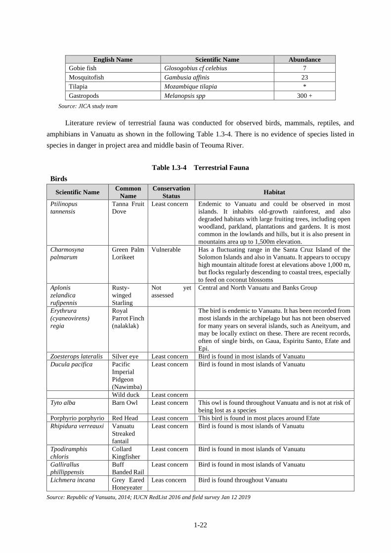
1-22
English Name Scientific Name Abundance
Gobie fish Glosogobius cf celebius 7
Mosquitofish Gambusia affinis 23
Tilapia Mozambique tilapia *
Gastropods Melanopsis spp 300 +
Source: JICA study team
Literature review of terrestrial fauna was conducted for observed birds, mammals, reptiles, and
amphibians in Vanuatu as shown in the following Table 1.3-4. There is no evidence of species listed in
species in danger in project area and middle basin of Teouma River.
Table 1.3-4 Terrestrial Fauna
Birds
Scientific Name Common
Name
Conservation
Status Habitat
Ptilinopus
tannensis
Tanna Fruit
Dove
Least concern Endemic to Vanuatu and could be observed in most
islands. It inhabits old-growth rainforest, and also
degraded habitats with large fruiting trees, including open
woodland, parkland, plantations and gardens. It is most
common in the lowlands and hills, but it is also present in
mountains area up to 1,500m elevation.
Charmosyna
palmarum
Green Palm
Lorikeet
Vulnerable Has a fluctuating range in the Santa Cruz Island of the
Solomon Islands and also in Vanuatu. It appears to occupy
high mountain altitude forest at elevations above 1,000 m,
but flocks regularly descending to coastal trees, especially
to feed on coconut blossoms
Aplonis
zelandica
rufipennis
Rusty-
winged
Starling
Not yet
assessed
Central and North Vanuatu and Banks Group
Erythrura
(cyaneovirens)
regia
Royal
Parrot Finch
(nalaklak)
The bird is endemic to Vanuatu. It has been recorded from
most islands in the archipelago but has not been observed
for many years on several islands, such as Aneityum, and
may be locally extinct on these. There are recent records,
often of single birds, on Gaua, Espiritu Santo, Efate and
Epi.
Zoesterops lateralis Silver eye Least concern Bird is found in most islands of Vanuatu
Ducula pacifica Pacific
Imperial
Pidgeon
(Nawimba)
Least concern Bird is found in most islands of Vanuatu
Wild duck Least concern
Tyto alba Barn Owl Least concern This owl is found throughout Vanuatu and is not at risk of
being lost as a species
Porphyrio porphyrio Red Head Least concern This bird is found in most places around Efate
Rhipidura verreauxi Vanuatu
Streaked
fantail
Least concern Bird is found is most islands of Vanuatu
Tpodiramphis
chloris
Collard
Kingfisher
Least concern Bird is found in most islands of Vanuatu
Gallirallus
phillippensis
Buff
Banded Rail
Least concern Bird is found in most islands of Vanuatu
Lichmera incana Grey Eared
Honeyeater
Leas concern Bird is found throughout Vanuatu
Source: Republic of Vanuatu, 2014; IUCN RedList 2016 and field survey Jan 12 2019

1-23
Mammals
Scientific
Name
Common
Name
Conservation
Status Habitat
Fruit bats
(Pteropodidae)
Notopteris
macdonaldi
Fijian
Blossom-bat
Vulnerable Restricted to Fiji and Vanuatu. Observers in Efate and other
islands. Roosts in caves and forages in lowland forests and
intermediate altitude vegetation.
Insectivorous
bats
Miniopterus
tristis
Great Bent-
winged
Bat
Least Concern A native species, known from the islands of Espiritu Santo
and Efate in Vanuatu. Roosts only in caves and forages in
agricultural areas and disturbed lowland forest near sea
Level
Miniopterus
australis
Little Long-
fingered
Bat
Least concern Native to Vanuatu, this bat is found roosting in colonies in
caves and tunnels, and may also be found roosting in tree
holes. It forages for insects in rainforest, Meleleuca swamps
and dry sclerophyll forests. Unlikely to be affected by this
proposal
Source: IUCN RedList and field survey of Jan 12 2019
Reptiles and amphibians
Scientific
Name
Common
Name
Conservation
Status Habitat
Amphibia
Litoria aurea Green and
golden
bell frog
Vulnerable
This frog was introduced to Vanuatu in the 1960s and is native
to Australia. It is found in Efate, Malekula and Santo islands.
The natural habitat requirements of the species have proved
difficult to define because it has been associated with almost
every type of water body except fast-flowing streams. There
also appears to be some confusion over whether or not forested
habitats are utilized by the species (Hero et al 2004).
Reptilia
Brachylophus
bulabula
Banded
Iguana
Endangered Banded Iguanas are native to Fiji and were introduced to
Vanuatu by a reptile dealer in the 1960s. It is found on Efate
Island.
The Fiji Banded Iguana lives in both wet and dry forest, but
wetter forests contain preferred plant species. Iguanas are
sometimes found in marginal habitats of nonnative plants,
native hibiscus, and degraded forest around resorts and also
along ocean margins, but always where trees are at least six
meters in height (Fisher et al 2012)
Gehyra
oceanica
Oceanic
Gecko
Least
concern
This is a nocturnal, arboreal gecko. It occurs in primary and
secondary forested habitats and coastal thickets. It also occurs
in edificarian habitats such as rural gardens and urban areas and
many populations are commensal with humans (Fisher et al
2015). IT is known to occur on Efate Island.
HeMIPU
DPWactylus
frenatus
Common
House
Gecko
Least
concern
This gecko was introduced to Vanuatu. It is a nocturnal species
which is found on boulders, beneath rocks or rotting logs, on
trees, and, most commonly on buildings.
This species is found in both villages and large urban areas; it
is usually found close to electric lights at dusk. In addition, this
species also occurs in a diverse range of habitats, including rain
forests, savannahs, and deserts (Ota and Whitaker 2010). This
species is found on Efate Island.
Lepidodactylus Vanuatu Least Endemic to Vanuatu, this gecko is known from Efate, Espiritu

1-24
Scientific
Name
Common
Name
Conservation
Status Habitat
vanuatuensis
Gecko concern
Santo and Anatom Islands. It is likely, however, to occur on all
main islands (Hamilton et al 2013).
Emoia
nigromarginata
Vanuatu
Silver
Vineskink
Least
Concern
Endemic to Vanuatu, it has been recorded from Efate Island,
Pentecost Island, Malakula Island, Espiritu Santo Island, and
Ambrym Islands, although it is possible that this species is
limited to Efate Island and specimens from other islands may
represent different species.
This is an arboreal species, found in areas covered by seral or
climax forest, and to a lesser extent, in areas with reduced tree
cover such as strand forest, partly cleared forest, tree-studded
pasture
Emoia sanfordi Vanuatu
Green
Tree Skink
Least
Concern
Endemic to Vanuatu, this skink is found from the Torres Islands
south to Efate. This is a strongly arboreal species, and can be
found in overgrown coconut plantations, primary forest,
secondary forest, rural gardens, trees within villages (Harlow
2013).
Lipinia noctua Moth Skink Not yet
assessed
An arboreal skink that occurs in Santo, Malo, Aore, Pentecost,
Malakula, Ambrym, Epi, Efate, Tanna, and Anatom.
(Reptiledatabase 2016)
Candoia
carinata
Pacific Boa
Constrictor
Least concern Found throughout Melanesia and in Vanuatu it is probably
introduced
Candoia
carinata
paulsoni
White
bellied
brown
snake
Least concern Snake is found in Efate and other islands
Source: IUCN Redlist, www.iucnredlist.org/ and field survey of Jan 12 2019
(3) Local Livelihood
As it shown in the Table 1.3-5 below, one-third of households in Eratap are depending to fish, crops,
and handicraft as their main source of income.
Table 1.3-5 Main source of income by region: Number of households and percentage
Region
Main Source of household income (household number)
Wages/
salary Landlord Remittances
Rent
House
Sale of
fish/crops/
handicrafts
Individual
business Others None
Vanuatu 22,413 185 5,688 1,046 33,304 12,894 3,850 535
Shefa 14,060 68 1,577 762 6,735 4,578 819 74
Port Vila 9,810 21 580 638 1,496 2,027 148 20
Eratap 767 11 93 7 682 462 20 2
Region
Main Source of household income (household %)
Wages/
salary Landlord Remittances
Rent
House
Sale of
fish/crops/
handicrafts
Individual
business Others None
Vanuatu 28% 0% 7% 1% 42% 16% 5% 1%
Shefa 49% 0% 5% 3% 23% 16% 3% 0%
Port Vila 67% 0% 4% 4% 10% 14% 1% 0%
Eratap 38% 1% 5% 0% 33% 23% 1% 0%
Source: 2016 Post Pam Mini Census Report

1-25
(4) Poverty
Consumption-based poverty level of Vanuatu is 12.3% that is not high, but the level varies widely
regionally. The poverty headcount rates are higher in North Malekula, Maewo, Pentecost and Tanna, and
lower in prime agricultural areas of Santo and parts of Ambae and Ambrym.
The household well-being indicators such as poverty headcount ratio in Eratap region along with
Port Villa are shown in the following Table 1.3-6.
Table 1.3-6 Household Well-being Indicators
Area
Council
Number of
households
Poverty
headcount
ratio
Distribution
of the poor
Population
density
(per km2)
Average
monthly
consumption
(PCAE)
GINI
coefficient
The inequality
ratio (the
90th/10th
percentile ratio)
VANUATU 47,373 12.3% N/A 18.7 19,089 0.351 4.72
SHEFA 6,875 13.0% 14.2% 22.8 19,112 0.400 5.74
Port Villa 9,055 18.4% 29.6% 1,803.2 4,163 0.340 4.54
Eratap 721 3.1% 0.4% 51.5 3 1,890 0.399 5.83
Source: Population and Housing Census, 2009 and Household Income and Expenditure Survey, 2010
(5) Social Infrastructures
1) Source of Drinking Water
The sources of drinking water for households in the Eratap region are shown in the following Table
1.3-7 by number of households and percentage.
Table 1.3-7 Main source of drinking water (Number of households and percentage)
Region
Total
Households
(Number)
Pipe Rainwater Bottled
water from
shops
Surface
water
Ground-
water Other
Private Shared Village
Stand Private Shared
Vanuatu 55,285 9,226 16,373 2,345 10,385 9,743 314 4,502 2,203 194
Shefa 19,913 5,627 6,792 420 3,175 2,377 248 449 681 144
Port Vila 10,965 4,178 5,470 147 438 295 170 40 210 17
Eratap 1,293 253 47 8 497 188 19 96 108 77
Region
Total
Households
(Percentage)
Pipe Rainwater Bottled
water from
shops
Surface
water
Ground-
water Other
Private Shared Village
Stand Private Shared
Vanuatu 100% 17% 30% 4% 19% 18% 1% 8% 4% 0%
Shefa 100% 28% 34% 2% 16% 12% 1% 2% 3% 1%
Port Vila 100% 38% 50% 1% 4% 3% 2% 0% 2% 0%
Eratap 100% 20% 4% 1% 38% 15% 1% 7% 8% 6%
Source: 2016 Post Pam Mini Census Report
Then, the alternative sources of drinking water in the Eratap region are shown in the following Table 1.3-8.
1-26
Table 1.3-8 Household by alternative source of drinking water by region (only private houses)
Region
Total
Households
(Number)
Pipe Rainwater Bottled
water from
shops
Surface
water
Ground-
water Other
Private Shared Village
Stand Private Shared
Vanuatu 1,949 2,581 1,842 2,816 758 4,358 834 6,259 11,248 4,397
Shefa 742 904 722 1,556 298 1,806 355 4,578 1,591 1,115
Port Vila 265 177 2 890 108 909 45 3,552 79 56
Eratap 55 111 71 114 10 95 13 225 321 211
Region
Total
Households
(Percentage)
Pipe Rainwater Bottled
water from
shops
Surface
water
Ground-
water Other
Private Shared Village
Stand Private Shared
Vanuatu 3.5% 4.7% 3.3% 5.1% 1.4% 7.9% 1.5% 11.3% 20.3% 8.0%
Shefa 3.7% 4.5% 3.6% 7.8% 1.5% 9.1% 1.8% 23.0% 8.0% 5.6%
Port Vila 2.4% 1.6% 0.0% 8.1% 1.0% 8.3% 0.4% 32.4% 0.7% 0.5%
Eratap 4.3% 8.6% 5.5% 8.8% 0.8% 7.3% 1.0% 17.4% 24.8% 16.3%
Source: 2016 Post Pam Mini Census Report
It can be said local people depend on river and stream water as the sources of drinking water on the
Efate Island. Judging from the observation at the Teouma Bridge, where local people often fetch water and
wash clothes in the project area, the water of Teouma River is the most important water resources for
domestic use.
2) Teouma River Water Use
An interview survey has been conducted, targeting local people who came to the bridge to fetch water
or to do laundry. Outline and the result of the survey are summarized in the following:
Outline of the Interview Survey
Target: Local people who visit the Teouma Bridge to fetch water and wash clothes
Purpose: To understand Teouma River water use and users
Survey method: Interview survey
Date: June 20, 22, and 30, 2018
Result of the Interview Survey
Respondents Sex Number Percentage
Female 11 44%
Male 14 56%
Total 25 100%
Source: JICA study team
Residence location and means of transportation
The following table is regarding residence location and commuting. Four respondents came to the
Bridge by bus.
Residence Location Number Percentage Transportation
Eratap Village 2 8% By bus (both)
Etas 2 8% By bus (both)
Teouma Bridge 18 72% On foot (all)

1-27
Residence Location Number Percentage Transportation
Teouma Valley 2 8% On foot (all)
Teouma White wood 1 4% By car
Total 25 100%
Source: JICA study team
Frequency to visiting the bridge
Those who live within walking distance of the bridge answered they come once or twice per day,
while respondents from other villages come to the bridge once per week.
Location of
Residence
Frequency Total
Once per week Twice per week Once per day Twice per day
Eratap Village 2 2
Etas 2 2
Teouma Bridge 14 4 18
Teouma Valley 1 1 2
Teouma White wood 1 1
Total 4 1 15 5 25
Source: JICA study team
Water Use
The below table shows water use by respondents who are living within walking distance (20
respondents). They are utilizing river water for various purposes.
Water Use Number %
Drinking and cooking 19 95%
Domestic use (such as clearing, shower, and so on) 20 100%
Farming 18 90%
Production 8 40%
Others (poultry & piggery, sandalwood nursery) 4 20%
Total 20 100%
Source: JICA study team
Water use for laundry (domestic work or business)
Out of 20 respondents who mention of water use for laundry, 3 of them were laundry for business.
Purpose of Laundry Number Total
for family 19 22
for business 3
Source: JICA study team
Water resources during the construction work
Five respondents answered they have other sources for drinking water such as well and water tank,
while four respondents said they had no other choices. Two respondents asked for support.
The result of this survey shows Teouma River is very important source of water for local people. It
is important to consider a place to fetch water and do laundry near the temporary bridge and to take
necessary measures to prevent water pollution during the construction period.

1-28
(6) Current Situations of HIV/AIDs
There is no data on HIV/AIDS rate in Vanuatu. Governmental authorities only recognize number of
people who are confirmed to be infected by voluntary counselling and testing. The number of reported HIV
cases in 2015 is shown in the following Table 1.3-9.
Table 1.3-9 Reported HIV cases by province, 2015
Number of reported cases by province
total Torba Penama Sanma Malampa Shefa Tafea
Male adult 0 0 0 0 2 1 3
Female adult 0 0 2 0 1 2 5
Child 0 0 0 0 1 1 2
Total 0 0 2 0 4 4 10
Source: HIV and STI Unit, MOH
Since the number of people who are tested for infection is limited, it seems the actual rate would be
much higher.
On the other hand, the prevalence rate of sexually transmitted infections (STI) is high as shown in
Table 1.3-10 below, even though this data is rather old. It is very important to increase awareness on STI
including HIV/AIDS in Vanuatu in order to prevent further spreading.
Table 1.3-10 STI situation
Variable Percentage
Prevalence ANC women over 25 years 18%
Prevalence ANC women under 25 years 29%
Ever diagnosed with an STI: male youth 37%
At least one symptom STI: female youth 42%
% female youth with symptom(s) who sought treatment 30%
STI client sexual partner(s) treated: male 38%
STI client sexual partner(s) treated: female 28%
Source:Second Generation Surveillance Survey 2008
1.3.1.3 Policy, Legal, and Administrative Frameworks of Environmental and Social
Considerations
(1) Relevant Policies in Vanuatu
National Sustainable Development Plan (NSDP 2016-2030)
The National Sustainable Development Plan or NSDP (2016-2030) is the overall national planning
framework that replaces the Priorities and Action & Agenda (PAA) which came to the end in 2015. The
NSDP incorporates two (2) important pillars of sustainable development that has been missing in all
Vanuatu’s national planning since 1980, environment and culture are two pillars to compliment two other
important economic and social pillars. The overall vision of the NSDP is:
Our people and place are at the very heart of our development aspirations. Together we strive for a
nation that is stable, sustainable and prosperous, so that all people have a just and equal opportunity to be

1-29
well educated, healthy and wealthy. Just as we strive to progress in a way that protects and preserves our
natural resources for our children, and theirs.
Vanuatu 2030 is our National Sustainable Development Plan for the period of 2016 to 2030, and
serves as the country’s highest level policy framework. It is founded on our culture, traditional knowledge
and Christian principles, and builds on our development journey since Independence in 1980. We have
already achieved a great deal, as we have encountered many difficulties and setbacks, some from natural
disasters.
The four (4) main development aspirations of the NSDP are:
• A vibrant cultural identity underpinning a peaceful, just and inclusive society; supported by
responsive and capable state institutions delivering quality public services, including health and
education, to all citizens;
• Maintaining a pristine natural environment on land and at sea that serves our food, cultural, economic
and ecological needs;
• With enhanced resilience and adaptive capacity to climate change and natural disasters; and
• A stable economy based on equitable, sustainable growth that creates jobs and income earning
opportunities accessible to all people in rural and urban areas.
Vanuatu Land Use Planning & Zoning Policy
The policy aims to guide land use planning by setting priorities and outlining legislative and
institutional arrangements to enable and encourages best use of the land and at the same time allowing for
future generations to equitably benefit from the same resources.
The land use planning policy covers rural communities to urban centres integrates and recognizes
custom basis as being part of the land planning process. The policy seeks to address land use planning
issues while at the same time integrate the policy principles of custom, equity and sustainable development.
These land use planning issues include:
• Minimizing the impact of economic development pressures on customary land
• Acknowledging the importance and significance of multi-stakeholder processes in the governance of
land
• Highlighting the under-utilization of Vanuatu’s cultivable land for productive use
• Looming effects of urbanization and informal settlements in the major urban centers of Vanuatu
• Emphasizing the role of the land sector as an important part of the framework for environmental and
natural resource management
• Mandating proper planning and development of the land asset; including the management of
government and public lands, the management of common property resources, individual and
community based land use planning and urban planning and development.
(2) Laws and Regulations related to Environmental Consideration
Constitution of the Republic of Vanuatu

1-30
Environmental management is enshrined in the 1980 Constitution of Vanuatu which states “to protect
the Republic of Vanuatu and to safeguard the national wealth, resources and environment in the interests
of the present generation and for future generation”.
Environmental Management and Conservation Act (Cap 283)
The EPCA’s objective is ‘to provide for the conservation, sustainable development and management
of the environment of Vanuatu, and the regulation of related activities’ and applies ‘throughout Vanuatu,
including its lands, air and waters.1
The Act defines “environment” as the components of the earth and includes all or any of the
following:
• land and water;
• layers of the atmosphere;
• all organic and inorganic matter and living organisms; and
• the interacting natural, cultural and human systems.2
Part 2 of the Act provides for the Administration of the Act by the Director of the Department of
Environmental Protection and Conservation and for all instruments established for its implementation,
namely the Environmental Registry, the National State of the Environment Reports, and the National
Policies and National Plans. Part 3 regulates environmental impact assessment (EIA), and Part 4 is
concerned with Biodiversity and Conservation Areas. It provides for the declaration of community
conservation areas, discussed in the first part of the legislative review.
Physical Planning Act
The Act regulates land development in Vanuatu. Land use and developments occurring outside
foreshore land may impact on the foreshores through, example water contamination and land contamination
by pesticides and other pollutants, or sedimentation of foreshore waters.
The Act provides for Municipal Councils or Local Government Councils to declare any area within
their jurisdiction as physical planning areas and this is then published in the Gazette for public to view and
any interested persons can submit their objections.
Pollution Control Act
The objects of this Act are to:
• minimize and manage the discharge of air and land waste pollutants, the emission of noise, odour and
electromagnetic radiation into the environment;
• minimize the adverse effects of pollution on human health and the environment; and
• encourage all levels of government to work together to control the discharge and emission of
pollution.
The government proposes to achieve these objectives by:
1 In the title and section 1 of the Environmental Protection and Conservation Act [Cap 283]. 2 Section 2 of the Environmental Protection and Conservation Act [Cap 283].

1-31
• requiring owners and occupiers of property to take reasonable and practicable measures to prevent or
minimize the discharge of waste and the emission of noise, odour or electromagnetic radiation from
their property;
• establishing a permit regime for owners and occupiers who wish to cause or increase the discharge of
waste or pollution, or the emission of noise, odour or electromagnetic radiation from their property;
• empowering the government to issue pollution abatement notices in circumstances where pollution is
being or is likely to be discharged or emitted from premises into the environment;
• establishing offences for the discharge and emission of pollution from premises of owners or
occupiers of property, that unreasonably interferes with the health and/or environment of others; and
• delegating enforcement powers to Municipal Councils and Provincial Government Councils.
Water Resources Management Act
The objective of the Act is ‘to provide for the protection, management and use of water resources in
the Republic of Vanuatu’. Water in the Water Resources Management Act includes any:
• river, stream, creek or other natural course for water;
• lake, lagoon, bay, swamp, marsh or spring, and estuarine or coastal sea water
The Act consists of 7 Parts including inter alia water use, water management (including planning)
and administration of water resources.
Section 4 defines traditional rights of water users and the rights of land owners to use water on or
adjacent to their land. In both cases other water user’s right must not be adversely affected.
As the operation of hotel and building tower will generate substantial solid and liquid waste near a
major water body in Fatumaru Bay, serious considerations have to be made to utilize state-of-the-art
wastewater treatment facilities. One option will be provided to supplement what the company is proposing.
Health & Safety at Work Act [Cap 195]
With respect to the health and safety of the workforce as stipulated in the Health and Safety at Work
Act [Cap 195] It is the duty of every employer and employee to ensure, so far as is reasonably practicable,
the health, safety and welfare requirements at work are met. As discussed earlier the Act (CAP 195) makes
it very clear that both employers and employees have a role to play regarding health and safety at work.
The employer has the “duty of care” to provide personal protective equipment (PPE) and make
workplace safe (policies, procedures, code of conduct etc.) and the employee has “due diligence” of making
sure all PPE and other safety at work policies and procedure of the company are followed and used properly
and looked after. The specific occupational health and safety for the identified impacts are discussed below.
The requirements of worker’s safety and welfare need careful consideration as over 100 workers are
expected to work during construction and operation phases.
Public Health Act, 1994
The Public Health Act makes general provisions for public health in Vanuatu, including regulation
of waste management, sanitation, and prohibiting water pollution.

1-32
The Act provides for prevention of public health disease resulting for unhealthy living conditions or
unhealthy environments such as poor sanitation and indiscriminate waste disposal.
The construction site must have a healthy living atmosphere for workers who will spend over 8 hours
per day at the site.
Waste Management Act
An Act to provide for the protection of the environment through encouragement of effective waste
services and operations as follow:
• Implement International Conventions and Treaties that relate to management of hazardous waste
• Implement the National Waste Management Strategy
• Develop environmental standards
• Undertake audit of waste generation and disposal
• Establish and implement licensing system for waste management services/operations
• Develop standard operating procedures
Public Road Act
The Act provides is for designing, planning, administration, construction, and maintenance of public
roads. The objectives of this Act are as follow:
• establish a procedure for identifying and designating public roads;
• assign a level of government to be responsible for each public road;
• provide a legislative basis for strategic planning and making policies for the public road network;
• apply technical standards to the public road network;
• clarify functions and provide powers to Road Authorities to design, construct and maintain public
roads; and
• regulate access, utility works, encroachments and unauthorized activities on the public road network.
(3) Organizations related to environmental and social considerations in Vanuatu
Department of Environmental Protection and Conservation (DEPC)
The Department of Environmental Protection and Conservation is responsible for formulation and
implementation of environmental policies with the aim of ensuring ecologically sustainable development
in Vanuatu by Ministry of Climate Change Adaptation and its affiliated agencies such as Meteorology &
Geo-Hazards, Environment, Energy and Disaster Management.
The Environmental Protection and Conservation Act [CAP 283] (the EPC Act) outline its role in the
development, coordination and implementation of the Government's environmental policies and programs.
The Department has five divisions, and one of them is the Environmental Planning and Impact
Assessment Division, and it is responsible for to managing Environmental Impact Assessment (EIA) in
Vanuatu.
Public Works Department/ Ministry of Infrastructure and Public Utilities

1-33
The Public Works Department (PWD) under the Ministry of Infrastructure and Public Utilities
(MIPU) is in-charge of infrastructure development projects and infrastructure maintenance.
The PWD is one of the few central government departments with line staff in such provinces as Shefa,
Sanma, Malampa, Tafea, Penama, and Torba. Therefore, its roles to ensure the safeguard policies in the
infrastructure projects in Vanuatu are critical. The Shefa office is responsible for the maintenance of Efate
Ring Road.
National Disaster Management Office (NDMO)
The National Disaster Management Office (NDMO) is a government department under the Ministry
of Climate Change and Adaptation. It is a government agency coordinating disaster preparedness, response
and recovery operations in the Republic of Vanuatu.
One of tis tasks to increase the resilience of communities throughout Vanuatu by integrating the
coordination of Disaster Risk Management and Climate Change Adaptation into sectoral plans, policies
and budget.
Local government
Both local government and decentralization are enshrined in the constitution (Section 82 and 83).
The provincial and municipal governments in Vanuatu are responsible for reginal planning, waste
collection and disposal, road, along with pre-school & primary education as well as primary care. Water
and sanitation are managed by both national and local governments.
(4) EIA Approval Process
Under the Environmental Management and Conservation Act (Cap 283), any project, proposal or
development that falls within the scope of the Act is subject to a two-step EIA process. The first step is a
preliminary environmental assessment (PEA) pursuant to Section 14 of the Act. The second step of the EIA
process takes place where the Director has determined that an EIA is required.
The Director develops an EIA terms of reference, with “special consideration to the need for
consultation, participation and involvement of custom landowners, chiefs and other interested parties, and
may consult with the National Council of Chiefs for that purpose”
The EIA Regulations order No. 175 of 2011 sets out the following processes and procedures for EIA
studies including determining which activities require environmental assessments, the formulation of
guidelines for conducting the EIA in the form of a Terms of Reference, and the decision making process
for EIA. It also covers miscellaneous issues such as registration of consultants, fees to pay as well as
compliance monitoring and enforcement of the EPC Act as well as this regulation etc.
In addition, the EIA Regulations 2011 requires to formulate the Environmental Management and
Monitoring Plan (EMMP), which under this Regulations should: (i) describe proposal or development
activity of project and the environmental protection measures that will put in place by the project proponent
in case of project approval; (ii) include an environmental monitoring and surveillance program of actions;
and (iii) Appointing an environmental monitoring manager by project proponent in consultation with DEPC

1-34
in order to verify EMMP and protection measures are being fulfilled and also adverse impacts of project as
well as proposal or development activities are documented.
The DEPC has to undertake an environmental audit in an annual basis of all projects, proposals and
development activities with EIA approval.
The process for obtaining EIA approval is shown in the following Figure 1.3-3.
Source: EIA and VIPA by DEPC
Figure 1.3-3 EIA Approval Process
(5) Comparison between JICA Guidelines and EIA Related Laws/Regulations in Vanuatu
An inter-comparison between the JICA Guidelines for Environmental and Social Considerations
2010 (hereinafter referred to as “JICA Guidelines”) and EIA related laws and regulations in Vanuatu are
summarized in the following Table 1.3-11.
Table 1.3-11 Comparison between JICA Guidelines and EIA Related Laws/Regulations
No. JICA Guideline Related Laws/ Regulations in Vanuatu Difference Counter-
measures
1 [complying with laws]
The Project must comply
with laws, regulations and
standards concerning
[Implementation of PEA and EIA]
- Under the Environmental Protection and
Conservation Act (EPCA) (2010), all activities
or proposed projects that impact or are likely to
No difference
1. Application Received
2. Preliminary Environmental
Assessment (PEA) Conducted
3. Is an EIA report and
EMMP required?
5. Terms of Reference developed
4/9 Environmental Permit granted
or refused
6. EIA studies and consultation
undertaken
7. EIA report and EMMP submitted
8. Application reviewed by EIA
Review Committee
1-35
No. JICA Guideline Related Laws/ Regulations in Vanuatu Difference Counter-
measures
environmental and social
considerations established
by the governments (central
and local governments)
where the Project is
implemented. Furthermore,
the Project must satisfy
policies and plans
concerning environmental
and social considerations
established by the
governments where the
Project is implemented.
impact the environment must make an
application for approval to the Department of
Environmental Protection and Conservation
(DEPC).
- Once an application is lodged and fee paid,
the DEPC EIA Unit officers carry out a
preliminary environmental assessment (PEA)
and determine whether an EIA is required or
not.
- An EIA is required for those activities/
projects that cause or are likely to cause
significant impacts on “environment, social
and/or custom”.
2 [Examination of Avoidance
and Mitigation Measures]
During the implementation
of the Project, from its
planning stage, the impact
on the natural and social
environment of the Project
must be studied and
examined in the as early
stage as possible.
Alternative and mitigation
measures to avoid and
minimize the impact must
be studied and the result
must be reflected in the
Project plan.
[Examination of avoidance and mitigation
measures]
The proponent is required to first submit an
application containing a description of the
proposed activity/ project and identification of
likely environmental impacts and required
measures to avoid or mitigate the impacts (EIA
regulations (2011).
It is not clear
whether the
result of
identification
of measures to
avoid or
mitigate the
impacts is
reflected in
the Project.
It is necessary
to ensure that
the identified
required
measures to
avoid or
mitigate the
impacts are
reflected in
the Project
plan.
3 [Examination of
alternatives]
In order to avoid and
minimize the negative
impact of the Project and to
select the best option from
the aspect of environmental
and social consideration,
several alternatives must be
examined.
[Notification of alternatives and mitigation
measures]
- An EIA report must include a statement of the
various alternatives that have been considered
for the project, proposal or development
activity, including the option of taking no
action, and an outline of the reasons for
choosing the proposed action.
- An EIA report must include a statement of the
mitigation action proposed in respect of any
adverse impacts identified in the report (EIA
regulations (2011).
No difference
4 [Scope of study and
examination]
Regarding environmental
and social considerations,
the impact to be
examined includes the
impact on human health and
security and that on
the natural environment
(including cross-border and
global impact) through air,
water, soil, waste,
accidents, water use, climate
change, ecosystem and
[EIA-covered project]
- All projects, proposals or development
activities that will do or are likely to do all or
any of the following are subject to the EIA
provisions:
a) affect coastal dynamics or result in coastal
erosion;
b) result in the pollution of water resources;
c) affect any protected, rate, threatened or
endangered species, its habitat or nesting
grounds;
d) result in the contamination of land;
e) endanger public health;
f) affect important custom resources;
The
environmental
standards are
not mentioned
in EPCA and
EIA
regulations.
Referring to
internationally
acknowledged
guidelines
(WHO, IFC,
etc.) or
standards of
The expected
impact shall
be compared
and examined.

1-36
No. JICA Guideline Related Laws/ Regulations in Vanuatu Difference Counter-
measures
fauna and flora. It also
includes the impact with
respect to social
considerations.
g) affect protected or proposed protected
areas;
h) affect air quality;
i) result in the unsustainable use of renewable
resources; and
j) result in the introduction of foreign
organisms and species.
(Environmental Protection and Conservation
Act)
advanced
countries.
5 [Information disclosure and
public involvement]
As for the Project which is
expected to put relatively
big impact on the
environment, from the early
stage when alternatives of
the Project are examined,
the information should be
disclosed. And then, it is
necessary that the
stakeholders such as local
residents are fully consulted
and that the result is
reflected in the Project.
[Decision-making]
- The project proponent must conduct public
consultations on the project, proposal or
development activity at times and places as
determined by the Director and convenient for
those likely to with to take part.
- At least one of the public consultation
meetings must be held in the close vicinity of
the area of the proposed development.
- Notices of public consultation meetings must
be given by the project proponent in the manner
directed by the Director and such notices must
inform the public of:
a) the locality and the nature of the project,
proposal or development activity
b) the location and the time of the public
consultation meeting
- The cost of convening public consultation
meetings is to be met by the project proponent
(EIA regulations (2011).
It is not clear
from which
stage of the
project public
consultations
take place. It
is not clear
whether the
result of
public
consultations
is reflected in
the project.
Public
consultations
shall take
place from as
early stage of
the project as
possible. The
result of the
consultations
shall be
recorded and
reflected in
the project.
[Decision-making on EIA]
- The project proponent must conduct public
consultations on the project, proposal or
development activity at times and places as
determined by the Director and convenient for
those likely to with to take part.
- At least one of the public consultation
meetings must be held in the close vicinity of
the area of the proposed development.
- If a public consultation meeting is held, notice
of it must be given by the project proponent in
the manner directed by the Director and must
inform the public of:
a) the locality and the nature of the project,
proposal or development activity;
b) where copies of the EIA report can be
obtained;
c) the location and the time of the meeting;
and
d) time limit as determined by the Director for
the submission of comments in writing.
- The cost of convening public consultation
meetings is to be met by the project proponent
(EIA regulations (2011).
6 [Monitoring] [Monitoring System] It is not clear The result of

1-37
No. JICA Guideline Related Laws/ Regulations in Vanuatu Difference Counter-
measures
The donor country shall
check the monitoring results
which are deemed important
for a certain period in order
to verify whether the host
country considers the
environmental and social
impact.
Information necessary for
verifying the monitoring
results shall be reported by
the host country via a proper
manner such as
documentation etc.
- An environmental management and
monitoring plan (EMMP) for a project,
proposal or development activity
must be submitted with the EIA report.
- An EMMP must:
a) describe the environmental protection
measures that will be put in place by the
proponent;
b) include and environmental monitoring and
surveillance program of action; and
c) provide for an environmental monitoring
manager to be appointed by the project
proponent to verify that the EMMP and
protection measures are being fulfilled and
adverse impacts are documented.
(EIA regulations (2011)
whether the
result of
monitoring is
documented
in a proper
manner.
monitoring
shall be
documented
and submitted
to relevant
agencies.
Source: JICA study team
1.3.1.4 Alternative Analysis including No Project (No Action)
(1) High Risk of No Action
The abutment of existing Teouma Bridge in the right bank of Teouma river, along with the approach
road, is seriously damaged by Cyclone Pam. The traffic of Ring Road was suspended for six days before
implementation of an emergency reconstruction work. It is highly anticipated that another devastating
cyclone cause a fatal damage to the bridge and this could lead to serious interruption of daily life in the
Efate Island as well as the Vanuatu economy. Therefore, it is urgent for the Vanuatu government to replace
the Teouma Bridge with the new one.
(2) Alternatives for Flood Countermeasure
Items Option 0:
No Action Option 1: Embankment
Option 2: Embankment +
Culvert
Option 3: Overflow
management
Ring Road
Inundation
×
No change
〇
Sag part of the Ring Road,
the left side of the bridge,
shall be elevated with soil
fill embankment up to 8.7
m above MSL in height to
prevent inundation of the
Ring Road even at a 100-
year return period flood
event.
〇
Sag part of the Ring Road,
the left side of the bridge,
shall be elevated with soil
fill embankment up to a
height of 8.4 m above
MSL to prevent
inundation of the Ring
Road even at a 100-year
return period flood event.
〇
Ring Road with a decline
slope of 3% will connect the
bridge to the bottom of
existing road in order to
utilize existing drainage
function of sag part of the
Ring Road.
Overflow
management
△
No change
〇
No overflow in sag part of
the Ring Road
〇
No overflow in sag part of
the Ring Road
△
Flood water shall flow over
sag part of the Ring Road by
flood of 10-year return
period or larger.

1-38
Items Option 0:
No Action Option 1: Embankment
Option 2: Embankment +
Culvert
Option 3: Overflow
management
Flood
Management
△
No Change
△
Flooding in the upstream of
the Ring Road will be
slightly worse.
〇
This is not increasing
flooding in the upstream
of the Ring Road.
〇
This is not increasing
flooding in the upstream of
the Ring Road.
Construction
Cost
〇
No cost
〇
Low
△
Medium
×
High
Land
Acquisition
〇
No land
acquisition
△
Embankment with the
maximum height of 2.5 m
requires a larger land area
for construction.
△
Embankment with the
maximum height of 2.5 m
requires a larger land area
for construction.
△
The Ring Road from the
bridge entrance to sag part of
the road will be filled with soil
Safety and
Convenience
X
Not good in
road alignment
〇
Vertical alignment will be
improved even at a 100-
year return period flood
event.
〇
Vertical alignment will be
improved even at a 100-
year return period flood
event.
△
Vertical alignment will be
improved, but the road risk
grade is still large.
The road might be blocked
by food with 10-year return
period or larger.
Overall
Evaluation
Not
recommended Not recommended Recommended Not Recommended
*〇: Good, △: Fair, X: Not Acceptable
(3) Options for Bridge Type
Options
Items Option 0: No Action Option 1: Warren Pony Truss Option 2: Steel Plate Girder
Structural
Features
No change 〇
The bridge structural height of
the pony truss is 1.1 m, lower
than that of the plate girder
type. The road elevation can be
lower.
△
One of advantages of the Girder
type is its simple structure. The
bridge structural height is 1.5 m
and it need to elevate the road 0.4m
higher than that of pony truss type.
Safety X
The width of the road is
narrow and does not
meet the standards
△
There is risk of hitting the
main steel (truss) by vehicle.
Drivers also feel pressure
when passing the bridge.
〇
There is no risk that the vehicle
may hit the main steel structure
since it is a deck bridge. This type
of bridge is superior to pony truss
type in terms of road visibility.
Construction 〇
No construction
〇
It is easier to manage the
construction work, because the
members are small and light.
Special erection method is not
required.
△
Crane erection method can be
adopted, though the members are
bigger. Special erection method is
not required.
Cost 〇
No cost
△
Approx. 370 kg/m2
Total steel weight: approx.
211t
(width:9.5m, length:60m)
〇
Approx. 240 kg/m2
Total steel weight: approx. 137t
(width:9.5m, length:60m)

1-39
Options
Items Option 0: No Action Option 1: Warren Pony Truss Option 2: Steel Plate Girder
Maintenance
(15 Points)
X
Intensive maintenance is
required due to large
number of the members.
Sand sedimentation has
been observed on lower
chord member.
X
Intensive maintenance is
required due to large number
of the members. Sand
sedimentation has been
observed on lower chord
member.
〇
Numbers of members are not too
many leading to an easier
maintenance work.
Total Not recommended Not recommended Recommended
*〇: Good, △: Fair, X: Not Acceptable
(4) Options for Approach Road Alignment
Option Option 0:
No Action
Option 1:
Existing
Option 2:
Upstream
Option 3:
Downstream
Obstacles 〇
No obstacle
△
Electrical line, poles
and other utilities
exist. It is necessary to
relocate them during
the construction.
△
Electrical line, poles and
other utilities exist. It is
necessary to relocate
them during the
construction.
△
Electrical line, poles
and other utilities exist.
It is necessary to
relocate them during
the construction.
Road alignment
(Traffic Safety)
X
Vertical
alignment does
not meet the
standards
〇
Radius of curvature is
not increased due to
the extension of the
bridge to the right side
of the river. The
alignment is the same.
〇
The road curve on the
right bank side becomes
gentler, and this enhances
road safety.
△
The road curve on the
left bank side becomes
sharp, and this affects
road safety
Construction
period* 〇
No construction
△
The construction
period of bridge and
road will be longer,
but the whole
construction period
depends on that of
river improvement
work.
△
The construction period
of bridge and road will be
shorter, but the whole
construction period
depends on that of river
improvement work.
△
The construction period
of bridge and road will
be shorter, but the
whole construction
period depends on that
of river improvement
work.
Cost 〇
No cost
〇
No need to huge soil
fill embankments and
other construction in
this option and also no
need to structures
such as retaining
walls. Lowest cost for
this option.
X
Large amount of soil fill
embankment and
structures such as
retaining walls causes
increase in cost.
X
Large amount of soil fill
embankment and
structures such as
retaining walls causes
increase in cost.

1-40
Option Option 0:
No Action
Option 1:
Existing
Option 2:
Upstream
Option 3:
Downstream
Environmental
Impact 〇
No impacts
〇
No resettlement of
residents is needed.
Limited area of land is
needed to be
expropriated.
X
A large area of land
acquisition is required.
The land on the left side
of the river and north of
the road is on the long-
term lease contract and it
is difficult to negotiate
the land acquisition.
At the time of traffic
switch from the old
bridge to the replaced
bride, a detour is needed
at the downstream side.
X
A large area of land
acquisition is required.
At the time of traffic
switch from the old
bridge to the replaced
bride, a detour is needed
at the downstream side.
Socio-economic
impacts
X
Safe and smooth
traffic is not
secured, and this
could cause
problems for
local economic
development and
social welfare
〇
Safe and smooth
traffic would enhance
economic
development and
social welfare.
〇
Safe and smooth traffic
would enhance the local
economic development
and social welfare.
〇
Safe and smooth traffic
would enhance the
economic development
and social welfare.
Total evaluation Not
recommended
Recommended Not recommended Not recommended
*〇: Good, △: Fair, X: Not Acceptable
1.3.1.5 Scoping
Under the Vanuatu EIA Procedures, a ToR developed by DEPC after visiting project sites and
discussion with concerned organizations and people.
JICA survey team also conducted a scoping in cooperating with PWD and an EIA consultant team.
Opinions and comments from residents and local governments at the first consultation meetings is reflected
in the finalized scoping shown in Table 1.3-12.
Table 1.3-12 Result of Scoping
Category Items
Evaluation
Reason Before/ During
Construction Operation
Anti-
pollution
measures
1 Air pollution
B- C
[Before/During Construction] Ambient air quality
will be affected by the dust and emission gas
generated during the preparation and construction
work, but the impacts will be limited due to the
limited number of heavy vehicles and trucks.
[Operation] After the completion of the work, along
with the ADB road rehabilitation project, the traffic
volume of the ring road is expected to increase, and
this could affect the ambient air quality. (The
second phase of the ADB project will not increase
the traffic volume at the bridge)

1-41
Category Items
Evaluation
Reason Before/ During
Construction Operation
2 Water
pollution
B- D
[Construction] Excavation/embankment work along
the river and the construction work of bridge pier
could worsen river water quality during the
construction period.
Rainfall during or just after the embankment/Cut-
earth work could cause soil erosion and river water
pollution.
[Operation] Slope protection work could mitigate
soil erosion during the operation phase.
3 Soil
Pollution
C D
[Construction] There is a possibility of soil
contamination by oil during the maintenance work
of heavy vehicles and trucks, but the area might be
limited.
[Operation] There are no works which could cause
soil pollution.
4 Waste
✓ Municipa
l solid
waste
(MSW)
✓ Construct
ion waste
(CW)
B- D
[Construction] It is unlikely that camps for
construction workers would be established, and the
problems caused by general waste would be very
limited.
[Operation] There will be no works which generate
general waste.
[Construction] Construction waste such as
excavated soil and concrete debris will be
generated.
Organic waste and soil including organic waste will
be also generated after the site clearance.
5 Noise and
Vibrations
B- C
[Construction] During the construction period,
construction work will cause problems of noise and
vibrations.
[Operation] During the operation phase, same as air
pollution, noise and vibration problems would
worsen due to the increase in traffic volume.
6 Ground
subsidence C- C-
[Construction] No construction work could cause
ground subsidence, but it is necessary to check
based on the result of the ground survey.
[Operation] There are no elements to cause ground
subsidence.
Soil erosion
B- B-
[Construction] Construction work to widen and
change the channel could cause soil erosion.
Rainfall during or just after the embankment/Cut-
earth work could cause soil erosion.
[Operation] Change of river channel at and around
the bridge could cause soil erosion in the
downstream of the river, after the completion of the
construction work.
7 Offensive
odors D D
[Construction]/[Operation] There is no activity to
cause offensive odor.
Natural
environme
nt
8 Bottom
sediment B- D
[Construction] Construction of a pier and
excavation work would have negative impacts on
bottom sediment.
[Operation] No negative impacts are not expected.

1-42
Category Items
Evaluation
Reason Before/ During
Construction Operation
9 Protection
area C- C
[Construction]/[Operation] No national park or
conservation areas inside the project area are
identified so far. The EIA survey will check if there
are any protected areas inside the project area.
10 Biota and
ecosystems
B- D
[Before/During Construction] Channel widening
and excavation work would have negative impacts
on aquatic organisms, in particular Benthos. Need
to collect the data on fauna and flora in and around
the Teouma river.
[Operation]
11 Hydrology
B- B-
[Construction] River improvement work could have
impact on the hydrology of the downstream.
[Operation] Modified river alignment upstream and
downstream of the Teouma Bridge could have
impacts on the alignment of the downstream.
The elevated access road could worsen the flooding
north of the access road.
12 Geographical
features/Lan
dscape
B C
[Construction/
Operation] Due to the elevation of the new bridge
and access road, the landscape will be changed.
Social
environme
nt
13 Land
acquisition
and
resettlement
B- D
[Pre-construction] No households need to be
resettled, but a certain area of land is needed to be
permanently expropriated or temporarily used as
the detour.
Need to estimate the compensation amount for land,
structures, trees and crops.
[Operation] Compensation and support will be
implemented based on the RAP during the
preconstruction, this would minimize the negative
impact.
14 Vulnerable
groups /Poor
people C D
[Pre/During Construction] No issues of minority
and indigenous people are identified, but If the
result of social and economic survey finds issues to
be solved, some kinds of support would be
considered. Same as for poor people.
[Operation] Issues identified during the surveys will
be dealt with.
15 Local
economies
B+/- B+
[Construction] The project will bring about some
benefits such as job creation and economic
opportunities to sell foods/goods to workers, while
some households will lose a part of farmland.
[Operation] During the flood, traffic of the ring
road is secured, and this could contribute to the
local economic development.
16 Land use
B- C
[Construction] A part of farmland and roadside
cannot be temporarily or permanently used.
[Operation] Due to the change of river channel
around the bridge, there might be change of the
river channel downstream, and this could restrict
the use of the land.

1-43
Category Items
Evaluation
Reason Before/ During
Construction Operation
17 Water use
B- B+
[Construction] The construction work could worsen
water quality and this would be problems of water
use for both drinking and farming water purposes.
The right-side riverbank just below the bridge is the
place where people take water and do the laundry
(some people come from other areas in order to do
laundry by bus). During the construction work, they
need to look for other places
[Operation] the steps are planned to be installed in
the bank, and this will make it easier for local
people to access to river water.
18 Existing
social
infrastructure
s and
Services
B- B+
[Construction] The construction work will cause a
problem of other infrastructure such as transmission
line, as well as traffic congestion (not serious)
[Operation] After the project, the transportation
network in Efate Island will be improved.
19 Social
institutions D D
[Construction] Land expropriation issues could
affect the consensus formation in the community.
[Construction]/[Operation] The project will not
affect the local social institutions and decision-
making organization.
20 Misdistributi
on of
benefits and
damages
C- C-
[Pre-Construction] The project could cause gaps
among project affected households
[Operation] The project could ensure the main
transportation system in Efate Island during the
cyclone and this is a benefit for all the local people.
The change of river channel in the upstream of the
bridge could affect the area in the downstream.
21 Local
conflicts of
interest D D
[Pre-Construction/Construction] The main purpose
of the project is the replacement of the bridges, and
there could be no local conflicts.
[Operation] The project will bring about benefits
the whole community can enjoy, so the local
conflict of interests will not be expected.
22 Cultural
heritage
C D
[Construction] No local archeological, historical,
cultural, and religious heritages are identified inside
and near the project area, but the EIA survey will
check the existence.
[Operation] If the cultural heritage site is identified,
a necessary measure will be taken.
23 Landscape
B- C-
[Construction] The construction work could affect
the landscape, but the project site is not a tourist
site or scenic spot and its impact might be limited.
[Operation] The elevation of the bridge and access
road could change the landscape.
24 Gender/
Children’s
rights C D
[Operation] There could be a gender bias against
the employment of construction workers.
[Operation] The project is not expected to affect the
gender/children’s right related issues.

1-44
Category Items
Evaluation
Reason Before/ During
Construction Operation
25 Infectious
diseases such
as
HIV/AIDS
C D
[Construction] Construction workers are planned to
be employed locally, so the infectious diseases such
as HIV/AIDS are not expected to be increased.
[Operation] The negative impacts are not expected.
26 Working
conditions
(work safety) B- D
[Construction] There would be accidents, injuries
and health problems at the construction sites.
[Operation] Problems related to working safety are
not expected.
27 Accidents
B- B-
[Construction] There would be traffic accidents,
involving local people, during the construction
work.
[Operation] Elevation of the access road could
cause traffic accidents for a certain period after the
completion of the construction work
28 Global
warming
D C
[Construction] A limited amount of global warming
gas (GHS) will be emitted.
[Operation] The traffic volume might be slightly
increased and this increases the emission amount of
GHS gas, but the effect on the global warming will
be very limited.
Rating:
A+/-: Significant positive/negative impact is expected.
B+/-: Positive/negative impact is expected to some extent.
C: Extent of positive/negative impact is unknown (Examination is needed. Impacts may become clear as study
progresses.)
D: No impact is expected
Source: JICA study team
1.3.1.6 ToR for Survey of Environmental and Social Considerations
A ToR for the survey of Environmental and Social Consideration Survey was made based on the
ToR made by DEPC and the result of scoping in Table 1.3-13.
Table 1.3-13 ToR of survey of Environmental and Social Considerations
Items of Impact Survey Items Survey method
1. Air pollution (1) Environmental
standard, current situations
of ambient air
(2) Impact of construction
work
(1) literature survey (environmental standard, measuring
method)
(2) project components, construction method, construction
schedule, heavy vehicles/trucks, construction area, and so on
(from JICA expert team)
2. Water pollution (1) Environmental
standard, current situations
of water quality
(2) Impact of construction
work
(1) literature survey (environmental standard, measuring
method, monitoring data)
(2) project components, construction method, construction
schedule, construction area, and so on (from JICA expert
team)
(3) Baseline data survey
(4) Result of soil and ground survey (from JICA expert team)
4. Waste (1) Laws and regulations
(2) Impact of construction
work
(1) literature survey (Solid management systems in Vanuatu)
(2) project components, construction method, construction
schedule, construction area, and so on (from JICA expert
team)

1-45
Items of Impact Survey Items Survey method
5.Noise and
vibrations
(1) Environmental
standard, current situations
of ambient noise
(2) Impact of construction
work
(1) literature survey (environmental standard, measuring
method)
(2) project components, construction method, construction
schedule, heavy vehicles/trucks, construction area, and so on
(from JICA expert team)
(3) Baseline data survey
6. Soil erosion (1) Impact of construction
work
(1) literature survey related to soil survey
(2) project components, construction method, construction
schedule, construction area, and so on (from JICA expert
team)
(3) Result of soil and ground survey (from JICA expert team)
10. Biota and
ecosystems
(1) data on fauna and flora
(in particular endangered
species)
(2) Impact of construction
work
(1) literature survey (reports on fauna and flora along the
river)
(2) project components, construction method, construction
schedule, construction area, and so on (from JICA expert
team)
(3) Baseline data survey
11. Hydrology (1) current situations
(2) Impact of construction
work
(1) literature survey (reports of similar projects)
(2) project components, construction method, construction
schedule, construction area, and so on (from JICA expert
team)
(3) Result of soil and ground survey (from JICA expert team)
13.Resettlement/
land acquisition
(1) legal framework related
to resettlement
(2) households needed to be
resettled
(3) compensation policies
(1) literature survey (legal framework, reports of other
projects)
(2) project components, construction method, construction
schedule, construction area, and so on (from JICA expert
team)
(3) Socio-economic survey, Inventory survey, consultation
meetings
14. Vulnerable
groups
(1) Current situations (1) literature survey
(2) Socio-economic survey and consultation meetings
15. Local economy
such as
employment and
livelihood
(1) Impact of construction
work
(1) literature survey
(2) Socio-economic survey (RAP)
(3) consultation meetings
16. Utilization of
land and local
resources
(1) Impact of construction
work
(1) literature survey
(2) Socio-economic survey (RAP)
(3) consultation meetings
17.Water use
(drinking water)
(1) Impact of construction
work (during and after the
construction work)
(1) literature survey
(2) Socio-economic survey (RAP)
(3) consultation meetings
(4) Interview survey at the Teouma bridge
18.Existing
social
infrastructures and
services
(1) Impact of construction
work
(1) literature survey (EIA reports of other projects)
(2) Consultation meetings
(3) Site inspections
20. Misdistribution
of benefits and
damages
(1) Impact of construction
work
(1) literature survey
(2) Socio-economic survey (RAP)
(3) consultation meetings
22. Cultural
heritage
(1) Impact of construction
work
(1) literature survey
(2) Consultation meetings
(3) Socio-economic survey
22. Landscape (1) Impact of construction
work
(1) literature survey
(2) Consultation meetings

1-46
Items of Impact Survey Items Survey method
24.Gender/
Children’s right
(1) Impact of construction
work
(1) literature survey
(2) Socio-economic survey (RAP)
(3) consultation meetings
25. Infectious
diseases such as
HIV/AIDS
(1) Impact of construction
work
(1) literature survey
(2) interview survey with organizations concerned
26. Work
Conditions
including Work
Safety
(1) Impact of construction
work
(1) literature survey
(2) interview survey with organizations concerned
(3) project components, construction method, construction
schedule, construction area, and so on (from JICA expert
team)
27. Accidents (1) Impact of construction
work
(1) literature survey
(2) interview survey with organizations concerned
28. Global
warming
(1) Impact of construction
work
(1) literature survey
(2) project components, construction method, construction
schedule, construction area, and so on (from JICA expert
team)
Source: JICA study team
1.3.1.7 Survey Result of Environmental and Social Considerations
(1) Air Pollution
There are neither air quality standards nor emission standards for vehicles in Vanuatu. There are also
very limited monitoring data on the ambient air3. An IEE report of AID project for Cyclone Pam Road
Reconstruction Project4 stated air quality at the project site is very good.
Since the main source of air pollution is dust caused by excavation/embankment work and dump
trucks running on the access roads, the qualitative monitoring will be done by observation during
construction.
The following risks are expected during the construction and operation period.
[Construction phase]
• Air pollution caused by dust, which are generated from excavation/embankment work and dump
trucks running on the access road at the project site, is the biggest concern. Soils from the buck of
the dump trucks and tires would also cause air pollution along the road.
• Emission gas from trucks and heavy vehicles would also affect air quality, though its degree is
limited due to the limited number of vehicles and limited total operation days, as shown in the
table of Construction Machinery Schedule, in the section of 25) Global Warming.
The following countermeasures could mitigate the above mentioned problems.
• To use trucks and heavy vehicles of good conditions with certificates and conduct a regular check
and maintenance of these vehicles
3 One of the data available is the data on the annual mean concentrations of PM2.5, provided for the Gloval Buden
of Disease Study 2015 by Brauer, M. et al.The value for PM2.5 air pollution, mean annual exposure (micrograms
per cubic meter) in Vanuatu was 8.52 as of 2015. (The World Health Organization’s air quality guidelines
recommend that the annual mean concentrations of PM2.5 should not exceed 10 µm/m3 and 20 µm/m3 for PM10.) 4 Ministry of Infrastructure and Public Utilities, Initial Environmental Examination (VAN: Cyclone Pam Road
Reconstruction Project - Additional Financing), June 2017, Asian Development Bank

1-47
• To implement regular watering at the construction site and stock yard and to wash tires of dump
trucks
• To cover construction materials loaded on the back of the dump trucks
[Operation phase]
The result of the truck traffic volume estimation shows an increase in the light vehicle traffic volume
by 15% in 2022, while the large size truck volume is estimated at the same level (refer to Chap 2.2.1.5).
Due to the development of the residential area in the east side of the bridge, the volume of passenger cars
and wagons (bus) would also be increased, but the current level of the traffic volume is small, and the
impact of the traffic increase is very limited.
(2) Water Contamination
The result of the water quality survey under the baseline survey and the sampling locations are shown
in Table 1.3-14 and Figure 1.3-4 below.
Table 1.3-14 Result of Baseline Survey
Analysis Sample 1 Sample 2 Sample 3 Unit Standard
Fecal coliform (FC) 9 21 2 U/100ml =0 (NF T 90-414) WHO Guideline
Enterococcus 2 19 0 U/100ml =0 (NF T 90-416) WHO Guideline
pH 8.03 8.01 8.27 >6.5 & < 9.5 (NF T 90-008) WHO
Guideline
Conductivity 455 462 457 μS/cm
BOD 1 1 0 mg/l O (<1 mg/l for rivers categorized as AA,
which water can be used as drinking water
with simple filtering method in Japan)
Nitrate 3.7 3.4 2.8 mg/l <50 mg/l (WHO guideline)
Nitrite 0.2 0.3 0.2 mg/l < 3 mg/l (WHO guideline)
Phosphor reactive
(orthophosphate) 0 0.01 0 mg/l
Turbidity 2.74 1.98 0.5 NTU (≦2 standards for tap water in Japan)
Source: JICA study team
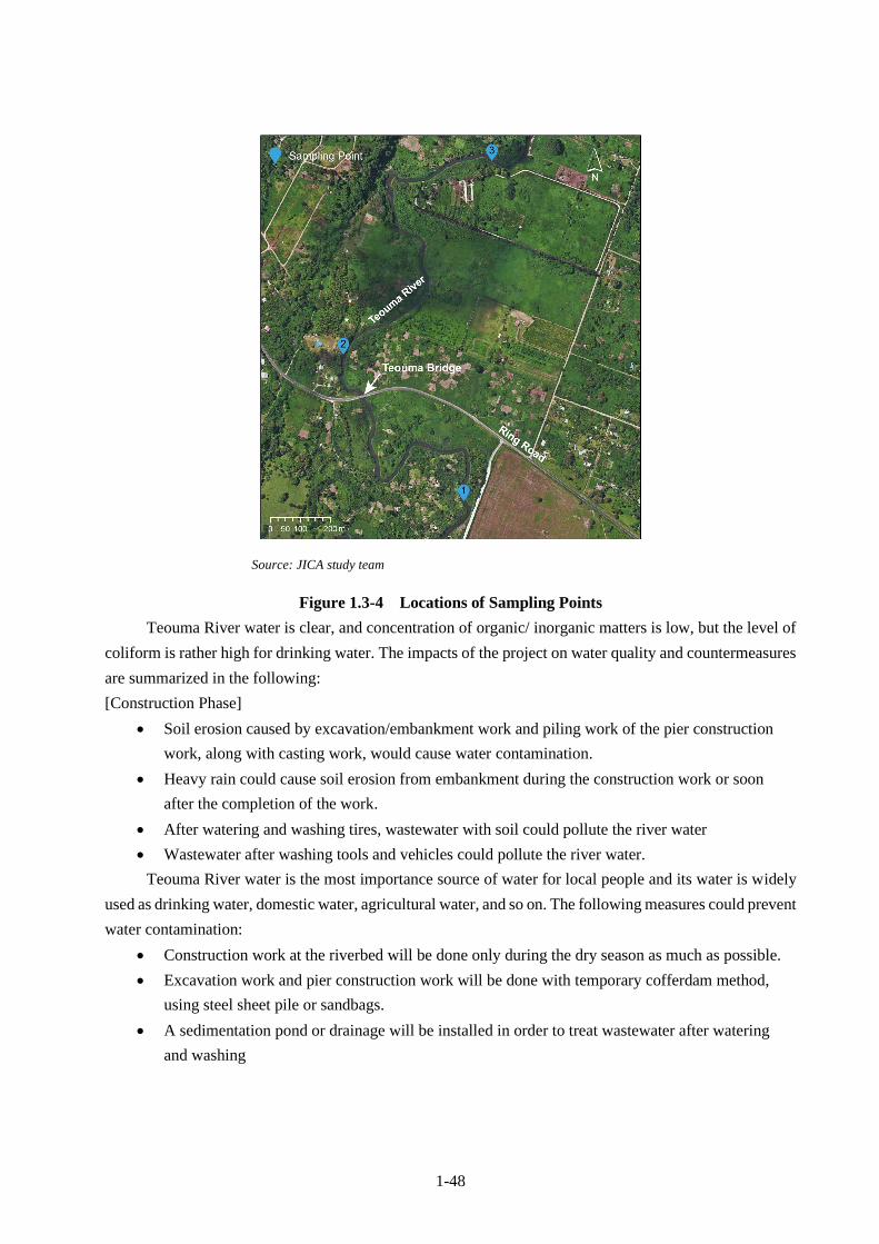
1-48
Source: JICA study team
Figure 1.3-4 Locations of Sampling Points
Teouma River water is clear, and concentration of organic/ inorganic matters is low, but the level of
coliform is rather high for drinking water. The impacts of the project on water quality and countermeasures
are summarized in the following:
[Construction Phase]
• Soil erosion caused by excavation/embankment work and piling work of the pier construction
work, along with casting work, would cause water contamination.
• Heavy rain could cause soil erosion from embankment during the construction work or soon
after the completion of the work.
• After watering and washing tires, wastewater with soil could pollute the river water
• Wastewater after washing tools and vehicles could pollute the river water.
Teouma River water is the most importance source of water for local people and its water is widely
used as drinking water, domestic water, agricultural water, and so on. The following measures could prevent
water contamination:
• Construction work at the riverbed will be done only during the dry season as much as possible.
• Excavation work and pier construction work will be done with temporary cofferdam method,
using steel sheet pile or sandbags.
• A sedimentation pond or drainage will be installed in order to treat wastewater after watering
and washing

1-49
(3) Soil Contamination
[Construction Phase]
The storage facilities of oil, chemicals and vehicle maintenance are installed at the site. In order to
prevent or mitigate the problems caused by leakage, spillover prevention measures such as bunding are
necessary.
There is a possibility of soil contamination by oil and grease, leaked from maintenance work. The
use of oil tray could mitigate this kind of problem.
(4) Waste
[Pre-construction/Construction phase]
The organic waste and soils mixed with organic waste will be generated during the site-clearance
work.
Excavated soil will be generated due to construction work, while general waste will be generated at
the site office and construction site. Oil/grease waste will be also generated. In addition, due to the removal
of abutment, concrete debris will be generated. A surplus soil of 10,000 m3, equivalent to the volume of
2,000 dump trucks, will be also generated by removal of detour and other facilities at the end of the
construction work. The following measures are necessary to be implemented:
• Organic waste and soils mixed with organic waste is generated during the site clearance work. This
waste will be disposed at the authorized Bouffa landfill operated by Port Vila city.
Disposal fee:
small size and pick-up truck: VT 1,150/truck
middle size truck: VT 2,875/truck
large size truck: VT 5,750/truck
16 wheel truck: VT 9,780/truck
• Garbage containers and temporary toilets will be installed
• Management plan of oil & grease and chemicals should be prepared.
• Excavated soils will be used for embankment work
• Concrete debris will be reused as filling materials of riverbed (PWD will reuse the superstructure)
• Temporary storage places of excavated soil and concrete debris will be prepared for proper storage of
these materials
• Surplus soil will be brought to the stock yard and reused later
(5) Noise and Vibrations
The result of the noise level survey is as follow:
LAeq, 10min 6:00 – 17:00
Result 45.6 dB
Survey date: February 4, 2019
Weather: fine
Location: in front of the market, west of the Teouma Bridge (See Figure 1.3-5)
The following Japanese standards are referred.

1-50
Daytime (6:00-22:00) Night (20:00-6:00)
Residential area 55 dB or less 45 dB or less
Commercial area 70 dB or less 60 dB or less
Residential area along the main road with 2
or more than 2 lanes each way 60 dB or less 55 dB or less
Commercial area along the main road with
2 or more than 2 lanes each way 65 dB or less 60 dB or less
Source: JICA study team
Figure 1.3-5 Location of Noise Level Measurement
Noise level is measured along the Ring Road, as shown in the above map. Compared to the Japanese
standards for residential areas facing the main road with 2 or more than 2 lanes each way, the current noise
level is very low. Houses near the construction area are located dozen meters away from the road and no
houses are facing the road.
There are several schools in the neighboring areas but none of them are located near the project site, as
shown in Figure 1.3-6.
Teouma Bridge
Measurement Location

1-51
Source: JICA study team
Figure 1.3-6 Location of sensitive facilities such as schools around the project area
Construction noise will cause moderate to low disturbance to the neighboring community within the
immediate semi-rural area, due to the need for the temporary use of a pile driver. The pile driver has been
used in the assessment below as a worst case scenario. The village of Melemaat is located approximately
300 meters downslope. The immediate vicinity of the road is uninhabited and there is one house further
upslope which has no direct line of sight to the sources of noise.
Using an attenuation rate of 6 dBA per doubling of distance, the projected noise was found to be
within the standard at the main village, using accepted daytime level of 55 dBA for residential land use in
the village. The numbers of receptors within the each area are also shown in the table. Most of the receptors
are houses along with 3 markets and one tourist facility within 1 km from the bridge.
Noise level at the nearest houses can be below the standards, but if plural heavy vehicles and
machines are used at one time, it is likely that the noise level exceeds the standard. Please refer to the
following Table 1.3-15.
Construction Area
Primary School
Secondary School
1 km

1-52
Table 1.3-15 Expected Noise Level
Distance from source (m) 15.24 30 61 122 244 488 975
Number of Receptors 0 0 0 1 1 388 +338
Vibrator Pile Driver 101 95 89 83 77 71 65
Concrete Mixer Truck
(dBA) 79 73 67 61 55 49 43
Concrete Pump Truck
(dBA) 81 75 69 63 57 51 45
Dump Truck(dBA) 76 70 64 58 52 46 40
Excavator (dBA) 81 75 69 63 57 51 45
Source: JICA study team
[Construction phase]
• Bridge construction work, in particular piling work, would cause noise and vibration problems
• The noise level caused by each excavation/embankment work by heavy vehicles and equipment
or a dump truck/concrete pump truck would be within an acceptable level, but plural works are
done simultaneously, it is likely that the noise level would exceed the standards.
The following countermeasure will be taken.
• Information on the construction work should be opened beforehand to local residents and authority,
and the noisier construction work will be restricted to daytime.
• Low noise heavy vehicles and machines will be used.
• Simultaneous operation of plural noisy machines should be avoided as much as possible.
• The level of noise and vibrations will be regularly measured during the construction phase.
[Operation phase]
As mentioned in (1) Air pollution, the noise level would be worsening due the increase in the traffic
volume, but the extent of the impact would be limited. Since the current noise level is law, the noise level
during the operation would not exceed the noise standards.
(6) Soil erosion
[Construction phase]
The construction work of widening the width and changing the channel of Teouma River, would
cause soil erosion. In addition, heavy rain could trigger soil erosion from the embankment during the
construction work or the just after the completion of the construction work.
In order to prevent soil erosion, the following measures will be taken.
• Construction work at the riverbed is restricted to the dry season.
• Appropriate drainage plan will be formulated beforehand.
• Excavation work and pier construction work will be done with temporary cofferdam method,
using steel sheet pile or sandbags.
1-53
[Operation phase]
In the past, Teouma River meandered freely through the rift valley with 1.5 km in width. The change
of river course at the bridge could trigger the further meandering downstream. It is recommended to monitor
the river morphology in the long term, from not only the environmental and social aspects but also disaster
management aspect.
• The monitoring of the river course will be conducted once a year, as mentioned in the section of
Hydrology.
(7) Bed sediment
[Construction phase]
The bridge construction and excavation/embankment work at the river could affect the bed sediment.
The result of freshwater fauna survey shows very low biodiversity due to activities development along the
river. There are no species to be protected necessarily.
The following measures could prevent further degradation.
• Construction work at the riverbed will be restricted to the dry season as much as possible.
• Appropriate drainage plan will be formulated beforehand.
(8) Biota and ecosystems
As shown in the section of 1.3.1.2(2) “Biological Conditions”, the area along Teouma River is well
vegetated, though modified with secondary vegetation (shrub). The diversity of freshwater fauna is low due
to the development activities. There are no species to be protected necessarily. Along the river and road,
there are no trees of significant height that will be affected.
But in order to prevent further degradation, the following measures will be taken.
• An attention will be paid to wildlife at the time of site clearance (to check if there are nests along the
river sides, in particular during breeding period)
• Construction work at the riverbed will restricted to the dry season as much as possible
• During the site clearance, the loss of vegetation should be restricted inside the construction area
• Temporary expropriated farmland plots must be returned after rehabilitation with top soil.
(9) Hydrology
[Construction phase]
Since there would be soil erosion due to the river improvement work, the following countermeasures
will be taken.
• Construction work at the riverbed will restricted to dry season as much as possible
• The loss of vegetation should be restricted inside the construction area
[Operation phase]
The change of river course at the bridge could trigger a further meandering downstream.
In addition, the elevated access road would block the flow of overflown water from north to south at
the time of heavy rain and could widen flooding area in floodplain at the left side of the river.
The following measures will be taken in order to mitigate these concerns:

1-54
Countermeasures against change of river channel
• Long term monitoring of river course will be conducted
• Construction of permanent structures near the river downstream should be restricted
Countermeasures against widening inundation area
• The trapezoidal drainage system will be installed along the north side of the access road and a box
culvert will be buried under the access road in order to drain overflown water of flood plain to the south
of the elevated waterproofing road. Please see Figure 1.3-7 below.
Source: JICA study team
Figure 1.3-7 Drainage Systems along the Flood-proofing Road
(10) Geographical features/Landscape
Increasing elevation of the bridge and access road from 7.7 m to 10.4 m could change the landscape
very much. It is a necessary action in order to protect new bridge for100-year return period flood. The
following measures will assist to reduce and eliminate negative impacts of the landscape change to the daily
life of local people:
• Steps to facilitate access to road and route along the riverbank under the bridge will be installed in
order to connect both sides of the access road.
• Trapezoidal drainage system along the north of the access road with a box culvert will be installed, in
order to prevent inundation.
(11) Resettlement and Land acquisition
There will be no involuntary resettlement, but permanent and temporary land acquisition would be
necessary. It is important to estimate and arrange compensation for land plots, structures, trees, and crops.

1-55
[Pre-construction phase]
• Resettlement action plan is formulated and implemented properly (refer to 1.3.2 Land Acquisition and
Resettlement).
(12) Vulnerable groups /Poor people
According to the result of the RAP survey, no vulnerable groups or poor families were identified at
the project area.
(13) Local economy such as employment and livelihood
The project would have positive effect on local economies, such as job creation (e.g. construction
workers) and also increase in sales of food to construction workers. However, some houses will suffer from
partial loss of farmland and business opportunities of selling vegetables along the access road.
[Pre-construction phase]
• The resettlement action plan is formulated and implemented properly (refer to 1.3.2 Land Acquisition
and Resettlement).
[Construction phase]
• The Contractor should hire local people as construction worker fairly and impartially, when it needs to
employ workers from local people.
• A place to fetch water will be constructed near the temporary bridge, so that local people can continue
to use the river water for their business as well as drinking and domestic water.
(14) Land use
[Pre-construction]
During the construction work, a part of land plots and street stalls along the access road cannot be
used temporarily. The following measures will be taken.
• The resettlement action plan is formulated and implemented properly (refer to 1.3.2 Land Acquisition
and Resettlement).
[Operation phase]
The change of river course at the bridge section would change the river morphology in downstream
in long term. This could affect farmland and houses in downstream. The following measures will be taken:
• Long term monitoring of river course will be conducted.
• Construction of permanent structures near the river in downstream should be restricted.
(15) Water use
[Construction phase]
Since Teouma River is the main source of water for local people, water contamination would be a
serious problem. In addition, during the construction work, local people will lose access to river water. In
order to mitigate these problems, the following measures will be taken:
• Construction work at the riverbed will be restricted to dry season.
• Construction work of pier and riverbank will be done by temporary cofferdam method, using steel
sheet pile or sandbags.

1-56
• A sedimentation pond or drainage will be installed in order to treat wastewater after watering and
washing tires and vehicles. An oil separator will be used, just in case.
• River steps will be installed near temporary bridge.
[Operation phase]
Access steps will be installed at 4 places near the new bridge. This makes it easier for local people
to use river water.
(16) Existing infrastructures and social services
Traffic of the Ring Road will be interrupted and installed infrastructures along the access road cannot
be used such as electric cable.
[Pre-construction phase]
• The relocation plan of installed infrastructures along the access road will be formulated and
implemented in consultation with owners and authorities.
• Traffic management plan will be formulated. This plan should be reflected in the construction
management plan.
[Construction phase]
• Traffic management plan will be implemented in order to mitigate problems such as traffic congestions.
[Operation phase]
• Turnoff will be constructed in the both side of the access road in order to secure the access to houses
located on the both sides of the road.
• The pavements will be installed in both sides of the access and bridge road in order to secure the
safety of pedestrians.
(17) Unjustified sharing of benefits and damages
[Pre-construction phase]
There would be economic gaps in project affected community and the following measures will be
taken:
• A proper resettlement action plan will be formulated and implemented.
[Operation phase]
Traffic at the new Teouma Bridge will be secured even during 100-year return period flood. This is
common benefit for all residents.
(18) Local conflict of interests
The main purpose of this project is replacing a bridge. No local conflicts of interest were observed
during consultation meetings and interview surveys.
(19) Cultural heritage
No cultural heritages were identified in the project area during EIA survey.

1-57
(20) Landscape
[Operation phase]
Increasing in the elevation of bridge and access road could change the landscape. However, Teouma
River is not a scenic place and this change will not be a serious issue. The following measures will help
local communities to adapt with the changes:
• Well explanation of the new bridge design in the consultation meetings
• Take necessary measures to improve convenience of constructed facilities for local communities to
access road and riverbank, etc.
(21) Gender and Children’s right
No negative impacts of the project on gender and children’s right are expected. However, it is
recommended to pay attention in order to make sure of fair employment for female workers. Poorer states
in Vanuatu have child labor issue in agricultural sector. However, this project site is in the area with very
low poverty headcount rate. However, there is no comprehensive child protection law. It is recommended
to check the age at the time of hiring even though child labor is not expected in this project.
(22) Infectious diseases such as HIV/AIDS
The project is not expected to spread the infectious diseases such as HIV/AIDS as construction
workers will be recruited locally.
(23) Working conditions (work safety)
[Construction phase]
There would be accidents and injuries as well as health problems caused by dust and noise in the
construction site. The following measures will be taken in order to mitigate these problems:
• The Work Safety Plan will be prepared based on the laws and regulations in Vanuatu and also
international standards (OHSAS)
• Safety goods will be provided along with regular meetings and trainings as well as necessary measures
such as watering will be implemented according to the safety plan.
(24) Accidents
[Construction phase]
There is risk of accidents involving local residents and passenger cars. The following measures will
be taken:
• A community safety plan will be formulated.
• Information of the construction plan will be shared. Necessary facilities will be installed such as
fences between the construction site and surrounding houses.
• A traffic management plan will be formulated.
• Trained guards will be assigned and necessary facilities such as signboards will be installed in order
to prevent accidents.

1-58
[Operation phase]
Due to the change of road alignment (longitudinal) and increase in traffic volume, the number of
accidents is expected to increase for a while. The following measures will be implemented.
• Signboards will be installed.
• Information on the new road alignment will be disseminated by radio and newspaper.
(25) Global Warming
Types, number and working days of trucks, heavy vehicles and machines are shown in the following
Table 1.3-16:
Table 1.3-16 Construction Machinery Schedule
Source: JICA study team
The following construction materials will be procured from an authorized quarry in Efate. This
material will be stored in a stock yard, located 2.1 km north-west of the bridge. Dump trucks will commute
between the construction site and stock yard to carry construction materials.
• Soil for embankment work: 25,000 m3 equivalent to volume of 5,000 dump trucks
• Stones: 2,000 m3 equivalent to volume of 400 dump trucks
The location of the construction site, stockyard, and Bouffa disposal sites are shown in Figure 1.3-8
below.
7 8 9 10 11 12 1 2 3 4 5 6 7 8 9 10 11 12 1 2 3 4 5 6 7 8 9
1 2 3 4 5 6 7 8 9 10 11 12 13 14 15 16 17 18 19 20 21 22 23 24 25 26 27
1 Bulldozer 21t vehicle 1 670
2 Backhoe (extream long boom) 0.45m3 vehicle 1 609
3 Backhoe 0.8m3 vehicle 1 670
4 Dump truck 10t vehicle 5
5 Motor grader 3.1m vehicle 1
6 Road roller 10~12t vehicle 1
7 Tire roller 8~20t vehicle 1
8 Rough Terrain Crane 35t vehicle 1 639
9 Rough Terrain Crane 35t vehicle 1 61
10 Crawler crane 80t vehicle 1 33
11 Vibro-hammer 60KW vehicle 1 639
12 Vibro-hammer 60KW vehicle 1 61
13 Large size breaker 1,300kg class breaker 1
14 Generator 125/150KVA generator 1 639
15 Generator 125/150KVA generator 1 61
16 Generator 25KVA generator 1 122
17 Generator 25KVA generator 1 518
18 Generator 25KVA generator 1 122
19 Generator 25KVA generator 1 700
20 Distributer 2000~3000ℓ distributer 1 7
21 Line marker walk behind type roller marker 1
22 Tamping rammer 60~80kg rammer 1
23 Concrete pump truck 90~110m3/hr, boom type vehicle 1
24 Rotary Press Fitting Machine Nippon Sharyo DHJ-45 machine 1 68
Japan
shipping periof
operat
ion
days
code Name Specification unitnumbe
r
2020 2021 2022
Remarks

1-59
Source: JICA study team
Figure 1.3-8 Locations of Teouma Bridge, Stockyard, and Bouffa Landfill sites
[Construction phase]
Greenhouse Gas (GHG) will be generated from trucks, heavy vehicles and machines. However, the
volume of GHG is limited due to limited number of vehicles/machines. Mainly 4 heavy vehicles and 2
generators will travel in short distance between the stockyard and construction site.
CO2 equivalent to GHG is estimated using the list of law emission vehicles and machines by Ministry
of Land, Infrastructure, Transport and Tourism as well as based on reports of GHG generation amount by
local governments and companies. It is assumed that the daily working hours of vehicles and machines are
6 hours. The result is shown in the table below.
Heavy Vehicles kw Working
hours Total working
days Fuel
amount(l) Basic Unit
CO2 (ton)
CO2 eq N2O(ton)
Bulldozer 21 ton 152 6 670 106,932 2.58 276 2.12
Backhoe 0.8m3 104 6 670 73,164 2.58 189 1.45
Backhoe
(extream long boom) 0.4m3 60
6 609 38,367 2.58 99 0.76
Rough Terrain Crane 35 ton 257 6 700 92,820 2.58 239 1.84
Generstor 150 kVA 150 6 700 107,730 2.58 278 2.14
Generator 25 kVA 30 6 1,462 43,860 2.58 113 0.87
Total 1,194 9.18
Stock Yard Site Office
Bouffa Landfill
Teouma Bridge
Port VIla
2km

1-60
CO2 equivalent to GHG generated from dump trucks is also estimated assuming traveling distance
of 6.0 km including 4.2 km for round trip and 1.8 km traveling inside the construction area. The result is
shown in the table below.
Type No of trips
Travel Distance
km
Total Travel
Distance km
Fuel
(l) CO2 (ton)
CO2 eq CH4 (ton)
CO2 eq N2O (ton)
Total (ton)
Dump Truck 10 ton 5400 6 32,400 9,299 24 0.01 0.14 24.1
Total amount of CO2 equivalent GHG is estimated at around 1,000 ton. This would have little impact
on Global Warming.
[Operation phase]
Target construction area is very limited and completed project is expected to mitigate the negative
impacts of the global warming. As the result, the impact of the project on cross border effect is not assumed.
The traffic volume is expected to increase in a light rate and limited number. Therefore, the impact
of project on global warming is not much expected.
1.3.1.8 Impact Assessment
Result of the impact assessment is shown in the following Table 1.3-17.
Table 1.3-17 Result of Impact Assessment
Category Items Evaluation Evaluation
Reason Pre/ During Construction
Operation
Before/ During Construction
Operation
Anti-
pollution
measures
1 Air pollution
B- C B- D
[Pre-Construction/Construction phase]
Ambient air quality will be affected by the dust
and emission gas generated during the
preparation and construction work, but the
impacts will be limited due to the limited
number of heavy vehicles and trucks.
[Operation phase] The traffic volume of the ring
road is expected to increase, and this could
affect the ambient air quality. But since the
current volume is law, the impact of increased
traffic volume is assumed to be small.
The second phase of the ADB project will not
increase the traffic volume at the bridge, since
the main part of the work is in Port Vila.
2 Water pollution
B- D B- D
[Construction phase] Excavation/ embankment
work along the river and the construction work
of bridge pier could worsen river water quality
during the construction period.
Rainfall during or just after the
embankment/Cut-earth work could cause soil
erosion and river water pollution. (slope
protection work could mitigate soil erosion
during the operation phase)
[Operation] Slope protection could prevent soil
runoff.

1-61
Category Items Evaluation Evaluation
Reason Pre/ During Construction
Operation
Before/ During Construction
Operation
3 Soil Pollution
C D C- D
[Construction phase] There is a possibility of
soil contamination by oil during the
maintenance work of heavy vehicles and trucks,
but the area might be limited.
There is also a risk of oil/chemical leakage from
the storage facilities.
[Operation phase] There are no element which
cause soil pollution.
4 Waste
✓ Municipal
solid waste
(MSW)
✓ Construction
waste (CW)
B- D B- D
[Construction phase] Camps for construction
workers would not be arranged, and the
problems caused by general waste would be
very limited.
Construction waste such as excavated soil and
concrete debris will be generated.
Organic waste and soil including organic waste
will be also generated after the site clearance.
[Operation phase] There are no works which
generate waste during the operation.
5 Noise and
Vibrations
B- C B- D
[Construction phase] During the construction
period, construction work will cause problems of
noise and vibrations.
[Operation phase] Even though the traffic
volume will be increased but the current noise
level is now and the impact of the increased
traffic volume on the noise level is limited and
the noise level will not exceed the standards.
6 Ground
subsidence D D D D
There is no work which could cause ground
subsidence. Based on the result of the ground
survey, ground subsidence is not expected to
occur
Soil erosion
B- B- B- B-
[Construction phase] Construction work to
widen and change the channel could cause soil
erosion.
Rainfall during or just after the
embankment/Cut-earth work could cause soil
erosion.
[Operation phase] Change of river channel
around the bridge could change the river
channel downstream in the long term, and this
would cause soil erosion, after the completion
of the construction work.
7 Offensive odors D D D D
[Construction]/[Operation] There is no activity
to cause offensive odor.
Natural
environ
ment
8 Bottom sediment
B- D B- D
[Construction phase] Construction of a pier and
excavation work at the riverbed would have
negative impacts on bottom sediment.
[Operation phase] The negative impacts on
bottom sediment is not expected.
9 Protection area D D D D No national park or conservation areas inside
the project areas were identified.

1-62
Category Items Evaluation Evaluation
Reason Pre/ During Construction
Operation
Before/ During Construction
Operation
10 Biota and
ecosystems
B- D B- D
[Construction phase] Channel widening and
excavation work would have negative impacts
on aquatic organisms, in particular Benthos. No
endangered species were found.
[Operation phase] No negative impacts on
ecosystems are not expected.
11 Hydrology
B- B- B- B-
[Construction phase] River improvement work
could have impact on the hydrology of the
downstream.
[Operation phase] Modified river alignment
around the Teouma Bridge could have impacts
on the alignment of the downstream.
The elevated access road could worsen the
flooding north of the access road (left side of the
river), but installation of drainage systems along
the access road could mitigate this problem.
12 Geographical
features/ geology
B- C B- B-
[Construction phase] The elevated access road
and bridge changes the geographical feature.
[Operation phase] It is possible to mitigate
problems caused by the change of the
geographical feature, by installing steps to the
access road and route along the river under the
bridge to connect the both sides of the access
road.
Social
environ
ment
13 Land acquisition
and resettlement
B- D B- D
[Pre-construction] No households need to be
resettled, but a certain area of land is needed to
be permanently expropriated or temporarily
used as the detour.
Need to estimate the compensation amount for
land, structures, trees and crops.
[Operation phase] No negative impacts are not
expected.
14 Vulnerable groups
/Poor people
C D D D
[Pre/During Construction] No issues of minority
and indigenous people are identified, but if the
result of social and economic survey finds
issues to be solved, some kinds of support
would be considered. Same as for poor people.
[Operation] Issues identified during the surveys
will be dealt with.
15 Local economies
B+/- B+ B+/- B+
[Construction] The project will bring about
some benefits such as job creation and
economic opportunities to sell foods/goods to
workers, while some households will lose a part
of farmland.
[Operation] During the flood, traffic of the ring
road is secured and this could contribute to the
local economic development.

1-63
Category Items Evaluation Evaluation
Reason Pre/ During Construction
Operation
Before/ During Construction
Operation
16 Land use
B- D B- B-
[Construction phase] A part of farmland and
roadside cannot be temporarily or permanently
used.
[Operation phase] Modified river alignment
around the Teouma Bridge could have impacts
on the alignment of the downstream river in the
long term, and this could affect the land use a
little bit.
17 Water use
B- B+ B- B+
[Construction] The construction work could
worsen water quality and this would be
problems of water use for both drinking and
farming water purposes.
The right side riverbank just below the bridge is
the place where people take water and do the
laundry (some people come from other areas in
order to do laundry by bus). During the
construction work, a temporary place for
fetching water is necessary.
[Operation] the river steps are planned to be
installed at 4 places along the riverbank, and
this will make it easier for local people to access
to river water.
18 Existing social
infrastructures
and Services B- B+ B- B+
[Construction] The construction work will cause
a problem of other infrastructure such as
transmission line, as well as traffic congestion.
[Operation] After the project, the transportation
network in Efate Island will be improved.
19 Social institutions
D D D D
[Construction] Land expropriation issues could
affect the consensus formation in the community.
The project will not affect the local social
institutions and decision-making body.
20 Misdistribution of
benefits and
damages
B- C- B- D
[Construction phase] The project could cause
gaps among project affected households
[Operation phase] The project could ensure the
main transportation system in Efate Island during
the cyclone and this is a benefit for all the local
people.
21 Local conflicts of
interest B- D D D
[Construction phase] This is a project of bridge
replacement and would not cause local conflicts.
[Operation phase] No conflicts are expected.
22 Cultural heritage
C D D D
[Construction phase] No local archeological,
historical, cultural, and religious heritages were
identified inside and near the project area.
[Operation phase] Since there is no cultural
heritage, no problems are expected.
23 Landscape
B- C- D D
[Construction phase] The project site is not a
tourist site or scenic spot, the construction work
with heavy vehicles will not be a problem.
[Operation phase] The elevation of the bridge
and access road could change the landscape
very much. At the consultation meetings, design
and expected landscape were explained well and
participants understood it.
1-64
Category Items Evaluation Evaluation
Reason Pre/ During Construction
Operation
Before/ During Construction
Operation
24 Gender/
Children’s rights
C D B- B+
[Operation phase] Problems caused by gender
bias and abuses of children’s right are not
expected to occur.
[Operation phase] The project is expected to
mitigate flood problems and could bring about
benefit for communities. Newly installed river
steps at 4 places would ease their work using
water.
25 Infectious
diseases such as
HIV/AIDS C D D D
[Construction phase] Construction workers are
planned to be recruited locally, so the infectious
diseases such as HIV/AIDS are not expected to
spread by the project.
[Operation phase] No spread of infectious
disease is expected.
26 Working
conditions (work
safety) B- D B- D
[Construction phase] There would be accidents,
injuries and health problems at the construction
sites.
[Operation phase] No problems related to work
safety are not expected.
27 Accidents
B- B- B- B-
[Construction phase] There would be traffic
accidents, involving local people, during the
construction work.
[Operation phase] Elevation of the access road
could cause traffic accidents for a certain period
after the completion of the construction work
28 Global warming
D C D D
[Construction] A limited amount of global
warming gas (GHS) will be emitted.
[Operation] The traffic volume might be slightly
increased, and this increases the emission
amount of GHS gas, but the effect on the global
warming will be very limited.
Source: JICA study team
1.3.1.9 Environmental Management Plan (Proposed Actions and Implementation Cost)
Proposed mitigation measures and implementation cost of these measures are summarized in the
following Table 1.3-18:
Table 1.3-18 Proposed Actions and Implantation Cost
No Environmental
Consideration
Suggested Actions and Mitigation
Measures Implementing
Agencies
Responsible
Organizations
Cost
(USD)
Pre-construction phase
1
5
Air pollution/
Noise and
Vibrations
Procure low noise and low emission
vehicles and machines
Contractor PWD
6 Soil
contamination
Procure soils and stones from quarries
with permission
Contractor DEPC/PWD -
10 Ecosystems Pay attentions to wildlife and restricted
site-clearance inside the project area
Contractor -
13 Resettlement/
Land acquisition
Land expropriation, arrangement of
compensation, and supporting
measures based on RAP
PWD PWD/DOL RAP cost

1-65
No Environmental
Consideration
Suggested Actions and Mitigation
Measures Implementing
Agencies
Responsible
Organizations
Cost
(USD)
15 Local economy
such as
employment and
livelihood
Arrange the compensation and support
based on the RAP
PWD PWD/DOL RAP cost
Employ local people as construction
workers
Make sure of no discrimination against
women
Check the age of workers
Contractor Included
in BoQ
Construction phase
1 Air pollution Watering at storage place and
construction site and washing tires of
trucks
Regular check of the conditions of
heavy vehicles and trucks
Try to avoid and minimize idling all
vehicles
Using sheet to cover truck box
Contractor DEPC/PWD Included
in BoQ
2 Water
contamination
Construction work in the riverbed will
be done in dry season
Temporary cofferdam method will be
used at the time of pier construction
and river embankment work
After watering and washing tires, a
countermeasure, such as sedimentation
tank will be taken in order to prevent
sediment from flowing out to the river
directly.
Contractor DEPC/PWD Included
in BoQ
3 Waste Dispose of organic waste and soil
mixed with organic waste after the site
clearance work at the Bouffa Landfill.
Store excavated soil and concrete
debris at a temporary storage place and
reuse as embankment soil and filling
soil respectively
Surplus soil will be brought back to the
stock yard and reused later
Contractor DEPC/PWD Included
in BoQ
4 Soil
Contamination
Use oil tray at the time of maintenance
work in order to prevent soil
contamination
Proper storage of oil and chemicals (oil
spill over management)
Contractor DEPC/PWD Included
in BoQ
5 Noise and
Vibrations
Regular maintenance of heavy vehicle
and machines will be implemented in
order to prevent abnormal sound and
vibrations
Noisy heavy vehicles and machines
will not be operated simultaneously as
much as possible
Safety goods are provided for workers
who work near the machine, which
causes noise and vibrations
Noise levels will be regularly measured
Contractor
DEPC/PWD Included
in BoQ
6 Soil erosion Construction work in the riverbed will
be done in dry season
Proper drainage will be planned in
advance
Temporary cofferdam method will be
Contractor DEPC/PWD Included
in BoQ

1-66
No Environmental
Consideration
Suggested Actions and Mitigation
Measures Implementing
Agencies
Responsible
Organizations
Cost
(USD)
used at the time of pier construction
and river embankment work
8 Bed sediments Construction work in the riverbed will
be done in dry season
Temporary cofferdam method will be
used at the time of pier construction
and river embankment work
Proper drainage will be planned in
advanced
10 Biota and
ecosystems
Construction work in the riverbed will
be done in dry season
Temporary expropriated farmland plots
will be returned after rehabilitation.
Contractor DEPC/PWD Included
in BoQ
11 Hydrology Construction work in the riverbed will
be done in dry season
Proper drainage will be made
beforehand
Contractor DEPC/PWD Included
in BoQ
18 Water use Same as water contamination
A place for fetching water will be
construction near the temporary bridge
Contractor
/WASAC
DEPC/PWD Included
in BoQ
19 Existing infrastructures and social services
The relocation plan of infrastructures
along the access road will be
formulated and implemented, in
consultation with owners of
infrastructures.
A traffic management will be planed
The plan will be implemented,
assigning a person who guides traffic
and installing signboards, and so on
Contractor PWD/Police
Force/Organiz
ations
concerned
Included
in BoQ
26 Work Conditions including Work Safety
Prepare for Work Safety Plan based on
the Vanuatu laws and international
standards such as OHSAS
Provide safe goods such as masks and
globes for workers
Provide training programs of work
safety and organize regular meetings
with workers in order to promote
awareness of work safety
Contractor PWD/
Included
in BoQ
29 Accidents Development of a Community safety
plan
Take countermeasures such as
disseminating information on
construction work schedule, installing
fences between construction site and
houses, and assigning a trained guard,
in order to prevent accidents
Development of a traffic management
plan
Assign a guard to guide traffic and
install signboards, in order to prevent
accidents between trucks and private
passenger vehicle
Contractor PWD/ Police
Force/Local
authority
Included
in BoQ
Operation phase
11 Hydrology Monitor the river morphology in the
long term
PWD PWD USD600
29 Accidents Provide the information on new road PWD USD5000

1-67
No Environmental
Consideration
Suggested Actions and Mitigation
Measures Implementing
Agencies
Responsible
Organizations
Cost
(USD)
alignment on radio and other media
and install signboards
Collect data on accidents
Source: JICA study team
1.3.1.10 Environmental Management and Monitoring Plan (Implementation details, Methodology
and Cost)
The following Environmental and Monitoring Plan will be implemented in order to monitor
mitigation measures during pre-construction, construction and operation/maintenance phase.
Table 1.3-19 Environmental Management and Monitoring Plan (EMMP)
Environmenta
l Issues Monitoring Items
Parameter
/Indicator Location Frequency Responsible Cost
Pre-construction and site mobilization phase
Land
expropriation,
compensation
payment and
other support
Compensation for
land and lost
structure
Number of
structures
expropriated
Area of land
expropriated
Project
area
Once before
construction
PWD RAP
monitoring
Complaints
resolutions
GRM log book Project
area
DOL RAP
monitoring
Ecosystem Site clearance
activities
Approval of
cutting trees
Record of site
clearance
Records of waste
disposal (Bouffa)
Air Pollution/
Noise &
vibrations
Equipment and
automobiles with
less emission gas
and noise
Number of
automobiles with
certification on site
As
appropriate
Contractor No cost
applicable
to monitor.
Soil Erosion Source of
construction
materials such as
soil and stones
Quarry permission once No cost
Construction phase
Accident and
Incident
Complaint (in
general such as
noise, traffic jam,
and accidents)
Records of
complaints
Project
area
Contractor
PWD
Constructio
n cost
Air Pollution Equipment and
automobiles in
good shape
Regular inspection
and maintenance
(daily check sheet)
Project
area
Daily Contractor No cost
applicable
to monitor.

1-68
Environmenta
l Issues Monitoring Items
Parameter
/Indicator Location Frequency Responsible Cost
Air quality Level of dust:
observed by
contractor
Observed by
community
(community
survey)
Project
area
Daily
Quarterly
Contractor Constructio
n cost
USD 2,000
Mitigation
measures such as
spraying of water,
washing tires,
covering loaded
materials
Records on water
spay/ washing
(check sheet)
Project
area
Daily Contractor Constructio
n cost
Water
Contamination
Surface water
quality
Temperature, pH,
EC (by portable
water quality
meter)
oil & grease
(observation)
Upper
site/ lower
site of the
river
Weekly Contractor US$ 2,000
Mitigation
measures
Records of
mitigation
activities (check
sheet)
Project
area
Daily Contractor Constructio
n cost
Noise and
Vibrations
Restriction of
noise/vibration
emitting activities
to working hours.
Noise level by
portable noise
meter
Observed by
community
(community
survey)
Project
area
At the time
of earth
works
Quarterly
Contractor US$ 1,000
(Along
with air
pollution)
Soil
Contamination Check prevention
measures of oil
contamination
Prevention
measures are done
or not (based on
daily check sheet)
Project
area
Monthly Contractor Constructio
n cost
Soil Erosion Check the
conditions of river
bank
Conditions (check
sheet)
Project
area
Monthly Contractor Constructio
n cost
Waste Management of
excavated soil,
concrete debris and
others
Proper storage nor
not (based on
check sheet)
reuse (check list)
Project
area
Monthly Contractor Constructio
n cost
Management of
general waste
Records of waste
disposal
Project
area
Monthly Contractor Constructio
n cost
Bed sediment/
Ecosystem
Mitigation
measures
Mitigation
measures are done
or not (based on
daily check sheet)
Project
area
Monthly Contractor Constructio
n cost
Work
conditions
Occupational
Safety and Health
plan
Availability of
OHS Plan
Monthly Contractor
Constructio
n cost

1-69
Environmenta
l Issues Monitoring Items
Parameter
/Indicator Location Frequency Responsible Cost
Meetings and
trainings
Number of
meetings and
trainings
Safety goods for
workers
Number of
workers with
safety gear
Noise and
vibrations
(from noise and
vibrations)
(from noise
and
vibrations)
Occurrence of
accidents and
injuries
Records of
accident and
injuries
Project
area
Monthly
Accident/
Traffic
Congestions
Traffic
Management Plan
Availability of
TMP
Project
area
Monthly Contractor Constructio
n cost
Implementation of
TMP
Availability of
guard, signboard,
and so on
(activity records)
Project
area
Monthly Contractor Constructio
n cost
Water use Mitigation
measures of water
quality
(from water
pollution)
Constructio
n cost
Conditions of place
to fetch water
Observation by the
Contractor
Observed by
community
(community
survey)
Project
area
Monthly
Quarterly
Contractor
community
Constructio
n cost
(along with
air
pollution)
Local
Economy
Local economy
(sales,
employment, and
so on)
Observed by
community
(community
survey)
Communit
ies near
the project
area
Quarterly (along with
air
pollution)
Operation phase
Accident Number of accident
Prevention
measures
Monthly PWD Operational
cost
Hydrology River morphology
in downstream
One a year PWD Operational
cost
Total cost for
monitoring
USD 5,000
Source: DEPC annual environmental audit (the Contractor will bear the cost)
1.3.1.11 Stakeholder Meetings
Formal stakeholder meetings were organized in three phases, (a) at the time of scoping, (b) during
environmental, socio-economic and inventory survey phase, and (c) during drafting of EIA report/RAP
phase. Notice of the meeting was given in advance in Daily Posts, along with on national radio and social
medial especially Facebook.

1-70
These consultation meetings have been organized from May to December 2018 by participation of
government agencies, landlords, community leaders and interested groups such as market vendors and
female groups. The following were the main objectives of meetings:
• promote partnerships with stakeholder communities
• Information sharing on project and its components and activities
• Communicate with stakeholders that their cooperation and participation is essential in Project activities
including surveys, site investigations, planning, feasibility study and design, construction, monitoring
and maintenance.
(1) Project Scoping Phase
The first two meetings held as stakeholder inception meetings to introduce the project and its scope.
Outlines of these two meetings are summarized in the following Table 1.3-20.
1) Stakeholder consultation meetings on environmental & social considerations
Table 1.3-20 Stakeholder Consultation Meeting
Date: 23 May 2018
Venue: PWD Head Office – Conference Room
Participants:
Combination of
Participants:
28 (Male – 21; Female – 7)
Local Residents – 14
Officers from related government offices – 5
JICA – 2
JST – 7
Agenda: 1. Presentation of the project (by PWD)
1) Objectives of meeting, 2) Background, 3) Review of former meeting (Dec.
2016), 4) Outline of the project, 5) Environmental & Social considerations in the
Project Area, 6) Compensation and Assistance, 7) Request for assistance, 8)
Tentative schedule, 9) Open forum.
2. Exchange of opinions
Source: JICA study team
Questions and Answers at the meetings are summarized in Table 1.3-21 below.
Table 1.3-21 Questions and Answers
No Name Questions/Suggestions Responses
1 Harold Priorities should be given to local
residents in terms of jobs opportunities
for construction workers.
This will be taken into consideration and will be
informed to contractor (JST/PWD)
2 J. Chabod How about the acquisition of leased
land in the upstream?
The acquired land will be compensated including
properties based on the cost estimation report
provided by the DOL. (JST/PWD).
3 Resident How about compensation for
properties?
All properties that will be affected by the project
will be compensated and must be included in cost
estimation report. (JST/PWD)
4 Resident How about using acquired land for
washing and swimming, etc?
The acquired land will not be fenced or restricted.
So, residents can still use the land after the
construction work finishes.
It is necessary for the government to have
unlimited access to this area for construction
works and for maintenance purposes in the future.
(JST/PWD)

1-71
No Name Questions/Suggestions Responses
5 SG SHEFA Do we need compulsory acquisition,
rather than just asking to have access to
land?
The government intends to acquire land to
minimize properties issue between government,
and landowner during design, construction of
concrete for river bank protection and also in the
future for maintenance purposes.
Some river works was stopped by one of tenant
when the bridge was damaged by Cyclone PAM
in 2015. The project has not continued since then.
It is necessary to prevent this from happening
again. (PWD)
6 Resident Will concrete river protection cause
any problems in future?
The works will include widening of the river from
30m to 50m, construction of concrete river bank
protection wall to stop erosion on LHS upstream
and a proper alignment of the river to ensure it
flows in its correct path and also protect bridge
from future disasters. (JST)
7 DOL officer Ministry of Lands has received a letter
from MIPU to start the process of
compulsory land acquisition.
DOL valuation team will then carry out
their assessments with a submitted
survey plan.
Compensation will be done according
to valuation report assessments and
payments will be made to landowner.
All rented properties will be also
assessed for compensation.
From now till 2019, all tenants should
work closely with DOL to ensure they
receive a fair compensation.
Noted (JST/PWD)
Source: JICA study team
At the end of the meeting, PWD asked participants to help identify the unknown tenant for the leased
land as shown in the map.
2) Preparatory Stakeholder Inception Meeting
Table 1.3-22 Preparatory Stakeholder Inception Meeting
Date: 13 June 2018, 0900 – 1100
Venue: PWD Head Office Conference Room
Participants: 23
(Male: 16, Female: 7)
Combination of Participants:
Local residents: 15 (M. Nasak et al)
DOL: P. Gambetta, R. Aru
SHEFA Province : Z. Daniel
EIA Consultant (QC) : Y. Qualao
PWD : A. Nafuki
EIA consultant (AEA) : A. Williams, J. Williams
Agenda: Project Presentation
Environmental & Social Impacts and Mitigation Measures
Tentative Schedule
Exchanging Ideas (Q&A)
Acceptance of the Project
Source: JICA study team
Questions and Answers at the meetings are summarized in Table 1.3-23 below.

1-72
Table 1.3-23 Questions and Answers
No Name Questions/Suggestions Responses
1 Chief
Representati
ve K. Sandy
Compensation has been paid only for
the expropriated farmland during the
construction of the first bridge. Need
to know the compensation policies
clearly this time.
This is noted and will be taken up as part of the
Consultation Process. This will be discussed
with the government offices concerned too.
(PWD/ JST)
2 Effluent from the landfill at Etas
would pollute the water of Teouma
River?
New bill passed in Parliament to deal with
waste is a positive way forward. (JST)
3 Resident Stated concern on safety of access to
river water
Steps to access river water will be installed for
the safe access to river water. (JST)
4 Chief rep Is it expected to have more floods in
the upstream areas due to increase in
the elevation of road and blockage?
Moreover, whether the increase in
river width to 50 m will impact water
flow/velocity or not?
Construction work will include excavation of
river bed and an embankment to keep the
elevation level enough for water flow.
(JST/PWD)
5 Resident Is sedimentation in the riverbed
would cause more floods?
6 Resident Whether the drainage system planned
to be installed under the access road
could divert run-offs completely
straight into river rather than block
mid-way causing flooding on
residential properties near the river
banks?
It is taken note of and will be referred to project
proponents for consideration in design.
(JST/PWD)
7 Resident Whether they will have another water
source during the construction phase?
The Social Impact Assessment (SIA) will deal
with concern during the consultation phase.
(JST)
8 Chief rep How river bank users will be
compensated?
Director of Land (DOL) deals with land
compensation process. DOL will evaluate
damages to the agriculture products in gardens
that need to be expropriated.
DOL will work with PWD to verify boundaries.
(PWD/DOL)
9 Resident DOA has given them a form to fill up
with lots of details of crops in their
garden, etc. However, no support to
fill it up. They need support on this.
EIA team will assist the residents to complete
the forms. (JST)
10 Resident Where will temp road be built? At the moment, it is considering south of the
current structure (JST/PWD)
Source: JICA study team
At the end of the meeting, participants agreed to hold next consultation meeting on Wednesday 20
June 2018 at Chief Jack Kalmet community hall.
(2) Survey Phase
1) First Public Consultation of the Environment & Social Impact Assessment (ESIA)
The third consultation meeting was organized as Public Consultation just before the start of the
Environmental, Socio-economic and inventory survey. Outline of the meeting is summarized in the
following Table 1.3-24.

1-73
Table 1.3-24 Public Consultation of the Environment & Social Impact Assessment (ESIA)
Date: 20 June 2018, 0940 – 1145
Venue: Chief Andrew Kalpoilep’s Community hall.
Participants: 26
(Male: 19, Female: 7)
Combination of Participants:
Local residents of project area: 15
Local residents of other area: 2
DOL : I. Nango, D. Steve
JICA : R. Boekara, K. Ohara
DEPC : O. Melenamu
PWD : U. Nafuki, A. Iatipu
EIA consultant (AEA and QC) : A. Williams, N. Tamara
Agenda: Project Presentation
Contents and schedule of the Environment and Social impact survey
Source: JICA study team
Questions and answers at the meeting are summarized in Table 1.3-25 below.
Table 1.3-25 Questions and Answers
No Name Questions/Suggestions Responses
1 Paramount
chief
Insisted that the project must proceed without
delay to ensure connectivity of movement,
facilitate the development and ensure the
safety of people at the heavy rain or cyclone.
Assured that there is no land dispute.
Noted by PWD
2 Resident Insisted that the new bridge should last long,
unlike the previous bridge and Mele Bridge.
Noted by PWD
3 JST There is a tourism operator in the south side
of the bridge where temporary by-pass will be
constructed. More detailed on this will be
provided to find out best options for this
cultural dance tourism site.
4 Chief rep Raised the compensation issues again with
respect to the previous project.
DOL rep noted and informed that they
would start the survey this week.
5 Residents Stated concerns about safety of water use and
alternative water resources.
Suggested borehole drilling and installation
of a solar pumps.
Expansion of the Port Vila Urban Water
Supply System was also discussed.
To be considered (PWD/JST)
6 Resident Boundary of one leased land plot has not been
determined yet
DOL working with PWD will verify the
boundary (DOL/PWD)
7 Residents
rep
Requested DOA officer support them to fill
the forms of crops and other agricultural
products.
Noted (PWD/JST)
8 Resident Where is location of detour and is it affect her
farmland?
The location has not decided yet, but
probably south of the existing road. The
survey will investigate which crops and
structures would be affected. (JST)
Source: JICA study team
The EIA consultant asked participants from local communities to support ESIA survey. A community
close to bridge agrees to meet with the consulting Team on Sunday 25th June 2018 at 3pm. They also agree
to conduct interview survey with residents who work during daytime.

1-74
Paramount Chief has also agreed to utilize Chief Kalpoleb’s community hall at any time for meetings
and consultations related to the project.
(3) Draft Phase
1) Second Public Consultation of the Environment and Social Impact Assessment (ESIA)
The Public Consultation was organized in order to present the result of the ESIA survey including
mitigation measures and to consult with stakeholders about the project plan. Outline of the meeting is shown
in the following Table 1.3-26.
Table 1.3-26 Public Consultation of the Environment & Social Impact Assessment (ESIA)
Date: 24 December 2018, 0945 – 1130
Venue: Chief Andrew Kalpoilep’s Community hall.
Participants: 20
(Male: 16, Female: 4)
Combination of Participants:
Local Residents – 16
Civil Servants (DOL& PWD - VGov) – 1
JICA - 1
AEA – 1
Other - 1
Agenda: Project Presentation
Environmental Conditions (EIA)
Social Condition (Lands, Crops, Assets and Compensation including
business operations after the cut-off date)
Open Forum (Q&A/Discussions)
Acceptance of the Project
Source: JICA study team
The questions and answers at the public consultation are summarized in the following Table 1.3-27.
The participants from communities in the project area asked mainly about policies and compensation
procedures.
Table 1.3-27 Questions and Answers
No Name Questions/Suggestions Responses
1 Mr. Alilee What is impacts of project on mamas
market stall?
Markets stalls will be relocated and
compensation for the loss of income will be
arranged. (JST)
2 How will new bridge look? The length will be extended to 58 m and the
height increased by 3 m. (showing a slide)
3 Mr. Japheth How about his leased land without
pegs?
Due to the peg issues, revaluation has been done
recently done by lands department. Original
survey docs have required for the review.
4 Resident Weather houses and other structures
will be affected by project?
Any affected structures will be compensated.
(JST)
5 Resident Express concern about drainage
system considered in the new road. It
would be better than the current
system?
The new design would improve the drainage
functions. (JST)
6 Mr. Alilee Weather riverbanks and walls will be
enhanced?
It is necessary to secure the access to
the river water.
Yes, they will be enhanced.
River steps will be installed. The locations will
be decided based on the convenience of local
residents. (JST)
7 Resident Will construction work disturb
commuters?
The detour will be constructed, and the
construction work will not affect commuters.
8 Resident Weather considering importance of
access to clean water?
Yes, it is considered. (PWD/ JST)

1-75
9 Resident Insisted to install pumps far away
from river.
This request is received. (PWD/JST)
Source: JICA study team
At the end of the meeting, participants were asked the following questions:
• Do we support the project?
• Why we support or not?
• Will you be able to support the project?
All participants from local communities were supportive to thus project. Following people provided
their motivation to support the project.
Commentator Reason to Support
Mr. Charles Rodin Totally agree to support project.
The project will provide job opportunities for communities within and
surrounding the project area.
Mr. Marakon Alililee Fully support the project.
He believes design of new bridge will make it safer. He also mentioned water
issues are affecting communities. He says it is good to widen the river channel
with respect to climate change and potential more rainfall. Thus, communities
must support the project. More importantly the community population will
be given the priority to work in the project. He hopes it is not like some current
contractors of road works around Port Vila.
Mr. Noel Takau (on behalf of
Chief Andrew Kalpoilep)
Fully support the project from day one.
He stated that bridge will help community members and so they will support
the project. It will facilitate and also encourage investors to come and invest
in the area. He further emphasized job opportunities for youths and
community members.
Mrs Emma Japeth Totally agree to support project.
She mentioned since the Chief and Landowner Rep have already promised to
support the project, all land and resource owners would like to do so.
Other participants They are all agreed to support the project to proceed.
Number of participants who answered yes or no to support the project
Yes 14 participants (Approval rate: 100%)
No Zero
1.3.2 Land Acquisition and Resettlement
1.3.2.1 Target Area for Action Plan
The following project components are selected as the priority project and become the target to develop a
tangible land acquisition and resettlement action plan for the future project.
1. Rehabilitation of
Teouma Bridge
: Rehabilitation with extension of the old bridge from 30 m to 58 m and
widening it from 6.5 m to 9.5 m.
2. Improvement of
Teouma River
: Improvement of both-side embankments and riverine from 250 m upstream to
110 m downstream of Teouma Bridge in 50 m width
3. Improvement of
access road
: Prevention of inundation and overflow by flood in upstream by increasing +3
m in elevation (+3 m)

1-76
Figure 1.3-9 shows locations of each component. Details of these project components are discussed in
Chapter 2 of this report.
Source: JICA Study Team
Figure 1.3-9 Location of Project Components
1.3.2.2 Outline of Laws and Regulations regarding Land Acquisition and Resettlement
(1) The Constitution 1980
The Constitution as “the supreme Law of Vanuatu, contains two sections related to land acquisition and
resettlement. Chapter 5, Articles 29 to 32 of the Constitution refers to “National Council of Chiefs”. Article 30,
in particular, recognizes National Council of Chiefs membership having authority to discuss, and may be
consulted on, any issue related to customs, culture and its preservation in any matter, as required by the National
Government.
Chapter 12 is another chapter considering the traditional ties between Vanuatu nationals and the land.
Therefore, the majority of discussions related to land have centered on Articles 30 (in Chapter 5) and
Articles 73, 74, 75 and 76 of Chapter 12. However, it would be safer to consider all nine articles of Chapter
12 (articles 73 to 81) are related to Land Acquisition and Resettlement depending upon the situation. This
following are summary articles:
All land is owned by its traditional, customary owners; parliament prescribes the criteria for
compensation payment for land;

1-77
The Government may own and acquire land for State interest and may redistribute land away
from traditional owners, in such cases as informal settlements and relocating of residents from
other islands; and
Disputes in land ownership.
(2) Land Reform Act 1980, last amended in 2014
This Act specifies all land titles are belonging to customary or transferred to the traditional owners,
whose lineage can be traced back locally to 200 years. It specifically outlines indigenous owners and the
non-indigenous land users.
(3) Land Leases Act 1988, last amended in 2013
The Act has 23 sections that discuss Land Records Office and laws regarding leases including its definition,
terms, types, registration and obligations of landlord and tenant. Of relevance to a project are the discussions
on requirement to provide rights of access, rights of water and rights to sites for government infrastructure.
The Act also discusses variation of agreements and condition of lease by the Ministry of Lands and
Natural Resources (MOL). This is where a change of lease agreement using a prescribed form under this
Act may be executed by both landlord and tenant prior to the expiration of the lease. A landlord also may
sublease the land for the remaining life of the lease. The Act also includes the registration of caution or
restrictions, including its definition such as mortgage or claims arising from bankruptcy, its placement and
removal on a leased property. The leaseholder may also grant easement over his land. Fees imposed on
subleasing of leaseholds are also provided in the Act.
(4) Land Acquisition Act 1992, last amended in 2000
The Act is the key law directly related to Land Acquisition and Resettlement. This Act, gives the MOL,
full discretionary powers to acquire land on behalf of the Government. It covers to an extent, that which will be
compensated under the Act:
Compensation for damages made during the process of land valuation;
Compensation entitlements for land and for rents and business losses;
Basic rights for grievance and appeals; and
Notice periods.
This Act does recognize market value compensation for land but is very vague in compensation
entitlements for rents and businesses.
(5) Custom Land Management Act 2013, last amended in 2014
This Act strengthens the legal framework concerning title to custom land and also discusses management
of custom land by customary institutions. It formalizes recognition of customary institutions termed
‘NAKAMALS’, which means the traditional meeting and ‘Custom Area Land Tribunals’ to determine the
rules of custom as the basis of ownership and use of land in Vanuatu. In general, the Act aims at holding
of custom land by owners as a cluster. Custom land means land owned or occupied, or land in which an
interest is held, by one or more persons in accordance with the rules of custom. For the purposes of this
Act, each island is divided into “Custom Areas”. Larger islands are divided into many custom areas.

1-78
The Act also provides for appointment of a National Coordinator of Land Dispute Management and
provides with respect to the process of determination of custom owners and determination of land disputes
by NAKAMALS or “Custom Area Land Tribunals and review of such determinations by court. A custom
land must not be registered under the Land Leases Act unless the National Coordinator confirms by
certification of the custom owners list, the names of the custom owners and the representatives of the custom
owners, who may sign on behalf of the custom owners.
(6) Customary Land Tribunal Act 2001, last amended in 2014
As per the title, this Act details the set-up of the Customary Land Tribunal at village, island levels as well
as its basic terms of reference (TOR) especially for dispute resolution and process for affected person to appeal
the tribunal decision.
(7) Valuation of Land Act 2002
This Act stipulates relates to the organization of the “Valuation General Office” and their role. The Act
does not stipulate minimum approach to valuation of the land, which is more directly specified in the “Land
Acquisition Act”. Furthermore, this Act is unclear about the role of the Valuation General Office in terms of
relocation/involuntary displacement of households as well as valuation of structures, incomes and businesses.
1.3.2.3 Practices in Resettlement and Land Acquisition
(1) Identification of Areas for Acquisition
A majority of Government land acquisition in Vanuatu has been for smaller social services projects such
as for village health facilities and educational institutions. The land acquisition legislation and process have not
been utilized for urban development infrastructure projects. In the year prior to an infrastructure development
project, each Ministry and other Government agencies will develop a work plans for the following fiscal year.
This is inclusive of the other feasibility study requirements such as budgeting, environmental, engineering etc.
At this time proposals for projects where land acquisition is involved should be submitted. This is subject to the
approval of the Council of Ministers. There is no minimum standard that requires the projects to minimize land
acquisition and impact on the community.
(2) Process for Relocation and Land Acquisition
On an annual basis, the Government allocates in its National budget 200 million VT (approximately 1.82
million USD, as of December 2018) for Government Land Acquisition projects. According to MOL, if the
budget is not spent the remaining amount accrues on top of the normal, annual 200 million VT budget. In the
event that the budget is used up, with finances still required, the Government and Ministry executing a project,
is responsible to find further finances to cover the necessary Land Acquisition budget requirement.
Once a plot of land is selected for a government project, a notice signed by the Minister of MOL is
provided to the customary owners/title holders and a public notice is erected in full public view. The notice is
made for a minimum of 30 days.
After this period, the land is assessed and valued. The land valuation is stipulated by law, but generally
involves valuing of the following:

1-79
1. Lease type – residential/agricultural/commercial/special industrial;
2. Location of property from CBD, aesthetic view, amenities, waterfront, type of neighborhood;
3. Marketability – number of properties marketed nearby in recent times and price range of those
transactions;
4. Physical characteristics – terrain, vegetation, soil type, improvements made and size; and
5. Intangibles – interest, customary and other resource rights attached.
Valuations include both land and structures affected and may include value of income produced from land.
However, this does not include “non-land producing” incomes such as income from shop business etc. Any
damage to the land, caused by valuation investigations, is by law, liable for compensation to the existing owners.
Once the valuation has been made and signed by the Minister, the owners have 30 days to file objections, at the
same time, the MOL must disclose information on the valuation and proposed land acquisition over a 30-day
period by radio at least 3 times on separate occasions, in one national newspaper each week, on the main notice
boards and on the land itself. Objections must be lodged within this 30 days period, and on decision by the
Minister, the objector, if dissatisfied, may appeal the Minister’s decision through the Supreme Court of Vanuatu.
However, if the issues are related to tradition and custom, then the National Council of Chiefs may be consulted,
if necessary, although not compulsory.
(3) Carrying out the Acquisition of Land/Structures
After a 30-day notice period, and as long as all conflict claims and complaints are resolved, the physical
compensation processes can then commence. The MOL is responsible for this process, monitored by the Ministry
of Finance and Economic Management (MFEM). However, problems in moving through this stage may include
complaints about the process of valuation to compensation itself; and process of the assessment of disputes. This
is generally supposed to be settled through the Customary Lands Tribunal, or if unresolved, through the Supreme
Court.
The land acquisition usually needs a period of 6 to 8 months from the application to completion. The
period, however, can be shortened with the degree of project importance or interest by the Government of
Vanuatu.
1.3.2.4 Comparison between JICA Policy and Vanuatu Resettlement Laws
(1) JICA Policy for Resettlement
JICA Policy for resettlement includes the following items:
(a) Involuntary resettlement and loss of means of livelihood are to be avoided when feasible by exploring all
viable alternatives.
(b) When, after such an examination, avoidance is proved unfeasible, effective measures to minimize impact and
to compensate for losses must be agreed upon with the people who will be affected.
(c) People who must be resettled involuntarily and people whose means of livelihood will be hindered or lost
must be sufficiently compensated and supported, so that they can improve or at least restore their standard of
living, income opportunities and production levels to pre-project levels.
(d) Compensation must be based on the full replacement costs as much as possible.
(e) Compensation and other kinds of assistance must be provided prior to displacement.

1-80
(f) For projects that entail large-scale involuntary resettlement, resettlement action plans must be prepared and
made available to the public. It is desirable that the resettlement action plan include elements laid out in the
World Bank Safeguard Policy, OP 4.12, Annex A.
(g) In preparing a resettlement action plan, consultations must be held with the affected people and their
communities based on sufficient information made available to them in advance. When consultations are held,
explanations must be given in a form, manner, and language that are understandable to the affected people.
(h) Appropriate participation of affected people must be promoted in planning, implementation, and monitoring
of resettlement action plans.
(i) Appropriate and accessible grievance mechanisms must be established for the affected people and their
communities.
(j) Above principles are complemented by World Bank OP 4.12, since it is stated in JICA Guideline that “JICA
confirms that projects do not deviate significantly from the World Bank’s Safeguard Policies”. Additional key
principle based on World Bank OP 4.12 is as follows.
(k) Affected people are to be identified and recorded as early as possible in order to establish their eligibility
through an initial baseline survey (including population census that serves as an eligibility cut-off date, asset
inventory, and socioeconomic survey), preferably at the project identification stage, to prevent a subsequent
influx of encroachers of others who wish to take advance of such benefits.
(l) Eligibility of Benefits include, the PAPs who have formal legal rights to land (including customary and
traditional land rights recognized under law), the PAPs who don't have formal legal rights to land at the time
of census but have a claim to such land or assets and the PAPs who have no recognizable legal right to the
land they are occupying.
(m) Preference should be given to land-based resettlement strategies for displaced persons whose livelihoods are
land-based.
(n) Provide support for the transition period (between displacement and livelihood restoration.
(o) Particular attention must be paid to the needs of the vulnerable groups among those displaced, especially those
below the poverty line, landless, elderly, women and children, ethnic minorities etc.
(p) For projects that entail land acquisition or involuntary resettlement of fewer than 200 people, abbreviated
resettlement plan is to be prepared.
Source: JICA Guidelines for Environmental and Social Considerations, 2010
In addition to the above core principles of JICA Policy, it has also emphasis on a detailed resettlement
policy inclusive of all the above points; specific resettlement plan; institutional arrangements for the plan
implementation; monitoring and assessment; implementation schedule and detailed financial plan, etc.
(2) Comparison between JICA Guidelines and Vanuatu Related Laws
Table 1.3-28 discuses comparison and gap analysis of the policies for some key issues between JICA
Guidelines for Environmental and Social Considerations, 2010, hereinafter referred to as “JICA Guidelines” and
Vanuatu’s relevant regulations. The gaps are treated basically in line with the JICA Guidelines as long as not
violating laws in Vanuatu.
Table 1.3-28 Comparison result of JICA Guidelines and Vanuatu Related Laws
No. JICA Guidelines Vanuatu Related Laws/
Regulations Differences
How to Bridge the
Gap
1
[Avoidance of involuntary
resettlement]
Involuntary resettlement
and loss of means of
livelihood are to be
No provision. There is no standard to
minimize land
acquisition and impact
on the community.
The project shall
adopt the objective of
minimizing
involuntary land
acquisition and

1-81
No. JICA Guidelines Vanuatu Related Laws/
Regulations Differences
How to Bridge the
Gap
avoided when feasible by
exploring all viable
alternatives.
resettlement impacts
on community and
business/ productive
interests are avoided
through careful
technical design.
2
[Mitigation measures for
displacement]
When population
displacement is
unavoidable, effective
measures to minimize
impact and to compensate
for losses should be taken.
No provision. There is no standard to
minimize land
acquisition and impact
on the community.
The project will
ensure that all
resettlement and land
acquisition and
impacts on
community and
business/ productive
interests are
minimized wherever
possible.
3
[Securing livelihood and
assistance]
People who must be
resettled involuntarily and
people whose means of
livelihood will be hindered
or lost must be sufficiently
compensated and
supported, so that they can
improve or at least restore
their standard of living,
income opportunities and
production levels to pre-
project levels.
- Compensation is
determined based on
issues including land type,
crops etc. (Land
Acquisition Act)
- Land is valued by Valuer-
General in the MLNR.
Compensation does not
include “non-land
producing” incomes
such as income from
shop business etc. Laws
and practices in
Vanuatu do not
recognize the standards
of living of the poor
and vulnerable, in
determining
compensation for land
acquisition and
resettlement.
There is no provision to
improve or at least
restore the livelihood of
all DPs.
The project will
ensure all resettlement
and land acquisition
and impacts on
community and
business/ productive
interests are
minimized whenever
possible.
4
[Valuation based on
replacement cost]
Compensation must be
based on the full
replacement cost as much
as possible.
- In Vanuatu valuation of
land is stipulated by Law,
and is conducted based on
several factors regarding
that specific plot of
affected land such as lease
and ownership type;
location of property;
amenities; market price of
nearby properties;
physical land
characteristics; and
intangibles. (Land
Acquisition Act)
- The law specifically
points out times for
disclosure prior to
valuation, time for
objection to valuation and
The law does not
provide any clauses for
prompt compensation,
income restoration and
entitlements.
The RAP includes a
provision for
restoration for APs
under the project.

1-82
No. JICA Guidelines Vanuatu Related Laws/
Regulations Differences
How to Bridge the
Gap
acquisition of lands and
assets. (Land Acquisition
Act)
- Land is valued by Valuer
General in MLNR. The
VG will determine
compensation
requirements relating to
land, land-based income
losses. All other
compensations (monetary
and non-monetary) will be
based on replacement at
the existing market rates.
5
[Compensation prior to
displacement]
Compensation and other
kinds of assistance must
be provided prior to
displacement.
- Compensation will be
provided after a period of
disclosure and a period for
settlements of objections.
Legislation does not
clearly state that
compensation will be
provided prior to
commencement of
construction, which
force physical/
economic displacement
impacts to occur.
The project will
ensure that land
acquisition,
resettlement and/ or
compensation
measures are
completed prior to
commencing of
construction.
6
[Development and
disclosure of RAP]
For projects that entail
large-scale involuntary
resettlement, resettlement
action plans must be
prepared and made
available to the public.
- Under Vanuatu Law, land
acquisition and
resettlement and
compensation are carried
out focusing on
households affected and
the values of the land and
structures affected. (Land
Acquisition Act)
An RAP per se is not
necessarily required.
The project will
ensure that a RAP is
prepared and is
updated at the time of
detailed design.
7
[Holding public
consultation meetings]
In preparing a resettlement
action plan, consultations
must be held with the
affected people and their
communities based on
sufficient information
made available to them in
advance.
- The law, and current
practices, does require the
land acquisition and
relocation orders to be
announced several times
over radio and in the
printed media for one
month period and also
display on project site.
(ADB reports)
There is neither
recognition of
vulnerable groups nor
the consultation with,
or participation of APs/
DPs at any part of the
process, except in the
case of people given
opportunity to make
objections.
JICA GL will be
enforced in that
prepared RP and its
implementation will
require a level of
participation and
consultation.
8
[Use of local language]
When consultations are
held, explanations must be
given in a form, manner,
and language that are
understandable to the
affected people.
- A notice for land
acquisition is writing in
Bislama, English and
French languages. (Land
Acquisition Act)
Only the radio would
be useful for the
illiterate to become
informed of any
pending land
acquisition and
resettlement activity on
a specific site.
The project will
arrange public
hearings/ meetings.
9
[Promoting public
involvement]
- The law and current
practices require that land
acquisition and relocation
Only the radio would
be useful for the
illiterate to become
The project will
arrange public
hearings/ meetings.
1-83
No. JICA Guidelines Vanuatu Related Laws/
Regulations Differences
How to Bridge the
Gap
Appropriate participation
of affected people must be
promoted in planning,
implementation, and
monitoring of resettlement
action plans.
orders for a specific site
be disclosed several times
over radio and in the
printed media for one
month period, as well as
display on project site.
(ADB reports)
informed of any
pending land
acquisition and
resettlement activity on
a specific site.
10
[Establishing grievance
redness mechanism]
Appropriate and
accessible grievance
mechanisms must be
established for the affected
people and their
communities.
- Vanuatu already has a
Grievance redress system
for general village matters,
followed by the chief.
MLNR has also recently
been set up at Provincial
level, through the
Customary Land Tribunal.
(Land Acquisition Act,
Customary Land Tribunal
Act)
No difference. The project ensures an
appropriate multiple
level grievance
redress system, which
allows AP/DP
participation,
relatively rapid action
and results, as well as
encompassing existing
grievance procedures.
11
[Identifying eligibility]
Affected people are to be
identified and recorded as
early as possible in order
to establish their eligibility
through an initial baseline
survey (including
population census that
serves as an eligibility cut-
off date, asset inventory,
and socioeconomic
survey), preferably at the
project identification
stage, to prevent a
subsequent influx of
encroachers of others who
wish to take advantage of
such benefits. (WB OP
4.12 Para. 6)
- The law and current
practice does specify
census requirements and
protocols for managing
inflow of ineligible
people. (Land Acquisition
Act)
No difference. For this project, a
census of APs will be
conducted including
inventory of losses
and basic socio-
economic information
at household level.
The inventory of
flosses will cover the
value of impacted
land, structures,
business/ livelihoods
and assets. The ‘cut-
off” date for the RAP
will be the date when
the inventory of
affected people is
completed and set out
in the RAP.
12
[Eligibility requirements]
Eligibility of benefits
includes, the PAPs who
have formal legal rights to
land (including customary
and traditional land rights
recognized under law), the
PAPs who don't have
formal legal rights to land
at the time of census but
have a claim to such land
or assets and the PAPs
who have no recognizable
legal right to the land they
are occupying. (WB OP
4.12 Para. 15)
No provision Laws have no clauses
that recognize
encroachers in any way
to be entitled or NOT
entitled to
compensation or
rehabilitation.
The project will
recognize
encroachers, who are
legitimately affected
at the time of the
census/ detailed
measurement survey
conducted.
1-84
No. JICA Guidelines Vanuatu Related Laws/
Regulations Differences
How to Bridge the
Gap
13
[Land-to-land
Compensation]
Preference should be
given to land-based
resettlement strategies for
displaced persons whose
livelihoods are land-based.
(WB OP 4.12 Para. 11)
- In Vanuatu, land
acquisition, resettlement
and compensation for
land-based losses are
included under the law.
(Land Acquisition Act)
No difference WB OP 4. 12 will be
enforced to ensure that
preference is given to
land- based
resettlement strategies
for DPs whose
livelihoods are land-
based.
14
[Assistance during
transition]
Provide support for the
transition period (between
displacement and
livelihood restoration).
(WB OP 4. 12, para.6)
- In Vanuatu, land
acquisition, resettlement
and compensation for
land-based losses are
included under the law.
(Land Acquisition Act)
Impacts on business
and their employees are
less clear and there is
no recognizable
transitional support
mechanism under the
law.
WB OP 4. 12 will be
enforced in
supplementing the
Law of Vanuatu in
order to cover
transition assistance
requirements, business
and employees
impacted, as required.
15
[Consideration to
vulnerable group]
Particular attention must
be paid to the needs of the
vulnerable groups among
those displaced, especially
those below the poverty
line, landless, elderly,
women and children,
ethnic minorities etc. (WB
OP 4.12 Para. 8)
No provision. There is no recognition
of vulnerable groups
nor the consultation
with or participation by
APs at any part of the
process, except in the
case of people given
the opportunity to make
objections.
WB OP4.12 will be
enforced. Prepared
RAP and its
implementation will
require participation
and consultation of
vulnerable groups.
Source: JICA Study Team
(3) Policy for Land Acquisition and Resettlement in the Project
As indicated in Table 1.3-28 crucial gaps are not identified in fundamental aspects despite of a few minor
differences. For considering a more tangible policy in compensation and livelihood assistance in the future, the
project examines a feasible way to satisfy both JICA Policy and Vanuatu laws in case there would be a gap
between policies of these two frameworks.
1.3.2.5 Scale and Scope of Land Acquisition
The result of population census, asset valuation and socio-economic surveys are described in the
following sections:
(1) Affected Households and Population
The number of affected households and population is shown in Table 1.3-29. Out of 8 households, 6 were
family households and the rest of 2 were commercial facilities (a street stall for agricultural products and a
tourism facility).

1-85
Table 1.3-29 List of Affected Household and Population
Village Affected Households Affected Population
Legal Illegal Total Legal Illegal Total
Teouma 8 0 8 148 0 148
Source: JICA Study Team
Note: Approximately estimated 100 out of the 148 affected people are workers of a street stall for agricultural
products.
(2) Affected Properties
1) Land
In Total 23,497 m2 land will be affected in this project as it is shown in Table 1.3-30. Out of it, 4,123 m2
(17.5% of the total) are leased farmland (agricultural land) and 19,374 m2 (82.5% of the total) are customary
land. In this project, leased farmlands are going to be compensated for eternal use and customary lands are going
to be compensated both for eternal use and temporary use for temporary roads and so forth.
Table 1.3-30 Affected Land
Village Type of Use Classification Area
(m2)
Total
(m2)
Teouma
Permanent Use
Leased farmland
(agricultural land) 4,123
12,561
Customary Land 8,438
Temporary Use
Leased farmland
(agricultural land) 0
10,936
Customary Land 10,936
Total of Leased farmland (agricultural land) 4,123
Total of Customary land 19,374
Grand Total 23,497
Source: JICA Study Team
The location and area of land and peripteries that are going to acquire by this project have been surveyed
and determined by the Department of Lands, the Ministry of Climate Change Adaptation, Meteorology & Geo-
Hazards, Energy, Environment and National Disaster Management Office (MCCA-DOL) based on the design
result. The result of the land to be acquired for eternal and temporary use necessary in this project determined
by DOL and it is shown in Figure 1.3-10. The red areas in the Figure are lands for eternal use for compensation
and the yellow areas are lands for temporary use for compensation.
2) Structures
The affected structures are shown in Table 1.3-31. Out of 6 affected structures, one is residential, three
commercial facilities, one cattle stall, and one house a subsidiary facility.

1-86
Table 1.3-31 Affected Structures
No. Village Type of Structure Subtotal Total
Residential
1 Teouma Concrete one-story building 1 1
Commercial Facilities
2
Teouma
Street stall for agricultural products 1
3 3 Ballroom for tourists 1
4 Kava Bar (Beverage Facility) 1
Cattle Stall
5 Teouma Pigsty 1 1
Facilities with a House
6 Teouma Kitchen 1 1
Source: JICA Study Team
Source: MCCA-DOL
Figure 1.3-10 Location and Area of land necessary to acquire
3) Agricultural Products/ Trees/ Cattle
Table 1.3-32 shows affected agricultural products, trees and cattle.

1-87
Table 1.3-32 Affected Agricultural Products/ Trees/ Cattle
No. Village Type of Agricultural Products/ Trees/ Cattle Subtotal Total
Agricultural Products
1
Teouma
Tomato 20
440
2 Cucumber 20
3 Kumala (tubers) 100
4 Cabbage 100
5 Lettuce 200
Trees
6
Teouma
Naus 1
90
7 Sandalwood 1
8 Banyan tree 2
9 Mango 4
10 Nakatambol 4
11 Coconut 5
12 Natangra 7
13 Pawpaw 15
14 Banana 51
Cattle
15 Teouma Pig 1 1
Source: JICA Study Team
(3) Socio-Economic Situations
The following are result of socio-economic study of eight affected households.
1) Overview of Household Heads
a) Gender
Out of the eight households, 7 household heads are male (88%) except for the street stall for agricultural
products. Householder of the street stall for agricultural products is considered as female as it is operated jointly
by cooperation of women in neighborhood.
b) Age Composition
As is shown in Table 1.3-33 the mainstream of household heads is from their thirties to fifties. However,
as the workers of the street stall for agricultural products are comprised of a wide age group from twenties to
sixties, its age composition is considered as unspecified.
Table 1.3-33 Age Composition of Household Heads
Age Group Number of Population (%)
Under 20 0 0
21-30 1 12.5
31-40 2 25.0
41-50 2 25.0
51-60 2 25.0
Over 61 0 0
Unspecified 1 12.5
Total 8 100
Source: JICA Study Team

1-88
c) Educational Background
Table 1.3-34 shows the educational background of the household heads. 3 of them (37.5%), have finished
secondary education (equivalent to junior high and high schools). Two (25.0%) have finished tertiary education
(equivalent to universities). It was not able to specify the educational background of the workers of the street
stall for agricultural products.
Table 1.3-34 Educational Background of Household Heads
Educational Background Number of Population (%)
Primary 1 12.5
Secondary 3 37.5
Tertiary 2 25.0
Graduate 0 0
Vocational 1 12.5
Unspecified 1 12.5
Total 8 100
Source: JICA Study Team
d) Occupation
Table 1.3-35 shows occupations of the household heads. Four self-employed (50.0%) are operating shops
and Kava (local beverage) bars. The street stall for agricultural products is included in the category of the self-
employed.
Table 1.3-35 Occupation of Household Heads
Occupation Number of Population (%)
Farmer 2 25.0
Self employed 4 50.0
NGO 1 12.5
Unemployed 1 12.5
Total 8 100
Source: JICA Study Team
2) Overview of Households
As for overview of households, the answers from 5 households out of 6 are summarized.
a) Household Size
Table 1.3-36 shows the household size. There was no household with less than five members, and the
average household size was 9 members.
Table 1.3-36 Household Size
Household Size Number of Household (%)
Less than 5 members 0 0
5-6 members 1 20.0
7-8 members 1 20.0
9-10 members 1 20.0
11-12 members 2 40.0
Total 5 100
Source: JICA Study Team

1-89
b) Age Composition of Household Members
Table 1.3-37 shows the age composition of household members. The majority are younger generation
(aged 20 or younger), followed by the twenties. Fifties and under consists mostly of the household members.
Table 1.3-37 Age Composition of Household Members
Age Group Number of Members (%)
10 and under 6 13.0
11-20 15 32.6
21-30 9 19.6
31-40 5 10.8
41-50 9 19.6
51-60 1 2.2
61 and over 1 2.2
Total 46 100
Source: JICA Study Team
c) Educational Background of Household Members
Table 1.3-38 shows educational background of household members. As is the case with householders, the
majority consisting of 23 members (50.0%) finished secondary education (equivalent to junior high and high
school). There were 4 members (8.7%) in preschools. As a side note, the number of members for each
educational background of primary and secondary education includes students being enrolled in those schools.
Table 1.3-38 Educational Background of Members
Educational Background Number of Members (%)
Preschool 4 8.7
Primary 11 23.9
Secondary 23 50.0
Tertiary 4 8.7
Graduate 0 0
Vocational 3 6.5
Unspecified 1 2.2
Total 46 100
Source: JICA Study Team
d) Occupation of Household Members
Table 1.3-39 shows occupation of household members. The majority consisting of 13 (28.3%) are
agricultural workers (farmers), followed by the self-employed of 5 (10.8%). Most of the unemployed are engaged
in domestic help. Furthermore, the ratio of non-workers is also high; 16 students (34.8%) and 4 preschool
children (8.7%).

1-90
Table 1.3-39 Occupation of Household Members
Occupation Number of Members (%)
Farmer 13 28.3
Self employed 5 10.8
NGO 1 2.2
Student 16 34.8
Preschool 4 8.7
Unemployed 7 15.2
Total 46 100
Source: JICA Study Team
e) Household Income
Table 1.3-40 shows the annual income of 5 households who provided information. The minimum was
851,000 Vatu (approximately 7,530 USD). The poverty line defined by the Asian Development Bank (ADB) is
1.25 USD per day (approximately 141.3 Vatu per day), which means the poverty line of the average household
size (9 members) per year is approximately 464,000 Vatu. Therefore, all above-mentioned households lived
above the poverty line defined by ADB.
Table 1.3-40 Household Income
Annual Income Range
(Vatu) Number of Household (%)
851,000-900,000 1 20.0
1,000,100-1,500,000 1 20.0
1,501,000-2,000,000 1 20.0
2,501,000-3,000,000 2 40.0
Total 5 100
Source: JICA Study Team
3) Opinion Regarding the Project
All affected households showed favor opening to the project. In addition, all households would like
implementation of the project as soon as possible, implying a high expectation for the project.
4) Socially Vulnerable Households
All male householders were healthy at the time of survey. However, the members of the street stall
for agricultural products consisted of some 100 women. Therefore, it could be regarded as the socially
vulnerable household because the construction work might temporally disturb their income opportunity.
1.3.2.6 Policies for Compensation and Assistance
(1) Loss Compensation
Under this project, the followings are the target of compensation or at least livelihood assistance:
- Those that lose lands (including farm lands), structures, agricultural products, income, regular land-
use rights and customary land-use rights by the implementation of this project.
- Tenant (regardless with or without registration)
The followings are details of compensation measures:

1-91
1) Land (Temporary use)
Qualified Persons: Lessees, Customary landholders, Tenant farmers
Compensation Coverage: Compensated by the leased land bill calculated based on the assessed
value by the Valuation General Office of the Department of Land. It is calculated considering the
market price.
Note: The duration is two years applied to the land for temporary roads.
2) Land (Permanent use)
Qualified Persons: Lessees, Customary landholders
Compensation Coverage: Compensated by the leased land bill calculated based on the value
assessed by the Valuation General Office of the Department of Land. It is calculated considering
the market price.
Qualified Persons: Illegal settlers
Compensation Coverage: Compensated for damages on non-land assets (agricultural products, trees,
structures and etc.)
3) Agricultural Products and Trees
Qualified Persons: Producers of agricultural products (regardless of whether ones are legal or
illegal)
Compensation Coverage: Made to be harvested as much as possible by issuing harvest notification
before land acquisition. However, the agricultural products which cannot be harvested are going to
be compensated at reasonable cost by cash.
4) Structures (Partial or total relocation)
Qualified Persons: Owners of structures (regardless whether ones are legal or illegal)
Compensation Coverage: Actual cost compensation necessary for damages and relocation by this
project or assistance to search for a relocation site. Shops shall be paid for inconvenience fee during
the interference of business.
5) Socially-vulnerable People
Qualified Persons: Households whose householders are the socially vulnerable affected by this
project (householders are women, elderly persons or disabled persons, and the poor household)
Compensation Coverage: Livelihood assistance to householders by cash.
6) Relocation of Communal Facilities (if any)
Qualified Persons: Managers of such facilities
Compensation Coverage: Actual cost compensation necessary for the damages and relocation by this
project or assistance for relocation.
7) Unforeseen or Unintended Impacts
Qualified Persons: Persons directly or indirectly affected by this project (unforeseen impacts)

1-92
Compensation Coverage: Applying the compensation coverage from a) to f), the others shall be
compensated according to the JICA Guideline and etc.
The Cut-off date of this project is 20th of June 2018 which is the date of the public hearing before
the start of this study.
(2) Livelihood Assistance Plan
Since this project is not going to cause resettlement or land acquisition in large scale, its impacts on
the daily lives of residents are limited. Thus, it is not expected to cause forced loss or change of jobs.
According to the socio-economic surveys and consultations, it became clear that the early implementation
of this project is preferred. In addition, local residents expect to be actively employed as construction
workers.
Furthermore, as the income of sellers and their related producers is going to be lost by the relocation
of the street stall for agricultural products during the construction, livelihood compensation at uniform rate
is going to be paid to the eligible persons.
(3) Entitlement Matrix
Table 1.3-41 shows the draft entitlement matrix which lists types of asset losses, application,
definition of affected persons and compensation coverage.
Table 1.3-41 Draft Entitlement Matrix
Types of Loss Application Definition of
Affected Persons Compensation Coverage
Land for
Temporary Use
Land to be used
during
construction
Lessor/ Lessee/ Customary
Landholder/ Land user
Necessary to agree with landholders or
affected persons. Affected landholders and
persons shall be paid for an agreed lease
expense. After use, the land shall be
returned to owners after restoration of the
land to its original condition.
Land for
Eternal Use
Acquired land Lessor/ Lessee/ Customary
Landholder/ Land user
Compensation in money based on
replacement cost or provision of land
which has equivalent area and quality.
Illegal settlers without
legal rights (inside ROW)
Compensation for non-land assets
(agricultural products, trees, structures and
etc.) in land affected by this project.
Agricultural
Products and
Trees
Agricultural
products and
trees in affected
land
Owners of agricultural
products or trees
(regardless with or without
legal/ customary rights)
Harvest notification of agricultural
products and trees is issued before land
acquisition. If harvest is impossible,
compensation is made in monetary form
based on replacement cost (market price).
Partial or Total
Clearance of
Structures
(Residence or
Commercial
Facilities)
Structures in
affected land
(residential or
commercial)
All affected persons
(regardless with or without
legal rights)
Compensation for the costs of demolition
or for transferring building materials or
buildings themselves of structures based
on replacement cost. In addition, support
for the search for a relocation site. In case
of building a new structure, it should be
completed before the relocation of the
covered structures. In case of commercial
facilities, inconvenience fee shall be paid
whose amount is equivalent to the duration

1-93
Types of Loss Application Definition of
Affected Persons Compensation Coverage
of impacts.
The Socially
vulnerable
The socially
vulnerable
affected by the
project
(regardless with
or without
eligibility)
Socially vulnerable
households specified by
the socio-economic
surveys (Its householders
are female elder or
disabled, or a poor
household) and households
severely affected
Livelihood support for householders of
affected households including financial
provision. Employment for construction
works of this project.
Relocation of
Communal
Facilities (if
any)
Communal
facilities in
affected land
A management
representative specified
through socio-economic
surveys
Compensation by replacement cost based
on market price for the affected parts of
buildings. Necessary support for
demolition and relocation of buildings for
communities.
Unforeseen or
Unintended
Impacts
Impacts revealed
by the detailed
design
Affected residents Application of a) to f) and compliance of
the JICA guideline for any other cases.
Source: JICA Study Team
1.3.2.7 Grievance Redress Mechanism (GRM) and Addressing Complaints
(1) Introduction
JICA Guidelines requires appropriate and accessible Grievance Redress Mechanisms (GRM) to be
established for persons affected by involuntary land acquisition and also their communities. Specifically,
OP 4.12 requires affordable and accessible procedures for third-party settlement of disputes arising from
land acquisition. GRM should take into account availability of judicial recourse as well as community and
traditional dispute settlement mechanisms.
In the Republic of Vanuatu, the affected people will be given several opportunities to review the
survey results and compensation policies during the planning and implementation processes. In the course
of the implementation, disputes may arise which require independent resolution. The affected people will
be informed of their rights and GRM is available to them. These mechanisms include traditional forms of
conflict resolution, legal and also political means.
Grievance and Complaints Procedures are set up to:
Provide support to affected persons and affected parties on problems arising from land acquisition
and associated impacts;
Provide a means by which the various conflicting stakeholders may be consulted and negotiated
agreement reached; and
Specify names of and contact numbers of officers who will be responsible for handling grievance
procedures.
(2) GRM and Addressing Complaints Procedures
It is discussed at different levels as in the following:

1-94
1) At Community Level
A community committee shall be set up by membership of department representatives, community
representatives and representatives of the customary owners. The committee will meet in the case a
complaint. A decision should be made within 7 days of the complaint being lodged. The committee will be
chaired by the Village Chief. In the event that the Village Chief is a ‘customary owner’, the chair of the
committee may be represented by the community’s religious leader.
2) At Project Level
A complainant has the option to appeal at the project level if it is not satisfied with the decision at
community level. The project level committee would be the same as the Project Management Unit (MIPU-
PWD in this project). A decision must be made within 14 days of receipt of appeal.
3) Customary Land Tribunal
As per the current land acquisition law, the complainant may choose to appeal to the customary land
tribunal if not satisfied with the project level decision. Under the law and current procedures in Vanuatu, a
complaints procedure can last up to 30 days. The decision of the tribunal is generally final, unless the
tribunal procedures are challenged.
4) Legal Procedures
Further appeal may be made through the Supreme Court of Vanuatu, only in the case that the
customary tribunal procedures were faulty in the specific case.
1.3.2.8 Implementation System
(1) Driving Organizations
1) Public Works Department, Ministry of Infrastructure and Public Utilities (MIPU-PWD)
The MIPU-PWD is the main driving organization in this project and implements land acquisition and
compensation through operating and supervising the project in coordination with related organizations.
MIPU-PWD also receive budget at a suitable time during the RAP implementation to enforce.
2) Department of Lands, Ministry of Climate Change Adaptation, Meteorology, Geo-Hazards,
Environment, Energy and Disaster Management (MCCA-DOL)
The MCCA-DOL is comprised of five sections such as 1) Land Survey, 2) Land Management, 3)
Land Registry, 4) Customary Lands Tribunal and 5) Valuer General's Office. Therefore, the department is
responsible for all procedures on land such as identification, valuation, computation of compensation values,
tenure transfer and complaint handling for the land to be acquired, when endorsing a request from the
project entity.
3) Ministry of Agriculture, Livestock, Forestry, Fisheries and Biosecurity (MALFFB)
The MALFFB plays a role in computing compensation for agricultural products and trees in land
acquisition. The computation is based on the result of a socio-economic survey by the project entity. In
collaboration with MCCA-DOL, the MALFFB evaluates the fair compensation values through confirming
land classification and attribution.

1-95
(2) Supporting Organizations
1) Department of Environmental Protection and Conservation, Ministry of Climate Change
Adaptation, Meteorology, Geo-Hazards, Environment, Energy and Disaster Management
(MCCA-DEPC)
The MCCA-DEPC is responsible for all activities regarding the EIA in Vanuatu. A close
collaboration with MCCA-DEPC is essential because land acquisition is tightly combined to the
environmental policy.
2) Shefa Provincial Government
The Shefa provincial Government, in which the Teouma Bridge is located, collaborates with the
central governmental units and local community mainly regarding land acquisition and complaint handling
after being devolved by the central government.
3) Community in Teouma Area
In the community managed by the chief, most members are deemed stakeholders of the project. The
chief is a title indicating a man who represents a community in a non-conventional context such as church
or the state. The chief belongs to all communities, is selected with respect, and manages all issues regarding
communities. The chief is a necessary person to conduct the project smoothly for acquiring customary lands
and conflict resolution among the affected people.
4) NGOs
NGOs are those who support strict implementation of the project as a third party for land acquisition
and external monitoring of compensation. For instance, Oxfam Vanuatu has been operating widely in
Vanuatu dealing with gender issues to become prominent recently in the country. It has contributed to
empowering the socially vulnerable and eliminating sexual violence.
1.3.2.9 Implementation Schedule
Table 1.3-42 shows the schedule for land acquisition/resettlement and compensation. The draft RAP
will be amended and finalized with revising the location and area of the acquired land and re-computing
the compensation values in case the content of overall designs would be revised during the detailed design
stage. On the other hand, prior to these activities, the project entity establishes the project management unit,
or PMU and GRM framework. In tandem with these activities, the project entity starts public consultations,
advertising activity, complaint handling, and monitoring/ evaluation (internal and external) until the
completion of the project. Negotiating with the affected people and attaining an agreement are commenced
in accordance with the construction progress and payment of compensation shall be finished before
resettlement. The project will start preparations of livelihood restoration assistance and others in tandem
with the negotiation with affected people and its agreement.

1-96
Table 1.3-42 RAP Implementation Schedule
Source: JICA Study Team
1.3.2.10 Costs Estimation
Table 1.3-43 shows cost estimation for land acquisition and RAP implementation. The estimated
costs will be updated in the review of RAP at time of the detailed design. Costs shown here shall be financed
according to the budget rules of Vanuatu Island by project implementation organization (Public Works
Department, Ministry of Infrastructure and Public Utilities: MIPU-PWD).
Table 1.3-43 Cost Estimation for RAP Implementation
Item Amount
(Vatu) Note
Properties
(Land/
Buildings)*1
Land (Permanent
Use) 22,899,000
Estimated based on valuation (replacement cost) by
MCCC-DOL.
Land (Temporary
Use) 1,749,760
Valuation price by MCCC-DOL shall be discounted
by the duration of use (2+1 years) *2. Buildings/ Facilities
with a Structure 730,000 Estimated based on replacement cost.
Subtotal (1) 25,378,760
Compensation/
Support
Agricultural
products/ Trees 112,260
Estimated based on market price according to
agricultural products and trees.
Livelihood Support 300,000
Livelihood support for workers of the street stall for
agricultural products and its suppliers who are forced
to be relocated. It is estimated 10,000 Vatu per
person for about 100 affected persons.
Inconvenience Fee 400,000
Inconvenience fee paid to the tourism facility of Port
Vila Cultural Tour located in the downstream of
Teouma River that is expected to be affected by bank
protection works. Inconvenience fee of 2,000 vatu
per visitor is estimated to be paid for approximately
200 visitors.
Support for Socially
Vulnerable
Households
0
Householders affected by this project are not socially
vulnerable and no need to relocation. Thus, this is
item is not applicable.
Subtotal (2) 812,260
Total (3) 26,191,020 (1) + (2)
7 8 9 10 11 12 1 2 3 4 5 6 7 8 9 10 11 12 1 2 3 4 5 6 7 8 9 10 11 12 1 2 3 4 5 6 7 9
1 Preparatory Survey
2 Predge・G/A
3 RAP Implementation
3-1Framework Arrangement of RAP
Implementation and Grievance Redress
3-2 Review and Amendment of RAP Content
3-3 Consultation, IEC & Grievance Redress
3-4Resettement Negotiation, Agreement &
Compensation
3-5 Relocation & Land Acquisition
3-6 Livelihood Restoration & Other Assistance
3-7 Monitoring & Evaluation (Internal & External )
4 Detailed Design & Bidding
5 Construction
5-1 Preparation Work
5-2 Bridging Work
5-3 River Improvement Work
5-4 Road Improvement Work
River Relocation
Traffic switch (1st) Traffic switch (2nd)
2022
Work
Year/Month 2019 2020 2021

1-97
Item Amount
(Vatu) Note
RAP Activity
Cost (4) 3,928,650 15% of Total (3) (round-off)
Physical
Contingency (5) 1,505,980 5% of Total (3) + (4) (round-off)
Grand Total 31,625,650 (3) + (4) + (5)
Source: JICA study team
*1: All lands to be acquired (leased and customary lands) are owned by the ministry of lands.
*2: Replacement Cost / Lease Period (50-75 years) * [Expected Duration of Use by this Project (2 years) + Original
State Restoration & Preparatory Period (1 year)]
1.3.2.11 Monitoring System
A monitoring system will be conducted in order to evaluate resettlement activities are implemented
as planned in the RAP or not. In the monitoring process regular data collection and analysis will be carried
out throughout the entire resettlement activities.
(1) Internal Monitoring
The project entity (MIPU-PWD) will do supervision and in-house monitoring on implementation of
the RAPs. So, they will be alternately called the Internal Monitoring Agent (IMA). The IMA will assign
internal staff of MIPU or local consultants as the members of IMA. Tasks of IMA include:
Regularly supervise and monitor the implementation of the RAPs in coordination with the
related organizations and the community in Teouma area. The findings will be documented in
the quarterly report to be submitted to JICA and the supervising body;
Verify that the re-inventory baseline information of all project-affected households (PAHs) has
been carried out and that the valuation of assets lost or damaged, the provision of compensation
and other entitlements, and relocation, if any, has been carried out in accordance with the
respective RAP;
Ensure that the RAP is implemented as designed and planned; and
Record all grievances and their resolution and ensure that complaints are dealt with promptly.
(2) External Monitoring
An External Monitoring Agent (EMA) will be commissioned by MIPU-PWD to undertake
independent external monitoring and evaluation. The EMA for the project will be either a qualified
individual or a consultancy firm with qualified and experienced staff. A local NGO, an academic institution
or a local consulting firm may be commissioned for the EMA. The tasks of the EMA shall include:
Verify results of internal monitoring;
Verify and assess the results of the information campaign for PAHs rights and entitlements;
Verify that the compensation process has been carried out with the procedures communicated
with the PAHs during the consultations;
Assess whether resettlement objectives have been met; specifically, whether livelihoods and
living standards have been restored or enhanced;
Assess efficiency, effectiveness, impact and sustainability of resettlement and implementation;

1-98
Review on how compensation rates were evaluated; and
Review of the handling of compliance and grievances cases.
(3) Monitoring Indicators
The monitoring indicators are set based on the ones shown in the LARRIPP in accordance with the
conditions of priority projects and affected people. Table 1.3-44 and Table 1.3-45 show the monitoring
indicators for internal and external monitoring activities in this RAP. The major monitoring indicators are
as below.
Internal Monitoring
Budget and timeframe, delivery of compensation and entitlements, public participation and
consultation, benefit monitoring.
External Monitoring
Basic information on PAHs, restoration of living standards, restoration of livelihoods, levels of
PAH satisfaction, effectiveness of resettlement planning, other impacts (unintended impacts).
Table 1.3-44 Internal Monitoring Indicators
Monitoring
Indicators Basis for Indicators
1. Budget and
Timeframe
Have all land acquisition and resettlement staff been appointed and mobilized for the
field and office work on schedule?
Have capacity building and training activities been completed on schedule?
Are resettlement implementation activities being achieved against the agreed
implementation plan?
Are funds for resettlement being allocated to resettlement agencies on time?
Have resettlement offices received the scheduled funds?
Have funds been disbursed according to the RAP?
Has the social preparation phase taken place as scheduled?
Has all land been acquired and occupied in time for project implementation?
2. Delivery of
Compensation and
Entitlements
Have all Affected Persons (APs) received entitlements according to numbers and
categories of loss set out in the entitlement matrix?
Have APs received payments for affected structures and lands on time?
Have APs losing from temporary land borrow been compensated?
Have all received the agreed transport costs, relocation costs, income substitution
support and any resettlement allowances, according to schedule?
Have all replacement land plots or contracts been provided? Was the land developed as
specified? Are measures in train to provide land titles to APs?
How many APs resorted to expropriation?
How many APs households have received land titles?
How many APs have received housing as per relocation options in the RAP?
Does house quality meet the standards agreed?
Have relocation sites been selected and developed as per agreed standards?
Are the APs occupying the new houses?
Are assistance measures being implemented as planned for host communities?
Is restoration proceeding for social infrastructure and services?
Are the APs able to access schools, health services, cultural sites and activities at the
level of accessibility prior to resettlement?
Are income and livelihood restoration activities being implemented as set out in
income restoration plan? For example utilizing replacement land, commencement of
production, numbers of APs trained and provided with jobs, micro-credit disbursed,
number of income generating activities assisted?
Have affected businesses received entitlements including transfer and payments for net
losses resulting from lost business and stoppage of production?
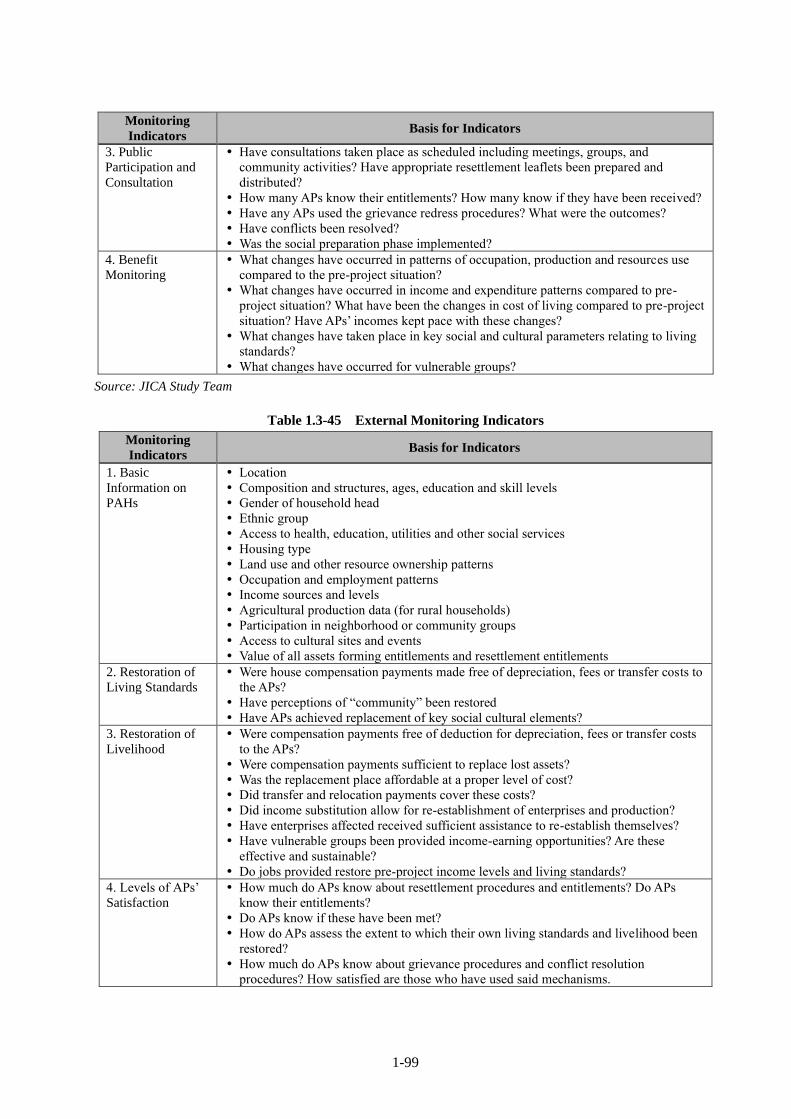
1-99
Monitoring
Indicators Basis for Indicators
3. Public
Participation and
Consultation
Have consultations taken place as scheduled including meetings, groups, and
community activities? Have appropriate resettlement leaflets been prepared and
distributed?
How many APs know their entitlements? How many know if they have been received?
Have any APs used the grievance redress procedures? What were the outcomes?
Have conflicts been resolved?
Was the social preparation phase implemented?
4. Benefit
Monitoring
What changes have occurred in patterns of occupation, production and resources use
compared to the pre-project situation?
What changes have occurred in income and expenditure patterns compared to pre-
project situation? What have been the changes in cost of living compared to pre-project
situation? Have APs’ incomes kept pace with these changes?
What changes have taken place in key social and cultural parameters relating to living
standards?
What changes have occurred for vulnerable groups?
Source: JICA Study Team
Table 1.3-45 External Monitoring Indicators
Monitoring
Indicators Basis for Indicators
1. Basic
Information on
PAHs
Location
Composition and structures, ages, education and skill levels
Gender of household head
Ethnic group
Access to health, education, utilities and other social services
Housing type
Land use and other resource ownership patterns
Occupation and employment patterns
Income sources and levels
Agricultural production data (for rural households)
Participation in neighborhood or community groups
Access to cultural sites and events
Value of all assets forming entitlements and resettlement entitlements
2. Restoration of
Living Standards
Were house compensation payments made free of depreciation, fees or transfer costs to
the APs?
Have perceptions of “community” been restored
Have APs achieved replacement of key social cultural elements?
3. Restoration of
Livelihood
Were compensation payments free of deduction for depreciation, fees or transfer costs
to the APs?
Were compensation payments sufficient to replace lost assets?
Was the replacement place affordable at a proper level of cost?
Did transfer and relocation payments cover these costs?
Did income substitution allow for re-establishment of enterprises and production?
Have enterprises affected received sufficient assistance to re-establish themselves?
Have vulnerable groups been provided income-earning opportunities? Are these
effective and sustainable?
Do jobs provided restore pre-project income levels and living standards?
4. Levels of APs’
Satisfaction
How much do APs know about resettlement procedures and entitlements? Do APs
know their entitlements?
Do APs know if these have been met?
How do APs assess the extent to which their own living standards and livelihood been
restored?
How much do APs know about grievance procedures and conflict resolution
procedures? How satisfied are those who have used said mechanisms.

1-100
Monitoring
Indicators Basis for Indicators
5. Effectiveness of
Resettlement
Planning
Were the PAHs and their assets correctly enumerated?
Was the time frame and budget sufficient to meet objectives?
Were entitlements too generous?
Were vulnerable groups identified and assisted?
How did resettlement implementers deal with unforeseen problems?
6. Other Impacts Were there unintended environmental impacts?
Were there unintended impacts on employment or incomes?
Source: JICA Study Team
1.3.2.12 Public Consultation
Public consultations on resettlement issues were held together with those for Environmental Impact
Assessment (EIA) as impacts on project area and local people are considered minimum. The detailed
contents of the consultations are explained in 1.3.1 Environmental Impact Assessment. Opinions and
responses regarding land acquisition and compensation as well as interest in the project have been observed
through 4 consultation meetings are presented in Table 1.3-46.
Table 1.3-46 Outlines and Opinions/Attitude from Participants in each Consultation
Meeting No.
& Date
Objective &
Background
Major Questions &
Opinions Responses
Favor/
Disfavor
1st
23 May 2018
Project
introduction,
request of
cooperation and
exchange ideas
among related
organizations and
local
representatives
・Scheme of land
acquisition and
compensation manner to
make sure of a fair
compensation
・River water use by local
people in the future
(whether laundry could
be disturbed or not)
・The value of compensation
is computed through the site
survey and will be paid to
PAPs in line with JICA
guidelines and domestic
laws.
・Alternative sites are placed
during construction. The
planned embankment has
facilities to access the river
water.
All
participants
expressed
positive
attitude and
promised full
cooperation.
2nd
13 June 2018
Project
introduction and
also local
contractor, request
of cooperation and
exchange ideas
among related
organizations and
local
representatives
・Confirmation of
implementing of a fair
compensation as of
some problems in the
past.
・Effectiveness of flood
control project
(Discharge capacity
after widening river
course and building
embankments)
・Compensation for crops
& trees. It is not easy to
make a detailed list of
crops for DOA.
・The value of compensation
will be estimated through a
site survey and will be paid
to PAPs in line with JICA
guidelines and domestic
laws.
・This project will contribute
to flood controls in this area
and the designs discharge
will be based on a fair flood
return period.
・Compensation will be
estimated and paid based on
market transaction values.
Ditto

1-101
Meeting No.
& Date
Objective &
Background
Major Questions &
Opinions Responses
Favor/
Disfavor
3rd
20 June 2018
Public consultation
before on-site
survey
Outline of on-site
survey, request of
cooperation and
exchange ideas
(Informing cut-off
date to local
residents and
stakeholders)
・The project is essential
to Teouma area and
there are no disputes on
lands by area chief.
・Wish to implement
compensation without
failures (From a bad
experiences in the past)
・Wish to know a
particular leased or
managing land would be
involved or not
・Noted. We would fully like
to request local cooperation.
・The value of compensation
will be estimated through
the site survey and will be
paid to PAPs in line with
JICA guidelines and
domestic laws.
・It will be revealed thru the
on-site survey. However, a
draft map has been showed
for land acquisition
Ditto
4th
24 Dec. 2018
Public consultation
after on-site survey
Outline of the
results of on-site
survey, request of
cooperation and
exchange ideas
(To same
stakeholders as the
3rd consultation)
・Impact on a stall along
the road
・How to treat the leased
land without border
pegs?
・Wish to implement the
project ASAP
・We consider compensation
for relocation. Livelihood
assistance could be optional
if necessary.
・DOL carried out a cadastral
survey to clarify the
boundary.
・Noted. We would fully like
to request your cooperation.
Ditto
Source: JICA Study Team
In the 1st and 2nd consultation meetings, JICA survey team fostered enhancement of an
understanding and cooperation for the project toward the related organizations and local representatives
(including affected people) through interpreting the project. In the 3rd and 4th consultation meetings, all
participants showed positive opinions and favor to the project since a mutual understanding had been
developed in Teouma area. All stakeholders hope a rapid implementation of the project due to obtaining a
high countenance since the pre-survey in 2016.
A steady implementation of compensation and supports in accordance with relevant laws was
requested by some participants. They have experienced insufficient compensation and land expropriation
for a public work in the past. In addition, an affirmative engagement of local people was requested during
the construction phase.
1.3.2.13 Gender Equity
Attention to gender is essential. It is essential for women and men to equally benefit from and to
participate in projects and do their best to avoid inequality. This study is to confirm policies and institutional
arrangements related to gender equity as well as efforts on this by other donors. In case of land acquisition
and resettlement, the study shall consider:
1) The gender balance of stakeholder consultation meetings;
2) The gender composition of project affected peoples,
3) Special considerations for female headed households and socially vulnerable households; and
4) Appropriate and steady measures for compensation and livelihood support.

1-102
In Vanuatu the Protection in the Pacific (ProPa) Network is established between the government and
women’s organizations in order to respond to cyclones and the climate change by the support of the UNDP.
This study shall confirm the contents and directions of these activities for their use and application in this
project.
The Government of Vanuatu addresses gender mainstreaming by formulating “National Gender
Equality Policy 2015-20195”. The number of violence cases against women is still high and the women’s
social advancement is delayed. Therefore, considerations for and advancements of women is an urgent
issue. The policy sets the following six principles:
1. The fundamental rights and freedoms of all men and women in Vanuatu are enshrined in the
Constitution.
2. Gender equality is about all men and women.
3. Gender mainstreaming is a commitment in the Government agenda.
4. There is a high level of diversity among men and women and it must be recognized that women are
more vulnerable than men.
5. The strategies and actions identified in this policy are practical, achievable, measurable and relevant
to the Vanuatu context.
6. The policy framework is not prescriptive.
Furthermore, the policy prioritizes the following four strategic areas:
1. Reducing Domestic and Gender Based Violence
2. Enhancing Women’s Economic Empowerment
3. Promoting Women’s Leadership and Equal Political Participation
4. Building a Foundation of Gender Mainstreaming
With respect to the climate change, Vanuatu ratified the Convention on the Elimination of All Forms
of Discrimination against Women (CEDAW) in 1995 and established the National Advisory Board on
Climate Change & Risk reduction Project Management Unit (NAB-PMU) under the parliament in 2012.
Though NBA-PMU in 2013, Vanuatu achieved gender participation in response to the increase of women
in the process of the United Nations Framework Convention on Climate Change (UNFCCC). As a result,
the half of the delegation from Vanuatu was women for the Conference of the Parties (COP) 19 held in
Poland in 2013. In this way, it can be said that Vanuatu has addressed the advancement and utilization of
women nationwide and recognized women as important actors in the field of disaster management. On the
other hand, the followings are the current issues facing Vanuatu:
Low rate of participation of women in disaster mitigation organizations;
Limited participation of women at the community level;
The Vanuatu Humanitarian Team (VHT) and the parliament struggle in order to ensure gender
mainstreaming in policies for the climate change and disaster mitigation management. However, the
activity still remains at the governmental level and does not spread to the citizen level; and
5 https://www.pacificclimatechange.net/sites/default/files/documents/NationalGenderEqualityPolicyJuly 2015.pdf

1-103
Limitation of capacity of the Department of Women Affairs (DWA) in order to ensure gender
mainstreaming at all levels of governments.
A relevant project to this project is the Cyclone Pam Road Reconstruction Project6 funded by the
Asian Development Bank (ADB). The purpose of the project is to provide an opportunity to improve gender
equality by securing continued access to markets, government services and basic social facilities (healthcare
and education) to pregnant women, mothers of infants and children as well as men. The details are as below.
Provision of concrete steps and footpaths to the edge of freshwater to make its access easy and
construction and improvement of laundry facilities (for example in Mele, Tanoliu, Epau, Pangpang
and Rentapau);
Universal access provisions of all communal facilities (for example in Prima, Mele, Creek Ai,
Tanoliu, Marona, Sara Epule, Lamin and Pangpang); and
Provision of opportunities to secure income for women during construction (employment of non-
skilled labor, procurement of local food and etc.).
One of NGOs active in Vanuatu on a large scale is Oxfam Vanuatu. It implements the following
programs concerning gender support in collaboration with Oxfam Australia7.
1. Australian Humanitarian Partnership: Disaster Ready – Vanuatu
Humanitarian support program for four and half years (2018-2022) focusing on the enhancement of
disaster resilience, the establishment of cash transfer schemes and the promotion of humanitarian
collaboration in cooperation with the government of Vanuatu and local organizations.
2. Vanuatu Governance, Leadership and Accountability
Support program for the socially vulnerable for seven years (2012-2019) focusing on sharing purposes
and achieving positive effects by reflecting the voice of the socially vulnerable including women in
decision making.
3. Vanuatu Gender Justice, Youth and Livelihoods
Support program for the socially vulnerable for three years (2016-2019) promoting livelihood supports
and facilitation of the access to resources and participation in policy making targeting at the socially
vulnerable including LGBTQI8.
4. Pacific Climate Change Collaboration, Influencing and Learning
Participation program for the measures against the climate change for four years (2018-2022), with the
purpose of reflecting opinions in the Pacific Islands Climate Action Network through gender equality
activities.
5. Unblocked Cash: Piloting Accelerated Cash Transfer Delivery in Vanuatu
Development program of a multi-purpose cash transfer platform for one year (2018-2019) for the
purpose of improving the speed of cash transfer, transparency and cost efficiency in Vanuatu and its
surrounding areas with the aid of brock-chain technology.
6 ADB Vanuatu: Cyclone Pam Road Reconstruction Project (49319-001)
https://www.adb.org/projects/49319-001/main#project-overview 7 https://www.oxfam.org.au/country/vanuatu/ 8 An abbreviation for Lesbian, Gay, Bisexual, Transgender, Queer and Intersex


2-1
CHAPTER 2 Contents of the Project
2.1 Basic Concept of the Project and Design Policy
2.1.1 Basic Concept for Flood Disaster Countermeasure
The following manual and guidelines highlight hydrological and hydraulic design such as setting-up
of a freeboard and also flood return period:
Vanuatu Resilient Roads Manual as a design guide for low volume rural roads in Vanuatu based
on accessibility, security and sustainability (Australian Aid, June 2014)
AUSTROADS Bridge Design Code, June 1998
Hydrological parameters for design are summarized in the following Table 2.1-1 using above
documents:
Table 2.1-1 Hydrological Parameters for Design
Manual
/Guidelines Vanuatu Resilient Road Manual (VRRM) AUSTROADS Bridge
Parameters Minimum ARI Desired ARI Design
Secured Safety
for Major Bridges 50-year 100-year 100-year ARI
for small Bridges 10-year 50-year
Freeboard - 500 mm
Remarks Flooding could be
considered in 100-year ARI
ARI: Average Recurrence Interval (Flood Return Period)
Source: JICA study team
Considering the importance of the ring road in Efate Island and the related ADB reconstruction
project, policies for flood disaster countermeasures are summarized as follows:
Bank protection structures shall be installed along the riverbank under erosion to prevent local
scouring and washout damages around the bridge abutment. The structural damages occurred
during Cyclone Pam in 2015.
For this purpose, riverbank protection works shall be planned for 250 m of upstream and 100 m
of downstream of the bridge.
Furthermore, the main objectives of the above-mentioned river improvement works are
prevention of bank erosion and also fixing of meandering channel. In the case of flood inundation
risk in large flood such as 100-year design flood, floodwater in the river channel will flow
downstream safely.

2-2
The followings are also solid working policies:
Two-dimensional flooding simulation model will be set-up based on interview results of flooding
situation during Cyclone Pam. The computation results of this 2-D flood simulation shall be
utilized in bridge improvement design and necessary river improvement.
100-year return period flood shall be considered hydrological and hydraulic computation through
the two-dimensional flooding simulation for alternative study on river and bridge improvement.
In parallel with 100-year return period, 50-year return period flood shall be examined as well.
Approximate cost of alternatives and their socio-economic impacts shall be examined
comprehensively so that the optimum plan would be proposed.
2.1.2 Policies for Flood Disaster Countermeasure
(1) Model Configuration of Two-dimensional Flooding Simulation
Two-dimensional simulation model is constructed in the following procedure:
Digital elevation model (DTM) of 10 m grid is developed after confirmation of good agreement
between topographic data produced by LIDAR survey provided by Department of Land, Vanuatu
as well as results of river cross-section and also road longitudinal section survey.
Initial conditions for simulation such as water level at river mouth and flood hydrograph are
already described in “1.2 Natural Conditions (Climate and Hydrology)” in the preceding Chapter.
Observed daily rainfall of 514 mm in Bauerfield during Cyclone Pam is nearly equivalent to 50-
year return period. Since hourly and spatial distribution of daily rainfall are unknown, a probable
50-year daily rainfall is used for identification of the simulation model. The highest flood level
of 7.6 m at Teouma Bridge during Cyclone Pam is an index for verification of the model.
Roughness coefficients of 0.035 in river channel and 0.20 of floodplain are obtained through trial
and error. As the results of model simulation, a peak discharge of 650 m3/s might pass through
the bridge. In addition, 60 m3/s overtop flow might be observed in 200 m width of the ring road
on the left bank. The simulation results are illustrated thus:
The results of the simulation are shown in Figure 2.1-1.

2-3
Remarks: Maximum flood depth is depicted throughout the flood time.
Source: JICA study team
Figure 2.1-1 Results of Flooding Simulation during Cyclone Pam
(2) Hydraulics Computation for River Width
From this point of view, The relationship between river width and hydraulic parameters in the river
channel countermeasure section (about 400 m in length) shown in the “Data Collection Survey in 2017”
are examined, and the results are shown in Table 2.2-1 and Figure 2.1-2.
In particular, the following items should be secured for a stable hydraulics flow condition:
Average flow velocity should be kept lower than around 3 m/s in the bridge section.
The flow capacity along with widening river width should be increased effectively.
Comparing the computation results illustrated in Figure 2.1-2, 50 m channel width is considered
optimum. Flood discharge capacity of river channel is limited due to overbanking flooding in the

2-4
immediately upstream of the bridge. They are 680 m3/s (50-year flood return period) and 920 m3/s (100-
year flood return period). The exceeding flood discharge overflows in the upper reaches and causing
floodplain inundation are 40 m3/s and 100 m3/s for 50 and 100-year return period, respectively. In this case,
less than 5 m3/s in 50-year and about 30 m3/s in 100-year will flow toward east along the upper part of the
ring road.
Table 2.1-2 Results of Hydraulics Analysis for Channel Widening
Flood Magnitude 50-yr 100-yr
River Channel Condition
(Width)
Existing
(30 m) 40 m 50 m 60 m 100 m
Existing
(30 m) 40 m 50 m 60 m 100 m
Peak Discharge at Teouma
Bridge (m3/s) 650 665 670 675 680 850 890 920 920 920
Overflow Discharge on the
Ring Road(m3/s) 60 45 40 35 35 110 80 60 60 60
Water Level at Teouma
Bridge (m MSL) 7.59 7.77 7.83 7.91 7.96 8.15 8.29 8.39 8.51 8.60
Flood Velocity at Teouma
Bridge (m/s) 4.35 3.00 2.49 1.85 1.06 5.06 3.63 3.07 2.29 1.31
Source: JICA study team
River Width-Flow Discharge(50-year) River Width-Flow Discharge(100-year)
River Width-Water Level(50-year) River Width-Water Level(100-year)
640
650
660
670
680
690
700
710
720
730
740
0 20 40 60 80 100 120
RIv
er D
isch
arge
(m3/s
)
River Width (m)
840
860
880
900
920
940
960
980
1000
1020
1040
0 20 40 60 80 100 120
RIv
er D
isch
arge
(m3/s
)
River Width (m)
7.5
7.6
7.7
7.8
7.9
8
0 20 40 60 80 100 120
Wat
er L
evel
(M
SL)
River Width (m)
8.1
8.2
8.3
8.4
8.5
8.6
8.7
0 20 40 60 80 100 120
Wat
er L
evel
(M
SL)
River Width (m)

2-5
River Width-Flow Velocity(50-year) River Width-Flow Velocity(100-year)
Source: JICA study team
Figure 2.1-2 Changes of Hydraulics Parameters in River Widening
(3) Comparative Study of Alternatives
Premises of Comparative Study and Alternatives in Brief
It is better to summarize premises for comparative study prior to setting-up of alternatives and
conducting hydraulics computation as follows:
Water level in 100-year return period flood is computed at 8.39 m for 50-m wide channel.
Therefore, High Water Level (HWL) can be set at 8.4 m.
Freeboard: By considering 0.5 m freeboard following guidelines, the soffit level of Teouma
Bridge would be 8.9 m.
Considering Steel I-girder type as described in the section 2.2.1.7 (4) of this section, the structural
height is 1.5 m. Therefore, the proposed road elevation would be 10.4 m.
For that reason, the road surface will be elevated from the existing 7.7 m up to 10.4m. Flood disaster
mitigation alternatives are how to approach from the planned bridge to the existing road surface on the left
bank. The following are the proposed alternatives and their conceptual longitudinal profile is depicted in
the following too:
Alternative Road Embankment Alt.: Embankment road with height of 8.7 m above MSL will be
planned from the bridge surface to convex ridge at a distance of 340 m east in order to discharge
fully through bridge section.
Road Embankment & Drainage Culvert Alt.: Box culvert (2.5 m x 2.5 m in 2 cells) with bottom
height of 5 m above MSL along the lowest part of the existing ring road will be installed to
discharge flooding water. Embankment road will be planned at elevation of 8.4 m above MSL
with covering earth of 1.0 m thick.
Road Embankment & Overflow Section: Approach road will decline with a slope of 3%
connecting to the bottom of existing road, and will follow the existing ring road. Flood water will
overtop the reinforced overflow section.
0
1
2
3
4
5
0 20 40 60 80 100 120
Flo
w V
elo
city
(m/s
)
River Width (m)
0
1
2
3
4
5
6
0 20 40 60 80 100 120
Flo
w V
elo
city
(m/s
)
River Width (m)

2-6
Layout Plan
Source: JICA study team
Figure 2.1-3 Flood Disaster Mitigation Alternatives and Longitudinal Profiles
Comparative Study of Alternatives
Hydraulics parameters of alternatives by flood magnitude, 50-year and 100-year ARI (flood return
period) are shown in Table 2.1-3 below. Flooding simulation results are also illustrated in Figure 2.1-4 and
Figure 2.1-5 respectively.
Table 2.1-3 Comparative Study on Hydraulics Parameters of the Alternatives
Flood Magnitude 50-yr 100-yr
Alternatives Existing Embank-
ment
Embank-
ment &
Culvert
Embank-
ment &
Overflow
Existing Embank-
ment
Embank-
ment &
Culvert
Embank-
ment &
Overflow
Peak Discharge at Teouma Bridge
(m3/s) 650 710 690 670 850 960 940 920
Overtopping Discharge or Outflow
through Box Culvert (m3/s) 60 0 20 40 110 0 30 60
Water Level at Teouma Bridge (m
MSL) 7.59 7.83 7.84 7.83 8.15 8.37 8.38 8.39
Flow Velocity at Teouma Bridge
(m/s) 4.35 2.61 2.53 2.51 5.06 3.21 3.14 3.07
Water Level Upstream of Ring Road
(m MSL) 7.80 8.05 7.93 7.72 8.38 8.63 8.56 8.35
Water Level Downstream of Ring
Road (m MSL) 7.74 7.55 7.76 7.66 8.32 8.11 8.29 8.26
2.5 m x 2.5 m x 2 cells of Drainage Culvert in Road
Embankment & Drainage Culvert Alternative

2-7
Flood Magnitude 50-yr 100-yr
Alternatives Existing Embank-
ment
Embank-
ment &
Culvert
Embank-
ment &
Overflow
Existing Embank-
ment
Embank-
ment &
Culvert
Embank-
ment &
Overflow
Flow Velocity through Box Culvert
(Case B)/of Overtopping Flow (Case
C)(m/s)
- - 1.67 0.48 - - 2.10 0.50
Source: JICA study team
Comparative study results are summarized in Table 2.1-4.
Based on the non-deterioration principle, road embankment alternative is ruled out at first. Compare
to two remaining measures, Road Embankment and Drainage Culvert Alternative would be selected
because as it is cheaper with almost similar effect as the other option.

2-8
Existing (50-yr)
Road Embankment Alt. (50-yr)
Road Embankment & Drainage Culvert Alt. (50-yr)
Road Embankment & Overflow Section Alt. (50-yr)
Source: JICA study team
Figure 2.1-4 Result of Flooding Simulation by Alternatives in 50-year return period flood

2-9
Existing (100-yr)
Road Embankment Alt. (100-yr)
Road Embankment & Drainage Culvert Alt. (100-yr)
Road Embankment & Overflow Section Alt. (100-yr)
Source: JICA study team
Figure 2.1-5 Result of Flooding Simulation by Alternatives in 100-year Return Period Flood

2-1
0
Table 2.1-4 Overall Comparative Study Results of the Flood Disaster Mitigation Alternatives
Road Improvement
(With/Without
Overtopping)
Flood Disaster
Mitigation
Measures
Evaluation
Flood Disaster Mitigation Effects Cost Land Acquisition
Convenience
& Safety of
Road
Traffic
Safety
Overall
Evaluation
Road
Embankment
Alt.
Ring road shall be
elevated with soil up
to a height of 8.7 m
MSL not to be
overtopped by the
100-year flood.
Embankment road
to guide the
flooding water to
the river channel
along the upstream
side of ring road.
Flooding situation in the upstream of
ring road slightly worsen from existing
conditions in both 50-year and 100-
year floods.
Low
(Only earth
embankment)
Due to embankment
road with highest
one of 2.5 m,
necessary area of
land is widest.
All-weather
type
Fair Medium
Road
Embankment
& Drainage
Culvert Alt.
Ring road shall be
elevated with soil up
to a height of 8.4 m
MSL not to be
overtopped by the
100-year flood.
Existing lower part
of the road will not
overtop the
floodwater.
Flooding situation in the upstream of
ring road will not worsen from existing
conditions.
Medium
(Box culverts
and earth
embankment)
Due to embankment
road with highest
one of 2.5 m,
necessary area of
land is wide.
All-weather
type
Fair High
Road
Embankment
& Overflow
Section Alt.
Utilizing existing
drainage function of
lower part of the ring
road, road will
decline with a slope
of 3% connecting to
the bottom of
existing road.
Floodwater will
overtop the
reinforced
overflow section.
Overtop starts in
more intensive
than 10-year flood.
Flooding situation in the upstream of
ring road will not worsen from existing
conditions.
Overtopping situation
50-year:overflow depth 1.5 m,
velocity 0.48 m/s
100-year:overflow depth 2.1 m,
velocity 0.50 m/s
High
(Flood
proofing road
and earth
embankment)
Due to embankment
road, but necessary
area of land is not
so wide.
Road will be
closed in
more
intensive
than 10-year
flood
Low Low
Source: JICA study team

2-11
(4) Countermeasures to Protect Scouring of the Right Bank at Bend
Scouring Situation at River Bend
According to the results of river cross-sectional survey, significant scouring cannot be observed in
the longitudinal riverbed profile (refer to Figure 2.1-6) and river cross-sections. A few large-scale cyclones
still pass Efate Island after Cyclone Pam and riverbed materials mainly consisting of movable sand and fine
gravels can easily be used to backfill scoured portion after any floods.
Source: JICA study team
Figure 2.1-6 Longitudinal Profile of Deepest Riverbed at Bend upstream of Teouma Bridge
5100 m
5000 m
4900 m
4800 m
Source: JICA study team
Figure 2.1-7 River Cross-sectional Survey Location at Bend upstream of Teouma Bridge
0
1
2
3
4
5
6
7
8
9
10
4,750 4,800 4,850 4,900 4,950 5,000 5,050 5,100 5,150
Elevation
(m)
Longitudinal Distance (m)
Local Scouring along the Bend Upstream of Teouma Bridge
Right Bank
Left Bank
Deepestbed

2-12
Scouring Depth Prediction
The following guidelines are referred to for estimation of scouring depth: Revised Version of Mechanical
Designing for River Revetment Works (Japanese), Japan Institute of Countryology and Engineering (2007)
Below is the estimation process for scouring depth:
(1) Relation of maximum flow depth (Hmax) and average flow depth of an average annual maximum
flood (Hm) shall be confirmed Refer to Figure 2.1-8.
.
Using curvature radius of river bend (r=140 m) and river width (B=50 m), r/B of 2.8 can be estimated.
Checking the figure and using r/B of 2.8, Hmax/Hm of 2.3 can be made out in the rivers without formation
of sandbar (dotted line in the figure).
(2) From average flow depth in average annual maximum flood (Hm), maximum flow depth in design
flood (Hmax) can be estimated.
Assuming Hm of 1.0 m as average annual maximum flood (40 m3/s in 3 - 4 year ARI), Hmax can be
estimated as follows, referring to the Guidelines.
Hmax = 1.0 x 2.3 x 1.3 = 3.0 m
(3) Setting-up of design foundation depth
Considering average water depth of 1.0 m, design foundation depth of 2.0 m the below riverbed
design can be obtained.
Source: Rivised Revetment Dynamic Design Methods / Japan Institute of Country-ology and Engineering (2007)
Figure 2.1-8 Relation between Hmax/Hm and r/B at Bend
1) Scouring Prediction around Bridge Pier
a) Causal Factors of Local Scouring
According to HEC 23, riverbed scouring generally occurs in complex phenomena combining the
following three independent factors:
• Riverbed aggradation/degradation: Channel scouring occurs by sediment balance situation. If
human/natural activities or structures which influence the sediment balance situation in the upper
reaches does not exist, then it is not necessary to consider this factor.

2-13
• River channel contraction: A large amount of floodwater flowed down along the river channel and
simultaneously eroded the riverbank during Cyclone Pam, resulting in the widening of the river
channel. As a result, Teouma bridge remained forming a constriction section. In the Outline Design,
it is planned to widen the river channel and in doing so, this factor also may influence only negligible
small effects.
• Structure’s effect: Occurrence of vortex caused by bridge pier accelerates local scouring around the
structure. This factor is major causal factor of local scouring.
b) Scouring Prediction around Bridge Pier
Based on the following article, the scouring depth around the bridge pier shall be computed: Planning
Guidelines for River Crossing Bridge (Draft), Japan Institute of Country-ology and Engineering, 2009
Based on the actual site conditions of Teouma Bridge, the necessary hydraulics parameters are:
• Average water depth (ho): 6 m
• Width of bridge pier(D): 2.0 m (Oval shape)
• Mean diameter of riverbed materials(dm): 1-0.5 mm (Coarse sand)
• Froude number (Fr): 0.4
Following the above figures, ho/D is 3 so that experimental result of ho/D between 2.75 to 3.50 can
be used for estimation of local scouring depth. Fr is 0.4 and ho/dm ranges 6,000 to 12,000. Considering the
figure below, ho/dm could be 6,000. As a result, non-dimensional scouring depth Z/D may be 1.7, and
actual scouring depth Z could be computed as 3.4 m. The design scouring depth could be set at 3.5 m as a
round number.
Source: Planning Guidelines for River Crossing Bridge (Draft), Japan Institute of Country-ology and
Engineering, 2009
Figure 2.1-9 Relation between Fr, ho/dm and Z/D for Prediction of Scouring Depth
Assessment of the impact of climate change
Based on climate change projections, a two-dimensional flooding simulation was conducted. The results
are shown in Table 2.1-5.

2-14
When climate change is considered in simulation, the maximum water level at Teouma Bridge would be
0.19 m above maximum water level without effect of climate change. However, 0.19 m is covered by free board
0.5 m. The water level at the left bank approach road 8.8 m is 0.1 m above the elevation of designed approach
road 8.7 m. However, this 0.1m is absorbed in the super elevation of the approach road because this part is
located in the curve section. Therefore, the increase of the water discharge due to climate change can be address
by a newly design structure.
Table 2.1-5 Changes of Hydraulics Analysis Results Considering Climate Change
50-yr 100-yr
No Climate
Change
Climate
Change
No Climate
Change
Climate
Change
Peak Discharge (m3/s) 720 820 1020 1160
Peak Discharge at Teouma Bridge (m3/s) 690 780 950 1060
Water Level at Teouma Bridge (m MSL) 7.83 8.04 8.37 8.59
Water Level at left bank approach road of
Teouma Bridge (m MSL)
7.90 8.18 8.57 8.80
Note:Teouma Bridge HWL;8.40 m MSL、Water Level at left bank approach road;8.70 m MSL
Source: JICA study team
2.1.3 Design Policy of River Improvement Works
Based on the design policy of Flood Disaster Countermeasure described in 2.1.1 above, the following
presents the design policy for river channel improvement works around the Teouma Bridge (a stretch of about
100m downstream and about 300 m upstream from bridge). A box culvert is also proposed under the road to
drain flood overflow on the left bank.
At first, the present conditions of the river channel are investigated. Then, the design items of the channel
improvement works such as alignment, longitudinal profiles and typical cross section are prepared.
Furthermore, design policies are considered on excavation and embankment works to shape the proposed
river channel. Bank slope protection works are needed for protection of vulnerable banks from erosion, and
box culvert works are needed as drainage facility on the left bank. In addition, maintenance works are
planned for completed channel.
(1) Site Conditions of River around Teouma Bridge
The present conditions of the river channel around the Teouma Bridge are described as follows:
・ The River course shows a big bend towards the right (western) side in the upstream of the
bridge using topographic data. River flow cause erosion severely in the right riverbank and
hits the right approach road of the bridge. The river water then turns to the left and flows under
the bridge. Fast-flow and/or turbulent water flow occurring due to flooding could cause erosion
easily on the vulnerable riverbanks.
・ During the flood caused by Cyclone Pam in 2015, severe erosion was observed on the
approach road of the bridge on the right bank as shown in Figure 2.1-10 below (left photo).
Emergency rehabilitation work using stones was done (right photo).

2-15
Damage to the Right Approach Road
(2015)
Urgent Rehabilitation Works of Right
Approach Road (Present)
Source: JICA study team
Figure 2.1-10 Teouma Bridge Damaged by Cyclone Pam
・ Present width of riverbed is 20 to 30 m approximately. The riverbed elevation ranges from 1m above
Mean Sea Level (MSL) to 1.5 m (hereafter presented by EL. 1 m or EL. 1.5 m). Top elevations of
upstream riverbanks range from EL. 5 m to EL. 8.6 m at the right bank and EL. 6 m to 7 m at the left
bank. Top elevations of downstream riverbanks are EL. 5 m at right bank and EL. 6 m at left bank.
Height of riverbanks from riverbed are 4 m to 7 m.
・ Present bank full flow capacity of river channel is estimated at 120m3/s which is less than 5-year return
period.
・ Material of river channel is fine sand.
・ No riparian structures are found except gabion cylinders placed for abutments of Teouma Bridge.
・ As for present land use, there is residential area for few houses on the right riverbank upstream and
farm/bush land on left riverbank upstream and bush areas on both downstream riverbanks.
・ At the area where a drainage facility is proposed under the road on the left bank 180 m from the bridge,
there is a drainage pipe with 0.9 m diameter under the existing embanked road. Top of road is EL. 6.3
m and natural surface ground is about EL.5 m.
(2) Design Alignment, Longitudinal Profiles and Cross Section for Channel Improvement
As mentioned in 2.1.1 Design Policy for Flood Disaster Countermeasures, design flood level of
EL.8.4m and design width of 50 m at the location of proposed new bridge are determined. Since the present
river width is 20 m to 30 m, widening of channel is necessary.
Moreover, present alignment of river channel invading widely private land is not desirable due to bending.
Re-alignment is necessary to stabilize the channel.
a. Design Alignment of River Channel
According to the collected land lot sketch map in the upstream area, the present river course invades
the private area on the right riverbank. Old river course with a width of about 45 m is now filled with soils
and bush land. Re-alignment of river channel is proposed to have almost the same as old channel
considering the flowing:
・ Alignments of new bridge and river channel should orthogonally intersect each other as much as
possible, so that the bridge length can be shortened.

2-16
・ Proposed alignment of river channel should be in the old river course (public land) to minimize the
use of private land.
End of upstream of new river channel connects with the existing course 260 m upstream of bridge.
On the other hand, end of downstream of new channel connects with existing course 110 m downstream of
bridge.
b. Design Longitudinal Profile of Riverbed
Riverbed elevations of stretch to be re-aligned are determined following the existing riverbed profile;
EL. 1.2 m at the downstream end and EL. 1.5 m at the upstream end. Then, the design longitudinal riverbed
gradient becomes 1:1400 (vertical and horizontal direction).
c. Design Cross Section of River Channel
Design standard cross section is determined under the following policy:
・ 50 m width is proposed as designed river channel width measured at the design flood level
(EL. 8.4 m at bridge) with a freeboard of 0.5 m.
・ Design slope gradient of riverbanks is 1:1.5 (vertical: horizontal) provided that the
riverbank slope protection is constructed and 1:2.0 without slope protection.
・ In case the slope height is more than 5.0 m, a 1.5 m wide berm, horizontal step, in the
sloping profile is provided for stability.
Design width of the riverbed is 25.7 m which is almost the same as the existing one. The design
standard cross-section of the river channel is showed in the following Figure 2.1-11.
.
Source: JICA study team
Figure 2.1-11 Proposed Typical Cross Section of River Channel (at Bridge)
(3) Excavation and Embankment Works to Make Re-Aligned River Channel
Excavation and embankment works are needed to shape proposed channel in accordance with the
design alignment, design longitudinal profiles and design standard cross-section of river channel. Existing
soil condition shows that excavation area comprises of sandy soil without any rocks found. Selected soils
Design Profile
Design Flood Level 8.4
Berm
1:1.5
1:1.5
50.0 0.75 0.75
51.5m
1.5 1.5
3.4
3.7
0.5
1.3
5.0
5.85 5.55 5.85 5.55 25.7

2-17
from excavation work or borrow pit are to be used for necessary embankment. Cut/embankment slope
gradient is designed to be 1:1.5 under the provision of slope protection and 1:2.0 for no provision of slope
protection.
(4) Design Elevations of Riverbanks
Design top elevations of riverbanks are proposed to be almost the same as existing ground elevations.
(5) Bank Sections to be Covered with Revetment
Since the soil type of riverbanks is sandy and easily eroded by flood current, provision of revetments
is proposed at curve portions and around the bridge structures as shown in Table 2.1-6 below:
Table 2.1-6 Bank Sections to be Covered with Revetment
Location Left Bank Right Bank
Downstream
of Bridge
There are curves at both bonks and banks are eroded. Revetments are to be
provided on both bonks to fix the channel alignment.
Around
Bridge
Stronger revetments are to be provided to reinforce the bridge structure and
access roads.
Upstream of
Bridge
Since left bank is inside of curve,
erosion of bank is not severe and area
on left bank is unused area. No
provision of revetment is proposed.
This bank is concave curve. Curve
would be more in progress if no any
protection. Revetment along the curve
portion is proposed up to the existing
straight channel.
Source: JICA study team
(6) Selection of Optimum Type of Slope Protection of Revetment
Revetment/Slope protection is designed based on the Japanese standards/guidelines on river
engineering works.
Design of slope protection as part of revetment and placed on slope of riverbanks needs
considerations of the subsoil condition, flood velocity, necessary height of slope protection, gradient of
slope, depth of riverbed scouring, available space for construction, cost, maintenance works, etc.
・ Fine sandy soil which is easily eroded
・ Design flood velocity 3.2 m/s
・ About 7 m water depth in case of design flood with 100-year return period
・ Design flood level gradient of 1:550 (classified within rapid-middle stream having gradient of 1:500
to 1:2000)
・ Design riverbed slope 1:1400
・ Estimated potential scouring depth 2 m approximately
・ Minimizing of land acquisition by slope gradient to avoid social issues
・ Possible construction space for dry works under dry work condition in 26 m at riverbed
・ Utilization of locally sourced materials which result in cost minimizing and easy maintenance works
As a first step in designing of slope protection, types of slope protections which might be applicable
for this river course are listed as shown in Figure 2.1-12.

2-18
(1) Wet Stone Masonry
(2) Concrete Block Wet Masonry
(3) Concrete Lining
(4) Reinforced Concrete Crib
(5) Gabion Mattress
(6) Steel Sheet Piling
(7) Dry Stone Masonry
Source: JICA study team
Figure 2.1-12 Types of Slope Protection

2-19
Comparison of types of slope protection is made in the following table (Table 2.1-7) considering the
structural stability, applicable slope, locally available materials, cost, etc. As a result of comparison, “Dry
Stone Masonry” and “Reinforced Concrete Crib” are selected. Strong reinforced concrete crib revetment is
applied around the important bridge structure. Economical Dry-Stone Masonry revetment using local
available stones is applied for area except bridge area.
Table 2.1-7 Comparison of Slope Protection
Item
No.
Slope
Protection
Type
Typical Structural
Details
Applicable
Slope
Gradient
Applicability Evaluation
1 Wet Stone
Masonry
Cobble stones
(around 30 cm
diameter) filled
with concrete
1:1.5
to
1:3.0
Hard stone is better. However, stone produced in
Vanuatu is semi-hard stone.
2 Concrete
Block Wet
Masonry
Concrete blocks
with thickness of
20 cm filled with
cement mortal
Factory-fabricated concrete blocks are not locally
available.
3 Concrete
Lining
Concrete slab
with thickness of
20 cm (with steel
mesh-net, if
needed)
Similar to type below (item 4). However,
structural strength is not enough for river with
high velocity. Since surface of slope protection is
smooth, function of velocity reduction cannot be
expected. This is generally used for river with
relatively slow velocity. Construction cost is
comparatively high.
4 Reinforced
Concrete
Crib
Concrete cribs
with 30 cm
sectional square
and filled with
20cm thick
concrete lining
Structure is strong and rigid. Velocity on surface
of slope protection can be reduced by exposed
cribs. This type is frequently used for river with
high velocity like this river. This is utilized
around the important structure, because of high
cost.
5 Gabion
Mattressess
Rocks filled in
Steel mesh box
This type is used for urgent works of disaster as
temporary works. Durability is poor.
6 Steel Sheet
Piling
Slope protection
on steel sheet
piling
Vertical
Wall
This type is used where cofferdam construction
is too costly due to deep water at near sea, etc.
It is also preferable in urban area where land
acquisition is difficult. However, construction
cost is too high.
7 Dry Stone
Masonry
Stones with
around 0.5m
diameter are
placed. Void
between stones is
filled with small
stones.
1:1.5
to
1:3.0
Locally available stones can be used, resulting in
low construction cost. Construction and
maintenance are easy.
Source: JICA study team
(7) Plan for Maintenance and River Water Use
Aggressive river flow can result in local erosion and damage of river channel. It is essential to
regularly check the slope protection system and repairs should be carried out as soon as possible. A small
damage could lead to a rapid deterioration of the total protection system. Moreover, local people are using

2-20
the river water for water intake, washing, etc. A step facility in bank slope is designed for the convenience
of maintenance inspection and water use by local people.
(8) Box Culvert under Road for to Discharge Flood Overflow
A reinforced concrete box culvert with size of 2.5 m high by 2.5 m wide x 2 cells is proposed under
the embanked road to drain smoothly the floodwater that overflows on the left bank. The structure design
is made based on the Japanese design standards/guidelines.
2.1.4 Policies for Utilization of Existing Teouma Bridge
JICA team inspected existing Teouma bridge during the 1st site survey. The inspection result is
described below.
⚫ Rust had been found on many bolts of the existing bridge. If the existing bridge is to be utilized as
a part of the new bridge, all bolts must be replaced.
⚫ Rust on the bolts mainly was found on the upper chord members on the existing bridge. One of the
reasons is considered that the airborne salt on the road surface may be rolled up by the vehicles
passing the existing bridge which is located approximately 2 km form the coast.
⚫ Peeling of galvanized corrosion protection was confirmed in a part of the main structural steel
members, but it can be judged that it is sound as a base steel material.
⚫ Road width of the existing bridge is 6.5 m (Carriageway:3.0 m x 2 + Side strip:0.25 m x 2). It does
not satisfy the road design specification in VRRM which was enacted in June 2014.
Therefore, JICA team concluded that it is difficult to utilize the existing bridge as a part of the new
bridge. In that case, utilization of the existing bridge shall not be considered in the new Teouma bridge
planning.
2.1.5 Policies for Seismic Design Condition
Seismic load had been considered for bridge design in a project by ADB because of the frequent
earthquakes that occur around Vanuatu. In bridge seismic design in Vanuatu, Australian standards normally
apply. The Australian standard has been applied too in the ADB project.
By comparison of earthquake response spectra between Australian standard and Japanese standard
is shown in Figure 2.1-13. The earthquake force in both standards is deemed mostly the same. Therefore,
Japanese standard named “SPECIFICATIONS FOR HIGHWAY BRIDGES, PART V SEISMIC DESIGN,
2012” will be applied in seismic design of this project.
Going by the construction report of the existing bridge, the soil class around Teouma bridge was
classified as Class-2, with a horizontal acceleration coefficient determined as kH=0.26. But, based on the
result of the soil investigation implemented in this survey, the soil class is classified as Class-3 (that is,
softer than Class-2), with the horizontal acceleration coefficient determined as kH=0.3.

2-21
Level 1 Earthquake (Exceedance probability 1/50)
Level 2 Earthquake (Exceedance probability 1/1000)
(a)Australian Standard (b)Japanese Standard
Source: Specifications for Highway Bridges
Figure 2.1-13 Comparison of Earthquake Response Spectra
2.1.6 Policies for Bridge Planning
The following items shall be considered for the bridge planning such as bridge location,
superstructure type, substructure type, etc.
(1) The road alignment and bridge location shall be appropriately studied taking into consideration
the construction plan.
(2) The external requirement of the bridge planning, ex) live load and flood flow, shall be satisfied
0.00
0.05
0.10
0.15
0.20
0.25
0.30
0.35
0.40
0.10 1.00
A B C
D E(kh)
5.00 T(s)
Class
of
soil
0.00
0.20
0.40
0.60
0.80
1.00
1.20
1.40
0.10 1.00
A B C
D E(kh)
5.00T(s)
Class
of Soil
kh
Natural Period (Ts)
Class-1
Class-2
Class-3
Class-1
Class-2
Class-3
kh
Natural Period (Ts)

2-22
(3) Consideration of quality, easiness and rapidity shall be considered
(4) The traffic safety and run-ability shall be considered
(5) Ease of maintenance shall be considered.
(6) The design standard shall be determined comparing both the Australian and Japanese
standards.
(7) The procurement condition for equipment and materials in Vanuatu shall be considered.
(8) Utilization of the existing bridge is not possible.
(1) Condition on Bridge Location
Considering the function of the bridge as a trunk national road and the security of traffic flow during
construction, three alternatives in the same location as well as upstream and downstream of the bridge will
be compared and examined with respect to road alignment, obstacles, environmental impact, construction
period and economic efficiency.
There are houses and street stalls around the Teouma Bridge. In the bridge planning, consideration
shall be given to the geometric shapes of bridges and approach roads to minimize the relocation of these
facilities and houses. When selecting a bridge type, the elevation of the road surface should be suppressed
as much as possible. When the road surface height changes, consideration should be given to installing
stairs, etc. in order to maintain access to facilities and houses.
(2) Condition on Bridge Profile
The High-Water Level (HWL) for the bridge design shall be determined based on Two-dimensional
Flooding Simulation as mentioned in 2.1.1. The impact of climate change shall also be considered for HWL.
The appropriate freeboard and the cross-sectional area of the river shall be maintained to make the
river flow smoothly during floods. The freeboard in this project is determined as 0.5 m in accordance with
Australian standard as mentioned in 2.1.1.
(3) Condition on Cross Section
The following shall be considered for typical cross section:
Width of carriage way and marginal strip shall comply with the VRRM.
Typical cross section shall be considered to maintain the continuity of the existing ring road.
Sidewalks shall be installed on both sides of the carriage way only on the bridge.
Sine there is a manual for road design (VRRM) in Vanuatu, the condition on road width shall be
complied as per the VRRM. According to the VRRM, the width on ordinary road and bridge are not well-
defined, and pedestrians will walk on the road shoulder. However, in this project, a sidewalk shall be
installed only on the bridge area in respect to the strong request by the Vanuatu.
(4) Condition on Comparative Study of Bridge Planning
Bridge planning including bridge location, superstructure, substructure, pile etc., should be
comprehensively determined in consideration of the following requirements:
To select a proper location and road alignment for bridge construction
To satisfy any external requirements for the bridge planning

2-23
To be structurally stable and economical
To consider the quality, ease and rapidity of construction
To consider safety and comfort of driving
To select structural type superior in easiness of bridge maintenance
(5) Condition on Comparative Study of Bridge Planning
The bearing layer of the bridge foundation shall be selected based on:
The bearing layer of the bridge shall be determined based on the Standard Penetration Test (SPT).
The N-value of bearing layer shall be more than or equal to 30 for the sand or gravel layer and 20
for the clay layer.
The bearing layer shall be carefully decided for gravel layer to consider the errors due to existing
of boulders, possibility of scouring and the scale of the structure. The N-value of more than or
equal to 30 is not the absolute condition in case of gravel.
The thin layer shall not be selected even if the N-value was satisfied.
2.1.7 Policies for Road Planning
(1) Policies for Plan of Approach Road Alignment
Approach road will be planned based on the following policies:
In principal, to follow VRRM
To refer to AUSTROADS Guide, Road Design Part 3: Geometric Design (hereinafter referred
to as the “AGRD”) or Government Order on Road Design Standards of Japan)
To provide guardrail in high embankment section as a traffic safety measure
To consider the ease of maintenance
To maintain the continuity of the existing road
To design with an emphasis on safety because the curve radius of existing road is small and
the road is steep
To plan to minimize land acquisition
1) Consideration of Road Alignment
In planning approach of the road alignment, the survey compared three options: See Table 2.2-14.
Option-1: Almost same alignment as existing road, Option-2: Moving the alignment to the upstream
side, and Option-3: Moving the alignment to the downstream side. The items for comparison were:
Obstacles
High-voltage and low-voltage electric wires are laid around the Teouma bridge. The height of
embankment will be 2.5 m to 3.0 m due to the elevation of new bridge. Therefore, the relocation of the
poles and cables are indispensable for all options. In that case, the 3 options do not have much difference.
Environmental Impact
Vanuatu has a traditional customary land use system and this custom remains deeply rooted at present.
Therefore, there are many lands where landowners are not clear. The land use situation around Teouma

2-24
bridge is as follows: upstream side is leased land registered under the government and registered in the land
registry, however, the downstream side is a customary land and the leader of the village substantially
manages it. Land expropriation is very difficult in Vanuatu for both leased and customary land. Designed
flood water level will be higher than the existing bridge. Accordingly, height of embankment also will be
higher than existing road. Relocation of houses may occur with both option-2 and option-3. Therefore,
Option-1, in which land expropriation doesn’t occur except in some embankment sections, has an advantage
compared to the other two options.
Alignment
In the case of option-3, the horizontal alignment on the right bank side has a smaller radius of
curvature than the existing alignment due to the relationship with location of the bridge. This means driving
safety will slightly decrease. In case of Option-1 or Option-2, the plan is not to deteriorate the approach
road alignment.
Construction Period
In case of Option-1, it is necessary to construct a detour road before beginning of road and bridge
works. Therefore, construction period takes longer than others.
On the other hand, as for Option-2 or Option-3, the construction period is shorter compared to
Option-1 because the bridge can be constructed while the existing road is in service. However, since new
road elevation is 2 or 3 m higher than present road, it is necessary to construct a detour road so as to not
affect the new road in the overlap section between existing and new road alignment.
In addition, in order to ascertain the cross-sectional area of the river, it is necessary to remove existing
bridge. Particularly, in case of Option-2 and Option-3, the existing bridge can be removed, and the
revetment works can be done only after completion of the new bridge and approach road. Note: Revetment
work can be done only in dry season, therefore, the 3 options have not much difference in this regard.
Cost
In the case of Option-1: Embankment constructed for main road is smaller than the other options,
and installation of structure such as retaining walls is unnecessary. Therefore, the project cost is smaller
than the other two options.
In the other hand, the project cost of Option-2 and Option-3 are more than Option-1 due to:
The length of the main road will be longer than the existing road in case of Option-2 and Option-3;
The amount of embankment will increase because the existing ground surface on the new alignment
is lower than the existing road; and,
Retaining walls will be installed due to reducing area of land expropriation and amount of
embankment.
Even though the cost for temporary works for Option-1 is more than the other two options due to the
longer length of detour road and installation of temporary bridge, this is a small addition in comparison
with the addition to the main construction cost.

2-25
2) Comparative Study Results
As a result of examining the approach road alignment, Option-1 has the overall advantage. This is in
view of safety considerations and minimizing land acquisition with respect to the difficulty of land
acquisition by customary land use system in South Pacific countries.
(2) Policies for Pavement Planning
Since there is no asphalt plant in Vanuatu, road surface types are limited to 2 types of unseal surface
(earthen road) or seal surface (DBST / SBST). Double Bituminous Surface Treatment (DBST) is used on
the existing road surface and the existing surface condition is very sound and also considering the simplicity
of maintenance. Therefore, DBST will be applied in this project.
Appropriate pavement plan shall be prepared based on the results of the geotechnical survey and
material tests (conducted during the second field survey). The pavement structure of seal surface (DBST)
used in Vanuatu is shown in Figure 2.1-14 below.
Source: Report on the Project for Improvement of the Ring Road in EFATE Island in the Republic of VANUATU JICA 1997
Figure 2.1-14 Seal Pavement Structure
2.1.8 Policies for Procurement
The local construction business mainly consists of construction work such as small-scale buildings
and private houses, and civil engineering work can only be seen as maintenance and repair work. Large
civil works are carried out through foreign funding. The works are majorly implemented by foreign
contractors, for example, from New Zealand and China. The construction market in Vanuatu is small, and
there are no big contractors in Vanuatu. Such local circumstances shall be considered in this project.
2.1.9 Policies for Utilization of Local Contractors
The construction market in Vanuatu is very small and local construction companies are mostly very
small. There is no company that can correspond as a sub-contractor to a Japanese construction company in
Vanuatu. There are only a few suppliers of stone/crushed stone and a concrete manufacturing company as
a supplier of materials. Only Local suppliers of soil and concrete materials shall be utilized in this project.
2.1.10 Policies for operation and maintenance
Maintenance works after completion of the Project will be carried out by the Office of Shefa
belonging to the PWD under MIPU. Sufficient budget has been secured. Since advanced technology is not

2-26
required for maintenance, instruction on maintenance methods should be given during construction or after
completion.
2.2 Outline Design of the Japanese Assistance
2.2.1 Basic Plan
The Overall project plan is shown in Table 2.2-1. The road width including shoulders in the section
of approach road will be 8.0 m. In the bridge section, sidewalk with 1.25m width will be installed on both
sides of the bridge. Its effective width will be 9.5 m.
Table 2.2-1 Overall Project Plan
Source: JICA study team
Items Standards and Quantity
Design
Overview
Road
Length 620.0 m
(Bridge Section:58.0 m)
Design Speed 60 km/h
Total
Width
General
Section
STA.1+0.0m~2+37.7m,
STA.2+37.7m~7+20.0m 8.6 m
Widening
section STA.2+37.7m~67.7m 13.6 m
Number of Lanes / Carriage Way Width 2 lanes / 6.00 m
(3.00 m×2=6.00 m)
Shoulder 1.0 m
Box Culvert(2.5m×2.5m×2no 14.0 m
River
Design Flood Level E.L.=8.4 m
Design River Width 50.0 m
Riverbed Slope 1:1400
Length 482.5 m
Riprap 80.0 m (4 Places)
Stone Pitching 302.5 m (Right Bank, 2 Places)
Reinforced Concrete Revetment 100.0 m (2 Places)
Bridge
Superstructure
Structural Type Plate Girder
Bridge Length 58.0m
Girder Length 57.0m
Span Length 28.4 m + 28.4 m
Substructure
Abutment 2
Pier 1
Foundation Type Spiral Steel Rotation Pile
(Friction Pile)
Numbers of Pile /Pile Length
A1=24.5 m/12 piles
P1=24.5 m/28 piles
A2=22.5 m/14 piles

2-27
2.2.1.1 Applicable Criteria
VRRM is used as a road design standard in Vanuatu and is used in the project. Reference is made to
the AGRD for terms which are not covered in VRRM. AASHTO and Japanese relevant design standards
shall be applied mutatis mutandis for other items.
Vanuatu Resilient Road Manual (VRRM)
AUSTROADS guide to road design Part 3 Geometric Design (AGRD)
A Policy on Geometric Design of Highways and Streets: AASHTO
Design Specifications of Highway Bridges by Japan Road Association
Pavement Design Manual by Japan Road Association
Government Ordinance for Structural Standard for River Administration Facilities by Japan River
Association
2.2.1.2 Road Class and Specifications
Road Class is classified as per the following table (Table 2.2-2) in VRRM 5.2 Traffic Class.
Table 2.2-2 Traffic Classes
Traffic Classes Traffic
(Vehicles per day (vcd)) Number of lane
T4 >500 2 lanes
T3 200 – 500 2 lanes
T2 50 – 200 2 lanes
T1 <50 1 lane
Source: VRRM
The daily traffic volume at Teouma bridge on a weekday is more than 5,000 vehicles, therefore, to
the road is classified as T4.
2.2.1.3 Design Speed
The classification criterion for design speed in Vanuatu is as detailed in Table 2.2-3 below. The
terrain around Teouma bridge is classified as flat with traffic classification of T4. Considering these, the
design speed is set at 60 km/h.
Table 2.2-3 Design Speed
Terrain T4 T3 T2 T1
Rolling 40 km/h 30 km/h 30 km/h 10 km/h
Flat 60 km/h 40 km/h 40 km/h 30 km/h
Source: VRRM
2.2.1.4 Geometric Condition
Standards and Geometric Conditions in Vanuatu are shown in Table 2.2-4.

2-28
Table 2.2-4 Geometric Condition for Road and Bridge in Vanuatu
Source: JICA study team
2.2.1.5 Traffic Demand Forecast
(1) Traffic Survey Implementation Overview
Traffic Count Survey for 24 hours, Roadside OD Interview Survey and Axle Load Survey were
conducted in order to understand the traffic situation around Teouma bridge and to carry out traffic demand
forecast. The outline of the traffic surveys are shown in Table 2.2-5 below and the survey locations are
shown in Figure 2.2-1.
Table 2.2-5 Outline of the Traffic Survey
Source: JICA study team
T4
60
30
seal 1.0
seal 3.0
250
5.4 AGRD, P169
AGRD, P169
>500
Type of Surface carriageway
seal 2.5 P.42
m 100
%
m 48 AGRD, P158
Maximum Gradient Standard %
% 12
m 600
Stopping m 85
Passing m -
K-Value 9.2 AGRD, P183
Dadius m 920 AGRD, P183
K-Value 9.2 AGRD, P183
Radius m 920 AGRD, P183
m 40 AGRD, P190
ItemsRoad Classification
Remarks
Design Speed (km/h) flat land
Cross Section Configuration
Road Cross Section
Right of way (m)
Minimum Shouder Width
Lane Width(m)
Pavement Thickness (m)
Pavement Structure
Longitudinal Alignment
Minimum Vertical
Clearance(m)
carriageway
sidewalk 2.4
Traffic Volume
Design Traffic Volume (ADT)
Structure Loading
Structure Live Loading (minimum) T/L44, HS20 (or A-Load Japan)
Superelevation Development Lengths
PavementSeal Pavement (DBST)
Crossfall (%)
Geometric Conditions
Horizontal Alignment
Minimum Horizontal Curvature
Maximum Superelevation 8
Minimum Vertical Curve Length
Vertical Alignment
12
Gradient with Limitations
Sight Distance
Minimum Dadius
Crest Curve
Minimum Dadius
sag Curve
Items Purpose of Survey Contents of Survey Remark
1. Traffic Count
Survey
To understand information
for road design based on
traffic demand forecast
3 places (weekday/Sunday: 24hours)
Vehicle Type Composition: 10 types
and pedestrians (by gender)
2. Roadside OD
Interview Survey
To grasp vehicle trip
pattern on the route
3 places (weekday: 12 hours)
Vehicle Type Composition: 10 types Interview
3. Axle Load
Survey
To grasp axle situation of
heavy truck on the route
1 place (weekday: 12 hours)
Number of Samples: all
Observation by
using simple truck
scale

2-29
Source: JICA study team
Figure 2.2-1 Survey Locations
(2) Result of Traffic Survey
1) Traffic Count Survey
A 24-hour traffic count survey was conducted one day each on a weekday and holiday. The result is
shown in Table 2.2-6 below.
Table 2.2-6 Result of Traffic Count Survey
Sta.
No.
Survey
day
Motorcycle/
Buggy
Car/ Taxi/
Pickup
Van
(Van Taxi) Bus Truck
Heavy
Truck Total
Commercial
Vehicles Ratio
No.1 Weekday 32 1,187 1,463 2 263 33 2,980 1.1%
Holiday 55 1,447 1,756 4 221 5 3,488 0.1%
No.2 Weekday 31 1,806 2,580 19 543 53 5,032 1.1%
Holiday 36 1,857 2,443 0 304 1 4,641 0.0%
No.3 Weekday 22 907 736 0 36 8 1,709 0.5%
Holiday 40 788 1,129 20 133 7 2,117 0.3%
Source: JICA study team
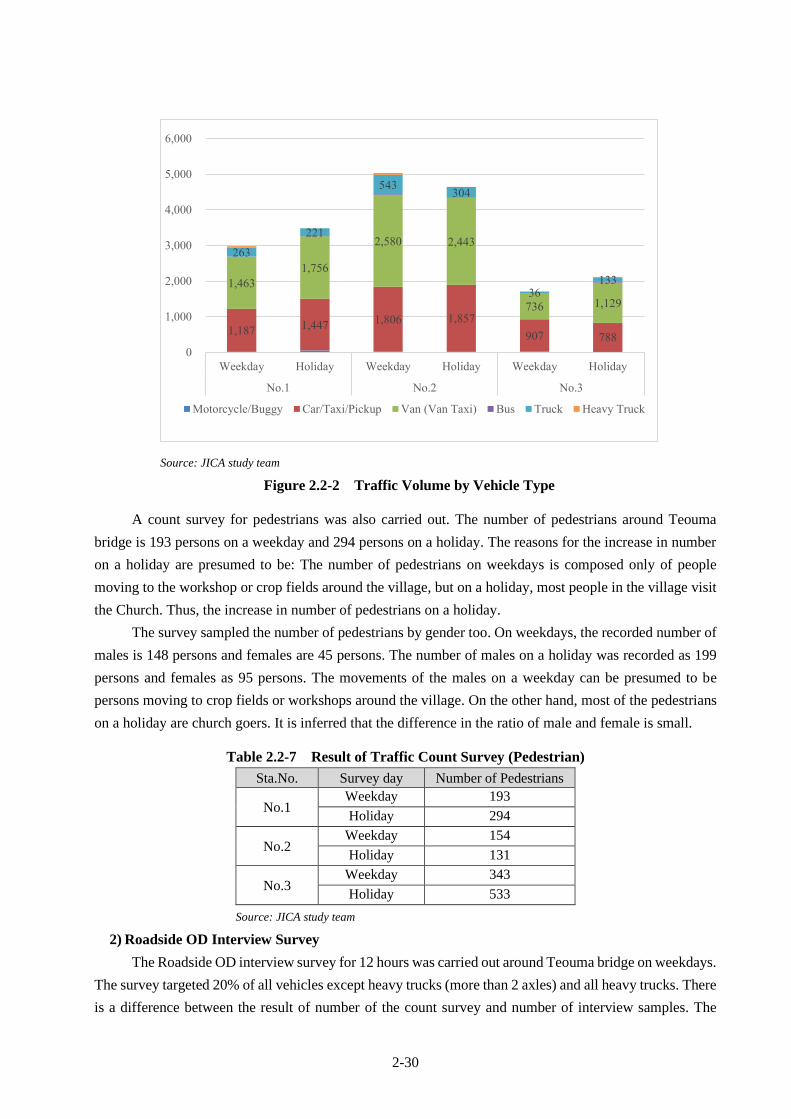
2-30
Source: JICA study team
Figure 2.2-2 Traffic Volume by Vehicle Type
A count survey for pedestrians was also carried out. The number of pedestrians around Teouma
bridge is 193 persons on a weekday and 294 persons on a holiday. The reasons for the increase in number
on a holiday are presumed to be: The number of pedestrians on weekdays is composed only of people
moving to the workshop or crop fields around the village, but on a holiday, most people in the village visit
the Church. Thus, the increase in number of pedestrians on a holiday.
The survey sampled the number of pedestrians by gender too. On weekdays, the recorded number of
males is 148 persons and females are 45 persons. The number of males on a holiday was recorded as 199
persons and females as 95 persons. The movements of the males on a weekday can be presumed to be
persons moving to crop fields or workshops around the village. On the other hand, most of the pedestrians
on a holiday are church goers. It is inferred that the difference in the ratio of male and female is small.
Table 2.2-7 Result of Traffic Count Survey (Pedestrian)
Sta.No. Survey day Number of Pedestrians
No.1 Weekday 193
Holiday 294
No.2 Weekday 154
Holiday 131
No.3 Weekday 343
Holiday 533
Source: JICA study team
2) Roadside OD Interview Survey
The Roadside OD interview survey for 12 hours was carried out around Teouma bridge on weekdays.
The survey targeted 20% of all vehicles except heavy trucks (more than 2 axles) and all heavy trucks. There
is a difference between the result of number of the count survey and number of interview samples. The
1,187 1,447
1,806 1,857
907 788
1,463
1,756
2,580 2,443
736 1,129
263
221
543 304
36 133
0
1,000
2,000
3,000
4,000
5,000
6,000
Weekday Holiday Weekday Holiday Weekday Holiday
No.1 No.2 No.3
Motorcycle/Buggy Car/Taxi/Pickup Van (Van Taxi) Bus Truck Heavy Truck

2-31
survey skipped interview survey of vehicles which had already been carried out. In general, there are lots
of vehicles making round trips within the urban area which takes about 15 minutes from Teouma bridge
and surrounding villages.
Table 2.2-8 Result of Roadside OD Interview Survey
Classification Number of
Sample (OD)
Result of
Count Survey Rate
Bicycle 7 9 77.8%
Motorcycle 4 20 20.0%
Car/ Taxi/ SUV 64 846 7.6%
Van/Van Taxi 54 1078 5.0%
Bus 0 2 0.0%
2-Axle Truck or Trailer 80 211 37.9%
3-Axle Truck or Trailer 7 24 29.2%
4-Axle Truck or Trailer 2 3 66.7%
Agriculture Vehicle 0 1 0.0%
Another Special Vehicle 0 5 0.0%
Total 218 2199 9.9%
Source: JICA study team
The traffic purposes are shown in Figure 2.2-3 below. Flow of traffic for private reason is 44% of
the total, being the largest number. The totals for work and business is 43%, to/from school is 8%, and
leisure or tourism is 3%, however, the percentage may increase to 20% on a day a cruise ship arrives as
more people may arrive for sightseeing purposes.
Source: JICA study team
Figure 2.2-3 Result of Roadside OD Interview Survey (Purpose of the Trip)
To / From Work24%
To / From School8%
Business19%
Private44%
Leisure / Tourism3%
Others2%

2-32
Source: JICA study team
Figure 2.2-4 Result of Roadside OD Interview Survey (Departure and Destination)
Figure 2.2-4 shows spider network of the traffic on the ring road. Basically, more than half of the
vehicles were going to Port Villa (urban district) from around the Teouma bridge or vice versa. In recent
years, residential areas have been developed around the Teouma bridge, vehicles going to the urban area
from the vicinity of Teouma bridge to commute for work or school are increasing. As other features, in
addition to cars bound for the tourist spots scattered on the north side from the east side of the ring road,
buses or cars carrying tourists traveling around the island were seen. In addition, when heavy trucks go to
northern part of Efate Island, the trucks must trip counterclockwise from Port Villa because the high uphill
slope with a very steep gradient and the hairpin curve are on the northwestern part of Efate Island, and the
passage by the heavy vehicle from Port Villa to the north side is impossible.
3) Axle Load Survey
Axle load survey was conducted using portable axle load measurement at the Teouma bridge in order
to understand the existing axle load situation. The outline of the axle load survey is shown in Table 2.2-9
below.
Table 2.2-9 Outline of Axle Load Survey
Type of Vehicle Truck Traffic (not including Bus)
No. of Sample 100% Inspection
Methodology by axle.
Survey Duration 1 weekday and 12 hours (From AM 6:00 to PM 18:00)
Source: JICA study team
Teouma
Port Vila
Rentapao
1140478
7292
Other

2-33
The axle load and gross load regulation of trucks as specified by the laws of Vanuatu are shown in
Table 2.2-10 below.
Table 2.2-10 Load Regulation for Road of Vanuatu
Axle Load Regulation (per axle) Gross Load Regulation (Total Loading)
8 t/axle 24 t/car
Source: Laws of the Republic of Vanuatu Road Traffic Control
The methodology of counting overloaded trucks is shown below. The result of counted overload is
also shown in Table 2.2-11.
1. To sum up the number of trucks(a) surveyed with axle load survey
2. To sum up the number of trucks whose results exceed the limit values
3. To rule out the trucks without any cargo whose results exceed the limit values
4. To define the truck whose axle weight and/or vehicle weight is exceed the limit values as
overloaded truck and to sum them up (b)
5. To calculate the conversion rate by total surveyed number of trucks for 24 hours(d) /(a)
6. To calculate the number of overloaded trucks for 24 hours(e) by multiplying (a) by conversion
rate
7. To compute the rate of (e) over (d)
Table 2.2-11 Number of Overloaded Truck and Its Rate
Source: JICA study team
(3) Traffic Demand Forecast
Total traffic volume for 10 years starting from 2022 (start of service year of the road) are estimated
based on results of the traffic survey on May 2018 and economic growth rate. The results are shown in
Table 2.2-12 below.
Truck Volume
(veh/day)
Overloaded Truck
(veh/day)Rate
Truck Volume
(veh/day)
Overloaded Truck
(veh/day)Rate
( a ) ( b ) ( b )/( a ) ( d ) ( e ) ( e )/( f )
2 axles 74 1 1.4% 263 4 1.4%
3 axles 11 7 63.6% 30 19 63.6%
4 axles 0 0 0.0% 0 0 0.0%
5 axles 0 0 0.0% 0 0 0.0%
6 axles 1 0 0.0% 3 0 0.0%
Total 86 8 9.3% 296 23 7.7%
Number of
Axle
Observed Trucks Expanded Truck by Traffic Cound Survey

2-34
Table 2.2-12 Traffic Demand Forecast
Source: JICA study team
2.2.1.6 Riverbank Protection Plan
(1) Design Alignment, Longitudinal Profiles, Cross Section and Riverbank Elevation
Designing these items follows the design policy mentioned in 2.1.3. Design alignment of river
channel for modification of present river course, longitudinal profiles of riverbed and banks, and cross
sections are presented in 2.2.2 Outline Design Drawings. Table 2.2-13 shows the design top elevations of
riverbanks.
Table 2.2-13 Design Top Elevation of Riverbanks
Channel Stretch Left Bank (East Side) Right Banks (West Side)
Downstream of Bridge EL.5.0 m (Unused Area) EL.5.0 m (Unused Area)
Around Bridge EL.5.0 m to EL.7.5 m to EL.5.0 m
(EL. 7.5 m under bridge for
maintenance of bridge, 1.4 m
clearance)
EL.5.0 m to EL.7.5 m to EL.6.5 m
(EL. 7.5m under bridge for
maintenance of bridge, 1.4 m
clearance)
20 m to 60 m Upstream
from Bridge
(Sta. 0+20 – Sta. 0+60)
EL.5.0 m
(Unused Area)
EL.6.5 m to EL.7.5 m
(Several Houses)
60 m to 200 m Upstream
from Bridge
(Sta. 0+60 – Sta. 2+00)
EL.5.0 m
(Unused Area)
EL.7.5 m
(Several Houses)
200 m to 260 m Upstream
from Bridge
(Sta. 2+00 – Sta. 2+60)
EL.5.0 m
(Unused Area)
EL.7.5 m to EL.5.0 m
(Unused Area)
Source: JICA study team
(2) Detailed Planning of Reinforced Concrete Crib Revetment
Details of revetment having the selected slope protection (reinforced crib type) are shown in 2.2.2
Outline Design Drawings. It is further described below.
Daily Traffic Volume Annual Traffic Volume Daily Traffic Volume Annual Traffic Volume Daily Traffic Volume Annual Traffic Volume
2014 2.30 235 85,640 27 9,769 3 977
2015 0.16 235 85,777 27 9,784 3 978
2016 3.47 243 88,753 28 10,124 3 1,012
2017 4.20 253 92,481 29 10,549 3 1,055
2018 3.80 263 95,995 30 10,950 3 1,095
2019 3.50 272 99,355 31 11,333 3 1,133
2020 3.00 280 102,335 32 11,673 3 1,167
2021 3.00 289 105,406 33 12,023 3 1,202
2022 3.00 297 108,568 34 12,384 3 1,238
2023 3.00 306 111,825 35 12,756 3 1,276
2024 3.00 316 115,179 36 13,138 4 1,314
2025 3.00 325 118,635 37 13,532 4 1,353
2026 3.00 335 122,194 38 13,938 4 1,394
2027 3.00 345 125,860 39 14,357 4 1,436
2028 3.00 355 129,636 41 14,787 4 1,479
2029 3.00 366 133,525 42 15,231 4 1,523
2030 3.00 377 137,530 43 15,688 4 1,569
2031 3.00 388 141,656 44 16,159 4 1,616
1,244,607 141,970 14,197Total
yearEconomic Growth
Rate (%)
Small Truck Heavy Truck Trailer

2-35
a. Foundation
Foundation supporting slope protection is designed as reinforced concrete structure which is
generally applied. In addition, reinforced concrete piles (0. 2m x 0.2 m square section and 2.5 m long)
supporting designed foundation for local scouring is also driven at 2.0 m interval.
b. Riprap for Countermeasure against Scouring at Foundation
There are many reported cases that collapse of slope protection is caused by the riverbed scouring.
The potential depth of scoring is estimated at 2 m. It is too costly for slope protection to be embedded by
2.0 m under the design riverbed elevation. Construction (excavation and dewatering) is always difficult in
the limited working space. In this regard, design 1m insert and riprap with 2 m width using locally available
stones with 0.5 m diameter more or less in front. Sheet is provided under the riprap stones to prevent from
sinking.
Design diameter of riprap stones are estimated based on Japanese technical guideline” Dynamics
Design Method of Revetment”, as follows.
Dm=1)/ρ2g(ρE
V
ws
2
1
2
0
−
Where,
Dm : Average Diameter of Stones (m)
Vo : Representative Velocity (m/s)
Vo=α×Vm
Vm : Average Velocity (m/s)
α=1+ Z/(2Hd)+B/(2r)
=1+Estimated Depth of Scouring/ (2 x Floodwater Depth)
+ Riverbed Width / (2 x River Course Curve Radius)
=1+2.0/(2x7)+25/(2x140)=1.23
Vo = α×Vm = 1.23 x 3.14 = 3.86 m/s
g : Gravitational Acceleration (9.8m/s2)
ρw : Water Density (1.0)
ρS : Stone Density, ρS /ρW = 2.29(based on laboratory sampling test conducted)
E1 : Experimental Coefficient for Flow Disturbance (ordinarily 1.20)
When riprap stones are placed horizontally on the riverbed,
Dm=3.862/{1.22×2×9.8×[2.29-1.0]}=0.41 m
Therefore, stones locally produced are applied with more or less 0.5 m diameter.
c. Reinforced Concrete Cribs
Type of Reinforced Concrete Crib Slope Protection composes of reinforced concrete crib (square
0.3 m by 0.3 m), 0.2 m thick concrete slab inside of cribs on 0.15 m thick crushed stones and 0.05 m thick
concrete for reduction of underground water pressure. Cribs are exposed by 0.1 m to make roughness for
reduction of flow velocity.

2-36
d. Drain Pipe
Since underground waters press the slope protection, 5 cm diameter drainpipes should be properly
installed for 1 pipe per 2 m2.
e. Protection on Riverbank Crest
Adjoining crest of slope protection should be reinforced against scouring. A crib protection is
extended on crest.
f. Expansion Joint
Since type of reinforced concrete crib is rigid, expansion joint is provided in an interval of about 10m
for expansion due to change of temperature.
(3) Detailed Planning of Dry-Stone Masonry Revetment
Details of Dry-Stone Masonry Revetment are shown in 2.2.2 Outline Design Drawings and also
described below.
a. Foundation
Foundation supporting slope protection is made of the same stones as slope protection.
b. Slope Protection
Sheet on selected soil fill is provided under stone foundation and dry stone masonry against sinking.
Void of around 0.5 m thick dry-stone masonry is filled with small stones.
c. Reinforced End of Revetment and Riprap
Since the end of revetments is bound to be damaged by high-velocity flowing water, special attention
is needed. A 20 m long dumped riprap works using locally available stones (0.5 m diameter more or less)
should be applied continuously from dry stone masonry revetment. A sheet is also provided under the riprap
stones to protect against sinking.
(4) Step Facility
Four step facilities on bank slope are to be provided for maintenance and convenience of people’s
water use, at the end of Reinforced Concrete Crib Revetment. Step walls are to be deeply embedded to
protect revetment from scouring. Step facilities are accessible from steps provided on the slopes of main
road embankment.
(5) Design of Box Culvert
As shown in 2.2.2 Outline Design Drawings, drainage box culverts (2.5 m height x 2.5 m width x 2
cells) are made of reinforced concrete.
・ Design invert elevation: EL. 4.7 m considering present topographic condition and drainage plan of
the road
・ Provision of Cut-off considering scouring and erosion due water level difference between upstream
and downstream
・ Riprap on outlet bed against scouring

2-37
2.2.1.7 Bridge Plan
(1) Location
Location of new bridge should be considered with the function as national road and safety for public
transportation during construction. Three options below have been studied in reference of site survey result.
Option-1: Upstream side
Option-2: Existing location
Option-3: Downstream side
Comparing the above three options in consideration with obstacles, environmental impact, road
alignment, construction period, and economic efficiency, location of new bridge is shown in Table 2.2-14.
Especially, Vanuatu has land problems such as customary land, and since landowners are not registered at
the government office, land acquisition may take very long time. In consideration of such circumstances,
JICA study team evaluated with an emphasis on "environmental impact". Since this project is a disaster
reconstruction project, it is desired to implement projects promptly and reliably. Therefore, the new bridge
will be reconstructed at the existing bridge position.
Table 2.2-14 Comparative Study for Bridge Location
Source: JICA study team
(2) Bridge Length and Span Length
The following points should be considered when deciding the bridge length:
⚫ Secure design flow capacity of the river calculated from hydrological analysis
Options of New Bridge Location for Teouma Bridge
Plan
Option
Obstacle
Electrical line, poles and other utilities are
existed. It is necessary to relocate them during
construction.
Fair
Electrical line, poles and other utilities are
existed. It is necessary to relocate them during
construction.
Fair
Electrical line, poles and other utilities are
existed. It is necessary to relocate them during
construction.
Fair
Road alingment Not changed Good Not changed GoodRoad alignment of right bank side will be
tighten than existing road alignment.Fair
Construction
period*Same as other options. Fair Same as other options. Fair Same as other options. Fair
EconomicCost is not higher than other options due to low
quantity of embankmentGood
Cost is higher than Option-1 due to high
quantity of embankment and structurl
installation
Poor
Cost is higher than Option-1 due to high
quantity of embankment and structurl
installation
Poor
Environmental
impact
Ressetlement of residents and land acquisition
are not required. (If necessary, it is a little.)Good Land acquisition is required. Poor Land acquisition is required. Poor
Total evaluation
* In either case, detour road will be installed beside new constructed bridge.
Option-1 Existing (Blue) Option-2 Upstream side (Red) Option-3 Downstream side (Green)
Recommended Not recommended Not recommended
River stream direction
View from downstream side
Port Vila
Rentapao
*Proposed road lines above do not accurately reflect the road design standard.

2-38
⚫ Make flat space (more than 1.5 m width) in front of both abutments for bridge inspection and
maintenance
⚫ Determine the substructure location of the new bridge with a distance that does not interfere
with the substructure of the existing bridge. It is difficult to remove the piles of the existing
bridge.
Source: JICA study team
Figure 2.2-5 Determination of Bridge Length
Since the bridge to be constructed in this project is crossing the Teouma river, it should be considered
to ensure an appropriate span length and maintaining river flowing capacity (planned flow rate). Therefore,
the new bridge length is determined to be 58.0 m with 2 spans (refer to Figure 2.2-5)
(3) Live Load
Both live load strength has been judged almost equal based on the Australian standard (T 44) and
Japanese standard (Class-A in Specifications for Highway Bridges) as shown in Figure 2.2-6. Therefore,
the Japanese standard (Class-A in Specifications for Highway Bridges) will be applied for the design of
new Teouma bridge.
5000

2-39
COMPARISON TABLE FOR LIVE LOAD <Bridge Length:30.0m Width:6.5m Two lanes>
Japanese Specification Australian Standard
Wheel
Loading
L Loading T44 Loading
Wheel 100 kN 48 kN
Axial 200 kN 96 kN
Live Loading
A Type Loading L44 Loading
p1 10 kN/m2 x 6m x 5.5m = 330.0 kN
p2 3.5 kN/m2 x 30m x 5.5m = 577.5 kN
1/2p1 10 kN/m2 x 6m x 1.0m = 60.0 kN
2/2p1 3.5 kN/m2 x 30m x 1.0m = 105.0 kN 1072.5 kN
(1.02)
0.0
L44-Uniformly dist. Load 12.5kN/m x 30m x 2 = 750.0 kN
L44-Concentrated load 150.0 kN x 2 = 300.0 kN
1050.0 kN
(1.00)
Source: JICA study team
Figure 2.2-6 Comparison of Live Load Strength
(4) Superstructure Type
JICA study team carried out compressive test to the aggregate of concrete available near the project
site. The uniaxial compressive strength of the aggregate was about 29 N/mm2. JICA study team concluded
that it is impossible to apply pre-stressed concrete girder using aggregate procured near the project site. As
a result, steel bridge is the only suitable type of bridge as per the comparative study of the superstructure
type in the Project.
Span length of the new Teouma Bridge was determined to be 29.0 m in Chapter 2.2.1.7 which is a
short length for a steel bridge. Therefore, only two structure types of superstructure could be compared:
pony truss and I-beam. In order to determine the optimum superstructure type from a comprehensive point
of view, comparative study was carried out from the comparison items of (1) Structure, (2) Safety, (3)
Construction, (4) Cost, and (5) Maintenance.
The following points were considered for each comparison item in order to weigh the evaluation
according to its importance. The overall point was evaluated by the total points of each evaluation item
(Refer to Table 2.2-15). The points of each evaluation item are as follows:
Comparative Study Item Point
Structure ...................................... 10 points
Safety .......................................... 10 points

2-40
Construction ................................ 15 points
Cost ............................................. 50 points
Maintenance ................................ 15 points
Overall Evaluation ...................... 100 points
Table 2.2-15 Comparative Study on Superstructure Type
Option Option-1 Pony Truss Option-2 Steel I-Girder
Typical Cross
Section
* Pedestrian bridge will be required
separately.
Structure
(10 points)
Since around A1 is a curve section, it is
necessary to widen the interval of truss
structure member.
The height of superstructure from the bottom
of cross beam to road surface is about 1.0m.
Simple and general structure. The height of
superstructure from the bottom of girder to road
surface is about 1.5 m. Therefore, proposed
road elevation will be higher than Option-1.
8/10 Good 8/10 Good
Safety
(10 points)
There is a risk that the traveling vehicle will
collide with the main structure. And the
driver feels a sense of pressure by the
exposure of the truss member beside the
roadway.
There is no risk that traveling vehicle will
collide with the main structure.
The driver doesn’t feel a sense of pressure
because only concrete barrier is onto the road.
6/10 Fair 10/10 Good
Construction
(15 points)
Transportability of the bridge member is
superior because the size of the member is
smaller than that of Option-2. No special
machine for erection is required.
Although the size of the member is larger than
that of Option-1, crane erection method will be
applicable installation, and no special machine
is required.
15/15 Good 12/15 Fair
Cost
(50 points)
Steel weight per 1 m2:About 370 kg/m2
Approximate steel weight: 200 ton (Total
width: 9.3 m, Bridge Length: 58 m)
Steel weight per 1 m2:About 200 kg/m2
Approximate steel weight: 122 ton (Total
width: 10.5 m, Bridge Length: 58 m)
40/50 Fair 50/50 Good
Maintenance
(15 points)
Number of require members are large and
maintainability is inferior. Sedimentation on
the lower truss member of the existing
Teouma bridge has been confirmed.
The number of members is small, and
maintainability is superior.
10/15 Fair 15/15 Good
Evaluation 79/100 95/100 (Adopt)
Source: JICA study team
Concrete Pavement
CL
2.0%2.0%
9005x1700=8500900
250100
3000 500 1250 4003000500
2.5%2.5%
1200
1250400
10300
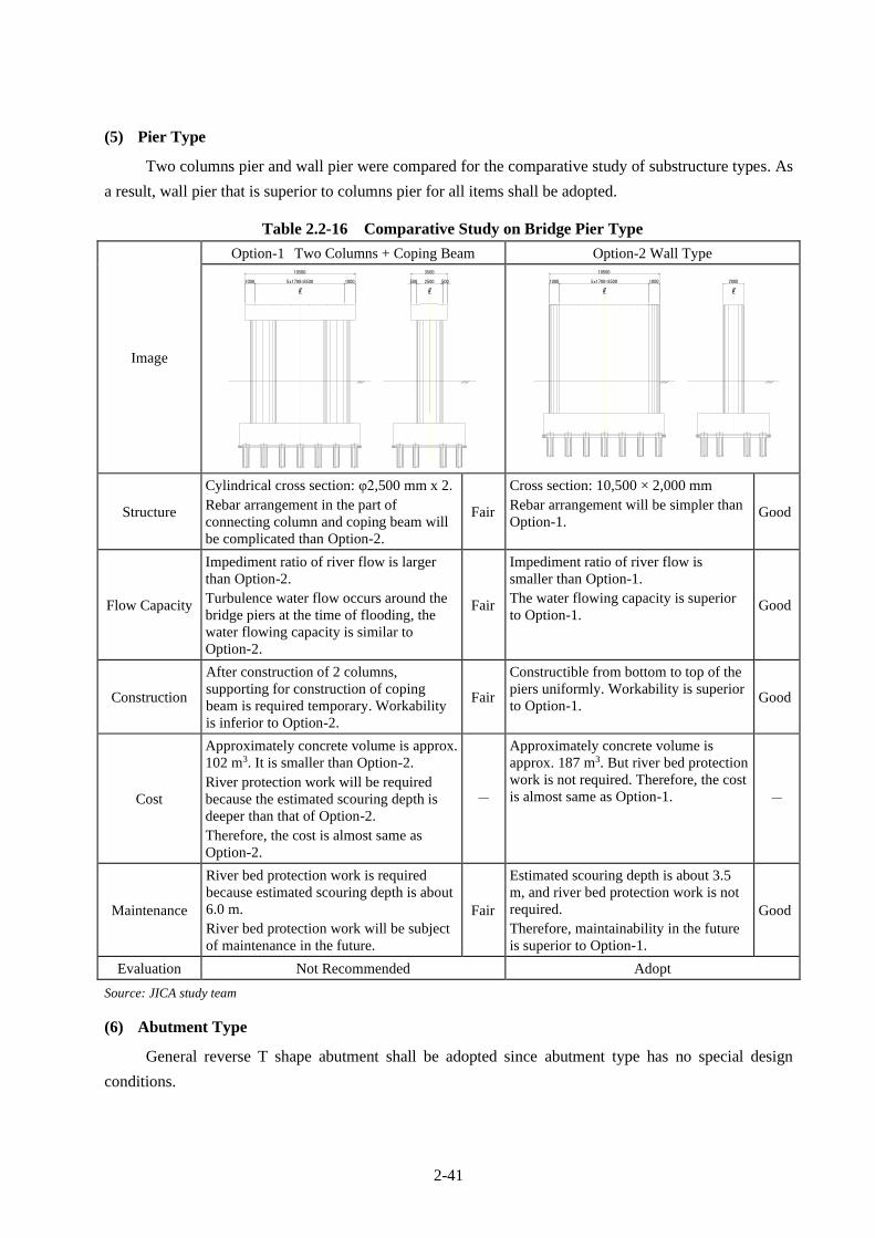
2-41
(5) Pier Type
Two columns pier and wall pier were compared for the comparative study of substructure types. As
a result, wall pier that is superior to columns pier for all items shall be adopted.
Table 2.2-16 Comparative Study on Bridge Pier Type
Image
Option-1 Two Columns + Coping Beam Option-2 Wall Type
Structure
Cylindrical cross section: φ2,500 mm x 2.
Rebar arrangement in the part of
connecting column and coping beam will
be complicated than Option-2.
Fair
Cross section: 10,500 × 2,000 mm
Rebar arrangement will be simpler than
Option-1. Good
Flow Capacity
Impediment ratio of river flow is larger
than Option-2.
Turbulence water flow occurs around the
bridge piers at the time of flooding, the
water flowing capacity is similar to
Option-2.
Fair
Impediment ratio of river flow is
smaller than Option-1.
The water flowing capacity is superior
to Option-1. Good
Construction
After construction of 2 columns,
supporting for construction of coping
beam is required temporary. Workability
is inferior to Option-2.
Fair
Constructible from bottom to top of the
piers uniformly. Workability is superior
to Option-1. Good
Cost
Approximately concrete volume is approx.
102 m3. It is smaller than Option-2.
River protection work will be required
because the estimated scouring depth is
deeper than that of Option-2.
Therefore, the cost is almost same as
Option-2.
-
Approximately concrete volume is
approx. 187 m3. But river bed protection
work is not required. Therefore, the cost
is almost same as Option-1. -
Maintenance
River bed protection work is required
because estimated scouring depth is about
6.0 m.
River bed protection work will be subject
of maintenance in the future.
Fair
Estimated scouring depth is about 3.5
m, and river bed protection work is not
required.
Therefore, maintainability in the future
is superior to Option-1.
Good
Evaluation Not Recommended Adopt
Source: JICA study team
(6) Abutment Type
General reverse T shape abutment shall be adopted since abutment type has no special design
conditions.
5x1700=8500 500
C
1000
L
3500
500
L
2500
C
1000
10500
1000 20005x1700=8500
C C
1000
10500
L L

2-42
(7) Pile Type
The geological profile and soil model in longitudinal direction of the bridge collected by boring
survey is shown in Figure 2.2-7.
. The boring survey was carried out to a depth of 45 m, but no definite bearing layer could be
confirmed. Therefore, friction pile shall be applied.
Source: JICA study team
Figure 2.2-7 Geological Profile and Soil Model
3 options of steel pipe pile, cast-in place concrete pile and spiral steel pipe pile were compared for
pile types. Spiral steel pipe pile shall be adopted because it can be expected to have higher friction bearing
force than other option and possible to reduce the pile cap size (Refer to Table 2.2-17). In addition, spiral
steel pipe pile has advantage that pile driving equipment is minimal, construction speed is faster as well as
no excavated soil coming out. It is economical too.
(8) Steel and Painting
Considering the regional characteristics of the bridge location and long-term maintainability, the steel
materials and painting specifications shown below are used for the main members of the bridge.
[Superstructure] Steel material that can be extended the repainting cycle, C5 paint system
in Japanese paint specifications
[Reinforcement rebar in RC slab] Coating rebar
1
6
6
-15
14
17
0
-35
12
Dep.=45.45m
4
5
10
18
Near P1
11
50
1
0
5
3
40
18
10
14
30
21
15
4
1
10
15
N-value
0
150
6
21
17
-20 21
0
-40
12
Near A1
2
Elevation20
1
Near A2
2
15
10
0
50
19
0
16
9
10
40
9
14
N-value
4
12
-5
0
23
12
-25
29
BH-3
8
7
11
30
12
9
20
11
6
16
10
10
7
4
50
0
10
N-value
5
17
-10
1
12
17
4
-30
12
R.L.=6.00m
4
0
22
19
40
1
4
9
30
13
8
9
20
23
17
4
2
Dep.=37.50mR.L.=5.80mBH-2
Dep.=45.45mR.L.=5.80mBH-1
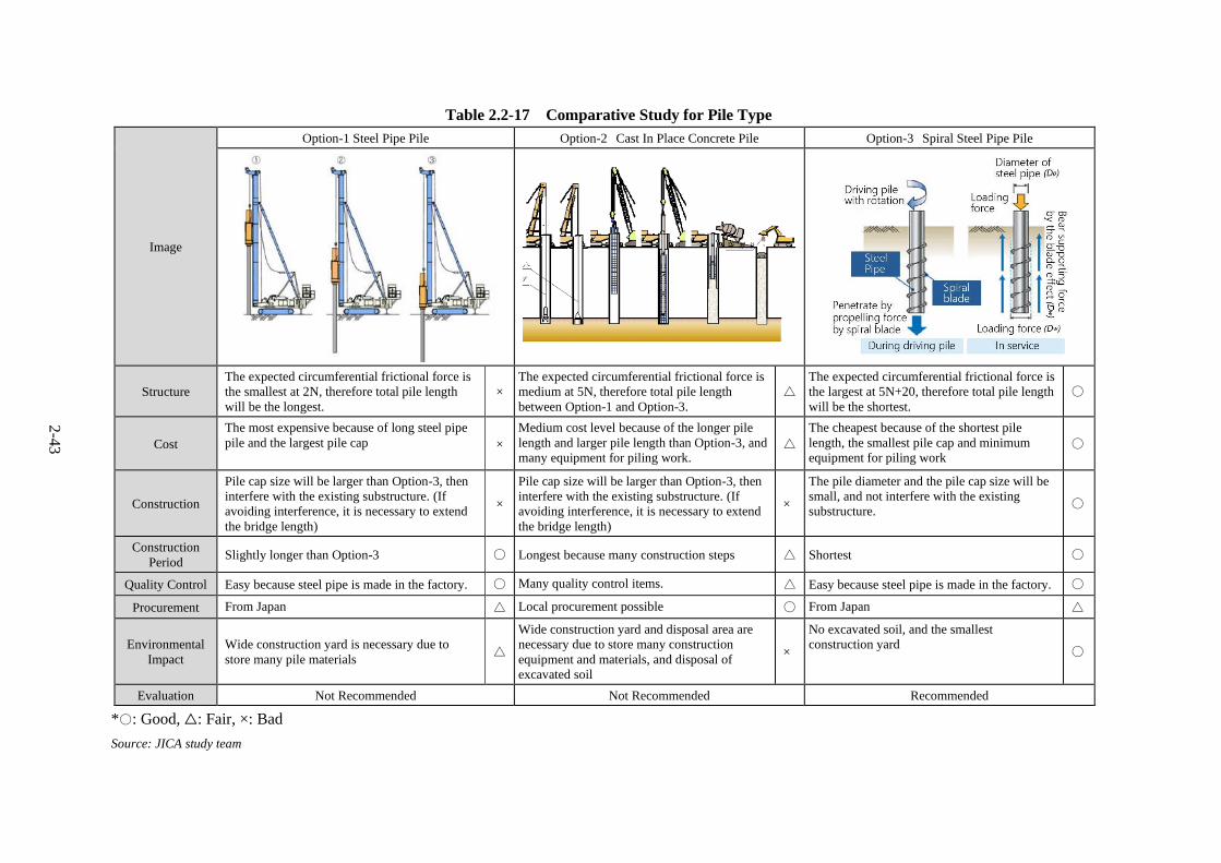
2-4
3
Table 2.2-17 Comparative Study for Pile Type
Image
Option-1 Steel Pipe Pile Option-2 Cast In Place Concrete Pile Option-3 Spiral Steel Pipe Pile
Structure
The expected circumferential frictional force is
the smallest at 2N, therefore total pile length
will be the longest.
×
The expected circumferential frictional force is
medium at 5N, therefore total pile length
between Option-1 and Option-3.
△
The expected circumferential frictional force is
the largest at 5N+20, therefore total pile length
will be the shortest.
〇
Cost
The most expensive because of long steel pipe
pile and the largest pile cap
×
Medium cost level because of the longer pile
length and larger pile length than Option-3, and
many equipment for piling work. △
The cheapest because of the shortest pile
length, the smallest pile cap and minimum
equipment for piling work 〇
Construction
Pile cap size will be larger than Option-3, then
interfere with the existing substructure. (If
avoiding interference, it is necessary to extend
the bridge length)
×
Pile cap size will be larger than Option-3, then
interfere with the existing substructure. (If
avoiding interference, it is necessary to extend
the bridge length)
×
The pile diameter and the pile cap size will be
small, and not interfere with the existing
substructure. 〇
Construction
Period Slightly longer than Option-3 〇 Longest because many construction steps △ Shortest 〇
Quality Control Easy because steel pipe is made in the factory. 〇 Many quality control items. △ Easy because steel pipe is made in the factory. 〇
Procurement From Japan △ Local procurement possible 〇 From Japan △
Environmental
Impact
Wide construction yard is necessary due to
store many pile materials △
Wide construction yard and disposal area are
necessary due to store many construction
equipment and materials, and disposal of
excavated soil
×
No excavated soil, and the smallest
construction yard 〇
Evaluation Not Recommended Not Recommended Recommended
*〇: Good, △: Fair, ×: Bad
Source: JICA study team

2-44
2.2.1.8 Accessories of the Bridge
(1) Bridge Railing
The type of bridge railing shall be steel guard fence. This is in order to reduce the oppressive feeling
by pedestrians and for its superior view. It shall be installed on the curb beside sidewalk.
(2) Bearing
Bearing shall be Fix-Move type.
(3) Expansion Joint
Rubber stretching apparatus with abundant experience in Japan shall be adopted for expansion joint.
(4) Unseating Prevention Structure
Seat length which is described in “Specifications for Highway Bridges, Part V, 2012” in Japan, will
be ensured.
(5) Bridge Drainage System
The water on the bridge shall be discharged directly into river by drainage system on the bridge.
(6) Approach Slab
The approach slab shall be placed behind both abutments for prevention of subsidence of the road by
settlement of the embankment. The length of the approach slab will be 5.0m, and its width will be same as
the road width.
(7) Others
Power lines have been installed in the upper and lower sides of the Teouma Bridge, and
communication lines shall also be laid in the future and shall be provided for on the eastern part of the
Teouma Bridge. The construction work of these utility lines shall be done by the business operator, but the
steel bracket for erection of these utility lines shall be installed in this project.
In consideration of the surrounding conditions and maintainability, lighting equipment shall not be
installed.
2.2.1.9 Approach Road Plan
(1) Horizontal Alignment
New horizontal road alignment shall follow the existing road alignment.
(2) Vertical Alignment
According to the hearing survey, combination of a steep downslope of more than 10% and horizontal
curve has caused frequent traffic accidents around Teouma Bridge. Since the height of bridge surface is 2.5
m higher than existing bridge, road surface is also raised by embankment to lower gradient, and the
maximum gradient was set to 8%.
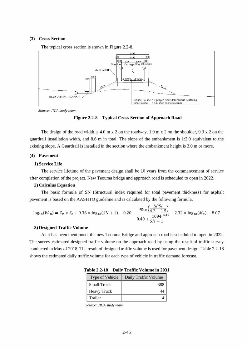
2-45
(3) Cross Section
The typical cross section is shown in Figure 2.2-8.
Source: JICA study team
Figure 2.2-8 Typical Cross Section of Approach Road
The design of the road width is 4.0 m x 2 on the roadway, 1.0 m x 2 on the shoulder, 0.3 x 2 on the
guardrail installation width, and 8.6 m in total. The slope of the embankment is 1:2.0 equivalent to the
existing slope. A Guardrail is installed in the section where the embankment height is 3.0 m or more.
(4) Pavement
1) Service Life
The service lifetime of the pavement design shall be 10 years from the commencement of service
after completion of the project. New Teouma bridge and approach road is scheduled to open in 2022.
2) Calculus Equation
The basic formula of SN (Structural index required for total pavement thickness) for asphalt
pavement is based on the AASHTO guideline and is calculated by the following formula.
log10(𝑊18) = 𝑍𝑅 × 𝑆0 + 9.36 × log10(𝑆𝑁 + 1) − 0.20 +log10 (
∆𝑃𝑆𝐼4.2 − 1.5)
0.40 +1094𝑆𝑁 + 1
5.19 + 2.32 × log10(𝑀𝑅) − 8.07
3) Designed Traffic Volume
As it has been mentioned, the new Teouma Bridge and approach road is scheduled to open in 2022.
The survey estimated designed traffic volume on the approach road by using the result of traffic survey
conducted in May of 2018. The result of designed traffic volume is used for pavement design. Table 2.2-18
shows the estimated daily traffic volume for each type of vehicle in traffic demand forecast.
Table 2.2-18 Daily Traffic Volume in 2031
Type of Vehicle Daily Traffic Volume
Small Truck 388
Heavy Truck 44
Trailer 4
Source: JICA study team

2-46
4) ESAL Conversion Factor
ESAL Conversion Factor by Vehicle Type used for pavement design was calculated based on the
axle load survey results at the target bridge site (see Table 2.2-19). The traffic characteristics at the target
bridge point are that the traffic of small vehicles (minivans, pickups, etc.) are the majority and the traffic
volume of large vehicles is extremely small. Most supplies are being transported by small vehicles and
small trucks. In addition, there is almost no full load of small trucks. However, dump trucks (heavy trucks)
with full of earth and sand were observed since there are many quarry sites on the east side of the target
bridge. The number of observed trailers was much smaller than small vehicles and the observed load of
trailer also small. Therefore, the ESAL Conversion Factor for small truck and trailer is smaller than ordinal
value. In addition, since there is no development plan that will increase the traffic of large vehicles in the
future, these figures were adopted. However, a validity of pavement thickness will be verified by using the
values of ESAL Conversion Factor of Trailer adopted in another country.
Table 2.2-19 ESAL Conversion Factor by Vehicle Type
Type of Vehicle ESAL
Conversion Factor
Small Truck 0.12
Heavy Truck 3.55
Trailer 0.29
Source: JICA study team
5) Estimation of Accumulative ESAL (18kip) Value of Trailer and Truck
The survey estimated accumulative ESAL of 10 years from the services commencement based on
traffic demand forecast.
Table 2.2-20 Estimated ESAL Value from Year 2022 to Year 2031
Source: JICA study team
6) Input Parameters and Result of Pavement Calculation
Inputted parameters and result of the pavement calculation is as follows.
1. Input Parameters
1) Design Life): 10 years
2) Reliability: 80% (National Road)
3) Standard Normal Deviation(ZR): -0.841
4) Standard Deviation (So): 0.49
5)Design Serviceability Loss: 1.7 (Initial (4.2) – Finale (2.5))
6) Resilient Modulus : 1500*CBR
7) Drainage Factor: 1.0
DTV ATV DTV ATV DTV ATV
2022 3.00 297 108,568 34 12,384 3 1,238 57,351
2023 3.00 306 111,825 35 12,756 3 1,276 59,072
2024 3.00 316 115,179 36 13,138 4 1,314 60,844
2025 3.00 325 118,635 37 13,532 4 1,353 62,669
2026 3.00 335 122,194 38 13,938 4 1,394 64,549
2027 3.00 345 125,860 39 14,357 4 1,436 66,486
2028 3.00 355 129,636 41 14,787 4 1,479 68,480
2029 3.00 366 133,525 42 15,231 4 1,523 70,534
2030 3.00 377 137,530 43 15,688 4 1,569 72,651
2031 3.00 388 141,656 44 16,159 4 1,616 74,830
1,244,607 141,970 14,197 657,465
ESAL
Value
Total
Dump TruckSmall Truck TrailerEconomic
Grow Rate
%
Year

2-47
CBR Value of actual subgrade (embankment) is more than 10, but CBR 10 is adopted for the SN
calculation on Pavement Structure since this calculation of AASHO allows maximum CBR Value is 10.
The thickness of base course shall be 45 cm from above calculation result. As a result of verification of a
pavement design by the highest value 6.840 of ESAL Conversion Factor of trailer adopted in another
country, it was confirmed that the required SN Value is 2.387, pavement thickness is 43.3 cm which was
within adopted pavement thickness 45.0 cm.
(5) Accessory Facilities
1) Extension of shoulder
There is a direct farmer market built by residents in the roadside in downstream of right side bank.
Residents sell their products to passing vehicles or tourists. However, according to the new road and bridge
plan, market space and road will be separated by raised embankment and the residents could not continue
their business at the same place. Therefore, it is planned to widen the shoulder at existing market to secure
selling market and parking space and also to minimize the negative impact on the local economic activities.
2) Guardrail
A guardrail will be installed in the section where the height of embankment is 3.0 m or more in order
to prevent the vehicles from falling down.
3) Road Marking
Center line (width; 15 cm, white, solid) and sideline (width; 10 cm, white, solid) will be planned on
the new road. Incidentally, a “cat eye” will be installed at the boundary of sidewalk and roadway in the
bridge section to take safety measure.
2.2.2 Outline Design Drawing
The table of contents of the drawing of Outline Design shown in Table 2.2-21 below. The drawings
are attached in Appendix-6.
Table 2.2-21 Table of Contents of Drawings of Outline Design
No. Classification Name
1 General Overall Plan
2 Revetment PLAN (REVETMENT)
3 River Alignment
4 Detailed Plan Around Abutment
5 Profile (Revetment)
6 Typical Cross Section (Revetment)
7 Riprap / Stone Pitching
8 Revetment (1)
9 Revetment (2)
10 Approach Steps (1)
Layer Factor (a)
Thickness(inch) (D)
Dranage Factor(m)
SN = a*D*m
アスコン表層 (新設) 0.420 0.000 - 0.000
Base Course New 0.140 16.654 - 2.331 42.3 45.0
2.331 < 2.331 42.3 45.0
OK
Adopted Thickness(cm)
Total
Result of SN Calculation on pavement structure 1(inch)=2.540cm
MaterialThickness(cm) (D)
2-48
No. Classification Name
11 Approach Steps (2)
12 Bridge General View of Teouma Bridge
13 General View of Superstructure
14 General View of A1 (1/2)
15 General View of A1(2/2)
16 General View of P1
17 General View of A2 (1/2)
18 General View of A2(2/2)
19 Road Main Road Alignment
20 Plan (1) (Main Road)
21 Plan (2) (Main Road)
22 Profile (Main Road)
23 Typical Cross Section
24 Wet Stone Pitching
25 Reinforced Concrete Crib (Type A)
26 Reinforced Concrete Crib (Type B) (1)
27 Reinforced Concrete Crib (Type B) (2)
28 Approach Steps at Road Embankment
29 Drainage Structure
30 Box Culvert General View of Box Culvert (1)
31 General View of Box Culvert (2)
32 General View of Box Culvert (3)
33 Temporary Work Plan (1) (Detour Road)
34 Plan (2) (Detour Road)
35 Detour Road Alignment
36 Profile (Detour Road)
37 Typical Cross Section (Detour Road)
Source: JICA study team
2.2.3 Implementation Plan
2.2.3.1 Implementation Policy
The project implementation principles are:
・ A cooperation project will be implemented in accordance with grant aid system of the government
of Japan by concluding Note of Exchange (E/N) and Grant Agreement (G/A) for the project between
the Government of Japan and Government of Vanuatu.
・ The executing agency for implementation of the cooperation project is the Public Works Department
(PWD) of the Ministry of Public Works of Vanuatu.
・ The consulting services including detailed design, tender-related works and construction supervision
services, will be provided by a Japanese consulting firm in accordance with the consultancy contract
that shall be signed with the Republic of Vanuatu.
・ The construction of the cooperation project will be executed by a Japanese construction firm that
shall be selected through pre-qualification and bidding, in accordance with the construction work
contract that shall be signed between the said construction firm and the Republic of Vanuatu.

2-49
The basic policies for the construction/procurement of this project are as follows:
・ Equipment, materials and labor for construction shall be procured locally as much as possible. In
cases where local procurement is not possible, they shall be procured either from a third country or
from Japan considering price, quality and secured supply quantity.
・ The construction method and construction process shall be consistent with the natural conditions
such as the local climate, topography, geology, etc. as well as topographical conditions and river
hydraulics characteristics of the site.
・ Plan a general and easy construction method which shall not require the use of special or
sophisticated equipment or technology from the viewpoint of construction such as reduction of
construction period and quality assurance and cost.
・ The contractor’s site organization shall be planned to satisfy the established construction
specifications and construction management standards set for this project. Likewise, the consultant’s
organization shall be based on such specified project management standards.
・ An appropriate traffic management plan including deployment of traffic personnel at vantage
positions shall be considered I order to ensure safety during construction.
・ Appropriate preservation methods of the environment shall be adopted such as selection of
temporary garbage dumping sites which were specified from the Republic of Vanuatu in order to
reduce the influence of construction works on of the environment of project site.
2.2.3.2 Implementation Conditions
(1) Considerations for Natural Condition
The climate of Vanuatu is divided into rainy and dry seasons. Rainy season is from December to
April. In the latter half of the rainy season, the water level around the site rises for a short period of time
and the surrounding farmland might be inundated. Based on these changes in water level, construction
works in river (revetment and bridge substructure work) shall be planned during dry season when the river
water level is low in order to secure the safety and reliability of the construction as well as to reduce the
cost of temporary works and also improve the effectiveness of the project.
(2) Traffic Control Plan during Construction Period
A detour road will be installed during construction period on the downstream side. The new bridge
will be constructed in the current location. Regarding the detour road, it is planned to maintain the same
level of functions as existing road based on discussion and request from local. Width, pavement structure,
and minimum secured height of detour road will be specified in bidding document.
2.2.3.3 Scope of Works
The responsibilities to be borne by Japan and the Republic of Vanuatu are summarized in Table
2.2-22.
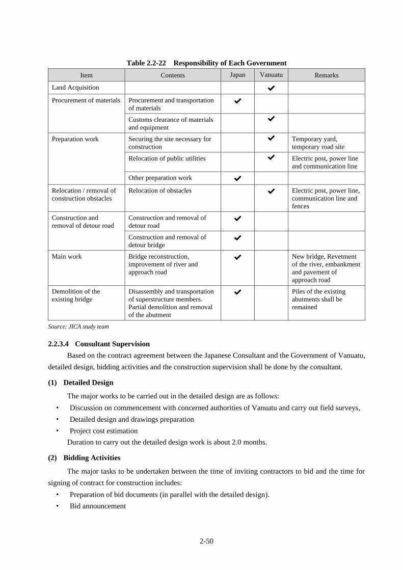
2-50
Table 2.2-22 Responsibility of Each Government
Item Contents Japan Vanuatu Remarks
Land Acquisition ✔
Procurement of materials Procurement and transportation
of materials ✔
Customs clearance of materials
and equipment
✔
Preparation work Securing the site necessary for
construction
✔ Temporary yard,
temporary road site
Relocation of public utilities ✔ Electric post, power line
and communication line
Other preparation work ✔
Relocation / removal of
construction obstacles
Relocation of obstacles ✔ Electric post, power line,
communication line and
fences
Construction and
removal of detour road
Construction and removal of
detour road ✔
Construction and removal of
detour bridge ✔
Main work Bridge reconstruction,
improvement of river and
approach road
✔ New bridge, Revetment
of the river, embankment
and pavement of
approach road
Demolition of the
existing bridge
Disassembly and transportation
of superstructure members.
Partial demolition and removal
of the abutment
✔ Piles of the existing
abutments shall be
remained
Source: JICA study team
2.2.3.4 Consultant Supervision
Based on the contract agreement between the Japanese Consultant and the Government of Vanuatu,
detailed design, bidding activities and the construction supervision shall be done by the consultant.
(1) Detailed Design
The major works to be carried out in the detailed design are as follows:
・ Discussion on commencement with concerned authorities of Vanuatu and carry out field surveys,
・ Detailed design and drawings preparation
・ Project cost estimation
Duration to carry out the detailed design work is about 2.0 months.
(2) Bidding Activities
The major tasks to be undertaken between the time of inviting contractors to bid and the time for
signing of contract for construction includes:
・ Preparation of bid documents (in parallel with the detailed design).
・ Bid announcement

2-51
・ Pre-qualification of bidders
・ Bidding
・ Evaluation of bid documents
・ Preparation of Contract Agreement
The duration of the bid-related activities is about 4.0 months.
(3) Construction Supervision
The Consultant will supervise the Contractor’s planning and implementation of the construction
contract. The major tasks under this stage include:
・ Verification/Approval of related surveys and quantities
・ Review/Approval construction plans
・ Quality Control
・ Process Control
・ Work Output Control
・ Safety Management
・ Turnover Inspection and Acceptance
The duration of construction supervision is approximately 27.0 months. The construction supervision
team shall consist of: 1-Resident/Chief Engineer (Japanese), 1-Construction Engineer (Japanese) for
superstructure erection, 1-Construction Engineer (Local), 1-Clerk (Local) and 1-Utility Personnel (Local).
A construction engineer for superstructure (Japanese) will be dispatched at the time of construction of
superstructure.
The chief engineer is in charge of construction support, completion inspection, quality control
meeting and dispatches engineers at the time of defect inspection.
During the construction period, special attention should be paid to safety management, and the
supervision should be carried out to prevent accidents in advance by consulting and cooperating with the
safety manager of the construction company.
2.2.3.5 Quality Control Plan
Regarding quality control, the contractor should submit the quality control plan. The construction
works shall be commenced after the approval by the consultant. The main items requiring quality control
during the construction period are as follows:
・ Superstructure work
・ Rotating pile (spiral steel pipe pile) work
・ Concrete Work
・ Reinforcement and formwork
・ Earthwork
・ Pavement work (DBST)
・ Installation inspection of expansion joint, bearing shoe
The quality control standards are based on the standards of the Ministry of Land, Infrastructure,
Transport and Tourism of Japan as well as local standards.

2-52
Based on the above, the quality control for superstructure works, rotating pile works and concrete
works as typical quality control items are presented in Table 2.2-23, Table 2.2-24 and Table 2.2-25.
Table 2.2-23 Quality Control Plan for Superstructure Works
Item Test item Test method
(Specification) Test frequency
Material for
superstructure
JIS G 3101, JIS G
3106, JIS G 3140
Mill sheet and inspection report
Factory painting Painting Materials JIS K 5551, JIS K
5552, JIS K 5553, JIS
K 5659
Mill sheet and inspection report
Coating thickness C-5 paint system
(Japanese paint
specifications)
Inspection report
Appearance Visual inspection
Fabrication of
steel
Welding Inspection report for the various test result i.e. tensile
test, bending test, impact test, groove weld test, fillet
weld test, and Vickers hardness test
Temporary assembly Specifications for
Highway Bridges
(2012)
Check the quality of the temporary assembly by the
Consultant
Field erection Erection Check to camber and joints after temporary fastening
by the Consultant in the site
Tightening of high
strength bolt
Site inspection and inspection report
Erection completion Check the camber, bearing installation after anchor
bolt grout hardening, and fastening anchor bolt by the
Consultant at the site
Field painting Surface preparation Check the rust removal on damaged and accessory
parts
Painting Materials JIS K 5551, JIS K
5552, JIS K 5553, JIS
K 5659
Mill sheet and inspection report
Coating thickness Inspection report
Appearance Visual inspection
Bearing Product Prior to delivery (Shipping)
Installation Site inspection after installation
Completion Check set bolt looseness, finished condition, filling
condition of non-shrink mortar after pouring concrete
Expansion Joint Product Prior to delivery (Shipping)
Installation Site inspection after installation
Completion Check set bolt looseness, finished condition, filling
condition of non-shrink mortar after pouring concrete
Drainage Product Prior to delivery (Shipping)
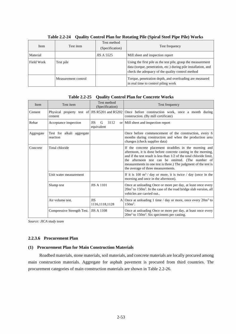
2-53
Table 2.2-24 Quality Control Plan for Rotating Pile (Spiral Steel Pipe Pile) Works
Item Test item Test method
(Specification) Test frequency
Material JIS A 5525 Mill sheet and inspection report
Field Work Test pile Using the first pile as the test pile, grasp the measurement
data (torque, penetration, etc.) during pile installation, and
check the adequacy of the quality control method
Measurement control Torque, penetration depth, and overloading are measured
in real time to control piling work
Table 2.2-25 Quality Control Plan for Concrete Works
Item Test item Test method
(Specification) Test frequency
Cement Physical property test of
cement JIS R5201 and R5202 Once before construction work, once a month during
construction. (By mill certificate)
Rebar Acceptance inspection JIS G 3112 or
equivalent
Mill sheet and inspection report
Aggregate Test for alkali aggregate
reaction
Once before commencement of the construction, every 6
months during construction and when the production area
changes (check supplier data)
Concrete Total chloride If the concrete placement straddles in the morning and
afternoon, it is done before concrete casting in the morning,
and if the test result is less than 1/2 of the total chloride limit,
the afternoon test can be omitted. (The number of
measurements in one test is three.) The judgment of the test is
the average of three measurements.
Unit water measurement If it is 100 m3 / day or more, it is twice / day (once in the
morning and once in the afternoon).
Slump test JIS A 1101 Once at unloading Once or more per day, at least once every
20m3 to 150m3. In the case of the road bridge slab version, all
vehicles are carried out.。
Air volume test. JIS A
1116,1118,1128
Once at unloading 1 time / day or more, once every 20m3 to
150m3.
Compressive Strength Test. JIS A 1108 Once at unloading Once or more per day, at least once every
20m3 to 150m3. Six specimens per casting.
Source: JICA study team
2.2.3.6 Procurement Plan
(1) Procurement Plan for Main Construction Materials
Roadbed materials, stone materials, soil materials, and concrete materials are locally procured among
main construction materials. Aggregate for asphalt pavement is procured from third countries. The
procurement categories of main construction materials are shown in Table 2.2-26.
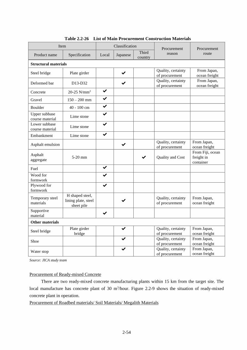
2-54
Table 2.2-26 List of Main Procurement Construction Materials
Item Classification Procurement
reason
Procurement
route Product name Specification Local Japanese Third
country
Structural materials
Steel bridge Plate girder ✔ Quality, certainty
of procurement
From Japan,
ocean freight
Deformed bar D13-D32 ✔ Quality, certainty
of procurement
From Japan,
ocean freight
Concrete 20-25 N/mm2 ✔
Gravel 150 – 200 mm ✔
Boulder 40 - 100 cm ✔
Upper subbase
course material Lime stone
✔
Lower subbase
course material Lime stone
✔
Embankment Lime stone ✔
Asphalt emulsion ✔ Quality, certainty
of procurement
From Japan,
ocean freight
Asphalt
aggregate 5-20 mm ✔ Quality and Cost
From Fiji, ocean
freight in
container
Fuel ✔
Wood for
formwork
✔
Plywood for
formwork
✔
Temporary steel
materials
H shaped steel,
lining plate, steel
sheet pile
✔ Quality, certainty
of procurement
From Japan,
ocean freight
Supportive
material ✔
Other materials
Steel bridge Plate girder
bridge
✔
Quality, certainty
of procurement
From Japan,
ocean freight
Shoe ✔
Quality, certainty
of procurement
From Japan,
ocean freight
Water stop ✔
Quality, certainty
of procurement
From Japan,
ocean freight
Source: JICA study team
Procurement of Ready-mixed Concrete
There are two ready-mixed concrete manufacturing plants within 15 km from the target site. The
local manufacture has concrete plant of 30 m3/hour. Figure 2.2-9 shows the situation of ready-mixed
concrete plant in operation.
Procurement of Roadbed materials/ Soil Materials/ Megalith Materials

2-55
There are several quarries within several kilometers from target site. Therefore, the contractor can
procure from the quarries. However, regarding procurement of boulders 2 or more quarries are considered
to meet the construction schedule.
Ready-mixed Concrete plant Panoramic View of Quarry
Source: JICA study team
Figure 2.2-9 Photo of Local Concrete Plant and Quarry
(2) Procurement Plan for Special Construction Materials
The special construction materials which cannot be procured in Vanuatu are plate girder, deformed
reinforced bar, asphalt emulsion, aggregate for asphalt pavement (DBST), guardrail, bearing, telescopic
device, drainpipe, and water stop. These materials shall be procured from abroad. The destinations and the
reasons are highlighted below.
Plate Girder Bridge
There is no manufacturing capacity in Vanuatu, it is concluded that procurement from Japan is
appropriate to secure the production quality and procurement security.
Deformed Reinforced Bar
Only small diameter deformed reinforced bar are imported from neighboring countries in Vanuatu.
However, the quantity circulated in Vanuatu is very small in addition to poor storage condition. In the
project, quantity of procurement is large and large diameter reinforced bar is required. Therefore, deformed
reinforced bar shall be procured in Japan.
Asphalt Emulsion
There are no local items in Vanuatu, and the materials are imported from neighboring countries when
necessary for repair. Therefore, Japanese procurement is appropriate to ensure quality and certainty of
procurement.
Aggregate for Asphalt Pavement (DBST)
Most of the aggregates for asphalt pavement are being imported from neighboring countries like Fiji
because quality is inappropriate. For assurance of quality and also certainty of procurement, it is judged
that procurement from Fiji is appropriate.

2-56
Guardrail, Bearing, Telescopic Device, Drainpipe, Sealing Plate
There are no local items on site, and those are being imported from neighboring countries when
necessary for repair. Therefore, Japanese procurement is appropriate from the viewpoint of ensuring quality
and certainty of procurement.
(3) Procurement Plan for Construction Machineries
There are no companies that specialize in machine leasing and several general construction machines
are owned by local aggregate manufacturers and foreign contractors. Basically, short-term leases can be
considered, but long-term leases are difficult and expensive. Therefore, special equipment is to be procured
from Japan. General equipment such as backhoe and bulldozer can be procured locally. However, if it is
more economical to procure from Japan, it shall be procured from Japan. Table 2.2-27 shows a list of
procurement categories for construction machine.
Table 2.2-27 List of Procurement Construction Equipment
Item Lease
/Buy
Procurement classification
Procurement reason Transport
route Machine name Specs Local Japan Third
country
Backhoe
(ultra-long boom) 0.4/0.3 m3 Lease ✔ Locally not available Ocean Freight
Backhoe 0.8/0.6 m3 Lease ✔ Cost Ocean Freight
Pile rotating driving
machine Lease ✔ Locally not available Ocean Freight
Dump truck 10t Cap Lease ✔
Dump truck 4t Cap Lease ✔
Bulldozer 21 ton Lease ✔ Cost Ocean Freight
Bulldozer 15 ton Lease ✔
Tire roller 8 to 20 ton Lease ✔
Road Roller 10 to 12 ton Lease ✔
Motor grader W=3.1 m Lease ✔
Rough Terrain crane 35 ton Lease ✔ Cost Ocean Freight
Crawler crane 80 ton Lease ✔ Locally not available Ocean Freight
Vibrating Hammer 60 kW Lease ✔ Locally not available Ocean Freight
Heavy weight Breaker 1300 kg Buy ✔
Vibration Roller 3-4 ton Buy ✔
Water pump φ150 mm,
15 kW Buy
✔ Locally not available Ocean Freight
Generator 20/25 kW Lease ✔
Quality, certainty of
procurement Ocean Freight
Generator 125/150 kW Lease ✔ Locally not available Ocean Freight
Concrete pump Lease ✔
Distributor 2000 to 3000 ℓ Lease ✔ Locally not available Marine transport
Line marker Lease ✔ Locally not available Marine transport
Source: JICA study team
2.2.3.7 Soft Component Plan
Soft component shall not be included in the project.

2-57
2.2.3.8 Implementation Schedule
Figure 2.2-10 shows construction implementation schedule.
Source: JICA study team
Figure 2.2-10 Construction Implementation Schedule
2.3 Security Plan
[Overview of security threat risk]
Among the South Pacific islands, it is said that security is particularly good, and atrocious crimes
such as murders are rare. However, there is an increasing number of general crimes such as snatching,
empty nests and sex crimes, mainly in the capital city of Port Vila.
[Safety measures items]
To avoid going to an unpopular place, walking alone and going out at night especially on
weekends.
To stay in the hotels or apartments with high security.
To lock the door of the room of a hotel or home.
Not to wear gorgeous and conspicuous clothes or brand-name precious metals or watches.
2.4 Obligations of Recipient Country
The undertakings required by the Government of Vanuatu for the smooth execution of this project
are:
To acquire land for construction and to relocate affected houses;
To secure land for a temporary yard, stock yard, site office, construction road and detour routes
5 6
Deta
iled
Desig
n
1 2 3 4 7 8 9 10 11
121 2 3 4 5 6 7 8 9 10 11 25 26 27
Con
str
ucti
on
Acti
viti
es
19 20 21 22 23 2413 14 15 16 17 18
Preparation
Substructure Work
Temporary Work
Removal of the Current Bridge
Superstructure Work
Road Work Rivetment Work
Cleaning
Field Survey
Detailed Design
Tender Assistant

2-58
and to shoulder tenancy payment for them;
To secure borrow pits, spoil-banks, and industrial waste disposal area;
To relocate all utilities such as electric poles, power lines, telecommunication cable and water
pipeline which will disturb the Project works and to restore them on the new road and bridge;
To bear the cost of bank charges such as the Advising commission and Payment commission to
bank where an account related to the Project is opened;
To arrange tax exemption and smooth custom clearance and to assist smooth inland transportation
for imported materials
To arrange for tax exemption for Vat for purchased materials, Japanese contractor’s cooperate
tax and income tax for the employees, including Japanese staff, local staff and staff employed
from third counties.
To provide necessary permissions that allow the personnel engaged in the construction work such
as supervision engineer, construction workers etc., to enter and stay in Vanuatu.
To provide necessary permission/certificate for environmental issues, construction of bridges,
working inside river, earthwork and traffic control during the construction period, etc.
To maintain new bridge and approach roads properly
To assist in solving all conflicts raised by residents adjacent to the construction site and third
parties.
To bear all the expenses, other than those to be borne by the Grant Aid necessary for construction
of facilities; and
To monitor, analyze natural and social environment such as air and water quality during
construction and public use, and take necessary actions based on the results of the monitoring and
follow-up analysis.
2.5 Project Operation and Maintenance Plan
Public Works Department (PWD) of The Ministry of Infrastructure and Public Utilities (MIPU)
executes the periodic inspection, routine maintenance and repair. Road and Bridge maintenance work
conducted by PWD is as follows:
Periodic Inspection :Bridge and Approach road
Routine Maintenance :Pavement, Drainage Structure, Expansion Joint, Clearing, etc.
Repair Works :Pavement, Drainage Structure, Concrete Structure,
Incidental Facilities, Road marking, Revetment Structure, etc.
Since the bridge to be constructed in this project is durable against the environment in Vanuatu,
serious repair is not expected in the immediate future. It is considered that there are no technical problems
in carrying out the necessary maintenance work.
The organization of MIPU and PWD is shown in Figure 2.5-1 and Figure 2.5-2 respectively. The
PWD, Shefa office will execute the maintenance, cleaning and repair works.

2-59
Source:PWD
Figure 2.5-1 Organization of MIPU
Source: PWD
Figure 2.5-2 Organization of PWD
2.6 Project Cost Estimation
2.6.1 Initial Cost Estimation
2.6.1.1 Government of Vanuatu’s Contribution
For confidentiality, the cost borne by the Japan’s Grant Aid is not shown in this report.
2.6.1.2 Government of Vanuatu’s Contribution
The approximate amount estimated for contribution from Vanuatu is shown in Table 2.6-1.
Table 2.6-1 Approximate Cost Estimate of Vanuatu Contribution
Item Amount (VUV)
1. Bank commission 3,583,000
2. Land acquisition 28,810,000
3. High voltage transmission line relocation 40,164,000
Total 72,557,000
Source: JICA study team
Ministry of Infrastructure and Public Utilities (MIPU)
Public Works Department (PWD)
Civil Aviation AuthorityPorts and Marine
Department
Manager(Operations)
Manager(Admin & Procurement)
ExecutiveSecretary
Deputy Director
Executive Secretary Operations
PrincipalEngineer
Divisions(Shefa, Sanma, Tafea, Pepama,
Malampa, Torba)
Technical Service Unit
BuildingEnvironmental Unit
Procurement
Contract
Finance
Receptionist
Cleaner
Gardener
Manager(Projects)
Project Liaison Engineer
Principal Engineer
Engineer
Finance
Director of PWD
Driver / Messenger
Project Secretary

2-60
2.6.1.3 Cost Estimation Condition
1. Cost Estimation Month : May 2018
2. Exchange rate : US $ 1.00 = 108.12 JPY
(US Dollar vs. Japanese Yen Exchange Rate)
VUV 1.00 = 1.039 JPY
(Vanuatu vatu versus Japanese yen exchange rate)
3. Implementation period : Detailed design and period of construction to be required are
shown in the implementation schedule.
4. Others : The estimate is carried out based on the Japanese
Government’s Grant Aid Scheme.
2.6.2 Operation and Maintenance Cost
Operation and maintenance expenses are being paid from the budget of the Ministry of Public
Transport. The maintenance items and repair costs of bridges and approach road per one bridge are shown
in Table 2.6-2.
Table 2.6-2 Main Maintenance Items and Annual Cost
Perio
dic In
spectio
n
Component Inspection items Frequency No. of
persons
Materials
and
equipment
Required
quantity
Amount
(VUV)
Pavement Crack, unevenness,
potholes etc.
12 times /
year
1 day / time
3 persons Scoop,
hammer,
hook,
barricade
36 people /
day
237,600
Drainage facility Sediment, obstacles Structure damage, deformation,
dirt, peeling etc.
Revetment Crack, damage,
collapse etc.
Pick up 12 units
/year
105,600
Bridge Bracket of Utilities,
Railings, etc
Subtotal 343,200 D
aily M
ainten
ance
Component Inspection items Frequency No. of
persons
Materials
and
equipment
Required
quantity
Amount
(VUV)
Pavement Cleaning 4 times /
year
2 days /
time
7 persons Scoop,
barricade,
grass cutter,
broom,
tooling
56
persons/ye
ar
384,000
Drainage facility Removal of soil,
obstacles. cleaning
Expansion Joint Removal of soil,
obstacles. cleaning
Bridge Cleaning Small truck 8 units /
day
73,100
Subtotal 457,100

2-61
Rep
air
Component Inspection items Frequency No. of
persons
Materials
and
equipment
Required
quantity
Amount
(VUV)
Pavement Crack seal, repair of
defect
1 time /
year
4 days /
time
9 persons 36
persons/ye
ar
246,800
Drainage facility Repair of damaged
part
Structure Repair of damaged
part
Compactor 4 units
/year
33,600
Bridge Repair of damaged
handrail
Pavement marking Repair of lane
marking
Small truck 4 units
/year
47,500
Revetment
facilities
Repair of damaged
parts
Asphalt
emulsion
0.36t3/year 31,800
Gravel for
asphalt
0.9m3/year 39,100
Lane marker 100m/year 20,900
Seawall 10m2/year 106,900
Subtotal 526,600
Total 1,326,900
Source: JICA study team


3-1
CHAPTER 3 Project Evaluation
3.1 Preconditions
The Project preconditions related to the required undertakings of the Government of Vanuatu are as
follows:
▪ To acquire land for the project and transport affected houses in 4 months after the conclusion of
Exchange of Note.
▪ To secure land for temporary yard, stock yards, detour road, borrow pit and disposal area in 4 months
after the conclusion of Exchange of Note.
▪ To relocate all utilities including underground utilities that will disturb the Project works to the place
where the works will not be disturbed in 4 months after the conclusion of Exchange of Note.
▪ To take any necessary actions for tax exemption in compliance with E/N and G/A.
▪ To conduct quick custom clearance for the goods from Japan and third countries.
▪ This project does not require to process the EIA procedure. However, environmental mitigation
measures and monitoring plan is described in 1.3.1.10 to monitor, analyze natural and social
environment such as air and water quality during construction and public use.
▪ To provide necessary permits for extracting soil materials from borrow pits and cutting trees in 4
months after the conclusion of Exchange of Note.
▪ To assist to solve all conflicts with residents adjacent to the construction site and third parties.
3.2 Necessary Inputs by Recipient Country
The maintenance work for the Project is vital after handing it over in order to realize and sustain the
effects of the overall project. In order to ensure the service life of bridge, approach roads and other ancillary
facilities, the budget shown in Section 2.6.2 (about 1,326,900 VUV / year) shall be secured and regular
inspections shall be carried out. If in case damage was confirmed, it is necessary to carry out appropriate
repairs at the initial stage. In daily maintenance, it is necessary to clean the pavement surface and drainage
facilities, such as removing sediment and obstacles, and to ensure safe traffic and services for users.
3.3 Important Assumptions
(1) Restriction of Overloaded Tracks
Restriction of overloaded trucks has not been conducted in Vanuatu. It is necessary to conduct a
control system for the overloaded trucks in order to ensure the durability of the pavement.
(2) River Management
It is necessary to carry out river management so that the flow of the river is not obstructed when the
development of the Teouma River basin progresses.

3-2
3.4 Project Evaluation
3.4.1 Relevancy
Implementations of this cooperation projects is recommended using Japan’s grant aid as follows:
1. The beneficiaries’ populations are almost half of the east Efate Island. It is a big number.
2. The project is urgently needed on the Ring Road to contribute to the strengthening of trunk road
transport networks and to stabilize and improve the livelihoods of residents.
3. Vanuatu authorities could operate and maintain bridges and roads using internal resources and
technologies. There is no need for sophisticated technology for operation and maintenance.
4. This project contributes to the environmental and economic objectives of Vanuatu national
development plan: “Recovery from climate change and disasters” and “Improving
infrastructure”.
5. There is little negative environmental and social impact.
6. In addition to the necessity and superiority of using bridge construction technology of Japan,
Japanese grant aid system allows the project to be implemented without any difficulty.
3.4.2 Effectiveness
3.4.2.1 Quantitative Effect
There is a high possibility of interruption of bridge service and closure of the connected road due to
inundation and also scouring and erosion of approach road due to the progressive erosion of riverbanks in
the upstream as well as potential change in river course. However, by implementation of this project, the
risk of inundation will be highly reduced by raising the road elevation, and also the river course will be
stabilized by river works and erosion prevention countermeasures.
The expected quantitative effect of the project implementation is shown in Table 3.4-1. The base
value was measured in 2018 and the target value is set for three years after project completion.
Table 3.4-1 The Quantitative Effects Expected from the Implementation of the Projects
Items Base Value
(FY2018 Actual) Target Value
(3 yrs after completion)
Traffic Volume(Unit/day) 2,980 3,600
Number of Passengers(person/day) 755 905
Weight of Cargo(ton/year) 60,000 72,000
3.4.2.2 Qualitative effect
The qualitative effects of the project are:
1. Maintenance of economic activities and access to various services are ensured by eliminating
the blockage of logistics and commuting due to flooding after heavy rain.

3-3
2. By changing from emergency rehabilitation to permanent restoration, there is no fear of a
falling bridge and the toughness of the bridge is secured.
3. River erosion to private land on the upper right bank can be avoided.