
INDIA Preparatory Survey for Dedicated Freight Corridor ...
122
INDIA Preparatory Survey for Dedicated Freight Corridor Project (Phase 2) Final Report February 2010 JAPAN INTERNATIONAL COOPERATION AGENCY PADECO Co., Ltd.
-
Upload
khangminh22 -
Category
Documents
-
view
3 -
download
0
Transcript of INDIA Preparatory Survey for Dedicated Freight Corridor ...

INDIA Preparatory Survey for
Dedicated Freight Corridor Project (Phase 2)
Final Report
February 2010
JAPAN INTERNATIONAL COOPERATION AGENCY
PADECO Co., Ltd.

Preparatory Survey for Dedicated Freight Corridor Project (Phase 2) Final Report
Contents
1 General ..............................................................................................................................1-1 1.1 Background of the Preparatory Survey ..................................................................... 1-1 1.2 Objective and Method of Survey .............................................................................. 1-2
2 Present Status of Preparation Work for Section of Phase 2..........................................2-1 2.1 Technical Study and Survey for Railway Construction ............................................ 2-1
2.1.1 Project Outline of Technical Study and Survey for Railway Construction .... 2-1 2.1.2 Preliminary Works and Detailed Engineering Construction Survey for
Construction of DFCC ................................................................................... 2-5 2.1.3 Following Preparation Work of Preliminary Works and Detailed
Engineering Construction Survey ................................................................ 2-17 2.2 Environmental Pollution and Natural Environment................................................ 2-18
2.2.1 Introduction .................................................................................................. 2-18 2.2.2 Review on the Existing Environmental Study for the Project...................... 2-19 2.2.3 Findings through the Field Survey ............................................................... 2-24
2.3 Progress of Land Acquisition and Social Consideration Activities......................... 2-33 2.3.1 Comprehending the Progress of Land Acquisition Process ......................... 2-33 2.3.2 Comprehension of the Progress and Social Considerations Undertaken ..... 2-35
3 Required Preparation Work in Future to Apply for ODA Loan ..................................3-1 3.1 Technical Study and Survey for Railway Construction ............................................ 3-1
3.1.1 Confirmation and Revision of Documents/Drawings by DFCCIL ................ 3-1 3.1.2 Technical Study/Survey.................................................................................. 3-1
3.2 Natural Environment and Pollution Control ............................................................. 3-2 3.2.1 General ........................................................................................................... 3-2 3.2.2 Comprehensive EIA on Natural Environmental and Pollution Control ......... 3-3
3.3 Social Considerations................................................................................................ 3-7 3.3.1 Present Status and Necessary Steps for Social Considerations ...................... 3-7 3.3.2 Expected Study for Phase 2.......................................................................... 3-11 3.3.3 Preparatory Survey of Social Aspects for Phase 2 ....................................... 3-15
4 Conclusion and Recommendation...................................................................................4-1 4.1 Findings of Preparatory Survey................................................................................. 4-1
4.1.1 Remaining Works to be Completed before JICA Loan Appraisal .................. 4-1 4.1.2 Comparison of Fund Scheme for Next Step of Work..................................... 4-1
4.2 Implementation Schedule for Rail Technical Work................................................... 4-2 4.2.1 Preparatory Survey for Comprehensive EIA and RRP Establishment ........... 4-3
Appendices
Appendix 1 Railway Technical Aspect Findings in the FLS Derivatives Appendix 2 Notification Issued by Ministry of Environment & Forests Appendix 3 Social Environmental Consideration
i
Preparatory Survey for Dedicated Freight Corridor Project (Phase 2) Final Report
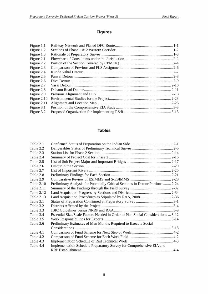
Figures Figure 1.1 Railway Network and Planed DFC Route............................................................ 1-1 Figure 1.2 Sections of Phase 1 & 2 Western Corridor ........................................................... 1-2 Figure 1.3 Rationale of Preparatory Survey .......................................................................... 1-3 Figure 2.1 Flowchart of Consultants under the Jurisdiction .................................................. 2-2 Figure 2.2 Portion of the Section Covered by CPM/HQ ....................................................... 2-4 Figure 2.3 Comparison of Previous and FLS Assignment..................................................... 2-6 Figure 2.4 Kunde Vahal Detour ............................................................................................. 2-7 Figure 2.5 Panvel Detour....................................................................................................... 2-8 Figure 2.6 Diva Detour .......................................................................................................... 2-9 Figure 2.7 Vasai Detour ....................................................................................................... 2-10 Figure 2.8 Dahanu Road Detour .......................................................................................... 2-11 Figure 2.9 Previous Alignment and FLS ............................................................................. 2-13 Figure 2.10 Environmental Studies for the Project................................................................ 2-23 Figure 2.11 Alignment and Location Map............................................................................. 2-25 Figure 3.1 Position of the Comprehensive EIA Study........................................................... 3-3 Figure 3.2 Proposed Organization for Implementing R&R................................................. 3-13
Tables Table 2.1 Confirmed Status of Preparation on the Indian Side ............................................ 2-1 Table 2.2 Deliverables Status of Preliminary Technical Survey .......................................... 2-5 Table 2.3 Station List for Phase 2 Section ......................................................................... 2-14 Table 2.4 Summary of Project Cost for Phase 2 ................................................................ 2-16 Table 2.5 List of Sub Project Major and Important Bridges .............................................. 2-17 Table 2.6 Detour in the Section.......................................................................................... 2-20 Table 2.7 List of Important Rivers ..................................................................................... 2-20 Table 2.8 Preliminary Findings for Each Section .............................................................. 2-21 Table 2.9 Comparative Review of ESIMMS and S-ESIMMS........................................... 2-23 Table 2.10 Preliminary Analysis for Potentially Critical Sections in Detour Portions ........ 2-24 Table 2.11 Summary of the Findings through the Field Survey .......................................... 2-32 Table 2.12 Land Acquisition Progress by Sections and Districts......................................... 2-34 Table 2.13 Land Acquisition Procedures as Stipulated by RAA, 2008................................ 2-36 Table 3.1 Status of Preparation Confirmed at Preparatory Survey ...................................... 3-1 Table 3.2 Districts Affected by the Project........................................................................... 3-4 Table 3.3 JBIC Guidelines versus NRRP and RAA............................................................. 3-9 Table 3.4 Essential Size/Scale Factors Needed in Order to Plan Social Considerations ... 3-12 Table 3.5 Work Responsibilities for Experts...................................................................... 3-14 Table 3.6 Preliminary Estimates of Man Months Required to Execute Social
Considerations.................................................................................................... 3-18 Table 4.1 Comparison of Fund Scheme for Next Step of Work........................................... 4-2 Table 4.2 Comparison of Fund Scheme for Each Work Field.............................................. 4-2 Table 4.3 Implementation Schedule of Rail Technical Work ............................................... 4-3 Table 4.4 Implementation Schedule Preparatory Survey for Comprehensive EIA and
RRP Establishment............................................................................................... 4-4
ii
Preparatory Survey for Dedicated Freight Corridor Project (Phase 2) Final Report
Abbreviations AA: Acquiring Agent
AR&R: The Administrator for Rehabilitation and Resettlement
ADB: Asian Development Bank
AF: Affected Family
AM: Assistant Manager
CA: Competent Authority
CPM: Chief Project Manager
CRO: Chief Resettlement Officer
DC: District Collector
DFC: Dedicated Freight Corridor
DFCCIL: Dedicated Freight Corridor Corporation of India Limited
DyDC: Deputy District Collector
EC: Environmental Clearance
EIA: Environmental Impact Assessment
EMAP: Environmental Management Plan
EMOP: Environmental Monitoring Plan
ESCS: Environmental and Social Considerations Study
ESIMMS: Environmental & Social Impact Mitigation Measures Study
ESZ: Eco-Sensitive Zone
FLS: Final Location Survey
FU: Field Unit
GAD: General Arrangement Drawing
GLD: Guideline Design
GNIDA: Greater Noida Industrial Development Authority
GOI: Government of India
HSIIDA: Haryana State Industrial and Infrastructural Development Authority
IEE: Initial Environmental Examination
INR: India National Railways
iii
Preparatory Survey for Dedicated Freight Corridor Project (Phase 2) Final Report
iv
JBIC Guideline: JBIC Guidelines for Confirmation of Environmental and Social Considerations
JICA: Japan International Cooperation Agency
JICA F/S: JICA Feasibility Study
JMS: Joint Measurement Survey
JNPT: Jawaharlal Nehru Port Trust
JST: Study team of JICA Feasibility Study
LC: Level Crossing
MOR: Ministry of Railways
NGO: Non-governmental Organization
NH: National Highway
NRRP: The National Rehabilitation and Resettlement Policy, 2007
ODA: Official Development Assistance
PAF: Project Affected Family
PAP: Project Affected Person
PIU: Project Implementation Unit
RRP: Rehabilitation and Resettlement Plan
ROB: Road Over Bridge
RAA: The Railways (Amendment) Act, 2008
RUB: Road Under Bridge
R&R: Rehabilitation and Resettlement
SC: Scheduled Caste
SEMU: Social and Environmental Management Unit
S-ESIMMS: Supplemental Environmental & Social Impact Mitigation Measures Study
SIA: Social Impact Assessment
ST: Scheduled Tribe
STEP: Special Terms of Economic Partnership
TVU: Total Volume of Urban traffic
VAO: Village Administration Officer
Preparatory Survey for Dedicated Freight Corridor Project (Phase 2) Final Report
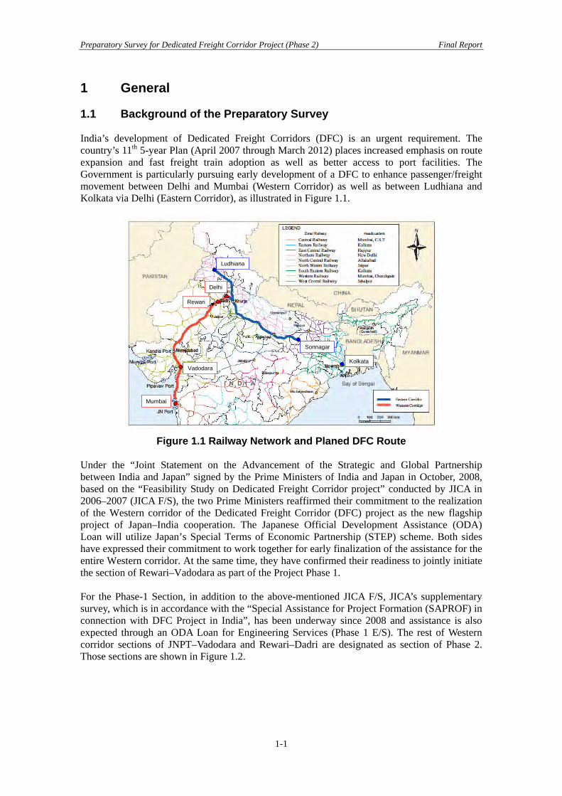
1 General 1.1 Background of the Preparatory Survey India’s development of Dedicated Freight Corridors (DFC) is an urgent requirement. The country’s 11th 5-year Plan (April 2007 through March 2012) places increased emphasis on route expansion and fast freight train adoption as well as better access to port facilities. The Government is particularly pursuing early development of a DFC to enhance passenger/freight movement between Delhi and Mumbai (Western Corridor) as well as between Ludhiana and Kolkata via Delhi (Eastern Corridor), as illustrated in Figure 1.1.
Mumbai
Ludhiana
Kolkata
Sonnagar
Delhi
Vadodara
Rewari
Mumbai
Ludhiana
Kolkata
Sonnagar
Delhi
Vadodara
Rewari
Figure 1.1 Railway Network and Planed DFC Route
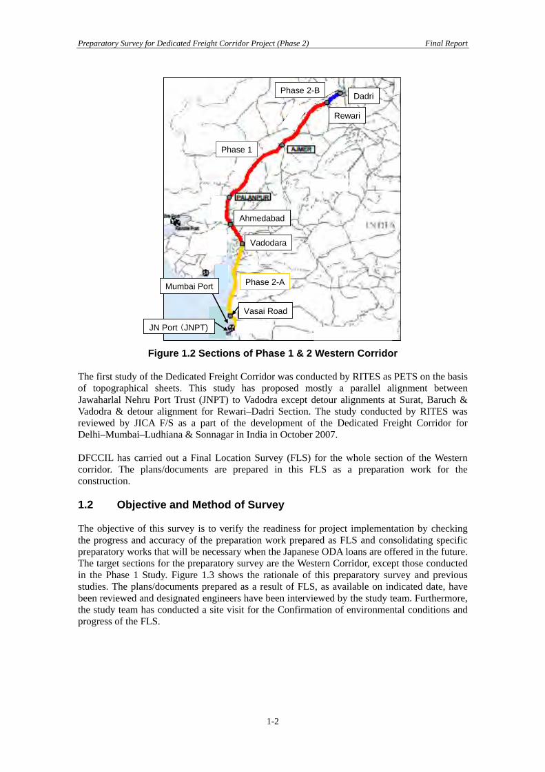
Under the “Joint Statement on the Advancement of the Strategic and Global Partnership between India and Japan” signed by the Prime Ministers of India and Japan in October, 2008, based on the “Feasibility Study on Dedicated Freight Corridor project” conducted by JICA in 2006–2007 (JICA F/S), the two Prime Ministers reaffirmed their commitment to the realization of the Western corridor of the Dedicated Freight Corridor (DFC) project as the new flagship project of Japan–India cooperation. The Japanese Official Development Assistance (ODA) Loan will utilize Japan’s Special Terms of Economic Partnership (STEP) scheme. Both sides have expressed their commitment to work together for early finalization of the assistance for the entire Western corridor. At the same time, they have confirmed their readiness to jointly initiate the section of Rewari–Vadodara as part of the Project Phase 1. For the Phase-1 Section, in addition to the above-mentioned JICA F/S, JICA’s supplementary survey, which is in accordance with the “Special Assistance for Project Formation (SAPROF) in connection with DFC Project in India”, has been underway since 2008 and assistance is also expected through an ODA Loan for Engineering Services (Phase 1 E/S). The rest of Western corridor sections of JNPT–Vadodara and Rewari–Dadri are designated as section of Phase 2. Those sections are shown in Figure 1.2.
1-1
Preparatory Survey for Dedicated Freight Corridor Project (Phase 2) Final Report
Rewari
Dadri
Phase 2-A
Phase 2-B
Vadodara
Vasai Road
JN Port (JNPT)
Ahmedabad
Mumbai Port
Phase 1
Rewari
Dadri
Phase 2-A
Phase 2-B
Vadodara
Vasai Road
JN Port (JNPT)
Ahmedabad
Mumbai Port
Phase 1
Rewari
Dadri
Phase 2-A
Phase 2-B
Vadodara
Vasai Road
JN Port (JNPT)
Ahmedabad
Mumbai Port
Phase 1
Rewari
Dadri
Phase 2-A
Phase 2-B
Vadodara
Vasai Road
JN Port (JNPT)
Ahmedabad
Mumbai Port
Phase 1
Figure 1.2 Sections of Phase 1 & 2 Western Corridor
The first study of the Dedicated Freight Corridor was conducted by RITES as PETS on the basis of topographical sheets. This study has proposed mostly a parallel alignment between Jawaharlal Nehru Port Trust (JNPT) to Vadodra except detour alignments at Surat, Baruch & Vadodra & detour alignment for Rewari–Dadri Section. The study conducted by RITES was reviewed by JICA F/S as a part of the development of the Dedicated Freight Corridor for Delhi–Mumbai–Ludhiana & Sonnagar in India in October 2007. DFCCIL has carried out a Final Location Survey (FLS) for the whole section of the Western corridor. The plans/documents are prepared in this FLS as a preparation work for the construction. 1.2 Objective and Method of Survey The objective of this survey is to verify the readiness for project implementation by checking the progress and accuracy of the preparation work prepared as FLS and consolidating specific preparatory works that will be necessary when the Japanese ODA loans are offered in the future. The target sections for the preparatory survey are the Western Corridor, except those conducted in the Phase 1 Study. Figure 1.3 shows the rationale of this preparatory survey and previous studies. The plans/documents prepared as a result of FLS, as available on indicated date, have been reviewed and designated engineers have been interviewed by the study team. Furthermore, the study team has conducted a site visit for the Confirmation of environmental conditions and progress of the FLS.
1-2

Preparatory Survey for Dedicated Freight Corridor Project (Phase 2) Final Report
Phase I (Rewari-Vadodara) Phase II
Construction
PETS (2006-2007)
JICA F/S (2006-2007)
Phase I (E/S)
JICA SAPROF for Phase I
Preliminary Works and DetailEngineering Construction
Preliminary Works and DetailEngineering Construction
Survey
Required study and survey
PreparatorySurvey
Verify readinessof the Project toapply the loanscheme
Figure 1.3 Rationale of Preparatory Survey
1-3

Preparatory Survey for Dedicated Freight Corridor Project (Phase 2) Final Report
1-4
Preparatory Survey for Dedicated Freight Corridor Project (Phase 2) Final Report
2 Present Status of Preparation Work for Section of Phase 2 2.1 Technical Study and Survey for Railway Construction The Indian side has conducted the “Preliminary works and detail engineering construction survey” (called final location survey: FLS) after the JICA F/S. The study included only civil construction preparation (tonsorial, geological survey, general arrangement drawings, design calculation and cost estimation) with land acquisition preparation. There are no mentions of Signal & Telecommunication, Electrification, Depot (locomotive, freight wagon, maintenance) and rolling stock purchasing in the FLS deliverable. This section outlines the required preparation for the loan appraisal, including items covered in the FLS and others which are not. Also Table 2.1 shows the required preparation and confirmed present status. (1) Required Item included in the FLS
• Alignment (Topological survey, L-section drawing, Topo sheet) • Land plan (Topological survey, Land plan drawing) • Station (Yard layout) • Civil structures (Bridge, Permanent way, Track), Geological survey, Topological survey,
design calculation, General arrangement drawing, Cost estimation. (2) Required Items which are Not Included in the FLS
• Station (Topological & Geological study, building plan/drawing, cost estimation) • Signal & Telecommunication (plan/drawing , cost estimation) • Electrification (plan/drawing, cost estimation) • Rolling stock depot (locomotive, freight wagon) Maintenance depot • Locomotive & freight wagon purchasing (plan/drawing, cost estimation) • Project implementation schedule for above items (1) and (2).
Table 2.1 Confirmed Status of Preparation on the Indian Side
Item Geological Survey
Topological Survey
Plan drawings
Cost estimation
Implementa-tion Schedule
Alignment N/A Y Y N/A N/A Land Plan N/A Y Y N/A N/A Station N N Y Y N Civil structure Y Y Y Y N Signal & Telecom N/A N/A N N N Depot N N N N N Electrical facility N/A N/A N N N Rolling stock N/A N/A N N N
Y: Study confirmed N: Study not found N/A: Not applicable 2.1.1 Project Outline of Technical Study and Survey for Railway Construction (1) Project Outline and Formation
In order to speed up the activities involved in Western and Eastern Freight Corridors, the Government of India set up an organization named Dedicated Freight Corridor Corporation of India Limited (DFCCIL) under the Ministry of Railways (MOR). In turn, DFCCIL invited private entities to carry forward the work as mentioned in the TOR pursued under the Chief Project Manager stationed at Mumbai, Surat, Vadodara and Head Quarter for the Phase 1I alignment of DFCCIL. Figure 2.1 explains the consultants under the jurisdiction.
2-1

Preparatory Survey for Dedicated Freight Corridor Project (Phase 2) Final Report
Consultants Consultants Consultants
CPM/ Mumbai CPM/Surat CPM/Vadodara
Consultants
DFCCIL/HQ (Rewari–Dadri)
Figure 2.1 Flowchart of Consultants under the Jurisdiction The Broad Scope of work for this assignment includes the following items: Staking Out the Designed Alignment as per the Data Given by DFCCIL and the Study of Alternatives for the Detour Portion
The scope of work involves transferring the finalized alignment on ground using the total station. Data required for stacking out were provided by DFCCIL. Consultants/BB Contractors in each section were asked to stack the alignment as decided by the concerned Chief Project Manager. In the staking out of the designed alignment, consultants were required to stake the alignment with concrete pillars sized at 150 mm × 150 mm × 900 mm at every 500 meters in the straight portion of the alignment and in the curve portion. Concrete pillars should be fixed at every junction point of the straight and curve, curve and straight etc. Furthermore, at every 100 meters, CC muttam’s were to be staked. A study of alternatives for the detour portion was conducted by the consultants as directed by the Engineer-in-charge/Chief Project Manager. Consultants were required to do a feasibility study by traversing through the tentative alignment using differential GPS and plotting the best fit alignment on a Toposheet. By receiving approval for the best fit alignment from the Engineer-in-charge, the consultants are required to do a detail engineering construction survey on the approved alignment for 100 m width on both sides of the alignment using the total station equipment. Survey should comply with the Indian Railways Code of Engineering department (1999, Third reprint). With the detailed engineering survey completed, the consultants were required to submit the L-Section along with the Plan of alignment designed using MX Rail/Auto CAD as a derivation tool. Preparation of Land Plans
Consultants were briefed in their scope to prepare a land plan for the entire jurisdiction of Mumbai, Surat & Vadodara. The scope of work involves the following,
• Identification of Villages and respective Village administrative officers (VAO) under each section.
• Collection of Village maps and Jamabandhi (Ownership of Land Details) from VAO’s. • Calculation of Right of Way (ROW) as per the L-Section provided by DFCCIL. • Superimposition of proposed alignment on the scaled village map. • Identification of Survey numbers falling within the ROW and the respective owners. • Calculation of area for the Identified survey numbers.
2-2

Preparatory Survey for Dedicated Freight Corridor Project (Phase 2) Final Report
• Preparation of Land Plan and land acquisition proposal — Village, District & Sub Divisional Magistrate’s Jurisdiction wise.
• Submission of Land Plan, land acquisition proposals and receiving approval by the Competent Authority.
Competent authority (CA) is appointed by the respective State Government on the basis of requisites received from DFCCIL through the Ministry of Railways. CA’s are the final authority to vet out the approval for the land plan. Subsurface Investigation for Major & Minor Bridges
The Consultants were asked to carry out the Sub-surface investigations along the proposed alignment on the entire jurisdiction of CPM’s falling under Phase 2. The criterions for the sub-surface investigations are as follows:
• Drilling of 150 mm diameter bore holes in all kinds of soil for - Major Bridges — up to 30 m depth at each abutment and one representative pier. - Minor Bridges or RUB or formation at every 1,000 m — up to 12 m depth.
• Conducting Standard Penetration Tests at every 3.0 m interval starting from the first sample at 1.5 m depth or at the change of stratum as per IS: 2131.
• Collection of disturbed, undisturbed soil samples and water samples. Furthermore, carrying out various laboratory testing as per relevant IS codes in consultation with the Engineer-in-Charge of DFCCIL.
• Collection of rock core samples and carrying out various laboratory testing as per relevant IS codes in consultation with the Engineer-in-charge of DFCCIL.
• Preparation of bore logs, location plan of boreholes, various test results curves and calculations with recommendation of suitable type of foundations with the Safe Bearing Capacity.
Hydraulic Survey for Streams
Consultants were required to conduct Hydraulic surveys of Streams. For Minor bridges — leveling of river profile to be conducted for 0.5 km on the upstream and downstream side, which includes traversing of catchment area of the stream and collection of hydrological data For Major bridges — leveling of river profile to be conducted for 1 km on the upstream and downstream side, which includes traversing of catchment area of the stream and collection of hydrological data Based on the leveling of river profile and collection of hydrological data, consultants must validate and finalize the length of the bridge, number of spans must be supported with proper hydrological calculation, type of sub-structure, design of scour beds, design of guide bunds. Preparation of GAD for Major & Minor Bridges
Scope of work requires the consultant to prepare a General Arrangement Drawing for the proposed minor and major bridges as finalized and approved by the Engineer-in-Charge/Chief Project Manager.
2-3

Preparatory Survey for Dedicated Freight Corridor Project (Phase 2) Final Report
Preparation of Detailed Estimate
Scope of work requires the consultant to prepare a detailed estimate on the Quantity of earthwork, blanket/ballast walling, side drains, minor & major bridges, and permanent way materials. Detailed estimate should be the latest and realistic with the calculation of lead involved, availability of material required for earthwork, blanketing, etc and must be accompanied by the submission of the rate analysis. The Western corridor is divided into 16 sections. The CPM/HQ in charge for the sections of Phase 2 is shown bellow Figure 2.2.
Section1(107.0km)
Section 2(94.06km)
Section 3(92Km)
Section4(102.2km)
Section15 (63km)
Section16(64km)
Rewari-Dadri HQ(127km)
Section 5(89.20km)
CPM Mumbai(201.6km)
CPM Vadodra(182.16km)
CPM Surat(115km)
Western Corridor( JNPT ‐ Dadri)
JNPT
VAITRA
NA
VADODRA
REWARI
DADRI
SANJAN
MARO
LI
VARE
DIYA
Phase II a = 425.26km Phase II b =127
Figure 2.2 Portion of the Section Covered by CPM/HQ
(2) Deliverables of the Preliminary Technical Survey
The Consultants were required to submit the Final report based on the above mentioned scope of work. The deliverables’ format and formation were not defined; it was left to the consultants to decide. Whole volumes of documents and drawings were unknown because no document lists /drawing lists were attached. L-section drawings were ready for the whole of the Phase 2 section, except for a few km in the Surat Rewari–Dadri section. However checking of L-section drawings continuity is very difficult because there is no continuous chainage. The deliverables of the Preliminary Technical Survey are shown in Table 2.2 and the final report of the study included the following items:
• Descriptive report on the work done as per the scope pursued under the Chief Project Manager.
• Report on Staking out Alignment. • Report on Detailed engineering survey conducted for the detour with supportive
documents such as the L-Section and Plan of the alignment. • Report on Land Plan and Land Acquisition Proposals with supportive documents of
Land Plans and the acquisition proposal in hard and soft copy. • Report on Sub surface investigations with laboratory test results. • Detailed Estimate report and • Annexure on Hydrological calculations with Hydraulic survey drawings and General
Arrangement Drawings (GAD) of Minor and Major bridges.
2-4
Preparatory Survey for Dedicated Freight Corridor Project (Phase 2) Final Report
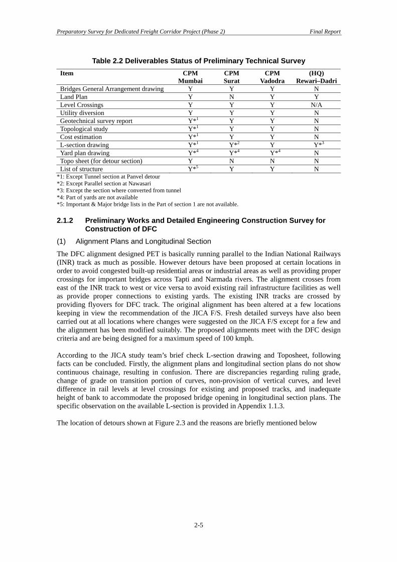
Table 2.2 Deliverables Status of Preliminary Technical Survey Item CPM
Mumbai CPM Surat
CPM Vadodra
(HQ) Rewari–Dadri
Bridges General Arrangement drawing Y Y Y N Land Plan Y N Y Y Level Crossings Y Y Y N/A Utility diversion Y Y Y N Geotechnical survey report Y*1 Y Y N Topological study Y*1 Y Y N Cost estimation Y*1 Y Y N L-section drawing Y*1 Y*2 Y Y*3 Yard plan drawing Y*4 Y*4 Y*4 N Topo sheet (for detour section) Y N N N List of structure Y*5 Y Y N
*1: Except Tunnel section at Panvel detour *2: Except Parallel section at Nawasari *3: Except the section where converted from tunnel *4: Part of yards are not available *5: Important & Major bridge lists in the Part of section 1 are not available. 2.1.2 Preliminary Works and Detailed Engineering Construction Survey for
Construction of DFC (1) Alignment Plans and Longitudinal Section
The DFC alignment designed PET is basically running parallel to the Indian National Railways (INR) track as much as possible. However detours have been proposed at certain locations in order to avoid congested built-up residential areas or industrial areas as well as providing proper crossings for important bridges across Tapti and Narmada rivers. The alignment crosses from east of the INR track to west or vice versa to avoid existing rail infrastructure facilities as well as provide proper connections to existing yards. The existing INR tracks are crossed by providing flyovers for DFC track. The original alignment has been altered at a few locations keeping in view the recommendation of the JICA F/S. Fresh detailed surveys have also been carried out at all locations where changes were suggested on the JICA F/S except for a few and the alignment has been modified suitably. The proposed alignments meet with the DFC design criteria and are being designed for a maximum speed of 100 kmph. According to the JICA study team’s brief check L-section drawing and Toposheet, following facts can be concluded. Firstly, the alignment plans and longitudinal section plans do not show continuous chainage, resulting in confusion. There are discrepancies regarding ruling grade, change of grade on transition portion of curves, non-provision of vertical curves, and level difference in rail levels at level crossings for existing and proposed tracks, and inadequate height of bank to accommodate the proposed bridge opening in longitudinal section plans. The specific observation on the available L-section is provided in Appendix 1.1.3. The location of detours shown at Figure 2.3 and the reasons are briefly mentioned below
2-5

Preparatory Survey for Dedicated Freight Corridor Project (Phase 2) Final Report
Figure 2.3 Comparison of Previous and FLS Assignment
JICA/FS
FLS
Joravasan & Navasari
2-6
Preparatory Survey for Dedicated Freight Corridor Project (Phase 2) Final Report
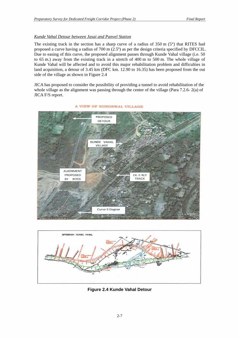
Kunde Vahal Detour between Jasai and Panvel Station
The existing track in the section has a sharp curve of a radius of 350 m (5°) that RITES had proposed a curve having a radius of 700 m (2.5º) as per the design criteria specified by DFCCIL. Due to easing of this curve, the proposed alignment passes through Kunde Vahal village (i.e. 50 to 65 m.) away from the existing track in a stretch of 400 m to 500 m. The whole village of Kunde Vahal will be affected and to avoid this major rehabilitation problem and difficulties in land acquisition, a detour of 3.45 km (DFC km. 12.90 to 16.35) has been proposed from the out side of the village as shown in Figure 2.4 JICA has proposed to consider the possibility of providing a tunnel to avoid rehabilitation of the whole village as the alignment was passing through the center of the village (Para 7.2.6- 2(a) of JICA F/S report.
Figure 2.4 Kunde Vahal Detour
2-7
Preparatory Survey for Dedicated Freight Corridor Project (Phase 2) Final Report
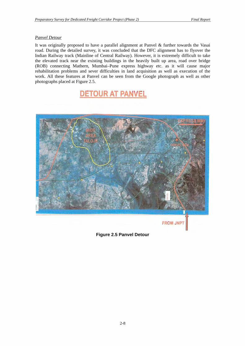
Panvel Detour
It was originally proposed to have a parallel alignment at Panvel & further towards the Vasai road. During the detailed survey, it was concluded that the DFC alignment has to flyover the Indian Railway track (Mainline of Central Railway). However, it is extremely difficult to take the elevated track near the existing buildings in the heavily built up area, road over bridge (ROB) connecting Mathern, Mumbai–Pune express highway etc. as it will cause major rehabilitation problems and sever difficulties in land acquisition as well as execution of the work. All these features at Panvel can be seen from the Google photograph as well as other photographs placed at Figure 2.5.
Figure 2.5 Panvel Detour
2-8
Preparatory Survey for Dedicated Freight Corridor Project (Phase 2) Final Report
Diva Detour between Nilije and Kopar Road
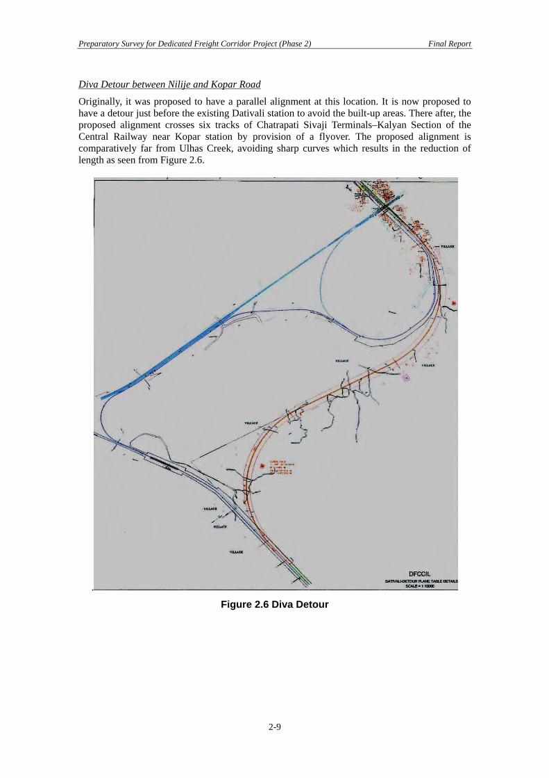
Originally, it was proposed to have a parallel alignment at this location. It is now proposed to have a detour just before the existing Dativali station to avoid the built-up areas. There after, the proposed alignment crosses six tracks of Chatrapati Sivaji Terminals–Kalyan Section of the Central Railway near Kopar station by provision of a flyover. The proposed alignment is comparatively far from Ulhas Creek, avoiding sharp curves which results in the reduction of length as seen from Figure 2.6.
.
Figure 2.6 Diva Detour
2-9

Preparatory Survey for Dedicated Freight Corridor Project (Phase 2) Final Report
Vasai Detour between Juchandra and Vaitarana Station
There are a number of built up areas in between these stations at Vasai road and Virar in particular. The distance between sea coast and the mountain range is also very short. The surrounding area of Vaitarana riverRiver is marsh land. Moreover, the railroad is served by four track lines of the suburban section and there are lots of development activities along the existing Railway track. Also, there are three roadroads over bridges (ROB) which will have to be rebuilt. It will be extremely difficult to rebuild these ROB’s as the area is fully developed. The massive habitats in these areas are clearly visible in the Google pictures. The original survey report of RITES proposes parallel alignment however the JICA team has considered it better to explore the possibility of providing a detour at this location to overcome the problems. The detour proposed overcomes all these problems but will involve construction of two tunnels having a length of 540 m and 240 m respectively on a straight alignment. Since the Jawaharlal Nehru Port Vasai road section has a steep undulation, the JICA study team has also stated that a tunnel may be necessary (see Figure 2.7). The detailed engineering and geological survey for the tunnels has yet to be carried out.
Tunnel Vasai–Vaitrana Detour
Juchandra Station
Vaitrana Station
To Panvel
Figure 2.7 Vasai Detour
2-10
Preparatory Survey for Dedicated Freight Corridor Project (Phase 2) Final Report
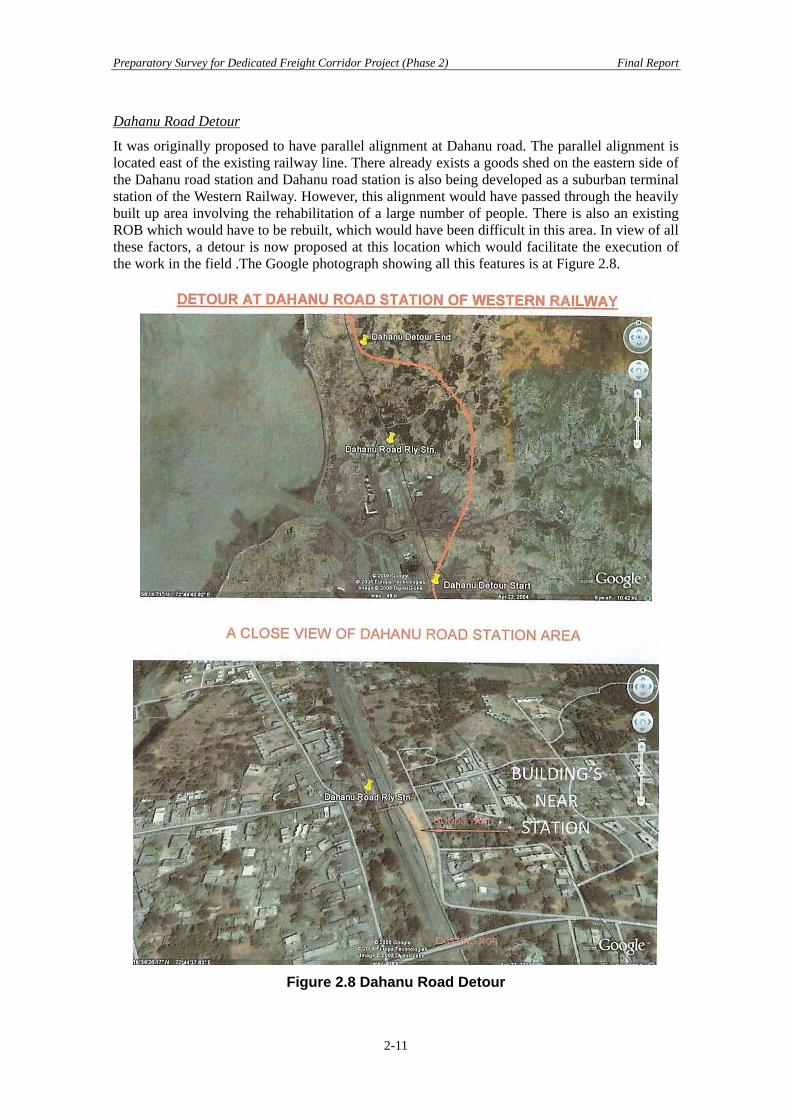
Dahanu Road Detour
It was originally proposed to have parallel alignment at Dahanu road. The parallel alignment is located east of the existing railway line. There already exists a goods shed on the eastern side of the Dahanu road station and Dahanu road station is also being developed as a suburban terminal station of the Western Railway. However, this alignment would have passed through the heavily built up area involving the rehabilitation of a large number of people. There is also an existing ROB which would have to be rebuilt, which would have been difficult in this area. In view of all these factors, a detour is now proposed at this location which would facilitate the execution of the work in the field .The Google photograph showing all this features is at Figure 2.8.
Figure 2.8 Dahanu Road Detour
2-11
Preparatory Survey for Dedicated Freight Corridor Project (Phase 2) Final Report
Navsari
It was originally proposed to have parallel alignment at this location however JST felt the possibility of providing a detour may be examined in view of the fact that there will be number of ROB’s which may pose problems in execution in this built up area. The possibility of providing a detour at this location has been examined but not found feasible due to the heavily built up area and difficulties in getting highly fertile agricultural land. Thus, it is concluded to have a parallel alignment in this stretch as originally proposed. Surat Detour
A detour was originally proposed at Surat in order to avoid the heavily built up Surat city area, Utran, Kosad and industrial estate of Udhana. JICA F/S team has suggested shifting the alignment to further northwest with the objective to minimize the number of project affected families of the urban area of Surat city, which is rapidly expanding. Incidentally, this will also provide a better location for the bridge across Tapti River. The new alignment proposed diverges after Sachin station and after flying over Udhana–Jalgaon Rly. line of the Indian Railways and crossing Tapti river it will meet the existing alignment at Gothangam and run parallel to the existing alignment thereafter. This alignment is also suggested by JICA F/S team. Bharuch Detour
The earlier report of RITES had proposed the detour at Bharuch from short of Ankleswar to short of Palej and then parallel alignment for some stretch before another detour at Vadodra. The JICA F/S team has suggested that the Bharuch detour may be extended towards the north western side and meet almost at Makarpura, thus avoiding a parallel alignment patch. This has been suggested to minimize resettlement problems and avoid industrial areas which are expected to be further urbanized near future. The final study has adopted the route proposed by the JICA team which avoids densely populated and well developed markets at Ankleswar, Bharuch, Palej and Miyagam. This also avoids several religious structures in communally sensitive towns of Ankleswar, Bharuch, Palej and Miyagam, permitting further development of the already existing industrial area on both sides of the existing Railway track. This alignment also provides suitable location of a bridge across Narmada River. Rewari–Dadri Detour
The section between Rewari and Dadri has been proposed for diversion route because Delhi is not only the centre of the National Capital Region of India but also is heavily populated, build up and a historical area. It was originally proposed to have a 4.0 km long tunnel on the proposed diversion as there is a steep cliff over a mountain having a vertical drop of 100 m, along with about one km long viaduct/bridge and very high embankments and cuttings. The JICA F/S team has suggested that the length of the tunnel may be increased to 6 km or alternatively, the alignment may be shifted by about 1.5 km towards Sohna city in order to reduce the tunnel length to about 3 km. JICA F/S team proposed the new tunnel alignment from the point of view of construction time, cost, workability and environmental impact. In a further detailed study of site conditions, it is considered that the tunnel can be avoided by increasing the length of diversion route. Hence it is now proposed to adopt the route which avoids provision of the tunnel. Figure 2.9 shows comparison of alternative alignments proposed in the JICA F/S and FLS
2-12

Preparatory Survey for Dedicated Freight Corridor Project (Phase 2) Final Report
Figure 2.9 Previous Alignment and FLS
(2) Yard/Station Plan
In Phase 2 of Western DFC, there will be 14 stations, 2 terminal stations, 2 junction stations and 10 crossing stations. All station yards are planned to have a total of 1,500 m CSR of lines whereas for the present proposal will be 750 m. It is found that, Yard plans are schematic and available for only seven stations namely JNPT Station, Nilje Station, Vasai Road, Joravasan, Navsari, Gothamgam, Sanjali, and Varediya. In general they should be drawn to a scale of 1 : 1000 showing all details. Also, the yard plans do not indicate the length of various yard lines along with their nomenclature, location of curves, grades, bridges, level crossings, chainages of various turnouts etc., which are essentially required for proper appreciation. Furthermore, the grades in the yard are not shown with the result and so it is not possible to check if there is any crossover or turnout on the change of grade. Chainages of the turnouts and the distance between the track centers should also be shown. The specific observations on the available yard plans are provided in Appendix 1.1.1. The number of stations has decreased due to the removal of Tigaon station from Rewari–Dadri section. However the distances for each station were not confirmed because chainage was not mentioned in the Yard drawings. For reference, the station list and station distances mentioned in the JST report are shown Table 2.3.
2-13

Preparatory Survey for Dedicated Freight Corridor Project (Phase 2) Final Report
Table 2.3 Station List for Phase 2 Section CPM Name of
Station Classification JST
Chainage Distance of stations
Yard Plan
FLS Chainage*
1 JNTP Terminal 7 Y 90 2 Nilaje Crossing 45 38 Y 44 3 Vasai Road Junction 79 34 Y 74 4 Palghar Crossing 117 38 N 20 5 Gholvad Crossing 157 40 N -
Mumbai
6 Vapi Crossing 197 40 N - 7 Joravasan Crossing 237 49 Y - Surat 8 Navasari Crossing 276 39 N - 9 Gothangam Junction 316 40 Y 29 10 Sanjali Crossing 351 35 Y -
Vadodra
11 Varedia Crossing 389 38 Y - Phase 1 Section
12 Dharuhera Crossing 1391 N - 13 Pirthala Junction 1429 38 N -
HQ
14 Dadri Terminal 1483 54 N - *FLS chainage is not continuous chainage (3) Bridge Design
The General Arrangement Drawings are provided for Important, Major and Minor bridges (including Road over bridges). The design calculations had been carried out based geological and hydrological survey results. The bridge locations that mentioned in the L-section drawings are verified with bridge lists provided by each CPM. It is recommended the GAD needs to mention planed formation levels and also the arrangement of piers for exiting tracks. (4) Road Crossings: Level Crossing (LC), Road Over Bridge (ROB), Road Under
Bridge (RUB)
No new (manned or unmanned) level crossings have been proposed on detour alignment of DFC as all road crossings have grade separation, mostly road under bridges with exceptions of a few road over bridges. Existing ROB’s have vertical clearance of 6,250 mm. Whereas DFC requires vertical clearance of 8,430 mm and hence all ROB’s on the parallel section of DFC will normally need rebuilding. In case of newly constructed ROB’s, the height of the girder at the side span is smaller than that of the main span and thus the vertical clearance is greater. In such case, modifications suitable for DFC may be required. Such station exists only at a road over bridge in Boisar yard. Existing road under bridges will be extended and level crossings will also be extended excepting those having TVU of 50,000 or more as the same will be replaced by road over/under bridges keeping in view the site conditions. At certain locations, the DFC alignment will be cutting across the existing INR tracks and at all such locations, the DFC track will fly over the existing INR tracks The crossing of Narul– Belapur–Uran track is presumed to be flying over the DFC track while for the quarry siding and sleeper factory siding of Udvada station, there will be a surface diamond crossing. (5) Project Cost Estimation
The Western Rail Freight Corridor was originally estimated by RITES during January, 2007. It was updated in June 2009 by considering various changes in the field as well as technical specifications and so the revised project cost is Rs. 261,240 million now.
2-14

Preparatory Survey for Dedicated Freight Corridor Project (Phase 2) Final Report
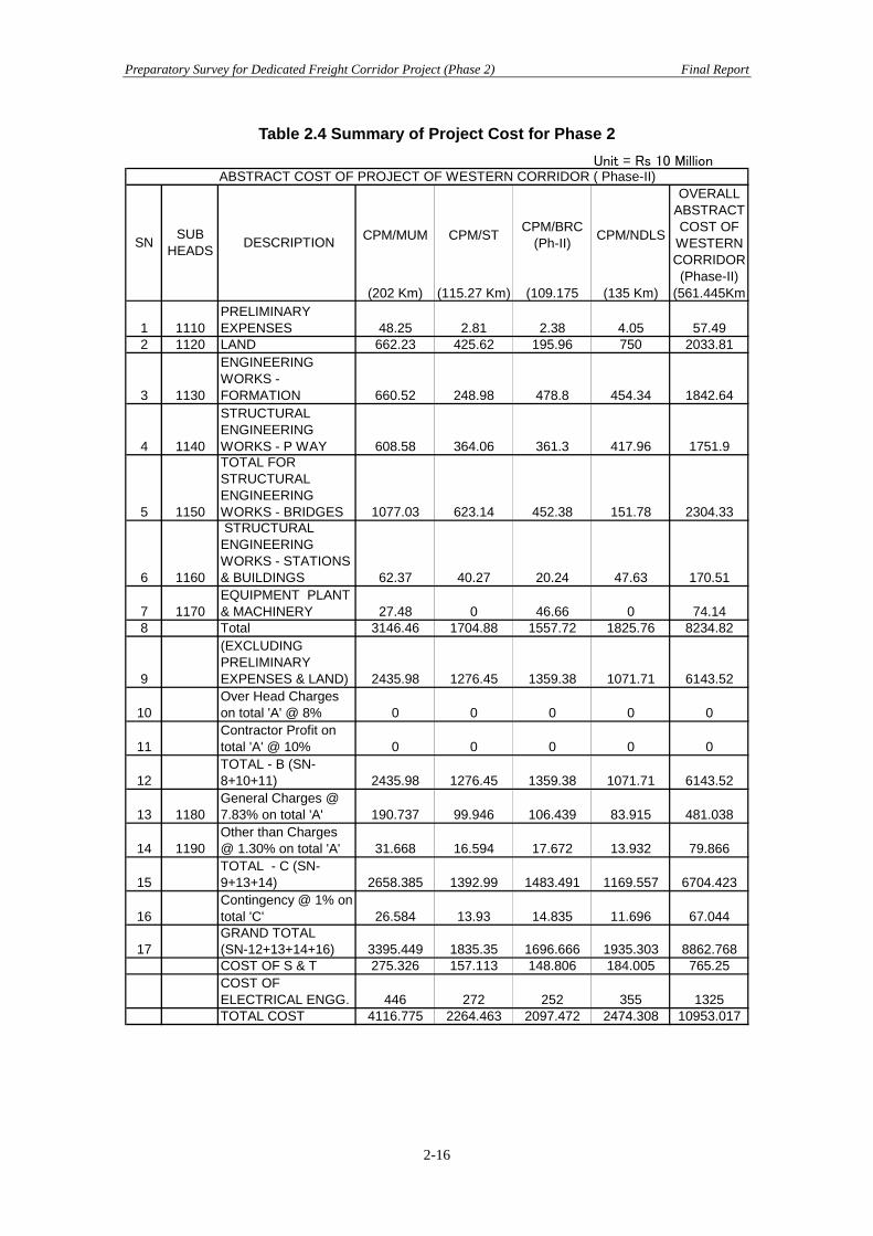
The cost of Phase 2 of the project i.e. JNPT to Vadodra and Rewari to Dadri is Rs. 109,530 million at this time. For reference the cost estimation provided by DFCCIL is shown in Table 2.1. Additional modification of alignment has been continued for Phase 2 section as per FLS. Phase 2 project cost mentioned above includes preliminary expenses and land, totaling approx Rs. 20,900 million. Also included is the cost for 54 important and major bridges, for which the contract is already awarded, approximating to Rs. 6,050 million. The original alignment in the Rewari–Dadri section had a tunnel of length 4 km. With the revision in the alignment the cost of the tunnel has been subtracted, on the other hand there are two new tunnels (240 m and 540 m) at Panvel detour in Mumbai CPM section. Also, a number of detours have been added. These reasons explain why the cost estimation needs to be updated after the FLS results. Furthermore the cost estimation provided by DFCCIL seems to include Civil structures, Track structures, Electrification, Signal and Telecommunication facility and Stations (including buildings) only. The Depots (for locomotives, flight wagons and maintenance) and rolling stock purchasing cost are not included. The scope of the loan scheme needs to confirm these points.
2-15
Preparatory Survey for Dedicated Freight Corridor Project (Phase 2) Final Report
Table 2.4 Summary of Project Cost for Phase 2 Unit = Rs 10 Million
CPM/MUM CPM/ST CPM/BRC(Ph-II) CPM/NDLS
OVERALLABSTRACTCOST OF
WESTERNCORRIDOR(Phase-II)
(202 Km) (115.27 Km) (109.175 (135 Km) (561.445Km
1 1110PRELIMINARYEXPENSES 48.25 2.81 2.38 4.05 57.49
2 1120 LAND 662.23 425.62 195.96 750 2033.81
3 1130
ENGINEERINGWORKS -FORMATION 660.52 248.98 478.8 454.34 1842.64
4 1140
STRUCTURALENGINEERINGWORKS - P WAY 608.58 364.06 361.3 417.96 1751.9
5 1150
TOTAL FORSTRUCTURALENGINEERINGWORKS - BRIDGES 1077.03 623.14 452.38 151.78 2304.33
6 1160
STRUCTURALENGINEERINGWORKS - STATIONS& BUILDINGS 62.37 40.27 20.24 47.63 170.51
7 1170EQUIPMENT PLANT& MACHINERY 27.48 0 46.66 0 74.14
8 Total 3146.46 1704.88 1557.72 1825.76 8234.82
9
(EXCLUDINGPRELIMINARYEXPENSES & LAND) 2435.98 1276.45 1359.38 1071.71 6143.52
10Over Head Chargeson total 'A' @ 8% 0 0 0 0 0
11Contractor Profit ontotal 'A' @ 10% 0 0 0 0 0
12TOTAL - B (SN-8+10+11) 2435.98 1276.45 1359.38 1071.71 6143.52
13 1180General Charges @7.83% on total 'A' 190.737 99.946 106.439 83.915 481.038
14 1190Other than Charges@ 1.30% on total 'A' 31.668 16.594 17.672 13.932 79.866
15TOTAL - C (SN-9+13+14) 2658.385 1392.99 1483.491 1169.557 6704.423
16Contingency @ 1% ontotal 'C' 26.584 13.93 14.835 11.696 67.044GRAND TOTAL(SN-12+13+14+16)COST OF S & T 275.326 157.113 148.806 184.005 765.25COST OFELECTRICAL ENGG. 446 272 252 355 1325TOTAL COST 4116.775 2264.463 2097.472 2474.308 10953.017
8862.7683395.449 1835.35 1696.666 1935.303
SN SUBHEADS DESCRIPTION
17
ABSTRACT COST OF PROJECT OF WESTERN CORRIDOR ( Phase-II)
2-16

Preparatory Survey for Dedicated Freight Corridor Project (Phase 2) Final Report
2.1.3 Following Preparation Work of Preliminary Works and Detailed Engineering Construction Survey
(1) Overview of Sub Project of Important and Major Bridges
The 54 major and important bridges between VATARNA and UTRAN are separate from the rest of the construction work as sub project for the following reason. Bridge construction is one of most symbolic work in the DFC project and it needs a long construction period. The sub project is considered a commencement notice to the nation, indicating that the DFC project is in progress physically. Furthermore, the domestic contractor can finish the construction work before or at the same time as the Phase 1 section. The construction contractor and engineering consultants for supervision has been decided. General arrangement drawings for 15 bridges have been approved and detailed design for ten of them has also been finalized. The work of construction has started at two locations. The amount of bridge length of the sub project is about 4.4 km and it accounts for 26% (length of bridge base) of the important and major bridges in the Phase 2 section. (2) Review of the Documents for the Sub Project
The main contractor of the project is SOMA Pvt Ltd and the contract is the lump sum base design build. The JICA study team has reviewed the general arrangement drawings (GADs), commenting as following. The 54 bridges (one span – 23 spans) consist of box culvert and simple beam girders, the type of structures are categorized as below. A simple girder length is between 7.1 m and 19.8 m and 3 span box culverts are 6.1 m–7.1 m per box. Table 2.1 shows sub project structure profiles of Major and important bridges. Type 1. Span 14.2–14.4 m I–beam type Pre-stressed concrete girder (beam for a track) Type 2. Span 19.8 U-shape though type Pre-stressed concrete girder (par track) Type 3. Span 19.0–19.8 1Box girder type Pre-stressed concrete girder (par track) Type 4. Span 6.1–7.1 m Concrete box culvert (three spans) Type 5. Span 7.1 m Slab type concrete girder
Table 2.5 List of Sub Project Major and Important Bridges Sl. No. Bridge No. Location (in km) Span Remarks 1 92 69/2–16 20 × 19 m Important Bridge 2 93 70/12–26 23 × 19 m Important Bridge 3 98 74/8–10 3 × 7.10 m Major Bridge 4 99 74/24–26 3 × 6.10 m Skew Major Bridge 5 115 82/6–8 3 × 7.10 m Major Bridge 6 119 83/32–84/2 4 × 9.40 m Major Bridge 7 125 88/2–4 1 × 19.8 m Major Bridge 8 126 88/24–26 3 × 7.10 m Major Bridge 9 135 94/18–20 1 × 19.80 m Major Bridge 10 136 94/20–22 2 × 14.20 m Major Bridge 11 139 96/16–18 3 × 6.50 m Major Bridge 12 143 99/10–12 5 × 19.80 m Major Bridge 13 144 99/24–26 3 × 14.40 m Major Bridge 14 163 113/22–26 3 × 19.0 m Major Bridge 15 166 118/2–4 3 × 19.0 m Major Bridge 16 169 120/16–20 4 × 19.80 m Major Bridge 17 173 124/10–12 5 × 14.2 m Major Bridge 18 182 127/24–26 1 × 19.8 m Major Bridge 19 192 133/18–20 2 × 19.8 m Major Bridge 20 203 138/8–10 2 × 19.8 m Major Bridge 21 228 148/6–10 7 × 19.0 m Major Bridge
2-17
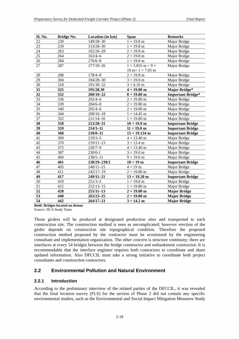
Preparatory Survey for Dedicated Freight Corridor Project (Phase 2) Final Report
Sl. No. Bridge No. Location (in km) Span Remarks 22 230 149/28–30 1 × 19.8 m Major Bridge 23 239 153/28–30 1 × 19.8 m Major Bridge 24 263 162/26–28 2 × 19.8 m Major Bridge 25 264 163/4–6 2 × 19.8 m Major Bridge 26 284 176/6–8 1 × 19.8 m Major Bridge 27 287 177/18–26 1 × 3.835 m + 9 ×
19 m+ 1 × 7.05 m Major Bridge
28 288 178/4–8 2 × 19.8 m Major Bridge 29 304 184/28–30 3 × 19.0 m Major Bridge 30 318 191/30–32 3 × 6.10 m Major Bridge 31 325 195/28.30 4 × 19.80 m Major Bridge* 32 332 200/10–22 8 × 19.80 m Important Bridge* 33 336 202/4–6 2 × 19.80 m Major Bridge 34 339 204/6–8 2 × 19.80 m Major Bridge 35 340 205/4–6 2 × 19.80 m Major Bridge 36 344 208/16–18 1 × 14.45 m Major Bridge 37 352 211/14–16 1 × 19.80 m Major Bridge 38 358 213/28–31 10 × 19.0 m Important Bridge 39 359 214/3–11 11 × 19.0 m Important Bridge 40 368 218/0–11 15 × 19.134 m Important Bridge 41 369 219/3–5 4 × 13.40 m Major Bridge 42 370 219/11–13 3 × 13.4 m Major Bridge 43 372 220/7–9 4 × 13.40 m Major Bridge 44 387 230/0-1 3 × 19.0 m Major Bridge 45 400 238/5–11 9 × 19.0 m Major Bridge 46 401 238/29–239/1 18 × 19 m Important Bridge 47 405 240/11–15 4 × 19 m Major Bridge 48 411 242/17–19 2 × 19.80 m Major Bridge 49 417 249/11–21 13 × 19.20 m Important Bridge 50 419 251/3–5 1 × 19.8 m Major Bridge 51 422 252/13–15 1 × 19.80 m Major Bridge 52 428 255/11–13 2 × 19.80 m Major Bridge 53 440 263/23–25 2 × 19.80 m Major Bridge 54 442 264/17–21 3 × 14.2 m Major Bridge
Bold: Bridges located on detour Source: JICA Study Team Those girders will be produced at designated production sites and transported to each construction site. The construction method is seen as uncomplicated; however erection of the girder depends on construction site topographical condition. Therefore the proposed construction method proposed by the contractor must be scrutinized by the engineering consultant and implementation organization. The other concern is structure continuity; there are interfaces at every 54 bridges between the bridge constructor and embankment constructor. It is recommendable that the interface engineer requires both contractors to coordinate and share updated information. Also DFCCIL must take a strong initiative to coordinate both project consultants and construction contractors. 2.2 Environmental Pollution and Natural Environment 2.2.1 Introduction According to the preliminary interview of the related parties of the DFCCIL, it was revealed that the final location survey (FLS) for the section of Phase 2 did not contain any specific environmental studies, such as the Environmental and Social Impact Mitigation Measures Study
2-18

Preparatory Survey for Dedicated Freight Corridor Project (Phase 2) Final Report
(ESIMMS) conducted in the JICA Feasibility Study (JICA F/S). Environmentally sensitive areas like forests and hilly areas are given special environmental consideration in the FLS process. However, the alignment was planned to pass through these areas in case of unavoidable circumstances. At this stage, the issues were discussed with the Forest Department’s local offices to understand the sensitivity of the forest and clearances required. Environmental considerations observed by the JICA F/S study were also reviewed and considered. The GoI EIA Notification of 2006 (replacing the EIA Notification of 1994) sets out the requirement for Environmental Assessment in India. This states that prior Environmental Clearance (EC) is required for specified activities/projects and must be obtained before any construction work or land preparation (except land acquisition) may commence. Projects are categorized under the Notification as A or B depending on the scale of the project and the nature of its impacts. Note that railway and bridge construction projects are not included in the EIA Notification and therefore do not require prior Environmental Clearance. JICA integrates environmental and social considerations into its cooperation projects to avoid or minimize adverse impacts on the environment and local communities. For this purpose, JICA developed “Guidelines for Environmental and Social Considerations,” which were updated/ revised in 2004. One of the main aspects of the guidelines is that cooperation projects must conform to applicable laws of the recipient government, including the Central, State, and Local Governments, as the case may be. Projects are classified into three categories (A, B, and C), similar to the classifications applied by agencies like World Bank, ADB, and JBIC. Classifications are assigned by taking into consideration the type of project, scale, location sensitivity, and environmental regulations of the recipient country. JICA Guidelines require that impacts on the natural environment, local communities, human health and safety, and cultural heritage be assessed and appropriate mitigation measures identified and integrated into the project to mitigate/minimize impacts to acceptable limits. The Dedicated Freight Corridors (DFC) project is classified as Category A (likely to have significant adverse impacts on the environment and society), which requires the execution of an Environmental Impact Assessment (EIA) study based on JICA Guidelines. 2.2.2 Review on the Existing Environmental Study for the Project (1) Environmental and Social Considerations Study (ESCS)
General
As part of the JICA F/S, an Environmental and Social Considerations Study (ESCS — this is an IEE level study) was conducted in the initial phase of the F/S between November 2006 and March 2007. The scope of the ESCS was 1,200 km of Eastern Corridor, between Ludhiana and Sonnagar, and 1,400 km of Western Corridor, between Dadri and JNPT. First stage public consultation meetings were also conducted. The ESCS identified critical environmental and social considerations in the project, which required detailed analysis, and recommended a detailed study such as an Environmental Impact Assessment (EIA). Summary of the ESCS
Since the FLS by the MoR had not been completed by then, JICA F/S devised that Guideline Design (GLD) and General Arrangement Drawing (GAD) be followed in the FLS. A summary of the findings of the ESCS for the Section of Phase 2 is given below.
2-19

Preparatory Survey for Dedicated Freight Corridor Project (Phase 2) Final Report
Detours for Urban Centers The DFC Project has been designed to construct its double-track line along the existing railway lines. However, considering likely involuntary resettlement issues, a number of bypass routes were considered during the ESCS, as shown in Table 2.6.
Table 2.6 Detour in the Section Section Detour Section Length (km)
Kundevhal Detour 3.4 Panvel Detour 25.0
Mumbai–Vasai Road
Diva Detour 4.8 Vasai Detour 21.0 Dhanu Detour 12.6 Surat Detour 24.5
Vasai Road–Vadodara
Baruch Detour 48.0 Rewari–Dadri Entire new alignment 127.0 Total 266.3
Major River Crossings Table 2.7 lists important rivers where bridges will be required to be constructed.
Table 2.7 List of Important Rivers Section Name of the River Width of the River Section (m) Mumbai–Vasai Road Ullhas 457
North Vaitarna 352 South Vaitarna 396 Daman Ganga 274 Par 243 Auranga 274 South Kaveri 283 North Kaveri 201 Ambika 274 N. Poorna 313 Mindhola 238 Tapi 572
Vasai Road–Vadodara
Narmada 1,409 Rewari–Dadri Yamuna 548
Tunnels There are two tunnels (240 & 540 m) on Panvel detour. Preliminary findings of the Potential Environmental Issues & Recommendations Table 2.8 shows preliminary findings in terms of potential environmental issues for each Section.
2-20
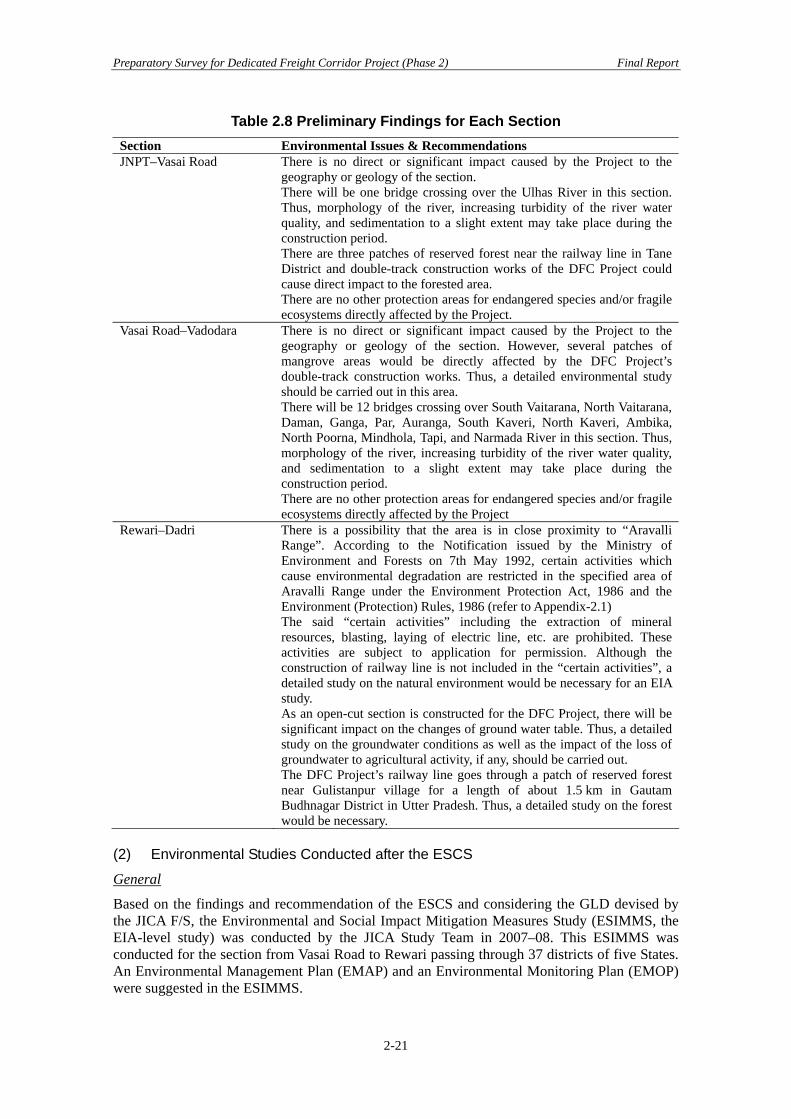
Preparatory Survey for Dedicated Freight Corridor Project (Phase 2) Final Report
Table 2.8 Preliminary Findings for Each Section Section Environmental Issues & Recommendations JNPT–Vasai Road There is no direct or significant impact caused by the Project to the
geography or geology of the section. There will be one bridge crossing over the Ulhas River in this section. Thus, morphology of the river, increasing turbidity of the river water quality, and sedimentation to a slight extent may take place during the construction period. There are three patches of reserved forest near the railway line in Tane District and double-track construction works of the DFC Project could cause direct impact to the forested area. There are no other protection areas for endangered species and/or fragile ecosystems directly affected by the Project.
Vasai Road–Vadodara There is no direct or significant impact caused by the Project to the geography or geology of the section. However, several patches of mangrove areas would be directly affected by the DFC Project’s double-track construction works. Thus, a detailed environmental study should be carried out in this area. There will be 12 bridges crossing over South Vaitarana, North Vaitarana, Daman, Ganga, Par, Auranga, South Kaveri, North Kaveri, Ambika, North Poorna, Mindhola, Tapi, and Narmada River in this section. Thus, morphology of the river, increasing turbidity of the river water quality, and sedimentation to a slight extent may take place during the construction period. There are no other protection areas for endangered species and/or fragile ecosystems directly affected by the Project
Rewari–Dadri There is a possibility that the area is in close proximity to “Aravalli Range”. According to the Notification issued by the Ministry of Environment and Forests on 7th May 1992, certain activities which cause environmental degradation are restricted in the specified area of Aravalli Range under the Environment Protection Act, 1986 and the Environment (Protection) Rules, 1986 (refer to Appendix-2.1) The said “certain activities” including the extraction of mineral resources, blasting, laying of electric line, etc. are prohibited. These activities are subject to application for permission. Although the construction of railway line is not included in the “certain activities”, a detailed study on the natural environment would be necessary for an EIA study. As an open-cut section is constructed for the DFC Project, there will be significant impact on the changes of ground water table. Thus, a detailed study on the groundwater conditions as well as the impact of the loss of groundwater to agricultural activity, if any, should be carried out. The DFC Project’s railway line goes through a patch of reserved forest near Gulistanpur village for a length of about 1.5 km in Gautam Budhnagar District in Utter Pradesh. Thus, a detailed study on the forest would be necessary.
(2) Environmental Studies Conducted after the ESCS
General
Based on the findings and recommendation of the ESCS and considering the GLD devised by the JICA F/S, the Environmental and Social Impact Mitigation Measures Study (ESIMMS, the EIA-level study) was conducted by the JICA Study Team in 2007–08. This ESIMMS was conducted for the section from Vasai Road to Rewari passing through 37 districts of five States. An Environmental Management Plan (EMAP) and an Environmental Monitoring Plan (EMOP) were suggested in the ESIMMS.
2-21

Preparatory Survey for Dedicated Freight Corridor Project (Phase 2) Final Report
The results of the ESIMSS were reviewed by the JICA Environmental Advisory Committee and the comments from the Committee are summarized below. Natural environment study
• Seasonal information has not been collected satisfactorily under the limited study period.
• The Corridor should be examined for the migratory animals due to construction of embankment structure for the DFC project.
Pollution control
• Although the noise and vibration impact analysis has been conducted, it was only carried out with sensitive receptors for measuring noise and vibration at 60 sites. Impacts to houses and other structures should also be examined.
• In evaluating the impacts of the nose and vibration, quantitative target levels on noise and vibration should be examined.
Environmental management plan
• The environmental management and monitoring plans should be more concrete in further stages of the project.
• A concrete proposal for employing NGOs should be required in implementing the resettlement plan.
Based on a review of the JICA F/S, JBIC found need for additional studies and, accordingly, JBIC initiated the Special Assistance for Project Formulation Study (SAPROF) in July 2008 to formulate the project in a more sustainable and effective manner, especially with respect to social and environmental aspects. Therefore, an important objective of the study included the Supplemental Environmental and Social Impact Mitigation Measures Study (S-ESIMMS) based on confirmed FLS and GAD, in accordance with JBIC Guidelines for Confirmation of Environmental and Social Considerations. The S-ESIMMS was conducted for the section between Vadodara and Rewari (Section of Phase 1), where the alignment and other important facilities have been finalized. Supplemental surveys and studies to ESIMMS were requested for the following:
• To consider the changes/deviations in alignment proposed in the GLD and considered in the FLS
• To consider seasonal changes in flora and fauna in the project area • To include a detailed noise and vibration study considering the distribution of sensitive
receptors • To include a detailed socio-economic survey as part of the Social Impact Assessment
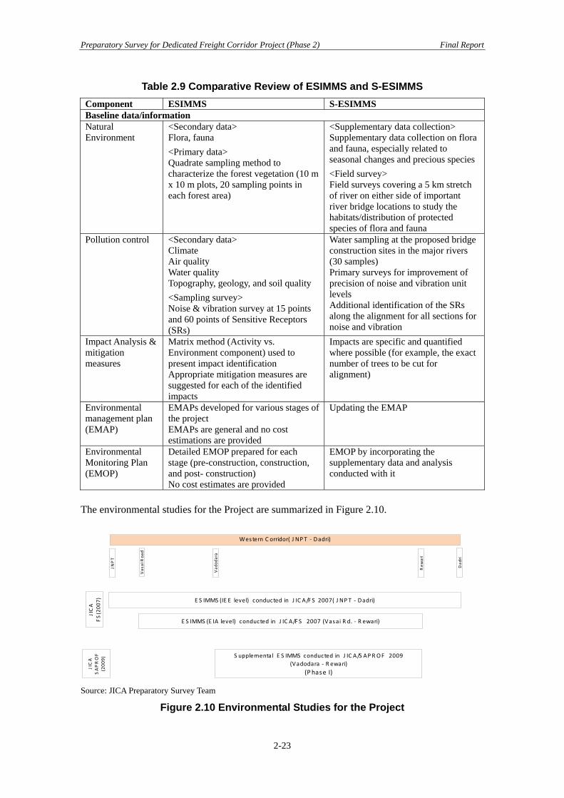
(SIA) Comparative Review of ESIMMS and S-ESIMMS
Comparative Review of ESIMMS and S-ESIMMS is shown in the Table 2.9
2-22
Preparatory Survey for Dedicated Freight Corridor Project (Phase 2) Final Report
Table 2.9 Comparative Review of ESIMMS and S-ESIMMS Component ESIMMS S-ESIMMS Baseline data/information Natural Environment
<Secondary data> Flora, fauna <Primary data> Quadrate sampling method to characterize the forest vegetation (10 m x 10 m plots, 20 sampling points in each forest area)
<Supplementary data collection> Supplementary data collection on flora and fauna, especially related to seasonal changes and precious species <Field survey> Field surveys covering a 5 km stretch of river on either side of important river bridge locations to study the habitats/distribution of protected species of flora and fauna
Pollution control <Secondary data> Climate Air quality Water quality Topography, geology, and soil quality <Sampling survey> Noise & vibration survey at 15 points and 60 points of Sensitive Receptors (SRs)
Water sampling at the proposed bridge construction sites in the major rivers (30 samples) Primary surveys for improvement of precision of noise and vibration unit levels Additional identification of the SRs along the alignment for all sections for noise and vibration
Impact Analysis & mitigation measures
Matrix method (Activity vs. Environment component) used to present impact identification Appropriate mitigation measures are suggested for each of the identified impacts
Impacts are specific and quantified where possible (for example, the exact number of trees to be cut for alignment)
Environmental management plan (EMAP)
EMAPs developed for various stages of the project EMAPs are general and no cost estimations are provided
Updating the EMAP
Environmental Monitoring Plan (EMOP)
Detailed EMOP prepared for each stage (pre-construction, construction, and post- construction) No cost estimates are provided
EMOP by incorporating the supplementary data and analysis conducted with it
The environmental studies for the Project are summarized in Figure 2.10.
E S IMMS (E IA level) conducted in J IC A/F S 2007 (Vasai R d. ‐ R ewari)
S upplemental E S IMMS conducted in J IC A/S APR OF 2009(Vadodara ‐ R ewari)
(P hase I)
E S IMMS (IE E level) conducted in J IC A/F S 2007( J NP T ‐ Dadri)
Western C orridor( J NP T ‐ Dadri)
JICA
SAPROF
(200
9)
JICA
FS(200
7)
JNPT
Vas
ai Roa
d
Vad
odara
Rew
ari
Dad
ri
Source: JICA Preparatory Survey Team
Figure 2.10 Environmental Studies for the Project
2-23

Preparatory Survey for Dedicated Freight Corridor Project (Phase 2) Final Report
2.2.3 Findings through the Field Survey (1) Preliminary Analysis on Critical Sections in Detour Portions
The review of the ESCS, ESIMSS, and S-ESIMSS indicates that the supplemental studies are necessitated for the section of the Phase 2 by the change in alignment/detours, facilities, and other infrastructure, limited availability of data on natural environment, flora & fauna (temporal, spatial, habitats), noise and vibration data at sensitive receptors and unit level, water quality, etc. The impact assessment would be revised/updated as per the additional data generated and mitigation measures formulated, including EMAP and EMOP. Based on the review of the available documents and the final alignment drawings available at the time of the preparatory survey, various sections which are likely to be critical in terms of environmental sensitivity are identified and presented below in Table 2.10. The critical sections were noted mainly in terms of alignment encroaching into forest areas, water bodies, notified sensitive areas by Governments (central or state governments, as the case may be), alignment in hilly terrain, etc. After a preliminary review of the alignment, the JICA Preparatory Survey Team determined that the detour sections should be looked at more closely in order to understand the sensitivity of the alignment and to examine whether or not a further study, such as an EIA, is required, and, if so, to draft an appropriate framework for the study.
Table 2.10 Preliminary Analysis for Potentially Critical Sections in Detour Portions
Section Location Critical Issues Site visit (Y/N)
CPM
JNPT–Vadodara Raigarh District Kundewahal Detour Partly in hilly track Yes Mumbai Raigarh District Panvel Detour Partly in hilly track, and
passes through RF at a section
Yes Mumbai
Thane Datiwali Detour No critical areas are included No Mumbai Thane Vasai Detour Hilly & forest areas Yes Mumbai Thane Dahanu Detour Creeks are included Yes Mumbai Surat Surat Detour No critical areas No Surat Bharuch Bharuch Detour No critical areas No VadodaraVadodara Vadodara Detour No critical areas No VadodaraRewari–Dadri Rewari–Dadri Entire length is a
detour from existing line
New alignment, passing through hilly & forested areas of Aravali range (between chaniages 102000–110000)
Yes Rewari
Subsequently, the JICA Preparatory Survey Team conducted field visits to critical sections of the Rewari–Dadri Section on 1st December 2009 and for JNPT–Vasai road on 7th and 8th December 2009, respectively. (2) Site Visit to Rewari–Dadri Section
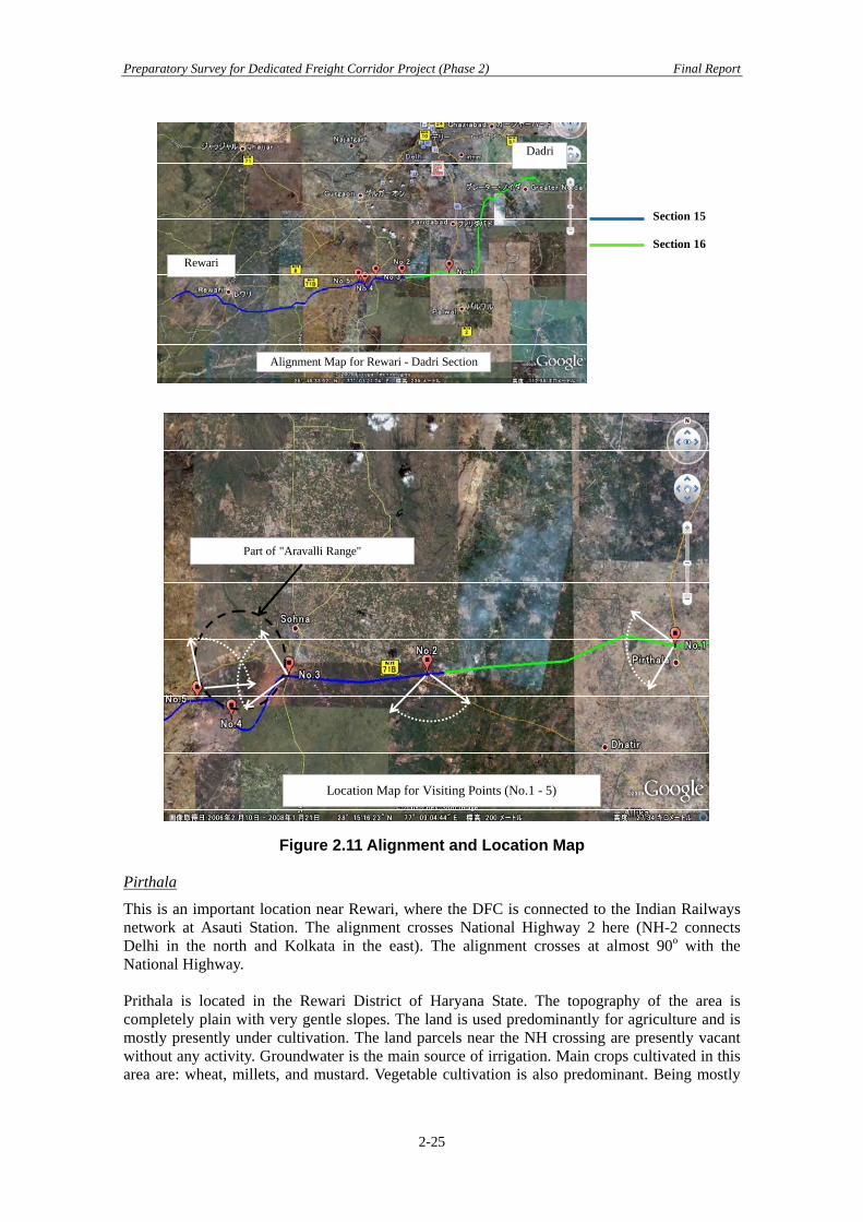
The site visit for the Rewari–Dadri Section was conducted on 1st December 2009 with DFCCIL officials, the JICA study team, and the DFC consultants for the Section. The following are observations from the site visit (see Figure 2.11).
2-24
Preparatory Survey for Dedicated Freight Corridor Project (Phase 2) Final Report
Dadri
Rewari
Alignment Map for Rewari - Dadri Section
Part of "Aravalli Range"
Location Map for Visiting Points (No.1 - 5)
Section 15
Section 16
Figure 2.11 Alignment and Location Map
Pirthala
This is an important location near Rewari, where the DFC is connected to the Indian Railways network at Asauti Station. The alignment crosses National Highway 2 here (NH-2 connects Delhi in the north and Kolkata in the east). The alignment crosses at almost 90o with the National Highway. Prithala is located in the Rewari District of Haryana State. The topography of the area is completely plain with very gentle slopes. The land is used predominantly for agriculture and is mostly presently under cultivation. The land parcels near the NH crossing are presently vacant without any activity. Groundwater is the main source of irrigation. Main crops cultivated in this area are: wheat, millets, and mustard. Vegetable cultivation is also predominant. Being mostly
2-25

Preparatory Survey for Dedicated Freight Corridor Project (Phase 2) Final Report
agricultural land, tree cover is limited. Fully grown Neem and Babul trees are observed in the alignment near Pirthala.
Silani
Silani is the end point of section 15 and the starting point of section 16 for the FLS. At this location, the alignment passes through barren lands. The topography of the area is plain. A vast stretch of land here is characterized by salt-affected (calcareous) soils which are not suitable for cultivation. Vegetation is limited to bushes and shrubs of domestic species that can grow on these lands. Other parts of the alignment are mostly agriculture. The predominant crops cultivated are wheat, millets, and mustard. Irrigation is groundwater-based. Silani village is located at about 1.5 km from the alignment.
Sohna
The topography along the alignment is almost flat from Pirthala to near Sohna Town, where the alignment traverses Aravalli Mountain Range. This is the southern extreme of the vast Aravalli Range of Mountains that stretches over 800 km across three states of Gujarat, Rajasthan, and Haryana from the southwest to northeast in the western part of India.
Photo No.1 (Prithala)
Photo No.2 (Silani)
Part of Aravalli Range
Photo No.3 (Sohna)
2-26

Preparatory Survey for Dedicated Freight Corridor Project (Phase 2) Final Report
According to the Notification issued by the Ministry of Environment and Forests on 7th May 1992, certain activities which cause environmental degradation are restricted in the specified area of Aravalli Range under the Environment Protection Act, 1986 and the Environment (Protection) Rules, 1986 (refer to Appendix 2.1). These activities, including the extraction of mineral resources, blasting, laying of electric line, etc, are subject to application for permission. There is also a water catchment area for a large part of Delhi. In this southern extreme of the range in Haryana, near Delhi, the Aravalli range is mostly in the form of isolated hills and rocky ridges. The DFC alignment traverses the Aravalli Range for about 6 km starting from Sohna Road. The rocky ridge is almost vertical and the difference of elevation between the road level and the ridge is approximately 100 m. The DFC alignment takes sharp curves to negotiate this level difference. Based on the recommendation of the JICA F/S, the DFCCIL has dropped its initial proposal of constructing a tunnel to avoid curves which increased the alignment by about 3 km. The alignment traverses (about a 100–150 m stretch) a forest reserve area between Sohna Road and the ridge. The Road abuts on the unfenced forest reserve, which consists of young domesticated species that will need to be cleared off for construction. The ridge is rocky and has no tree cover. DFC construction will require large scale cutting and filling to negotiate the ridge. It is not clear from the available maps whether the ridge also falls under the forest area or not. Although it seems that traversing the ridge appears pertinent, realizing the DFC marginally to avoid the small patch of reserve forest between Sohna Road and Ridge needs further study. Clearing tree cover in a state of very low forest cover should be avoided. This will also avoid conversion of forest land to non-forest purposes. KMP Expressway (Kudli–Manesar–Palwal Expressway, also called the Western Peripheral Ring Road of Delhi), which is presently under construction, also traverses Aravalli Ridge near Sohna. Although it is not clear on the site how both alignments will run, it appears that both of the alignments cross at three points. The elevation of the DFC with reference to the Expressway is also not available at this stage. However, depending on the technical feasibility, an alignment parallel and almost at the same elevation to the KMC as far as possible at this stretch would minimize the impact of the corridor.
Embankment of the expressway
Photo No.5
(3) Site Visit to JNPT–Dahanu Section
The site visit was conducted on 7th and 8th December 2009 with DFCCIL officials, the JICA study team, and the DFC consultants for the two sections under the Mumbai CPM. The site visit was mainly focused on the detour sections. The following are the observations of the site visit.
2-27
Preparatory Survey for Dedicated Freight Corridor Project (Phase 2) Final Report
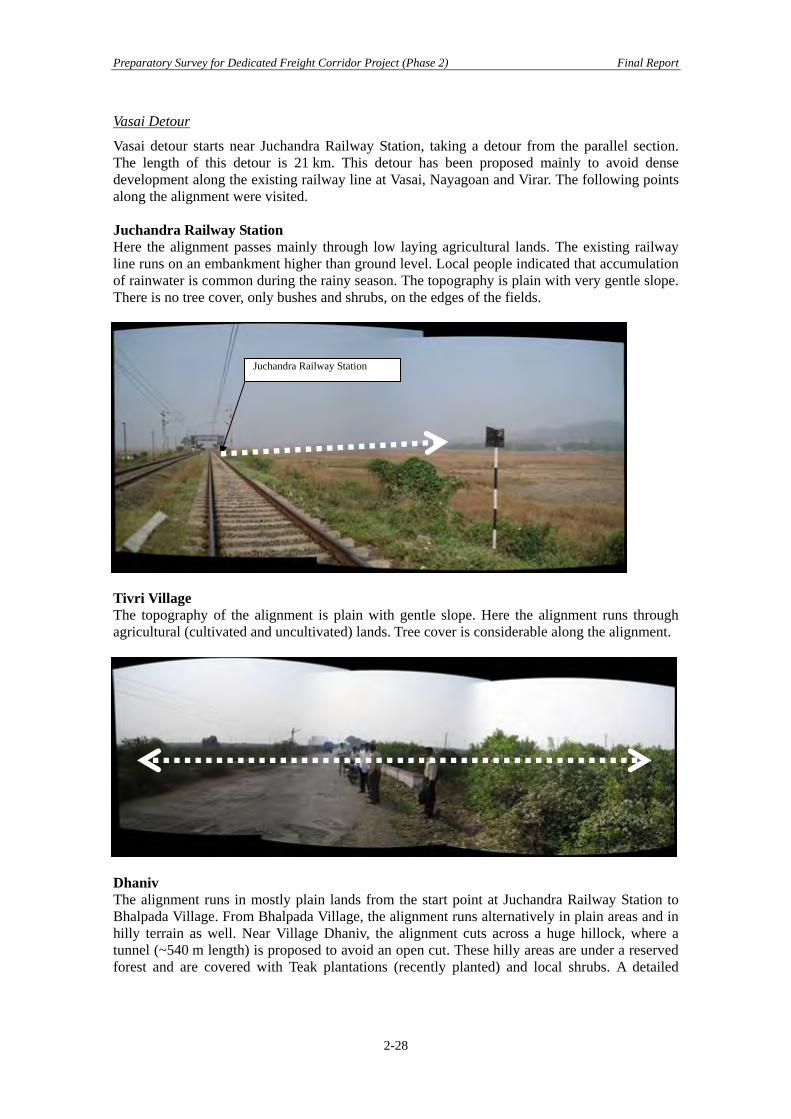
Vasai Detour
Vasai detour starts near Juchandra Railway Station, taking a detour from the parallel section. The length of this detour is 21 km. This detour has been proposed mainly to avoid dense development along the existing railway line at Vasai, Nayagoan and Virar. The following points along the alignment were visited. Juchandra Railway Station Here the alignment passes mainly through low laying agricultural lands. The existing railway line runs on an embankment higher than ground level. Local people indicated that accumulation of rainwater is common during the rainy season. The topography is plain with very gentle slope. There is no tree cover, only bushes and shrubs, on the edges of the fields.
Juchandra Railway Station
Tivri Village The topography of the alignment is plain with gentle slope. Here the alignment runs through agricultural (cultivated and uncultivated) lands. Tree cover is considerable along the alignment.
Dhaniv The alignment runs in mostly plain lands from the start point at Juchandra Railway Station to Bhalpada Village. From Bhalpada Village, the alignment runs alternatively in plain areas and in hilly terrain as well. Near Village Dhaniv, the alignment cuts across a huge hillock, where a tunnel (~540 m length) is proposed to avoid an open cut. These hilly areas are under a reserved forest and are covered with Teak plantations (recently planted) and local shrubs. A detailed
2-28

Preparatory Survey for Dedicated Freight Corridor Project (Phase 2) Final Report
study on construction of the tunnel and alignment through reserved forest/hilly areas needs to be conducted.
Reserved Forest
Bhatpada This is in continuation of Dhaniv and the alignment also passes through a hilly stretch. It is proposed to construct a tunnel of ~240 m length. Mining (basalt rock) is prevalent and at present about 20 percent of the hill is cleared off. If mining continues, the tunnel may not be required. The hill is covered by a thick layer of soil which supports the tree cover. The tree cover on the hill is very limited and is comprised only of local shrubs.
Virar Road Crossing After Batpada, the alignment mainly runs in plain areas. At Virar road crossing, the alignment traverses through a small habitation.
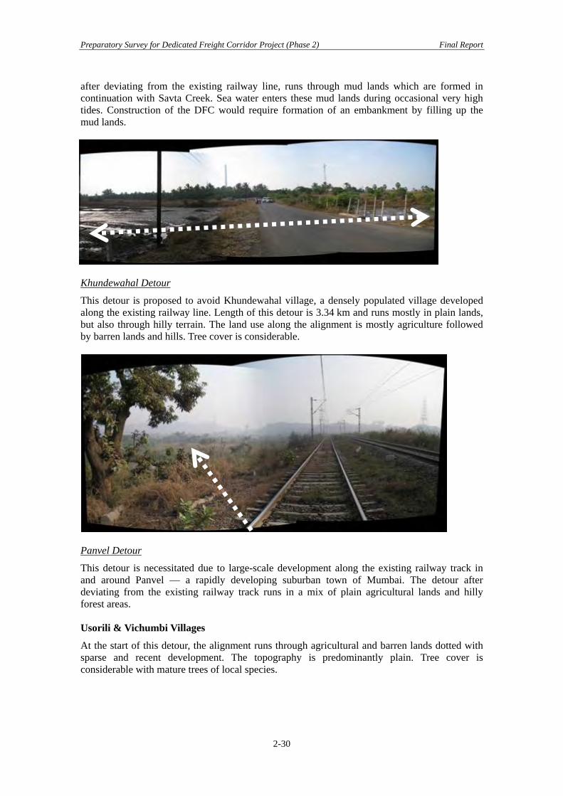
Dahanu Detour
This detour is necessitated by the large-scale residential and industrial development along the existing railway line at Dahanu. The length of detour is 12 km. The detour alignment mainly passes through agricultural areas and coastal mud lands. At the start of the detour, the alignment,
2-29
Preparatory Survey for Dedicated Freight Corridor Project (Phase 2) Final Report
after deviating from the existing railway line, runs through mud lands which are formed in continuation with Savta Creek. Sea water enters these mud lands during occasional very high tides. Construction of the DFC would require formation of an embankment by filling up the
ud lands.
m
Khundewahal Detour
This detour is proposed to avoid Khundewahal village, a densely populated village developed along the existing railway line. Length of this detour is 3.34 km and runs mostly in plain lands, but also through hilly terrain. The land use along the alignment is mostly agriculture followed
y barren lands and hills. Tree cover is considerable.
b
Panvel Detour
This detour is necessitated due to large-scale development along the existing railway track in and around Panvel — a rapidly developing suburban town of Mumbai. The detour after deviating from the existing railway track runs in a mix of plain agricultural lands and hilly
rest areas.
aphy is predominantly plain. Tree cover is considerable with mature trees of local species.
fo Usorili & Vichumbi Villages
At the start of this detour, the alignment runs through agricultural and barren lands dotted with sparse and recent development. The topogr
2-30
Preparatory Survey for Dedicated Freight Corridor Project (Phase 2) Final Report
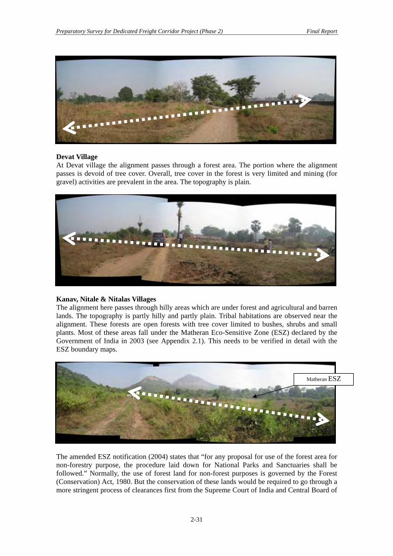
Devat Village At Devat village the alignment passes through a forest area. The portion where the alignment passes is devoid of tree cover. Overall, tree cover in the forest is very limited and mining (for gravel) activities are prevalent in the area. The topography is plain.
Kanav, Nitale & Nitalas Villages The alignment here passes through hilly areas which are under forest and agricultural and barren lands. The topography is partly hilly and partly plain. Tribal habitations are observed near the alignment. These forests are open forests with tree cover limited to bushes, shrubs and small plants. Most of these areas fall under the Matheran Eco-Sensitive Zone (ESZ) declared by the Government of India in 2003 (see Appendix 2.1). This needs to be verified in detail with the ESZ boundary maps.
Matheran ESZ
The amended ESZ notification (2004) states that “for any proposal for use of the forest area for non-forestry purpose, the procedure laid down for National Parks and Sanctuaries shall be followed.” Normally, the use of forest land for non-forest purposes is governed by the Forest (Conservation) Act, 1980. But the conservation of these lands would be required to go through a more stringent process of clearances first from the Supreme Court of India and Central Board of
2-31
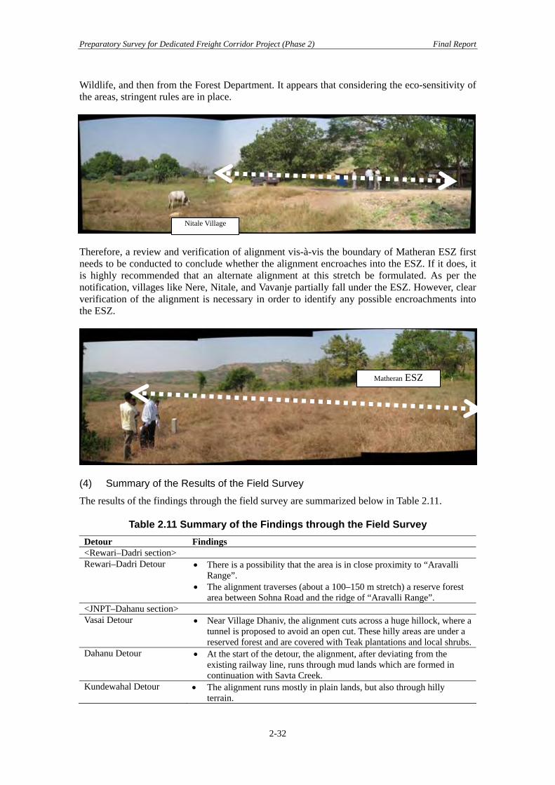
Preparatory Survey for Dedicated Freight Corridor Project (Phase 2) Final Report
Wildlife, and then from the Forest Department. It appears that considering the eco-sensitivity of the areas, stringent rules are in place.
Nitale Village
Therefore, a review and verification of alignment vis-à-vis the boundary of Matheran ESZ first needs to be conducted to conclude whether the alignment encroaches into the ESZ. If it does, it is highly recommended that an alternate alignment at this stretch be formulated. As per the notification, villages like Nere, Nitale, and Vavanje partially fall under the ESZ. However, clear verification of the alignment is necessary in order to identify any possible encroachments into the ESZ.
(4) Summary of the Results of the Field Survey
The results of the findings through the field survey are summarized below in Table 2.11.
Table 2.11 Summary of the Findings through the Field Survey Detour Findings <Rewari–Dadri section> Rewari–Dadri Detour • There is a possibility that the area is in close proximity to “Aravalli
Range”. • The alignment traverses (about a 100–150 m stretch) a reserve forest
area between Sohna Road and the ridge of “Aravalli Range”. <JNPT–Dahanu section> Vasai Detour • Near Village Dhaniv, the alignment cuts across a huge hillock, where a
tunnel is proposed to avoid an open cut. These hilly areas are under a reserved forest and are covered with Teak plantations and local shrubs.
Dahanu Detour • At the start of the detour, the alignment, after deviating from the existing railway line, runs through mud lands which are formed in continuation with Savta Creek.
Kundewahal Detour • The alignment runs mostly in plain lands, but also through hilly terrain.
Matheran ESZ
2-32

Preparatory Survey for Dedicated Freight Corridor Project (Phase 2) Final Report
Detour Findings Panvel Detour • The alignment passes through hilly areas which are under forest,
agricultural, and barren lands. Most of these areas fall under the Matheran Eco-Sensitive Zone (ESZ) declared by the Government of India in 2003.
2.3 Progress of Land Acquisition and Social Consideration Activities 2.3.1 Comprehending the Progress of Land Acquisition Process Fact findings on DFCCIL’s progress of land acquisition are conducted through interviews with respective Field Unit’s CPMs and AGMs/DPMs held responsible for the Phase 2 target sections. Field Units interviewed include that of CPM/Mumbai (Sections 1 and 2), CPM/Surat (Section 3), CPM/Vadodara (Section 4 and 5), and CPM/Rewari–Dadri (Section 15 and 16). The extent of progress by section varies depending on the Field Units’ preparedness and process of mobilization. For example, land acquisition of the Rewari–Dadri Section has undergone a unique process, in that parts of the target section are going to be acquired through the “resumption” process, transferring land ownership from the State Agencies (Haryana State Industrial and Infrastructural Development Authority (HSIIDA), Haryana State and from the Greater Noida Industrial Development Authority (GNIDA), Uttar Pradesh State) to DFCCIL, which does not directly entail a “land acquisition” process involving private landowners. In this context, the land acquisition shall be clarified on the nature of the resumption process; whether it has been initiated in order to transfer the land title from the original title-holders respectively of HSIIDA and GNIDA, both of whom originally maintained the ownership or whether both authorities’ land acquisition have been triggered at the request of DFCCIL. However, the finalized alignment of Rewari–Dadri has been determined by the guiding principles of minimizing interference and loss of agricultural land, as well as minimizing incidence of involuntary resettlement. There is a possibility that the area is in close proximity to “Aravalli Range”. According to the Notification issued by the Ministry of Environment and Forests on 7th May 1992, certain activities which cause environmental degradation are restricted in the specified area of Aravalli Range under the Environment Protection Act, 1986 and the Environment (Protection) Rules, 1986 (refer to Appendix 2.1). The Land acquisition progress by section is summarized as follows.
2-33

Preparatory Survey for Dedicated Freight Corridor Project (Phase 2) Final Report
Table 2.12 Land Acquisition Progress by Sections and Districts Field Units/ CPMs/Districts (Sub-districts involved)
Dates of Notification (20A and 20E) by RAA
Targeted Acquisition Length (km) and Acreage (ha) with chainages from JNPT for the Sections of Mumbai CPM
Associated Documents /Length/ Scale
Number of Villages Involved
Mumbai CPM Raigad (Uran, Panvel)
03/30/2009 (20A)
18 km/89.311 ha (22–40 km from JNPT)
Land Plan (1 : 3,000)
15 Villages
Thane–1 (Kalyan, Vasai, Palgar)
12/31/2008 (20A)
112 km/332.102 ha (56–106 km from JNPT)
Land Plan (1 : 3,000)
Thane–2 (Kalyan)
03/16/2009 (20A)
6 km/35.084 ha (48–56 km from JNPT)
Land Plan (1 : 3,000)
Thane–3 (Ambernath, Thane)
03/30/2009 (20A)
5 km/30.251 ha (41–47 km from JNPT)
Land Plan (1 : 3,000)
Thane–4 (Thane, Kalyan, Bhivandi, Vasai)
05/25/2009 (20A)
8.48 km/31.709 ha (Intermittently out of 50–88 km from JNPT)
Land Plan (1 : 3,000)
Thane–5 (Kalyan, Vasai)
08/10/2009 (20A)
6.259 km/29.765 ha (Intermittently out of 46–94 km from JNPT)
Land Plan (1 : 3,000)
93 Villages altogether, Joint Survey in Progress (60%–65%)
Valsad (Umargaon)
3/16/2009 (20A) 21 km/24.29 ha (181–201 km from JNPT)
Not available*3 9 Villages
Vadodara CPM Surat (Surat City, Olpad, Mangrol)
29/09/2008 (20A) 15/09/2009 (20E)
31.98 km/147.87 ha Not available*3 17 Villages
Bharuch (Bharuch, Amod, Ankleshwar)
29/09/2008 (20A) 15/09/2009 (20E)
53.14 km/330.22 ha Not available*3 28 Villages
Vadodara (Vadodara, Karjan)
29/09/2008 (20A) 15/09/2009 (20E)
31 km/410.17 ha Not available*3 31 Villages
Surat CPM Navsari (Gandevi, Jalalpore)
06/11/2008 (20A)
100.84 ha Not available*3 21 Villages
Surat (Choryansi, Kamrej, Palsana)
06/10/2008 (20A)
149.29 ha Not available*3 19 Villages
Valsad (Pardi, Umargam, valsad)
06/11/2008 (20A)
57.41 ha Not available*3 22 Villages
Rewari–Dadri Sect-15 Rewari (Phase2), Alwar, Gurgaon
Partial Resumption from HSIIDA*1
Total length of 36 km (Rewari), of which a 17 km segment is going to be resumed from HSIIDA*1.
Land Plan (1 : 4,000)
Rewari (13 Villages)
2-34
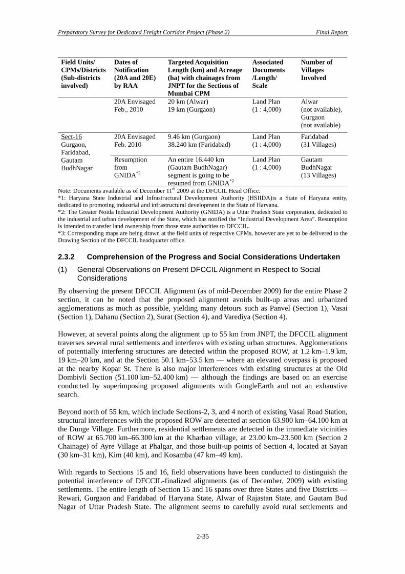
Preparatory Survey for Dedicated Freight Corridor Project (Phase 2) Final Report
Field Units/ CPMs/Districts (Sub-districts involved)
Dates of Notification (20A and 20E) by RAA
Targeted Acquisition Length (km) and Acreage (ha) with chainages from JNPT for the Sections of Mumbai CPM
Associated Documents /Length/ Scale
Number of Villages Involved
20A Envisaged Feb., 2010
20 km (Alwar) 19 km (Gurgaon)
Land Plan (1 : 4,000)
Alwar (not available),Gurgaon (not available)
20A Envisaged Feb. 2010
9.46 km (Gurgaon) 38.240 km (Faridabad)
Land Plan (1 : 4,000)
Faridabad (31 Villages)
Sect-16 Gurgaon, Faridabad, Gautam BudhNagar
Resumption from GNIDA*2
An entire 16.440 km (Gautam BudhNagar) segment is going to be resumed from GNIDA*2
Land Plan (1 : 4,000)
Gautam BudhNagar (13 Villages)
Note: Documents available as of December 11th 2009 at the DFCCIL Head Office. *1: Haryana State Industrial and Infrastructural Development Authority (HSIIDA)is a State of Haryana entity, dedicated to promoting industrial and infrastructural development in the State of Haryana. *2: The Greater Noida Industrial Development Authority (GNIDA) is a Uttar Pradesh State corporation, dedicated to the industrial and urban development of the State, which has notified the “Industrial Development Area”. Resumption is intended to transfer land ownership from those state authorities to DFCCIL. *3: Corresponding maps are being drawn at the field units of respective CPMs, however are yet to be delivered to the Drawing Section of the DFCCIL headquarter office. 2.3.2 Comprehension of the Progress and Social Considerations Undertaken (1) General Observations on Present DFCCIL Alignment in Respect to Social
Considerations
By observing the present DFCCIL Alignment (as of mid-December 2009) for the entire Phase 2 section, it can be noted that the proposed alignment avoids built-up areas and urbanized agglomerations as much as possible, yielding many detours such as Panvel (Section 1), Vasai (Section 1), Dahanu (Section 2), Surat (Section 4), and Varediya (Section 4). However, at several points along the alignment up to 55 km from JNPT, the DFCCIL alignment traverses several rural settlements and interferes with existing urban structures. Agglomerations of potentially interfering structures are detected within the proposed ROW, at 1.2 km–1.9 km, 19 km–20 km, and at the Section 50.1 km–53.5 km — where an elevated overpass is proposed at the nearby Kopar St. There is also major interferences with existing structures at the Old Dombivli Section (51.100 km–52.400 km) — although the findings are based on an exercise conducted by superimposing proposed alignments with GoogleEarth and not an exhaustive search. Beyond north of 55 km, which include Sections-2, 3, and 4 north of existing Vasai Road Station, structural interferences with the proposed ROW are detected at section 63.900 km–64.100 km at the Dunge Village. Furthermore, residential settlements are detected in the immediate vicinities of ROW at 65.700 km–66.300 km at the Kharbao village, at 23.00 km–23.500 km (Section 2 Chainage) of Ayre Village at Phalgar, and those built-up points of Section 4, located at Sayan (30 km–31 km), Kim (40 km), and Kosamba (47 km–49 km). With regards to Sections 15 and 16, field observations have been conducted to distinguish the potential interference of DFCCIL-finalized alignments (as of December, 2009) with existing settlements. The entire length of Section 15 and 16 spans over three States and five Districts — Rewari, Gurgaon and Faridabad of Haryana State, Alwar of Rajastan State, and Gautam Bud Nagar of Uttar Pradesh State. The alignment seems to carefully avoid rural settlements and
2-35

Preparatory Survey for Dedicated Freight Corridor Project (Phase 2) Final Report
2-36
major canal structures. However, the superimposing exercise has not been conducted for those two sections. Search exercises on GoogleEarth have not been conducted for the major and minor Bridges and ROBs/RUBs, which may be considered to accommodate settlements, legal or illegal, on the proposed strip of land within the ROW. (2) Land Acquisition in Progress by Districts and Sections
Sections targeted for Phase 2 are undergoing various stages of land acquisition; some Field Unit (FU) Offices already have sections earmarked for the target dates of 20E Notification or even envisaged Land Acquisition commencement dates. For example, CPM/Vadodara has already gazetted 20E Notification in the time span of October–November, 2009. However, the Rehabilitation and Resettlement (R&R) activities are yet to be implemented for all Phase 2 sections surveyed, involving DFC project-affected families as well as directly and indirectly impacted stakeholders. After Notification 20A and a “no objections” status is achieved through coordination with the Competent Authority, which is immediately after the section 20(D) in the table 2.3, is cleared, “Joint Measurement Survey (JMS)” mobilization by DFCCIL’s (acquiring agency) initiatives may be possible under the auspices of the Competent Authority. In fact, FU-assigned officers have already initiated communication with village officials to undertake a “Joint Measurement Survey”, with a view to maintain transparency in the demarcation of respective land plot (Khasra) boundaries for landowners. In the presence of landowners and other concerned bodies, the JMS identifies the manner of how the proposed alignment crosses the titleholders’ plots, structures located within the proposed ROW. After the JMS, the Competent Authority will decide on the exact amount of the compensation to be paid. Major milestones in the early stage of land acquisition up to 20F (Awarding Compensation) are shown in the table below, as stipulated by the Railways (Amendment) Act (RAA), 2008.
Table 2.13 Land Acquisition Procedures as Stipulated by RAA, 2008 Section Number
Milestones Stipulated by RAA “Land Acquisition Procedure”
“Initiatives by Entities And Participating Bodies”
7A The Central Government will nominate the Competent Authority to act as a Land Acquisition Officer
37A The Central Government will gazette DFC as a Special Railway Project 20A The Central Government will
declare intention to acquire landState Government shall provide land records
Acquiring Body DFCCIL District Collector
20B On issue of 20A publication, it is lawful to do a survey and set out boundaries
Land Survey Set out boundaries
DFCCIL
20D Objections will be made and heard by the Competent Authority
Objections Raised, Heard, and Arbitrated.
Competent Authority
Within a maximum of one year since 20A notification, 20E shall be declared. 20E The Central Government will declare the acquisition of Land under 20E Within a maximum of one year since 20E notification, compensation (20F) shall be awarded. 20F Compensation shall be awarded
to the entitled person DFCCIL
Competent Authority

Preparatory Survey for Dedicated Freight Corridor Project (Phase 2) Final Report
3 Required Preparation Work in Future to Apply for ODA Loan
3.1 Technical Study and Survey for Railway Construction 3.1.1 Confirmation and Revision of Documents/Drawings by DFCCIL The study team confirmed the Final location survey progress and quality by rough checking. According to DFCCIL the remaining deliverables will be prepared within a month. The deliverables will be scrutinized by DFCCIL and all errors and faults corrected. Particularly, the following documents and drawings are needed to be prepared completely and correctly in accordance with the latest FLS deliverable. Furthermore the following documents/drawings and cost estimations must be coherent for project cost estimation. Table 3.1 shows the status as identified in this preparatory survey and the required actions for DFCCIL.
Table 3.1 Status of Preparation Confirmed at Preparatory Survey Item Status of Preparatory
survey Required action for Cost estimation checking
1) GAD for Bridge Some bridges are not available*1
To be prepared as a complete set
2) GAD for Permanent way Not available To be prepared 3) GAD for Station (Include Building) Not available To be prepared 4) GAD for Equipment & Machinery Not available To be prepared 5) GAD for Tunnel Not available To be prepared 6) List of structures Partially available*2 To be prepared as a
complete set 7) List of Equipment & Machinery Not available To be prepared 8) Plan or drawing for Electrification Not available To be prepared 9) Plan or drawing for Signal & Telecom Not available To be prepared 10) Detail cost estimate for S&T Not received To be provided 11) Detail cost estimate for Electrification Not received To be provided 12) Detail cost estimate for civil structures Partially available*3 To be prepared as a
complete set 13) L-section drawing Almost available*4 To be revised
*1 GAD for three steel bridges in CPM Surat and Rewari- Dadri had not ready yet. *2 Lack of information in the provided lists. No structure list have provided from Rawari-Radri section. *3 Cost estimation of Rawari-Radri had not completed. *4 Current status of availability is mentioned in table 2.2. 3.1.2 Technical Study/Survey Supplemental technical study/survey should be conducted by designated consultants after DFCCIL correction mentioned above 3.1.1. (1) Review of the FLS Deliverables
1) General arrangement drawing for bridges 2) Land Plan 3) Level Crossing reports & drawings 4) Utility diversion Plan (include laboratory test) 5) Geological survey 6) Topological survey 7) Cost estimation for structures (include Rate analysis) 8) L-section
3-1
Preparatory Survey for Dedicated Freight Corridor Project (Phase 2) Final Report
9) Yard Layout 10) Topo sheet (for detour section)
(2) Required Items which are Not Included in the FLS
1) General drawing of Permanent way 2) Stations (building plan/drawing) 3) Depot, Facility & Machinery (plan/drawing) 4) Electrification (plan/drawing) 5) Signal & Telecommunication (plan/drawing) 6) Electrification (detailed cost estimation) 7) Signal & Telecommunication (cost estimation) 8) Structure list (BRIDGE, station, Level crossing, depot) 9) Structure cost estimation (station, Depot) 10) Rolling stock purchasing (plan/ drawing, cost estimation) 11) Project implementation schedule for above items.
(3) Re-Arrangement of L-Section Drawings and Topo Sheet
RITES and consultants provided L-section drawings which need to be re-arranged. The drawings will be prepared in both hard & soft copies in a standard CAD drawing format. Topological information, such as the ground level must be checked at the joining of sections. If there is significant discrepancy, additional topological surveys will be required.
(4) Geological and Topological Survey
Tunnels and any requirements resulting from the DFCCIL review and 3.1.1 review.
(5) Basic Design of Tunnels (540 m and 240 m)
At first a field survey will be conducted to prepare a survey plan (survey method and schedule). Boring soil investigations will be conducted at 6 locations for a 540m tunnel (2 for both entrance and 2 for intermediate) and 5 for a 240m tunnel (2 for both entrance and 1 for intermediate). The laboratory tests (uniaxial compression test, triazxial compression test etc.) will be conducted with the soil sample from the above boring. Also, the Crack profile and rock weathering condition will be provided in the survey. According to the soil investigation results, the design plan and construction method will be considered. The basic design work for the tunnels includes (Tunnel design calculation, General Arrangement drawings, bill of quantities and construction plan).
3.2 Natural Environment and Pollution Control 3.2.1 General As already mentioned, the Environmental and Social Impact Mitigation Measures Study (ESIMMS, EIA-level study) for the section of Vasai Road–Vadodara has been conducted. However, as for the sections JNPT–Vasai Road and Rewari–Dadri, only IEE level studies (Environmental and Social Considerations Study: ESCS) have been carried out. Regarding the section of Phase 1 which extends from Rewari to Vadodara, a supplementary ESIMMS was conducted for additional studies based on the request of JBIC.
3-2

Preparatory Survey for Dedicated Freight Corridor Project (Phase 2) Final Report
Therefore, it is necessary to carry out a comprehensive EIA study for the whole section of Phase 2 for the planning and design of the next stage. To this end, a framework for a comprehensive EIA for the Phase 2 section is proposed in this chapter. The terms of reference for both the ESIMMS and the supplementary ESIMMS were referred to the process of the establishment of the framework for a comprehensive EIA. The findings of the field visits to each section (Rewari–Dadri and JNPT–Vadodara) were also considered. The position of the comprehensive EIA is explained in Figure 3.1.
ESIMMS(EIA level) (Vasai Rd. - Rewari)
(Phase I)Supplemental ESIMMS underJICA/SAPROF(Vadodara - Rewari)
ESIMMS(IEE level) ( JNPT - Dadri)
Suggestions from the JICAAdvisory Committee
(Phase II)Comprehensive EIA( JNPT- Vadodara)(Rewari-Dadri)
Amendment on the Alignments
(Phase I)Engineering Service for Phase IMarch 2010 -
(Phase II)Preparatory Survey( JNPT- Vadodara)(Rewari-Dadri)
JICA F/S(2007)
Figure 3.1 Position of the Comprehensive EIA Study
3.2.2 Comprehensive EIA on Natural Environmental and Pollution Control (1) Objectives
The main objectives of the comprehensive EIA are:
• Identification of the project activities likely to cause potential significant impacts to the natural environment and pollution control;
• Identification of the extent of environmental impacts caused by DFC Project activities to the existing environment within the study area;
• To predict and analyze the intensity and nature of impacts whether they are permanent or temporary, cumulative, and/or irreversible, in each district directly affected by the Project;
• To report the results of the Works of Comprehensive EIA; • To analyze alternatives through a systematic comparative analysis on feasible
alternatives;
3-3

Preparatory Survey for Dedicated Freight Corridor Project (Phase 2) Final Report
• To prepare Environmental Management Plan (EMP) describing mitigation, monitoring and institutional measures; and
• To conduct stakeholder meetings at the stage of the scoping and the completion of a draft of the final report and prepare minutes of the meeting.
(2) Areas Affected by the Project
As shown in Table 3.2, there are twelve (12) districts in Maharashtra, Gujarat, Haryana, and Rajasthan Uttar Pradesh that are directly affected by the Project. These districts are subject to the Comprehensive EIA.
Table 3.2 Districts Affected by the Project
District Name State I Section: JNPT–Vadodara 1 Raigarh Maharashtra 2 Thane Maharashtra 3 Valsad Gujarat 4 Navsari Gujarat 5 Surat Gujarat 6 Bharuch Gujarat 7 Vadodara Gujarat II Section: Rewari–Dadri 1 Rewari Haryana 2 Alwar Rajasthan 3 Gurgoan Haryana 4 Faridabad Haryana 5 Gautam Budh Nagar Uttar Pradesh
(3) Scope of the Works
Identification of the Project Activities
The DFC Project’s railway line is, in general, constructed alongside the existing railway lines in the area. In addition, not only limited to but included are various railway facilities planned to be constructed, including:
• Detours of the DFC Project’s railway lines to avoid urban centers alongside the existing railway lines;
• Junction and crossing stations approximately 60 m wide and 1,600 m long each; • Major and minor bridges crossing over important rivers; • ROBs and RUBs subject to construction;
Time Line of Project Activities Subject to Environmental Impact Assessment
The project activities subject to examination should be subdivided into three phases of the Project as follows:
(a) Environmental Impacts during Pre-Construction Phase (b) Environmental Impacts during the Construction Phase
i. Preparation Works Materials and Equipment Transportation Mobilization of Labor and Construction Equipment Preparation of base camp, workshop, storage, etc.
3-4

Preparatory Survey for Dedicated Freight Corridor Project (Phase 2) Final Report
ii. Implementation Land preparation Excavation and filling Material transportation (quarry/borrow pit activities) Earthworks followed by rail, electric line, and signal installation works ROB/RUB, bridge construction works
(c) Environmental Impacts during the Post-construction Phase
Operation and maintenance of trains, railways, ROB/RUB, and bridges (4) Environmental Components Subject to Study
Natural Environment
• Identify protected and endangered species in the study area and analyze effects of the Project on them on a district basis with seasonal information
• Inventory and analyze effects of the Project on fauna and flora identified to exist in the study area on a district basis
• Examine wildlife and forest reserves directly affected by the Project. • Climate inventory and analysis • Survey ground water conditions such as stream patterns, quantity and quality • Physiology, soil morphology, geology structure, and soil type inventory and analysis
Pollution Control
Noise and Vibration Survey • Collect baseline data for noise and vibration; • Select survey locations where they are close to sensitive receptors such as hospitals,
schools, residential areas, etc. alongside the railway lines of the Project; • Conduct impact analysis for noise and vibration not only for sensitive receptors, but
also for houses and other structures • Identify areas affected by the Project
Water Quality Analysis
• Collect baseline data for water quality; • Identify important rivers directly affected by the construction of important bridges for
the Project. • Collect secondary data and existing data from the related ESCS and ESIMMS Report. • Analyze likely impacts of water pollution as a result of bridge construction works based
on the collected data. Air Quality Examination
• Collect baseline data for air quality; • Identify areas affected by the Project; • Collect secondary data and existing data from the related ESCS and ESIMMS Report; • Analyze likely impacts of air pollution as a result of bridge construction works based on
the collected data. Socio-Economic/Cultural Components
• Collect baseline data for socio-economic aspects including population, standards of living, economic development, social infrastructure and facilities, job opportunities and natural resource usage patterns;
3-5

Preparatory Survey for Dedicated Freight Corridor Project (Phase 2) Final Report
• Collect baseline data on existing religious and cultural issues; • Collect baseline data on land tenure system and traditional common use of land and
water. Environmental Management Plan (Natural Environment and Pollution Control)
Elaborate environmental management plan as follows:
• Identify and elaborate, as a result of the study on natural environmental impact assessment, measures necessary to take in order to mitigate, reduce, rectify, or compensate adverse environmental impacts caused by the Project, to areas such as those subject to protection of the forest, wildlife, or any other species of fauna and flora and eco-sensitive areas; and
• Identify, if, for instance a hospital should be kept noise, vibration, and air pollution free or free from any other sources of pollution, as a result of noise and vibration and its interview survey as well as other surveys on pollution control that are such units of receptors prone to such pollution are subject to environmental management. Elaborate appropriate environmental management measures such as noise-bouncing fencing, etc., that are effective to control sources of pollution subject to study within the framework of the Works;
• Elaborate a general environmental management plan subject to implementation during the construction period of the DFC Project.
Environmental Monitoring Plan (Natural Environment and Pollution Control)
Elaborate an environmental monitoring plan as follows:
• Elaborate an environmental monitoring plan spanning 3–5 years for the area subject to protection (such as forests, wildlife sanctuaries, and eco-sensitive areas alongside the DFC Project line) and areas subject to the environmental management plan; and
• Elaborate a monitoring plan spanning 3–5 years for the areas or units subject to the environmental management plan for noise, vibration, and air pollution, as well as other pollution control measures, as well as areas or units that are subject to the environmental management plan;
• Elaborate general an environmental monitoring plan subject to implementation during the construction period.
(5) Proposed Organization of the Study Team
The study team should consist of at least the following eight people:
• One (1) Team Leader with a background in general environmental issues and good communication skills in English.
• One (1) Sub-team leader to work exclusively for the Study • Two (2) Natural Environment Experts with prior knowledge of environmental
protection, wildlife, and forest conservation; • Two (2) Pollution Analysts with prior knowledge of pollution control on noise,
vibrations as well as other aspects such as air, water, and soil pollution. • Two (2) Natural Environment Study Team members, at a minimum, consisting of
experts with prior knowledge of geo-physical conditions, environmental protection, wildlife, and forest conservation.
3-6
Preparatory Survey for Dedicated Freight Corridor Project (Phase 2) Final Report
3.3 Social Considerations 3.3.1 Present Status and Necessary Steps for Social Considerations In order to comprehend the present status of Rehabilitation and Resettlement (R&R) activities to be undertaken by the project proponent, DFCCIL in concert with the land acquisitions in progress, intensive interviews were conducted with responsible officers at the DFCCIL headquarter level as well as at the Field Unit level. The results show a lack of activities in respect of R&R activities to be mobilized with the commencement of the land acquisition procedure, in particular with the Notifications by 20A and 20E of RAA. The necessary steps stipulated by RAA are clarified below. (1) A Framework for R&R Activities
The NRRP 2007 together with RAA 2008 gives guiding principles and directions on R&R activities mandated in the planning and implementation of the DFC railway project. Therefore, DFCCIL is required to undertake social programs proceeding with land acquisition and relocation in accordance with NRRP. “Rehabilitation and Resettlement” (hereinafter abbreviated as R&R) activities are stipulated in article 1 of NRRP 2007. (2) RAA accommodates NRRP
The Article 20-O of RAA stipulates, “The provisions of the National Rehabilitation and Resettlement Policy, 2007, for project affected families, shall apply in respect of acquisition of land by the Central Government under this act. Therefore the NRRP principles and executing norms shall also be understood to be applied to DFCCIL’s railway projects. (3) Principles and Norms of NRRP
In principle, NRRP calls for a broader concerted effort on the part of the planners to include in the displacement, rehabilitation and resettlement process framework, not only for those who directly lose land and other assets but also for those whose means of livelihood are affected by such acquisition of assets. Moreover, the entire cost needed to implement R&R shall be borne by the “requiring body” (i.e. a company for whom land is to be acquired by the appropriate Government, 3.1 definition (u), NRRP), including such expenditures and benefits provided for affected families and assistance costs which supplement gaps between replacement cost and compensation amount calculated by applicable local laws/regulations. The adverse impact on affected families needs to be assessed in a participatory and transparent manner. (4) Steps Mandated by RAA in Acquiring Railway Land
RAA stipulates steps to be taken in the railway land acquisition procedure. By Section 7A, RAA, the Central Government (Ministry of Railways) nominates the Competent Authority to act as the Land Acquisition Officer. This provides the Competent Authority with the power to execute railway land acquisition for the Dedicated Freight Corridor construction. By the Section 20A, RAA, the Central Government declares, by notification, its intention to acquire such land required for the execution of a special railways project. The intention is published in two local newspapers. With this notification, the State Government appoints the Competent Authority, District-wise, whoever may be called either as the Deputy Collector, Special Land Acquisition Officer, Land Acquisition Officer, or under any other title of a respective District Office, to initiate the procedure. The validity of the 20A notification is 1 year
3-7

Preparatory Survey for Dedicated Freight Corridor Project (Phase 2) Final Report
(A maximum of one year term is given since the 20A notification until the succeeding 20E is issued.). Ancillary to 20A are; doing survey /bore holing becomes lawful (20B), damages during survey/bore holing compensated (20C), and objections can be made within 30 days of 20A publication by local newspapers (20D), which are subjected to review and decision by the Competent Authority (20D). The 20D procedure terminates if “no objection to acquisition” is achieved (20D). Since the issuance of the 20A notification, land surveys along the DFC’s intended ROW are conducted to produce a “Land Plan” for respective sections, at a scale of 1 : 3,000–4,000. It identifies village names/Sub-district (Block) names together with their boundaries traversed/bisected by ROW on both sides. It also goes with respective residential housing profiles and circumferences of large commercial/residential structures, which lie either within ROW, or the immediate vicinity of ROW. A “Land Acquisition Plan” is also produced at the same scale to indicate respective land plot (Khasra) boundaries and numbers, referring to the land registration map maintained by the Village-level Administration Office, together with detail acreage measured in square meters. Usually it is customary to conduct a “Joint Measurement Survey (JMS)”, at the timing when the above “No objection status” (20D) is reached. The objective of JMS is to maintain a level of transparency in the survey to identify exact boundaries of privately owned plots to be acquired, and structures in the presence of landowners, requiring body (DFCCIL), Competent Authority and the revenue collector (Tehsildar). By conducting JMS in the above manner, a level of consensus is expected to be reached, which then will further facilitate project progress. Section 2.3.1 shows the overall land acquisition progress at the time of the field survey of the “Preparatory Survey (Phase 2)” undertaken by the JICA Consultants in December, 2009. A general overview of land acquisition progress with respect to RAA notifications is as follows. The Districts of Surat, Bharuch, Vadodara of Section 4, have progressed as far as the notification of 20E, unaccompanied by the baseline survey. In contrast, at the Districts of Thane and Raigar (Maharashtra) and Valsad (Gujarat), which have seen more than 6 months have passed since the 20A notification, most of those Districts envisage 20E completion by the 2009 calendar year-end except for a sub-district in Thane. From the above observations, it is evident that the land acquisition procedure, for all Phase 2 Sections except the “Rewari–Dadri”, has taken place in advance unaccompanied by any preparatory surveys or activities of R&R. Therefore, although the timing is late for the target sections, it is desired to undertake a baseline survey with 20A notification, in harmony with what are required by NRRP. Within a maximum of one year after the issuance of the Section 20A notification, the Central Government is able to declare, by notification, the acquisition of Land for the purpose mentioned in the above Section 20A. After publication of the Section 20E on local newspapers, the Land is vested with the Central Government. Subsequently, within a maximum of one year since the issuance of 20E, compensation amount must be determined by the Competent Authority and awarded to the entitled person (20F (2)). Furthermore, the Section 20F, gives the manner of compensation payments, inviting claims, and applicable cases for arbitration. Moreover, under the Section 20G, means to assess award values in view of market value, minimum specified by the State Government, damages due to severing land, and damages to immovable property are stipulated.
3-8

Preparatory Survey for Dedicated Freight Corridor Project (Phase 2) Final Report
Therefore within a maximum of a year since the issuance of the 20E Notification, compensations due to land acquisition are to be determined and awarded to the entitled persons (landowners). (5) Review on Mandates of JBIC Guidelines and Those of NRRP and RAA
Mandates of JBIC Guidelines (formally as the “JBIC Guidelines for Confirmation of Environmental and Social Considerations, April 2002”) are extracted in view of relevance to social aspects of proposed project’s land acquisition procedure and are compared with those of NRRP and RAA. The purpose of the exercise is to identify requirements to be satisfied by respective provisions. The article 20-O of RAA, manifests incorporation of NRRP principles and norms into RAA.
Table 3.3 JBIC Guidelines versus NRRP and RAA Requirements of JBIC Guidelines Requirements of National Rehabilitation and
Resettlement Policy, 2007 (NRRP) and RAA, 2008
1. Need for a Resettlement Plan For projects that will result in large-scale involuntary resettlement, basic resettlement plans must be submitted. (Part 1 4. (3) p.8)
• For large-scale involuntary resettlements, a Social Impact Assessment (SIA) is required (para 1.5, NRRP), and the “Affected Area” shall be declared by the appropriate Government (para. 6.1, NRRP).
• The Administrator for Rehabilitation and Resettlement (AR&R) shall undertake a baseline survey and census (para. 6.3, NRRP).
• The appropriate Government shall publish the details of the survey in the Official Gazette (para. 6.8, NRRP).
• The AR&R shall prepare a draft R&R plan for the affected families (AFs) after consultations with the representatives of AFs including women and the representatives of the required body (para. 6.14.1, NRRP).
• The AR&R shall submit the draft R&R plan to the appropriate Government for its approval (para. 6.17, NRRP)
• After approving the R&R plan, the appropriate Government shall publish it in the Official Gazette (para. 6.18, NRRP).
• The SIA Clearance shall be accorded (para. 4.5, NRRP).
2. Need for Consultations For projects with a potentially large environmental impact, sufficient consultations with stakeholders, such as local residents, must be conducted via disclosure of information from an early stage where alternative proposals for the project plans may be examined. The outcome of such consultations must be incorporated into the contents of the project plan (Part 2 (1) p.15, Social Acceptability and Social Impacts)
• The Administrator for Rehabilitation and Resettlement (AR&R) shall prepare a draft R&R plan for the affected families (AFs) after consultations with the representatives of AFs including women and the representatives of the required body (para. 6.14.1, NRRP).
• The draft R&R plan shall also be discussed in gram sabhas* in rural areas and in public hearings in urban and rural areas where gram sabhas* don’t exist. (para. 6.15.1, NRRP)
3-9
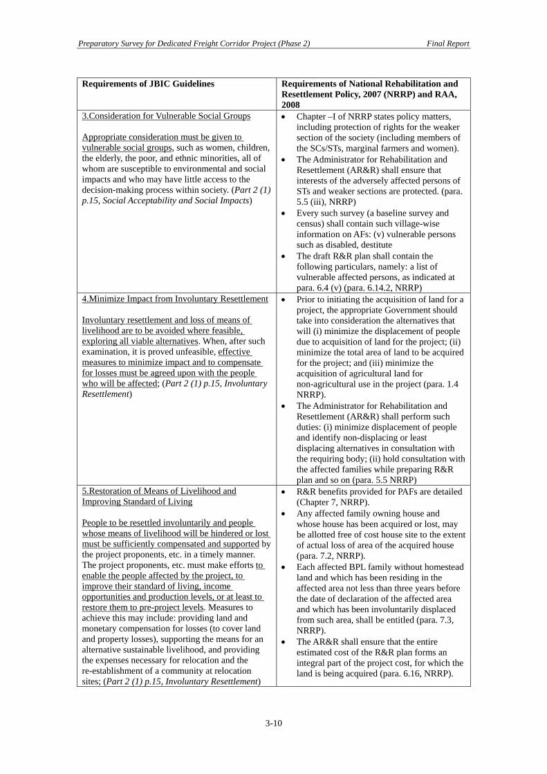
Preparatory Survey for Dedicated Freight Corridor Project (Phase 2) Final Report
Requirements of JBIC Guidelines Requirements of National Rehabilitation and Resettlement Policy, 2007 (NRRP) and RAA, 2008
3.Consideration for Vulnerable Social Groups Appropriate consideration must be given to vulnerable social groups, such as women, children, the elderly, the poor, and ethnic minorities, all of whom are susceptible to environmental and social impacts and who may have little access to the decision-making process within society. (Part 2 (1) p.15, Social Acceptability and Social Impacts)
• Chapter –I of NRRP states policy matters, including protection of rights for the weaker section of the society (including members of the SCs/STs, marginal farmers and women).
• The Administrator for Rehabilitation and Resettlement (AR&R) shall ensure that interests of the adversely affected persons of STs and weaker sections are protected. (para. 5.5 (iii), NRRP)
• Every such survey (a baseline survey and census) shall contain such village-wise information on AFs: (v) vulnerable persons such as disabled, destitute
• The draft R&R plan shall contain the following particulars, namely: a list of vulnerable affected persons, as indicated at para. 6.4 (v) (para. 6.14.2, NRRP)
4.Minimize Impact from Involuntary Resettlement Involuntary resettlement and loss of means of livelihood are to be avoided where feasible, exploring all viable alternatives. When, after such examination, it is proved unfeasible, effective measures to minimize impact and to compensate for losses must be agreed upon with the people who will be affected; (Part 2 (1) p.15, Involuntary Resettlement)
• Prior to initiating the acquisition of land for a project, the appropriate Government should take into consideration the alternatives that will (i) minimize the displacement of people due to acquisition of land for the project; (ii) minimize the total area of land to be acquired for the project; and (iii) minimize the acquisition of agricultural land for non-agricultural use in the project (para. 1.4 NRRP).
• The Administrator for Rehabilitation and Resettlement (AR&R) shall perform such duties: (i) minimize displacement of people and identify non-displacing or least displacing alternatives in consultation with the requiring body; (ii) hold consultation with the affected families while preparing R&R plan and so on (para. 5.5 NRRP)
5.Restoration of Means of Livelihood and Improving Standard of Living People to be resettled involuntarily and people whose means of livelihood will be hindered or lost must be sufficiently compensated and supported by the project proponents, etc. in a timely manner. The project proponents, etc. must make efforts to enable the people affected by the project, to improve their standard of living, income opportunities and production levels, or at least to restore them to pre-project levels. Measures to achieve this may include: providing land and monetary compensation for losses (to cover land and property losses), supporting the means for an alternative sustainable livelihood, and providing the expenses necessary for relocation and the re-establishment of a community at relocation sites; (Part 2 (1) p.15, Involuntary Resettlement)
• R&R benefits provided for PAFs are detailed (Chapter 7, NRRP).
• Any affected family owning house and whose house has been acquired or lost, may be allotted free of cost house site to the extent of actual loss of area of the acquired house (para. 7.2, NRRP).
• Each affected BPL family without homestead land and which has been residing in the affected area not less than three years before the date of declaration of the affected area and which has been involuntarily displaced from such area, shall be entitled (para. 7.3, NRRP).
• The AR&R shall ensure that the entire estimated cost of the R&R plan forms an integral part of the project cost, for which the land is being acquired (para. 6.16, NRRP).
3-10

Preparatory Survey for Dedicated Freight Corridor Project (Phase 2) Final Report
Requirements of JBIC Guidelines Requirements of National Rehabilitation and Resettlement Policy, 2007 (NRRP) and RAA, 2008
6. Participation by the Affected People Appropriate participation by the people affected and their communities must be promoted in planning, implementation and monitoring of involuntary resettlement plans and measures against the loss of their means of livelihood. (Part 2 (1) p.15, Involuntary Resettlement)
• The AR&R shall prepare a draft R&R plan for the affected families (AFs) after consultations with the representatives of AFs including women and the representatives of the required body (para. 6.14.1, NRRP).
• The draft R&R plan should be made known locally by wide publicity in the affected area and the resettlement area(s) in such a manner as may be prescribed by the appropriate Government (para. 6.14.3).
• The draft R&R plan shall also be discussed in gram sabhas* in rural areas and in public hearings in urban and rural areas where gram sabhas* don’t exist (para. 6.15.1, NRRP).
7. Indigenous People’s Rights When a project may have adverse impact on indigenous peoples, all of their rights in relation to land and resources must be respected in accordance with the spirit of the relevant international declarations and treaties. Efforts must be made to obtain the consent of indigenous peoples after they have been fully informed. (Part 2 (1) p.15, Indigenous Peoples)
• Rehabilitation and resettlement benefits for PAFs belonging to STs and SCs (para. 7.21 NRRP) deal with particular benefits available for STs and SCs.
• In case of involuntary displacement of 200 or more ST families, a Tribal Development Plan shall be prepared, detailing procedure for settling land rights (para. 7.21.1 NRRP)
• The concerned gram sabha*/panchayats** in the Scheduled Areas shall be consulted in all cases of land acquisition, before issuing notification under the Land Acquisition Act or any other Act in force under which land acquisition is undertaken and the consultation shall be in accordance with the provisions of the Panchayats** (para. 7.21.2 NRRP).
Note: “gram sabha” is a village-level self governance body, composed of all villagers of age above 18 years old. The “gram panchayat” is a village-level council, elected by gram sabha, taking decisions on issues key to a village's social, cultural and economic life. The above comparative exercise of the JBIC Guidelines versus NRRP (and RAA) reveals the necessity of urgent execution of local consultations with the affected families, persons and local stakeholders at the district-level as well as village-level. Despite the above mandates of JBIC Guidelines and NRRP, it was found that local consultations to accompany the land acquisition process have so far not been implemented at any Sections of Phase 2. Therefore, the implementation of local consultations with careful planning of timing, venue and the manner of publicity and solicitation of local stakeholders is urgently needed. 3.3.2 Expected Study for Phase 2 (1) Remaining Works of DFCCIL in View of Social Aspects of Land Acquisition
Land Acquisition Procedure
For Sections 1, 2, 3, and 4, the process is well underway in terms of issuance of 20A and, at some sections, even of 20E. However, different land acquisition schemes are in progress for Sections 15 and 16, where the finalized alignment spans three States (Haryana, Rajastan, and
3-11
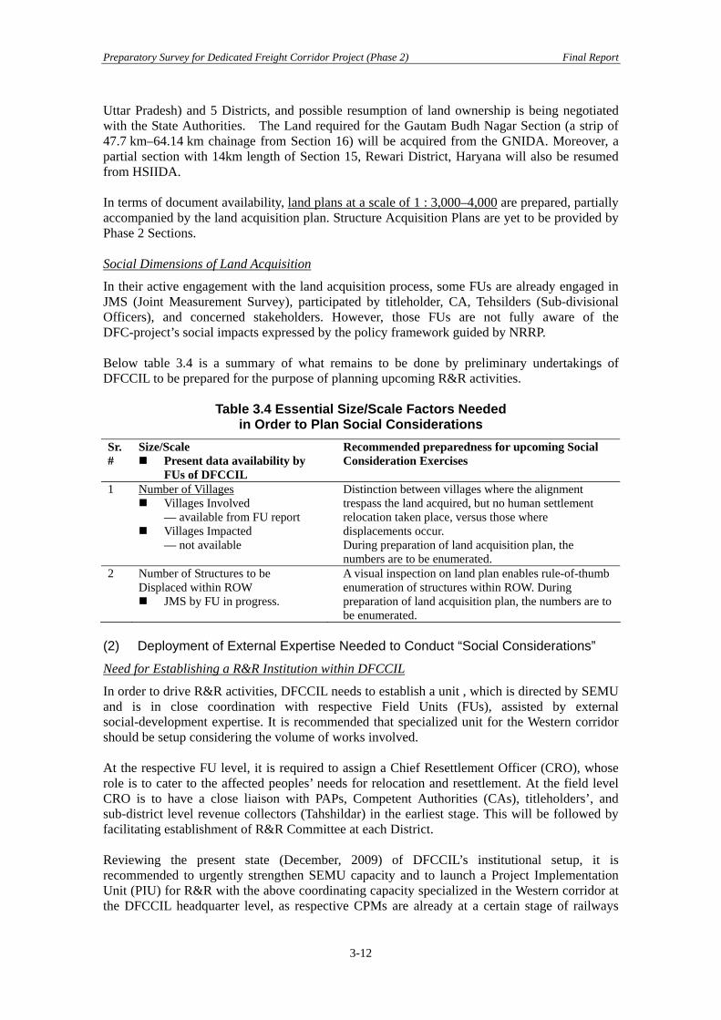
Preparatory Survey for Dedicated Freight Corridor Project (Phase 2) Final Report
Uttar Pradesh) and 5 Districts, and possible resumption of land ownership is being negotiated with the State Authorities. The Land required for the Gautam Budh Nagar Section (a strip of 47.7 km–64.14 km chainage from Section 16) will be acquired from the GNIDA. Moreover, a partial section with 14km length of Section 15, Rewari District, Haryana will also be resumed from HSIIDA. In terms of document availability, land plans at a scale of 1 : 3,000–4,000 are prepared, partially accompanied by the land acquisition plan. Structure Acquisition Plans are yet to be provided by Phase 2 Sections. Social Dimensions of Land Acquisition
In their active engagement with the land acquisition process, some FUs are already engaged in JMS (Joint Measurement Survey), participated by titleholder, CA, Tehsilders (Sub-divisional Officers), and concerned stakeholders. However, those FUs are not fully aware of the DFC-project’s social impacts expressed by the policy framework guided by NRRP. Below table 3.4 is a summary of what remains to be done by preliminary undertakings of DFCCIL to be prepared for the purpose of planning upcoming R&R activities.
Table 3.4 Essential Size/Scale Factors Needed in Order to Plan Social Considerations
Sr. #
Size/Scale Present data availability by
FUs of DFCCIL
Recommended preparedness for upcoming Social Consideration Exercises
1 Number of Villages Villages Involved
— available from FU report Villages Impacted
— not available
Distinction between villages where the alignment trespass the land acquired, but no human settlement relocation taken place, versus those where displacements occur. During preparation of land acquisition plan, the numbers are to be enumerated.
2 Number of Structures to be Displaced within ROW
JMS by FU in progress.
A visual inspection on land plan enables rule-of-thumb enumeration of structures within ROW. During preparation of land acquisition plan, the numbers are to be enumerated.
(2) Deployment of External Expertise Needed to Conduct “Social Considerations”
Need for Establishing a R&R Institution within DFCCIL
In order to drive R&R activities, DFCCIL needs to establish a unit , which is directed by SEMU and is in close coordination with respective Field Units (FUs), assisted by external social-development expertise. It is recommended that specialized unit for the Western corridor should be setup considering the volume of works involved. At the respective FU level, it is required to assign a Chief Resettlement Officer (CRO), whose role is to cater to the affected peoples’ needs for relocation and resettlement. At the field level CRO is to have a close liaison with PAPs, Competent Authorities (CAs), titleholders’, and sub-district level revenue collectors (Tahshildar) in the earliest stage. This will be followed by facilitating establishment of R&R Committee at each District. Reviewing the present state (December, 2009) of DFCCIL’s institutional setup, it is recommended to urgently strengthen SEMU capacity and to launch a Project Implementation Unit (PIU) for R&R with the above coordinating capacity specialized in the Western corridor at the DFCCIL headquarter level, as respective CPMs are already at a certain stage of railways
3-12

Preparatory Survey for Dedicated Freight Corridor Project (Phase 2) Final Report
land acquisition, most of which have undergone 20A Notification, or even have issued 20E Notification.
Social and Environmental Management Unit (SEMU)
Legend: CPM: Chief Project ManagerAM (CRO): Assistant Manager cum Chief Resettlement Officer
DFCCIL Headquarter
Project Implementation Unit (PIU)for R&R
COORDINATION BY EXTERNAL EXPERTISE
FACILITATION BY EXTERNAL EXPERTISE FACILITATION BY EXTERNAL EXPERTISE
DistrictR&R
Committee
S
TA
TE A
UTH
OR
ITY
LO
CA
L-S
ELF
GO
VER
NM
EN
T
R&R Committeeat the ProjectLevel
R&R Committeeat the VillageLevel
● Rewari/Dadri CPM AM (CRO)
● Vadodra CPM AM (CRO)
● Surat CPM AM (CRO)
● Mumbai CPM AM (CRO)
■ District Level(Competent Authority)
■ Sub-districtLevelRevenue Collector(Tehsildar)
■ Village LevelVillage AdministrativeOfficers
● Zilla Parishad(District Level)
● PanchayatSamitis (Sub-district level)
● VillagePanchayats(Villagelevel)
Field Units of DFCCILField Units of DFCCIL
Figure 3.2 Proposed Organization for Implementing R&R
External Expertise Inputs to Facilitate the above R&R
In order to facilitate DFCCIL to launch and mobilize R&R activities, external expertise (both Local and International) shall be engaged in the manner shown in subsection 3.3.3. In implementing R&R, external expertise, either of an NGO or consultants, may facilitate all aspects of R&R activities, working on behalf of DFCCIL, as a coordinating agent with the State Authorities (shown as a left-most vertical Column in Figure 3.2) and the Local Self-government (right-most column in Figure 3.2). “Zilla Parishad”, “Panchayat Samitis”, and “Village Panchayat”, illustrated in the above Figure 3.2, represent elected autonomous local bodies, of the District, Sub-district and the Village level respectively. Organization of the External Expertise Inputs to Facilitate the above R&R
In order to facilitate DFCCIL to launch and mobilize R&R activities, a portfolio of external expertise (both Local and International) shall be engaged.
• Senior Resettlement Specialist (Local) (SRS) • Senior Researcher (SR) • Resettlement Specialist (Local) (RS) • Field Superintendent (FR) (Local) • IT Specialist (ITS) (Local) • Field Surveyor cum R&R Facilitator (FS) (Local)
3-13
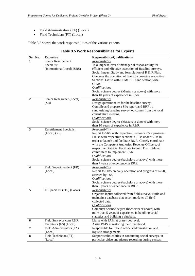
Preparatory Survey for Dedicated Freight Corridor Project (Phase 2) Final Report
• Field Administrators (FA) (Local) • Field Technician (FT) (Local)
Table 3.5 shows the work responsibilities of the various experts.
Table 3.5 Work Responsibilities for Experts Ser. No. Expertise Responsibility/Qualifications 1 Senior Resettlement
Specialist (International/Local) (SRS)
Responsibility Take highest level of managerial responsibility for efficient and effective execution of Baseline surveys, Social Impact Study and formulation of R & R Plan. Oversees the operation of five RSs covering respective Sections. Liaise with SEMU/PIU and section-wise CPMs. Qualifications Social science degree (Masters or above) with more than 10 years of experience in R&R.
2 Senior Researcher (Local) (SR)
Responsibility Design questionnaire for the baseline survey. Compile and prepare a SIA report and RRP by synthesizing baseline survey, outcomes from the local consultative meeting. Qualifications Social science degree (Masters or above) with more than 10 years of experience in R&R.
3 Resettlement Specialist (Local) (RS)
Responsibility Report to SRS with respective Section’s R&R progress. Liaise with respective sectional CROs under CPM in order to launch and facilitate R&R. Closely coordinate with the Competent Authority, Revenue Officers, of respective Districts. Facilitate to build District-level committees to implement R&R. Qualifications Social science degree (bachelors or above) with more than 7 years of experience in R&R.
4 Field Superintendent (FR) (Local)
Responsibility Report to DRS on daily operation and progress of R&R, assisted by FSs. Qualifications Social science degree (bachelors or above) with more than 5 years of experience in R&R.
5 IT Specialist (ITS) (Local) Responsibility Organize inputs collected from field surveys. Build and maintain a database that accommodates all field collected data. Qualifications Computer science degree (bachelors or above) with more than 5 years of experience in handling social statistics and building a database.
6 Field Surveyor cum R&R Facilitator (FS) (Local)
Liaise with PAPs at grass-root level. Assist PAPs in restoring their livelihood.
7 Field Administrators (FA) (Local)
Responsible for 5 field office’s administration and logistic arrangements.
8 Field Technician (FT) (Local)
Support technicalities in conducting social surveys, in particular video and picture recording during census.
3-14

Preparatory Survey for Dedicated Freight Corridor Project (Phase 2) Final Report
A rough sketch of field deployment of external expertise is envisioned as shown below.
• Strengthening Institutional launch of “PIU for R&R” within the DFCCIL headquarter as well as the FU-level. This envisages strengthening the existing capacity of SEMU to undertake “PIU for R&R”. At the FU level, a CRO assisted by Resettlement Officers (ROs) must be assigned.
• SEMU shall direct the hiring of external expertise (Consulting Firm or an NGO specialized in social development) to mobilize and undertake all stages of R&R activities.
• CRO shall be engaged in liaison and close coordination with the Competent Authority, SDOs (Sub-district Officers), village authorities and villagers to facilitate relocation and resettlement. CRO shall deliver responsibility in concert with hired external expertise at the level of “Resettlement Specialist” who is assigned to each FU.
• CRO, in coordination with hired experts, will facilitate the launch of a village-level grievance redress committee at project-affected villages, in coordination with CA, Deputy DC (district Collector), VAO (Village Administration Officer), PAPs, and community representatives.
• External expertise shall be mobilized in the earlier stages, to assist CROs to launch District-level committees that can address project-generated grievances and any conflicts felt by PAPs due to the project.
• In the meantime, CRO is assisted by External Expertise to hold stakeholders meetings in affected villages in order to make PAPs aware of the project outline. Furthermore, their apprehensions and requests are channeled to the project proponent, and respective CAs, DCs and VAOs attend.
3.3.3 Preparatory Survey of Social Aspects for Phase 2 With most of the alignments for respective Phase 2 Sections being finalized, land acquisition procedures for respective Phase 2 Sections are already well underway. The land acquisition procedure , mandated by, RAA, is mobilized by the DFCCIL initiatives, district-wise, in close coordination with the Competent Authorities (CA), and the Local Self-government with people affected. The above land acquisition procedure shall concurrently be accompanied by due R&R activities, which intend to mitigate and rehabilitate adverse social impacts perceived by project affected peoples (PAPs). The article 20 (O) of RAA also stipulates entailing administrative and legal processes with the railways land acquisition to be in harmony with the National Rehabilitation and Resettlement Policy (NRRP), 2007. Implementing R&R shall also be undertaken, in conformance with the JBIC Guidelines for Confirmation of Environmental and Social Considerations, April, 2002 (JBIC Guidelines). In order to put forward the proposed DFC project Phase 2, in conformance with the JBIC Guidelines, a R&R Plan (RRP) dedicated to the target sections of Phase 2 needs to be prepared. The RRP shall be made through data obtained via a Baseline Survey, including the Census with a Survey on inventory of asset losses. It shall also be accompanied by DFCCIL’s local consultations with PAPs and stakeholders concerned with the project. 1. Review past Studies by JICA/JBIC on Social Considerations A good reference to and consultation with the foregoing social consideration portion of the JICA studies for the target section shall be conducted. It includes, but not limited to; JICA FS, JICA Preparatory Study for Phase 1, and the Preparatory Survey (Phase 2) part 1.
3-15

Preparatory Survey for Dedicated Freight Corridor Project (Phase 2) Final Report
2. Inclusion of Particular Aspects of Social Considerations In view of conformance with the above NRRP and JBIC Guidelines, the following aspects, in particular, need to be addressed:
• Vulnerable groups— those below the poverty line, women-headed households, SCs/STs, and other socially vulnerable people;
• Compensation and assistance to PAPs, who are non-titleholders; • Inclusion of such expenditures and benefits provided for affected families and
assistance costs which supplement gaps between replacement cost and compensation amount calculated by applicable local laws/regulations (JBIC Guidelines);and
• Those socially affected, not only directly affected by relocation due to land acquisition, but indirectly affected (para. 1.2, NRRP,).
3. Implementation of the Social Considerations Recognizing present status of land acquisition, being undertaken by DFCCIL initiatives with respective Field Unit offices engaged in the acquisition process, for those Phase 2 sections, the DFCCIL shall undertake the following tasks. Task-1 Social Impact Assessment (SIA)
1) General Whenever an EIA process is undertaken at the district level, participatory aspects (i.e. public consultation meetings) of SIA may be conducted concurrently. In other districts, where an EIA process in not undertaken, a SIA shall be done as an individual work. 2) Subjects to be covered by the SIA Study The SIA Study shall address such subjects as; i) identification of sections/zones of social and economic impacts due to the project’s new corridor alignment, ii) comprehension by enumerative and exhaustive household surveys on socio-economic profiles of PAFs and PAPs, without resorting to sampling, iii) analysis of impacts on different categories and attributes of PAPs, either, displaced, not-displaced-but-indirectly affected, such as landowners, tenants, small-holders, farmers, wage workers, hawkers/temporal shop-keepers, SCs/STs and women, iv) identification of existing local institutions that exercise socio-political powers at the village level, which are available for participation as stakeholders, grievance redress and conflicts arbitration, v) comprehension of PAPs’ perception regarding socio-economic impacts anticipated and acceptable mitigation measures, vi) assessment and mitigation measures of construction-induced socio-economic impacts on local communities, and vii) recommendation of a broad range of mitigation strategies to mitigate adverse social impacts 3) Census Survey and Asset Inventory Survey Census and asset survey shall be done for all project affected persons (PAPs), directly and indirectly affected by displacement. Census and asset inventory survey shall be undertaken, in an exhaustive manner, without resorting to population sampling, for all families and individuals (PAPs). Survey items on household and non-household member includes; attributes of household (family size, sex, age, income, years of residence at the site), assets (land, structure, facilities, agricultural implements, and others), crops and trees, livestock, incomes and social category (Scheduled Castes/Scheduled Tribes).By census survey, IDs are to be given to respective structures (private and communal), permanent and temporal, and videos and pictures taken for respective heads of households. The above gives an indicative list, however, a comprehensive list is given in Appendix 3.1.3. Task-1 3) Particulars of Census Survey and 4) Particulars of Inventory of Losses.
3-16
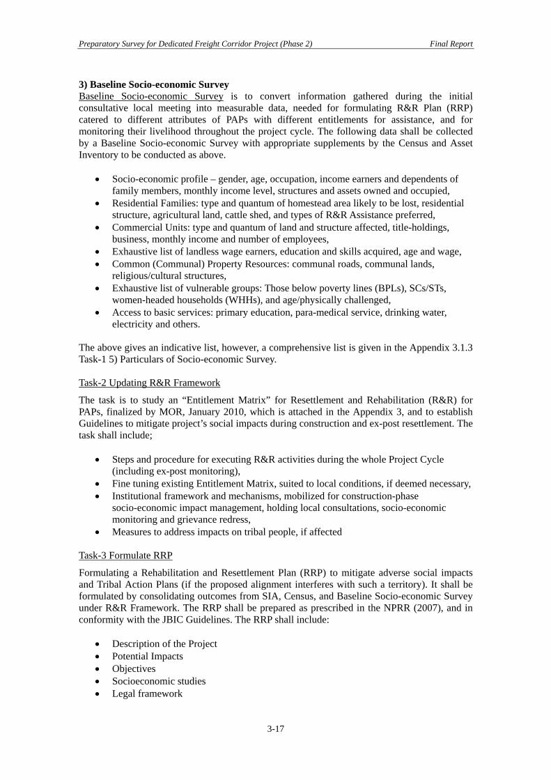
Preparatory Survey for Dedicated Freight Corridor Project (Phase 2) Final Report
3) Baseline Socio-economic Survey Baseline Socio-economic Survey is to convert information gathered during the initial consultative local meeting into measurable data, needed for formulating R&R Plan (RRP) catered to different attributes of PAPs with different entitlements for assistance, and for monitoring their livelihood throughout the project cycle. The following data shall be collected by a Baseline Socio-economic Survey with appropriate supplements by the Census and Asset Inventory to be conducted as above.
• Socio-economic profile – gender, age, occupation, income earners and dependents of family members, monthly income level, structures and assets owned and occupied,
• Residential Families: type and quantum of homestead area likely to be lost, residential structure, agricultural land, cattle shed, and types of R&R Assistance preferred,
• Commercial Units: type and quantum of land and structure affected, title-holdings, business, monthly income and number of employees,
• Exhaustive list of landless wage earners, education and skills acquired, age and wage, • Common (Communal) Property Resources: communal roads, communal lands,
religious/cultural structures, • Exhaustive list of vulnerable groups: Those below poverty lines (BPLs), SCs/STs,
women-headed households (WHHs), and age/physically challenged, • Access to basic services: primary education, para-medical service, drinking water,
electricity and others. The above gives an indicative list, however, a comprehensive list is given in the Appendix 3.1.3 Task-1 5) Particulars of Socio-economic Survey. Task-2 Updating R&R Framework
The task is to study an “Entitlement Matrix” for Resettlement and Rehabilitation (R&R) for PAPs, finalized by MOR, January 2010, which is attached in the Appendix 3, and to establish Guidelines to mitigate project’s social impacts during construction and ex-post resettlement. The task shall include;
• Steps and procedure for executing R&R activities during the whole Project Cycle (including ex-post monitoring),
• Fine tuning existing Entitlement Matrix, suited to local conditions, if deemed necessary, • Institutional framework and mechanisms, mobilized for construction-phase
socio-economic impact management, holding local consultations, socio-economic monitoring and grievance redress,
• Measures to address impacts on tribal people, if affected Task-3 Formulate RRP
Formulating a Rehabilitation and Resettlement Plan (RRP) to mitigate adverse social impacts and Tribal Action Plans (if the proposed alignment interferes with such a territory). It shall be formulated by consolidating outcomes from SIA, Census, and Baseline Socio-economic Survey under R&R Framework. The RRP shall be prepared as prescribed in the NPRR (2007), and in conformity with the JBIC Guidelines. The RRP shall include:
• Description of the Project • Potential Impacts • Objectives • Socioeconomic studies • Legal framework
3-17

Preparatory Survey for Dedicated Freight Corridor Project (Phase 2) Final Report
3-18
• Institutional Framework • Eligibility (refer to DFCCIL’s Entitlement Matrix, Appendix 3. Social environmental
considerations) • Valuation and compensation for losses • Resettlement Measures • Site selection, site preparation and relocation • Housing, infrastructure, and social services • Environmental protection and management • Community participation • Integration with host populations • Grievance procedures • Organizational responsibilities • Implementation schedule • Costs and budget
Detailed requirements of the above items are given in the Appendix 3.1 3. Task-3 Formulate a R & R Plan. 4. A preliminary estimate of external expertise deployment is indicated below. Since the field conditions required to estimate the amount of expertise are not well known at the present, the numbers shall be reviewed and rectified in accordance with progress of project activities, in particular the number of affected families, on the part of DFCCIL.
Table 3.6 Preliminary Estimates of Man Months Required to Execute Social Considerations
Position Number of Persons Required Deployment Over 9 Months (Months/Person)
Subtotal Man Months
SRS 1 6 6 RS 5 6 30 SR 1 6 6 FR 5 6 30 ITS 2 6 12 FS 30 6 180 FA 5 6 30 FT 4 4 16 Total 53 46 310
Preparatory Survey for Dedicated Freight Corridor Project (Phase 2) Final Report
4 Conclusion and Recommendation 4.1 Findings of Preparatory Survey According to Chapter 3 herewith is the remaining works for the next step of the project implementation for the Phase 2 section. The preparation stages of Project Phase 2 are not in a systematic order. In addition, although the design and preparation of tenders for bridges are advanced, the plan drawing (L-section) has not been carefully checked and will be a cause for confusion. Land acquisition work is also being processed without any preliminary surveys and participation of PAPs in R&R activities such as public consultations. The EIA has not progressed much since the JICA F/S. It is understood that the Phase 2 section was previously laid outside of the JICA loan scheme. If the JICA loan scheme also applies to Phase 2, the present implementation process needs to be improved. Below is the next step of work to be done before evaluation of L/A. 4.1.1 Remaining Works to be Completed before JICA Loan Appraisal (1) Preparation work to be completed by DFCCIL and evaluation
Remaining FLS works and correction to be completed and required documents/drawings mentioned in 3.1.2 will be prepared by DFCCIL. JICA must evaluate the deliverables and additional documents provided by DFCCIL to ascertain if they are suitable to verify project cost estimation and to hand over to the next step of survey/study. If those deliverables are not of sufficient quantity or quality, the next step of study/survey shall not start. Furthermore, establishment of a PIU for R&R and assignment of CRO in DFCC HQ and village level committees by SEMU/CRO are required. (2) Remaining Works to be Completed by External Party before Evaluation for JICA
Loan Appraisal
Review of previous study documents, additional Geological survey, additional Topological survey, basic design of civil structures (as mentioned in 3.1.2). Also comprehensive EIA on natural Environmental and Pollution Control and establishment of Rehabilitation and Resettlement Plan with appropriate participation of PAPs and stakeholders as mentioned in 3.2 and 3.3. 4.1.2 Comparison of Fund Scheme for Next Step of Work There are alternatives of schemes for the next step of work as Phase 1 Engineering service, India own fund, Phase 2 Engineering Service, and JICA preparatory survey. There are advantages and disadvantages as mentioned below.
1) Phase 1 E/S consultant has knowledge of the project and suitable personnel and equipment to implement the Phase 2 preparation work. However Phase 2 preparation work must take priority. It seems difficult to make Phase 2 preparation a priority because the work volume and required personnel are too large to be attached to the Phase 1 ES main contract.
2) Consultant hired by the India side: quality of the work is assured if a qualified consultant is selected from the short list provided by JICA. But the fund shortage and disbursement delay might be cause of work to be disqualified.
3) Timing of Phase 2 E/S has yet to be determined and the rail technical issues need to be finalized before Phase 2 E/S for the sake of smooth E/S implementation.
4-1

Preparatory Survey for Dedicated Freight Corridor Project (Phase 2) Final Report
4) JICA Preparatory Survey seems to have overall advantages over other alternatives considering the India side’s intention, time schedule to complete remaining works as well as the quality of the work, including addressing the requirement of donor’s guideline appropriately.
Table 4.1 Comparison of Fund Scheme for Next Step of Work
Scheme
Fund type
Intention ofIndia side ○
The preparation of Phase2 isincluded in the TOR of Phase1General consultancy service(GC)
× Budget for the additional workshas to be secured ×
EIA and R&R activity need tobe done before the JICA loanappraisal
○The grant aid is requested byIndia side strongly
Period oftime △
Phase 2 preparation need tobe prioritized by the consultant ×
It will take time for fundpreparation and tender of thecontract
×Schedule of Loan agreementfor Phase 2 is yet to bedetermined
○
Next step to be taken in shorttime. Because the TOR andcost are provided in thispreparatory survey.
Quality ofwork ○
Appropriate work will beprovided by the qualifiedconsultant for Phase 1General Consultancy Services
△Appropriate work may not beprovided due to fund shortage ○
Appropriate work will beprovided by nominatedqualified consultant for Phase2
○
Appropriate work will beprovided by qualifiedconsultant who decided intender process
Evaluation
Loan fund Loan fund JICA's expenseown fund
Phase 1 E/S India own fund Phase 2 E/S JICA Preparatory Survey 2
2nd 4th 3rd 1st Each of the 3 fields, namely, rail technical, comprehensive EIA, SIA & RRP establishment are to be considered and applied to the schemes separately. The rail technical works are short term and the work volume is suitable to be included in the Phase 1 Engineering service. However for the Comprehensive EIA and RRP establishment, a long time period is needed and they require a heavy work load. These works should be applied to the JICA Preparatory Survey scheme.
Table 4.2 Comparison of Fund Scheme for Each Work Field Scheme
Work Field
RailTechnical
◎
Phase 1 E/S consultant havesuitable personnel andknowledge to implementationthe work
○
Appropriate work will beprovided by qualifiedconsultant who decided intender process
EIA ×Work volume is big and periodof time is too long to includePhase 1 Engineering Service
○
Appropriate work will beprovided by qualifiedconsultant who decided intender process
SIA & RRP ×Work volume is big and periodof time is too long to includePhase 1 Engineering Service
○
Appropriate work will beprovided by qualifiedconsultant who decided intender process
Phase 1 E/S JICA Preparatory Survey 2
4.2 Implementation Schedule for Rail Technical Work
The remaining work of the railway technical aspect might be included in the Phase 1 Engineering Service. The FLS deliberative need to be checked and revised before hand over to the consultants who will implement the remaining technical work. Table 4.3 shows the implementation schedule of rail technical work. The required personnel for the work would be (i) Geological Specialist, (ii) Tunnel Specialist, and (iii) Railway Structure Engineer as
4-2

Preparatory Survey for Dedicated Freight Corridor Project (Phase 2) Final Report
international consultant and (i) Project Coordinator (co-Team Leader), (ii) Railway Engineering Expert, (iii) CAD operator, (iv) Track/Alignment engineer as local consultants.
Table 4.3 Implementation Schedule of Rail Technical Work
Year
Month 2 3 4 5 6 7 8 9 10 11 12
FLS work and check and revise
FLS & required documents Checkedby JICA
Review of previous study documents
Add Geological and Topological survey
Basic design of tunnel and otherstructure
Task for JICA
Task for DFCC
Task for External party
2010R
ail Technic
al
4.5
2
2
2
4.2.1 Preparatory Survey for Comprehensive EIA and RRP Establishment The Comprehensive EIA and RRP established are recommendable to be applied to the Preparatory survey. Table 4.4 shows the work task and implementation schedule of the Preparatory survey. The JICA Loan Appraisal can be started for the construction after completion of the basic rail technical study, Comprehensive EIA and RRP establishment. The line at February 2011 shows the available time to start the JICA Loan Appraisal.
4-3
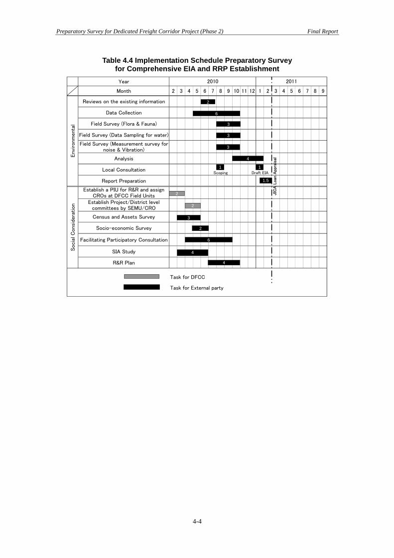
Preparatory Survey for Dedicated Freight Corridor Project (Phase 2) Final Report
4-4
Table 4.4 Implementation Schedule Preparatory Survey for Comprehensive EIA and RRP Establishment
Year
Month 2 3 4 5 6 7 8 9 10 11 12 1 2 3 4 5 6 7 8 9
Reviews on the existing information
Data Collection
Field Survey (Flora & Fauna)
Field Survey (Data Sampling for water)
Field Survey (Measurement survey fornoise & Vibration)
Analysis
Local ConsultationScoping Draft EIA
Report Preparation
Establish a PIU for R&R and assignCROs at DFCC Field Units
Establish Project/District levelcommittees by SEMU/CRO
Census and Assets Survey
Socio-economic Survey
Facilitating Participatory Consultation
SIA Study
R&R Plan
Task for DFCC
Task for External party
Socia
l C
onsi
dera
tion
Envi
ronm
enta
l
2010 2011
4
2
3
6
2
6
3
1.5
2
2
3
3
JIC
A L
oan
Appra
isal
4
4
1 1

Appendices

Preparatory Survey for Dedicated Freight Corridor Project (Phase 2) Appendix 1
Appendix 1 Railway Technical Aspect Findings in the FLS Derivatives
1.1 Findings in the FLS Derivatives 1.1.1 Yard Plans A JNPT Station (Terminal Station between JNPT and JASAI)
1. The yard plan indicates only 3 additional lines besides slewing of one line of the existing yard and 4- existing line in this yard where as the plan given on the L-section sheet indicates 6 additional line and slewing one line in addition to 3 existing lines. It is necessary to reconcile the position.
2. The yard plan indicates a CSR of 750 m where as the yard on the L- section sheet indicates CSR 1500 m. The yard plan should be modified to provide for the future loop length of 1500m.The yard plan indicates CSR of 750m for line no 10 at one location and 1505m at another location.
3. The lines in the yard plan are numbered 3 to 10 which indicates that perhaps two lines have not been shown in yard plan which have been shown on the plan in L-section sheet. This needs clarification.
4. The grades in the yard are not shown with the result it is not possible to check if there is any crossover or turnout on change of grade.
5. Towards Dadri end of the yard on the existing alignment there is curve no17 (L) having the radius 873m (2°) and a total length 394m but the Ch: of the curve are not indicated where as for the proposed DFC lines there is a curve of 1° radius of 1750 m having length of 312m.This needs to be reconciled as lines appears to be parallel to each other.
6. There is a crossover connecting existing DN line to proposed DFC UP line which may up come on transition of the curve .This could not be verified as the chain age of the existing curve are not indicated.
7. The yard plan gives the details of existing bridges how ever details of the proposed extension for DFC line have not been indicated.
8. As per the yard plan there are two existing manned level crossing no 6 and 7 (C ) class at Km: 90.720 and Km:91.168 respectively. It is not indicated whether these LC’s are to be extended or converted into ROB. The L- section sheets indicates the LC no 7 will be converted in to ROB as per the alignment plan however as per the L-section it indicates that it will remain a LC. In the case of LC no 6 L-section sheet indicates that will remain as a LC. The statement of LC indicates that the TVU at LC no 7 are only 2478 and it will continue to remain as a manned LC where as for LC no 6 it is stated that this LC has been closed .It is necessary to reconciled the whole issue .The provision of manned LC on the crossover location may not be desirable and further more it will affect working also.
B. Nilje Station (Crossing Station between Taloja and Nilje)
1. The grades in the yard are not shown with the result it is not possible to check if there is any crossover or turnout on change of grade.
2. It is seen that there is a grade of 0.026 and 0.305 in the yard. There is also curve no 30 having radius of 3500m on the stretch having grade of 0.305. These grades are beyond permissible limits and hence need rectification.
3. Chain ages of the turnouts are not indicated. 4. The distance between the track centres are not shown. 5. Curve no- 31 ( R) having a radius 3500m and length of 206.7m on Diva end of the
yard. The location of the curve has not shown properly on the yard plan as only one end of the curve have been indicated at DFC Km. 44/064.927.
A1-1

Preparatory Survey for Dedicated Freight Corridor Project (Phase 2) Appendix 1
6. The yard plan indicates there is a LC No 3 (C –Class ) unmanned on Dadri end which is proposed to be replaced by ROB No 23 at Km 42/786.128 but the span of the ROB in not indicated?
7. The yard plan is indicates LC No 2 (C – Class) manned which is proposed to be replaced by a ROB where as L-section does not indicated the same. This span of the ROB is also not indicated.
8. In the existing yard there is a FOB. One of the landings of the FOB is proposed to be dismantled and foot over bridge extended further across 4- lines of DFC. Feasibility of the same needs to be examined or else it may become necessary to re-built the FOB completely.
9. The yard plan indicates construction of a new station building on the offside of DFC tracks where as existing station side appears to be on opposite side. This may be clarified.
C. Vasai Road ( Junction Station between Kharbao and Kaman Road )
1. The yard plan does not indicate any scale. 2. The c/c at various tracks are not indicated. 3. The nomenclature of the various lines is not indicated. 4. The grades in the yard are not shown with the result it is not possible to check if
there is any crossover or turnout on change of grade. 5. The yard is between Ch: 72000.0 to Ch: 75500.0 the L-section of this stretch shows
grades of 0.234, 0.400 and again 0.234 all rising and hence it is felt that the yard on is very steep grade which needs to be reviewed and rectified there is also a curve of 2° on 0.234 grade which needs to be taken into consideration while re grading.
6. There is a small curve of 37.502 m length having the radius of 2° in between curve no 56 & 57 near the facing point towards JNPT at the yard at Ch:73000, where as this curve is not shown in L-section.
7. The facing point at JNPT end appears to be on the curve at Ch: 73000. 8. The whole yard is in deep cutting of average depth 7 to 8 m and with maximum
depth of cutting 9.5 m. It will be necessary to provide proper drainage arrangement. The yard is also lower than the existing track by 4m to 5 m.
9. There is a LC no-8, C - class manned at Ch: 74.450 which is proposed to be replaced by ROB at Ch: 74.395 but the span for the ROB is not indicated and feasibility of the same will have to be studied.
10. There is a semi through Girder bridge no 72/1 at existing Km: 72.028 which is proposed to be extended as 1 x 12.2 PSC Girder at new Ch: 74.678. Feasibility of the same needs critical studies as formation level of the new track is much lower than the existing track.
11. The bridge no 70/2 at existing Km: 70.307 and new Km: 72.935 also needs review as per bridge no 72/1 as the proposed formation level is much lower at this location also.
12. The schematic plan of connection to Indian Railway tracks shows that UP line (single line DFC) fly’s over the proposed DFC line (2 lines ) at chain age 5/225.308 whereas DN line (single line DFC) fly’s over existing Indian Railways track (double line) at chain age 2/872.56. The curvature for the connecting lines is up to 4° however the grades and longitudinal sections for the same are not available.
D. Palghar (Crossing Station)
1. The yard plan is not available. 2. In the L-section sheet between chain age 20000-21000 a yard is shown but this is
having loop length of only 320m. This is not understood and needs clarification.
A1-2

Preparatory Survey for Dedicated Freight Corridor Project (Phase 2) Appendix 1
E. Joravasan (Crossing Station)
There are two ‘C’ class manned level crossings no.104 and 105, out of which level
crossing no.104 has been proposed to be converted into a road over bridge but level crossing no. 105 has been proposed to be extended as a level crossing for the present and to be converted into a road over bridge in future when loop length will be extended from 750m to 1500m.It may be desirable to convert this level crossing also into a road over bridge at this stage itself as it will be very close to the facing point.
F. Gothamgam (Junction Station)
1. The yard plan is schematic and not to scale. 2. The location of curves and grades are not indicated however it appears that curve no.
9 at Km 29.422 to 29.514 is likely to come in turnout location on Vadodara end. 3. Distance between track centres not shown. 4. The existing LC no. 149 (Km 28.012) and LC no. 150 (Km 28.953) are proposed to
be converted into ROB’s but same are not shown. 5. The schematic diagram indicating chain ages of turnouts provides a surface
connection to Delhi Mumbai Main Line Track at Mumbai end. The need for the same needs to be examined in details.
6. There is a flyover (DFC single line flying over two tracks of western railway main line) for KRIBHCO siding on Mumbai end. The exact location of this flyover and span etc. of the same are not shown.
7. The longitudinal section for the siding connection not shown. 8. The details of curves at Mumbai end of siding connection immediately after turnouts
not shown.
G. Sanjali (Crossing station) 1. The yard is on detour alignment. 2. There is only a schematic diagram without any dimension and hence no comments
are possible. H. Varediya (Crossing station)
1. The yard is on detour alignment. 2. There is only a schematic diagram without any dimension and hence no comments
are possible.
1.1.2 Rail Infrastructure –Road Crossings 1. The LC no 8 C class manned at existing Km: 71.811 and proposed Ch:74.750 is to be
replaced at Km: 74.395 this is across Kharbao yard having 6 nos DFC lines (including future provision) and two existing track.
2. LC 161 (B class) at existing km 298/20-22 (DFCC chainage 16616.66) between
Hathijan and Kosamba stations. a. The vertical clearance as per general arrangement drawing is only 8325mm
which should be 8430mm. Note no.18 should also be modified accordingly. b. As per note 4, clearance above the track is fixed. Any variation in depth of
girder after proper design will change the level of the road surface and also length of approaches of ROB.
c. It has been proposed to provide the girders and the road on a curve having a radius of 50m only. It is necessary to have the horizontal curves in a accordance with clause 4.4.1 of IRC 73 depending on the classification of road. The
A1-3
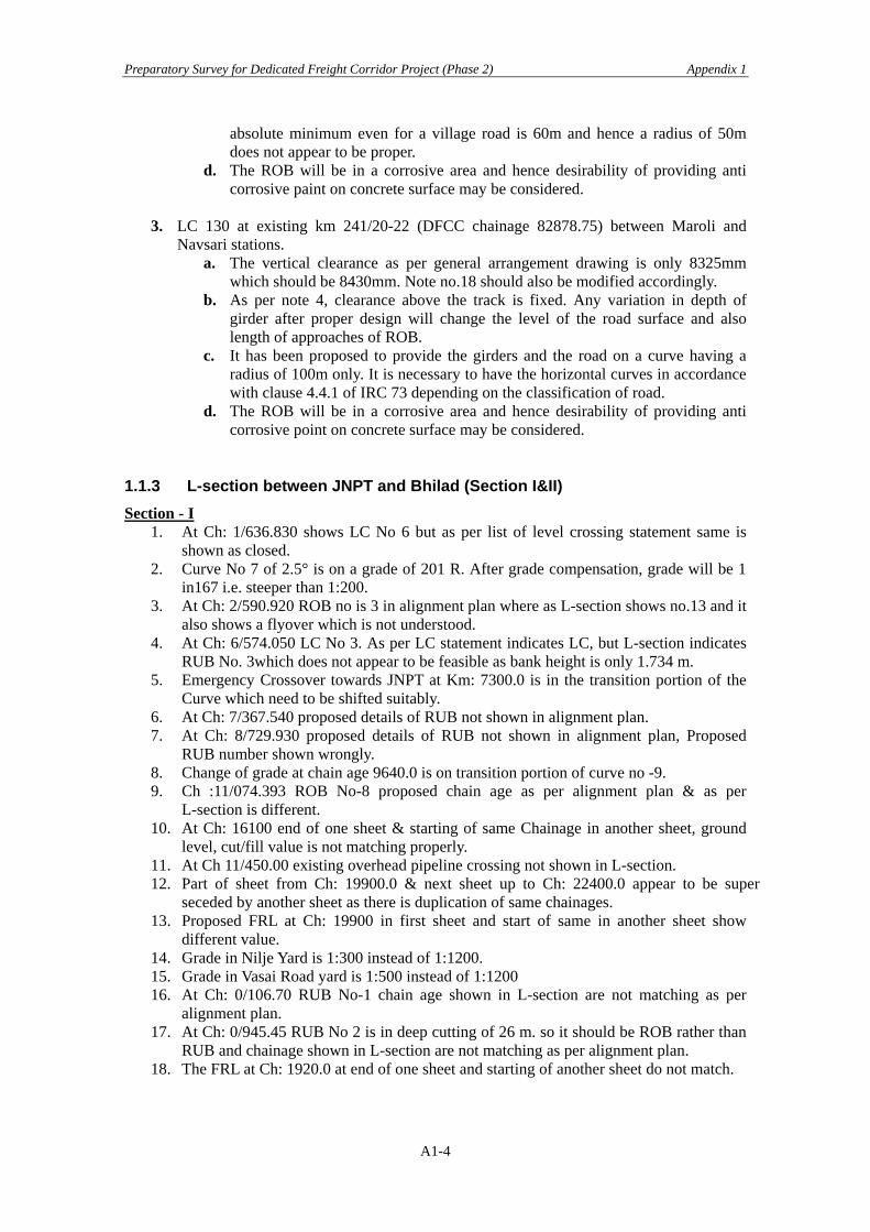
Preparatory Survey for Dedicated Freight Corridor Project (Phase 2) Appendix 1
absolute minimum even for a village road is 60m and hence a radius of 50m does not appear to be proper.
d. The ROB will be in a corrosive area and hence desirability of providing anti corrosive paint on concrete surface may be considered.
3. LC 130 at existing km 241/20-22 (DFCC chainage 82878.75) between Maroli and
Navsari stations. a. The vertical clearance as per general arrangement drawing is only 8325mm
which should be 8430mm. Note no.18 should also be modified accordingly. b. As per note 4, clearance above the track is fixed. Any variation in depth of
girder after proper design will change the level of the road surface and also length of approaches of ROB.
c. It has been proposed to provide the girders and the road on a curve having a radius of 100m only. It is necessary to have the horizontal curves in accordance with clause 4.4.1 of IRC 73 depending on the classification of road.
d. The ROB will be in a corrosive area and hence desirability of providing anti corrosive point on concrete surface may be considered.
1.1.3 L-section between JNPT and Bhilad (Section I&II) Section - I
1. At Ch: 1/636.830 shows LC No 6 but as per list of level crossing statement same is shown as closed.
2. Curve No 7 of 2.5° is on a grade of 201 R. After grade compensation, grade will be 1 in167 i.e. steeper than 1:200.
3. At Ch: 2/590.920 ROB no is 3 in alignment plan where as L-section shows no.13 and it also shows a flyover which is not understood.
4. At Ch: 6/574.050 LC No 3. As per LC statement indicates LC, but L-section indicates RUB No. 3which does not appear to be feasible as bank height is only 1.734 m.
5. Emergency Crossover towards JNPT at Km: 7300.0 is in the transition portion of the Curve which need to be shifted suitably.
6. At Ch: 7/367.540 proposed details of RUB not shown in alignment plan. 7. At Ch: 8/729.930 proposed details of RUB not shown in alignment plan, Proposed
RUB number shown wrongly. 8. Change of grade at chain age 9640.0 is on transition portion of curve no -9. 9. Ch :11/074.393 ROB No-8 proposed chain age as per alignment plan & as per
L-section is different. 10. At Ch: 16100 end of one sheet & starting of same Chainage in another sheet, ground
level, cut/fill value is not matching properly. 11. At Ch 11/450.00 existing overhead pipeline crossing not shown in L-section. 12. Part of sheet from Ch: 19900.0 & next sheet up to Ch: 22400.0 appear to be super
seceded by another sheet as there is duplication of same chainages. 13. Proposed FRL at Ch: 19900 in first sheet and start of same in another sheet show
different value. 14. Grade in Nilje Yard is 1:300 instead of 1:1200. 15. Grade in Vasai Road yard is 1:500 instead of 1:1200 16. At Ch: 0/106.70 RUB No-1 chain age shown in L-section are not matching as per
alignment plan. 17. At Ch: 0/945.45 RUB No 2 is in deep cutting of 26 m. so it should be ROB rather than
RUB and chainage shown in L-section are not matching as per alignment plan. 18. The FRL at Ch: 1920.0 at end of one sheet and starting of another sheet do not match.
A1-4
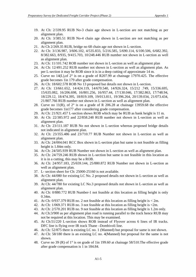
Preparatory Survey for Dedicated Freight Corridor Project (Phase 2) Appendix 1
19. At Ch: 2/339.95 RUB No-3 chain age shown in L-section are not matching as per alignment plan.
20. At Ch: 3/385.51 RUB No-4 chain age shown in L-section are not matching as per alignment plan.
21. At Ch 2/269.35 RUB, bridge no 68 chain age not shown in L-section. 22. At Ch: 3/136.987, 3/606.102, 4/535.833, 5/216.585, 5/690.114, 6/100.506, 6/682.392,
8/382.663, 8/935, 9/415.703, 10/248.446 RUB number not shown in L-section as well as alignment plan.
23. At Ch: 11/101.742 ROB number not shown in L-section as well as alignment plan 24. At Ch: 12/491.252 RUB number not shown in L-section as well as alignment plan. As
per L-section it may be ROB since it is in a deep cutting of approximate 14 m. 25. Curve no 14(L),of 2° is on a grade of R207.99 at chainage 17970.425. The effective
grade becomes 1in 179 after grade compensation. 26. At Ch: 18/602.578 ROB No 13 proposed but details not shown in L-section. 27. At Ch: 13/661.652, 14/424.119, 14/670.540, 14/926.324, 15/212 .749, 15/336.695,
15/635.082, 16/206.698, 16/801.256, 16/957.44, 17/130.046, 17/382.863, 17/748.94, 18/229.12, 18/474.395, 18/819.109, 19/013.811, 19/396.264, 20/139.034, 21/073.434, 21/807.766 RUB number not shown in L-section as well as alignment plan.
28. Curve no 11(R), of 2° is on a grade of R 206.28 at chainage 13959.68 the effective grade becomes 1in177 after considering grade compensation.
29. At Ch: 21/921.457 L-section shows ROB which may be RUB as bank height is 11 m. 30. At Ch: 22/385.972 and 22/858.248 RUB number not shown in L-section as well as
alignment plan. 31. At Ch: 23/111.187 RUB No not shown in L-section whereas proposed bridge details
not indicated in alignment plan. 32. At Ch: 23/355.486 and 23/710.77 RUB Number not shown in L-section as well as
alignment plan. 33. At Ch: 24/004.041 RCC Box shown in L-section plan but same is not feasible as filling
height is 1.84m only. 34. At Ch: 24/505.939 RUB Number not shown in L-section as well as alignment plan. 35. At Ch: 24/759.246 RUB shown in L-section but same is not feasible in this location as
it is in a cutting, this may be a ROB. 36. At Ch: 24/957.183, 25/659.144, 25/880.872 RUB Number not shown in L-section as
well as alignment plan. 37. L- section sheet for Ch: 25000-25160 is not available. 38. At Ch: 44/080 for existing LC No. 2 proposed details not shown in L-section as well as
alignment plan. 39. At Ch: 44/780 for existing LC No.3 proposed details not shown in L-section as well as
alignment plan. 40. At Ch: 0/880.772 RUB Number-1 not feasible at this location as filling height is only
0.34m. 41. At Ch: 0/937.379 RUB no. 2 not feasible at this location as filling height is < 2m. 42. At Ch: 1/069.371 RUB no. 3 not feasible at this location as filling height is <2m. 43. At Ch: 2/570.201 RUB no. 9 not feasible at this location as filling height is 1.2m only. 44. At Ch:3/900 as per alignment plan road is running parallel to the track hence RUB may
not be required at this location. This may be examined. 45. At Ch:51/220 L-section shows ROB instead of Flyover across 6 lines of IR tracks.
DFC line is flying over IR track Thane –Dombivoli line. 46. At Ch: 52/875 there is existing LC no. 1 (Manned) but proposal for same is not shown. 47. At Ch: 58/180 there is an existing LC no. 4(Manned) but proposal for the same is not
shown. 48. Curve no 39 (R) of 1° is on grade of 1in 199.60 at chainage 58/510.The effective grade
after grade compensation is 1 in 184.84.
A1-5
Preparatory Survey for Dedicated Freight Corridor Project (Phase 2) Appendix 1
49. Curve no 43(L) Ch: 60160, change of grade is very close to curve. 50. At Ch: 66/060 for existing LC No.6 proposed details not shown in L-section as well as
in alignment plan. It is presumed LC may be extended which needs confirmation. 51. Chainage 70660.0 there is change of grade on transition portion of curve no 54(L). 52. At Ch: 72/400 for existing LC No.7 proposed details not shown in L-section as well
as alignment plan. It is presumed LC may be extended. 53. At Ch: 1/590.358 and 2/550.7137 RUB Number & details not shown in L-section as
well as alignment plan. 54. Curve no 2 of 2° is on a grade 1 in 226.70 at Ch: 4000.903. The effective grade
becomes 1in 192 after grade compensation. 55. At Ch: 3/189, 5/965.277, 6/791.593, 7/983.904, 8/412.635, 9/900, 10/319.224,
13/311.057, 13/751.409, 13/867.922, 15/572.767, 17/763.751, 20/112.625 RUB Number not shown in alignment plan.
56. Chainage 17116.323 there is change of grade in transition portion of curve no 8 57. At Ch: 20/536.323 RUB number not shown in alignment plan. At this location RUB is
not feasible as filling height is 2.514 m. only. 58. From Ch: 12600 to 12900 L-section is not available. 59. In L-section sheet a flyover is indicates at Ch: 2590 where as no such flyover in the
alignment plan, however the necessity of this fly over is not understood this need clarification.
60. From the alignment plan it is seen that the proposed Narul-Belapur-Uran line cuts across the proposed DFC line as well as existing IR tracks between chain age 6700 and 6800. It is not indicated whether DFC line is flying over the proposed IR track or IR line is flying over the DFC line. It may be clarified.
61. For proposed connection of Vasai Road yard to IR track, DFC UP and DN lines are crossing across DFC main line track and IR track but same are not shown in L-section.
62. Bridge no 54/1A Ch: 56/760 and bridge no 54/02 Ch: 57/880 are pipe line crossings on existing tracks. Proposals for same not shown.
63. A casual perusal of the L- section sheet from chainage 74200 to 75100 indicates that the grade is 0.400 i.e. (1:250) where as per proposed FRL it comes (1:420) and it is indicated the same grade continuous further, where as the next sheet from chainage 75600 the grade shown is 0.347 i.e. (1:288) and as per FRL it comes 1 in 318.
64. The Road width of LC no 6, 7 & 8 at Km 63/23-25, Km69/29-31, Km 71/43-45 respectively is less than 5.5m.it will be necessary to change the lifting barrier for suitable length.
65. The grade of Road Surface in between the Existing & Proposed DFC track at LC No 2(Km: 47/13-14) , LC No -4 (55/17-19),LC No-6 (63/23-25), LC No 7(Km:91/1-2),LC No -8 (71/43-45), is not feasible keeping in view track centre & difference of FRL.
Section - II
1. Curve No-1 at chainage 2106.154 to 4182.954 is having change in grade at four locations. Possibility of avoiding frequent change of grade on the curve may be examined.
2. From Ch: 16260- 16820 there is grade of R 1in 186.66 and there is a curve of 1/2° also at that location. The compensated grade will thus be 1 in 179.94.
3. Ch:27900 change of grade is very close to the end of the curve no-8 at ch:27896.781 4. Curve no 21 at chainage 60514.40 is of 2° on a grade of 1in 201 thus compensated
grade will be 1 in 173. There is also change of grade in transition portion of curve. 5. Curve no 22 & 23 between Ch:62045.735 and 62457.86 are reverse curves and distance
between these two curve is only 48.29m which is less than 50m as required in terms of Para -219 of Indian Railways code for Engineering Department.
6. Curve no 20 of 2° is on a grade of 1:201, after compensation grade is coming 1:173.
A1-6

Preparatory Survey for Dedicated Freight Corridor Project (Phase 2) Appendix 1
7. At Ch:32011.0 there is a ROB as per L-section in Boisar yard but the yard plan of Boisar yard does not indicate any ROB which need clarification.
Surat section
1. The alignment plan shows that 2 curves of 2.5° each between km 2.38 and 4.24 have been replaced by a single curve (no.4 revise) of 0.5° having a length of 1833.898m but the chainage at the end of curve are not shown in the alignment plan. The longitudinal section still shows two curves and hence needs correction.
2. It may be possible to avoid change of grade at 3000 by providing one grade from 2800 to 3200. This may be examined.
3. There is a change of grade at 10380 very close to start of transition of curve no. 6(R). Feasibility of shifting this grade post outside the curve may be examined.
4. The horizontal alignment is not shown from 13540 to 14000. 5. Locations of the curve no.10 and 11 (near Vapi station) between km 13 and 14 not
shown with the result it cannot be verified whether change of grade at 13600 falls on transition portion of curve 10 or otherwise.
6. Alignment plan shows curve no. 15,16, 17 and 18 between 22000 and 23000 but location of same are not indicated there on and also on longitudinal section.
7. The longitudinal section shows two curves between 22000 and 22500 which appear to be old curve no 12 and 13. This should be examined.
8. There is a change of grade at 22900 which may fall on transition portion of curve no. 18. This could not be verified as chainage of curve are not shown. This needs to be examined and if necessary, the gradient post should be shifted suitably.
9. There are two sets of reverse curves i.e. curve no. 15, 16, 17 and 18. Feasibility of providing one set of reverse curve may be examined. This could not be examined in the absence of complete details about the location of these curves.
10. The DFC tracks cut across Udvada sleeper factory siding by a diamond as surface crossing. Chainage of the location of diamond as well as angle of crossing etc. are not shown. It may be confirmed that diamond crossing is not on curve portion. There is a gradient post also at 23300 which should not be on diamond crossing or very close to it.
11. The alignment plan shows two curves no. 19 and 20 but exact location of same are not shown either in alignment plan or in longitudinal section.
12. The longitudinal section shows two curves between 23650 and 24013 which appear to be old curve no. 21 and 22. This should be examined.
13. There is a change of grade at 23300 which may come on transition portion of curve no. 19. This may be examined as same could not be done in the absence of detailed location of curve.
14. The alignment plan shows two curves no. 21 and 22 but exact location of same are not shown either in alignment plan or in longitudinal section.
15. The alignment plan shows curve no. 23 on DN line and curve no 24 on Up line between km 29 and 30 but exact location of same are not shown either in alignment plan or in longitudinal section.
16. The longitudinal sections shows a curve between 28976 and 29105 which appears to be old curve no.26. This may be examined.
17. The start of curve no.26 is very close to gradient post. There will also be a vertical curve at this location. This may be examined.
18. The vertical curve at 31740 is not indicated. 19. The proposed alignment has deflected away from existing IR tracks from 31366 to
3318 necessitating the construction of a ROB on the existing road at 31571 and RUB at 31766. Feasibility of having DFC alignment in between existing IR tracks and existing road should be explored so that construction of both ROB and RUB could be avoided.
A1-7

Preparatory Survey for Dedicated Freight Corridor Project (Phase 2) Appendix 1
This feasibility may be examined by making slight adjustments in curve no. 25 and 26 also. This will incidentally result in reduction of land acquisition also. Alternatively the existing road between 31500 to31766 may be diverted to avoid construction of both ROB and RUB.
20. In case the alignment between 31366 to 33188 is kept close to existing IR tracks, there will be saving in the cost of ROB no. 67 at km 32/710 which is being provided in lieu of existing L.C. no. 20B as the length across the railway tracks will reduce.
21. The alignment plan shows curve no.29 and 30 of 2.5° each but complete details of the same are not given and same are not marked with chainages on plan. These curves are also not shown in longitudinal section.
22. There is a change of grade at 32900 which may fall on the transition portion. This needs to be checked.
23. The longitudinal section shows two curves between 32774 and 33462 which appear to be old curve no.21 and 22. This may be examined.
24. There is a change of grade at 34332 on curve no.31 which can perhaps be avoided by providing one grade from 34100 to 35002.
25. The proposed FRL at Ch: 37200.0 of one sheet and continuation on next sheet with chainage starting from 0.00 and track centre do not matching.
26. The longitudinal section sheets for the survey up to 37200 as done by RITES is available and thereafter from 42020 onwards thus leaving a gap of 4820m. A sheet showing chainage 0 to 4680 for survey done by Monarch is available. There is therefore a gap of 140m. it needs clarification. The levels are also different and hence correctness cannot be known. This sheet does not give chainages of curves etc. It does not show structures etc in adjoining area, even Bulsar electric loco shed is not shown. In view of this no comments are possible.
27. Ch: 4680.0 proposed FRL and continuation of same location starting on next sheet from Ch: 42020.0 proposed FRL is not matching.
28. There are four curves no. 38, 39, 40 and 41 between km 43 and 44 as per alignment plan but chainage of these curves are not shown in alignment plan. The longitudinal section does not show these curves at all.
29. There are curve no. 42 and 43 between km 45 and 46 as per alignment plan but chainage of these curves are not shown in alignment plan. The longitudinal section does not show these curves at all.
30. There are two curves no. 44 and 45 between km 47 and 48 as per alignment plan but chainage of these curves are not shown in alignment plan. The longitudinal section does not show these curves at all.
31. The longitudinal section shows one curve between chainage 47520 and 47580 but same appears to be deleted curve no. 41 of alignment sheet.
32. There are curve no.48 and 50 for DN line and curve no. 49 and 51 for up line between km 49 and 50. But chainage of none of these curves ae shown in alignment plan.
33. There is a curve no 52 between km 54 and 55 as per alignment plan but chainage of this curve are not shown.
34. There is curve no.53 between km 55 and 56 as per alignment plan but chainages of this curve are not shown in alignment plan. The longitudinal section does not show this curve at all.
35. The longitudinal section shows one curve between chainage 55640 and 56055 which appears to be deleted curve no.31.
36. There are curve no.54,55,56,57,58,59 and 60 between km 56 and 58 as per alignment plan but chainage of these curves are not shown in alignment plan. The longitudinal section does not show these curves at all.
37. The longitudinal section shows two curves which are not understood and need clarification.
A1-8
Preparatory Survey for Dedicated Freight Corridor Project (Phase 2) Appendix 1
38. The particulars of curve no.61 in alignment plan and longitudinal section are not matching.
39. The alignment plan shows two curves no.62 and 63 between chainage 58894 and 59165 whereas longitudinal section shows only one curve between these chainage. This needs to be reconciled.
40. The curve no.66 is starting from chainage 62701 and there is a change of grade at 62700. This needs reconsideration.
41. Ch: 64/186.531 existing LC no 112 proposed details not shown in L-section. 42. There are curve no. 71 up, 72 dn, 73 dn, 74 up, 75 dn and 76 up between km 70 and 72
but chainage of same are not shown in alignment plan nor are these curves shown correctly in longitudinal section.
43. There are curve no. 77,78,79 and 80 between km 76 and 78 as per alignment plan but chainage of these curves are not shown in alignment plan. The longitudinal section does not show these curves at all.
44. The longitudinal section shows two curve between 76960 and 77600 which appear to be old curve no. 38 and 40.
45. The alignment plan shows curve no.81 and 72 (which should be 82) and an old curve no.82 (which appears to be deleted) between km 78 and 79. The chainage of new curves are not shown. This need reconciliation and shown correctly in longitudinal section also.
46. LC no. 127 proposed details not shown in L-section as well as alignment plan. 47. Ch: 80/600.0 LC no. 128 proposed details not shown in L-section as well as alignment
plan. 48. The proposed Navsari station is shown on a grade 1 in 400 and 1 in 800 instead of 1 in
1200. 49. There are curve no. 83, 84 and 85 as per alignment plan near km 87 but chainage of
these curves are not shown in alignment plan. The longitudinal section does not show these curves at all.
50. The longitudinal section shows two curves between 86960 and 87340 which may be deleted curve 73 and 74.
51. The proposed formation level at chainage 93000 (end of section 3) is shown as 16.574 where as same at chainage 93000 (start of section 4) is shown as 10.090. This needs reconciliation.
52. Section IV starts from fresh km 0 and curve no.80 onwards whereas there were curve up to number 85 near km 87 and hence it should start with curve no.86.
53. The alignment plan shows “new proposed loop line” at existing Sachin railway station of Indian Railway, which is not understood.
54. Curve no.83 of 0.5° is between chainage 8219 and 8816. From chainage 8660 onwards there is a grade of 1 in 203 which after compensation will be 192.3 and hence needs to be regarded suitably.
55. The alignment plan shows that there is a canal running parallel to proposed alignment and crossing the same at two locations between km 20.50 and 21. It is proposed to divert this canal in this stretch. This will need coordination with irrigation department and provision of a bridge on diverted portion of canal for the passage of road.
Vadodra section
1. Change of grade is too close to Curve no 7R both at start & end of the curve. 2. Gothangam Junction Station yard plan is to be developed with all the details.ie.
chainages of various turnouts, curves, grade etc. 3. Curve no 8 at Km 28300- 28460 of 0.5° is in the yard. Where the grade is
1:1200.300.after grade compensation it will become stepper than 1:1200. 4. Curve no -9 at Km 29400 of 1° is in the yard .where the grade is 1:1200.300 after grade
compensated it will comes stepper than 1:1200.
A1-9

Preparatory Survey for Dedicated Freight Corridor Project (Phase 2) Appendix 1
5. As per L-section there are 4 no of curves 1, 2, 3& 4 at CH: 48200 but yard plan KOSAMBA does not show any curve.
6. CH: 78462.96-79867.96 L-section is not available. 7. At Km 28.012 ROB bridge no. 64 in lieu of LC -149 is shown as per alignment plan
but details not shown and this is not shown in L-section. 8. Curve no 8 between Km 28300- 28460 of 0.5° is in the yard. Where the grade is
1:1200.300.after grade compensation it will become stepper than 1:1200. 9. Curve no -9 at Km 29400 of 1° is in the yard .where the grade is 1:1200.300 after grade
compensated it will comes stepper than 1:1200. 10. At Km 28.953 ROB bridge no. 67 in lieu of LC-150 is shown as per alignment plan but
details not shown and this is not shown in L-section. 11. At Km 29.460 end of the crossing station wrongly shown in alignment plan. 12. At Km 30.658 LC - 151 ROB bridge no.72 shown in alignment plan but details not
shown and this is not shown in L-section. 13. At Km 0.00 proposed ROB bridge no.1 in lieu of LC no 153 is shown as per alignment
plan but details not shown and this is not shown in L-section. 14. The L-section plan shows a uniform grade 1in 863 between chainage 4900 & 5850
where as the vertical alignment column in the L-section indicates 2 grades in this sheet of 0.067% and 0.200% respectively. This need reconciliation.
15. At Km 1/471 ROB bridge no.2 in lieu of LC -154 is shown as per alignment plan but details not shown and this is not shown in L-section.
16. At Km 5/462 ROB no.4 in lieu of LC – 156 is shown as per alignment plan but details not shown in L-section as well as alignment plan.
17. At Km 6/245 the proposed bridge no. 5 is shown as 1x18.3m PSC Girder but this span appears to be adequate as per alignment plan.
18. At Km 8/333 ROB bridge no.7 in lieu of LC 158 but details not shown in L-section as well as alignment plan.
19. It is seen from the alignment plan that there is a drain at the location of the proposed DFC track from Km 8/400 to 9/800.The proposal for the diversion there off or otherwise is not indicated.
20. ROB bridge no.12 in lieu of LC-160 at Km 14/945 but details not shown in L-section as well as alignment plan.
21. At Km 16/616 ROB bridge no.14 in lieu of LC 161B but details not shown in L-section as well as alignment plan.
22. There is metal road at the location of proposed DFC track between Km 16/600 to 17/00 which may have to be diverted but no proposal has been indicated.
23. At Km 19/067 ROB bridge no 16 in lieu of LC no 162 but details not shown in L-section as well as alignment plan and existing LC not indicated in alignment also.
24. At Km 20/109 the alignment show bridge no. 17 as 1x3.05m PSC Slab where as the L- Section shows the same as 1x6.1m PSC Slab. This needs reconciliation.
25. At Km 20/140 ROB bridge no.18 in lieu of bridge no.163 but details not shown in L-section as well as well as alignment plan.
26. At Km 21/933 in alignment plan bridge no.19 is shown as 1x3.05m PSC Slab where as the same is 1x6.10m PSC Slab shown in L-section.
27. Bridge no. 20 at Km 22/853 shown in alignment plan where as at Km 22/860 shown in L-section.
28. Bridge no.22 at Km 23/933 is shown as 1x 6.05m PSC Slab in alignment plan where as the same is 1x9.15m shown in L-section.
29. ROB bridge no.24 in lieu of LC-165 but details not shown in L-section as well as alignment plan.
30. A bridge as 1x4x5.5m PSC Slab is shown at Km 24/525 in L-section where as no such bridge is shown in alignment plan. This location is in 0.984m deep cutting.
A1-10

Preparatory Survey for Dedicated Freight Corridor Project (Phase 2) Appendix 1
31. ROB bridge no.26 in lieu of LC no 166 at Km 26/471 but details not shown in L-section as well as alignment plan.
32. At Km 27/480 bridge no.27 is shown as 1x4.57m PSC Slab in alignment plan where as the same is shown as 1x9.15m in L-section.
33. ROB no. 28 chainage wrongly shown in alignment plan 28/305 in place of 27/780. 34. RUB (Flyover) of 1 x 18.30m PSC Girder is proposed at Km 30/660 where as another
2x 12.2m PSC Girder bridge no 32A proposed on canal crossing at Km 30/723. The feasibility of constructing 2 bridges with earthen bank in between may be examined.
35. At Km 30/070 bridge no.31 is shown as 1x 4.66m as per alignment plan but as per L-section it is shown as 1x6.1m.
36. At km 31/080 is shown as 1x 4.66m PSC Slab in alignment plan where as same is a show 1x6.1m PSC slab in L-section.
37. At Km 31/080 a bridge 1x6x5.5 m RCC box is shown in L-section but not shown in alignment plan.
38. At Km.31/573 Bridge no. 33, 1x 9.15m PSC slab is shown in alignment plan where as the same is shown as 1 x 12.2m PSC Slab in L-section.
39. The feasibility of diverting the road suitably to avoid one RUB may be examined at Km31/990 and 32/097.
40. At Km. 32/097 Bridge no.35 1x4x5.0m PSC Box is shown in alignment plan where as the same is shown as 1x4x5.5m RCC Box in L-section.
41. At Km 32/808 Bridge no.36 1x4x5.0m RCC box is shown in alignment plan where as the same is shown as 1x 6 x 5.5 m RCC Box in L-section.
42. At Km 33/245 Bridge no 37 is shown as 1x4x5.0m PSC Box in alignment plan where as same is shown as 1x 4x 5.5 m RCC Box in L-section.
43. At Km 33/245 and 33/346 two RUB’s have been proposed. The feasibility of diverting one of the road suitably to avoid one of the RUB may be examined.
44. At Km. 34/698 Bridge no.40 shown in L-section but not shown in alignment plan. 45. At Km 35/730 Bridge no.41 1x0.6m Pipe shown in L-section but not shown in
alignment plan. 46. At Km. 36/065 bridge no.41, 1x 9.15m PSC Slab shown in alignment plan where as the
same is shown as 1x12.2m PSC Girder in L-section. 47. At Km 36/560 Bridge no.41 wrongly shown in L-section. 48. At Km.37/320 Bridge no.43 1x 4 x 5.0m. PSC Box is shown in alignment plan where
as the same is shown as 1 x 4 x5.5m. RCC Box in L-section. 49. At Km 39/200 RUB bridge is shown in L-section but not shown in alignment plan. 50. At Km 39/230 bridge no.44 1 x 4 x 5.0m. PSC box shown in alignment plan where as
the same is shown as 1 x 4 x 5.5m in L-section. 51. At Km.39/300 change of grade is very close to end of the curve curve no.16. 52. It is proposed to have RUB no. 44 at Km39/230 and another RUB no.45 at Km. 39/467.
It may be possible to divert the cart track and avoid RUB at Km.39/467. This needs examination.
53. At Km 39/467 bridge no.45 1 x 4 x 5.0m.is shown in alignment plan where as the same is shown as 1 x 4 x 5.5m in L-section.
54. At Km. 40/520 RUB bridge no.47, 1 x 4x5.0m. PSC box is shown in alignment plan where as the same is shown as 1 x 6 x 5.5m in L-section.
55. At Km 40/550 RUB bridge with details shown in L-section but not shown in alignment plan. Need for a RUB so close to another RUB at Km.40/520 may be examined.
56. At Km 41/244 bridge no.48, 40 x 30.48m PSC Girder is shown in alignment plan where as the same is shown as 19 x 76.20m in L-section. This is across Narmada River.
57. At Km 41/890 bridge no.49,1 x 4 x 5.0 m PSC Box is shown in alignment plan where as the same is shown as 1 x 6 x 5.5m. RCC Box in L-section.
58. At Km. 114/525 change of grade is very close to the end of the transition of the curve no.21.
A1-11
Preparatory Survey for Dedicated Freight Corridor Project (Phase 2) Appendix 1
59. At Km113/000 there is a road shown in alignment plan but no proposal is shown in L-section as well as alignment plan.
60. It is proposed to have RUB At Km.102/257 and Km102/134.The feasibility of diverting road suitably to avoid one of the RUB’s should be examined.
61. At Km.90/700 canal is shown in alignment plan but no proposal for the same is shown. This is also not shown in L-section.
62. At Km. 90/460 on curve no.19 possibility of avoiding change in grade in the curve portion.
63. At Km 87/462 RUB with details is shown in alignment plan as well as L-section but no road is indicated in alignment plan.
64. At Km 86/200 alignment plan indicates lined canal but no proposal is shown. This is also not shown in L-section.
65. At Km 85/962 a RUB 1x 6 x 5.6m is shown in L-section as well as alignment plan but no road is indicated in alignment plan.
66. At Km 82/892 a RUB is shown in L-section as well as alignment but no road is shown in alignment plan.
67. At Km.80/700 and 80/800 cart tracks are shown in alignment plan but no proposal for the same is shown in L-section as well as alignment plan.
68. At Km77/600 there is canal shown in alignment plan but no proposal for the same is shown in L-section as well as alignment plan.
69. At Km. 75/649 a bridge 1 x 4 x 5.5m is shown in alignment plan but not shown in L-section.
70. At Km73/200 a RUB bridge 1 x 6 x 5.5m shown in alignment plan as well as L-section but no road is indicated at this location in alignment plan.
71. It is proposed to have RUB’s at Km 71/910 and 71/658.The feasibility of diverting road suitably to avoid one of the RUB’s should be examined.
72. At Km69/533 a RUB bridge no.192, 1x6x5.6m is shown in alignment plan as well as L-section but no road is indicated at this location in alignment plan.
73. At Km 69/033 a RUB bridge 1x6x5.5m is shown in alignment plan as well as L-section but no road is indicated at this location in alignment plan.
74. At Km. 67/933 a RUB bridge1x6x5.5m is shown in alignment plan as well as L-section but no road is indicated at this location in alignment plan
75. At Km 64/533 a RUB bridge 1x6x5.5m is shown in alignment plan as well as L-section but no road is indicated at this location in alignment plan.
76. At Km. 62/650 a lined canal is shown in alignment plan but no proposal for the same is shown in L-section as well as alignment plan.
Section 15 (Phase 2 from km 56/500 i.e. excluding Rewari Yard)
1. There is a proposed RCC box no.12 for the canal crossing at km 56/520. The details for the RCC box are not complete.
2. There is a cart track alongside the canal at km 56/520 but proposal for the same is not indicated.
3. The change of grade at km 56/598 is on the transition portion of curve no.8 which starts from km 56/596.
4. There is proposed ROB no.13 at km 56/600 which is a steel girder of 40m span. 5. There is an existing road at approx km 57/300 but no proposal for the same is shown. 6. There is an existing road at approx km 57/580 but no proposal for the same is shown. 7. There is an existing road at approx km 57/850 but no proposal for the same is shown. 8. Curve no. 9 of 0.5° between km 58/502 and 58/956 is on a grade of 0.500% which after
compensation will become steeper than 1 in 200 and there is change of grade very close to it.
9. The dimensions of RCC box no. 14 at km 58/670 are not complete. It should be also desirable to mention that this is a RUB.
A1-12
Preparatory Survey for Dedicated Freight Corridor Project (Phase 2) Appendix 1
10. There is a proposed steel girder bridge of 12.1m span at km 59/038 as per alignment plan but same is not shown in longitudinal section.
11. Curve no.10 of 2° between km 60/105 and 61/221 is on a grade of 0.500% which after compensation will become steeper than 1 in 200.
12. There is proposed RCC box no.16 at km 60/456 as per alignment plan but same is not shown in longitudinal section and its details are incomplete.
13. There is an existing cart track at approx km 60/450 but no proposal for the same is indicated.
14. The DFC line flys over the IR Delhi-Jaipur main line at km 60/712 and canal nearby where steel girder bridge no.17 of 4x18.1m is proposed. It should be a ballasted deck as it is on 2° curve no.10.
15. The details of RCC box no.18 at km 60/800 are not complete and same is not shown in longitudinal section. It will be desirable to indicate the same as RUB.
16. Curve no.11 of 0.5° between km 61/444 and km 62/144 is partly on a grade of 0.500% which will become steeper than 1 in 200 after compensation.
17. RCC box no.19 at km 61/367 is 1x2x2. This is a RUB and hence opening size appears to be inadequate as per clause 8 of IRC 54.
18. RCC box no.20 at km 61/822 is a RUB and its dimensions are not complete. 19. Curve no.12 of 1° between km 62/284 and 62/756 is on a grade of 0.501% which after
compensation will become still steeper. 20. There is a change of grade at start of curve at km 62/284. 21. There is an existing cart track at approx. km 62/500 but no proposal for same is shown. 22. At km 63/145 RCC box ROB no.22 is proposed. This appears to be a mistake and
should be RUB. Complete details of the box are also not shown. 23. Curve no.13 of 1° between km 63/329 and 63/900 is on a grade of 0.500% which after
compensation will be steeper than 1 in 200. 24. There is an existing cart track at approx. km 64/220 but no proposal for the same is
shown. 25. Curve no.15 of 4000m radius between km 64/478 and km 64/853 is partly on a grade
of 0.500% which after compensation will become steeper than 1 in 200. 26. There is a proposed steel girder bridge of 12.1m span at km 64/643 and same is not
shown in longitudinal section. 27. There is an existing road at approx. km 64/680 but no proposal for the same is shown. 28. There is a proposed RCC box ROB no.24 at km 65/295 for which complete details are
not given and same is not shown in longitudinal section. 29. There is an existing road at approx. km 65/950 but no proposal for the same is shown. 30. There is a proposed ROB on NH8 at km 66/568 where 2x18.3 steel girder are
proposed. 31. There is an existing road at approx. km 67/610 but no proposal for the same is shown. 32. There is an existing road at approx. km 67/670 but no proposal for the same is shown. 33. Bridge no.26 at km 67/658 is proposed as 12.1m span steel girder. This bridge is skew
and angle of skew is not indicated. It should be as per para 301 of IR Bridge Mannual. 34. There is an existing road at approx. km 68/690 but no proposal for the same is shown. 35. There is an existing road at approx. km 69/060 but no proposal for the same is shown. 36. There is an existing road at approx. km 69/300 but no proposal for the same is shown. 37. There is an existing road at approx. km 69/700 but no proposal for the same is shown. 38. There is an existing road at approx. km 69/900 but no proposal for the same is shown. 39. There is an existing road at approx. km 70/310 but no proposal for the same is shown. 40. A RUB No.28 has been proposed at km 69/108 (R) but details of the same are not
given. 41. Minor bridge no.53 has been proposed at km 69/573 (R) but details of the same are not
given.
A1-13
Preparatory Survey for Dedicated Freight Corridor Project (Phase 2) Appendix 1
42. A RUB no.29 has been proposed at km 70/833 but details of the same are not given. 43. A RUB No.30 has been proposed at km 71/200 but details of the same are not given. 44. The proposed bridge no.24 at km 71/440 is shown in alignment plan but same is not
shown in longitudinal section. 45. These appears to be an existing road at km 72/020 in the alignment plan but no
proposal for the same is shown. 46. Minor bridge no.54 is proposed at km 72/035 but details of the same are not given. 47. Major bridge no.55 is proposed at km 72/140 but details of the same are not given. 48. The ground level is shown as 999.000 from km 75/480 to 75/600 and thereafter it is
stated “Data not available” up to km 76/760. 49. There appears to be an existing road at approx. km 76/740 but no proposal for the same
is shown. 50. A RUB is proposed at km 77/800 and another RUB at km 77/902. Feasibility of
avoiding RUB at km 77/800 by diverting this road may be examined. The details of these RUB’s are also not given. These are not shown in longitudinal section.
51. A bridge is shown at km 78/020 in alignment plan but same is not shown in longitudinal section.
52. The existing cart tracks are shown at km 79/120, 79/287 and 79/420 but only one RUB is shown at km 79/287 and diversion of other cart tracks is not shown. Details of the proposed RUB are not given and same is not shown in longitudinal section.
53. Bridge no. 33 at km 79/500 is shown in alignment plan but not shown in longitudinal section.
54. A RUB no.83 is proposed at km 80/450 but details of same are not shown. 55. A RUB no.85 is proposed at km 81/400 but details of same are not shown. 56. As per alignment plan, there is a cart track at approx. 82/180 but no proposal for the
same is shown. 57. The alignment plan shows a ROB no.6 at km 82/832 whereas same is shown as no.40
in longitudinal section. The details of this ROB are also not given. 58. The vertical grade is not shown from km 85/400 to 89/600. 59. There is an existing cart track as per alignment plan at approx km 87/420 but no
proposal for the same is shown nor is it shown in longitudinal section. There is a small cutting at this location.
60. The kilometerage for the change of grade at approx. km 87/600 is not given and it is too close to the end of transition point of curve no.42.
61. The horizontal alignment is not shown from km 86/060 to 88/200. 62. There is an existing cart track at approx. km 88/030 but no proposal for the same is
shown. This is also not shown in longitudinal section. 63. There appears to be an existing road at approx. km 88/660 but no proposal for the same
is shown. This is also not shown in longitudinal section. 64. There is a proposed RUB no.86 at km 89/352 but details for the same is not shown. 65. There is a proposed RUB no.87 at km 89/635 but details for the same is not shown. 66. The feasibility of diverting roads suitably to provide one RUB instead of RUB 86 and
87 may be examined. 67. There is a proposed RUB no.88 at km 91/000 but details of the same are not given. 68. There is a proposed RUB no.89 at km 91/552 but details of the same are not given. 69. There is a proposed RUB no.90 at km 92/200 but details of the same are not given. 70. There is a proposed RUB no.91 at km 92/793 but details of the same are not given. The
height of bank at this location is approx. 4.00 m only. 71. There is a proposed RUB no.92 at km 93/400 but details of the same are not given. 72. There is a proposed major bridge no.56 at km 93/793 but details of the same are not
given. This bridge is on a curve of 0.5°.
A1-14

Preparatory Survey for Dedicated Freight Corridor Project (Phase 2) Appendix 1
73. There is a proposed RUB no.93 at km 94/812 but details of the same are not given. This is on a curve of 0.5° and height of bank is only 3.2m.
74. There is a proposed RUB no.94 at km 96/400 but details of the same are not given. 75. There is a proposed RUB no.95 at km 97/155 but details of the same are not given. The
height of bank at this location is only 3.1m. 76. There is a proposed RUB no.96 at km 97/600 (alignment plan) and km 97/619
(L-section) but details of the same are not given. The height of bank at this location is only 1.4m and hence RUB will not be feasible.
77. There is a proposed ROB at km 98/154 but details of the same are not given. Section 16
1. The existing drain at km 1/729 is proposed to be diverted to avoid another cross drainage work. This diversion is shown outside proposed railway land.
2. The span of RUB no.3 at km 2/557 not shown 3. There is an existing road at km 2/959 which is proposed to be diverted but locations
where it is diverted is not shown. 4. Span of RUB no.4 at km 3/430 not shown. This RUB is not shown in L-section. 5. The existing road at km 3/548 is proposed to be diverted but location where it is
diverted is not shown. 6. Span of RUB no.5 at km 4/508 not shown. 7. Span of RUB no.6 at km 5/453 not shown. 8. The existing road at 5/775 is proposed to be diverted but diversion is not shown. 9. Span of RUB no.7 at km 5/912 not shown. 10. Span of RUB no.8 at km 6/861 not shown 11. Existing road at km 7/771 is proposed to be diverted. Diversion is shown outside
proposed railway land. 12. There is an existing road at km 8/216 which is proposed to be diverted but diversion is
not shown. Further more the nearest RUB at 8/606 is approx. 400m away. 13. Details of proposed RUB no.9 at km 8/606 not shown. 14. Details of proposed RUB no.10 at km 9/936 are not shown. 15. There is an existing road 10/160 as per alignment plan but no proposal for same is
shown in alignment plan or longitudinal section. 16. Details of proposed RUB no.11 at km 10/553 not shown 17. Details of proposed RUB no.12 at km 10/851 not shown 18. In the proposed Prithala junction station, there are existing roads at km 12/154, 12/808
and 13/631 which are proposed to be diverted but diversion of the same are not shown. Besides these there is one more road crossing a approx. 12/650 for which no proposal is shown either in alignment plan or in longitudinal section.
19. There is a change of grade at km 14/145 which falls on transition portion of curve no.4. 20. Details of the ROB no.1 at km 14/145 not shown. 21. There is an existing road at approx. km14/850 for which no proposal is shown. 22. Details of RUB no.13 at km 14/999 not shown. 23. There is an existing road at approx. 15/950 which is proposed to be diverted but
diversion of road is shown outside proposed railway land. There is another road at km 16/130 which is also proposed to be diverted but diversion is not shown.
24. Details of RUB no. 14 at km 16/043 not given. 25. Details of RUB no. 15 at km 16/538 not given. 26. Details of RUB no. 16 at km 17/177 not given. 27. The alignment plan shows that DFC line is crossing existing Delhi-Mathura main line
of Indian Railways at km 17/672 (km1490 of Delhi-Mathura line) by a fly over but details of the fly over are not shown. Besides existing three line, construction of the fourth line is already in progress and in addition the need for having provision for a future line on Delhi-Mathura section may also be considered.
A1-15

Preparatory Survey for Dedicated Freight Corridor Project (Phase 2) Appendix 1
28. The alignment plan shows that Pahladpur distributory is proposed to be realigned so that it crosses DFC track at km 17/855 by a 1x12.1m PSC slab. This realignment of distributory is shown outside proposed railway land and needs provision of a new bridge across the existing Delhi-Mathura main line of Indian Railways. The details of the new opening across Delhi-Mathura line of Indian Railways are not shown. The feasibility of avoiding new opening under Delhi-Mathura main line of Indian Railways by diverting the distributory after its existing crossing of Indian Railway tracks should be examined or alternatively the feasibility of avoiding diversion of the distributory altogether may be examined. This may be examined keeping in view the skew in terms of para 301 of Indian Railways Bridge Manual.
29. Details of proposed RUB no.17 at km 18/224 are not shown. 30. Details of proposed RUB no.18 at km 19/468 are not shown. 31. Details of proposed RUB no.19 at km 20/000 are not shown. 32. There appears to be a road coming up to proposed track at km 20/960 but nothing is
mentioned about same. 33. Details of proposed RUB no.20 at km 21/438 are not shown. 34. Details of proposed RUB no.21 at km 22/135 are not shown. 35. Details of proposed RUB no.22 at km 23/035 are not shown. 36. Details of proposed RUB no.23 at km 23/913 are not shown. 37. Details of proposed RUB no.24 at km 25/093 are not shown. 38. The alignment plan shows that two gas pipelines are crossing the proposed track at
approx. km 25/850 but same is not shown in longitudinal section nor any crossing arrangement indicated.
39. Details of proposed RUB no.25 at km 26/538 are not shown. 40. Details of proposed RUB no.26 at km 27/046 are not shown. 41. Details of proposed RUB no.27 at km 27/605 are not shown. 42. Details of proposed RUB no.27A at km 27/963 are not shown. 43. The existing roads at km 28/910 and km 28/966 are proposed to be diverted but
diversion is shown outside proposed railway land. 44. Details of proposed RUB no.28 at km 29/010 are not shown. 45. There is an existing road crossing at approx. km 29/480 which is shown to be diverted
in alignment plan but diversion is not shown. 46. The alignment plan shows a metalled road at km 30/679 which is proposed to be
diverted but diversion is not shown. 47. The alignment plan shows a gas pipeline at approx. km 30/880 but proposal for the
same is not indicated. 48. Details of proposed RUB no.29 at km 31/031 are not shown. 49. Details of proposed RUB no.30 at km 31/733 are not shown. 50. Details of proposed RUB no.31 at km 33/143 are not shown. 51. The existing road at km 33/443 is proposed to be diverted but diversion is shown
outside proposed railway land. 52. Details of proposed RUB no.32 at km 34/062 are not shown. 53. Details of proposed RUB no.33 at km 34/943 are not shown. 54. There is an existing road at km 35/440 (approx.) but proposal for same is not shown. 55. Details of proposed RUB no.34 at km 36/741 are not shown. 56. The Khori Kalan minor has been shown to be diverted between approx. km 35/950 and
37/200. The diversion is shown outside proposed railway land. It will be necessary to provide a bridge on the existing road on diverted canal.
57. The existing road at km 37/000 is proposed to be diverted but diversion proposal is not shown.
58. Details of proposed RUB no.35 at km 37/854 are not shown. 59. Details of proposed RUB no.36 at km 38/903 are not shown. 60. Details of proposed RUB no.37 at km 39/448 are not shown.
A1-16

Preparatory Survey for Dedicated Freight Corridor Project (Phase 2) Appendix 1
61. Details of proposed RUB no.38 at km 39/952 are not shown. 62. The existing road at km 41/031 is proposed to be diverted and diversion is shown
outside proposed railway land. 63. Details of proposed RUB no.39 at km 41/488 are not shown. 64. The existing road at km 41/861 is proposed to be diverted and diversion is shown
outside proposed railway land. 65. Details of proposed RUB no. 40 at km 42/473 are not shown. 66. Details of proposed RUB no. 41 at km 43/222 are not shown. 67. Details of proposed RUB no. 42 at km 44/031 are not shown. 68. Details of proposed RUB no. 43 at km 45/315 are not shown. 69. The existing road at km 45/667 is proposed to be diverted and diversion is shown
outside proposed railway land. 70. Details of proposed RUB no.44 at km 46/424 are not shown. 71. Details of proposed RUB no.45 at km 46/694 are not shown. 72. Details of proposed RUB no.46 at km 48/360 are not shown. 73. The existing road at approx. km 48/630 is proposed to be diverted and diversion is
shown outside proposed railway land. 74. Details of proposed RUB no.47 at km 49/678 are not shown. 75. The details of the proposed RUB no.48 at km 50/575 are not shown. 76. The details of the proposed RUB no. 49 at km 51/148 are not shown. 77. The curve no.12 of 2.5° is shown between km 51/240 and 51/905 in the alignment plan
as well as longitudinal section thus having a total length of 665m whereas horizontal alignment plan shows a length of 675m. The length of transition is shown as 55m which is not adequate.
78. The curve no.12 (should be 12A) of 2.5° is shown between km 51/925 and 52/473 in the alignment plan as well as longitudinal section thus having a total length of 548m whereas horizontal alignment shows a length of 511m only. The transition length is shown as 65m which is not adequate.
79. The straight between the reverse curve is only 20m as per alignment plan and longitudinal section but same is shown as 44m as per horizontal alignment. This needs to be reconciled and desirability of keeping a straight of 50m as per para 219 of I.R. code for Engineering Department may be examined.
80. It appears that an alternative alignment having a curve of 2° was explored from km 51/240 which may be deleted from alignment plan to avoid any confusion.
81. There appears to be an existing road at km 51/925 in the alignment plan but no proposal for the same is shown and it is also not shown In longitudinal section.
82. There is some crossing at approx. km 52/130 as per alignment plan but no details for same are given.
83. A steel girder bridge of 4 x 48.150 m in proposed at Km 53/838. There is curve of 2° on the Rewari approach of this bridge which ends at Km 53/820. Thus the transition portion of the curve will be on this girder bridge. This needs examination.
84. There appears to be an earlier proposal of 2° curve no. 13 between Km 54 and 54/311 which need to be deleted to avoid confusion.
85. There is RUB no.51 at Km 54/200 for the old alignment proposal but no RUB is shown for alignment proposed now. This needs clarification.
86. There appears to be an existing road near Km. 55 but no proposal for the same is shown.
87. Curve no.14 of 1° between Km 55/779 and 56/394 is partly on a grade of 0.500% and hence grade after compensation will be steeper than 1 in 200.
88. Between Km 57/870 and 59/870, a “crossing station” is shown in alignment plan as well as longitudinal section which should be “junction station” as it is Dadri.
A1-17

Preparatory Survey for Dedicated Freight Corridor Project (Phase 2) Appendix 1
A1-18
89. There appears to be an existing road at Km 59/400 which is proposed to be diverted but proposal for diversion is not shown.
90. The transition portion of curve no. 15 of 2° between Km 59/888 and 60/417 is having change of grade.
91. There is a proposal for a ROB at Km 60/117 but details of same are not given. 92. There appears to be an existing road crossing at Km 61/453 which is proposed to be
closed. This is not clear. 93. There is an existing road at Km 61/929 which is proposed to be diverted but proposal
for diversion is not shown. 94. There is a proposal for a ROB no.3 at Km 62/485 but details of same are not given. 95. There is a proposal for a ROB no.4 at Km 63/035 but details of same are not given.
1.2 Route Length for Western Corridor Phase 2
From To From To parallel detour total
Sec 1 0 107 52.800 54.200 107.000
Sec 2 107 201.06 81.460 12.600 94.060
Sec 3 0 92 67.500 24.500 92.000
Sec 4 0 23 23.000 0.000 23.000
Sec 4 23 102.2 31.200 48.000 79.200
Sec 5 0 30 30.000 0.000 30.000
Sec 16 0 64 0.000 64.000 64.000
TOTAL 285.96 266.300 552.260
63.000Sec 15 57 120 63.0000.000
Surat Sanjan 23km fromMaroli
1 Mumbai
2
JNPT Sanjan
Route Length(km)Sr. CPM FLS
SectionSection Chainages(km)
Dadri
Vadodra
4 HQ(New Delhi)
23km fromMaroli
73.5kmfrom
Vadodra
Rewari
3
Phase I Section
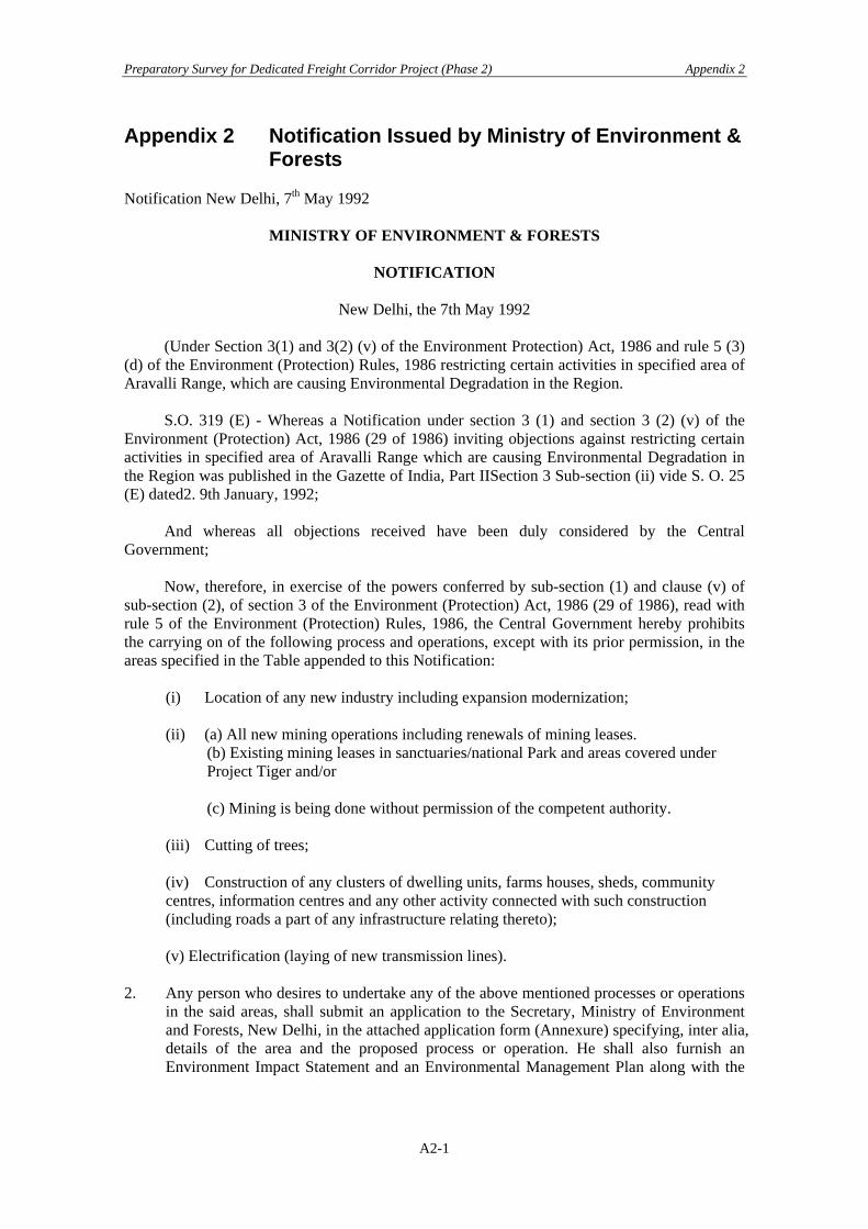
Preparatory Survey for Dedicated Freight Corridor Project (Phase 2) Appendix 2
Appendix 2 Notification Issued by Ministry of Environment & Forests
Notification New Delhi, 7th May 1992
MINISTRY OF ENVIRONMENT & FORESTS
NOTIFICATION
New Delhi, the 7th May 1992 (Under Section 3(1) and 3(2) (v) of the Environment Protection) Act, 1986 and rule 5 (3) (d) of the Environment (Protection) Rules, 1986 restricting certain activities in specified area of Aravalli Range, which are causing Environmental Degradation in the Region. S.O. 319 (E) - Whereas a Notification under section 3 (1) and section 3 (2) (v) of the Environment (Protection) Act, 1986 (29 of 1986) inviting objections against restricting certain activities in specified area of Aravalli Range which are causing Environmental Degradation in the Region was published in the Gazette of India, Part IISection 3 Sub-section (ii) vide S. O. 25 (E) dated2. 9th January, 1992; And whereas all objections received have been duly considered by the Central Government; Now, therefore, in exercise of the powers conferred by sub-section (1) and clause (v) of sub-section (2), of section 3 of the Environment (Protection) Act, 1986 (29 of 1986), read with rule 5 of the Environment (Protection) Rules, 1986, the Central Government hereby prohibits the carrying on of the following process and operations, except with its prior permission, in the areas specified in the Table appended to this Notification:
(i) Location of any new industry including expansion modernization; (ii) (a) All new mining operations including renewals of mining leases.
(b) Existing mining leases in sanctuaries/national Park and areas covered under Project Tiger and/or
(c) Mining is being done without permission of the competent authority.
(iii) Cutting of trees; (iv) Construction of any clusters of dwelling units, farms houses, sheds, community centres, information centres and any other activity connected with such construction (including roads a part of any infrastructure relating thereto); (v) Electrification (laying of new transmission lines).
2. Any person who desires to undertake any of the above mentioned processes or operations
in the said areas, shall submit an application to the Secretary, Ministry of Environment and Forests, New Delhi, in the attached application form (Annexure) specifying, inter alia, details of the area and the proposed process or operation. He shall also furnish an Environment Impact Statement and an Environmental Management Plan along with the
A2-1

Preparatory Survey for Dedicated Freight Corridor Project (Phase 2) Appendix 2
application and such other information as may be required by the Central Government for considering the application.
3. The Central Government in the Ministry of Environment and Forests shall, having regard
to the guidelines issued by it from time to time for giving effect to the provisions of the said Act, grant permission within a period of three months from the date of receipt of the application or where further information has been asked for from the applicant, within a period of three months from the date of the receipt of such information, or refuse permission within the said time on the basis of the impact of the proposed process or operation on the environment in the said area.
4. For seeking permission under this Notification, an application in the prescribed form (see
Annexure), duly filled in, may be submitted to the Secretary, Ministry of Environment and Forests, Paryavaran Bhavan, CGO Complex, Lodi Road, New Delhi.
[No. 17/1/91-PL/IA] R. RAJAMANI, Secy.
TABLE
Areas where carrying on of processes and operations without permission is prohibited
(i) all reserved forests, protected forests or any other area shown as "forest in the land records maintained by the State Government as on the date of this notification in relation to Gurgaon District of the State of Haryana and the Alwar District of the State of Rajasthan.
(ii) All areas shown as: -
(a) Gair Mumkin Pahar, or (b) Gair Mumkin Rada, or (c) Gair Mumkin Behed, or (d) Banjad Beed, or (e) Rundh.
in the land records maintained by the State Government as on the date of this notification in relation to Gurgaon district of the State of Haryana and the Alwar district of the State of Rajasthan.
(ii) all areas covered by notifications issued under section 4 and 5 of the Punjab Land
Preservation Act, 1900, as applicable to the State of Haryana in the district of Gurgaon up to the date of this Notification.
(iii) all areas of Sariska National Park and Sariska Sanctuary notified under the Wildlife
(Protection) Act, 1972 (53 of 1972).
A2-2
Preparatory Survey for Dedicated Freight Corridor Project (Phase 2) Appendix 2
ANNEXURE
APPLICATION FORM
1. (a) Name & address of the project proposed: (b) Location of the project: Name of the Place: District, Tehsil: Location Map: (c) Alternate sites examined and the reasons for the site proposed: 2. Objectives of the project:
3. (a) Land Requirement:
Agriculture land: Other (specify): (b) (i) Topography of the area indicating gradient, aspect & altitude. (ii) Erodability classification of the proposed land. (c) Pollution sources existing within 10 km. Radius. (d) Distance of the nearest National Park/Sanctuary/Biosphere Reserve/Monuments/heritage site/Reserve Forest: (e) Rehabilitation plan for Quarries/borrow areas: (f) Green belt plan. (g) Compensatory afforestation plan
4. Climate & Air Quality*: (a) Wind rose at site: (b) Max. /Min./Mean annual temperature. (c) Ambient air quality data:
(d) Nature & concentration of emission of SPM, Gases (CO, CO2, SO2, NOx etc.) from the project:
5. ** (a) Water balance at site surface and ground water availability and demand: (b) Lean season water availability: (c) Water source to be tapped with details of competing users (Rivers, lake, Ground, Public supply): (d) Water Quality: (e) Changes observed in quantity and quality of water in the last 15 years and present charging and extraction details: (f) (i) Quantum of waste water to be released with treatment details: (ii) Quantum & Quality of water in the receiving water body: (iii) Quantum of waste water to be released on land and the type of land: 6. Solid Wastes: (a) Nature & quantity of solid wastes generated: (b) Solid waste disposal method: 7. Noise & vibrations: (a) Sources of noise & vibrations: (b) Ambient noise level: (c) Noise & vibration control measures proposed: (d) Subsidence problem, if any, with control measures:
A2-3

Preparatory Survey for Dedicated Freight Corridor Project (Phase 2) Appendix 2
8. Power requirement indicating source of supply; complete environmental details to be furnished separately, if captive power unit proposed:
9. Total labour force to be deployed with details of:
- Endemic health problems in the area. - Health care system proposed: 10. (a) Number of families and population to be displaced : (b) Rehabilitation Master Plan: 11. Risk assessment report: 12. (a) Environmental Impact Assessment Report : (b) Environmental Management Plan: Prepared as per Guidelines of MEF
issued from time to time. (c) Detailed Feasibility Report:
(d) Proposal for diversion of Forestland under Forest (Conservation) Act, 1980 including Benefit Cost analysis.
13. Recommendations of the State Pollution Control Board and/or the State Department
of Environment & Forests.
Signature of the Applicant Along with name, date and
full Postal address. *Data may be obtained from India Meteorological Department and State Pollution Control Board. **Ground water Board and the Irrigation Deptt. May be contacted for data. N.B. A. Item Nos. 3(c), 4, 5, 6, 7, 8, 9, 10, 12 (b) and 12 (c) are not applicable to cutting of trees. B. Item Nos. 3(c), 4, 7, 11 are not applicable to construc tion of cluster of dwelling units,
farm sheds, community centre and any other activity connected with such construction including roads.
C. Item Nos. 3(b), 3(c) (3e), 3(f), 4, 5, 6, 7, 9, 12(a) & 12(b) are not applicable to
electrification. D. All items to be furnished in case of mining, industry, thermal power, transport projects. E. Notwithstanding the above, any item(s) considered not applicable may be so indicated
along with reasons
A2-4
Preparatory Survey for Dedicated Freight Corridor Project (Phase 2) Appendix 2
2.1 Notification New Delhi, 4th February 2003
MINISTRY OF ENVIRONMENT AND FORESTS NOTIFICATION
New Delhi, the 4th February. 2003
S. O. 133(E).- Whereas a draft notification under sub-section (1) and clause (v) of subsection (2) of section 3 of the Environment (Protection) Act, 1986 (29 of 1986), inviting objections or suggestions against the proposal for notifying Matheran and surrounding region as an Eco-sensitive Zone and imposing restriction on industries, operations, processes and other developmental activities in the region which have detrimental effect on the environment was published in the Gazette of India vide notification of the Government of India in the Ministry of Environment and Forests number S.O. No. 167(E) dated the 6th February, 2002; And whereas copies of the said Gazette were made available to the public on the 6th day of February, 2002; And whereas all objections and suggestions received have been duly considered by the Central Government; Now, therefore, in exercise of the powers conferred by sub-section (1) read with clause (v) of sub-section (2) of section 3 of the Environment (Protection) Act, 1986 (29 of 1986) and clause (d) of sub-rule (3) of rule 5 of the Environment (Protection) Rules, 1986, the Central Government hereby notifies Matheran and surrounding region in the State of Maharashtra as the Matheran Eco-sensitive Zone (herein after called "the Ecosensitive Zone”). 2. The said Eco-sensitive Zone covers an area of 214.73 sq. kms. and a 200 mts. buffer zone and it shall consist of the area of the Matheran Municipal Council and its environs. The map of the co-sensitive Zone is at Annexure-A. A description of the boundary along with the list of villages is at Annexure-B and the exceptions and exemptions in the 200 mts. buffer zone are at Annexure-C. 5. All activities in the forest (both within and outside municipal areas) shall be governed by the provisions of the Indian Forest Act, 1927 (16 of 1927) and Forest (Conservation) Act, 1980 (69 of 1980). All activities in the protected areas shall be governed by the provisions of the Wildlife (Protection) Act, 1972 (53 of 1972). The following activities shall be regulated in the Eco-sensitive Zone namely: (a) Zonal Master Plan for the Eco-sensitive Zone:- (i) The Zonal Master Plan for the Eco-sensitive Zone shall be prepared by the State Government by following a procedure similar to that prescribed under the Maharashtra Regional and Town Planning Act, 1966 (Maharashtra Act XXXVII of 1966), within a period of two years from the date of publication of this notification in the Official Gazette and approved by the Ministry of Environment and Forests in the Government of India. The Zonal Master Plan shall be prepared with due involvement of all concerned Departments for integrating environmental considerations into it. The Zonal Master Plan shall provide for restoration of denuded areas, management of catchment areas, watershed management, groundwater management, soil and moisture conservation, provision for fuel wood, needs of local community and such other aspects of the ecology and environment that need attention.
A2-5

Preparatory Survey for Dedicated Freight Corridor Project (Phase 2) Appendix 2
(ii) The Zonal Master Plan shall demarcate all the existing gaothans, gaothan expansion areas, forests, green areas, horticultural areas, agricultural areas, orchards, tribal areas including tribal hamlets, natural springs, natural heritage sites, historic Neral-Matheran railway line and other environmentally and ecologically sensitive areas. No change of land use from green uses such as orchards, horticulture areas, agriculture, parks and other like places to non-green uses and tribal uses to non-tribal uses shall be permitted in the Zonal Master Plan without the prior approval of the Central Government in the Ministry of Environment and Forests. The Zonal Master Plan shall also indicate measures and lay down stipulations for regulating traffic, especially through traffic in the Eco-sensitive Zone.
(iii) The areas within and outside Matheran Municipal Council area shall have separate Sub-zonal Master Plans which may be prepared by the State Government as a component of the Zonal Master Plan and concurrence of the Ministry of Environment and Forests shall be obtained on such Subzonal Master Plans. All habitations in the Eco-sensitive Zone having population of more than 5000 should also have Area Development Plans. The Sub-zonal Master Plan shall also include development regulations for gaothan and gaothan expansion areas.
(iv) Pending the preparation of and approval by the Ministry of Environment and Forests to the Zonal Master Plan and Sub-zonal Master Plan for Ecosensitive Zone, there shall be no increase in the existing parameters of permissible Floor Area Ratio, permissible height, maximum number of storeys and ground coverage for buildings in Matheran Municipal limits. No new constructions shall be allowed but repairs and restoration may be permitted provided that it does not involve structural changes and are on the existing authorised plinth area in the Matheran Municipal limits. In areas other than Matheran Municipal limits:- (1) There shall be no reduction in Tribal Area, Forest Zone, Green Zones and Agricultural
Area. (2) Absolute height of buildings shall not exceed 9 meters and the number of storeys shall
not exceed ground plus one upper storey. (3) Activities mentioned in Annexure-D may be permitted by the Monitoring Committee
subject to the State and local laws and the rules and regulations made there under. (4) All development activities including additions, alterations, demolitions, repairs,
renovations and restorations of buildings shall require prior approval of the Monitoring Committee and shall be subject to heritage clearance if necessary.
(5) The Monitoring Committee shall prescribe additional measures, if necessary, in furtherance of the objectives and for giving effect to the provisions of this notification.
(b) Industrial units:- On or after the publication of this notification in the Official Gazette, only non-polluting, non-hazardous small-scale and service industries, agriculture, floriculture, horticulture or agro-based industries producing products from indigenous goods from the Eco-sensitive Zone and which do not cause any adverse environmental impact shall be permitted. Accordingly, guidelines shall be drawn by the Government of Maharashtra and approved by the Ministry of Environment and Forests. No such, guidelines shall conflict with the provisions of the Environment Impact Assessment Notification number S.O. 60(E) dated the 27th January, 1994 of the Government of India in the Ministry of Environment and Forests and as amended from time to time. (c) Quarrying and Mining:- Quarrying and Mining activities shall be banned in the Eco-sensitive Zone and no fresh mining lease shall be granted. However, the Monitoring Committee shall be the authority to grant special permission for limited quarrying of materials required for the construction of local residential housing and traditional road making and maintenance work in Matheran Municipal Council area based on site evaluation. No quarrying shall be permitted on steep hill slopes or areas with a high degree of erosion or on forestlands.
A2-6

Preparatory Survey for Dedicated Freight Corridor Project (Phase 2) Appendix 2
Explanation:- In this notification, "steep hill slope" means a hill slope with a gradient of 20 degrees or more., (d) Trees:- There shall be no felling of trees whether on Forest, Government, Revenue or private lands, without the prior permission of the State Government in case of forest land, and the respective District Collector in case of Government, Revenue and private land, as per procedure which shall be laid down by the State Government. (e) Tourism:- (1) Tourism activities shall be as per a Tourism Master Plan, with emphasis on eco-tourism, eco-education and eco-development, to be prepared by the Department of Tourism of the State Government in consultation with the Ministry of Tourism of Government of India and approved by the Ministry of Environment and Forests. The Tourism Master Plan shall also form a component of the Zonal Master Plan. There shall be a ban on new and additional tourist facilities like hotels, restaurants, inns, lodging and boarding houses and the like within Matheran Municipal Council area till the Tourism Master Plan is approved by the Ministry of Environment and Forests. Pending the approval of the Tourism Master Plan by the Ministry of Environment and Forests, the use of existing heritage buildings for heritage hotels within Matheran Municipal Council area may be permitted by the Monitoring Committee only after it is approved by the Heritage Conservation Committee. (2) The Tourism Master Plan shall be based on a detailed Carrying Capacity Study of the Eco-sensitive Zone which may be carried out by the State Government and submitted to the Ministry of Environment and Forests for approval within a period of two years from the date of publication of this notification. All new tourism activities, developments for tourism and expansion of existing tourism activities shall be permitted only within the parameters of the Tourism Master Plan and carrying capacity study. Till the Tourism Master Plan is approved by the Ministry of Environment and Forests, outside Matheran Municipal Council area, new tourism activities, development for tourism and expansion of existing tourism activities may be permitted only after a detailed analysis is carried out and approved by the Monitoring Committee subject to guidelines laid down by the Ministry of Environment and Forests. (f) Natural Heritage:- The sites of valuable natural heritage in the Eco-sensitive Zone shall be identified, particularly rock formations, waterfalls, pools, springs, gorges, groves, caves, points, walks, rides and the like and plans for their conservation in their natural setting shall be incorporated in the Zonal Master Plan and Sub-zonal Master Plan. Strict guidelines shall be drawn up by the State Government to discourage construction activities at or near these sites including under the garb of providing tourist facilities. Development or construction activities at or around the heritage sites shall be regulated under the statutory provisions of the State Government, made in accordance with the Model Regulations for Conservation of Natural and Man-made Heritage Sites formulated by the Ministry of Environment and Forests in 1995 and as amended from time to time. The State Government may draw up proper plans for their conservation or preservation within one year from the date of publication of this notification. These plans shall form a part of the Zonal Master Plan and Sub-zonal Master Plan. (g) Man-made heritage:- Buildings, structures, artefacts, areas and precincts of historical, architectural, aesthetical, and cultural significance shall be identified in the Eco-sensitive Zone and plans for their conservation, particularly their exteriors (and wherever deemed appropriate their interiors also) shall be prepared and incorporated in the Zonal and Sub-zonal Master Plan within one year from the date of publication of this notification. Guidelines shall be issued by the State Government to regulate building and other activities in the Eco-sensitive Zone, particularly in Matheran Municipal Council area, so that the special character and distinct ambience of the town and the Eco-sensitive Zone are maintained. Development or construction
A2-7
Preparatory Survey for Dedicated Freight Corridor Project (Phase 2) Appendix 2
activities at or around the heritage sites shall be regulated under the statutory provisions of the State Government, made in accordance with the Model Regulations for Conservation of Natural and Manmade Heritage Sites formulated by the Ministry of Environment and Forests in 1995 and as amended from time to time. (h) Ground Water:- Extraction of ground water for the bona-fide agricultural and domestic consumption of the occupier of the plot is allowed. Extraction of ground water for industrial, commercial or residential complexes shall require prior written permission, including the amount that can be extracted, from the State Ground Water Board. No sale of ground water shall be permitted except with the prior approval of the Monitoring Committee constituted under paragraph 4 of this notification. All steps shall be taken to prevent contamination or pollution of water, including from agriculture activities. (i) Use of plastics:- No person shall use plastic bags within Matheran Municipal Council area. The use of plastics, laminates and tetra-packs within the Eco-sensitive Zone shall be regulated by the Monitoring Committee. (j) Protection of Hill Slopes:- (i) The Zonal Master Plan shall indicate areas on hill slopes where construction shall not be permitted. (ii) No construction on existing steep hill slopes or slopes with a high degree of erosion shall be permitted. (k) Discharge of effluents:- (i) The discharge of any untreated effluent is prohibited within the Eco-Sensitive Zone. (ii) No effluent, either treated or untreated, shall be permitted to be discharged into any water body or water source within the Eco-sensitive Zone. (l) Solid Wastes:- (i) The local authorities shall draw up plans for the segregation of solid wastes into biodegradable and non-biodegradable components. (ii) The biodegradable material may be recycled preferably through composting or vermiculture and the inorganic material may be disposed of at environmentally acceptable locations. (iii) No burning or incineration of solid wastes shall be permitted. Explanation.- In this notification, "solid wastes" shall include domestic, industrial, commercial and garden wastes. (m) Natural Springs:- (i) The catchment area of all natural springs shall be identified and plans for their conservation and rejuvenation of those that have run dry in their natural setting shall be incorporated in the Zonal Master Plan. (ii) Strict guidelines shall be drawn up by the State Government to ban development activities at or near these areas. (n) Traffic:- No vehicular traffic shall be permitted within the Matheran Municipal limits, except ambulance and fire engine and use of tractor for transportation of solid waste. 5. Monitoring Committee:- (1) In exercise of the powers conferred by sub-section (3) of section 3 of the Environment (Protection) Act, 1986 (29 of 1986), the Central Government hereby constitutes a Committee to
A2-8

Preparatory Survey for Dedicated Freight Corridor Project (Phase 2) Appendix 2
be called the Monitoring Committee, to monitor and ensure compliance with the provisions of this notification. (2) The Monitoring Committee shall consists of not more than ten members. (3) The Monitoring Committee shall consist of a representative each from the Ministry of Environment and Forests, Central Pollution Control Board, Department of Environment of the Government of Maharashtra, Department of Urban Development of the Government of Maharashtra, subject expert knowledgeable about the Eco-sensitive Zone and at least two representatives of non-government organizations working in the field of environment (including heritage conservation) and the Collector of Raigad District, in the State of Maharashtra and any other persons or persons nominated by the Central Government. (4) The Chairman of the Monitoring Committee shall be an eminent person with proven managerial or administrative experience and understanding of local problems. (5) The Collector of Raigad District shall be the Convener of the Monitoring Committee. 6. Powers and functions of the Monitoring Committee:- (1) In exercise of the powers conferred by sub-section (3) of section 3 and read with Section 23 of the Environment (Protection) Act, 1986 (29 of 1986), the Central Government hereby empowers the Monitoring Committee to discharge the functions specifically enumerated in the notification and to do all things incidental thereto (except the function as are required to be performed by the Central Government under the provisions of the Environment Impact Assessment Notification of 27th January, 1994, as amended from Lime to time). (2) It shall be the duty of the Monitoring Committee to file complaints under section 19 of the Environment (Protection) Act, 1986 if commission of any offences under the said Act comes to its notice and in case of non-compliance of the directions issued by it. (3) The Monitoring Committee or member of the Monitoring Committee authorised by it shall file complaints under the Environment (Protection) Act, 1986. 6. Appeal:- (1) Any person aggrieved by a decision or order of the Monitoring Committee shall prefer an appeal against such decision or order to the Government of India in the Ministry of Environment and Forests. (2) Every memorandum of appeal under this paragraph shall precisely state the facts of the case, the particulars of the decision or order appealed against and the reasons for being aggrieved by the decision or order and the remedy sought for and shall be addressed to the Secretary to the Government of India, Ministry of Environment and Forests, New Delhi. (3) Every memorandum of appeal shall be made within ninety days from the date of receipt of the decision or order by the affected person. (4) The Ministry of Environment and Forests shall, after giving the parties to the appeal an opportunity to present their case, dispose of the appeal within ninety days of date of receipt of the memorandum of appeal.
[F.No.J-20011/1/99-I.A.-III] Dr. V RAJAGOPALAN. Jt. Secy.
A2-9
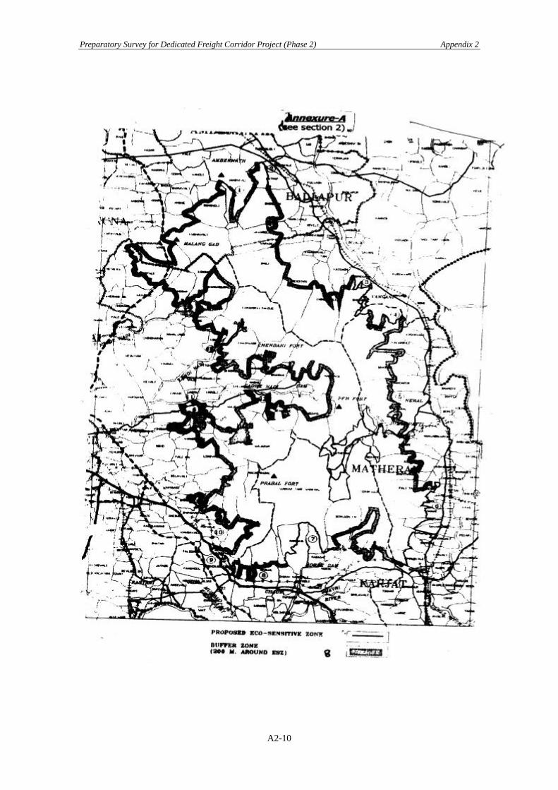
Preparatory Survey for Dedicated Freight Corridor Project (Phase 2) Appendix 2
A2-10
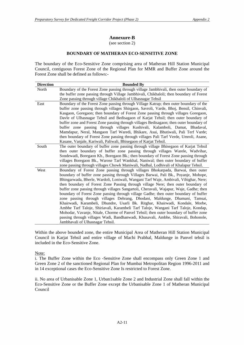
Preparatory Survey for Dedicated Freight Corridor Project (Phase 2) Appendix 2
Annexure-B (see section 2)
BOUNDARY OF MATHERAN ECO-SENSITIVE ZONE
The boundary of the Eco-Sensitive Zone comprising area of Matheran Hill Station Municipal Council, contiguous Forest Zone of the Regional Plan for MMR and Buffer Zone around the Forest Zone shall be defined as follows:-
Direction Bounded By North Boundary of the Forest Zone passing through village Jambhivali, then outer boundary of
the buffer zone passing through Village Jambhivali, Chikhaloli; then boundary of Forest Zone passing through village Chikhaloli of Ulhasnagar Tehsil
East Boundary of the Forest Zone passing through Village Katrap; then outer boundary of the buffer zone passing through villages Shirgaon, Savroli, Varde, Bhoj, Bensil, Chinvali, Kasgaon, Goregaon; then boundary of Forest Zone passing through villages Goregaon, Davle of Ulhasnagar Tehsil and Bedisagaon of Karjat Tehsil; then outer boundary of buffer zone and Forest Zone passing through villages Bedisagaon; then outer boundary of buffer zone passing through villages Kushivali, Kalamboli, Damat, Bhadaval, Mamdapur, Neral, Mangaon Tarf Waredi, Bhikare, Asai, Bhutiwali, Pali Terf Varde; then boundary of Forest Zone passing through villages Pali Tarf Verde, Umroli, Asane, Kasane, Vanjale, Kariwali, Paliwali, Bhisegaon of Karjat Tehsil.
South The outer boundary of buffer zone passing through village Bhisegaon of Karjat Tehsil then outer boundary of buffer zone passing through villages Warele, Wadvihar, Sondewadi, Boregaon Kh., Boregaon Bk.; then boundary of Forest Zone passing through villages Boregaon Bk., Warose Tarf Wankhal, Naniwal; then outer boundary of buffer zone passing through villages Chowk Maniwali, Nadhal, Lodhivali of Khalapur Tehsil.
West Boundary of Forest Zone passing through villages Bhokarpada, Barwai, then outer boundary of buffer zone passing through Villages Barwai, Pali Bk., Poyanje, Mohope, Bhingarwada, Bherle, Wardoli, Loniwali, Wangani Tarf Waje, Ambivali, Vihighar, Nere;then boundary of Forest Zone Passing through village Nere; then outer boundary of buffer zone passing through villages Sangartoli, Cheravali, Wajapur, Waje, Gadhe; then boundary of Forest Zone passing through village Gadhe; then outer boundary of buffer zone passing through villages Dehrang, Dhodani, Maldunge, Dhamani, Tamsai, Khairwadi, Karambeli, Dhundre, Usarli Bk. Ritghar, Khairwadi, Kondale, Morbe, Ambhe Tarf Taloje, Shiriavali, Karambeli Tarf Taloje, Wangani Tarf Taloje, Kondap, Mohodar, Vavanje, Nitale, Chorme of Panvel Tehsil; then outer boundary of buffer zone passing through villages Wadi, Bandhanwadi, Khusavali, Ambhe, Shiravali, Bohonole, Jambhavali of Ulhasnagar Tehsil.
Within the above bounded zone, the entire Municipal Area of Matheran Hill Station Municipal Council in Karjat Tehsil and entire village of Machi Prabhal, Maldunge in Panvel tehsil is included in the Eco-Sensitive Zone. Note: i. The Buffer Zone within the Eco -Sensitive Zone shall encompass only Green Zone 1 and Green Zone 2 of the sanctioned Regional Plan for Mumbai Metropolitan Region 1996-2011 and in 14 exceptional cases the Eco-Sensitive Zone Is restricted to Forest Zone. ii. No area of Urbanisable Zone 1, Urban1sable Zone 2 and Industrial Zone shall fall within the Eco-Sensitive Zone or the Buffer Zone except the Urbanisable Zone 1 of Matheran Municipal Council
A2-11

Preparatory Survey for Dedicated Freight Corridor Project (Phase 2) Appendix 2
LIST OF VILLAGES OF MATHERAN ECO-SENSITIVE ZONE DISTRICT: RAIGAD TEHSIL: KARJAT
S.No. VILLAGE STATUS 1 Asai Partial 2 Ashane Partial 3 Bedisgaon Partial 4 Bekare Partial 5 Bhadwal Partial 6 Bhisegaon Partial 7 Bhutiwali Partial 8 Damat Partial 9 Halivali Partial 10 Kalamboli Partial 11 Kirwali Partial 12 Koshane Partial 13 Kushivali Partial 14 Mamdapur Partial 15 Mangaon Tarf Waredi Partial 16 Matheran Full 17 Neral Partial 18 Pali Tarf Waredi Partial 19 Umroli Partial 20 Wanjale Partial
Note - The entire file Matheran Municipal Council area is included. TEHSIL: KHALAPUR
S.No. VILLAGE STATUS 21 Borgaon Bk. Partial 22 Borgaon Kh. Partial 23 Chowk Maniwali Partial 24 Lodhivali Partial 25 Nadhal Partial 26 Naniwali Partial 27 Sondewadi Partial 28 Wad Vihar Partial 29 Warose Tarf Wankhal Partial 30 Wawarle Partial
TEHSIL: PANVEL
S.No. VILLAGE STATUS 31 Ambhe Tarf Taloje Partial 32 Ambivali Partial 33 Barwai Partial 34 Bherle Partial 35 Bhingar Partial 36 Bhokarpada Partial 37 Cheravali Partial 38 Chorme Partial 39 Deharang Partial 40 Dhamani Partial 41 Dhodani Partial
A2-12

Preparatory Survey for Dedicated Freight Corridor Project (Phase 2) Appendix 2
S.No. VILLAGE STATUS 42 Dundre Partial 43 Gadhe Partial 44 Karabeli Partial 45 Karambeli Tarf Taloje Partial 46 Khairwadi Partial 47 Kondale Partial 48 Kondap Partial 49 Luniwali Partial 50 Machiprabal Full 51 Mahoda Partial 52 Maldunge Partial 53 Mohope Partial 54 Morbe Partial 55 Nere Partial 56 Nitale Partial 57 Pali Bk. Partial 58 Poyanje Partial 59 Ritghar Partial 60 Sangatoli Partial 61 Shriavali Partial 62 Tamsai Partial 63 Usarli Bk. Partial 64 Vavanje Partial 65 Vihighar Partial 66 Wajapur Full 67 Waje Partial 68 Wangani Tarf Taloje Partial 69 Wangani Tarf Waje Partial 70 Wardoli Partial
DISTRICT : THANE TEHSIL: ULHASNAGAR
S.No. VILLAGE STATUS 71 Ambhe Partial 72 Bandhanwadi Partial 73 Bendshil Partial 74 Bhoj Partial 75 Bohonoli Partial 76 Chikhaloli Partial 77 Chinchvali Partial 78 Dhavale Partial 79 Goregaon Partial 80 Jambhivali Partial 81 Kasgaon Partial 82 Katrap Partial 83 Kushavali Partial 84 Savaroli Partial 85 Shiravali Partial 86 Shirgaon Partial 87 Vangani Partial 88 Varade Partial 89 Wadi Partial
A2-13
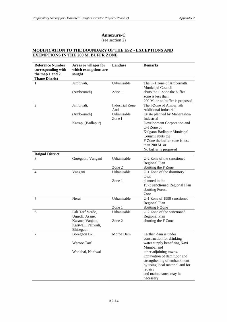
Preparatory Survey for Dedicated Freight Corridor Project (Phase 2) Appendix 2
Annexure-C (see section 2)
MODIFICATION TO THE BOUNDARY OF THE ESZ - EXCEPTIONS AND EXEMPTIONS IN THE 200 M. BUFFR ZONE
Reference Number corresponding with the map 1 and 2
Areas or villages for which exemptions are sought
Landuse Remarks
Thane District 1 Jambivali,
(Ambernath)
Urbanisable Zone 1
The U-1 zone of Ambernath Municipal Council abuts the F Zone the buffer zone is less than 200 M. or no buffer is proposed
2 Jambivali, (Ambernath) Katrap, (Badlapur)
Industrial Zone And Urbanisable Zone I
The I-Zone of Ambernath Additional Industrial Estate planned by Maharashtra Industrial Development Corporation and U-I Zone of Kulgaon Badlapur Municipal Council abuts the F-Zone the buffer zone is less than 200 M. or No buffer is proposed
Raigad District 3 Goregaon, Vangani Urbanisable
Zone 2
U-2 Zone of the sanctioned Regional Plan abutting the F Zone
4 Vangani Urbanisable Zone 1
U-1 Zone of the dormitory town planned in the 1973 sanctioned Regional Plan abutting Forest Zone
5 Neral Urbanisable Zone 1
U-1 Zone of 1999 sanctioned Regional Plan abutting F Zone
6 Pali Tarf Verde, Umroli, Asane, Kasane, Vanjale, Kariwali, Paliwali, Bhisegaon
Urbanisable Zone 2
U-2 Zone of the sanctioned Regional Plan abutting the F Zone
7 Boregaon Bk., Warose Tarf Wankhal, Naniwal
Morbe Dam Earthen dam is under construction for drinking water supply benefiting Navi Mumbai and other adjoining towns. Excavation of dam floor and strengthening of embankment by using local material and for repairs and maintenance may be necessary
A2-14
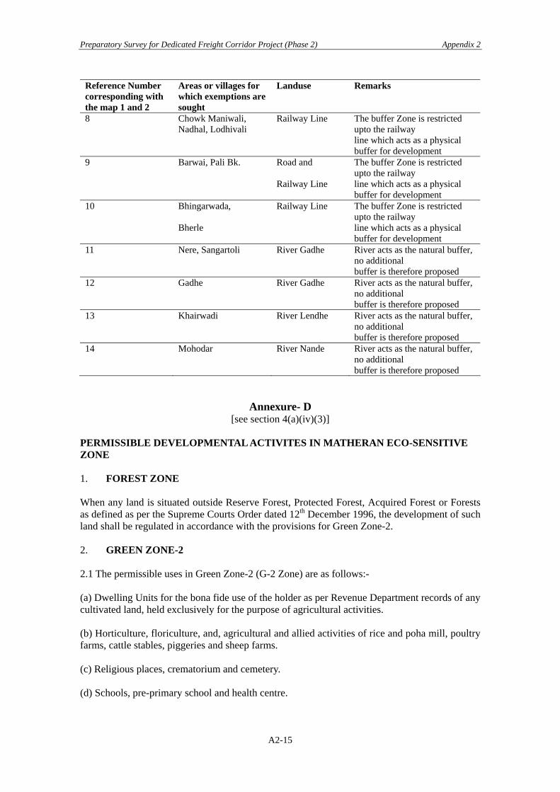
Preparatory Survey for Dedicated Freight Corridor Project (Phase 2) Appendix 2
Reference Number corresponding with the map 1 and 2
Areas or villages for which exemptions are sought
Landuse Remarks
8 Chowk Maniwali, Nadhal, Lodhivali
Railway Line The buffer Zone is restricted upto the railway line which acts as a physical buffer for development
9 Barwai, Pali Bk. Road and Railway Line
The buffer Zone is restricted upto the railway line which acts as a physical buffer for development
10 Bhingarwada, Bherle
Railway Line The buffer Zone is restricted upto the railway line which acts as a physical buffer for development
11 Nere, Sangartoli River Gadhe River acts as the natural buffer,no additional buffer is therefore proposed
12 Gadhe River Gadhe River acts as the natural buffer,no additional buffer is therefore proposed
13 Khairwadi River Lendhe River acts as the natural buffer,no additional buffer is therefore proposed
14 Mohodar River Nande River acts as the natural buffer,no additional buffer is therefore proposed
Annexure- D [see section 4(a)(iv)(3)]
PERMISSIBLE DEVELOPMENTAL ACTIVITES IN MATHERAN ECO-SENSITIVE ZONE 1. FOREST ZONE When any land is situated outside Reserve Forest, Protected Forest, Acquired Forest or Forests as defined as per the Supreme Courts Order dated 12th December 1996, the development of such land shall be regulated in accordance with the provisions for Green Zone-2. 2. GREEN ZONE-2 2.1 The permissible uses in Green Zone-2 (G-2 Zone) are as follows:- (a) Dwelling Units for the bona fide use of the holder as per Revenue Department records of any cultivated land, held exclusively for the purpose of agricultural activities. (b) Horticulture, floriculture, and, agricultural and allied activities of rice and poha mill, poultry farms, cattle stables, piggeries and sheep farms. (c) Religious places, crematorium and cemetery. (d) Schools, pre-primary school and health centre.
A2-15
Preparatory Survey for Dedicated Freight Corridor Project (Phase 2) Appendix 2
(e) Clinics and dispensaries. (f) Roads and bridges, railways, underground pipelines and cables, electricity transmission lines, communication towers, small check dams for watershed management, ropeways 2.2 The minimum plot size shall be 0.4 ha. 3. GREEN ZONE-1 3.1 The permissible uses in Green Zone-1 (G-1 Zone) are as follows:- (a) Dwelling Units for the bona fide use of the holder as per Revenue Department records of any cultivated land, held exclusively for the purpose of agricultural activities. (b) Holiday resort and holiday homes. (c) Educational, medical, social, cultural and religious institutions along with residential quarters and shops for the staff on plots not be less than 2.5 ha. (d) Schools, pre-primary school and health centre. (e) Clinics, dispensaries and health centres. (f) Storage of LPG cylinders. (g) Horticulture, floriculture, and, agricultural and allied activities of rice and poha mill, poultry farms, cattle stables, piggeries and sheep farms. (h) Religious places, crematorium and cemetery. (i) Parks, gardens, play fields, camping grounds with public conveniences. (j) Roads and bridges, railways, underground pipelines and cables, electricity transmission lines, communication towers, small check dams for watershed management 3.2 The minimum plot size shall be 0.4 ha. 4. URBANISABLE ZONE-2 4.1 The permissible activities in Urbanisable Zone-2 are :-
(a) Dwelling Units for the bona fide use of the holder as per Revenue Department records of any cultivated land, held exclusively for the purpose of agricultural activities.
(b) Non polluting scientific institutions (c) Schools, pre-primary school and health centre (d) Clinics, dispensaries and health centres (e) With the prior approval of the Monitoring Committee, hotels, tourists resorts,
holiday homes, motels and club houses (f) Houses for residential purposes only (g) Parks, gardens, play-fields and camping grounds with public conveniences (h) Religious places, crematorium and cemetery. (i) Horticulture, floriculture, and, agricultural and allied activities of rice and poha mill,
A2-16
Preparatory Survey for Dedicated Freight Corridor Project (Phase 2) Appendix 2
poultry farms, cattle stables, piggeries and sheep farms (j) Retail shops, whole sale shops, restaurants and banks (k) Government offices (l) Garages, petrol pumps, automobile repair workshops (m) With prior approval of the Monitoring Committee, public services and utility
establishment of water treatment plant, sewage treatment plant, solid waste treatment and disposal facilities electricity substation, gas works, fire brigade, police station, telephone exchange, bus shelters, terminals and depots
(n) Roads and bridges,, railways, underground pipelines and cables, electricity transmission lines, communication towers, small check dams for watershed management
4.2 The minimum plot size for item (b) to (f) of paragraph 4.1 shall be 2,000 sq. m. 5. URBANISABLE ZONE-1 5.1 In preparing the sub-Zonal Master Plan for Matheran Municipal Council area the recommendations of the report titled Matheran: A Comprehensive Heritage Listing Proposal commissioned by the Mumbai Metropolitan Region - Heritage Conservation Society shall be taken into account. 5.2 The development of lands within the Urbanisable Zone-1 of Neral and Wangani falling outside the area under the Layout prepared as a part of the final Regional Plan 1973 shall be regulated in accordance with the provisions for Green Zone-1. 6. GOATHAN and GAOTHAN EXPANSION 6.1 The following provisions irrespective of Zones shall regulate Gaothan and Gaothan Expansion. 6.2 The boundary of the Gaothan shall be as shown in the revenue maps when the Regional Plan came into force. 6.3 Gaothan Expansion may be permitted by the Monitoring Committee based on needs and requirements of and for existing gaothan residents only. 6.4 The lands in Gaothan and Gaothan Expansion may be used for any of the following purposes :
(a) Residential. (b) Shops, garages, small eating places, banks and post offices. (c) Schools. (d) Community centres and other social institutions. (e) Religious places. (f) Clinics, dispensaries and health centres. (g) Essential public services and utilities including local Government offices. (h) Stables for domestic animals subject to limit of 5 animals on each plot. (i) Traditional household industries. (j) Storage of crop, fodder, manure, agricultural implements and other similar needs (k) Parks, gardens and playgrounds. (l) Public conveniences. (m) Storage of fuels for domestic and commercial uses.
A2-17

Preparatory Survey for Dedicated Freight Corridor Project (Phase 2) Appendix 2
6.5 Floor Area Ratio and Ground Coverage Area FAR Ground coverage Gaothan 1.00 - Gaothan Expansion 0.40 40%
Note: The classification of zones referred to above is as per the sanctioned Regional Plan of the Mumbai Metropolitan Region, September 1999. 2.2 Notification New Delhi, 16th January 2004
MINISTRY OF ENVIRONMENT AND FORESTS
NOTIFICATION
New Delhi, the 16th January 2004 S.O. 83 (E) – Whereas by the notification of the Government of India in the Ministry of Environment and Forests number S.O. 133 (E), dated the 4th February, 2003 (hereinafter referred to as the said notification), the Central Government notified Matheran and surrounding areas an Eco-sensitive Zone (ESZ) and imposed restrictions on industries, operations, processes and other developmental activities in the said zone. Now, therefore, in exercise of powers conferred by sub-section (1) read with clause (v) of sub-section (2) of section 3 of the Environment (Protection) Act, 1986 (29 of 1986) and clause (d) of sub-rule (3) of rule 5 of the Environment (Protection) Rules, 1986, the Central Government hereby makes the following amendments in the aforesaid notification, namely :-
1. In paragraph 2, in line 2, after the words “buffer zone”, the words “comprising of a total area of 251.56 sq. kms” shall be inserted; 2. In paragraph 3, the following shall be inserted at the end, namely:- “In particular, and without prejudice to the provisions of the said Acts, following steps shall also be taken:
(a) In any proposal for use of forest area for non-forestry purpose, the procedure laid down for National Parks and Sanctuaries shall be followed.
(b) Adequate fuel wood plantation shall be undertaken in the surrounding area to prevent illegal cutting of trees for firewood, etc.
(c) A specific Forest Protection Plan shall be prepared by the Maharashtra State Forest Department and necessary funds for implementation of the Protection Plan shall be provided by the State Government on priority basis.”
A2-18

Preparatory Survey for Dedicated Freight Corridor Project (Phase 2) Appendix 2
3. In paragraph 4,-
(a) in sub-paragraph(a), in item (iv), (i) in line 5, after the words “ground coverage for buildings” the words “in Matheran Municipal limits” shall be omitted;
(ii) in line 10, for the words “In areas other than Matheran Municipal limits:- ” the words “In the Eco-Sensitive Zone:-” shall be substituted.
(b) in sub-paragraph (h), in line 7, for the figure ”4”, the figure ”5” shall be substituted.
(c) in sub-paragraph (n), in line 2, for the words “except ambulance and fire engine
and use of tractor for transportation of solid waste”, the words “except one ambulance and one fire engine and in addition to one ambulance and one fire engine as standby” shall be substituted.
4. In paragraph 6, after sub-paragraph (3), the following sub-paragraphs shall be inserted, namely:-
“(4) It shall be the duty of the Monitoring Committee to inquire into or review cases of alleged violations of the provisions of the Environment (Protection) Act, 1986, and the rules made thereunder, and if found necessary in a specific case, issue directions under section 5 of the said Act.
(5) The Monitoring Committee or any Officer or member of the Monitoring Committee authorized by it shall be authorized to take action under section 10 of the said Act to verify the facts concerning the issues arising from the above.”
5. At page 26, in line 1, for the figure and words ” 6. Appeal”, the figure and words “7. Appeal”
shall be substituted. 6. In Annexure–B, in line 2, for the words “MMR” the words “Mumbai Metropolitan Region
(MMR)” shall be substituted. 7. In Annexure-D, sub-paragraph 5.2 shall be omitted.
[F. No. J-20011/1/99-I.A.-III]
Dr. R.R. Khan Adviser
A2-19

Preparatory Survey for Dedicated Freight Corridor Project (Phase 2) Appendix 2
A2-20
Preparatory Survey for Dedicated Freight Corridor Project (Phase 2) Appendix 3
Appendix 3 Social Environmental Consideration 3.1 Terms of Reference for Phase 2 Preparation of Social Aspects With most of the alignments for respective Phase 2 Sections being finalized, land acquisition procedures for respective Phase 2 Sections are already well underway. The land acquisition procedure (LAP), mandated by, RRA, is mobilized by the DFCCIL initiatives, district-wise, in close coordination with the Competent Authorities (CA), and the Local Self Government with people affected. The above LAP shall concurrently be accompanied by due R&R activities, which intend to mitigate and rehabilitate adverse social impacts perceived by project affected peoples (PAPs). The article 20 (O) of RRA also stipulates entailing administrative and legal processes with the railways land acquisition to be in harmony with the National Rehabilitation and Resettlement Policy (NRR), 2007. Implementing R&R shall also be undertaken, in conformance with the JBIC Guidelines for Confirmation of Environmental and Social Considerations, April, 2002 (JBIC Guidelines). In order to put forward the proposed DFC project phase 2, in conformance with the JBIC Guidelines, a R&R Plan (RRP) dedicated to the target sections of the phase 2 needs to be prepared. The RRP shall be made through data obtained conducting a Baseline Survey, including the Census with a Survey on inventory of losses. It shall also be accompanied by DFCCIL’s local consultations with PAPs and stakeholders concerned with the project.
1. Review past Studies by JICA/JBIC on Social Consideration A good reference to and consultation with the foregoing Social consideration part of the JICA studies for the target section shall be conducted. It includes, but not limited to; JICA FS, JICA SAPROF for Phase 1, and the Preparatory Survey for Phase 2.
2. Inclusion of Particular Aspects of Social Considerations
In view of conformance with the above NRRP and JBIC Guidelines, the following aspects, in particular, need to be addressed.
- Vulnerable groups – those below poverty line, women-headed households, SCs/STs, and other socially vulnerable,
- Compensation and assistance to PAPs, who are non-titleholders,
- Additional assistance costs incurred to supplement a gap represented by replacement costs of structures and those valued by local laws,
- Those socially affected, not only directly affected by relocation due to land acquisition, but indirectly affected (para 1.2, NRRP,), and
- Inclusion of compensation and assistance costs needed for those not relocated, but directly and/or indirectly affected, in restoring assets, crops and livestock, livelihood, means of earning, and ex-post monitoring (para 1.4, NRRP,).
3. Implementation of the Social Considerations Recognizing present status of land acquisition, being undertaken by DFCCIL initiatives with respective Field Unit offices engaged in the acquisition process, for those Phase-2 sections, DFCCIL shall undertake following tasks.
A3-1

Preparatory Survey for Dedicated Freight Corridor Project (Phase 2) Appendix 3
Task-1 Social Impact Assessment (SIA)
1) General Whenever an EIA process is undertaken at the District level, participatory aspects (i.e. public consultation meetings) of SIA may be conducted concurrently. In other Districts, where EIA process in not undertaken, SIA shall be done as an individual work.
2) Subjects to be covered by the SIA Study
The SIA Study shall address such subjects as; i) identification of sections/zones of social and economic impacts due to the project’s new corridor alignment, ii) comprehension by enumerative and exhaustive household surveys on socio-economic profiles of PAFs and PAPs, without resorting to sampling, iii) analysis of impacts on different categories and attributes of PAPs, either, displaced, not-displaced-but-indirectly affected, such as landowners, tenants, small-holders, farmers, wage workers, hawkers/temporal shop-keepers, SCs/STs and women, iv) identification of existing local institutions that exercise socio-political powers at the village level, which are available for participation as stakeholders, grievance redress and conflicts arbitration, v) comprehension of PAPs’ perception regarding socio-economic impacts anticipated and acceptable mitigation measures, vi) assessment and mitigation measures of construction-induced socio-economic impacts on local communities, and vii) recommendation of a broad range of mitigation strategies to mitigate adverse social impacts
3) Particulars of Census Survey 1. Background Information
(a) Questionnaire code and date of survey (b) Name of interviewer (c) Name of state, district and village
2. Household Census (a) Name of household head and all household members (b) Relationship of household members to the household head (c) Age and sex of each household member (d) Information on ethnicity (e) Education level of each member (f) Primary occupation and monthly income of each member (g) Incomes from secondary sources for each member (h) Location of job or businesses as the case may be (i) Length of stay on present location
3. Tenure Status (a) Category of land (b) Type of land ownership and the name of the owner HH member (c) Type of document possessed to certify ownership type (d) If not owned, name and address of owner (e) If informal use right, type of agreement (f) Number of years used (g) Rent per month paid by tenant (h) Deposits made by lessee
4) Particulars of Inventory of Losses
1. Land Use a. Existing use of land b. Areas under different land usages, where applicable c. Total and affected area of land with breakdown by usages, if applicable
A3-2

Preparatory Survey for Dedicated Freight Corridor Project (Phase 2) Appendix 3
d. Estimate whether the remaining area is viable for continued use e. Total area of land by type for compensation purposes
2. Structures
a. Type of structure b. Number of floors c. Area by floor d. Name of owner of structure e. Year of construction f. Whether permit obtained for structure g. Use of structure and areas by usages, if applicable h. Description of building material used for roof, walls and floors by surface
areas i. Type of foundation j. Description of any special features of structure k. Utility connections (electric meter, water supply, etc.) I. Charges paid for utility connections m. Affected area of structure n. Estimate whether the remaining structure is viable for continued use o. Total area of building for compensation purposes
3. Other Structures
a. Types of structures (wells, boundary wall, fence, warehouse, etc.) b. Area of fish pond affected c. Average household income from fish pond d. Description of areas and construction material of affected structures e. Use of other structures
4. Household Assets
a. Type and number of farm equipment and implements owned by the household
b. Type of other business equipment owned by household c. Estimated value of affected equipments d. Type of transport owned (bike, motorcycle, truck, animal cart, car, other) e. Major kitchen equipments owned (stove, cooker, etc.) f. Ownership of fridge, radio, TV, etc. g. General condition of building (excellent, good, average, poor) h. General condition of household furnishing (furniture, cupboards, etc.)
5. Agricultural Products
a. Type of crops affected b. Owner of affected crops c. Total yearly production of crop on affected land d. Average yield of crop e. Are any products sold at market f. Number of employees/labor used for crop production g. Average value of crop h. Average yearly household income from agriculture
6. Trees
a. Number and types of affected trees b. Age of tress c. Name of owner of trees
A3-3
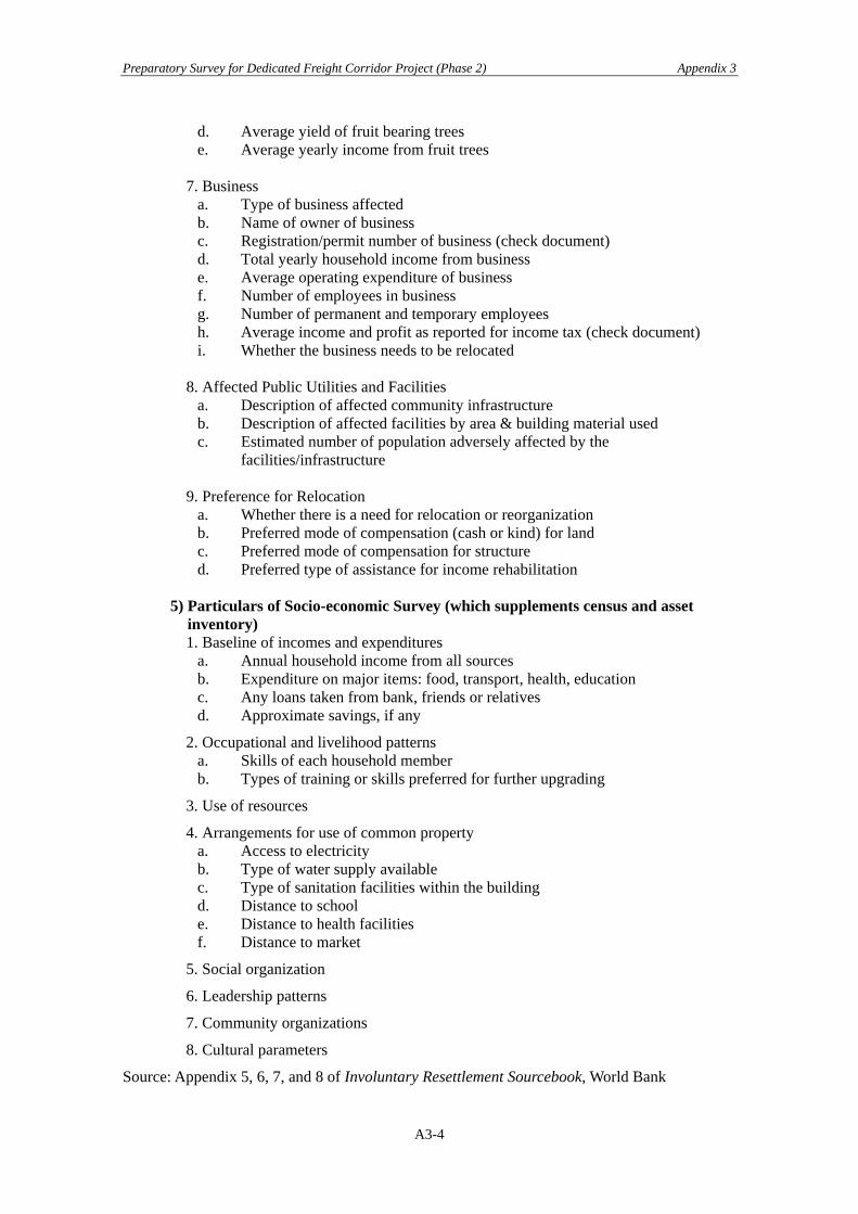
Preparatory Survey for Dedicated Freight Corridor Project (Phase 2) Appendix 3
d. Average yield of fruit bearing trees e. Average yearly income from fruit trees
7. Business
a. Type of business affected b. Name of owner of business c. Registration/permit number of business (check document) d. Total yearly household income from business e. Average operating expenditure of business f. Number of employees in business g. Number of permanent and temporary employees h. Average income and profit as reported for income tax (check document) i. Whether the business needs to be relocated
8. Affected Public Utilities and Facilities
a. Description of affected community infrastructure b. Description of affected facilities by area & building material used c. Estimated number of population adversely affected by the
facilities/infrastructure 9. Preference for Relocation
a. Whether there is a need for relocation or reorganization b. Preferred mode of compensation (cash or kind) for land c. Preferred mode of compensation for structure d. Preferred type of assistance for income rehabilitation
5) Particulars of Socio-economic Survey (which supplements census and asset
inventory) 1. Baseline of incomes and expenditures
a. Annual household income from all sources b. Expenditure on major items: food, transport, health, education c. Any loans taken from bank, friends or relatives d. Approximate savings, if any
2. Occupational and livelihood patterns a. Skills of each household member b. Types of training or skills preferred for further upgrading
3. Use of resources
4. Arrangements for use of common property a. Access to electricity b. Type of water supply available c. Type of sanitation facilities within the building d. Distance to school e. Distance to health facilities f. Distance to market
5. Social organization
6. Leadership patterns
7. Community organizations
8. Cultural parameters
Source: Appendix 5, 6, 7, and 8 of Involuntary Resettlement Sourcebook, World Bank
A3-4

Preparatory Survey for Dedicated Freight Corridor Project (Phase 2) Appendix 3
Task-2 Updating R&R Framework
The task is to study an “Entitlement Matrix” for Resettlement and Rehabilitation (R&R) for PAPs, finalized by DFCCIL, December, 2009, which is attached in the Appendix 3, and to establish Guidelines to mitigate project’s social impacts during construction and ex-post resettlement. The task shall include;
• Steps and procedure for executing R&R activities during the whole Project Cycle (including ex-post monitoring),
• Fine tuning existing Entitlement Matrix, suited to local conditions, if deemed necessary,
• Institutional framework and mechanisms, mobilized for construction-phase socio-economic impact management, holding local consultations, socio-economic monitoring and grievance redress,
• Measures to address impacts on tribal people, if affected Task-3 Formulate a R&R Plan
Formulate a Rehabilitation and Resettlement Plan (RRP) to mitigate adverse social impacts and Tribal Action Plans (if the proposed alignment interferes with such a territory). It shall be formulated by consolidating outcomes from SIA, Census, and Baseline Socio-economic Survey under R&R Framework. The RRP shall be prepared as prescribed in the NPRR (2007), and in conformity with the JBIC Guidelines. The RRP shall include;
1. Description of the project. General description of the project and identification of the project area.
2. Potential impacts.
Identification of (a) the project component or activities that give rise to resettlement; (b) the zone of impact of such component or activities; (c) the alternatives considered to avoid or minimize resettlement; and (d) the mechanisms established to minimize resettlement, to the extent possible,
during project implementation.
3. Objectives. The main objectives of the resettlement program.
4. Socioeconomic studies.
The findings of socioeconomic studies to be conducted in the early stages of project preparation and with the involvement of potentially displaced people, including
(a) the results of a census survey covering (i) current occupants of the affected area to establish a basis for the design
of the resettlement program and to exclude subsequent inflows of people from eligibility for compensation and resettlement assistance;
(ii) standard characteristics of displaced households, including a description of production systems, labor, and household organization; and baseline information on livelihoods (including, as relevant, production levels and income derived from both formal and informal economic activities) and standards of living (including health status) of the displaced population;
(iii) the magnitude of the expected loss—total or partial—of assets, and the extent of displacement, physical or economic;
A3-5

Preparatory Survey for Dedicated Freight Corridor Project (Phase 2) Appendix 3
(iv) information on vulnerable groups or persons, for whom special provisions may have to be made; and
(v) provisions to update information on the displaced people's livelihoods and standards of living at regular intervals so that the latest information is available at the time of their displacement.
(b) Other studies describing the following (i) land tenure and transfer systems, including an inventory of common
property natural resources from which people derive their livelihoods and sustenance, non-title-based usufruct systems (including fishing, grazing, or use of forest areas) governed by local recognized land allocation mechanisms, and any issues raised by different tenure systems in the project area;
(ii) the patterns of social interaction in the affected communities, including social networks and social support systems, and how they will be affected by the project;
(iii) public infrastructure and social services that will be affected; and (iv) social and cultural characteristics of displaced communities, including
a description of formal and informal institutions (e.g., community organizations, ritual groups, nongovernmental organizations (NGOs)) that may be relevant to the consultation strategy and to designing and implementing the resettlement activities.
5. Legal framework
The findings of an analysis of the legal framework, covering (a) the scope of the power of eminent domain and the nature of compensation
associated with it, in terms of both the valuation methodology and the timing of payment;
(b) the applicable legal and administrative procedures, including a description of the remedies available to displaced persons in the judicial process and the normal timeframe for such procedures, and any available alternative dispute resolution mechanisms that may be relevant to resettlement under the project;
(c) relevant law (including customary and traditional law) governing land tenure, valuation of assets and losses, compensation, and natural resource usage rights; customary personal law related to displacement; and environmental laws and social welfare legislation;
(d) laws and regulations relating to the agencies responsible for implementing resettlement activities;
(e) gaps, if any, between local laws covering eminent domain and resettlement and the JBIC Environmental Guidelines, and the mechanisms to bridge such gaps; and
(f) any legal steps necessary to ensure the effective implementation of resettlement activities under the project, including, as appropriate, a process for recognizing claims to legal rights to land—including claims that derive from customary law and traditional usage.
6. Institutional Framework.
The findings of an analysis of the institutional framework covering (a) the identification of agencies responsible for resettlement activities and
NGOs that may have a role in project implementation; (b) an assessment of the institutional capacity of such agencies and NGOs; and (c) any steps that are proposed to enhance the institutional capacity of agencies
and NGOs responsible for resettlement implementation.
A3-6

Preparatory Survey for Dedicated Freight Corridor Project (Phase 2) Appendix 3
7. Eligibility. Definition of displaced persons and criteria for determining their eligibility for compensation and other resettlement assistance, including relevant cut-off dates.
8. Valuation of and compensation for losses. The methodology to be used in valuing
losses to determine their replacement cost; and a description of the proposed types and levels of compensation under local law and such supplementary measures as are necessary to achieve replacement cost for lost assets.1
9. Resettlement measures. A description of the packages of compensation and other
resettlement measures that will assist each category of eligible displaced persons to achieve the objectives of the policy (see OP 4.12, para. 6). In addition to being technically and economically feasible, the resettlement packages should be compatible with the cultural preferences of the displaced persons, and prepared in consultation with them.
10. Site selection, site preparation, and relocation. Alternative relocation sites
considered and explanation of those selected, covering (a) institutional and technical arrangements for identifying and preparing relocation sites, whether rural or urban, for which a combination of productive potential, locational advantages, and other factors is at least comparable to the advantages of the old sites, with an estimate of the time needed to acquire and transfer land and ancillary resources; (b) any measures necessary to prevent land speculation or influx of ineligible persons at the selected sites; (c) procedures for physical relocation under the project, including timetables for site preparation and transfer; and (d) legal arrangements for regularizing tenure and transferring titles to resettlers.
11. Housing, infrastructure, and social services. Plans to provide (or to finance resettlers' provision of) housing, infrastructure (e.g., water supply, feeder roads), and social services (e.g., schools, health services);2 plans to ensure comparable services to host populations; any necessary site development, engineering, and architectural designs for these facilities.
12. Environmental protection and management. A description of the boundaries of the
relocation area; and an assessment of the environmental impacts of the proposed 1. With regard to land and structures, "replacement cost" is defined as follows: For agricultural land, it is the pre-project or pre-displacement, whichever is higher, market value of land of equal productive potential or use located in the vicinity of the affected land, plus the cost of preparing the land to levels similar to those of the affected land, plus the cost of any registration and transfer taxes. For land in urban areas, it is the pre-displacement market value of land of equal size and use, with similar or improved public infrastructure facilities and services and located in the vicinity of the affected land, plus the cost of any registration and transfer taxes. For houses and other structures, it is the market cost of the materials to build a replacement structure with an area and quality similar to or better than those of the affected structure, or to repair a partially affected structure, plus the cost of transporting building materials to the construction site, plus the cost of any labor and contractors' fees, plus the cost of any registration and transfer taxes. In determining the replacement cost, depreciation of the asset and the value of salvage materials are not taken into account, nor is the value of benefits to be derived from the project deducted from the valuation of an affected asset. Where domestic law does not meet the standard of compensation at full replacement cost, compensation under domestic law is supplemented by additional measures so as to meet the replacement cost standard. Such additional assistance is distinct from resettlement measures to be provided under other clauses in OP 4.12, para. 6. 2. Provision of health care services, particularly for pregnant women, infants, and the elderly, may be important during and after relocation to prevent increases in morbidity and mortality due to malnutrition, the psychological stress of being uprooted, and the increased risk of disease.
A3-7
Preparatory Survey for Dedicated Freight Corridor Project (Phase 2) Appendix 3
resettlement3 and measures to mitigate and manage these impacts (coordinated as appropriate with the environmental assessment of the main investment requiring the resettlement).
13. Community participation. Involvement of resettlers and host communities, 4
including (a) a description of the strategy for consultation with and participation of resettlers and hosts in the design and implementation of the resettlement activities; (b) a summary of the views expressed and how these views were taken into account in preparing the resettlement plan; (c) a review of the resettlement alternatives presented and the choices made by displaced persons regarding options available to them, including choices related to forms of compensation and resettlement assistance, to relocating as individuals families or as parts of preexisting communities or kinship groups, to sustaining existing patterns of group organization, and to retaining access to cultural property (e.g. places of worship, pilgrimage centers, cemeteries);5 and (d) institutionalized arrangements by which displaced people can communicate their concerns to project authorities throughout planning and implementation, and measures to ensure that such vulnerable groups as indigenous people, ethnic minorities, the landless, and women are adequately represented.
14. Integration with host populations. Measures to mitigate the impact of resettlement on any host communities, including (a) consultations with host communities and local governments; (b) arrangements for prompt tendering of any payment due the hosts for land or other assets provided to resettlers; (c) arrangements for addressing any conflict that may arise between resettlers and host communities; and (d) any measures necessary to augment services (e.g., education, water, health,
and production services) in host communities to make them at least comparable to services available to resettlers.
15. Grievance procedures. Affordable and accessible procedures for third-party
settlement of disputes arising from resettlement; such grievance mechanisms should take into account the availability of judicial recourse and community and traditional dispute settlement mechanisms.
16. Organizational responsibilities. The organizational framework for implementing
resettlement, including identification of agencies responsible for delivery of resettlement measures and provision of services; arrangements to ensure appropriate coordination between agencies and jurisdictions involved in implementation; and any measures (including technical assistance) needed to strengthen the implementing agencies' capacity to design and carry out resettlement activities; provisions for the transfer to local authorities or resettlers themselves of responsibility for managing facilities and services provided under the project and for transferring other such responsibilities from the resettlement implementing agencies, when appropriate.
3 . Negative impacts that should be anticipated and mitigated include, for rural resettlement, deforestation, overgrazing, soil erosion, sanitation, and pollution; for urban resettlement, projects should address such density-related issues as transportation capacity and access to potable water, sanitation systems, and health facilities. 4 . Experience has shown that local NGOs often provide valuable assistance and ensure viable community participation. 5. OPN 11.03, Management of Cultural Property in Bank-Financed Projects.
A3-8
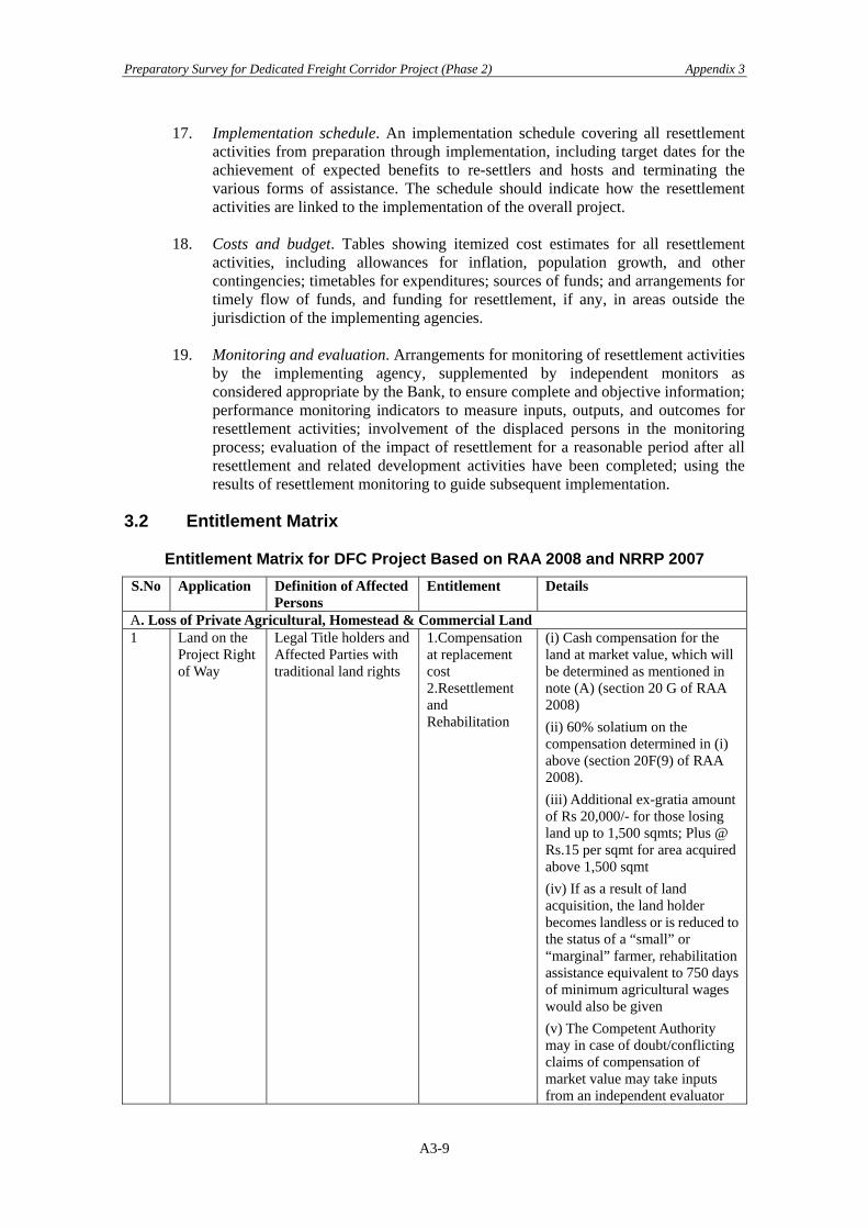
Preparatory Survey for Dedicated Freight Corridor Project (Phase 2) Appendix 3
17. Implementation schedule. An implementation schedule covering all resettlement activities from preparation through implementation, including target dates for the achievement of expected benefits to re-settlers and hosts and terminating the various forms of assistance. The schedule should indicate how the resettlement activities are linked to the implementation of the overall project.
18. Costs and budget. Tables showing itemized cost estimates for all resettlement
activities, including allowances for inflation, population growth, and other contingencies; timetables for expenditures; sources of funds; and arrangements for timely flow of funds, and funding for resettlement, if any, in areas outside the jurisdiction of the implementing agencies.
19. Monitoring and evaluation. Arrangements for monitoring of resettlement activities
by the implementing agency, supplemented by independent monitors as considered appropriate by the Bank, to ensure complete and objective information; performance monitoring indicators to measure inputs, outputs, and outcomes for resettlement activities; involvement of the displaced persons in the monitoring process; evaluation of the impact of resettlement for a reasonable period after all resettlement and related development activities have been completed; using the results of resettlement monitoring to guide subsequent implementation.
3.2 Entitlement Matrix
Entitlement Matrix for DFC Project Based on RAA 2008 and NRRP 2007 S.No Application Definition of Affected
Persons Entitlement Details
A. Loss of Private Agricultural, Homestead & Commercial Land 1 Land on the
Project Right of Way
Legal Title holders and Affected Parties with traditional land rights
1.Compensation at replacement cost 2.Resettlement and Rehabilitation
(i) Cash compensation for the land at market value, which will be determined as mentioned in note (A) (section 20 G of RAA 2008) (ii) 60% solatium on the compensation determined in (i) above (section 20F(9) of RAA 2008). (iii) Additional ex-gratia amount of Rs 20,000/- for those losing land up to 1,500 sqmts; Plus @ Rs.15 per sqmt for area acquired above 1,500 sqmt (iv) If as a result of land acquisition, the land holder becomes landless or is reduced to the status of a “small” or “marginal” farmer, rehabilitation assistance equivalent to 750 days of minimum agricultural wages would also be given (v) The Competent Authority may in case of doubt/conflicting claims of compensation of market value may take inputs from an independent evaluator
A3-9
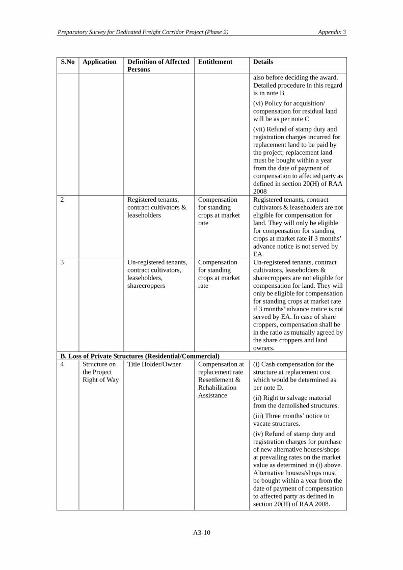
Preparatory Survey for Dedicated Freight Corridor Project (Phase 2) Appendix 3
S.No Application Definition of Affected Persons
Entitlement Details
also before deciding the award. Detailed procedure in this regard is in note B (vi) Policy for acquisition/ compensation for residual land will be as per note C (vii) Refund of stamp duty and registration charges incurred for replacement land to be paid by the project; replacement land must be bought within a year from the date of payment of compensation to affected party as defined in section 20(H) of RAA 2008
2 Registered tenants, contract cultivators & leaseholders
Compensation for standing crops at market rate
Registered tenants, contract cultivators & leaseholders are not eligible for compensation for land. They will only be eligible for compensation for standing crops at market rate if 3 months’ advance notice is not served by EA.
3 Un-registered tenants, contract cultivators, leaseholders, sharecroppers
Compensation for standing crops at market rate
Un-registered tenants, contract cultivators, leaseholders & sharecroppers are not eligible for compensation for land. They will only be eligible for compensation for standing crops at market rate if 3 months’ advance notice is not served by EA. In case of share croppers, compensation shall be in the ratio as mutually agreed by the share croppers and land owners.
B. Loss of Private Structures (Residential/Commercial) 4 Structure on
the Project Right of Way
Title Holder/Owner Compensation at replacement rate Resettlement & Rehabilitation Assistance
(i) Cash compensation for the structure at replacement cost which would be determined as per note D. (ii) Right to salvage material from the demolished structures. (iii) Three months’ notice to vacate structures. (iv) Refund of stamp duty and registration charges for purchase of new alternative houses/shops at prevailing rates on the market value as determined in (i) above. Alternative houses/shops must be bought within a year from the date of payment of compensation to affected party as defined in section 20(H) of RAA 2008.
A3-10

Preparatory Survey for Dedicated Freight Corridor Project (Phase 2) Appendix 3
S.No Application Definition of Affected Persons
Entitlement Details
(v) Resettlement & Rehabilitation Assistance as applicable as under: (a) Transition Allowance of Rs 4,000/- per household. (b) Each affected family getting displaced shall get a one-time financial assistance of Rs 10,000 as shifting allowance (para 7.10 NRRP 2007). (c) Each affected family that is displaced and has cattle, shall get financial assistance of Rs 15,000/- for construction of cattle shed (para 7.10 NRRP 2007). (d) Each affected person who is a rural artisan, small trader or self employed person and who has been displaced shall get a one-time financial assistance of Rs 25,000/- for construction of working shed or shop (para 7.12 NRRP 2007).
5 Structure on the Project Right of Way
Tenants/Lease Holders Resettlement & Rehabilitation Assistance
(i). Registered lessees will be entitled to an apportionment of the compensation payable to structure owner as per applicable local laws. (ii) In case of tenants, three months written notice will be provided along with Rs 10,000 towards shifting allowance (NRRP 7.11). (iii) Three months’ notice to vacate structures. In case notice is not provided, then three months’ rental allowance will be provided in lieu of notice.
C. Loss of Trees & Crops 6 Standing
Trees, Crops on Project Right of Way
Owners & beneficiaries of land
Compensation at market value
(i) 3 months’ advance notice to affected parties to harvest fruits, standing crops and remove trees(ii) Compensation to be paid at the rate estimated by: (a) the Forest Department for timber trees (b) State Agriculture Extension Department for crops (c) Horticulture Department for perennial trees (d) Cash assistance to title holders and non title holders
A3-11

Preparatory Survey for Dedicated Freight Corridor Project (Phase 2) Appendix 3
S.No Application Definition of Affected Persons
Entitlement Details
including informal settlers/ squatters for loss of trees, crops and perennials at market value
D. Loss of Residential/Commercial Structures by Non Title Holders 7 Structures on
the Project ROW
Owners of structures identified as on date of notification (20A).
Compensation at replacement costResettlement & Rehabilitation Assistance
(i) Encroachers (as defined in Note F) shall be given three months’ notice to vacate occupied land or compensation for loss of crops or structures if notice is not given (ii) Cash assistance to squatters (as defined in Note F) for their structures at replacement costs which will be determined as mentioned in Note D (iii) Resettlement & Rehabilitation assistance as under: (a) Transition Allowance of Rs 4,000/- per household. (b) Shifting allowance of Rs 10,000 per household (para 7.11 NRRP 2007). (c) Assistance of Rs 15,000/- for loss of cattle shed (para 7.10 NRRP 2007). (d) If the affected party getting displaced is a rural artisan, small trader or self employed person assistance of Rs 25,000/- for construction of working shed or shop (para 7.12 NRRP 2007) e) House construction assistance for those living below poverty line equivalent to the latest construction cost of Indira Awas Yojana Scheme for Rural Areas and cost of house construction under JNURM for Urban Areas (f) Subsistence allowance for those living below poverty line equivalent to 300 days of minimum wages.
E. Loss of Livelihood 8 Households
living on Right of way
Title Holders/ Non-Title holders/share-croppers, agricultural labourers and employees
Rehabilitation Assistance
(i) Rehabilitation grant equivalent to 750 days of minimum agricultural wages to those families losing livelihood (NRRP para 7.14) (land title holders availing assistance of 750 days minimum wages under section 1 (iv) above would not be eligible for this
A3-12

Preparatory Survey for Dedicated Freight Corridor Project (Phase 2) Appendix 3
S.No Application Definition of Affected Persons
Entitlement Details
assistance) (ii) Training Assistance of Rs 4,000/- for income generation per household (iii) Temporary employment in the project construction work to Affected Persons with particular attention to APs Below Poverty Line (BPL) by the project contractor during construction, to the extent possible
E1 Additional support to Vulnerable Group (as defined in Note E) & those Below Poverty Line 9 Households
affected by ROW
Households affected by ROW
Resettlement & Rehabilitation Assistance
One time additional financial assistance equivalent to 300 days of minimum wages (BPL household availing 300 days minimum wages, subsistence allowance under section 6 (f) above would not be eligible for this compensation)
E2 Additional assistance to Scheduled Tribe affected families 10 Affected
Scheduled Tribes
Households affected by ROW
Rehabilitation Assistance
(i) Each ST affected family shall get an additional one time financial assistance equivalent to five hundred days minimum agricultural wages for loss of customary right or usage of forest produce (para 7.21.5 NRRP 2007) (ii) In case of land acquisition from each ST affected family, at least one third of the compensation amount due shall be paid to the affected families at the outset as first instalment and the rest at the time of taking over the possession of the land (para 7.21.4 NRRP 2007)
F. Loss of Community Infrastructure/Common Property Resources Structures &
other resources (eg land, water, access to social services etc) on ROW
Affected communities and groups
Reconstruction of community structure and common property resources
Reconstruction of community structures and replacement of common property resources in consultation with the community as appropriate
G. Temporary impact during Construction Land &
assets temporarily impacted during construction
Owners of land & assets
Compensation for temporary impact during construction like disruption of normal traffic, damage to
The contractor shall bear the compensation cost of any impact on structure or land due to movement of machinery during construction or establishment of construction plant. All temporary use of lands outside proposed
A3-13

Preparatory Survey for Dedicated Freight Corridor Project (Phase 2) Appendix 3
S.No Application Definition of Affected Persons
Entitlement Details
adjacent parcel of land/ assets due to movement of heavy machinery and plant site.
ROW to be through written approval of the landowner and contractor. Location of construction camps by contractors in consultation with DFCCIL
Note A 1. Compensation would be determined by Competent Authority as per provisions in RAA 2008, section 20 (G) which specifies the following criterion for assessing and determining market value of the land:
(i) the minimum land value, if any, specified in the Indian Stamp Act, 1899 for the registration of sale deeds in the area, where the land is situated; or
(ii) the average of the sale price for similar type of land situated in the village or vicinity, ascertained from not less than 50% of the sale deeds registered during three years, where higher price has been paid, whichever is higher.
2. Wherever the above provisions are not applicable, the concerned State Government shall specify the floor price per unit area of the said land based on the average higher prices paid for similar type of land situated in the adjoining areas or vicinity, ascertained from not less than 50% of sale deeds registered during the preceding 3 years where higher price has been paid, and the competent authority may calculate the value of the land accordingly (section 20(G) of RAA 2008 to be followed).
3. While determining the compensation amount, competent authority or arbitrator shall also take into account the following, as per provisions in section 20 F (8) of RAA 2008 :
(i) damage, if any sustained by the person interested at the time of taking possession of the land, by reason of the severing of such land from other land.
(ii) damage, if any, sustained by the persons interested at the time of taking possession of the land, by reason of the acquisition injuriously affecting his other immovable property in any manner, or his earnings
(iii) if, in consequence of the acquisition of the land, the person interested is compelled to change his residence or place of business, the reasonable expenses, if any, incidental to such change.
4. Before assessing and determining the market value of the land being acquired, competent authority shall:
(i) ascertain the intended land use category of such land; and
(ii) take into account the value of the land of the intended category in the adjoining areas or vicinity.
5. In case where the right of the user or any right in the nature of an easement on, any land is acquired, an amount calculated at ten percent of the compensation amount determined under section 20 F(1) of RAA 2008, shall be paid by the EA to the owner and any other person whose right in enjoyment of the land has been affected.
Note B DFCCIL would also hire an Independent Evaluator registered with Government, who can assist to assess the replacement cost of land as follows and provide inputs to the competent authority:
(i) Appraise recent sales and transfer of title deeds and registration certificates for similar type of land in the village or urban area and vicinity
(ii) Appraise circle rate in urban and rural areas of the district
(iii) Appraise agricultural productivity rate for land – 20 years yield.
The Competent Authority may take inputs from the independent evaluator before deciding the compensation for the land.
A3-14

Preparatory Survey for Dedicated Freight Corridor Project (Phase 2) Appendix 3
Note C If the residual plot(s) is (are) not economically viable, the EA will follow the rules and regulations applicable in the state and compensate accordingly; if there are no state specific rules and regulations available regarding residual land is less than average land holding of the district after EA purchase, the EA in agreement with the Affected Party, will follow one of the following:
i. The EA will buy the residual land for the project following the entitlements listed in the entitlement matrix; or
ii. The EA will pay the Affected Party 25% of the land hardship compensation for that portion of land without its purchase.
Note D The compensation for houses, buildings and other immovable properties will be determined on the basis of replacement cost by referring to relevant Basic Schedule of Rates (B.S.R) as on date without depreciation. While considering the B.S.R, the independent evaluator registered with the Government will use the latest B.S.R for the residential and commercial structures in the urban and rural areas of the region, and in consultation with the owners
Note E NRRP 2007 defines Vulnerable Persons as disabled, destitute, orphans, widows, unmarried girls, abandoned women or persons above 50 years of age; who are not provided or cannot immediately be provided with alternative livelihood, and who are not otherwise covered as part of a family (para 6.4 (v) NRRP 2007)
Note F
Definitions: Marginal farmer - A cultivator with an un-irrigated land holding up to 1 hectare or with an irrigated land holding up to half hectare.
Small farmer – A cultivator with an un-irrigated land holding up to 2 hectares or with an irrigated land holding up to 1 hectare, but more than a marginal farmer.
Encroacher- A person/family, who transgresses into the public land (prior to the cut of date), adjacent to his/her own land or other immovable assets and derives his/her additional source of shelter/livelihood.
Squatter – A person/family that has settled on the public land without permission or has been occupying public building without authority prior to the cut-off date and is depending for his or her shelter or livelihood and has no other source of shelter or livelihood. 3.3 Indicative Land Prices
It is intended to see disparities between the “Circle Rate” as against “Market Price” at the two sites adjacent to the proposed alignment in the Section 1. One is at Dombivali Built-up area (47-50km from JNPT), Thane District and the other at Kunde Vahal and Dapoli Built-up area (19-21km from JNPT), Raigarh District. Reference to the Government rates (=Circle rate) are given from the CPM/Mumbai office, while market rates are based on interviews from local real estate agents.
A3-15
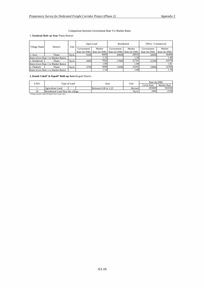
Preparatory Survey for Dedicated Freight Corridor Project (Phase 2) Appendix 3
A3-16
Comparison between Government Rate V/s Market Rates
1. Dombivali Built-up Area Thane District
GovernmentRate (In INR)
MarketRate (In INR)
GovernmentRate (In INR)
MarketRate (In INR)
GovernmentRate (In INR)
MarketRate (In INR)
1. Ayre Thane Sq.m. 6500 8000 20600 28016 26000 364001.23 1.36 1.40
2. Dombivali Thane Sq.m. 4400 7920 17800 32765 22200 410701.80 1.84 1.85
3. Thakurli Thane Sq.m. 3700 5698 15000 25263 19000 323001.54 1.68 1.70
2. Kunde Vahal* & Dapoli* Built-up Area Raigarh District
Circle Rate Market Rate1 Agriculture Land Hectare 293000 50103010 1000 2330
Open LandDistrictVillage Name
Residential Office / CommercialUnit
Ratio (Govt Rate 1 to Market Ratio)
Ratio (Govt Rate 1 to Market Ratio)
Ratio (Govt Rate 1 to Market Ratio)
S.NO. Type of Land Area Rate (In INR)Unit
*Village Kunde Vahal & Dapoli have same ratesSq.m.Residential Land Near the village
Between 0.00 to 1.25