
maharaja ranjit singh armed forces preparatory institute ...
Upload
khangminh22Category
view
0download
0
Preparatory Survey
on
National Power Transmission Network
Development Project Phase III
Final Report
Pre-release Version
January, 2021
Japan International Cooperation Agency (JICA)
TEPCO Power Grid, Inc.
Tokyo Electric Power Company Holdings, Inc.
NIPPON KOEI CO., LTD.
Tokyo Electric Power Services Co., Ltd.
1R
JR(P)
21-001
The Republic of the Union of Myanmar
Ministry of Electricity and Energy
Transmission Project Preparatory Survey Phase III
Final Report (Advanced Release)
i
Contents
1. Background and Appropriateness of the Project .................................................. 1-1
1.1. Outline of the Survey ...................................................................................... 1-1
1.2. Power Demand Records ................................................................................... 1-4
1.3. Power Demand Forecast for Yangon............................................................... 1-5
1.4. Power Generation Plan in Yangon .................................................................. 1-8
1.5. Power System Plans ...................................................................................... 1-11
Plans ........................................................................................................ 1-11
Fault Currents ........................................................................................ 1-20
Stability ................................................................................................... 1-20
Voltage Maintenance .............................................................................. 1-20
New 1,250 MW Thilawa LNG Power Plant .......................................... 1-20
1.6. Power Distribution Plan in Yangon .............................................................. 1-21
Plan .......................................................................................................... 1-21
Current Progress .................................................................................... 1-24
1.7. Electrification Plans ...................................................................................... 1-24
Plans ........................................................................................................ 1-24
Progress ................................................................................................... 1-25
Support from Other Donors ................................................................... 1-25
2. Selection of Location for New 500 kV Substation ................................................. 2-1
2.1. Selection of Location for New 500/230 kV Substation .................................. 2-1
2.2. Necessary Dimensions for New 500/230 kV Substation ............................... 2-1
500 kV Switchgear .................................................................................... 2-1
500/230 kV Transformer .......................................................................... 2-4
Dimensions of 500/230 kV Substation .................................................... 2-4
2.3. Study on Expansion of Existing East Dagon Substation .............................. 2-4
500 kV Switchgear .................................................................................... 2-5
Expansion Study ....................................................................................... 2-5
2.4. Study on Western Side of Yangon - Hlegu Township Area (Reference) ....... 2-6
Substation Candidate Option-B in Hlegu Township ............................. 2-7
2.5. Study on Eastern Side of Yangon (East Dagon Area) ................................... 2-7
Substation Candidate Option-1 in East Dagon Area ............................. 2-8
Substation Candidate Option-5 in East Dagon Area ............................. 2-9
2.6. Comparison of Candidates and Conclusion ................................................. 2-11
3. Study for Transmission Line Route Selection ....................................................... 3-1
3.1. Study for Transmission Line Route Selection ............................................... 3-1
3.2. Route map for Transmission Lines ................................................................. 3-2
3.3. Soil Investigation ............................................................................................. 3-9
3.4. Details of Selection for 500kV Overhead Transmission Line Route .......... 3-38

Transmission Project Preparatory Survey Phase III
Final Report (Advanced Release)
ii
4. Environmental and Social Considerations ............................................................ 4-1
4.1. Environmental and Social Considerations .................................................... 4-1
Outline of the Project Components with Environmental and Social
Impacts 4-1
Basic environmental and social conditions............................................. 4-3
System and Organization for Environmental and Social Considerations
in Myanmar ............................................................................................................... 4-17
Consideration of Alternatives ................................................................ 4-28
Scoping and TOR for the Survey on Natural and Social Environments 4-
31
Results of the Survey on Environmental and Social Impact and
Environmental and Social Impact Evaluation ....................................................... 4-37
Mitigation Measures and Costs for Implementing Mitigation Measures
4-47
Monitoring Plan ...................................................................................... 4-52
Institutional Arrangements ................................................................... 4-54
Stakeholder Meetings ............................................................................ 4-56
Summary of the Study Schedule following EIAP ................................ 4-71
4.2. Land Acquisition and Resettlement ............................................................. 4-73
Necessity of Land Acquisition and Resettlement ................................. 4-73
Legal Framework for Land Acquisition and Resettlement ................. 4-73
Location and Scale of Land Acquisition and Resettlement ................. 4-84
Compensation and Assistance Measures ............................................ 4-107
Implementation Structure .................................................................... 4-111
Grievance Redress Mechanism............................................................ 4-112
Implementation Schedule .................................................................... 4-113
Public Consultation .............................................................................. 4-117
Monitoring Structure and Monitoring Forms by Implementation Body 4-
118
5. Outline of Project Plan ........................................................................................... 5-1
5.1. Purposes of and Need for the Project ............................................................. 5-1
Purposes .................................................................................................... 5-1
Need ........................................................................................................... 5-1
6. Conceptual Design .................................................................................................. 6-1
6.1. Overhead Transmission Line Design Concept ............................................... 6-1
6.2. 500kV Transmission Line Design ................................................................... 6-1
Overview of Transmission Line Route .................................................... 6-1
Design Conditions..................................................................................... 6-1
Conductor and Ground Wire Design ....................................................... 6-3
Insulator Design ....................................................................................... 6-4

Transmission Project Preparatory Survey Phase III
Final Report (Advanced Release)
iii
Determination of Tower Configuration ................................................... 6-5
Towers ........................................................................................................ 6-6
Tower Foundations ................................................................................... 6-9
Quantities of the Transmission Line Materials ..................................... 6-9
6.3. 230kV Transmission Line Design ................................................................. 6-11
Overview of Transmission Line Route .................................................. 6-11
Design Conditions................................................................................... 6-12
Conductor and Ground Wire Design ..................................................... 6-13
Insulator Design ..................................................................................... 6-15
Ground Clearance ................................................................................... 6-16
Determination of Tower Configuration ................................................. 6-16
Towers ...................................................................................................... 6-17
Tower Foundations ................................................................................. 6-21
Quantities of the Transmission Line Materials ................................... 6-21
Obstacle Limitation Surface .................................................................. 6-24
6.4. Design of Foundations ................................................................................... 6-24
Soil Conditions ........................................................................................ 6-24
Loads Conditions for Pile Foundations ................................................. 6-32
Results of Foundation Design ................................................................ 6-33
6.5. Preliminary Design for Underground Transmission Lines ........................ 6-38
Design for Burial Method ...................................................................... 6-38
Design of Ducts ....................................................................................... 6-39
Design of Manholes and Joint Bays ...................................................... 6-40
Design of Cable ....................................................................................... 6-42
Preliminary Design ................................................................................ 6-43
6.6. Substations ..................................................................................................... 6-62
General .................................................................................................... 6-62
Design Concepts ..................................................................................... 6-62
Design Criteria ....................................................................................... 6-64
Sar Ta Lin New 500 kV Substation ....................................................... 6-65
East Dagon Substation .......................................................................... 6-71
Hlawga Substation ................................................................................. 6-78
Thaketa Substation ................................................................................ 6-85
6.7. Work and Procurement Plan ......................................................................... 6-90
Work Plan ................................................................................................ 6-90
7. Project Implementation Policy ............................................................................... 7-1
7.1. Safety of Construction Work ........................................................................... 7-1
7.2. COVID-19 Infection Prevention Measures .................................................... 7-1
7.3. Contract Management ..................................................................................... 7-1
7.4. Anti-graft Plan ................................................................................................. 7-2
Transmission Project Preparatory Survey Phase III
Final Report (Advanced Release)
iv
7.5. Actions concerning Gender ............................................................................. 7-2
8. Project Implementation System ............................................................................. 8-1
8.1. Suggestions for Configuring the Project Implementation and Operation and
Maintenance Systems .................................................................................................... 8-1
Confirmation of Project Implementation System .................................. 8-1
Capabilities of Each Department Related to the Project and its Role in
the Project ................................................................................................................... 8-1
Execution Department for each Component .......................................... 8-2
Organizational Structure of Executing Agency and main related
Organizations (Organizational Chart) ...................................................................... 8-3
Project Implementation Unit (PMU) ...................................................... 8-5
9. Evaluation of the Project ........................................................................................ 9-1
9.1. Quantitative Evaluation ................................................................................. 9-1
Benefits ..................................................................................................... 9-1
EIRR and FIRR ........................................................................................ 9-3
9.2. Reducing Greenhouse Gas Emissions ............................................................ 9-6
9.3. Performance Effectiveness Indicators ............................................................ 9-8
10. Preliminary Data Collection Survey for Plan for Power Grid Extension to
Mawlamyaing ................................................................................................................... 10-1
10.1. Outline of the Survey ................................................................................. 10-1
10.2. Data Collection on System Configuration ................................................ 10-1
Current Status and Plans for System Configuration .......................... 10-1
New Power Plant Construction Plans ................................................... 10-3
Approximate Current Forecast.............................................................. 10-3
10.3. Data Collection on New Power Transmission Lines ................................ 10-4
Conceptual Study of Transmission Line Routes .................................. 10-4
10.4. Data Collection for Construction and Expansion of Substations ........... 10-6
500 kV Pharyargy ................................................................................... 10-6
500 kV Mawlamyaing ............................................................................ 10-6
10.5. Environmental and Social Considerations ............................................... 10-7
Environmental Considerations.............................................................. 10-7
Social Considerations ............................................................................. 10-9
Transmission Project Preparatory Survey Phase III
Final Report (Advanced Release)
v
Figure 1.1-1 Project Outline and Area ............................................................................. 1-1 Figure 1.1-2 Power Grid in Myanmar (November 2018) ................................................ 1-3 Figure 1.3-1 Comparison of Various Demand Forecasts and Demand Forecasts in This
Survey ............................................................................................................ 1-7 Figure 1.5-1 Existing 230 kV System in Yangon City (January 2020) .......................... 1-11 Figure 1.5-2 Power Flow in 2020 (Without Emergency Generators) ............................ 1-12 Figure 1.5-3 Power Flow in 2020 (With Emergency Generators) ................................. 1-12 Figure 1.5-4 Power Flow in 2020 (With Emergency Generators and 80% of Full Power
Outputs of Generators) ................................................................................. 1-13 Figure 1.5-5 Power Flow in 2020 (With Emergency Generators and New Lines Hlawga-
East Dagon) ................................................................................................. 1-13 Figure 1.5-6 Power Flow in 2025 (With Emergency Generators; with Phase II and without
Phase III) ...................................................................................................... 1-14 Figure 1.5-7 Power Flow in 2025 (Without Emergency Generators in 2020; with
Emergency Generators in 2021 and without Phase III) ............................... 1-14 Figure 1.5-8 Power Flow in 2027 (Without Emergency Generators and with the Initially
Assumed Scope) .......................................................................................... 1-15 Figure 1.5-9 Power Flow in 2027 (With 230 kV transmission line from East Dagon-South
Okkalapa (A)) .............................................................................................. 1-16 Figure 1.5-10 Power Flow in 2027 (Rebuilding the existing 230 kV Lawpita line from the
north to Thaketa via Hlawga for new double circuits (B)) .......................... 1-16 Figure 1.5-11 Phase III Project Scope ........................................................................... 1-17 Figure 1.5-12 Power Flow in 2025 (Without Emergency Generators in 2020, with
Emergency Generators in 2021, and with Phase III) ................................... 1-18 Figure 1.5-13 Power Flow in 2027 (Without Emergency Generators in 2020, without
Emergency Generators in 2021, and with Phase III) ................................... 1-18 Figure 1.5-14 Power Flow in 2030 (Without Emergency Generators in 2020, without
Emergency Generators in 2021, and with Phase III) ................................... 1-19 Figure 1.5-15 Power Flow in 2027 (without emergency power in 2020, without emergency
power in 2021, with Phase III, with Thilawa LNG 1,250 MW) .................. 1-21 Figure 1.6-1 66 kV and 33 kV Systems in Yangon in 2014-2015 ................................. 1-22 Figure 1.6-2 66 kV System in Yangon in 2027 .............................................................. 1-23 Figure 1.7-1 Myanmar Electrification Rate Trends and Targets .................................... 1-24 Figure 2.1-1 Candidates for New 500 kV Substation ...................................................... 2-1 Figure 2.2-1 Dimensions Required in 500 kV H-GIS ..................................................... 2-3 Figure 2.2-2 Dimensions Required in 500 kV GIS ......................................................... 2-3 Figure 2.2-3 Necessary Dimensions of the 500/230 kV Transformer ............................. 2-4 Figure 2.3-1 Available Space for Expansion in Existing East Dagon Substation............ 2-5 Figure 2.3-2 Arrangement of 500 kV Facilities in Existing East Dagon Substation ....... 2-6 Figure 2.3-3 Situation after Expansion in East Dagon Substation .................................. 2-6 Figure 2.4-1 Substation Candidate Option-B in Hlegu Township ................................... 2-7 Figure 2.5-1 YCDC Area and Selected Candidates in East Dagon Area ......................... 2-8 Figure 2.5-2 Substation Candidate Option-1 in East Dagon Area (Wide-Area) .............. 2-9 Figure 2.5-3 Substation Candidate Option-1 in East Dagon Area (around Substation) .. 2-9 Figure 2.5-4 Substation Candidate Option-5 in East Dagon Area (Wide-Area) ............ 2-10 Figure 2.5-5 Substation Candidate Option-5 in East Dagon Area (around Substation) 2-10 Figure 2.6-1 Substation Candidate Option-5 in East Dagon Area (around Substation) 2-11 Figure 3.2-1 Overall View of Phase III project ............................................................... 3-2 Figure 3.2-2 500 kV Pharyargyi-Sar Ta Lin Route Map of Overhead Transmission
Lines .............................................................................................................. 3-3 Figure 3.2-3 Map of 230kV Sar Ta Lin-Hlawga and 230kV Sar Ta Lin-Hlawga OHTL 3-4 Figure 3.2-4 230kV Overall View of Underground Transmission Line System .............. 3-4 Figure 3.2-5 Illustration of Branch Tower ....................................................................... 3-5 Figure 3.2-6 230kV Sar Ta Lin SS – Hlawga SS UGTL Route ....................................... 3-6 Figure 3.2-7 230kV Thaketa SS – Hlawga SS Route Outline ......................................... 3-6 Figure 3.2-8 Expected Site for Branch Tower of 230kV Thaketa – Hlawga Line .............. 3-7
Transmission Project Preparatory Survey Phase III
Final Report (Advanced Release)
vi
Figure 3.2-9 230kV Overall UGTL View (Close-up) ...................................................... 3-8 Figure 3.3-1 Locations of Standard Borings ..................................................................... 3-10 Figure 3.3-2 Locations of Simplified Borings 1/2 ............................................................ 3-11 Figure 3.3-3 Locations of Simplified Borings 2/2 ......................................................... 3-11 Figure 3.3-4 Geological Map of TL Route (1) .............................................................. 3-12 Figure 3.3-5 Geological Map of TL Route (2) .............................................................. 3-13 Figure 3.3-6 BH 1 Boring Log ...................................................................................... 3-14 Figure 3.3-7 BH 2 Boring Log ...................................................................................... 3-15 Figure 3.3-8 BH 3 Boring Log ...................................................................................... 3-16 Figure 3.3-9 BH 4 Boring Log ...................................................................................... 3-17 Figure 3.3-10 BH 5 Boring Log .................................................................................... 3-18 Figure 3.3-11 BH 6 Boring Log ..................................................................................... 3-19 Figure 3.3-12 BH 101 Boring Log ................................................................................ 3-20 Figure 3.3-13 BH 102 Boring Log ................................................................................ 3-21 Figure 3.3-14 BH 103 Boring Log ................................................................................ 3-22 Figure 3.3-15 BH 104 Boring Log ................................................................................ 3-23 Figure 3.3-16 BH 105 Boring Log ................................................................................ 3-24 Figure 3.3-17 BH 106 Boring Log ................................................................................ 3-25 Figure 3.3-18 BH 107 Boring Log ................................................................................ 3-26 Figure 3.3-19 BH 108 Boring Log ................................................................................ 3-27 Figure 3.3-20 BH 109 Boring Log ................................................................................ 3-28 Figure 3.3-21 BH 1010 Boring Log .............................................................................. 3-29 Figure 3.3-22 bh 101 Boring Log .................................................................................. 3-30 Figure 3.3-23 bh 102 Boring Log .................................................................................. 3-31 Figure 3.3-24 bh 103 Boring Log .................................................................................. 3-32 Figure 3.3-25 bh 104 Boring Log .................................................................................. 3-33 Figure 3.3-26 bh 105 Boring Log .................................................................................. 3-34 Figure 3.3-27 Location of Soil Investigation in Hlawga S/S ......................................... 3-35 Figure 3.3-28 Boring Log of Hlawga S/S ...................................................................... 3-35 Figure 3.3-29 Location of Soil Investigation in East Dagon S/S ................................... 3-36 Figure 3.3-30 Boring Log of East Dagon S/S (BH.1) ................................................... 3-36 Figure 3.3-31 Boring Log of East Dagon S/S (BH.2) ................................................... 3-37 Figure 3.3-32 Boring Log of East Dagon S/S (BH.3) ................................................... 3-37 Figure 3.4-1 East and West Route from Pharyargyii to Sar Ta Lin ............................... 3-38 Figure 3.4-2 West Route (Forest Area) of Pharyargyii to Sar Ta Lin ............................ 3-39 Figure 3.4-3 Map of Pharyargyii - Sar Ta Lin East Route ............................................. 3-39 Figure 4.1-1 The Project and Protected Areas related to Environmental and Social
Considerations ............................................................................................... 4-1 Figure 4.1-2 Environmental Baseline Locations (Distant View) ..................................... 4-6 Figure 4.1-3 Environmental Baseline Locations (Near View) ......................................... 4-7 Figure 4.1-4 Myanmar EIA/IEE Procedures (1/6) ........................................................ 4-20 Figure 4.1-5 Myanmar EIA/IEE Procedures (2/6) ........................................................ 4-21 Figure 4.1-6 Myanmar IEE Procedures (3/6) ................................................................ 4-21 Figure 4.1-7 Myanmar IEE Procedures (4/6) ................................................................ 4-22 Figure 4.1-8 Myanmar IEE Procedures (5/6) ................................................................ 4-22 Figure 4.1-9 Myanmar IEE Procedures (6/6) ................................................................ 4-23 Figure 4.1-10 Organizational Structure of Ministry of Natural Resources and
Environmental Conservation (MONREC) ................................................... 4-24 Figure 4.1-11 Organizational Structure of Environmental Conservation Department
(ECD) ........................................................................................................... 4-24 Figure 4.1-12 Alternative Transmission Line Route for 500kV (West/East route (Option
A/Option B)) ................................................................................................ 4-30 Figure 4.1-13 Organizational Structure of the Ministry of Electricity and Energy
(MOEE) ....................................................................................................... 4-55 Figure 4.1-14 Organizational Structure of the Department of Power Transmission and
System Control (DPTSC) ............................................................................ 4-55
Transmission Project Preparatory Survey Phase III
Final Report (Advanced Release)
vii
Figure 4.1-15 Proposed Institutional Arrangements for Environmental Management of the Project at Pre-construction and Construction Stages ................................... 4-56
Figure 4.1-16 Proposed Institutional Arrangements for Environmental Management of the Project at Operation Stage ........................................................................... 4-56
Figure 4.1-17 Photos of Public Disclosure of the draft IEE Report Executive Summary . 4-67
Figure 4.2-1 500 kV Transmission Tower and Width of ROW ..................................... 4-75 Figure 4.2-2 230 kV Transmission Tower and Width of ROW ..................................... 4-75 Figure 4.2-3 Illustrations of the Transmission Line and Clearance Distance ................ 4-76 Figure 4.2-4 500kV Sar Ta Lin Substation Site Close-up.............................................. 4-84 Figure 4.2-5 500kV Sar Ta Lin Substation Site and Surrounding Area ......................... 4-85 Figure 4.2-6 Land Occupation by DPTSC under the Transmission Towers .................. 4-86 Figure 4.2-7 Route of the 500kV Transmission Line (Purple: Pharyargyii SS to Sar Ta Lin
SS) ................................................................................................................ 4-87 Figure 4.2-8 New 230kV Overhead Transmission Lines (Red) .................................... 4-87 Figure 4.2-9 Existing 230kV Transmission Line (Orange: Overhead, Blue: New
underground) ................................................................................................ 4-88 Figure 4.2-10 Existing Structures (AA01-AA38) and 500kV Transmission Line Route .. 4-
96 Figure 4.2-11 Existing Structures (BA01-BA67) and 230kV Transmission Line Route (Sar
Ta Lin-East Dagon) ...................................................................................... 4-97 Figure 4.2-12 Existing Structures (BA01-BA06) and 230kV Transmission Line Route (Sar
Ta Lin-Hlawga) ............................................................................................ 4-98 Figure 4.2-13 Existing Towers (HT), ROW (Green), and Structures (Red circles) along the
230kV Transmission Line (Hlawga-Thaketa) .............................................. 4-98 Figure 4.2-14 Meeting Material on Land Acquisition Prepared by DPTSC................ 4-118 Figure 6.1-1 Normal ACSR Conductor and Low-loss Conductor ................................... 6-1 Figure 6.2-1 Route of 500kV Pharyargyii S/S – Sar Ta Lin S/S ..................................... 6-1 Figure 6.2-2 Clearance Diagram...................................................................................... 6-6 Figure 6.2-3 Type DA Tower ........................................................................................... 6-8 Figure 6.2-4 Type DB Tower ........................................................................................... 6-8 Figure 6.2-5 Type DC Tower ........................................................................................... 6-8 Figure 6.2-6 Type DD Tower ........................................................................................... 6-8 Figure 6.2-7 Type DE Tower ........................................................................................... 6-9 Figure 6.3-1 230kV Sar Ta Lin S/S – Hlawga S/S and Sar Ta Lin S/S – East Dagon
Transmission Line Route Map ..................................................................... 6-11 Figure 6.3-2 230kV Hlawga S/S – East Dagon S/S Transmission Line Route Map ..... 6-12 Figure 6.3-3 Clearance Diagram....................................................................................... 6-17 Figure 6.3-4 Type A Tower ............................................................................................ 6-19 Figure 6.3-5 Type B, C, D Tower .................................................................................. 6-19 Figure 6.3-6 Type E Tower ............................................................................................ 6-19 Figure 6.3-7 Type 4A Tower .......................................................................................... 6-20 Figure 6.3-8 Type 4B, 4C Tower ................................................................................... 6-20 Figure 6.3-9 Obstacle Limitation Surface of Yangon International Airport .................. 6-24 Figure 6.3-10 Illustration of the Limitation Surface ...................................................... 6-24 Figure 6.4-1 Location of Boring Logs near East Dagon SS .......................................... 6-25 Figure 6.4-2 Soil Conditions of Pile Foundation (1/5) .................................................. 6-26 Figure 6.4-3 Soil Conditions of Pile Foundation (2/5) .................................................. 6-27 Figure 6.4-4 Soil Conditions of Pile Foundation (3/5) .................................................. 6-28 Figure 6.4-5 Soil Conditions of Pile Foundation (4/5) .................................................. 6-29 Figure 6.4-6 Soil Conditions of Pile Foundation (5/5) .................................................. 6-30 Figure 6.4-7 Geology Near Phayargi S/S ...................................................................... 6-31 Figure 6.4-8 Geology between Phayargi S/S and Sar Ta Lin S/S .................................. 6-32 Figure 6.5-1 Overview of direct burial method and duct burial method ....................... 6-38 Figure 6.5-2 Overview of duct burial method ............................................................... 6-38 Figure 6.5-3 Horizontal Directional Drilling Method ................................................... 6-38

Transmission Project Preparatory Survey Phase III
Final Report (Advanced Release)
viii
Figure 6.5-4 Overview of HDPE duct (right) and PFP duct (left) ................................. 6-39 Figure 6.5-5 Overview of PFP duct ............................................................................... 6-40 Figure 6.5-6 Overview of Joint Bay ................................................................................. 6-41 Figure 6.5-7 Overview of Manhole .................................................................................. 6-41 Figure 6.5-8 Overview of precast manhole ...................................................................... 6-42 Figure 6.5-9 Typical cross-section of Extra High Voltage cable with different metallic
sheath (left figure: lead sheath, right figure: Aluminum sheath) ................. 6-43 Figure 6.5-10 Conceptual diagram of Underground transmission system........................ 6-46 Figure 6.5-11 Monthly average temperature in Yangon city ......................................... 6-47 Figure 6.5-12 Interval of ventilation towers and Air Temp. (1.1 m/s) .............................. 6-48 Figure 6.5-13 Interval of ventilation towers and Air Temp. (N-1 Sar - Hlw) ................ 6-49 Figure 6.5-14 Interval of ventilation towers and Air Temp. (N-1 Tha - Hlw) ............... 6-50 Figure 6.5-15 Conceptual diagram of Underground transmission system (N-1 Sar –
Hlw) ............................................................................................................. 6-52 Figure 6.5-16 Conceptual diagram of Underground transmission system (N-1 Tha –
Hlw) ............................................................................................................. 6-53 Figure 6.5-17 Example of ventilation system (cross section) ........................................ 6-55 Figure 6.5-18 Example of ventilation system (plane figure) ......................................... 6-55 Figure 6.5-19 Standard distance for ducts (left) and Spacer (right) .............................. 6-56 Figure 6.5-20 Cross section of Shield Tunnel ............................................................... 6-57 Figure 6.5-21 Existing facilities in the vicinity of Hlaga S/S ........................................ 6-58 Figure 6.5-22 Existing facilities in the vicinity of the middle of Hlaga S/S and No. 3 Main
Road ............................................................................................................. 6-58 Figure 6.5-23 Existing facilities in the vicinity of the intersection of Brochan Road and No.
3 Main Road ................................................................................................ 6-59 Figure 6.5-24 Longitudinal section of Shield Tunnel .................................................... 6-59 Figure 6.5-25 Standard type of manhole (2 circuits) ..................................................... 6-60 Figure 6.5-26 Standard type of manhole (6 circuits) ..................................................... 6-60 Figure 6.5-27 Cable joint in Tunnel ............................................................................... 6-60 Figure 6.5-28 Cable joint in tunnel (cross section) ........................................................ 6-61 Figure 6.5-29 Overall construction schedule for cable .................................................. 6-61 Figure 6.5-30 Overall construction schedule for civil work .......................................... 6-61 Figure 6.6-1 One and a Half CB Arrangement .............................................................. 6-62 Figure 6.6-2 System Configuration of Substation based on IEC 61850 ........................ 6-63 Figure 6.6-3 Photos of Planned Location for Construction of Sar Ta Lin Substation ... 6-65 Figure 6.6-4 Location Map of East Dagon Substation .................................................. 6-71 Figure 6.6-5 Photos of Current East Dagon Substation ................................................. 6-72 Figure 6.6-6 Layout of Control Room in East Dagon Substation ................................. 6-72 Figure 6.6-7 Single Line Diagram of 230 kV Switchgear in East Dagon Substation .... 6-73 Figure 6.6-8 Single Line Diagram of 230 kV Switchgear in East Dagon Substation After
the Project .................................................................................................... 6-74 Figure 6.6-9 Layout of 230 kV Switchgear in East Dagon Substation .......................... 6-75 Figure 6.6-10 Location Map of Hlawga Substation ...................................................... 6-78 Figure 6.6-11 Photos of Current Hlawga Substation ..................................................... 6-79 Figure 6.6-12 Single Line Diagram of 230 kV Switchgear in Hlawga Substation ........ 6-80 Figure 6.6-13 Single Line Diagram of 230 kV Switchgear in Hlawga Substation after the
Project .......................................................................................................... 6-80 Figure 6.6-14 Layout of 230 kV Switchgear in Hlawga Substation Before the Project 6-81 Figure 6.6-15 Layout of 230 kV Switchgear in Hlawga Substation After the Project .. 6-81 Figure 6.6-16 Necessary Dimensions of 230 kV GIS with Double Busbar (Reference) ... 6-
82 Figure 6.6-17 Single Line Diagram of GIS in Hlawga Substation after 1st Phase ........ 6-82 Figure 6.6-18 Location Map of Hlawga Substation ...................................................... 6-85 Figure 6.6-19 Photos of Current Hlawga Substation ..................................................... 6-86 Figure 6.6-20 Single Line Diagram of 230 kV Switchgear in Thaketa Substation Before
the Project .................................................................................................... 6-87

Transmission Project Preparatory Survey Phase III
Final Report (Advanced Release)
ix
Figure 6.6-21 Single Line Diagram of 230 kV Switchgear in Thaketa Substation After the Project .......................................................................................................... 6-87
Figure 6.6-22 Layout of 230 kV Switchgear in Thaketa Substation After the Project .. 6-88 Figure 6.7-1 Layout of 230 kV Switchgear in Hlawga Substation (Step-1) .................. 6-91 Figure 6.7-2 Single Line Diagram of 230 kV GIS in Hlawga Substation (Step-1) ....... 6-91 Figure 6.7-3 Layout of 230 kV Switchgear in Hlawga Substation (Step-2) .................. 6-92 Figure 6.7-4 Single Line Diagram of 230 kV GIS in Hlawga Substation (Step-2) ....... 6-93 Figure 6.7-5 Layout of 230 kV Switchgear in Hlawga Substation (Step-3) .................. 6-94 Figure 6.7-6 Single Line Diagram of 230 kV GIS in Hlawga Substation (Step-3) ....... 6-94 Figure 6.7-7 Layout of 230 kV Switchgear in Hlawga Substation (Step-4) .................. 6-95 Figure 6.7-8 Single Line Diagram of 230 kV GIS in Hlawga Substation (Step-4) ....... 6-95 Figure 8.1-1 Organizational Chart of MOEE .................................................................. 8-1 Figure 8.1-2 Organizational Chart of DPTSC ................................................................. 8-1 Figure 8.1-3 Organizational Chart of Power System Department ................................... 8-3 Figure 8.1-4 Each Transmission Line Maintenance Office’s Area of Operations ........... 8-4 Figure 8.1-5 Organizational Chart of Power Transmission Project ................................. 8-5 Figure 8.1-6 Phase III Implementation Structure (PMU) (Draft) .................................... 8-6 Figure 9.1-1 Comparison of the Power Flow in 2030 with and without this Project ...... 9-1 Figure 9.1-2 Comparison of the Power Flow in 2030 with and without this Project (change
in operating amount of thermal power in Yangon city) ................................. 9-2 Figure 9.3-1 Power Flow Diagram in 2028 after completion of Phase III ...................... 9-8 Figure 9.3-2 One-day Operation of Power Generation in April 2019 ............................. 9-9 Figure 10.2-1 System Map of the Southeast from Pharyargyi....................................... 10-1 Figure 10.2-2 System Configuration in Eastern Yangon and Southeast from
Pharyargyi .................................................................................................... 10-2 Figure 10.2-3 Recommended System Configuration .................................................... 10-3 Figure 10.3-1 500 kV Mawlamyaing Substation ........................................................... 10-4 Figure 10.3-2 Overview of the Transmission Line Routes ............................................ 10-5 Figure 10.3-3 Status of Conservation Forests and Other Areas near Transmission Line
Routes .......................................................................................................... 10-5 Figure 10.4-1 Layout of Phayagyi Substation under Phase II Project ........................... 10-6 Figure 10.5-1 Protected Areas/KBA (left) and Reserved Forests (right) near the Project Site
..................................................................................................................... 10-8 Figure 10.5-2 Satellite Photos of the Proposed Substation Site and Surrounding Area .. 10-
10 Figure 10.5-3 Satellite Photos of the Proposed Transmission Line Route .................. 10-10
Table 1.2-1 Maximum Power Demand Records in Myanmar ......................................... 1-4 Table 1.2-2 Maximum Load Records for 66 kV and 33 kV Systems at Four Substations in
Yangon city - Hlawga, Ahlone, Thaketa and Ywama - from 2018 to 2019 ... 1-5 Table 1.3-1 Forecast of Maximum Total Power Demand by Region in Myanmar (December
2017 Forecast)................................................................................................ 1-5 Table 1.3-2 Forecast of Maximum Total Power Demand by Region in Myanmar (December
2017 Forecast)................................................................................................ 1-5 Table 1.3-3 Assumed Maximum Power Demand in Yangon City by YESC ................... 1-6 Table 1.3-4 Maximum Power Demand Forecast in Yangon ............................................ 1-7 Table 1.4-1 Existing Power Plants in Myanmar .............................................................. 1-8 Table 1.4-2 Power Generation Facilities at Thaketa, Ahlone, Ywama and Hlawga in
Yangon City ................................................................................................... 1-9 Table 1.4-3 Power Plants under Construction in Myanmar ............................................. 1-9 Table 1.4-4 Emergency Power Supply recruited in 2019 .............................................. 1-10 Table 1.4-5 Power Generation Plan in Yangon .............................................................. 1-10 Table 1.5-1 Line Parameters per Unit Length of New Overhead Transmission Lines .. 1-19 Table 1.5-2 Line Parameters per Unit Length of New Underground Cables ................. 1-20 Table 1.5-3 Transformer Parameters of the New 500 kV Substation ............................ 1-20 Table 2.2-1 Minimum Required Facility Configuration for 500 kV Switchgear in the

Transmission Project Preparatory Survey Phase III
Final Report (Advanced Release)
x
Project ............................................................................................................ 2-2 Table 2.2-2 Expandability and Area Ratio of Switchgear in the Case of One and a Half CB
Arrangement with 2 Transmission Line ......................................................... 2-2 Table 2.2-3 Specifications of 500/230 kV Transformer in the Project ............................ 2-4 Table 2.6-1 Comparison of Candidates for New 500 kV Substation ............................. 2-11 Table 3.1-1 Categories to Note in Preliminary Investigation for Transmission Line
Construction ................................................................................................... 3-1 Table 3.2-1 Evaluation of 500kV Route ............................................................................. 3-3 Table 3.4-1 Comparison Table: Sar Ta Lin SS and Route of 500kV OHTL ..................... 3-38 Table 4.1-1 Screening for EIA/IEE/EMP Requirements related to the Project ............... 4-2 Table 4.1-2 Current Environmental and Social Conditions in and around the Project
Area ................................................................................................................ 4-3 Table 4.1-3 Outline of Environmental Baseline Survey .................................................. 4-5 Table 4.1-4 Locations for Environmental Baseline Survey ............................................. 4-5 Table 4.1-5 Air Quality Survey Results (Daily Average) ................................................ 4-8 Table 4.1-6 Water Quality Survey Results ....................................................................... 4-8 Table 4.1-7 Results of Soil Quality Survey ..................................................................... 4-9 Table 4.1-8 Results of Noise Level (LAeq) Monitoring .................................................. 4-9 Table 4.1-9 Results of Vibration Level (Lv10) Monitoring ............................................. 4-9 Table 4.1-10 List of Bird Species in Hlawga Wildlife Park, Yangon ............................ 4-10 Table 4.1-11 List of Mammal Species in Hlawga Wildlife Park, Yangon ..................... 4-10 Table 4.1-12 List of Reptile Species in Hlawga Wildlife Park, Yangon ........................ 4-11 Table 4.1-13 List of Flora in Hlawga Wildlife Park in Yangon ..................................... 4-11 Table 4.1-14 Bird Species List in Moeyungyi Wildlife Sanctuary ................................ 4-11 Table 4.1-15 List of Endangered, Vulnerable and Nearly Threatened Bird Species in
Moeyungyi Wildlife Sanctuary .................................................................... 4-13 Table 4.1-16 Land Use Status of Intagaw Reserved Forest ........................................... 4-14 Table 4.1-17 List of Flora in Bago Township ................................................................ 4-14 Table 4.1-18 List of fauna in Bago Township ................................................................ 4-15 Table 4.1-19 List of flora species in Thanatpin Township ............................................. 4-16 Table 4.1-20 List of fauna species in Thanatpin Township ........................................... 4-16 Table 4.1-21 List of Flora Species in Kawa Township .................................................. 4-16 Table 4.1-22 List of Fauna Species in Kawa Township ................................................. 4-16 Table 4.1-23 List of Flora Species in Hlegu Township ................................................. 4-17 Table 4.1-24 List of Fauna Species in Hlegu Township ................................................ 4-17 Table 4.1-25 Fundamental Laws and Regulations Related to Environmental and Social
Considerations and Health in Myanmar ...................................................... 4-17 Table 4.1-26 Major International Agreements and Treaties that the Myanmar Government
has Ratified Related to Environmental and Social Considerations .............. 4-19 Table 4.1-27 Gaps between JICA Guidelines for Environmental and Social Considerations
and EIAP/Myanmar Legislation .................................................................. 4-25 Table 4.1-28 Results without and with the Project (Option A and B) ............................ 4-28 Table 4.1-29 Results between Upgrading the Existing S/S (Option A) and Construction of
New S/S (Option B) ..................................................................................... 4-29 Table 4.1-30 Results between East Route (Option A) and West Route (Option B) for 500
kV Transmission line ................................................................................... 4-31 Table 4.1-31 Environmental and Social Impacts Related to the Project ........................ 4-32 Table 4.1-32 Brief Description of Adverse Impacts and Approach for Evaluation ....... 4-35 Table 4.1-33 TOR for Environmental and Social Considerations ................................. 4-35 Table 4.1-34 Results of the Survey on Environmental and Social Impact .................... 4-37 Table 4.1-35 Summary of Impact Assessment ............................................................... 4-44 Table 4.1-36 Environmental Mitigation Measures to be Considered for the
Construction/Closure Stages ........................................................................ 4-48 Table 4.1-37 Environmental Mitigation Measures to be Considered for Operation Stage 4-
50 Table 4.1-38 Environmental Monitoring Plan ............................................................... 4-52

Transmission Project Preparatory Survey Phase III
Final Report (Advanced Release)
xi
Table 4.1-39 Estimated Annual Costs for Monitoring ................................................... 4-54 Table 4.1-40 Summary of the 1st Stakeholder Meetings ............................................... 4-57 Table 4.1-41 Summary of Public Consultation Meetings for the draft IEE Report ....... 4-58 Table 4.1-42 Detailed Information for Stakeholder Meetings ....................................... 4-58 Table 4.1-43 Questions/Comments and Explanations/Responses from Public Consultation
Meetings ...................................................................................................... 4-59 Table 4.1-44 Public Disclosure for the IEE ................................................................... 4-64 Table 4.1-45 Disclosure Duration for draft IEE report Executive Summary ................ 4-65 Table 4.1-46 Feedback from Mingalardon Township at Stakeholder Meeting and Public
Disclosure .................................................................................................... 4-68 Table 4.1-47 Feedback from East Dagon Township at Stakeholder Meeting and Public
Disclosure .................................................................................................... 4-68 Table 4.1-48 Feedback from Bago Region at Stakeholder Meeting and Public
Disclosure .................................................................................................... 4-68 Table 4.1-49 Feedback from Hlegu Township at Stakeholder Meeting and Public
Disclosure .................................................................................................... 4-70 Table 4.2-1 Permanent and Temporary Impacts due to the Project ............................... 4-73 Table 4.2-2 Width of ROW ............................................................................................ 4-74 Table 4.2-3 Minimum Height of Overhead Power Line from the Ground .................... 4-76 Table 4.2-4 Minimum Clearances between Overhead Transmission Lines and Buildings 4-
76 Table 4.2-5 Gap Analysis and Measures to Fill the Gaps between the Myanmar Land
Acquisition Law 2019 and JICA Guidelines ............................................... 4-77 Table 4.2-6 New Constructions and Improvement of Transmission Lines ........... 4-85 Table 4.2-7 Estimated Size of Land Acquisition for Transmission Line Construction .. 4-88 Table 4.2-8 Temporary Leases of Land for the Access Road during the Construction Phase
..................................................................................................................... 4-88 Table 4.2-9 Area of Newly Designated ROW ............................................................... 4-89 Table 4.2-10 Population Census of the PAPs from the Construction of the Sar Ta Lin
Substation .................................................................................................... 4-90 Table 4.2-11 Population Census of the PAPs from the Construction of the Transmission
Lines ............................................................................................................ 4-91 Table 4.2-12 Land Area to be Affected by the Construction of the Sar Ta Lin Substation 4-
91 Table 4.2-13 Structures to be Affected by the Construction of the Sar Ta Lin Substation 4-
92 Table 4.2-14 Trees and Crops to be Affected by the Construction of the Sar Ta Lin
Substation .................................................................................................... 4-92 Table 4.2-15 Land Area to be Affected by the Construction of the Transmission Lines 4-92 Table 4.2-16 Impacts by Township ................................................................................ 4-93 Table 4.2-17 Land Lease Area by Township (ha) .......................................................... 4-93 Table 4.2-18 New ROW Area by Township .................................................................. 4-94 Table 4.2-19 Structure Count within ROWs based on Satellite Photos and Handling Policy
..................................................................................................................... 4-95 Table 4.2-20 Planned Facilities and Townships to be Affected ..................................... 4-99 Table 4.2-21 Land Use in Affected Townships .............................................................. 4-99 Table 4.2-22 Number of Houses, Households and Population .................................... 4-100 Table 4.2-23 Ethnic Composition ................................................................................ 4-101 Table 4.2-24 Size of Workforce and Fields of Work ................................................... 4-101 Table 4.2-25 Size of Workforce and Unemployment Ratio ......................................... 4-102 Table 4.2-26 Annual individual Income (MMK) ......................................................... 4-103 Table 4.2-27 Major Infectious Disease Occurrences and Deaths (2018-2019) ........... 4-103 Table 4.2-28 Living Conditions of Households (2014) ............................................... 4-103 Table 4.2-29 Poverty Line and Headcount, 2017 ........................................................ 4-106 Table 4.2-30 Adult Equivalence Scales ....................................................................... 4-106 Table 4.2-31 Entitlement Matrix for the Project .......................................................... 4-107
Transmission Project Preparatory Survey Phase III
Final Report (Advanced Release)
xii
Table 4.2-32 Implementation Structure for Land Acquisition and Resettlement ........ 4-111 Table 4.2-33 RAP Implementing Authorities .............................................................. 4-111 Table 4.2-34 Grievance Redress Mechanism for Land Acquisition and Resettlement 4-112 Table 4.2-35 Steps for Implementation of Land Acquisition and Resettlement .......... 4-113 Table 4.2-36 Steps for Conversion of Agricultural Land ............................................. 4-114 Table 4.2-37 Implementation schedule for the Project and the ARAP ........................ 4-116 Table 4.2-38 Monitoring Formats during ARAP Implementation ............................... 4-118 Table 4.2-39 Outline of External Monitoring for ARAP Implementation ................... 4-121 Table 6.2-1 Technical Characteristics of Conductor ........................................................ 6-3 Table 6.2-2 Technical Characteristics of Ground Wires .................................................. 6-3 Table 6.2-3 Maximum Working Tension and Every Day Stress ...................................... 6-3 Table 6.2-4 Technical Characteristics of the Insulator..................................................... 6-4 Table 6.2-5 Determination of Number of Insulators per Strings ..................................... 6-5 Table 6.2-6 Tension Insulator Assembly .......................................................................... 6-5 Table 6.2-7 Tension Insulator Assembly .......................................................................... 6-5 Table 6.2-8 Minimum Height of the Conductor above Ground....................................... 6-5 Table 6.2-9 Swing Angle and Insulation Clearance ......................................................... 6-5 Table 6.2-10 Length of Suspension String Set and Drop of Jumper Loop ...................... 6-6 Table 6.2-11 Clearances to Ground and Obstacles .......................................................... 6-6 Table 6.2-12 Tower Types and the Applied Conditions ................................................... 6-7 Table 6.2-13 Design Span ................................................................................................ 6-7 Table 6.2-14 Maximum Sag and Standard Height of Towers .......................................... 6-7 Table 6.2-15 Unit Weight of the Towers (Estimated) ...................................................... 6-9 Table 6.2-16 Tower Load Conditions ( 2 cct 500 kV) .................................................. 6-9 Table 6.2-17 Numbers of Towers and Tower Weight ...................................................... 6-9 Table 6.2-18 Quantities of Conductors and Ground Wire ............................................. 6-10 Table 6.2-19 Quantities of Insulators and Insulator Assemblies .................................... 6-10 Table 6.2-20 Quantities of Foundation Concretes ......................................................... 6-10 Table 6.3-1 Technical Characteristics of Conductors .................................................... 6-14 Table 6.3-2 Technical Characteristics of Ground Wires ................................................ 6-14 Table 6.3-3 Maximum Working Tension and Every Day Stress .................................... 6-14 Table 6.3-4 Technical Characteristics of the Insulators ................................................. 6-15 Table 6.3-5 Determination of Number of Insulators per Strings ................................... 6-16 Table 6.3-6 Tension Insulator Assembly ........................................................................ 6-16 Table 6.3-7 Tension Insulator Assembly ........................................................................ 6-16 Table 6.3-8 Minimum Height of the Conductor above Ground..................................... 6-16 Table 6.3-9 Swing Angle and Insulation Clearance ....................................................... 6-16 Table 6.3-10 Length of Suspension String Set and Drop of Jumper Loop .................... 6-17 Table 6.3-11 Tower Types and the Applied Conditions ................................................. 6-18 Table 6.3-12 Design Span .............................................................................................. 6-18 Table 6.3-13 Maximum Sag and Standard Heights of Towers (Proposal) ..................... 6-18 Table 6.3-14 Unit Weight of the 2 Circuit Towers ......................................................... 6-20 Table 6.3-15 Unit Weight of the 4 Circuit Towers ......................................................... 6-20 Table 6.3-16 Tower Load Conditions (2 cct 230 kV) ................................................. 6-21 Table 6.3-17 Tower Load Conditions (4 cct 230 kV) ................................................. 6-21 Table 6.3-18 Numbers of Towers and Tower Weight (Sar Ta Lin S/S to East Dagon S/S) 6-
21 Table 6.3-19 Numbers of Towers and Tower Weight (Sar Ta Lin S/S to Hlawga S/S) . 6-21 Table 6.3-20 Numbers of Towers and Tower Weight (Hlawga S/S to Thaketa S/S) ..... 6-22 Table 6.3-21 Quantities of Conductors and Ground Wire ............................................. 6-22 Table 6.3-22 Quantities of Insulators and Insulator Assemblies .................................... 6-23 Table 6.3-23 Quantities of Foundation Concretes ......................................................... 6-23 Table 6.3-24 Total Quantities of Insulators ................................................................... 6-23 Table 6.4-1 Classification of Foundations ..................................................................... 6-31 Table 6.4-2 Tower load conditions for 230kV TL ......................................................... 6-32 Table 6.4-3 Tower load conditions for 500kV TL ......................................................... 6-33

Transmission Project Preparatory Survey Phase III
Final Report (Advanced Release)
xiii
Table 6.4-4 Dimensions of the pile foundations for 500 kV (2 circuits) ....................... 6-34 Table 6.4-5 Dimensions of the pile foundations for 230kV (2 circuits) ........................ 6-35 Table 6.4-6 Dimensions of the pile foundations for 230kV (4 circuits) ........................ 6-36 Table 6.4-7 Dimensions of the Pad and Chimney foundations for 230kV (4 circuits) .. 6-37 Table 6.5-1 Evaluation of direct burial and duct burial method .................................... 6-39 Table 6.5-2 Evaluation of HDPE duct and PFP duct ........................................................ 6-40 Table 6.5-3 Evaluation of Joint Bay and Manhole ........................................................... 6-41 Table 6.5-4 Evaluation of cable specifications with different metallic sheaths ............. 6-43 Table 6.5-5 Basic conditions for design......................................................................... 6-44 Table 6.5-6 Ambient temperature of soil ....................................................................... 6-44 Table 6.5-7 Thermal resistivity of soil ........................................................................... 6-44 Table 6.5-8 Technical Particulars of the selected 230kV 1C Cable ............................... 6-45 Table 6.5-9 Result (Duct system: Sar Ta Lin - Hlawaga) .............................................. 6-46 Table 6.5-10 Results (Duct system: Thaketa - Hlawga) ................................................ 6-47 Table 6.5-11 Results (Tunnel system: Sar Ta Lin - Hlawga) ......................................... 6-48 Table 6.5-12 Tunnel (Tunnel system: Hlawga –Thaketa) .............................................. 6-48 Table 6.5-13 Wind velocity in tunnel (Normal operation)............................................. 6-48 Table 6.5-14 Results of calculation for N-1 (Sar – Hlw) in 2027 .................................. 6-49 Table 6.5-15 Wind velocity in tunnel (N-1 Sar - Hlw) .................................................. 6-49 Table 6.5-16 Results of calculation for N-1 (Tha – Hlw) in 2027 ................................. 6-50 Table 6.5-17 Wind velocity in tunnel (N-1 Tha - Hlw) ................................................. 6-50 Table 6.5-18 Results of calculation for Duct burial system ........................................... 6-51 Table 6.5-19 Results of calculation for Tunnel system (trefoil) .................................... 6-51 Table 6.5-20 Results of calculation for Tunnel system (phase separation) .................... 6-51 Table 6.5-21 Results of calculation in Duct for N-1 (Sar – Hlw) .................................. 6-52 Table 6.5-22 Results of calculation for Tunnel (N-1 Sar – Hlw) ................................... 6-53 Table 6.5-23 Results of calculation in Duct for N-1 (Tha – Hlw) ................................. 6-54 Table 6.5-24 Results of calculation of permissible transmission capacity for Tunnel ... 6-54 Table 6.5-25 Results of calculation for Tunnel (N-1 Tha – Hlw) .................................. 6-54 Table 6.5-26 Basic conditions (Short fault) ................................................................... 6-55 Table 6.5-27 Basic conditions (Ground fault) ............................................................... 6-55 Table 6.5-28 Results for short and ground faults ........................................................... 6-56 Table 6.5-29 Duct specifications ................................................................................... 6-56 Table 6.5-30 Comparison table of tunnel construction methods ................................... 6-57 Table 8.1-1 Execution Department for each Component in the Project .......................... 8-2 Table 8.1-2 Standard Numbers of Personnel for each Organization ............................... 8-3 Table 9.1-1 Comparison of Transmission Line Losses .................................................... 9-1 Table 9.1-2 Comparison of Supply Capacity in 2030 ...................................................... 9-2 Table 9.1-3 Comparison of Transmission Line Losses (change in operating amount of
thermal power in Yangon city) ....................................................................... 9-2 Table 9.1-4 FIRR Calculation Sheet ................................................................................ 9-4 Table 9.1-5 EIRR Calculation Sheet ................................................................................ 9-5 Table 9.2-1 -Calculation Table for Greenhouse Gas Emissions Reduction ........................ 9-7 Table 10.5-1 EIA/IEE/EMP Requirements related to the Project in Myanmar ............. 10-8 Table 10.5-2 Outline of the Project’s in line with the JICA Guidelines for Environmental
and Social Considerations (2010) ................................................................ 10-9

Transmission Project Preparatory Survey Phase III
Final Report (Advanced Release)
xiv
Abbreviation List
AC Alternative Current
ACSR Aluminum Conductors Steel Reinforced
ADB Asian Development Bank
AIS Air Insulated Switchgear
ANSI American National Standards Institute
APs Affected persons
AQ Air Quality
ARAP Abbreviated Resettlement Action Plan
ASTM American Society for Testing and Materials
BOD Biochemical Oxygen Demand
BOQ Bill of quantities
BOT Build-operate-transfer
BS British Standards
BTNMT Bộ Tài nguyên và Môi trường
℃ degree Celsius
CB Circuit Breaker
CBEs Commercial and Business Enterprises
CFMC Central Farmland Management Committee
CHS Community Health and Safety
CIF Cost, Insurance and Freight
CLS Closure Stage
COD Chemical Oxygen Demand
CS Construction Stage
CT Current Transformer
CVT Capacitor Voltage Transformer
dB decibel
DC Direct Current
DDMMYY Date, Month, Year
DEPP Department of Electric Power Planning
DFMC District Farm Land Management Committee
DGSME Department of Geological Survey and Mineral
DHPI Department of Hydropower Implementation
DM Department of Mines
DMS Detailed Measurement Survey
DPTSC Department of Power Transmission and System Control
DS Disconnecting Switch
DUHD Department of Urban & Housing Development
DZGD Dry Zone Greening Department
ECC Environmental Compliance Certificate
ECD Environmental Conservation Department
EDS Every Day Stress
EHS General Environmental, Health and Safety
EIA Environmental Impact Assessment
EIAP Environmental Impact Assessment Procedure
EIRR Economic Interest Rate of Return

Transmission Project Preparatory Survey Phase III
Final Report (Advanced Release)
xv
EMF Electromagnetic fields
EMoP Environmental Monitoring Plan
EMP Environmental Management Plan
ENAA Engineering Advancement Association of Japan
EPA Environmental Protection Agency
EPGE Electric Power Generation Enterprise
ES Earthing Switch
ESE Electric Supply Enterprise
FD Forest Department
FIDIC International Federation of Consulting Engineers
FIRR Financial Interest Rate of Return
FMC Farmland Management Committee
FS Feasibility Study
GAD General Administration Department
GCB Gas Circuit Breaker
GDP Gross Domestic Product
GFC Grievance Focal Person
GIB Gas-insulated busbars
GIS Gas-insulated switchgear
GL Guidelines
GPa giga pascal
GPS Global Positioning System
GRMC Grievance Management Committee
GRS Grievance Redress System
HDD Horizontal Directional Drilling
HDPE High Density Polyethylene
HH Household
HIV Human Immunodeficiency Virus
HLT Hlaingtayar
HV High Voltage
Hz Hertz
IACS International annealed copper standard
ICB International Competetive Bidding
ID Identification
IEC International Electrotechnical Commission
IEE Initial Environmental Examination
IEEE Institute of Electrical and Electronics Engineers
IFC International Finance Corporation
IPP Indepent Power Producer
JEC Japanese Electrotechnical Committee
JEM Japan Electrical Manufacturers Association
JETRO Japan External Trade Organization
JICA Japan International Cooperation Agency
JIS Japan Industrial Standards
JPY Japanese yen
JV joint venture
kN kilo newton
kV kilo volt

Transmission Project Preparatory Survey Phase III
Final Report (Advanced Release)
xvi
kVA kilo volt-ampere
kWh kilo watt-hour
LA Land Acquisition
LAeq Equivalent continuous A-weighted sound pressure Level
LL Low Loss
LNG Liquid Natural Gas
Ltd Limited
Mbit mega bit
MCB Myanmar Central Belt
MCM mega circular mil
Mdy Mandalay
ME Mining Enterprise
MEPE Myanma Electric Power Enterprise
MESC Mandalay Electricity Supply Corporation
MGE Myanmar Gems Enterprise
MJTD Myanmar Japan Thilawa Development Ltd.
MKI Myanmar KOEI
MMK Myanmar KYAT
MO Ministry Office
MOC Ministry of Construction
MOECAF Ministry of Environmental Conservation and Forestry
MOEE Ministry of Electricity and Energy
MOGE Myanmar Oil and Gas Enterprise
MOM Minute of Meeting
MONREC Ministry of Natural Resources and Environmental Conservation
MOU Minutes of Understanding
MP Master Plan
MPE Myanmar Pearl Enterprise
MPN Most Probable Number
MPPE Myanmar Petroleum Product Enterpris
MUSD million US dollar
MVA mega volt-ampere
MVar mega Var
MW mega watt
MYA Myanmar Central Belt
NCC National Control Center
NEDA Thai Neighboring Countries Economic Development Cooperation Agency
NEDO New Energy and Industrial Technology Development Organization
NEP National Electrification Plan
NEQG National Environmental Quality (Emission) Guidelines
NGO non-governmental organizations
NPT Naypyidaw
NV Noise and Vibration
NW northwest
ODA Official Development Assistance
ODF optical distribution frame
OGPD Oil and Gas Planning Department
OH Overhead
Transmission Project Preparatory Survey Phase III
Final Report (Advanced Release)
xvii
OHS Occupational Health and Safety
OHTL Overhead Transmission Line
OLTC On Load Tap Changer
ONAF Oil Natural Air Forced
ONAN Oil Natural Air Natural
OP Optocal fibre composite overhead ground wire
OPGW Optocal fibre composite overhead ground wire
OS Operation Stage
P2 MY-P2 Project
P8 MY-P8 Project
P14 MY-P14 Project
PAHs Project Affected Households
PAP Project Affected Persons
PAUs Project Affected Units
PCB polychlorinated biphenyl
PCM Public Consultation Meetings
PFP POLYCON FRP Pipe
pH power of hydrogen
PIB Project Implementation Branch
PLC Power Line Carrier
PM Particulate matter
PM10 Particulate matter (a diameter of 10 micrometers or less)
PM2.5 Particulate matter (a diameter of 2.5 micrometers or less)
POPs Persistent Organic Pollutants
PPE Personal Protective Equipment
PSD Power System Department
PTP Power Transmission Project
PTPO Power Transmission Project Office
PYG Pharyargyi
QCVN Quy chuẩn kỹ thuật
RAP Resettlement Action Plan
ROW Right of Way
SA Surge Arrester
SAS Substation Automation System
SBD Standard Bidding Documents
SCADA Supervisory Control And Data Acquisition
SDMTE Survey Department & Myanmar Timber Enterprise
SEZ Special Economic Zone
SF6 sulfur hexafluoride
SGRT Site Grievance Redress Team
SIL Surge Impedance Load
SIWV Switching Impulse Withstand Voltage
SLRD Settlement and Land Record Department
SQ square
SS substation
ST steam turbine
STM Synchronous Transfer Mode
TDC Township Development Committee

Transmission Project Preparatory Survey Phase III
Final Report (Advanced Release)
xviii
TEPCO Tokyo Electric Power Company
TFMC Township Farmland Management Committee
TJ terra Jule
TL Transmission Line
TLRD Township Land Records Department
TN Total Nitrogen
TOR Terms of Reference
TP Total Phosphorus
TSS Total Suspended Solids
TW Trapezoid shaped wire
UFES University of Forestry and Environmental Science
UG Underground
UGTL Underground Transmission Line
UMO Union Minister Office
UNFCCC United Nations Framework Convention on Climate Change
UREC Union Resources & Engineering Co.,Ltd.
US United States
USD United States dollar
UTS Ultimate Tensile Strength
VAT Value Added Tax
VFV Vacant, Fallow and Virgin Land
VT Votage Transformer
W Watt
WB World Bank
WQ Water Quality
XLPE cross-liked polyethylene cable
YCDC Yangon City Developmemnt Committee
YESC Yangon Electricity Supply Corporation
Transmission Project Preparatory Survey Phase III
Final Report (Advanced Release)
1-1
1. Background and Appropriateness of the Project
1.1. Outline of the Survey
The power supply is unstable in Yangon, the largest power demand center in Myanmar, due to its
insufficient power supply network system. It is estimated that the loads of transmission lines exceed
the limits of their capacities in some sections, and that the aging transmission lines and substation
facilities are at a high risk of failure. In order to improve the situation, JICA has been gradually
supporting the development of the 500 kV backbone transmission system in the “National Power
Transmission Network Development Project”. Stabilization of the power supply through improvement
of the backbone systems in Yangon, where power demand is expected to increase, is essential for the
economic development of Myanmar, even after the installation of backbone transmission lines via
these projects. The necessary surveys will be conducted in order to carry out the project and help
improve the situation, as part of Japan's loan assistance projects.
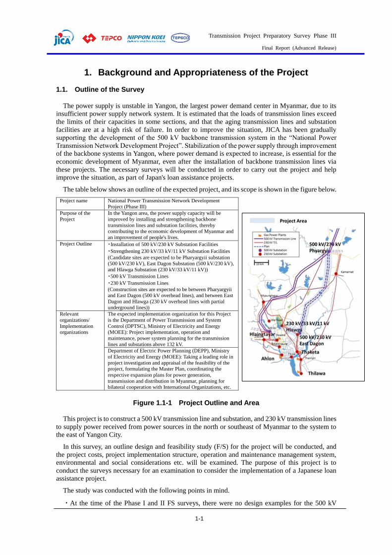
The table below shows an outline of the expected project, and its scope is shown in the figure below.
Project name National Power Transmission Network Development Project (Phase III)
Purpose of the
Project
In the Yangon area, the power supply capacity will be
improved by installing and strengthening backbone
transmission lines and substation facilities, thereby contributing to the economic development of Myanmar and
an improvement of people's lives.
Project Outline ・Installation of 500 kV/230 kV Substation Facilities
・Strengthening 230 kV/33 kV/11 kV Substation Facilities
(Candidate sites are expected to be Pharyargyii substation (500 kV/230 kV), East Dagon Substation (500 kV/230 kV),
and Hlawga Substation (230 kV/33 kV/11 kV))
・500 kV Transmission Lines
・230 kV Transmission Lines
(Construction sites are expected to be between Pharyargyii and East Dagon (500 kV overhead lines), and between East
Dagon and Hlawga (230 kV overhead lines with partial underground lines))
Relevant
organizations/
Implementation organizations
The expected implementation organization for this Project
is the Department of Power Transmission and System
Control (DPTSC), Ministry of Electricity and Energy (MOEE): Project implementation, operation and
maintenance, power system planning for the transmission
lines and substations above 132 kV.
Department of Electric Power Planning (DEPP), Ministry
of Electricity and Energy (MOEE): Taking a leading role in
project investigation and appraisal of the feasibility of the project, formulating the Master Plan, coordinating the
respective expansion plans for power generation,
transmission and distribution in Myanmar, planning for bilateral cooperation with International Organizations, etc.
Figure 1.1-1 Project Outline and Area
This project is to construct a 500 kV transmission line and substation, and 230 kV transmission lines
to supply power received from power sources in the north or southeast of Myanmar to the system to
the east of Yangon City.
In this survey, an outline design and feasibility study (F/S) for the project will be conducted, and
the project costs, project implementation structure, operation and maintenance management system,
environmental and social considerations etc. will be examined. The purpose of this project is to
conduct the surveys necessary for an examination to consider the implementation of a Japanese loan
assistance project.
The study was conducted with the following points in mind.
・At the time of the Phase I and II FS surveys, there were no design examples for the 500 kV
Transmission Project Preparatory Survey Phase III
Final Report (Advanced Release)
1-2
transmission lines, and it was difficult to set and explain their design conditions. For this reason, for
the first 230 kV underground line, the contents of the explanation and the materials were thoroughly
examined, and discussions were held with DTPSC to avoid redoing work.
・Geological surveys conducted by a subcontractor are important for transmission line route
selection and cost calculations, and it is necessary for the executing company to be able to cooperate
with DTPSC at all times. In this project, we incorporated such conditions into the specifications and
selected the most appropriate subcontractor.
・Construction related to the 500 kV transmission line, with support from Serbia, has been
completed for the tower, and the wires are being connected. The construction is expected to be
completed shortly.
・Compatibility with MP
According to the JICA Master Plan, three 500 kV substations will be required around Yangon by
2030. In addition to Payaji and Rheinthaya, which are under construction, boosting the Loga substation
to a 500 kV substation is illustrated. However, DPTSC indicated that it was difficult to extend the 500
kV transmission line to the Loga substation in terms of the surrounding environment. Therefore, in
this study, the 500 kV substation around East Dagon is planned to be installed as the third 500 kV
substation, and the 230 kV transmission line is to be constructed from the new 500 kV substation at
Loga and East Dagon substation.
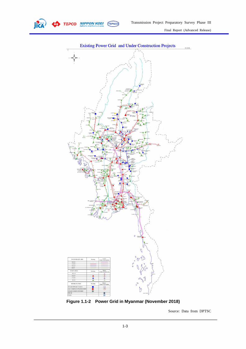
Transmission Project Preparatory Survey Phase III
Final Report (Advanced Release)
1-3
Figure 1.1-2 Power Grid in Myanmar (November 2018)
Source: Data from DPTSC

Transmission Project Preparatory Survey Phase III
Final Report (Advanced Release)
1-4
1.2. Power Demand Records As per the data released by the MOEE at the ADB meeting1 in November 2019, the actual peak
demand in Myanmar is shown in the table below: 2,497 MW in 2015 and 3,798 MW in 2019.
Table 1.2-1 Maximum Power Demand Records in Myanmar Year 2009 2010 2011 2012 2013 2014 2015 2016 2017 2018 2019
Peak
Load
(MW)
1,129 1,371 1,588 1,790 1,969 2,102 2,497 2,802 3,189 3,586 3,798
Source: Data from MOEE
According to the Project for Capacity Development of Power Sector Development Planning
(December 2017), the total maximum power demand in Myanmar in 2015 was 2,437 MW, and the
maximum power demand in Yangon was 1,096 MW in 2015, accounting for 45% of the total for
Myanmar.
The maximum power demand in 2019 increased by about 50% compared to 2015. Increasing at this
rate, Myanmar's peak power demand in 2020 is expected to exceed 4,000 MW. Power demand in
Yangon is expected to be around 2,000 MW by 2020.
Table 1.2-2 shows the maximum load of the 66 kV and 33 kV systems in Hlawga, Ahlone, Thaketa
and Ywama in Yangon City from 2018 to 2019. The total maximum load of these four substations was
about 1,150 MW. Since the load for each substation records the maximum load on the 66 kV and 33
kV distribution lines during a particular month or day, there is a difference between the total maximum
load and the overall maximum load. There is isochronous separation. Therefore, the maximum value
of the load for the entire four substations is smaller than this value. Generators are installed at the four
substations.
In addition to the above four substations, the 230 kV substations in Yangon include 230 kV/66 kV
Bayintnaung, 230 kV/66 kV East Dagon, 230 kV/33 kV Hlaingtharyar, 230 kV/33 kV Kamarnat, 230
kV/33 kV Myaungdagar, 230 kV/ 33 kV Thanlyin, 230 kV/33 kV Wartayar, and 230 kV Thilawa.
According to MOEE, the peak power demand in Yangon City was around 1,500 MW in 2019.
1 RPTCC (Regional Power Trade Coordination Committee) 26, Hanoi, 27/11/2019
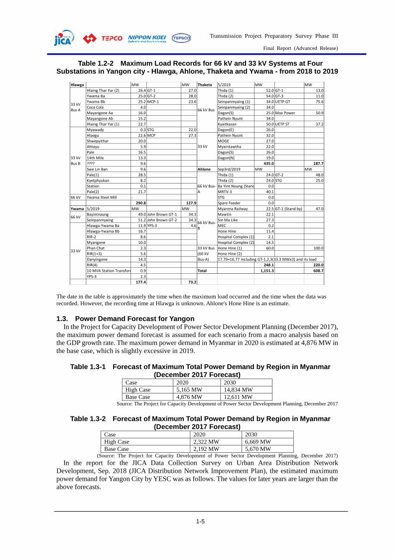
Transmission Project Preparatory Survey Phase III
Final Report (Advanced Release)
1-5
Table 1.2-2 Maximum Load Records for 66 kV and 33 kV Systems at Four Substations in Yangon city - Hlawga, Ahlone, Thaketa and Ywama - from 2018 to 2019
The date in the table is approximately the time when the maximum load occurred and the time when the data was
recorded. However, the recording time at Hlawga is unknown. Ahlone's Hone Hine is an estimate.
1.3. Power Demand Forecast for Yangon In the Project for Capacity Development of Power Sector Development Planning (December 2017),
the maximum power demand forecast is assumed for each scenario from a macro analysis based on
the GDP growth rate. The maximum power demand in Myanmar in 2020 is estimated at 4,876 MW in
the base case, which is slightly excessive in 2019.
Table 1.3-1 Forecast of Maximum Total Power Demand by Region in Myanmar (December 2017 Forecast)
Case 2020 2030
High Case 5,165 MW 14,834 MW
Base Case 4,876 MW 12,611 MW Source: The Project for Capacity Development of Power Sector Development Planning, December 2017
Table 1.3-2 Forecast of Maximum Total Power Demand by Region in Myanmar (December 2017 Forecast)
Case 2020 2030
High Case 2,322 MW 6,669 MW
Base Case 2,192 MW 5,670 MW (Source: The Project for Capacity Development of Power Sector Development Planning, December 2017)
In the report for the JICA Data Collection Survey on Urban Area Distribution Network
Development, Sep. 2018 (JICA Distribution Network Improvement Plan), the estimated maximum
power demand for Yangon City by YESC was as follows. The values for later years are larger than the
above forecasts.
Hlawga MW MW Thaketa 5/2019 MW MW
Hlaing Thar Yar (2) 26.4 GT-1 27.0 Thida (1) 52.0 GT-1 13.0
Ywama Ba 25.0 GT-2 28.0 Thida (2) 54.0 GT-3 11.0
Ywama Bb 25.2 MCP-1 23.6 Seinpanmyaing (1) 34.0 UETP GT 75.6
Coca Cola 4.0 Seinpanmyaing (2) 34.0
Mayangone Aa 16.0 Dagon(S) 25.0 Max Power 50.9
Mayangone Ab 15.2 Pathein Nyunt 34.0
Hlaing Thar Yar (1) 22.7 Kyaitkasan 50.0 UETP ST 37.2
Myawady 0.3 STG 22.0 Dagon(E) 26.0
Hlaegu 22.6 MCP 27.3 Pathein Nyunt 32.0
Shwepyithar 20.0 MOGE 27.0
Ahtayu 5.9 Myaintawtha 22.0
Pale 16.5 Dagon(S) 26.0
14th Mile 13.3 Dagon(N) 19.0
???? 9.6 435.0 187.7
Swe Lin Ban 9.6 Ahlone Sep3rd/2019 MW MW
Pale(1) 28.5 Thida (1) 24.0 GT-2 48.0
Kyetphyukan 8.2 Thida (2) 24.0 STG 25.0
Station 0.1 Ba Yint Noung (Stand by) 0.0
Pale(2) 21.7 MRTV-3 40.1
66 kV Ywama Steel Mill - STG 0.0
290.8 127.9 Spare Feeder 0.0
Ywama 5/2019 MW MW Myanma Railway 22.5 GT-1 (Stand by) 47.0
Bayintnaung 49.0 John Brown GT-1 34.3 Mawtin 22.1
Seinpanmyaing 51.2 John Brown GT-2 34.3 Sin Ma Like 27.3
Hlawga-Ywama Ba 11.9 YPS-3 4.6 MEC 0.2
Hlawga-Ywama Bb 16.7 Hone Hine 11.4
RIR-2 8.6 Hospital Complex (1) 2.1
Myangone 10.0 Hospital Complex (2) 14.5
Phan Chat 2.3 Hone Hine (1) 60.0 100.0
RIR(1+3) 5.6 Hone Hine (2)
Danyingone 14.3 17.79+16.77 including GT-1,2,3(33.3 MWx3) and its load
RIR(4) 4.5 248.1 220.0
10 MVA Station Transformer 0.9 Total 1,151.3 608.7
YPS-3 2.3
177.4 73.2
66 kV Bus
33 kV
66 kV
33 kV
33 kV
Bus A
33 kV
Bus B
66 kV Bus-
A
66 kV Bus-
B
33 kV Bus
(66 kV
Bus-A)
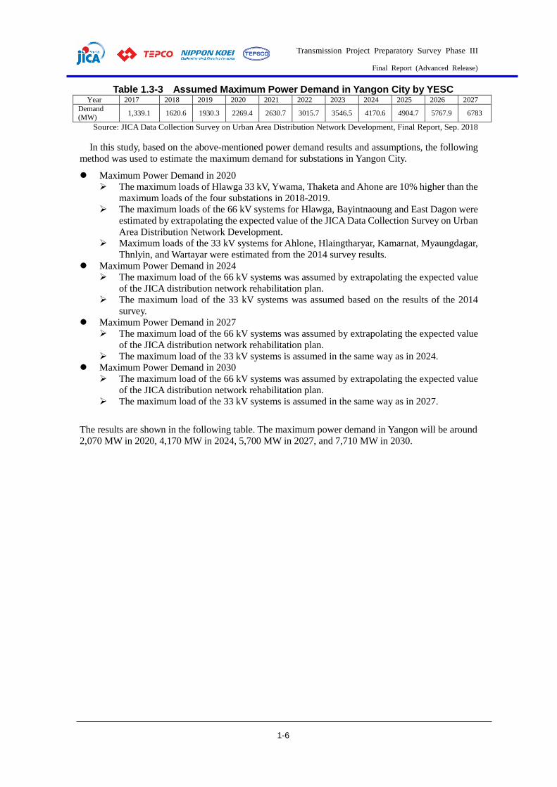
Transmission Project Preparatory Survey Phase III
Final Report (Advanced Release)
1-6
Table 1.3-3 Assumed Maximum Power Demand in Yangon City by YESC Year 2017 2018 2019 2020 2021 2022 2023 2024 2025 2026 2027
Demand
(MW) 1,339.1 1620.6 1930.3 2269.4 2630.7 3015.7 3546.5 4170.6 4904.7 5767.9 6783
Source: JICA Data Collection Survey on Urban Area Distribution Network Development, Final Report, Sep. 2018
In this study, based on the above-mentioned power demand results and assumptions, the following
method was used to estimate the maximum demand for substations in Yangon City.
Maximum Power Demand in 2020
The maximum loads of Hlawga 33 kV, Ywama, Thaketa and Ahone are 10% higher than the
maximum loads of the four substations in 2018-2019.
The maximum loads of the 66 kV systems for Hlawga, Bayintnaoung and East Dagon were
estimated by extrapolating the expected value of the JICA Data Collection Survey on Urban
Area Distribution Network Development.
Maximum loads of the 33 kV systems for Ahlone, Hlaingtharyar, Kamarnat, Myaungdagar,
Thnlyin, and Wartayar were estimated from the 2014 survey results.
Maximum Power Demand in 2024
The maximum load of the 66 kV systems was assumed by extrapolating the expected value
of the JICA distribution network rehabilitation plan.
The maximum load of the 33 kV systems was assumed based on the results of the 2014
survey.
Maximum Power Demand in 2027
The maximum load of the 66 kV systems was assumed by extrapolating the expected value
of the JICA distribution network rehabilitation plan.
The maximum load of the 33 kV systems is assumed in the same way as in 2024.
Maximum Power Demand in 2030
The maximum load of the 66 kV systems was assumed by extrapolating the expected value
of the JICA distribution network rehabilitation plan.
The maximum load of the 33 kV systems is assumed in the same way as in 2027.
The results are shown in the following table. The maximum power demand in Yangon will be around
2,070 MW in 2020, 4,170 MW in 2024, 5,700 MW in 2027, and 7,710 MW in 2030.

Transmission Project Preparatory Survey Phase III
Final Report (Advanced Release)
1-7
Table 1.3-4 Maximum Power Demand Forecast in Yangon
(Source: JICA Survey Team)
Various power demand forecasts were compared with the power demand forecasts in this survey.
The estimated value this time is between the estimated value of the power development plan capacity
improvement project (December 2017) and the estimated value of the JICA Data Collection Survey
on Urban Area Distribution Network Development, Sep. 2018.
Figure 1.3-1 Comparison of Various Demand Forecasts and Demand Forecasts in
This Survey
JICA MP: the Project for Capacity Development of Power Sector Development Planning
(December 2017)
JICA Distribution Survey: JICA Data Collection Survey on Urban Area Distribution Network
Development, Sep.2018 (demand forecast up to 2027)
(MW)
66 kV 33 kV 66 kV 33 kV 66 kV 33 kV 66 kV 33 kV 66 kV 33 kV
Hlawga 75.4 319.9 146.6 265.6 162.6 294.7 200.2 362.7 273.4 495.4
Ywama 110.3 84.9 88.3 18.0 98.0 20.0 120.6 24.6 164.7 33.6
Bayintnaung 165.3 - 343.0 - 380.5 0.0 468.4 - 639.7 -
Dagon E 119.3 - 130.8 - 145.1 0.0 178.6 - 243.9 -
New E. Dagon - 0.0 130.8 0.0 145.1 0.0 178.6 0.0 243.9 0.0
Thaketa 339.9 138.6 361.3 109.1 400.8 121.0 493.4 149.0 673.9 203.4
Thuwanna - - 118.5 - 131.5 0.0 161.9 - 221.1 -
S.Okkalapa - - 195.0 - 216.3 0.0 266.3 - 363.7 -
Thida - - 271.6 - 301.3 0.0 370.9 - 506.6 -
Ahlone 206.9 121.0 226.6 110.0 251.4 122.1 309.5 150.3 422.7 205.2
Kyaik Ka San - - 171.0 - 189.8 0.0 233.6 - 319.0 -
Hlaingtharyar - 119.0 - 274.1 0.0 304.1 - 374.3 - 511.2
West University - - - 274.1 0.0 304.1 - 374.3 - 511.2
Kamarnat - 38.2 - 175.8 0.0 195.1 - 240.1 - 327.9
Myaungdagar - 74.0 - 341.0 0.0 378.3 - 465.7 - 636.0
Thanlyin - 39.9 - 183.9 0.0 204.0 - 251.2 - 343.0
Wartayar - 19.4 - 89.2 0.0 98.9 - 121.8 - 166.3
Thilawa - 100.0 - 146.4 0.0 162.5 - 200.0 - 200.0
Total 1,017.1 1,054.9 2,183.4 1,987.2 2,422.5 2,204.7 2,982.0 2,713.9 4,072.6 3,633.4
2,072.0 4,170.6 4,627.2 5,695.9 7,706.0
202720242020 20302025
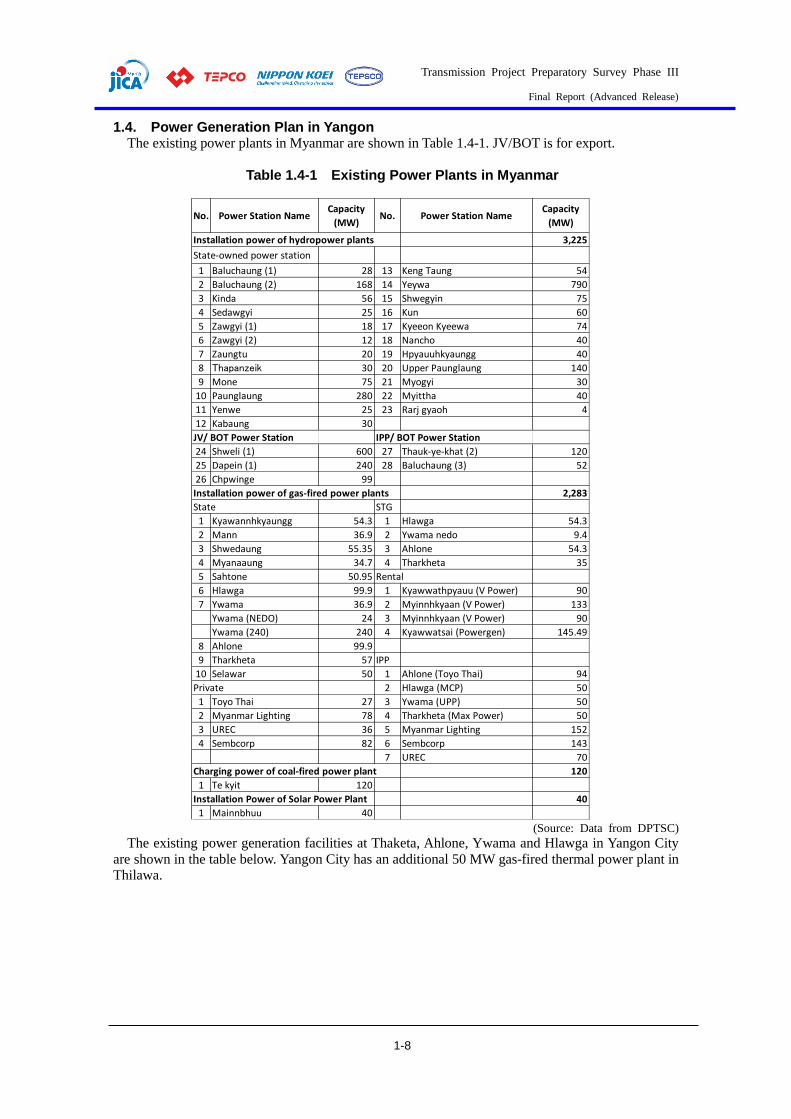
Transmission Project Preparatory Survey Phase III
Final Report (Advanced Release)
1-8
1.4. Power Generation Plan in Yangon The existing power plants in Myanmar are shown in Table 1.4-1. JV/BOT is for export.
Table 1.4-1 Existing Power Plants in Myanmar
(Source: Data from DPTSC)
The existing power generation facilities at Thaketa, Ahlone, Ywama and Hlawga in Yangon City
are shown in the table below. Yangon City has an additional 50 MW gas-fired thermal power plant in
Thilawa.
No. Power Station NameCapacity
(MW)No. Power Station Name
Capacity
(MW)
Installation power of hydropower plants 3,225
State-owned power station
1 Baluchaung (1) 28 13 Keng Taung 54
2 Baluchaung (2) 168 14 Yeywa 790
3 Kinda 56 15 Shwegyin 75
4 Sedawgyi 25 16 Kun 60
5 Zawgyi (1) 18 17 Kyeeon Kyeewa 74
6 Zawgyi (2) 12 18 Nancho 40
7 Zaungtu 20 19 Hpyauuhkyaungg 40
8 Thapanzeik 30 20 Upper Paunglaung 140
9 Mone 75 21 Myogyi 30
10 Paunglaung 280 22 Myittha 40
11 Yenwe 25 23 Rarj gyaoh 4
12 Kabaung 30
JV/ BOT Power Station IPP/ BOT Power Station
24 Shweli (1) 600 27 Thauk-ye-khat (2) 120
25 Dapein (1) 240 28 Baluchaung (3) 52
26 Chpwinge 99
Installation power of gas-fired power plants 2,283
State STG
1 Kyawannhkyaungg 54.3 1 Hlawga 54.3
2 Mann 36.9 2 Ywama nedo 9.4
3 Shwedaung 55.35 3 Ahlone 54.3
4 Myanaaung 34.7 4 Tharkheta 35
5 Sahtone 50.95 Rental
6 Hlawga 99.9 1 Kyawwathpyauu (V Power) 90
7 Ywama 36.9 2 Myinnhkyaan (V Power) 133
Ywama (NEDO) 24 3 Myinnhkyaan (V Power) 90
Ywama (240) 240 4 Kyawwatsai (Powergen) 145.49
8 Ahlone 99.9
9 Tharkheta 57 IPP
10 Selawar 50 1 Ahlone (Toyo Thai) 94
Private 2 Hlawga (MCP) 50
1 Toyo Thai 27 3 Ywama (UPP) 50
2 Myanmar Lighting 78 4 Tharkheta (Max Power) 50
3 UREC 36 5 Myanmar Lighting 152
4 Sembcorp 82 6 Sembcorp 143
7 UREC 70
Charging power of coal-fired power plant 120
1 Te kyit 120
Installation Power of Solar Power Plant 40
1 Mainnbhuu 40
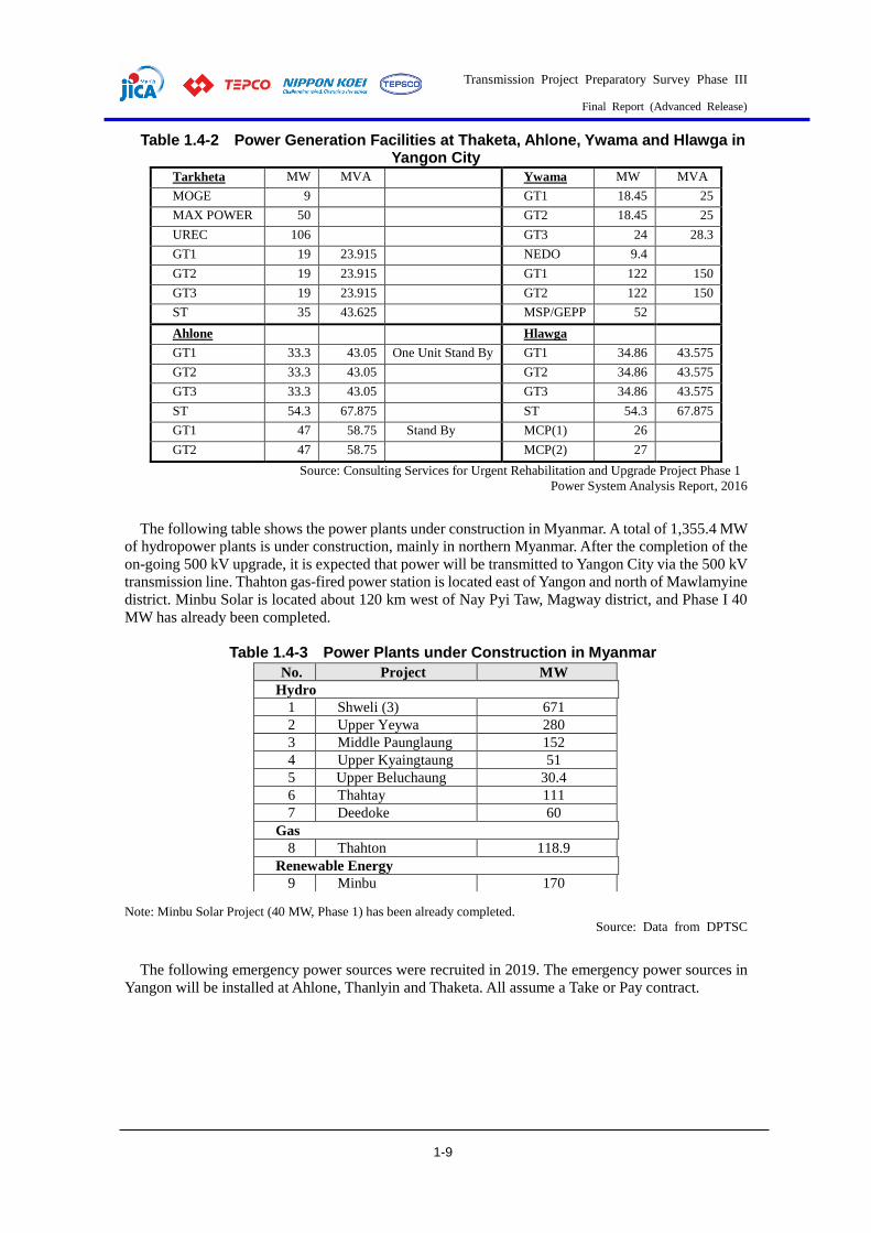
Transmission Project Preparatory Survey Phase III
Final Report (Advanced Release)
1-9
Table 1.4-2 Power Generation Facilities at Thaketa, Ahlone, Ywama and Hlawga in Yangon City
Tarkheta MW MVA Ywama MW MVA
MOGE 9
GT1 18.45 25
MAX POWER 50
GT2 18.45 25
UREC 106
GT3 24 28.3
GT1 19 23.915 NEDO 9.4
GT2 19 23.915 GT1 122 150
GT3 19 23.915 GT2 122 150
ST 35 43.625 MSP/GEPP 52
Ahlone
Hlawga
GT1 33.3 43.05 One Unit Stand By GT1 34.86 43.575
GT2 33.3 43.05 GT2 34.86 43.575
GT3 33.3 43.05 GT3 34.86 43.575
ST 54.3 67.875 ST 54.3 67.875
GT1 47 58.75 Stand By MCP(1) 26
GT2 47 58.75 MCP(2) 27
Source: Consulting Services for Urgent Rehabilitation and Upgrade Project Phase 1
Power System Analysis Report, 2016
The following table shows the power plants under construction in Myanmar. A total of 1,355.4 MW
of hydropower plants is under construction, mainly in northern Myanmar. After the completion of the
on-going 500 kV upgrade, it is expected that power will be transmitted to Yangon City via the 500 kV
transmission line. Thahton gas-fired power station is located east of Yangon and north of Mawlamyine
district. Minbu Solar is located about 120 km west of Nay Pyi Taw, Magway district, and Phase I 40
MW has already been completed.
Table 1.4-3 Power Plants under Construction in Myanmar
Note: Minbu Solar Project (40 MW, Phase 1) has been already completed.
Source: Data from DPTSC
The following emergency power sources were recruited in 2019. The emergency power sources in
Yangon will be installed at Ahlone, Thanlyin and Thaketa. All assume a Take or Pay contract.
No. Project MW
Hydro
1 Shweli (3) 671
2 Upper Yeywa 280
3 Middle Paunglaung 152
4 Upper Kyaingtaung 51
5 Upper Beluchaung 30.4
6 Thahtay 111
7 Deedoke 60
Gas
8 Thahton 118.9
Renewable Energy
9 Minbu 170

Transmission Project Preparatory Survey Phase III
Final Report (Advanced Release)
1-10
Table 1.4-4 Emergency Power Supply recruited in 2019 Name Capacity Fuel Contract
years
Kyun Chaung 20 MW (Gas) inland gas field (Magway
Region)
5 years
Ahlone 120 MW (Gas) Tanada Gas Field 5 years
Kyauk Phyu 150 MW (LNG) Steel Mill IPP 5 years
Thanlyin 350 MW (LNG, land-based gas, barge,
or other)
5 years Connected to
Thilawa
Thaketa 400 MW (LNG) 5 years
Total 1,040 MW
There are other plans for around the city of Yangon, including thermal power in the Thilawa and
Mawlamyine areas, as well as imports from Thailand, but none has been decided. Emergency power
is planned to be recruited in 2020. In addition, there is a trend of building IPP power plants in Yangon
City. The power supply plan for Yangon in this study is set as shown in the table below.
Table 1.4-5 Power Generation Plan in Yangon The figures are in MW of power generation capacity.
Existing Emergency
added 2020
Emergency
added 2021
IPP
New
Total
State IPP
Tarkheta 92.0 165.0 400.0 0.0 500.0 1,157
Aholne 154.2 94.0 120.0 0.0 300.0 668
Seikkyi Khanaungto 0.0 0.0 0.0 300.0 0.0 300
Ywama 314.3 52.0 0.0 0.0 300.0 666
Hlawga 158.9 53.0 0.0 400.0 0.0 612
Thanlyin 0.0 0.0 350.0 0.0 0.0 350
Thilawa 0.0 50.0 0.0 0.0 350.0 400
East Dagon 0.0 0.0 0.0 200.0 0.0 200
Mee Linn Gyaing (500 kV)
1,390.0 1,390
Total 719.4 414.0 870.0 900.0 2,840.0 5,743

Transmission Project Preparatory Survey Phase III
Final Report (Advanced Release)
1-11
1.5. Power System Plans
Plans
(1) Existing System and MOEE Plan The figure below shows the existing 230 kV system in Yangon City.
Figure 1.5-1 Existing 230 kV System in Yangon City (January 2020)
The 500 kV facilities are currently under construction in Phase I and II of the ODA loan project and
they are not part of the existing grid. Most 230 kV transmission lines consist of one route and one
circuit. East Dagon-Thaketa has a double circuit transmission line, but one circuit has not been
serviced yet; both ends are open and not charged. The 230 kV line from the north through Hlawga to
Thaketa, called the Lawpita Line, was constructed when the Baluchan hydropower plant started
operation. At that time, the standard capacity of the transmission line was small, so the capacity per
line of this transmission line was 164 MVA, which is smaller than the currently used standard capacity
(288 MVA). Since the current 230 kV system does not have sufficient transmission capacity, there are
sections where the capacity is insufficient during peak demand and sections where a large supply
interruption is expected when one circuit of the transmission line is stopped.
There is no fixed plan for the development of the 500 kV and 230 kV power systems in Yangon
City, but the general concept of the MOEE plan is as follows.
Establish new 500 kV substations in the east and west of the city (West: Hlaingtayar, East:
around East Dagon).
500 kV substations are supplied by 500 kV transmission lines from distant but economical
power sources such as those in the north and southeast.
The 230 kV transmission lines in Yangon city will consist of two circuits per route and will be
supplied from the 500 kV substations east and west of the city.
230 kV transmission lines from the east-west 500 kV substations to the city are interconnected
via several substations.
Since there are many places where it is difficult to secure transmission line routes, transmission
lines will be constructed along wide roads with relatively little traffic and existing transmission
line routes.
(2) Status of Power Flow in 2020 The figure below shows the power flow of the 230 kV system in Yangon in 2020 in a situation
where supply and demand are relatively severe without emergency power generators installed. Only
the existing power sources were used in the city. The power flow of one 230 kV circuit from the north
to Thaketa via Hlawga exceeds the capacity during peak power demand. For this reason, when no

Transmission Project Preparatory Survey Phase III
Final Report (Advanced Release)
1-12
emergency power generators are installed, there is a concern that the load on Yangon will be reduced
during peak power demand.
Figure 1.5-2 Power Flow in 2020 (Without Emergency Generators)
Figure 1.5-3 shows the expected power flow when the aforementioned emergency power supply is
installed at the 230 kV substations - Ahn City. The power flows from Thaketa and Thanlyin to Hlawga
and East Dagon, which in turn overloads the flow between Thaketa and Hlawga. The following
measures can be considered to improve this situation.
1. Suppress output of emergency power supply
or
2. Increase the number of circuits between Thaketa and Hlawga
The power flow in each case is shown in Figure 1.5-4 and Figure 1.5-7. DPTSC has decided to
implement the measures described in item 2 and plans to implement procurement in 2020.
Figure 1.5-3 Power Flow in 2020 (With Emergency Generators)
<Main study conditions>
Maximum Power Demand in Yangon
2,072 MW
Existing Power Generators in Yangon
Full power outputs
Emergency generators in Yangon
None
Year: 2020
<Main study conditions>
Maximum Power Demand in Yangon
2,072 MW
Existing Power Generators in Yangon
Full power outputs
Emergency generators in Yangon
Operating
Year: 2020
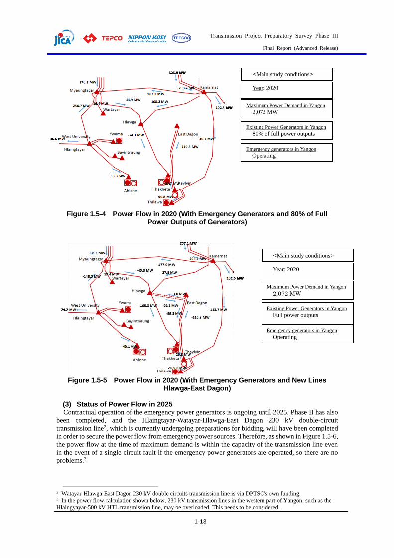
Transmission Project Preparatory Survey Phase III
Final Report (Advanced Release)
1-13
Figure 1.5-4 Power Flow in 2020 (With Emergency Generators and 80% of Full
Power Outputs of Generators)
Figure 1.5-5 Power Flow in 2020 (With Emergency Generators and New Lines
Hlawga-East Dagon)
(3) Status of Power Flow in 2025 Contractual operation of the emergency power generators is ongoing until 2025. Phase II has also
been completed, and the Hlaingtayar-Watayar-Hlawga-East Dagon 230 kV double-circuit
transmission line2, which is currently undergoing preparations for bidding, will have been completed
in order to secure the power flow from emergency power sources. Therefore, as shown in Figure 1.5-6,
the power flow at the time of maximum demand is within the capacity of the transmission line even
in the event of a single circuit fault if the emergency power generators are operated, so there are no
problems.3
2 Watayar-Hlawga-East Dagon 230 kV double circuits transmission line is via DPTSC's own funding. 3 In the power flow calculation shown below, 230 kV transmission lines in the western part of Yangon, such as the
Hlaingyayar-500 kV HTL transmission line, may be overloaded. This needs to be considered.
<Main study conditions>
Maximum Power Demand in Yangon
2,072 MW
Existing Power Generators in Yangon
80% of full power outputs
Emergency generators in Yangon
Operating
Year: 2020
<Main study conditions>
Maximum Power Demand in Yangon
2,072 MW
Existing Power Generators in Yangon
Full power outputs
Emergency generators in Yangon
Operating
Year: 2020
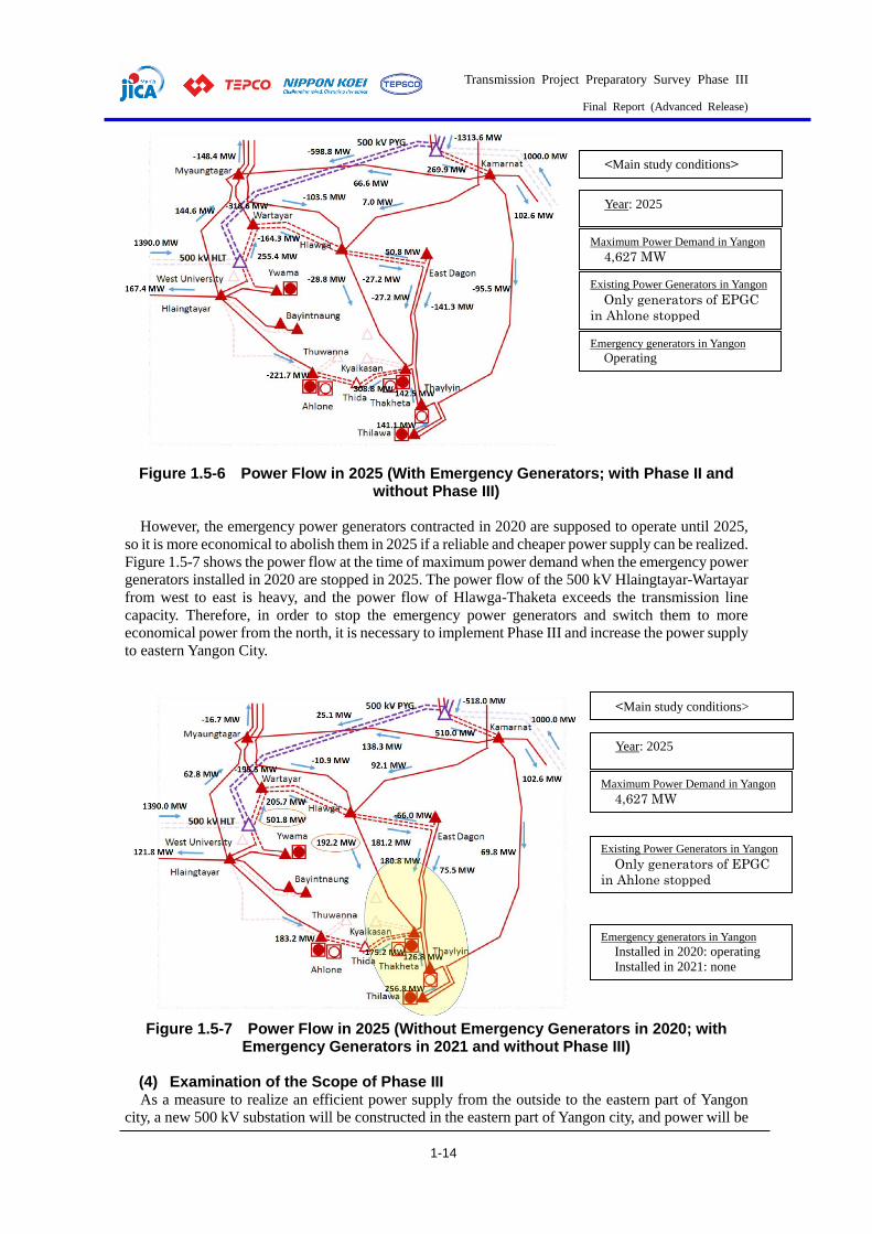
Transmission Project Preparatory Survey Phase III
Final Report (Advanced Release)
1-14
Figure 1.5-6 Power Flow in 2025 (With Emergency Generators; with Phase II and
without Phase III)
However, the emergency power generators contracted in 2020 are supposed to operate until 2025,
so it is more economical to abolish them in 2025 if a reliable and cheaper power supply can be realized.
Figure 1.5-7 shows the power flow at the time of maximum power demand when the emergency power
generators installed in 2020 are stopped in 2025. The power flow of the 500 kV Hlaingtayar-Wartayar
from west to east is heavy, and the power flow of Hlawga-Thaketa exceeds the transmission line
capacity. Therefore, in order to stop the emergency power generators and switch them to more
economical power from the north, it is necessary to implement Phase III and increase the power supply
to eastern Yangon City.
Figure 1.5-7 Power Flow in 2025 (Without Emergency Generators in 2020; with
Emergency Generators in 2021 and without Phase III)
(4) Examination of the Scope of Phase III As a measure to realize an efficient power supply from the outside to the eastern part of Yangon
city, a new 500 kV substation will be constructed in the eastern part of Yangon city, and power will be
<Main study conditions>
Maximum Power Demand in Yangon
4,627 MW
Existing Power Generators in Yangon
Only generators of EPGC
in Ahlone stopped
Emergency generators in Yangon
Operating
Year: 2025
<Main study conditions>
Maximum Power Demand in Yangon
4,627 MW
Existing Power Generators in Yangon
Only generators of EPGC
in Ahlone stopped
Emergency generators in Yangon
Installed in 2020: operating
Installed in 2021: none
Year: 2025
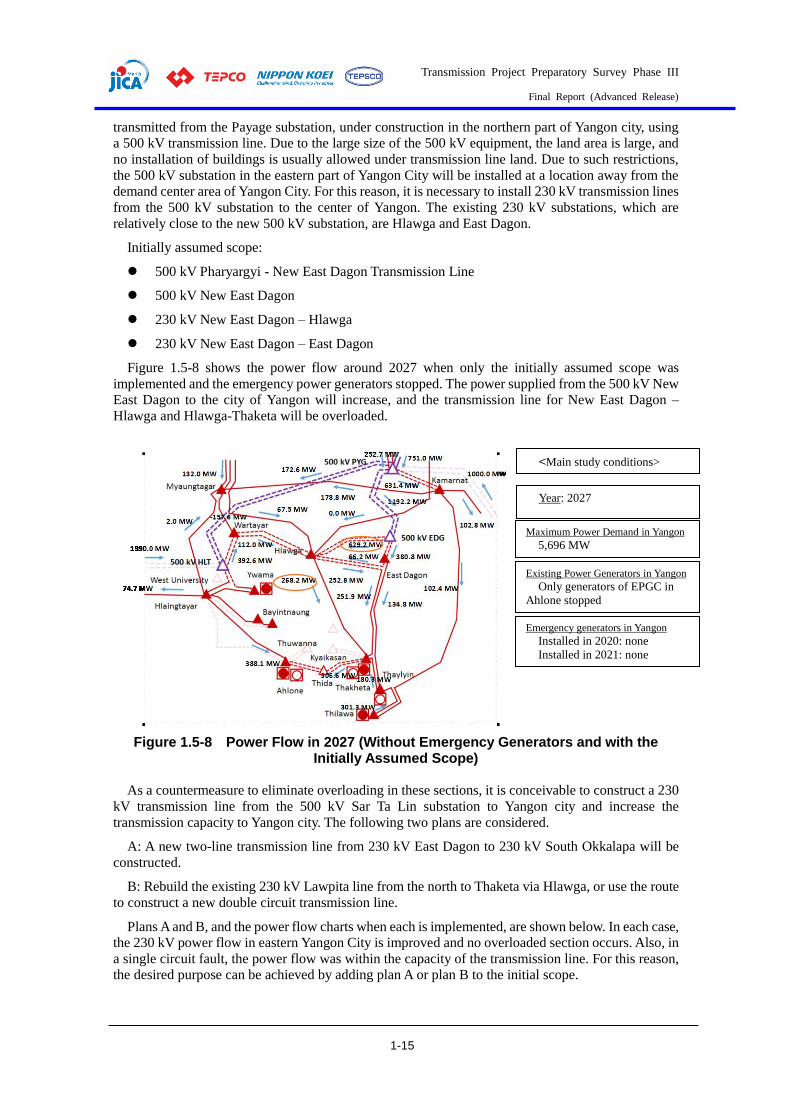
Transmission Project Preparatory Survey Phase III
Final Report (Advanced Release)
1-15
transmitted from the Payage substation, under construction in the northern part of Yangon city, using
a 500 kV transmission line. Due to the large size of the 500 kV equipment, the land area is large, and
no installation of buildings is usually allowed under transmission line land. Due to such restrictions,
the 500 kV substation in the eastern part of Yangon City will be installed at a location away from the
demand center area of Yangon City. For this reason, it is necessary to install 230 kV transmission lines
from the 500 kV substation to the center of Yangon. The existing 230 kV substations, which are
relatively close to the new 500 kV substation, are Hlawga and East Dagon.
Initially assumed scope:
500 kV Pharyargyi - New East Dagon Transmission Line
500 kV New East Dagon
230 kV New East Dagon – Hlawga
230 kV New East Dagon – East Dagon
Figure 1.5-8 shows the power flow around 2027 when only the initially assumed scope was
implemented and the emergency power generators stopped. The power supplied from the 500 kV New
East Dagon to the city of Yangon will increase, and the transmission line for New East Dagon –
Hlawga and Hlawga-Thaketa will be overloaded.
Figure 1.5-8 Power Flow in 2027 (Without Emergency Generators and with the
Initially Assumed Scope)
As a countermeasure to eliminate overloading in these sections, it is conceivable to construct a 230
kV transmission line from the 500 kV Sar Ta Lin substation to Yangon city and increase the
transmission capacity to Yangon city. The following two plans are considered.
A: A new two-line transmission line from 230 kV East Dagon to 230 kV South Okkalapa will be
constructed.
B: Rebuild the existing 230 kV Lawpita line from the north to Thaketa via Hlawga, or use the route
to construct a new double circuit transmission line.
Plans A and B, and the power flow charts when each is implemented, are shown below. In each case,
the 230 kV power flow in eastern Yangon City is improved and no overloaded section occurs. Also, in
a single circuit fault, the power flow was within the capacity of the transmission line. For this reason,
the desired purpose can be achieved by adding plan A or plan B to the initial scope.
<Main study conditions>
Maximum Power Demand in Yangon
5,696 MW
Existing Power Generators in Yangon
Only generators of EPGC in
Ahlone stopped
Emergency generators in Yangon
Installed in 2020: none
Installed in 2021: none
Year: 2027
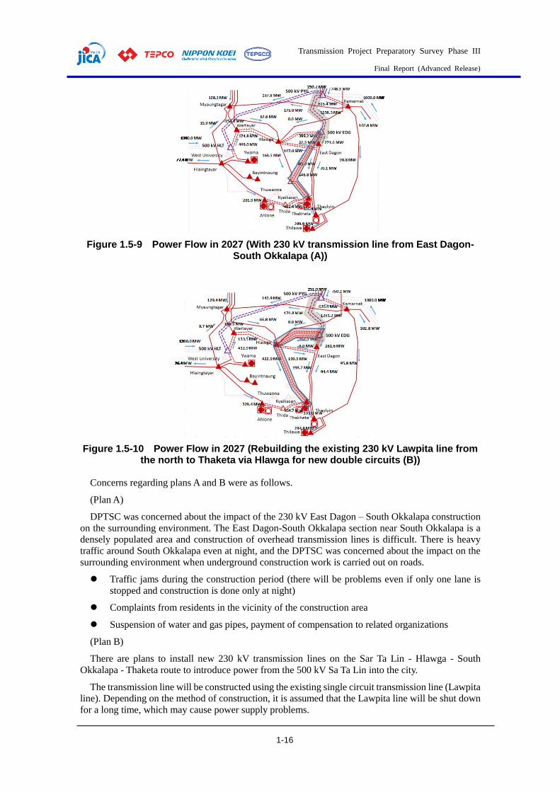
Transmission Project Preparatory Survey Phase III
Final Report (Advanced Release)
1-16
Figure 1.5-9 Power Flow in 2027 (With 230 kV transmission line from East Dagon-
South Okkalapa (A))
Figure 1.5-10 Power Flow in 2027 (Rebuilding the existing 230 kV Lawpita line from the north to Thaketa via Hlawga for new double circuits (B))
Concerns regarding plans A and B were as follows.
(Plan A)
DPTSC was concerned about the impact of the 230 kV East Dagon – South Okkalapa construction
on the surrounding environment. The East Dagon-South Okkalapa section near South Okkalapa is a
densely populated area and construction of overhead transmission lines is difficult. There is heavy
traffic around South Okkalapa even at night, and the DPTSC was concerned about the impact on the
surrounding environment when underground construction work is carried out on roads.
Traffic jams during the construction period (there will be problems even if only one lane is
stopped and construction is done only at night)
Complaints from residents in the vicinity of the construction area
Suspension of water and gas pipes, payment of compensation to related organizations
(Plan B)
There are plans to install new 230 kV transmission lines on the Sar Ta Lin - Hlawga - South
Okkalapa - Thaketa route to introduce power from the 500 kV Sa Ta Lin into the city.
The transmission line will be constructed using the existing single circuit transmission line (Lawpita
line). Depending on the method of construction, it is assumed that the Lawpita line will be shut down
for a long time, which may cause power supply problems.
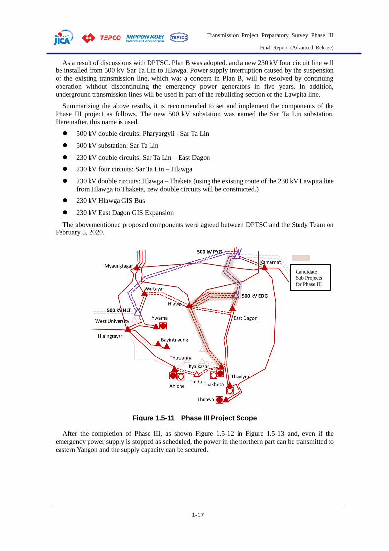
Transmission Project Preparatory Survey Phase III
Final Report (Advanced Release)
1-17
As a result of discussions with DPTSC, Plan B was adopted, and a new 230 kV four circuit line will
be installed from 500 kV Sar Ta Lin to Hlawga. Power supply interruption caused by the suspension
of the existing transmission line, which was a concern in Plan B, will be resolved by continuing
operation without discontinuing the emergency power generators in five years. In addition,
underground transmission lines will be used in part of the rebuilding section of the Lawpita line.
Summarizing the above results, it is recommended to set and implement the components of the
Phase III project as follows. The new 500 kV substation was named the Sar Ta Lin substation.
Hereinafter, this name is used.
500 kV double circuits: Pharyargyii - Sar Ta Lin
500 kV substation: Sar Ta Lin
230 kV double circuits: Sar Ta Lin – East Dagon
230 kV four circuits: Sar Ta Lin – Hlawga
230 kV double circuits: Hlawga – Thaketa (using the existing route of the 230 kV Lawpita line
from Hlawga to Thaketa, new double circuits will be constructed.)
230 kV Hlawga GIS Bus
230 kV East Dagon GIS Expansion
The abovementioned proposed components were agreed between DPTSC and the Study Team on
February 5, 2020.
Figure 1.5-11 Phase III Project Scope
After the completion of Phase III, as shown Figure 1.5-12 in Figure 1.5-13 and, even if the
emergency power supply is stopped as scheduled, the power in the northern part can be transmitted to
eastern Yangon and the supply capacity can be secured.
Candidate Sub Projects
for Phase III

Transmission Project Preparatory Survey Phase III
Final Report (Advanced Release)
1-18
Figure 1.5-12 Power Flow in 2025 (Without Emergency Generators in 2020, with
Emergency Generators in 2021, and with Phase III)
Figure 1.5-13 Power Flow in 2027 (Without Emergency Generators in 2020, without
Emergency Generators in 2021, and with Phase III)
Figure 1.5-14 shows the power flow in 2030 when this project is implemented. If this project is
implemented, the power flow in eastern Yangon will remain within the capacity of the facilities.
According to the calculation results, the load of Sar Ta Lin exceeds 2,000 MW, so five transformers
are required. (In this project, the layout of substations up to four units is presented, but it is possible
to install a fifth substation on the site judging by the area of the site.) In addition to the installation of
the fifth unit, the following countermeasures are conceivable and need to be studied in the future.
・ Consider the installation of a fifth unit (since there is enough space on the site, it can be installed
Transmission Project Preparatory Survey Phase III
Final Report (Advanced Release)
1-19
at that time)
・ Establish a fourth 500 kV substation
・ Installation of new power supply in Yangon city
Figure 1.5-14 Power Flow in 2030 (Without Emergency Generators in 2020, without Emergency Generators in 2021, and with Phase III)
(5) Power Flow Calculation Conditions The conditions of the power flow calculation described above are shown below.
Power load in Yangon: Table 1.3-4 Maximum Power Demand Forecast in Yangon
Power generators: Table 1.3-4 Maximum Power Demand Forecast in Yangon
However, the government-owned Ahlone 154.2 MW has been shut down due to information that it
will be used as a backup after IPP operation commenced.
The constants per km of the 500 kV and 230 kV overhead transmission lines required for the power
flow calculation in the Yangon area were set to the values shown in Table 1.5-1.
Table 1.5-1 Line Parameters per Unit Length of New Overhead Transmission Lines
(Unit: p.u./km, 100 MVA Base)
Voltage
Class (kV)
Resistance Reactance Admittance
230 0.000089863 0.000569130 0.002025963
500 0.000007511 0.000104556 0.010976457
The resistance and the reactance are parameters representing a loss due to the current of the
transmission line and a voltage drop due to the magnetic field, respectively, and the admittance is a
parameter representing a voltage rise due to a charging current of the transmission line. The values
differ depending on the voltage class, the arrangement of the transmission lines, and so on. The line
parameters per km of the 230 kV underground transmission line are set as in Table 1.5-2.

Transmission Project Preparatory Survey Phase III
Final Report (Advanced Release)
1-20
Table 1.5-2 Line Parameters per Unit Length of New Underground Cables (Unit: p.u./km, 100 MVA Base)
Voltage
Class (kV)
Resistance Reactance Admittance
230 0.00001701 0.00029100 0.03988566
The transformer parameters of the new 500 kV substation are as follows.
Table 1.5-3 Transformer Parameters of the New 500 kV Substation Capacity 500 MVA
% Impedance 14%
Fault Currents The fault current in a three-phase short circuit of the 230 kV bus was calculated. The generator
connected to the 230 kV substation in Yangon was set to be connected to the 230 kV bus via a 15%
impedance (step-up transformer). (In actual fact, there are places where the step-up transformer of the
generator is connected to the 66 kV or 33 kV bus. In this case, since the impedance between the 230
kV bus and the generator becomes larger than the conditions described above, the fault current of the
kV bus is smaller than the value calculated under these conditions.)
The next transient reactance of the generator was set to 20%. When a generator is connected to the
66 kV or 33 kV bus, the fault current of the 66 kV or 33 kV bus increases. Therefore, the fault current
of the 66 kV and 33 kV bus needs to be confirmed in each case. The Myanmar generators outside
Yangon were modeled as much as possible.
The result was that the fault current was less than 31.5 kA for all 230 kV buses, which was within
the level of fault current allowed for the 230 kV system in Myanmar.
Stability Generally, the SIL value of a transmission line is used as a criterion for easily determining the
transmission stability. The SIL value is a power flow value at which the decrease/increase of the
voltage at both ends of the transmission line becomes zero, and is a numerical value unique to the
transmission line. The guideline for the transmission power limit, which is restricted by stability, is
expressed in multiples of SIL. The longer the transmission distance, the smaller the limit.
In terms of guidelines for the transmission limit, the transmission distance is about twice the SIL
when the transmission distance is 100 miles (about 160 km), and about 3 times the SIL when the
transmission distance is 50 miles (about 50 km).
The SIL value of a normal 230 kV transmission line in Myanmar is around 180 MW. The 230 km
transmission line in Yangon city has a short transmission distance of 50 km or less, and the power flow
per line is less than three times the SIL value. Therefore, there are no stability problems in the 230 kV
system in Yangon city.
The 230 kV power flow in Yangon city is more limited by the heat capacity of the transmission line
than by the stability.
Voltage Maintenance In the 230 kV system in Yangon City, power flows from the periphery to the center of the city, and
the voltage at the center of the city tends to decrease. In order to improve the voltage drop, it is
necessary to install a power capacitor. It is effective to install a power capacitor on the load side, and
it is considered effective to install it on the load side of the 230 kV system in Yangon city, such as at
Taketa, Aron, or Thanlyin. For the substation where the power capacitor is installed, it is necessary to
measure and study the power factor of the load along with the power flow of the transmission line, the
load of the substation, and the power generated.
New 1,250 MW Thilawa LNG Power Plant It is presumed that the transmission method for this power plant is under consideration, but based
on the size of the power output, two general proposals can be considered.
A new 500 kV transmission line will be built to transmit 1,250 MW to the Sar Ta Lin area.
Transmission Project Preparatory Survey Phase III
Final Report (Advanced Release)
1-21
A new 500 kV line will be built to transmit part of the 1,250 MW to Sar Ta Lin, and a new 230
kV line will be built to transmit the rest of the 1,250 MW to Thilawa, Thanlyin and Thakhta,
depending on the size of the regional demand.
Both the former and the latter proposals will require the construction of a new 500 kV transmission
line, and the route for the line from Thilawa to Sar Ta Lin will need to be surveyed. The latter will
require a route study of a 230 kV transmission line through the densely populated areas in southern
Yangon, but it is unclear whether a feasible route can be secured.
Power flow calculations were conducted for the case where the former transmission method was
adopted for 2027. The results are shown in Figure 1.5-15. Compared to the cross section shown in
powwe flow from Pharyargyi to the north via Sar Ta Lin is reduced by about 1,000 MW, and since the
Figure 1.5-3 conditions of power sources and loads south of Pharyargyi are unchanged except for
Thilawa 1,250 MW, the output of power sources in the northern part of the country will be curtailed
due to the increase of Thilawa 1,250 MW.
Although the power flow on the 230 kV system from Sar Ta Lin to Yangon city will increase, the
power flow in eastern Yangon will continue to be within the capacity of the facility due to the increase
in lines from this project.
Figure 1.5-15 Power Flow in 2027 (without emergency power in 2020, without emergency power in 2021, with Phase III, with Thilawa LNG 1,250 MW)
1.6. Power Distribution Plan in Yangon
Plan Yangon Electricity Supply Corporation (YESC), a MOEE organization, conducts the power distribution business in
Yangon. YESC has drawn up a five-year plan4 for power distribution network development and has revised it from
time to time. The main distribution network in Yangon consists of 66 kV and 33 kV distribution lines and substations,
and 66 kV and 33 kV distribution lines are supplied from the 230 kV substation. Below that, an 11 kV or 6.6 kV
distribution line is connected. YESC plans to upgrade from 33 kV to 66 kV and from 6.6 kV to 11 kV. There are
many plans for adopting GIS-type switchgear and buses, which are compact equipment, for 66 kV. (Source: JICA
Data Collection Survey on Urban Area Distribution Network Development, Final Report, Sep. 2018)
Figure 1.6-1 shows the main power distribution network in Yangon around 2014-2015. Figure 1.6-2
shows the plan for the 66 kV distribution system in Yangon City in 2027.
4 Most recently, it was formulated for the years 2011/11-2015/16 and 2016/17-2019/20.

Transmission Project Preparatory Survey Phase III
Final Report (Advanced Release)
1-22
(Source: JICA Data Collection Survey on Urban Area Distribution Network Development, Final Report, Sep.
2018)
Figure 1.6-1 66 kV and 33 kV Systems in Yangon in 2014-2015
230 kV
Hlaingtharyar S/S
230 kV
Bayintnaung S/S
230 kV
Hlawga S/S
230 kV
Thaketa S/S
230 kV
ThanLyin S/S
230 kV
Ahlone S/S
Red colored: 230 kV Green colored: 66 kV
Yellow colored: 33 kV
Transmission Project Preparatory Survey Phase III
Final Report (Advanced Release)
1-23
(Source: JICA Data Collection Survey on Urban Area Distribution Network Development, Final Report, Sep.
2018)
Figure 1.6-2 66 kV System in Yangon in 2027
Transmission Project Preparatory Survey Phase III
Final Report (Advanced Release)
1-24
Current Progress Based on the aforementioned YESC five-year plan, several donors are providing support for the
development of the distribution network in Yangon. The main areas of support are described below.
ADB Power Distribution Improvement Project
The LA was signed in 2014. In the Yangon, Mandalay, Sagaing and Magway regions, four 66/11
kV substations and four 33/11 kV substations will be upgraded and distribution lines will be replaced
in Yangon.
Thailand NEDA (Neighboring Countries Economic Development Cooperation Agency)
Financing of approximately 1.4 billion baht for distribution line projects in North Dagon, North
Okkalapa and Shwepaukkan in Yangon.
JICA Power Distribution Improvement Project in Yangon Phase I
The LA was signed in 2015. It will provide financing of 6.1 billion yen and renovate 66 kV
distribution substations in four townships in Yangon, including distribution lines in 11 townships.
Urban Area Power Distribution Improvement Project
The LA was signed in January 2020. The loan amount is 12.288 billion yen. Rehabilitation and
enhancement of distribution network equipment to improve power supply in Yangon and Mandalay.
1.7. Electrification Plans
Plans
(1) Changes in Electrification Rate Figure 1.7-1 shows the transition of the electrification rate in Myanmar. The target value for 2030
is also shown at 100%. From the end of 2019 to the beginning of 2020, the electrification rate reached
50%. Compared to the target value, it is progressing smoothly, but the annual investment required in
the future is expected to increase.
(Source: Data from JETRO)
Figure 1.7-1 Myanmar Electrification Rate Trends and Targets
(2) National Electrification Plan (NEP) From 2014 to 2015, with the support of the World Bank, the National Electrification Plan (NEP)
was formulated. NEP aims to reach 100% electrification by 2030. Ultimately, 90% of the new power
supply will be supplied from the grid. However, in some areas where grid extension is very slow, there
are plans to implement off-grid electrification, called pre-electrification connections, before full-scale
grid electrification. Even in areas where on-grid electrification is anticipated in the future,
implementing off-grid electrification will have the effect of deferring investment in grid extensions,
and off-grid power will be maintained even after electrification via grid extension has been
implemented. The main methods for off-grid electrification are as follows.
・Home solar system

Transmission Project Preparatory Survey Phase III
Final Report (Advanced Release)
1-25
・Mini-hydropower
・Mini-grid
The gap between the cost of electrification and the recovery from tariffs will be covered by
government subsidies, but the policy is to set the power tariff to be recovered from fee incomes.
However, in the end, electrification will also contribute to poverty reduction, so the electricity tariff
system will be reviewed taking into account the ability to pay among households.
Progress As mentioned above, from late 2019 to early 2020, Myanmar's electrification rate reached 50%.
The main projects are shown below.
National Electrification Project
The National Electrification Project was launched in 2015 with the support of the World Bank to
promote electrification planned at the NEP. This project targets areas where grid-based electrification
will not be implemented within 10 years, or will not be implemented after that, and where private
implementation is not expected (Chin, Kachin, Kayin, Shan, Rakhine, Taninthayi, and Sagaing
regions).
Extension and installation of medium-voltage distribution lines 375 million USD
Off-grid electrification 172 million USD
Technical Assistance 20 million USD
The Project for Electrification of Rural Villages
In 2014, the Project for Electrification of Rural Villages (grant limit: 994 million yen) was
implemented as grant aid by JICA. In this project, small-scale hydropower and solar power were
introduced to the villages.
Regional Development Project for Poverty Reduction Phase I
The LA of a yen loan (17 billion yen) for this project was concluded in 2013, and Phase 2 (23.97
billion yen) was concluded in 2017. This includes rehabilitation of roads and bridges, construction and
expansion of 66 kV transmission and distribution networks, and development and expansion of water
supply facilities.
Regional Infrastructure Improvement Project
The LA was signed in January 2020. This is a project to develop basic infrastructure in rural areas
of Myanmar, mainly in the Chin, Rakhine, Mon, Cain and Tanintharyi regions, and consists of 70
subprojects (roads and bridges: 35, electricity: 25, water supply: 10) totaling 38,842 million yen.
ADB Off-Grid Renewable Energy Demonstration Project (47128-001, TA 8657-MYA)
This was implemented from 2014 to 2018. It included the installation of clean energy-based (mainly
solar) systems, lowest cost electricity access to selected pilot facilities in Mandalay, Sagaing, Magway,
Chin, Kayah and Rakhine and capacity building for government and private institutions for planning,
manufacturing, installing, operating and maintaining clean energy systems.
ADB Accelerated Rural Electrification Project (53223-001)
This is a proposed project with an assumed total of US $200 million. It targets Ayeyarwady, Bago
(East), Magway, and Kayin regions. It includes 48 66/33/11 kV medium-voltage substations, 715 km
of 66 kV distribution lines, 438 km of 33 kV distribution lines, and automatic distribution systems.
Support from Other Donors In addition to the above, construction of 500 kV transmission lines in Myanmar and 230 kV
substations in Yangon are currently underway.
JICA provides support for the 500 kV Metihla substation, the Taungoo substation (Phase I), the 500
kV Pharyargyii substation, the Hlaingtayar 500 kV substation, and a transmission line between the
new Pharyargyii and Hlaingtayar (Phase II) as yen loan projects. The Pharyargyii Substation will be

Transmission Project Preparatory Survey Phase III
Final Report (Advanced Release)
1-26
connected to a 500 kV transmission line financed by Korea from the northern Taungoo Substation,
which will be constructed as Phase I, and the transmission line project has begun since 2019.
In addition, as a transmission line to the 500 kV system in Yangon, there are plans for a 500 kV
transmission line from the future power source in the Mawlamyine area in the southeast to Pharyargyii,
and if a large-scale power supply is developed in the Thilawa area, a 500 kV transmission line could
be built to Sar Ta Lin.
The 500 kV Sar Ta Lin substation will provide power to meet the increasing demand for 230 kV
substations in eastern Yangon, such as Hlawga, East Dagon, South Okkalapa, Kyaikasan, Thaketa,
Thida, Thaylyin, and Thiruawa. Even if power is supplied from power plants in Hlawga, Thaketa,
Thaylyin, and Thilawa, the still insufficient power will be transmitted from the 500 kV Sar Ta Lin
substation to eastern Yangon.
After studying the Transmission and Distribution Improvement Project in 2013, ADB is supporting
the construction of four new 230 kV substations in Yangon - Thida, Kyaikasan, South Okkalapa, and
West University - and a transmission line for Thida-Thaketa-Kyaikasan. The LA was signed in 2016
(Loan 3330-MYA: Power Transmission Improvement Project).
In addition, the Power Network Development Project provides support for 230 kV transmission
lines between Ahlone and Thida (16.6 km) and 230 kV transmission lines between Mawlamyine-Ye-
Dawei (286 km).
There are plans to build a 500 kV transmission line from China to the Pharyargyii substation in
northern Yangon and import power from China. MOEE called on China to implement the FS.
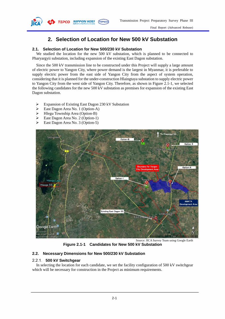
Transmission Project Preparatory Survey Phase III
Final Report (Advanced Release)
2-1
2. Selection of Location for New 500 kV Substation
2.1. Selection of Location for New 500/230 kV Substation We studied the location for the new 500 kV substation, which is planned to be connected to
Pharyargyii substation, including expansion of the existing East Dagon substation.
Since the 500 kV transmission line to be constructed under this Project will supply a large amount
of electric power to Yangon City, where power demand is the largest in Myanmar, it is preferable to
supply electric power from the east side of Yangon City from the aspect of system operation,
considering that it is planned for the under-construction Hlaingtaya substation to supply electric power
to Yangon City from the west side of Yangon City. Therefore, as shown in Figure 2.1-1, we selected
the following candidates for the new 500 kV substation as premises for expansion of the existing East
Dagon substation.
Expansion of Existing East Dagon 230 kV Substation
East Dagon Area No. 1 (Option-A)
Hlegu Township Area (Option-B)
East Dagon Area No. 2 (Option-1)
East Dagon Area No. 3 (Option-5)
Source: JICA Survey Team using Google Earth
Figure 2.1-1 Candidates for New 500 kV Substation
2.2. Necessary Dimensions for New 500/230 kV Substation
500 kV Switchgear In selecting the location for each candidate, we set the facility configuration of 500 kV switchgear
which will be necessary for construction in the Project as minimum requirements.
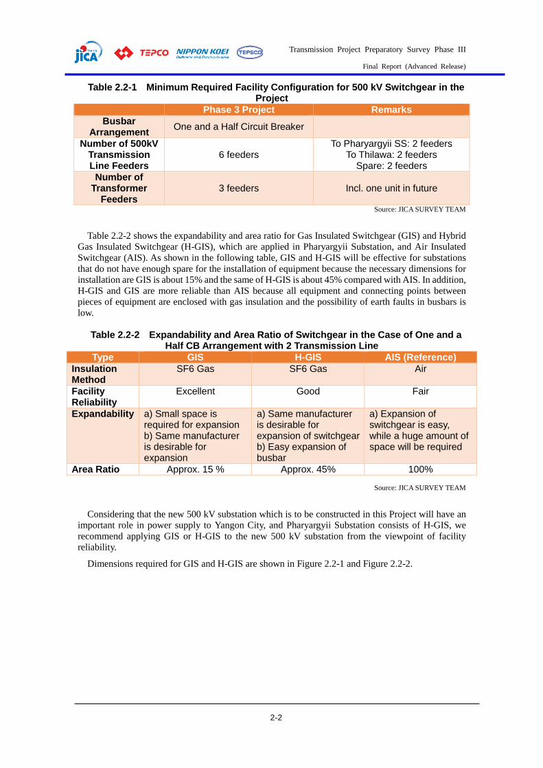
Transmission Project Preparatory Survey Phase III
Final Report (Advanced Release)
2-2
Table 2.2-1 Minimum Required Facility Configuration for 500 kV Switchgear in the Project
Phase 3 Project Remarks
Busbar Arrangement
One and a Half Circuit Breaker
Number of 500kV Transmission Line Feeders
6 feeders To Pharyargyii SS: 2 feeders
To Thilawa: 2 feeders Spare: 2 feeders
Number of Transformer
Feeders 3 feeders Incl. one unit in future
Source: JICA SURVEY TEAM
Table 2.2-2 shows the expandability and area ratio for Gas Insulated Switchgear (GIS) and Hybrid
Gas Insulated Switchgear (H-GIS), which are applied in Pharyargyii Substation, and Air Insulated
Switchgear (AIS). As shown in the following table, GIS and H-GIS will be effective for substations
that do not have enough spare for the installation of equipment because the necessary dimensions for
installation are GIS is about 15% and the same of H-GIS is about 45% compared with AIS. In addition,
H-GIS and GIS are more reliable than AIS because all equipment and connecting points between
pieces of equipment are enclosed with gas insulation and the possibility of earth faults in busbars is
low.
Table 2.2-2 Expandability and Area Ratio of Switchgear in the Case of One and a Half CB Arrangement with 2 Transmission Line
Type GIS H-GIS AIS (Reference)
Insulation Method
SF6 Gas SF6 Gas Air
Facility Reliability
Excellent Good Fair
Expandability a) Small space is required for expansion b) Same manufacturer is desirable for expansion
a) Same manufacturer is desirable for expansion of switchgear b) Easy expansion of busbar
a) Expansion of switchgear is easy, while a huge amount of space will be required
Area Ratio Approx. 15 % Approx. 45% 100%
Source: JICA SURVEY TEAM
Considering that the new 500 kV substation which is to be constructed in this Project will have an
important role in power supply to Yangon City, and Pharyargyii Substation consists of H-GIS, we
recommend applying GIS or H-GIS to the new 500 kV substation from the viewpoint of facility
reliability.
Dimensions required for GIS and H-GIS are shown in Figure 2.2-1 and Figure 2.2-2.

Transmission Project Preparatory Survey Phase III
Final Report (Advanced Release)
2-3
Source: Bidding Documents in Phase 2 Project
Figure 2.2-1 Dimensions Required in 500 kV H-GIS
Source: JICA SURVEY TEAM
Figure 2.2-2 Dimensions Required in 500 kV GIS
While GIS is applied in the study for expansion of the existing East Dagon Substation due to the
limited space, H-GIS is applied to other candidates for construction of the new 500 kV substation in
135 m
204 m
36 m
CB/DS/CT/VT GIB GIB
CB/DS/CT/VT GIB
CB/DS/CT/VT GIB
GIB
GIB
CB/DS/CT/VT GIB GIB
CB/DS/CT/VT GIB
CB/DS/CT/VT GIB
GIB
GIB
CB/DS/CT/VT GIB GIB
CB/DS/CT/VT GIB
CB/DS/CT/VT GIB
GIB
GIB
CB/DS/CT/VT GIB GIB
CB/DS/CT/VT GIB
CB/DS/CT/VT GIB
GIB
GIB
CB/DS/CT/VT GIB GIB
CB/DS/CT/VT GIB
CB/DS/CT/VT GIB
GIB
GIB
Busbar
Busbar
Busbar
Busbar
Busbar
Busbar
31
m
CB: Circuit BreakerDS: DisconnectorCT: Current TransformerVT: Voltage TransformerGIB: Gas Insulated Busduct

Transmission Project Preparatory Survey Phase III
Final Report (Advanced Release)
2-4
consideration of future expansion plans.
500/230 kV Transformer The basic specifications of the 500/230 kV transformer in reference to Phase 2 Project are shown
in Table 2.2-3.
Table 2.2-3 Specifications of 500/230 kV Transformer in the Project
Item Phase 3 Project
Rated Voltage at Primary Side 500 kV
Rated Voltage at Secondary Side 230 kV
Rated Voltage at Tertiary Side 33 kV
Phase (Three or Single) Single Phase Transformer
(Auto Transformer)
Vector Symbol YNa0d11
Rated Capacity 500 MVA (166.6 MVA/phase) x 3
Cooling Type ONAF/ONAN Source: JICA Survey Team
We considered the space dimensions when three units of transformer are installed in the new 500
kV substation taking into account one spare unit.
Figure 2.2-3 shows the necessary dimensions of the 500/230 kV transformer.
Source: JICA Survey Team
Figure 2.2-3 Necessary Dimensions of the 500/230 kV Transformer
Dimensions of 500/230 kV Substation Considering the above, we assumed that a substation with 60 Acre dimensions will be enough to
secure space for not only the necessary facilities even in the case of H-GIS, but also the residential
area for the substation’s operation and maintenance staff.
2.3. Study on Expansion of Existing East Dagon Substation As shown in Figure 2.3-1, we studied the possibility of installing the 500 kV switchgear and 500/230
kV transformer within unused space in the existing East Dagon Substation.
15,0
00
34,500 34,500 11,500 34,500
500/230 kV TR No.1500 MVA
500/230 kV TR No.2500 MVA
Spare 500/230 kV TR No.3500 MVA

Transmission Project Preparatory Survey Phase III
Final Report (Advanced Release)
2-5
Figure 2.3-1 Available Space for Expansion in Existing East Dagon Substation
500 kV Switchgear As studied in 2.2 above, H-GIS cannot be installed in the available space at the existing East Dagon
Substation because H-GIS requires dimensions of 200 m x 130 m, and it is also impossible to secure
the space for the 500/230 kV transformer and construction of the gantry structure.
Hence, we applied GIS in studying the expansion of the existing East Dagon Substation.
Expansion Study The layout arranging 500 kV GIS, 500/230 kV transformer and gantry structures for 500 kV
transmission lines is shown in Figure 2.3-2 and Figure 2.3-3. In the study, Gas Insulated Busduct (GIB)
is applied for connection between 500 kV GIS and transformer/gantry structures so as to save space.
It will be possible to install facilities for this Project only in the available space, as shown in Figure
2.3-2. However, this expansion plan cannot be recommended because there is not enough space for
construction of a gantry structure in future, limited space for expansion of 230 kV switchgear and
other concerns like acquisition of the surrounding field in the case of further expansion to install an
emergency thermal plant.
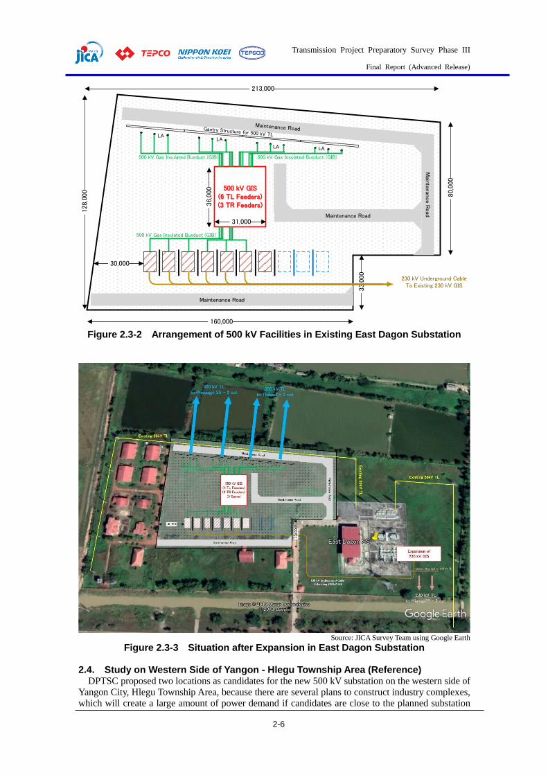
Transmission Project Preparatory Survey Phase III
Final Report (Advanced Release)
2-6
Figure 2.3-2 Arrangement of 500 kV Facilities in Existing East Dagon Substation
Source: JICA Survey Team using Google Earth
Figure 2.3-3 Situation after Expansion in East Dagon Substation
2.4. Study on Western Side of Yangon - Hlegu Township Area (Reference) DPTSC proposed two locations as candidates for the new 500 kV substation on the western side of
Yangon City, Hlegu Township Area, because there are several plans to construct industry complexes,
which will create a large amount of power demand if candidates are close to the planned substation
500 kV GIS(6 TL Feeders)(3 TR Feeders)
213,000 1
28,0
00
160,000
33,0
00
80,0
00
Mainten
ance R
oad
Maintenance Road
500 kV Gas Insulated Busduct (GIB) 500 kV Gas Insulated Busduct (GIB)
30,000
Maintenance Road
LALA
LA LA
230 kV Underground CableTo Existing 230 kV GIS
500 kV Gas Insulated Busduct (GIB)
36,0
00
31,000
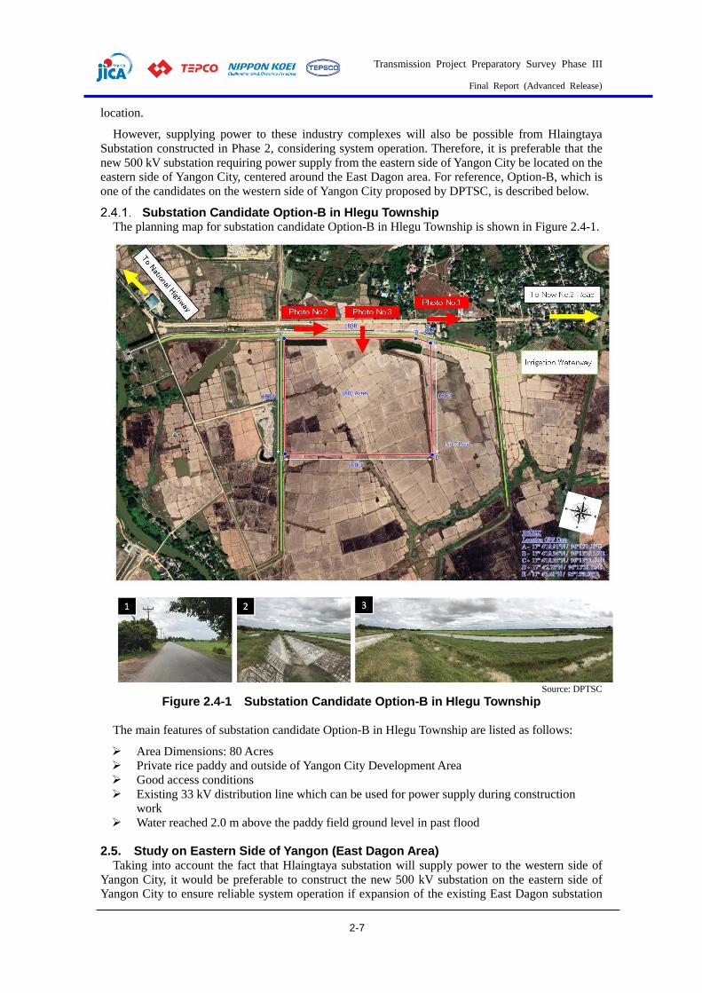
Transmission Project Preparatory Survey Phase III
Final Report (Advanced Release)
2-7
location.
However, supplying power to these industry complexes will also be possible from Hlaingtaya
Substation constructed in Phase 2, considering system operation. Therefore, it is preferable that the
new 500 kV substation requiring power supply from the eastern side of Yangon City be located on the
eastern side of Yangon City, centered around the East Dagon area. For reference, Option-B, which is
one of the candidates on the western side of Yangon City proposed by DPTSC, is described below.
Substation Candidate Option-B in Hlegu Township The planning map for substation candidate Option-B in Hlegu Township is shown in Figure 2.4-1.
Source: DPTSC
Figure 2.4-1 Substation Candidate Option-B in Hlegu Township
The main features of substation candidate Option-B in Hlegu Township are listed as follows:
Area Dimensions: 80 Acres
Private rice paddy and outside of Yangon City Development Area
Good access conditions
Existing 33 kV distribution line which can be used for power supply during construction
work
Water reached 2.0 m above the paddy field ground level in past flood
2.5. Study on Eastern Side of Yangon (East Dagon Area) Taking into account the fact that Hlaingtaya substation will supply power to the western side of
Yangon City, it would be preferable to construct the new 500 kV substation on the eastern side of
Yangon City to ensure reliable system operation if expansion of the existing East Dagon substation
Transmission Project Preparatory Survey Phase III
Final Report (Advanced Release)
2-8
proves difficult.
On the other hand, East Dagon is in an area managed by Yangon City Development Committee
(YCDC), as shown in the following figure. It is expected that negotiations to acquire the land will be
difficult because many residential areas and industrial complexes will be constructed in the future
within the YCDC area.
Source: JICA Survey Team using Google Earth
Figure 2.5-1 YCDC Area and Selected Candidates in East Dagon Area
Inside the YCDC area, there are plans to develop a 2,000 acre economic complex by the
“Department of Urban & Housing Development (DUHD)”, of the Ministry of Construction (MOC),
and AMATA group in Thailand. As a result of discussions with DUHD, we selected two locations for
the new 500 kV substation inside (Option-1) and outside (Option-5) the YCDC area, because securing
land for the new 500 kV substation (about 60 acres) inside an economic complex like Option-A will
affect its development plan, and it is assumed that it will be difficult to construct the transmission line
inside an economic complex. The locations of the new 500 kV substation were selected from the point
of access from the existing road for transporting heavy equipment like 500/230 kV transformers.
Substation Candidate Option-1 in East Dagon Area The planning map for the substation candidate referred to as Option-1 in the East Dagon Area is
shown in Figure 2.5-2 and Figure 2.5-3 with the planned route for the 500 and 230 kV transmission
lines:
Transmission Project Preparatory Survey Phase III
Final Report (Advanced Release)
2-9
Source: JICA Survey Team using Google Earth
Figure 2.5-2 Substation Candidate Option-1 in East Dagon Area (Wide-Area)
Source: JICA Survey Team using Google Earth
Figure 2.5-3 Substation Candidate Option-1 in East Dagon Area (around Substation)
As shown in Figure 2.5-2 above, laying 500 kV transmission lines from the new substation to
Pharyargyii and Thilawa will be difficult because the transmission lines will cross a residential area
and national road, while influence on the YCDC management area will be small. In addition,
construction of a 230 kV transmission line to the existing East Dagon and Hlawga substations will be
difficult because it will be laid within the YCDC management area and have to cross the existing 230
kV transmission line.
Substation Candidate Option-5 in East Dagon Area The planning map for substation candidate Option-5 in the East Dagon Area is shown Figure 2.5-4
and Figure 2.5-5 with the planned route for the 500 and 230 kV transmission lines:
Transmission Project Preparatory Survey Phase III
Final Report (Advanced Release)
2-10
Source: JICA Survey Team using Google Earth
Figure 2.5-4 Substation Candidate Option-5 in East Dagon Area (Wide-Area)
Source: JICA Survey Team using Google Earth
Figure 2.5-5 Substation Candidate Option-5 in East Dagon Area (around Substation)
As shown in Figure 2.5-4 above, construction of 500 kV transmission lines from the new substation
to Pharyargyii and Thilawa will be easier than the candidate Option-1 proposed in Sub-chapter 2.5.1
because it is not necessary to cross the national road or residential area and the influence on the YCDC
500kV TL Route 5 (W)Phayagyi – New SS5
500kV TL Route 5Thilawa – New SS5
230kV TL Route 5East Dagon – New SS5
230kV TL Route 5 (O/H)Hlawga – New SS5
230kV TL Route (U/G)Hlawga – New SS 1 or 5
YCDC Boundary (Assumption)
500kV TL Route 5 (E)Phayagyi – New SS5
AMATA Area
500kV TL Route 5 (W)Phayagyi – New SS5
500kV TL Route 5Thilawa – New SS5
230kV TL Route 5East Dagon – New SS5
230kV TL Route 5 (O/H)Hlawga – New SS5
Road No.2New 500 kV SS Option-5
500kV TL Route 5 (E)Phayagyi – New SS5
Transmission Project Preparatory Survey Phase III
Final Report (Advanced Release)
2-11
management area is also small, as Option-5 is located outside YCDC. In addition, Option-5 is
recommended from the aspect of future expansion of the transmission line system since Option-5 has
room for future expansion due to its surrounding conditions.
2.6. Comparison of Candidates and Conclusion Candidates for the new 500 kV substation selected above were compared from the aspects of facility
expandability, construction costs and system operation, as below:
Table 2.6-1 Comparison of Candidates for New 500 kV Substation
Item East Dagon (Existing)
Option-A (Reference)
Option-B (Reference)
Option-1 Option-5
System Operation A(5) A(5) C(1) A(5) B(3)
Construction of SS A(5) C(1) A(5) B(3) A(5)
Expandability of SS D(0) C(1) A(5) C(1) A(5)
Construction Cost of SS A(5) B(3) B(3) B(3) B(3)
Construction of TL C(1) C(1) C(1) B(3) A(5)
Construction Cost of TL A(5) B(3) C(1) A(5) B(3)
Land Acquisition for SS A(1) B(3) C(1) B(3) B(3)
Land Acquisition for TL B(3) C(1) B(3) C(1) A(5)
Evaluation B (25) C (18) C (20) B (24) A (29)
Source: JICA Survey Team
In conclusion, taking into account the above factors, candidate Option-5 in the East Dagon Area
was found to be the most effective. As a result of several discussions with DPTSC based on the above
comparison, DPTSC and the JICA Survey Team agreed to construct the new 500 kV substation on
land next to the west side of the Option-5 location, in consideration of the connection of 230 kV
transmission lines as MOM, shown in Annex 2-1. In this regard, the new 500 kV substation was named
“Sar Ta Lin Substation”, from the region where it is located. The following figure shows the location
of Sar Ta Lin Substation.
Source: JICA Survey Team using Google Earth
Figure 2.6-1 Substation Candidate Option-5 in East Dagon Area (around Substation)
230kV TL RouteEast Dagon – Sar Ta Lin
230kV TL Route (O/H)Hlawga – Sar Ta Lin SS
Sar Ta Lin 500kV SS
500kV TL RoutePhayagyi – Sar Ta Lin

Transmission Project Preparatory Survey Phase III
Final Report (Advanced Release)
3-1
3. Study for Transmission Line Route Selection
3.1. Study for Transmission Line Route Selection The team carried out field investigations for the selected route, and topographical and geological surveys
for transmission lines, as needed. The team discussed the outcome with the C/Ps and drew a figure of the
transmission line route.
[Points to note in the transmission line route investigation]
The general categories of land/facilities/properties in the following table, such as airports, microwave
communication routes, large rivers etc., need to be considered in the construction of transmission lines in
Myanmar. Several routes that avoid these categories will then be examined via desk study. In order to
conduct efficient and effective investigations, an accurate route map using the latest topographical data,
such as Google Earth, etc., is to be prepared and the team will utilize it effectively in the on-site investigation.
Table 3.1-1 Categories to Note in Preliminary Investigation for Transmission Line Construction
General categories
representing an
obstacle
- National parks: Avoidance in terms of environmental and social considerations
- Yangon International Airport and Military Airport: Considering building restrictions on air
routes
- Micro communication routes: Considering the height and direction of communication route
- Large-scale rivers: Understanding the possibility of long spans and clearance of vessels to be
navigated, etc.
- Extra-high voltage transmission lines: Considering clearance between conductors
- Expressways, major roads: Considering road widths, road-accessorized equipment, height on
roads, traffic volumes, etc.
- Railroads: Considering track widths, track accessories (such as communication lines), height on
tracks, avoidance measures for conductor drop, etc.
- Housings/Dwellings: Avoidance and reducing the amount of inhabitant relocation
- Schools, Religious facilities/cemeteries and Local community facilities: Avoidance in terms of
environmental and social considerations
- Chimneys: Avoiding electrical accidents and avoiding passing chimneys of brick sinter pots to
prevent conductor corrosion
Individual
categories in
Myanmar
representing an
obstacle
- Military facilities/sites: Avoiding military facilities, which are widely distributed and have large
site areas in Myanmar
- Rubber forests and Mango Gardens: Necessity of avoidance to reduce RoW compensation due
to high asset value
- Teak forest: Necessity of avoidance to reduce RoW compensation because it constitutes a major
part of commercial forest in Myanmar
Categories
representing an
obstacle for
overhead lines
- Areas of weak soil: The foundation support layers in weak areas such as river basins are to be
confirmed via visual inspection and geological investigation
- Weir areas: Confirmation of weir water level (for examination of foundation configuration)
- Roads: Access methods at construction stage, necessity of temporary construction and
maintenance methods after construction
Categories
representing an
obstacle for
underground lines
Underground burials: Confirmation of underground burials for water pipes, gas pipes and electric
power lines
Crossing points of rivers, railways and so on
Source: JICA survey team
[Route Investigation Methods for Overhead Transmission Lines]
For the route investigation, an expert from the team confirms the Categories to Note (Table 3.1-1) for the
sites and selects the final routes via vehicle and on foot, with a route map pre-prepared using Google Earth
and other tools. In addition, in mountainous areas - and especially in rubber forests and mango fields, where
the C/Ps emphasize route selection (areas of western Pharyargyii, southern Bago, etc.) - the study team also
confirms proposed transmission route avoidance plans to avoid the locations of fields.
[Route Investigation Methods for underground transmission lines]
Preliminary route selection for underground transmission lines is carried out on a map (such as Google
Maps). Route surveys in the field are performed considering the following items comprehensively.
Transmission Project Preparatory Survey Phase III
Final Report (Advanced Release)
3-2
Traffic situation
Obstacles to route selection for underground transmission lines
Residences surrounding routes selected for underground transmission lines
Crossing points of rivers, railways and so on
3.2. Route map for Transmission Lines An overall view of this project is shown below. Pharyargyii substation, as the base point, is located around
90 km north of the center of Yangon city.
Source: JICA survey team
Figure 3.2-1 Overall View of Phase III project
Based on the results of the site investigations described in the previous section, the team compares
multiple alternative plans by considering the economics, workability, site conditions, construction plans,
environmental and social considerations, etc. Optimal plans and designs for transmission lines are
developed to proceed to the preliminary design stage.
500 kV Pharyargyi-Sar Ta Lin Overhead transmission line
Pharyargyi substation is located about 90 km northeast of Yangon. Sar Ta Lin substation was eventually
determined as a 500kV new construction in the northern part of Yangon. The route connecting the two
substations had the following three candidates. Route A (64 km long) going south, parallel to the ODA loan
500 kV Pharyargyi-Hlinetaya transmission line, which will start construction soon, about 20 km and going
south to the Sar Ta Lin substation. Route B (72 km long), which passes south of Route A. Route C (70km
long), which runs mainly through the riverbed on the east side of Bago city.
As a result of evaluating and comparing these three routes, the eastern route (Route C) was determined
for the following reasons.
> Outlet of overhead transmission line from Pharyargyi substation without changing.
> It is flat countryside and passes through a riverbed.
> No land negotiation regarding rubber forests or mango gardens is required.
> Good access to the construction site.
However, this route is long and most of it passes through riverbeds and countryside - areas which have
weak soil conditions. Therefore, most of the tower foundations must be pile type foundations, so the
construction costs increase by around 50% compared to Routes A or B.

Transmission Project Preparatory Survey Phase III
Final Report (Advanced Release)
3-3
Source: JICA survey team
Figure 3.2-2 500 kV Pharyargyi-Sar Ta Lin Route Map of Overhead Transmission Lines
Table 3.2-1 Evaluation of 500kV Route
Route
Total
Length
(km)
Expected
Weak
Soil Area
(km)
Plantation
Area
(km)
Forest
Protection
Area
(km)
Crossing Points Connection Bay in
Pharyargyi S/S Evaluation
A 64km
27km
(42%) 1km 5km
Highway: 2
National road: 1
River: 1
T/L: 2
P14 T/L must be
shifted to right side
bay and P14 T/L
towers from No.1-7
also moved to North.
×
◎ 〇 ◎ △ △ ×
B 72km
27km
(38%) 15km 5km
National road: 2
River: 1
T/L: 2
Originally planned
bay in Pharyargyi
S/S can be used. ×
△ 〇 × △ 〇 ◎
C 70km
68km
(97%) 3km None
National road: 5
Railway: 3
River: 3
T/L: 5
As above 〇
〇 △ 〇 ◎ △ ◎ Source: JICA survey team
Near the existing 230kV Hlawga substation, there are military and national parks in the north, residential
areas in the east and south, and Hlawga Lake in the west. In consideration of environmental and social
considerations and the feasibility of transmission line construction, it was decided that the Sar Ta Lin-
Hlawga transmission line route would include underground line because the vicinity of the Hlawga
substation will be densely populated with residential areas. The demarcation point from the overhead line
is the boundary between the residential area and the cultivated area to reduce construction costs. The 17km
overhead transmission route from the Sar Ta Lin substation to the branch tower passes through the
countryside and does not pass through residential areas. This transmission line will have a much larger
transmission capacity in the future judging by the system analysis, and will become a four-circuit route. The
Sar Ta Lin-East Dagon transmission line route has a route length of 21km that detours the future YCDC
area. From the Sar Ta Lin substation, it heads south for 10 km through the countryside and follows the No.
7 road southeast to the East Dagon substation. There are some houses along National Road Route 7.
Transmission Project Preparatory Survey Phase III
Final Report (Advanced Release)
3-4
230 kV Sar Ta Lin-Hlawg and 230kV Sar Ta Lin-Hlauga OHTL
Source: JICA survey team
Figure 3.2-3 Map of 230kV Sar Ta Lin-Hlawga and 230kV Sar Ta Lin-Hlawga OHTL
Outline of 230 kV Underground Transmission Line route This scope of the underground transmission line facilities is as follows:
>1 system: Sar Ta Lin substation to Hlawga substation, 4 circuits
>1 system: Thaketa Substation to Hlawaga Substation, 2 circuits
Every underground transmission line is planned to pass through a branch tower from the overhead
transmission line without circuit breakers.
These transmission lines are planned to be underground because the area around the Hlawga substation
has many residential developments.
SOURCE: JICA survey team
Figure 3.2-4 230kV Overall View of Underground Transmission Line System
Sar Ta Lin
S/S
Hlawga S/S
East Dagon S/S
Sar Ta Lin-Hlawga 230kV T/L Route
Sar Ta Lin-East Dagon 230kV T/L Route
Transmission Project Preparatory Survey Phase III
Final Report (Advanced Release)
3-5
Outline of 230kV UGTL (Sar Ta Lin SS – Hlawga SS) The Transmission line from Sar Ta Lin SS to Hlawaga SS is 4 circuits, in accordance with the power
system analysis. The transmission line is overhead, starting from Sar Ta Lin substation. It is difficult to build
towers for overhead transmission lines in the area of Hlawga Substation because of residential developments.
This area is underground transmission, under a public road. It is necessary to divide it into two routes from
the branch tower to NHG3 road because the road is very narrow.
Source: JICA survey team
Figure 3.2-5 Illustration of Branch Tower
This figure shows an outline of a branch tower. The conductor from the tower goes down to a cable
3m
North Route to Hlawga SS)
(Width of road: 3m)
North Route to Hlawga SS
(Width of road: 5m)
5m
South Route to Sar Ta Lin SS
(Width of road: 10m)
Transmission Project Preparatory Survey Phase III
Final Report (Advanced Release)
3-6
termination, then underground. The required area is 35m x 45m, taking into consideration a fence for the
borderline with the public area.
This figure shows an outline of Sar Ta Lin SS to Hlawga SS. The blue line is around 4.8km in length and
shows the north route. The yellow line is around 6km in length and shows the south route. These routes
merge from the intersection of the NH3 road.
Source: JICA survey team
Figure 3.2-6 230kV Sar Ta Lin SS – Hlawga SS UGTL Route
Outline of 230kV UGTL (Thaketa – Hlawga SS)
Underground cables are applied for replacement and repowering of the existing overhead transmission
line between Thaketa SS and Hlawga SS because it passes through dense residential areas. The existing line
is replaced for the new transmission line, with a tower around 18km from Thaketa substation. Underground
transmission line is planned from the branch tower to Hlawga SS, through the NH3 road. The length is
around 5.7km. This figure shows an outline of the overhead and underground transmission lines.
Source: JICA survey team
Figure 3.2-7 230kV Thaketa SS – Hlawga SS Route Outline

Transmission Project Preparatory Survey Phase III
Final Report (Advanced Release)
3-7
Source: JICA survey team
Figure 3.2-8 Expected Site for Branch Tower of 230kV Thaketa – Hlawga Line
Branching for the underground transmission line is on the same, existing route without changing ROW,
and the underground transmission line has access to a public road.
All 230 kV UGTL routes for this scope (2 systems, 6 circuits)
This figure shows an outline of the 230kV underground transmission line system in this project. Every
underground transmission system is built in a duct system from the branch tower.
Sar Ta Lin – Hlawga North Route (blue line): around 2.5km
Sar Ta Lin – Hlawga South Route (yellow line): around 2.8km
Thaketa – Hlawga (red line): around 2.5km
This line connects with Sar Ta Lin – Hlwga south line at the intersection of the NH3 road. This route is
4 circuits. These underground transmission lines are built in a tunnel system. The length is around 0.9km.
In addition, these 4 circuits connect with the Sar Ta Lin – Hlawga north line at another intersection of the
NH3 road. These 6 circuits go to Hlwga Substation. These underground transmission lines are built in a
tunnel system, and the length is around 2.3km.

Transmission Project Preparatory Survey Phase III
Final Report (Advanced Release)
3-8
Source: JICA survey team
Figure 3.2-9 230kV Overall UGTL View (Close-up)
Source: JICA survey team
This figure shows the situation at the road between the NH3 road and Hlwga SS. There are utility pipes
on both sides of the road. It is necessary to build the tunnel in the center of the road, avoiding both utility
pipes.
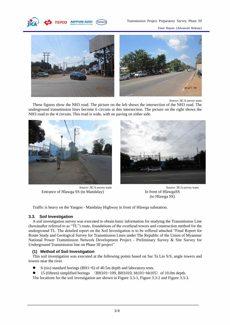
Transmission Project Preparatory Survey Phase III
Final Report (Advanced Release)
3-9
Source: JICA survey team
These figures show the NH3 road. The picture on the left shows the intersection of the NH3 road. The
underground transmission lines become 6 circuits at this intersection. The picture on the right shows the
NH3 road to the 4 circuits. This road is wide, with no paving on either side.
Traffic is heavy on the Yangon - Mandalay Highway in front of Hlawga substation.
3.3. Soil Investigation A soil investigation survey was executed to obtain basic information for studying the Transmission Line
(hereinafter referred to as “TL”) route, foundations of the overhead towers and construction method for the
underground TL. The detailed report on the Soil Investigation is to be reffered attached “Final Report for
Route Study and Geological Survey for Transmission Lines under The Republic of the Union of Myanmar
National Power Transmission Network Development Project - Preliminary Survey & Site Survey for
Underground Transmission line on Phase III project”.
(1) Method of Soil Investigation This soil investigation was executed at the following points based on Sar Ta Lin S/S, angle towers and
towers near the river.
6 (six) standard borings (BH1~6) of 40.5m depth and laboratory tests.
15 (fifteen) simplified borings (BH101~109, BH1010, bh101~bh105)of 10.0m depth.
The locations for the soil investigation are shown in Figure 3.3-1, Figure 3.3-2 and Figure 3.3-3.
Source: JICA survey team
Entrance of Hlawga SS (to Mandalay) Source: JICA survey team
In front of HlawgaSS
(to Hlawga SS)
Transmission Project Preparatory Survey Phase III
Final Report (Advanced Release)
3-10
Source: JICA Study Team based on Google Earth
Figure 3.3-1 Locations of Standard Borings
Transmission Project Preparatory Survey Phase III
Final Report (Advanced Release)
3-11
Source: JICA Study Team based on Google Earth
Figure 3.3-2 Locations of Simplified Borings 1/2
Source: JICA Study Team based on Google Earth
Figure 3.3-3 Locations of Simplified Borings 2/2
(2) Geology of Project Area The map for the TL Route, adding to the 1977 geological map of this project area, is shown in Figure
3.3-4 and Figure 3.3-5.
The locations of this project area are classified into 3 groups: Alluvium, Irrawaddy Formation, and Pegu

Transmission Project Preparatory Survey Phase III
Final Report (Advanced Release)
3-12
Group. Alluvium is soft ground, Irrawaddy Formation is solid soil ground, and Pegu Group is rock ground.
Most of the TL routes are on the Alluvium, which is relatively new and soft soil.
Near Phayargi S/S, the area near the middle of the TL route between Pharyargyii S/S and Sar Ta Lin S/S
and the area near Hlawga S/S are on Irrawaddy Formation, which is relatively solid from Miocene to
Pliocene.
Alluvium is the river terrace deposit of older alluvium and mainly consists of sand, silt, clay and some
gravel. Irrawaddy Formation is the continental and marginal marine deposits of the Miocene – Pliocene
belonging to the Irrawaddy Formation.
Since the Sagaing fault is found from Yangon city to the north of Yangon, based on the Figure 3.3-4
geological map, it is necessary to consider avoiding this fault when selecting tower locations.
Figure 3.3-4 Geological Map of TL Route (1)

Transmission Project Preparatory Survey Phase III
Final Report (Advanced Release)
3-13
Source: JICA Study Team based on Google Earth
Figure 3.3-5 Geological Map of TL Route (2)
(3) Results of Soil Investigation Boring logs as surveyed in this project are shown below. A boring log from Hlawga S/S, excerpted from
“URGENT REHABILITATION AND UPGRADE PROJECT (PHASE 1) RENOVATION WORKS OF
TRANSMISSION SYSTEM (PACKAGE 2) P2”, and boring logs from East Dagon S/S are shown in the
following figures.
Pegu Group
Alluvium
Alluvium
Irrawaddy Foundation
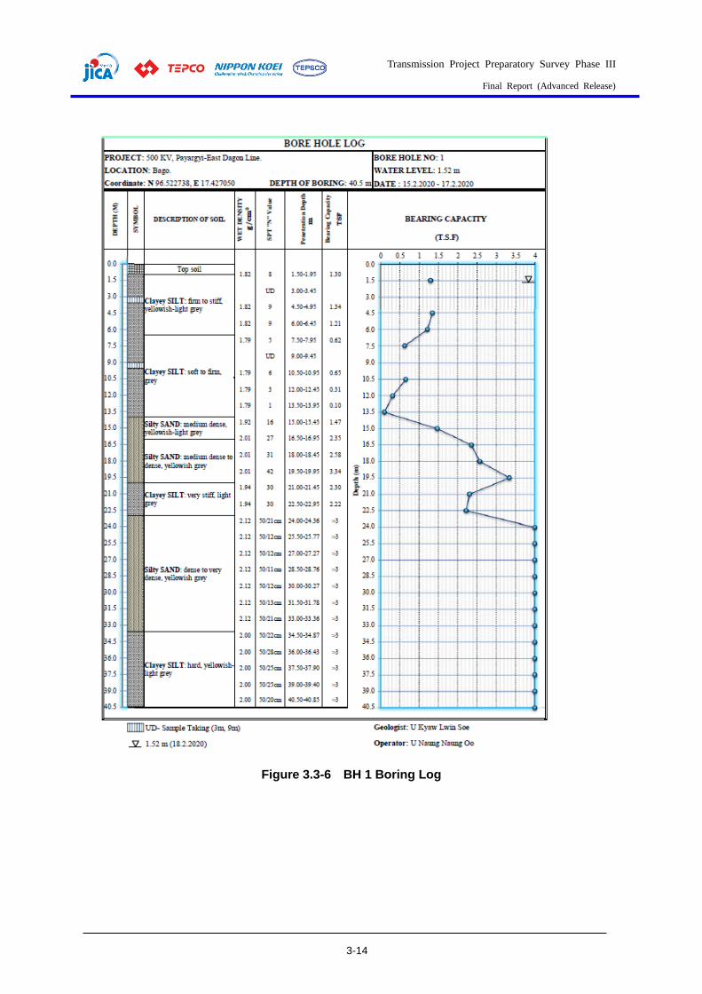
Transmission Project Preparatory Survey Phase III
Final Report (Advanced Release)
3-14
Figure 3.3-6 BH 1 Boring Log

Transmission Project Preparatory Survey Phase III
Final Report (Advanced Release)
3-15
Figure 3.3-7 BH 2 Boring Log
Transmission Project Preparatory Survey Phase III
Final Report (Advanced Release)
3-16
Figure 3.3-8 BH 3 Boring Log
Transmission Project Preparatory Survey Phase III
Final Report (Advanced Release)
3-17
Figure 3.3-9 BH 4 Boring Log

Transmission Project Preparatory Survey Phase III
Final Report (Advanced Release)
3-18
Figure 3.3-10 BH 5 Boring Log

Transmission Project Preparatory Survey Phase III
Final Report (Advanced Release)
3-19
Figure 3.3-11 BH 6 Boring Log
Transmission Project Preparatory Survey Phase III
Final Report (Advanced Release)
3-20
Figure 3.3-12 BH 101 Boring Log

Transmission Project Preparatory Survey Phase III
Final Report (Advanced Release)
3-21
Figure 3.3-13 BH 102 Boring Log
Transmission Project Preparatory Survey Phase III
Final Report (Advanced Release)
3-22
Figure 3.3-14 BH 103 Boring Log

Transmission Project Preparatory Survey Phase III
Final Report (Advanced Release)
3-23
Figure 3.3-15 BH 104 Boring Log

Transmission Project Preparatory Survey Phase III
Final Report (Advanced Release)
3-24
Figure 3.3-16 BH 105 Boring Log

Transmission Project Preparatory Survey Phase III
Final Report (Advanced Release)
3-25
Figure 3.3-17 BH 106 Boring Log
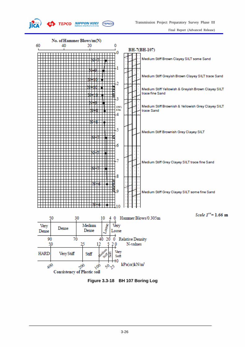
Transmission Project Preparatory Survey Phase III
Final Report (Advanced Release)
3-26
Figure 3.3-18 BH 107 Boring Log
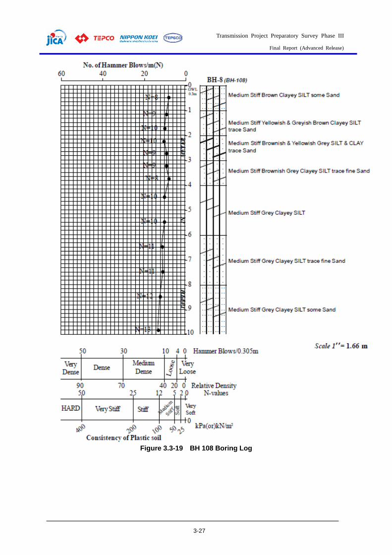
Transmission Project Preparatory Survey Phase III
Final Report (Advanced Release)
3-27
Figure 3.3-19 BH 108 Boring Log

Transmission Project Preparatory Survey Phase III
Final Report (Advanced Release)
3-28
Figure 3.3-20 BH 109 Boring Log

Transmission Project Preparatory Survey Phase III
Final Report (Advanced Release)
3-29
Figure 3.3-21 BH 1010 Boring Log
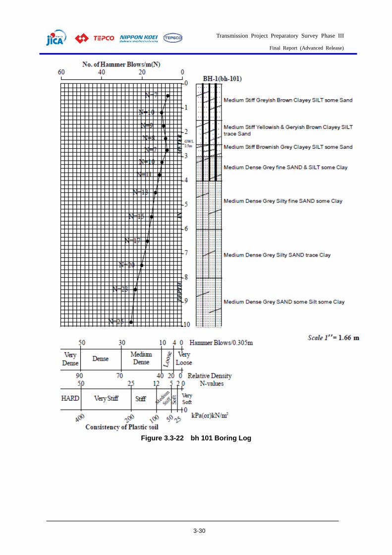
Transmission Project Preparatory Survey Phase III
Final Report (Advanced Release)
3-30
Figure 3.3-22 bh 101 Boring Log

Transmission Project Preparatory Survey Phase III
Final Report (Advanced Release)
3-31
Figure 3.3-23 bh 102 Boring Log
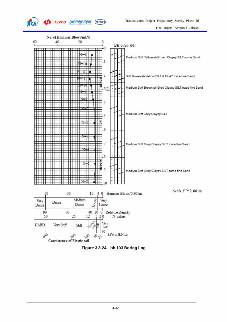
Transmission Project Preparatory Survey Phase III
Final Report (Advanced Release)
3-32
Figure 3.3-24 bh 103 Boring Log
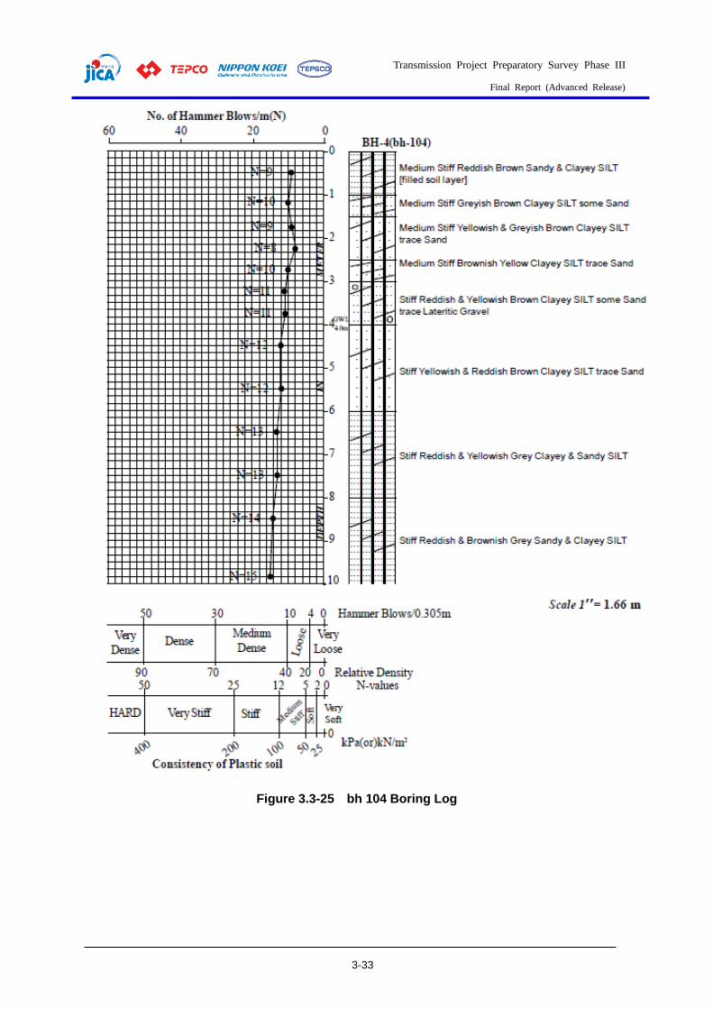
Transmission Project Preparatory Survey Phase III
Final Report (Advanced Release)
3-33
Figure 3.3-25 bh 104 Boring Log
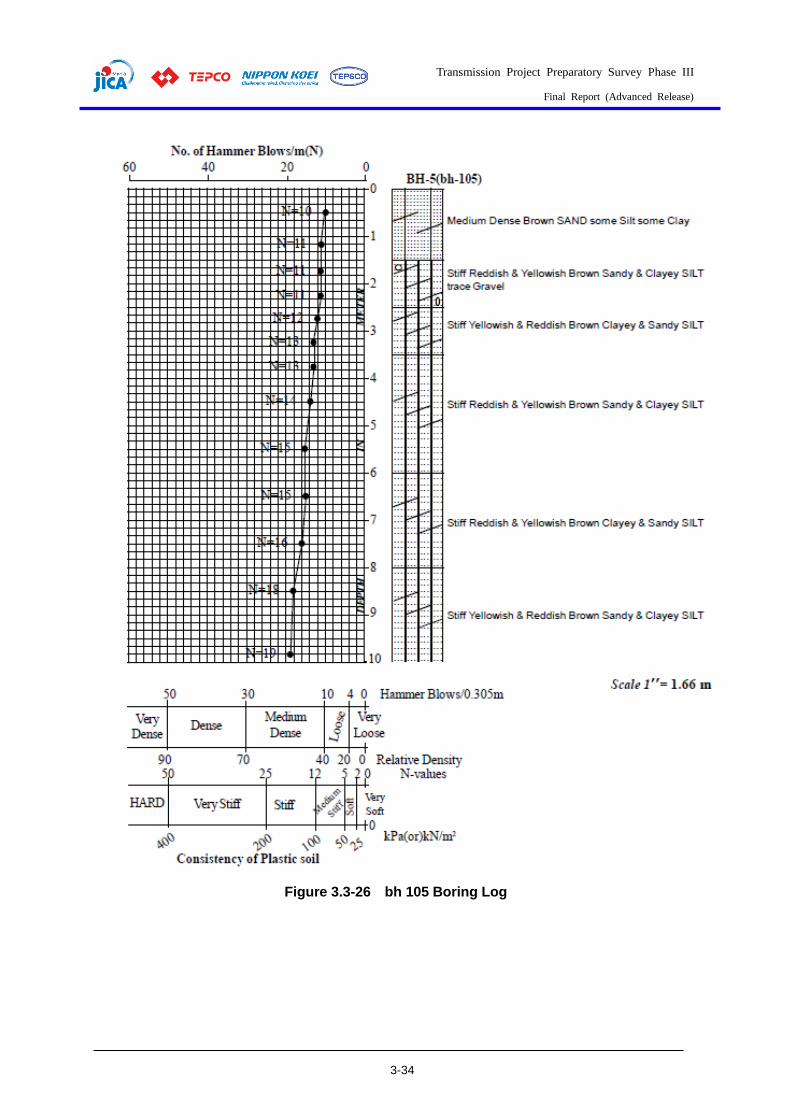
Transmission Project Preparatory Survey Phase III
Final Report (Advanced Release)
3-34
Figure 3.3-26 bh 105 Boring Log

Transmission Project Preparatory Survey Phase III
Final Report (Advanced Release)
3-35
Figure 3.3-27 Location of Soil Investigation in Hlawga S/S
Figure 3.3-28 Boring Log of Hlawga S/S

Transmission Project Preparatory Survey Phase III
Final Report (Advanced Release)
3-36
Figure 3.3-29 Location of Soil Investigation in East Dagon S/S
Figure 3.3-30 Boring Log of East Dagon S/S (BH.1)
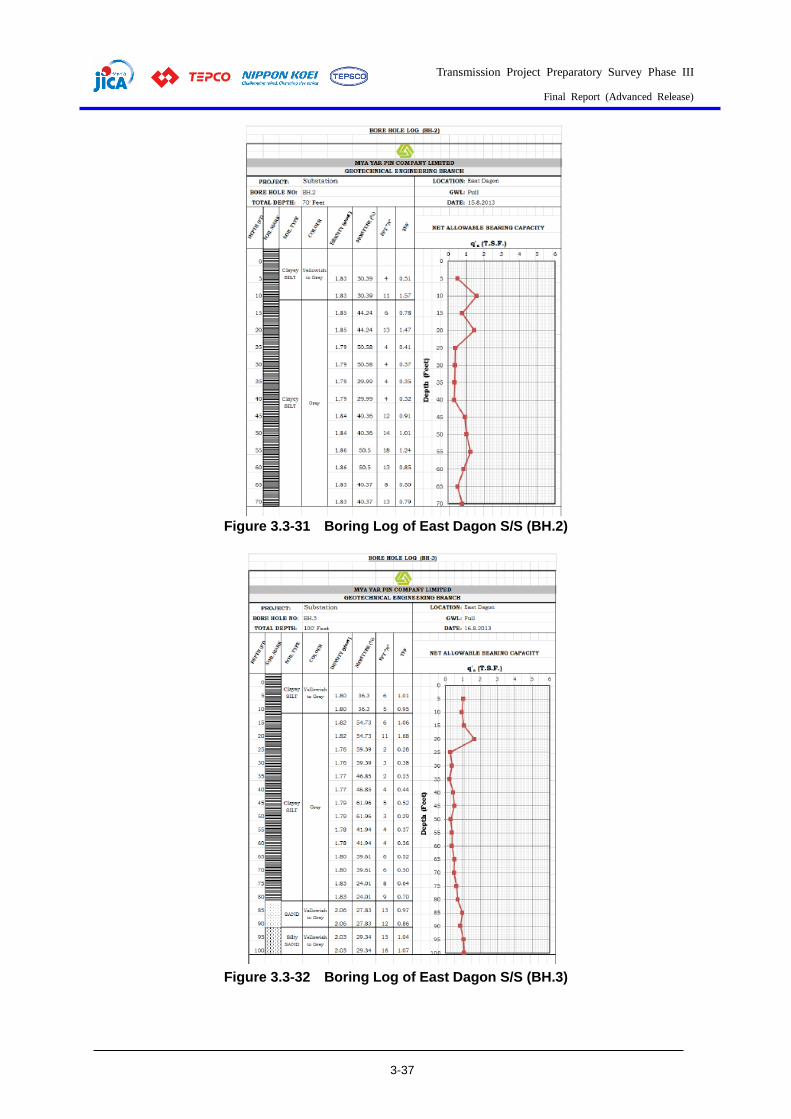
Transmission Project Preparatory Survey Phase III
Final Report (Advanced Release)
3-37
Figure 3.3-31 Boring Log of East Dagon S/S (BH.2)
Figure 3.3-32 Boring Log of East Dagon S/S (BH.3)
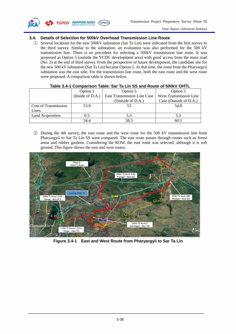
Transmission Project Preparatory Survey Phase III
Final Report (Advanced Release)
3-38
3.4. Details of Selection for 500kV Overhead Transmission Line Route
① Several locations for the new 500kV substation (Sar Ta Lin) were indicated from the first survey to
the third survey. Similar to the substation, an evaluation was also performed for the 500 kV
transmission line. There is no precedent for selecting a 500kV transmission line route. It was
proposed as Option 5 (outside the YCDC development area) with good access from the main road
(No. 2) at the end of third survey. From the perspective of future development, the candidate site for
the new 500 kV substation (Sar Ta Lin) became Option 5. At that time, the route from the Pharyargyii
substation was the east side. For the transmission line route, both the east route and the west route
were proposed. A comparison table is shown below.
Table 3.4-1 Comparison Table: Sar Ta Lin SS and Route of 500kV OHTL
Option 1
(Inside of D.A.)
Option 5
East Transmission Line Case
(Outside of D.A.)
Option 5
West Transmission Line
Case (Outside of D.A.)
Cost of Transmission
Lines
53.9 53 54.8
Land Acquisition 0.5 5.3 5.3
54.4 58.3 60.1
② During the 4th survey, the east route and the west route for the 500 kV transmission line from
Pharyargyii to Sar Ta Lin SS were compared. The east route passes through routes such as forest
areas and rubber gardens. Considering the ROW, the east route was selected, although it is soft
ground. This figure shows the east and west routes.
Figure 3.4-1 East and West Route from Pharyargyii to Sar Ta Lin

Transmission Project Preparatory Survey Phase III
Final Report (Advanced Release)
3-39
Figure 3.4-2 West Route (Forest Area) of Pharyargyii to Sar Ta Lin
③ Following this, DPTSC indicated that the route from Pharyargyii to the new 500 kV substation had
been changed from the eastern route to a well-grounded route parallel to the planned Phase 2 route.
In the fifth survey, the final decision was made on the eastern route after discussions with DPTSC.
An outline of the eastern and western routes is shown below.
Figure 3.4-3 Map of Pharyargyii - Sar Ta Lin East Route
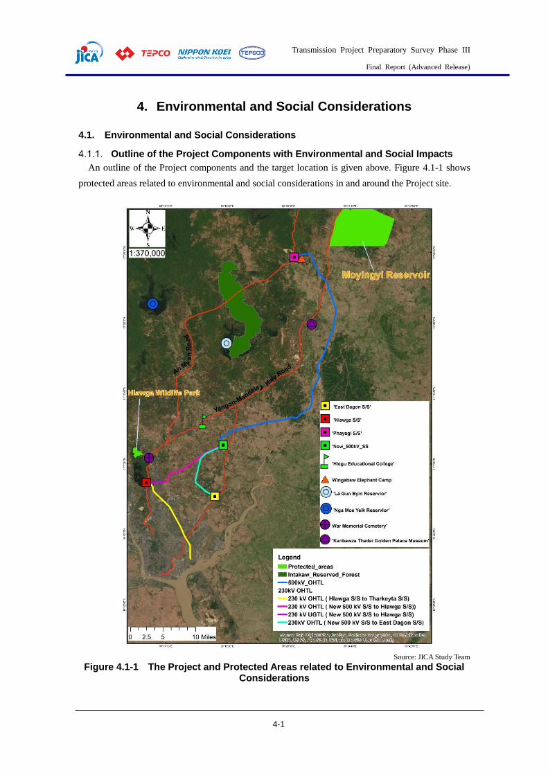
Transmission Project Preparatory Survey Phase III
Final Report (Advanced Release)
4-1
4. Environmental and Social Considerations
4.1. Environmental and Social Considerations
Outline of the Project Components with Environmental and Social Impacts
An outline of the Project components and the target location is given above. Figure 4.1-1 shows
protected areas related to environmental and social considerations in and around the Project site.
Source: JICA Study Team
Figure 4.1-1 The Project and Protected Areas related to Environmental and Social Considerations

Transmission Project Preparatory Survey Phase III
Final Report (Advanced Release)
4-2
For the implementation of projects over a specific scale in Myanmar, it is necessary to implement
an Environmental Impact Assessment (EIA) or Initial Environmental Examination (IEE) in
accordance with the Environmental Impact Assessment Procedure (EIAP) (Notification No.
616/2015). The scale requirements are described in Annex 1 of EIAP, and the Project components that
have environmental and social impacts are outlined below according to the type and scale in EIAP
Annex 1.
1) Type of Project: Energy Sector Development especially
2) Type of Economic Activities: 27. Electrical Power Transmission Line ≥230kV
28. High Voltage (230kV and 500kV) Transformer
Substations
3) Main Infrastructure & Utilities: Scope of the engineering work includes analysis of
facilities, new construction of substation (25ha),
expansion/improvement of existing substation, new
500kV overhead transmission line, new 230kV overhead
transmission line, and new 230 kV underground
transmission line.
4) EIA/ IEE/ EMP* Requirement: EIA or IEE is required
* EIA: Environmental Impact Assessment
IEE: Initial Environmental Examination
EMP: Environmental Management Plan
In accordance with Appendix-1: Project Categorization for Assessment Purposes of EIA Procedures,
stipulated in December 2015, as prepared by the Ministry of Environmental Conservation and Forestry
(the former name of the Ministry of Natural Resources and Environmental Conservation (MONREC)),
the Project can be categorized as “EIA or IEE is required”, as shown inTable 4.1-1. Judging by
examples of transmission line projects implemented by DPTSC/MOEE, such as transmission lines
longer than the Project, and interviews with the Environmental Conservation Department
(ECD)/Ministry of Natural Resources and Environmental Conservation (MONREC), which is the
EIAP implementation organization, no transmission line projects have required an EIA so far. In
addition, the transmission line route and project area will not pass through land/facilities that are
important in terms of environmental considerations, thus the study team expected the project to be
categorized as an IEE project. However, according to the screening results received at the end of
December 2020, the project has been categorized as two IEE projects.
Table 4.1-1 Screening for EIA/IEE/EMP Requirements related to the Project
No. Type of Investment
Project
Size of Project
which requires IEE
Size of Project which
requires EIA Notes
ENERGY SECTOR DEVELOPMENT
27 Electrical Power Transmission Lines ≥ 230 kV
All sizes All activities where the Ministry requires that the Project shall undergo EIA
-
28 High Voltage (230 kV and 500 kV) Transformer Substations
≥ 4 ha All activities where the Ministry requires that the Project shall undergo EIA
The size of the Project is less than 25 ha, including Staff dormitories.
Source: Extract from EIA Procedures (2015)

Transmission Project Preparatory Survey Phase III
Final Report (Advanced Release)
4-3
As described above, the planned transmission line route for the Project does not pass through
important areas in terms of environmental and social considerations. Therefore, it is considered that
negative impacts on the environment will not be significant. In addition, as described in 4.2.4.
“Location and Scale of Land Acquisitions and Resettlement” concerning the Project-affected people,
no direct resettlement will occur due to the construction of the substation. Furthermore, with regard to
the development of the transmission lines, it is expected that no residents, businesses or commercial
premises will need to be relocated due to land acquisition. Therefore, this Project is assumed to be a
category B project based on the “JICA Environmental and Social Considerations Guidelines (April
2010)” because it is not classified as “Sectors and characteristics that are easily affected”/"Sensitive
areas” and undesirable environmental and social impacts were determined not to be significant.
Basic environmental and social conditions
(1) Overview of the Environment and Social Situation around the Project Site
Information on items expected to be affected during the construction and operation of the project
(pollution, natural environment, protected areas, socio-economic situation) were reviewed by
collecting existing information and data, as shown inTable 4.1-2. Details are described in Chapter 4 of
the attached IEE report (draft).
Table 4.1-2 Current Environmental and Social Conditions in and around the
Project Area
Item Description
Natural Environment
Meteorology/
Temperature
and Rainfall
Upper east of Yangon region and lower east of Bago region has three seasons. Summer season is from
March to May, the rainy season is from June to October, and winter is from November to February.
According to the records of Kaba aye Meteorological station, the highest temperatures occurring in
Yangon and Bago are 30.7 and 30.9 in April, and the lowest temperatures 24.9 and 24.4, respectively.
Except in January, the monthly temperatures in both cities are above 25.0 °C. The southwest monsoon
wind is the main source of rain, and the Yangon and Bago area receives rain during the period from May
to October. The average annual amount of rainfall is 241 mm and 278 mm in Yangon and Bago cities.
Rainfall sharply decreases from November and continues at nearly 10 mm from December to February.
Hydrological
Situation
Main river around the project area is the Bago River, the source of which is near Thikkyi in Bago Yoma,
and it runs from Phayagyi substation and Hlegu substation. The total length of the river is about 260 km
(162 miles), and it flows into the Yangon River. Pazundaung Creek (upstream as Ngamoeyeik creek) can
be found around the project area, and it also flows into the Yangon River. There are also two main
reservoirs, called Ngamoeyeik and Lagunbyin, around the project area.
Topography This Project will pass through eight cities: East Dagon, Hlegu, Mingaladon, Bago, North Okkalapa,
North Dagon, South Dagon, and Therkhata. A flat, lowland, and clay type soil can be found in East
Dagon and this is located about 9m above sea level. North-West and North area of Hlegu Tsp are the
edge of Pegu Range end, with a flat plain situated at the bottom of mountain ranges. A flat plain descends
from north to south, situated about 45.5 m above the sea level. Except for the Ngweyar mountain and
Hlawga Lake, which are located in the western region of the township, the rest of the Mingalardon Tsp
are plains. Bago township is the drainage area of Pegu Range and the western part of the township is a
highland area. Reserved forests with merchantable trees are located in the northern part of the township.
The township is 21 miles from east to west and 43 miles from north to south by area, and about 30 m
above sea level. North Okkalapa and North Dagon have a plain land mass topography. Therkata
Township is located on the peninsula and it has a flat plain topography. Silty soil can be found in this
township. A landmass of plain and clay soil can be found in Dagon Myothit (south).
Geographical
Features
Myanmar Central Belt (MCB) exists between the Indo-Burman Ranges and Shan Plateau. Bago Yoma
Range sits in the northwest (NW) of the Project area. This area is in a north-south trending sedimentary
deposit of Minbu Basin and Pegu Yoma Sittaung Basin. All of the mineral deposits in the Minbu Basin
are 23.7 Million Years Ago to Present Day. This is related to the Sagaing Fault and also has
Unconformity, Folds and Faults in Myanmar Central Belt. Most of the deposits are Sedimentary Rock in
Myanmar Central Belt, mostly formed by Irrawaddy Formation and Recent Alluvial deposits.
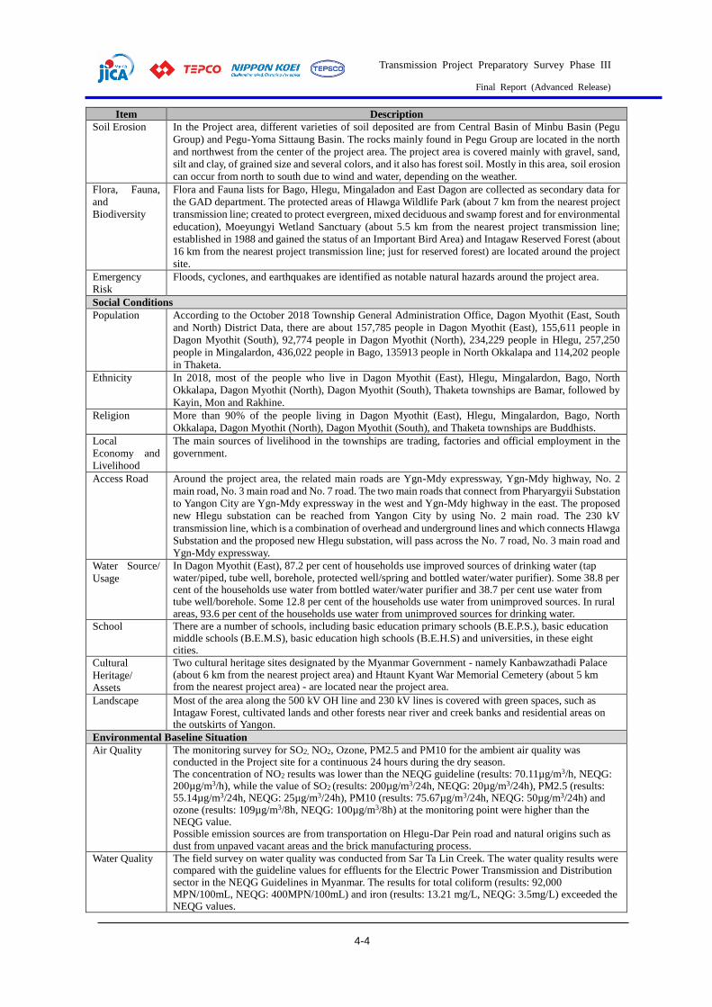
Transmission Project Preparatory Survey Phase III
Final Report (Advanced Release)
4-4
Item Description
Soil Erosion In the Project area, different varieties of soil deposited are from Central Basin of Minbu Basin (Pegu
Group) and Pegu-Yoma Sittaung Basin. The rocks mainly found in Pegu Group are located in the north
and northwest from the center of the project area. The project area is covered mainly with gravel, sand,
silt and clay, of grained size and several colors, and it also has forest soil. Mostly in this area, soil erosion
can occur from north to south due to wind and water, depending on the weather.
Flora, Fauna,
and
Biodiversity
Flora and Fauna lists for Bago, Hlegu, Mingaladon and East Dagon are collected as secondary data for
the GAD department. The protected areas of Hlawga Wildlife Park (about 7 km from the nearest project
transmission line; created to protect evergreen, mixed deciduous and swamp forest and for environmental
education), Moeyungyi Wetland Sanctuary (about 5.5 km from the nearest project transmission line;
established in 1988 and gained the status of an Important Bird Area) and Intagaw Reserved Forest (about
16 km from the nearest project transmission line; just for reserved forest) are located around the project
site.
Emergency
Risk
Floods, cyclones, and earthquakes are identified as notable natural hazards around the project area.
Social Conditions
Population According to the October 2018 Township General Administration Office, Dagon Myothit (East, South
and North) District Data, there are about 157,785 people in Dagon Myothit (East), 155,611 people in
Dagon Myothit (South), 92,774 people in Dagon Myothit (North), 234,229 people in Hlegu, 257,250
people in Mingalardon, 436,022 people in Bago, 135913 people in North Okkalapa and 114,202 people
in Thaketa.
Ethnicity In 2018, most of the people who live in Dagon Myothit (East), Hlegu, Mingalardon, Bago, North
Okkalapa, Dagon Myothit (North), Dagon Myothit (South), Thaketa townships are Bamar, followed by
Kayin, Mon and Rakhine.
Religion More than 90% of the people living in Dagon Myothit (East), Hlegu, Mingalardon, Bago, North
Okkalapa, Dagon Myothit (North), Dagon Myothit (South), and Thaketa townships are Buddhists.
Local
Economy and
Livelihood
The main sources of livelihood in the townships are trading, factories and official employment in the
government.
Access Road Around the project area, the related main roads are Ygn-Mdy expressway, Ygn-Mdy highway, No. 2
main road, No. 3 main road and No. 7 road. The two main roads that connect from Pharyargyii Substation
to Yangon City are Ygn-Mdy expressway in the west and Ygn-Mdy highway in the east. The proposed
new Hlegu substation can be reached from Yangon City by using No. 2 main road. The 230 kV
transmission line, which is a combination of overhead and underground lines and which connects Hlawga
Substation and the proposed new Hlegu substation, will pass across the No. 7 road, No. 3 main road and
Ygn-Mdy expressway.
Water Source/
Usage
In Dagon Myothit (East), 87.2 per cent of households use improved sources of drinking water (tap water/piped, tube well, borehole, protected well/spring and bottled water/water purifier). Some 38.8 per cent of the households use water from bottled water/water purifier and 38.7 per cent use water from tube well/borehole. Some 12.8 per cent of the households use water from unimproved sources. In rural areas, 93.6 per cent of the households use water from unimproved sources for drinking water.
School There are a number of schools, including basic education primary schools (B.E.P.S.), basic education middle schools (B.E.M.S), basic education high schools (B.E.H.S) and universities, in these eight cities.
Cultural
Heritage/
Assets
Two cultural heritage sites designated by the Myanmar Government - namely Kanbawzathadi Palace (about 6 km from the nearest project area) and Htaunt Kyant War Memorial Cemetery (about 5 km from the nearest project area) - are located near the project area.
Landscape Most of the area along the 500 kV OH line and 230 kV lines is covered with green spaces, such as Intagaw Forest, cultivated lands and other forests near river and creek banks and residential areas on the outskirts of Yangon.
Environmental Baseline Situation
Air Quality The monitoring survey for SO2, NO2, Ozone, PM2.5 and PM10 for the ambient air quality was conducted in the Project site for a continuous 24 hours during the dry season. The concentration of NO2 results was lower than the NEQG guideline (results: 70.11µg/m3/h, NEQG: 200µg/m3/h), while the value of SO2 (results: 200µg/m3/24h, NEQG: 20µg/m3/24h), PM2.5 (results: 55.14µg/m3/24h, NEQG: 25µg/m3/24h), PM10 (results: 75.67µg/m3/24h, NEQG: 50µg/m3/24h) and ozone (results: 109µg/m3/8h, NEQG: 100µg/m3/8h) at the monitoring point were higher than the NEQG value. Possible emission sources are from transportation on Hlegu-Dar Pein road and natural origins such as dust from unpaved vacant areas and the brick manufacturing process.
Water Quality The field survey on water quality was conducted from Sar Ta Lin Creek. The water quality results were compared with the guideline values for effluents for the Electric Power Transmission and Distribution sector in the NEQG Guidelines in Myanmar. The results for total coliform (results: 92,000 MPN/100mL, NEQG: 400MPN/100mL) and iron (results: 13.21 mg/L, NEQG: 3.5mg/L) exceeded the NEQG values.

Transmission Project Preparatory Survey Phase III
Final Report (Advanced Release)
4-5
Item Description
Two expected reasons for the exceedance of coliform in water would be existing natural bacteria and delivery from upstream areas. A possible reason for iron may be the influence of natural origins (iron can reach out from soil due to run-off). In Yangon, soil is naturally rich in iron.
Soil Quality The results of soil quality analysis showed significantly lower levels than the standards examined for Vietnam and Thailand. Therefore, the soil quality in the area surrounding the Project is good.
Noise and
Vibration Level
Noise and vibration measurements were carried out for one location on a 24-hour basis. Compared with the guideline value for noise level prescribed in the NEQG Guidelines, the day time results were under the guideline values and the night time results were slightly higher than the guideline value. The vibration level value was compared with the target value for Thilawa Special Economic Zone B, which is set based on the Japanese standard. Compared with the target vibration level for the operation stage in the EIA report for Thilawa Special Economic Zone development project Zone B, all of the results were under the target values.
Source: JICA Study Team
(2) Summary of Baseline Survey
The baseline survey is implemented to collect the necessary data and information on environmental
conditions that are required to assess the environmental impact of substations and transmission lines.
Moreover, the survey data collected will be utilized to evaluate the current situation and predict future
perspectives, and serve as baseline levels for comparison in the future. The outline of the field survey
for environmental monitoring in this Project is described below.
Outline of Field Survey
The following table shows an outline of the environmental baseline survey.
Table 4.1-3 Outline of Environmental Baseline Survey
No. Item Survey Items Methodology
1 Air Quality 1) PM2.5, 2) PM10, 3) NO2, 4) SO2, 5) Ozone, 6) Wind Speed & Direction
Using Haz-Scanner (US EPA approved)
2 Water Quality
1) Temp., 2) pH, 3) EC,4) BOD5, 5) CODCrO, 6) Oil & Grease, 7) Total Coliform, 8) TN, 9) TP, 10) TSS, 11) Cr-Total, 12) Cd, 13) As, 14) Zn, 15) Pb, 16) Hg, 17) Cu, 18) Fe, 19) Mn
Using reliable laboratory in Yangon
3 Soil Quality
1) Cr-Total, 2) Cd, 3) As, 4) Zn, 5) Pb, 6) Hg, 7) Cu, 8) Fe, 9) Mn
Using reliable laboratory in Yangon
4 Noise and Vibrations
Noise Level (LAeq dB) Vibration (dBs)
International standard method
Source: JICA Study Team
Monitoring Locations
The JICA Study Team, together with the field survey team, conducted a site visit to decide the exact
location of the field survey for the new Substation area and the route for the transmission line. The
team went to a monastery which is located near the Substation area. It is 1 km from the boundary of
the new substation area. Therefore, the location of the monastery was not selected as a monitoring
location. An outline of the baseline survey locations is shown in Table 4.1-4, and the location maps
are shown in Figure 4.1-2 and Figure 4.1-3.
Table 4.1-4 Locations for Environmental Baseline Survey
No. Items Area/point Rationale Period
1 Air Quality 1 point around the project site
-To consider the closest receptor from the new Substation area as a representative point with other places, including the route of transmission line - To avoid emissions from normal life activities at houses
24 hours continuously in dry season (1 weekday)
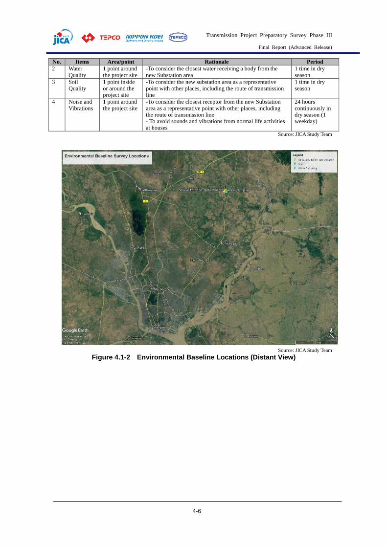
Transmission Project Preparatory Survey Phase III
Final Report (Advanced Release)
4-6
No. Items Area/point Rationale Period
2 Water Quality
1 point around the project site
-To consider the closest water receiving a body from the new Substation area
1 time in dry season
3 Soil Quality
1 point inside or around the project site
-To consider the new substation area as a representative point with other places, including the route of transmission line
1 time in dry season
4 Noise and Vibrations
1 point around the project site
-To consider the closest receptor from the new Substation area as a representative point with other places, including the route of transmission line - To avoid sounds and vibrations from normal life activities at houses
24 hours continuously in dry season (1 weekday)
Source: JICA Study Team
Source: JICA Study Team
Figure 4.1-2 Environmental Baseline Locations (Distant View)
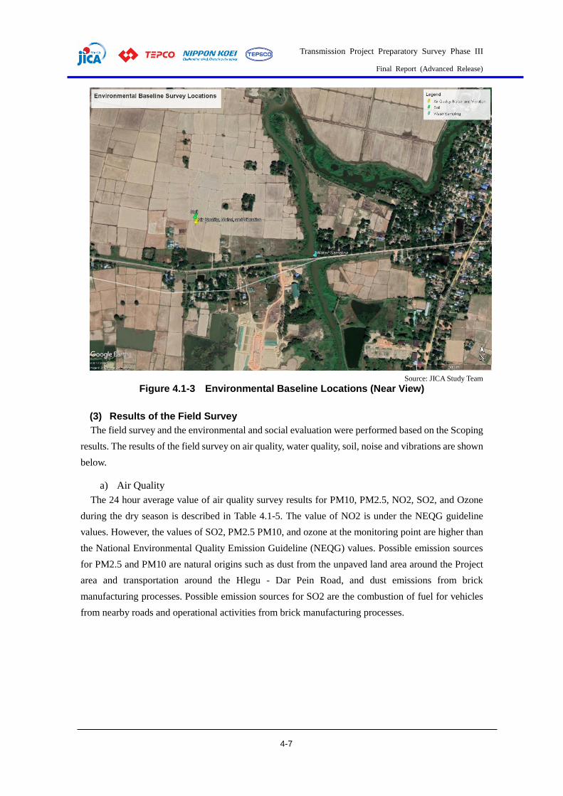
Transmission Project Preparatory Survey Phase III
Final Report (Advanced Release)
4-7
Source: JICA Study Team
Figure 4.1-3 Environmental Baseline Locations (Near View)
(3) Results of the Field Survey
The field survey and the environmental and social evaluation were performed based on the Scoping
results. The results of the field survey on air quality, water quality, soil, noise and vibrations are shown
below.
a) Air Quality
The 24 hour average value of air quality survey results for PM10, PM2.5, NO2, SO2, and Ozone
during the dry season is described in Table 4.1-5. The value of NO2 is under the NEQG guideline
values. However, the values of SO2, PM2.5 PM10, and ozone at the monitoring point are higher than
the National Environmental Quality Emission Guideline (NEQG) values. Possible emission sources
for PM2.5 and PM10 are natural origins such as dust from the unpaved land area around the Project
area and transportation around the Hlegu - Dar Pein Road, and dust emissions from brick
manufacturing processes. Possible emission sources for SO2 are the combustion of fuel for vehicles
from nearby roads and operational activities from brick manufacturing processes.
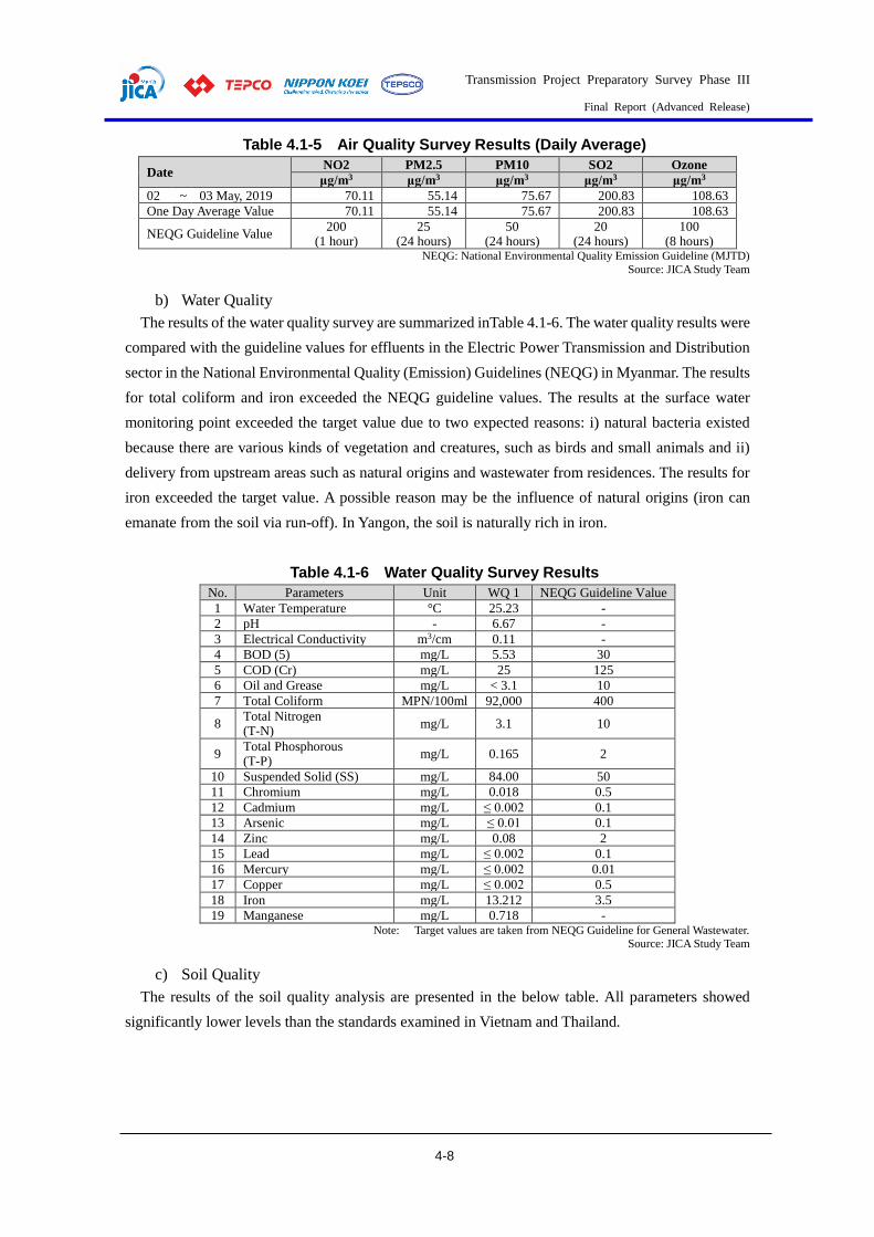
Transmission Project Preparatory Survey Phase III
Final Report (Advanced Release)
4-8
Table 4.1-5 Air Quality Survey Results (Daily Average)
Date NO2 PM2.5 PM10 SO2 Ozone
μg/m3 μg/m3 μg/m3 μg/m3 μg/m3
02 ~ 03 May, 2019 70.11 55.14 75.67 200.83 108.63
One Day Average Value 70.11 55.14 75.67 200.83 108.63
NEQG Guideline Value 200
(1 hour) 25
(24 hours) 50
(24 hours) 20
(24 hours) 100
(8 hours) NEQG: National Environmental Quality Emission Guideline (MJTD)
Source: JICA Study Team
b) Water Quality
The results of the water quality survey are summarized inTable 4.1-6. The water quality results were
compared with the guideline values for effluents in the Electric Power Transmission and Distribution
sector in the National Environmental Quality (Emission) Guidelines (NEQG) in Myanmar. The results
for total coliform and iron exceeded the NEQG guideline values. The results at the surface water
monitoring point exceeded the target value due to two expected reasons: i) natural bacteria existed
because there are various kinds of vegetation and creatures, such as birds and small animals and ii)
delivery from upstream areas such as natural origins and wastewater from residences. The results for
iron exceeded the target value. A possible reason may be the influence of natural origins (iron can
emanate from the soil via run-off). In Yangon, the soil is naturally rich in iron.
Table 4.1-6 Water Quality Survey Results
No. Parameters Unit WQ 1 NEQG Guideline Value
1 Water Temperature °C 25.23 -
2 pH - 6.67 -
3 Electrical Conductivity m3/cm 0.11 -
4 BOD (5) mg/L 5.53 30
5 COD (Cr) mg/L 25 125
6 Oil and Grease mg/L < 3.1 10
7 Total Coliform MPN/100ml 92,000 400
8 Total Nitrogen (T-N)
mg/L 3.1 10
9 Total Phosphorous (T-P)
mg/L 0.165 2
10 Suspended Solid (SS) mg/L 84.00 50
11 Chromium mg/L 0.018 0.5
12 Cadmium mg/L ≤ 0.002 0.1
13 Arsenic mg/L ≤ 0.01 0.1
14 Zinc mg/L 0.08 2
15 Lead mg/L ≤ 0.002 0.1
16 Mercury mg/L ≤ 0.002 0.01
17 Copper mg/L ≤ 0.002 0.5
18 Iron mg/L 13.212 3.5
19 Manganese mg/L 0.718 - Note: Target values are taken from NEQG Guideline for General Wastewater.
Source: JICA Study Team
c) Soil Quality
The results of the soil quality analysis are presented in the below table. All parameters showed
significantly lower levels than the standards examined in Vietnam and Thailand.
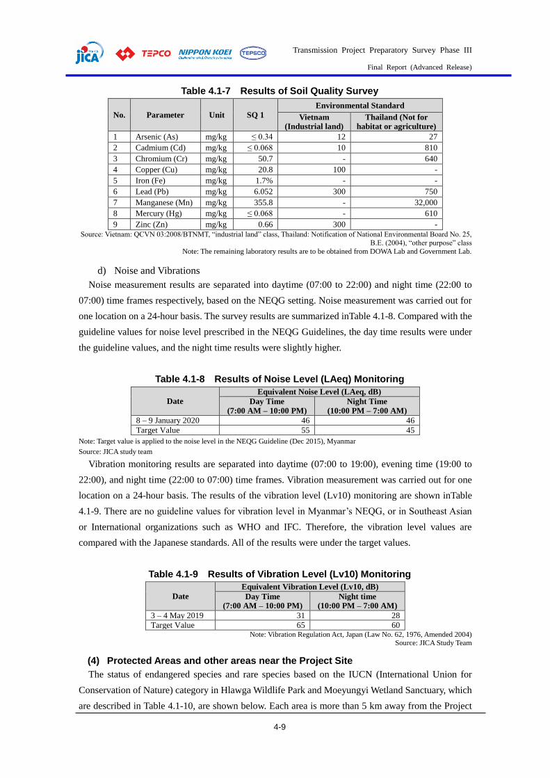
Transmission Project Preparatory Survey Phase III
Final Report (Advanced Release)
4-9
Table 4.1-7 Results of Soil Quality Survey
No. Parameter Unit SQ 1
Environmental Standard
Vietnam (Industrial land)
Thailand (Not for habitat or agriculture)
1 Arsenic (As) mg/kg ≤ 0.34 12 27
2 Cadmium (Cd) mg/kg ≤ 0.068 10 810
3 Chromium (Cr) mg/kg 50.7 - 640
4 Copper (Cu) mg/kg 20.8 100 -
5 Iron (Fe) mg/kg 1.7% - -
6 Lead (Pb) mg/kg 6.052 300 750
7 Manganese (Mn) mg/kg 355.8 - 32,000
8 Mercury (Hg) mg/kg ≤ 0.068 - 610
9 Zinc (Zn) mg/kg 0.66 300 -
Source: Vietnam: QCVN 03:2008/BTNMT, “industrial land” class, Thailand: Notification of National Environmental Board No. 25,
B.E. (2004), “other purpose” class
Note: The remaining laboratory results are to be obtained from DOWA Lab and Government Lab.
d) Noise and Vibrations
Noise measurement results are separated into daytime (07:00 to 22:00) and night time (22:00 to
07:00) time frames respectively, based on the NEQG setting. Noise measurement was carried out for
one location on a 24-hour basis. The survey results are summarized inTable 4.1-8. Compared with the
guideline values for noise level prescribed in the NEQG Guidelines, the day time results were under
the guideline values, and the night time results were slightly higher.
Table 4.1-8 Results of Noise Level (LAeq) Monitoring
Date
Equivalent Noise Level (LAeq, dB)
Day Time
(7:00 AM – 10:00 PM)
Night Time
(10:00 PM – 7:00 AM)
8 – 9 January 2020 46 46
Target Value 55 45
Note: Target value is applied to the noise level in the NEQG Guideline (Dec 2015), Myanmar
Source: JICA study team
Vibration monitoring results are separated into daytime (07:00 to 19:00), evening time (19:00 to
22:00), and night time (22:00 to 07:00) time frames. Vibration measurement was carried out for one
location on a 24-hour basis. The results of the vibration level (Lv10) monitoring are shown inTable
4.1-9. There are no guideline values for vibration level in Myanmar’s NEQG, or in Southeast Asian
or International organizations such as WHO and IFC. Therefore, the vibration level values are
compared with the Japanese standards. All of the results were under the target values.
Table 4.1-9 Results of Vibration Level (Lv10) Monitoring
Date
Equivalent Vibration Level (Lv10, dB)
Day Time (7:00 AM – 10:00 PM)
Night time (10:00 PM – 7:00 AM)
3 – 4 May 2019 31 28
Target Value 65 60 Note: Vibration Regulation Act, Japan (Law No. 62, 1976, Amended 2004)
Source: JICA Study Team
(4) Protected Areas and other areas near the Project Site
The status of endangered species and rare species based on the IUCN (International Union for
Conservation of Nature) category in Hlawga Wildlife Park and Moeyungyi Wetland Sanctuary, which
are described in Table 4.1-10, are shown below. Each area is more than 5 km away from the Project

Transmission Project Preparatory Survey Phase III
Final Report (Advanced Release)
4-10
Site.
Table 4.1-10 List of Bird Species in Hlawga Wildlife Park, Yangon
No Scientific Name Common Name Family IUCN (2020-2)
1 Acridotheres tristis Common Myna Sturnidae LC
2 Aegithina tiphia Common Iora Aegithinidae LC
3 Anas poecilorhyncha Indian Spot-billed Duck Antidae LC
4 Anastomus oscitans Asian Openbill Podicipedidae LC
5 Aviceda leuphotes Black Baza Accipitridae LC
6 Bubulcus coromandus Eastern Cattle Egret Ardeidae NE
7 Centropus sinensis Greater Coucal Cuculidae LC
8 Cinnyris jugularis Olive-backed Sunbird Nectariniidae LC
9 Coracias benghalensis Indian Roller Coraciidae LC
10 Coracina melascbistos Black-winged Cuckooshrike Campephagidae NE
11 Corvus splendens House Crow Corvidae LC
12 Crypsirina temia Racket-tailed Treepie Corvidae LC
13 Cypsiurus balas Asian Palm Shwift Apodidae LC
14 Dendrocygna javanica Lesser Whistling Duck Antidae LC
15 Dicaeum cruentatum Scarlet-backed Flowerpecker Dicaeidae LC
16 Dicrurus leucophaeus Dusky Warbler Dicruridae LC
17 Dicrurus leucophaeus Hair-crested Drongo Dicruridae LC
18 Dicrurus macrocercus Black Drongo Dicruridae LC
19 Elanus caeruleus Black-shouldered Kite Falconidae: LC
20 Eumyias thalassina Verditer Flycatcher Muscicapidae LC
21 Garrulax leucolophus White-crested Laughingthrush Leiothrichidae LC
22 Halcyon smyrnensis White-throated Kingfisher Alcedinidae LC
23 Hirundo rustica Barn Swallow Hirundinidae LC
24 Lanius cristatus Brown Shrike Laniidae LC
25 Megalaima haemaccephala Coppersmith Barbet Ramphastidae NE
26 Merops leschenaulti Chestnut-headed Bee-eater Meropidae LC
27 Metopidius indicus Bronze-winged Jacana Jacanidae LC
28 Oriolus chinensis Black-naped Oriole Oriolidae LC
29 Orthotomus sutorius Common Tailordbird Cisticolidae LC
30 Pandion baliaetus Ospery Coraciidae NE
31 Pbalacrocorax niger Little Cormorant Phalacrocoracidae NE
32 Pericrocotus cantonensis Brown-rumped Minivet Campephagidae LC
33 Pericrocotus divaricatus Ashy Minivet Campephagidae LC
34 Phylloscopus fuscatus Dusky Warbler Phylloscopidae LC
35 Pellomeum ruficeps Puff-throated Babbler Pellorneidae LC
36 Pycnonotus blanfordi Streak-eared Bulbul Pycnonotidae LC
37 Pycnonotus cafer Red-vented Bulbul Pycnonotidae LC
38 Pycnonotus jocosus Red-whiskered Bulbul Pycnonotidae LC
39 Pycnonotus melanicterus Black-capped Bulbul Pycnonotidae LC
40 Streptopelia chinensis Spotted Dove Columbidae NE
41 Streptopelia tranquebarica Red Turtle-Dove Columbidae LC
42 Tacbybaptus ruficollis Little Grebe Podicipedidae NE
43 Treron phocenicoptera Yellow-fronted Green Pigeon Columbidae NE
44 Turdoides gularis White-throated Babbler Timaliidae LC
Note: NE = Not Evaluated, LC = Least Concern Source: Announcement letter from MONREC
Table 4.1-11 List of Mammal Species in Hlawga Wildlife Park, Yangon
No Scientific Name Common Name Family IUCN (2020-2)
1 Panolia eldii Eld’s Deer Cervidae EN
2 Hyelaphus porcinus Golden Deer Cervidae NE
3 Rhesus macaque Monkey Cercopithecidae LC
4 Manis javanica Sunda Pangolin Manidae CR Note: LC = Least Concern, EN = Endangered, CR = Critically Endangered
Source: Announcement letter from MONREC

Transmission Project Preparatory Survey Phase III
Final Report (Advanced Release)
4-11
Table 4.1-12 List of Reptile Species in Hlawga Wildlife Park, Yangon
No. Scientific Name Common Name Family IUCN
(2020-2)
1 Bungarus fasciatus Banded Krait Elapidae LC
2 Varanus albigularis Monitor Lizard Varanidae NE
3 Naja kaouthia Cobra Elapidae LC
4 Python bivittatus Burmese Python Pythonidae VU Note: LC = Least Concern, VU = Vulnerable
Source: Announcement letter from MONREC
Table 4.1-13 List of Flora in Hlawga Wildlife Park in Yangon
No Scientific Name Local Name Family Habitat IUCN
(2020-2)
1 Albizia procera Sit Mimosaceae Tree LC
2 Anisoptera scaphula Kaung mu Dipterocarpaceae Tree EN
3 Anogeissus acuminata Yon Combretaceae Tree NE
4 Anthocephalus cadamba Ma U let tan she Rubiaceae Tree NE
5 Bambusa Polymorpha Kya thaung Poaceae Bamboo NE
6 Carallia brachiata Maniawga Rhizophoraceae Tree NE
7 Cephalostachy pergracile Tin Poaceae Bamboo NE
8 Dipterocarpus grandiflorus Kanyin Dipterocarpaceae Tree EN
9 Dipterocarpus tuberculatus In Dipterocarpaceae Tree NT
10 Homalium tomentosum Myauk chaw Salicaceae Tree NE
11 Lagerstroemia speciosa * Pyin ma Lythraceae Tree NE
12 Pentacme siamensis Ingyin Dipterocarpaceae Tree NE
13 Pterocarpus macrocarpus * Thit Padauk Fabaceae Tree EN
14 Shorea oblongifolia Thit ya Dipterocarpaceae Tree CR
15 Simarouba gluca Sithapyay Simaroubaceae Tree NE
16 Sterculia campanulata Shaw pyar Malvaceae Tree NE
17 Swintonia floribunda Taung tha yet Heliconiaceae Tree NE
18 Tectona grandis * Kyun (Teak) Verbenaceae Tree NE
19 Terminalia bellerica Thit seint Combretaceae Tree NE
20 Terminalia chebula Phan kha Bombacaceae Tree NE
21 Terminalia tomentosa Htuk kyant Combretaceae Tree NE
22 Xylia xylocarpa * Pyin ka doe Mimosaceae Tree LC
Note: NE = Not Evaluated, LC = Least Concern, CR = Critically Endangered, EN = Endangered Note: * = Protected Tree Species in The Whole Region of Myanmar
Source: Announcement letter from MONREC
Table 4.1-14 Bird Species List in Moeyungyi Wildlife Sanctuary
No Scientific Name Common Name Family IUCN
(2020-2)
1 Accipiter badius Shikra Accipitridae LC
2 Acridotheres fuscus Jungle Myna Sturnidae LC
3 Acridotheres grandis Great Myna Sturnidae LC
4 Acridotheres tristis Common Myna Sturnidae LC
5 Acrocephalus aedon Thick-billed Warbler Acrocephalidae LC
6 Acrocephalus agricola Paddy-field Warbler Acrocephalidae LC
7 Acrocephalus bistrigiceps Black browed reed Warbler Acrocephalidae LC
8 Acrocephalus concinens Blunt Winged Warbler Acrocephalidae LC
9 Acrocephalus orientalis Oriental Reed Warbler Acrocephalidae LC
10 Actitis hypoleucos Common Sandpiper Scolopacidae LC
11 Aegithina tiphia Common Iora Aegithinidae LC
12 Alauda gulgula Oriental Skylark Alaudidae LC
13 Alcedo atthis Common Kingfisher Alcedinidae LC
14 Amaurornis phoenicurus White-breasted Waterhen Rallidae LC
15 Anas acuta Northern Pintail Anatidae LC
16 Anas poecilorhyncha Indian Spot-billed Duck Anatidae LC
17 Anas querquedula Garganey Anatidae LC
18 Anastomus oscitans Asian Openbill Ciconiidae LC
19 Anhinga melanogaster Oriental Dater Anhingidae NT
20 Anthus cervinus Red-throated Pipit Motacillidae LC

Transmission Project Preparatory Survey Phase III
Final Report (Advanced Release)
4-12
No Scientific Name Common Name Family IUCN
(2020-2)
21 Anthus rufulus Paddy field Pipit Motacillidae LC
22 Ardea cinerea Grey-Heron Ardeidae LC
23 Ardea purpurea Purple-Heron Ardeidae LC
24 Ardeola bacchus Chinese Pond-Heron Ardeidae LC
25 Ardeola grayi Indian pond Heron Ardeidae LC
26 Ardeola speciosa Javan Pond -Heron Ardeidae LC
27 Artamus fuscus Ashy Wood Swallow Artamidae NA
28 Bubulcus ibis Cattle Egret Ardeidae LC
29 Casmerodius albus Great White Egret Ardeidae LC
30 Centropus bengalensis Lesser Coucal Cuculidae LC
31 Centropus sinensis Greater Coucal Cuculidae LC
32 Charadrius dubius Little Ringed Plover Charadriidae LC
33 Charadrius leschenaultii Greater Sand-Plover Charadriidae LC
34 Charadrius mongolus Lesser Sand-Plover Charadriidae LC
35 Chlidonias hybridus Whiskered Tern Laridae LC
36 Chlidonias leucopterus White-winged Tern Laridae LC
37 Circus aeruginnosus Western Marsh-Harrier Accipitridae NA
38 Circus cyaneus Hen-Harrier Accipitridae LC
39 Circus melanoleucos Pied Harrier Accipitridae LC
40 Circus spilonotus Eastern Marsh-Harrier Accipitridae LC
41 Cisticola juncidis Zitting Cisticola Cisticolidae LC
42 Columbia livia Rock Pigeon Columbidae NA
43 Copsychus saularis Oriental Magpic Robin Muscicapidae LC
44 Corvus splendens House crow Corvidae LC
45 Cypsirurs babs Asian palm-Swift Apodidae NA
46 Delichon dasypus Asian House Martin Hirundinidae LC
47 Dendrocygna javanica Lesser Whistling - Duck Anatidae LC
48 Dendronanthus indicus Forest Wagtail Motacillidae LC
49 Dicaeum cruentatum Scarlet-backed Flowerpecker Dicaeidae LC
50 Dicrurus macrocercus Black Dongo Dicruridae LC
51 Egretta garzetta Little Egret Ardeidae LC
52 Elanus caeruleus Black-winged Kite Accipitridae LC
53 Ficedula parva Red-breasted Flycatcher Muscicapidae LC
54 Fulica atra Common coot Rallidae LC
55 Gallicrex cinerea Watercock Rallidae LC
56 Gallinago gallinago Common Snipe Scolopacidae LC
57 Gallinula chloropus Common Moorhen Rallidae LC
58 Gallirallus striatus Salty-breasted Rail Rallidae LC
59 Gcomantis merulimus Plaintive Cuckoo Cuculidae NA
60 Glareola maldivarum Oriental Pratincole Glareolidae LC
61 Grus antigone Sarus Crane Gruidae VU
62 Halycon pileala Black-capped Kingfisher Alcedinidae NA
63 Halycon smyrnensis White-throated Kingfisher Alcedinidae NA
64 Himantopus himantopus Black winged Stilt Recurvirostridae LC
65 Hirundo rustica Barn Swallow Hirundinidae LC
66 Hirundo striolata Straited Swallow Hirundinidae NA
67 Hirundo tabitica Pacific Swallow Hirundinidae NA
68 Hydrophasianus chirurgus Pheasant-tailed Jacana Jacanidae LC
69 Ictinaetus malayensis Black Eagle Accipitridae LC
70 Ixobrychus cinnamoneus Cinnamon Bitten Ardeidae NA
71 Ixobrychus sinensis Yellow Bittern Ardeidae LC
72 Lanius cristatus Brown Shrike Laniidae LC
73 Lanius schach Long-tailed Shrike Laniidae LC
74 Larus brunnicephalus Brown-headed Gull Laridae LC
75 Leptoptilos javanicus Lesser adjutant Ciconiidae VU
76 Lonchura punctulata Scaly-breasted Munia Estrildidae LC
77 Lonchura striata White-rumped Munia Estrildidae LC
78 Megalurus palustris Striated Grassbird Locustellidae LC
79 Merops orientalis Asian Green Bee-eater Meropidae LC
80 Merops philippinus Blue-tailed Bee-eater Meropidae LC
81 Mesophoyx intermedia Intermediate Egret Ardeidae NA
82 Metopidius indicus Bronze-winged Jacana Jacanidae LC
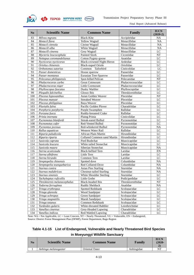
Transmission Project Preparatory Survey Phase III
Final Report (Advanced Release)
4-13
No Scientific Name Common Name Family IUCN
(2020-2)
83 Milvus mgrans Black-Kite Accipitridae NA
84 Motacil flava Yellow Wagtail Motacillidae NA
85 Motacil citreola Citrine Wagtail Motacillidae NA
86 Motacill alba White Wagtail Motacillidae NA
87 Motacill cinerea Grey Wagtail Motacillidae LC
88 Mycteria leucocephala Painted Stork Ciconiidae NT
89 Nettapus coromandelianus Cotton Pygmy-goose Anatidae LC
90 Nycticorax nycticorax Black-crowned Night-Heron Ardeidae LC
91 Oriolus chinensis Black-naped Oriole Oriolidae LC
92 Orthotomus sutorius Common Tailorbird Cisticolidae LC
93 Passer domesticus House sparrow Passeridae LC
94 Passer montanus Eurasian Tree-Sparrow Passeridae LC
95 Pelecanus philippensis Spot-billed Pelican Pelecanidae NT
96 Phalacrocorax carbo Great Cotmorant Phalacrocoracidae LC
97 Phalacrocorax niger Little Cormorant Phalacrocoracidae LC
98 Phylloscopus fuscatus Dusky Warbler Phylloscopidae LC
99 Plegadis falcinellus Glossy Ibis Threskiornithidae LC
100 Ploceus hypoxanthus Asian Golden Weaver Ploceidae NT
101 Ploceus manyar Streaked Weaver Ploceidae LC
102 Ploceus philippinus Baya Weaver Ploceidae LC
103 Pluvialis fulva Pacific Golden Plover Charadriidae LC
104 Porphyrio porphyrio Purple Swamphen Rallidae LC
105 Porzana fusca Ruddy-breasted Crake Rallidae LC
106 Prinia inornata Plaing Prinia Cisticolidae LC
107 Pycnonotus blanfordi Streak-eared Bulbul Pycnonotidae LC
108 Pycnonotus cafer Red-Vented Bulbul Pycnonotidae LC
109 Pycnontus jocosus Red-whiskered Bulbul Pycnonotidae NA
110 Rallus aquaticus Western Water Rail Rallidae LC
111 Riparia paludicola African Plain Martin Hirundinidae LC
112 Riparia riparia Collared Common sand Martin Hirundinidae LC
113 Saxicola caprata Pied Bushchat Muscicapidae LC
114 Saxicola leucura White tailed Stonechat Muscicapidae LC
115 Saxicola maura Siberian Stonechat Muscicapidae NA
116 Sterna acuticauda Black-bellied Tern Laridae EN
117 Sterna albifrons Little Tern Laridae LC
118 Sterna hirundo Common Tern Laridae LC
119 Streptopelia chinensis Spotted dove Columbidae NA
120 Streptopelia teanquebarica Red Collared-Dove Columbidae NA
121 Sturnus contra Asian Pies Starling Sturnidae NA
122 Sturnus malabricus Chestnut-tailed Starling Sturnidae NA
123 Sturnus sinensis White Shoulder Sterling Sturnidae LC
124 Tachybaptus ruficollis Little Grebe Podicipedidae LC
125 Threskiornis melanocephalus Black-headed Ibis Threskiornithidae NT
126 Todorna ferruginea Ruddy Shelduck Anatidae NA
127 Tringa erythropus Spotted Redshank Scolopacidae LC
128 Tringa glareola Wood Sandpiper Scolopacidae LC
129 Tringa ochropus Green Sandpiper Scolopacidae LC
130 Tringa stagnatilis Marsh Sandpiper Scolopacidae LC
131 Tringa totanus Common Redshank Scolopacidae LC
132 Turdoides gularis White-throated Babbler Leiothrichidae LC
133 Vanellus cinereus Grey-Headed Lapwing Charadriidae LC
134 Vanellus indicus Red-Wattled Lapwing Charadriidae LC Note: NA = Not Applicable, LC = Least Concern, NT = Nearly Threatened, VU = Vulnerable, EN = Endangered, Source: District Forest Management Plan (DFMP), Forest Department, Bago Region
Table 4.1-15 List of Endangered, Vulnerable and Nearly Threatened Bird Species
in Moeyungyi Wildlife Sanctuary
No Scientific Name Common Name Family IUCN
(2020-2)
1 Anhinga melanogaster Oriental Dater Anhingidae NT
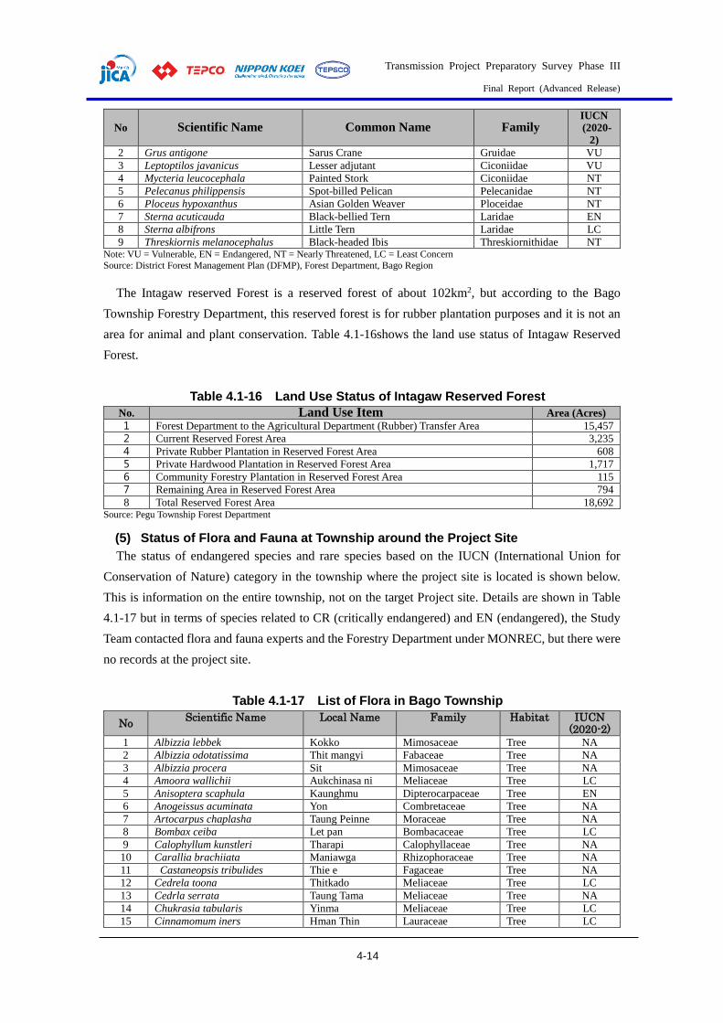
Transmission Project Preparatory Survey Phase III
Final Report (Advanced Release)
4-14
No Scientific Name Common Name Family IUCN
(2020-
2)
2 Grus antigone Sarus Crane Gruidae VU
3 Leptoptilos javanicus Lesser adjutant Ciconiidae VU
4 Mycteria leucocephala Painted Stork Ciconiidae NT
5 Pelecanus philippensis Spot-billed Pelican Pelecanidae NT
6 Ploceus hypoxanthus Asian Golden Weaver Ploceidae NT
7 Sterna acuticauda Black-bellied Tern Laridae EN
8 Sterna albifrons Little Tern Laridae LC
9 Threskiornis melanocephalus Black-headed Ibis Threskiornithidae NT Note: VU = Vulnerable, EN = Endangered, NT = Nearly Threatened, LC = Least Concern
Source: District Forest Management Plan (DFMP), Forest Department, Bago Region
The Intagaw reserved Forest is a reserved forest of about 102km2, but according to the Bago
Township Forestry Department, this reserved forest is for rubber plantation purposes and it is not an
area for animal and plant conservation. Table 4.1-16shows the land use status of Intagaw Reserved
Forest.
Table 4.1-16 Land Use Status of Intagaw Reserved Forest
No. Land Use Item Area (Acres) 1 Forest Department to the Agricultural Department (Rubber) Transfer Area 15,457
2 Current Reserved Forest Area 3,235
4 Private Rubber Plantation in Reserved Forest Area 608
5 Private Hardwood Plantation in Reserved Forest Area 1,717
6 Community Forestry Plantation in Reserved Forest Area 115
7 Remaining Area in Reserved Forest Area 794
8 Total Reserved Forest Area 18,692 Source: Pegu Township Forest Department
(5) Status of Flora and Fauna at Township around the Project Site
The status of endangered species and rare species based on the IUCN (International Union for
Conservation of Nature) category in the township where the project site is located is shown below.
This is information on the entire township, not on the target Project site. Details are shown in Table
4.1-17 but in terms of species related to CR (critically endangered) and EN (endangered), the Study
Team contacted flora and fauna experts and the Forestry Department under MONREC, but there were
no records at the project site.
Table 4.1-17 List of Flora in Bago Township
No Scientific Name Local Name Family Habitat IUCN
(2020-2)
1 Albizzia lebbek Kokko Mimosaceae Tree NA
2 Albizzia odotatissima Thit mangyi Fabaceae Tree NA
3 Albizzia procera Sit Mimosaceae Tree NA
4 Amoora wallichii Aukchinasa ni Meliaceae Tree LC
5 Anisoptera scaphula Kaunghmu Dipterocarpaceae Tree EN
6 Anogeissus acuminata Yon Combretaceae Tree NA
7 Artocarpus chaplasha Taung Peinne Moraceae Tree NA
8 Bombax ceiba Let pan Bombacaceae Tree LC
9 Calophyllum kunstleri Tharapi Calophyllaceae Tree NA
10 Carallia brachiiata Maniawga Rhizophoraceae Tree NA
11 Castaneopsis tribulides Thie e Fagaceae Tree NA
12 Cedrela toona Thitkado Meliaceae Tree LC
13 Cedrla serrata Taung Tama Meliaceae Tree NA
14 Chukrasia tabularis Yinma Meliaceae Tree LC
15 Cinnamomum iners Hman Thin Lauraceae Tree LC
Transmission Project Preparatory Survey Phase III
Final Report (Advanced Release)
4-15
No Scientific Name Local Name Family Habitat IUCN
(2020-2)
16 Cinnamomum inunctum Karawe Lauraceae Tree NA
17 Cordia fragantissima Sanda wa Boraginaceae Tree NA
18 Dalbergia cultrata Yin daik Fabaceae Tree NT
19 Dalbergia oliveri Tamalan Fabaceae Tree EN
20 Diospyros oblonga Thit khaya Ebenaceae Tree NA
21 Diospyros pendula Magyi pway Ebenaceae Tree NA
22 Dipterocarpus dyeri Kanyin Dipterocarpaceae Tree EN
23 Dipterocarpus tuberculatus In Dipterocarpaceae Tree NT
24 Duabanga grandiflora Myauk ngo Lythraceae Tree LC
25 Eugenia jambolana Tha byay Myrtaceae Tree NA
26 Fagraea fragrans Anan Gentianaceae Tree LC
27 Gardenia coronaria Yin gat Rubiaceae Tree NA
28 Garuga pinnata Chin yoke Burseraceae Tree NA
29 Gmelina arborea Ye ma ne Lamiaceae Tree LC
30 Heritiera fomes Kanaso Malvaceae Tree EN
31 Lagerstroemia speciosa Pyin ma Lythraceae Tree NA
32 Lannea coromandelica Nabe Anacardiaceae Tree NA
33 Madhuca longifolia Talaing gaung Sapotaceae Tree NA
34 Mangifera caloneura Taw thayet Anacardiaceae Tree NA
35 Melanorrhoea usitata Thitse Anacardiaceae Tree NA
36 Mellettia pendula Thinwin Fabaceae Tree NA
37 Mesua ferrea Gan gaw Calophyllaceae Tree NA
38 Michelia champaca Saga wa Magnoliaceae Tree LC
39 Mytragyna rotundifolia Binga Rubiaceae Tree NA
40 Paloquium polyanthum Peinne bo Sapotaceae Tree NA
41 Parashorea stelata Thingadu Dipterocarpaceae Tree NA
42 Pentace burmanica Kashit Malvaceae Tree DD
43 Pentace graffithii Thit sho Malvaceae Tree NA
44 Pentacme siamensis Ingyin Dipterocarpaceae Tree NA
45 Pinus species Htin yu Pinaceae Tree -
46 Protium settatum Tha di Burseraceae Tree NA
47 Pterocarpus macrocarpus Padauk Fabaceae Tree EN
48 Quercus species Thit cha Fagaceae Tree -
49 Sesbania paludosa Nyan Fabaceae Tree NA
50 Shorea assamica Kyilan Dipterocarpaceae Tree LC
51 Shorea obtusa Thit ya Dipterocarpaceae Tree NT
52 Shorea thorelii Ka nyaung Dipterocarpaceae Tree VU
53 Spondias pinnata Gwe Anacardiaceae Tree NA
54 Swietenia floribunda Taung Thayet Anacardiaceae Tree NA
55 Tectona grandis Kyun (Teak) Verbenaceae Tree NA
56 Terminalia chebula Phan kha Combretaceae Tree NA
57 Terminalia tomentosa Taukkyan Combretaceae Tree NA
58 Tetrameles nudiflora Baing Tetramelaceae Tree LC
59 Xulocarpus molluccensis Kyana Meliaceae Tree NA
60 Xylia xylocarpa Pyin ka do Fabaceae Tree LC Note: NA = Not Applicable, LC = Least Concern, DD = Data Deficient, VU = Vulnerable, EN = Endangered, NT = Nearly
Threatened
Source: General Administration Departments of the related township
Table 4.1-18 List of fauna in Bago Township
No. Scientific Name Local Name Family IUCN (2020-2) 1 Cuon alpinus Asiatic Wild Dog Canidae EN
2 Bubalus arnee Asian buffalo/water buffalo Bovidae EN
3 Elephant species Elephant Elephantidae DD
4 Bos gaurus Gaun Indian bison Bovidae VU
5 Lutra sumatrana Hairy-nosed Otter Mustelidae EN
6 Neofelis nebulosa Leopad Felidae VU
7 Monkey species Monkeys - DD
8 Sus scrofa Wild boar Suidae LC Note: LC = Least Concern, VU = Vulnerable, EN = Endangered, DD = Data Deficient
Source: General Administration Departments of related township

Transmission Project Preparatory Survey Phase III
Final Report (Advanced Release)
4-16
Table 4.1-19 List of flora species in Thanatpin Township
No Scientific Name Local Name Family Habitat IUCN
(2020-2) 1 Acacia pennata Suboke gyi Mimosaceae Climber/Creeper NA
2 Erythrina fusca Kathit Fabaceae Tree NA
3 Tamarindus indica Mangyi Caesalpiniaceae Tree NA
4 Albizia lebbek Kokko Mimosaceae Tree LC
5 Ziziphus jujuba Zi Rhamnaceae Tree LC
6 Mangifera indica Thayet Anacardiaceae Tree DD
7 Cocas nucifera Ohn Arecaceae Tree NA
8 Borassus flabellifer Htan Arecaceae Tree EN
9 Psidium guajava Malaka Myrtaceae Small Tree LC
10 Musa sapientum Nget pyaw Musaceae Herb NA Note: NA = Not Applicable, LC = Least Concern, DD = Data Deficient, VU = Vulnerable, EN = Endangered, NT = Nearly
Threatened
Source: General Administration Departments of related township, IUCN red list
Table 4.1-20 List of fauna species in Thanatpin Township
No Scientific Name Local Name Family IUCN (2020-2) 1 Bandicota bengalensis Lesser Bandicoot Rat Muridae LC
2 Fejervarya limnocharis Paddy frog Dicroglossidae LC
3 Ptyas mucosa Indian Rat Snake Colubridae NA
4 Anguilliformes Eel Actinopterygii NA
5 Macrobrachium rosenbergil Fresh Water Prawn Palaemonidae NA
6 Brachyura Fresh Crab Malacostraca -
7 Bubalus bubalis Water Buffalo Bovidae NA
8 Bos taurus Ox Bovidae NA
9 Gallus gallus domesticus Chicken Phasianidae NA
10 Anas platyrhynchos Duck Anatidae LC
11 Sus scrofa scrofa Linnaeus Pig Suidae NA
11 Ovis aries Sheep Bovidae NA
12 Capra aegagrus hircus Goat Bovidae NA
13 Coturnix japonica domestica Quail Phasianidae NA
14 Canis lupus familiaris Dog Canidae -
15 Felis catus Cat Felidae NA Note: LC = Least Concern, VU = Vulnerable, EN = Endangered, NA = Not Applicable
Source: General Administration Departments of related township, IUCN red list
Table 4.1-21 List of Flora Species in Kawa Township
No Scientific Name Local Name Family Habitat IUCN (2020-2) 1 Albizia lebbek Kokko Mimosaceae Tree LC
2 Lagerstroemia reginae Pyin ma Lythraceae Tree NA
3 Baccaurea sapida Kanazo Euphorbiaceae Tree NA
4 Ficus rumphii Nyaung Moraceae Tree NA
5 Syzygium grande Thabye gyi Myrtaceae Tree NA
6 Cocas nucifera Ohn Arecaceae Tree NA
7 Borassus flabellifer Htan Arecaceae Tree EN
8 Mangifera indica Thayet Anacardiaceae Tree DD
9 Delonix regia Sein pan Caesalpiniaceae Tree LC
10 Nypa fruticans Dani Arecaceae Small Tree LC
11 Senna siamea Mazali Caesalpiniaceae Tree LC
12 Eragrostis brownii Thaman myet Poaceae Grass NA Note: NA= Not Applicable, LC = Least Concern, DD = Data Deficient, VU = Vulnerable, EN = Endangered, NT = Nearly
Threatened
Source: General Administration Departments of related township, IUCN red list
Table 4.1-22 List of Fauna Species in Kawa Township
No Scientific Name Local Name Family IUCN (2020-
2)
1 Felis chaus Jungle Cat Felidae LC

Transmission Project Preparatory Survey Phase III
Final Report (Advanced Release)
4-17
No Scientific Name Local Name Family IUCN (2020-
2)
2 - Squirrels Sciuridae NA
3 - Mongoose Herpestidae LC
4 - Various kind of snakes Serpentes NA
5 - Various kind of birds - NA
6 Dendrocygna javanica Lesser Tree Duck Anatidae LC Note: LC = Least Concern, NA = Not Applicable
Source: General Administration Departments of related township, IUCN red list
Table 4.1-23 List of Flora Species in Hlegu Township
No Scientific Name Local Name Family Habitat IUCN
(2020-2)
1 Carallia brachiiata Maniawga Rhizophoraceae Tree NA
2 Dipterocarpus baudii Ka nyin Dipterocarpaceae Tree VU
3 Garuga pinnata Chin yoke Burseraceae Tree NA
4 Gmelina arborea Ye ma ne Lamiaceae Tree LC
5 Lagerstroemia tomentosa Leza Lythraceae Tree NA
6 Microcos paniculata Mya ya Malvaceae Tree LC
7 Protium settatum Tha di Burseraceae Tree NA
8 Swintonia floribunda Taung Thayet Anarcardiaceae Tree NA
9 Tectona grandis Teak (Kyun) Verbenaceae Tree NA
10 Xylia xylocarpa Pyin ka doe Fabaceae Tree LC Note 1: NA = Not Applicable, LC = Least Concern, VU = Vulnerable
Source: General Administration Departments of related township, IUCN red list
Table 4.1-24 List of Fauna Species in Hlegu Township
No. Scientific Name Local Name Family IUCN
(2020-2)
1 Sus scrofa Wild boar Suidae LC
2 Rusa unicolor Samban sambar deer Cervidae VU
3 Cuon alpinus Dhole Asiatic Wild Dog Canidae EN
4 Petinomys vordermanni Vordermann’s flying squirrel (Shu pyan) Sciuridae VU
5 Manispenta dactyla Chinese pangolin Manidae CR
6 Aceros nipalensis Rufous-necked hornbill (Aung Laung) Bucerotidae VU
Note: LC = Least Concern, CR = Critically Endangered, VU = Vulnerable, EN = Endangered Source: General Administration Departments of related township, IUCN red list
System and Organization for Environmental and Social Considerations in Myanmar
The following summarizes the environmental and social considerations system and related
organizations in Myanmar.
(1) Fundamental Laws and Regulations Related to Environmental and Social Considerations
The fundamental laws and regulations related to environmental and social considerations and health
in Myanmar are shown in Table 4.1-25. In addition, major international agreements and treaties that
the Myanmar government has ratified related to environmental and social considerations are shown in
Table 4.1-26.
Table 4.1-25 Fundamental Laws and Regulations Related to Environmental and
Social Considerations and Health in Myanmar
No. Laws and Regulations as of October 2020
Environmental Framework
1 The National Environmental Policy (2019)

Transmission Project Preparatory Survey Phase III
Final Report (Advanced Release)
4-18
No. Laws and Regulations as of October 2020
2 The Climate Change Policy (2019)
3 Myanmar Agenda 21 (1997)
4 National Sustainable Development Strategy (2009)
5 The Environmental Conservation Law (2012)
6 The Environmental Conservation Rules (2014)
7 EIA Procedures (December 2015)
8 National Environmental Quality (Emission) Guidelines (December 2015)
9 Draft Guideline on Public Participation in Myanmar’s EIA Processes (2017)
Water Environment
10 The Underground Water Act (1930)
11 The Territorial Sea and Maritime Zone Law (2017)
12 The Law on Aquaculture (1989)
13 The Conservation of Water Resources and Rivers Law (2006)
14 The Conservation of Water Resources and Improvement of River Systems Rules (2013)
Forestry/Biodiversity/Agriculture
15 The Pesticide Law (1990, Amendment in 2016)
16 The Forest Law (2018)
17 The Forest Rules (1995)
18 The Plant Pest Quarantine Law (1993)
19 The Protection of Biodiversity and Protected Areas Law (2018)
20 The Animal Health and Development Law (1994, Amendment in 2010)
21 The Fertilizer Law (2002)
Land Use
22 The Land Acquisition, Resettlement and Rehabilitation Act (2019)
23 The Farmland Law (2012)
24 The Farmland Rules (2012)
25 The Vacant, Fallow and Virgin Lands Management Law (2012)
26 The Vacant, Fallow and Virgin Lands Management Rules (2012)
Heritage
27 The Protection of Preservation of Cultural Heritage Region Law (1998, Amendment in 2009)
28 The Heritage Goods Protection Law (or) The Protection and Preservation of Ancient Monuments Law
(2015)
Public Health and Safety
29 The Penal Code of Offences Affecting Public Health, Safety, Convenience, Decency and Morals (1961)
30 The Public Health Law (1972)
31 The National Drug Law (1992)
32 The Narcotic Drugs and Psychotropic Substances Law (1993)
33 The Prevention and Control of Communicable Diseases Law (1995, Amendment in 2011)
34 The Traditional Drug Law (1996)
35 The National Food Law (1997)
36 The Control of Smoking and Consumption of Tobacco Products Law (2006)
37 The Law related to Private Health Care Services (2007, Amendment in 2013)
38 The Automobile Law (2015)
Industrial Law
39 The Occupational Explosive Materials Act (2018)
40 The Explosive Substances Act (1908/Amendment in 2001)
41 The Law relating to the Fishing Rights of Foreign Fishing Vessels (1989, Amendment in 1993)
42 The Private Industrial Enterprise Law (1990)
43 The Marine Fisheries Law (1990/Amendment in 1993)
44 The Freshwater Fisheries Law (1991)
45 The Salt Enterprise Law (1992)
46 The Science and Technology Development Law (1994)
47 The Myanmar Mines Law (1994)
48 The Myanmar Pearl Law (1995, Amendment in 2014)
49 The Myanmar Gemstone Law (1996)
50 The Prevention of Hazards from Chemicals and Related Substances Law (2013)
51 The Business for Ozone Depleting Substances: Notification No. 37/2014
52 The Prevention of Hazards from Chemicals and Related Substances Rules (2016)
53 The Petroleum and Petroleum Products Law (2017)
Working Environment
54 The Worker’s Compensation Act (1923)

Transmission Project Preparatory Survey Phase III
Final Report (Advanced Release)
4-19
No. Laws and Regulations as of October 2020
55 The Payment of Wages Act (2016)
56 The Factory Act (1951/Amendment in 2016)
57 The Shops and Establishment Act (1951)
58 The Leave and Holiday Act (1951, partially Amendment in 2014)
59 The Labor Organization Law (2011)
60 The Social Security Law (2012)
61 The Labor Organization Rules (2012)
62 The Labor Dispute Settlement Law (2012/Amendment in 2016)
63 The Employment and Skill Development Law (2013)
64 The Minimum Wage Law/Rules (2013)
65 The Social Security Rules (2014)
66 The Occupational Health and Safety Law (2019)
67 The Payment of Wages Law (2016)
Infrastructure/Economic Development/ Administration
68 The Town Act (1907)
69 The Village Act (1907)
70 The Ports Act (1908)
71 The Myanmar Insurance Law (1993)
72 The Myanmar Hotel and Tourism Law (1993)
73 The Constitution of the Union of Myanmar (2008)
74 The Ward or Village Tracts Administration Law (2012/Amendment in 2012/2016)
75 The Export and Import Law (2012)
76 The Myanmar Investment Law (2016)
77 The Myanmar Investment Rules (2017)
78 The Electricity Law (2014)
79 The Boiler Law (2015)
80 The Foreign Investment Law (2012/Amendment in 2015)
81 The Foreign Investment Rules (2013)
82 The Myanmar Citizen Investment Law (2013/Amendment in 2012/2016)
Emergency
83 The Natural Disaster Management Law (2013)
84 The Myanmar Fire-brigade Law (2015)
Source: JICA Study Team
Table 4.1-26 Major International Agreements and Treaties that the Myanmar
Government has Ratified Related to Environmental and Social Considerations
No. International Agreements and Treaties Date Ratified
1 Ramsar Convention (Convention on Wetlands of International Importance Especially as
Waterfowl Habitat), 1971 2005
2 Convention on International Trade in Endangered Species of Wild Fauna and Flora,
Washington, D.C., 1973; and this convention as amended in Bonn, Germany, 1979 1997
3 Vienna Convention for the Protection of the Ozone Layer, 1985 1993
4 Basel Convention, 1989 2015
5 Montreal Protocol on Substances that Deplete the Ozone Layer, 1989 1993
6 London Amendment to the Montreal Protocol on Substances that Deplete the Ozone
Layer, London, 1990 1993
7 United Nations Framework Convention on Climate Change (UNFCCC), New York, 1992 1994
8 Convention on Biological Diversity, Rio de Janeiro, 1992 1994
9 Stockholm Convention on Persistent Organic Pollutants (POPs), 2001 2004 (Accession)
Source: The Republic of the Union of Myanmar, National Biodiversity Strategy and Action Plan (2011), Website of the Basel Convention (http://www.basel.int/Countries/StatusofRatifications/PartiesSignatories/tabid/4499/Default.aspx)
The following are summaries of the key laws, NEQG and EIAP, related to the natural and social
environment in Myanmar that will likely be relevant to the Project.
National Environmental Quality (Emission) Guidelines (2015)
The Ministry of Natural Resources and Environmental Conservation (MONREC) formulated the

Transmission Project Preparatory Survey Phase III
Final Report (Advanced Release)
4-20
National Environmental Quality (Emission) Guidelines (NEQG) in coordination with ADB in
December 2015. The NEQG determines the guideline values for general emissions, such as air
emissions, wastewater, noise levels, and odors, and those for sector-specific emissions such as
emissions from forestry, agribusiness/food production, chemicals, oil and gas, infrastructure, general
manufacturing, mining, and power.
The EIA Procedure (2015)
The first full-scale legal framework for EIA was established by "Environmental Assessment
Procedure, Notification No. 616/2015", which came into force on 29 December 2015, by MONREC.
The first step in the EIA procedure is to submit a project proposal to the Environmental Conservation
Department (ECD) of MONREC. Then, ECD will decide on an EIA, IEE, or EMP according to the
project description. After the decision by ECD, the project proponent must propose expert lists (3rd
party consultants) for ECD approval. After the approval, the experts/consultants can start to conduct
the EIA/IEE/EMP investigation and submit the report to ECD for approval. A detailed description of
EIA/IEE procedures, which the Project is expected to require, is given in the following charts step by
step, from Figure 4.1-4 toFigure 4.1-14.
Source: Annex 2 of EIA Procedure (2015), ECD, MONREC
Figure 4.1-4 Myanmar EIA/IEE Procedures (1/6)
Transmission Project Preparatory Survey Phase III
Final Report (Advanced Release)
4-21
Source: Annex 2 of EIA Procedure (2015), ECD, MONREC
Figure 4.1-5 Myanmar EIA/IEE Procedures (2/6)
Source: Annex 2 of EIA Procedure (2015), ECD, MONREC
Figure 4.1-6 Myanmar IEE Procedures (3/6)

Transmission Project Preparatory Survey Phase III
Final Report (Advanced Release)
4-22
Source: Annex 2 of EIA Procedure (2015), ECD, MONREC
Figure 4.1-7 Myanmar IEE Procedures (4/6)
Source: Annex 2 of EIA Procedure (2015), ECD, MONREC
Figure 4.1-8 Myanmar IEE Procedures (5/6)

Transmission Project Preparatory Survey Phase III
Final Report (Advanced Release)
4-23
Source: Annex 2 of EIA Procedure (2015), ECD, MONREC
Figure 4.1-9 Myanmar IEE Procedures (6/6)
(2) Environmental and Social Considerations System and Related Organizations
The lead ministry in charge of environmental and social considerations is the Environmental
Conservation Department of the Ministry of Natural Resources and Environmental Conservation
(MONREC), which was reorganized with the former Ministry of Environmental Conservation and
Forestry (MOECAF) and Ministry of Mines (MOM) in April 2016. MONREC acts as the main
ministry for the preparation of environment-related laws/rules/procedures/policies/guidance, the
management of environmental issues, and the development of environmentally-friendly businesses
and sustainable projects in Myanmar. The organization structure of MONREC is described in Figure
4.1-10.
Transmission Project Preparatory Survey Phase III
Final Report (Advanced Release)
4-24
UMO = Union Minister Office FD = Forest Department DZGD = Dry Zone Greening Department ECD = Environmental Conservation Department SDMTE = Survey Department & Myanmar Timber Enterprise UFES = University of Forestry and Environmental Science DM = Department of Mines DGSME = Department of Geological Survey and Mineral
Exploration ME-1 = No. 1 Mining Enterprise ME-2 = No. 2 Mining Enterprise MGE = Myanmar Gems Enterprise MPE = Myanmar Pearl Enterprise
Source: MONREC
Figure 4.1-10 Organizational Structure of Ministry of Natural Resources and Environmental Conservation (MONREC)
In MONREC, the Environmental Conservation Department (ECD) has 11 Divisions and State &
Regional Offices, as shown in Figure 4.1-10. Among these Divisions, the EIA Division is in charge of
EIA issues, i.e., screening, review, and evaluation of EIA, IEE or EMP, as well as issuing
Environmental Compliance Certificate (ECC) as evidence of environmental approval. If the project
proponent is one of the Line Ministries of the Central Government, such as MOEE, ECD, Nay Pyi
Taw is responsible for EIA issues, and if the proponent is located in a regional area, the regional office
of ECD is responsible for the EIA issues.
Source: ECD, MONREC
Figure 4.1-11 Organizational Structure of Environmental Conservation Department (ECD)
Director General
Deputy Director General Deputy Director General
Director (Administ
ration Division)
Director (Human
Resource Division)
Director (Finance Division)
Director (Policy
and Law Division)
Director (Project
Planning and GIS
Division)
Director (International and Reginal Relation Division)
Director (Climate Change
Division)
Director (Environm
ental Quality
and Standard Division)
Director (Environm
ental Pollution Control
Division)
Director (Natural
Resource Conservat
ion
Division)
Director (Environm
ental Impact
Assessment
Division)
Nay Pyi Taw Council, State and RegionState and Region Level (15) numbers of Offices
Nay Pyi Taw Council, State and RegionDistrict Level (73) numbers of Offices
Nay Pyi Taw Council, State and RegionTownship Level (330) numbers of Offices
Transmission Project Preparatory Survey Phase III
Final Report (Advanced Release)
4-25
(3) Gap Analysis between Myanmar Law and JICA Guidelines for Environmental and Social Considerations (April 2010)
The results of the gap analysis between the policies of Myanmar’s legislation, including the EIAP,
and the Guidelines for JICA Environment and Social Considerations, are described in 4.2 Land
Acquisition and Resettlement with countermeasures for the Project.
The gap analysis between the Myanmar Land Acquisition Law 2019 and the JICA Guidelines is
described in 4.2. “Land Acquisition and Resettlement” of this report.
Table 4.1-27 Gaps between JICA Guidelines for Environmental and Social
Considerations and EIAP/Myanmar Legislation
Item JICA Guidelines EIAP and Myanmar Legislation Countermeasures for
the Project
Underlying Principles
Environmental impacts that may be caused by projects must be accessed and examined at the earliest possible planning stage. Alternatives or mitigation measures to avoid or minimize adverse impacts must be examined and incorporated into the project plan.
Article 3 of the EIA Procedure stipulates that all Projects and Project expansions which have the potential to cause Adverse Impacts are required to undertake IEE or EIA or to develop an EMP to obtain an ECC. Article 58 of the EIA Procedure stipulates that EIA investigation shall also include an analysis of Alternatives. Such analysis shall include a description of each Alternative, and an assessment and comparison of the Adverse Impacts, required mitigation measures and Residual Impacts of the Alternatives, but there is no line which stipulates the timing of the above implementation.
There is no significant difference between JICA Guidelines and Myanmar legislation. The Project will be screened as EIA or IEE and will submit the environmental report, including Alternative investigation and mitigation measures.
Examination of Measures
Multiple alternatives must be examined in order to avoid or minimize adverse impacts and to choose better project options in terms of environmental and social considerations. In the examination of measures, priority is to be given to the avoidance of environmental impacts; when this is not possible, minimization and reduction of impacts must be considered next. Compensation measures must be examined only when impacts cannot be avoided by any of the aforementioned measures.
Article 58 of the EIA Procedure stipulates that EIA investigation shall also include an analysis of Alternatives. Such analysis shall include a description of each Alternative, and an assessment and comparison of the Adverse Impacts, required mitigation measures and Residual Impacts of the Alternatives, but the conducting of compensation measures is not stipulated in the EIA procedures. Article 63 of the EIA Procedure stipulates that the project proponent is responsible for preparing an EIA report which contains Impact and Risk Assessment and Mitigation Measures.
There is no significant difference between JICA Guidelines and Myanmar legislation. The study team investigated the alternatives and described them in the draft IEE report to be submitted to ECD/MONREC.
Scope of Impacts to be Assessed
The impacts to be accessed with regard to environmental and social considerations include impacts on human health and safety, as well as on the natural environment, that are transmitted through air, water, soil, waste, accident, water usage, climate change, ecosystem, fauna and flora, including transboundary or global scale impacts. These also include
Article 63(6) of the EIA Procedure stipulates (I) identification and assessment of potential Environmental Impacts including (i) physical, biological, social, socio- economic, health, cultural, and visual impacts; (ii) potential impacts on climate change such as greenhouse gas emissions and loss of carbon sinks or stocks; and (iii) identification of impacts on climate change in the Project based on available climate change predictions from designated national authorities or international scientific research bodies,
There is no significant difference between JICA Guidelines and Myanmar legislation. The study team investigated the alternatives and described them in the draft IEE report to be submitted to ECD/MONREC.

Transmission Project Preparatory Survey Phase III
Final Report (Advanced Release)
4-26
Item JICA Guidelines EIAP and Myanmar Legislation Countermeasures for
the Project
social impacts, including migration of population and involuntary resettlement, local economy such as employment and livelihood, utilization of land and local resources, social institutions such as social capital and local decision-making institutions, existing social infrastructure and services, vulnerable social groups such as poor and indigenous peoples, equality of benefits and losses and equality in the development process, gender, children’s rights, cultural heritage, local conflicts of interest, infectious diseases such as HIV/AIDS, and working conditions including occupational safety.
(II) Identification and assessment of the likelihood and severity of natural and industrial hazards relevant to the Project are necessary in EIA report. However, social impacts, local economy, social institution and social infrastructure are not determined.
Compliance with Laws, Standards, and Plans
Projects must comply with the laws, ordinances, and standards related to environmental and social considerations established by the governments that have jurisdiction over project sites (including both national and local governments). They must also conform to the environmental and social considerations policies and plans of the governments that have such jurisdiction.
Article 28 of The Environmental Conservation Law prescribes that “No one shall, without prior permission, operate business, work-site or factory, or workshop which is required to obtain prior permission under this Law” Article 29 of the law stipulates that “No one shall violate any prohibition contained in the rules, notifications, orders, directives, and procedures issued under this Law.”
No law directly prescribes that projects must comply with laws, ordinances, and standards related to environmental and social considerations. There are National Environmental Quality (Emission) Guidelines, and the JICA Study team referred to these values.
Social Acceptability
Projects must be adequately coordinated so that they are accepted in a manner that is socially appropriate to the country and locality in which they are planned. For projects with a potentially large environmental impact, sufficient consultations with local stakeholders, such as local residents, must be conducted via disclosure of information at an early stage, at which time alternatives for project plans may be examined. The outcome of such consultations must be incorporated into the contents of project plans.
Article 36 (g) of the EIA procedures stipulates that public consultation and public participation processes, recommendations received from the public, and the Project Proponent's written responses to comments received during that process are necessary in IEE report. Article 50 of the EIA Procedure stipulates that as part of the Scoping, the Project Proponent shall ensure the following public consultation and participation process: a) disclose information about the proposed Project to the public and civil society through posting on the Project or Project Proponent’s website(s) and local media, including by means of the prominent posting of legible sign boards and advertising boards at the Project site which are visible to the public; and b) arrange the required complement of consultation meetings as advised by the Ministry, with local communities, potential PAPs, local authorities, community-based organizations, and civil society, and provide appropriate and timely explanations in press conferences and media interviews.
There is no significant difference between JICA Guidelines and Myanmar legislation. The study team had public consultation meetings and public disclosures at all target townships.
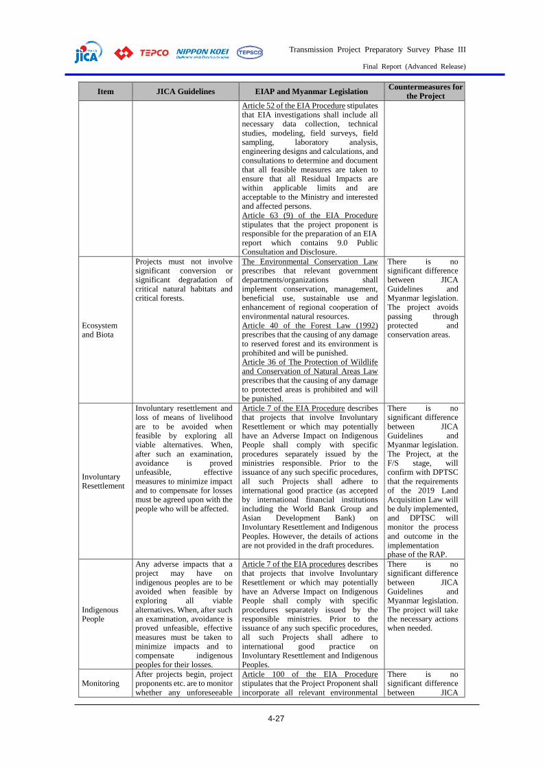
Transmission Project Preparatory Survey Phase III
Final Report (Advanced Release)
4-27
Item JICA Guidelines EIAP and Myanmar Legislation Countermeasures for
the Project
Article 52 of the EIA Procedure stipulates that EIA investigations shall include all necessary data collection, technical studies, modeling, field surveys, field sampling, laboratory analysis, engineering designs and calculations, and consultations to determine and document that all feasible measures are taken to ensure that all Residual Impacts are within applicable limits and are acceptable to the Ministry and interested and affected persons. Article 63 (9) of the EIA Procedure stipulates that the project proponent is responsible for the preparation of an EIA report which contains 9.0 Public Consultation and Disclosure.
Ecosystem and Biota
Projects must not involve significant conversion or significant degradation of critical natural habitats and critical forests.
The Environmental Conservation Law prescribes that relevant government departments/organizations shall implement conservation, management, beneficial use, sustainable use and enhancement of regional cooperation of environmental natural resources. Article 40 of the Forest Law (1992) prescribes that the causing of any damage to reserved forest and its environment is prohibited and will be punished. Article 36 of The Protection of Wildlife and Conservation of Natural Areas Law prescribes that the causing of any damage to protected areas is prohibited and will be punished.
There is no significant difference between JICA Guidelines and Myanmar legislation. The project avoids passing through protected and conservation areas.
Involuntary Resettlement
Involuntary resettlement and loss of means of livelihood are to be avoided when feasible by exploring all viable alternatives. When, after such an examination, avoidance is proved unfeasible, effective measures to minimize impact and to compensate for losses must be agreed upon with the people who will be affected.
Article 7 of the EIA Procedure describes that projects that involve Involuntary Resettlement or which may potentially have an Adverse Impact on Indigenous People shall comply with specific procedures separately issued by the ministries responsible. Prior to the issuance of any such specific procedures, all such Projects shall adhere to international good practice (as accepted by international financial institutions including the World Bank Group and Asian Development Bank) on Involuntary Resettlement and Indigenous Peoples. However, the details of actions are not provided in the draft procedures.
There is no significant difference between JICA Guidelines and Myanmar legislation. The Project, at the F/S stage, will confirm with DPTSC that the requirements of the 2019 Land Acquisition Law will be duly implemented, and DPTSC will monitor the process and outcome in the implementation phase of the RAP.
Indigenous People
Any adverse impacts that a project may have on indigenous peoples are to be avoided when feasible by exploring all viable alternatives. When, after such an examination, avoidance is proved unfeasible, effective measures must be taken to minimize impacts and to compensate indigenous peoples for their losses.
Article 7 of the EIA procedures describes that projects that involve Involuntary Resettlement or which may potentially have an Adverse Impact on Indigenous People shall comply with specific procedures separately issued by the responsible ministries. Prior to the issuance of any such specific procedures, all such Projects shall adhere to international good practice on Involuntary Resettlement and Indigenous Peoples.
There is no significant difference between JICA Guidelines and Myanmar legislation. The project will take the necessary actions when needed.
Monitoring After projects begin, project proponents etc. are to monitor whether any unforeseeable
Article 100 of the EIA Procedure stipulates that the Project Proponent shall incorporate all relevant environmental
There is no significant difference between JICA
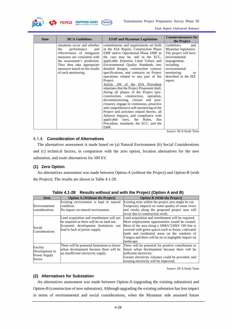
Transmission Project Preparatory Survey Phase III
Final Report (Advanced Release)
4-28
Item JICA Guidelines EIAP and Myanmar Legislation Countermeasures for
the Project
situations occur and whether the performance and effectiveness of mitigation measures are consistent with the assessment’s prediction. They then take appropriate measures based on the results of such monitoring
commitments and requirements set forth in the EIA Report, Construction Phase EMP and/or Operational Phase EMP as the case may be, and in the ECC, applicable Emission Limit Values and Environmental Quality Standards, into detailed designs, construction contract specifications, and contracts on Project operations related to any part of the Project. Article 106 of the EIA Procedure stipulates that the Project Proponent shall, during all phases of the Project (pre-construction, construction, operation, decommissioning, closure and post-closure), engage in continuous, proactive and comprehensive self-monitoring of the Project and activities related thereto, all Adverse Impacts, and compliance with applicable laws, the Rules, this Procedure, standards, the ECC, and the EMP.
Guidelines and Myanmar legislation. The project will have environmental management, including environmental monitoring as described in the IEE report.
Source: JICA Study Team
Consideration of Alternatives
The alternatives assessment is made based on (a) Natural Environment (b) Social Considerations
and (c) technical factors, in comparison with the zero option, location alternatives for the new
substation, and route alternatives for 500 kV.
(1) Zero Option
An alternatives assessment was made between Option-A (without the Project) and Option-B (with
the Project). The results are shown in Table 4.1-28.
Table 4.1-28 Results without and with the Project (Option A and B)
Item Option A (Without the Project) Option B (With the Project)
Environmental considerations
Existing environment is kept in natural condition. No impact on natural environment.
Existing trees within the project area might be cut. Temporary impacts on water quality of some rivers and creeks along the proposed project area will occur due to construction work.
Social Considerations
Land acquisition and resettlement will not be required as there will be no land use. Economic development limitations can lead to lack of power supply.
Land acquisition and resettlement will be required. More employment opportunities would be created. Most of the area along a 500kV/230kV OH line is covered with green spaces such as forest, cultivated lands and residential areas on the outskirts of Yangon and there will be no or negligible impact on landscape.
Facility Development in Power Supply Sector
There will be potential limitations to future urban development because there will be an insufficient electricity supply.
There will be potential for positive contribution to future urban development because there will be sufficient electricity. Greater electricity volumes could be provided, and existing electricity will be improved.
Source: JICA Study Team
(2) Alternatives for Substation
An alternatives assessment was made between Option-A (upgrading the existing substation) and
Option-B (construction of new substation). Although upgrading the existing substation has less impact
in terms of environmental and social considerations, when the Myanmar side assumed future

Transmission Project Preparatory Survey Phase III
Final Report (Advanced Release)
4-29
electricity demand in the country many were of the opinion that it would be difficult to choose to
upgrade the existing substation because it will be impossible to expand in the future due to land
restrictions. In the case of constructing a new substation, it is necessary to consider cutting down some
trees and acquiring land for land preparation, but the scale would be limited and it is possible to deal
with this, meaning that the substation could be expanded in the future. Option B (construction of a
new substation) was selected. The results are shown in Table 4.1-29.
Table 4.1-29 Results between Upgrading the Existing S/S (Option A) and
Construction of New S/S (Option B)
Item Option A
(Upgrading the Existing Substation) Option B
(Construction of New Substation)
En
vir
on
men
tal
con
sid
erat
ion
s
Air quality, noise and vibrations
No site cleaning is required so air quality impacts due to dust generation, and noise and vibration impacts from construction work will be reduced compared to Option B. Some air quality impact, noise and vibration generation are expected from installation of new 500 kV equipment.
Site cleaning will be required for the construction of the new substation, so air quality, noise, and vibration impacts are expected. Compared to Option A, greater air quality impacts and noise and vibration generation are expected due to the construction of the new substation and installation of new 500 kV equipment.
Cutting trees and Site Clearance
No tree cutting is required. Some weeds will have to be cleared for installation of new equipment.
Some tree cutting will be required for site cleaning. Approximately 80 acres of paddy field will have to be cleared for the construction of the new substation.
Water pollution
Water quality impact on nearby fish ponds is expected due to construction work.
There will be a greater water quality impact on nearby creeks and fish ponds due to construction work compared to Option A.
So
cial
co
nsi
der
atio
ns
Land acquisition
There will be no requirement for land acquisition to upgrade the existing facilities.
A total area of approximately 80 acres of land will have to be acquired for the installation of 500 kV substation.
Livelihoods
There will be no impacts on the livelihoods of local people.
Because of the land requirement for substation, 80 acres of paddy fields need to be removed. Therefore, the livelihoods of local people would be affected, and local living standards would be improved due to the sufficient power supply.
Tec
hn
ical
is
sues
Future Expansion
Future expansion cannot be undertaken due to land limitations.
With Option B, future expansion can be undertaken because there is a large amount of space for the construction of the new substation.
Source: JICA Study Team
(3) Route Alternatives for 500 kV
An alternatives assessment was made between Option-A (West route) and Option-B (East route), as
shown in Table 4.1-31. There were no big differences in technical issues and costs between Option A
(west route) and Option B (east route), but Option A (west route) has a large number of rubber
plantations to be cut down on the route, and compensation and negotiations were considered difficult.
Therefore, Option B (East Route) was selected. The results are shown in Table 4.1-12.

Transmission Project Preparatory Survey Phase III
Final Report (Advanced Release)
4-30
Source: JICA Study Team
Figure 4.1-12 Alternative Transmission Line Route for 500kV (West/East route (Option A/Option B))

Transmission Project Preparatory Survey Phase III
Final Report (Advanced Release)
4-31
Table 4.1-30 Results between East Route (Option A) and West Route (Option B)
for 500 kV Transmission line
Item Option A (West Route) Option B (East Route)
En
vir
on
men
tal
issu
es Air quality, noise
and vibrations Compared to Option B, there are more receptors such as houses on the route and impacts on air quality, noise and vibration are anticipated.
Air quality, noise and vibration impacts are expected due to construction work
Cutting trees and Site Clearance
Compared to Option B, the cutting of more trees and more land clearance will be required due to site conditions.
Trees within the alignment of TL are required to be cut down. Some land clearance will be required.
Natural Environment TL alignment will cross Intagaw Reserved Forest and near the Nga Moe Yeik Reservoir.
There are no direct crossings of protected areas or reserved forest. Wingabaw Elephant Camp is located near the TL alignment.
So
cial
Con
sid
erat
ion
s
Traffic disruption and inconvenience to pedestrians, including access
Traffic along the Number 2 Main Road, Yangon-Mandalay Highway is expected while transmission line facilities and construction materials are transported to the construction site.
Traffic along the Number 2 Main Road, Yangon-Mandalay Highway, and Yangon-Mandalay Expressway is expected while transmission line facilities are transported to the construction site.
Impact on residential, commercial, government, and heritage structures
The transmission line route will be designed to avoid residential areas themselves but the route crosses through Tha Nat Pyin village. The transmission line route also crosses near five (5) villages. There are three (3) pagodas, ten (10) monasteries and seven (7) churches near the transmission line route. The transmission line route also crosses over two (2) livestock areas (fish ponds). The first crossing is approximately 0.5 km in distance and the second crossing is approximately 0.1 km in distance.
The transmission line route will be designed to avoid residential areas themselves but it crosses near three (3) villages. There are three (3) pagodas and one (1) monastery near the transmission line route. There are no crossings over livestock areas.
Tec
hn
ical
is
sues
Cost Lower cost than the eastern route (Option B).
30-40% increase in construction costs compared to the western route (Option A).
Construction of the transmission lines
Compared to Option B, construction of the transmission lines would be more constrained by the route through the forest area and rubber plantations, and the change in the positions of the bays at Pharyargyi substation. The ground along Number 2 Main Road is relatively firm. It is assumed that low-cost pad foundations can be partially applied.
There is no change in the positions of the bays at Pharyargyi substation, and the route passes through flat rice fields and riverbeds and does not pass through rubber forests and mango orchards, making access to the construction sites easy. The construction work for the transmission lines is relatively easy. Most of the route passes through riverbed and rural areas, where the ground is soft, and therefore, pile foundations for steel tower are expected to be relatively expensive.
Source: JICA Study Team
Scoping and TOR for the Survey on Natural and Social Environments
(1) Draft Scoping Results
The outline of the Project components is as described above. According to Article 25 of EIA
Procedure Notification No. 616/2015, the following conservation areas are categorized as sensitive
environmental and conservation areas requiring special consideration in conserving the areas. The
following conservation areas are NOT expected to exist in the area of the Project.
1) Forest conservation area (including biodiversity reserved area) 2) Public forest 3) Park (including marine parks) 4) Mangrove swamp 5) Any other sensitive coastal area 6) Wildlife sanctuary 7) Scientific reserve 8) Nature reserve
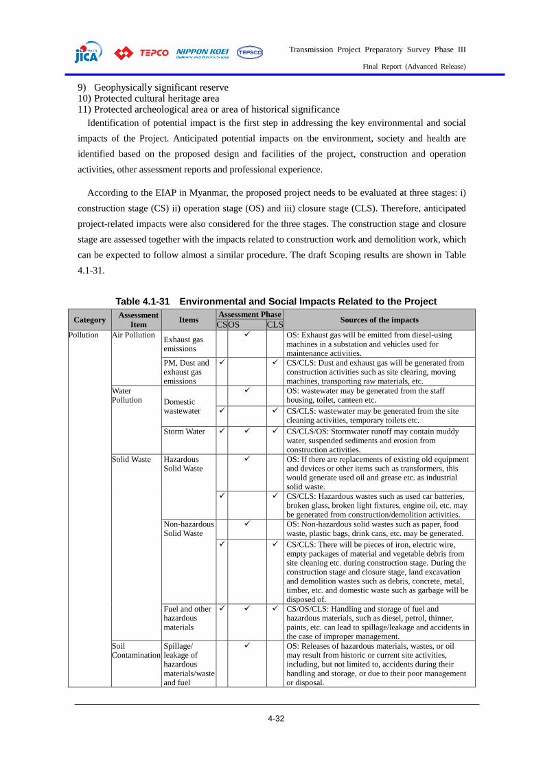
Transmission Project Preparatory Survey Phase III
Final Report (Advanced Release)
4-32
9) Geophysically significant reserve 10) Protected cultural heritage area 11) Protected archeological area or area of historical significance
Identification of potential impact is the first step in addressing the key environmental and social
impacts of the Project. Anticipated potential impacts on the environment, society and health are
identified based on the proposed design and facilities of the project, construction and operation
activities, other assessment reports and professional experience.
According to the EIAP in Myanmar, the proposed project needs to be evaluated at three stages: i)
construction stage (CS) ii) operation stage (OS) and iii) closure stage (CLS). Therefore, anticipated
project-related impacts were also considered for the three stages. The construction stage and closure
stage are assessed together with the impacts related to construction work and demolition work, which
can be expected to follow almost a similar procedure. The draft Scoping results are shown in Table
4.1-31.
Table 4.1-31 Environmental and Social Impacts Related to the Project
Category Assessment
Item Items
Assessment Phase Sources of the impacts
CS OS CLS Pollution Air Pollution
Exhaust gas emissions
OS: Exhaust gas will be emitted from diesel-using machines in a substation and vehicles used for maintenance activities.
PM, Dust and exhaust gas emissions
CS/CLS: Dust and exhaust gas will be generated from construction activities such as site clearing, moving machines, transporting raw materials, etc.
Water Pollution Domestic
wastewater
OS: wastewater may be generated from the staff housing, toilet, canteen etc.
CS/CLS: wastewater may be generated from the site cleaning activities, temporary toilets etc.
Storm Water CS/CLS/OS: Stormwater runoff may contain muddy water, suspended sediments and erosion from construction activities.
Solid Waste Hazardous Solid Waste
OS: If there are replacements of existing old equipment and devices or other items such as transformers, this would generate used oil and grease etc. as industrial solid waste.
CS/CLS: Hazardous wastes such as used car batteries, broken glass, broken light fixtures, engine oil, etc. may be generated from construction/demolition activities.
Non-hazardous Solid Waste
OS: Non-hazardous solid wastes such as paper, food waste, plastic bags, drink cans, etc. may be generated.
CS/CLS: There will be pieces of iron, electric wire, empty packages of material and vegetable debris from site cleaning etc. during construction stage. During the construction stage and closure stage, land excavation and demolition wastes such as debris, concrete, metal, timber, etc. and domestic waste such as garbage will be disposed of.
Fuel and other hazardous materials
CS/OS/CLS: Handling and storage of fuel and hazardous materials, such as diesel, petrol, thinner, paints, etc. can lead to spillage/leakage and accidents in the case of improper management.
Soil Contamination
Spillage/ leakage of hazardous materials/waste and fuel
OS: Releases of hazardous materials, wastes, or oil may result from historic or current site activities, including, but not limited to, accidents during their handling and storage, or due to their poor management or disposal.
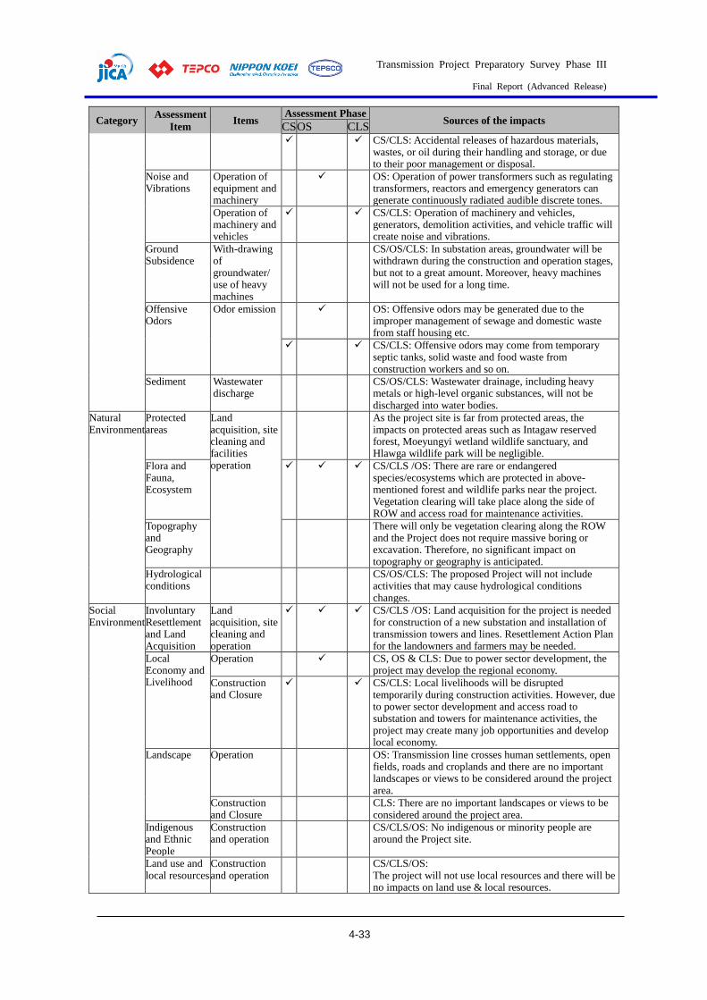
Transmission Project Preparatory Survey Phase III
Final Report (Advanced Release)
4-33
Category Assessment
Item Items
Assessment Phase Sources of the impacts
CS OS CLS CS/CLS: Accidental releases of hazardous materials,
wastes, or oil during their handling and storage, or due to their poor management or disposal.
Noise and Vibrations
Operation of equipment and machinery
OS: Operation of power transformers such as regulating transformers, reactors and emergency generators can generate continuously radiated audible discrete tones.
Operation of machinery and vehicles
CS/CLS: Operation of machinery and vehicles, generators, demolition activities, and vehicle traffic will create noise and vibrations.
Ground Subsidence
With-drawing of groundwater/ use of heavy machines
CS/OS/CLS: In substation areas, groundwater will be withdrawn during the construction and operation stages, but not to a great amount. Moreover, heavy machines will not be used for a long time.
Offensive Odors
Odor emission
OS: Offensive odors may be generated due to the improper management of sewage and domestic waste from staff housing etc.
CS/CLS: Offensive odors may come from temporary septic tanks, solid waste and food waste from construction workers and so on.
Sediment Wastewater discharge
CS/OS/CLS: Wastewater drainage, including heavy metals or high-level organic substances, will not be discharged into water bodies.
Natural Environment
Protected areas
Land acquisition, site cleaning and facilities operation
As the project site is far from protected areas, the impacts on protected areas such as Intagaw reserved forest, Moeyungyi wetland wildlife sanctuary, and Hlawga wildlife park will be negligible.
Flora and Fauna, Ecosystem
CS/CLS /OS: There are rare or endangered species/ecosystems which are protected in above-mentioned forest and wildlife parks near the project. Vegetation clearing will take place along the side of ROW and access road for maintenance activities.
Topography and Geography
There will only be vegetation clearing along the ROW and the Project does not require massive boring or excavation. Therefore, no significant impact on topography or geography is anticipated.
Hydrological conditions
CS/OS/CLS: The proposed Project will not include activities that may cause hydrological conditions changes.
Social Environment
Involuntary Resettlement and Land Acquisition
Land acquisition, site cleaning and operation
CS/CLS /OS: Land acquisition for the project is needed for construction of a new substation and installation of transmission towers and lines. Resettlement Action Plan for the landowners and farmers may be needed.
Local Economy and Livelihood
Operation CS, OS & CLS: Due to power sector development, the project may develop the regional economy.
Construction and Closure
CS/CLS: Local livelihoods will be disrupted temporarily during construction activities. However, due to power sector development and access road to substation and towers for maintenance activities, the project may create many job opportunities and develop local economy.
Landscape Operation OS: Transmission line crosses human settlements, open fields, roads and croplands and there are no important landscapes or views to be considered around the project area.
Construction and Closure
CLS: There are no important landscapes or views to be considered around the project area.
Indigenous and Ethnic People
Construction and operation
CS/CLS/OS: No indigenous or minority people are around the Project site.
Land use and local resources
Construction and operation
CS/CLS/OS: The project will not use local resources and there will be no impacts on land use & local resources.
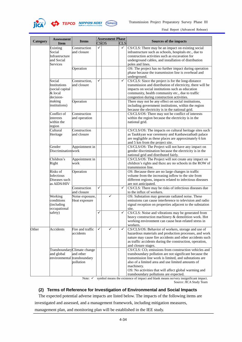
Transmission Project Preparatory Survey Phase III
Final Report (Advanced Release)
4-34
Category Assessment
Item Items
Assessment Phase Sources of the impacts
CS OS CLS Existing Social Infrastructure and Social Services
Construction and closure
CS/CLS: There may be an impact on existing social infrastructure such as schools, hospitals etc., due to construction activities such as excavation for underground cables, and installation of distribution poles and lines.
Operation OS: The project has no further impact during operation phase because the transmission line is overhead and underground.
Social Institutions (social capital & local decision-making institutions)
Construction, and closure
CS/CLS: Since the project is for the long-distance transmission and distribution of electricity, there will be impacts on social institutions such as education community, health community etc., due to traffic congestion during construction activities.
Operation There may not be any effect on social institutions, including government institutions, within the region because the electricity is in the national grid.
Conflict of interests within the region
Construction and operation
CS/CLS/OS: There may not be conflict of interests within the region because the electricity is in the national grid.
Cultural Heritage
Construction and closure
CS/CLS/OS: The impacts on cultural heritage sites such as Taukkyan war ceremony and Kanbawzathadi palace are negligible as these places are approximately 6 km and 5 km from the project site.
Gender Discrimination
Appointment in work
CS/CLS/OS: The Project will not have any impact on gender discrimination because the electricity is in the national grid and distributed fairly.
Children’s Right
Appointment in work
CS/CLS/OS: The Project will not create any impact on children’s rights and there are no schools in the ROW of transmission line.
Risks of Infectious Diseases such as AIDS/HIV
Operation OS: Because there are no large changes in traffic volume from the increasing inflow to the site from different regions, impacts related to infectious diseases are not anticipated.
Construction and closure
CS/CLS: There may be risks of infectious diseases due to the influx of workers.
Working conditions (including occupational safety)
Noise exposure, Heat exposure
OS: Substation may generate radiated noise. These emissions can cause interference to television and radio signal reception on properties adjacent to the substation site.
CS/CLS: Noise and vibrations may be generated from heavy construction machinery & demolition work. Hot working environment can cause heat-related stress in workers.
Other Accidents Fire and traffic accidents
CS/CLS/OS: Behavior of workers, storage and use of hazardous materials and production processes, and work nature may cause fire accidents and other accidents such as traffic accidents during the construction, operation, and closure stages.
Transboundary and global environmental
Climate change and other transboundary pollution
CS/CLS: CO2 emissions from construction vehicles and transboundary pollution are not significant because the transmission line work is limited, and substations are also of a limited area and use limited amounts of machinery. OS: No activities that will affect global warming and transboundary pollutions are expected.
Note: symbol means the existence of impact and blank means no/very insignificant impact.
Source: JICA Study Team
(2) Terms of Reference for Investigation of Environmental and Social Impacts
The expected potential adverse impacts are listed below. The impacts of the following items are
investigated and assessed, and a management framework, including mitigation measures,
management plan, and monitoring plan will be established in the IEE study.

Transmission Project Preparatory Survey Phase III
Final Report (Advanced Release)
4-35
1) Health and Safety 2) Socio-Economic 3) Emergency Response 4) Construction activities (Air, Water, Solid Waste, Noise, and Vibrations)
For the above, a brief description of adverse impacts and the approach for the evaluation are
summarized in the following table. The preparation of TOR for the survey on natural and social
environments will be examined after the scoping preparation.
Table 4.1-32 Brief Description of Adverse Impacts and Approach for Evaluation
Type Potential Adverse Impacts and Approach
Pollution Control This project (new/expanded substation and 230kv/500kV transmission line) itself does not cause serious adverse impacts, and, in particular, there might be no impact during the operation stage. Even at the construction stage, the impact is limited.
Natural Environment Area for the project development is limited, and it is not a special area (e.g. paddy field and/or areas not currently in use). To err on the side of caution, a Flora and Fauna survey will be conducted as a baseline survey through the IEE study.
Social Environment There will be no or limited resettlement because transmission line routes can avoid residential areas. The expansion of the existing Hlawga has no social impact. The new substation in east Dagon was originally the planned area for Yangon Amata Smart and Eco City, which will be handed over from YCDC.
Source: JICA Study Team
Table 4.1-33 shows the TOR for the environmental and social considerations survey, including
survey/forecast items and survey/forecast methods.
Table 4.1-33 TOR for Environmental and Social Considerations
Category Assessment
Item Survey/Forecast Items Survey/Forecast Methods
Pollution Air Pollution - PM, dust and exhaust gas generated from the construction or closure (demolition) activities - Exhaust gas will be emitted via the combustion of diesel-using machines/ vehicles used for maintenance activities during operation stage.
- Examine the impact of air pollution during the construction/closure stages by considering the construction/ demolition methods and schedule, the features of project site, and air quality management controls. - Examine the impact of air pollution during the operation stage by considering the substation design & operation manner. - Field Survey for ambient air quality near the Project site
Water Pollution
- Construction runoff and domestic wastewater generated from the construction or closure (demolition) activities. - Domestic wastewater and surface runoff generated from the operation of proposed project (substation).
- Examine the impact of water pollution during the construction/closure stages by considering the construction/ demolition methods and schedule, the features of project site, and water quality management controls. - Examine the impact of water pollution during the operation stage by considering sewage effluent from the septic tanks of staff housing. - Field Survey for water quality near the Project site
Solid Waste - Hazardous waste such as rags contaminated with chemicals, petrol oil, diesel oil, paint, thinner and epoxy for finishing work during construction/closure stages.
- Examine the impact of hazardous and non-hazardous wastes during the construction and closure stages by considering the construction/closure work plan for the proposed project. - Examine the impact of hazardous and non-hazardous wastes during the operation stage by considering the operation work plan for the proposed project.
Soil Contamination
- Possibility of soil contamination as a result of activities in construction, operation and closure stages.
- Examine the impact of soil contamination during the construction and closure stages by considering the possibility of soil contamination and distribution of contaminated soil as a result of the demolition work in the project area.
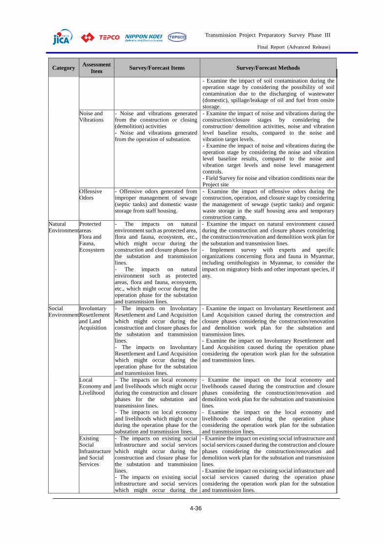
Transmission Project Preparatory Survey Phase III
Final Report (Advanced Release)
4-36
Category Assessment
Item Survey/Forecast Items Survey/Forecast Methods
- Examine the impact of soil contamination during the operation stage by considering the possibility of soil contamination due to the discharging of wastewater (domestic), spillage/leakage of oil and fuel from onsite storage.
Noise and Vibrations
- Noise and vibrations generated from the construction or closing (demolition) activities - Noise and vibrations generated from the operation of substation.
- Examine the impact of noise and vibrations during the construction/closure stages by considering the construction/ demolition activities, noise and vibration level baseline results, compared to the noise and vibration target levels. - Examine the impact of noise and vibrations during the operation stage by considering the noise and vibration level baseline results, compared to the noise and vibration target levels and noise level management controls. - Field Survey for noise and vibration conditions near the Project site
Offensive Odors
- Offensive odors generated from improper management of sewage (septic tanks) and domestic waste storage from staff housing.
- Examine the impact of offensive odors during the construction, operation, and closure stage by considering the management of sewage (septic tanks) and organic waste storage in the staff housing area and temporary construction camp.
Natural Environment
Protected areas Flora and Fauna, Ecosystem
- The impacts on natural environment such as protected area, flora and fauna, ecosystem, etc., which might occur during the construction and closure phases for the substation and transmission lines. - The impacts on natural environment such as protected areas, flora and fauna, ecosystem, etc., which might occur during the operation phase for the substation and transmission lines.
- Examine the impact on natural environment caused during the construction and closure phases considering the construction/renovation and demolition work plan for the substation and transmission lines. - Implement survey with experts and specific organizations concerning flora and fauna in Myanmar, including ornithologists in Myanmar, to consider the impact on migratory birds and other important species, if any.
Social Environment
Involuntary Resettlement and Land Acquisition
- The impacts on Involuntary Resettlement and Land Acquisition which might occur during the construction and closure phases for the substation and transmission lines. - The impacts on Involuntary Resettlement and Land Acquisition which might occur during the operation phase for the substation and transmission lines.
- Examine the impact on Involuntary Resettlement and Land Acquisition caused during the construction and closure phases considering the construction/renovation and demolition work plan for the substation and transmission lines. - Examine the impact on Involuntary Resettlement and Land Acquisition caused during the operation phase considering the operation work plan for the substation and transmission lines.
Local Economy and Livelihood
- The impacts on local economy and livelihoods which might occur during the construction and closure phases for the substation and transmission lines. - The impacts on local economy and livelihoods which might occur during the operation phase for the substation and transmission lines.
- Examine the impact on the local economy and livelihoods caused during the construction and closure phases considering the construction/renovation and demolition work plan for the substation and transmission lines. - Examine the impact on the local economy and livelihoods caused during the operation phase considering the operation work plan for the substation and transmission lines.
Existing Social Infrastructure and Social Services
- The impacts on existing social infrastructure and social services which might occur during the construction and closure phase for the substation and transmission lines. - The impacts on existing social infrastructure and social services which might occur during the
- Examine the impact on existing social infrastructure and social services caused during the construction and closure phases considering the construction/renovation and demolition work plan for the substation and transmission lines. - Examine the impact on existing social infrastructure and social services caused during the operation phase considering the operation work plan for the substation and transmission lines.

Transmission Project Preparatory Survey Phase III
Final Report (Advanced Release)
4-37
Category Assessment
Item Survey/Forecast Items Survey/Forecast Methods
operation phase for the substation and transmission lines.
Social Institutions (social capital & local decision-making institutions)
- The impacts on social institutions which might occur during the construction and closure phase for the substation and transmission lines. - The impacts on social institutions which might occur during the operation phase for the substation and transmission lines.
- Examine the impact on social institutions caused during the construction and closure phases considering the construction/renovation and demolition work plan for the substation and transmission lines. - Examine the impact on social institutions caused during the operation phase considering the operation work plan for the substation and transmission lines.
Risks of Infectious Diseases such as AIDS/HIV
- The risks of infectious diseases such as AIDS/HIV, including community health and safety, which might occur during the construction and closure stages for the substation and transmission lines.
- Examine the risks to community health and safety, including infectious diseases such as AIDS/HIV, caused during the construction and closure stages by considering the construction and closure work plans for the substation and transmission lines.
Working conditions (including occupational safety)
- The impacts on working conditions (including occupational safety) which might occur during the operation stage for the substation and transmission lines. - The impacts on working conditions (including occupational safety) which might occur during the construction and closure stages for the substation and transmission lines.
- Examine the impact on the working conditions (including occupational safety) caused during the operation stage by considering the operation work plan for the substation and transmission lines. - Examine the impact on the working conditions (including occupational safety) caused during the construction and closure stages by considering the construction and closure work plans for the substation and transmission lines.
Other Accidents - Accidents due to construction, operations and demolition work may increase the vulnerability of the project site to fire hazards and traffic accidents.
- Examine risk of potential fire accidents and other accidents during operation stage by considering the operation work plan for the proposed project. - Examine risk of potential fire accidents and other accidents during construction and closure stages by considering the construction and closure work plans for the proposed project.
Source: JICA Study Team
Results of the Survey on Environmental and Social Impact and Environmental and Social Impact Evaluation
(1) Results of the Survey on Environmental and Social Impact
The survey on environmental and social consideration and impact assessment were conducted based
on the scoping results. A summary of the results of the survey is shown in Table 4.1-34. Details are
described in the attached IEE report (draft).
Table 4.1-34 Results of the Survey on Environmental and Social Impact
Assessment
Item Results of Survey
Pollution
Air Pollution 【Construction and Closure Stages】 The principal source of potential air quality impacts during the construction and closing stages will be dust, based on a consideration of general construction activities at the Project site, including Workshop, Foundations, Mechanical work, and Electrical work. Firstly, it will be generated from site preparation for both substation and transmission lines. Activities like site cleaning and levelling during site preparation could generate dust and particulate matter (PM10). Moreover, dust could also be generated from the transportation of construction material, movement of vehicles and machinery, and excavation activities during the construction of tower foundations and underground transmission
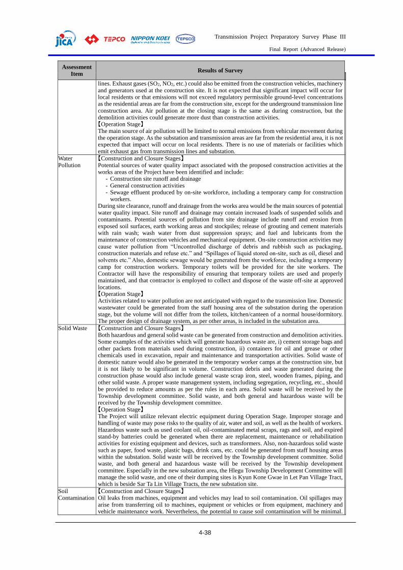
Transmission Project Preparatory Survey Phase III
Final Report (Advanced Release)
4-38
Assessment
Item Results of Survey
lines. Exhaust gases (SO2, NO2, etc.) could also be emitted from the construction vehicles, machinery and generators used at the construction site. It is not expected that significant impact will occur for local residents or that emissions will not exceed regulatory permissible ground-level concentrations as the residential areas are far from the construction site, except for the underground transmission line construction area. Air pollution at the closing stage is the same as during construction, but the demolition activities could generate more dust than construction activities. 【Operation Stage】 The main source of air pollution will be limited to normal emissions from vehicular movement during the operation stage. As the substation and transmission areas are far from the residential area, it is not expected that impact will occur on local residents. There is no use of materials or facilities which emit exhaust gas from transmission lines and substation.
Water Pollution
【Construction and Closure Stages】 Potential sources of water quality impact associated with the proposed construction activities at the works areas of the Project have been identified and include:
- Construction site runoff and drainage - General construction activities - Sewage effluent produced by on-site workforce, including a temporary camp for construction
workers. During site clearance, runoff and drainage from the works area would be the main sources of potential water quality impact. Site runoff and drainage may contain increased loads of suspended solids and contaminants. Potential sources of pollution from site drainage include runoff and erosion from exposed soil surfaces, earth working areas and stockpiles; release of grouting and cement materials with rain wash; wash water from dust suppression sprays; and fuel and lubricants from the maintenance of construction vehicles and mechanical equipment. On-site construction activities may cause water pollution from “Uncontrolled discharge of debris and rubbish such as packaging, construction materials and refuse etc.” and “Spillages of liquid stored on-site, such as oil, diesel and solvents etc.” Also, domestic sewage would be generated from the workforce, including a temporary camp for construction workers. Temporary toilets will be provided for the site workers. The Contractor will have the responsibility of ensuring that temporary toilets are used and properly maintained, and that contractor is employed to collect and dispose of the waste off-site at approved locations. 【Operation Stage】 Activities related to water pollution are not anticipated with regard to the transmission line. Domestic wastewater could be generated from the staff housing area of the substation during the operation stage, but the volume will not differ from the toilets, kitchen/canteen of a normal house/dormitory. The proper design of drainage system, as per other areas, is included in the substation area.
Solid Waste 【Construction and Closure Stages】 Both hazardous and general solid waste can be generated from construction and demolition activities. Some examples of the activities which will generate hazardous waste are, i) cement storage bags and other packets from materials used during construction, ii) containers for oil and grease or other chemicals used in excavation, repair and maintenance and transportation activities. Solid waste of domestic nature would also be generated in the temporary worker camps at the construction site, but it is not likely to be significant in volume. Construction debris and waste generated during the construction phase would also include general waste scrap iron, steel, wooden frames, piping, and other solid waste. A proper waste management system, including segregation, recycling, etc., should be provided to reduce amounts as per the rules in each area. Solid waste will be received by the Township development committee. Solid waste, and both general and hazardous waste will be received by the Township development committee. 【Operation Stage】 The Project will utilize relevant electric equipment during Operation Stage. Improper storage and handling of waste may pose risks to the quality of air, water and soil, as well as the health of workers. Hazardous waste such as used coolant oil, oil-contaminated metal scraps, rags and soil, and expired stand-by batteries could be generated when there are replacement, maintenance or rehabilitation activities for existing equipment and devices, such as transformers. Also, non-hazardous solid waste such as paper, food waste, plastic bags, drink cans, etc. could be generated from staff housing areas within the substation. Solid waste will be received by the Township development committee. Solid waste, and both general and hazardous waste will be received by the Township development committee. Especially in the new substation area, the Hlegu Township Development Committee will manage the solid waste, and one of their dumping sites is Kyun Kone Gwae in Let Pan Village Tract, which is beside Sar Ta Lin Village Tracts, the new substation site.
Soil Contamination
【Construction and Closure Stages】 Oil leaks from machines, equipment and vehicles may lead to soil contamination. Oil spillages may arise from transferring oil to machines, equipment or vehicles or from equipment, machinery and vehicle maintenance work. Nevertheless, the potential to cause soil contamination will be minimal.
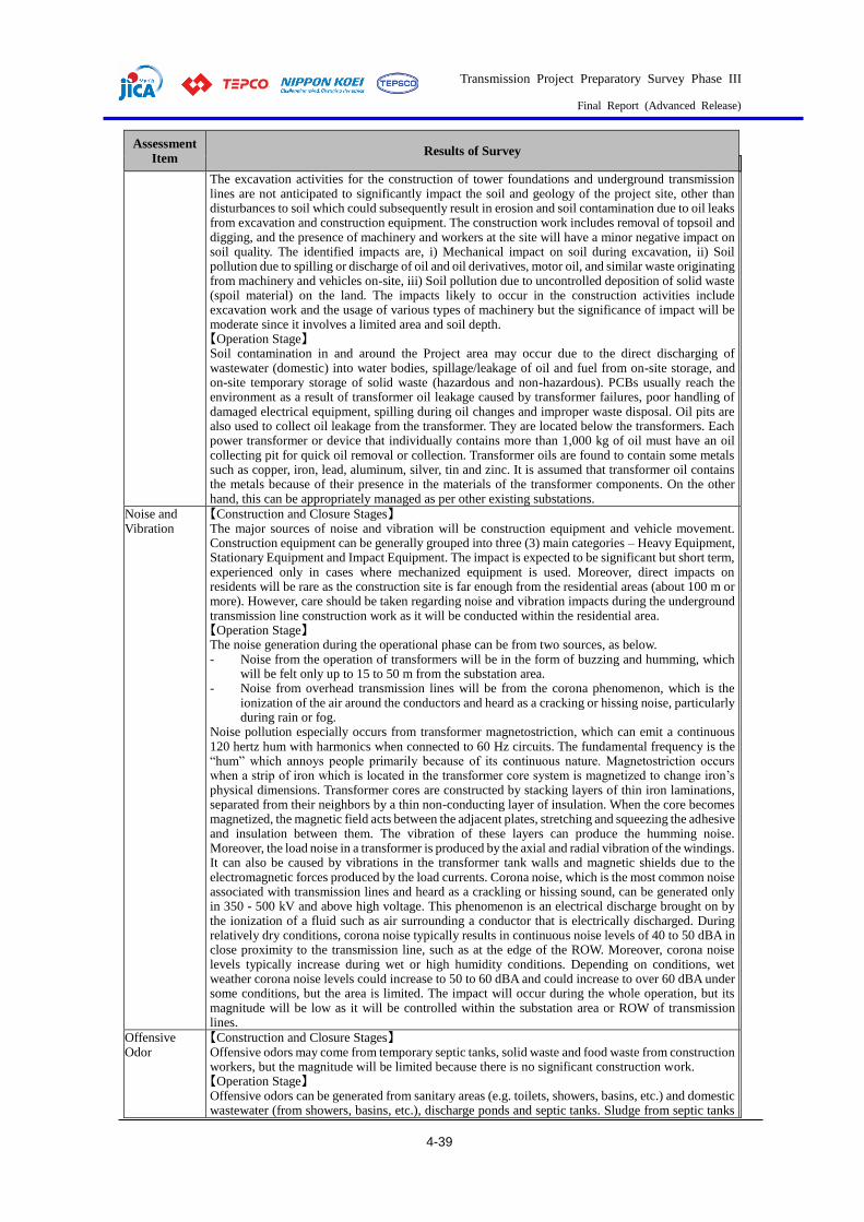
Transmission Project Preparatory Survey Phase III
Final Report (Advanced Release)
4-39
Assessment
Item Results of Survey
The excavation activities for the construction of tower foundations and underground transmission lines are not anticipated to significantly impact the soil and geology of the project site, other than disturbances to soil which could subsequently result in erosion and soil contamination due to oil leaks from excavation and construction equipment. The construction work includes removal of topsoil and digging, and the presence of machinery and workers at the site will have a minor negative impact on soil quality. The identified impacts are, i) Mechanical impact on soil during excavation, ii) Soil pollution due to spilling or discharge of oil and oil derivatives, motor oil, and similar waste originating from machinery and vehicles on-site, iii) Soil pollution due to uncontrolled deposition of solid waste (spoil material) on the land. The impacts likely to occur in the construction activities include excavation work and the usage of various types of machinery but the significance of impact will be moderate since it involves a limited area and soil depth. 【Operation Stage】 Soil contamination in and around the Project area may occur due to the direct discharging of wastewater (domestic) into water bodies, spillage/leakage of oil and fuel from on-site storage, and on-site temporary storage of solid waste (hazardous and non-hazardous). PCBs usually reach the environment as a result of transformer oil leakage caused by transformer failures, poor handling of damaged electrical equipment, spilling during oil changes and improper waste disposal. Oil pits are also used to collect oil leakage from the transformer. They are located below the transformers. Each power transformer or device that individually contains more than 1,000 kg of oil must have an oil collecting pit for quick oil removal or collection. Transformer oils are found to contain some metals such as copper, iron, lead, aluminum, silver, tin and zinc. It is assumed that transformer oil contains the metals because of their presence in the materials of the transformer components. On the other hand, this can be appropriately managed as per other existing substations.
Noise and Vibration
【Construction and Closure Stages】 The major sources of noise and vibration will be construction equipment and vehicle movement. Construction equipment can be generally grouped into three (3) main categories – Heavy Equipment, Stationary Equipment and Impact Equipment. The impact is expected to be significant but short term, experienced only in cases where mechanized equipment is used. Moreover, direct impacts on residents will be rare as the construction site is far enough from the residential areas (about 100 m or more). However, care should be taken regarding noise and vibration impacts during the underground transmission line construction work as it will be conducted within the residential area. 【Operation Stage】 The noise generation during the operational phase can be from two sources, as below. - Noise from the operation of transformers will be in the form of buzzing and humming, which
will be felt only up to 15 to 50 m from the substation area. - Noise from overhead transmission lines will be from the corona phenomenon, which is the
ionization of the air around the conductors and heard as a cracking or hissing noise, particularly during rain or fog.
Noise pollution especially occurs from transformer magnetostriction, which can emit a continuous 120 hertz hum with harmonics when connected to 60 Hz circuits. The fundamental frequency is the “hum” which annoys people primarily because of its continuous nature. Magnetostriction occurs when a strip of iron which is located in the transformer core system is magnetized to change iron’s physical dimensions. Transformer cores are constructed by stacking layers of thin iron laminations, separated from their neighbors by a thin non-conducting layer of insulation. When the core becomes magnetized, the magnetic field acts between the adjacent plates, stretching and squeezing the adhesive and insulation between them. The vibration of these layers can produce the humming noise. Moreover, the load noise in a transformer is produced by the axial and radial vibration of the windings. It can also be caused by vibrations in the transformer tank walls and magnetic shields due to the electromagnetic forces produced by the load currents. Corona noise, which is the most common noise associated with transmission lines and heard as a crackling or hissing sound, can be generated only in 350 - 500 kV and above high voltage. This phenomenon is an electrical discharge brought on by the ionization of a fluid such as air surrounding a conductor that is electrically discharged. During relatively dry conditions, corona noise typically results in continuous noise levels of 40 to 50 dBA in close proximity to the transmission line, such as at the edge of the ROW. Moreover, corona noise levels typically increase during wet or high humidity conditions. Depending on conditions, wet weather corona noise levels could increase to 50 to 60 dBA and could increase to over 60 dBA under some conditions, but the area is limited. The impact will occur during the whole operation, but its magnitude will be low as it will be controlled within the substation area or ROW of transmission lines.
Offensive Odor
【Construction and Closure Stages】 Offensive odors may come from temporary septic tanks, solid waste and food waste from construction workers, but the magnitude will be limited because there is no significant construction work. 【Operation Stage】 Offensive odors can be generated from sanitary areas (e.g. toilets, showers, basins, etc.) and domestic wastewater (from showers, basins, etc.), discharge ponds and septic tanks. Sludge from septic tanks
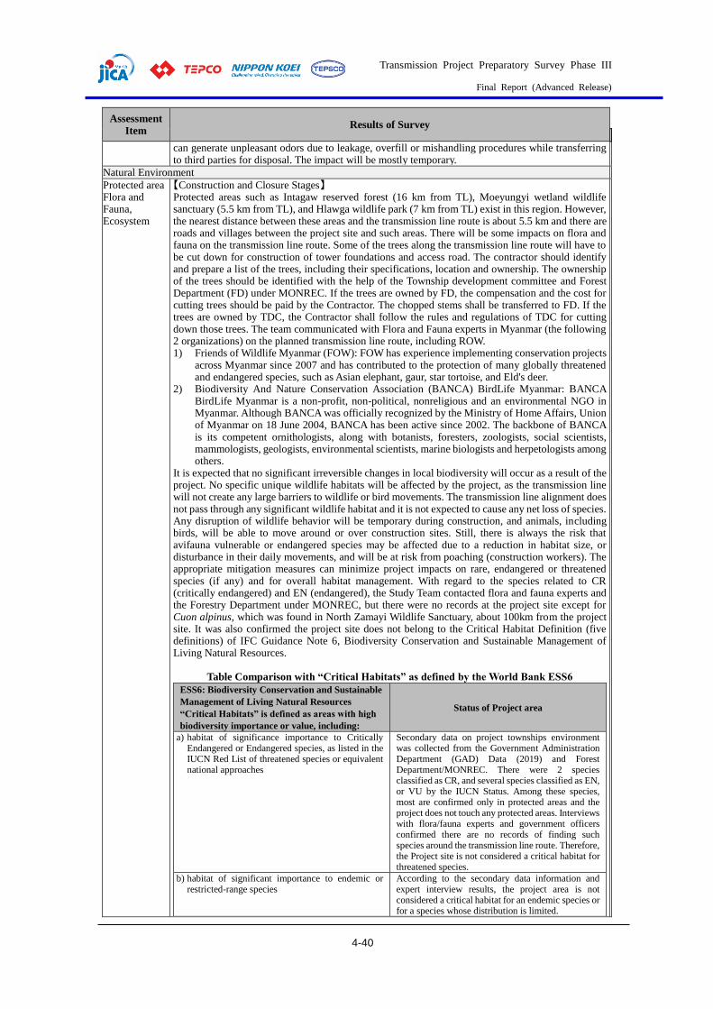
Transmission Project Preparatory Survey Phase III
Final Report (Advanced Release)
4-40
Assessment
Item Results of Survey
can generate unpleasant odors due to leakage, overfill or mishandling procedures while transferring to third parties for disposal. The impact will be mostly temporary.
Natural Environment
Protected area Flora and Fauna, Ecosystem
【Construction and Closure Stages】 Protected areas such as Intagaw reserved forest (16 km from TL), Moeyungyi wetland wildlife sanctuary (5.5 km from TL), and Hlawga wildlife park (7 km from TL) exist in this region. However, the nearest distance between these areas and the transmission line route is about 5.5 km and there are roads and villages between the project site and such areas. There will be some impacts on flora and fauna on the transmission line route. Some of the trees along the transmission line route will have to be cut down for construction of tower foundations and access road. The contractor should identify and prepare a list of the trees, including their specifications, location and ownership. The ownership of the trees should be identified with the help of the Township development committee and Forest Department (FD) under MONREC. If the trees are owned by FD, the compensation and the cost for cutting trees should be paid by the Contractor. The chopped stems shall be transferred to FD. If the trees are owned by TDC, the Contractor shall follow the rules and regulations of TDC for cutting down those trees. The team communicated with Flora and Fauna experts in Myanmar (the following 2 organizations) on the planned transmission line route, including ROW. 1) Friends of Wildlife Myanmar (FOW): FOW has experience implementing conservation projects
across Myanmar since 2007 and has contributed to the protection of many globally threatened and endangered species, such as Asian elephant, gaur, star tortoise, and Eld's deer.
2) Biodiversity And Nature Conservation Association (BANCA) BirdLife Myanmar: BANCA BirdLife Myanmar is a non-profit, non-political, nonreligious and an environmental NGO in Myanmar. Although BANCA was officially recognized by the Ministry of Home Affairs, Union of Myanmar on 18 June 2004, BANCA has been active since 2002. The backbone of BANCA is its competent ornithologists, along with botanists, foresters, zoologists, social scientists, mammologists, geologists, environmental scientists, marine biologists and herpetologists among others.
It is expected that no significant irreversible changes in local biodiversity will occur as a result of the project. No specific unique wildlife habitats will be affected by the project, as the transmission line will not create any large barriers to wildlife or bird movements. The transmission line alignment does not pass through any significant wildlife habitat and it is not expected to cause any net loss of species. Any disruption of wildlife behavior will be temporary during construction, and animals, including birds, will be able to move around or over construction sites. Still, there is always the risk that avifauna vulnerable or endangered species may be affected due to a reduction in habitat size, or disturbance in their daily movements, and will be at risk from poaching (construction workers). The appropriate mitigation measures can minimize project impacts on rare, endangered or threatened species (if any) and for overall habitat management. With regard to the species related to CR (critically endangered) and EN (endangered), the Study Team contacted flora and fauna experts and the Forestry Department under MONREC, but there were no records at the project site except for Cuon alpinus, which was found in North Zamayi Wildlife Sanctuary, about 100km from the project site. It was also confirmed the project site does not belong to the Critical Habitat Definition (five definitions) of IFC Guidance Note 6, Biodiversity Conservation and Sustainable Management of Living Natural Resources.
Table Comparison with “Critical Habitats” as defined by the World Bank ESS6
ESS6: Biodiversity Conservation and Sustainable
Management of Living Natural Resources
“Critical Habitats” is defined as areas with high
biodiversity importance or value, including:
Status of Project area
a) habitat of significance importance to Critically Endangered or Endangered species, as listed in the IUCN Red List of threatened species or equivalent national approaches
Secondary data on project townships environment was collected from the Government Administration Department (GAD) Data (2019) and Forest Department/MONREC. There were 2 species classified as CR, and several species classified as EN, or VU by the IUCN Status. Among these species, most are confirmed only in protected areas and the project does not touch any protected areas. Interviews with flora/fauna experts and government officers confirmed there are no records of finding such species around the transmission line route. Therefore, the Project site is not considered a critical habitat for threatened species.
b) habitat of significant importance to endemic or restricted-range species
According to the secondary data information and expert interview results, the project area is not considered a critical habitat for an endemic species or for a species whose distribution is limited.
Transmission Project Preparatory Survey Phase III
Final Report (Advanced Release)
4-41
Assessment
Item Results of Survey
c) habitat supporting globally or nationally significant concentrations of migratory or congregatory species
Per a suggestion by an expert from the Biodiversity and Nature Conservation Association (BANCA), the transmission line has been routed across human settlements, open fields, roads and croplands. This took it about 7-8 km away from Moeyungyi Wetland wildlife Sanctuary, which is an internationally important wetland area. Therefore, the study team confirmed that there are no migratory or congregatory species or exosystems that would support such species in the project area.
d) highly threatened or unique ecosystems Per the results for secondary data information and expert interviews, it was confirmed that there are no highly threatened or unique ecosystems in the project area. So, no specific unique wildlife habitats will be affected by the project, as the transmission line will not pass through such areas.
e) ecological functions or characteristics that are needed to maintain the viability of the biodiversity values described above in (a) to (d).
The project area is not considered an area with the functions or characteristics detailed in (e). See above for details.
Source: JICA Study Team 【Operation Stage】 As described above, there is no protected area on the project site, both the transmission line and substation. Also, roads and villages between the project site and such areas are existing. According to FOW, there is only one moving route of a herd of wild elephants (about 3~4 individuals) in Hlegu township. These elephants mostly occurred near the Nga-moe-yeik reservoir which is located more than 30 km far from the closest Project site (Transmission line route). Additionally, there are Yangon-Mandalay Expressway and many local roads, rivers including Bago river, and several villages between the Project site and Nga-moe-yeik reservoir. Also, the study team confirmed with Head Office of Myanmar Timber Enterprise, which are operating Winkabaw Elephant Camp and re-confirmed about the same information. There are nine global-scale flyways that migratory birds take around the world, and Myanmar has two of them. They are the Central Asian Flyway, and the East Asian Australasian Flyway. According to BANCA’s review, the transmission line has been across the human settlement, open field, roads and croplands. It took about 7-8 km away from Moeyungyi Wetland wildlife Sanctuary. Moeyungyi is International important wetlands, the first Ramsar site in Myanmar as well as IBA (Important Bird and Biodiversity Area) and KBA (Key Biodiversity Area). It is one of the East Asian Australasian Flyway Site (EAAF119). If it does not pass through Moeyungyi Inn, the impact on migratory birds due to bird crush will be anticipated since there might be the detailed flyway for wintering birds that live there around the project site. As results of hearing of BANCA and literature survey, there is no information on the detailed flyway, so its route has not been confirmed. However, according to BANCA, the impact is limited because the Moeyungyi Wetland wildlife Sanctuary is 7-8km away from the project site, and there are structures in human settlement around the project site, thus birds are unlikely to fly at the height of the transmission line. Based on this consideration, BANCA also confirmed that mitigation measure such as increasing the visibility of transmission lines using markers and/or bird diverters if any impacts are identified through monitoring during operation is appropriate
Social Environment
Involuntary Resettlement and Land Acquisition
【Construction/Closure Stages, and Operation Stage】 During the feasibility study, an Abbreviated Resettlement Action Plan (ARAP) was prepared. The preliminary survey data for land acquisition, project affected persons (PAPs) and households (PAHs) and proposed compensation plan are addressed in that report. At the Detailed Design Stage, an additional socio-economic survey will be conducted to collect detailed information on PAPs and PAHs, and the ARAP report will be updated using these data. Approximately 25~32 ha (about 80 acres) of permanent land, in which most of the land area is agricultural land, has to be acquired for construction of the substation. Therefore, there will be a permanent loss of land and income in those areas. The acquired land will be purchased directly from the landowner with the unit price set by the Government for paddy fields under the supervision of the Yangon Regional Government (YRG). A small number of houses is found within the land area, but those households will be avoided by the substation area so no resettlement will be necessary for the project. Therefore, there will be socio-economic impacts such as loss of income due to the construction of the substation, but this will be mitigated by purchasing the land with the proper amount of compensation. Also, the total area of the tower base along the transmission line has to be acquired for installation of transmission lines. The majority of the total area will mainly occupy a plantation area and agricultural land. As most of the crop plantation can be resumed after the construction, there will not be any loss

Transmission Project Preparatory Survey Phase III
Final Report (Advanced Release)
4-42
Assessment
Item Results of Survey
of permanent land or income due to the construction of transmission lines. The impact will only be temporary during the construction stage.
Local Economy and Livelihood
【Construction and Closure Stages】 During the construction phase, some business such as plantations, cultivation, etc. will be temporarily disrupted by construction activities for towers and transmission lines. An Abbreviated Resettlement Action Plan (ARAP) was prepared, which considered loss of income sources in the entitlement matrix. The Project will also temporarily increase sales at some local shops and vendors due to the increased demand for construction workers. The substation is located in Sar Ta Lin Village in Hlegu Township. The main sources of livelihood in Hlegu townships are odd jobs, livestock and agriculture. According to the statistical data of Hlegu Township, most of the people earn their livelihoods in Odd Jobs (32.31%) and Livestock (31.09%). A lot of job opportunities will be created as most of the general construction labor workforce will be derived from the local population from nearby Sar Ta Lin Village and surrounding villages for the construction of the new substation. During the closure phase, the work will be almost the same as the construction phase so the impacts will also be the same. Positive impacts will likely to occur in both stages, and will help to improve the livelihoods of local people by creating job opportunities. At the same time, land acquisition will have a negative impact on the livelihoods of the Project Affected People. 【Operation Stage】 Yangon City is a strategic economic location which can be recognized as the commercial capital of Myanmar. Nevertheless, with major plans for the future, Myanmar’s energy demands are expected to grow concurrently with its development. The city used 1,548MW in 2018, which is expected to increase based on growth rates, historical data and new projects. The Project will implement the development of 500kV backbone system to solve the problem of an insufficient power supply network system in Yangon City. Therefore, it will help in regional infrastructure and economic development in Yangon City. As the substation compound is mostly agricultural land, it may create alternative livelihoods for laborers and landowners of affected agricultural land.
Existing social infrastructure and services
【Construction and Closure Stages】 For local people living in and around the Project area, the accessibility of social infrastructure is expected to change more or less because of the construction work. During the construction phase, an access road will be constructed for construction vehicle transportation and heavy machinery as necessary. It has also been confirmed based on the existing regional information that social infrastructure such as schools and hospitals is located in the populated area around the Project site. Therefore, traffic congestion might occur near the access road due to the temporary increase in construction vehicles. More traffic congestion is expected for the underground transmission line construction rather than overhead transmission line construction, as the transmission line will be constructed within the ROW of a narrow street in a residential area. The transmission line alignment will also pass through a railway, but the construction activities will not disrupt the operation of the railway system so the impact will be negligible. Moreover, the majority of the transmission line route is across plantations and agricultural land so no significant impact on public spaces is expected.
Social Institutions
【Construction and Closure Stages】 Due to the traffic congestion impact on social infrastructure and services, the community near the Project area will be affected. On the other hand, positive impact is expected on political institutions such as the Government. The Project will achieve power sector development in important commercial areas such as Yangon City.
Risks of Infectious Diseases such as AIDS/HIV
【Construction and Closure Stages】 There is a possibility of air pollutant emissions, including dust due to the operation of construction machines and vehicles, as well as construction work, which might cause some adverse effects on respiratory organs. Impacts on public health and communities, the dusty conditions of the construction site, exhaust gases from the machinery & vehicles, the discharge of site-generated wastewater, the generation of construction waste, demolition debris, domestic waste, hazardous waste, and the noise generated by construction machinery may affect the surrounding community. These impacts shall be managed by the construction contractor through the provision of safety education and training for workers based on the OHS training stipulated in international guidelines such as EHS Guidelines by IFC. Also, no large-scale construction/demolition work is planned. The spread of infectious diseases is estimated to some extent due to an influx of contract workers from outside of the community.
Working conditions (including occupational safety)
【Construction and Closure Stages】 The possibility of accidents and incidents is expected more or less during the implementation of the Project’s construction (construction of site structures and facilities) and closing stages (demolition of the facilities). In order to prevent accidents and incidents, working conditions during the construction and closing stages shall be managed by the Contractor based on OHS training stipulated in international guidelines such as EHS Guidelines by the IFC. There are also national laws and regulations related to the working environment, such as the Occupational Health and Safety Law (2019) etc. It is evaluated that the impact will only be short term, with low intensity. However, the
Transmission Project Preparatory Survey Phase III
Final Report (Advanced Release)
4-43
Assessment
Item Results of Survey
Contractor shall prepare and implement an appropriate HSE plan under the respective impact assessment to avoid potentially severe impacts on occupational health and safety. 【Operation Stage】 Workplace injuries are common on the job, and the majority of such random events can happen to anyone and at any time. Not only is it the employer’s responsibility to ensure a safe work environment, but each employee also has a responsibility to themselves to exercise caution when on the job. Engineers, electricians and overhead line workers are most exposed to electrical hazards. Electric utility workers typically have a higher exposure than the general public due to working in proximity to electric power lines, such as through electrical installation and repairs, testing of fixtures and equipment and inspection and maintenance activities. The project proponent has great experience in avoiding such negative situations at other project sites. Unforeseen accidents such as road and traffic accidents, emergencies such as fires, explosions, heavy rain and flooding, earthquakes with loss of human life and damage to structures and facilities could have a high impact on the safety and health of the employees.
Other
Accidents 【Construction and Closure Stages】 Although the construction and closure work for the proposed project will contain large-scale work using firearms and explosives, the risk of fire accidents could be considered low. However, risks are inevitable because some activities taken by the workers, such as smoking and cooking, could lead to fire accidents in the proposed project. Traffic accidents might also happen due to an increased number of vehicles related to the construction work. To eliminate the risks of fire accidents and traffic accidents, the behavior of the workers shall be managed by the construction contractor through the provision of safety education and training for workers based on the OHS training stipulated in international guidelines such as the EHS Guidelines by IFC. 【Operation Stage】 At the operation stage, there will be a risk of potential fire accidents from the substation and transmission lines. At the substation, transformer explosions and fires can result from a breakdown of insulation due to over-current, over-voltage or short circuit. Degradation of insulation, like the decay of transformer oil due to moisture or ageing or decomposition, is another cause of fire in substations. Once the insulation drops below a threshold value an electric arc is generated. The temperature of the oil increases and oil decomposes, leading to the generation of ignitable gases and pressurization of the oil tank, which may lead to transformer explosions. The most common causes of fire in transmission lines are weather-related events such as thunderstorms and strong winds etc. that cause damage to lines and equipment attached to them. Once the equipment is damaged or downed, wires may make contact with trees and other combustible materials resulting in sparks, smoke and fires. In other cases, animal or human contact, equipment failures and conductor slaps can also create fire hazards in transmission lines.
Source: JICA survey team
(2) Results of Environmental and Social Impact Assessment
The environmental and social impact assessment was conducted by examining the available data,
interviewing stakeholders and carrying out field surveys. According to the results of the IEE, the
project area is not included in an environmentally priority area as it does not exist in the conservation
areas designated by the Myanmar Government. The area has been in common use, with paddy fields,
commercial plantations, secondary forests, scrub land and human habitation areas. To err on the side
of caution, a Flora and Fauna secondary baseline data collection was conducted through the IEE study.
The individual results and evaluation methods are described in the draft IEE report. Consequently, it
was concluded that the project (new/expanded substation and 230kV/500kV transmission line) would
not cause serious adverse impacts during the operation stage and the majority of negative impacts are
temporary and site-specific due to construction activities during the construction phase, and the
expected impacts could be avoided or minimized by implementing mitigation measures.
A summary of anticipated potential adverse impacts and proposed mitigation measures is tabulated
in Table 4.1-35.

Transmission Project Preparatory Survey Phase III
Final Report (Advanced Release)
4-44
Table 4.1-35 Summary of Impact Assessment
Category Assessment
Item Items
Evaluation Sources of the Impacts and reason for the Evaluation
CS OS CLS
Pollution Air Pollution Exhaust gas emissions
D
OS: There is no use of materials or facilities which emit exhaust gases from transmission lines or substation. Therefore, the significance of impact can be assessed as negligible.
PM, Dust and exhaust gas emissions
B- B-
CS/CLS: The principal source of potential air pollutants will be dust from construction/demolition work. Exhaust gases (SO2, NO2 & PM10) will be emitted from the construction vehicles, generators and machinery but the construction work is not large. Therefore, the significance of impact can be assessed as moderate.
Water Pollution
Domestic wastewater & storm water
B- OS: Wastewater may be generated from the staff housing, toilets, canteen etc. Therefore, the significance of impact can be assessed as moderate.
B- B-
CS/CLS: Wastewater may be generated from the site cleaning activities, temporary toilets at construction sites, etc. Stormwater runoff passing through the construction sites may contain muddy water, construction materials, etc. Therefore, the significance of impact can be assessed as moderate.
Solid Waste Managements of waste disposal
B-
OS: Used coolant oil, oil-contaminated metal scraps, rags and soil, and expired stand-by batteries would be generated from the maintenance and replacement of transformers. Non-hazardous solid waste such as paper, food waste, etc. may be generated from staff housing. Solid waste will be received by the Township development committee. Especially in the new substation area, Hlegu Township Development Committee will manage the solid waste and the dumping site is Kyun Kone Gwae in Let Pan Village Tract, which is beside Sar Ta Lin Village Tracts, the new substation site. Therefore, the significance of impact can be assessed as moderate.
B- B-
CS/CLS: Low amounts of hazardous waste (such as used car batteries, broken glass, engine oil, etc.) and non-hazardous waste (such as debris, concrete, paper, food waste, etc. and electric wires, empty packages of material, etc.) would be generated from construction and construction camps/demolition activities. Solid waste will be received by the Township development committee and will be managed appropriately at their responsibility. Therefore, the significance of impact can be assessed as moderate.
Soil Contamination
Spillage/leakage of hazardous materials/waste and fuel
B-
OS: Soil contamination in and around the Project area may occur due to the direct discharging of wastewater (domestic) onto the soil, and spillage/leakage of oil and fuel from on-site storage. Therefore, the significance of impact can be assessed as moderate.
B- B-
CS/CLS: Oil spillage may arise from transferring oil to machines, equipment or vehicles or from equipment, machinery and vehicles during maintenance work. Therefore, the significance of impact can be assessed as moderate.
Noise and Vibrations
Noise level
B-
OS: Noise from the operation of transformers will be in the form of buzzing and humming, which will be felt only up to 15 to 50 m from the substation area. Noise from overhead transmission lines will be from the corona phenomenon or hissing noises near ROW only. Therefore, the significance of impact can be assessed as moderate.
Noise and Vibration level
B- B-
CS/CLS: The major sources of noise and vibration will be construction equipment and vehicle movement, but this will be short term only. Moreover, the construction site is far enough from the residential areas (about 100 m or more)

Transmission Project Preparatory Survey Phase III
Final Report (Advanced Release)
4-45
Category Assessment
Item Items
Evaluation Sources of the Impacts and reason for the Evaluation
CS OS CLS
to reduce the noise and vibrations. Therefore, the significance of impact can be assessed as moderate.
Ground Subsidence
Withdrawal of groundwater/ use of heavy machines
D D D
CS/OS/CLS: In the substation area, no great amounts of groundwater will be withdrawn during the construction and operation stages. Moreover, heavy machines will not be used for long time. Therefore, the significance of impact can be assessed as negligible.
Offensive Odors
Odor emission
B-
OS: Offensive odors may be generated in small amounts from the sanitary areas of staff housing (e.g. toilets, showers, etc.) and septic tanks. Therefore, the significance of impact can be assessed as moderate.
B- B-
CS/CLS: Small volumes of offensive odors may come from temporary septic tanks, solid waste and food waste from construction workers, but the amount will be limited because there is no large construction work. Therefore, the significance of impact can be assessed as moderate.
Sediment Wastewater discharge
D D D
CS/OS/CLS: Wastewater drainage including heavy metals or high-level organic substances will not be discharged into the water body. Therefore, the significance of impact can be assessed as negligible.
Natural Environment
Protected areas Flora and Fauna, Ecosystem
Site cleaning and other construction activities
B- B- B-
CS/CLS /OS: The transmission line will not pass through any wildlife park. There were no records at the project site according to the results of interviews with flora and fauna experts. It was also confirmed that the project site does not belong to the Critical Habitat Definition of IFC Guidance Note 6, Biodiversity Conservation and Sustainable Management of Living Natural Resources. As for wild elephants, according to the natural environmental experts in Myanmar, there are the Yangon Mandalay expressway and Bago River and others between the place in which wild elephants were observed and the project site. According to BANCA, the impact on migratory bird due to bird crush is anticipated but limited since the Moeyungyi Wetland wildlife is 7-8km away from the project site, and there are structures in human settlement around the transmission line, so the birds is unlikely to fly at the height of the transmission line. However, mitigation measure such as increasing the visibility of transmission lines using markers and/or bird diverters if any impacts are identified through monitoring during operation.is necessary since the detailed flyway has not been confirmed. Any disruption of wildlife behavior will be temporary during construction, and animals, including birds, will be able to move around or over construction sites. Still, there is always the risk that avifauna vulnerable or endangered species may be affected due to a reduction in habitat size, or disturbances in their daily movements, and will be at risk from poaching (by construction workers). Therefore, the significance of impact can be assessed as moderate, but it is necessary to consider having mitigation measures for birds.
Hydrological conditions
D D D
CS/OS/CLS: The proposed Project will not include activities that may cause hydrological conditions changes. Therefore, the significance of impact can be assessed as negligible.
Social Environment
Involuntary Resettlement and Land Acquisition
Land acquisition and resettlement
B- B- B-
CS/OS/CLS: Permanent land of approximately 32.37 ha (80 acres) has to be acquired for construction of the substation. The total area of tower bases along the transmission line has to be acquired for installation of transmission lines to follow the appropriate rules. Therefore, the significance of impact can be assessed as moderate.
Local Economy A+
OS: The Project will implement the development of a 500kV backbone system to solve the issue of an insufficient
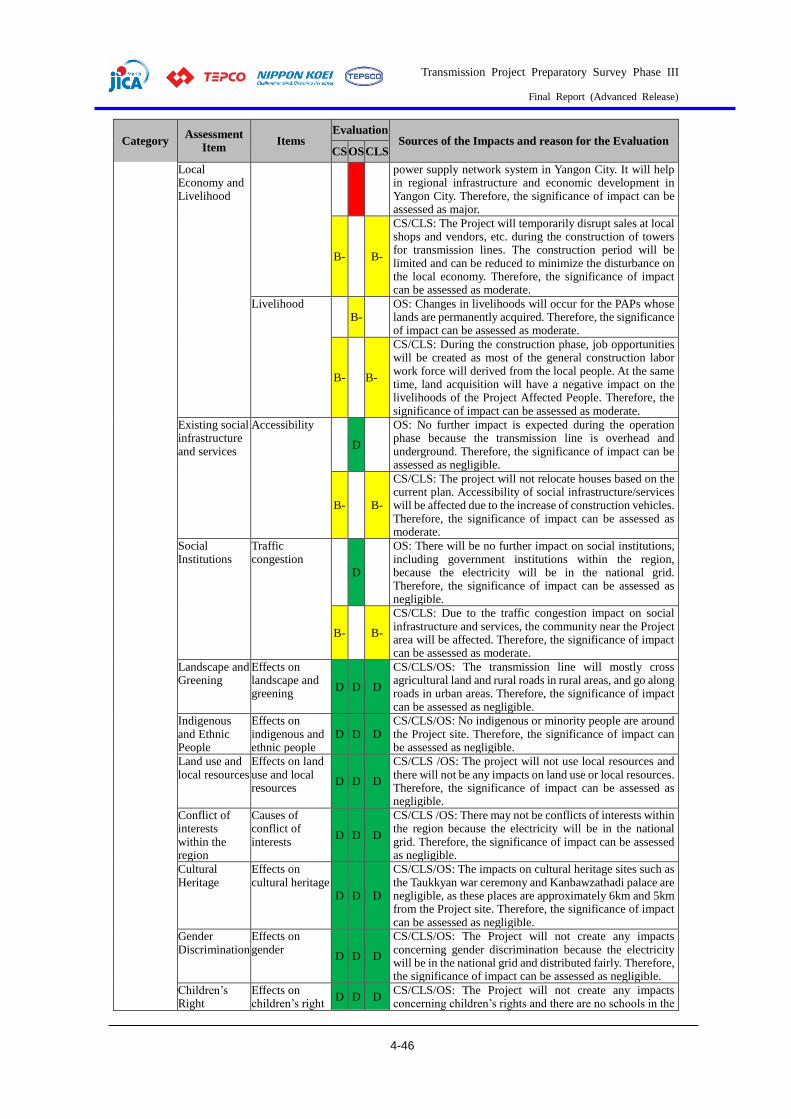
Transmission Project Preparatory Survey Phase III
Final Report (Advanced Release)
4-46
Category Assessment
Item Items
Evaluation Sources of the Impacts and reason for the Evaluation
CS OS CLS
Local Economy and Livelihood
power supply network system in Yangon City. It will help in regional infrastructure and economic development in Yangon City. Therefore, the significance of impact can be assessed as major.
B- B-
CS/CLS: The Project will temporarily disrupt sales at local shops and vendors, etc. during the construction of towers for transmission lines. The construction period will be limited and can be reduced to minimize the disturbance on the local economy. Therefore, the significance of impact can be assessed as moderate.
Livelihood B-
OS: Changes in livelihoods will occur for the PAPs whose lands are permanently acquired. Therefore, the significance of impact can be assessed as moderate.
B- B-
CS/CLS: During the construction phase, job opportunities will be created as most of the general construction labor work force will derived from the local people. At the same time, land acquisition will have a negative impact on the livelihoods of the Project Affected People. Therefore, the significance of impact can be assessed as moderate.
Existing social infrastructure and services
Accessibility
D
OS: No further impact is expected during the operation phase because the transmission line is overhead and underground. Therefore, the significance of impact can be assessed as negligible.
B- B-
CS/CLS: The project will not relocate houses based on the current plan. Accessibility of social infrastructure/services will be affected due to the increase of construction vehicles. Therefore, the significance of impact can be assessed as moderate.
Social Institutions
Traffic congestion
D
OS: There will be no further impact on social institutions, including government institutions within the region, because the electricity will be in the national grid. Therefore, the significance of impact can be assessed as negligible.
B- B-
CS/CLS: Due to the traffic congestion impact on social infrastructure and services, the community near the Project area will be affected. Therefore, the significance of impact can be assessed as moderate.
Landscape and Greening
Effects on landscape and greening
D D D
CS/CLS/OS: The transmission line will mostly cross agricultural land and rural roads in rural areas, and go along roads in urban areas. Therefore, the significance of impact can be assessed as negligible.
Indigenous and Ethnic People
Effects on indigenous and ethnic people
D D D CS/CLS/OS: No indigenous or minority people are around the Project site. Therefore, the significance of impact can be assessed as negligible.
Land use and local resources
Effects on land use and local resources
D D D
CS/CLS /OS: The project will not use local resources and there will not be any impacts on land use or local resources. Therefore, the significance of impact can be assessed as negligible.
Conflict of interests within the region
Causes of conflict of interests
D D D
CS/CLS /OS: There may not be conflicts of interests within the region because the electricity will be in the national grid. Therefore, the significance of impact can be assessed as negligible.
Cultural Heritage
Effects on cultural heritage
D D D
CS/CLS/OS: The impacts on cultural heritage sites such as the Taukkyan war ceremony and Kanbawzathadi palace are negligible, as these places are approximately 6km and 5km from the Project site. Therefore, the significance of impact can be assessed as negligible.
Gender Discrimination
Effects on gender
D D D
CS/CLS/OS: The Project will not create any impacts concerning gender discrimination because the electricity will be in the national grid and distributed fairly. Therefore, the significance of impact can be assessed as negligible.
Children’s Right
Effects on children’s right
D D D CS/CLS/OS: The Project will not create any impacts concerning children’s rights and there are no schools in the

Transmission Project Preparatory Survey Phase III
Final Report (Advanced Release)
4-47
Category Assessment
Item Items
Evaluation Sources of the Impacts and reason for the Evaluation
CS OS CLS
ROW for the transmission line. Therefore, the significance of impact can be assessed as negligible.
Risks of Infectious Diseases such as AIDS/HIV
Operation
D
OS: Because there will be no large changes in traffic volume due to the increased inflow to the site from different regions, impacts concerning infectious diseases are not anticipated. Therefore, the significance of impact can be assessed as negligible.
Construction and closure
B- B-
CS/CLS: No large-scale construction/demolition work is planned. The spread of infectious diseases is estimated to some extent due to the influx of contract workers from outside of the community. Therefore, the significance of impact can be assessed as moderate.
Working conditions (including occupational safety)
Noise exposure, Heat exposure
B-
OS: Engineers, electricians and overhead line workers may be exposed to electrical hazards. The project proponent has great experience in avoiding such negative situations at other project sites. Therefore, the significance of impact can be assessed as moderate.
B- B-
CS/CLS: There is a possibility of air pollution, noise pollution, heat exposure, exposure to hazardous materials, etc. In order to prevent the occurrence of accidents and incidents in normal work conditions, working conditions during the construction and closing stages shall be managed by the contractor. Therefore, the significance of impact can be assessed as moderate.
Other Accidents Fire and traffic accidents
B- B- B-
CS/OS/CLS: The risk of fire accidents and traffic accidents is anticipated for all stages. However, the proposed project will not contain large-scale work using firearms or explosives. In addition, people working with high voltages and in high places might encounter accidents but the project proponent has avoided such accidents in other similar projects in Myanmar through normal working conditions. Therefore, the risk of accidents could be considered low and the significance of impact can be assessed as moderate.
Transboundary and global environmental
Climate change and other transboundary pollution D D D
CS/OS/CLS: CO2 emissions from construction vehicles and transboundary pollution are not significant because the transmission line work is limited, and substations are of a limited area and use limited amounts of machinery. No activities that will affect global warming or transboundary pollution are expected. Therefore, the significance of impact can be assessed as negligible.
Note: Rating - In general, both positive impact (+) and negative impact (-) are expected due to the anticipated project activities. Thus, the following rating criteria are adopted with respect to the extent of impacts:
A (+/-): Significant positive/negative impact is expected,
B (+/-): Positive/negative impact is expected to some extent, C: Extent of impact is unknown (further examination is needed and the impact could be clarified as the study progresses),
D: Negligible or no impact is expected.
Source: JICA Study Team
Mitigation Measures and Costs for Implementing Mitigation Measures
An Environmental Management Plan (EMP) and Environmental Monitoring Plan (EMoP) were
developed based on the results of impact assessments for Environmental, Social, and Health Impacts
and Emergency Risks, as described below.
(1) Mitigation Measures to be Considered for Construction and Closure Stages
Environmental mitigation measures to be considered for the construction/closure stages for different
aspects, including pollution, natural environment, social environment, health and safety, and
emergency risks, are summarized in the following Table 4.1-36. Most of the environmental mitigation
measures will be implemented by the contractor for construction/demolition work under the
management of the project proponent.

Transmission Project Preparatory Survey Phase III
Final Report (Advanced Release)
4-48
Table 4.1-36 Environmental Mitigation Measures to be Considered for the
Construction/Closure Stages
Category Item Mitigation Measures Implementer
Pollution Air pollution Water spraying of the entire construction site will be carried out during the construction and demolition activities to suppress and control dust emissions.
Dust nets of adequate height shall be erected around the entire construction site perimeter
The excavated earth material should be kept at the designated place and should be covered to prevent wind erosion.
In the case of higher wind forces, construction work relating to dust generation will not be allowed.
Netting will be attached along fences to minimize the spread of dust to neighboring areas.
Construction materials which emit dust will be covered.
Contractor
Water pollution
Cover piles of building materials like cement, sand and other powders, regularly inspect for spillages, and locate them where they will not be washed into waterways or drainage areas.
Generators are sited on concrete foundations and with bund wall to prevent any spillage or leakage.
Sewage from septic tanks will be disposed of by requesting collection by Township Development Committee.
Site drainage system (temporarily opened soil gutters) will be in effect to ensure no water ponding, overflowing or blocking.
Contractor
Solid Waste Prepare a plan, which includes the control of receipt, storage and final disposal of such substances.
Waste should be collected daily. Non-hazardous waste should not be mixed with any
category of hazardous waste at any time. All waste shall be collected by the city/township
development committee and processed at the appropriate disposal site by the committee. Therefore, communicate with the committee for smooth solid waste disposal.
Contractor
Soil contamination
Construction materials (hazardous or non-hazardous types) are stored in adequate places managed by City Development Committee to avoid contamination during occurrences of rain or floods.
Maintenance of heavy equipment, machinery and vehicles will be conducted by authorized and experienced personnel.
Fuel filling of some machinery, equipment and vehicles will be carried out by an authorized vendor to prevent spill-over and leakage from fuel transfers and on-site storage.
In any cases of occurrence, the contaminated soil will be collected, placed in appropriate containers and disposed of through TDC.
Contractor
Noise and vibration
Prior notification to the local community on the schedule for construction activities.
Restricted operation hours of heavy construction machines (such as excavators fitted with construction/demolition/breaking equipment) and avoid idling.
Paying attention when dropping materials from a height. Construction work will not be conducted at night. Regular inspections, maintenance and servicing of
machines and equipment will be conducted.
Contractor
Offensive Odor
Proper management of sewage and domestic waste from temporary construction camp.
Monitor waste storage conditions and odor conditions around septic tanks of temporary construction camp.
Contractor
Natural Environment
Flora, Fauna, Ecosystem, Biodiversity,
Ensure minimal land clearing and removal of vegetation by working closely with the Forest Department/MONREC to ensure that there is no rampant clearing or felling of forests
Contractor
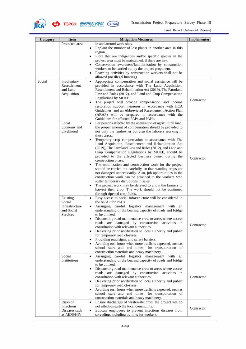
Transmission Project Preparatory Survey Phase III
Final Report (Advanced Release)
4-49
Category Item Mitigation Measures Implementer
Protected area in and around work sites. Replant the number of lost plants in another area in this
region. Flora that are indigenous and/or specific species in the
project area must be maintained, if there are any. Conservation awareness/familiarization by construction
workers to be carried out by the project proponent. Poaching activities by construction workers shall not be
allowed (no illegal hunting).
Social
Involuntary Resettlement and Land Acquisition
Appropriate compensation and social assistance will be provided in accordance with The Land Acquisition, Resettlement and Rehabilitation Act (2019), The Farmland Law and Rules (2012), and Land and Crop Compensation Regulations by MOEE.
The project will provide compensation and income restoration support measures in accordance with JICA Guidelines, and an Abbreviated Resettlement Action Plan (ARAP) will be prepared in accordance with the Guidelines for affected PAPs and PAHs.
Contractor
Local Economy and Livelihood
For persons affected by the acquisition of agricultural land, the proper amount of compensation should be provided to not only the landowner but also the laborers working in those areas.
Temporary crop compensation in accordance with The Land Acquisition, Resettlement and Rehabilitation Act (2019), The Farmland Law and Rules (2012), and Land and Crop Compensation Regulations by MOEE, should be provided to the affected business owner during the construction phase.
The mobilization and construction work for the project should be carried out carefully, so that standing crops are not damaged unnecessarily. Also, job opportunities in the construction work can be provided to the workers who suffer temporary disruptions in sales.
The project work may be delayed to allow the farmers to harvest their crop. The work should not be continued through ripened crop fields.
Contractor
Existing Social Infrastructure and Social Services
Easy access to social infrastructure will be considered in the ARAP for PAHs.
Arranging careful logistics management with an understanding of the bearing capacity of roads and bridge to be utilized.
Dispatching road maintenance crew to areas where access roads are damaged by construction activities in consultation with relevant authorities.
Delivering prior notification to local authority and public for temporary road closures.
Providing road signs, and safety barriers. Avoiding rush hours when more traffic is expected, such as
school start and end times, for transportation of construction materials and heavy machinery.
Contractor
Social Institutions
Arranging careful logistics management with an understanding of the bearing capacity of roads and bridge to be utilized.
Dispatching road maintenance crew to areas where access roads are damaged by construction activities in consultation with relevant authorities.
Delivering prior notification to local authority and public for temporary road closures.
Avoiding rush hours when more traffic is expected, such as school start and end times, for transportation of construction materials and heavy machinery.
Contractor
Risks of Infectious Diseases such as AIDS/HIV
Ensure discharges of wastewater from the project site do not affect/disturb the local community.
Educate employees to prevent infectious diseases from spreading, including training for workers.
Contractor

Transmission Project Preparatory Survey Phase III
Final Report (Advanced Release)
4-50
Category Item Mitigation Measures Implementer
Educate employees on correct ways to integrate into the community and on understanding local culture and traditions.
Working conditions (including occupational safety)
Visitors to the site are provided with PPE and escorted around the construction site.
PPE requirement signboards. Nettings and toe boards are provided at scaffolding
workplaces to prevent falling material hazards. Warning signage for various hazards are visibly posted to
warn workers at the workplace.
Contractor
Others Accidents Storage of fuel to be managed appropriately (e.g. diesel and petrol for generators, and heavy machinery equipment such as excavators), with worker education to avoid any traffic accidents.
Electrical fires to be managed appropriately (e.g. avoid usage of faulty equipment, un-safe electrical connections, broken electrical cords, etc.)
Check gas cylinders, valves and connections for usage of acetylene torches and incompatible work nearby, and provide portable fire extinguishers, etc.
Contractor
Source: JICA Study Team
(2) Mitigation Measures to be Considered for Operation Stage
Environmental mitigation measures to be considered for the operation stage for different aspects,
including pollution, natural environment, social environment, health and safety, and emergency risks,
are summarized in the following Table 4.1-37. Most of the environmental mitigation measures will be
implemented by the project proponent.
Table 4.1-37 Environmental Mitigation Measures to be Considered for Operation
Stage
Category Item Environmental Mitigation Measures Implementer
Pollution Water Pollution
Sewage generated from staff housing will be disposed of by requesting collection by Township Development Committee.
Ensure no leakages from oil pits to drain line. Drainage system of substation will be checked to ensure no
water ponding, overflowing or blocking occurs.
Project proponent
Solid Waste Substation should be regularly checked so as not to generate hazardous waste.
Waste oil/hydrocarbons shall be stored in drums that are leak-proof
All storage areas shall be cleaned thoroughly and regularly and especially in the event of any spillage, contamination, leaks or the like.
Keep dustbins for waste which may include damaged electrical equipment or be used by surrounding people.
All waste, including hazardous waste such as waste oil, batteries, etc., shall be collected by the city/township development committee and processed at the appropriate disposal site by the committee. Therefore, communicate with the with the Township development committee for smooth solid waste disposal.
Project proponent
Soil contamination
Fuel filling of some machinery, equipment and vehicles will be carried out by an authorized vendor to prevent spill-over and leakage from fuel transfers and on-site storage.
DPTSC should monitor oil leakage from aging or used electric transformers, oil-circuit breakers and batteries.
If considerable oil leakage is identified, DPTSC should reconsider proper prevention measures such as installing oil pits.
Project proponent
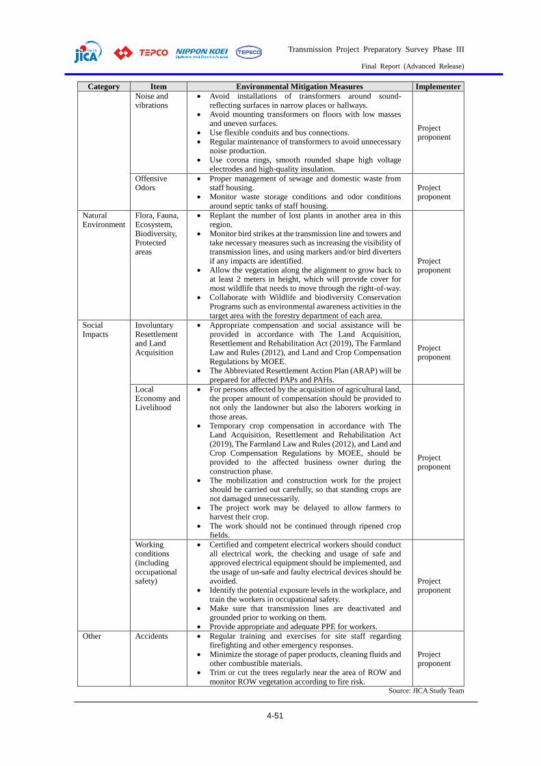
Transmission Project Preparatory Survey Phase III
Final Report (Advanced Release)
4-51
Category Item Environmental Mitigation Measures Implementer
Noise and vibrations
Avoid installations of transformers around sound-reflecting surfaces in narrow places or hallways.
Avoid mounting transformers on floors with low masses and uneven surfaces.
Use flexible conduits and bus connections. Regular maintenance of transformers to avoid unnecessary
noise production. Use corona rings, smooth rounded shape high voltage
electrodes and high-quality insulation.
Project proponent
Offensive Odors
Proper management of sewage and domestic waste from staff housing.
Monitor waste storage conditions and odor conditions around septic tanks of staff housing.
Project proponent
Natural Environment
Flora, Fauna, Ecosystem, Biodiversity, Protected areas
Replant the number of lost plants in another area in this region.
Monitor bird strikes at the transmission line and towers and take necessary measures such as increasing the visibility of transmission lines, and using markers and/or bird diverters if any impacts are identified.
Allow the vegetation along the alignment to grow back to at least 2 meters in height, which will provide cover for most wildlife that needs to move through the right-of-way.
Collaborate with Wildlife and biodiversity Conservation Programs such as environmental awareness activities in the target area with the forestry department of each area.
Project proponent
Social Impacts
Involuntary Resettlement and Land Acquisition
Appropriate compensation and social assistance will be provided in accordance with The Land Acquisition, Resettlement and Rehabilitation Act (2019), The Farmland Law and Rules (2012), and Land and Crop Compensation Regulations by MOEE.
The Abbreviated Resettlement Action Plan (ARAP) will be prepared for affected PAPs and PAHs.
Project proponent
Local Economy and Livelihood
For persons affected by the acquisition of agricultural land, the proper amount of compensation should be provided to not only the landowner but also the laborers working in those areas.
Temporary crop compensation in accordance with The Land Acquisition, Resettlement and Rehabilitation Act (2019), The Farmland Law and Rules (2012), and Land and Crop Compensation Regulations by MOEE, should be provided to the affected business owner during the construction phase.
The mobilization and construction work for the project should be carried out carefully, so that standing crops are not damaged unnecessarily.
The project work may be delayed to allow farmers to harvest their crop.
The work should not be continued through ripened crop fields.
Project proponent
Working conditions (including occupational safety)
Certified and competent electrical workers should conduct all electrical work, the checking and usage of safe and approved electrical equipment should be implemented, and the usage of un-safe and faulty electrical devices should be avoided.
Identify the potential exposure levels in the workplace, and train the workers in occupational safety.
Make sure that transmission lines are deactivated and grounded prior to working on them.
Provide appropriate and adequate PPE for workers.
Project proponent
Other Accidents Regular training and exercises for site staff regarding firefighting and other emergency responses.
Minimize the storage of paper products, cleaning fluids and other combustible materials.
Trim or cut the trees regularly near the area of ROW and monitor ROW vegetation according to fire risk.
Project proponent
Source: JICA Study Team

Transmission Project Preparatory Survey Phase III
Final Report (Advanced Release)
4-52
Monitoring Plan
The environmental monitoring plan, including monitoring items, location, frequency and related
organization in construction/closure stages and operation stage, is shown in the following Table 4.1-38.
Monitoring for the construction/closure stages will be implemented by the contractors and monitoring
for the operation stage will be implemented by the project proponent. An environmental monitoring
form (EMoF) in line with this monitoring plan is attached to this report.
Table 4.1-38 Environmental Monitoring Plan
Env. Indicators
Location Means of
Monitoring Measurement
Method Frequency
Repo-rting*
Responsibility
Supervision Supervision
Construction/Closure Stage
Air
Qu
alit
y
One point at
the new 500
kV
substation
CO2, PM2.5,
PM10, NO2, SO2,
Ozone, Wind
Speed, Wind
Direction
On-site
measurement Annually Annually
MOEE/
DPTSC Contractor
In and
around
substation
area and
along all
transmission
lines
Water spraying,
dust nets, covering
construction
materials and
excavated earth
Visual
inspection and
record keeping
Monthly Bi-
annually
MOEE/
DPTSC Contractor
Wat
er Q
ual
ity
One point
near new
500kV
substation
Temperature, pH,
Electrical
Conductivity,
On-site
measurement
Once in
dry season
and once
in rainy
season
Annually MOEE/
DPTSC Contractor
BOD5, COD Cr,
Oil and grease,
Total coliform
bacteria, Total
Nitrogen, Total
phosphorus,
Suspended Solids,
Total Chromium,
Cadmium, Arsenic,
Zinc, Lead,
Mercury, Copper,
Iron, Manganese
Laboratory
analysis
In and all
around
substation
and along
all
transmission
lines
Septic tanks,
temporary drainage
system, bund wall
or spill kit
Visual
inspection and
record keeping
Monthly Bi-
annually
MOEE/
DPTSC Contractor
So
lid W
aste
All
construction
sites
Waste manage plan,
record of waste
collection and
disposal (photos,
vouchers, etc.)
Visual
inspection and
record keeping
Monthly Every 6
months
MOEE/
DPTSC Contractors
So
il C
on
tam
inat
ion
All
construction
sites
Waste storage
conditions, fuel
filling method, spill
kit considering soil
contamination
(photos, drawing,
etc.)
Visual
inspection and
record keeping
Monthly Every 6
months
MOEE/
DPTSC Contractors
No
ise
and
V
ibra
tio
ns One point at
the new
Noise Level
LAeq (dB)
On-site
measurement Annually Annually
MOEE/
DPTSC Contractor

Transmission Project Preparatory Survey Phase III
Final Report (Advanced Release)
4-53
Env.
Indicators Location
Means of
Monitoring Measurement
Method Frequency
Repo-
rting*
Responsibility
Supervision Supervision
500kV
substation
Vibration Level
Lv10 (dB)
In and all
around
substation
and along
all
transmission
lines
Records of notice
letters, work
schedule and night
work, inspection
and maintenance of
machines
Visual
inspection and
record keeping
Monthly Bi-
annually
MOEE/
DPTSC Contractor
Off
ensi
ve
Od
ors
All
construction
sites
Waste storage
conditions, odor
conditions around
septic tanks
Visual
inspection and
record keeping
Monthly Every 6
months
MOEE/
DPTSC Contractors
Flo
ra,
Fau
na,
E
cosy
stem
, B
iodiv
ersi
ty,
All
construction
sites
Incident and
accident record, and
record of measures
as necessary
Visual
inspection and
record keeping
Monthly Bi-
annually
MOEE/
DPTSC Contractor
Ris
ks
of
Infe
ctio
us
Dis
ease
s su
ch
as A
IDS
/HIV
All
construction
sites
Records of status of
community safety
and health
including infectious
diseases
Record
keeping Monthly
Every 6
months
MOEE/
DPTSC Contractors
Wo
rkin
g c
ond
itio
ns
(in
cludin
g
occ
up
atio
nal
sa
fety
) All
construction
sites
Records of PPE
wearing, safety
sign boards, hazard
warning posts,
toolbox meetings,
training, etc.
Visual
inspection and
record keeping
Monthly Every 6
months
MOEE/
DPTSC Contractors
Acc
iden
ts
All
construction
sites
Records of fire, and
traffic accidents at
the site
Record
keeping Quarterly
Every 6
months
MOEE/
DPTSC Contractors
Operation Stage
Wat
er
Qu
alit
y
In and all
around
substation
Records of Septic
tanks and drainage
usage
Visual
inspection and
record keeping
Monthly Bi-
annually MOEE
Project
Proponent
So
lid W
aste
In and all
around
substation
Waste manage
plan, record of
waste collection
and disposal
(photos, vouchers,
etc.)
Visual
inspection and
record keeping
Monthly Bi-
annually MOEE
Project
Proponent
So
il
Con
tam
inat
ion
In and all
around
substation
Waste storage
conditions, oil
filling method, oil
pits (photos,
drawing, etc.)
Visual
inspection and
record keeping
Monthly Bi-
annually MOEE
Project
Proponent
No
ise
Inside
substation
Records of
inspection and
maintenance of
machines
Visual
inspection and
record keeping
Monthly Bi-
annually MOEE
Project
Proponent
Off
ensi
ve
Odo
rs
Staff
housing
Waste storage
conditions, odor
conditions around
septic tanks
Visual
inspection and
record keeping
Monthly Bi-
annually MOEE
Project
Proponent

Transmission Project Preparatory Survey Phase III
Final Report (Advanced Release)
4-54
Env.
Indicators Location
Means of
Monitoring Measurement
Method Frequency
Repo-
rting*
Responsibility
Supervision Supervision
Flo
ra,
Fau
na,
E
cosy
stem
, B
iodiv
ersi
ty
ROW of
transmission
line
including
tower
Incident and
accident records,
such as bird strikes
Visual
inspection and
record keeping
Monthly Bi-
annually MOEE
Project
Proponent
Wo
rkin
g c
ond
itio
ns
(in
cludin
g
occ
up
atio
nal
saf
ety
)
In and all
around
substation,
and ROW of
transmission
line
Incident and
accident record,
Records of wearing
PPE provided
Visual
inspection and
record keeping
Monthly Bi-
annually MOEE
Project
Proponent
Acc
iden
ts
In and all
around
substation,
and ROW
of
transmission
line
Records of fire, and
traffic accidents at
the site
Record
keeping Quarterly
Bi-
annually MOEE
Project
Proponent
Note*: The reporting frequency described this table indicates the reporting frequency from the project proponent to MONREC-ECD. As a general rule, the results of environmental and social consideration shall be reported from MOEE/DPTSC to
JICA once a quarter.
Source: JICA Study Team
In terms of the budget for environmental monitoring before/during construction and the closure and
operation phases, the main monitoring costs are those for field measurements, such as air quality, water
quality and noise. Annual costs for field measurements at the construction stage by the contractor, and
at the operation stage by the Project Proponent are estimated as shown in Table 4.1-39.
Table 4.1-39 Estimated Annual Costs for Monitoring
Stage Monitoring Items Implementing Organizations
Expected Cost Remarks
Pre-construction
- Conducting DMS survey (including crops)
Project Proponent
USD 45,000 To calculate the land compensation costs
500 kV and 230 kV transmission lines
Construction
- Implementation of mitigation measures
Project Proponent
USD 14,000/yr Only the costs for field work
Operation -Training and capacity development - EMF and safety clearance monitoring
Project Proponent
USD 6000/yr
Substations
Construction
- Onsite monitoring of air, water and noise levels - Implementation of mitigation measures
Project Proponent
USD 15,000/yr (AQ, WQ, NV) USD 6,000/yr
Operation -Training and capacity development - EMF and safety clearance monitoring
Project Proponent
USD 6000/yr
Note: 1) Budget is estimated at April 2020 from various existing information.
2) If the cost for monitoring at the operation and closure stages exceeds the budget, the extra expense will be secured by the Project Proponent
Source: JICA Study Team
Institutional Arrangements
(1) Project Proponent
The project proponent for National Power Transmission Network Development (Phase-III) is the
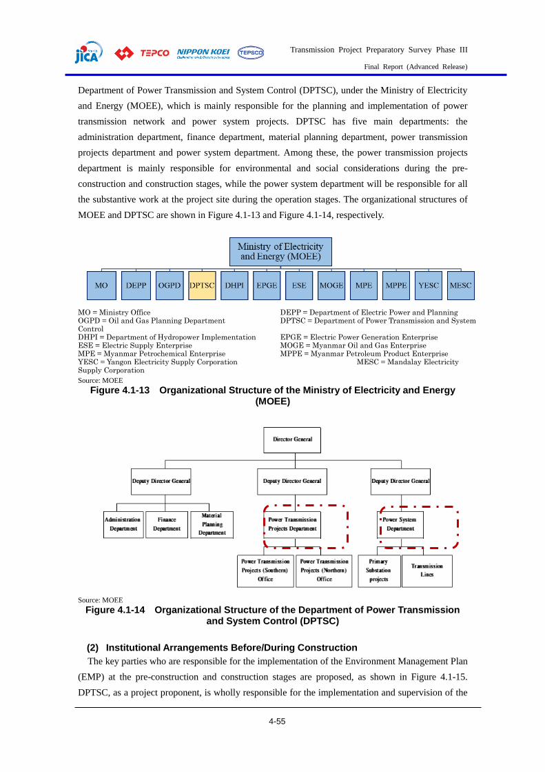
Transmission Project Preparatory Survey Phase III
Final Report (Advanced Release)
4-55
Department of Power Transmission and System Control (DPTSC), under the Ministry of Electricity
and Energy (MOEE), which is mainly responsible for the planning and implementation of power
transmission network and power system projects. DPTSC has five main departments: the
administration department, finance department, material planning department, power transmission
projects department and power system department. Among these, the power transmission projects
department is mainly responsible for environmental and social considerations during the pre-
construction and construction stages, while the power system department will be responsible for all
the substantive work at the project site during the operation stages. The organizational structures of
MOEE and DPTSC are shown in Figure 4.1-13 and Figure 4.1-14, respectively.
MO = Ministry Office DEPP = Department of Electric Power and Planning OGPD = Oil and Gas Planning Department DPTSC = Department of Power Transmission and System Control DHPI = Department of Hydropower Implementation EPGE = Electric Power Generation Enterprise ESE = Electric Supply Enterprise MOGE = Myanmar Oil and Gas Enterprise MPE = Myanmar Petrochemical Enterprise MPPE = Myanmar Petroleum Product Enterprise YESC = Yangon Electricity Supply Corporation MESC = Mandalay Electricity Supply Corporation
Source: MOEE
Figure 4.1-13 Organizational Structure of the Ministry of Electricity and Energy (MOEE)
Source: MOEE
Figure 4.1-14 Organizational Structure of the Department of Power Transmission and System Control (DPTSC)
(2) Institutional Arrangements Before/During Construction
The key parties who are responsible for the implementation of the Environment Management Plan
(EMP) at the pre-construction and construction stages are proposed, as shown in Figure 4.1-15.
DPTSC, as a project proponent, is wholly responsible for the implementation and supervision of the

Transmission Project Preparatory Survey Phase III
Final Report (Advanced Release)
4-56
project, including the environmental aspect. The project proponent will implement environmental
monitoring and submit the monitoring report to MONREC. The project proponent will submit the
monitoring report to JICA as well. Environmental, Social and Health management will be the
responsibility of the HSE team from the Design and Construction Contractors during the construction
stages.
Source: JICA study team
Figure 4.1-15 Proposed Institutional Arrangements for Environmental Management of the Project at Pre-construction and Construction Stages
(3) Institutional Arrangements during Operation
The institutional arrangements at the operation stage are shown in Figure 4.1-16. For the operation
stage, DPTSC will take care of all the substantive work at the site.
Source: JICA study team
Figure 4.1-16 Proposed Institutional Arrangements for Environmental Management of the Project at Operation Stage
Stakeholder Meetings
It is necessary to conduct stakeholder consultations at least once during the IEE study in order to

Transmission Project Preparatory Survey Phase III
Final Report (Advanced Release)
4-57
comply with the EIAP in Myanmar. The first stakeholder meeting was conducted as a preliminary
individual discussion from February to March 2020. After that, the project proponent (DPTSC/MOEE)
and the JICA Study Team informed the communities and stakeholders of each Township and District.
The meetings were held with invitations posted on the township notice boards so that any residents or
interested persons could attend.
(1) 1st Stakeholder Meeting
There are ten townships totally/partially overlapping the Project area. Specifications for
methodology and approach, such as notifications, venue, date, time, and participants for all the
meetings, were decided for the consultation based on recommendations from the General
Administration Departments in the Yangon and Bago Regions. Interviews on specific, recent, local
conditions were also implemented during the meeting to aid in the design of the Project, as well as the
design of the Stakeholder Meeting.
Table 4.1-40 Summary of the 1st Stakeholder Meetings
Meeting Date and
Time Venue Attendants
Discussion results for the 2nd Meeting Content
1st
Yangon Northern District
Tuesday, 18 February 2020, 9:30 am
General Administration Department, Northern Yangon District
District level: 1 person JICA Study Team: 2 persons
20 March at Hlegu Township of Northern District 13 wards/villages 13 March at Mingalardon Township of Northern District 5 wards/villages
2nd
Eastern District
Tuesday, 18 February 2020, 1:30 pm Monday, 3 March 2020, 1:30 pm
General Administration Department, Eastern Yangon District
District level: 1 person JICA Study Team: 2 persons District level: 1 person MOEE: 2 persons JICA Study Team: 2 persons
1 March North Dagon Township (7 wards) South Dagon Township (3 wards) North Okkalapa Township (1 ward) Thaketa Township (1 ward)
3rd
Hlegu Township
Thursday, 20 February 2020, 10:30 am
General Administration Department, Hlegu Township
Township level: 1 person MOEE: 2 persons JICA Study Team: 3 persons
20 March 13 wards/villages
4th
Mingalardon Township
Thursday, 20 February 2020, 1:30 pm
General Administration Department, Mingalardon Township
Township level: 4 persons MOEE: 2 persons JICA Team: 3 persons
13 March 5 wards/villages
5th
Bago District Wednesday, 4 March 2020, 11:00 am
General Administration Department, Bago District
Township level: 1 person MOEE: 1 person JICA Study Team: 4 persons
18 March Bago District (14 villages) Kawa Township (1 village) Thanapin Township (6 villages)
6th
Thanatpin Township
Thursday, 5 March 2020, 11:30 am
General Administration Department, Thanatpin Township
Township level: 2 persons MOEE: 1 person JICA Study Team: 2 persons
7th
Kawa Township
Thursday, 5 March 2020, 1:30 pm
General Administration Department, Kawa Township
Township level: 1 person MOEE: 1 person JICA Study Team: 2 persons

Transmission Project Preparatory Survey Phase III
Final Report (Advanced Release)
4-58
Meeting Date and
Time Venue Attendants
Discussion results for the 2nd Meeting Content
8th East Dagon Township
Friday, 6 March 2020
General Administration Department, East Dagon Township
Township level: 1 person JICA Study Team: 2 persons
16 March 8 wards
Source: JICA study team
(2) 2nd Stakeholder Meeting
a) Methodology for Public Consultation for IEE
The methodology of the Public Consultation Meetings for IEE (2nd Stakeholder Meeting) is
described in the following Table.
Table 4.1-41 Summary of Public Consultation Meetings for the draft IEE Report
Timing Methodology and Special Considerations
Draft IEE stage: planned for March 2020
【Method and No. of Meetings】 1 meeting is planned for one day, which will be organized in order to ensure the participation of the stakeholders in the public sector and the local residents. 【Venue】 Related Township General Administration Department (Mingalardon, Hlegu, Dagon Myothit (East) and Bago, North Okkala, South Dagon, North Dagon, Thaketa). 【Agenda】 Draft IEE on the Department of Power Transmission and System Control (DPTSC). Baseline survey results and impact assessment results Proposed environmental mitigation measures and environmental monitoring plan IEE study schedule 【Expected Participants & Invitation Method】 Local government bodies in and around the related townships. Local residents in the project area. Project Proponent and related government organizations Any interested individuals and parties The invitation/notice for the meeting will be posted in each village for one week in advance. 【Language Used】 The presentation and handout will be in the Myanmar Language. The explanation will also be provided in the Myanmar Language. 【Special Considerations for Socially Vulnerable Groups】 Feedback forms will be provided to the participants so that people who hesitate to speak out in public can share their views and comments in written form. Assistants will be available to fill out the form in case the participant requires assistance in writing/reading. Female assistants will be available for female participants who need any assistance.
Source: JICA study team
The public consultation meeting is held over five sessions to cover all of the project areas of
influence, as described in Table 4.1-42.
Table 4.1-42 Detailed Information for Stakeholder Meetings
Time and Date
Mingalardon Township: Friday, 13 March 2020, 10:00 am to 12:00 pm East Dagon Township: Monday, 16 March 2020, 10:00 am to 12:00 pm Bago Region: Wednesday, 18 March 2020, 10:00 am to 12:00 pm Yangon Eastern District: Thursday, 19 March 2020, 4:00 pm to 5:00 pm Hlegu Township: Friday, 20 March 2020, 10:00 am to 12:00 pm
Venue
Mingalardon Township: Administration Office, Thingangyungyi Village, Mingalardon Township, Yangon East Dagon Township: General Administration Department, Dagon Myothit (East) Township, Yangon Bago Region: General Administration Department, Bago District, Bago Yangon Eastern District: General Administration Department, Eastern Yangon District, Yangon Hlegu Township: General Administration Department, Hlegu Township, Yangon
Attendees Mingalardon Township: 33 persons
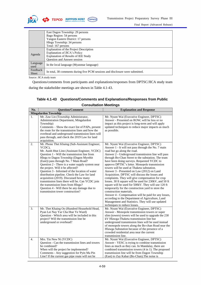
Transmission Project Preparatory Survey Phase III
Final Report (Advanced Release)
4-59
East Dagon Township: 29 persons Bago Region: 54 persons Yangon Eastern District: 17 persons Hlegu Township: 34 persons Total: 167 persons
Agenda
Explanation of the Project Description Explanation of JICA’s Policy Explanation of Results of IEE Study Question and Answer session
Language used
In the local language (Myanmar language)
Feedback Sheet
In total, 38 comments during five PCM sessions and disclosure were submitted.
Source: JICA study team
Questions/comments from participants and explanations/responses from DPTSC/JICA study team
during the stakeholder meetings are shown in Table 4.1-43.
Table 4.1-43 Questions/Comments and Explanations/Responses from Public
Consultation Meetings
No. Question/Comment Explanation and Response
Mingalardon Township
1. Mr. Zaw Lin (Township Administrator, Administration Department, Mingalardon Township) Comments – Show the exact list of PAPs, present the route for the transmission lines and how the overhead and underground transmission lines will pass through, and check the 2019 Law for land acquisition.
Mr. Nyunt Wai (Executive Engineer, DPTSC) Answer - Presented on ROW; will be less or no impact as this project is long-term and will apply updated techniques to reduce major impacts as much as possible.
2. Mr. Phone Thet Khaing (Sub-Assistant Engineer, YCDC), Mr. Aunh Htut Linn (Assistant Engineer, YCDC) Question 1 - Will the transmission line from Hlegu to Dagon Township (Dagon Myothit (East)) pass through No. 7 Main Road? Question 2 - There is a water supply system near the project. Will it be affected? Question 3 - Informed of the location of water distribution pipeline. Check the Law for land acquisition (2019). Discussed how many transmission lines there will be. Can YCDC join the transmission lines from Hlegu? Question 4 - Will there be any damage due to transmission tower construction?
Mr. Nyunt Wai (Executive Engineer, DPTSC) Answer 1 - It will not pass through the No. 7 main road but go along the road. Answer 2 - Underground transmission line will pass through Bo-Chan Street to the substation. The team have been doing surveys. Requested YCDC to approve DPTSC’s letter. Monopole transmission towers will be used at Thaketa substation. Answer 3 - Presented on Law (2012) on Land Acquisition. DPTSC will discuss the losses and complaints. They will give compensation for crop losses. 30 ft square will be used for 230kV, and 50 ft square will be used for 500kV. They will use 120 ft temporarily for the construction yard to store the construction materials. Answer 4 - Compensation will be paid for any losses, according to the Department of Agriculture, Land Management and Statistics. They will use updated techniques to reduce losses.
3. Mr. Thet Khaing Oo (Hundred Household Head, Pyan Lei Nay Yar Cha Htar Ye Ward) Question - Which area will be included in this project? Will the transmission line be underground or overhead?
Mr. Nyunt Wai (Executive Engineer, DPTSC) Answer - Monopole transmission towers or super slim (towers) towers will be used to upgrade the 230 kV Hlawga-Thaketa transmission line but underground transmission lines will be used instead of monopole towers along the Bo-chan Road near the Hlawga Substation because of the presence of a crowded residential area near the current transmission line.
4. Mrs. Tin New Ni (YCDC) Question - Can the transmission lines and towers be combined? When will the project be implemented? Comments - Any suggestion for Pyin Ma Pin Line? If the current gas pipe route will not be
Mr. Nyunt Wai (Executive Engineer, DPTSC) Answer - YESC is trying to combine transmission lines as much as they can. In Mandalay, there are combined transmission towers (4 in 1). The proposed transmission line will be from Dagon Township (East) to Zay Kabar (Bo-Chan).The noise is
Transmission Project Preparatory Survey Phase III
Final Report (Advanced Release)
4-60
No. Question/Comment Explanation and Response
used, new routes would be. If new underground transmission lines are constructed under the Bo-chan Road, there might be underground gas pipelines under the road. The transmission towers from Pyin-Ma Pin are currently generating noise.
generated from Pyin Ma Bin as the transmission lines are suffering overloaded capacity. The proposed project will include a 2 circuit system for better current capacity to solve the overload problem at Pyin Ma Bin. It may take over 5 years to implement this project.
Dagom Myothit (East) Township
1. Mr. Zaw Min Htike (GAD) Comment 1 - Although almost all the land is owned by township development committee, there is still farmland worked by farmers. So it would be necessary to negotiate with both TDC and the local people. One issue in this township is that even though YCDC owns the land for implementing projects, some land is still not utilized. Therefore, the original farmers cultivate their lands again. The legal owner is YCDC and the original farmers are currently working it. Therefore, discussions should be undertaken with all of them. ROW of Transmission line (200 ft.) from Sar Ta Lin Village to Dagon Myothit (East) should be clear in design. Comment 2 - There are also other projects (especially industrial zone development plan) related to this township so DPTSC needs to consider a long term plan over about 30 years. YCDC has those long-term plans and this should be discussed with them. Comment 3 - It is better to plan the design after field study because some data from Google Earth cannot provide exact information.
Mr. Nyunt Wai (Assistant Director, DPTSC, MOEE) The suggestions are very useful for the project. There are many projects in MOEE which are facing many difficulties due to land issues. Therefore, we will carefully consider all your suggestions for the project. Yes, we will follow your suggestions.
2. Mr. Nay La (Water Distribution Department, Township Development Committee) Comment 1 - There are also gas lines and water distribution lines. Therefore, it is necessary to negotiate with the respective authorities or departments. Most of the data can be obtained from the Township Development Committee.
Mr. Nyunt Wai (DPTSC, MOEE) Answer 1 - We also face many difficulties whereby the data are not relevant to the ground conditions. But we will always meet and discuss with related departments. For design, we proposed to use Slim Towers with double circuits, which can increase the cost, but they only need a small land area or size and reduce the amount of land acquisition issues. But it is difficult to use Slim Towers in Mingalardon Township. Therefore, we will put 6 circuits in an underground tunnel. After passing through the tunnel, we will use Mono towers. Therefore, I also wish to suggest that YCDC invite and discuss matters with MOEE when implementing the new industrial zones. Then we will discuss including enough space for transmission lines in the future. We do not get data for gas pipelines. We also carried out detailed survey designs along Bo Chan Road. Comment 1 - Due to problems in land acquisition, the projects have to be delayed. Comment 2 - Existing transmission lines of Hlawga-Thaketa need to be upgraded. Slim towers are planned to be used with bored pile although it might be expensive. Comment 3 - If government is planning to develop an industrial zone in this Dagon Myothit (East) Area, the electricity will be essential for everyone. So, please do cooperate with us.
3. Mr. Linn Htet Ko (District GAD) I wish to include land owner list and related government list in the presentation. It should include project initial time and finishing time. How should GAD and related departments like YCDC/YESC provide support for this project? There cannot be land issues in Yangon Area.
Mr. NAKANO Hiroshi (JICA Study Team) Answer 1 - As it is only the feasibility stage, the project schedule has not been fixed. The only information we can give for now is that target timing of the loan agreement is in August. Design stage may take about 1 year. So, we still do not have a project schedule.

Transmission Project Preparatory Survey Phase III
Final Report (Advanced Release)
4-61
No. Question/Comment Explanation and Response
Since the project is a National level project, there should be discussions at the Central level. Sometimes, following JICA guidelines exactly in our country may create difficulties. Therefore, international standards and guidelines should be relevant to our country’s conditions. Question 1 - Is there any project schedule which includes start and end date of the project? Question 2 - How can GAD and other related departments be involved in the project? Comment 1 - It would be better to include departments and land owners related to project in power point presentation so that it is easier to understand each party’s responsibilities. Comment 2 - The project includes cutting trees and replantation. Therefore, the project owner should discuss this with Forestry Department. There can be disagreements in usage of agricultural lands in Kawa and Thanatpin Townships. For slide 46, Ministry of Forestry has regulations on which kind of trees can be cut and where to replant them. Therefore, before starting the project, please make sure to negotiate with the Ministry of Forestry.
Answer 2 - Our team could not decide how GAD can be involved. DPTSC will discuss this with related departments.
4. Mr. Than Hlaing (No. 1 Ward Administrator) Comment 1 - There were two fatal incidents due to electric shock in my ward: one was at a dumping site and the other occurred while undertaking electricity repairs. To avoid such situations, please provide us with more information in advance so that we can give precautions to the public.
Mr. Nyunt Wai (DPTSC, MOEE) Answer (DPTSC) Trees like bamboo, for which height cannot be controlled, will need to be cut. However, those which can be controlled will be remain the same. So, I believe if everyone follows the respective laws and rules, the number of accidents will be reduced.
5. Mr. Aung Ko Ko (EE, YESC) If the transmission line will pass through No. 7 Road, I wish the line to be installed in the area located within the project operated by Zayyar Premier Company. If No. 7 Road is expanded by a future project, the transmission line will need to be removed again.
Mr. Nyunt Wai (Assistant Director, DPTSC, MOEE) Currently, water pipelines exist along No. 7 Road. We will discuss with YCDC on the transmission line area. We will place the towers after negotiations with them.
Bago District
1. Mr. Kyi Swe (Administrator, Oe Bo Village Tract) Question - If the transmission line passes through a village track, will DPTSC give compensation?
Mr. Soe Naing Win (Assistant Director, DPTSC) Answer - When DPTSC does surveys, there is a surveyor to be followed. During construction of the tower, there will be access road, so DPTSC will give compensation for damaged crops until the construction ends. The compensation’s value may be decided via Department of Agriculture, Land Management and Statistics rules through step-by-step negotiations. Dr. Phyo Thu Aung (MKI) Answer - According to MOEE Law, there is no compensation for land acquisition in any village tract development project.
2. Mr. Kyaw San Aung (Deputy Township Administrator, Ka Wa Township) Question - Will DPTSC give compensation for Land Acquisition surrounding the towers? Communications operator gave compensation for land acquisition annually. Comments (Deputy Administrator, Ka Wa Township) - DPTSC should consider making PCM for severely affected people because it is unable to construct any buildings and unable to plant any crops.
Mr. Soe Naing Win (Assistant Director, DPTSC) Answer - There will not be compensation for land used for substation, but DPTSC will give crop compensation of three times’ the current market price in every season because there are many towers in Myanmar. So, the government can’t give compensation for every piece of land used. Dr. Phyo Thu Aung (MKI) Answer - This is just the process of implementing IEE report. After loan is agreed, there will be detailed design, the list of actual affected persons will be released and Public Consultation Meeting will be held.

Transmission Project Preparatory Survey Phase III
Final Report (Advanced Release)
4-62
No. Question/Comment Explanation and Response
3. Mr. Kyaw Thet (Department of Public Health) Comments - Noise and Vibrations at Hlegu-Dar Pein should be measured every three months and should be inspected monthly. Water quality should also be tested twice in every rainy season.
Dr. Phyo Thu Aung (MKI) Answer - There are no standard rules or regulations for monitoring frequency but DPTSC will follow these comments.
4. Mr. Tin Win Htut (Officer, Department of Fisheries) Question - There are many fish ponds under towers, so will they be affected due to electricity?
Mr. Soe Naing Win (Assistant Director, DPTSC) Answer (DPTSC, MOEE) - There are transmission lines above fish ponds in Ayeyarwady Region and no issues have occurred up to now. There may not be an effect on these but after negotiation with the village tract, DPTSC will avoid these areas if possible. Mr. NAKANO Hiroshi (JICA Study Team) Answer – Sufficient insulators will be fixed at towers, so there will be no electricity danger for fish ponds. If an uneducated person touches a tower, it might result in electrocution. DPTSC will follow the MOEE’s Laws and JICA’s international laws to lessen or eliminate the impacts. According to MOEE’s rules, towers must be built a sufficient distance from houses. Moreover, there are households under the Hlawga-Thaketa 230kV transmission line. So, the technicians from both MOEE and JICA will improve that line by applying updated techniques.
5. Mrs. Pa Pa Win (Assistant Director, Planning Department, Thanatpin Township) Question - Will there be any danger if people work under transmission lines?
Mr. Soe Naing Win (Assistant Director, DPTSC) Answer - There will be no danger after the tower construction has been completed. 75 feet square is required for 230kV transmission for ROW. Lightning conductors will be fixed on the top of towers for safety.
6. Mr. Nay Min (Deputy Staff Officer, Department of Forestry) Comments - Sub-group composition should include the members from relevant departments. According to his experience, compensation processes were very complicated and it was hard to deal with Project-Affected Persons (PAPs).
Dr. Phyo Thu Aung (MKI) Answer - This is just the stage to implement the IEE report. After the loan is approved, which could take 1 year, the detailed designs will be published. Then, DPTSC will cooperate with other departments to implement this project, and affected people will be recorded and compensated. The cut-off date will be specified and surveys will be undertaken.
7. Mr. Maung Soe (Kan Ni Village Tract Administrator, Kawa Township) Comments - The transmission line in Kawa Township is broken. So please implement the projects in a safe way to create less damage. The relevant organizations should discuss the Land Acquisition with local people in detail.
Mr. Soe Naing Win (Assistant Director, DPTSC) Answer - If the transmission line is broken, there is no current in it so no electric hazard is expected. Therefore, we don’t need to be afraid of that condition. Dr. Phyo Thu Aung (MKI) Answer - MKI submitted IEE (Draft), and JICA gave comments, including on the routes for bird migration. MKI has been considering JICA’s comments to put in IEE (Draft).
Eastern Yangon District
1. Mr. Soe Lin Htike (Thaketa Township Administrator) Comment 1 - There are transmission lines in No. (9) Ward of Thaketa. So, it would be better to get detailed information on how the project affects that area. Comment 2 - Even after the agreement between Myanmar Government and JICA, there might be difficulties when it comes to ground surveys and negotiations with local people. Question 1 - Are transmission line towers new? Where would they be placed? Question 2 - How many third parties are involved in this project?
Dr. Phyo Thu Aung (Myanmar Koei LTD) Answer 1 - The old transmission line will be upgraded with a new line. Therefore, the location and length of the line is the same. We will upgrade the current tower area. In other areas which are far from the main road, the project will construct approach lanes. Mr. Thura Aung (General Manager, Resource and Environment Myanmar Co., Ltd.) The leading organization for IEE Study is Myanmar Koei International Co., Ltd. and we (REM) take the responsibility for social considerations and RAP framework. When we discussed this with DPTSC, they did not want to share the project information with local people as it is at the feasibility stage and they worried that rumors would spread and the project would not work out as planned. However,
Transmission Project Preparatory Survey Phase III
Final Report (Advanced Release)
4-63
No. Question/Comment Explanation and Response
they agreed to have a stakeholder meeting at this feasibility stage.
2. Mr. Tint Zaw (North Okkalapa Township Administrator) Question 1 - Has DPTSC informed parliament members about the project? Question 2 - What are these feedback forms for?
Dr. Phyo Thu Aung (Myanmar Koei LTD) Answer 1 - DPTSC invited one parliament member in Hlegu Township. Answer 2 - These feedback forms are for Township Administrator, Ward Administrator and Local people who are interested in the project.
3. Mr. Ye Aung (Dagon Myo Thit (South) Township Administrator) Comment 1 - There will not be many issues in Eastern Yangon District since it is an old transmission line area. Mr. Kyaw Moe (Dagon Myo Thit (North)) Comment 1 - If the project is carried out after signing MOU, there will be many problems to be solved at ground level. The project should discuss matters with communities first. Moreover, impact of transmission line is high on farmers especially during rainy season.
Dr. Phyo Thu Aung (Environmental Expert, Myanmar Koei International Co., Ltd.) The project is just at the study phase for loan agreement. The government has budget limitations. During meeting with MOEE in Naypyitaw, they said that they do not wish to survey villages/wards because some areas are a sensitive area for survey. Moreover, the design is not confirmed yet.
4. All Township Administrators We can give suggestions after giving information to the community. We wish the project members to meet related government departments and the public as well. We will support the project 100 percent as electricity is essential for the sake of our country and people.
Mr. Thura Aung (General Manager, Resource and Environment Myanmar Co., Ltd.) The project is at the initial stage and the design may be changed. If IEE study is not sufficient for this project, the developer will carry out EIA study according to ECD comments.
Hlegu Township
1. Mr. Win Aung (Deputy Township Administrator, General Administration Department (Hlegu)) Question - Ask Land Acquisition about the area which will be passed through for 230kV and 500kV. How many towers will be in Hlegu Township and how big will the area used be? Comments 1 - Should consider the area which will be used in Hlegu Township. Comments 2 - The project should consider people who cannot live under ROW of 500 kV Transmission line. Compensation for substation area as well as for transmission line should be considered. Number of towers, distance between each tower and their locations should be considered. We found that other transmission lines are sagging in some areas.
Dr. Phyo Thu Aung (Environmental Expert, Myanmar Koei International Co., Ltd.) Answer – DPTSC needs site survey to know about the numbers of towers in Hlegu Township. After the MOU, detailed designs will be published. JICA will provide support financially, but this is the draft stage. There are households under 230kV Hlawga-Thaketa but an improvement of this line will be included in this project. Moreover, JICA will call tender for techniques as the adviser. So, many technicians will be included. JICA will also inspect the construction using International Guidelines. It is certain that the proposed project will be better than the previous projects.
2. Mr. Aung Aung (Village Administrator, Sar Ta Lin Village Tract) Comment - Since this is the loan acquisition phase, we cannot give suggestions for our village. When the project starts, our village will cooperate with the project by negotiating with land owners and community. Mr. Bo Bo Myint Aung, U Mya Aung (Township Development Committee) Comment - The vertical right of way can be changed when villages are developed and ground level is changed due to the development.
-
3. Mr. Min Zaw (Township Engineer, Electricity Supply Cooperation) Comment 1 - Since ground clearance changes as time passes, the project should consider carefully the height of the towers with some percentage added onto the current ground level. Comment 2 - Hlegu has limitations in electricity. The township will be developed in the near future with many development projects. The village
Dr. Phyo Thu Aung (Environmental Expert, Myanmar Koei International Co., Ltd.) Answer 1 - Yes, the Ministry will install the towers at a height of at least 30 ft. But in some places, the ground clearance of the tower will decrease due to the upgrading of the road. Answer 2 - According to PCMs in other townships, there are suggestions for the cooperation of related government departments, township administrators,
Transmission Project Preparatory Survey Phase III
Final Report (Advanced Release)
4-64
No. Question/Comment Explanation and Response
administrators cannot discuss the project today because they did not see the detailed design or transmission line routes, but when the project starts, Hlegu Township will cooperate to ensure the success of the project.
ward/village heads and so on. Moreover, stakeholders also suggested that meeting with current development project owners and proposed development project owners was also necessary. Mr. Hla Ko Oo (Assistant Engineer, DPTSC) Answer - According to MOEE law, there is no compensation for land acquisition in any village tract development project.
4. Mr. Bo Bo Myint Aung, Mr. Mya Aung (YCDC) Comment - There is a 66kV transmission line from Hlawga but the villagers can’t accept this, so the route might be changed. If DPTSC shows the affected area in detail, the leaders from the village tracts can discuss this with each other.
Dr. Phyo Thu Aung (Environmental Expert, Myanmar Koei International Co., Ltd.) Answer - Some proposed areas are under private companies and DPTSC expects to get MOU with the current government. Once the detailed designs are out, it will be possible to conduct a site survey.
5. Mr. Win Aung (Deputy Township Administrator, General Administration Department (Hlegu)) Comments - If DPTSC shows the detailed design, the administrators from village tracts can discuss this in more detail. In Htan-Ta-Bin, once the towers were constructed the contractors could not pay compensation and they still haven't been able to negotiate this. The value of the land will increase.
Dr. Phyo Thu Aung (Environmental Expert, Myanmar Koei International Co., Ltd.) Answer - DPTSC will negotiate with public construction enterprises and ROW is rarely allowed.
6. Mr. Win Aung (Deputy Township administrator, General Administration Department) Comments - Plantation will be needed in exact areas.
Source: JICA study team
(3) Public Disclosure for Draft IEE Report
The Executive Summary of the draft IEE report in the Myanmar language was disclosed for review
and comments, as shown in Table 4.1-44. The final IEE will be available for public viewing on the
website of MOEE.
Table 4.1-44 Public Disclosure for the IEE
Stage Methodology and Special Considerations
Draft IEE stage: planned for March 2020
【Announcement Method】 Public disclosure will be announced 5 days before the public consultation meeting and 7 days after the public consultation meeting. (In total, about 10 days.) Disclosure period, and comment submission method will be described in the disclosure places. The draft IEE report will be available on the MOEE official website. 【Disclosure Places】 Related Township General Administration Department (Mingalardon, Hlegu, Dagon Myothit (East) and Bago, North Okkala, South Dagon, North Dagon, Thaketa). Village Tract Offices/Ward Offices in the Project area. 【Disclosure Period】 About 10 working days (to exclude National Holidays, Saturdays and Sundays) 【Comment Submission Method】 Comments can be submitted with the comment form provided at the disclosure places or by e-mail, either in the Myanmar Language or the English language.
Source: JICA study team
An executive summary of the IEE report translated into the Myanmar language was prepared and
disclosed together with a feedback form for each invitee during the stakeholder meetings. The
disclosure duration was 7 weekdays starting from the date of holding the stakeholder meetings. The
disclosure duration for each township is shown in Table 4.1-45.

Transmission Project Preparatory Survey Phase III
Final Report (Advanced Release)
4-65
Table 4.1-45 Disclosure Duration for draft IEE report Executive Summary
Target Area Disclosure Duration
Mingalardon Township 13-23 March 2020
East Dagon Township 16-24 March 2020
Bago Region 18-26 March 2020
Yangon Eastern District 19-30 March 2020
Hlegu Township 20-31 March 2020
Source: JICA study team
Public Disclosure at General Administration Department, Northern Yangon District
Public Disclosure at Electricity Supply Cooperation, Mingalardon Township
Public Disclosure at Administration Office, Thingangyungyi Village Tract, Mingalardon Township
Public Disclosure at Administration Office, Pyan Lal Nay Yar Cha Hter Yay Village Tract, Mingalardon Township
Public Disclosure at General Administration Department, Dagon Myothit (East) Township
Public Disclosure at Administration Office, No (1) Ward, Dagon Myothit (East) Township

Transmission Project Preparatory Survey Phase III
Final Report (Advanced Release)
4-66
Public Disclosure at General Administration Department, Bago District
Public Disclosure at General Administration Department, Bago Township
Public Disclosure at Township Development Committee, Bago Township
Public Disclosure at Forest Department, Bago District
Public Disclosure at Department of Agricultural Land Management and Statistics, Bago Township
Public Disclosure at Electricity Supply Corporation, Bago District
Public Disclosure at General Administration Department, Thanatpin Township
Public Disclosure at Department of Public Health, Thanatpin Township

Transmission Project Preparatory Survey Phase III
Final Report (Advanced Release)
4-67
Public Disclosure at Township Development Committee, Thanatpin Township
Public Disclosure at General Administration Department, Kawa Township
Public Disclosure at Township Development Committee, Kawa Township
Public Disclosure at Department of Agricultural Land Management and Statistics, Kawa Township
Public Disclosure at Electricity Supply Corporation, Kawa Township
Public Disclosure at General Administration Department, Hlegu Township
Public Disclosure at Electricity Supply Cooperation, Hlegu Township
Public Disclosure at National League for Democracy Party Office, Hlegu Township
Source: JICA study team
Figure 4.1-17 Photos of Public Disclosure of the draft IEE Report Executive Summary

Transmission Project Preparatory Survey Phase III
Final Report (Advanced Release)
4-68
Several comments in the PCM sessions and 26 written comments in feedback forms during the PD
were received. Comments are shown from Table 4.1-46. There were no special written comments from
Yangon Eastern District.
Table 4.1-46 Feedback from Mingalardon Township at Stakeholder Meeting and
Public Disclosure
No. Township Comments/Suggestions
1 Thingangyungyi Village, Mingalardon
The consultations and meetings with the local people should be carried out four to five times rather than just one time.
2 Pyanlalnayyarchahatryay Ward, Mingalardon
There should be proper, detailed explanations concerning the houses within the rehabilitation ward, and those located within the project area, and concerning measures for the compensation.
3 Mingalardon There should be effective compensation schemes to lessen the potential impacts on the communities within and around the project area.
4 Shwe Nanthar Ywama Village, Mingalardon
If the project will be good for the country, it is fully encouraged. It would be better if the project does not have negative impacts on the communities as well.
5 Thingangyungyi Village, Mingalardon
There should be no impact on the houses during project implementation.
6 Thingangyungyi Village, Mingalardon
There should be no impact on the houses, and public health should be considered.
Source: JICA study team
Table 4.1-47 Feedback from East Dagon Township at Stakeholder Meeting and
Public Disclosure
No. Name Township Comments/Suggestions
1 U Kyaw Win Naing
125 Ward, Dagon Myothit (East)
The consultations and meetings with the local people should be carried out four to five times rather than just one time.
Source: JICA study team
Table 4.1-48 Feedback from Bago Region at Stakeholder Meeting and Public
Disclosure
No. Township Comments/Suggestions
1 General Administration Department, Bago
There should be more effective measures to make the respective farmers aware of and understand the compensation for their lands and gardens due to the project. There can be problems in signing MoUs on loans without taking these measures. The land compensation should be reconsidered by the Ministry concerned. According to 2012 Farmland Law, the farmers holding the Land Use Certificate (Form 7) are supposed to be the owners of their agricultural land.
2 Township Development Committee, Bago
It is known that cultivation can be carried out under the 500KV transmission towers. However, cultivation should not be done alone in this area since there can be dangers of electrical hazards. The area of the transmission line (41' x 31') is not a large one when it comes to the villages. After the project is implemented, there should be transparent negotiations and discussions.
3 Forest Department, Bago
There should be transparency in conducting field surveys for compensation with the local people before the actual implementation of the project so as to avoid unnecessary disputes.
4 Bago The current 230 kV transmission lines do not have clear-cut ground clearance in some places, and there are some cables falling off just above the ground. In order to avoid such incidents, there should be strict line span distances between the transmission towers.
5 Myanmar Maternal and
Sometimes, especially in winter, transformers in the city can malfunction and make noises that can cause local people and the monks living around there to become nervous and worried. In some
Transmission Project Preparatory Survey Phase III
Final Report (Advanced Release)
4-69
No. Township Comments/Suggestions
Child Welfare Association, Bago
cases, the electricity can even go off. Thus, it would be best to avoid such cases happening after this project. We are very grateful to you for upgrading the transmission lines.
6 Myanmar Women’s Affair Federation, Bago
There can be problems concerning land. Since this project is intended to aid the development of the country, it would be better if the government also takes responsibility in solving such problems. There should be awareness raising activities and training by the organizations concerned so that the local people will be more engaged, interested and willing to support the project. In doing this, the non-governmental organizations should also contribute.
7 Kanni Village, Bago
There should be effective measures concerning the environmental impacts of the project and the compensation for the affected communities. The system for the electrical transmission line should be safe enough to avoid possible risks for the local people. Since this project can bring advantages to our country, there is no objection to it.
8 Shwe Tan Village, Bago
The compensation should be provided not only for the affected crops in the land near the transmission towers but also for the affected land and crops along the transmission line.
9 Aut See Tee (East) Village, Bago
The project will be successful if there is strong collaboration among the government, the ministries concerned, the public and JICA.
10 Department, of Agricultural Land Management and Statistics, Thanatpin
The project area should be away from the residences of the local communities as well as extensive village areas. Concerning the compensation for crops, although the seasonal crops can be re-cultivated, the long-term crops cannot be cultivated again. Thus, for those long-term crops, compensation for the costs of cultivating them and for a further two- or three-year period should be provided.
11 Livestock Breeding and Veterinary Department, Thanatpin
Since there are measures to replant trees, there should also be measures for the pond providing drinking water for animals located near the power station. In the awareness raising workshops, information and knowledge on the routes of wild birds should be included.
12 Thanatpin There should be consultations with the local communities living around the project area. It would be more feasible if there are measures on compensation or the annual rents for the land for the transmission towers. There should be awareness raising activities for the communities around the project area on the measures taken for the potential risks of electrical hazards.
13 Department of Agriculture, Thanatpin
There should be open discussions about the project implementation with the farmers working the land.
14 Department of Fisheries, Thanatpin
The Department of Fisheries would like to suggest that the transmission lines should not be placed in fishing ponds since it can cause electrical hazards. Thus, there should be consideration of this fact.
15 Forest Department, Thanatpin
The Initial Environmental Evaluation for the project (phase-3) should be carried out after conducting the field survey and awareness-raising activities with the departments concerned and village tracts, with training provided for the local communities.
16 Department of Public Health, Thanatpin
There should be regular monitoring on noise pollution once a month. The drains should be cleaned before and after the rainy season. There should be measures for the safety and security of the local population.
17 General Administration Department, Kawa
The 500-KV transmission line will pass through the Na Be Village Tract, Kawa Township. Thus, the construction of the transmission towers and the installation of the transmission line will be carried out across these areas. We were informed that compensation will be provided only for the affected crops at 3 times that of the current price, but not for the land. The telecom operators pay annual rents

Transmission Project Preparatory Survey Phase III
Final Report (Advanced Release)
4-70
No. Township Comments/Suggestions
for the land where their transmission towers are placed. If the compensation or the annual rents for the land for constructing the transmission towers are not provided, there could be complaints since it is not in accordance with the government’s Land Acquisition Policy.
18 Department, of Agricultural Land Management and Statistics, Kawa
It is said that compensation of three times’ the current price will be paid for the crops cultivated on the land where the transmission line passes through. It would be better if there is specification of widths for both sides in installing the transmission line. For conducting the initial evaluation, prior information should be given, with all the departments concerned included. The compensation for land and crops should be reported to the Township Farm Land Management Committee in order to be more reliable and effective.
19 Nabebin Village, Kawa
During construction of the towers, there should be measures to create the minimum impacts on the local farmers, the natural environment and the local people. There should also be proper compensation schemes. There should be transparent and open negotiations with the local farmers with more consideration of their interests.
Source: JICA study team
Table 4.1-49 Feedback from Hlegu Township at Stakeholder Meeting and Public
Disclosure
No. Area Comments/Suggestions
1. Sar Ta Lin Village Tract, Hlegu
This project should be implemented because it will support the energy sector of the country. Safe operations in the environmental and social sectors and mitigation of negative health impacts should be systematically and sufficiently carried out.
2. Sar Ta Lin Village Tract, Hlegu
We fully agree with the construction of the 500kV transmission line in Hlegu Township. It is crucial for development of the township. It can support the energy sector of the country, too. The project should be carefully implemented by minimizing negative environmental impacts.
3. Sar Ta Lin Village Tract, Hlegu
No disagreement with the project because it will not impact biodiversity-sensitive areas or Yangon’s Cultural Heritage Infrastructure. The project contractor should follow related mitigation measures within project area.
4. Inn Taing Village Tract, Hlegu
The project is fully encouraged because it is very important for implementing the country’s projects and development of the country’s economy.
5. Inn Taing Village Tract, Hlegu
We fully welcome the project since it can develop the Villages/Wards, factories and living standards in Hlegu Township. But the project can have some negative impacts on the environment and people. Therefore, technicians and professionals should work together to reduce negative impacts.
6. Inn Taing Village Tract, Hlegu
We are in full agreement regarding the project because it will support the electricity needs of the county. The project should understand people’s worries about the dangers and should explain the protection systems for transmission lines. Law Pi Ta Transmission Line has fallen to the ground due to ground filling. Therefore, traffic and local people face electricity dangers during the rainy season. Maintenance for such issues should be included in the project.
7. Alan Gapo Village Tract, Hlegu
The project will develop some villages in Hlegu Township. Compensation for affected farmers should be given by negotiating with related persons. Technicians and professionals should work together to reduce negative impacts on the environment. I am ready to help ensure the success of the project.
8. Alan Gapo Village Tract, Hlegu
The project will improve the economy of Hlegu Township and living standards of the people. Compensation for affected owners of farms and gardens should be given by negotiating with township representatives, village representatives and related government persons. It is very important because 75% of the main livelihood of
Transmission Project Preparatory Survey Phase III
Final Report (Advanced Release)
4-71
No. Area Comments/Suggestions
people in rural areas comes from farming. Technicians and professionals should work together to mitigate negative impacts on the environment. I am ready to help ensure the success of the project.
9. Alan Gapo Village Tract, Hlegu
The project will improve the economy of Hlegu Township and living standards of the people. Impacted owners of farms and gardens should be given compensation negotiating with Township representatives, village representatives and related government persons. It is very important because 75% of the main livelihood of people in rural areas comes from farming. Technicians and professionals should work together to mitigate negative impacts on the environment. I am ready to help ensure the success of the project.
10 Shan Te Gyi Village Tract, Hlegu
Yangon has limitations in electricity and thus the 500kV transmission line should be installed. The project can produce a few negative impacts on the environment, but it can provide many positive impacts.
11. Shan Te Gyi Village Tract, Hlegu
The 500kV transmission line project should be implemented at the earliest opportunity to reinforce the power supply in the township, minimizing negative impacts and using modern technologies.
12. Shan Te Gyi Village Tract, Hlegu
Even though the 500kV transmission line project may impact the environment, it should be implemented because the people in ward, village and township can get a sufficient electricity supply.
Source: JICA study team
Summary of the Study Schedule following EIAP
The Ministry of Natural Resources and Environmental Conservation (MONREC) announced the
stipulation of the EIA procedures, which define the detailed legal process for the preparation of the
Environmental Management Plan, Initial Environmental Examination (IEE) Report and
Environmental Impact Assessment (EIA) Report in Dec 2015. Basically, the IEE Procedure covers the
below content, such as the screening of projects (Project Proposal application), qualifications for
conducting IEE studies (submission of the 3rd party consultant selection), preparation of IEE report,
environmental management plan (EMP), public involvement, submission and approval of IEE report
by MONREC (according to the EIAP, the Ministry shall deliver the final decision within sixty working
days of receipt of an IEE Report), and monitoring process after approval of the EIA/IEE/EMP report.
The Project Proposal was submitted by DPTSC/MOEE in January 2020. However, ECD/MONREC
normally does not have the processing capacity to comply with the EIAP description. Additionally,
there was the COVID-19 pandemic and work restrictions at ECD/MONREC. DPTSC eventually
received the screening results from MONREC-ECD at the end of December 2020.
1) Project Proposal Application Submitted: January 2, 2020
Re-submitted: September 21, 2020
Received the screening result: December 30, 2020
2) Submission of 3rd Party Consultant selection
3) IEE report preparation
3) Public Consultation Meeting
5) Draft Final IEE Report submission
6) IEE Report Approval
The letter from MONREC-ECD (original Burmese and English translated version) is attached to
this report. The screening result was to prepare two IEE Reports for this Project. MONREC-ECD

Transmission Project Preparatory Survey Phase III
Final Report (Advanced Release)
4-72
requested DPTSC to do the following:
a) Submit the Initial Environmental Examination (IEE) report covering all activities, including
the construction of a new 500-kV substation (25 ha) in Hlegu and the construction of a new
68.9 km of 500 kV TL from Bago Region (Hpayargyi) to Hlegu.
b) Submit the Initial Environmental Examination (IEE) report covering all activities, including
the improvement of Dagon Myothit (East) Substation (230kV) and Hlawga Substation
(230kV), the construction of a new 19.5 km of 230kV TL from Hlegu Substation to Dagon
Myothit (East) Substation, the construction of a new 17.4 km of 230kV Overhead TL and 4.6
km of 230 kV Underground TL from Hlegu to Hlawga, and improvement of the 22.3 km of
existing overhead TL from Hlawga Substation to Thaketa Substation.
c) Get approval for the Third Party (or) Organization from MONREC, in accordance with Article
32 of the Environmental Impact Assessment Procedures, who will conduct the Initial
Environmental Examination (IEE).
d) Submit and get the approval for IEE Reports from MONREC, in accordance with Articles 34,
35, 36, 37, and 38 of EIA Procedures, after getting the approval for the Third Party (or)
Organization.
For the preparation of the Project Proposal in line with EIAP, the JICA Study Team and DPTSC
discussed this from the first fieldwork for the Project (August 2019), and DPTSC submitted the Project
Proposal on January 2, 2020, but ECD/MONREC eventually screened it as two IEE projects. The
JICA Study team and JICA discussed the screening results from MONREC-ECD, and decided that it
will be necessary to proceed with DPTSC support via a loan consultant in consideration of the
necessary steps and this Preparatory Survey period. First, DPTSC needs to submit the IEE implementer,
corresponding to c) above (submit the 3rd Party Consultant selection form from MOEE/DPTSC to
MONREC-ECD). After that, it will be necessary to carry out the required baseline surveys and public
consultation meetings in accordance with the EIA Procedures (2015) and General EIA Guidelines
(draft in 2017) in Myanmar.

Transmission Project Preparatory Survey Phase III
Final Report (Advanced Release)
4-73
4.2. Land Acquisition and Resettlement
Necessity of Land Acquisition and Resettlement
The Project requires permanent and temporary land acquisition, as described in the following table.
The details of the land to be acquired and the amount of resettlement will therefore be studied.
The final decision on the route for the transmission line and the location of towers will be made by
DPTSC in the Detailed Design Phase. The route to be studied is the one agreed between the JICA
Study Team and DPTSC in the F/S Phase.
Table 4.2-1 Permanent and Temporary Impacts due to the Project
Project Component Permanent Impacts Temporary Impacts (during construction work)
Construction of New Substation
Acquisition of the land (stoppage of existing land use)
None (possibility of need for temporary access road construction)
Construction of New Transmission Line
Occupation of the land at the 4 legs of a transmission tower
Land use regulations (height limit) within the ROW
Work area at the foot of the transmission towers
Access road to reach the tower site Areas for storage, repairs and other
purposes
Construction of Transmission Line Using Existing ROW
Occupation of the land at the 4 legs of a new transmission tower may be necessary
Additional land use regulations (height limit) within the ROW may be necessary because of the increase in voltage
Land for similar purposes above may be necessary
Construction of underground transmission line
(No land acquisition) Temporary use of storage, and repair yard
Temporary occupation of the work area
Source: JICA Study Team
Legal Framework for Land Acquisition and Resettlement
(1) Legal Framework of Republic of the Union of Myanmar
Land Acquisition and Resettlement
a. Legal Framework and the Essence of the Laws
The Land Acquisition Law 1894 was terminated when the new Land Acquisition, Resettlement and
Rehabilitation Law (hereinafter, ‘Land Acquisition Law 2019’) (drafted by the Amyotha Hluttaw
(House of Nationalities - a 224-seat upper house)) was enacted in August 2019. In the meeting with
DPTSC on October 9, 2019, it was agreed that this Project will be implemented based on the Land
Acquisition Law 2019.
The Land Acquisition Law 2019, in fact, states in Articles 2 (g), 45, and 67, that acquisition of Farm
Land will still apply the Farm Land Law 2012. Most of the substations and the foundations for the
transmission towers is currently used as rice paddies and it is assumed that the land is registered as
Agricultural Land. For Agricultural Land, the Farm Land Law and Farm Land Rules (2012) will still
be applied for the process of land acquisition and the price of land and crops.
The fourth, Vacant, Fallow and Virgin Land Law (VFV Law), defines the process and regulations
when there is a proposal to use land classified as Vacant Land, Fallow Land, or Virgin Land. Since the
Transmission Project Preparatory Survey Phase III
Final Report (Advanced Release)
4-74
Project is located in the Yangon Metropolitan area, it is assumed that the Project site is classified as
VFV land. Once the site to be acquired is agreed between respective parties, land class and the law to
be applied will be confirmed.
b. Related Organizations
Communication and coordination with various authorities related to land acquisition and
resettlement are the responsibility of the General Administration Department, both at Township and
Region level. Land acquisition issues, including the measurement and finalization of the PAPs list,
involve the Township Land Management Committee. DPTSC plays the role of initiator at every step
in the implementation, but none of the steps shown in the table can be completed without coordinating
with other authorities. DPTSC is also responsible for securing the budget necessary for compensation
and assistance. RAP implementing authorities at each step of implementation are shown in Table
4.2-33.
Within DPTSC, staff from Project Manager-1 Office located in Yangon and Project Manager (Civil)
Office located in Nay Pyi Taw, both under the supervision of the Power Transmission Projects (South)
Office, will join the Township level Compensation Committee to determine the compensation amounts
and eligible PAPs.
Land Use Regulations within the ROWa. Legal Framework
The essence of the land use regulations described in item c. below is published on the website of
DPTSC.
b. Related Organizations
Communication and coordination with people to be affected are the responsibility of the General
Administration Department at the Township level. DPTSC plays the role of project owner, and
explains the project to affected people, and secures the budget necessary for compensation and
assistance.
c. Essence of the Regulations
Land use regulations will be applied to the land under the transmission line, as shown in the
following table and figures, depending on the voltage. Within the ROW, low-height crops such as rice
can be cultivated. Rubber trees, however, need to be cleared where the new ROW passes through the
plantations.
Table 4.2-2 Width of ROW
kV One side Both sides
230 22.86m 45.72m
500 30.48m 60.96m
Source: DPTSC Website https://www.moee.gov.mm/mm/ignite/page/598 (Visited 2019.11.3)
In addition to setting the ROW, the minimum clearance distance between the overhead transmission
line and ground/trees/buildings is determined.

Transmission Project Preparatory Survey Phase III
Final Report (Advanced Release)
4-75
Minimum clearances between overhead transmission lines and ground, trees and buildings are
shown in the following figures. Existing land use is expected to be continued in the ROW as long as
the minimum clearance distance is secured.
Details on the land use restrictions in the planned ROW are being confirmed with DPTSC as of
April 2020.
Source: DPTSC website https://www.moee.gov.mm/mm/ignite/page/598 (Visited 2019.11.3)
Figure 4.2-1 500 kV Transmission Tower and Width of ROW
Source: DPTSC website https://www.moee.gov.mm/mm/ignite/page/598 (Visited 2019.11.3)
Figure 4.2-2 230 kV Transmission Tower and Width of ROW

Transmission Project Preparatory Survey Phase III
Final Report (Advanced Release)
4-76
Source:https://www.myhomedata.net/real_estate/important/electric-line.html
Figure 4.2-3 Illustrations of the Transmission Line and Clearance Distance
Table 4.2-3 Minimum Height of Overhead Power Line from the Ground
Content 500 kV
Ground (Mountain or forest areas) 11.0 m
Ground (Paddy field) 14.0 m
River crossing (Above highest water level) 20.0 m
Road 15.0 m
Railway 16.0 m
Trees (Rubber plants etc.) 7.0 m
Distribution line (including poles) 8.0 m
Transmission line (including towers) ‒
66 kV transmission line 9.0 m
132 kV transmission line 9.0 m
230 kV transmission line 9.0 m
Other 7.0 m
Source: National Power Transmission Network Development Project (Phase II)
No Content 230 kV
1 The height of overhead power line where vehicles cannot go through. 6.7 m (22ft)
2 The height of overhead cable line parallel with any road, passage or village street. 7.32 m (24ft)
3 The height of overhead cable line passing over any road, passage or village street. 7.01 m (23ft)
4 Passing over a railway track. 7.62 m (25ft)
a) The maximum distance must be (36.58 m) to pass over railway track.
b) Must pass over the railway track perpendicularly.
c) Medium voltage overhead power line passing should be horizontal and should not be
within railway area.
d) Electricity poles or towers should be constructed far from railway, and at least 1.5
times’ its height.
Source: DPTSC website https://www.moee.gov.mm/mm/ignite/page/598 (Visited 2019.10.9)
Table 4.2-4 Minimum Clearances between Overhead Transmission Lines and
Buildings
Sr. Description 230kV
1. Horizontal Distance 15.24 m (50 ft)
2. Vertical Distance 4.88 m (16 ft) Source: DPTSC website https://www.moee.gov.mm/mm/ignite/page/598 (Visited 2019.10.9)
Clearance Area
Transmission Project Preparatory Survey Phase III
Final Report (Advanced Release)
4-77
(2) JICA Guidelines
The Environmental Screening conducted prior to the Study categorized the Project as Category B
because the Project does not belong to a sector, have characteristics, or include sensitive areas that are
likely to have significant adverse impacts on the environment and society.
On February 2, 2020, the improvement of the existing Lhawga-Thaketa Transmission Line was
newly added to the project scope. The JICA Study Team explained the definition of Categories to
DPTSC, and it was well understood by DPTSC that minimization of resettlement is critical to
implement not only the improvement project, but the Project as a whole.
(3) Gap Analysis
The gap analysis and measures to fill the gaps between the Myanmar Land Acquisition Law 2019
and JICA Guidelines are described in the next table.
Table 4.2-5 Gap Analysis and Measures to Fill the Gaps between the Myanmar
Land Acquisition Law 2019 and JICA Guidelines
No. JICA Guidelines
Myanmar Land Acquisition Law
2019
(Informal translation by the
JICA Study Team)
Gaps Between
Laws in Myanmar
and JICA
Guidelines
Measures to Fill Gaps
1. Involuntary resettlement and loss of means of livelihood
are to be avoided when
feasible by exploring all
viable alternatives. (JICA
Guidelines: JICA GL)
48. While carrying out programmes, the Resettlement
and Restoration
Implementation Body shall:
(a) Make necessary arrangements
to avoid adverse impact on
livelihood activities, life, and environment of host
communities, and land owners
due to resettlement.
There is no significant
difference.
The law talks about
minimizing the
negative impacts. JICA Guidelines
require
minimization of the resettlement and
loss of livelihoods.
The Project examined alternatives to avoid or
minimize resettlement and
loss of livelihoods.
2. When population displacement is unavoidable,
effective measures to
minimize impact and to compensate for losses should
be taken. (JICA GL)
No description on minimization.
3. (p) Compensation means money
paid to the land owner compensated for the land
acquired and buildings on the
acquired land, and other immovable objects and crops
on the acquired land.
There is no significant
difference.
No description to
encourage
minimization of the impact.
The Project examined alternatives to minimize
negative impacts of
resettlement and loss of livelihoods.
3. People who must be resettled
involuntarily and people whose means of livelihood
will be hindered or lost must
be sufficiently compensated and supported, so that they
can improve or at least
restore their standard of living, income opportunities
and production levels to pre-
project levels. (JICA GL)
Following considerations for
damages will be provided to all affected, not limited to the
resettlers.
3. (o) Cost of land acquisition
includes the following costs:
(1) Compensation and Damages; (3) Costs related to administration
and management;
(p) Compensation means money paid to the land owner
compensated for the land acquired and buildings on the
acquired land, and other
immovable objects and crops on the acquired land;
(q) Damages means the money (or
other support measures)
provided to affected persons to
compensate for the following
There is no
difference.
People who must be
resettled involuntarily and people whose means of
livelihood will be assisted
to improve or restore livelihood at least to pre-
project level via cash
assistance and job training that will be decided by
township level
Compensation Committee based on the needs
determined during the stakeholder meetings in
the implementation phase.
Transmission Project Preparatory Survey Phase III
Final Report (Advanced Release)
4-78
No. JICA Guidelines
Myanmar Land Acquisition Law
2019
(Informal translation by the
JICA Study Team)
Gaps Between
Laws in Myanmar
and JICA
Guidelines
Measures to Fill Gaps
damage/disturbance due to land acquisition:
(1) Living Costs and Meal Costs
for land owner before resettlement;
(2) Loss of income due to
termination/disruption of livelihood activities and jobs;
(r) Relocation Expenses includes
the expenses incurred due to relocation or removal from the
acquired land, as well as
support provided for settling at
the relocation site.
4. Compensation must be based
on the full replacement cost
as much as possible. (JICA GL)
11.
(c) Negotiation on the amounts
for Resettlement and Restoration of Livelihoods to
be paid by the department and
organizations proposing to acquire land, based on expert
opinion and the requests of the affected persons, and IN
ACCORDANCE WITH
FULL REPLACEMENT COST of the affected land
and/or assets;
There is no
difference. -
5. Compensation and other
kinds of assistance must be provided prior to
displacement. (JICA GL)
33. (d) When field survey is
finished, data recorded shall be made public;
(e) The confirmed list of loss
entitled to be compensated for with Compensation and
Damages and the amount of
money to be provided, deadline for the request for the payment,
the person and the place the
compensation request can be submitted, shall be made
public:
34. Land Acquisition Implementation Body:
(1) Shall take the land in
possession after carrying out activities under section 32 and
33;
46. (a) Once the process of taking land in possession and
transferring land has begun,
resettlement and restoration
process for the head of the
landowner household shall be implemented.
There is no clear
indication about timing of
compensation
payments in the Myanmar legal
framework.
DPTSC will disburse
the compensation and assistance before the
physical resettlement or
taking of the land.
6. For projects that entail large-
scale involuntary
resettlement, resettlement action plans must be
prepared and made available
to the public. (JICA GL)
8. Department and organization
under section 7 shall submit
the proposal to acquire land for Public Purpose for any matter,
to the Central Committee in
accordance with the rules. 9. The proposal for land
acquisition for Public Purpose
shall attach the following necessary documents:
(e) Environmental impact
assessment report and socio-economic impact assessment
report;
(f) RESETTLEMENT AND RESTORATION
There is no
difference.
No matter the scale of the involuntary
resettlement,
resettlement plan must be prepared.
The Project, at F/S stage,
prepared the Resettlement
Action Plan.
In the implementation
phase, the plan will be revised for each
component of the project,
such as the substation and the transmission lines,
based on the results of the
Detailed Measurement Survey, population census
survey, and socio-
economic survey that will be implemented by

Transmission Project Preparatory Survey Phase III
Final Report (Advanced Release)
4-79
No. JICA Guidelines
Myanmar Land Acquisition Law
2019
(Informal translation by the
JICA Study Team)
Gaps Between
Laws in Myanmar
and JICA
Guidelines
Measures to Fill Gaps
REHABILITATION PLAN/S to be implemented for land
owners of the land to be
acquired.
DPTSC for each component.
7. In preparing a resettlement action plan, consultations
must be held with the
affected people and their communities based on
sufficient information made
available to them in advance. (JICA GL)
18. (a) Moreover, copies of Notification of Intention to
Acquire Land shall be placed
on public noticeboards in the following places where the
land is situated, for information
of the general public, and if necessary, the Notification
shall also be published in the
local language: 21. Land Acquisition
Implementation Body shall
carry out the following duties after informing affected
persons at least 7 days in
advance about the process related to field survey of the
land to be acquired and seeking public opinion about the
purpose and condition of land
acquisition; (c) seek and accept written
objections from affected
persons and the public concerning the Purpose and
situation of the land
acquisition, and may hold
hearings or call for the
submission of supporting
documents and if necessary undertake field surveys to
investigate and resolve
objections.
Provision of information and
seeking public
opinion are clearly stated.
Organizing consultation
meeting with PAPs
during the preparation of
resettlement action
plan is not included in the Myanmar
legal framework.
DPTSC, together with other authorities related to
land acquisition, will hold
consultation meetings with the affected people and
their communities before
the commencement of the Detailed Measurement
Survey, and after the draft
resettlement action plan is prepared.
Above meetings are additional to the gatherings
and individual negotiations
that are to be implemented during the land acquisition
procedure in the standard Myanmar public works
projects.
8. When consultations are held, explanations must be given
in a form, manner, and
language that are understandable to the
affected people. (JICA GL)
18. (a) The Notification of Intention to Acquire Land shall
be placed on public
noticeboards in the following places where the land is
situated, for information of the
general public, and if necessary, the Notification
shall also be published in the
local language:
There is no difference.
The consultations will use Myanmar language in oral
and written
communications with assistance via visual
images.
9. Appropriate participation of
affected people must be
promoted in planning, implementation, and
monitoring of resettlement
action plans. (JICA GL)
Affected people will be surveyed
by the Project Proponent, and by
the Land Acquisition Implementation Body, three times
in total, in the RAP planning
phase. (LA Law 9(f), 11(a), 21(d))
6. The Central Committee shall
take the following duties: (a) Adopting policies related to
land acquisition, resettlement
and rehabilitation and developing guidelines in
accordance with those policies
and monitoring the implementation.
Participation of
affected people
through surveys in the planning phase
is secured.
Participation of
affected people in
implementation and monitoring of
resettlement action
plan is not required by the LA Law.
By implementing the
internal and external
monitoring during the implementation phase of
the project, affected people
will participate as interviewees.
In the planning and implementation phase,
representatives of affected
people will be members of the township-level
compensation committee.
10. Appropriate and accessible
grievance mechanisms must be established for the
affected people and their
communities. (JICA GL)
41. If any affected person is not
satisfied with the following matters, they shall make a
request to the Land Acquisition
Implementation Body by providing the reason why they
The procedure for
grievances in the Myanmar context
is direct settlement
at court, which may
In the planning and
implementation phase, DPTSC will establish a
site-based grievance
redress team as well as a Grievance Focal

Transmission Project Preparatory Survey Phase III
Final Report (Advanced Release)
4-80
No. JICA Guidelines
Myanmar Land Acquisition Law
2019
(Informal translation by the
JICA Study Team)
Gaps Between
Laws in Myanmar
and JICA
Guidelines
Measures to Fill Gaps
would like to seek a court ruling:
(a) Regarding the size of the land
for which Compensation and Damages are to be provided;
(b) Regarding the amount of
Compensation and Damages being provided;
(c) Regarding the matter of which
affected persons should be compensated or who has the
right to receive such
Compensation and Damages;
(d) Regarding the matter of who
should be included in the
allocation of Compensation and Damages or whether such
allocation is too little or too
much.
not easy or accessible to PAPs.
Person in village and township level to receive
grievances in oral and
written forms.
The grievance can be
accepted either directly from the affected person or
indirectly from other
person such as village head.
11. Affected people are to be identified and recorded as
early as possible in order to establish their eligibility
through an initial baseline
survey (including population census that serves as an
eligibility cut-off date, asset
inventory, and socioeconomic survey),
preferably at the project
identification stage, to
prevent a subsequent influx
of encroachers of others who
wish to take advantage of such benefits. (WB OP4.12
Annex A Para. 6)
32. After the Ministry responsible issues the Notification to
Acquire Land for Public Purpose and informs the
public, the following shall be
carried out by Land Acquisition Implementation
Committee as necessary;
(a) Informing the public AGAIN at the location where the land is
situated, about the Notification
to Acquire Land, if necessary.
Notification in local language
shall also be attached;
(b) Doing field survey and recording the land to be
acquired if necessary and
calculating and issuing Compensation and Damages in
accordance with the provisions
under Chapter 8 of this law.
There is no specific description for
identifying affected people as early as
possible in the
national law.
The locations and the site/ROW boundaries for
the substation and the transmission lines are not
yet decided by
DPTSC/MOEE, or approved by the local
authorities as of November
2020.
Once the locations and the
site/ROW boundaries are
decided and approved,
DPTSC will implement the
Detailed Measurement Survey as early as
possible, and declare the
cut-off-date, to identify and record affected people
and assets.
12. Eligibility of benefits includes the PAPs who have
formal legal rights to land
(including customary and traditional land rights
recognized under law), the
PAPs who don't have formal legal rights to land at the
time of census but have a
claim to such land or assets
and the PAPs who have no
recognizable legal right to the land they are occupying.
(WB OP4.12 Para. 15)
3. (c) Land Owner means a person
and his/her household who
owns the land with strong evidence and who are entitled
to demand compensation,
damages and other entitlements bestowed by this law for being
affected by land acquisition.
The term also includes the
following affected persons:
(1) a person who is recorded in the land records in accordance
with existing law as being the
owner or person who has the right to possess or use land or a
building or a part thereof;
(2) a person who has been issued an owner grant or lease grant in
respect of that land according
to existing law; (3) a person who has been
declared or enrolled as the
Land Owner under any order of Court or authority;
(4) a person who is accepted by
local groups and recognized by
relevant Region or State
government as the owner
No difference. DPTSC will identify all the persons related to the
acquired land who are
affected by the land acquisition by the survey
in the implementation
phase.

Transmission Project Preparatory Survey Phase III
Final Report (Advanced Release)
4-81
No. JICA Guidelines
Myanmar Land Acquisition Law
2019
(Informal translation by the
JICA Study Team)
Gaps Between
Laws in Myanmar
and JICA
Guidelines
Measures to Fill Gaps
according to customary practices of ethnic
nationalities, though there are
no legal documents; (5) a person who genuinely lives
on or uses for economic
purposes, such as cultivation, the acquired land for at least
twelve consecutive years
before acquiring the land
though there are no legal
documents and invests in the
land for livelihood activities;
(l) Affected persons mean land
owners and persons related to
the acquired land who are affected by the land
acquisition.
13. Preference should be given to
land-based resettlement strategies for displaced
persons whose livelihoods are land-based. (WB OP4.12
Para. 11)
38. Land Acquisition
Implementation Committee shall provide the replacement
land or other form of compensation equivalent to the
compensation money with the
approval from Union Government after coming to an
agreement with the landowner.
There is no
regulation requiring the giving
of preference to land-based
resettlement
strategies.
DPTSC will confirm the
choice of the affected households.
If the affected households
choose replacement land
equivalent to the compensation money,
DPTSC will coordinate
with the Department of Agricultural Land
Management and.
Statistics, which is a
member of the township-
level compensation
committee.
14. Provide support for the transition period (between
displacement and livelihood
restoration). (WB OP4.12 Para. 6)
3. (r) Relocation Expenses include the expenses incurred due to
relocation or removal from the
acquired land, as well as support provided for settling at
the relocation site;
39. For the land being acquired, the Land Acquisition
Implementation Body:
(d) Shall provide the following Compensation and Damages if
there are perennial crops,
seasonal crops, or livelihoods on the acquired land:
(1) 3 times the market price
based on the standing trees
cultivated on the acquired
land (2) 3 times the market price
based on the yield amount
per acre of seasonal crops (3) Estimated loss in income due
to the loss of livelihood and
job opportunities.
There is no specific description about
support between
displacement and recovery of
original standard of
living.
DPTSC will find out whether the amount of
compensation and
relocation assistance will be sufficient in terms of
the support between
displacement and recovery of original standard of
living for each affected
household.
If it is found that the
amount of compensation and relocation assistance
will not be sufficient, the
affected households will be
treated as Vulnerable and
will be given additional support for the transition
period.
15. Particular attention must be paid to the needs of
vulnerable groups among
those displaced, especially those below the poverty line,
landless, elderly, women and
children, ethnic minorities etc. (WB OP4.12 Para. 8)
50. Resettlement and Restoration Implementation Body shall pay
special attention to prevent
potential harmful effects due to resettlement and restoration
activities on vulnerable people,
including women, children, ethnic minorities and those
entitled to own land by
customary practices.
There is no difference.
-
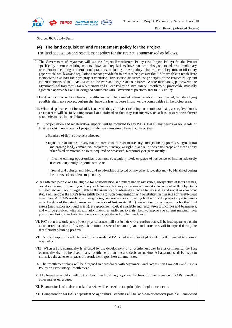
Transmission Project Preparatory Survey Phase III
Final Report (Advanced Release)
4-82
Source: JICA Study Team
(4) The land acquisition and resettlement policy for the Project
The land acquisition and resettlement policy for the Project is summarized as follows.
I. The Government of Myanmar will use the Project Resettlement Policy (the Project Policy) for the Project
specifically because existing national laws and regulations have not been designed to address involuntary
resettlement according to international practices, including JICA's policy. The Project Policy aims to fill in any
gaps which local laws and regulations cannot provide for in order to help ensure that PAPs are able to rehabilitate
themselves to at least their pre-project condition. This section discusses the principles of the Project Policy and
the entitlements of the PAPs based on the type and degree of their losses. Where there are gaps between the
Myanmar legal framework for resettlement and JICA's Policy on Involuntary Resettlement, practicable, mutually
agreeable approaches will be designed consistent with Government practices and JICA's Policy.
II. Land acquisition and involuntary resettlement will be avoided where feasible, or minimized, by identifying
possible alternative project designs that have the least adverse impact on the communities in the project area.
III. Where displacement of households is unavoidable, all PAPs (including communities) losing assets, livelihoods
or resources will be fully compensated and assisted so that they can improve, or at least restore their former
economic and social conditions.
IV. Compensation and rehabilitation support will be provided to any PAPs, that is, any person or household or
business which on account of project implementation would have his, her or their:
: Standard of living adversely affected;
: Right, title or interest in any house, interest in, or right to use, any land (including premises, agricultural
and grazing land), commercial properties, tenancy, or right in annual or perennial crops and trees or any
other fixed or moveable assets, acquired or possessed, temporarily or permanently;
: Income earning opportunities, business, occupation, work or place of residence or habitat adversely
affected temporarily or permanently; or
: Social and cultural activities and relationships affected or any other losses that may be identified during
the process of resettlement planning.
V. All affected people will be eligible for compensation and rehabilitation assistance, irrespective of tenure status,
social or economic standing and any such factors that may discriminate against achievement of the objectives
outlined above. Lack of legal rights to the assets lost or adversely affected tenure status and social or economic
status will not bar the PAPs from entitlements to such compensation and rehabilitation measures or resettlement
objectives. All PAPs residing, working, doing business and/or cultivating land within the project impacted areas
as of the date of the latest census and inventory of lost assets (IOL), are entitled to compensation for their lost
assets (land and/or non-land assets), at replacement cost, if available and restoration of incomes and businesses,
and will be provided with rehabilitation measures sufficient to assist them to improve or at least maintain their
pre-project living standards, income-earning capacity and production levels.
VI. PAPs that lose only part of their physical assets will not be left with a portion that will be inadequate to sustain
their current standard of living. The minimum size of remaining land and structures will be agreed during the
resettlement planning process.
VII. People temporarily affected are to be considered PAPs and resettlement plans address the issue of temporary
acquisition.
VIII. When a host community is affected by the development of a resettlement site in that community, the host
community shall be involved in any resettlement planning and decision-making. All attempts shall be made to
minimize the adverse impacts of resettlement upon host communities.
IX. The resettlement plans will be designed in accordance with Myanmar Land Acquisition Law 2019 and JICA's
Policy on Involuntary Resettlement.
X. The Resettlement Plan will be translated into local languages and disclosed for the reference of PAPs as well as
other interested groups.
XI. Payment for land and/or non-land assets will be based on the principle of replacement cost.
XII. Compensation for PAPs dependent on agricultural activities will be land-based wherever possible. Land-based
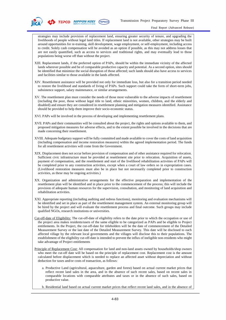
Transmission Project Preparatory Survey Phase III
Final Report (Advanced Release)
4-83
strategies may include provision of replacement land, ensuring greater security of tenure, and upgrading the
livelihoods of people without legal land titles. If replacement land is not available, other strategies may be built
around opportunities for re-training, skill development, wage employment, or self-employment, including access
to credit. Solely cash compensation will be avoided as an option if possible, as this may not address losses that
are not easily quantified, such as access to services and traditional rights, and may eventually lead to those
populations being worse off than without the project.
XIII. Replacement lands, if the preferred option of PAPs, should be within the immediate vicinity of the affected
lands wherever possible and be of comparable productive capacity and potential. As a second option, sites should
be identified that minimize the social disruption of those affected; such lands should also have access to services
and facilities similar to those available in the lands affected.
XIV. Resettlement assistance will be provided not only for immediate loss, but also for a transition period needed
to restore the livelihood and standards of living of PAPs. Such support could take the form of short-term jobs,
subsistence support, salary maintenance, or similar arrangements.
XV. The resettlement plan must consider the needs of those most vulnerable to the adverse impacts of resettlement
(including the poor, those without legal title to land, ethnic minorities, women, children, and the elderly and
disabled) and ensure they are considered in resettlement planning and mitigation measures identified. Assistance
should be provided to help them improve their socio-economic status.
XVI. PAPs will be involved in the process of developing and implementing resettlement plans.
XVll. PAPs and their communities will be consulted about the project, the rights and options available to them, and
proposed mitigation measures for adverse effects, and to the extent possible be involved in the decisions that are
made concerning their resettlement.
XVIII. Adequate budgetary support will be fully committed and made available to cover the costs of land acquisition
(including compensation and income restoration measures) within the agreed implementation period. The funds
for all resettlement activities will come from the Government.
XIX. Displacement does not occur before provision of compensation and of other assistance required for relocation.
Sufficient civic infrastructure must be provided at resettlement site prior to relocation. Acquisition of assets,
payment of compensation, and the resettlement and start of the livelihood rehabilitation activities of PAPs will
be completed prior to any construction activities, except when a court of law orders so in expropriation cases.
(Livelihood restoration measures must also be in place but not necessarily completed prior to construction
activities, as these may be ongoing activities.)
XX. Organization and administrative arrangements for the effective preparation and implementation of the
resettlement plan will be identified and in place prior to the commencement of the process; this will include the
provision of adequate human resources for the supervision, consultation, and monitoring of land acquisition and
rehabilitation activities.
XXI. Appropriate reporting (including auditing and redress functions), monitoring and evaluation mechanisms will
be identified and set in place as part of the resettlement management system. An external monitoring group will
be hired by the project and will evaluate the resettlement process and final outcome. Such groups may include
qualified NGOs, research institutions or universities.
Cut-off-date of Eligibility: The cut-off-date of eligibility refers to the date prior to which the occupation or use of
the project area makes residents/users of the same eligible to be categorized as PAPs and be eligible to Project
entitlements. In the Project, the cut-off-date for titleholders will be the date of commencement of the Detailed
Measurement Survey or the last date of the Detailed Measurement Survey. This date will be disclosed to each
affected village by the relevant local governments and the villages will disclose this to their populations. The
establishment of the eligibility cut-off-date is intended to prevent the influx of ineligible non-residents who might
take advantage of Project entitlements
Principle of Replacement Cost: All compensation for land and non-land assets owned by households/shop owners
who meet the cut-off date will be based on the principle of replacement cost. Replacement cost is the amount
calculated before displacement which is needed to replace an affected asset without depreciation and without
deduction for taxes and/or costs of transaction, as follows:
a. Productive Land (agricultural, aquaculture, garden and forest) based on actual current market prices that
reflect recent land sales in the area, and in the absence of such recent sales, based on recent sales in
comparable locations with comparable attributes and taxes or in the absence of such sales, based on
productive value.
b. Residential land based on actual current market prices that reflect recent land sales, and in the absence of

Transmission Project Preparatory Survey Phase III
Final Report (Advanced Release)
4-84
such recent land sales, based on prices of recent sales in comparable locations with comparable attributes,
fees and taxes.
c. Existing local government regulations for compensation calculations for buildings, crops and trees will be
used wherever available.
d. Houses and other related structures based on actual current market prices of affected materials.
e. Annual crops equivalent to three times the current market value of the annual yield of crops, or lost harvest
timing of crops for temporal impacts, at the time of compensation.
f. For perennial crops, cash compensation at replacement cost that should be in line with local government
regulations, if available, is equivalent to current market value given the type and age at the time of
compensation, plus three times the current market value of the annual yield, or lost harvest timing for
temporal impact.
g. For standing trees, including timber trees cultivated on the acquired land, cash compensation at three times
the market price that should be in line with local government regulations, if available, for each type, age and
relevant productive value at the time of compensation based on the diameter at breast height of each tree.
(Act 2019 33 (a) 4)
Source: JICA Study Team
Location and Scale of Land Acquisition and Resettlement
(1) New Construction of the 500 kV Sar Ta Lin Substation
Based on a request by DPTSC, 24.3 ha (60 acres) will be selected for the site for the new 500 kV
substation. The existing land use of the site is irrigated rice paddy with 2 harvests per year. Houses
surrounded by various trees are scattered in the matrix of the rice paddy. No temporary lease of land
is planned for the substation.
Purple: Substation site
Source: JICA Study Team
Figure 4.2-4 500kV Sar Ta Lin Substation Site Close-up

Transmission Project Preparatory Survey Phase III
Final Report (Advanced Release)
4-85
Source: JICA Study Team
Figure 4.2-5 500kV Sar Ta Lin Substation Site and Surrounding Area
(2) New Construction and Improvement of Transmission Lines
Transmission Lines
The Project contains 4 transmission line routes, as shown inTable 4.2-6 . The Hlawga - Thaketa
Line is improvement (voltage increase) work within already existing ROW. The other three lines are
new constructions.
Table 4.2-6 New Constructions and Improvement of Transmission Lines
No. Voltage Start End Overhead Under- Total
New Improvement ground
1 500 kV Pharyargyii Sar Ta Lin 70.0 km - - 70.0 km
2 230 kV Sar Ta Lin East Dagon 18.0 km - - 18.0 km
3 230 kV Sar Ta Lin Hlawga 16.9 km - 4.6 km
6.0 km 27.5 km
4 230 kV Hlawga Thaketa - 18.0 km 5.7 km 23.7 km
Total 104.9 km 18.0 km 16.3 km 139.2 km
Source: JICA Study Team
Permanent impacts from the above transmission line work include the occupation of land for 4
foundation blocks per tower, and land use (height) limitations of the land within the ROW.
During the construction of the towers on farmland, relatively large excavations will be necessary,
as shown in the figure below. After finishing the base concrete work, however, 4 separated base blocks
will remain on the ground surface, and DPTSC has explained that the land owner can continue farming
even under the towers after the completion of the work. With such conditions, DPTSC does not acquire
ownership rights or farming rights for the land under the towers. DPTSC pays cash for a land lease
during the construction work that is equivalent to the size of the loss of harvest caused by the land
Sar Ta Lin

Transmission Project Preparatory Survey Phase III
Final Report (Advanced Release)
4-86
lease.
Source: DPTSC
Figure 4.2-6 Land Occupation by DPTSC under the Transmission Towers
Temporary land lease during the construction will be necessary for the access road between the
towers (within ROW, width about 4m (14ft)), for the work areas around the tower foundations, and
for the yard for stocks and machinery.
Underground transmission lines are planned for areas where the lines need to cross existing urban
areas. Since the underground lines are planned to be under existing roads, no permanent acquisition
of private land is necessary. Permanent facilities such as maintenance manholes will be set within the
road ROW. Temporary land lease will be necessary with overhead transmission lines for storage.
The ROW where transmission line improvement work is planned is defined by a road and ditches
on both side, and it is basically open land in between. Houses and shops are situated along the crossing
road where the road crosses the ROW. The improvement work will consist of the removal of existing
lines and towers, the construction of new, higher towers, and the stringing of the transmission lines.
All this work, including temporary storage and work areas with tall cranes, will use the space within
the ROW. Access to the ROW from the adjacent road may require the temporary lease of privately
owned vacant land.

Transmission Project Preparatory Survey Phase III
Final Report (Advanced Release)
4-87
Source: JICA Study Team
Figure 4.2-7 Route of the 500kV Transmission Line (Purple: Pharyargyii SS to Sar Ta Lin SS)
Source: JICA Study Team
Figure 4.2-8 New 230kV Overhead Transmission Lines (Red)
Sar Ta Lin SS
Hlawga SS
East Dagon SS

Transmission Project Preparatory Survey Phase III
Final Report (Advanced Release)
4-88
Source: JICA Study Team
Figure 4.2-9 Existing 230kV Transmission Line (Orange: Overhead, Blue: New underground)
Land Lease for Tower Foundations
The work area surrounding the base of the transmission line towers will be leased during the
Construction Phase. The required land area totals 5.6 ha, as shown in the table below.
Table 4.2-7 Estimated Size of Land Acquisition for Transmission Line
Construction
No. Voltage Start End Number of
Towers
Side
Length
Average Area per
Tower
Total
1 500 kV Pharyargyii Sar Ta Lin 152 15-20m 243m2 3.7ha
2 230 kV Sar Ta Lin East
Dagon 45
0.9ha
3 230 kV Sar Ta Lin Hlawga 45 14-16m 207m2 1.0ha
4 230 kV Hlawga Thaketa (51)* -*
Total 242 5.6ha
*: Located within existing ROW
Source: JICA Study Team
Temporary Lease of Land for the Access Road during the Construction Phase
To construct the overhead transmission lines, temporary access roads will be constructed within
ROW with a width of 4m (14ft). The total area to be leased is estimated as 42.0 ha.
Table 4.2-8 Temporary Leases of Land for the Access Road during the
Construction Phase
No. Voltage Start End Length Width of Necessary
New Improvement Access Road Area
1 500 kV Pharyargyii Sar Ta Lin 70.0 km - 28.0 ha
Hlawga SS
Thaketa SS

Transmission Project Preparatory Survey Phase III
Final Report (Advanced Release)
4-89
No. Voltage Start End Length Width of Necessary
New Improvement Access Road Area
2 230 kV Sar Ta Lin East Dagon 18.0 km - 4m 7.2 ha
3 230 kV Sar Ta Lin Hlawga 16.9 km - 6.8 ha
4 230 kV Hlawga Thaketa - 18.0 km -*
Total 104.9 km 18.0 km 42.0 ha
*Located within existing ROW
Source: JICA Study Team
Area of New ROW
As shown in Table 4.2-9, land use within the ROW of the overhead transmission line will have a
height limit restriction. The width of the ROW is about 61m for the 500kV line and about 46m for
230kV lines. The total area to be newly affected is calculated as about 590ha.
Table 4.2-9 Area of Newly Designated ROW
No. Voltage Start End Length Width Area
1 500 kV Pharyargyii Sar Ta Lin 70.0 km 60.96m 426.7ha
2 230 kV Sar Ta Lin East Dagon 18.0 km 82.3ha
3 230 kV Sar Ta Lin Hlawga 16.9 km 45.72m 77.3ha
4 230 kV Hlawga Thaketa - -
Total 104.9 km 586.3ha
-: Use already existing ROW
Source: JICA Study Team
(3) Population Census
Sar Ta Lin Substation
Direct displacement of residents will not occur due to the new substation constructions because the
site boundary is set to avoid any existing structures.
Since the satellite photo shows 81 lots of rice paddies surrounded by footpaths, the maximum
number of land owner households to be affected at the site can be estimated as 81.
In the implementation phase of the Project, affected land owners will be identified, and a population
census for them will be carried out.
Because the rice paddies within the site receive irrigation water, it can be assumed that the paddies
are covered by a regional, strategic farming plan or project. Therefore, it can be assumed that the land
owners will be either legal owners or customary owners, and will not include illegal occupation.
Other Project Affected Peoples (PAPs) who will not be relocated by the Project, such as seasonal
agricultural wage laborers or temporary agricultural wage laborers, will be identified and a population
census for them will be carried out during the implementation phase of the Project.
No temporary lease of land is planned for the construction of the substation.

Transmission Project Preparatory Survey Phase III
Final Report (Advanced Release)
4-90
Table 4.2-10 Population Census of the PAPs from the Construction of the Sar Ta
Lin Substation
Type of loss No of PAUs No of APs
Legal Illegal Total Legal Illegal Total
Physical displacement required
1 HH (Structure owner on Gov. land) 0 0 0 0 0 0
2 HH (Structure on Private land) 0 0 0 0 0 0
3 HH (Tenants) 0 0 0 0 0 0
4 CBEs (Structure owner on Gov. land) 0 0 0 0 0 0
5 CBEs (Structure owner on Private land) 0 0 0 0 0 0
6 CBEs (Tenants) 0 0 0 0 0 0
7 Community-owned structures including
physical cultural resources 0 0 0 0 0 0
Sub-total 0 0 0 0 0 0
Physical displacement not required a
8 Land owners Max 81 0 Max 81 371 - 371
9 Wage earners b 0 b b - b
Sub-total Max 81 0 Max 81 371 - 371
Grand Total (1-9) Max 81 0 Max 81 371 0 371
HH: House-hold, CBEs: Commercial and Business Enterprises
a: The number is an estimation. The 81 lots of rice paddies surrounded by footpaths is estimated as the maximum
number of land owner households. Number of affected persons is calculated by assuming an average household
size of 4.57 persons per household.
b: Seasonal and temporal laborers to be affected will be identified in the implementation phase of the Project
Source: JICA Study Team
Transmission Lines
In total, 5.6 ha for construction of the towers, and 42.0 ha for the access road between the towers
will be leased to construct the transmission lines. In addition, new ROW of about 590 ha will be subject
to land use restrictions (height limit). DPTSC has a policy of avoiding not only affecting existing
structures, but also affecting residential plots in the decision on tower locations. The proposed routes
and ROWs were studied by the JICA Study Team and the Team agreed that technically existing
structures can be avoided. Therefore, no relocation of residents, businesses, or commercial entities is
expected.
The size of the work areas for the tower base is 10 to 20 m square for a 500kV tower, and 14 to 16
m square for a 230kV tower. These areas are far smaller than the average size of one rice paddy in the
Study Area. Therefore, it can be assumed that one land owner will be affected by the construction of
one tower. The maximum number of land owner households to be affected by the 242 transmission
towers was assumed as 242.
In the implementation phase of the Project, affected land owners, seasonal or temporary agricultural
wage laborers, and businesses who will be affected by the temporal land lease and/or land use
restrictions will be identified, and a population census for them will be carried out.

Transmission Project Preparatory Survey Phase III
Final Report (Advanced Release)
4-91
Table 4.2-11 Population Census of the PAPs from the Construction of the
Transmission Lines
Type of loss No of PAUs No of APs
Legal Illegal Total Legal Illegal Total
Physical displacement required
1 HH (Structure owner on Gov. land ) 0 0 0 0 0 0
2 HH (Structure on Private land) 0 0 0 0 0 0
3 HH (Tenants) 0 0 0 0 0 0
4 CBEs (Structure owner on Gov. land) 0 0 0 0 0 0
5 CBEs (Structure owner on Private land) 0 0 0 0 0 0
6 CBEs (Tenants) 0 0 0 0 0 0
7 Community-owned structures including physical
cultural resources 0 0 0 0 0 0
Sub-total 0 0 0 0 0 0
Physical displacement not required (land lease during
construction for tower base) a
8 Land owners Max
242 b
Max
242 1,106 b 1,106
9 Wage earners b b b b b b
Sub-total Max
242 b
Max
242 1,106 b 1,106
Grand Total (1-9) Max
242 b
Max
242 1,106 b 1,106
HH: House-hold, CBEs: Commercial and Business Enterprises
a: The number is an estimation. The 81 lots of rice paddies surrounded by footpaths is estimated as the maximum
number of land owner households. Number of affected persons is calculated by assuming an average household
size of 4.57 persons per household.
b: Seasonal or temporary laborers to be affected will be identified in the next phase of the Project
Source: JICA Study Team
(4) Land Survey and Asset Census
Sar Ta Lin Substation
According to past and recent satellite photos, 25.0ha of land is currently used for rice paddies, or
was used for rice paddies. The land type, therefore, is expected to be registered farm land. Official
land type information needs to be obtained from the Hlegu Township Department of Agriculture, Land
Management and Statistics during the implementation phase of the Project.
Table 4.2-12 Land Area to be Affected by the Construction of the Sar Ta Lin
Substation
No
. Location Land Type Affected Total
1 Hlegu Township
Farm Land 25.0 ha 25.0 ha
2 Other land a
Total 25.0 ha
a: Need final confirmation by Hlegu Township Department of
Agriculture, Land Management and Statistics.
Source: JICA Study Team
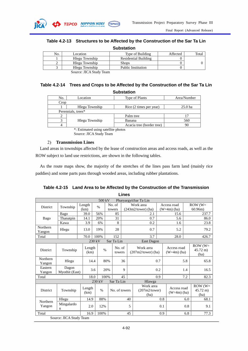
Transmission Project Preparatory Survey Phase III
Final Report (Advanced Release)
4-92
Table 4.2-13 Structures to be Affected by the Construction of the Sar Ta Lin
Substation
No. Location Type of Building Affected Total
1 Hlegu Township Residential Building 0
2 Hlegu Township Shops 0 0
3 Hlegu Township Public Institution 0
Source: JICA Study Team
Table 4.2-14 Trees and Crops to be Affected by the Construction of the Sar Ta Lin
Substation
No. Location Type of Plants Area/Number
Crop
1 Hlegu Township Rice (2 times per year) 25.0 ha
Perennials, trees*
2
Hlegu Township
Palm tree 17
3 Banana 560
4 Acacia tree (border tree) 90
*: Estimated using satellite photos
Source: JICA Study Team
Transmission Lines
Land areas in townships affected by the lease of construction areas and access roads, as well as the
ROW subject to land use restrictions, are shown in the following tables.
As the route maps show, the majority of the stretches of the lines pass farm land (mainly rice
paddies) and some parts pass through wooded areas, including rubber plantations.
Table 4.2-15 Land Area to be Affected by the Construction of the Transmission
Lines
500 kV PharyargyiiSar Ta Lin
District Township Length
(km) %
No. of
towers
Work area
(243m2/tower) (ha)
Access road
(W=4m) (ha)
ROW (W=
60.96m)
Bago
Bago 39.0 56% 85 2.1 15.6 237.7
Thanatpin 14.1 20% 31 0.7 5.6 86.0
Kawa 3.9 6% 8 0.2 1.6 23.8
Northern
Yangon Hlegu 13.0 19% 28 0.7 5.2 79.2
Total 70.0 100% 152 3.7 28.0 426.7
230 kV Sar Ta Lin East Dagon
District Township Length
(km) %
No. of
towers
Work area
(207m2/tower) (ha)
Access road
(W=4m) (ha)
ROW (W=
45.72 m)
(ha)
Northern
Yangon Hlegu 14.4 80% 36 0.7 5.8 65.8
Eastern
Yangon
Dagon
Myothit (East) 3.6 20% 9 0.2 1.4 16.5
Total 18.0 100% 45 0.9 7.2 82.3
230 kV Sar Ta Lin Hlawga
District Township Length
(km) % No. of towers
Work area
(207m2/tower)
(ha)
Access road
(W=4m) (ha)
ROW (W=
45.72 m)
(ha)
Northern
Yangon
Hlegu 14.9 88% 40 0.8 6.0 68.1
Mingalardo
n 2.0 12% 5 0.1 0.8 9.1
Total 16.9 100% 45 0.9 6.8 77.3
Source: JICA Study Team

Transmission Project Preparatory Survey Phase III
Final Report (Advanced Release)
4-93
(Existing ROW)
230 kV Hlawga Thaketa (Existing ROW)
District Township Length (km) % No. of towers
Northern
Yangon Mingalardon 3.4 19% 10
Eastern
Yangon
North Okkalapa 1.5 8% 4
Dagon Myothit (North) 7.9 44% 22
Dagon Myothit (South) 4.9 27% 14
Thaketa 0.3 2% 1
Total 18.0 100% 51
Source: JICA Study Team
Table 4.2-16 Impacts by Township
Length of Transmission Line
District Township 500kV Sar-ED Sar-Hlawga
(overhead)
Hlawga-
Thake
(east of NH3)
Total
Bago
Bago 39.0 39.0
Thanatpin 14.1 14.1
Kawa 3.9 3.9
Northern
Yangon
Hlegu 13.0 14.4 14.9 42.3
Mingalardon 2.0 (3.4) 2.0
(3.4)
Eastern Yangon
Dagon Myothit (East) 3.6 3.6
North Okkalapa (1.5) (1.5)
Dagon Myothit (North) (7.9) (7.9)
Dagon Myothit (South) (4.9) (4.9)
Thaketa (0.3) (0.3)
Total 70.0 18.0 16.9 (18.0) 104.9
(18.0)
(): Within the existing ROW
Number of Transmission Line Towers (Pylon)
District Township 500kV Sar-ED Sar-Hlawga
(overhead)
Hlawga-Thake (east
of NH3) Total
Bago
Bago 85 85
Thanatpin 31 31
Kawa 8 8
Northern
Yangon
Hlegu 28 36 40 104
Mingalardon 5 (10) 5
(10)
Eastern
Yangon
Dagon Myothit (East) 9 9
North Okkalapa (4) (4)
Dagon Myothit (North) (22) (22)
Dagon Myothit (South) (14) (14)
Thaketa (1) (1)
Total 152 45 45 (51) 242
(51)
(): Within the existing ROW
Source: JICA Study Team
Table 4.2-17 Land Lease Area by Township (ha)
500kV Sar-ED Sar-Hlawga
(overhead)
Hlawga-
Thake
(east of NH3)
Total
District Township Work
area Access
road Work
area Access
road Work
area Access
road Work
area Access
road
Bago Bago 2.1 15.6* 17.7
Thanatpin 0.7 5.6 6.4
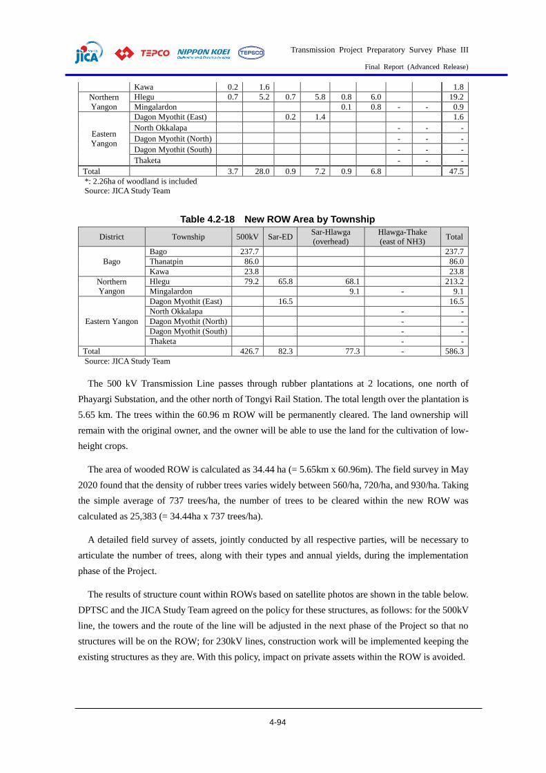
Transmission Project Preparatory Survey Phase III
Final Report (Advanced Release)
4-94
Kawa 0.2 1.6 1.8
Northern
Yangon
Hlegu 0.7 5.2 0.7 5.8 0.8 6.0 19.2
Mingalardon 0.1 0.8 - - 0.9
Eastern
Yangon
Dagon Myothit (East) 0.2 1.4 1.6
North Okkalapa - - -
Dagon Myothit (North) - - -
Dagon Myothit (South) - - -
Thaketa - - -
Total 3.7 28.0 0.9 7.2 0.9 6.8 47.5
*: 2.26ha of woodland is included
Source: JICA Study Team
Table 4.2-18 New ROW Area by Township
District Township 500kV Sar-ED Sar-Hlawga
(overhead)
Hlawga-Thake
(east of NH3) Total
Bago
Bago 237.7 237.7
Thanatpin 86.0 86.0
Kawa 23.8 23.8
Northern
Yangon
Hlegu 79.2 65.8 68.1 213.2
Mingalardon 9.1 - 9.1
Eastern Yangon
Dagon Myothit (East) 16.5 16.5
North Okkalapa - -
Dagon Myothit (North) - -
Dagon Myothit (South) - -
Thaketa - -
Total 426.7 82.3 77.3 - 586.3
Source: JICA Study Team
The 500 kV Transmission Line passes through rubber plantations at 2 locations, one north of
Phayargi Substation, and the other north of Tongyi Rail Station. The total length over the plantation is
5.65 km. The trees within the 60.96 m ROW will be permanently cleared. The land ownership will
remain with the original owner, and the owner will be able to use the land for the cultivation of low-
height crops.
The area of wooded ROW is calculated as 34.44 ha (= 5.65km x 60.96m). The field survey in May
2020 found that the density of rubber trees varies widely between 560/ha, 720/ha, and 930/ha. Taking
the simple average of 737 trees/ha, the number of trees to be cleared within the new ROW was
calculated as 25,383 (= 34.44ha x 737 trees/ha).
A detailed field survey of assets, jointly conducted by all respective parties, will be necessary to
articulate the number of trees, along with their types and annual yields, during the implementation
phase of the Project.
The results of structure count within ROWs based on satellite photos are shown in the table below.
DPTSC and the JICA Study Team agreed on the policy for these structures, as follows: for the 500kV
line, the towers and the route of the line will be adjusted in the next phase of the Project so that no
structures will be on the ROW; for 230kV lines, construction work will be implemented keeping the
existing structures as they are. With this policy, impact on private assets within the ROW is avoided.

Transmission Project Preparatory Survey Phase III
Final Report (Advanced Release)
4-95
Table 4.2-19 Structure Count within ROWs based on Satellite Photos and
Handling Policy No. Voltage Start End Overhead Number of
DPTSC and the JICA Study Team Policy New Existing Structures
1 500 kV Phayargi Sar Ta
Lin
70.0
km - 38
Location of the towers and route will be adjusted
so that no structures will be on the ROW
2 230 kV Sar Ta
Lin
East
Dagon
18.0
km -
67
On No.7
Road: 60 Other: 7
Location of the towers will be adjusted so that
existing structures will not be affected during the
construction, and will remain as-is after the construction
3 230 kV Sar Ta
Lin Hlawga
16.9
km - 6
Location of the towers will be adjusted so that
existing structures will not be affected during the
construction, and will remain as-is after the construction
4 230 kV Hlawga Thaketa - 18.0 km 433
With the demolition of existing towers and lines,
and with the construction of new towers and lines, construction methods and locations will be
selected so that existing structures will not be
affected during the construction, and will remain as-is after the construction
Source: JICA Study Team

Transmission Project Preparatory Survey Phase III
Final Report (Advanced Release)
4-96
Source: JICA Study Team
Figure 4.2-10 Existing Structures (AA01-AA38) and 500kV Transmission Line Route

Transmission Project Preparatory Survey Phase III
Final Report (Advanced Release)
4-97
Source: JICA Study Team
Figure 4.2-11 Existing Structures (BA01-BA67) and 230kV Transmission Line Route (Sar Ta Lin-East Dagon)

Transmission Project Preparatory Survey Phase III
Final Report (Advanced Release)
4-98
Source: JICA Study Team
Figure 4.2-12 Existing Structures (BA01-BA06) and 230kV Transmission Line Route (Sar Ta Lin-Hlawga)
Source: JICA Study Team
Figure 4.2-13 Existing Towers (HT), ROW (Green), and Structures (Red circles) along the 230kV Transmission Line (Hlawga-Thaketa)
(5) Livelihood and Living Conditions Survey
Literature survey results on the livelihood and living conditions in the area to be affected are
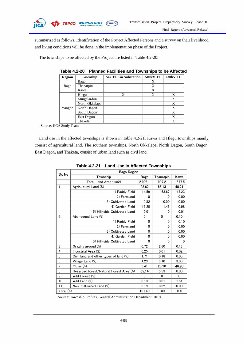
Transmission Project Preparatory Survey Phase III
Final Report (Advanced Release)
4-99
summarized as follows. Identification of the Project Affected Persons and a survey on their livelihood
and living conditions will be done in the implementation phase of the Project.
The townships to be affected by the Project are listed in Table 4.2-20.
Table 4.2-20 Planned Facilities and Townships to be Affected
Region Township Sar Ta Lin Substation 500kV TL 230kV TL
Bago
Bago X
Thanatpin X
Kawa X
Yangon
Hlegu X X X
Mingalardon X
North Okkalapa X
North Dagon X
South Dagon X
East Dagon X
Thaketa X
Source: JICA Study Team
Land use in the affected townships is shown in Table 4.2-21. Kawa and Hlegu townships mainly
consist of agricultural land. The southern townships, North Okkalapa, North Dagon, South Dagon,
East Dagon, and Thaketa, consist of urban land such as civil land.
Table 4.2-21 Land Use in Affected Townships
Sr. No Bago Region
Township Bago Thanatpin Kawa
Total Land Area (km2) 2,905.1 997.2 1,677.5
1 Agricultural Land (%) 28.62 65.13 48.21
1) Paddy Field 14.59 63.67 47.23
2) Farmland 0 0 0.00
3) Cultivated Land 0.82 0.00 0.00
4) Garden Field 13.20 1.46 0.98
5) Hill-side Cultivated Land 0.01 0 0.01
2 Abandoned Land (%) 0 0 0.10
1) Paddy Field 0 0 0.10
2) Farmland 0 0 0.00
3) Cultivated Land 0 0 0.00
4) Garden Field 0 0 0.00
5) Hill-side Cultivated Land 0 0 0
3 Grazing ground (%) 0.72 2.60 0.13
4 Industrial Area (%) 0.25 0.01 0.02
5 Civil land and other types of land (%) 1.71 0.18 0.05
6 Village Land (%) 1.23 3.10 3.00
7 Other (%) 5.41 28.98 46.98
8 Reserved forest/Natural Forest Area (%) 55.14 5.53 0.00
9 Wild Forest (%) 0 0 0
10 Wild Land (%) 0.13 0.01 1.51
11 Non-cultivated Land (%) 8.19 0.82 0.00
Total (%) 101.40 100 100
Source: Township Profiles, General Administration Department, 2019
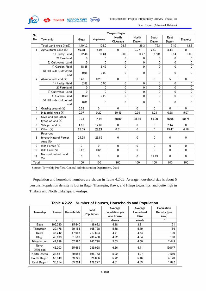
Transmission Project Preparatory Survey Phase III
Final Report (Advanced Release)
4-100
Sr.
No
Yangon Region
Township Hlegu Mingalardon North
Okkalapa
North
Dagon
South
Dagon
East
Dagon Thaketa
Total Land Area (km2) 1,494.2 108.0 26.7 26.3 79.1 91.0 12.8
1 Agricultural Land (%) 40.88 16.06 0 0.77 27.31 8.14 0
1) Paddy Field 22.46 10.64 0.00 0.77 27.31 8.14 0.00
2) Farmland 0 0 0 0 0 0 0
3) Cultivated Land 0 0 0 0 0 0 0
4) Garden Field 18.36 5.42 0 0 0 0 0
5) Hill-side Cultivated
Land 0.06 0.00 0 0 0 0 0
2 Abandoned Land (%) 3.43 0.20 0 0 0 5 0
1) Paddy Field 2.82 0.00 0 0 0 0 0
2) Farmland 0 0 0 0 0 0 0
3) Cultivated Land 0 0 0 0 0 0 0
4) Garden Field 0.60 0.20 0 0 0 0 0
5) Hill-side Cultivated
Land 0.01 0 0 0 0 0 0
3 Grazing ground (%) 0.59 0 0 0 0 0 0
4 Industrial Area (%) 0.07 0.20 30.49 0.39 1.21 0.58 5.07
5 Civil land and other
types of land (%) 0.31 14.93 68.90 98.84 59.00 65.05 90.76
6 Village Land (%) 1.16 12.86 0 0 0 2.14 0
7 Other (%) 28.65 28.21 0.61 0 0 19.47 4.18
8
Reserved
forest/Natural Forest
Area (%)
24.28 26.89 0 0 0 0 0
9 Wild Forest (%) 0 0 0 0 0 0 0
10 Wild Land (%) 0.62 0.65 0 0 0 0 0
11 Non-cultivated Land
(%) 0 0 0 0 12.49 0 0
Total 100 100 100 100 100 100 100
Source: Township Profiles, General Administration Department, 2019
Population and household numbers are shown in Table 4.2-22. Average household size is about 5
persons. Population density is low in Bago, Thanatpin, Kawa, and Hlegu townships, and quite high in
Thaketa and North Okkalapa townships.
Table 4.2-22 Number of Houses, Households and Population
Township Houses Households Total
Population
Average
population per
one house
Average
Household
Size
Population
Density (per
km2)
a b c d=c/a e=c/b f
Bago 105,280 115,440 439,622 4.18 3.81 151
Thanatpin 29,178 30,185 165,738 5.68 5.49 166
Kawa 46,242 47,967 217,604 4.71 4.54 130
Hlegu 48,633 51,563 239,458 4.92 4.64 160
Mingalardon 47,699 57,380 263,798 5.53 4.60 2,443
North
Okkalapa 46,303 65,669 289,928 6.26 4.41 10,847
North Dagon 33,581 39,953 198,743 5.92 4.97 7,560
South Dagon 56,949 59,725 325,886 5.72 5.46 4,120
East Dagon 35,814 39,284 172,277 4.81 4.39 1,892
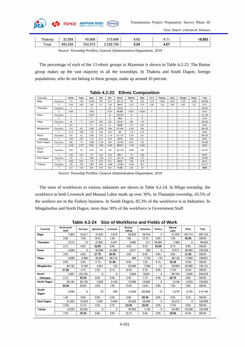
Transmission Project Preparatory Survey Phase III
Final Report (Advanced Release)
4-101
Thaketa 32,589 45,806 215,696 6.62 4.71 16,893
Total 482,268 552,972 2,528,750 5.24 4.57
Source: Township Profiles, General Administration Department, 2019
The percentage of each of the 13 ethnic groups in Myanmar is shown in Table 4.2-23. The Bamar
group makes up the vast majority in all the townships. In Thaketa and South Dagon, foreign
populations, who do not belong to these groups, make up around 10 percent.
Table 4.2-23 Ethnic Composition Township Kachin Kayar Kayin Chin Mon Bamar Rakhine Shan Pa O Palaung Danu Taungyo Kayan Total
Bago Population 115 104 16,329 463 5,517 390,116 793 822 1,574 5,568 2,837 2,165 2,205 428,608
% 0.03 0.03 3.66 0.11 1.26 88.73 0.18 0.19 0.36 1.29 0.64 0.49 0.5 97.47
Thanatpin Population 5 - 13 - 30 159,412 2 4 1 - - - - 159,467
% 0.003 - 0.008 - 0.018 96.183 0.0012 0.0024 0 - - - - 96.22
Kawa Population 1 - 4,524 - 22 208,592 19 6 - - - - - 213,164
% 0 - 2 - 0 95.8 0 0 - - - - - 97.80
Hlegu Population 36 2 12,231 600 239 222,421 388 125 - - - - - 236,042
% 0.01 - 5.1 0.25 0.1 92.88 0.16 0.05 - - - - - 98.55
Mingalardon Population 519 221 3,839 2,352 1,642 247,899 3,126 504 - - - - - 260,102
% 0.19 0.08 1.45 0.89 0.62 94 1.18 0.19 - - - - - 98.60
North Population 267 52 3,650 218 1,118 271,770 2,791 327 - - - - - 280,193
Okkalapa % 0.09 0.02 1.26 0.07 0.38 93.73 0.96 0.11 - - - - - 96.62
North Dagon Population 366 75 4,489 3,146 894 183,236 2,931 784 - - - - - 195,920 % 0.184 0.377 2.261 1.585 0.495 92.317 1.476 0.394 - - - - - 99.09
South
Dagon Population 824 35 3,474 709 765 287,146 4,600 208 - - - - - 297,761
% 0.25 0.01 1.07 0.22 0.24 88.11 1.41 0.06 - - - - - 91.37
East Dagon Population 107 18 2,004 1,236 370 162,140 2,588 310 - - - - - 169,040 % 0.06 0.01 1.16 0.72 0.21 94.12 1.66 0.18 - - - - - 98.12
Thaketa Population 792 706 1,807 840 1,886 174,889 5,436 861 - - - - - 187,217
% 0.37 0.33 0.84 0.39 0.87 81.08 2.52 0.4 - - - - - 86.80
Source: Township Profiles, General Administration Department, 2019
The sizes of workforces in various industries are shown in Table 4.2-24. In Hlegu township, the
workforce in both Livestock and Manual Labor made up over 30%. In Thanatpin township, 43.5% of
the workers are in the Fishery business. In South Dagon, 85.3% of the workforce is in Industries. In
Mingalardon and North Dagon, more than 30% of the workforce is Government Staff.
Table 4.2-24 Size of Workforce and Fields of Work
Township Government
Staff Services Agriculture Livestock
Buying/
Selling Industries Fishery
Manual
Labor Other Total
Bago 7,803 18,517 37,632 2,670 20,830 36,478 0 21,029 120,774 265,733
2.9% 7.0% 14.2% 1.0% 7.8% 13.7% 0.0% 7.9% 45.4% 100.0%
Thanatpin 3,512 15 27,681 5,437 3,665 211 36,903 7,399 0 84,823
4.1% 0.0% 32.6% 6.4% 4.3% 0.2% 43.5% 8.7% 0.0% 100.0%
Kawa 5,494 3 43,060 41,085 5,971 556 0 10,571 48,493 155,233
3.5% 0.0% 27.7% 26.5% 3.8% 0.4% 0.0% 6.8% 31.2% 100.0%
Hlegu 4,260 3,598 26,404 46,210 486 1,732 170 48,132 17,859 148,851
2.9% 2.4% 17.7% 31.0% 0.3% 1.2% 0.1% 32.3% 12.0% 100.0%
Mingalardon 40,732 6,100 2,841 153 25,000 7,300 15 22,000 25,000 129,141
31.5% 4.7% 2.2% 0.1% 19.4% 5.7% 0.0% 17.0% 19.4% 100.0%
North 5,087 123,102 0 0 5,850 18,821 0 89,783 2,035 244,678
Okkalapa 2.1% 50.3% 0.0% 0.0% 2.4% 7.7% 0.0% 36.7% 0.8% 100.0%
North Dagon 39,195 26,130 3,920 9,146 19,598 16,985 0 9,146 6,533 130,653 30.0% 20.0% 3.0% 7.0% 15.0% 13.0% 0.0% 7.0% 5.0% 100.0%
South
Dagon 2,940 0 70 460 12,029 182,605 10 9,279 6,792 214,185
1.4% 0.0% 0.0% 0.2% 5.6% 85.3% 0.0% 4.3% 3.2% 100.0%
East Dagon 21,955 16,830 5,381 5,994 30,328 26,040 0 22,372 0 128,900 17.0% 13.1% 4.2% 4.7% 23.5% 20.2% 0.0% 17.4% 0.0% 100.0%
Taketa 12,250 39,455 0 0 30,503 7,145 0 50,495 23,358 163,206 7.5% 24.2% 0.0% 0.0% 18.7% 4.4% 0.0% 30.9% 14.3% 100.0%
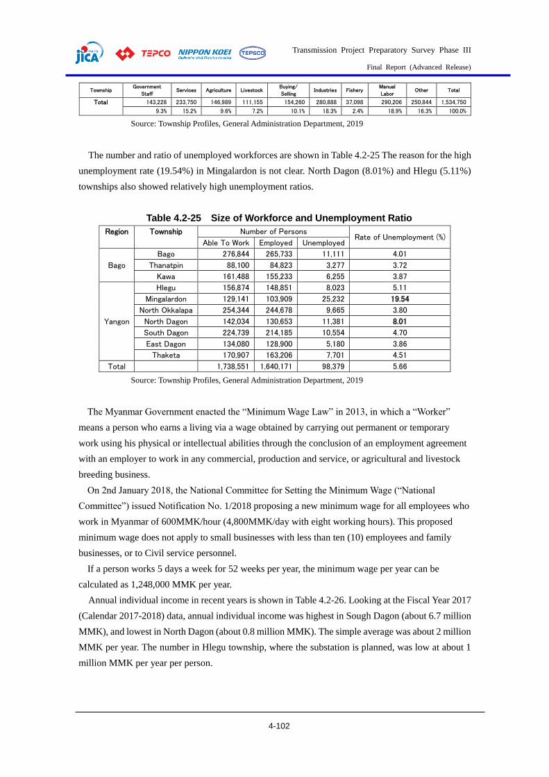
Transmission Project Preparatory Survey Phase III
Final Report (Advanced Release)
4-102
Township Government
Staff Services Agriculture Livestock
Buying/
Selling Industries Fishery
Manual
Labor Other Total
Total 143,228 233,750 146,989 111,155 154,260 280,888 37,098 290,206 250,844 1,534,750 9.3% 15.2% 9.6% 7.2% 10.1% 18.3% 2.4% 18.9% 16.3% 100.0%
Source: Township Profiles, General Administration Department, 2019
The number and ratio of unemployed workforces are shown in Table 4.2-25 The reason for the high
unemployment rate (19.54%) in Mingalardon is not clear. North Dagon (8.01%) and Hlegu (5.11%)
townships also showed relatively high unemployment ratios.
Table 4.2-25 Size of Workforce and Unemployment Ratio
Region Township Number of Persons Rate of Unemployment (%)
Able To Work Employed Unemployed
Bago
Bago 276,844 265,733 11,111 4.01
Thanatpin 88,100 84,823 3,277 3.72
Kawa 161,488 155,233 6,255 3.87
Yangon
Hlegu 156,874 148,851 8,023 5.11
Mingalardon 129,141 103,909 25,232 19.54
North Okkalapa 254,344 244,678 9,665 3.80
North Dagon 142,034 130,653 11,381 8.01
South Dagon 224,739 214,185 10,554 4.70
East Dagon 134,080 128,900 5,180 3.86
Thaketa 170,907 163,206 7,701 4.51
Total 1,738,551 1,640,171 98,379 5.66
Source: Township Profiles, General Administration Department, 2019
The Myanmar Government enacted the “Minimum Wage Law” in 2013, in which a “Worker”
means a person who earns a living via a wage obtained by carrying out permanent or temporary
work using his physical or intellectual abilities through the conclusion of an employment agreement
with an employer to work in any commercial, production and service, or agricultural and livestock
breeding business.
On 2nd January 2018, the National Committee for Setting the Minimum Wage (“National
Committee”) issued Notification No. 1/2018 proposing a new minimum wage for all employees who
work in Myanmar of 600MMK/hour (4,800MMK/day with eight working hours). This proposed
minimum wage does not apply to small businesses with less than ten (10) employees and family
businesses, or to Civil service personnel.
If a person works 5 days a week for 52 weeks per year, the minimum wage per year can be
calculated as 1,248,000 MMK per year.
Annual individual income in recent years is shown in Table 4.2-26. Looking at the Fiscal Year 2017
(Calendar 2017-2018) data, annual individual income was highest in Sough Dagon (about 6.7 million
MMK), and lowest in North Dagon (about 0.8 million MMK). The simple average was about 2 million
MMK per year. The number in Hlegu township, where the substation is planned, was low at about 1
million MMK per year per person.

Transmission Project Preparatory Survey Phase III
Final Report (Advanced Release)
4-103
Table 4.2-26 Annual individual Income (MMK)
Region Township 2016-2017 2017-2018 2018-2019
Bago
Bago 2,224,431 2,532,554 -
Thanatpin 1,229,164 1,305,676 1,424,772
Kawa 1,162,456 1,209,806 -
Yangon
Hlegu 966,166 1,099,779 -
Mingalardon 1,800,000 3,100,889 3,100,889
North Okkalapa 1,926,889 2,260,724 2,051,121
North Dagon 913,511 802,831 -
South Dagon 5,514,419 6,667,680 -
East Dagon 1,013,153 1,154,651 -
Thaketa 1,047,842 1,189,441 -
Average 1,779,803 2,132,403
Italic: Potentially lower than minimum wage income.
Source: Township Profiles, General Administration Department, 2019
Major infectious disease occurrences and deaths in Fiscal 2018 are shown in Table 4.2-27. In Hlegu
township, the number of Dysentery (waterborne) patients was the largest, followed by Diarrhea
(mainly waterborne) and Tuberculosis (airborne). Tuberculosis caused 56 deaths in the Study Area.
Table 4.2-27 Major Infectious Disease Occurrences and Deaths (2018-2019)
Township
Type of Disease
Malaria Diarrhea Tuberculosis (TB) Dysentery Hepatitis B
Occ. Deaths Occ. Deaths Occ. Deaths Occ. Deaths Occ. Deaths
Bago 14 - 1,255 - 315 - 58 - - -
Thanatpin - - 1,001 1 241 - 197 - 10 1
Kawa - - 1,779 - 292 15 241 - -
Hlegu 5 - 683 - 520 10 884 - 11 -
Mingalardon - - 907 - - - 393 - - -
North Okkalapa 4 1 46 1 768 13 6 - - -
North Dagon 1 - 6 - 228 - - - - -
South Dagon - - 130 - 729 18 23 - 5 -
East Dagon - - 232 - - - 54 - - -
Thaketa - - - - - - -
Total 24 1 6,039 2 3,093 56 1,856 0 26 1
Source: Township Profiles, General Administration Department, 2019
Living conditions of households by Region are shown in Table 4.2-28. The Bago Region has a
strong rural character, such as the ownership of houses and its sources of energy and water. In the
Yangon Region, however, houses are still built with wood floors and corrugated sheet roofs. Drinking
water is taken from Bottled/purifier water (34.4%), Tube well and borehole (25.5%), or Pool/pond/lake
(18.8%).
Table 4.2-28 Living Conditions of Households (2014)
Region Bago Yangon
Ownership of housing unit (Tenure) Owner 91.9% 64.5%
Renter 2.7% 24.5%

Transmission Project Preparatory Survey Phase III
Final Report (Advanced Release)
4-104
Region Bago Yangon Provided free (individually) 2.0% 3.4%
Government quarters 2.7% 4.9%
Private company quarters 0.4% 1.3%
Other 0.3% 1.4%
Material for housing
Wall Floor Roof Wall Floor Roof
Dhani/Theke/In leaf 3.6% - 39.3% 9.2% - 17.8%
Bamboo 62.5% 25.8% 0.4% 31.8% 15.6% 0.2%
Earth 0.1% 1.6% - <0.1% 0.5% -
Wood 23.5% 65.2% 0.1% 24.0% 52.0% 0.2%
Corrugated sheet 0.1% - 58.9% 1.5% - 76.3%
Tile/Brick/Concrete 9.4% 6.7% 0.6% 32.0% 30.7% 5.2%
Other 0.8% 0.7% 0.7% 1.5% 1.2% 0.3%
Main source of energy for cooking
Electricity 9.4% 47.1%
LPG 0.1% 2.0%
Kerosene 0.2% 0.1%
Biogas 0.1% 0.5%
Firewood 77.9% 26.2%
Charcoal 9.0% 21.0%
Coal 0.3% 0.4%
Other 3.0% 2.6%
Main source of energy for lighting
Electricity 27.7% 69.3%
Kerosene 8.8% 5.7%
Candles 28.9% 7.2%
Batteries 22.5% 11.8%
Generator (private) 4.5% 4.0%
Water mill (private) 0.1% Less than 0.1%
Solar system/energy 6.4% 1.6%
Other 1.1% 0.4%
Main source of drinking water
Tap water/piped 1.9% 13.3%
Tube well, borehole 49.7% 25.5%
Protected well/spring 18.4% 4.1%
Bottled/purifier water 3.6% 34.4%
TOTAL Improved 73.6% 77.3%
Unprotected well/spring 3.9% 1.8%
Pool/pond/lake 14.4% 18.8%
River/stream/canal 5.3% 0.7%
Waterfall/rainwater 0.8% 0.3%
Other 2.0% 1.1%
TOTAL Unimproved 26.4% 22.7%
Main source of water for non-drinking use
Tap water/piped 2.4% 24.4%
Tube well, borehole 55.2% 51.1%
Protected well/spring 18.2% 4.3%
Unprotected well/spring 3.9% 1.9%
Pool/pond/lake 11.4% 15.7%
River/stream/canal 6.3% 1.5%
Waterfall/rainwater 0.5% Less than 0.1%
Bottled/purifier water 0.1% 0.2%
Other 2.0% 0.9%
Type of toilet

Transmission Project Preparatory Survey Phase III
Final Report (Advanced Release)
4-105
Region Bago Yangon Flush 0.8% 6.3%
Water seal (Improved pit latrine) 73.8% 84.8%
Total Improved Sanitation 74.6% 91.1%
Pit (Traditional pit latrine) 7.9% 2.6%
Bucket (Surface latrine) 5.9% 2.7%
Other 0.9% 0.3%
None 10.7% 3.3%
Availability of communications amenities
Radio 38.0% 25.9%
Television 45.3% 71.6%
Landline phone 3.8% 8.2%
Mobile phone 26.2% 60.9%
Computer 1.4% 11.1%
Internet at home 3.9% 19.1%
% with none of the items 32.0% 17.8%
% with all of the items 0.2% 1.7%
Availability of Transportation equipment
Car/Truck/Van 1.2% 7.8%
Motorcycle/Moped 34.3% 13.6%
Bicycle 49.9% 46.2%
4-Wheel tractor 1.9% 1.2%
Canoe/Boat 3.8% 1.2%
Motor boat 1.2% 1.0%
Cart (bullock) 27.6% 4.8%
Source: The 2014 Myanmar Population and Housing Census: Bago Region, Yangon Region
(6) Vulnerable Groups
Sar Ta Lin Substation
No resettlement of residents or businesses is expected due to the construction of the substation.
Persons who will not be relocated but who will be affected by the land acquisition, such as tenant
farmers, will be identified after the official Detailed Measurement Survey by DPTSC, in the
implementation phase of the Project.
Literature surveys and field observations are in progress to ascertain the general conditions of the
poor, minority groups and other groups of concern in the Hlegu Township.
Transmission Lines
No resettlement of residents or businesses is expected due to the construction of the substation.
Persons who will not be relocated but who will be affected by the land acquisition and ROW
setting, such as tenant farmers, will be identified after the finalization of the route, and after the
official Detailed Measurement Survey by DPTSC, in the implementation phase of the Project.
Literature surveys and field observations are in progress to ascertain the general conditions of the
poor, minority groups and other groups of concern in the townships where the lines pass through.
Literature survey results on Vulnerable Groups in the area to be affected
The definition of Vulnerable Groups includes the following: all households headed by a woman,
with disabled persons, with elderly persons (over 60 years old) without the support of younger family,
and with an income below the poverty line.

Transmission Project Preparatory Survey Phase III
Final Report (Advanced Release)
4-106
The poverty line in 2017 was 1,590 MMK per adult equivalent per day (Table 4.2-29). Multiplied
by 365, the annual income for one adult household is calculated as 580,350 MMK. Using the Adult
Equivalence Scales shown in Table 4.2-30, the annual poverty line for a household with 2 adults and
2 children between 16 and 19 years old is calculated as 2,437,470 MMK, using the equation below.
1,590 MMK x (1.00 x 2 + 1.10 x 2) x 365 = 2,437,470 MMK
The ARAP Survey for the Project needs to obtain age information for all the members of the
households to be affected to understand their economic status.
Table 4.2-29 Poverty Line and Headcount, 2017
Poverty Line per adult equivalent per day, 2017 1,590 MMK
Poverty headcount %, 2017 Bago Region 17.4 %
Yangon Region 13.7 %
Union 24.8 %
Source: Report 03: Poverty Report, Myanmar Living Conditions Survey 2017, June 2019, World Bank
Table 4.2-30 Adult Equivalence Scales
Source: Report 03: Poverty Report, Myanmar Living Conditions Survey 2017, June 2019, World Bank
Annual income when working with the minimum wage is calculated as 1,248,000 MMK. Six
townships among all those to be affected by the Project showed lower average annual individual
incomes compared to the above income levels (Table 4.2-26). The most probable negative impact of
the Project on vulnerable groups, therefore, will be worsened poverty conditions caused by a decrease
or loss of income. Based on this assumption, mitigation measures for the short term were proposed,
including cash compensation of three times the annual agriculture income, and, for the long term,
measures including livelihood rehabilitation and assistance such as agricultural technical assistance
and opportunities for employment as staff at DPTSC.
When the removal of residential structures is required or livelihoods cannot be sustained with the
remaining productive assets because of public projects, the project owner authority in Myanmar,
including DPTSC, usually hires one person from the affected household and brings the household into
Transmission Project Preparatory Survey Phase III
Final Report (Advanced Release)
4-107
staff housing as a standard mitigation measure of compensation for the loss of housing and income.
In other words, DPTSC does not have experience of other types of additional assistance for
vulnerable groups.
The Framework Resettlement Action Plan for Twente Canal Improvement Project, Myanmar, July
2019, is a recent, good example of assistance for vulnerable groups in the Yangon Metropolitan Area.
In this project, the Department of Water Resources and Improvement of River Systems (DWIR)
planned to provide cash assistance equivalent to the minimum wage for one month for households that
belong to vulnerable groups. In addition to this, a further one month’s worth of minimum wage is
planned to be provided to the households if the household head is a woman, or if the household income
is below the poverty line. The framework also planned to provide assistance in finding relocation
houses and livelihood rehabilitation assistance such as vocational training for the vulnerable groups.
In this Project, it is also desirable to provide cash compensation equivalent to 30 days of minimum
wage as a mitigation measure for the possible worsening of poverty conditions in vulnerable groups.
Final mitigation measures will be decided based on the results of the livelihood and living conditions
survey, and of the stakeholder meetings that will be held during the implementation phase of the
Project.
Compensation and Assistance Measures
The JICA Study Team presented the entitlement matrix for Phase I/II of the Project to DPTSC on
March 5, 2020. DPTSC agreed on the contents with a few minor changes (Table 4.2-31).
The market price survey method and results, as well as the calculation of compensation prices based
on the survey results, are explained in 4.2.8 (2).
In Myanmar, the final decision on compensation and assistance (selection of entitled persons,
content and size of the compensation, etc.) will be decided by the land acquisition implementation
committee, of which the Project Owner is a member.
Table 4.2-31 Entitlement Matrix for the Project
No. Type of Loss Entitled Persons Entitlement Implementation
Issues/Guidelines
Organization
Responsible
1. Fixed Assets
1.1 Loss of
residential
land
Person who obtained land use
certificate and person who
does not have land use
certificate but has current land
ownership certified by the
Settlement and Land Record
Department (SLRD)
concerned
Cash compensation at
replacement price
following the JICA
Guidelines, calculated
based on the current
market price of the
residential area of that
area
Compensation amount
is calculated by
Township Farmland
Management
Committee and
approved by YRG
Decision:
Township
Farmland
Management
Committee,
Township/YRG
Implementation:
DPTSC
1.2 Loss of
arable land
from
permanent
land
occupation
Person who obtained land use
certificate, person who does
not have land use certificate
but was recorded during
population census survey and
person who does not have
Cash compensation at
replacement price
following the JICA
Guidelines, calculated
based on the current
Compensation amount
is calculated by
Township Farmland
Management
Committee and
approved by YRG
Decision:
Township
Farmland
Management
Committee,
Township/YRG
Transmission Project Preparatory Survey Phase III
Final Report (Advanced Release)
4-108
No. Type of Loss Entitled Persons Entitlement Implementation
Issues/Guidelines
Organization
Responsible
land use certificate but has
current land ownership
certified by the SLRD
concerned
market price of the
farmland of that area
Implementation:
DPTSC
1.3 Temporal
loss of land
during
construction
phase
Owner of the land (person
who obtained land use
certificate and person who
does not have land use
certificate but has current land
ownership certified by the
SLRD concerned)
Cash compensation for
the loss of income
generated from the land
during temporary land
acquisition (see 2.1)
Compensation amount
is calculated by
Township Farmland
Management
Committee and
approved by YRG
Decision:
Township
Farmland
Management
Committee,
Township/YRG
Implementation:
DPTSC
1.4 Loss of
structure
within SS
site
Those who own the structure Cash payments for
structure (or structure
repair for partial loss) at
full replacement cost (for
materials, labor and
contract fee,
transportation at current
market price), WITHOUT
deduction for depreciation
or salvageable materials,
WITH ownership
registration fee,
ownership transfer tax,
and any other
governmental process cost
if required.
Compensation amount
is calculated by
Township Farmland
Management
Committee and
approved by YRG
Decision:
Township
Farmland
Management
Committee,
Township/YRG
Implementation:
DPTSC
1.5 Loss of
structure
within TL
ROW
Those who own the structure Cash payments for
structure (or structure
repair for partial loss) at
full replacement cost (for
materials, labor and
contract fee,
transportation at current
market price), WITHOUT
deduction for depreciation
or salvageable materials,
WITH ownership
registration fee,
ownership transfer tax,
and any other
governmental process cost
if required.
Compensation amount
is calculated by
Township Farmland
Management
Committee and
approved by YRG
Decision:
Township
Farmland
Management
Committee,
Township/YRG
Implementation:
DPTSC
1.6 Permanent
loss of
standing
crops/tress
within SS
site
To be assisted as part of loss
of income sources (2.1, 2.2)
(Refer to 2.1, 2.2) (Refer to 2.1, 2.2) (Refer to 2.1,
2.2)
1.7 Permanent
Loss of
standing
crops/trees
within TL
ROW
To be assisted as part of loss
of income sources (2.1, 2.2)
(Refer to 2.1, 2.2) (Refer to 2.1, 2.2) (Refer to 2.1,
2.2)
2 Loss of Income Source
2.1 Loss of
income from
standing
crops/trees
within SS
Those who own and cultivate
crops and trees
Crops: Three times the
current market price of
the yield, multiplied by
the number of lost harvest
timing
Compensation amount
is calculated based on
yield amount recorded
in Township Farmland
Management Body at
DMS.
Decision:
Township
Farmland
Management
Committee,
Township/YRG
Transmission Project Preparatory Survey Phase III
Final Report (Advanced Release)
4-109
No. Type of Loss Entitled Persons Entitlement Implementation
Issues/Guidelines
Organization
Responsible
site and TL
ROW
Trees: Market price of the
same size tree, and three
times the current market
price of the yield,
multiplied by the number
of lost harvest timing
To the extent possible,
affected households
will be allowed to
harvest their annual and
perennial crops prior to
construction.
Implementation
: DPTSC
2.2 Loss of
income from
termination
of farm labor
contract
Those who provide labor on
farmland in exchange for cash,
food, and accommodation
*Cash compensation
equivalent to the labor
fee, food and
accommodation expenses
for the remaining contract
term, or for the transition
period, whichever is
longer.
*Assistance by the
employer and/or
Department of
Agriculture in finding
alternative employment
opportunity in the same
production period or the
next production period.
*Livelihood rehabilitation
and assistance (4.1).
To the extent possible,
affected households
will be allowed to
finish the contract term
prior to commencement
of the construction.
Decision:
Township
Farmland
Management
Committee,
Township/YRG
Implementation
: DPTSC,
employer
2.3 Loss of
income from
termination
of business
activities
(permanent
or temporal)
*Those who own businesses
that need to be closed because
of the Project. (e.g. street
vendors whose regular
operations are located within
the transmission line ROW)
*Those who work at
businesses that need to be
closed because of the Project.
*Coordination and
negotiation will be done
to avoid temporal closure
or permanent termination
of the businesses by
providing alternate
locations for the business.
*If temporal closure is
found to be unavoidable,
the business income and
wage income during the
temporal closure will be
compensated for.
*If permanent termination
is found to be
unavoidable, the business
income and wage income
will be compensated for.
Entitled persons will be
asked to raise requests for
the assistance, such as the
number of months to be
covered by income
compensation, during the
consultation in the
implementation phase.
Relocation assistance will
be provided as described
in 3.2 when eligible.
Livelihood rehabilitation
assistance will also be
provided as described in
4.1.
Compensation amount
is calculated by
Township Farmland
Management
Committee and
approved by YRG
Decision:
Township
Farmland
Management
Committee,
Township/YRG
Implementation:
DPTSC,
employer
3 Relocation
3.1 Loss of
residential
structure or
land
Relocating households, either
legal residents or residents
without legal basis
New land and similar
infrastructure plus
necessary relocation costs
(including option of hiring
- Decision:
Township
Farmland
Management

Transmission Project Preparatory Survey Phase III
Final Report (Advanced Release)
4-110
No. Type of Loss Entitled Persons Entitlement Implementation
Issues/Guidelines
Organization
Responsible
resulting
from
physical
relocation
one person per household
as DPTSC staff and
providing staff housing for
the household)
Committee,
Township/YRG
Implementation:
DPTSC
3.2 Loss of
productive
assets with
remaining
assets not
sufficient to
support
livelihood
(economic
relocation)
Affected households, either
legal residents or residents
without legal basis.
Affected businesses.
New land and similar
infrastructure plus
necessary relocation costs
(including option of hiring
one person per household
as DPTSC staff and
providing staff housing for
the household)
- Decision:
Township
Farmland
Management
Committee,
Township/YRG
Implementation:
DPTSC
4 Livelihood Rehabilitation and Assistance
4.1 Loss of
productive
assets
Those whose livelihoods are
to be affected by the Project,
including land owners,
business owners and
employees, and agriculture
laborers, either with or
without legal rights or
contracts
Entitled persons will be
asked to raise requests for
the assistance during the
consultation in the
implementation phase.
Following assistance was
proposed in past cases of
public projects in Yangon
Regionx which may also
be applicable for the
Project:
*technical advice on
agriculture
*vocational training in
fields other than
farming
*job opportunities in
construction work at
the substation as skilled
or unskilled labor
For business owners and
employees, in addition to
above, cash compensation
for loss of income, ideally
equal to or more than 30
days of minimum wage,
will be negotiated during
the consultation in the
implementation phase.
DPTSC has not
provided this type of
assistance yet.
Assistance will be
decided by Township
Farmland Management
Committee and
approved by YRG.
Implementation body
and preparation of
budget for the
assistance will be
discussed and
negotiated among the
authorities comprising
the Compensation
Committee at township
level.
Decision:
Township
Farmland
Management
Committee,
Township/YRG
Implementation:
service
providing
authorities,
DPTSC
5 Assistance for the Vulnerable
5.1 Vulnerable
Groups
All households affected by
substation construction
belonging to following
groups: headed by woman,
with disabled person, elderly
person (over 60 years old)
without support of younger
family, poor household
(below poverty line of 2017 )
One-time cash assistance
(lump-sum) per person,
ideally equal to or more
than 30 days of minimum
wage.
Other types of assistance
needs, such as job
training, will be discussed
during the consultation in
the implementation phase.
DPTSC has not
provided this type of
assistance yet.
Assistance amount will
be calculated by
Township Farmland
Management
Committee and
approved by YRG, and
may be paid under
“crop compensation” or
“land compensation.”
Implementation body
and preparation of
budget for other types
Decision:
Township
Farmland
Management
Committee,
Township/YRG
Implementation:
DPTSC

Transmission Project Preparatory Survey Phase III
Final Report (Advanced Release)
4-111
No. Type of Loss Entitled Persons Entitlement Implementation
Issues/Guidelines
Organization
Responsible
of assistance will be
discussed and
negotiated among the
authorities comprising
the Compensation
Committee at township
level.
Source: JICA Study Team
Implementation Structure
The implementation structure described in the ARAP for Phase I/II of the Project is shown in Table
4.2-32. Although the table mentions the Environmental and Social Staff in the Project Management
Unit of MOEE, neither MOEE nor DPTSC have staff specializing in environmental and social issues.
Project Managers are the persons in charge of such issues.
RAP implementing authorities at each step of implementation are summarized in Table 4.2-33.
Communication and coordination with various authorities are the responsibility of the General
Administration Department, both at Township and Region level. Land acquisition issues, including
the measurement and finalization of the PAPs list, involves the Township Land Management
Committee. DPTSC plays the role of initiator at every step in the implementation, but none of the
steps shown in the table can be finished without coordinating with other authorities.
Table 4.2-32 Implementation Structure for Land Acquisition and Resettlement
Institution Roles and Responsibilities
Pre-Construction Phase
Compensation Committee at
township level
- Set compensation standards/assistance
- Members: DPTSC/MOEE*, Regional Government (Yangon and Bago)
(land records department, police officers, agriculture and irrigation
department, conservation environment and forestry department),
YCDC, Officer of GAD
Administration Department in
MOEE, Nay Pyi Taw
- Review and approve the ARAP report as Project Owner
- Finalize compensation price with affected people and disburse
compensation/assistance to project affected peoples
Environmental and Social Staff* in
Project Management Unit of MOEE
- Implement ARAP Survey and formulate the report
- Monitor compensation procedure based on resettlement action plan
ECD, Nay Pyi Taw - Review and approve the ARAP report
Construction Phase
Environmental and Social Staff in
Project Management Unit in Project
Manager-1 Office (Yangon), MOEE
- Consultation desk for project affected peoples
*: Staff from Project Manager-1 Office located in Yangon and staff from Project Manager (Civil) Office located
in Nay Pyi Taw, both under supervision of Power Transmission Projects (South) Office
Source: Resettlement Action Plan for National Power Transmission Network Development Project, January 2014
Table 4.2-33 RAP Implementing Authorities
DPTSC GAD TLMC
Contractor/
CMC ECD
Role and Authority Proponent
Local
communication and
coordination
Land
management
Survey and
service
provision
Review &
approval
1. Public Consultation X X X
Transmission Project Preparatory Survey Phase III
Final Report (Advanced Release)
4-112
DPTSC GAD TLMC
Contractor/
CMC ECD
Role and Authority Proponent
Local
communication and
coordination
Land
management
Survey and
service
provision
Review &
approval
2. Implementation of
Detailed Measurement
Survey
3. Setting and announcing the
cut-off date
4. Implementation of
Population and Asset
Census, Socio-Economic
Survey
5. Finalization of PAPs List
6. Explanation and agreement
of ROW landowners
concerning the land use
restrictions
X X X X
7. Approval of RAP X
X
8. Payment of compensation
and moving/livelihood
assistance
X X
9. Implementation of
livelihood rehabilitation
program, if necessary
10. Physical relocation of
residents/occupants
X X X
11. Land registration under
MOEE X X
NOTE: GAD = General Administration Department
TLMC = Township Land Management Committee
CMC = Construction management consultant
ECD = Environmental Conservation Department
Source: JICA Study Team
Grievance Redress Mechanism
The grievance redress mechanism described in the ARAP for Phase I/II of the Project is shown in
Table 4.2-34. A similar mechanism will handle grievances caused by the Project. A grievance focal
person in DPTSC will receive the complaints from the PAPs. DPTSC will work with a contractor
representative and the authorities concerned at the local and township level in the Redress Team and
the Management Committee.
Table 4.2-34 Grievance Redress Mechanism for Land Acquisition and
Resettlement
Grievance Focal
Person (GFC)
Grievance focal person, DPTSC, shall be appointed by Project Management
Unit to implement the Grievance Redress procedure effectively. The person
nominated for the role should have sound and broad experience within the
social region and have acted within such a role previously.
The roles shall function as the primary resources for interfacing on issues
relevant to RAP.
GFC will receive the complaints in verbal or written form from the PAP
through the site construction team or village head, or through the PAP
himself. The complaint shall be recorded and registered accordingly and the
message delivered to the Site Grievance Redress Team promptly.
Site Grievance
Redress Team
(SGRT)
Site-based grievance redress team shall be established and headed by DPTSC
site manager, contractor representative and authorities concerned at local and
township level.

Transmission Project Preparatory Survey Phase III
Final Report (Advanced Release)
4-113
SGRT will review any complaint or concern and find a solution to ease
their degree, which will be agreed and accepted by the PAP. SGRT shall
address the issue within (14) days. At this stage, as many issues as possible shall
be resolved locally.
If the case is not addressed to the satisfaction of the PAP within the given time
frame, SGRT shall submit the issue to the Grievance Redress Management
Committee for further review.
Grievance Redress
Management
Committee (GRMC)
GRMC is the highest authority for making a final decision within project-
specific Grievance Redress System on the issues which SGRT cannot address
alone. GRMC is headed by a Senior Official of DPTSC with members of
relevant government bodies.
Unsolved Issues
If the case is still not resolved by GRMC, PAP can proceed through judicial
system, such as appealing to the courts for final resolution, starting from
township level jurisdiction.
Source: Resettlement Action Plan for National Power Transmission Network Development Project, January 2014
Implementation Schedule
(1) Implementation Schedule
The steps for implementation of Phase I/II of the Project, with modification of place names for
Phase III, is shown in Table 4.2-37. The Detailed Measurement Survey will be started by DPTSC at
Step 5, with official declaration of the Cut-Off-Date, and official listing of the PAPs.
Besides the above, conversion of agricultural land to other uses will require a different course to the
steps. The process needs to be finished between Step 2 and Step 4 in Table 4.2-36.
The implementation schedule for these activities is shown in Table 4.2-37, together with the Project
Implementation Schedule. DPTSC is expected to start the Detailed Measurement Survey (DMS) for
the planned sites for the Substation and Transmission Line Towers starting from January 2021.
Development of ARAP, approval by MOEE and ECD, and submission to JICA by DPTSC/MOEE are
expected to be implemented by the end of September 2021, i.e. the end of Myanmar’s fiscal year 2020.
Then, the Compensation Committee will be formed, the affected persons will negotiate with the
Committee, and the disbursement of compensation will be started well before the commencement of
site clearance work, which is planned from July 2023.
Table 4.2-35 Steps for Implementation of Land Acquisition and Resettlement
1. Detailed design of SS and TL, Decision on and start of the land acquisition process between DPTSC/ MOEE and
respective authorities
2. Application for agricultural land conversion
3. Setting up of implementation team for ARAP in DPTSC/MOEE (Project Management Office)
4. Obtaining the approval on conversion for the proposed project land from the land records department at relevant
township
5. DPTSC conducts Detailed Measurement Survey (DMS) for the planned sites for Substations and Transmission
Line Towers
6. Start or end date of the DMS is set as the cut-off-date for each location
7. Conduct land survey. Identification of PAPs
8. Conduct stakeholder meetings, implement population and asset census
9. DPTSC/MOEE draft compensation price for the land consulting with relevant village heads and affected peoples
10. Development of ARAP, and submission to JICA by DPTSC/MOEE
11.
The project owner makes a request to the general administration department at relevant township to organize a
Compensation Committee in order to scrutinize the drafted compensation price
Formed of Compensation Committee with following members and tasks

Transmission Project Preparatory Survey Phase III
Final Report (Advanced Release)
4-114
- Members: DPTSC/MOEE, Regional Government (Yangon and Bago) (land records department, police officers,
agriculture and irrigation department, conservation environment and forestry department), YCDC, Officer of
GAD
- Task: Estimation of and decision on offer amount for Compensation rate
12. Confirmation survey of PAPs and assets with cut-off-date by the Compensation Committee, if required
13. The compensation price is finalized at compensation committee
14. Negotiation with PAPs, obtaining agreement on compensation and assistance with them and arrangement of
payment procedures
15. If affected person is not satisfied with the compensation price, he/she can appeal to the compensation committee
to reconsider the price
16. In the implementation phase, the Compensation Committee or its deputy, or DPTSC/MOEE will disburse the
compensation and assistance before the physical resettlement or taking of the land
17. In the implementation phase, the implementation team for ARAP in DPTSC/MOEE will monitor the progress of
resettlement and land acquisition
Source: Modified from Resettlement Action Plan for National Power Transmission Network Development
Project, January 2014
Table 4.2-36 Steps for Conversion of Agricultural Land
Step
No. Procedures
Department
Concerned Process Further Action Time Taken
1.
Application with Form -14
Township Land Records Department
(TLRD)
Open the dossier for using farmland for other means on the
application
Scrutinizing the requirements as
listed in Article 84 of the Rules
Within 30 days starting from the
acceptance
date of application
2.
Submitting the application to Township Farmland
Management
Committee with
comments given by
TLRD
Township Farmland Management
Committee
(TFMC)
Scrutinizing the requirements as listed in Article 86 of the
Rules
The application shall be submitted to Region/State Farmland Management
Committee through the District
Farmland Management
Committee with the comments
Within 15 days starting
from the acceptance
date of the
application in TLRD
3.
If the application to
use farmland for
other means is for Paddy land (Le)
Region/State Farmland Management Committee
(R/S - FMC)
Scrutinizing the application
Continued Submission of the
application to Central Farmland Management Committee with
the comments given by the
Region/State Farmland
Management Committee
Within 30 days
4.
If the application to
use farmland for
other means is for land other than
Paddy land
Region/State
Farmland
Management Committee
Scrutinizing the
application which has
been passed step by step
Continued submission of the
application to Region/State
Government with comments given by Region/State Farmland
Management Committee
Within 30
days
5.
Issuing Form – 15 Approved Permit shall be issued for
Paddy lands (Le)
which are to be used by other means
Central Farmland Management
Committee
(CFMC)
If the application
meets with the requirements,
approval shall be
issued regarding Article 87 (a)
- -
6.
Issuing Form – 15 A Approved Permit
shall be issued for
land other than Paddy lands which
are to be used by
other means
Region/State Farmland Management
Committee
If the application
meets with the requirements,
approval shall be
issued regarding Article 87 (b)
- -
Total time taken for the whole application process until the approval for the use of farmland by other means
Sub-total
105 days
7.
Form – 16 Inspection Report on conditions of
implementation for
the farmlands granted for other
means.
The report is to be submitted every 6
Region/State Farmland Management
Committee
Field inspections
shall be done by DFMC and TFMC
for the farmland
granted by other means.
The inspection
reports with photo documents shall be
If the DFMC and TFMC find that the lands granted have not yet started to be utilized by other
means or the proposed project
has not yet been implemented within 6 months from the date of
approval, the case shall be
opened as a separate dossier. The report shall then be

Transmission Project Preparatory Survey Phase III
Final Report (Advanced Release)
4-115
Step
No. Procedures
Department
Concerned Process Further Action Time Taken
months to Central
Farmland
Management Committee
presented to R/S-
FMC
submitted with photo evidence
to Region/State Farmland
Management Committee
8.
Presenting the case
to Central Farmland
Management Committee for
necessary actions to
be taken
CFMC Upon receiving the case, CFMC shall analyze and scrutinize the case
After scrutinizing the case, the
necessary actions shall be taken
as shown in Article 93.
9.
Confiscate the land Central Farmland Management Committee (CFMC)
CFMC shall confiscate the land as
it is revoked under
rule (93) (a) or the land will be revoked
by Region/State
Government as it is notified under sub
rule (b).
-
Source: Resettlement Action Plan for National Power Transmission Network Development Project, January 2014
(2) RAP Survey TOR in Implementation Phase
The RAP Survey shall be implemented by DPTSC along with the Detailed Measurement Survey so
that the survey requirements of the JICA Guidelines are fully satisfied and the survey results are
reported to JICA.

Transmission Project Preparatory Survey Phase III
Final Report (Advanced Release)
4-116
Table 4.2-37 Implementation schedule for the Project and the ARAP
Source: JICA Study Team
Fiscal year 2020 2021 2022 2023
Calendar month 10 11 12 1 2 3 4 5 6 7 8 9 10 11 12 1 2 3 4 5 6 7 8 9 10 11 12 1 2 3 4 5 6 7 8 9 10 11 12 1 2
A Procurement of consultant
B Consulting service Basic design
C Tender assistance Preparation of bid documents
D Construction supervision Site survey
E Cleaning of ROW/
Construction of access roads
1. Detailed design of SS and TL, Decision and start of the land acquisition process between DPTSC/ MOEE and
respective authorities
2. Application for agriculture land conversion
3. Setting up of implementation team for ARAP in DPTSC/MOEE (Project Management Office)
4. Obtaining the approval of conversion for the proposed project land from the land record department at relevant
township
5. DPTSC conduct Detailed Measurement Survey (DMS) for the planned sites for Substation and the Transmission Line Towers
6. Start or end date of the DMS is set as the cut-off-date for each location
7. Conduct land survey. Identification of PAPs.
8. Conduct stakeholder meetings, implement population and asset census.
9. DPTSC/MOEE draft compensation price for the land in consulting with relevant village heads and affected peoples.
10. Development of ARAP, approval by MOEE and ECD, and submission to JICA by DPTSC/MOEE
11.
The project owner makes a request general administration department at relevant township for organizing a
Compensation Committee in order to scrutinize the drafted compensation price.
Forming of Compensation Committee
12. Confirmation survey of PAPs and assets with cut-off-date by the Compensation Committee, if required.
13. The compensation price is finalized at compensation committee
14. Negotiation with PAPs, obtaining agreement of compensation and assistance with them and arrangement of payment procedure
15. In case affected people is not satisfied the compensation price, he/she can appeal to the compensation committee to reconsider the price.
16. In the implementation phase, the 【Compensation Committee or its deputy】 or 【DPTSC/MOEE】 will disburse
the compensation and assistance before the physical resettlement or taking of the land.
17. In the implementation phase, the implementation team for ARAP in DPTSC/MOEE will monitor the progress of
resettlement and land acquisition

Transmission Project Preparatory Survey Phase III
Final Report (Advanced Release)
4-117
Public Consultation Public consultation on land acquisition and resettlement during the basic design phase of a project is not
legally mandated in Myanmar. Therefore, information dissemination for the project and policies regarding
land acquisition and resettlement, as well as the recording of local opinions, were implemented through the
stakeholder meetings required by the Myanmar EIAP. The design and records of the meetings are explained
in 4.1.10.
The first stakeholder meetings were held as preliminary coordination meetings with township and district
officials in February and March 2020. The second meetings were held in March 2020 with invitations posted
on the township notice boards so that any residents or interested persons could attend.
In the second stakeholder meetings, DPTSC staff, using the slides shown in Figure 4.2-14, explained
about the land acquisition for the substation, the size of base blocks for the transmission towers, temporal
land leases during the construction phase, and height regulations within the transmission line ROW during
the operation phase. The staff then orally explained that: 1) affected land lots will be identified in the
following detailed study; 2) DPTSC, together with respective authorities, will hold village-wise stakeholder
meetings to explain the Project and ask for cooperation; 3) DPTSC will implement a Detailed Measurement
Survey; 4) a township-wise compensation committee will be established; and 5) the type and size of
compensation and assistance will be negotiated between the committee and the project affected persons.

Transmission Project Preparatory Survey Phase III
Final Report (Advanced Release)
4-118
Source: Slides were prepared by DPTSC, and were translated by the JICA Study Team
Figure 4.2-14 Meeting Material on Land Acquisition Prepared by DPTSC
In the implementation phase of the Project, the location and site/ROW boundaries of the substation and
the transmission lines will be studied in detail. Then, the project affected persons will be identified, and
stakeholder meetings will be held to reach agreement on the project implementation, as well as on the
compensation and assistance measures. Timings of the stakeholder meetings will be: 1) before
commencement of the Detailed Measurement Survey (Line 5 of Table 4.2-37), population census survey,
and socio-economic survey; and 2) after the results of those surveys and the draft RAP has been prepared
for dissemination and discussion.
Monitoring Structure and Monitoring Forms by Implementation Body
(1) Internal Monitoring In terms of the monitoring structure, internal monitoring will be implemented by DPTSC. DPTSC will
report the results to MOEE, and MOEE will report to JICA.
Monitoring forms provided by the JICA Study Team (Table 4.2-38) were accepted by DPTSC in May
2020. Since the internal monitoring is to be implemented by DPTSC using regular personnel expenses, no
specific budget will be necessary.
Table 4.2-38 Monitoring Formats during ARAP Implementation
1. Public Consultation [Monitored by: DPTSC]
No Date
DDMMYY Location
SS TL TL Number
of
Attendants
Record of Discussions Acquisition Acquisition
ROW
Land use
restriction
1
[Agenda]
[Comments and Answers]
2
[Agenda]
[Comments and Answers]
2. Progress of Implementation [Monitored by: DPTSC]
Progress (Number) Progress (%)
Planned
finish
date
Implementing
Institution and
Institution
Responsible Activity Quantity Unit
Before this
report-
ing period
This
report-ing
period
Total
Before this
report-
ing period
This
report-ing
period
a b c d=b+
c e=b/a f=d/a
DDMMY
Y
1. Procurement of
consult
ant/NG
M/M [Implement] DPTSC
[Responsible]

Transmission Project Preparatory Survey Phase III
Final Report (Advanced Release)
4-119
Progress (Number) Progress (%)
Planned
finish
date
Implementing
Institution and
Institution
Responsible Activity Quantity Unit
Before
this
report-ing
period
This report-
ing
period
Total
Before
this
report-ing
period
This report-
ing
period
a b c d=b+
c e=b/a f=d/a
DDMMY
Y
O/
Implem
entation
staff
DPTSC/JICA
2. Implementation
of
Detaile
d
Measur
ement
Survey
Township
[Implement]
DPTSC
[Responsible]
DPTSC/GAD/
TLMC/ Contractor
3. Setting and
announ
cing the
cut-off
date
Township
[Implement]
DPTSC [Responsible]
DPTSC/GAD/
TLMC/ Contractor
4. Implementation
of
Populat
ion and
Asset
Census,
and
Socio-
Econo
mic
Survey
[Implement] DPTSC
[Responsible]
DPTSC/GAD/
TLMC/
Contractor
5. Township 1: Household
6. Township 2: Household
7. Approval of RAP
Date of approval: DDMMYY
[Implement] DPTSC
[Responsible]
DPTSC/ECD
8. Finalization of
PAPs List Township
[Implement] DPTSC
[Responsible]
GAD/TLMC/ DPTSC
9. Explanation to
and agreement of
ROW landowners
concerning the land
use restrictions
[Implement]
DPTSC [Responsible]
DPTSC/GAD/
TLMC
10. Townshi
p 1: Household
11. Townshi
p 2: Household
12. Payment
of compensation
and
moving/livelihood
assistance
[Implement]
DPTSC [Responsible]
DPTSC/GAD
13. Townshi
p 1: Household
14. Townshi Household

Transmission Project Preparatory Survey Phase III
Final Report (Advanced Release)
4-120
Progress (Number) Progress (%)
Planned
finish
date
Implementing
Institution and
Institution
Responsible Activity Quantity Unit
Before
this
report-ing
period
This report-
ing
period
Total
Before
this
report-ing
period
This report-
ing
period
a b c d=b+
c e=b/a f=d/a
DDMMY
Y
p 2:
15. Impleme
ntation of livelihood
rehabilitation
program, if
necessary
[Implement]
DPTSC
[Responsible] DPTSC/GAD/
Contractor
16. Townshi
p 1: Household
17. Townshi
p 2: Household
18. Negotiat
ion and agreement
of resettlement
options
[Implement]
DPTSC
[Responsible] DPTSC/GAD
19. Preparati
on of relocation
houses
[Implement]
DPTSC
[Responsible] DPTSC
20. Physical
relocation of
residents/occupants
[Implement]
DPTSC [Responsible]
DPTSC/GAD/
Contractor
Township 1: Household
Township 2: Household
21. Land
registration under
MOEE
[Implement]
DPTSC
[Responsible] DPTSC/GAD
Township 1: ha
Township 2: ha
NOTE: GAD = General Administration Department
TLMC = Township Land Management Committee
ECD = Environmental Conservation Department
3. Record of Grievances [Grievance received by: DPTSC, Monitored by: DPTSC]
Issues Number received in
the reporting period
Number not
resolved
1. Refusal for survey
2. Refusal to sell
3. Refusal of offered price/assistance
4. Refusal to relocate
5. Other (specify)
4. Other progress and concerns
5. End of Monitoring Activities: Any of the following timings that takes the longest period:
1) Until the end of the Land registration under MOEE;
2) Until all the grievances are resolved;

Transmission Project Preparatory Survey Phase III
Final Report (Advanced Release)
4-121
3) Until 2 years after the end of the Construction Phase of the Project;
4) If livelihood rehabilitation program is implemented, until submission of the monitoring
report after the end of the program.
After the above, all the grievances will have been received and resolved by the Regional Project
Management Offices, DPTSC.
Source: JICA Study Team
(2) External Monitoring External monitoring should be carried out by an independent monitoring agency to provide an
independent view on the achievements of the RAP. The external monitoring will focus on the outcomes and
results of compensation and livelihood support, such as the changes in living standards and livelihoods of
the PAPs; the effectiveness, impact and sustainability of entitlements; the need for further mitigation
measures if any; and to learn strategic lessons for future policy formulation and planning.
The external monitoring can adopt some of the following indicators:
1. Full payment to be made to all affected persons sufficiently before land acquisition.
2. Completion of land acquisition before the construction starts.
3. Public consultation and awareness of compensation policy.
4. The operation of the mechanisms for grievance redress, and the speed of grievance redress
will be monitored.
5. The level of satisfaction of PAPs concerning various aspects of the livelihood support
program will be monitored and recorded.
6. Throughout the implementation process, the trends of living standards will be observed
and surveyed. Any potential problems in the restoration of living standards will be
reported, and recommendations for further adjustment of the plan will be made.
The following activities are the standard functions of the external monitors:
1. Verification of internal monitoring reports, by field checking of the following:
a. payment of compensation, including its levels and timing
b. livelihood restoration
c. satisfaction of PAPs concerning the RAP implementation
2. Interview random samples of PAPs to assess their knowledge and concerns regarding the
compensation process, their entitlements and rehabilitation measures.
3. Check the type of grievance issues and the functioning of grievance redress mechanisms by
reviewing processing of appeals at all levels and interviewing aggrieved PAPs.
4. Survey the standards of living of PAPs to assess whether they have been improved or
maintained.
5. Advise Project managers regarding possible improvements in the implementation of the RAP.
The following table is the suggested monitoring framework for the land acquisition, compensation and
resettlement.
Table 4.2-39 Outline of External Monitoring for ARAP Implementation
Stage Major Objectives Monitoring Item Frequency Implementation
Organization
Budget
(USD)
During relocation
Examination of procedure and effectiveness of resettlement work plan
Content and process for preparing resettlement work plan
4 times a year
External monitoring experts Individual or firms, or NGOs
10,000

Transmission Project Preparatory Survey Phase III
Final Report (Advanced Release)
4-122
Stage Major Objectives Monitoring Item Frequency Implementation Organization
Budget (USD)
Effectiveness of relocation
Effectiveness of grievance redress mechanism
Necessity of further measures
After relocation
Examination of procedure and effectiveness of resettlement work plan
Income and livelihood restoration and other assistance programs (food security, vocational training)
Content and process for preparing resettlement work plan
Effectiveness of relocation
Effectiveness of grievance redress mechanism
Necessity of further measures
4 times a year
External monitoring experts Individual or firms, or NGOs
10,000
Source: JICA Study Team

Transmission Project Preparatory Survey Phase III
Final Report (Advanced Release)
5-1
5. Outline of Project Plan
5.1. Purposes of and Need for the Project
Purposes In this project, a 500 KV substation and a 230 kV transmission line will be newly constructed in the
eastern part of Yangon City, where power supply facilities are insufficient. The purpose of this project
is to supply power from the north and east sides, outside Yangon City and Bago City, to the 500 kV
Payagey Substation, which is being constructed near Bago City, and from there to eastern Yangon.
Need The power demand in Yangon is increasing significantly, and the power supply capacity is lacking.
In 2019, an emergency power source to be installed in Yangon city (using domestic gas fields or LNG
as fuel) will be recruited to solve the power supply shortage in Yangon city. In addition, extra
emergency power will be recruited in 2020. However, these are power supplies with high operation
and maintenance costs and high power generation costs, and are provisional contracts for about five
years. Therefore, it is not advisable to continue the operation of these emergency power sources for a
long time, and it is necessary to supply a sufficient amount of power to Yangon City in the near future
by replacing it with a more economical power source.
When the 500 kV transmission facility currently under construction is completed, the economical
power of the hydroelectric power plants in northern Myanmar will be transferred to the 500 kV
Pharyargyi substation near Bago city in northern Yangon, and the 500 kV Hlaingtayar in western
Yangon city. In the future, a new 500 kV transmission line will be installed from China to the 500 kV
Pharyargyi Substation, and power will be imported. From the power sources in southeastern Myanmar,
the 500 kV Pharyargyi Substation will take power from the new thermal power plants or from Thailand.
Because these power supplies are cheaper and more economical than emergency power supplies, it is
necessary to replace the emergency power supply with power from these supplies as soon as possible.
However, in the western part of Yangon City, although a sufficient amount of power can be supplied
from low-cost power sources via the 500 kV Hlaingtayar Substation under construction, the 230 kV
transmission routes from the western part of Yangon City to the eastern part do not have enough
circuits, and the existing 230 kV transmission line in eastern Yangon City is old and the current
transmission capacity is insufficient. Therefore, it is necessary to quickly replace the power sources
and secure the transmission capacity to eastern Yangon city by implementing this project, constructing
a new 500 kV substation in the eastern part of Yangon city, constructing 230 kV transmission lines
from the new 500 kV substation, and strengthening the existing 230 kV transmission lines.
In addition, gas fields near Yangon are expected to be depleted, and the development of ports for
importing fuel will be costly, so the capacity of new thermal power sources installed near Yangon City
is limited. For this reason, this alone cannot secure sufficient generated power for the future. Therefore,
the facilities of this project will be effective in the future for increasing the transmission capacity from
the power sources in the northern and southeastern parts of the outside of Yangon City to the city of
Yangon.
In addition, by operating the 500 kV Hlaingtayar substation constructed in the west of Yangon city
together with the new 500 kV substation constructed in this project, power can be supplied from the
east and west of Yangon in duplicate. Emergency response in the event of a transmission line accident
and backup can be performed quickly, and the reliability of power supply to Yangon city can be
improved.
Copyright © 2022 FDOKUMEN