Spatial-temporal variation and prediction of rainfall in North-eastern Nigeria

For a number of reasons, obsidian has properties
that are ideally suited for the study of prehistoric ex-change and interaction in the Hohokam region of cen-tral Arizona (Shackley 2005). First, obsidian is a highly desirable raw material for retouched tool manufacture (e.g., arrow points). As a result, it was commonly transported and exchanged across long distances. Sec-ond, obsidian has geochemical properties that allow source areas to be identified with a high degree of pre-cision. Third, obsidian sources are generally localized deposits that in most instances are also abundant. Consequently, obsidian found at archaeological sites can be traced to specific locations. Fourth, because obsidian does not occur within the Phoenix Basin, all of the obsidian found at archaeological sites in the Hohokam core area must have been transported there from other regions. It is therefore possible to examine the nature of interaction between core area popula-
tions and populations from surrounding areas, as well as interactions among communities within the core area.
This paper presents the results of geochemical studies of nearly 100 obsidian artifacts from the Lower Santan Platform Mound Village, which is located along the middle Gila River within the Gila River Indian Com-munity (GRIC) (Figure 1). The results of the Lower San-tan analysis are then compared to recent sourcing studies from other Hohokam sites. I argue that the distribution of obsidian within the Hohokam core area was more closely tied to directional factors than dis-tance considerations, and that there is considerable regional variation in the obsidian source use. Further-more, rather than being transported as finished prod-ucts, obsidian was generally brought to the core area in unreduced form. This suggests that prehistoric pop-ulations in the lower Salt and middle Gila River valleys, as well as those in the Tonto Basin, maintained differ-ent trade contacts. Regional obsidian acquisition patterns indicate that the strongest socioeconomic ties among communities were those between people who lived on the same waterways.
This regional variability in obsidian use also sug-gests that the Classic period Hohokam were not a po-litically centralized or economically integrated entity. In general, over time there is a tendency for increasing reliance on obsidian sources located to the south of the core area, and use of sources to the north, west, and east substantially decreased or ended. This pattern appears to begin during the Classic period (ca. A.D. 1150–1450) when use of some previously heavily exploited obsidian sources dramatically declined or stopped. Data from Historic period sites within the GRIC suggests that this pattern continued and intensi-fied to the extent that Sauceda obsidian, which occurs
ABSTRACT During the Classic period in central Arizona, there is considera-
ble variation among adjacent areas in raw material utilization, and direction of the source has a greater effect than distance. This sug-gests that populations in the Hohokam region maintained different trade relationships. Obsidian data suggest that the strongest socio-economic ties among communities were between sites located on the same streams. Regional variation in acquisition patterns sug-gests that the Classic period Hohokam were not a politically cen-tralized or economically integrated entity. Despite these differ-ences, it appears that two trends occur throughout the core area. First, use of the closest source, Superior, decreased over time. Sec-ond, Sauceda obsidian became one of the most important supplies by the late Classic. Data from the middle Gila suggest that these trends continued into the Historic period. This continuity of patterns is one example of the link between the Hohokam and the Akimel O’odham.
Chris R. Loendorf
REGIONAL AND TEMPORAL VARIATION IN
OBSIDIAN USE WITHIN THE HOHOKAM REGION
Chris R. Loendorf / Cultural Resource Management Program, Gila River Indian Community / [email protected]
Journal of Arizona Archaeology 2010, Volume 1, Number 1: 47-59 Copyright © 2010 by the Arizona Archaeological Council
47

to the southwest of the core area, was nearly the ex-clusive source utilized. This continuity of trends be-tween the Classic and Historic periods is one example of the link between the Hohokam and the Akimel O’o-dham (Pima), who live in the area today.
SOUTHWESTERN OBSIDIAN STUDIES
Study of the intersocietal movement of goods is
one of the primary methods archaeologists employ to study prehistoric interaction systems at different scales from the local to the regional (Schortman and Urban 1992:236). Exchange patterns reflect communi-ty and regional economic, ideological, and political interrelationships (Simon and Gosser 2001:220). These socioeconomic relationships involve many factors, in-cluding value, the number and type of transactions between the source and the consumer, regional distri-bution, competition, and cultural beliefs regarding the goods (Kooyman 2000:140).
During the last three decades, geoarchaeological investigations in Arizona have located and chemically characterized more than 50 sources, many in the Son-oran Desert, that were variously utilized by the Hoho-kam and their descendants (Loendorf et al. 2004; Mar-shall 2002; Mitchell and Shackley 1995; Rice et al. 1998; Shackley 1988, 1990, 1992, 1995, 2005). Geo-chemical data from these sources provides the means for identifying the distribution of obsidian raw materi-als. Trace element analysis of the Gila River samples was performed at the Archaeological XRF Laboratory, Department of Earth and Planetary Sciences, Universi-ty of California, Berkeley, under the supervision of M. Steven Shackley.
Shackley (2005) has identified sources of both calc-alkaline and per-alkaline obsidian throughout western New Mexico, Arizona, Nevada, California, Baja Califor-nia, and Sonora (Figure 2). The sources are the result of volcanism that occurred during two periods: the middle to late Tertiary and the Quaternary. Middle to Late Tertiary sources in Arizona include Antelope
JAzArch Fall 2010 48 Loendorf
Figure 1. Gila River drainage and the location of the Gila River Indian Community.

Wells, Burro Creek, Vulture, Sauceda Mountain, Supe-rior, Los Vidrios, and Tank Mountain. Somewhat more recent marekanite sources farther to the east include Mule Creek and Red Hill in western New Mexico. Qua-ternary sources produce larger nodules as much as 30 cm in diameter. Obsidian sources of this period include the San Francisco Volcanic Fields in northern Arizona (Government Mountain), Cow Canyon in southeastern Arizona, and the Río Grande Rift zone including Jemez and San Antonio mountains in central and northern New Mexico.
GRIC ARCHAEOLOGICAL RESEARCH
Beginning in 1993, the GRIC Cultural Resource
Management Program (GRIC-CRMP) undertook an ex-tensive regional survey encompassing more than 145,000 acres and documenting over 1,000 archaeo-logical sites within the modern community (Ravesloot and Waters 2004). These investigations were funded by the Bureau of Reclamation as part of the Pima-Maricopa Irrigation Project (P-MIP). More than 7,700
JAzArch Fall 2010 49 Loendorf
Figure 2. Southwestern obsidian sources (adapted from Shackley 2005).
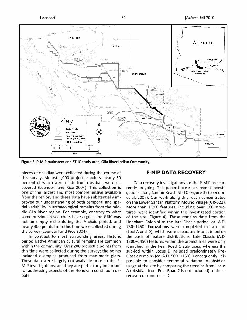
P-MIP DATA RECOVERY Data recovery investigations for the P-MIP are cur-
rently on-going. This paper focuses on recent investi-gations along Santan Reach ST-1C (Figure 3) (Loendorf et al. 2007). Our work along this reach concentrated on the Lower Santan Platform Mound Village (GR-522). More than 1,200 features, including over 100 struc-tures, were identified within the investigated portion of the site (Figure 4). These remains date from the Hohokam Colonial to the late Classic period, ca. A.D. 750–1450. Excavations were completed in two loci (Loci A and D), which were separated into sub-loci on the basis of feature distributions. Late Classic (A.D. 1300–1450) features within the project area were only identified in the Pear Road 1 sub-locus, whereas the sub-loci within Locus D included predominately Pre-Classic remains (ca. A.D. 500–1150). Consequently, it is possible to consider temporal variation in obsidian usage at the site by comparing the remains from Locus A (obsidian from Pear Road 2 is not included) to those recovered from Locus D.
pieces of obsidian were collected during the course of this survey. Almost 1,000 projectile points, nearly 30 percent of which were made from obsidian, were re-covered (Loendorf and Rice 2004). This collection is one of the largest and most comprehensive available from the region, and these data have substantially im-proved our understanding of both temporal and spa-tial variability in archaeological remains from the mid-dle Gila River region. For example, contrary to what some previous researchers have argued the GRIC was not an empty niche during the Archaic period, and nearly 300 points from this time were collected during the survey (Loendorf and Rice 2004).
In contrast to most surrounding areas, Historic period Native American cultural remains are common within the community. Over 200 projectile points from this time were collected during the survey; the points included examples produced from man-made glass. These data were largely not available prior to the P-MIP investigations, and they are particularly important for addressing aspects of the Hohokam continuum de-bate.
Figure 3. P-MIP mainstem and ST-IC study area, Gila River Indian Community.
JAzArch Fall 2010 50 Loendorf

JAzA
rch Fall 2
010
51
Lo
endo
rf
(West) Obsidian Source (East)
Collection Period Tank Mtns. Burro Creek
Partridge Creek
Los Vidri-os Vulture
Govern-ment Mtn
RS Hill/Sitgreaves
Sauceda Mts Sand Tanks Superior
Cow Can-yon
Mule/Antelope
Creek Unknown/
Other
Distance From
Snaketown in Km
K-Means Cluster
Sample Size
Snaketown Pre-Classic 0% 0% 0% 0% 5% 2% 2% 22% 1% 60% 2% 1% 0% 0 3 299
GR-522 Locus D Pre-Classic 0% 0% 0% 0% 3% 13% 0% 15% 0% 51% 0% 0% 18% 14 3 39
GR-522 Locus A Classic 0% 0% 0% 2% 0% 4% 0% 61% 0% 20% 0% 2% 12% 14 1 51
ELXP Classic? 0% 1% 0% 7% 5% 3% 4% 63% 5% 8% 0% 0% 1% 15 1 76
Rowley Classic 0% 0% 0% 0% 47% 0% 0% 30% 0% 23% 0% 0% 0% 29 5 43
Pueblo Grande Classic 1% 0% 4% 4% 27% 22% 0% 30% 0% 10% 0% 0% 3% 31 5 220
Los Colinas Pre-Classic 4% 0% 2% 4% 26% 38% 10% 10% 0% 2% 0% 0% 4% 36 2 50
Casa Grande Classic 0% 0% 0% 0% 1% 29% 0% 46% 0% 7% 0% 14% 2% 42 4 137
Grewe Pre-Classic 0% 0% 0% 0% 1% 0% 0% 1% 0% 95% 0% 1% 2% 45 3 137
Palo Verde Pre-Classic 0% 0% 2% 0% 55% 31% 11% 0% 0% 0% 1% 0% 0% 64 2 122
Gatlin Pre-Classic 0% 3% 0% 1% 4% 0% 0% 85% 0% 0% 0% 0% 7% 73 1 75
Brady Wash Classic 0% 0% 0% 3% 7% 4% 0% 79% 0% 3% 0% 1% 1% 86 1 67
Tonto Arm Early Classic 0% 0% 0% 0% 0% 5% 0% 0% 0% 90% 2% 0% 3% 93 3 11
Tonto Arm Late Classic 0% 0% 0% 0% 0% 38% 0% 20% 0% 6% 4% 32% 0% 93 4 80
Salt Arm Early Classic 0% 0% 0% 0% 0% 13% 13% 13% 0% 64% 0% 0% 0% 97 3 54
Salt Arm Late Classic 0% 0% 0% 0% 3% 33% 0% 11% 0% 15% 9% 26% 3% 97 4 45
Marana Classic 0% 0% 0% 0% 6% 0% 0% 85% 0% 4% 1% 3% 1% 124 1 152
P-MIP Survey Data
Pre-Classic GRIC Pre-Classic 0% 0% 0% 0% 0% 11% 0% 55% 0% 33% 0% 0% 0% N/A N/A 9
Classic GRIC Classic 0% 0% 0% 0% 8% 0% 0% 67% 0% 8% 0% 8% 8% N/A N/A 12
Historic GRIC Historic 0% 0% 0% 5% 9% 0% 0% 76% 0% 9% 0% 0% 0% N/A N/A 21
All Data
Pre-Classic Avg. Pre-Classic 0.6% 0.4% 0.6% 0.7% 13.5% 13.5% 3.3% 26.8% 0.2% 34.4% 0.4% 0.2% 4.4% N/A N/A 731
Classic Average Classic 0.1% 0.1% 0.3% 1.3% 8.7% 12.6% 1.4% 42.1% 0.4% 21.5% 1.4% 7.2% 2.8% N/A N/A 948
Total Average Both 0.3% 0.3% 0.5% 1.0% 11.1% 13.0% 2.4% 34.5% 0.3% 28.0% 0.9% 3.7% 3.6% N/A N/A 1679
Table 1. Obsidian source proportions for collections with more than 40 sourced artifacts (source data from Loendorf et al. 2004; Marshall 2002; Mitchell and Shackley 1995; Peterson et al. 1997; Rice et al. 1998; Shackley & Bayman 2006).

JAzArch Fall 2010 52 Loendorf
Figure 4. Excavations at Lower Santan, P-MIP Reach ST-IC, Gila River Indian Community.
1990s, researchers concluded that elites at platform mounds “did not exercise managerial control over long-distance exchange or the production of craft items” (Peterson et al. 1997; Rice et al. 1998), and this model is now largely rejected. Therefore, this model will not be considered further here. Instead, the fol-lowing discussion considers if the “direct access” or “social exchange” models most closely match pattern-ing in the archaeological record.
REGIONAL AND TEMPORAL
VARIATION IN OBSIDIAN USE With the exception of Sand Tank, the closest ob-
sidian sources to the core area were the most com-monly used by the Hohokam (Shackley 2005). These include the Sauceda, Superior, and Vulture sources. The use of these materials, however, varies substan-tially over time and space. Although Sand Tank is the closest source to the GRIC, this material rarely occurs there. Sand Tank obsidian does not appear to have been extensively utilized throughout the Hohokam region, but the reasons for this remain unclear (Shackley and Tucker 2001).
Sauceda obsidian was one of the most common types used by the Hohokam, and its proportion in as-semblages is very weakly correlated (Pearson correla-tion = -.03) with distance from the source (Figure 6). These data are not consistent with “direct access”
HOHOKAM OBSIDIAN RESEARCH Table 1 presents obsidian source proportions for
collections with more than 40 sourced artifacts from the Hohokam area in southern Arizona (Figure 5). Sites are organized based on their distance from Snaketown, and the sources are arranged across the top from west to east. The results from a non-hierarchical K-means cluster analysis are also reported. As can be seen in the cluster assignments, site proximi-ty appears to be a surprisingly poor predictor of obsidi-an assemblages, and considerable temporal and re-gional variation are present in these data.
Although it is a relatively straightforward process to identify source locations for obsidian found at ar-chaeological sites, understanding how that material came to the sites is more complicated. “Identifying the precise behavioral mechanisms behind Hohokam, in-deed any form of obsidian circulation, is extremely difficult given that multiple processes could account for its movement” (Bayman and Shackley 1999:842). Although obsidian acquisition may have been a com-plicated process that lacks a single universal explana-tion, it is still possible to evaluate different explana-tions for obsidian movement. Models that have previ-ously been proposed for Hohokam obsidian acquisition can be grouped into three general categories: 1) “direct access,” 2) “elite control,” and 3) “social ex-change” models (Peterson et al. 1997). In the late

JAzArch Fall 2010 53 Loendorf
Figure 5. Archaeological site locations and obsidian sources identified at these sites.

models for obsidian acquisition. Models in this catego-ry assume that the end user of the obsidian personally traveled to the source to collect the material. Peterson et al. (1997) referred to this category as the Opportun-istic Model, in part, because some researchers argue that obsidian procurement strategies were embedded within the acquisition of other goods. It is assumed that obsidian was a comparatively low value item that was obtained when possible in the context of other activities. This model holds that distance to the source should be a primary factor that determines obsidian frequencies at sites. Temporal variation in obsidian utilization as well as the lack of distance decay rela-tionships for common obsidian types suggests this model is not the most parsimonious explanation for obsidian acquisition in the Hohokam region.
Nonetheless, some distance decay relationships are apparent in the obsidian frequencies for the P-MIP survey data. Figure 7 graphs average distances to the three most common source areas for different por-tions of the community by distance to the sources. A rapid fall off with distance is apparent for the propor-tions of Superior and Vulture obsidians; however, the two types have opposite fall off patterns. Proportions of Superior obsidian, which is located to the east, fall off from east to west. In contrast, proportions of Vul-ture obsidian, which is located to the west, fall off
from west to east. Excluding the Sauceda source, a strong negative linear relationship exists between the log transformations of source proportion and distance. The Pearson correlation coefficient for this relationship is -.87, with a probability of .02. Distance to the source appears to be the primary barrier for the movement of these two obsidian types within the GRIC, which is consistent with down-the-line exchange or direct pro-curement.
P-MIP survey data suggest that the dependence on Sauceda obsidian increased over time, with the highest incidence occurring in the Historic period (Loendorf et al. 2004). This possibility is also supported by the ob-servation that obsidian artifacts in the sample from one of the largest single-component Historic period sites identified within the community (Sacate) are al-most exclusively from the Sauceda source. The diag-nostic artifact assemblage at Sacate consists largely of Historic period materials, and Pre-Classic or Classic period artifacts are rare (Randolph et al. 2002). Obsidi-an samples from the site are dominated by material from the Sauceda source: 13 of the 14 submitted sam-ples are Sauceda obsidian, and the remaining artifact is from Los Vidrios, which is located farther to the south in Mexico. The proportion of Sauceda obsidian in the Phoenix Basin also increased during the Classic period, and this trend toward greater reliance on southern
JAzArch Fall 2010 54 Loendorf
Distanse from Sauceda Source in KM
180160140120100806040200
Sa
uce
da
Pro
po
rtio
n in
Site
Co
llectio
n
100
80
60
40
20
0
-20
Marana
Salt ArmTonto Arm
Brady Wash
Gatlin
Palo Verde Grewe
Casa Grande
Los Colinas
Pueblo Grande Rowley
ELXPGR-522 A
GR-522 D
Snaketown
Figure 6. Scatterplot of Sauceda obsidian proportions by straight line distance in kilometers from the source location.
c km

JAzArch Fall 2010 55 Loendorf
Figure 7. Obsidian proportion by location with in the GRIC and distance to the source, P-MIP survey collection, Gila Riv-er Indian Community.
sources appears to have occurred throughout the Hohokam area (Marshall 2002:132–133).
At the same time, use of obsidian from the Superi-or source appears to have declined after the Pre-Classic period. For example, data from Grewe (a large Pre-Classic period village) and Casa Grande (a nearby Classic period village) show that a dramatic decline occurred in the use of Superior obsidian during the Classic period (Bayman and Shackley 1999). Superior obsidian was also the most common material identi-fied at the Pre-Classic period site of Snaketown (Shackley and Bayman 2006). A similar pattern occurs in the Tonto Basin, where the use of Superior obsidian also declined over time (Rice et al. 1998).
Vulture obsidian utilization may have peaked dur-ing the Classic period in the community, when it con-stitutes 18 percent of the survey sample. Previous ex-amination of sites in the Phoenix Basin shows a slight increase in the use of Vulture obsidian during the Clas-sic period; however, this material is substantially more common during both the Pre-Classic and Classic peri-ods in the Phoenix Basin than it appears to be in the GRIC study area (Marshall 2002; Mitchell and Shackley 1995; Peterson et al. 1997). The western portion of the survey area is closer to the Vulture obsidian source than sites in the core of the Phoenix Basin, but only seven percent of the obsidian from the western-most
portion of the community was derived from the Vul-ture source. However, this material constitutes rough-ly 30 percent of the overall Phoenix Basin collection (Loendorf et al. 2004). These observations suggest that proximity to the source alone does not fully account for differences in the utilization of Vulture obsidian.
LOWER SANTAN DATA Similar patterns in obsidian utilization are also ap-
parent in the Lower Santan data. Very little Vulture obsidian is present for either the Pre-Classic or Classic periods, and Sauceda proportions increase during the Classic period, while the proportion of Superior de-creases (Figure 8). Shackley argues that access to the source was restricted by the Salado during the Classic period (Shackley 2005). However, a similar temporal pattern of decline in the use of Superior obsidian oc-curs in the Tonto Basin (Rice et al. 1998), which has traditionally been considered to be the heartland of the Salado. It is possible that access to the source was cut off in the Classic period, but if this was the case, then it occurred for all of the communities of seden-tary agriculturalists that have been sampled to date.
Rice et al. (1998) suggested two possibilities for the decline in Superior obsidian use during the late Classic period. First, the source was depleted. Second, a large village appropriated exclusive use of the
km

source. The first possibility appears unlikely because substantial obsidian deposits remain at the source to-day. The second possibility is more probable; however, the site that cut off access has not as yet been identi-fied. A third possibility is that a group of foragers (e.g., the Apache), who are difficult to otherwise identify in the archaeological record, moved into the area around Superior and cut off access to the source.
Differences in obsidian utilization among sites in different portions of the Hohokam area can be illus-trated by comparing individual sites such as Pueblo Grande and Lower Santan (Figure 9). Although these two sites are less than 35 km apart, obsidian acquisi-tion patterns differ substantially between them (see Table 1). For example, in addition to the previously noted differences in Vulture obsidian frequencies, sites in the Phoenix Basin generally have much higher pro-portions of obsidian from the large nodule sources in northern Arizona than occurs along the Gila River, where northern Arizona sources are comparatively rare throughout the sequence. The northern Arizona sources are approximately 265 km from the Gila River sites, a distance that far exceeds the roughly 35 km that separates the two sites. These data show that di-rection of the source has a greater effect than absolute distance. This pattern suggests that prehistoric popula-tions in the Phoenix Basin and along the middle Gila River maintained different trade contacts, which is
consistent with social exchange models for obsidian transport.
REGIONAL PATTERNS
In order to further consider regional variation in
obsidian use, it is necessary to control for the temporal differences that are apparent in these data. One way to do this is to consider only those sites that are from the same time period. Figure 10 is a cluster analysis dendrogram for Classic period obsidian frequencies. The analysis employed a squared Euclidian distance measure and Ward’s method. At the two cluster solu-tion level, all lower Salt River sites are in one cluster, whereas all middle Gila River sites are in the second. Although some middle Gila sites such as GR-522 occur in proximity to the lower Salt sites, obsidian propor-tions differ substantially between sites along the two rivers. At the same time, the Tonto Basin is more than 80 km away from Pueblo Grande, yet it has similar ob-sidian proportions. These data suggest that the strong-est socioeconomic ties were among communities lo-cated on the same waterways.
SUMMARY AND CONCLUSIONS
Studying materials that were transported to the
Hohokam core area provides a complementary per-spective with materials that were produced and dis-
JAzArch Fall 2010 56 Loendorf
Figure 8. Obsidian proportions by period, Lower Santan Platform Mound Village, Gila River Indian Community.
0%
10%
20%
30%
40%
50%
60%
70%
Los Vid
rios
Vultu
re
Gov
ernm
ent M
tn
Sau
ceda
Mts
Sup
erior
Mule/
Antelo
pe C
reek
Unkn
own/
Oth
er
Pre-Classic
Classic

tributed locally (e.g., ceramics), which may have differ-ent patterns of distribution. In the past 30 years, ob-sidian analyses have become increasingly comprehen-sive (Shackley 2005), and broad regional and temporal patterns have now become apparent in these data.
The results of my research indicate that the direc-tion of the obsidian source has a substantially greater effect than absolute distance on raw material utiliza-tion. Further, obsidian commonly arrived in the core area in unreduced form. If people traveled directly to sources to obtain obsidian, then distance should be the primary barrier to the acquisition of the material. However, obsidian proportions for the most commonly utilized sources are not correlated with distance. These observations suggest that prehistoric people in the lower Salt, middle Gila, Casa Grande, and Tonto Basin maintained different trade contacts. Patterning in obsidian acquisition suggests that the strongest soci-oeconomic ties among communities were those be-tween sites located on the same waterways.
Variation in acquisition patterns among these are-as supports the argument that the Classic period Hohokam were not a politically centralized or econom-ically integrated entity. Data suggest that by the late Classic period, little obsidian was transferred between some adjacent subregions. Instead, communities of sites received most of their obsidian from distant areas in different directions. Use of the closest source, Supe-rior, decreased dramatically over time from the Pre-
Classic to the Classic periods. In contrast, Sauceda ob-sidian, which is located to the southwest of the core area, became the main supply of obsidian by the late Classic period, and this trend appears to have contin-ued into the Historic period. This continuity of trends between the Classic and Historic periods is one exam-ple of the link between the Hohokam and the Akimel O’odham, who live in the area today.
The Historic period represents the culmination of this long trend toward greater reliance on obsidian sources located to the southwest of the middle Gila, and during this period Sauceda obsidian may have be-come nearly the exclusive source. The well-documented relocation of Akimel O’odham popula-tions to the south bank of the Gila River for protection from Apache raiding during the seventeenth century offers a partial explanation. Access to northern, west-ern, and eastern sources including the San Francisco Volcanics, Vulture, and Superior sources was effective-ly cut-off by intervening Apache and Yavapai popula-tions. Meanwhile, alliances between the Tohono O’O-dham (Papago), Cocopah, and the Pee Posh (Maricopa) would have allowed continuing access to raw materials in the direction of the Gulf of California. The observa-tion that the decline in the use of obsidian from north-ern, western, and eastern sources begins during the Classic period suggests the possibility that foragers such as the Apache and Yavapai may have moved into
JAzArch Fall 2010 57 Loendorf
Figure 9. Pueblo Grande and Lower Santan obsidian data.
0%
10%
20%
30%
40%
50%
60%
70%
Tank
Moun
tains
Par
tridg
e Cre
ek
Los Vid
rios
Vultu
re
Gov
ernm
ent M
tn
Sau
ceda
Mts
Sup
erior
Mule/
Antelo
pe C
reek
Unkn
own/
Oth
er
GR-522 Classic
Pueblo Grande

southern Arizona earlier than has traditionally been assumed.
Acknowledgements. This research was undertaken in conjunction with the Gila River Indian Community, Cul-tural Resource Management Program and the Pima-Maricopa Irrigation Project under funding from the Department of the Interior, U.S. Bureau of Reclama-tion, under the Tribal Self-Governance Act of 1994 (P.L. 103-413), for the design and development of a water delivery system utilizing Central Arizona Project water. I want to thank Lynn Simon for drafting the maps and other figures. I also would like to recognize all of the hard work and dedication of the field crews, including Damon Burden and Wesley Miles, who made this research possible.
REFERENCES CITED
Bayman, J. M., and M. S. Shackley 1999 Dynamics of Hohokam Obsidian Circulation in the
North American Southwest. Antiquity 73:836-845. Kooyman, B. P
2000 Understanding Stone Tools and Archaeological Sites. University of Calgary Press, Alberta, Canada.
Loendorf, C. and G. E. Rice 2004 Projectile Point Typology, Gila River Indian Commu-
nity, Arizona. Anthropological Research Papers No. 2. Gila River Indian Community, Sacaton, Arizona.
Loendorf, C., J. A. Darling, and M. S. Shackley 2004 Hohokam Obsidian Procurement and Distribution in
the Middle Gila River Valley: A Regional Approach. Pa-per presented at the Inaugural Symposium of the Ar-chaeological Sciences of the Americas, Tucson, Arizona.
Loendorf, C., K. Woodson, J. Ravesloot, A. Darling, D. Bur-den, B. Randolph, and R. Barfield
2007 A Preliminary Report on the Results of Phase I Data Recovery Investigations of Cultural Resources in Santan
Reaches ST-IB, ST-IC, and ST-FP of the Pima-Maricopa Irrigation Project, Gila River Indian Community, Pinal County, Arizona. P-MIP Technical Report No. 2006-03. Cultural Resource Management Program, Gila River Indian Community, Sacaton, AZ.
Marshall, J. T. 2002 Obsidian and the Northern Periphery: Tool Manufac-
ture, Source Distribution, and Patterns of Interaction. In Phoenix Basin to Perry Mesa: Rethinking the “Northern Periphery,” edited by M. R. Hackbarth, K. Hays-Gilpin, and L. Neal, pp. 121–138. Arizona Archaeologist Num-ber 34. Arizona Archaeological Society, Phoenix.
Mitchell, D. R., and M. S. Shackley 1995 Classic Period Hohokam Obsidian Studies in South-
ern Arizona. Journal of Field Archaeology 22(3):291–304.
Peterson, J., D. R. Mitchell, and M. S. Shackley 1997 The Social and Economic Contexts of Lithic Procure-
ment: Obsidian from a Classic-Period Hohokam Site. American Antiquity 62(2):231–259.
Randolph, B., J. A. Darling, C. Loendorf, and B. Rockette 2002 Historic Pima Site Structure and the Evolution of the
Sacate Site (GR-909), Gila River Indian Community. In Visible Archaeology on the Gila River Indian Reserva-tion, P-MIP Report No. 21. Cultural Resource Program, Gila River Indian Community, Sacaton, Arizona.
Ravesloot, J. C., and M. R. Waters 2004 Geoarchaeology and Archaeological Site Patterning
on the Middle Gila River, Arizona. Journal of Field Ar-chaeology 29:203–214.
Rice, G. E., A. Simon, and C. Loendorf 1998 Production and Exchange of Economic Goods. In A
Synthesis of Tonto Basin Prehistory: The Roosevelt Ar-chaeology Studies, 1989 to 1998, edited by G. E. Rice, pp. 105–130. Roosevelt Monograph Series 12 and An-thropological Field Studies 41. Arizona State University, Tempe.
Schortman, E. M. and P.A. Urban 1992 Current Trends in Interaction Research. In Re-
sources, Power, and Interregional Interaction, edited by E. M Schortman and P.A. Urban, pp. 235–257. Plenum
JAzArch Fall 2010 58 Loendorf
Stream Site1 5 10 15 20 25
Santa Cruz Marana
Santa Cruz Brady Wash
Santa Cruz EXLP
Gila GR-522 A
Gila Casa Grande Group 1
Tonto Tonto Arm Group 2
Salt Salt Arm
Salt Pueblo Grande
Salt Rowley
Approximate Rescaled Cluster Combination Distance
Figure 10. Cluster analysis dendrogram (squared Euclidean distance measure and Ward’s method) for Classic period obsidian data.

Press, NY. Shackley, M. S.
1988 Sources of Archaeological Obsidian in the South-west: An Archaeological, Petrological, and Geochemical Study. American Antiquity 53(4):752–772.
1990 Early Hunter-Gatherer Procurement Ranges in the Southwest: Evidence from Obsidian Geochemistry and Lithic Technology. Unpublished Ph.D. dissertation, De-partment of Anthropology, Arizona State University, Tempe.
1992 The Upper Gila River Gravels as an Archaeological Obsidian Source Region: Implications for Models of Ex-change and Interaction. Geoarchaeology 7(4):315–326.
1995 Sources of Archaeological Obsidian in the Greater American Southwest: An Update and Quantitative Anal-ysis. American Antiquity 60(3):531–551.
2005 Obsidian: Geology and Archaeology in the North American Southwest. University of Arizona Press, Tuc-son.
Shackley, M. S. and J. M. Bayman 2006 Obsidian Source Provenance, Projectile Point Mor-
phology and Sacaton Phase Hohokam Cultural Identity. In A Snaketown Retrospective, edited by P. Fish and S. Fish. University of Arizona Press, Tucson.
Shackley, M. S. and D. B. Tucker 2001 Limited Prehistoric Procurement of Sand Tank Ob-
sidian, Southwestern Arizona. Kiva 66(3):345–374. Simon, A. W. and D. C. Gosser
2001 Conflict and Exchange among the Salado of Tonto Basin: Warfare Motivation or Alleviation? In Deadly Landscapes: Case Studies in Prehistoric Warfare, edited by G. E, Rice and S. A. LeBlanc, pp. 219–238. The Univer-sity of Utah Press, Salt Lake City.
JAzArch Fall 2010 59 Loendorf
Copyright © 2022 FDOKUMEN