Atmospheric brown clouds reach the Tibetan Plateau by crossing the Himalayas

Multi-process generated sediment waves on the LandesPlateau (Bay of Biscay, North Atlantic)
Jean-Claude Fauge'res a;�, Eliane Gonthier a, Thierry Mulder a, Neil Kenyon b,Pierre Cirac a, Roger Griboulard a, Serge Berne¤ c, Raymond Lesuave¤ c
a De¤partement de Ge¤ologie et Oce¤anographie, UMR CNRS 5805-EPOC, 33405 Talence cedex, Franceb Southampton Oceanography Centre, Southampton SO14 3ZH, UK
c DRO/GM, IFREMER, B.P. 70, 29280 Plouzane¤, France
Received 1 February 2001; accepted 31 July 2001
Abstract
Detailed analyses of recently collected bathymetric and sparker seismic data, support a new interpretation of theLandes Plateau field of sediment waves located on the Aquitaine upper continental slope (Bay of Biscay). The wavegeometry, previously described as the result of a major sediment failure, is interpreted as a structure with a complexorigin including the interaction of depositional and gravity deformation processes. Depositional processes are mainlyrecorded by the upslope migrating pattern of the waves resulting from oblique or sigmoid downlap reflections on theupslope flank of the waves and by toplapping and truncated reflections on the downslope flank. Hemipelagic andturbiditic sedimentation may be involved in the wave building as well as contouritic processes that could be related tothe existing northward polar current and internal waves. Gravity deformations are syndepositional, discontinuous andof low amplitude, affecting thick layers which alternate with undeformed layers. They seem to correspond to gentlesediment creeping or stretching associated with minor listric or compaction-like faults, and possible limited backrotation of sediment blocks. These multi-process generated sediment waves could be rather common on thecontinental margins as they could have been mistaken with either depositional or deformational structures. 7 2002Elsevier Science B.V. All rights reserved.
Keywords: continental slope; Bay of Biscay; Landes Plateau; sediment wave; process interaction; sediment deformation; contourcurrent; seismic data
1. Introduction
Sediment waves are usually giant bedformscommonly observed on the sea£oor from the shelf
break to the abyssal domains of the deep ocean.They form mainly in ¢ne-grained sediment (claysand silts) and occur regularly over large areas.Their dimensions range from tens to about onehundred metres in amplitude and hundreds ofmetres to kilometres in wavelength. Three di¡er-ent types of processes are usually evoked as re-sponsible for the settling of such sediment waves(Fauge'res et al., 1999): turbidity-current process,
0025-3227 / 02 / $ ^ see front matter 7 2002 Elsevier Science B.V. All rights reserved.PII: S 0 0 2 5 - 3 2 2 7 ( 0 1 ) 0 0 2 4 2 - 0
* Corresponding author. Tel. : +33-5684-8853;Fax: +33-5684-0848.
E-mail address: [email protected](J.-C. Fauge'res).
MARGO 3003 2-5-02
Marine Geology 182 (2002) 279^302
www.elsevier.com/locate/margeo

contour-current process, and sediment deforma-tion due to gravity processes such as mass trans-port. On this basis, they can be classi¢ed intothree types of wavy bedforms according to thepredominant process involved (Table 1).The ¢rst two types are clearly depositional bed-
forms and result from distinct sedimentologicalprocesses.(1) Contouritic sediment waves have a very large
distribution as they can be deposited on any rel-atively £at areas on the continental margins andin oceanic basins whatever the water depth(McCave and Tucholke, 1986).(2) Turbiditic sediment waves (Normark et al.,
1980) are less frequent as they are generally re-stricted to turbiditic levees associated with a ma-jor channel in deep-sea fans.But neither the hydrodynamic processes respon-
sible for their deposition, nor any reliable seismicfeatures to distinguish the two types of sedimentwaves have yet been clearly established (see Lons-dale and Hollister, 1979; Allen, 1982; Normark etal., 1980; McCave and Tucholke, 1986; Kidd andHill, 1987; Flood, 1988, 1994; Blumsack andWeatherly, 1989; Savoye et al., 1993; Manleyand Caress, 1994; Brew, 1995; Migeon et al.,2000, among many other authors). In both cases,the usual criteria used to recognise them are the£ow direction, which is more or less perpendicular
to the trend of the associated waves, and some-times an antidune internal geometry that under-lines an upslope and upstream wave migration.However, these criteria are highly variable in thecase of contour-current sediment waves.A third type of bedforms is sediment waves due
to synsedimentary deformation of deposits duringgravity mass transport events that mimic the true
Table 1Sediment waves: three types according to the origin
(1) Depositional contouritic sediment wavesWidespread distribution: continental margin, oceanic basin (of whatever depth)Wave crests:^ perpendicular to current trend: downcurrent migration or upcurrent migration (‘antidune’)^ oblique or parallel to £ow direction: lateral migration^ upslope or downslope migrationMuddy (more rarely sandy) sediments(2) Depositional turbiditic sediment wavesFrequent mainly in turbiditic ‘channel^levees’ systemsWave crests:^ perpendicular to current trend: upslope and upcurrent migration (‘antidune’)Sandy to muddy sediments(3) ‘Wave-like’ bedforms due to deposit deformation, associated with gravity mass movementLocated on steep to gentle slopes (continental slopes, volcanic seamounts)Associated with compaction, creeping, sliding, slumping processes and features like:^ extensional structures with ‘antidune’-like geometries (elastic stretching, compaction and listric faults, rotated blocks, folds)^ compressional structures (‘compressional ridges’, folds, faults)Muddy to sandy sediments
Fig. 1. Location of the study area.
MARGO 3003 2-5-02
J.-C. Fauge'res et al. /Marine Geology 182 (2002) 279^302280

depositional sediment waves. They are frequentlyobserved on continental slopes or at the edge ofthe continental shelf. They result from constantstrain such as compaction and creeping, or fromdownslope mass transport like sliding and slump-ing. These processes generate deformations in-cluding elastic stretching, compaction or listricfaults, block rotation, and folding due to exten-sional and compressional deformation often asso-ciated with a relatively small downslope move-ment. The resulting features present a sediment-wave-like morphology and are sometimes very
similar in appearance to depositional antidunes(Ballard, 1966; Bouma and Treadwell, 1975;Hill et al., 1982; Mulder and Cochonat, 1996;O’Leary and Laine, 1996; Gardner et al., 1999;Wynn et al., 2001, among others). They are de-scribed under various names like rotated blocks,tension faults, creep folds, or compressionalridges if they are related to deformations, andsediment waves if they are mistaken for deposi-tional waves.The distinction between these three types of
bedforms is even more complex as interaction be-
Fig. 2. Location of the ¢elds of sediment waves on the Landes Plateau (after Kenyon et al., 1978). 1, Field of sediment waves lo-cated on the upper continental slope, with location of ITSAS seismic pro¢les 76, 76b and 77, and multibeam echosounder mosaic(m); 2, ¢eld of sediment waves located on the lower continental slope. Location of Fig. 3, and Ibis, Antare¤s and Orion wells isalso indicated (bathymetric contour in metres).
MARGO 3003 2-5-02
J.-C. Fauge'res et al. /Marine Geology 182 (2002) 279^302 281
tween two or three of the wave-forming processesmay be common on many continental slopes(Fauge'res et al., 2000a,b; Gonthier et al., 2001).In addition, the original process of formationand the process that caused subsequent progra-dation and aggradation of the wave ¢eld may bedi¡erent (Howe, 1996). Consequently, interpre-tation of the processes generating sedimentwaves or sediment-wave-like structures on con-tinental slopes, can often be subjective and spec-ulative.Recent new acoustic data collected from the
Landes Plateau (Figs. 1 and 2) in the Bay of Bis-cay (Cirac, 1998; Fauge'res et al., 2000a) providenew insights on sediment wave or ridge patternson the continental slope. The occurrence of ¢eldsof sediment ridges was ¢rst described in this re-gion by Stride et al. (1969) and Kenyon et al.(1978), from Gloria data (Fig. 2). The waveshave been observed both on the uppermost andlowermost parts of the continental slope, and in-terpreted by these authors as compressional ridgesresulting from deformation associated with aslump. The ¢eld we have studied in this paper islocated on the uppermost part of the continentalslope of the Landes Plateau (area 1 in Fig. 2).This part of the slope presents a fairly regularsurface without any major canyon or channel.
Major canyons only occur further north (CapFerret canyon system) and further south (Canyonof Capbreton). Northward polar currents andcurrents associated with internal waves havebeen described in the area (Durrieu de Madronet al., 1999; Correard et al., 2000). Several rivershave delivered terrigenous supply on the adjacentshelf during the Pliocene. However, during theQuaternary, some of the rivers have shifted eithernorthward (Garonne system) or southward(Adour River), as a consequence of tectonics(Legigan, 1979).The acoustic data consisting of bathymetric
data, multibeam echosounder mosaic, and sparkerseismic pro¢les, were collected during cruise Zee(‘Zone e¤conomique exclusive’)-Gascogne I and IIin 1992 and 1993 (Le Suave¤, 2000; Bourillet andLoubrieu, 1995; Bourillet et al., 1999) and theITSAS (‘Images et Transfert des Sediments Aqui-taineS’) cruise in 1998 (Cirac, 1998; Cirac et al.,1999a,b). These data have allowed a detailed anal-ysis of the ‘ridge’ morphology and geometry to beundertaken and enable us to suggest a new con-ceptual model for the mechanism of ridge forma-tion in which gravity deformational processes in-teract with depositional processes. Thus, in thefollowing sections, we will refer to the ridges as‘sediment waves’.
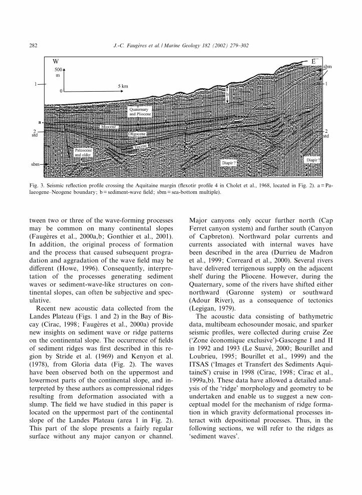
Fig. 3. Seismic re£ection pro¢le crossing the Aquitaine margin (£exotir pro¢le 4 in Cholet et al., 1968, located in Fig. 2). a =Pa-laeogene^Neogene boundary; b= sediment-wave ¢eld; sbm= sea-bottom multiple).
MARGO 3003 2-5-02
J.-C. Fauge'res et al. /Marine Geology 182 (2002) 279^302282

2. Sediment-wave location, morphology andchronology
The ¢eld of sediment waves (Figs. 2^4) spreadsout from 400 to 1000 m of water depth, just sea-ward of the shelf break which is marked by anabrupt increase of the slope from 5‡ to 10‡. Thesediment-wave package forms a wedge with aconcave shape and covers an area of about 1300km2, which is elongated N^S along the slope (40to 50 km long and 5 to 15 km wide). The meanslope at the location of the ¢eld varies from 2‡ to3‡ westward and 0.4‡ to 0.5‡ northward. The sur-¢cial sediment-wave crests are fairly parallel,
sometimes braided, and display a linear to sinu-ous trend with a crest length varying between 1and 4 km and oriented between 010‡N and 035‡N(Fig. 4). The sediment waves display variable di-mensions with a wavelength ranging from 800 to1600 m and an amplitude varying from 20 to 70m. In the south they are smaller, more abundantand more braided than in the north, and the trendchanges northwards from 010‡ to 035‡N. At thenorthernmost end of the ¢eld, the larger, 035‡Ntrending sediment waves pass abruptly to smallerwaves trending 010‡N. This change is marked bya discontinuity directed E^W that corresponds toa regional structural trend, and to the trend of
Fig. 4. Multibeam echosounder mosaic showing the sediment-wave distribution on the upper slope, and the location of the IT-SAS seismic pro¢les: (a) mosaic (from Bourillet et al., 1999); (b) interpretation. See Fig. 2 for location.
MARGO 3003 2-5-02
J.-C. Fauge'res et al. /Marine Geology 182 (2002) 279^302 283

Fig. 5.
MARGO 3003 2-5-02
J.-C. Fauge'res et al. /Marine Geology 182 (2002) 279^302284

major canyons further to the north (Berthois andBrenot, 1966; Garcia-Monde¤jar, 1996). This sug-gests a composite pattern of the sediment-wave¢eld with at least two generations of waves. Thecross-section pro¢les of the sediment waves isoften an asymmetric showing, in most cases, ashorter upslope £ank with a low dip comparedto a longer and steeper downslope £ank (Fig. 5).On the pro¢le, in Fig. 3, the sediment-wave
package continues below the seabed with a thick-ness that decreases downslope from about 500 to250 m and probably represents a range of timefrom the upper Pliocene to Present (using amean acoustic wave velocity of 2000 m/s, Choletet al., 1968; Valery et al., 1971). It overlies anEocene to lower Pliocene sedimentary serieswhich buries tectonic structures of various origins.These structures may have been inherited fromthe ¢rst stages of the Aquitaine margin formation(upper Cretaceous). Furthermore, the entire Ce-nozoic succession on the slope may have beensubjected to deformation due to halokinesis, asso-ciated with abundant salt diapirs along the mar-gin (Cholet et al., 1968; Valery et al., 1971). Thepro¢le also suggests that a change in the construc-tion of the margin took place at the boundarybetween the Palaeogene and the Neogene. Palaeo-gene deposits increase westward (from about 180to 340 m) as they ¢ll up a sea£oor depression.Neogene deposits decrease westward, downslope,from about 750 to 450 m in thickness. Theyformed stacked sedimentary wedges that under-line the upper continental slope progradation.The top of the Miocene deposits would be at adepth of about 550 to 400 m below the sea£oor.The wavy series visible on ITSAS seismic pro¢lesrepresent the upper part of the sediment-wavepackage, and displays a thickness of about 280m in the east and 140 m in the west (Figs. 5and 6). It may represent the uppermost Plioceneand Quaternary deposits.Upper Pleistocene and Holocene deposits ob-
served at several stations (box cores, gravity cores
and Kullenberg piston cores) along the Aquitano-Armorican continental slope (Anschutz et al.,1999; Baltzer, 1994; Zaragosi et al., 2001; Zara-gosi, 2001) consist of clayey silty sediments with awater content that decreases rapidly down intothe sediments (water content of 70% at a depthof a few decimetres). The sedimentation rate forthis period is about 10 cm/1000 yr (Caralp, 1968,1971; Duprat, 1983). Such a sedimentation rate issimilar to the Pliocene sedimentation rate as givenby the Ibis drill hole data (Winnock, 1973), lo-cated northward of the study area (Fig. 2), andto the Pliocene^Quaternary sedimentation rate es-timated from the seismic pro¢le in Fig. 3 (550-m-thick deposits on the uppermost continentalslope). It suggests no major changes in the volumeof sediment supply between the Pliocene and theQuaternary.Miocene and Palaeogene deposits are not well-
known as there is no borehole in the vicinity ofthe studied area. They could be constitutedmainly of silty clay as suggested by data fromtwo boreholes, Orion and Antare¤s (Cholet et al.,1968; Bois and Gariel, 1994), located on the near-by shelf (Fig. 2).
3. Seismic stratigraphy and sediment-wavegeometry and distribution
Three seismic pro¢les (sparker) have been ana-lysed (Fig. 4): two downslope E^W pro¢les 13 kmapart (pro¢le 76 in the south and pro¢le 77 in thenorth) cross a dozen of the waves, and one along-slope N^S pro¢le (pro¢le 76b) that links both thedownslope ends of the dip pro¢les (Figs. 2 and 5^7).These pro¢les only show the upper 250^350 m
of the Neogene section. On the basis of the loca-tion of these sparker pro¢les on the continentalslope, the interpreted top of the Miocene sequencein Fig. 3 (Cholet et al., 1968; Kieken, 1973), and amean sedimentation rate of 10 cm/1000 yr, we
Fig. 5. Northern downslope sparker pro¢le, ITSAS pro¢le 77 (located in Figs. 2 and 4): (a) pro¢le; (b) interpretation. R1^R4 re-fer to the re£ectors bounding the main units; 1 = fold-like re£ector terminations, either deformed as a consequence of diapiric up-lift or due to bottom-current activity (moat). Location of Figs. 8 and 10^12 is also indicated.
MARGO 3003 2-5-02
J.-C. Fauge'res et al. /Marine Geology 182 (2002) 279^302 285
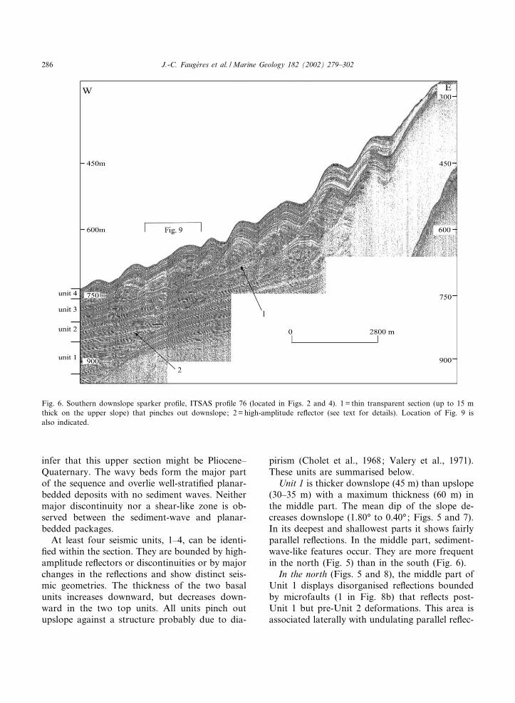
infer that this upper section might be Pliocene^Quaternary. The wavy beds form the major partof the sequence and overlie well-strati¢ed planar-bedded deposits with no sediment waves. Neithermajor discontinuity nor a shear-like zone is ob-served between the sediment-wave and planar-bedded packages.At least four seismic units, 1^4, can be identi-
¢ed within the section. They are bounded by high-amplitude re£ectors or discontinuities or by majorchanges in the re£ections and show distinct seis-mic geometries. The thickness of the two basalunits increases downward, but decreases down-ward in the two top units. All units pinch outupslope against a structure probably due to dia-
pirism (Cholet et al., 1968; Valery et al., 1971).These units are summarised below.
Unit 1 is thicker downslope (45 m) than upslope(30^35 m) with a maximum thickness (60 m) inthe middle part. The mean dip of the slope de-creases downslope (1.80‡ to 0.40‡; Figs. 5 and 7).In its deepest and shallowest parts it shows fairlyparallel re£ections. In the middle part, sediment-wave-like features occur. They are more frequentin the north (Fig. 5) than in the south (Fig. 6).
In the north (Figs. 5 and 8), the middle part ofUnit 1 displays disorganised re£ections boundedby microfaults (1 in Fig. 8b) that re£ects post-Unit 1 but pre-Unit 2 deformations. This area isassociated laterally with undulating parallel re£ec-
Fig. 6. Southern downslope sparker pro¢le, ITSAS pro¢le 76 (located in Figs. 2 and 4). 1= thin transparent section (up to 15 mthick on the upper slope) that pinches out downslope; 2= high-amplitude re£ector (see text for details). Location of Fig. 9 isalso indicated.
MARGO 3003 2-5-02
J.-C. Fauge'res et al. /Marine Geology 182 (2002) 279^302286

tions that suggest gentle folding of deposits asso-ciated to the microfault play (3a in Fig. 8b). Inaddition, several undulating structures (amplitude15^25 m; wavelength 1000^1300 m) are developedin the thickest middle to upper part of the unit (4in Fig. 8b). They show an asymmetric sectionwith a depositional overthickening on the upslope£ank. Locally, the re£ections of the upslope £ankof a structure present toplap geometries, and on-lap or downlap the down£ank of the adjacentstructure (4a in Fig. 8b). Those features thatlead to an upslope migration of the bedform canonly be due to a depositional process, and arestrongly suggestive of migrating sediment waves.However in some cases, the termination of theupslope £ank re£ections in the trough of thesemigrating sediment waves show small-scale defor-mations (folded and chaotic re£ections, 2 in
Fig. 8b), demonstrating complex interaction be-tween deformation and deposition processes. Up-slope the re£ection terminations seem to be gentlyfolded near their contact with the diapiric struc-ture (Fig. 5), suggesting a possible activity of thediapir during the sediment-wave formation or anenhanced bottom-current activity along the diapir£ank that could have been responsible for theformation of a moat.
In the south (Figs. 6 and 9), the overthickenedpart of the unit is due to the occurrence of a well-developed sediment wave with evident downlapand toplap re£ections in the upslope £ank, andwithout any evidence of synsedimentary deforma-tion.In the N^S longitudinal pro¢le (Fig. 7), Unit 1
is characterised by well-strati¢ed, continuous re-£ections with variable amplitude. No wavy re£ec-
Fig. 7. N^S alongslope pro¢le, ITSAS pro¢le 76b (located in Figs. 2 and 4): (a) sparker pro¢le; (b) interpretation. dl = drapinglayers; l = thin transparent layer.
MARGO 3003 2-5-02
J.-C. Fauge'res et al. /Marine Geology 182 (2002) 279^302 287

Fig. 8. Detail of ITSAS seismic pro¢le 77 (location in Fig. 5b): (a) sparker pro¢le; (b) interpretation showing deformation fea-tures. 1 =minifaults; 2 =disturbed chaotic re£ections; 3 = gently folded re£ections; 3a= folded re£ections associated with mini-faults; 4 =wavy depositional bedforms with downlap and toplap geometries (4a), in Units 1 and 2; 5=draping thin bed betweenUnit 1 and Unit 2a (see text for details).
MARGO 3003 2-5-02
J.-C. Fauge'res et al. /Marine Geology 182 (2002) 279^302288

Fig. 9 (Caption overleaf).
MARGO 3003 2-5-02
J.-C. Fauge'res et al. /Marine Geology 182 (2002) 279^302 289

tions are observed due to the N^S trend of thewaves.The base of Unit 2 is marked by a high-ampli-
tude re£ector (2 in Fig. 6), that drapes Unit 1 inthe southern part of the area. As with Unit 1, thethickness of Unit 2 increases downslope from 40to 70 m. Internal re£ections are more regularlyparallel and continuous than in Unit 1. Wavystructures are also present but they are of loweramplitude and show a di¡erent distribution (Figs.6 and 8). Eastward, the upslope terminations ofthe re£ections onlap the diapir, and underline aphase of tectonic stability.
In the north (Fig. 5), Unit 2 displays a verydi¡erent geometry in the deepest part comparedto the middle and upper parts of the slope. In thedeepest part of the slope, Unit 2 displays verychaotic re£ections (Fig. 10) that are restricted toa zone more or less elongated N^S; the width ofthis zone is 0.5^1 km, and its length is at least 2.5km (on the N^S pro¢le, Fig. 7). These chaoticre£ections extend throughout Unit 2 and thebase of Unit 3. They suggest disorganisation ofdeposits by mass gravity processes that would ap-pear to a¡ect a zone of sediment sub-parallel tothe wave crest.
Fig. 10. Detail of ITSAS seismic pro¢le 77 (location in Fig. 5b): (a) sparker pro¢le; (b) interpretation showing the chaotic re£ec-tion zone (ch.) at the westernmost end of the pro¢le.
Fig. 9. Detail of ITSAS seismic pro¢le 76 (location in Fig. 6): (a) sparker pro¢le (1, 2, 3 refer respectively to SD1, SD2 andSD3 types of wave geometry, see text for details); (b) interpretation showing wavy bedforms with re£ection geometry. 1 = toplapand downlap oblique to sigmoidal re£ections suggesting depositional sediment waves in Units 1, 2 and 3; 2= depositional sedi-ment waves associated with tiny re£ection deformations in Unit 3; dl = draping well-strati¢ed layers at the top and base of Unit2, and in Unit 4. Note that Unit 3 consists of four subunits (see text for details).
MARGO 3003 2-5-02
J.-C. Fauge'res et al. /Marine Geology 182 (2002) 279^302290

On the upper slope, two subunits (2a, 2b) canbe de¢ned in Unit 2 (Figs. 5 and 8). In Subunit 2a,the chaotic re£ections merge eastward into sub-parallel, continuous to discontinuous re£ectionsassociated with upslope migrating waves (length1000 m and amplitude less than 20 m), then, onthe uppermost slope, into parallel re£ectionsforming more gentle waves with only a slight mi-gration (Fig. 8). Compared to Unit 1, the migrat-ing waves show a very similar geometry but someof them are not inherited from Unit 1 (Fig. 5),from which they are sometimes separated by adraping thin bed of sediments (5 in Fig. 8b). Sub-unit 2b di¡ers from Subunit 2a by the geometry ofthe waves (wavelength 600^1000 m; amplitude 20m) that display no migration or only very slightmigration (Figs. 5 and 8).
In the south (Figs. 6 and 9), Unit 2 is far morecomplex. Draping sub-parallel re£ections occur atthe base of the unit. They pass laterally and areoverlain by more irregular and discontinuous re-£ections associated with waves of smaller dimen-sions (wavelength 600 m; amplitude up to 15 m)located on the middle part of the slope. Somesediment waves present a very spectacular upslopemigration, underlined by oblique to sigmoid re-£ections that strongly support an interpretationas depositional sediment waves. However, thereis no clear variation in the migration trend likein the north where two subunits have been distin-guished. The top of the unit consists again of athin layer of draping deposits similar to the basaldeposits (Fig. 8).In the N^S pro¢le (Fig. 7), this unit displays
continuous parallel re£ections that merge north-ward into the chaotic area.The base of Unit 3 is marked by a change in the
distribution of deposits and in re£ection geome-try, with localised erosion in the north of the arearesulting in a small erosive channel, 10 m deepand 600 m wide (Fig. 7). The thickness of theunit decreases westward (downslope) and south-ward (from 150 m to 90 m in the north, and from100 m to 60 m in the south). Asymmetric migrat-ing sediment waves occur throughout the unit.They show variations in both size and geometryof the wave, and display an upward increase ofthe amplitude and migration trend that is marked
by an upslope climbing ripple-like geometry onthe upper part of the slope.
In the south, the unit shows from base to topthe superposition of four subunits (Fig. 9). Sub-unit 3a consists of a thin 10- to 15-m-thick sectionwith very low-amplitude, discontinuous re£ectionsand a few indications of wavy bedforms. Subunit3b consists of a 20- to 30-m-thick section withhigh-amplitude, more continuous re£ections andsediment waves of varying size and geometry(wavelength 400^1000 m; amplitude 30 m; up-slope increasing migration trend). Small-scalepre-Subunit 3c deformations appear in the formof disturbed re£ections and re£ection discontinu-ities associated with a gentle o¡set (2 in Fig. 9).Subunit 3c is a thin transparent section, up to15 m thick on the upper slope that pinches outdownslope (Fig. 6). Finally, Subunit 3d is a 20-m-thick section with high-amplitude, more contin-uous re£ections, and well-developed migratingsediment waves. The wavelength and amplitudeof the wave increase upslope, from 600/800 m to1500 m, and from 30 m to 90 m, respectively.
In the north (Figs. 5, 10 and 11), the southernbasal Subunit 3a does not occur. The lower partof Unit 3 that merges downslope in the chaoticzone shows an upslope seismic pattern very sim-ilar to the thick Subunit 3b observed in the south.The sediment waves display a similar asymmetricsection with various wavelengths (from 600 to1300 m) and an upslope increasing amplitude(from 20 m to 50 m) and migration trend.Small-scale deformations are also sometimes ob-served in the base of the sediment waves or inbetween two adjacent sediment waves as inFig. 11 where they are probably synsedimentary(i.e. before Unit 3 upper part, see 3 in Fig. 11) asthey only a¡ect a thin section of deposit inter-bedded in undeformed re£ections. Eastward, theupslope terminations of the re£ections seems gen-tly folded and turned up near the diapir, andsome of them are truncated by an erosional sur-face (Fig. 12). These features could be due eitherto diapirism or to changing current regime. How-ever, diapirism should induce a trend in the re-£ection geometry along the diapir £ank. Becausethe re£ection geometry seems to vary randomly,and evidences of erosion are visible on the mod-
MARGO 3003 2-5-02
J.-C. Fauge'res et al. /Marine Geology 182 (2002) 279^302 291

ern seabed on this part of the slope, the changesin the current regime could predominantly controlthese features. The upper part of Unit 3 showssediment waves with patterns similar to those ob-
served in Subunit 3d in the south. However, theupslope re£ection terminations onlap or downlapthe £ank of the diapiric structure, suggesting aperiod of tectonic or current stability. In the
Fig. 11. Detail of ITSAS seismic pro¢le 77 (location in Fig. 5b). (a) Sparker pro¢le (1, 2, 3 refer respectively to SD1, SD2 andSD3 types of wave geometry, see text for details). Note the upward evolution of an individual sediment wave, with a more orless symmetric SD1 type at the base (lower part of Unit 3), then migrating asymmetric SD2 type (middle upper part of Unit 3),passing gradually to ‘inverse’ asymmetrical SD3 type, in Unit 4. (b) Interpretation. In Unit 3, wavy bedforms and re£ection ge-ometry suggest depositional sediment waves with (1) toplap^downlap, oblique to sigmoidal re£ections, (2) ponded horizontal de-posits ¢lling up some wave troughs, and (3) tiny deformations a¡ecting the re£ections along the (4) discontinuity (dashed obliqueline) that limits two adjacent waves. In Unit 4, the draping well-strati¢ed re£ections form ‘inverse’ asymmetrical sediment waves.See text for details.
MARGO 3003 2-5-02
J.-C. Fauge'res et al. /Marine Geology 182 (2002) 279^302292

Fig. 12. Detail of seismic pro¢le 77 (location in Fig. 5b): (a) sparker pro¢le; (b) interpretation showing in Unit 3: a stair-shape-like discontinuity between two adjacent waves, that suggests syndepositional local deformation (1d) of the wave migration surface(1ms); the eastward re£ection terminations against the possible diapiric structure (2), that seems to onlap (3) or to be folded (4),suggesting either an uplift structure or a bottom-current-controlled ¢gure (moat); tectonic activity and/or current erosion is alsosuggested by the unconformity (5) and the seabed erosion (6).
MARGO 3003 2-5-02
J.-C. Fauge'res et al. /Marine Geology 182 (2002) 279^302 293

N^S pro¢le (Fig. 6), low-amplitude (10^30 m),slightly northeastward migrating wavy structures(with a wavelength of 1200^2000 m) represent thetangential section of the sediment waves describedabove in Unit 3.The wavy character of the sediment package
continues in Unit 4, which displays a westerly de-crease both in the north (from 48 m to 11 m, Fig.5) and in the south (from 70 m to 30 m, Fig. 6).However, in contrast with Unit 3, this unit ismarked by a change in the geometry of the waves.These sediment waves show parallel re£ectionsthat are continuous throughout the unit withonly a slight increase in layer thickness of theupslope £ank. The waves seem mostly to be in-active and to represent the draping cover of theundulated surface inherited from Unit 3. Hence amajor change in the sedimentation regime marksthe Unit 3^Unit 4 boundary. However, the wavesmay present locally a fairly steep downslope £ankcompared to the sub-horizontal upslope £ank, asa consequence of the progressive trapping of sedi-ments in the wave trough. The wave cross-sectionis then asymmetric but compared to a section ofUnit-3 waves, the steepest £ank is downslope in-stead of upslope what is called ‘‘inverse asymmet-rical cross-section sediment waves’’, in Migeon etal. (2000).Evidence of erosion of the modern seabed by
bottom currents is observed on the uppermostpart of the slope (6 in Fig. 12b).
4. Sediment-wave patterns
4.1. Sediment-wave geometry
The analysis of the four units leads to the def-inition of three types of sediment wave accordingto the cross-sectional shape and the internal ge-ometry of deposits.(1) Sediment Wave 1 (SD1, Figs. 9 and 11) is
symmetric to slightly asymmetric. In the asym-metric case the downslope £ank is slightly to sig-ni¢cantly longer than the upslope £ank, and witha similar, gentle dip. The re£ections are slightlydivergent upslope and seem to present some top-lap geometries in the slightly thinner downslope
£ank. It records predominant aggradation process-es and minor upslope migration (Units 3 and 4).(2) Sediment Wave 2 (SD2, Figs. 5^11) is asym-
metric with a longer downslope £ank and aslightly steeper, shorter upslope £ank. It displaysoblique to sigmoid re£ections with downlap diver-gent geometries toward the wave trough, and top-lap or onlap geometries and truncations towardthe wave crest and the downslope £ank. Thesepatterns strongly suggest predominant prograda-tion and upslope migration (Units 1 and 2) withisolated highly migrating waves and, in Unit 3,more continuous waves showing upward varia-tions in the migration rate.(3) Sediment Wave 3 (SD3, Figs. 9 and 11) dis-
plays no signi¢cant migration and an ‘inverse’asymmetrical cross-section with a steep down-slope £ank and a sub-horizontal upslope £ank(Migeon et al., 2000). The re£ections are sub-par-allel and continuous from one wave to the adja-cent one, with only slightly thicker deposits in theupslope £ank. Such geometries underline the pre-dominance of aggradation processes by predomi-nant deposition of draping sediments associatedwith some trapping processes of sediments in thewave trough (Unit 4).There is an evolution or a progressive vertical
transition from one type to the other. Very often,the initiation of the wave occurs in the form oflow-amplitude SD1 type of waves (symmetric togently asymmetric). Upward, it moves into an up-slope migrating SD2 type, then may progressivelychange into an ‘inverse’ asymmetrical SD3 type,that corresponds to quasi-inactive waves anddraping deposits (Figs. 8, 9 and 11). Such an up-ward evolution of the wave geometry is well re-corded throughout Units 3 and 4. Furthermore,waves SD2 present progressive variations of thedip of the oblique re£ections that can be relatedto the rate of wave migration (Figs. 10 and 11);for example the dip can vary from gentle to steepthen back to gentle, or it can show a more com-plex evolution with, sometimes, horizontal depos-its trapped in the wave trough similar to pondeddeposits (Fig. 11, Unit 3). Similar vertical wavegeometry evolution has been previously describedin turbiditic depositional sediment waves (Migeonet al., 2000).
MARGO 3003 2-5-02
J.-C. Fauge'res et al. /Marine Geology 182 (2002) 279^302294

All these features strongly suggest the impor-tant role of depositional processes in wave forma-tion and evolution.
4.2. Relationships between sediment waves andevidence for deformation
In Units 1, 2 and 3, where the waves SD2 arepredominant, the lateral transition from one waveto another displays a discontinuity in the re£ec-tions. The superimposed individual re£ection dis-continuities form an oblique surface with a down-slope dip that may vary along the surface from 2‡to 12‡ (Figs. 11 and 12). As the upslope £ankre£ections within the waves downlap or onlaponto this surface, it can be interpreted as a sedi-mentary migration surface.However, locally the discontinuity is frequently
associated with small-scale disturbed or chaoticre£ections that seem to be gentle sediment defor-mations due to microfaults or folds (Figs. 10 and11). The migration surface of the waves seemsalso to record deformations as it may present astair-like shape (Fig. 12). This suggests the episo-dic play of compaction or listric faults and/ordrag folds responsible for the steep parts of thesurface (ld in Fig. 12b) that alternate with £atparts (ms in Fig. 12b) representing the unde-formed migrating surface. Such deformationcould be induced by episodes of uplift of the dia-piric structure, located at the nearby slope^shelfboundary (Fig. 5). One may then consider thatthe waves are undergoing episodic and low-ampli-tude rotational block-like deformations, inducedby gravity processes. Similar discontinuities withevidence of sediment deformation may also occuron the downslope £ank of the waves (Fig. 8).Looking at the whole studied series, we have
observed several layers of draping deposits show-ing continuous re£ections throughout the along-slope seismic pro¢les, as at the base and top ofUnit 2 and in Unit 4 (Figs. 8^11). In addition,some re£ectors forming the top and basal waveboundaries (Units 1 and 2), or observed inside thesame wave generation, like in Unit 3, are fairlycontinuous, at least at the scale of several adja-cent waves (Figs. 5 and 6). That means that thefaults and other sediment deformations described
above only a¡ect thin slices of sediment, during orjust after the deposition. Thus, we interpret theseas minor synsedimentary deformation features.The only important evidence of post-depositionalsediment deformation, that a¡ects a large part ofthe series (Units 2 and 3), is the chaotic re£ectionarea at the downslope boundary of the sediment-wave ¢eld (Figs. 7 and 10). However, no fault orany other deformation feature is observed at thescale of the whole series, and no major shear sur-face has been observed at its base.
5. Origin of the sediment waves: discussion andinterpretation
All the observations we have made suggest thatthe sediment waves of the Landes Plateau haveundergone various types of sedimentary processincluding deformation by gravity processes, anddepositional processes. In the following section,we will consider the evidence for the relative im-portance of these processes and their interaction.
5.1. The case of gravity deformation processes
We have seen in the previous section that someof the wave geometry features clearly show sedi-ment deformations that could be related to grav-ity mass displacement of deposits. The fact thatthe two ¢elds of sediment waves recognised byStride et al. (1969) and Kenyon et al. (1978), arelocated just below areas of highest slope dip (be-low the shelf break and below the western deepestboundary of the Landes Plateau, Fig. 2) also sug-gests that deformation may have played a role inthe wavy bedform formation. Thus it is importantto consider whether or not such processes arepossible along the Landes Plateau slope, from ageotechnical point of view.It is now well known that sediment slides are
frequent along continental margins, whatever thedepth, when certain factors are encountered (Din-gle, 1977; Bugge, 1983; Cremer, 1983; Nely et al.,1985; Bugge et al., 1987; Mulder et al., 1992;Mulder and Cochonat, 1996; Armishaw et al.,1998; Holmes et al., 1998; Gardner et al., 1999;Taylor et al., 2000, etc.). Among these factors, the
MARGO 3003 2-5-02
J.-C. Fauge'res et al. /Marine Geology 182 (2002) 279^302 295

most signi¢cant are the existence of a steep slope,a high sediment load undergoing the e¡ect ofgravity, the e¡ect of the tide, long-period stormwaves and internal waves creating excess porepressure and tectonic activity.At least two of these factors, high slope and
tectonics, seem to occur in the studied ¢eld ofsediment waves. The slope might be locally im-portant as the gradient reaches up to 10‡. Tecton-ic activity may be partly responsible for re£ectiondeformations and discordance observed near aburied diapiric-like structure (upslope part of theseismic pro¢les, Figs. 5 and 12). Additional obser-vations that seem to support a sediment-wave-likeorigin by gravity deformations include: (1) adownslope decreasing trend of wave amplitude,and (2) the apparent block-like rotation, creeping,
or wave migration marked by the dip of the dis-continuity between adjacent waves (Unit 3,Figs. 11 and 12), that is parallel to the decreasingtrend of the slope dip (from 4‡ to 0.3‡). This sug-gests a decreasing shear stress with decreasingslope dip.In the most simple case, in which only the grav-
ity e¡ect is active, the instability is a function ofthe sedimentation rate that controls the down-ward vertical e¡ective stress : the higher the sed-imentation rate the more e¡ective is the verticalstress. When the rate is high enough, the increas-ing excess pore pressure has no time to dissipateand conditions for a stress failure may be reached.The sediment failure occurs when the shear stressis larger than the shear resistance, i.e. the internalfriction for granular deposits and the cohesion,Su, for ¢ne-grained deposits. Assuming that theLandes Plateau deposits are mostly silty clays (oildrill Ibis, Winnock, 1973; Caralp, 1971; Anschutzet al., 1999), the shear resistance for the sedimentlocated on the Landes Plateau continental slopewill be due to the internal cohesion.To assess the potential for slide triggering on
the uppermost slope of the Landes Plateau, it ispossible to calculate the excess pore pressure thatcan generate a failure using the geotechnical pat-terns of the deposits. We can then calculate asafety factor, F (Almagor and Wiseman, 1977)which is the ratio between the resisting force(only cohesion under undrained conditions) andthe driving force (shear stress).
F ¼ SuQ0zsinKcosK
ð1Þ
where QP is the buoyant volumic weight (6 and 8kN/m3 for silty clay sediments of the Trevelyanarea on the Armorican margin, Baltzer, 1994), z isthe depth below sea£oor, and K is the slope.
Su (in kPa) has been evaluated from core datacollected further north along the Armorican mar-gin (Baltzer, 1994). Two groups of sediments havebeen distinguished according to the relation of Suwith z (Fig. 13). As the cores are short (4^6 m),we have extrapolated the measured values of Sudown to the depth z where possible shear surfacesmight occur, using a linear relationship estab-
Fig. 13. (a,b) De¢nition of the two geotechnical groups de-¢ned on the Celtic and Aquitaine margin using data of Balt-zer (1994). Nomograms giving the critical value of the un-drained cohesion, Su, as a function of the depth belowsea£oor, z, and the slope, K. Relationships de¢ned for thetwo geotechnical groups are shown on the nomograms. Fail-ure occurs when Su= QPz sinK cosK. (a) QP=6 kN/m3 ; (b)QP=8 kN/m3.
MARGO 3003 2-5-02
J.-C. Fauge'res et al. /Marine Geology 182 (2002) 279^302296

lished along the core length between the Su mea-sured values and the depth for each group.Group 1:
Su ¼ 1:71zþ 2:59 ð2aÞ
Group 2:
Su ¼ 0:95zþ 7:60 ð2bÞ
If z is large, Eqs. 2a and 2b can be approxi-mated at: group 1 Su=1.712; group 2 Su=0.952.The extrapolated values obtained for Su repre-
sent maximal values using the relationship forgroup 1, and minimal values using the relation-ship for group 2.Eq. 1 shows that if Su is larger than or equal to
QPz sinK cosK the sedimentary mass located abovethe failure depth z is stable. It is then possible toestimate the domain of stability as a function ofthe slope (K).Using Eqs. 2a and 2b, we made two nomo-
grams (Fig. 13) to estimate the critical value forSu to generate a sediment failure in the studyarea. The ¢rst nomogram (Fig. 13a) is madewith a minimum value for QP (6 kN/m3). The sec-ond nomogram (Fig. 13b) is made with a maxi-mum value for QP (8 kN/m3). In the ¢rst case,sediments belonging to group 1 are unstable fora slope v 17.4‡, whilst sediments belonging togroup 2 are unstable for a slope locally v 9.2‡.In the second case, sediments belonging to group1 are unstable for a slope v 12.6, whilst sedimentsbelonging to group 2 are unstable for a slopev 6.9‡.In such conditions, the sediments of the Landes
Plateau slope, taken as a whole, may be consid-ered as stable. However, they are unstable for aslope dip of 10‡, which is reached on the upper-most part of the slope, close to the shelf breakand diapiric structures. Local underconsolidationconditions in the subsurface deposits may deter-mine sediment instability for a slope of 7‡. As themean dip of the beds in the studied seismic pro-¢les is lower than this value, there is little possi-bility for a major slide origin, like the Storegga(Bugge, 1983; Bugge et al., 1987) or the Hum-
boldt slide (Gardner et al., 1999), for the sedi-ment-wave ¢eld.However, as the deposit characteristics are near
the upper boundary of the stability threshold,very close to the stress limit for failure, theymay experience minor deformation such as creep-ing or stretching. These deformations can be ac-tive when the stress due to sediment load is main-tained above the deformation plane. If someadditional factors like a huge increase in sedimentsupply or minor tectonic activity (like diapiric up-lift) interact with the gravity e¡ect, then, moreimportant sediment failures may be initiated.
5.2. The case of depositional processes
The sediment-wave internal geometry that wehave described in the previous sections stronglysupport the hypothesis that depositional processes(like turbidity currents and/or contour currents)have played a major role in the formation of thesewaves. The variations of the re£ection geometryand of the thickness of the deposit between thelong and thin downslope £ank, and the short andthicker upslope £ank of the wave, cannot be ex-plained by deformation processes alone, althoughwe know that deformation associated with ‘listricfaults’ may induce fold-like structures and relatedthickness variations. However, such deformationcannot be responsible for features like: (1) re£ec-tors that are neither continuous nor parallel at thescale of a wave, and deposit stratigraphy that isdissimilar on both £anks; (2) an upslope £ankshowing oblique to sigmoid re£ectors with toplapgeometry and truncated re£ectors towards the topand the downslope £ank, and downlap or onlapgeometries towards the wave trough; (3) inter-bedding of horizontal deposits ¢lling-up wavetroughs and onlapping both sides of the trough;(4) alternation of transparent draping layersshowing standing sediment waves, and layerswith active migrating sediment waves; (5) down-lap deposits showing short-period dip variationsin the same wave that could not be due to thedeformation of sediment layers originally depos-ited horizontally; (6) downlap deposits responsi-ble for wave migrating patterns; (7) the very
MARGO 3003 2-5-02
J.-C. Fauge'res et al. /Marine Geology 182 (2002) 279^302 297

smooth slope (typically in the range of 1‡ to 2‡) ofthe oblique surface separating two adjacentwaves, interpreted as the wave migration surfaceand not as shear surfaces; and (8) the deepest partof these surfaces, at the scale of a wave ¢eld,rooted in the same sediment layer, that do not¢t with size variations of the rotational blocksin a slide but rather ¢t in with the initiation ofwave depositional processes at a speci¢c point intime.All of these features bear evidence for a gradual
building of the sediment waves by sedimentaryprocesses that allow for aggradation and progra-dation^migration of the deposit at the scale of thewaves. Amongst these processes, turbidity-currentand/or contour-current processes may be in-volved.Turbidity currents were certainly active during
the Neogene in this region, at least during inter-vals of low sea level. However, the study area isnot crossed by any major canyons and channelsthat could have induced important over£owingprocesses and sedimentary levee formation. Thestudied sediment waves cannot then correspondto the waves commonly associated with such tur-biditic levees. The only clear evidence for thisturbidity-current activity is the presence of hori-zontal deposits trapped in the wave trough (Unit3) that can only be turbidites. It is also possiblethat turbidity currents could have been involvedin the deposition of the migrating sediment waves,as such currents could originate from the shelfbreak (cascading processes), or from the palaeo-river mouths, frequent along the Landes coast,during the Pliocene and early Quaternary (Legi-gan, 1979). However, from our seismic data it isimpossible to point out their presence. Turbiditycurrents may be also invoked to explain the wavegeometry of Unit 4 with more sediment deposited(and trapped) in the wave trough than on thedownslope £ank that became steeper and shortercompared to Unit-3 sediment waves.The possible role of contour currents may be
also considered as we know that the northwardpolar current £ows along the margin at thisdepth, with a signi¢cant velocity (ranging from25 cm/s to 10 cm/s for water depths between380 m and 1370 m, respectively; Durrieu de Ma-
dron et al., 1999). Other hydrodynamic factorscould also lead to the wave formation; for exam-ple internal waves which are known to be initiatedin the northeast part of the Bay of Biscay by thesemidiurnal tides with co-tidal pro¢les directedN35‡ (Cavanie¤ and Hyacinthe, 1976), i.e. moreor less parallel to the sediment-wave trend. Twotypes of waves have been de¢ned: disturbed pro-gressive waves with a long period (12 h 25 min),and a wavelength of tens of kilometres (Pingree etal., 1986; Correard et al., 2000), and waves ofshorter period (20 min) and wavelength (about1 km; Haury et al., 1983; Kerry et al., 1984) asobserved on the east coast of the United States.Short-period waves could be involved in someway in the Landes Plateau sediment-wave forma-tion as both have a similar wavelength. Seismicevidences support more clearly the role of suchbottom currents in the sediment-wave depositionthan that of turbidity currents : erosive disconti-nuities on the modern sea-bed and in Unit 3;stratal terminations against the diapir suggestingmoats; the variable geometry of the waves thatsuggests variable intensity of the currents; theprocess that controls the deposition of migratingdeposits on the upslope £ank of the waves cannotbe the same as that for the ponded sediments inthe wave trough, and strongly suggests depositionby respectively contouritic and turbiditic process-es.
5.3. The case of process interaction
From the whole set of observations, it seemsmore likely that the sediment-wave successionhas probably developed as the result of interact-ing processes. The initiation of the wavy shape ofthese bedforms is controlled by depositional pro-cesses as the sediments are deposited on continu-ous undeformed layers. Subsequent wave buildingand internal geometry likely result from predom-inantly depositional processes and minor simulta-neous gravity deformation processes that can beclassi¢ed into two groups: the ¢rst group includesprocesses that are continuous and responsible forthe bedform aggradation and migration; the sec-ond group includes processes that are episodicand result in very low-amplitude deformation on
MARGO 3003 2-5-02
J.-C. Fauge'res et al. /Marine Geology 182 (2002) 279^302298

a metric to decametric scale. The second group isassociated with creeping, stretching, and minorcompaction with locally minor listric fault-like ac-tivity and possible block rotation. The latter mayexplain re£ector disturbance, seen as a chaoticfacies, and discontinuities that are sometimes as-sociated with re£ector o¡set. Furthermore, theyprobably a¡ect the migration surface and the re-£ection termination, and may increase the dip ofthe downlap re£ections in the upslope-tilted £ankof the wave. Some of the deepest wave troughs¢lled in by horizontal onlapping re£ections (Unit3) ¢t in with block rotation-like deformation.Such deformation may be triggered by the dis-
continuous uplift of the diapir located upslope.Deformation that a¡ects more than one unitthickness is very rare.When sediment-wave-building processes are in-
active, ubiquitous deposition persists through pro-cesses such as hemipelagic sedimentation and/orvery low-energy turbidity or contour-current sed-imentation. A more or less uniform layer of sedi-ments tends to bury the pre-existing waves withdraping layers or with wavy standing bedforms(Unit 4). These bedforms tend to develop an ‘in-verse’ asymmetrical cross-section as a result ofincreased particle trapping in the wave troughsas compared to the top- or down£ank of thewave.
6. Conclusions
Fields of sediment waves have been knownsince the 1970s on the Landes Plateau in theAquitaine continental slope of the Bay of Biscay.They had previously been interpreted as the resultof major sediment failures. Detailed analysis ofbathymetric and sparker seismic data recently col-lected as part of the ITSAS programme, support anew interpretation for the origin of the upper ¢eldof sediment waves.The wave geometry strongly suggests a complex
origin with the interaction of various depositionaland gravity deformation processes.(1) Depositional processes are mainly recorded
by the upslope migrating pattern of the wavesresulting from oblique or sigmoidal downlap re-
£ections on the upslope £ank of the wave, and bytoplap and truncated re£ections on the downslope£ank. Turbidity currents may be involved in thebuilding of such waves, as they are usually themajor process of sediment transfer across theslope and are known to build waves on deep lev-ees. However, in the study area the sediment-wave¢eld is not related to any major channel^leveesystem. The only evidence of the role of turbiditycurrents here is, locally, the ¢lling up of the wavetrough by ponded onlapping turbidites.(2) Contouritic processes may also act, related
to the existing northward polar current and tointernal waves (tidal origin). They could play apredominant role in the sediment-wave depositionand migration as the wave internal geometry ¢tswith such processes; more particularly the varia-tions of the dip of the upslope prograding sigmoidre£ection ¢ts with changes in the bottom-currentregime. However, there is few reliable evidence todiscriminate between either process.(3) Hemipelagic and/or very low-energy turbi-
ditic or contouritic sedimentation is responsiblefor the settling of draping layers that tend tosmooth the sea£oor surface, and which are inter-bedded with wavy layers.(4) Gravity deformations are syndepositional,
discontinuous and of low amplitude. They a¡ectsome layers interbedded with undeformed layers.They occur in the form of disturbed, sometimeschaotic re£ections, small fold-like structures andre£ection discontinuities associated with a gentleo¡set. They seem to correspond to sedimentcreeping or stretching associated with minor com-paction or listric faults and possible tiny back-rotation-like deformation of sediment blocks.The following scenario is proposed for the com-
plex interaction of the various depositional anddeformation processes: gentle gravity deforma-tion may have generated an irregular seabed,and have favoured the initiation of the sedimentwaves; the sediment-wave deposition and upslopemigration would be predominantly controlled bycontour currents; the dip of the re£ections in theupslope £ank of the waves could be controlledpartly by variations of the contour-current inten-sity, and partly by gravity deformation. Episodi-cally, the troughs of the waves are ¢lled in by
MARGO 3003 2-5-02
J.-C. Fauge'res et al. /Marine Geology 182 (2002) 279^302 299
ponded turbidites. Interbedded draping layersmay be explained by major changes in the currentregime and/or in the volume of sediment deliveredinto the deep, according to sea-level variations.The deposition of such sedimentary section
composed of packages of multi-process-generatedsediment waves interbedded with draping depositsmay occur on continental slopes showing a steepenough slope (i.e. s 3‡) and/or undergoing sometectonic stress, contour-current activity, and suf-fering signi¢cant terrigenous material supply(mean sedimentation rate of about 10 cm/1000yr). Such conditions may be encountered fre-quently on the continental margin. That suggeststhat extensional or compressional ridges previ-ously interpreted as slump in the literature mayhave been misunderstood.
Acknowledgements
The authors are grateful to IFREMER and tothe captain and crew of N/O Le Suro|“t for theiractive cooperation and facilities. The authorsacknowledge V. Bellec and M. Rabineau for theirhelp in the treatment of seismic lines, and P.Castaing for fruitful discussions. Many thanks aredue to M.S. Stoker for a very helpful review andto J. Howe for constructive remarks. This is anU.M.R./EPOC C.N.R.S 5805 contribution No.1413.
References
Allen, J.R.L., 1982. Sedimentary Structures: Their Characterand Physical Basis. Developments in Sedimentology 30, El-sevier, Amsterdam, 663 pp.
Almagor, G., Wiseman, G., 1977. Analysis of submarineslumping in the continental slope o¡ the Southern Coastof Israel. Mar. Geotechnol. 2, 349^388.
Anschutz, P., Hyacinthe, C., Carbonel, P., Jouanneau, J.-M.,Jorissen, F., 1999. La distribution du phosphore inorganiquedans les se¤diments modernes du golfe de Gascogne. C.R.Acad. Sci. II 328, 765^771.
Armishaw, J.E., Holmes, R.W., Stow, D.A.V., 1998. Morphol-ogy and sedimentation on the Hebrides Slope and Barra fan,NW UK continental margin. In: Stoker, M.S., Evans, D.,Cramp, A. (Eds.), Geological Processes on Continental Mar-
gins, Sedimentation, Mass-wasting and Stability. Geol. Soc.London Spec. Publ. 129, 81^104.
Ballard, J.A., 1966. Structure of the lower continental rise hillsof the western north Atlantic. Geophysics 31, 506^523.
Baltzer, A., 1994. Dynamique se¤dimentaire des marges deNouvelle Ecosse et des Entre¤es de la Manche au Quater-naire. The'se de 3e cycle, Universite¤ de Bretagne occidentale,252 pp.
Berthois, L., Brenot, R., 1966. Morphologie de la partie Est dela plaine abyssale du Golfe de Gascogne. Bull. Assoc. Fr.Grandes Profond. Oce¤an. 5, 11^20.
Blumsack, S.L., Weatherly, G.L., 1989. Observations of thenearby £ow and a model for the growth of mud waves.Deep-Sea Res. 1 Oceanogr. Res. Pap. 36, 1327^1339.
Bois, C., Gariel, O., 1994. Seismic investigation in the ParentisBasin (Southwestern France). In: Mascle, A. (Ed.), Hydro-carbon and Petroleum Geology of France. Special Publica-tion of the European Association of Petroleum Geoscientists4, Springer, Berlin, pp. 173^186.
Bouma, A., Treadwell, T.K., 1975. Deep-sea dune-like fea-tures. Mar. Geol. 19, M53^M59.
Bourillet, J.F., Loubrieu, B., 1995. Atlantique Nord-Est,Bathy-morphologie de la Marge des Entre¤es de la Manche.Rapport IFREMER 1/250000.
Bourillet, J.F., Raoul, C., Le Suave¤, R., 1999. Ge¤omorpholo-gie de la marge de la marge Atlantique nord-est. VIIe'mecongre's de Se¤dimentologie, 15^17 Novembre 1999, Nancy,33, 39^40.
Brew, D.S., 1995. Mud waves at Deep Sea Drilling Project site603, US Atlantic lower continental rise. Geo-Mar. Lett. 15,92^98.
Bugge, T., 1983. Sub-marine slides on the Norwegian conti-nental margin, with special emphasis on the Storrega area.Continental Shelf Institute, Norway, 110, 152 pp.
Bugge, T., Befring, S., Belderson, R.H., Eldvin, T., Jansen, E.,Kenyon, N.H., Holtedahl, H., Sejrup, H.P., 1987. A giantthree-stage-submarine slide o¡ Norway. Geo-Mar. Lett. 7,191^198.
Caralp, M., 1968. Variations climatiques ple¤istoce'nes dans leGolfe de Gascogne d’apre's les foraminife'res planctoniques.Bull. Inst. Geol. Bassin d’Aquitaine 5, 87^110.
Caralp, M., 1971. Les foraminife'res planctoniques du Ple¤isto-ce'ne terminal dans le Golfe de Gascogne, interpre¤tation bio-stratigraphique et pale¤oclimatique. Bull. Inst. Geol. Bassind’Aquitaine 11, 1^187.
Cavanie¤, A., Hyacinthe, J.L., 1976. Etude des courants et de lamare¤e a' la limite du plateau continental d’apre's les mesurese¡ectue¤es pendant la campagne ‘Golfe de Gascogne 1970’.Rapport Scienti¢que et Technique, CNEXO-IFREMER,Brest, 23, 41 pp.
Cholet, J.B., Damotte, B., Grau, G., Debyser, Y., Montadert,L., 1968. Recherches pre¤liminaires sur la structure ge¤ologi-que de la marge continentale du Golfe de Gascogne: com-mentaires sur quelques pro¢ls de sismique re¤£exion £exotir.Rev. Inst. Fr. Pet. 23, 1029^1045.
Cirac, P., 1998. Mission ITSAS. Rapport interne, D.G.O.,Universite¤ Bordeaux I.
MARGO 3003 2-5-02
J.-C. Fauge'res et al. /Marine Geology 182 (2002) 279^302300

Cirac, P., Manau, F., Bellec, V., 1999a. Les formes se¤dimen-taires du plateau interne Aquitaine reconnues par les me¤th-odes acoustiques. VIIe'me Colloque International d’Oce¤a-nographie du Golfe de Gascogne, Biarritz.
Cirac, P., Bourillet, J.F., Griboulard, R., Normand, A., Mul-der, T., 1999b. Le canyon de Capbreton: nouvelle approchege¤omorphologique. VIIe'me Colloque International d’Oce¤a-nographie du Golfe de Gascogne, Biarritz.
Correard, S., Pichon, A., Huet, P., 2000. In£uence of the sea-sonal variability on the internal tide in the Bay of Biscay, athree dimensional case. VIIe'me Colloque Internationald’Oce¤anographie du Golfe de Gascogne, Biarritz.
Cremer, M., 1983. Approches Se¤dimentologique et Ge¤ophysi-que des Accumulations Turbiditiques. l’EŁ ventail Profond duCap-Ferret (Golfe de Gascogne), la Se¤rie des Gre's d’Annot(Alpes de Haute Provence). The'se de Doctorat d’Etat, Bor-deaux, Re¤f. IFP32036, 344 pp.
Dingle, R.V., 1977. The anatomy of a large submarine slumpon a sheared continental margin (SE Africa). J. Geol. Soc.London 134, 293^310.
Duprat, J., 1983. Les foraminife'res planctoniques du quatern-aire terminal d’un domaine pe¤ricontinental (Golfe de Gas-cogne, co“tes ouest-Ibe¤riques, mer d’Alboran): e¤cologie^bio-stratigraphie. Bull. Inst. Geol. Bassin d’Aquitaine 33, 71^150.
Durrieu de Madron, X., Castaing, P., Ny¡eler, F., Courp, T.,1999. Slope transport of suspended particulate matter on theAquitanian margin of the Bay of Biscay. Deep-Sea Res. 2Top. Stud. Oceanogr. 46, 2003^2027.
Fauge'res, J.C., Stow, D.A.V., Imbert, P., Viana, A., 1999.Seismic features diagnostic of contourite drifts. Mar. Geol.162, 1^38.
Fauge'res, J.C., Gonthier, E., Cirac, P., Castaing, P., Bellec, V.,2000a. Origine des dunes ge¤antes rencontre¤es sur le plateauLandais (Golfe de Gascogne). VIIe'me Colloque Internation-al d’Oce¤anographie du Golfe de Gascogne, Actes de Collo-ques, IFREMER 31, 26^31.
Fauge'res, J.C., Viana, A., Gonthier, E., Migeon, S., Stow,D.A.V., 2000b. Seismic features diagnostic of contouritedrifts and sediment waves. In: Deep-Water Sedimentation:the Challenges for the Next Millennium, 31st IGC Work-shop, Rio 2000, Deep-Seas, Abstr., pp. 26^32.
Flood, R.D., 1988. A lee-wave model for deep-sea mud waveactivity. Deep-Sea Res. 1 Oceanogr. Res. Pap. 35, 973^984.
Flood, R.D., 1994. Abyssal bedforms as indicators of changingbottom current £ow: examples from the U.S. East coastcontinental rise. Paleoceanography 9, 1049^1060.
Garcia-Monde¤jar, J., 1996. Plate reconstruction of the Bay ofBiscay. Geology 24, 635^638.
Gardner, J.V., Prior, D.B., Field, M.E., 1999. Humboldt Slide^ a large shear-dominated retrogressive slope failure. Mar.Geol. 154, 323^338.
Gonthier, E., Fauge'res, J.C., Gervais, A., Ercilla, G., Alonso,B., Baraza, J., 2002. Quaternary sedimentation and multi-process generated sediment waves on the Demerara conti-nental rise (northeastern margin of South America). Mar.Geol. (in press).
Haury, L.R., Wiebe, P.H., Orr, M.H., Briscoe, M.G., 1983.Tidally generated high-frequency internal wave packetsand their e¡ects on plankton in Massachusetts Bay. J. Mar.Res. 41, 65^112.
Hill, P.R., Moran, K., Blasco, S.M., 1982. Creep deformationof slope sediments in the Canadian Beaufort Sea. Geo-Mar.Lett. 2, 163^170.
Holmes, R., Long, L., Dodd, L.R., 1998. Large-scale debritesand submarine landslides on the Barra fan, west of Britain.In: Stoker, M.S., Evans, D., Cramp, H. (Eds.), GeologicalProcesses on Continental Margins: Sedimentation, Mass-Wasting and Stability. Geol. Soc., London, Spec. Publ.129, 67^79.
Howe, J., 1996. Turbidite and contourite sediment waves inthe northern Rockall Trough, north Atlantic Ocean. Sedi-mentology 43, 210^234.
Kenyon, N.H., Belderson, R.H., Stride, A.H., 1978. Channels,canyons and slump folds on the continental slope betweenSouth-West Ireland and Spain. Oceanol. Acta 1, 369^380.
Kerry, N.J., Burt, R.J., Lane, N.M., Bagg, M.T., 1984. Simul-taneous radar observations of surface slicks and in situ mea-surements of internal waves. J. Phys. Oceanogr. 14, 1419^1423.
Kidd, R.B., Hill, P.R., 1987. Sedimentation on Feni and Gar-dar sediment drifts. Init. Rep. DSDP 94, 1217^1244.
Kieken, M., 1973. Evolution de l’Aquitaine au cours du Terti-aire. Bull. Soc. Geol. Fr. Ser. 7 15, 1^16.
Legigan, P., 1979. l’EŁ laboration de la Formation des Sablesdes Landes. The'se Sci. Nat., Universite¤ Bordeaux, 642, 428pp.
Le Suave¤, R., 2000. Synthe'se bathyme¤trique et imagerie acous-tique. Zone e¤conomique exclusive (ZEE). Atlantique Nord-Est. IFREMER, Brest.
Lonsdale, P., Hollister, C.D., 1979. A near-bottom traverse ofRockall-Trough: hydrographic and geologic inferences. Oce-anol. Acta 21, 91^105.
Manley, P.L., Caress, D.W., 1994. Mudwaves on the Gardarsediment drift, NE Atlantic. Paleoceanography 9, 973^988.
McCave, I.N., Tucholke, B.E., 1986. Deep current-controlledsedimentation in the western north Atlantic. In: Vogt, P.R.,Tucholke, B.E. (Eds.), The Geology of North America, Vol.M: the Western North Atlantic Region, Decade of NorthAmerica Geology. Geological Society of America, Boulder,CO, pp. 451^468.
Migeon, S., Savoye, B., Fauge'res, J.C., 2000. Quaternary de-velopment of migrating sediment waves in the Var deep-seafan: distribution, growth pattern, and implication for leveeevolution. Sediment. Geol. 133, 265^293.
Mulder, T., Cochonat, P., 1996. Classi¢cation of o¡shore massmovements. J. Sediment. Res. 66, 43^57.
Mulder, T., Cochonat, P., Schieb, T., Tisot, J.P., 1992. Esti-mation de l’e¤paisseur de se¤diment implique¤e dans des glisse-ments sous-marins a' partir des donne¤es sur l’e¤tat de consol-idation. Application a' la Baie des Anges (S.E. de la France).C.R. Acad. Sci. Paris Ser. 2 315, 1703^1709.
Nely, G., Coumes, F., Cremer, M., Orsolini, P., Petitperrin, B.,Ravenne, C.H., 1985. L’e¤ventail profond du Cap Ferret
MARGO 3003 2-5-02
J.-C. Fauge'res et al. /Marine Geology 182 (2002) 279^302 301

(Golfe de Gascogne, France): reconnaissance des diversprocessus se¤dimentaires interfe¤rents gra“ce a' une me¤thodolo-gie d’exploration originale. Bull. Cent. Rech. Explor.-Prod.Elf-Aquitaine 9, 253^334.
Normark, W.R., Hess, G.R., Stow, D.A.V., Bowen, A.J.,1980. Sediment waves on the Monterey fan levees: a pre-liminary physical interpretation. Mar. Geol. 37, 1^18.
O’Leary, D.W., Laine, E., 1996. Proposed criteria for recog-nizing intrastratal deformation features in marine high res-olution seismic re£ection pro¢les. Geo-Mar. Lett. 16, 305^312.
Pingree, R.D., Mardell, G.T., New, A.L., 1986. Propagation ofinternal tides from the upper slopes of the Bay of Biscay.Nature 321, 154^158.
Savoye, B., Piper, D.J.W., Droz, L., 1993. Plio^Pleistoceneevolution of the Var deep-sea fan o¡ the French Riviera.Mar. Pet. Geol. 10, 550^571.
Stride, A.H., Curray, J.R., Moore, D.G., Belderson, R., 1969.Marine geology of the Atlantic continental margin of Eu-rope. Philos. Trans. R. Soc. London Ser. A 264, 31^75.
Taylor, J., Dowdeswell, J.A., Kenyon, N.H., Whittington,R.J., van Weering, T.C.E., Mienert, J., 2000. Morphologyand Late Quaternary sedimentation on the North Faeroes
slope and abyssal plain, North Atlantic. Mar. Geol. 168, 1^24.
Valery, P., Delteil, J.R., CottencYon, A., Montadert, L., Dam-otte, B., Fail, J.P., 1971. La marge continentale d’Aquitaine.In: Histoire structurale du Golfe de Gascogne, Publicationsde l’I.F.P., Collection colloques et se¤minaires. Technip,Paris, pp. IV.8-1^IV.8-23.
Winnock, E., 1973. Expose¤ succint de l’e¤volution pale¤oge¤olo-gique de l’Aquitaine. Bull. Soc. Geol. Fr. Ser. 7 15, 8^12.
Wynn, R.B., Weaver, P., Ercilla, G., Stow, D.A.V., Masson,D.G., 2001. Sedimentary processes in the Selvage sediment-wave ¢eld, NE Atlantic: new insights into the formation ofsediment waves by turbidity currents. Mar. Geol. (in press).
Zaragosi, S., 2001. Les Syste'mes Turbiditiques de la MargeCeltique Armoricaine. Physiographie et EŁ volution au Coursdes Derniers 30 000 Ans. The'se Universite¤ Bordeaux I, Nr.2264, 292 pp.
Zaragosi, S., Eynaud, F., Pujol, C., Au¡ret, G.A., Fauge'res,J.C., Turon, J.L., Garlan, T., 2001. Initiation of the Euro-pean deglaciation as recorded in the northwestern bay ofBiscay slope environment (Meridzek terrace and Trevelyanescarpment: a multi-proxies approach. Earth Planet. Sci.Lett. 188, 493^507.
MARGO 3003 2-5-02
J.-C. Fauge'res et al. /Marine Geology 182 (2002) 279^302302
Copyright © 2022 FDOKUMEN