Frequencies of different nuclear morphological features in prostate adenocarcinoma
Upload
independentCategory
view
0download
0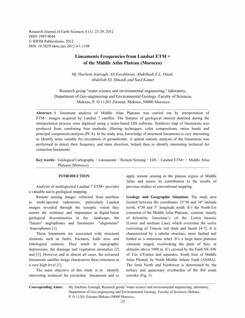
Research Journal of Earth Sciences 4 (1): 23-29, 2012ISSN 1995-9044© IDOSI Publications, 2012DOI: 10.5829/idosi.rjes.2012.4.1.1108
Coorespending Autor: My Hachem Aouragh, Research group "water science and environmental engineering, laboratory,Department of Geo-engineering and Environmental Geology, Faculty of Sciences, Meknes,P. O 11201 Zitoune-Meknes-50000 Morocco.
23
Lineaments Frequencies from Landsat ETM +of the Middle Atlas Plateau (Morocco)
My Hachem Aouragh, Ali Essahlaoui, Abdelhadi E.L. Ouali,Abdellah EL Hmaidi and Said Kamel
Research group "water science and environmental engineering," laboratory, Department of Geo-engineering and Environmental Geology, Faculty of Sciences,
Meknes, P. O 11201 Zitoune, Meknes, 50000 Morocco
Abstract: A lineament analysis of Middle Atlas Plateaus was carried out by interpretation ofETM+ images acquired by Landsat 7 satellite. The features of geological interest detected during theinterpretation process were digitized using a raster-based GIS software. Synthesis map of lineaments wasproduced from combining four methods; filtering techniques, color compositions, ratios bands andprincipal components analysis (PCA). In the study area, knowledge of structural lineaments is very interestingto identify areas suitable for circulation of groundwater. A spatial statistic analysis of the lineaments wasperformed to detect their frequency and main direction, helped then to identify interesting technical forextraction lineaments.
Key words: Geological Cartography Lineaments Remote Sensing GIS Landsat ETM+ Middle AtlasPlateaus (Morocco)
INTRODUCTION apply remote sensing in the plateau region of Middle
Analysis of multispectral Landsat 7 ETM+ provides previous studies of conventional mapping.a valuable aid to geological mapping.
Remote sensing images collected from satellites Geology and Geographic Situation: The study areato multi-spectral radiometer, particularly Landsat located between the coordinates 33°30 and 34° latitudeimages revealed through the synoptic vision they north, 4°30 and 5° longitude south. It’s the North-Estrestore the existence and importance as digital linear extension of the Middle Atlas Plateaus, consists mainlygeological discontinuities in the landscape, the of dolomitic limestone’s of the Lower Jurassic''linears'' anglophones and lineaments "alignments" (Lower and medium Lias), which overcome the series francophones [1]. consisting of Triassic red shale and basalt [4-7]. It is
These lineaments are associated with structural characterized by a tabular structure, more faulted andelements such as faults, fractures, folds axes and folded as a monotone relief. It’s a large karst plateauslithological contacts. They result in topographic variously staged, overlooking the plain of Sais, atdepressions, the drainage and vegetation anomalies [2] altitudes above 1000 m. It’s crossed by the Fault NE-SWand [3]. However and in almost all cases, the extracted of Tizi n'Tratten and separates, South East of Middlelineaments satellite image characterize these structures at Atlas Pleated, by North Middle Atlasic Fault (ANMA).a very high level [1]. The limit North and Northwest is determined by the
The main objective of this study is to identify tertiary and quaternary overburden of the Rif southinteresting technical for extraction lineaments and to corridor (Fig. 1).
Atlas and assess its contribution to the results of
Res. J. Earth Sci., 4 (1): 23-29, 2012
24
Fig. 1: Simplified geological map of the Middle Atlas(FEDAN and al., 1989 modified) and location ofthe study area (in part).
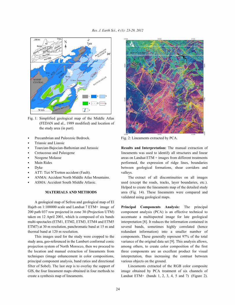
Precambrian and Paleozoic Bedrock. Fig. 2: Lineaments extracted by PCA.Triassic and LiassicToarcian-Bajocian-Bathonian and Jurassic Results and Interpretation: The manual extraction ofCretaceous and Paleogene lineaments was used to identify all structures and linearNeogene Molasse areas on Landsat ETM + images from different treatmentsMain Rides performed, the expression of ridge lines, boundariesDyke between geological formations, shear corridors andATT: Tizi N'Tretten accident (Fault). valleys.ANMA: Accident North Middle Atlas Mountains. The extract of all discontinuities on all imagesASMA: Accident South Middle Atlasic. used (except the roads, tracks, layer boundaries, etc.).
MATERIALS AND METHODS area (Fig. 14). These lineaments were compared and
A geological map of Sefrou and geological map of ElHajeb on 1:100000 scale and Landsat 7 ETM+ image of Principal Components Analysis: The principal200 path 037 row projected in zone 30 (Projection UTM) component analysis (PCA) is an effective technical totaken on 12 April 2001, which is composed of six bands accentuate a multispectral image for late geologicalmulti-spectacles (ETM1, ETM2, ETM3, ETM4 and ETM5 interpretation [8]. It reduces the information contained inETM7) at 30 m resolution, panchromatic band at 15 m and several bands, sometimes highly correlated (hencethermal band at 120 m resolution. redundant information) into a smaller number of
This images used for the study were cropped to the components. These generally represent 97% of the totalstudy area, geo-referenced in the Lambert conformal conic variance of the original data set [9]. This analysis allows,projection system of North Morocco, then we proceed to among others, to create color composition of the firstthe location and manual extraction of lineaments from three components are an excellent product for visualtechniques (image enhancement in color compositions, interpretation, thus increasing the contrast betweenprincipal component analysis, band ratios and directional various objects on the ground.filter of Sobel). The last step is to overlay the support of Lineaments extracted of the RGB color compositeGIS, the four lineament maps obtained in four methods to image obtained by PCA treatment of six channels ofcreate a synthesis map of lineaments. Landsat ETM+ (bands 1, 2, 3, 4, 5 and 7) (Figure 2).
Helped to create the lineaments map of the detailed study
validated using geological maps.
North
South
EastWest
North
South
EastWest
Res. J. Earth Sci., 4 (1): 23-29, 2012
25
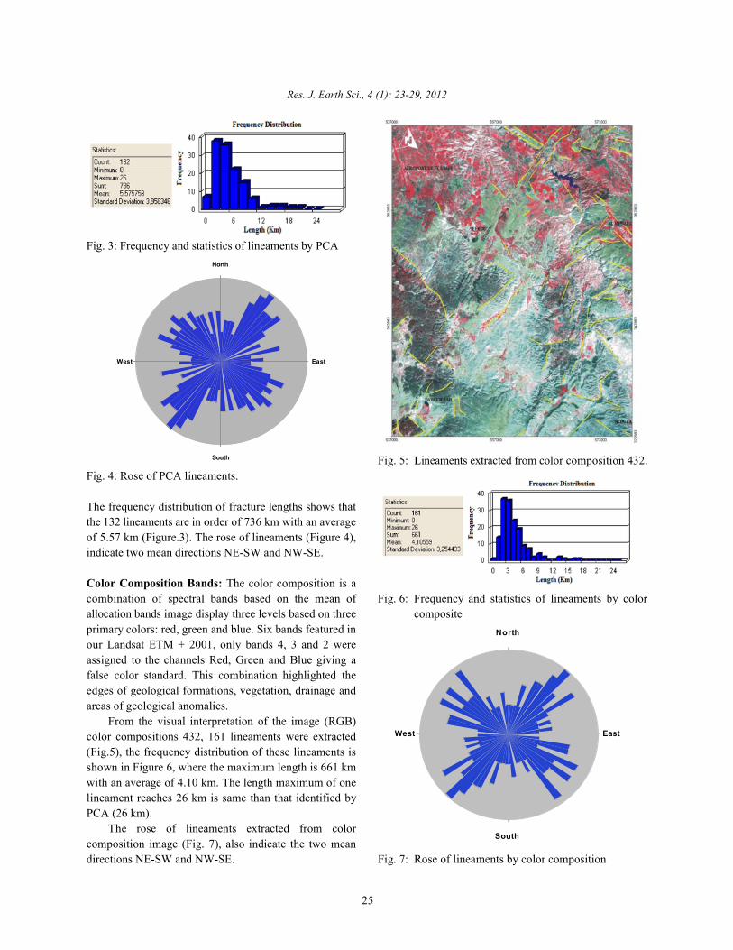
Fig. 3: Frequency and statistics of lineaments by PCA
Fig. 4: Rose of PCA lineaments.
The frequency distribution of fracture lengths shows thatthe 132 lineaments are in order of 736 km with an averageof 5.57 km (Figure.3). The rose of lineaments (Figure 4),indicate two mean directions NE-SW and NW-SE.
Color Composition Bands: The color composition is acombination of spectral bands based on the mean of Fig. 6: Frequency and statistics of lineaments by colorallocation bands image display three levels based on three compositeprimary colors: red, green and blue. Six bands featured inour Landsat ETM + 2001, only bands 4, 3 and 2 wereassigned to the channels Red, Green and Blue giving afalse color standard. This combination highlighted theedges of geological formations, vegetation, drainage andareas of geological anomalies.
From the visual interpretation of the image (RGB)color compositions 432, 161 lineaments were extracted(Fig.5), the frequency distribution of these lineaments isshown in Figure 6, where the maximum length is 661 kmwith an average of 4.10 km. The length maximum of onelineament reaches 26 km is same than that identified byPCA (26 km).
The rose of lineaments extracted from colorcomposition image (Fig. 7), also indicate the two meandirections NE-SW and NW-SE. Fig. 7: Rose of lineaments by color composition
Fig. 5: Lineaments extracted from color composition 432.
North
South
EastWest
Res. J. Earth Sci., 4 (1): 23-29, 2012
26
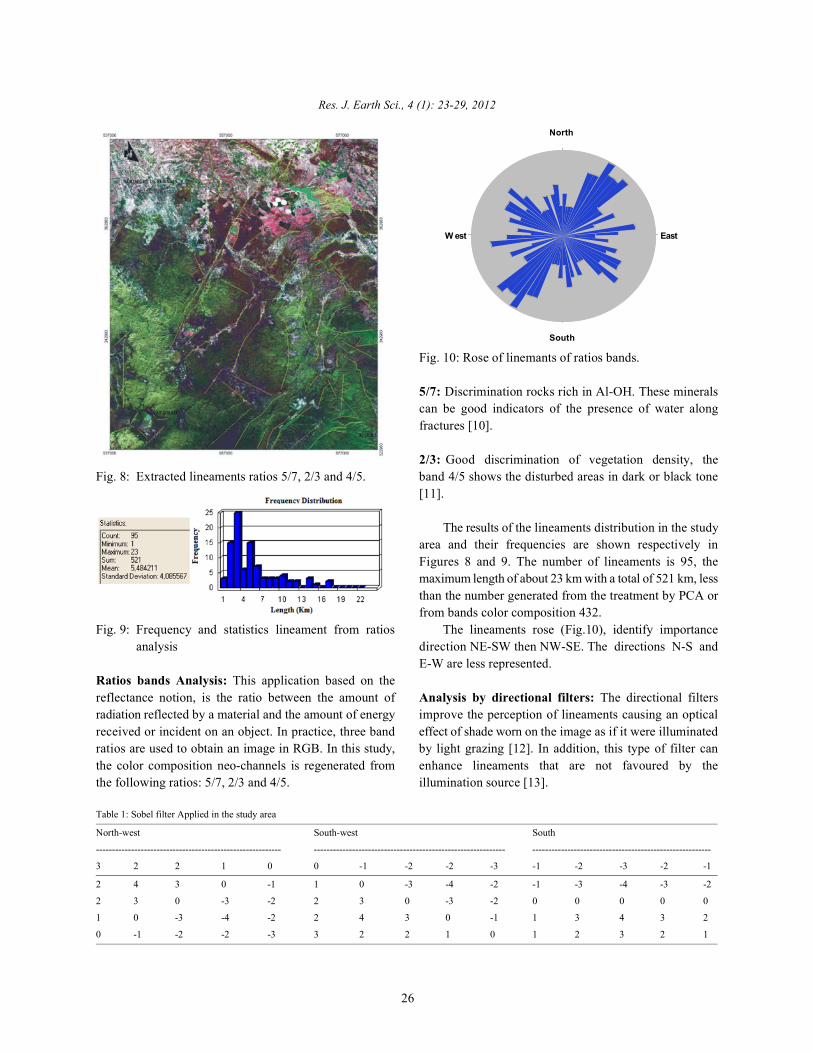
Fig. 8: Extracted lineaments ratios 5/7, 2/3 and 4/5. band 4/5 shows the disturbed areas in dark or black tone
Fig. 9: Frequency and statistics lineament from ratios The lineaments rose (Fig.10), identify importanceanalysis direction NE-SW then NW-SE. The directions N-S and
Ratios bands Analysis: This application based on thereflectance notion, is the ratio between the amount of Analysis by directional filters: The directional filtersradiation reflected by a material and the amount of energy improve the perception of lineaments causing an opticalreceived or incident on an object. In practice, three band effect of shade worn on the image as if it were illuminatedratios are used to obtain an image in RGB. In this study, by light grazing [12]. In addition, this type of filter canthe color composition neo-channels is regenerated from enhance lineaments that are not favoured by thethe following ratios: 5/7, 2/3 and 4/5. illumination source [13].
Fig. 10: Rose of linemants of ratios bands.
5/7: Discrimination rocks rich in Al-OH. These mineralscan be good indicators of the presence of water alongfractures [10].
2/3: Good discrimination of vegetation density, the
[11].
The results of the lineaments distribution in the studyarea and their frequencies are shown respectively inFigures 8 and 9. The number of lineaments is 95, themaximum length of about 23 km with a total of 521 km, lessthan the number generated from the treatment by PCA orfrom bands color composition 432.
E-W are less represented.
Table 1: Sobel filter Applied in the study area
North-west South-west South
---------------------------------------------------------- ------------------------------------------------------------ --------------------------------------------------------
3 2 2 1 0 0 -1 -2 -2 -3 -1 -2 -3 -2 -1
2 4 3 0 -1 1 0 -3 -4 -2 -1 -3 -4 -3 -2
2 3 0 -3 -2 2 3 0 -3 -2 0 0 0 0 0
1 0 -3 -4 -2 2 4 3 0 -1 1 3 4 3 2
0 -1 -2 -2 -3 3 2 2 1 0 1 2 3 2 1
North
South
EastWest
Res. J. Earth Sci., 4 (1): 23-29, 2012
27
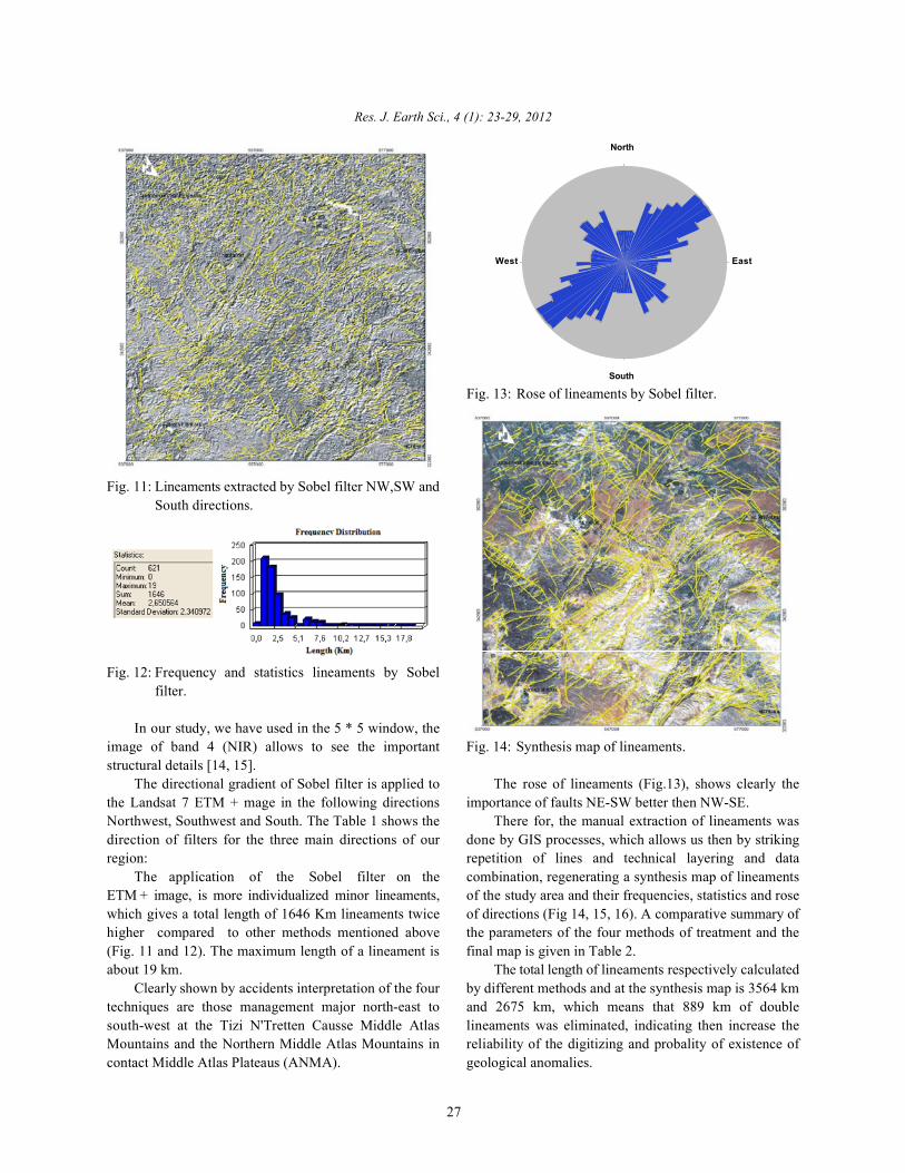
Fig. 11: Lineaments extracted by Sobel filter NW,SW andSouth directions.
Fig. 12: Frequency and statistics lineaments by Sobelfilter.
In our study, we have used in the 5 * 5 window, theimage of band 4 (NIR) allows to see the important Fig. 14: Synthesis map of lineaments.structural details [14, 15].
The directional gradient of Sobel filter is applied to The rose of lineaments (Fig.13), shows clearly thethe Landsat 7 ETM + mage in the following directions importance of faults NE-SW better then NW-SE.Northwest, Southwest and South. The Table 1 shows the There for, the manual extraction of lineaments wasdirection of filters for the three main directions of our done by GIS processes, which allows us then by strikingregion: repetition of lines and technical layering and data
The application of the Sobel filter on the combination, regenerating a synthesis map of lineamentsETM + image, is more individualized minor lineaments, of the study area and their frequencies, statistics and rosewhich gives a total length of 1646 Km lineaments twice of directions (Fig 14, 15, 16). A comparative summary ofhigher compared to other methods mentioned above the parameters of the four methods of treatment and the(Fig. 11 and 12). The maximum length of a lineament is final map is given in Table 2.about 19 km. The total length of lineaments respectively calculated
Clearly shown by accidents interpretation of the four by different methods and at the synthesis map is 3564 kmtechniques are those management major north-east to and 2675 km, which means that 889 km of doublesouth-west at the Tizi N'Tretten Causse Middle Atlas lineaments was eliminated, indicating then increase theMountains and the Northern Middle Atlas Mountains in reliability of the digitizing and probality of existence ofcontact Middle Atlas Plateaus (ANMA). geological anomalies.
Fig. 13: Rose of lineaments by Sobel filter.
North
South
EastW est
Res. J. Earth Sci., 4 (1): 23-29, 2012
28
Table 2: Comparison of the synthesis map with the used methods.
CPA Color composition Ratios Sobel filter Synthesis map
Frequency 132 161 95 621 822
Total length (km) 736 661 521 1646 2675
Max length (km) 26 26 23 19 26
Moy length (km) 5.57 4.10 5.48 2.65 3.25
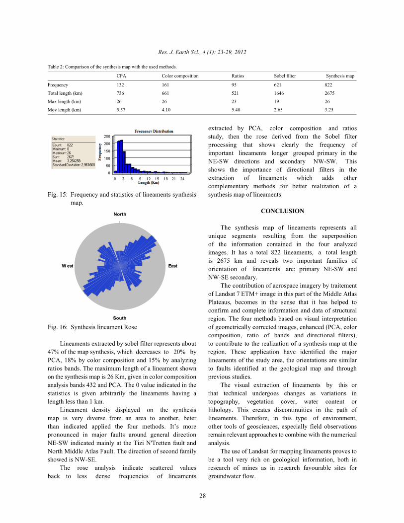
Fig. 15: Frequency and statistics of lineaments synthesis synthesis map of lineaments.map.
Fig. 16: Synthesis lineament Rose of geometrically corrected images, enhanced (PCA, color
Lineaments extracted by sobel filter represents about to contribute to the realization of a synthesis map at the47% of the map synthesis, which decreases to 20% by region. These application have identified the majorPCA, 18% by color composition and 15% by analyzing lineaments of the study area, the orientations are similarratios bands. The maximum length of a lineament shown to faults identified at the geological map and throughon the synthesis map is 26 Km, given in color composition previous studies.analysis bands 432 and PCA. The 0 value indicated in the The visual extraction of lineaments by this orstatistics is given arbitrarily the lineaments having a that technical undergoes changes as variations inlength less than 1 km. topography, vegetation cover, water content or
Lineament density displayed on the synthesis lithology. This creates discontinuities in the path ofmap is very diverse from an area to another, beter lineaments. Therefore, in this type of environment,than indicated applied the four methods. It’s more other tools of geosciences, especially field observationspronounced in major faults around general direction remain relevant approaches to combine with the numericalNE-SW indicated mainly at the Tizi N'Tretten fault and analysis.North Middle Atlas Fault. The direction of second family The use of Landsat for mapping lineaments proves toshowed is NW-SE. be a tool very rich on geological information, both in
The rose analysis indicate scattered values research of mines as in research favourable sites forback to less dense frequencies of lineaments groundwater flow.
extracted by PCA, color composition and ratiosstudy, then the rose derived from the Sobel filterprocessing that shows clearly the frequency ofimportant lineaments longer grouped primary in theNE-SW directions and secondary NW-SW. Thisshows the importance of directional filters in theextraction of lineaments which adds othercomplementary methods for better realization of a
CONCLUSION
The synthesis map of lineaments represents allunique segments resulting from the superpositionof the information contained in the four analyzedimages. It has a total 822 lineaments, a total lengthis 2675 km and reveals two important families oforientation of lineaments are: primary NE-SW andNW-SE secondary.
The contribution of aerospace imagery by traitementof Landsat 7 ETM+ image in this part of the Middle AtlasPlateaus, becomes in the sense that it has helped toconfirm and complete information and data of structuralregion. The four methods based on visual interpretation
composition, ratio of bands and directional filters),

Res. J. Earth Sci., 4 (1): 23-29, 2012
29
REFERENCES 8. Biemi, J., et al., 1991. Geology and lineaments
1. Scanvic, J.Y., 1983. Aerospace and Remote Sensing mapping using Landsat-TM and the total magneticgeological information. Manuals and Methods, field. Remote sensing and resource management.Editions BRGM, Orléans, France, 24: 284. flight. vii, Paul Gagnon (eds), Remote Sensing
2. Soesilo, L. and R.A. Hoppin, 1986. Evaluation of Quebecoise Association, pp: 134-145.processed Landsat imagery and digitaiIy SIR-A 9. Deslandes, S., 1986. Evaluation of Seasat and SPOTimagery for pological. imagery for mapping lineaments sector Stoke Monts,
3. Yatabe, S. and P.H. Howarth, 1984. Lineament Quebec, a comparison based on spectrum analysisenhancernent and interpretation in Northem Ontario Foumer. Master's thesis, Department of Geography,from airborne, multispectral scanner data. University of Sherbrooke, pp: 62.Proceedings of the International Symposium on 10. Crippen, R.E., 1988. The dangers of underestimatingRemote Sensing, 3 Thematic Conference, Remote the importance of data in band ratioing Adjustments,rd
Sensing for Exploration Geology, pp: 1-8. Int. J. Remote Sensing, 9: 767-776.4. Charriere, A., 1990. Inheritance Hercynian and Alpine 11. Won-In, K.P. Charusiri, 2003. Enhancement of
geodynamic evolution of intracontinental chain: the thematic mapper satellite images for geologicalMiddle Atlas southeast of Fez (Morocco), state mapping of the Cho Dien area, Northern Vietnam,thesis, Toulouse. International Journal of Applied Earth Observation
5. Fedan, B., E. La Ville and El Mezgueldia, 1989. The and Geoinformation, 15: 1-11.Jurassic basin of the Middle Atlas (Morocco): 12. Marion, A., 1987. Introduction to the techniques ofexample of relay pool setbacks. Ball. Soc. Geol. image processing. Paris, Editions Eyrolles, pp: 278.France, t.v, No. 6, p. From 1123 to 1136. 13. Drury, S.A., 1986. Remote Sensing of Geological
6. Lashkar, G., D. Ouarrache and A. Charrière, 2000. Structure in Temperate Agricultural Land. GeologicalNew palynological data on the sedimentary Magazine, 123(2): 113-121.formations associe'es Triassic basalts of the Middle 14. Jourda, J.P., E.V. Djagoua, K. Kouamé, B.M. Saley,Atlas and High Moulouya (Morocco), C. Gronayes, J.J. Achy and M. Razack, 2006.Micropaleontol., 43: 281-299. Identification and mapping of lithologic units and
7. Ouarhache, D., 2002. Sedimentation and volcanic major structural accidents Department of Korhogoactivity (effusive and explosive) Triassic rifting and (north of Côte d'Ivoire): Contribution of Landsatassociated infra-Liassic in the south-western Middle ETM + imagery. Remote Sensing, 6(2): 123-142.Atlas and High Moulouya (Morocco), state thesis, 15. Shupe, S.M. and V. Akha, 1989. Remotely sensed andUniversity Mohammed V, Rabat. Intergation of GISData for mineral exploration:
networks, watershed area of Marahoue, Côte d'Ivoire:
Halifax area, Vova seventh, Geocarto InternationalA multi-disciplinary Journal of Remote Sensing,pp: 49-54.
Copyright © 2022 FDOKUMEN