Cenozoic tectonic lineaments of the Terra Nova Bay region, Ross Embayment, Antarctica
16
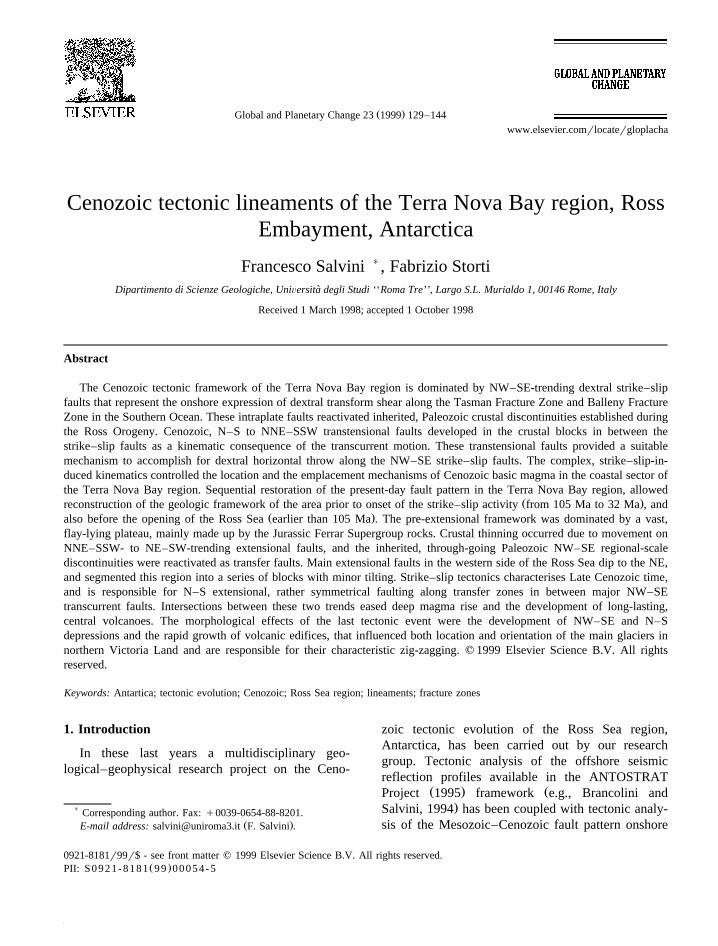
Ž . Global and Planetary Change 23 1999 129–144 www.elsevier.comrlocatergloplacha Cenozoic tectonic lineaments of the Terra Nova Bay region, Ross Embayment, Antarctica Francesco Salvini ) , Fabrizio Storti Dipartimento di Scienze Geologiche, UniÕersita degli Studi ‘‘Roma Tre’’, Largo S.L. Murialdo 1, 00146 Rome, Italy ` Received 1 March 1998; accepted 1 October 1998 Abstract The Cenozoic tectonic framework of the Terra Nova Bay region is dominated by NW–SE-trending dextral strike–slip faults that represent the onshore expression of dextral transform shear along the Tasman Fracture Zone and Balleny Fracture Zone in the Southern Ocean. These intraplate faults reactivated inherited, Paleozoic crustal discontinuities established during the Ross Orogeny. Cenozoic, N–S to NNE–SSW transtensional faults developed in the crustal blocks in between the strike–slip faults as a kinematic consequence of the transcurrent motion. These transtensional faults provided a suitable mechanism to accomplish for dextral horizontal throw along the NW–SE strike–slip faults. The complex, strike–slip-in- duced kinematics controlled the location and the emplacement mechanisms of Cenozoic basic magma in the coastal sector of the Terra Nova Bay region. Sequential restoration of the present-day fault pattern in the Terra Nova Bay region, allowed Ž . reconstruction of the geologic framework of the area prior to onset of the strike–slip activity from 105 Ma to 32 Ma , and Ž . also before the opening of the Ross Sea earlier than 105 Ma . The pre-extensional framework was dominated by a vast, flay-lying plateau, mainly made up by the Jurassic Ferrar Supergroup rocks. Crustal thinning occurred due to movement on NNE–SSW- to NE–SW-trending extensional faults, and the inherited, through-going Paleozoic NW–SE regional-scale discontinuities were reactivated as transfer faults. Main extensional faults in the western side of the Ross Sea dip to the NE, and segmented this region into a series of blocks with minor tilting. Strike–slip tectonics characterises Late Cenozoic time, and is responsible for N–S extensional, rather symmetrical faulting along transfer zones in between major NW–SE transcurrent faults. Intersections between these two trends eased deep magma rise and the development of long-lasting, central volcanoes. The morphological effects of the last tectonic event were the development of NW–SE and N–S depressions and the rapid growth of volcanic edifices, that influenced both location and orientation of the main glaciers in northern Victoria Land and are responsible for their characteristic zig-zagging. q 1999 Elsevier Science B.V. All rights reserved. Keywords: Antartica; tectonic evolution; Cenozoic; Ross Sea region; lineaments; fracture zones 1. Introduction In these last years a multidisciplinary geo- logical–geophysical research project on the Ceno- ) Corresponding author. Fax: q0039-0654-88-8201. Ž . E-mail address: [email protected] F. Salvini . zoic tectonic evolution of the Ross Sea region, Antarctica, has been carried out by our research group. Tectonic analysis of the offshore seismic reflection profiles available in the ANTOSTRAT Ž . Ž Project 1995 framework e.g., Brancolini and . Salvini, 1994 has been coupled with tectonic analy- sis of the Mesozoic–Cenozoic fault pattern onshore 0921-8181r99r$ - see front matter q 1999 Elsevier Science B.V. All rights reserved. Ž . PII: S0921-8181 99 00054-5
Transcript of Cenozoic tectonic lineaments of the Terra Nova Bay region, Ross Embayment, Antarctica
Ž .Global and Planetary Change 23 1999 129–144www.elsevier.comrlocatergloplacha
Cenozoic tectonic lineaments of the Terra Nova Bay region, RossEmbayment, Antarctica
Francesco Salvini ), Fabrizio StortiDipartimento di Scienze Geologiche, UniÕersita degli Studi ‘‘Roma Tre’’, Largo S.L. Murialdo 1, 00146 Rome, Italy`
Received 1 March 1998; accepted 1 October 1998
Abstract
The Cenozoic tectonic framework of the Terra Nova Bay region is dominated by NW–SE-trending dextral strike–slipfaults that represent the onshore expression of dextral transform shear along the Tasman Fracture Zone and Balleny FractureZone in the Southern Ocean. These intraplate faults reactivated inherited, Paleozoic crustal discontinuities established duringthe Ross Orogeny. Cenozoic, N–S to NNE–SSW transtensional faults developed in the crustal blocks in between thestrike–slip faults as a kinematic consequence of the transcurrent motion. These transtensional faults provided a suitablemechanism to accomplish for dextral horizontal throw along the NW–SE strike–slip faults. The complex, strike–slip-in-duced kinematics controlled the location and the emplacement mechanisms of Cenozoic basic magma in the coastal sector ofthe Terra Nova Bay region. Sequential restoration of the present-day fault pattern in the Terra Nova Bay region, allowed
Ž .reconstruction of the geologic framework of the area prior to onset of the strike–slip activity from 105 Ma to 32 Ma , andŽ .also before the opening of the Ross Sea earlier than 105 Ma . The pre-extensional framework was dominated by a vast,
flay-lying plateau, mainly made up by the Jurassic Ferrar Supergroup rocks. Crustal thinning occurred due to movement onNNE–SSW- to NE–SW-trending extensional faults, and the inherited, through-going Paleozoic NW–SE regional-scalediscontinuities were reactivated as transfer faults. Main extensional faults in the western side of the Ross Sea dip to the NE,and segmented this region into a series of blocks with minor tilting. Strike–slip tectonics characterises Late Cenozoic time,and is responsible for N–S extensional, rather symmetrical faulting along transfer zones in between major NW–SEtranscurrent faults. Intersections between these two trends eased deep magma rise and the development of long-lasting,central volcanoes. The morphological effects of the last tectonic event were the development of NW–SE and N–Sdepressions and the rapid growth of volcanic edifices, that influenced both location and orientation of the main glaciers innorthern Victoria Land and are responsible for their characteristic zig-zagging. q 1999 Elsevier Science B.V. All rightsreserved.
Keywords: Antartica; tectonic evolution; Cenozoic; Ross Sea region; lineaments; fracture zones
1. Introduction
In these last years a multidisciplinary geo-logical–geophysical research project on the Ceno-
) Corresponding author. Fax: q0039-0654-88-8201.Ž .E-mail address: [email protected] F. Salvini .
zoic tectonic evolution of the Ross Sea region,Antarctica, has been carried out by our researchgroup. Tectonic analysis of the offshore seismicreflection profiles available in the ANTOSTRAT
Ž . ŽProject 1995 framework e.g., Brancolini and.Salvini, 1994 has been coupled with tectonic analy-
sis of the Mesozoic–Cenozoic fault pattern onshore
0921-8181r99r$ - see front matter q 1999 Elsevier Science B.V. All rights reserved.Ž .PII: S0921-8181 99 00054-5

( )F. SalÕini, F. StortirGlobal and Planetary Change 23 1999 129–144130
Ž .e.g., Salvini and Storti, 1994 , to produce a generalŽtectonic map of the whole Ross Sea region Bran-
.colini et al., 1997 . Overprinting relationships amongdifferent fault systems, offshore and onshore ageconstraints, geometric and kinematic analysis of thecross-sectional fault patterns, together with plate tec-tonic reconstructions, have been used to set up aMesozoic–Cenozoic evolutionary model of the Ross
Ž .Sea region Salvini et al., 1997a .
In this paper we illustrate the tectonic frameworkof the Terra Nova Bay region, namely the areabordered by the Mesa Range to the north, by theDrygalski Ice Tongue to the south, by the PolarPlateau to the west and by the western Ross Sea to
Ž .the east Figs. 1 and 2 . Particular emphasis is givento the description of the Cenozoic fault pattern andto the sequential restoration of the fault arrays toinfer the overall tectonic pattern of the Terra Nova
Fig. 1. Tectonic sketch map of Victoria Land and the Ross Sea. The main NW–SE fault systems are clearly visible and affect the wholeregion. Most of these faults represent reactivated, inherited Early Paleozoic discontinuities formed during the terrane accretion of the RossOrogen. The main extensional grain is also outlined and shows an arcuate shape roughly parallel to the coastline. N–S tectonics relate to theinteractions between adjacent NW–SE faults. Cenozoic volcanic rocks crop out along a belt that follows the coastal trend. The gray boxindicates location of Fig. 2. Locations of the cross section and seismic line in Fig. 3 are also indicated. RBT, Robertson Bay Terrane; BT,Bowers Terrane; WT, Wilson Terrane; F, right-lateral strike–slip faults; IF, inverted extensional faults; NF, extensional faults, barbs on thedownthrown block; MMV, main outcrops of Cenozoic McMurdo Volcanic rocks; CAF, Cape Adare Fault, TF, Tucker Fault; LYF, LeapYear Fault; LF, Lanterman Fault; RG, Rennick Graben; AF, Aviator Fault; CF, Campbell Fault; PF, Priestley Fault; RF, Reeves Fault, DF,David Fault; CH, Central High; CL, Coulman High; CT, Central Trough; VL, Victoria Land Basin, TR, Terror Rift; M, McMurdo Sound;ca, Cape Adare; ci, Coulman Island; cw, Cape Washington.

( )F. SalÕini, F. StortirGlobal and Planetary Change 23 1999 129–144 131
Bay region during the major evolutionary stages ofthe Ross Sea opening and consequent uplift of theTransantarctic Mountains.
2. Geological overview of northern Victoria Land
Three major terranes have been recognized inŽ .northern Victoria Land Fig. 1 . From NE to SW
they are the Robertson Bay Terrane, the BowersŽTerrane and the Wilson Terrane Kleinschmidt and
Tessensohn, 1987; Bradshaw, 1989; Carmignani et. Žal., 1989; Laird, 1989 . The Leap Year Fault Findlay
.and Field, 1983 separates the Robertson Bay Ter-rane from the Bowers Terrane, and the Lanterman
Ž .Fault Dow and Neall, 1974; Gibson, 1985 separatesthe Bowers Terrane from the Wilson Terrane. Ter-rane matching is commonly ascribed to the EarlyPaleozoic Ross Orogeny, when new crustal materialwas accreted by transpression to the East Antarctic
ŽCraton Findlay and Field, 1983; Weaver et al.,.1984; Bradshaw et al. 1985 . However, geodynamic
considerations on the contrasting stratigraphy and onthe different structural levels of the rocks outcrop-ping respectively to the north and to the south of theLeap Year Fault suggest that the final matching ofthe Robertson Bay Terrane and the Wilson–Bowersterranes lithospheric block might have been achieved
Ž .in Mesozoic times Salvini and Storti, 1994 .Large batholiths of the Cambro-Ordovician Gran-
Ž .ite Harbour Intrusives Gunn and Warren, 1962characterize the Wilson Terrane. They intruded intolow- to high-grade metamorphic rocks of uncertainage but generally ascribed to the Proterozoic and to
Žthe Lower Cambrian Kleinschmidt and Tessensohn,. Ž .1987 . The Bowers Terrane Cambrian–Ordovician
is a narrow NW–SE-elongated belt made up bylow-grade metavolcanic and metasedimentary rocksŽ .Weaver et al., 1984 . Cambrian–Early Ordovicianterrigenous continental shelf sediments of low meta-
Ž .morphic grade Burrett and Findlay, 1984 are widelyexposed in the Robertson Bay Terrane. They areintruded by Devonian–Carboniferous granitoids of
Žthe Admiralty Intrusives Vetter and Tessensohn.1987 .
The Paleozoic rocks of the Wilson Terrane–Bowers Terrane assembly have been deeply eroded
Ž .up to peneplanation sub-Beacon Peneplain . The
Ž .sub-Beacon Peneplain Gunn and Warren, 1962 isone of the most outstanding morphological and geo-logical features of the Transantarctic Mountains. Itconsists of the envelopment of partially overlappingregional erosional surfaces, progressively younging
Ž . Ž .from the south Devonian to the north TriassicŽ .Barrett et al., 1972 . Shallow-water continental and
Ž .marine sediments Beacon Supergroup were uncon-formably deposited above the sub-Beacon PeneplainŽ .Wolfe and Barrett, 1995 and references therein .The Beacon Supergroup is in turn overlain and in-truded by the Jurassic sequence of the Ferrar Super-group, consisting of thick and areally extensive
Žbasaltic lava flows Kirkpatrick Basalt; Grindley,. Ž .1963 and dolerite sills Ferrar Dolerite . No out-
crops of the Beacon and the Ferrar supergroups havebeen found north of the Leap Year Fault, in theRobertson Bay Terrane. Widespread volcanic activ-ity affected the coastal sector of the Victoria Land
Žand the western Ross Sea McMurdo Volcanic rocks;.Harrington, 1958 during the Cenozoic time.
3. Cenozoic tectonic pattern
The pre-Mesozoic basement in the Terra NovaŽBay region mainly consists of granitoids both Gran-
.ite Harbour Intrusives and Admiralty Intrusives andmetamorphic rocks and has been left undifferentiatedin the sketch map of Fig. 2. An abrupt decrease ofthe outcropping granitoids belonging to the GraniteHarbour Intrusives occurs to the north of the WilsonTerrane–Bowers Terrane boundary.
The tectonic fabric of the cristalline basementoriginated during the Ross Orogeny in early Paleo-
Ž .zoic times about 500–480 Ma . Structural trendsdefined by a steeply dipping metamorphic foliation,highly strained shear zones and fold axial trends, are
Žmainly NW–SE Gibson, 1987; Kleinschmidt and.Tessensohn, 1987; Carmignani et al., 1989 . The
spatial distribution of different metamorphic facies inthe crystalline basement of the Terra Nova Bay
Žregion GANOVEX Team, 1987; Carmignani et al.,.1989; Giudice et al., 1991 supports the presence of
NW–SE-trending Paleozoic crustal discontinuities.Glaciers presently occupy the major NW–SE struc-tural lineaments.

( )F. SalÕini, F. StortirGlobal and Planetary Change 23 1999 129–144132
Fig. 2. Present-day tectonic map of the Terra Nova Bay region. See Fig. 1 for location. Three main sets of fault systems contribute to thepresent-day tectonic setting. The NW–SE fault systems are the dominant ones and their activity relates to the last, right-lateral,transtensional event. Neither NE–SW and N–S extensional or transtensional faulting ever cut across the NW–SE faults, suggesting theirrelative younger activity. The cross relationships of NW–SE faults with N–S faulting, their kinematic compatibility, and interactions withCenozoic magmatism suggest that both systems were active during the Late Cenozoic tectonic event. Main volcanic edifices locate alongNW–SE faults, at their intersection with N–S tectonic depressions. Glacier flows are deeply affected by the presence of NW–SE and N–Sdiscontinuities and follows the two trends with a characteristic zig-zag pattern.

( )F. SalÕini, F. StortirGlobal and Planetary Change 23 1999 129–144 133
By the end of the Paleozoic–Early Mesozoic timesthe Ross Orogen was isostatically compensated andthermally re-equilibrated as testified by the develop-ment of the sub-Beacon peneplain. Yet the WilsonTerrane–Bowers Terrane lithospheric block pre-served a series of NW–SE-trending mechanicalanisotropies along localized belts that will have in-fluenced the pattern of the later Mesozoic and Ceno-
Ž .zoic tectonics Fig. 2 .Large outcrops of the Jurassic Ferrar Supergroup
overlie the Permian–Triassic sediments of the Bea-Ž .con Supergroup unified as Mesozoic rocks in Fig. 2
and are widely exposed in the northwestern sector ofthe region, in the Mesa Range, northern Deep Freeze
Ž .Range and in the Eisenhower Range Fig. 2 . Only asmall outcrop of Jurassic rocks occurs southward, inthe Prince Albert Mountains. No outcrops of theBeacon and Ferrar rocks have been preserved east-ward, along the Ross Sea shoulder, where tectoni-cally enhanced erosion caused faster removal of a
Žgreater amount of material e.g., Van der Beck et al.,.1994 .
Cenozoic volcanic rocks crop out in the coastalŽ .sector of the Terra Nova Bay region Fig. 2 . Effu-
sive rocks are clustered close to the two majorcentral volcanoes: Mt. Melbourne and Mt. Overlord.Two other effusive centres are present south of Mt.
Ž .Overlord Mt. Rittmann and Berlin Dome . North ofthe Campbell Glacier, Cenozoic intrusive rocksŽ .Meander Intrusives are exposed in the coastal re-
Ž .gion e.g., Tonarini et al., 1997 .The Cenozoic pattern of onshore and offshore
faults in the Victoria Land is shown in Fig. 1. Thedominant set of fault systems trends NW–SE andmajor glacier streams lie roughly parallel to thattrend. Seven major NW–SE fault systems constitutethe main tectonic grain of the northern Victoria LandŽ .Fig. 2 . Both positive and negative flower structureshave been discovered along their path, and suggest aright-lateral, strike–slip sense of motion of these
Ž .faults Salvini et al., 1997b .Each of these fault systems consists of an enve-
lope of coalescent right-lateral strike–slip faults thatdefine a discrete regional-scale deformation zone.Deformation intensity along the shear zones variesabruptly both along and across strike. Polished faultsurfaces and slickensides generally border elongatezones of fault breccia, fault gouge, cataclasite, ultra-
Žcataclasite and, locally, pseudotachylyte Rossetti and.Storti, 1998 . Dyke swarms originated along the fault
zones and in the borderland zones in between them.Cenozoic dykes with strike–slip slickensides in-truded along main fault planes with contradictorytemporal relationships between dikes and faults. Thissuggests that magma rise was triggered by the re-gional NW–SE right-lateral strike–slip fault zonesduring the Cenozoic.
N–S tectonic depressions are common features inbetween adjacent faults. Field investigations haveconfirmed their tectonic origin and their relationshipwith the strike–slip tectonics and with the Cenozoic
Ž .magmatism Rossetti and Storti, 1998 . The N–Sdepressions have been interpreted as extensional ortranstensional structures associated to the generalCenozoic, right-lateral shear affecting the region.
The main glaciers of northern Victoria Land de-veloped along the main path of the regional, NW–SE
Ž .faults Fig. 2 . In the coastal region, linked to thechange in crustal thickness and rheology towards the
Ž .Ross Sea Salvini et al., 1997a,b , some of theNW–SE faults branch in correspondence with Ceno-zoic intrusions of the Meander Intrusives or centralvolcanoes of the McMurdo Volcanic rocks, and ofN–S tectonic depressions. In the regional, right-lateral tectonic picture, the junctions between NW–SE faults and N–S extensional depressions producethe most favourable conditions for persistent, deepmagma rise: this explains the development of largevolcanoes and intrusions in northern Victoria LandŽ .Salvini et al., 1997a,b . This variation in the tec-tonic style is recorded in the path of some of themain glaciers, that abruptly deviate into the N–Sdepressions in correspondence with the main Ceno-zoic volcanoes or intrusions.
NE–SW to NNE–SSW faults are common in theŽTerra Nova Bay region in the following referred as.the NE–SW fault system . They border the westernŽ .shoulder of the Ross Sea Fig. 2 and relate to the
Transantarctic Mountains uplift. Faults roughly trendŽ .parallel to the coastline Fig. 1 , and rotate N–S to
NNW–SSE to the South, in front of the VictoriaLand Basin. Their strike and apparent throw havebeen obtained by photogeological mapping andquantitative map analysis of the outcrop patterns ofthe Ferrar Supergroup in the Deep Freeze RangeŽ . ŽGiudice et al., 1991 and in the Mesa Range Petri

( )F. SalÕini, F. StortirGlobal and Planetary Change 23 1999 129–144134
Ž . Ž .Fig. 3. a Geological cross section along an E–W Transantarctic Mountains–Victoria Land profile, modified from Behrendt et al. 1991 .Location of the profile is in Fig. 1. Post-RSSU-6 sediments are differentiated with heavy dots. Pre-RSSU-6 sediments are shown in lightdots. Heavier lines represent faults active during the Late Cenozoic, transtensional event, and show typical flower structures near the
Ž .surface. Note the general symmetry of Late Cenozoic tectonic depressions. b Restored geological cross section of Fig. 3a in EarlyCenozoic times. The asymmetric shape of the the Victoria Land Basin is well evident, and suggests a half graben geometry with the listric
Ž .master faults in the western side and dipping eastward. c Interpreted seismic section IT90AR-63 showing a tectonic flower structure alongŽ .the eastern margin of the Terror Rift. Location is in Fig. 1 after Salvini et al., 1998 .

( )F. SalÕini, F. StortirGlobal and Planetary Change 23 1999 129–144 135
.et al., 1997 . Observed and calculated apparent dis-placements show a general downthrow of fault blocks
Ž .toward SE and ESE Salvini and Storti, 1994 .Northward of the Aviator Glacier, southward of theReeves Glacier and in the coastal region, faults havebeen located by morphotectonic analysis and satelliteimagery interpretation. An important feature of theNE–SW-trending fault system is its systematic seg-mentation against the through going NW–SE re-gional fault zones.
The third fault system set in the Terra Nova BayŽ .Region trends N–S Fig. 2 and has been already
introduced. Offshore, N–S faults constitute thenorthern end of the Terror Rift in the Victoria Land
Ž .Basin Fig. 3a,c . These faults have not been imagedin the seismic profiles north of Cape Washington.Positive flower structures along the N–S faults, es-pecially the easternmost ones, testifies for the occur-rence of positive local inversion into an overall
Ž .transtensional framework Salvini et al., 1998 . Inparticular, Fig. 3c shows an example of flower struc-tures along the eastern slope of the Terror Rift Basin,with either normal or reverse stratigraphic separa-tions along near-vertical fault planes. The alreadymentioned morphological evidences support thepresence of N–S-trending faults onshore, in particu-lar in correspondence of the abrupt clockwise turnsof the Aviator, Campbell, and Priestley Glaciers.
Merging onshore and offshore data has providedthe possibility to constrain the age of the fault sys-
Žtems in the whole Ross Sea region Brancolini et al.,.1997 . In the Terra Nova Bay area, the offshore
segments of the Aviator Fault and of the LantermanFault in many cases cut across most of the sedimen-tary succession and, in places, these faults havemorphological expression on the seafloor. NW–SEstrike–slip faulting postdates the unconformityRSSU-6 offshore, whose age has been inferred to be
Ž .around 32 Ma Busetti, 1994 . This means that theactivity of the NW–SE regional strike–slip belts isyounger than the Oligocene and has continued torecent times, possibly up to the present. The same
Ž .age constraints i.e., they cut the RSSU-6 have beenfound for the N–S faults east of Terra Nova Bay andcan be reasonably assumed also for the onshore N–Strending faults.
The NE-trending fault system was active over amuch wider time span. The Jurassic rocks belonging
to the Ferrar Supergroup are affected by NE–SWŽ .faulting. East of the Vulcan Hills Berlin Dome a
clearly developed fault escarpment is overprinted bylava flows belonging to the McMurdo Volcanic
Ž .Group Salvini and Storti, 1994 . Absolute dating ofthe nearest McMurdo lava flows gave an age of 12.6
Ž .Ma Armienti et al., 1991 , providing a minimumage for fault movement. Age determinations and
Ž .cross-cutting relationships Fig. 2 suggest that theNE–SW fault system may be generally older thanthe N–S fault systems. The NE–SW fault trend isparallel to the boundary between the continentalcrust of Victoria Land and the thinned Ross Sea one,and this may well indicate that this fault systemdeveloped during the Ross Sea opening over the last105 Ma. Locally, offshore NE–SW faults show in-versions that cut post-RSSU-6 sediments. These re-activations refer to the onset of the NW–SE right-lateral strike–slip tectonics, for they are both com-
Žpatible with its kinematics and age Salvini et al.,.1997a .
4. Tectonic evolution
Three major stages have been identified in theMesozoic–Cenozoic evolution of the Ross Sea re-
Ž . Ž .gion Salvini et al., 1997a : 1 105–55 Ma exten-Ž . Ž .sion; 2 55–32 Ma renewed extension; 3 32 Ma to
Present right-lateral strike–slip tectonics andtranstension. The absolute ages assigned to the mainstages are interpretative, based on the offshore ageinformation from the western Ross Sea. The lack ofgood age constraints onshore does not allow us todetail the timing of the fault activity in Victoria Landmore closely. Differentiation between the first andthe second evolutionary stages is mainly based on
Žapatite fission track dating of onshore materials e.g.,.Fitzgerald, 1992 , regional-scale inferences linked to
Žmagmatic activity e.g., Tessensohn and Worner,.1991 and plate tectonic reconstructions for the SW
Ž .Pacific Ocean e.g., Lawver and Gahagan, 1994 .Uncertainties in the absolute dating of the RSSU-6
Žunconformity in the seismic lines offshore Busetti,.1994 do not allow closer estimation of the onset age
Ž .32–0 Ma for strike–slip tectonics in the Ross Searegion. Other considerations are the diachronous on-set of deformation at the regional scale and the
( )F. SalÕini, F. StortirGlobal and Planetary Change 23 1999 129–144136
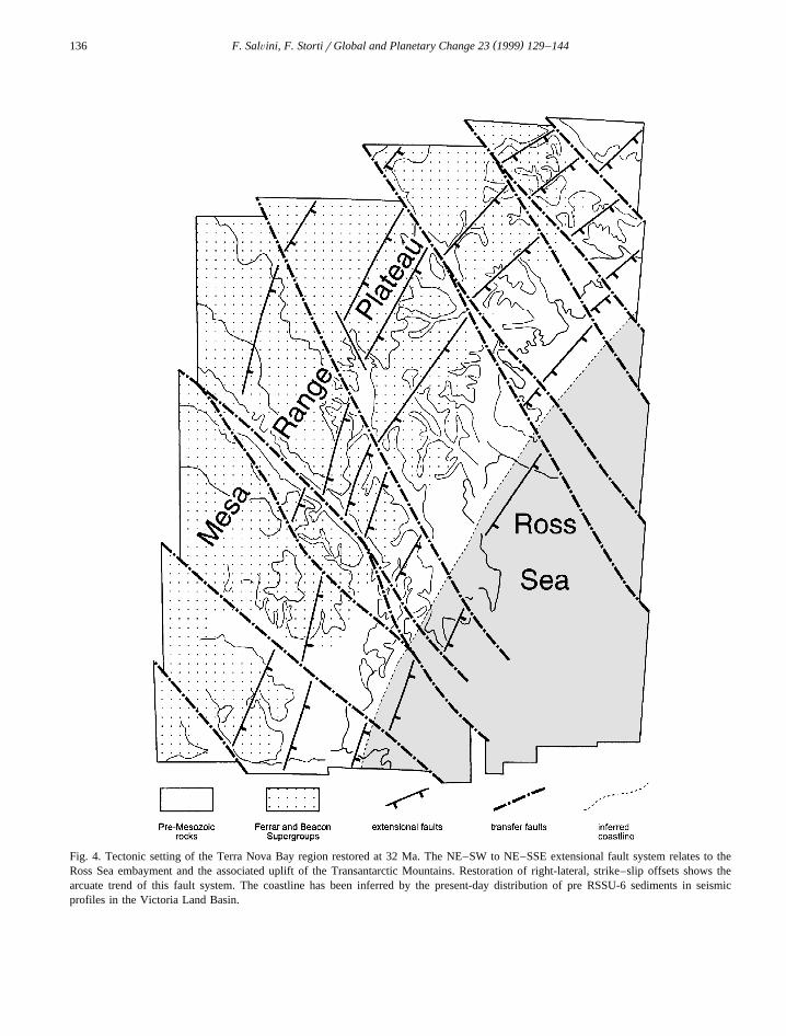
Fig. 4. Tectonic setting of the Terra Nova Bay region restored at 32 Ma. The NE–SW to NE–SSE extensional fault system relates to theRoss Sea embayment and the associated uplift of the Transantarctic Mountains. Restoration of right-lateral, strike–slip offsets shows thearcuate trend of this fault system. The coastline has been inferred by the present-day distribution of pre RSSU-6 sediments in seismicprofiles in the Victoria Land Basin.

( )F. SalÕini, F. StortirGlobal and Planetary Change 23 1999 129–144 137
possible reactivation of the pre-existing faults duringthe younger tectonic events.
The sequential restoration of the tectonic patternin the Terra Nova Bay region has allowed us to
Fig. 5. Tectonic setting of the Terra Nova Bay region restored at 105 Ma. This is the most speculative reconstruction. Almost all the faultsystems have been removed. The Mesa Range Plateau relates to the sub-Beacon peneplain and is the dominant landscape. Peneplain relicsfound in the seismic record offshore testifies its original extension in the present-day Ross Sea.

( )F. SalÕini, F. StortirGlobal and Planetary Change 23 1999 129–144138
reconstruct the fault pattern initially produced by thetwo extensional events. The deformation attributableto each separate event is poorly distinguishable, dueto the lack of tight age constraints onshore. The maindifference resides in the tectonic style. The olderevent is characterized by E- to SE-dipping exten-sional faults with a general eastward down-throw
Ž .and subordered anthitetic faults Petri et al., 1997 ina half graben geometry. The younger one is associ-ated to the regional strike–slip tectonics and does nothave a defined polarity, that is, extensional faultingis rather symmetrical and creates N–S- to NNW–SSE-elongated, tectonic depressions. The develop-ment of the Terror Rift within the Victoria LandBasin represents the best example of the interaction
Ž .between the two tectonic episodes Fig. 3a–c . Theolder Victoria Land Basin shows a steep westernshoulder and a gentle, eastern slope. The youngerTerror Rift depression and the adjacent one, havesymmetrical steep slopes, locally associated to inver-sion tectonics due to the strike–slip component.
The displacement due to the younger event in theTerra Nova Bay region has been inferred by restor-ing the pattern of the older faults into a homoge-neous, arcuate shape that it is assumed to havebordered the Late Cretaceous Ross Sea. The result-ing tectonic pattern is illustrated in Fig. 4. As apassive marker, also the present-day coastline hasbeen restored. A speculative geological landscapeprior to the Ross Sea opening has been obtained byinterpretatively restoring the extension of the first
Ž .event faults as proposed by Petri et al. 1997 and isshown in Fig. 5.
( )5. Pre-Ross Sea opening pre. 105 Ma
Total restoration of the Mesozoic–Cenozoic faultpatterns produces a reconstruction of the pre-exten-sional tectonic setting of the Terra Nova Bay regionŽ .Fig. 5 . The NW–SE trending crustal discontinuitiesremain because they are inherited elements from theearly Paleozoic Ross Orogeny. The Jurassic andTriassic rocks of the Ferrar and Beacon supergroupscrop out in most of the region at 105 Ma, and form
Ž .an extensive, flat-lying plateau Mesa Range Plateauthat predates the development of the TransantarcticMountains. The occurrence of these volcanic and
sedimentary rocks has not been assumed in theŽ .Robertson Bay Terrane right-hand corner in Fig. 5 ,
where evidence of their original deposition is notpreserved.
6. Ross Sea extension and Transantarctic Moun-( )tains uplifting 105–32 Ma
Ž .Starting at about 95–105 Ma Veevers, 1984extension affected the Ross Sea area and most crustal
Žthinning occurred before 85 Ma Lawver and Gaha-.gan, 1994 . This produced the Ross Embayment and
started the uplift of the Transantarctic Mountains,with associated block-faulting in the Terra Nova Bay
Ž .region Salvini and Storti, 1994 . The faulting framein Fig. 4 represents the tectonic pattern due to thisolder, extensional event.
Partial restoration of the Cenozoic tectonic frame-work in the Terra Nova Bay region by unravellingthe post 32 Ma deformation and magmatic activityprovides insight on the pre RSSU-6 fault patternŽ .Fig. 4 . NW–SE-trending right-lateral strike–slipfaulting was not active but the major fault zonespersisted as inherited crustal discontinuities. Innorthern Victoria Land, N–S extensional or transten-sional faults did not occur, given their kinematic linkwith the successive, strike–slip tectonics. Most ofthe magmatic rocks belonging to the McMurdo Vol-canic Group are younger than 32 Ma, apart from few
Ž .‘‘precursory’’ dykes Tonarini et al., 1997 . A rea-sonable inference is the widening of the Ferrar andBeacon rocks in the Mesa Range, Eisenhower Range,and Mountaineer Range, as well as south of the
Ž .Reeves Glacier Mesa Range Plateau . The MesaRange Plateau constituted one of the main sectors ofthe Early Cenozoic Transantarctic Mountains.
The pre 32 Ma tectonic pattern of the Terra NovaBay region is characterized by the NE–SW to NNE–SSW extensional faults all along the western shoul-der of the Ross Sea. As already described, in south-ern Victoria Land the NE–SW fault system rotatesand becomes roughly N–S, being responsible for theinitial development of the Victoria Land Basin. Here,the tectonic style of the pre-32 Ma extension can beinferred by restoring the displacement of the last
Ž .event in a seismic derived profile Fig. 3a–c . Fig.3b reveals the original, asymmetric development of
( )F. SalÕini, F. StortirGlobal and Planetary Change 23 1999 129–144 139
the Victoria Land Basin in a half graben geometrywith an eastern dipping master fault.
Attempts to correlate extensional faults across theNW–SE regional fault zones have failed for the lackof correlation criteria and for the strongly differentfault patterns across these inherited crustal disconti-nuities. This proves that inherited NW–SE faultsre-acted as transfer zones during the extensional
Ž .deformation Fig. 2 .Apart from the general attribution of the NE–SW
fault system to the pre 32 Ma tectonics, no absoluteage constraints are at present available to relate this
Ž .extensional tectonics to the second 32 to 55 Ma orŽ .to the first 55 to 105 Ma evolutionary stages of the
Ross Sea opening. The presence of well-preservedfault escarpments in the Vulcan Hills area and in theDeep Freeze Range favours the reactivating of manyNE–SW-trending faults during the second evolution-ary stage, where a strong increase of the uplift of theTransantarctic Mountains occurred in the last 55 MaŽ .e.g., Fitzgerald, 1992 . Moreover, the major preRSSU-6 extensional basins in the Ross Sea trend
Ž .roughly N–S Cooper et al., 1987 , and this suggestsan E–W extensional direction during the Ross Seaopening. Given the low azimuthal difference be-
Žtween the two extensional fault systems N–S and.NE–SW to NNE–SSW , part of the NE–SW-trend-
ing faults may well have originated earlier than 55Ma and possibly reactivated during the reneweduplift of the Ross Sea shoulder, i.e., the Transantarc-tic Mountains, after 55 Ma.
( )7. Transtensional tectonics 32 Ma to Present
Ž .The 32 Ma to Present post RSSU-6 right-lateralstrike–slip tectonics along the NW–SE-trending re-gional fault zones and the coeval right-lateraltranstension along the N–S-trending faults can belinked in a comprehensive kinematics where N–Sfaulting is triggered by the NW–SE strike–slip mo-
Ž .tion Salvini et al., 1997a,b . To the south of CapeWashington, the general strike–slip trend mergeswith the extensional tectonics of the former event,and rotates into NNW–SSE-trending transtensionalfaults parallel to the coast. Evidence of this strike–slip regime have been discovered further south, in
Ž .the Dry Valleys region Wilson, 1995; Jones, 1996 .
In the Terra Nova Bay region, E–W extension iskinematically compatible with NW–SE right-lateralstrike–slip faulting being generated by the dynamicstresses induced in the borderland zones of the
Ž .strike–slip faults e.g., Harding, 1985 .The opening of the N–S-trending Terror Rift
within the pre RSSU-6 Victoria Land Basin in theRoss Sea provides the best example of the kinematic
Ž .link between NW–SE and N–S faulting Fig. 6 .The section in Fig. 3a illustrates the differences instyle between the last, transtensional event and theprevious, extensional ones. The former events are
Ž .characterized by an asymmetrical extension Fig. 3bcharacterized by horizontal extension much greaterthan the vertical component. The tectonic depres-sions formed during the last event have symmetrical
Ž .shapes Fig. 3a and a vertical offset comparable orslightly greater than the horizontal component.
The northern end of the Terror Rift lies in the areanorth of Terra Nova Bay and east of Cape Washing-ton. The Priestley Fault and the Campbell Faultconverge in the same area. The lack of evidence fortheir offshore continuation eastward of the TerrorRift and the occurrence of a right-lateral strike–slipcomponent along the basin-controlling faults in the
Ž .Terror Rift Salvini et al, 1997b suggest the exis-tence of a kinematic link between the opening of thisdeep trough and the motion along the Priestley andCampbell faults. Also the southern branch of theAviator Fault is likely to end close to the eastern
Ž .boundary fault of the Terror Rift Fig. 2 . This mayimply that even part of the right-lateral strike–slipdisplacement along the Aviator Fault has been ac-complished by N–S transtension in the Terror RiftŽ .Fig. 6 .
Accordingly, we can generalize this kinematicinterpretation to N–S faulting along the southern partof the Aviator Glacier and of the Priestley Glacier, inthe Eisenhower Range, and in the Evans Neve. In all´these cases transtensional opening of N–S tectonictroughs may provide a mechanism to accomplish forthe progressive compensation of displacement alongthe regional NW–SE right-lateral strike–slip belts.
The influence of the NW–SE right-lateral strike–slip faulting on the post RSSU-6 geological settingof the Terra Nova Bay region is also testified by thespatial association of the Cenozoic intrusions anddyke swarms. Cenozoic intrusions are exposed in the

( )F. SalÕini, F. StortirGlobal and Planetary Change 23 1999 129–144140
Ž . Ž .Fig. 6. Basin reactivation mechanism for the Cenozoic opening of the Terror Rift. a Conceptual model; b relations among right-lateralstrike–slip motions along the Aviator Fault, the Campbell Fault, the Priestley Fault, and the David Fault, and the opening of the Terror Rift.
coastal region northeast of the Campbell Fault. Atpresent, no outcrops of Meander Intrusives rockshave been discovered to the southwest of this re-
Ž .gional strike–slip belt Fig. 2 . Cenozoic mafic dykeswarms and their genetic relationships with thestrike–slip and transtensional faulting are well ex-
Žposed southward of the Reeves Fault Rossetti and
.Storti, 1997, umpublished data . Only a limited num-ber of McMurdo dykes crop out north of the ReevesFault, in the Northern Foothills–southern DeepFreeze Range area.
Finally, we can speculate on the present-day posi-tion of the coastline to infer possible evidences ofCenozoic tectonics in the Terra Nova Bay region. In
Ž .Fig. 7. a False color enhanced mosaic of Landsat MSS Band 7 images of the coastal region of the northern Victoria Land. The zig-zagŽ .patterns of the main glaciers are visible. Color code refers to spatial frequency analysis, where warm colors red refer to higher contrasted
Ž .zones, while cold colors blue represent homogeneous areas. Reddish colors evidentiate rock outcrops or crevassed areas. Heavily crevassedglaciers are black, as in the Priestley Glacier in the center-left of the image. Open Sea is again represented by black color. The AviatorGlacier locates in the center of the image and shows a NW–SE to N–S zig-zagging. The Drygalski Ice Tongue is visible in the bottom. TheCampbell Glacier locates immediately NE of the Priestley Glacier, and shows in yellow-green colors a crevassed area in its final flow, justSW of the Mt. Melbourne Volcano. Location of the mosaic is in Fig. 7d. Original mosaic courtesy of the CNR — Laboratorio di
Ž .Telerilevamento Polare, Rome, Italy. b Annotated portion of the image of Fig. 7a, showing the Aviator Glacier region. Light blueŽ .represents the present-day Aviator Glacier flow. Light red represents the Mt. Rittmann Pleistocene volcano 0.7 Ma . The abnormally large
but short glacier occupying the valley at the SE of the volcano is represented in blue, and has been interpreted as the relic of theŽ .paleo-Aviator flow. Late Cenozoic faulting is shown with red lines. c Annotated portion of the image of Fig. 7a, showing the lower
Campbell Glacier area. The glacier flow is represented in light blue colors. Light red colors indicate the Mt. Melbourne quiescent volcano.The N–S deviation of the Campbell Glacier flow has been interpreted as caused by the settlement of the volcanic edifice in Plio–Pleistocenetimes. It provoked the reduction in width of the low Campbell Glacier flow along a N–S new path. This trend is tectonically related, as it isclearly visible in the shape of the volcanics. The reduction in width of the Campbell caused a change in the dynamics of its flow with the
Žgeneration of a crevassed area SE of the main volcanic edifice that is represented by green-yellow colors in Fig. 7a along the coast,. Ž .between the Aviator and the Priestley Glaciers . d Location of images in Fig. 7a–c.

( )F. SalÕini, F. StortirGlobal and Planetary Change 23 1999 129–144 141

( )F. SalÕini, F. StortirGlobal and Planetary Change 23 1999 129–144142
the northern sector, from the Mariner Glacier to theTinker Glacier, the coastline trends roughly NE–SW;southward of the Campbell Glacier it trends NNE–SSW. The change in orientation occurs in correspon-dence of the Campbell Fault, where the Mt. Mel-
Ž .bourne volcano developed Fig. 2 . The continuity ofŽ .the coastline ends south of the Reeves Fault Fig. 2 ,
where at least part of the abrupt westward shift mayrelate to the right-lateral displacement of this fault.
8. Influences of Late Cenozoic tectonics on glacierevolution
The Landsat-MSS satellite image of Fig. 7a repre-sents the east coastal region of the northern VictoriaLand. The main glaciers are visible and show theirzig-zagging trend. Their regional paths follow aNW–SE trend with poor relationships to the coastline. In the coastal zone some of the main glacierpaths have an abrupt bend and assume a N–S flowdirection.
In the Terra Nova Bay region, the close depen-dence of glacier flow directions on the location andtrend of Cenozoic faults is well illustrated by theAviator Glacier, whose upper stream follows theNW–SE trace of the Aviator Fault and then, in thecoastal region, it deviates into a N–S path just in
Ž .front of the Mt. Rittmann volcano Fig. 7b . Tracesof the older Aviator Glacier valley are still possiblyvisible in the image SE to the volcano and arerepresented by a short ice tongue with overdimen-sioned width and lacking of its charge area. The twoNW–SE sectors, respectively to the NW and to theSE of Mt. Rittmann align very well and have similarwidths. The younger, N–S flow is very well definedand straight, and this strongly suggests that the Avia-tor Glacier flow was there trapped into a partlypre-existing topographic depression related to theE–W extension associated to the strike–slip tecton-ics. Similar structures have been observed offshore
Ž .in the Victoria Land Basin e.g., Fig. 3 .A similar N–S bend in proximity of the coast
characterizes the Campbell Glacier, whose flow pathbends from SE to S just in front of the Mt. Mel-
Ž .bourne volcano Fig. 7c . The development of theMt. Melbourne volcano appears thus to have influ-enced the flow path of the Campbell Glacier, and the
N–S trend of the Mt. Melbourne Volcano structuremay testify for the presence of N–S faulting similarto the Aviator Glacier tectonics. Moreover, Mt. Mel-bourne lava flows likely floored the Campbell Glaciervalley, presently causing ice accumulation immedi-ately to the north, and the steepening and narrowingof the coastal sector of the Campbell Glacier, wherea strongly crevassed area has been developing be-hind the ice tongue.
To sum up, Late Cenozoic tectonics in VictoriaLand has influenced the evolution of glacial pro-
Ž .cesses in three ways: a NW–SE strike–slip faultsgenerated more easy erodible, elongated weaker belts
Ž .that localized glacier flow; b tectonically relatedcentral volcanoes located along the NW–SE strike–slip fault zones close to their interception with theN–S tectonic depressions, and volcanoes develop-ment should have been a major obstruction to the
Ž .flow path of the glaciers; c N–S tectonic depres-sions in the coastal sector of northern Victoria Landproduced topographic lows that trapped the deviatedglacier flows.
9. Conclusions
The Cenozoic tectonic pattern of the Terra NovaBay region resulted from the overprinting of a pre-existing extensional framework by intraplate right-lateral strike–slip shear along NW–SE-trending re-gional fault zones, in their turn inherited from eventsof the Ross Orogeny. This caused reactivation ofpre-existing NNE–SSW-trending, possibly Mesozoicandror Early Cenozoic extensional faults astranstensional ones, and development of new N–S-trending extensional and transtensional faults.
The Cenozoic strike–slip geodynamics stronglyinfluenced location and emplacement mechanisms ofthe McMurdo Volcanic rocks, constraining both theposition and trend of dikes, and location of centralvolcanoes. This tectonic event developed on an al-ready developed and active glacial morphology, andinfluenced the main glacier flows, originally devel-oped along inherited, rheologically weaker, NW–SEbelts.
Sequential restoration of fault displacements ac-complished during sequentially older deformationshas allowed reconstruction of the Early Cenozoic,

( )F. SalÕini, F. StortirGlobal and Planetary Change 23 1999 129–144 143
and the Late Jurassic tectonic configurations of theTerra Nova Bay region. The former was character-ized by extensional faulting along the Ross Seashoulder and reactivation of NW–SE inherited crustaldiscontinuities as transfer faults. The latter was char-acterized by a virtually undeformed basaltic plateauŽ .Mesa Range plateau predating rifting betweenAntarctica and Australia and the opening of the RossSea.
Acknowledgements
We are grateful to F.M. Van der Wateren, H.Sten, and in particular to C. Smith Siddoway fortheir careful reviews that improved the paper. Finan-cial support was received from the Italian PNRAŽ .Programma Nazionale di Ricerche in Antartide ,
Ž .Research Project 1a.2 coordinated by F. Salvini . F.Storti gratefully acknowledges a PNRA postdoctoralfellowship at the Dipartimento di Scienze Geo-logiche, Universita ‘‘Roma Tre’’.`
References
ANTOSTRAT Project, 1995. Seismic stratigraphic atlas of theRoss Sea, Antarctica. In: Cooper, A.K., Barker, P.F., Brancol-
Ž .ini, G. Eds. , Geology and Seismic Stratigraphy of theAntarctic Margin. Antarct. Res. Ser. 68 AGU, Washington,DC, 22 plates.
Armienti, P., Civetta, L., Innocenti, F., Manetti, P., Tripodo, S.,Villari, L., Vita, G., 1991. New petrological and geochemicaldata on Mt. Melbourne Volcanic Field, Northern Victoria
Ž .Land, Antarctica. II Italian Antarctic Expedition Mem. Soc.Geol. Ital. 46, 397–424.
Barrett, P.J., Grindley, G.W., Webb, P.N., 1972. The BeaconŽ .Supergroup of East Antarctica. In: Adier, J. Ed. , Antarctic
Geology and Geophysics. Oslo, pp. 319–332.Behrendt, J.C., Le Masurier, W.E., Cooper, A.K., Tessensohn, F.,
Trehu, A., Damaske, D., 1991. Geophysical studies of theWest Antarctic rift system. Tectonics 10, 1257–1273.
Bradshaw, J.D., 1989. Terrane boundaries in North Victoria Land.Mem. Soc. Geol. Ital. 33, 9–15.
Bradshaw, J.D., Weaver, S.D., Laird, M.G., 1985. Suspect ter-ranes and Cambrian tectonics in Northern Victoria Land,
Ž .Antarctica. In: Howell, J. Ed , Tectonostratigraphic Terranesof the Circum-Pacific Region. Circum-Pacific Council forEnergy and Mineral Resources Earth Science Series 1pp.467–479.
Brancolini, G., Salvini, F., 1994. Modelling the Cenozoic evolu-tion of the Victoria Land–Ross Sea system. Progress Report,
V Meeting Earth Science in Antarctica, abstract volume, p. 55,Siena, 11–13 April, 1994.
Brancolini, G., Busetti, M., Cooper, A.K., Salvini, F., Storti, F.,1997. Tectonic map of the Ross Sea–Victoria Land geody-
Ž .namic system, Antarctica. In: Ricci, C.A. Ed. , The AntarcticRegion: Geological Evolution and Processes. Terra AntarticaPublication, pp. 1163–1164.
Burrett, C.F., Findlay, R.H., 1984. Cambrian and OrdovicianConodonts from the Robertson Bay Group, Antarctica, andtheir tectonic significance. Nature 307, 723–725.
Busetti, M., 1994. A new constraints for the age of unconformityU6 in the Ross Sea. Terra Antarctica 1, 523–526.
Carmignani, L., Ghezzo, C., Gosso, G., Lombardo, B., Meccheri,M., Montrasio, A., Pertusati, P.C., Salvini, F., 1989. Geologyof Wilson Terrane in the area between David and Mariner
Ž .Glaciers, Victoria Land Antarctica . Mem. Soc. Geol. Ital. 33,77–97.
Cooper, A.K., Davey, F.J., Behrendt, J.C., 1987. Seismic stratig-raphy and structure of the Victoria Land Basin, Western Ross
Ž .Sea, Antarctica. In: Cooper, A.K., Davey, F.J. Eds. , TheAntarctic Continental Margin: Geology and Geophysics of theWestern Ross Sea. 5B Circum-Pacific Council of Energy andMineral Resources, Houston, pp. 27–76.
Dow, J.A.S., Neall, V.E., 1974. Geology of the Lower RennickGlacier, northern Victoria Land, Antarctica. N.Z. J. Geol.Geophys. 17, 659–714.
Findlay, R.H., Field, B.D., 1983. Tectonic significance of defor-mations affecting the Robertson Bay Group and associatedrocks, Northern Victoria Land, Antarctica. In: Olivier, R.J.,
Ž .James, P.R., Jago, J.B. Eds. , Antarctic Earth Science. Aus-tral. Acad. Sci., Canberra, pp. 107–112.
Fitzgerald, P.G., 1992. The Transantarctic Mountains of southernVictoria Land: the application of apatite fission track analysisto a rift shoulder uplift. Tectonics 11, 634–662.
Gibson, G.M., 1985. Lanterman Fault: boundary between al-lochthons terranes in northern Victoria Land, Antarctica. Na-ture 315, 480–483.
Gibson, G.M., 1987. Metamorphism and deformation in the Bow-ers Supergroup: implications for terrane accretion in Northern
Ž .Victoria Land. In: Leitch, E.C., Schiebner, E. Eds. , TerraneAccretion and Orogenic Belts. Am. Geophys. Union 19 pp.207–219.
Giudice, A., Mazzarini, F., Salvini, F., Storti, F., 1991. Geologyof the Mt. Melbourne area, North Victoria Land, Antarctica:Evidences from photointerpretative analysis. Mem. Soc. Geol.Ital. 46, 505–514.
Grindley, G.W., 1963. The geology of the Queen AlexandraRange, Beardmore Glacier, Ross Dependency, Antarctica withnotes on the correlation of Gondwana sequences. N.Z. J. Geol.Geophys. 6, 307–347.
Gunn, B.M., Warren, G., 1962. Geology of Victoria Land be-tween the Mawson and the Mulock Glaciers, Antarctica. Bull.N.Z. Geol. Surv. 71, 1–157.
Harding, T.P., 1985. Seismic characteristics and identification ofnegative flower structures, positive flower structures and posi-tive structural inversion. Am. Assoc. Pet. Geol. Bull. 69,582–600.

( )F. SalÕini, F. StortirGlobal and Planetary Change 23 1999 129–144144
Harrington, H.J., 1958. Nomenclature of rock units in the RossSea region, Antarctica. Nature 182, 4361.
Jones, S., 1996. Late Quaternary faulting and neotectonics, SouthŽ .Victoria Land, Antarctica. J. Geol. Soc. London 153, 645–
652.Kleinschmidt, G., Tessensohn, F., 1987. Early Paleozoic westward
directed subduction at the Pacific margin of Antarctica. In:Ž .McKenzie, G.D.M. Ed. , Gondwana Six: Structure, Tectonics
and Geophysics. pp. 89–105.Laird, M.G., 1989. Evolution of the Cambrian–Early Ordovician
Bowers basin, Northern Victoria Land, and its relationshipwith the adjacent Wilson and Robertson Bay Terranes. Mem.Soc. Geol. Ital. 33, 125–134.
Lawver, L.A., Gahagan, L.M., 1994. Constraints on timing ofextension in the Ross Sea Region. Terra Antarctica 1, 545–552.
Petri, A., Salvini, F., Storti, F., 1997. Geology of the Beacon andFerrar supergroups in the Mesa Range area, Northern VictoriaLand, Antarctica: a photogeological study. In: Ricci, C.A.Ž .Ed. , The Antarctic Region: Geological Evolution and Pro-cesses. Siena University Press, pp. 305–312.
Rossetti, F., Storti, F., 1998. Brittle deformation analysis and dykeswarm distribution in the region between the Campbell Glacierand the Mawson Glacier, and in the Mariner Glacier area,Victoria Land, Antarctica. Terra Antartica Reports 2, 39–41.
Salvini, F., Storti, F., 1994. Domino faulting in Northern VictoriaŽ .Land Antarctica : preliminary data from the Mt. Murchison
Quad area. Terra Antarctica 1, 78–81.Salvini, F., Brancolini, G., Busetti, M., Storti, F., Mazzarini, F.,
Coren, F., 1997a. Cenozoic geodynamics of the Ross SeaRegion, Antarctica: crustal extension, intraplate strike–slipfaulting and tectonic inheritance. J. Geophys. Res. 102,24,669–24,696.
Salvini, F., Brancolini, G., Busetti, M., Storti, F., Mazzarini, F.,Coren, F., 1997b. Cenozoic right-lateral strike–slip tectonics
Ž .in the Ross Sea region, Antarctica. In: Ricci, C.A. Ed. , The
Antarctic Region: Geological Evolution and Processes. TerraAntartica Publication, pp. 585–590.
Salvini, F., Storti, F., Brancolini, G., Busetti, M., De Cillia, C.,1998. Strike–slip induced Cenozoic basin inversion in theRoss Sea, Antarctica: Kinematic versus dynamic deformation.Terra Antartica 5, 209–215.
Tessensohn, F., Worner, G., 1991. The Ross Sea rift system,Antarctica: structure, evolution and analogues. In: Thompson,
Ž .M.R.A., Crame, J.A., Thompson, J.W. Eds. , GeologicalEvolution of Antarctica. Cambridge Univ. Press, pp. 273–277.
Tonarini, S., Rocchi, S., Armienti, A., Innocenti, F., 1997. Con-straints on timing of Ross Sea rifting inferred from Cainozoicintrusions from Northern Victoria Land, Antartica. In: Ricci,
Ž .C.A. Ed. , The Antarctic Region: Geological Evolution andProcesses. Terra Antartica Publication, Siena, pp. 511–521.
Van der Beek, P., Cloething, S., Andriessen, P., 1994. Mecha-nisms of extensional basin formation and vertical motions ofrift flanks: constraints from tectonic modelling and fission-trackthermochronology. Earth Planet. Sci. Lett. 121, 417–433.
Veevers, J.J., 1984. Breakup of Australia and Antarctica estimatedŽ .as mid-Cretaceous 95"5 Ma from magnetic and seismic
data at the continental margin. Earth Planet. Sci. Lett. 77,91–99.
Vetter, U., Tessensohn, F., 1987. S- and I-type granitoids ofNorthern Victoria Land, Antarctica, and their inferred geotec-tonic setting. Geol. Rundsch. 76, 233–243.
Weaver, S.D., Bradshaw, J.D., Laird, M.G., 1984. Geochemistryof Cambrian volcanics in Northern Victoria Land, Antarctica.Earth Planet. Sci. Lett. 68, 128–140.
Wilson, T.J., 1995. Cenozoic transtension along the Transantarcticmountains. west Antarctic rift boundary, southern VictoriaLand, Antarctica. Tectonics 14, 531–545.
Wolfe, K.J., Barrett, P.J., 1995. Constraining the Devonian toTriassic tectonic evolution of the Ross Sea sector. TerraAntarctica 2, 7–21.