Detrital zircon and apatite fission track data in the Liaoxibasins
Upload
independentCategory
view
1download
0
Mesozoic and Cenozoic tectonics of the northern edge of the
Tibetan plateau: fission-track constraints
M. Jolivet a,*, M. Brunel a, D. Seward b, Z. Xu c, J. Yang c, F. Roger d, P. Tapponnier d,J. Malavieille a, N. Arnaud e, C. Wu c
aLaboratoire GTS, CC 060, Universite Montpellier II, Place E. Bataillon, 34095 Montpellier cedex 5, FrancebGeology Institute, ETH Zentrum, Sonneggstrasse 5, CH-8092 Zurich, Switzerland
cInstitute of Geology, Chinese Academy of Geological Sciences, Beijing, ChinadLaboratoire de Geochronologie, Univ. Paris7-IPG Paris, CNRS-UMR 7578, 4 Place Jussieu, 75252 Paris cedex 05, France
eCNRS UMR6524, Magmas et Volcans, 63000 Clermont-Ferrand, France
Received 18 January 2001; accepted 3 September 2001
Abstract
Fission-track analysis on zircons and apatites yields new information about the timing of deformation of the northern Tibetan
plateau. Ages on zircons, ranging from 221 ± 22 to 96 ± 4 Ma are indicative of a general late Triassic–early Jurassic cooling
probably driven by the collision between the Qiantang and Kunlun blocks. Mid-Jurassic slow cooling is recorded also in the
apatites in regions not affected by later Cenozoic deformation. This Jurassic denudation was followed by a period of
sedimentation during the Cretaceous, except along the Altyn Tagh fault (ATF) zone, and in some restricted areas of the western
and eastern Qilian Shan. This long and relatively quiet period ended at about 40 ± 10 Ma along the major Altyn Tagh and Kunlun
strike-slip fault zones, which were activated by the India–Asia collision. This first movement along lithospheric faults resulted
in the eastward extrusion of the Tibet plateau, which was followed, in late Oligocene–Miocene times, by a major compression
event, initiating the formation of the high relief of north Tibet. A final compressional event took place at 9–5 Ma and is well
correlated with high sedimentation rates in the basins of this region. This compression induced continental subduction in the
Kunlun ranges, the Altun Shan belt, and possibly the Qilian Shan belt. D 2001 Elsevier Science B.V. All rights reserved.
Keywords: Fission-track analysis; Tibet; Exhumation rates; Mesozoic; Cenozoic
1. Introduction
Plate kinematics predict that India has moved north-
ward some 2500 km relative to Asia since they collided
about 50 Ma ago (Patriat and Achache, 1984; Besse et
al., 1984; Tapponnier et al., 1990b). This collision
appears to be diachronous along strike, starting in the
late Ypresian (� 52Ma) in the Zanskar–Hazara region
(western Himalaya) and probably after 45 Ma in the
eastern part of the Himalayan belt (Searle et al., 1997;
0040-1951/01/$ - see front matter D 2001 Elsevier Science B.V. All rights reserved.
PII: S0040-1951 (01 )00196 -2
* Corresponding author.
E-mail addresses: [email protected] (M. Jolivet),
[email protected] (M. Brunel), [email protected]
(D. Seward), yangjsui@publicbtanetcn (J. Yang),
[email protected] (F. Roger), [email protected]
(P. Tapponnier), [email protected] (N. Arnaud).
www.elsevier.com/locate/tecto
Tectonophysics 343 (2001) 111–134
Rowley, 1998). The large amount of convergence
involves an important deformation of the Asian plate.
Despite differences in explaining the mechanism of its
formation, it is widely admitted that the main uplift of
the Tibet plateau results from the India–Asia continen-
tal collision (e.g. Dewey and Burke, 1973; Bird, 1978;
England and Houseman, 1986; Tapponnier et al., 1986;
Peltzer and Tapponnier, 1988; Molnar, 1988; Mattauer,
1990; Burg et al., 1995; Royden et al., 1997). The
northern edge of the Tibet plateau, between the Kunlun
and the Altyn Tagh lithospheric strike-slip faults (Tap-
ponnier and Molnar, 1977; Peltzer and Tapponnier,
1988; Wittlinger et al., 1998) is characterized by active
crustal shortening, leading to the formation of numer-
ous mountain ranges (Kunlun, Altun Shan, Qilian
Shan, etc. . .) separated by endoreic basins (Fig. 1).
These basins are filled with several kilometers of
Tertiary and Quaternary sediments (Metivier et al.,
1998; Vincent and Allen, 1999), implying very active
erosion over this time period. Meyer et al. (1998) and
Metivier et al. (1998) reported in detail on the tectonic
and sedimentation history of north Tibet. Meyer et al.
(1998) proposed a subduction of the Qaidam basin
underneath the Tibetan plateau along the Kunlun fault,
starting less than 15 Ma ago (see Fig. 10c in Meyer et
al., 1998). The Qilian Shan belt would thus have been
formed by thrusting in the Qaidam crust along a large
decollement level in the lower crust (Tapponnier et al.,
1990a), which implies a northeastward propagation of
the deformation in north Tibet, from the older Kunlun
and Qimantag ranges, to the young Qilian Shan (Meyer
et al., 1998; Metivier et al., 1998). In order to check this
hypothesis, we examined at the exhumation history of
the main mountain ranges in the area around the
Qaidam basin. The initial assumption was that if there
is a northward propagation of the deformation in north
Tibet, the exhumation of the southern ranges (the
Kunlun range, for example), should have occurred
before the exhumation of the northern ones (the Qilian
Shan belt). Further, in southern Asia, large movements
along lithospheric faults are generally associated with
high to medium temperature metamorphism in the rock
suites now exposed (e.g. Scharer et al., 1994; Leloup et
al., 1995; Roger et al., 2000). This does not seem to be
the case in north Tibet where no metamorphism due to
Cenozoic tectonic movements has been recognized
(Mock et al., 1999; Delville et al., in press; Sobel et
al., in press). Thus, to obtain information about exhu-
mation processes around the Qaidam basin, we used
fission track analysis on zircon and apatite. This low-
temperature method gives access to the later stages of
mountain building and apatite fission track analysis in
particular allows differentiation of vertical movements
in the upper 3 or 4 km of the upper crust. This paper
presents the results that yield new data on the Mesozoic
and Cenozoic tectonic history of north Tibet, between
the Altyn Tagh fault to the north, the Kunlun fault to the
south and west, and the Gobi desert to the east (Fig. 1).
2. Geological setting
North Tibet consists of several structural zones: (a)
the Tarim, (b) the Altyn Tagh fault system and
associated mountain system, including the Altun Shan
belt, (c) the Qaidam basin, (d) the Kunlun Fault
system with its associated mountain belt, and finally
(e) the Qilian Shan range (Fig. 1).
(a) The Tarim Basin: The following geological
description is summarized from Tian et al. (1989),
Lee (1985), Sobel (1995) and Hendrix et al. (1992).
The Tarim basement is composed of Archean and
Lower Proterozoic deeply metamorphosed gneiss.
Until Permian times, marine sediments were deposited
on this basement, but from the beginning of the
Mesozoic, sedimentation was dominantly continental.
Triassic sediments are composed of coarse clastic
piedmont deposits and shallow lake facies. The Juras-
sic sequence unconformably overlies these Triassic
sediments along the southern border of the basin.
They are coal-bearing continental formations (lower
to middle Jurassic), followed by coarse clastic depos-
its (upper Jurassic). Cretaceous and Paleogene series
are composed of red sandstones, gypsum, red clastic
sediments and argillaceous limestones from the east to
the west of the basin. During Oligo–Miocene times,
the Tarim basin subsided, and since Miocene times, a
huge thickness of conglomerates has been deposited.
Late Tertiary deposits, 6000–8000 m, are recorded in
the southwest depression, mostly composed of Plio-
cene conglomerates (Zhou et al., 1984; Sobel and
Dumitru, 1997).
(b) The Altyn Tagh fault (ATF) system and the
Altun Shan belt: The ATF is the longest (� 1800 km)
active strike-slip fault of Asia (Tapponnier and Mol-
nar, 1977; Peltzer and Tapponnier, 1988; Meyer et al.,
M. Jolivet et al. / Tectonophysics 343 (2001) 111–134112
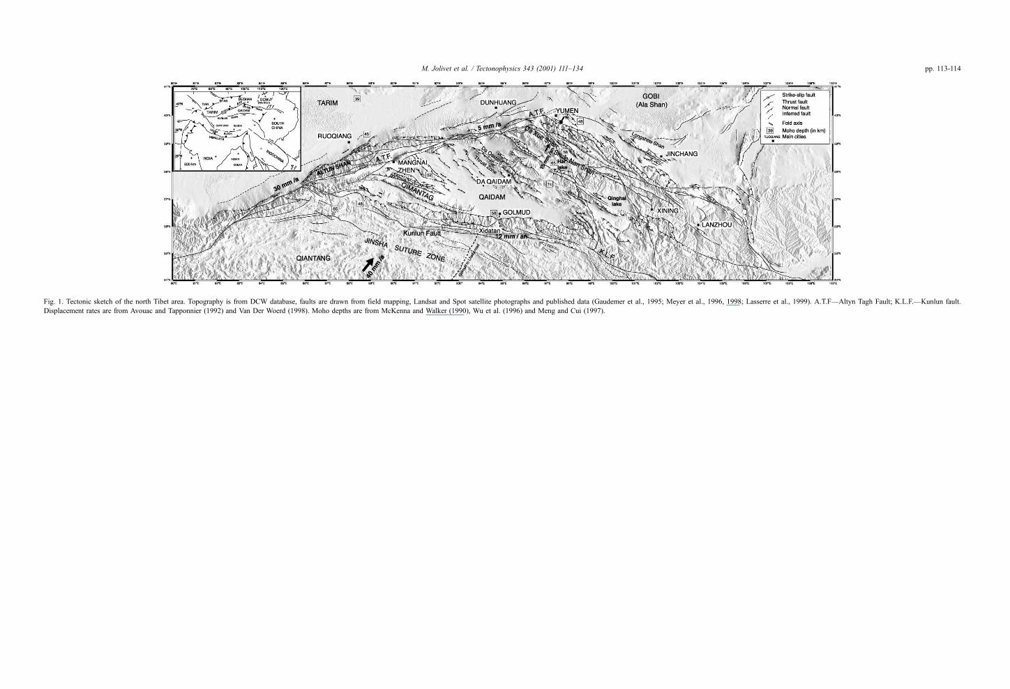
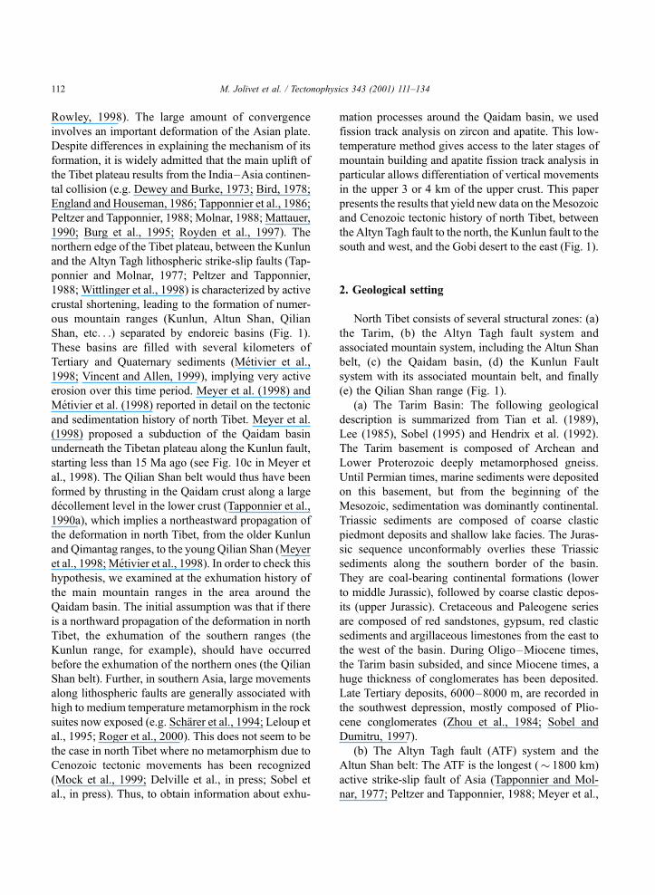
Fig. 1. Tectonic sketch of the north Tibet area. Topography is from DCW database, faults are drawn from field mapping, Landsat and Spot satellite photographs and published data (Gaudemer et al., 1995; Meyer et al., 1996, 1998; Lasserre et al., 1999). A.T.F—Altyn Tagh Fault; K.L.F.—Kunlun fault.
Displacement rates are from Avouac and Tapponnier (1992) and Van Der Woerd (1998). Moho depths are from McKenna and Walker (1990), Wu et al. (1996) and Meng and Cui (1997).
M. Jolivet et al. / Tectonophysics 343 (2001) 111–134 pp. 113-114
M. Jolivet et al. / Tectonophysics 343 (2001) 111–134 pp. 115-116
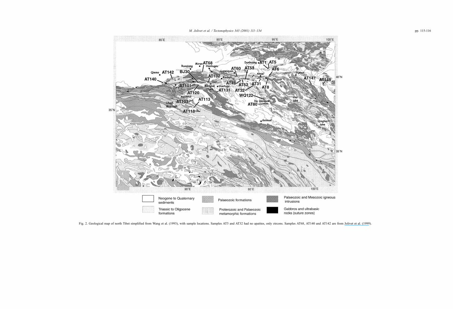
Fig. 2. Geological map of north Tibet simplified from Wang et al. (1993), with sample locations. Samples AT5 and AT32 had no apatites, only zircons. Samples AT68, AT140 and AT142 are from Jolivet et al. (1999).
1996; Sobel and Arnaud, 1999). It separates the Tarim
basin to the north from the Qaidam basin and Qian-
tang block to the south. This left-lateral strike-slip
fault is a major lithospheric boundary on the southern
edge of the Tarim, and its movement accommodates
the northeastward extrusion of the Tibetan plateau
(Tapponnier and Molnar, 1977; Peltzer and Tappon-
nier, 1988; Meyer et al., 1996). A 400 ± 60 km post-
Bajocian offset has been recognized along the western
segment of the ATF, using a piercing point consisting
of Aalenian–Bajocian deposits correlated on each
sides of the fault (Ritts and Biffi, 2000). Sobel et al.
(in press) calculate a 350 km post-Jurassic offset
along the same segment of the ATF, using cooling
ages obtained from 40Ar/39Ar diffusion modelling on
K-feldspars. The late Neogene rate of displacement
along the fault is still debated. On the basis of neo-
tectonic studies, Van Der Woerd (1998) estimated this
rate to be between 30 mm a� 1 west of the Qaidam
basin and 5 mm a� 1 near Dunhuang (Fig. 1). More
recently, Bendick et al. (2000), using GPS measure-
ments across the Altun Shan belt, calculated a strike-
slip rate of 9 ± 5 mm a� 1 along the ATF, a value two
to three times lower than the one reported by Van Der
Woerd.
Like most major strike-slip faults, the ATF is not a
discrete cut in the lithosphere but a very complex
structure. It is composed of several interconnected
segments with numerous associated thrust faults.
Several push-up structures have developed between
nearly parallel segments of the transcurrent fault.
From the western termination of the Kunlun fault to
the Gobi desert, on both sides of the fault corridor is
an associated mountain chain, the Altun Shan being
the best developed (about 100-km wide). Altitude
variation within the ranges is large, with a maximum
of nearly 4000 m on the northern side of the Altun
Shan. South of the fault corridor, these variations tend
to be lower (a maximum of 2000 m) because of the
already high mean level of the Qaidam basin (about
3000 m). Both mountain fronts, to the north and to the
south, are very active. Large rivers (especially in the
Altun Shan) cut through Quaternary sediments, indi-
cating nonmature topography. In this paper, the whole
structure around the ATF sensus stricto will be con-
sidered as the Altyn Tagh fault zone, except when
specified. A detailed geological description of the
ATF zone is given by the Chinese Bureau of Geology
(1981), Chen et al. (1985), Wang et al. (1993) and
more recently by Sobel and Arnaud (1999). Permian
and Triassic strata are absent. Coal-bearing nonmarine
lower to middle Jurassic sediments, unconformably
overlying Proterozoic and Palaeozoic igneous, meta-
morphic and sedimentary rocks are exposed in small
outcrops throughout the range. Cretaceous sediments
are not exposed. Neogene and Quaternary rocks are
continental conglomerates and sandstones, exposed in
small basins such as the Mangnai Zhen basin (Fig. 1).
Ophiolitic rocks are mapped along the fault, especially
near Hongliugou (Fig. 2), and are interpreted as early
Paleozoic oceanic material caught up in a post–early
Silurian to pre–middle Devonian suture (Sobel and
Arnaud, 1999).
(c) The Qaidam Basin: Because of its petroleum-
rich sedimentary series, the Qaidam basin has been
widely studied (e.g. Gu and Di, 1989; Wang and
Coward, 1990). The mean elevation of the basin is
between 2500 and 3000 m. The basement is com-
posed of a 1.5–2-Ga (Wang and Coward, 1990) suite
of quasi-flysch—quartzose sandstones—carbonate
formations, up to 18-km thick. During Paleozoic
times, and up to the end of the Triassic period,
sedimentation was alternately marine and continental.
From the end of the Triassic, it became exclusively
continental with lacustrine and fluviatile sediments.
Tertiary and Quaternary strata are thick (3200 m of
Quaternary sediments in some areas; Gu and Di,
1989). At the end of the Pliocene, the Qaidam basin
was uplifted by renewed tectonic movements (Metiv-
ier, 1996; Metivier et al., 1998).
The Cenozoic tectonic activity visible inside the
basin is weak, only marked by folding of the Meso-
zoic to Quaternary sedimentary cover in the northern
part. These folds trend NW–SE and are sometimes
developed into thrust faults (Fig. 1).
(d) The Kunlun range: The Kunlun fault system
marks the southern edge of the study area. This
lithospheric left-lateral strike-slip fault separates the
Qiantang block to the south from the Qaidam and
Tarim blocks to the north (Matte et al., 1996) (Fig. 1).
The slip rate near Xidatan (Fig. 1) is up to 12 mm a� 1
(Van Der Woerd et al., 1998). Meyer et al. (1998)
suggest that since about 15 Ma, the active southward
continental subduction of the Qaidam and Tarim
blocks under the Qiantang block induced deformation
on the southern edge of the Qaidam basin (Matte et
M. Jolivet et al. / Tectonophysics 343 (2001) 111–134 117
al., 1996; Meyer et al., 1998), such as in the Qimantag
range (Fig. 1).
The geology of this largely inaccessible area is
mostly known along the Golmud to Lhasa road (Fig.
1) (Ministry of Geology and Natural Resources, 1980;
Chang et al., 1986; Kidd and Molnar, 1988). The
expedition to theUlughMuztagh area (Fig. 2) is provid-
ing some information on the western end of the Kunlun
system (Molnar et al., 1987; Burchfiel et al., 1989).
Basement rocks are middle Proterozoic gneiss and
granitoids (Harris et al., 1988; Mock et al., 1999).
Middle Paleozoic granites are exposed on the northern
side of the Kunlun fault along the whole southern
border of the Qaidam basin. Carboniferous sediments
and Permian limestones are covered by extensive
Triassic turbidites, deformed by E–W trending folds
(Burchfiel et al., 1989). Jurassic coal-bearing sedi-
ments are exposed on the western part of the Kunlun
fault around and west of the Ulugh Muztagh. Except at
a few localities, Cretaceous rocks are generally absent.
Outcrops of ophiolitic fragments are mapped along
the fault, SE of Golmud and around the Ulugh
Muztagh (Fig. 2). They are interpreted as remnants
of the late-Triassic Jinsha suture between the Kunlun
and Qiantang terranes (Harris et al., 1988; Pearce and
Mei, 1988). The extensive Triassic flysch now
thrusted on top of the Kunlun was deposited along
this subduction zone.
(e) The Qilian Shan belt: The Qilian Shan belt is a
500-km-wide fold and thrust belt, between the Qai-
dam basin and the Ala Shan massif (North China
Platform) (Fig. 1) (Tapponnier et al., 1990a). The
whole structure trends NW–SE and is limited to the
north by the ATF (Fig. 1). The Qilian Shan can be
divided into two blocks (Meng and Cui, 1997; Wu et
al., 1993, 1996):� The South Qilian block, limited to the south by
the Da Qaidam thrust zone and to the north by the Da
Xue Shan–Shule Nan Shan thrust zone (Fig. 1). It
consists of a Paleozoic metamorphic basement
intruded by large Ordovician and Silurian granites.
Small outcrops of Jurassic limestones appear along
the Da Qaidam thrust zone (Fig. 1), whereas Triassic
sediments are widely exposed north of the Qinghai
Lake (Fig. 1). Thick Cenozoic sediments accumulated
in small basins (about 5 km of Miocene and Pliocene
sediments in the Har Lake area) (Fig. 1) (Meng and
Cui, 1997; Xu et al., 1996). Along the Da Qaidam
thrust zone, outcrops of mafic to ultramafic rocks
indicate a possible Ordovician (Yang, personal com-
munication) suture zone between the Qaidam block
and the South Qilian block.� The North Qilian block, bounded to the north by
the Longshou Shan fault (Fig. 1). Its basement is
composed of a Precambrian metamorphic sequence
(Wu et al., 1993). Two Paleozoic blueschist facies
zones are exposed suggesting that an oceanic basin
existed in this area during the Ordovician (Wu et al.,
1993; Liu and Gao, 1998).
The 58–74-km-deep Moho under the inner and
western Qilian Shan (58–74 km) (Wu et al., 1996;
Meng and Cui, 1997) implies a large amount of
thickening of the crust, not taken into account in
many of the previous models. The seismic reflection
profile from Wu et al. (1996) crossing the northeastern
Qilian Shan piedmont thrust fault, south of Yumen
(Fig. 1), shows reflection planes dipping southward
between 15 and 30 km in the crust, and probably
down to the Moho at 45 km. The Moho itself may
have a discrete offset in this region, which could
represent the northern boundary of the Qinghai–Tibet
plateau lithosphere (Wu et al., 1996). The northeastern
Ala Shan block could be subducting under the Qilian
Shan belt along this major fault.
3. Summary of known Mesozoic and Cenozoic
large-scale tectonic events in NE Asia
Since Triassic times, several continental blocks
have been accreted to the southern margin of Eura-
sia. The thick Triassic flysch sequence south of the
Kunlun range is a remnant of the late Triassic
collision between the Kunlun and Qiangtang blocks
along the Jinsha suture zone (Fig. 1). This collision
is thought to have produced some tectonic move-
ments far to the north, along what is now the ATF
zone. A major discordance level occurs in the sedi-
ment deposits of the Tarim basin between the
Devonian and lower Jurassic, indicating a major
erosion/nondeposition period. The Jurassic sequence
evolved from lower Jurassic thin coal-bearing lake
deposits to middle Jurassic thick continental con-
glomerates, indicating the erosion of nearby relief
(Sobel, 1999; Sobel et al., in press). This Jurassic
sequence is also well documented in the Hexi
M. Jolivet et al. / Tectonophysics 343 (2001) 111–134118
corridor, east of the Qilian Shan belt (Vincent and
Allen, 1999).
Evidence of N–S transtensive movements are
reported by Vincent and Allen (1999) in the Hexi
corridor between late Jurassic and early Cretaceous,
associated with coarse sedimentation. The late Juras-
sic–early Cretaceous period is marked by the collision
of the Lhasa block with Eurasia along the Bangong–
Nujiang suture zone (e.g. Allegre et al., 1984; Chang et
al., 1986; Matte et al., 1996). Nonetheless, in north
Tibet, the Cretaceous appears to be a tectonically quiet
period. Consistent with this, Coward et al. (1988)
reported that in the region of the Lhasa–Golmud road,
accretion of the Qiantang block was accompanied by
intense deformation, whereas later accretion of the
Lhasa block only weakly deformed the Qiantang block.
Cretaceous sedimentation was slow, with no more than
1000 m of deposits in the Hexi corridor. In late Creta-
ceous, the Tarim basin was near sea level, and a final
marine regression apparently occurred in the early
Oligocene (Sobel and Dumitru, 1997).
The India–Asia collision is dated between 52 and
40 Ma (e.g. Searle et al., 1997; Rowley, 1998; Zhang
and Scharer, 1999). However, the first movements are
recorded geochronologically in north Tibet around 30
Ma (40Ar/39Ar dating along the Kunlun fault near
Golmud) by Mock et al. (1999) and 25–20 Ma (apatite
fission track dating on sediments from the Tarim) along
the western Kunlun and in the Tian Shan by Sobel and
Dumitru (1997). The overall calculated sedimentation
rates (Metivier, 1996) increase very rapidly in both the
Qaidam basin and Hexi corridor in early Pliocene times
(from 0.07 ± 0.03 to 0.16 ± 0.09 mm a � 1 in Hexi
corridor and from 0.08 ± 0.03 to 0.74 ± 0.29 mm a� 1
in the Qaidam). Because there is no evidence of any
sediment exchange between the basins and the nearby
Tarim or Gobi basins, this increase in sedimentation
rates was due to renewed erosion indicating renewed
tectonics.
In summary, available data show tectonic activity
during late Triassic–early Jurassic, followed by wide-
spread active erosion during the Jurassic. The Creta-
ceous is described as a more tectonically quiet period
despite the collision of the Lhasa block with Eurasia.
The first evidence of the 60–40-Ma-old India–Asia
collision are recorded around 30–20 Ma along the
Kunlun and in the Tian Shan. Finally, an increase in
sedimentation rates in both Qaidam basin and Hexi
corridor indicates a late Miocene–early Pliocene
renewal of the tectonic activity. Since at least Oligo-
cene times (Ritts and Biffi, 2000), the Qaidam basin
has been a closed endoreic structure from which the
sediments cannot escape. This means that any varia-
tion in sedimentation rates inside the basin is induced
by change in erosion rates in the surrounding moun-
tain ranges and not by sediment exchange with other
basins, which would lead to the same results.
4. Sampling approach and methodology
4.1. Sampling approach
Sampling was carried out during the 1996 and 1997
Sino-French expeditions to north Tibet (INSU–Minis-
try of Chinese Geology collaboration project). Samples
were taken both along the large strike-slip AT and
Kunlun faults and within the Altun Shan, Qimantag
and Qilian Shan fold and thrust belts (Fig. 2).
Both major strike-slip faults and small associated
thrust faults were sampled. Such a sampling should
allow us not only to confirm the presence or absence of
vertical movement on the strike-slip faults themselves
but also to get an idea of the main activation periods of
the large faults by studying their effects on the smaller
related thrusts. We sampled the 1000-km length of the
AFT to the junction with the Kunlun with the hope of
describing the deformation at this point, to the north-
eastern termination of the ATF. The western Kunlun
fault was much more difficult to reach and we only
obtained samples south of the Aqqikkol basin (Fig. 2)
over a distance of about 100 km along strike.
Generally speaking, these samples were collected
along cross-sections perpendicular to the strike of the
main mountain belts, on the main thrust faults, but
also within the inter-mountain basins. We thus
expected to correlate the movements on the main
ranges with the movements in the basins.
Lithologically, the samples were from crystalline
rocks ranging in age from Precambrian (2 Ga) to Juras-
sic: granites, granodiorites, gneisses and syenites. The
altitude of most of the samples was measured using a
portable GPS coupled with an altimeter. When a GPS
measurement was not available, the altitude was calcu-
lated on the 1/500000 T.P.C. map provided by the
American Defense Mapping Agency or on the 1/
M. Jolivet et al. / Tectonophysics 343 (2001) 111–134 119
200000 Chinese Topographic Map. In both cases, pre-
cision is of the order of ± 50 m.
4.2. Ages and genetic algorithm modelling of track
lengths
It is commonly accepted that fission tracks in
zircons record temperatures of approximately
250 ± 50 �C (Hurford, 1986). Recent studies show
that the zone of partial annealing may range from 370
to 190 �C (Yamada et al., 1995; Tagami et al., 1996;
Tagami and Shimada, 1996). In apatite, fission tracks
form with a constant length of about 16 mm (Gleadow
and Duddy, 1981; Gleadow et al., 1986a,b). For
temperatures higher than 110 ± 10 �C, these tracks
are immediately annealed, but for temperature below
110 ± 10 �C, the annealing rate decreases significantly
and tracks become more stable. Central fission-track
ages (calculated using the mean value of the log
distribution of ages, weighted by the error on each
age) have no simple geological meaning as in many
other geochronological systems. FT ages represent a
record of a complex history of past thermal events.
Access to such thermal events can be made by
measuring confined track lengths in the sample. The
statistics of the length distribution and the FT age can
be combined together using various modelling proce-
dures in order to investigate the possible thermal
histories that a rock has suffered. Because in apatite,
FT are immediately annealed at temperature higher
than 110 ± 10 �C and very slowly at temperatures
lower than 60 �C (‘‘immediately’’ and ‘‘slowly’’ refer
to geologically significant rates of the order of the
Ma), track length modelling can only describe the T– t
evolution of the sample in-between 110 and 60 �C.Using the Monte Trax program (Gallagher, 1995), we
performed this modelling for samples having sets of at
least 20 track-length measurements, but as often as
possible with sets of 100 measurements (Table 1). In
each model, only the 50 best T– t curves were taken
into account.
Because of some possible artifacts in the modelling
process, the last segment of the T– t curve can show a
dramatic increase in the cooling rate. To try to
discriminate between natural events and modelling
problems, these last segments will be taken into
account only if their starting point on the best T– t
curve is at a temperature higher then 40 �C. Exper-
imental data on fission track annealing and length
interpretation in zircon are not yet adequate to allow
any track-length modelling.
4.3. Laboratory processing
Fission track ages of apatites and zircons were
determined using the external detector method (Hur-
ford and Green, 1983). Apatite grains were mounted
on a glass slide, ground, polished and etched in 6.5%
HNO3 for 50 s at 20 �C, in order to reveal natural
fission tracks. Zircons were mounted in teflon,
ground and polished, and etched in the eutectic
mixture of NaOH and KOH (Gleadow et al., 1976)
at 210 �C for 12–15 h depending on their etching
rate (Yamada et al., 1995; Tagami et al, 1996; Tagami
and Shimada, 1996). The muscovite external detec-
tors were etched in 40% HF for 40 min at 20 �C to
reveal the induced fission tracks. Samples were
irradiated at the ANSTO facility, Lucas Heights,
Australia, with a nominal neutron flux of 1.0� 1016
n cm � 2 for apatites and 1.0� 1015 n cm � 2 for
zircons. The ages were calculated following the
method recommended by Hurford (1990), using the
zeta calibration method (Hurford and Green, 1983).
The CN1 zircon zeta is 93 ± 5 (M.J.) and CN5 apatite
zeta is 305 ± 25 (M.J.). Fission tracks were counted
on a Zeiss microscope, using a magnification of 1250
under dry objectives for apatites, and 1600 with oil
immersion for zircons. All ages are central ages and
are quoted at ± 2r.
5. Fission-track ages and their implications
5.1. Zircons ages
Twelve samples were analysed. The ages range
from 220.8 ± 21.8 to 96.4 ± 3.8 (Table 1 and Fig. 3).
Because the understanding of track-length distribu-
tions in zircons has not reached the level of under-
standing as apatites, we cannot«look into» the ages in
the same way. It has to be assumed here for simplicity
that the ages represent a cooling event that has not an
internal modification, e.g. a small heating and second
cooling phase. We conclude that all but one of the
zircon ages represent a Jurassic cooling event. There
is no relationship with the current altitude of the
M. Jolivet et al. / Tectonophysics 343 (2001) 111–134120
Table 1
Fission track central ages
Number Altitude
[m]
Min. Number of
grains
Standard track
density� 104
cm�2 (counted)
qS� 104
cm�2
(counted)
qi� 104
cm�2
(counted)
U
concentration
[ppm]
P(v2)[%]
Var
[%]
Mean track
length [mm] ( ± 1r)(counted)
Standard
deviation
[mm]
Central age
( ± 2r)[Ma]
AT1 1600 Ap. 23 118.6 (6891) 191.0 (1925) 281.8 (2840) 29.7 25 7 12.58 ± 0.18 (100) 1.83 134.1 ± 4.8
AT6 2950 Ap. 20 109.1 (8991) 160.6 (1140) 262.1 (1861) 30.0 23 9 12.58 ± 0.14 (118) 1.55 101.2 ± 4.5
AT8 4000 Ap. 21 115.1 (6891) 19.3 (161) 229.9 (1921) 25.0 42 18 12.22 ± 0.46 (35) 2.73 16.9 ± 1.6
AT31 3600 Ap. 20 115.7 (8991) 158.8 (494) 187.1 (582) 20.2 31 12 12.43 ± 0.22 (100) 2.15 147.4 ± 10.2
AT49 3300 Ap. 20 125.5 (8991) 47.42 (414) 93.1 (813) 9.3 63 8 12.56 ± 0.18 (94) 1.73 97.3 ± 6.3
AT52 3100 Ap. 20 99.3 (8991) 36.6 (310) 71.1 (602) 9.0 80 0 12.41 ± 0.18 (99) 1.74 77.5 ± 5.5
AT53 3450 Ap. 20 129.5 (5188) 86.9 (563) 133.8 (867) 12.9 56 2 11.90 ± 0.19 (100) 1.92 127.0 ± 7.1
AT60 2800 Ap. 24 113.9 (6891) 36.8 (244) 41.6 (276) 4.6 60 1 11.73 ± 0.16 (100) 1.64 167.0 ± 14.8
AT68 * 2300 Ap. 21 111.6 (6891) 21.8 (108) 135.1 (669) 15.1 25 21 11.09 ± 0.31 (33) 1.77 30.3 ± 3.5
AT80 3950 Ap. 20 124.1 (5188) 236.8 (862) 425.0 (1547) 42.8 12 11 10.67 ± 0.23 (100) 2.29 105.0 ± 5.5
AT81 3950 Ap. 20 92.7 (8991) 50.8 (393) 53.0 (410) 7.2 88 0 12.17 ± 0.24 (100) 2.35 134.1 ± 9.6
AT101 4405 Ap. 23 145.5 (12670) 200.3 (2548) 259.4 (3300) 22.3 52 2 11.8 ± 0.17 (115) 1.807 166.9 ± 4.7
AT103 4377 Ap. 24 136.3 (8059) 16.7 (76) 68.5 (311) 6.3 45 18 11.97 ± 0.38 (38) 2.37 52.8 ± 7.2
AT113 5000 Ap. 20 107.9 (12670) 15.7 (124) 131.9 (1043) 15.3 90 0 13.56 ± 0.23 (80) 2.04 19.3 ± 1.8
AT118 5500 Ap. 23 109.3 (6891) 14.4 (100) 152.2 (1058) 17.4 46 6 12.45 ± 0.31 (35) 1.87 17.3 ± 1.8
AT120 4100 Ap. 25 144.0 (8059) 58.2 (251) 231.1 (996) 20.1 99 0 10.97 ± 0.32 (54) 2.32 55.1 ± 3.9
AT131 3400 Ap. 25 123.6 (12670) 13.5 (161) 142.6 (1701) 14.4 95 0 11.7 ± 0.39 (52) 2.82 17.6 ± 1.5
AT132 3500 Ap. 20 117.3 (12670) 120.4 (514) 152.2 (650) 16.2 100 0 11.8 ± 0.15 (87) 1.44 138.1 ± 8.2
AT140 * 2691 Ap. 20 132.1 (8991) 32.3 (169) 672.3 (3523) 63.6 14 17 13.49 ± 0.22 (61) 1.73 10.1 ± 0.9
AT142 * 1800 Ap. 19 128.5 (8059) 8.4 (62) 168.1 (1237) 16.3 69 0 9.8 ± 1.3
AT147 1980 Ap. 30 103.4 (6891) 102.4 (1217) 160.2 (1904) 19.4 16 11 11.29 ± 0.11 (120) 1.2 109.5 ± 4.9
AT148 1900 Ap. 20 139.2 (12670) 198.4 (962) 272.8 (1323) 24.5 36 5 13.3 ± 0.17 (100) 1.69 150.9 ± 6.8
BJ30 3780 Ap. 25 151.8 (8059) 23.8 (215) 113.3 (1024) 9.3 87 1 11.83 ± 0.20 (90) 1.85 48.4 ± 3.7
WQ122 4000 Ap. 24 106.9 (6891) 10.7 (95) 93.1 (824) 10.9 81 0 11.75 ± 0.41 (20) 1.85 20.7 ± 2.3
AT1 1600 Zr. 19 42.9 (2821) 2597 (2186) 242.3 (204) 226.2 100 0 205.0 ± 15.5
AT5 1600 Zr. 5 45.2 (2360) 3592 (241) 372.6 (25) 329.9 28 9 199.6 ± 42.9
AT8 3600 Zr. 20 48.5 (2821) 4368 (2250) 514.5 (265) 424.6 57 6 168.2 ± 11.8
AT32 3400 Zr. 19 421.5 (2360) 1981 (3493) 222.9 (393) 211.6 51 0 172.3 ± 9.8
AT52 3100 Zr. 8 38.1 (2360) 2673 (636) 302.6 (72) 317.6 99 0 155.1 ± 19.5
AT60 2800 Zr. 15 46.6 (2821) 1968 (1233) 185.1 (116) 158.9 99 0 220.8 ± 21.8
AT68 2300 Zr. 9 47.5 (2821) 4800 (738) 500.8 (77) 421.4 100 0 203.4 ± 24.7
AT80 3950 Zr. 12 37.1 (2360) 3557 (2864) 284.4 (229) 306.5 24 14 219.7 ± 19.8
AT113 5000 Zr. 20 33.88 (2507) 3038 (6486) 492.7 (1052) 581.7 31 3 96.4 ± 3.8
AT118 5500 Zr. 9 41.1 (2360) 3142 (1246) 370.7 (147) 360.5 61 0 160.6 ± 14.4
AT147 1980 Zr. 14 43.8 (2821) 2605 (1562) 2651 (159) 242.1 90 1 192.2 ± 16.4
WQ122 4000 Zr. 18 41.0 (2821) 2732 (1712) 3527 (221) 344.2 91 6 143.0 ± 10.9
Ap. = apatite; Zr. = zircon. qS and qi represent sample spontaneous and induced track densities; P(v2) is the probability of v2 for v degrees of freedom (where v= number of
crystals� 1). Zeta CN5 apatite = 305 ± 25 (M.J.) and zeta CN1 zircon 93 ± 5 (M.J.). Samples were irradiated at the ANSTO facility, Australia. Samples marked * are from Jolivet et al.
(1999).
M.Jolivet
etal./Tecto
nophysics
343(2001)111
–134
121
Fig. 3. Zircon fission track ages in Ma ( ± 2r error). Sample numbers are quoted in brackets. Sample AT68 is from Jolivet et al. (1999) (see Table 1 for detailed data).
M.Jolivet
etal./Tecto
nophysics
343(2001)111
–134
122
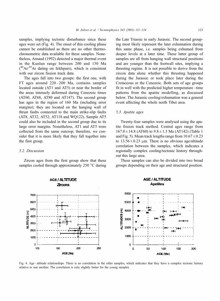
samples, implying tectonic disturbance since these
ages were set (Fig. 4). The onset of this cooling phase
cannot be established as there are no other thermo-
chronometric data available for these samples. None-
theless, Arnaud (1992) detected a major thermal event
in the Kunlun range between 200 and 150 Ma
(40Ar/39Ar dating on feldspars), which is consistent
with our zircon fission track data.
The ages fall into two groups: the first one, with
FT ages around 220–200 Ma, contains samples
located outside (AT1 and AT5) or near the border of
the areas intensely deformed during Cenozoic times
(AT60, AT68, AT80 and AT147). The second group
has ages in the region of 160 Ma (including error
margins); they are located on the hanging wall of
thrust faults connected to the main strike-slip faults
(AT8, AT32, AT52, AT118 and WQ122). Sample AT5
could also be included in the second group due to its
large error margins. Nonetheless, AT1 and AT5 were
collected from the same outcrop; therefore, we con-
sider that it is more likely that they fall together into
the first group.
5.2. Discussion
Zircon ages from the first group show that these
samples cooled through approximately 250 �C during
the Late Triassic to early Jurassic. The second group-
ing most likely represent the later exhumation during
this same phase, i.e. samples being exhumed from
deeper levels at a later time. These latter group of
samples are all from hanging wall structural positions
and are younger than the footwall sites, implying a
thrusting regime. It is not possible to derive from the
zircon data alone whether this thrusting happened
during the Jurassic or took place later during the
Cretaceous or the Cenozoic. Both sets of age groups
fit in well with the predicted higher temperature–time
patterns from the apatite modelling, as discussed
below. The Jurassic cooling/exhumation was a general
event affecting the whole north Tibet area.
5.3. Apatite ages
Twenty-four samples were analysed using the apa-
tite fission track method. Central ages range from
167.0 ± 14.8 (AT60) to 9.8 ± 1.3 Ma (AT142) (Table 1
and Fig. 5). Mean track lengths range from 10.67 ± 0.23
to 13.56 ± 0.23 mm. There is no obvious age/altitude
correlation between the samples, which indicates a
regionally complex cooling/tectonic history through-
out this large area.
These samples can also be divided into two broad
groups depending on their age and structural position.
Fig. 4. Age–altitude relationships. There is no correlation in the older samples, which indicates that they have a complex tectonic history
relative to one another. The correlation is only slightly better for the young samples.
M. Jolivet et al. / Tectonophysics 343 (2001) 111–134 123

Fig. 5. Apatites fission track ages in Ma ( ± 2r error). Sample numbers are quoted in brackets. Samples AT68, AT140 and AT142 are from Jolivet et al. (1999) (see Table 1 for detailed
data).
M.Jolivet
etal./Tecto
nophysics
343(2001)111
–134
124
Group A will refer to samples with FT ages about
or older than 50 Ma, generally associated with areas
undeformed by the ATF or/and on the borders of the
Qilian Shan. Group B will refer to samples with FT
ages lower than 50 Ma, mostly structurally associated
with hanging wall situations (Fig. 5). Both group A
and group B show a strong correspondence with
structural position.
Group A can be divided in two subgroups.
(i) One group of older ages is situated along the
ATF zone, and samples are all from sites that are
undeformed by the ATF, that is basically undeformed
basement. Two of these sites, AT1 and AT60, have
corresponding zircon ages. The apatite modelling plus
the extension to higher temperatures of the zircon
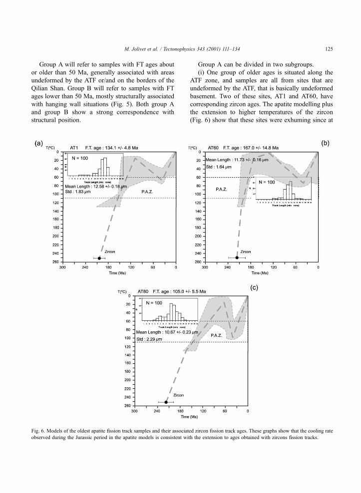
(Fig. 6) show that these sites were exhuming since at
Fig. 6. Models of the oldest apatite fission track samples and their associated zircon fission track ages. These graphs show that the cooling rate
observed during the Jurassic period in the apatite models is consistent with the extension to ages obtained with zircons fission tracks.
M. Jolivet et al. / Tectonophysics 343 (2001) 111–134 125
least 210 Ma. The timing of initiation of cooling
cannot be made from this data set as no higher
temperature geothermometer were used. They cooled
at about 3 �C/Ma from 210 to 120 Ma, and then
underwent a period of heating or stayed at constant
temperature until approximately 40 Ma. The timing of
this increase or stabilisation in temperature cannot be
clearly made from samples AT1 and AT60 (Fig. 6) as
it took place when the rocks were in the upper limit of
the P.A.Z., where the modelling procedure is not well
constrained. They were heated to temperatures of 60–
70 �C, and at about 40 Ma, they were finally exhumed
to the surface today.
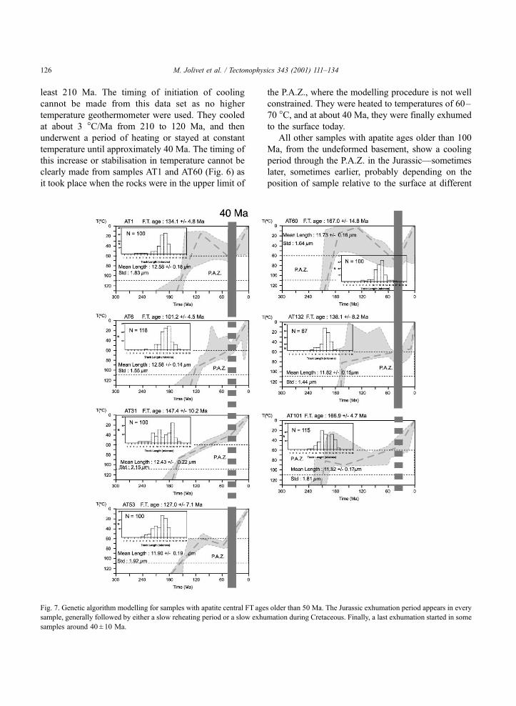
All other samples with apatite ages older than 100
Ma, from the undeformed basement, show a cooling
period through the P.A.Z. in the Jurassic—sometimes
later, sometimes earlier, probably depending on the
position of sample relative to the surface at different
Fig. 7. Genetic algorithm modelling for samples with apatite central FT ages older than 50 Ma. The Jurassic exhumation period appears in every
sample, generally followed by either a slow reheating period or a slow exhumation during Cretaceous. Finally, a last exhumation started in some
samples around 40 ± 10 Ma.
M. Jolivet et al. / Tectonophysics 343 (2001) 111–134126
times (Fig. 7). Even if isothermal residence in the
P.A.Z. cannot be fully excluded, many samples also
reveal a heating event after this phase of cooling,
always to temperatures of 60–70 �C. The exact timing
of this change is hard to assess, for the reasons
mentioned above, but sample AT53 suggests a time
of about 120 ± 20 Ma (Fig. 7). Cooling was reinitiated
at about 40 Ma. Some samples from this age group
have a simple noneventful cooling history, but with a
possible slight change in cooling rate also at this time
(e.g. samples AT101, AT31, Fig. 7), and some have a
possible mixture undefinable from the modelling
between the two, e.g. AT6, where the best fit is a
simple cooling history but the 50 best solutions
suggest also cooling, heating, cooling trend.
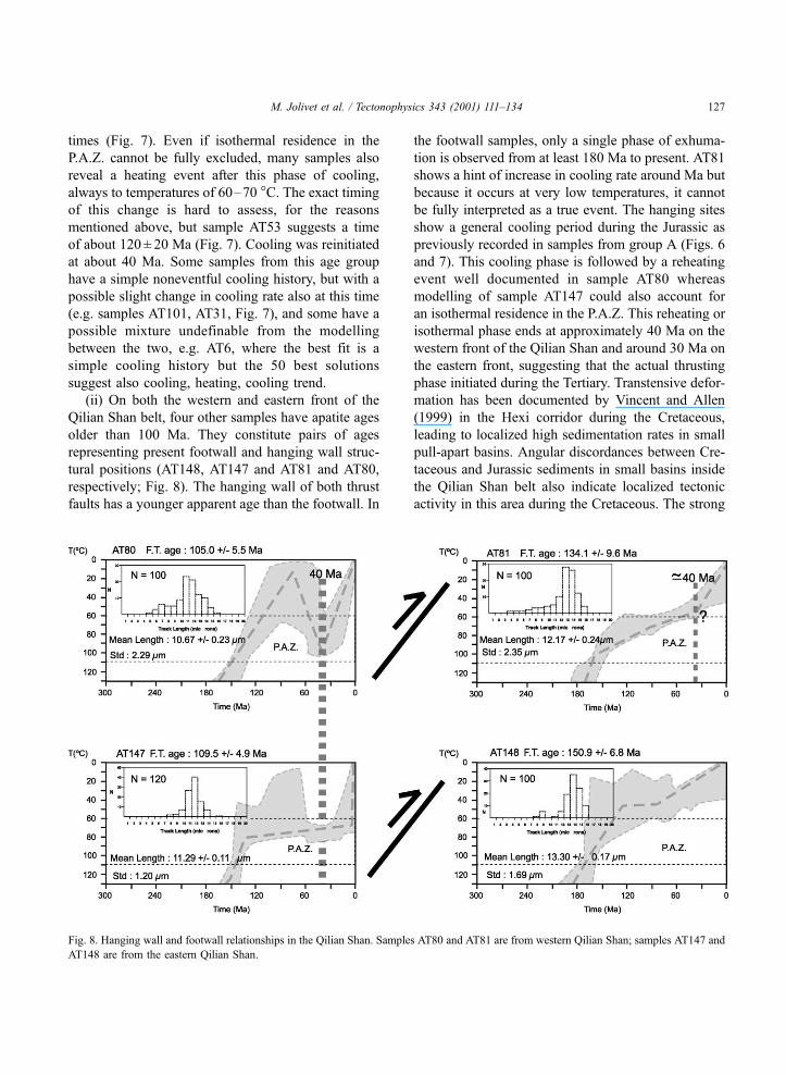
(ii) On both the western and eastern front of the
Qilian Shan belt, four other samples have apatite ages
older than 100 Ma. They constitute pairs of ages
representing present footwall and hanging wall struc-
tural positions (AT148, AT147 and AT81 and AT80,
respectively; Fig. 8). The hanging wall of both thrust
faults has a younger apparent age than the footwall. In
the footwall samples, only a single phase of exhuma-
tion is observed from at least 180 Ma to present. AT81
shows a hint of increase in cooling rate around Ma but
because it occurs at very low temperatures, it cannot
be fully interpreted as a true event. The hanging sites
show a general cooling period during the Jurassic as
previously recorded in samples from group A (Figs. 6
and 7). This cooling phase is followed by a reheating
event well documented in sample AT80 whereas
modelling of sample AT147 could also account for
an isothermal residence in the P.A.Z. This reheating or
isothermal phase ends at approximately 40 Ma on the
western front of the Qilian Shan and around 30 Ma on
the eastern front, suggesting that the actual thrusting
phase initiated during the Tertiary. Transtensive defor-
mation has been documented by Vincent and Allen
(1999) in the Hexi corridor during the Cretaceous,
leading to localized high sedimentation rates in small
pull-apart basins. Angular discordances between Cre-
taceous and Jurassic sediments in small basins inside
the Qilian Shan belt also indicate localized tectonic
activity in this area during the Cretaceous. The strong
Fig. 8. Hanging wall and footwall relationships in the Qilian Shan. Samples AT80 and AT81 are from western Qilian Shan; samples AT147 and
AT148 are from the eastern Qilian Shan.
M. Jolivet et al. / Tectonophysics 343 (2001) 111–134 127
reheating event recorded by sample AT80 during the
same period might indicate that such transtensive
deformation also occurred further west along the
actual western front of the Qilian Shan belt. If con-
firmed, it could imply that the presently ongoing
deformation reactivates preexisting fault structures.
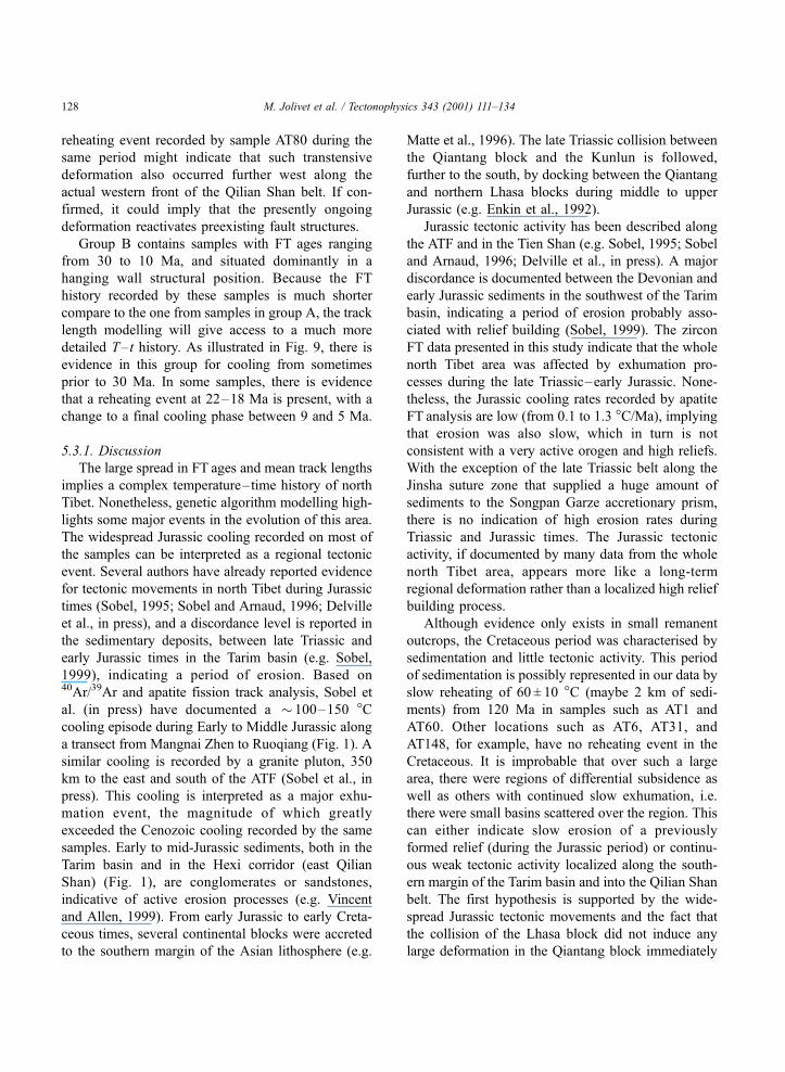
Group B contains samples with FT ages ranging
from 30 to 10 Ma, and situated dominantly in a
hanging wall structural position. Because the FT
history recorded by these samples is much shorter
compare to the one from samples in group A, the track
length modelling will give access to a much more
detailed T– t history. As illustrated in Fig. 9, there is
evidence in this group for cooling from sometimes
prior to 30 Ma. In some samples, there is evidence
that a reheating event at 22–18 Ma is present, with a
change to a final cooling phase between 9 and 5 Ma.
5.3.1. Discussion
The large spread in FT ages and mean track lengths
implies a complex temperature–time history of north
Tibet. Nonetheless, genetic algorithm modelling high-
lights some major events in the evolution of this area.
The widespread Jurassic cooling recorded on most of
the samples can be interpreted as a regional tectonic
event. Several authors have already reported evidence
for tectonic movements in north Tibet during Jurassic
times (Sobel, 1995; Sobel and Arnaud, 1996; Delville
et al., in press), and a discordance level is reported in
the sedimentary deposits, between late Triassic and
early Jurassic times in the Tarim basin (e.g. Sobel,
1999), indicating a period of erosion. Based on40Ar/39Ar and apatite fission track analysis, Sobel et
al. (in press) have documented a � 100–150 �Ccooling episode during Early to Middle Jurassic along
a transect from Mangnai Zhen to Ruoqiang (Fig. 1). A
similar cooling is recorded by a granite pluton, 350
km to the east and south of the ATF (Sobel et al., in
press). This cooling is interpreted as a major exhu-
mation event, the magnitude of which greatly
exceeded the Cenozoic cooling recorded by the same
samples. Early to mid-Jurassic sediments, both in the
Tarim basin and in the Hexi corridor (east Qilian
Shan) (Fig. 1), are conglomerates or sandstones,
indicative of active erosion processes (e.g. Vincent
and Allen, 1999). From early Jurassic to early Creta-
ceous times, several continental blocks were accreted
to the southern margin of the Asian lithosphere (e.g.
Matte et al., 1996). The late Triassic collision between
the Qiantang block and the Kunlun is followed,
further to the south, by docking between the Qiantang
and northern Lhasa blocks during middle to upper
Jurassic (e.g. Enkin et al., 1992).
Jurassic tectonic activity has been described along
the ATF and in the Tien Shan (e.g. Sobel, 1995; Sobel
and Arnaud, 1996; Delville et al., in press). A major
discordance is documented between the Devonian and
early Jurassic sediments in the southwest of the Tarim
basin, indicating a period of erosion probably asso-
ciated with relief building (Sobel, 1999). The zircon
FT data presented in this study indicate that the whole
north Tibet area was affected by exhumation pro-
cesses during the late Triassic–early Jurassic. None-
theless, the Jurassic cooling rates recorded by apatite
FT analysis are low (from 0.1 to 1.3 �C/Ma), implying
that erosion was also slow, which in turn is not
consistent with a very active orogen and high reliefs.
With the exception of the late Triassic belt along the
Jinsha suture zone that supplied a huge amount of
sediments to the Songpan Garze accretionary prism,
there is no indication of high erosion rates during
Triassic and Jurassic times. The Jurassic tectonic
activity, if documented by many data from the whole
north Tibet area, appears more like a long-term
regional deformation rather than a localized high relief
building process.
Although evidence only exists in small remanent
outcrops, the Cretaceous period was characterised by
sedimentation and little tectonic activity. This period
of sedimentation is possibly represented in our data by
slow reheating of 60 ± 10 �C (maybe 2 km of sedi-
ments) from 120 Ma in samples such as AT1 and
AT60. Other locations such as AT6, AT31, and
AT148, for example, have no reheating event in the
Cretaceous. It is improbable that over such a large
area, there were regions of differential subsidence as
well as others with continued slow exhumation, i.e.
there were small basins scattered over the region. This
can either indicate slow erosion of a previously
formed relief (during the Jurassic period) or continu-
ous weak tectonic activity localized along the south-
ern margin of the Tarim basin and into the Qilian Shan
belt. The first hypothesis is supported by the wide-
spread Jurassic tectonic movements and the fact that
the collision of the Lhasa block did not induce any
large deformation in the Qiantang block immediately
M. Jolivet et al. / Tectonophysics 343 (2001) 111–134128
to its north (Coward et al., 1988). The second hypoth-
esis implies that the docking of the Lhasa block to the
south induced some deformation north of the Kunlun
ranges. This idea has already been proposed by
Vincent and Allen (1999) to explain the transtensive
movements observed in the Hexi corridor during early
Cretaceous. Cretaceous tectonic deformation has also
been reported in the Tien Shan (e.g. Hendrix et al.,
1992), or in southern Mongolia (e.g. Hendrix et al.,
1996; Lamb et al., 1999). We thus cannot exclude
tectonic deformation in north Tibet at that time.
Furthermore, Marshallsea et al. (2000), using apatite
Fig. 9. Genetic algorithm modelling for samples with apatite FT ages younger than 30 Ma. They show major, widespread tectonic activity since
mid-Oligocene times. There is no time– location pattern in the exhumation of these samples.
M. Jolivet et al. / Tectonophysics 343 (2001) 111–134 129
fission track analysis, evidenced a cooling episode in
the northeastern Qilian Shan starting between 115 and
90 Ma.
As shown before, AT80 and AT81 (Fig. 8) also
seem to have recorded some movements during Mes-
ozoic times on the western front of the Qilian Shan. At
about 150 Ma, both samples were at a similar temper-
ature of 90 ± 10 �C, but AT80 cooled more rapidly
than AT81 after this time, possibly due to thrusting.
This period ended around 90 Ma when AT80 was
heated up again, possibly due to a combination of
sedimentation and burial by thrusting, whereas AT81
was still exhumed but at a lower rate. At 40 Ma,
sample AT80 started to cool again. An increase in
AT81 cooling rate is also observed from 40 Ma. These
three periods in the thermal history of sample AT80
might be interpreted in terms of fault activity.� From about 150 until 90 Ma, AT80 and AT81
were separated by a thrust fault, AT80 being exhumed
more rapidly than AT81. This movement may be the
same as that recorded by Vincent and Allen (1999),
during the Late Jurassic–Early Cretaceous period in
the Hexi corridor, induced by the docking of the
Lhasa block to the south.� From 90 to 40 Ma, the tectonic activity in the Da
Qaidam area changed from compression to extension,
allowing small pull-apart basins to form. Only small
outcrops of Cretaceous and Tertiary sediments seem to
remain west of the Qilian Shan but because the whole
series is represented by continental red sandstones, a
precise age cannot be assessed for each individual unit,
and the Cretaceous sediments might prove to be much
more extensive. Pull-apart basin formation was also
recorded during the Cretaceous in the Hexi corridor
(Vincent and Allen, 1999) along NW–SE trending
faults, parallel to the Da Qaidam thrust system.� Finally, around 40 Ma, the India–Asia collision
reactivated the fault again to a thrust system. The
Qilian Shan was affected by tectonic movements very
early in the India–Asia collision history.
The second exhumation event at about 40Ma is seen
in the «older» samples (Fig. 7). It is either represented
by a change from heating to cooling or by a small break
in slope of the continuous cooling curve, which would
normally be dismissed except for the fact that we see it
elsewhere. Using apatite fission track analysis, Sobel et
al. (in press) also record possible Paleocene (?)–
Eocene tectonism in the northern Qaidam basin. This
event represents intracontinental disruption following
the collision of India and Asia. The apatite fission track
modelling show a consistent increase of the cooling
rates along the large strike-slip faults (i.e. the Kunlun
and Altyn Tagh faults) around 40 Ma, indicating that
activation of these structures began in Eocene–early
Oligocene times, while nappe formation was very
active in the Himalayan belt (Treolar et al., 1989; Le
Fort, 1996). Strike-slip movements are documented
along the Red River Fault from 35 Ma (e.g. Harrison
et al., 1992; Scharer et al., 1994; Roger et al., 2000).
Using 40Ar/39Ar analysis on K feldspar, Mock et al.
(1999) demonstrate the occurrence of a significant
cooling event (9–15 �C/Ma) around 30 Ma in eastern
Kunlun. This cooling is localized along the actual
Kunlun fault and the Golmud batholith (Fig. 1) imme-
diately to the north is not affected. Finally, Delville et
al. (in press) show a faint metamorphic event on the
eastern end of the ATF around the same period. These
observations associated with our FT data could imply
that very early in the India–Asia collision, deformation
occurs far to the north along major mechanical boun-
daries in the Asian lithosphere.
The young apatite ages are situated within the
major mountain belts of north Tibet: on both sides
of the Qaidam basin, in the Kunlun ranges, in the
Qilian Shan and in the Altun Shan (Fig. 5). They tend
to be positioned on the hanging walls of major thrust
faults, which have deformed Neogene and Quaternary
sediments of the Tarim basin, the Qaidam basin and
the Hexi corridor. They all show cooling from prior to
30 Ma, which is consistent with the pattern in the
older ages. A second event is apparent in the young
ages with a change from cooling to heating around 20
Ma in some samples. Between 9 and 5 Ma, there is a
clear change to cooling. This may represent the last
rapid phase of exhumation which can be correlated to
the period of maximum sedimentation recorded in the
Qaidam basin during Cenozoic times (up to 0.7 km
Ma� 1; Metivier et al., 1998).
Finally, the Altun Shan belt on the northern edge of
the ATF zone has a slightly different evolution. Multi-
method geochronological analysis (Jolivet et al.,
1999) suggest that the Altun Shan has been a stable
block since at least 380 Ma with a mean cooling rate
of about 0.8 ± 0.3 �C/Ma. This very slow exhumation
ends around 10 Ma with a sharp increase in cooling
rates, up to 8 ± 2 �C/Ma. This 10-Ma-old range has
M. Jolivet et al. / Tectonophysics 343 (2001) 111–134130
been described by Wittlinger et al. (1998) and Jolivet
et al. (1999) as the consequence of the southward
subduction of the Tarim lithosphere underneath the
Altyn Tagh–north Tibet system. The ATF being the
southern boundary of this microbloc.
6. Conclusion
Fission track analysis has allowed identification of
the major tectonic events from the early Jurassic
onwards in north Tibet, between the Kunlun and the
Altyn Tagh faults.
(a) The first phase is represented by a period of
cooling interpreted as exhumation during the Jurassic.
The beginning of this event cannot be identified from
our data but must be situated sometimes during the
Triassic. This exhumation period may be the result of
the late Triassic collision between the Qiantang block
and the Kunlun block. The following period of heat-
ing by as much as 60 �C may represent a period of
localized sedimentation during the Cretaceous as
documented by Vincent and Allen (1999) in the Hexi
corridor.
(b) The first response to the India–Asia collision
appears in the Tertiary orogenic history, at about
40 ± 10 Ma. This cooling phase, localized along major
lithospheric block boundaries such as the Kunlun fault
or the ATF is consistent with several other arguments
leading to a possible early reactivation of mechanical
weakness in the Asian lithosphere, following the onset
of the India–Asia collision.
(c) Finally, track length modelling on samples from
group B records high cooling rates from late Oligo-
cene–Miocene times. This indicate large vertical
movements associated with the development of the
large-scale compressive structures throughout north
Tibet (there is no evidence of any major Tertiary
extensional faults north of the Kunlun fault). Because
apatite fission tracks do not ‘‘see’’ events occurring at
temperatures higher than 110 �C, we cannot assess theexact period of onset of this late compressive tectonic,
which is situated sometimes between Eocene and late
Oligocene.
Further investigations will be needed to fully
understand the kinematics of the deformation in north
Tibet. Fission track analysis inside the Qilian Shan
belt, at the eastern end of the ATF, might provide
some information about the relations between major
transcurrent movement and thrust fault activity.
Detailed cross-sections across the ATF and the Kun-
lun fault would allow a better understanding of the
kinematics along these major structures, and espe-
cially provide some information about the early stages
of the India–Asia collision-related deformation.
Acknowledgements
Field work was supported by INSU and the
Chinese Institute of Geology (Beijing). Analytical
work in University Montpellier has been supported by
ISTEEM. Constructive reviews by B.C. Burchfiel and
L. Ratschbacher helped to improve the manuscript.
References
Allegre, C.J., et al., 1984. Structure and evolution of the Himalaya–
Tibet orogenic belt. Nature 307, 17–22.
Arnaud, N.O., 1992. Apports de la thermochronologie Ar/Ar sur
feldspaths potassiques a la connaissance de la tectonique Cen-
ozoıque d’Asie. PhD Dissert, Univ. Blaise Pascal.
Avouac, J.P., Tapponnier, P., 1992. Cinematique des deformations
actives en Asie Centrale. C.R. Acad. Sci. Paris 315, 1791–
1798.
Bendick, R., Bilham, R., Freymueller, J., Larson, K., Yin, G., 2000.
Geodetic evidence for a slow slip rate in the Altyn Tagh fault
system. Nature 404, 69–72.
Besse, J., Courtillot, V., Pozzi, J.P., Westphal, M., Zhou, Y.X., 1984.
Paleomagnetic estimates of crustal shortening in the Himalayan
thrust and Zhangbo suture. Nature 311, 621–626.
Bird, P., 1978. Initiation of intracontinental subduction in the Hi-
malaya. J. Geophys. Res. 83, 4975–4987.
Burchfiel, B.C., Molnar, P., Zhao, Z., Liang, K., Wang, S., Huang,
J.F., Sutter, J.F., 1989. Geology of the Ulugh Muztagh area,
northern Tibet. Earth Planet. Sci. Lett. 94, 57–70.
Burg, J.P., Davy, P., Martinod, J., 1995. Shortening of analogue
models of the continental lithosphere: new hypothesis for the
formation of the Tibetan plateau. Tectonics 13, 475–483.
Chang, C., et al., 1986. Preliminary conclusions of the Royal Soci-
ety and Academica Sinica 1985 Geotraverse of Tibet. Nature
323, 501–507.
Chen, Z., Wu, N., Zhang, D., Hu, J., Huang, H., Shen, G., Wu, G.,
Tang, H., Hu, Y., 1985. Geological map of the Xinjiang Uygur
Autonomous Region, China, scale 1:2,000,000. Geol. Publ.,
Beijing.
Chinese Bureau of Geology, 1981. Stratigraphic Tables for Xinjiang
Autonomous Region. Geol. Publ., Beijing, 486 pp.
Coward, M.P., Kidd, W.S.F., Pan, Y., Shackleton, R.M., Zhang, H.,
1988. The structure of the 1985 Tibet Geotraverse, Lhasa to
Golmud. Philos. Trans. R. Soc. London, Ser. A 327, 307–336.
M. Jolivet et al. / Tectonophysics 343 (2001) 111–134 131
Delville, N., Arnaud, N., Montel, J.M., Roger, F., Brunel, M., Tap-
ponnier, P., Sobel, E., in press. Paleozoic to Cenozoic deforma-
tion along the Altyn Tagh Fault in the Altun Shan massif area,
Eastern Qilian Shan, NE Tibet, China. Bull. Geol. Soc. Am.
Spec. Pap.
Dewey, J.F., Burke, K., 1973. Tibetan, Variscan and Precambrian re-
activation: product of continental collision. J. Geol. 81, 683–692.
England, P., Houseman, G., 1986. Finite strain calculations of con-
tinental deformation, 2. Comparison with the India–Asia colli-
sion zone. J. Geophys. Res. 91, 3664–3676.
Enkin, R., Yang, Z., Chen, Y., Courtillot, V., 1992. Paleomagnetic
constraints on the geodynamic history of the major blocks of
China from the Permian to the Present. J. Geophys. Res. 97,
13953–13989.
Gallagher, K., 1995. Evolving temperature histories from apatite
fission-track data. Earth Planet. Sci. Lett. 136, 421–435.
Gaudemer, Y., Tapponnier, P., Meyer, B., Peltzer, G., Shunmin, G.,
Zhitai, C., Huagung, D., Cifuentes, I., 1995. Partitioning of
crustal slip between linked, active faults in the eastern Qilian
Shan, and evidence for a major seismic gap, the ‘Tianzhu Gap’,
on the western Haiyuan fault, Gansu (China). Geophysical J.
120, 599–645.
Gleadow, A.J.W., Duddy, I.R., 1981. A natural long-term track
annealing experiment for apatite. Nucl. Tracks Radiat. Meas.
5, 169–174.
Gleadow, A.J.W., Hurford, A.J., Quaife, R.D., 1976. Fission track
dating of zircons: improved etching techniques. Earth Planet.
Sci. Lett. 33, 273–276.
Gleadow, A.J.W., Duddy, I.R., Green, P.F., Hegarty, K.A., 1986a.
Fission track lengths in the apatite annealing zone and the in-
terpretation of mixed ages. Earth Planet. Sci Lett. 78, 245–254.
Gleadow, A.J.W., Duddy, I.R., Green, P.F., Lovering, J.F., 1986b.
Confined fission track lengths in apatite—a diagnostic tool for
thermal history analysis. Contrib. Mineral. Petrol. 94, 405–415.
Gu, S., Di, H., 1989. Mechanism of formation of the Qaidam basin
and its control on petroleum. In: Zhu, X. (Ed.), Chinese Sedi-
mentary Basins. Elsevier, New York, pp. 45–51.
Harris, N.B.W., Xu, R., Lewis, C.L., Jin, C., 1988. Plutonic rocks of
the 1985 Tibet Geotraverse, Lhasa to Golmud. Philos. Trans. R.
Soc. London A327, 145–168.
Harrison, T.M., Copeland, P., Kidd, W.S.F., Yin, A., 1992. Raisin
Tibet. Science 255, 1663–1670.
Hendrix, M., Graham, S., Carroll, A., Sobel, E., McKnight, C.,
Schulein, B., Wang, Z., 1992. Sedimentary record and climatic
implications of recurrent deformation in the Tian Shan: evidence
from Mesozoic strata of the north Tarim, south Dzungar, and
Turpan basin, northwest China. Geol. Soc. Am. Bull. 104, 53–
79.
Hendrix, M., Graham, S.A., Armory, J.Y., Badarch, G., 1996. Noy-
on Uul syncline, southern Mongolia: lower Mesozoic sedimen-
tary record of the tectonic amalgamation of central Asia.
B.G.S.A. 108 (10), 1256–1274.
Hurford, A.J., 1986. Cooling and uplift in the Lepontine Alps South
Central Switzerland, and age of vertical movement on the In-
subric fault line. Contrib. Mineral. Petrol. 92, 413–427.
Hurford, A.J., 1990. Standardization of fission track dating calibra-
tion: recommendation by the fission track working group of the
I.U.G.S. Subcommission on Geochronology. Chem. Geol. 80,
171–178.
Hurford, A.J., Green, P.F., 1983. The zeta age calibration of fission-
track dating. Chem. Geol. 1, 285–317.
Jolivet, M., Roger, F., Arnaud, N., Brunel, M., Tapponnier, P., Sew-
ard, D., 1999. Histoire del’exhumation de l’Altun Shan: indica-
tions sur l’age de la subduction du bloc du Tarim sous le
systeme de l’Altyn Tagh (Nord Tibet). C. R. Acad. Sci. 329,
749–755.
Kidd, W.S.F., Molnar, P., 1988. Quaternary and active faulting ob-
served on the 1985 Academia Sinica–Royal society geotraverse
of Tibet. Philos. Trans. R. Soc. London A327, 337–363.
Lamb, M.A., Hanson, A.D., Graham, S.A., Badarch, G., Webb,
L.E., 1999. Left-lateral sense offset of upper Proterozoic to
Paleozoic features across the Gobi Onon, Tost, and Zuunbayan
faults in southern Mongolia and implications for other central
Asian faults. Earth. Planet. Sci. Lett. 173, 183–194.
Lasserre, C., Morel, P.H., Gaudemer, Y., Tapponnier, P., Ryer-
son, F.J., King, G.C.P., Metivier, F., Kasser, M., Kashgarian, M.,
Baichi, L., Taiya, L., Daoyang, Y., 1999. Postglacial left slip rate
and past occurence of M� 8 earthquakes on the western Haiyuan
fault, Gansu, China. J. Geophys. Res. 104, 17633–17651.
Lee, K., 1985. Geology of the Tarim basin with special emphasis on
petroleum deposits, Xinjiang Uygur Zizhiqu, Northwest China.
U.S. Geol. Surv. Open File Rep. U.S. Geological Survey, pp.
85–616.
Le Fort, P., 1996. Evolution of the Himalaya. In: Yin, A., Harrison,
M. (Eds.), The Tectonic Evolution of Asia. Cambridge Univ.
Press, pp. 95–110.
Leloup, P.H., Lacassin, R., Tapponnier, P., Scharer, U., Dalai, Z.,
Xiaohan, L., Liangshang, Z., Shaocheng, J., Trinh, P.T., 1995.
The Ailao Shan–Red River shear zone (Yunnan, China), tertiary
transform boundary of Indochina. Tectonophysics 251, 3–84.
Liu, X., Gao, R., 1998. The crustal structure and assembly of ter-
ranes in the Qaidam–Qilian–Beishan area, Western China. Ac-
ta Geol. Sin. 72 (3), 243–255.
Marshallsea, S.J., George, A.D., Wyrwoll, K.H., Chen, J., Lu, Y.,
2000. Mid Miocene cooling in hexi corridor–Qilian Shan re-
gion, Qinghai–Tibet plateau. 9th International Conference on
Fission Track Dating and Thermochronology, Melbourne, Aus-
tralia.
Mattauer, M., 1990. Arguments en faveur d’un diapir mantellique
sous le plateau tibetain. C. R. Acad. Sci. 310 (II), 1695–1700.
Matte, P., Tapponnier, P., Arnaud, N., Bourjot, L., Avouac, J.P.,
Vidal, P., Liu, Q., Pan, Y., Wang, Y., 1996. Tectonics of Western
Tibet, between the Tarim and the Indus. Earth Planet. Sci. Lett.
142, 311–330.
McKenna, L.W., Walker, J.D., 1990. Geochemistry of crustally de-
rived leucocratic igneous rocks from the Ulugh Muztagh area,
Northern Tibet and their implications for the formation of the
Tibetan Plateau. J. Geophys. Res. 95, 21483–21502.
Meng, L., Cui, J., 1997. Study on the gravity field and deep-seated
crustal structure at the north margin of the Qinghai–Tibet pla-
teau. Cont. Dyn. 2 (1), 29–38.
Metivier, F., 1996. Volumes sedimentaires et bilans de masses en
Asie pendant le Cenozoıque. PhD Thesis, Universite Paris VII,
255 pp.
M. Jolivet et al. / Tectonophysics 343 (2001) 111–134132
Metivier, F., Gaudemer, Y., Tapponnier, P., Meyer, B., 1998. North-
eastward growth of the Tibet plateau deduced from balanced
reconstruction of two depositional areas: the Qaidam and Hexi
corridor basins, China. Tectonics 17 (6), 823–842.
Meyer, B., Tapponnier, P., Gaudemer, Y., Peltzer, G., Guo, S., Chen,
Z., 1996. Rate of left-lateral movement along the easternmost
segment of the Altyn Tagh Fault, east of 96�E (China). Geo-
phys. J. Int. 124, 29–44.
Meyer, B., Tapponnier, P., Bourjot, L., Metivier, F., Gaudemer, Y.,
Peltzer, G., Shunmin, G., Zhitai, C., 1998. Crustal thickening in
Gansu–Qinghai, lithospheric mantle subduction, and oblique,
strike-slip controlled growth of the Tibet plateau. Geophys. J.
Int. 135, 1–47.
Ministry of Geology and Natural Resources, 1980. Geological Map
of the Qinghai–Xizang (Tibet) Plateau (1:1.5 Million Scale).
Ministry of Geology and Natural Resources, Beijing.
Mock, C., Arnaud, N.O., Cantagrel, J.M., 1999. A nearly unroofing
in northeastern Tibet? Constraints from 40Ar/39Ar thermochro-
nology on granitoids from the eastern Kunlun range (Qianghai,
NW China). Earth Planet. Sci. Lett. 171 (1), 107–122.
Molnar, P., 1988. A review of geophysical constraints on the deep
structure of the Tibetan plateau, the Himalayas, and the Kara-
korum and their tectonic implication. Philos. Trans. R. Soc.
London A326, 33–88.
Molnar, P., Burchfield, B.C., Zhao, Z., Liang, K., Wang, S., Huang,
M., 1987. Geologic evolution of northern Tibet: results of an
expedition to Ulugh Muztagh. Science 235, 257–396.
Patriat, P., Achache, J., 1984. India–Eurasia collision chronology
has implications for crustal shortening and driving mechanism
of plates. Nature 311 (5987), 615–621.
Pearce, J.A., Mei, H., 1988. Volcanic rocks of the 1985 Geotraverse:
Lhassa to Golmud. Philos. Trans. R. Soc. London A327, 169–
201.
Peltzer, G., Tapponnier, P., 1988. Formation and evolution of strike-
slip faults, rifts, and basin during the India–Asia collision: an
experimental approach. J. Geophys. Res. 93, 15085–15117.
Ritts, B.D., Biffi, U., 2000. Magnitude of Post –Middle Jurassic
(Bajocian) displacement on the Altyn Tagh Fault, NW China.
Geol. Soc. Am. Bull. 112 (1), 61–74.
Roger, F., Leloup, P.H., Jolivet, M., Lacassin, R., Phan Trong, T.,
Brunel, M., Seward, D., 2000. Long and complex thermal his-
tory of the Song Chay metamorphic dome (Northern Vietnam)
by multi-system geochronology. Tectonophysics 321, 449–
466.
Rowley, D.B., 1998. Minimum age of initiation of collision between
India and Asia north of Everest based on the subsidence history
of the Zhepure Mountain section. J. Geol. 106, 229–235.
Royden, L.H., Burchfield, B.C., King, R.W., Wang, E., Chen, Z.,
Shen, R., Liu, Y., 1997. Surface deformation and lower crustal
flow in eastern Tibet. Science 276, 788–790.
Scharer, U., Zhang, L.S., Tapponnier, P., 1994. Duration of strike-
slip movements in large shear zones: the Red River belt, China.
Earth Planet. Sci. Lett. 126, 379–397.
Searle, M., Corfield, R.I., Stephenson, B., McCarron, J., 1997.
Structure of the North Indian continental margin in the La-
dakh–Zanskar Himalayas: implications for the timing of ob-
duction of the Spontang ophiolite, India–Asia collision and
deformation events in the Himalaya. Geol. Mag. 134 (3),
297–316.
Sobel, E.R., 1995. Basin analysis and apatite thermochronology of
the Jurassic–Paleogene Western Tarim basin [PhD dissertation]:
Stanford, CA, Stanford University, 308 pp.
Sobel, E.R., 1999. Basin analysis of the Jurassic–Lower Cretaceous
southwest Tarim basin, northwest China. Geol. Soc. Am. Bull.
111 (5), 709–724.
Sobel, E.R., Arnaud, N., 1996. Age controls on origin and cooling
of the Altyn Tagh range, NW China. Geol. Soc. Am. Abstr.
Prog. 28 (7), A67.
Sobel, E.R., Arnaud, N., 1999. A possible middle Paleozoic suture
in the Altyn Tagh, NW China. Tectonics 18 (1), 64–74.
Sobel, E.R., Dumitru, T.A., 1997. Thrusting and exhumation around
the margins of the western Tarim basin during the India–Asia
collision. J. Geophys. Res. 102 (B3), 5043–5063.
Sobel, E.R., Arnaud, N.O., Jolivet, M., Ritts, B.D., Brunel, M., in
press. Jurassic to Cenozoic exhumation history of the Altyn
Tagh range, NW China, constrained by 40Ar/39Ar and apatite
fission track thermochronology. B.G.S.A. Spec. Pap.
Tagami, T., Shimada, C., 1996. Natural long-term annealing of the
zircon fission track system around a granitic pluton. J. Geophys.
Res. 101 (B4), 8245–8255.
Tagami, T., Carter, A., Hurford, A.J., 1996. Natural long-term an-
nealing of the zircon fission-track system in Vienna Basin deep
borehole samples: constraints upon the partial annealing zone
and closure temperature. Chem. Geol. 130, 147–157.
Tapponnier, P., Molnar, P., 1977. Active faulting and tectonics of
China. J. Geophys. Res. 82, 2905–2930.
Tapponnier, P., Peltzer, G., Armijo, R., 1986. On the mechanics of
the collision between India and Asia. In: Coward, M.P., Ries,
A.C. (Eds.), Collision Tectonics. Geol. Soc. London Spec. Publ.,
vol. 19, pp. 115–157.
Tapponnier, P., Avouac, J.P., Peltzer, G., Gaudemer, Y., Shun-
min, G., Hongfa, X., Kelun, Y., Zhitai, C., Shuahua, C.,
Huagang, D., 1990a. Active thrusting and folding in the Qilian
Shan, and decoupling between upper crust and mantle in the
northeastern Tibet. Earth Planet. Sci. Lett. 97, 382–403.
Tapponnier, P., Lacassin, R., Leloup, P.H., Scharer, U., Zhong, D.,
Liu, X., Ji, S., Zhang, L., Zhong, J., 1990b. The Ailao Shan/Red
River metamorphic belt: tertiary left-lateral shear between Indo-
china and South China. Nature 343, 431–437.
Tian, Z.I., Chai, G.L., Kang, Y.Z., 1989. Tectonic evolution of the
Tarim basin. In: Zhu, X. (Ed.), Chinese Sedimentary Basins.
Elsevier, Amsterdam, pp. 33–43.
Treolar, P.J., Rex, D.C., Coward, M.P., Searle, M.P., Windley, B.F.,
Petterson, M.G., Jan, M.Q., Luff, I.W., 1989. K–Ar and Ar–Ar
geochronology of the Himalayan collision in NW Pakistan: con-
straints on the timing of suturing, deformation, metamorphism
and uplift. Tectonics 8, 881–909.
Van Der Woerd, J., 1998. Couplage cinematique entre decroche-
ments et chevauchements actifs dans le Nord du Tibet. Crois-
sance du plateau Tibetain, PhD Thesis, Universite Paris VII,
411 pp.
Van Der Woerd, J., Ryerson, F.J., Tapponnier, P., Gaudemer, Y.,
Finkel, R., Meriaux, A.S., Caffee, M., Zhao, G., He, Q., 1998.
Holocene left-slip rate determined by cosmogenic surface dating
M. Jolivet et al. / Tectonophysics 343 (2001) 111–134 133
on the Xidatan segment of the Kunlun fault (Qinghai, China).
Geology 26, 695–698.
Vincent, S.J., Allen, M.B., 1999. Evolution of the Minle and
Chaoshui Basins, China: implications for Mesozoic strike-slip
basin formation in Central Asia. Geol. Soc. Am. Bull. 111 (5),
725–742.
Wang, Q.M., Coward, M.P., 1990. The Chaidam basin (NW Chi-
na): formation and hydrocarbon potential. J. Pet. Geol. 13, 93–
112.
Wang, G.P., Wu, G.T., Lun, Z.Q., Zhu, Y.Y. (Eds.), 1993. Regional
Geology of Xinjiang Uygur Autonomous RegionGeol. Mem.
Ser. 1, vol. 32. Geol. Publ., Beijing, 841 pp.
Wittlinger, G., Tapponnier, P., Poupinet, G., Mei, J., Danian, S.,
Herquel, G., Masson, F., 1998. Tomographic evidence for local-
ized lithospheric shear along the Altyn Tagh fault. Science 282,
74–76.
Wu, H., Feng, Y., Song, S., 1993. Metamorphism and defor-
mation of blueschist belts and their tectonic implications,
North Qilian Mountains, China. J. Metamorph. Geol. 11,
523–536.
Wu, G., Gao, R., Cui, Z., Wu, X., 1996. Preliminary study on
geophysical data in Qilian Mountains. Cont. Dyn. 1 (1), 10–19.
Xu, Zh., Cui, J., Zhang, J., 1996. Deformation Dynamics of Con-
tinental Mountain Chains. Metallurgical Industry Press, Beijing,
246 pp. (in Chinese).
Yamada, R., Tagami, T., Nishimura, S., Ito, H., 1995. Annealing
kinetics of fission tracks in zircons: an experimental study.
Chem. Geol. 122, 249–258.
Zhang, L.S., Scharer, U., 1999. Age and origin of magmatism along
the Cenozoic Red River shear belt, China. Contrib. Mineral.
Petrol. 134, 67–85.
Zhou, Y.C., Qiu, D.Z., Wang, Y.L., 1984. The petroleum potential
of the Miocene series in the southwestern Tarim basin. Oil Gas
Geol. 5, 261–270.
M. Jolivet et al. / Tectonophysics 343 (2001) 111–134134
Copyright © 2022 FDOKUMEN