The Rakitnica Village on the Bjelasnica Plateau - UIJRT
10
75 UIJRT | United International Journal for Research & Technology | Volume 03, Issue 01, 2021 | ISSN: 2582-6832 All rights are reserved by UIJRT.COM. The Rakitnica Village on the Bjelasnica Plateau: Living on the Way of Sustainability Ahmet Hadrovic Faculty of Architecture, University of Sarajevo, Sarajevo, Bosnia and Herzegovina Email: [email protected], [email protected] Abstract— Bjelasnica Mountain occupies a central place in the geographical area of Bosnia and Herzegovina. Due to this fact, its altitude (2067 m), it is the border between Bosnia, on the one hand, and Herzegovina, on the other, and the border between the changed mediterranean and continental climates (while Bjelasnica itself has a mountainous to alpine climate). Due to these natural inputs, Bjelasnica is a „rain and snow catcher”, and because of its geological structure (mostly limestone), it is also the largest reservoir of water in B&H. That is why Bjelasnica is considered to be the „mother of B&H”, since at its base there are springs of two of the most important rivers in B&H (Bosnia and Neretva), and on its own (Bjelasnica plateau) a large number of springs, watercourses, permanent lakes and bars. Natural conditions have been a magnet for inhabiting the Bjelasnica Plateau, from prehistory to the present. Due to its specific natural values, in a combination of favorable social environment, Bjelasnica (with Jahorina, Trebevic and the city of Sarajevo itself) hosted the 14th Winter Olympic Games (1984) and subsequently hosted several FIS races. The Rakitnica village (Geographic coordinates: 43°39'25.69'N; 18°16'23.85' E; about 1165 meters above sea level) is located on the plateau of Bjelasnica, along the river Rakitnica, which divides the area of the Bjelasnica and Treskavica mountains. The village belongs to the municipality of Trnovo (about 13.8 km by air line). Due to the abundance of natural resources (water, arable land, meadows, pastures, forests) the area of the village of Rakitnica is constantly inhabited, from prehistory to the present. The presence of people in this area is witnessed by many cultural and historical monuments, the medieval necropolis of stećak tombstones. Until the war in Bosnia and Herzegovina (1991-1995), the village lived in a more or less traditional way, within its traditional physical structure. During the war the village was flooded and its population was exiled. After the war, the village was quickly rebuilt, but in changed socio-economic circumstances, and with architectural structures that in all respects reflect modern life. The Rakitnica village on the Bjelasnica plateau is an exemplary study of the metamorphosis of settlements (driven by the changing social environment), in the rich natural environment where they continue to live, partly in the traditional way, and partly in the contemporary way, therefore in the way of sustainability. Keywords— Bjelasnica, Rakitnica, water, pastures, traditional architecture, sustainability. 1. INTRUDUCTION The Rakitnica village (Geographic coordinates: 43°39'25.69' N, 18°16'23.85' E, about 1165 m above sea level) is located on the Rakitnica river, which divides the Bjelasnica plateau from the slopes of Traskavica Mountain (Figure 1). The village belongs to the municipality of Trnovo, about 13.8 km away by air. Following the theory of space developed by the author in 1987, the Rakitnica village will be considered in this paper as a system, that is, an architecturally defined space (ADP) through consideration of its four basic elements: environment, man, borders and perspectives [1], (Figure 2). Simultaneous representation of these elements will determine their mutual cause and effect relationship and will not leave out anything that is important for forming an image of this space. Figure 1: Rakitnica village. Location Source: Google Earth (Accessed: 06/10/2021), (left) | Photo: Vladimir Obradović (dron-video, 07/29/2017.), (right)
-
Upload
khangminh22 -
Category
Documents
-
view
2 -
download
0
Transcript of The Rakitnica Village on the Bjelasnica Plateau - UIJRT

75
UIJRT | United International Journal for Research & Technology | Volume 03, Issue 01, 2021 | ISSN: 2582-6832
All rights are reserved by UIJRT.COM.
The Rakitnica Village on the Bjelasnica Plateau: Living
on the Way of Sustainability Ahmet Hadrovic
Faculty of Architecture, University of Sarajevo, Sarajevo, Bosnia and Herzegovina
Email: [email protected], [email protected]
Abstract— Bjelasnica Mountain occupies a central place in the geographical area of Bosnia and Herzegovina. Due to this
fact, its altitude (2067 m), it is the border between Bosnia, on the one hand, and Herzegovina, on the other, and the border
between the changed mediterranean and continental climates (while Bjelasnica itself has a mountainous to alpine climate).
Due to these natural inputs, Bjelasnica is a „rain and snow catcher”, and because of its geological structure (mostly
limestone), it is also the largest reservoir of water in B&H. That is why Bjelasnica is considered to be the „mother of
B&H”, since at its base there are springs of two of the most important rivers in B&H (Bosnia and Neretva), and on its
own (Bjelasnica plateau) a large number of springs, watercourses, permanent lakes and bars. Natural conditions have
been a magnet for inhabiting the Bjelasnica Plateau, from prehistory to the present. Due to its specific natural values, in
a combination of favorable social environment, Bjelasnica (with Jahorina, Trebevic and the city of Sarajevo itself) hosted
the 14th Winter Olympic Games (1984) and subsequently hosted several FIS races. The Rakitnica village (Geographic
coordinates: 43°39'25.69'N; 18°16'23.85' E; about 1165 meters above sea level) is located on the plateau of Bjelasnica,
along the river Rakitnica, which divides the area of the Bjelasnica and Treskavica mountains. The village belongs to the
municipality of Trnovo (about 13.8 km by air line). Due to the abundance of natural resources (water, arable land,
meadows, pastures, forests) the area of the village of Rakitnica is constantly inhabited, from prehistory to the present.
The presence of people in this area is witnessed by many cultural and historical monuments, the medieval necropolis of
stećak tombstones. Until the war in Bosnia and Herzegovina (1991-1995), the village lived in a more or less traditional
way, within its traditional physical structure. During the war the village was flooded and its population was exiled. After
the war, the village was quickly rebuilt, but in changed socio-economic circumstances, and with architectural structures
that in all respects reflect modern life.
The Rakitnica village on the Bjelasnica plateau is an exemplary study of the metamorphosis of settlements (driven by the
changing social environment), in the rich natural environment where they continue to live, partly in the traditional way,
and partly in the contemporary way, therefore in the way of sustainability.
Keywords— Bjelasnica, Rakitnica, water, pastures, traditional architecture, sustainability.
1. INTRUDUCTION
The Rakitnica village (Geographic coordinates:
43°39'25.69' N, 18°16'23.85' E, about 1165 m above sea
level) is located on the Rakitnica river, which divides the
Bjelasnica plateau from the slopes of Traskavica
Mountain (Figure 1). The village belongs to the
municipality of Trnovo, about 13.8 km away by air.
Following the theory of space developed by the author
in 1987, the Rakitnica village will be considered in this
paper as a system, that is, an architecturally defined
space (ADP) through consideration of its four basic
elements: environment, man, borders and perspectives
[1], (Figure 2). Simultaneous representation of these
elements will determine their mutual cause and effect
relationship and will not leave out anything that is
important for forming an image of this space.
Figure 1: Rakitnica village. Location
Source: Google Earth (Accessed: 06/10/2021), (left) | Photo: Vladimir Obradović (dron-video, 07/29/2017.), (right)

76
UIJRT | United International Journal for Research & Technology | Volume 03, Issue 01, 2021 | ISSN: 2582-6832
All rights are reserved by UIJRT.COM.
Figure 2: Architectural Defined Space (ADS)
Source: Author (1988)
2. ENVIRONMENT
By the term “environment” we mean every possibility in
a space in which a person can achieve his existence [1].
The natural environment. By the natural environment
we mean all those data provided by nature, on which
man (mostly) has not exercised his influence:
geographical location, geomorphology, water flows and
aquatic reservoirs, wildlife, available soil, climate [1] ....
The Bjelasnica plateau is a vast geographical area in the
central part of Bosnia and Herzegovina, with the summit
of the Bjelasnica mountain as a central point, framed by
the Igman, Ivan-planina, Visocica and Treskavica
mountains [2]. The plateau is about 25 km southwest of
Sarajevo. This plateau (along with the Igman mountain
that is part of it) extends about 30 km in a northeast-
southwest direction, perpendicular to the Dinaric massif
and a width of about 10-20 km. The northernmost part
of Bjelasnica (also its highest ridge) extends from east
to west for about 12 km. At the far eastern edge of this
ridge is the highest corner of Bjelasnica with a
meteorological station (observatory). The boundaries of
this plateau are the flow of the Zujevina River and Igman
mountain in the north, the Hoyta ridge and Treskavica
mountain in the southeast, the 25 km long Rakitnica
river canyon (which divides the Bjelasnica plateau and
Visocica mountain) to the south, the Neretva river valley
(which separates the Bjelašnica plateau and Prenj
mountain) to the southwest and the Ivan-mountain
saddle (which connects the Bjelasnica plateau with the
Bitovnja mountain) to the west (Figure 3).
Figure 3: Left: Bjelasnica plateau, from Hoyta to Visocica (view from the top of Bjelasnica);
Right: Bjelasnica Plateau. View from Visocica | Source: Author (08/09/2018 and 09/08/2018)
Bjelasnica is named after the white snow cover
(“drops”), which remains there for most of the year,
from November to May, sometimes during the summer
months (Figure 4). The highest peak of Bjelasnica (2067
m) is also called the Observatory, according to the
meteorological station there. Bjelasnica is the Olympic
mountain, today a favorite excursion site for Sarajevo
that offers great opportunities for skiing (on Olympic
trails), walking and hiking, mountain biking, rafting (on
the Rakitnica river), paragliding in the air and in the
snow ...

77
UIJRT | United International Journal for Research & Technology | Volume 03, Issue 01, 2021 | ISSN: 2582-6832
All rights are reserved by UIJRT.COM.
Figure 4: View of Sarajevo, Bjelasnica and Treskavica from the Nahorevo Hills
Source: Author (04/12/2014.)
Bjelasnica Plateau is rich in various relief forms. From
a geological point of view, Bjelasnica is part of the
Dinaric Alps, composed of secondary and tertiary
sedimentary rocks, mainly limestone and dolomite. The
largest part of Bjelasnica is built of middle and upper
triassic limestones and dolomites. There are differences
in the geological composition of its individual parts. The
rocks on the eastern part of the mountain, east of
Umoljani (the valley of the Rakitnica river around
Sabici and Rakitnica villages) are formed into clayey, ie
waterproof marls, sandstones [2].
The climate of Bjelasnica is of a transitional character,
between mediterranean and continental influences, with
dominant characteristics of mountain and alpine climate.
In the greater Bjelasnica area below 1500 meters above
sea level, there is a mountain climate (type Dfb,
according to the Köppen classification of climate, humid
boreal climate with warm summer). This type of climate
is characterized by large annual amplitudes: mean
temperatures of the warmest month ≤ 22 °C, 3 to 4 and
even 5 months’ temperatures are lower than 0 °C,
coniferous forests and steppes develop in arid regions,
and deciduous forests in wetter ones. In areas with an
altitude of more than 1500 meters, a mountain climate
(type Dfc according to the Köppen classification, humid
boreal climate with fresh summer) is represented. This
type of climate is characterized by long, very cold
winters and short fresh summers - for only 1 to 4 months
the average temperature is ≥ 10 °C. Due to its
geographical location and altitude, Bjelasnica represents
the limit of influence of two large climatic units -
Mediterranean and Continental. Thus, the Bjelasnica
clashes with Adriatic and continental air masses, which
results in frequent and rapid changes in weather
conditions, frequent and strong winds and heavy
rainfall, relatively early occurrence of the first snow and
frost (mid-September), as well as long retention of
heavy snow cover in higher areas (until the second half
of May). There is plenty of precipitation every season.
The average annual rainfall in the mountainous area
exceeds 1200 mm, and it is mostly snowfall that persists
for a long time. The mountain is generally known for
strong and frequent winds, and at the top of Bjelasnica
sometimes in the winter months they reach hurricane
force and speed of over 100 km/h.
Resources are natural resources that are more or less
directly used by a person to satisfy a wide range of
needs. Most often, we understand resources as natural
resources. Given their abundance, we distinguish
between renewable and non-renewable resources.

78
UIJRT | United International Journal for Research & Technology | Volume 03, Issue 01, 2021 | ISSN: 2582-6832
All rights are reserved by UIJRT.COM.
Renewable resources are: Solar radiation, water, forests
and living things in general. Non-renewable resources
include oil, gas, coal and minerals. In our
considerations, we will treat water, forest, soil (as a
“derived” natural resource, without or with human
activity) in the emergent forms of forest pastures,
cultivated meadows and fields, and orchards (as man-
cultivated and especially purposeful trees, ie plant) as
renewable resources. biomass). Of non-renewable
resources, stone is the most important, as building
material, above all.
The Rakitnica river springs at the western end of
Treskavica near the Rakitnica village, at an altitude of
between 1300 and 1500 m and flows into the Neretva on
the Bjelasnica-Visocica-Prenj mountain tributary, as its
right tributary, not far from Boracko Lake (Boracko
jezero), at an altitude of 324 m. This typical mountain
river cuts deep between Bjelasnica on the right and
Visocica on the left, forming a canyon, a morphological
phenomenon and an idyllic wonder of nature, with a
series of rapids, waterfalls, waterfalls and peaceful pools
(Figures 5 and 6).
Figure 5: Rakitnica river canyon
Source: Author (08/13/2016.)
Rakitnica canyon is the longest and deepest in Bosnia
and Herzegovina. It is over 20 km long and the depth
ranges between 800 and 1000 m. The beginning of the
Rakitnica canyon is at an altitude of 1120 m. It is a
stream of 4-5 km with a fall of about 300 m and
numerous waterfalls and waterfalls. Until the 1992-1995
war, the Rakitnica River was the site of a large number
of watermills, and today it is a natural attraction for
many visitors.
Figure 6: Rakitnica River canyon
Source:
https://lh5.googleusercontent.com/p/AF1Qip
M6v-
ZfjjScbfix1oSMQV_vTlj1sORwvBUtG0jH=
w1440-h1440-pd
https://lh5.googleusercontent.com/p/AF1QipP
H3Cu1i7J5shMcC3JN8U9auqfEssGKBcsU7
Wax=h1440
http://dimitrijeostojic.com/blog/medjurecki-
potok-canyon/, Accessed: 01/21/2020.
For the village of Rakitnica, the Rakitnica river is of
vital importance. It is completely clean and, as such,
meets a range of life needs. Along its shores are fertile
plains suitable for growing cereals and various
vegetables, with the possibility of irrigation, as needed
(Figure 7.)
Figure 7: Potato cultivation in the Rakitnica (Scenes
from the documentary Bjelokapic)
Source:https://www.youtube.com/watch?v=UfBhqQoVi
zk, Accessed: 01/24/2020.
In the traditional way of life, several water mills were
installed on the Rakitnica river. In the village itself, the
Ladjevac stream flows into the Rakitnica river, which is
full of water throughout the year. There are fertile plains
along the stream suitable for growing cereals and
vegetables (Figure 8).

79
UIJRT | United International Journal for Research & Technology | Volume 03, Issue 01, 2021 | ISSN: 2582-6832
All rights are reserved by UIJRT.COM.
Figure 8: Left: Rakitnica River is the backbone of the
village of Rakitnica
Source: Author (01/02/2020)
Right: Ladjevac stream in the village of Rakitnica
Source:https://www.youtube.com/watch?v=y4Jh5wwY
Lhc, Accessed: 01/17/2020.
Around the village are vast pastures suitable for animal
husbandry (Figure 9).
Figure 9: Livestock breeding in the Rakitnica village
(Scenes from the documentary Bjelokapić)
Source:https://www.youtube.com/watch?v=UfBhqQoVi
zk, Accessed: 01/24/2020.
There are abundant conifer forest complexes near the
village: on the Hoyta hill and on the Traskavica
mountain (Figure 10).
Figure 10: Rakitnica village
https://www.facebook.com/63806849895/photos/a.108
713999895/10152876909369896/?type=3&theater
Accessed: 01/29/2020.
Social environment. The social environment represents
everything that man has created and what sets him apart
from the world of other living beings. It encompasses
both physical structures (various material, more or less
ordered products of their activity), as well as the
intangible world that we recognize by intellect (science,
philosophy, religion, law, morals) through an ordered
system of abstract symbols (letter, signs). According to
research to date, part of today's villages on the
Bjelasnica plateau can be traced back to the 14th
century, when they were still used for the summer
grazing of Herzegovina's nomads [3, 4]. However, there
was life on the mountain before, as evidenced by
numerous necropolises of stecak tombstones, as well as
archeological findings from earlier historical periods
(Neolithic, Illyrian times, such as Gradina, fortifications
near the village of Umoljana). There is also the site of
Crkvina, located not far from the Rakitnica river on a
hill above the medieval cemetery. For a long time, there
was a conviction that the area of Bjelasnica villages was
an area of worship, where this teaching and world view
persisted for the longest time [5, 6, 7].
The population of the celebrated Illyrian novels dealt
predominantly with livestock and kiridian affairs. They
contacted the Dalmatian cities that traded with the
Slavic hinterland. The goods were transported by
caravans - horses, mules and donkeys. Among the
villages of Bjelasnica are the Lower and Upper Kramari,
whose name (probably) comes from the Vlach caravan
elders called kramari. The Blessed Peaks of Velika and
Mala Vlahinja testify in support of this claim [8].
Several necropolises on the Bjelasnica plateau,
including the one in the village of Sabici (near the
village of Rakitnica), dating from the 14th and 15th
centuries, testify to the existence and teaching of the
“Bosnian Church”, ie people who considered
themselves “Pravi kristijani” (“Real christians”) –
Bogumils [6]. The Ottoman census of Herzegovina
(dating from 1477, fourteen years after the fall of Bosnia
under the Ottoman Empire) mentions the Tusila
Bjelasnica village, belonging to the Zagorje Grgura
vojvode (Gregory of the Duke) [8].
The necropolis of the stecak tombstones in the village of
Sabici consists of an agglomeration of a total of 58
tombstones (stećak) that arose during the Middle ages
(including the 14th and 15th centuries).
“The necropolis of stecak tombstones is located in the
center of the village in the Han site. In this area are
represented pedigree cemeteries as well as smaller
necropolises of individual families. The necropolis
contains 53 stećaks, of which 4 plates, 27 crates, 12
crates with plinth, 4 gabled, 4 gabled with potol and two
groups with several remains of shattered pieces of
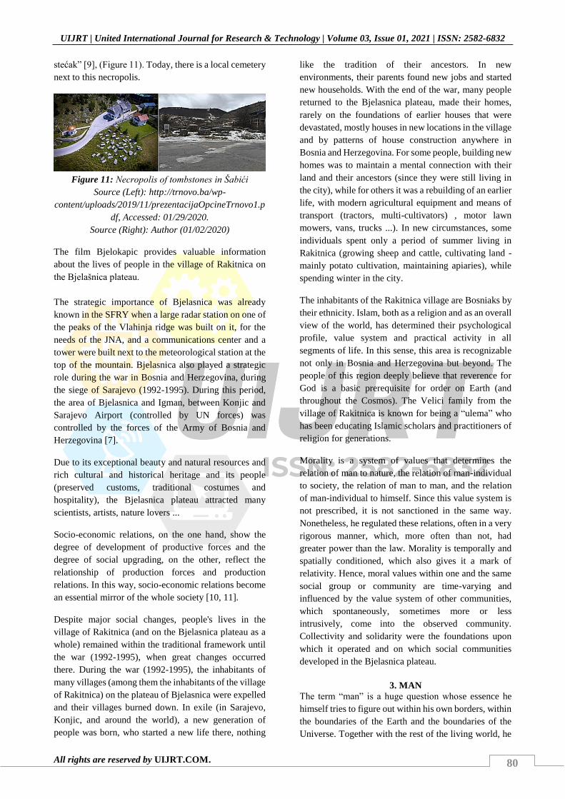
80
UIJRT | United International Journal for Research & Technology | Volume 03, Issue 01, 2021 | ISSN: 2582-6832
All rights are reserved by UIJRT.COM.
stećak” [9], (Figure 11). Today, there is a local cemetery
next to this necropolis.
Figure 11: Necropolis of tombstones in Šabići
Source (Left): http://trnovo.ba/wp-
content/uploads/2019/11/prezentacijaOpcineTrnovo1.p
df, Accessed: 01/29/2020.
Source (Right): Author (01/02/2020)
The film Bjelokapic provides valuable information
about the lives of people in the village of Rakitnica on
the Bjelašnica plateau.
The strategic importance of Bjelasnica was already
known in the SFRY when a large radar station on one of
the peaks of the Vlahinja ridge was built on it, for the
needs of the JNA, and a communications center and a
tower were built next to the meteorological station at the
top of the mountain. Bjelasnica also played a strategic
role during the war in Bosnia and Herzegovina, during
the siege of Sarajevo (1992-1995). During this period,
the area of Bjelasnica and Igman, between Konjic and
Sarajevo Airport (controlled by UN forces) was
controlled by the forces of the Army of Bosnia and
Herzegovina [7].
Due to its exceptional beauty and natural resources and
rich cultural and historical heritage and its people
(preserved customs, traditional costumes and
hospitality), the Bjelasnica plateau attracted many
scientists, artists, nature lovers ...
Socio-economic relations, on the one hand, show the
degree of development of productive forces and the
degree of social upgrading, on the other, reflect the
relationship of production forces and production
relations. In this way, socio-economic relations become
an essential mirror of the whole society [10, 11].
Despite major social changes, people's lives in the
village of Rakitnica (and on the Bjelasnica plateau as a
whole) remained within the traditional framework until
the war (1992-1995), when great changes occurred
there. During the war (1992-1995), the inhabitants of
many villages (among them the inhabitants of the village
of Rakitnica) on the plateau of Bjelasnica were expelled
and their villages burned down. In exile (in Sarajevo,
Konjic, and around the world), a new generation of
people was born, who started a new life there, nothing
like the tradition of their ancestors. In new
environments, their parents found new jobs and started
new households. With the end of the war, many people
returned to the Bjelasnica plateau, made their homes,
rarely on the foundations of earlier houses that were
devastated, mostly houses in new locations in the village
and by patterns of house construction anywhere in
Bosnia and Herzegovina. For some people, building new
homes was to maintain a mental connection with their
land and their ancestors (since they were still living in
the city), while for others it was a rebuilding of an earlier
life, with modern agricultural equipment and means of
transport (tractors, multi-cultivators) , motor lawn
mowers, vans, trucks ...). In new circumstances, some
individuals spent only a period of summer living in
Rakitnica (growing sheep and cattle, cultivating land -
mainly potato cultivation, maintaining apiaries), while
spending winter in the city.
The inhabitants of the Rakitnica village are Bosniaks by
their ethnicity. Islam, both as a religion and as an overall
view of the world, has determined their psychological
profile, value system and practical activity in all
segments of life. In this sense, this area is recognizable
not only in Bosnia and Herzegovina but beyond. The
people of this region deeply believe that reverence for
God is a basic prerequisite for order on Earth (and
throughout the Cosmos). The Velici family from the
village of Rakitnica is known for being a “ulema” who
has been educating Islamic scholars and practitioners of
religion for generations.
Morality is a system of values that determines the
relation of man to nature, the relation of man-individual
to society, the relation of man to man, and the relation
of man-individual to himself. Since this value system is
not prescribed, it is not sanctioned in the same way.
Nonetheless, he regulated these relations, often in a very
rigorous manner, which, more often than not, had
greater power than the law. Morality is temporally and
spatially conditioned, which also gives it a mark of
relativity. Hence, moral values within one and the same
social group or community are time-varying and
influenced by the value system of other communities,
which spontaneously, sometimes more or less
intrusively, come into the observed community.
Collectivity and solidarity were the foundations upon
which it operated and on which social communities
developed in the Bjelasnica plateau.
3. MAN
The term “man” is a huge question whose essence he
himself tries to figure out within his own borders, within
the boundaries of the Earth and the boundaries of the
Universe. Together with the rest of the living world, he

81
UIJRT | United International Journal for Research & Technology | Volume 03, Issue 01, 2021 | ISSN: 2582-6832
All rights are reserved by UIJRT.COM.
participates in the process of the circulation of matter
and energy in nature, sharing with him the same destiny,
birth and dying beyond his will. Being endowed with
reason, will and feelings, he is the only one in the living
world able to discover the given laws of the constitution
of nature.
About the traditional way of life of the people on the
Bjelasnica plateau, their customs, costumes, beliefs and
morals, a documentary film Bridal customs on
Bjelasnica was made for German television WDR in the
1980s. Within a household, there was a hierarchy of
duties and responsibilities: at the top of the hierarchy
was the husband/father who made the final decisions
and whose orders had to be obeyed and obeyed;
wife/mother was in charge of running a home economy
and doing a number of jobs (servicing the barn with pets,
weaving carpets and cotton cloth, making clothes, taking
care of children, various field jobs ...); children assisted
parents in various jobs and thus, in addition to their
concrete effect, acquired knowledge of running the
household; the grandparents had no strict household
duties, and they did what they could and wanted.
Today's households are contemporary, similar to
households in other parts of Bosnia and Herzegovina. As
a rule, people in the Rakitnica village now have their
houses in the city (Sarajevo, Hrasnica) where they live a
city lifestyle, where they work and educate their
children. Some of them go to the village in the summer
to cultivate the land (mainly sowing potatoes, onions,
carrots, parsley and less frequently peppers and
tomatoes), collecting herbs and forest fruits and raising
livestock. They have adequate means of transportation
for transporting livestock, food and other necessities.
Some people have erected catering establishments (eco-
friendly restaurants).
Of great importance in the life of the people of the
Rakitnica village (and of the Bjelasnica plateau as a
whole) is the religious gathering of people, where apart
from the religious act, it is extremely important to get to
know each other, communicate and socialize, both in
mosques and outdoors [12, 13, 14, 15], (Figures 12. and
13.). There is a weekly collective prayer - juma-namaz
on fridays, and a seasonal gathering - mevlud, prayer
and ceremony to celebrate the birth of Prophet
Muhammad, s.a.v.s. (Figure 14.).
In addition to religious gatherings, the Bjelasnica
plateau is also known for holding summer teferi, usually
at the end of summer, whose significance is
multidimensional in people's lives: relaxation and fun,
trade, getting to know people (especially young people
who are married).
Figure 12: Mosque in the Rakitnica village
Source: Vladimir Obradovic (drone-video:
29/07/2017)
Figure 13: Mosque opening ceremony in Rakitnica
village (2008)
Source: Author (08/24/2008)
Photo 14: Mevlud in the Rakitnica village (06/05/2011)
Source:https://www.youtube.com/watch?v=5aL97t0fo
KA, Accessed: 01/27/2020.
4. BOUNDARIES: ARCHITECTURE AS A
FRAMEWORK OF LIFE
Boundaries are those places of ADP (Architectural
Defined Space) where, in the most materially exact way,
the human needs, on the one hand, and the environment,
on the other, are expressed. The boundaries are most
often physically expressed, and often not mentally [1,
10].
Bjelasnica plateau level. If you look at the Bjelasnica
plateau, on the plan and from the tops of the mountains
on its edges (Figure 15), it can be seen that each village

82
UIJRT | United International Journal for Research & Technology | Volume 03, Issue 01, 2021 | ISSN: 2582-6832
All rights are reserved by UIJRT.COM.
has its own area with which it acquires its identity of
micro-social community. Each village has, within its
range, basic resources that make it sustainable: a water
source (with a public fountain), some villages and their
own streams where water mills are arranged (with the
Rakitnica river being a common resource for all
villages), orchards, fields, more or less pastures, and
some of the villages and their forest. The wide open
areas of the Bjelašnica mountains (and Visočice and
Treskavica) are their common resource where large
flocks of sheep are grazed during the summer [10].
In these circumstances, close social relationships are
developed at the individual village level, within
individual families, and at the village family level. The
interconnection of two or more villages on the level of
the Bjelasnica plateau, where each village from the
perspective of the other “alien world” with its
peculiarities, takes place in the inter-familial
relationships established by marriage / marriage,
teferici, villages, meetings in mosques, trade, meetings
in open pastures, mills on the central river-Rakitnica ...
It seems that in this way a sufficiently rich social life is
ensured that ensures the integrity of the individual-
individual and his social collectivities. The distance
between the villages is large enough to allow people
from one village to visit (especially earlier when
walking or riding a horse) to experience an “event”
rather than a routine.
Figure 15: View from the coast to the Bjelasnica
plateau
Source: Author (02/04/2017)
Rakitnice village level. The main resources of the
Rakitnica village are water (Rakitnica river, Ladjevac
stream and many springs), fruitful gardens adjacent to
houses, arable land and meadows near the village, and
pastures around the village and beyond, on the
Bjelasnica plateau and on Treskavica. In addition to the
village itself, springs and public fountains with livestock
feeders are found in the pastures themselves [10, 11].
During the 1992-1995 war, the village was set on fire,
so we can get an insight into its traditional architecture
based on literature and preserved old photographs
(Figure 16). After the war, many new houses were built
(Figure 17), which in rare cases follow the patterns of
rich traditional architecture of the area (Figure 18).
a) Rakitnica village (1932
b) Chardaklija house (1970) c) Rakitnica village (1980)
Figure 16: Traditional architecture of Rakitnice
village
Source:
Kadić, M. (1967.), Starinska seoska kuća u Bosni i
Hercegovini, Veselin Masleša, Biblioteka kulturno
nasljeđe, Sarajevo
https://www.dinarskogorje.com/bjelascaronnica---
vodi269-po-planini.html
https://www.dinarskogorje.com/bjelascaronnica.html,
Accessed: 01/17/2020.
Figure 17: New houses in Rakitnica village
Source: Author (01/02/2020)

83
UIJRT | United International Journal for Research & Technology | Volume 03, Issue 01, 2021 | ISSN: 2582-6832
All rights are reserved by UIJRT.COM.
Figure 18: Ismet Velic's House by the Lađevac stream
(Architect: Prof. dr Ahmet Hadrovic)
Source (Up):
https://www.youtube.com/watch?v=y4Jh5wwYLhc,
Accessed: 01/17/2020.
Source (down): Author (08/21/2010 and 01/02/2020)
5. CONCLUSION
The natural environment is more or less a constant of the
Rakitnice village, while the social environment and man
are flexible categories whose content is changing faster.
The natural and social environment of the Rakitnice
village will continue to be a prerequisite for living
according to its traditional patterns, with a lot of
facilitation brought to it by the construction of asphalt
roads, dedicated vehicles (for transporting livestock in
winter and summer season, from plateaus to houses in
sub-Belashta settlements - Tarcin). Pazaric, Hadzici,
Ovcari ...) and the introduction of modern
communication systems (mobile telephony, Internet).
The natural and social environment of the Rakitnica
village is the basis for the whole spectrum of new
activities of people: local food restaurants, boarding
houses, household arrangements and their rent for the
whole season ...
Mountaineering, visits to the Rakitnica river canyon,
visits to cultural and historical monuments (pupils and
students of all educational levels) are activities that will
not bring direct tangible benefits to the inhabitants of
Rakitnica village, but will certainly contribute to its
promotion on the international level, which will bring
economic benefits. The Rakitnica village (as well as the
entire Bjelasnica plateau) will continue to be a valuable
resource for the people of Sarajevo, where everyone,
according to their needs, will have the space to meet a
wide range of their needs - appropriate to the people
living in the city.
Architecture as a framework of life on the Bjelasnica
plateau will always find its new patterns (Figures 19 and
20) and the language of expression, since the future
inputs of life are very powerful, and with some good
perspectives [10].
Figure 19: Healthy food restaurant in Rakitnica
village
Source: Author (01/02/2020)
Figure 20: Recreation playground in Rakitnica village
Source: Author (01/02/2020)
In this case, the local cemetery is an “outdoor book” that
bears witness to the past of the Rakitnica village in
Bjelasnica (Figure 21.).
Figure 21: Cemetery in Rakitnica village
Source: Author (01/02/2020)

84
UIJRT | United International Journal for Research & Technology | Volume 03, Issue 01, 2021 | ISSN: 2582-6832
All rights are reserved by UIJRT.COM.
REFERENCES
[1] Hadrovic, A. (2007.), Defining Architecrural Space
on the Model of the Oriental Style City House in
Bosnia and Herzegovina, Serbia, Montenegro,
Kosovo and Macedonia, Booksurge, LLC, North
Charleston, SC, USA, p. 9
[2] Popovic, J. (1931), „Ljetni stanovi (mahale) na
planini Bjelasnici“, Glasnik Zemaljskog muzeja,
Sarajevo, sv XLIV, p. 83, 89.
[3] Soldo, S. (1932.), Tipovi kuca i zgrada u predjasnjoj
Bosni i Hercegovini, Drzavna stamparija
Kraljevine Jugoslavije Beograd, p. 72
[4] Kadic, M. (1967.), Starinska seoska kuća u Bosni i
Hercegovini, Veselin Maslesa, Biblioteka kulturno
nasljeđe, Sarajevo, p. 51
[5] Klaic, V. (1990), Povijest Bosne, fototip izdanja iz
1882. god., Svjetlost, Sarajevo, p. 345
[6] Imamović, M. (1997), Historija Bosnjaka,
Bosnjacka zajednica kulture Preporod, Sarajevo, p.
636
[7] Malcolm, N. (2011), Bosna, kratka povijest,
Buybook, Biblioteka Memorija, Sarajevo, p. 29
[8] Celebija, E. (1996.), Putopis. Odlomci o
jugoslovenskim zemljama, Sarajevo-Publishing,
Sarajevo, p. 478
[9] Nekropole stecaka http://trnovo.org/spomenici/,
Accessed: 01/22/2020.
[10] Hadrovic, A. (2008.), Bioclimatic Architecture,
Searching for a Path to Heaven, Booksurge, LLC,
North Charleston, SC, USA, p. 8
[11] Hadrovic, A. (2014.), Water and man in
autoshthonous symbiosis in Bosnia and
Herzegovina, Avicena, Sarajevo, p. 1
[12] Hadrovic, A. (2017), Moj pristup projektiranju
dzamija/My approach to designing mosques,
Arhitektonski fakultet Univerziteta u Sarajevu, p.
260-299
[13] Hadrovic, A. (2009), Structural Systems in
Architecture, Booksurge, LLC, North Charleston,
SC, USA, p. 138, 145
[14] Alic, H. S. (1976), Arapsko-islamska filozofija;
definicija i znacaj u istoriji, Orijentalni institut u
Sarajevu, POF XXIV/1974., Sarajevo, p. 120
[15] Grozdanic, Dr S. (1976), Uvod u arapsko-islamsku
estetiku, Orijentalni institut u Sarajevu, POF
XXIV/1974., Sarajevo, p. 56