VOLCANIC HAZARD MANAGEMENT IN DIENG PLATEAU AREA
18
Yogyakarta, Indonesia: 8 December 2012 ECOSYSTEM BASED DISASTER RISK REDUCTION JOINT SCIENTIFIC PROGRAM AND ONE DAY SEMINAR ON: FACULTY OF GEOGRAPHY - UNIVERSITAS GADJAH MADA MASTER PROGRAM ON PLANNING AND MANAGEMENT OF COASTAL AREA AND WATERSHED (MPPDAS) PROCEEDINGS Editors : Junun Sartohadi, Jiba Raj Pokarel, Udo Michael Nehren, Guilherme Fernandez, Simone Sandholz 2013 IN COOPERATION WITH: CENTER FOR NATURAL RESOURCES AND DEVELOPMENT (CNRD) ISBN: 978-602-14856-1-5
Transcript of VOLCANIC HAZARD MANAGEMENT IN DIENG PLATEAU AREA

Yogyakarta, Indonesia: 8 December 2012
ECOSYSTEM BASEDDISASTER RISK REDUCTION
JOINT SCIENTIFIC PROGRAMAND ONE DAY SEMINAR ON:
FACULTY OF GEOGRAPHY - UNIVERSITAS GADJAH MADA
MASTER PROGRAM ON PLANNING AND MANAGEMENT
OF COASTAL AREA AND WATERSHED (MPPDAS)
PROCEEDINGS
Editors : Junun Sartohadi, Jiba Raj Pokarel, Udo Michael Nehren,Guilherme Fernandez, Simone Sandholz
2013
IN COOPERATION WITH: CENTER FOR NATURAL RESOURCES AND DEVELOPMENT (CNRD)
ISBN: 978-602-14856-1-5


Yogyakarta, Indonesia: 8 December 2012
ECOSYSTEM BASEDDISASTER RISK REDUCTION
JOINT SCIENTIFIC PROGRAMAND ONE DAY SEMINAR ON:
Prof. Dr. Junun Sartohadi, M.Sc. Prof. Dr. Jiba Raj Pokharel Dr. Udo Michael NehrenProf. Dr. Guilherme FernandezDipl. Ing. Simone Sandholz M. Eng.
Master Program on Planning and Management of Coastal Area and Watershed (MPPDAS)Faculty of Geography - Universitas Gadjah Mada
Center for Natural Resources and Development (CNRD)2013
in Cooperation with:
Editors
ISBN: 978-602-14856-1-5


Yogyakarta, Indonesia: 8 December 2012
ECOSYSTEM BASEDDISASTER RISK REDUCTION
JOINT SCIENTIFIC PROGRAMAND ONE DAY SEMINAR ON:
Editors :Prof. Dr. Junun Sartohadi, M.Sc. (Universitas Gadjah Mada-Indonesia)
Prof. Dr. Jiba Raj Pokharel (Tribhuvan University-Nepal)Dr. Udo Michael Nehren (Cologne University of Applied Sciences-Germany)
Prof. Dr. Guilherme Fernandez (University of São Paulo-Brazil)Dipl. Ing. Simone Sandholz M. Eng.(University of Innsbruck-Austria)
Master Program on Planning and Management of Coastal Area and Watershed (MPPDAS)
Faculty of Geography - Universitas Gadjah Madain Cooperation with:
Center for Natural Resources and Development (CNRD)January 2013
Published by:
Cover Photograph by:Ahmad Cahyadi, Andung Bayu Sekaranom
Layout:Andung Bayu Sekaranom
ISBN:
978-602-14856-1-5

Foreword
In the history of the interaction between human and its environment, disaster event is considered as the most unfortunate event to the human live. Although many disaster events are well-documented, the integration into disaster risk reduction action are still insufficient. In addition to the present disaster phenomena, degraded environtment can cause or exaberate higher disasters event in the future.Deforestation in the upstream can cause more flooding and landslide, while reclamation in the coastal area can worsen the flooding in the low land area. The projected future phenomena of climate change also possibly make the disaster to be even worse. The additional stress factor due to climate change is predicted to contribute to the negative impacts of water and climate related hazards. such as stroms, heat waves, flood, and drought. The close linkages between environment and disasters also present an opportunity for the appropriate management of the ecosystem and environmental management. By applying appropriate ecosystem and environmental management, it can be harnessed for reducing disaster risk as well as maintain the environmental sustainability.Balanced and well-managed ecosystems, both land and aquatic ecosystem, can act as buffer and natural protection against common hazards. In this joint scientific program (JSP) and one day seminar held by Master program on Planning and Management of Coastal Area and Watershed (MPPDAS) Faculty of Geography-Universitas Gadjah Mada in collaboration with Center for Natural Resource and Management (CNRD), the issues of ecosystem based disaster risk reduction is taken into account. The collaboration of research result from Indonesia, Nepal, and Mozambique related to this topic therefore has been compiled, in which we can compare the ecosystem management related to the disaster risk reduction. We hope this proceeding will contribute to further discussions and researches in academic and institutional needs.
In Yogyakarta, December, 2012
Editors

FACULTY OF GEOGRAPHY
BULAKSUMUR, YOGYAKARTA 55281UNIVERSITAS GADJAH MADA
MASTER PROGRAM ON PLANNING AND MANAGEMENT
OF COASTAL AREA AND WATERSHED (MPPDAS)
2013
IN COOPERATION WITH: CENTER FOR NATURAL RESOURCES AND DEVELOPMENT (CNRD)

i
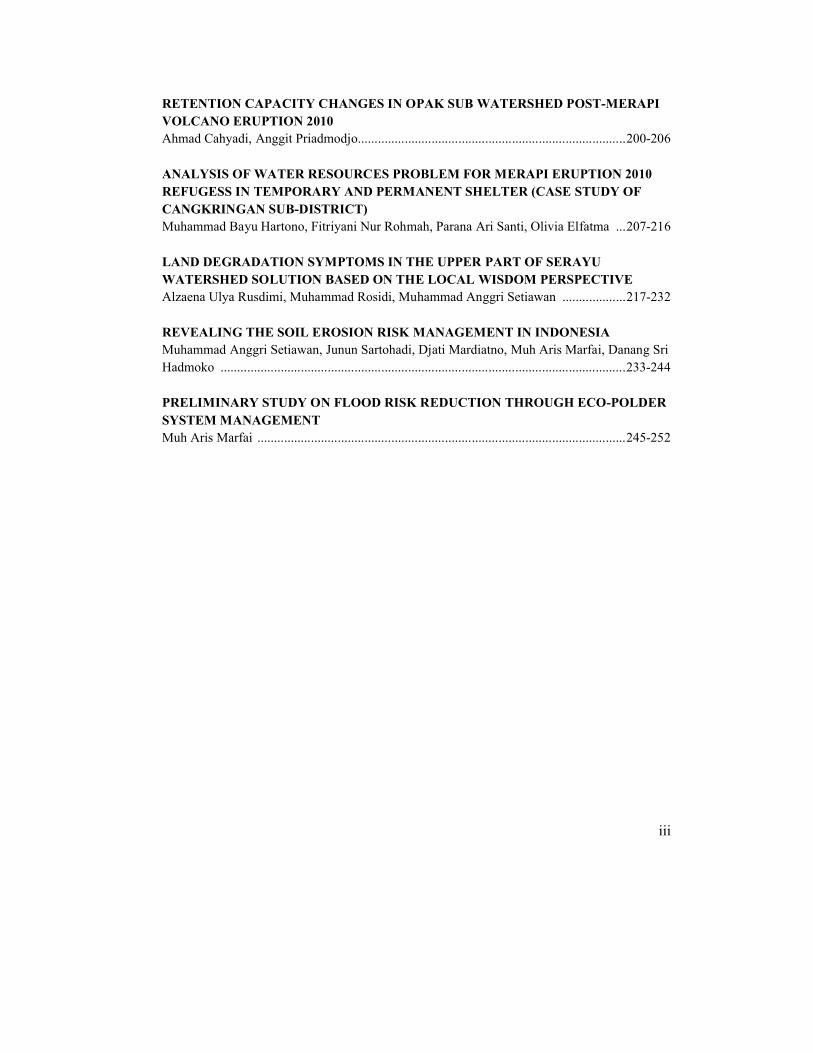
TABLE OF CONTENTS
STUDY OF LANDSLIDE DYNAMIC WITH SPATIAL-TEMPORAL APPROACH AND ITS RELATION TO THE EXISTING ECO-DRR PROGRAM ON A PART OF DIENG AREA, INDONESIAFredi Satya Candra Rosaji, Arief Darmawan, Danang Sri Hadmoko, Diana Paola Ordonez Coboz, Johannes Husener, Udo Michael Nehren, Nirmal Raj Harma, Ghanashyam Sapkota, Shreema Rana, Ajay Chandra Lal .........................................................................................1-12
VOLCANIC HAZARD MANAGEMENT IN DIENG PLATEAU AREAHenky Nugraha, Warsini Handatani, Munawaroh, Djati Mardiatno, Susanne Boerner, Corina Nienhaus, Andrea Teran Valdez, Guenther Straub, Ram Prasad Neupane, Jiba Raj Pokharel ..............................................................................................................................................13-20
SOIL EROSION REDUCTION: A CASE OF KEJAJAR SUB-DISTRICT, DIENG COMPLEXNirjana Shrestha, Alzaena Ulya Rusdimi, Andrea Giraldo Arias, Matthias Knuver, MuhammadRosidi, Ram Mani Ghimire, Aweta Amatya Shrestha ..........................................................21-31
MANAGING SOIL EROSION THROUGH ECOSYSTEM-BASED APRROACHES: THE CASE OF URUGURU MOUNTAIN RANGES, IN MOROGORO REGION, TANZANIATumpale Sakijege .................................................................................................................32-38
POLICIES AND CHALLENGES FOR EARTHQUAKE RISK REDUCTION IN MUNICIPALITIES OF NEPALAjay Chandra Lal..................................................................................................................39-54
ENVIRONMENTAL MANAGEMENT AT GENDOL RIVER COURSE - SOUTHERN SLOPE OF MERAPI VOLCANO IN YOGYAKARTA SPECIAL REGIONDarmakusuma Darmanto ......................................................................................................55-72
GEOINDICATORS RELATED TO COASTAL MORPHODYNAMIC IN MAPUTO AND MACANETA BEACH, MOZAMBIQUEParana Ari Santi, Aniesa Norma Dantie, Gabriel Spinola, and Wanderson Correa .............73-83
INTEGRATED COASTAL ZONE MANAGEMENT PLANNING BASED ON DISASTER RISK MANAGEMENT IN MAPUTO CITY, MOZAMBIQUEAjeng Larasati, Ahmad Cahyadi, Dhandhun Wacano ..........................................................84-92

ii
COMMUNITY-BASED DISASTER RISK MANAGEMENT (COMPARATIVE STUDY OF JAKARTA AND SURAKARTA CITY)Muh Aris Marfai, Annisa Triyanti ......................................................................................93-102
MANGROVE-COMMUNITY CONTRIBUTION ON DISASTER RISK REDUCTION DUE TO COASTAL FLOOD (A CASE STUDY IN LAWANGREJO VILLAGE, PEMALANG REGENCY)Anang Widhi Nirwansyah ................................................................................................103-119
PERCEPTION AND RESPONSE TO TIDAL FLOOD INUNDATION (CASE STUDY: TEGAL MUNICIPALITY)Riswan Septriayadi, Muh Aris Marfai, Johannes Hamhaber............................................119-134
BIODEGRADATION OF SEAGRASS ECOSYSTEM AND ITS IMPLICATION ON COASTAL RESOURCES IN MARATUA ISLAND, EAST KALIMANTAN –INDONESIABachtiar Wahyu Mutaqin, Fitriyani Nur Rohmah ...........................................................135-146
IS VULNERABILITY 'A MERE MATTER OF SOCIAL-PHYSICAL PROBLEM' IN URBANAREAS? A CASE STUDY IN BANTUL DISTRICT – INDONESIADyah Rahmawati Hizbaron, Martin Coy, Mohamad Baiquni, Junun Sartohadi, Raden Rijanta ..........................................................................................................................................147-160
AGROCLIMATE CROPPING PATTERN FOR HARVEST FAILURE MITIGATION (CASE STUDY: TINALAH WATERSHED, YOGYAKARTA SPECIAL PROVINCE)Fitria Nucifera, Sari Utami ...............................................................................................162-169
QUANTIFYING THE POTENTIAL CLIMATE CHANGE DRIVEN HAZARD IN A WATERSHED: CASE STUDY OF UPPER OPAK CATCHMENT AREAAndung Bayu Sekaranom.................................................................................................170-179
RIVER MORPHOLOGICAL CHANGE DUE TO PYROCLASTIC FLOW AND LAHAR FROM MERAPI ERUPTION 2010 IN KALI GENDOL, SLEMAN, YOGYAKARTAGilang Arya Dipayana, Aries Dwi Wahyu Rahmadana, Fardyansari Cahyaningtyas, Dhandhun Wacano, Danang Sri Hadmoko ........................................................................................180-191
GEOMORPHOLOGICAL APPROACH FOR THE DISTRIBUTION OF DAMAGE ASSESSMENT OF INFRASTRUCTURE, SETTLEMENT, AND AGRICULTURAL LAND CAUSED BY LAHAR IN 2012-2011 CASE: KALI PUTIH, MAGELANG DISTRICT, CENTRAL JAVAMunawaroh, Widiyanto ....................................................................................................192-199
iii
RETENTION CAPACITY CHANGES IN OPAK SUB WATERSHED POST-MERAPI VOLCANO ERUPTION 2010Ahmad Cahyadi, Anggit Priadmodjo................................................................................200-206
ANALYSIS OF WATER RESOURCES PROBLEM FOR MERAPI ERUPTION 2010 REFUGESS IN TEMPORARY AND PERMANENT SHELTER (CASE STUDY OF CANGKRINGAN SUB-DISTRICT)Muhammad Bayu Hartono, Fitriyani Nur Rohmah, Parana Ari Santi, Olivia Elfatma ...207-216
LAND DEGRADATION SYMPTOMS IN THE UPPER PART OF SERAYU WATERSHED SOLUTION BASED ON THE LOCAL WISDOM PERSPECTIVEAlzaena Ulya Rusdimi, Muhammad Rosidi, Muhammad Anggri Setiawan ...................217-232
REVEALING THE SOIL EROSION RISK MANAGEMENT IN INDONESIAMuhammad Anggri Setiawan, Junun Sartohadi, Djati Mardiatno, Muh Aris Marfai, Danang Sri Hadmoko .........................................................................................................................233-244
PRELIMINARY STUDY ON FLOOD RISK REDUCTION THROUGH ECO-POLDER SYSTEM MANAGEMENTMuh Aris Marfai ..............................................................................................................245-252

Ecosystem Based Disaster Risk Reduction 2013, Yogyakarta-INDONESIA
13
VOLCANIC HAZARD MANAGEMENT IN DIENG PLATEAU AREA
Henky Nugraha1, Warsini Handayani1, Munawaroh1, Djati Mardiatno1, Susanne Börner2, Corina Nienhaus2, Andrea Terán Valdez2, Günther Straub2,
Ram Prasad Neupane3, Jiba Raj Pokharel3
1Master Program on Planning and Management of Coastal Area and Watershed, Universitas Gadjah Mada, Yogyakarta, Indonesia
Email: [email protected], [email protected], [email protected] University of Applied Sciences, Institute for Technology and Resource Management in the
Tropics and Subtropics, Germany3Master Program on Disaster Risk Management, Department of Civil Engineering, Tribhuvan University,
Kathmandu, Nepal
AbstractDieng Plateau,located in Central Java Province, which is an active volcanic complex composed of various volcanic appearance of small-medium sized growing in the old volcanic complex of Young Pleistocene Jembangan caldera. The purpose of this article is to study the hazard management in the Dieng Plateau. The study will show about volcanic management in Dieng Plateau, with emphasis on volcanic hazards. For this study, literature study and field observations were conducted to get all of the data. The results show that Dieng Plateau is potential for volcanic hazard, especially poisonous gas hazards. Several villages in the Dieng Plateau are prone to poisonous gas hazards. A total of 10 evacuation points facilities were prepared for disaster mitigation strategies. They are scattered in villages surrounding disaster-prone areas. However, the amount of existing health facilities is still fairly limited. Center of Volcanology and Geological Hazard Mitigation monitors volcanic and seismic activity in the Dieng area, which is conducted visually and instrumentally. The visual monitoring includes temperature, water pH, chemical contents of water, and the volume of poisonous gas, while the instrumental monitoring uses a digital seismograph (Sindoro, Slamet, Silari and Dieng), a manual seismograph (Dieng), telemetry (CO2 in Timbang) and thermal photos (3 km distance) for gases spread. Volcanic hazard management is very important for preventive assessment of evacuation strategy. It also has important role in ongoing crisis to determine when to evacuate and what steps should be taken. Quick actions and appropriate decisions in the volcano crisis will be important in the context of disaster risk reduction.
Keywords: emergency, volcanic hazard, disaster management
I. IntroductionIndonesia is located in the subduction zone of three active tectonic plates, Eurasian,
Indo-Australian and Pacific. This condition results in a series of volcanoes along the island of Sumatra, Java, Bali, Nusa Tenggara, Maluku and North Sulawesi. In Indonesia, there are 130 active volcanoes which potentially lead to disaster. Approximately, 17 percent of the world's active volcanoes are situated in Indonesia and 30 percent of active volcanoes in Indonesia is situated in Java and Bali (Sudibyakto and Abasi 1996).
In 600 AD, Dieng Plateau area came under the influence of one of great kingdom in Java, Galuh Pasundan Kingdom. Etymologically, the name of "Dieng" comes from the combination of two ancient Sundanese words, namely: the word "Di" which means high place or mountainous, and "Hyang" which means God. Thus, Dieng means the highlands (mountains) as the dwelling place of the Gods (Santosa 2009).

Ecosystem Based Disaster Risk Reduction 2013, Yogyakarta-INDONESIA
14
Geomorphologically, Dieng Plateau is a highland with complex condition in the west of the Sindoro and Sumbing volcano and included in the district of Banjarnegara and Wonosobo (Figure 1). It is located in Central Java Province and deemed an active volcanic region, the result of a giant volcanic activity, with craters. It is, as well, composed of various volcanic appearance of small-medium sized growing in the old volcanic complex of Young Pleistocene Jembangan caldera (Verstappen 2000). This complex is located on the topography with an altitude above 2000 msl with 14 km long and 6 km wide (Lavigne et al. 2008).
Based on the relative age of rock, residual morphology, rate of erosion, stratigraphic relationships and level of rocks weathering, the activities of volcanism on the Dieng volcanic complex is divided into three chronological order, i.e. the pre-caldera; post-caldera; and lava flows, pyroclastic, and hydrothermal. Formation of pre-caldera volcanic activity is indicated by Rogojambangan, Tlerep, Djimat and Prau, the product spread on the outside of the Dieng complex. Post-caldera formation, shown by the volcanic activity inside the caldera, includesBisma-Sidede, Seroja, Nagasari, Pangonan, Igir Binem and Pager Kandang. Their activities produced pyroclastic fall (airborne deposits) that covered almost the entire area, which is also known as Dieng pyroclastic deposits. The activity of that time was marked by a lava flow with biotite-andesite composition and associated with pyroclastic fall. The last activity wascharacterized by phreatic eruptions. The third chronology activities generate volcano-biotite andesite lava, pyroclastic fall and hydrothermal activity. Volcanic activity produced lava dome and biotite-andesite lava flow that can be found in 9 eruption places on the southeastern caldera (Santosa 2009).
Dieng Plateau volcanic activity has formed various landforms, namely: explosion craters, tuff-ring craters, scoria cones, small strato volcano, lava flows, and so on (Verstappen1988). Active volcanic activity has caused it to be particularly vulnerable to volcanic hazards, especially to volcanic gas hazards. Phreatic eruption that occurred in 1979 in the west of Dieng Plateau near the Sinila crater is followed by the release of CO2 gas coming out of a few places along the fault or faults that lie somewhat to the west, near the village of Timbang and Simbar. 149 people died during the eruption (Verstappen 1988).
Dieng air temperature ranged between 15-20° C in the daytime and ± 10° C at night. In the dry season, between July and August, temperatures sometimes reach 0° C in the morning, and bring frost, which locals called "bun upas or toxic dew", because the dews can cause damage to agricultural crops (Santosa 2009). Beside its proneness to volcanic disasters, Dieng Plateau is also inhabited by more than 500,000 people living close to the volcanic hazards (Lavigne et al. 2008). Emergency response during disasters is very important as a way to reduce the number of casualties. Good planning becomes an important factor in the context of disaster risk reduction. Continuous observation, hazard mapping and emergency handling procedures enable the reduction of losses of property and life. An emergency plan should be prepared well in preparation for disaster that can happen at any time.
II. ObjectivesThis research aims to study the hazard management in the Dieng Plateau and to
analyze the volcanic management in Dieng Plateau with emphasis on volcanic hazards.
III.MethodsLiterature study and field observations were conducted to get all of the data. Literature
study was used to find the relevant reference theories regarding pernicious cases or problems found in the study area. The references were obtained from books, journals, research reports,

Ecosystem Based Disaster Risk Reduction 2013, Yogyakarta-INDONESIA
15
articles and sites on the internet. The output of this literature is the correlation references that relevant to the formulation of the problem. Its aim is to strengthen the problem as well as a theoretic basis in conducting studies and also to become the basis for control design and simulation of volcanic hazard mitigation in Dieng Plateau.
Figure 1. The study area, Dieng Plateau Area
Field observation was conducted by in-depth interviews. They were conducted to obtain information regarding the various issues raised in the study. The information was obtained from the Volcanological Survey observer in Dieng Plateau who knows about the problems of the research.
IV. Results and DiscussionDieng Volcano Complex is one of the most dangerous volcanoes in Indonesia with
poisonous gas as its primary hazard. The poisonous gas is not always preceded by the eruption, but may also come out through cracks in volcanic area. CO2 is the main gas in Dieng Volcano which significantly causes casualties (Set BAKORNAS PBP (2005). Recently, Dieng Plateau has been growing as farming and tourism area. Eco-tourism, agro-tourism, and cultural tourism are the most developed tourisms. Dieng natural and cultural conditions are the main attraction for tourists, among others: the crater and the lake in Dieng Plateau, temples, and cultural community such as shabby hair cutting ceremony (Figure 2).

Ecosystem Based Disaster Risk Reduction 2013, Yogyakarta-INDONESIA
16
According to the tourism agency data, the number of visitors in Dieng Plateau reaches326.551 (BAPPEDA and BPS Wonosobo 2011). Dieng tourism activity provides income to both local government and community. This potential activity deals with potential volcanic hazard in Dieng Plateau. Therefore, it is necessary to manage Dieng Plateau based on ecosystem-based disaster risk reduction. Disaster management in Dieng Plateau is performed by several parties i.e. agencies National Disaster Management Agency (BNPB), Center of Volcanology and Geological Hazard Mitigation (CVGHM), Forestry Agencies, and local community groups. These agencies work together within the framework of disaster management. During an increase in volcanic activities, which potentially leads to devastating hazards, volcano observation post conveys information to the tourism office to warn travelers about the condition of Dieng Plateau.
Figure 2. Tourism activities in Dieng Plateau: (a) crater and lake (Field Survey 2012), (b) temple and hair cutting ceremony as cultural tourism (Kautsar 2012), and (c) agro-tourism(Field Survey 2012)
4.1. Identification of Volcanic Hazard Zones and Disaster Mitigation FacilitiesVolcanic hazard zoning is one of disaster management efforts undertaken in Dieng
Plateau. Volcanic hazard zone map in Dieng Plateau was created by Center of Volcanology and Geological Hazard Mitigation (CVGHM). It is divided into three zones ranging from low to high level i.e. Hazard Zone I, II, and III. High levels indicate closer distances to the volcanic hazard source. A hazard zoning map of the area is given in Figure 3.
Dieng Plateau is potential for volcanic hazard, especially poisonous gas. Several villages in the Dieng Plateau are prone to poisonous gas hazards. It is presented in Table 1. A total of 10 evacuation points facilities were prepared in order to disaster mitigation strategies. It is scattered in villages surrounding disaster-prone areas. However, the amount of existing health facilities is still fairly limited.
4.2. Institution Coordination on Disaster ManagementThe emergency response phase is undertaken as soon as the disaster occurred and
lasted about one to two months. This phase is led by BNPB (National Disaster Management Agency) which mainly provides planning and coordinating among central government, provin-
a b
c

Ecosystem Based Disaster Risk Reduction 2013, Yogyakarta-INDONESIA
17
Figure 3. Hazard zoning in Dieng Plateau. Hazard Zone I (yellow), II (red), and III (darker-red) (BNPB 2011)
Table 1. Dieng Volcano disaster-prone areaVillages Potential Hazards Survival DirectionsTlagabang Poisonous gas KosonganCondong Campur dan Gembol Poisonous gas Pasurenan DukuhNgandam dan Pulosari Poisonous gas TempuranSikunang dan Siterus Poisonous gas Sembungan
Dieng Wetan Poisonous gas Patak BantengWanapria dan Sidongkal Poisonous gas WatulembuKradenan dan Gerlang Poisonous gas KayuabangSimbar, Serang, dan Sumberrejo Poisonous gas Batur dan PramenKaliputih Poisonous gas Pasurenan DukuhGandoran, Pekasiran Poisonous gas Pasurenan Krajan
Kepakisan dan SimpanganPoisonous gas, Surge, volcanic rock from Sileri crater
Karangtengah
Pawuan/Dieng Kulon Poisonous gas Patak Banteng
Buntu dan Bakal Poisonous gas KarangtengahSource: CVGHM (2003)

Ecosystem Based Disaster Risk Reduction 2013, Yogyakarta-INDONESIA
18
cial and local government during emergency relief. Implementation in provincial level is coordinated by the BPBD (Provincial Disaster Management Agency), while it is implemented by BPBD district (District/City Implementing Unit) at district/city level. During this stage, many donors and stakeholders/NGOs give contributions for emergency relief which is coordinated by BPBD.
Figure 4.Volcanic emergency management in Dieng Plateau (Data Analysis 2012)
CVGHM is an institution under the Geological Agency as well as the Ministry of Energy and Mineral Resources. CVGHM monitors volcanic and seismic activity (as seen in Table 2) in the Dieng area which is conducted visually and instrumentally. The visual monitoring includes temperature, water pH, chemical contents of water, and the volume of poisonous gas, while the instrumental monitoring uses a digital seismograph (Sindoro, Slamet, Silari and Dieng), a manual seismograph (Dieng), telemetry (CO2 in Timbang) and thermal photos (3 km distance) for monitoring the spreading of gases. In emergency conditions, the warning alert is made by the central government but it also can be made by the local government when the fast decision is needed (very emergency situation). The evacuation is done by looking the strength of volcanic activity. But, it also can be done when the status of volcanic activity in third level.
National Disaster Management Agency
Ministry of Energy and Mineral Resources
Geological Agency
Center of Volcanology and
Geological Hazard Mitigation
Provincial Disaster Management Agency
Regional Disaster Management Agency
Sub-district Level Operational Unit
Village Level Operational Unit
Dieng Observatory Station
Community
: warning: communication

Ecosystem Based Disaster Risk Reduction 2013, Yogyakarta-INDONESIA
19
Table 2. Levels of volcanic activityLevel Volcanic ActivityLevel I: Normal Normal gas activityLevel II: Waspada Increase of seismic activity and gasesLevel III: Siaga Small eruptions
Level IV: AwasPhreatic eruption, water vapor, gas (CO2 and sulfur), hot mud flow, and the eruption influence in settlement
Source: CVGHM (2012)
The first warning is given by the Center of Volcanology to the Central Government of Indonesia, then to local government, and further to the local community by loud speakers of.mosques. In normal conditions, observer in CVGHM observation posts reports the volcanic condition to the national CVGHM twice a day. The volcanic emergency management in Dieng Plateau is shown in Figure 4. Volcanic hazard management is very important for preventive assessment of evacuation strategy. It is also has important role in on-going crisis to know when to evacuate and what steps should be taken. Quick actions and appropriate decisions in the volcano crisis will be important in the context of disaster risk reduction
V. ConclusionsDieng Plateau stores potential volcanic hazard, especially poisonous gas. Several
villages in the Dieng Plateau are prone to poisonous gas hazards. A total of 10 evacuation points facilities were prepared as an attempt for disaster mitigation strategies. They arescattered in villages surrounding disaster-prone areas. However, the amount of existing health facilities is still fairly limited. Volcanic hazard management is very important for preventive assessment of evacuation strategy. It also has important role in ongoing crisis to know when to evacuate and what steps should be taken. Quick actions and appropriate decisions in the volcano crisis will be important in the context of disaster risk reduction.
VI. AcknowledgementMany thanks to (1) the Biro Perencanaan dan Kerjasama Luar Negeri (BPKLN)
Kementrian Pedidikan Nasional Republik Indonesia which has provided master's program scholarships to the writers through the program of BEASISWA UNGGULAN. Hopefully, this program can gain a better appreciation from the government and becomes leader for the Indonesian bright future. (2) Dr.rer.nat. Muh Aris Marfai, M.Sc. as the Head of Master Program on Planning and Management Coastal Area and Watershed, Universitas Gadjah Mada, Yogyakarta.
VII. ReferenceSet BAKORNAS PBP (2005) Panduan Pengenalan Karakteristik Bencana dan Upaya
Mitigasinya di Indonesia. Biro Mitigasi Sekretariat BAKORNAS PBP. Jakarta.BAPPEDA and BPS Wonosobo (2011) Wonosobo in Figures. BPS Wonosobo Regency.
WonosoboBNPB (2011) Peta KRB Komplek Gunung Dieng. Accessed from http://geospasial.bnpb.go.id/
2011/06/01/peta-krb-komplek-gunung-dieng/, 1 January 2011.CVGHM (2003) Dieng Volcanic Hazard Socialization, Banjarnegara, Central Java. Slide
Presentation. Geological Agency - Ministry of Ministry of Energy and Mineral Resources

Ecosystem Based Disaster Risk Reduction 2013, Yogyakarta-INDONESIA
20
Kautsar I (2012) Dieng Plateau, Nirwana Sunyi Anak-anak Gimbal. Accessed from http://wisata.kompasiana.com/jalan-jalan/2012/08/06/dieng-plateau-nirwana-sunyi-anak-anak-gimbal-476105.html, 1 January 2012
Lavigne F, De Coster B, Juvin N, Flohic F, Gaillard JC, Texier P, Mori P, Sartohadi J (2008)People's Behavior in the Face of Volcanic Hazards: Perspectives from Javanese Communities, Indonesia. Journal of Volcanology and Geothermal Research 172 (2008) 273–287
Santosa LW (2009) Geomorfologi Gunungapi Dieng; Suatu Tinjauan Geomorfologis terhadap Fenomena Kegunungapian dan Bentanglahan Kompleks Gunungapi Dieng. Seminar Regional: Potensi, Ancaman, dan Pengelolaan Dataran Tinggi Dieng MatalabiogamaFakultas Biologi UGM, Yogyakarta
Sudibyakto dan Abasi SH (1996) The Eruption of Merapi Volcano, November 22, 1994: The Geographical Review. The Indonesian Journal of Geography, Vol.28. No. 72 December 1996, pp.1-10
Verstappen TH (1988) Geomorphological Surveys and Natural Hazard Zoning, with special reference to volcanic hazards in Central Java. Z.Geomorph.N.F 1988 81-101
Verstappen TH (2000) The Geomorphology of Indonesia. ITC. The Netherland