Hydrodynamic performance of the minke whale (Balaenoptera acutorostrata) flipper
Upload
independentCategory
view
2download
0
ARTICLE IN PRESS
www.elsevier.com/locate/pce
Physics and Chemistry of the Earth xxx (2006) xxx–xxx
Long-term hydrodynamic response induced by past climaticand geomorphologic forcing: The case of the Paris basin, France
A. Jost a,*, S. Violette a, J. Goncalves a, E. Ledoux b, Y. Guyomard c,F. Guillocheau c, M. Kageyama d, G. Ramstein d, J.-P. Suc e
a UMR 7619 Sisyphe, Universite Pierre et Marie Curie-Paris6, Paris, Franceb UMR 7619 Sisyphe, Centre d’Informatique Geologique, ENSMP, Fontainebleau, France
c UMR 6118, Geosciences Rennes, Universite de Rennes 1, Rennes, Franced UMR 1572, Laboratoire des Sciences du Climat et de l’Environnement, Gif-sur-Yvette, France
e UMR 5125, Laboratoire PaleoEnvironnements et PaleobioSphere, Universite Claude Bernard, Villeurbanne, France
Received 1 July 2005; received in revised form 3 February 2006; accepted 3 February 2006
Abstract
In the framework of safe underground storage of radioactive waste in low-permeability layers, it is essential to evaluate the mobility ofdeep groundwaters over timescales of several million years. On these timescales, the environmental evolution of a repository shoulddepend upon a range of natural processes that are primarily driven by climate and geomorphologic variations. In this paper, the responseof the Paris basin groundwater system to variations in its hydrodynamic boundary conditions induced by past climate and geodynamicchanges over the last five million years is investigated.
A three-dimensional transient modelling of the Paris basin aquifer/aquitard system was developed using the code NEWSAM (Ecoledes Mines de Paris, ENSMP). The geometry and hydrodynamic parameters of the model originate from a basin model, NEWBAS(ENSMP), built to simulate the geological history of the basin. Geomorphologic evolution is deduced from digital elevation model anal-ysis, which allows to estimate river-valley incision and alpine surrection. Climate forcing results from palaeoclimate modelling experi-ments using the LMDz atmospheric general circulation model (Institut Pierre Simon Laplace) with a refined spatial resolution, forthe present, the Last Glacial Maximum (21 ka) and the Middle Pliocene Warmth (�3 Ma). The water balance is computed by the dis-tributed hydrological model MODSUR (ENSMP).
Results about the simulated evolution of piezometric heads in the system in response to the altered boundary conditions are presented,in particular in the vicinity of ANDRA’s Bure potential repository site within the Callovo-Oxfordian argillaceous layer. For the present,the comparison of head patterns between steady state and time dependent simulation shows little differences for aquifer layers close to thesurface but suggests a transient state of the current system in the main aquitards of the basin and in the deep aquifers, characterized byabnormally low fluid potentials. The dependence of the boundary-induced transient effects on the hydraulic diffusivity is illustrated bymeans of a sensitivity study.� 2006 Elsevier Ltd. All rights reserved.
Keywords: Paris basin; Palaeohydrogeology; Palaeoclimate; Palaeogeomorphology; Numerical modelling
1. Introduction
The prospect of storing nuclear waste in low-permeabil-ity rocks, in general shale or crystalline units, has high-
1474-7065/$ - see front matter � 2006 Elsevier Ltd. All rights reserved.
doi:10.1016/j.pce.2006.02.053
* Corresponding author. Tel.: +33 1 44 27 84 86; fax: +33 1 44 27 51 25.E-mail address: [email protected] (A. Jost).
Please cite this article in press as: Jost, A. et al., Long-term hydrodyn(2006), doi:10.1016/j.pce.2006.02.053
lighted the need to improve our understanding of thelong-term mobility of deep groundwater, in order to assesswhether they can indeed be safely used as natural barrierunits. From a hydrodynamic point of view, it is thereforenecessary to evaluate the relevant driving forces with a sig-nificant impact on fluid fluxes and flow patterns over a suf-ficiently large timescale, in order of several million years,
amic response induced by past climatic ..., J. Phys. Chem. Earth
2 A. Jost et al. / Physics and Chemistry of the Earth xxx (2006) xxx–xxx
ARTICLE IN PRESS
and how the flow system responds to the resultant pertur-bations. In particular, it can be worth determining whetherpresent-day conditions represent a steady flow in equilib-rium with stable modern boundary conditions or whetherthe groundwater flow is slowly transient. Indeed, one ofthe most significant aspects of low-permeability environ-ments is their ability to maintain long-lived transient flowconditions, unlike permeable layers which adjust very rap-idly to any disturbances (Neuzil, 1995).
Among the most common and documented sources forunsteady flow in low-permeability formations, slow geo-logic processes acting on the system, such as diagenesis,tectonic compression, compaction of sediments or ero-sional unloading (Neuzil and Pollock, 1983; Ge and Gar-ven, 1992; Luo, 1994; Neuzil, 1995; Bjørlykke and Høeg,1997; Burrus, 1997; Goncalves et al., 2004a, for instance)can explain many pressures anomalies that characterizehydrodynamic transients found in certain geological set-tings. Other mechanisms, which involve the flow of fluidsfrom a source layer, for instance osmotic membrane phe-nomena (Neuzil, 1995, 2000; Goncalves et al., 2004b), havealso been suggested. Recent changes in hydrodynamicboundary conditions, especially those induced by climaticand morphologic variations, can similarly create transientflow of fluids, which could still persist in the low-permeabil-ity layers. Instances of this kind are rare (Toth and Millar,1983; Certes et al., 1997; Goncalves et al., 2004b; Heath-cote and Michie, 2004), however these studies are particu-larly relevant since the changes that have occurred in thepast are likely to extend in the future, over the timescalesrelevant for radiological safety assessments.
In this context, the complex multi-layered aquifer sys-tem of the Paris basin (France), provides a well charteredsite suitable for such a study. Indeed, over the last few mil-lion years, the hydrodynamic system evolution has beenprimarily governed by climatic and geomorphologic varia-tions, namely: (1) the cyclic alternation of glacial and inter-glacial intervals of the Plio-Pleistocene epoch, combinedwith eustatic variations, (2) the tectonic uplift due to theAlpine deformation, and (3) resultant geomorphologic pro-cesses, mainly river-valley incision, that have shaped thelandscape over approximately one million years. Thesechanges may have a severe impact on groundwater flowpatterns because they continuously affect conditions atthe boundaries. For instance, the hydraulic gradients mayhave been altered by temporal variations in recharge andshifting aquifer outlets. Eustatic variations will have animpact on the base level. The river bed deepening causesa decrease in hydraulic head at the outcrops. In addition,the occurrence of permafrost under glacial conditions pre-vented infiltration and was accompanied by significantchanges in the hydrogeological properties of the frozenground.
The aim of this paper is, therefore, to investigate theimplications for changes in hydraulic head boundary con-ditions due to climate variations together with geodynamicprocesses on the Paris basin groundwater system. Of
Please cite this article in press as: Jost, A. et al., Long-term hydrodyn(2006), doi:10.1016/j.pce.2006.02.053
particular interest is the determination of the capacity ofthe resultant disturbances to maintain present-day tran-sient conditions. Given the spatial expanse and depth ofthe basin and since boundary conditions have experiencedcontinuous and various changes, it is appropriate to evalu-ate their impact on a global scale, both spatially, i.e., on theentire basin and temporally, i.e., the timeframe to considerfor this study has been set to the last five million years. Forthis purpose, a three-dimensional transient groundwaterflow modelling of the Paris basin groundwater systemwas developed, using the code NEWSAM from the Ecoledes Mines de Paris (ENSMP) (Ledoux, 1980) over the lastfive million years. The prescription of spatially and tempo-rally evolving hydrodynamic boundary conditions origi-nates from geomorphologic and climatic scenarios. Bothhave been established to quantify the nature, the magni-tude and duration of each process and both will be detailedin a first step. Then, the simulated evolution of the flow andpressures in the aquifer system, in response to the alteredboundary conditions induced by atmospheric and geomor-phologic forcing, will be presented and discussed in termsof hydrodynamic parameters sensitivity.
2. Past hydrodynamic boundary conditions evolution:
relevant scenarios
2.1. Climate scenario
2.1.1. Overview of climate changes over the last five million
years
One of the primary drivers of recent environmental evo-lution is considered to be climate. The most important cli-matic phenomenon of the last million of years has been thetransition to glacial climatic states from non-glacial statesmainly controlled by cyclic changes in the earth orbitalparameters. The fluctuation in oxygen isotopes in forami-niferan shells extracted from deep ocean cores, such asODP 659 (Tiedemann et al., 1994) is an indicator of theglobal climate evolution, as illustrated in Fig. 1 for the last5 Ma. The Plio-Pleistocene epoch is characterized by a glo-bal cooling trend that led up to the Quaternary ice ages.Between 2.6 and 0.9 Ma, the climatic record is dominatedby a 41 ka cyclicity. There is a major climate shift near0.9 Ma after which the length and amplitude of the cycleincreased, to about 100 ka with relatively stable warminterglacials, following much longer and more variable gla-cial periods. Climatic variations were accompanied by sealevel oscillations.
Generally speaking, the Pliocene was significantly war-mer by several degrees than at present with a general trendof increased precipitation and high sea-levels (Dowsett andCronin, 1990). It nevertheless contains episodic climatefluctuations in aridity and temperature. The transition tothe generally cooler climates of the Pleistocene was charac-terized by prominent glacial–interglacial cycles, with largeice-sheets over high latitude North America and Europeand a global sea level drop, between 120 and 130 m
amic response induced by past climatic ..., J. Phys. Chem. Earth

Fig. 1. Palaeoclimate scenario: Plio-Pleistocene time series based on isotopic variations from Tiedemann et al. (1994) and the subsequent time sequences,LMDz simulations and simulated temperatures in �C (Jost et al., 2005), MODSUR water balance (P: precipitation, ETP: potential evapotranspiration, I:infiltration) in mm yr�1 (Jost, 2005); and Palaeomorphologic scenario: estimated incision and uplift rates over the modelled study area since 0.9 Ma, inm Ma�1 (Jost, 2005).
A. Jost et al. / Physics and Chemistry of the Earth xxx (2006) xxx–xxx 3
ARTICLE IN PRESS
(Fairbanks, 1989; Bard et al., 1990a,b; Yokoyama et al.,2000), during glacial periods. In western Europe, theclimate of the last cold extremum, i.e., the Last GlacialMaximum (LGM, 21 ka), was colder than today by5–15 �C, with drier conditions, up to as much as�750 mm yr�1 relative to present, as indicated by pollendata (Peyron et al., 2005). The lower sea level meant acontinental English Channel.
Apart from the resultant recharge fluctuations, one ofthe most important effects of climate on groundwater sys-tems should come from the development of permafrostunder glacial conditions. It is accompanied by significantchanges in hydrological, thermal and mechanical soilsproperties. Permafrost, being nearly impermeable, acts asa confining layer that inhibits discharge and recharge ofgroundwater (Sloan and van Everdingen, 1988; Woo andWinter, 1993). In this paper we shall focus on the impactof this latter property on groundwater systems. Duringthe glacial eras, the Paris basin laid beyond the large Fen-noscandian ice cap which covered northern Europe andwas subject to a periglacial type of climate. Either discon-tinuous or continuous permafrost, with perennially frozenground overlain by a seasonally active layer may, therefore,
Please cite this article in press as: Jost, A. et al., Long-term hydrodyn(2006), doi:10.1016/j.pce.2006.02.053
have existed in the basin. Spatial reconstructions show thatcontinuous and thick permafrost has affected most of theParis basin during the LGM (Van Vliet-Lanoe, 2000)although this scenario is not universally shared (Huijzerand Vandenberghe, 1998).
2.1.2. Climate scenario
The first order climate scenario, from which variationsin aquifer recharge are inferred and on which sea levelchanges and permafrost development phases are superim-posed, is based on the major Plio-Pleistocene climaticchanges. Given that the accuracy of palaeoclimate recon-structions decreases as they go back in time, it is necessaryto adopt simplifying hypotheses. Given the selected time-frame, only the large temporal scales on which climate var-ies will be considered. Many other abrupt and shortertimescales, that characterized in particular glacial stages,will not be taken into account but should be borne in mindwhen discussing the results.
A set of main stages of stable climatic situations wasidentified from the ODP 659 marine oxygen isotopes curvecovering the last five million years. Five time sequenceshave been chosen for the Pliocene epoch, followed by the
amic response induced by past climatic ..., J. Phys. Chem. Earth
4 A. Jost et al. / Physics and Chemistry of the Earth xxx (2006) xxx–xxx
ARTICLE IN PRESS
41 ka and then the 100 ka cyclic alternation between a coldand a warm extremum, as described in Fig. 1.
In order to quantify the climate forcing over the basin,and in particular to specify the spatial patterns of atmo-spheric variables, a serie of palaeoclimate modelling exper-iments was undertaken. The LMD-Zoom atmosphericgeneral circulation model (AGCM), from the InstitutPierre Simon Laplace (IPSL) (Zhou and Li, 2003; Li andConil, 2003), was used with a refined spatial resolutiondown to 50 · 50 km, centred on Paris, for three representa-tive periods: the warm and humid Middle Pliocene, thecold extremum of the LGM and the present-potential cli-mate, referred to as CTRL. Model response to palaeocli-mate situations was confronted to independent climatereconstructions. In particular simulation results for theLGM was compared to updated pollen-based palaeocli-matic indicators for temperature and precipitation (Jostet al., 2005). This comparison indicates that the high reso-lution AGCM, as well as its lower resolution counterpart,underestimates the large cooling indicated by pollen data,especially in winter, by around 10 �C in southwestern Eur-ope. Trends in precipitation are reproduced more closely,but still with lower aridity than the data. Conversely, thePliocene simulated temperatures match estimates from pal-ynological studies, indicating significantly warmer temper-atures, whereas hydrological values show less consistency.
Despite these large uncertainties in the simulated values,a reference scenario was constructed with the aid of theAGCM outputs. It is assumed to produce sufficient differ-ences between climate sequences to generate significantvariations in aquifer recharge, the amplitude of whichwas not yet tested. However this will be done in the futureto estimate the large range of hydrological uncertaintiesdue to climate uncertainties.
The daily means of simulated precipitation and potentialevapotranspiration were corrected taking into account thedifferences between observations on the Seine basin (MeteoFrance data) and the present-potential simulation. Theyare converted as an input for a groundwater model usinga distributed hydrological model, MODSUR (ENSMP)(Ledoux, 1980), on climatic zones defined by the LMDzgrid cell. MODSUR uses classical production functions,depending on the soil and land cover type, to computethe water budget with a daily time step. Results of thehydrological model, expressed as recharge in mm yr�1 onthe entire basin, are indicated in Fig. 1, for each climatesequences.
Associated to each main climate stages, a mean value ofthe sea level is allocated from short-term eustatic curves(Greenlee and Moore, 1988), oscillating between 25 and40 m NGF during the Pliocene, 20 and �70 m NGF duringthe 41 ka cycles and 0 and �120 m NGF during the 100 kacycles.
Based on the objectives of the study, simplifyingassumptions concerning the permafrost representationwere made for the present model. A continuous permafrostcovering the entire basin was modelled during more than
Please cite this article in press as: Jost, A. et al., Long-term hydrodyn(2006), doi:10.1016/j.pce.2006.02.053
half of each of the 100 ka glaciation. It appears 35 ka afterthe beginning of the glacial stage and lasts 55 ka. It isdescribed in a simplifying manner by an inhibition of therecharge in response to soil freezing. However, groundwa-ter discharge has been assumed to be possible and watercan escape along the low head potential zones of the basin.This simple representation allows avoiding the difficultiesof reconstructing the thickness and extension of the pastpermafrost, by testing a sort of drastic scenario associatedwith this phenomenon. The capability of permafrost toprovide water during each deglaciation has not beenaccounted for. Fig. 1 summarizes the climate scenario(Jost, 2005), upon which the geomorphologic evolutionmust then be superimposed.
2.2. Geomorphologic scenario
2.2.1. Geomorphologic evolution
The next step in building the model is the characteriza-tion of the geomorphologic evolution of the Paris basin.Generally speaking, it is linked to tectonic movements inrelation with the Alpine uplift, and to climate and eustaticvariations of the Plio-Pleistocene. It has resulted in theslow uplift of the basin (Pomerol, 1978; Fourniguet,1987) and in river-valley incision which began around1 Ma ago following the major climate shift already men-tioned (Le Roux and Harmand, 1998; Brault et al.,2004). The timing of the beginning of incision relies onmulti-disciplinary studies of alluvial terrace systems ofthe drainage basins such as the Seine or the Somme valleys(Lautridou et al., 1999; Antoine et al., 2000). It leads to sig-nificant topographic changes and to the development of themodern incised hydrological network from the smooth pla-nation surface of the Pliocene (Dewolf and Pomerol, 1997)characterized by shifting river courses. It implies majorreorganizations of the river systems, such as river migra-tion or capture. It is accompanied by erosion processes thatmodelled the landscape, i.e., clearance and stripping of theplateaus or retreat of the coastlines. Although kinematicsand timing of these valley incisions are still uncertain, sig-nificant incision appears to occur at the beginning of eachglacial period in a short climatic transitional period, as ithas been well identified in several valleys from northwestEurope for the last glacial cycle (Vandenberghe, 1993;Antoine et al., 2000; Mol et al., 2000).
2.2.2. Geomorphologic scenario
From these geological considerations, the geomorpho-logical scenario will be split as follows: (1) from 5 to0.9 Ma, a first uplift stage solely, (2) from 0.9 Ma untiltoday, a continuous uplift stage accompanied by specificincision phases of 20 ka, occurring at the transition froman interglacial state to the following glacial. The effect ofa forebulge due to glacio-isostasic crustal rebound (Boul-ton, 1990), which may be negligible with regard to tectonic
amic response induced by past climatic ..., J. Phys. Chem. Earth

Fig. 2. Summary of the stratigraphy and lithology of hydrogeologic units.
A. Jost et al. / Physics and Chemistry of the Earth xxx (2006) xxx–xxx 5
ARTICLE IN PRESS
uplift (Lericolais, 1997), as well as the subaerial erosion ofthe outcrops, causing sub-aquifer exposures, will not betaken into account.
Incision is measured using the new method developed byBonnet et al. (2000) based on a digital elevation modelanalysis (Jost, 2005). It has the advantage of producing adistributed field of incised quantities representative of eachindividual drainage basin, instead of a local erosional rateinferred from alluvial terrace systems analysis, which variesfollowing the position along the drainage network. Fig. 1exhibits the rates of estimated incision during the last mil-lion years. The mean incision rate over the basin is 50 mper Ma, reaching higher values up to 250 m in the mainriver valleys and in the eastern plateaus.
Furthermore, incision partly reflects continental move-ments and is of potential use to measure regional uplift.This method makes possible to separate the tectonic contri-bution and estimate the minimum amounts of differentialuplift between drainage basins. The uplift rate deducedfrom analysis of the amount of erosion ranges mostlybetween 50 and 150 m Ma�1 since 0.9 Ma (Fig. 1). Thesevalues are on the order of those deduced by analysis ofthe terraces systems (Antoine et al., 2000). Between 5 and0.9 Ma, the estimation of vertical motion has been deducedfrom a reconstruction of the 5 Ma palaeotopography.
3. Numerical simulations
3.1. Building the 3D groundwater model
The study area is located in northern France and coversapproximately 250,000 km2. It matches the present expanseof the sedimentary Paris basin and is extended to the southof the London basin including the English Channel forcontinuity reasons. The semi-circular intracratonic Parisbasin was a quasi-continuous subsidence and sedimenta-tion site during Mesozoic time. It is made of a maximumof 3 km of indurated sediments from the Triassic to theTertiary, resting on the basement. The present-day geome-try of the basin, with its characteristic distribution of theoutcrops in concentric rings, is attributed to the majoruplift and erosion stages associated with the Tertiary pyre-nean then alpine compression, initiated during the LateCretaceous.
Groundwater flow is modelled using the numerical codeNEWSAM from the Ecole des Mines de Paris (Ledoux,1980). It is a three-dimensional finite differences modelcapable of simulating transient flow in porous media. Anested square mesh is built over the studied area for eachgeological unit of the model. The basic mesh size is10 km, refined to 5 km on the outcrops and 2.5 km alongthe main structural features of the basin.
The geometrical and hydrodynamic representation ofthe basin are based on the basin model built by Goncalveset al. (2004a) to simulate the 248 Ma geological history ofthe basin. Hydrodynamic units have been chosen accordingto the stratigraphic database of Guillocheau et al. (2000).
Please cite this article in press as: Jost, A. et al., Long-term hydrodyn(2006), doi:10.1016/j.pce.2006.02.053
The 3D geometry is characterized by a succession of 20 sat-urated or semipervious layers. Stratigraphy and lithologyof these hydrogeologic units are summarized in Fig. 2. Afull description of the model is given by Goncalves et al.(2004a). The hydrodynamic input parameters of the differ-ent units introduced in the model, namely horizontal andvertical permeability and specific storage coefficient, havebeen computed on the entire basin as the consequence ofthe geological processes occurring in the course of the basinevolution. Estimations of the hydraulic conductivity fieldsappear to be within one order of magnitude from observa-tions at the regional scale (Goncalves et al., 2004a). It is
amic response induced by past climatic ..., J. Phys. Chem. Earth

6 A. Jost et al. / Physics and Chemistry of the Earth xxx (2006) xxx–xxx
ARTICLE IN PRESS
noteworthy that stratigraphic boundaries incorporated inthe model do not always coincide with the hydrogeologicalboundaries, defined by hydrodynamic properties, becauseof lateral variations in sedimentary facies.
Once the main geological processes, such as compactionforces, cease at the beginning of the Tertiary, following theemergence of the basin, and in the absence of any other dis-turbances, such as changing boundary conditions oranthropogenic activities, the multi-layered system is likelyto reach near-hydrostatic conditions. Fluids move in atopography-induced flow system subject to contemporaryboundary conditions. Present-day regional-scale ground-water flow is oriented from the southeastern major upliftedrecharge area towards the Northwest. Fluids discharge inthe major valleys and in the English Channel. However,the related effects of climate and sea level oscillationstogether with changing surface topography that took placeduring the last million of years are assumed to give rise to acycle of disturbances on the groundwater system and tosuperimpose abnormal patterns on the predominantlytopographically-driven flow that is present. Pressure andflow fields may therefore reflect past boundary conditions.Temporal recharge changes inferred from the climate sce-nario, combined to eustatic variations and the occurrenceof permafrost during cold phases, together with upliftand incision rates, are imposed as hydrodynamic boundaryconditions for a time-dependent computation of a 3Dgroundwater flow, as follows:
1. Recharge rates: spatially-and temporally-varying mete-oric water recharge takes place at the top of the layeredsystem according to the previous reconstructions (i.e.,Section 2). During the cold periods preceding the onsetof a frozen ground, meteoric replenishment is reducedby 60%. In case of permafrost, a no-recharge boundarycondition is used.
2. Constant head boundary conditions: if the boundary iscovered by the sea, constant head boundary conditionsare applied, at the sea level.
3. Drainage elevation: the drainage network is determinedfrom the landscape evolution, from the Pliocene topog-raphy to the modern surface elevation, given theimposed uplift and incision rates. Drainage or infiltra-tion will occur if the groundwater head exceeds or islower than the drainage level, respectively. In the pres-ent-day situation, the groundwater heads are generallyequal or higher than the surface water levels in the riv-ers, and only a fraction of the recharge enters the systemfrom leakage through the river beds.
The 3D model is used to reproduce the transient responseto changes in hydrodynamic boundary conditions duringPlio-Pleistocene time. The hydrodynamic state of the systemwas recorded every 1000 yr. To determine a set of coherentinitial conditions at 5 Ma, a reference steady state simula-tion is made to compute the hydraulic head distribution,from which the time evolution of the system is calculated.
Please cite this article in press as: Jost, A. et al., Long-term hydrodyn(2006), doi:10.1016/j.pce.2006.02.053
3.2. Hydrodynamic modelling results
The model generates the distribution of hydraulic headthrough the Plio-Pleistocene history. Fig. 3 is a sample ofthe results produced by the transient simulation. It repre-sents the piezometric head evolution for a mesh pointincluding ANDRA’s Bure study site (Meuse, France) (seelocation in Fig. 4), across a vertical line through the Cal-lovo-Oxfordian argillaceous layers, i.e., the potential hostformations for underground storage of nuclear waste, sur-rounded by the Dogger and Lusitanian aquifers, in theeastern part of the basin. Starting from the initial condi-tions given by the reference steady state, the long-trendevolution of the piezometric head in each point of the basinreflects:
1. the alpine uplift, illustrated by the upward trendobserved all along the simulation, competed with thedownward incision trend since 900 ka;
2. the fluctuations of the recharge rate occurring during the41 ka and 100 ka cycles, responsible for a cyclic ground-water flow evolution with small variations of thehydraulic head, on the order of a few meters;
3. the most salient effect of permafrost existence, duringcold glacial stages, when groundwater heads are rapidlydropping, tending towards an equilibrium value givenby the sea surface elevation, as the groundwater systemis allowed to be drained but not recharged;
4. and for marine and coastline meshes (not shown inFig. 3), the influence of sea level changes.
Based on the objectives of this study, the calculated headpatterns given by the transient simulation are compared totheir steady-state counterpart for the present conditions, soas to evaluate the possible presence of transient pressureremnants due to past changes in the boundary conditions.
The comparison between steady state and time depen-dent simulation shows little differences for aquifer layersclose to the surface due to their relatively high permeabil-ity. Indeed, if the flow is changing in the course of thePlio-Pleistocene history of the groundwater system, as thehydrogeologic framework evolves in time, it adjusts so rap-idly that it remains quasi-steady through all disturbances.
Conversely, the distribution of transient minus steady-state heads suggests a transient state of the current systemin the main aquitards of the basin as well as in the deepestaquifers. The main features of these patterns indicateabnormally low heads as compared with values observedin a steady-state equilibrium. Head differences are locatedin lower permeability areas of the concerned units andrange from a few meters to as much as one hundred meters.As much as 80% of the last maximum head disturbance stillremains, as shown for instance for the Callovo-Oxfordianand Lower Liassic aquitards, and also for the Lower Trias-sic aquifer (Fig. 4). The present-day head field must then beconsidered as a relict feature of past boundary conditions,mainly generated by the lowering of hydraulic heads subse-
amic response induced by past climatic ..., J. Phys. Chem. Earth
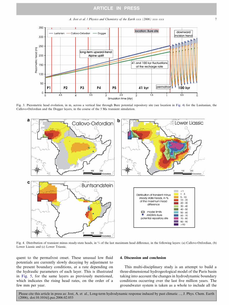
Fig. 3. Piezometric head evolution, in m, across a vertical line through Bure potential repository site (see location in Fig. 4) for the Lusitanian, theCallovo-Oxfordian and the Dogger layers, in the course of the 5 Ma transient simulation.
Fig. 4. Distribution of transient minus steady-state heads, in % of the last maximum head difference, in the following layers: (a) Callovo-Oxfordian, (b)Lower Liassic and (c) Lower Triassic.
A. Jost et al. / Physics and Chemistry of the Earth xxx (2006) xxx–xxx 7
ARTICLE IN PRESS
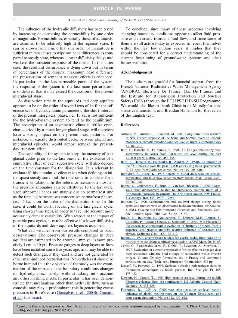
quent to the permafrost onset. These unusual low fluidpotentials are currently slowly decaying by adjustment tothe present boundary conditions, at a rate depending onthe hydraulic parameters of each layer. This is illustratedin Fig. 5, for the same layers as previously mentioned,which indicates the rising head rates, on the order of afew mm per year.
Please cite this article in press as: Jost, A. et al., Long-term hydrodyn(2006), doi:10.1016/j.pce.2006.02.053
4. Discussion and conclusion
This multi-disciplinary study is an attempt to build athree-dimensional hydrogeological model of the Paris basintaking into account the changes in hydrodynamic boundaryconditions occurring over the last five million years. Thegroundwater system is taken as a whole to include all the
amic response induced by past climatic ..., J. Phys. Chem. Earth
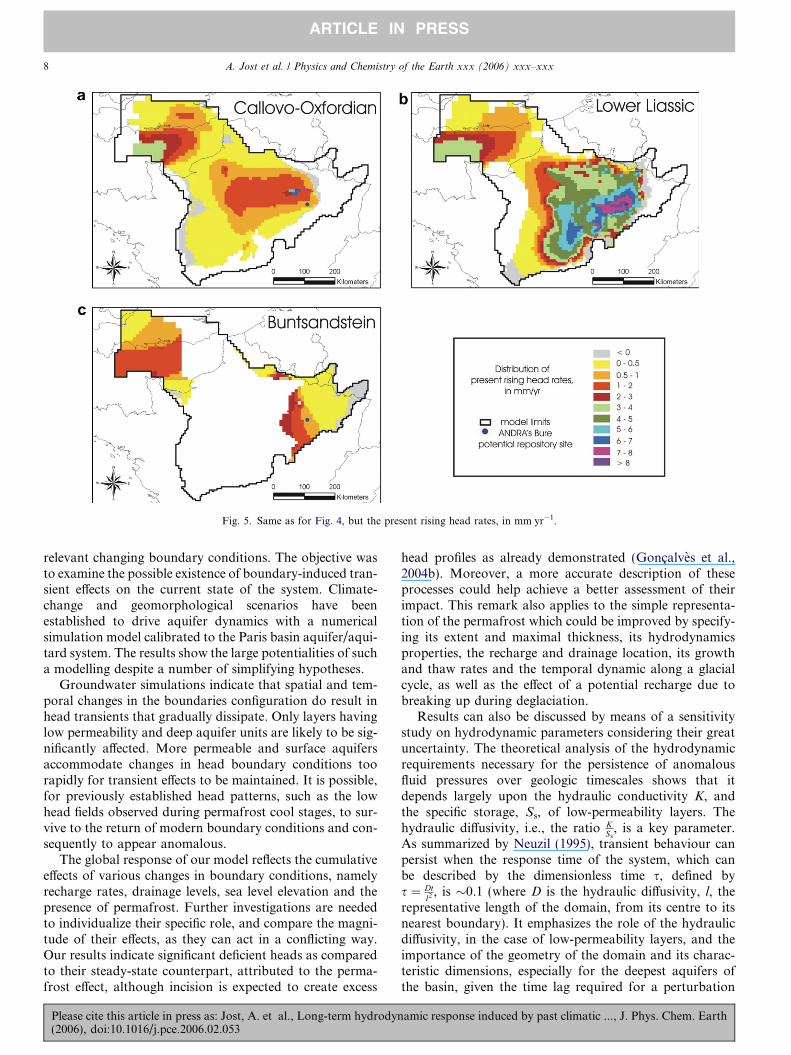
Fig. 5. Same as for Fig. 4, but the present rising head rates, in mm yr�1.
8 A. Jost et al. / Physics and Chemistry of the Earth xxx (2006) xxx–xxx
ARTICLE IN PRESS
relevant changing boundary conditions. The objective wasto examine the possible existence of boundary-induced tran-sient effects on the current state of the system. Climate-change and geomorphological scenarios have beenestablished to drive aquifer dynamics with a numericalsimulation model calibrated to the Paris basin aquifer/aqui-tard system. The results show the large potentialities of sucha modelling despite a number of simplifying hypotheses.
Groundwater simulations indicate that spatial and tem-poral changes in the boundaries configuration do result inhead transients that gradually dissipate. Only layers havinglow permeability and deep aquifer units are likely to be sig-nificantly affected. More permeable and surface aquifersaccommodate changes in head boundary conditions toorapidly for transient effects to be maintained. It is possible,for previously established head patterns, such as the lowhead fields observed during permafrost cool stages, to sur-vive to the return of modern boundary conditions and con-sequently to appear anomalous.
The global response of our model reflects the cumulativeeffects of various changes in boundary conditions, namelyrecharge rates, drainage levels, sea level elevation and thepresence of permafrost. Further investigations are neededto individualize their specific role, and compare the magni-tude of their effects, as they can act in a conflicting way.Our results indicate significant deficient heads as comparedto their steady-state counterpart, attributed to the perma-frost effect, although incision is expected to create excess
Please cite this article in press as: Jost, A. et al., Long-term hydrodyn(2006), doi:10.1016/j.pce.2006.02.053
head profiles as already demonstrated (Goncalves et al.,2004b). Moreover, a more accurate description of theseprocesses could help achieve a better assessment of theirimpact. This remark also applies to the simple representa-tion of the permafrost which could be improved by specify-ing its extent and maximal thickness, its hydrodynamicsproperties, the recharge and drainage location, its growthand thaw rates and the temporal dynamic along a glacialcycle, as well as the effect of a potential recharge due tobreaking up during deglaciation.
Results can also be discussed by means of a sensitivitystudy on hydrodynamic parameters considering their greatuncertainty. The theoretical analysis of the hydrodynamicrequirements necessary for the persistence of anomalousfluid pressures over geologic timescales shows that itdepends largely upon the hydraulic conductivity K, andthe specific storage, Ss, of low-permeability layers. Thehydraulic diffusivity, i.e., the ratio K
Ss, is a key parameter.
As summarized by Neuzil (1995), transient behaviour canpersist when the response time of the system, which canbe described by the dimensionless time s, defined bys ¼ Dt
l2 , is �0.1 (where D is the hydraulic diffusivity, l, therepresentative length of the domain, from its centre to itsnearest boundary). It emphasizes the role of the hydraulicdiffusivity, in the case of low-permeability layers, and theimportance of the geometry of the domain and its charac-teristic dimensions, especially for the deepest aquifers ofthe basin, given the time lag required for a perturbation
amic response induced by past climatic ..., J. Phys. Chem. Earth

Fig. 6. Sensitivity analysis based on an increased/decreased vertical and horizontal diffusivity (Dv and Dh) of one order of magnitude: piezometric headevolution, in m, of the Callovo-Oxfordian (Dv � 4 · 10�7 m2 s�1), Lower Liassic (Dv � 10�7 m2 s�1) and Lower Triassic layers(Dh � 8 · 10�3 m2 s�1 � Dv � 8 · 10�6 m2 s�1), for the 100 ka cycles.
A. Jost et al. / Physics and Chemistry of the Earth xxx (2006) xxx–xxx 9
ARTICLE IN PRESS
to reach basal zones of the system and given the spatialexpanse of the basin.
With the set of hydrodynamic parameters introduced inthe model, a significant transient effect is especially
Please cite this article in press as: Jost, A. et al., Long-term hydrodyn(2006), doi:10.1016/j.pce.2006.02.053
observed when the hydraulic diffusivity is low (on the orderof 10�7 m2 s�1 for its vertical component in the mainaffected zones). The response of a given layer also dependson the hydraulic properties of its boundary layers.
amic response induced by past climatic ..., J. Phys. Chem. Earth
10 A. Jost et al. / Physics and Chemistry of the Earth xxx (2006) xxx–xxx
ARTICLE IN PRESS
The influence of the hydraulic diffusivity has been testedby increasing or decreasing the permeability by one orderof magnitude. Permeabilities, especially those of aquitards,are assumed to be relatively high at the regional scale. Itcan be shown from Fig. 6 that one order of magnitude issufficient in most cases to wipe out head differences as com-pared to steady state, whereas a lower diffusivity delays andweakens the transient response of the media. In this lattercase, the resultant disturbance is dying down but in termsof percentages of the original maximum head difference,the preservation of remnant transient effects is enhanced.In particular, in the less permeable parts of the system,the response of the system to the last main perturbationis so delayed that it may exceed the duration of the presentinterglacial stage.
As dissipation time in the aquitards and deep aquifersappears to be on the order of several tens of ka for the ref-erence set of hydrodynamic parameters, the short intervalof the present interglacial phase, i.e., 10 ka, is not sufficientfor the hydrodynamic system to tend to the equilibrium.The prescription of an asymmetric climatic 100 ka cycle,characterized by a much longer glacial stage, will thereforehave a strong impact on the present head patterns. Forinstance, an equally distributed cycle, between glacial andinterglacial episodes, would almost remove the present-day transient effect.
The capability of the system to keep the memory of pastglacial cycles prior to the last one, i.e., the existence of acumulative effect of each successive cycle, will also dependon the time constant for the dissipation. It is relevant toevaluate if this cumulative effect exists when defining an ini-tial quasi-steady state and the timeframe to consider for atransient simulation. In the reference scenario, almost allthe pressure anomalies can be attributed to the last cycle,since abnormal heads are mainly due to permafrost andas the time lag between two consecutive permafrost phases,i.e., 45 ka, is on the order of the dissipation time. In thiscase, it could be worth focusing on the last glacial cycle,using shorter time steps, in order to take into account moreaccurately climate variability. With respect to the impact ofpossible past cycles, it can be effective if a lower diffusivityof the aquitards and deep aquifers layers is assumed.
What can we infer from our results compared to basinobservations? The observable pressure changes in deepaquifers are estimated to be around 1 mm yr�1 (more pre-cisely 1 cm in 10 yr). Pressure gauges in deep layers at Burehave been installed some five years ago, and may be able todetect such changes, if they exist and are not generated byother man-induced perturbations. Nevertheless it should beborne in mind that the objective of the study was the exam-ination of the impact of the boundary conditions changeson hydrodynamics solely, without taking into accountany other masking effects. In particular, it has been demon-strated that mechanisms other than hydraulic flow, such asosmosis, may play a predominant role in generating excesspressures in Bure’s case (Goncalves et al., 2004b; Gueutinet al., this issue).
Please cite this article in press as: Jost, A. et al., Long-term hydrodyn(2006), doi:10.1016/j.pce.2006.02.053
To conclude, since many of these processes involvingchanging boundary conditions appear to affect fluid pres-sure and to create transient fluid flow, and since some ofthem are still active today or expected to repeat themselveswithin the next few million years, it implies that theyshould be considered for a correct understanding of thecurrent functioning of groundwater systems and theirfuture evolution.
Acknowledgements
The authors are grateful for financial support from theFrench National Radioactive Waste Management Agency(ANDRA), Electricite De France, Gaz De France, andthe Institute for Radiological Protection and NuclearSafety (IRSN) through the ECLIPSE II INSU Programme.We would also like to thank Ghislain de Marsily for con-structive discussions, and Brendan Halleman for the reviewof the English text.
References
Antoine, P., Lautridou, J., Laurent, M., 2000. Long-term fluvial archivesin NW France: response of the Seine and Somme rivers to tectonicmovements, climatic variations and sea-level changes. Geomorphology33, 183–207.
Bard, E., Hamelin, B., Fairbanks, R., 1990a. U–Th ages obtained by massspectrometry in corals from Barbados: sea level during the past130,000 years. Nature 346, 456–458.
Bard, E., Hamelin, B., Fairbanks, R., Zindler, A., 1990b. Calibration ofthe 14C timescale over the past 30,000 years using mass spectrometricU–Th ages from Barbados corals. Nature 345, 405–410.
Bjørlykke, K., Høeg, K., 1997. Effects of burial diagenesis on stresses,compaction and fluid flow in sedimentary basins. Mar. Petrol. Geol.14, 267–276.
Bonnet, S., Guillocheau, F., Brun, J., Van Den Driessche, J., 2000. Large-scale relief development related to Quaternary tectonic uplift of aProterozoic-Paleozoic basement: The Armorican Massif, NW France.J. Geophys. Res. 105, 19273–19288.
Boulton, G., 1990. Sedimentation and sea-level change during glacialcycles and their control on glacimarine facies architecture. In: Scourse,J. (Ed.), Glacimarine Environments: Processes and Sediments. Geol.Soc. London, Spec. Publ., vol. 53, pp. 15–52.
Brault, N., Bourquin, S., Guillocheau, F., Dabard, M.P., Bonnet, S.,Courville, P., Esteoule-Choux, J., Stepanoff, F., 2004. Mio-Pliocene toPleistocene paleotopographic evolution of Brittany (France) from asequence stratigraphic analysis: relative influence of tectonics andclimate. Sediment Geol. 163, 175–210.
Burrus, J., 1997. Overpressure models for clastic rocks, their relation tohydrocarbon expulsion: a critical reevaluation. AAPG Mem. 70, 35–63.
Certes, C., Escalier des Orres, P., Goblet, P., Levassor, A., Marivoet, J.,1997. Evaluation of elements responsible for the effective engaged doserates associated with the final storage of radioactive waste: Everestproject. Volume 2b: clay formation, site in France and commmonconclusions on clay. Tech. rep., European Commission, 532 pp.
Dewolf, Y., Pomerol, C., 1997. Surfaces d’erosion polygeniques dans lesformations cenozoıques du Bassin parisien. Bull. Soc. geol Fr. 168,473–482.
Dowsett, H., Cronin, T., 1990. High eustatic sea level during the middlePliocene: evidence from the southeastern US Atlantic Coastal Plain.Geology 18, 435–438.
Fairbanks, R., 1989. A 17,000-year glacio-eustatic sea-level record:influence of glacial melting rates on the Younger Dryas event anddeep ocean circulation. Nature 342, 637–642.
amic response induced by past climatic ..., J. Phys. Chem. Earth

A. Jost et al. / Physics and Chemistry of the Earth xxx (2006) xxx–xxx 11
ARTICLE IN PRESS
Fourniguet, J., 1987. Geodynamique actuelle dans le Nord et le Nord-Estde la France. Apport des comparaisons de nivellements. Mem. BRGM127, 173.
Ge, S., Garven, G., 1992. Hydromechanical modeling of tectonicallydriven groundwater flow with application to the Arkoma forelandbasin. J. Geophys. Res. 97, 9119–9144.
Goncalves, J., Violette, S., Guillocheau, F., Robin, C., Pagel, M., Bruel,D., de Marsily, G., Ledoux, E., 2004a. Contribution of a three-dimensional regional scale basin model to the study of the past fluidflow evolution and the present hydrology of the Paris basin, France.Basin Res. 16, 569–586.
Goncalves, J., Violette, S., Wendling, J., 2004b. Analytical and numericalsolutions for alternative overpressuring processes: application to theCallovo-Oxfordian sedimentary sequence in the Paris basin, France. J.Geophys. Res. 109, B02110.
Greenlee, S., Moore, T., 1988. Recognition and interpretation of deposi-tional sequences and calculation of sea-level changes from stratigraphicdata – Offshore New Jersey and Alabama, Tertiary. In: Wilgus, C.,Hastings, B., Kendall, C., Posamentier, H., Ross, C., Van Wagoner, J.(Eds.), Sea-level Changes: An Integrated Approach. Society of EconomicPaleontologists and Mineralogists, Spec. Publ., vol. 42, pp. 329–353.
Gueutin, P., Altmann, S., Goncalves, J., Cosenza, P., Violette, S., thisissue. Osmotic interpretation of overpressures from monovalent basedtriple layer model, in the Callovo-Oxfordian at the Bure site,doi:10.1016/j.pce.2005.12.002.
Guillocheau, F., Robin, C., Allemand, P., Bourquin, S., Brault, N.,Dromart, G., Friedenberg, R., Garcia, J., Gaulier, J., Gaumet, F.,Grosdoy, B., Hanot, F., Le Strat, P., Mettraux, M., Nalpas, T., Prijac,C., Rigollet, C., Serrano, O., Grandjean, G., 2000. Meso-Cenosoicgeodynamic evolution of the Paris basin: 3D stratigraphic constraints.Geodyn. Acta 13, 189–246.
Heathcote, J., Michie, U., 2004. Estimating hydrogeological conditionsover the last 120 ka: an example from the Sellafield area, UK. J. Geol.Soc. London 161, 995–1008.
Huijzer, B., Vandenberghe, J., 1998. Climatic reconstruction of theWeichselian Pleniglacial in northwestern and central Europe. J.Quaternary Sci. 13, 391–417.
Jost, A., 2005. Caracterisation des forcages climatiques et geomorpho-logiques des cinq derniers millions d’annees et modelisation de leursconsequences sur un systeme aquifere complexe: le bassin de Paris.Ph.D. thesis, Universite Pierre et Marie Curie-Paris6, Paris, 344 pp.
Jost, A., Lunt, D., Kageyama, M., Abe-Ouchi, A., Peyron, O., Valdes, P.,Ramstein, G., 2005. High-resolution simulations of the last glacialmaximum climate over Europe: a solution to discrepancies withcontinental palaeoclimatic reconstructions? Clim. Dyn. 24, 577–590.
Lautridou, J., Auffret, J., Baltzer, A., Clet, M., Lecolle, F., Lefebvre, D.,Lericolais, G., Roblin-Jouve, A., Balescu, S., Carpentier, G., Descom-bes, J., Occhietti, S., Rousseau, D., 1999. Le fleuve Seine, le fleuveManche. Bull. Soc. Geol. Fr. 170, 545–558.
Ledoux, E., 1980. Modelisation integree des ecoulements de surface et desecoulements souterrains sur un bassin hydrologique. Ph.D. thesis,Ecole Nationale Superieure des Mines de Paris, Paris, 236 pp.
Please cite this article in press as: Jost, A. et al., Long-term hydrodyn(2006), doi:10.1016/j.pce.2006.02.053
Lericolais, G., 1997. Evolution plio-quaternaire du fleuve Manche:stratigraphie et geomorphologie d’une plate-forme continentaleen regime periglaciaire. Ph.D. thesis, Universite de Bordeaux 1,265 pp.
Le Roux, J., Harmand, D., 1998. Controle morphostructural de l’histoired’un reseau hydrographique: le site de capture de la Moselle. Geodyn.Acta 11, 149–162.
Li, Z., Conil, S., 2003. Transient response of an atmospheric GCM toNorth Atlantic SST anomalies. J. Clim. 16, 3993–3998.
Luo, X., 1994. Modelisation des surpressions dans les bassins sedimen-taires et des phenomenes associes. Ph.D. thesis, Universite deMontpellier 2, Montpellier.
Mol, J., Vandenberghe, J., Kasse, C., 2000. River response to variations ofperiglacial climate in mid-latitude Europe. Geomorphology 33, 131–148.
Neuzil, C., 1995. Abnormal pressures as hydrodynamic phenomena. Am.J. Sci. 295, 742–786.
Neuzil, C., 2000. Osmotic generation of ‘anomalous’ fluid pressures ingeological environments. Nature 403, 182–184.
Neuzil, C., Pollock, D., 1983. Erosional unloading and fluid pressures inhydraulically ‘‘tight’’ rocks. J. Geol. 91, 179–193.
Peyron, O., Begeot, C., Heiri, O., Magny, M., Millet, L., Ruffaldi, P., VanCampo, E., Yu, G., 2005. Late-Glacial climate changes in EasternFrance (Lake Lautrey) from pollen, lake-levels, and chironomids.Quaternary Res. 64, 197–211.
Pomerol, C., 1978. Evolution paleogeographique et structurale du Bassinde Paris, du Precambrien a l’actuel, en relation avec les regionsavoisinantes. Geol. Mijnbouw 57, 533–543.
Sloan, C., van Everdingen, R., 1988. Region 28, Permafrost region. In:Back, W., Rosenshein, J., Seaber, P. (Eds.), The Geology of NorthAmerica. Geol. Soc. Am., vol. 0–2, Hydrogeology, pp. 263– 270(Chapter 31).
Tiedemann, R., Sarnthein, M., Shackleton, N.J., 1994. Astronomictimescale for the Pliocene d18O and dust records of Ocean DrillingProgram Site 659. Paleoceanography 9, 619–638.
Toth, J., Millar, R., 1983. Possible effects of erosional changes of thetopographic relief on pore pressures at depth. Water Resour. Res. 19,1585–1597.
Vandenberghe, J., 1993. Changing fluvial processes under changingperiglacial conditions. Z. Geomorphol., Suppl. Band 88, 17–28.
Van Vliet-Lanoe, B., 2000. Extension du pergelisol en Europe auDernier Maximum Glaciaire (20 ka BP). Lett. PIGB-PMRC 10, 38–43.
Woo, M., Winter, T., 1993. The role of permafrost and seasonal frost inthe hydrology of northern wetlands in North America. J. Hydrol. 141,5–31.
Yokoyama, Y., Lambeck, K., De Deckker, P., Fifield, L., 2000. Timing ofthe last glacial maximum from observed sea-level minima. Nature 406,713–716.
Zhou, T., Li, Z., 2003. Simulation of the East Asian Summer Monsoonusing a variable resolution atmospheric GCM. Clim. Dyn. 19, 167–180.
amic response induced by past climatic ..., J. Phys. Chem. Earth
Copyright © 2022 FDOKUMEN