Geomorphologic setting and 1755? tsunami deposits at Cape Trafalgar
Upload
independentCategory
view
1download
0
URBAN AND
URBANIZATION
Chief Editors
Prof. Dr. Recep EFEProf. Dr. Turgut Tüzün ONAY
Assoc. Prof. Dr. Igor SHARUHOAssoc. Prof. Dr. Emin ATASOY
Managing Editor
Assist. Prof. Dr. Mehmet BAYARTAN
ST. KLIMENT OHRIDSKIUNIVERSITY PRESSSOFIA • 2014

© 2014 Recep Efe, Turgut Tüzün Onay, Igor Sharuho, Emin Atasoy© 2014 St. Kliment Ohridski University Press ISBN 978-954-07-3772-0
xvii
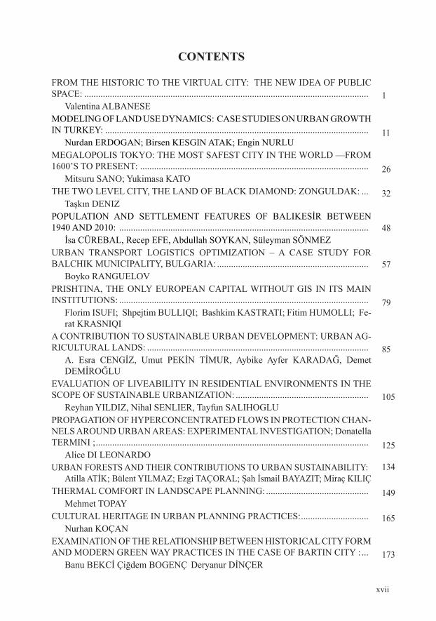
cONTENTS
FROM THE HISTORIC TO THE VIRTUAL CITY: THE NEW IDEA OF PUBLIC SPaCE: .......................................................................................................................... Valentina ALBANESEMODELING OF LAND USE DYNAMICS: CASE STUDIES ON URBAN GROWTH In TuRKEy: ................................................................................................................. Nurdan ERDOGAN; Birsen KESGIN ATAK; Engin NURLUMEGALOPOLIS TOKYO: THE MOST SAFEST CITY IN THE WORLD —FROM 1600’S TO PRESEnT: .................................................................................................. Mitsuru SANO; Yukimasa KATOTHE TWO LEVEL CITY, THE LAND OF BLACK DIAMOND: ZONGULDAK: ... Taşkın DENIZPOPULATION AND SETTLEMENT FEATURES OF BALIKESİR BETWEEN 1940 AND 2010: ........................................................................................................... İsa CÜREBAL, Recep EFE, Abdullah SOYKAN, Süleyman SÖNMEZURBAN TRANSPORT LOGISTICS OPTIMIZATION – A CASE STUDY FOR BALCHIK MUNICIPALITY, BULGARIA: ................................................................. Boyko RANGUELOVPRISHTINA, THE ONLY EUROPEAN CAPITAL WITHOUT GIS IN ITS MAIN InSTITuTIOnS: ...........................................................................................................
Florim ISUFI; Shpejtim BULLIQI; Bashkim KASTRATI; Fitim HUMOLLI; Fe-rat KRASNIQI
A CONTRIBUTION TO SUSTAINABLE URBAN DEVELOPMENT: URBAN AG-RICULTURAL LANDS: ...............................................................................................
A. Esra CENGİZ, Umut PEKİN TİMUR, Aybike Ayfer KARADAĞ, Demet DEMİROĞLU
EVALUATION OF LIVEABILITY IN RESIDENTIAL ENVIRONMENTS IN THE SCOPE OF SUSTAINABLE URBANIZATION: .........................................................
Reyhan YILDIZ, Nihal SENLIER, Tayfun SALIHOGLUPROPAGATION OF HYPERCONCENTRATED FLOWS IN PROTECTION CHAN-NELS AROUND URBAN AREAS: EXPERIMENTAL INVESTIGATION; Donatella TERMINI ; ..................................................................................................................... Alice DI LEONARDOURBAN FORESTS AND THEIR CONTRIBUTIONS TO URBAN SUSTAINABILITY: Atilla ATİK; Bülent YILMAZ; Ezgi TAÇORAL; Şah İsmail BAYAZIT; Miraç KILIÇTHERMAL COMFORT IN LANDSCAPE PLANNING: ............................................ Mehmet TOPayCULTURAL HERITAGE IN URBAN PLANNING PRACTICES: ............................. Nurhan KOÇANEXAMINATION OF THE RELATIONSHIP BETWEEN HISTORICAL CITY FORM AND MODERN GREEN WAY PRACTICES IN THE CASE OF BARTIN CITY : ... Banu BEKCİ Çiğdem BOGENÇ Deryanur DİNÇER
1
11
26
32
48
57
79
85
105
125
134
149
165
173

xviii
URBAN CHARACTERIZATION BY MEANS OF DYNAMIC FRACTAL PARAM-ETERS: ......................................................................................................................... Jean-François PARROT ; Carolina RAMÍREZ-NÚÑEZINDUSTRIAL POTENTIAL OF BURDUR: ................................................................ Osman YILMAZURBAN CULTURE, URBAN IDENTITY AND LIVABLE URBAN PLACES: ........ Erkan POLATAN ANALYTICAL APPROACH IN THE CONTEXT OF CONSISTENCY OF PROVINCIAL AND REGIONAL BOUNDARIES WITH CATCHMENT BASIN BOunDaRIES: ............................................................................................................ Ufuk Fatih KÜÇÜKALİPOWER- IDENTITY AND CITY SQUARES: A SOCIOPOLITIC GEOGRAPHY ANALYSIS: .................................................................................................................. Nurettin ÖZGEN SEISMIC MONITORING AND EARLY WARNING SYSTEMS FOR SMALL-SI-ZED CITIES. PERNIK CASE STUDY, BULGARIA: ................................................ Boyko RANGUELOVThE SIGnIfICanCE Of uRBan TRanSfORMaTIOn In aDana In TERMS Of uRBan GEOGRaPhy: ........................................................................................ Tülay ÖCALCITY AND URBANIZATION: URBAN CULTURE OF IZMIR IN THE PROCESS Of MIGRaTIOn: .......................................................................................................... Nevzat GÜMÜŞ; Nalan ALTAYThE SOunD Of STREET IS CRaCKED: ................................................................. Seher KEÇE TÜRKERA RESEARCH IN TERMS OF POPULATION GEOGRAPHY: BÜYÜKÇEKMECE: Kaan KaPanLITTORALIZATION AND RURAL-URBAN DIVIDE IN THE ITALIAN REGION Of ThE MaRChES ..................................................................................................... Gian Luigi CORINTOuSInG anaCROnISM fOR ThE IDEnTIfICaTIOn Of ChaRaCTERS In ANECDOTES: ISTANBUL AND BEKRİ MUSTAFA: ............................................... Abdulkadir EMEKSIZTHE URBANIZATION PERCEPTIONS OF THE EIGHT GRADE STUDENTS: .... Bahadır KILCAN; Turhan ÇETİN ; Bülent AKSOYCHANGE OF LAND USE WITHIN THE CITY OF PRISHTINA:............................. Florim ISUFI; Riza MURSELITHE POPULATION DISTRIBUTION IN ÜSKÜDAR: .............................................. Adem YULUSOCIO-ECONOMIC SITUATION OF ARMUTLU IN THE MIDST OF THE 19TH CENTURY (1844): ........................................................................................................ Mehmet BayaRTan
183
192
209
219
228
242
256
274
290
294
305
317
325
343
354
361

xix
CITIES, URBANIZATION, METROPOLISES, AND RELATED PROBLEMS: THE CaSE Of TuRKEy: ..................................................................................................... Mesut DOĞANSOCIAL DEPRIVATION AND URBANITY AS THE ELEPHANT IN THE ROOM: Mirek DYMITROW ; René BRAUER PRINCIPLES AND CONCEPTS IN THE TRANSPORTATION SYSTEMS OF UR-Ban aREaS: ................................................................................................................ Özlem SERTKAYA DOĞANINVESTIGATING THE FEMALE SUICIDES IN KARS PROVINCE IN THE NOVEL “SNOW” WITH SPECIFIC REFERENCE TO THE NOTION OF AUTHORITY: ....... Pelin DİMDİKEXAMPLES TO CITTASLOW (QUIET CITY) MOVEMENT FROM TURKEY: .... Zehranur ŞERBETCİATABEGS RULE IN AL-JAZĪRA REGION AND CITY SETTLEMENTS(521-660 / 1127-1262) ................................................................................................... Adnan ESKİKURTA GENERAL REVIEW ON POLITICAL STABILITY AND CITY SETTLEMENTS IN ANATOLIA (ROME-BYZANTIUM AND SALJUQID PERIODS): ...................... Adnan ESKİKURTINVESTIGATION OF THE POTENTIALS FOR SUSTAINABLE URBAN PAT-TERn fOR TuRKEy: .................................................................................................. Reyhan YILDIZ; Nihal SENLİER; Ayşe Nur ALBAYRAKGEOCULTURAL FRAMEWORK OF TRADITIONAL TURKISH URBAN SET-TLEMENTS IN THE BALKANS: ................................................................................ Bekir Yüksel HOŞINVESTİGATİON OF MUDDY VOLCANOES İN AZERBAİJAN İN TERMS OF GEOGRAPHİCAL AND ECO TOURISM: .................................................................. Fatih İMAT; Duran AYDINÖZÜAN EXAMPLE FOR TOURISM ORIENTED URBANISATIONS IN TURKEY: AL-ANYA (ANTALYA): ...................................................................................................... Erol KAPLUHANPROCESSES and CHANGES IN THE SELECTION OF LOCATIONS FOR RESI-DENTIAL AREAS: A CASE STUDY OF ADAPAZARI: ............................................ Zerrin KARAKUZULU; Fatih ARICI; Hatice TURUTAN EVALUATION OF THE GEOGRAPHICAL FEATURES OF DENİZLİ IN TERMS OF ITS POTENTIAL FOR URBAN DEVELOPMENT: .............................. Erol KAPLUHANSPATIAL DEVELOPMENT OF TARSUS AND THE CHANGES IN LAND USE: .. Ersin Kaya SANDAL; Fatih ADIGÜZELECOLOGY-BASED CONTEMPORARY URBANISM APPROACHES: ...................
Demet DEMİROĞLU; Umut PEKİN TİMUR; Aybike Ayfer KARADAĞ; A. Esra CENGİZ
374
381
396
406
416
427
443
461
481
496
513
532
546
570
579

xx
aS OnE Of ThE MOST SIGnIfICanT KaRST hERITaGES Of TuRKEy, a RESEARCH OF ILGARINI CAVE IN TERMS OF GEOGRAPHY AND ECOTOU-RISM ........................................................................................................................................................................................................................
Fatih İMAT; Duran AYDINÖZÜ; B.Ünal İBRETDIPLOMACY AND CITIES: ........................................................................................ Kerim ACARTÜRKURBANITE LIFE OFFERED IN ADVERTISEMENTS OF HOUSING PROJECTS IN İSTANBUL: .............................................................................................................. nebiye KOnuKTHE COURSE OF POPULATION GROWTH IN SOUTHWESTERN COASTS OF THE SEA OF MARMARA (BALIKESIR, CANAKKALE) AND ITS SPATIAL DI-STRIBuTIOn: ............................................................................................................... Sümeyra KuRTSPATIAL AND FUNCTIONAL TRANSFORMATION OF SETTLEMENTS IN PRESEVO VALLEY: ..................................................................................................... arsım EJuPITHE LOCAL GOVERNMENT STRATEGIES FOR THE PROTECTION OF AR-CHITECTURAL AND CULTURAL HERITAGE: THE CASE OF BURSA METRO-POLITAN MUNICIPALITY: ........................................................................................ Z. Sevgen PERKEREVALUATION OF LOCATION SELECTION IN YALOVA IN TERMS OF GEO-MORPHOLOGIC FEATURES AND NATURAL RISKS : .......................................... Sümeyra KURT; himmet hayBaTTHE IMPORTANCE OF OTTOMAN FINANCIAL DECREE LEDGERS FROM THE STANDPOINT OF CITY HISTORY: THE EXAMPLE OF KONYA IN THE 16Th CEnTuRy: ............................................................................................................ Rıfat GÜNALANCITTASLOW – SLOW CITIES: ................................................................................... Onur GÖRKEM; Murat BAYRAM; Serkan BERTANURBAN CULTURE, URBAN IDENTITY AND LIVABLE URBAN PLACES: ........ Erkan POLATURBAN RUSSIA AND GLOBALIZATION: PROBLEMS, CHALLENGES AND OPPORTunITIES: ....................................................................................................... Anokhin A. A.; ZHITIN D. V. ; LACHININSKII S. S.A SURVEY ON POPULATION GEOGRAPHY: POPULATION MOBILITY IN TURKEY AND EXAMPLE OF UŞAK CITY: ............................................................. Erol KAPLUHANCan KInShIP IDEnTITy BE COnVERTED InTO a COnSEnSuS TOOL IN URBAN LIFE?: . . . . . . . . . . . . . . . . . . . . . . . . . . . . . . . . . . . . . . . . . . . . . . . . . . . . . . . . . . . . . . . nebiye KOnuK
aBOuT ThE auThORS .............................................................................................
601
618
622
636
653
660
673
689
670
712
722
732
753
765

673
EVALUATION OF LOcATION SELEcTION IN YALOVA IN TERMS OF GEOMORPHOLOGIc
FEATURES AND NATURAL RISKS
Sümeyra KuRThimmet hayBaT
INTRODUcTIONPhysical and human factors play an important role upon the establishment, develop-
ment, planning and location selection of the cities. While physical factors influence natural environment and urban development, human factors also influence these areas by proces-sing and structuring them (Özdemir & Günay, 2005; Sargın, 2004; Ekinci, 2004; Özşahin, 2010). The most obvious indicator of the relationship between physical factors and human beings present itself in the selection of the place of settlement. A significant part of the popu-lation can be affected by a natural disaster that might emerge and unplanned and haphazard urbanization may also occur in cases of inability to evaluate geomorphologic features as risk factors in the selection of the place of settlement (Tonbul & Sunkar, 2008).
The residential areas, having many different geographical formations, in Turkey as in many parts of the world, also encounter natural disasters such as floods, earthquakes, landslides and mass movements. urban development plans, which would be prepared by disregarding these risks, cause the emergence of many disasters from both economic and social perspective like in Marmara Earthquake of August 17, 1999 (Alarslan, 2011). Even though researches, conducted on the problem of natural disasters in Turkey, were increased after 1999, these researches cannot be considered to be at sufficient level. In addition, it is a significant need to analyze the changes that would occur in the land after the devastating natural disasters by scientific methods, to take correct measures by using these data and to identify new places that would be suitable for settlement in fighting with these disasters as well as in taking preparations for earthquakes that would occur (Aydöner & Maktav, 2013). Therefore, it has become an inevitable necessity to implement necessary controls, met-hods and techniques in order to determine, to classify and to resolve problems that already emerged or would emerge from geomorphologic perspective (Turoğlu, 1993, 1996, 1997; Özşahin, 2010).
nowadays even though technological developments for reducing the damages of na-tural disasters related to geographical formations to a minimum and for controlling and resolving environmental problems are extremely large, it is an important problem to realize how to utilize from this technology in most helpful and sustainable way. Therefore, accu-rate planning should be made and solutions and their implementations should be carried out appropriately and on timely manner (Keleş, 1985-1986; Yılmazer et al., 1996; Özşahin, 2010; Aydöner & Maktav, 2013). In this study, geomorphologic features and natural risk factors arising from these features were examined after making an evaluation on the rela-tionship between location selection in yalova province and geomorphologic features. for this purpose, problems arose from geomorphology in Yalova province were identified and suggestions on the impact of these problem from the past to the present and their state in future were being made.

674
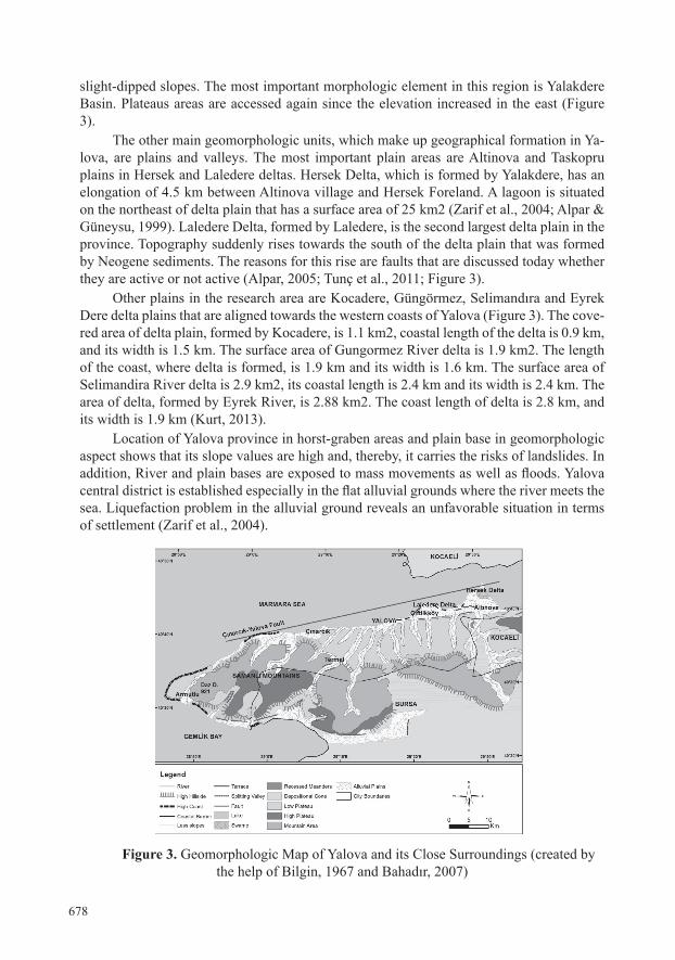
LOcATION OF STUDY AREAyalova is located on the northeast of Turkey and southern part of the Sea of Marmara
between 28° 45’ and 29° 35’ Eastern longitudes and 40° 28’ and 40° 45’ Northern latitudes. Established on the northern coast of armutlu Peninsula and northern slopes of Samanli Mountains, the province is located on G2-c2, G21-c3, G21-c4, G22-d1, G22-d2, G22-d3, G22-d4, G22-c1, G22-c2, G22-c3, G22-c4, G23-d1, H21-b1, H21-b2 sheets of 1:25000 scale topographical map. The Sea of Marmara is located on the north and west of yalova, Kocaeli on its east, and Bursa province and the Gulf of Gemlik on its south (Figure 1).
Figure 1. Location Map of Yalova Province
MATERIALS AND METHODS1:25000 scale topographical map, 1:100000 scale geological map, color numerical
orthophotos with 0.45 cm resolution and field works conducted on the area constitute the data resources of this study which analyzes geomorphologic features of urban settlement in yalova and natural risk factors that these features revealed.
The sheets of geological map with 1:100000 scale, after being scanned in JPEG for-mat (UTM, WGS 84, Zone 35N), were converted into numerical state by hand-numeration method. Distributions of lithological units were determined by using arcGIS10.2 software. Sheets, in 1:25000 scale and vectored format, were used as main base in the determination of geomorphologic features in the area. Stages of elevation, geology and geomorphologic maps related to the research area were produced over these maps. These conducted proce-dures were also supported by area examinations. Color numerical orthophotos with 0.45 resolutions (UTM, WGS 84, Zone 35N), produced by General Commandership of Maps, were used during the creation of these maps. Data on earthquakes, which were effective in Yalova and its surroundings between 1900 and 2013, were obtained from Republic of Tur-key Prime Ministry Disaster and Emergency of Management Presidency. The distribution map of risk factors that are effective in the area was created by using the data derived from Modul Planning Ltd. Co. The natural risk factors map of the area was created in the light of the obtained data and the existing literature. These information, in the final stage, were

675
interpreted and evaluated with a geographical perspective.
RESULTSGeologic Features Located on Armutlu Peninsula, the research area and its surroundings have been exa-
mined by many local and foreign scientists from 1800s to the present day in terms of its ge-ological features (Akartuna, 1968; Göncüoğlu et al., 1986; Yılmaz, 1981; Köprübaşı, 1998; Köprübaşı et al., 2000; Delaloye & Bingöl, 2000; Yılmaz et al., 2010). These studies, which are mainly related to tectonic features and stratigraphy of the area, provide information on the Paleo-geographic development of the research area.
Paleozoic, Mesozoic, and Cenozioc-aged units are located in the research area where rocks of various ages and types from Paleozoic to the present can be found. The oldest unit of the area, according to the conducted studies, is Paleozoic-aged armutlu metamorphi-tes which also partly include volcanic rocks within themselves. Pamukova Metamorphites, which are thought to be Precambrian-Base Paleozoic-aged, constitute the basis of the regi-on. Lower Triassic-aged Taskopru Formation, Upper Cretaceous-aged Bakacak Formation, upper Paleocene-Middle Eosen-aged Incebel formation and Eosen-ahed Sarisu formation are sedimentary and volcano-sedimentary units on this basis. fistikli Granitoids were lo-cated on the area Eosen period. Sarmasiyen-aged Kilic Formation, Upper Miocene-Lower Pliocene-aged yalakdere formation and Pleistocene-aged marine sediments and current alluvions can be found on these (Köprübaşı, 1998; Köprübaşı et al., 2000; Bahadır, 2007; Yılmaz et al., 2010, Figure 2).
The main lithology of Pamukova metamorphites, which are surfaced about 1 km in the south of Gacik village, are amphibolites. Lower-levels of this unit, which is found in homogeneous masses of green, grey-green or dark-green colors, are Precambrian-aged and its upper parts are Lower Paleozoic-aged (Akartuna, 1968; Figure 2).
The lithology of Taskopru formation, which is surfaced in Taskopru and its surroun-dings, consists of sandstone, siltstone and pebbles that are red-purple, grey in color, fissured, hard, tight-fitted, medium-thick surfaced. The age of this unit was determined by Akartuna (1968) as Triassic age.
There are mostly pebbles and sandstones in Bakacak formation that is surfaced in the south of Kilic village. Starting with a basal conglomerate at the thick-bedded base, unit was situated discordantly over Paleozoic and Triassic-aged formations. Its upper part was cohe-rently covered by Paleocene-Middle Eocene-aged Incebel formation and was discordantly covered by Miocene-aged Kilic Formation (Figure 2).
Incebel formation was surfaced in the west of the research area and between Ortabu-run village, Subasi, Mecidiye and Incebel. Stated by Akartuna (1968) as Upper Paleocene-Middle Eocene-aged, formation starts with a basal conglomerate underneath and continues with sandstones, mudstones, marl and pebble-alternation. Intermediate levels of the forma-tion, referred to as tuff member, were fine-coarse-grained and tightly attached between the colors of white and green (Figure 2).
Sarisi formation was surfaced in the south of Elmalik village and in a limited area. Starting with a level consisting of pebbles, mudstones, sandstones and limestone over me-tamorphic rocks, formation continues with pyroclastic rocks comprised of andesitic tuff and rock fragments of various sizes within fine-coarse-grained tuff and lapilli tuff. There
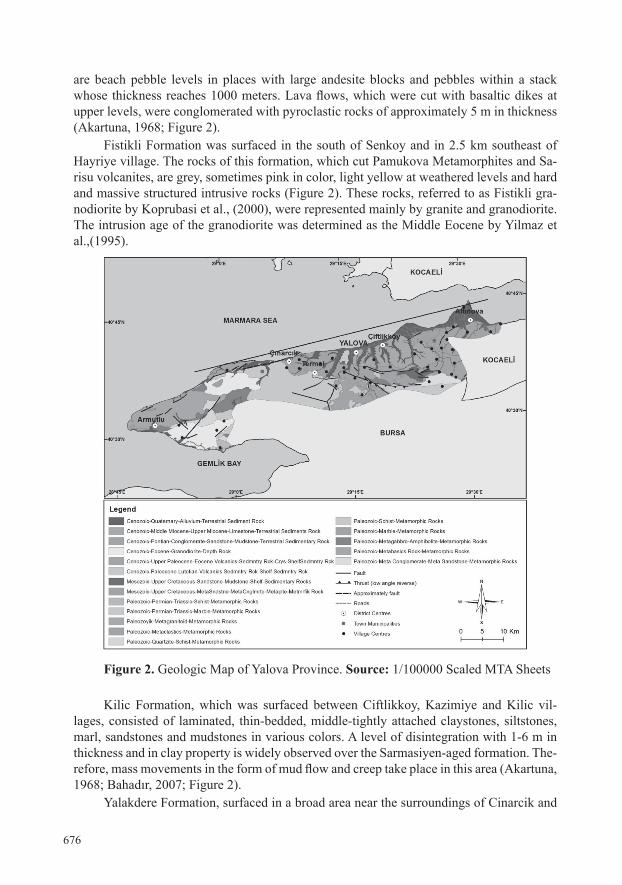
676
are beach pebble levels in places with large andesite blocks and pebbles within a stack whose thickness reaches 1000 meters. Lava flows, which were cut with basaltic dikes at upper levels, were conglomerated with pyroclastic rocks of approximately 5 m in thickness (Akartuna, 1968; Figure 2).
fistikli formation was surfaced in the south of Senkoy and in 2.5 km southeast of hayriye village. The rocks of this formation, which cut Pamukova Metamorphites and Sa-risu volcanites, are grey, sometimes pink in color, light yellow at weathered levels and hard and massive structured intrusive rocks (Figure 2). These rocks, referred to as Fistikli gra-nodiorite by Koprubasi et al., (2000), were represented mainly by granite and granodiorite. The intrusion age of the granodiorite was determined as the Middle Eocene by yilmaz et al.,(1995).
Figure 2. Geologic Map of yalova Province. Source: 1/100000 Scaled MTa Sheets
Kilic formation, which was surfaced between Ciftlikkoy, Kazimiye and Kilic vil-lages, consisted of laminated, thin-bedded, middle-tightly attached claystones, siltstones, marl, sandstones and mudstones in various colors. a level of disintegration with 1-6 m in thickness and in clay property is widely observed over the Sarmasiyen-aged formation. The-refore, mass movements in the form of mud flow and creep take place in this area (Akartuna, 1968; Bahadır, 2007; Figure 2).
yalakdere formation, surfaced in a broad area near the surroundings of Cinarcik and
677
Dumbelek Mountain and yakindere, consisted of interrelated sandstone, pebble, siltstone, claystone and mudstone levels. unit, where limestone levels of various degrees were also observed, has a wriggly and faulted structure with the effect of tectonizm. Landslides can also be partly seen in Pliocene-aged formation area.
The youngest units in the research area are Quaternary sediments. These are situated widely in the coastline between altinova, yalova and Cinarcik and in the valley bottoms (Figure 2). Divided into 13 sub-units by Emre et al., (1997), features of sediment environ-ment in Holocene-aged ones in this unit were taken into consideration. Quaternary sedi-ments consist of sediment flocks and marine sediments found in the coastal and river envi-ronments (Meriç et al.,1999). Marine sediments, among these, are scattered behind plains and foothills located on the coast and the backshores between altinova-yalova. In addition, it was also observed in the north of Subasi village, Hersek delta and in Laledere delta in the north of Taskopru village (Meriç et al.,1999). Defined by Ardel (1949) as upper terrace sediments, these sediments morphologically created steps in the elevations of 3-5 and 8-70 meters. Bottom terrace sediments are found in stacks in the foothills and valley bottoms that are about 1 km inside from the coast.
yalova province and its surroundings, shaped in neo-tectonic period, are located in an area where tectonic activity is intensely felt (Sakınç & Bargu 1989). North Anatolian Fault (NAF), the most important structural element of the area, is divided into two branches, inc-luding north and south, in armutlu Peninsula. north branch continues towards the westward through Izmit-adapazari corridor by following the depressions of the Sea of Marmara. Ex-tending along Geyve-Gemlik line, other branch borders the elevation of armutlu Peninsula from the south. Other faults, belonging to tectonic period in the research area, are passive faults extending in the direction of NW-SE and NE-SW (Figure 2). Active faults, observed in Hersek and Laledere deltas, are situated within the NAF zone. According to Akartuna (1968), the longest fault of the area is Karamursel-Yalova Fault which intersects the penin-sula in E-W direction and in 115 km long right-lateral strike (Figure 2).
Geomorphologic FeaturesThe research area, which was formed under the influence of North Anatolia Fault
Zone (KAFZ), is located over the horst between grabens of Izmit Gulf and Gemlik Gulf in geomorphologic sense (Ardel, 1949; Bilgin, 1967; Akartuna, 1968; Meriç et al., 1999; Tunç et al., 2011; Figure 2).
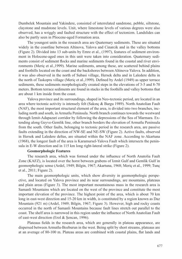
The main geomorphologic units, which show diversity in geomorphologic perspe-ctive, and located on yalova province and its near surroundings, are mountains, plateaus and plain areas (Figure 3). The most important mountainous mass in the research area is Samanli Mountains which are located on the west of the province and constitute the most important elevation of the province. The highest point of the area, which is about 70 km long in east-west direction and 15-20 km in width, is constituted by a region known as Daz Mountain (921 m) (Ardel, 1949; Bilgin, 1967; Figure 3). However, high and rocky coasts occurred in the north of Samanli Mountains because fault lines stretch out parallel to the coast. The shelf area is narrowed in this region under the influence of North Anatolian Fault of east-west direction (Erol & Şencan, 1996).
Plateaus fields in the research area, which are generally in plateau appearance, are dispersed between armutlu-Bozburun in the west. Being split by short streams, plateaus are at an average of 80-100 m. Plateau areas are combined with coastal plains, flat lands and
678
slight-dipped slopes. The most important morphologic element in this region is yalakdere Basin. Plateaus areas are accessed again since the elevation increased in the east (Figure 3).
The other main geomorphologic units, which make up geographical formation in ya-lova, are plains and valleys. The most important plain areas are altinova and Taskopru plains in Hersek and Laledere deltas. Hersek Delta, which is formed by Yalakdere, has an elongation of 4.5 km between Altinova village and Hersek Foreland. A lagoon is situated on the northeast of delta plain that has a surface area of 25 km2 (Zarif et al., 2004; Alpar & Güneysu, 1999). Laledere Delta, formed by Laledere, is the second largest delta plain in the province. Topography suddenly rises towards the south of the delta plain that was formed by neogene sediments. The reasons for this rise are faults that are discussed today whether they are active or not active (Alpar, 2005; Tunç et al., 2011; Figure 3).
Other plains in the research area are Kocadere, Güngörmez, Selimandıra and Eyrek Dere delta plains that are aligned towards the western coasts of Yalova (Figure 3). The cove-red area of delta plain, formed by Kocadere, is 1.1 km2, coastal length of the delta is 0.9 km, and its width is 1.5 km. The surface area of Gungormez River delta is 1.9 km2. The length of the coast, where delta is formed, is 1.9 km and its width is 1.6 km. The surface area of Selimandira River delta is 2.9 km2, its coastal length is 2.4 km and its width is 2.4 km. The area of delta, formed by Eyrek River, is 2.88 km2. The coast length of delta is 2.8 km, and its width is 1.9 km (Kurt, 2013).
Location of Yalova province in horst-graben areas and plain base in geomorphologic aspect shows that its slope values are high and, thereby, it carries the risks of landslides. In addition, River and plain bases are exposed to mass movements as well as floods. Yalova central district is established especially in the flat alluvial grounds where the river meets the sea. Liquefaction problem in the alluvial ground reveals an unfavorable situation in terms of settlement (Zarif et al., 2004).
Figure 3. Geomorphologic Map of Yalova and its Close Surroundings (created by the help of Bilgin, 1967 and Bahadır, 2007)

679
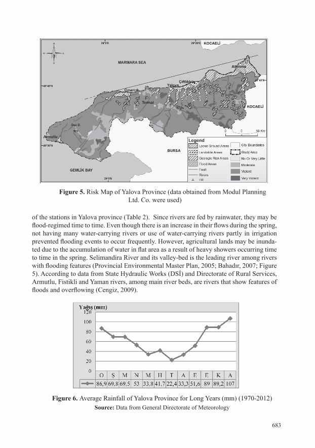
Natural Risks Factors That Affect Yalova ProvinceSince majority of the cities, which are not established in appropriate grounds with
their geomorphologic features, face natural risk factors (Tonbul&Sunkar, 2008), Yalova province is also under the risk factors that arise from geologic and geomorphologic features such as flooding, liquefaction, mass movements and earthquake (Figure 5).
Turkey is a country that encounters various dangers as a result of its geologic, geo-morphologic, earthquake and cultural features. The most risky of these dangers is earthqu-akes that cause two thirds of structural damages and a large part of life and property losses (Tercan, 2005). Since the research area is located at a very young area in terms of active tectonics and shows a character of being surrounded by fault lines, it encountered many de-vastating earthquakes from the past to the present and a large ratio of life and property losses at a large was experienced as a result of these earthquakes (Yüksel et al., 2000; Yaltırak et al., 2003; Alarslan, 2011; Table 1). Therefore, Yalova is located in 1st degree earthquake zone according to Turkey Earthquake Zones map which was put into effect by the decree of the Council of Ministers dated April 18, 1996 and numbered 96/8109 (Special Provincial administration, 2012).
The effectiveness of faulting that shows right lateral strike-slip and partly normal as well as reverse faulting in the occurrence of earthquakes shows that the area has a complex tectonic features. north anatolian fault, the most important structural element of the area, also checks tectonics of today (Erol, 1983; Adatepe, 2000; Algan, 2000;Alpar, 2000; Göka-şan, 2000; Güneysu, 2000; Kinscheret al.,2013; Figure 2). According to research conducted recently in the Sea of Marmara and its surroundings, the fraction of this fault is believed to be quite high in the near future (Tüysüz, 2009). Earthquake, which occurred in Gemlik, situ-ated on the western end of armutlu Peninsula also housing the research area, on 22.10.2006 at the magnitude of ML=5.2, is significant in terms of showing the continuity of the tectonic activity in the area (Selim et al.,2005; Tunç et al.,2011; Figure 4).
There seem to be a harmonious parallelism between earthquakes occurred in Yalova and its surroundings at Ms<4 magnitude in the instrumental period and active faults in the region (Gökaşan, 2000; Güneysu, 2000; Tüysüz, 2009; Selim et al.,2005; Alpar, 2000; Me-riç et al.,2009). The most notable of these are Karamursel Earthquake of October 9, 1909 (Ms= 5.8), Cinarcik Earthquake of September 18, 1963 (Ms= 6.3) and Marmara Earthquake of August 17, 1999 (7.4). Especially Marmara Earthquake caused significant damage in the area from Yalova to Bolu. According to official figures, more than 20.000 people (45 thousand people according to unofficial figures) lost their lives. In Yalova province, 212 buildings were destroyed, 946 buildings were heavily damaged, and 3000 people lost their lives. The most risky areas in the research area in this regard are Cinarcik, Ciftlikkoy and Central district. These areas are under great risks because of ground conditions as well as their proximity to fault lines (Yüksel et al., 2000; Şahin & Tari, 2000; Özdemir & Bahadır, 2008; Bulut & Aktar, 2007, Alarslan, 2011; Figure, 5).
Since earthquakes affect geomorphologic structure and appearances of the areas whe-re they were effective and also cause subsidence in coastal regions, they also caused signi-ficant damage in alluvial grounds in the research area (Rathje et al., 2004). However, even though the fault, which was effective in Marmara Earthquake, passed through the lagoon in hersek Delta situated on the east of the research area, it did not cause too much deformation on the surface of the delta (Yüksel et al., 2000; Figure 5).

680
Figure 4. Earthquakes that were Effective in Yalova and its Surroundings (1900-2013). Source: Republic of Turkey, Prime Ministry Disaster & Emergency Management
Presidency.

681

682
Table 2. Earthquakes that were Effective in Yalova and its Surroundings and Belong to a Historical Period (412 BC- 1900 AD)
Source: Republic of Turkey, Prime Ministry Disaster & Emergency Management Presidency.
The most obvious effect of the earthquake in terms of geomorphologic risks is the areas, located on plains and valley grounds especially belonging to Quaternary, are shown to be the most weak and weak grounds since they vary according to lithological features of the ground. The possible occurrences of subsidence, sedimentation, collapsing and lands-lides, depending on the liquefaction in these types of grounds, are quite high (Yüksel et al., 2000; Rathje et al., 2004; Erken, 2004; Special Provincial Administration, 2012). It is estimated that moderately firm grounds, consisting of Pliocene erosion and fillings, and durable grounds comprised of upper Miocene eroded surfaces will be less affected than weak grounds from the intensity of an earthquake considering the geological features of the research area (Erol & Şencan, 1996; Aydöner & Maktav, 2013).
The southern parts of Taskopru (Ciftlikkoy) and Altinova and the southern and eas-tern part of armutlu are seen to be more appropriate for settlements when consulting the geological map (Figure 2). However, since the sections of especially Yalova Central distri-ct, Cinarcik and armutlu that were founded on the alluvial grounds received damages in Marmara Earthquake of August 17, 1999, they are also comprised of grounds that carry the earthquake risks in the near (Figures 2 and 5).
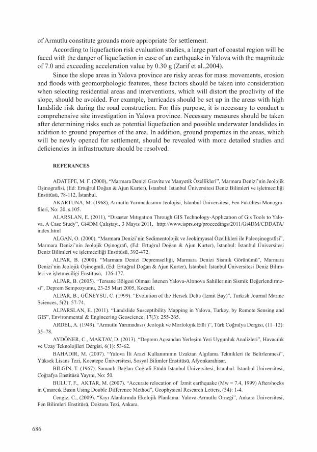
One of the risk factors in the research area is floods. Yalova province has a rich stru-cture in terms of water resources. Many rivers, large or small arriving from the slopes of Samanli Mountains (Laledere (Kılıç), Safrandere (Kurtköy), Selimandıra Deresi (Gökçede-re), Karpuzdere (Teşvikiye), Hamamdere (Armutlu), Yamandere (Kapaklı), Balabandere, Korudere, Kocadere), reach up to the sea. However, some of these rivers cause floods and overflows since their flow increase with heavy rainfall in the months of spring (Provincial Environmental Master Plan, 2005).
The average annual rainfall of the research area is 62.3 mm for many years according to measurements made between 1970 and 2012. The river flows and thus the frequency of floods and low waters are also affected according to these data. As can be seen in Figure 6, the rainfall increases in October, November and December and thus, river flow also incre-ases. While there is a steady decline in rainfall in January and September, increase is seen until March and, later on it decreases in parallel with rainfall. Since the precipitation is in the form of snow in January-March period, it can be concluded that snow on high elevations be-gins to melt in February and March and increases the river flow. Floods and low waters, ca-used by precipitation, result from the changes in the amounts of river flows in this period.
It can be concluded that while river-flow values reduce in summer months depending on rainfall, it increases in the months of winter and spring by looking at precipitation figures
683
of the stations in Yalova province (Table 2). Since rivers are fed by rainwater, they may be flood-regimed time to time. Even though there is an increase in their flows during the spring, not having many water-carrying rivers or use of water-carrying rivers partly in irrigation prevented flooding events to occur frequently. However, agricultural lands may be inunda-ted due to the accumulation of water in flat area as a result of heavy showers occurring time to time in the spring. Selimandira River and its valley-bed is the leading river among rivers with flooding features (Provincial Environmental Master Plan, 2005; Bahadır, 2007; Figure 5). According to data from State Hydraulic Works (DSİ) and Directorate of Rural Services, armutlu, fistikli and yaman rivers, among main river beds, are rivers that show features of floods and overflowing (Cengiz, 2009).
Figure 6. Average Rainfall of Yalova Province for Long Years (mm) (1970-2012)Source: Data from General Directorate of Meteorology
Figure 5. Risk Map of Yalova Province (data obtained from Modul Planning Ltd. Co. were used)

684
Table 2. annual flow Values of Rivers in yalova Province with flooding PropertiesSource: General Directorate of Meteorology/ Modul Planning Ltd. Co.
Mass movements, which are among risk factors in yalova province, become effective in the forms of landslides, rock falls and mud flows. They occur as a result of the retention of water by clay elements in the soil with the impact of ground properties and heavy rains. Therefore, Çiftlikköy (49 km²), Central District (35 km²) and Altınova (18 km²) are areas under high landslide risk (Table 3; Figure 7). Since a weathering level 1-6 m in thickness was formed widely between Ciftlikkoy and Kazimiye, mud flow and mass movements in the form of creep occurred. According to data of 2013 from TÜİK, some homes were evacuated because landslides and ones with wide-scales caused property losses in these districts where a total of 130.115 people reside and industrial organizations and fertile agricultural lands are in high intensity (Alparslan, 2011; Bahadır, 2007). Some of the highways (like highway connecting Centeral district to armutlu) in these areas, consisting of pebble, sandstone, and mudstone alternated units, belonging mostly to Miocene and Cretaceous, are under risks.
armutlu, Cinarcik and Termal districts are the areas which are safer in terms of lands-lides in yalova and where landslides either never occurred or are seen very less. among these, the areas, where landslides never occurred, cover an area of 37% in Armutlu, 60% in Cinarcik, and 37% in Termal. Total of 19.306 people reside in these three districts that are mostly covered by forests and agricultural lands according to TÜİK 2013 data (Table, 3; Figure 7).
Figure 7. Landslide and Liquefaction Map of Yalova Province

685
One of the risk factors in the research area is the liquefaction problem especially seen in the coasts (Table 3; Figure 7). If the ground has a structure with significant mixture of sand and pebbles, liquefaction occurs depending on the percentage of thin materials and hydraulic conductivity. Therefore, liquefaction and subsidence occurred during the Marma-ra Earthquake of August 17, 1999 in the coasts of Yalova, mainly in Hersek and Laledere delta areas. Therefore, significant damages happened in coastal structures and port autho-rities that were in the domain of the earthquake. For example, the concrete pier, belonging to Aksa Inc., received great damage. Factors, such as liquefactions, subsidence in landfills and dynamic deformation of soft alluvial clay layers, were effective in the occurrence of damages (Yüksel et al., 2000; Lubkowski, 2002; Yılmaz, 2005). Since the sea floor, espe-cially near hersek delta, is covered by mud consisted of silt, clayey silt and clay further down (Yüksel et al., 2000), this region is believed to encounter significant dangers in the next earthquake that will happen within the Sea of Marmara. According to liquefaction risk evaluation studies, a large part of coastal region will be faced with the danger of liquefaction in case of an earthquake in Yalova with the magnitude of 7.0 and exceeding acceleration value by 0.30 g (Zarif et al.,2004).
Table 3. Distribution of Landslide and Liquefaction Sensitivity in Yalova Province
cONcLUSIONyalova province is located on an area consisting of problems of geologic and geo-
morphologic origin which manifest themselves by earthquakes, mass movements, lique-faction and floods. Residential areas gained sudden intensity mostly along river valleys, and coasts. however, they are included in the group of risky areas since they are exposed to mass movements as well as floods. In addition, the rivers with increased flow rate cause floods time to time at the research area that has a rich structure in terms of water resources as result of heavy rainfall in spring.
yalova, which is established on elements belonging to various geological periods from Paleozoic to the present and, at the same time, is located within north anatolian fault Zone, is situated in a region that is active in terms of seismicity. Thus, life and property losses were experienced as result of severe earthquakes happened time to time. Areas with firm grounds should be chosen while selecting residential areas as can be understood by the damages inflicted through earthquakes in North Anatolian Fault Zone (NAF) (Figures 2 and 5). The southern parts of Ciftlikkoy and altinova, as well as the southern and eastern parts
686
of armutlu constitute grounds more appropriate for settlement. According to liquefaction risk evaluation studies, a large part of coastal region will be
faced with the danger of liquefaction in case of an earthquake in Yalova with the magnitude of 7.0 and exceeding acceleration value by 0.30 g (Zarif et al.,2004).
Since the slope areas in yalova province are risky areas for mass movements, erosion and floods with geomorphologic features, these factors should be taken into consideration when selecting residential areas and interventions, which will distort the proclivity of the slope, should be avoided. for example, barricades should be set up in the areas with high landslide risk during the road construction. for this purpose, it is necessary to conduct a comprehensive site investigation in yalova province. necessary measures should be taken after determining risks such as potential liquefaction and possible underwater landslides in addition to ground properties of the area. In addition, ground properties in the areas, which will be newly opened for settlement, should be revealed with more detailed studies and deficiencies in infrastructure should be resolved.
REFERANcES
ADATEPE, M. F. (2000), “Marmara Denizi Gravite ve Manyetik Özellikleri”, Marmara Denizi’nin Jeolojik Oşinografisi, (Ed: Ertuğrul Doğan & Ajun Kurter), İstanbul: İstanbul Üniversitesi Deniz Bilimleri ve işletmeciliği Enstitüsü, 78-112, İstanbul.
aKaRTuna, M. (1968), Armutlu Yarımadasının Jeolojisi, İstanbul Üniversitesi, Fen Fakültesi Monogra-fileri, No: 20, s.105.
ALARSLAN, E. (2011), “Dısaster Mıtıgatıon Through GIS Technology-Applıcatıon of Gıs Tools to Yalo-va, A Case Study”, Gi4DM Çalıştayı, 3 Mayıs 2011, http://www.isprs.org/proceedings/2011/Gi4DM/CDDATA/index.html
ALGAN, O. (2000), “Marmara Denizi’nin Sedimentolojik ve Jeokimyasal Özellikleri ile Paleoşinografisi”, Marmara Denizi’nin Jeolojik Oşinografi, (Ed: Ertuğrul Doğan & Ajun Kurter), İstanbul: İstanbul Üniversitesi Deniz Bilimleri ve işletmeciliği Enstitüsü, 392-472.
ALPAR, B. (2000). “Marmara Denizi Depremselliği, Marmara Denizi Sismik Görünümü”, Marmara Denizi’nin Jeolojik Oşinografi, (Ed: Ertuğrul Doğan & Ajun Kurter), İstanbul: İstanbul Üniversitesi Deniz Bilim-leri ve işletmeciliği Enstitüsü, 126-177.
ALPAR, B. (2005). “Tersane Bölgesi Olması İstenen Yalova-Altınova Sahillerinin Sismik Değerlendirme-si”, Deprem Sempozyumu, 23-25 Mart 2005, Kocaeli.
ALPAR, B., GÜNEYSU, C. (1999). “Evolution of the Hersek Delta (Izmit Bay)”, Turkish Journal Marine Sciences, 5(2): 57-74.
ALPARSLAN, E. (2011). “Landslide Susceptibility Mapping in Yalova, Turkey, by Remote Sensing and GIS”, Environmental & Engineering Geoscience, 17(3): 255-265.
ARDEL, A. (1949). “Armutlu Yarımadası ( Jeolojik ve Morfolojik Etüt )”, Türk Coğrafya Dergisi, (11–12): 35–78.
AYDÖNER, C., MAKTAV, D. (2013). “Deprem Açısından Yerleşim Yeri Uygunluk Analizleri”, Havacılık ve Uzay Teknolojileri Dergisi, 6(1): 53-62.
BAHADIR, M. (2007). “Yalova İli Arazi Kullanımının Uzaktan Algılama Teknikleri ile Belirlenmesi”, Yüksek Lisans Tezi, Kocatepe Üniversitesi, Sosyal Bilimler Enstitüsü, Afyonkarahisar.
BİLGİN, T. (1967). Samanlı Dağları Coğrafi Etüdü İstanbul Üniversitesi, İstanbul: İstanbul Üniversitesi, Coğrafya Enstitüsü Yayını, No: 50.
BULUT, F., AKTAR, M. (2007). “Accurate relocation of İzmit earthquake (Mw = 7.4, 1999) Aftershocks in Çınarcık Basin Using Double Difference Method”, Geophysıcal Research Letters, (34): 1-4.
Cengiz, C., (2009). “Kıyı Alanlarında Ekolojik Planlama: Yalova-Armutlu Örneği”, Ankara Üniversitesi, fen Bilimleri Enstitüsü, Doktora Tezi, ankara.

687
DELALOYE M., BİNGÖL, E. 2000. “Granitoids from Western and Nortwestern Anatolia: Eochemistry and Modeling of Geodynamic Evolution”, International Geology Review, (42): 241-268.
EKİNCİ, D. (2004). “Gülüç Çayı Havzasının Uygulamalı Jeomorfolojisi”, Yayınlanmamış Doktora Tezi, İstanbul Üniversitesi, Sosyal Bilimler Enstitüsü, İstanbul.
EMRE, Ö., ERKAL, T., KAZANCI, N, GÖRMÜS, S., GÖRÜR, N., KUSÇU, İ., KEÇER, M. (1997). “Gü-ney Marmara’nın Neojen- Kuvaterner Tektonigi ve Jeomorfolojisi”, Marmara Denizi Araştırmaları, Workshop III, 2–3 Haziran 1997, Genisletilmiş Bildiri Özetleri, s. 55–60, Ankara.
ERKEN, A., ÖZAY, R., KAYA, Z., ÜLKER, M., B., C., ELİBOL, B. (2004). “Depremler Sırasında Zemin-lerin Sıvılaşması ve Taşıma Gücü Kayıpları”, Türkiye Mühendislik Haberleri, (431/3): 20-26.
EROL, O., ŞENCAN., A. (1996). “Çınarcık ve Çevresinin Jeomorfolojik Etüdü”, Marmara Coğrafya Der-gisi, (1): 57-62.
EROL, O. (1983). “Türkiye’nin Genç Tektonik ve Jeomorfolojik Gelişimi”, Jeomorfoloji Dergisi, (11): 1-23.
GÖKAŞAN, E. (2000). “Marmara Denizi’nin Jeolojik Özellikleri”, Marmara Denizi’nin Jeolojik Oşinogra-fi, (Ed: Ertuğrul Doğan & Ajun Kurter), İstanbul: İstanbul Üniversitesi Deniz Bilimleri ve işletmeciliği Enstitüsü, 177-392.
GÖNCÜOĞLU, M., C., ERENDİL, M., TEKELİ, O., ÜRGÜN, B., AKSAY, A., KUŞÇU, İ., (1986). “Ar-mutlu Yarımadasının Doğu Kesiminin Jeolojisi: MTA Raporu, No: 7786, s. 43.
GÜNEYSU, C. (2000). “Marmara Denizi ve Kıyılarının Jeomorfolojik Özellikleri”, Marmara Denizi’nin Jeolojik Oşinografisi, (Ed: Ertuğrul Doğan & Ajun Kurter), İstanbul: İstanbul Üniversitesi Deniz Bilimleri ve işletmeciliği Enstitüsü, 33-77.
İL ÇEVRE DÜZEN PLANI, (2005). Yalova İli 1/25000 ölçekli Çevre Düzeni Planı Araştırma Raporu (Araştırma-Değerlendirme-Sentez), Modül Planlama Ltd. Şti. Yayını, Ankara.
KELEŞ, R. (1985–1986). “Kent ve Bölge Planlamasında Jeomorfoloji”, Jeomorfoloji Dergisi, s. 14.KINSCHER, J., KRUGER, F., WOITH, H., LUHR, B., G., HINTERSBERGER, E., IRMAK, T., S., BA-
RIŞ, S. (2013). “Institut “Seismotectonics of the Armutlu Peninsula (Marmara Sea, NW Turkey) from Geological Field Observation and Regional Moment Tensor İnversion”, Tectonophysics, (608): 980–995.
KÖPRÜBAŞI, N. (1998). “Fıstıklı (Armutlu-Yalova) Granitoyidinin Jeokimyasal Özellikleri”, Yüksek Li-sans Tezi, Kocaeli Üniversitesi, Fen Bilimleri Enstitüsü, Kocaeli.
KÖPRÜBAŞI, N., GENÇ, C., KÖPRÜBAŞI, N. (2000). Fıstıklı (Armutlu-Yalova) Granitoyidinin Jeokim-yası, Hacettepe Üniversitesi, Yer Bilimleri Bülteni, (22): 33-42.
KURT, S., (2013). “Marmara Denizi Güney Kıyılarının Jeomorfolojisi”, Doktora Tezi, İstanbul Üniversite-si, Sosyal Bilimler Enstitüsü, İstanbul.
LUBKOWSKI, Z., A., CHAPMAN, T., J., P., FREE, M. (2002). “Identıfıcatıon of Geo-Hazards for the Rehabilitation Plan of Yalova-Turkey” Earthquake Engineering, 12th European Conference, 9-13th September 2002, London.
MERİÇ, E., AVŞAR, N., NAZİK, A. (1999). “Armutlu Yarımadası Kuzey Alanı (Yalova-Karamürsel) Ku-vaterneri Hakkında”, İstanbul üniversitesi, Yerbilimleri Dergisi, (12): 1-8.
MTA (2011). “Yalova İli Jeoloji Haritası”, MTA Genel Müdürlüğü, Ankara.ÖZDEMİR, A., M., BAHADIR, M. (2008). “Yalova İlinde Arazi kullanımının Zamansal Değişimi”, İstan-
bul Üniversitesi Coğrafya Bölüm Dergisi, (17): 1-15.ÖZDEMİR, A., M., GÜNAY, M. (2005). “Bolvadin Kentinin Gelişiminde Coğrafî Koşulların Rolü”, Afyon
Kocatepe Üniversitesi, Sosyal Bilimler Dergisi, 7(2): 129-157.ÖZŞAHİN, E. (2010). “Antakya’da (Hatay) Yer Seçiminin Jeomorfolojik Özellikler ve Doğal Risk Açısın-
dan Değerlendirilmesi”, Balıkesir Üniversitesi, Sosyal Bilimler Enstitüsü Dergisi, 13(23): 1-26.RATHJE, E., M., KARATAŞ, İ., WRIGHT, S., G., BACHHUBER, J. (2004). “Coastal Failures During the
1999 Kocaeli Earthquake in Turkey”, Soil Dynamics and Earthquake Engineering, (24): 699–712.SAKINÇ, M., BARGU, S., (1989). İzmit Körfezi Güneyindeki Geç Pleyistosen (Tireniyen) Çökel Stratig-
rafisi ve Bölgenin Neotektonik Özellikleri. Türkiye Jeoloji Bülteni, (1-2): 51-64.SARGIN, S. (2004). “Isparta Yöresinde Fiziki Çevre Faktörlerinin Yerleşme Birimleri Üzerindeki Etkisi”,
Doğu Coğrafya Dergisi, (11): 371-388.ŞAHİN, M., TARİ, E. (2000). “The August 17 Kocaeli and the November 12 Düzce Earthquakes in Tur-
688
key”, Earth Planets Space, (52): 753–757.TERCAN, B. (2005). “Deprem Sonrası Yalova’da Yeniden Yerleşme Süreci”, Deprem Sempozyumu, 23-25
Mart 2005, Kocaeli.TONBUL, S., SUNKAR, M. (2008). “Batman Şehrinde Yer Seçiminin Jeomorfolojik Özellikler ve Doğal
Risk Açısından Değerlendirilmesi”, Ulusal Jeomorfoloji Sempozyumu Bildiriler Kitapçığı, 20–23 Ekim 2008, Çanakkale.
TUNÇ, B., ÇAKA, D., IRMAK, S., TUNÇ, S., WOITH, H., BARIŞ, Ş., ÖZER, F., M., LÜHR, G., B., GÜNTHER, E., GROSSER, H., ZSCHAU, J. (2011). “The Armutlu Network: an Investigation Into the Seismote-ctonic Setting of Armutlu-Yalova-Gemlik and the Surrounding Regions” 1 Annals of Geophysıcs, 54(1): 35-45.
TUROĞLU, H. (1993). “Mühendislik Jeomorfolojisinin Tanıtılması ve Metodolojisi”, Türk Coğrafya Der-gisi, (28): 345–349.
TUROĞLU, H. (1996–1997). “Mühendislik jeomorfolojisi”, Marmara Coğrafya Dergisi, (1): 257–266.TÜYSÜZ, O. (2009). “Marmara Denizi”, İTÜ Avrasya Yerbilimleri Enstitüsü, http://www.yerdurumu.org/
makaleler/documents/marmara_denizi.asp, Erişim Tarihi: 27 Ocak 2014.YALOVA VALİLİĞİ İL ÖZEL İDARESİ, (2012). “Yalova İli Madencilik Faaliyetlerine İlişkin Master Plan
Çalışması”, http://www.yalovaozelidare.gov.tr/, Erişim Tarihi: 13 Ocak 2013.YALTIRAK, C., ERTURAÇ, M. K., TÜYSÜZ, O., YALTIRAK, S. K. (2003). Marmara Denizi’nde tarihsel
depremler: yerleri, büyüklükleri, etki alanları ve güncel kırılma olasılıkları, İTÜ Avrasya Yerbilimleri Enstitüsü, Kuvaterner Çalıştayı IV, s. 174-180, İstanbul.
YILMAZ, D., KÖPRÜBAŞI, N., ÇELEBİ, D., KÖPRÜBAŞI, N. (2010). “Esenköy (Çınarcık-Yalova) Gra-nitoyidinin Jeokimyasal Özellikleri”, Uygulamalı Yerbilimleri, (2): 19-37.
YILMAZ, Y. (1981). “Sakarya Kıtası Güney Kenarının Tektonik Evrimi”, İstanbul Üniversitesi, Yerbilim-leri Dergisi, (1-2): 33-52.
YILMAZ, Y., GENÇ, Ş., C., YİĞİTBAŞ, E., BOZCU, M., YILMAZ, K. (1995). Geological Evolution of the Late Mesozoic Continental Magrin of Northwestern Anatolia”, Tectonophysics, (243) 155-171.
YILMAZER, İ., KAYA, Ş., DUMAN, T. Y. (1996). “Yeraltı Yapıları Projelerinde Mühendislik Jeolojisi Çalışmaları”, 49. Türkiye Jeoloji Kurultayı, Bildiri Özleri Kitabı, s. 17.
YILMAZ, I., YAVUZER, D. (2005). “Liquefaction Potentials and Susceptibility Mapping in the City of Yalova, Turkey”, Environmental Geology, 47 (2), 175-184.
YÜKSEL, Y., ÖZMEN, H., ÇEVİK, E., ÖZGÜVEN, O., ÇELİKOĞLU, Y., BOSTAN, T., GÜRER, S., GÖKOĞLU, F. (2000). “Doğu Marmara Depreminin Körfez Bölgesindeki Deniz Yapıları Üzerindeki Etkileri”, III: Ulusal Kıyı Mühendisliği Sempozyumu, 5-6-7 Ekim 2000, Çanakkale.
ZARİF, İ., H., ÖZÇEP, F., SEYYAR, T. (2004). “Yalova’daki Alüvyon Zeminlerin Sıvılaşma Tehlike Ana-lizi”, 16. Uluslararası Jeofizik Kongresi; s. 241-245, Ankara.
http://www.deprem.gov.tr/sarbis/Shared/Default.aspx, Erişim Tarihi: 01 Ocak, 2014
Copyright © 2022 FDOKUMEN