Genesis and geomorphologic and ecological evolution of the Ganzirri salt marsh (Messina, Italy)
9
Quaternary International 140–141 (2005) 150–158 Genesis and geomorphologic and ecological evolution of the Ganzirri salt marsh (Messina, Italy) A. Bottari a , C. Bottari a, , P. Carveni b , S. Giacobbe c , N. Spano` c a Osservatorio Sismologico - Di.C.T.A, Universia` di Messina, Via Osservatorio 4, 98121 Messina, Italy b Dipartimento di Scienze Geologiche, Universita` di Catania, Italy c Dipartimento di Biologia Animale ed Ecologia Marina, Universita` di Messina, Italy Abstract The results of geological and geomorphologic surveys on the salt marsh of Ganzirri (Pantano Grande), combined with geophysical researches and historiographical data, are reported here to define the genesis of the marsh and to evaluate the physical factors that influenced its recent evolution. The genesis of the Pantano Grande may be due to a state of equilibrium reached between differential lowering of the coastal plain, confined by normal faults, and generalized chain uplift. In particular, two normal faults are considered: the first borders the northern shore of the Pantano Grande, and the second bounds the Ionian coastal plain towards the south. Concerning the recent evolution of the Pantano Grande the importance of the sterile conglomerate outcrop, which borders the Ganzirri coastal plain, is stressed. The conglomerate is interposed between sediments that define the Pantano Grande basin, and the Ionian Sea, and influenced the water exchange between the marsh and the sea. Before the excavation of two canals that link up the Pantano Grande with the sea, the conglomerate, limiting the spread of benthic species, has definitively affected the ecological structure of the original marsh. r 2005 Published by Elsevier Ltd. 1. Introduction The Ganzirri and Faro salt marshes, located on the Sicilian coast of the Strait of Messina (Fig. 1) which are usually called Pantano Grande (Fig. 2) and Pantano Piccolo (Fig. 3) ‘‘large marsh’’ and ‘‘small marsh’’, respectively, were recently nominated as a protected natural reserve. These two salt marshes are complex ecosystems of great interest mostly due to their anthropic and natural implications which require multi- disciplinary study. In particular, some unsolved ques- tions dealing with the genesis and evolutionary history of the Pantano Grande can be now described with more certainty in the light of recent observations and findings. New geological surveys and geomorphologic and historical analyses have therefore been carried out, to establish with more accuracy the genesis and recent geomorphological evolution of this marsh and also to improve the lithological characterization of the terrains in which it is located. A geological survey of the terrains separating the Pantano Grande from the Ionian Sea was implemented with shallow borehole data. The survey shed light on the buried superficial lithology and the geometry of an intercalated sterile conglomerate in the Pleistocene formation of gravel and sand called For- mazione di Messina. Unfortunately, recent intensive anthropic expansion of the village of Ganzirri (Fig. 2), with the building of many edifices, does not permit further extensive geophysical surveys. The conglomer- ate, which outcrops along the Ionian coastline and also mainly under water from Ganzirri to Peloro Cape for a distance of about 3.2 km, lies between the sea and the beach deposits making up the southern shore of the Pantano Grande. A main point of this paper was to examine the exchange and mixing of marine and brackish waters which affected the evolution of the lacustrine ecosystem ARTICLE IN PRESS 1040-6182/$ - see front matter r 2005 Published by Elsevier Ltd. doi:10.1016/j.quaint.2005.07.001 Corresponding author. Tel.:+39 090 360101; fax: +39 090 363533. E-mail address: [email protected] (C. Bottari).
-
Upload
independent -
Category
Documents
-
view
1 -
download
0
Transcript of Genesis and geomorphologic and ecological evolution of the Ganzirri salt marsh (Messina, Italy)

ARTICLE IN PRESS
1040-6182/$ - se
doi:10.1016/j.qu
�Correspond
E-mail addr
Quaternary International 140–141 (2005) 150–158
Genesis and geomorphologic and ecological evolution of theGanzirri salt marsh (Messina, Italy)
A. Bottaria, C. Bottaria,�, P. Carvenib, S. Giacobbec, N. Spanoc
aOsservatorio Sismologico - Di.C.T.A, Universia di Messina, Via Osservatorio 4, 98121 Messina, ItalybDipartimento di Scienze Geologiche, Universita di Catania, Italy
cDipartimento di Biologia Animale ed Ecologia Marina, Universita di Messina, Italy
Abstract
The results of geological and geomorphologic surveys on the salt marsh of Ganzirri (Pantano Grande), combined with
geophysical researches and historiographical data, are reported here to define the genesis of the marsh and to evaluate the physical
factors that influenced its recent evolution. The genesis of the Pantano Grande may be due to a state of equilibrium reached between
differential lowering of the coastal plain, confined by normal faults, and generalized chain uplift. In particular, two normal faults are
considered: the first borders the northern shore of the Pantano Grande, and the second bounds the Ionian coastal plain towards the
south. Concerning the recent evolution of the Pantano Grande the importance of the sterile conglomerate outcrop, which borders
the Ganzirri coastal plain, is stressed. The conglomerate is interposed between sediments that define the Pantano Grande basin, and
the Ionian Sea, and influenced the water exchange between the marsh and the sea. Before the excavation of two canals that link up
the Pantano Grande with the sea, the conglomerate, limiting the spread of benthic species, has definitively affected the ecological
structure of the original marsh.
r 2005 Published by Elsevier Ltd.
1. Introduction
The Ganzirri and Faro salt marshes, located on theSicilian coast of the Strait of Messina (Fig. 1) which areusually called Pantano Grande (Fig. 2) and Pantano
Piccolo (Fig. 3) ‘‘large marsh’’ and ‘‘small marsh’’,
respectively, were recently nominated as a protectednatural reserve. These two salt marshes are complexecosystems of great interest mostly due to theiranthropic and natural implications which require multi-disciplinary study. In particular, some unsolved ques-tions dealing with the genesis and evolutionary historyof the Pantano Grande can be now described with morecertainty in the light of recent observations and findings.New geological surveys and geomorphologic andhistorical analyses have therefore been carried out, toestablish with more accuracy the genesis and recent
e front matter r 2005 Published by Elsevier Ltd.
aint.2005.07.001
ing author. Tel.:+39090 360101; fax: +39090 363533.
ess: [email protected] (C. Bottari).
geomorphological evolution of this marsh and also toimprove the lithological characterization of the terrainsin which it is located. A geological survey of the terrainsseparating the Pantano Grande from the Ionian Sea wasimplemented with shallow borehole data. The surveyshed light on the buried superficial lithology and thegeometry of an intercalated sterile conglomerate in thePleistocene formation of gravel and sand called For-
mazione di Messina. Unfortunately, recent intensiveanthropic expansion of the village of Ganzirri (Fig. 2),with the building of many edifices, does not permitfurther extensive geophysical surveys. The conglomer-ate, which outcrops along the Ionian coastline and alsomainly under water from Ganzirri to Peloro Cape for adistance of about 3.2 km, lies between the sea and thebeach deposits making up the southern shore of thePantano Grande.
A main point of this paper was to examine theexchange and mixing of marine and brackish waterswhich affected the evolution of the lacustrine ecosystem

ARTICLE IN PRESSA. Bottari et al. / Quaternary International 140– 141 (2005) 150–158 151
and its effects on the current structure of the benthiccommunities which characterize it.
2. Geostructural features of the Strait of Messina
The Strait of Messina is a graben which has beenundergoing intense evolution since the early Pliocene. It
Fig. 2. Aerial photo of
Fig. 1. General map of Strait of Messina; G and F: location of
Ganzirri (Pantano Grande) and Faro (Pantano Piccolo) salt marshes.
is bounded on the Sicilian side by NNE-SSW-runningfault systems and along the Calabrian side by NE-SW-running ones. It has been partially infilled by transgres-sive Plio-Pleistocene deposits lying on an allochthonouscrystalline basement and on Tortonian and Messiniandeposits.
Different hypotheses on the evolution of the Straithave been proposed. Seguenza (1880) hypothesized theexistence of a syncline, with flanks forming from thecrystalline rocks outcropping along the opposite shores
Pantano Grande.
Fig. 3. Aerial photo of Pantano Piccolo.

ARTICLE IN PRESSA. Bottari et al. / Quaternary International 140– 141 (2005) 150–158152
of the Strait. Cortese (1883, 1909), Di Stefano (1907),Gignoux (1909) and Taramelli (1911) instead identifiedan important system of normal faults running NE-SWwhich conform the Strait as a tectonic trench. Ogniben(1973), following the ideas of Cortese, hypothesized afault system with the same orientation and with a lefttranscurrence of 60 km. D’Amico et al. (1973), whofound petrographically correlated leucogranodioritealong the two shores of the Strait, the position ofwhich, however, was not compatible with horizontaldisplacements involving distances of several kilometres,did not agree with Ogniben’s hypothesis.
According to Selli (1978), the Strait of Messina ismade up of two grabens: one to the north, running E-W,and the other to the south, running N-S. An alternativeinterpretation suggests that only one graben is involved,the direction of which changes at the threshold to theStrait. Selli et al. (1978) believe that two crossinggrabens are involved. Most researchers believe that theorigin of the Strait of Messina is due to recent loweringmovements along normal faults active in the Plio-Pleistocene, although opinions differ, both as regardsmovements along the structures and the number oftectonic phases which generated the present-day settingof the territory (Selli, 1978; Selli et al., 1978; Bousquet etal., 1980; Ghisetti, 1979). These faults are still active asshown by seismic activity in the last 220 years (Bottari etal., 1986, 1989, 1997; Bottari and Lo Giudice, 1987;Camassi and Stucchi, 1997; Monaco and Tortorici,2000; Jacques et al., 2001; Catalano et al., 2003).
The deepest geological formation of the stratigraphicsuccession outcropping in the area of the Strait iscomposed of high-grade pre-Mesozoic metamorphites.They were transported as nappes, forming part of theAspromonte Unit, in the mid-Miocene. In particular,they are made of pegmatoid gneiss in Sicily (Atzori etal., 1974) and high-grade monzogabbro, augengneiss,paragneiss and micaschist in Calabria (Pezzino andPuglisi, 1980).
These metamorphic rocks are overlain by Neogene-Quaternary sediments due to infilling of the subsidingbasins which formed immediately after the mid-Mioceneorogenic transport phase (Barbano et al., 1978). Inparticular, the polygenetic sterile basic conglomerateevolves to a sandstone-clay alternation of Tortonian age(Jacobacci et al., 1961), on which tongues of evaporiticlimestone and Messinian gypsum lie in sedimentarycontinuity. Transgressional on these is infra-Pliocenewhite globigerine marl (Trubi) (Jacobacci et al., 1961).Transgressively on all the above-mentioned formationsare infra-Pleistocene limestone deposits (Lombardo,1980a, b); lastly, above them, are the infra-PleistoceneVito Superiore Clays. Again discordant on all theseterms are the mid-Pleistocene clinostratigraphic sandand gravel of the Messina Formation (Lombardo,1980a, b). On the latter, Late Pleistocene terraced
deposits outcrop discordantly, in both marine andcontinental facies (Ghisetti, 1981). The stratigraphicsuccession ends with alluvial fans, and recent andpresent-day alluvial and beach deposits.
3. Morphological characteristics and genesis of Pantano
Grande
The Pantano Grande is a small shallow coastal basin(surface area 0.34 km2; maximum depth 6.5m), 1.67 kmlong and about 0.28 km wide (Figs. 2, 4). It presents alengthened shape and its longer sides are parallel withthe Ionian coastline. It is separated from the sea byHolocene alluvial silt, sand and gravel (Gargano, 1994)overlain by aeolian deposits (Bonfiglio and Violanti,1983).
The formation of a coastal basin is generally due tothe accumulation of sand and gravel near a small baywhere the sea is shallow. When accumulation developsfrom an underwater bar to a tombolo, the bay, nowseparated from the sea, is transformed into a salt marsh.A tombolo may also form along a straight coastline, ifwater movements are sufficient to displace largequantities of debris supplied from watercourses.
However, topographical analysis of the PantanoGrande area (Figs. 1, 4) indicates that these necessaryconditions are lacking: there are no traces of a previousbay; water depth increases suddenly with distance fromthe coast; and there are no nearby watercourses whichcan supply large amounts of debris.
The Pantano Grande is located in the plain borderingthe Ionian coastline, from the village of S. Agata toPeloro Cape. As previously mentioned (Gargano, 1994),Holocene alluvial deposits outcrop near it. On thegeological and geostructural map of north-easternSicily, scale 1:100,000 (Lentini et al., 1993), the PantanoGrande is bounded transversally by the extension of twonormal and parallel faults (called here a and b) of anENE-WSW oriented system. The above-mentionedauthors also hypothesize the existence of a fault (c)which follows the same direction of the other two faultsand which is located along the longer axis of thePantano Grande. The geological map of the Messinaarea (Gargano, 1994), scale 1:25,000, shows faults a andb, but does not identify any fault along the basin.
These observations, together with analysis of thegeomorphological features of Peloro Cape, lead us tohypothesize that the transversal extension of the coastalplain of Ganzirri is bounded by the planes of twonormal faults oriented ENE-WSW. The first one,located near the NW shore of the Pantano Grande (onthe extension of fault a) connects the above-mentioneddeposits with the underlying mid-Pleistocene Forma-
zione di Messina. This formation is composed ofyellowish-grey polygenic sand and gravel of fluvial and

ARTICLE IN PRESS
Fig. 4. Topographical diagram from aerial photo (original scale: 1:4000) of Peloro Cape peninsula. SM-2: trace of seismic profile of Fig. 5; A–B:
trace of geological profile of Fig. 9; 1, 2, 3: locations of boreholes.
Fig. 5. SM-2 refraction seismic profile (from Del Ben and Finetti, 1985).
Fig. 6. Fault map of Peloro Cape area (from Del Ben, 1985).
A. Bottari et al. / Quaternary International 140– 141 (2005) 150–158 153
deltaic origin, and in it intercalations of stronglycemented, metre-thick, sterile conglomerate also appear.Due to intense anthropization of the site, the poormechanical characteristics of the formation, and theexistence of colluvial deposits, the fault plane cannot beidentified on the ground. However, a fault throw ofabout 10m was recognized at about a few dozen metresfrom the northern shore of the Pantano Grande,through a high-resolution seismic profile, MS-2 (DelBen and Finetti, 1985) (Figs. 4, 5).
Fault b, located south of the southern shore of thebasin and parallel to fault a, follows the coastline fromthe Guardia seasonal stream to Peloro Cape. This isconfirmed by the results of Del Ben (1985) and Del Benand Finetti (1985), who locate direct faults, mainlyparallel to the coast, in the Sicilian scarp of the Strait ofMessina between Ganzirri and Peloro Cape, and whichare lowered towards the median line (Fig. 6).
The genesis of the Pantano Grande basin wasprobably due to a state of equilibrium reached betweendifferential lowering of the coastal plain confined by twonormal faults, within a context of Late Quaternaryuplift of Messina area (Westaway, 1993; Catalano et al.,2003), shore erosion, and supply of debris carried by
tidal currents. This hypothesis on the genesis of thePantano Grande basin is also supported by historio-graphic sources and the results of new surveys.
4. Historiographical data and geological and geognostic
surveys
In 1960s excavation, archaic fragments of pottery andspecimens of impasto were brought to light at Due Torri
ARTICLE IN PRESSA. Bottari et al. / Quaternary International 140– 141 (2005) 150–158154
whose dating allowed to indicate that the area had beeninhabited around 2200–2000 BC. The first prehistoricvillage on the shores of the Strait of Messina was locatedbetween the present-day villages of Ganzirri and Faro(Biddittu et al., 1979).
Solino, a Roman historian of the 3rd century AD,mentions a monumental temple dedicated to Neptunewas built by Orion between the two marshes. In thesame area, called Margi, there was also a pagan templededicated to an unknown deity, set in the centre of athird salt marsh, which was only 0.5m deep. DuringRoman times, this pagan temple was destroyed and thesmall marsh was filled in (Biddittu et al., 1979). In the16th century AD, the geographer Maurolico (1543)mentions remains of two known salts: Pantano Grandeand Pantano Piccolo. In 1794 a canal to link the watersof the Pantano Piccolo to the Ionian Sea was built.Sixteen years later, during excavations for a canal (builtby the Bourbons to connect the waters of the twobasins) the foundations of a monumental building andother archaeological material were found at about 2mbelow ground level which were probably attributed tothe temple of Neptune (Biddittu et al., 1979). In 1848 the
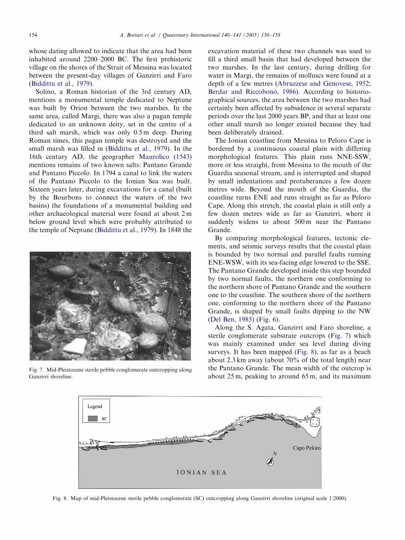
Fig. 7. Mid-Pleistocene sterile pebble conglomerate outcropping along
Ganzirri shoreline.
Fig. 8. Map of mid-Pleistocene sterile pebble conglomerate (SC) o
excavation material of these two channels was used tofill a third small basin that had developed between thetwo marshes. In the last century, during drilling forwater in Margi, the remains of molluscs were found at adepth of a few metres (Abruzzese and Genovese, 1952;Berdar and Riccobono, 1986). According to historio-graphical sources, the area between the two marshes hadcertainly been affected by subsidence in several separateperiods over the last 2000 years BP, and that at least oneother small marsh no longer existed because they hadbeen deliberately drained.
The Ionian coastline from Messina to Peloro Cape isbordered by a continuous coastal plain with differingmorphological features. This plain runs NNE-SSW,more or less straight, from Messina to the mouth of theGuardia seasonal stream, and is interrupted and shapedby small indentations and protuberances a few dozenmetres wide. Beyond the mouth of the Guardia, thecoastline turns ENE and runs straight as far as PeloroCape. Along this stretch, the coastal plain is still only afew dozen metres wide as far as Ganzirri, where itsuddenly widens to about 500m near the PantanoGrande.
By comparing morphological features, tectonic ele-ments, and seismic surveys results that the coastal plainis bounded by two normal and parallel faults runningENE-WSW, with its sea-facing edge lowered to the SSE.The Pantano Grande developed inside this step boundedby two normal faults, the northern one conforming tothe northern shore of Pantano Grande and the southernone to the coastline. The southern shore of the northernone, conforming to the northern shore of the PantanoGrande, is shaped by small faults dipping to the NW(Del Ben, 1985) (Fig. 6).
Along the S. Agata, Ganzirri and Faro shoreline, asterile conglomerate substrate outcrops (Fig. 7) whichwas mainly examined under sea level during divingsurveys. It has been mapped (Fig. 8), as far as a beachabout 2.3 km away (about 70% of the total length) nearthe Pantano Grande. The mean width of the outcrop isabout 25m, peaking to around 65m, and its maximum
utcropping along Ganzirri shoreline (original scale 1:2000).

ARTICLE IN PRESS
Fig. 9. Geological cross-section of Peloro Cape promontory (Fig. 4): 1—alluvial deposits (Olocene); 2—terraced deposits (Late Pleistocene); 3—sand
and gravel of Messina Formation (Mid-Pleistocene); 4—normal fault.
A. Bottari et al. / Quaternary International 140– 141 (2005) 150–158 155
thickness is not more than 2.5–3.0m. This value is largerthan that to the NE determined from geological logs (n.3 in Fig. 4), near the Sottile headland (Peloro Cape).Here, within gravel and sand deposits there areintercalations of conglomerate with coarse pebbles,whose thickness is about 50 cm (Bonfiglio and Violanti,1983). Borehole data from surveys carried out atDue Torri (n. 2 in Fig. 4) show that the conglomeratereaches a thickness of about 1m inside the sandy-gravelcover, whereas it is absent in the first 15m of coverabout 300m further W (near the new police station; n. 1in Fig. 4).
Through bibliographical data and surveys carried outin the area, we can define its geological section (Fig. 9).The normal fault along the northern shore of thePantano Grande has mainly been checked by geophy-sical surveys (Del Ben and Finetti, 1985), and iscompatible with proof of local subsidence from histor-iographical documents. The existence of the fault thatfollows the Ionian coastline is confirmed by morpholo-gical analysis and geophysical survey results (Del Ben,1985; Del Ben and Finetti, 1985).
5. Main features of benthic communities
Pantano Grande is located to the northern mouth ofthe Strait of Messina and is separated from Ionian Seaby a thin strip of alluvium and eolian deposits, whosewidth ranges between 100 and 200m. It presentspeculiar characteristics, mostly derived from the con-fluence of Ionian Sea waters with those of TyrrhenianSea. The Strait of Messina represents the junction ofthese two basins, even if physiographically distinct andwith different physico-chemical water characteristics,where strong sea currents drive a complex displacementof waters (De Domenico, 1987; Mosetti, 1995). Inmoving between the two basins, waters have to crossover the underwater sill (�70m), with a WSW-ENEoriented mouth. The mouth morphology has a funda-
mental role, not only in the hydrological regime of theStrait, but also in the distribution of the benthicpopulations which move in this particular environment.The hydrodynamic characteristics of the Strait ofMessina and the peculiar ecological conditions foundhere are strictly linked to its geological structure. Theintense tectonic activity which characterizes the area ofthe Strait is the first cause for the absence or narrownessof the coastal strip, of the moderate development of thecontinental shelf, and of the notable extension of theslope of the underwater escarpment and irregularities ofthe rocky sill (Selli, 1978; Selli et al., 1978; Colantori,1987).
The benthic ecosystem is very complex because thebenthos of the Strait is the result of a long andarticulated evolution. The benthic population showsevidence of an ancient origin from various geographicsources. The peculiar topography and hydrodynamics ofthe Strait allow the establishment of exclusive commu-nities to the Mediterranean Sea (Di Geronimo andFredj, 1987; Fredj and Giaccone, 1987).
Benthos data were collected in the course of severalfield research programmes by the Department of AnimalBiology and Marine Ecology, University of Messina,starting from 1974 and updated on the basis of morerecent sampling carried out within the national pro-gramme ‘‘Conservation of Biodiversity and SustainableManagement of Saltwater Biotopes of the Italiancoasts’’ in 1996–1997. During the research, more than40 quantitative samplings of benthos from both soft andhard substrates were examined, and data relative tomore than 20 death assemblages for topographicreconstruction of the outcropping portion of theconglomerate along the Ganzirri beach were alsoconsidered.
Results from the benthic communities of the PantanoGrande indicate that the salt marsh is generally wellcharacterized, at least as regards the most frequentlystudied taxa, i.e., molluscs. A qualitative difference isalso observed with respect to the adjacent Faro basin (or

ARTICLE IN PRESS
Table 1
List of species found in Ganzirri salt marsh in 1996–1997
Gasteropods
Guibbula (colliculus) adansoni (Payraudeau, 1826)
Cerithium rupestre (Risso, 1826)
Phyllonotus trunculus (L., 1758)
Nassarius mutabilis (L., 1758)
Cyclope neritea (L., 1758)
Haminoea hydatis (L., 1758)
Bivalves
Mytilus (M.) galloprovincialis (Lamarck, 1819)
Loripes lacteus (L., 1758)
Cerastoderma edule (L., 1758)
Abra (A.) ovata (Philippi, 1859)
Venerupis aurea (Gmelin in L., 1791)
Crustacean decapods
Palaemon serratus (Pennant, 1777)
Eriphia verrucosa (Forskal, 1775)
Pachygrapsus marmoratus (Fabricius, 1787)
Brachynotus sexdentatus (Risso, 1827)
Echinoderms
Amphipholis squamata (Delle Chiaje, 1828)
Holoturia polii (Delle Chiaje, 1823)
A. Bottari et al. / Quaternary International 140– 141 (2005) 150–158156
Pantano Piccolo; Parenzan, 1979; Department ofAnimal Biology and Marine Ecology, University ofMessina, unpublished data), linked directly with thePantano Grande by a wide and semi-natural channel.Not taking into account shellfish species, the benthiccommunities of Pantano Grande are characterized by amarked oligotype (Table 1) and by the prevalence ofcertain species such as Cyclope neritea and Abra ovata,which are marginal in the Piccolo Pantano.
In the same way, carcinofauna is characterizedprimarily by the crab Brachynotus sexdentatus, foundabundantly throughout the year in the Pantano Grande,but not observed in the Pantano Piccolo. In contrast,echinoderms do not show this exclusive character, andthe only two species observed appear to be confined tothe northern sector of the marsh, i.e., more directly incommunication with the sea. The composition anddistribution of phytobenthos have recently greatlychanged due to massive invasion by the tropical algaCaulerpa taxifolia (Frada et al., 1994; Frada and Calvo,1995). This last species, probably the only allochthonousbenthic organism to have colonized the bed of thePantano Grande successfully, is now widespread in thenorthern sector and adjacent sea floor, but has not yetreached the Pantano Piccolo.
6. Conclusion: suggestions and considerations
Characterization of the morpho-neotectonic processesresponsible for the recent formation of the Pantano
Grande and the geomorphological features whichhave conditioned its evolution are of great interest.This is not only true of overall geological studies ofthis particular area of the Strait of Messina, but alsoas regards research on the benthic communities livingin brackish waters and the consequences on themas a result of exchanges with the adjoining marineenvironment.
Geological and biological features of the PantanoGrande show that its tectonic genesis can be explainedby considering the following facts:
1.
The hilly relief behind the Ganzirri salt marsh is asmall horst, bounded by ENE-WSW-running normalfaults. The northern fault forms the boundary of thecoastal plain along the Tyrrhenian. The smallersouthern one lowers to the SSE and borders thenorthern shore of the Pantano Grande. This secondfault gave rise to local subsidence, as revealed byfindings made during the excavation of a canal inBourbon times, operations for drilling water wells,the processes of formation of two other marshescreated in time, and the remains of molluscs found ata depth of only a few metres.2.
The transverse dimension of the Pantano Grandeis defined to the north by the above-mentionedfault and to the south by small normal faultsdipping to the NW. Another normal fault modelsthe Ionian coastline from the mouth of the Guardiato Peloro Cape. It runs ENE-WSW and dips tothe SSE.3.
The outcropping of sterile conglomerate whichborders the Ganzirri coastal plain protects thealluvial deposits separating the Pantano Grandefrom the Ionian Sea. This is mainly due to itsmechanical characteristics, as regards both theerosive action of riptides and wave motion. Beforethe construction of two canals (about 200 years BP)linking the Ionian Sea with the Pantano Grande,the only way in which water could be exchangedbetween the marsh and the sea was by infiltration.For this reason, the conglomerate, influencing thespread of benthic species, affected the ecologicalstructure of the original brackish basin and present-day salt marsh.4.
The collected data set, deriving from a multidisci-plinary approach, highlights the peculiar geologicaland ecological characteristics of Pantano Grandewhich make it unique in the scenario of theMediterranean salt marsh. Therefore, the interest ofthe international scientific community should befocused on the unique characteristics of this lagoonenvironment, rather than simply comparing thefeatures of the Ganzirri marsh with other salt marshsystems.
ARTICLE IN PRESSA. Bottari et al. / Quaternary International 140– 141 (2005) 150–158 157
References
Abruzzese, D., Genovese, S., 1952. Osservazioni geomorfologiche e
fisico-chimiche sui laghi di Ganzirri e di Faro. Bollettino Pesca,
Piscicoltura e Idrobiologia 28 (VII, 1), 1–20.
Atzori, P., D’Amico, C., Pezzino, A., 1974. Relazione geo-petrografica
preliminare sul cristallino della catena peloritana. Geologica
Romana 13, 1–27.
Barbano, M.S., Carrozzo, MT., Carveni, P., Cosentino, M., Fonte, G.,
Ghisetti, F., Lanzafame, G., Lombardo, G., Patane, G., Riuscetti,
M., Totorici, L., Vezzani, L., 1978. Elementi per una carta
sismotettonica della Sicilia e della Calabria meridionale. Memorie
della Societa Geologica d’Italia 19, 681–688.
Berdar, G., Riccobono, F., 1986. Le meraviglie dello Stretto di
Messina. Edizinoi Dr. Antonino Sfameni, Messina.
Biddittu, I., Bonfiglio, L., Riccobono, F., 1979. Eneolitico di facies
Piano Conte a Ganzirri (Messina). Sicilia Archeologica 12 (40),
40–87.
Bonfiglio, L., Violanti, L., 1983. Prima segnalazione di Tirreniano ed
evoluzione Pleistocenica del Capo Peloro (Sicilia Nord-orientale).
Geografia Fisica e Dinamica Quaternaria 6, 3–15.
Bottari, A., Lo Giudice, E., 1987. Structural study on the
Strait of Messina. Seismotectonic data. In: Le Detroit de
Messine (Italie). Evolution tectono-sedimentaires recente
(Pliocene et Quaternaire) et environnement actuel. Documents et
Travaux Institut Geologique Albert-de-Lapparent, Paris, 11,
pp. 115–125.
Bottari, A., Carapezza, E., Carapezza, M., Carveni, P., Cefali, F., Lo
Giudice, E., Pandolfo, C., 1986. The 1908 Messina Strait earth-
quake in the regional geostructural framework. Journal of
Geodymanics 5, 275–302.
Bottari, A., Capuano, P., De Natale, G., Gasparini, P., Neri, G.,
Pingue, F., Scarpa, R., 1989. Source parameters of earthquakes in
the Strait of Messina, Italy, during this century. Tectonophysics
166, 221–234.
Bottari, A., Patane, G., Teramo, A., Termini, D., Centamore, C., La
Delfa, S., 1997. Analysis of seismicity and stress fields in North-
eastern Sicily and in the Southern Tyrrhenian Sea with reference to
the geodynamic evolution models proposed from 1973 to 1990. In:
Proceedings of the Scientific Meeting on ‘‘Earthquake fault-plane
solution data bases, derived parameters, geodynamic inferences’’
Taormina, February 4th–5th, 1997.
Bousquet, J.C., Carveni, P., Lanzafame, G., Philips, H., Tortorici, L.,
1980. La distension pleistocene sur le bord oriental du Detroit de
Messine: analogies entre le resultats microtectoniques et le
mecanisme au foyer du seisme de 1908. Bulletin Societe Geologique
de la France 7 (XXII, 3), 327–336.
Camassi, F., Stucchi, M. (Eds.), 1997. NT4.1 un catalogo para-
metrico di terremoti di area italiana al disopra della soglia
del sonno. Gruppo Nazionale per la Difesa dai Terremoti,
Consiglio Nazionale delle Ricerche, Roma, International
Report, p. 84.
Catalano, S., De Guidi, G., Monaco, C., Tortorici, G., Tortorici, L.,
2003. Long-term behaviour of the late Quaternary normal faults in
the Straits of Messina area (Calabrian arc): structural and
morphological constrains. Quaternary International 101–102,
81–91.
Colantori, P., 1987. Marine geology of Straits of Messina, Vol.11.
Documents et Travaux Institut Geologique Albert-de-Lapparent,
Paris, pp. 191–209.
Cortese, E., 1883. Sulla formazione dello Stretto di Messina. Bollettino
Reale Comitato Geologica d’Italia 13 (1–2), 4–39.
Cortese, E., 1909. Una sezione geologica attraverso il Peloro, lo Stretto
di Messina e l’Aspromonte. Bollettino della Societa Geologica
d’Italia 28, 445–468.
D’Amico, C., Messina, A., Puglisi, G., Rottura, A., Russo, S., 1973.
Confronti petrografici nel cristallino delle due sponde dello Stretto
di Messina. Implicazioni geodinamiche. Bollettino della Societa
Geologica d’Italia 92, 939–953.
De Domenico, E., 1987. Caratteristiche fisiche e chimiche delle
acque nello Stretto di Messina, Vol. 11. Documents et
Travaux Institut Geologique Albert-de-Lapparent, Paris,
pp. 225–235.
Del Ben, A., 1985. Technical Report N. 85001, Stretto di Messina S
pA., Roma.
Del Ben, A., Finetti, I., 1985. Gexon Technical Report N. 850016,
Stretto di Messina SpA., Roma.
Di Geronimo, S.I., Fredj, G., 1987. Les fonds a Errina aspera et
Pachylasma giganteum, Vol. 11. Documents et Travaux Institut
Geologique Albert-de-Lapparent, Paris, pp. 243–247.
Di Stefano, G., 1907. Il terremoto calabro-siculo del 1894 in rapporto
con la tettonica e la costituzione del suolo. Annali del Reale Ufficio
Centro Meteorologia e Geodesia s 2, 19–32.
Frada Orestano, C., Calvo, S., 1995. Diffusione di Caulerpa taxifolia
(Vahl) C. Agardh nelle acque dello Stretto di Messina. Biologia
Marina Mediterranea 2, 645–647.
Frada Orestano, C., Calvo, S., Ferreri, BM., 1994. First record of
Caulerpa taxifolia (Vahl) C. Agardh in the Southwestern Medi-
terranean. Giornale Botanica Italia, 813-815.
Fredj, G., Giaccone, G., 1987. Bionomie des fonds a Luminaries du
Detroit de Messine, Vol. 11. Documents et Travaux Institut
Geologique Albert-de-Lapparent, Paris, pp. 237–238.
Gargano, C., 1994. Carta geologica di Messina e del settore nord-
orientale dei Monti Peloritani (Sicilia N.E.), scala 1:25000. SELCA,
Firenze.
Ghisetti, F., 1979. Relazioni tra strutture e fasi trascorrenti e distensive
lungo i sistemi Messina-Fiumefreddo, Tindari-Letoianni e Alia-
Malvagna (Sicilia Nord-orientale): uno studio microtettonico.
Geologica Romana 18, 23–58.
Ghisetti, F., 1981. L’evoluzione strutturale del bacino plio-
pleistocenico di Reggio Calabria nel quadro geodinamico
dell’Arco Calabro. Bollettino della Societa Geologica d’Italia
100, 433–466.
Gignoux, M., 1909. La Calabre. Annales de Geographie 141–160.
Jacobacci, A., Malatesta, A., Motta, S., 1961. Piano di studi
sullo Stretto di Messina per il collegamento della Sicilia
con la Calabria: ricerche geologiche. Instituto Ricerche E.S.,
Palermo 66pp.
Jacques, E., Monaco, C., Tapponnier, P., Tortorici, L., Winter, T.,
2001. Faulting and earthquake triggering during 1783
Calabria seismic sequence. Geophysical Journal International
147, 499–516.
Lentini, F., Carbone, S., Catalano, S., Vinci, G., Di Stefano, A., 1993.
Schema geologico-strutturale della Sicilia Nord-orientale. SELCA,
Firenze.
Lombardo, G., 1980a. Studio stratigrafico del Plio-Pleistocene del
bacino di Reggio Calabria. Atti della Accademia Gioenia Scienze
Naturali (Catania) 12, 233–298.
Lombardo, G., 1980b. Stratigrafia dei depositi pleistocenici della
Sicilia Nord-orientale. Atti della Accademia Gioenia Scienze
Naturali (Catania) 84, 84–113.
Maurolico, F., 1543. Lettera ad Petrum Gillium (from Panormi apud
Ignatium Virzı by Facciola, 1893).
Monaco, C., Tortorici, L., 2000. Active faulting in the Calabrian arc
and eastern Sicily. Journal of Geodynamics 29, 407–424.
Mosetti, F., 1995. Tidal and other currents in the Straits of Messina.
In: Guglielmo, L., Manganaro, A., De Domenico, E. (Eds.), The
Straits of Messina ecosystem, Proceedings of the Symposium held
in Messina, Italy, 4–6 April 1991, pp. 13–30.
Ogniben, L., 1973. Schema geologico della Calabria in base ai dati
odierni. Geologica Romana 5, 243–585.
Parenzan, P., 1979. Fauna malacologica dei laghi di Ganzirri e Faro
(Messina). Thalassia Salentina, 9.

ARTICLE IN PRESSA. Bottari et al. / Quaternary International 140– 141 (2005) 150–158158
Pezzino, A., Puglisi, G., 1980. Indagine geologico-petrografica sul
cristallino dell’Aspromonte centro-settentrionale (Calabria). Bol-
lettino della Societa Geologica d’Italia 99, 255–268.
Seguenza, G., 1880. Le formazioni terziarie nella provincia di Reggio
(Calabria). Atti della Reale Accademia Lincei, Classe di Scienze
Fisiche, Matematiche e Naturali s 3 (6), 1–45.
Selli, R., 1978. Geologia e sismotettonica dello Stretto di Messina. In:
L’attraversamento dello Stretto di Messina e la sua fattibilita.
Accademia Nazionale dei Lincei, pp. 111–148.
Selli, R., Colantoni, P., Fabbri, A., Rossi, S., Borsetti, AM.,
Gallignani, P., 1978. Marine geological investigation of the
Messina Straits and its approaches. Giornale Geologica 42 (2),
1–61.
Taramelli, T., 1911. Sull’origine dello Stretto di Messina. Atti
Societa Italiana per il Progresso delle Scienze, III Riunione, Roma,
pp. 29.
Westaway, R., 1993. Quaternary uplift of southern Italy. Journal of
Geophysical Research 98, 21741–21772.