Experimental river diversion for marsh enhancement
10
1416 Q 2002 Estuarine Research Federation Estuaries Vol. 25, No. 6B, p. 1416–1425 December 2002 Experimental River Diversion for Marsh Enhancement GEORGE H. WARD 1 ,MICHAEL J. IRLBECK 2, *, and PAUL A. MONTAGNA 3 1 Center for Research in Water Resources, University of Texas at Austin, PRC-119, Austin, Texas 78712 2 U.S. Bureau of Reclamation, Oklahoma-Texas Area Office, 300 East 8th Street, Suite G-169, Austin, Texas 78701 3 Marine Science Institute, University of Texas at Austin, 750 Channelview Drive, Port Aransas, Texas 78373 ABSTRACT: The Nueces River is the primary source of freshwater inflow to Corpus Christi Bay and virtually the only source of freshwater inflow to the Nueces Delta. In association with reservoir development and operation within the Nueces Basin, the magnitude of freshwater inflow has been greatly reduced since 1958. Continually increasing salt concentrations in the soil and water have compromised the function of the delta as a viable component of the estuarine ecosystem. In 1993, the U.S. Bureau of Reclamation began a 5-yr diversion project to increase the opportunity for freshwater flow into the delta. With the excavation of two overflow channels, the minimum flooding threshold for the upper delta was significantly lowered, and more frequent diversions of freshwater from the Nueces River were enabled. During the 50-mo diversion period, the amount of freshwater diverted into the upper Nueces Delta was increased seven- fold. The average salinity gradient in the upper delta reverted to a more natural pattern, with average salinity concen- trations decreasing from the lower (bay) to upper (riverine) delta, and a corresponding improvement in abundance and diversity of both intertidal vegetation and benthic communities. Introduction One of the defining characteristics of an estuary is an influx of freshwater (Ketchum 1951; Prit- chard 1967). The role of freshwater inflow in cre- ating time-space variation in salinity, nutrients, and sediment, among other waterborne properties, is central to maintenance of the estuarine ecosystem (e.g., Ward and Montague 1996). This role is es- pecially critical in those estuaries whose watersheds are semi-arid, such as those on the coasts of Flor- ida, southern California, and south Texas, in which even modest diminutions in inflow can produce marked alterations in the estuarine communities (Copeland 1966; Armstrong 1982; Montagna and Kalke 1992). One such system is Corpus Christi Bay, one of the major estuarine systems on the Texas coast. The principal inflow to Corpus Christi Bay is the Nueces River, which enters the system in the sec- ondary embayment, Nueces Bay (Fig. 1). With an increase in human population along the south Texas coast, regional municipal and industrial wa- ter demands from the Nueces River have also in- creased, necessitating storage reservoirs to meet these water demands. Two main-stem reservoirs have been constructed in the Nueces Basin: Lake Corpus Christi in 1958 and Choke Canyon Reser- voir in 1987. Since 1958, the magnitude of fresh- * Corresponding author; tele: 512/916-5650; fax: 512/916- 5662; e-mail: [email protected]. water inflow into Corpus Christi Bay has been re- duced for both Corpus Christi Bay (55%, Asquith et al. 1997) and the Nueces Delta (99%, Bureau of Reclamation 2000a). These reductions are not attributable to precipitation differences before and after reservoir construction (Bureau of Reclama- tion 2000c). An important intermediary in the ecological re- sponse of an estuary to riverine inflow is the delta of that river. These are generally regions of exten- sive salt marshes and vegetated flats that are peri- odically inundated by tides and floods, and are a critical transitional environment used by both es- tuarine and marine plants and animals. Odum (1961) proposed that tidal marshes were intimately and disproportionately important to the productiv- ity of estuaries. The idea is supported by the gen- eral correlation between estuarine productivity and the extent of tidal marshes (Daiber 1986), but the exact mechanisms and their relative impor- tance are controversial (Nixon 1980). Comprising a complex array of channels, pools, marshes, and tidal flats, the delta of the Nueces River is located in the western extreme of Nueces Bay (Fig. 1). The delta is inundated regularly by salt water from the bay via tides and wind, and oc- casionally by freshwater when the Nueces River spills over its banks. The channel of the Nueces River skirts the delta and debouches into Nueces Bay on its south shore (Fig. 1). River flows enter the delta only when stage is sufficient to broach
Transcript of Experimental river diversion for marsh enhancement

1416Q 2002 Estuarine Research Federation
Estuaries Vol. 25, No. 6B, p. 1416–1425 December 2002
Experimental River Diversion for Marsh Enhancement
GEORGE H. WARD1, MICHAEL J. IRLBECK2,*, and PAUL A. MONTAGNA3
1 Center for Research in Water Resources, University of Texas at Austin, PRC-119, Austin,Texas 78712
2 U.S. Bureau of Reclamation, Oklahoma-Texas Area Office, 300 East 8th Street, Suite G-169,Austin, Texas 78701
3 Marine Science Institute, University of Texas at Austin, 750 Channelview Drive, Port Aransas,Texas 78373
ABSTRACT: The Nueces River is the primary source of freshwater inflow to Corpus Christi Bay and virtually the onlysource of freshwater inflow to the Nueces Delta. In association with reservoir development and operation within theNueces Basin, the magnitude of freshwater inflow has been greatly reduced since 1958. Continually increasing saltconcentrations in the soil and water have compromised the function of the delta as a viable component of the estuarineecosystem. In 1993, the U.S. Bureau of Reclamation began a 5-yr diversion project to increase the opportunity forfreshwater flow into the delta. With the excavation of two overflow channels, the minimum flooding threshold for theupper delta was significantly lowered, and more frequent diversions of freshwater from the Nueces River were enabled.During the 50-mo diversion period, the amount of freshwater diverted into the upper Nueces Delta was increased seven-fold. The average salinity gradient in the upper delta reverted to a more natural pattern, with average salinity concen-trations decreasing from the lower (bay) to upper (riverine) delta, and a corresponding improvement in abundance anddiversity of both intertidal vegetation and benthic communities.
IntroductionOne of the defining characteristics of an estuary
is an influx of freshwater (Ketchum 1951; Prit-chard 1967). The role of freshwater inflow in cre-ating time-space variation in salinity, nutrients, andsediment, among other waterborne properties, iscentral to maintenance of the estuarine ecosystem(e.g., Ward and Montague 1996). This role is es-pecially critical in those estuaries whose watershedsare semi-arid, such as those on the coasts of Flor-ida, southern California, and south Texas, in whicheven modest diminutions in inflow can producemarked alterations in the estuarine communities(Copeland 1966; Armstrong 1982; Montagna andKalke 1992).
One such system is Corpus Christi Bay, one ofthe major estuarine systems on the Texas coast.The principal inflow to Corpus Christi Bay is theNueces River, which enters the system in the sec-ondary embayment, Nueces Bay (Fig. 1). With anincrease in human population along the southTexas coast, regional municipal and industrial wa-ter demands from the Nueces River have also in-creased, necessitating storage reservoirs to meetthese water demands. Two main-stem reservoirshave been constructed in the Nueces Basin: LakeCorpus Christi in 1958 and Choke Canyon Reser-voir in 1987. Since 1958, the magnitude of fresh-
* Corresponding author; tele: 512/916-5650; fax: 512/916-5662; e-mail: [email protected].
water inflow into Corpus Christi Bay has been re-duced for both Corpus Christi Bay (55%, Asquithet al. 1997) and the Nueces Delta (99%, Bureauof Reclamation 2000a). These reductions are notattributable to precipitation differences before andafter reservoir construction (Bureau of Reclama-tion 2000c).
An important intermediary in the ecological re-sponse of an estuary to riverine inflow is the deltaof that river. These are generally regions of exten-sive salt marshes and vegetated flats that are peri-odically inundated by tides and floods, and are acritical transitional environment used by both es-tuarine and marine plants and animals. Odum(1961) proposed that tidal marshes were intimatelyand disproportionately important to the productiv-ity of estuaries. The idea is supported by the gen-eral correlation between estuarine productivityand the extent of tidal marshes (Daiber 1986), butthe exact mechanisms and their relative impor-tance are controversial (Nixon 1980).
Comprising a complex array of channels, pools,marshes, and tidal flats, the delta of the NuecesRiver is located in the western extreme of NuecesBay (Fig. 1). The delta is inundated regularly bysalt water from the bay via tides and wind, and oc-casionally by freshwater when the Nueces Riverspills over its banks. The channel of the NuecesRiver skirts the delta and debouches into NuecesBay on its south shore (Fig. 1). River flows enterthe delta only when stage is sufficient to broach
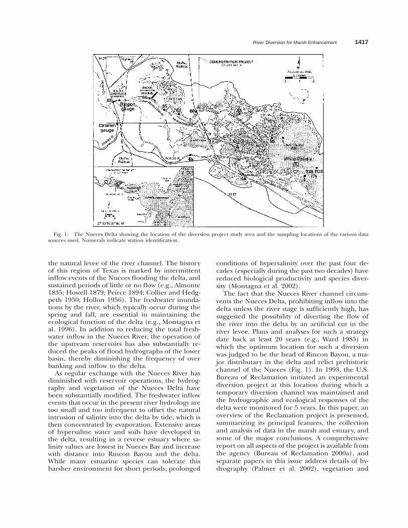
River Diversion for Marsh Enhancement 1417
Fig. 1. The Nueces Delta showing the location of the diversion project study area and the sampling locations of the various datasources used. Numerals indicate station identification.
the natural levee of the river channel. The historyof this region of Texas is marked by intermittentinflow events of the Nueces flooding the delta, andsustained periods of little or no flow (e.g., Almonte1835; Howell 1879; Peirce 1894; Collier and Hedg-peth 1950; Hollon 1956). The freshwater inunda-tions by the river, which typically occur during thespring and fall, are essential in maintaining theecological function of the delta (e.g., Montagna etal. 1996). In addition to reducing the total fresh-water inflow in the Nueces River, the operation ofthe upstream reservoirs has also substantially re-duced the peaks of flood hydrographs of the lowerbasin, thereby diminishing the frequency of overbanking and inflow to the delta.
As regular exchange with the Nueces River hasdiminished with reservoir operations, the hydrog-raphy and vegetation of the Nueces Delta havebeen substantially modified. The freshwater inflowevents that occur in the present river hydrology aretoo small and too infrequent to offset the naturalintrusion of salinity into the delta by tide, which isthen concentrated by evaporation. Extensive areasof hypersaline water and soils have developed inthe delta, resulting in a reverse estuary where sa-linity values are lowest in Nueces Bay and increasewith distance into Rincon Bayou and the delta.While many estuarine species can tolerate thisharsher environment for short periods, prolonged
conditions of hypersalinity over the past four de-cades (especially during the past two decades) havereduced biological productivity and species diver-sity (Montagna et al. 2002).
The fact that the Nueces River channel circum-vents the Nueces Delta, prohibiting inflow into thedelta unless the river stage is sufficiently high, hassuggested the possibility of diverting the flow ofthe river into the delta by an artificial cut in theriver levee. Plans and analyses for such a strategydate back at least 20 years (e.g., Ward 1985) inwhich the optimum location for such a diversionwas judged to be the head of Rincon Bayou, a ma-jor distributary in the delta and relict prehistoricchannel of the Nueces (Fig. 1). In 1993, the U.S.Bureau of Reclamation initiated an experimentaldiversion project at this location during which atemporary diversion channel was maintained andthe hydrographic and ecological responses of thedelta were monitored for 5 years. In this paper, anoverview of the Reclamation project is presented,summarizing its principal features, the collectionand analysis of data in the marsh and estuary, andsome of the major conclusions. A comprehensivereport on all aspects of the project is available fromthe agency (Bureau of Reclamation 2000a), andseparate papers in this issue address details of hy-drography (Palmer et al. 2002), vegetation and

1418 G. H. Ward et al.
habitat effects (Alexander and Dunton 2002), andbenthic ecology (Montagna et al. 2002).
Materials and Methods
THE DIVERSION EXPERIMENT
The diversion experiment consisted of a pro-gram of hydrographic and biological monitoringin the Nueces Delta for an extended period, dur-ing part of which the physiography of the delta wasmodified to divert part of the river flow throughthe delta. Since the overall objective was to dem-onstrate by direct experiment the efficacy of sucha diversion in improving the ecological functioningof the delta, it is referred to as the Rincon BayouDemonstration Project. The primary features ofthe Demonstration Project were two excavatedchannels: the Nueces Overflow Channel and theRincon Overflow Channel (Fig. 1). These channelswere completed in October 1995.
The Nueces Overflow Channel was a cutthrough the river levee to lower the minimumflooding threshold of the delta and allow inflow tothe delta at river stages below those normally re-quired to overtop the levee. This channel, locatedapproximately 60 m downstream of the InterstateHighway 37 Bridge along the north bank, was ex-cavated to an approximate 274 m length and 12 mwidth, with a bottom elevation of 0.0 m MSL. Priorto the creation of the Nueces Overflow Channel,flood flows entered the delta by overtopping thenatural river levee at several low points, most im-portant of which was the levee at Rincon Bayouwhere the Nueces Overflow Channel was installed.A river stage of 1.64 m was determined to be thenatural overflow threshold, corresponding to aflow in the Nueces River of about 60 m3 s21 (vary-ing about 10% depending upon water level in Nu-eces Bay).
The purpose of the Rincon Overflow Channelwas to improve the exchange of water within thedelta itself by facilitating flow into an extensive tid-al flat area in the north section of the delta. It wasexcavated to an approximate 610 m length and 30m width, with a bottom elevation of 1.22 m MSLon the upstream (south) end and 0.91 m MSL onthe downstream (north) end. This channel did nottherefore affect the frequency of inundation by riv-er water, but did improve the distribution of theriver water once it was diverted into the delta bythe Nueces Overflow Channel.
Monitoring activities used both automatic robotsensors and traditional field sampling, and werefocused on hydrographic changes in the area andthe response of organisms in the water column,sediments, and tidal flats of the delta. These ob-servations were supplemented by data collection
programs already underway in the region (sum-marized in the next section). The most intense pe-riod of data collection was the 50-mo study period,October 1994 through December 1999. This peri-od included 12 mo of data before the NuecesOverflow Channel was opened, and 38 mo of dataafter. The data collection program was designed tomeasure the hydrographic changes (reference andtreatment) at stations throughout the upper delta,and to compare the responses of biological param-eters that would be most responsive to project di-version, namely water column productivity, benthiccommunities, and vegetation communities. Biolog-ical data collection is described in Alexander andDunton 2002 and Montagna et al. 2002.
HYDROGRAPHIC EVENTS:IDENTIFICATION AND ANALYSIS
Nueces Bay, including the Nueces delta, is sub-ject to numerous hydrometeorological influences,viz. river flow, precipitation, peripheral runoff, andforcing from wind and tide. Each of these, in iso-lation or in combination, may alter water chemis-try (e.g., salinity and nutrients), transport detritalmaterial, induce exchanges between the bay, delta,and river, and make accessible or restrict habitatsavailable for estuarine aquatic organisms. Interpre-tation and analysis of the effects of the diversionproject and the resulting biological responses re-quire a quantitative delineation of the hydrogra-phy of the area, specifically with regard to flow,water level (stage), and salinity over the 50-mostudy period (October 1994 through December1999). A longer-term analysis of the effects of riverdiversions on the salinity gradient of the Nuecesdelta was also performed using data from selectedstations in Nueces Bay and delta for the period ofJanuary 1992 through December 1999. This 8-yrinterval was divided into two nearly equal periodsbefore (3.8 yr) and after (4.2 yr) the Nueces Over-flow Channel was completed on October 26, 1995and project diversions began.
The sources for data used to evaluate the diver-sion experiment are summarized in Table 1. Manyof these are from automatic monitors. The TexasCoastal Ocean Observing Network stations in Nu-eces Bay, operated by Texas A&M University-Cor-pus Christi Conrad Blucher Institute, providedconductivity (SALT03) and water level (WhitePoint) at hourly intervals (Fig. 1). While there isno doubt some slope to the water surface in Nue-ces Bay occurs in response to meteorology, tides,and storm hydrographs in the river (Ward 1997),this is negligible in comparison to the temporalexcursions in water level in the river and marsh.Therefore, stage data from the White Point gaugewas regarded as an acceptable indication of the co-

River Diversion for Marsh Enhancement 1419
TA
BL
E1.
Sum
mar
yof
dat
aso
urc
es.U
SGS
5U
.S.G
eolo
gica
lSu
rvey
,TC
OO
N5
Tex
asC
oast
alO
cean
Obs
ervi
ng
Net
wor
k,an
dC
BI
5T
exas
A&
MU
niv
ersi
ty-C
orp
us
Ch
rist
iC
onra
dB
luch
erIn
stit
ute
.
Dat
aSo
urc
eP
aram
eter
Dat
aT
ype
Mea
sure
men
tL
ocat
ion
(Nu
mbe
rof
Stat
ion
s)P
erio
dof
Rec
ord
Use
d
Rin
con
Bay
oun
ear
Cal
alle
n,
USG
S(S
tati
on08
2155
03)
Wat
erle
vel,
curr
ent
velo
city
,cal
-cu
late
dfl
owD
ata
reco
rded
at15
-min
inte
r-va
lsU
pp
erR
inco
nB
ayou
(1)
May
16,
1996
–Dec
31,
1999
Dai
lyp
reci
pit
atio
nD
ata
arch
ived
asd
aily
valu
esN
uec
esR
iver
atC
alal
len
,U
SGS
(Sta
tion
0821
1500
)E
stim
ated
dai
lyfl
ow*
Dat
are
cord
edat
15-m
inin
ter-
vals
Nu
eces
Riv
er(1
)O
ct1,
1994
–Dec
31,
1999
TC
OO
Nsy
stem
,C
BI
Wat
erle
vel,
win
dd
irec
tion
and
velo
city
Salin
ity
Dat
are
cord
edas
6-m
inav
er-
aged
valu
esN
uec
esan
dC
orp
us
Ch
rist
iB
ays
(2)
Jan
1,19
92–D
ec31
,19
99
Cor
pu
sC
hri
sti
Bay
NW
SD
aily
pre
cip
itat
ion
Dat
aar
chiv
edas
dai
lyva
lues
Cor
pu
sC
hri
sti
Inte
rnat
ion
alA
irp
ort
(1)
Jan
1,19
92–M
ay15
,19
96
Bio
logi
cal
Mon
itor
ing
(wat
erco
lum
np
rod
uct
ivit
y)W
ater
qual
ity,
nu
trie
nts
,p
hyt
o-p
lan
kton
Dat
asa
mp
led
mon
thly
Nu
eces
Riv
eran
dlo
wer
Rin
con
Bay
ou(3
)Ja
n1,
1992
–Dec
31,
1999
Up
per
and
cen
tral
Rin
con
Bay
-ou
,an
du
pp
erd
elta
(7)
Oct
1,19
94–D
ec31
,19
99
Bio
logi
cal
Mon
itor
ing
(ben
thic
s)M
acro
fau
na,
mei
ofau
na
Dat
asa
mp
led
quar
terl
yU
pp
eran
dce
ntr
alR
inco
nB
ay-
ou,
and
up
per
del
ta(6
)O
ct1,
1994
–Dec
31,
1999
Bio
logi
cal
Mon
itor
ing
(veg
eta-
tion
)Su
rfac
ean
dp
orew
ater
qual
ity,
mac
rop
hyt
esD
ata
sam
ple
dbi
-an
nu
ally
Up
per
del
taan
dce
ntr
alR
inco
nB
ayou
(3)
Oct
1,19
94–D
ec31
,19
99
*R
elia
ble
dat
afo
rd
isch
arge
valu
esab
ove
77.8
7m
3s2
1w
ere
not
avai
labl
e;al
ld
aily
flow
valu
esin
exce
ssof
this
amou
nt
(of
wh
ich
ther
ew
ere
3in
the
reco
rdu
nd
erre
view
)w
ere
esti
mat
edby
extr
apol
atio
n.
incident elevation of Nueces Bay. Daily mean flowof the Nueces River is gauged by the U.S. Geolog-ical Survey (USGS) at Calallen, located just up-stream from the diversion channel (Fig. 1). This isa low, rubble-mound dam, employed to facilitatewater-supply diversion by the City of Corpus Christiand the head of tide for the Nueces River. TheRincon Bayou gauge was operated expressly forthis project by the USGS. This automatic gauge waslocated in the channel of Rincon Bayou, approxi-mately 275 m downstream from the Nueces Riverdiversion point (Fig. 1). Instrumentation includedsensors for precipitation, stage, and current veloc-ity. Details on the installation and calibration of thegauge are given in Bureau of Reclamation (2000a).The Rincon gauge was activated on May 15, 1996,about 7 mo after the Nueces Overflow Channelwas opened, so there is a gap in the data record atthis gauge for the period of operation of the Over-flow Channel. This 7-mo period proved to be rel-atively dry with few hydrographic events, so fortu-itously the missing data are not critical.
Results and DiscussionThe conceptual model of the function of the di-
version project is that it should partially divert astorm hydrograph on the Nueces River from theriver channel into the upper marsh, resulting inan increase in water elevation in the marsh (andassociated inundation) and a decrease in salinity.In order to analyze the response of the marsh dur-ing the diversion experiment, it is necessary toidentify such events in the data record. A hydro-graphic event was considered to include one ormore of the following responses: occurrence of asubstantial volume of freshwater flow in the NuecesRiver or in the diversion channel, an increase inwater level (stage) in the marsh, or a decrease insalinity. The interpretation of the effect of suchevents on Nueces marsh is complicated by the factthat such responses can occur in isolation and re-sult from processes other than a riverine storm hy-drograph.
In order to objectively identify candidate hydro-graphic events in the data record, criteria were for-mulated to define an event based upon the sepa-rate behaviors of each of the key hydrographic var-iables. These included water-surface elevation (i.e.,stage) in Nueces Bay, Rincon Bayou and the super-elevation (defined below) of Rincon over NuecesBay, flow in the Nueces River and Rincon Bayou,and salinity in Nueces Bay (Table 2). Precipitationand wind were not treated as separate criterion var-iables because they provide no information on hy-drographic response not independently containedin data on water flow, elevation, or salinity eventhough these meteorological elements can be use-

1420 G. H. Ward et al.
TABLE 2. Criteria used to define hydrographic events in the data record. CBI 5 Texas A&M University-Corpus Christi ConradBlucher Institute.
ResponseParameter Location Defining Criteria of a Hydrographic Event
Flow Nueces River A 24-h mean (daily) flow in the Nueces River at Calallen exceeding 14.2 m3 s21.Rincon Bayou A 24-h mean (daily) flow in Rincon Bayou, either positive or negative, exceeding 0.28 m3 s21.
Stage Nueces Bay A 24-h mean (daily) stage in the water elevation of Nueces Bay exceeding 0.30 m, referenced to theconsistent CBI datum from Ward (1997), established by empirical leveling.
Rincon Bayou A 24-h mean (daily) stage in the water elevation of Rincon Bayou exceeding 0.61 m, relative to Rin-con gauge datum, which is 422 cm above the consistent datum for CBI gauges.
Super-elevation The difference of Rincon Bayou minus Nueces Bay daily stage values exceeding 0.15 m, referenced tocommon datum.
Salinity Nueces Bay Change in salinity concentrations of Nueces Bay exceeding 5 psu over a 5-d period.
Fig. 2. Selected hydrographic data for the calendar year 1999.
ful and important in understanding the responseof the delta ecology. Individual occurrences withinthe data record which met at least one of the sixcriteria of Table 2 were identified as hydrographicevents. Each identified event occurring betweenOctober 1, 1994 and December 31, 1999 was num-bered sequentially. As an example, a single year isplotted in Fig. 2 showing the time series(smoothed by 24-h averaging) for the various hy-drographic variables, and the hydrographic events28–37 are identified.
For each event, the integrated values for all hy-drographic variables are summarized in Table 3.The term integrated means either averaged or ac-cumulated over the duration of the event, which-ever is more useful for the parameter under con-sideration. The duration period for each event wasat least that for which the defining criterion wassatisfied, though often a longer event period wasspecified to be sure that the complete response of
the bay or delta was included. When several hydro-graphic events overlapped (i.e., when several vari-ables each satisfied criteria separately and simul-taneously), the event duration was at least the pe-riod from the first occurrence of the earliest cri-terion threshold for any parameter to the latestsub-threshold occurrence for all parameters. Sep-aration of the record into events was frustratedwhen the response to one event overlapped thatof the next. For example, a series of river stormhydrographs might occur, each of which raised theRincon stage or Calallen flow above the thresholddefining an event, and a new surge of inflow oc-curred before the recession of the preceding eventhas subsided (e.g., Events 12–14, 16–17, 21–27, 35–36, etc.). These instances are identified in Table 3by an asterisk following the event number, andsome may be observed in Fig. 2.
The super-elevation of Rincon Bayou over Nue-ces Bay is the algebraic difference of Rincon Bayou

River Diversion for Marsh Enhancement 1421
TABLE 3. Summary of hydrographic events that occurred during the study period October 1, 1994 through December 31, 1999.Response variables that met event criteria are in bold. An asterisk (*) indicates an event that begins immediately following theconclusion of the previous event.
EventNumber
Starting Date
Year Month DayDuration
(d)Rainfall
(cm)
Flow Volume (103 m3)
TotalNuecesRiver
NetRinconBayou
Event Mean Stage (m MSL)
NuecesBay
RinconBayou
Super-elevation
Salinity inNueces Bay (psu)
StartNet
Change
12345
19941995
125689
2029185
22
146
131019
976135
11391
4,950801
7,489191
10,978
0000
—
0.350.550.420.630.69
—————
—————
26.628.827.125.130.4
26.623.228.820.723.7
6789
10 1996
101212121
261
17251
1012654
2971
1600
1.7811,617
276241
1,221
—————
0.690.320.330.260.27
—————
—————
23.825.124.223.223.7
20.922.4
1.54.9
20.1111213*14*15 1997
81010104
211
19241
15185
1013
2051765
130
6021,248
41591280
322291742
215
0.460.720.590.640.66
0.510.740.660.680.73
0.050.020.070.040.06
43.840.944.439.631.4
20.922.6
0.40.2
25.61617*181920
1998
67
1036
2146
256
13232099
592
29000
45,36966,24928,892
1,4910
973940329
23114
0.420.380.680.550.55
1.161.010.940.610.62
0.730.630.260.060.07
26.83.7
26.524.031.8
223.00.3
217.22.82.2
2122*23*24*25*26*
8899
1010
12231
291630
118
28171413
1422
12793
20129
9074,894
65,28336,75949,09230,002
2127771218
3,764189
0.400.530.730.590.760.64
0.440.600.940.801.390.90
0.040.070.200.210.630.26
38.531.630.812.35.42.1
27.223.0
219.927.923.2
3.127*28293031*32
19991133456
125
242772
16122310176
761
660
410
32,883322
24,216595221
4,600
8010
165227
212112
0.480.480.520.630.630.50
0.750.590.710.690.690.62
0.280.100.180.060.060.12
5.723.225.019.722.723.2
22.52.7
29.12.52.4
21.43334*3536*37
66899
1928194
27
815161721
5837
1903169
2,94827,57110,49138,1922,901
2133162
2601,052247
0.560.430.450.480.62
0.630.720.650.950.65
0.070.290.200.470.03
27.318.922.716.310.0
28.029.126.229.5
8.6
stage minus Nueces Bay stage, after correction toa common datum. Super-elevation is the direct hy-draulic force driving discharge into the deltathrough the Nueces Overflow Channel. This wascomputed at hourly intervals from the respectivedata records, and then further integrated as nec-essary for long-term analyses.
The hydraulic variables of flow and stage re-spond quickly to river freshets and other hydro-dynamic forcings. Salinity exhibits a much slowerresponse. In upper Nueces Bay, this would be ex-pected to be an initial drop in concentration, fol-lowed by a recovery or re-intrusion period of a slowincrease with time (Ward and Montague 1996).While several indicators of salinity response wereemployed, only one is shown in Table 3, the netincremental change over the duration of the event,for which the initial salinity is also given.
For the entire study period, a total of 37 hydro-graphic events were identified (Table 3), of whichfive occurred prior to the opening of the NuecesOverflow Channel. These 37 events were highly var-iable in the magnitude and duration of their re-sponses, and in the subset of hydrographic variablesin which a response occurred. Some were associatedwith seasonally high waters in Nueces Bay (drivenby the secular variation of the Gulf of Mexico, seeWard 1997), some were salinity responses elicitedonly by internal circulations of the bay, some wereresponses to intense rainfall, and some were due toinflow from storm hydrographs in the Nueces River.Most (28) of these events occurred when the USGSRincon gauge was operating in the Nueces Over-flow Channel, allowing the direct measurement offlow diverted by the diversion project, the associatedwater level rise and local precipitation.

1422 G. H. Ward et al.
Fig. 3. Positive flow volume diverted through Rincon Bayou(or through the Nueces Overflow Channel) versus total flowvolume carried in the Nueces River. Only events that met cri-teria for a flow event in the Nueces River were used to accountfor the corruptive influence that tide has on flow into RinconBayou, especially at low river flow values. The solid line repre-sents a linear regression of all data points, and the dashed linesrepresent linear regressions of data points grouped by stage in-terval.
During the diversion experiment period, theNueces River exceeded the natural floodingthreshold for the delta (1.64 m) on only four oc-casions. Except for these events (Events 16, 18, 25,and 36), all of the water exchanged between theNueces River and Rincon Bayou during the studyperiod was due to the Nueces Overflow Channel,and the Rincon Bayou flow volumes in Table 3 arethose measured in this channel. For the extremehigh-water Events 16, 18, 25, and 36, an additionalamount of water also entered Rincon Bayou via thelow depressions along the natural bank of the river,water which would have spilled into the upper del-ta independent of the Nueces Overflow Channel.This additional volume (totaling 1.2 3 106 m3) wasestimated by application of the Corps of EngineersHEC-2 hydraulic model (Bureau of Reclamation2000d) and included in the totals presented in Ta-ble 3.
Because each of the hydrographic variable re-sponses can occur in isolation without the involve-ment of the others, a certain degree of care mustbe used in determining how a hydrographic eventhas influenced the chemistry and ecology of theproject area. Of the 37 events in Table 3, 15 metthe flow criteria for a flow event in the NuecesRiver, 16 met the criteria for a stage event in Nu-eces Bay, and 21 met the criteria for a salinityevent.
For a flood hydrograph in the Nueces Riverchannel, we might anticipate an association be-tween the total flow volume in the Nueces Riverand the flow diverted through the Nueces Over-flow Channel (Fig. 3). The volume diverted gen-erally increases with the flow in the river, and theactual proportion of the flow amount diverted ison the order of 2% of that in the river. There isconsiderable scatter in this relationship. The pro-portion of river flow diverted into the marsh by theNueces Overflow Channel is a complex functionof the hydraulics of the channel and the time sig-nal of the flood hydrograph in the river. For pres-ent purposes, we observe that this proportion isdictated by the difference in water levels betweenthe river stage at the point of diversion and upperNueces Bay (in turn governed by the river hydro-graph and the tidal variation in the bay) and bythe capacity of the Nueces Overflow Channel (inturn governed by the cross section and frictionalresistance of the channel).
To explore this further, the data of Fig. 3 aresegregated by 0.3-m intervals in water level in Rin-con Bayou. Within each water level class, the vol-ume transported through the Nueces OverflowChannel proves to be substantially independent ofthe volume in the Nueces River. This is a manifes-tation of the phenomenon of hydraulic capacity.
The Nueces Overflow Channel (and upper RinconBayou) achieves hydraulic capacity shortly after aflood event begins, so additional increases in thevolume diverted through the overflow channel re-quire disproportional increases in the flow (andstage) of the Nueces River. A similar sorting by wa-ter levels is also evident when the flow volume inRincon Bayou is plotted against the super-elevation(not shown).
Unlike a river channel system in which the headgradient and the water level (stage) are closely re-lated (e.g., Grover and Harrington 1943), there isno direct relation between water level and flow inthe Nueces River below Calallen Dam because ofthe corrupting effect of tidal and meteorologicalwater-level variations in Nueces Bay. In the NuecesOverflow Channel, the Nueces River hydraulichead (i.e., the super-elevation) is superimposed onwhatever water level is present in Nueces Bay. Thiswater level still affects how the river head can driveflow through the overflow channel, because thedeeper the water, the greater the cross-section areaof the channel (and upper delta), and the lowerthe frictional resistance. For a given hydraulic headfrom the Nueces River to Nueces Bay, there is agreater flow through the diversion channel whenthe Nueces Bay water levels are higher.
For the purpose of salinity-response analysis, allhydrographic events occurring from 1992 through1999 were considered so that a larger database ofpre-diversion events could be included in the anal-ysis. The incremental salinity responses in NuecesBay of each event (as a percentage of initial salin-

River Diversion for Marsh Enhancement 1423
Fig. 4. Total event flow volume in Nueces River (measuredat Calallen gauge) versus the fractional salinity response of Nu-eces Bay. The solid line represents a linear regression of post-project event data.
Fig. 5. Relative mean salinity concentrations for selected sta-tions in the Nueces River and Rincon Bayou (before and afterconstruction of the Nueces Overflow Channel) presented as afraction of mean bay salinity. Error bars are based on between10 and 111 profile surveys for each station in the BEFORE pe-riod (total of 856), and between 51 and 82 for each station inthe AFTER period (total of 903). The Nueces Overflow Channelconnects the Nueces River with Rincon Bayou immediately be-low the IH 37 Bridge at about 0 km (see Fig. 1).
ity) are plotted against the total event flow volumein the Nueces River in Fig. 4. Data for events forwhich the initial salinity was less than 5 psu areexcluded due to noise introduced by determiningpercentages from such small salinity values. Thesame general relation of diminishing salinity re-sponse with increasing event flow volume is evidentfor both pre-diversion and post-diversion condi-tions. Operation of the overflow channel does notmeasurably affect the response of bay salinity,which is not a surprising conclusion given the verysmall proportion of flow volume diverted throughthe overflow channel compared with that in theriver. For event flow volumes less than about 10 3106 m3, the fractional salinity response in NuecesBay is noisy, even positive for a number of theevents, because non-hydrological factors becomeincreasingly important in affecting the salinity ofNueces Bay. Such multivariable controls on estuarysalinity are theoretically anticipated (e.g., Wardand Montague 1996) and there is a level of inflowbelow which its effects on estuary salinity are nil.Although quantification of this threshold for Nu-eces Bay is not relevant to evaluating the effects ofthe diversion project, it may be useful in devisingoperating strategies for a future permanent con-trolled diversion.
The diversion project had no obvious effect onthe long-term salinity pattern of the Nueces River(Fig. 5). In both pre-project and post-project pe-riods, salinity concentrations in the river channelincrease with distance downstream toward NuecesBay. The effect of diversion was observed in thesalinity of the delta. In the upper and central seg-ments of Rincon Bayou, the average salinity and itslongitudinal gradient changed dramatically after
the opening of the Nueces Overflow Channel (Fig.5). During the period prior to the diversion proj-ect, these reaches of Rincon Bayou exhibited thehighest average salinity concentrations in the Nu-eces delta, while during the period of project di-versions, salinity concentrations were the lowest inthe delta. This alteration was due not only to thediversion of freshwater inflows into the delta dur-ing flood events, but also to the opportunity of reg-ular daily exchange between Rincon Bayou and theNueces River, which were too small in magnitudeto meet the criteria for a flow event (see Table 2).Before the diversion project, there was no regularexchange with the Nueces River, and the resultingsalinity gradient in the upper Rincon Bayou chan-nel may be termed a reverse estuary, opposite thatof an estuary channel with regular freshwater in-flux at its head. Without the diversion project, av-erage salinity concentrations in upper Rinconchannel during the second period would have re-mained strongly hypersaline, likely greater than 50psu instead of the observed range of 21 to 28 psu.
The ecological response of the delta to increasedfreshwater inflow and reduced salinity concentra-tions in the soil and water was positive (Bureau ofReclamation 2000a; Montagna et al. 2002; Alex-ander and Dunton 2002). Nutrient import and pri-mary production in the water column were in-creased (Bureau of Reclamation 2000a), as werebenthic community abundance, biomass and di-versity (Montagna et al. 2002). The percent cover

1424 G. H. Ward et al.
of annual marsh plants was increased at rates great-er than areas not directly influenced by river di-versions (Alexander and Dunton 2002).
ConclusionsWith the natural physiography of the Nueces
River levee and post-reservoir hydrology, the min-imum flooding threshold required for the NuecesRiver to spill freshwater into the upper Nueces Del-ta was rarely attained (Ward 1985; Bureau of Rec-lamation 2000a). From 1982 (the completion ofChoke Canyon Dam) through 1999, the NuecesRiver has only significantly exceeded its banks inthe delta on five occasions. Excavation of the over-flow channel fundamentally changed this condi-tion, lowering the minimum flooding threshold forthe delta from 1.64 m to about 0.0 m MSL. Duringthe 50-mo period when the overflow channels ofthe Demonstration Project were operating, over 83 106 m3 was diverted from the Nueces River intoRincon Bayou and the upper delta. Of this totalamount, only about 1.2 3 106 m3 would havespilled into the marsh without the Nueces Over-flow Channel. During the diversion period, the to-tal volume of freshwater inflow into the upper Nu-eces Delta was increased about seven-fold overwhat would have occurred without the project.
Though the diversion had no effect on the salin-ity of the Nueces River channel or Nueces Bay (asexpected), its effects on salinities and the salinitygradient in Rincon Bayou were substantial. In arelatively short period of time (only 4.2 yr after theopening of the Nueces Overflow Channel), the re-verse estuary salinity gradient in the upper deltabefore the diversion project reverted to a morenatural form, with average salinity concentrationslowered in upper Rincon Bayou and diminishingwith distance toward the overflow channel. Whilebeyond the scope of monitoring and analysis ofthis project, we postulate that an ecologicallyhealthier Nueces delta will indirectly benefit thecommunities of the larger Nueces Bay estuary sys-tem.
Because of limitations in program authority andlandowner participation, the U.S. Bureau of Rec-lamation’s Rincon Bayou Demonstration Projectwas declared complete in September 2000 and theNueces Overflow Channel was filled in. Basedupon the findings of Reclamation’s ConcludingReport for the project, the City of Corpus Christiimplemented a permanent diversion project andreopened the Nueces Overflow Channel in Octo-ber 2001. The overflow channel will be maintainedby the City and is to remain open in perpetuity.
Despite the significance of a seven-fold increasein the amount of freshwater diverted during thestudy period and the positive ecological response,
the project modifications did not restore the nat-ural flow regime to the Nueces Delta. Assumingthat the overflow channel had been in place from1982 (or, since the completion of Choke CanyonDam, the last reservoir to be built in the Nueceswatershed) through 1999, the total amount offreshwater diverted would only have representedabout 2% of the volume naturally diverted duringthe pre-1958 (and therefore, pre-reservoir) period(Bureau of Reclamation 2000b). Therefore, the ef-fect of the reservoir system on the natural flow re-gime of the Nueces River was not negated by theproject diversions. This project, however, demon-strates that the location of freshwater inflow canbe as important as its magnitude, and optimizingthe location of its introduction into the estuary canprovide benefits without necessarily altering thevolume of freshwater inflow. This observation haspotential implications for management of inflow towater-deficient systems such as Corpus Christi Bay.
Literature Cited
ALEXANDER, H. D. AND K. H. DUNTON. 2002. Freshwater inun-dation effects on the emergent vegetation of a hypersalinesalt marsh. Estuaries 25:1426–1435.
ALMONTE, J. N. 1835. Statistical report on Texas. C. E. Castaneda(trans.), 1925. The Southwestern Historical Quarterly 28:177–222.
ARMSTRONG, N. E. 1982. Responses of Texas estuaries to fresh-water inflows, p. 103–120. In V. Kennedy (ed.), EstuarineComparisons. Academic Press, New York.
ASQUITH, W. H., J. G. MOSIER, AND P. W. BUSH. 1997. Status,trends and changes in freshwater inflows to bay systems in theCorpus Christi Bay National Estuary Program Study Area.CCBNEP-17. Coastal Bend Bays and Estuaries Program, Cor-pus Christi, Texas.
BUREAU OF RECLAMATION. 2000a. Concluding Report: RinconBayou Demonstration Project. U.S. Department of the Inte-rior, Bureau of Reclamation, Austin, Texas.
BUREAU OF RECLAMATION. 2000b. Analysis of the historic flowregime of the Nueces River into the upper Nueces Delta, andof the potential restoration value of the Rincon Bayou Dem-onstration Project. Appendix C, Concluding Report: RinconBayou Demonstration Project. U.S. Department of the Inte-rior, Bureau of Reclamation, Austin, Texas.
BUREAU OF RECLAMATION. 2000c. Recent trends in precipitationoccurring on the Nueces River watershed of South Texas. Ap-pendix D, Concluding Report: Rincon Bayou DemonstrationProject. U.S. Department of the Interior, Bureau of Recla-mation, Austin, Texas.
BUREAU OF RECLAMATION. 2000d. Hydraulic Analysis of RinconBayou Using HEC-2, Rincon Bayou-Nueces Marsh WetlandsRestoration and Enhancement Project. U.S. Department ofInterior, Bureau of Reclamation, Great Plains Regional Of-fice, Billings, Montana.
COLLIER, A. AND J. HEDGPETH. 1950. An introduction to the hy-drography of tidal waters in Texas. Publications of the Instituteof Marine Science 1:125–194.
COPELAND, B. J. 1966. Effects of decreased river flow on estua-rine ecology. Journal of Water Pollution Control Federation 38:1831–1839.
DAIBER, F. C. 1986. Conservation of Tidal Marshes. Van Nos-trand Reinhold Co., New York.
GROVER, N. AND A. HARRINGTON. 1943. Streamflow: Measure-

River Diversion for Marsh Enhancement 1425
ment, Records and Their Uses. John Wiley and Sons, NewYork.
HOLLON, W. E. (ED.). 1956. William Bollaert’s Texas. Universityof Oklahoma Press, Norman, Oklahoma.
HOWELL, C. W. 1879. Survey of Aransas Pass and Bay up to Rock-port and Corpus Christi, Texas and Corpus Christi Pass andChannel. Appendix K, Annual Report, Chief of Engineers.U.S. House of Representatives, 46th Congress, 2nd Session.U.S. Government Printing Office, Washington, D.C.
KETCHUM, B. H. 1951. The exchange of fresh and salt water intidal estuaries. Journal of Marine Science Research 10:18–38.
MONTAGNA, P. A. AND R. D. KALKE. 1992. The effect of fresh-water inflow on meiofaunal and macrofaunal populations inthe Guadalupe and Nueces estuaries, Texas. Estuaries 15:307–326.
MONTAGNA, P. A., R. D. KALKE, AND C. RITTER. 2002. Effect ofrestored freshwater inflow on macrofauna and meiofauna inupper Rincon Bayou, Texas, USA. Estuaries 25:1436–1447.
MONTAGNA, P. A., J. LI, AND G. T. STREET. 1996. A conceptualecosystem model of the Corpus Christi Bay National EstuaryProgram Study Area. Report CCBNEP-08. Texas Natural Re-source Conservation Commission, Austin, Texas.
NIXON, S. W. 1980. Between coastal marshes and coastal waters:A review of twenty years of speculation and research on therole of salt marshes in estuarine productivity and water chem-istry, p. 437–525. In P. Hamilton and K. MacDonald (eds.),
Estuarine and Wetland Processes with Emphasis on Modeling.Plenum Press, New York.
ODUM, E. P. 1961. The role of tidal marshes in estuarine pro-duction. New York State Conservation 16:12–15.
PALMER, T., P. MONTAGNA, AND R. KALKE. 2002. Downstream ef-fects of restored freshwater inflow to Rincon Bayou, NuecesDelta, Texas, USA. Estuaries 25:1448–1456.
PEIRCE, A. C. 1894. A Man from Corpus Christi, or the Adven-tures of Two Bird Hunters and a Dog in Texan Bogs. Forestand Stream Publishing Company, New York.
PRITCHARD, D. W. 1967. What is an estuary: physical viewpoint,p. 3–5. In G. Lauff (ed.), Estuaries. Publication No. 83. Amer-ican Association for the Advancement of Science, Washing-ton, D.C.
WARD, G. H. 1985. Evaluation of marsh enhancement by fresh-water diversion. Journal of Water Resources Planning and Man-agement, ASCE 111:1–23.
WARD, G. AND C. MONTAGUE. 1996. Estuaries, p. 12-1-12-114. InL. Mays (ed.), Water Resources Handbook. McGraw-Hill BookCompany, New York.
WARD, G. H. 1997. Processes and trends of circulation withinthe Corpus Christi Bay National Estuary Program Study Area.Report CCBNEP-21. Corpus Christi Bay National Estuary Pro-gram, Corpus Christi, Texas.
Received for consideration, February 18, 2002Accepted for publication, September 19, 2002