Carbon Black Supported FM-NC (FM=Fe, Co, Ni) Single-Atom ...
Upload
khangminh22Category
view
5download
0
FM Area DiversionProject Update“Speaker”
ND Senate Appropriations CommitteeJan. 10, 2019

Flood Protection 10 Years in the Making
►The City of Fargo and the City of Moorhead began working with the Corps on a Federal Feasibility Study in 2008
►Progress continues to be made and final studies are anticipated to be complete by the end of 2018
►This would not be possible without the strong and early support of the State, which allowed us to better navigate the federal approval system.
THANK YOU!
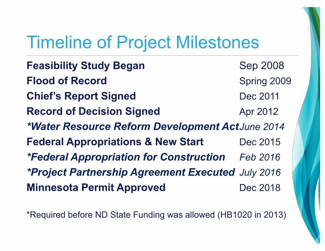
Timeline of Project MilestonesFeasibility Study Began Sep 2008Flood of Record Spring 2009Chief’s Report Signed Dec 2011Record of Decision Signed Apr 2012*Water Resource Reform Development ActJune 2014Federal Appropriations & New Start Dec 2015*Federal Appropriation for Construction Feb 2016*Project Partnership Agreement Executed July 2016Minnesota Permit Approved Dec 2018
*Required before ND State Funding was allowed (HB1020 in 2013)

Flood Protection 10 Years in the Making
►To date, $450M has been spent enhancing the flood protection in Fargo and Cass County
►20+ miles of permanent levees and flood walls have been constructed at a cost of $215M
►In Fargo and Cass County combined, 416 properties have been acquired since 2009.
►Land acquisition for federal project includes 200 parcels acquired to date, including 150 residential units
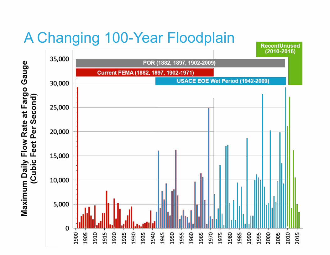
A Changing 100-Year Floodplain
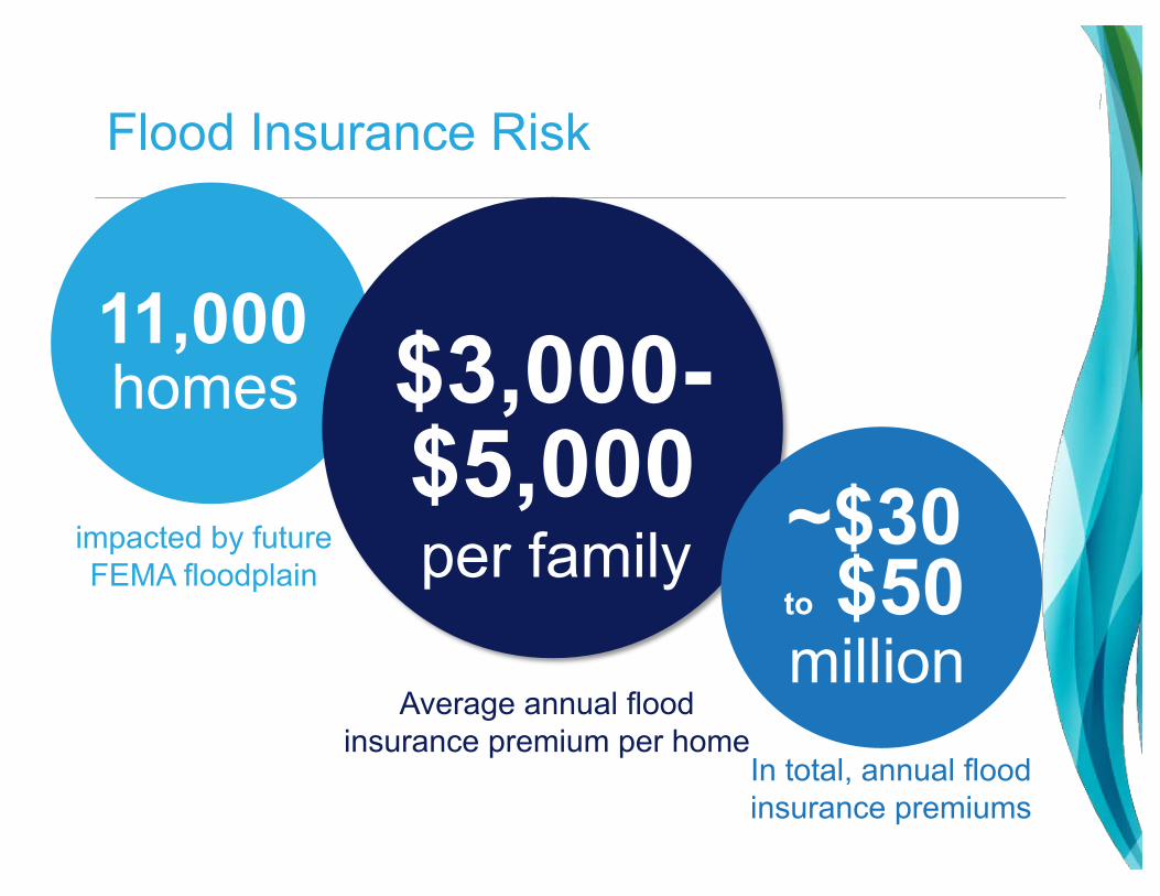
Flood Insurance Risk
11,000
impacted by future FEMA floodplain
$3,000-$5,000 ~$30
to $50million
Average annual flood insurance premium per home
In total, annual flood insurance premiums
per family
homes
Governors’ Task Force

Why did the Project change?►The Richland/Wilkin County JPA filed a lawsuit against
the U.S. Army Corps of Engineers in 2013. The lawsuit was later joined by the Fargo-Moorhead Diversion Authority and by the State of Minnesota.
►State of Minnesota denied a permit for the Project in Oct. 2016
►An injunction stopping construction was ordered in Sept., 2017
“It is time for all parties to work together to find common ground.”
- Chief Judge John A. Tunheim

Governors’ Task Force
►Governors Dayton (MN) and Burgum (ND) agreed to form and co-chair a 16-person Task Force
►Purpose►To develop design principles and concept-level engineering solutions to achieve balanced flood risk management for the Fargo-Moorhead region

Governors’ Task Force

Task Force Consensus
►Utilize full Period of Record hydrology
►100-yr flood = 33,000 CFS
►Allow control of flood water flows through town to 37-feet during a 100-yr flood event
►New Western Tie-back Levee alignment in North Dakota
►Add an Eastern Tie-back Levee alignment in Minnesota
►Distributed storage is valuable for long-term risk management; however, it is not a component of the near-term Project that needs to provide 100-year flood protection for the F-M Metro

A Changing 100-Year Floodplain
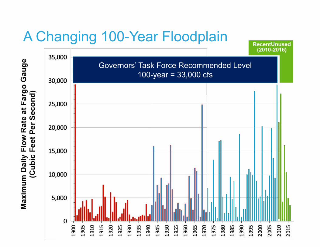
A Changing 100-Year Floodplain
Governors’ Task Force Recommended Level100-year = 33,000 cfs

2 floods
15 floods
5 floods
8 floods
3 floods
Increased flow through Fargo-Moorhead (37-feet)►Design will allow 37-feet through town (up from 35-feet)►Project will only operate 1 in 20 years, on average
Plan B

Eastern Tie-Back Levee
Limits the extent of impacts in Minnesota
►Eliminates any impacts to the City of Comstock, thus eliminating the need for a ring levee
►Eliminates the need to raise Hwy 75 or the BNSF railroad
►Impact to organic farms has been reduced nearly 90 percent from an estimated 2,900 acres to 300 acres

Revised Western Tie-Back Levee
►Shifts the western tie-back levee south and west from Horace
►Helps balance the impacts between North Dakota and Minnesota
►Reduces the impacts to Richland and Wilkin counties

Moving the Southern Embankment North
►Move the southern embankment north in balances the impacts between ND and MN
►Reduces the impacts to Richland and Wilkin counties
►Removes 4 of 11 cemeteries from the impacted area

PRE-TASK FORCE
Balanced Impacts between MN and ND
PROTECTED ACRES• ND = 47,100 • MN = 11,000
STAGING AREA ACRES• ND = 20,700 • MN = 14,800
PLAN B
ND 81%
MN19%
ND 58%
MN42%
PROTECTED ACRES• ND = 41,200
MN = 9,500
STAGING AREA ACRES• ND = 22,600 • MN = 5,400
ND 81%
MN19%
ND 81%
MN19%

Mitigating Upstream Impacts
City of Oxbow►Flood protection through the City of Oxbow has been built to mitigate
potential Project impacts
►Over 50 homes upstream have been acquired to preemptively
mitigate the impacts of operation of the Diversion Project
Kindred School District►Between 2011-2017, since Project was first announced to the public,
enrollment had increased from 665 to 758 students with a tax base
increasing from approximately $15.4M to $23.0M.
►Tax base increases were led by the City of Oxbow property valuations
increased 38 percent in 2016 and another 58 percent in 2017.

Cass County Impacts (100-yr flood)Pre-Task Force Project Impacts
Plan B Impacts Change
Staging Area Total Area (Acres)
16,290 19,802 +3,512
Staging Area Additional Area (Acres)
5,964 7,155 +1,191
Total Impacted Residential Structures in Staging Area
41 58 +17
Newly Impacted Residential Structures in Staging Area
32 42 +10

Richland County Impacts (100-yr flood)Pre-Task Force Project Impacts
Plan B Impacts Change
Staging Area Total Area (Acres)
4,387 2,783 (1,604)
Staging Area Additional Area (Acres)
1,124 596 (528)
Total Impacted Residential Structures in Staging Area
3 2 (1)
Newly Impacted Residential Structures in Staging Area
3 2 (1)

Richland County Impacts (100-yr flood)
►***********

Community OutreachPlan B Presentations and Information Distribution
►Clay, Cass, Richland, and Wilkin Counties►Cities of Fargo, Harwood, Horace, Oxbow, Reiles Acres, and
West Fargo in ND►Cities of Moorhead, Dilworth, and Comstock in MN►Townships:
►Barnes, Berlin, Harwood, Mapleton, Pleasant, Raymond, Reed, Stanley, and Wiser in ND
►Holy Cross in MN
►Buffalo Red River Watershed District►Cass County Joint Water Resource District

Listening & Gathering Input
September 2017►Gov. Burgum and Gov. Dayton meet in Moorhead to
discuss the flood protection
Governor’s Task force assembled►Five meetings between Oct. and Dec. 2017
►Wide geographic representation
Technical Advisory Group►Diversion Authority, MDNR, USACE, and
R/W JPA engineer
►Further analysis and iteration of unresolved issues from the Task Force
Policy Group►Leadership from the USACE, MDNR, Diversion
Authority, and R/W JPA
►Held four meetings

New Permit Application (Plan B)
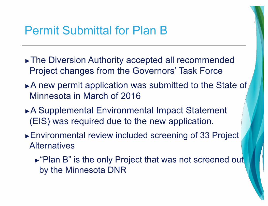
Permit Submittal for Plan B
►The Diversion Authority accepted all recommended Project changes from the Governors’ Task Force
►A new permit application was submitted to the State of Minnesota in March of 2016
►A Supplemental Environmental Impact Statement (EIS) was required due to the new application.
►Environmental review included screening of 33 Project Alternatives
►“Plan B” is the only Project that was not screened out by the Minnesota DNR

Permit Approved!
►On Dec. 27, DNR granted a Dam Safety and Public Waters for the Project, known as Plan B – which authorizes construction to commence.
►The permit includes more than 50 conditions governing project design, construction, operation, and maintenance.
►For reference: two other dam safety permits issued in Nov. 2018 included 46 and 51 conditions respectively
►Conditions were expected, even requested, by the DA to define the terms
►The DNR will have an ongoing regulatory role to ensure that the project is built and maintained properly and all mitigation is completed.

What is Plan B?►100-year Flood Protection
Minimum►Some features designed to PMF
(Probable Maximum Flood) as required by State and Federal Dam Safety Requirements
►Diversion Channel►Southern Embankment and
Control structures►Temporary Staging of Flood
Waters Upstream ►In-town Levees through
Fargo-Moorhead

Existing Conditions
►100-year floodplain shown in Blue

With Project
►100-year floodplain with project shown in Blue
►Project also gives the ability to defend against a 500-year flood
►Would require 18-20 miles of temporary clay and sandbag levees
Land Acquisition and Property Mitigation

Land Acquisition Progress
In-Town Levees ► Fargo & Mhd
► ~100 homes
► ~10 businesses
► ~30 acquired to date
Diversion Channel ► ~220 parcels impacted
► ~45 acquired to date
Southern Embankment ► ~150 parcels impacted
► ~10 acquired to date
Upstream Mitigation Area ► OHB Ring Levee
► Flowage easements
► ~750 parcels total
► ~100 residential properties
► ~20 farmsteads►~200 parcels acquired to date
►~150 residential units mitigated to date (includes 120 residents in Park East Apartment Building)
Property Rights needed for Project Construction & Operation

Land AcquisitionParcels impacted by footprint of the Diversion Channel and Southern Embankment
Approximately 8,000 acres needed for Project Construction

Table of Contents
Property Rights Acquisition and Mitigation Plan
►The 115-page Plan was drafted in coordination with U.S. Army Corps and in consultation with the ND State Water Commission and the MN Department of Natural Resources
►The comprehensive Plan details the approach and process for property acquisitions and the methods to mitigate property impacts
• Property Acquisition Philosophies
• Typical Property Acquisition Process
• Appraisal Review Plan
• Offer Presentation and Negotiation Process
• Property Rights Map
• Property Acquisition Schedule
• Early Property Acquisition Program
• Organic Farmland Acquisition Plan
• Disposal of Excess Property
• Mitigation of Properties Upstream
• USACE/FEMA Coordination Plan
• Flowage Easement Plan
• Sample Flowage Easement
• Dispute Resolution Board
• Cemetery Mitigation Plan
• Mitigation of Historic Places
• Post-Operation Debris Clean-Up Plan: Private Lands
• Post-Operation Repair and Clean-Up Plan: Public Lands
• Summer Operation Supplemental Crop Loss Program
• Financial Assurance Plan for O&M, On-going Mitigation
• Mitigation Communications Plan
• Oxbow-Hickson-Bakke Mitigation Project
• In-Town Levee Mitigation Projects
• Pre-PPA Medical Hardship Acquisition Program

Property Acquisition Process
►Property rights determined by project design
►Valuation determined by Appraisal following state law
►Property Owners receive: ►‘Just Compensation’ = payment for real estate
►‘Relocation Benefits’ = moving, relocation, re-establishment
►~200 acquired to date►Mostly satisfied with process and result
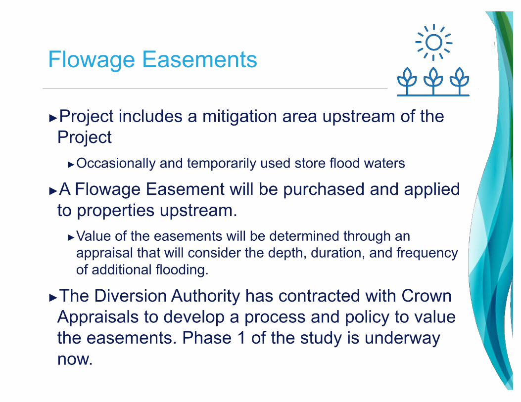
Flowage Easements
►Project includes a mitigation area upstream of the Project
►Occasionally and temporarily used store flood waters
►A Flowage Easement will be purchased and applied to properties upstream.
►Value of the easements will be determined through an appraisal that will consider the depth, duration, and frequency of additional flooding.
►The Diversion Authority has contracted with Crown Appraisals to develop a process and policy to value the easements. Phase 1 of the study is underway now.

Post-Operation Clean-Up Programs
►Concern from producers about debris and damage left after Project Operation
►Operation anticipated ~20-year return frequency►Flowage easements compensate landowners for impacts
associated with the Project ►Project may cause debris to accumulate within the
upstream mitigation area, impacting producers►Diversion Authority developed a post-operation debris
clean-up plans for both private property and public properties
►Private Property plan is mirrored after clean-up week►Public Property plan is mirrored after FEMA disaster assistance
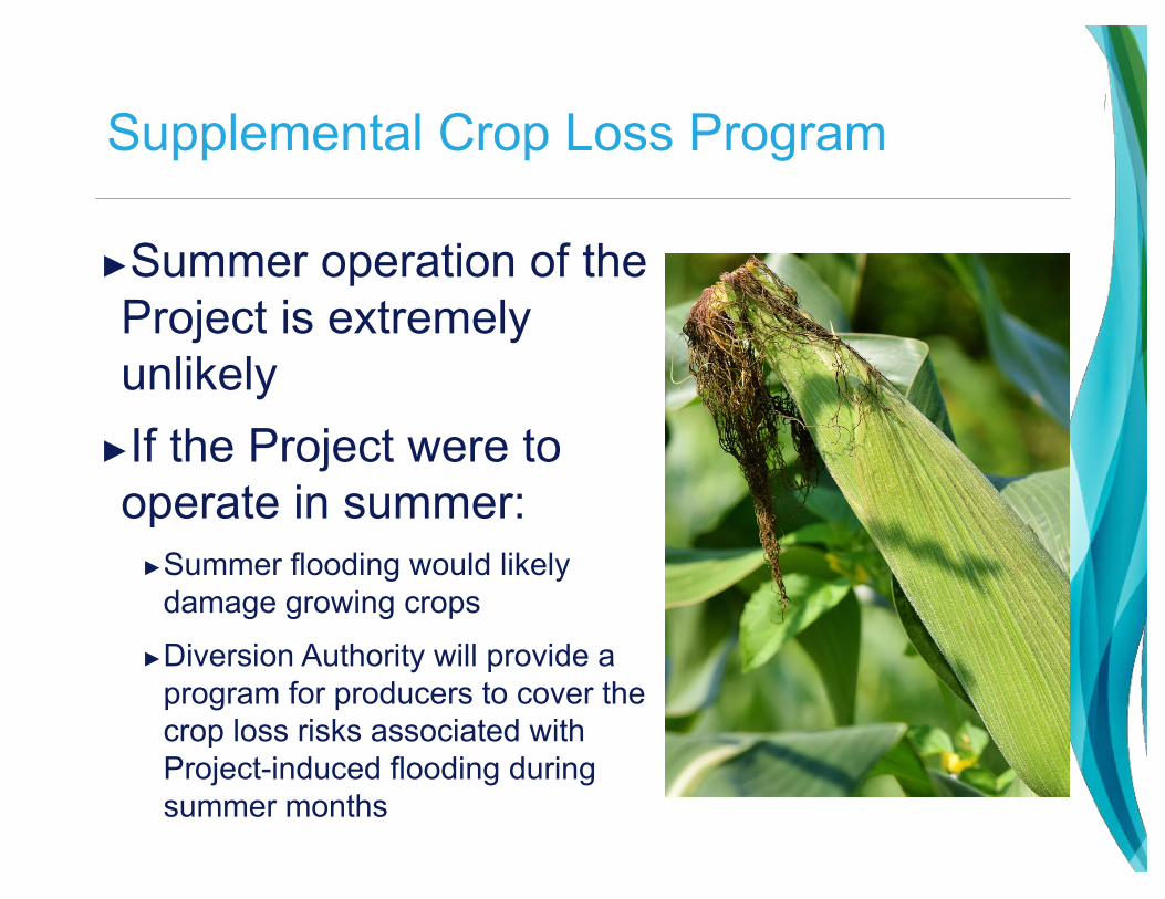
Supplemental Crop Loss Program
►Summer operation of the Project is extremely unlikely
►If the Project were to operate in summer:
►Summer flooding would likely damage growing crops
►Diversion Authority will provide a program for producers to cover the crop loss risks associated with Project-induced flooding during summer months

Cemeteries
►There are 5 cemeteries upstream of the Project that may be impacted at varying levels during major floods due to operation of the Project
►Plan B reduced the impacted cemeteries from 11 to 5
►Additionally, there are 21 cemeteries that currently flood that will now have improved flood protection due to the Project
►Flowage easement will be purchase from each cemetery
►Potential additional mitigation for each site will be reviewed and discussed with each cemetery after completion of environmental and permitting review

Dispute Resolution Board
►Administrative program for properties that believe they are impacted by Project, but do not receive direct mitigation
►Modeled after a similar process created by the NDSWC for the Devils Lake outlet project
►Allows a forum for property owners to file claims and an independent and fair process to determine damages from the Project
►Avoids expensive legal action

Diversion Project Financial Overview

Current opinion of estimated cost is $2.75B in 2018 dollars
43

Costs Include USACE, Diversion Authority, Fargo, and Moorhead flood mitigation projects
Category
Base Cost
Contingency and Risk/
Opportunity
Current Opinion ofEstimated
CostLands/Impacted Properties Mitigation $466 $36 $502
Channel / P3 $979 $10 $989
USACE / SEAI $585 $118 $703
Fargo and Moorhead In-Town Projects $240 $26 $266
Other/Mitigation Construction $44 -- $44
Non-Construction Costs* $185 $65 $250
TOTAL $2,499 $255 $2,754
44
*Legal/Financial/Designs/Studies/Procurement/PgM/CM/General Contingency

Lands and impacted property mitigation = $502M
► Mitigation of Impacted Properties
► Acquisition of Property Rights► Buyouts
► Flowage Easements
► Business and Residential Relocations
45

Channel/P3 = $989M
►Channel / P3► Channel
► Highway Crossings
► Railroad Crossings
► Aqueducts
► Drain Inlets
► Utility Relocations
► Outlet
46

Southern Embankment/USACE Projects = $703M
►USACE Projects
► Southern Embankment
► Control Structures
► I-29 and Other Road Raises
► Environmental Mitigation Projects
47

Fargo and Moorhead In-Town projects = $266M
►Projects to Accommodate Increased Flows Through Town (River Stage 37 ft.)
► City of Fargo
► City of Moorhead
► Cass County Road Raises
► Clay County Road Raises
►City of Fargo Comprehensive Flood Control Plan Projects
48

Non-Construction costs = $250M
► Studies► Design► Procurement► Legal► Financial► Program Management► Construction
Management► General Contingency
49
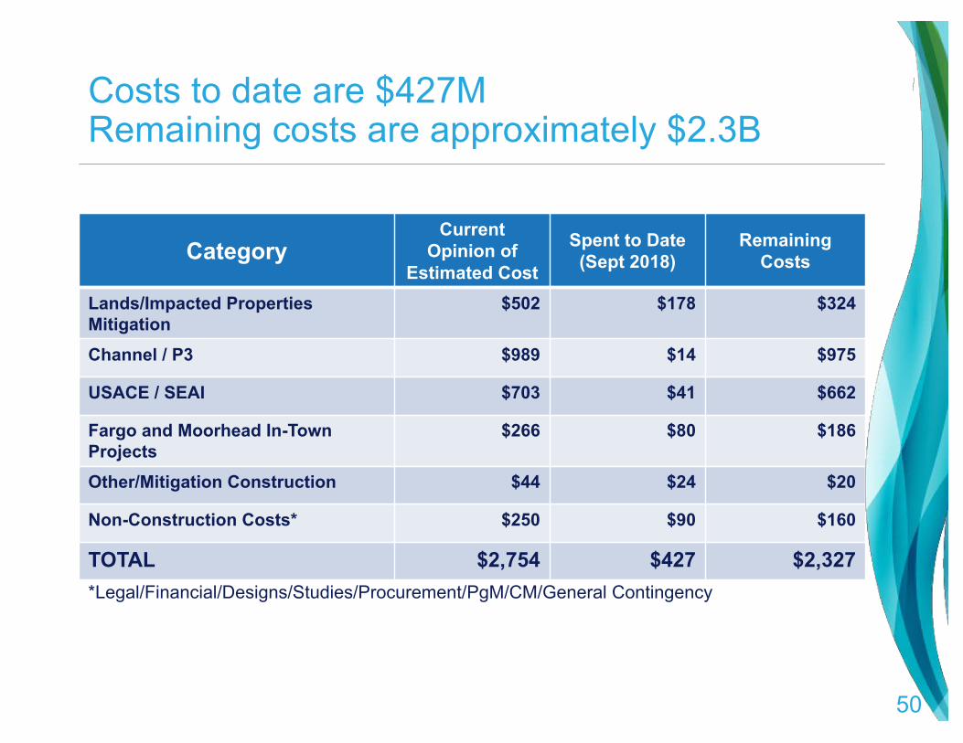
Costs to date are $427MRemaining costs are approximately $2.3B
CategoryCurrent
Opinion of Estimated Cost
Spent to Date (Sept 2018)
Remaining Costs
Lands/Impacted Properties Mitigation
$502 $178 $324
Channel / P3 $989 $14 $975
USACE / SEAI $703 $41 $662
Fargo and Moorhead In-Town Projects
$266 $80 $186
Other/Mitigation Construction $44 $24 $20
Non-Construction Costs* $250 $90 $160
TOTAL $2,754 $427 $2,327
50
*Legal/Financial/Designs/Studies/Procurement/PgM/CM/General Contingency
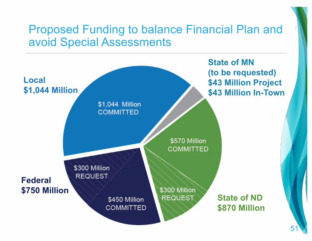
Proposed Funding to balance Financial Plan and avoid Special Assessments
Local$1,044 Million
State of MN(to be requested)$43 Million Project$43 Million In-Town
State of ND$870 Million
Federal$750 Million
51

Local Funding Summary►Local funding makes up over 50% of the
proposed Non-Federal share►Voters approved sales tax extensions until 2084►Sales tax used to fund
local share of Project►~$42M in collections / year
►$725M assessment district also approved as a financing tool, not for capital expenditures
2016 Sales Tax Election Results

Federal Funding Summary
►Federal funding to date = $127 Million
►$35 Million included in 2018 USACE Work Plan
►Current federal commitment = $479 Million
►Total funding commitment increases with inflation
►Additional federal request = $300 Million

Minnesota Funding ►Minnesota has appropriated $130M for flood protection
locally to date, ►Clay County and Moorhead, as members of the Diversion Authority,
have agreed to request additional funding for the Diversion Project.
►Minnesota does not allow for funding requests prior to approvals being granted for the Project itself, but the legislature is aware of the needs
► It had been discussed previously that the Minnesota share of the Diversion Project would be 2% of the costs
►Future funding request for Diversion Project and other in-town totals $86M

ND Funding Summary►Current legislative intent for $570M for flood protection funding ►Additional $300M being requested ($166.5M in 2019)
Year Amount 2009 $45 M2011 $30 M2013 $100 M2015 $129 M2017 $66.5 M2019 $66.5 M $100 M2021 $66.5 M $100 M2023 $66.5 M $100 M

DO WE NEED A SLIDE LIKE THIS??

Questions?
FMDiversion.com@FMDiversion
Copyright © 2022 FDOKUMEN