Irelease - DTIC
195
DOCUMENTS IR NO. 67-77 INFORMAL REPORT OCEANOGRAPHIC DATA REPORT SAN CLEMENTE ISLAND AREA OCTOBER TO DECEMBER 1966 cm ROBERT K. OSER JAMES L BERGER LOUIS J. FRANC 0) Bottor Environmental Surveys Projec Developmental Surveys Division Oceanographic Surveys Department LIBRARY 0 0 JUL 22 1971 0 SEPTEMBER 1967 I). S. NAVAL ACADE,, EThIs docurnent has been approved for public Irelease and sale; its distribution is unlimited. .,wo o Best Available Copy NAVAL OCEANOGRAPHIC OFFICEBetAalbeC p WASHINGTON, D. C. 20390 7
-
Upload
khangminh22 -
Category
Documents
-
view
0 -
download
0
Transcript of Irelease - DTIC
DOCUMENTS
IR NO. 67-77
INFORMAL REPORT
OCEANOGRAPHIC DATA REPORTSAN CLEMENTE ISLAND AREAOCTOBER TO DECEMBER 1966 cm
ROBERT K. OSERJAMES L BERGERLOUIS J. FRANC 0)
Bottor Environmental Surveys Projec
Developmental Surveys DivisionOceanographic Surveys Department
LIBRARY 00JUL 22 1971 0
SEPTEMBER 1967I). S. NAVAL ACADE,,
EThIs docurnent has been approved for publicIrelease and sale; its distribution is unlimited.
.,wo o Best Available CopyNAVAL OCEANOGRAPHIC OFFICEBetAalbeC p
WASHINGTON, D. C. 20390
7

INFORMAL REPORT
The Informal Report (IR) as produced at the Naval Oceanographic Officeis a means for personnel to issue timely scientific and technical preliminaryreports of their investigations. These are primarily informal documentsused to report preliminary findings or useful byproducts of investigationsand work to members of the scientific and industrial communities.
Informal Reports are assigned sequential numbers for each calendar year;the digits preceding the dash indicate the year.
The distribution made of this report is determined primarily by the author.Information concerning obtaining additional copies or being placed on adistribution list for all future Informal Reports in a given area of interestor specialty field, should be obtained from:
Distribution Control DepartmentCode 4420Naval Oceanographic OfficeWashington, D. C. 20390

ABSTRACT'
This report presents sediment, deep towed profiler, physicaloceanography, visibility, and current data collected in the SanClemente Island Test Range from October to December 1966 aboardthe USNS DAVIS (T-AGOR 5). The sediments vary in size from claysto sand and the bearing strength ranges from 0.8 g/ca2 near thetops of several cores to 58.7 g/cm2 for near the bottom of one ofthe longer cores (80 - 87cm interval). The deep towed profilertraces show hillocks six feet in height and subbottom reflectinglayers from 3 to 50 feet below the sediment surface. Sea watertemperature values range from 18.50C at the surface to 2.850C at1483 meters depth in San Clemente Basin. M nimum sound velocityvalues for the area occur between 700 and 800 meters depth. Alphavalues for the water column range from 0.03 ln/m (150-200 metersdepth) to 0.28 ln/m (30-40 meters depth). This wepresents visi-bility ranges from about 130 meters to 14 meters respectively.Tidal forces appear to exert an influence on the current regimeto the greatest depth measured (1829 meters). Current speeds forthe water colun range from zero to about 1.5 knots with rotarydirection vectors. Instrumentation development pertinent to thesurvey is also discussed. Conclusions reached -in this reportare tentative based on the limited amount of survey data avail-able. More seasonal investigations of the currents, temperature,and visibility, and more detailed measurements of sea floor topo-graphy and sediments are essential in order to clearly define theoceanographic environment.
This Manuscript has been reviewed an is approved for releaseas an UNCLASSIFIED Informal Report.
4= d C. ByrnesDirectorDevelopmental Surveys Division
i

CONTENTSPage
. INTRODUCTION , . , * . .. . . . . . . . 1
II. GEOLOGY * * . * * * . * * . 4 * * . . * * * . . . . . . .0 .@ 5
III. PHYSICAL OCEANOGRAPHY . . . . . . . . ........ 24
IV. CURRENTS * .* . . . . . . . . . . . . . . . . . . . . . . . 43
V. INSTRUMENTATION DEVELOPMENT . . . . . . . . . . . . . . . . . . 52
VI. REFERENCES * . . * . . . . . . . . . . . . . . . . . . . . . .w 56
FIGURES
1. USNS CHARLES H. DAVIS (T-AGOR 5) ............... 3
2. Bathymetry of the Continental Borderland * * . . . . . . . . 4
3. Station Locations - Area I......* .. , . * . . . . . . 6
4. Cross Sectious through Dme- AreaI *......... . . 8
5. Station Locations and Bathymetry- Area II . . . . . . * 9
6. Pinger Record- Core 14 . .. .. ... .. .. .. . . 11
7. Nomenclature of Sediment Types - Areas I and II . . . . . . . . 12
8. Isopleths-Median Diameters of Surface Sediments - Area I . . . 13
9. DTP Record - Subbottom Strata - Base of Scarp . , . . . * . . . 14
10o Bearing Strength versus Depth - Typical Cores o . . , . , . . . 17
11o Deep Towed High Resolution Profiler (DTP). . . . . . . . . . . . 18
12. DTP Track Chart ......... . . . . . . . . . . . . . . . 19
13. DTP Record - Southeast Flank of Dome . . o . . . . . . . . . . . 21
14. DTP Record - Northeast Flank of Dome 0 . . o . . 0 . . . . . . o 22
15. DTP Record- San Clemente Escarpment ............. . 23
16. Typical Temperature Profiles - Area I . . . . . . . . . . * . 0 26
17. Typical Sound Velocity Profiles - Area I . . . . . . . . . . . . 27
iBest Available Copy

FIGURES (CONTINUED)Page
18. Transmissometer Stations- Area I .*, , *... *. .,. 29
19. Maximum Visibility (in/m) - Area I . . . . . . . . . . . . . 30
20. Surface Visibility (ln/m) -AreaI ......... .1 .. 31
21. Bottom Visibility (ln/m) -Area I ......... .. ... 32
22. Minimum Visibility Layer - 30 to 40 meter depth - Area I . • 33
23. Alpha versus Depth- Stations 1B and 1D. ..... . .. 34
24. Alpha versus Depth - Stations 4A and 4C. .# * a o . • . • . 35
25. Alpha versus Depth - Station 4E.. . . . . . . . . . . . . . 36
26. Alpha versus Depth - Stations 5D and 5G. . • . . . .a a a 37
27. Alpha versus Depth- Stations 7B ad 7E. ........... 38
28. Alpha versus Depth- Stations 9A and 9D .......... . 39
29. Alpha versus Depth-Station 10A-AreaII ........1. 40
30. Sites - Current Observations . . . . . . . . . . . . . . . . . 44
31. Current Meter Depths . . . . . . . . . . . . . . . . . . . . . 46
32. Typical Current Meter Array .................. 47
33. Bottom Mounted Camera System o . . . . . . . . . . . . . . . . 55
APPENDIXES
Ao PHYSICAL OCEANOGRAP DATA .. .. .. ...... 57
B, CURRENT DATA . . . . . . . . . . . . . . . . . .o s . 103
C. GLOSSARY OF OCEANOGRAPHIC TERMS .... ......... 149
PLATES
I. C6GS 1206N-15 - Santa Barbara to Huntington Beach . . * , Back Cover
TABLES
I. Current Meter Depth List and Observation Period . . . * . . . 45
iii
I. INTRODUCTION
General
From October to December 1966, the Bottom Environmental Survey Project
(BESP) of the Naval Oceanographic Office (NAVOCEANO) conducted an oceano-
graphic environmental survey in the vicinity of San Clemente Island. The
purpose of the survey was to obtain oceanographic information for the sup-
port of the Deep Submergence Systems Program (DSSP).
Messrs, R. K. Oser and R. P. Kopenski were NAVOCEANO Project Leaders.
They were assisted by Messrs. 3. H. Rohrhirsch, J. Frankel, R. S. Rushton,
K. M. Olson, M. G. Fagot, J. L. Berger, M. Car, J, D. Hawes, We Carriker,
and A. R. Mooney.
Operations
The survey was conducted aboard USNS CHARLES H. DAVIS (T-AGOR 5)
(Figure 1) from 11 October to 12 December 1966. Observations were made in
two areas designated Area I and Area II. Area I borders the northeast
side of San Clemente Island and Area II, about 12 miles square, is located
in the San Clemente Basin (Figure 2). The observations and instrument
tests made were as follows:
64 Kullenberg and Boomerang Cores
35 Ramsay probes (temperature, sound velocity, depth)
9 Nansen casts
6 Taut-wire current meter sites (arrays)
52 Miles of Deep Towed Profiler (DTP) track

18 Camera/visibility lowerings (36 hours). Results to be published
separately.
13 Transmissometer lowerings
1 Bottom transmissometer drift (5 miles)
9 K-Meter lowerings
1 Test lowering of 16-inch diameter Coming glass spheres to 560fathoms
1 Test firing of IEC explostve cutter on 9/16 inch diameter nylonline at 40-foot depth
1 Test firing of EEC explosive cutter on 1/2 inch wire cable at3900-foot depth
Data
Original records for most of the data are retained by NAVOCEANO. Trans-
missometer lowerings, K-meter, and bottom transmissometer drift data are
retained by the Naval Undersea Warfare Center (NUWC), Pasadena, California.
Copies of the transmissometer data were given to the NAVOCEANO Project
Leaders after completion of the survey.
2

01.
A C,
Ir
AW

121* 120* 119, 1B 117"35* - 15*
A ~ ~~ , 'SANTA -ANICA T-SNA*,E A~
34-A. ~ ~ LOS ANGELES 34-
/ 6-N
33* 33' o A'
ASAN
121. 120' 119, lie 1
FIGURE 2. BATHYMETRY OF THE CONTINENTAL BORDERLAND.
4

II. GEOLOGY
General
The great majority of the world's continental land masses are bordered
by gently sloping marine terraces termed continental shelves. These shelves
encompass the area from the low water tidal mark seaward as much as 200 miles
to the edge of the steep continental slope. Continental shelves are gener-
ally relatively flat features exhibiting only minor relief. In the vicinity
of San Clemente Island and off the southern California coast, this is not
the case. Here the shelf has a complex topography consisting of deep basins
and high, steep-walled blocks (Figure 2).
To distinguish the physiography of this marine basin and range province,
which is topographically similar more to the contiguous land area than to
the continental shelf it represents, the term "continental borderland" has
been applied by Shepard and Emery (1941). The borderland extends seaward
approximately 140 miles and is terminated by the steep Patton Escarpment
which slopes down to the Pacific Basin. The northern limit of the contin-
ental borderland is near Point Conception, California. North of the Point,
the shelf is typically flat. The borderland area consists of a series of
northwest-southeast striking islands, ridges, basins, and troughs that are
truncated by steep, rocky fault escarpments.
Geomorpho loy
Area I is adjacent to the northeast side of San Clemente Island and
consists of three distinct geomorphic features - the southern part of the
Santa Catalina Basin. a prominent subsurface dome, and the San Clemente
Escarpment (Figure 3). The basin is a structual feature bounded on the
north and south by the steep fault scarps adjacent to San Clemente and
5

C O20
IX 05 .24 11.
3X0 40*2
0 .50
20 46 -2
2z 46
3[2 .425
are
N.
4 24
1000
!IV lir1cp "I
FIUE3\TTO LCTOS-RA1
6~00

Santa Catalina Islands (Plate I). The basin is relatively flat because of
filling and leveling by organic debris and by clastic sediments borne out-
ward from the mainland. In Area I the basin has a maximum depth of about
700 fathoms. Approximately 8 miles northeast of San Clemente Island, a
prominent near circular, subsurface dome disrupts the otherwise nearly flat
basin plain. The structure is approximately 8 miles across at its base
and rises at an average gradient of 40 from a maximum depth of boo fathoms
to a minimum depth of 394 fathoms (Figures 3 and 4). The San Clemente fault
scarp which forms the steep northeast slope of the island continues from
sea level to the basin floor. This rocky linear feature has an average
gradient of about 170 along its island portion.
Area II is located within the confines of San Clemente Basin which is
situated between 15 and 70 miles southeast of San Clemente Island. This
basin is considerably deeper than the Santa Catalina Basin (Figure 5). The
marked difference in depth is a function of the availability of terrigenously
derived sediments. The eastern side of San Clemente Basin is bordered by
Forty Mile Bank which rises to within 43 fathoms of the surface. This topo-
graphic high serves as an effective block to the sediments derived from the
mainland. Because of Vie relative paucity of detrital material, the floor
of San Clemente Basin is deep and irregular.
Sediment .haracteristics
According to Emery (1952) the groups of shelf sediments found within
the continental borderland off southern California are:
a. Authigenic - Composed of glauconite and phosphorite
b. Organic - Consisting of foraminifera tests and shells
c. Residual - Consisting of material weathered from underlyingrock
7

FEET
__0_ 0
I I T TN
FEET
t j
00
oL--- I
c4
m go
N4 OR wCDC
100
CD
00
o Po
:jFATHOMVSFATHOMS
m 3 -.4J.__
CFATHOM-4

10' 05 1rws-20
CLE SAN 57DEPTH IN FATHOMS 316CLM NT, IS.
400
0400 300--
la
00
"0 43'
30
"005
660
6 302
too 009
0000
3rA(HANSENI CAS
1524 20 10530,057 00
FIUR05 0TTO LOATON ANDIN BAHMTYAEE 11
979
d. Relict - Consisting of sedimentary remnants from an earliergeologic environment
e. Detrital - Consisting of clastic sediments derived from river
mouths, beaches, and sea cliffs
Of these five sources, Revelle and Shepard (1939) have indicated that sedi-
ments of stream derivation are the most important source of depositional
material in the continental borderland. During periods of flooding, streams
and rivers of southern California carry sediments to the sea. Ocean currents
then disperse the sediments over the borderland. Topographic highs of the
borderland are swept free of fine sediment by ocean currents.
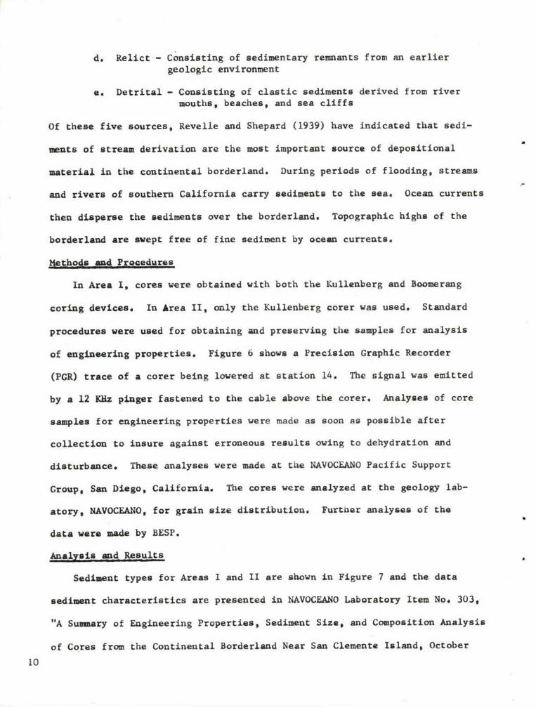
Mpt:hds and Procedures
In Area I, cores were obtained with both the Kullenberg and Boomerang
coring devices. In Area II, only the Kullenberg corer was used. Standard
procedures were used for obtaining and preserving the samples for analysis
of engineering properties. Figure 6 shows a Precision Graphic Recorder
(PGR) trace of a corer being lowered at station 14. The signal was emitted
by a 12 KRz pinger fastened to the cable above the corer. Analyses of core
samples for engineering properties were made as soon as possible after
collection to insure against erroneous results owing to dehydration and
disturbance. These analyses were made at the NAVOCEANO Pacific Support
Group, San Diego, California. The cores were analyzed at the geology lab-
story, HAVOCEANO, for grain size distribution. Further analyses of the
data were made by BESP.
Analysis and Results
Sediment types for Areas I and II are shown in Figure 7 and the data
sediment characteristics are presented in NAVOCEANO Laboratory Item No, 303,
"A Summary of Engineering Properties, Sediment Size, and Composition Analysis
of Cores from the Continental Borderland Near San Clemente Island, October
10

-- olON20 fathoms FOTTOM." ' SHUT OFF
; BOTTOM
a'8"c o.r
.4w4.4
DEPTH,679 FATHOMS CORER
FIGURE 6. PINGER RECORD-CORE 14. 11

100 0
clay080 20
0
A sandy silty
A Clay clay
o •
00
50 50$0
o0
o sand 0 a
clay 0
clayeyclayey20 sad 0 0silt
80
sand silty sand sandy silt silt
0 100100 80 50 20 o
O/o SAND CONTENT
o Area I basin sediments* Area I scarp and dome sediments0 Area II basin sediments
FIGURE 7. NOMENCLATURE OF SEDIMENT TYPES-AREAS I AND II.
( After Shepard, 19541, p.157)
12

11W. fir 11 "r lir u 1 w
go-
4,0 30
1000
3 _________ __7,4
.3.3
1966-December 19bb. The types of sediments (Figure 7) are based only on
analyses of cores obtained during the survey.
The San Clemente Island scarp is mantled by a sand and gravel veneer
with interstitial silt and clay. The sediment is predominately residual
although aerial erosion of the island and shells of marine organisms have
contributed significantly to the material. Figure 8 shows median diameter
contours in microns of the surface sediments in Area I. The high concen-
tration of coarse sediments along the eastward flank of the island occurs
along the highest and steepest part of the island scarp. It is likely that
the tongue of coarse material which extends from the water line outward onto
the basin floor is a function of subaerial erosion of the island scarp.
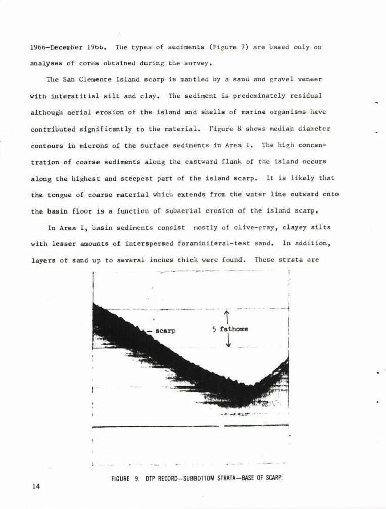
In Area I, basin sediments consist mostly of olive-gray, clayey silts
with lesser amounts of interspersed foraminiferal-test sand. In addition,
layers of sand up to several inches thick were found. These strata are
-1
a cap5 fathoms
FIGURE 9. DTP RECORD-SUBBOTTOM STRATA-BASE OF SCARP.14

attributed to sediment slumping and/or turbidity currents that were initiated
on the steep island scarp and subsurface dome. The material at the bottom
of the slope has settled out as a function of density. The depositional
sequence began with sand on the bottom, grading upward to silts and clays.
Figure 9 shows several of the sand strata at the base of the San Clemente
s carp.
The sediment on the dome differs substantially from the material on
the adjacent basin floor. Above the 500 fathom contour, the samples were
predominately sand with lesser amounts of gravel, silt# and clay. This
was substantiated in Area I, where extensive coring attempts on the escarp-
ment and dome yielded small quantities of sediment, and by the core cutters
that were scored as a result of hitting rock. The topographic lows, and
in particular the basins of the area, are the recipients of the finer clas-
tics. The submerged topographic highs are mantled with coarser residual
and relict sediments.
In Area II, sediments consist of olive-gray, silty-clay with only traces
of foraminiferal sand. Laboratory analysis has shown the CaCO3 constitutes
from 13 to 48 percent of the sample weight. Traces of mica were also found.
Enxineering Properties
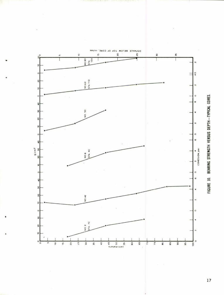
Bearing strength of sediments is defined as the average load per unit
area (grams per square centimeter) required to produce failure, by rupture.
of the supporting sediment mass. The uppermost bearing strength tests
(vane shear) were usually conducted at the 15-centimeter core depth. The
;ediment above this level was usually of a fluid consistency and could not
accurately be analyzed for bearing strength.
15

In Area I the sediment bearing strength values for the 15-22cm core in-
terval range from 5.0 to 38.7 g/cm2 with an average value of about 9 g/cm 2.
The dome appears to consist of rock outcrops and sand which would have a
higher bearing capacity than the basin floor sediments. Samples obtained
near the top of the dome and on the scarp consisted of small amounts of un-
consolidated sand. No engineering tests were made on these samples. In
Area II the values range from 0.8 to 22.0 g/cm2 for the 15-22cm interval
with an average value of about 7 g/cm2. The overall strength of the sedi-
ments increases almost linearly from top to bottom of the cores. The
strengths average 28 g/c=2 in Area I and 19 g/cM2 in Area II for the 65-72
core interval. Figure 10 shows plots of bearing strength versus core inter-
val for six typical core samples of Areas I and II.
The average length of cores from the basin in Area I was less than that
of cores from Area II. This was attributed to the presence of a very dry
and dense sediment layer occurring at various depths within the sediments
in Area I. The extreme hardness of the layer was such that a 425 pound corer,
falling at terminal velocity, failed to penetrate the layer more than sev-
eral inches in most instances.
An important feature of the engineering properties of sediments is sensi-
tivity. Sensitivity is defined as the ratio of the natural strength of a
sample to the remolded (disturbed) strength of sample. The average sensi-
tivity of the core samples was about 2.U which indicates that the sediment
when disturbed and remolded lost about 50 percent of its original undisturbed
strength. Sensitivity values range from 1.1 to 24.8 with most values grouped
near 2.0 (NAVOCEANO Lab. No. 303).
High Resolution Profiling
A Deep Towed Profiler (Figure 11) which was designed in-house (NAVOCEANO
16 IM NO. 67-12) was towed in Area I as shown in Figure 12. Records obtained
SA-Q3u' '3OO 40 dOl M01313 3:NVISIO
0
00
o 0
00 wi7
0
0.0
0- 0C*
ac
z u0
_ _ _ _ _ _r__ _
900
0 0
0~0
0 6
s,jDw, ua3
17

low impedancen&Conductor cable
transformerpassive -.--,battery packtransducep
activepower transducersupply
amplifier
pinger-driver

lie- 35 fil- tv lie w itsi. Is' ife Id
- - m SEE FIG. 14
500500 DEEP TOWED VEHICLE TR! CKS
W 00'
.00
SE 15
7 19

while towing the DTP across the dome showed a relatively smooth bottom with
no subbottom reflectors above the 500 fathom contour. Near the top, small
hills are superimposed on the dome. These features are 6 to 50 feet in
height and were detected only near the top of the dome. Traces of the bottom
below the 500-fathom isobath of the dome and the basin floor show a generally
smooth bottom with from one to three subbottom reflecting layers. These
reflectors occur between 3 and 50 feet below the sediment surface.
Small hillocks are shown in Figure 13. These hillocks which are on the
southeast flank of the dome are approximately 12 feet high and are 400 feet
long. The bottom shown to the left of the hillocks has a subbottom reflect-
ing layer several feet below the sediment surface. The hillocks appear to
have no stratification and are probably rock outcrops. The bottom in Figure
14 on the northeast flank of the dome shows substantially more subbottom
stratification than on the southeast flank. The signal penetrated the
bottom to depths in excess of 30 feet. Two strong subbottom sonic reflecting
layers, their thicknesses, and changes in slope are shown.
The sharply defined bottom trace shown in Figure 15 was obtained while
towing the fish up the San Clemente Island escarpment. Here the bottom is
composed of solid rock with a veneer of fine material. Near the bottom of
the escarpment approximately six, thin reflectors are present (Figure 9).
These strata are a result of sediment slumping and/or turbidity currents
that initiated on the escarpment.
20

- e -
i I
LLJ
I-l
ww
C=
700
iI..... i
95 FATHOMS
21

.... $ OH.LV.- g6e .
7 1
I 4
-r
m
22

i AV
uii
ui toLJ
C9U
I LAJ
0-0
CD,
-JA
IrZ
-95 FATHOMS
23
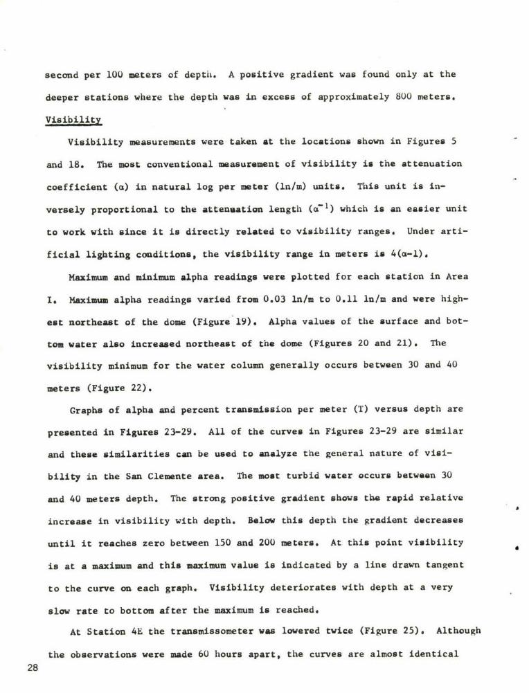
III. PHYSICAL OCEANOGRAPHY
General
Numerous oceanographic investigations have been made of the continental
borderland. A brief summary of sea surface temperatures and salinities in
the vicinity of Areas I and II are as follows:
Jan a Au& Nov
Mean Temperature (OC) 14.4 15.6 18.3 16.7
Mean Salinity (U/UU) 33.5 33.5 33,5 34.0
In addition, average monthly wind, sea, and swell data conditions are
listed in Appendix A, The area is apparently characterized by small seasonal
excursions of temperature and salinity. Results similar to those obtained
from this survey were obtained by NAVOCEANO during a survey in September and
October 1965 of the area between San Clemente and San Nicolas Islands (report
in preparation). Sound velocity profiles were similar; however, time series
observations indicated variations of as much as 1.5 m/sec during a 24-hour
period.
Methods and Procedures
Temperature, salinity, sound velocity, and visibility data were obtained
in Areas I and II.
Temperature and salinity data were taken by standard Nansen casts at 7
stations in Area I and at 2 stations in Area II. The Nansen cast data in
Area I were taken concurrently with the Ramsay Probe to confirm the sound
velocity-temperature data.
Temperatures and sound velocities were measured at 35 stations in Area I.
These data were obtained with a Ramsay, Mark-l, Deep-Sea Probe. The probe
24

is battery powered, frequency modulated, automatic digital recording, temp-
erature and sound velocity measuring instrument.
Visibility data were measured at 13 stations with a prototype trans-
missometer constructed by Scripps Institution of Oceanography, La Jolla,
California. The transmissometer has a folded beau, 2-mter water path, and
gives a continuous analog trace of the coefficient of attenuation of light
with depth, in natural log units per meter (lu/m).
Analysis and Results
The thermal structure of the waters off San Clemente Island was very
stable during the survey period. Spatially the isotherms in the area varied
little with depth as indicated by comparative datafor stations shown in
Figures 4 and 16. An isothermal layer, 170 to 18 0 C, was found from the sur-
face to approximately 30 or 40 meters. At this depth a relatively sharp
negative gradient occurred with an average temperature drop of 5*C per 35
meters (Figure 16). Below the thermocline, the negative gradient decreased
to an almost linear rate of about 10C per 125 meters. At station 6A the
probe was placed on the bottom at 923 meters (504 fathoms), where a minimum
temperature of 4.580 C was recorded.
Sound Velocity
Because the sound velocity characteristics of a water mass are chiefly
a function of thermal characteristics, the sound velocity profiles in the
area closely resemble those of the temperature profiles (Figure 17). An
isovelocity condition of 1,516 to 1,517 m/sec., exists from the surface to
depths of 30 or 40 meters. At this depth a sharp negative gradient occurred
which was similar to that of the temperature profiles. Below the steep grad-
ient, the sound velocity decreased at a rate of approximately 1 meter per
25

DEPTH (METERS)
-0
• . , .. . . . , . . . . . . . . . . . . . . .
............
C C
0..................................
-.- o
CCn
-4-
mm
-U m
0 "'
-4
€3
DEPTH (FEET)
26

DEPTH (FEET)
oLdi
00
ui
Iz
1cn
00cnJ
IaJX
a.) z
.. .. .. . ..... .
9---
Lni
g g
..........0
4
o, I I _ _ _ _ _ _ _ _ _ _ _ _
DEPTH (METERS)
27
second per 100 meters of depth. A positive gradient was found only at the
deeper stations where the depth was in excess of approximately 800 meters.
Visibility
Visibility measurements were taken at the locations shown in Figures 5
and 18. The most conventional measurement of visibility is the attenuation
coefficient (a) in natural log per meter (ln/m) units. This unit is in-
versely proportional to the attenuation length (a71 ) which is an easier unit
to work with since it is directly related to visibility ranges. Under arti-
ficial lighting conditions, the visibility range in meters is 4(a-l).
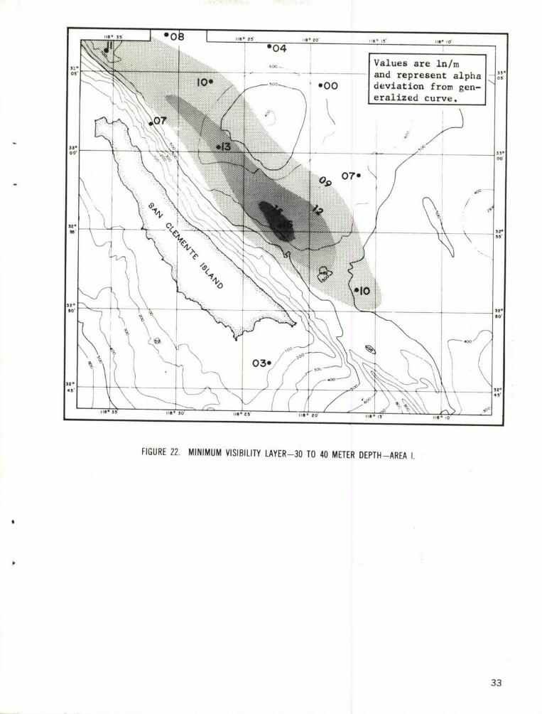
Maximum and minimum alpha readings were plotted for each station in Area
I. Maximum alpha readings varied from 0.03 ln/m to 0.11 ln/m and were high-
est northeast of the dome (Figure 19). Alpha values of the surface and bot-
tom water also increased northeast of the dome (Figures 20 and 21). The
visibility minimum for the water column generally occurs between 30 and 40
meters (Figure 22).
Graphs of alpha and percent transmission per meter (T) versus depth are
presented in Figures 23-29. All of the curves in Figures 23-29 are similar
and these similarities can be used to analyze the general nature of visi-
bility in the San Clemente area. The most turbid water occurs between 30
and 40 meters depth. The strong positive gradient shows the rapid relative
increase in visibility with depth. Below this depth the gradient decreases
until it reaches zero between 150 and 200 meters. At this point visibility
is at a maximum and this maximum value is indicated by a line drawn tangent
to the curve on each graph. Visibility deteriorates with depth at a very
slow rate to bottom after the maximum is reached.
At Station 4E the transmissometer was lowered twice (Figure 25), Although
the observations were made 60 hours apart, the curves are almost identical
28

its- 35 OID le 5ie-o is0 li fort
014E I
33.05* -C -- - ---- ---- 3
I Is'
*71E.00
St. *7B
'09
3t-
49A . so
39A* / 0. 2"
its- Se im- 30' lie-Is'0 11 I 114
FIGURE 18. TRANSMISSOMETER STATIONS AREA 1.
29

Ifll 55 1070 1 its- 15, its- I5d1
*06
33.-~
006 oil
S'09. w__ 3_ __ 3.
060
*0732'
0800
45'45.
FIGURE 19. MAXIMUM VISIBILITY (In/mn) -AREA 1.
30

118. 35 17* Ile- 25, tis- idits- to' 15'
33- i s05, ow
130 MM.,
.............
.........33- .....
00, K:,:: o4yp
Ato
16N
015 Arrows indicatecurrent directilon
1 159/
CP45' 45,
t
FIGURE 20. SURFACE VISIBILITY (In/m)-AREA 1.
31

33' 05
330 33*
00 0
32- ---
520\
32.
Its- 35 0lie- 2S Il-20'5 'IOI
*04________ _
Values are in/rn3011'
- - and represent alpha 05
*00 deviation from gen-eralized curve.
332*00 .. . .
32''
80 _____80'
45, sk-
4:: x-: 1 5ISO~~~~is 351S3'1 5 20, 118o 15 16
FIGURE 22. MINIMUM VISIBILITY LAYER-30 TO 40 METER DEPTH-AREA 1.
33

0 0 0 0 0 0 0 0
N viC0 0 CA 00 CR 0 R 00I.0 0 0 Og
o
o 0
N
0
G-C
MO 0 --0o
5,
C>
m 0
-"z 0
r_ CD
0 -
o
o -
°m 1
S0 =
CIR
o 0
0
o00 0 0 0
-- ,- 0.-i -- 00 O
34

o t0-. I :-- --Z0 2 co c 0 p;
E 0
a' ;
OD 000
0 1_r 00 i i
oo00
00
Q5 0
40
o / 3
° 8
oo 000
zz
0 ,
0 L r
C ,
fnn
d
uz
0 CP z02C0 0 2
w 000o 0
00
00-0
0
00
0
0 tn 0 0 ) 0 n 0 0 I0l 7C
0 0c
c'J 30

) o o o 0 0 0
(A 0 U' 0 ( 0 (1 0 c 0 CA 0! 1 I I I I I
o0
m
o 0
o -0
30 0
I'.0 0
0
-0 ---
0 0
S2
0 2a 0
0 . -"
0.
z
00
f0
toC
0
0
36

o: 0 -!-0 W., 0 40
I~C 01 0
0
1 0
0
E --- E 0o
,€ 2 E E0
£. E
o 0 =i * i P
0
0 -iE0
00 ool
N 0PD N0
0 m,
/' o o0z z
C z0 , , U I
/ 0 a
I 0
0
70
0 0
N 0
N
t t > i I II " I _: n 0 an 0 0 it) 0 an 0 aIE0 -- - 0 0 N
37

0 0-~ 0 9 0 9300 0 0 Z3 O
0 0 -T -o L____0___._ 0 (II _ _ _ _ _ _ _ _ _ _ _ _
0
0
N 0o 0, o0
0 -I 0
0 00
m 000-
-v-03
0c 0 00
0 0 mrI --
-
0 00 O
I ID 5
I C zz 0
S - O8 0
0
~000 D r 00
0 CA0
0
-44
00
oo ID 40 0 440
m 0 c I 00
383

0 e. - 0 0i -
0 GD 0 P 0 0h 0 0 0 .
00
0::~ E
Co Q 0,
o 0
0*
cc. ; 0
oJ toN
0- 0o0 0 0
40 10
*0o Y 0
0 0
00
o 2 0
0 ao .20
0f 0
00 _
tv 0
I I-- 4 00 0 4 V) 0 0 0
I0 0 c00 0
1 09

S 0 0 0 0
I I III
a _0
00
0
0
0-0
0-
0
V0
rn a
0/
0- x
-4 3
S 0 r,z 0 0
-4 z
mm
0 r
c O
0
0
4000 --0 2
I 0 5
401

in shape. The major difference is the shift to higher alpha values in the
second lowering, representing a general loss of visibility with times Com-
parison of Figures 20 and 21 indicates a turbid water mass northeast of the
island gradually decreasing to less turbid water in the direction of the
island.
Consideration of the time dependence of the data from the two 4E Sta-
tions and the synoptic currents as shown on Figures 20 and 21, suggests
a turbid water mass that was moving toward the island from the northeast.
The simple form of the graph of the lowering at station 5C (Figure 26)
is a model representation of the visibility characteristics of the water
mass. However$ it does not show all the characteristics coisn to this
area as evidenced by a comparison with the other graphe. The most obvious
and important deviation from the simple form. comon to the other graphs,
is an increase in alpha between the depths of approximately 30 and 40 meters.
This phenomena coincides with a strong thermocline. The increase in alpha
occurred abruptly at discrete depths and did not affect the water above or
below. Consequently, an aqueous determinant was unlikely. Rather, the
visibility losses were probably the result of plankton concentrations at
the thermocline. Measurements of the deviations of alpha from the smoothed
curve (in alpha units) provide a measure of the density of the determinant.
A plot of the concentration of the determinants is presented in Figure 22.
This figure indicates that an elongated cloud, probably of plankton, was
concentrated in Area I.
Briefly summarized, visibility in Area I was as follows:
a. Maximum visibility ranges (minimum alpha values) were between150 and 200 meters water depth.
b. Minimum visibility ranges (maximum alpha values) were generallybetween 30 and 40 meters water depth and probably were the results ofplankton concentrations at the thermocline. 41

c. Alpha values ranged from 0.28 in/m to 0.03 in/m representing
visibility ranges from about 14 to 130 meters.
d. Visibility varied with time as observed at station 4E. The
largest fluctuations appear to depend on the currents.
42

IV. CURRENTS
General
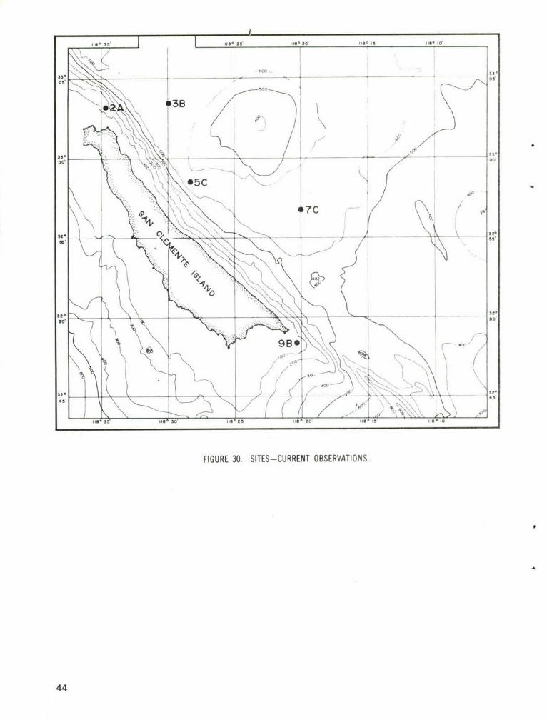
Current meters were planted at the five sites shown in Figure 30. In
addition observations were made at site 1iC, located about 25 miles south-
east of San Clemente Island in a water depth of 6,078 feet (Figure 5).
Geodyne Model A-lOU current meters with an accuracy of ±3 percent at 0.3 knot
and a direction resolution of ± 2.5 degrees were used.
A total of 19 current meters were used at depths ranging from 225 feet
to 6,066 feet (Table I). Data were obtained from 9 meters which provided
information for 2 sites at 500 feet, 2 sites at 2,200 feet, and 5 sites
near the ocean bottom (Figure 31).
Methods and Procedures
Figure 32 shows a typical current meter array. The damping plate,
shown above the anchor, was used to reduce the rate of descent as the array
free-fell to the bottom. Meters at the bottom of the array were located between
12 and 3b feet above bottom depending on the site. The meters were suspended
by 9/16-inci nylon line; a stretch factor of 7 percent was used to calculate
(corrected) depths.
Deployment of the array began when the buoys were put over the side.
The line was paid out slowly and each component attached in proper order.
The ship advanced slowly in the direction of the proposed site to keep the
array laid out properly.
43
33' 600
05,
5
33. 5 3.
00* 00'
325.
so' Do*S 0
444

TABLE I. CURRENT METER DEPTH LIST AND OBSLRVATION PERIOD
DEPTh OFLATTITUDE LONGITUDE WATER DEPTH METER OBSERVATION PERIODSITE (North) (West) (Feet) (Feet) Begin End
2A 33003.4' 118034.8' 870 834 24 Oct 1966 22 Nov 1966858 No Data
3B 33o04.3 118029.8 ' 3960 500 25 Oct 4 Dec2205 25 Oct 4 Dec3923 No Data3957 No Data
5C 32058.8' 118028.8' 3750 225 No Data1830 No Data3714 No Data3737 22 Oct 19 Nov
7C 3205b.7' 118019.81 4080 536 26 Oct 23 Nov2195 26 Oct 23 Nov4040 No Data4053 26 Oct 23 Nov
9B 32048.3 ' 118o20.1 ' 300 264 No Data288 25 Oct 22 Nov
(Direction Data Only)
liC 32028.4 ' 118006.4 6078 1015 No Data6043 No Data6066 16 Nov 9 Dec
45

DEPTH (FEET)
0)D ' 01 . .4 (Aj (Aj rlo r)CA 0 LA 0 0 0 0 (A 0 Ul 00 0 0 0 0 0 0 0 0 0 0 0 00 0 0 0 0 0 0 0 0 0 0 0 0I I 111111111 I I
00r
00
am C
rMm
az
I U'
03 0
46
46.

5004P DANKO BUOY (POSITIVE BUOYANCY)
3/8" CHAIN
MILLER SWIVEL 1-1/2 TON
CURRENT METER
9/16" NYLON ROPE
MILLER SWIVEL 1-1/2 TON
CURRENT METER
9/16" NYLON ROPE
CURRENT METER
MILLER SWIVEL 1-1/2 TON
ORE ACOUSTIC RELEASE
3/8" CHAIN
MILLER SWIVEL 1-1/2 TONDAMPING PLATE
-8OO;V RAILROAD WHEEL ANCHOR
FIGURE 32. TYPICAL CURRENT METER ARRAY. 47
Geodyne Model A-lOU current meters encode the data on standard lomm
photographic film. The meters were adjusted to strobe every 5 seconds dur-
ing 50-second recording periods. A sampling rate of 10 minutes per hour
was selected to make the record statistically valid and allow a recording
life of sufficient length.
Ilost of tie arrays were implanted in late October and retrieved in
late November or early December. Retrieval was initiated by actuating
Ocean Researcn Lquipment, Inc. ancuor releases by means of - coded acoustic
signal transmitted from the surface vessel.
The raw data were processed by the Ceodyne Corporation, kalti&am,
Massachusetts. Analyses of the data were made by the bottom Lnvironmental
Survey Project, NAVOCEANO.
Analysis and Results
Tides - To evaluate the effects of tidal forces on the currents in the
area, especially those at or near the ocean bottom, tide data were requested
from the Coast and Geodetic Survey. No observed data were available for
San Clemente Island; as a result ,data from observations made in Los Angeles
harbor were used (U. S. Coast and Geodetic Survey). No attempt was made to
separate the non-tidal and tidal components.
Tides in the San Clemente Island area are mixed; that is, two high
waters and two low waters occur each tidal day, with large inequalities in
their heights. During the time of the observations, higliest high waters
and lowest low waters took place several hours before and after the time of
New Noon. The time of least vertical excursion between tie daily high waters
occurred one day before the First Quarter phase of the moon.
Currents - Current meters were planted at select sites around the dome
located northeast of San Clemente Island. Arrays 3b, 5C, and 7C (Figure 30)
48

were each placed about 6 miles from the summit of the dome. Where mean
current speeds are given, the speeds were averaged over various periods
of time, ranging from 1 to 6 hours. Short-term fluctuations in speed are
evident, but usually non-consistent, and higher speeds usually occurred
during times of lower semidiurnal waters.
Two meters on each of arrays 3B and 7C were located at about the same
depths: 500 feet and 2,200 feet. Comparison of the records (Appendix B)
shows some similarities in the current directions, but the current speeds
are dissimilar.
At the 500-foot depth, prevailing directions at site 7C are southeast
and northeast; at site 3B they are northeast and southeast, with an addi-
tional strong component to the northwest.
Currents at 500 feet, site 7C, fluctuated in speed from les than 0.20
knot to 0.31 knot from the beginning of the record until 4 November. On
that date, currents increased to 1.00 knots after which the speed fluctuated
between 0.50 and 1.30 knot. The current speeds did not exceed 0.20 knot at
the 500-foot depth at site 3B.
At the 2,200-foot depth, the prevailing directions at site 7C are south-
east and southwest. At site 3B there are three principal directional com-
ponents, northeast, south, and northwest.
The current speed at 2,200 feet in site 3B did not exceed 0.20 knot,
whereas at site 7C, at that depth, there were several periods (usually
associated with low waters, and especially at the time of new moon) when
the current speeds reached 0.40 knots and averaged about 0.21 knots.
Most data obtained near the bottom were of poor quality; as a result,
interpretation was difficult. There are similarities in the records obtained
49

by the near bottom meters at site 2A and 5C. Direction vs Time plots show
that the currents were rotary most of the time (Appendix B). The change of
the tidal height with time compares favorably with the change in speed of
the current. Resemblence of the tide curve to variation of current speed
is an indication that the currents were influenced by the tides.
The mean current speed for the recording period at site 2A, computed
for those speeds which had significant frequencies of occurrence, was 0.05
knot. (Zero current speed was not included in the computations.) The fre-
iuency of occurrence of zero speed was about equal to that of the combined
frequencies of all other speeds, and its inclusion would have reduced the
mean to a misinterpreted value. As stated above, a favorable comparison
exists between the tide curve and time variation of current speed at this
site. These times usually corresponded to the periods of high and low
waters, and it is then when appreciable current speeds were attained; and
it is to these periods that the mean speed applies. The maximum speed of
a significant frequency of occurrence was 0.15 knot. These speed values
compare favorable with those of observations made nearby (Carrison, et al,
1961).
Mean current speeds at site 5C (using the same computational procedures
as for site 2A) was 0.09 knot. The maximum speed was 0.23 knots for a
significant frequency of occurrence.
The bottom meter at site 9B malfunctioned in such a manner as to record
only direction. No speed data are available. Two distinct directional
components are shown in the polar coordinate histogram plot of direction
(Appendix B): east-northeast and south-southeast.
50

At site IC, Area I, three main direction components are evident
(Appendix B) from data obtained from the meter located near-bottom: north-
northeast, southwest and west. The currents appear to have been rotary
during the First Quarter phase of the moon, but changed to reversing
after Full Moon. This indicates that a tidal component is present. The
mean speed at 6066 - 10 foot depth (12-feet above bottom) was 0.08 knot,
and the maximum speed of a significant frequency of occurrence was 0.38 knot.
Conclusions
As stated above, 9 of the 19 meters implanted functioned properly.
Because of a lack of adequate sampling of the water column, a definitive
account of the current regime in the Sani Clemente Island area cannot be made.
Also, in order to gain an understanding of the current patterns, the effects
of topography, and seasonal variations, a prolonged series of observations
should be made within and adjacent to tne area.
From the data that are available, several conclusions were made con-
cerning the currents in the area: (1) tide forces exerted an influence to
the deepest depth sampled (6,000 feet); (2) bottom currents attained speeds
as great as 0.2u knot; (3) current speeds at the 500-foot depth just soutil
of the dome were relatively high (0.2u - 1.30 knots).
51

V. INSTRUMENTATION DEVELOPMENT
Purpose
The instrumentation developments of this project are intended to pro-
vide a capability for measuring the environmental parameters that cannot
be measured easily with conventional configurations of instruments that are
used for normal oceanographic operations. For the most part, the develop-
ments involved design, fabrication, and testing of systems comprised of con-
ventional instruments arranged in novel configurations. The instruments
were designed to measure micro-bathymetry, currents, visibility, and sedi-
ment characteristics.
Systems
Deep Towed i4h Resolution Profiler (DTP) - The performance objective
of the DTP was to obtain high resolution bathymetry or bottom roughness
data along with high resolution subbottom profiling. The system needed to
be relatively inexpensive and capable of being readily rigged for deploy-
ment from different ships (Figure 11).
By positioning a 12 KHz transducer near the bottom, a 3U' beam width
(at-3db point) provides fairly high resolution of the bottom topography.
The close proximity of the instrument to the bottom minimizes spreading
and attenuation losses of acoustic energy. With modest acoustic energy
output, good penetration and resolution of the subbottom reflecting horizons
are obtained. An upward-looking transducer is used to determine the depth
and horizontal stability of the system by monitoring the acoustic signal
reflected from the sea surface.
Transducers are keyed by the recording and control systems aboard the
tow ship. Signals for keying the transducers, and signals received when the
52
transducers are in the listening mode, are transmitted through an armored,
coaxial tow cable.
Results of field testing this first system, at San Clemente Island,
indicated that high resolution bathymetry and subbottom profiling could be
obtained with a system towed close to the bottom. The DTP was capable of
being readily rigged, and is comprised of off-the-shelf equipment. The
problems encountered include: (1) severe limitations on tow speed; (2)
the ships roll motions were transmitted via the cable to the towed vehicle
and resulted in the motions being superimposed on the recordings of the
bottom topography; (3) limited battery capacity which required recovery
of the system to change batteries after about four hours of operation; (4)
limited capability for changing pulse duration and repetition rate; and (5)
in areas with greatly changing depth or steep bottom slopes, the winch had
to lower or raise the towed vehicle to avoid bottom contact while continuing
to maintain the desired topographic resolution.
Photoiraphic Visibility Systems - Two systems were built*and field
tested to determine if near bottom visibility could be determined by photo-
graphic techniques.
A system using conventional deep-operating oceanographic camera com-
ponents was used to photograph a target composed of 6 wedged shaped colors
grading from white to black. Eight targets were mounted at fixed distances
from the camera on the supporting frame. The targets were arranged so that
their surface was normal to the incident light. A capability also existed
for switching from one light source-camera pair to the other pair without
retrieving the system. A pinger mounted on the camera framework was moni-
tored by the ship's UQN to allow winch adjustments for controlling the tow-
53

Lng depth. The data chamber of one camera was modified by removing the
depth gauge and mounting a meter for monitoring battery voltage, in order
that light intensity coorelations could be made by observing the recorded
voltage values on the data-frame portion of the photographic record.
A moored photographic-visibility system, similar to the towed system,
was constructed. The moored system employed gray, wedge targets mounted
in a frame below the camera mounting; however, this system employed a
special timing circuitry that controlled exposures at fixed intervals for
up to 30 days. The system is shown in Figure 33. A special feature of the
system was a set of 6 tubes, each 30 inches long, that were loaded with 1/2-
inch diameter steel balls. Periodically timing circuitry fired a squib
that caused one of the tubes to open and drop the column of balls which
fell to the bottom (within the field view of the camera). When the balls
were dropped, the camera system made exposures every 10 seconds for a period
of 5 minutes, before returning to the usual rate. By photographing the fall-
ing steel balls and the turbidity created, it was anticipated that an
indication would be obtained of the character of the sediments and bottom
currents in relation to the degradation of near bottom visibility. Initial
indications were that this system should perform properly in deep water;
however, this array was lost due to the parting of a nylon line used to
support the system. Efforts to retrieve this system are continuing.
54

&f~ PACK
TARGMERAA
- RELEASE MECHANISM
/(Acoustic w/timedbackup)
FIGURE 33. BOTTOM MOUNTED CAMERA SYSTEM. 55

VI. REFERENCES
Coast and Geodetic Survey: Tide Tables, High and Low Water Predictions,
West Coast of North and South America, Including the Hawaiian Islands,
1966; U. S. Department of Commerce, ESSA. pp. 224.
Emery, K. 0., 1952: Continental Shelf Sediments of Southern California;
Bull. Geol. Soc. Amer., Vol 63, No. 11, pp/l105-1108. Nov.
1960: The Sea Off Southern California a Modern Habitat
of Petroleum; John Wiley and Sons Inco, N.Y., N.Y., pp. 104.
Fagot, M. and Oser, R. K.: Deep-Towed Bathymetric System; U. S. Naval
Oceanographic Office, Washington, D. C., IM NO. 67-12, 14 p.
Garrison, G. R., L. H. Linger, and T. E. Ewart, 1961: Measurements of
Deep Currents with a Submersible Drift Bottle; Applied Physics Lab.,
APL/UW/TE/60-35, Wash. (State) Univ., Seattle, Wash., pp. 58. May.
Revelle, R. and F. P. Shepard, 1939: Sediments of the California Coast;
Recent Marine Sediments, A Symposium; Amer. Assoc. Petroleum Geol.,
Tulsa, Okla., pp. 245-282.
Shepard, F. P. and K. 0. Emery, 1941: Submarine Topography Off the
California Coast: Canyons and Tectonic Interpretation; Geol. Soc.
Amer., Special Paper No. 31, pp. 171. May
Shepard, F.P., 1954: Sediment homenclature Based on Sand: Silt: Clay
Ratios; Journals of Sed. Petrology, Vol. 24. No. 3, p.1 5 7.
U. S. Naval Oceanographic Office: Glossary of Oceanographic Terms; U. S.
Naval Oceanographic Office Special Pub. 35, 2nd edition; U. S. Government
Print. Office, Washington, D. C., 1966, 204 p.
56

APPENDIX A
PHYSICAL OCEANOGRAPHIC DATA
Ramsay Probe, Nansen Cast, Sea State, Swell,
and Monthly Wind Force Data
57

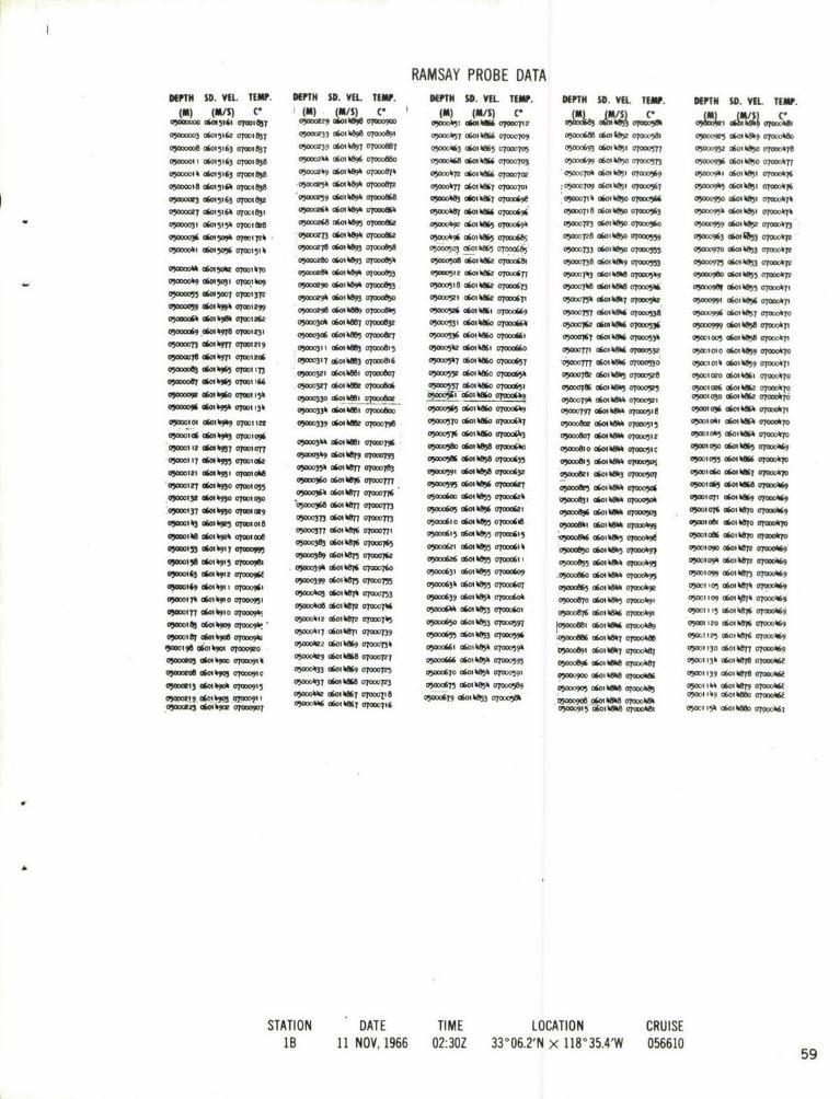
RAMSAY PROBE DATADEPTH SD. VEL. TEMP. DEPTH SD. VEL. TEMP.
(m) (M/S) v (m) (m/S) (0
050D0002 (*0151 U3 070DI072 05000212 06014%09 07000O%7
05--0o6 06015183 071w87 o5oov o6oi%.928 o7000ffi1
05000010 G&W15183 0T001a69
05o0.00i5 o6ol5i79 070i1861
05000021 06015175 07001843
o5000026 06015165 07001812
050009 06015157 OT-ITT77
0500003 06015134 07001171
0500003* 0605106 07m15v7
05AM039 06015087 07T01533
05000063 06015WK607001475
05000067 06015W5 07001605
V,000050 06015037 07001333
05000055 06015W07 0T001292
= 00w0?N 07r27.0
050(0D65 06015005 a7Wl 20e
05000070060150000701189,
05000071 06015001 apol11s
05000073 0601 W9 07001178
V5OD00rM 06016196 0700 11
W500W06 0601698 07001129
05000078 0601 6985 07009126
0500D083 06014693 07ml1 121
05000o85 06016980 070011030o00059 060' 6979 070D1096
V0092 06016978 07001095
o5woo95 06oi16976 07MI1o89
V,ODOO"9 0601 6976 07-01075
050D0103 06014B7 07001071
OW1~o06 0601496T 07001067
05=i0110 o696ot 07ooioh0
050011I6 06014965 07ml1039
oWi q1 060164965 o7ooi034
0500121 06M k960 0700101 k
0500124 060164Z9 07OD006~
05001 29 06014"98 07001005
OWI0032 06016358 07000997
050D0136'06014957 0700095
05000139 0601"37 07W991
05W143 06016956 07000983,
05000117 06016356 07000380
05W0151 06016351 07000972
0500=154 06016967 0700952 EXPLANATORY NOTE:05000158 06016947 0700969
0W506 o6oi4965 07000967 CHANNEL 05-DEPTH IN WHOLE METERS05oo169 0601695 070006
05000162 060161963 0700931 CHANNEL 06-SOUND VELOCITY IN TENTHS0500O175 0030 0700090 OF METERS PER SECOND
050001830601"96007000912 CHANNEL 07-TEMPERATURE IN HUNDRETHS OC05 068 060m6"7 O 051
05-0190 06016936 07000698
05m00193 0601493h 07000892 ~05000196 06016933 07000867
05000200 06016931 07000878
05000206 a6oik631 07000873
050"0a8 06016930 07000872
A
CHANNEL IDENTIFIERS
STATION DATE TIME LOCATION CRUISE
58 IA 3 NOV, 1966 16:21Z 33004.01N x 118 038.0'W 056610
RAMSAY PROBE DATAUSPN SD. VIL. TEW. K"PN SO. VIL TEW. K"PN 30. VEL TIN. OEMN $0. VIIL TIN. OWPN SO. VEL TEW.
WU (AIS) C* (U)m ) C. (0) (FA/S) C' 4 83.&AVI JC.A'S1
03000003 06m15l6t O01637 V00233 OW0166W 07-00891 OW"T3 00 N 070D0709 03O0c666 06i 680o 07WQ581 ON0601 6ila *ooowO
05-0000 060M5163 qW83 O)0D0239 O09667 070ofi 05000663 OW016W5 07=TO5 030DO693 06Mas 070a05n7 050095 060165 WA aaoil"-It01 06015163 0701 8 05-0j60 o 118A ar700fi6) 3OD468 06MIlM6 0N7"10 0500069 aw0%950 a7m0wm 050(093 amk"685 am-AITT05-0014 0605163 alma5a3 05019 40609 OTWDSTII 030 06016W6 ar007oe '05000706 06- "61 c?000%9 0500001 ow "I5 070wk%~o5oomis6 a6m5 tli qwtaga5 0011 66W" 07000670 0ic00lln 06MW75 q700701 :05-0709 0601M65, 0700367 90093 0604fti, aW7%OWDOM3 060M5163 W=SP63 "cw o6o aoooffi W)01AS36 GftkS7 WoGW9 vj0007Ik 06oi65 0lo000%6 03W00950 do 46"1 07000*7k0500E 06M514 07001831 05maeo6 060169700 pos "Wo 6014 07O6 05000718 06o030A 07IO0%3 05"009"6 0604fti O70006%"
*03000051 06311 00It "-2 owil"9 07000m 0 0601410" 66 cr0oow 0500723 060165 OPWo%O 0"000959 4MW665 VIOM73"0006 0601"9 UM72 :05000 dmo, 6 a6o7o66 ooa%2 05 t 0645 0768w 05000728 0601665 0M0Y059 05063 am%S, a70m0ir2
090540002000154 -7 06011693 0700 05000506 06mw65 am00(6t 05000738 06os666 07mM~3 03c0009 f- 06165 00670900000 o6oi5ft6 a7Mt%To 05000m8640148" of000ft 00512 0602 070mo6n 050071#3 06014W 07000549 -A0009601)60507T017p
- 0)000049 06mg"03 am'lle"0 030c 0"6009 070m"5 05000518 0o6kW 90Mt673 05G00766 0601666 01POW516 05p00g" gOW0665 07-*o6l05000m awsmT 0070013p 0500(09 OW10 669000850 03000521 06 1 we6 010006I 0300054 a"W6. M-3112 05000591 aw",% Oyo*ok7,
am le"k99 0WWI'" 050"03601"%65 07005 05000526 060%sl6 07000669 05W1757 0 6mu mmms .3 05W0005 (160"6 00011r00500D066 dMI0981 OM12kg OODD30 060111 0100ft 05000531 060160 0700066 MO"&o% "o,6" olwo"6 OP-"9 WW01A6oT0oo04603OW110,0600"M5 07mi113l "-Y* 0610 0o-08 05000536 060, 6O 010D661 00367 06014"6 "70053% 050,000@60,66507000llp050007 dmlot W=00219 .03000311 dmm%S OJOW815 05000562 060116K. 070D0060 05WMI 0601656 U700D3P o500oio04f voi roookw67050m001w loole" 17,:0 fotf 0 or0700&6 0500D547 (ISM11NO0006 01W7 0wo 06om~6 a7p03 OW010116016659 070D067I050000%3 0 4 WWI 001 73 09D321 0601,110 07000117 05000552 O6016660 070D0656 0007ft 0o6111 07TOWW 05M010e0 06"Wsl6 ("00o470opo0000aml7 am$3 I"06 mmm a6cilift orwo" 050257g6l0s 07006 ox-mv 06mo66 a7000o3 050I~G26 06kw o7wal6or
0505060165 "@oml13 v)00033p 06016,j 7000800 '030005 6 1 k6o O000649 05-r07t 016M hill051 O050106 06I' 0700c671o"WIDI0 060,696 07mlin0 0500339 06A%ft 07 000756 00057006owm86001000067 030D0613 0600"66 070515 o3wialif 06clowlt qooo0670950;s'g 06o"6 am9 "Woroal 0"N mo 0 gD56001%K 0 TWO0,13 moW?~ 0601%ft oypw5iz 03m10b5 0o6%646 07000hr
o"il am" owan 36 "60S667 4MWAys OT 4 9CM&O 01% o' Ic 03130105c) 0604668 OMOO6918106a050"35 0"k6016o67D3 07006 o6 0 72 vrwi" 900M5, dmkft6 opoos 05Will6 0601%m7 07ol0670owol006161 07007 056M9 lim~63 07mlaft 05-35% o6ol"66 alo 05G0 060%678 0p00k"o30omm2o6coon Md8 51050041lw07062 ilof, wlf Ow
vJ-01270u63 07W%W 050 0500560160 777 awoops05D 060, 6 O7-o616 ojwo&5 06" aoo96 oposts"1 *6*iWW opcoUg,"-1326 0601667 07 000 113 O"n05T? 000605 0601665 0m7 ti 30006231~9 dam*6 Q?Wwjo vimlorl 06mk167 w0o%o0500370695 000V0 0000 06w66a 0700077 050060300656 dMk I0d2 "150161060 6670a700067.5031016obw32 070a0"1018 o0m 16 7.T os0i 0601665 MwMg 090DA66 06o,501O 65 .5006 o6 0007
vjoot%3060 a6" almoia 050600670006 5000610 c""", 0Oyg,6 "Wo 060"*5 0465 "osm owifto 01000rp
W5JWIAA 16107009 ow" ooo 06mkw wm307W000762 06"5 OTOM15 0Pwm00653 0~ opm,o%o 0500ia9 0601"mp @70o0k6o501 6mil" WADo3f 067000M90626Wn0711 )-w owool 0wi 6e 0W16
0 -193 060%r9jo 090m"56 06" cr vAo3 6W 7a" .300aml o* 5i"0onOOw4--0005061665 07ol*WO, aw" mmV0007%5 000634 06o" .,00oy06of "We6 omW 01oi06" Owl105 060667 05000669
vilkatr op161 I7106 V000" 060mw67 070005 05(00639 06W665 07000"6A 0"~006 06mm"66 01069"t 0500l10 06mip67k 07.0416963W 0017 060 1910 orw o* . M 0 I 06 016652 07007 66 0 0 00666 o" On65 o 7ooA oi 000806 M M 4 go opoo0"0 05011 3 CW M *6 07 0OW 49ox00113 06m%m a!, wAttoll"! dmwp61 Cr0W62 7 4 0- W o on165 07p 00om fOYM N I5 060111 OfW Aft~ 0500120 06018 0eg 000669
WDODIOV 06"%90* VpWgkl 0)000417 OWWP67 OF-nil3 5 410 0g," 0gom~ q-Y *0WN6 06M1 QMDW 05001125 06IMS a0ooo0liq
196 d .0 "m 079oroe 5042001W0OM1 aoooook5o7o5k 00O9 61*7000 0001061" TOD9
0500um 06mkm0 omwsm91 05000DW9 0601 11W 070G07M 0000666 061WA armom5 WA006O 060,6%m amoct"6 0500113 0go1 466M 07006Ew)5o0dolo of069 p a7001 M0503 06wwg6 ap*m7 0301)(470 Of01665 070D0591 QW 690 oi 6"M upwa0W 03001139 go.0,670 070W0O6vj00mt3 o6ot"0 07t0t5 .0500637 06W16" 07000723 0000673 06065 aP0oo"6 WADo1905 o6oi kf qoook%6 03001661 M 667" 0700016f2
0500o06g 1 W66 0700118 a 0VA-0679 oo 6653 w 5 050019 go606660 070D0OWvj!tO 060100009r I 5o66~~ 7'0561 6I66 706 0500ow~5 06011im? 0706*90661cmW ?wk
STATION DATE TIME LOCATION CRUISE113 11 NOV, 1966 02:30Z 33006.2'N x 118*35.4'W 056610 5

filIIIlfl 1 I
fil
vM II I M MIMMIM Mifit ll IM M tff 0

r-
SLL -~'ME C
93 1~
iIIIiiiIIi lllH lfilIIIIII tiitIHIil p
0~NJ
S-I IiIIiIIIIIII IIi4iiIIIlIIlI
1*
61

Hj i. ii 14 1 i I i~ iIi ~ i I I I i LOLA
[fil I Ii j if
cc~
glf I [ i 1"1111111 II HI II
2

RAMSAY PROBE DATAKEPN 58. VEL. TEMW. ""T SO. VE. TfMP. K"NT SD. VEL TEW. TM SO. VIL TIM. wT So. I TEMP.
IN) (IS) C' (m) (MIS) C. (#A) (IA/) C (0) J04 c() (MS0500NO03 06M5161 q7@01ho 050CL18& 060149D9 070DC949 0500053% 0601 M" OFOO668 03000M, OTO5 07006 "OO6 0604090 arolift8050000D8 06i0l5t63*W7008W OW510014 ,o 9aT 0700943 03000543 C6fi 0w%5 q00675 0500737 060149M3 0700565 VADD931 0601 W at07000
0500011 06015164 c702ola0 o500o 189 06010906 07020936 05o0552 060,0864 07WC6 05-07%2 (1601 W9 076M2 0502W936 06mo, wliftc0
o5oooto o6w5ililt qwi08ki a5mos093 o6oikqo3 o7ooo93o 05om0555 o6ot 0860 ooo66 0Ww07kh 060m"85 0700056C VA290,06MM 05, 07-003
o50ccce c6oi5i6h 070ol8ho 05ovji96 c6oi4o 0 TomW 0709( 5006 06014&53 07-"c63 05020751 C6014&R5 010D20357 .5.*,#06010w 07--008
0500025 06015165 07W110 :050000C, 06o0193 O7o00WO o5ow56oi 6016 o7ooo662 05003061081 7OT0550 050200906ow04&p mcck.&
05000org 06M 166 qwol 8lw 05002203 06014903 0TODG921 050209c6o bWA 0700*69 105=160 awl lifto 075009206, 85551~c8
05000op 06015164 qw21800 J--47 02010903 -TO-9- 9 05ooo576 o6oi08W3 0700056 05000765 06W18ft O00*1517 050xl%5 060,09 07t0or008lf
0500003% 0OW 1 i 0TWl"o8o o05oo o6olI903 070D0916 050001 06014862 000653 050D0770 Ofimll"l 07005 17 0500960 of01Alft qw(*ll8
8050000 060o511 01 74o0 o0D21 0 60, 4901 O?OD0914 0M000583 0601 W%2 O000649 05=0774 06010W409 0005" 05-0*60cf- " 07000479
VAM%00 060109 SM w0 qMW 000228 0601W)97 00D09 o5ooo58? o6oiltl%i 07ooo6%7 O3Wlr9 GSMW*89 OyOD0o11 050209m am0 4"5 07020k79
0500209 ck0- %69 q701577 05020235 06014089 7o06OD9 o5oo*g9i c6ot6 0ffi 20opo 6 05-27193 060100 v?WM8 0502097 owl 4"5~ 0oooka
0500053 06015M2 OM011111 o5Ooo23 0601W896 0700M7 050095 060111861 0T020603 0500-786 Of-118118 O102053 W500m7 06 am-?07
050D0057 a6m5wT) qW01350 a5mml;02 060100 armXft 05000601 06014&1, 07000 050D071 060MWq0 Qj0 0vi0098 P6008 07020k7
0)OD0061 0601011W 0700I295 0500020 06f,089 07000870 05000605 o616oi W 070To638 03-911 OW MDM wAog 0600 W 70
05-066 ofio 40 oW-fro 05000251 06011180 010008n, 050006o 06o0"9 000632 05-799 6"80*9 O70-053 "-X1M9 OW010857 0700078050007 06WIPW8 0701231 0500269 V6-S85 OW )08 o0co%i q3 61i5 o66 So 0yoc63i 050001 06W011109 0a0101530 050o090 016005 07ao0ttr
0105 GW" 97 07001224 050D021 060,0485 07000859 030o06,8 06wwl08q 07000629 WDA0081 060,00 O7020529 o5willoo o6otWA~ 070o0w7
05000079 06014*3 07001211 05ow0296 060mkO89 070oooe6 05006 0604"89 aom"o~ v5o08" 0604ft50 07005 0S3- 005 0601085 07020076050000sh 06.0"7 o0702Igo 050203011 060,0M1 01708a11 oo 050 6mw 0870702062 05000&11 o6wilftl ap000P7 OWIM9 "WO a610 7004736
05008 06mk%93 07m 1 80 050j0 06M VMDA70082 050Wa3, 06010WA807000619 VA000"1 "030 07ND0526 0500015 0601086 ao*%0'05000090 060,096, 07w,D 157 MOW033 d-014878 07=279e 05000636 060108W8 a70206l? 05aD0@30 060108" O000521 W)001P2 060,08%, OFO0D016wAwoge a kM105 0a00,50 _!??-~3010680 07020793 050000 060185 070D0617 05AD0833 0611184 070D0519 vj-01-3 06010862 07000075010060103"5O2 o 1725 , 0500360 o6ol87 en 7oTo-* o5o% o6iW olooi QX052089 060W89 000566 05w1m2 OW0W2 0004760)0wl 09 06o0409 "=It 2i 5="36 060,07 07q02776 05wo0650 o6m189 ar-(613 V05000 A a 8w" fffo-515 05 030618 720605000113 060100 07w1101 ,00D373 060,4 0878 M 07A)55 06"~s 0601057 0T0c0610 05000807 060, i 080 boos 0500 06Mh 8k 070DO"7
0500m117 ofim 0100105 o50003ao 060ll,8ha 01002774 W0o6W 06014%97 VIOOW6 0502089 060 s o7808 s a720 05001003 0601885 0?02075~ 0600901 700181 050239 060187 ar716 0300066, e W6l057 OTOW( 050008955 06010m" 0rW050 0502l0w1 060MW86 07020505 I30(ilIW 04 05000398 0601087 O?WO761 03-266 06105 1260 000906MI1090700508 owlax050604" wim")07
133'2 06104M3 0500005 06'01-7013 000 06014%76 07000601 5264615 y~6 0015 618600o70502001 060O0875 0700M35 050oo6727W 4W,09 01ow56 W500M&3 0601089 000055C 053011P0 060mk8" OPO117%05-1033 0601 kZ5o 07-01057 05020035 0601h0870 0021 VA0068 06010896 arOD596 wi50@28 o6olioft8 ow0o" 05M0006 06omW6 010200731
0D14200470MOM o5m3 o6oilltri 0102073i aco 06o10 0700590 050028786018007000 ma502O10"90604K687007OW0876,6kOowog W *5O W 0700M73 0500069 06014080005" 050001M 0601000009 050607 0601W8607MO0013
0500150 060m0w06 07M1016 00o90010 O003 5o 61f rc5e " O 60181 7Dk 9OO 6 O00Di
05=21"0 0601491 OTI0 WWoc4O7 06014&69 07000122 05.2,0694 060.03 010205391 050208m 06ww"0 wr0o04o wAM076 GW01bW 070004n0502057 061000050008 0601087 0700713 0500698 0601W)35 v0259 wimoft93 o601tM%9 a?-"09 "-do 0601019 oym2007OW 57C01* 0009 00D4706117 O0070 wom06M"5 orwo3f 07Vi8 5288 809il 07000090 "01911 060107 amo*p7030004600601401-0989 0 06MW*89 07000707 05=0706 06013 0e~ 700580 "Woo"89c060""8 om7 ll0055 90500oo0601"87070200p
050016006010m15070 m mo 55ookf? 7o68 05WI10000o91 AD9*0Mh O 0p 0WO O W FW7091800I5a o 5o02? 060o86 07000oD689 QPY-0V6 0601095 07000580 0500090l 0601m".9 07001 05021093 0601w8o ar7oiI73
0500112 06010915 0702097 05aeopo o6oiW086 o10cc6ft 05-)721 *6m%09507000576 0300D912 06mm"80 mwago8o3oDoi15 o6ov"9110700963 (A00523 0601086 07coo68e 0500M2 06m"e~ arocTrk 05DD91-6 060,101180 o7ooo05-IT79 06mk090 07)953 050o05V8 o6ollift o0mo68t 0502730 060ot"3 07mcW37 0500owl0 0601080 oooom
STATION . DATE TIME LOCATION CRUISE2B I1I NOV, 1966 07:16Z 33005.51N x 118 033.0'W 056610
63

RAMSAY PROBE DATADEPTH SD. VEL TEMP. DEPTH SD. VEL TEMP.
(I) (MS) C' (M) (M/S) Vo5ooo0 06015156 07M&I 0500025 06014902 ooo907o5ooo2 o6o15156 o7oo1n 05000252 06 4901 07000905o5oooo4 c6o15157 oToolan 050 0601490 07000905o5ooooo6 06o515 oTmi8 050 6 cr 4901 0700906
5o0o 0 05158 07ml 821 o5oo9265o6oo19o o7ooo905000011 06015157 07001822 0500(0600,11901 0700089705000013 06015158 07001822 050 t027 6 014900 070o89605000018 06015159 07001822 o5ooo2T7 6olt9tx o7ooo891
0500o01 06015160 o0001822 050002T9 06014901 o70o8915ooo25 oi51i59 o70i02l 0500283 06014900 07o&08
05000027 06015154 07001815 o5ooo286 o6oik9i o7ooo89oo5oo3o oo15i46 07001787 0o0291 0601490 O700088
05000034 0OI5137 07001759 05000295 001490 07000886050013 06015134 O7-1733 0500029 0o014900 OT000883
05000010 06015124 07001O 05o003 0 04900 07000 005000051 06015m09 010DIh1k 05000305 060149cc00O007o5om005 o6oi5m8 07o01391 0500 09 0 01400 oloo,r05000o0 0*0t5016 07o01378 VY=0313 06011900 0000874
05000064 00k999 07001320 05000318 06018" 070008T70500o07 601995 070c0 050323 0*0118 070ou86905co007 00149960 ooc1276 05ow326 o896 moooso
05000074 06014991 oT01271 05o328 c011 07oo350500007401 1198 07001249 05A0033 0*0119 0700003P
0oooo83 06014916 07001222 05000335 0614 MOO050oM7 06014969 07001197. 0503 4o 6001"18 0jW8W
0500125 0*0,11960 07001158 M05053 060111891 07"(89o0500128 06o0149"1 qml0 140 050oee311 a001o191 070089
05000132 0*0,11969 07001 17 5o0-W5 *0W4890 0700083205 o138 06o14S o7o1105 05000355 c 01890 070o0 9
0500016o 060169 o7oo098 o5ooo358 o6ot4W o7oo0D860500c1l" 06014945 O7001093 05000362 0601887 0700081
05=147 0601491 0700,082 o5oo366 06ok8t5 o7oo816
05000151 0016499 OT0010 0Mo369 0*01183 0O002o500155 0*011h935 7o0o106l 050037h 0601181 oTo0801
05000160 0601699 07M0415 050-378 060187 OTOW79e050O16 06*0,W8 07001033 MOD05o383 o0o877 07-76305000167 060149e5 07001cel 05(-385 0601187 07000703ONW0171 C601114n 07001008 5000306 0011870700078205000IT5 C6014" 007m01O0505000178 0*014W3 07001o005=1 8 060141919 070o0958
05oooift7o6*4qi6 0700098"0500190 0*0111915 0700976
05001 '9 06014914 07000974
05000197 06o)4913 07000967
05000201 06011912 o7ooo962
s0oo012 06,1491o 070009560500020 06014910 070c95305000212 060,14910 07000950
05000217 0601%1910 07000918
05000220 o 9o9 70oo91
0500o22 06011499 07000911o50227 o6ov 195 o7ooo938
050Do231 *011904 01070927
05oDC35 0OW 49,01 o7000902
oymmo 9 06o490 07000910
0500213 06011902 07000909
0000247 06014901 07000910
STATION DATE TIME LOCATION CRUISE3A 11 NOV, 1966 08:24Z 33002.1'N x 118 032.9'W 056610 64

RAMSAY PROBE DATADEPTH So. VEL. TEW. DEPTH SD. W L Iw. DEPTH SO. VIL wUMP.
(N) (FAS) C" (U) (F/S) C' (m) (Mus) c-
0500000 006W513 o8.07M& wioo*5 080801 a?-"o 05-* dff 18015 0q000305 o 06015153 o7o810 J00069 06,81o 07010880 "5 a "165 0om1859o500000o 06015153 070Do00 030O2 0 O 070008" 7 0 o5 o . 00 5186%05000007 16015154 t00811 0O280 106o014 07008 w ni6wl 0qww05000011 16015155 0001810 '05000283 180.1901 000052 0oo" 0%%3 aOom05MoM15 015155 0700181o oyml 0018oI m010000871 "5o05t8 06m"83 **"000019 60151% 07mi8l I o,oo90 0oiM8W 07-0801 oW005 0?o006 ",o
050WU02 060151-57 07001811 vAoo03- c818oi o -a7 000597 4mf 07-ow2050oW6 C*0157 7W1810 05000306 06018"9 070080 05000 dm078K3 07DO"t,05000030 0 05152 o 70I 803 0500312 1OW4" 070DG"0 05-a" a0i63 010390500003% 1807514 MMIT0(.68 w,000317 00oi8aw 07000837 WjOW613 06WiS 852 0638050D038 06015130 0700739 0500022 0601889 07000831 030"17 401i %W 7O032
03 002 o.e5 W07,0 03037 10685" otog19 05000 22 088O 0700040047 0601358 07OD152 0 W-003333 OAM7 0T000609 ogooo"8" o 0801163 ar00u
050005 0015m1 001371 WM3A f80 0OA7M vi00s3 88 OFOW,l 65004 01 8 ot 0oo70 5 5000344 06019 0 0o798 D37 CWI% 070008.A050008 01087 07001230 woo10389 0801m87 0700078 05020881 06m8% O00080
050o072 080168 070012 05-00 18 o7C"" -79 WAD" a"" 070000507T 601806 o70180 00o 06 18018878 0YODT73 050018" 08018 00050l6 080149"5 0700 18 050P95-3" 7 0 700011OT 687 0500"% 010" 07000m050 -03 860188 07001168 OAMO3 0 n8w8 o7ooolG3 050100. ff7%ft 01 96050089 owl1499 O701 1 05000375 0601 "7-0762 05001865 of-W o059
05000o 9% 0o1495 O7001139 050003016018107 OT0759 0070 "mon omym030Do0986 4o485 7oW0113 0o3%0 0 06mm8n 07 05000"1 06 ula0
05om100 C601 k9o 0700m08 500389 O 1f8018 o GrA V0000 06M am0y"o50001c 0 1 o98o 07007oan 0o3" o8m8a0 07008 aim" 0601 000up
050l10 o8,7"9 07007075 5 0o399 ooi8 07ooo0500=1 60119807 oms1070 o5000805 18W%8809 t0758o500I8 180M. 89 070o0162 0500089 080,859 o 50300012 08078930 G7W1049 M00085 0801887 07007380500026 000flkW7 07001031 050k081 06m,w80 a77ni
05wo'30 1801kM 07010ek8 m50085 8Ofilm oT07 300500013% 0104M2 07001015 050082 0d07%89 0700072605-0138 ooo089U OMI-09 0500808o, 8808W OyOOOT2050(O183 010VO7 afD0009*"k o 00o whW 1 010 00720
ooool%6 0o01 "8 070oo097 05oooD5 0860AW U M905A151 0 09DA0 050ODM9 08CATI 070CR050-05,01%916 UrDM 05000"k 06mw8a97175
4 y0159 08014915 0700019 0500859Z 380188 0e000773
0300016h 6913 0700900 050000 1. a80807056
OWwlo 73 0601%910 070095 05OD0474 06o01 arWo104
05000118 06014911 07000958 05w00Wb 10608 0710070e
05000182 06018910 070009%8 W050W8 06018w O00070
050w0.88 06014910 07000987 0500088 0601 88m GT0o6"05000192 06018910 07000983 0501098 060A8808009705000797 108l9t0o70o8 0500,899 MWA i80 0 7001835WO
_vwA0e0am0 k o87 coma 0700093 0500010188%8 070D0698
050 06018907 0100932 0500m50 1807m80 or070182W=0013 08o80740 02 o5oo3sk1 18w7880 o?oDo691
050D0218 180090 al=916 05OW519 1601857 O06%8
0500023 06018908 07-22 .ON-0523 100 7 0708QY g0"814o 908 070009e3 w05g0009107&0 070000805000233 18078907 07000916 050D0538 08018807 0100087800n23 06m189m O70090 050010538 060.88W OTo0075050Do24% 1001 07000Wl 050-06014%887 07001673o5oo81w% OW4 0OTOO"9 05000588 100 0706700500023300W 0700089' 05=000300188050O018005000259 186m90 07000888o 050OD58 080086WM 07000665
STATION DATE TIME LOCATION CRUISE4 A I11 NOV, 1966 08:59Z 33000.9'N x 118 031.41W 056610 6

V l' IIiIiI I III If I lII I-I
i--l I I-cI%aii I'il l I II I I Il I i°Li111111IiU H IR11111III III[if i ll t
IIII-
iIf f f
-C14
Ell I I i i Ii l 11 4wi i i ** *
66

r6 H iiiiii IIifi f 1101111111111111.
U iII li!tftt!I iIIi i iiiiI I
C1 0-
2 ;i tttttItlHtlIiiilItlItt1lIIlilirl
MLAJ n *IifitHvin iitil I f il 11 i"III
m0
.J .0D0i l
67

II fII I fi4 A1
~c
R IR 2ii if 41 -1 H0 9iiIf4
m 12 F768

RAMSAY PROBE DATASNEN S. ViL nIW. NEPTh SO. VU. UiW. mm 3. ViL TOEW. im a. VSL Tw. uEm a. VI..
(a) 1./0) C6 &S C- (a) (M/S) c* V3 (35 /I
OJ0m4 06o0516T ar0ma3 09,o235 0601101 o5000va 0oo. e qomtO 0500066? dCWVob @G06 Wo 001o"0oo og09o.046 06011, 5339 , OYMM906M09D 01000ft wiow dows 0o0m 030 66 069 domg o50m*9 0614ft0-M3 061.27 q-2 o0 Wo3 6It Moooftl 050Wo3 , 06OoW5 WO006 06060 WA Q"00%7 "Wood 060m"0)oo" a6oW 0104639 00col doo aft 0-% 03 dow amm 0 00 6,5 4%000061, dmo 06d1oe0590o5 d0m06 0W" 03m d"f oeFW. & 0900OD.0 W% VrOWnO @ 0 o5006TY 06OW08 003060 am1,j05ooo "s cWhe 05000%38 00W,95 orwaft8 000WP d063 OMM0M m 8 osmca 06oo1W 06m WA
099050 dmwl70/6 owkw 000 16 oo0bc 0300ow" dm60 *o 0,nS dak owm a0mm"9S
"0Ws00005 15 06030-07016 o 0o601M 07OWN61 09W0ft00%ft Qf20-00 0"W6 00M61 upow30 dm%01,
Am o"% q000 50 0 yo85'03 65MMft 961 ooSI, 030, dwW 653 o018, 07mo3 0m 9 o"WA aP0" 6uj50007 060I 010 1117 007cm 060m9 o0008 09o4p dmp9 01000M 09wI do "MW * 0601W%70DWFt dob oo,yl v- 6-o. 8ocftq 05mo5w 0604"3 max0u 09 -, %6o"91 09 3 o618
5 m0I 067 0709777% 0530 dmww" oambgs o5o03wa c6mkm56 -m-, "=1i 49 o" 0)000942 0%M65qp-p omkm oloy,7o 0, mm U 1 It dmW3 QPW N opwits dowl5 0ajO, do0e9GPM00" 06049560 01094%3 0"00D3W 0601988 07lo088 05i00i1 06w%Ks omm75 5000 d91 ow- 4W"""' dmog 5"5..4 .6o145M 07M 0" 05000306 d-b9ft3 o a vowp a65otM olao000 007 a9 wb5 op-M 060.9OftWJ100100 0604%9 01094%5 000312 06mkm6 opwma fjo'r dwhol coo 05056 091M 6000*6 06o"30500106 4069 0709*0 6000317 060IM4 ojomM6 0PP7 0ol.9 olo 07wo91 0m%ft 4m opaw0f0I1I 060495" 010999 5053060 )MG60f ol000be o50o0s3 d"486. oyaw09 OF0079 dm6%3 o-op 06s"9"VJ30116 dlokgtA 7mm8 "C0D3" a6m%W OWAS awm3n o3%o oyawD Cla0.73 06000 0p-m amwffia3m00ao0460mom07376 OM5000J331 060l0700 a707 Upo oi-46% ow".~ "W.96A
WWr0 l~O 6I~Oyey6 3od~6I1 7366 50 q~85 01000767 OPWI61 4w4f Wing050030 060198 MM0"10 w ow,9 m or~6 op0o96m 45 6060 7070 sol 06w%ft ~o""-Ono013015037037q8 03"0o*" dmuf q709%60 o5oco'go 06ak"3 01,6 A 50p7m dmw%i51w
050.614D6500]376 NV05360,3 ]9G ]3:48Z 363°055' .5]18°5.0dWm567
opwil 0601bri O0M3 03,c "W "1*6 09-7 dow q9o wimo dow "-am do"QF0015 0604PS9 070na6 "WOW~ dw"n96 ow9o9 opw 4"W3 viom73 dM951"Owl"5 06"bo34 o70offm opoy dwWUo"@70NS96 0300038 down5 0or-0o6 -,N, down05*-15 4601%90 0703Y7" 0,00s0.07 do k"06 c7 dmA WI "IO down1
0o63 06014 opyif @7077 0030 060*n1 0700 05-0 060495000-2 vibc 06own6
ojwm5 0601bM960P, qo)oo9f "Own87 O-161 a)- down8 '107065 * W6 %fWoo-o179 dmkwl0055 mwo ~ 060%W 9lowe oyco616 CWf -m 00076 fjows dooke
vimolej0609650 4~O66 05 060OWn770la-65 0-0" 060W 0,~0 9~ "m9itaaq00m96 06.0090 OK ow00gm "Wo987000770" WW0613 06o495i7007 -06.9oftha" , obw upoom 07"D0A1 050 o"m001601=0191 03-6111 doop300700060 6300d dmm5owo0600 dcl oom -AD046t3 06080003 UP-,, 0cmou doop a~6 -Oft O%"Moto%0 069,010601 woark 0 630671dO ' I'll"0 O03-d do",3 "7065 0063 do9so05000a0 060148j 0100053 0504263 dm670 01-111 0,00630 06fflft OF=71 005P dmft0
v500060am% 9 "WWA "C&3 V50069706667 "MOM -F R -06 4 0%M W 06o4o
"MM9 60%8e JO00 ooop 6oWWopwl opoo 93 07o07A opm, daho695
olowe 06m%ol.
STATION .DATE TIME LOCATION CRUISE4D 1 1 NOV. 1966 13:48Z 33005.5'N x 118025.0vW 056610 6

RAMSA Y PROBE DATAmIN So. VIL. TEMP. DEP"H SO. VEL TEWP. DEPN SD. YR. TEUW. K"PH SO. VEL. TEMP. DEPTN SD. VEI. nwM.
1(A) 4IS) C* (U) *(IS) C* (m) (M/S) C, (M) (MA/S) V (U) (MA/S) C'0300000 96fl5l&2 0700181 % "WO0245 0601m89 07000ft q3000%ak OW WK76 07000677 05-702% 0OWII919 070003 09O0057 006CHW 01" I5
05000002 06015163 070011813 1 0500025A0'601%sw0 0700ow8 05mom80018mkm V000874 V50w073008'wl8907000532 73ja 046ww570a0k"
W050000 OW5433 07-01813 050oo51 C601mw, amooft W,000%93 0601%&7 07000613 05-0736 06018&9 07O05M WA00097 0o6m%w UPWAWA
OSMW012 OW0516% MWI& 82 05000260 0801889 000839 WA50 IP" OW 0084" 07OD069 05000llf 0801 88R907000526 05M0 0 6018 WAI6 070D085
OWW19 06@i5163 07001813 05000265 " "18~ 0f00083h W05W OW04884 070D0865 05007* 080188 070003211 050009 4o088w 07000889
o5ooooe o6o 58149 o7ooi 810o 050oc7p 0ofioi4o o7oDo9jo 05W0050W 06010"4 O07 663 030001i2 owlifte8 0700051 9 05-D0k 081885 0700D89
0500003 o6ol5M 0a00i6w0. 03000w1 080mm"8 07000&5 05000514 060IM"4 070D0660 05o5001 o6oi%880700o5io 0501000 c6m48%p 07000885
0500006 dw05c" 07001535 050M& O 081W8 0700022 05000519 08W%864 0700067 050001u 08088 07000513, 03M0100% 080wh84 070O0OW
o30000m dw1,53 0700Imb "50028 080m%8900082 ormow 050 o6lifi 07000651 05-*015 001W8a80w0513 05M009 QW8o 0 070001118
050000%6 dffl5WI qw00391 WOD29si81 8s OW oo2 4W5000OWD530 080184"3 0700088 0ooon, o80o8W almosiz 050D013 06mllft401o0008
0"5000 06043008 07001335 W5002M 080'" MOOS' T70~ 7 000534 0601843070w26" 05000O75080118107000W51 0 05I017 001%&61 07GO0I88
05000057 06014%8 07001239 05000300 0681888 0700081 3 050O539 0106884 07000641 05-007 4" apW 700508 0U141I06OWT VSTAT 040500003 0601111% 07001212 050030 080mw8 07wo"o 05P00P3 0601%92 07000839 0500763 060118116 aft)w"8
030m0048080 m975070193 o5owpi1 080483707000803 "505W88080118620700637 050007,0088OW W 050
o50000p 0601VA69 07001183 05000317 06013 0700080I 03O53k55 0801843 07000835 050m07o 0804888 070who05000077 o08818 o70mi 42 05000322 06014. 07-~79 05000559 08*m%K4 07000833 05000 06018%68 oywo%g
05000327 080888 07000795 W050%5 080183 07000832 MA50 eal as 08 am8 0008505000084 08oa8% 0700 1%89 0300033 OW 08857 0700OM53 05000571 0801m42 0700082ts 00013 0801888 0700088090o009 0801%m5 07001125 05=00) 0601%mk 0778 0500516 0816311" 000682i 05000818 0801888 O70008W
050000e ow"m811 07000ge 0-340 080m%W 070078 05OD"W 0801885 070O"15 05000W3 060%888 070008&050010 0804937 0700100 0-00%5 0601 hf 07000Tn os500s8s 08018W38 07000812 05000"2 0801888 070008178ajwlag 0801bm5 0700I080 0500589 086w 07000810 05000ON 0801888 OTO475o5m01iA 08618k30 qw01030 0500grA 080188& 07000M7 WAoo)" aom 863 M070007 00W 080ll88 o0mokTil0500011 is 185 0o7k" 0oml2e 050003% 0601880 y04 0 3000565VW 80188W7"07000808 05000881' 06014113 0700ARl05MO122 08WlIV,8 0?001017 050D001 1 C0018880 07000*6 05q 05w0o" 5 07000802ooo6 0500088 0801881 07000870oOP0001i8 06 48 07001007 05000367 0601887, 07-0758 05oo8g 080 883 0006001"6 a TOO
5sw01' sh806m,km 0700096 0M72 080M87 07% 000015 56185 08011163 0709 050 00-6f8 4-01848 UPOD11660500039 08w4n 070*VW9 "000376 080IWft8 0700733 03000620 060186A MWOM9 "ow86 080W"8 07000848ajowikk o6oi4M 07000563 05383 080188k 0?70151 "050085 08018"3 07000589 o500caMa 0801888 070008k"054m01" a6mow, 0a009ro 050003a8 08018880 07000751 V050631 0801863 o7ooo3a6 05Ao08n 00m888 07000%600500053 o6oili9oB oooDO6 0500039e OW0W88 M70015 0500081 086433f 070003W wi-ei7 0801888 0700"OW00156 i6m"896 TOy 04 05000397 080880000 O789 088 0601863 07W578 030oOft 060AM88 "W0ob-A05MM"4408019I20700D0987 "0101 080188707 11075 05000 am l0ift30700578 -Aooaft 06m%"88 qok"805000168 0801119ll 07000580 0500080 08011879 0y0o-Till "Wo"q 06018633 o7005M WwOnl 0604"W" 0M708505oy0IT8 086m"a1 0o5mi 0500o'3 080181 0700073 05OD5 01 3 oWW 70oW570 050089 080888 0ooo"OWOOS80 0801810 07000552 050001 08W88" 07028 05O0085 08018631 07000565 05O0950 0601888 070008VAo5mi o w, " 08190 -7002 05000O28 060DIM" 00720 030046 OWWA63 aoo*6 omwlo 0o- 88 m 07 kov0c5g0 00 %190 a70,I 0500=" 0804887 07000716 050069813 0 70%W 0p560 050D0912 080118887 070008503O01%6 08o 01" 0?000910 0300083 0808872 0700071t o50D0676 0801863007000357T moo09180801888 OW"8505000200 08018" 07WO"0 0500038 060188q0070008 05000681 080186"0 07000553 "050A0 110988 070oo85ldoot2o10o 0"1190 0 V0011112 06018870 arOD0701 0500088 0801863l 07000552 o5owWg0 o6oiW88, 07000858owmio2 08048900 o7oooffi 0500088 08018865 07000858 050O691 08630l" 0700050 wswm 086w0 07wokm505000015 08018508 070001 05wo"82 080184 07000655 o50096 0614889 07000587 05O" a4 6w amook0500022 0804w90 0700088 0500057 08618%%9 aNoO0692 03(m0im ow%w63 07-o0"k 05000988 0801"3 070-10m03AO0U5 080889 07085 050008162 00848 07000o691 05000705 0601%ft0 07000583 MW0)0OG 001 WA3 OTMOP80500230 06010806 0700a84 050oos6 08018868 07000687 0OW710 0601%930 070005%1 050093 060188% 07?o"l
05000r36 001o, 8OT00080 W05 110711 06010848 07000683 03000715 06010530 0700039 05000937 086 010013105o0o241 06M0,88 a7ow"5 050008179 0oo8848 07W81 0s5o719 08011109 070OM7 oscoosEs 060183 0700o8"t
STATION DATE TIME LOCATION CRUISE4E I1I NOV, 1966 15:45Z 33007.21N x 118022.8'W 056610 70

RAMSAY PROBE DATADEPT SO. VIL TEMP. DEPT SO. VEI. TEMP. K"PH SO. VEL TEMP. K"PN WD. VII. tW-P K"PN WD. V&I TEW.
5ooo0a 6ms5ia 0am0a5 550M245 0603890 07005 050014 fom70-M "06600480003 5 W d! "MD4030000 051A 7IS6 05*02 oi4malw 0004006o08m" 070006ft "om0i 06mom arow"003 "000895 06M%~0.06
05-18c 0"1096 07-0170303 ~ co0603 9 of-maower~ ook"8 dmui8S alood78 WwWo 06o386" 0OWW 050009006064ft7 0oWD461
O00o7 0601"i6 01001591 "0500893 070008MWO 05*00"70601W5 070D0615 vo*o06l WNS *jQwPl VAW%* 0 o6oi W", v60w70W86
00004180ow3m3 010011 0300OW67 06014"0 am00087 VAW%08t 0601ba" a700-678 o,oo068 0"Afte8 Oow"o% W)Wo" 06m%m , 07008
0o0o003a aimpp0 O069 0J00c07z 0601890 ON-ft76 vpoW 06m%% o0?0000 699VA0" afiohm orwool8 dp"3,o doi%"07o00M
050D0W 06013013 01013M V000 dal" cla03 WA089 300"8 060kw5 O73O"5 %079 05009 o60 07000YR~ o5000MS o60olk" @7001
oso-at 65wo mn%"OO 0603303 0700338 o5awkyl 00089 0603852 07000660 0300706 06018408 Oy=298 0WA09M om6o§W 05m0838
- ~000066 060130DO00033M 05000083 aw0k8w oloofto "O,508 40%W ari070mw 0500mt0 06W888 O73 "w000A06o$409 u04135
0o9wom ow04m0 0o00i2a 0500ce"5 aww"85 al-W8 "moga 06m""86 00006w oqw1 601%m~ olo005m WAmm0 06.8609 070005"woolk 06014ft7 MO27026 o5omm o887078 300 0603" w" Wi o6ol" @0000 03MM971 0o 60W90~5 10024 jmm OW0 o~ocow88
0500007o dot"m7 @70)212 ~ ~ , 0500m30l" 1 0 qo514 aial"8 o7ow6kA 05po07h 060W40 07W0053P 050om3 0603883 a70
05000080389ftW? 0700312 05O00 0610 @000827 S o6o3 8957 070006W ODW~ do %& a60 8705 a500360 ol"Ioloof* o3060bok 05 lom 07003312 m30003030 looo8% k7a7ooopk 0601803 01000634 05000732mW 0 18@000"3 09003 00 83 06o§% 00oowb
050009 go,896 0100113 a5ogi a3030 6oiWO oyo 090 06MO88 0?00*13 00738e 060IM59 almm96 0300098 d0803" 07005
05000 1093. 0601"m3 amiasT2 05OW0316 060k. ..... A P W 0601WA% 07TO639 050007tA 06smW149 07006 opwM93 a6osW89 07004
a3cooid8 o6m4%1 0700308 o503)yk om8W 07ywo&2 05000 88"% omak2 w)50006m% opm 050000oa7 dmwffi or45
aj000303 06ot88 a7030" 0-AO0323 0601"F307003 O?wO&q "Wo 0601" 0,00i v500w09 GWMW 705 03-o96 m8 awo crow6a3ol 30 06m%"k WW oia a0o33k52 o6o%ft o7000"3 WAooW awb"8 OTON6- opu 0603860 @100096 090096 0601083 aow"oi03003062038 007035 ow033y vio0s3OWW9 O7N8o 0300058 6085 W%9 ~oo 0603888 olow5l, o5ow"97 Owe"3 00851
050L0pzk 0ombm5 0700305s o0033z do6mm" upoom o%ow"o o60388" 0700616 0o9own6 owe"6 0700090 oooe dWWA85 0or00ksovi00mma0 060%W3 07003007 vi38st4olm" 07000796 o5ow*5 060183 On~t alali OJMTF 0603856 WIDW501 0500 m on483 07p00"
upws37 o6of8"300013 OT 003% 000" 0005 atom"go~ 1003 050772" W6i85 07006 O)0m-40 WA 0808 D0700Wojo% 06014w 000003 05dOW6006MM 01000111 0300m% 060188A 0O00O" 0300071006W5 0700VjWol3k 06390000" FWq 003"1 C60wa8 "7ayl5 059000" OW"M7 or NX oo8W9OoW
OW15 wkk 5=6 *010 "71 9-9 4O aem som06038b05 olow" 0009 d8960085000337 dmbg90 @7pow90 M031% 0601WO 0700079 mow 7 0601003 00005 05p07" do"" 0100049
vjc=61 doibre0000 a30060opow90307 o,maW ~ do;W Vl6o3070000601" 3rms 0"weal do 60 00. 3030 ll3890008
W5owl5t 06mkva0 os00mft 05006mo 060 oom00t 0900035 06013 ar-070059 03ow7t9 ofiffib" o7fo0oks
030003m00WWA1000m30003r 060389, 07003 13 *W""7 7008 5000 060388p 073ow" 03=06 06"860 0700086
0w33i3 0603896 07r0om "000400 008M 0707036 o300060 060188W op00oom @5woma 06O0388@0004m703000379oo "lo3w" o9cook o 6ok*clwn 050"673 Oodmkftoii up0o6 030O0N6 0603860 a0WW%6
omerdmm-awi 06019mwm000 03? 072h~ VoiON1 060WA3 oroo 008006018"8"086
053mige dak"97000 cramps3 dpm88IS 06 0000G2 VAGO aWW .003 GWWM33608507000W6
05coam9 060390700 1 0 50o3 06387 07A%" 0w%" 7r02 03000633 0604W83 07POWS vAw&"9 o6ofW" uPw"0
050D03 060%M908 o7oo3 0300o0 06014"7 @N703 05000606 0603860 OP000571 og3o83f 0603860 000790500"00 0603890m9 I@700093WON000om fmkt jwqq 0W&600WAWOA
0500005 "W0810 Crac093 05000"q 0603e88 07070M 05000633 0601%807307 05m-09 06Wo8o" 0o"a70100cl W0.00 )03 00 9 olum Wow73 @7078 6mW60 83 07000%71 qA050083 06038603 070091
05mouS3 060*1408 0700099 0500089 060887 07000700 a5ow6p5 dom 8%8 07000%t WAme" 0o14"0 07008w
o500m? 06031"a ow" 0woV 50601 dWcl00w696 03000659 Q6038W8 070003 WWOD87 060383, 070W06
03-0003060389m3or-0u8 05000663 060808700W 03006% 05m6W0000466
STATION DATE TIME LOCATION CRUISE5G 12 NOV, 1966 03:01Z 33004.4'N x 1180 18.7'W 056610 7

RAMSAY PROBE DATAmIl m.mS. I. hIfN a. MS. TW. NlN 3. VI.. Rw. mPh a. VOL ff
(0) fAvs) cl VU 11A)C. () wpIS C' on amS c*03aua a5gji4090mals0 1409850 0718 "oooW7 100WIS 01=7111 03m140 do49oa0z
00010 1in-65 70 0wn 41MI10 01000M1 ONO"5 dffl" WJWM1 "W*b7, dm%mj o4U 0wo305003 "1"E ormsajo "W03602 14w" QT-ft "WOVA1 0106 09WR oy11 0"W146 0I ab op%3
0501e00610I5,65 m7olft o3ownl% 100 07000ft 05"0ow dOW9~ .7101 vim60144 4 01000%,
0300018131651(lAs 0 0700& W0200mk 60At "wk 01064may 07p0ofi 0100" 6W0 1Bof~030D018l 1405165 C?Wl& MADO aw"~c awft~ "(1130114 mu MCA o1mw3 03aug36 Qp,o%Qo53010001 00156 q=16 09100m 0milm.,ONO14 p1852 16011167 o006%9 wil6 dab vp0%G
010030 d15 al3w0l0oh8 09omi 06im 0100"3 "oviin4 ollow6 maug4 opm6, dolft "CM5
O030 160511l 07-016M I 1091m96 aramus WD6 0 116011W 61x09 000t" dowleqi -l~0o"0300030135 6m50om1653 o00mwk wno$,1105 0310085 diW o710o6a. op"017 "Wl~ 0p005m
05100*61409m"W amm10 001 0614o19W 0100083 011~104ft ff dam O11146 0-1,7 'Wm.-o
dogm w-1350~39 op="g (16011100637DO opoolif 1161110 o0046 *- dolift QpWA
140930007 09am3 oq60.43 ouooft9 030006" I63 0147 m9m.* daltag I-A,
- - doli m ocaf 0% mo 05000"i dolls0 wilialo P04 oitr*oj-dq "N"" amine10 wymall"d= 010ow 0010A da914o naw" 71 d"13 WA ,53auo7 14mk*6 amlimo Ww", 09mmm030 o~u dolill" opo006b d"o3iow dmwp1 q700196 wjww dwow307.06 ao"o dm%m5 "Mom ~ dowA amoll,op-4 o"" q-6 011 Wa opm9 0460% 97~ do~ 14W37 5006110 0911mmo0 domg -Tom**Xo30601 dM8, OW00135 05p5om dolo"6 00M2 01015 Aon wa?0oaft 09100016 aftlemo9oo 014"1 "W01105 05P00508 d6mli8 Ooft W0519 d46"7 0?-I%63 daa vrW%
WA"0 06ffbo awa00 is001 "W"6 0100756 053G3149WT0013 01039 downnpod o3com 0ali3100 abot6 o70m17 w,amo30a "MWu5 opm73 5~3 1 4.60013 *l GOW1 do%"p - m
wimlg 61" i6lwb o"0om Am"" up,S wim duo6 wo~ CFO"16 o 4m"6o03IMI14016301 0M003 0301033 dolm pol v)-mg, 530 wo6 40100" o"W"51070 daft? " OW4OJW0118 dima Oooum1m 5.06m000110 ag0ma" doop , 0I "q down06 open09=12M 1060 ow10900 00090 do"% of-,71 go." do% qo*5 so do6A3 !=it7031o06014 Mm853 07 ADO" dailm owl wjqwqq ONWO4U 0100 gpwm down7 -05l
50115 106IO 07-097 5006 14p0w do"% 36 0Q005m offlop "Ol 430716101" "EW 1:1ll05"016illo 30 07obw 7 . wm 064 0ap001m 091171411 37105dalft "am"~ 14uWA M ...
opmoo dobo6 0o0mam7 05AD""% 10MM& up100ft 51S5 6op-s5P30mw 100o0n1% 065071uM "036 9 d0lf OP0M12 03m dou4j 530A 9 opm071 duowd 0a02
via-%~~ ~ ~ ~ ~ dooo 00700M3o6lit30oDo
c5motG 4856 0 100 0 a0dm0 CP**40.61 QI=7 03mm36 d ow,3 01o10f0t59dam
owwl?5 dook"s5 al0mom 0500ow 10660wl 17 olo V 401631 am", 53 w 0 0 w71gollo
0OPW019 d6li am"0fi09 05moo doliffi 0700O149 3 & 5 601401401OD386 0900owl 0401%"7 070m30
03=001t dmk50m OTODos W00b060 - "o do670008 05110106300100. owwm, d4own6 olooobo"ay a4mlim .,u 0"1006 dol6l6 oa711 O5IDD62 06MW v7ub 01011066 7u9OX0011119 0601km0 O000"ll 050mblo down67 ufwm7 V310W417 146WA 0710057
mi-Dm aw0"m. omos" ojawkik7 d%t7 w7p 05001426 106O3 ?7am501092 040160 "at *Xf owkl 14mwm7 0Mf1301"072opw5
0500"060185w oyoft oool aoWf --
STATION DATE TIME LOCATION CRUISE5F 12 NOV, 1966 04:01Z 33*03.4'N x 118 021.0'W 056610 7

RAMSAY PROBE DATAEPIN SO. V&i RN. NMT So. MI l1. NM 3. W. nEw.
(U) WMS) V (0) (AUS) C* (a) (MS) V*
0500002 C0015162 07001 M 9 050D0 0601M 6I T200087 W7000D O 2611" 07000009
V,O005o 0M5163 070,819 0WAOM05 0ofiok"g 0700089 "04%63 o001107 010"2M
050000lo C60154 0700I819 05OW250 040' W9 V0W5 0500MA 401107 0700MY6
05wwikl 0601514 Umtata1 o3Aooo" 460141" a7mo0e5 0500DW 60110 OIMD0~683
050ow01a OW4o6 07M01& 03000208 0o6010 07000632 0000 046m" O7MN63.
05000021 06015163 0700186l4 0500co4i 06oi1heo 07000"2 0(1001168 d4ow oromow6WOOOC26 06015155 Uml"811 "W00265 060141897 07000t5 (15000473 04@0111M0U0"13
050D0031 06015135 0q-02rA OO o 6o,Wg4 07000"1 "mom~7 d4ote ar00mw
050DO35 06015105 07001680 "OWE" 060111"3 alwoftl WADI*" (1040"4 07000"7
050D0039 06015068 Uml0132 050Ot 0WWP69 07M0030 0004%6 04012w" 0700070
"ODOO060150"8 UF0011108 05000M do,0koo 07000&05 "WAS00264140110 4V4O9
"WW 015wh6 OT-41~3 WAOoM5060W07-D&82 v0omb006001105 a7md
"W00052 0401501 at001337 0091 060111891 07000&00 050oAW 410405 -PM066
o"00096 040111999 0701310 o700xe9 doW,69 070NM069 09IP 040%W 101005000c640 04l6 w700-% op=g%6 046901U0el69 0 9 0005
07w0 Be 041 m-00705 073000 o9 07w%" 1 opoee 00O1 0640 UmUW4505000069 0601"p7 0701213 "War% owlift66 00818as oo* 1u fD5
o5owoft~~~00050 o6oikOi o7v io 0ww 60w rIel
"W30 06141 VOw"o8 0750D57 060160 OPOO"~
07050ft06Wl707001111 050mo3g 0o6o 070009 wo06667003
05*000 OM163 0700I123 0530MI 461"M 01000795 V 006WA 00%o
OOD0 04001450 07001113 0D316 040667 070001& "aw0"3 dow63 aroO63
057000r10 0496 0701 06pn wl 090039 0601 " 0, 39
vic-M11 0646 07m02ss 050003w oww" upowr opoo"l 060"6 07000438
07 2 0643 upw107 ON ocm 0661 aroW0030 VA0 300d669%w mom".4
o5ow0m0 o6kM 07mlo6k 6I 0900059 GW*ffi5 07OW0412
victo00153d 0494 @01-063 "7Og3" dam*65 o017010"aw"430
O7000136 046"3 100 oR ;%Do" ts"Wo'l-e070"0"" 04.00"b o"0007 090bo dowA~ arox6ol
0970004 0460VI q7wl6A d0if OFO dim~ WA frood7
09M3 C6014"0U376 040166el 010001* 0 *W doll -og0003%2 0401%wk 070009 O5oWM9 do0"I 070~
%6l5 06O 1 VACCO36 04mw66 Upom "luo" 4151"009
W)ODIVI 06014192.0Y 0J7003 060OWn7 07000734 *4-0 w
o5m0o0iM 011 a6os0bw 070003n0 0401661 070ow0007m35oo
001484166 ww7000 A083040DUMM
07W016 046k1 M7000% w73o 0406wa oloWn3
05-168 060169"5 07000969 )D39 61W jW03C-17 0-61915 O~M-9 050DO060016 VM000033070003 octilog", 6 =9M1 MADOW1 0006tts"M omml073
050m0i80o6bc0000 090&06 0461110 07141P29
07000191 0604 OF00o91S 03wo" ow"667 07r072
1)o95 dtM~ 070D0907 07000612 0601161" UTOD07M
0700196 *049 of90 05000469 0406667 010007205000000401900070696 070D01026 O vrm67 0007M
m-ce7 04w%w907000&A 0WAZZ41010 U67m0007M
0700O01 0601 07OD080 0700%3 04d667 h* 0or7r3
o9omii o46otbtt o?wob O04031 046O2 0700011
W90 416697" 01000" %003 401"6" 0.000706
030mig dmh7205 o'00047110""0-
It002 060101 0700067 0wow 04WWP5-00ow0
07003 (160149061 070Mn 00006617 04087 070006970500023642601"m0 OlFowe,
STATION DATE TIME LOCATION CRUISE5E 12 NOV, 1966 04:30 Z 33001.5'N x 1180231V 056610 7

RAMSAY PROBE DATADEPTH SO. VI. TEMr. DEPTH SO. VEL. YEW. . N H SO. VEL TEW . DE"N SO. VEL. TEWP. DpTN So. VII. TEWP
(11) (0/S) V (1A) (IAS) V (m) (wIs) c- (A) / C C. PA l V0A,00000 51 "-I,i~ b70 o1 owoo76 dw48 o 7 0031 armlo 01MY046 J. 7lo 056Do"i3 a6bolill5? opomk53
050D001 1 06015460 07001810 0500087 06033390 0700912 wonft 06men.7 amwTIA 0,00550 06014fts5 07000621 QWW0053 060168&g 0100,08
05000015 060151i61 07001809 ) , 0=192 0603139W 07000899 0,00387 0603373 0742' ,000353 0601685 0700"-2 05-003% 06mk&389 07000526
ow-10o9 060W,59 070l80 o 0500 060160 4WI OM90D 0,00091 060"l7 W 7000737 05000557 O 06 386 070001639 05-*% ,,63383 70053
05000023 06035355 0o00o801 03000232 ow0"50 07000am 050003911 sm w87m 0700735 05000562 0601338 OT0061 8 03000765 061)1118338 070005o
0500002 06015138 07001768 0500016 06190 070DOW 05000399 060333876 0000733 0,000!166 0603338% 07ooo6t8 05000768 06033389 07000339
0500030 2603509 0700(.T0 VA a 0603,ot0 0000N7 05000330 0601387 0700732 oA510 06W W89 0700637 730(774 060168&9 07O)0516
OW000035 06035067 07003 537 0500025 0603690 0700088 VAWkq30 OW367 07000730M 053DD575 0603385 07000616 Oy-79 060333869 ar0515
0300009 4m05vA8 0700333813 y u 05002 Vol90 M08ft 05000330 06033387 07000O28 V55M8 06031383 a7000613 05000786 06MM486 07000533
05003 0601,5068 OM1469 05c3h 330 7 ~ 00033 060164W3 07000ft O A WIM 720 05000586 06031385 0700D0609 0300769 0603 386 07000532
050D0033 06035031 07003330 OWM2)~7 0614 O70WO" 05000338 0601 WTI7 070O0737 05-00 601" 9 070605 050793 OW0W"6 OTO2O5113
o5o0005i 060350" 07003363i 05000263 060333900 07O0OOT WA002 060 W8V 0V7177 050059 06031385 0700060 0500798 06033389 0700O507
- ~05000053 06m"32 aml03k W-%00025 06011189 O0007 0500DW86 0603I59 0100073h M0559 060W38" 07-0600 -ADON0 0603%86 07000505
0,0M0059 0601408 070D3060 owmkg6 0603"1 O00085 050D0629 060333867 07000703 osoo06s 0owh"35 070o06w -03000806 0601141119 0700W505
050D0063 0603397 0700X2M 0A002,2 06036890 070-085 ViOD0433 06~35 07000704 05000"q 060m38" 070003e 050D0830 06033833 070D05W3
0500067 0603W3 WWI8 70395 0057 0601"8, 0700086 054m"s33 060,658 0?=M 050006331 060333ft 070005ge 050D08&3 06033838 01000W0
05-71 060p6966 00167 03000263 06013389 07=1349 05000363 063 h67 07000699 O0615 06033853 07000591 05A2OW0 060683 II O7Vu0o04
0500075 0603696 MWI15?, WA00265 0603390 070083 05000hm3 0603335 arDW97 0"10~9 0604385 0700059 05ux" 063366 07000ho
05000080 "06393 WW 1% 05000270 0603690 0732W08A 0500333 06036867 07000696 0,000623 060385 07000588 Ad9 Ift aD4
"Woo00" 0601b6963 1070 050)0273 0603900 070008%6 05000)o53 06033385 070wa$9 05000629 0601 338n 0OMWA8 030m"kdo 06035 0700339- ~~0500027 0603389 07000852 050wk% 060335 07000688 050)0633 0603385 0700wif83 03-f0t5 06016653 07M0039
050, 92 06033395 07001109 50 06,89 y0 3 3 0 0 3 5 07087 000306383000a 00063 638000o35
05000096 06967? OM O9 o3o0 ltae 06 "389 0700833 "50 3" 0603655 0700683 0,00063 0614 ) 03320)516 063389 07000339
690009 a 49 0moo WJOM0 0018A POD11 05DO66 60IM TOD67 WAOW 06033853 07000576 ViD0831 06033385 07OJWWIT05=0h0 o060l 49"3 o7l 05000 06033389 07-0838 0,000672 0603653 07000615 030DO6119 0603 683 07000572 05000857 0603 WA5 07000687050)0309 06""6 07=0069 05000300 060333IN6 07o0MOI1 I 0500076 060335 07000672 05000653 06016851 07000369 05005086" %ft 07000335605300033 06033399 0700363 0500305 0603335307000 0,0000 060363 0700069 05A00"5 0603385 07000968 0)000867 06033386* 0700owo50ol is8060393 0700303333 05000309 0603338m 0700079 050008 0603335 07000667i M0,0663 0331 385 7000365 mweT8io- 68694 0700338o9coln 06036933 07003108 050DO3143 0603318 07NO 00790T 050OMS3 06W%63 07000046 -O50667 06033383 07000,6k WA00oem 06w33385 070068OPM23 0603" aw320703o 050D0339 OW0 %f8t 07=7%5 05000339 06co33862 oc6k3 0,000672 06033385 07000363 05000mi3 06033385 070003809mol"30 060339w 070W3ce3 @3000373 060333w 0700075 os0500I1 060o363 GTO0263 W,00676 060o3 680o70-5 W050W85 0603385 0700O%7905000333 QW%%I 07003at0 05OM7 OWWW38 07-787 "050069 d6033hW 07000 05000679 0603k&89 M7WM5 "-Oftl 06038 07OO067805000338 06033390 0700009 0,3D0330 0603335 0700078 "WOW5S 06031460 00O0657 05000685 0603686 O700555 050003 06033385 07000675M05033 04P6,9 070009W 050D0333 060365 "7 18 0500050 0w60335 07000656 0500068 c60m33k9 0700055 050008A 0603685 0o000673
03507 dto"a~3 07m5om o5000382 o6oiMB3 o7000T78 05D505WO0009 O0"0M AO0000 0W03 39 0004V
05000150 060333938 0700095 500034 6 U 07= k 5D5v o6tW 070006k0 05000691 060366 07000A WAO550OOfO07
0950 60%"253 up W 050032 67 M 000*17 05W 0760054k 070006" 7006
050038 60693 000938 A5003% 060338n 0700016 o5ow5n 060m335 07000636 050073 1 0603338500050348 0603692 0?0009"3 V50-362 OW367 4" ON-75 -ADD530o 06033385 07000639 0300735 060mkfto 07006VAWIP 060369300700059 0"Mai"6 OWWK38 0?-rj? Owo0%k 06MW 3387 700635 0500733 06 W385 070005370500033 0603693 07000956 05000370 0603385 0700075 05W033 06033385 07000630 o5ooM)78 o6oik3385 07000,36
STATION DATE TIME LOCATION CRUISE5D 12 NOV, 1966 05:17Z 33*00.2'N x 118 026.4'W 056610 74

RAMSAY PROBE DATADEPTH SO.VEL. TEMP~ DEPTH SM.VEL. TEMP DEPTH 3O.YEL. TEMP.
(m) (m/s) co (m) (M/s) Ce (m) WMs) ce
"o-e7'dm *5lp am,*m o9aas 0 , a, - l5 o9ai om$a
'5 . d05~138 OTW7510 0"a"? 060 .'mft
opo -95 smM-163 qwm "o" .. Ny3
"o-W3 c"5116 olm"~m viocow"Np 2ua
03000011 dmWlW q32 pm dalif ovw*i
o0mx0=0 065 oam3i* OPD41 0611W Aji0
oo-"% o6m m arwo igg emooo m"N or-17
010-P~ dew~0 awl ITT v)oDm damb3 ...
willown a"" aram"43 0"Wo3 doomS - -. 11
03mmil 0111101 1419 wiaw dw%mD qw"09f OWy, 4M UM 133 fiww"m~ liw,%
060""m~w iouJom 4160410"
05=oo09 dm 07wooI VAUM d"Wo owm1349=010 iIS o%m 05 mmi vismom down07m
ogeou5 m bms~ w am oI "oo g" " lim. ogW w03=130 do""T almom% 03=30""o gugp0wm
O01O34 dow Uo0axw o9oso dw om
09ollia1 0604vg c~g -91 do"" oinum
030001% dolipt -. 9" dgO.OM9~ 4"Wr9
ON5ooi "1011301 uwo oew dowsu~ @owl I
~O)MI dok"6I .I00", 1 datat avowle.9...o65 460140 ,-,p3 "Not" do%" 1-1.9
OJeW69 gU 461131 a "- am I-W
UFM74 GW%Vl @i'0905 Gw% duwK gp-m
ax036 oqwo 1 0-601 *)"WI dows oodoO!Pmat1 dmk"g3 opowO ""Nj owifs"IN"000106 40brO qWDW pjo,' GW%Mg @16jg
05001021 "ilmS0 "yOeIl 013@05 doll" O
won"03 dotW oooo "113o doolmai"
0,0t6 oo67 o700oft opir doll" oys"
050"ZT5 dOW40 070DI)II5 OWW 10500105 C"%"o -oh 61%0uo6
STATION k aTE TIMEt LOCATIO CR%wISEm5B om 124 NoV.o 1966 o dw%W1 O3M058' 180W 05607

RAMSAY PROBE,DATANP"N SD. VIL TEW.
(a) (MS) C*0300mol CoIZt 071 m
0500 ~05 50 0q0I11M
050WM60 0601519 0700170
PA30(09 060m0, 07l0isw1300000 06m"7 oy-lbo
09mmw 06mgm 000~
050=Ms do"38 ow0ifte
0500003 06019033 070930500DOR09m WW 70388
J05011o7 116010503 ct=331
050003 0601" 05r193m
~OWM 06N09 7 0DezSzWAM"8 060"fp5 07MEP
05-4009 C0 ~%07 am ITT
0"000016 (10"36 OW 001351
050000e% 080 Ism 0O00s Ito
05000087 08mkw W,5 00103
5wDW 0OW38407M091)
0530090s 08o"37 o70010%
u3ml01is 06004 a 070903oymst? 0601bw3 O07033
0300127 016011190 0700909
00930 dmkp9 amol0l009
o"WI38 01610111111 alooom
"Mile aw"n 080
o3mliq5 0804'p .... 070007
v5ioam c"9~lom 070092
03000.7 dw09ss96 070096203m6a 06014PIS 07003
OJ01667 dmbmk9 07000951
03m0la096mkvI~t 0005
0500191 0601%910 07(00"2
qWOD191 0804" of7009
050DO0(6014d89~ 07O00907050002".flA ol0 oo700o0
o3ooo2a09o"00 070008M
050DO016 0601W99 01000%39
MWo% 011115 00003
0-0e 01 irmD0o3
"WV 08010 apoomi
S*- N DATE TIME LOCATION CRUISE5A 12 NOV, 1966 06:56Z 32058.41N x 118030.91W 056610 7

RAMSAY PROBE DATADE"TH SD. VfL. TEW. DEPTH SD. ViL. TEW. K"NT SD. VFL. TEWP. SE7 So. m. TE2P.
() (#A/$) C (U) (MA/S) V (a) (#&I$) c (a) (mIs) V05000000 08015153 awl T9e 0""0(93 060185M O70owt 0jo500o7 0859 o?06ni2 MMA62o 060WA. *NOD"87
o50000oi 060,515% 0701 794 050019 awlim8 0700,00 50050 09maw 8wkft 070"019 wiose 0"%ft a7mclo"
050DO0005 08015153 070W1791 W30W0303 CK- %M6 07-Dt 0006 600 701 amp001"am05OW009 08015153 07WIT9e 050-0309 OW Oft8 070-T"9 0500059 06014ft9 a000113 "0000" goiM hm ooo05000013 06013154 0WIT191 05-(313 0601883 0700097 030DO58 06018658 O7000611 I 439-ow 6 "mm" rmolo05-1I7 060151"5 070017W V'WC317 060mb 070079C 00016M 086w 07000OW 0"0 06W oy1oWA"05000mi 060151% qw-' 91 05000322 080auft 070007g0 0500 dowA 00803 05mm, do%"~ up0oN63
5DOAoz 080-51% 07-01T91 o30wopfi 0801"8 ro3 03m081 08mono8o83 c "71oft% 0506ow VM66605(0D032 06015157 07WI T9e "5003y 080,4 arow7ak 05000815 086WT Or06W0 09MOD99 dfWf afWDKRo3ooDo037 o0ot5*6 almoTp7 0"000337 0"0Aft6 071-17 00069 amil"03 O?W0(0 -A-m Q".8n o"00110530102 0605 307 070598 o,o 08670000 55561b"omo w I dolft .
05W0(007 0601"00 07001834 3031"8)890~7 0500" 086w of9 "owp "0110 upal
WA-120 06013014 070363 05 fi057 80w87 07m003u -AO*033 06-41 70053 089 -V1401m", uo7mls0000% 08w18980700300 03oro337"lwo ap8031767 416mw8 01op 08o630m8ow
05000060800141 am" "07%0(16em503105000383 06m1887 07000269 "W61 060480 0710A-fln ac 6m 07mmi75 "ofd" 086"o u,56
v50207o OW0808 07001207 05000369 do,1 "Aj 0ow 05010062 0801wo8 a70170300M 0dmkT186 0700122T 05000379 080em" 0700078 05000"7 0801863 ovaDom5705000050 0601488am"016 03000369 06018&7 U0O7109 0500066T "WOR3 01cMil7050000908-0 Ulm0701470 050003ft080w88770700783 05086 m"68o~050DD09 0601893 VM01 106 050D039D 060*88Wn 07000780 oA-676 086w 071WO%98
050mm0 O kg 080m98 0"o7w "WOdmAwm%vim001os o8018m" qW1005 0D" 61" 1 7' O06M 0"10B 9D%
d0000 641O17 05000W4 0601w8o a7m0oam 09800 83 700905= 900900105W Z0002152 a308485 down~i 30000860 02
0500103 060149e3 OM07a0o30611ifi0o=61w
0500127 060,1W 0702"."9.-3
050(1132 OW0W 007009M6 0900017 dm85k97P00712 0P321 0680151 07000547137 080489105000%n3 awm*89 ,pwj1 o -'-07v6 08m1%%t 07p0053
-5137 08imkV' 0000"Wok8 0601%W7 0700030 09p272 dow831 olon53w
05000142068041"6 09703
0O14 60 4" 0 05000958 -A0433 66 OWM 0709 05g0078 08OW66 owme53
05001690 080ro093 aTm aits ro 5DT0dW
05AW169 0801 0 000931 3"0D55 06011155 070""6 007%0 4fflhft6 UPO01
05 17 6m m OJD916 0500086k 0801485 07lo08m 09OT31 dowa6 07012131o5o a o6oi%"0 070090 05000810 0801853 a6i 090r 07."087 OFW522
050001 8 00489 6m"m 169 527wo 08048586ow "'A 090DOM8 4601%Pq 0 219
050019908a6*4670 7 68 m "00 08018600 00f 76 05j0077 0804866 07w00505W005080869 070~ 030A0086011801803oo 0 8000 d66" 01OW51
owih 080186"50000"6 "Wk dwm007 qoq 6O4 rcp0530080W49 0700059T 030004& 801855 0100067 0501o16 080866 070Womv0500601%wmom85mm o" 00"0 07000Qimif gom'0500" 0500050 OD41 0801855 071100W 1079m 080866 o700o"m500ceq08018W9070008 wook 08018507ood6 "Wom~ 0801%668o000
v3won26801WW8070w@63 "- dow507r5 oww3 5DO 0"Ok" 00W0031 08010"9 a000939 05000513 0804%55 07wo"I osooS,o 08.1%ft3 0710t
OJW3.69W009 09501119 06014101 070G)"8 0008114 08663" 07100085
050008 dOWW9 07owcft 05w23A 0085 07000853 w-&m"a-
w o"0 86" 07(? 62 0000 5 38p 086o 85W alooo64 -A0 4( ofimm" 07mow6
GWON608189 0700O68 05M000"k5 OPO08 0500w060018668000086
0 5 a0 6 m " 8 m o m o 6 o 5 o Do 3 W 6 i K i o o 08 0W O17 0 0 8 3 0 ( 0 6 6 0 8 0 8 O68 0 D0 0W*050o 0801489 07000838 0500058 080m5 %W70(0637 "30DW6 060,8668 07NC1bb
050D0006001Ws6070008*7 -,WM"553t-bft5 070")3T 0500671 6000004Twome6 dolow6 07027 0500M3 060,868, 00)635 WAM07w 0866" 070OW416
03000aft 0801 8687 010D681 I 0O36l 08014"61 OT000631 "050657 0601068 V07kP8
STATION DATE TIME LOCATION CRUISE6A 12 NOV, 1966 07:41Z 32*56.2'N x 118026.9W 056610 7

RAMSAY PROBE DATA
DPTN So. VIL Tsw. K N IS. VIL. TEW.(). (a/) c, () (I) C
050OO 06015153 WWI a05 VA0003% do Iwo am-07~0 5 0 0 o w s 0 60 1 5 15 5 0 7 0 18 0 0 WA D 3 a ao0 i 0 n 0 0o - 50 0 0 O 0 0 o S W 0 5 1 5 4 0 1T 1 9 7 O D 3 0 * K O F -T U
05-007 ow6155 870im9 OJ-9 6190-4050003W9 0601 WB OTOD0732
q5000020 "805157 07-017M 05oXAI1f 040 M8I00~203==? 06015158 07017% 050OD423 d8 MW9 07000711o5oooo 6 0065158 a7mmo7 05DDk 3o 0601,MS- 97o0050O0 t1 06015123 aW T1779 050 37 0 6o 146o "0707
05-oo46 06015oo ol-i%6 V0D 0601 58 "-Ol00oo53 0601505 7o0ll o50oo49 05=Ug 868 OM"0(9
05000059 O80m5m% 0700344 05o 06mkm qwQ609h
W0500W 06015001 07001309 03=W 06014%9 M-"08705Am 01ko ami3 05=k 06o101m 0rom
050o079 060149& 0701215 00wr 00111%7 OrOD0683
05000086 0801km59ymi 05000"W8W 080mms86 07000878050wo9e 080111km2 0001 It$ 05=k1c9l 0801116 07TOD06505000099 060144A11 07001099 "-VA~o Owl""86 O0700500-105 0mk%9 07001069 0500001 0804W 0D oa66605=01 1W 060I14935 07001051 050D0511 080IM850O0006010500o117 0601119"1 o0034o5ooo124 060140 0701016 o5wqi7 o6oih%k o70o660
0500i0o"n0 aml0 0701e 03mm52 0816m 070mfi%
0500138 as8l" "Wo 7~9ft 05000530 0601 W83 070008533
0"W % 0fAkM 000%? 050O057 0601W183 07006t11
o5m152 06011a9 v wpooc5 160 0yo ski05003152 ~ ~ 0500051 0801Ws86070003%1
.05000159 06W41911 07000018 VA00558 .0'01WS80 0700063105000441 ow0 490 07000936 050005%6 060111"5 01000627
05000o9308011190 050005,83jao, 08ol3 ~8o5ooli2 o6,ot4gi opooM7
5AW17ao001kM9 OD90 050005 001WA 07000623coy0050(185 07m" 0a087r3 05305968 060% " up"I
-AmI95 001k"107=M 050T05E T60ME 4ftION0CR3
0900 0601%W 071 51
com2 3, 01"9 0700837 32 . 18°2.3' 0561"50 OW37M01 O900000M0 050008908do%"0go"!7
000021 0601"19 07000815 000016" OW01 1807000603
0300B060200"OO06 05000851081a6m00al56m
050002%4 owmn01118 6s 03-070m"0,-m
050002750801D1632 070M%3 OM-W,08116117007"50028 08011MW8 07000658 "063987 06011kft3 470DO"
05A0028 080111888 07000 "-008*1 am"%151 at0om*050002962 060111W97 070D0816 0~0W 00 05
119am"o46
500030a 08014881 07000*3 "-GX" 0601 "85 070oo5n
0500037001 kftl 07000p0 05O000WWA111 GTOD005"0
05000385 08o0118 0700077 5000 60 n070A
05000210011WN o00788 W-&004 -
0500032 0601W OTO"1 070060ao07083?
05000311 060tM164 07Xf000779oo,"5Mo%
05000308 00118Q 00077 mTo5614 rw%
050D03158 080117 0700077P
05000yo 080111hm8 07000760
050O3271 0601117 ktV07835
0500030 0&mhW8 07-0079
STATION DATE TIME LOCATION CRUISE7A 12 NOV, 1966 08:37Z 32053.9'N x 118*24.3'W 056610 7

RAMSAY PROBE DATADEPTH SO. VEL TEMP. DEPTH S0. VE.. TEIMP. DEPTH SO. VIL TIEMP, DEPTH SO. VIL TEMP.
(U) (MIS) C (N) (M/S) c (5) (AVS) c (U) (#/S) V
051000 76015162 oT001M. 05-036 0601%M o7oo0r8 3T04 06ffl85 01"50 050070 W 169 o7D0M9
-wW0fr %6o 5,61 070l an 0500352 06014mi OTOOT5 05000710 0601WI OTODOY6 05-01076 060" O7OOD48050)00006 C601 5162 070Ml 81 05060358 06,m rolg 05000717 060168l 070005%3 o5woftO 06mwv67 070006kA9
0 5 o 0 1 T 0 6 0 1 5 1 6 ( 01 8 1 5 0 53 6 3 6o 1 " 8 8 o7 o o 6 4 0 7 0 1 6A 0 0 0 5 0 0 79O U
05DT o35T, oyooI, o 0601 Wn 87 V= 5070 WA 070wu537 05001097 -60 383 q7=*(4T6905000022 06015165 o70WI W3 05000376 066 oT o 050131 OWW 07000536 0500 102 6016814 07061.W
0500008 06015166 0700181E 0500385 C60168"P 070071 8 506 V 060m16W49 07000529 05ml1105 060.687 07000619
05000036 0605143 o'oW 1, oc-3wT W0 85763 05-T09 OW1W*9 UD957 05o o17 06M8 07000668
AoD45OW "o3 T00 kr-oTo 61 Maoo71 o5o6 oii7 7w1
050)00 39 605m3 070031 0 6 "6It OT-728 0 601WW7 aTOOD51 i
050D00039 06058 2 70I003 ,50D07 d %06 W000522F0 005O0 6 00 op0o687o070o0 050 06,01 W68 0708
05ooo6 061500 700310 050041 0MWr 070D71 050076 060SM 6 WV-d 00WWI
05000061 0605189 OT301 00 060168*9 0712 0O1 060181u7 0000"o0300DOT7 0603M032 07001265 05-%V.1 06014687 07000725 05000780 060W86 07tw050
050O0O6 060110 0700123 05ok39 87 7o00076 o500AG3 "ob87 q-0W
0500006 060.49W6070013 05000625 0601686 0700071 50710018700000500 9e0O3 960. 5 OT 107021 05062 60 687 70 77 03000 06o1686 07000500
05)07900198 70123 0500063 060166 %MOyW06" 05000807 060187 %ft OTO49
05 5 060.64"S 0T7001 0 050065 060o6866 070006932 5 )0 1 M D0 3 87 W 00
05000106 06m4w96 07001111 05000662 0604%86 070oo6f9t 0069006670009OWI 0)12 06016963 0700073 25016 615 7066 0309 O076807000491
05000117 06016961 07001063 0500067 060,%8w 0700068 oww01. 060mm86 alwow68
05 7 OW % oTooo6i voo% 6m%taooI
03000123 060146957 0700104 050001.79 06016865 07000677 "500869 060168648 OTM04ft
05000129 0601490 MO1 050005 060 019000673 2°55 06.%8 a1%830500c135 0601105 07001008 05000691 060168. 07000670 500060 0686 W%e mwwo050WOW6 06016500 07000989 05000697 06031. 07000665 G50Y-W6 0601687 aMCK*17705000369 06W16918 0700097 "5PY50 06m0641 070O(A3 "om"87 owm"86 07000i75050mcio c6ow4.i6 07000963 o5)5o0066 706805006760687370)7
05mo0i62 0&014.913 070009561 VA)570086 763 000TT6 ff-1W*7 Or72~60502117 003613 700963 OW5172 0601m% 00060w0.900066
050033 60193 0~96 0~50 060160 %W 006 030)089 060686 WNW4690500017 0601 6913 070009.3 053243 06036860 070006520 ~ 050o6 000605-1 T3 06mk69.3 0700958 MA000006386 090 0601 %"8 apo00k6
050)35006019090700328 OD530s6 06m O.85 070D063 05o 06016%%9 opmw8
05000 ft506 49635907000917 os %'s 060 5 0 00 6 3e " W 91 o w a 0 0 00 63coy)0 0 0 2 0 6 m k6 9 " 0 7 0 o w 0 3 0o o5 " 0 6 0 .6 ft8 0 7 0 0 0 62 7 W " ,?9 5 0 6 - W A8 5 M7 0 0 6 ,a0 o w)"2 O W k61 9 o7 0 7 0 0 0 9 0 6 A0 57o% 1 d - W. A 0 6 2 0 5 0 9 2 3 0 6 0 6 5 " 0 O ? O0 6 1~
0500021 06016910 070OD9el Mw0)0FA 060685 070060u 0096 "902 07MC0V505000223 0601.0 07M00099 050m%%r 06011.85 0700o66 000980065"0005
o5ooov81 0oioo 070865000 59M-S 060I157 0700063. 05O5 0OW 685 07000657
v0= M0 dm600 603.9000)87 05010590601 W5 070D0616 ViD92O 5 T O3
050.009 060169 0 00089" O)OD050 060.1.830 7009 O?(XA1 0Acooe 6aw " 0700065
M,ODC23O %"019 07000861 050D)59 0OMW5 07000510 0so-y 060185 070U00655
W0500660031" 0700m al5000WA""060685 07mo58 _A009 06mk"85a70mo65
050007 060314W98070008D1 050006w" arOD50700599 ODD97 060168"80"05050M0706031.6907000852 WA006"6 0604ft850 0 920586 m 06010 88070%5
050)28 060169 070085 ora) o6&A M 06011W843? 07000580 MDO G")000066 0f70)065-5w j 601 WSWNDOa" VIM'W'060.1.85 -M"%07099 0MA 7mk
W-M029 0600689 07wO982 05003016WOT00& mog 0603186 070w65
0500009 o6ol4oo5 07000839 1(imWOfOl 05I%00 W00?0*
05 S5QWW05D35 V0006560C60168ft 07w005w 05=0102 060.686&07001.l050)03go aW0W.5 07000826 0500066 0603.85 00305 05000 C601w%l6 O070451
0500030906031.89' 070083000& 06 061.5 o70% 5ooice1. 06016861. 07000650
0500031e 060168W9lS4 0506600 W02078wM o500ice0 o6oi%ast1 070o0150
M,05003206 016W81707000805 05D6 061t07o% 05mi.0563k il VA070060
05000328 06036887 000" O 66 6l7X row6 0500105 060,186 070)0650
0500340614 00wo 0i0068M 0601.85 07000558 050)30% 0601657 O0005005000336 060AW381 07.00798 35000694 0601685 arOD055% 05003063 06016868 aloooM9
050036 0011883070(76 5(009 OW0"I85 07000553
STATION DATE TIME LOCATION CRUISE713 12 NOV, 1966 09:19Z 32055.2'N X 118-22.61W 056610 7

RAMSAY PROBE DATADEPTH SD. VEL. TEW. DEPT SD. VEL TEW. NP"N SD. VEL. TEMP.
(m) (#A/$) * C* (I) (MIS) C. (M) (IS) C'05000001 06015163 07001 &0o 050DO"0 dw0"7 07000711 05000%81 0WWl83 0J*0D9l
05000060W05'63 070016el 05W0"3 001W8O 0700009 o0-M8 0601683 0am068
050m0l01 060i5l"0 0700la2l 05-%039 OW0,%SO 070D0703
050D00019 060151"6 0T001821 50W 0601%067 07000696
05oo0oG2 ofim 5165 07001821 0500065 060,1W7 070D0694
05000032 06015128 C7001789 VAW0W8 0ow%m8 u7p""6
05oooo38 0601506 u7001531 05000669 0601wo6 o700DW7
mooo 0' 06015018 07001399 0500076 0601%%'7 07000666
o5ow., 52 060'5wk6 07901323 "W0o0w* 0601%m8 wooU6w
0500060 0601649 0700128 zft 0VM691 060 67 0700079
0500"07 o60ol94M 07001263 05000697 06@16%K7 0700067%
o5owoT73 0*01 he207001 z23 vi00%0 06014%87 0700071
0500008, 06014967 070l0196 0300o511 060,6MS8 O0669
050001 001657 70114 W 500519 do016w" 07000662
05009600168 5 07001q% 1..6 o5 OSd06 1% 61811 o,o65,
050mio01 06016967 0700110. 05000533 0600"61 0700066
050oo0b06m "6,66 07001074 0)=339 aw%s18 0ofo039
05=01 16 06016957 qw,01059 050057 060180S "ON0636
05000122 0601k"3l 0701056 0500055 060,6%K0 07000631
o5=iM10 06016926 07001 0l 050205l 06O1618 07000630
05000136 06014W02 07000998 V000 06m" 68 o000625
o50o66 06014918 07000979 050005% 06o165 0700019
0500152 OW01k915 07OCC966 050OD58t 0601WA3 07001615
o5=0159 OW0"91 070-951 o5wo059 06o'WA3 07=061305000167 06014907 0700095 05005" 060166OR 01OW"05WI01 766&01q06 0700926 050o" 00601 OR37000"0
0500181 06&o690 07000916 050D0613 0601663 Of00060W
05m0olog 0601690 0700909 03000620 0601%W3 07000599
05000196 060169"3 07000909 05000627 06016h"7 07000595
05000206 06014901 07000196 05000635 0601%934 07000591
050O21 I060164901 07000890 05O00663 060163 070OT0580
05ooo2i9 0601690e 07ODDW3 "W00650 060l13 070005"8
0500MZ27 0601k9W 07000666 WA00060 0601663 qW576
0533 001"03 07081 "ow6 dm0683 0700057
050WAO600601690507000660 V06T3 060166330000538
o0D(ek 0601689 07000871 050D0679 o06 3 07000DD5
050025 0601665 070001W 0500068 0o'wl 07005505000022060168b*607000832 AUD 45009 0 161 0700D55ff
M021001 0601%M9 070006&7 owim70 0601"61 070005m
05000278 0owwo9 070)0oft 0OcTl 06w16051 0700s%9
05000266 060IM69 07000.836 o5=0717 dW0663 0700056
0500W935ofi0 %fto0000032 OW M7 06Wbft300700W
o5oo3oD 06016890 07000818 05MM33 06m%e630 u7000m9
05000306 C601%66807000813 05=*0700WW*6907ar)0mh
030D031% 06016%W9 07000W7 OWT"76 ow0w"6 cl000"f6
050D0321 0601 4890 07000606 05000755 fi066 . , 019.030DOV28 0601666N 0700005 05m801m 060,66hm 0700051 5
05000o336 060ol%W 0?7973 030C0770 06whm 07000511
05000366 06016663 07-1)076 0C15077 dW0kW6 MWD0510
050D0360 0601"87 a7000167 05000M 06W168W 070005WT050D0368 0601687 070007860 05000 06m6" 07000
05000376,0601 667 07000756 0500060 06006 07000506
"o0003at ow0"7 0y700079 o300Mo6 mm06 "66 07000500
0500366 060168 070076 05AD0on 060m6630 0700050m
0500095 060"7 m-m%73 W3000830 06o1W 6 O3007D06W
030006%M 0&01%874 070D0730 O)ODo838 0601"61 07f006"
o5ooo%io 060ot68TI107000726 0300065 0601"61 07000696
oW40018 0601%870 0T0D0716 V050ft6 0601W832 UP00069
STATION DATE TIME LOCATION CRUISE613 12 NOV, 1966 10: 18Z 32-58.8'N X 118-22.7'W 056610 80

RAMSAY PROBE DATAMO a. vu mr~ EmT so. "L. 1w. KMPT SO ILT
PA) (MIs) C* (U) (AUS) V (#A) WMS) C*0500000 06015162 Qm001&8 "7000327 0601ME oofte 05-T090 OW"685 07=1)22
o5 66w%o,.8 0o0mtatg 073W3" dmm"86 07000796 0300CT96 GWOR5 07001)518ONO003 06005161 0700.8f.7 050"olo 06%m 0700078u 0500CI6 086"3 0703U55
05000oo6 06W.5162 OM00.8I wA 3v2 Oki"88 010oml& a5m0c7 086852 a70wo5ft00008 08015162 07l0l&a 070D0359 O0%8 OfMM9 05000501 086WA 0700051405000w09 0605163 0aml16a 050003%7 0601468 07000771 0W000mi d-kft6o 070("005000011 080M5163 07M0181 090MI3 0o.6mm,awl5g 0500o644 086"1 070005d030(0015 06015163 0(IM.818 o5amaQ3 06mwy 07rm07a vi0wei9 o801mk"0 a7low5m05000018 06015.68 *?=&a8. 0030539 06014"77 07007k5 05)0oon Oki6 ka 70a00ol98
OD006~ 06M51.65 01M01118 via-lo' 1 08760p 173 o? r050OWj 086607%0 O069
030DO0 6M900."2 07001SI8 OSOW2O080 6W 07000p70 ww am %m 0w
0700003 480W5165 lw& 0 9008.6 00690&MOM.*6700 0112 OV00957 08M66607000%ft0OW35 00W5155arm 07WWl 1~6" 08.6 7W~O?06 -AC00KA 086W 070006Ij8
05-000A 080.5132 OW7 "07DW688006 OPM0 wi-On87 06mk&? 070-473o9w000ft 08o5,09 07M1% 07000IF5 0600611W 0CMDO8 050DOME 08WAIM6 07" I7
"06 080m%t7 07008 03000W2 do""88 0700087, MAD*" 6m8 wq~ 070004700700W11980GW3M07RM51 -% 0Q 0 mkm aromo 05-0080 06bW00470900DO0050 8 4M" 0?04 000D40% 086%M O7OW663 -ADD9W8 08mWA 07000697
03000055 080Y15"077 W 00142 004 08014%2 0?0Do" 0703 060%ft5 0700AI
VA00d, 080503 or00ins "OX0516 06861 o70c0"2 0"009~ 81 65 OW 7A0V0DGAI07000oo6 6~6 o 2 "0oi 000W524 0801118 00 0888 05000990 0l"65 0700046303000073 0801"97 070019 030005%2 0mw0. y8o, 0(. 00000A 00% O061
03000081 a861 0701157 0700056 0866.) 0UOW831; "000987 0"0%~ alw0060050D0OOBS dM49% 0WII79 -A-5m0 dmwA65 olO60 "OD%0MW D*"0700 6 0601605 W0708 03=5"s 080164"6 0fWoft7 0"0D9f 4016%0 070008
07000110 080160m 0700107 070OYA5 080I66A c70082 "-M, do*" 07008507O00111 086AIW 01100" "M08% 06MWA 070019 0700006 OW8S1 v607"06307000to 8m"m~ 07001lz o5a00%q a6W5 07Ma081 03401013 "Imist, 0700653
'03000131 c6w4WI 079MM i- 47051006600 I 0700icel 0801662070085
07000139 080169"8 0700ow "07053 06owop1 0008" 0jwIwi,6w%w6 07o00AM
0500016 0806917 0700097 0700059 4m0663 07lma8m 05W0107 080688lif 07m85i
07000155 086i07 010005 00 dooll"5 07m-597 070016 dollai 0700065
"W00ou2006kol 07005 "Ilm"0 awwy65 amm"5 070010670dm6 0?omt85
05-0171 0864M 070O0M 07000813 08ak665 01000017 050010be 086hm 07t=>IP0
0700178 Gk01690 07000W0 070D0821 080"83 07008 07W00109 0601%086 0100065 oows fimkgd.90 oomo 070o08" 060651 0opo0om MWI00N awlift8 07000651c500o%94 0860" 070DO9l6 "ON37 08WWV8 0?-036 05700153 080OU8 07000850
0700al0 086910 D?Owpz 090m(8p a01W~ 07OM5'
05000210 080165( 010009"7 "3o8o aw06"3 a700077
"-0002A 0801o a0 0mp90 0700-6 awlifte q70058
030=21213601"m230?000833 "700ft7o801m85 07000560
"WOrA000600 0"000W9 vicad" do"6832OFWM77 /707058 080"" 683 lm70so o"9"comoom 0 6% oywmq
"Wo"*50806oo 0701 "com 65 I 070005o50wAmn07 Ow0e"0 070006 03MM079 doop~ clow"T
050002&306800o 0ya%7 "my OWNP8 aop"W002"1 086"W 070000" WA007o 08ww65 0q0o053
ow0030o 0868hO 0700067 0700o18 086653n q7Wo530003 086W40 O7006&S 077 0864M 0700MO
07000312 0601W89 071OW&1 070007T5 080.kft 070005707000320 0806W9 0708*5 07W00f8 0601W5 OW00523
STATION DATE TIME LOCATION CRUISE6C 12 NOV, 1966 11:11Z 33-01.6'N X 118 018.OV 056610
81

RAMSAY PROBE DATADEPTH SD. VEL. TEMP. DEPTH S0. VEL.' TEMP. DEPTH SD. VEL TEMP. DEPTH SD. VEL TEMP.
(m) (m/S) C- (m) (MIS) C. (m) (M/S) v (U) (mIS) C-05000001 80,155 0T00180i 05O93 060188We aloweee 0300060,1 036 070D00603D 05x 68010853 07000455mJ00oo04 06ot5,07001800 0500o 00 8OR 880o7o00uh 030006M 86014"5 07OW01 0300M9, 8001 4W o7aoo4505000007 06015156 07001790 0500308 06014ft 0701ow80 mi-0612 8186k" 07000593 030D09%6 8001057 OT000405000CI2 06015157 0T709 050309 0601I9 O?7W0M6 05A00617 aw0op5 am**8 050009M 6 8014ft7 0700085805000016 06153 ap700 e 03W00318 8o0601 W 07000809 M050062% cfim85 WA 000583 050098 4010858'070D0005000020 06015158 aTool0 9 050032 C0oIM 070800o803 05MO3I 1 804t 07000577 050995 0601%ftg 07"D0km050D023 06015158 aTo 798 050DO326 8001 'It 070009 0J0083T 88W WA5 olowm 05m0l Oc 06, 18WO 070008530028 06015s158 07OC1788 05003 060M 8~OTWC795 W0013 0601189 ON0 05001OD 060,1861 0700Wkn5
050O033 060151 U 07M01769 05000335 0601888" 070D0788 wia"068880189 070o05o53 0"W1013 80,601W 7005000037 06015098 07001687 voo00339 o6ov kas5 07lo0787 05- OW 85L (00011 0300100 060188W3 07000k503000041 0601509,0701-512 0500385 06,Mf 0ar0Da8M 050DO660 8601865 070OD%3 -05001007 8018863 0700ok505WO5 0601 508 07001855 V0W5 0030801%ft8 07000774 030DOM67 06011109 070005C
wj04009 060150800T001423 05000355060182 W& 7000172 05000673 806N8807OO0553
W5000054 080150-6 07T01390 05000360 80mkm0 0"000l6 0g00060 4088 070005,p
05000057 0601501, 07001341 WADOW5~ ifi0t 0700D07461 000686 aw18 hog 0ar 5510500"3 06015W03 0T001296 WAD0372 80017WM00" 050DO693 091600AOTOO"050D0068 C6018990 001260 0500378 8"017 071MI 000w 060186ilm0700058%
05000071 88014987 0700123v 0500388 060187 WnC0778 05000708 0601%m8 0700054105000076 OWI 1987 07001227 05000389 a"0,88k 07000739 050D071 0 c"l W89 0700053905000086 o6ot 4*8 0700t118g 05000393 06014078s 0700735 o5wo075 o6oi8688 070w053605000092068018965 o7ow t5o 0500398 88018Wyk 0700013 0500020 806 894 00 2505OD(X96 06014%60 070ollh0 050C00 60183 Wn 0V07M8 0500027 801888&9 07WM305000l01 88018498 07001105 050008W 80men 070072h 03 3 8801868 0700ow305000105 88018988 07001082 030D0813 0601 887 01000TI 8 05000739 06011107 07000V705DO 1: 00198 07O00106a 0WA0019 8018873 01000718 0500087817 0& 0aaD 205001 17 8801"99 O7001060 050 008 6801887 0700716 05000M 060188&7 0700051805000122 060148935 0T7001081 05000831 880181870 0T00071I 05000759 ofiol6km 070005315
05MO 127 0601 8938 07001030 0500035 880189 k&q oWT08 090M07(6 80kw8 070005I 10500-"32 06014932 07001022 050081A1 8801069 07000O703 050007? 00186m5 07000508050wl 37 88018930 0700,016 0500085 800tQ0 0700070 050c778 C60188" 0700050cojooc142 0601th9e7 07001003 0500085A0680188W8 0700ow9 03000783 d8o88 kf 70a 00m0500147 06014W05 oToo9o o0"85 8018mk8 M0o693 OW500070801888 07000500500(152 060149e3 070009%86U 050086 880188 0 9 0500098 0601%065 0ooo4970500"159886018"W2 07000977 050 06801864607a"ft6 Woos 88OW8""507-00005000163 0601 8925 07000q76 05000871 Gw0tf8t 070088bo W008607 88018%&A o7wo"0500mi68 88ot k9e3 o79)097 05000877 8801 %8m 07OW616 05000818 8801888 07000890
05000173 88018k919 0TO)D966 050004ft6 O hM186 000871 05=bl88 8068 0aloAf05000178 06018915 T70947 0500088 8061a 07WO0668 w5ooem8 88N88" or00kf3
i)05W01 888860111915 07000988 500 601813 ()7=0663 V00fth580018000=81050D0189 06014916 0?000941 o5oD0%97 4mid86i o7oo066i 03woft8 060(A6WM 070W479050001968008913 07000932 050-3m0 OW186 070vtw*7 W050 06 8018885v70ooq6
05000001 08018913 07000926 050050 OW01886 0700885 0500063 806 5 07000875,0500M088 cfiol 89 07000905 0500512 8801886" 07000152 05000859 dO01868 070008730500m010 06018909 07000914 o5o005i1I06oi188 pwW6-% 07085 050888088 07000872
0500(215 06018908 07000908 000523 06018NMI a00086 05A0019 06018885 0700087005000,20 06014909 07oD0905 05000529 880184%1 0700068 05000875 0601884W 0700086g05000226 o6oihgo9 o70oo9o3 05000538 880181fi 07000681 05000881 88018687 OT00086705000232 06014907 07000899 O0550 08014"61 0700C639 0500088m (60,86k8 070004705000237 060, 890 0700888 0N50058 060thU61 07008838 050oo895 o86oi WII0Sor 8wh0-5mlc282 060, 490e 0700087T8 05000546 060'8WWI 070636 05OD09M0 1 " 0700086805000287 0601 8901 07000872 o5000558 886o886o 000633 05w0 068018lo"0 O000iik
0500(251 06018901 07000868 0500055 88o6oiW oToo8630 0500A 88, 65W 07008w05 57 06018899 07000812 0500068018659 0700882 05000901 060180 070O00862
0500(262 88018899 07000859 0500057O0680188"0 07008823 0300097 06UIt65 0700085905000268 06018898 070008l58 05000576 06018639 0700O0622 05000935 8fi0ika52 07=oo580500QT4 . ,880001 0853 v500058i 06o6oi 070088Tw48 030DO"81 8801865t3 o008GW
0500019 0601 W89 070axA87 05000587 060186539 07008816 050009807 06WW865 oTouok58
0500003 0601"9 07"088 cl5cc,59 0601885 07000613 0500M 88018658h 07000858
05011286 060I8894 07035 0500o597 806507 0006a 05000960 a6ol 805 ook%
STATION DATE TIME LOCATION CRUISE7D 12 NOV, 1966 12:29Z 32058.0'N x 1180 18.OrW 056610 8
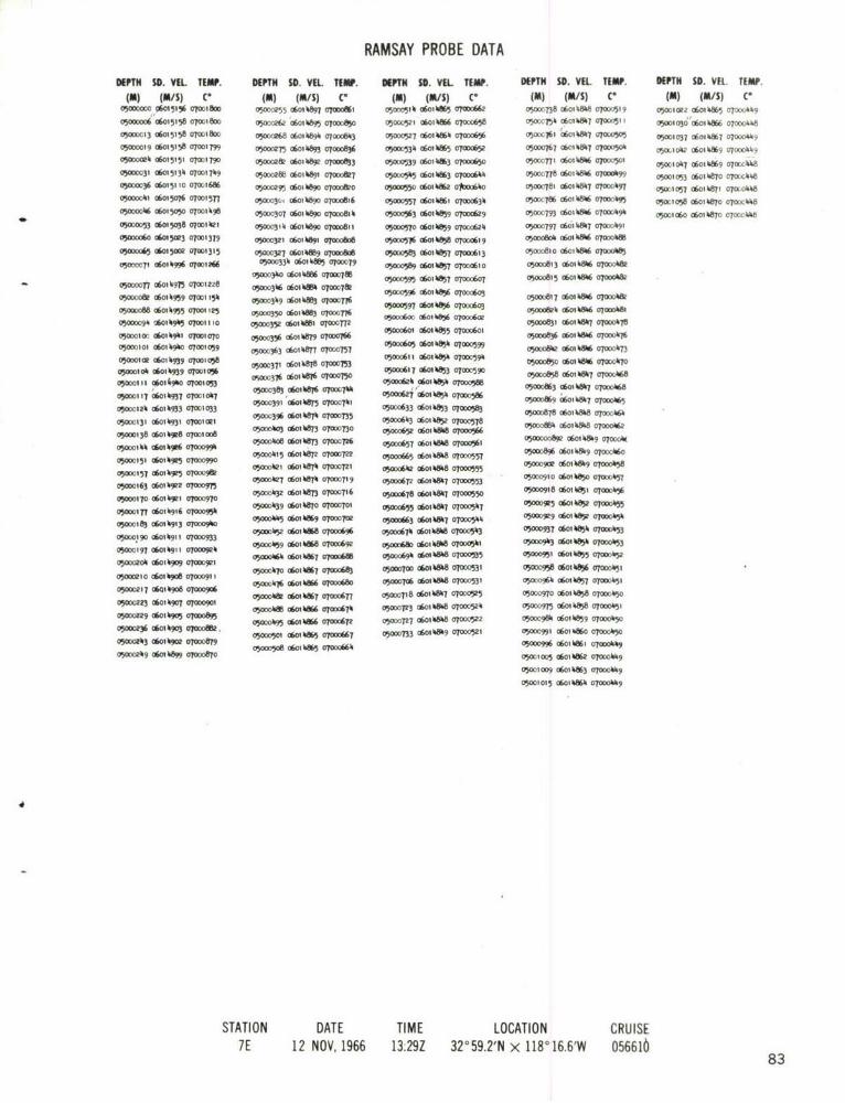
RAMSAY PROBE DATA
DEPN SO. VfL TEMP. DEPT SO. VEL. TEW. DEPT SD. VEL TEMP. DEPTH SO. VEL TEMP. DEPT SD. VEL. TEM .
(M) (IS) C' (m) (M&/S) C- (0) (#A/S) V (M) (IS) C' (NA) (MI/S) V050000 0 0415% o7mlew 0500055 060-089 07000ftl 050D0510 060108W5 07OD066 0OWT38 06014W0 07000519 05001022 0601W*05 07CKA49
O)ODOOD6 C6015158 07W00 00 £60, "89 00W0850 050(1521 06o0 W6 07Oo£658 OW7)540£601080T 0 7000511 osoo0o0o '6ol0866 070D004.8
05MM13 06W15158 moclem0 05000Z68 060-W89 07003 05100527 06010860t 07000656 050OC761 £60101807 070UD5053 05M037 060, k807 O70ODD"9
05000019 06015158 070DIT799 05-73 0600" 07-00836 00130" ff01m" 0700085 050077 06014847 0700050 05MI04 0o 60, hS9~ 07010M9050000ek1 £6013151 07001790 C15-&0 6i081 At7w0r0o8f3 05000539 OWI108W 07000650 0500771 C6~04W 070)1)501 05Io07 06010609 0700eckM
0500031 OW015130 07-017119 050002880£601089 07000&07 03000505 (601 kA63 070DO614 a5ooon78 o6ot 0806 oTowD*9 05001053 06010870 071)2I0448
o5cooo36 os0i5i to 070mt686 05-0095 06010890 OTO00 05OMW 0£6018%W 0*o6h0 05000781 06010807 070D0497 0500105M £001W 070(04M050D00i0l 0601507 0 10D05n7 0500030- 0601 "8s 07000816 05,00557t £60WKI0 07000630 oW(07a6 o60o8i 4W 009 oloo 05 I5 6010W7O 0700CM08o5oDookA o6otMo5 07ootkgB 050)0307 060108O0 070D0814 M00363 £60085 07WO0629 0750DO793 06010806 0709 £50049 um o6o0 601 k870 070ckkbO
viomm05 £601503e 07001421 0500331 £ 6014890 07000611 0501)0570 £601 "95 07000624 0500097 066I W*07 070:491
OW50000£6015M0 07001379 o50003pi £60oi8Wi o7a00o0 05000516 £60188 0700rou*l9 0500080h £6006 070000O8O
030108" £6015=0 07001315 05o00V7 06o0 W* 0700D8" 0500D583 0601 W87 0 001 050D0810 £601084W 07000485
05000(71 £6010 01001 26 050D334 06031 kft OTOD79 050005891 £60108W7 070D00830 05000813 £601080 070000Wk0500030 0601 %ft 07000788 Wo005M o6ot 057 0700o6o7 05000815 £60106 W%O7000W2
-050ooofl7£6*I10975 07001228 0500036 00M 07000782 -05ct0596 £601i W 070083o50oo"6100 7008030DOow £61959 07001 154 05004 (160~ kft T-776VO01761" -&
05O013 008 6014953 07001125 05000330 £6010883 0a000M 0 59780 £60d8- WA 0(6WO" 05(0081 o6m189 07600l0ok
050094 'A*1""0 070D03110 0500350 £601i081 0l7072 05o6ocfW3070025 001" O00e
050001 W, £6010901 07001070 0505 £ofio W87 07000766 V00060 cwhf 0700060 0500083 £6010806 070(106
05mt00 £6014900 07001059 05000363 £601187 07W0757 M00005 £60 385 070005" ~ 0 2 060106 07000073n
030001ce £601 0939 070010383£0 88 050081I £601 0850 070OC590 4ho£000 7 )7
05oct0o0k £60ot939 Moolo056 0W316o 6 "01 07000750 0500061 £601085 07000590 0500058 £601080 0700)040
0"o 10604 arol m MD01 oo 16O N 050008240£60t 0850 070005W0 0500080 60108 07 oo06
05000117 £60104"7 07001007 o5m .W " oooh -Ao62j '£601 0850 07000586 0500869 £6010807 07O0068
o"W0121; 08014"3 00103 050D0391 £6010875 07000701 05000833 £618;000 ~ 0007 6010808 0700"
0500131 £601*Bl~ 07001021 0500039 £60100 WBO07730 05000603 £60,05 07loM00OD800578t TD06
gymi3a 06o04w 7010e5010308107 07mlooB o5ooo652 £6o10808 07000966 0500oo8ge c6oi80 % 7000ooA00O"OW 96 ?D94 05000008 £6107 07000-726 05000851 £6010808 07000563 50080£0001700
0351 060149F6 07000990 050015 £6010870 0700722 o5oo6 08008 W O7,OD55T 05ooo896 o6oi04M9 o70Do060
05)157 £6010kg05 07000990 000021 £601 M870 07000721 Vi0(D08e C601 08M8 07?5M5 0500902 £6010809 0700003
0530163 08019020 WD7 050001127 £6010870 07000719 05000872 £6010807 000553 05500091,0 C& WAOt070005
0000170 £06014,OOM t 05000 oi £60087 070007l6 WW78 0601*"0 (F7000550 05O00918 £601,851 0700004%
o3aoos77 £6010916 07000950 05=ko39 06010W70 0700701 WA50 005£60108W V7000547 0500095 £6010852 070O0A5
05000183 £6014V13 70090 a5o0ok5 £6010869 070007oe 03000863 dm0080 07)000544 0500O9 0 60185 07O000050
05000190 £6010911 M00093 05WA)52 £6010168 013066 00008VA074 06044W0 0700503 0500097 OW01050 07000053
05000197 £6011 0700900 050 0 £60IM88 07000692 0500080 060W 0700001 050 03£601085 OT-"03
05000204 6l0 0601 o0 ar W, 010001 007 01000 V00080 £6a" 0 ka%s 0m35 05000951£601 hft~ ut00wwg
pmI 610 9it 0700091 1 050ooh7o £601086 OTODftn6 05000700 080M088 07000531 05000958 £&0105 WA 7000051
mAD 7o6iko aog6 050Oco16 060108%W 07O00880 0500706 £60080 al00053 05000960 c6ot 057 al"0i
050002 01 0 000 05040 £604067 O087 0500718 £601087 07000505 0500O7 £60185 W OT000'150
0500022 £601090 070089 05l0W oW%M86 Mooo6710 05000703 0601080 07000520 93000975 060108 WA 000l 5,
05000036o £619o00082 009 6mk%86 00072 05000727 o60180 %W 700O0522 05-)19ft £601089 070D0450350 0614 102 05000501 £601086 07000667 a5005=733 £60i%8k9 07000521 050030991 £601 WMo OTODO0o
700300 m000 5OD50's8 060108M5 o7ooo664 05WO996 0604%, 070000090a00w09 £601089 07000870 0500100l £6010862 0700009
05001009 £6010803 07000009
0500t015 £6010860 00000
STATION DATE TIME LOCATION CRUISE7E 12 NOV, 1966 13:29Z 32059.2'N x 1180 16.61W 056616
83

RAMSAY PROBE DATA
DEPTH ID. Vft TEMP. DEIN S. VIL TEMP. DIPTH So. VIL TEMP.(N) (M/S) C (m) (M/S) C• (m) (/S) C
05000000 06015,52 0700)788 051owk8 060)1.W10 070DoP0 1 05000800 Woio).81 07oD0050
05000oL 06015152 o70079 0500.15 060W869 07o00713 050o0 06014A 070001.8050o008 0o15152 OM7IT& o5oooo.o 06014S9 07-,0708050105 c6015153 070l 781 050o030 0601 69 070o705
0500(cz0 06015)1.6 0TO0)T79 0500A137 060)1.W%9 0700(703050COC07 06015 08 0700101 05oo3W o6ot18 o7ow9
o50ocL6 of60i50o30opch5o 050001.50 061o467 070006930500cc05 06015024 07OC137 0500(1.55 0601.k867 07000690
050(OC57 06014.999 07001319 05o1k6t of6ioi168 0700069o0500 063 06014990 OT90 25. o5C0069 o601. 07000685
050DL(1 o60)14973 07oc1230 050o 076 0601W 070006050oL77 06014963 O7016 050(018 060148650wo 6705oooL,84 o6oik96i 0700t 13 050004 0601.M6 070006T3050( 091 0601 "57 0700131 05o0196 060)1.865 070(O 7
050(0098 060)1.949 07001105 0500050 0601haS41 07000663
o50c 0i o60o4 6 oooBB 05000509 060186 07ooo660050c0110 0601490 070)c063 o5ooo516 06ooA863 o7ooL&5
05 0 18 06014T937 0700056 05000523 0601W 6 0700065)05W,5 060)1932 O70026 05000530 0601K863 OO069
050OC132 060)14932 0700)000 VA0OO"S 0601MQ O00615
05000)39 060)14929 0700)0)0 050005". 060)1.863 0700061)05ODC1.5 .601.926 0700O05 05000552 0601 i6 OT0006370500052 060)14922 0T00(986 05000558 060)1.S) 0700063305"(159 06o1492c OTOO970 0505 0601O0 000628o5o(066 o6o492o 07ooo965 050570 0601.859 070006250500)1T3 06014918 070O(961 05000577 0601.0 T o700062)owci80)6 o06o496 00o0946 05OD05&) 06aih8"o7C068050oc93 060191 07o0o932 05o0590 0601k 88070DO6)2
050 L199 060)1.9)) 07oo921 050059B 0601 9 0700o6l,05oc0czo6 o6o499 070009)7 050o605 0601 Wo 07000(6)1OW OZ01. 060)14907 07000909 0506)2 060)1.W8 07(206"
050(3220 6011.907 00o090)1 050oo6ig 060i.t5 opwfot
050227 0601 ".90 07000893 vian02 060)1858 0700059905000233 0601.901 ot7089) 050032 0601 1000598o5oocp4o o6o o7ooo80 2 0500068 06 O 1.- 07o005890500021.7 060)1.90C 070008n3 05O06"11 060 1.85 O000583
o5ooo25. 6o 49oc o7oo0866 05 o65) 0601 5o 070-5W
0500-261 060)14903 07000867 05WO658 0601. 5 0700571o5000267 0601.902 o70o065 5000"5 06014ft 0700057)05000271. 060)1.90) 0700086) 05000673 060)1.85) 070" k1
o5ooo286 06o) 07000812 05000678 60)1.850 070o2557
05000291. 060)1.895 o000837 05006as o6oka5o 70o55o5o030) 6oi83 o70o8 0500069) 06014&.9 7NC0552o500308 o601.89) 07owo0 o500060 6t 070051.05O(03)3 06014M69 07 8)3 0507 060)1.50 O7OW51.o50=(32c o60018 07005o7" 50C07) 0601 05 07=0411
05aC327 06014W87 07oor800 oo7)8 c6o.81.9 o7oooM57
052331 o6oi4886 07000791. 050705,96014 op7o53)
0500031.0 060)1.W3 07000785 0"W0733 060, W816 070005t5
05D-A317 060)14880 070077 0500071 060.1.88 070OV,o
0500(353 0601.4WO 07000766 0500071. 060)1.817 0roowm
0500X36) 0601.878 07000763 0(XT51 060)1. o7wo5t6
05000368 060)1.87 07000753 05000760 060)14&17 070005)3
05-037'5 060)1.871. a7-0715 050767 ofiot8W%8 0700o35
0500038) 0601.871. 07000739 05(07r3 06oikft. 07025))i
*050 2388 C6014M471 07(XX738 05000T78 060)148&7 07000506
05ck395 06011.872 0700c731 0500(,786 060)1.88 ol0owM0o5o,-,4ot o60)1.87) 07000124. 05002792 060)1.81. o70o(5e
STATION DATE TIME LOCATION CRUISE8E 12 NOV, 1966 14:52Z 32056.4'N x 118014.0'W 056610 84

RAMSAY PROBE DATADEPTH SD. VEL. TEMP. DEPTH SD. VEL TEMP.
(M) (M/S) C" (M) (M/S) C
05MO002 06015118 070D1T7200 o ;60517 0T51 o0535 c6i1&3 o7px6i
1050"52 06011, 0700635ooD26 o6o1 18 o100723 050D0360 0601 W 0700063305000036 .6015069 oToW:624 05ODC05 70062605000(114A 06015035 070014138 05,5 060111"7 070DO610500053 06015015 070013711 0005 7 0601 WA 070D0605woal6 060111988 07001296 05000601 0601 "87 07000602
050o71 060149680o70o199 05000613 0601 5 oTo0598050D0081 060111958 07001155 05000620 0601118"k 07WdW505000091 0601498 07001 13 o5000629 06014ft3 07O0058t
owce o6o1k941 07001079 050oo639 06015 2 070O5790500011 060111 936 0TO0I057 00X0647 060111W5 0700057
o"W00121 0601131 0"k 001ol38 05000658 06f-lkft.0700oo%g
050=131 06014931 07001023 00066 06011150 070Do563050oo11 06011928 07001008 05000675 06014f85 0700056005-01 51 060141927 07000998 0500683 0601W381 07000558
o"06o of6iot9 o7oDD989 O)0D0691 060 41850 T O70554050170 06014919 o'0DO*To 0 6o 118 11 o7oo51705000180 060 149?0 070D952 05000708 06014*11 070M05"1
0WIaB 060111916 07000956 050017 060118 107000539050 198 060111"90 00 ooW o26 061 W8 07000530500o006 06014908 07000914 050735 0601118117 07O05Ox0215 060111908 07000907 0500715 060148ki 07000250500220 06014907 O901 05-753 060 1 19 07000523050032 060111906 0700089 03000161 0601 %&19 07000521o5ooc,242 o6oA o oTooW 8 0"W70 0601 %&T 0700051605000251 06011"190 0oft 05w0om7 (*Of" 1111 000511
05000260 0601 oM00700-M4 03-787 011 W 70sO050D1269 060111901 07000865 050007953 06111 07000030500.9 06m" aoo 0 o5oW0 6 oiWOowo50050D02aS 06066 0700-0813 050081 5 c",18 07a0aw "
oooceg o6oik" oTo00934 D& 61%t V
oW3 o6oi opoO U0 00500313 06011188 0700"
05000322 0601 525 Wl4 ar0791050332 0601 8 0700050500339 0601117 0700019
050-0318 060111876 7363
05000357 0601117 WM O-5505-03"5060111WP20T000746
0500376 06011187 0TOW73705000388 &o "8117 0700073i
0500393 060187 07000730
0500041020601" 1870000726
o5ooohio0 o60oi8" 07000723
050Wi1119 0601116 mfiq -,05000112 060111ka9 0700500013T *0I114%9 07000701
.0500OM17 o6oi118%8 o7oD0699
0OW456 06014&87 07o693
o5,000172 06011188 0700068605-k0T18 060, W18 OT0-677
4 05(-0018 060,14%6 07000675
0500198 0601 11881107000668
05W0O5" 0601 k8811 07000661
05"0017 0&011kffik 070D0659
03WOY56 ;60111W8 0700065
STATION DATE TIME LOCATION CRUISE8D 12 NOV, 1966 15:25Z 320 55.4'N x 1180'15.6'W 056610 8

RAMSAY PROBE DATADEPTH SD. VEL. TEMP. DEPTH SD. VEL TEMP. DEPTH SD. VEL TEMP.
(M) (M/S) C" (I) (M/S) C* (m) (M/S) C"
0500ca1 06015151 ol 1784 )50300 06014.W3 0ooo726 05ocC805 06o14 oo090
0500OX3 06015151 o7001782 35oochi, o6oi14" o70 733 o5o81 060148 o1 70V,487
05occo07 06015151 070T1782 050D0417 06014873 0700,T9 o5oo818 o6oih&8)3 o7oc48
o5oco 2 06015151 o7o.4178o 050D)431 06O,S1k4 07016 0500025 06014&4 070006805002019 06015150 07001776 0500)433 06014714 07o0:C713 5000832 060144 0700480
050 C26 0601514 7 07o01764 050o 443 06014 07o0710 05000839 0ol4844 007oo4650c, C32 06015142 07O0170T8 050451 06o1487o 03o 702 o5ooo8 06oi44 oltooo475
05&c38 6of151o3 o7o0692 0o0oo58 060W7O 07"0,697 05OC853 o6o4&86 0700)4Tk
0502c0147 06015053 07001530 0 465 06i 870 o700693 0500c859 0604846 o7 okT4
0500C053 06015031 07001411 05000472 06014&8 0700087 05oo866 06ot486 0700p 3o50o6 o6oi5oc9 07o01354 5o0T8 c6ol 868 070oo683 C5 873 06o01487 o700A7O
050coo66 o6oi4989 o7oc,1264 0503 0601468 07000679 050XAW 06014841 0700D4690500374 0601"4932 0300121 0500491 0601 468 0700676 0500o886 06ot 41 o7o o'68
050D0082 06014964 07001162 050D01498 06014%76 07000672 05000893 060114&)9 07000463o500o08A o6o4962 o7ooii48 050 05 060146 07000669 050009 0 oo6oi4&9 03OOx466
050094 06014954 07001 2T 05000511 06014863 W 7000664 0500o907 0601 "o 0300c465
o5oucioe 06014951 o700105 o5ooo5t8 60i4ffiT 0o700663 05000914 0oik50 o7o00o630500109 06011497 0708 I 0500052 6oi4864 0300655 o5o002o 06014 0 0700062
o5ooc1 6 o6o4g9ki o7olo68 05000531 0601ffi4 07000649 05ooo927 06014852 oT00)460
05000123 o6oi4932 07oo1038 05000538 06014862 03000643 05000933 06014 53 OTOW4590500013 601 4925 0o7oc02 05544 060114 1 0T000638 05000940 060113 030045905001 38 06014 23 07000993 o5oo552 c6oi486i 07000633 oFooo0947 6oi4834 07oo459o50ooihk o6014923 070oC985 05o0558 o6o148 o7o0630 0502954 0601 54 OTOO(1457o5oo2152 o6o114924 o7oco985 050o0565 0601186 07000Too625 5000961 060114855 0700C,56o5o22160 060o145e3 07000936 05000572 060t14859 07000622 0500(96T 0601415 WA oToc455050 167 06oi498 ox.962 050o578 u6ol4859 ooo0618 05oc09T3 060,157 070mo)4"50502173 001)4918 0T000952 050x5d5 OW0I4050 07000b13 050c0e 0C6 858 07004 5a5oi8o o6o4921 07oo956 050o591 0601858 OT0609 05000987 C60,89 oT=45505ccl88 o60oih9i3 ooc418 075000598 060114856 03000605 05-C0993 0601)4860 0300C454
05OL0604 0601685 0TOO60 050010oc o6oikf6o o70o1505 - 3 0 0IV96 0500915 5 00 06 1 0 856 3000597 0500 0 0601 h 61 07 0)453
05000209 06014910 o0000915 05o0617 0601)40 o95 03-o013 06014w 0700chm050001217 06014909 07000907 05000624 060141855 0700591 05001c00 0601 4mi! 07mk41v05000223 06k114qW o7o0 05000631 0601)4"5 07000586 05001028 060,)48W4 otooo"45050a31 060114909 07000900 0500038 060148 070005830500o233 0601)4909 07000597 05WZ5-*ffWA-MW5?9
o5oo245 o6o458 o7oooe93 05000650 o6ot54 oToco7 405000252 06014907 0T000885 05000657 06006854 070057205000258 06014905 07000880 05000664 060141853 07mo969o5ooo266 o6o4o2 oToo869 05000671 060114852 07000605O0272 060111900 07-3 7 050006T8 o60141W51 0700055805000280 0601899 070O650 050-683 (060185 0700C553050-0287 06041489 07 W 050ooi05 o6oi 451 0700055505OCK294 6oi489 o7o2829 o5oo697 06ov152 OTOOC55105 102 06014)800702062 05020303 06014181 07000549
05000307 06014 88o oTOO808 0500031) o6ov4851 o70o5440500314 o6o414888 o7o804 050C718 0601 W)50 070005410502322 o6oi14886 oo298 05000725 0601 45 070005A605: y329 06014885 0700 72 0500L3i o601485o o700oo5
05oo2335 060141W3 0700085 05000133 06014450 07° 531
050U3)4' 060,)W170 0500M(744 0601)48)49 07000528
0500348 060414880 070D0T70 05030354 0601484 07000524
05OC-355 0601488 03000767 05oc0753 0604847 03020549
35000362 060414880 07000764 050o0364 o6oi)4846 0700(513
0 503 ,369 0604)4879 0700-757 o5oo37p o604)4 07000540
5M3336 060414877 000750 0500L378 o6ol)4W45 0302050
65002383 060114875 0702 3142 05000386 0601)4"4 07(0500
)500390 06041487)4 0300kT33 05000352 0601448145 07T00D49935022396 06014873 0o730 050ck98 0601484 0702C496
STATION DATE TIME LOCATION CRUISE8C 13 NOV, 1966 02:58Z 32054.4'N x 118 17.3'W 056610
86

RAMSAY PROBE DATADEPTH SD. VEL. TEMP. DEPTH S0. VEL. TEMP. DEPTH SO. VEL. TEMP.
(m) (m/s) v (m) (M/S) C- (M) (m/Sp c-
05000002 06015146070001715 050X433 0601 WM7 07000722 050uo081o6o ,M81 o70ook&05000008 0601514907m'l1TT3 050001, 060t118" 07000715 05200ow. 0614W11 07000181050Do015 o6ot5i5o 070CIT73 05000447q 060)14&9 0700oTc 05000853
0 6011.&7
1 07000179
00003 06015,50 0700I7o 05000h155 06014&89 01000695 05oo0B59 o6ot 4&18 0o000ok7805000029 06015111 070c1763 050200.61 06014%88 070010691 050coW6 o6oi W*q o 7oo0705000036 060151 c(9100100170 c05000O168 06oi1.4%8 o700o68 050008741 0601.Wh7 07000476050000.2 06015051 07001522 050001.5 o60oi14M7 o7oooba2 0~oe 6,18. 1016
05000050 o6ol 5ce5 07001387 0500w4&8 -0601 W%78 0700679 0500088 06011.M1 07oook66
05000057 06015008 07001350 05000118 06011.867 07007 05000895 060oi.81.7 070011630500006h1 06014.990 OT001260 o5oo(1496 o6oth1866 07-o6T3 0500902 06oi 4&18 o0ooo46305000070 060111986 070r12341 o5ooo5o2 o6oi41865 01000667 50980118.
0500007 06011.979 07o01216 05000509 o6o1148611 07oo0660 A00 060,148&7 07000"95
05000081 o60oi4965 0700"33 0500051T 06014&41 070056 00O0 61& 70"
050D0091 06011.952 0700113. 05000523 0601W461 070Dc653
05000099 0601.9.1 07001085 0500051 060111862 0700061.805000107 06014192 o7mi10p 05000536 060 11%3 0700061.5
050011 06011."5 07001c51 050oo5k13 06oi11862 070006.305000122 060111927 0700,020 0500051 060111862 07000637
05000130 o6oik.9et 07ooo998 05000558 06011.fi2 07000635
050D0138 060oA116 07o00977 05000565 06014.861 oTooo3o
05oo1117 060111915 07000962 050005T1 o60i4ffio 07000601.
0500055 o6oi11918 oTood66 05000577 060118W8 0700062005000162 060111916 07000955 05000581 06011185 07oo061005-0170 -6011913 -07000946 05000592 060111855 070006030500179 060111913 07000931. 05000598 o6o11185 0700o6010500ol87 060111913 07000933 050060 060111856 a7000598050019 o6oi h619i0 2 o?c95 05000612 060i 1856 o700C,5%05000200 0601i4gii o 7oD092i .05oD06i9 0601115 W o0700059oWw0210o 060ol49i0 07oo09i2 050062 ol "~5 07000590
05000211 060,14909 07900907 0.632 '0I 118511 O505
050DO224 06011190 07000903 0500DOW10 060111853 0T000581
05000232 06014107 0700089 0500617 060111851 0700059
05000210 060,11906 0700o8BB o5ooo653 ofioi1"k oTooo57
050o00247 060141903 07000880 05000660 0601181 07000573m
05000251 060,11901 07000871 050oo666 06ot185 07000O569
05000261 060111"9 o7ooo86 0500063 0601118W 0700055
050oo268 060o118o 01000811 05006 06011185 0700055
05000271 0601118" 07000833 o5oDo68B8fo "i1185 070005705000281 06018WW9 0 0~19831 050o695 0601h819 07000550
05000288 0601W19 07000829 05000702 06011111 070005%41
05000295 060111On 07000827 05000709 060111819 0700051205000301 06014%81 07000818 05000715 060 11819 07000510
05000308 o6ovW190 070oo816 05000721 060111819 07000538
05W0315 060111890 07000810 05000T28 060 11818 0700053205000323 060111889 070008014 05wMT 0601 11817 070005290500330 0614 10 70oo798 05000713 o60ot1816 07000521
05000337 060,11W6 070ooT2 05000750 060111813 0700051805000313 06011.88 07000785 05000056 06111111 o0005io
050031.9 060111886 07000789 05000763 060118.1 0700050705000358 060111886 070o0780 050oo7p 06011811 07000501.05000361 0601 11881 070007. 05000778 o60t11813 0700050105000372 06o114ft 07000365 05000785 -00,418113 07020199050078 0601 "7 07-T059 0500792 060o11812 070001191
005000381 o6o187 0700oo75o 05000799 060111812 07000119005000390 060117 0700071cT8 05000805 060ot1813 oTo0ocii8
05000399 060o1188 07000715 050DO81;I 06011.W*3 07000180500010 060111879 0700r711 05000819 06011811 07000118050D01113 06011W"7 070ocT36 050o0826 o60oi18&4 o7000118&050001.19 OW4,1876 070079 5083 60181500018
050001126 oo 7x73 0003 06011187 0700c(723
STATION DATE TIME LOCATION CRUISE813 13 NOV, 1966 03:42Z 32o52.2'N X 118-19.4'W 056610
87

RAMSAY PROBE DATADEF'TN SD. VEL. TEMP. DEPTH SD. VEL. TEMP.
(m) (m/s) c. (MA) (M/S) C-
050ooot1 06015155 07001792 05001 I18 7065050ooce0 o6ot5i57 07001792 05009 060I1162 070006541o5oo0028 o6oo5o8o 07001716 05001 061% 070DO652
05000036 06015035 070014&8 0500P5 0601 htg5 0700064150500O111 06015016 07001380 05000533 060111WA 070"033
05000053 060111993 aloo128B 050005413 06014185 070D62805000062 060141987 07001219 0500055, ;6I11"41 070W621
o5oooop1 o6o14975 0700122% 0500559 0601 854 07000615o5oooo8o0o6ot4967 00,17 05000567 o60o1185k 01000612
0500c099 06014915 0700083 0500"76 o60ot1854 07000608050D0106 06011913 07001071 050058 o60oi85 070006a1
o5000i15 oW411938 o7wo155 05000593 060111853 0700060o
05000123 060111935 07001044 05000600 60oik85 07000595
050Dc130 060111929 07001018 05000608 o60o1185 0700e59i
050D0139 060111922 07~99 0000 o x6ih o60os85 0 7oo0587
0OoI117 06041920 07000981
05000151 060141917 07000967
o50ooo63 o601ik9ik 070oo93
05000171 o6011191t 070oc9k12
05000179 0601119li o7oo0g3i
05000187 0o111909 0700O960500095 060111903 070009111
05000203 o6011898 oloocOW
050D021 1 0601889 07000817
050DO218 0601119 " 07000871o5oD0e27 060111"9 07000873
05Oc2341 0601118" 0700071
05000212 0601189 O001466
05000250 060111899 07000B66
050c259 0601118" 070o0860
050027 060111M98 07000511
05000211 060111898 070005
05000280 06011189T 0700W1W
05-297 06018897 07000811
05000305 o6oi189 0 7000821
05W03111 060111Oft 070D0809
050003Z3 o6o018 07000781
05000332 0601 4W8O a0o00783
05000339 06011187 O70=71
050-0317 06011187 0700765
05000357 060111871 0700MT57
0500365 06014Mk71 070007
05000371 0601 W871 07000713
0500( 3& 06011871 07W000
05000390 W060881 07000736
05oo0399 06014811 07000732
V0000110 06011187 07000727
05000116 060I11W9 07000713
050001132 o601l1866 0700697
050004411 060111866 07000691
050001150 0601 167 07000693
050004%5 o6oi11W*5 07000690
050001167 o6oi 1185 0700o68&
05001171 060111865 07000679
05000183 06014W83 07000672
05000192 060,1186 07000665
STATION DATE TIME LOCATION CRUISE8A 13 NOV, 1966 04:29Z 32051.4'N x 118o2l.41W 056610 8

RAMSAY PROBE DATADEPTH SD. VEL. TEMP.
(M) (M/S) C"0500OCC2 o6oi5i)49 07o0i78
00CN,5 06015149 o7001 760500o0)0 06015150 07Oc177505oc013 06015151 0O715
0500oC16 C6015151 O70T76o5ooco19 o6015i50 o70o0i)5
050W'023 o605145 7oci7650500C27 06015130 070C738
0500co31 o06i5104 0ot605(oc35 o6o15o82 o7oc1581
05000038 06015076 07o01533050o0C42 060)5071 07001510
050DO045 0601554 070cl890500o49 0601503 071396o500053 i0503 o7oo36805000 06 014995 01001 26?
0500co64 o6oi992 o7oi25c
050CV69 06014984 07oc1229050(C72 06014981 07001206
o5oc76 o6osh978 07ocii95o5ooco8o o614978 o7oci186o5oc083 o01oi9T7 07omif8
o5ooco876oi974 07ocii7705000co9) o6osh9764 q7w)16i
050(0C95 06014952 0700)*180500099 060114950 07rc1092
05000 03 06014950 0700109005a 06 060149"9 070CIo85
0500 11C 0601)4949 0700)082
05000113 06014949 070(Io795o5oo017 o6oik4k 07oo075
05000122 06011496 OT001065
o5ooc26 o6oi4944 o700262
STATION DATE TIME LOCATION CRUISE9A 13 NOV, 1966 05:22Z 32046.8'N x 118 022.4'W 056610
89

RAMSAY PROBE DATADEPTH SM.VEL. TEMP. DEPTH $D.VEL. TEMP.
(M) (MIS) co (M) (M/s) cc
0500000( 0601511.1 0700171.8 050031.25 06,014&87 070Mo8
0500000 0601514t1 07M 1 IJ69 OW00C432 06014%88 07027m
050c2 060151.1 0700748 050D01.39 060I14866 07000697
05000010 06015i143 070C 171.8 o5ooo4* 6 l W61185 0700*91
05mmlBI 0601511.3 0700171.7 050001.54 06011.8"1 07(0DO685
050000626 060, 5110 0T00174.0 050004.62 06011.863 070"180
05000033 06015131. 07001721 0500(1 60, W%ol.6 07000670
050DW.311 06015129 0T001701 05003176 060141.59 070D0665
05omo%5 060i5y*3 o7or0i570 050004&8 060, WA5 O?O0657
050oc064. 06015013 0700136, 050001.89 06011.85 070-652
05m,0070 06014.992 07001295 050u01.96 06011."7 0700019
05000077 06014.9T9 07001231 050005 0 ,1.857 070006"050mo"8 06014*96 07w]1178 05030511 06.011.5 WA 7alM638
05(00090106014.9%9 07001122 o5wo3t18 o6o11k8% OTooo35
0500097 0601k.93g 0T001079 0OD05no 060i1085 07000632
0500010D4 06014.931. 07001050 o5ooco33i o6othft5 070006W0WW001? C6011.hW9 070D103%1 05000339 06011.W54 07000Q25
05000117 06014297 07001015 05000515 060118. "k700O06190500025 06014.923 07001005 050O053 o6oi "5s o7o0o616
050wl132 060114W90 700O9ft 05wo%l 06011.54 o70006141050MI410 060111917 0700097 05*DD%67 C601 Wjh1 070006110500011.7,06011.916 07000965 05000573 060, "83 010006"05000151. 06011.911. 07000960 o5oo05a0 06011."3 0T0006m0
o5ooo16o o60oik9it 07oo091. 05000587 0601 "81 07000598050CI3168 0601AI908 07000930 05000591. 06011."1 07000591.
050V, I75 06011.907 070D0921 05000601 06011.851 0700058?
05000182 06011.908 07000901 o5w-was 0601l OR 0?-05m05-0189 06011.907 07000915 0500x*15 06011k85l 0700051o5oDot 96 o6oi4.90B 0ToD09i2 050DO624. 06011.50 070005"
0500020 06011.907 alw90" 05000630 060,1.81. 07000570
05000211 0601%.906 07010D901. 05iOW637 OW60118 07W00905000219 0601"q90 00089 W5000O"3 0601.81. 07N00965
05000226 06014.903 07000898 05000650 06011.8&9 070009620500033 06014.90e 070D088 050OW 060118W 0o0006105000239 0601."99 70w0871 o5ooo665 o6oihW1. 07ooo554.0500021.7 06011.897 070w06k 05000672 06011.1. 07000553
0500231. 060,1.96 0700085 05000679 060i1W*18 010D105520500026i oW041894 o7oo05i 0561 . C6014ft50 07000552
05000268 06011.80 07000839 050006920 1 ~h.18. 0700051.9
05000275 06011.89 070082 05oo0699 o60,.8l 07000oo51.2
0500oz89 060oik8go 07000823 05000707 06011.". aO051
05000297 06011.88 07000819 05000711. 06011.850 07000539
05000Y301. 06014188q 0700008in 050020 okot1.8&9 070wu538050031 1 061.889 07000809 050C0727 06,014&819 0700053505000319 06011.MW 07m00805 05000733 0*014.850 0700053205000326 06011.888 070M,798 0500071.0 06014&819 0700053005000332 o6oi1.W% o7000795 0500071. 06011.8&9 0700052505000339 06011.885 07T-789 05000755 0601hb85o 07000522
0500031.6 c6oihM81 0700078i 00-762 0601%ft50 07000522050055 06011.kft 07-0775 5000*670d-l.051 07000523050D0361 06011.881 07000769 05000775 06011.W52 V700052
05000368 06011.MOO 07000760 50007&0 0601 07-052105000375 0601"n87 070D755 o5ooo788 o6oi1.8k8 o7ow35u2
05000382 Of-I1.8M 070071.5 0500796 0601-1. 07O000500
05000389 06011.WTh 0700138 0500080 060i1.8mm 070001.98A05000396 06011.8" 07000732 o5o0<o809 o6o,181. 070co1.95
05-001.01 06011.WP 07-TZ77 *5oo08i6 06011.817 070WD494.050001.12 o6oik.8p o70o0720
05(001.W 06011.870 a07lk1
STATION DATE TIME LOCATION CRUISE9C 13 NOV, 1966 06:16Z 32'50.0'N X 118-16.0'W 056610
90

RAMSAY PROBE DATADEmT So. VIL. "W'. amT a. VS.. "W. Wu a. V.. nEw.
(W) (8/S) C* IN) (AWS) C* (U) (am5 C.
050DC0(1 "605149 *7001779 05W03M 0601117 " OT-732 030DO696 0601 W"b 070005W6
05W0D.5V0W5l48 070D171% OwnC37 aw%m11 070=(31 oswym0 a",151 WV 70c053mo
050000I0 "651419 070D17M 05000385 Of-111K9 070OC723 05000710 0600m"5 O00w23
0500MI15 06M1514 amom7017 050003ge 060,1w8 OiTOWRO 0"000717 aww"1 070"s90
050002 06M151415 07-01763 05000397 06014%9, q-T0)17 0501Zm 06o1m" a700050
05000027 0OW5i143 0rosiite 05000398 0601115 OT=716 VA-T031 0601407 070D056
05000032 "6051 lk 0?0l?W 05000O0 C60IM58 070DC115 05 73 GW OfW524
0500039 060,5140? 07013 35000" "IlW15 G70ODG11 I ,0y1 CPPMOT" GW 07 WO-PS
050000441 06015134 a?CDI1731 00DO12 0601111100 O73 W "505 0 7 1~
05mo,050 0ii01311 it7001670 MW0001M7 C"O11 CVFON6 030001,61 06MOi1 O7MM0I?
05000055 0601"Ill1 07001605 05000123 0601WK41 070D0699 030-*e GWW1 UP5000513
V000"3 "06o,8 070WtkO1 05000129 0601%ffill U7t0063 05OD0775 CWQW15 0,~ 11
050D069 060111997 07001314 0500013 06014"53 07000669 o50w07M a6ooMM8 o7cou5st
0500007m 0601119 om0139 030"018 060.1WK3 0700068 03mo0ft o6olit , i~qo
05000081 "6011969 qW01201 00OCk"1 06014%35 07000683 0500781 060111597Q0011050000a "4(19%6 070011VIA 05000"11 0601115 07O0(679 05=03 060111*g a0511
m500003060mkgw 07001107 0500451 06011152 07000675 030007% 060401907000511
o5000101 060911906 07001OTT 0500002 06011ot 070o0wo63 05W07W0 0601W 07O0D311
0500ml0a 060m"93 0700059 o5ok7 0601MM5 07looa7i
ow00015 060114"1 070010"3 vA000h7 0601s1507000666
O500122 OW011W?, 01M01M2 05(-4176 " "1189 070%4W6
05000t?9 c6ook9ek 0700ciam 05000181 060O1189 070ow657Wx'0(35 060)149e2 0100D991 05-4W19 0601WA85 070(0653
0500112 06011119 0100D9%3 ow "019 a"113 WA 700co119
05-0150 0604111 07o00009 ww"019 060111858 O700cO"gOW50016 dm0b11i5 o70owoi 05000197 06011185 07m061
0500062 '06m1119111 00wffl 03~0 0601W158 or-ow
-A000169 06011111 0700091 030(0*50 06OW189 0700(61305000176 0601111 00M0g9%6 W,00051 5 061W 85 070006113
05-0183 060mk%95 o7wo0W MWM209001WA85070M639
050018 06011l9ve 07000m3 050D0526 o6olWA8 07000633
05000193 OW011913 qow"09, "-W53 0601WA 07000"280500020 ow0lig91I a7-p19 03*o0Mg 0601%ftk 1wo06a2
0500020 060111911 7 99 O0550 0601151 0700618
05w"m0 06m"1w0 07000918 050D0551 06011WA1 07000616
o5wwa& 6oi04q170-""90 ON50005860118530700613
05so01f4 060mk%96 00w0 "-O%k61 06M185 o?woo
05w(22 0601419* aoso "50uMc7 06014%81 o7*Do60M
05w029 060111905 O000891 0500051 0601 1 07000599
050023 06011190 0700W 0500(o3m 060111WA*07"0096
0500211 OW01193 070-M8 05A005 060111WA OTOD059e
050oc250 060,1190 070DOOD7 0000588 060111"91 OTOOC591
05l0025 a60kgm0 0700058 M50059 OW01150 07wc0591
o5cx7266 06011190 0?0-865 0500590 06fi1llo0 07000591
050272 0601 W" OT070:57 "50DC3" 060'WOA3 at"M509
0500027 061169 m00 w8 05000601 060"81 0700058
05ow02a060*m 96oToD8Oks 03000" 6 ol4w118 0700ow
05000293 O060119 OTW%l MMA0013 GWOR18 0Mm058P
0500300 06011188 (7000ft 0500620 0601%w o7005&1
050M036 060111km 07000 05006Z7 06011150 070005770500633 06011185 07000571
05000313 061 kf 7000796 mAooW'1060l"185 070O0573
05D32 60M 07ODC70 mo5"00611 0111W 07000570
050oc332 0601118t8 07000lk1 050D0660 C601 11819 070005%2
05000339 0601WO8 0700767 oWo0661 o6otlo8W1 aloo52500306 0601M8* aj03 05000675 060o11W17 07000550o5(52o fo %611814 07oo0r5 0500081 0601114P7 0700051105000358 06011187 070078 0500065 060111817 afo-)513
05-0365 0601"187TO-0738
STATION DATE TIME LOCATION CRUISE9D 13 NOV, 1966 07:05Z 32*51.7'N x 1180*16.0'W 056610 9

RAMSAY PROBE DATADEPTH SD. YR. TEMP. DEPTH SD. VEL. TUAP.
(1A) (MA/S) C' (m) (m/S) C-o50o0002 0Soi5i58 0700oiM 05000358 06010880 0700072
05ooooo5 c6oi5i58 o7moi 8o6 WAO362 Ofim88j 0700079
050D0010 06015158 07001 805 05000369 060187 0700753
0500017 06015158 07-01a03 -Y-0316 060188WM 07-07467 f 0501-383 060, "87 0700780
05ooo2k a6ai5i%6 o700otp8 05000391 0601 "7 07-32
05000031 060,518k3 07001T78 05000399 06018870 0700725
05000038 0601 "9 07001695 0500080 0-l0,86 07-D71 905000084 06015062 070D1523 o3oo00iii o6oi84&8 07000712
05000052 06015039 a70018k57 U5000421 060148 60700070805000059 06015012 a7-01356 0500028 06014&76 07010705
05oo0o66 OW41997 07001311 05000837 06014&66 07000696
050000T5 06014970 07001208 05000888 o60i8W66 07000695
05000082 06018960 07001158 05000850 o601o8W" c7ooo:6b
05000092 0601 8951 07001129 05000"S8 060188W 070006ft
05000099 06014098 07001099 0500086 06014%~5 070OWc8
05000106 06018980 0700107, 05000878 060186 07ikO000675
05000 116 060184937 07001058 05000881 06018863 07000671o5000i2h o6oih8932 07001027 0500088 06014%63 07-667
050CO133 o60tk929 oyooi0t8 05000897 06018862 0700O662
0500180 06018928 07000998 05000508 0160,886 07000658
05000150 0601hM2 0700098 050O0512 06018860 070006510350015 06oikgei 0o0omo98 050O0319 0601886s 0700688
05000165 06018913 07000958 05000527 06018037 0700068005000173 060,8918 070D0946 0500053 o6m Q856o7000630
05000181 06018915 00046 050D0582 06018kftl olooo8
o5000i89 o06oi8913 07000936 05000550 06018856 0700062
0500>0197 060184912 07000928 050058 06018Wb? 070D:0622
05000208 06004912 0700<922 05000565 060, 885 070oo6i18
05000212 C6018911 OTOD017 05000572 060185 0%7000613
050002i90o60t49o007000913 05000579 060188*% 07000611I
0500022 c6oi km 0ooDogof 0500587 060l8855 0700060
0500025 060, 8908 ap"m90 05000593 C6018853 07000600
05000242 06019"q 01~~COM 05000601 060185 07000598
05000289 0601890 0700DOM9 05000609 0601W85, 0?0005U8
0500055 0601490607000882 050061T 06018OR 0700035
05000263 06014905 07000877 050065 060, 8850 0700058
05000271 06018908 07000872 05MO633 0601h88 07000571
05000278 06014908 07000865 0500068 060, 8887 07000567
05000286 ofioik9ce 07000860 05000607 OW0888 07000563
0500003 060188W9 0700051 05000658 06018888e 0700055
05000300 06018899o7000884 -- 05 -6 06887 aN00536
05000308 060188M" 07000836 05000669 060188W7 07000551
05000317 06018898 07000803 050o0676 0601848 07000551
05000328 060i 889 0lo000818 05000688 06018887 07000589
05010330 0601 887 07O0080 05000691 060188847 07000583
05000337 06018885 0700793 05000699 0601 888 07000582
05000386 060188Q& 07(X0781 05001:707 ob01888 070005400500715 0601889 070005390500708 06018889 070005
05WW073060188ks0g002"31
0500037 06018889 07000530
STATION DATE TIME LOCATION CRUISE9E 13 NOV, 1966 08: 18Z 32053.1'N x 1180 13.2'W 056610 92

CRUISE I D EPTHASSIGNED CONSECLUJJTIV mo DAY I YR I R N W METERS U/sEC D: .
05660 1A 1 111 3 66 116 330 4.0 18 *39.51 229 2.1 275TEMPERATURE CLOUD SEA SWELL WATFjPANEMO BAROMETEF ---- E 4LMIDT' WW ' 1 | ISB COO
MGT meS DRY WET DTPEI
AN IR ANT IR A T COLOR TRANS
1025 16039 14-- 79I 320 1' 5 m
OBSERVED TEMP SALINITY DENSITY SND VEL
DEPTH(m) oc O/oo ot m/sqc
0 18.48 33.49 23.64 1516.1
1142 9.78 33.91 26.23 , 1490.6208 8.68 3.22 26.h0 11487.8
STATION NUMBER DATE (i...MT) LATITUDE LONGITUDE SONIC WIND
CRUISE DEPTHASSIGNED CONSECUTIVE MO DAY YR HR N W METERS N/SEC DIR
056610 2C 2 1 U 1 66 06 3 07.5 118 29.5 12 3.6 300TEMPERATURE CLOUD SEA SWELL WATER
ANEMO BAROMETEA - DITY WW VSBYHGT MBS DRY WET TypE AMT DIR ANT DIR ANT COLOR TRAN
1019 18.OC 14.7 70 ,tr 1/1 -- calm -- 0 om
OBSERVED TEMP SALINITY DENSITY SND VELDEPTH(m) oC /oo ot m/s*c
0 17.89 33.55 214.21 151-.5247 8.37 34.15 26.57 1487.2
492 6.52 34.35 27.00 1484.5
740 5.16 34.38 27s18 1483,.1988 4.17 34.46 2736 1 1483.2
1088 4.10 314.46 27.37 l,84 .5
NANSEN CAST DATA93

STATION NUMBER DATE J,,iMT) LATITUDE LONGITUDE SONIC WIND
CRUISE I DEPTH
ASSIGNED CONSECUTIVE MO DAY YR I R N ,W METERS M/SEC DIR
0 5o 4C l 11 11 66 In "33 04-.1 118 27.11 1152 1.0 280TEMPERATURE CLOUD SEA SWELL WATFP
ANEMO BAROIETER -- 'IIHIT WW '1SBY
HGT NBS DRY WET - TYPE AMT DIR AMT DIR AMT COLOR TRANS
1020 16.11 13.33 73 Cure 3/10 -- caln 300 1.5' 1oe
OBSERVED TEMP SALINITY DENSITY SND VELDEPTH(m) oc 0/oo ot m/sec
0 17.78 33.53 24.19 15114.0
250 8.12 314.09 26.56 1486.2500 6.53 34.30 26.96 148-.5750 5.02 34.42 27.24 1482.8
1000 14.18 34.46 27.36 1483.31100 4.10 34.146 27.37 148-.7
STATION NUMBER DATE (,MT) LATITUDE LONGITUDE SONIC WIND
CRUISE DEPTH
ASSIGNED CONSECUTIVE MO DAY YR HR N W METERS M/SEC DIR
056610 SE 4 11 12 66 0 33 01.5 118 23.1 732 ... 3. 129TEMPERA TURE CLOUD SEA SWELL WATER
ANE.MO BAROMETER K.MIDV t TY WW vsBY
WGT mes DRY WET TYPE AM DIR AMT DIR AMT COLOR TRANS
1020 16.11 13.33 73 SC 1/0 290 1' -- 0 lore
OBSERVED TEMP SALINITY DENSITY SND VELDEPTH(m) c0/00 0t m/sec
0 17.83 33.54 24.22 1514.5
99 10.66 33.64 25.79 1493.8198 8.83 34.03 26.41 1488.1
297 8.06 34.18 26.64 1487.1
447 6.83 34.27 26.89 1484.8596 5.69 34.35 27.10 1482.8
NANSEN CAST DATA
94

STATION NUMBER DATE (,iMT LATITUDE LONGITUDE SONICWN
CRUISE I DEPTH
ASSIGNEDI CONSECUTIV Mo DAY YR HR N -W METERS N/SEC DIR
05661o 6c 1 5 111 121 66 U1 3301.9 118. 18.0 1088 4.1 320TEMPERATURE CLOUD SEA SWELL WATEPANEMC, BAROMIETEF; - - HI-IMDITW -S-
HGT MeS DRY WET TYPE AOT 1DI A DC TRANS
1019 16.11 13.8 78 C 1Cm,
OBSERVED TEMP SALINITY DENSITY SND VELDEPTH(m) oc 6/oo ot m/s*c
0 17.79 33.56 24.24 1514.2
249 8.47 34.14 26.54 1487.7
498 6.36 34.29 26.96 1483.8
747 5.o4 34.39 27.22 1482.8
997 4.18 34.45 27.35 1483.3
1047 4.16 34.61 27.48 148-.3
STATION NUMBER DATE (3MT) LATITUDE LONGITUDE SONIC WIND
CRUISE DEPTH
ASSIGNED CONECUTIVE MO DAY YR MR N W METERS M/SEC DIR
05661 7E 6 11112 66 114 359.2 118 16.6 34' 2l 320TEMPFRATURE CLOUD SEA SWELL WATER
ANEMO BAROMETE -qUMDITy vS
OBSERVED TEMP SALINITY DENSITY SND VEL
DEPTH(m) °C 0/00 ot m / sec
0 17.6o 33.52 24.14 1513.5
240 8.68 34.11 26.49 1488.3
480 6.58 34.28 26.93 148-.3721 5.14 34.39 27.20 1182.7961 4.19 34.46 27.35 11482.8
1057 4.16 34.46 27.35 148.2
NANSEN CAST DATA 95

STATION NUMBER DATE (JMT) LATITUDE LONGITUDE SONIC WIND
CRUISE DETASSIGNED CONSECUTIVE MO DAY IYR IMR N -w METERS M/SEC DIR
056610 9D 7 111 13 166107 '32 *51.7' 118' 16.6 8145 5.2 310ANEMO BROMETER TEMPFRATURE CLOUD SEA SWELL WATEPANEM 8A ET o-,, my 'D wwI , I B
HGT MBS DRY WET TYPE IAMT DIR AMT DR ATCOLOR TRANSp!t1017 16.L 15.0 89 2u 2/10 320 2' -- me(
OBSERVED TEMP SALINITY DENSITY SND VELDEPTH(m) °C O/o0 ot m/sec
0 17.37 33.46 214.29 1512.8195 9.19 33.99 26.32 1489.3289 8.20 34.18 26.64 1487.4386 7.12 34.23 26.82 i484.8583 5.70 34.33 27.08 1482.6782 1 4.83 314.141 27.25 1582.4
STATION NUMBER 1 DA-E (GMT) LATfTUDE LONGITUDE SONIC WINO
CRUISE YDE JD PTHASSIGNED CONSECUTIVE I DAY - METERS /SEC DIR
o56610 loA 8 12 8 6 66 1 32. 8 12.2 1682 14.1T TEMPERATURE CLOUD SEA SWELL T WATERANEMO, BARMETES HUIDITY WW V1SBY
HGT meS TP DRY IWET TYE MT: DR AT DR AMT OLR TRANS
1019 15.00 12.T8 78 IMl 2/10 310 2 325 10' 1 o.OBSERVED TEMP SALINITY DENSITY SND VELDEPTH(m) oC 0/00 ot m/s*c
0 16.29 33.45 24.51 1509.510 16.29 33.45 214.51 1509.719 16.28 33.145 24.51 1509.829 16.27 33.45 24.51 1509.948 13.08 33.25 25.04 1499.772 12.13 33.40 25.35 1497.197 11.6o 33.52 25.52 1495.8292 8.12 34.17 26.63 1487.0489 6.47 34.29 26.95 1484.1
686 5.30 314.37 27.16 1482.710814 3.81 314.48 1 27.143 1483.141483 2.85 314.56 27.57 1486.1
NANSEN CAST DATA96

STATION NUMBER DATE (GMT) LATITUDE LONGITUDE SONIC WIND
CRUISE DEPTH
ASSIGNED CONSECUTIVE MO DAY YR HR N -W METER M/SEC DIR
o56Uo 12A 9 12 9 66 23 32 23. 118 11.8 156 1.5 050TEMPERATURE CLOUD SEA SWELL WATER
ANEMO BAROMETER qU-DITy WW VSBY
HGT MBS DRY WET TYPE AMT DIR AMT DIR AMT COLOR TRANS
1022 21.67 18.3A 72 Cir 2/1 --- Can 280 2 11(,lOBSERVED TEMP SALINITY DENSITY SND VELDEPTH(m) c 0/00 ot m/sec
0 16.6 33.48 24.46 1510.7
10 16.6o 33.7 24.16 1510.720 16.58 33.1.7 24.46 1510.8
29 16.50 33.17 24.48 1510.719 13.80 33.29 24.93 1502.1
73 11.98 33.38 25.36 1196.598 11.04 33.55 25.72 1.94.0
295 8.18 34.15 26.60 I87.3192 6.60 34.27 26.92 1184.6
689 5.18 34.38 27.18 14W8.3
1084 3.76 [email protected] 1 27-3 183.2148o 2.90 34.56 27.62 i83
NANSEN CAST DATA
97

DOUGLAS SEA AND SWF LL CODES
Marsden Square 120:30o-40* North
110'-120* West
Month: by number
Sub-Marsden Square 28:32o-33* North
118°-119* West
Directions:
0 - Calm1 - NE2 -E3 - SE4 -S5 - SW6 -W7 -NW
8 -N
Sea State CodeCode Height Description0 o' calm1 1 ' smooth2 1-3' slight3 3-5' moderate4 5-8' rough5 8-12' very rough6 12-20' high7 20-40' vei high8 : 40' mountainous9 40' phenomenal
Swell Code
Code Height Wave Length0 0' none
1 1-6' 0-600'2 1-6t over 600'3 6-12' 0-300'4 6-12' 300-600'5 6-12' over 600'6 over 12' 0-300'7 over 12' 300-600'8 over 12' over 600'9 confused
98

- I
- I I
V..:.- . -.+ - - -
- o..... . .
1~I
II
3 -n.annno..... nn
en. 1 -+o - - e *4* -!oo
.,aaOao,2... .... 0-----.....
ennnnnnn nnnn n0b0 00no *n00 n99

" " I-------------------
o o. .... .
'finnnnon o:oooo:ooo
I ' -
S ...- n ame- n ..: +"
0I01

POSITION: 32 - 33 N ---- MONT4: !POSITION : 32-1 1!MONT": ..
118 -119 w JANARY 118 -119 W
SPEED (BEAUFORT FORCE) SPEED (IBAUFORT FORCE)
DIRECTION O-1 2-3 4 5-6 7- 1 TOTAL DIRECTION 0-1 2-3 4 1-8 7-12 TOTAL
N 2.6 8.3 3. 1.9 01 15.9 N 1.1 2.5 1.1 0.8 0.1 5.6
NE 1.7 4.1 1.3 0.6 0.1 7.6 NIE 1.2 1.9 0.1 3.3
E 1.3 3.7 0.9 0.6 1 6,7 E 0.9 1.8 0.1 0.1 2.9
SE 1.3 2.9 0.7 0.6 0.1 5.7 SE 0.8 2.6 0.7 0.3 4.3
5 1.3 3.7 1.1 1.1 0.3 7,4 S 1.4 4.7 1.4 0.6 81
SW 1.1 4.3 1.8 .17 7.S SW 1.3 6.9 3.7 1.1 0.1 13.1
W 1.7 9.0 4.4 2.8 0.5 18.3 W 1.9 13.7 9.0 6.2 0.6 31.6
NW 2.2 11.9 6.6 4.3 0.4 25.4 NW 1.8 10.2 7.3 7.0 0.6 26.9
CALM 5.1 5.1 CALM 4.6 6.4
TOTAL 18.2 47.9 19.8 12.5 1.6 100.0 TOTAL 16.8 64.3 23.6 16.1 1.4 100.0
POSITION: 32 - 33 N MONTH: lrIBSUAT IOSTION: 32 -33 8 AMONTH T N
118 -119 v 11 -119 ISPEED (BEAUFORT FORCE) SPEED (BIEAUFORT FORCE)
DIRECTION 0-1 2-3 4 -8 1 -12 TOTAL DIRECTION 0-I 2-3 4 - -10 TOTAL
N 2.4 7.2 2.6 1.6 0.2 16,0 N 0.6 2.3 0.9 1.0 0.1 5.1
NE 1.4 4.0 1.0 0.6 7.1 RE 0.8 1.0 0.1 1.9
E 1.1 3.6 0.9 0.6 6.2 E 0.9 1.6 0.2 0.1 2.7
SE 1.2 2.7 1.0 0.9 0.2 6.0 SE 0.9 2.1 0.3 0.1 3.4
S 1.1 3.5 1.0 0.7 0.2 6.5 1.2 4.4 0.6 0.2 6,6
SW 1.0 4.5 2.2 0.6 Q.1 8,3 SW 1.4 7.3 2.8 1.t 0.1 13.0
I 1.7 9.6 3.4 3.3 0.5 20., W 2.0 16.8 10.2 6.0 0.6 35.4
NW 1.6 11.3 7.7 5.2 0.8 28.6 NW 1.4 9.8 7.8 7.5 0.6 27.2
CALM 4.8 4. CALM 4.7 47
TOTAL 16.4 66.4 21.8 13.5 1.9 100,0 TOTAL 16.1 45.3 23 0 16 3 1.2 100.0
jpoS'T*": 32 - 33 N POSITION; 32 - 33 N MONTH
118 -119 U 1 19"T
SPEED (BEAUFORT FORCE) SPEED (BEAUFORT FORCE)
DIRECTION 0-1 2-3 4 5-6 7-12 TOTAL DIRECTION 0-t 2-3 4 3-6 7-It TOTAL
N 1.8 4.7 1.4 111 0.1 91 0.9 1.9 0.8 0.6 4.2
NE 1.6 3.1 0.3 0.2 5.2 NE 0.7 0.8 0.1 0.1 1.6
E 1.1 2.4 3 093 4.2 - D.9 1.6 0.1 2.7
SE 0.9 2.7 0.6 0.4 0.1 4, SE 11 28 05 01 4
S 1.1 4.4 1.2 0.5 0.1 7.3 S 1.5 6.3 1.4 0.1 9.3
S 1.3 6.1 3.2 1.1 0.1 11.7 S 1.8 8.3 3.8 2.0 15.9
w 1.7 12.3 7.2 5.6 0.8 27.6 2.4 17.0 8.0 4.4 0.2 32.2
NW 1.9 9.9 7.1 6.2 0.7 25.7 NW 1.6 9.1 6.6 6.6 0.6 24.5
CALM 6.4 4.4 CALM 5.2 5.2
TOTAL 15.7 45.7 21.3 15.4 1.9 100.0 TOTAL 16.2 47.8 21.2 13.9 0.9 100.0
MONTHLY WIND FORCE DATA 101

POSTON . 32 - 33 N MONT): JULY POSITION: 32 - 33 N 11ONT)):118 -119 w 1 118 -119 w OPTOEN -
SPEED tIEAUFORT FORCE) SPEED (BIEAUFORT FORCE)
DIRECTION 0- 2 A- 4 ,-4 1- 1. TOTAL DIRECTION - ] s.o ,-.1 TOTAL
N 1.0 2.2 1.0 0.6 4.8 N 2.2 1.3 0. 9.7
NE 0.7 0.7 0.1 1.5 NE 1.6 2.4 0,2 0.1 4.3
E 0.7 10 01 1. E 1.1 2.2 0.5 4.1 4.2
SE 0.9 2.5 0,4 3.9 SE 1.1 2.3 03 0.1 3.9
S 1.6 5.4 0.9 0.1 8.0 $ 1.3 4.2 0.6 0.2 6.3
SW 1.4 6.4 1.2 0.3 9.3 Sw 1.4 6.1 2.8 0.0 11.0
W 3.1 20.3 8.4 3.. 0.1 35.0 W 2 164 4 2.7 0,2 26.2
NW 2.0 12.8 8.2 5.1 0.2 28.3 NW 25 136. 74 4. 0.2 20.5
CALM 6.7 6.7 CALM 9 5.9
TOTAL 18.2 51,2 20.3 9.9 0. 100.0 TOTAL 196 50.5 19.5 9. 05 99.9
POSITION: 32 -33 N MONTH: POSITION: 3 - 33 9IMONT":8 - I1W 1-119 W
SPEED (BEAUFORT FORCE) SPEED (IBAUFORT FORCE)
IDIRECTION 0-) 2-3 4 5-8 7-12 TOTAL DIRECTION 0-I 2-3 4 3-0 7-rD TOTAL
N 1.1 2.4 0.9 0.6 5.0 N 2.8 7.5 2.8 1-1 0.1 14.3
NE 0.7 0.7 01 1.5 NE 1.8 4.2 0.9 0.8 0.1 7.8
E 0.9 1.2 0.1 2.2 E 1.5 3.3 0.7 0.6 5.9
SE 0.9 1.7 0.2 2.9 SE 1.1 2.1 0.4 0.1 3.8
S 1.3 4.6 0.8 0. 6.7 1.1 3.4 0.7 0.2 5.4
s 1.6 7.3 3.4 1.4 13.7 S 11 5.2 1.8 0.4 8.5
W 3.2 19.3 9.1 3.3 0.1 33.9 W 2.1 10.5 4.4 2 5 0.4 19.9
NW 2.3 12.4 8,2 4.5 0.2 27.5 1W 2.6 13.8 7.3 4.4 0.5 28.5
CALM 6.6 6.6 CALM 5.9 5.9
TOTAL 18.5 48.7 22.6 9.9 0.3 100.0 TOTAL 20.0 50.0 19.0 9.9 1.1 100.0
POSITION 32 - 33 N MONTH: POSITION: 32 -33 N MONT":11s 119 6) S 0!TUnI 118 - 119 W D___
SPEED (BEAUFORT FORCE) SPEED (BEAUFORT FORCE)
DIRECTION 0-I 2-3 4 9 7-ID TOTAL DIRECTION 0-I 2-3 4 5-6 7-12 TOTAL
N 1.5 3.1 1.2 1.2 0.1 7.1 N 3.1 7.7 2.4 1.5 0.2 14,9
NE 1.2 1. 1 0.1 2.4 NE 2.3 5.1 1.1 0.9 0,1 9.5
E 1.0 1.6 0.1 2.8 E 2.0 3.9 l.1 0.7 0.1 7.8
SE SE
SE 0. 1.8 0.2 0.1 0.1 3.1 1.6 3.9 1,2 0.7 0.1 7.5
S 1.1 3.3 0.6 0.1 5.1 ...... 1.4 3.7 0.8 0.6 0.1 6.6
SW 1.5 6.- 3.7 1.5 12.8 SW 1.4 4.9 1.5 0.5 0.1 8.4
W 2.7 15.2 7.7 3.4 0.W 29.1 W 2.1 7.9 3.3 2.0 0.4 15.6
NW 2.4 12.8 9.2 7.2 0.4 32.0 RW 2.8 11.9 5.1 2.9 0.4 23.1
CALM 5.6 5.6 CALM 6.6 6.6
TOTAL 17.8 45.0 22.8 13.6 0 N 100.0 TOTAL 23.3 48.9 16.6 9 9 1.5 100.0
MONTHLY WIND FORCE DATA 102
APPENDIX B
CURRENT DATA
Current Meter Record and Tide Height, 5-Day Record,
Polar Coordinate Histograms, Histograms of Rotor Speed, and Scatter Plots
103

TrTLE: FILM PROCESSMO AND READIG LA)O* ~7F MIDENTmFcATnom By curomm Date .. GOyne Assigned Film No.
Name lffzzzzm Thoas 0. Long
Address Nfta Oceanographic Office n_._AWash, igton D.C. 20390 Customer's film identification
Type of Instrumnt A.inn rnrrart matnr and Serial No. 338Motor RPM , Film Advance 1jee;..120 in/mn , No. Timer CaO Lobes0 Continuous or. @ Interval Record. Time Interval Between Record. 5 seconds
Cruisee056a&-. Location: Lat. 33° 03.4'N Long. 118 3i4.81W Meter Depth 36 feetMagnetic variation (+ a Most, - a Went) Iho o4,. v.&,Recording started at 181 .HoursL_.un 8. Time Zone. 24 Oct 1)6 DateRecording ended at 1720 Hours, plus8 Time Zone. 22 Nov 1966 DateComments:
Station 2 Alpha , Water depth 870 feet
INSTRUCTIONS TO GEODYNE Store at Geodyne or send to:
(3 Process original flm. E3 100'. 3 150' Nwvl Ocannrrah-e Officea Print for band reading (clear edge) Washington D.C. 20390a Print for Somatic " (dark edge) Attn: Ronald Kopenski, Code 9100S Analog strip chart recordR Magnetic tape recordOther Instructions:1. Process only hat data between tape strips on the film.2. Supply scattr r plots and histogrm plots.3. Supply plots af direction versus time and speed mr"tmer's Order No.
FILM AND READING EVALUATION BY GEODYNERecord started: foot mark ,fA -// @ hours. DateRecord ended: foot mark 1 t _-- _/ __ hours, DateTotal footagetim e Totof rcaprd _e _ _ _ _dFIM EVALUATION: Alignment , DensityCompass_________ , Vane . Rotor ,,Time pulseComments:
Strip Chart:
Magnetic Tape: e , q ~ .2
Date C ipleted: Pim Processing ,Reading 3-! //- ( /
SITE 2A. DATA SHEET-S FOOT DEPTH (36 FEET ABOVEBOTTOM) OCTOBER-NOVEMBER 1966
104

R400 -- 24b_ 2500
II NOV. 1966 TIME (LO
1200 15 18 21 0000 03 06 09I I,I I I I I I I ,l ! I Ii I I 1.,,,
00.
+
0.v, -% o:: ______ :~4 %:4
+~~~~~ -- f t o .
;' oe . , , *, , .,,,. * , . ._ _ _ _ __ _ _ . 051, ;: _ _ _
* e . 4 . . , +4
4 t .
oo IWO 2440 2460 4so., 2e00 Mo Ro0d
• , . . +. _ +_+..' Q , :I ' ++ _+ +I

. . . . ... . .. . ........................................... . .....
F3. L40- Zbo zbwO zb49 -2tto
TIME (LOCAL) 12 NOV.09 1200 15 18 21 0000 03 06 09 1200I- , I I II l oo l I I I.- I I I I i I I
'0 * *. . . . . . . . * 0-- ,
. . * . . . . °
• ' t +, 4jp , . 4*
"_ : j :. _ _ _ _ _ _ .'_ _
* ** + , .4 . , 4+ 4 , , , - ., . V . . , . .. O ' : :
• +0
t___ r . . to - . .. . . . .. .. :.840 M M 0 2 0 1
4, 4 0 ' h ' ' " * , .+' ' 'I * * , 4-
* .+ +.. . .. , + - M .. . .. --
35 09 * 5 01*00- ... . ..... ..... .. .. liU

efo -22 2r40 zfb -ZIS,- 2020 E0I40
13 NOV.1200 15 18 21 0000 03 06 09 1200
I I I [ I-I I II• ! I 4 - I I : - -I it t I i ! t
* _ _ _ _ . . ., - I * , ,.-.. .*. 0
*- "o. W. 4 4 ,: 4 ..,*_• .. . * . 4 + ** .4~ 4 ,
* : .0,; ,* . 4 , 4 , ,4,: . ' . + +
* . + * * . 't +'_ _ 4-. d0lII
4 46 , 4
4 * * . * . + 4 4 .0 t : . .
i t I i
clo roto rfo &ISO itsoo Ireta e.
SITE 2A. CURRENT METER RECORD AND TIDE HEIGHT-5 DAY RECORD-834 FOOT DEPIH (36 FEET ABOVE BOTTOM)
105

14 NOV.15 18 21 0000. 03 06 09 1200 15 1
4~ 0~q: .4#
*0. , .
.0 , be:. ,
a- I
:+ .6 '. I.
-' t:fwf9
teeneue80

10
* 6
~4
* . .
0*
03 140 2
15 NOV.18 21 0000 03 06 09 1200 15I I I 0 1200 15
.0 . 0.* * . : °
0 : : :0
JG*
:0
. . . .- 7 - - - - - - - - . .: : .
G ' ° . "* . :0:i , * , . 0
1 0 03 6 0 O3 1 0 0 $ | t o 3 1 4 0* * .

oftC*iSlut IST01a PlOt OP sIInCIO On SA savict OF 490"49
II.0 IOIvClE 49.Ov
NOTE SCALE REDUCTIONT OF ALL SEVEN)
POLRC OIN AT II OGRAS
SITE 2A. POLAR COORDINATE HISTOGRAM 834 FOOTDEPTH (36 FEET ABOVE BOTTOM) OCTOBER-NOVEMBER 1966
106

IlSRTORlAI OI INItT, Sl{r
-m - I 7:
-N
U*S
I
a
U
ta
SITE 2A HISTOGRAM OF ROTOR SPEED 834 FOOT DEPTH(36 FEET ABOVE BOTTOM) OCTOBER-NOVEMBER 1966
107

"FLQT ,X A. R Sir EC VERSUS CIRECTIcii4.46 L**. CI"ISE 5661G 1zIst rat4 OU
8.90
T
.
ki a
10
-- - - - - -
Sa m - -- - - - - -No$.1'r
3.0
I.
-------------------------------------------------------------
i 1NIII SI INN)
SITE 2. SCATTER PLOT 834 FOOT DEPTH(36 FEET ABOVE BOTTOM) OCTOBER--NOVEMBER 1966
108

ITrrLE: PILM PROCESING AND READING LOG* _ _ __ _ _
Goodyne Assigned Film No._,Name XZXzAjXM"if Thomas 0. 16ong
Address Naval Oceanocraphic Office-wash7ngton D.C.* eujyIu Cusaltwwomer's film identification
Type of Instrument A-o uTu ee and Serial No. 35Motor RPM , imAvneSed 1QiT -c o Timor Cam 11 ae 60~ Continuous or. W Interval Record, Time Interval Between Records 5 secon7s
Cruise-o56610 , Location: Lat. 30o.N -Long. 1180 29.8-W Meter Det eeMagnetic variation (+ a East, - a West) 1& p9wsRecording started at IM Hours I Dis rime Zone. 2ot196 DateRecording ended at 1700 Hours. plus 5 Time Zone, 4Dc 196j'DtoCommetat'on 3 Brvo water depth 3960 feet
INSTRUCTIONS TO GEODYNE Store at G*odyne or send to:0 Process oriviAnal film. X3 100'. 0 150' Naval Oceeno=wajhic OfficeC3 Print for hand reading (clear edge) Washinagton D.C. 2034Oa Print for automatic " (dark edge) Attn; Ronald Kopenski, Code 9100I& Analog strip chart record _____________________
V1 Magnetic tape record_____________________Other instructions:~ Process only th. t data between the tape strips on film.*
.Supply plots of direction versuis tine and speed vesus time.3. Supply scatter plots and histogram plots. Customer's Order No._______
FILM AND READING EVALUATION BY GEODYNERecord started: foot mark-77 5' - 0 @ hours. DateRecord ended: foot mark i?_/_c_______0hours, -____ DateTotal footage *39 j e. Totl eapsd time ofrecord_ ________FILM EVALUATION:* Alignment *Density_________Compass_____ vane *Rotor .wTlme pulseComments:
Strip Chart:
Magnetic Tape: p / tt 2
L Date Co'mpleted: Film Processing .Reading 3 / '$
SITE 38. DATA SHEET-500 FOOT DEPTH (3460 FEET ABOVEBOTTOM) OCTOBER-DECEMBER 1966
109

0
15 NOV 196615 18 21 0000 03 06 09 12(
300
0
*sa 00 _ _ __
100 0
W 0 0 o 00110 ls Ilso
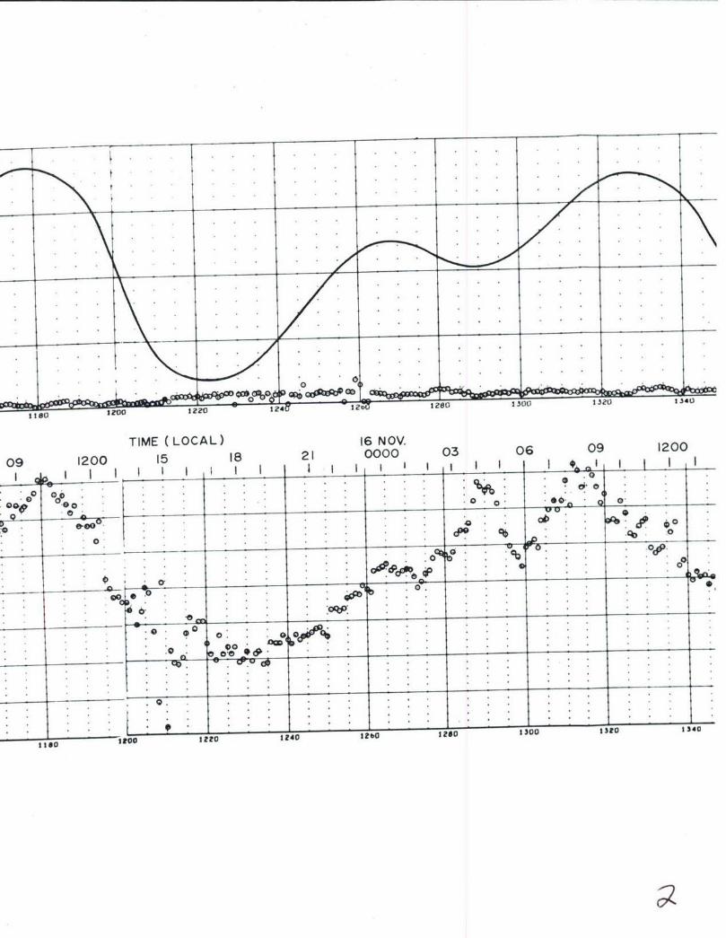
sZ80 1~ 182300 1.340
TIME (LOCAL) 16 NOV 0 60910
0910 518 21 0000 0300920
0 0 o
.00P0 0 0
0.0
00
000
-0 .4 328 130 .HoI
llso~~ I3ooI0r

.. . tcc 4 :W E .___. . ._ . L. . . .
1340 130130 lo14014010 O8 !0
17 NOV1200 15 18 21 0000 03 06 09 1200 1
0
00 . . .
1340 330 30 1400 1420 1440 146014050
SITE 38. CURRENT METER RECORD AND TIDE HEIGHT-5 DAY RECORD-500 FOOT DEPTH (3460 FEET ABOVE BOTTOM)110

18 NOV18 2.1 0000 03 06 09 1200 15 18
go . . .
0 . 'qD . . .
'-p,
so..
Go~ ~ * " f5 o1b u 001

101
-- 6
4
1b80 1,20I t40 d
19 NOV.2 1 0000 03 06 09 1200 15
0-
I FO 1* 4 *
o

POLA COORDINATE NISTOWgAN PL~OT OF DIRECTION too*5A. SEvICE OF 69ODvNE
SITE 3B. POLAR COORDINATE HISTOGRAM 500 FOOT DEPTH(3460 FEET ABOVE BOTTOM) OCTOBER-DECEMBER 1966

NISOWA OFa* Rv OTO SKCs h t
no
ft
ACT
me
F_ _I T T _
7fi
to T
ROTOR 04toS IN KNOTS
SITE 3B. HISTOGRAM OF ROTOR SPEED 500 FOOT DEPTH(3460 FEET ABOVE BOTTOM) OCTOBER-DECEMBER 1966
112

Uft") CRUMI Gs"IG 4101h7
8.'.Ir
0
8113
p - - -- - - -- - - -- - -
CCaI
NA .'N
V
S .M
--.. .* : ." 4 * .. - -.- .'
aJACTi. IN AI6l $
SITE 3B. SCATTER PLOT 500 FOOT DEPTH(3460 FEET" ABOVE BOTTOM) OCTO'BER-DECEMBER 1966
113

TrTLE: rImm Pi )cEssiNG AND READiNG LA)Gs ________
So Assigned Film No.Name m jnWWM= Thoa G. bonsAddress Navt Oceanographic Office
"wa-SF ngton D.C. 70390 Customer's film identification
Type of Instrument A-100 Current Meter and Serial No. 399Motor RPM . Film Advance Speed No. Timer Cam Lobes 60 Continuous or,-WInterval Record. Time Interval Between Records 5 sec.Cruise0 1 Location: Lat. ° Long. 1180 29.81W Meter Depth
Magnetic variation (+ a East, - m Went) 14v 26EastRecording started at 0 1go _.ours. ,nin 8 Time Zone, 0ateRecording ended at 1930 Hours, plus 8 Time Zone. Dec 1966 Date\ Comments:
Stat:'.on 3 Br&vOv Water depth 3960 feet
INSTRUCTIONS TO GEODYNE Store at Geodyne or send to:
0 Process original film. 3 100', 0 150' Naval Oceano=Whic Office13 Print for hand reading (clear edge) Washington D.C. 20390M2 Print for automatic " (dark edge) Attn: ItonaL FLQenp=sa %;oe y.LVV
£& Analog strip chart recordA& Magnetic tape recordOther instructions:1. Process on]" that data between the tape strips on the film.2. Supply plot; of direction versus time and speed versus tim e.3. Supply scat -er plots and histogram plots. Customer's Order No.
FILM AND READING EVALUATION BY GEODYNERecord started: foot mark k .9 e" ( J @ hours. DateRecord ended: foot mark 4 r57 -/6 a hours, -DateTotal footage , -/. Total elapsed time of R-ecordFILM EVALUATION: Alignment DensityCompass__ Vane. ,Rotor *Time pulseComments:
Strip Chart:
Magnetic Tape: ~ ~ 5
Date Co'mpleted: Film Processing *Reading 3' / -
SITE 3B. DATA SHEET-2205 FOOT DEPTH (1755 FEET ABOVEBOTTOM) OCTOBER-DECEMBER 1966
114

ft.
S+
2.0
@4~~~ ~ ~~ 24024 4tI ~ 8ZO
12 NV. 166 1 NOV
OO 060 12010000
C too-______
r : : ,t
36 86 ro r4ro 2400 3430 2480 esc0

"00 211 o 60C40 L6P
13 NOV. TIME (LOCAL) 14 N OV.00000600120018000000
0000 F4T-A J--
t t - - - - - - -
t ,
t:. 4+444H
ftsoc 8910 2540 W960 8*00 rboa 8t10 i..a.0

14 NOV. 15"NOV.0000 0600 1200 1800 0000
A T 4-- -- --
I r
so -N -
-J t -- & L2
4 4 _
I - 7 - - - 1 1 17
406 0660 step EfRo Voofoo
SITE 3B. CURRENT METER RECORD AND TIDE HEIGHT-5 DAY RECORD-2205 FOOT DEPTH (1755 FEET ABOVE I
115
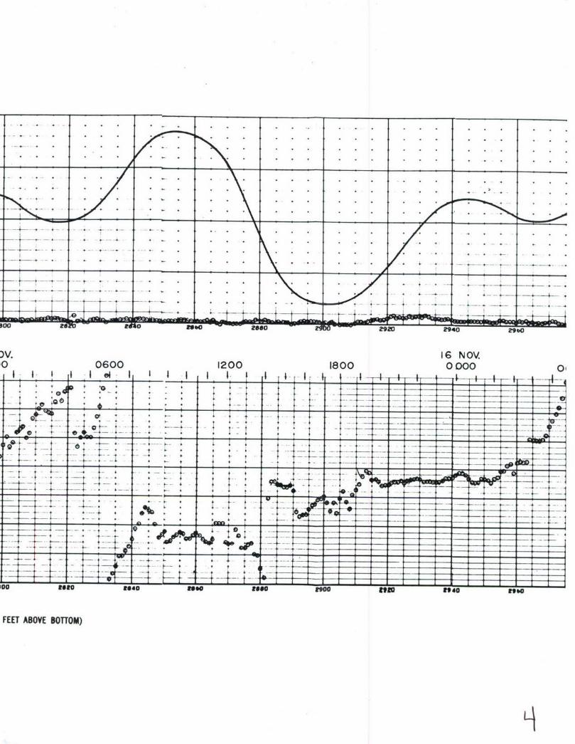
X 16 NOV'0 0600 1200 1800 0000 0
7 -f ---- -1
~ ___-4-4
~e+00 .:; : _t
* t h t 1
- -~ -+
- + I - -
.,. * -. -4 .- - 4 t + +7
4 r14-i.0 Uto .4 ;;*a
FEET~- -- ABV OTM

I0
6
4
'GPb
-30 0&1-3ct000 3120 3140 2
17 N OV.
)1200 1800 0000
___i_______ ___ ..t.. .. 1 1 1 I I I ' 1 ... A.... .. L .... ....
tt
_. _ + , . , . .. . . . ._ .
Soto s 1oo 0 0 3000 300003
• ' ° + • i ' •
t- jj 4 - t t* * 4- 4 '.... ~__ __ ± ..v V . *
1 . 4 4
-,. . . -- . ___ __ . . 4 t ." . . .
4-_ +- . . .. . .
o3l o 1o 0040 3000 ,10e; aza 3201 0 33 40
_.

POLA COMR0INATE UISTOR* PLOT OF DIRECTION &33 o*A SERVICE OF GOII
SITE 3B. POLAR COORDINATE HISTOGRAM 2205 FOOT DEPTH(1755 FEET ABOVE BOTTOM) OCTOBER-DECEMBER 1966
116

"IST041AN i7# I-)T,* 3PEEC
Soo
00
NOO SPEDINKNT
SIE3.HSORMO OO PE 25FO ET
(15 ETAOE OTM COE- EE R16
I11

P L O T O F RO fT w v s u D I R C T I O N v atI.304.0 ~>M0 CRUISE "to 420128
- i
3.60
11
40K3.00
S.W*I
a
pCC
0
K 0.0sN
DrIRECTION IN KCGftcs
SITE 3B. SCATTER PLOT 2205 FOOT DEPTH(1755 FEET ABOVE BOTTOM) OCTOBER-DECEMBER 1966
118

TITL.E: PILM PROCESSING AND READING LOG* *// 6FILM IENTIFICATION BY CUSTOMER Date jdye Assigned Film No.
Name xU&&mUpJzz Thomas G. longAddress Nava& oceanographlc urrice 455c
wasn ngtv D.C. 2 Customer's film identification
Type of Instrument A-100 Current Meter and Serial No. 451Motor RPM . Film Advance Speed * No. Timer Cam Lobe. 60 Continuous or, EInterval Record, Time Interval Between Records 5 SEos
Cruise 056610 , Location: Lat. 320 28.8'N Long. 318P 28.8W Meter Depth 13 feetMagnetic variation (+ - East, - - Went),,, 14 2 "t ove laRecording started at 4934 Hours, Plus 8 Time Zone, 22 oct.1966 DateRecording ended at 1459 Hours, plis 8 Time Zone. 19 Novj1966 DateComments:
Station 5 C, Water depth 3750 feet
INSTRUCTIONS TO GEODYNE Store at Geodyne or send to:
0 Process original film, 13 100', 0 150' Naval Oceanographic Office.CI Print for hand reading (clear edge) Washington D.C. 20390C1 Print for automatic " (dark edge) Attn: bonld Kopensma, CoRe SMM& Analog strip chart recordA Magnetic tape recordOther instructions:1. Process only that data between the tape strips on the film.2. Supply plots of direction versus time and speed versus time.3. Supply scatter plots and histogram plots. Customer's Order No.
FILM AND READING EVALUATION BY GEODYNERecord started: foot mark 02 3 7 7- 1A @ hours. DateRecord ended: foot mark 6 7 1 S, 10 hours, DateTotal footage- t -3Xr , Total elapsed time of recordFILM EVALUATION: Alignment . Density_Compass_ _ Vane * Rotor ,Time pulseComments: rL, -.- .
Strip Chart: A * 4' i eLJ1 " 5
Magnetic Tape: L1V S
Date Co'mnleted: Film Processing * Reading 3-/1K-e 7
SITE 5C. DATA SHEET-3737 FOOT DEPTH (13 FEET ABOVEBOTTOM) OCTOBER-NOVEMBER 1966
119

- .
-0 0 - oc e f'o
d ;v
26 OCT.15 18 21 0000 03 06 09
I of 01 1__ _ _ _ 1 _ _ _ _ _
.. . . . . . D
goo
- *.. . . . . .. . .. . .
TO. G.V . .
t o .. .
"® 7'
01
.r.. . . .
,,0. , : :: 2
_________• z.z.4b0 480 500 $20 $40 56O $60

* t
L0c-L . ....0
TIME (LOCAL) 27 OCT.1200 15 18 21 0000 03 06 09 1200_I I I I I I I .I I . I I I I I I . I I I I t I I I
a . . .o__ . .
. * . .. . . . . . .- . , " ."0
Soo0 to .40 b6 "0 00 'to 140

. .. . . ..1
. ~ ~ ~ ~~~ .
.. 0 . . . . .
I to 0b '80 Vol
0 15 18 21 28000T 03 06 09 1200 15
*. . . . . . OD . . .
SIE5.CURRENT METER RECORD AND TIDE HEIGHT-5 DAY RECORD-3737 FOOT DEPTH (13 FEET ABOVE BOTTOM)
120

,1 -
9000 96 ou12080DSbol,8 0 , o o o o 0* 0 0 9 ,o0a 8
29 OCT.18 21 0000 03 06 09 1200 15 18 21
___ ___0__ 0'
* z• "o........................_ __-*
40
tro
.4 6 o 100loo140160Ss
•. ..
............................................
10004 9 O 8 l O I OtO 1040 tOo ! 11
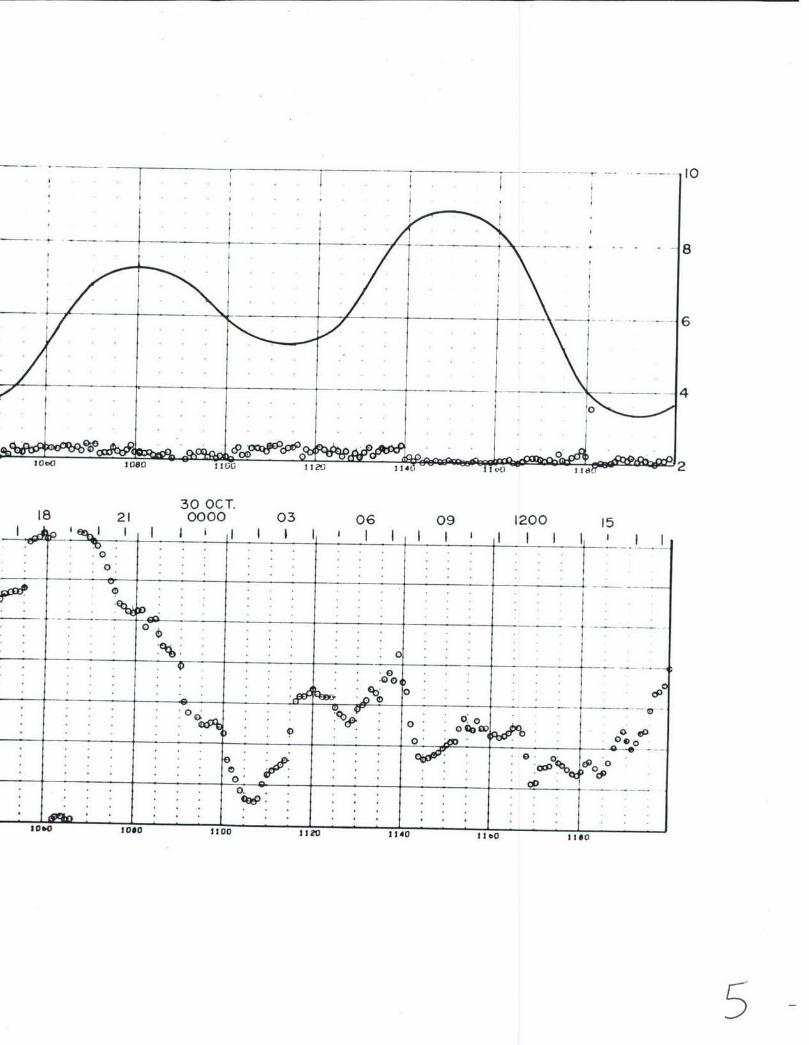
_ _ _ - - . 10
8
lo i eo do I vo ge!t,
30 OCT.18 21 0000 03 06 09 1200 15
oo . o
0 . . . .. .. . .. . .
. . o . . .. . . . . . .
0 . .
lO O O_ |0 * . . |140 6''o~ -- 5--
000
(0-s00 0
-05-
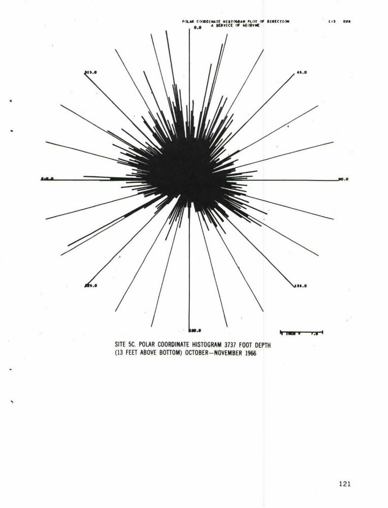
POLM COORDINATE NISTOGIAN KLOT OF DIRECTION I, fs lt
6 .0 4*.g
$9.0
SITE 5C. POLAR COORDINATE HISTOGRAM 3737 FOOT DEPTH(13 FEET ABOVE BOTTOM) OCTOBER-NOVEMBER 1966
121
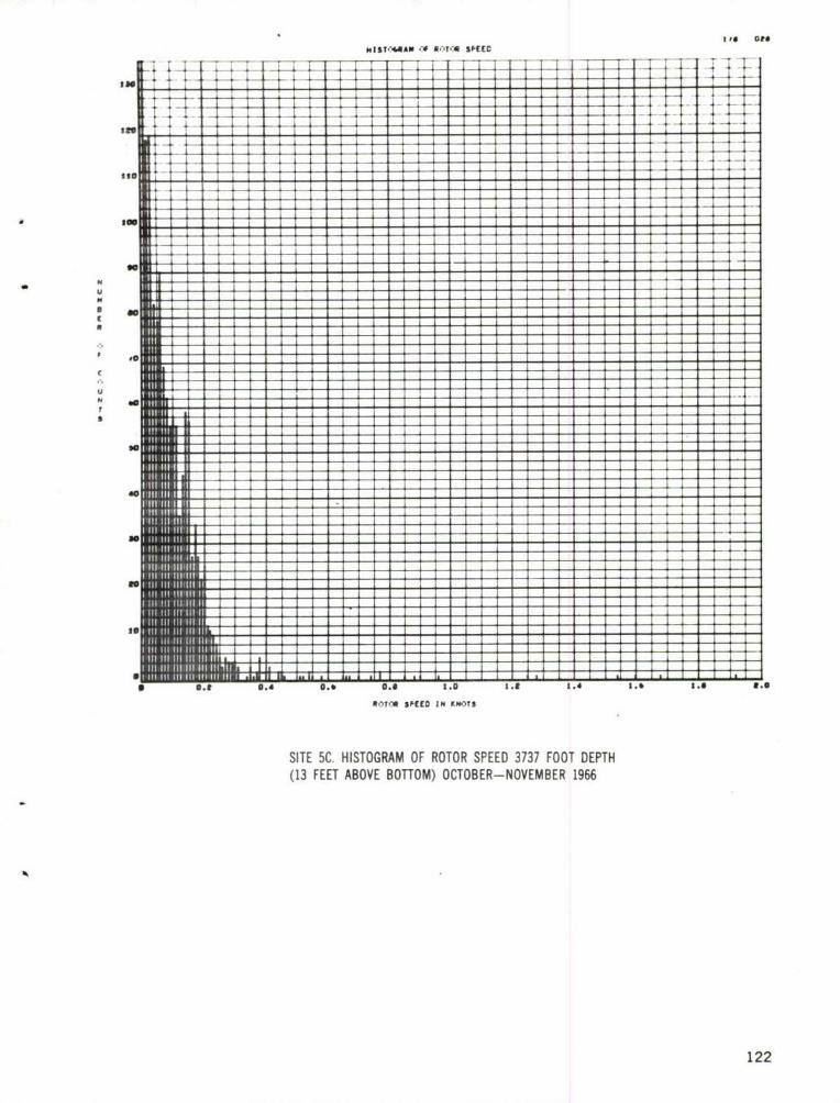
mIST'*AW -# Orl,- SPEED
I t
00
to
so
40
Al
a . 0.4 0.6 0.0 1.0 . 1.4 3.0 1.0 8.0
NOYCI $FEED IN KPO)TS
SITE 5C. HISTOGRAM OF ROTOR SPEED 3737 FOOT DEPTH(13 FEET ABOVE BOTTOM) OCTOBER-NOVEMBER 1966
122

FL.OT .-f i.T,:a Sr O Di IA CTlCIa 03 0aUS w , SC CRU ISE 0566 10 410 116U
S.'
Ai
- --
* U
£D
K 5'N
VS
1.123
3.0o
-ltco . . **..
SITE 5C. SCATTER PLOT 3737 FOOT DEPTH(13 FEET ABOVE BOTTOM) OCTO'BER-NOVEMBER 1966
123

JTITLE: PILM PFCESSING AND READING LOG* 41/eII// 1FILM IDENTIFICATION BY CUSTOMER Date 9 Jan 1967 Geodyme Assigned Film No.
Name rzrTfsfm Thomas G. LongAddress Naval Oceanographic Office 245-7C
Washington D.C. Customer's film identificationType of Instrument A-lO Current Meter and Serial No. 245Motor RPM , Film Advance Speed , No. Timer Cam Lobes b13 Continuous or, 3 Interval Record, Time Interval Between Records 5 Seconds
Cruise 056610 , Location: Lat. 32° 56.7'N Long. 180 19.75'iMeter Depth 36 feeMagnetic variation (+ - East, - a Went) Ii 26 EastRecording started at_j Hour vlus 8 Time Zone. 26 oct 1966 DateRecording ended at _ 1425 Hours, plus 8 Time Zone. 23 Nov 1966 DateComments:
Station 7C, Water depth 4080 feet
INSTRUCTIONS TO GEODYNE 1010000Store at Geodyne or send to:
0 Process original film, 13 100', 0 150' Nava 0cen&rh= Offire(3 Print for hand reading (clear edge) Washington D.C. 20390al Print for automatic " (dark edge) Attn: Ronald Kopenski, C " de 91006 Analog strip chart recordBA Magnetic tape recordOther instructions:1. Process on15 that data between tape strips on film.2. Supply scatt ,r plots and histogram plots.3. Supply plotr of direction versus time and speed veU%dt&#Af,t1 Order No.
FILM AND READING EVALUATION BY GEODYNERecord started: foot mark 66 .5/ /- 7) _ hours, DateRecord ended: foot mark _____________hours, DateTotal footage- /'0 Total elapsed time of recordFILM EVALUA 'ION: Alignment _ Density_. _ __Compass_ _ Vane .Rotor ,Time pulseComments:
Strip Chart:
Magnetic Tape: 0 00 5/
Date Completed: Film Processing - Reading - / - 4
SITE 7C. DATA SHEET-536 FOOT DEPTH (3544 FEET ABOVEBOTTOM) OCTOBER-NOVEMBER 1966
124

4. _______ _______
S.OP .___._ _.
03 06 09 1200 15 18 21
I - , I I I I t j I I I I I I I I I I
300 0D* 0 "
0 0
0~: O 's..
o o 6,
4__ ___-- On jj" .0'h.0 .. 0 .
0.- .
.0 .' 0"
0: a
0 fr &I m HS
t 0 * . * . .
120O0 222 22 Z40 22! 228! 0 2200 2220
1

0 O 'b.
Z240 z280 2300 2320 2340 2Z0 2300 Z400
II NOV. TIME (LOCAL) 12 NOV.0000 03 06 09 1200 15 18 21 0000 O:
*
" 0, 0 .-.0 . . .
O•. . . . . . .= ,- =_ = o .*0 *. . .0
0000- :, 0 0
: .
940'0 0Uo00 2320 1340 230 9360 &400

ID
.0 i
00
DOODI 20 44to 2 2400 2480 ?500 2:Zo 2 4,
13 NOV.03 06 09 1200 15 18 21 0000 03 06, ,I ., l i i i ,' I I a I = ! I4I I 1i 1 1.. o,O
* . . :. o o:,:,: : :
. .. " 0
0: w :
e . .: o;-.. . . ....... .... .. .
0, ¢ , . ,o:, .r, ,. o . M0 '
*. . * . .. . i .o * .
*•. *** *
* • :'* * e . * * .e
SITE 7C. CURRENT METER RECORD AND TIDE HEIGHIT-5 DAY RECORD-536 FOOT DEPTH (3544 FEET ABOVE BOTTOM)
125• + +3

- o 70I
Z:8O 2O * tZ?l o40 ,14 8VO Z 14
14 NOV.09 1200 15 18 21 0000 03 06 09 120-111111 1, I II I I I I I I I I )
* . . . 0.4t oo1-"~
0.
A_ _ 0
__ _
0.
" 0 o 0* * .0,o ._o , o0 ,.. : .oo o ..... ....... ..., oo. . ..- ep 0
* * .I. O '. a. . ... .0
.
* . . . e 0.0,9q00
_ _ _ _ _ _l , . * ' ".. . . . . . . . . . . . 4 o -
. . . . . c o.°.0 *0 j p•
Ms.o oGo 2020 2040 000 F00 2o1l 2+40

- 10
... . .. . .. .. ....... .... ... .*8
* t6
C%- o 0- 0 0O 40 .0 40c CID 01 %00
06 09 1200 15 18 21 15 NOV.0000 03
* 10
0 0
0O0~ 7 0 0 4
00oX 900cb v
0 900 0
0 f 00 0 0
00 '(4
_ 4)0 0 ....d.oelo . *-
00R't 0 "Z. 28 80 8024
--?e ; 5

F-XAR C,---001ATE MISUARAN PFL CIRtECTUO ~ It, ot
A SERVICE -V~ &(E-PO
46.
$6.0
SITE XC POLAR COORDINATE HISTOGRAM 536 FOOT DEPTH(3544 FEET ABOVE BOTTOM) OCTOBER-NOVEMBER 1966
126

H.IST-44AN sfEIC
t Tt T
Ito 11KIt*to
to
u
I n
If. . . . .0 23 24Ieiea
Ito. 11U 1p N t
SITE IC HITGA OFRTRSED56FOIET(3i44 FEE ABV BOTM1COE-OEBR16
go2

FL., $FlASEED VERSUS CIRECTI.N 1i 6 "L4us.. CRUISE 0~56610 410114
3.50 _ _-
N
8.50 j
9015toa m,"
DIET- I ERE
SIE7.SATRPLT56FOCET
(340ETAOEBTO)OTBR OEBR16
12

TITLE: FILM P1 CESSING AND READING LOG*' 4 / jFIL IDENTI1 CATION BY CUSTOMER Date 9 JsEB!9_ qp yn e Assigned Film No.
D) Name JUX TJXKXlI Thomas 0. LongAddress Na-i I Oceanographic Office 184-7C
Was ington D.C. Customer's film identification
Type of Instrument A-100 Current Meter and Serial No. 383Motor RPM , Film Advance Speed * No. Timer Cam LobesM2 Continuous or, K Interval Record. Time Interval Between Records 5 Seconds
Cruise 0o56610 , Location: Lat. 320 56.7N Long. 1180 19.75'W Meter Depth 2195 feeMagnetic variation (+ a East, - a West) 3_40 261mmtRecording started at 1123 Hourt plus 8, Time Zone.. 26 oct 1 D66 DateRecording ended at 1425 Hours, plus 8 Time Zone, 23 Nov.1966 DteComments:
Station 7C, Water depth 4o8o feet
INSTRUCTIONS TO GEODYNE Store at Geodyne or send to:
" Process original film. X3 100', 0 150' N v,,l Oen'rZhLc Office(3 Print for hand reading (clear edge) Washington D.C. 2039012 Print for automatic " (dark edge) Attn: Ronald Kopenski, Code 9100
AR Analog strip chart recordU Magnetic tape recordOther instructions:D 3.. Process onl; that data between tape stripq on the film.2. Supply plot: of direction versus time and speed versus time.3. Supply scat- er plots and histogram plots. Customer's Order No.
FILM AND READING EVALUATION BY GEODYNERecord started: foot mark 6 S a 7 4 .w" @ hours, Date
Record ended: foot mark 6S -_- 3 0 * hours. DateTotal footage 4 -0 1..?4- P Total elapsed time of recordFILM EVALUATION: Alignment . DensityCompass_ _ Vane * Rotor , Time pulseComments:
Strip Chart:
Magnetic Tape: 9.Ol) / 9
Date Conpleted: Film Processing o Reading - / "7' - 9
SITE 7C. DATA SHEET-2195 FOOT DEPTH (1885 FEET ABOVEBOlTOM) OCTOBER-NOVEMBER 1966
129

. . ..- D C V
0 423u 2340~8 23*
11 NOV. 1966100800000 060012080
C300. , 6 0 e 7 7..e p ..........
too. . .. . .. .
* 0
sin 230000 .
* * 0

5380 2400 2420--24 F
12 NOV. TIME (LOCAL) 13 NO0000 0600 1200 1800 OOOC
0 pe , ..
93*0 830400 E40 40 40 M

. .. . . . . . .0
.0 . .0 .* . . .# jx~ .o . o.. .
. . . ..o . . .. .
. . . . . . . ..' . . . .
. . . . .*
*~~~. . . . . ..__ _ _ _ _ __ _ _
*" 'o* * *
*60 2000__ _:o 0~
,00 0600 ~ 100 1800 0000
00130
:003

.. .. . . .. .... T . . . . . . .- .. .- •
Op q. • • ,
bO 40D+ Gk (0 30-- -6D _QM .1,00 Z, 20 Rat WA
0600 1200 1800 15 NOV.0000 0600
:t I_I___I _ I I II II I I I I I I I I I I I I I
0 0 0,
. 'e '
tiZ
; ..+o ++ . .
f 0 . . . .
1,00 lt,O 1,40 t,,O tI0 zeIO0 180 140 18.0

GID. 00 0 90
-oo as-.- 0-~- -- 0,--- 8
0600 120 180 0000
0600 200 800 1 NOV
0--4
0. 0. .. 'OD 0
00 dc" 0 0 0*cc 0 wp:0
?#so 2900 Z9V 940

POLAR C.-O1ACNTE 101ST"."AN Ps..f D1 NEUCTV0 02$ or#
0. SUVwICE CA 44.rt*u
86.0
SITE 7C. POLAR COORDINATE HISTOGRAM 2195 FOOT DEPTH(1885 FEET ABOVE BOTTOM) OCTOBER-NOVEMBER 1966
131

-T -- I -I--4
too- IIIII:I I I
11W S--- UD IN9WT
SIT 7C.--- - - - -- - - -HITGA FRTRSPE 15FO E T(18 ETAOEBTO) COE-OEBR16
---- ---- ---- --- ---- I 1324

i.-.T -.f RIbA-A V.EEC VERSUS CIRECTI.:d tiit
VSft-. CRUISE 0566IIU 41111
5.00
L%,=Ta
DIETO I EM
SIE7.SATRPO 15FO ET(18PETAOEBTO) COE-OEBR16
13

TITLE: FILM Pf'OCESSrNG AND READING LOC}G* 4Id
FILM IDENTIFICATION BY CUSTOMER Date 9 January 19 * d y n e Assigned Film No.
Name !JZU= Thowas G. LongAddress Naval Oceanographic Office 177-7C
Washington D.C. 20390 Customer's film identification
Type of Instrummnt A-100 Current Meter and Serial No. 1Motor RPM . Film Advance Speed . No. Timer Cam Lobes0 Continuous or, 41nterval Record. Time Interval Between Records slan
Cruise-oLa10 , Location: LAt. i2 ° %.71N Long.1 7 Meter DepthpMagnetic variation (+ a East - a West) IV 26'st above bottomRecording started at j Hours, plus 6 Time Zone, 26 Oct 1966 DateRecording ended at 1425 Hours. plus " Time Zone. 23 NOV l9bb DateComments:
Station 7C, Water depth 4080 feet
INSTRUCTIONS TO GEODYNE Store at Geodyne or send to:
C3 Process original film.t 100'. 0 150. Nyva OceanoArmnbic OfficeCI Print for hand reading (clear edge) Washington D.C. 203_0C1 Print for automatic " (dark edge) Attn- Ronald Kopenski, Code 9100ML Analog strip chart recordIt Magnetic tape recordOther instructio ws:D . Process onl. that data betveen tae strips on the film.
2. Supply plot: of direction versus time and speed versus time. (3. Supply scat ,r plots and histogram plots. Customer's Order No. ''
FILM AND READING EVALUATION BY GEODYNERecord started: foot mark 4 -) @ hours, DateRecord ended: foot mirk 7 46 4- x ff _ -hours. DateTotal footage __, Total elapsed time of recordFILM EVALUA' ION: Alignment _ __ ___ DensityCompass_ _ Vane ,Rotor *Time pulseComments:
Strip Chart:
Magnetic Tape: /
Date Completed: Film Processing * Reading - / n- 7
SITE 7C. DATA SHEET-4053 FOOT DEPTH (27 FEET ABOVEBOTTOM) OCTOBER-NOVEMBER 1966
134

30 OCT. 19661800 0000 0600 1200
OD 0. ....
zoo * *.
F * * * r* *
40 Sa M *4 S" $so0

. . . . . ". . 0)p0 00
L0~bo 100 :
TIME(LOCAL) 31 OCT.1200 1800 0000 0600 1200
0 : . ' ,: Q D o "__ e .~ I I!~~ o I .
* . o " ;00; ' . ' ' _
* . . . . . . . . . . . -0
* , * 0 , , ,~ * , , * ,* , , , *
.. . ... .
4t * * I I t
.4 . . i i . 4 , ,i i. * 0. , .
• '0 + + + 0"I
$so 60*90 *40 66 0 too Ito 140
.. : + ! : : I"'-+ + • i+ + + +t a z

010
. . .. ..- . .
. . . . . lp 0
* tO 84*o7 * o*0 8 80 9088 0 0(
1 NOV.1800 0000 0600 1200 1800I I I I A .I )I I I I I I I I I _Io I I I I I I j
4 9
.0 . , 4 ,'* 9 4 - , 9 * , . 0
'0 t t
I t t
S * t * ,+ - 9 * . .
- i - . * I60. f o . 8 0 S t
: -0 : + . , .o . o 9 .
* o. ., ,,_ 0+ . *" .*. . ,* * 0,, o , u' . , 0 *, " : . .. . . . * , .. 9,+
* * t . 4+ 4 9+ .. 9 + .~
SITE 7C. CURRENT METER RECORD AND TIDE HEIGHT-5 DAY RECORD-4053 FOOT DEPTH (27 FEEr ABOVE BOTTOM)
135• " + +': + t3

* .. . . . . .
0.0 0
*~
0 .
.0
.0 0. '. .. 0.000.0
. .00
0 .6
0 .o
0 0--0 b &A , .1 0- -~ Oo0 0
940 9bo- 90 1000 TO - 040 1000u
2 NOV.0000600 1200 1800 0000
0 .7__ _
o e a *d
04 $0 .0 0
ru94 90 9*0 loco taoo. 1040 Soso
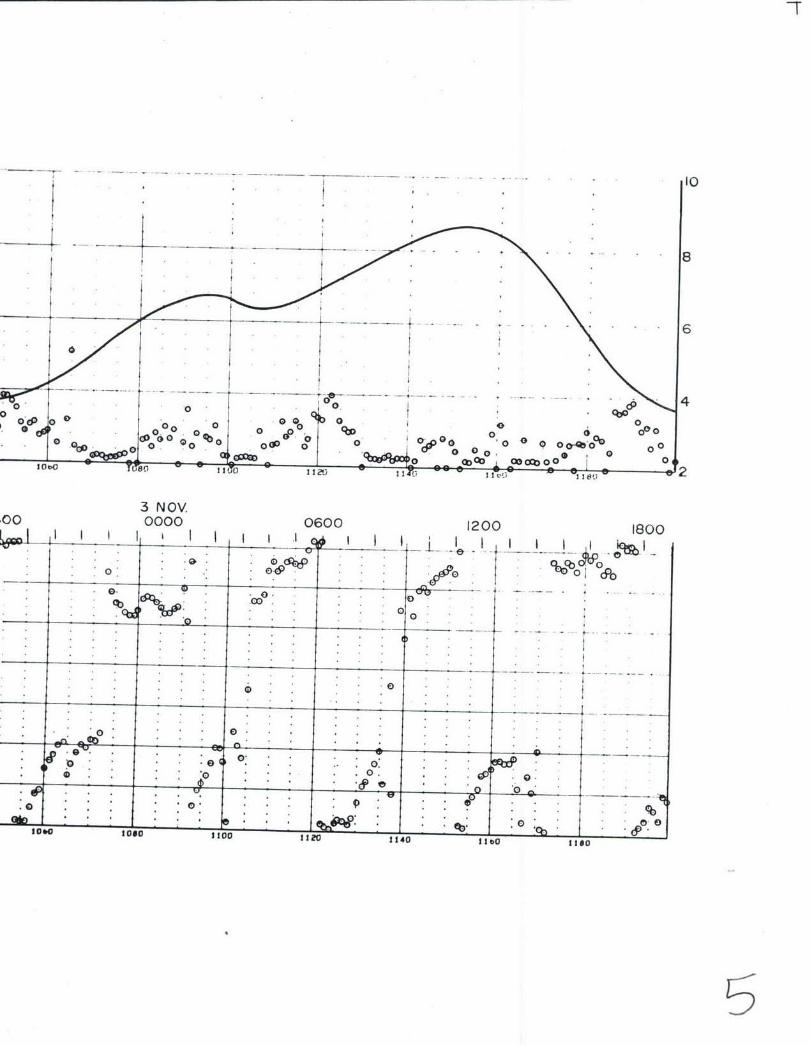
- - 8
0 0 0
0 lo 0 00 % 0 oeVDW 0 -Q -OO 0 0 0 04~o
3 NOV.00 0000 0600 1200 1800
0, 0. 0 C
c 0c0
0 .* . . .
0 0.
* 00
10O0 loso flo0 1120 2140 1160 12M.

mm 1 comiK h|VOiIAN Ow" PLOT OP-flaCT ION iSA vICt OF 61olC
*.6.
SITE 7C. POLAR COOiATE HISTOG" 48D MR Wffl(27 FEET ABOVE BOTTOM) OCTOBER-NOVMitE 16
136
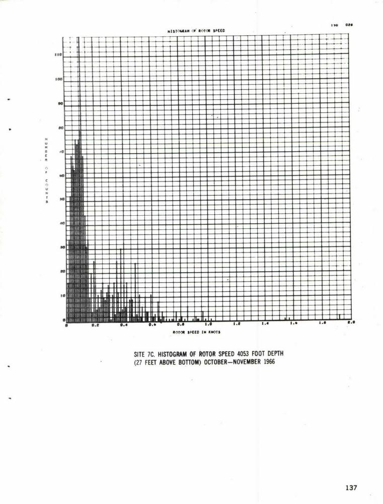
NIST-AtAllN- MOT-A WID
U17 -
So
IO~ IUOI N
SIE*.HSORA FRTRSED 03FO ET
(2sETAOEBTO)oCOE-OEBR16
I I I137

fLv' -Df S,FEE., sC VERSUS OIRECTEV ".2US.-:, C*UISE GS160 41011S
- I - -
3.00_
IA
3.10
p
C[a
!
SO
lr..
3..'0
0.10-
so" I t a .ar. e it s
,.,. '.., •I ... • ... . .,J.
SITE 7C. SCATTER PLOT '4053 FOOT DEPTH(27 FEET ABOVE BOTTOM) OCTOBER-NOVEMBER 1966
138
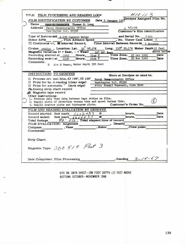
TITLE: FILM PROCESSING AND READING LOG* k '4//FILM IDENTIFICATION BY CUSTOMER Date 9 January 196? " dy e Asigned Film No.
D Name wrz~~~ Thomas 0. L6ongAddress Naval Oceanographic Office r 463-9B
Was:ington D.C. 20390 Customer's film identificationType of Instrument A-100 Current Meter and Serial No. G 46
Motor RPM . Film Advance Speed * No. Timer Cam Lobes 613 Continuous or, I Interval Record, Time Interval Between Records
0
Cruise ncq1p , Lfcation: Lat. 320 48.3N Long. 1180 20.11W Meter Depthl2 feetMagnetic variation (+ a East, - West) 1o 2t, tt aove 0
Recording started at o946 Hours plus 8 Time Zone, 25 Oct 1966 DateRecording ended at U30 Hours, plus 8 Time Zone. 22 Nov 1966 DateComments: S Ion 9 Bravo, Water depth 300 feet
INSTRUCTION1 TO GEODYNE Store at Geodyne or send to:
[ Process ori, inal film. 13 100'. 0 150' Naval 0essnolraDhic officeCI Print for ha d reading (clear edge) Washington D&C. 20390a Print for automatic " (dark edge) Attn: Ronald Kopenskl, Code 91002xAnalog strip chart record
4 Magnetic tape recordOther instructions:1. Process only that data between tape strips on film.2. Supply plots of direction versus time and speed versus time. O eN3. Supply scatter plots and histogram plots. Customer's Order No.
FILM AND READING EVALUATION BY GEODYNERecord started: foot mark K L a '- , @ hours, DateRecord ended: foot mark / 6 (1 q4, 3 - a . hours, DateTotal footage 93; , -# , Total elapsed time of recordFILM EVALUATION: Alignment ________ Density_Compass__ Vane Rotor ,Time pulseComments:
Strip Chart:
Magnetic Tape: )60 5/1 3/ -
Date Co mpleted: Film Processing ,Reading /% /- j
SITE 9B. DATA SHEET-288 FOOT DEPTH (12 FEET ABOVEBOTTOM) OCTOBER-NOVEMBER 1966
139

oeo 44
11 NOV101580000 03 06 09 10 51
.00
0 * 0CP*
246 *44 L*2*
wo,
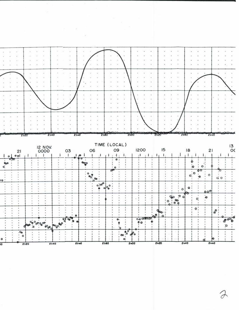
12 NOV TIME (LOCAL) 1321 0000 03 06 09 1200 15 18 21 O(
t! A I i I I I II I
* 4 ... ' . 4 , , 4 . .' O
______'___ , : ! . .t : ,
_ _ _ - . .. • t t t " .
4 .• 4 , 4' * t* * * , , , * ' " !
. .. .. -+,, . +,4 - . . • . . . . 4 . .,4+ !
: 4 ,+
. ... t .:10. CS - &se * o.1'...1t 1' t LLL et 1 ,
u. oIP4 s o teal it.0 Zll 2.40 ,

13 NOV. 14 NOV.0000 03 06 09 1200 15 18 21 0000 03
SIt ' ! ! . I ;I IIII I I I I,
. . . . . .. . .4 ,.
. 4 4 , . . . . .. ..t ' ' . . .
* .. . . . . . 4 . 4 4 t 4 4 4 4 4 .. ...... . . . . .
s: * + * t * * * * ::*0 ' t I " ; "* * 4 " -
* * * A * * 4 4 4 4 .
208D reu Z40 -zu140c
1 NOV. 1 NOV +
*~~~ f I i
+ ' " t , , ' i + , . . .. .. . ."t
+ . . . t; i ' ' + ' '
&*so0 efo C0•,'IO 40 V0 28Ot 0 00 Rate R0 40
SITE 98. CURRENT METER RECORD AND TIDE HEIGHT-5 DAY RECORD-288 FOOT DEPTH (12 FEET ABOVE BOTTOM)
140

. .. .. ... .
15 NOV.06 09 1200 15 18 21 0000 03 06 0I I t i . t II I- I I I I I I I I
* 4 * t ' , , , * tt
i I I 'I ' II: _ _ _ _ _I0* , I *
'Ge
*e, , , , .
S* ... * t* 'O7"
_ _ _ _ _ 0. 0 *,*
' 1 0:....
* ..4. , . , . . .. . ..* .. * * ,, . 4 o *o% ,Oo..t .... : , 4' 4 T t , , , _ _ t e0 " "
t,aeeeoo a t,ao ea 800o0eo iO

6
......................
Go : : p
0 _ _ . .
19*0 3000 Soto $040 3060 310h0o• ' e e .LL.I5

FLAN CO)OINATE NIST06RAN PLT) OFI IECTION 0#3 0&0* ERcICE OF 6follNo
45.0
SITE 9B. POLAR COORDINATE HISTOGRAM 288 FOOT DEPTH(12 FEET ABOVE BOTTOM) OCTOBER-NOVEMBER 196
141

NISV:4itAW-(# NOT'A SPIEDC
- -r f II
11 U I t I
1.4 -j : : :4:
I.E -4. -
-
N S.E I I
o.. - -,
I - - - - a
* 0.1 0.4~~~~ U. I .e ie ie I. . .
SITE 9B. HISTOGRAM OF ROTOR SPEED 288 FOOT DEPTH(12 FEET ABOVE BOTTOM) OCTOBER-NOVEMBER 1966
n
0.4 ,. . :142

i L,,T -.f A -.A SPEEC vERSUS CIRECTI.-i tI L,toL4.00 usm. CRUISE 65661f, 410113
1.90
[° t
1.
DIRIECTI,.." IN DG [
SITE 98. SCATTER PLOT 288 FOOT DEPTH(12 FEET ABOVE ROTTOM) OCTOBER-NOVEMBER 1966
143

TITLE: FILM PROCESSING AND READING LOG* , / / //FILM IDENTIFICATION BY CUSTOMER Date 9 January 19 podyne Assigned Film No.
Name E§jjW M Thomas G. LonxAddress Nav-l Oceanographic Office 228-11C
Wai ingt D.C. 20390 Customer's film identification
Type of Instrument and Serial No. poMotor RPM o Film Advance Speed , No. Timer Cam Lobes 60J Continuous or, j Interval Record, Time Interval Between Records 5 SecondsCruise 056610 , Location: Lat. 32 28.4'N e Long. 1180 06.4'w Meter Depth 12 feetMagnetic variation (+ a East, - a Went) II 26' 11-t asV 0oE (aRecording started at_1LU_ Hours, plus 3 Time Zone. 16 Nov 1966 DateRecording enderi at 0830 Hours. plus 8 Time Zone, 9' Dec1966 -ateComments:C e : tation 11 C, Water depth 6078 feet
INSTRUCTIONS TO GEODYNE Store at Goodyne or send to:
0 Process ori inal film, r 100'. 0 150' Naval fin-no2raphic OfficeQ3 Print for ha d reading (clear edge) Washin.on D.C. 20390CI Print for ar )matlc " (dark edge) Attn: Ronald Kopenski, Code 9100
A Analog strip chart recordW Magnetic tar! recordOther instructi. nl:D 1. Process o, y that data between tape strips on the film.2. Supply pl.o s of direction versus time and speed versus time. /3. Supply sca-ter plots and histogrn plots. Customer's Order No.
FILM AND READING EVALU TION BY GEODYNERecord started: foot mark b65 5 --Is @ hours, DateRecord ended: foot mark 0 _" ff Y -/ 1 0 hours, DateTotal footage 3 - / * Total elapsed time of recordFILM EVALUATION: Alignment _ _ _ _ DensityCompass_, Vane ,Rotor ,Time pulseComments:
Strip Chart:
Magnetic Tape: 0C) 00 /' -
- Date Co'mpleted: Film Processing ,Reading 3 / '- 6
SITE I1C. DATA SHEET-6066 FOOT DEPTH (12 FEET ABOVEBOTTOM) NOVEMBER-DECEMBER 1966
144
21 NOV. 19660000 03 06 09 1200 15 18
too-
3 00-
0. WUN .* .
"40 *so 100 Ito 140

21U 0000 030910 51 10
0. *w- * . . .
0 .& 090'
00
* ~~~~~ ~ ~ ~ e COCK , . . . . . . .C *
* .. * *. .. ,,ee
.%% * *'~ .la
*~~~~O pace:. . . . .
So * r .4 Oro . . *
. . . . *

.NO. 24 NOV.. . .
. . ... . .. . . . . . .
. .9 . . . . . . . . .~I g U
. .* . . . . . 4 V *t . . . . . . . .
00
v . 4 9. .* .00 It ,04 100 jo
SITE~~~~~~~~~ ~ ~ ~ ~ ~ ~ 11.CRETMTRRCR.N IEHIH- A EOD66 OTDPH(2FE BV OTM
* * * . . . _ _ _ _ _ _ _ _ .145

0000. 03
. . . . . . . . . . . . .
. . . . . . . . . .
. . . . . . . . . . .
06 09 120 15 18 21 000 03.0
0 . . . 7-7
1t0

-T - 0
000I I Z4 - rU( 134 2 . i I I I
..0
* , .0 . .. 6 .
01240 12.0 12eo 1300 1320 1340

F"-4.Al CiXDilAt HIST-Alln 06LO~t OiiCtION oso offA IEJIVICE RSCN
49.
56.0
slo ls I .f
SITE 11C. POLAR COORDINATE HISTOGRAM 6066 FOOT DEPTH(12 FEET ABOVE BOTTOM) NOVEMBER-DECEMBER 1966
146

MIST.-44AN co VCC SED
-. r: A : .'., s-t
* I .. . . ....... ... . .. . .. . .
too
Im
- ~~-- - -- ----- - - - -
RoTro SPE10 IN KWITS
SITE 11C. HISTOGRAM OF ROTOR SPEED 6066 FOOT DEPTH(12 FEET ABOVE BOTTOM) NOVEMBER- DECEMBER 1966
147

L.,T ,.f R-:T,-A VCEC VERSUS CIRECTI-A ;w t.i.
U&C.,- CRUISE 656615 41611Z
S.1111 _ __
St.90
ft
T
0
t
N
2.9
K 148
S .30"_"._"_..
-• ,.. . ; .. . . , .,
12,ii ,;=;. , ,. .... ... • ..,.*._.*
OIRCCTZ,CN tN OCGRCES$
" SITE IIC. SCATTER PLOT 6066 FOOT DEPTH(12 FEET ABOVE BOTTOM) NOVEMBER-DECEMBER 1966
148

APPENDIX C
GLOSSARY OF OCEANOGRAPHIC TERMS
149

GLOSSARY OF TERMS
Alpha meter (Transmissometer) - An instrument which measures the optical
attenuation coefficient of an in-situ water sample.
Basin - A depression of the sea floor more or less equidimensional in form
and of variable extent. When the length is much greater than the width,
the feature is called a trough.
Benthic - Pertaining to all submarine bottom terrain regardless of water
depth.
Clastic Sediments - A rock composed of debris transported mechanically into
its place of final deposition. Sandstones and shales are the most
common clastics.
Continental Borderland - A region adjacent to a continent, normally occupied
by the Continental Shelf, which is highly irregular with depths well in
excess of those typical of Continental Shelves.
Continental Shelves - Zones adjacent to a continent or around an island, and
extending from the low water line to the depth at which there is usually
a marked increase of slope to greater depth.
Continental Slope - A declivity seaward from a shelf edge into greater depth.
Dome- An elevation rising less than 500 fathoms from the sea floor, and of
limited extent across the summit.
Fault Escarpment - An elongated and comparatively steep slope of the sea
floor, separating flat gently sloping areas.,
Fines- The silt and clay fraction of a sediment.
150

Clauconite - A green mineral, closely related to the micas and essentially a
hydrous potassium iron silicate. Occurs in sediments of marine origin.
Hizh Water - The maximum height reached by a rising tide.
K-Meter - An instrument which measures the upwelling and downwelling light
in the ocean environment.
Low Water - The minimum height reached by a falling tide.
hixed Tide - Type of tide in which a diurnal wave produces large inequalities
in heights and/or durations of successive high and/or low waters.
Orzanic.Sediment - Biological matter which accumulates in a loose uncon-
colidated form.
Pelagic - A division of the ocean which includes the whole water mass.
Phosphorite - A fibrous concretionary mineral occurring in sediments of
marine origin.
Reversinst Current - A tidal current that flows alternately in approximately
opposite directions, with a period of slack water at each reversal of
direction.
Rotary Current - A tidal current that flows continually, with the direction
of flow changing through all points of the compass during a tide cycle.
Sedimentation - The process of breakup and separation of particles from the
parent rock, their transportation, deposition, and consolidation into
another rock.
Semi-diurnal - Having a period or cycle of approximately half a lunar day
(12.42 solar hours).
Tectonic - Pertains to the origin and development of the structural features
of the earth's crust.
Terrigenous - Formed by the erosive action of rivers, tides, and currents.
151

Transducer - A device that converts electrical energy to sound energy, or
the converse.
Turbidity Current - A highly turbid, relatively dense current, carrying
large quantities of clay, silt, and sand in suspension which flows
down a submarine slope through less dense sea water.
152

UNCLASSIFIED
Security Classification
DOCUMENT CONTROL DATA - R & D(Security classification of title, body of abstract and indexing annotation must be entered when the overall report is classified
I, ORIGINATING ACTIVITY (Corporate author) 120. REPORT SECURITY CLASSIFICATION
U. S. Naval Oceanographic Office UNCLAGqRFTVUWashinjton, D. C. 20390 2b GROUP
3 REPORT TITLE
Oceanographic Data Report, San Clemente Island Area, October to December 1966
4. DESCRIPTIVE NOTES (Type of report and inclusive dates)
Tnformml Raobt. AL THORiS) (Firspna!e, middle initial, last name)
Oser, Robert ..; Berger, James L.; Franc, Louis J.6. REPORT DATE
7a. TOTAL NO. OF PAGES 17b. NO. OF REFS
Ssptansar 1967 9a. Cb NTRACT OR GRANT NO. ga, ORIGINATOR'S REPORT NUMBERIS)
b. PROJECT NO. 771 IR. No. 67-77
9b. OTHER REPORT NO(S) (Any other numbers that may be assglnedthis report)
d.
10 DISTRIBUTION STATEMENT
Distribution of this document is unlimited.
i SUPPLEMENTARY NOTES 12. SPONSORING MILITARY ACTIVITY
U. S. Naval Oceanographic Office
13. ABSTRACT
This report presents sediment, deep towed profiler, physical oceanography, visi-bility, and current data collected in the San Clemente Island Test Range from Octoberto December 1966 aboard the USNS DAVIS (T-AGOR 5). The sediments vary in size fromclays to sand and the bearing strength ranges from 0.8 g/cm 2 near the tops of severalcores to 58.7 g/cm2 for near the bottom of one of the longer cores (80-87cm later-val). The deep towed profiler traces show hillocks six feet in height and subbottomreflecting layers from 3 to 50 feet below the sediment surface. Sea water temperaturevalues range from 18.50 C at the surface to 2.850 C at 1483 meters depth in San ClementeBasin. Mini mm sound velocity values for the area occur between 700 and 800 metersdepth. Alpha values for the water column range from 0.03 In/m (150-200 meters depth)to 0.28 n/m (30-40 meters depth). This represents visibility ranges from about 130meters to 14 meters respectively. Tidal forces appear to exert an influence on thecurrnt regime to the greatest depth measured (1829 meters). Current speeds for thewater column range from zero to about 1.5 knots with rotary direction vectors. Instrumentation development pertinent to the survey is also discussed. Conclusions reachedin this report are tentative based on the limited mount of survey data available. Moseasonal investigations of the currents, temperature, and visibility, and more detailsmeasurements of sea floor topography and sediments are essential in order to clearlydefine the oceanographic environment.
DD, NFOVRa 514 7 3 (UNCLASSIFIEDS/N 0101.807.6801
Security Classification

UNCLASSIFTEDSecurity Classification
14LINK A LINK B LINK cKEY WORDS ___
ROLE WT ROLE WT ROLE WT
San Clemente Island Area
Deep Towed Profiler Data
Current Data
Sediunt Characteristics
Tranamissoneter Data
Physical Oceanography
D D ,FORM1473 (BACK)
(PAGE' 2) Security Classification