From Field to Landscape-Scale Vadose Zone Processes: Scale Issues, Modeling, and Monitoring
11
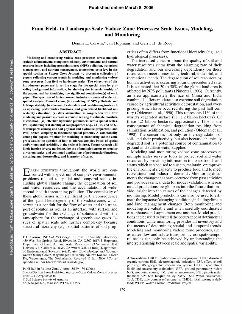
From Field- to Landscape-Scale Vadose Zone Processes: Scale Issues, Modeling, and Monitoring Dennis L. Corwin,* Jan Hopmans, and Gerrit H. de Rooij ABSTRACT Modeling and monitoring vadose zone processes across multiple scales is a fundamental component of many environmental and natural resource issues including nonpoint source (NPS) pollution, watershed management, and nutrient management, to mention just a few. In this special section in Vadose Zone Journal we present a collection of papers reflecting current trends in modeling and monitoring vadose zone processes from field to landscape scales. The objectives of this introductory paper are to set the stage for the special issue by pro- viding background information, by showing the interrelationship of the papers, and by identifying the significant contribution(s) of each paper. The spectrum of topics covered includes (i) issues of scale, (ii) spatial analysis of model error, (iii) modeling of NPS pollutants and hillslope stability, (iv) the use of estimation and conditioning tools such as upscaling, pedotransfer functions, and generalized likelihood un- certainty estimation, (v) data assimilation in conjunction with flow modeling and passive microwave remote sensing to estimate moisture distribution, (vi) effective hydraulic parameters across spatial scales, (vii) spatiotemporal stability of soil properties (e.g., Cl 2 , B, and NO 3 – N transport; salinity; and soil physical and hydraulic properties), and (viii) nested sampling to determine spatial patterns. A commonality among the papers, whether for modeling or monitoring vadose zone processes, is the question of how to address complex issues of spatial and/or temporal variability at the scale of interest. Future research will likely involve inverse modeling, the use of multiple sensors to monitor at various scales, and continued applications of pedotransfer functions, upscaling and downscaling, and hierarchy of scales. E ARTH SCIENTISTS throughout the world are con- fronted with a spectrum of complex environmental problems related to spatial and temporal scales, in- cluding global climate change, the degradation of soil and water resources, and the accumulation of wide- spread, health-threatening pollution. The complexity of these global issues is, in significant part, a consequence of the spatial heterogeneity of the vadose zone, which serves as a conduit for the flow of water and the trans- port of solutes, as well as an interface with surface and groundwater for the exchange of solutes and with the atmosphere for the exchange of greenhouse gases. Is- sues of spatial scale add further complexity because structural hierarchy (e.g., spatial patterns of soil prop- erties) often differs from functional hierarchy (e.g., soil hydrological processes). The increased concern about the quality of soil and water resources stems from the alarming rate of their degradation and our increasing dependency on these resources to meet domestic, agricultural, industrial, and recreational needs. The degradation of soil resources by human activities is occurring at an unprecedented rate. It is estimated that 30 to 50% of the global land area is affected by NPS pollutants (Pimental, 1993). Currently, an area approximately the size of China and India combined suffers moderate to extreme soil degradation caused by agricultural activities, deforestation, and over- grazing, which have occurred during the past half cen- tury (Oldeman et al., 1990). This represents 11% of the world’s vegetated surface (i.e., 1.2 billion hectares). Of these 1.2 billion hectares, approximately 12% is the consequence of chemical degradation resulting from salinization, acidification, and pollution (Oldeman et al., 1990). The concern is not only for the degradation of soils and their productivity, but also because chemically degraded soil is a potential source of contamination to ground and surface water supplies. Modeling and monitoring vadose zone processes at multiple scales serve as tools to protect soil and water resources by providing information to assess trends and status, which can be used to sustain, maintain, or improve the environment’s capacity to produce food and to meet recreational and industrial demands. Monitoring docu- ments the changes that have occurred from past activities and provides critical data for model validation, whereas model predictions are glimpses into the future that pro- vide insight into the causes of the changes detected by monitoring. Model predictions can also be used to esti- mate the impacts of changing conditions, including climate and land management changes. Both monitoring and modeling are valuable and when carefully coordinated can enhance and supplement one another. Model predic- tions can be used to foretell the occurrence of detrimental conditions, while monitoring provides an inventory and the means of determining spatial and temporal trends. Modeling and monitoring vadose zone processes, such as water flow and solute transport, across spatiotempo- ral scales can only be achieved by understanding the interrelationship between scale and spatial variability. D.L. Corwin, USDA-ARS, George E. Brown, Jr. Salinity Laboratory, 450 West Big Springs Road, Riverside, CA 92507-4617; J. Hopmans, Department of Land, Air, and Water Resources, 123 Veihmeyer Hal, University of California, Davis, CA 95616; G.H. de Rooij, Department of Environmental Sciences, Soil Physics, Ecohydrology and Ground- water Quality Group, Wageningen University, Nieuwe Kanaal 11 6709 PA, Wageningen, The Netherlands. Received 11 Jan. 2006. *Corre- sponding author ([email protected]). Published in Vadose Zone Journal 5:129–139 (2006). Special Section: From Field- to Landscape-Scale Vadose Zone Processes doi:10.2136/vzj2006.0004 ª Soil Science Society of America 677 S. Segoe Rd., Madison, WI 53711 USA Abbreviations: DBCP, 1,2-dibromo-3-chloropropane; DOC, dissolved organic carbon; EMI, electromagnetic induction; ESP, effective soil porosity; GIS, geographic information system; GLUE, generalized likelihood uncertainty estimation; GPR, ground penetrating radar; NPS, nonpoint source; PM, passive microwave; PTF, pedotransfer function; SJV, San Joaquin Valley; SWAT, Soil Water Assessment Tool; TDR, time domain reflectometry; TMDL, total maximum daily load; WEPP, Water Erosion Prediction Project. Reproduced from Vadose Zone Journal. Published by Soil Science Society of America. All copyrights reserved. 129 Published online March 8, 2006
-
Upload
independent -
Category
Documents
-
view
3 -
download
0
Transcript of From Field to Landscape-Scale Vadose Zone Processes: Scale Issues, Modeling, and Monitoring
From Field- to Landscape-Scale Vadose Zone Processes: Scale Issues, Modeling,and Monitoring
Dennis L. Corwin,* Jan Hopmans, and Gerrit H. de Rooij
ABSTRACTModeling and monitoring vadose zone processes across multiple
scales is a fundamental component of many environmental and naturalresource issues including nonpoint source (NPS) pollution, watershedmanagement, and nutrient management, to mention just a few. In thisspecial section in Vadose Zone Journal we present a collection ofpapers reflecting current trends in modeling and monitoring vadosezone processes from field to landscape scales. The objectives of thisintroductory paper are to set the stage for the special issue by pro-viding background information, by showing the interrelationship ofthe papers, and by identifying the significant contribution(s) of eachpaper. The spectrum of topics covered includes (i) issues of scale, (ii)spatial analysis of model error, (iii) modeling of NPS pollutants andhillslope stability, (iv) the use of estimation and conditioning tools suchas upscaling, pedotransfer functions, and generalized likelihood un-certainty estimation, (v) data assimilation in conjunction with flowmodeling and passive microwave remote sensing to estimate moisturedistribution, (vi) effective hydraulic parameters across spatial scales,(vii) spatiotemporal stability of soil properties (e.g., Cl2, B, and NO3–N transport; salinity; and soil physical and hydraulic properties), and(viii) nested sampling to determine spatial patterns. A commonalityamong the papers, whether for modeling or monitoring vadose zoneprocesses, is the question of how to address complex issues of spatialand/or temporal variability at the scale of interest. Future research willlikely involve inverse modeling, the use of multiple sensors to monitorat various scales, and continued applications of pedotransfer functions,upscaling and downscaling, and hierarchy of scales.
EARTH SCIENTISTS throughout the world are con-fronted with a spectrum of complex environmental
problems related to spatial and temporal scales, in-cluding global climate change, the degradation of soiland water resources, and the accumulation of wide-spread, health-threatening pollution. The complexity ofthese global issues is, in significant part, a consequenceof the spatial heterogeneity of the vadose zone, whichserves as a conduit for the flow of water and the trans-port of solutes, as well as an interface with surface andgroundwater for the exchange of solutes and with theatmosphere for the exchange of greenhouse gases. Is-sues of spatial scale add further complexity becausestructural hierarchy (e.g., spatial patterns of soil prop-
erties) often differs from functional hierarchy (e.g., soilhydrological processes).The increased concern about the quality of soil and
water resources stems from the alarming rate of theirdegradation and our increasing dependency on theseresources to meet domestic, agricultural, industrial, andrecreational needs. The degradation of soil resources byhuman activities is occurring at an unprecedented rate.It is estimated that 30 to 50% of the global land area isaffected by NPS pollutants (Pimental, 1993). Currently,an area approximately the size of China and Indiacombined suffers moderate to extreme soil degradationcaused by agricultural activities, deforestation, and over-grazing, which have occurred during the past half cen-tury (Oldeman et al., 1990). This represents 11% of theworld’s vegetated surface (i.e., 1.2 billion hectares). Ofthese 1.2 billion hectares, approximately 12% is theconsequence of chemical degradation resulting fromsalinization, acidification, and pollution (Oldeman et al.,1990). The concern is not only for the degradation ofsoils and their productivity, but also because chemicallydegraded soil is a potential source of contamination toground and surface water supplies.Modeling and monitoring vadose zone processes at
multiple scales serve as tools to protect soil and waterresources by providing information to assess trends andstatus, which can be used to sustain, maintain, or improvethe environment’s capacity to produce food and to meetrecreational and industrial demands. Monitoring docu-ments the changes that have occurred from past activitiesand provides critical data for model validation, whereasmodel predictions are glimpses into the future that pro-vide insight into the causes of the changes detected bymonitoring. Model predictions can also be used to esti-matetheimpactsofchangingconditions, includingclimateand land management changes. Both monitoring andmodeling are valuable and when carefully coordinatedcan enhance and supplement one another.Model predic-tions canbeused to foretell the occurrence of detrimentalconditions, while monitoring provides an inventory andthe means of determining spatial and temporal trends.Modeling and monitoring vadose zone processes, suchas water flow and solute transport, across spatiotempo-ral scales can only be achieved by understanding theinterrelationship between scale and spatial variability.
D.L. Corwin, USDA-ARS, George E. Brown, Jr. Salinity Laboratory,450 West Big Springs Road, Riverside, CA 92507-4617; J. Hopmans,Department of Land, Air, and Water Resources, 123 Veihmeyer Hal,University of California, Davis, CA 95616; G.H. de Rooij, Departmentof Environmental Sciences, Soil Physics, Ecohydrology and Ground-water Quality Group, Wageningen University, Nieuwe Kanaal 11 6709PA, Wageningen, The Netherlands. Received 11 Jan. 2006. *Corre-sponding author ([email protected]).
Published in Vadose Zone Journal 5:129–139 (2006).SpecialSection:FromField- toLandscape-ScaleVadoseZoneProcessesdoi:10.2136/vzj2006.0004ª Soil Science Society of America677 S. Segoe Rd., Madison,WI 53711USA
Abbreviations: DBCP, 1,2-dibromo-3-chloropropane; DOC, dissolvedorganic carbon; EMI, electromagnetic induction; ESP, effective soilporosity; GIS, geographic information system; GLUE, generalizedlikelihood uncertainty estimation; GPR, ground penetrating radar;NPS, nonpoint source; PM, passive microwave; PTF, pedotransferfunction; SJV, San Joaquin Valley; SWAT, Soil Water AssessmentTool; TDR, time domain reflectometry; TMDL, total maximum dailyload; WEPP, Water Erosion Prediction Project.
Reproducedfrom
VadoseZoneJournal.PublishedbySoilScienceSociety
ofAmerica.Allcopyrights
reserved.
129
Published online March 8, 2006

The growing interest in studies concerning spatiotem-poral scales, particularly field- to landscape-scale stud-ies, stems from many environmental and naturalresource issues, such as NPS pollution, total maximumdaily loads (TMDLs), landscape hydrology, nutrientmanagement, watershed management, site-specific cropmanagement, and global changes. In an effort to bringtogether leading scientists from areas of soil and hy-drologic sciences and related environmental disciplines,such as geology, ecology, and agronomy, a LandscapeProcesses Symposium was organized as part of the 2004ASA-CSSA-SSSA Annual Meeting (31 Oct.– 4 Nov.2004, Seattle, WA). The interdisciplinary symposiumwas designed to stimulate interactions among the soil,hydrologic, and environmental sciences and to promoteintegrated research approaches at different scales. Se-lected invited papers from this symposium were joinedwith invited contributions from the EGS-AGU-EUGJoint Assembly session From Pore to Core to Field:Processes and Observations (Nice, France, April 2003)and other invited papers specifically solicited for thisspecial issue. The objective of the EGS-AGU-EUGsession was to address how observations and/or theoryon one scale should be applied to problems that are atscales at least one order of magnitude larger. It is theaim of this special issue to highlight vadose zone re-search that reflects current trends involving modelingand monitoring of vadose zone processes from field tolandscape spatial scales. Our objectives in this paper are(i) to show the interrelationship of the collection of in-vited papers, (ii) to identify their significant scientificcontributions, and (iii) to bring into perspective the spa-tial factors that need to be considered when modelingand monitoring vadose zone processes at multiple scales.
Spatial Factors to Consider for Modeling andMonitoring Vadose Zone Processes
An awareness and understanding of the interrelation-ship of scale and spatial variability serves as the linchpinfor modeling and monitoring vadose zone process acrossdifferent scales.
Scale
Scale, as used in soil science and hydrology, refers tothe “characteristic length in the spatial domain” and tothe “characteristic time interval in the temporal domain”(Baveye and Boast, 1999). Even though space and timeare continuous, there is only a discrete set of scales that isrelevant based on specific features that make them ofparticular use or interest (Wagenet and Hutson, 1996).Several books exist (e.g., Rosswall et al., 1988; Sposito,1998; Pachepsky et al., 2003) as well as numerous reviewpapers (e.g., Wood et al., 1990; de Boer, 1992; Gelharet al., 1992; Koltermann and Gorelick, 1996; Shuttle-worth et al., 1997; Mayer et al., 1999; Dodds andRothman, 2000; Cushman et al., 2002; Farmer, 2002;Grayson et al., 2002; Western et al., 2002; Neuman andFederico, 2003; Skoien et al., 2003; Sivapalan, 2003;Sivapalan et al., 2003; Shaman et al., 2004; Bloschl, 2006;
Noetinger et al., 2005; Loague and Corwin, 2006) thatprovide tremendous insight into the current state ofknowledge on scale issues.
The existence of a hierarchy of scales has been pos-tulated to relate to spatial or temporal features ofsystems of interest (see Fig. 1; Hoosbeek and Bryant,1993; Vogel and Roth, 2003). Temporal and spatialscales dictate the general type of model (Dooge, 1986;Wagenet and Hutson, 1996). The consideration of scalein model development requires observed informationfor the real system being modeled at the spatial andtemporal scales of interest. This means that microscopic-scale models developed in the laboratory are not alwaysappropriate for macroscopic-scale applications, and viceversa. An important consideration in model conceptu-alization is for the model to account for the predominantprocesses occurring at the spatial and temporal scales ofinterest. This complies with the guideline of parsimony.Qualitatively speaking, as spatial scale increases in asystem where local-scale irregularities such as unstablefingers or macropores are not significant, the complexlocal patterns of solute transport are attenuated anddominated by macroscale characteristics. When consid-ering scale changes in spatial extent, mechanistic modelsare utilized more frequently at the soil column to mo-lecular scales, while functional models are more oftenapplied from field to global scales. Stochastic modelsgenerally are used at field scales and larger.
The hierarchy of scales as applied to model type maynot be readily applied to soils in all instances becauseof the peculiar geometry that limits the range of scales inthe direction of predominant flow. As a cautionary note,the short vertical travel distances in soils compared withtheir lateral extent create a persistence of some small-
Fig. 1. Organizational hierarchy of spatial scales pertinent toenvironmental models (redrawn fromHoosbeek and Bryant, 1993).
Reproducedfrom
VadoseZoneJournal.PublishedbySoilScienceSociety
ofAmerica.Allcopyrights
reserved.
130 VADOSE ZONE J., VOL. 5, FEBRUARY 2006
scale effects, such as those due to macropore flow. Inthese instances, the breakthrough curve of a plot, field,or region will be dominated by macropores observableat the square-meter scale (or pedon scale) as long as thedepth to groundwater does not change much. Thereason is that the scale in the direction of flow does notchange significantly, even when the horizontal scalevaries widely. The fact that the length of stream tubes ina soil varies little in relation to the horizontal extent ofthe domain considered can cause small-scale processes,such as macropore flow, to dominate solute leachingbelow a critical depth at a wide range of horizontalscales. In addition, small-scale processes with a nonlin-ear dependence on solute concentration (e.g., sorptionand decay) can affect the large-scale behavior of solutes.Small-scale variations in flux concentrations were ob-served by de Rooij and Stagnitti (2000) below an un-disturbed soil monolith where peak concentrations werethree times higher than of the aggregated lysimeter-scalebreakthrough curve. This suggests that even whenproblems are addressed at the field or landscape scale(0.01–100 km2), it may be prudent to establish monitor-ing programs that record fluxes of water and solutes atnested scales. In fact, all field models at present use dataand algorithms from a variety of scales.
The relevance of the temporal domain must also notbe overlooked. Larger spatial scales appear more con-stant because the rapid dynamics of the lower scales aredisregarded (O’Neill, 1988). For this reason, time stepsof functional models can expand over days, such as thetime between irrigation or precipitation events, whilethe time steps of mechanistic models characteristicallyextend over minutes. A complete discussion of the ap-plication of models at different spatial and temporalscales was presented by Wagenet (1996) and Wagenetand Hutson (1996). Wagenet and Hutson (1996) pos-tulated three issues that should guide the application oftransport models across spatial and temporal scales: (i)the type of model (e.g., functional or mechanistic) mustbe commensurate with the scale of application andthe nature of available data at that scale, (ii) samplingand measurement of input and validation data must bespatially consistent with the model, and (iii) measure-ment and monitoring methods must be relevant atthe temporal domain being modeled. Similar issues ofscale and their implications for modeling are also dis-cussed by Mulla and Addiscott (1999) and Baveye andBoast (1999).
Spatial and temporal scale, as pertaining to measure-ments and model simulations, are characteristically de-scribed by extent, support, and coverage. This scaletriplet has been defined by Bloschl and Sivapalan (1995)andbyBierkens et al. (2000). Support refers to the largestarea or time interval for which a measured property orsimulation is considered homogeneous. Increasing thesupport is called upscaling, while decreasing supportis called downscaling. The extent refers to the area ortime interval over which observations aremade ormodeloutcomes are calculated. Coverage refers to the ratioof the sum of areas or time intervals for all supportunits for which averages are known and the extent.
Upscaling methods are divided into four major classeson the basis of modeling—if the model is linear, whetherthe model is site and time specific, if the model form isthe same at the scales involved, and if the larger-scalemodel is analytically derived from the smaller-scalemodel (Bierkens et al., 2000). The four classes include(i) averaging observations or model outputs, (ii) findingrepresentative parameters or input variables, (iii) av-eraging model equations, and (iv) model simplification(Bierkens et al., 2000). The vadose zone has a char-acteristic geometry in which the vertical extent (i.e., thedominant direction for most flow and transport pro-cesses) is generally orders of magnitude smaller thanits lateral extent, and which in flat areas (e.g., deltas)varies little with changing horizontal scales. Conse-quently, upscaling with the third class (averaging modelequations) is of limited use for the vadose zone be-cause travel distances are often too small to reach therequired asymptotic behavior (Yeh, 1998; Vanderborghtet al., 2006).Downscaling essentially consists of restructuring the
variation of a property at a smaller scale from informa-tion at a larger scale using only the arithmetic averageat the larger scale (Bierkens et al., 2000). Downscalingis a problem with a nonunique solution in that an infi-nite number of functions can describe the variation at asmaller scale, having the same average value as over thelarger scale (Bierkens et al., 2000). Typically, there arefour steps to upscaling and downscaling, as listed byBloschl (2006): (i) analyzing local data and scrutinizingthe literature to decide on the model type, (ii) estimatingparameters from the data, (iii) verifying the upscaling ordownscaling model against an independent data set, and(iv) performing the actual upscaling and downscaling.Loague and Corwin (2006) pointed out that the size
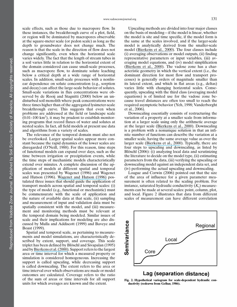
of the area of influence for a given parameter mea-surement is often related to the scaling problem. Forinstance, saturated hydraulic conductivity (Ks) measure-ments can be made at several scales: point, column, plot,and local. Figure 2 illustrates that data from differentscales of measurement can have different correlation
Fig. 2. Hypothetical variogram for scale-dependent hydraulic con-ductivity (redrawn from Gelhar, 1986).
Reproducedfrom
VadoseZoneJournal.PublishedbySoilScienceSociety
ofAmerica.Allcopyrights
reserved.
131www.vadosezonejournal.org
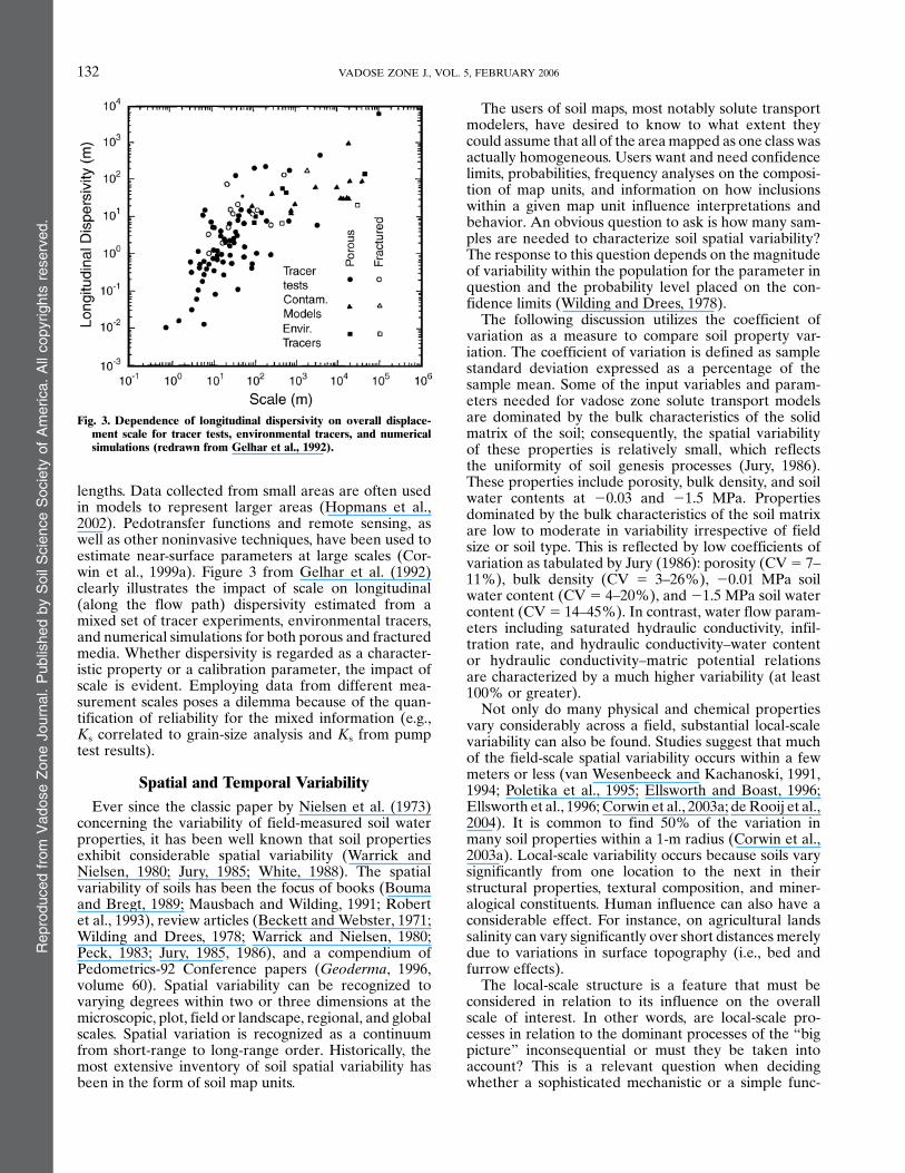
lengths. Data collected from small areas are often usedin models to represent larger areas (Hopmans et al.,2002). Pedotransfer functions and remote sensing, aswell as other noninvasive techniques, have been used toestimate near-surface parameters at large scales (Cor-win et al., 1999a). Figure 3 from Gelhar et al. (1992)clearly illustrates the impact of scale on longitudinal(along the flow path) dispersivity estimated from amixed set of tracer experiments, environmental tracers,and numerical simulations for both porous and fracturedmedia. Whether dispersivity is regarded as a character-istic property or a calibration parameter, the impact ofscale is evident. Employing data from different mea-surement scales poses a dilemma because of the quan-tification of reliability for the mixed information (e.g.,Ks correlated to grain-size analysis and Ks from pumptest results).
Spatial and Temporal VariabilityEver since the classic paper by Nielsen et al. (1973)
concerning the variability of field-measured soil waterproperties, it has been well known that soil propertiesexhibit considerable spatial variability (Warrick andNielsen, 1980; Jury, 1985; White, 1988). The spatialvariability of soils has been the focus of books (Boumaand Bregt, 1989; Mausbach and Wilding, 1991; Robertet al., 1993), review articles (Beckett and Webster, 1971;Wilding and Drees, 1978; Warrick and Nielsen, 1980;Peck, 1983; Jury, 1985, 1986), and a compendium ofPedometrics-92 Conference papers (Geoderma, 1996,volume 60). Spatial variability can be recognized tovarying degrees within two or three dimensions at themicroscopic, plot, field or landscape, regional, and globalscales. Spatial variation is recognized as a continuumfrom short-range to long-range order. Historically, themost extensive inventory of soil spatial variability hasbeen in the form of soil map units.
The users of soil maps, most notably solute transportmodelers, have desired to know to what extent theycould assume that all of the areamapped as one class wasactually homogeneous. Users want and need confidencelimits, probabilities, frequency analyses on the composi-tion of map units, and information on how inclusionswithin a given map unit influence interpretations andbehavior. An obvious question to ask is how many sam-ples are needed to characterize soil spatial variability?The response to this question depends on the magnitudeof variability within the population for the parameter inquestion and the probability level placed on the con-fidence limits (Wilding and Drees, 1978).
The following discussion utilizes the coefficient ofvariation as a measure to compare soil property var-iation. The coefficient of variation is defined as samplestandard deviation expressed as a percentage of thesample mean. Some of the input variables and param-eters needed for vadose zone solute transport modelsare dominated by the bulk characteristics of the solidmatrix of the soil; consequently, the spatial variabilityof these properties is relatively small, which reflectsthe uniformity of soil genesis processes (Jury, 1986).These properties include porosity, bulk density, and soilwater contents at 20.03 and 21.5 MPa. Propertiesdominated by the bulk characteristics of the soil matrixare low to moderate in variability irrespective of fieldsize or soil type. This is reflected by low coefficients ofvariation as tabulated by Jury (1986): porosity (CV5 7–11%), bulk density (CV 5 3–26%), 20.01 MPa soilwater content (CV 5 4–20%), and 21.5 MPa soil watercontent (CV5 14–45%). In contrast, water flow param-eters including saturated hydraulic conductivity, infil-tration rate, and hydraulic conductivity–water contentor hydraulic conductivity–matric potential relationsare characterized by a much higher variability (at least100% or greater).
Not only do many physical and chemical propertiesvary considerably across a field, substantial local-scalevariability can also be found. Studies suggest that muchof the field-scale spatial variability occurs within a fewmeters or less (van Wesenbeeck and Kachanoski, 1991,1994; Poletika et al., 1995; Ellsworth and Boast, 1996;Ellsworth et al., 1996; Corwin et al., 2003a; deRooij et al.,2004). It is common to find 50% of the variation inmany soil properties within a 1-m radius (Corwin et al.,2003a). Local-scale variability occurs because soils varysignificantly from one location to the next in theirstructural properties, textural composition, and miner-alogical constituents. Human influence can also have aconsiderable effect. For instance, on agricultural landssalinity can vary significantly over short distances merelydue to variations in surface topography (i.e., bed andfurrow effects).
The local-scale structure is a feature that must beconsidered in relation to its influence on the overallscale of interest. In other words, are local-scale pro-cesses in relation to the dominant processes of the “bigpicture” inconsequential or must they be taken intoaccount? This is a relevant question when decidingwhether a sophisticated mechanistic or a simple func-
Fig. 3. Dependence of longitudinal dispersivity on overall displace-ment scale for tracer tests, environmental tracers, and numericalsimulations (redrawn from Gelhar et al., 1992).
Reproducedfrom
VadoseZoneJournal.PublishedbySoilScienceSociety
ofAmerica.Allcopyrights
reserved.
132 VADOSE ZONE J., VOL. 5, FEBRUARY 2006

tional model should be applied to a particular vadosezone problem.
A need exists to quantify soil variability and to deter-mine the scale or scales of its occurrence. Such infor-mation is increasingly needed for modeling flow andcontaminant transport processes in geographic informa-tion system (GIS) applications and for environmentalimpact assessment (Corwin et al., 1997). Currently, sev-eral techniques are available to quantify and delineatespatial variability, including the use of electromagneticinduction (EMI), time domain reflectometry (TDR),ground penetrating radar (GPR), aerial photography,and multi- and hyperspectral imagery. However, few ofthese methods have been as extensively studied as theuse of EMI for characterizing soil spatial variability(Corwin and Lesch, 2005). Spatial domains or map unitsof “homogeneous” water flow characteristics, referredto as stream tubes, are promising and potentially welladapted to GIS applications. The stream-tube model isdiscussed in detail by Jury and Roth (1990) and Jury(1996). Examples of this approach for simulating field-scale solute transport are given by Bresler and Dagan(1981), Destouni and Cvetkovic (1991), and Toride andLeij (1996a, 1996b). However, comparatively few havebeen directed to realistic evaluations of this approach orto actual delineations of a stream tube. Corwin et al.(1998) proposed a potential means of delineating streamtubes in the field using EMI, and subsequently used thestream-tube approach to predict salt loading to tile drainsover a 5-yr period for a 2400-ha study area (Corwin et al.,1999b). In addition to delineating stream tubes, EMIhas been used to map the spatial variability of physicaland chemical properties for applications in soil qualityassessment (Corwin et al., 2003a, 2005) and precisionagriculture (Corwin et al., 2003b).
Though not as extensively studied as the spatial var-iability of soil, the aspect of temporal variability, par-ticularly of soil hydraulic properties, is also of concern.Temporal variation can be attributed to both intrinsicfactors (i.e., natural processes) such as freezing andthawing, root growth and exudates, wetting and dryingcycles, C turnover and biological activity; and extrinsicfactors (i.e., human activities) such as tillage operations.Temporal changes have been demonstrated to occur fortotal porosity (Cassel, 1983; Scott et al., 1994), bulkdensity (Cassel, 1983; Scott et al., 1994), water retention(Gantzer and Blake, 1978; Cassel, 1983; Anderson et al.,1990), saturated hydraulic conductivity (Scott et al.,1994), macroporosity (Skidmore et al., 1975; Cassel,1983; Carter, 1988), and infiltration rate (Starr, 1990;Van Es et al., 1991; Van Es, 1993). Tillage affects boththe magnitude and variability of soil properties becauseit physically disrupts the structure of the soil and causeschanges in water and solute flow patterns, which maychange again with time as soil settles and continuousmacropores develop through active soil biota and/or byphysical processes of nature (e.g., freezing and thawing,wetting and drying) (Coquet et al., 2005). To handletemporal data within existing soil survey databases,Grossman and Pringle (1987) provided a description of arecord to join together the use and time invariant in-
formation from soil survey documentation with use-dependent temporal quantities.
OVERVIEWAmong the most challenging tasks to characterize
hydrologic processes across the landscape is knowledgeof the spatial and temporal distribution of the soil hy-drologic properties that define key differences withinthe landscape. The more readily available relevant in-formation includes topography, climate, vegetation, andsoil surveys. Yet, water flow is also determined by sub-surface soil properties and geology, which combined candirect water flow through preferential flow paths alongthe hillslope and across the hydrologic basin, and ismuch more difficult to assess. This special issue providesa wide array of measurement, sampling, spatial analysis,and modeling techniques to improve the hydrologiccharacterization of the landscape in the vadose zone. Ofthe contributions, two papers involve issues of scale,nine papers deal with modeling at field to landscapescales or spatial analysis of model error, and nine in-volve the characterization of spatial variability.Of the two papers addressing the issue of scale, the
paper by Jardine et al. (2006) is a noteworthy contri-bution in that it cogently demonstrates the significanceof scale in amultiscale case study of the fate and transportof dissolved organic carbon (DOC) involving spatialscales from the laboratory to the landscape. This workprovides an improved understanding of the coupledhydrogeochemical mechanisms that control DOC mo-bility and sequestration in deep subsoils. Laboratory-scale experiments indicated that lower horizons have atendency to accumulate DOC with preferential fractureflow limiting sequestration. Intermediate-scale experi-ments indicated the beneficial effects of C diffusion intomicropores, while field- and landscape-scale studiesdemonstrated hydrological, geochemical, and microbio-logical mechanisms limiting C sequestration and theirsensitivity to environmental conditions. This study con-vincingly demonstrates the benefit of a multiscale ap-proach for unraveling the mechanisms involved in alandscape-scale process.The second of the scale-related papers addresses
the hydrological implications of scale effects in esti-mating the variogram parameters of a soil property.Ideally, sampling and modeling scales should be com-mensurate with the scales of soil properties of interestwhenmonitoring or modeling landscape-scale processes.This is usually not possible because the true covari-ance structure of the property of interest is unknowna priori. The findings of Skoien and Bloschl (2006)indicate that biases and random errors in variogramparameters depend on the choice of spacing, extent,and support relative to the scale of the underlying pro-cess of interest.The subsequent nine papers concerning modeling
cover the following topics: spatial analysis of modelerror, upscaling using stochastic continuum transportequations, NPS pollutant transport using PRZM-2,modeling of atrazine transport using parameter sets
Reproducedfrom
VadoseZoneJournal.PublishedbySoilScienceSociety
ofAmerica.Allcopyrights
reserved.
133www.vadosezonejournal.org

conditioned with Generalized Likelihood UncertaintyEstimation (GLUE), simulation of field-scale water flowusing an ensemble of pedotransfer functions (PTFs), useof a two-stage calibration approach for the Soil WaterAssessment Tool (SWAT) hydrologic model, testing themodel performance of the Water Erosion PredictionProject (WEPP), risk assessment, and modeling hill-slope stability.
Landscape-scale model performance may be scaledependent. Conventional methods of model validation,such as 1:1 plots and non-spatial statistical analysis, canobscure the complex, scale-dependent relation betweenmodel predictions and observations. Spatial analysis ofmodel error was used by Pringle and Lark (2006) tosimulate soil CO2 emissions across a 1024-m transect atSilsoe, UK. A linear model of coregionalization wasused to study the spatial relation between observed CO2
emissions and model predictions. The model accuratelypredicted low frequency fluctuations in CO2 emissions,but not high frequency fluctuations. The authors foundthat soil water content had a scale-dependent correla-tion with model error, but that this correlation was notsufficiently strong to warrant its inclusion into themodel. This work offers a less common focus on spatial,rather than temporal, dynamics of soil CO2 emissionsand presents geostatistical techniques for the analysis oflandscape-process models that can be applied in bothtemporal and spatial domains.
Vanderborght et al. (2006) review theoretical treat-ments of field-scale solute transport in heterogeneoussoils, focusing on approximations using the one-dimen-sional convection–dispersion equation with an effectivedispersivity and the stochastic-convective stream-tubemodel. Although both approaches have been appliedwith some success, their general applicability is ham-pered by factors such as the short travel distances insoils, which preclude an asymptotic transport regime,and the complexity and connectivity of soil spatialvariations, which cannot be captured by customarysecond-order stationary Gaussian fields of the soil hy-draulic properties.
Loague and Soutter (2006) conducted an intensivesimulation case study using PRZM-2 (Mullins et al.,1993) to examine whether NPS pesticide application canproduce regional-scale contamination of groundwaterwith localized high concentration hotspots. Results frommore than 11,000 NPS simulation scenarios for thepesticide 1,2-dibromo-3-chloropropane (DBCP) in thevicinity of Fresno in the San Joaquin Valley (SJV),involving a combination of elevated water table loadingconcentrations and high pumping rates, indicated that“isolated high concentration hotspots, within a regional-scale subsurface system, are not easily generated fromlabel-recommended pesticide applications.” HistoricalDBCP hotspots, previously attributed to diffuse applica-tions of DBCP, were not substantiated by the simula-tions with plausible hydrological conditions. Rather thandiffuse application as the cause of observed DBCP hot-spots in the SJV, they concluded that point sources, suchas spills, intended downwell dumping, and surplus burialwere the likely causes of the hotspots.
Beven et al. (2006) present an approach for approx-imating field-scale pesticide transport in the vadosezone, given uncertainty in local characteristics and field-scale distribution of properties influencing pesticidetransport. The approach represents within-field vari-ability by using parameter estimates from the literatureas prior distributions, and information obtained byfitting observed breakthrough curves for experimentalcolumns, to condition posterior field distributions, whiletaking account of uncertainty in both sources of infor-mation. Conditioning with behavioral parameter setsobtained using GLUE from undisturbed columns re-sulted in steady-state flow predictions of atrazine trans-port to groundwater in the Rhone Valley of Switzerland,thereby showing very low long-term risk of groundwatercontamination. This paper is an extension of the workby Beven (1993) by (i) considering a reactive substance(i.e., atrazine), (ii) testing additional conditioning pro-vided by multiple column experiments, and (iii) allowingfor uncertainty in the estimation of parameter values foreach column experiment.
Pedotransfer functions of soil hydraulic properties arepotentially useful tools in flow simulations at field tolandscape scales. However, using PTFs always intro-duces substantial uncertainty because their accuracy isunknown when used outside the development dataset;as a result, the selection of a single model for use overlarge spatial extents has become a problem. Using amultimodel ensemble method, Guber et al. (2006) eval-uated the applicability of an ensemble of PTFs fromsimulations of water flow at the field scale. A compar-ison of results showed that errors were on average twotimes smaller when the ensemble of PTFs was used, thusindicating that the ensemble PTF estimation gave asubstantially better approximation of field-scale waterretention than laboratory data.
Lin and Radcliffe (2006) present a two-stage routinefor automatic calibration of the SWAT semidistributedhydrologic model to determine optimal model param-eters and their uncertainty. In the first stage, a globaloptimization method was used to determine the best-fitlumped model parameters. In the second stage, theseparameter values were used as initial values for a localsearch algorithm to estimate the distributed set of pa-rameters for the distributed model. The calibrationtechnique was applied to a 10-yr record of daily streamflow data for a 1580-km2 watershed of the Etowah River,near Canton, GA. Subbasin hydrologic response unitswere defined by differentiation in soils, land use, topog-raphy, and climate. The proposed calibration approachwas successful in preserving the heterogeneity of thewatershed. Uncertainty analysis demonstrated that themodeling approach was more reliable for long-term an-nual flow than short-term, 7-d average flow prediction.
Greer et al. (2006) present field experimental resultsfrom dedicated field plots to test the performance of theWEPP model for water erosion prediction in Palouseregion of the Pacific Northwest, near Pullman, WA. Thespecific objective was to assess winter erosion mechanicsduringmultiple freeze–thaw cycles along steep land slope.This study concludes that the hillslope configuration
Reproducedfrom
VadoseZoneJournal.PublishedbySoilScienceSociety
ofAmerica.Allcopyrights
reserved.
134 VADOSE ZONE J., VOL. 5, FEBRUARY 2006

of this mechanistic flow and sediment transport model isnot able to predict measurement runoff and associatederosion rates during a 3-yr simulation period. Resultsshow that soil thawing and snowmelt alone can result insignificant runoff and erosion, without any precipitation.Moreover, rainfall onto frozen ground causes signifi-cant runoff, increasing soil moisture and high erosionrates down slope. Although the WEPP model contains aphysically based winter routine to simulate snow coverand soil frost and thaw, it was unable to accurately pre-dict winter erosion.
High concentrations of herbicides (e.g., propanil andmolinate) applied to rice have been found in surface-and groundwater systems of large river basins in Europewhere rice is commonly cultivated. Karpouzas et al.(2006) performed a risk assessment of a 2000-ha rice-cultivated basin in the Axios River Basin of Greece.Combining subsurface water quality (RICEWQ 1.6.2v)and surface water quality (RIVWQ 2.02v) models, sim-ulated results over a 20-yr period for the two herbicidesindicated a likelihood of low risk to groundwater. Evenso, it was recommended that prolonging the closure of arice paddy after pesticide application could be abeneficial strategy for minimizing pesticide load risks.Comparison of the 90th percentile of maximum dailypredicted concentrations of propanil and molinate withmaximum measured concentrations for 1994 showedacceptable agreement in magnitude and temporal dis-tribution. This study exemplifies a well-defined basin-scale risk assessment that is representative of herbicideuse in rice paddies in Greece.
Mukhlisin et al. (2006) present a model of hillslopestability. A numerical model was developed to simulatetwo-dimensional rainwater infiltration into an unsatu-rated layer, the development of a saturated zone, andsubsequent changes in slope stability. The model wasused to analyze the effects of soil porosity parameters onslope failure and movement of debris flow for weath-ered granitic hillslopes. Sloping surface soils having re-latively large effective soil porosity (ESP) have greatercapacity to hold water, which delays infiltration andan increase in pore water pressure in the subsurface.Greater ESP contributes to delaying slope failure, butif failure occurs, the increased water content of the dis-placed material results in faster and larger travel dis-tances and a broader extent of debris flow.
The remaining papers address spatiotemporal vari-ability of soil properties. The topics that are coveredinclude data assimilation with one-dimensional flowmodeling and passive microwave (PM) remote sensingto estimate root zone moisture distribution, effectivehydraulic parameters across spatial scales, temporal sta-bility of moisture patterns, nested sampling to determinespatial patterns of soil hydraulic properties, examinationof the effects of long-term alternative farming practiceson soil physical and hydraulic properties, spatial var-iability of Cl2 tracer transport, temporal variability ofsalinity and B under a shallow water table manage-ment strategy, geostatistical simulation of the spatiosea-sonal distribution of NO3–N, and seasonal evolution ofwater repellency.
Landscape-scale assessment of soil moisture withinthe root zone is a critical hydrologic variable used inhydroclimatic and environmental models. It is a dynamicspatiotemporal property that is influenced by a varietyof meteorological, biological, anthropogenic, edaphic,and topographic factors, which can also vary spatially.Passive microwave remote sensing has successfullymapped near-surface (i.e., »0–0.5 m) soil moisture. Dasand Mohanty (2006) build on recent PM work byestimating root zone (»0–0.6 m) soil moisture distribu-tion across Oklahoma’s Little Washita watershed usinga simple sequential data assimilation approach (i.e.,Ensemble Kalman Filter) with a one-dimensional va-dose zone model of water flow (i.e., HYDRUS-ET) thatutilizes remotely sensed surface moisture from an elec-tronically scanned thinned array radiometer. Reason-able agreement was found between footprint-scalemodel estimates and point-scale measurements usingTDR. Of particular advantage is the approach’s abilityto determine root zone soil moisture distributions overtime at multiple spatial scales. To improve the approach,additional work is needed to determine “effective” hy-draulic parameters across spatial scales, develop sub-surface soil properties data bases, implement moreappropriate landscape-scale water flow models, performcorrection of forcing data, and implement the approachon spatially correlated pixels.Zhu et al. (2006) address the issue of the need for
“effective” hydraulic parameters across spatial scalesraised by Das and Mohanty (2006). Zhu et al. (2006)study the influence of the third-order moment of thehydraulic parameter distribution on the effective para-meters that are able to produce ensemble flux in het-erogeneous soils.Lin (2006) investigates the temporal stability of soil
moisture patterns to explain time-persistent subsurfacepreferential flow paths. This study exemplifies the so-called hydro-pedological approach, demonstrating theimportance of soil spatial structure in hydrologic mod-eling. Year-around monitoring at 77 sites in the ShaleHills forested catchment in central Pennsylvania showedsignificant temporal stability of soil moisture, as con-trolled by soil types and landforms. Soil moisture pat-terns, in combination with the presence of riparian areasand wetlands, explained rapid channeling of precipi-tation to stream discharge. Specifically, hydrologicallyactive zones were identified for deep soils and low-lyingswales with favorable subsurface lateral flow pathways,especially for regions with soils of high lateral saturatedconductivity values.The paper by Wendroth et al. (2006) investigates a
nested sampling approach along a 5000-m transect of anortheastern Germany moraine landscape to determinethe spatial pattern of soil hydraulic properties and as-sociated variables. Pedotransfer functions, includingneural network techniques, and state-space modelswere evaluated in terms of their potential to describetheir spatial structures. The study concluded that PTFscan estimate spatial average values but, unlike state-space models, PTFs cannot adequately describe spa-tial fluctuations.
Reproducedfrom
VadoseZoneJournal.PublishedbySoilScienceSociety
ofAmerica.Allcopyrights
reserved.
135www.vadosezonejournal.org

Rolf et al. (2006) compare conventional and alterna-tive management practices and crop rotations in ad-jacent 65-ha fields. Alternative tillage and crop rotationsimproved soil physical and hydraulic properties, mainlyin the A horizon. Feeding unsaturated zone modelswith approximate parameter values based on generalcharacteristics may lead to systematic errors whenused to estimate water and nutrient mass balances.One-dimensional simulations showed that infiltrationincreased and drainage was reduced under alterna-tive practices.
For a study extending 34 yr, Woods et al. (2006)quantify the spatial variability of the transport of a Cl2
tracer under low transient flow semiarid conditions fromthe pedon to field scale. This included the transition oflocal-scale travel-time variance to field-scale travel timevariance and the influence of topography on the mag-nitude and spatial redistribution of surface water after19 mo and its relationship to Cl2 tracer distribution after34 yr. Slight variations in topography were found to havea significant effect on surface water redistribution, soilprofile development, and the movement of water andsolute in the vadose zone. Furthermore, the spatial pat-tern of soil water storage after 19 mo was significantlycorrelated to Cl2 transport after 34 yr, suggesting tem-poral stability of spatial patterns.
The disposal of agricultural drainage water is a seriousproblem in the productive San Jaoquin Valley of centralCalifornia. Various alternatives have been proposed toreduce volumes of drainage volumes, including use ofevaporation ponds, drainage water reuse, and restrictingflow in subsurface drains to raise the water table andinduce water consumption of groundwater by crops.Shouse et al. (2006) report a 3-yr monitoring study of theimpact of a shallow groundwater management drainagereduction strategy on spatiotemporal changes in soilsalinity and B in a 60-ha field. The field-scale monitoringstudy indicated little change during the period of study,but within-year fluctuations related to cropping andirrigation practices and environmental conditions. Win-ter rainfall and pre-plant irrigations tended to erase anychanges, indicating at least a short-term viability of shal-low groundwater management strategies.
A geostatistical simulation approach was used byGrunwald et al. (2006) for modeling the spatioseasonaldistribution of soil NO3–N in Florida’s Santa Fe RiverWatershed by integrating sparse field observations ofsoil NO3–N with auxiliary spatial environmental data-sets (i.e., land use, drainage class, DRASTIC index). Theapproach is a hybrid model where the probabilities ofexceeding a series of NO3–N threshold values are de-rived from secondary information using ordered logisticregression and are updated using indicator kriging. Theapproach is the first to use ordered logistic regressionto estimate the prior probabilities of occurrence inindicator kriging. To establish temporal (i.e., seasonal)trends in soil NO3–N due to climate and management,three typical seasons (January, May, and September)were observed. Areas of consistently high soil NO3–Nfor all three seasons targeted those areas where bestmanagement practices could reduce NO3–N loads.
Taumer et al. (2006) provide extensive data of a year-long monitoring campaign documenting the seasonalevolution of water repellency on a sandy soil near Ber-lin. The water-repellent fraction of the topsoil peakedin summer and was minimal in early spring. The spa-tial variation of the water content changes caused byrain showers corroborated the seasonal trend of wa-ter repellency.
FUTURE DIRECTIONS, CHALLENGES,AND NEEDS
The characterization of field- to landscape-scale pro-cesses in the vadose zone requires the ability to bothmeasure spatial and temporal data and model at mul-tiple scales. No single instrument or model is currentlycapable of functioning across such a broad range ofspatial scales. Ideally, compatibility is desired betweenthe scale of measurement of model parameters and themodel scale.
It is widely recognized that a better understanding ofthe dynamics of flow and transport in the vadose zone isneeded over the spectrum of spatial scales. A single,physically consistent model of landscape-scale flow andtransport in the vadose zone based on local-scale mea-surements has not been forthcoming because differentflow processes tend to dominate at different scales, sug-gesting that different processed-based models areneeded at each discrete spatial scale. For this reason,the concept of hierarchy of scales, where the soil isviewed from a hierarchy of spatial scales, will likelycontinue to serve as a guide for model selection anddevelopment. The development of the mathematicalrelationships that describe the dominant hydrological,chemical, and biological processes at each scale isneeded. Harter and Hopmans (2004) suggested thatthe key challenges facing researchers are “to address thehierarchy of scales in the vadose zone appropriately inlight of the dichotomy presented by the horizontal-to-vertical scale ratio, to explore the proper dimen-sionality of vadose zone processes, and to find theirappropriate regional-scale representation without losingthe link to local-scale soil physics.”
Currently, most models rely on parameters that aremeasured at points comprised of volumes of measure-ment of a few cubic centimeters, rather than integratedover cubic meters, tens of cubic meters, or larger. In-formation is needed to fill gaps in spatial databases (e.g.,SSURGO, STATSGO, and NATSGO) necessary forlandscape-scale vadose zone models, including (i) theneed for integrated spatial data of topographic, mete-orological, biologic, anthropogenic, and edaphic prop-erties; (ii) the need for real-time data and rapidprocessing and analysis to enable temporal as well asspatial management decisions; and (iii) the need for acollection of sensors that can measure dynamic soilproperties at a variety of spatial scales.
A variety of tools have potential for meeting the needto extend beyond point measurements with submetersupport. The integrated use of multiple remote andground-based sensors is the likely future direction of
Reproducedfrom
VadoseZoneJournal.PublishedbySoilScienceSociety
ofAmerica.Allcopyrights
reserved.
136 VADOSE ZONE J., VOL. 5, FEBRUARY 2006

monitoring of landscape-scale vadose zone processes toobtain the extensive amount of spatial data needed formodeling and management purposes. The combined useof multiple sensors (e.g., EMI, multispectral imagery,hyperspectral imagery, GPR, Doppler radar, X-ray to-mography, advanced very high resolution radiometry,aerial photography, magnetic resonance imaging, micro-waves, lidar, and thermal infrared) may sufficientlycover the full spectrum of spatial data necessary tocharacterize the topographic, meteorological, biologic,anthropogenic, and edaphic properties influencing va-dose zone processes at the landscape scale. Of these,the combined use of GPR, hyperspectral imagery, EMI,and real time kinematic GPS probably have the greatestpotential from a cost–benefit perspective. Pedotransferfunctions will continue to play a significant role in pa-rameter estimation. Undoubtedly, inverse modeling,which is capable of integrating parameters over largespatial extents, will see greater application in modelingat field scales and larger spatial extents, particularlywhen the necessary and sufficient conditions for inverseproblems to be well posed are met (Yeh and Simunek,2002). Even now inverse modeling has shown its utility.Only when parameters were estimated by means of aninverse procedure did large-scale field infiltrationsimulations with a hierarchy of models show significantimprovement in model fit (Wang et al., 2003). Compu-tational tools such as upscaling and downscaling willdefinitely serve a valuable role in landscape-scale ap-plications. Furthermore, wavelet analysis provides a val-uable means of determining the dominant processesassociated with a particular spatial scale (e.g., Lark andWebster, 1999; Lark et al., 2003).
Each paper within this special issue contains a com-mon element—how do we address the complex issue ofspatial and/or temporal variability at the scale of con-cern?. This problem will continue to be a major area ofconcern in environmental and natural resource re-search. The challenges that this problem poses to re-searchers can only be met through cross-disciplinaryinteraction that stimulates innovative, unconventionalapproaches. Whether a unified theory of spatiotemporalscales can be developed or a hierarchy of scales con-tinues to be used will likely depend on the success andextent of this interaction.
ACKNOWLEDGMENTS
The authors extend their appreciation to the contributors tothe special issue of Vadose Zone Journal entitled “From Field-to Landscape-Scale Vadose Zone Processes.” The time andeffort spent by each of the contributors is reflected in a timelycollection of papers. It was a pleasure to work with eachcontributor. The authors thank Dr. Rien van Genuchten,Editor of Vadose Zone Journal, for the invitation to serve asguest editors, for his constant assistance and encouragement,and for helping to bring this special issue to publication.
REFERENCESAnderson, S.H., C.J. Gantzer, and J.R. Brown. 1990. Soil physical
properties after 100 years of continuous cultivation. J. Soil WaterConserv. 45:117–121.
Baveye, P., and C.W. Boast. 1999. Physical scales and spatial pre-dictability of transport processes in the environment. p. 261–280. InD.L. Corwin et al. (ed.) Assessment of non-point source pollutantsin the vadose zone. Geophys. Monogr. 108. AGU, Washington, DC.
Beckett, P.H.T., and R. Webster. 1971. Soil variability: A review. SoilsFert. 34:1–15.
Beven, K.J. 1993. Estimating transport parameters at the grid scale:On the value of a single measurement. J. Hydrol. 143:109–124.
Beven, K., D. Zhang, and A. Mermoud. 2006. On the value of localmeasurements for prediction of pesticide transport at the fieldscale. Available at www.vadosezonejournal.org. Vadose Zone J. 5:222–233 (this issue).
Bierkens, F.P., P.A. Finke, and P. de Willigen. 2000. Upscaling anddownscaling methods for environmental research. Kluwer Aca-demic Publishers, Dordrecht, The Netherlands.
Bloschl, G. 2006. Scale and scaling in hydrology: A framework forthinking and analysis. JohnWiley& Sons, Chichester, UK (in press).
Bloschl, G., and M. Sivapalan. 1995. Scale issues in hydrologicalmodeling: A review. Hydrol. Processes 9:251–290.
Bouma, J., and Bregt. A.K. (ed.) 1989. Land qualities in space andtime. Pudoc, Wageningen, The Netherlands.
Bresler, E., and G. Dagan. 1981. Convective and pore scale dispersivesolute transport in heterogeneous fields. Water Resour. Res. 17:1683–1693.
Carter, M.R. 1988. Temporal variability of soil macroporosity in a finesandy loam under mouldboard ploughing and direct drilling. SoilTillage Res. 12:37–51.
Cassel, D.K. 1983. Spatial and temporal variability of soil physicalproperties following tillage of Norfolk loamy sand. Soil Sci. Soc.Am. J. 47:196–201.
Coquet, Y., C. Coutadeur, C. Labat, P. Vachier, M.Th. van Genuchten,J. Roger-Estrade, and J. Simunek. 2005. Water and solute transportin a cultivated silt loam soil: 1. Field observations. Available atwww.vadosezonejournal.org. Vadose Zone J. 4:573–586.
Corwin, D.L., M.L.K. Carrillo, P.J. Vaughan, D.G. Cone, and J.D.Rhoades. 1999b. Evaluation of a GIS-linked model of salt loadingto groundwater. J. Environ. Qual. 28:471–480.
Corwin, D.L., S.R. Kaffka, J.D. Oster, J. Hopmans, Y. Mori, J.W. vanGroenigen, C. van Kessel, and S.M. Lesch. 2003a. Assessment andfield-scale mapping of soil quality properties of a saline-sodic soil.Geoderma 114:231–259.
Corwin, D.L., and S.M. Lesch. 2005. Apparent soil electrical con-ductivity measurements in agriculture. Comput. Electron. Agric.46:11–43.
Corwin, D.L., S.M. Lesch, J.D. Oster, and S.R. Kaffka. 2005. Mon-itoring management-induced spatio-temporal changes in soilquality with soil sampling directed by apparent soil electricalconductivity. Geoderma (in press).
Corwin, D.L., S.M. Lesch, P.J. Shouse, R. Soppe, J.A. Jobes, J.Fargerlund, and J.E. Ayars. 2003b. Identifying soil properties thatinfluence cotton yield using soil sampling directed by apparent soilelectrical conductivity. Agron. J. 95:352–364.
Corwin, D.L., K. Loague, and T.R. Ellsworth. 1998. GIS-based mod-eling of nonpoint source pollutants in the vadose zone. J. Soil WaterConserv. 53:34–38.
Corwin, D.L., K. Loague, and T.R. Ellsworth (ed.) 1999a. Assessmentof non-point source pollution in the vadose zone. Geophys.Monogr. 108. AGU, Washington, DC.
Corwin, D.L., P.J. Vaughan, and K. Loague. 1997. Modeling nonpointsource pollutants in the vadose zone with GIS. Environ. Sci. Tech-nol. 31:2157–2175.
Cushman, J.H., L.S. Bennethum, and B.H. Ju. 2002. A primer onupscaling tools for porous media. Adv. Water Resour. 25(8–12):1043–1067.
Das, N.N., and B.P. Mohanty. 2006. Root zone soil moisture assessmentusing remote sensing and vadose zone modeling. Available atwww.vadosezonejournal.org. Vadose Zone J. 5:296–307 (this issue).
de Boer, D.H. 1992. Hierarchies and spatial scale in process geo-morphology: A review. Geomorphology 4:303–318.
de Rooij, G.H., R.T.A. Kasteel, A. Papritz, and H. Fluhler. 2004. Jointdistributions of the unsaturated soil hydraulic parameters and theireffect on other variates. Available at www.vadosezonejournal.org.Vadose Zone J. 3:947–955.
de Rooij, G.H., and F. Stagnitti. 2000. Spatial variability of solute
Reproducedfrom
VadoseZoneJournal.PublishedbySoilScienceSociety
ofAmerica.Allcopyrights
reserved.
137www.vadosezonejournal.org

leaching: Experimental validation of a quantitative parameteriza-tion. Soil Sci. Soc. Am. J. 64:499–504.
Destouni, G., and V. Cvetkovic. 1991. Field scale mass arrival of sorp-tive solute into the groundwater. Water Resour. Res. 27:1315–1325.
Dodds, P.S., and D.H. Rothman. 2000. Scaling, universality, andgeomorphology. Annu. Rev. Earth Planet. Sci. 28:571–610.
Dooge, J.C.I. 1986. Looking for hydrologic laws. Water Resour. Res.22:46S–58S.
Ellsworth, T.R., and C.W. Boast. 1996. The spatial structure of solutetransport variability in an unsaturated field soil. Soil Sci. Soc. Am. J.60:1355–1367.
Ellsworth, T.R., P.J. Shouse, T.H. Skaggs, J.A. Jobes, and J. Fargerlund.1996. Solute transport in an unsaturated field soil: Experimentaldesign, parameter estimation and model discrimination. Soil Sci.Soc. Am. J. 60:397–407.
Farmer, C.L. 2002. Upscaling: A review. Int. J. Numer. Methods Fluids40:63–78.
Gantzer, C.J., and G.R. Blake. 1978. Physical characteristics of LeSueur clay loam soil following no till and conventional tillage.Agron. J. 70:853–857.
Gelhar, L.W. 1986. Stochastic subsurface hydrology from theory toapplications. Water Resour. Res. 22:1355–1453.
Gelhar, L.W., C. Welty, and K.R. Rehfeldt. 1992. A critical review ofdata on field-scale dispersion in aquifers. Water Resour. Res. 28:1955–1974.
Grayson, R.B., G. Bloschl, A.W. Western, and T.A. McMahon. 2002.Advances in the use of. observed spatial patterns of catchmenthydrological response. Adv. Water Resour. 25:1313–1334.
Greer, R.C., J.Q. Wu, P. Singh, and D.K. McCool. 2006. WEPPsimulation of observed winter runoff and erosion in the U.S. PacificNorthwest. Available at www.vadosezonejournal.org. Vadose ZoneJ. 5:261–272 (this issue).
Grossman, R.B., and F.B. Pringle. 1987. Describing surface soilproperties—Their seasonal changes and implications for manage-ment. p. 57–75. In Soil survey techniques. SSSA Spec. Publ. 20.SSSA, Madison, WI.
Grunwald, S., P. Goovaerts, C.M. Bliss, N.B. Comerford, D.A. Graetz,and S. Lamal. 2006. Incorporation of auxiliary information in thegeostatistical simulation of soil nitrate nitrogen. Available at www.vadosezonejournal.org. Vadose Zone J. 5:391–404 (this issue).
Harter, T., and J.W. Hopmans. 2004. Role of vadose zone flowprocesses in regional scale hydrology: Review, opportunities andchallenges. p. 179–210. InR.A. Feddes et al. (ed.) Unsaturated zonemodeling: Progress, challenges and applications. Kluwer AcademicPublishers, Dordrecht, The Netherlands.
Hoosbeek, M.R., and R.B. Bryant. 1993. Towards the quantitativemodeling of pedogenesis: A review. Geoderma 55:183–210.
Hopmans, J.W., D.R. Nielsen, and K.L. Bristow. 2002. How useful aresmall-scale soil hydraulic property measurements for large-scalevadose zone modeling? p. 247. In P.A. Raats et al. (ed.) En-vironmental mechanics: Water, mass, and energy transfer in thebiosphere. Geophys. Monogr. 129. AGU, Washington, DC.
Jardine, P.M., M.A. Mayes, P.J. Mulholland, P.J. Hanson, J.R. Tarver,R.J. Luxmoore, J.F. McCarthy, and G.V. Wilson. 2006. Vadose zoneflow and transport of dissolved organic carbon at multiple scalesin humid regimes.Available atwww.vadosezonejournal. org.VadoseZone J. 5:140–152 (this issue).
Jury, W.A. 1985. Spatial variability of soil physical parameters in solutemigration: A critical literature review. Rep. EA-4228. ElectricalPower Research Inst., Palo Alto, CA.
Jury, W.A. 1986. Spatial variability of soil properties. p. 245–269. InS.C. Hern and S.M. Melancon (ed.) Vadose zone modeling oforganic pollutants. Lewis Publishers, Chelsea, MI.
Jury, W.A. 1996. Stochastic solute transport modeling trends and theirpotential compatibility with GIS p. 57–67. In D.L. Corwin and K.Loague (ed.) Application of GIS to the modeling of non-pointsource pollutants in the vadose zone. SSSA Spec. Publ. 48. SSSA,Madison, WI.
Jury, W.A., and K. Roth. 1990. Transfer functions and solutemovement through soil. Birkhauser Verlag, Basel, Switzerland.
Karpouzas, D.G., E. Capri, and E. Papadopoulou-Mourkidou. 2006.Basin-scale risk assessment in rice paddies:Anexample based on theAxios River Basin in Greece. Available at www.vadosezonejournal.org. Vadose Zone J. 5:273–282 (this issue).
Koltermann, C.E., and S.M. Gorelick. 1996. Heterogeneity in sedi-mentary deposits: A review of structure-imitating process-imitatingand descriptive approaches. Water Resour. Res. 32:2617–2658.
Lark, R.M., and R. Webster. 1999. Analysis and elucidation of soilvariation using wavelets. Eur. J. Soil Sci. 50:185–206.
Lark, R.M., S.R. Kaffka, and D.L. Corwin. 2003. Multiresolutionanalysis of data on electrical conductivity of soil using wavelets.J. Hydrol. 272:276–290.
Lin, H. 2006. Temporal stability of soil moisture spatial patternsand subsurface preferential flow pathways in the Shale Hills Catch-ment. Available at www.vadosezonejournal.org. Vadose Zone J. 5:317–340 (this issue).
Lin, Z., and D.E. Radcliffe. 2006. Automatic calibration and predictiveuncertainty analysis of a semidistributed watershed model. Avail-able at www.vadosezonejournal.org. Vadose Zone J. 5:248–260(this issue).
Loague, K., and D.L. Corwin. 2006. Scale issues. In J.W. Delleur (ed.)The handbook of groundwater engineering. CRC Press, BocaRaton, FL (in press).
Loague, K., and L.A. Soutter. 2006. Desperately seeking a causefor hotspots in regional-scale groundwater plumes resulting fromnon-point source pesticide applications. Available at www.vadose-zonejournal.org. Vadose Zone J. 5:204–221 (this issue).
Mausbach, M.J., and L.P. Wilding (ed.) 1991. Spatial variabilities ofsoils and landforms. SSSA Spec. Publ. 28. SSSA, Madison, WI.
Mayer, S., T.R. Ellsworth, D.L. Corwin, and K. Loague. 1999. Iden-tifying effective parameters for solute transport models in heter-ogeneous environments. p. 119–133. In D.L. Corwin et al. (ed.)Assessment of non-point source pollutants in the vadose zone.Geophys. Monogr. 108. AGU, Washington, DC.
Mukhlisin, M., K. Kosugi, Y. Satofuka, and T. Mizuyama. 2006. Effectsof soil porosity on slope stability and debris flow runout at aweathered granitic hillslope. Available at www.vadosezonejournal.org. Vadose Zone J. 5:283–295 (this issue).
Mulla, D.J., and T.M. Addiscott. 1999. Validation approaches forfield-, basin-, and regional-scale water quality models p. 63–78.In D.L. Corwin et al. (ed.) Assessment of non-point source pollu-tants in the vadose zone. Geophys. Monogr. 108. AGU, Washing-ton, DC.
Mullins, J.A., R.F. Carsel, J.E. Scarbough, and A.M. Ivery. 1993.PRZM-2, A model for predicting pesticide fate in the crop root andunsaturated soil zones: User’s manual release 2. EPA-600/R-93/046.Environmental Research Laboratory, USEPA, Athens, GA.
Neuman, S.P., and V. Di Federico. 2003. Multifaceted nature of hydro-geologic scaling and its interpretation. Rev. Geophys. 41(3):1014.doi:10.1029/2003RG000130.
Nielsen, D.R., J.W. Biggar, and K.T. Erh. 1973. Spatial variability offield-measured soil-water properties. Hilgardia 42:215–259.
Noetinger, B., V. Artus, and G. Zargar. 2005. The future of stochasticand upscaling methods in hydrology. Hydrogeol. J. 13:184–201.
Oldeman, L.R., V.W.P. Van Engelen, and J.H.M. Pulles. 1990. In L.R.Oldeman et al. (ed.) World map of the status of human-induced soildegradation: An explanatory note. International Soil Referenceand Information Centre, Wageningen, The Netherlands.
O’Neill, R.V. 1988. Hierarchy theory and global change. p. 29–45. InRosswall et al. (ed.) Scales and global change. Scientific Committeeon Problems of the Environment (SCOPE), John Wiley & Sons,New York.
Oquist, K.A., J.S. Strock, and D.J. Mulla. 2006. Influence of alternativeand conventional management practices on soil physical andhydraulic properties. Available at www.vadosezonejournal.org.Vadose Zone J. 5:356–364 (this issue).
Pachepsky, Y., D.E. Radcliffe, and H.M. Selim (ed.) 2003. Scalingmethods in soil physics. CRC Press, Boca Raton, FL.
Peck, A.J. 1983. Field variability of soil physical properties. p. 189–221.D.Hillel (ed.) Advances in irrigation. Vol. 2. Academic Press, New York.
Pimental, D. (ed.) 1993. World soil erosion and conservation.Cambridge Univ. Press, Cambridge, UK.
Poletika, N.N., W.A. Jury, and M.V. Yates. 1995. Transport of bromide,simazine, and MS-2 coliphage in a lysimeter containing undis-turbed, unsaturated soil. Water Resour. Res. 31:801–810.
Pringle, M.J., and R.M. Lark. 2006. Spatial analysis of model error,illustrated by soil carbon dioxide emissions. Available at www.vadosezonejournal.org. Vadose Zone J. 5:168–183 (this issue).
Reproducedfrom
VadoseZoneJournal.PublishedbySoilScienceSociety
ofAmerica.Allcopyrights
reserved.
138 VADOSE ZONE J., VOL. 5, FEBRUARY 2006

Robert, P.C., R.H. Rust, and W.E. Larson (ed.). 1993. Proceedings ofsoil specific crop management. SSSA, Madison, WI.
Rosswall, T., R.G.Woodmansee, and P.G. Risser (ed.) 1988. Scales andglobal change: Spatial and temporal variability in biospheric andgeospheric processes. John Wiley & Sons, New York.
Scott, H.D., A. Mauromoustakos, I.P. Handayani, and D.M. Miller.1994. Temporal variability of selected properties of loessial soil asaffected by cropping. Soil Sci. Soc. Am. J. 58:1531–1538.
Shaman, J., M. Stieglitz, and D. Burns. 2004. Are big basins just thesum of small catchments? Hydrol. Processes 18:3195–3206.
Shouse, P.J., S. Goldberg, T.H. Skaggs, R.W.O. Soppe, and J.E. Ayars.2006. Effects of shallow groundwater management on the spa-tial and temporal variability of boron and salinity in an irrigatedfield. Available at www.vadosezonejournal.org. Vadose Zone J. 5:377–390 (this issue).
Shuttleworth, W.J., Z.-L. Yang, and M.A. Arain. 1997. Aggregationrules for surface parameters in global models. Hydrol. Earth Syst.Sci. 1:217–226.
Sivapalan, M. 2003. Process complexity at hillslope scale, processsimplicity at the watershed scale: Is there a connection? Hydrol.Processes 17:1037–1041.
Sivapalan, M., L. Zhang, R. Vertessy, and G. Bloschl. 2003. Preface:Downward approach to hydrological prediction. Hydrol. Processes17:2099.
Skidmore, E.L., W.A. Cartenson, and E.E. Banbury. 1975. Soilchanges resulting from cropping. Soil Sci. Soc. Am. J. 39:964–967.
Skøien, J.O., and G. Bloschl. 2006. Scale effects in estimating thevariogram and implications for soil hydrology. Available at www.vadosezonejournal.org. Vadose Zone J. 5:153–167 (this issue).
Skoien, J.O., G. Bloschl, and A.W. Western. 2003. Characteristic spacescales and timescales in hydrology. Water Resour. Res. 39(10):1304.doi:10.1029/2002WR001736.
Sposito, G. (ed.) 1998. Scale dependence and scale invariance in hy-drology. Cambridge Univ. Press, Cambridge, UK.
Starr, J.L. 1990. Spatial and temporal variation of ponded infiltration.Soil Sci. Soc. Am. J. 54:629–636.
Taumer, K., H. Stoffregen, and G. Wessolek. 2006. Seasonal dynamicsof preferential flow in a water repellent soil. Available at www.vadosezonejournal.org. Vadose Zone J. 5:405–411 (this issue).
Toride, N., and F.J. Leij. 1996a. Convective-dispersive stream tubemodel for field-scale solute transport: I. Moment analysis. Soil Sci.Soc. Am. J. 60:342–352.
Toride, N., and F.J. Leij. 1996b. Convective-dispersive stream tubemodel for field-scale solute transport: II. Examples and calibration.Soil Sci. Soc. Am. J. 60:352–361.
Vanderborght, J., R. Kasteel, and H. Vereecken. 2006. Stochasticcontinuum transport equations for field-scale solute transport:Overview of theoretical and experimental results. Available atwww.vadosezonejournal.org. Vadose Zone J. 5:184–203 (this issue).
Van Es, H.M. 1993. Evaluation of temporal, spatial, and tillage-induced variability for parameterization of soil infiltration. Geo-derma 60:187–199.
Van Es, H.M., S.L.M. Verheijden, and J. Pleasant. 1991. p. 197–210. In
J.A. Stone et al. (ed.) Soil structure research in E. Canada. HeraldPress, Windsor, ON, Canada.
vanWesenbeeck, I.J., and R.G. Kachanoski. 1991. Spatial scale depen-dence of in situ solute transport. Soil Sci. Soc. Am. J. 55:3–7.
van Wesenbeeck, I.J., and R.G. Kachanoski. 1994. Effect of vari-able horizon thickness on solute transport. Soil Sci. Soc. Am. J. 58:1307–1316.
Vogel, H.-J., and K. Roth. 2003. Moving through scales of flow andtransport in soil. J. Hydrol. 272:95–106.
Wagenet, R.J. 1996. Description of soil processes and mass fluxes atthe regional scale. p. 1–18. In A.A.M. Del Re et al. (ed.) TheEnvironmental Fate of Xenobiotics, Proc. Xth Symposium on Pes-ticide Chemistry, Piacenza, Italy. Sept. 30–Oct. 2, 1996. CastelnuovoFogliani, La Goliardica Pavesa, Pavia, Italy.
Wagenet, R.J., and J.L. Hutson. 1996. Scale-dependency of solutetransport modeling/GIS applications. J. Environ. Qual. 25:499–510.
Wang, W., S.P. Neuman, T. Yao, and P.J. Wierenga. 2003. Simulation oflarge-scale field infiltration experiments using a hierarchy ofmodels based on public, generic, and site data. Available atwww.vadosezonejournal.org. Vadose Zone J. 2:297–312.
Warrick, A.W., and D.R. Nielsen. 1980. Spatial variability of soilphysical properties in the field. p. 319–344. In D. Hillel (ed.)Applications of soil physics. Academic Press, New York.
Wendroth, O., S. Koszinski, and E. Pena-Yewtukhiv. 2006. Spatialassociation among soil hydraulic properties, soil texture, andgeoelectrical resistivity. Available at www.vadosezonejournal.org.Vadose Zone J. 5:341–355 (this issue).
Western, A.W., R.B. Grayson, and G. Bloschl. 2002. Scaling of soilmoisture: A hydrologic perspective. Annu. Rev. Earth Planet. Sci.30:149–180.
White, I. 1988. Measurement of soil physical properties in the field.p. 59–85. In W.L. Steffen and O.T. Denmead (ed.) Flow and trans-port in the natural environment: Advances and applications.Springer-Verlag.
Wilding, L.P., and L.R. Drees. 1978. Spatial variability: A pedologist’sviewpoint. p. 1–12. InM.Drosdoff et al.(ed.) Diversity of soils in thetropics. SSSA, Madison, WI.
Wood, E.F., M. Sivapalan, and K. Beven. 1990. Similarity and scale incatchment storm response. Rev. Geophys. 28:1–18.
Woods, S.A., R.G. Kachanoski, andM.F. Dyck. 2006. Long-term solutetransport under semi-arid conditions: Pedon to field scale. Avail-able at www.vadosezonejournal.org. Vadose Zone J. 5:365–376(this issue).
Yeh, T.-C.J. 1998. Scale issues of heterogeneity in vadose-zone hy-drology. p. 224–265. InG. Sposito (ed.) Scale dependence and scaleinvariance in hydrology. Cambridge Univ. Press, Cambridge, UK.
Yeh, T.-C.J., and J. Simunek. 2002. Stochastic fusion of information forcharacterizing and monitoring the vadose zone. Available atwww.vadosezonejournal.org. Vadose Zone J. 1:207–221.
Zhu, J., B.P. Mohanty, and N. Das. 2006. On the effective averag-ing schemes of hydraulic properties at the landscape scale. Avail-able at www.vadosezonejournal.org. Vadose Zone J. 5:308–316(this issue).
Reproducedfrom
VadoseZoneJournal.PublishedbySoilScienceSociety
ofAmerica.Allcopyrights
reserved.
139www.vadosezonejournal.org