a multispecies ethnography of organic tea plantations in India
Soil±landscape resource assessment for plantations Ð aconceptual framework towards an explicit multi-scale approach
Robin N. Thwaitesa,*, Brian K. Slaterb
aSchool of Land and Food, The University of Queensland, St Lucia, Qld 4072, AustraliabSchool of Natural Resources, Ohio State University, Columbus, OH, USA
Abstract
Soil survey is a major component of forest land resource assessment. Conceptual and operational problems arise from
employing the conventional methods of survey in forest lands, namely: implicit methods of landscape interpretation (lack of
explicit procedures), transfer of data by analogy to unsampled landscapes by inferences which are scale-, and interpreter-
dependent, variability of intuitive surveyor judgement, and poor expression of soil variation within map units. These issues are
being addressed through the forestland resource assessment and modeling study (FRAMS). This study rede®nes the
conceptual process of resource assessment, and applies soil±landscape modeling (developed here as regolith±terrain
modeling) by developing explicit relationships between soil±landscape attributes within a digital, spatial geographic
information system (GIS) framework. Soil survey (advanced here as regolith±terrain modeling) is the science and art of
predicting soil attribute patterns in the 3D landscape. The FRAMS attempts to overcome some scale and procedural issues
related to soil mapping in forest site assessment by adopting a multi-scale and explicit landscape modeling approach. The
conceptual aspects of the method presented here aim to predict the ranges in variation of soil±geomorphic attributes that are
relevant to forest plantation management. Soil±landscape analysis is adapted in this study to encompass regolith±terrain
analysis (i.e. the complete regolith within an understanding of geomorphic systems) employed at three environmental scales:
`hillslope', `catenary', and `landscape'. There is no linear relationship of data resolution and expression of regolith±terrain
attributes between these scales. Each scale is a scale-dependent system linked by an explicit multi-scale method.
When combined with geological and climatic data analysis the resultant model provides an advanced, strati®ed sampling
scheme for subsequent ®eld survey procedures in forestland resource assessment. The ®eld analysis, remote-sensing and
digital terrain model (DTM) analyses are managed in a raster GIS and can then be effectively classi®ed, a posteriori, according
to `fuzzy logic' rules.
In the FRAMS, we investigate the scale effect on both the regolith±terrain parameters and their notional relationships to
forestland management by investigation at ®ner scales: hillslope and catenary scales (in southeast Queensland for planted
native hoop pine (Araucaria cunninghamii)), and at a broader scale: the landscape scale (in north Queensland for native
species reforestation). The study is still in the preliminary stages so the model is not yet fully functional nor have the
components been validated so far. # 2000 Elsevier Science B.V. All rights reserved.
Keywords: Site assessment; Forest ecosystems; Land evaluation; Terrain analysis; Forest soils; Fuzzy logic; Soil±landscape modeling
1. Forestland resource assessment
Lack of soil information at appropriate scales hin-
ders forest management in Australia, not only for
Forest Ecology and Management 138 (2000) 123±138
* Corresponding author. Tel.: �61-7-3365-1689;
fax: �61-7-3365-2965
E-mail address: [email protected] (R.N. Thwaites).
0378-1127/00/$ ± see front matter # 2000 Elsevier Science B.V. All rights reserved.
PII: S 0 3 7 8 - 1 1 2 7 ( 0 0 ) 0 0 4 1 6 - 3
management of the current forested lands, but also for
planning (Thwaites, 1997). Soil information is an
essential component of forest site assessment. Forest
site classi®cation can take a variety of forms depend-
ing on the purpose and type of data collected (Grey,
1980). The more complex form integrates biophysical
data to produce a generic classi®cation for several
forest management and planning purposes. Site clas-
si®cation systems for native forest management in
Australia are dominated by a plant ecology bias,
whereas site survey and classi®cation for plantation
forestry tend towards characterization of physical land
qualities, those related to soil, landforms and hydro-
logical factors. This latter bias for plantation forests is
mainly owing to:
1. the ephemeral nature of the vegetation compo-
nents of the assessed ecosystems, which is
dominated by a managed crop;
2. the disturbed nature of the plant ecosystem
because of intensive management influences;
3. the strong expression of physical landscape
character and relevant attributes by pedological
and geomorphological features;
4. the stability of the physical components of the
ecosystem, even under disturbed circumstances.
These criteria are also valid for native forests.
Different purposes for forest land assessments have
spawned distinct philosophical approaches to the pro-
cess. These can be classi®ed into three broad themes
(Thwaites, 1997):
1. Phytocentric Ð plant species and communities
serve as indicators (phytoindicators) of site
properties;
2. Geocentric (or physiographic) Ð soil factors,
topography, parent materials, geomorphic factors,
climate are the site indicators (geoindicators);
3. Integrated Ð combines phytocentric and geo-
centric approaches.
Phytocentric models are valid for tracts of compara-
tively intact native ecosystems vegetation and for
characterization of landscapes for ecological and sil-
vicultural management purposes. They establish con-
ceptual relationships between the biotic and abiotic
components of the ecosystem.
Geocentric models of site classi®cation have been
developed because of disturbances to biotic compo-
nents of ecosystems caused by intensive land use
development and management. These models are
based on concepts of abiotic relationships (often
poorly expressed) with silvicultural requirements to
predict the performance of any site for a speci®c forest
land use. In the absence of detailed information for
any tract, geocentric forestland/site classi®cation is a
valid and sound process because the soil and soil-
in¯uencing processes relate directly to responsible
land resource management and planning.
Integrated systems have been developed with the
intention of holistic assessment of ecosystems as well
as to serve multi-objective land management. This
concept originated with the integrated survey (Chris-
tian and Stewart, 1953) and allied land systems
approaches to the complex land resource survey sys-
tems widely employed today, largely for strategic
planning and land capability and suitability analysis.
Soil survey has developed this century to become
more of an integrated approach in general Ð at the
broad scale. At ®ner scales, and in plantation forestry
(particularly after ®rst rotation), the geocentric
approach applies to conventional soil survey.
Some conceptual problems with conventional soil
survey (expressed by Hewitt, 1993; McKenzie and
Austin, 1993; Slater and Grundy, 1999; Thwaites,
2000a, and others) still linger, e.g. implicit methods
of landscape interpretation which are not recorded or
rationalized (and a corresponding lack of explicit
procedures), transfer of data by analogy to unsampled
landscapes by inferences which are scale-, and inter-
preter-dependent, variability of intuitive surveyor jud-
gement, poor expression of soil variation within map
units, poor ability to validate resultant maps, and a
priori groupings of soil attributes into classes through
implicit criteria.
Technological advances have in¯uenced the more
practical side of land resource assessment. Faith in the
potential use of digital terrain models (DTMs) in
aiding soil±geomorphic forest site classi®cation has
been held for many years (e.g. Grey, 1984; Thwaites,
1988) since their development as altitude matrices in
the late 1970s. Only recently, however, has generally
available computing power allowed the necessary
experimentation with DTMs for forestland resource
assessment (e.g. Gessler et al., 1995; Thwaites, 1995).
The ef®ciency of site surveys, and hence site classi-
®cation, can be increased by using easily identi®able
124 R.N. Thwaites, B.K. Slater / Forest Ecology and Management 138 (2000) 123±138
features in the landscape and applying land-forming
processes.
The traditional implicit and intuitive methodology
of soil survey can be enhanced by de®ning the con-
ceptual process and by developing explicit relation-
ships between soil and geomorphic (later de®ned as
`regolith±terrain') components.
This paper concentrates on the role of explicit
spatial relationships within physical land processes
Ð the soil and geomorphic elements Ð for forest site
assessment, hereafter termed `forestland resource
assessment'. The concepts of the soil±geomorphic
relationships to forestland resource assessment are
presented here through the experience of the continu-
ing forestland resource assessment and modeling
study (FRAMS). As the development of the models
and the subsequent analyses are still underway, the
results of this study and its outputs will be published in
the future.
The objectives of the FRAMS are:
1. To predict the spatial variation in pedogeomorphic
attributes and patterns that are relevant to the
planning and management of plantation forest-
lands; in this study, those attributes relating to soil
water are emphasized as the soil±geomorphic
factor that has a direct relationship to forest
productivity as well as other land management
considerations.
2. To accommodate the sensitivities of changes in
spatial scale that are necessary to address in a
multi-objective land resource assessment; the
systems studied change their character according
to changes in scale and level of investigation
requires a statement of scale and resolution
characteristics.
3. To represent the continua of complex pedogeo-
morphological relationships at particular scales
more realistically by avoiding a priori application
of taxonomic schemes that result in uncertain and
unclear polygon map units; the technique favored
for this study is that of a posteriori expression
through fuzzy rules-based classification.
A problem arises with the temporal variability of
attributes that are being measured. The intention is to
measure or estimate temporally stable (at ®ner time
scales) soil parameters such as water holding capacity
through texture, structure and fabric of the soil, or bulk
density by direct or surrogate means. However, all
characteristics are prone to vary over time, but over
different time scales. The interest is in the spatial
variation of selected attributes rather than their varia-
tion over time. Allen and Hoekstra (1992) argue the
point that all scienti®c modes of ecological investiga-
tion demand that a window of observation be de®ned
on a speci®c time/space scale. Inevitably, certain
phenomena will be consigned to the background while
focusing on the system boundaries, components and
interactions that are central to the study. For the
purposes of this study we are focusing on the spatial
aspects of the soil±landscape systems at various
scales. Whilst cognizant of variation within and
between time scales we have consigned the time-
dependence characteristics of the soil±phenomena
to the background.
1.1. Soil in forestland resource assessment
Soil factors play an important role in assessing
forest site quality and performance. Therefore, soil
classi®cation (i.e. soil description and interpretation)
has been employed by forest managers to characterize
sites in terms of growth performance and other man-
agement properties at the ®ner scale. However, much
of the operational and technological progress in soil
survey has been for agricultural land or for special
developments. In many surveys soils appear to stop at
the forest boundary. Generic soil surveys of lasting
quality have been undertaken only occasionally on the
public forest estate, at a variety of scales. Soil mapping
of private forestland has been variable at best, with
updated comprehensive soil surveys being rare
(Thwaites and Payn, 1997). Forest managers in Aus-
tralia and New Zealand have not prioritized consistent,
routine soil survey and physical site assessment for the
whole of their forest estates. This is largely on con-
siderations of cost, although the cost/bene®t ratio is
favorable (e.g. Turvey, 1984). A survey of forest
managers in Australia and New Zealand indicated
that soil survey procedures are generally ill-under-
stood and that the outcomes from soil survey also
appear to be commonly underestimated and underused
(Thwaites and Payn, 1997).
Much of this poor perception seems to arise from
the generality of information presented in soil survey
reports, the mapping scales used, and their inability to
R.N. Thwaites, B.K. Slater / Forest Ecology and Management 138 (2000) 123±138 125
serve multiple purposes. Survey and mapping of gen-
eric soil types are not necessarily useful for forestry
planning and management. Most soil classi®cation
systems (taxonomies) either are biased towards agri-
cultural requirements or are speci®c to pedological
inventory. A `technical' soil-site survey must be
designed for forestry purposes. This is a task for
specialists with a methodology devised for particular
goals. Even with a broadly applicable technical for-
estry survey approach, the forest managers may not
get what they want. Either the initial terms of refer-
ence (TOR: the agreed requirements for conducting
the survey and the results to be achieved) are inade-
quate or the soil-site assessor cannot provide the
detail the managers require at the scale or in a form
for which they are prepared to pay (Thwaites and
Payn, 1997).
A way around this (besides addressing the issue of
the TOR) is to rethink the types of information that are
acquired as part of a forest soil-site assessment, and to
develop methods for multiple scales with multiple
objectives. The major constraints to achieving this
have been (i) the time and labor costs of the necessary
®eld survey and interpretation of site attributes and
characteristics, the outputs of which could be used at a
variety of scales, and (ii) the unwillingness to quantify
the many attributes and characteristics (again, largely
because of the cost) that are necessary for multi-
objective interpretation.
Forestland assessment methodology normally com-
prises a soil survey to predict potential productivity of
sites to guide site remediation and management. This
is usually perceived as a comparatively simple scheme
that relates speci®cally to the individual management
regime of the forest, and that can be undertaken by
forestry staff who are not necessarily skilled in the
rigorous procedures for soil survey. However, forest
managers and planners now expect more bene®ts out
of the forestland assessment process in the longer
term, and for a wider range of purposes than nutri-
tional management and establishment requirements
(Thwaites and Payn, 1997). This is because of
increased pressures to embrace environmentally sen-
sitive site management for long-term sustainability
and the desire to grasp the opportunities offered by
advances in technology and management methods.
The desirable aim of soil survey information is to
realize effective site-speci®c forest management.
2. Process-based systems and geocentricity
Site survey and classi®cation of forested environ-
ments should integrate, as far as practicable, the
abiotic and biotic components by recognizing ecolo-
gical principles (Grey, 1980). This is not just a descrip-
tive process, as demonstrated in the past by the
widespread use of `land systems' surveys (e.g. Wertz
and Arnold, 1972; Wendt et al., 1975), amongst many
others, but as an expression of landscape±ecosystem
processes. In this way site classi®cation is seen to be
dynamic and relevant to multi-objective forest land
use planning and management.
Bourne (1931) expressed the concept of forest site
as a biophysical, dominantly physiographic, notion of
site regions. He advocated the use of aerial photo-
graphy. European (and especially east European) site
assessment has also favored this concept, both for
native and planted forests, apparently following the
Russian approach of employing the `biogeocoenose'
(Sukachev and Dylis, 1968). The biogeocoenose is a
macro-view of the ecosystem developed in the 1920s
and 1930s. We would now call this a holistic viewpoint
encompassing ecosystem processes, as expressed by
the seminal `Total Site' concept of Hills (1953) in
North America. Site is therefore considered as an
arbitrary subdivision of the landscape, regardless of
scale. It is generally perceived as a natural unit, a
spatial entity which cannot be subdivided without the
loss of an intrinsic characteristic.
The geocentric basis to site assessment, with an
emphasis on the soil and geomorphological compo-
nents, found favor with some agencies in the western
USA with the land systems approach (e.g. Steinbren-
ner, 1965), and for eastern USA hardwoods (Smalley,
1984), as well as some provinces of Canada, e.g. New
Brunswick (Van Groenewoud and Ruitenberg, 1982).
Neither Australia nor New Zealand has had a uni-
®ed approach to forest site assessment. Nor has there
been discussion in the local technical literature about
such a coordinated approach (Thwaites and Payn,
1997). Each state agency responsible for forestry in
Australia has adopted procedures that have suited
local forest types, productivity goals, and expertise.
An emphasis on phytoecological (rather than geoeco-
logical) methods has resulted. This is broadly based on
site index and forest typing, even though the methods
have changed over time (Thwaites, 1997). Some
126 R.N. Thwaites, B.K. Slater / Forest Ecology and Management 138 (2000) 123±138
agencies in Australia have forged the geocentric direc-
tion and have emphasized soil and geomorphic factors
in classi®cations as research tools (e.g. Turner and
Holmes, 1991; Turvey, 1987), but few have been
transferred to successful operational systems. None
are in service in state forestry agencies. The soil-site
factors used by Turner et al. (1990) in a topographical
framework are an example of the type of geocentric
information recorded:
1. parent rock (hard or unconsolidated, from which
the soil is formed),
2. soil profile texture (related to field morphological
description),
3. depth to impeding layer (e.g. rock, densipan or
indurate pan, waterlogging; to an arbitrary max-
imum soil depth),
4. texture of uppermost 10 cm of soil (either intact
A1 horizon or disturbed layer from field morpho-
logical description),
5. condition of the uppermost 10 cm of soil (pedality
and consistence of surface soil when wet or dry),
6. degree of weathering of surficial horizons (pre-
sence and characteristics of an A2 (or E) horizon,
seasonal drainage conditions of the B horizon),
7. nature of subsoil (those morphological character-
istics of the B horizon which affect soil water
permeability).
The systems mentioned above are largely descrip-
tive rather than dynamic, i.e. involving geoecological
processes that operate in the forest landscape. Moss
(1983), amongst others, has shown some of the meth-
odological issues that should be involved in dynamic
forestland assessment procedures. Nonetheless, expli-
cit quanti®cation of landscape attributes is still lack-
ing. Current computing technology and spatial
procedures now readily allow an enhanced quantita-
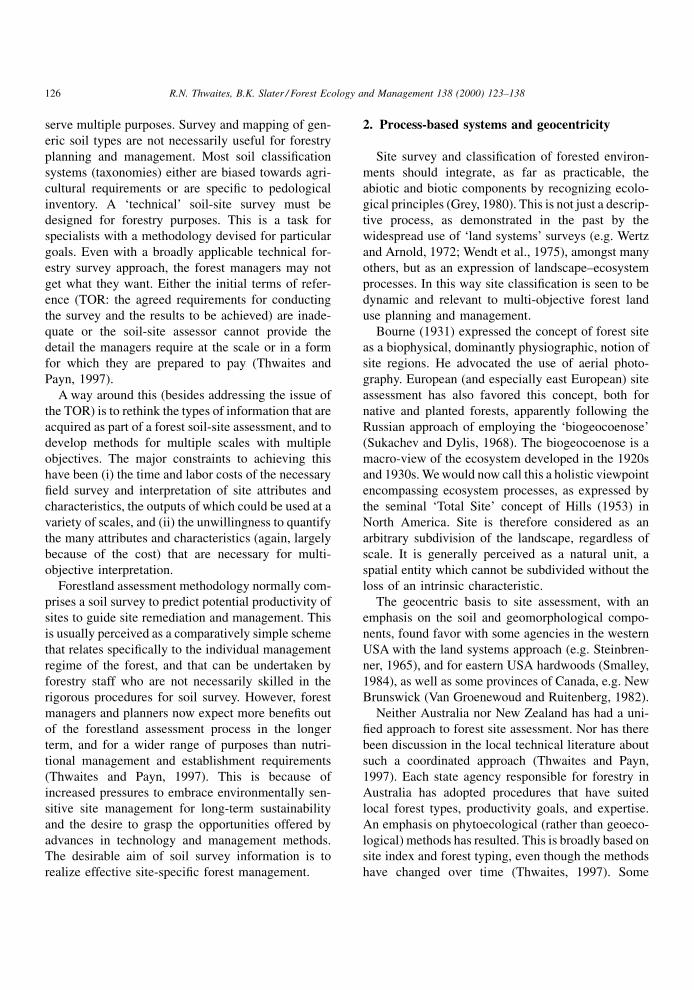
tive approach (Fig. 1).
3. Scale in forest soil-landscape investigation
From a reductionist perspective, soil and soil±land-
scape attributes can be identi®ed, described and inter-
preted from a regional landscape scale down through
the smallest soil pro®le, or pedon, to microscopic scale
of composition, with the presumption that the sum of
the reduced parts constitute the whole. This iso-
morphic view, zooming in and out to the scale of
interest, is inappropriate in this context because of the
prohibitive data requirements to make spatial state-
ments and since it ignores the discrete scales at which
certain landscape processes operate. Pedogenetic and
geomorphic (i.e. pedogeomorphic) investigations of
soil±landscapes show that pedogeomorphic relation-
ships are rarely linear across scales. Speci®c attributes
are uniquely in¯uenced at particular scales (Slater
et al., 1994).
Scale is often perceived in terms of cartographic
resolution. In this context the distinction between
`scale' and `resolution' can be blurred, especially
when `large' scale refers to detailed resolution. Turner
and Gardner (1985) propose de®nitions for scale-
related phenomena in landscape ecology whereby
the term `®ne scale' represents high resolution of
measurement and smaller dimension of the object
of study, and the term `broad scale' relates to the
coarser resolution of measurement and larger phenom-
ena. These are the terms and contexts that will be used
hereafter.
Arguing on the basis of hierarchy theory, Holling
(1992) presents a hierarchy of scaled structuring
processes. Each of these scales of processes can be
studied individually or in hierarchical form. If the
linkage of scales of study is hierarchical (non-linear)
then a boundary constraint must exist between the
scale of interest and the scales above and below it
(Holling, 1992). This conclusion leads to some indi-
cation of the signi®cance of the scale of study to the
phenomena being studied and to the resolution at
which they may be measured (Meentemeyer and
Box, 1987). Studies must be conducted and presented
at the appropriate process-sensitive scale. As broad-
ness of scale increases, the constraining variables
should become fewer, more apparent and dominant.
With increasing ®neness of scale more variables are
introduced and their relative domination changes.
Many soil classi®cation schemes have formalized
the broad-scale in¯uences (Slater et al., 1994). A
classical example in soil science is the `zonal' model
of pedogenesis popularized by Jenny (1941) whereby
at the global and continental scales, soil patterns
assume `zones' determined by the so-called active
factors of soil formation: climate and vegetation
(themselves highly covariant). The unwitting mistake
has been made subsequently in pedology and soil
R.N. Thwaites, B.K. Slater / Forest Ecology and Management 138 (2000) 123±138 127
survey to apply that broad-scale concept at ®ner
scales; it is only truly relevant at the broad scale, in
which it was conceived. The pedogenesis of so-called
azonal soils can be attributed to phenomena acting at
®ner scales. They are azonal because the zonal idea
does not apply at those scales. At the ®ner landscape
and topographic scales the zonality concept breaks
down but it is not replaced by another scale-appro-
priate concept.
A more acceptable approach would be to seek a
method that uses common indices that do not change
fundamentally across scales, or one that develops
`linking models' that integrate the component models
for each scale (Slater et al., 1994). This is the essence
of a multi-scale approach.
In a soils-based forest site analysis, it is important to
establish the relationships between signi®cant attri-
butes of the pedogeomorphic landscape and the forest
land use. Some attributes studied should maintain their
relevance at multiple scales, others will change
between component models depending on the scale
of investigation. The intensity (or density) of their
Fig. 1. A comparison of approaches to soil survey: the traditional method and the enhanced method that includes predictive digital modeling.
128 R.N. Thwaites, B.K. Slater / Forest Ecology and Management 138 (2000) 123±138
measurement will also change with the resolution
requirements being applied. Digital modeling and
digital terrain analysis provide a ¯exibility of resolu-
tion to match the scale of investigation to synthesize,
organize, and even generate the relevant pedogeo-
morphic attributes. The limitations to using traditional
approaches to soil and site surveys for forestlands
because of scale restriction and resolution of data may
be overcome with these technologies.
Dijkerman (1974) portrays soil as an open system
with many subsystems. He describes a hierarchy that
can be subdivided at increasing levels of organization
to suit the level of pedological investigation. This sort
of open system (from the soil continuum in the macro-
ecosystem to fabric micro-morphology and mineral-
ogy) is often portrayed as a `morphological' system,
hybridizing with a `process±response' system. In land
resource assessment (LRA) we need to capture the
process±response system as much as possible,
although much interpretation and expression
(through soils maps and tables) are in a morphological
model.
The process±response model environment in which
LRA operates is that of the `soil±landscape' Ð a
variously de®ned concept, reviewed by Hall (1983)
and best standardized to that of Huggett (1975) as a
`soil±landscape system'. Thwaites (1995, 2000b) sub-
sequently has taken this concept further by de®ning
the 3D `catenary unit' as the fundamental soil±land-
scape entity. The catenary unit is akin to Huggett's
`valley basin' but with full inclusion of surface and
subsurface pedogeomorphic processes which can be
synthesized through digital terrain modeling.
Hoosbeek and Bryant (1992) introduced three
dimensions to the pedological hierarchy by de®ning
perpendicular axes of `degree of computation' and
`degree of complexity' to our models along a vertical
axis of scale of hierarchy. The relative degree of
computation ranges from `qualitative' to `quantitative'
and the degree of model structure complexity ranges
from `empirical' (or `functional') to `mechanistic'.
These discrete levels of hierarchy are termed `i-
levels'. Bouma and Hoosbeek (1996) added the con-
text of the scale of research approach using i-levels
and took the base i-level to be that of the soil pro®le, or
pedon. This has been adapted for this study so that the
base i-level is the catenary unit to re¯ect the scale
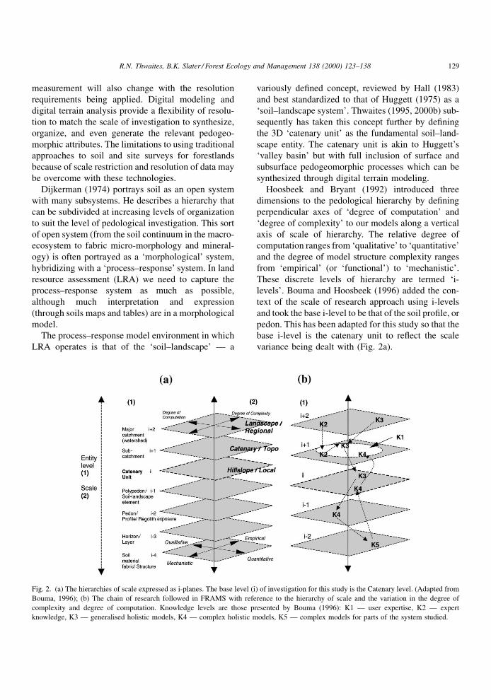
variance being dealt with (Fig. 2a).
Fig. 2. (a) The hierarchies of scale expressed as i-planes. The base level (i) of investigation for this study is the Catenary level. (Adapted from
Bouma, 1996); (b) The chain of research followed in FRAMS with reference to the hierarchy of scale and the variation in the degree of
complexity and degree of computation. Knowledge levels are those presented by Bouma (1996): K1 Ð user expertise, K2 Ð expert
knowledge, K3 Ð generalised holistic models, K4 Ð complex holistic models, K5 Ð complex models for parts of the system studied.
R.N. Thwaites, B.K. Slater / Forest Ecology and Management 138 (2000) 123±138 129
We contend that within a holistic systems approach
these hierarchical levels should be investigated with
methods suitable to the individual level (the `i-level').
Our perspective of the process±response systems will
change depending on the i-level of investigation. From
a holistic ecosystems perspective, soil and soil±land-
scape attributes must be treated within homomorphic
models of appropriate scale. Soil±landscape systems
need to be investigated as systems, and target proper-
ties (e.g. soil attributes) should be dealt with in a
systems context.
4. Explicitness and prediction for forestlandresource assessment
It would be highly desirable for forestland resource
assessment to quantify soil and site attributes for any
location, rather than record interpreted site classes or
derived qualities. The laborious and intensive process
of measuring attributes satisfactorily for extrapolation
to other sites has often precluded the development of
this more desirable approach beyond the experimental
stage. However, through technological advances some
means of measurement are becoming more accessible,
particularly in spatial modeling.
Soil maps and site maps such as those based on
the `land systems' of `ecoregions' approaches are
models. They are also hypotheses (Hudson, 1991)
but they are `descriptive', possibly `explanatory' mod-
els (in Dijkerman's, 1974, terminology). They are not
dynamic, nor are they predictive. The mental models
used to create the soil or site maps are those that we
need to specify, to make explicit, and to bring them
into our assessment and classi®cation procedures
(Hewitt, 1993; Slater and Grundy, 1999; Thwaites,
2000a).
Predictive modeling has been a major area in soil
and land resources survey, but there is little in the
literature to mark this signi®cance. The lack of pre-
dictive models in the soil survey literature (e.g. Dent
and Young, 1981; Gunn et al., 1988; Landon, 1991;
USDA, 1993) and, indeed in its practice, suggest that
soil and site surveyors do not readily appreciate the
role of predictive models in the course of their work.
These predictive models should be the essence of soil
and site survey Ð enhancing the scienti®c aspects of
the discipline.
The predictive modeling process is the key to
expressing and communicating the interpretation of
soil and site in land resource survey. Hewitt (1993)
suggests that predictive models have two roles: First,
making statements about soil or site classes and their
spatial arrangement through `soil±landscapes', or
more usefully, statements about soil properties and
their trends related to landscape features. Second,
`target-property' models (we will use the term `attri-
bute' models) which are predictive models used to
make inferences about technical soil and site qualities
from soil and site observations in the ®eld.
Only recently has interest been shown in making the
extremely complex procedure of predicting soil±land-
scape properties from survey observations more expli-
cit (e.g. McKenzie and Austin, 1993). Explicit
modeling adds quantitative objectivity and repeatabi-
lity into forestland resource survey.
Soil±landscape models are a complex integration of
spatial pedogeomorphic information and processes.
Their use entails a distinct shift from some of the
concepts in conventional soil survey, as a result of the
increased explicitness, quantitativeness, and repeat-
ability, whilst replacing the transfer of interpretation
by analogy with gridded data prediction and by redu-
cing the inherent uncertainty in the traditional
approach (see Table 1). The scale of information
and the resolution of sampling forest sites is markedly
improved with spatial modeling and, with some prior
strati®ed sampling, the accuracy of the information
can be improved in a very short time (see Ryan et al.,
2000). Predictive spatial modeling can optimize the
use of restricted human, ®nancial and time resources.
5. Soil-landscape modeling for forestland resourceassessment
Soil survey is a paradigm-based science (Hudson,
1991) which allows for experimental validation. How-
ever, it usually does not allow for falsi®cation or
replication. Soil survey can be interpreted as the
science of describing and predicting soil attribute
patterns in the 3D landscape. In a strict sense the
output from soil survey, the `theory' of soil pattern, is
more areal than spatial, usually relying on soil pattern
expression by choropleth polygons. Conventional
choropleth soil maps are scale-dependent: they cannot
130 R.N. Thwaites, B.K. Slater / Forest Ecology and Management 138 (2000) 123±138
be used at any other scale. They represent a generality
at a particular level that is only meaningful at that level
(Thwaites, 2000a). To be truly useful and adaptable in
a spatial sense we need to predict earth material
attributes in the 3D landscape and express them in
a more explicit and versatile manner. There are two
main conceptual issues that need to be addressed: the
appropriate analysis and interpretation of earth mate-
rials (soil and regolith), and the appropriate expression
of the earth material attributes.
Most soil survey techniques are based on the con-
ventional pedological concepts that have been engen-
dered by Jenny's (1941) original postulation of the
soil-forming factors. Jenny's assertion that there are
`active' and `passive' factors of soil formation has led
to implicit interpretations of soil pattern variation to be
dominated by climate (atmospheric) and vegetation
(botanic) relationships. Paton et al. (1995), amongst
others, have asserted that this is a misleading frame-
work and that soil parent materials and topographic
processes exert at least as much in¯uence on soil
formation as the so-called active factors throughout
a range of scales. In erosional, therefore geomorphi-
cally active, landscapes, the in¯uence of parent mate-
rial and topography geomorphic processes generated
by parent material characteristics and hillslope pro-
cesses dominate over the climatic and vegetational
in¯uences. Indeed these latter will be strongly mod-
i®ed by the geomorphological conditions at anything
but the coarse regional and continental scales (Auten,
1945; Carmean, 1975).
For exotic pine plantation forestry, Grey (1983)
found that geomorphic units proved to be of greater
value for site index and mean annual increment (MAI)
prediction than soil classi®cation. Rowe (1971: 3)
provides the reason why a geomorphic approach to
forestland resource surveys works: `̀ . . . geomorphol-
ogy Ð the form and substance of the earth's surface Ð
exerts the fundamental control over all other asso-
ciated phenomena. It is `genetic' in the sense that the
form and substance of the land `makes' the local
climate, . . . selects the appropriate fauna and ¯ora
that can survive there, and shapes the subsequent
development of the soil.'' (original author's emphasis).
Thus Thwaites (1988) makes the statement that at least
up to the `landscape' (or `catchment') scale, soil and
soil materials are `geomorphogenetic', a somewhat
bulky, but accurate, term.
The other aspect of conventional soil, or soil-based,
surveys is that the material described and interpreted is
often contained within or peripheral to the solum
(strictly, the A and B horizons of the soil pro®le).
The characterization and interpretation of the C hor-
izon (a variety of weathered and weathering materials
forming the rest of the regolith) and any underlying
rock is rarely entertained. This may be a legacy of the
dominant agricultural in¯uence in soil survey devel-
opment. Within a forestry and forestland management
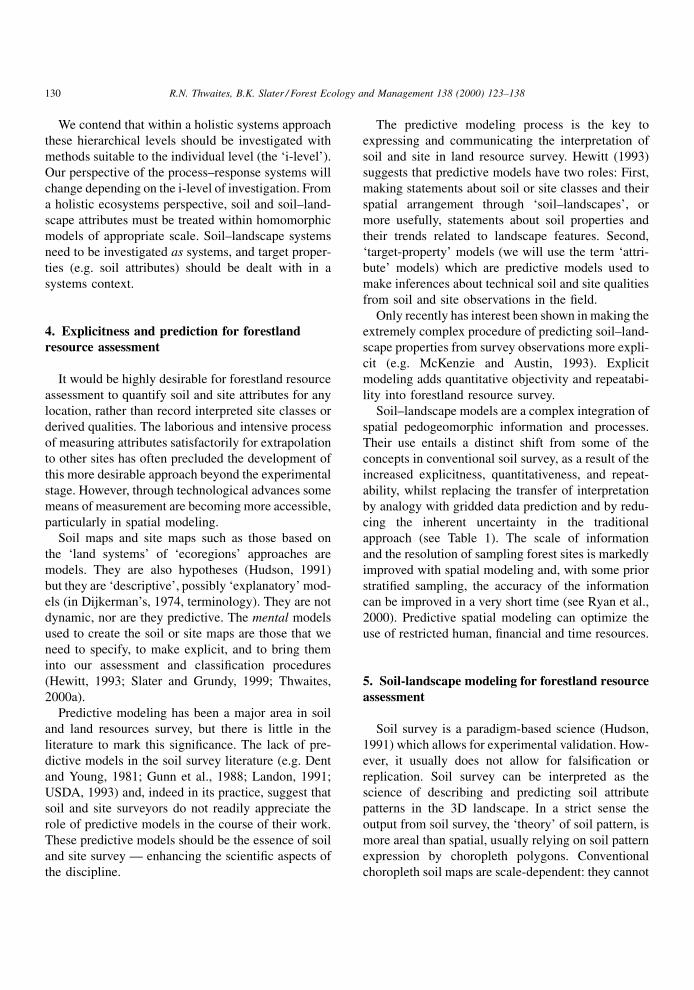
Table 1
A comparison between the ideology of the traditional soil survey approach with that of a more explicit, multi-scale, and
pedogeomorphological approach as represented by the FRAMS. The latter is recommended as an improvement of the core land resource
assessment basis and does not represent replacement of it (adapted from Slater et al., 1994, and Thwaites, 1995)
Features Traditional soil survey Pedogeomorphological modeling
Soil±landscape entities Nodal concept (e.g. profiles, pedons, polypedons) Spatial systems (e.g. lateral soil layers,
3D catenary units)
Field observation Soil profile description Soil layer, regolith description; catenary unit definition
Boundary observation Implicitly inferred from surrogate entity distributions Inferred through `fuzzy' expression
Entity classification `a priori' generic or regional taxonomic classification
of soils or land types
`a posteriori' fuzzy classification of local
pedogeomorphic attributes
Map units Rigidly defined boundaries and units Continuous membership in multiple classes by cell
Attributes Implied as largely homogenous for classified
map units, change at boundaries
Continuous variation
Presentation dimensions Data generalized to 2D 3D model and data structure
Model type Deterministic, empirical Stochastic, more mechanistic
Final scale Standardized published map scales, smaller than
field survey scales
Variable appropriate to local complexity,
and model and user requirements
R.N. Thwaites, B.K. Slater / Forest Ecology and Management 138 (2000) 123±138 131
context the whole regolith (all non-hard rock materials
at the earth surface) is of importance, particularly if
one is investigating the status and dynamics of soil
water and drainage and trees' access to water. Stone
and Kalisz (1991) point out that the extensive root
systems through the regolith of many tree species play
a more important role in the uptake of water and
nutrients than indicated by just their density. They
also suggest that the commonly accepted limitations to
rooting depth (e.g. pans, stone layers, rock, `dry'
substrates) are not necessarily the barrier to root
penetration that they are assumed to be, especially
to sinker roots.
Standard soil survey and classi®cation alone do not
provide the strongest conceptual basis for forestland
classi®cation or multi-purpose forestland manage-
ment. Generic soil taxonomies are not designed for
forest management purposes. They are to help us
organize our information about natural soil bodies
but this restricts their applicability. Therefore, they
can provide only a basis for further, subjective, inter-
pretation, e.g. for `plantability' and erodibility classi-
®cation, as expressed by Foster and Costantini (1991).
Powers et al. (1998) state that for forest soil quality
assessment soil units should be based on stable soil
properties that have strong relationships to forest
productivity, e.g. available soil water capacity and
rooting depth. These stable properties can also be
viewed as soil geomorphic properties, albeit prone
to change by forest soil management. They conclude
that assessment of soil quality indices would have
limited value without an adequate and extensive soil
inventory as a basis. An effective basis is a pedogeo-
morphic approach to soil and site description and
classi®cation, explicitly expressed, which provides a
strong conceptual framework for overall site assess-
ment. At minimum, it provides a preliminary strati®-
cation procedure in cases of landscape complexity for
further, more detailed study.
Surface con®guration is the major physiographic
property that, usually, can be perceived and measured
either in the ®eld or from remote means (e.g. aerial
photography, topographic data). In addition, the model
being developed in this way has not only the potential
to derive salient landform attributes rapidly, but also
the essential perspective of three dimensions.
A DTM provides a 3D analytical component of
forest site assessment and classi®cation. It is an
essential quantitative, repeatable and predictive
model. For the proposed methodological model DTMs
must be used in a soil±landscape systems context with
consideration of process as well as form. Forestland
resource survey can incorporate soil±landscape mod-
eling, at least as an initial framework and stratifying
procedure, to great effect. It has the potential to play a
much greater role in overall forestland site assessment
(Thwaites, 1997). The difference between the model-
ing approach undertaken in the FRAMS project and a
conventional mapping approach is shown in Fig. 1. A
distinction between the two concerns the strategy of
incorporating the ®eld survey and sampling phase, as
well as the type of data that may be collected. Further
distinctions are in the means and method of classi®ca-
tion and presentation of information as output. This
affects the usefulness and ¯exibility of output infor-
mation at the scales at which it can be applied.
Therefore, the systems approach is used here in a
predictive process in a multi-scaled resource assess-
ment. It has an pedogeomorphic framework that
focuses on the explicit interpretation and modeling
of relevant attributes of the whole regolith (subsur-
face) and terrain (surface) system at appropriate
scales: a multi-scale regolith±terrain model.
6. Forestland resource assessment and modelingstudy (FRAMS)
The FRAMS addresses the issue of scale by using a
holistic, systems-oriented approach within the pedo-
geomorphic framework. In the FRAMS, we are
attempting to overcome some of the scale and proce-
dural problems by adopting a multi-scale and explicit
landscape modeling approach that can be implemen-
ted using GIS. Soil±landscape analysis has been
adapted in the study to emphasize `regolith±terrain'
analysis (i.e. emphasizing in¯uences of the complete
regolith within a geomorphological systems frame-
work and using DTMs) employed at nested scales. The
traditional implicit and intuitive methodology of soil
survey is enhanced by ®rst de®ning the conceptual
survey and assessment process, then de®ning the
landscape processes and, consequently developing
explicit relationships between regolith±terrain com-
ponents (e.g. regolith depth, or layer stoniness to slope
gradient and curvature for speci®c lithological types).
132 R.N. Thwaites, B.K. Slater / Forest Ecology and Management 138 (2000) 123±138
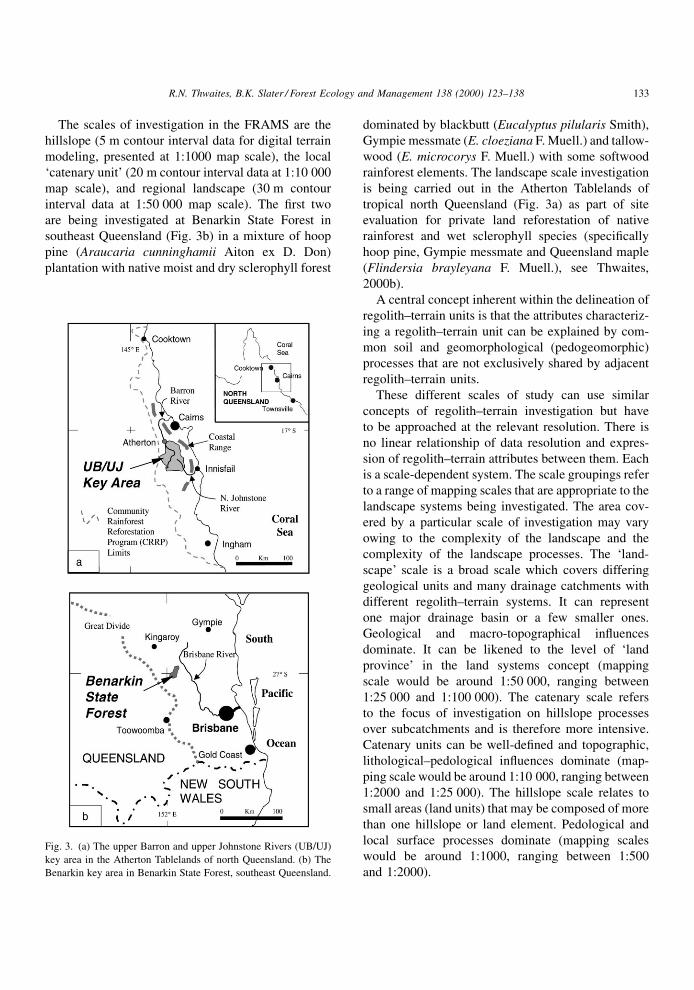
The scales of investigation in the FRAMS are the
hillslope (5 m contour interval data for digital terrain
modeling, presented at 1:1000 map scale), the local
`catenary unit' (20 m contour interval data at 1:10 000
map scale), and regional landscape (30 m contour
interval data at 1:50 000 map scale). The ®rst two
are being investigated at Benarkin State Forest in
southeast Queensland (Fig. 3b) in a mixture of hoop
pine (Araucaria cunninghamii Aiton ex D. Don)
plantation with native moist and dry sclerophyll forest
dominated by blackbutt (Eucalyptus pilularis Smith),
Gympie messmate (E. cloeziana F. Muell.) and tallow-
wood (E. microcorys F. Muell.) with some softwood
rainforest elements. The landscape scale investigation
is being carried out in the Atherton Tablelands of
tropical north Queensland (Fig. 3a) as part of site
evaluation for private land reforestation of native
rainforest and wet sclerophyll species (speci®cally
hoop pine, Gympie messmate and Queensland maple
(Flindersia brayleyana F. Muell.), see Thwaites,
2000b).
A central concept inherent within the delineation of
regolith±terrain units is that the attributes characteriz-
ing a regolith±terrain unit can be explained by com-
mon soil and geomorphological (pedogeomorphic)
processes that are not exclusively shared by adjacent
regolith±terrain units.
These different scales of study can use similar
concepts of regolith±terrain investigation but have
to be approached at the relevant resolution. There is
no linear relationship of data resolution and expres-
sion of regolith±terrain attributes between them. Each
is a scale-dependent system. The scale groupings refer
to a range of mapping scales that are appropriate to the
landscape systems being investigated. The area cov-
ered by a particular scale of investigation may vary
owing to the complexity of the landscape and the
complexity of the landscape processes. The `land-
scape' scale is a broad scale which covers differing
geological units and many drainage catchments with
different regolith±terrain systems. It can represent
one major drainage basin or a few smaller ones.
Geological and macro-topographical in¯uences
dominate. It can be likened to the level of `land
province' in the land systems concept (mapping
scale would be around 1:50 000, ranging between
1:25 000 and 1:100 000). The catenary scale refers
to the focus of investigation on hillslope processes
over subcatchments and is therefore more intensive.
Catenary units can be well-de®ned and topographic,
lithological±pedological in¯uences dominate (map-
ping scale would be around 1:10 000, ranging between
1:2000 and 1:25 000). The hillslope scale relates to
small areas (land units) that may be composed of more
than one hillslope or land element. Pedological and
local surface processes dominate (mapping scales
would be around 1:1000, ranging between 1:500
and 1:2000).
Fig. 3. (a) The upper Barron and upper Johnstone Rivers (UB/UJ)
key area in the Atherton Tablelands of north Queensland. (b) The
Benarkin key area in Benarkin State Forest, southeast Queensland.
R.N. Thwaites, B.K. Slater / Forest Ecology and Management 138 (2000) 123±138 133
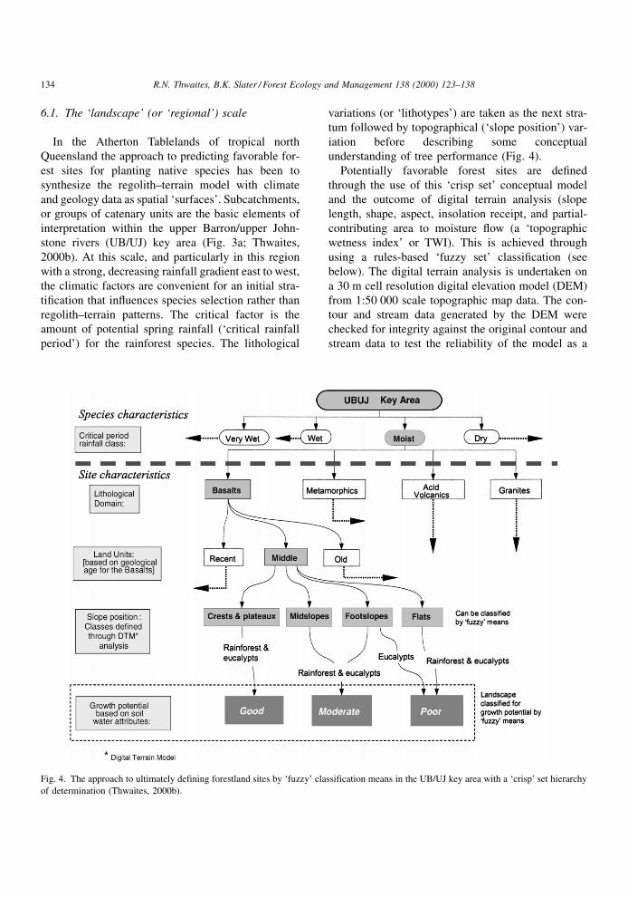
6.1. The `landscape' (or `regional') scale
In the Atherton Tablelands of tropical north
Queensland the approach to predicting favorable for-
est sites for planting native species has been to
synthesize the regolith±terrain model with climate
and geology data as spatial `surfaces'. Subcatchments,
or groups of catenary units are the basic elements of
interpretation within the upper Barron/upper John-
stone rivers (UB/UJ) key area (Fig. 3a; Thwaites,
2000b). At this scale, and particularly in this region
with a strong, decreasing rainfall gradient east to west,
the climatic factors are convenient for an initial stra-
ti®cation that in¯uences species selection rather than
regolith±terrain patterns. The critical factor is the
amount of potential spring rainfall (`critical rainfall
period') for the rainforest species. The lithological
variations (or `lithotypes') are taken as the next stra-
tum followed by topographical (`slope position') var-
iation before describing some conceptual
understanding of tree performance (Fig. 4).
Potentially favorable forest sites are de®ned
through the use of this `crisp set' conceptual model
and the outcome of digital terrain analysis (slope
length, shape, aspect, insolation receipt, and partial-
contributing area to moisture ¯ow (a `topographic
wetness index' or TWI). This is achieved through
using a rules-based `fuzzy set' classi®cation (see
below). The digital terrain analysis is undertaken on
a 30 m cell resolution digital elevation model (DEM)
from 1:50 000 scale topographic map data. The con-
tour and stream data generated by the DEM were
checked for integrity against the original contour and
stream data to test the reliability of the model as a
Fig. 4. The approach to ultimately defining forestland sites by `fuzzy' classification means in the UB/UJ key area with a `crisp' set hierarchy
of determination (Thwaites, 2000b).
134 R.N. Thwaites, B.K. Slater / Forest Ecology and Management 138 (2000) 123±138
topographic simulation. The data for the conceptual
model vary in scale and resolution (e.g. geology
mapping at 1:100 000 scale, soil mapping at
1:50 000 scale, climate surface generation at 50 m
resolution cell size). The digital terrain analysis (at
30 m resolution) and ®eld analysis enhance the soils
(and regolith) map data through applying soil±geo-
morphic processes to the landscape at a higher resolu-
tion. A 50 m resolution output (nominally at 1:50 000
map scale) from this analysis is deemed legitimate for
the landscape scale although validation has yet to be
undertaken.
6.2. The `catenary' (or `topo') scale
At the `catenary' scale, where catenary units are the
basic elements of investigation within subcatchments,
the components of the regolith±terrain system are
Fig. 5. A set of possible pedotransfer functions illustrating alternative approaches to estimate soil moisture parameters such as hydraulic
conductivity, water retention and soil water deficit: from detailed (TF1±TF4±TF5) to crude (TF6) (adapted from Bouma, 1989).
R.N. Thwaites, B.K. Slater / Forest Ecology and Management 138 (2000) 123±138 135
different from those of the landscape scale. The
investigation is being carried out in the rugged tribu-
tary catchments of the upper Brisbane river in Benar-
kin State Forest in southeast Queensland (Fig. 3b).
Only microclimatic elements such as cold air drainage
and localized frosts have been considered for climatic
analysis here, the in¯uence of which can also be
predicted through use of a DEM. No soil mapping
has been done for this area, so regolith±terrain inves-
tigation is being undertaken as part of the modeling
process. Lithological variation at this scale assumes
importance, as do readily measurable regolith attri-
butes that relate to soil moisture dynamics (soil tex-
ture, structure Ð particularly macro-void pattern, A
horizon depth, bulk density, abundance of coarse
fragments). Other general attributes assume a level
of importance such as pH and presence of texture-
contrast (or `duplex') soil morphology. Certain attri-
butes, which are logistically dif®cult, costly or
impracticable to measure, can be estimated using
surrogate means known as pedotransfer functions
(Bouma and van Lanen, 1989). These predictive rela-
tionships are based on known or empirically-derived
soil relations, such as a function of soil structure,
texture and organic matter for bulk density, as well
as other regolith±terrain attributes which can substi-
tute for hydraulic conductivity and moisture retention
(Fig. 5). Both of these latter attributes are rarely
measured in the course of routine land resource sur-
veys. Ryan et al. (2000) discuss the problems inherent
in applying these pedotransfer functions at inappropri-
ate scales and levels of intensity. At this scale, topo-
graphy dominates soil±geomorphic dynamics, so
DEM derivatives are used speci®cally in the concep-
tual model of site de®nition and in deriving simple
pedotransfer functions for hydraulic conductivity and
soil water status with regolith morphology. The DEM
resolution for this area is 10 m, from 20 m contour
data. Output resolution is at the DEM resolution of
10 m, so site units or `toposites' at this resolution can
be expressed at 1:10 000 mapping scale which corre-
sponds to the standard map scale used by the state
forestry agency.
6.3. The `hillslope' (or `local') scale
The hillslope scale study of Hill 60 is nested within
the catenary scale study area at Benarkin State Forest.
Hill 60 has been topographically surveyed to 5 m
contour resolution from which a 5 m DEM has been
erected. Fine scale topographic derivatives have been
used in conjunction with ®eld data to produce topo-
sites for hoop pine management. In this instance, the
®eld data include bulk density and soil moisture
measurements to aid the digital terrain analysis. These
were not deemed routine measurements for the Caten-
ary scale investigations but are of signi®cance at this
Hillslope scale.
Output resolution is at 5 m cell size which is con-
servatively believed to be suitable for 1:5000 scale
mapping of the predicted toposite classi®cation.
7. Conclusion
FRAMS provides a basis for regolith±terrain map-
ping of forestlands by employing digital terrain ana-
lysis and conceptual soil±geomorphic process
modeling at appropriate scales. The intention is to
predict the variation in pedogeomorphic attributes and
patterns that are relevant to the planning and manage-
ment of plantation forests. In these studies, those
attributes relating to soil water are emphasized. This
digital spatial analysis lends itself to the classi®cation
and presentation of the forest toposite data through
fuzzy rule-set techniques.1 Fuzzy rule classi®cation
re¯ects the reality of regolith±terrain variation more as
a continuum with the expression of class central
concepts and intergrades rather than as crisply de®ned
classes or polygon map units. It also clearly re¯ects
the knowledge system from which the rules were
derived. Instead of classifying natural soil or land
bodies to an a priori scheme, each grid cell is de®ned
by the proportional membership of assigned subsets of
regolith±terrain attributes according to knowledge-
based rules. Thus, it is a classi®cation of selected
attributes rather than a classi®cation of natural soil
bodies. Ryan et al. (2000) use heuristic Bayesian
probability in a similar way for the same purposes.
Therefore, this resource assessment procedure for
forestland not only accommodates the sensitivities
of scale but also attempts to represent the continua
1 See the special issue of Geoderma, Vol. 77, 1997, for
discussions on using of fuzzy logic in soil studies.
136 R.N. Thwaites, B.K. Slater / Forest Ecology and Management 138 (2000) 123±138
of complex pedogeomorphological variations more
closely. We believe that the procedure outlined here
goes further towards the ultimate goal of a dynamic,
process-based, and multi-scale land resource assess-
ment approach.
Acknowledgements
Funding and infrastructural support for this work
has come through the Cooperative Research Centre for
Tropical Rainforest Ecology and Management and the
Enhanced Resource Assessment project of the Depart-
ment of Natural Resources, Queensland. We thank Dr.
David Hammer for valuable comments on an earlier
draft of this paper and Dr. Brendan Mackey for his
helpful insights.
References
Allen, T.F.H., Hoekstra, T.W., 1992. Toward a Unified Ecology.
Columbia University Press, New York, 384 pp.
Auten, J.T., 1945. Prediction of site index for yellow-poplar from
soil and topography. J. Forestry 43, 662±668.
Bouma, J., 1989. Using soil survey for quantitative land evaluation.
Adv. Soil Sci. 9, 177±213.
Bouma, J., 1996. Role of quantitative approaches in soil science
when interacting with stakeholders. In: Soil Science Ð Raising
the Profile. Proceedings of the Australian and New Zealand
National Soils Conference, Vol. 1. University of Melbourne,
ASSSI, Canberra, July 1±4, 1996, pp. 67±72.
Bouma, J., Hoosbeek, M.R., 1996. The contribution and impor-
tance of soil scientists in interdisciplinary studies dealing with
land. In: Wagenet, R.J., Bouma, J. (Eds.), The Role of Soil
Science in Interdisciplinary Research, Soil Science Society of
American Special Publication No. 45, pp. 1±15.
Bouma, J., van Lanen, H.A.J., 1989. Transfer functions and
threshold values: from soil characteristics to land qualities. In:
Beek, K.J., Burrough, P.A., McCormack, D.E. (Eds.), Quanti-
fied Land Evaluation Procedures. Proceedings of the Interna-
tional Workshop, Washington, DC, pp. 106±111.
Bourne, R., 1931. Regional survey and its relation to stock-taking
of the agricultural and forestry resources of the British Empire.
Oxford For. Mem. 13, 16±17.
Carmean, W.H., 1975. Forest site quality evaluation in the United
States. Adv. Agron. 27, 209±258.
Christian, C.S., Stewart, G.A., 1953. General Report on Survey of
the Katherine±Darwin Region, 1946. CSIRO Australian Land
Research Series No. 1, 156 pp.
Dent, D., Young, A., 1981. Soil Survey and Land Evaluation.
Chapman & Hall, London, 278 pp.
Dijkerman, J.C., 1974. Pedology as a science: the role of data,
models and theories in the study of natural soil systems.
Geoderma 11, 73±93.
Foster, P.G., Costantini, A., 1991. Pinus plantation establishment in
Queensland. I. Field surveys for site preparation planning and
site design. Aust. For. 54 (1±2), 75±82.
Gessler, P.E., Moore, I.D., McKenzie, N.J., Ryan, P.J., 1995. Soil±
landscape modelling and spatial prediction of soil attributes.
Int. J. Geogr. Inform. Sys. 4, 421±432.
Grey, D.C., 1980. On the concept of site in forestry. South Afr. For.
J. 113, 81±83.
Grey, D.C., 1983. The geomorphic approach to site delineation in
exotic plantations. South Afr. For. J. 127, 26±30.
Grey, D.C., 1984. Classification of forestry land. South Afr. For. J.
132, 54±57.
Gunn, R.H., Beattie, J.A., Reid, R.E., van de Graaff, R.H.M., 1988.
Australian Soil and Land Survey Handbook: Guidelines for
Conducting Surveys. Inkata Press, Melbourne, 300 pp.
Hall, G.F., 1983. Pedology and geomorphology. In: Wilding, L.P.,
Smeck, N.E., Hall, G.F. (Eds.), Pedogenesis and Soil
Taxonomy I. Concepts and Interactions. Elsevier, Amsterdam,
pp. 117±140.
Hewitt, A.E., 1993. Predictive modelling in soil survey. Soils Fert.
56, 305±314.
Hills, G.A., 1953. The use of site in forest management. For.
Chron. 29, 128±136.
Holling, C.S., 1992. Cross-scale morphology, geometry, and
dynamics of ecosystems. Ecol. Monogr. 62 (4), 447±502.
Hoosbeek, M.R., Bryant, R.B., 1992. Towards the quantitative
modelling of pedogenesis Ð review. Geoderma 55, 183±210.
Hudson, B.D., 1991. The soil survey as a paradigm based science.
Soil Sci. Soc. Am. J. 56, 836±841.
Huggett, R.J., 1975. Soil landscape systems: a model of soil
genesis. Geoderma 13, 1±22.
Jenny, H., 1941. Factors of soil formation. A System of
Quantitative Pedology. McGraw-Hill, New York, 281 pp.
Landon, J.R. (Ed.), 1991. Booker Tropical Soil Manual. Booker-
Tate/Longman, London, 474 pp.
McKenzie, N.J., Austin, M.P., 1993. A quantitative Australian
approach to medium and small scale surveys based on soil
stratigraphy and environmental correlation. Geoderma 57, 329±
355.
Meentemeyer, V., Box, E.O., 1987. Scale effects in landscape
studies. In: Turner, M.G. (Ed.), Landscape Heterogeneity and
Disturbance. Springer, New York, pp. 15±34.
Moss, M.R., 1983. Landscape synthesis, landscape processes, and
land classification, some theoretical and methodological issues.
GeoJournal 7 (2), 145±193.
Paton, T.R., Humphreys, G.S., Mitchell, P.B., 1995. Soils. A New
Global View. UCL Press, London, 213 pp.
Powers, R.F., Tiarks, A.E., Boyle, J.R., 1998. Assessing soil
quality: practicable standards for sustainable forest productivity
in the United States. In: Adams, M., Ramakrishna, K., Davidson,
E.A. (Eds.), The Contribution of Soil Science to the Development
and Implementation of Criteria and Indicators of Sustainable
Forest Management. SSSA Special Publication No. 53, Soil
Science Society of America, Madison, WI, pp. 53±80.
Rowe, J.S., 1971. Why classify forest land? For. Chron. 47 (3), 1±5.
R.N. Thwaites, B.K. Slater / Forest Ecology and Management 138 (2000) 123±138 137
Ryan, P.J., McKenzie, N.J., O'Connell, D.M., Loughhead, A.N.,
Leppert, P.M., Jacquier, D., Ashton, L., 2000. Integrating forest
soils information across scales: spatial prediction of soil properties
under Australian forests. For. Ecol. Manage. 138, 139±157.
Slater, B.K., Grundy, M.J., 1999. Enhanced resource assessment:
integration of innovative technologies by agency soil scientists
in Australia. Paper presented at the Second Approximation
International Conference on Soil Resources, their Inventory,
Analysis and Interpretation in the 21st Century, June 10±12,
1999, Minneapolis, MN, USA.
Slater, B.K., McSweeney, K., Ventura, S.J., Irvin, B.J., McBratney,
A.B., 1994. A spatial framework for integrating soil±landscape
and pedogenic models. In: Bryant, R.B., Arnold, R.W. (Eds.),
Quantitative Modeling of Soil Forming Processes. SSSA
Special Publication No. 39. Soil Science Society of America,
Madison, WI, pp. 169±185.
Smalley, G.W., 1984. Landforms: a practical basis for classifying
forest sites in the Interick Uplands. In: Proceedings of the 12th
Annual Hardwood Symposium. Hardwood Research Council,
Auburn, AL, pp. 92±112.
Steinbrenner, E.C., 1965. The influence of individual soil and
physiographic factors on the site index of Douglas-fir in
western Washington. In: Youngberg, C.T. (Ed.), Forest±Soil
Relationships in North America. Proceedings of the Second
North American Forest Soils conference. Oregon State
University Press, Corvallis.
Sukachev, V.N., Dylis, H., 1968. Fundamentals of Forest
Biogeocoenology. Oliver and Boyd, London, 73 pp. (J.M.
MacLennan, Trans.; Osnovy Lesnoi Biogeotsendogii).
Thwaites, R.N., 1988. An introduction to digital terrain modelling
in forest site analysis Ð an example from the Grabouw±
Lebanon key area. South Afr. For. J. 144, 63±68.
Thwaites, R.N., 1995. Soil landscape modelling for forestry land
resource assessment: technologies and concepts. In: Bren, L.,
Greenwood, C. (Eds.), Applications of New Technologies in
Forestry. Institute of Foresters of Australia, Canberra, pp. 57±4.
Thwaites, R.N., 1997. Revisiting forest site assessment. Changing
requirements necessitate a policy for new approaches. In:
Preparing for the 21st Century. Proceedings of the Fourth
ANZIF Conference. Institute of Foresters of Australia,
Canberra, April 21±24, 1997, pp. 211±217.
Thwaites, R.N., 2000a. From biodiversity to geodiversity and soil
diversity. A spatial understanding of soil in ecological studies
of the forest landscape. J. Trop. For. Sci., in press.
Thwaites, R.N., 2000b. Matching native tree species to sites for
plantations using spatial, predictive terrain analysis. New
Forests, in press.
Thwaites, R.N., Payn, T.W., 1997. Soil information for sustainable
plantations in Australia and New Zealand: a policy necessity.
In: Preparing for the 21st Century. Proceedings of the Fourth
ANZIF Conference. Institute of Foresters of Australia,
Canberra, April 21±24, 1997, pp. 205±210.
Turner, J., Holmes, G.I., 1991. Site classification of Pinus radiata
plantations in the Lithgow district, New South Wales, Australia.
For. Ecol. Mgmt. 12, 253±263.
Turner, J., Thompson, C.H., Turvey, N.D., Hopmans, P., Ryan, P.J.,
1990. A soil technical classification system for Pinus radiata
plantations. I. Development. Aust. J. Soil Res. 28, 797±811.
Turner, M.G., Gardner, R.H., 1985. Quantitative methods in
landscape ecology: an introduction. In: Turner, M.G. (Ed.),
Landscape Heterogeneity and Disturbance. Springer, New
York, pp. 4±14.
Turvey, N.D., 1984. Benefits and costs of soil surveys. In: Grey,
D.C., Schoenau, A.P.G., Schutz, C.J. (Eds.), Proceedings of the
Symposium on Site and Productivity of Fast Growing
Plantations, Vol. 1, Pretoria and Pietermaritzburg, South Africa,
April 30±May 11. SAFRI/IUFRO, Pretoria, pp. 139±146.
Turvey, N.D., 1987. A technical classification for soils of Pinus
plantations: field manual. Bulletin No. 6, School of Forestry,
University of Melbourne, 41 pp.
USDA, 1993. Soil Survey Manual. Agriculture Handbook 18. US
Department of Agriculture, Washington, DC, 437 pp.
Van Groenewoud, H., Ruitenberg, A.A., 1982. A productivity-
oriented forest site classification system for New Brunswick.
Information Report MX 136. Maritimes Forest Research
Centre, Canadian Forestry Service, Fredericton, 9 pp.
Wendt, G.E., Thompson, R.A., Larson, K.W., 1975. Land Systems
Inventory, Boise National Forest. USDA Forest Service,
Intermountain Region, ID, 54 pp.
Wertz, W.A., Arnold, J.F., 1972. Land Systems Inventory. USDA
Forest Service, Intermountain Region, Ogden, UT, 12 pp.
138 R.N. Thwaites, B.K. Slater / Forest Ecology and Management 138 (2000) 123±138
Copyright © 2022 FDOKUMEN