Impacts and underlying factors of landscape-scale historical disturbance of mountain forest...
13
Full length article Impacts and underlying factors of landscape-scale, historical disturbance of mountain forest identified using archival documents J. Bru ˚ na a,e,⇑ , J. Wild a,c , M. Svoboda b , M. Heurich d , J. Müllerová a a Institute of Botany, Academy of Sciences of the Czech Republic, CZ-252 43 Pru ˚honice, Czech Republic b Czech University of Life Sciences Prague, Faculty of Forestry and Wood Sciences, Kamy ´cká 129, Praha 6, Suchdol 16 521, Czech Republic c Czech University of Life Sciences Prague, Faculty of Environmental Sciences, Kamy ´cká 129, Praha 6, Suchdol 16 521, Czech Republic d Nationalpark Bayerischer Wald, Freyunger Straße 2, 94481 Grafenau, Germany e Institute of Environmental Studies, Faculty of Science, Charles University in Prague, Benátska 2, 128 44 Prague 2, Czech Republic article info Article history: Received 26 February 2013 Received in revised form 4 June 2013 Accepted 10 June 2013 Available online 18 July 2013 Keywords: Mountain forests Disturbance Historical maps Historical range of variability Bark beetle outbreak Windthrow abstract Large areas of temperate mountain Norway spruce (Picea abies) forests in Central Europe have been dis- turbed by windstorms and subsequent bark beetle (Ips typographus) outbreaks in recent years. The impact of these events has been severe, with millions of canopy trees dying in nature reserves, where sal- vage logging was not conducted. The occurrence of these windstorms has raised the question of whether such events were within the historical range of variability (HRV) of forest dynamics in Central Europe, where disturbances were traditionally perceived as non-natural and without strong relevance for forest development. To answer this question, we analyzed the available historical forest management maps documenting large-scale disturbance resulting from windthrow events in the years 1868–1870 in spruce- and beech- (Fagus sylvatica) dominated forests in the Bohemian Forest region (Šumava Mts., Czech Republic and Bayerischer Wald, Germany). We created a cross-boundary forest database covering 54 974 ha and containing information about tree species composition and age, and the severity of the 1868–1870 disturbance, considering the cumulative effect of the windthrow, subsequent bark beetle out- break, and salvage logging. The age structure of the forests before the disturbances was unbalanced, with stands of 80–120 years underrepresented, and covering only 9% of the area, and stands older than 120 years, historically classified as old growth, covering 26% of the area. Within the decade that included the windstorms and their aftermath, 40% of the stands in the mountain range were at least partly dis- turbed, with significant effect on the oldest stands. To identify important factors responsible for the severity of disturbance, we constructed regression models relating severity to two groups of explanatory variables: forest stand characteristics and environmental attributes (mainly topographic factors). Overall, stand age was identified as the most important driver of disturbance severity across the landscape, with the oldest trees most susceptible. The high importance of age for disturbance severity showed the role of forest age structure in determining the scale of disturbances resulting from windstorms and associated bark beetle outbreaks. Nevertheless, despite the documented occurrence of frequent large disturbances during the two centuries that preceded the 1868–1870 events, old growth accounted for 26% of the area, making it clear that both large scale disturbance and old-growth forest are within the HRV of mountain spruce forest dynamics in Central Europe. Ó 2013 Elsevier B.V. All rights reserved. 1. Introduction Large areas of temperate Norway spruce (Picea abies) forests in mountain areas of Central Europe have recently been disturbed by several major windstorms: Vivian and Wiebke in 1990, Lothar in 1999, and Kyrill in 2007. Because windthrow in spruce stands usu- ally triggers bark beetle (Ips typographus) outbreaks (Fischer et al., 2002; Wermelinger, 2004; Økland and Berryman, 2004), the wind- damaged forest areas subsequently suffered bark beetle infesta- tions. These infestations resulted in thousands of hectares of can- opy trees dying in nature reserves, in which sanitary logging was not performed (Lausch et al., 2011). Until recently, such large dis- turbances were not thought to be a natural part of mountain spruce forest dynamics in Central Europe (Splechtna et al., 2005). These events raised two basic questions: (1) whether these large disturbances were within the historical range of variability (HRV) of forest dynamics in Central Europe; and (2) what future effects these disturbances will have on forests. Knowledge about HRV 0378-1127/$ - see front matter Ó 2013 Elsevier B.V. All rights reserved. http://dx.doi.org/10.1016/j.foreco.2013.06.017 ⇑ Corresponding author. Address: Institute of Botany of the ASCR, Zámek 1, CZ- 252 43 Pru ˚ honice, Czech Republic. Tel.: +420 271 015 207; fax: +420 271 015 105. E-mail address: [email protected] (J. Bru ˚ na). Forest Ecology and Management 305 (2013) 294–306 Contents lists available at SciVerse ScienceDirect Forest Ecology and Management journal homepage: www.elsevier.com/locate/foreco
-
Upload
nationalpark-bayerischer-wald -
Category
Documents
-
view
4 -
download
0
Transcript of Impacts and underlying factors of landscape-scale historical disturbance of mountain forest...
Forest Ecology and Management 305 (2013) 294–306
Contents lists available at SciVerse ScienceDirect
Forest Ecology and Management
journal homepage: www.elsevier .com/ locate/ foreco
Full length article
Impacts and underlying factors of landscape-scale, historical disturbanceof mountain forest identified using archival documents
0378-1127/$ - see front matter � 2013 Elsevier B.V. All rights reserved.http://dx.doi.org/10.1016/j.foreco.2013.06.017
⇑ Corresponding author. Address: Institute of Botany of the ASCR, Zámek 1, CZ-252 43 Pruhonice, Czech Republic. Tel.: +420 271 015 207; fax: +420 271 015 105.
E-mail address: [email protected] (J. Bruna).
J. Bruna a,e,⇑, J. Wild a,c, M. Svoboda b, M. Heurich d, J. Müllerová a
a Institute of Botany, Academy of Sciences of the Czech Republic, CZ-252 43 Pruhonice, Czech Republicb Czech University of Life Sciences Prague, Faculty of Forestry and Wood Sciences, Kamycká 129, Praha 6, Suchdol 16 521, Czech Republicc Czech University of Life Sciences Prague, Faculty of Environmental Sciences, Kamycká 129, Praha 6, Suchdol 16 521, Czech Republicd Nationalpark Bayerischer Wald, Freyunger Straße 2, 94481 Grafenau, Germanye Institute of Environmental Studies, Faculty of Science, Charles University in Prague, Benátska 2, 128 44 Prague 2, Czech Republic
a r t i c l e i n f o
Article history:Received 26 February 2013Received in revised form 4 June 2013Accepted 10 June 2013Available online 18 July 2013
Keywords:Mountain forestsDisturbanceHistorical mapsHistorical range of variabilityBark beetle outbreakWindthrow
a b s t r a c t
Large areas of temperate mountain Norway spruce (Picea abies) forests in Central Europe have been dis-turbed by windstorms and subsequent bark beetle (Ips typographus) outbreaks in recent years. Theimpact of these events has been severe, with millions of canopy trees dying in nature reserves, where sal-vage logging was not conducted. The occurrence of these windstorms has raised the question of whethersuch events were within the historical range of variability (HRV) of forest dynamics in Central Europe,where disturbances were traditionally perceived as non-natural and without strong relevance for forestdevelopment. To answer this question, we analyzed the available historical forest management mapsdocumenting large-scale disturbance resulting from windthrow events in the years 1868–1870 in spruce-and beech- (Fagus sylvatica) dominated forests in the Bohemian Forest region (Šumava Mts., CzechRepublic and Bayerischer Wald, Germany). We created a cross-boundary forest database covering 54974 ha and containing information about tree species composition and age, and the severity of the1868–1870 disturbance, considering the cumulative effect of the windthrow, subsequent bark beetle out-break, and salvage logging. The age structure of the forests before the disturbances was unbalanced, withstands of 80–120 years underrepresented, and covering only 9% of the area, and stands older than120 years, historically classified as old growth, covering 26% of the area. Within the decade that includedthe windstorms and their aftermath, 40% of the stands in the mountain range were at least partly dis-turbed, with significant effect on the oldest stands. To identify important factors responsible for theseverity of disturbance, we constructed regression models relating severity to two groups of explanatoryvariables: forest stand characteristics and environmental attributes (mainly topographic factors). Overall,stand age was identified as the most important driver of disturbance severity across the landscape, withthe oldest trees most susceptible. The high importance of age for disturbance severity showed the role offorest age structure in determining the scale of disturbances resulting from windstorms and associatedbark beetle outbreaks. Nevertheless, despite the documented occurrence of frequent large disturbancesduring the two centuries that preceded the 1868–1870 events, old growth accounted for 26% of the area,making it clear that both large scale disturbance and old-growth forest are within the HRV of mountainspruce forest dynamics in Central Europe.
� 2013 Elsevier B.V. All rights reserved.
1. Introduction
Large areas of temperate Norway spruce (Picea abies) forests inmountain areas of Central Europe have recently been disturbed byseveral major windstorms: Vivian and Wiebke in 1990, Lothar in1999, and Kyrill in 2007. Because windthrow in spruce stands usu-ally triggers bark beetle (Ips typographus) outbreaks (Fischer et al.,
2002; Wermelinger, 2004; Økland and Berryman, 2004), the wind-damaged forest areas subsequently suffered bark beetle infesta-tions. These infestations resulted in thousands of hectares of can-opy trees dying in nature reserves, in which sanitary logging wasnot performed (Lausch et al., 2011). Until recently, such large dis-turbances were not thought to be a natural part of mountainspruce forest dynamics in Central Europe (Splechtna et al., 2005).These events raised two basic questions: (1) whether these largedisturbances were within the historical range of variability (HRV)of forest dynamics in Central Europe; and (2) what future effectsthese disturbances will have on forests. Knowledge about HRV

J. Bruna et al. / Forest Ecology and Management 305 (2013) 294–306 295
could help us better understand the long-term dynamics of thesemountain forests and therefore shape current management andnature protection strategies in the area (Landres et al., 1999; Keaneet al., 2009).
Various kinds of disturbances, including stand-replacing eventsoperating at the landscape scale, are among the main natural forcesshaping forest structure and dynamics around the world (Pickettand White, 1985; Frelich, 2002; Gromtsev, 2002; Turner, 2010).Although severe wind disturbances are considered to be the natu-ral, and even dominant driver of some temperate forest dynamicsin North America (Canham and Loucks, 1984; Frelich and Lorimer,1991), their natural role in temperate forests of Europe is still rel-atively unknown (Wolf et al., 2004; Nagel and Diaci, 2006; Nagelet al., 2006; Zielonka et al., 2010; Panayotov et al., 2011). They havealso been revealed to be an important, although not dominant, fea-ture of the disturbance regime of boreal coniferous forests (Ulano-va, 2000; Rich et al., 2007).
In Europe, over the period 1950–2000, storms caused more than50% of the damage attributed to all disturbance factors, with mostof the storm damage reported from mountain areas of Sub-Atlanticand Central Europe (Schelhaas et al., 2003). Despite such a largeamount of forest affected by wind disturbance, this phenomenon,along with other large-scale stand-replacing disturbances such asfire and insect outbreaks, was long thought of as non-natural inCentral Europe and without strong relevance for forest develop-ment (Clark and Merkt, 1989; Ellenberg, 1996). In Europe, forestdynamics for a long time have been shaped largely by humanactivities (Glatzel, 1999). Therefore, the many large-scale distur-bances as well as the overall increase in disturbance frequencyover the last century have been ascribed mainly to management-driven changes in forest species composition and structure (Seidlet al., 2011). Additionally, Central European traditional forestryschools have emphasized the influence of site-specific conditionson vegetation patterns. Thus, small-scale gap dynamics were longthought to be the only type of disturbance influencing forest struc-ture, with large-scale or intensive events not considered to be anatural part of forest dynamics (Falinski and Falinska, 1986; Kor-pel’, 1995; Splechtna et al., 2005). Although large-scale distur-bances eventually came to be accepted as part of the naturaldynamics of various forest types in this region (Heurich and Jehl,2000; Kulakowski and Bebi, 2004; Svoboda and Pouska, 2008; Svo-boda et al., 2010; Panayotov et al., 2011), we still largely lackunderstanding of natural disturbance dynamics in the CentralEuropean context. In particular, we lack the knowledge of theinteractions between disturbances and particular forest state andenvironmental factors necessary to validly assess HRV. Indeed,the effects of a storm event may vary greatly across the landscapeand depend on the interaction of wind characteristics and environ-mental conditions that include forest species composition (Papaikand Canham, 2006), spatial/age structure, soil condition, and landsurface parameters (Ruel, 2000; Achim et al., 2005; Scott andMitchell, 2005).
The paucity of knowledge of long-term natural landscapedynamics could be addressed by space-for-time substitution(Hessburg et al., 1999), modeling (Seidl et al., 2010) or the use ofarchives. However, the use of space-for-time substitution is limitedboth by the extent of natural forest in a given region and by thevariability of environmental conditions across large areas (Keaneet al., 2009). Models also face obstacles, as they are difficult toparameterize precisely, and require spatially explicit data for ini-tialization and validation. Thus, the most valuable source of infor-mation on disturbance regimes can be found in natural anddocumentary archives (Swetnam et al., 1999). Natural archivessuch as tree rings (Zielonka et al., 2010; Hadley and Knapp,2011; Svoboda et al., 2012; Cada et al., 2013) and pollen records(Nielsen and Odgaard, 2005, 2010; Hernández et al., 2011) enable
relatively precise assessment of past disturbance regimes,although obtaining landscape-scale results requires intensive,time-demanding field sampling and laboratory analyses.
In areas long used by humans, historical maps and records offercomprehensive sources of information on forest development andhuman impacts at the landscape scale (Bruna et al., 2010). Modernforestry in Central Europe, based on the German tradition, has em-ployed thorough maps (Fernow, 1911) and accompanying writtendocuments (Pretzsch, 2009) that include detailed informationallowing retrospective examination of woodland developmentover the last ca. 200 years (Axelsson et al., 2002; Wulf et al.,2009; Šebková et al., 2011; Mikusinska et al., 2012). Despite therecognized importance of historical maps as a source of spatiallyexplicit data on forest structure and species composition, however,they have only rarely been used for information on historical dis-turbances (Keane et al., 2009).
Here we employ available historical sources of information onforest management and disturbance to assess the landscape-leveleffects of late 19th century, severe, large-scale disturbance eventson Norway spruce-, beech- (Fagus sylvatica), and fir- (Abies alba)dominated forest (Heurich and Englmaier, 2010) of a Central Euro-pean mountain region. The high representation of old-growth for-est in the study area that was present prior to a series of severedisturbances in 1868–1870, as documented in the archives, en-abled us to gain a better understanding of landscape-scale distur-bance dynamics and the factors that influence disturbanceseverity in both natural and managed forests.
Our particular goals are to: (i) assess age structure and speciescomposition at the landscape scale, using available historical datafrom before 1868 on about 54 000 ha of forest; (ii) analyze the im-pacts on the forests stands of the 1868–1870 windstorms, subse-quent bark beetle outbreak and salvage logging, in terms of areaand type of stands affected by disturbance; and (iii) identify thefactors that affected the spatial distribution and severity of distur-bance, and use them for modeling disturbance at the landscapescale.
2. Materials and methods
2.1. Site and historical archive descriptions
The Bohemian Forest region (Fig. 1) comprises a 190 km long,heavily forested mountain range on the borders of Germany (Bay-erischer Wald), Austria (Böhmer Wald) and the Czech Republic(Šumava Mts.), with heights of 600–1450 m a.s.l. and a north-west/southeast orientation. Geologically, this range is among theoldest in Central Europe, with typical relict plateaus having eleva-tions higher than 1000 m a.s.l. The lower elevations in this areawould naturally be covered by mixed montane forest of beech,fir and Norway spruce, which could be placed mainly in two phy-tosociological associations: Luzulo-Fagetum at lower elevations,and Calamagrostio villosae-Fagetum at middle and higher elevations(Neuhäuslová, 2001; Fischer et al., 2013). However, the mixedmontane forests have largely been replaced by Norway spruceplantations, especially on the northeast, Czech side of the moun-tain range. The highest elevations are covered by pure Norwayspruce woodland (Calamagrostio villosae-Picetum), with Norwayspruce also dominating waterlogged areas that feature sphag-num-rich (Sphagno-Picetum) and moss-rich (Bazzanio-Picetum)phytosociological associations (Neuhäuslová, 2001; Fischer et al.,2013). The vegetation on south- and southwest-facing slopes in-cludes sycamore maple (Acer pseudoplatanus L.), Norway maple(Acer platanoides L.), mountain elm (Ulmus glabra Huds.), large-leaved linden (Tilia platyphyllos Scop.), and common ash (Fraxinusexcelsior L.) as subordinate species (Ewald et al., 2011). Two na-
Germany
Czech Republic
Austria
National boundaries
National park boundaries
0 10 205 Km
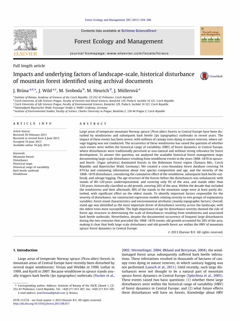
Fig. 1. Map of the area with national park borders (black lines). Area with all historical data available covers 43 247 ha (dark grey), additional 6983 ha does not containsufficient data about age structure (grey) and 4774 ha does not contain sufficient data about disturbances in 1868–1870 (light grey). Total area with species composition datacovers 54 974 ha of forests.
296 J. Bruna et al. / Forest Ecology and Management 305 (2013) 294–306
tional parks were established to protect this forested region: Bohe-mian Forest (in 1991) and Bavarian Forest (in 1970), on the Czechand German sides of the border, respectively (Fig. 1). In our studywe focused mainly on the area of these two national parks.
In the 19th century, when the focal wind events of our study oc-curred, the area’s various landowners were all using similar silvi-cultural practices derived from the then common CentralEuropean/German approach to forestry (Martin, 1906). These ex-treme wind events occurred in the winters of 1868 (December7–8 and 24–26), 1869 (November 1–3, 14 and 15), and 1870 (Octo-ber 26–27), resulting in large-scale windthrow disturbance andsubsequent bark beetle outbreaks. The cumulative impact of wind-throw, bark beetle outbreak, and salvage logging was well docu-mented during the approximately 10 years that the disturbedstands were managed after the windstorms. In fact, this was thefirst large-scale disturbance in the area for which we have localiza-tion and disturbance severity records, as the previous events weredocumented only in terms of amount of timber losses (Elling et al.,1987; Jelínek, 1988).
The historical forest maps used in this study include informa-tion about the borders, dominant age class, and species composi-tion (in terms of presence of important tree species, but notprevalence) of each stand. The positional accuracy of the old for-estry maps is very high, since they were created using sophisti-cated cadaster mapping methods (Kacmar et al. 2013), and mostof the stand borders are still used in present forest managementmaps. For the Czech part, they were compiled by Jelínek (2005)from multiple archives. Complementing the maps of the Czechareas were forest management books that have more detailedinformation about every stand. For the German part, we used forestinventory maps from 1844, 1856, and 1860 covering different partsof the area, as well as a species composition map constructed byElling et al. (1987) based on historical data.
Importantly, both Elling et al. (1987) and Jelínek (2005) con-structed maps of disturbance severity, covering approximatelythe decade following the 1868–1870 windstorms. The informationused in these maps was originally recorded because, during thisdecade, stand management was dictated by disturbance impact.Therefore, these maps documented the cumulative severity of dis-turbance from the windthrow and subsequent beetle outbreaksand salvage logging. We presume that, due to the scale of the
disturbance, most management activities (and therefore documen-tation) done following the 1868–1870 wind events were concen-trated in or near the areas subjected to this disturbance,although this was not specifically stated in the documents.
The Czech forest management books recorded summaryamounts of salvaged wood from each stand or area. Jelínek(2005) translated these salvaged wood records into disturbanceseverity data, classified in three roughly quantitative categories:low, consisting of damage to single trees; intermediate, indicatingdamage to approximately half the trees; and high, for stand-replac-ing events in which all canopy trees in a given stand were dam-aged. Jelínek (2005) also grouped the stand ages in six classes:0–40 years, 40–80 years, 80–120 years, more than 120 years, self-regenerating logged class (R, 20% mature trees left for regenera-tion), and naturally sparse forest class (S). The oldest age category,encompassing stands over 120 years old, represents the definitionused by historical foresters for old-growth stands, i.e., those with-out significant past human influence (Jelínek, 1988). We assessedthe categorical accuracy of the age class designation used by Jelí-nek (2005) by comparing it with detailed stand information fromthe forest management books and maps for random locations, withreasonable results. The high accuracy was facilitated by the usageof Jelínek (2005) age classes that were broader than those in theoriginal forest maps.
Using ArcMap 10.0 (ESRI, 2011), the historical forestry mapsfrom both sides of the border were digitized and combined, result-ing in a cross-boundary map covering 54 974 ha of the two na-tional parks. The legend of the forest maps of both national parkswas unified regarding both the disturbance severity and age struc-ture, in both cases using the classifications developed by Jelínek(2005). Because some forest records are missing, the age structureof some parts of the Bavarian Forest NP and historical disturbanceinformation from the Zdíkov estate (Bohemian Forest NP) remainsunknown. These areas were therefore omitted from the age struc-ture and historical analyses, respectively (Fig. 1).
2.2. Modeling the disturbance
To identify important local attributes responsible for distur-bance severity, we constructed a regression model (the ‘‘all vari-able model’’) with disturbance severity as a dependent variable
J. Bruna et al. / Forest Ecology and Management 305 (2013) 294–306 297
and two groups of explanatory variables: forest stand characteris-tics and environmental, mainly topographically derived factors (alllisted in Table 3). These were all assessed per point in a grid with1.25 km spacing to minimize autocorrelation of variables used inthe model. The spatial independence of explanatory variableswas tested by Moran’s I test in R 2.14.2 (R Development Core Team,2012) as implemented by Bivand et al. (2012). The self-regenerat-ing logged and naturally sparse forest areas, as well as areas with-out sufficient information on age structure or disturbances, wereexcluded from this analysis.
Severity of disturbance at the sampled point was calculated asthe mean disturbance severity in a circle of 250 m radius, thusincluding the surroundings while avoiding the arbitrary nature ofstand borders. This number was converted to a proportion (0–1)for use in a generalized linear regression with binomial distribu-tion and logit link function assuming single tree damage (causingimmediate or eventual tree death) to represent 10% disturbanceseverity, damage to half the trees to represent 50% severity, anddamage to all trees to represent 100% severity.
The stand characteristics tested included age, Euclidean dis-tance to stand edge for each different age class, and the pres-ence/absence of each major tree species. Age was computed asthe mean age class in a circle of 250 m radius (as a surrogate forforest stand), and we then calculated the difference in mean ageclass between the 250 m circle and a 500 m circle to yield theage difference index value. Similar index was used in Mikitaet al. (2012) to identify forest edge areas susceptible to wind dam-age due to heights differences. We used this approach instead ofstand data because there was not only variability in sizes amongstands, but also in disturbance within some stands, resulting inmultiple stand parts with different disturbance data.
A digital elevation model based on ASTER Global Digital Eleva-tion Model V002 (METI/NASA, 2011) was used to calculate valuesof topographic variables related to wind risk and site conditions.The morphometric protection index, equivalent to the positiveopenness described in Yokoyama et al. (2002), and similar to thedistance-limited Topex (Pyatt et al., 1969) widely used in wind-throw risk prediction and modeling (Quine and White, 1998;
0−4035%
40−8024%
Disturbanceseverity
0%
10%
50%
100%
Fig. 2. Disturbance severity significantly increases in older age classes. More of the youtotal area. ‘‘S’’ means sparse forests and ‘‘R’’ means areas left intentionally for natural re
Hanewinkel et al., 2004, 2011; Scott and Mitchell, 2005), was com-puted in SAGA GIS (SAGA Development Team, 2011), along withslope, aspect, and sky view factor. MAXTOPEX was calculated fol-lowing the method of Mikita et al. (2012), who used it in the samearea to model the recent disturbances. Other commonly used site-descriptive indexes, including SAGA wetness, solar radiation, ter-rain ruggedness (TRI), relative height and slope position, altitudeabove channel network, and effective air flow heights from eightprincipal directions were calculated using SAGA GIS. All stand-re-lated variables were calculated and all DEM-related layer valuesand latitude and longitude were extracted using ArcMap 10.0(ESRI, 2011). Point selection, variable testing, modeling, and valida-tion were done using R 2.14.2 (R Development Core Team, 2012).Significant variables and all reasonable interactions for the modelwere selected by backward and forward selection based on theAkaike Information Criterion (AIC). To assess the usefulness of his-torical data for modeling the effect of disturbance, we validated themodel on a set of points in the same design as the original, butshifted from it both latitudinally and longitudinally by half the dis-tance between the points (625 m), thus covering a similar area andgradients.
3. Results
3.1. Age structure
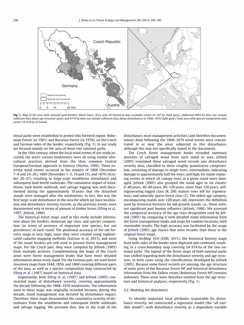
Age structure of the 47926 ha of forests before the 1868–1870disturbances was unbalanced, with most stands either youngerthan 40 years (33%) or 40–80 years old (25%). The 80–120 yearage class was present in only 10% of the area and 26% of the forestbelonged to the age class comprising stands older than 120 years(Fig. 2).
The large-scale disturbances of 1868–1870 substantially alteredthe age structure. The older classes were subject to substantiallygreater disturbance, resulting in decrease of the area of forest olderthan 120 years (old-growth forest) by 69% and those of age 80–120 years by 55%. In the oldest age class, the windthrow
80−1209%
120+26%
S3%
R3%
0.0
0.2
0.4
0.6
0.8
1.0
nger age stands were managed before the disturbance. Width shows proportion ofgeneration (20% of standing trees left after logging).

Age class0-40
40-80
80-120
120+
Sparse forest with grasslands
Self renewing
Disturbance severity10 %50 %100 %
Water canal for timber transportBuilt (1789-1822)
National Boundary
0 1.5 30.75 Km
Fig. 3. Detailed map of the Trojmezná region. Almost all areas of primeval forest were disturbed to some degree, although not necessarily completely. The nearby areas weresurrounded by intensively managed areas before the 1870 disturbance, partly enabled by a canal that had been constructed several decades earlier, which enabled logs to betransported from the mountains. The canal also made salvage logging possible after the 1870 disturbance, unlike for previous disturbances. Map is an overlay of datapublished by Jelínek (2005).
298 J. Bruna et al. / Forest Ecology and Management 305 (2013) 294–306
disturbance and subsequent bark beetle infestation and salvagelogging resulted in the greatest proportion (41%) of stands experi-encing loss of all trees, whereas in younger stands, this level ofdestruction was much rarer (2% for age class 0–40 years and 7%for 40–80). In the two youngest classes of stands, the most com-mon level of disturbance was the loss of individual trees or halfof the stands. Most (83%) of the forest area belonging to class R(logged with 20% of trees left for natural regeneration) was at leastpartly disturbed, in contrast with those of class S (naturally sparseforests), of which only 35% of their area showed disturbance.
From the analyzed area of 43 247 ha, 7725 ha of stands werecompletely damaged (100% of canopy removed), 4647 ha had halfthe canopy removed, and 5014 ha had individual trees that weredamaged, resulting in 40% of the stands in the study area beingat least partly disturbed within approximately a single decade. Ofthe oldest, unmanaged forests, only 31% were left undisturbed,meaning that the old-growth forests decreased from 26%(11 177 ha) to just 8% (3464 ha) of the analyzed area. This is mostapparent in the Trojmezná region, where almost all the stands old-er than 80 years were disturbed to some degree (Fig. 3).
3.2. Tree species composition
Spruce was present in 90% of stands. Pure spruce stands ac-counted for 46% of stands, forming the most common forest type,followed by the mixture of spruce, beech and fir, which covered34% of the area. Fir was present in 41% of the stands and beechin 37% of the stands, mainly in the southeastern part of the area
(Table 1). Species composition changed along an elevation gradient(Fig. 4, Fig. 7), with higher elevations having increasing proportionsof pure spruce stands and decreasing proportion of beech and fir. Inpure spruce stands, the two youngest age classes prevail, whereasmixed stands had more balanced proportions of age classes domi-nated only slightly by the oldest one.
Pure spruce forest was the most disturbed, with 62% of its areaaffected by the disturbances (Table 1). Similarly, about 58% of thesecond most common forest type, mixed spruce, beech and firwas affected, but the proportion of stands completely destroyedwas lower (21%) than in pure spruce stands (33%), and these mixedstands were more affected by single tree disturbance (19%), thanwere the pure spruce (11%) stands (Table 1). Disturbance severitywas low in the beech-dominated and mixed spruce and beechstands, which represented a small proportion of the landscape(<5%). The species composition in the disturbed area and in theunaffected area was very similar (Fig. 4), although disturbance ex-tent differed among species groups along the elevation gradient(Fig. 4 and Fig. 8).
3.3. Modeling the disturbances
Mean age was identified as the most important factor for distur-bance severity, with a positive effect. Latitude had a positive influ-ence, indicating more severe disturbance in northern areas.Disturbance was significantly more severe on the Czech side ofthe border (i.e. northeastern slopes) than the German. In the vali-dation, the all variable model performed quite well for the Czech
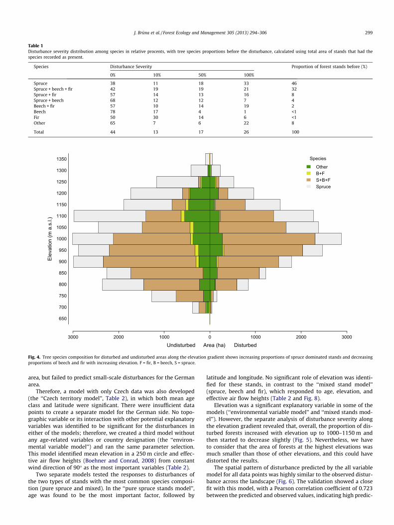
Table 1Disturbance severity distribution among species in relative procents, with tree species proportions before the disturbance, calculated using total area of stands that had thespecies recorded as present.
Species Disturbance Severity Proportion of forest stands before (%)
0% 10% 50% 100%
Spruce 38 11 18 33 46Spruce + beech + fir 42 19 19 21 32Spruce + fir 57 14 13 16 8Spruce + beech 68 12 12 7 4Beech + fir 57 10 14 19 2Beech 78 17 4 1 <1Fir 50 30 14 6 <1Other 65 7 6 22 8
Total 44 13 17 26 100
650
700
750
800
850
900
950
1000
1050
1100
1150
1200
1250
1300
1350
Elev
atio
n (m
a.s
.l.)
Species
OtherB+FS+B+FSpruce
3000 2000 1000 0 1000 2000 3000
Undisturbed Area (ha) Disturbed
Fig. 4. Tree species composition for disturbed and undisturbed areas along the elevation gradient shows increasing proportions of spruce dominated stands and decreasingproportions of beech and fir with increasing elevation. F = fir, B = beech, S = spruce.
J. Bruna et al. / Forest Ecology and Management 305 (2013) 294–306 299
area, but failed to predict small-scale disturbances for the Germanarea.
Therefore, a model with only Czech data was also developed(the ‘‘Czech territory model’’, Table 2), in which both mean ageclass and latitude were significant. There were insufficient datapoints to create a separate model for the German side. No topo-graphic variable or its interaction with other potential explanatoryvariables was identified to be significant for the disturbances ineither of the models; therefore, we created a third model withoutany age-related variables or country designation (the ‘‘environ-mental variable model’’) and ran the same parameter selection.This model identified mean elevation in a 250 m circle and effec-tive air flow heights (Boehner and Conrad, 2008) from constantwind direction of 90� as the most important variables (Table 2).
Two separate models tested the responses to disturbances ofthe two types of stands with the most common species composi-tion (pure spruce and mixed). In the ‘‘pure spruce stands model’’,age was found to be the most important factor, followed by
latitude and longitude. No significant role of elevation was identi-fied for these stands, in contrast to the ‘‘mixed stand model’’(spruce, beech and fir), which responded to age, elevation, andeffective air flow heights (Table 2 and Fig. 8).
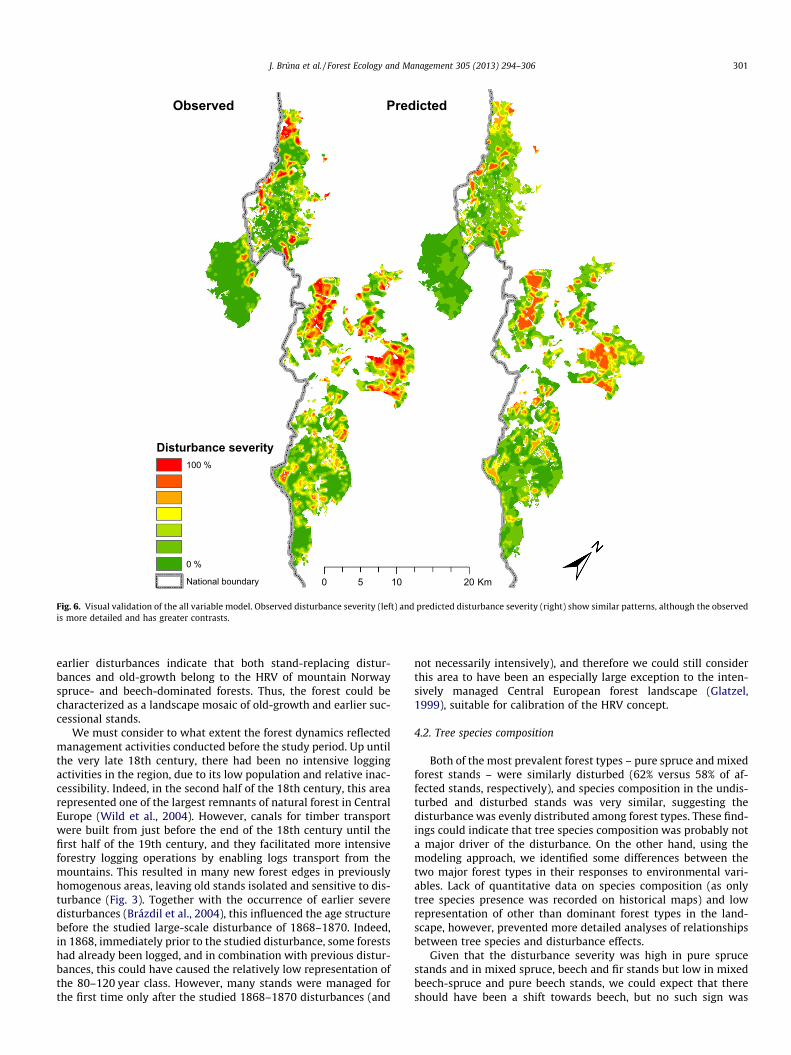
Elevation was a significant explanatory variable in some of themodels (‘‘environmental variable model’’ and ‘‘mixed stands mod-el’’). However, the separate analysis of disturbance severity alongthe elevation gradient revealed that, overall, the proportion of dis-turbed forests increased with elevation up to 1000–1150 m andthen started to decrease slightly (Fig. 5). Nevertheless, we haveto consider that the area of forests at the highest elevations wasmuch smaller than those of other elevations, and this could havedistorted the results.
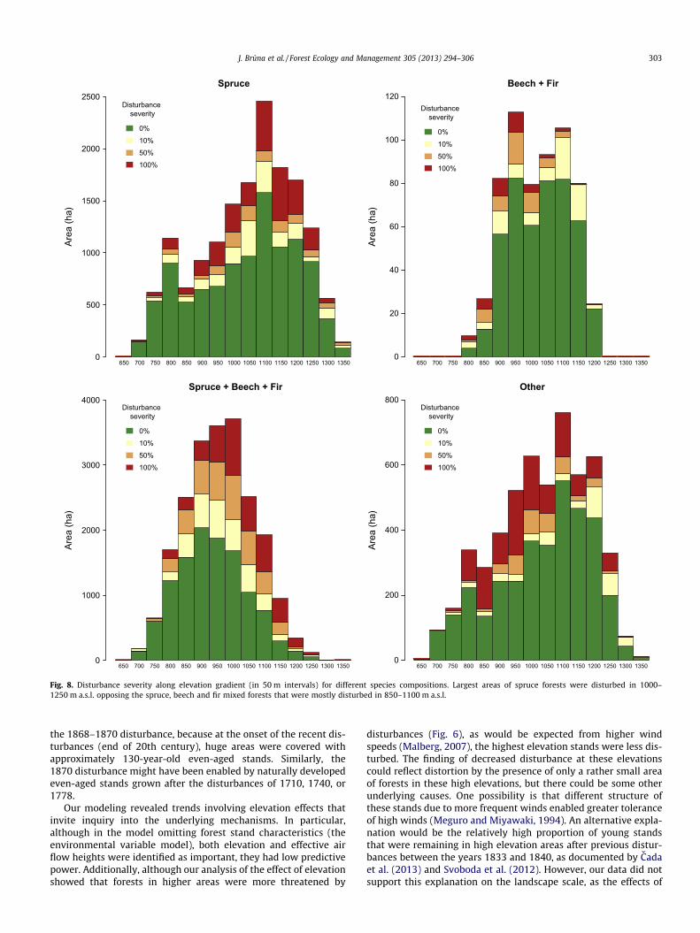
The spatial pattern of disturbance predicted by the all variablemodel for all data points was highly similar to the observed distur-bance across the landscape (Fig. 6). The validation showed a closefit with this model, with a Pearson correlation coefficient of 0.723between the predicted and observed values, indicating high predic-
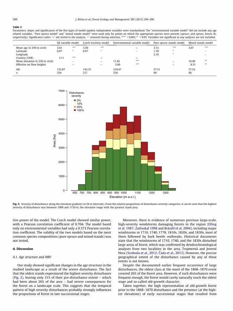
Table 2Parameters, slopes and significances of the five types of model applied. Independent variables were standardized. The ‘‘environmental variable model’’ did not include any agerelated variables. ‘‘Pure spruce model’’ and ‘‘mixed stands model’’ were used only for points on which the appropriate species were present (spruce; and spruce, beech, fir,respectively). Significance codes: ‘�’ not tested in the analysis, ‘–’ removed during selection, ‘***’ < 0.001,‘*’ < 0.05. Variables not significant in any analyses are not included.
All variable model Czech territory model Environmental variable model Pure spruce stands model Mixed stands model
Mean age in 250 m circle 3.41 *** 3.30 *** � 3.13 *** 3.67 ***Lattitude 0.97 * 0.97 * – 1.70 * –Longitude 3.19 * –Country (GER) �3.11 *** � �Mean elevation in 250 m circle – – 11.42 *** – 16.49 **Effective air flow heights – – �5.60 *** – �8.31 **
AIC 152.87 145.35 218.47 57.51 57.52n 254 217 254 94 96
650 700 750 800 850 900 950 1000 1100 1200 1300Elevation (m a.s.l.)
Area
(ha)
0
1000
2000
3000
4000
5000
6000
7000Disturbance
severity0%10%50%100%
Fig. 5. Severity of disturbance along the elevation gradient (in 50 m intervals). From the relative proportions of disturbance severity categories, it can be seen that the highestseverity of disturbance was between 1000 and 1150 m, the elevation range with the greatest stand area.
300 J. Bruna et al. / Forest Ecology and Management 305 (2013) 294–306
tive power of the model. The Czech model showed similar power,with a Pearson correlation coefficient of 0.704. The model basedonly on environmental variables had only a 0.373 Pearson correla-tion coefficient. The validity of the two models based on the mostcommon species compositions (pure spruce and mixed stands) wasnot tested.
4. Discussion
4.1. Age structure and HRV
Our study showed significant changes in the age structure in thestudied landscape as a result of the severe disturbance. The factthat the oldest stands experienced the highest severity disturbance(Fig. 2), leaving only 31% of their pre-disturbance extent – whichhad been about 26% of the area – had severe consequences forthe forest on a landscape scale. This suggests that the temporalpattern of high severity disturbances probably strongly influencesthe proportions of forest in late successional stages.
Moreover, there is evidence of numerous previous large-scale,high-severity windstorms damaging forests in the region (Ellinget al. 1987; Zatloukal 1998 and Brázdil et al. 2004), including majorwindstorms in 1710, 1740, 1778, 1810s, 1820s, and 1830s, most ofthem followed by bark beetle outbreaks. Historical documentsstate that the windstorms of 1710, 1740, and the 1830s disturbedlarge areas of forest, which was confirmed by dendrochronologicalanalyses from two localities in the area, Trojmezná and JezerníHora (Svoboda et al., 2012; Cada et al., 2013). However, the precisegeographical extent of the disturbance caused by any of theseevents is not known.
Despite the documented earlier frequent occurrence of largedisturbances, the oldest class at the onset of the 1868–1870 eventcovered 26% of the forest area. However, if such disturbances werefrequent enough, the forest would rarely naturally reach the oldeststage and so-called old-growth character.
Taken together, the high representation of old-growth forestprior to the 1868–1870 disturbance and the presence (at the high-est elevations) of early successional stages that resulted from
0 10 205 Km
Disturbance severity100 %
0 %
National boundary
PredictedObserved
Fig. 6. Visual validation of the all variable model. Observed disturbance severity (left) and predicted disturbance severity (right) show similar patterns, although the observedis more detailed and has greater contrasts.
J. Bruna et al. / Forest Ecology and Management 305 (2013) 294–306 301
earlier disturbances indicate that both stand-replacing distur-bances and old-growth belong to the HRV of mountain Norwayspruce- and beech-dominated forests. Thus, the forest could becharacterized as a landscape mosaic of old-growth and earlier suc-cessional stands.
We must consider to what extent the forest dynamics reflectedmanagement activities conducted before the study period. Up untilthe very late 18th century, there had been no intensive loggingactivities in the region, due to its low population and relative inac-cessibility. Indeed, in the second half of the 18th century, this arearepresented one of the largest remnants of natural forest in CentralEurope (Wild et al., 2004). However, canals for timber transportwere built from just before the end of the 18th century until thefirst half of the 19th century, and they facilitated more intensiveforestry logging operations by enabling logs transport from themountains. This resulted in many new forest edges in previouslyhomogenous areas, leaving old stands isolated and sensitive to dis-turbance (Fig. 3). Together with the occurrence of earlier severedisturbances (Brázdil et al., 2004), this influenced the age structurebefore the studied large-scale disturbance of 1868–1870. Indeed,in 1868, immediately prior to the studied disturbance, some forestshad already been logged, and in combination with previous distur-bances, this could have caused the relatively low representation ofthe 80–120 year class. However, many stands were managed forthe first time only after the studied 1868–1870 disturbances (and
not necessarily intensively), and therefore we could still considerthis area to have been an especially large exception to the inten-sively managed Central European forest landscape (Glatzel,1999), suitable for calibration of the HRV concept.
4.2. Tree species composition
Both of the most prevalent forest types – pure spruce and mixedforest stands – were similarly disturbed (62% versus 58% of af-fected stands, respectively), and species composition in the undis-turbed and disturbed stands was very similar, suggesting thedisturbance was evenly distributed among forest types. These find-ings could indicate that tree species composition was probably nota major driver of the disturbance. On the other hand, using themodeling approach, we identified some differences between thetwo major forest types in their responses to environmental vari-ables. Lack of quantitative data on species composition (as onlytree species presence was recorded on historical maps) and lowrepresentation of other than dominant forest types in the land-scape, however, prevented more detailed analyses of relationshipsbetween tree species and disturbance effects.
Given that the disturbance severity was high in pure sprucestands and in mixed spruce, beech and fir stands but low in mixedbeech-spruce and pure beech stands, we could expect that thereshould have been a shift towards beech, but no such sign was

650 700 750 800 850 900 950 1000 1050 1100 1150 1200 1250 1300 1350
Spruce
Area
(ha)
0
500
1000
1500
2000
2500Age Class
0−4040−8080−120120+RS
Spruce + Beech + Fir
Area
(ha)
0
1000
2000
3000
4000Age Class
0−4040−8080−120120+RS
Beech + Fir
Area
(ha)
0
20
40
60
80
100
120Age Class
0−4040−8080−120120+RS
Other
Area
(ha)
0
200
400
600
800Age Class
0−4040−8080−120120+RS
650 700 750 800 850 900 950 1000 1050 1100 1150 1200 1250 1300 1350
650 700 750 800 850 900 950 1000 1050 1100 1150 1200 1250 1300 1350650 700 750 800 850 900 950 1000 1050 1100 1150 1200 1250 1300 1350
Fig. 7. Age class distribution along elevation gradient (in 50 m intervals) for different species compositions before the 1868–1870 disturbances. Most old-growth (120+)spruce forests were present in elevations higher than 1100 m a.s.l. whereas old-growth spruce, beech and fir mixed forests were more evenly distributed along the elevationgradient.
302 J. Bruna et al. / Forest Ecology and Management 305 (2013) 294–306
detected. This could be attributed to the fact that stands which in-cluded beech without spruce only accounted for a small proportionof the landscape. The lower amount of completely damaged can-opy cover in mixed spruce, beech and fir forests was likely dueto mechanical damage to young broad-leaved trees from fallingspruce trees (Jelínek, 1988). Subsequent bark beetle outbreaks in-creased the number of spruce trees killed, while sparing beechand fir, which helps explain the disparity in disturbance severitybetween the pure spruce and other stand types. Elevation couldalso underlie this disparity, since pure spruce stands were concen-trated mostly at higher elevations (Fig. 4). The greater proportionof young trees in the pure spruce stands than in mixed stands (bal-anced age classes, slightly dominated by the oldest one), suggests
the start of a gradual shift towards pure spruce stands. This wouldhave resulted from previous management and disturbances.
4.3. Modeling the disturbance
The strong effect of age on disturbance severity suggests animportant influence of age structure on the scale of such distur-bances. Particularly noteworthy, even the unmanaged oldeststands were unable to withstand the extreme winds and subse-quent bark beetle outbreak. This finding is important for currentmanagement, since many of the stands have already reached theoldest age class. In fact, recent large-scale windthrow events andbark beetle outbreaks might have been direct consequences of
650 700 750 800 850 900 950 1000 1050 1100 1150 1200 1250 1300 1350
SpruceAr
ea (h
a)
0
500
1000
1500
2000
2500Disturbance
severity
0%10%50%100%
Spruce + Beech + Fir
Area
(ha)
0
1000
2000
3000
4000Disturbance
severity
0%10%50%100%
Beech + Fir
Area
(ha)
0
20
40
60
80
100
120Disturbance
severity
0%10%50%100%
OtherAr
ea (h
a)
0
200
400
600
800Disturbance
severity
0%10%50%100%
650 700 750 800 850 900 950 1000 1050 1100 1150 1200 1250 1300 1350
650 700 750 800 850 900 950 1000 1050 1100 1150 1200 1250 1300 1350650 700 750 800 850 900 950 1000 1050 1100 1150 1200 1250 1300 1350
Fig. 8. Disturbance severity along elevation gradient (in 50 m intervals) for different species compositions. Largest areas of spruce forests were disturbed in 1000–1250 m a.s.l. opposing the spruce, beech and fir mixed forests that were mostly disturbed in 850–1100 m a.s.l.
J. Bruna et al. / Forest Ecology and Management 305 (2013) 294–306 303
the 1868–1870 disturbance, because at the onset of the recent dis-turbances (end of 20th century), huge areas were covered withapproximately 130-year-old even-aged stands. Similarly, the1870 disturbance might have been enabled by naturally developedeven-aged stands grown after the disturbances of 1710, 1740, or1778.
Our modeling revealed trends involving elevation effects thatinvite inquiry into the underlying mechanisms. In particular,although in the model omitting forest stand characteristics (theenvironmental variable model), both elevation and effective airflow heights were identified as important, they had low predictivepower. Additionally, although our analysis of the effect of elevationshowed that forests in higher areas were more threatened by
disturbances (Fig. 6), as would be expected from higher windspeeds (Malberg, 2007), the highest elevation stands were less dis-turbed. The finding of decreased disturbance at these elevationscould reflect distortion by the presence of only a rather small areaof forests in these high elevations, but there could be some otherunderlying causes. One possibility is that different structure ofthese stands due to more frequent winds enabled greater toleranceof high winds (Meguro and Miyawaki, 1994). An alternative expla-nation would be the relatively high proportion of young standsthat were remaining in high elevation areas after previous distur-bances between the years 1833 and 1840, as documented by Cadaet al. (2013) and Svoboda et al. (2012). However, our data did notsupport this explanation on the landscape scale, as the effects of
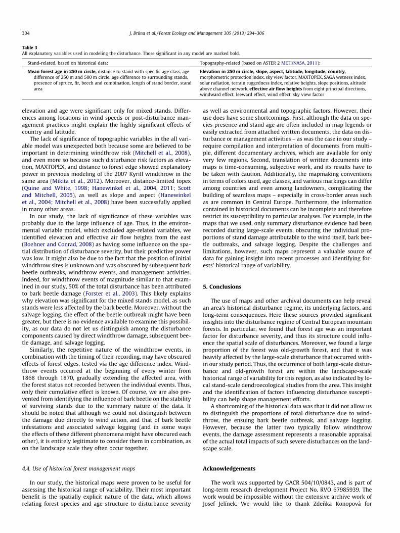
Table 3All explanatory variables used in modeling the disturbance. Those significant in any model are marked bold.
Stand-related, based on historical data: Topography-related (based on ASTER 2 METI/NASA, 2011):
Mean forest age in 250 m circle, distance to stand with specific age class, agedifference of 250 m and 500 m circle, age difference to surrounding stands,presence of spruce, fir, beech and combination, length of stand border, standarea
Elevation in 250 m circle, slope, aspect, latitude, longitude, country,morphometric protection index, sky view factor, MAXTOPEX, SAGA wetness index,solar radiation, terrain ruggedness index, relative heights, slope positions, altitudeabove channel network, effective air flow heights from eight principal directions,windward effect, leeward effect, wind effect, sky view factor
304 J. Bruna et al. / Forest Ecology and Management 305 (2013) 294–306
elevation and age were significant only for mixed stands. Differ-ences among locations in wind speeds or post-disturbance man-agement practices might explain the highly significant effects ofcountry and latitude.
The lack of significance of topographic variables in the all vari-able model was unexpected both because some are believed to beimportant in determining windthrow risk (Mitchell et al., 2008),and even more so because such disturbance risk factors as eleva-tion, MAXTOPEX, and distance to forest edge showed explanatorypower in previous modeling of the 2007 Kyrill windthrow in thesame area (Mikita et al., 2012). Moreover, distance-limited topex(Quine and White, 1998; Hanewinkel et al., 2004, 2011; Scottand Mitchell, 2005), as well as slope and aspect (Hanewinkelet al., 2004; Mitchell et al., 2008) have been successfully appliedin many other areas.
In our study, the lack of significance of these variables wasprobably due to the large influence of age. Thus, in the environ-mental variable model, which excluded age-related variables, weidentified elevation and effective air flow heights from the east(Boehner and Conrad, 2008) as having some influence on the spa-tial distribution of disturbance severity, but their predictive powerwas low. It might also be due to the fact that the position of initialwindthrow sites is unknown and was obscured by subsequent barkbeetle outbreaks, windthrow events, and management activities.Indeed, for windthrow events of magnitude similar to that exam-ined in our study, 50% of the total disturbance has been attributedto bark beetle damage (Forster et al., 2003). This likely explainswhy elevation was significant for the mixed stands model, as suchstands were less affected by the bark beetle. Moreover, without thesalvage logging, the effect of the beetle outbreak might have beengreater, but there is no evidence available to examine this possibil-ity, as our data do not let us distinguish among the disturbancecomponents caused by direct windthrow damage, subsequent bee-tle damage, and salvage logging.
Similarly, the repetitive nature of the windthrow events, incombination with the timing of their recording, may have obscuredeffects of forest edges, tested via the age difference index. Wind-throw events occurred at the beginning of every winter from1868 through 1870, gradually extending the affected area, withthe forest status not recorded between the individual events. Thus,only their cumulative effect is known. Of course, we are also pre-vented from identifying the influence of bark beetle on the stabilityof surviving stands due to the summary nature of the data. Itshould be noted that although we could not distinguish betweenthe damage due directly to wind action, and that of bark beetleinfestations and associated salvage logging (and in some waysthe effects of these different phenomena might have obscured eachother), it is entirely legitimate to consider them in combination, ason the landscape scale they often occur together.
4.4. Use of historical forest management maps
In our study, the historical maps were proven to be useful forassessing the historical range of variability. Their most importantbenefit is the spatially explicit nature of the data, which allowsrelating forest species and age structure to disturbance severity
as well as environmental and topographic factors. However, theiruse does have some shortcomings. First, although the data on spe-cies presence and stand age are often included in map legends oreasily extracted from attached written documents, the data on dis-turbance or management activities – as was the case in our study –require compilation and interpretation of documents from multi-ple, different documentary archives, which are available for onlyvery few regions. Second, translation of written documents intomaps is time-consuming, subjective work, and its results have tobe taken with caution. Additionally, the mapmaking conventionsin terms of colors used, age classes, and various markings can differamong countries and even among landowners, complicating thebuilding of seamless maps – especially in cross-border areas suchas are common in Central Europe. Furthermore, the informationcontained in historical documents can be incomplete and thereforerestrict its susceptibility to particular analyses. For example, in themaps that we used, only summary disturbance evidence had beenrecorded during large-scale events, obscuring the individual pro-portions of stand damage attributable to the wind itself, bark bee-tle outbreaks, and salvage logging. Despite the challenges andlimitations, however, such maps represent a valuable source ofdata for gaining insight into recent processes and identifying for-ests’ historical range of variability.
5. Conclusions
The use of maps and other archival documents can help revealan area’s historical disturbance regime, its underlying factors, andlong-term consequences. Here these sources provided significantinsights into the disturbance regime of Central European mountainforests. In particular, we found that forest age was an importantfactor for disturbance severity, and thus its structure could influ-ence the spatial scale of disturbances. Moreover, we found a largeproportion of the forest was old-growth forest, and that it washeavily affected by the large-scale disturbance that occurred with-in our study period. Thus, the occurrence of both large-scale distur-bance and old-growth forest are within the landscape-scalehistorical range of variability for this region, as also indicated by lo-cal stand-scale dendroecological studies from the area. This insightand the identification of factors influencing disturbance suscepti-bility can help shape management efforts.
A shortcoming of the historical data was that it did not allow usto distinguish the proportions of total disturbance due to wind-throw, the ensuing bark beetle outbreak, and salvage logging.However, because the latter two typically follow windthrowevents, the damage assessment represents a reasonable appraisalof the actual total impacts of such severe disturbances on the land-scape scale.
Acknowledgements
The work was supported by GACR 504/10/0843, and is part oflong-term research development Project No. RVO 67985939. Thework would be impossible without the extensive archive work ofJosef Jelínek. We would like to thank Zdenka Konopová for
J. Bruna et al. / Forest Ecology and Management 305 (2013) 294–306 305
digitalization of part of the data sources and Jonathan Rosenthal forvaluable comments and corrections to this text.
References
Achim, A., Ruel, J.-C., Gardiner, B.A., Laflamme, G., Meunier, S., 2005. Modelling thevulnerability of balsam fir forests to wind damage. For. Ecol. Manage. 204, 37–52.
Axelsson, A., Östlund, L., Hellberg, E., 2002. Changes in mixed deciduous forests ofboreal Sweden 1866–1999 based on interpretation of historical records.Landscape Ecol. 17, 403–418.
Bivand, R., Altman, M., Anselin, L., Assunção, R., Berke, O., Andrew, B., Blanchet, G.,Blankmeyer, E., Carvalho, M., Christensen, B., Chun, Y., Dormann, C., Dray, S.,Halbersma, R., Krainski, E., Legendre, P., Lewin-Koh, N., Li, H., Ma, J., Millo, G.,Mueller, W., Ono, H., Peres-Neto, P., Piras, G., Reder, M., Tiefelsdorf, M., Yu., D.,2012. spdep: Spatial dependence: weighting schemes, statistics and models.
Boehner, J., Conrad, O., 2008. Effective Air Flow Heights. SAGA.Brázdil, R., Dobrovolny, P., Štekl, J., Kotyza, O., Valášek, H., Jez, J., 2004. History of
Weather and Climate in the Czech Lands VI: Strong Winds. Masaryk University,Brno.
Bruna, V., Krováková, K., Nedbal, V., 2010. Historical landscape structure in thespring area of the Blanice River, Southern Bohemia – an example of theimportance of old maps. Acta Geodaet Geophys Hung 45, 48–55.
Cada, V., Svoboda, M., Janda, P., 2013. Dendrochronological reconstruction of thedisturbance history and past development of the mountain Norway spruce inthe Bohemian Forest, central Europe. For. Ecol. Manage. 213, 59–68.
Canham, C., Loucks, O., 1984. Catastrophic windthrow in the presettlement forestsof Wisconsin. Ecology 65, 803–809.
Clark, J., Merkt, J., 1989. Post-glacial fire, vegetation, and human history on thenorthern alpine forelands, south-western Germany. J. Ecol. 77, 897–925.
Ellenberg, H., 1996. Vegetation Mitteleuropas mit den Alpen in ökologischer,dynamischer und historischer Sicht, Ulmer. Ulmer, Stuttgart, Stuttgart.
Elling, W., Bauer, E., Klemm, G., Koch, H., 1987. Klima und Böden, 2nd ed.Bayerisches Staatsministerium für Ernährung, Landwirtschaft und Forsten.
ESRI 2011. ArcGIS Desktop: Release 10.0 Redlands, CA: Environmental SystemsResearch Institute.
Ewald, J., Jehl, H., Braun, L., Lohberger, E., 2011. Die Vegetation des NationalparksBayerischer Wald als Ausdruck von Standort und Walddynamik. Tuexenia, pp.9–38.
Falinski, J., Falinska, K., 1986. Vegetation dynamics in temperate lowland primevalforests: ecological studies in Bialowieza Forest. Springer.
Fernow, B.E., 1911. A brief history of forestry: in Europe, the United States and othercountries. Toronto : University Press; Cambridge, Mass.
Fischer, A., Lindner, M., Abs, C., Lasch, P., 2002. Vegetation dynamics in centraleuropean forest ecosystems (near-natural as well as managed) after stormevents. Folia Geobot. 37, 17–32.
Fischer, H.S., Winter, S., Lohberger, E., Jehl, H., Fischer, A., 2013. Improvingtransboundary maps of potential natural vegetation using statistical modelingbased on environmental predictors. Folia Geobot. 48, 115–135.
Forster, B., Meier, F., Gall, R., Zahn, C., 2003. Erfahrungen im Umgang mitBuchdrucker-Massenvermehrungen (Ips typographus L.) nachSturmereignissen in der Schweiz. Schweiz Z Forstwes 154, 431–436.
Frelich, L.E., 2002. Forest Dynamics and Disturbance Regimes: Studies fromTemperate Evergreen-Deciduous Forests, Agriculture. Cambridge UniversityPress.
Frelich, L.E., Lorimer, C.G., 1991. Natural disturbance regimes in hemlock-hardwoodforests of the upper great lakes region. Ecol. Monogr. 61, 145.
Glatzel, G., 1999. Historic forest use and its possible implications to recentlyaccelerated tree growth in Central Europe. In: Causes and Consequences ofAccelerated Tree Growth in Europe. EFI Proceedings No 27, pp. 65–74.
Gromtsev, A., 2002. Natural disturbance dynamics in the boreal forests of EuropeanRussia: a review. Silva Fenn. 36, 41–55.
Hadley, K.S., Knapp, P.A., 2011. Detection of high-wind events using tree-ring data.Can. J. For. Res. 41, 1121–1129.
Hanewinkel, M., Zhou, W., Schill, C., 2004. A neural network approach to identifyforest stands susceptible to wind damage. For. Ecol. Manage. 196, 227–243.
Hanewinkel, M., Peltola, H., Soares, P., González-Olabarria, J.R., 2011. Recentapproaches to model the risk of storm and fire. For. Syst. 3, 30–47.
Hernández, L., Rubiales, J.M., Morales-Molino, C., Romero, F., Sanz, C., GómezManzaneque, F., 2011. Reconstructing forest history from archaeological data: acase study in the Duero basin assessing the origin of controversial forests andthe loss of tree populations of great biogeographical interest. For. Ecol. Manage.261, 1178–1187.
Hessburg, P.F., Smith, B.G., Salter, R.B., 1999. Detecting change in forest spatialpatterns from reference conditions. Ecol. Appl. 9, 1232–1252.
Heurich, M., Englmaier, K.H., 2010. The development of tree species composition inthe Rachel – Lusen region of the Bavarian Forest National Park. Silva Gabreta 16,165–186.
Heurich, M., Jehl, H., 2000. Waldentwicklung im Bergwald nach Windwurfund Borkenkäferbefall, Wissenschaftliche Schriftenreihe derNationalparkverwaltung Bayerischer Wald. Grafenau, Band, p. 14.
Jelínek, J., 1988. Vetrná a kurovcová kalamita na Šumave z let 1868 az 1878.Lesprojekt, Brandys nad Labem.
Jelínek, J., 2005. Od jihoceskych pralesu k hospodárskym lesum Šumavy. MZE CR,Úsek lesního hospodárství, ÚHÚL Brandys nad Labem.
Kacmar, M., Wild, J., Moravcová, M., Konopová, Z., Zajícková, L. (2013):Geodatenbank über die historische Entwicklung der Waldbestände imNationalpark Böhmische Schweiz, In: Csaplovics, E., Seiler, U., Wild, J. (eds.):Historische Waldentwicklung in der Sächsisch-Böhmische Schweiz / Historickyvyvoj lesa v Ceskosaskm Švycarsku, Schriftenreihe Fernerkundung undAngewandte Geoinformatik – Bd.10, Rhombos Verlag.
Keane, R.E., Hessburg, P.F., Landres, P.B., Swanson, F.J., 2009. The use of historicalrange and variability (HRV) in landscape management. For. Ecol. Manage. 258,1025–1037.
Korpel’, Š., 1995. The Virgin Forests of the Western Carpathians. Gustav FischerVerlag, Stuttgart.
Kulakowski, D., Bebi, P., 2004. Range of variability of unmanaged subalpine forests.Forum für Wissen, pp. 47–54.
Landres, P.B., Morgan, P., Swanson, F.J., 1999. Overview of the use of naturalvariability concepts in managing ecological systems. Ecol. Appl. 9, 1179–1188.
Lausch, A., Fahse, L., Heurich, M., 2011. Factors affecting the spatio-temporaldispersion of Ips typographus (L.) in Bavarian Forest National Park: a long-termquantitative landscape-level analysis. For. Ecol. Manage. 261, 233–245.
Malberg, H., 2007. Meteorologie und Klimatologie: Eine Einführung. Springer DE.Martin, H., 1906. Die Forsteinrichtung. Ein Grundriss zu Vorlesungen und ein
Leitfaden für Praktiker, second ed. Julius Springer, Berlin.Meguro, S., Miyawaki, A., 1994. A study of the relationship between mechanical
characteristics and the coastal vegetation among several broad-leaf trees inMiura Peninsula in Japan. Vegetatio 112, 101–111.
METI/NASA, 2011. ASTER Global Digital Elevation Model V002.Mikita, T., Klimánek, M., Kolejka, J., 2012. Usage of multidimensional statistic
methods with MAXTOPEX factor for Windthrow risk assessment. Allg. For.Jagdztg 183, 63–74.
Mikusinska, A., Zawadzka, B., Samojlik, T., Jedrzejewska, B., Mikusinski, G., 2012.Quantifying landscape change during the last two centuries in Białowie _zaPrimeval Forest. Appl. Veg. Sci., 16.
Mitchell, S.J., Lanquaye-Opoku, N., Modzelewski, H., Shen, Y., Stull, R., Jackson, P.,Murphy, B., Ruel, J.-C., 2008. Comparison of wind speeds obtained usingnumerical weather prediction models and topographic exposure indices forpredicting windthrow in mountainous terrain. For. Ecol. Manage. 254, 193–204.
Nagel, T.A., Diaci, J., 2006. Intermediate wind disturbance in an old-growth beech-firforest in southeastern Slovenia. Can. J. For. Res. 36, 629–638.
Nagel, T.A., Svoboda, M., Diaci, J., 2006. Regeneration patterns after intermediatewind disturbance in an old-growth Fagus–Abies forest in southeastern Slovenia.For. Ecol. Manage. 226, 268–278.
Neuhäuslová, Z. (Ed.), 2001. The Map of Potential Natural Vegetation of the ŠumavaNational Park. Explanatory text, Silva Gabreta, Suppl. 1/2001.
Nielsen, A.B., Odgaard, B.V., 2005. Reconstructing land cover from pollenassemblages from small lakes in Denmark. Rev. Palaeobot. Palynol. 133, 1–21.
Nielsen, A.B., Odgaard, B.V., 2010. Quantitative landscape dynamics in Denmarkthrough the last three millennia based on the landscape reconstructionalgorithm approach. Veg. Hist. Archaeobot. 19, 375–387.
Økland, B., Berryman, A., 2004. Resource dynamic plays a key role in regionalfluctuations of the spruce bark beetles Ips typographus. Agric. For. Entomol. 6,141–146.
Panayotov, M., Kulakowski, D., Laranjeiro Dos Santos, L., Bebi, P., 2011. Winddisturbances shape old Norway spruce-dominated forest in Bulgaria. For. Ecol.Manage. 262, 470–481.
Papaik, M.J., Canham, C.D., 2006. Species resistance and community response towind disturbance regimes in northern temperate forests. J. Ecol. 94, 1011–1026.
Pickett, S., White, P., 1985. Patch dynamics: a synthesis, pp. 371–384.Pretzsch, H., 2009. Forest Dynamics, Growth and Yield, Stand. Springer Berlin
Heidelberg, Berlin, Heidelberg.Pyatt, D.G., Harrison, D., Ford, A.S., 1969. Guide to site types in forests of North and
Mid – Wales. Forestry Commission, United Kingdom, London.Quine, C.P., White, I.M.S., 1998. The potential of distance-limited topex in the
prediction of site windiness. Forestry 71, 325–332.R Development Core Team, 2012. R: a language and environment for statistical
computing.Rich, R.L., Frelich, L.E., Reich, P.B., 2007. Wind-throw mortality in the southern
boreal forest: effects of species, diameter and stand age. J. Ecol. 95, 1261–1273.Ruel, J.-C., 2000. Factors influencing windthrow in balsam fir forests: from
landscape studies to individual tree studies. For. Ecol. Manage. 135, 169–178.SAGA Development Team, 2011. System for Automated Geoscientific Analyses
(SAGA GIS).Schelhaas, M.J., Nabuurs, G.J., Schuck, A., 2003. Natural disturbances in the
European forests in the 19th and 20th centuries. Glob. Change Biol. 9, 1620–1633.
Scott, R.E., Mitchell, S.J., 2005. Empirical modelling of windthrow risk in partiallyharvested stands using tree, neighbourhood, and stand attributes. For. Ecol.Manage. 218, 193–209.
Šebková, B., Šamonil, P., Janík, D., Adam, D., Král, K., Vrška, T., Hort, L., Unar, P., 2011.Spatial and volume patterns of an unmanaged submontane mixed forest inCentral Europe: 160 years of spontaneous dynamics. For. Ecol. Manage. 262,873–885.
Seidl, R., Fernandes, P.M., Fonseca, T.F., Gillet, F., Jönsson, A.M., Merganicová, K.,Netherer, S., Arpaci, A., Bontemps, J.-D., Bugmann, H., 2010. Modelling naturaldisturbances in forest ecosystems: a review. Ecol. Model. 222, 903–924.

306 J. Bruna et al. / Forest Ecology and Management 305 (2013) 294–306
Seidl, R., Schelhaas, M.-J., Lexer, M.J., 2011. Unraveling the drivers of intensifyingforest disturbance regimes in Europe. Glob. Change Biol. 17, 2842–2852.
Splechtna, B.E., Gratzer, G., Black, B.A., 2005. Disturbance history of a European old-growth mixed-species forest – a spatial dendro-ecological analysis. J. Veg. Sci.16, 511–522.
Svoboda, M., Pouska, V., 2008. Structure of a Central-European mountain spruceold-growth forest with respect to historical development. For. Ecol. Manage.255, 2177–2188.
Svoboda, M., Fraver, S., Janda, P., Bace, R., Zenáhlíková, J., 2010. Natural developmentand regeneration of a Central European montane spruce forest. For. Ecol.Manage. 260, 707–714.
Svoboda, M., Janda, P., Nagel, T.a., Fraver, S., Rejzek, J., Bace, R., 2012. Disturbancehistory of an old-growth sub-alpine Picea abies stand in the Bohemian Forest,Czech Republic. J. Veg. Sci. 23, 86–97.
Swetnam, T.W., Allen, C.D., Betancourt, J.L., 1999. Applied historical ecology: usingthe past to manage for the future. Ecol. Appl. 9, 1189–1206.
Turner, M.G., 2010. Disturbance and landscape dynamics in a changing world.Ecology 91, 2833–2849.
Ulanova, N.G., 2000. The effects of windthrow on forests at different spatial scales: areview. For. Ecol. Manage. 135, 155–167.
Wermelinger, B., 2004. Ecology and management of the spruce bark beetle Ipstypographus – a review of recent research. For. Ecol. Manage. 202, 67–82.
Wild, J., Neuhäuslová, Z., Sofron, J., 2004. Changes of plant species composition inthe Šumava spruce forests, SW Bohemia, since the 1970s. For. Ecol. Manage.187, 117–132.
Wolf, A., Møller, P.F., Bradshaw, R.H.W., Bigler, J., 2004. Storm damage and long-term mortality in a semi-natural, temperate deciduous forest. For. Ecol. Manage.188, 197–210.
Wulf, M., Sommer, M., Schmidt, R., 2009. Forest cover changes in the Prignitz region(NE Germany) between 1790 and 1960 in relation to soils and other drivingforces. Landscape Ecol. 25, 299–313.
Yokoyama, R., Shlrasawa, M., Pike, R.J., 2002. Visualizing topography by openness : anew application of image processing to digital elevation models. Photogramm.Eng. Remot. Sens. 68, 257–265.
Zatloukal, V., 1998. Historické a soucasné príciny kurovcové kalamity v Národnímparku Šumava. Silva Gabreta 2, 327–357.
Zielonka, T., Holeksa, J., Fleischer, P., Kapusta, P., 2010. A tree-ring reconstruction ofwind disturbances in a forest of the Slovakian Tatra Mountains, WesternCarpathians. J. Veg. Sci. 21, 31–42.