Large-scale landscape modification
19
Atkins, P.J., Simmons, I.G. and Roberts, B.K. (1998) People, Land and Time London: Hodder Arnold ISBN: 0340677147 and 0470236590 http://www.routledge.com/books/details/9780340677148/ CHAPTER 7. LARGE-SCALE LANDSCAPE MODIFICATION: PAYS AND PRE- INDUSTRIAL PLANNING ‘Watch out for the fellow who talks about putting things in order! Putting things in order always means getting other people under your control ’. Diderot, D. (1796) Supplement to Bougainville’s “Voyage”. INTRODUCTION We tend to think of planning in the landscape as a twentieth century phenomenon. In reality the visual appearance and functional organization of landscape features has always been evolving, with two scales of action particularly noticeable.
Transcript of Large-scale landscape modification
Atkins, P.J., Simmons, I.G. and Roberts, B.K. (1998) People, Land and Time London:
Hodder Arnold ISBN: 0340677147 and 0470236590
http://www.routledge.com/books/details/9780340677148/
CHAPTER 7. LARGE-SCALE LANDSCAPE MODIFICATION: PAYS AND PRE-
INDUSTRIAL PLANNING
‘Watch out for the fellow who talks about putting things in order! Putting
things in order always means getting other people under your control’.
Diderot, D. (1796) Supplement to Bougainville’s “Voyage”.
INTRODUCTION
We tend to think of planning in the landscape as a twentieth century phenomenon. In reality
the visual appearance and functional organization of landscape features has always been
evolving, with two scales of action particularly noticeable.

First, there is small-scale and localised change. The term organic is often used to describe
this gradual accretion of features in the cultural landscape, which may concern perhaps the
rebuilding of a few cottages, the sub-division of a field, the exploitation of a new resource
such as the opening of a quarry, or any of the myriad run-of-the-mill decisions which people
make to improve their lives. Doolittle (1984) makes out a case that such incremental change
is the norm in agriculture, involving ‘gradual upgrading through small units of input over
long periods of change’. There may well have been back-breaking work involved in making
such minor alterations but no-one would have felt threatened by revolutionary change.
Second, much less frequently but more fundamentally, there have been key points in history
when whole landscapes and parts of landscapes have been very substantially changed; one
might almost say re-planned de novo. Such wholesale re-organization has been by no means
uncommon in the past, even the distant past. In southern England they were certainly present
in the late Bronze Age, as we know from the reaves of Dartmoor, and in Neolithic Ireland
when reave-like field walls were created.
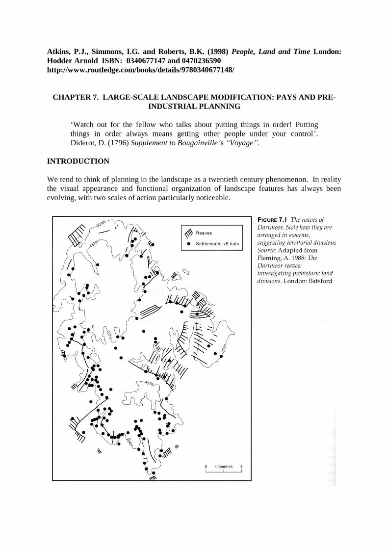
On Dartmoor reave field boundaries were laid out (c. 1,700-1,600 B.C.) in parallel lines
approximately 100 metres apart (Figures 7.1 and 7.2), in groups covering up to 3,000
hectares, each presumably representing the territory of a clan or community group (Fleming
1988). There are terminal reaves at the edge of each group and a stretch of grazing beyond to
make up a balanced farming system. This is an astonishing feat of common will for an
allegedly primitive people, no doubt directed by an élite with power on a regional scale.
Similar, coaxial, field systems and swarms of linear earthworks and ditches have been

identified in other upland parts of England, and the suspicion is that such boundaries were
also present in the lowlands but have been swept away by the tidal waves of history. In the
case of Dartmoor the surviving reaves and their associated huts imply farming, at first
entirely pastoral but later with some arable, at 250-400 metres above sea level, well above
the current limit of cultivation. They probably show an expansion into a mixture of light
woodland and open heath during a phase of warm climatic conditions, and successive
generations of farmers would certainly have been put under pressure by the deterioration of
temperatures from about 900-500 B.C..
THE ORIGINS OF THE GREAT LANDSCAPE PROVINCES OF EUROPE
Western Europe has a fascinating variety of landscapes that cannot be explained by geology
and topography alone. The human imprint has been marked from an early date, leading by a
process of steady change to today’s distinctive cultural regions.
A satisfying approach to describing these regions, or pays as he called them, was developed
by the French geographer Paul Vidal de la Blache (1845-1918). To him the study of
landscape was best achieved locally, by analyzing the connexions between people and the
resources available to them in their immediate physical environment. France had retained its
regional lifestyles and typical products such as local cheeses and wines, culinary dishes,
vernacular architecture and traditional dress. These were outward expressions of a popular
culture which gave a focus of identification for local inhabitants. French geographers,
inspired by Vidal de la Blache and others, wrote a series of regional monographs which
represent a very strong tradition in the subject. To this day the country is a patchwork of
hundreds of pays which, although increasingly drawn together by the processes of
industrialization and the homogenizing influence of modern culture, remain clearly
identifiable.
Cultural regions or pays have survived in all the European countries despite the devastation
of wars and the restructuring of economy and society which has accelerated in the twentieth
century. Their resilience suggests an inertia of both physical capital and cultural investment
which is not easy to write off.

Meeus (1990, 1995) and his collaborators have classified European landscapes into thirty
types (Figures 7.3 and 7.4) on the basis of vegetation, degree of enclosure/openness, and the
intensity of cultivation. While we might not agree with the precise boundaries that he has
delimited, Meeus has performed a considerable service in alerting us to the underlying logic
of the landscapes that we tend to take for granted. One of the faults of historical geography
has been its tendency to be parochial, perhaps because of the degree of specialization needed
to analyze the documentary record of any one country, and this map gives us a first draft of a
Europe-wide view, based upon map analysis and the skilled visual impressions of a team of
landscape architects, which need to be refined in the light of the local scholarship of
historians and geographers. The reality is likely to be a great deal more complex than this
simple model.
CASE STUDY: CHAMPION AND ENCLOSED
To the casual observer looking out of a car or train window, there are clear but puzzling
differences between the major landscape types in north western Europe. There are vast tracts
of open country with large fields, sometimes sub-divided into strips, juxtaposed with
enclosed, hedged and walled areas which have an altogether different ambience. There are
many variations within these broad groupings but the fundamental cleavage remains between
the open and the enclosed.
The open-field landscape has also been called the Midland system after its characteristic
region of England, and also fielden, champion or champagne. On the continent it flourished
in northern and eastern France, Denmark, and in parts of Germany and Sweden. Agricultural
organization varied: although most of the arable was subdivided into narrow strips, and still
is in some areas, land was not always held collectively as implied by the confusing term
common fields.
Contrast this with the texturally dissimilar landscape of wooded or hedged enclosures (called
bocage in Britanny) of western Britain, East Anglia, western France, the Low Countries,
northern Germany, and the Baltic fringes.
Various explanations have been put forward for the evolution of these landscapes.
Agricultural specialization, for instance, has certainly been important because a pastoral-
based economy requires less cooperative effort for its success and is therefore less likely to
need an associated settlement pattern of nucleated villages. The links between arable
farming and low-lying fertile land on the one hand, and between pastoralism and hilly
country on the other, inevitably led to a rash of environmentally deterministic hypotheses
involving topography and geology, but the main mediating factors are undoubtedly mainly
agro-climate, the availability of water, and soil fertility.
Racial factors have also been mentioned, by nineteenth and early twentieth century writers
such as Meitzen who one hundred years ago argued that village settlement patterns were
associated with the Teutonic peoples, whereas isolated farmsteads and hamlets were said to
be more a feature of the Celtic fringe of western Europe.
Apart from the well-known division of Britain into highland and lowland zones, Oliver

Rackham (1986) has identified within lowland England another boundary between what he
calls the ancient and planned landscapes. He argues that the two regions are significantly
different especially in their settlement patterns and the disposition of vegetation in woods and
hedges (Table 7.1).

Table 7.1 Today’s landscape elements of the ‘ancient’ and ‘planned’ countrysides
Ancient countryside Planned countryside
Many antiquities Few antiquities
Heathland common Heaths rare
Many ponds Few ponds
Open fields few in number and enclosed
early
Strong tradition of open fields, lasting
until Parliamentary Enclosures.
Pollarded trees away from human habitation Few pollards
Non woodland trees: oak, ash, alder, birch Non woodland trees: elders, thorns
Winding hedgerows of mixed species Straight hedges, often hawthorn
Many small woods Fewer woods, but larger in size
Many footpaths Few public footpaths
Dense network of narrow, winding lanes,
often sunken
Fewer roads, mainly straight
Isolated farms of ancient origin Isolated farms created upon enclosure
Dispersed settlement Nucleated villages
Source: after Rackham (1986) pp 4-5

The most obvious differences between the two arise from the widespread enclosure of fields
in the eighteenth and nineteenth centuries, but the contrast has deeper historical roots.
Rackham postulates that the planned countryside was in fact the legacy of the Roman
occupation. Their fields were rectangular and probably hedged, but these hedges were
removed by the Anglo-Saxons when they initiated the open field system with its very
different type of open landscape.
The ancient countryside was less affected by the Romans. It was a landscape of great
antiquity which visually remains essentially unchanged today. Here fewer open fields were
created and later enclosed. The differences between the landscape provinces in England are
shown for a number of features in Figure 7.5.
LAND REFORM
Most land reforms, both historical and modern, have been instigated by two types of
argument. The first is that greater efficiency of production will be gained by the restructuring
of land-holdings, leading to reductions in costs, improved profitability and increased
quantities of output. Experience has shown that such arguments stand on shifting ground

because fluctuations in economic variables and technological developments may within a
few years undermine a neatly planned re-organization. Secondly, a political and social logic
has demanded land reform in the interests of greater equitability of land-holding, especially,
but not exclusively, in socialist countries such as the former Soviet Union and the People’s
Republic of China. Land reforms drawing upon this second strand of arguments were rare
before the French Revolution.
Land reforms may be classified according to their physical and functional results:
A re-ordering of landownership patterns which, according to the system to be
replaced, will usually mean collectivization or privatization.
A consolidation of scattered parcels of each farmer’s land into a compact unit, for
instance the French remembrement which since 1941 has been responsible for the
reorganization of 12 million hectares, about 40 per cent of the country’s agricultural
area, into consolidated blocks of fields which are large enough for modern machinery.
Here the state pays the administrative costs and heavily subsidizes physical activities
such as hedge removal and the laying of new roads.
Engrossment, where once independent farms are merged to make more viable
economic units. Again the French have pioneered this process as a policy to
modernize their farming structure.
CASE STUDY: IMPERIALISM AND ROMAN CENTURIATION
The Roman empire was administered with a methodical and practical efficiency that has had
few equals in history. This extended to agriculture and the land division that formed the
intersection between the farmer and the landscape. The practice of centuriation was
widespread, from the Po Valley in northern Italy to the semi-desert of southern Tunisia
(Figure 7.6), and from the air we can immediately see it as a very important cultural
signature. The chessboard appearance of the Roman field system was not repeated on any
scale until the land division of north America in the nineteenth century.
The basis of the grid of centuriae was a pair of base lines (roads) set at right angles. From
these lines a network of minor intersecting boundaries were laid out using the Roman
surveying cross-staff, the groma. Secondary roads were provided for at regular intervals of
2,400 Roman feet (708m). Each century was subdivided into two hundred iugera (0.25 ha)
which were then grouped into square or rectangular farms.
In Tunisia the whole province was laid out in several groups of centuriae, but land in other
parts of the empire was dealt with in smaller packets. Professional land surveyors, the
agrimensores, were responsible for the technical work on the ground, but decisions about the
orientation of the pattern and its extent were presumably made at a high bureaucratic level.
The centuriation of the landscape epitomises the Roman will to dominate the natural world
but it also has implications for the control of the economic and political spheres.
Many centuriated landscapes were laid out for colonists. In other words the farmers, often
retired soldiers and their families, were used as a means of establishing control, as in the
recently conquered north African territories of Carthage in 146 B.C.. Government policy was
‘that all lands that are suitable for olives and vines as well as for grain crops should be
brought into cultivation’, and to encourage this tenants on imperial estates were allowed to

keep all of their olive harvests for the first ten years, after which one third had to be delivered
to the estate manager. According to the third century north African writer Tertullian:
‘Wildernesses have been replaced by most attractive estates; woods have yielded to
the plough; the cover of wild beasts has become grazing land; sands are sown, stones
are broken up, and marshes are drained’. De Anima 30.3, quoted in Meiggs, R.
(1982) Trees and timber in the ancient Mediterranean world Oxford.
Taxes were tied to the land and became ever more extortionate in the later empire as the
authorities despaired of alternative means of raising revenue. Taxes paid in grain were stored
by the state and some surpluses went to feed the population of Rome. Their need to pay
these taxes forced farmers to use extractive techniques that were damaging to the fragile
semi-arid environment. Classical mosaics suggest a rich flora and fauna, but this was later
greatly depleted and it seems likely that the fall in population since Roman times is due less
to climatic desiccation than to the over-exploitation of the land and the cutting down of trees,
leading to soil exhaustion and erosion.

CASE STUDY: AGRICULTURAL ENCLOSURE IN BRITAIN, 1500-1900
In the Europe of A.D. 1500 there was still a widespread distribution of subdivided, open
fields, with a tremendous variety of form and function (Chapter 11). Over the next four
centuries land reform was responsible for the transformation of the appearance and function
of such landscapes out of all recognition in some regions, and by way of example we will
look at the revolution in English land-use systems which was brought about by the process of
enclosure of the open fields. This was a change mainly inspired by economic advantage but
there were other factors as well, such as population pressure.
In post-medieval England the feudal system was disintegrating and market forces were
bearing increasingly upon the lives of ordinary people. The decision-making of farmers,
especially those located close to large centres of population, was less motivated by pure
subsistence and opportunities opened up for specialized, commercial production. Thus, some
time in the mid fifteenth century the prices of livestock products in England, especially wool,
began to outstrip corn. The demand for wool had expanded, both for export and increasingly
for manufacture into textiles, but the population had yet to recover its demand for staple
grains after the demographic disasters of the fourteenth century, when famine and the
bubonic plague under the name of the Black Death (1348) had stalked the land. Inevitably,
grass began to look like a better economic proposition and much arable was either abandoned
or actively transferred to pastoralism by aggressive landlords who evicted their tenants.
Some of the hamlets deserted in the later medieval period had been subjected to this policy
(see Chapter 11).
Large areas were enclosed for sheep pasture, especially in the Midlands where as much as a
tenth of the agricultural land was enclosed between 1450 and 1600, but also in the western
and south western fringes which were environmentally better suited anyway to a
specialization in a grass-based agriculture. About 45 per cent of England was already
enclosed in 1450, with a further 2-3 per cent by 1600 (Figure 7.7).
At times enclosure was bitterly contested. The strong-arm tactics of certain manorial lords
were crude and relied for their success upon the fact that news travelled slowly and only
locally. As communications improved and something approximating to public opinion
emerged, so changes in rural areas became political. Such was the uproar in the Tudor
period for instance, when Sir Thomas More wrote of ‘sheep devouring men’, that parliament
instigated enquiries and legislated certain measures of control. The Midland Revolt of 1607
was partly related to enclosure and there was widespread disquiet at the loss of previously
collective resources, such as grazing and gathering fuel, which cottagers and smallholders
had enjoyed time out of mind.
From the mid-sixteenth century some of the political temperature was reduced by a wider
adoption of the procedure of enclosure by agreement among the landowners of a parish. The
incidence of violent coercion declined but the power of large landowners remained a factor.
Some theorists argue that enclosure was most popular in regions where the increase in
farming profitability was likely to be greatest, and there is logic in that, but there were some
fertile areas where open fields remained intact until the eighteenth century. Here it may be
that the potential rewards were so great that agreement by persuasion was difficult to
achieve.
In the seventeenth century educated opinion came to favour enclosure as a means of
improvement. To many it seemed a rational and even a necessary condition for modernizing
agriculture. In the early eighteenth century enclosure by Private Act of Parliament became
the norm. These were thought important because enclosure by agreement, democratic though
it may sound, actually caused endless legal wrangles in the Courts of Chancery and
Exchequer, with disputes sometimes dragging on for decades. A Parliamentary Act added
the possibility of legal compulsion which over-rode local objections.
On the whole, enclosure seems to have proceeded with least opposition in areas where
population pressure was not a problem, where farming had a pastoral bias, and where there
was still plenty of waste to improve. Where population pressure was on the verge of
outstripping the available waste and common resources, people were obviously not keen on
an enclosure which would deny them access to their common rights in the open fields. Riots
were not uncommon in such areas, for instance Northamptonshire (Figure 7.8).
Even where violence was avoided, the impact of enclosure upon the lives of ordinary people
was often negative. Of the contemporary writers who described this, John Clare (1793-1864)
is perhaps one of the most renowned. He was a Northamptonshire agricultural labourer who
put into verse the great changes in the countryside around his native village. He hated
enclosure and the changes it had wrought in the beloved landscape of his youth:
‘The cow boy with his Green is gone
And every Bush and tree
Dire nakedness over all prevails
yon fallows bare and brown
Is all beset wi’ posts and rails
And turned upside down...
The bawks and Eddings are no more
The pastures too are gone

The greens the Meadows and the moors
Are all cut up and done
There’s scarce a greensward spot remains
And scarce a single tree
All naked are thy native plains
And yet they’re dear to thee.’
The Lamentations of Round-Oak Waters (c. 1815)
Clare was right in identifying the remarkable modification of the Midland landscape. A
more recent commentator is firm that enclosure was one of the most significant events in
landscape history:
‘Parliamentary enclosure was possibly the largest single aggregate landscape change
induced by man [sic] in an equivalent period of time. In a number of ways it surely
warrants this weight of significance, producing as it did scattered farmsteads where
once nucleated villages proliferated, hedgerows or stonewalls and thus a mosaic of
geometrically shaped fields, and ordered landownership patterns where once existed
the relatively disorderly open fields...’. Turner (1980, 33).
During the eighteenth century there was a tremendous upsurge in Enclosure Acts, especially

during two periods: 1765-80, and 1793-1815. Eighty percent of all Enclosure Acts were
passed during these two periods (Figure 7.9).
An obvious factor was profit potential, especially during the rapid price inflation of food
during the Napoleonic Wars which encouraged the expansion of capitalist, market-orientated
agriculture. A broader degree of enterprise specialization was possible, with exploitation of
comparative advantage causing a shift of the agricultural pendulum further away from
regional self-sufficiency. Thus more and more land in the Midlands was laid down to grass
(Figure 7.10), so that by 1850 James Caird was able to claim a geographical distinction
between the arable east and the pastoral west of England.
As a result of the privatisation of farm land accomplished by enclosure, collective risk
minimization was replaced by individual enterprise, so innovative farmers felt less inhibited.
An example of this was the collective grazing of the stubble which was allowed after the
harvest had been gathered in. This made selective breeding of animals difficult and therefore
improvements in wool quality, milk yield and carcass weight were delayed until enclosure
allowed the separation of beasts with desirable genetic traits.
Enclosure’s functional implications for farming were fundamental. Individual decisions
about crops and livestock, and the results of those decisions, were no longer so dependent
upon the agreement of neighbours, although we should not be so naive as to assume that
success or failure now depended only upon the personal qualities of the landlord and tenant.
There were still constraints upon both.

The physical nature of the landscape was completely replanned in many villages. Each Act
appointed a small group of commissioners and gave them considerable powers. They had to
reallocate land held in scattered strips by an individual into a compact block. There were
detailed regulations for the construction of roads, fences, gates and hedges. Naturally the
whole process was very costly, and expenses were shared out among the new proprietors.
Table 7.2 shows the break-down of costs for the Buckinghamshire parish of Prince’s
Risborough.
Table 7.2 Costs of enclosing Prince’s Risborough, 1820-23
£ s d
Soliciting the Act 837 0 10
Clerk 1,014 12 5
Commissioners 1,400 12 0
Surveyor 1,486 8 7
Roads 3,930 14 3
Fences 853 9 5
Bridges 209 17 1
Tillage 521 10 5
Other 1,467 18 10
Total 11,722 3 10
Source: Turner (1973)
Agreement about the nature of the Act was often difficult to achieve among the potential

beneficiaries. In North Thoresby in Lincolnshire, for instance, enclosure was first discussed
in 1766, again in 1801-2, 1809-10, and 1823-4. Each generation of farmers disagreed
amongst themselves until 1836 when the agreement was finally drawn up (Russell and
Russell 1987).

Within a few years of the passing of the Act the landscape of the parish had been transformed
by a team of surveyors who carried out the instructions of the commissioners. An open, bare
landscape of large fields was divided into compact, regular blocks marked off by straight
fences and quickset hawthorn hedgerows. Roads were straight, with wide grass verges. New
farms were often created, away from the compact villages, on sites more convenient for
individual farming, although inertia maintained the essential structure of the rural settlement
pattern.
So there appeared in the eighteenth century a new planned landscape in the English Midlands
(Figure 7.11), substantially different from anything seen before. Occasionally relicts of
earlier, open-field landscapes survive because some enclosure commissioners, in order to
minimise costs, simply hedged individual or groups of strips without properly consolidating
and engrossing them, thus preserving medieval shapes as an anachronistic oddity.
For Johnson (1996) the closure of common resources had a fundamental significance beyond
the creation of hedges and ditches. It was a rare moment of shifting mentality when the
private interests of individual replaced the collective conscientiousness as a driving force of
society. Seen from this perspective it is clear that the public desire for improvement was a
smokescreen for social changes in which the interests of smallholders and labourers were
downgraded. The physical changes in the landscape were proof of thousands of local
skirmishes whose outcomes varied in time but not in symbolism.

LANDSCAPE PLANNING IN SCOTLAND
In Scotland enclosure was somewhat different. Agricultural improvements were later and
slower than in England, and enclosure was usually at the instigation of a large landlord.
Neither agreement with the community, nor an Act of Parliament, were necessary under
Scottish law.
In the period roughly 1730-1850 there were substantial changes in the rural Scottish
landscape. The old open field run rig was replaced by large, square fields. The farming
hamlets, ferm touns, were replanned and sometimes landlords laid out new towns and
villages in controlled, geometric patterns on green field sites with economic activities
alternative to agriculture (Figure 7.12). Some were associated with the textile and fishing
industries and provided opportunities for tradesmen. Douglas Lockhart (1980) has calculated
that over 450 Scottish settlements have this strong impress of the planner.
Traditional customs in Scotland meant that landlords felt obliged to provide for those
dispossessed by these changes. But such customs broke down in the nineteenth century as
the population increased, and failures of potato crops led to misery. Landlords with an eye to
profit from sheep forced their tenants off the land and encouraged them to emigrate, the
notorious clearances creating deserts in areas of the Highlands (see Chapter 20).
CASE STUDY: PLANNING A LANDSCAPE FROM SCRATCH: THE US LAND
SURVEY
Although the British, French and Spanish colonists in north America imported their
unsystematic European traditions of land division, they were nevertheless open to new ideas.
This is most obvious in the rectangular street patterns in cities such as Philadelphia and
Charleston. In May 1785 a more general system was devised with the passing of the justly
famous Land Ordinance, a statutory means of allotting land to the west, in the territories
which were still the sole realm of native Americans.
In discussion, Thomas Jefferson and others decided that allotment on the basis of a
checkerboard of squares was the most appropriate. It would be the cheapest to survey and it
also fitted the rational, scientific philosophy of these men of the Enlightenment. Here we
have the clearest large-scale expression of ideology in superficial landscape geometry.
Functional boundaries from field edges to state lines were affected, creating what Cosgrove
(1984) calls Palladian America. (Palladio was an influential Italian architect who was
responsible for the revival of many classical ideas of design.)
There were north-south principal meridians and intersecting east-west base lines. Starting in
Ohio, these were carefully surveyed using standardized chains and formed the basis for all of
the subsequent land subdivision. Range lines were surveyed at six mile (9.65 km) intervals
and these formed the boundaries of townships of (usually) 36 square miles. In turn these
townships were subdivided into a gridiron of 36 sections of 640 acres (260 hectares), each
made up of four quarter sections or sixteen forties. The last of these was the most popular
size of plot for the average pioneering farm family.
The American landscape of straight lines was packaged and commodified de novo.

Unsurprisingly there was no part in it for its aboriginal owners who were unceremoniously
dispossessed and herded into reservations. Their lifestyle, especially the nomadism of the
plains Indians, was inconvenient for planners and settlers alike. The boundaries were real
enough as physical barriers to movement but they were also intended as a symbolic
declaration of the independence of each lot holder. The landscape had been privatised and,
having invested their sweat in clearing and ploughing it, the new inhabitants were
aggressively resistant to any perceived intrusions into their piece of tamed wilderness.
Every landscape evolves and it is interesting to speculate how the land division will influence
America in the next millennium. So far forties and quarter sections have been split or
amalgamated to suit convenience, leading to a blurring of the primary survey lines (Figure
7.13). Most likely to survive are the transport routes, for their straight lines have become the
viscera of American life.

CONCLUSION
Landscape planning is not just a feature of modernism. We have adduced evidence of
planned and replanned agricultural landscapes from the Bronze Age to the nineteenth
century, with administrative and commercial motives. Sometimes such features have
survived in relict form only but there is a strong suspicion that the logic of communal
planning underlies much of what may appear to be ordinary landscapes. The specialized
skills of historical geographers, landscape historians and archaeologists are required to
unravel this particular story about the organizational motivations of our ancestors.
FURTHER READING AND REFERENCES
Fleming (1988) provides a good introduction to the Dartmoor reaves and coaxial field
systems in general. Meeus is one of the few writers to address landscapes at a continental
scale, but his disciplinary origin is landscape architecture rather than cultural and historical
research. Rackham’s (1986) classic account of the ancient and planned landscapes of
England is essential reading, and Bradford (1957) is an authority on centuriation. See Turner
(1980) on enclosure and Johnson (1990) on the US land survey.
Bradford, J. (1957) Ancient landscapes: studies in field archaeology London: Bell
Cosgrove, D. (1984) Social formation and symbolic landscape London: Croom Helm
Doolittle, W.E. (1984) Agricultural change as incremental process, Annals of the Association
of American Geographers 74, 124-37
Fleming, A. (1988) The Dartmoor reaves: investigating prehistoric land divisions London:
Batsford
Johnson, H.B. (1990) Towards a national landscape, pp 127-45 in Conzen, M.P. (Ed.) The
making of the American landscape Boston: Unwin Hyman
Johnson, M. (1996) An archaeology of capitalism Oxford: Blackwell
Lockhart, D.G. (1980) Scottish village plans: a preliminary analysis, Scottish Geographical
Magazine 96, 141-57
Meeus, J.H.A. (1995) Pan-European landscapes, Landscape and Urban Planning 31, 57-79
Meeus, J.H.A., Wijermans, M.P. & Vroom, M.J. (1990) Agricultural landscapes in Europe
and their transformation, Landscape and Urban Planning 18, 289-352
Rackham, O. (1986) The history of the countryside London: Dent
Russell, E. & Russell, R.C. (1987) Parliamentary enclosure and new Lincolnshire
landscapes Lincoln: Lincolnshire Recreational Services
Turner, M.E. (1973) The cost of Parliamentary enclosure in Buckinghamshire,
Agricultural History Review 21, 35-46
Turner, M.E. (1980) English Parliamentary enclosure: its historical geography and
economic history Folkestone: Dawson