Landscape - Greening
21
New Territories Series No. 7 Sha Tin District http://www.greening.gov.hk http://www.greening.gov.hk Greening, Landscape and Tree Management Section Development Bureau Greening, Landscape and Tree Management Section Development Bureau 發展局 綠化、園境及樹木管理組 發展局 綠化、園境及樹木管理組 Tree & Landscape ap
-
Upload
khangminh22 -
Category
Documents
-
view
1 -
download
0
Transcript of Landscape - Greening

New Territories SeriesNo. 7
Sha Tin District
http://www.greening.gov.hkhttp://www.greening.gov.hk
Greening, Landscape and Tree Management Section Development BureauGreening, Landscape and Tree Management Section Development Bureau
發展局 綠化、園境及樹木管理組 發展局 綠化、園境及樹木管理組
Tree &Landscape
ap

Cover Photos Cover Photos 封面照片
2
Top: The Chinese University of Top: The Chinese University of Hong Kong Hong KongMiddle: Hong Kong Science ParkMiddle: Hong Kong Science ParkBottom:Bottom: Pak Shek Kok PromenadePak Shek Kok Promenade
上 : 香港中文大學上 : 香港中文大學中 : 香港科學園中 : 香港科學園下 : 白石角海濱長廊白石角海濱長廊
Sha Tin District沙田區
New Territories新界
Hong Kong Island香港島
Lamma Island南丫島
Kowloon九龍
Lantau Island大嶼山
A區Area A
B區Area Bnt
rodu
ctio
nI
td
tit
dti
IIIntttr
odddduc
tttiion ForewordForeword
引言引言
人樹共融 綠滿家園人樹共融 綠滿家園
This Tree & Landscape Map prepared by the Greening, This Tree & Landscape Map prepared by the Greening, Landscape and Tree Management Section, Development Landscape and Tree Management Section, Development Bureau, aims to highlight the greening and landscape Bureau, aims to highlight the greening and landscape assets in different parts of Hong Kong, so as to promote assets in different parts of Hong Kong, so as to promote the understanding, appreciation and enjoyment of open the understanding, appreciation and enjoyment of open spaces and trees.spaces and trees.
發展局 綠化、園境及樹木管理組編寫的樹木園境地圖,重發展局 綠化、園境及樹木管理組編寫的樹木園境地圖,重點介紹香港各區的綠化園境資產,讓市民認識、欣賞及享點介紹香港各區的綠化園境資產,讓市民認識、欣賞及享受綠化空間與樹木帶來的樂趣。受綠化空間與樹木帶來的樂趣。
People, Trees, HarmonyPeople, Trees, Harmony

沙田三面環山,城門河流經區內,直達東北面的沙田海。從前每逢潮退,位於沙田海的河口便會露出一片白沙灘,而瀝源附近的地方也都山明水秀,是50及60年代的郊遊勝地。隨着70年代新市鎮的發展,沙田河道兩側皆進行了大規模的填土工程,昔日的農田與海岸遂變成高樓大廈,土地經重新規劃,加入了不少休憩用地和綠化地帶,以提高居住環境的質素,應付不斷增加的人口。
Sha Tin is surrounded by mountains on three sides, with Shing Mun River running through it and flowing out into Sha Tin Hoi in the northeast. The river mouth at Sha Tin Hoi in the old days was a sandy beach at low tide and the land near Lek Yuen was once pristine rural fields. Back in the 1950s and 1960s, Sha Tin was a popular place for outings. With the development of new town in the 1970’s, large scale reclamation took place on both sides of the river. Fields and natural shoreline gave way to high-rises. Open spaces and green belts were added to enhance the living environment and to cater for the need of a growing population.
新界New Territories
沙田Sha Tin
目錄
CON
TEN
TS
Area AA 區
N
Sha Tin Park沙田公園
City Art Square城市藝坊
Shing Mun Riverfront城門河沿河景觀
11
2
3
Sha Tin Hoi
2
ShaHo
aHo
吐露港
公路 T
aiPo
大老山公路 T
ate ’
sC
airn
Hig
hway
沙
田路 S
haTi
n Road
大埔公路(沙田
段) T
ai
PoRo
ad(S
haTi
n)
青沙
公路 T
sing
Sha
Hy
w
車公廟路
Che
Kung
Miu
Road
美田路
Mei Tin Rd 紅梅谷路
城門隧道公路Shing Mun Tunnel Rd
HungM
uiuK
k
Rd
獅子山隧
道
公路
LionRock Tunnel Rd
1
3
3
沙田圍路 Sha Tin Wai Ro
ad
大涌
橋路
Tai Chung Ki
uRd
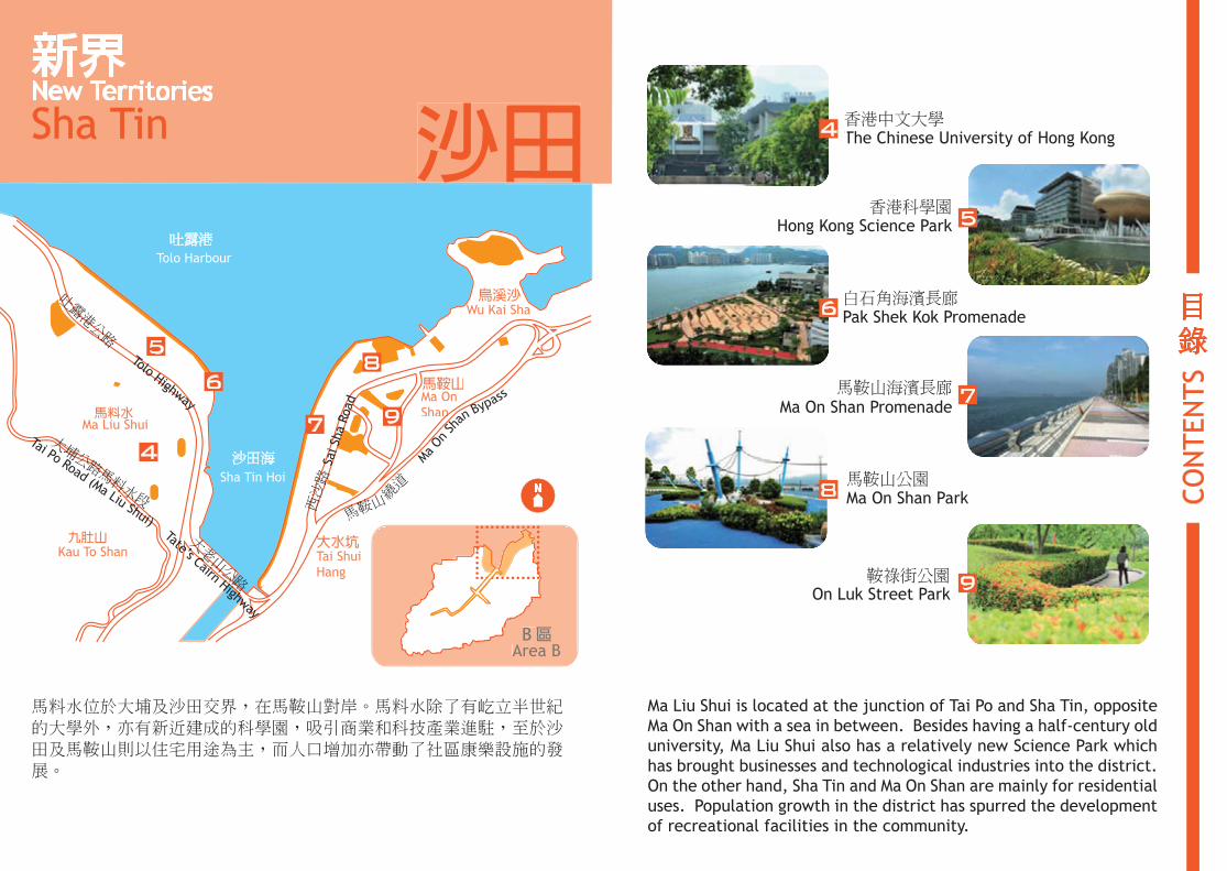
馬料水位於大埔及沙田交界,在馬鞍山對岸。馬料水除了有屹立半世紀的大學外,亦有新近建成的科學園,吸引商業和科技產業進駐,至於沙田及馬鞍山則以住宅用途為主,而人口增加亦帶動了社區康樂設施的發展。
Ma Liu Shui is located at the junction of Tai Po and Sha Tin, opposite Ma On Shan with a sea in between. Besides having a half-century old university, Ma Liu Shui also has a relatively new Science Park which has brought businesses and technological industries into the district. On the other hand, Sha Tin and Ma On Shan are mainly for residential uses. Population growth in the district has spurred the development of recreational facilities in the community.
新界New Territories
沙田Sha Tin
目錄
CON
TEN
TS
Area BB 區
The Chinese University of Hong Kong香港中文大學
Hong Kong Science Park香港科學園
Pak Shek Kok Promenade白石角海濱長廊
Ma On Shan Park馬鞍山公園
On Luk Street Park鞍祿街公園
Ma On Shan Promenade馬鞍山海濱長廊
14
5
7
6
8
9
4
5
6
大埔公路馬料水段
沙田海
吐露港
吐露港公路
九肚山
馬料水
大水坑大
馬鞍山
烏溪沙西沙路
Tolo Harbour
Sha Tin Hoi
Tai ShuiHang
Ma OnShann
Sai S
ha R
oad
Wu Kai Sha
大老山公路
Kau To ShanTate’s Cairn Highway
Tolo Highway
Ma Liu ShuiTai Po Road (Ma Liu Shui)
MaOn
Shan
Bypass
馬鞍山
繞
道 N
7
8
9

沙田公園前稱沙田中央公園,面積約8公頃,於1988年啟用。公園採用中式園林設計,內有多個亭台樓閣及水景魚池,植物種類繁多,是沙田最大的綠化休憩空間。
Sha Tin Park, formerly known as Sha Tin Central Park, was opened in 1988 with an area of about 8 hectares. This Chinese style landscape garden is dotted with pavilions, fish pond, water features and a variety of plant species. The park is the largest green open space in Sha Tin.
沙田公園沙田公園SHA TIN PARKSHA TIN PARK
An Urban Greenland An Urban Greenland Where East Meet WestWhere East Meet West
8
1沙田公園
SH
A T
IN P
AR
KS
HA T
IN P
AR
K

1
21 3
4
公園入口Park Entrance
Wes
tern
Hill西
山
Wat
erfa
ll瀑布
Rock
Gar
den石
景花園
Moo
n Pa
vilio
n 南園正門
Azal
ea G
arde
n 杜鵑園
Law
n
草地Av
iary
Gar
den 水
池花園
Scen
ted
Gar
den 馥
園
Wal
led
Gar
den圍
牆花園
Vera
ndah日
影廊
Law
n 草地
Nor
th G
arde
n En
tran
ce北園正門
Nor
th G
arde
n
北園
Shing Mun River城門河
Sha Tin Town Hall
沙田大會堂
41
23
N10
1沙田公園
SH
A T
IN P
AR
KS
HA T
IN P
AR
K

城市藝坊於2008年落成,目的是要宣揚北京奧運及發展沙田區的公共藝術和休憩空間。
City Art Square was opened in 2008 to mark the Beijing Olympics and for development of public arts and open space in Sha Tin.
12
14
12
2城市藝坊
CIT
Y A
RT
SQ
UAR
E
城市藝坊
City artsquare
Bus Stop
Sha Tin New Town Plaza
Sha Tin Town Hall
沙田新城市中心
沙田大會堂
巴士站3
2
1
4
56
78
9
10
1112Sha Tin Park
沙田公園
N
公園入口Park Entrance

「城市藝坊」展出19位來自海外、內地及本地的知名藝術家及設計師的作品,藝術與景觀結合,令沙田市中心的公共空間變得多姿多采。
The square displays the works of 19 well-known artists and designers from overseas, Mainland and Hong Kong, integrating art with the landscape and enriching the public space in the heart of Sha Tin.
4
7
3
11
10
8
14
2城市藝坊
CIT
Y A
RT
SQ
UAR
E
5

16
3
城門河,又稱城門河道,位於沙田區中心地帶,河道與多條源於附近山上的支流連接,除具備引水排洪的功能外,亦是一條將沿河不同地方串連起來的綠化帶,河上設有多條橋樑,為居民締造休閒舒適的環境。
Shing Mun River, also called Shing Mun River Channel, is situated at the centre of Sha Tin District. The channel is fed by several tributaries that come down from the surrounding hills. Apart from drainage purposes, Shing Mun River is also a green corridor linking up areas along both
sides of the riverfront with landscaped spaces and bridges, thus providing a relaxed and 城comfortable environment to the residents. 門
河沿河景觀
SH
ING
MU
N R
IVER
FR
ON
T

1
2
3
5
4
楓香 Sweet Gum(Liquidambar formosana)
南天竹 Sacred Bamboo(Nandina domestica)
沿岸一路綠樹成蔭Green tree shadings along the riverfront沿岸一路綠樹成蔭Green tree shadings along the riverfront
沙田海Sha Tin Hoi
Penfold Park &Racecourse
源禾遊樂場Yuen Wo
Playground
沙田公園Sha Tin Park
城門河第一海濱花園
瀝源橋Lek Yuen Bridge
崗背街休憩花園Kong Pui Street Rest Garden
圓洲角公園Yuen Chau Kok Park
城門河第二海濱花園Shing Mun River Promenade Garden no.2
Shing Mun River Promenade Garden no.1
馬鞍山海濱長廊Ma On Shan Promenade
曾大屋
5
4
3
21
N
彭福公園及馬場
王屋Wong Uk
Tsang Tai Uk
18
3城門河沿河景觀
SH
ING
MU
N R
IVER
FR
ON
T
城門河沿河景觀
城門河周邊景觀
城門河周邊歷史建築
Promenade Scenic Spots
Surrounding Landscape
Surrounding Historical Heritages
N

����������������� ���� ����������Green Campus
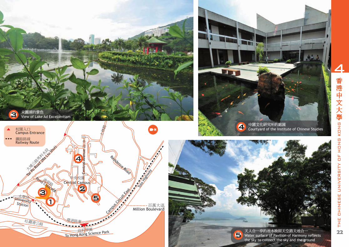
中央校園中心的「百萬大道」兩旁種滿樹木Trees are planted along "Million Boulevard" at Central Campus.
未圓湖湖邊的小徑綠草如茵
Greenery along the pathway by Lake Ad Excellentiam1
2
20
4香港中文大學
THE C
HIN
ES
E U
NIV
ER
SIT
Y O
F H
ON
G K
ON
G
位於馬料水的香港中文大學佔地137公頃,校園依山而建,接近四分三土地均長滿植物。車站附近有崇基學院的未圓湖,山頂則有新亞書院的天人合一亭,校內的樹木品種逾200,為全港大學校園之冠。
Located at Ma Liu Shui, the Chinese University of Hong Kong occupies a total area of 137 hectares and is built on a hillside with nearly three quarters of its site covered by greenery. Unique features of the University include the Lake Ad Excellentiam of the Chung Chi College near the railway station, and the Pavilion of Harmony of the New Asia College atop the hill. There are over 200 species of trees grown in the campus, outnumbering other university campuses in Hong Kong.
大埔公路馬料水段
吐露港公路
大學站
池旁路
中央道
Tolo
Hig
hway
UniversityStation
Tai P
o Roa
d (M
a Liu
Shui)
中央校園Central Campus
Pond Crescent
士林路
Residence Road
eunevA lartneC
環迴路東
Cam
pus C
ircui
t Eas
t
往科學園
To Hong Kong Science Park
校園入口Campus Entrance
鐵路路線Railway Route
31
2
百萬大道Million Boulevard
百萬大道Million Boulevard
22
4香港中文大學
THE C
HIN
ES
E U
NIV
ER
SIT
Y O
F H
ON
G K
ON
G
N
4
5
未圓湖的景色View of Lake Ad Excellentiam3
4 中國文化研究所的庭園Courtyard of the Institute of Chinese Studies
天人合一亭的池水映照天空將天地合一Water surface of Pavilion of Harmony reflects the sky to connect the sky and the ground
5
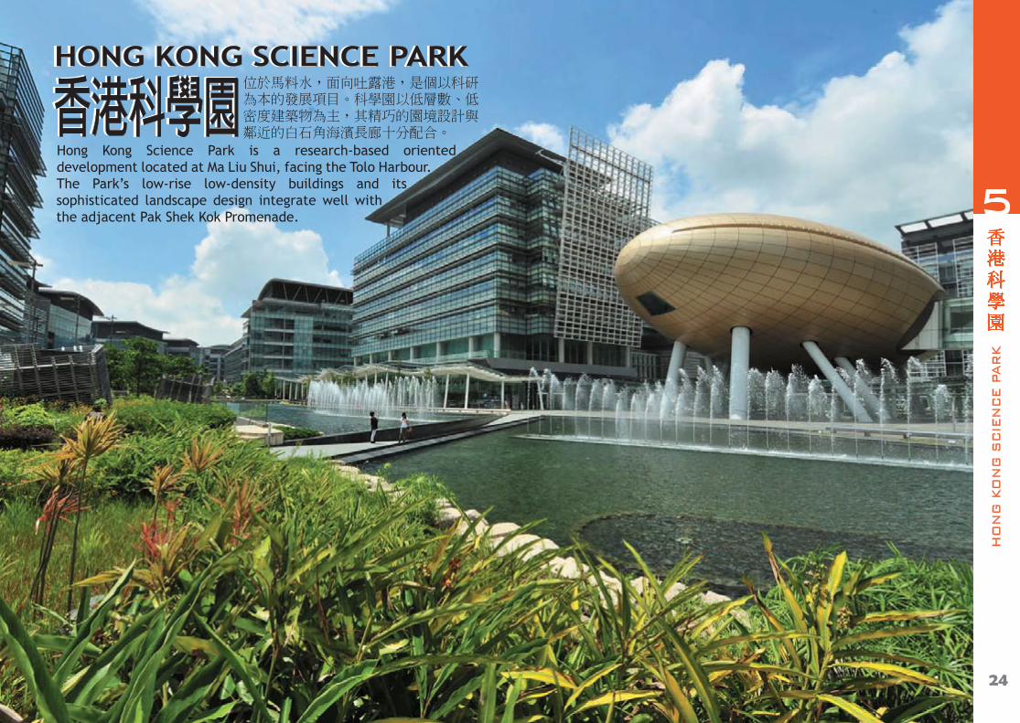
位於馬料水,面向吐露港,是個以科研為本的發展項目。科學園以低層數、低密度建築物為主,其精巧的園境設計與鄰近的白石角海濱長廊十分配合。香港科學園香港科學園
HONG KONG SCIENCE PARKHONG KONG SCIENCE PARK
24
5香港科學園
HO
NG
KO
NG
SC
IEN
CE P
AR
K
Hong Kong Science Park is a research-based oriented development located at Ma Liu Shui, facing the Tolo Harbour. The Park’s low-rise low-density buildings and its sophisticated landscape design integrate well with the adjacent Pak Shek Kok Promenade.

3
科研路
科技大道西
科學園路
吐露港公路
往香港中文大學
Fo Y
in R
oad
Science Park Road
Tolo Highway
Science Park West Avenue
2
2
3
1
2
1
3
科學園路兩旁的綠化環境Greenery along Science Park Road
科學園中央的大型水景設施Large water featurelocated in the centre of the Park
高錕會議中心前的議事廣場The Forum in front of CharlesK. Kao Auditorium
白石角海濱長廊Pak Shek Kok Promenade
公園入口Park Entrance
鐵路路線Railway Route
26
5香港科學園
HO
NG
KO
NG
SC
IEN
CE P
AR
K
N

白石角海濱長廊位於香港科學園以北的海濱,全長約2公里,設有緩跑徑,其南面盡頭是一個作為集合點的廣場。
Pak Shek Kok promenade is locatedalong the waterfront to the northof the Hong Kong Science Park. It is about 2 km long with a jogging track along the waterfront. Its southern end is a plaza where people gather.
上: 海濱長廊南部的廣場Top: A plaza of the southern part of the Promenade
下左: 毗鄰的單車徑兩旁盡是樹蔭花圃Bottom left: Various trees and shrubs growing along the cycling track
下中: 沿海濱長廊的觀海涼亭Bottom middle: Seaview pavilion along the promenade
下右: 由香港科學園望向海濱長廊Bottom right: View of the Promenade from Hong Kong Science Park
28
6白石角海濱長廊
PAK S
HEK K
OK P
RO
MEN
AD
E

馬鞍山公園Ma On Shan
Park
寧泰路 Ning Tai Road
鞍駿街On Chun Street
恆明街
Hang Ming Street
馬鞍山海濱長廊全長3.2公里,是一條綠化走廊暨公共休憩空間,並設有行人道,將馬鞍山公園及臨海各個住宅區的公共休憩用地連接起來。遊人沿路可遠眺對岸的八仙嶺及享用長廊內的康樂設施,例如兒童遊樂場及健身站等,是個運動和觀景的好去處。
Ma On Shan Promenade is 3.2 km long. It is a green corridor cum public open space with footpaths that link up the open spaces in Ma On Shan Park and the various residential areas along the seafront. Visitors can enjoy the great view of Pat Sin Range across the sea and the recreational facilities along the promenade, such as the children’s playground and fitness stations. Itis a great place to go for exercise and splendid views.
沙田海
Sha Tin Hoi
公園入口Park Entrance
簕杜鵑園Bougainvillea Garden兒童遊樂場Children’s Playground
太極場Tai Chi Area健身站Fitness Station長者健體園地Elderly Fitness Corner
沙田海
Sha Tin Hoi
Ma On Shan Promenade
30
馬鞍山海濱長廊
MA O
N S
HAN
PR
OM
EN
AD
E
N
7

左上: 海濱長廊沿途有不少涼亭,供遊人休息乘涼。Top left: Promenade punctuated by pavilions that are for shade and for rest.
左下: 沿長廊往東走可達烏溪沙。Bottm left: Walking towards the east will lead to Wu Kai Sha.
右: 節能設施之一:太陽能及風能燈Right: Solar and wind hybrid lamp is one of its energy saving features
32
馬鞍山海濱長廊
MA O
N S
HAN
PR
OM
EN
AD
E
7
WWu Kai S

連接馬鞍山海濱長廊,佔地約5.5公頃。園內植物眾多、品種豐富,設有不同主題的園區,包括中央草坪、迷宮花園、海洋廣場等,此外,還有一個介紹馬鞍山採礦歷史的展覽場。在廣場入口、海洋廣場及觀景台的各種剪型植物,亦為公園增添不少趣味。
海洋廣場全景 (小圖為廣場內的海豚雕塑及剪型植物等)Full view of Marine Plaza (Thumbnail: Dolphin sculptures and topiary plants inside the plaza)
Linked to the Ma On Shan Promenade, the Ma On Shan Park occupies an area of about 5.5 hectares. The park has a rich diversity of plants. It is divided into different theme zones, including the Central Lawn, Garden and Maze, Marine Plaza etc. There is also a Mining History Display Area where the mining history of Ma On Shan is explained. Topiary plants found at the plaza entrances, Marine Plaza and viewing platform all add colours and fun to the park.
34
馬鞍山公園
MA O
N S
HAN
PAR
K
8
8

兒童遊樂場Children’s Playground
健身站Fitness Station
海洋廣場Marine Plaza
馬鞍山採礦歷史展覽Ma On Shan MiningHistory Display Area迷宮Maze
中央草坪Central Lawn特色花園Floral Garden
馬鞍山泳池
馬鞍山海濱長廊
休憩處
鞍駿街
鞍駿街
沙田海
Sha Tin Hoi
Ma On Shan Promenade
Sitting-out Area
Ma On Shan Swimming Pool
On Chun Street
On C
hun
Stre
et被植物包圍的休憩處Sitting-out areasurrounded by greenery
遊人可在寬敞的中央草坪自由活動Visitors can move freely on the Central Lawn
海洋廣場的後方綠蔭處處Greenery abounds at the rear of Marine Plaza
36
馬鞍山公園
MA O
N S
HAN
PAR
K
8
N
公園與海濱長廊連接
Left: The park linked to the promenade
1
1
2
2
3
3
12
3
公園入口Park Entrance

上: 盛放的龍船花層次分明 Top: Layers of flowering Ixora (Ixora spp.)
中: 在健身設施四周生長的蜘蛛蘭Middle: America Hymenocallis (Hymenocallis americana) growing near the fitnessfacilities
下: 亭頂佈滿攀藤植物Bottom: Climbers spreading out and covering the pavilion
38
鞍祿街公園
ON
LU
K S
TREET
PAR
K
鞍祿街公園位處馬鞍山市中心,兩旁是 On Luk Street Park, located at the Ma On 屋苑及學校,園內起伏的地形在建築物 Shan town centre, is surrounded by群當中顯得十分突出,是馬鞍山區觀賞 housing estates and schools. Its 杜鵑花的理想地點之一,縱使在非杜鵑 undulating relief makes the park more 花盛開的季節,該公園仍然花團錦簇, prominent when viewed against the美不勝收。 buildings surrounding it. It is one of the
key viewing sites of Azaleas in Ma On Shan. Even in the non-flowering season of Azaleas, the park is adorned withbeautiful flowers.
9

版權 版權 © 2012年 樹木園境地圖 2012年 樹木園境地圖
版權所有 未經許可 不得複製版權所有 未經許可 不得複製
編著編著 : : 綠化、園境及樹木管理組 綠化、園境及樹木管理組
出版出版 : : 香港特別行政區政府 發展局 香港特別行政區政府 發展局
承印承印 : : 政府物流服務署 政府物流服務署
(使用環保油墨和紙張印製)(使用環保油墨和紙張印製)
版次 : 2012年10月第一版版次 : 2012年10月第一版
國際書號 : 978-988-16821-6-1國際書號 : 978-988-16821-6-1
© 2012 Tree and Landscape Map 2012 Tree and Landscape Map
All Right Reserved, Unauthorized reproduction prohibitedAll Right Reserved, Unauthorized reproduction prohibited
Compiled by : Greening, Landscape & Tree Management SectionCompiled by : Greening, Landscape & Tree Management Section
Published by : Development BureauPublished by : Development Bureau
The Government of the Hong Kong Special Administrative Region The Government of the Hong Kong Special Administrative Region
Printed by : Government Logistics DepartmentPrinted by : Government Logistics Department
(Printed with environmentally friendly ink and paper) (Printed with environmentally friendly ink and paper)
Edition : First Edition, October 2012Edition : First Edition, October 2012
ISBN : ISBN : 978-988-16821-6-1978-988-16821-6-1